This is a modern-English version of The Atlas of Ancient and Classical Geography, originally written by Butler, Samuel.
It has been thoroughly updated, including changes to sentence structure, words, spelling,
and grammar—to ensure clarity for contemporary readers, while preserving the original spirit and nuance. If
you click on a paragraph, you will see the original text that we modified, and you can toggle between the two versions.
Scroll to the bottom of this page and you will find a free ePUB download link for this book.
![]()
![]()
 |
 |
 |
 |
Note from the Editor of the Electronic version.
Note from the Editor of the electronic version.
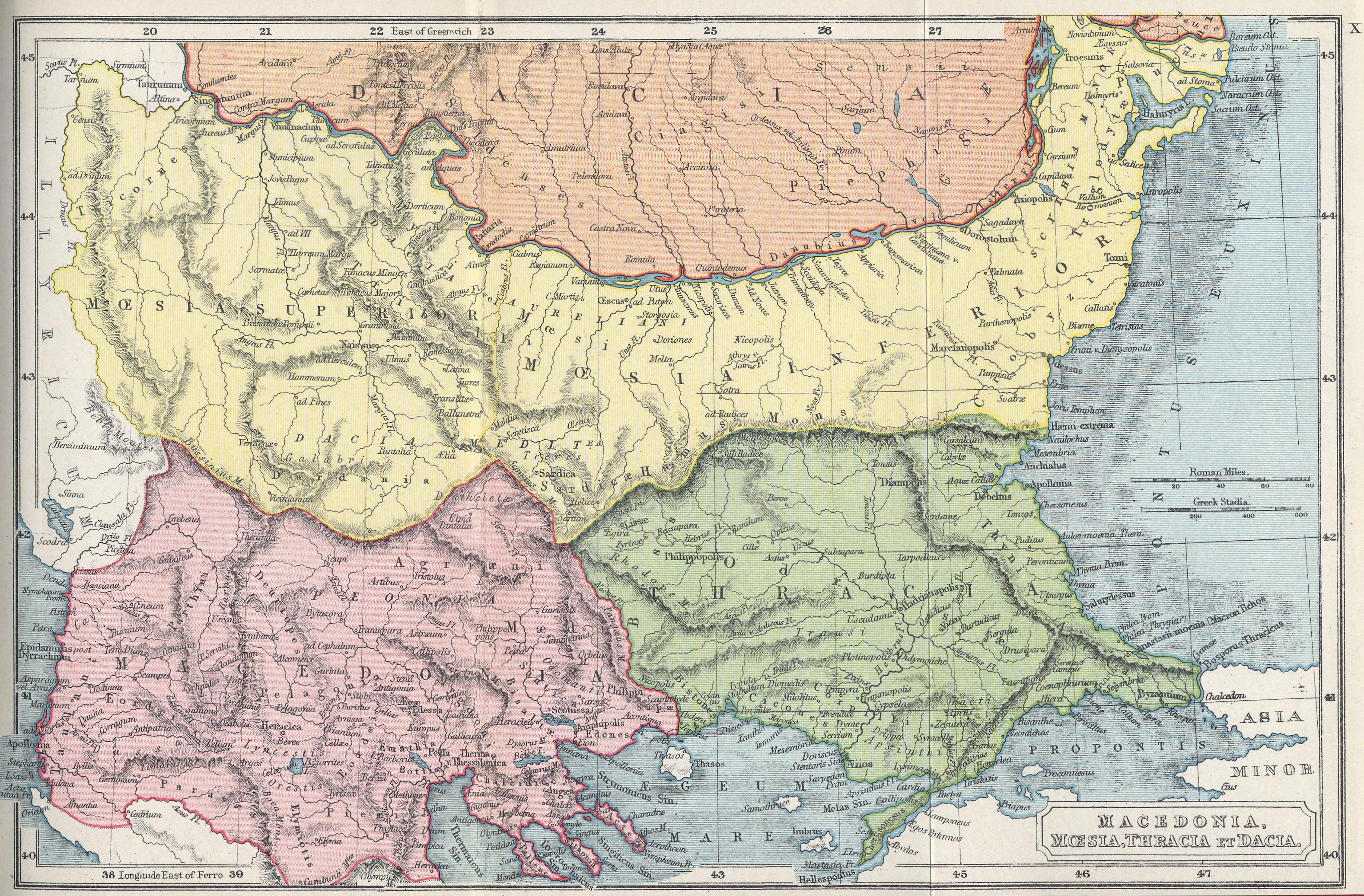
The maps of the Classical Atlas have been scanned at a sufficient resolution to enable easy reading, but they may not display at an appropriate scale, depending on screen size, resolution, and window size; we recommend you use software that allows zooming to view them.
The maps in the Classical Atlas have been scanned at a high enough resolution for easy reading, but they may not display at the correct scale depending on your screen size, resolution, and window size; we recommend using software that allows you to zoom in for better viewing.
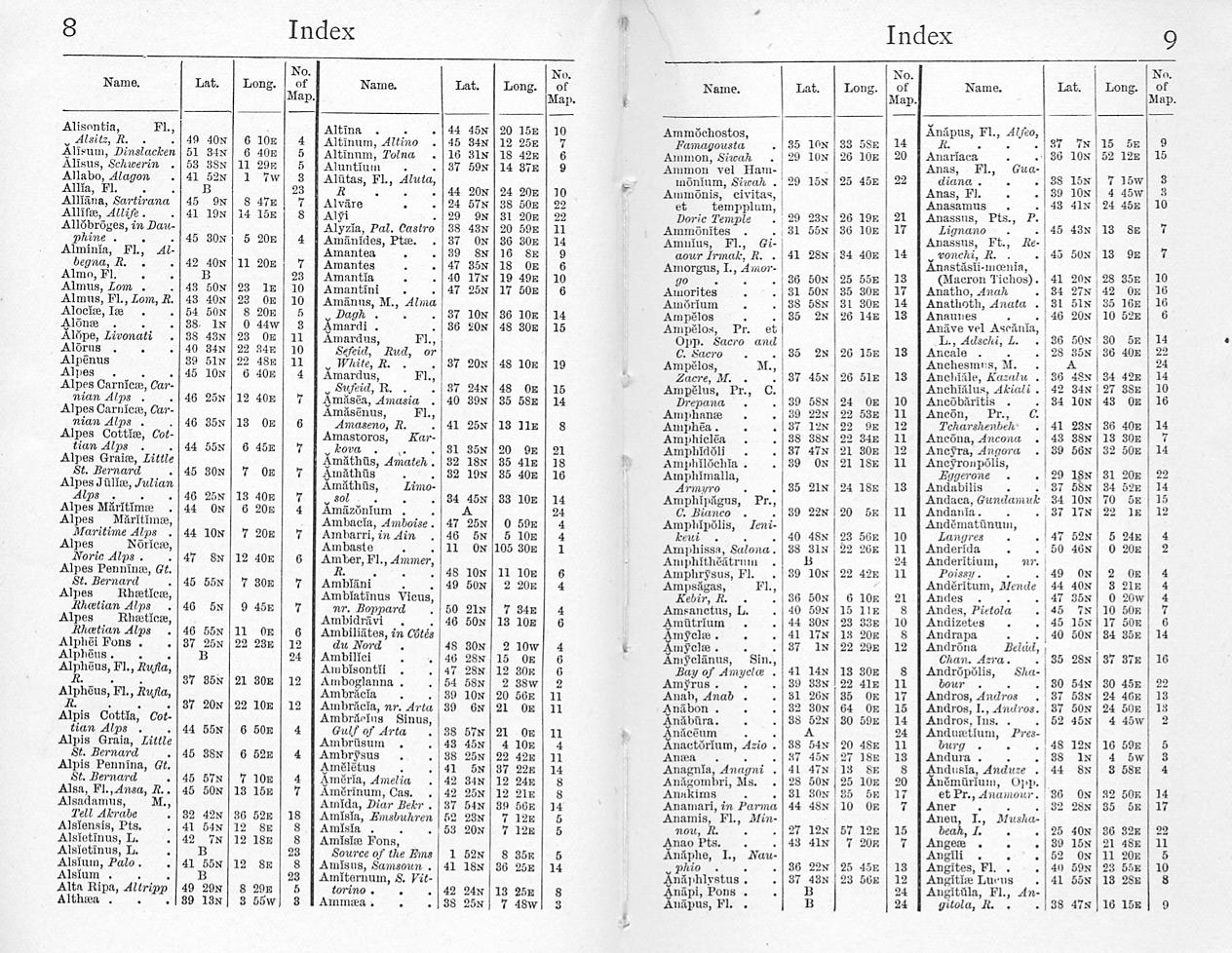
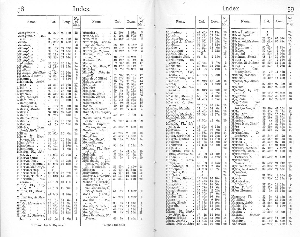
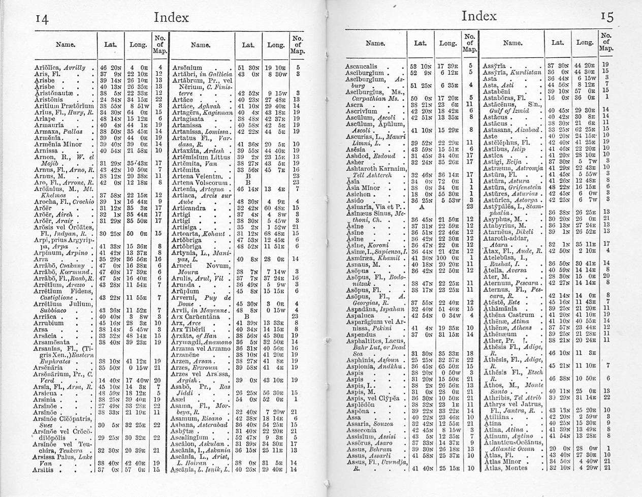
The numbers of the maps given in the Index pages are the same as those in the list in the main body of the Atlas, allowing cross-reference.
The map numbers in the Index pages correspond to those in the list in the main section of the Atlas, making cross-referencing simple.
Note that the Latitude and Longitude given in the Index pages are from Greenwich, while the maps, as common with many of the times, have grids with Longitudes given both from Greenwich and Ferro. If you use the latter you won't find your target.
Remember that the Latitude and Longitude shown on the Index pages are based on Greenwich, while the maps, like many from that time, include grids with Longitudes from both Greenwich and Ferro. If you use the Ferro system, you won't find your target.
INTRODUCTION
THE accompanying Atlas has been included in this series for the greater convenience of the reader of “Grote's Greece” and other works that ask a continual reference to maps of ancient and classical geography. The disadvantage of having to turn perpetually from the text of a volume to a map at its end, or a few pages away, is often enough to prevent the effective use of the one in elucidating the other. Despite some slight variations of spelling in the classical place-names used by different authors, there need be no difficulty in adapting the same Atlas to various works, whether they are English versions of historians like Herodotus or Livy, or English histories of the ancient world, such as Grote's and Gibbon's. Taking the case of Grote, he preferred, as we know, the use of the “K” in Greek names to the usual equivalent “C,” and he retained other special forms of certain words. A comparative list of a few typical names which appear both in the index to his “History of Greece” in this series, and in the index to the present Atlas, will show that the variation between the two is regular and, fairly uniform and easy to remember:
THE accompanying Atlas has been included in this series for the added convenience of anyone reading “Grote's Greece” and other works that require constant reference to maps of ancient and classical geography. The hassle of constantly flipping from the text of a volume to a map at the end or a few pages away can often hinder the effective use of both. Despite some minor spelling differences in the classical place names used by different authors, it should be easy to adapt the same Atlas to various works, whether they are English translations of historians like Herodotus or Livy, or English histories of the ancient world, such as Grote's and Gibbon's. In the case of Grote, he preferred using “K” in Greek names instead of the usual “C,” and he kept other unique forms of certain words. A comparative list of a few typical names that appear in both the index of his “History of Greece” in this series and in the index of the current Atlas will demonstrate that the differences between the two are consistent and fairly uniform, making them easy to remember:
GROTE'S spelling  CLASSICAL ATLAS      GROTE'S SPELLING   CLASSICAL ATLAS

Adrumetum         Hadrumetum           Hydra              Hydrea
Ægean             Ægæan                Iasus              Iassus
Akanthus          Acanthus             Kabala             Cabalia
Akarnania         Acarnania            Nile               Nilus
Akesines          Acesines             Olympieion         Olympieum
Aktê              Acte                 Oneium             Œneum
Chæroneia         Chæronea             Paliké             Palica
Dekeleia          Decelea              Pattala            Patala
Dyrrachium        Dyrrhachium          Peiræum            Piræum
Eetioneia         Eetionea             Phyle              Phylæ
Egypt             Ægyptus              Pisa               Pisæ
Eresus            Eressus              Pylus              Pylos
Erytheia          Erythia              Thessaly           Thessalia
Helus             Helos                Thrace             Thracia
GROTE'S spelling  CLASSICAL ATLAS      GROTE'S SPELLING   CLASSICAL ATLAS

Adrumetum         Hadrumetum           Hydra              Hydrea
Aegean             Aegean                Iasus              Iassus
Acanthus          Acanthus             Kabala             Cabalia
Acarnania         Acarnania            Nile               Nilus
Acesines          Acesines             Olympieion         Olympieum
Acte              Acte                 Oneium             Oneum
Chaaroneia         Chaaronea             Palike             Palica
Dekeleia          Decelea              Pattala            Patala
Dyrrachium        Dyrrhachium          Peiraeum            Peiraeum
Eetioneia         Eetionea             Phyle              Phyla
Egypt             Agyptus              Pisa               Pisa
Eresus            Eressus              Pylus              Pylos
Erytheia          Erythia              Thessaly           Thessalia
Helus             Helos                Thrace             Thracia
By comparing in the same way the place-names in Gibbon's and other histories, the reader will need no glossarist in using the Atlas to lighten their geographical allusions. It is not only when he comes to actual wars, campaigns and sieges that he will find a working chart of advantage. When he reads in Grote of the Ionic colonization of Asia Minor, and wishes to relate the later view of its complex process to the much simpler account given by Herodotus, he gains equally by having a map of the region before him.
By comparing the place names in Gibbon’s and other histories in the same way, readers won’t need a glossary when using the Atlas to clarify the geographical references. It's not just during actual wars, campaigns, and sieges that they will find a helpful map. When reading Grote about the Ionian colonization of Asia Minor and wanting to connect the later, complex view of the process with Herodotus’s much simpler account, having a map of the area in front of them is equally beneficial.
We realize how Grote himself worked over his topographical notes, eking out his own observations with map, scale and compass, when we read his preliminary survey of Greece, in the second volume of his history. “Greece proper lies between the 36th and 40th parallels of north latitude and between the 21st and 26th degrees of east longitude. Its greatest length, from Mount Olympus to Cape Tænarus, may be stated at 250 English miles; its greatest breadth, from the western coast of Akarnania to Marathon in Attica, at 180 miles; and the distance eastward from Ambrakia across Pindus to the Magnesian mountain Homolê and the mouth of the Peneius is about 120 miles. Altogether its area is somewhat less than that of Portugal.” But as to the exact limits of Greece proper, he points out that these limits seem not to have been very precisely defined even among the Greeks themselves.
We see how Grote worked on his topographical notes, supplementing his own observations with maps, scales, and compasses when we look at his preliminary survey of Greece in the second volume of his history. “Greece is located between the 36th and 40th parallels of north latitude and between the 21st and 26th degrees of east longitude. Its longest stretch, from Mount Olympus to Cape Tænarus, is about 250 English miles; its widest point, from the western coast of Akarnania to Marathon in Attica, is about 180 miles; and the distance east from Ambrakia through Pindus to the Magnesian mountain Homolê and the mouth of the Peneius is around 120 miles. Overall, its area is slightly less than that of Portugal.” However, regarding the exact boundaries of Greece, he notes that these limits do not seem to have been well defined even among the Greeks themselves.
The chain called Olympus and the Cambunian mountains, ranging east and west and commencing with the Ægean Sea or the Gulf of Therma near the fortieth degree of north latitude, Grote continues, “is prolonged under the name of Mount Lingon until it touches the Adriatic at the Akrokeraunian promontory. The country south of this chain comprehended all that in ancient times was regarded as Greece or Hellas proper, but it also comprehended something more. Hellas proper (or continuous Hellas, to use the language of Skylax and Dikæarchus) was understood to begin with the town and Gulf of Ambrakia : from thence northward to the Akrokeraunian promontory lay the land called by the Greeks Epirus — occupied by the Chaonians, Molossians, and Thesprotians, who were termed Epirots and were not esteemed to belong to the Hellenic aggregate.”
The chain known as Olympus and the Cambunian mountains, stretching east and west and starting from the Aegean Sea or the Gulf of Therma near the 40th degree of north latitude, continues, according to Grote, under the name of Mount Lingon until it reaches the Adriatic at the Akrokeraunian promontory. The area south of this chain included everything that was considered Greece or Hellas in ancient times, but it also included a bit more. Hellas proper (or continuous Hellas, as Skylax and Dikæarchus referred to it) was thought to start with the town and Gulf of Ambrakia: from there, north to the Akrokeraunian promontory lay the region known to the Greeks as Epirus—home to the Chaonians, Molossians, and Thesprotians, who were called Epirots and were not considered part of the Hellenic collective.
Beside this survey of Hellas proper or continuous Hellas, as Grote presented it, he set the word-map of Italy that Gibbon draws — Italy changing its face under the Roman civilization: “Before the Roman conquest, the country which is now called Lombardy was not considered as a part of Italy. It had been occupied by a powerful colony of Gauls, who, settling themselves along the banks of the Po, from Piedmont to Romagna, carried their arms and diffused their name from the Alps to the Apennine. The Ligurians dwelt on the rocky coast, which now forms the republic of Genoa. Venice was yet unborn; but the territories of that state, which lie to the east of the Adige, were habited by the Venetians. The middle part of the peninsula, that now composes the duchy of Tuscany and the ecclesiastical state, was the ancient seat of the Etruscans and Umbrians; to the former of whom Italy was indebted for the first rudiments of a civilized life. The Tiber rolled at the foot of the seven hills of Rome, and the country of the Sabines, the Latins, and the Volsci, from that river to the frontiers of Naples, was the theatre of her infant victories. On that celebrated ground the first consuls deserved triumphs, their successors adorned villas, and their posterity have erected convents. Capua and Campania possessed the immediate territory of Naples; the rest of the kingdom was inhabited by many warlike nations, the Marsi, the Samnites, the Apulians, and the Lucanians; and the sea-coasts had been covered by the flourishing colonies of the Greeks. We may remark, that when Augustus divided Italy into eleven regions, the little province of Istria was annexed to that seat of Roman sovereignty."
Beside this overview of Greece or continuous Greece, as Grote described it, he included the map of Italy that Gibbon outlines — Italy transforming under Roman civilization: “Before the Roman conquest, the area now called Lombardy wasn’t seen as part of Italy. It had been settled by a strong colony of Gauls, who established themselves along the banks of the Po, from Piedmont to Romagna, spreading their influence and name from the Alps to the Apennines. The Ligurians lived on the rocky coast, which is now the republic of Genoa. Venice had not yet been founded; however, the regions that now belong to that state, located east of the Adige, were inhabited by the Venetians. The central part of the peninsula, which now makes up the duchy of Tuscany and the Papal States, was the ancient homeland of the Etruscans and Umbrians; it was to the former that Italy owed its first steps toward a civilized life. The Tiber flowed at the base of the seven hills of Rome, and the territories of the Sabines, Latins, and Volsci, stretching from that river to the borders of Naples, were the scene of its early victories. On that famous ground, the first consuls earned triumphs, their successors adorned villas, and their descendants have built convents. Capua and Campania comprised the immediate area around Naples; the rest of the kingdom was home to many warrior nations, including the Marsi, Samnites, Apulians, and Lucanians; the coastlines were dotted with thriving Greek colonies. It’s worth noting that when Augustus divided Italy into eleven regions, the small province of Istria was added to that center of Roman power."
As we see by this topical extract, Gibbon's practice in the use of Latin place-names is very much freer than Grote's in the use of the Greek. A few comparative instances from the Atlas will suffice:
As we can see from this relevant excerpt, Gibbon's approach to Latin place names is much more flexible than Grote's approach to Greek. A few comparative examples from the Atlas will be enough:
Gibbon's spelling   Classical Atlas     Gibbon's spelling    Classical Atlas

Antioch             Antiochia           Naples               Neapolis prius
Apennines           Apenninus                                      Parthenope
Dardenellcs         Hellespontus        Osrhoene             Osroene
Ctesiphon           Ctesipon            Thrace               Thracia
Egypt               Ægyptus             Ostia                Ostia
Gau1                Gaula               Cordova              Corduba
Genoa               Genua
Gibbon's spelling   Classical Atlas     Gibbon's spelling    Classical Atlas

Antioch             Antiochia           Naples               Neapolis prius
Apennines           Apenninus                                      Parthenope
Dardenelles         Hellespontus        Osrhoene             Osroene
Ctesiphon           Ctesipon            Thrace               Thracia
Egypt               Ægyptus             Ostia                Ostia
Gaul                Gaula               Cordova              Corduba
Genoa               Genua
Among other works which the present Atlas will help to illustrate, editions of Gibbon's "Decline and Fall of the Roman Empire," and of Merivale's Roman History which leads up to it, are already in preparation; it is hoped to publish in the series also an edition of Herodotus, the father of the recorders of history and geography, who realized almost as well as did Freeman the application of the two records, one to another. The good service of the Classical Atlas, however is not defined by any possible extension of Everyman's Library. The maps of Palestine in the time of our Lord and under the older Jewish dispensation, of Africa and of Egypt, and that, now newly added, of the Migrations of the Barbarians, and the full index, give it the value of a gazetteer in brief of the ancient world, well adapted to come into the general use of schools where an inexpensive work of the kind in compact form has long been needed.
Among other works that this Atlas will help illustrate, editions of Gibbon's "Decline and Fall of the Roman Empire" and Merivale's Roman History, which leads up to it, are already in the works; we also hope to publish an edition of Herodotus, the father of history and geography, who understood the connection between the two records almost as well as Freeman did. However, the true value of the Classical Atlas isn't limited to any potential expansion of Everyman's Library. The maps of Palestine during our Lord's time and under the earlier Jewish dispensation, of Africa and Egypt, as well as the newly added map of the Migrations of the Barbarians and the full index, provide it with the value of a brief gazetteer of the ancient world, making it well-suited for general use in schools where an affordable work of this kind in a compact format has long been needed.
The present Atlas has the advantage of being the result of the successive labour of many hands. Its original author was Dr. Samuel Butler, sometime head-master of Shrewsbury school and afterwards Bishop of Lichfield and Coventry. He edited Aeschylus, and was in his way a famous geographer. The work was at a later date twice revised, and its maps were re-drawn, under the editorship of his son. It has now been again revised and enlarged to suit the special needs of this series.
The current Atlas benefits from the collective effort of many contributors. Its original author was Dr. Samuel Butler, who was once the headmaster of Shrewsbury School and later became the Bishop of Lichfield and Coventry. He edited Aeschylus and was well-known as a geographer in his own right. The work was revised twice later on, with its maps being redrawn under the guidance of his son. It has now been revised and expanded once more to meet the specific needs of this series.
LIST OF MAPS
- ORBIS VETERIBUS NOTUS
- BRITTANNIA
- HISPANIA
- GALLIA
- GERMANIA
- VINDELICIA, RHÆTIA, NORICUM, PANNONIA, ET ILLYRICUM
- ITALÆ PARS SEPTENTRIONALIS
- ITALÆ PARS MEDIA
- ITALÆ PARS MERIDIONALIS
- MACEDONIA, MŒSIA, THRACIA ET DACIA
- GRÆCIA EXTRA PELOPONNESUM
- PELOPONNESUS ET GRÆCIA MERIDIONALIS
- INSULÆ MARIS ÆGÆI
- ASIA MINOR
- ORIENS
- SYRIA, MESOPOTAMIA, ASSYRIA, ETC.
- PALESTINA, TEMPORIBUS JUDICUM ET REGUM
- PALESTINA, CHRISTI ET APOSTOLORUM EJUS TEMPORIBUS
- ARMENIA, COLCHIS, IBERIA, ALBANIA, ETC.
- AFRICA ANTIQUA
- AFRICA SEPTENTRIONALIS
- ÆGYPTUS
- ROMA ET VICINIA ROMA
- ATHENÆ ET SYRACUSÆ
- ORBIS HERODOTI
- ORBIS PTOLEMÆI
- MIGRATIONS OF THE BARBARIANS
Index to the Classical Atlas
Download ePUB
If you like this ebook, consider a donation!