This is a modern-English version of The South of France—East Half, originally written by Black, C. B. (Charles Bertram).
It has been thoroughly updated, including changes to sentence structure, words, spelling,
and grammar—to ensure clarity for contemporary readers, while preserving the original spirit and nuance. If
you click on a paragraph, you will see the original text that we modified, and you can toggle between the two versions.
Scroll to the bottom of this page and you will find a free ePUB download link for this book.
The hotel rating symbols are explained at several random points in the text, though not in the introductory section:
The hotel rating symbols are explained at various random points throughout the text, but not in the introductory section:
“Those with the figure 1 are first-class houses, with 2 second-class. The asterisk signifies that they are especially good of their class.”
“Those with the figure 1 are top-tier houses, with 2 being mid-tier. The asterisk indicates that they are especially good for their category.”
A few typographical errors have been corrected. They are shown in the text with mouse-hover popups. Missing “from” or “to” mileage numbers have not been individually noted.
A few typographical errors have been fixed. They're indicated in the text with mouse-hover popups. Missing “from” or “to” mileage numbers have not been individually mentioned.

SOUTH OF FRANCE
EAST HALF
GUIDES BY C. B. BLACK.
SPAS of CHELTENHAM and BATH, with Maps and Plan of Bath. 1s.
Spas of Cheltenham and Bath, with Maps and Plan of Bathroom. 1s.
TOURIST’S CAR GUIDE in the pleasant Islands of JERSEY, GUERNSEY, ALDERNEY and SARK. Illustrated with 6 Maps and Plan of the Town of Saint Helier. Second edition. 1s.
TOURIST’S CAR GUIDE in the beautiful Islands of Jersey, Guernsey, Alderney, and Sark. Illustrated with 6 Maps and a Plan of the Town of Saint Helier. Second edition. 1s.
CORSICA, with large Map of the Island. 1s.
CORSICA, with a large map of the island. 1s.
BELGIUM, including Rotterdam, Flushing, Middelburg, Schiedam and Luxembourg. Illustrated by 10 Plans and 5 Maps. 2s. 6d.
BELGIUM, including Rotterdam, Vlissingen, Middelburg, Schiedam and Luxembourg. Illustrated by 10 plans and 5 maps. 2s. 6d.
NORTH FRANCE, LORRAINE AND ALSACE, including the Mineral Waters of Contrexéville, Vittel, Martigny, Plombières, Luxeuil, Aix-la-chapelle, etc. Illustrated with 5 Maps and 7 Plans. Third Edition. 2s. 6d.
NORTH FRANCE, LORRAINE AND ALSACE, including the Mineral Waters of Contrexéville, Vittel, Martigny, Plombières, Luxeuil, Aix-la-Chapelle, etc. Illustrated with 5 Maps and 7 Plans. Third Edition. £2.50.
TOURAINE, NORMANDY AND BRITTANY. Illustrated with 14 Maps and 15 Plans. Eighth edition. 5s.
TOURAINE, NORMANDY AND BRITTANY. Illustrated with 14 Maps and 15 Plans. Eighth edition. 5s.
The above two contain the North Half of France; or France from the Loire to the North Sea and from the Bay of Biscay to the Rhine.
The above two contain the North Half of France; or France from the Loire to the North Sea and from the Bay of Biscay to the Rhine.
THE RIVIERA, or the coast of the Mediterranean from Marseilles to Leghorn, including Lucca, Pisa and Florence. Illustrated with 8 Maps and 6 Plans. Second edition. 2s. 6d.
THE RIVIERA, or the Mediterranean coast from Marseille to Leghorn chicken, including Lucca, Pisa, and Florence. Illustrated with 8 Maps and 6 Plans. Second edition. 2s. 6d.
FRANCE—South-East Half—including the whole of the Valley of the Rhône in France, with the adjacent Departments; the Valley of the Upper Loire, with the adjacent Departments; the Riviera; the Passes between France and Italy; and the Italian towns of Turin, Piacenza, Modena, Bologna, Florence, Leghorn and Pisa. Illustrated with numerous Maps and Plans. Fourth edition. 5s.
FRANCE—Southeast Half—including all of the Rhône Valley in France, along with the neighboring Departments; the Upper Loire Valley, with the neighboring Departments; the Riviera; the Passes between France and Italy; and the Italian cities of Turin, Piacenza, Modena, Bologna, Florence, Livorno and Pisa. Illustrated with numerous Maps and Plans. Fourth edition. 5s.
From “Scotsman,” June 2, 1884.
“C. B. Black’s Guide-books have a character of their own; and that character is a good one. Their author has made himself personally acquainted with the localities with which he deals in a manner in which only a man of leisure, a lover of travel, and an intelligent observer of Continental life could afford to do. He does not ‘get up’ the places as a mere hack guide-book writer is often, by the necessity of the case, compelled to do. Hence he is able to correct common mistakes, and to supply information on minute points of much interest apt to be overlooked by the hurried observer.”
C. B. Black’s guidebooks have a unique quality, and that quality is a positive one. The author has personally explored the places he writes about in a way that only someone with free time, a passion for travel, and an insightful understanding of European life can manage. He doesn’t just compile information like many standard guidebook writers often have to. Because of this, he can clear up common misconceptions and provide detailed information on interesting aspects that are likely to be missed by someone in a hurry.
THE
SOUTH OF FRANCE
EAST HALF
INCLUDING THE VALLEYS OF
THE RHÔNE, DRÔME AND DURANCE
the BATHS of
VICHY, ROYAT, AIX, MONT-DORE AND BOURBOULE
THE WHOLE OF THE
RIVIERA FROM CETTE TO LEGHORN
WITH THE INLAND TOWNS OF
TURIN, BOLOGNA, PARMA, FLORENCE AND PISA
AND
THE PASSES BETWEEN FRANCE AND ITALY
Illustrated with Maps and Plans
FOURTH EDITION
C. B. BLACK
EDINBURGH: ADAM AND CHARLES BLACK
1885
Printed by R. & R. Clark, Edinburgh.
PREFACE.
This Guide-book consists of Routes which follow the course of the main Railways. To adapt these Routes as far as possible to the requirements of every one the Branch Lines are also pointed out, together with the stations from which the Coaches run, in connection with the trains, to towns distant from the railway. The description of the places on these branch lines is printed either in a closer or in a smaller letter than that of the towns on the main lines.
This guidebook consists of Routes that follow the paths of the main railways. To make these routes as useful as possible for everyone, the branch lines are also highlighted, along with the stations where coaches connect with trains to towns that are far from the railway. The descriptions of the locations on these branch lines are printed in either a smaller or a more condensed font than that of the towns on the main lines.
Each Route has the Map indicated on which it is to be found. By aid of these maps the traveller can easily discover his exact situation, and either form new routes for himself, or follow those given.
Each Route has the Map shown where it can be found. With these maps, travelers can easily find their exact location and either create new routes for themselves or follow the ones provided.
The Arrangement of the Routes is such that they may be taken either from the commencement to the end, or from the end to the commencement. The Route from Paris to Marseilles, for example, does equally well for Marseilles to Paris.
The Arrangement of the Routes is designed so that they can be traveled from start to finish or from finish to start. The Route from Paris to Marseilles, for instance, works just as well for Marseilles to Paris.
The Distance of towns from the place of starting to the terminus is expressed by the figures which accompany them on each side of the margin; while the distance of any two towns on the same route from each other is found by subtracting their marginal figures on either side from each other.
The Distance between towns from the starting point to the destination is shown by the numbers next to them on each side of the margin. To find the distance between any two towns on the same route, you subtract their margin numbers from each other.
In the Description of towns the places of interest have been taken in the order of their position, so that, if a cab be engaged, all that is necessary is to mention to the driver their names in succession. Cabs on such occasions should be hired by the hour. To guard against omission, the traveller should underline the names of the places to be visited before commencing the round. In France the Churches are open all the day. In Italy they close at 12; but most of them reopen at 2 P.M. All the vi Picture-Galleries are open on Sundays, and very many also on Thursdays. When not open to the public, admission is generally granted on payment of a franc.
In the Description of towns, the points of interest are listed in the order of their location, so if you hire a cab, you just need to tell the driver their names one after the other. Cabs for these trips should be booked by the hour. To avoid missing anything, travelers should highlight the names of the places they want to visit before starting the tour. In France, churches are open all day. In Italy, they close at 12 but most of them reopen at 2 PM All the vi Picture Galleries are open on Sundays, and many are also open on Thursdays. When they are not open to the public, you can usually get in by paying a franc.
In “Table of Contents” the Routes are classified and explained. For the Time-tables recommended, and for the mode of procedure on the Continental Railways, see “Preliminary Information.”
In the “Table of Contents,” the routes are categorized and described. For the recommended schedules and procedures for Continental Railways, refer to “Preliminary Information.”
Before commencing our description of the Winter Resorts on the Mediterranean, with the best routes towards them, let it be clearly understood that not even in the very mildest of these stations is it safe for the invalid to venture out either in the early morning or after sunset without being well protected with warm clothing; and that, even with this precaution, the risk run of counteracting the beneficial influences of a sojourn in these regions is so great as to render it prudent to determine from the first to spend those hours always within doors. On the other hand, it is most conducive to health, during the sunny hours of the day, to remain as much as possible in the open air, walking and driving along the many beautiful terraces and roads with which these places abound; and if the day be well employed in such exercise, it will be no great hardship to rest at home in the evening. Nor is it necessary to remain in the same town during the entire season; indeed a change of scene is generally most beneficial, for which the railway as well as the steamers affords every facility. “I would strongly advise every person who goes abroad for the recovery of his health, whatever may be his disease or to what climate soever he may go, to consider the change as placing him merely in a more favourable situation for the removal of his disease; in fact, to bear constantly in mind that the beneficial influence of travelling, of sailing, and of climate requires to be aided by such dietetic regimen and general mode of living, and by such remedial measures as would have been requisite in his case had he remained in his own country. All the circumstances requiring attention from the invalid at home should be equally attended to abroad. If in some things greater latitude may be permitted, others will demand vii even a more rigid attention. It is, in truth, only by a due regard to all these circumstances that the powers of the constitution can be enabled to throw off, or even materially mitigate, in the best climate, a disease of long standing.
Before we start describing the Winter Resorts on the Mediterranean and the best routes to get there, it’s important to understand that even in the mildest locations, it’s not safe for anyone with health issues to go outside early in the morning or after sunset without warm clothing. Even with this precaution, the risk of negating the health benefits of staying in these areas is significant, so it’s wise to stay indoors during those times. Conversely, it’s very beneficial for health to spend as much time as possible outdoors during sunny hours, walking and driving along the many beautiful terraces and roads these places offer. If you make good use of your day with such activities, it won’t be too difficult to relax at home in the evening. There's also no need to stay in the same town for the entire season; in fact, changing your scenery is usually very helpful, and both the train and ferries provide excellent options for travel. “I strongly recommend that anyone traveling abroad to recover their health, regardless of their illness or destination, view the change as merely providing a better environment for addressing their health issue; essentially, it’s crucial to remember that the positive effects of traveling, sailing, and climate need to be supported by a proper diet and lifestyle, along with necessary treatments just as they would at home. All considerations for the individual’s health at home should be equally prioritized abroad. While some things may offer more flexibility, others will require even stricter adherence. It’s truly only by paying attention to these factors that the body can effectively overcome or significantly reduce a long-standing illness, even in the best climate.”
“It may appear strange that I should think it requisite to insist so strongly on the necessity of attention to these directions; but I have witnessed the injurious effects of a neglect of them too often not to deem such remarks called for in this place. It was, indeed, matter of surprise to me, during my residence abroad, to observe the manner in which many invalids seemed to lose sight of the object for which they left their own country—the recovery of their health. This appeared to arise chiefly from too much being expected from climate.
“It might seem odd that I feel the need to emphasize the importance of following these guidelines, but I have seen too many harmful results from ignoring them to think these comments aren’t necessary here. While living abroad, I was truly surprised to see how many patients seemed to forget the reason they left their home country—their health recovery. This seemed to mostly stem from unrealistic expectations about climate.”
“The more common and more injurious deviations from that system of living which an invalid ought to adopt, consist in errors of diet, exposure to cold, over-fatigue, and excitement in what is called ‘sight-seeing,’ frequenting crowded and over-heated rooms, and keeping late hours. Many cases fell under my observation in which climate promised the greatest advantage, but where its beneficial influence was counteracted by the operation of these causes.” —Sir James Clark on the Sanative Influence of Climate.
“The more common and harmful deviations from the way of living that someone with health issues should follow include poor diet, exposure to cold, too much fatigue, and excitement from what’s known as ‘sight-seeing,’ hanging out in crowded, overheated places, and staying up late. I observed many cases where the climate offered significant benefits, but those advantages were negated by these factors.” —Sir James Clark on the Sanative Influence of Climate.
SEE MAP PAGE 27, AND MAP ON FLY-LEAF.
Many after leaving the Riviera are the better of making a short stay at some of the baths, such as Vichy (p. 359), Vals (p. 93), Mont-Dore (p. 378), Bourboule (p. 383), Aix-les-Bains (p. 283), Bourbon-l’Archambault (p. 357), or Bourbon-Lancy (p. 358). If at the eastern end of the Riviera, the nearest way to them is by rail from Savona (pp. 209 and 183), or from Genoa (pp. 212 and 279) to Turin (p. 292). From Turin a short branch line extends to Torre-Pèllice (p. 305), situated in one of the most beautiful of the Waldensian valleys.
Many people find it beneficial to take a short break at some of the baths after leaving the Riviera, such as Vichy (p. 359), Vals (p. 93), Mont-Dore (p. 378), Bourboule (p. 383), Aix-les-Bains (p. 283), Bourbon-l’Archambault (p. 357), or Bourbon-Lancy (p. 358). If you're at the eastern end of the Riviera, the easiest way to reach them is by train from Savona (pp. 209 and 183), or from Genoa (pp. 212 and 279) to Turin (p. 292). From Turin, a short branch line goes to Torre-Pèllice (p. 305), located in one of the most beautiful Waldensian valleys.
If the journey from Turin to Aix-les-Bains, 128 miles, be too long, a halt may be made for the night at Modane (p. 290); where, however, on account of the elevation, 3445 ft., the air is generally rather sharp and bracing.
If the trip from Turin to Aix-les-Bains, 128 miles, is too long, you can stop for the night at Modane (p. 290); however, due to the elevation of 3445 ft., the air is usually quite cool and refreshing.
From the western end of the Riviera the best way north and to the baths is by the valley of the Rhône (map, p. 27), in which there are many places of great interest, such as Arles (p. 68), Avignon (p. 58), Orange (p. 51), and Lyons (p. 29). From Lyons take the western branch by Montbrison (p. 349) for Vichy, Mont-Dore, and Bourboule. For Aix-les-Bains take the eastern by Ambérieux (p. 281) and Culoz (p. 282). From Avignon, Carpentras (p. 54), Pont-St. Esprit (p. 98), Montélimart (p. 48), La Voulte (p. 82), Crest (p. 46) and Grenoble (p. 324), interesting and picturesque excursions are made. From Carpentras Mont Ventoux (p. 56) is visited. From La Voulte, Ardechè (p. 45) is entered. From Crest diligences run to the towns and villages between it and Aspres (pp. 47 and 345). From Grenoble the roads and railways diverge which lead to the lofty peaks of the western Alps and to the mountain passes between France and Italy.
From the western end of the Riviera, the best way to head north and reach the baths is through the Rhône Valley (map, p. 27), which has many fascinating places to visit, like Arles (p. 68), Avignon (p. 58), Orange (p. 51), and Lyons (p. 29). From Lyons, take the western route via Montbrison (p. 349) to Vichy, Mont-Dore, and Bourboule. To get to Aix-les-Bains, take the eastern route through Ambérieux (p. 281) and Culoz (p. 282). From Avignon, you can explore Carpentras (p. 54), Pont-St. Esprit (p. 98), Montélimart (p. 48), La Voulte (p. 82), Crest (p. 46), and Grenoble (p. 324) for some interesting and picturesque excursions. From Carpentras, you can visit Mont Ventoux (p. 56). From La Voulte, you can enter Ardechè (p. 45). From Crest, stagecoaches run to the towns and villages between it and Aspres (pp. 47 and 345). From Grenoble, the roads and railways branch out towards the high peaks of the western Alps and the mountain passes connecting France and Italy.
None should go abroad without a passport. Even where several are travelling together in one party, each should have his own passport. They are easily procured and easily carried, and may be of great use.
None should travel abroad without a passport. Even if several people are traveling together as a group, each should have their own passport. They are easy to obtain and convenient to carry, and they can be very helpful.
The best hotels in the places frequented by the Americans and English cost per day from 12 to 22 frs., and the pensions from 9 to 15 frs., including wine (often sour) in both. The general charge in the hotels of the other towns throughout France is from 8 to 9 frs. per day. Meat breakfast, 2 to 3 frs.; dinner, 3 to 4 frs.; service, ½ fr.; “café au lait,” with bread and butter, 1½ fr. The omnibus between the hotel and the station costs each from 6 to 10 sous. The driver in most cases loads and unloads the luggage himself at the station, when he expects a small gratuity from 2 to 10 sous, according to the quantity of bags and trunks. The omnibuses of the Riviera hotels cost from 1½ to 2 frs. each, and although the conductor does not unload the luggage he expects a gratuity.
The best hotels in popular spots for Americans and Brits charge between 12 and 22 francs per day, while pensions range from 9 to 15 francs, which includes wine (often sour) in both. The average price in hotels across other towns in France is about 8 to 9 francs per day. A meat breakfast costs 2 to 3 francs; dinner ranges from 3 to 4 francs; service is ½ franc; and a “café au lait” with bread and butter is 1½ francs. The bus between the hotel and the station costs between 6 and 10 sous each. In most cases, the driver handles the luggage at the station and expects a small tip of 2 to 10 sous, depending on the number of bags and trunks. The buses for hotels on the Riviera charge between 1½ and 2 francs each, and while the conductor doesn't handle the luggage, a tip is still expected.
Neither jewellery nor money should be carried in portmanteaus. When a stay of merely a day or two is intended, the bulky and heavy luggage should be left in depôt at the station. Some companies charge 1, others 2 sous for each article (colis) per day. See “Railways” in “Preliminary Information.”
Neither jewelry nor money should be carried in suitcases. When only a short stay of a day or two is planned, the large and heavy luggage should be left in storage at the station. Some companies charge 1, others 2 sous for each item (colis) per day. See “Railways” in “Preliminary Information.”
C. B. B.
C. B. B.
PRELIMINARY INFORMATION.
THE LANDING-PLACES ON THE FRENCH SIDE
OF THE CHANNEL.
The six principal ports on the French side of the English Channel connected by railroad with Paris are:—
The six main ports on the French side of the English Channel, linked by train to Paris, are:—
Dieppe—distant from Paris 125 miles; passing Clères Junction, 100 m.; Rouen, 85 m.; Gaillon, 58 m.; Mantes Junction, 36 m.; and Poissy, 17 m. from Paris. Arrives at the station of the Chemins de Fer de l’Ouest, Saint Lazare. Time, 4½ hours. Fares—1st class, 25 frs.; 2d cl. 19 frs.; 3d cl. 14 frs.
Dieppe—125 miles from Paris; passing Clères Junction, 100 miles; Rouen, 85 miles; Gaillon, 58 miles; Mantes Junction, 36 miles; and Poissy, 17 miles from Paris. Arrives at the Chemins de Fer de l’Ouest station, Saint Lazare. Time, 4½ hours. Fares—1st class, 25 frs.; 2nd class, 19 frs.; 3rd class, 14 frs.
London to Paris via Newhaven and Dieppe (240 miles):—tidal; daily, except Sunday, from Victoria Station and London Bridge Station. Fare—1st class, 31s.; 2d cl. 23s.; 3d cl. 16s. 6d. Sea journey, 60 miles; time, 8 hours. Time for entire journey, 16 hours. For tickets, etc., in Paris apply to Chemin de Fer de l’Ouest, Gare St. Lazare, Rue St. Lazare 110, ancien 124. Bureau spécial, agent, M. Marcillet, Rue de la Paix, 7. A. Collin et Cie, 20 Boulevard Saint Denis.
London to Paris via Newhaven and Dieppe (240 miles):—tidal; daily, except Sunday, from Victoria Station and London Bridge Station. Fare—1st class, £3.10; 2nd class, £2.3; 3rd class, £0.16. Sea journey, 60 miles; time, 8 hours. Total journey time, 16 hours. For tickets, etc., in Paris, contact Chemin de Fer de l’Ouest, Gare St. Lazare, 110 Rue St. Lazare, formerly 124. Special office, agent, M. Marcillet, 7 Rue de la Paix. A. Collin et Cie, 20 Boulevard Saint Denis.
From Dieppe another line goes to Paris by Arques, Neufchâtel, Serqueux, Forges-les-Eaux, Gournay, Gisors, and Pontoise. Distance, 105 miles. Time by ordinary trains, 5 hours 10 minutes. Fares—1st class, 21 frs.; 2d, 15½ frs.; 3d, 11¼ frs. Arrives at the St. Lazare station of the Chemins de Fer de l’Ouest.
From Dieppe, another route goes to Paris via Arques, Neufchâtel, Serqueux, Forges-les-Eaux, Gournay, Gisors, and Pontoise. Distance: 105 miles. Time on regular trains: 5 hours and 10 minutes. Fares—1st class: 21 francs; 2nd class: 15½ francs; 3rd class: 11¼ francs. Arrives at the St. Lazare station of the Chemins de Fer de l’Ouest.
From Tréport a railway extends to Paris by Eu, Gamaches, Aumale, Abancourt, Beauvais, and Creil. Distance, 119¼ miles. Time, 8 hours 40 minutes. Fares, 1st class, 24 frs.; 2d, 18 frs.; 3d, 13 frs. Arrives at the station of the Chemin de Fer du Nord. There are few through trains by this line.
From Tréport, there’s a train line to Paris that goes through Eu, Gamaches, Aumale, Abancourt, Beauvais, and Creil. The distance is 119¼ miles and takes about 8 hours and 40 minutes. Ticket prices are 24 francs for first class, 18 francs for second class, and 13 francs for third class. It arrives at the Chemin de Fer du Nord station. There aren’t many direct trains on this route.
BOULOGNE—distant 158 miles from Paris; passing Montreuil, 134 m.; Abbeville, 109 m.; Amiens, 82 m.; Clermont, 41 m.; and Creil, 32 m. from Paris. Arrives at the station of the Chemin de Fer du Nord, No. 18 Place Roubaix. Time by express, 4½ hours. Fares—1st class, 31 frs. 25 c.; 2d cl. 23 frs. 45 c.; 3d cl. 17 frs. 20 c.
BOULOGNE—158 miles from Paris; passing Montreuil, 134 miles; Abbeville, 109 miles; Amiens, 82 miles; Clermont, 41 miles; and Creil, 32 miles from Paris. Arrives at the Chemin de Fer du Nord station, No. 18 Place Roubaix. Travel time by express is 4½ hours. Fares—1st class, 31.25 francs; 2nd class, 23.45 francs; 3rd class, 17.20 francs.
London to Paris, via, Folkestone and Boulogne (255 miles):—tidal route; from Charing Cross, Cannon Street, or London Bridge. Express trains daily to Folkestone, and from Boulogne, first and second class. Sea journey, 27 miles; time of crossing, 1 hour 40 minutes. Fares from London to Paris by Boulogne—1st class, 56s.; 2d cl. 42s. Time for the entire journey, 10 hours. For tickets, etc., in Paris apply to the railway station of the Chemin de Fer du Nord.
London to Paris, via Folkestone and Boulogne (255 miles):—tidal route; from Charing Cross, Cannon Street, or London Bridge. Express trains run daily to Folkestone, and from Boulogne, available in first and second class. Sea journey is 27 miles; crossing takes 1 hour and 40 minutes. Fares from London to Paris by Boulogne—1st class, £2.80; 2nd class, £2.10. Total travel time for the journey is 10 hours. For tickets and information in Paris, go to the Chemin de Fer du Nord railway station.
CALAIS—185 miles from Paris; by Boulogne, 158 m.; Montreuil, 134 m.; Abbeville, 109 m.; Amiens, 82 m.; Clermont, 41 m.; and Creil, 32 m. from Paris. Arrives at the station of the Chemin de Fer du Nord, No. 18 Place Roubaix. Time by express, 5½ hours. Fares—1st class, 36 frs. 55 c.; 2d cl. 27 frs. 40 c.
CALAIS—185 miles from Paris; via Boulogne, 158 m.; Montreuil, 134 m.; Abbeville, 109 m.; Amiens, 82 m.; Clermont, 41 m.; and Creil, 32 m. from Paris. Arrives at the station of the Chemin de Fer du Nord, No. 18 Place Roubaix. Time by express, 5½ hours. Fares—1st class, 36 frs. 55 c.; 2nd class, 27 frs. 40 c.
London to Paris, via Dover and Calais (mail route, distance 283 miles);—departing from Charing Cross, Cannon Street, or London Bridge. Sea journey, 21 miles; time about 80 minutes. First and second class, express. Fares—60s.; 2d cl. 45s. Total time, London to Paris, 10 hours. Luggage is registered throughout from London, and examined in Paris. Only 60 lbs. free. For tickets, etc., in Paris apply at the railway station of the Chemins de Fer du Nord.
London to Paris, via Dover and Calais (mail route, distance 283 miles);—departing from Charing Cross, Cannon Street, or London Bridge. Sea journey, 21 miles; time around 80 minutes. First and second class, express. Fares—£3; 2nd class £2. Total time from London to Paris is 10 hours. Luggage is checked through from London and inspected in Paris. Only 60 lbs. are allowed for free. For tickets, etc., in Paris, go to the railway station of the Chemins de Fer du Nord.
CALAIS—204 miles from Paris; by Saint Omer, 177 m.; Hazebrouck, 165 m.; Arras, 119 m.; Amiens, 82 m.; Clermont, 41 m.; and Creil, 32 m. Arrives at the station, No. 18 Place Roubaix. Time, 7 hours 40 minutes. Fares—1st class, 36 frs. 55 c.; 2d cl. 27 frs. 40 c.; 3d cl. 20 frs. 10 c.
CALAIS—204 miles from Paris; via Saint Omer, 177 m.; Hazebrouck, 165 m.; Arras, 119 m.; Amiens, 82 m.; Clermont, 41 m.; and Creil, 32 m. Arrives at the station, No. 18 Place Roubaix. Time: 7 hours 40 minutes. Fares—1st class, 36 frs. 55 c.; 2nd class, 27 frs. 40 c.; 3rd class, 20 frs. 10 c.
DUNKERQUE—190 miles from Paris; by Bergues, 185 miles; Hazebrouck, 165 m., where it joins the line from Calais; Arras, 119 m.; Amiens, 81 m.; Clermont, 41 m.; and Creil, 32 m. Arrives at the station, No. 18 Place Roubaix. Time, 10½ hours. Fares—1st class, 37 frs. 55 c.; 2d cl. 28 frs. 15 c.
DUNKIRK—190 miles from Paris; via Bergues, 185 miles; Hazebrouck, 165 miles, where it connects with the line from Calais; Arras, 119 miles; Amiens, 81 miles; Clermont, 41 miles; and Creil, 32 miles. Arrives at the station, No. 18 Place Roubaix. Time: 10½ hours. Fares—1st class, 37 fr. 55 c.; 2nd class, 28 fr. 15 c.
England and Channel, via Thames and Dunkirk (screw):—tidal; three times a week from Fenning’s Wharf. Also from Leith, in 48 to 54 hours.
England and Channel, via Thames and Dunkirk (screw):—tidal; three times a week from Fenning’s Wharf. Also from Leith, in 48 to 54 hours.
LE HAVRE—142 miles from Paris; by Harfleur, 138 m.; Beuzeville Junction, 126 miles; Bolbec-Nointot, 123 m.; Yvetot, 111 m.; Rouen, 87 m.; Gaillon, 58 m.; Mantes Junction, 36 m.; and Poissy, 17 m. from Paris. Arrives, as from Dieppe and Cherbourg, at the station of the Chemin de Fer de l’Ouest, No. 124 Rue St. Lazare. Fares—1st class, 28 frs. 10 c.; 2d cl. 21 frs. 5 c.; 3d cl. 15 frs. 45 c. Time by express, 4 hours 50 minutes, and nearly 3 hours longer by the ordinary trains.
LE HAVRE—142 miles from Paris; via Harfleur, 138 miles; Beuzeville Junction, 126 miles; Bolbec-Nointot, 123 miles; Yvetot, 111 miles; Rouen, 87 miles; Gaillon, 58 miles; Mantes Junction, 36 miles; and Poissy, 17 miles from Paris. Arrives, like from Dieppe and Cherbourg, at the Chemin de Fer de l’Ouest station, No. 124 Rue St. Lazare. Fares—1st class, 28 frs. 10 c.; 2nd class, 21 frs. 5 c.; 3rd class, 15 frs. 45 c. Travel time by express is 4 hours 50 minutes, and nearly 3 hours longer on regular trains.
London and Channel, via Southampton and Le Havre:—Monday, Wednesday, and Friday, 9 P.M. from Waterloo Station, leaving Southampton 11.45 P.M. Sea journey, 80 m.; time, 8 hours.
London and Channel, via Southampton and Le Havre:—Monday, Wednesday, and Friday, 9 PM from Waterloo Station, leaving Southampton at 11:45 PM. Sea journey, 80 m.; time, 8 hours.
CHERBOURG—231 miles from Paris; by Lison, 184 m.; Bayeux, 167 m.; Caen, 149 m.; Mezidon Junction, 134 m.; Lisieux, 119 m.; Serquigny Junction, 93 m.; Evreux, 67 m.; Mantes Junction, 36 m.; and Poissy, 17 m. from Paris. Time by express, 8½ hours; slow trains, nearly 13 hours.
CHERBOURG—231 miles from Paris; via Lison, 184 m.; Bayeux, 167 m.; Caen, 149 m.; Mezidon Junction, 134 m.; Lisieux, 119 m.; Serquigny Junction, 93 m.; Evreux, 67 m.; Mantes Junction, 36 m.; and Poissy, 17 m. from Paris. Time by express, 8½ hours; slower trains take nearly 13 hours.
FRENCH, BELGIAN, AND GERMAN RAILWAYS.
On these railways the rate of travelling is slower than in England, but the time is more accurately kept.
On these railways, the travel speed is slower than in England, but the schedules are more reliable.
To each passenger is allowed 30 kilogrammes, or 66 lbs. weight of luggage free.
Each passenger is allowed 30 kilograms, or 66 lbs, of luggage for free.
Railway Time-Tables.
Time-tables or Indicateurs. For France the most useful and only official time-tables are those published by Chaix and Cie, and sold at all the railway stations. Of these excellent publications there are various kinds. The most complete and most expensive is the “Livret-Chaix Continental,” which, besides the time-tables of the French railways, gives those also of the whole Continent, and is furnished with a complete index; size 18mo, with about 800 pages. The “Livret-Chaix Continental” is sold at the station bookstalls. Price 2 frs.
Time tables or Indicators. In France, the most useful and only official time tables are published by Chaix and Cie, available at all railway stations. These excellent publications come in various types. The most comprehensive and expensive is the “Livret-Chaix Continental,” which not only includes the time tables of French railways but also those from across the entire continent, complete with an index; it's 18mo in size and has about 800 pages. The “Livret-Chaix Continental” can be found at station bookstores. Price: 2 frs.
Next in importance is the “Indicateur des Chemins de Fer,” sold at every station; size 128 small folio pages, price 60 c. It contains the time-tables of the French railways alone, and an index and railway map.
Next in importance is the “Indicateur des Chemins de Fer,” available at every station; size 128 small folio pages, price 60 c. It includes the time tables for the French railways, along with an index and a railway map.
The great French lines of the “Chemins de Fer de l’Ouest,” of the “Chemins de Fer d’Orleans,” of the “Chemins de Fer de Paris à Lyon et à la Méditerranée,” of the “Chemins de Fer du Nord,” and of the “Chemins de Fer de l’Est,” have each time-tables of their own, sold at all their stations. Price 40 c. Size 18me. With good index.
The major French railways, including the “Chemins de Fer de l’Ouest,” “Chemins de Fer d’Orleans,” “Chemins de Fer de Paris à Lyon et à la Méditerranée,” “Chemins de Fer du Nord,” and “Chemins de Fer de l’Est,” each have their own timetables available for sale at all their stations. Price 40 c. Size 18me. Includes a good index.
For Belgium, the best time-tables are in the “Guide Officiel sur tous les Chemins de Fer de Belgique.” Sold at the Belgian railway stations. Size 18me. Price 30 c. It contains a good railway map of Belgium.
For Belgium, the best schedules are in the “Official Guide to All Railways in Belgium.” Available at Belgian train stations. Size 18me. Price 30 cents. It includes a detailed railway map of Belgium.
For Italy, use “L’Indicatore Ufficiale delle Strade Ferrate d’Italia.” Containing excellent maps illustrating their circular tours. Price 1 fr.
For Italy, use “L’Indicatore Ufficiale delle Strade Ferrate d’Italia.” It has great maps showing their circular routes. Price 1 fr.
In Spain use the “Indicador de los Ferro-Carriles,” sold at the stations. The distances are, as in the French tables, in kilometres, of which 8 make 5 miles. Lleg. or Llegada means “arrival”; Salida, “departure.”
In Spain, use the “Indicador de los Ferro-Carriles,” available at the stations. The distances are measured in kilometers, just like in the French tables, where 8 kilometers equal 5 miles. Lleg. or Llegada means “arrival”; Salida means “departure.”
In England consult the “Continental Time-tables of the London, Chatham, and Dover Railway,” sold at the Victoria Station, Pimlico, price 2d.; or those of the London and South-Eastern, 1d.
In England, check the “Continental Time-tables of the London, Chatham, and Dover Railway,” available at Victoria Station, Pimlico, for 2d.; or the ones from the London and South-Eastern, for 1d.
In the Railway Station.
Before going to the station, it is a good plan to turn up in the index of the “Livret-Chaix Continental” the place required, to ascertain the fare and the time of starting, which stations are supplied with refreshment rooms (marked B), and the time the train halts at each on its way.
Before heading to the station, it's a good idea to check the index of the “Livret-Chaix Continental” for the needed location, to find out the fare and departure time, which stations have refreshment rooms (marked B), and how long the train stops at each one along the route.
On arriving at the station join the single file (queue) of people before the small window (guichet), where the tickets (billets) are sold. Your turn having arrived, and having procured your ticket, proceed to the luggage department, where deposit your baggage and deliver your ticket to be stamped. The luggage tickets are called also “bulletins.”
On arriving at the station, get in line at the small ticket window where tickets are sold. When it’s your turn and you’ve bought your ticket, head to the luggage department to drop off your bags and hand over your ticket to get it stamped. The luggage tickets are also referred to as “bulletins.”
After your articles have been weighed, your ticket, along with a luggage receipt, is handed you from the “guichet” of the luggage office, where, if your baggage is not overweight, you pay 10 c. or 2 sous. Before pocketing the luggage ticket, just run your eye down the column headed “Nombre de Colis,” and see that the exact number of your articles has been given. The French have a strange way of making the figures 3, 5, xii and 7. Whatever is overweight is paid for at this office; but remember, when two or more are travelling together, to present the tickets of the whole party at the luggage department, otherwise the luggage will be treated as belonging to one person, and thus it will probably be overweight. Another advantage of having the entire number of the party on the “Billet de Bagage” is that, in case of one or other losing their carriage tickets, this will prove the accident to the stationmaster (chef-de-Gare) and satisfy him. If, after having purchased a ticket, the train is missed, that ticket, to be available for the next train, must be presented again to the ticket office, to be re-stamped (être visé).
After your bags have been weighed, you'll receive your ticket and a luggage receipt from the luggage office, where, if your bags aren’t overweight, you’ll pay 10 cents or 2 sous. Before putting away the luggage ticket, take a quick look at the column labeled “Number of Pieces,” and make sure the exact number of your bags is listed. The French have a peculiar way of writing the numbers 3, 5, and 7. Any overweight charges will be settled at this office; but keep in mind, if you're traveling with others, make sure to present the tickets for everyone at the luggage department; otherwise, the luggage will be considered as belonging to one person, which could lead to overweight fees. Another benefit of having the entire group listed on the “Luggage Ticket” is that if someone loses their train ticket, this will confirm the situation to the stationmaster (chef-de-Gare) and reassure him. If you miss the train after buying a ticket, to use that ticket for the next train, you’ll need to take it back to the ticket office to get it re-stamped.
The traveller, on arriving at his destination, will frequently find it more convenient not to take his luggage away with him; in which case, having seen it brought from the train to the station, he should tell the porter that he wishes it left there. He retains, however, his luggage ticket, which he only presents when he desires his luggage again.
The traveler, upon reaching his destination, often finds it easier not to take his luggage with him. In this case, after seeing it brought from the train to the station, he should tell the porter that he wants it left there. However, he keeps his luggage ticket, which he only presents when he wants his luggage back.
On the Railway.
In the carriage cast the eye over the line as given in our railway map, and note the junctions; for at many of these—such as Amiens, Rouen, Culoz, Macon, etc. etc.—the passengers are frequently discharged from the carriages and sent into the waiting-rooms to await other trains. On such occasions great attention must be paid to the names the porter calls out when he opens the door of the waiting-room, otherwise the wrong train may be taken. To avoid this, observe on our railway map what are the principal towns along the line in the direction required to go; so that when, for example, he calls out, “Voyageurs du Côté de Lyon!” and we be going to Marseilles from Macon, we may, with confidence, enter the train, because, by reference to the map, we see we must pass Lyon to reach Marseilles. The little railway map will be found very useful, and ought always to be kept in readiness for reference.
In the train, look over the route on our railway map and note the junctions; because at many of these—like Amiens, Rouen, Culoz, Macon, etc.—passengers often have to get off the train and go into the waiting rooms to wait for other trains. During those times, it’s crucial to pay attention to the names the porter shouts when he opens the door of the waiting room, or else you might end up on the wrong train. To prevent this, check our railway map to see the main towns along the way to your destination; for instance, if he calls out “Passengers for Lyon!” and we're traveling to Marseilles from Macon, we can confidently board the train because the map shows that we have to pass through Lyon to get to Marseilles. The small railway map will be very helpful and should always be kept handy for reference.
Buffet means “refreshment-room”; and Salle d’Attente, “waiting-room.”
Buffet means “snack bar”; and Salle d’Attente, “waiting area.”
There are separate first, second, and third class carriages for ladies.
There are separate first, second, and third class cars for women.
Express trains have third class carriages for long distances.
Express trains have third-class carriages for long distances.
Railway Omnibuses.
At the stations of the largest and wealthiest towns three kinds of omnibuses await the arrival of passengers. They may be distinguished by the names of the General Omnibus, the Hotel Omnibus, and the Private Omnibus. The general omnibus takes passengers to all parts of the town for a fixed sum, rarely above half a franc; so that, should the omnibus be full, it is some time till the last passenger gets put down at his destination. The hotel omnibus takes passengers only to the hotel or hotels whose name or names it bears.
At the stations of the largest and richest towns, three types of buses are ready for passengers. They are called the General Bus, the Hotel Bus, and the Private Bus. The General Bus takes passengers to various parts of the town for a set fare, usually no more than half a franc; so if the bus is full, it can take a while for the last passenger to reach their stop. The Hotel Bus only takes passengers to the hotel or hotels that it is named after.
CONTENTS.
RAILWAYS, ROADS, and BYE-WAYS in the
SOUTH-EAST of FRANCE, and the MOUNTAIN
PASSES between FRANCE and ITALY.
For the whole of the south-east of France use the time-tables of the “Chemins de Fer de Paris à Lyon et à la Méditerranée.” Sold at all their stations, price 8 sous. In Italy use the “Indicatore Ufficiale,” 1 fr. or 1 lira, which gives, besides the time-tables of the railway trains, those also of the steam-trams, which traverse the country in all directions.
For the entire southeast of France, refer to the schedules from the "Chemins de Fer de Paris à Lyon et à la Méditerranée." Available at all their stations, priced at 8 sous. In Italy, use the "Indicatore Ufficiale," for 1 fr. or 1 lira, which provides, in addition to the train schedules, the times for the steam trams that travel all over the country.
In England consult the time-tables of the London and South Eastern Railway, 1d.; or the Continental time-tables of the London, Chatham and Dover Railway, 3d.
In England, check the schedules of the London and South Eastern Railway for 1d.; or the Continental schedules of the London, Chatham and Dover Railway for 3d.
PAGE
PAGE
PARIS to MENTON by Fontainebleau, Joigny, Dijon, Macon, Lyons, Valence, Avignon, Arles, Rognac, Marseilles, Toulon, Hyères, Cannes, Nice and Monaco (see map on fly-leaf) 1
PARIS to MENTON via Fontainebleau, Joigny, Dijon, Macon, Lyons, Valence, Avignon, Arles, Rognac, Marseilles, Toulon, Hyères, Cannes, Nice and Monaco (see map on fly-leaf) 1
The train, after leaving the station, passes some of the most interesting towns and villages in the neighbourhood of Paris, of which the most important is Fontainebleau. Dijon and Macon are good resting-places. Lyons is the largest city on the line. Avignon and Arles should, if possible, be visited. Among the branch lines which ramify from this great central railway are
The train, after departing from the station, passes some of the most interesting towns and villages near Paris, with Fontainebleau being the most significant. Dijon and Macon are great spots to take a break. Lyons is the biggest city along the route. If possible, it's worth visiting Avignon and Arles. Among the branch lines that spread out from this major railway are
La Roche to Les Laumes by Auxerre, Cravant, Sermizelles, Avallon and Semur. At Sermizelles a coach awaits passengers for Vezelay, containing a grand and vast church. 14
La Roche to Les Laumes by Auxerre, Cravant, Sermizelles, Avallon, and Semur. At Sermizelles, a coach is ready to take passengers to Vezelay, which has a large and impressive church. 14
Verrey (p. 19) is a good station to alight at, to visit the source of the Seine.
Verrey (p. 19) is a great place to get off and visit the source of the Seine.
From Dijon (p. 20) southwards to Chagny (p. 24) are the famous Burgundy vineyards.
From Dijon (p. 20) south to Chagny (p. 24) are the renowned Burgundy vineyards.
Macon to Paray-le-Monial by Cluny. At Paray-le-Monial (p. 27) a nun called Alacoque is said to have had several interviews with J. C.
Macon to Paray-le-Monial by Cluny. At Paray-le-Monial (p. 27), a nun named Alacoque is reported to have had several meetings with J. C.
Lyons (p. 29), though a splendid city, ought to be avoided by invalids in winter. Lyons is an important railway junction. 78 miles E. by Amberieux and Culoz is Aix-les-Bains (p. 283). 76 miles S.E. by Rives, Voiron and Voreppe is Grenoble (p. 324). Voiron is the station for the Grande Chartreuse (p. 323). From the station of St. Paul, 113 miles W. by Montbrison (p. 349), is Clermont-Ferrand (p. 369). 89½ miles S.W. by St. Etienne (p. 346) is Le Puy (p. 86). The rail from Lyons along the E. side of the Rhône leads to Avignon (p. 58) and Arles (p. 68); and on the W. side to Nîmes (p. 101). See map, p. 27.
Lyons (p. 29), while a beautiful city, should be avoided by those who are unwell in winter. Lyons is a key railway hub. 78 miles east via Amberieux and Culoz is Aix-les-Bains (p. 283). 76 miles southeast via Rives, Voiron, and Voreppe is Grenoble (p. 324). Voiron is the stop for the Grande Chartreuse (p. 323). From the St. Paul station, 113 miles west via Montbrison (p. 349), is Clermont-Ferrand (p. 369). 89½ miles southwest via St. Etienne (p. 346) is Le Puy (p. 86). The train from Lyons along the east side of the Rhône goes to Avignon (p. 58) and Arles (p. 68); and on the west side to Nîmes (p. 101). See map, p. 27.
Valence to Ardèche 45
Valence to Ardèche __A_TAG_PLACEHOLDER_0__
Saou is an ancient village curiously situated. Bourdeaux is separated from Dieulefit by a high mountain.
Saou is an old village with a unique location. Bourdeaux is separated from Dieulefit by a tall mountain.
Crest to Aspres, 57 miles E. by Die. This route traverses the whole of the valley of the river Drôme (map, p. 27) 47
Crest to Aspres, 57 miles E. by Die. This route goes through the entire valley of the Drôme River (map, p. 27) 47
Montelimart to Grignan, where Madame Sévigné died 49
Montélimar to Grignan, where Madame Sévigné died 49
La Croisière to Nyons, 29½ miles E. (p. 50). The climate of Nyons is mild and well suited for those who leave the Riviera early. From Nyons another coach goes on to Serres, 41 miles E. (p. 51) on the railway between Marseilles and Grenoble (map, p. 27).
The Cruise to Nyons, 29½ miles E. (p. 50). The weather in Nyons is mild and perfect for those who head out from the Riviera early. From Nyons, another bus continues to Serres, 41 miles E. (p. 51) on the train line between Marseilles and Grenoble (map, p. 27).
Avignon to Nîmes by the famous Roman aqueduct called the Pont-du-Gard 64
Avignon to Nîmes by the famous Roman aqueduct known as the Pont-du-Gard 64
Avignon to the Fontaine of Vaucluse, where Petrarch lived for some time 64
Avignon to the Fountain of Vaucluse, where Petrarch lived for a while 64
Avignon to Manosque by Apt (map, p. 27) 66
Avignon to Manosque via Apt (__A_TAG_PLACEHOLDER_0__) 66
Arles to Fontvieille by Mont-Majour. Arles has magnificent Roman remains 71
Arles to Fontvieille by Mont-Majour. Arles has stunning Roman ruins 71
Arles to Port St. Louis at the mouth of the Rhône 72
Arles to Port Saint Louis at the mouth of the Rhône 72
Arles to Port de Bouc, through the Camargue, on the canal steamboat __A_TAG_PLACEHOLDER_0__ and __A_TAG_PLACEHOLDER_1__
Lunel to Montpellier 73
Lunel to Montpellier __A_TAG_PLACEHOLDER_0__
Rognac to the aqueduct of Roquefavour, which brings water to Marseilles from the Durance 77
Rognac to the Roquefavour aqueduct, which supplies water to Marseilles from the Durance 77
Rognac to the baths of Aix-en-Provence. Aix has communication by rail and by coach with very many of the neighbouring towns 78
Rognac to the baths of Aix-en-Provence. Aix is connected by train and bus to many nearby towns. 78
LYONS to NÎMES by the west side of the Rhône (map, p. 27) 81
LYONS to NÎMES along the west bank of the Rhône (map, p. 27) 81
Peyraud by rail to Annonay, and thence by coach to St. Etienne 81
Peyraud took the train to Annonay, and then continued by bus to St. Etienne 81
La Voulte to Le Cheilard, the chief diligence centre in the department of Ardèche (map, p. 46) 83
La Voulte to Le Cheilard, the main bus station in the department of Ardèche (map, p. 46) 83
The road to the source of the Loire (map, p. 85) 83
The road to the source of the Loire (map, p. 85) 83
Lachamp-Raphaél to Le Béage (map, p. 85) 84
Lachamp-Raphaél to Le Béage (__A_TAG_PLACEHOLDER_0__) 84
Le Béage to Le Puy by Le Monastier (map, p. 46) 85
Le Béage to Le Puy by Le Monastier (map, p. 46) 85
Le Puy to Langogne by Pradelles (map, p. 46) 88
Le Puy to Langogne by Pradelles (map, p. 46) 88
Le Puy to Langeac by St. Georges (map, p. 46) 89
Le Puy to Langeac by St. Georges (map, p. 46) 89
Darsac to Chaise-Dieu (map, p. 46) 89
Darsac to Chaise-Dieu (__A_TAG_PLACEHOLDER_0__) 89
Chaise-Dieu to Thiers by Arlanc and Ambert (map, p. 27) 90
Chaise-Dieu to Thiers by Arlanc and Ambert (map, p. 27) 90
Langeac to Monistrol and to Saugues. Coach from Monistrol station to Le Puy (map, p. 46) 91
Langeac to Monistrol, and then to Saugues. Bus from Monistrol station to Le Puy (map, p. 46) 91
Le Pouzin to Privas (map, p. 27) 92
Le Pouzin to Privas (__A_TAG_PLACEHOLDER_0__) 92
Teil to Alais, 62 miles S.W. (map, p. 27) 93
Teil to Alais, 62 miles S.W. (map, p. 27) 93
This is the branch line to take for the baths of Vals and the interesting volcanic mountains in the neighbourhood.
This is the branch line you should take for the Vals baths and the fascinating volcanic mountains nearby.
Prades to Langogne by Mayres and Pradelles (map, p. 27) 94
Prades to Langogne by Mayres and Pradelles (map, p. 27) 94
Ruoms to Vallon and the fine natural bridge called the Pont d’Arc (map, p. 27), approached also from Pont-St. Esprit (p. 98) 96
Ruoms to Vallon and the beautiful natural bridge known as the Pont d’Arc (map, p. 27), which can also be reached from Pont-St. Esprit (p. 98) 96
Pont d’Avignon, station on W. bank of the Rhône, for Avignon 99
Avignon Bridge, stop on the west bank of the Rhône, for Avignon 99
Nîmes To Millau by Vigan (map, p. 27) 105
Nîmes to Millau by Vigan (__A_TAG_PLACEHOLDER_0__) 105
THE RIVIERA.
Steamer to La Seyne (pp. 124, 127), to St. Mandrier (p. 127), to the Iles d’Hyères or d’Or (pp. 124, 131).
Steamer to La Seyne (pp. 124, 127), to St. Mandrier (p. 127), to the Iles d’Hyères or d’Or (pp. 124, 131).
The Iles d’Or. Porquerolles, Port-Cros, Ile du Levant 131
The Golden Islands. Porquerolles, Port-Cros, Ile du Levant 131
Hyères. Hotels, cabs, drives, stage-coaches, excursions, productions, climate 133
Hyères. Hotels, taxis, drives, coaches, trips, shows, weather 133
Carnoules. Carnoules to Gardanne by rail, passing Brignoles and Ste. Maximin 142
Carnoules. Take the train from Carnoules to Gardanne, going through Brignoles and Ste. Maximin. 142
Le Luc. Le Luc to St. Tropez by coach, across the Maure mountains 144
Le Luc. Le Luc to St. Tropez by coach, through the Maure mountains 144
Les Arcs to Draguignan by rail. From Draguignan diligences start to Aups, Barjols, Fayence, Lorgues and Salernes, and correspond at these towns with other diligences 145
Les Arcs to Draguignan by train. From Draguignan, coaches leave for Aups, Barjols, Fayence, Lorgues, and Salernes, and connect at these towns with other coaches. 145
Cannes to Auribeau, (p. 156), to Cannet, (p. 154), to Cap d’Antibes (p. 154), to Castelaras (p. 156), to Croisette (p. 154), to Croix des Gardes (p. 155), to Estérel (p. 155), to Grasse (p. 160), to the Iles de Lerins (p. 156), to Mougins (p. 156), to Napoule and Theoule (p. 155), to Pégomas (p. 156), to St. Cassien (p. 155), to Vallauris by the Golfe de Jouan and Californie (p. 152).
Cannes to Auribeau, (p. 156), to Cannet, (p. 154), to Cap d’Antibes (p. 154), to Castelaras (p. 156), to Croisette (p. 154), to Croix des Gardes (p. 155), to Estérel (p. 155), to Grasse (p. 160), to the Iles de Lerins (p. 156), to Mougins (p. 156), to Napoule and Theoule (p. 155), to Pégomas (p. 156), to St. Cassien (p. 155), to Vallauris by the Golfe de Jouan and Californie (p. 152).
Nice to St. Martin Lantosque by coach, and thence to Cuneo by the Col di Finestra 180
NICE to St. Martin Lantosque by coach, and then to Cuneo by the Col di Finestra 180
Nice to Puget-Theniers and Saint Sauveur by coach. From St. Sauveur an excellent road by the side of the Tinée ascends to St. Etienne; whence bridle-road E. to Vinadio (map, p. 165). 182
Nice to Puget-Theniers and Saint Sauveur by coach. From St. Sauveur, a great road alongside the Tinée leads up to St. Etienne; from there, a bridle path heads east to Vinadio (map, p. 165). 182
Nice to Cuneo by the tunnel of the Col di Tenda 182
Nice to Cuneo by the tunnel of the Col di Tenda 182
Savona to Turin by Carru, Bra, Cavallermaggiore and Moncalieri, 90¾ miles N. 183
Savona to Turin via Carru, Bra, Cavallermaggiore, and Moncalieri, 90¾ miles N. 183
Beaulieu to Port St. Jean and the Lighthouse—a pleasant walk 185
Beaulieu to Port St. Jean and the Lighthouse—a nice walk 185
MENTON to GENOA—the western part of the Italian Riviera, called also the Riviera di Ponente 200
MENTON to GENOA—the western part of the Italian Riviera, also known as the Riviera di Ponente 200
Bordighera, up the valley of the Nervia, to Pigna 201
Bordighera, along the Nervia valley, to Pigna 201
GENOA to PISA and LEGHORN—the eastern Italian Riviera, or the Riviera di Levante 219
GENOA to PISA and LEGHORN—the eastern Italian Riviera, or the Riviera di Levante 219
Avenza to Carrara by rail—a very easy and interesting excursion 222
Avenza to Carrara by train—a very simple and enjoyable trip 222
Pisa to Florence by Pontedera and Empoli (map, p. 199) 227
Pisa to Florence via Pontedera and Empoli (map, p. 199) 227
Genoa to Turin by Alessandria—a very interesting railway journey 279
Genoa to Turin via Alessandria—a really fascinating train ride 279
END OF THE RIVIERA.
Bussoleno to Susa 291
Bussoleno to Susa __A_TAG_PLACEHOLDER_0__
Torre-Pellice to Mont-Dauphin by the Col de la Croix 306
Torre-Pellice to Mont-Dauphin by the Col de la Croix 306
Saluzzo to Mont Dauphin by the Col de la Traversette 308
Saluzzo to Mont Dauphin by the Col de la Traversette 308
Cuneo to Barcelonnette (see Barcelonnette to Cuneo) 341
Cuneo to Barcelonnette (see Barcelonnette to Cuneo) __A_TAG_PLACEHOLDER_0__
TURIN to FLORENCE by Piacenza, Parma, Modena and Bologna 309
TURIN to FLORENCE via Piacenza, Parma, Modena, and Bologna 309
St. Pierre d’Albigny to Courmayeur by the Little Saint Bernard 320
St. Pierre d’Albigny to Courmayeur by the Little Saint Bernard 320
PARIS to MODANE by Lyons, Voiron and Grenoble. This is the route to take to visit the Grande Chartreuse and the picturesque valleys about the formidable group of the Ecrin mountains 322
PARIS to MODANE via Lyons, Voiron, and Grenoble. This is the best route to take if you want to visit the Grande Chartreuse and the beautiful valleys surrounding the impressive Ecrin mountains. 322
Grenoble to Sassenage 327
Grenoble to Sassenage __A_TAG_PLACEHOLDER_0__
Grenoble to Briançon by Bourg d’Oisans and the Col de Lautaret. A grand mountain road 328
Grenoble to Briançon via Bourg d’Oisans and the Col de Lautaret. A stunning mountain road 328
Bourg d’Oisans to La Berarde, at the base of the Ecrin group, by Vosc and St. Christophe 329
Bourg d’Oisans to La Berarde, at the base of the Ecrin group, by Vosc and St. Christophe 329
Briançon to Mt. Pelvoux by La Bessée and the Val Louise __A_TAG_PLACEHOLDER_0__, __A_TAG_PLACEHOLDER_1__
Grenoble to Corps by La Mure (map, p. 27). From Corps another diligence proceeds to Gap (p. 340). From Corps the pilgrimage is made to N. D. de la Salette 333
Grenoble to Corps by La Mure (map, p. 27). From Corps, another bus goes to Gap (p. 340). From Corps, the pilgrimage is made to N. D. de la Salette 333
Goncelin to Allevard-les-Bains 336
Goncelin to Allevard-les-Bains __A_TAG_PLACEHOLDER_0__
MARSEILLES to GRENOBLE by Gardanne, Aix, St. Auban, Sisteron, Serres, Veynes, Aspres, Clelles and Claix (map, p. 27) 338
MARSEILLES to GRENOBLE via Gardanne, Aix, St. Auban, Sisteron, Serres, Veynes, Aspres, Clelles, and Claix (map, p. 27) 338
St. Auban to Digne 339
St. Auban to Digne __A_TAG_PLACEHOLDER_0__
Digne to Barcelonnette by La Javie and Seyne (map, p. 304) 339
Digne to Barcelonnette by La Javie and Seyne (map, p. 304) 339
Digne to Barcelonnette by Draix, Colmars and Allos 339
Digne to Barcelonnette by Draix, Colmars, and Allos 339
VEYNES to MONT DAUPHIN-GUILLESTRE station, 51 miles N.E. by rail. Both of these towns are at the French end of several of the important passes between France and Italy 340
VEYNES to MONT DAUPHIN-GUILLESTRE station, 51 miles N.E. by rail. Both of these towns are at the French side of several key routes between France and Italy. 340
Gap to Barcelonnette 341
Gap to Barcelonnette __A_TAG_PLACEHOLDER_0__
Barcelonnette to Cuneo (map, p. 27) 341
Barcelonnette to Cuneo (__A_TAG_PLACEHOLDER_0__) 341
Gap to Grenoble by Corps (map, p. 304) 342
Gap to Grenoble by Corps (__A_TAG_PLACEHOLDER_0__) 342
Mont-Dauphin to Saluzzo (map, p. 304) 344
Mont-Dauphin to Saluzzo (__A_TAG_PLACEHOLDER_0__) 344
Paris to Lyons by Saint Etienne (map, p. 27) 346
Paris to Lyon by Saint Etienne (map, p. 27) 346
Paris to Lyons by Tarare (map, p. 27) 348
Paris to Lyon by Tarare (__A_TAG_PLACEHOLDER_0__) 348
Lyons to Clermont-Ferrand by Montbrison (map, p. 27) 349
Lyons to Clermont-Ferrand via Montbrison (__A_TAG_PLACEHOLDER_0__) 349
Paris to Marseilles by Clermont-Ferrand and Nîmes (see map on fly-leaf) 351
Paris to Marseille via Clermont-Ferrand and Nîmes (see map on fly-leaf) 351
Laqueuille to the Baths of Mont-Dore and Bourboule 377
Laqueuille to the Mont-Dore and Bourboule Baths 377
Mont-Dore to Issoire by the Baths of St. Nectaire 385
Mont-Dore to Issoire by the Baths of St. Nectaire 385
A diligence runs between St. Nectaire and the Coude railway station.
A bus runs between St. Nectaire and the Coude train station.
MAPS AND PLANS.
Some full-page maps have been moved to avoid breaking up paragraphs. All links, both here and in the body text, lead to the map itself.
Some full-page maps have been relocated to keep paragraphs intact. All links, both here and in the main text, direct to the map itself.
Map references in the text are inconsistent. The “Rhône and Savoy” map was printed twice, between pages 26/27 and 106/107. In the List of Maps it is given as “page 107”; in the text it is randomly cited as “page 27” and “page 26”. “Map. p. 199” and “p. 200” both refer to the Italian Riviera map, also cited twice as “p. 220”. The map of Hyères (p. 129) is twice cited as “p. 177”.
Map references in the text are inconsistent. The “Rhône and Savoy” map was printed twice, between pages 26/27 and 106/107. In the List of Maps, it's listed as “page 107”; in the text, it's randomly referenced as “page 27” and “page 26.” “Map. p. 199” and “p. 200” both refer to the Italian Riviera map, which is also cited twice as “p. 220.” The map of Hyères (p. 129) is referenced twice as “p. 177.”
PAGE
PAGE
Ardèche, general map of, including the northern part of the department of Drôme and the southern of the Haute-Loire 46
Ardèche, general map of, including the northern section of the department of Drôme and the southern part of the Haute-Loire 46
This map contains a large part of the valleys of the Rhône and the Allier, the towns of Le Puy, Vals, Beage, Langogne, Cheilard, Tournon, Valence, La Voulte, etc., the source of the Loire and Mount Mezenc.
This map includes a significant portion of the valleys of the Rhône and the Allier, the towns of Le Puy, Vals, Beage, Langogne, Cheilard, Tournon, Valence, La Voulte, etc., the source of the Loire, and Mount Mezenc.
Showing the drives around Cannes and Antibes.
Showing the drives around Cannes and Antibes.
Showing the course of the upper Corniche Road from Nice to Menton, as well as that of the lower and perhaps more beautiful road between Nice and Monte-Carlo, extending along the coast, nearly parallel to the railway.
Showing the route of the upper Corniche Road from Nice to Menton, along with the lower road, which might be even more beautiful, between Nice and Monte-Carlo, running along the coast and almost parallel to the railway.
This map contains also the Environs of Nice, Monaco, and Menton.
This map also includes the Surroundings of Nice, Monaco, and Menton.
Estérel Mountains, or Frejus and St. Raphael to Cannes 146
Estérel Mountains, or Fréjus and St. Raphael to Cannes 146
The most beautiful walk or drive is by the Porta Romana up to the Piazza Michelangiolo.
The most stunning walk or drive is from Porta Romana to Piazza Michelangiolo.
The Florence Picture Gallery. Contained in two vast edifices on both sides of the Arno; united by long corridors, which from the Uffizi straggle down to the river, cross the bridge, and reach the Pitti Palace by the upper story of the houses bordering the Via Guicciardini.
The Florence Picture Gallery. It’s located in two large buildings on either side of the Arno River; connected by long hallways that stretch from the Uffizi down to the river, cross the bridge, and lead to the Pitti Palace via the upper floors of the buildings along Via Guicciardini.
As the excursions from Hyères and Toulon are nearly the same, the environs of both towns are given on the same map.
As the trips from Hyères and Toulon are almost identical, the surroundings of both towns are shown on the same map.
Italian Riviera, or the Riviera from Ventimiglia to Leghorn 199
Italian Riviera, or the Riviera from Ventimiglia to Livorno 199
Called also the Riviera di Ponente and the Riviera di Levante. The French Riviera is given on the map of the “Rhône and Savoy,” and parts on a larger scale on the maps of the “Corniche Road” “Marseilles to Cannes,” and the “Durance to the Var and San Remo.”
Called also the Riviera di Ponente and the Riviera di Levante, the French Riviera appears on the map of the “Rhône and Savoy,” with parts shown on a larger scale in the maps of the “Corniche Road” from “Marseilles to Cannes,” and the “Durance to the Var and San Remo.”
This map shows the position of the towns and villages on the coast and in the interior, the roads between them and the Marseilles canal; which, from the Durance, enters the sea at Cape Croisette. At the southern side are given the “Iles d’Or,” called also the “Islands of Hyères,” of which the largest is Porquerolles.
This map shows the locations of the towns and villages along the coast and inland, the roads connecting them, and the Marseilles canal, which flows from the Durance into the sea at Cape Croisette. On the southern side, you can see the "Iles d’Or," also known as the "Islands of Hyères," with Porquerolles being the largest.
This plan shows the railway from St. Pierre-d’Albigny to Turin by Modane and Susa. Rail from St. Pierre to Albertville; whence coach-road to Courmayeur by Moutiers, Bourg-St. Maurice, Seez and the Little St. Bernard. Coach road from Albertville to Annecy on Lake Annecy.
This plan displays the railway connecting St. Pierre-d’Albigny to Turin via Modane and Susa. Rail travel will run from St. Pierre to Albertville; from there, there is a coach route to Courmayeur through Moutiers, Bourg-St. Maurice, Seez, and the Little St. Bernard. There is also a coach road from Albertville to Annecy on Lake Annecy.
Paris to Vichy, Macon, Bourg and Geneva, situated towards the S. and S.E. Carlsruhe, Baden, Strasburg, Freiburg, Basel, Schaffhausen, Lucerne and Interlaken to the E., and Epernay, Verdun and Metz to the N. 1
Paris to Vichy, Macon, Bourg and Geneva, located in the south and southeast. Carlsruhe, Baden, Strasburg, Freiburg, Basel, Schaffhausen, Lucerne, and Interlaken to the east, and Epernay, Verdun, and Metz to the north. 1
The object of this plan is to enable tourists to find their way unaided to the Leaning Tower, the Cathedral, the Baptistery, and the Campo Santo or Cemetery. The frescoes on the walls of the Cemetery require the cultivated talent of an artist to appreciate. Those who have to remain over the night should take one of the hotels close to the station.
The goal of this plan is to help tourists find their way on their own to the Leaning Tower, the Cathedral, the Baptistery, and the Campo Santo or Cemetery. The frescoes on the Cemetery walls need the refined eye of an artist to truly appreciate. Those who need to stay overnight should choose one of the hotels near the station.
This map shows all the railway routes in France and their correspondence with the railways in Belgium, Prussia, Baden, Switzerland, Italy and Spain. Also the railways on both sides of the Rhine and of the Rhône.
This map displays all the railway routes in France and how they connect to the railways in Belgium, Prussia, Baden, Switzerland, Italy, and Spain. It also includes the railways on both sides of the Rhine and the Rhône.
This map gives the entire course of the Rhône in France, with the railways on both sides from Lyons to Avignon. The Railroads and Passes between France and Savoy. The French Riviera.
This map shows the full route of the Rhône in France, along with the railways on both sides from Lyon to Avignon. The Railroads and Passes between France and Savoy. The French Riviera.
Illustrating the position of the pleasant winter stations of Arenzano, Pegli, Sestri-Ponente, Nervi, Santa-Margherita-Ligure and Rapallo.
Illustrating the location of the nice winter spots of Arenzano, Pegli, Sestri-Ponente, Nervi, Santa Margherita Ligure, and Rapallo.
This map shows principally the position of the towns in the interior, approached by diligence from Grasse (near Cannes), Draguignan, and Nice. From Nice start the diligences which run between France and Italy.
This map mainly shows the locations of the towns in the interior, accessible by coach from Grasse (near Cannes), Draguignan, and Nice. From Nice, the coaches travel between France and Italy.
The French and Italian Waldensian valleys, with the mountain-passes between them 304
The French and Italian Waldensian valleys, with the mountain passes between them 304
The high volcanic peaks in the department of Ardèche; among which are Mezenc and the Gerbier-de-Joncs, with the source of the Loire 84
The tall volcanic peaks in the Ardèche department, including Mezenc and Gerbier-de-Joncs, which is where the Loire River begins. 84
The Italian Riviera or north-west Italy, including the railways between Turin, Savona, Genoa and Florence 200
The Italian Riviera or northwest Italy, including the railways connecting Turin, Savona, Genoa, and Florence 200
Showing the position of the canals and of the great lakes in this neighbourhood. The principal towns are Marseilles, Aix-en-Provence, Arles, Avignon, Aigues-Mortes and Montpellier. The Marseilles canal from the Durance commences opposite Pertuis directly N. from Marseilles (see pp. 77, 115, and 338). A little farther down the Durance is the commencement of the Craponne canal (p. 66).
Showing the position of the canals and the large lakes in this area. The main towns are Marseille, Aix-en-Provence, Arles, Avignon, Aigues-Mortes, and Montpellier. The Marseille canal from the Durance starts opposite Pertuis, directly north of Marseille (see pp. 77, 115, and 338). A little further down the Durance is where the Craponne canal begins (p. 66).
The plains between the Ardèche, Rhône and Durance, in which are situated Aubenas, Alais, Montélimart, Pont-St. Esprit, Orange, Carpentras, Vaison and other places of interest 56
The flatlands between the Ardèche, Rhône, and Durance, where you can find Aubenas, Alais, Montélimart, Pont-St. Esprit, Orange, Carpentras, Vaison, and other interesting spots 56
Thermometer, on the Centigrade and Fahrenheit scale 107
Thermometer, on the Celsius and Fahrenheit scale 107
This map will be found very useful in the excursions by the small steamers sailing from the port.
This map will be very useful for trips on the small steamers leaving from the port.
CARTE DU JOUR.
The following List contains the explanation of the technical terms of some of the most useful dishes mentioned in the “Cartes du Jour” of the restaurants. Fancy names cannot be translated.
The following list includes explanations of the technical terms for some of the most useful dishes found in the “Cartes du Jour” of the restaurants. Fancy names can't be translated.
The following section is given exactly as printed. Some items may require added salt.
The following section is provided exactly as it was printed. Some items might need more salt.
SOUPS.
Consommé, beef-tea.
Beef broth.
Bouillon, broth.
Broth.
Potage, soup.
Soup.
Julienne, vegetable soups.
Julienne, veggie soups.
Purée, pease-soup.
Pea soup, puréed.
Purée, when qualifying a noun, means “mashed,” as—
Purée, when describing a noun, means “mashed,” as—
Purée de pommes, mashed potatoes.
Apple purée, mashed potatoes.
„ „marron, mashed chestnuts.
marron, mashed chestnuts.
BEEF.
Bœuf au naturel, or simply “nature,” plain boiled beef.
Bœuf au naturel, or just "nature," plain boiled beef.
Naturel in cookery means “plain.”
Naturel in cooking means “plain.”
Bœuf à la mode, beef stewed with carrots.
Bœuf à la mode, beef stewed with carrots.
Nearly the same as the next.
Nearly the same as the next.
Bœuf à la jardinière, beef with vegetables.
Bœuf à la jardinière, beef with veggies.
Aloyau, a sirloin of beef.
Aloyau, a beef sirloin.
Aloyau a la jardinière, sirloin with vegetables.
Aloyau a la jardinière, sirloin with vegetables.
Aloyau sauté, sirloin in slices.
Sautéed sirloin slices.
Sauté in cookery means “sliced.”
Sauté in cooking means “sliced.”
Rosbif aux pommes, roast beef with potatoes.
Beef roast with potatoes.
In these lists the words de terre are rarely affixed to pommes.
In these lists, the words de terre are rarely attached to pommes.
Bifteck au naturel, plain beefsteak.
Bifteck au naturel, plain steak.
„ aux pommes, with potatoes.
with apples, with potatoes.
„ aux pommes sautées, with sliced potatoes.
sautéed potatoes, with sliced potatoes.
„ aux haricots, with kidney beans.
„ with kidney beans.
„ bien cuit, well done.
„ bien cuit, well-done.
„ saignant, under done.
rare, undercooked.
Palais de Bœuf au gratin, broiled ox palate.
Gratinated Beef Palace, broiled ox tongue.
Au gratin in cookery means “baked” or “broiled”; when applied to potatoes it means “browned.”
Au gratin in cooking means “baked” or “broiled”; when it refers to potatoes, it means “browned.”
MUTTON.
Côtelettes de mouton au naturel, plain mutton chops.
Côtelettes de mouton au naturel, simple mutton chops.
„ „ „ panées, mutton chops fried with crumbs.
„ „ „panées, mutton chops breaded and fried.
„ „ „ aux pointes d’asperge, mutton chops with asparagus tops.
„ „ „asparagus tips, lamb chops with asparagus tips.
„ „ „ à la purée de pommes, mutton chops with mashed potatoes.
„ „ „with mashed apples, mutton chops with mashed potatoes.
Gigot roti, a roast leg of mutton.
Roast leg of lamb.
Pieds de mouton, sheep’s trotters.
Pieds de mouton, sheep trotters.
Gigot d’agneau, a leg of lamb.
Gigot d’agneau, a leg of lamb.
Blanquette d’agneau, hashed stewed lamb.
Blanquette d’agneau, shredded stewed lamb.
Rognons à la brochette, broiled kidneys.
Grilled Kidneys.
„ sautés, sliced kidneys.
sautéed sliced kidneys.
Etuvé, stewed.
Etuvé, braised.
VEAL.
Côtelette de veau, veal cutlet.
Veal cutlet.
Tête de veau en vinaigrette, calf’s head with oil and vinegar.
Tête de veau en vinaigrette, calf's head with oil and vinegar.
Oreille de veau en marinade, pickled calf’s ear.
Pickled Calf's Ear, pickled calf’s ear.
Ris de veau, sweetbread.
Veal sweetbread.
Foie de veau, calf’s liver.
Calf liver.
Blanquette de veau, hashed stewed veal.
Blanquette de veau, a dish made with tender stewed veal.
Fricandeau au jus, Scotch collops with gravy.
Fricandeau au jus, Scotch collops with gravy.
Jus, gravy.
Jus, sauce.
VEGETABLES.
Pommes de terre, potatoes.
Pommes de terre, potatoes.
Legumes et fruits primeurs, early vegetables and fruits.
Legumes et fruits primeurs, early veggies and fruits.
Asperges à la sauce, asparagus with sauce.
Asparagus with dip.
Chou, cabbage.
Chou, cabbage.
Champignons, mushrooms.
Mushrooms.
Epinards, spinage.
Spinach.
Fêves de marais, garden beans.
Fêves de marais, broad beans.
Haricots verts, green kidney beans.
Green beans.
Oseille, sorrel.
Sorrel
Petits pois, green peas.
Petits pois, green peas.
Jardinière means “dressed with vegetables.”
Jardinière means “topped with vegetables.”
POULTRY AND GAME.
Poularde, fowl.
Poularde, chicken.
Poulet, chicken.
Poulet, chicken.
Chapon, capon.
Chapon, castrated rooster.
Cuisse de poulet, leg of a chicken.
Chicken leg.
Des œufs à la coque, boiled eggs.
Soft-boiled eggs, boiled eggs.
Dindonneau, young turkey.
Dindonneau, young turkey.
Canard, duck.
Duck.
Perdreau, partridge.
Partridge.
Mauviettes, field-larks.
Mauviettes, meadowlarks.
Alouettes, larks.
Alouettes, larks.
Grives, thrushes.
Grives, thrushes.
Becasse, woodcock.
Becasse, woodcock.
Becassine, snipe.
Becassine, a snipe.
Chevreuil, venison.
Deer, venison.
Caille, quail.
Caille, quail.
FISH.
Anguille, eel.
Eel.
Eperlans, smelts; or, as the Scotch call them, sperlings.
Eperlans, smelts; or, as the Scots call them, sperlings.
Homard, lobster.
Lobster.
Huitres, oysters.
Oysters.
Merlans, whitings.
Merlans, whiting fish.
Morue, cod.
Cod, cod.
Raie, skate.
Ray, skate.
Saumon, salmon.
Salmon
Sole, sole.
Sole, sole.
Turbot, turbot.
Turbot, turbot.
Frit, fried.
Frit, deep-fried.
Grillé, done on the gridiron.
Grilled, cooked on the grill.
DESSERT.
Compote, applied to fruits, means “stewed.”
Compote, when referring to fruits, means “cooked down.”
„ de pommes, stewed apples.
stewed apples
„ de pruneaux, stewed prunes.
stewed prunes
Beignets de pommes, apple fritters.
Apple fritters.
„ „ „ soufflés, puffed apple fritters.
„ „ „soufflés, fluffy apple fritters.
Mendiants, raisins, nuts and almonds.
Mendiants, raisins, nuts, and almonds.
DRINK.
Vin de Bordeaux, claret.
Bordeaux wine, claret.
A bottle of soda-water is called a siphon. The cheap wines ought always to be drunk with it, or with common water.
A bottle of soda water is called a siphon. Cheap wines should always be consumed with it, or with regular water.
At even the cheap restaurants palatable wine may be had by paying a little extra.
At even the affordable restaurants, you can get decent wine by paying a little more.
Frappé, applied to liquids, means “iced.”
Frappé, when referring to liquids, means “iced.”
Caraffe frappé, iced water.
Iced coffee, iced water.
Vin frappé, iced wine.
Iced wine.
The litre of beer is called a canette, and the half-litre a choppe.
The liter of beer is called a canette, and the half-liter a choppe.
The fifth part of a litre of wine is called a carafon, a word often used in the cheap restaurants.
The fifth of a liter of wine is called a carafon, a term commonly used in inexpensive restaurants.
Paris to Marseilles: Itineraries
Paris to Marseilles: Maps
Paris to Marseilles: Text
General Index
Paris to Marseilles: Itineraries
Paris to Marseilles: Maps
Paris to Marseilles: Text
General Index
ITINERARY
(pages 1–106)
PAGE
PAGE
The train, after leaving the station, passes some of the most interesting towns and villages in the neighbourhood of Paris, of which the most important is Fontainebleau. Dijon and Macon are good resting-places. Lyons is the largest city on the line. Avignon and Arles should, if possible, be visited. Among the branch lines which ramify from this great central railway are
The train, after departing the station, goes by some of the most fascinating towns and villages near Paris, with Fontainebleau being the most significant. Dijon and Macon are nice spots to take a break. Lyons is the biggest city along the route. If you can, make sure to check out Avignon and Arles. Among the branch lines that spread out from this main railway are
La Roche to Les Laumes by Auxerre, Cravant, Sermizelles, Avallon and Semur. At Sermizelles a coach awaits passengers for Vezelay, containing a grand and vast church. 14
La Roche to Les Laumes by Auxerre, Cravant, Sermizelles, Avallon, and Semur. At Sermizelles, a coach is ready for passengers heading to Vezelay, which has a large and impressive church. 14
Verrey (p. 19) is a good station to alight at, to visit the source of the Seine.
Verrey (p. 19) is a great stop to get off and check out where the Seine begins.
Chagny to Nevers by Autun, Montchanin and Creusot. Autun (p. 24) is one of the most ancient cities in France. At Creusot (p. 25) are very large ironworks.
Chagny to Nevers by Autun, Montchanin, and Creusot. Autun (p. 24) is one of the oldest cities in France. At Creusot (p. 25) there are very large ironworks.
Macon to Paray-le-Monial by Cluny. At Paray-le-Monial (p. 27) a nun called Alacoque is said to have had several interviews with J. C.
Macon to Paray-le-Monial by Cluny. At Paray-le-Monial (p. 27), a nun named Alacoque reportedly had several meetings with J. C.
Lyons (p. 29), though a splendid city, ought to be avoided by invalids in winter. Lyons is an important railway junction. 78 miles E. by Amberieux and Culoz is Aix-les-Bains (p. 283). 76 miles S.E. by Rives, Voiron and Voreppe is Grenoble (p. 324). Voiron is the station for the Grande Chartreuse (p. 323). From the station of St. Paul, 113 miles W. by Montbrison (p. 349), is Clermont-Ferrand (p. 369). 89½ miles S.W. by St. Etienne (p. 346) is Le Puy (p. 86). The rail from Lyons along the E. side of the Rhône leads to Avignon (p. 58) and Arles (p. 68); and on the W. side to Nîmes (p. 101). See map, p. 27.
Lyons (p. 29), while a beautiful city, should be avoided by those who are unwell in winter. Lyons is a key railway hub. 78 miles E. by Amberieux and Culoz is Aix-les-Bains (p. 283). 76 miles S.E. by Rives, Voiron, and Voreppe is Grenoble (p. 324). Voiron is the station for the Grande Chartreuse (p. 323). From the station of St. Paul, 113 miles W. by Montbrison (p. 349), is Clermont-Ferrand (p. 369). 89½ miles S.W. by St. Etienne (p. 346) is Le Puy (p. 86). The rail from Lyons along the E. side of the Rhône goes to Avignon (p. 58) and Arles (p. 68); and on the W. side to Nîmes (p. 101). See map, p. 27.
Valence to Grenoble, 62 miles N.E. 44
__A_TAG_PLACEHOLDER_0__, 62 miles NE 44
Crest to __A_TAG_PLACEHOLDER_0__ by Saou and Bourdeaux 46
Crest to Aspres, 57 miles E. by Die. This route traverses the whole of the valley of the river Drôme (map, p. 27) 47
Crest to Aspres, 57 miles E. by Die. This road goes through the entire valley of the Drôme River (map, p. 27) 47
Montelimart to Grignan, where Madame Sévigné died 49
__A_TAG_PLACEHOLDER_0__ to __A_TAG_PLACEHOLDER_1__, where Madame Sévigné passed away 49
La Croisière to Nyons, 29½ miles E. (p. 50). The climate of Nyons is mild and well suited for those who leave the Riviera early. From Nyons another coach goes on to Serres, 41 miles E. (p. 51) on the railway between Marseilles and Grenoble (map, p. 27).
La Croisière to Nyons, 29½ miles E. (p. 50). Nyons has a mild climate that's perfect for those who head out from the Riviera early. From Nyons, another coach continues to Serres, 41 miles E. (p. 51) on the railway line between Marseilles and Grenoble (map, p. 27).
Sorgues to Carpentras, 10½ m. east 54
__A_TAG_PLACEHOLDER_0__, 10.5 miles east 54
Carpentras makes excellent headquarters for visiting a great variety of places in the neighbourhood, among others Mont Ventoux (p. 56) and Vaison (p. 53).
Carpentras is a great base for exploring a wide range of locations nearby, including Mont Ventoux (p. 56) and Vaison (p. 53).
Avignon to Nîmes by the famous Roman aqueduct called the Pont-du-Gard 64
Avignon to Nîmes by the famous Roman aqueduct known as the Pont-du-Gard 64
Avignon to the Fontaine of Vaucluse, where Petrarch lived for some time 64
Avignon to the Fountain of Vaucluse, where Petrarch stayed for a while 64
Avignon to Manosque by Apt (map, p. 27) 66
__A_TAG_PLACEHOLDER_0__ by Apt (__A_TAG_PLACEHOLDER_1__) 66
Avignon to Miramas by Cavaillon 66
__A_TAG_PLACEHOLDER_0__ by Cavaillon 66
__A_TAG_PLACEHOLDER_0__ to __A_TAG_PLACEHOLDER_1__ and __A_TAG_PLACEHOLDER_2__ 67
Arles to Fontvieille by Mont-Majour. Arles has magnificent Roman remains 71
Arles to Fontvieille by Mont-Majour. Arles has amazing Roman ruins 71
Arles to Port St. Louis at the mouth of the Rhône 72
Arles to Port-Saint-Louis at the mouth of the Rhône 72
Arles to Port-Bouc, across the Camargue, by the canal steamboat 76 and 72
Arles to Port-Bouc, through the Camargue, by the canal boat __A_TAG_PLACEHOLDER_0__ and __A_TAG_PLACEHOLDER_1__
Arles to Aigues-Mortes by St. Gilles and Lunel 72
Arles to __A_TAG_PLACEHOLDER_0__ by __A_TAG_PLACEHOLDER_1__ and __A_TAG_PLACEHOLDER_2__ 72
Lunel to Montpellier 73
Lunel to __A_TAG_PLACEHOLDER_0__ 73
Rognac to the baths of Aix-en-Provence. Aix has communication by rail and by coach with very many of the neighbouring towns 78
Rognac to the baths of Aix-en-Provence. Aix is connected by train and by bus to many of the nearby towns 78
LYONS to NÎMES by the west side of the Rhône (map, p. 27) 81
LYONS to NÎMES by the west side of the Rhône (map, p. 27) 81
Peyraud by rail to Annonay, and thence by coach to St. Etienne [pg. 354] 81
Peyraud by train to Annonay, and then by bus to St. Etienne [pg. 354] 81
La Voulte to Le Cheilard, the chief diligence centre in the department of Ardèche (map, p. 46) 83
La Voulte to Le Cheilard, the main diligence center in the Ardèche department (map, p. 46) 83
__A_TAG_PLACEHOLDER_0__ (__A_TAG_PLACEHOLDER_1__) 83
__A_TAG_PLACEHOLDER_0__ (__A_TAG_PLACEHOLDER_1__) 84
Le Béage to Le Puy by Le Monastier (map, p. 46) 85
__A_TAG_PLACEHOLDER_0__ by Le Monastier (__A_TAG_PLACEHOLDER_1__) 85
Le Puy to Langogne by Pradelles (map, p. 46) 88
__A_TAG_PLACEHOLDER_0__ by Pradelles (__A_TAG_PLACEHOLDER_1__) 88
Le Puy to Langeac by St. Georges (map, p. 46) 89
__A_TAG_PLACEHOLDER_0__ by St. Georges (__A_TAG_PLACEHOLDER_1__) 89
Darsac to Chaise-Dieu (map, p. 46) 89
__A_TAG_PLACEHOLDER_0__ to __A_TAG_PLACEHOLDER_1__ (__A_TAG_PLACEHOLDER_2__) 89
Chaise-Dieu to Thiers by Arlanc and Ambert (map, p. 27) 90
__A_TAG_PLACEHOLDER_0__ by Arlanc and Ambert (__A_TAG_PLACEHOLDER_1__) 90
Langeac to Monistrol and to Saugues. Coach from Monistrol station to Le Puy (map, p. 46) 91
__A_TAG_PLACEHOLDER_0__ to __A_TAG_PLACEHOLDER_1__. Bus from Monistrol station to __A_TAG_PLACEHOLDER_2__ (__A_TAG_PLACEHOLDER_3__) 91
__A_TAG_PLACEHOLDER_0__ (__A_TAG_PLACEHOLDER_1__) 92
Teil to Alais, 62 miles S.W. (map, p. 27) 93
__A_TAG_PLACEHOLDER_0__, 62 miles SW (__A_TAG_PLACEHOLDER_1__) 93
This is the branch line to take for the baths of Vals and the interesting volcanic mountains in the neighbourhood.
This is the branch line to take for the Vals baths and the fascinating volcanic mountains nearby.
Prades to Langogne by Mayres and Pradelles (map, p. 27) 94
__A_TAG_PLACEHOLDER_0__ by Mayres and Pradelles (__A_TAG_PLACEHOLDER_1__) 94
Prades to Montpezat. From Montpezat the source of the Loire (p. 84) is visited 95
Prades to Montpezat. From Montpezat the source of the Loire (p. 84) is visited 95
Ruoms to Vallon and the fine natural bridge called the Pont d’Arc (map, p. 27), approached also from Pont-St. Esprit (p. 98) 96
__A_TAG_PLACEHOLDER_0__ to __A_TAG_PLACEHOLDER_1__ and the beautiful natural bridge known as the Pont d’Arc (map, p. 27), which can also be accessed from Pont-St. Esprit (p. 98) 96
Pont d’Avignon, station on W. bank of the Rhône, for Avignon 99
Bridge of Avignon, station on the west bank of the Rhône, for Avignon 99
Nîmes To Millau by Vigan (map, p. 27) 105
__A_TAG_PLACEHOLDER_0__ by Vigan (__A_TAG_PLACEHOLDER_1__) 105
MAPS AND PLANS
(pages 1–106)
PAGE
PAGE
Ardèche, general map of, including the northern part of the department of Drôme and the southern of the Haute-Loire 46
Ardèche, general map of, including the northern part of the department of Drôme and the southern part of Haute-Loire 46
This map contains a large part of the valleys of the Rhône and the Allier, the towns of Le Puy, Vals, Beage, Langogne, Cheilard, Tournon, Valence, La Voulte, etc., the source of the Loire and Mount Mezenc.
This map includes a significant portion of the Rhône and Allier valleys, as well as the towns of Le Puy, Vals, Beage, Langogne, Cheilard, Tournon, Valence, La Voulte, and others, along with the source of the Loire and Mount Mezenc.
Paris to Vichy, Macon, Bourg and Geneva, situated towards the S. and S.E. Carlsruhe, Baden, Strasburg, Freiburg, Basel, Schaffhausen, Lucerne and Interlaken to the E., and Epernay, Verdun and Metz to the N. 1
Paris to Vichy, Macon, Bourg and Geneva, located to the S. and S.E. Carlsruhe, Baden, Strasburg, Freiburg, Basel, Schaffhausen, Lucerne and Interlaken to the E., and Epernay, Verdun and Metz to the N. 1
This map gives the entire course of the Rhône in France, with the railways on both sides from Lyons to Avignon. The Railroads and Passes between France and Savoy. The French Riviera.
This map shows the full route of the Rhône River in France, with the railways along both sides from Lyon to Avignon. The Railroads and Passes between France and Savoy. The French Riviera.
Map appears on page 27 in this section.
Map appears on page 27 in this section.
The high volcanic peaks in the department of Ardèche; among which are Mezenc and the Gerbier-de-Joncs, with the source of the Loire 84
The tall volcanic peaks in the Ardèche region; including Mezenc and Gerbier-de-Joncs, which is where the Loire river begins 84
Showing the position of the canals and of the great lakes in this neighbourhood. The principal towns are Marseilles, Aix-en-Provence, Arles, Avignon, Aigues-Mortes and Montpellier. The Marseilles canal from the Durance commences opposite Pertuis directly N. from Marseilles (see pp. 77, 115, and 338). A little farther down the Durance is the commencement of the Craponne canal (p. 66).
Showing the location of the canals and the large lakes in this area. The main towns are Marseille, Aix-en-Provence, Arles, Avignon, Aigues-Mortes, and Montpellier. The Marseille canal from the Durance starts opposite Pertuis directly north of Marseille (see pp. 77, 115, and 338). A little further down the Durance is where the Craponne canal begins (p. 66).
The plains between the Ardèche, Rhône and Durance, in which are situated Aubenas, Alais, Montélimart, Pont-St. Esprit, Orange, Carpentras, Vaison and other places of interest 56
The plains between the Ardèche, Rhône, and Durance, which include Aubenas, Alès, Montélimar, Pont-Saint-Esprit, Orange, Carpentras, Vaison, and other interesting places 56
PARIS to VICHY, MACON, BOURG, GENEVA &c.

PARIS to VICHY, MACON, BOURG, GENEVA, etc.
THE DIRECT ROAD TO THE RIVIERA.
Paris to Lyons, Marseilles, Hyères, Cannes, Nice, Monaco and Menton, 692 miles.
PART I.—PARIS TO MARSEILLES.
By Sens, Dijon, Lyons, and Avignon, 537 miles.
Best resting-places, Sens, Dijon, Macon, Lyons, and Avignon. For “London to Marseilles,” see under that head in the “Continental Time-tables of the London, Chatham, and Dover Railway.” Through tickets sold at their London office.
Best resting places: Sens, Dijon, Macon, Lyon, and Avignon. For "London to Marseilles," see under that heading in the "Continental Time-tables of the London, Chatham, and Dover Railway." Through tickets available at their London office.
MARSEILLES
537
PARIS. Start from the station
of the Chemin de Fer de Paris à Lyon, No. 20 Boulevard Mazas, where
purchase one of the Time-tables, 8 sous or 40 cents, the only absolutely
trustworthy tables respecting the prices, distances, and movements of
the trains. Good restaurant at station. Opposite the station is the
H. de l’Univers, and a little farther off the H. Jules
César.
Marseille 537 PARIS. Start at the Paris to Lyon train station, located at 20 Boulevard Mazas, where you can buy a timetable for 8 sous or 40 cents. This is the only completely reliable schedule for train prices, distances, and departures. There's a good restaurant at the station. Across from the station is the Hotel de l’Univers, and a bit further away is the Hotel Jules César.
Maps.—For the general route, consult map on fly-leaf; for the details as far as Macon, map page 1; and for the remainder of the journey, map page 26. The fare, third class, from London to Paris by Dieppe, by the London, Brighton, and South Coast Railway, is 17s. From Paris to Marseilles, by the Paris and Lyons Railway, it is £2:7s., time 23 hours; starting from the station of the Chemin de Fer de Lyon at 6.30 A.M., and arriving next day at 5.33 A.M. From Marseilles a train starts at 6.35 A.M. for Toulon, where it arrives at 9 A.M. From Toulon a train starts for Hyères at 9.32 A.M., and arrives at 10.13 A.M. The third-class carriages between Paris and 2 Marseilles are provided with separate compartments for ladies, and with warming-pans. For those going to Hyères, the nearest of the winter-stations, it is better, if possible, not to break the journey, but to take a through ticket from Paris to Hyères (£2:12s.), as every break adds considerably to the expense; moreover, the train passes the most suitable resting-places at a most inconvenient hour in the night. By the first class the whole journey from Paris to Hyères can be done in 18¼ hours for £4:13:6.
Maps.—For the main route, check map on fly-leaf; for the details up to Macon, map page 1; and for the rest of the trip, map page 26. The fare for third class from London to Paris via Dieppe, on the London, Brighton, and South Coast Railway, is 17s. From Paris to Marseilles, using the Paris and Lyons Railway, it costs £2:7s., taking 23 hours; departing from the Chemin de Fer de Lyon station at 6:30 AM and arriving the next day at 5:33 AM. A train leaves Marseilles at 6:35 AM for Toulon, arriving at 9 AM. From Toulon, a train departs for Hyères at 9:32 A.M., arriving at 10:13 AM The third-class carriages between Paris and Marseilles have separate compartments for ladies and come with warming pans. For those heading to Hyères, the closest winter station, it's best, if possible, to avoid breaking the journey and to purchase a through ticket from Paris to Hyères (£2:12s.), as any breaks add significantly to the cost; additionally, the train passes the most convenient resting places at very awkward hours in the night. The entire journey from Paris to Hyères can be completed in 18¼ hours by first class for £4:13:6.
The train, after leaving the station, skirts the S.W. corner of the Bois de Vincennes at Charenton and St. Maurice, both upon the Marne, which here joins the Seine. Charenton, 4 m. from Paris, pop. 9000, has a large lunatic asylum founded in 1644. Boarders pay £60 the year. St. Maurice, pop. 4300, has in the Château d’Alfort a veterinary college with an hospital for animals, which takes horses for 2s. per day. It contains a library, museum, and laboratory; and possesses a nursery for the cultivation of grasses. Immediately beyond Fort Charenton are the Maisons-Alfort, pop. 8000, on the Seine. Diana of Poitiers and Robespierre resided here some time.
The train, after leaving the station, passes the southwest corner of the Bois de Vincennes at Charenton and St. Maurice, both located by the Marne River, which joins the Seine here. Charenton, 4 miles from Paris, has a large mental asylum established in 1644. Residents pay £60 a year. St. Maurice, with a population of 4,300, features the Château d’Alfort, which houses a veterinary college with a hospital for animals, charging 2 shillings per day for horses. It includes a library, museum, and laboratory, and it has a nursery for growing grasses. Just beyond Fort Charenton are the Maisons-Alfort, with a population of 8,000, located on the Seine. Diana of Poitiers and Robespierre lived here for a while.
Villeneuve St. George. Melun.
Villeneuve St. George. Melun.
9½ m. S. from Paris is the pretty town of Villeneuve St. George, pop. 1500, on the Seine, where it unites with the Yères, a deep river flowing through a verdant valley. 3¼ m. farther is Montgeron on the Yères, pop. 1300, with the castle which belonged to Sillery, chancellor of Henri IV. On the other side of the river is the village of Crosne; where on the 1st November 1636 was born, in the house No. 3 Rue Simon, Nicolas Boileau Despréaux, died 13th March 1711. He was a great critic, and the first to introduce French versification to rule. Through Pope and his contemporaries he had also a strong influence on English literature.
9½ miles south of Paris is the charming town of Villeneuve St. George, with a population of 1500, located on the Seine where it meets the Yères, a deep river flowing through a lush valley. 3¼ miles farther is Montgeron on the Yères, with a population of 1300, featuring the castle that belonged to Sillery, chancellor of Henri IV. On the other side of the river is the village of Crosne, where Nicolas Boileau Despréaux was born on November 1, 1636, at house No. 3 Rue Simon. He died on March 13, 1711. He was a well-known critic and the first to set rules for French versification. He also influenced English literature through Pope and his contemporaries.
13¾ m. from Paris is Brunoy, pop. 1550, an ancient town, which was inhabited by the earliest kings of France. Louis XVIII. created the Duke of Wellington Marquis of Brunoy. The train now traverses the Yères viaduct, 1235 ft. long, on 28 arches 104½ ft. high. 28 m. S. from Paris is the prettily situated town of MELUN, pop. 12,000. Inns: Grand Monarque; Commerce; both near each other, and near St. Aspais. Between them is the omnibus office. Église Protestante. Melun, the Melodunum of Julius Cæsar, occupies both banks of the Seine, and the island in the centre, as well as both sides of the Almont, which here enters the Seine. One long, nearly straight road, under the names of the Avenue de Thiers, Rue St. Ambroise, Rue St. Etienne, Rue St. Aspais, and the Rue du Palais de Justice, extends from the railway station to the northmost limit of the town. In the part of Melun on the left or south bank are large cavalry barracks. On the island is the church of Notre Dame, 11th cent., restored; with a neat 2 storied tower over each transept, 10th cent. The large building 3 behind the church is the principal prison. Very near the church, in the Rue Notre Dame, is the Eglise Protestante, a small chapel. Off the main street, in the part of the town on the right or north bank, is St. Aspais, an elegant church of the 14th cent. surrounded by crocketed gabled chapels. By the side of the main entrance rises a buttressed square tower, terminating in a high peaked roof prolonged into a short spire. In the interior are some delicately sculptured canopy work and 8 windows with valuable old glass. A few yards off the main street is the Hotel de Ville with a round attached turret in each corner; and in the centre of the court a marble statue to Jacques Amyot, born in 1514, “Un des Grandes Reformateurs de la langue française au 16me siècle.” Behind are the public gardens containing some capitals of ancient columns. Near it is the Place St. Jean, with a handsome fountain. North-west from St. Aspais are the Prefecture and the belfry St. Barthélemy, restored in 1858. The Palais de Justice, the theatre, the Gendarmerie, and another of the prisons, are all together at the north end of the town. The gardens of Melun produce excellent pears—some are very large. Hardly 4 m. N.E. from Melun is the Chateau of Vaux-Praslin, containing paintings by Lebrun and Mignard. From Melun the line continues by the side of the Seine till Bois-le-Roi, where it enters the forest of Fontainebleau.
13¾ miles from Paris is Brunoy, population 1550, an ancient town that was home to the earliest kings of France. Louis XVIII made the Duke of Wellington the Marquis of Brunoy. The train now crosses the Yères viaduct, which is 1235 feet long and supported by 28 arches that are 104½ feet high. 28 miles south of Paris is the beautifully located town of MELUN, population 12,000. Inns: Grand Monarque; Commerce; both close to each other and near St. Aspais. Between them is the bus office. Église Protestante. Melun, the Melodunum of Julius Caesar, occupies both banks of the Seine and the island in the center, as well as both sides of the Almont, which flows into the Seine here. A long, nearly straight road runs from the railway station to the northern edge of the town, known as Avenue de Thiers, Rue St. Ambroise, Rue St. Etienne, Rue St. Aspais, and Rue du Palais de Justice. On the left or south bank of Melun are large cavalry barracks. On the island stands the church of Notre Dame, from the 11th century and restored, which features a neat two-story tower over each transept, dating back to the 10th century. The large building 3 behind the church is the main prison. Very close to the church, on Rue Notre Dame, is the Eglise Protestante, a small chapel. Off the main street, in the part of town on the right or north bank, is St. Aspais, an elegant church from the 14th century surrounded by crocketed gabled chapels. Next to the main entrance is a buttressed square tower, topped with a high peaked roof that extends into a short spire. Inside, there are some delicately sculpted canopy works and eight windows with valuable old glass. Just a few yards off the main street is the Hotel de Ville, featuring round turrets at each corner; in the center of the courtyard stands a marble statue of Jacques Amyot, born in 1514, “One of the Great Reformers of the French language in the 16th century.” Behind it are public gardens containing several capitals from ancient columns. Nearby is the Place St. Jean, with a beautiful fountain. Northwest of St. Aspais are the Prefecture and the St. Barthélemy belfry, restored in 1858. The Palais de Justice, the theater, the Gendarmerie, and another prison are all located together at the northern end of the town. The gardens of Melun produce excellent pears—some of them are very large. Just 4 miles northeast of Melun is the Chateau of Vaux-Praslin, which contains paintings by Lebrun and Mignard. From Melun, the railway line continues along the Seine until it reaches Bois-le-Roi, where it enters the forest of Fontainebleau.
Fontainebleau.
Fontainebleau.
PARIS
MARSEILLES
37
500
FONTAINEBLEAU
pop. 9200, about 2 miles from the Seine, and one from the station;
but omnibuses await passengers for the hotels. Fare, 30 c. For the Cour
du Cheval Blanc of the Chateau, 50 c. The most expensive hotels front
the Chateau. The Londres; Europe; France et Angleterre; Ville de Lyon;
Aigle Noir; Lion d’Or. At the end of the main street, No. 9 Rue Grande,
is the Cadran Bleu. In the Rue de la Chancellerie, near the Cour des
Offices or east end of the Chateau, is the H. de la Chancellerie.
In the Rue de France, the H. de la Sirène. The last 4 hotels are
the most moderate in their charges. Situated among the large hotels
facing the Cour du Cheval Blanc is the Pension Launoy; 1st storey, 13
frs., 2d, 11 frs. per day. For those who come for one day, the best plan
is to enter at the station any of the Chateau omnibuses. Alight at the
end of the Rue Grande, where there is a square with a garden surrounded
with good shops—a bookseller’s with maps, plans, and
photographs—souvenirs made from wood of the forest; a good
confectioner’s shop and some restaurants, where refreshments can be had
either before or after visiting the chateau. Those afraid of losing the
train, should, however, rather take their refreshments at some of the
restaurants opposite the station. From the end of the Rue Grande, the
Cour du Cheval Blanc is about 5 minutes’ walk.
Paris Marseille 37 500 FONTAINEBLEAU population 9,200, about 2 miles from the Seine and one mile from the station; but buses are available for passengers heading to hotels. The fare is 30 cents. For the Cour du Cheval Blanc of the Chateau, it's 50 cents. The most expensive hotels are located near the Chateau. They include: Londres, Europe, France et Angleterre, Ville de Lyon, Aigle Noir, and Lion d’Or. At the end of the main street, No. 9 Rue Grande, you'll find the Cadran Bleu. In the Rue de la Chancellerie, close to the Cour des Offices or the east end of the Chateau, is the H. de la Chancellerie. In Rue de France, there’s the H. de la Sirène. The last four hotels offer the most affordable rates. Among the larger hotels facing the Cour du Cheval Blanc is the Pension Launoy; first floor, 13 francs per day, second floor, 11 francs per day. For those just staying for a day, the best choice is to take any of the Chateau buses from the station. Get off at the end of Rue Grande, where there’s a square with a garden surrounded by nice shops—a bookstore with maps, plans, and photographs—souvenirs made from the wood of the forest; a good pastry shop and several restaurants where you can grab refreshments before or after visiting the chateau. However, if you're worried about missing your train, it’s better to eat at some of the restaurants across from the station. From the end of Rue Grande, the Cour du Cheval Blanc is about a 5-minute walk.
Temple Protestant, in which an English service is also held.
Temple Protestant, where an English service is also held.
Coach Tariff.—The principal cab-stand is at the end of the Rue Grande at the square. Before starting procure a plan, 1½ fr., of the forest in the shop opposite.
Coach Tariff.—The main taxi stand is at the end of Rue Grande by the square. Before you head out, be sure to get a map of the forest for 1½ fr. at the shop across the street.
Carriages may also be engaged by the hour at the following prices:—
Carriages can also be hired by the hour at these prices:—
A four-wheeled carriage for 5 persons, with 2 horses, 4 frs. for the first hour, and 3 frs. for each succeeding hour.
A four-wheeled carriage for 5 people, pulled by 2 horses, costs 4 frs. for the first hour and 3 frs. for each additional hour.
A four-wheeled carriage for 4 persons, with 1 horse, for the first hour 3 frs., and each succeeding hour 2 frs. 25 c.
A four-wheeled carriage for 4 people, with 1 horse, costs 3 fr. for the first hour, and 2 fr. 25 c. for each additional hour.
A two-wheeled carriage for 4 persons, with 1 horse, 2 frs. an hour.
A two-wheeled carriage for 4 people, pulled by 1 horse, at 2 francs an hour.
Donkeys and mules may be hired at 3 frs. a day.
Donkeys and mules can be rented for 3 francs a day.
Fontainebleau deserves a visit, not only to see the Chateau, but to enjoy the delightful air and walks in the gardens and woods, which cover an area of 18,740 acres, intersected by 12,000 m. of roads and footpaths. The palace consists of square towers linked together by congeries of low brick buildings, enclosing spacious courts, each bearing some suggestive name. The roofing is said to occupy 14 acres. The palace is open from 11 to 4. The men who show it attend in one of the rooms on the left side of the “Cour des Adieux,” or “du Cheval Blanc,” which court forms the main entrance. A small fee is expected; but as the Palace belongs to the State, it is not obligatory.
Fontainebleau is worth a visit, not just to see the Chateau, but also to enjoy the lovely air and strolls in the gardens and woods, which span 18,740 acres, crossed by 12,000 m of roads and paths. The palace features square towers connected by a series of low brick buildings, creating spacious courtyards, each with a unique name. The roof is said to cover 14 acres. The palace is open from 11 AM to 4 PM. The guides are in one of the rooms on the left side of the “Cour des Adieux,” or “du Cheval Blanc,” which serves as the main entrance. A small fee is appreciated, but since the Palace is owned by the State, it's not mandatory.
To see the “appartements reservés” an especial order is requisite, procured by letter addressed to “M. Le Commandant des Chateaux.” The “appartements reservés” comprehend sometimes a greater, and sometimes a smaller number of rooms, according to the requirements of the household, but never any of the splendid halls. The order observed in showing the Palace is constantly changed, yet the itinerary we give will be found in the main correct. It is sometimes reversed.
To visit the "reserved apartments," you need a special request, which can be made by sending a letter to "M. Le Commandant des Chateaux." The "reserved apartments" can include a varying number of rooms depending on what the household needs, but they never include the grand halls. The order in which the Palace is shown changes frequently, but the itinerary we provide will generally be accurate. Sometimes, it may even be in reverse.
The Chateau of Fontainebleau, as it now stands, was founded by Francis I., who commenced by demolishing the whole of the former edifice, excepting the pavilion of St. Louis, which still exists. Henri IV., who spent £100,000 upon it, doubled the area of the buildings and gardens, and added, among other portions, the gallery of Diana and the gallery des Cerfs. Napoleon I. expended £250,000 upon it, and Louis XVIII. and Louis Philippe contributed also large sums.
The Chateau of Fontainebleau, as it is today, was established by Francis I, who started by tearing down the entire previous structure, except for the pavilion of St. Louis, which still stands. Henri IV, who invested £100,000 into it, expanded the size of the buildings and gardens, adding features like the gallery of Diana and the gallery des Cerfs. Napoleon I spent £250,000 on it, while Louis XVIII and Louis Philippe also contributed significant amounts.
Fontainebleau: Entrance. Chapelle de la Trinité.
Fontainebleau: Entrance. Chapel of the Trinity.
The principal entrance is at the west end by the Cour du CHEVAL BLANC, the largest of all the courts, measuring 498 ft. by 368. It is also called the Cour des Adieux, because here Napoleon I., forsaken by nearly all his generals, took leave, on the 20th of April 1814, of the ever-faithful soldiers of his Old Guard, from whom he tore himself away amidst sobs and tears, and threw himself into his carriage. On the 19th of March 1815 he was back again in this palace from the island of Elba, wandering with almost infantine joy through the splendid apartments which had witnessed his glory and his wretchedness.
The principal entrance is located at the west end by the Cour du CHEVAL BLANC, the largest of all the courtyards, measuring 498 ft. by 368. It’s also known as the Cour des Adieux because this is where Napoleon I, abandoned by nearly all his generals, said goodbye on April 20, 1814, to the loyal soldiers of his Old Guard. He left them in tears and then jumped into his carriage. On March 19, 1815, he returned to this palace from the island of Elba, wandering through the magnificent rooms that had seen both his glory and his despair with almost childlike joy.
As very little time is given to inspect the different articles, the following abridged list should be read before entering.
Since there is very little time to check out the different items, the following shortened list should be read before you go in.
The visitor enters by the door under the Horseshoe staircase, which has 46 steps on each side. To the right, the longer of the 2 iron bars in the wall represents the height of Francis I. The first place entered is the Chapelle de la Trinité, built by Francis I. in 1529, and largely 5 decorated by Henri IV. in consequence of the Spanish ambassador having remarked that “the palace would be more beautiful if the Almighty were as well housed as his majesty.” Louis XI. was married in this chapel. The divorce between Napoleon and Josephine was pronounced in it; and here, in 1810, Napoleon III. was baptized. The paintings are by Fréminet, made during the reigns of Henri IV. and Marie de Médicis and Louis XIII. The high altar was finished in the reign of Louis XIII. by Bordogni. The reredos is by Jean Dubois. The statues on each side of the altar, representing Charlemagne and St. Louis, are by G. Pilon. The magnificent angels, which support the escutcheons of France and Navarre, are by Jean Goujon. The 4 bronze angels are by G. Pilon.
The visitor enters through the door beneath the Horseshoe staircase, which has 46 steps on each side. To the right, the longer of the two iron bars in the wall marks the height of Francis I. The first area you enter is the Chapelle de la Trinité, built by Francis I in 1529, and largely 5 decorated by Henri IV after the Spanish ambassador commented that “the palace would look nicer if the Almighty were as well housed as his majesty.” Louis XI was married in this chapel. The divorce between Napoleon and Josephine was declared here; and in 1810, Napoleon III was baptized here. The paintings are by Fréminet, created during the reigns of Henri IV, Marie de Médicis, and Louis XIII. The high altar was completed in the reign of Louis XIII by Bordogni. The reredos is by Jean Dubois. The statues flanking the altar, representing Charlemagne and St. Louis, are by G. Pilon. The magnificent angels that support the coats of arms of France and Navarre are by Jean Goujon. The four bronze angels are by G. Pilon.
Fontainebleau: Apartments of Napoleon.
Fontainebleau: Napoleon's Apartments.
Ascend staircase to the APARTMENTS OF NAPOLEON. The first room is the Antichambre des Huissiers (ushers), painting by Brenet, 1785. Cabinet des Secretaires, paintings by Vanloo, Doyen, and Hallé. Pass now through a small passage, painted with flowers by Spraendonck, to the most charming Salle des Bains. The walls are of plate glass, on which are painted, in graceful forms and lovely colours, cupids, birds, and flowers. The bath-room opens into the Abdication Room, containing the famous mahogany table, about a yard in diameter, on which Napoleon signed his abdication, 5th April 1814. Walls hung with rich embroidered satin from Lyons. Cabinet de Travail (study) of the Emperor. Beautiful writing desk by Jakob. Painting on ceiling represents law and justice. Bedroom of Napoleon I. and III. Bed restored under Louis Philippe, and hung with silk velvet from Lyons. Round the wall grisaille paintings of cupids, admirable imitations of relief, by Sauvage. Clock, present from Pio VII. to Napoleon. Salon de Famille or Salle du Conseil; dates from François I. and Henri IV., and made by Louis XV. his study. In centre of room mahogany table, 6 yards in circumference, one piece. The 20 red and blue symbolical paintings round wall are by the two Vanloos. On ceiling arms of France on gold ground. Furniture covered with Beauvais tapestry of time of Louis XV. Clock of Louis XIV. Throne-room. Built by Charles IX., ornamented by Louis XIII. and XIV., to which Napoleon I. added the throne. In this room the marshals of France used to take their oath of allegiance. The ceiling magnificently gilt and painted, and chimney-piece in same style. Over it portrait of Louis XIII. The lustre of rock crystal is valued at £2000.
Ascend the staircase to the APARTMENTS OF NAPOLEON. The first room is the Antichambre des Huissiers (ushers), featuring a painting by Brenet from 1785. Next is the Cabinet des Secretaires, with works by Vanloo, Doyen, and Hallé. Now, pass through a small corridor decorated with flower paintings by Spraendonck to the delightful Salle des Bains. The walls are made of plate glass, painted with elegant designs of cupids, birds, and flowers in beautiful colors. The bath opens into the Abdication Room, which has the famous mahogany table, about a yard in diameter, where Napoleon signed his abdication on April 5, 1814. The walls are draped in rich embroidered satin from Lyons. Next is the Cabinet de Travail (study) of the Emperor, featuring a stunning writing desk by Jakob. The ceiling painting symbolizes law and justice. Bedroom of Napoleon I. and III. The bed was restored under Louis Philippe and is draped in silk velvet from Lyons. The walls are adorned with grisaille paintings of cupids, masterfully imitating relief, by Sauvage. There’s a clock, a gift from Pio VII. to Napoleon. The Salon de Famille or Salle du Conseil dates back to François I. and Henri IV., made by Louis XV. for his study. In the center of the room is a mahogany table, 6 yards in circumference, made from one piece. The 20 red and blue symbolic paintings around the walls are by the two Vanloos. The ceiling features the arms of France on a gold background. The furniture is upholstered in Beauvais tapestry from the time of Louis XV. There is also a clock from the time of Louis XIV. The throne room, built by Charles IX., was decorated by Louis XIII. and XIV., and Napoleon I. added the throne. This is where the marshals of France took their oaths of allegiance. The ceiling is magnificently gilded and painted, with a matching chimney-piece. Above it hangs a portrait of Louis XIII. The crystal chandelier is valued at £2000.
Fontainebleau: Apartments of Marie Antoinette.
Fontainebleau: Marie Antoinette's Apartments.
APARTMENTS OF MARIE ANTOINETTE and of the Empress Eugenie. Aurora on ceiling by Barthélemy. Arabesques of the panels on green ground. On console tables by Coindrel, 2 ivory vases presented to Napoleon I by the Emp. of Austria. This room was fitted up for Marie Antoinette by Louis XVI., who forged, but did not finish, the window bolts (espagnolettes). The Bedroom. Occupied successively by Marie de Medicis, Maria Theresa of Austria, Marie Antoinette, Marie-Amélie, wife of Louis Philippe, and the Empress Eugenie. The gorgeous drapery and curtains of the bed were presented to Marie Antoinette by the city of Lyons on the occasion of her marriage. 6 Wall hung with the richest satin, hand embroidered. Two wardrobes by Riésener. Clock of Louis XVI. Salon de Musique. Ceiling, Minerva and the Muses by Barthélemy, 1786. Over door the Muses painted in grisaille by Sauvage. Porcelain table by Georget, 1806. Petit Salon, from which a door opens into the
APARTMENTS OF MARIE ANTOINETTE and of the Empress Eugenie. Aurora on the ceiling by Barthélemy. Arabesques on the panels with a green background. On console tables by Coindrel, there are 2 ivory vases given to Napoleon I by the Emperor of Austria. This room was designed for Marie Antoinette by Louis XVI., who started but did not finish the window locks (espagnolettes). The Bedroom. It was occupied in succession by Marie de Medicis, Maria Theresa of Austria, Marie Antoinette, Marie-Amélie, wife of Louis Philippe, and the Empress Eugenie. The beautiful drapery and curtains of the bed were given to Marie Antoinette by the city of Lyons for her wedding. 6 The walls are covered with the richest hand-embroidered satin. There are two wardrobes by Riésener. A clock from the time of Louis XVI. Salon de Musique. The ceiling features Minerva and the Muses by Barthélemy, 1786. Above the door, the Muses are painted in grisaille by Sauvage. A porcelain table by Georget, 1806. Petit Salon, from which a door opens into the
GALERIE DE DIANE or Bibliothèque, built in 1600. The ceiling, divided into compartments, is painted by Pujol and Blondel, representing mythological scenes. In front of one of the windows are suspended the sword and coat of mail worn by Monaldeschi, when he was assassinated on the 15th of October 1657 by order of Christina of Sweden, second daughter of Gustavus Adolphus. The atrocious deed took place in the room immediately below, in the Galerie des Cerfs. The unfortunate man, in parrying the first thrust, had 3 of his fingers cut off. He then fell on his knees before his confessor Father Le Bel, sent him by Christina, and, while praying God for pardon of his sins, one of the murderers thrust his sword into his face; while the other first cut off the crown of his skull, and then pierced his throat, which made him fall to the ground, where he lay breathing for quarter of an hour. Throughout all this terrible scene the kind priest kept bawling aloud with all his might consolation to the dying man. That same evening he was buried, near the holy water basin, in the church of Avon, 1 m. E. from the chateau, at the extremity of the park. Monaldeschi was Queen Christina’s chamberlain, and is supposed to have betrayed some of her secrets. The Marquis begged most piteously Father Le Bel to implore the Queen to spare his life; but when the confessor went to her and beseeched her, in the name of Our Blessed Lord, to have mercy on the unhappy man, she replied with petulance, “that she could not, and that many had been condemned to the wheel who did not deserve it so much as this coward.”
GALERIE DE DIANE or Library, built in 1600. The ceiling, divided into sections, is painted by Pujol and Blondel, depicting mythological scenes. In front of one of the windows hang the sword and armor worn by Monaldeschi when he was killed on October 15, 1657, by the orders of Christina of Sweden, the second daughter of Gustavus Adolphus. The brutal act occurred in the room directly below, in the Galerie des Cerfs. The unfortunate man, in defending against the first strike, had three of his fingers severed. He then dropped to his knees before his confessor, Father Le Bel, sent by Christina, and while praying to God for forgiveness of his sins, one of the attackers stabbed him in the face; the other first struck off the crown of his skull and then cut his throat, causing him to collapse on the ground, where he remained breathing for another fifteen minutes. Throughout this horrifying scene, the kind priest kept shouting loudly words of comfort to the dying man. That same evening, he was buried near the holy water basin in the church of Avon, 1 m. E. from the chateau, at the edge of the park. Monaldeschi was Queen Christina’s chamberlain and is thought to have betrayed some of her secrets. The Marquis pleaded desperately with Father Le Bel to ask the Queen to spare his life; but when the confessor approached her and begged, in the name of Our Blessed Lord, to show mercy to the unfortunate man, she reacted with irritation, saying that she could not, and that many had been sentenced to the wheel who did not deserve it as much as this coward.
At the extremity of the gallery of Diana is the Salon de Diane, with indifferent modern paintings by Blondel, representing the story of the goddess Diana.
At the end of the gallery of Diana is the Salon de Diane, featuring mediocre modern paintings by Blondel that depict the story of the goddess Diana.
We now enter the Escalier de la Reine, ornamented with hunting scenes by C. Parocel, 1688-1782; Oudry, 1686-1755; and F. Desportes, 1661-1743. The door to the left opens into the Galerie des Chasses, not shown (see page 8). The other leads into
We now enter the Escalier de la Reine, decorated with hunting scenes by C. Parocel, 1688-1782; Oudry, 1686-1755; and F. Desportes, 1661-1743. The door on the left opens into the Galerie des Chasses, not shown (see page 8). The other leads into
Fontainebleau: Salons de Francois I., Louis XIII., St. Louis. Salon Des Gardes.
Fontainebleau: Salons of François I, Louis XIII, St. Louis. Guard Room.
LES GRANDS APPARTEMENTS. The Antechamber. Ceiling of pinewood in gilt compartments. Walls hung with ancient Gobelins tapestry. Salon des Tapisseries hung with beautiful tapestry, representing the loves of Psyche. Sevres porcelain vase worth £600, gift to the Empress Eugenie. Salon de François I. Napoleon I. and Charles X. used it as their dining-room. Louis Philippe restored the ceiling. The Flemish tapestry represents royal hunting scenes. In the centre of chimney-piece fresco by Primaticcio, Mars and Venus. The ebony cabinets are of the 15 and 16 cents. Furniture covered with very remarkable Beauvais tapestry. Salon de Louis XIII. The small Venetian looking-glass, one of the earliest manufactured, and the first that came to France, indicates the place where the bed of Marie de 7 Médicis stood when Louis XIII. was born. The paintings on the ceiling and on the walls represent the story of Theagenes and Charicles, which had been translated from the Greek by Jacques Amyot, and dedicated to Francis I. Beautiful marble chimney-piece. Salle de Saint Louis. Over chimney-piece equestrian statue in relief of Henri IV. by Jacquet. Salon des Aides-de-Camp. Portraits in Gobelins tapestry of Henri IV. and Louis XV., 1773-1777. Salle des Gardes, principally by Charles IX., but restored by Louis Philippe. In the medallions above the five real and mock doors are portraits of Francis I., with the allegorical figures of Might and the Fine Arts; Henri II., with figures of Diana and Liberality; Antoine Bourbon (father of Henri IV.), with figures of Hope and Abundance; Henri IV., with figures of Peace and Glory; and Louis XIII., with figures of Religion and Justice. Beautiful chimney-piece by Jacquet, 1590, 17 ft. high and 13 wide. In centre bust of Henri IV., and at each side statues of Might and Peace by Francarville. A very pretty little room, with floor of inlaid wood, corresponding in design with the ceiling, leads to the
LES GRANDS APPARTEMENTS. The Antechamber. Ceiling made of pine wood featuring gilded sections. Walls adorned with ancient Gobelins tapestries. Salon des Tapisseries decorated with stunning tapestries depicting the loves of Psyche. A Sevres porcelain vase valued at £600, a gift to Empress Eugenie. Salon de François I. Used as a dining room by Napoleon I. and Charles X. Louis Philippe restored the ceiling. The Flemish tapestry showcases royal hunting scenes. In the center of the fireplace is a fresco by Primaticcio, illustrating Mars and Venus. The ebony cabinets date back to the 15th and 16th centuries. Furniture covered with remarkable Beauvais tapestries. Salon de Louis XIII. A small Venetian mirror, one of the earliest made and the first to come to France, marks the spot where Marie de Médicis's bed was when Louis XIII. was born. The painted ceiling and walls tell the story of Theagenes and Charicles, which was translated from Greek by Jacques Amyot and dedicated to Francis I. A beautiful marble fireplace. Salle de Saint Louis. Above the fireplace, there’s an equestrian statue in relief of Henri IV. by Jacquet. Salon des Aides-de-Camp. Portraits in Gobelins tapestry of Henri IV. and Louis XV., from 1773-1777. Salle des Gardes, mainly by Charles IX., but restored by Louis Philippe. In the medallions above the five actual and false doors are portraits of Francis I., accompanied by the allegorical figures of Might and Fine Arts; Henri II., paired with figures of Diana and Liberality; Antoine Bourbon (father of Henri IV.), accompanied by figures of Hope and Abundance; Henri IV., along with figures of Peace and Glory; and Louis XIII., with figures of Religion and Justice. A beautiful fireplace by Jacquet, 1590, 17 feet high and 13 feet wide. In the center, a bust of Henri IV., with statues of Might and Peace by Francarville on each side. A charming little room, with an inlaid wooden floor that matches the ceiling's design, leads to the
ESCALIER DU ROI. The top part of this staircase, built by Louis XV., was originally the Chambre de la Duchesse d’Etampes. The frescoes, representing scenes in the life of Alexander, are chiefly by Niccolo dell’ Abate, indifferently restored in 1836 by Abel Pujol.
ESCALIER DU ROI. The upper section of this staircase, constructed by Louis XV, was originally the Chamber of the Duchess of Etampes. The frescoes, depicting scenes from the life of Alexander, are mostly by Niccolo dell’Abate, poorly restored in 1836 by Abel Pujol.
GALERIE DE HENRI II., or Salle des Fêtes. The most magnificent hall in the palace, shining with gold, 90 ft. long by 30 wide, lighted on one side by 5 windows looking into the Cour Ovale, and on the other by the same number looking to the gardens. It was built by François I., and decorated by Henri II. for his favourite Diane de Poitiers. The walls are covered with frescoes between gilt coupled columns by Primaticcio, Rosso, and Abate, restored in 1864 by Alaux. The ceiling, of walnut, is divided into 27 compartments, elaborately ornamented with scrolls, mouldings, and friezes, all richly gilt, and enclosing the ciphers of Henri II. and of Diana. The chimney-piece, of rare marbles, covered with fleurs-de-lis, is by Rondelet. At the end of this gallery is one of the entrances into the chapel of St. Saturnin, generally closed (see page 8). We return now to the Escalier du Roi, where we enter the
GALERIE DE HENRI II., or the Ballroom. The most stunning hall in the palace, gleaming with gold, measuring 90 ft. long by 30 ft. wide, illuminated on one side by 5 windows overlooking the Cour Ovale, and on the other by the same number facing the gardens. It was built by François I and decorated by Henri II for his favorite, Diane de Poitiers. The walls are adorned with frescoes between gilt coupled columns by Primaticcio, Rosso, and Abate, restored in 1864 by Alaux. The walnut ceiling is divided into 27 compartments, intricately decorated with scrolls, moldings, and friezes, all richly gilded, enclosing the initials of Henri II and Diana. The fireplace, made from rare marbles and decorated with fleurs-de-lis, is by Rondelet. At the end of this gallery is one of the entrances to the chapel of St. Saturnin, which is usually closed (see page 8). We now return to the Escalier du Roi, where we enter the
GALERIE DE FRANÇOIS I., parallel to the apartments of Napoleon, 210 ft. long by 20 wide. It was built by Francis to serve as a communication between the Courts of the Cheval Blanc and of St. Louis. Ceiling in variously shaped gilt panels, producing a curious effect. The frescoes, representing mythological scenes, are chiefly by Rosso, but a few are by Primaticcio, restored by Condere. Bust of François I. From the vestibule of the Horseshoe staircase we enter the
GALERIE DE FRANÇOIS I., parallel to Napoleon's apartments, measures 210 ft. long and 20 ft. wide. It was constructed by Francis to link the Courts of the Cheval Blanc and St. Louis. The ceiling features variously shaped gilded panels, creating an interesting effect. The frescoes, depicting mythological scenes, are mostly by Rosso, with a few by Primaticcio, restored by Condere. A bust of François I. From the vestibule of the Horseshoe staircase, we enter the
APPARTEMENTS DES REINES MERES et du Pape Pie VII. They were inhabited by Catherine de Médicis and Anne of Austria (mother of Louis XIV.), whose portraits hang opposite each other in the bedroom; and also by Pope Pius VII., more, however, as a prisoner than a guest of Napoleon I. The magnificent bedstead was put up by Napoleon III. for Queen Victoria and Prince Albert, when they were expected to have visited Fontainebleau. The tapestry is of the finest 8 quality from the Gobelins manufactory, and the paintings are by Coypel, Mignard, and other French masters. Antechamber. Portrait of Diana de Poitiers as the goddess of the chase, one of Primaticcio’s best works. Cabinet (Bahut) of time of Louis XIII. Walls hung with embossed leather. Furniture covered with Cordova leather. Salles des Officers. Hung with Gobelins tapestry, representing the story of Esther. Salon. Walls hung with beautiful coloured Gobelins. Furniture covered with Beauvais tapestry. Elegant ceiling, divided into compartments bearing the initials of Anne of Austria and of Louis XIII. The Old Bedroom (see above). Modern furniture in style of Louis XIII. Table in mosaic given by Pio IX., bearing his signature. Very beautiful ceiling by Cotelle de Meaux. Study of Pio VII.—portrait of him by David. Dressing-room—wardrobe of inlaid wood by Riésener, one of the finest in France. Bust of Louis XV. by Lemoyne, 1751. New Bedroom—bedstead of time of Louis XIV., enlarged in reign of Louis Philippe. Salon de Reception—Gobelins tapestry—furniture of time of Louis XV. Bust of Napoleon by Canova. Waiting-room or Salle d’Attente. Gobelins dating from the time of Louis XV. Beautiful clock of Louis XVI. Antechamber. 4 pictures by Breughel, of which one is on wood. Vestibule of the Galerie des Fresques.
APARTMENTS OF THE QUEEN MOTHERS and Pope Pius VII. They were lived in by Catherine de Médicis and Anne of Austria (mother of Louis XIV), whose portraits hang opposite each other in the bedroom; also by Pope Pius VII, more as a prisoner than a guest of Napoleon I. The magnificent bed was set up by Napoleon III for Queen Victoria and Prince Albert when they were expected to visit Fontainebleau. The tapestry is of the finest quality from the Gobelins factory, and the paintings are by Coypel, Mignard, and other French masters. Antechamber. Portrait of Diana de Poitiers as the goddess of the hunt, one of Primaticcio’s best works. Cabinet (Bahut) from the time of Louis XIII. Walls lined with embossed leather. Furniture covered with Cordovan leather. Officers' Rooms. Decorated with Gobelins tapestry, depicting the story of Esther. Salon. Walls adorned with beautiful colored Gobelins. Furniture covered with Beauvais tapestry. Elegant ceiling, divided into sections bearing the initials of Anne of Austria and Louis XIII. The Old Bedroom (see above). Modern furniture styled in Louis XIII. Mosaic table gifted by Pio IX, bearing his signature. Very beautiful ceiling by Cotelle de Meaux. Study of Pio VII—portrait of him by David. Dressing room—wardrobe of inlaid wood by Riésener, one of the finest in France. Bust of Louis XV by Lemoyne, 1751. New Bedroom—bed of the time of Louis XIV, enlarged during the reign of Louis Philippe. Reception Room—Gobelins tapestry—furniture from the time of Louis XV. Bust of Napoleon by Canova. Waiting Room or Salle d’Attente. Gobelins from the time of Louis XV. Beautiful clock from the Louis XVI period. Antechamber. Four pictures by Breughel, one of which is on wood. Vestibule of the Galerie des Fresques.
GALERIE DES FRESQUES or Des Assiettes. All the pictures in this gallery were painted in fresco in the reign of Henri IV. by Ambroise Dubois on the gallery of Diana, whence they were removed in 1805, and some of them put on canvas. In addition Louis Philippe placed on the walls 128 plates, with views of the royal residences in France, and incidents connected with Fontainebleau. We now enter the gallery leading to the
GALERIE DES FRESQUES or Des Assiettes. All the artwork in this gallery was painted in fresco during the reign of Henri IV by Ambroise Dubois on the gallery of Diana. They were taken down in 1805, and some of them were transferred to canvas. Additionally, Louis Philippe added 128 plates to the walls, featuring views of royal residences in France and events related to Fontainebleau. We now enter the gallery leading to the
SALLE DE SPECTACLE or theatre, built by Napoleon III., and seated for 400. Visitors now leave the palace by the staircase of Charles VIII., adorned with a statue of him in stucco.
SALLE DE SPECTACLE or theater, built by Napoleon III, with seating for 400. Visitors now exit the palace via the staircase of Charles VIII, which features a stucco statue of him.
Fontainebleau: Chapelle de St. Saturnin.
Fontainebleau: St. Saturnin Chapel.
LES APPARTEMENTS RESERVES.
Chapelle Basse de St. Saturnin, built by Louis VII. after his return from Palestine, and consecrated by Thomas à Becket in 1169. The painted glass of the windows was manufactured at Sevres from designs by the Princess Marie, 1836, daughter of Louis Philippe; and the altar is the same at which Pope Pius VII. performed mass during his stay at Fontainebleau from 1812 to 1814. The lower chapel was reconstructed in 1545 by Francis I., upon which he built the Upper Chapel. It was ornamented with charming frescoes, in the reign of Henri IV., about the year 1608. Napoleon III. commenced the restoration.
Chapelle Basse de St. Saturnin, built by Louis VII after his return from Palestine and consecrated by Thomas à Becket in 1169. The stained glass windows were made in Sevres from designs by Princess Marie, daughter of Louis Philippe, in 1836; and the altar is the same one where Pope Pius VII celebrated mass during his stay at Fontainebleau from 1812 to 1814. The lower chapel was rebuilt in 1545 by Francis I, who then constructed the Upper Chapel. It was decorated with beautiful frescoes during the reign of Henri IV. around the year 1608. Napoleon III started the restoration.
Adjoining the lower chapel a corridor leads to the Ancienne Salle à Manger de Louis Philippe, or the Galerie des Colonnes, of the same dimensions as the Galerie de Henri II. immediately over it. To the right is the old spiral staircase of Francis I.
Adjoining the lower chapel, a corridor leads to the Ancienne Salle à Manger de Louis Philippe, or the Galerie des Colonnes, which is the same size as the Galerie de Henri II directly above it. To the right is the old spiral staircase of Francis I.
Galerie des Cerfs, built by Henri IV., under the Galerie de Diane, ornamented with views of the royal residences, indifferently executed. It was here Monaldeschi was murdered (see p. 6).
Galerie des Cerfs, built by Henri IV, under the Galerie de Diane, decorated with scenes of the royal residences, poorly done. It was here Monaldeschi was killed (see p. 6).
Appartements des Chasses, consisting of two rooms, hung round 9 with pictures representing dogs, game, and hunting scenes. The best by J. B. Oudry.
Appartements des Chasses, which has two rooms, is decorated with pictures of dogs, game, and hunting scenes. The best ones are by J. B. Oudry.
Appartements de Madame de Maintenon, consisting of an antechamber, saloon, boudoir, and toilet-room. They are of no interest further than that it was in one of them, it is said, that Louis XIV. signed the revocation of the Edict of Nantes in 1685, which led to such cruelties. The embroidery on the furniture and screen is by the noble pupils of St. Cyr. Adjoining is the Galerie de Henri II. (see p. 7).
Appartements of Madame de Maintenon, which include an antechamber, salon, boudoir, and bathroom. They are not particularly noteworthy except for the fact that it's said Louis XIV signed the revocation of the Edict of Nantes here in 1685, leading to significant cruelty. The embroidery on the furniture and screen was done by the noble students of St. Cyr. Next to it is the Gallery of Henry II. (see p. 7).
The Musée Chinois, consisting of a valuable and interesting collection of articles from China, cannot be seen without especial permission.
The Musée Chinois, featuring a valuable and fascinating collection of items from China, can only be visited with special permission.
THE COURTS.
From the Cour du Cheval Blanc an arched way, near the Horseshoe staircase, leads through to the Cour de la Fontaine. In the side facing the lake is the Galerie de François I. Having passed through the porch in the N.E. corner of the Cour de la Fontaine, we have before us the gardens and forests of Fontainebleau, and immediately to the left the Porte Dorée, one of the gates that opens into the Cour Ovale. It is generally closed. On the soffit and sides are frescoes on a gold ground by Primaticcio, restored in 1835 by Picot. The subjects are mythological. Charles V. entered by this gateway in 1539. And by this portal the Duchesse d’Etampes fled from Fontainebleau, driven from it by the haughty and jealous Diana. Eastward to the left we pass the apsidal portion of St. Saturnin, supported by narrow buttresses, faced with pillars and pilasters. Both here and on the Porte Dorée is the device of Francis I., a salamander. The principal entrance to the Cour Ovale faces the Cour des Offices.
From the Cour du Cheval Blanc, an arched passage near the Horseshoe staircase leads to the Cour de la Fontaine. On the side facing the lake is the Galerie de François I. After passing through the porch in the northeast corner of the Cour de la Fontaine, we see the gardens and forests of Fontainebleau, and immediately to the left is the Porte Dorée, one of the gates that opens into the Cour Ovale. It's usually closed. The soffit and sides have frescoes on a gold background by Primaticcio, restored in 1835 by Picot. The subjects depicted are mythological. Charles V entered through this gateway in 1539. Also, the Duchesse d’Etampes fled from Fontainebleau through this portal, driven away by the proud and jealous Diana. To the east on the left, we pass the rounded part of St. Saturnin, supported by narrow buttresses, faced with pillars and pilasters. Both here and on the Porte Dorée is the emblem of Francis I, a salamander. The main entrance to the Cour Ovale faces the Cour des Offices.
At the east end of the palace, fronting the Place d’Armes, connected with the Rue Grande by the Rue de la Chancellerie, is the Cour de Henri IV. or Des Offices, 285 ft. long by 255 wide, occupied by the artillery college, formerly at Metz. The course lasts 2 years. The gateway is grand, but heavy; the buildings contain nothing particular.
At the east side of the palace, facing the Place d'Armes and connected to the Rue Grande by the Rue de la Chancellerie, is the Cour de Henri IV, or Des Offices, which is 285 feet long and 255 feet wide. It's home to the artillery college, which used to be in Metz. The program lasts 2 years. The entrance is impressive but somewhat imposing; the buildings don't have anything noteworthy.
Fontainebleau: Drives in the Forest.
Fontainebleau: Driving in the Forest.
Excursions into the forest. Those wishing to walk should provide themselves with a pocket compass and a copy of the plan of the Forêt de Fontainebleau, 1½ fr. In the forest the posts painted red indicate the way back to the town; the black posts lead in the other direction. The coachmen are acquainted with all the roads. The artistic part of the forest comprises only 3719 acres. The following are the three principal drives, each requiring 6 hours:—
Excursions into the forest. Those who want to go for a walk should bring a pocket compass and a copy of the plan of the Forêt de Fontainebleau, which costs 1½ fr. In the forest, the red posts show the way back to town, while the black posts lead elsewhere. The drivers know all the roads. The beautiful part of the forest covers only 3719 acres. Here are the three main routes, each taking about 6 hours:—
1. Croix du Grand Veneur par la Tillaie—Point de vue du camp de Chailly par la Table du Grand Maitre et le carrefour de Belle Vue—Barbison par le Bas Bréau—Gorges d’Apremont et Franchard.
1. Croix du Grand Veneur by the Tillaie—Viewpoint from the Chailly camp by the Grand Master’s Table and the Belle Vue crossroads—Barbison by the Bas Bréau—Gorges of Apremont and Franchard.
2. Vallée du Nid de l’Aigle—Mont Ussy—Caverne d’Augas—Vue sur le champ de Courses et Mont Chauvet—Gorges et Rochers de la Solle—Rocher St. Germain—Bocages des Ecouettes—Fort l’Empereur—Calvaire—Roche Eponge et Point de vue de Nemorosa.
2. Eagle's Nest Valley—Mount Ussy—Augas Cave—View of the Racecourse and Mount Chauvet—Gorges and Rocks of the Solle—St. Germain Rock—Ecouettes Hedges—Emperor's Fort—Calvary—Sponge Rock and Nemorosa Viewpoint.
The most picturesque parts of the first drive, or perhaps in the whole forest, are the ravines of Apremont, about 3 m. N.W. from Fontainebleau; and Franchard, about 2½ m. W. The second contains the best places for obtaining good general views of the forest, such as from the Croix du Calvaire, near the railway station, but especially from the Fort de l’Empereur, about 2½ m. N. The Gorge aux Loups in the 3d drive, 3½ m. S., leads to a very picturesque part called the Long Rocher. If only one drive can be taken, take the first, 3¼ m. by rail from Fontainebleau.
The most scenic areas of the first drive, or maybe even the entire forest, are the ravines of Apremont, about 3 miles northwest of Fontainebleau, and Franchard, about 2.5 miles west. The second drive offers the best spots for getting great overall views of the forest, like from Croix du Calvaire, near the train station, but especially from Fort de l’Empereur, about 2.5 miles north. The Gorge aux Loups in the third drive, 3.5 miles south, leads to a very picturesque area called the Long Rocher. If you can only take one drive, go for the first one, which is 3.25 miles by train from Fontainebleau.
After Fontainebleau is Thomery. Inn: Popardin, where the famous grape, the Chasselas de Fontainebleau, is grown extensively on walls and trellis-work.
After Fontainebleau is Thomery. Inn: Popardin, where the famous grape, the Chasselas de Fontainebleau, is grown widely on walls and trellises.
Moret. Jean Sans Peur.
Moret. John the Fearless.
PARIS
MARSEILLES
42
495
MORET, pop. 2000. Inn:
Écu de France. An ancient town on the Loing, with remains of
fortifications, 15th cent., and the two old city gates Paris and
Bourgogne. The church, containing some curious woodwork, is principally
of the 12th cent. The portal and organ are of the 15th. 7½ m.
farther S.E. is Moutereau junction, where the Chemins de Fer of the
Paris and Lyons system unite with those of the Eastern system.
Paris Marseille 42 495 MORET, pop. 2000. Inn: Écu de France. An ancient town on the Loing, with remains of fortifications from the 15th century, and the two old city gates Paris and Bourgogne. The church, which features some unique woodwork, mainly dates back to the 12th century. The portal and organ are from the 15th century. 7½ m. further southeast is Moutereau junction, where the Paris and Lyons railway connects with the Eastern railway system.
Montereau-faut-Yonne, pop. 7000; station about a mile from the town. Inn: Grand Monarque, where the omnibus stops, near the post office. Those who may require to wait for a train at this junction, should, if time permit, drive up in the omnibus to the town and visit the parish church, with its handsome columns gracefully ramifying into the groining of the roof of the aisles. Suspended to the right of the high altar is the sword of Jean Sans Peur. Beyond this church a fine stone bridge, or rather two continuous bridges, cross the Seine and the Yonne, which here unite. On the tongue of land between them is an equestrian statue of Napoleon I.; and on the bridge over the Yonne a marble slab indicates the spot where Jean Sans Peur was murdered in 1419. On the steep hill overlooking the town is the handsome modern castle of Surville. Montereau has important potteries.
Montereau-faut-Yonne, population 7000; located about a mile from the town. Inn: Grand Monarque, where the bus stops, near the post office. Anyone who might need to wait for a train at this junction should, if time allows, take the bus up to the town and visit the parish church, which has beautiful columns that elegantly spread into the groin of the roof in the aisles. Hanging to the right of the high altar is the sword of Jean Sans Peur. Beyond this church, a fine stone bridge, or rather two connected bridges, crosses the Seine and the Yonne, which merge here. On the piece of land between them stands an equestrian statue of Napoleon I.; and on the bridge over the Yonne, a marble slab marks the spot where Jean Sans Peur was killed in 1419. On the steep hill overlooking the town is the beautiful modern castle of Surville. Montereau is known for its important potteries.
Sens. Thomas À Becket.
Sen. Thomas À Becket.
PARIS
MARSEILLES
71
466
SENS on the Yonne, pop. 12,400.
Inns: Paris; Écu. The best street, the Rue Royale, extends from
north to south. At the north end is the promenade, and going southwards
up the street, we have first the statue of the chemist Thénard, and then
the cathedral. At the end of the street is the arch erected in honour of
the Duchess of Angoulême, when she visited this city in 1828. Behind are
spacious boulevards, which, together with the promenade, form agreeable
walks.
Paris Marseille 71 466 SENS on the Yonne, population 12,400. Inns: Paris; Écu. The best street, Rue Royale, runs from north to south. At the north end is the promenade, and as you head south down the street, you'll first see the statue of the chemist Thénard, followed by the cathedral. At the end of the street is the arch built to honor the Duchess of Angoulême when she visited this city in 1828. Behind it are wide boulevards that, along with the promenade, provide pleasant walking paths.
The Cathedral of St. Etienne was commenced in 972, but nearly rebuilt two centuries afterwards. The façade, though not without beauty, is heavy and massive. The south tower, 240 feet high, has a belfry attached to it. In the interior, coupled columns, alternating with massive piers, run down each side of the nave, supporting pointed arches, over which runs a triforium of round arches on clustered colonnettes. Against the 5th pier left is a reredos, with sculptured canopies. In the chapel immediately behind the high altar is a beautiful relief in marble, representing the death of St. Savinien, first bishop of Sens, who suffered martyrdom in 240. In the adjoining chapel is the mausoleum of the Dauphin, brother of Louis XVI., by G. Coustou, and statues of Archbishop Duperron and his nephew. In the next or 3d chapel, Becket used to officiate. The picture on the wall by Bouchet, 1846, represents his assassination. He stayed, 1166, in the abbey of St. Columba, 1 m. from the cathedral. It is now occupied by the Sœurs de l’Enfance de Jesus. The transepts are lighted by superb glass; but the best window is the second to the right on entering from the façade, painted in 1530 by Jean Cousin. In a glass case in the treasury are the mitre, albe, chasuble, stole, and maniple worn by Thomas à Becket; discovered in 1523 in an old house adjoining the cathedral; yet there does not exist sufficient evidence to prove that they are genuine. In the same case is an ivory crucifix by Girardon. In the case behind are enamels from Limoges, 15th century, and two small paintings on marble by A. del Sarto. Next them is valuable old tapestry. Near two shrines is a deed signed by St. Vincent de Paul. In one of the shrines is a bone of the arm of Simeon. Adjoining the cathedral is the hall, called the Officialité, restored by Violet le Duc. The convent of St. Colombes is about 1 m. from the church, and to the left of the high road. The only portion of the present buildings that existed in Becket’s time is the piece parallel to the Abbey Church. When in France, he lived chiefly in the Cistercian Abbey of Pontigny, 7 m. S. from St. Florentin, page 16, and 13 m. N.E. from Auxerre, page 14. Becket was assassinated at the foot of the altar of St. Benedict in Canterbury cathedral in 1170, and canonised two years afterwards. Down to the Reformation pilgrimages were made to his shrine by devotees from every corner of Christendom. Every 50th year a jubilee was celebrated in his honour.
The Cathedral of St. Etienne began construction in 972 but was almost entirely rebuilt two centuries later. The façade, while somewhat attractive, feels heavy and solid. The south tower stands at 240 feet and has a belfry attached. Inside, paired columns alternate with sturdy piers along each side of the nave, supporting pointed arches above which is a triforium with round arches on clustered colonnettes. To the left of the 5th pier is a reredos adorned with sculptured canopies. In the chapel directly behind the high altar is a stunning marble relief depicting the death of St. Savinien, the first bishop of Sens, who was martyred in 240. In the chapel next door is the mausoleum of the Dauphin, brother of Louis XVI, created by G. Coustou, along with statues of Archbishop Duperron and his nephew. In the next, or 3rd, chapel, Becket used to serve. The wall painting by Bouchet, from 1846, shows his assassination. In 1166, he stayed at the abbey of St. Columba, located 1 mile from the cathedral, which is now home to the Sœurs de l’Enfance de Jesus. The transepts are illuminated by beautiful stained glass; however, the best window is the second one to the right when entering from the façade, painted in 1530 by Jean Cousin. In a glass case in the treasury are the mitre, albe, chasuble, stole, and maniple worn by Thomas à Becket, discovered in 1523 in an old house next to the cathedral; yet there is not enough evidence to verify they are authentic. Also in the same case is an ivory crucifix by Girardon. Behind it are Limoges enamels from the 15th century and two small marble paintings by A. del Sarto. Next to them is valuable old tapestry. Near two shrines is a document signed by St. Vincent de Paul. One of the shrines contains a bone from the arm of Simeon. Next to the cathedral is a hall known as the Officialité, restored by Violet le Duc. The convent of St. Colombes is about 1 mile from the church, to the left of the main road. The only part of the current buildings that was present during Becket’s time is the section parallel to the Abbey Church. While in France, he mainly resided in the Cistercian Abbey of Pontigny, 7 miles south of St. Florentin, page 16, and 13 miles northeast of Auxerre, page 14. Becket was murdered at the altar of St. Benedict in Canterbury Cathedral in 1170 and was canonized two years later. Up until the Reformation, pilgrims visited his shrine from all over Christendom. A jubilee was celebrated every 50th year in his honor.
Troyes.
Troyes.
12

12 __A_TAG_PLACEHOLDER_0__
41 m. E. from Sens by the Chemin de Fer de l’Etat is TROYES, pop. 39,000. Hotels: At the station, the Grand Mulet. In the principal street, the Rue Notre Dame, the hotels Saint Laurent, Commerce. In the Rue Hôtel de Ville, the Hôtel des Couriers.
41 m. E. from Sens by the Chemin de Fer de l’Etat is TROYES, pop. 39,000. Hotels: At the station, the Grand Mulet. On the main street, Rue Notre Dame, the hotels Saint Laurent and Commerce. On Rue Hôtel de Ville, the Hôtel des Couriers.
Troyes: Cathedral.
Troyes: Cathedral.
Troyes, the former capital of Champagne, is situate on the Seine,
canalised in the 12th century by Theobald IV. These canals move the
machinery of numerous manufactories of hosiery, paper, and linen, which
produce an annual average value of about two million pounds sterling.
Troyes is famous for the number and beauty of its churches, of which the
most important is the Cathedral of St. Pierre et St. Paul,
situated at the eastern side of the town, the railway station being on
the western or opposite side. This edifice, among the most beautiful
12
in France, was commenced in 1208, but as it was not finished till the
end of the 16th century, represents the different styles of these
intermediate epochs. The fine western façade belongs to the 16th
century, while the portal of the N. transept belongs to the 13th. Three
hundred and seventy-eight steps lead to the top of the tower rising
above the western façade. The building is 352 feet long, and the
transept 154 feet. Two spacious aisles run up each side of the nave,
separated by clustered columns supporting pointed arches, the front row
being surmounted by a narrow mullioned triforium and a lofty clerestory,
both lighted by beautifully-painted glass windows. The height of the
roof of the nave is 92 feet, and of the cupola 192. The glass of the
windows of the choir, of the roses in the transepts, and over the
western entrance behind the organ, is of the 13th cent. The marble
statues of Jesus and Mary in the first chapel, N. side of choir, are of
the 16th cent., and the altar piece, with reliefs in wood, of the 17th
cent.
Troyes: Henry V.
Salle Simard.
Before the high altar in this church Henry V. of England was affianced to the
Princess Catherine, daughter of Charles VI. of France, on the 20th
May 1420. Next day the famous treaty was signed, which secured the crown
of France to Henry by the exclusion of the dauphin Charles, whenever the
poor mad Charles VI. should cease to live. Behind the high altar in
the Lady chapel is a Madonna by Simard, and the window containing the
oldest glass in the church. A stair to the right of the high altar
leads to the treasury, of no great interest. It contains croziers of the
13th century, reliquaries of St. Loup and St. Bernard, with enamels of
the 12th century, a tooth of St. Peter in a small gold box, etc. In
the reliquary of St. Bernard is a bit of the skull of an Irish primate,
St. Malachie, who lived between the 11th and 12th centuries. A few
yards to the N. of the cathedral is the building containing the
Library, open from 10 to 3, with 125,000 volumes and 3600 MSS.,
in a large hall, with windows composed of curiously-painted panelled
panes. Among the illuminated books are a Bible of St. Bernard and St.
Paul’s Epistles, 12th century. In the same building are the
Museum, or picture gallery, with paintings by Watteau, Coypel,
Mignard, etc.; and the Salle
Simard, containing a valuable collection of the Models made
by Simard for his statues and works in relief. Also some statuary by
Girardon, and other French sculptors. The museum is open to the public
on Sundays and feast-days from 1 to 4. On other occasions a small fee is
expected. A short distance eastward from the cathedral is the
Hospice, and a little beyond St. Nizier, with painted panel panes in the
window of the sacristy. The glass in the windows of the church is of the
16th century. Westward, in Rue Urbain IV., is a gem of Gothic
architecture, the church of St. Urbain, built by that Pope
towards the end of the 13th century. The high altar occupies the place
where his father used to sit in the exercise of his calling, which was
that of a cobbler. A short way N. is St. Remi, 14th century,
with a bronze crucifix over the altar by Girardon. Directly W. from St.
Urbain, by the Rue de l’Hotel de Ville, is the Hotel de Ville,
built according to the plans of Mansard, commenced in 1624, and finished
in
13
1670. Beyond is St. Jean, 14th century. The high altar was
sculptured by Girardon, while the painting of the Baptism of our Lord,
forming the reredos of the altar, is by Mignard. Behind, in the chapel
“O Sacrum Convivium,” are some good relief sculptures. From St. Jean,
pass up northwards by the Rue de Montabert. At the N. corner of the
first division is the Post Office; and at the end of the next division
is La Madeleine, commenced in the 12th century, and remarkable
for its magnificent jubé, or rood-loft, constructed by Jean de Gualde in
1508. The beautiful windows behind the altar belong to the same period.
The nearly flat roof might have been called an achievement in Gothic
architecture, if the vaulting did not show signs of weakness. West from
St. Jean is St. Nicolas, 16th century, near the Hôtel Mulet. To
the right of the entrance a broad staircase leads up to a Calvary
containing a colossal statue of Christ. In the chapel below is a statue
of our Saviour by Gentil, representing him as rising from the dead.
Troyes, the former capital of Champagne, is located on the Seine, which was channeled in the 12th century by Theobald IV. These canals power the machinery of many factories that produce hosiery, paper, and linen, generating an annual average value of around two million pounds. Troyes is renowned for the number and beauty of its churches, the most significant being the Cathedral of St. Pierre et St. Paul, located on the eastern side of the town, with the railway station on the western side. This building, one of the most beautiful in France, began in 1208, but wasn't completed until the late 16th century, showcasing different architectural styles from these periods. The stunning western façade dates from the 16th century, while the portal of the northern transept is from the 13th century. Three hundred and seventy-eight steps lead to the tower that rises above the western façade. The church is 352 feet long, and the transept is 154 feet wide. Two spacious aisles run along each side of the nave, separated by clustered columns supporting pointed arches, with the front row topped by a narrow mullioned triforium and a tall clerestory, both illuminated by beautiful stained glass windows. The nave's roof reaches a height of 92 feet, while the dome rises to 192 feet. The stained glass in the choir windows, the rose windows in the transepts, and the western entrance behind the organ is from the 13th century. The marble statues of Jesus and Mary in the first chapel on the north side of the choir are from the 16th century, and the altarpiece, featuring wooden reliefs, is from the 17th century.
Troyes: Henry V.
Simard Hall.
Before the high altar in this church, Henry V. of England was betrothed to Princess Catherine, the daughter of Charles VI of France, on May 20, 1420. The next day, the famous treaty was signed, which secured the French crown for Henry by excluding the dauphin Charles, whenever the unfortunate mad Charles VI should pass away. Behind the high altar in the Lady chapel is a Madonna by Simard, along with the window featuring the oldest glass in the church. A staircase to the right of the high altar leads to the treasury, which is not particularly interesting. It contains croziers from the 13th century, reliquaries of St. Loup and St. Bernard, along with enamels from the 12th century, a tooth of St. Peter in a small gold box, etc. Within the reliquary of St. Bernard is a fragment of the skull of an Irish archbishop, St. Malachie, who lived between the 11th and 12th centuries. A few yards north of the cathedral is the building housing the Library, open from 10 AM to 3 PM, featuring 125,000 volumes and 3,600 manuscripts in a large hall, with windows made up of intricately painted panelled panes. Among the illuminated books are a Bible of St. Bernard and St. Paul’s Epistles from the 12th century. In the same building, there’s the Museum, or picture gallery, showcasing paintings by Watteau, Coypel, Mignard, etc.; and the Salle
Simard, which has a valuable collection of the Models made by Simard for his statues and relief works. There are also some sculptures by Girardon and other French artists. The museum is open to the public on Sundays and holidays from 1 PM to 4 PM. On other days, a small fee is expected. A short distance east of the cathedral lies the Hospice, and a little further is St. Nizier, featuring painted panels in the windows of the sacristy. The stained glass in the church windows is from the 16th century. To the west, on Rue Urbain IV, is a stunning example of Gothic architecture, the church of St. Urbain, built by that Pope toward the end of the 13th century. The high altar is placed where his father used to sit while working as a cobbler. A short distance north is St. Remi, from the 14th century, with a bronze crucifix over the altar by Girardon. Directly west of St. Urbain, on Rue de l’Hotel de Ville, is the Hotel de Ville, built according to Mansard's plans, started in 1624 and finished in 1670. Beyond that is St. Jean, also from the 14th century. The high altar was sculpted by Girardon, while the painting of the Baptism of our Lord, forming the reredos, is by Mignard. Behind it, in the chapel “O Sacrum Convivium,” are some impressive relief sculptures. From St. Jean, go north up Rue de Montabert. At the northeast corner of the first section is the Post Office; and at the end of the next section is La Madeleine, which began construction in the 12th century and is notable for its magnificent jubé, or rood-loft, built by Jean de Gualde in 1508. The beautiful windows behind the altar are from the same period. The nearly flat roof could have been called a triumph of Gothic architecture if the vaulting didn’t show signs of weakness. West of St. Jean is St. Nicolas, from the 16th century, near the Hôtel Mulet. To the right of the entrance, a broad staircase leads up to a Calvary containing a colossal statue of Christ. In the chapel below is a statue of our Saviour by Gentil, depicting him rising from the dead.
Near St. Nicolas is St. Pantaleon, 16th century. To the right on entering is a Calvary by Gentil. On the panels of the pulpit are beautiful reliefs in bronze by Simard. Behind the pulpit is the chapel of St. Crispin, the patron of shoemakers, containing curious groups. The glass of the windows is rich, while the numerous statues on consoles give the church the appearance of a statue gallery.
Near St. Nicolas is St. Pantaleon, from the 16th century. To the right upon entering, there's a Calvary by Gentil. The pulpit features beautiful bronze reliefs by Simard. Behind the pulpit is the chapel of St. Crispin, the patron saint of shoemakers, which contains interesting groups. The windows are filled with rich glass, and the many statues on consoles give the church the look of a statue gallery.
South from the church St. Pantaleon by the Rue de Croncels, and its continuation the Faubourg de Croncels, is the small chapel of St. Gilles. In this neighbourhood, 1½ mile northwards from the barracks of the Oratoire, by a road through gardens and fields, are the village and church of St. André, of which the principal feature is the west portal, constructed at the expense of the inhabitants in 1549, and ornamented by Gentil.
South of St. Pantaleon Church on Rue de Croncels, which continues as Faubourg de Croncels, is the small chapel of St. Gilles. In this area, about 1.5 miles north of the Oratoire barracks, there's the village and church of St. André, notable for its west portal, built by the locals in 1549 and decorated by Gentil.
Those who prefer to drive through the town should follow the order we have adopted. A cab for four costs 3 frs. per hour; and for two, 2 frs. However, before entering request to see the tariff.
Those who want to drive through the town should stick to the order we've set. A taxi for four people costs 3 francs per hour, and for two people, it's 2 francs. However, make sure to ask to see the rate card before getting in.
Troy Weight.
Troy Weight.
The weight known by the name of the Troy weight was brought from Cairo during the time of the crusades, and first adopted in this city. Troyes was the headquarters of Napoleon I. during his struggles in 1814.
The weight called Troy weight was brought from Cairo during the Crusades and was first used in this city. Troyes was the headquarters of Napoleon I during his battles in 1814.
Villeneuve-sur-Yonne.
Villeneuve-sur-Yonne.
PARIS
MARSEILLES
79
458
VILLENEUVE-sur-yonne, pop. 5100. Hotel:
Dauphin. In the old castle here of Pulteau the man “au masque de Fer”
spent some days while on his way to the Bastile (p. 158). Villeneuve is joined to
its suburb, Saint Laurent, by a bridge 700ft. long. 5 m. beyond, or
84 m. from Paris, is St. Julien du Sault, pop. 1500. Hotel:
Des Bons Enfants. A poor town, nearly a mile from the station, but
possessing a fine church, of which the greater part of the choir, as
well as the S. and N. porches, belong to the 13th cent., and the
remainder of the edifice to the 14th-16th cents. Overlooking the town,
and distinctly seen from the station, is a ruined chapel belonging to
the 13th cent.
Paris Marseille 79 458 Villenueve-sur-Yonne, pop. 5100. Hotel: Dauphin. In the old castle here of Pulteau, the man “with the iron mask” spent some days while on his way to the Bastille (p. 158). Villeneuve is connected to its suburb, Saint Laurent, by a bridge that is 700 ft. long. 5 m. further along, or 84 m. from Paris, is St. Julien du Sault, pop. 1500. Hotel: Des Bons Enfants. A poor town, nearly a mile from the station, but it has a beautiful church, most of the choir, along with the southern and northern porches, dating back to the 13th century, with the rest of the building from the 14th to 16th centuries. Overlooking the town and clearly visible from the station is a ruined chapel from the 13th century.
PARIS
MARSEILLES
91
446
JOIGNY, pop. 7000. A good
resting-place. Hotels: The Poste, between the station and the
bridge; the *Bourgogne, on the quay on the right bank of the Yonne,
which is the principal promenade. The most important part of the town
occupies the hill rising from the promenade, in which are situated St.
André, the most prominent of all; St. Jean, 16th cent.; and St.
Thibault, 15th cent.
Paris Marseille 91 446 JOIGNY, pop. 7000. A great place to rest. Hotels: The Poste, located between the station and the bridge; the *Bourgogne, on the quay on the right bank of the Yonne, which is the main promenade. The most significant part of the town is on the hill that rises from the promenade, where you'll find St. André, the most prominent of all; St. Jean, from the 16th century; and St. Thibault, from the 15th century.
PARIS
MARSEILLES
96
441
LA ROCHE, on the Canal
de Bourgogne, at the confluence of the Armançon and the Yonne. Large
refreshment-rooms. Junction with branch line to Les Laumes, 79½ m.
southwards, passing by Auxerre, Cravant, Sermizelles, Vezelay, Avallon,
and Semur. (See map on p. 1.)
Paris MARSEILLE 96 441 LA ROCHE, located on the Canal de Bourgogne, where the Armançon meets the Yonne. There are spacious refreshment areas. It's where the branch line to Les Laumes connects, which is 79½ miles south, passing through Auxerre, Cravant, Sermizelles, Vezelay, Avallon, and Semur. (See map on p. 1.)
Auxerre.
Auxerre.
LA ROCHE TO AUXERRE, VEZELAY, AND LES LAUMES.
12½ m. S. from La Roche is Auxerre, pop. 16,500, on the Yonne and the hill rising from the river; Hôtel Laspard. Seen from the station, the most prominent object is the Cathedral, to the right is St. Germain, to the left St. Pierre, and, above St. Pierre, the Tour Guillarde or Clock Tower, at the market-place. The Cathedral, St. Etienne, was rebuilt in the 13th cent., over a crypt of the 11th. The tower over the western entrance is 230 feet high. The north and south portals are crowded with statues. The entire length of the church is 332 feet, and of the transepts 128 feet. 110 feet intervene between the floor and the vaulted roof of the nave and choir, and the pillars are 79 feet high. The great western window, and the end windows of the N. and S. transepts, contain superb glass set in light flamboyant tracery. Adjoining is the Préfecture, formerly the Episcopal Palace, built in the 13th cent. Near the Cathedral is the hospital and the church of St. Germain, with a curious crypt of the 9th cent., but restored in the 17th. Apply to the concierge at the gate beside the now isolated tower, 173 feet high, built in the 11th cent. St. Pierre, begun in the 16th and finished in the 17th cent., is in Italian-Gothic.
12½ miles south of La Roche is Auxerre, with a population of 16,500, located on the Yonne River and on the hill rising from the river; Hôtel Laspard. From the station, the most striking feature is the Cathedral; to the right is St. Germain, to the left is St. Pierre, and above St. Pierre is the Tour Guillarde or Clock Tower, located in the marketplace. The Cathedral, St. Etienne, was rebuilt in the 13th century over an 11th-century crypt. The tower above the western entrance stands 230 feet tall. Both the north and south portals are filled with statues. The total length of the church is 332 feet, with the transepts measuring 128 feet. There is a 110-foot distance between the floor and the vaulted roof of the nave and choir, and the pillars reach a height of 79 feet. The large western window and the end windows of the north and south transepts feature stunning stained glass set in intricate flamboyant tracery. Next to the Cathedral is the Préfecture, which was formerly the Episcopal Palace and built in the 13th century. Close to the Cathedral is the hospital and the church of St. Germain, which has an interesting crypt dating back to the 9th century, though it was restored in the 17th century. Inquire with the concierge at the gate next to the now-isolated tower, which is 173 feet tall and built in the 11th century. St. Pierre, started in the 16th century and completed in the 17th century, features an Italian-Gothic style.
Near the Hôtel de l’Épé is the church of St. Eusebe, founded in the 12th cent. The most remarkable parts of the church are the tower, the capitals of the fascicled columns, and the glass of the windows around the chapel of the Virgin behind the high altar. In the principal walk is a statue of Maréchal Davoust. Coach from Auxerre to Pontigny and Chablis. (For Pontigny, see page 16.)
Near the Hôtel de l’Épé is the church of St. Eusebe, established in the 12th century. The standout features of the church are the tower, the capitals of the grouped columns, and the stained glass windows surrounding the chapel of the Virgin behind the high altar. In the main walkway, there’s a statue of Maréchal Davoust. Coach service from Auxerre to Pontigny and Chablis. (For Pontigny, see page 16.)
13 miles east from Auxerre is Chablis, pop. 3000, Hôtel Lion d’Or, on the Serein. The vineyards, occupying 30,000 acres, produce the well-known white wine, of which the best growths are those of Val Mur, Vauxdésir, Grenouille, Blanchot, and Mont de Milieu. When the quality of the vintage is good, the wines are dry, diuretic, and of a flinty flavour.
13 miles east of Auxerre is Chablis, population 3000, Hôtel Lion d’Or, located on the Serein. The vineyards cover 30,000 acres and produce the famous white wine, with the best varieties being Val Mur, Vauxdésir, Grenouille, Blanchot, and Mont de Milieu. When the vintage quality is high, the wines taste dry, are diuretic, and have a flinty flavor.
Cravant, pop. 1000, Inn: Hôtel de l’Espérance, on the Yonne, nearly a mile from the station, owing its importance to its position at 15 the junction of the branch to Clamecy, 22 miles S., with the line to Les Laumes, 56 miles S.E. Cravant is 85 miles from Nevers by Clamecy, and 116 miles from Paris by La Roche. (See map, page 1.)
Cravant, population 1000, Inn: Hôtel de l’Espérance, situated on the Yonne, almost a mile from the station, owes its significance to its location at 15 the junction of the branch to Clamecy, 22 miles to the south, and the line to Les Laumes, 56 miles to the southeast. Cravant is 85 miles from Nevers via Clamecy and 116 miles from Paris via La Roche. (See map, page 1.)
Sermizelles. Vezelay.
Sermizelles. Vézelay.
37¼ miles from La Roche, 14¼ miles from Cravant, and 42½ miles from Les Laumes is Sermizelles, the station for Vezelay (6¼ miles distant), for which a coach awaits passengers. Fare, 1½ fr. At the station there is a comfortable little inn, the Hôtel de la Gare, where a private vehicle can be had (20 frs.) for visiting Vezelay, Pont Pierre-Perthuis (for the view), 2 miles distant, and St. Pêre; then back to Sermizelles Station. See also p. 354.
37¼ miles from La Roche, 14¼ miles from Cravant, and 42½ miles from Les Laumes is Sermizelles, the station for Vezelay (6¼ miles away), where a coach is ready for passengers. The fare is 1½ fr. At the station, there's a cozy little inn, the Hôtel de la Gare, where you can rent a private vehicle (20 frs.) to visit Vezelay, Pont Pierre-Perthuis (for the view), 2 miles away, and St. Pêre; then return to Sermizelles Station. See also p. 354.
Vezelay, pop. 1300. Inn: Hôtel de la Poste. An ancient and decayed town on the top of a hill, possessing one of the finest ecclesiastical edifices in France, the Church of the Madeleine; restored by Violet le Duc. The narthex belongs to the 12th cent., the nave and aisles to the 11th, and the choir and transept to the 12th and 13th. The length of the building is 404, and the height of the roof 70 feet. The exterior is unadorned, and supported by plain receding flying buttresses. The doors and tympanum of the western entrance are enclosed by a wide expanding circular arch with four sculptured ribs. Above rises a large window with boldly sculptured mullions. Within the doorway is a spacious narthex, of which the triforium is filled with antiquities connected with the monastery which adjoined the church. To appreciate the noble proportions, simplicity, and harmony of this vast edifice it is necessary to have the door between this narthex and the nave opened. The nave and aisles are lighted by forty small round-headed windows, and their roofs rest on forty semicircular arches springing from massive piers, with attached columns ornamented with the peculiar capitals of their period. A triforium runs round the transept and choir. Eleven circular columns, of one stone each, support the arches which enclose the sanctuary. From the S. side of the choir a door opens into what was formerly the “salle capitulaire,” built in the 12th cent. The cloister is a modern addition by Violet le Duc, who also constructed the altar in the beautiful crypt below the choir. Near the abbey church is St. Martin’s, 12th cent., and St. Etienne, now used as a storehouse. The Port St. Croix (15th cent.), as well as parts of the fortifications, still remain. Becket. Thomas à Becket celebrated mass in the Madeleine on the 15th May 1166; when also, with the awful forms provided by the Roman ritual, he pronounced sentence of excommunication against John of Oxford and others, and would have included Henri II. himself, had he not been informed that the King at that time was seriously ill. At Vezelay, in 1190, the crusaders under Richard Cœur-de-Lion joined those under Philippe-Auguste to set out on the third crusade. Vezelay is the birthplace of Theodore Beza (June 24, 1519), one of the pillars of the Reformed Church. In his arms Calvin expired.
Vezelay, pop. 1300. Inn: Hôtel de la Poste. An old and rundown town on top of a hill, home to one of the finest church buildings in France, the Church of the Madeleine; restored by Violet le Duc. The narthex dates back to the 12th century, the nave and aisles to the 11th, and the choir and transept to the 12th and 13th centuries. The length of the building is 404 feet, and the height of the roof is 70 feet. The outside is plain, supported by simple receding flying buttresses. The doors and tympanum of the western entrance are framed by a wide, expanding circular arch with four sculpted ribs. Above it is a large window with boldly sculpted supports. Inside the doorway is a spacious narthex, where the triforium is filled with artifacts related to the monastery that used to be next to the church. To truly appreciate the noble proportions, simplicity, and harmony of this vast structure, the door between the narthex and the nave must be opened. The nave and aisles are lit by forty small round-headed windows, and their roofs rest on forty semicircular arches rising from massive piers with attached columns decorated with the unique capitals from their era. A triforium surrounds the transept and choir. Eleven circular columns, each made from a single stone, support the arches that enclose the sanctuary. From the south side of the choir, a door leads into what was formerly the “salle capitulaire,” built in the 12th century. The cloister is a modern addition by Violet le Duc, who also built the altar in the beautiful crypt below the choir. Near the abbey church are St. Martin’s, from the 12th century, and St. Etienne, which is now used as a storage room. The Port St. Croix, from the 15th century, along with parts of the fortifications, still remain. Becket. Thomas à Becket celebrated mass in the Madeleine on May 15, 1166; at that time, using the solemn forms provided by the Roman ritual, he pronounced a sentence of excommunication against John of Oxford and others, and would have included Henry II himself, had he not been informed that the King was seriously ill at that moment. At Vezelay, in 1190, the crusaders under Richard Cœur-de-Lion joined those under Philippe-Auguste to go on the third crusade. Vezelay is also the birthplace of Theodore Beza (June 24, 1519), one of the key figures of the Reformed Church. Calvin passed away in his arms.
1¼ m. from Vezelay is St. Pêre, pop. 2000, with a beautiful church of the 14th cent., but the elegant steeple is of the 13th. 5 m. from St. Pêre is the Château Baroche, which belonged to Marshal Vauban.
1¼ m. from Vezelay is St. Pêre, population 2000, featuring a beautiful church from the 14th century, but the graceful steeple dates back to the 13th century. 5 m. from St. Pêre is the Château Baroche, which was owned by Marshal Vauban.
9½ m. E. from Sermizelles by rail is Avallon, pop. 6000, on the Cousin. Hotels: Chapeau Rouge; Poste. The parish church of St. Lazare, 12th cent., is a beautiful but somewhat peculiar specimen of Burgundian architecture. Coach awaits passengers at the station for Saulieu, 17 miles distant, pop. 4000. Hôtel de la Poste. An interesting town with a church, St. Andoche, 12th cent. The vineyards of Avallon produce good wine. The best keeps well in bottle from fifteen to twenty years. 10 miles S.W. from Avallon is the Forêt de Morvan, whence Paris receives firewood, sent down the Yonne and Seine in rafts.
9½ miles east of Sermizelles by train is Avallon, with a population of 6,000, located on the Cousin River. Hotels: Chapeau Rouge; Poste. The St. Lazare parish church, built in the 12th century, is a stunning yet somewhat unusual example of Burgundian architecture. A coach is ready for passengers at the station heading to Saulieu, which is 17 miles away and has a population of 4,000. Hôtel de la Poste is available there. It's an interesting town featuring the St. Andoche church, also from the 12th century. The vineyards in Avallon produce excellent wine, with the best varieties aging well in bottles for 15 to 20 years. Ten miles southwest of Avallon lies the Forêt de Morvan, from which Paris gets its firewood, transported down the Yonne and Seine rivers on rafts.
Semur.
Semur.
After Avallon comes Rouvray, with vineyards producing good wine, and then, 20 miles from Avallon and 12½ from Les Laumes, is Semur, pop. 4150. Hotels: Côte d’Or; Commerce. Picturesquely situated on the Armançon, about a mile from the station. The parish church of Notre Dame was founded in 1065 by Robert I., Duke of Burgundy, rebuilt in the 13th cent., and repaired in 1450. The entrance is provided with a sculptured porch. The windows of the N. aisle contain fine old glass; the subjects are portrayed with great expression and quaintness. In this part is a beautifully wrought tabernacle of one stone 16½ feet high. At each transept is a small cloister. There are some pleasant walks around and about the town. The dungeon tower and part of the ramparts still remain. 12½ miles N.E. this branch line joins the main line at Les Laumes, 160 miles from Paris. (See page 19, and map page 1.)
After Avallon comes Rouvray, known for its vineyards that produce good wine, and then, 20 miles from Avallon and 12½ from Les Laumes, is Semur, with a population of 4,150. Hotels: Côte d’Or; Commerce. It's beautifully located by the Armançon River, about a mile from the station. The parish church of Notre Dame was founded in 1065 by Robert I, Duke of Burgundy, rebuilt in the 13th century, and repaired in 1450. The entrance features a sculptured porch. The windows of the north aisle contain impressive old glass; the images are depicted with great expression and charm. In this section, there’s a beautifully crafted tabernacle made from a single stone, standing 16½ feet tall. Each transept has a small cloister. There are also some nice walking paths around the town. The dungeon tower and parts of the ramparts are still standing. 12½ miles to the northeast, this branch line connects to the main line at Les Laumes, 160 miles from Paris. (See page 19, and map page 1.)
Saint Florentin.
Saint Florentin.
PARIS
MARSEILLES
107½
429½
SAINT FLORENTIN,
pop. 3000. Inns: At station, H. de la Gare. In town,
H. Porte Dilo. Pilgrims to Pontigny alight here, whence a coach
starts in the afternoon for Chablis and Ligny, passing within a mile of
Pontigny. There is a small inn at the part where the Pontigny road
separates from the Chablis road.
Paris Marseille 107.5 429.5 SAINT FLORENTIN, population 3000. Inns: At the station, Hotel de la Gare. In town, Hotel Porte Dilo. Pilgrims heading to Pontigny get off here, where a coach leaves in the afternoon for Chablis and Ligny, passing within a mile of Pontigny. There's a small inn at the spot where the Pontigny road diverges from the Chablis road.
Saint Florentin is on an eminence more than a mile from the station. The parish church, 12th to 15th cents., is small, but interesting. The windows contain 15th and 16th cent. glass, repaired with modern pieces. The sanctuary is surrounded by a screen composed of slender colonnettes standing diagonally, and is shut off from the nave by a beautiful rood-loft. Behind the high altar, which is elaborately sculptured, is a relief, 1548, sadly mutilated, representing the death and resurrection of Jesus Christ.
Saint Florentin is situated on a rise over a mile from the station. The parish church, dating from the 12th to 15th centuries, is small but fascinating. The windows feature glass from the 15th and 16th centuries, restored with modern pieces. The sanctuary is surrounded by a screen made of slender columns positioned diagonally and is separated from the nave by a beautiful rood loft. Behind the intricately sculpted high altar is a relief from 1548, regrettably damaged, depicting the death and resurrection of Jesus Christ.
At Pontigny there is a small but comfortable inn, the Hôtel St. Éloi, but pilgrims to the shrine of St. Edmund are generally lodged in the abbey buildings. From Pontigny a coach runs every other day to Auxerre, 13 m. S.W., stopping at a café near the station. The greater part of the church of Pontigny was built in 1150. It is a plain vast edifice with narthex and round turret at main entrance. The interior, which is grand and imposing, is 355 ft. from W. to E., 72 ft. 17 wide, and 72 high, and is upheld by 30 arches springing from lofty massive piers. There are 11 chapels in the choir, but none in the nave. A row of small round-headed windows extends round the church below the arches, and another, exactly similar, above them. In a shrine, 18th cent., behind the high altar are the bones of St. Edmund, Archbishop of Canterbury, who died in 1243 at a village in the neighbourhood. The original shrine, a plain wooden coffin, is upstairs in the cloister. The view of the interior of the building is spoilt by an ugly screen, rendered necessary to shut off the sanctuary from the rest of the church to make it more comfortable for the villagers, whose parish church it has now become. The abbey buildings, of which parts still remain in good condition, were inhabited by Becket. In the treasury is the black strip of a stole he used to wear, sewed on to another stole. Also relics of St. Edmund, and curious deeds connected with him and others, who had retired to this, then an austere Cistercian monastery. The walls of the cloister are hung with engravings representing scenes in the life of St. Edmund.
At Pontigny, there’s a small but cozy inn, the Hôtel St. Éloi, but visitors to the shrine of St. Edmund usually stay in the abbey buildings. A coach goes from Pontigny to Auxerre, 13 miles southwest, every other day, stopping at a café near the station. Most of the church of Pontigny was constructed in 1150. It’s a simple, large structure with a narthex and a round turret at the main entrance. The interior is grand and impressive, measuring 355 ft. from west to east, 72 ft. wide, and 72 ft. high, supported by 30 arches rising from tall, massive piers. There are 11 chapels in the choir, but none in the nave. A row of small round-headed windows runs around the church below the arches, with another identical row above them. In an 18th-century shrine behind the high altar lie the bones of St. Edmund, Archbishop of Canterbury, who passed away in 1243 at a nearby village. The original shrine, a simple wooden coffin, is upstairs in the cloister. The view of the building's interior is marred by a harsh screen set up to separate the sanctuary from the rest of the church, making it more comfortable for the villagers, as it has become their parish church. The abbey buildings, parts of which are still in good condition, were home to Becket. In the treasury is a black strip from a stole he used to wear, sewn onto another stole. There are also relics of St. Edmund and interesting documents related to him and others who lived here when it was a strict Cistercian monastery. The walls of the cloister are decorated with engravings depicting scenes from the life of St. Edmund.
Becket arrived at this abbey on the 29th of November 1164, and remained till Easter 1166. From Pontigny he went to Vezelay, and from Vezelay to Sens.
Becket arrived at this abbey on November 29, 1164, and stayed until Easter 1166. From Pontigny, he went to Vezelay, and from Vezelay to Sens.
Tonnerre.
Tonnerre.
PARIS
MARSEILLES
123
414
TONNERRE, pop. 6000, on
the Armançon. Inns: Lion d’Or; Courriers—both near each
other. The street St. Pierre, to the left of the Lion d’Or, leads past
the church of Notre Dame (now condemned) up to the cemetery, and to the
church of St. Pierre, situated on a terrace right above the town. At the
foot of this hill is a beautiful spring of water, enclosed in a circular
basin about 40 feet in diameter, called the Fosse Dionne; but it is in a
dirty part of the town, and used by the washerwomen. A straight
street to the right of the Lion d’Or leads down to the hospital, built
in 1834, the original part of which, built by Marguerite de Bourgogne in
1293, is now the church of the hospital. Her remains repose under a
beautiful mausoleum in front of the high altar (died September 4, 1308).
To the left is the mausoleum of the Marquis de Louvois (died 1691). The
arrondissement of Tonnerre produces some excellent wine.
Paris MARSEILLE 123 414 TONNERRE, pop. 6000, on the Armançon. Inns: Lion d’Or; Courriers—both close together. The street St. Pierre, to the left of the Lion d’Or, leads past the church of Notre Dame (now closed) up to the cemetery, and to the church of St. Pierre, which is located on a terrace above the town. At the bottom of this hill is a beautiful spring of water, enclosed in a circular basin about 40 feet in diameter, called the Fosse Dionne; however, it is in a neglected part of the town and is used by the washerwomen. A straight street to the right of the Lion d’Or leads down to the hospital, which was built in 1834; the original part, constructed by Marguerite de Bourgogne in 1293, is now the hospital church. Her remains rest under a beautiful mausoleum in front of the high altar (died September 4, 1308). To the left is the mausoleum of the Marquis de Louvois (died 1691). The arrondissement of Tonnerre produces some excellent wine.
Tanlay.
Tanlay.
PARIS
MARSEILLES
127½
409½
TANLAY, pop. 1000, on the
Armançon. A small village with a handsome castle in an extensive
park. The oldest part was built by Guillaume de Montmorenci, in 1520,
but by far the largest portion by a brother of Admiral Coligny, in 1559.
The vast façade is flanked by two wings. The principal court is 79 feet
by 36. In a
18
room in the second story of the Tour de la Ligue the leaders of the
Protestant party used to meet under the presidency of Admiral Coligny.
A fresco on the ceiling represents, under the disguise of the gods
of Olympus, the persons who took the most prominent part in the
political and religious events of that period. Catherine de Médicis is
portrayed as Juno, Charles IX. as Pluto, and the Condé as Mars. Round
the room are a series of curiously-constructed recesses, communicating
with each other in the walls. The largest of the splendid chimney-pieces
is 12½ feet high by 7 wide. Beyond the grounds are the ruins of the
abbey of de Quincy, and the well of St. Gaultier, both of the 13th cent.
At this station is a coach for Cruzy-le-Chatel, pop. 1000, time 1 hour
45 minutes, among forests, and famous for truffles.
Paris Marseille 127.5 409.5 TANLAY, population 1000, located on the Armançon. A small village with a beautiful castle set in a large park. The oldest section was built by Guillaume de Montmorenci in 1520, but the majority was constructed by a brother of Admiral Coligny in 1559. The grand façade is flanked by two wings. The main courtyard measures 79 feet by 36 feet. In a room on the second floor of the Tour de la Ligue, the leaders of the Protestant movement would gather under Admiral Coligny’s leadership. A fresco on the ceiling portrays figures from the political and religious events of that time, disguised as the gods of Olympus. Catherine de Médicis is depicted as Juno, Charles IX as Pluto, and Condé as Mars. Surrounding the room are a series of uniquely designed recesses that connect with each other in the walls. The largest of the impressive fireplace mantels is 12½ feet tall and 7 feet wide. Beyond the castle grounds are the ruins of the abbey of de Quincy and the well of St. Gaultier, both dating back to the 13th century. At this station, there's a coach to Cruzy-le-Chatel, population 1000, taking about 1 hour and 45 minutes, passing through forests and known for its truffles.
Ancy-le-Franc. Montbard.
Ancy-le-Franc. Montbard.
PARIS
MARSEILLES
136
401
ANCY-LE-FRANC,
pop. 2000. The fine castle here was commenced in 1545, and built
according to the plans of Primaticcio.
Paris Marseille 136 401 ANCY-LE-FRANC, population 2000. The impressive castle here started construction in 1545 and was built based on the designs of Primaticcio.
PARIS
MARSEILLES
142
395
NUITS-SOUS-RAVIERES, pop. 700.
Important junction with the Paris and Bâle line, by Troyes (see page 11), by a branch extending 72 miles north-east to
Bricon, passing Châtillon, 22 miles north-east from Nuits. In the
environs of Nuits-sur-Armençon are the ruins of the castle of Rochefort,
17th and 18th cents.
Paris Marseille 142 395 NUITS-SOUS-RAVIERES, population 700. Key junction with the Paris and Bâle line, near Troyes (see page 11), with a branch extending 72 miles northeast to Bricon, passing Châtillon, 22 miles northeast of Nuits. In the surroundings of Nuits-sur-Armençon are the ruins of the Rochefort castle, dating from the 17th and 18th centuries.
PARIS
MARSEILLES
151
386
MONTBARD, pop. 3000, on
the Canal de Bourgogne. Inn: Hôtel de la Poste. Buffon, the celebrated naturalist, was born
in this small village on the 7th of September 1707. His château,
a plain large house, is entered from the extremity of the main
street farthest from the station. The grounds are extensive, and laid
out in terraces. On the western front of the terrace is the small square
house, with three windows and one door, into which he retired at five in
the morning to pursue his studies. In another building he kept his
manuscripts. In the grounds of the château, on the walk below the
dungeon tower of the castle of the Dukes of Bourgogne, is the small
column erected to his memory by his son, who fell a victim to the
tyranny of Robespierre, only fifteen days before the downfall of that
monster. Situated on a terrace at the entrance of the grounds is the
parish church, containing the tomb of Buffon. A black stone slab
over the door bears the following inscription:—
Paris Marseille 151 386 MONTBARD, population 3000, on the Canal de Bourgogne. Inn: Hôtel de la Poste. Buffon, the famous naturalist, was born in this small village on September 7, 1707. His château, a simple large house, is accessed from the end of the main street that is farthest from the station. The grounds are spacious and arranged in terraces. On the western side of the terrace is a small square house, with three windows and a door, where he would retreat at five in the morning to focus on his studies. He stored his manuscripts in another building. In the château grounds, along the path below the dungeon tower of the castle of the Dukes of Bourgogne, stands a small column erected in his memory by his son, who fell victim to the tyranny of Robespierre, just fifteen days before the fall of that monster. At the entrance of the grounds, on a terrace, sits the parish church, which contains Buffon's tomb. A black stone slab over the door has the following inscription:—
Buffon
A été inhumé dans le
Caveau de cette chapelle
Le 20 Avril 1788.
Buffon
Was buried in the
Tomb of this chapel
On April 20, 1788.
There is also a bronze statue of him here. 3½ miles from Montbard is the abbey of Fontenay, founded in 1118; now a paper mill.
There’s also a bronze statue of him here. 3½ miles from Montbard is the abbey of Fontenay, founded in 1118; it's now a paper mill.
PARIS
MARSEILLES
160
377
LES LAUMES.
Inn: H. Duvernet. Overlooking the station is Mount Auxois,
1370 ft. above the sea. Near the top, and about 1½ mile from the
station, is the ancient Alesia (Alise-Sainte-Reine, pop. 900.
Inn: H. du Cheval Blanc), where Cæsar, B.C. 50, defeated the Gauls under Vercingetorix,
whose statue by Millet, pedestal by V. le Duc, stands just above
the hospital. The church of St. Thibault (14th cent.) has some curious
sculpture. It is visited by pilgrims on the 7th of September. Four miles
from Les Laumes is the Château Bussy Rabutin, in a beautiful park of 84
acres, built by Renaudin, one of the benefactors of the abbey of
Fontenay, about the year 1150. It contains a valuable collection of
portraits of historical personages by eminent artists. (See
page 14.)
Paris Marseille 160 377 LES LAUMES. Inn: H. Duvernet. Overlooking the station is Mount Auxois, 1,370 ft. above sea level. Near the top, about 1½ miles from the station, is the ancient Alesia (Alise-Sainte-Reine, pop. 900. Inn: H. du Cheval Blanc), where Julius Caesar, B.C. 50, defeated the Gauls led by Vercingetorix, whose statue by Millet, with a pedestal designed by V. le Duc, stands just above the hospital. The church of St. Thibault (14th century) features some interesting sculptures. It's visited by pilgrims on September 7th. Four miles from Les Laumes is Château Bussy Rabutin, set in a beautiful 84-acre park, built by Renaudin, one of the benefactors of the abbey of Fontenay, around the year 1150. It houses a valuable collection of portraits of historical figures by well-known artists. (See page 14.)
PARIS
MARSEILLES
165
372
DARCEY, pop. 850, 2 miles
from its station, at the foot of steep mountains 1315 ft. high.
Inn: Hôtel Guyot. Near the village are curious caves, and a
subterranean lake, the source of the Douix. Omnibus at station for
Flavigny, 1½ mile distant,
pop. 1300, on a hill 1390 ft. above the Lozerain. Remains of fine old
walls. Church 13th cent., with rood-loft 16th cent. Houses of 13th,
14th, and 15th cents. Convent of the Ursulines, with splendid view.
Paris Marseille 165 372 DARCEY, population 850, located 2 miles from its station, at the base of steep mountains rising 1315 ft. Inn: Hôtel Guyot. Close to the village are interesting caves and an underground lake, which is the source of the Douix. Shuttle service available at the station for Flavigny, 1½ miles away, population 1300, situated on a hill 1390 ft. above the Lozerain. Remnants of impressive old walls can be found. The church dates back to the 13th century, featuring a rood-loft from the 16th century. Houses from the 13th, 14th, and 15th centuries are also present. There’s a convent of the Ursulines that offers a stunning view.
PARIS
MARSEILLES
171¼
365¾
VERREY, pop. 900.
Inns: Hôtel de la Gare; Bourbogne. Station for the Source of
the Seine, 6¼ miles S. by the path over the hill through the woods,
but 9¼ by the carriage-road, which follows the railway till the village
of Villotte, pop. 800, where it ascends the hill towards Bligny-le-Sec,
pop. 700, 5 miles from Verrey, and after passing the farmhouse
Bonne Rencontre joins the Dijon road. Then turn to the left and follow
the Dijon road to a few yards beyond the 33 kilomètre (Côte d’Or) stone,
where take the narrow road to the left, which passes first the farmhouse
Vergerois and then descends to the source of the Seine (1545 feet above
the sea), under an artistic grotto in the midst of a little garden
enclosed by a railing. The keeper lives in the house beyond. The tiny
infant stream issues forth under the protection of a recumbent statue of
the river divinity. Coach there and back 10 frs., or guide 5 frs.
It is not necessary to return to Verrey. Those who please can go back by
the Dijon road to St. Seine, on the Cressonne, 5 miles south, pop.
1000. Inns: Mack; Soleil d’Or. With a 14th cent, church.
A diligence runs between it and Dijon. The railway station for St.
Seine is Blaizy-Bas, 7½ m. distant.
Paris Marseille 171.25 365.75 VERREY, pop. 900. Inns: Hôtel de la Gare; Bourbogne. This is the station for the Source of the Seine, located 6¼ miles south via a path over the hill through the woods, but 9¼ miles by the carriage road, which follows the railway until the village of Villotte, pop. 800. From there, it goes uphill toward Bligny-le-Sec, pop. 700, which is 5 miles from Verrey. After passing the farmhouse Bonne Rencontre, it joins the Dijon road. Then turn left and follow the Dijon road a little beyond the 33 kilomètre (Côte d’Or) marker, where you'll take the narrow road to the left. This road first passes the farmhouse Vergerois and then descends to the source of the Seine (1545 feet above sea level), located under a decorative grotto in a small garden surrounded by a railing. The caretaker lives in the house beyond. The small infant stream flows out beneath a reclining statue of the river goddess. A round trip by coach costs 10 frs., or a guide is available for 5 frs. It's not necessary to return to Verrey; those who prefer can go back via the Dijon road to St. Seine, on the Cressonne, 5 miles south, pop. 1000. Inns: Mack; Soleil d’Or. It features a 14th-century church. There’s a coach service between it and Dijon. The railway station for St. Seine is Blaizy-Bas, 7½ miles away.
PARIS
MARSEILLES
179
358
BLAIZY-BAS, situated
at the commencement of the tunnel which pierces through the basin of the
Seine to that of the Rhône. It is 13,440 feet long, and 1330 feet above
the sea.
Paris Marseille 179 358 BLAIZY-BAS, located at the start of the tunnel that goes through the basin of the Seine to that of the Rhône. It is 13,440 feet long and sits 1,330 feet above sea level.
PARIS
MARSEILLES
190
347
VELARS, pop. 1400. After the
preceding station of Malain, and before reaching the next station,
Plombières-sur-Ouche, there is some bold railway engineering. The
viaduct of the Combe-Bouchard is on two tiers of arches and is 492 feet
long, while that of Neuvon is 774 feet long. From Velars commences the
branch to Nevers by Autun, 74½ miles from Nevers. (For Autun, see
page 24.)
Paris Marseille 190 347 VELARS, pop. 1400. After the previous station of Malain, and before you get to the next station, Plombières-sur-Ouche, there’s some impressive railway engineering. The Combe-Bouchard viaduct has two tiers of arches and is 492 feet long, while the Neuvon viaduct is 774 feet long. From Velars, you can start the branch to Nevers via Autun, which is 74½ miles from Nevers. (For Autun, see page 24.)
DIJON
opp. 20

opp. 20 __A_TAG_PLACEHOLDER_0__
The principal street is the Rue Guillaume. To the left is the Castle built by Louis XI., now the Gendarmerie. Beyond, at No. 1, are the Place and Statue of St. Bernard. No. 2 is the Préfecture. That large building at the foot of the Rue Condé, Nos. 4 and 5, is the ancient Palace of the Dukes of Burgundy, containing the Hôtel de Ville, the Museums, and the Post Office. No. 3 is the Church of Notre Dame; No. 6 St. Michel; and No. 7 the Theatre. Opposite the Palace, at No. 9, is the Palais de Justice. The church near the station (No. 8) is St. Bénigne, easily recognised by its lofty needle spire. Close to it is St. Jean, the church of Bossuet.
The main street is Rue Guillaume. To the left is the castle built by Louis XI, which now houses the Gendarmerie. Further down, at No. 1, are the Place and Statue of St. Bernard. No. 2 is the Préfecture. That big building at the end of Rue Condé, Nos. 4 and 5, is the former Palace of the Dukes of Burgundy, which includes the City Hall, the Museums, and the Post Office. No. 3 is the Church of Notre Dame; No. 6 is St. Michel; and No. 7 is the Theatre. Across from the Palace, at No. 9, is the Palais de Justice. The church near the station (No. 8) is St. Bénigne, easily recognized by its tall needle spire. Close by is St. Jean, the church of Bossuet.
PARIS
MARSEILLES
196
341
DIJON, pop. 48,000. Good refreshment-rooms at the station.
Hotels: La Cloche, in the Rue Guillaume; and the Jura, near the
station. Near the Cloche is the Galêre. Just outside the arch, the
Bourgogne and the Nord. In the Rue Bossuet, the Genève. Dijon is famous
for mustard, gingerbread, and the liqueur Cassis.
Paris MARSEILLE 196 341 DIJON, pop. 48,000. There are good refreshment rooms at the station. Hotels: La Cloche on Rue Guillaume, and the Jura near the station. Close to La Cloche is the Galêre. Just outside the arch are the Bourgogne and the Nord. On Rue Bossuet, you'll find the Genève. Dijon is known for its mustard, gingerbread, and the liqueur Cassis.
Cabs, 1 fr. 75 c. the first hour, and 1 fr. 50 c. every succeeding hour. Coaches daily to Ancey, Fleury-sur-Ouche, La Cude, Cissey, and St. Seine. The St. Seine dil. starts daily from the inn, Hôtel du Commerce, 82 Rue Godrans, and takes about 3½ hours. From St. Seine an excellent road leads to the source of the Seine, 5 m. distant. (See page 19.)
Cabs cost €1.75 for the first hour and €1.50 for each additional hour. There are daily coaches to Ancey, Fleury-sur-Ouche, La Cude, Cissey, and St. Seine. The St. Seine line starts daily from the inn, Hôtel du Commerce, 82 Rue Godrans, and takes about 3½ hours. From St. Seine, there's a great road that leads to the source of the Seine, which is 5 miles away. (See page 19.)
Dijon: Salle des Gardes. Museums.
Dijon: Guards' Hall. Museums.
The most interesting buildings in Dijon are near the palace, which
was inhabited by Jean Sans Peur, Philippe le Bon, and Charles le
Temeraire; but of that ancient building there remain only the Tour de
Brancion, the Salle des Gardes, the kitchens and vaulted rooms on the
ground-floor, and the Tour de la Terrasse, 152 feet high, ascended by
323 steps, and commanding a bird’s-eye view of the whole town. The rest
is modern, and is occupied by the Hôtel de Ville, the Post Office, the
École des Beaux Arts, the Museums, and the Protestant church. The museum
is on the right side of the great court, and is open to the public on
Sundays. Other days a fee of 1 fr. is expected. In the Salle des Gardes are the
magnificent mausoleums of Philippe le Hardi, 1342-1404, and of his son
Jean Sans Peur, 1371-1419, with his consort Margaret of Bavaria. Of the
two, the first is the more elaborate. It is in pure black and white
marble, set round with a delicate frieze, and adorned with forty
statuettes representing his most famous contemporaries. Among the
articles which belonged to them in this room are three
beautifully-carved folding altar-screens for private chapel service;
and, under a glass case, the ducal crown, the cup of St. Bernard, and
the crozier of St. Robert, first abbot of the Cistercian order, died
1098.
21
The chimney-piece in this hall is 30 feet high and 20 wide. Two statues
of mail-clad knights stand on it, apparently a yard high each, but in
reality 6 feet 2 inches. The picture-gallery contains a few choice
paintings, and some good statuary. No. 402, St. Jerome, is considered
one of the best. Down stairs is the Musée Archéologique, and the
kitchen, nearly 50 feet square, and provided with 6 chimneys. Fronting
the Palais is the Place d’Armes, with its shops and houses arranged in a
kind of horse-shoe curve. Behind the palace runs the Rue des Forges.
Nos. 34 and 36 is the Maison Richard, formerly the residence of the
British Embassy to the Court of Burgundy. At the top of the spiral
staircase is the “Homme au panier,” a statue 4 feet 6 inches
in height, on a pedestal at the topmost step, representing a manciple or
serving-man bearing a basket on his right shoulder, out of which spring,
like so many stems of wheat, nearly a score of vaulting ribs for the
roof that closes in the staircase. No. 38, the Maison Milsand has a fine
Renaissance façade, also some sculpture in the court. On No. 52 and 54
of this same street is exhibited a reproduction of that kind of double
arch seen in the Hotel de Ville.
Dijon: Notre Dame.
St. Benigne.
Close to the Rue des Forges is Notre Dame, consecrated in 1331,
a very beautiful and interesting specimen of Burgundian
architecture. At the east end is the house Vogue, in the Renaissance
style, and farther east, in the Rue Chaudronnière, the Maison des
Cariatides. A short distance from the front of the Hotel de Ville
is the Palais de Justice, formerly the palace of the Parliament of
Burgundy. The ceiling of the Cour d’Assises is of massive carved
chestnut, 17th cent. The crucifixion in the same room is by Belle. At
the end of the Salle des Pas Perdus is the pretty little chapel which
belonged to the parliament house. Near the theatre is St. Etienne,
founded in the 10th cent., and partly rebuilt in the 18th, but now the
corn-market. At the end of this same street, R. Vaillan, is St.
Michel, rebuilt in the 16th cent., with a few curious frescoes. Standing
at the Arc de Triomphe, looking down the Rue Guillaume, we have, towards
the left, the chateau built by Louis XI. in 1478, or rather what remains
of it, converted into the Gendarmerie; and a little to the N.E. by a
wide Boulevard, the Place and statue of St. Bernard, who was born (1091)
at Fontaine Lez-Dijon, in the chateau beside the curious little church,
2 miles N.W. by the road of that name. Towards the right is St. Benigne, easily
recognised by its slightly twisted needle spire, built in 1742, 300 feet
high, and a little inclined by the tempest of 1805. The crypt and the
porch belong to the 11th cent., the remainder to the 13th. In the south
aisle is the
22
slab tomb of Ladislaus Czartoryski (1388), and adjoining the beautiful
mausoleum of Joannes Berbisey. In the N. aisle, in the baptistery
chapel, are deposited the remains of Jean sans Peur. Near St. Benigne is
St. Philibert, 12th cent., with a narthex and a beautiful crocketed
spire. It is now used as an artillery store.
Dijon: St. Jean. Bossuet.
Asile des Aliénés.
From this the narrow street, Rue des Novices, leads to St. Jean,
founded, as the tablet in the church states, in the 2d cent., rebuilt in
1458, and restored in 1866. The vault of the roof is bold, the tracery
of the windows nearly rectilinear, and the mural paintings not without
merit.
Bossuet was baptised
in this church, and born in No. 10 of this “Place,” 27th September 1627.
Among the writings of this eloquent and illustrious prelate the finest
is the funeral oration on the death of Henrietta Anne, the daughter of
our Charles I., and wife of the Duke of Orleans. Southwards is St.
Anne, 1690. At the Octroi gate, beside the railway, is the entrance into
the Asile des
Aliénés, formerly the Chartreuse, founded by Philippe le Hardi
in 1379. Fee, 1 fr. On the portal (14th cent.) of the chapel are
the kneeling effigies of Philippe and his spouse Marguerite, accompanied
by Sts. Antoine and Catherine, whose figures are portrayed in the
beautiful glass (15th cent.) of the chancel windows. The visitor is next
taken to the well called Le Puits de Moise, 22½ feet in diameter,
consisting of a hexagonal pedestal, having on each side a statue of one
of the prophets, by Claux Sluter in the 14th cent., the sculptor of the
ducal monuments in the Palais des Etats. The statue of Moses is the
least successful, and that of Zachariah the most expressive. The house
contains on an average 500 patients. Dijon is not a town for sightseers,
but an admirable town for resting during a long journey. The Cloche and
Jura are comfortable houses, and although La Galêre is less so, its
charges are more moderate, while its fare is better. There are a number
of pleasant walks. Just beyond the arch is the Promenade du Chateau
d’eau, and at the foot of the railway station the Botanic Gardens.
Towards the extremity of the gardens is a black poplar 490 years old.
The southern continuation of the Place de St. Etienne leads by the Rue
Chabot Charny, the Place St. Pierre, and the Cours du Pari (1465 yards
long), to the public park. From Dijon the rail runs southwards parallel
to the slopes of the famous wine producing hills of the Côte d’Or,
extending from N.E. to S.W., and attaining an elevation of 324 feet.
Behind them rises another range, reaching the height of 1315 feet, and
sheltering the lower range from the cold winds. Between Dijon and
Meursault grow the first-class Burgundy wines; while south from
Meursault follow the
23
Macon wines. First-class Burgundy is at its best after having been ten
years in bottle. The inferior classes can hardly stand three years.
The most interesting buildings in Dijon are near the palace, which was home to Jean Sans Peur, Philippe le Bon, and Charles le Temeraire; however, only the Tour de Brancion, the Salle des Gardes, the kitchens and vaulted rooms on the ground floor, and the Tour de la Terrasse, 152 feet high and accessible by 323 steps, remain of that ancient structure, providing a bird’s-eye view of the entire town. The rest is modern and houses the Hôtel de Ville, the Post Office, the École des Beaux Arts, various museums, and a Protestant church. The museum is located on the right side of the large courtyard and is open to the public on Sundays. On other days, a fee of 1 fr. is charged. In the Salle des Gardes are the magnificent mausoleums of Philippe le Hardi (1342-1404) and his son Jean Sans Peur (1371-1419), along with his wife Margaret of Bavaria. Of the two, the first is the more intricate. It is made of pure black and white marble, surrounded by a delicate frieze, and adorned with forty statuettes representing his most famous contemporaries. Among the items that belonged to them in this room are three beautifully carved folding altar-screens for private chapel service; and under a glass case, the ducal crown, the cup of St. Bernard, and the crozier of St. Robert, the first abbot of the Cistercian order, who died in 1098.
21
The chimney in this hall is 30 feet tall and 20 feet wide. Two statues of knights in armor stand on it, appearing to be a yard tall each, but they are actually 6 feet 2 inches. The picture gallery has a few select paintings and some good statues. No. 402, St. Jerome, is considered one of the best. Downstairs is the Musée Archéologique, and the kitchen, which is nearly 50 feet square and has 6 chimneys. In front of the Palais is the Place d’Armes, with shops and homes arranged in a semi-circle. Behind the palace is the Rue des Forges. Nos. 34 and 36 is the Maison Richard, which was formerly the residence of the British Embassy to the Court of Burgundy. At the top of the spiral staircase is the “Homme au panier,” a statue 4 feet 6 inches tall, on a pedestal at the top step, depicting a manciple or serving man carrying a basket on his right shoulder, from which almost a score of vaulting ribs spring, resembling stems of wheat, for the roof that encloses the staircase. No. 38, the Maison Milsand, features a beautiful Renaissance façade, with some sculpture in the courtyard. On Nos. 52 and 54 on this same street is a reproduction of the type of double arch seen in the Hôtel de Ville.
Dijon: Notre Dame.
St. Benigne.
Close to the Rue des Forges is Notre Dame, consecrated in 1331, which is an incredibly beautiful and interesting example of Burgundian architecture. At the east end is the house Vogue, in the Renaissance style, and further east, at Rue Chaudronnière, is the Maison des Cariatides. A short distance from the front of the Hôtel de Ville is the Palais de Justice, which was formerly the palace of the Parliament of Burgundy. The ceiling of the Cour d’Assises is made of massive carved chestnut wood from the 17th century. The crucifixion in the same room is by Belle. At the end of the Salle des Pas Perdus is the charming little chapel that belonged to the parliament house. Near the theatre is St. Etienne, founded in the 10th century and partly rebuilt in the 18th century, which is now the corn market. At the end of this same street, R. Vaillan, is St. Michel, rebuilt in the 16th century and featuring a few interesting frescoes. Standing at the Arc de Triomphe and looking down the Rue Guillaume, to the left is the château built by Louis XI in 1478, or what remains of it, now converted into the Gendarmerie; and a bit to the northeast, across a wide boulevard, is the Place and statue of St. Bernard, who was born (1091) at Fontaine Lez-Dijon, in the château next to the curious little church, 2 miles northwest along the road of that name. To the right is St. Benigne, easily recognized by its slightly twisted needle spire, built in 1742, 300 feet high, and slightly leaning due to the storm of 1805. The crypt and porch date back to the 11th century, while the rest belongs to the 13th century. In the south aisle is the
22
slab tomb of Ladislaus Czartoryski (1388), and adjacent is the beautiful mausoleum of Joannes Berbisey. In the north aisle, in the baptistery chapel, are the remains of Jean Sans Peur. Close to St. Benigne is St. Philibert, from the 12th century, featuring a narthex and a beautiful spire with crockets. It is currently used as a storage facility for artillery.
Dijon: St. Jean. Bossuet.
Asile des Aliénés.
From here, the narrow Rue des Novices leads to St. Jean, which was founded, as noted on the plaque in the church, in the 2nd century, rebuilt in 1458, and restored in 1866. The roof vault is bold, the window tracery is nearly rectilinear, and the mural paintings are quite impressive.
Bossuet was baptized in this church, having been born in No. 10 of this “Place” on September 27, 1627. Among the writings of this eloquent and notable prelate, the most acclaimed is the funeral oration for Henrietta Anne, the daughter of Charles I and wife of the Duke of Orleans. To the south is St. Anne, built in 1690. At the Octroi gate, beside the railway, is the entrance to the Asile des
Aliénés, formerly the Chartreuse, founded by Philippe le Hardi in 1379. A fee of 1 fr. is charged. The chapel's portal (from the 14th century) features kneeling effigies of Philippe and his spouse Marguerite, accompanied by Saints Antoine and Catherine, whose figures are depicted in the exquisite stained glass (from the 15th century) of the chancel windows. Visitors are then taken to the well called Le Puits de Moise, 22½ feet in diameter, consisting of a hexagonal pedestal, with a statue of each of the prophets on each side, crafted by Claux Sluter in the 14th century, the same sculptor responsible for the ducal monuments in the Palais des Etats. The statue of Moses is the least successful, while that of Zachariah is the most expressive. The house typically accommodates around 500 patients. Dijon may not be a tourist town, but it's a great place to rest during a long journey. The Cloche and Jura are comfortable hotels, and though La Galêre is less so, its prices are more reasonable, and the food is better. There are several pleasant walking paths. Just beyond the arch is the Promenade du Chateau d’eau, and at the foot of the train station are the Botanic Gardens. Towards the end of the gardens stands a black poplar that is 490 years old. The southern continuation of the Place de St. Etienne leads via the Rue Chabot Charny, through Place St. Pierre, and along the Cours du Pari (1465 yards long) to the public park. From Dijon, the train travels southward parallel to the slopes of the famous wine-producing hills of the Côte d’Or, which extend from northeast to southwest and rise to an elevation of 324 feet. Behind them rises another range of hills, reaching 1315 feet and protecting the lower hills from cold winds. Between Dijon and Meursault, some of the best Burgundy wines are produced, while south of Meursault, you find the
23
Macon wines. Top-quality Burgundy reaches its peak flavor after aging in the bottle for ten years. The lower quality wines rarely last for more than three years.
Gevrey-Chambertin.
Gevrey-Chambertin.
PARIS
MARSEILLES
203
334
GEVREY-CHAMBERTIN, 1¼ mile from station,
pop. 2000. Famous for their first-class growths, of which the best are
the red and white Chambertin. Bèze, St. Jacques, Mazy, and Vèroilles, in
the commune of Gevrey, produce also first-class Burgundies.
Paris MARSEILLE 203 334 GEVREY-CHAMBERTIN, 1¼ miles from the station, population 2000. Known for their high-quality wines, particularly the red and white Chambertin. Bèze, St. Jacques, Mazy, and Vèroilles, located in Gevrey, also produce top-notch Burgundies.
PARIS
MARSEILLES
206¼
330¾
VOUGEOT, on the Vouge,
pop. 500, ¾-mile from station. Inn: Groffier. Here there are
above 125 acres of vineyards producing first-class Burgundies. Among the
most distinguished are the Romanée St. Vivant, Romanée Conti,
Richebourg, and La Tache.
Paris Marseille 206.25 330.75 VOUGEOT, on the Vouge, pop. 500, ¾-mile from the station. Inn: Groffier. Here, there are over 125 acres of vineyards producing top-quality Burgundies. Some of the most notable are Romanée St. Vivant, Romanée Conti, Richebourg, and La Tache.
PARIS
MARSEILLES
209½
327½
NUITS, pop. 4000. Inn:
Trois Maures. Omnibus awaits passengers. The best vineyard here is the
St. George, which produces a wine of an exquisite flavour and a delicate
and delicious bouquet. The church, St. Symphorien, belongs to the 13th
cent., and St. Denis to the 14th. 8 miles from Nuits is the abbey
of Citeaux, now used as a house of detention for youthful criminals, who
are trained here to be agricultural labourers. This abbey, founded by
Robert de Molesme in 1098, had at one time 3600 dependent convents of
the Cistercian order, and from it went forth four of its abbots, to
assume the keys of St. Peter. The greater part of the buildings was
rebuilt in 1798.
Paris Marseille 209.5 327.5 NUITS, pop. 4000. Inn: Trois Maures. A bus is waiting for passengers. The best vineyard here is the St. George, which produces a wine with an amazing flavor and a subtle, delicious aroma. The church, St. Symphorien, dates back to the 13th century, and St. Denis to the 14th. 8 miles from Nuits is the abbey of Citeaux, now used as a facility for young offenders, who are trained here to become agricultural workers. This abbey, founded by Robert de Molesme in 1098, once had 3600 dependent convents of the Cistercian order, and four of its abbots went on to hold the keys of St. Peter. Most of the buildings were rebuilt in 1798.
Beaune.
Beaune.
PARIS
MARSEILLES
219
318
BEAUNE, pop. 12,000.
Hotels: Chevreuil; France. On the stream Buzoise. This town is
the headquarters of the merchants who deal in Burgundy wines, as
Bordeaux is that of the claret merchants. Around it are the first-class
vineyards of Beaune Pommard, Volnay, and Romanée. Of these the Volnay
vineyards, extending over 532 acres, produce the most valuable wine,
under the names of Bouche d’Or and Caillerets, and the Pommard under
that of Commarine. The town is of poor appearance. The principal church,
Notre Dame, founded in the 12th cent., contains semicircular and
equilateral-triangled arches and cusped and Corinthian capitals.
Paris Marseille 219 318 BEAUNE, pop. 12,000. Hotels: Chevreuil; France. On the Buzoise River. This town is the hub for merchants who trade in Burgundy wines, just as Bordeaux is for claret merchants. Surrounding it are top-quality vineyards like Beaune, Pommard, Volnay, and Romanée. Among these, the Volnay vineyards, covering 532 acres, produce the most sought-after wines, known as Bouche d’Or and Caillerets, while the Pommard vineyards produce wines labeled Commarine. The town has a shabby appearance. The main church, Notre Dame, established in the 12th century, features semicircular arches, equilateral triangular arches, and cusped and Corinthian capitals.
In the Place Monge, off the street de l’Ile, is a bronze statue to Gaspard Monge, the inventor of descriptive geometry, born at Beaune in 1746. To him France is indebted for the establishment of the Polytechnic School. Contiguous to the Chevreuil Inn is the hospital, built in the 15th cent.—a curious and interesting building. The Salle de Conseil upstairs is hung with Aubusson tapestry, and contains also a painting of the Last Judgment by Roger van der Weyden. 24 Near Beaune is Savigny, with a château built in 1672; in the neighbourhood are the Fontaine Froide, the ruins of the abbey of St. Marguerite, and the Roche Percée.
In Place Monge, off de l’Ile street, there’s a bronze statue of Gaspard Monge, the inventor of descriptive geometry, who was born in Beaune in 1746. France owes him for founding the Polytechnic School. Next to the Chevreuil Inn is the hospital, built in the 15th century—a curious and interesting building. The upstairs Salle de Conseil is decorated with Aubusson tapestries and also features a painting of the Last Judgment by Roger van der Weyden. 24 Near Beaune is Savigny, which has a château built in 1672; nearby are the Fontaine Froide, the ruins of the abbey of St. Marguerite, and the Roche Percée.
Meursault.
Meursault.
PARIS
MARSEILLES
223½
313½
MEURSAULT, pop. 3000,
1½ m. from the station. Omnibus awaits passengers for the Inn. The most
distinguished wines produced here are the Goutte d’Or,
a golden-coloured wine, and the Perrières, a dry white wine of
a slightly sulphureous taste. In the neighbourhood is Puligny, where the
delicious sparkling white wine called Montrachet is grown.
PARIS MARSEILLES 223.5 313½ MEURSAULT, pop. 3000, 1½ miles from the station. The bus is waiting for passengers heading to the Inn. The most notable wines produced here are Goutte d’Or, a golden-colored wine, and Perrières, a dry white wine with a slightly sulfurous taste. Nearby is Puligny, where the delicious sparkling white wine known as Montrachet is produced.
PARIS
MARSEILLES
228
309
CHAGNY, pop. 4200.
Inn: Commerce. Junction with line to Nevers 102 m. W.,
passing Nolay 5 m. W., Autun 26 m. W., Montchanin 18 m.
W., and Le Creusot 22 m. W. (see page
25, and map page 1). From Chagny
southwards commence the Macon wines, of which the vineyards around
Chagny produce a first-class quality.
Paris Marseille 228 309 CHAGNY, pop. 4200. Inn: Commerce. Junction with the line to Nevers 102 m. W., passing Nolay 5 m. W., Autun 26 m. W., Montchanin 18 m. W., and Le Creusot 22 m. W. (see page 25, and map page 1). From Chagny going south begins the Macon wines, with the vineyards around Chagny producing a top-quality variety.
Nolay, pop. 5000. Inns: Cheval Blanc, La St. Marie. The vineyards in this neighbourhood produce a good white Macon. A few miles distant is the Vallon de Vaux-Chignon, below cliffs 200 ft. high. In a deep fissure is the source of the Cusane. 3¼ m. E. are the ruins of the castle Rochepot, 15th cent. In the church of the village is a remarkable echo. 8 m. beyond is Epinac, pop. 5000, with coal mines.
Nolay, pop. 5000. Accommodations: Cheval Blanc, La St. Marie. The vineyards in this area produce a nice white Macon. A few miles away is the Vallon de Vaux-Chignon, featuring cliffs that are 200 ft. high. In a deep crevice is the source of the Cusane. 3¼ miles to the east are the ruins of the 15th-century Rochepot castle. The village church has an amazing echo. 8 miles further is Epinac, pop. 5000, which has coal mines.
Autun.
Autun.
26 m. W. from Chagny is Autun, pop. 13,000. Hotels: Poste; Cloche. This modernised little town, the ancient Bibracte, claims with Trèves the honour of having been built before the Roman invasion. Cæsar spent a winter in this city with two Roman legions; and at a later period, when the Emperor Augustus went to Gaul, he made Bibracte his headquarters, and erected so many magnificent public buildings that the name of the town was changed to Augustodonum, modernised into Autun. Napoleon III., in his “History of Cæsar,” considers, however, that the site of Bibracte was on the summit of Mount Beauvray, 14 miles westwards, where coins of Gaul, mosaic pavements, fragments of pottery, and an enormous number of amphoræ, have been discovered. The walls of Autun were 10,000 feet in circumference and 8 feet thick, and were garnished with 40 towers, and pierced with four large gates, of which two—the Porte d’Arroux, 55 feet high, and the Porte St. André, lately restored—still remain. The Porte d’Arroux and the temple of Janus (a plain square tower) are behind the railway station. But the Porte St. André, adjoining an ancient church, is on the town side of the line at the Faubourg St. Jean. The Cathedral, which commands the entire city, was completed in 1178. The architecture of the modern portions is Gothic, but the more ancient is Romanesque. The two towers have been restored and adorned with Gothic spires. The interior contains several windows of painted glass. The entrance is by a handsome open portico with sculptured arches and columns. From the Porte St. 25 Blaise (straight up from the cathedral) a cross road leads to the Pierre Couchard (Coarre), a pyramidal monument of great antiquity.
26 miles west of Chagny is Autun, population 13,000. Hotels: Poste; Cloche. This modernized little town, the ancient Bibracte, proudly claims, alongside Trèves, the distinction of having been established before the Roman invasion. Cæsar spent a winter here with two Roman legions; later, when Emperor Augustus traveled to Gaul, he made Bibracte his headquarters and constructed so many impressive public buildings that the town's name was changed to Augustodonum, now known as Autun. Napoleon III, in his “History of Cæsar,” argues that the original site of Bibracte was atop Mount Beauvray, 14 miles to the west, where coins from Gaul, mosaic floors, pottery fragments, and a vast number of amphorae have been uncovered. The walls of Autun measured 10,000 feet in circumference and were 8 feet thick, adorned with 40 towers and featuring four large gates, two of which—the Porte d’Arroux, 55 feet high, and the recently restored Porte St. André—still stand today. The Porte d’Arroux and the plain square tower of the temple of Janus are located behind the railway station. The Porte St. André, next to an ancient church, is on the town side of the line at Faubourg St. Jean. The Cathedral, which overlooks the whole city, was completed in 1178. The architecture of the modern parts is Gothic, while the older sections are Romanesque. The two towers have been restored and topped with Gothic spires. Inside, there are several stained glass windows. The entrance features an elegant open portico with sculpted arches and columns. From the Porte St. 25 Blaise (straight up from the cathedral), a crossroad leads to the Pierre Couchard (Coarre), a pyramidal monument of great antiquity.
In the College is the Public Library, with 12,000 volumes; and the Picture Gallery, containing paintings by Horace Vernet. In 1789 Talleyrand, afterwards Prince Talleyrand, was Bishop of Antun.
In the College, there is the Public Library, with 12,000 books, and the Picture Gallery, featuring paintings by Horace Vernet. In 1789, Talleyrand, who later became Prince Talleyrand, was the Bishop of Antun.
Montchanin. Le Creusot.
Montchanin. Le Creusot.
73 m. E. from Moulins, 86 m. E. from Nevers, 18 m. W. from Chagny, is Montchanin, pop. 2500. Inn: H. des Minis; its omnibus awaits passengers. The town, nearly a mile from the station, consists chiefly of the houses of the workmen employed in the surrounding coalpits, foundries, and large artistic brick and tile works. Outside the town is the Étang Berthaud, the reservoir of the Canal du Centre, which connects the Saône with the Loire, between Chalon and Digoin.
73 miles east of Moulins, 86 miles east of Nevers, and 18 miles west of Chagny, is Montchanin, population 2500. Inn: H. des Minis; its shuttle is ready for passengers. The town, almost a mile from the station, mainly consists of homes for the workers at the nearby coal mines, foundries, and large artistic brick and tile factories. Just outside the town is the Étang Berthaud, the reservoir for the Canal du Centre, which links the Saône with the Loire, between Chalon and Digoin.
78¼ m. E. from Nevers, 7¾ m. W. from Montchanin, and 26 m. W. from Chagny, is Le Creusot, pop. 25,000, of whom 6300 are employed in the ironworks. Hotels: Commerce; Rodrigue, near each other in the principal street, the Rue d’Autun. Their coaches await passengers. Le Creusot is on the southern slope of one of the wooded hills which enclose this valley, 1¼ mile long and ½ mile wide, occupied by the coal-pits, forges, and foundries of Schneider et Cie, bought by them from the former owners, Manby, Wilson, and Co. Detached straggling suburbs occupy the other slopes of the hills. In all the general feature is the same, rather untidy streets and houses, with parks, shops, and cafes to suit. The streets are full of children, but few priests, policemen, and beggars. In the principal square, near the two hotels, is a statue by H. Chapu of Eugene Schneider, erected in 1878 by the workmen and inhabitants. The view of the works from the road is imposing, and, although they contain a forest of chimneys and all manner of powerful machinery, there is no noise.
78¼ km east of Nevers, 7¾ km west of Montchanin, and 26 km west of Chagny, is Le Creusot, with a population of 25,000, of whom 6,300 work in the ironworks. Hotels: Commerce; Rodrigue, located close to each other on the main street, the Rue d’Autun. Their coaches are ready for passengers. Le Creusot is positioned on the southern slope of one of the wooded hills surrounding this valley, which is 1¼ miles long and ½ mile wide, filled with the coal pits, forges, and foundries of Schneider et Cie, acquired from the previous owners, Manby, Wilson, and Co. Scattered suburbs are spread across the other slopes of the hills. Generally, the area is characterized by somewhat messy streets and houses, with parks, shops, and cafes available. The streets are lively with children, but there are few priests, police officers, and beggars. In the main square, near the two hotels, stands a statue by H. Chapu of Eugene Schneider, erected in 1878 by the workers and residents. The view of the factories from the road is impressive, and despite the numerous chimneys and various heavy machinery, it is surprisingly quiet.
West from Le Creusot, and 65¼ m. E. from Nevers, is Etang, with an ancient castle. 51½ m. E. from Nevers is Luzy, pop. 3000, on the Alène. Inn: H. Delaigue, close to station. Coach 12 m. to St. Honoré-Les-Bains, with alkaline sulphureous springs, 90° Fahr. 33 m. E. from Nevers is Cercy-la-Tour, on the Aron, 53 m. south from Clamecy by the rail, skirting the Canal Nivernais. Inn: H. de la Croix, close to station. 23½ m. E. from Nevers is Decize, pop. 4800. Inns: Paris; Commerce. Omnibus awaits passengers. Situated on an island in the Loire, at its junction with the Aron and the Canal Nivernais, which commences here and flows into the Yonne at Auxerre. The parish church has a choir of the 11th, nave of the 16th, and crypt of the 10th cent., containing the tomb of St. Aré. Foundries, glass bottle works, and coal-mines. Coach from Decize to La Machine 80 minutes.
West of Le Creusot, and 65¼ miles east of Nevers, is Etang, featuring an ancient castle. 51½ miles east of Nevers is Luzy, population 3,000, located on the Alène. Inn: H. Delaigue, near the station. Coach service is available, taking 12 miles to St. Honoré-Les-Bains, known for its alkaline sulphurous springs at 90° Fahrenheit. 33 miles east of Nevers is Cercy-la-Tour, situated on the Aron River, 53 miles south of Clamecy by rail, alongside the Canal Nivernais. Inn: H. de la Croix, close to the station. 23½ miles east of Nevers is Decize, population 4,800. Inns: Paris; Commerce. An omnibus awaits passengers. Decize is located on an island in the Loire, at the junction with the Aron River and the Canal Nivernais, which starts here and flows into the Yonne at Auxerre. The parish church features an 11th-century choir, a 16th-century nave, and a 10th-century crypt holding the tomb of St. Aré. There are foundries, glass bottle works, and coal mines in the area. A coach from Decize to La Machine takes about 80 minutes.
Chalon-sur-Saône.
Chalon-sur-Saône.
PARIS
MARSEILLES
235
302
CHALON-sur-saône, pop. 21,000. Hotels:
at the station, Hôtel Bourgogne; in the town, Chevreuil; Commerce; Trois
Faissans. Steamer to Macon and Lyons. Chalon is a quiet town situated on
an extensive plain on the Saône, at the mouth of the Canal du Centre,
both lined with good quays. The chief structures are—St. Vincent,
a Gothic edifice of the latter part of the 13th cent., occupying
the site of a church founded in 532; St. Peter, 1713, with two lofty
steeples; and the hospitals of St. Laurent and St. Louis. Chalon has two
stations—one in the town, and another at St. Come, where the
express trains halt. 2 miles from Chalon is St. Marcel, where
Abélard died 1142. The church still remains, but the monastery has
disappeared. A few miles west by coach is Givry, pop. 3200, with
first-class vineyards. Rail to
Paris MARSEILLE 235 302 Chalon-sur-Saône, population 21,000. Hotels: at the station, Hôtel Bourgogne; in the town, Chevreuil; Commerce; Trois Faissans. There's a steamer to Macon and Lyons. Chalon is a quiet town located on a large plain by the Saône, at the entrance of the Canal du Centre, both lined with good quays. The main buildings are—St. Vincent, a Gothic structure from the late 13th century, built on the site of a church established in 532; St. Peter, built in 1713, featuring two tall steeples; and the hospitals of St. Laurent and St. Louis. Chalon has two train stations—one in the town and another at St. Come, where the express trains stop. 2 miles from Chalon is St. Marcel, where Abélard died in 1142. The church still exists, but the monastery has vanished. A few miles to the west by coach is Givry, population 3,200, with top-quality vineyards. Rail to
PARIS
MARSEILLES
243
294
VARENNES. South from
this station the train passes before the abbey of St. Ambreuil.
Paris Marseille 243 294 VARENNES. Heading south from this station, the train goes by the abbey of St. Ambreuil.
PARIS
MARSEILLES
254
283
TOURNUS, on the Saône,
pop. 6200. Inn: Hôtel Sauvage, not clean. An untidy town on the
Saône, with remains of Roman fortifications. In the Place de l’Hôtel de
Ville is a marble statue of Greuze, erected by the citizens in 1868.
Jean Baptiste Greuze, some of whose works are among the finest paintings
of the French school in the Louvre, was born here on August 21, 1725.
The parish church, St. Philibert, is an interesting Gothic monument, of
which the earliest portions belong to the 9th and the latest to the 16th
cent. The interior is ornamented with mosaics. The Hôtel Dieu was
founded in 1674, the Hospice de la Charité in 1718, and the Hôtel de
Ville more recently. The vineyards of Tournus produce good wines.
Paris Marseille 254 283 TOURNUS, on the Saône, pop. 6200. Inn: Hôtel Sauvage, not clean. It's a messy town on the Saône, with remnants of Roman fortifications. In the Place de l’Hôtel de Ville, there’s a marble statue of Greuze, put up by the locals in 1868. Jean Baptiste Greuze, whose works are some of the best paintings of the French school in the Louvre, was born here on August 21, 1725. The parish church, St. Philibert, is an interesting Gothic structure, with the oldest parts dating back to the 9th century and the newest to the 16th century. The interior is decorated with mosaics. The Hôtel Dieu was established in 1674, the Hospice de la Charité in 1718, and the Hôtel de Ville was built more recently. The vineyards of Tournus produce good wines.
opp. 27
the RHONE & SAVOY
with the passes from
FRANCE INTO ITALY

opp. 27
the RHONE & SAVOY
with the routes from
FRANCE TO ITALY
Macon.
Macon.
PARIS
MARSEILLES
274
263
MACON, pop. 20,000. At
station, large refreshment-rooms. Junction with line to Bourg,
41 m. E. Hotels.—Near the station, H. Étrangers. In
town the Europe, on the Quai du Nord, near the landing-place from the
steamers, which sail daily up and down the Saône, between Chalons,
Macon, and Lyons. In the centre of the town are the hotels Champs
Elysées and Sauvage. Macon is the great depôt of the Macon wines, an
inferior Burgundy. The finest part of the town extends along the quays
which line the right side of the Saône, crossed by a stone bridge of 12
arches, uniting Macon with its suburb Saint Laurent on the left side of
the river. The oldest edifice is the Cathedral of St. Vincent,
built in the 12th cent. The arches are stilted, the columns Romanesque,
and the porch arcaded. Next to it is the Préfecture, formerly the
Episcopal palace. In this neighbourhood,
27
at No. 21 Rue des Ursulines, is the house where Lamartine was born. On a
black marble slab over the door are the words:—Ici est né
Alphonse-Marie-Louis De Lamartine, le 21 Octobre 1790.
Paris Marseille 274 263 MACON, pop. 20,000. At the station, there are large refreshment rooms. There’s a connection with the line to Bourg, 41 m. E. Hotels.—Near the station, H. Étrangers. In the town, the Europe hotel is on the Quai du Nord, close to the landing place for the steamers that travel daily up and down the Saône, between Chalons, Macon, and Lyons. In the center of town are the Champs Elysées and Sauvage hotels. Macon is the main hub for Macon wines, which are a lesser Burgundy. The most attractive part of town is along the quays on the right side of the Saône, connected by a stone bridge with 12 arches, linking Macon with its suburb Saint Laurent on the left side of the river. The oldest building is the Cathedral of St. Vincent, built in the 12th century. The arches are raised, the columns are Romanesque, and the porch is arcaded. Next to it is the Préfecture, which used to be the Episcopal palace. In this area, 27 at No. 21 Rue des Ursulines, is the house where Lamartine was born. On a black marble plaque above the door are the words:—Ici est né Alphonse-Marie-Louis De Lamartine, le 21 Octobre 1790.
In the Rue Dombey is an old timber house, and towards the station, the beautiful church of St. Pierre, built in 1865, in the Romanesque style, and decorated with frescoes. Opposite is the Hôtel de Ville.
In Rue Dombey, there's an old timber house, and near the station is the stunning St. Pierre church, built in 1865 in the Romanesque style and adorned with frescoes. Across from it is the City Hall.
From Macon a branch line extends 48 miles westward to Paray-le-Monial, passing Cluny, 15 miles from Macon. From Macon a line extends to Geneva 74 m. E., by Bourg 13½ m. E., Nantua and Bellegards 39¾ m. E. (See Black’s France, North Half, and map page 1.)
From Macon, a branch line goes 48 miles west to Paray-le-Monial, passing Cluny, which is 15 miles from Macon. There’s also a line from Macon to Geneva, 74 miles to the east, through Bourg, 13.5 miles to the east, Nantua, and Bellegarde, 39.75 miles to the east. (See Black’s France, North Half, and map page 1.)
Cluny. Paray-le-Monial.
Cluny. Paray-le-Monial.
Cluny, pop. 5000. In the valley of the Grosne. Hotels: Bourgogne; Pavilions—both near each other. This is the place where Guillaume-le-Pieux founded in the 10th cent, the famous abbey of Cluny. The abbey buildings are now used as a school. Of the abbey church an insignificant portion alone remains, and of it the most interesting part is the spire. In the Chapelle des Bourbons (15th cent.) are enormous corbels under the empty niches. About 300 yards distant is the Maison Abbatiale, 15th cent., with flattened elliptical-headed windows and ogee arches over the doors. At the entrance is a collection of columns, capitals, etc., from the first church founded in the 10th cent. Upstairs there is a small museum; entrance, ½-franc each.
Cluny, population 5000. Located in the valley of the Grosne. Hotels: Bourgogne; Pavilions—both close to each other. This is where Guillaume-le-Pieux established the famous abbey of Cluny in the 10th century. The abbey buildings now serve as a school. Only a small part of the abbey church remains, and the most interesting feature is the spire. In the Chapelle des Bourbons (15th century) are large corbels under the empty niches. About 300 yards away is the Maison Abbatiale, 15th century, with flattened elliptical-headed windows and ogee arches over the doors. At the entrance, there's a collection of columns, capitals, etc., from the first church founded in the 10th century. Upstairs, there is a small museum; entrance fee is ½-franc each.
41½ m. E. from Moulins and 33 m. from Montchanin is Paray-le-Monial, pop. 3700, on the Bourbince. Inns: The Poste, the best; across the bridge, the Lion d’Or; at the head of the principal street, near the Palais de Justice, the Trois Pigeons and the Commerce; opposite the Chapelle de la Visitation, the Inn H. des Pelerins. The Palais de Justice, with the clock tower, occupies the remains of an edifice built in the 16th cent., to which date belongs also the house close to it, occupied by the Mairie and the Post Office.
41½ miles east of Moulins and 33 miles from Montchanin is Paray-le-Monial, population 3,700, on the Bourbince River. Inns: The Poste, the best option; across the bridge, the Lion d’Or; at the top of the main street, near the Palais de Justice, the Trois Pigeons and the Commerce; across from the Chapelle de la Visitation, the Inn H. des Pelerins. The Palais de Justice, featuring the clock tower, stands on the site of a building constructed in the 16th century, which also includes the neighboring house that houses the Mairie and the Post Office.
A little way down the Bourbince is the formerly abbey, now the parish church, founded in the llth cent., but nearly rebuilt in the 12th cent. Over the façade rise two elegant square towers with pyramidal roofs, llth cent.; while from the centre of the transepts rises an octagonal tower in 2 stages, surmounted by a tapering 8-sided slated spire. From the apse radiate chapels adorned with dental friezes and short attached columns.
A short distance down the Bourbince is the former abbey, now the parish church, established in the 11th century but almost completely rebuilt in the 12th century. Two graceful square towers with pyramidal roofs from the 11th century rise above the façade, while an octagonal tower with two levels, topped by a slender eight-sided slate spire, rises from the center of the transepts. The apse is surrounded by chapels decorated with dental friezes and short attached columns.
From this church, the narrow street, the Rue de la Visitation, leads up to the nunnery of the Visitation, an order instituted in 1620, and established in Paray on the 4th September 1626 by 8 nuns from the monastery of Bellecour at Lyons. In 1633 they commenced to build their chapel, which was repaired in 1823, and restored and beautified in 1854. To this chapel the order attach great importance, as it was in this building that Marguerite-Marie Alacoque had most of her interviews with J. C. In the interior the walls and roof are 28 painted light brown, with frescoes and marguerites or daisies, but so hung with banners and votive offerings, chiefly hearts, that little of them is seen. The first picture, right hand, represents J. C. and 3 angels before Marguerite. The 2d, J. C., with flowing yellow hair and dressed in white, stoops to touch with his heart (which is very red and outside his garment) the head of the kneeling Marguerite, who holds her hands up near to her neck. The 3d is a full-length portrait of her. To the left of entrance the pictures are—1st, a Vision; 2d, Mary, sitting on a cloud, has put the child Jesus into the arms of Marguerite; 3d, life-size statues of J. C. and Marguerite. The picture over the high altar represents the interview in this place, when J. C. is said to have declared to Margaret: “I have chosen and sanctified this chapel, that my eyes and my heart may remain here for ever.” On the 2d July 1688 Mary, in great pomp and majesty, accompanied by numerous angels, appeared to Marguerite, and told her that the orders of the “Visitation” and of “Jesus” (the Jesuits) were to have the special charge of the worship of the sacred heart. For this worship there is a regular litany, containing 31 invocations to the heart of J. C. In many of the Romanist churches is a picture representing one of the above incidents.
From this church, the narrow street, the Rue de la Visitation, leads up to the nunnery of the Visitation, an order founded in 1620 and established in Paray on September 4, 1626, by eight nuns from the monastery of Bellecour in Lyons. In 1633, they started building their chapel, which was repaired in 1823 and renovated and beautified in 1854. The order places great importance on this chapel, as it was here that Marguerite-Marie Alacoque had most of her encounters with J. C. Inside, the walls and ceiling are painted light brown, adorned with frescoes and daisies, but they are so covered with banners and votive offerings, mainly hearts, that much of the artwork is obscured. The first painting on the right depicts J. C. and three angels before Marguerite. The second shows J. C., with flowing yellow hair and dressed in white, bending down to touch the head of kneeling Marguerite with his heart (which is very red and outside his garment), while she raises her hands near her neck. The third is a full-length portrait of her. To the left of the entrance, the paintings are: first, a vision; second, Mary, sitting on a cloud, placing the child Jesus into Marguerite's arms; third, life-size statues of J. C. and Marguerite. The picture above the high altar depicts the moment in this place when J. C. is said to have told Margaret: "I have chosen and sanctified this chapel, that my eyes and my heart may remain here forever." On July 2, 1688, Mary, in great splendor and majesty, appeared to Marguerite accompanied by numerous angels, and informed her that the orders of the “Visitation” and of “Jesus” (the Jesuits) were to have the special duty of promoting the worship of the sacred heart. For this worship, there is a regular litany consisting of 31 invocations to the heart of J. C. Many Roman Catholic churches feature a painting depicting one of the incidents mentioned above.
The bones of Marguerite, covered with flesh-like wax, and attired in the habit of the order, recline on a silver embroidered cloth in a coffin-like shrine of richly-gilt, tiny glazed arches set with rock-crystal. The face and hands are uncovered. The body is 5 ft. long. On her feast day the shrine is placed beside the Communion rail; at other times it is kept within the very beautiful altar-table, made of one piece of pure white marble. Marguerite-Marie Alacoque was born 22d July 1647, in the village of Versovres, near Autun, entered the convent of the Visitation in Paray on the 25th May 1671, and took the vows on the 6th November 1672. On the day when J. C. told her she had been chosen by him to propagate the worship of his heart, she was seized with a pain in her own heart, which continued throughout her life. She met at first with great opposition in her endeavours to institute the worship of the heart, and her sister nuns treated her as a visionary till 1675, when the R. P. de la Colombière, superior of the Jesuit establishment at Paray, became her convert. In her last illness she said: “I shall die in peace, because the heart of my Saviour commences to be known.” She died in October 1690, and was canonised by Pio IX. on the 14th October 1864. Since the institution of N. D. de Lourdes and de la Salette the number of pilgrims has decreased. In Paray there are 3 nunneries and a vast building belonging to the Jesuits.
The bones of Marguerite, covered with flesh-like wax and dressed in the habit of her order, lie on a silver embroidered cloth in a coffin-like shrine made of richly gilded, tiny glazed arches set with rock crystal. Her face and hands are exposed. The body measures 5 feet long. On her feast day, the shrine is placed next to the Communion rail; at other times, it's kept within a beautifully crafted altar table made from a single piece of pure white marble. Marguerite-Marie Alacoque was born on July 22, 1647, in the village of Versovres, near Autun. She entered the convent of the Visitation in Paray on May 25, 1671, and took her vows on November 6, 1672. On the day when Jesus told her she was chosen to spread the worship of His heart, she was struck by a pain in her own heart that lasted her entire life. Initially, she faced considerable opposition in her efforts to establish this worship, and her fellow nuns regarded her as a visionary until 1675 when Father de la Colombière, the superior of the Jesuit establishment at Paray, became her convert. During her final illness, she said, "I will die in peace because the heart of my Savior is beginning to be known." She passed away in October 1690 and was canonized by Pio IX on October 14, 1864. Since the establishment of Our Lady of Lourdes and La Salette, the number of pilgrims has decreased. In Paray, there are three convents and a large building belonging to the Jesuits.
From Macon the railway continues its course by the side of the Saône, whose banks become now more picturesque. From Macon use map on page 26.
From Macon, the railway keeps going alongside the Saône, where the banks become more scenic. From Macon, use map on page 26.
Romaneche. Belleville.
Romaneche. Belleville.
PARIS
MARSEILLES
283
254
ROMANECHE, pop. 3000.
Inn: Commerce. Produces a delicate light wine, with a pleasant
flavour and bouquet, called Moulin-a-Vent, which should be drunk in the
second year from the vintage.
Paris Marseille 283 254 ROMANECHE, pop. 3000. Inn: Commerce. It makes a light, delicate wine with a nice flavor and aroma called Moulin-a-Vent, which is best enjoyed in its second year after the harvest.
PARIS
MARSEILLES
288½
248½
BELLEVILLE, pop.
4000. The first part of the town is St. Jean, and the next Belleville,
1¼ m. from the station, with a comfortable little inn, the
H. Jambon. Omnibus at station. The church, 12th cent., has small
round-headed and pointed windows, with some good glass, especially in
those of the square towers at the end of the transept, and the small
circular window over the west portal. This is the headquarters of the
Beaujolais wines. From Belleville a branch line extends 10 m. W. to
Beaujeu, pop. 4000, on the Ardière. Church, 13th cent., and some curious
houses. (Map, page 26.)
Paris MARSEILLES 288.5 248.5 BELLEVILLE, pop. 4000. The first part of the town is St. Jean, and then there's Belleville, 1¼ m. from the station, with a cozy little inn, the H. Jambon. There's a bus at the station. The church, dating back to the 12th century, has small round and pointed windows, featuring some beautiful stained glass, especially in the square towers at the end of the transept and the small circular window above the west portal. This is the center for Beaujolais wines. From Belleville, a branch line goes 10 m. W. to Beaujeu, pop. 4000, located by the Ardière. The church there is from the 13th century, and there are some interesting houses. (Map, page 26.)
PARIS
MARSEILLES
297
240
VILLEFRANCHE-sur-saône, pop. 12,600, on
the river Morgan, near the Saône. Hotels: Provence; Europe.
Containing important linen manufactories, and vineyards producing a good
white wine. The parish church, N. D. des Marais, was commenced in
the 14th cent. 5½ m. S. is Trévoux station, 1½ m. from the
town, pop. 3000, on the E. bank of the Saône. Inns: Terrasse;
France. The Jesuits compiled and printed in this town the Journal de
Trévoux in 1701, and the Dictionnaire de Trévoux in 1704.
Paris Marseille 297 240 Villefranche-sur-Saône, population 12,600, located on the Morgan River, near the Saône. Hotels: Provence; Europe. It has significant linen factories and vineyards that produce good white wine. The parish church, N. D. des Marais, was started in the 14th century. Trévoux station is 5½ miles south and 1½ miles from the town, which has a population of 3,000, situated on the east bank of the Saône. Inns: Terrasse; France. The Jesuits produced and published the Journal de Trévoux in this town in 1701 and the Dictionnaire de Trévoux in 1704.
PARIS
MARSEILLES
306
231
ST. GERMAIN au-mont-d’or, junction with
line from Paris to Lyons, by Roanne and Tarare.
Paris Marseille 306 231 ST. GERMAIN au-mont-d’or, connection with the line from Paris to Lyons, via Roanne and Tarare.
Lyons.
Lyons.
30
[West]

[East]
30
[West]
__A_TAG_PLACEHOLDER_0__
[East]
PARIS
MARSEILLES
318
219
LYONS, pop. 343,000. The
Perrache railway station is 218 m. from Paris, 219 m. from
Marseilles, 78 m. from Aix-les-Bains, 36½ m. from Bourg,
104 m. from Geneva, 36 m. from St. Etienne, 56 m. from Roanne,
100 from Vichy, and 214 m. from Turin.
Paris Marseille 318 219 LYONS, population 343,000. The Perrache train station is 218 miles from Paris, 219 miles from Marseilles, 78 miles from Aix-les-Bains, 36½ miles from Bourg, 104 miles from Geneva, 36 miles from St. Etienne, 56 miles from Roanne, 100 miles from Vichy, and 214 miles from Turin.
Hotels (first-class).—H. de l’Europe, admirably situated, with one side to the Saône and the Tilsit bridge, and the other to the Place Bellecour, the terminus of some of the best trams. In the Rue de la République are the H. Collet and the H. de Lyon. H. Bellecour in the Place Bellecour. H. des Beaux Arts in the R. de l’Hôtel de Ville, also well situated. In the Place Perrache, below the station, are the hotels Univers, Angleterre, Bordeaux et du Parc.
Hotels (first-class).—H. de l’Europe, perfectly located, with one side facing the Saône and the Tilsit bridge, and the other toward Place Bellecour, the hub for some of the best trams. In Rue de la République, you'll find H. Collet and H. de Lyon. H. Bellecour is in Place Bellecour. H. des Beaux Arts is located on R. de l’Hôtel de Ville, which is also well-placed. Below the station in Place Perrache, you'll find the hotels Univers, Angleterre, Bordeaux, and du Parc.
Less expensive Hotels.—The H. du Globe; and the Havre et du Luxemburg—both near the Place Bellecour. Near the Place des Terreaux in the R. Platière, the H. de Paris et du Nord. Near the Bourse, the H. des Négociants, a large house frequented chiefly by commercial men. Near the Négociants, at No. 47 Rue de l’Hôtel de Ville, the H. Bayard. Hôtel des Étrangers, Place de la République. Hôtel de Toulouse et de Strasbourg, 8 frs., in the Place Perrache, opposite the station. Hôtel National, opposite the theatre. On the Quai do la Charité, near the General Hospital, the H. Bourne. A great 30 many diligences start from this neighbourhood. Hôtel de France et des 4 Nations, 9 Rue St. Catherine, close to the Place des Terreaux, one of the cheapest. Among the best cafés are the Café Anglais, opposite the Bourse; Casati, No. 8; Café Neuf, No. 7; and Maderni, No. 19 R. de la République; Café du Rhône, Place Bellecour. They have English newspapers. In Lyons the term Comptoir is applied to bars where wines, cordials, and brandies are sold.
Cheaper Hotels.—The H. du Globe and the Havre et du Luxemburg—both close to Place Bellecour. Near Place des Terreaux on R. Platière, there's the H. de Paris et du Nord. Close to the Bourse, the H. des Négociants is a large place mainly visited by businesspeople. Nearby, at No. 47 Rue de l’Hôtel de Ville, you’ll find the H. Bayard. Hôtel des Étrangers is located at Place de la République. Hôtel de Toulouse et de Strasbourg costs 8 frs. and is situated in Place Perrache, opposite the station. Hôtel National is across from the theater. On the Quai de la Charité, close to the General Hospital, is the H. Bourne. Many carriages depart from this area. Hôtel de France et des 4 Nations, at 9 Rue St. Catherine, near Place des Terreaux, is one of the most affordable. Some of the best cafés include Café Anglais, opposite the Bourse; Casati at No. 8; Café Neuf at No. 7; Maderni at No. 19 R. de la République; and Café du Rhône at Place Bellecour. They offer English newspapers. In Lyons, the term Comptoir refers to bars that serve wines, cordials, and brandies.
Post Office.—Head Post Office in the Place de la Charité, at the south end of the Place Bellecour. Branch Post Offices in the arcade of the Place des Terreaux and 39 Cours Morand.
Post Office.—Main Post Office in Place de la Charité, at the south end of Place Bellecour. Local Post Offices in the arcade of Place des Terreaux and 39 Cours Morand.
Telegraph.—Head office, No. 53 Place de la République. Branch offices—Perrache station, St. Paul station, and No. 38 Cours Morand.
Telegraph.—Main office, No. 53 Place de la République. Branch offices—Perrache station, St. Paul station, and No. 38 Cours Morand.
Lyons: Railway Stations. Cab Fares.
Lyons: Train Stations. Taxi Rates.
Railway Stations.—The great and central station is the Gare de Perrache, in the centre of the tongue of land between the Rhône and the Saône. From it passengers can reach any place, excepting those on the railway to Bourg. The Bourg or Satonay railway station is at the top of the Rue Terme, a street commencing near the N.E. corner of the Place des Terreaux. From the Rue Terme the train is pulled up the hill by a rope in the same way as at Fourvière. The gradient is 16 per 100, and the distance 547 yards. At the top station, in the Boulevard de la Croix Rousse, passengers for Bourg enter the ordinary railway carriages. The rope railway runs every 5 minutes, fare 1d., and forms a convenient way of escaping from the damp foggy atmosphere of Lyons. The Dombes or St. Paul’s railway station is for Montbrison, 40 m. S.W. The Vaise and Brotteaux stations are auxiliaries of the Perrache station. The Brotteaux station, situated on the confines of the Parc de la Tête d’Or, is the terminus of the best of the trams.
Railway Stations.—The main train station is the Gare de Perrache, located in the central area between the Rhône and the Saône rivers. From there, passengers can access any location, except for those on the line to Bourg. The Bourg or Satonay train station is at the top of Rue Terme, which starts near the northeast corner of Place des Terreaux. The train is pulled up the hill from Rue Terme by a rope, just like at Fourvière. The incline is 16 percent, and the distance is 547 yards. At the top station, located on Boulevard de la Croix Rousse, passengers heading to Bourg can board regular train carriages. The rope railway operates every 5 minutes, with a fare of 1d., providing a convenient way to escape the damp, foggy atmosphere of Lyon. The Dombes or St. Paul’s railway station serves Montbrison, 40 miles southwest. The Vaise and Brotteaux stations are extensions of the Perrache station. The Brotteaux station, located at the edge of Parc de la Tête d’Or, is the terminus of the best tram lines.
CAB FARES
| KIND OF CAB. |
From 7 AM to midnight. |
MIDNIGHT at 7 AM. |
||||
| LA course. | LA 1re heure. | LES H. suiv. | LA course. | l’heure. | ||
| A 2 places (coupés) | 1 25 | 1 50 | 1 25 | 1 65 | 2 50 | |
| A 4 places (berlines) | 1 50 | 2 | 1 50 | 2 | 3 | |
| Voitures découvertes | à 2 places à 4 places |
1 75 2 |
2 2 50 |
1 75 2 |
2 15 2 50 |
3 3 50 |
The “coupés” are cabs with a seat for two. The “berlines” are cabs with 2 seats for four. Each portmanteau 25 c. At the railway stations the omnibuses from the hotels await passengers.
The "coupés" are taxis with a seat for two. The "berlines" are taxis with 2 seats for four. Each suitcase costs 25 cents. At the train stations, the buses from the hotels wait for passengers.
Lyons: Tramways. Theatres. Steamers.
Lyons: Trams. Theaters. Boats.
Tramways.—The fares are moderate, and most of the cars comfortable. The best to take to see the principal parts of the town is the large roomy car running between the Perrache railway station and the Brotteaux railway station, passing through the P. Perrache, P. Henri IV., Rue Bourbon, P. Bellecour, R. and P. de la République between the Hôtel de Ville and the Grand Theatre, across the bridge Morand, and up the Cour Morand to the terminus at the Brotteaux railway station. At the Brotteaux terminus the road by the side of the fort “des Charpennes” leads in 5 minutes into the Parc de la Tête d’Or (see page 40), which having visited, return either by the same car, starting every 10 minutes, or by the other, whose terminus is in the Quai de la Charité. The outside of the cars, taken also by ladies, costs 3 sous; inside, 4. The two most important places to visit on the return journey are the Palais des Arts (page 35), and the silk museum in the Bourse (page 38). Tram between the Place de la Charité and Oullins every 15 minutes; fare outside, 3 sous. To visit the meeting-place of the two rivers, come out at the bridge before crossing the Saône. Oullins, 3¼ m. from Lyons, pop. 4000, is approached also by rail from Lyons.
Tramways.—The fares are reasonable, and most of the cars are comfortable. The best route for seeing the main areas of the city is the large, spacious car running between the Perrache railway station and the Brotteaux railway station. This route goes through P. Perrache, P. Henri IV., Rue Bourbon, P. Bellecour, R. and P. de la République, between the Hôtel de Ville and the Grand Theatre, across the Morand bridge, and up the Cour Morand to the terminus at the Brotteaux railway station. At the Brotteaux terminus, the road by the fort "des Charpennes" leads in 5 minutes to the Parc de la Tête d’Or (see page 40). After visiting, you can either return on the same car, which leaves every 10 minutes, or take the other car that terminates at the Quai de la Charité. The fare for riding on the outside of the cars, also taken by women, is 3 sous; inside, it's 4. The two most important places to visit on the way back are the Palais des Arts (page 35) and the silk museum in the Bourse (page 38). Trams run between the Place de la Charité and Oullins every 15 minutes, with an outside fare of 3 sous. To visit where the two rivers meet, get off at the bridge before crossing the Saône. Oullins, 3¼ m. from Lyons, with a population of 4000, can also be accessed by train from Lyons.
Theatres.—The Grand Théâtre, between the Hôtel de Ville and the Rhône. Boxes and front stalls, 6 frs. The Théâtre des Célestins, between the Rue St. Dominique and the Saône. Boxes, 6 frs.; stalls, 4 frs. Théâtre Bellecour, No. 85 Rue de la République, quite a new theatre, with all the modern comforts and appliances, and seated for 3000. The prices vary according to the subject. For an opera the stalls cost 7 frs. each; for a play, 4 frs. There are also the Théâtre des Variétés, Cours de Morand; Théâtre du Gymnase, 30 Quai St. Antoine; and the Théâtre de l’Elysée, 3 Place de la Victoire.
Theatres.—The Grand Théâtre, between the City Hall and the Rhône. Boxes and front stalls, 6 frs. The Théâtre des Célestins, between Rue St. Dominique and the Saône. Boxes, 6 frs.; stalls, 4 frs. Théâtre Bellecour, 85 Rue de la République, is a brand-new theater with all the modern comforts and seating for 3,000. Prices vary depending on the performance. For an opera, stalls are 7 frs. each; for a play, 4 frs. There are also the Théâtre des Variétés on Cours de Morand; Théâtre du Gymnase at 30 Quai St. Antoine; and the Théâtre de l’Elysée at 3 Place de la Victoire.
Steamers on the Saône (Les Guèpes).—Sail between the Quai St. Antoine (to the north of the Bourse) and Collonges, calling at the Ile Barbe. In summer 5 departures daily.
Steamers on the Saône (Les Guèpes).—Take a boat between Quai St. Antoine (north of the Bourse) and Collonges, stopping at Ile Barbe. In the summer, there are 5 departures every day.
Les Mouches, or penny boats, sail from the quay near the Place Perrache, by the side of the Pont du Midi, to the Pont du Port Mouton on the Quai de Vaise, calling on the way at numerous stations. From the Pont du Port another set of penny boats ascend to St. Rambert, calling likewise at numerous stations on the way. Opposite St. Rambert is Cuire, and between them in the centre of the river is the Ile Barbe.
Les Mouches, or penny boats, set off from the dock near Place Perrache, next to the Pont du Midi, to the Pont du Port Mouton on the Quai de Vaise, stopping at several stations along the way. From the Pont du Port, another group of penny boats travels up to St. Rambert, also stopping at various stations. Across from St. Rambert is Cuire, and in the middle of the river between them is the Ile Barbe.
The large steamers Parisiens sail in summer between the Quai St. Claire on the Rhône and Aix-les-Bains on Tuesdays, Thursdays, and 32 Saturdays. Fare, 9 frs. Another line sails between Lyons and Avignon, calling at the principal towns on the way, but chiefly for the landing and shipping of cargo.
The big steamers, Parisiens, operate in the summer between Quai St. Claire on the Rhône and Aix-les-Bains on Tuesdays, Thursdays, and Saturdays. The fare is 9 francs. Another route runs between Lyon and Avignon, stopping at the main towns along the way, but mainly for loading and unloading cargo.
Lyons: Sights.
Lyons: Attractions.
Sights.—Notre-Dame-de-Fourvière (see below). Drive in tram car, outside if possible, between the Place Perrache and the Brotteaux railway station, page 31. The Parc de la Tête d’Or, page 40. The galleries in the Palais des Arts, page 35. The museum of silk manufacture, page 38.
Sights.—Notre-Dame-de-Fourvière (see below). Take a tram ride, preferably outside, between Place Perrache and Brotteaux railway station, page 31. The Parc de la Tête d’Or, page 40. The galleries in the Palais des Arts, page 35. The museum of silk manufacture, page 38.
Lyons is a strongly-fortified city, intersected by two of the largest rivers in France, the Rhône and the Saône, which form as they approach each other the isthmus, 545 ft. above the sea, on which the finest part of the city is built. This portion is traversed by three great streets, the Rue de la République, the R. de l’Hôtel de Ville, and the R. Centrale, and contains the three most important and beautiful squares, the Places Perrache, Bellecour, and Des Terreaux. The Place Perrache, in front of the station, was planted with trees in 1851. In the centre was a bronze statue of Napoleon I. by Nieuwerkerke, which was taken down in 1870 and afterwards destroyed by order of the municipality. In its place is a fountain. The Place Bellecour (Bella-Curia), 339 yards long and 328 yards wide, is also planted with trees. In the centre is an equestrian statue of Louis XIV. by Lemot, which occupies the place of a former one by Desjardins, destroyed in 1793. Trams to all the important parts of the city run through these two squares. The Place des Terreaux, flooded with human blood in 1794, during the reign of terror, has on the south side the Palais des Arts, on the east the Hôtel de Ville, and on the west a block of buildings pierced by an arcade decorated by P. Delorme and Maupin (see page 37).
Lyons is a heavily fortified city, intersected by two of the largest rivers in France, the Rhône and the Saône, which create an isthmus 545 ft. above sea level where the best part of the city is located. This area is crossed by three major streets: Rue de la République, R. de l’Hôtel de Ville, and R. Centrale, and features the three most significant and beautiful squares: Places Perrache, Bellecour, and Des Terreaux. The Place Perrache, located in front of the station, was landscaped with trees in 1851. In the center stood a bronze statue of Napoleon I by Nieuwerkerke, which was removed in 1870 and later destroyed by the municipality. A fountain now occupies that space. The Place Bellecour (Bella-Curia), measuring 339 yards long and 328 yards wide, is also lined with trees. In the center is an equestrian statue of Louis XIV by Lemot, replacing a previous statue by Desjardins that was destroyed in 1793. Trams connecting all the major parts of the city run through these two squares. The Place des Terreaux, which saw a flood of human blood in 1794 during the Reign of Terror, has the Palais des Arts on its south side, the Hôtel de Ville to the east, and a block of buildings with an arcade decorated by P. Delorme and Maupin on the west side (see page 37).
The Rhône is crossed by 9 bridges, and the Saône by 13. The extent of substantial and spacious quays on both sides of these rivers measures 24 miles. For sailing on the Rhône the best steamers are the Bateaux Parisiens, starting from the quay in front of the Place Tholozan behind the Hôtel de Ville, and plying between Lyons and Avignon. For short sails on the Saône the Bateaux Mouches are very convenient, page 31.
The Rhône has 9 bridges, and the Saône has 13. The large and spacious quays on both sides of these rivers stretch for 24 miles. For traveling on the Rhône, the best steamers are the Bateaux Parisiens, which depart from the quay in front of the Place Tholozan behind the Hôtel de Ville, and operate between Lyon and Avignon. For short trips on the Saône, the Bateaux Mouches are very convenient, page 31.
opp. 33

opp. 33 __A_TAG_PLACEHOLDER_0__
Lyons: Notre-Dame-de-Fourvière. Rope Railway.
Lyons: Notre-Dame-de-Fourvière. Cable Car.
The most prominent building in Lyons is the church of Notre-Dame-de-Fourvière, standing on the site of the forum erected by Trajan, the Forum Vetus or Foro Vetere; whence the term Fourvière is supposed to be derived. It ought to be visited as early as possible, even should there be no time for anything else, on account of the excellent bird’s-eye view of the city obtained from it and its terraces. At the west end of the bridge of Tilsitt across the Saône, at the upper side of 33 the “Place,” is the rope railway, which ascends through tunnels the hill of Fourvière, the length of the Place des Minimes about ¾ of the way up the hill. Fare, 5 sous. From the station walk up, right hand, by the broad road, l’Antiquaille. At the highest part of this road is a large ugly edifice, the Hôpital de l’Antiquaille, especially devoted to the treatment of insanity and of cutaneous diseases. It has accommodation for 600 patients, and occupies the site of the Roman palace in which Claudius and Caligula were born. From in front of this hospital commences a narrow steep road called the Montée de Fourvière, lined nearly all the way with little shops stocked with wares for the pilgrims and devotees, such as images, crucifixes, amulets, chaplets, medals, photographs, and books. At the top are restaurants and hotels.
The most notable building in Lyon is the church of Notre-Dame-de-Fourvière, located on the site of the forum built by Trajan, known as the Forum Vetus or Foro Vetere; hence, the term Fourvière is believed to have originated. It should be visited as soon as possible, even if there's no time for anything else, due to the amazing panoramic view of the city that can be enjoyed from its terraces. At the west end of the Tilsitt bridge over the Saône, on the upper side of 33 the “Place,” is the rope railway, which travels through tunnels up the hill of Fourvière, extending the length of the Place des Minimes about ¾ of the way up the hill. The fare is 5 sous. From the station, walk up the broad road, l’Antiquaille, on the right. At the top of this road, you’ll find a large, unattractive building, the Hôpital de l’Antiquaille, primarily focused on treating mental health issues and skin diseases. It has space for 600 patients, and it stands on the site of the Roman palace where Claudius and Caligula were born. In front of this hospital begins a narrow, steep road called the Montée de Fourvière, lined almost entirely with small shops offering goods for the pilgrims and devotees, like images, crucifixes, amulets, rosaries, medals, photographs, and books. At the top, there are restaurants and hotels.
On the summit, 1206 feet above the sea and 410 feet above the Saône,
is the chapel of the “miraculous” image of Notre-Dame-de-Fourvière, from
which rises a domed tower crowned with a gilt image of Mary 6½ ft. high.
This tower is ascended by 200 steps, fee 25 c., and commands a superb
view of the city and environs. Lyons and its two great rivers are
immediately below, while in the distance, if the weather be clear, Mont
Blanc is distinctly seen. As for the sacred image itself, in the church
below, it is about the size of a big doll, and the child rather less.
The number of worshippers having become so great, the adjoining church,
which is more elegant and much more commodious, was constructed in 1884.
It stands on the very brow of the hill, and is the most prominent object
in Lyons. In shape it is rectangular, with at the eastern termination an
octagonal tower 115 ft. high, which forms the chancel. At each of the
four corners is a similar tower, and in each of the two sides are three
large windows separated by buttresses like square towers. Round the top
of the building as well as of the towers extends a balustrade of stiff
sculpture resembling acanthus leaves. The large buildings in the
neighbourhood are convents.
Lyons: Observatoire Gay.
St. Paul.
A little eastward is the “Observatoire Gay,” from which a steep path,
the Montée des Carmes Déchaussées, 536 yards long, descends to the city,
reaching it by the side of the station of the Chemin de Fer des Dombes (page 30). Near this
station is the church of St. Paul, all modern excepting the beautiful
N. portal, the handsome octagonal lantern resting on pendentive arches,
a few of the windows, and part of the walls which belonged to the
original church of the 11th cent. The old walls which remain in all the
early churches of Lyons are characterised by the enormous size of the
stones of which they are composed. Beyond is the bridge of St.
Vincent.
On the summit, 1,206 feet above sea level and 410 feet above the Saône, stands the chapel with the “miraculous” image of Notre-Dame-de-Fourvière, topped by a domed tower with a gilded statue of Mary that is 6.5 feet tall. You can climb the 200 steps to the tower for a fee of 25 cents, and it offers an amazing view of the city and surrounding areas. Lyons and its two major rivers lie directly below, and on clear days, you can see Mont Blanc in the distance. The sacred image in the church below is about the size of a large doll, with a slightly smaller child. As the number of worshippers grew, a more elegant and spacious church was built next door in 1884. This church is right on the edge of the hill and is the most noticeable structure in Lyons. It has a rectangular shape, featuring an octagonal tower 115 feet high at the eastern end, which serves as the chancel. Each of the four corners has a similar tower, and along each side, there are three large windows separated by buttresses resembling square towers. At the top of the building and the towers, there's a balustrade adorned with sculptures that look like acanthus leaves. The large buildings nearby are convents.
Lyons: Gay Observatory.
St. Paul.
A bit to the east is the “Observatoire Gay,” which has a steep path, the Montée des Carmes Déchaussées, 536 yards long, that leads down to the city, arriving next to the station of the Chemin de Fer des Dombes (page 30). Close to this station is the church of St. Paul, which is mostly modern except for the beautiful north portal, the impressive octagonal lantern sitting on pendentive arches, a few of the windows, and part of the walls that belonged to the original 11th-century church. The old walls that remain in all the early churches of Lyons are notable for the enormous size of the stones used to make them. Beyond is the bridge of St. Vincent.
Lyons: St. Irénée.
Lyons: St. Irénée.
The Terminus of the rope railway from the Pont Tilsit is at No. 42 Rue Trion, higher and to the N.W. of Fourvière and within a very short distance of the church of St. Irénée, on the summit of a hill in the suburb of St. Just. On the terrace at the east end of St. Irénée are a Via Crucis and Calvary, commanding a superb view of the plain watered by the Rhône and the Saône. By the N. side of the church is the entrance into the crypt. The first flight consists of 25 steps; and the second, which terminates in the crypt, of eight. On the first arch across the first flight an inscription states: “Cette crypte fut construite par St. Patient evéque de Lyon au V siècle sur l’emplacement du lieu ou St. Pothin et St. Irénée, envoyés a Lyon par Polycarpe disciple de l’apôtre St. Jean, reunissaient les premiers chretiens. De nombreux martyrs y furent ensevelis.” On the second arch another inscription states that in 1562 the Calvinists having injured the crypt and thrown the bones of animals among those of the saints, Grolier, Prior of St. Irénée, restored the building, separated the bones, and placed those of the saints in that small vault to the right, at the foot of the first flight. In the centre of the crypt is a now covered up well, the original resting-place of the martyrs, down which their bodies were thrown till it overflowed with blood, in the reign of Septimius Severus, A.D. 202. To visit the calvary and crypt apply to the concierge, 50 c. The church of St. Irénée has nothing particular. To the west, in the parish of Ste. Foy, are the remains of the Roman aqueduct which brought water to the city from Mont Pilat. It was 52 miles long, and capable of supplying 11,000,000 gallons per day. At present the water-supply of Lyons is obtained from the Rhône.
The end of the rope railway from Pont Tilsit is at No. 42 Rue Trion, higher up to the northwest of Fourvière and just a short distance from the church of St. Irénée, located on top of a hill in the St. Just suburb. On the terrace at the east end of St. Irénée, there is a Via Crucis and Calvary, offering a stunning view of the plain served by the Rhône and the Saône rivers. Next to the church is the entrance to the crypt. The first flight of stairs has 25 steps, and the second, which leads into the crypt, has eight steps. On the first arch over the first flight, there’s an inscription that reads: “This crypt was built by St. Patient, Bishop of Lyon, in the 5th century on the site where St. Pothin and St. Irénée, sent to Lyon by Polycarp, a disciple of the Apostle St. John, gathered the first Christians. Many martyrs were buried here.” On the second arch, another inscription states that in 1562, the Calvinists damaged the crypt and mixed animal bones with those of the saints. Grolier, Prior of St. Irénée, restored the building, separated the bones, and placed the saints' bones in a small vault to the right, at the bottom of the first flight of stairs. In the center of the crypt, there’s a now-covered well, the original burial place of the martyrs, where their bodies were thrown until it overflowed with blood during the reign of Septimius Severus, A.D. 202. To visit the calvary and crypt, see the concierge, 50 c. The church of St. Irénée doesn't have anything special. To the west, in the parish of Ste. Foy, are the remains of the Roman aqueduct that brought water to the city from Mont Pilat. It was 52 miles long and could supply 11,000,000 gallons per day. Currently, Lyon’s water supply comes from the Rhône.
Lyons: Cathedral of St. Jean.
Lyons: St. John Cathedral.
Opposite the commencement of the rope railway, and close to the Tilsit bridge, is the Cathedral of Saint Jean, founded in the 8th cent., repaired by Archbishop Leydrade, friend of Charlemagne, and reconstructed almost entirely three centuries later. The chancel dates from the end of the 12th cent., the lower part of the façade from the 13th, and the upper from the 14th cent. The exterior is chastely decorated, but the four towers are too low. The interior, 259 ft. from W. to E. and 108 ft. high, contains some brilliant 13th, 14th, and 15th cent. glass. The wheel window at the west end resembles a fully-blown flower. The clerestory windows are majestic and graceful. First, right hand, is the chapel built by the Cardinal de Bourbon and his brother Pierre, son-in-law of Louis XI. The two windows bearing their portraits, and the curious wheel window at the end, are admirable. The soffits of the arches and the vault of the roof are richly 35 decorated. In the N. transept is the now useless clock made by Nicholas Lippeus of Basel in 1508. The founder of the See of Lyons was St. Pothinus, an Asiatic Greek, who preached in this city A.D. 177, and sealed his doctrines with his blood. Adjoining the S. aisle is the Manécanterie, 11th cent., formerly the bishop’s place, now the music school for the choristers.
Opposite the start of the rope railway and near the Tilsit bridge is the Cathedral of Saint Jean, established in the 8th century, renovated by Archbishop Leydrade, a friend of Charlemagne, and almost completely rebuilt three centuries later. The chancel dates back to the late 12th century, the lower part of the façade is from the 13th century, and the upper part is from the 14th century. The exterior has simple decorations, but the four towers are a bit short. Inside, which is 259 feet long from west to east and 108 feet high, there is some stunning glass from the 13th, 14th, and 15th centuries. The rose window at the west end looks like a fully bloomed flower. The clerestory windows are impressive and elegant. To the right is the chapel built by Cardinal de Bourbon and his brother Pierre, who was the son-in-law of Louis XI. The two windows featuring their portraits, along with the unique wheel window at the end, are remarkable. The soffits of the arches and the vault of the roof are lavishly decorated. In the north transept is the now non-functional clock made by Nicholas Lippeus of Basel in 1508. The founder of the See of Lyons was St. Pothinus, an Asian Greek who preached in this city CE 177 and paid for his beliefs with his life. Next to the south aisle is the Manécanterie, built in the 11th century, which used to be the bishop’s residence but is now the music school for the choir boys.
A little farther down the river is the church of St. George (rebuilt) occupied in the 13th cent. by the Knight Templars. Above the cathedral is the Palais de Justice, planned by Baltard, the architect of the large market, the Halles Centrales of Paris. In front is a colonnade of 24 Corinthian columns. The hall is spacious and elegant, but the court rooms around it are too small. The bridge higher up—the Pont de Nemours—leads directly to the church of Saint Nizier, with the façade towards the bridge and the chancel towards the Rue de l’Hôtel de Ville. The handsome portal surmounted by twin spires is by Philibert Delorme, a native of Lyons, and dates from the 16th cent. The rest of the building belongs to the 15th cent. In the interior a broad triforium with heavily-canopied window-openings surrounds the church. The vaulting shafts expand in a curious way over the roof. In the chapel of the south transept is a statue of Mary by Coysvox. At the foot of the pier in this transept a trap-door opens into the crypt, 10th cent. At the south side of the Palais des Arts is St. Pierre, a modern edifice, with a beautiful portal of the 11th cent., all that remains of the original church.
A little further down the river is the church of St. George (rebuilt), which was occupied in the 13th century by the Knight Templars. Above the cathedral is the Palais de Justice, designed by Baltard, the architect of the large market, the Halles Centrales of Paris. In front is a colonnade of 24 Corinthian columns. The hall is spacious and elegant, but the courtrooms around it are too small. The bridge further up—the Pont de Nemours—leads directly to the church of Saint Nizier, which has its façade facing the bridge and the chancel facing the Rue de l’Hôtel de Ville. The beautiful portal topped by twin spires was created by Philibert Delorme, a native of Lyons, and dates back to the 16th century. The rest of the building is from the 15th century. Inside, a broad triforium with heavily-canopied window openings surrounds the church. The vaulting shafts expand in an unusual way over the roof. In the chapel of the south transept, there is a statue of Mary by Coysvox. At the base of the pier in this transept, a trapdoor opens into the crypt, dating from the 10th century. On the south side of the Palais des Arts is St. Pierre, a modern building, featuring a beautiful portal from the 11th century, which is all that remains of the original church.
Lyons: Palais des Beaux-Arts. Musée Lapidaire.
Lyons: Palace of Fine Arts. Gemstone Museum.
On the south side of the Place des Terreaux is the Palais des Beaux-Arts, built in 1667, formerly a convent of the Dames Bénédictines de Saint-Pierre. It contains the picture galleries and the museums. Open to the public on Sundays, Thursdays, and feast-days, from 11 to 4, and to strangers daily.
On the south side of the Place des Terreaux is the Palais des Beaux-Arts, built in 1667, which used to be a convent for the Dames Bénédictines de Saint-Pierre. It houses the picture galleries and museums. It's open to the public on Sundays, Thursdays, and holidays, from 11 AM to 4 PM, and to visitors every day.
Admirably arranged under a wide corridor round the great court are the ancient marbles or Musée Lapidaire, one of the best in Europe. The sepulchral inscriptions form a most interesting series of epitaphs, in many instances most tender and affecting. Indeed, reading these records of the love of kindred among the ancient heathen, from the Augustan age upwards, one would incline to believe that the Romans of that day were already “feeling after” Christianity. In the left corner of the court on entering is the stair which leads up to the Archæological Museum and the Picture Gallery, both on the first floor. Up on the second floor is the collection of paintings by the “peintres lyonnais.”
Arranged beautifully along a spacious hallway around the large courtyard are the ancient marbles or Musée Lapidaire, considered some of the finest in Europe. The grave inscriptions create a fascinating collection of epitaphs, many of which are quite tender and moving. In fact, as one reads these expressions of familial love from the ancient pagans starting from the Augustan period, it’s hard not to think that the Romans of that time were already “searching for” Christianity. On the left side of the courtyard upon entering, there’s the staircase that leads up to the Archaeological Museum and the Picture Gallery, both located on the first floor. On the second floor, you’ll find the collection of paintings by the “peintres lyonnais.”
Lyons: Musée Archéologique.
Lyons: Archaeological Museum.
The Musée Archéologique is well arranged and carefully labelled. The only object we would indicate, as it is apt to be overlooked, is the bronze table, A.D. 48, in the second room left hand, with inscribed portions of the harangue of Claudius before he became emperor, imploring the senate to grant to Lyons, his native city, the title of a Roman colony. The letters are beautifully cut and easily legible. This table was discovered in 1528 on the heights of Saint Sébastien. Germanicus, and the Emperors Claudius, Marcus Aurelius, and Caracalla, were also born in Lyons. The father of St. Ambrose was for some time prefect of Lyons. In the same room is a decree of the Egyptian pontiffs in hieroglyphics. There is a good collection of seals, coins, enamels, armour, carved work, and bronzes, as well as some necklaces, bracelets, rings, and coins, part of a treasure buried during the Roman period on the Fourvière heights, and discovered in 1811. The numismatic collection, 30,000 pieces, includes a series of the coins struck at Lyons from 43 B.C. to 1857. Adjoining and on the same floor is the Picture Gallery, contained in six small rooms, of which the first three contain the Flemish and Dutch schools, the next two the Italian and Spanish schools, and the sixth the French school. They are all carefully labelled. Among the pictures which represent the Flemish school are works by Rembrandt, Rubens, Teniers, Van Dyck, Holbein, Stein, Dietrich, Breughel, Wouvermans, and Ruysdael. The Italian and Spanish schools are represented by Canaletto, Sasso Ferrati, Guercino, Zucharo, Murillo, Ribera, Zurbaran, etc. On the floor of the fourth room is a remarkably perfect mosaic pavement, 5½ yards by 3, representing chariot races in the Circus. It was discovered near the church of Ainay.
The Musée Archéologique is well organized and clearly labeled. The one item we would point out, as it tends to be overlooked, is the bronze table, CE 48, located in the second room on the left, which has inscribed sections of Claudius's speech before he became emperor, appealing to the senate to grant his hometown of Lyons the status of a Roman colony. The lettering is beautifully carved and easy to read. This table was found in 1528 on the heights of Saint Sébastien. Germanicus and Emperors Claudius, Marcus Aurelius, and Caracalla were also born in Lyons. The father of St. Ambrose served as prefect of Lyons for a time. In the same room, there's a decree from the Egyptian priests in hieroglyphics. There’s a great collection of seals, coins, enamels, armor, carved works, and bronzes, along with necklaces, bracelets, rings, and coins from a treasure buried during the Roman era on the Fourvière heights, discovered in 1811. The numismatic collection, which includes 30,000 pieces, features coins minted in Lyons from 43 BCE to 1857. Next to it and on the same floor is the Picture Gallery, housed in six small rooms. The first three rooms display Flemish and Dutch works, the next two feature Italian and Spanish art, and the sixth room showcases the French school. All are well labeled. Among the Flemish paintings are works by Rembrandt, Rubens, Teniers, Van Dyck, Holbein, Stein, Dietrich, Breughel, Wouvermans, and Ruysdael. The Italian and Spanish collections include pieces by Canaletto, Sasso Ferrati, Guercino, Zucharo, Murillo, Ribera, Zurbaran, and others. On the floor of the fourth room, there is a remarkably intact mosaic pavement, measuring 5½ yards by 3, depicting chariot races in the Circus. It was discovered near the church of Ainay.
Lyons: Galerie Chenavard.
Lyons: Chenavard Gallery.
In the S.E. corner a handsome staircase leads up to the Galerie Chenavard on the first floor, containing large cartoons drawn by him illustrative of the scenes which accompanied the introduction of Christianity into France. They were intended for the Pantheon of Paris, but, the age of reason supervening, they were not sent. On the floors are three beautiful mosaic pavements found at Lyons. In the room above are the best pictures—J. F. Barbieri, 1590-1661; Bol, Breughel, P. Caliari, 1530-1588; A. Carracci, 1557-1602; L. Carracci, 1555-1619; P. Champaigne, Crayer, Greuze, 1721-1805; E. L. David, 1748-1825; Desportes, 1661-1742; Cuyp, Van Dyck, Heem, 1604-1674; Jordaens, Jouvenet, 1644-1717; Largillière, M. Mierveld, Murillo, 1618-1682; J. Palma, 1544-1628; Pietro Perugino, 1446-1524; an Ascension of Christ, considered the gem of the collection. 37 This picture, originally in the church of San Pietro at Perugia, was presented by Pope Pio VII. “in attestato del suo affetto é della grata sua rimembranza per la citta di Lione.” The lower part of the picture is by far the best, the figures in the air are too massive, and the posture of J. C. is stiff. J. Ribera, 1584-1656; H. Rigaud, 1552-1745*; Robusti, 1512-1594; Rubens, Ruysdael, A. del Sarto, 1488-1530; Sasso Ferrati, 1605-1685; Schorreel, 1495-1565; Sueur, 1617-1656; Sneyders, Teniers, Terburg, Zampieri, and Zurbaran.
In the southeast corner, an elegant staircase leads up to the Galerie Chenavard on the first floor, which features large cartoons drawn by him that illustrate the scenes surrounding the introduction of Christianity to France. They were meant for the Pantheon of Paris, but due to the rise of rationalism, they were never sent. On the floors, there are three stunning mosaic pavements from Lyons. In the room above, you'll find the best paintings—J. F. Barbieri, 1590-1661; Bol, Breughel, P. Caliari, 1530-1588; A. Carracci, 1557-1602; L. Carracci, 1555-1619; P. Champaigne, Crayer, Greuze, 1721-1805; E. L. David, 1748-1825; Desportes, 1661-1742; Cuyp, Van Dyck, Heem, 1604-1674; Jordaens, Jouvenet, 1644-1717; Largillière, M. Mierveld, Murillo, 1618-1682; J. Palma, 1544-1628; Pietro Perugino, 1446-1524; and an Ascension of Christ, which is considered the highlight of the collection. 37 This painting, originally located in the church of San Pietro at Perugia, was presented by Pope Pio VII “in testament to his affection and grateful memory for the city of Lyon.” The lower part of the painting is by far the best; the figures in the air appear too heavy, and the posture of J. C. is stiff. J. Ribera, 1584-1656; H. Rigaud, 1552-1745*; Robusti, 1512-1594; Rubens, Ruysdael, A. del Sarto, 1488-1530; Sasso Ferrati, 1605-1685; Schorreel, 1495-1565; Sueur, 1617-1656; Sneyders, Teniers, Terburg, Zampieri, and Zurbaran.
* Text shown as printed. Hyacinthe Rigaud, 1659-1743.
* Text shown as printed. Hyacinthe Rigaud, 1659-1743.
The Palais des Arts contains also the Natural History Museum, the Mineralogical Collection, in which are represented the characteristic rocks and fossils of every department of France, and the copper ores from the mine of Chessy, near Arbrèsle; and a library containing 40,000 engravings and drawings, and 650 volumes treating principally on the arts and sciences. There are likewise 6 municipal libraries, open every evening from 7 to 10, and the Bibliothèque de la Ville.
The Palais des Arts also houses the Natural History Museum, the Mineralogical Collection, which showcases the unique rocks and fossils from every region of France, as well as copper ores from the Chessy mine near Arbrèsle. Additionally, there’s a library with 40,000 engravings and drawings, along with 650 volumes mainly focused on the arts and sciences. There are also 6 municipal libraries that are open every evening from 7 to 10, plus the Bibliothèque de la Ville.
Lyons: Place Terreaux. Hôtel de Ville.
Lyons: Terreaux Square. City Hall.
On the north side of the Place des Terreaux is the Hôtel de Ville, built in 1665 by Maupin, at the cost of £320,000. The facade, flanked by domed square pavilions, is 160 ft. wide, while the building itself is 1150 ft. long. The back part, fronting the theatre, is the Préfecture. From the centre rises the clock-tower, 157 ft. high. On the façade over the entrance is an equestrian statue of Henri IV. in bold relief. Within the vestibule, to the right and left, are colossal bronze groups, by the brothers Coustou, representing the Rhône and the Saône. They stood originally under the statue of Louis XIV. in the Place Bellecour.
On the north side of the Place des Terreaux is the Hôtel de Ville, built in 1665 by Maupin for £320,000. The facade, flanked by domed square pavilions, is 160 ft wide, while the building itself is 1150 ft long. The back part, facing the theatre, is the Préfecture. From the center rises the clock tower, which is 157 ft high. Above the entrance on the facade is a bold relief equestrian statue of Henri IV. Inside the vestibule, on the right and left, are massive bronze sculptures by the brothers Coustou, representing the Rhône and the Saône. They were originally located under the statue of Louis XIV in the Place Bellecour.
In 1642 Cinq Mars and De Thou were executed, by order of Richelieu, in the Place des Terreaux. In 1794 the revolutionary tribunal, sitting in the Hôtel de Ville, guillotined so many people in this square that it became so flooded with blood as to render it necessary to send the executioners to Brotteaux, near the present railway station, to finish this wholesale slaughter of Frenchmen by Frenchmen.
In 1642, Cinq Mars and De Thou were executed on Richelieu's orders in the Place des Terreaux. In 1794, the revolutionary tribunal, meeting at the Hôtel de Ville, guillotined so many people in this square that it became flooded with blood, prompting the need to send the executioners to Brotteaux, near the current railway station, to continue this mass killing of French people by their fellow countrymen.
Lyons: Condition des Soies. Library. Bourse. Silk Museum.
Lyons: Condition of Silks. Library. Exchange. Silk Museum.
Behind the Hôtel de Ville, up the Rue de St. Polycarpe, house No. 7, is the establishment of the Condition des Soies, where the bales of silk brought to Lyons are sent to be dried. They are placed on an iron grating, and subjected for twenty-four hours to a temperature of from 64° to 72° Fahr., and are weighed both before and after this operation. The same is done to the wool. The sample drying room is in the first story, left hand. Any one may visit it. A little higher up are St. Polycarpe built in 1760, and St. Bruno built in 1688. At the opposite end of the bridge of St. Clair is the English church.
Behind the Hôtel de Ville, up the Rue de St. Polycarpe, at house No. 7, is the establishment of the Condition des Soies, where the bales of silk brought to Lyons are sent to dry. They are placed on an iron grating and exposed to a temperature of 64° to 72° Fahrenheit for twenty-four hours, and they are weighed before and after this process. The same procedure is applied to the wool. The sample drying room is on the first floor, to the left. Anyone can visit it. A bit further up are St. Polycarpe, built in 1760, and St. Bruno, built in 1688. At the other end of the St. Clair bridge is the English church.
In the Rue de la République is the Bourse, a profusely ornamented edifice inaugurated in 1860. At the south end is St. Bonaventure, built in the 14th cent., and recently restored. At the north end is the Lycée with the public library, containing the great terrestrial globe made at Lyons in 1701, indicating the great African lakes, the rediscovery of which has been one of the events of the present century. There are 160,000 volumes and 2500 manuscripts,—about 600 of the printed works being incunabula, and 25 of the MSS. belonging to the Carlovingian period.
In the Rue de la République is the Bourse, an elaborately decorated building that opened in 1860. On the south end is St. Bonaventure, constructed in the 14th century and recently renovated. On the north end is the Lycée with the public library, featuring the large terrestrial globe made in Lyons in 1701, showing the major African lakes, which have been rediscovered this century. There are 160,000 books and 2,500 manuscripts—about 600 of the printed works are incunabula, and 25 of the manuscripts are from the Carolingian period.
In the second story of the Bourse is the museum of the Art and Manufacture of silk. Open to the public on Sundays and Thursdays between 11 and 4. The great hall contains, in high glass cases, specimens of silk, satin, velvet, crape, and lace, arranged according to centuries from the 13th and 14th to the 19th. The 19th, which is by far the richest and most beautiful, is in two cases, representing the first and the latter half of the century. This collection is choice and highly artistic, displaying miniature portraits, superb embroidery, and lovely designs in charming colours, woven in the loom. At the entrance to the hall is a portrait (about 13 in. by 10) of Jacquard, in a sitting posture, woven in white and black silk, like those at St. Etienne. Also the Will of Louis XVI. In the next room are looms and models of looms from the time of Louis XI. The models are so perfect that each contains part of a web woven in it. Among them is the model of the famous loom made by Jacquard in 1804, by which a single workman was enabled to produce elaborate fabrics as easily as the plainest web, and by merely changing the “cartoons” to make the most different textures on the same loom. Near the loom is the first sewing machine. The inventor was B. Thimonier of Lyons in 1829, from which those now in use are improved copies.
In the second story of the Bourse is the museum of the Art and Manufacture of silk. It's open to the public on Sundays and Thursdays from 11 AM to 4 PM. The large hall features high glass cases showcasing specimens of silk, satin, velvet, crape, and lace, organized by centuries from the 13th and 14th to the 19th. The 19th century, which is the richest and most beautiful by far, is represented in two cases, covering the first and last halves of the century. This collection is exquisite and highly artistic, displaying miniature portraits, stunning embroidery, and lovely designs in beautiful colors, all woven on a loom. At the entrance to the hall is a portrait (about 13 in. by 10) of Jacquard, depicted sitting, woven in white and black silk, similar to those at St. Etienne. There's also the Will of Louis XVI. In the next room are looms and models of looms from the era of Louis XI. The models are so precise that each one contains part of a web that was woven on it. Among them is the model of the famous loom created by Jacquard in 1804, which enabled a single worker to produce intricate fabrics as easily as the simplest web, just by changing the “cartoons” to create the most different textures on the same loom. Nearby is the first sewing machine. The inventor was B. Thimonier from Lyons in 1829, which inspired the improved copies we use today.
The cases round the inmost room are devoted to the natural history of silk—displaying every variety of the silk butterfly, Bombyx mori, as well as of the allied species; cocoons of every kind and in every condition; eggs and caterpillars at every stage of their existence; and hanks of raw silk from every part of the world where it is produced. Adjoining is a room with drawings, many by the great masters.
The cases around the innermost room are dedicated to the natural history of silk—showing every type of the silk moth, Bombyx mori, along with related species; cocoons of all kinds and conditions; eggs and caterpillars at every stage of their life cycle; and bundles of raw silk from all over the world where it's produced. Next to it is a room filled with drawings, many created by the great masters.
Formerly Lyons manufactured only high-class silks, but the demand for these having been for some years on the decrease, the manufacturers, to hold their place in the market against especially their Créfeld rivals, have had to turn their attention to cheaper stuffs. This in some measure is owing to the rapid and violent changes of fashion, 39 which makes a silk dress good only for a few months, whereas formerly, with an occasional alteration, it was worn for years.
Previously, Lyons only produced high-quality silks, but since the demand for these has been declining for several years, the manufacturers have had to shift their focus to cheaper fabrics in order to compete with their rivals from Créfeld. This change is partly due to the fast and drastic shifts in fashion, 39 which means that a silk dress is now only stylish for a few months, whereas in the past, with some minor alterations, it could be worn for years.
In the street behind the east side of the Bourse are the large covered markets; where many of the fishes of the Rhone may be seen alive in tanks, and good Mont d’Or cheese be bought. It makes capital railway travelling provision. (See page 42.)
In the street behind the east side of the Bourse are the large covered markets, where you can see many of the fish from the Rhône alive in tanks and buy great Mont d'Or cheese. It makes for excellent travel snacks. (See page 42.)
Lyons: City Hospital and Workhouse.
Lyons: City Hospital and Homeless Shelter.
Farther down the street, with the principal facade to the Rhône, and the other, containing the entrance, to the Rue de l’Hôpital, is the Hôtel Dieu, or general hospital, with 1500 beds, founded in the 6th cent. by Childebert and Ultrogotha his queen. The present building is principally the work of Soufflet, the architect of the Pantheon in Paris. Of the beds, about 1300 are free, the remainder pay from 1¼ fr. to 12 frs. per day. The rooms are lofty and well ventilated. The principal female wards are arranged in the form of a cross, with an altar in the centre under the small dome, in such a position that all the patients can see it from their beds. From the large dome extends the principal ward of the men, containing 100 beds, and a smaller one on the other side. The sick are tended by nuns. The hospital has a house on the heights of the Croix-Rousse, near the terminus of the rope railway, and another at Oullins for incurables.
Further down the street, facing the Rhône on one side and the entrance on the Rue de l’Hôpital on the other, is the Hôtel Dieu, or general hospital, which has 1500 beds and was founded in the 6th century by Childebert and his queen Ultrogotha. The current building was mainly designed by Soufflet, the architect of the Pantheon in Paris. Of the beds, around 1300 are free, while the rest cost between 1¼ fr. and 12 frs. per day. The rooms are spacious and well-ventilated. The main female wards are arranged in a cross shape, with an altar in the center under the small dome, so that all the patients can see it from their beds. Extending from the large dome is the main ward for men, which has 100 beds, along with a smaller ward on the other side. Nuns care for the sick. The hospital also has a facility on the heights of the Croix-Rousse, near the end of the rope railway, and another at Oullins for terminal patients.
In the first court left of the large court, Dr. Young buried Mrs. Temple, the Narcissa of his Night Thoughts, who died in 1730 at Montpellier, but was there refused burial. At that time what is now a built-up court was a cemetery. Fifty years ago it was a garden, now it is covered with buildings. All trace of the grave has disappeared.
In the first court to the left of the main court, Dr. Young buried Mrs. Temple, the Narcissa of his Night Thoughts, who passed away in 1730 in Montpellier but was denied burial there. Back then, what is now a developed court was a cemetery. Fifty years ago, it was a garden; now it’s filled with buildings. All evidence of the grave is gone.
Near the entrance to the hospital is the church, 18th cent., richly decorated. In a chapel, left, is the enormous gilt shrine, in 5 stages, of Sainte Valentine.
Near the entrance to the hospital is the church, built in the 18th century, beautifully decorated. In a chapel on the left is the large gilded shrine, divided into 5 levels, dedicated to Saint Valentine.
Farther down the Rhône is the Hospice de la Charité, founded in 1531, on the occasion of a great famine. It receives the poor of both sexes who have reached 70; sick children under 15, and young women about to be mothers. The church was built in 1617.
Farther down the Rhône is the Hospice de la Charité, established in 1531 during a major famine. It provides care for poor people of both genders who are 70 or older, sick children under 15, and young women who are about to give birth. The church was built in 1617.
Lyons: St. Martin d’Ainay.
Lyons: St. Martin d'Ainay.
North from the hospice or workhouse, near the bridge of Ainay across the Saône, is the church of St. Martin d’Ainay, which, with the monastery, was founded by St. Badulph during the reign of Constantine, on the site of a temple erected by the sixty nations of Gaul in honour of Cæsar Augustus. The first church having been destroyed by the Saracens, in the 8th cent., it was rebuilt in 1070, and consecrated in 1106 by Pope Pascal II. Since then it has been frequently repaired and altered. The style belongs to what is called modern 40 Greek, introduced into France under Charlemagne. The cupola of the chancel rests on circular pendentive arches springing from four granite columns which stood formerly in the temple of Augustus. They were originally 2, but were cut into 4. The fresco paintings in the apsidal chapels are by H. Flandrin, a native of Lyons. To the right is the sacristy or chapel of Saint Blandina, in which a short stair leads down to the crypt and the dungeons, one on each side, where Pothinus, first bishop of Lyons, and Blandina, a converted slave, were kept before being tortured and put to death in A.D. 177, during the persecution under Marcus Antoninus, the implacable enemy of Christianity. The crypt, about 12 ft. square, was, as well as the dungeons, about 10 feet deeper, but on account of the overflowing of the river the floors were filled up to their present level.
North of the hospice or workhouse, near the Ainay bridge over the Saône, is the church of St. Martin d’Ainay, which, along with the monastery, was founded by St. Badulph during Constantine's reign, on the site of a temple built by the sixty nations of Gaul in honor of Caesar Augustus. The original church was destroyed by the Saracens in the 8th century, rebuilt in 1070, and consecrated in 1106 by Pope Pascal II. Since then, it has undergone frequent repairs and alterations. The architectural style is what’s called modern Greek, which was introduced into France during Charlemagne's time. The dome of the chancel rests on circular pendentive arches that come from four granite columns, which originally stood in the temple of Augustus. They started out as two but were cut into four. The frescoes in the apsidal chapels were created by H. Flandrin, who was from Lyons. To the right is the sacristy or chapel of Saint Blandina, where a short staircase leads down to the crypt and the dungeons, one on each side, where Pothinus, the first bishop of Lyons, and Blandina, a converted slave, were held before being tortured and executed in CE 177 during the persecution under Marcus Antoninus, who was a fierce enemy of Christianity. The crypt is about 12 feet square, and both the crypt and the dungeons are about 10 feet deeper, but due to the river overflowing, the floors have been filled up to their current level.
Lyons: Parc de la Tête-d’Or.
Lyons: Tête-d’Or Park.
The Parc de la Tête-d’Or, or park of Lyons, is situated at the N.E. extremity of the city, between the Brotteaux railway station and the left bank of the Rhône. It measures 282 acres, and contains, besides an abundant supply of varied walks, a large and excellent botanic garden with hothouses, a lake with islands inhabited by aquatic birds, and a dairy farm, whose produce is sent every morning into town for sale. Adjoining the park are the rifle-butts and the racecourse. In the Boulevard du Nord is the Guimet Museum, containing a collection of objects from the extreme east, to facilitate the study of the history, religions, and customs of the inhabitants of that part of the world. The institution publishes essays and translations.
The Parc de la Tête-d’Or, or park of Lyons, is located at the northeast end of the city, between the Brotteaux train station and the left bank of the Rhône River. It covers 282 acres and features a variety of walking paths, a large and impressive botanical garden with greenhouses, a lake with islands where water birds live, and a dairy farm that sends its products into town for sale every morning. Next to the park are the shooting ranges and the racetrack. On the Boulevard du Nord is the Guimet Museum, which has a collection of items from the far east to help study the history, religions, and customs of that region. The institution also publishes essays and translations.
By the western side of the Brotteaux railway station are the large barracks of the Part-Dieu and the Fort des Brotteaux.
By the west side of the Brotteaux train station are the big barracks of Part-Dieu and the Fort des Brotteaux.
Lyons employs 70,000 looms and 140,000 weavers in the manufacture of silk; and here, as at St. Etienne, the work is principally performed on the domestic system in the dwellings of the master weavers, each of whom has usually from two to six or eight looms, which, with their fittings, are generally his own property. Himself and as many of his family as can work are employed on these looms, aided frequently by one or more compagnons, or journeymen, who inhabit chiefly the suburb of La Croix Rousse, to the north of the town, and that of Fourvières, on the Saône. The silk merchants supply the silk and patterns to the owners of looms, who are entrusted with the task of producing the web in a finished state. The mean annual value of the silk goods manufactured is estimated at £15,000,000.
Lyons has 70,000 looms and 140,000 weavers producing silk. Like in St. Etienne, most of the work is done at home by master weavers. Each master usually owns two to eight looms, along with the necessary equipment. They and as many family members as can work operate these looms, often with help from one or more compagnons, or journeymen, who mainly live in the suburbs of La Croix Rousse to the north of the city and Fourvières on the Saône River. Silk merchants provide the silk and patterns to the loom owners, who are responsible for creating the finished product. The average annual value of the silk goods produced is estimated at £15,000,000.
The dyeing of the silk is also an important branch of manufacture. Many experiments had been made to bring this art to perfection, and 41 in particular to discover a dye of perfect black that would retain its colour. This a common dyer of Lyons at last invented, for which he received a pension, besides being made a member of the Legion of Honour. Prior to this the black dye which was used changed in a few days to a brown, and came off the stuff when it was hard pressed by the hand. Another improvement which was made consisted in procuring a silk of a permanent white colour. The eggs of the worm which produced this silk were brought from China, not, however, with the desired success. The worm was afterwards purchased from a merchant of Alais, and distributed in the southern departments of the country, where now a large number of persons are engaged in silkworm hatcheries. The produce of white silk is now very considerable and of great importance in the manufacture of gauzes, crapes, and tulles. Extensive chemical works, breweries, foundries, potteries, engineering works, printing establishments, and hat factories represent the secondary industries of Lyons. A large trade is carried on in chestnuts brought from the neighbouring departments, and known as marrons de Lyon.
Dyeing silk is also a significant part of manufacturing. Many experiments were conducted to perfect this craft, especially to find a black dye that would stay true to its color. Eventually, a common dyer from Lyons invented this dye, for which he received a pension and was honored with a membership in the Legion of Honour. Before this, the black dye used would fade to a brown after just a few days and would come off the fabric when pressed by hand. Another improvement included creating silk that maintained a permanent white color. The eggs of the silkworm that produced this silk were imported from China, but it wasn't successful at first. The silkworm was later bought from a merchant in Alais and spread across the southern regions of the country, where many people now run silkworm hatcheries. The production of white silk is now substantial and crucial for making gauzes, crapes, and tulles. In Lyons, there are also large chemical plants, breweries, foundries, potteries, engineering firms, printing companies, and hat factories that represent the secondary industries. A significant trade is conducted in chestnuts from the neighboring regions, known as marrons de Lyon.
The earliest Gallic occupants of the territory at the confluence of the Rhône and the Saône were the Segusians. In 590 B.C. some Greek refugees from the banks of the Hérault, having obtained permission of the natives to establish themselves on the Croix Rousse, called their new town by the Gallic name Lugdunum; and in 43 B.C. Munatius Plancus brought a Roman colony to Fourvières from Vienne. This settlement soon acquired importance, and was made by Agrippa the starting-point of four great roads. Augustus, besides building aqueducts, temples, and a theatre, gave it a senate and made it the seat of an annual assembly of deputies from the sixty cities of Gallia Comata. Under the emperors the colony of Forum Vetus and the municipium of Lugdunum were united, receiving the jus senatus. The town, burnt by Nero in 59 A.D., was rebuilt by him in a much finer style, and adorned by Trajan, Adrian, and Antoninus.
The earliest Gallic occupants of the area where the Rhône and Saône rivers meet were the Segusians. In 590 BCE, some Greek refugees from the banks of the Hérault, after getting permission from the locals to settle on the Croix Rousse, named their new town Lugdunum, a Gallic name. Then in 43 BCE, Munatius Plancus brought a Roman colony to Fourvières from Vienne. This settlement quickly became important and was made by Agrippa the starting point of four major roads. Augustus, in addition to building aqueducts, temples, and a theater, established a senate there and made it the site of an annual assembly for representatives from the sixty cities of Gallia Comata. Under the emperors, the colony of Forum Vetus and the municipium of Lugdunum were merged, gaining the jus senatus. The town, which was burned by Nero in 59 A.D., was rebuilt by him in a much more impressive style and enhanced by Trajan, Adrian, and Antoninus.
Mont-d’Or.
Mont-d’Or.
Among the most interesting, and at the same time easiest excursions from Lyons is to Mont Ceindre, 4 m. from Lyons. Take the omnibus starting from the Rue de la Platière to the village of St. Cyr-au-Mont-d’Or, 3¼ m., time 1½ hr., by a road always ascending. Fare, ½ fr. The omnibus office at St. Cyr, the inn, and the café, are on a wide terrace commanding an extensive view. The village, pop. 2000, is poor and dirty, and built on the side of the hill. To ascend Mont Ceindre walk from the omnibus office up to the new church, whence ascend by the telegraph posts, and then turn to the right. The ascent 42 and descent can be done easily in 80 minutes, in time to go back to Lyons by the returning coach. On the top of Mont Ceindre are some houses, an old hermitage, and a chapel surmounted with a statue of Mary. The view is grand, embracing the valleys of the Rhône and the Saône, the towns of Bugey and Beaujolais, the mountains of the Forez, the Dauphiné, and the Alps. Mont Ceindre, 1532 ft. above the sea; Mont Verdun, 2020 ft.; and Mont Houx, 2008 ft., form together Mont-d’Or, a group of mountains covered with vineyards and meadows. Cheese. The wine is thin, but the cheese is one of the best and most celebrated in France. They are soft, round, and flat, about 5 inches in diameter and half an inch thick, like round pancakes. They are made from a mixture of cow and goat’s milk, and are said to derive their peculiar flavour from the vine leaves on which the goats feed during a considerable portion of the year. The cheeses of Mont Dore (likewise famous) are thicker and smaller in diameter, and sold in small boxes. The coach, on its way from Lyons to St. Cyr, passes by Roche-Cardon, a favourite retreat of J. J. Rousseau. Another easy excursion is to the Ile Barbe. Take any of the mouches (penny boats) going up the Saône to Vaise station. Here change into the penny boat going to St. Rambert, a rather dirty little town on the right bank, 1½ m. above Vaise. Opposite, and connected by a bridge, is the town of Cuire. In the centre of the river is the Ile Barbe, across which the bridge passes. On the island there are a few uninviting country-houses, and the tower of a chapel (private property) of the 12th cent. The sail is the best part of the excursion, not the island.
One of the most interesting and also easiest trips from Lyon is to Mont Ceindre, 4 miles away. Catch the bus from Rue de la Platière to the village of St. Cyr-au-Mont-d’Or, which is 3¼ miles away and takes about 1½ hours along a gradually rising road. The fare is ½ franc. The bus station at St. Cyr, along with the inn and café, is located on a wide terrace with an expansive view. The village has a population of 2000, and it’s poor and dirty, built on the hillside. To reach Mont Ceindre, walk from the bus station up to the new church, then follow the telegraph poles and turn right. You can easily ascend and descend in 80 minutes, just in time to return to Lyon on the next coach. At the top of Mont Ceindre, there are some houses, an old hermitage, and a chapel topped with a statue of Mary. The view is stunning, stretching across the Rhône and Saône valleys, the towns of Bugey and Beaujolais, and the mountains of Forez, Dauphiné, and the Alps. Mont Ceindre stands 1532 ft. above sea level; Mont Verdun is 2020 ft., and Mont Houx is 2008 ft., forming together Mont-d’Or, a mountain range covered with vineyards and meadows. Cheese. The wine here is light, but the cheese is one of the best and most renowned in France. The cheeses are soft, round, and flat, about 5 inches across and half an inch thick, resembling round pancakes. They are made from a mix of cow and goat’s milk and are thought to get their unique flavor from the vine leaves that the goats eat for a good part of the year. The cheeses from Mont Dore (also famous) are thicker and smaller, sold in small boxes. The coach traveling from Lyon to St. Cyr passes by Roche-Cardon, a favorite spot of J.J. Rousseau. Another easy trip is to Ile Barbe. Take any of the mouches (penny boats) heading up the Saône to the Vaise station. From there, switch to another penny boat going to St. Rambert, a rather shabby little town on the right bank, 1½ miles above Vaise. Across from it, connected by a bridge, is the town of Cuire. In the middle of the river lies Ile Barbe, which the bridge crosses. On the island, there are a few uninviting country houses and the tower of a 12th-century chapel (private property). The ride is the best part of the trip, not the island itself.
For Lyons to Nîmes, by rail 172 m. south by the west bank of the Rhône, see p. 81; Paris to Lyons by Roanne and St. Etienne, p. 346; Paris to Lyons by Tarare, p. 348; Lyons to Clermont-Ferrand by St. Etienne, Montbrison, and Thiers, see p. 349, and map p. 27.
For Lyons to Nîmes, by rail 172 m. south along the west bank of the Rhône, see p. 81; Paris to Lyons by Roanne and St. Etienne, p. 346; Paris to Lyons by Tarare, p. 348; Lyons to Clermont-Ferrand by St. Etienne, Montbrison, and Thiers, see p. 349, and map p. 27.
Vienne.
Vienne.
PARIS
MARSEILLES
338
199
VIENNE, pop. 27,000.
Hotels: Nord; Poste; Jacquet. In this, the capital of the first
kingdom of Burgundy, there exist remains of important edifices, which
indicate that the citizens inhabiting it in the days of Cicero were no
strangers to the luxury and wealth preceding the Augustan age. The most
interesting of these is the Maison Carrée, an oblong temple of
the Corinthian order, dedicated to Augustus and his wife Livia, 55 ft.
high, 88 long, and 80 broad, situated a little way north from the
cathedral by the Rue St. Clementine. On a terrace fronting the chain
bridge is St. Maurice, a beautiful Gothic cathedral
commenced in the 12th cent., 315 ft. long, and the
43
roof of the nave 88 ft. high. It contains some fine glass, and near the
altar the skilfully-sculptured mausoleum of Cardinal Montmorin, who died
in 1723. At the main entrance are two ancient sarcophagi. At the other
end of the chain bridge is the Tour St. Colombe, built by Philippe
Valois. Up the Rhône, on the east side, at the top of the Quai Pajot,
near a stair leading down to the river, stood the Tour de Mauconseil,
where Pontius Pilate, who had been banished to Vienne by Tiberius, ended
his life (it is said) by throwing himself into the Rhône. About
¼ m. down the Rhône from the railway station, by the Marseilles
road, is the Pyramide de l’Aiguille, called also the tomb of Pilate. It
is 52 feet high, and rises from four arches resting on a square
basement. Columns with cushioned capitals ornament the four corners,
which cannot date earlier than the 4th cent. Vienne is a busy commercial
town, with important woollen manufactories. 3¼ m. S. by rail is
Vaugris, pop. 250. On the other side of the Rhône is Ampuis (p. 81). 6 m. farther S. by rail is Le
Péage-de-Roussillon. Roussillon, pop. 1500, is a straggling village
among vineyards, less than a mile E. from the station. From the Château
de Roussillon Charles IX. issued, in 1564, the decree that in future the
year was to commence with the first of January.
Paris Marseille 338 199 VIENNE, pop. 27,000. Hotels: Nord; Poste; Jacquet. In this city, the capital of the first kingdom of Burgundy, there are remains of significant buildings that show the residents from the time of Cicero enjoyed the luxury and wealth that preceded the Augustan era. The most notable is the Maison Carrée, a rectangular temple of the Corinthian style, dedicated to Augustus and his wife Livia, standing 55 ft. tall, 88 ft. long, and 80 ft. wide, located just north of the cathedral on Rue St. Clementine. On a terrace facing the chain bridge is St. Maurice, a stunning Gothic cathedral started in the 12th century, measuring 315 ft. long, with a nave roof reaching 88 ft. high. It boasts beautiful stained glass and near the altar, the intricately carved mausoleum of Cardinal Montmorin, who passed away in 1723. At the main entrance, there are two ancient sarcophagi. At the opposite end of the chain bridge stands the Tour St. Colombe, built by Philippe Valois. Up the Rhône, on the east side, at the top of the Quai Pajot, near a staircase leading down to the river, was the Tour de Mauconseil, where it's said Pontius Pilate, exiled to Vienne by Tiberius, ended his life by jumping into the Rhône. About ¼ m. down the Rhône from the railway station, along the Marseilles road, is the Pyramide de l’Aiguille, also known as Pilate's tomb. It stands 52 feet high, rising from four arches on a square base. Columns with cushioned capitals adorn the four corners, which can’t be older than the 4th century. Vienne is a bustling commercial town, with significant wool manufacturing. 3¼ m. S. by rail is Vaugris, pop. 250. On the other side of the Rhône is Ampuis (p. 81). 6 m. farther S. by rail is Le Péage-de-Roussillon. Roussillon, pop. 1500, is a scattered village among vineyards, located less than a mile E. from the station. From the Château de Roussillon, Charles IX issued the decree in 1564 that the year would officially begin on January 1st.
> St. Rambert-d’Albon. Tain.
St. Rambert-d'Albon. Tain.
PARIS
MARSEILLES
356½
180½
ST. RAMBERT-D’ALBON,
junction with line to Grenoble 57½ m. E., by Rives 35 m., and
Voiron 42 m. E. Junction by bridge with Peyraud, 3¾ m.
W., on the opposite side of the Rhône, whence rail to Annonay (see page 81, and map pages
26 and 46).
Paris Marseille 356.5 180.5 ST. RAMBERT-D’ALBON, connection to the line to Grenoble, 57½ miles East, via Rives, 35 miles, and Voiron, 42 miles East. There's a bridge connecting to Peyraud, 3¾ miles West, on the other side of the Rhône, where there's a train to Annonay (see page 81, and map pages 26 and 46).
5 m. S. by rail from St. Rambert is St. Vallier, pop. 4000. Inn: Merle. On the junction of the Galaure with the Rhône. In the town is the restored castle of Anne de Poitiers, and up the valley of the Galaure are the pass of the Roche Taillée, the ruins of a château of the Dauphins, and the chapel of N. D. de Vals (see map, page 46).
5 miles south by rail from St. Rambert is St. Vallier, population 4,000. Inn: Merle. At the meeting point of the Galaure and the Rhône. The town features the restored castle of Anne de Poitiers, and up the Galaure valley, you can find the Roche Taillée pass, the ruins of a château belonging to the Dauphins, and the chapel of N. D. de Vals (see map, page 46).
PARIS
MARSEILLES
368
169
TAIN, pop. 3000. Inns:
H. Europe; Midi. A pleasant town on the Rhône, immediately
opposite Tournon (page 82), and at the foot of
the hill, whose vineyards produce the Hermitage wines. The red variety
has a fine perfume, and is gratefully stomachic. The white is a
luxurious wine, and will keep for a century, but the produce is small.
Omnibus at station for Romans, 13 m. on the rail between Valence
and Voiron (see map page 46), pop. 13,000.
Inns: Europe; Midi. Situated at the confluence of the Isère with
the Savasse, crossed by a bridge of 4 arches which unites it with
Bourg-du-Péage, pop. 5000.
Paris Marseille 368 169 TAIN, pop. 3000. Inns: H. Europe; Midi. A nice town on the Rhône, directly across from Tournon (page 82), and at the base of the hill, where the vineyards grow the Hermitage wines. The red variety has a wonderful aroma and is easy to digest. The white is an exquisite wine that can be aged for a century, but the production is limited. Bus at the station for Romans, 13 miles on the train between Valence and Voiron (see __A_TAG_PLACEHOLDER_0__), population 13,000. Inns: Europe; Midi. Situated where the Isère River meets the Savasse, linked by a four-arch bridge to Bourg-du-Péage, population 5,000.
Valence.
Emotional tone.
PARIS
MARSEILLES
384
153
VALENCE, pop. 24,000.
Hotels: Louvre; Croix d’Or; France. The first the most expensive.
Commodious Temple Protestant. Good Protestant schools. Suspension bridge
across the Rhône. Omnibus to St. Péray, 2½ m. west. Coaches daily
to Ardèche. Valence is a pleasant town on an eminence rising from the
Rhône, surrounded by broad boulevards on the site of the old
fortifications. The most handsome is the Place Championnet, on the site
of the citadel, commenced by François. It commands an excellent view of
the river and of the hills beyond. In the distance, to the right, on an
arid rock, is the castle of Crussol. In this Place is the statue “au
General Championnet, sorti des rangs du peuple. Hommage public de sa
ville natale.” Died at Antibes 1800.
Paris Marseille 384 153 VALENCE, pop. 24,000. Hotels: Louvre; Croix d’Or; France. The first is the most expensive. Spacious Protestant Temple. Good Protestant schools. Suspension bridge across the Rhône. Bus to St. Péray, 2½ m. west. Coaches daily to Ardèche. Valence is a nice town on a rise above the Rhône, surrounded by wide boulevards built on the site of the old fortifications. The most impressive is the Place Championnet, located where the citadel was built, started by François. It offers a great view of the river and the hills beyond. In the distance, to the right, on a barren rock, is the castle of Crussol. In this Place is the statue “to General Championnet, who rose from the ranks of the people. Public tribute from his hometown.” Died at Antibes 1800.
To the left of the statue is the cathedral St. Apollinaire, built in 1095, and restored in 1604 and 1730. The west portal and tower were rebuilt in 1880. The other parts of the exterior have a venerable appearance. The buttresses are shallow, and do not reach the eaves. A delicate dentil cornice runs round the building, bending over the round-headed windows and across the buttresses. Within, the church by restoration looks as if it were modern. Tall piers, with attached Corinthian columns and vaulting shafts, run up to the commencement of the arches of the aisles and of the vault of the roof, all of stone. From the semicircular chancel radiate 4 semicircular chapels, one being occupied by the organ. At the right or S. side of the altar is the bust by Canova of Pope Pius VI., who died at Valence in 1799. His remains were removed to Rome.
To the left of the statue is the cathedral St. Apollinaire, built in 1095 and restored in 1604 and 1730. The west portal and tower were redone in 1880. The rest of the exterior looks quite old. The buttresses are shallow and don’t reach the eaves. A delicate dentil cornice runs around the building, curving over the round-headed windows and across the buttresses. Inside, the church appears modern due to the restoration. Tall piers with attached Corinthian columns and vaulting shafts rise up to the start of the aisle arches and the roof vault, all made of stone. From the semicircular chancel, four semicircular chapels radiate, one of which is home to the organ. On the right or south side of the altar is the bust by Canova of Pope Pius VI, who died in Valence in 1799. His remains were later moved to Rome.
Outside, opposite the N. transept, is Le Pendentif, a sepulchral chapel (22 ft. square and 25 ft. high) of the Mistral family, built in 1548. On each side is a large round arch, over which rises a remarkably flat dome. Close to the “Place des Clercs” is the Maison des Têtes, built in 1531, covered with mutilated statues and medallions under canopy work. The medallions, bosses, and groining in the passage leading into the court are in a much better state of preservation. The windows in the court are square-headed, but most have lost their transoms. Among the other buildings are a Temple Protestant, 18th cent., and a picture gallery.
Outside, across from the N. transept, is Le Pendentif, a burial chapel (22 ft. square and 25 ft. high) for the Mistral family, built in 1548. On either side, there’s a large round arch, topped by a surprisingly flat dome. Near the "Place des Clercs" is the Maison des Têtes, built in 1531, adorned with damaged statues and medallions under canopy work. The medallions, carvings, and the ceiling in the passage leading into the courtyard are in much better condition. The windows in the courtyard have square tops, but most have lost their transoms. Among the other buildings are an 18th-century Protestant Temple and an art gallery.
Vernoux. Coaches from Valence.
Vernoux. Buses from Valence.
Rail to Grenoble, 62 m. N.E., and to Chambery, 40 m. farther. Omnibus daily to St. Péray (p. 82). Coach by St. Péray to Vernoux, 18 m. W. Vernoux 1920 ft. above the sea, pop. 3100. Inns: Nord; Verd. Temple Protestant. One of the nicest towns in Ardèche, situated in the midst of carefully-cultivated mountains and valleys. A large proportion of the inhabitants are Protestants.
Train to Grenoble, 62 miles N.E., and to Chambery, 40 miles further. Bus service daily to St. Péray (p. 82). Coach from St. Péray to Vernoux, 18 miles W. Vernoux 1920 ft. above sea level, pop. 3100. Inns: Nord; Verd. Protestant Temple. One of the nicest towns in Ardèche, located in the middle of well-tended mountains and valleys. A large percentage of the residents are Protestants.
Valence is one of the most convenient places for entering the Ardèche. Diligences from Valence to St. Laurent-du-Pape, St. Fortunat, Les Ollières, St. Sauveur, St. Pierreville, and Le Cheilard (see page 83). The diligences from Valence, Soyons, Charmes, Beauchastel, and La Voulte to St. Pierreville and Le Cheilard meet at St. Laurent-du-Pape; whence the passengers are conveyed in two diligences the length of St. Sauveur, by St. Fortunat and Ollières. At Ollières, H. du Pont, they meet and correspond with the diligence from Privas. From St. Sauveur one diligence runs westward by the Glaire to St. Pierreville and Marcols, the other northwards to Le Cheilard. Valence is 5 hrs. from St. Sauveur. Beauchastel and La Voulte, 4 hrs. St. Sauveur to Pierreville, 2½ hrs.; and to Le Cheilard, 3½ hrs. (see also pages 93 and 94). Coach from Valence to La Mastre, 21¼ m. W., passing by Champis, pop. 3380, at the foot of a mountain, which during a part of the day intercepts the rays of the sun.
Valence is one of the most convenient entry points into the Ardèche. Coaches from Valence go to St. Laurent-du-Pape, St. Fortunat, Les Ollières, St. Sauveur, St. Pierreville, and Le Cheilard (see page 83). The coaches from Valence, Soyons, Charmes, Beauchastel, and La Voulte to St. Pierreville and Le Cheilard meet at St. Laurent-du-Pape, where passengers transfer to two coaches that travel the length of St. Sauveur, passing through St. Fortunat and Ollières. At Ollières, H. du Pont, they connect with the coach coming from Privas. From St. Sauveur, one coach heads west towards Glaire to St. Pierreville and Marcols, while the other goes north to Le Cheilard. Valence is 5 hours from St. Sauveur, Beauchastel and La Voulte are 4 hours away, it takes 2½ hours from St. Sauveur to Pierreville, and 3½ hours to Le Cheilard (see also pages 93 and 94). There’s a coach from Valence to La Mastre, 21¼ miles west, passing through Champis, pop. 3380, at the base of a mountain that blocks the sun’s rays for part of the day.
ARDECHE
its vineyards and Extinct Volcanoes.
ARDECHE
its vineyards and extinct volcanoes.
opp. 46
For continuation northwards see map, page 167.

For map of the Mountains of Ardeche see page
84.
For continuation southwards see map, page 56.
opp. 46
To continue north, see the map on page 167.
For a map of the Ardeche Mountains, see page
84.
To continue south, see map, page 56.
ARDÈCHE.
(See Map, page 46).
(See __A_TAG_PLACEHOLDER_0__).
Ardèche should not be visited till June, and not later than September. In the villages and hamlets in the pastoral districts most of the best houses are inns or auberges, where a bed can be had, and abundance of fare, in the shape of fried potatoes, butter, milk, eggs, coffee, bread often of rye, and hard salt pork sausages. The national dish is potatoes sliced very thin and fried with butter. They make also a pleasant soup of herbs mixed with potatoes. The numerous inns are required for the accommodation of guests during the fairs, of which each hamlet has at least 2, while the larger villages and towns have from 4 to 8, besides market-days. One of the prettiest sights in Ardèche is to see the people flocking from every direction along the winding mountain roads to the village where the fair is being held—many on foot driving small parcels of pigs, sheep, goats, or cattle, or carrying baskets full of eggs, cheese, and butter, and often an old hen; others with carts loaded with potatoes; others travelling comfortably in their char-à-bancs; and others on horseback, the women as well as the men being astride.
Ardèche shouldn't be visited until June and not later than September. In the villages and small towns in the rural areas, many of the best houses are inns or guesthouses, where you can get a bed and plenty of food like fried potatoes, butter, milk, eggs, coffee, bread (often rye), and salted pork sausages. The national dish consists of very thinly sliced fried potatoes with butter. They also make a tasty soup with herbs mixed with potatoes. The many inns are necessary to accommodate guests during the fairs, with each hamlet hosting at least 2, while larger villages and towns have between 4 to 8, in addition to market days. One of the most charming sights in Ardèche is seeing people coming from all directions along the winding mountain roads to the village where the fair is taking place—many on foot herding small parcels of pigs, sheep, goats, or cattle, or carrying baskets full of eggs, cheese, and butter, often with an old hen; others with carts full of potatoes; some riding comfortably in their carriages; and others on horseback, with women as well as men in the saddle.
Many of the inns, and even of the owners, are at first sight forbidding, but after a little kindly conversation the aspect of things improves rapidly. In the higher regions the agricultural products are potatoes and hay. In the next zone are wheat, chestnut, walnut, apple, pear, and cherry trees, cultivated on terraces supported by low stone walls of rough unhewn stones. Vineyards are in the lowest zone, on the sunny side of the mountains. The cattle are of a goodly size, mostly cream-coloured and light brown, with large bones and white horns generally tipped with black.
Many of the inns, and even the owners, seem intimidating at first, but after a bit of friendly conversation, things change quickly for the better. In the higher areas, the crops include potatoes and hay. In the next zone, there are wheat, chestnut, walnut, apple, pear, and cherry trees, grown on terraces held up by low stone walls made of rough, uncut stones. Vineyards are found in the lowest zone, on the sunny side of the mountains. The cattle are quite large, mostly cream-colored and light brown, with sturdy bones and white horns typically tipped with black.
At the fairs, besides every kind of country produce, girls and grown-up women offer their hair for sale. The best do not yield above 8s., and many only 2s. 6d. or 3s. When the bargain is made a woman shears it off in the same way as sheep are shorn, leaving only 46 a little in front. It is all over in two minutes, twisted into a hank, and thrust into a sack. Instead of receiving money, they usually take the value in cloth and ribbons. The standard occupation of the females during their long winters is lace-making.
At the fairs, in addition to all sorts of country goods, girls and women sell their hair. The best strands go for no more than 8 shillings, while many only fetch around 2 shillings and 6 pence or 3 shillings. Once the deal is done, a woman cuts the hair off just like sheep are sheared, leaving just a bit in front. It all happens in two minutes, twisted into a bundle, and tossed into a sack. Instead of cash, they usually take their payment in fabric and ribbons. During the long winters, most women are occupied with lace-making.
Among the remarkable sights in Ardèche are the volcanic rocks, Mont Mezenc and the Gerbier-de-Joncs, above the source of the Loire. The most central station of the diligences is Le Cheilard (see page 83).
Among the amazing sights in Ardèche are the volcanic rocks, Mont Mezenc, and the Gerbier-de-Joncs, located near the source of the Loire. The main station for the carriages is Le Cheilard (see page 83).
After Valence the railway traverses some of the most picturesque parts of the valley of the Rhône. At Mornas, 44½ m. S. from Valence and 23½ m. N. from Avignon, begins the region of the olives.
After Valence, the railway goes through some of the most beautiful areas of the Rhône valley. At Mornas, 44½ miles south of Valence and 23½ miles north of Avignon, the olive-growing region begins.
Livron. Crest.
Livron. Crest.
PARIS
MARSEILLES
395
142
LIVRON, pop. 4500, on the
Drôme, at some distance from the station. Restaurants at station. Inns
in the town. On the other side of the Rhône, connected by railway
bridge, is La Voulte, 1¼ m. W. (see
p. 82).
A highway, partly by rail and partly by diligence, extends from Livron,
68 m. east, to Aspres on the line between Grenoble and Marseilles.
As far as the Pass de Cabres the road ascends the picturesque and
well-cultivated valley of the Drôme, where there is a large Protestant
population, nearly every village having its Temple Protestant (see maps,
pages 26, 46, and 56).
Paris Marseille 395 142 LIVRON, pop. 4500, on the Drôme, at some distance from the station. There are restaurants at the station and inns in the town. On the opposite side of the Rhône, connected by a railway bridge, is La Voulte, 1¼ miles west (see p. 82). A road, partly by train and partly by bus, runs from Livron, 68 miles east, to Aspres along the route between Grenoble and Marseilles. Up to the Pass de Cabres, the road ascends through the beautiful and well-maintained valley of the Drôme, which has a significant Protestant community, with nearly every village featuring its own Protestant temple (see maps, __A_TAG_PLACEHOLDER_0__, __A_TAG_PLACEHOLDER_1__, and __A_TAG_PLACEHOLDER_2__).
11 miles E. from Livron by rail is Crest, pop. 6000. Hotels: Bonsans-Reboul, the best; opposite the France; and on the promenade, by the side of the river and the bridge, the inn Pont de la Drôme. The omnibuses of the two hotels await passengers. Crest is situated partly on the Drôme and partly on the steep sides of a high hill. At the foot, in the market-place, are the parish church and the Bibliothèque. Straight up from the bridge by the R. des Cordeliers, and a flight of 116 steps, is the entrance to the poor church of N. D. de la Garde, attached to the “Asile” for young children. A little higher up are the hospital and church. Above the “Asile” is the entrance to the enclosure, on which stands a huge structure, partly Roman and partly the remains of a castle which was added to it in the 13th cent. The highest side is 170 ft. above the ground, and the other three 148 ft., ascended by 260 steps. Although so high, the view is limited by the high side, into which visitors are not admitted. The concierge lives below in the town, near the hotel. The best way up the hill is by the first narrow street, left from the hotel, the Rue de la Carrière, which continue to a stone lettered “limite de l’Octroi,” whence ascend by the path, right, to the Calvary, where there is a splendid view of the valley of the Drôme.
11 miles east of Livron by train is Crest, with a population of 6000. Hotels: Bonsans-Reboul, the best; opposite the France; and on the promenade, next to the river and the bridge, the Pont de la Drôme inn. The shuttles from both hotels are ready for passengers. Crest is located partly on the Drôme and partly on the steep slopes of a high hill. At the base, in the market square, you'll find the parish church and the library. Directly up from the bridge on R. des Cordeliers, a flight of 116 steps leads to the entrance of the humble church of N. D. de la Garde, which is connected to the “Asile” for young children. A bit higher are the hospital and church. Above the “Asile” is the entrance to the grounds, which feature a large structure, partly Roman and partly the remnants of a castle that was added in the 13th century. The tallest side rises 170 feet above the ground, while the other three sides are 148 feet, accessible by 260 steps. Although it’s quite high, the view is restricted by the tall side, which is off-limits to visitors. The concierge resides below in the town, near the hotel. The best route up the hill is by the first narrow street to the left of the hotel, the Rue de la Carrière, which leads to a stone marked “limite de l’Octroi,” from where you can follow the path to the right up to the Calvary, where there’s a fantastic view of the Drôme valley.
Coaches daily from Crest to Montelimart, 22½ m. S.W. (see Index); also to Beaufort, 12 m. N.E., on the Geroanne. From the copious source of the Geroanne are occasionally thrown up blind trout. 3 miles from Beaufort is the picturesque gorge of Ombléze. Coach also to Bourdeaux, 16 m. S., passing Saou, 9 m. S. from Crest (see map, p. 56). Saou. Saou, pronounced Sou, pop. 1200, is a poor dirty village on the Vebre. Inn: H. Lattard. Mixed up with and built into the surrounding squalid houses are the remains of the abbey church and 47 buildings of Saint Tiers, founded in the 9th cent. The best parts are the wall and square tower near the Mairie. The remains of the church are within the court of a stable. Near it is the little parish church, 12th and 13th cents. Saou is visited principally on account of the beauty of the narrow valley of the Vebre, between two ranges of wooded mountains, from 4000 to 5000 ft. above the sea, with sand and limestone strata piled up into vertical cliffs and twisted into strange fantastic forms. It is 8 m. long, and from a few yards to 2 m. wide. At the commencement or west end, and on the right or N. side of the stream, is the Roche Colombe, 4595 feet above the sea, and opposite, on the other side, is the Roc, an isolated cliff like the shaft of a column. Mt. Colombe has also a columnar cliff, and at the base a house called the Donjon de Lastic, 14th cent., and a little farther down a square house, with two round turrets, called the Château d’Eurre. The best parts of the valley are this entrance and the east end, or its termination, where the Roche Courbe or Veillou rises to the height of 5324 ft. above the sea, and on which is the source of the Vebre. At the foot of Mt. Pomeyrol, about a mile from the entrance, the valley becomes so narrow that there is scarcely sufficient room for the stream to pass through. 2¼ m. farther up is the villa of Tibur, and, a little beyond, the terminus of the valley.
Coaches run daily from Crest to Montelimart, 22½ miles southwest (see Index); also to Beaufort, 12 miles northeast, along the Geroanne. Blind trout are occasionally thrown up from the abundant source of the Geroanne. Three miles from Beaufort is the scenic gorge of Ombléze. Coaches also go to Bourdeaux, 16 miles south, passing through Saou, 9 miles south from Crest (see map, p. 56). Saou. Saou, pronounced Sou, population 1200, is a poor, dirty village on the Vebre. Inn: H. Lattard. Mixed in with and built into the surrounding run-down houses are the remains of the abbey church and 47 buildings of Saint Tiers, founded in the 9th century. The best parts are the wall and square tower near the Mairie. The remains of the church are located within the courtyard of a stable. Nearby is a small parish church from the 12th and 13th centuries. Saou is mainly visited for the stunning beauty of the narrow valley of the Vebre, nestled between two ranges of wooded mountains, rising from 4000 to 5000 feet above sea level, with sand and limestone layers stacked into vertical cliffs and shaped into bizarre, fantastic forms. The valley stretches 8 miles long and varies from a few yards to 2 meters wide. At the west end, on the right or north side of the stream, is Roche Colombe, 4595 feet above sea level, and across from it, on the other side, is Roc, an isolated cliff resembling the shaft of a column. Mt. Colombe also features a columnar cliff, and at its base is a house called the Donjon de Lastic from the 14th century, and a little further down is a square house with two round turrets called the Château d’Eurre. The most beautiful parts of the valley are the entrance and the east end, or its conclusion, where Roche Courbe or Veillou rises to 5324 feet above sea level, and on which lies the source of the Vebre. At the base of Mt. Pomeyrol, about a mile from the entrance, the valley narrows so much that there is barely enough space for the stream to pass through. Another 2¼ miles upstream is the villa of Tibur, and just beyond that is the end of the valley.
Bourdeaux. Dieulefit.
Bordeaux. Dieulefit.
Coach from Saou to Bourdeaux, 7 m. S. Bourdeaux, pop. 1800. Inns: Blanc; Petit; Temple Protestant. On both sides of the Roubion, 8 m. N. from Dieulefit. On the left side of the river is the old town, composed of squalid houses and execrably paved steep lanes, creeping up the hill, crowned with the ruins of a large castle founded in the 8th cent. Agriculture and the rearing of silkworms are the chief industries. Although Bourdeaux is hardly 8 m. from Dieulefit the courrier requires 2 hours to perform the journey, as a high mountain ridge, the Dieu-Grace, intervenes between the two places.
Coach from Saou to Bourdeaux, 7 miles south. Bourdeaux, population 1800. Inns: Blanc; Petit; Temple Protestant. On both sides of the Roubion, 8 miles north from Dieulefit. On the left side of the river is the old town, made up of rundown houses and poorly paved steep streets, going up the hill, topped with the ruins of a large castle built in the 8th century. Farming and raising silkworms are the main industries. Although Bourdeaux is only 8 miles from Dieulefit, the courier takes 2 hours to make the trip because a high mountain ridge, the Dieu-Grace, lies between the two locations.
Dieulefit, pop. 5000. Inns: H. du Levant; Temple Protestant. On the Jabron at the foot of Mont de Dieu-Grace, 17½ m. E. from Montelimart, between which two towns several coaches run daily. In the town are silk, cotton, and cloth mills, and in the suburbs potteries where a coarse kitchen ware is made. The principal towns passed on the road to Montelimart are Poët-Lavat, 3⅛ m.; La Begude, 7½ m.; under Châteauneuf-de-Mazenc and Montboucher, situated on eminences at a considerable distance from the road (see map, page 56).
Dieulefit, population 5000. Inns: H. du Levant; Protestant Temple. Located on the Jabron River at the base of Mont de Dieu-Grace, 17½ miles east of Montelimart, where several coaches operate daily between the two towns. The town has silk, cotton, and cloth mills, and in the surrounding area, there are potteries producing basic kitchenware. The main towns along the route to Montelimart include Poët-Lavat, 3⅛ miles away; La Begude, 7½ miles away; under Châteauneuf-de-Mazenc and Montboucher, which are positioned on hills at a considerable distance from the road (see map, page 56).
Die.
Die.
CREST TO ASPRES
(Maps, pp. 46 and 56).
(Maps, pp. 46 and 56).
Crest to Aspres, 57 miles east by Die.—The road as far as the Pass de Cabres follows the course of the Drôme. The first town passed is Saillans, 9½ m. E. from Crest, pop. 1800. Inns: Lambert; Latour. In a ravine of the Drôme, 6½ m. farther, is Pontaix, similarly situated. 23 m. E. from Crest, and 34 m. W. from Aspres, is Die, pop. 4000, the principal town in the valley of the Drôme, which here receives the Mérosse. Inns: St. Dominique; Alpes—the coach stops between them; Église Protestante. The Clairette de Die is a thin white wine, drank during its first year; 48 in the second it is apt to deteriorate. Coach to Châtillon, 12 m. S.E. Die, on the Drôme, is in a small plain surrounded by mountains, of which the most remarkable is Mont Glandaz, 6648 ft. above the sea, flanked by great buttress cliffs. On the top is an undulating plateau, covered with small stones and grass; 5 hrs. required for the ascent. At the foot of the mountain is the rustic but not uncomfortable establishment of Sallières-les-Bains; pension per day, with baths, 9 frs. The treatment is called “Sudations résineuses.” The bath resembles a large oven, in which, after having been heated with resinous fir-wood, the patients sit as in a Turkish bath. Open from 15th June to 15th September. The landlord is likewise proprietor of a large part of Mt. Glandaz, whence he receives his supplies of fir-wood. On the top of a hill on the other side of the Drôme is a similar establishment, called the Martouret, pension 12 frs. The way to it strikes off the main road opposite the eminence, on which is the chapel of Notre Dame, commanding a very good view of the valley. At the entrance into Die from Crest, at one of the old gateways, a road strikes off to the left, which makes the tour of the ruins of the castle, amidst vines and mulberry trees. At the other end of the town, near the viaduct, is a much better gateway or Roman triumphal arch, fronting the “Place” St. Marcel. The parish church has been rebuilt, excepting the narthex.
Crest to Aspres, 57 miles east of Die.—The road up to Pass de Cabres follows the Drôme River. The first town along the way is Saillans, 9½ miles east of Crest, population 1800. Inns: Lambert; Latour. In a ravine of the Drôme, 6½ miles further is Pontaix, located similarly. 23 miles east of Crest, and 34 miles west of Aspres, is Die, population 4000, the main town in the Drôme valley, where it meets the Mérosse. Inns: St. Dominique; Alpes—the coach stops between these; Église Protestante. The Clairette de Die is a light white wine consumed during its first year; 48 in the second year, it tends to lose quality. Coach to Châtillon, 12 miles southeast. Die, on the Drôme, is situated in a small plain surrounded by mountains, the most notable being Mont Glandaz, 6648 feet above sea level, flanked by impressive cliffs. At the top is a rolling plateau, covered with small stones and grass; the ascent takes about 5 hours. At the base of the mountain is the charming but not uncomfortable resort of Sallières-les-Bains; daily stay, including baths, costs 9 francs. The treatment is called “Sudations résineuses.” The bath resembles a large oven where, after being heated with resinous fir-wood, patients sit like in a Turkish bath. Open from June 15 to September 15. The landlord also owns a large portion of Mt. Glandaz, from which he sources his fir-wood. On the hill across from the Drôme is a similar establishment called Martouret, with a pension of 12 francs. The path to it diverges from the main road opposite the hill, which has the chapel of Notre Dame, offering a great view of the valley. At the entrance to Die from Crest, one of the old gateways leads off to the left, which goes around the ruins of the castle, among vines and mulberry trees. At the other end of the town, near the viaduct, there’s a much better gateway or Roman triumphal arch facing the “Place” St. Marcel. The parish church has been rebuilt, except for the narthex.
Luc. Aspres.
Luc. Aspres.
From Die the road to Aspres is continued by another diligence, which changes horses at LUC en Diois, pop. 940. Inn: Du Levant; Église Protestante, 10½ m. S. from Die, or 23½ N.W. from Aspres. A poor town, among vineyards and walnut trees, on the Drôme, at the foot of high mountains. Nearly a mile up the river the narrow gorge becomes almost closed by huge fantastic masses of conglomerate which have fallen from the adjoining cliffs. 9½ m. farther up the valley is the village of Beaurières (Inn, where the coach changes horses). The ascent is now commenced by a beautiful and excellent road, of the Col de Cabres, 15 m. S. from Luc, and 4923 ft. high. On the pass, 2 m. from Beaurières, is La Baume, with the cave of Baumette, and a waterfall 195 ft. high. 4½ miles from Baume, and 3 from Aspres, is St. Pierre d’Argenson, with a sparkling acidulous chalybeate spring, grateful to the palate and invigorating to the system, and forming a refreshing mixture with the wine of Aspres, which is thin, and is at its best when 2 years old. Aspres, pop. 800, is situated on the railway, 126½ m. N. from Marseilles, and 77½ m. S. from Grenoble. The coach sets down passengers either at the station or at the inn H. Ferdinand. The church has been rebuilt, excepting the portal, which has on the tympanum a curious representation of the Trinity.
From Die, the journey to Aspres continues by another coach, which changes horses at LUC en Diois, pop. 940. Inn: Du Levant; Église Protestante, 10½ m. S. from Die, or 23½ N.W. from Aspres. It’s a small town among vineyards and walnut trees, by the Drôme River, at the foot of tall mountains. Nearly a mile upstream, the narrow gorge nearly closes in with huge, oddly-shaped chunks of rock that have fallen from the nearby cliffs. 9½ m. farther up the valley is the village of Beaurières (Inn, where the coach changes horses). The ascent begins on a beautiful, well-maintained road to the Col de Cabres, 15 m. S. from Luc, and reaching 4,923 ft. high. At the pass, 2 m. from Beaurières, is La Baume, home to the cave of Baumette and a waterfall that drops 195 ft. 4½ miles from Baume, and 3 from Aspres, is St. Pierre d’Argenson, which features a sparkling, slightly acidic mineral spring that’s pleasant to drink and refreshing for the body, mixing nicely with the thin wine of Aspres, which is best at 2 years old. Aspres, pop. 800, is located on the railway, 126½ m. N. from Marseilles, and 77½ m. S. from Grenoble. The coach lets passengers off either at the station or at the inn H. Ferdinand. The church has been rebuilt, except for the entrance, which has a unique depiction of the Trinity on the tympanum.
Montélimart.
Montélimart.
PARIS
MARSEILLES
412
125
MONTÉLIMART, pop.
12,000, situated at the confluence of the Roubion and Jabron with the
Rhône. Hotels: near the station, the France; in the town the
Poste; the Princes. The office of the coaches for Le Teil, on the W. side of the Rhône; for Grignan, p. 49; Dieulefit, p. 47; Bourdeaux, p. 47; and Nyons, p. 50; is near the hotels Poste and Princes. Up
the Grande Rue is the principal
49
church. On the opposite side of it is the Place d’Armes, with the Post
Office, the Palais de Justice, and the Hôtel de Ville. At the top of the
first flight of steps in the Hôtel de Ville is a marble slab 1 yard long
and 2 ft. wide, bearing in Latin a charter of the town engraved in 1198.
At the end of the street, the Rue Porte-Neuve, off the “Place,” is the
Temple Protestant. Montelimart is famous for white almond-cake,
“Nougat,” of which the best is in the shops in the Grande Rue. On an
eminence on the side of the town farthest from the station are the
ancient citadel and the tour de Narbonne, 11th cent. Montelimart,
originally a city of the Seglauni, became a Roman settlement under the
name of Montilium, which was changed afterwards into Monteil-d’Adhemar
by a powerful family, who came into possession of it in the days of
Charlemagne. To the same family belonged also Rochemaure, on the opposite side of the Rhône (see
page 92, and map page 56).
Paris Marseille 412 125 MONTÉLIMART, pop. 12,000, located at the point where the Roubion and Jabron rivers meet the Rhône. Hotels: near the station, the France; in town, the Poste; the Princes. The coach office for Le Teil is on the west side of the Rhône; for Grignan, p. 49; Dieulefit, p. 47; Bourdeaux, p. 47; and Nyons, p. 50; is near the Poste and Princes hotels. Up the Grande Rue is the main church. Directly across from it is the Place d’Armes, which has the Post Office, the Palais de Justice, and the Hôtel de Ville. At the top of the first flight of steps in the Hôtel de Ville is a marble slab 1 yard long and 2 feet wide, engraved with a Latin charter of the town from 1198. At the end of the street, the Rue Porte-Neuve, off the “Place,” is the Temple Protestant. Montelimart is known for its white almond cake, “Nougat,” with the finest available in the Grande Rue shops. On a hill on the far side of town from the station are the ancient citadel and the tour de Narbonne from the 11th century. Montelimart, originally a city of the Seglauni, became a Roman settlement called Montilium, which later changed to Monteil-d’Adhemar by a powerful family that acquired it during Charlemagne's time. This family also owned Rochemaure on the opposite side of the Rhône (see page 92, and map page 56).
Omnibuses to the sparkling chalybeate spring of Bondonneau, 2½ m. S.E. Two coaches daily to Grignan, 15 m. S.E. from Montelimart; one by Alan and Reauville, the other goes round by Donzère, 4½ m. longer. (See map, page 56.)
Omnibuses to the sparkling mineral spring of Bondonneau, 2.5 miles southeast. There are two coaches each day to Grignan, 15 miles southeast of Montelimart; one route goes through Alan and Reauville, while the other takes a longer path via Donzère, which is 4.5 miles extra. (See __A_TAG_PLACEHOLDER_0__.)
According to Mr. Murray (p. 109) in the village of Alan, half-way between Montelimart and Grignan, “there existed down to 1802 the first white mulberry tree planted in France. It was brought from Naples by Guy Pope de St. Auban, seigneur of Alan, one of the soldiers who accompanied Charles VIII. on his Italian campaign, in 1494.” The mulberry tree occupies a much wider zone in the south of France than the olive (see map, page 56).
According to Mr. Murray (p. 109) in the village of Alan, halfway between Montelimart and Grignan, “there was, until 1802, the first white mulberry tree planted in France. It was brought from Naples by Guy Pope de St. Auban, the lord of Alan, one of the soldiers who accompanied Charles VIII on his Italian campaign in 1494.” The mulberry tree is found in a much larger area in the south of France than the olive (see map, page 56).
Grignan. Marquise de Sévigné.
Grignan. Marquise de Sévigné.
Grignan, pop. 1900; Inn: Sévigné, is built on the slopes of a hill on the top of which, 100 ft. above the “Place,” are the gardens and ugly half-ruined and half-inhabited castle where Mme. Sévigné died. The former Salle du Roi has been converted into a picture-gallery, containing upwards of 300 paintings, among which the most interesting are—the portraits of Madame and her daughter, by Mignard. About half-way up the hill is the church, commenced in the 12th cent. In front of the altar a white marble slab, 2½ ft. long by 1½ wide, bears the following inscription:— “Cy Git Marie de Rabutin Chantal, Marquise de Sévigné. Décédé le 18 Avril 1696.” Above the well, in the “Place,” is a bronze statue of her with corkscrew curls. About ½ m. from the town is what was one of her favourite walks to an overhanging ledge of sandstone called the Grotte de Roche-Courbière. To visit it, descend from the inn, then take the first byeroad right, by a row of poplars to a short stair. A coach runs from Grignan to Nyons, 20½ m. S.E. by Valréas and Taulignan. Valréas (pronounce the “s”), 8¼ m. from Nyons and 22 from Orange, pop. 950; Inn: H. du Nord, is partly surrounded with its old walls, garnished with square towers and pierced by narrow gateways. Taulignan, 17 m. N.W. 50 from Nyons by Valréas and 11¼ m. by Rousset, Inn: H. du Commerce, pop. 1200, is also partly surrounded with its old walls.
Grignan, pop. 1900; Inn: Sévigné is built on the slopes of a hill where the gardens and a half-ruined, half-inhabited castle, where Mme. Sévigné passed away, are located 100 ft. above the “Place.” The former Salle du Roi has been turned into a picture gallery, featuring over 300 paintings, among which the most notable are the portraits of Madame and her daughter by Mignard. About halfway up the hill stands the church, which began construction in the 12th century. In front of the altar A white marble slab, measuring 2½ ft. long by 1½ ft. wide, has the following inscription: “Cy Git Marie de Rabutin Chantal, Marquise de Sévigné. Décédé le 18 Avril 1696.” Above the well in the “Place” is a bronze statue of her with corkscrew curls. About ½ m. from the town is a favorite walking spot of hers, an overhanging ledge of sandstone called the Grotte de Roche-Courbière. To get there, descend from the inn, then take the first side road on the right, by a row of poplars to a short staircase. A coach runs from Grignan to Nyons, 20½ m. S.E. via Valréas and Taulignan. Valréas (pronounce the “s”), 8¼ m. from Nyons and 22 from Orange, pop. 950; Inn: H. du Nord is partly surrounded by its old walls, decorated with square towers and pierced by narrow gateways. Taulignan, 17 m. N.W. 50 from Nyons via Valréas and 11¼ m. via Rousset, Inn: H. du Commerce, pop. 1200, is also partially surrounded by its old walls.
PARIS
MARSEILLES
420
117
DONZERE. H. du
Commerce. Romanesque church with handsome spire. Four and a half miles
south is Pierrelatte station, and the terminus of the unfinished
railway to Nyons, 15 miles from Grignan.
Coach from Pierrelatte to St. Paul-Trois-Châteaux, fare 6 sous, time 45
minutes. This, the Roman Augusta-Tricastinorum, contains an interesting
cathedral of the 12th cent., restored. Many Roman relics have been found
in the neighbourhood.
Paris Marseille 420 117 DONZERE. H. du Commerce. A Romanesque church with a beautiful spire. Four and a half miles south is Pierrelatte station, which is the end of the unfinished railway to Nyons, 15 miles from Grignan. Bus from Pierrelatte to St. Paul-Trois-Châteaux, ticket price 6 sous, travel time 45 minutes. This, the Roman Augusta-Tricastinorum, has an interesting 12th-century cathedral that has been restored. Many Roman artifacts have been found in the area.
La Croisiere.
Cruise.
PARIS
MARSEILLES
432
105
LA CROISIERE.
Two small inns at station.
Omnibus awaits passengers for Pont Saint-Esprit, H. de l’Europe,
3½ m. W. on the other side of the Rhône by an avenue of poplars.
Fare, 40 c. The bridge is 2756 ft. long, has 20 arches, was commenced in
1265 and finished in 1309. Till 1865 it had 21 arches, when the two at
the W. end were demolished and converted into one large iron arch for
the convenience of the steamboat to pass through. (For Pont Saint-Esprit, see page 98).
Paris Marseille 432 105 LA CROISIERE. There are two small inns at the station. A bus is waiting for passengers going to Pont Saint-Esprit, H. de l’Europe, 3½ miles west across the Rhône, along a tree-lined avenue. The fare is 40 cents. The bridge is 2756 feet long, has 20 arches, and was started in 1265 and finished in 1309. Until 1865, it had 21 arches, but the two at the western end were torn down and replaced with one large iron arch to let steamboats pass through more easily. (For __A_TAG_PLACEHOLDER_0__, see page 98).
Diligence at La Croisiere station for Nyons, 29½ m. E. by the valleys of the Lez and the Aigues, and the town of Bollène, pop. 6000. Inn: Croix Blanche, on the Lez, 4½ m. E. Manufactures of fire-bricks and clay-tubing. 7½ m. E., Suze-le-Rousse, pop. 2200. Coach here to Mansis. 12 m. E., Tulette, pop. 1300; Inn: Vigne. Horses changed here. 15¾ m. E., St. Maurice, pop. 1000; Inn: Lion d’Or. Near the village of Vinsobres a cross-road leads to the highway between Nyons and Vaison. At Nyons the coach stops in the “Place” in front of the H. du Louvre; whence the diligences start for Grignan and Montelimart (see map, page 56).
Diligence at La Croisiere station for Nyons, 29½ m. E. by the valleys of the Lez and the Aigues, and the town of Bollène, pop. 6000. Inn: Croix Blanche, on the Lez, 4½ m. E. Manufacturers of fire-bricks and clay tubing. 7½ m. E., Suze-le-Rousse, pop. 2200. Coach here to Mansis. 12 m. E., Tulette, pop. 1300; Inn: Vigne. Horses are changed here. 15¾ m. E., St. Maurice, pop. 1000; Inn: Lion d’Or. Near the village of Vinsobres, a cross-road leads to the highway between Nyons and Vaison. At Nyons, the coach stops in the “Place” in front of the H. du Louvre; from here, the diligences start for Grignan and Montelimart (see map, page 56).
Nyons.
Nyons.
NYONS, on the Aigues, pop. 4000. Hotels: Louvre, in the Place; Voyageurs, in a corner. Temple Protestant next the hospital. Nyons, surrounded by high mountains, is famous for its mild springs, and therefore eminently fitted for those returning from the Riviera. The orange and palm do not grow here, but abundance of mulberry, almond, fig, peach, and pear trees. In the oak forests are remarkably fine truffles. Silk mills and the preserving of fruit and truffles supply the principal industries. The old town, called Les Forts, is built on an eminence partly surrounded with its old walls garnished with square towers, 14th cent. The vieux château, or centre tower, has been converted by the curate into a chapel surmounted with an image of the “immaculately conceived.” The part of the town below is called Les Halles, whose dirty streets are bordered with thick heavy arches. The rest of the town, extending to the Aigues, is called the Bourg. The bridge, built in 1341, is of one arch and considerably higher in the centre than at the ends.
NYONS, on the Aigues, pop. 4000. Hotels: Louvre, in the square; Voyageurs, in a corner. The Protestant temple is next to the hospital. Nyons, surrounded by high mountains, is known for its mild springs, making it a great spot for those coming back from the Riviera. While oranges and palms don’t grow here, there are plenty of mulberry, almond, fig, peach, and pear trees. The oak forests are home to particularly fine truffles. Silk mills and the preservation of fruit and truffles are the main industries. The old town, called Les Forts, is built on a hilltop and partly surrounded by its ancient walls, which are adorned with square towers from the 14th century. The old castle, or central tower, has been turned into a chapel by the curate and features a statue of the “immaculately conceived.” The lower part of the town is known as Les Halles, with its dirty streets lined with thick, sturdy arches. The rest of the town, extending to the Aigues, is called the Bourg. The bridge, built in 1341, has a single arch and is much higher in the center than at the ends.
The Pontias Breeze.
The Pontias Breeze.
Behind the old town is the ridge called the Col-du-Divès, on which is the cavern, or rather hole, whence it is reported (most absurdly) that the night-breeze called the Pontias issues. In winter this wind is very 51 cold, and blows from 5 P.M. to 9 A.M. In summer it is pleasant, and blows from 9 P.M. to 7 A.M. The peculiarity is, that the degree of force is constant, and never breaks out into gusts. To go to the cave, commence from the foot of the tower of the church and ascend by the Rue Pousterle, having on the left the old town-walls. Beyond the last tower a path strikes off to the right, which take, and ascend to a small chapel on the top of the ridge, passing at about half-way a pavilion. Or, if preferred, continue the road from the tower to the part of the ridge where there is a gap; whence take the path at the back of the ridge leading to the chapel. Those who have ascended by this latter way retrace their steps from the chapel by the same path for 116 yards; while those who have come by the other go 116 yards beyond the chapel. Then about 30 yards to the left of the path will be observed the thin ledge of a rock overlying a small cavity, which is the entrance to the Pontias hole, of great depth, but otherwise of insignificant dimension. Among the neighbouring calcareous strata are several crevices. The view of the valley of the Aigues from this hill is very beautiful. The ascent takes 35 minutes.
Behind the old town is the ridge called the Col-du-Divès, where there's a cave—or more like a hole—said (quite absurdly) to be the source of the night breeze called the Pontias. In winter, this wind is very 51 cold, blowing from 5 PM to 9 AM. In summer, it's pleasant, blowing from 9 P.M. to 7 AM. What’s unique about it is that its strength is consistent, never bursting into gusts. To reach the cave, start from the base of the church tower and go up Rue Pousterle, with the old town walls on your left. Beyond the last tower, a path branches off to the right; take that and climb to a small chapel at the top of the ridge, passing a pavilion about halfway there. Alternatively, you can continue from the tower to the section of the ridge with a gap, then take the path at the back of the ridge leading to the chapel. Those who went up this way will retrace their steps from the chapel for 116 yards, while those who took the other route will walk 116 yards past the chapel. About 30 yards to the left of the path, you’ll see a narrow ledge of rock above a small cavity, which is the entrance to the Pontias hole. It’s deep but not particularly wide. Among the nearby limestone layers, there are several crevices. The view of the Aigues valley from this hill is stunning. The climb takes about 35 minutes.
NYONS TO SERRES.
Nyons to Serres (see map, p. 56), 41 miles east by the valleys of the Aigues and Blème, bounded on both sides by high mountains. Time, 7 to 8 hours. Fare, 7½ frs. Most of the towns passed are at a considerable height above the road, and sometimes on account of the steepness of the banks cannot be seen from it. The first village passed is Les Piles, situated on the road 3¾ m. from Nyons, and 3½ m. from the gorge “Des 30 Pas,” one of the excursions from Nyons. A little farther E. is Curnier, on a hill on the S. side of the river, here crossed by a bridge. Then follows Sahune, also on a hill on the S. side of the river. The gorge now becomes very narrow and the mountains precipitous, and, having passed under Villeperdrix, the road crosses to the S. side of the river and arrives at the station for St. May, where there is an inn, H. Marius. St. May itself is high up on the opposite side of the river. The cemetery is on the point of a lofty precipitous rock. After St. May the diligence crosses the river to the village of Rémusat, 17 m. E. from Nyons on the Oule, at its junction with the Aigues. The diligence now returns to the S. side of the river, which it crosses for the last time at Verclause, 22 m. from Nyons, and then proceeds to Rosans, 3½ m. farther or 15½ m. from Serres. From Rosans commences the ascent of the low Col of Ribeyret, whence the road descends to Serres by the N. side of the Blème, passing the villages of Epine and Montclus. Serres, pop. 1200. Inns: Voyageurs; Alpes. On the railway, 112½ m. N. from Marseilles and 77½ S. from Grenoble (see p. 340).
Nyons to Serres (see map, p. 56), 41 miles east through the valleys of the Aigues and Blème, flanked on both sides by high mountains. Time, 7 to 8 hours. Fare, 7½ frs. Most of the towns along the route sit significantly above the road, and due to the steep banks, they aren’t always visible from it. The first village is Les Piles, located 3¾ m. from Nyons and 3½ m. from the “Des 30 Pas” gorge, one of the excursions from Nyons. A bit farther east is Curnier, perched on a hill on the south side of the river, which is crossed by a bridge here. Next is Sahune, also on a hill on the south side of the river. The gorge starts to narrow, and the mountains become steep, and after passing under Villeperdrix, the road crosses to the south side of the river and reaches the St. May station, where there’s an inn, H. Marius. St. May itself is high on the opposite side of the river. The cemetery is located on a high, steep rock point. After St. May, the coach crosses the river to the village of Rémusat, 17 m. east of Nyons at the point where the Oule meets the Aigues. The coach then returns to the south side of the river, making its last crossing at Verclause, 22 m. from Nyons, and continues to Rosans, which is another 3½ m. further or 15½ m. from Serres. From Rosans, the road begins to ascend the low Col of Ribeyret, then descends into Serres on the north side of the Blème, passing the villages of Epine and Montclus. Serres, pop. 1200. Inns: Voyageurs; Alpes. On the railway, 112½ m. north from Marseilles and 77½ m. south from Grenoble (see p. 340).
Orange.
Orange.
PARIS
MARSEILLES
444
93
ORANGE, pop. 10,300.
Inn: H. de la Poste et des Princes. This, the Arausio of the
Romans, is situated on the slowly-running Meine. Close to the hotel is
the Triumphal Arch supposed to have been erected in honour of Tiberius
for his victory over Sacrovir and
52
Floras, A.D. 21. It stands E. and W.,
is of a yellowish sandstone, 75 ft. high, 64 wide, 27½ deep, and
consists of 3 arches, of which the centre one has a span of 17 ft. and
each of the other two a span of 10 ft. The soffits are ornamented with
six-sided sculptured panels. By the side of each arch is a grooved
Corinthian column. Over the small arches are sculptured trophies in the
shape of shields, boars, bulls, rostra, ropes, masts, dolphins, arrows,
etc. Over the main arch, on each side, is a group representing a
combat.
Paris Marseille 444 93 ORANGE, pop. 10,300. Inn: H. de la Poste et des Princes. This, the Arausio of the Romans, is located along the gently flowing Meine. Near the hotel is the Triumphal Arch, believed to have been built in honor of Tiberius for his victory over Sacrovir and 52 Floras, CE 21. It faces east and west, is made of yellowish sandstone, 75 feet high, 64 feet wide, and 27½ feet deep, featuring 3 arches. The center arch has a span of 17 feet, while the other two arches each have a span of 10 feet. The soffits are decorated with six-sided sculpted panels. Next to each arch stands a grooved Corinthian column. Above the smaller arches are sculpted trophies in the form of shields, boars, bulls, rostra, ropes, masts, dolphins, arrows, etc. Above the main arch, on either side, is a group depicting a battle.
At the other end of the town are the cathedral and the Roman theatre at the foot of the hill, crowned with an image of Mary. The Cathedral of Notre Dame, 12th cent., is small, and resembles in style the churches of the S.W. of France, of which the cathedral of Perpignan is the great type. No transepts nor triforia. Lofty chapels between the buttresses, and over the arches diminutive clerestory windows. A plain and ugly square tower, in this case, at the east end. Adjoining is the Place de l’Hôtel de Ville, with a statue to “Raimbaud II., Comte d’Orange, vainqueur à Antioche et à Jérusalem en MXCIX.” In the promenade of the town, the Cours St. Martin, is a statue to the Comte de Gasparin, a writer on agriculture, and a native of Orange; where also he died in 1862. At the foot of the hill, overlooking the town, are the grand and imposing ruins of one of the most perfect Roman theatres. It is built in a semicircular form, has a façade 118 ft. high and 384 ft. wide. The wall is 13 ft. thick, composed of huge blocks of stone. The semicircular wall consists of five stages, and included accommodation for 6500 spectators. The building has recently been repaired and cleared of a quantity of rubbish.
At the other end of town are the cathedral and the Roman theater at the base of the hill, topped with a statue of Mary. The Cathedral of Notre Dame, dating back to the 12th century, is small and resembles the style of churches in the southwest of France, with the cathedral in Perpignan being the prime example. There are no transepts or triforia. Tall chapels sit between the buttresses, and above the arches are small clerestory windows. There's a plain and unattractive square tower at the east end. Next to it is the Place de l’Hôtel de Ville, featuring a statue of “Raimbaud II., Comte d’Orange, vainqueur à Antioche et à Jérusalem en MXCIX.” In the town's promenade, the Cours St. Martin, stands a statue of the Comte de Gasparin, a writer on agriculture and a native of Orange; he also passed away here in 1862. At the foot of the hill, overlooking the town, are the grand and impressive ruins of one of the most well-preserved Roman theaters. It is built in a semicircular shape, has a façade that is 118 feet high and 384 feet wide. The wall is 13 feet thick and made of large stone blocks. The semicircular wall has five tiers and could accommodate 6,500 spectators. The building has recently been restored and cleared of a lot of debris.
In the 11th cent. Orange became an independent countship, probably under Raimbaud I., whose successor, Raimbaud II., has just been noticed. On the death of Philibert of Châlons, last of the third line of princes, the inheritance fell to his sister’s son Count René (Renatus) of Nassau-Dillenburg, who remaining childless chose as his successor his cousin William I., stadtholder of the United Netherlands. The title “Prince of Orange” was consequently borne by the stadtholders Maurice, Frederick-Henry, William I., William II., and William III. After the Revolution in Ireland of 1688, the English-Protestant party were designated Orangemen, from the title of their leader, William III., Prince of Orange. Louis XIV. seized the principality of Orange in 1672, but lost it by the peace of Ryswick. On the death of William III. there were two claimants—John William Friso of Nassau-Dietz, designated by William’s will, and Frederick I, King of 53 Prussia, who claimed to be nearer of kin, and to have been appointed by the will of Frederick-Henry. Thereupon Louis XIV. declared the principality a forfeited fief of the French crown, and assigned it to the Prince of Conti. The Parliament of Paris decided that this last prince should have the dominium utile; and its finding was confirmed by the treaty of Utrecht (1713), which, however, left the title and coat of arms to the King of Prussia, who is still styled Prince of Orange (Prinz von Oranien). John William Friso, however, also took the title, and his successors the stadtholders and kings of the Netherlands have all been designated princes of Orange-Nassau. Vast numbers of silkworms are reared at Orange. Coach daily to Valréas 22 m. E., p. 49, and to Vaison 17½ m. N.E. (Map p. 56.)
In the 11th century, Orange became an independent countship, likely under Raimbaud I, whose successor, Raimbaud II, has just been mentioned. After the death of Philibert of Châlons, the last of the third line of princes, the inheritance passed to his sister’s son Count René (Renatus) of Nassau-Dillenburg. Since he died without children, he chose his cousin William I, stadtholder of the United Netherlands, as his successor. As a result, the title “Prince of Orange” was held by the stadtholders Maurice, Frederick-Henry, William I, William II, and William III. Following the Irish Revolution of 1688, the English Protestant faction became known as Orangemen, named after their leader, William III, Prince of Orange. Louis XIV took control of the principality of Orange in 1672, but lost it in the peace of Ryswick. After William III's death, there were two claimants—John William Friso of Nassau-Dietz, named in William’s will, and Frederick I, King of Prussia, who claimed closer kinship and that he had been appointed by Frederick-Henry's will. Subsequently, Louis XIV declared the principality a forfeited fief of the French crown and granted it to the Prince of Conti. The Parliament of Paris ruled that this last prince should have the dominium utile; this decision was confirmed by the treaty of Utrecht (1713), which still granted the title and coat of arms to the King of Prussia, who is still referred to as Prince of Orange (Prinz von Oranien). However, John William Friso also took the title, and his successors, the stadtholders and kings of the Netherlands, have all been known as princes of Orange-Nassau. A large number of silkworms are raised at Orange. Coach daily to Valréas 22 m. E., p. 49, and to Vaison 17½ m. N.E. (Map p. 56.)
Vaison. St. Quenin.
Vaison. St. Quentin.
Vaison, pop. 3400. Inn: H. du Commerce. 5 m. N. from Malaucene, 17½ m. N. from Carpentras, 11¼ m. S. from Nyons, 13½ m. W. from Le Buis, and 4 m. S. from Villedieu. Old or high Vaison is on the left side of the Ouvèze, and new Vaison on the right. Both are connected by a Roman bridge of one arch of 48 ft. span, having at the left side a more elongated curve than at the right. The old town, with its squalid streets and poor houses, covers the sides of a hill crowned with the ruins of a castle built by Raymond VI., Count of Toulouse, in 1195. It is a plain rectangular edifice, 20 yards square, with a small square tower at one of the angles. A little below is the parish church with round and early pointed arches and square tower at S.E. end. The view from the terrace is beautiful.
Vaison, pop. 3400. Inn: H. du Commerce. 5 km N. of Malaucene, 17.5 km N. of Carpentras, 11.25 km S. of Nyons, 13.5 km W. of Le Buis, and 4 km S. of Villedieu. Old or high Vaison is on the left side of the Ouvèze, and new Vaison is on the right. Both are connected by a Roman bridge with a single arch spanning 48 ft, featuring a more elongated curve on the left side than on the right. The old town, with its shabby streets and dilapidated houses, spreads across the slopes of a hill crowned with the ruins of a castle built by Raymond VI, Count of Toulouse, in 1195. The castle is a simple rectangular structure, 20 yards square, with a small square tower at one corner. Just below it is the parish church, which has round and early pointed arches and a square tower at the southeast end. The view from the terrace is stunning.
The most ancient and most interesting buildings are in new Vaison, and very near each other. Take the Villedieu road to just without the town, where a byeway on the right leaves the main road at an acute angle. Continue this byeway to two arches, which indicate the site of the Roman theatre. The chapel seen to the N.W. is St. Quenin, while a little beyond is the cathedral. The amphitheatre, or “les arènes” as they call it, is built on the same plan, and in a similar position, as the theatre of Orange, but far less perfect. Besides the two arches, there exist still five tiers, but all the stone seats are gone, excepting those on the lowest stage. Now it has become a vineyard and an orchard. Beyond, by a narrow road, is St. Quenin, of which the east end is Roman, and may date from the 4th cent., but the rest belongs to the 10th. The east end, or apsidal termination, is in the form of an equilateral triangle, with an attached fluted Corinthian column at the apex, and also at each of the angles of the base. One of the pillars has figures on the capital. The neat little round-headed window on each side of the triangle is evidently a later addition. Bishop Quenin died in 578.
The oldest and most interesting buildings are in new Vaison and are very close to each other. Take the Villedieu road just outside of town, where a side road on the right branches off from the main road at a sharp angle. Follow this side road to two arches that mark the location of the Roman theater. The chapel visible to the northwest is St. Quenin, and a bit further on is the cathedral. The amphitheater, or “les arènes” as it’s called, is built in a similar style and location as the theater in Orange, but it's much less intact. Besides the two arches, there are still five tiers, but all the stone seats are gone except for those on the lowest level. It has now turned into a vineyard and an orchard. Further along a narrow road is St. Quenin, where the east end is Roman and may date back to the 4th century, while the rest is from the 10th century. The east end, or apsidal termination, has the shape of an equilateral triangle, featuring an attached fluted Corinthian column at the apex and at each angle of the base. One of the pillars has figures on the capital. The neat little round-headed window on each side of the triangle is clearly a later addition. Bishop Quenin died in 578.
Of the Cathedral the best part is also the outside. Under the eaves of the roof of the nave run a dentil moulding, and a frieze of medallions connected by an undulating line of foliage. The walls are pierced by small round-headed windows resting on spiral colonnettes. 54 The frieze of the aisles is plainer. In the interior, early pointed arches of great span, rising from four massive piers of clustered pilasters on each side of the nave, support a narrow-vaulted roof, also pointed. This part of the church dates from the 12th or 13th cent.; but the chancel, with its two Roman pillars, and arcade of blank arches on colonnettes, is much earlier. Over the little chapel, at the N.E. side, rises an elegant square tower. Next the tower is a very beautiful cloister, 11th cent., bearing some resemblance to the cloister of St. Michel in Brittany. It is 22 yards square, surrounded by an arcade of 13 arches on colonnettes in couples 3½ ft. high. At the corners is either a massive stone pier, or the stone hewn into 5 colonnettes. All the Roman antiquities Vaison has retained for itself are under this corridor. The most perfect piece of sculpture is a skull. On the top of the hill opposite the castle stands an image of the “Immaculée” on the capital and part of the shaft of a Roman column. (Map p. 56.)
Of the Cathedral, the best part is definitely the outside. Along the edge of the roof of the nave, there’s a decorative dentil molding and a frieze of medallions linked by a wavy line of foliage. The walls feature small, round-headed windows set on spiral colonnettes. 54 The frieze of the aisles is simpler. Inside, early pointed arches of large span rise from four massive piers made of clustered pilasters on each side of the nave, supporting a narrow-vaulted roof, also pointed. This section of the church dates back to the 12th or 13th century; however, the chancel, with its two Roman pillars and an arcade of blank arches on colonnettes, is much older. An elegant square tower rises above the small chapel on the northeast side. Next to the tower is a very beautiful cloister from the 11th century, reminiscent of the cloister at St. Michel in Brittany. It measures 22 yards square, surrounded by an arcade of 13 arches on colonnettes arranged in pairs 3½ ft. high. At the corners, there’s either a massive stone pier or the stone carved into 5 colonnettes. All the Roman antiquities that Vaison has preserved are located under this corridor. The most complete piece of sculpture is a skull. At the top of the hill opposite the castle, there’s a statue of the “Immaculée” on the capital and part of the shaft of a Roman column. (Map p. 56.)
Sorgues. Carpentras.
Sorgues. Carpentras.
PARIS
MARSEILLES
455
82
SORGUES, pop. 4000, on the
Sorgues, which rises at Vaucluse. Junction with line to Carpentras,
10½ m. eastwards. Carpentras, pop. 10,500, on an eminence
surrounded by avenues, rising from the Auzon. Hotels: Universe;
Orient, both good, and in the large “Place” opposite, the Hôtel-Dieu,
built in 1760 by Bishop Malachie. In the Hôtel-Dieu are a portrait by
Rigaud of the Abbot Rancé, and a handsome staircase. In the centre of
the Place is a bronze statue of the benevolent Malachie d’Inguimbert.
From this “Place,” up the narrow street, the first public building is
the church of St. Siffrein, dating from 1405.
The square tower, with octangular cupola, attached to the north side of
the chancel, was part of a former church constructed in the time of
Charlemagne. The stair (89 steps) up to the roof, whence there is a
pleasing view, commences at the south side of the chancel, outside.
Among the pictures in the interior of the church, the best is a
“Salutation” by the Flemish painter Andreas Schoonjans. Behind the
pulpit is a picture by Mignard representing Mary giving some of her milk
to St. Bernard. At the commencement of the chancel, near the cupola, is
the chapel in which the reliquaries are kept. Among them are the skull
and bones of St Siffrein, and the nail that pierced the right hand of
J. C. on the Cross. In the chancel is a “Coronation” of Mary
painted on wood, 15th cent., and behind the altar another “Coronation”
by P. Veronese. In the foreground are Saints Laurence and Siffrein.
Adjoining is the Palais de Justice, 1640, with frescoes and a crucifix
in the “salle des assises.” Within the court, right hand, is a Triumphal
arch, erected by Diocletian between 284 and 305, 30 ft. high (but
originally higher), 25½ ft. wide, 14½ ft deep, and 10 ft. span. On the
N. side, between two attached fluted columns, is, in bold relief,
a Latin cross with the arms at obtuse angles. On each side stands a
prisoner, with his hands behind him, chained loosely to the cross. From
the cross are suspended swords, horns, and pouches. On the south side is
a similar cross, but not in
55
such a good state of preservation. The main beam resembles more the stem
of a tree. From the top hangs the dress of a warrior.
Paris Marseille 455 82 SORGUES, population 4,000, located on the Sorgues River, which starts at Vaucluse. It connects with the line to Carpentras, 10½ miles to the east. Carpentras, population 10,500, sits on a high point surrounded by avenues, rising from the Auzon. Hotels: Universe; Orient, both good, and located in the large “Place” opposite the Hôtel-Dieu, built in 1760 by Bishop Malachie. Inside the Hôtel-Dieu is a portrait of the Abbot Rancé by Rigaud, along with a beautiful staircase. In the center of the Place stands a bronze statue of the generous Malachie d’Inguimbert. From this “Place,” heading up the narrow street, the first public building you encounter is the church of St. Siffrein, which dates back to 1405. The square tower, topped with an octagonal dome, attached to the north side of the chancel, was originally part of an earlier church built during Charlemagne's reign. The stairway (89 steps) leading to the roof, which offers a beautiful view, starts on the south side of the chancel, outside. Among the paintings inside the church, the standout piece is a “Salutation” by the Flemish artist Andreas Schoonjans. Behind the pulpit, there’s a painting by Mignard showing Mary giving some of her milk to St. Bernard. At the front of the chancel, near the dome, is the chapel that houses the reliquaries. Among these are the skull and bones of St. Siffrein and the nail that pierced Jesus’ right hand on the Cross. In the chancel, there’s a 15th-century “Coronation” of Mary painted on wood, and behind the altar, another “Coronation” by P. Veronese. In the foreground are Saints Laurence and Siffrein. Next to this is the Palais de Justice, built in 1640, featuring frescoes and a crucifix in the “salle des assises.” Inside the courtyard, to the right, is a Triumphal arch built by Diocletian between 284 and 305, standing 30 feet tall (originally taller), 25½ feet wide, 14½ feet deep, with a 10-foot span. On the north side, between two attached fluted columns, there’s a bold relief of a Latin cross with the arms at obtuse angles. On either side stands a prisoner, hands behind his back, loosely chained to the cross. From the cross hang swords, horns, and pouches. On the south side is a similar cross, but not in as good condition. The main beam looks more like a tree trunk. From the top hangs a warrior's garment.
The continuation of the street from the church leads to the Porte d’Orange, surmounted by a square tower 120 ft. high, of which only three sides exist. It was built by Innocent VI., who also surrounded the town with the ramparts, which now form beautiful Boulevards. From the boulevard in front of the gate are seen to the left the canal aqueduct, to the right the town water aqueduct, and in the distance, between the two, beyond a smaller ridge, Mont Ventoux, extending from N.W. to S.E., with a slight bend. The aqueduct which brings water to Carpentras crosses the valley of the Auzon by 48 massive arches. The canal, which by irrigation fertilises the surrounding country, extends from the Durance to the Ouvèze, a distance of 43 miles, and cost £90,000. In the principal Boulevard, nearly opposite the manufactory of preserved fruits of Eysseric, is the building containing the library and museum. The library contains a valuable collection of manuscripts, explained in a printed 4to volume, several rare incunables, and above 4000 vols., for which there is not sufficient accommodation. Carpentras: Museum. In the “Musée” are a few good pictures, and Roman statuettes in bronze and marble, all from Vaison, excepting a small Apollo found at Carpentras. The gem of the antiquities is an Egyptian-Aramaic limestone slab, 4th or 3d cent. B.C., 19¼ in. long by 13½ wide and 1 thick, divided into three compartments by narrow borders. In the principal compartment stands a young woman with uplifted hands before Osiris, who is seated in front of a table on which are sacrifices. Behind Osiris stands Isis. Below, in the second compartment, is the embalmed body of the deceased, attended by the jackal-headed Anubis and the hawk-headed Horus. Below the body are the four customary funeral vases. Below this, in the third compartment, is an Aramaic inscription in four lines, of which the last two are injured. The first French opera was written in Carpentras by the Abbot Mailly in 1646. Truffles. Truffles or tuberous mushrooms are black, dark gray, violet-coloured, or white. The last variety, principally found in the N. of Italy, has the smell of garlic. About Carpentras, and in the department of Vaucluse, they are black, and are found from 4 inches to 1 foot below the ground, at the extremities of the fibrous roots, both of the common and of the evergreen oak. The season for gathering them is from November to the end of March, after which those which remain become soft and decompose. They are at their best in January, when the rind is black, hard, and rough, and the inside mottled black and white. In size and shape the best resemble small round potatoes, of which the largest may weigh ½ lb., although few are of that size. They are sought by means of dogs and swine, both of a peculiar breed; the sow being the more dexterous of the two, and continues efficient for its duty for upwards of 21 years. It scoops out the earth with its powerful snout in a masterly manner faster than any dog can do. When just about to seize the truffle, the attendant thrusts a stick between its jaws, picks up the truffle himself, and throws to the sow instead two 56 acorns. Without this reward each time, the sow would not continue the search. Till the truffles are ripe, they have no odour.
The street that continues from the church leads to the Porte d’Orange, topped by a square tower that stands 120 feet high, although only three sides remain. This was built by Innocent VI, who also surrounded the town with ramparts that now form beautiful boulevards. From the boulevard in front of the gate, you can see to the left the canal aqueduct, to the right the town water aqueduct, and in the distance, between the two and beyond a smaller ridge, is Mont Ventoux, stretching from northwest to southeast with a slight bend. The aqueduct supplying water to Carpentras crosses the valley of the Auzon via 48 massive arches. The canal, which irrigates the surrounding area, extends from the Durance to the Ouvèze, covering a distance of 43 miles, at a cost of £90,000. In the main boulevard, directly across from the Eysseric canned fruit factory, is the building that houses the library and museum. The library holds a valuable collection of manuscripts detailed in a printed 4to volume, several rare incunables, and over 4,000 volumes, for which there isn’t enough space. Carpentras: Museum. In the “Musée,” there are a few good paintings and Roman statuettes in bronze and marble, all from Vaison, except for a small Apollo found in Carpentras. The highlight of the antiquities is an Egyptian-Aramaic limestone slab from the 4th or 3rd century B.C., measuring 19¼ inches long by 13½ inches wide and 1 inch thick, divided into three sections by narrow borders. In the main section, a young woman stands with her hands raised before Osiris, who is seated in front of a table with offerings. Behind Osiris stands Isis. Below, in the second section, is the embalmed body of the deceased, attended by the jackal-headed Anubis and the hawk-headed Horus. Below the body are the four traditional funeral vases. In the third section, there's an Aramaic inscription in four lines, with the last two lines damaged. The first French opera was composed in Carpentras by Abbot Mailly in 1646. Truffles. Truffles, or tuberous mushrooms, come in black, dark gray, violet, or white varieties. The white ones, mainly found in northern Italy, smell like garlic. Around Carpentras and in the Vaucluse department, the truffles are black and grow 4 inches to 1 foot below the surface, at the ends of the fibrous roots of both common and evergreen oaks. The season for gathering them is from November to the end of March, after which the remaining truffles become soft and decay. They are at their best in January, when the skin is black, hard, and rough, and the inside is mottled black and white. In size and shape, the best resemble small round potatoes, with the largest weighing about half a pound, though few are that size. They are located using specially bred dogs and pigs; the sow is more skilled and remains effective for over 21 years. It expertly digs up the ground with its strong snout faster than any dog. Just before it grabs the truffle, the handler slides a stick between its jaws, picks up the truffle himself, and gives the sow two 56 acorns as a reward. Without this incentive each time, the sow wouldn't continue searching. Until truffles ripen, they have no smell.
Ortolans.
Ortolans.
The ortolans, which breed about the hills and woods of Carpentras, migrate in autumn. While on the wing they are allured down to nets laid for them by ortolans singing in cages. Those caught are put into dark rooms, where they are fattened. In about a month’s time they become so plump as hardly to be able to fly, when they are killed and sold, excepting a few kept for alluring the others next year. The singing time of these is transferred from spring to August, by pulling out the large feathers of the tail and wings in April, and keeping them in a dark apartment till August.
The ortolans, which breed around the hills and woods of Carpentras, migrate in the fall. While flying, they are lured down to nets set up for them by ortolans singing in cages. Those captured are placed in dark rooms, where they are fattened up. After about a month, they become so plump they can barely fly, at which point they are killed and sold, except for a few that are kept to lure others next year. Their singing season is moved from spring to August by pulling out the large feathers from their tails and wings in April and keeping them in a dark room until August.
Carpentras is also famous for its preserved fruits and “berlingots,” a sweetmeat made of the syrup of a mixture of fruits, not unlike barley sugar, but cut into pieces 1 in. square. The best maker is Eysseric.
Carpentras is also known for its preserved fruits and "berlingots," a type of candy made from a syrupy blend of fruits, similar to barley sugar but cut into 1-inch square pieces. The top maker is Eysseric.
Carpentras is a good halting-place for delicate people returning from the Riviera—the hotels are comfortable and the prices moderate—excellent public library, pleasant walks, and in the vicinity of many interesting places connected by roomy diligences.
Carpentras is a great stop for sensitive travelers coming back from the Riviera—the hotels are cozy and the prices are reasonable—there's an excellent public library, nice walking paths, and it's close to many interesting places connected by spacious coaches.
Coach daily from Carpentras to Nyons 28½ m. N., by Vacqueyras 6½ m., and Vaison 17½ m. Also to Nyons 26 m., by Malaucene 10 m. N.E., and Vaison 15 m. by this way. Coach to Buis-les-Baronnies 23 m. N.E., passing through Malaucene. Coach from Buis to Nyons 19 m. N.W. by Mollans. Courrier from Vaison to Buisson 7½ m. N. on the Aigues. Coach to Sault 28½ m. E.
Coach daily from Carpentras to Nyons, 28½ miles north, via Vacqueyras, 6½ miles, and Vaison, 17½ miles. Also to Nyons, 26 miles, via Malaucene, 10 miles northeast, and Vaison, 15 miles by this route. Coach to Buis-les-Baronnies, 23 miles northeast, passing through Malaucene. Coach from Buis to Nyons, 19 miles northwest via Mollans. Courier from Vaison to Buisson, 7½ miles north on the Aigues. Coach to Sault, 28½ miles east.
Omnibus several times daily to St. Didier 4½ m. S.E. Coach daily to L’Ile 10½ m. S., convenient for visiting the fountain of Vaucluse. Coach on market-days from Carpentras to Apt 28½ m. S.E., by Venasque 7¼ m. S.E. (For these places see Index, and maps pages 56 and 66.)
Omnibus several times a day to St. Didier 4½ miles southeast. Daily coach to L’Ile 10½ miles south, which is handy for visiting the Vaucluse fountain. Coach operates on market days from Carpentras to Apt 28½ miles southeast, passing through Venasque 7¼ miles southeast. (For these places see Index, and maps pages 56 and 66.)
THE PLAINS
between the ARDECHE,
the RHONE and the DURANCE.
THE PLAINS
between the ARDECHE,
the RHONE, and the DURANCE.
opp. 56
[West End] For continuation northwards see map,
page 46.
[East End] For continuation northwards see map, page 327.

For continuation eastwards see map, page 327.
[West End] For continuation southwards see map,
page 66.
[East End] For continuation southwards see map, page 163.
opp. 56
[West End] To continue north, see map,
page 46.
[East End] To continue north, see map, page 327.
To continue east, see map, page 327.
[West End] To continue south, see map,
page 66.
[East End] To continue south, see map, page 163.
Bedoin. Mont Ventoux.
Bedoin. Mont Ventoux.
Coach daily to Bedoin 8¾ m. N.E., 900 ft. above the sea, pop. 1300. Inn: Hôtel de Mont Ventoux. Station to ascend Mont Ventoux, 6274 ft., by a good road from the south end of the ridge. The base is about 2 m. from the village and the top 10 m. by the easy southern slope. Time to ascend, from 5 to 6 hours. Mule, 10 frs. No guide necessary. Before commencing the ascent, go to the top of the hill by the side of the church and take a general survey of the land. The road extending to the right, under those mulberry trees, is the one to take. A little distance along it, at a well with a cistern, a narrow road strikes off to the left and ascends the mountain by a steeper and shorter way. The mountain offers a splendid field for botanists. To see the sun rise from the top, travellers generally start at 11 P.M., and await the appearance of the glorious luminary in the chapel of Ste. Croix, on the summit. Mont Ventoux is the culminating point of the Lure range, an offshoot from the Alps. Among the minerals it has quartz in every form and colour, in nodules and in strata. Also beautiful jasper and fossils such as ammonites and belemnites. The kaoline clay, “terre de Bedouin,” is found in the plain between Bedoin and Crillon, a village 2¾ m. N.E. At different parts in this 57 neighbourhood are strata of sandstone with fossils, overlying beds of sand. These strata crop up at different parts of the department.
Coach daily to Bedoin 8¾ miles N.E., 900 ft. above sea level, population 1300. Inn: Hôtel de Mont Ventoux. You can ascend Mont Ventoux, which is 6274 ft., via a good road from the south end of the ridge. The base is about 2 miles from the village, and the top is 10 miles by an easy southern slope. It takes about 5 to 6 hours to climb. Mule rental is 10 francs. No guide is necessary. Before starting the ascent, go to the top of the hill next to the church and take a look at the landscape. The road going to the right, under the mulberry trees, is the one to follow. A little bit along it, at a well with a cistern, a narrow road branches off to the left and climbs the mountain via a steeper and shorter route. The mountain is a fantastic place for botanists. To watch the sunrise from the top, travelers usually start at 11 PM and wait for the sun to appear in the chapel of Ste. Croix at the summit. Mont Ventoux is the highest point of the Lure range, which is an offshoot of the Alps. Among the minerals, it has quartz in various forms and colors, found in nodules and layers. It also contains beautiful jasper and fossils like ammonites and belemnites. The kaolin clay, known as “terre de Bedouin,” is found in the plain between Bedoin and Crillon, a village 2¾ miles N.E. In various parts of this 57 area, there are layers of sandstone with fossils, sitting atop beds of sand. These layers appear in different locations throughout the department.
Four and a half m. S. by omnibus from Carpentras is the village of St. Didier, with a good hydropathic establishment in an old château. Rooms from 1½ fr. to 3 frs. Servants’ rooms, 1 fr. Meat, breakfast and dinner, both with wine, 5 frs. Coffee in the mornings, ½ fr. Meat, breakfast and dinner, for children and servants, 3 frs. Service, ½ fr. First consultation, 10 frs. Every other consultation in the study gratis; but in the guests’ room 1 fr. each time. The baths are in the style of the Turkish baths, with the addition that the heated air is impregnated with resin or is turpentinised (térébenthiné). It has a beneficial effect on the lungs and muscular rheumatism. St. Didier is 2¾ m. W. from Venasque and 2 m. from Le Beaucet (map p. 56).
Four and a half miles from Carpentras by bus is the village of St. Didier, which has a nice spa in an old chateau. Rooms range from 1.5 francs to 3 francs. Staff rooms cost 1 franc. Meals, including meat, breakfast, and dinner with wine, are 5 francs. Coffee in the mornings is 0.5 francs. Meals for children and staff, which include meat, breakfast, and dinner, are 3 francs. Service is 0.5 francs. The first consultation costs 10 francs. Every other consultation in the study is free; however, in the guest room, it costs 1 franc each time. The baths are designed like Turkish baths, with the added feature of heated air infused with resin or turpentine (térébenthiné). This has a positive effect on the lungs and muscular rheumatism. St. Didier is 2.75 miles west of Venasque and 2 miles from Le Beaucet (map p. 56).
Two coaches daily from Carpentras to Buis-les-Baronnies, 23 m. N.E., by Malaucene 10 m. N.E. The road from Carpentras, in crossing the N.W. extremity of the Ventoux chain, passes by the village of Le Barroux on a hill crowned with the ruins of a castle, 15th cent. At the foot of Mont Ventoux, 5 m. S. from Vaison and 13 m. S.W. from Buis, is Malaucene, 1000 ft. above the sea, pop. 3000. Inn: Hôtel de Cours, in a picturesque neighbourhood, of which there is a good view from the calvary on an eminence in the town. At about ½ m. from the inn is the spring Groseau, gushing forth from the base of a lofty calcareous cliff, crowned with the ruins of the chapel of Groseaux, 11th cent. The stream that issues from the spring is soon strong enough to set in motion the machinery of paper, silk, and flour mills. Any one may visit the silk mills. In 1345 Petrarch ascended Mont Ventoux from Malaucene. The ascent from this place is more difficult, but more picturesque than from Bedoin and requires 2 hours more. On the side of the mountain are the springs—Angel, 3826 ft.; Puits de Mont-Serein, 4774 ft.; and Font Filiole, 5866 ft.
Two coaches daily from Carpentras to Buis-les-Baronnies, 23 m. N.E., via Malaucene 10 m. N.E. The road from Carpentras crosses the northwestern edge of the Ventoux mountain range, passing by the village of Le Barroux on a hill topped with the ruins of a 15th-century castle. At the foot of Mont Ventoux, 5 m. S. from Vaison and 13 m. S.W. from Buis, is Malaucene, 1000 ft. above sea level, with a population of 3000. Inn: Hôtel de Cours, located in a charming area that offers a great view from the calvary on a rise in the town. About half a mile from the inn is the Groseau spring, which flows from the base of a tall limestone cliff topped with the ruins of the 11th-century chapel of Groseaux. The stream that flows from the spring is quickly strong enough to power the machinery of paper, silk, and flour mills. Anyone can visit the silk mills. In 1345, Petrarch climbed Mont Ventoux from Malaucene. The ascent from this location is more challenging, but more scenic than from Bedoin, and takes an additional 2 hours. On the mountain's side are the springs—Angel, 3826 ft.; Puits de Mont-Serein, 4774 ft.; and Font Filiole, 5866 ft.
The road from Malaucene to Buis follows the picturesque valley of the Ouvèze. The most important village passed on the way is Mollans, with, in the neighbourhood, a great cave, beyond which is a deep lake. Shortly before arriving at Le Buis are seen, on an eminence, the bronze statue of Bishop Trophime, and beyond, the cliff of St. Julien. No public vehicle goes farther than Le Buis, although the road is good the length of the railway between Marseilles and Grenoble, passing St. Euphemie 7 m. E., St. Auban 10 m. E., Montguers 11¼ m. E., Lacombe 13¼ m. E., and Laborel 27 m. E., after which the road descends to the railway by the valley of the Céans.
The road from Malaucène to Buis winds through the beautiful Ouvèze valley. The most notable village along the way is Mollans, where you'll find a large cave nearby, beyond which lies a deep lake. Just before reaching Le Buis, you'll notice the bronze statue of Bishop Trophime on a hill, and beyond that, the St. Julien cliff. No public transport goes beyond Le Buis, even though the road is in good condition. The railway stretches between Marseilles and Grenoble, passing through St. Euphemie 7 miles east, St. Auban 10 miles east, Montguers 11¼ miles east, Lacombe 13¼ miles east, and Laborel 27 miles east, after which the road leads down to the railway through the Céans valley.
Le Buis.
Le Buis.
LE BUIS, pop. 2000; Inns: Luxembourg; Commerce; is situated in a hollow on the Ouvèze surrounded by mountains covered with olive, mulberry, fig, peach, and cherry trees. Schistose and shingle strata cover some parts; at others there are calcareous rocks in every form, either in gigantic cliffs or in countless strata of various thickness and at different angles. To go to the statue of St. Trophime and to the top of St. Julien, having crossed the bridge, ascend by the winding road to the valley, right hand, which continue to the next 58 bridge. For the statue cross the bridge and go directly to the right: for the cliffs, ascend by the back of St. Julien by the path on the left, just before reaching the bridge.
LE BUIS, pop. 2000; Inns: Luxembourg; Commerce; is located in a valley on the Ouvèze, surrounded by mountains filled with olive, mulberry, fig, peach, and cherry trees. Some areas have schist and shingle, while others feature limestone in various shapes, either as towering cliffs or in numerous layers of different thicknesses and angles. To reach the statue of St. Trophime and the summit of St. Julien, cross the bridge and take the winding road to the valley on the right, continuing to the next 58 bridge. To get to the statue, cross the bridge and turn right; for the cliffs, take the path on the left at the back of St. Julien, just before you reach the bridge.

SKETCH PLAN OF AVIGNON.
Avignon Sketch Plan.
1. Palace of the Popes: the small building opposite is the Consistoire de Musique; by the side of the palace is the church of Notre-Dame Des Doms, and by the side of the church, on the top of the hill, the beautiful promenade des Doms; whence a stair leads down to the Rhone, near 23, the old bridge Bénézet. Below the promenade is, 2, formerly an archbishop’s palace, now a seminary. Below the Pope’s Palace is B, the Place de l’Hotel de Ville, with the H. de Ville and theatre. The street C C, extending southward to the principal station, is called the R. de la Republique or Rue Petrarque, its original name. Just behind, 3, the Hotel de Ville is the church of St. Agricol, and a little farther S.W. is the Rue Calade, with, at 4, the Musée Calvet, and at 5, across the Rue de la Republique, the Musée Requien, a museum of natural history. Farther east is, 6, St. Joseph’s College, with all that remains of the Church of the Cordeliers, where Laura was buried. That large building at the east corner of the town, 7, is the Hotel-Dieu or hospital; the gate, O, beside it, is the Porte St. Lazare; while 8 indicates the road to the cemetery. A short way E. from the Place de l’Hotel de Ville is, 9, the church of St. Pierre. No. 10, not far from the station, is the Penitentiary, formerly the Convent of the Celestins, founded by Clement VII. in 1879; entrance from the Place du Corps-Saint. No. 13, Convent du St. Sacrement. 14. Chapel Bénézet on bridge. 15. St. Symphorien. 16. Sacré-Cœur. 17. Prison. 18. Mont-de-Piété. 19. Court-house. 20. Lyceum. 21. Prefecture. 22. Suspension Bridge. 23. Bénézet Bridge. A, Place du Palais. B, Place de l’Hôtel de Ville. C, Rue de la République. D, Rue Calade. F, Place du Corps Saint. G, Rue des Lices. H, Place Pie. J, Vieux Septier. K, Rue du Saule. L, Rue Carréterie. M, Porte du Rhône. N, Porte de la Ligne. O, Porte St. Lazarus. Q, Porte L’Imbert. R, Porte St. Michael. S, Porte St. Roche. T, Porte de l’Oulle.
1. Palace of the Popes: the small building across from it is the Consistoire de Musique; next to the palace is the church of Notre-Dame Des Doms, and beside the church, on top of the hill, is the beautiful promenade des Doms; from there, stairs lead down to the Rhône, near 23, the old Bénézet bridge. Below the promenade is, 2, once an archbishop’s palace, now a seminary. Below the Pope’s Palace is B, the Place de l’Hôtel de Ville, which includes the H. de Ville and the theater. The street C C, heading south to the main station, is called the R. de la République or Rue Petrarque, its original name. Just behind, 3, the Hôtel de Ville is the church of St. Agricol, and a bit farther southwest is the Rue Calade, where at 4, you’ll find the Musée Calvet, and at 5, across Rue de la République, the Musée Requien, a natural history museum. Further east is 6, St. Joseph’s College, along with the remains of the Church of the Cordeliers, where Laura was buried. That large building at the east corner of town, 7, is the Hôtel-Dieu or hospital; the gate, O, next to it, is the Porte St. Lazare; while 8 points to the road leading to the cemetery. A short distance east from the Place de l’Hôtel de Ville is 9, the church of St. Pierre. No. 10, not far from the station, is the Penitentiary, which used to be the Convent of the Celestins, founded by Clement VII. in 1879; entrance from the Place du Corps-Saint. No. 13, Convent du St. Sacrement. 14. Chapel Bénézet on the bridge. 15. St. Symphorien. 16. Sacré-Cœur. 17. Prison. 18. Mont-de-Piété. 19. Courthouse. 20. Lyceum. 21. Prefecture. 22. Suspension Bridge. 23. Bénézet Bridge. A, Place du Palais. B, Place de l’Hôtel de Ville. C, Rue de la République. D, Rue Calade. F, Place du Corps Saint. G, Rue des Lices. H, Place Pie. J, Vieux Septier. K, Rue du Saule. L, Rue Carréterie. M, Porte du Rhône. N, Porte de la Ligne. O, Porte St. Lazarus. Q, Porte L’Imbert. R, Porte St. Michael. S, Porte St. Roche. T, Porte de l’Ouille.
PARIS
MARSEILLES
461
76
AVIGNON, pop. 39,000, surrounded with strong embrasured walls,
garnished with 39 towers, and pierced with 9 gates, is situated on the
Rhône, 2 m. above its junction with the Durance, and 20 m.
N.E. from Nîmes by the railway passing the Pont d’Avignon and
Remoulins. Hotels: *Europe, near the Pont; *Luxembourg; Louvre;
St. Yves, in the centre of the town, near the Place Pie, the great
market-place. Temple Protestant in the R. Dorée, near the
Préfecture. Cabstands at station and in the Place de l’Hôtel de Ville,
2 frs. per hour. From the station, a beautiful avenue, the
Cours de la République, leads up to the Place de l’Hôtel de Ville, with
statue “au brave Crillon,” the friend of Henri IV., “Louis des
Balbes-Berton duc de Crillon et Lieutenant-colonel de l’infanterie
française,” died at Avignon in 1615. To the right is the road leading up
to the *Palace of the Popes, the church of *N. D. des Domes, and
the promenade, *“au Rochers des Doms;” which, with the ramparts, compose
the principal sights of Avignon. The concierge of the palace lives just
within the entrance. Fee for party, 1 fr. Opposite gate is the
Conservatoire de Musique, built in 1610 for a mint. The churches are
closed between 12 and 2. The Musées are open to the public on Sundays
between 12 and 4.
Paris Marseille 461 76 AVIGNON, population 39,000, surrounded by strong fortifications, decorated with 39 towers, and featuring 9 gates, is located on the Rhône, 2 miles above its confluence with the Durance, and 20 miles northeast of Nîmes by the railway that passes the Pont d’Avignon and Remoulins. Hotels: *Europe, near the bridge; *Luxembourg; Louvre; St. Yves, in the center of the town, close to Place Pie, the main marketplace. There is a Protestant Temple on R. Dorée, near the Préfecture. Taxi stands are available at the station and in Place de l’Hôtel de Ville, costing 2 francs per hour. From the station, a lovely avenue, the Cours de la République, leads up to Place de l’Hôtel de Ville, featuring the statue of “au brave Crillon,” a friend of Henri IV., “Louis des Balbes-Berton duc de Crillon et Lieutenant-colonel de l’infanterie française,” who died in Avignon in 1615. To the right is the road leading to the *Palace of the Popes, the church of *N. D. des Domes, and the promenade, *“au Rochers des Doms;” these, along with the ramparts, represent the main attractions of Avignon. The concierge of the palace resides just inside the entrance. The fee for a group is 1 franc. Across from the gate is the Conservatoire de Musique, built in 1610 as a mint. The churches are closed from 12 to 2. The museums are open to the public on Sundays from 12 to 4.
Avignon Palace.
Avignon Palace.
The present Palace, commenced by Benedict XII. in 1336, and finished by Gregory XI. in 1370, is an ugly huge structure, consisting of plain walls 100 ft. high and 14 thick, strengthened by long ungainly buttresses. Above the entrance, composed of a low archway, are the arms of Clement VI.; and higher up, on two oriel turrets, the balcony from which the Popes blessed the people. Within the gate is the Cour d’Honneur, a vast quadrangular space between flat walls, pierced by from 3 to 4 stories of windows, not on the same level nor of the same size. From the court ascend the Escalier d’Honneur, a groined staircase, of which the steps were formerly of marble, to the Salle Consistoriale d’Hiver, with an elegantly-groined roof. Before this hall was divided into two, it was 52 ft. high, 65½ wide, and 170 long. From it we enter the Salle d’Armes, with mural paintings by Simone Memmi of Sienna. Ascending higher the grand staircase, we pass on the left the small window for the Spies, and then go along a narrow lobby tunnelled in the wall, to a succession of large bare halls, the Galerie de Conclave, the Salle des Gardes, the Salle de Reception, and then enter the Tour St. Jean, containing the Chapelle du Saint-Office, 60 or the chapel of the Inquisition, with mural paintings. In the story immediately below is the chapel of the Popes. From the Tour St. Jean, after passing through a large hall, we enter an octagonal room, gradually narrowing towards the centre, till it forms a chimney-tower, called the Tour Strapade. Some say this was the torture room; but it is evidently more suited for a kitchen, which in all probability it was. Adjoining is the Glacière, into whose underground cellars, now built up, the democrats of 1791 flung the bodies of 60 men and women they had murdered. From this we enter again the Place d’Honneur by the Tour Trouillas, in which Rienzi was imprisoned five years, bound to a chain fixed to the roof of his cell. During the time of the Popes, from 1305 to 1234, and till 1793, the half of Avignon was occupied by ecclesiastical edifices, which tolled daily 300 bells, and had among them a daily succession of religious processions.
The current Palace, started by Benedict XII in 1336 and completed by Gregory XI in 1370, is a massive, unattractive building, featuring plain walls that are 100 feet high and 14 feet thick, reinforced by long, awkward buttresses. Above the entrance, which has a low archway, are the arms of Clement VI; and higher up, on two oriel turrets, is the balcony from which the Popes blessed the people. Inside the gate is the Cour d’Honneur, a large square area between flat walls, punctuated by 3 to 4 stories of mismatched windows at different levels. From the court rises the Escalier d’Honneur, a vaulted staircase that once had marble steps, leading to the Salle Consistoriale d’Hiver, which has an elegantly vaulted ceiling. Before this hall was divided in two, it stood 52 feet high, 65½ feet wide, and 170 feet long. From here, we enter the Salle d’Armes, adorned with wall paintings by Simone Memmi of Siena. Rising higher on the grand staircase, we pass a small window for the Spies on the left and then proceed along a narrow corridor carved into the wall, leading to a series of large, bare halls: the Galerie de Conclave, the Salle des Gardes, the Salle de Reception, and then into the Tour St. Jean, which houses the Chapelle du Saint-Office, 60 or the chapel of the Inquisition, featuring mural paintings. On the level below is the chapel of the Popes. From the Tour St. Jean, after passing through a large hall, we arrive at an octagonal room that gradually narrows toward the center to form a chimney-tower, known as the Tour Strapade. Some believe this was the torture room, but it is clearly more appropriate as a kitchen, which it likely was. Next to it is the Glacière, whose underground cellars, now filled in, were where the democrats of 1791 disposed of the bodies of 60 men and women they had killed. From here, we re-enter the Place d’Honneur via the Tour Trouillas, where Rienzi was imprisoned for five years, chained to the roof of his cell. During the Papal period, from 1305 to 1377, and until 1793, half of Avignon was occupied by ecclesiastical buildings, which rang 300 bells daily and hosted a continuous stream of religious processions.
Avignon: Rocher des Doms. Cathedral.
Avignon: Rocher des Doms Cathedral.
From the palace the road leads up to the highest part of the town, the Rocher des Doms; commanding a magnificent view, and laid out as a public garden, with in the centre a statue of Jean Althen, who introduced, in 1766, the culture of the “garance,” the Rubia tinctoria, now superseded, for the dyeing of red. From this terrace a stair leads down to the Rhône near the Bridge Bénézet (see page 63). In the middle of the river is the Ile de Barthelasse, and on the other side are the Tour de Philippe le Bel, the town of Villeneuve, and above it the Fort St. André. On the promenade is the Cathedral Notre-Dame-des-Doms, 194 feet above the Rhône, approached by a stair called the Pater, because originally it had as many steps as there are words in the Lord’s Prayer. This church has undergone many changes, and belongs to various periods. The portal and lower part of the tower are of the 10th cent., and are due to Fulcherius. The nave is two centuries later. The apse was added in 1671. The most remarkable part of the structure is the cupola, terminating in an octagonal lantern, and supported on pendentive arches. It bears traces of frescoes painted in 1672. In the sanctuary is the marble throne used by the Popes, in the sacristy the Gothic mausoleum of Jean XXII., and in one of the side chapels the tomb of Benoit XII. In the third chapel (right hand) is a Madonna in white marble, by Pradier. The sacristan is generally in the small room next the main entrance. Fee, ½ fr. for showing the church and the tomb.
From the palace, the road goes up to the highest point in town, the Rocher des Doms; offering a stunning view and designed as a public garden, featuring a statue of Jean Althen in the center, who introduced the cultivation of “garance,” the Rubia tinctoria, in 1766, which has since been replaced for red dyeing. From this terrace, stairs lead down to the Rhône near the Bridge Bénézet (see page 63). In the middle of the river is Ile de Barthelasse, and on the opposite side are the Tour de Philippe le Bel, the town of Villeneuve, and above that, Fort St. André. On the promenade is the Cathedral Notre-Dame-des-Doms, rising 194 feet above the Rhône, accessible via a staircase known as the Pater, because it originally had as many steps as there are words in the Lord’s Prayer. This church has gone through many changes and belongs to different periods. The portal and the lower part of the tower date back to the 10th century and are attributed to Fulcherius. The nave was built two centuries later, and the apse was added in 1671. The most notable part of the structure is the cupola, topped with an octagonal lantern and supported by pendentive arches. It shows remnants of frescoes painted in 1672. In the sanctuary, there’s the marble throne used by the Popes, the sacristy holds the Gothic mausoleum of Jean XXII., and in one of the side chapels is the tomb of Benoit XII. In the third chapel (on the right), there's a Madonna in white marble, created by Pradier. The sacristan usually sits in the small room next to the main entrance. The fee is ½ fr. for a tour of the church and the tomb.
Now return to the Place de l’Hôtel de Ville. At the foot or south end a tram-car leaves every ¼ to the Pont d’Avignon station on the other side of the Rhône, 2 sous; and another to St. Lazare at the 61 eastern end of the town near the cemetery, 2 sous. An omnibus starts every hour from the corner of the theatre for Villeneuve, where it stops at the east end of the church. Fare both ways, 4 sous.
Now return to the Place de l’Hôtel de Ville. At the south end, a tram leaves every 15 minutes for the Pont d’Avignon station on the other side of the Rhône, costing 2 sous; and another tram goes to St. Lazare at the eastern end of the town near the cemetery, also 2 sous. An omnibus departs every hour from the corner of the theater for Villeneuve, stopping at the east end of the church. The fare for both ways is 4 sous.
Avignon: St. Agricol. Musée Calvet.
Avignon: St. Agricol. Calvet Museum.
In the “Place” the principal edifice is the Hôtel de Ville, built in 1862, on the site of the Palais Colonna, 14th cent, of which all that remains is the handsome belfry called Jacquemard and his wife, from the two figures which strike the hours. Next the Hôtel de Ville is the theatre, built in 1847. Behind is the church of St. Agricol, 1340, the patron saint of Avignon. To the right on entering is the tomb of the painter Pierre Mignard, d. 4th April 1725, aged 86, and third chapel on same side is a virgin and child in wood by Coysevox. To the left of the entrance is an ancient and elegant marble baptismal font. At the foot of the short street St. Agricol, in the Rue Calade, is the Oratoire, built in 1730. At No. 65 of the Rue Calade is the Musée Calvet, containing a valuable collection of art treasures open to the public on Sundays from 12 to 4, and a library and reading-room open every day except Sunday. Against the wall of the inner court is the tomb of the donor of this museum, Claud François Calvet, d. 25th July 1810, in his 82d year. On the right is the monument erected by Sir Charles Kelsall in 1823 to Laura de Sade, dead of smallpox in 1348, and buried in the church of the Cordeliers (see p. 62). On the other side is the tomb of the military strategist Folard, a native of Avignon. In the outer court, and in the rooms and passages on the ground-floor, are Roman altars, monuments, milestones, torses, amphoræ, and 170 Latin inscriptions, found in the neighbourhood, but chiefly from Orange and Vaison (p. 53). Among the sculptures in relief, one represents a Roman chariot drawn by two horses with their hoofs shod. There are 27 Greek inscriptions, 3d or 4th cent., from Venice. The statuary and sculpture of the Middle Ages and the Renaissance have been gathered principally from the suppressed churches and convents. The most noticeable are: the mausoleums of Pope Urbain V., of Cardinals Lagrange and Brancas, and of Marshal Palice. Within railings are: Cassandra by Pradier, a faun by Brian, and a bather by Esparcieux, all in the finest white marble. Upstairs is a valuable collection of Roman glass and bronzes, and 20,000 coins and medals, including a complete set of the seals and medals of the Popes during their residence at Avignon, and the seal used by the Inquisition while here. There are nearly 500 pictures, and a collection of drawings, including the original sketches of Horace Vernet. Most of the pictures have the artists’ names affixed. Those 62 in the great hall are by Albano, Bassano, Berghem, Bloemen, Bourdon, Canaletto, A. Carracci, Caravaggio, Châlons, Coypel, Credi, David, *Eckout (crucifixion), Sasso Ferrati, F. Floris, Gericault, Girodet, Gros, Holbein, Lomi, Meel, P. and N. Mignard, J. and P. Parrocel, Poussin, Euysdael, Salvator Rosa, Teuiers jun., Veronese, Vigée-Lebrun, and Zurbaran. In the small room are the paintings by Claude-Joseph, Horace and Carle Vernet, with a few by Paul Huet. The marble busts of Horace and Carle are by Thorwaldsen. In the centre of an inner room, containing the medals and engravings, is the famous ivory crucifixion, 27 inches long, of one piece, excepting the arms, a chef-d’œuvre of the sculptor Guillermin in 1659. It is said that Canova stood in ecstasy over this delicate achievement in art. Avignon: Musée Requien. Continuing down the R. Calade to the other side of the R. Petrarque or de la République, we have on the right the Museum of Natural History in the church St. Martial, 15th cent. The greater part of the specimens were bequeathed by M. Requien, d. 1851, and of them the most interesting are those connected with the neighbourhood, such as the flamingo and beaver of the Rhône, and the fossils from Aix. In the eastern continuation of the R. Calade, at No. 62 R. des Lices, is the Collége Saint Joseph, containing within its grounds all that remains (the belfry and piece of the north aisle) of the church of the Cordeliers; in which Laura was buried. The aisle has been repaired, and is now used as a chapel. Visitors are freely admitted. It is to the left of the entrance. Of the tomb there are no vestiges, having been destroyed along with the church by an infuriated mob in 1791. On the E. side of the R. Petrarque, by the narrow R. Prévot, is the church of St. Dedier, 1355, containing, in first chapel right from entrance, a relief in marble representing Christ bearing his cross, executed by Francesco in 1481 at the request of King René. Opposite, over second arch, 36 ft. above the floor, is a stone pulpit with a sculptured pendant. The grave of St. Bénézet is under a plain slab in the middle of the nave, in front of the high altar. Near St. Dedier is the Hôtel Crillon, 17th cent.; and to the east of the Place de l’Hôtel de Ville is the church of St. Pierre (9 in plan), 1520, with an elaborately-sculptured door and pulpit. The pictures about the high altar are by N. Mignard, J. and P. Parrocel, and Simon de Châlons. From the S.E. corner of the Place de l’Hôtel de Ville, the R. des Marchands and its continuation the Rues Saunerie and Carréterie, lead to the Porte St. Lazare, with, to the right, the town hospital (7 in plan), having a frontage of 192 yards, built in the last century on the site of 63 the hospital of St. Martha, founded in 1354. Here, outside the town-walls to the right, then by a broad road to the left, is the Cemetery. The Protestant division is on the right side of the entrance. Avignon: J. S. Mill. In a corner at the end of a short avenue of pine trees is the white marble monument to John Stuart Mill, b. 20th May 1806, d. 7th May 1873. In the same grave is interred Harriet Mill, his beloved wife, who died at Avignon in the Hôtel de l’Europe, Nov. 3, 1858. A touching epitaph, recounting her virtues, occupies the whole surface of the top slab. From the Porte St. Lazare, a walk may be taken between the ramparts and the Rhône down to the bridge built in 1184, partly in the style of the Pont-du-Gard, by the shepherd, saint, and architect, Bénézet, who before had constructed one over the Durance at Maupas. This bridge, which stood 100 years, was 2952 ft. long and 13 wide, on 19 arches, of which four still remain. On the second arch is the chapel of St. Nicolas, in which the relics of St. Bénézet were kept till removed to the church of St. Dedier.
In the “Place,” the main building is the Hôtel de Ville, built in 1862, where the Palais Colonna used to stand in the 14th century; the only part remaining is the beautiful belfry known as Jacquemard and his wife, from the two figures that strike the hours. Next to the Hôtel de Ville is the theater, built in 1847. Behind that is the church of St. Agricole, built in 1340, the patron saint of Avignon. To the right upon entrance is the tomb of painter Pierre Mignard, who died on April 4, 1725, at age 86. The third chapel on the same side features a wooden Virgin and Child by Coysevox. On the left side of the entrance is an ancient and elegant marble baptismal font. At the end of the short St. Agricol street, on Rue Calade, is the Oratoire, built in 1730. At No. 65 Rue Calade is the Musée Calvet, which houses a valuable collection of art treasures open to the public on Sundays from 12 to 4, along with a library and reading room open every day except Sunday. Against the wall of the inner courtyard is the tomb of the museum's donor, Claud François Calvet, who died on July 25, 1810, at age 82. To the right is the monument erected by Sir Charles Kelsall in 1823 to Laura de Sade, who died of smallpox in 1348 and was buried in the church of the Cordeliers (see p. 62). On the opposite side is the tomb of the military strategist Folard, a native of Avignon. In the outer courtyard, and in the ground-floor rooms and corridors, are Roman altars, monuments, milestones, torsos, amphorae, and 170 Latin inscriptions found nearby, chiefly from Orange and Vaison (p. 53). Among the relief sculptures is one depicting a Roman chariot pulled by two horses with shod hooves. There are 27 Greek inscriptions from the 3rd or 4th century, collected from Venice. The Middle Ages and Renaissance statuary and sculpture mostly came from the suppressed churches and convents. The most notable pieces include the mausoleums of Pope Urbain V, Cardinals Lagrange and Brancas, and Marshal Palice. Behind railings are sculptures of Cassandra by Pradier, a faun by Brian, and a bather by Esparcieux, all crafted in fine white marble. Upstairs, there’s a valuable collection of Roman glass and bronzes, along with 20,000 coins and medals, including a complete set of the seals and medals of the Popes during their time in Avignon, and the seal used by the Inquisition while they were here. The collection features nearly 500 paintings and sketches, including original works by Horace Vernet. Most of the paintings are labeled with the artists’ names. In the grand hall, there are works by Albano, Bassano, Berghem, Bloemen, Bourdon, Canaletto, A. Carracci, Caravaggio, Châlons, Coypel, Credi, David, *Eckout (crucifixion), Sasso Ferrati, F. Floris, Gericault, Girodet, Gros, Holbein, Lomi, Meel, P. and N. Mignard, J. and P. Parrocel, Poussin, Euysdael, Salvator Rosa, Teuiers jun., Veronese, Vigée-Lebrun, and Zurbaran. In the small room are paintings by Claude-Joseph, Horace, and Carle Vernet, along with a few by Paul Huet. The marble busts of Horace and Carle are by Thorwaldsen. At the center of an inner room containing medals and engravings is the famous ivory crucifixion, 27 inches long, carved in one piece except for the arms, a masterpiece by sculptor Guillermin in 1659. It is said that Canova admired this delicate work in awe. Avignon: Musée Requien. Continuing down Rue Calade to the other side of Rue Petrarque or de la République, the Museum of Natural History is located in the 15th-century church of St. Martial. Most of the specimens were donated by M. Requien, who died in 1851, with many of them being the most interesting from the local area, such as the flamingo and beaver from the Rhône, as well as fossils from Aix. Further down the eastern extension of Rue Calade, at No. 62 Rue des Lices, is the Collège Saint Joseph, which contains what remains (the belfry and part of the north aisle) of the church of the Cordeliers, where Laura was buried. The aisle has been repaired and is now used as a chapel. Visitors are welcome, and it’s located to the left of the entrance. There are no traces left of the tomb, as it was destroyed along with the church by an angry mob in 1791. On the eastern side of Rue Petrarque, by the narrow Rue Prévot, is the church of St. Dedier, built in 1355, which features, in the first chapel to the right of the entrance, a marble relief of Christ bearing his cross, created by Francesco in 1481 at the request of King René. Opposite, above the second arch, 36 feet high, is a stone pulpit with a sculpted pendant. The grave of St. Bénézet lies beneath a plain slab in the center of the nave, in front of the high altar. Near St. Dedier is the Hôtel Crillon, built in the 17th century; and to the east of Place de l’Hôtel de Ville is the church of St. Pierre (plan 9), built in 1520, featuring an elaborately sculpted door and pulpit. The artwork around the high altar is by N. Mignard, J. and P. Parrocel, and Simon de Châlons. From the southeast corner of Place de l’Hôtel de Ville, Rue des Marchands and its continuation through Rue Saunerie and Carréterie lead to Porte St. Lazare, with the town hospital (plan 7) on the right, which has a frontage of 192 yards and was built last century on the site of the hospital of St. Martha, which was founded in 1354. Just outside the town walls to the right, a broad road leads to the left, to the Cemetery. The Protestant section is on the right side of the entrance. Avignon: J. S. Mill. In a corner at the end of a short avenue lined with pine trees stands the white marble monument to John Stuart Mill, born May 20, 1806, died May 7, 1873. Buried in the same grave is Harriet Mill, his beloved wife, who passed away at the Hôtel de l’Europe in Avignon on November 3, 1858. A touching epitaph recounting her virtues covers the entire surface of the top slab. From Porte St. Lazare, you can walk along the ramparts and the Rhône down to the bridge built in 1184, partly in the style of the Pont-du-Gard, by the shepherd, saint, and architect, Bénézet, who had previously constructed one over the Durance at Maupas. This bridge, which stood for 100 years, was 2,952 feet long and 13 feet wide, supported by 19 arches, four of which still remain. On the second arch is the chapel of St. Nicolas, which housed the relics of St. Bénézet until they were relocated to the church of St. Dedier.
Villeneuve-les-Avignon.
Villeneuve-lès-Avignon.
Avignon to Villeneuve.
Every ¼, a tram crosses the bridge for the Pont d’Avignon station, while every hour an omnibus crosses for Villeneuve-les-Avignon, pop. 3100, 2½ m. from the “Place,” or 1¼ m. from the Pont station. Near the parish church, 14th cent., is the Hospital, containing, in the chapel to the left, the mausoleum of Innocent VI., under a lofty elaborately-sculptured canopy, rising in pinnacles to the roof. Upstairs is the picture gallery, in two rooms. The most remarkable picture belongs to the 15th or 16th cent., painted on wood, and represents two subjects, Purgatory and the Judgment Day, apparently by two different artists. Although stiff, the design is admirable, and all the heads, even the smallest, are carefully executed. But the gem is the most charming and bewitching portrait by Mignard of Mme. de Ganges attired as a nun. She was born at Avignon in 1636, and when only 13 married the Marquis de Castellane, with whom she frequented the court of Louis XIV., where she was called La Belle Provençale. After her husband’s death she married the Marquis de Ganges, with whom she returned to Avignon, where her sorrows commenced, caused by the conduct of her two brothers-in-law, the Abbot and the Chevalier de Ganges, whose unlawful passion she steadfastly resisted. At last the exasperated abbot having made her drink poison, she threw herself out of the window, and while lying on the ground in the agony of death, the chevalier pierced her seven times with his sword. These two monsters were condemned by the parliament to be 64 broken alive on the wheel. The other pictures in the collection by Mignard are: Jesus before the Doctors, an Annunciation, and a St. Bruno. Fee, 1 fr., given to the hospital. In the parish church, built in the 14th cent, by Cardinal Arnaud de Via, there is nothing extraordinary. Near it are the ruins of the Chartreuse-du-Val-de-Bénédiction, and on an eminence Fort André, now inhabited as a walled village. The omnibus for Avignon starts every hour at the hour, from the apsidal end of the parish church of Villeneuve.
Every 15 minutes, a tram crosses the bridge to the Pont d’Avignon station, while every hour an omnibus goes to Villeneuve-les-Avignon, population 3100, 2½ miles from the “Place,” or 1¼ miles from the Pont station. Near the 14th-century parish church is the Hospital, which contains, in the chapel to the left, the mausoleum of Innocent VI, set under a tall intricately sculpted canopy that rises in pinnacles to the roof. Upstairs is the picture gallery, located in two rooms. The most notable painting is from the 15th or 16th century, done on wood, and depicts two scenes: Purgatory and Judgment Day, seemingly created by two different artists. Although the design is rigid, it is impressive, and all the heads, even the smallest ones, are meticulously executed. But the highlight is an enchanting and captivating portrait by Mignard of Mme. de Ganges dressed as a nun. She was born in Avignon in 1636, and at just 13, she married the Marquis de Castellane, with whom she attended the court of Louis XIV, where she was known as La Belle Provençale. After her husband's death, she married the Marquis de Ganges and returned to Avignon, where her troubles began due to the actions of her two brothers-in-law, the Abbot and the Chevalier de Ganges, whose illicit desires she firmly resisted. Eventually, the enraged abbot forced her to drink poison, and she jumped out of the window; while lying on the ground in her death throes, the chevalier stabbed her seven times with his sword. These two monsters were sentenced by the parliament to be 64 broken alive on the wheel. Other paintings in the collection by Mignard include: Jesus before the Doctors, an Annunciation, and a St. Bruno. Fee is 1 franc, given to the hospital. The parish church, built in the 14th century by Cardinal Arnaud de Via, has nothing remarkable. Nearby are the ruins of the Chartreuse-du-Val-de-Bénédiction, and on a hill, Fort André, which is now occupied as a walled village. The omnibus to Avignon departs every hour, on the hour, from the apsidal end of the parish church of Villeneuve.
Avignon is very much exposed to different winds, especially the Mistral, yet perhaps they are necessary, for, according to the adage, “Avenio ventosa, cum vento fastidiosa, sine vento venenosa,” the odours from the drains in some of the streets being very offensive.
Avignon is really exposed to various winds, especially the Mistral, but maybe that's a good thing because, as the saying goes, "Avenio ventosa, cum vento fastidiosa, sine vento venenosa," since the smells from the drains in some streets can be quite unpleasant.
Till July 26, 1793, Avignon belonged to the Papal See, when it was forcibly taken possession of by the Republican army under General Cartaux, who owed his victory to the skill of his captain of artillery, the young commandant Napoleon, who afterwards remained nearly a month in this town for the establishment of his health, in No. 65 Rue Calade, opposite the Musée Calvet, where he wrote “Le Souper de Beaucaire.”
Till July 26, 1793, Avignon was part of the Papal See until it was taken over by the Republican army led by General Cartaux. His victory was thanks to the talent of his artillery captain, the young commander Napoleon, who then stayed in this town for almost a month to recover his health, at No. 65 Rue Calade, across from the Musée Calvet, where he wrote “Le Souper de Beaucaire.”
Avignon to Nîmes.
Avignon to Nîmes.
Avignon to Nîmes.
Avignon is 1½ hour or 15½ miles N.E. from Nîmes by rail, starting from the Pont-d’Avignon station on the west side of the Rhône. Those wishing to visit the Pont-du-Gard on the way should take their tickets for the Pont-du-Gard station, changing carriages at Remoulins. If with luggage, it is better to take the tickets only to Remoulins; where, without loss of time on arriving, take other tickets to the Pont-du-Gard, leaving the luggage behind. Time will generally be saved by returning from the Pont to Remoulins on foot, about 3 m. by the road, but 5 m. by the rail. See Map, p. 56. For Nîmes see p. 101, and for the Pont-du-Gard see p. 104. Consult the “Indicateur des Chemins de Fer du Lyon” before starting.
Avignon is 1½ hours or 15½ miles northeast of Nîmes by train, starting from the Pont-d’Avignon station on the west side of the Rhône. If you want to visit the Pont-du-Gard along the way, you should buy your tickets for the Pont-du-Gard station and change trains at Remoulins. If you have luggage, it's better to buy tickets only to Remoulins; upon arrival, you can quickly get other tickets to the Pont-du-Gard, leaving your luggage behind. You'll generally save time by walking back from the Pont to Remoulins, which is about 3 miles by road but 5 miles by train. See Map, p. 56. For Nîmes, see p. 101, and for Pont-du-Gard, see p. 104. Check the “Indicateur des Chemins de Fer du Lyon” before you start.
L’Isle. Fontaine de Vaucluse.
L'Isle. Vaucluse Spring.
Avignon to Vaucluse by L’Isle.
From Avignon the Fontaine de Vaucluse is 18 m. eastward, by the village of Isle, on the line to Cavaillon. L’Isle, pop. 7000, a village on the Sorgues, with decorated church rebuilt in the 17th cent. Handsome reredos over high altar and several good paintings. The Tour d’Argent dates from the 11th cent. At the station the omnibuses of the Isle hotels, Petrarque et Laure and St. Martin, await passengers and take them to Vaucluse and back for 4 frs. each. From the village of Vaucluse, pop. 600, take for the fountain the road on 65 the right bank of stream, but for the house and garden of Petrarch take the left side, crossing the bridge. On the left side, against a cliff near the cloth mill, is a small house on the site of Petrarch’s, of which it is a copy. Before it, is still a piece of what was Petrarch’s garden. On the other side of the Sorgue is a cigar-paper mill. There is a little hotel at Vaucluse, the Hôtel Petrarch et Laure. Under a stupendous cliff 1148 feet high is the source of the river Sorgue, the placid Fontaine de Vaucluse about 30 yards in diameter— “a mirror of blue-black water, so pure, so still, that where it laps the pebbles you can scarcely say where air begins and water ends.” During floods, however, the cavern being no longer able to contain the increased volume, the water rushes over in a cascade into the bed below. The poet’s modest house stood at the foot of the rock crowned by the ruins of the castle in which lived his friend Cardinal Philippe de Cabasole. Petrarch himself gives the following description of the site:— “On one side my garden is bounded by a deep river; on another by a rugged mountain, a barrier against the noon-day heats, and which never refuses, not even at mid-day, to lend me its friendly shade; but the sweet air reaches me through all obstacles. In the distance a surly wall makes me inaccessible to both man and beast. Figs, grapes, walnuts, almonds—these are my delights. My table is also graced with the fish that abound in my river; and it is one of my greatest pleasures to watch the fishermen draw their nets, and to draw them myself. All about me is changed. I once used to dress myself with care; now you would believe me a labourer or a shepherd. My house resembles that of Fabius or Cato. I have but a valet and a dog. The house of my servant adjoins my own. I call him when I want him, and when I have no more need of him he returns home.”
From Avignon, the Fontaine de Vaucluse is 18 miles east, near the village of Isle, on the route to Cavaillon. L’Isle, population 7,000, is a village on the Sorgues, featuring a beautiful church that was rebuilt in the 17th century. It has an impressive reredos above the high altar and several notable paintings. The Tour d’Argent dates back to the 11th century. At the station, the buses from the Isle hotels, Petrarque et Laure and St. Martin, wait for passengers and take them to Vaucluse and back for 4 francs each. From the village of Vaucluse, population 600, take the road to the fountain along the right bank of the stream, but to reach the house and garden of Petrarch, take the left side and cross the bridge. On the left side, near the cloth mill, is a small house built on the site of Petrarch’s home, which it replicates. In front of it is a remnant of what was once Petrarch’s garden. Across the Sorgue is a cigar-paper mill. There is a small hotel in Vaucluse, the Hôtel Petrarch et Laure. Under a towering cliff 1,148 feet high is the source of the Sorgue river, the calm Fontaine de Vaucluse about 30 yards in diameter—“a mirror of blue-black water, so pure, so still, that where it laps the pebbles you can hardly tell where air begins and water ends.” However, during floods, the cavern can no longer contain the excess water, causing it to rush over in a cascade into the bed below. The poet’s modest house stood at the foot of the cliff topped by the ruins of the castle where his friend Cardinal Philippe de Cabasole lived. Petrarch himself describes the site: “On one side, my garden is bordered by a deep river; on another by a rugged mountain, a barrier against the noon-day heat, which never fails to provide me its friendly shade, even at mid-day; yet, the sweet air reaches me through all obstacles. In the distance, a forbidding wall makes me inaccessible to both man and beast. Figs, grapes, walnuts, almonds—these are my delights. My table is also enhanced by the fish that abound in my river; and one of my greatest pleasures is watching fishermen draw their nets, and doing it myself. Everything around me has changed. I used to dress with care; now you’d think I was a laborer or a shepherd. My house resembles that of Fabius or Cato. I only have a valet and a dog. My servant’s house is adjacent to mine. I call him when I need him, and when I don’t, he goes back home.”
On the 6th of April 1327 Francesco Petrarca saw in a church of Avignon Laura the daughter of Audibert de Noves, for whom he conceived a romantic but hopeless attachment. Incessantly haunted with the beautiful vision of the fair Laura, he visited in succession the south of France, Paris, and the Netherlands, and after an exile of eight months returned to bury himself in the solitude of Vaucluse.
On April 6, 1327, Francesco Petrarca saw Laura, the daughter of Audibert de Noves, in a church in Avignon, and he developed a romantic but impossible love for her. Constantly tormented by the image of beautiful Laura, he traveled through southern France, Paris, and the Netherlands, and after eight months in exile, he returned to isolate himself in Vaucluse.
Vehicles are also hired at Avignon. Fare to Vaucluse and back, 12 to 18 frs.; time, 8 hours. Also for the Pont du Gard, same price.
Vehicles are also available for rent in Avignon. The fare to Vaucluse and back is between 12 and 18 francs; the trip takes about 8 hours. The same price applies for a trip to the Pont du Gard.
20½ m. from Avignon by rail is Cavaillon (p. 66), whence a branch line extends 20 m. E. to Apt, another line 27 m. S.E. to Pertuis on the Marseilles and Grenoble line, and another 22½ m. S. to Miramas (p. 76), between Arles and Marseilles. (See map, p. 66.)
20½ miles from Avignon by train is Cavaillon (p. 66), from where a branch line goes 20 miles east to Apt, another line 27 miles southeast to Pertuis on the Marseilles and Grenoble line, and another 22½ miles south to Miramas (p. 76), located between Arles and Marseilles. (See map, p. 66.)
Apt.
Relevant.
AVIGNON TO MANOSQUE BY APT.
40½ m. E. by rail from Avignon, by Cavaillon, is Apt, pop. 7000, on the torrent Calavon, in a sheltered hollow surrounded by mountains and calcareous cliffs. Hotels: The *Louvre; des Alpes. The principal industries are agriculture, pottery, and the making of preserved fruits. Fruit to be glazed with sugar, as well as that on which the sugar is to be crystallised, is allowed to soak from 2 to 8 months in a strong solution of white sugar, in uncovered “terrines,” like small basins. Fruits with thick rinds, such as oranges, are pricked before being immersed. The best pottery (Bernard Croix) is near the station, to the left on descending the hill. The clay, gray and reddish, is in thick beds close to the establishment, and resembles that of Vallauris, near Cannes, in its power of resisting fire, and is therefore principally used for the manufacture of kitchen pottery. M. Croix has added artistic pottery and dinner and tea services, of which the prices are extremely low. Opposite is the establishment of L. A. Esbérard, who confines himself almost exclusively to kitchen pottery.
40½ m. E. by rail from Avignon, through Cavaillon, is Apt, population 7000, located on the Calavon river, in a sheltered area surrounded by mountains and limestone cliffs. Hotels: The *Louvre; des Alpes. The main industries here are agriculture, pottery, and making preserved fruits. Fruit to be glazed with sugar, as well as fruit intended for crystallization, is soaked for 2 to 8 months in a strong white sugar solution, in uncovered “terrines,” similar to small basins. Fruits with thick skins, like oranges, are pricked before being submerged. The best pottery (Bernard Croix) is found near the station, to the left when going down the hill. The clay, gray and reddish, is in thick layers close to the workshop, and is similar to that of Vallauris, near Cannes, known for its fire resistance, making it primarily used for kitchen pottery. M. Croix has also introduced artistic pottery and dinner and tea sets, which are very affordable. Opposite is L. A. Esbérard’s workshop, which focuses almost entirely on kitchen pottery.
The parish church of St. Anne dates from the 11th cent. To the left on entering is the chapel of St. Anne, under a low octagonal domed tower. Below the altar is a crypt, 10th cent., said to contain the bones of the mother of Mary. Round about the town are pleasant walks, of which many are shaded with Oriental plane trees. Coach daily to Manosque (Hotel: Eymon), 26 m. E., passing Céreste, 5¼ m. E., and Reillanne, on the top of a hill, 5 m. farther. Manosque is on the rail between Marseilles and Grenoble. (See maps, pages 26 and 66.)
The parish church of St. Anne dates back to the 11th century. To the left upon entering is the chapel of St. Anne, beneath a low octagonal domed tower. Below the altar is a crypt from the 10th century, thought to hold the bones of Mary’s mother. Around the town are nice walking paths, many of which are shaded by Oriental plane trees. There’s a daily coach to Manosque (Hotel: Eymon), 26 miles east, passing Céreste, 5¼ miles east, and Reillanne, which is located on a hill, 5 miles further. Manosque is on the train line between Marseille and Grenoble. (See maps, pages 26 and 66.)
Cavaillon to Miramas, 22½ m. S. (see map, p. 66), across a fertile plain, with vineyards and groves of olive, almond, and apricot trees. Cavaillon (pop. 8000). Inns: Parrocel; Teston. Omnibus at station. Cavaillon is a pleasant town, intersected by avenues, and situated on the Durance at the base of great limestone cliffs. It possesses an ancient triumphal arch and a cathedral dating from the 12th and 13th cents., with a cloister of the 12th. Excellent melons are grown in the neighbourhood. 4¼ m. S. from Cavaillon is Orgon (pop. 3000. Inns: Paris; Poste), on the Durance. 11 m. farther S. is Salon (pop. 7100. Inns: Poste; Croix de Malte), on the canal Craponne. This town, dealing largely in first-class olive oil, has still remnants of its old ramparts: a church, St. Michel, of the 13th cent., another, St. Laurent, of the 14th, and a castle of the same date. In the town is a fountain to the memory of Adam de Craponne, the engineer of the canal. (For Miramas, see p. 75.)
Cavaillon to Miramas, 22½ m. S. (see map, p. 66), across a fertile plain with vineyards and groves of olive, almond, and apricot trees. Cavaillon (pop. 8000). Inns: Parrocel; Teston. Bus at station. Cavaillon is a lovely town, lined with avenues, located by the Durance River at the foot of large limestone cliffs. It features an ancient triumphal arch and a cathedral from the 12th and 13th centuries, along with a cloister from the 12th century. Excellent melons are grown in the area. 4¼ m. S. from Cavaillon is Orgon (pop. 3000. Inns: Paris; Poste), on the Durance. 11 m. farther S. is Salon (pop. 7100. Inns: Poste; Croix de Malte), by the Craponne Canal. This town is famous for its high-quality olive oil and still has remnants of its old walls: a church, St. Michel, from the 13th century, another, St. Laurent, from the 14th, and a castle from the same period. In the town is a fountain dedicated to Adam de Craponne, the engineer behind the canal. (For Miramas, see p. 75.)
Tarascon. Martha’s Tomb.
Tarascon. Martha’s Tomb.
PARIS
MARSEILLES
474
63
TARASCON, pop. 11,000.
Hotels: At the foot of the station stairs, the Luxembourg; in the
town, the Empereurs. Junction with branch to Nîmes, 17 m. W., and
31 m. farther Montpellier. Below the station is a large hospital
for old men and orphans, founded in 1761 by Clerc Molière. Tarascon is
an unimportant town on the Rhône, opposite Beaucaire, and connected with
it by a chain bridge
67
1450 feet long. In the church of St. Martha, built in the 12th cent., is
an ancient crypt, just under the spire, with the tomb of Martha, the sister of
Lazarus, whose mortal remains are said to repose here under the
peaceful-looking marble effigy which marks the spot. The tradition of
the place says she had come with her maid from Aix, at the request of
the inhabitants, to kill a terrible dragon with a body as thick as a
bull’s, and having succeeded, the inhabitants, out of gratitude to her,
after her death buried her in this place. A few steps from the
church, by the side of the river, rises the massive strong square
castle, begun in 1400 and finished by the Roi René, now used as a
prison. On the opposite side of the river, overlooking Beaucaire, are
the more picturesque ruins of the castle of Montmorency, whose adjoining
garden forms one of the many promenades of the people of Beaucaire.
Beaucaire is a poor town with poor houses. The formerly famous fair,
commencing on July 1, has become now of little importance. It is held in
the broad avenue between the castle and the Rhône.
Paris Marseille 474 63 TARASCON, pop. 11,000. Hotels: At the bottom of the station stairs, the Luxembourg; in the town, the Empereurs. This is where the branch to Nîmes connects, 17 miles to the west, and 31 miles further is Montpellier. Below the station, there's a large hospital for elderly men and orphans, established in 1761 by Clerc Molière. Tarascon is a minor town on the Rhône, directly across from Beaucaire, linked by a chain bridge 67 1450 feet long. Inside the church of St. Martha, built in the 12th century, there's an ancient crypt just beneath the spire, where the remains of tomb of Martha, the sister of Lazarus, are said to rest under a peaceful-looking marble effigy that marks the site. According to local tradition, she came here with her maid from Aix at the request of the townspeople to slay a terrifying dragon with a body as thick as a bull's. After she succeeded, the grateful locals buried her here after her death. A few steps from the church, beside the river, stands the large, solid square castle that started construction in 1400 and was completed by Roi René, and it is now used as a prison. Across the river, overlooking Beaucaire, are the more picturesque ruins of Montmorency Castle, whose nearby garden is one of the many walking areas for the people of Beaucaire. Beaucaire is a poor town with dilapidated houses. The once-famous fair, which started on July 1, has now lost much of its significance. It takes place in the wide avenue between the castle and the Rhône.
THE MOUTHS OF THE RHONE.
THE RHONE DELTA.
opp. 66
For continuation northwards see map, page
56.
[West] For continuation see map, page 107.

For continuation eastwards see map, page 123.
opp. 66
For the continuation heading north, see map, page
56.
[West] For the continuation, check the map on page 107.
For the continuation heading east, see map, page 123.
St. Remy. Les Baux.
St. Remy. Les Baux.
9½ m. east from Tarascon by rail is St. Remy, pop. 6800. Inn: Hôtel du Cheval Blanc, a comfortable house, where carriages can be hired for Les Baux, 6 m. S.W., 10 frs. Also for Arles by Les Baux and Mont-Majour, 19 m. distant, 24 frs. A mile from the Hôtel Cheval Blanc, by the high road, stood the ancient Glanum, one of the commercial stations of the Phœnician traders from Marseilles, before it fell into the possession of the Romans, who have left here two remarkable monuments, of which the more perfect consists of an open square tower standing on a massive pedestal, and surmounted by a peristyle of ten columns surrounding two statues representing the parents of Sextus and Marius, of the family of the Julii, by whom it was erected. It is 50 ft. high; the faces of the statues look to the north. The sculpture on the north side of the pedestal represents a cavalry fight; the south, “sacrificing;” the west, a combat between infantry; and the east, which is the most dilapidated, “Victory crowning a wounded soldier.” Alongside stands a triumphal arch, of which the most perfect portions are the coffered panellings of the soffit.
9½ miles east from Tarascon by train is St. Remy, population 6800. Inn: Hôtel du Cheval Blanc, a comfortable place where you can hire carriages for Les Baux, 6 miles southwest, for 10 francs. You can also go to Arles via Les Baux and Mont-Majour, which is 19 miles away, for 24 francs. About a mile from the Hôtel Cheval Blanc, along the main road, is the ancient Glanum, one of the trading posts of the Phoenician merchants from Marseille before it came under Roman control. The Romans left behind two notable monuments, one of which is a well-preserved open square tower on a large base, topped with a peristyle of ten columns that surround two statues depicting the parents of Sextus and Marius from the Julian family who built it. The tower stands 50 feet high, and the statues face north. The relief on the north side of the pedestal shows a cavalry battle; the south side depicts a “sacrifice;” the west shows an infantry combat; and the east side, which is the most worn down, illustrates “Victory crowning a wounded soldier.” Next to it is a triumphal arch, with the best-preserved features being the coffered panels on the underside.
6 m. S.W. from St. Remy is Les Baux, the ancient Castrum de Baucis, pop. 100. Inn: Monte Carlo. The castle town of Les Baux, commenced in 485, occupies a naked mountain of yellow sandstone, worn away by nature into bastions and buttresses, and coigns of vantage, sculptured by ancient art into palaces and chapels, battlements and dungeons. Now art and nature are confounded in one ruin. Blocks of masonry lie cheek-by-jowl with masses of the rough-hewn 68 rock; fallen cavern vaults are heaped round fragments of fan-shaped spandrel and clustered column shaft; the doors and windows of old pleasure rooms are hung with ivy and wild fig tapestry; while winding staircases start midway upon the cliff and lead to vacancy. High overhead, suspended in mid-air, hang chambers—lady’s bower or poet’s singing room—now inaccessible, the haunt of hawks and swallows. Within this rocky honeycomb— “cette ville en monolithe,” as it has been aptly called, for it is literally scooped out of one mountain block—live a few poor people, foddering their wretched goats at carved piscina and stately sideboards, erecting their mud-beplastered hovels in the halls of feudal princes. From Les Baux road to Fontvieille, 7 m.; whence rail to Mont-Majour and Arles (see map, page 66).
6 miles southwest from St. Remy is Les Baux, the ancient Castrum de Baucis, population 100. Inn: Monte Carlo. The castle town of Les Baux, established in 485, sits on a bare mountain of yellow sandstone, shaped by nature into bastions and buttresses, and vantage points, sculpted by ancient art into palaces and chapels, battlements and dungeons. Now, art and nature are intertwined in one ruin. Blocks of masonry lie side by side with chunks of rough-hewn rock; fallen vaults are piled with fragments of fan-shaped spandrel and clustered column shafts; the doors and windows of old pleasure rooms are draped with ivy and wild fig tapestry; while winding staircases start halfway up the cliff and lead to emptiness. High overhead, suspended in mid-air, are chambers—ladies' bower or poets' singing room—now unreachable, inhabited by hawks and swallows. Within this rocky maze—“cette ville en monolithe,” as it has been fittingly called, since it is literally carved out of one mountain block—live a few poor people, feeding their miserable goats at carved basins and elegant sideboards, building their mud-plastered huts in the halls of feudal princes. From Les Baux road to Fontvieille, 7 miles; from there, take the train to Mont-Majour and Arles (see map, page 66).
Arles.
Arles.
opp. 68
[East]

[West]
Scale of ¼ Mile
opp. 68
[East]
__A_TAG_PLACEHOLDER_0__
[West]
Scale of ¼ Mile
PARIS
MARSEILLES
483
54
ARLES, pop. 26,000.
Hotels: Nord; Forum; near each other in the Place du Forum. Arles
is situated on the Rhône, near the Camargue, in a marshy place, as its
original name, Arelas, from the Celtic words, “Ar lach,” damp place,
indicates. It is said to have been founded 900 years before Marseilles,
700 years before Rome, and 1500 before the birth of Christ. The ramparts
and walls rising from the public gardens and the Boulevard des Aliscamps
are chiefly the work of the Emperor Constantine, who came to Arles with
his family and mother, Saint Helena. He built by the side of the Rhône a
superb palace, called afterwards “de la Trouille,” because opposite a
ferry-boat, which was pulled or dragged from one side of the river to
the other. Of this palace little more remains than the attached tower La
Trouille, constructed of alternate layers of brick and stone. On the 7th
August 312 his wife Faustina presented him with a son,
Constantine II., who succeeded his father in May 357. He commenced
the Forum, but was shortly after killed in battle defending himself
against his brother Constance, who usurped the throne and finished the
Forum. All that remains of this formerly splendid edifice are the two
Corinthian columns, with part of the pediment encrusted into the wall of
the Hôtel du Nord. It occupied the site of the Place du Forum, called
also the Place des Hommes, because labourers and men-servants used to be
hired in this “Place.”
Paris Marseille 483 54 ARLES, pop. 26,000. Hotels: Nord; Forum; located close to each other in the Place du Forum. Arles is located on the Rhône, near the Camargue, in a marshy area, as its original name, Arelas, from the Celtic words, “Ar lach,” meaning damp place, suggests. It’s said to have been founded 900 years before Marseilles, 700 years before Rome, and 1500 years before the birth of Christ. The ramparts and walls rising from the public gardens and the Boulevard des Aliscamps were mainly built by Emperor Constantine, who came to Arles with his family and mother, Saint Helena. He constructed a magnificent palace by the Rhône, later known as “de la Trouille,” because it was across from a ferry-boat that was pulled across the river. Little more than the attached tower La Trouille remains, made of alternating layers of brick and stone. On August 7, 312, his wife Faustina gave birth to a son, Constantine II., who succeeded his father in May 357. He started the Forum but was soon killed in battle while defending himself against his brother Constance, who took the throne and completed the Forum. All that’s left of this once grand building are the two Corinthian columns, with part of the pediment integrated into the wall of the Hôtel du Nord. It stood where the Place du Forum is now, also called the Place des Hommes, because laborers and servants used to be hired in this “Place.”
In the Place de la République is the Hôtel de Ville, built in 1675 on the site of the Roman baths constructed by the Emperor Augustus. The spacious vaults under the Hôtel du Nord formed probably a part of these baths, although in later times they seem to have been used as an ossuary.
In the Place de la République stands the Hôtel de Ville, built in 1675 on the site of the Roman baths established by Emperor Augustus. The large vaults beneath the Hôtel du Nord were likely part of these baths, though over time they appear to have been used as an ossuary.
Almost adjoining the Hôtel de Ville is the church of St. Anne, 69 now the Archæological Museum, with a collection of inscriptions, sarcophagi, urns, statues, columns, friezes, altars, and tombstones, those of the Pagans having the letters D.M., Diis manibus. Also some of the long lead pipes, with the name of the plumber, “C. Canthius Porthinus fac.,” which helped to bring water from the fountain at the foot of the hill on which Baux stands. At the inner end, right hand, is a torse of Mithras of white Pharos marble, 3 ft. 2 inches high, found in 1598 on the site of the Roman Circus. A serpent is coiled round the body, and between the coils are the signs of the Zodiac. In the opposite corner is an altar in Carrara marble to the good goddess “Bonae-Deae,” found under the church La Major. On the front face is a garland of oak leaves and acorns, and 7 inches distant from each other two human ears. Near it is a good head of Augustus, and a mutilated one of Diana. About the centre of the room is a recumbent figure of Silenus, with a wine skin under his arm.
Almost next to the Hôtel de Ville is the church of St. Anne, 69 now the Archaeological Museum, featuring a collection of inscriptions, sarcophagi, urns, statues, columns, friezes, altars, and tombstones, those of the Pagans marked with the letters D.M., *Diis manibus*. There are also some long lead pipes, engraved with the name of the plumber, “C. Canthius Porthinus fac.,” which helped deliver water from the fountain at the base of the hill where Baux is located. At the far end on the right is a torse of Mithras made from white Pharos marble, standing 3 feet 2 inches tall, discovered in 1598 on the site of the Roman Circus. A serpent is wrapped around the figure, and between its coils are the signs of the Zodiac. In the opposite corner stands an altar made of Carrara marble dedicated to the good goddess “Bonae-Deae,” unearthed beneath the church La Major. On its front is a garland of oak leaves and acorns, with two human ears placed 7 inches apart. Nearby is a nice bust of Augustus, along with a damaged one of Diana. In the center of the room is a reclining figure of Silenus, with a wine skin tucked under his arm.
In the centre of the “Place” is the monolith obelisk, 49 ft. high, hewn by the Romans from the quarries of Esterel. It stood originally in the Circus at the S.W. corner of the town; but of it no vestiges remain.
In the center of the “Place” is the monolith obelisk, 49 ft. tall, carved by the Romans from the Esterel quarries. It originally stood in the Circus at the southwest corner of the town, but there are no traces of it left.
Arles: St. Trophime.
Arles: St. Trophime.
Opposite St. Anne is the cathedral of St. Trophime, consecrated on the 17th May 626, and rebuilt in the 9th cent. The portal, erected in 1221, consists of a semicircular arch resting on six columns, behind which are statues of apostles and saints separated by pilasters. In the tympanum is Christ, the judge of the world, with the symbols of the Evangelists. In the interior the door on the S. side of the choir leads out to the cloister, of which the N. side belongs to the 9th, the south to the 16th, the east to the 13th, and the west to the 14th cent.
Opposite St. Anne is the cathedral of St. Trophime, consecrated on May 17, 626, and rebuilt in the 9th century. The portal, built in 1221, features a semicircular arch supported by six columns, behind which are statues of apostles and saints separated by pilasters. In the tympanum is Christ, the judge of the world, along with the symbols of the Evangelists. Inside, the door on the south side of the choir opens to the cloister, where the north side dates back to the 9th century, the south to the 16th, the east to the 13th, and the west to the 14th century.
Passing from the cloister into the street, and turning to the left, we arrive at the Theatre, commenced during the dominion of the Greeks, and finished before the Christian era. In the centre of this grand ruin, originally 335 ft. in its greatest diameter, stand two Corinthian columns 30 ft. high, and the base of other two, which formed part of the proscenium. Opposite them is the semicircular space for the spectators, with still many of the stone seats. The Venus of Arles, one of the most valuable statues in the Louvre, was found here. The theatre is open to the public, but the keeper endeavours to attach himself to strangers.
Leaving the cloister and turning left onto the street, we reach the Theatre, which started construction during the Greek era and was completed before the arrival of Christianity. In the center of this magnificent ruin, originally 335 ft. in its widest part, stand two 30 ft. high Corinthian columns, alongside the base of another two that were part of the stage area. Across from them is the semicircular area for the audience, where many stone seats still remain. The Venus of Arles, one of the most prized statues in the Louvre, was discovered here. The theatre is open to the public, but the caretaker tries to bond with visitors.
Arles: Amphitheatre.
Arles: Arena.
A short way N.E. is the far grander and more imposing Amphitheatre or Les Arènes, said to have been commenced by the father of Tiberius Nero, B.C. 46. It is elliptic, 459 ft. long and 132 wide, surrounded by a double wall 60 ft. high, each with two stages of 70 arches, and in each stage 60 arches. From around the arena rise 43 tiers of stone seats, capable of containing 23,438 spectators. The stone steps leading up to them were 1½ ft. high and 2 ft. 3 inches long. There were besides above 150 rooms for the gladiators and men connected with the theatre, and 100 dens for wild beasts. The three towers were added by the Saracens in the 8th cent. Bull-fights are given in the building, when a multitude of spectators, as in the time of the Romans, fill the galleries. A splendid view of the amphitheatre, the city, and of the commencement of the delta of the Rhône, is had from the western tower. The entrance into the amphitheatre is by the north gate. The doorkeeper lives in a house a little to the left of the gate. This grand ruin should, if possible, be visited by moonlight; yet during the day the beautiful masonry is more easily examined. It is the great sight in Arles, and it is better to omit all the others than to do this one hurriedly.
A short distance northeast is the much more impressive Amphitheatre or Les Arènes, believed to have been started by the father of Tiberius Nero in 46 B.C. It is oval-shaped, measuring 459 feet long and 132 feet wide, surrounded by a double wall that stands 60 feet high, each wall featuring two levels of 70 arches, with 60 arches on each level. From the arena, there are 43 tiers of stone seating that can accommodate 23,438 spectators. The stone steps leading up to the seats are 1½ feet high and 2 feet 3 inches long. In addition, there are more than 150 rooms for gladiators and staff, and 100 holding areas for wild animals. The three towers were added by the Saracens in the 8th century. Bullfights are held in the venue, drawing crowds similar to those in Roman times. A stunning view of the amphitheater, the city, and the beginning of the Rhône delta can be seen from the western tower. The entrance to the amphitheater is via the north gate, where the doorkeeper resides in a house slightly to the left. This magnificent ruin should be visited by moonlight if possible; however, the beautiful stonework is easier to appreciate during the day. It is the main attraction in Arles, and it’s better to skip the others than to rush through this one.
The Camargue or Delta of the Rhône, commencing at the outskirts of Arles, is a triangular plain of 180,000 acres extending to the Mediterranean, bounded on the west by the Petit Rhône, and on the east by the Grand Rhône. It contains small villages and large farms, with extensive vineyards and grazing ground for cattle, sheep, and horses. It is best visited by the steamboat sailing between Arles and Port St. Louis on the mouth of the great Rhône. (See p. 72, and map, p. 66.)
The Camargue, or Delta of the Rhône, starts at the edge of Arles and is a triangular plain covering 180,000 acres that stretches to the Mediterranean. It's bordered on the west by the Petit Rhône and on the east by the Grand Rhône. The area features small villages and large farms with extensive vineyards and grazing land for cattle, sheep, and horses. The best way to explore it is by steamboat sailing between Arles and Port St. Louis at the mouth of the great Rhône. (See p. 72, and map, p. 66.)
Arles: Elysei Campi. Trophimus.
Arles: Elysei Campi. Trophimus.
S.E. above the Promenade is the church of St. Cesaire, 9th cent., on the site of a temple of Jupiter. From this to go to Alyscamps, walk down the Boulevard Alyscamps to the canal Craponne, where turn to the left. The first ruin passed is an old entrance into what was the domain of the monastery of St. Cesaire. The Avenue of Alyscamps is lined on each side by 33 large stone coffins with lids, and 120 smaller coffins without lids. This, the Elysei Campi, an ancient Roman cemetery, is now divested of all its valuables and statues, of which a few are in the museum. As J. C.Himself is said to have appeared during the consecration of the cemetery, it was believed that at the resurrection it would be especially favoured by Him; hence the efforts made by so many to bury their friends here. It is said that up to the 12th cent. coffins with their dead, and money for the funeral expenses, floated down the Rhône, of their own accord, to be buried in this privileged spot. At the end of the avenue is the church of St. Honorat, on the site of the chapel founded by Trophimus the Ephesian, one of St. Paul’s converts, who was sent to Arles to preach the gospel and to put an end to human sacrifices. Among the first things he is 71 said to have done was to consecrate the Alyscamps and transform it thus from a heathen into a Christian burial-place, and add to it a little chapel. An old Arles writer alleges on his own authority that Trophimus dedicated this chapel to Mary, who was then alive. After labouring 36 years in this diocese he died on the 29th of November 94, and was buried in the little chapel he himself had built. Among the successors of Trophimus were Ambrose in 160, who remained here 20 years; Augustine in 220, who died 10 years afterwards; Jerome in 230, who also died 10 years afterwards; Marcien in 252, the originator of the Novatien sect; and St. Cyprien in 253. Saint Virgil, one of the successors, founded in 601 the church of St. Honorat beside the chapel of Trophimus. The present church dates only from the 12th to the 14th cent. The best and oldest part, excepting the foundations, is the apsidal termination, which is semicircular, with 4 pilasters and a small window in the centre to give light to the officiating priest. Over it rises a neat octagonal belfry in two arcaded stages. Under the chancel is a small crypt. The keeper calls a small chapel at the left hand corner of the chancel, the chapel of Trophimus.
S.E. above the Promenade is the church of St. Cesaire, built in the 9th century, on the site of a temple dedicated to Jupiter. To get to Alyscamps, walk down Boulevard Alyscamps to the Craponne canal, and then turn left. The first ruin you’ll see is an old entrance to what used to be the domain of the monastery of St. Cesaire. The Avenue of Alyscamps is bordered on both sides by 33 large stone coffins with lids and 120 smaller coffins without lids. This place, the Elysei Campi, is an ancient Roman cemetery, now stripped of all its valuables and statues, with only a few remaining in the museum. It is said that J. C. Himself appeared during the consecration of the cemetery, and it was believed that at the resurrection, it would be especially favored by Him; hence why many sought to bury their friends here. It is claimed that until the 12th century, coffins holding the dead, along with money for funeral expenses, floated down the Rhône of their own accord to be buried in this special spot. At the end of the avenue is the church of St. Honorat, located where the chapel founded by Trophimus, one of St. Paul’s converts from Ephesus, once stood. He was sent to Arles to preach the gospel and to end human sacrifices. Among the first things he reportedly did was consecrate the Alyscamps, transforming it from a pagan burial site into a Christian one, and added a small chapel. An old writer from Arles claimed that Trophimus dedicated this chapel to Mary, who was still alive at the time. After working for 36 years in this diocese, he died on November 29, 94, and was buried in the little chapel he had built. Following Trophimus were his successors: Ambrose in 160, who stayed for 20 years; Augustine in 220, who died 10 years later; Jerome in 230, who also passed away 10 years after; Marcien in 252, the founder of the Novatien sect; and St. Cyprien in 253. Saint Virgil, one of the later successors, established the church of St. Honorat beside Trophimus's chapel in 601. The current church only dates back to the 12th to 14th century. The best and oldest part, aside from the foundations, is the semicircular apse, which has 4 pilasters and a small central window to provide light for the officiating priest. Above it is a neat octagonal belfry with two arcaded levels. Beneath the chancel is a small crypt. The caretaker refers to a small chapel in the left corner of the chancel as the chapel of Trophimus.
Arles: Picture Gallery.
Arles: Image Gallery.
The Picture Gallery, or the Musée Reattu, is at No. 11 R. Grand Prieure, near the Tour Trouille. The house and pictures were bequeathed to the town by a cousin of the painter Reattu, b. at Arles 1760, d. 1833. On picture 119 are portraits of himself, wife, and two cousins. Next the picture gallery is the school of design.
The Picture Gallery, or the Musée Reattu, is located at 11 R. Grand Prieure, close to the Tour Trouille. The house and paintings were given to the town by a cousin of the painter Reattu, who was born in Arles in 1760 and died in 1833. In picture 119, there are portraits of him, his wife, and two cousins. Next to the picture gallery is the design school.
Branch line from Arles to Fontvieille, 7 m. E., passing Mont-Majour 4 m. E. Fontvieille is 7 m. S.W. from Les Baux by a good road. Junction at Arles with line to Aigues-Mortes, 36 m. S.W., and to Montpellier, 58 m. S.W.; Cette is 17 m. farther. (See map, p. 66.)
Branch line from Arles to Fontvieille, 7 miles East, passing Mont-Majour 4 miles East. Fontvieille is 7 miles Southwest from Les Baux by a good road. There’s a junction at Arles with the line to Aigues-Mortes, 36 miles Southwest, and to Montpellier, 58 miles Southwest; Cette is 17 miles farther. (See map, p. 66.)
Mont-Majour.
Mont-Majour.
4 m. eastwards by rail from Arles are the ruins of the castle and abbey of Mont-Majour, all in a good state of preservation, excepting the domestic buildings, constructed in 1786. The concierge lives in a house near the station. Fee, 1 fr. He generally shows first the church, 11th cent., and the spacious crypt below, 9th cent. Adjoining the church are the cloisters, 11th cent., of the same kind as those of St. Trophime, but more interesting and more perfect, and containing the tombs of some of the counts of Anjou. Next is the beautiful square dungeon tower, nearly as perfect as when erected in 1374. It is 262 ft. high, is ascended by 137 steps, and commands a wide prospect. From this, a stair leads down the face of the hill to the chapel and cell of St. Trophimus, principally hewn in the soft limestone cliff. Standing apart at the base of the hill is St. Croix, dedicated in 1019, 72 consisting of four semicircular sides, crowned with semidomes projecting from a square tower crowned with a kind of pyramid spire. At Fontvieille (Hôtel du Commerce) are important quarries of soft calcareous sandstone.
4 m. east by rail from Arles are the ruins of the castle and abbey of Mont-Majour, all well-preserved except for the residential buildings built in 1786. The caretaker lives in a house near the station. Entry fee is 1 fr. He usually starts with the church from the 11th century and the large crypt below, which dates back to the 9th century. Next to the church are the cloisters from the 11th century, similar to those at St. Trophime but more interesting and intact, and they hold the tombs of several counts of Anjou. Following that is the stunning square dungeon tower, nearly as intact as when it was built in 1374. It stands 262 ft. tall, accessed by 137 steps, and offers a broad view. From there, a staircase leads down the hill to the chapel and cell of St. Trophimus, mainly carved into the soft limestone cliff. Down at the base of the hill is St. Croix, established in 1019, 72 featuring four semicircular sides topped with semidomes extending from a square tower crowned with a pyramid-like spire. At Fontvieille (Hôtel du Commerce) are significant quarries of soft calcareous sandstone.
Arles to Port Saint Louis, at the mouth of the Great Rhône, 25 m. S. by steamer on the Great Rhône. Time, 5 hrs. Fare, 2 frs. Railway unfinished (see map, p. 66). The steamboat passes by an important part of the Camargue with large vineyards, rendered very fertile by irrigation, the water being forced up from the river by steam engines. Cattle, sheep, and horses are reared on the tufts of coarse grass which cover the more arid portions. The population is so sparse that not a village is seen during the whole journey. (See also p. 70.)
Arles to Port Saint Louis, at the mouth of the Great Rhône, 25 miles south by steamer on the Great Rhône. Time, 5 hours. Fare, 2 francs. The railway is unfinished (see map, p. 66). The steamboat travels through a significant part of the Camargue with large vineyards, made very fertile by irrigation, with water being pumped up from the river by steam engines. Cattle, sheep, and horses graze on the patches of coarse grass that cover the drier areas. The population is so sparse that no village is visible throughout the entire journey. (See also p. 70.)
Port Saint Louis.
Port Saint Louis.
Port Saint Louis (Hôtel Saint Louis), 6½ m. W. from Port Bouc, consists of a straggling village between the Rhône and the basin of the canal constructed to enable vessels to avoid the bar of the Rhône. This canal is 2½ m. long, 196 ft. wide, and 22 ft. deep. To understand the geography of this desolate flat region of land and water, exposed to every wind, it is necessary to ascend the “tour Saint Louis,” whence the plain, intersected by the Rhône and numerous canals, appears literally like a map. The only villages seen in the vast expanse are Fos, on a hill, and near it the Port Bouc.
Port Saint Louis (Hôtel Saint Louis), 6½ m. W. from Port Bouc, is a scattered village situated between the Rhône River and the basin of the canal built to help ships avoid the Rhône's bar. This canal is 2½ m long, 196 ft wide, and 22 ft deep. To really grasp the geography of this barren flat area of land and water, which is open to all winds, you need to climb the “tour Saint Louis,” from where the plain, crossed by the Rhône and several canals, looks almost like a map. The only villages visible in the wide landscape are Fos, located on a hill, and nearby is Port Bouc.
Great expense has been incurred to make Port St. Louis a convenient place for shipping, and attract to it some of the commerce from Marseilles.
A lot of money has been spent to make Port St. Louis a convenient spot for shipping and to draw some of the trade away from Marseilles.
23 m. S.W. from Arles, and separated from Port St. Louis by the great Etang Valcarès, is the port called Les Saintes-Maries-de-la-Mer, or simply Les Saintes. The parish church, 12th cent., surrounded by fortifications, contains the tombs of the Maries and some good sculpture.
23 miles southwest of Arles, and separated from Port St. Louis by the large Etang Valcarès, is the port known as Les Saintes-Maries-de-la-Mer, or simply Les Saintes. The parish church, dating back to the 12th century, is surrounded by fortifications and houses the tombs of the Maries along with some impressive sculptures.
For Arles to Port Bouc, 29 m. S., see p. 76. The steamer sails from the S.W. corner of Arles (see map, page 66).
For Arles to Port Bouc, 29 miles south, see p. 76. The steamer departs from the southwest corner of Arles (see map, page 66).
St. Gilles. Lunel.
St. Gilles, Lunel.
11¼ m. W. by rail from Arles is St. Gilles, pop. 7000. Hôtel du Cheval-Blanc. A poor and ancient town on the canal of Aigues-Mortes, near the Petit Rhône. The abbey church, founded in 1116, is considered a good specimen of Byzantine architecture. The façade consists of a bald wall with a plain tower on each side. Between these towers are three semicircular recessed portals, below an entablature resting on two single and two double columns. The capitals are Corinthian, but the pedestals (considerably effaced) consist of lions and grotesque animals in uncouth positions. Behind them, on the piers of the arches of the portals, stand in bold relief statues of apostles and saints, separated from each other by pilasters. The interior, consisting of a nave and two aisles, is 290 ft. long, 88 wide, and 62 high. In the N. aisle a stair of 33 steps leads down to the lower church, with semicircular arches on short massive piers. From the centre 7 more steps descend to the tomb of St. Gilles. All the characteristics of this church are equally well represented in St. Trophime of Arles.
11¼ miles west by rail from Arles is St. Gilles, population 7000. Hôtel du Cheval-Blanc. A small, ancient town on the canal of Aigues-Mortes, near the Petit Rhône. The abbey church, founded in 1116, is a great example of Byzantine architecture. The façade features a plain wall flanked by simple towers. Between these towers are three semicircular recessed doorways, above an entablature supported by two single columns and two double columns. The capitals are Corinthian, but the pedestals (which are quite worn) feature lions and strange animals in awkward poses. Behind them, on the piers of the door arches, bold relief statues of apostles and saints stand, separated by pilasters. The interior, which has a nave and two aisles, is 290 feet long, 88 feet wide, and 62 feet high. In the north aisle, a staircase of 33 steps leads down to the lower church, featuring semicircular arches on short sturdy piers. From the center, 7 more steps go down to the tomb of St. Gilles. All the features of this church are similarly seen in St. Trophime of Arles.
16¾ m. farther W., or 28 m. from Arles by rail, is Lunel, pop. 73 7300. Inns: Palais; Nord; Tapis-verd; none good. A town of narrow streets, with a park and promenade by the side of the canal. The church is constructed after the pattern of those of Carcassonne and Perpignan. On the surrounding plain an inferior wine is grown. The first-class vineyards, producing the generous white wines from 17° to 18°, are all on the neighbouring gravelly eminences.
16¾ km further west, or 28 km from Arles by train, is Lunel, population 73 7300. Inns: Palais; Nord; Tapis-verd; none are good. A town of narrow streets, with a park and walkway alongside the canal. The church is built in the style of those in Carcassonne and Perpignan. An inferior wine is grown in the surrounding plain. The top-quality vineyards, producing rich white wines with an alcohol content of 17° to 18°, are all on the nearby gravelly hills.
Aigues-Mortes.
Aigues-Mortes.
8 m. S. by rail from Lunel is the more interesting town of AIGUES-MORTES, “stagnant waters,” pop. 4300, 4 m. from the Mediterranean, and 4 ft. above it, and connected with it by a navigable canal. Inn: Saint Louis. It is of great historical interest, and is surrounded by the most perfect old embrasured wall in France, built in the form of a parallelogram, 596 yds. long by 149 yds. broad. It is 36 ft. high, and is flanked by 15 towers. On the western side rises the famous round tower of Constance, 96 ft. high and 72 in diameter, containing two vaulted superimposed circular chambers, used by Louis XIV. and Louis XV. as prisons for their Protestant subjects of both sexes, who here suffered such cruelties that the Dutch and Swiss Governments were roused to interfere in their behalf, and even Frederic the Great is said to have interceded for them, but in vain. From the platform at the top of this tower is the highly interesting view of the flat country at the mouth of the Rhône, whence the traveller may judge for himself whether the sea has, or has not, receded from the town since the time of Saint Louis—we think not. Both the tower of Constance and the walls are the work of Saint Louis, who had a predilection for Aigues-Mortes, as he considered it the most suitable place in his kingdom from which to embark for Palestine. On 25th August 1248, after having heard mass in the church Notre-Dame-des-Sablons (fronting his statue), he and his Queen Marguerite sailed from Aigues-Mortes on their first expedition to Palestine. On the 3d of July 1270 he again sailed from the same place; and on that same year, on the anniversary day of his first expedition, the 25th of August, he perished among the ruins of Carthage. 4 m. S. from Aigues-Mortes by omnibus, or steamer by the canal, is the bathing station of Port-Grau-du-Roi. Inns: Pommier; Dubois (see map, page 66).
8 m. S. by rail from Lunel is the more interesting town of AIGUES-MORTES, meaning “stagnant waters,” with a population of 4,300. It's located 4 m. from the Mediterranean and 4 ft. above sea level, connected to it by a navigable canal. Inn: Saint Louis. This town has significant historical importance and is encircled by the most intact old fortress wall in France, built in a parallelogram shape, measuring 596 yds. long by 149 yds. wide. The wall stands 36 ft. high and is supported by 15 towers. On the western side is the famous round tower of Constance, which is 96 ft. tall with a diameter of 72 ft. It features two stacked vaulted circular chambers that were used by Louis XIV and Louis XV as prisons for their Protestant subjects, enduring such brutality that the Dutch and Swiss governments were compelled to intervene on their behalf, and even Frederick the Great reportedly tried to advocate for them, but without success. From the platform at the top of this tower, there’s a fascinating view of the flat land at the mouth of the Rhône, allowing travelers to assess whether the sea has receded from the town since the time of Saint Louis—we think it hasn’t. Both the tower of Constance and the walls were constructed during the reign of Saint Louis, who favored Aigues-Mortes as he believed it was the best launching point in his kingdom for expeditions to Palestine. On August 25, 1248, after attending mass at the church of Notre-Dame-des-Sablons (which faces his statue), he and his Queen Marguerite set sail from Aigues-Mortes on their first journey to Palestine. On July 3, 1270, he again departed from the same location; that year, on the anniversary of his first expedition, August 25, he met his end among the ruins of Carthage. 4 m. S. from Aigues-Mortes by omnibus or steamer along the canal is the bathing spot of Port-Grau-du-Roi. Inns: Pommier; Dubois (see map, page 66).
49 m. N. from Lunel by rail is Vigan. (See page 105.)
49 m. N. from Lunel by train is Vigan. (See page 105.)
96½ m. W. from Marseilles, 43 m. W. from Arles, 31 m. S.W. from Nîmes, and 15 m. S.W. from Lunel, is
96½ miles west of Marseilles, 43 miles west of Arles, 31 miles southwest of Nîmes, and 15 miles southwest of Lunel, is
Montpellier.
Montpellier.
MONTPELLIER, on the sides and summit of an eminence 145 ft. above the sea and 7 miles from it. Pop. 56,000. Hotels: H. Nevet, the best and most expensive, at the commencement of the Esplanade. On the same side, only a little farther up, is a block of handsome buildings containing the Public Library, closed on Sundays and Thursdays, and the Picture Gallery or Musée Fabre, open on Sundays and Mondays. Adjoining is the Lycée.
MONTPELLIER, on the sides and top of a hill 145 ft. above sea level and 7 miles from it. Population 56,000. Hotels: H. Nevet, the best and most expensive, located at the beginning of the Esplanade. On the same side, a bit further up, is a group of attractive buildings housing the Public Library, which is closed on Sundays and Thursdays, and the Picture Gallery or Musée Fabre, which is open on Sundays and Mondays. Next to it is the Lycée.
In the Place de la Comédie, near the Esplanade, is the H. du Midi, the next best hotel. In the Grande Rue, the H. Cheval Blanc, frequented by commercial men. Opposite the station is the H. de la Gare. In the fine broad street, the Rue Maguelone, leading from the 74 station to the Place de la Comédie, is the H. Maguelone, second class. Their omnibuses await passengers.
In Place de la Comédie, close to the Esplanade, you'll find the H. du Midi, the next best hotel. On Grande Rue, there's the H. Cheval Blanc, popular with business travelers. Across from the station is the H. de la Gare. On the spacious Rue Maguelone, which connects the station to Place de la Comédie, is the H. Maguelone, which is second class. Their buses are waiting for passengers.
Temple Protestant near station, in the Rue Maguelone. Telegraph Office in the Boulevard de la Comédie. Post in the Boulevard Jeu-de-Paume. From the Esplanade omnibus runs to Castelnau. From near the Place de la Comédie coach to Mauguio. From the Boulevard de Blanquerie, below the prison, coach to Claret and St. Hippolyte. (See map, p. 66.)
Temple Protestant near the station, on Rue Maguelone. The Telegraph Office is on Boulevard de la Comédie. The Post Office is on Boulevard Jeu-de-Paume. An omnibus runs from the Esplanade to Castelnau. From near Place de la Comédie, there’s a coach to Mauguio. On Boulevard de Blanquerie, below the prison, you can catch a coach to Claret and St. Hippolyte. (See map, p. 66.)
Montpellier: Botanic Gardens.
Montpellier: Botanical Gardens.
The most modern part of the town is the Rue Maguelone, leading from the station to the Esplanade, a delightful promenade bounded by the citadel. At the N.W. angle of the Esplanade a stair leads down to a line of boulevards, passing up by the “Hôpital Général” to the Botanic Gardens, the earliest institution of this kind in France, founded in the reign of Henri IV., and for some years under the direction of the famous botanist De Candolle. It contains an area of 9 acres, divided into three parts: at the N. end is a nursery; at the S., in a hollow, surrounded by trees, the botanical part; and between these two divisions the arboretum. Opposite the Botanic Gardens is the once famous École de médecine, said to have been founded by Arab physicians under the patronage of the Counts of Montpellier. It now occupies the old bishops’ palace, built in the 14th cent., with additions in the 17th. At the entrance are bronze statues of Barthez, 1734-1806, and La Peyronie, 1678-1747. Within the entrance are busts of the most celebrated professors and divines connected with the college and the church of Montpellier. In the same building are also valuable anatomical and pathological collections, and a library with 55,000 vols. Adjoining is the Cathedral of St. Pierre, 14th and 15th cents., but the choir is recent, though in the same style. White marble statue of Mary and child by Canova.
The most modern part of the town is Rue Maguelone, which connects the station to the Esplanade, a lovely promenade surrounded by the citadel. At the northwest corner of the Esplanade, a staircase leads down to a series of boulevards that go past the “Hôpital Général” to the Botanic Gardens, the first institution of its kind in France, established during the reign of Henri IV and once managed by the famous botanist De Candolle. It covers 9 acres, divided into three sections: the northern end features a nursery; the southern end has a botanical area set in a hollow surrounded by trees; and between these two is the arboretum. Facing the Botanic Gardens is the once renowned École de médecine, believed to have been founded by Arab physicians with the support of the Counts of Montpellier. It now occupies the former bishops’ palace constructed in the 14th century, with some additions made in the 17th. At the entrance are bronze statues of Barthez (1734-1806) and La Peyronie (1678-1747). Inside the entrance, there are busts of the most celebrated professors and clergy associated with the college and the church of Montpellier. The building also houses valuable anatomical and pathological collections, as well as a library with 55,000 volumes. Next to it is the Cathedral of St. Pierre, dating from the 14th and 15th centuries, although the choir is more recent but maintains the same style. There is a white marble statue of Mary and child by Canova.
Overlooking the Botanic Gardens is the beautiful promenade, the Place du Peyrou, on an eminence at the western side of the town. In cold weather invalids and nurses with their children frequent the lower terrace of this “Place,” the promenade Basse du Midi. At the western end of the Peyrou is the Château d’Eau, a hexagonal Corinthian building, which receives and distributes through the town the water brought from the fontaine de St. Clement, 5½ m. from Montpellier. The aqueduct, which conveys the water across the valley from the opposite hill, consists of two tiers of arches 70 ft. high and 2896 ft. long. The gate at the end of the promenade was erected to commemorate the victories of Louis XIV. Adjoining is the Palais de Justice, with statues of Cambacérès and Cardinal Fleury. Eastwards, by crooked streets, are the Mairie and the markets.
Overlooking the Botanic Gardens is the lovely walkway, Place du Peyrou, situated on a hill on the western side of the town. In colder weather, people with health issues, along with their caregivers and children, often visit the lower terrace of this "Place," known as the promenade Basse du Midi. At the western end of the Peyrou stands the Château d’Eau, a hexagonal Corinthian-style building that collects and distributes water throughout the town from the fontaine de St. Clement, located 5½ miles from Montpellier. The aqueduct that carries the water across the valley from the opposite hill features two tiers of arches that are 70 feet high and 2896 feet long. The gate at the end of the promenade was built to celebrate the victories of Louis XIV. Next to it is the Palais de Justice, adorned with statues of Cambacérès and Cardinal Fleury. To the east, winding streets lead to the Mairie and the markets.
Montpellier: Musée Fabre.
Montpellier: Fabre Museum.
A short way north from the Hôtel Nevet, by the Rues Ste. Foi and also on the Esplanade, is a handsome modern edifice, comprising the Musée Fabre, the Bibliothèque publique with 65,000 vols., and the “Collection de la Société archéologique.” The Musée Fabre, open on Sundays and Mondays and feast days, contains, among many works of inferior merit, some good pictures by great artists, such as Berghem, 75 Fra Bartolommeo, P. C. Champaigne, Cuyp, L. David, G. Dow, Van Dyck, Ghirlandajo, Girodet, Granet, Greuze, Metsu, Palma, P.Veronese, Porbus, P. Potter, Poussin, Samuel Reynolds, Salvator Rosa, Rubens, Ruysdael, Andrea del Sarto, D. Teniers, Terburg, Titian, and Zarg. The library contains some curious MSS. connected with, the Stuarts, which belonged to Prince Charles Edward.
A short distance north of the Hôtel Nevet, along Rues Ste. Foi and on the Esplanade, is an impressive modern building that houses the Musée Fabre, the public library with 65,000 volumes, and the “Collection de la Société archéologique.” The Musée Fabre, open on Sundays, Mondays, and public holidays, exhibits many works of lesser quality, but it also has some great paintings by renowned artists, including Berghem, 75 Fra Bartolommeo, P. C. Champaigne, Cuyp, L. David, G. Dow, Van Dyck, Ghirlandajo, Girodet, Granet, Greuze, Metsu, Palma, P. Veronese, Porbus, P. Potter, Poussin, Samuel Reynolds, Salvator Rosa, Rubens, Ruysdael, Andrea del Sarto, D. Teniers, Terburg, Titian, and Zarg. The library also holds some interesting manuscripts related to the Stuarts, which once belonged to Prince Charles Edward.
Montpellier produces a lovely coloured wine with good bouquet, called St. Georges d’Orgues. The manufacture of verdigris, the preparation of preserved fruits, dye works, chemical works, and distilleries, are the principal industries.
Montpellier produces a beautiful colored wine with a great aroma, called St. Georges d’Orgues. The main industries include making verdigris, preparing preserved fruits, dye production, chemical manufacturing, and distilleries.
From the railway station, opposite the Hôtel de Nevet, a line extends through the lagoon Pérols, covering a surface of 3000 acres, and yielding annually 2000 tons of salt, to the port of Palavas, 5 m. south (pop. 1000), with a beautiful beach. At the Palavas terminus is the Casino hotel, and on the Canal the Hôtel des Bains and the Restaurant Parisien. A cabine (bathing-house), including costume and linen, costs 1 fr. Leave the train at the Plage station. 3 m. from Montpellier, in the retired valley of the Mosson, is the mineral water establishment of Foncaude. Water saline, unctuous, and sedative. Good for indigestion and nervous disorders. 12½ m. north from Montpellier is the Pic du Loup, rising from the village St. Mathieu (pop. 500) to the height of 680 ft., commanding an extensive view, and having on the top a chapel visited by pilgrims.
From the train station across from the Hôtel de Nevet, a line runs through the Pérols lagoon, covering 3000 acres and producing 2000 tons of salt each year, leading to the port of Palavas, which is 5 m. south (pop. 1000) and has a beautiful beach. At the end of the line in Palavas is the Casino hotel, and along the canal are the Hôtel des Bains and the Restaurant Parisien. A bathing house, including a costume and linens, costs 1 fr. Get off the train at the Plage station. 3 m. from Montpellier, in the quiet valley of the Mosson, is the mineral water facility of Foncaude. The water is saline, smooth, and calming. It's good for indigestion and nervous issues. 12½ m. north of Montpellier is the Pic du Loup, rising from the village of St. Mathieu (pop. 500) to a height of 680 ft., offering a wide view, and at the top is a chapel that attracts pilgrims.
From Montpellier a line extends 43½ m. W. to Faugères on the line from Beziers to Capdenac by Rodez. (See map, page 27.)
From Montpellier, a line goes 43½ miles west to Faugères on the route from Béziers to Capdenac via Rodez. (See map, page 27.)
Frontignan. Cette.
Frontignan. This.
109½ m. from Marseilles and 4½ from Cette is Frontignan, pop. 3000. Possessing 570 acres of vineyards producing rich amber-coloured, luscious, and spirituous wines, made principally from the clairette and picardan grapes. The neighbouring marshes yield annually about 50,000 tons of salt.
109½ m. from Marseilles and 4½ from Cette is Frontignan, pop. 3000. It has 570 acres of vineyards that produce rich amber-colored, delicious, and strong wines, made mainly from the clairette and picardan grapes. The nearby marshes produce about 50,000 tons of salt each year.
114 m. from Marseilles is Cette, pop. 29,000. At this point the Chemins de Fer de Paris à Lyon system joins the Chemins de Fer du Midi, and consequently carriages are often changed here. For Cette to Toulouse and Bordeaux, see Table “Bordeaux à Cette” in the “Indicateur des Chemins de Fer du Midi.” Cette is 271 m. east from Pau, 266 from Bordeaux, and 84 from Perpignan. Omnibuses and coaches await passengers. Hotels: Barrillon; Grand Galion; Bains; Souche. Cette makes a pleasant halting-place. The best walk is to the top of Mt. Setius, 590 ft. Ascend by the Rue d’Esplanade, and when at the highest part of the Public Gardens take the road to the right. The view is magnificent. In front is the Mediterranean, and behind Lake Thau with its villages. At the base of the mountain is Cette, and beyond Frontignan. The Port of Cette is protected by a breakwater 548 yds. long, which encloses a harbour of 210 acres, furnished with two jetties; the western, constructed by Vauban, is 656 yds. long, and the eastern 548 yds. This busy port, besides having an extensive carrying trade, has a large wine manufactory, where above 100,000 pipes of imitations of all the well-known wines are made annually, by mixing different wines with each other.
114 m. from Marseilles is Cette, pop. 29,000. At this point, the Paris to Lyon railway system connects with the Chemins de Fer du Midi, so carriages are often changed here. For routes from Cette to Toulouse and Bordeaux, see Table “Bordeaux à Cette” in the “Indicateur des Chemins de Fer du Midi.” Cette is 271 m. east of Pau, 266 from Bordeaux, and 84 from Perpignan. Omnibuses and coaches are waiting for passengers. Hotels: Barrillon; Grand Galion; Bains; Souche. Cette is a nice place to stop. The best walk is to the top of Mt. Setius, 590 ft. Ascend via Rue d’Esplanade, and when you reach the highest part of the Public Gardens, take the road to the right. The view is amazing. In front is the Mediterranean, and behind is Lake Thau with its villages. At the base of the mountain is Cette, and beyond it, Frontignan. The Port of Cette is protected by a breakwater 548 yds. long, which encloses a harbor of 210 acres, equipped with two jetties; the western one, built by Vauban, is 656 yds. long, and the eastern is 548 yds. This busy port not only has a significant carrying trade but also boasts a large wine factory, where over 100,000 pipes of imitations of all the well-known wines are produced each year by blending different wines.
From the first bridge over the canal (not including the railway bridge) a small steamer starts three times daily for Balaruc and Meze, on Lake Thau. Meze, like Cette, is entirely devoted to the wine trade. Balaruc has a bathing establishment, supplied by intensely saline springs, resembling strong sea-water, temperature 125° Fahr. A quart contains 106 grains of chloride of sodium, 13½ of the chloride of magnesia, and a fraction of the chloride of copper, 15 grains of the sulphate, and 13½ of the bicarbonate of lime. Pension, 8 to 9 fr., and the bath treatment 4½ fr. additional. The Canal du Midi enters Lake Thau at Les Onglous, 11 m. W. from Cette. (See map, page 27.)
From the first bridge over the canal (not including the railway bridge), a small steamer runs three times a day to Balaruc and Meze on Lake Thau. Meze, like Cette, is completely focused on the wine industry. Balaruc has a spa that uses highly saline springs, which are similar to strong seawater, with a temperature of 125°F. A quart contains 106 grains of sodium chloride, 13½ grains of magnesium chloride, a small amount of copper chloride, 15 grains of sulfate, and 13½ grains of calcium bicarbonate. The price for a stay is 8 to 9 francs, and the bath treatment costs an additional 4½ francs. The Canal du Midi flows into Lake Thau at Les Onglous, 11 miles west of Cette. (See map, page 27.)
Miramas. Port Bouc.
Miramas. Port Bouc.
PARIS
MARSEILLES
503
34
MIRAMAS, pop. 900, south
from the station at the head of the Étang Chamas. At the station there
are a small inn and a large plantation of almond trees, which, when in
flower, exhale a delightful perfume. Passengers to Avignon by Cavaillon
and L’Isle change carriages here (p. 65). Also for Port Bouc, 16¼ m.
south.
Paris MARSEILLES 503 34 MIRAMAS, population 900, is located south of the station at the head of the Étang Chamas. At the station, there is a small inn and a large almond tree plantation, which gives off a lovely scent when blooming. Passengers traveling to Avignon via Cavaillon and L’Isle change carriages here (p. 65). It's also the stop for Port Bouc, 16¼ miles south.
MIRAMAS TO PORT BOUC.
Miramas to Port Bouc by rail through a flat plain (see map, p. 66). The two most important towns passed on the way are: Istres, 6¼ m. from Miramas station and 10 N. from Port Bouc, pop. 4000, founded in the 8th cent. on Lake Olivier, and possessing still part of its ancient ramparts. The principal industry is the manufacture of salt and of the carbonate of soda. 13¼ m. from Miramas is Fos (Fossae Marianae), pop. 1100, on a hill crowned with the ruins of a castle, 14th cent. At the foot of the hill, by the side of the Arles canal, are large tanks for the manufacture of salt. From Fos, other 3 miles south by rail, or 16¼ miles altogether from the Miramas railway station, or 29 miles S. from Arles by the canal, is Port Bouc, pop. 1000. Inns: near the stations of the railway and the canal steamer, the Hôtel du Commerce; near the jetty, the Hôtel du Nord. Port Bouc, on the Étang Caroute, near the entrance to the great lake, the Étang de Berre, is an important fishing-station with a large and well-protected harbour. At the end of the jetty is a fixed light, seen within a radius of 10 m. At the other side of the entrance is Fort Bouc with a massive square tower in the centre and another lighthouse. About 7 miles west from Port Bouc by the coast road is the Port of St. Louis, page 72. (For Port Bouc to Martigues and Marseilles, see p. 118.)
Miramas to Port Bouc by train through a flat plain (see map, p. 66). The two main towns on the route are: Istres, 6¼ m. from Miramas station and 10 N. from Port Bouc, population 4000, founded in the 8th century on Lake Olivier, and still retaining part of its ancient ramparts. The main industry is salt production and the manufacturing of sodium carbonate. 13¼ m. from Miramas is Fos (Fossae Marianae), population 1100, located on a hill topped with the ruins of a 14th-century castle. At the bottom of the hill, next to the Arles canal, there are large tanks for salt production. Port Bouc, with a population of 1,000, is located 3 miles south by rail from Fos, or 16¼ miles in total from the Miramas railway station, or 29 miles south from Arles along the canal. Port Bouc. Inns: near the railway and canal boat stations, you'll find the Hôtel du Commerce, and near the jetty, there's the Hôtel du Nord. Port Bouc, situated on the Étang Caroute near the entrance to the large lake, the Étang de Berre, is a significant fishing location with a large, well-protected harbor. At the end of the jetty, there is a fixed light that can be seen from a distance of 10 miles. On the other side of the entrance is Fort Bouc, which has a large square tower in the center and another lighthouse. About 7 miles west of Port Bouc via the coastal road is the __A_TAG_PLACEHOLDER_0__, page 72. (For __A_TAG_PLACEHOLDER_1__, see p. 118.)
Port Bouc to Arles, 29 m. S. by the canal steamboat; time, 5 hrs; fare, 3 frs. The canal is 62 ft. wide and 8 deep. The embankments are very solid, and along a great part of them extends the railway between Arles and Saint Louis. The only town the canal passes is Fos, about ½ m. E. The Miramas railway passes it on the other side. Passengers drop into the steamer from the farmhouses. The steamer moors at the S.W. corner of Arles. (See p. 72, and map p. 66.)
Port Bouc to Arles, 29 miles south by the canal steamboat; duration, 5 hours; fare, 3 francs. The canal is 62 feet wide and 8 feet deep. The embankments are very sturdy, and along much of them runs the railway between Arles and Saint Louis. The only town the canal goes through is Fos, about half a mile east. The Miramas railway passes it on the opposite side. Passengers board the steamer from the farmhouses. The steamer docks at the southwest corner of Arles. (See p. 72, and map p. 66.)
Saint Chamas. Rognac.
Saint Chamas. Rognac.
PARIS
MARSEILLES
506½
30½
SAINT CHAMAS (Sanctus
Amantius), pop. 3000, about ½ m.
77
from the station. It is situated on the N. end of the Étang de Berre,
and on both sides of a short narrow ridge of soft sandstone pierced with
excavations. The Government have one of their most important powder
manufactories in this place. Hardly ½ m. E. from the Hôtel de Ville
is the Flavian Bridge, built by the Romans, across the stream Touloubre,
with at each end a kind of triumphal arch of 12 ft. span and about 22
ft. high. At each of the four corners is a grooved Corinthian pilaster
surmounted by a frieze and a projecting dentilled cornice. On the top at
each end stands a lion; the two on the east arch are apparently ready to
spring eastward, and the other two westward. The bridge is in a state of
perfect repair, but the sculpture and inscription on the two arches over
the entrances are slightly effaced. The road to it is by the Hôtel de
Ville and the parish church with a rudely sculptured “Pieta” over the
portal. The bridge is to the E. of St. Chamas, and is well seen from the
railway, especially when crossing the viaduct of 49 interlaced arches,
which carry the rail over the little valley of the Touloubre. 8½ m.
E. from St. Chamas is Berre station. The town, pop. 2100, is directly
south, on Lake
Berre, a sheet of water 14 m. long and 38 in
circumference.
Paris Marseille 506.5 30.5 SAINT CHAMAS (Sanctus Amantius), pop. 3000, about ½ m. 77 from the station. It is located at the north end of the Étang de Berre, on both sides of a short, narrow ridge of soft sandstone with excavations. The government has one of its most significant powder manufacturing facilities here. Just under ½ m. east of the Hôtel de Ville is the Flavian Bridge, built by the Romans, spanning the Touloubre stream, featuring a triumphal arch at each end, each 12 ft. wide and about 22 ft. tall. Each of the four corners has a fluted Corinthian pilaster topped with a frieze and a projecting cornice with dentils. At the top of each end, there's a lion; the two on the east side seem ready to leap eastward, while the other two face west. The bridge is in excellent condition, though the sculpture and inscription on the two arches above the entrances are somewhat worn. The path to it goes by the Hôtel de Ville and the parish church, which has a roughly carved “Pieta” above the entrance. The bridge is east of St. Chamas and is clearly visible from the railway, especially when crossing the viaduct with 49 interlaced arches that spans the small valley of the Touloubre. Berre station is 8½ m. east of St. Chamas. The town, with a population of 2100, is directly south, situated on Lake Berre, a body of water that is 14 m. long and 38 m around.
PARIS
MARSEILLES
519½
17½
ROGNAC, pop. 900. Junction
with rail to Aix, 16½ m. E., passing under the Roquefavour aqueduct, 7½ m.
E. The canal, which brings 200 cubic ft. of water per second from
the Durance to Marseilles and the neighbouring plain, commences opposite
Pertuis, directly north from
Marseilles. It is 94 m. long, of which more than 15 are under
ground; it has a fall of 614 ft., traverses, by 45 tunnels, 3 chains of
limestone hills, and crosses numerous valleys by aqueducts, of which the
largest crosses the ravine of the river Arc at Roquefavour. This
aqueduct is 270 ft. high on three tiers of arches, is 1312 ft. long, 44½
ft. wide at the base, and 14 ft. wide at the water-way. It consists of
51,000 cubic yards of masonry, and cost £151,394, while the cost of the
whole canal from the Durance to the sea, near Cape Croisette,
a little to the east of Marseilles, has been £2,090,000.
A branch from the principal channel throws 198,000 gallons per
minute into the city, while five other ramifications fertilise by
irrigation the country around it. The canal water is purified in the
basins of Réaltort. The large reservoir for Marseilles is behind the
Palais de
Longchamp. (See p. 114, and for the course of the canal, maps
pp. 66 and 123.)
Paris MARSEILLE 519.5 17.5 ROGNAC, pop. 900. It's a junction with a rail line to Aix, located 16½ miles east, passing under the Roquefavour aqueduct, which is 7½ miles east. The canal delivers 200 cubic feet of water per second from the Durance to Marseilles and the surrounding area, starting just opposite Pertuis, directly north of Marseilles. The canal is 94 miles long, with over 15 miles underground; it has a drop of 614 feet, crosses 3 ranges of limestone hills via 45 tunnels, and spans several valleys with aqueducts, the largest of which crosses the river Arc ravine at Roquefavour. This aqueduct stands 270 feet high on three tiers of arches, is 1,312 feet long, 44½ feet wide at the base, and 14 feet wide at the waterway. It contains 51,000 cubic yards of masonry and cost £151,394, while the total cost of the canal from the Durance to the sea, near Cape Croisette, slightly east of Marseilles, was £2,090,000. A branch from the main channel delivers 198,000 gallons per minute to the city, while five other branches irrigate the surrounding land. The canal water is purified in the Réaltort basins. The large reservoir for Marseilles is located behind the Palais de Longchamp. (See p. 114, and for the course of the canal, maps pp. 66 and 123.)
To visit the aqueduct, take the road to the left from the station, pass under the railway bridge, and then ascend partly by a steep path and partly by steps to the house of the concierge.
To reach the aqueduct, take the road on the left from the station, go under the railway bridge, and then climb up a steep path and some steps to the concierge's house.
Aix. Hôtel de Ville.
Aix. City Hall.
16½ m. E. from Rognac, or 33 m. N. from Marseilles by Rognac, but only 18 m. N. by Gardanne, is Aix-en-Provence, pop. 29,000. Hotels: Negre-Coste, the best, in the Grand Cours; at the east end of the Cours, Mule-Noire, and near it at the Palais de Justice, the Hôtel du Palais; at the station end of the Cours, the Louvre and the France; at the baths, the Hôtel des Bains; opposite the Hôtel de Ville, the Hôtel Aigle d’Or. Best cafés in the Cours René. Post and telegraph offices in the street behind the Cours, or behind the division opposite the Hôtel Negre-Coste. Aix, formerly the capital of Provence, was founded 120 B.C. by the Consul Sextius Calvinus around the thermal springs, which he himself had discovered. The temperature of the water is 95° F., and the ingredients, iron and iodine, the carbonates, sulphates, and chlorides of soda and magnesia, together with an organic bituminous matter strongly impregnated with glairine. The establishment is situated at the extremity of the Cours Sextius. Pension, 8½ frs. Each bath 1 fr. At the high end of the Cours René is a statue, by David, of René of Anjou, “le bon Roi,” king of Naples, Sicily, and Jerusalem; died in 1480 at the age of 72, and buried at Angers, where he was born. He was endowed with every virtue, was a poet, painter, and musician, and was skilled in medicine and astronomy. During his reign in Aix the people were prosperous, and art and science flourished. From the right of the statue streets lead up to the principal square with a monument to Lodovico XV., the Palais de Justice with statues of the jurists Portales and Siméon, and the church of the Madeleine, built for the perpetual adoration of the host. A little higher up are the Hôtel de Ville, built in 1640; the Halle-aux-Grains, reconstructed in 1760 and adorned with bold and spirited sculpture. Next the Hôtel de Ville is the great clock tower, bearing the date 1512. In the centre of the court of the Hôtel de Ville is a statue of Mirabeau, and on the staircase a white marble statue of Marshal Villars, by Coustou. In the Hôtel de Ville is also the public library with 100,000 vols. Among the MSS. is the prayer book of King René, with illustrations said to have been done by himself. No. 569 is a small 4to volume, with copies of letters written by Queen Mary Stuart. The first 57 pages relate to her early history. At page 645 commences a defence of her conduct, written by a warm partisan of the queen. The street, ascending through the gateway of the clock tower, leads to the university buildings, the palace of the archbishop, and the Aix: Cathedral. Cathedral of Saint Sauveur, built in the 11th cent., partly on the foundations of a temple to Apollo. The tower, 195 ft. high, was built in the 15th cent., and the chancel in 1285. The façade was commenced in 1476, and the beautiful sculpture on the great entrance door executed in 1503. It is generally covered by a plain outer door. In the interior to the right is the Baptistery, an octagonal chapel with six antique marble and two granite Corinthian columns about 30 ft. high, each shaft being of one stone. The ornamental sculpture on the panels and in the spandrels is by Puget. On the same side are two triptychs, one by Crayer, “Mary worshipped by Saints,” and the 79 other by some artist of the Jean Van Eyck school, representing in the centre Moses and the burning bush, with Mary up in a clump of trees. On one wing is King René on his knees, attended by the Magdalene, St. Maurice, and St. Anthony; and on the other wing is the king’s second wife, Jeanne de Laval, attended by her patron saints. On the outside of the shutters are the angel Gabriel and Mary.
16½ miles east of Rognac, or 33 miles north of Marseilles via Rognac, but only 18 miles north by Gardanne, is Aix-en-Provence, with a population of 29,000. Hotels: Negre-Coste, the best, is on the Grand Cours; at the east end of the Cours, there's Mule-Noire, and nearby at the Palais de Justice is the Hôtel du Palais; at the station end of the Cours, you'll find the Louvre and the France; at the baths, the Hôtel des Bains; opposite the Hôtel de Ville is the Hôtel Aigle d’Or. The best cafés are in the Cours René. Post and telegraph offices are in the street behind the Cours or behind the section opposite the Hôtel Negre-Coste. Aix, which was once the capital of Provence, was founded in 120 BCE by the Consul Sextius Calvinus around the thermal springs he discovered himself. The water temperature is 95° F., and it contains iron, iodine, carbonates, sulfates, and chlorides of soda and magnesia, as well as an organic bituminous substance strongly infused with glairine. The establishment is at the end of the Cours Sextius. The cost for a stay is 8½ frs., and each bath is 1 fr. At the top of Cours René stands a statue by David of René of Anjou, “le bon Roi,” king of Naples, Sicily, and Jerusalem; he died in 1480 at the age of 72 and was buried in Angers, where he was born. He was a man of many virtues, a poet, painter, musician, and knowledgeable in medicine and astronomy. During his reign in Aix, the people thrived, and art and science flourished. To the right of the statue, streets lead up to the main square, which features a monument to Lodovico XV., the Palais de Justice with statues of jurists Portales and Siméon, and the church of the Madeleine, built for the perpetual adoration of the host. A little further up are the Hôtel de Ville, built in 1640; the Halle-aux-Grains, reconstructed in 1760 and decorated with bold and spirited sculpture. Next to the Hôtel de Ville is the grand clock tower, dated 1512. In the center of the court of the Hôtel de Ville stands a statue of Mirabeau, and on the staircase is a white marble statue of Marshal Villars, by Coustou. The Hôtel de Ville also houses the public library, which contains 100,000 volumes. Among the manuscripts is the prayer book of King René, illustrated by him. No. 569 is a small 4to volume with copies of letters written by Queen Mary Stuart. The first 57 pages cover her early history. Page 645 begins a defense of her actions, written by a devoted supporter of the queen. The street leading up through the clock tower gateway leads to university buildings, the archbishop's palace, and the Aix: Cathedral. Cathedral of Saint Sauveur, which was begun in the 11th century, partly on the foundations of a temple to Apollo. The tower, rising 195 ft., was built in the 15th century, and the chancel was completed in 1285. The façade was started in 1476, and the beautiful sculpture on the grand entrance door was done in 1503. It is generally covered by a plain outer door. Inside, to the right, is the Baptistery, an octagonal chapel featuring six antique marble and two granite Corinthian columns that are about 30 ft. high, each made from a single stone. The ornamental sculpture on the panels and in the spandrels is by Puget. On that same side, there are two triptychs, one by Crayer titled “Mary worshipped by Saints,” and the 79 the other by an artist from the Jean Van Eyck school, depicting Moses and the burning bush in the center, with Mary nestled in a cluster of trees. One wing shows King René on his knees, attended by Mary Magdalene, St. Maurice, and St. Anthony; the other wing depicts the king’s second wife, Jeanne de Laval, with her patron saints beside her. On the outside of the shutters are the Angel Gabriel and Mary.
On each side of the chancel is an organ case, but only the one on the left hand has pipes. Under each is a large tapestry dating from 1511, representing scenes in the life of J. C. Both pieces are said to have belonged to St. Paul’s of London. Among the relics the church possesses are: the skull of St. Ursula, the arm of one of her 11,000 virgins presented by Nicolas V. in 1458, a rib of St. Sebastian presented by King René, and three thorns from the crown of our Lord.
On each side of the chancel, there's an organ case, but only the one on the left has pipes. Underneath each is a large tapestry from 1511, showing scenes from the life of J. C. Both pieces are believed to have come from St. Paul’s in London. Among the relics the church has are: the skull of St. Ursula, the arm of one of her 11,000 virgins given by Nicolas V. in 1458, a rib of St. Sebastian donated by King René, and three thorns from the crown of our Lord.
Aix: Picture Gallery.
Aix: Photo Gallery.
The last street at the S.E. end of the Cours René leads directly to the church of St. Jean and the Picture Gallery adjoining; free on Sundays and Thursdays from 12 to 4. St. Jean was built in the 13th cent. by the Princes of the house of Aragon for the order of the Knights of St. John of Jerusalem. The spire is 220 ft. high. To the left of the altar is the tomb of Raymond and wife, Comte de Provence.
The last street at the southeast end of Cours René leads directly to the church of St. Jean and the Picture Gallery next to it; it's free on Sundays and Thursdays from 12 to 4. St. Jean was built in the 13th century by the princes of the House of Aragon for the order of the Knights of St. John of Jerusalem. The spire is 220 feet tall. To the left of the altar is the tomb of Raymond and his wife, Count of Provence.
On the ground-floor of the picture gallery are sarcophagi, inscriptions, and statues ancient and modern. Upstairs is a large collection of paintings, water-colours, and drawings; but few have either labels or numbers.
On the ground floor of the art gallery, there are tombs, inscriptions, and both ancient and modern statues. Upstairs, there’s a big collection of paintings, watercolors, and drawings; however, few of them have labels or numbers.
The “Biscotins” seen in the shop windows are round sweet biscuits about the size and shape of walnuts. The better kind, “Gallissons,” are flat and diamond shaped. The olive oil made in the farms around Aix is reputed to have a very fine fruity flavour. The reason alleged is—the trees being small the berries are gathered, or rather plucked, by the hand before they are quite ripe. Where the trees are large, as in the more favoured parts of the Riviera, the fruit must be allowed to ripen to allow of its being shaken down by long poles. The trees are pruned in circles, leaving an empty space in the centre.
The “Biscotins” you see in the shop windows are round sweet biscuits about the size and shape of walnuts. The better kind, “Gallissons,” are flat and diamond-shaped. The olive oil produced on the farms around Aix is known for its excellent fruity flavor. The reason given is that the trees are small, so the berries are picked by hand before they’re fully ripe. In areas where the trees are larger, like the more favored parts of the Riviera, the fruit has to be allowed to ripen so it can be shaken down with long poles. The trees are pruned in a circular shape, leaving an empty space in the center.
Rians. Meyrargues.
Rians. Meyrargues.
(For the following see maps, pages 66 and 123.) Coach daily from the “Cours” to Rians, 20 in. N.E., passing Vauvenargues, 8 m. E. The castle, 14th cent., and village of Vauvenargues are situated near the cascades of the Val Infernets, and within 3 hrs. of the culminating point, 3175 ft. above the sea, of the Sainte Victoire mountains. Rians, pop. 2900, Inn: Hôtel Barème, is situated amidst olive trees and vineyards. Coach daily from Rians to Meyrargues, on the railway 34½ m. N. from Marseilles, and 155½ S. from Grenoble, passing Jouques, 7½ m. N., with the ruins of its castle, both situated in the gorge of the Riaou, in which rise the copious springs of the Bouillidous, which irrigate the fields and set in motion numerous mills. 2 m. beyond Jouques is Peyrolles (pop. 1200. Inn: Hôtel du Grand Logis), on the Durance, and at the foot of the Grand Sambiu, 2560 ft. above the sea. In the chapel of the old fortress is a painting on wood attributed to King René.
(For the following see maps, pages 66 and 123.) There’s a daily coach from the "Cours" to Rians, 20 miles northeast, passing Vauvenargues, 8 miles east. The castle, from the 14th century, and the village of Vauvenargues are located near the waterfalls of the Val Infernets, and within 3 hours of the highest point, 3175 feet above sea level, of the Sainte Victoire mountains. Rians, population 2900, Inn: Hôtel Barème, is surrounded by olive trees and vineyards. There’s a daily coach from Rians to Meyrargues, on the railway 34½ miles north of Marseilles, and 155½ miles south of Grenoble, passing Jouques, 7½ miles north, with the ruins of its castle, both located in the gorge of the Riaou, where the abundant springs of the Bouillidous rise, irrigating the fields and powering numerous mills. 2 miles beyond Jouques is Peyrolles (population 1200, Inn: Hôtel du Grand Logis), by the Durance River, at the foot of the Grand Sambiu, 2560 feet above sea level. In the chapel of the old fortress is a wooden painting attributed to King René.
Meyrargues (pop. 2000. Inn: Reynaud) is situated with its castle 80 in the valley of the Volubière. Coach at station awaits passengers from Rians.
Meyrargues (pop. 2000. Inn: Reynaud) is located with its castle 80 in the valley of the Volubière. A coach at the station is ready for passengers coming from Rians.
Diligence also from the Cours to Pélissanne, 18 m. W., passing by La Barben, with one of the best castles in Provence, 14 m. W. Coach from Pelissanne to Salon, 4 m. W. (For Salon, see p. 66.) 5 m. N.E. from Pelissanne is Lambesc.
Diligence also from Cours to Pélissanne, 18 m. W., passing by La Barben, which has one of the best castles in Provence, 14 m. W. Coach from Pélissanne to Salon, 4 m. W. (For Salon, see p. 66.) 5 m. N.E. from Pélissanne is Lambesc.
Diligences leave the Cours also for St. Cannat and Lambesc; but the best way is to go on to the next station N. from Aix, La Calade, where a coach awaits passengers for St. Cannat, 5 m. N.W., and Lambesc, 3½ m. farther. In the village of St. Cannat is the chapel of N. D. de la Vie, visited by pilgrims. Lambesc, 14 m. from Aix, pop. 3000, is a pretty little town, agreeably situated at the foot of the hill Berthoire. The manufactures of olive oil and silk form the principal industries.
Diligences also depart from the Cours for St. Cannat and Lambesc; however, the best option is to continue to the next station north of Aix, La Calade, where a coach is waiting for passengers headed to St. Cannat, 5 miles northwest, and Lambesc, 3.5 miles further. In the village of St. Cannat, you'll find the chapel of N.D. de la Vie, which attracts pilgrims. Lambesc, 14 miles from Aix, with a population of 3,000, is a charming little town nicely located at the base of the Berthoire hill. The main industries here are olive oil and silk production.
7 m. S. from Aix, and 11 m. N. from Marseilles, is Gardanne, pop. 3500, with extensive coalfields. Junction here with branch to Carnoules, 52 m. S.E., on the line between Marseilles and Cannes. (See under Carnoules, p. 142.)
7 miles S. from Aix, and 11 miles N. from Marseilles, is Gardanne, with a population of 3,500 and large coalfields. There's a junction here with the branch to Carnoules, 52 miles S.E., on the route between Marseilles and Cannes. (See under Carnoules, p. 142.)
Four and a half miles south from the Pas-des-Lanciers, and 7 miles north from Marseilles, is the station of L’Estaque, a village on the sea, full of large brick and tile works, extending a good way up the valley of the Séon. This is the birthplace of the painter, sculptor, architect, and engineer Pierre Puget, born 31st October 1622, died at Marseilles 2d December 1694, in the 51st year of the reign of Louis XIV., to the glory of which his genius had contributed. He was the youngest of three brothers, the children of Simon Puget, a poor stonemason, who died while Pierre was still a boy.
Four and a half miles south of Pas-des-Lanciers and 7 miles north of Marseilles is the station of L’Estaque, a seaside village filled with large brick and tile factories, stretching quite a distance up the valley of the Séon. This is the birthplace of the painter, sculptor, architect, and engineer Pierre Puget, who was born on October 31, 1622, and died in Marseilles on December 2, 1694, during the 51st year of Louis XIV's reign, to which his talent greatly contributed. He was the youngest of three brothers, the children of Simon Puget, a poor stonemason who passed away while Pierre was still a child.
Marseilles (see p. 111). Cabs and the omnibuses from all the principal hotels await passengers in the large open court just outside the arrival side of the railway station. At the east end of the departure side of the railway station is the Station Hotel, very comfortable, but the prices are rather more than moderate.
Marseilles (see p. 111). Taxis and buses from all the main hotels are waiting for passengers in the big open area just outside the arrivals section of the train station. At the east end of the departures side of the train station is the Station Hotel, which is quite comfortable, but the prices are a bit higher than average.
LYONS TO NÎMES.
172 m. south by the west bank of the Rhône, passing Oullins, Givors-canal, Ampuis, Peyraud, Tournon, La Voulte, Le Pouzin, Le Teil, Laudun, and Rémoulins. Thence to Marseilles other 79 miles.
172 miles south by the west bank of the Rhône, passing Oullins, Givors-canal, Ampuis, Peyraud, Tournon, La Voulte, Le Pouzin, Le Teil, Laudun, and Rémoulins. From there to Marseille is another 79 miles.
Maps, __A_TAG_PLACEHOLDER_0__, __A_TAG_PLACEHOLDER_1__, __A_TAG_PLACEHOLDER_2__, and __A_TAG_PLACEHOLDER_3__.
NÎMES
172
LYONS: start from the Perrache station. The train after passing
Oullins and Irigny arrives at Vernaison, 9 m. from Lyons, pop.
1400, with manufactories of pocket-handkerchiefs, and a large castle
converted into a school. 4 m. farther is Givors-canal, where the Nîmes line
separates from the line to St. Etienne, 29 m. W. The canal of
Givors, commenced in 1761, is 13 m. long, and is used chiefly by
the coal barges. Near Tartaras it traverses a tunnel 118 yards long. The
train now proceeds to Loire, 16½ m. S. from Lyons, pop. 1400,
famous for chestnuts, and then 8 m. farther down the Rhône to
Ampuis (opposite Vaugris), pop.
2000, H. du Nord, producing apricots, melons, and chestnuts, and
possessing 94 acres of the Côte-Rotie vineyards, of which 46 acres
belong to the first class, yielding one of the best wines of France,
remarkable for its fine colour, flavour, and violet perfume. It is a
little heady, and gains much by a voyage. 3 m. farther south by
rail is Condrieu, with 87 acres of vineyards, producing luscious white
wines, becoming amber-coloured. 31 m. S. from Lyons is Chavanay,
pop. 1800, with old castle and suspension bridge. Inns:
H. Commerce; Soleil; omnibus at station. 4 m. from Chavanay by
coach is Pelussin, pop. 4000. Romanesque church with crypt and ruins of
Virieux castle. 7 m. farther is Serrieres, pop. 1700. Railway
viaduct of 66 arches.
NÎMES 172 LYONS: start at the Perrache station. After passing Oullins and Irigny, the train arrives at Vernaison, 9 miles from Lyons, with a population of 1,400, known for its production of pocket handkerchiefs and a large castle that has been turned into a school. Four miles further is Givors-canal, where the Nîmes line branches off from the line to St. Etienne, 29 miles to the west. The Givors canal, which began construction in 1761, is 13 miles long and mainly used by coal barges. Near Tartaras, it goes through a tunnel that is 118 yards long. The train continues to Loire, 16.5 miles south of Lyons, with a population of 1,400, famous for chestnuts, and then 8 miles down the Rhône to Ampuis (opposite Vaugris), with a population of 2,000, known for apricots, melons, and chestnuts, and featuring 94 acres of Côte-Rotie vineyards, of which 46 acres are first class, producing one of the best wines in France, notable for its rich color, flavor, and violet aroma. It's slightly intoxicating and improves with aging. Three miles further south by rail is Condrieu, home to 87 acres of vineyards that yield sweet white wines that turn amber in color. Thirty-one miles south of Lyons is Chavanay, with a population of 1,800, boasting an old castle and a suspension bridge. Inns: H. Commerce; Soleil; bus at the station. Four miles from Chavanay by coach is Pelussin, with a population of 4,000, featuring a Romanesque church with a crypt and the ruins of Virieux castle. Seven miles further is Serrieres, with a population of 1,700 and a railway viaduct with 66 arches.
LYONS
NÎMES
39¼
132¾
PEYRAUD, pop. 400.
Junction with line to Annonay, 9 m. W., and to Grenoble, 60 m.
E. by Rives and Voreppe. Annonay, pop. 16,500, built in the hollow and on
the sides of the surrounding mountains, at the confluence of the Déôme
and the Cance. Inn: H. Midi, in the principal square,
occupying the centre of the low town.
The ruins of the old castle are on a rock by the side of the Cance. The
Hôtel de Ville is on a hill beyond. The spot from which the brothers
Joseph and Etienne Montgolfier made the first air-balloon ascent, 3d
June 1783, is indicated by a pyramid. They were also the founders of one
of the celebrated paper mills of Annonay; whose paper was long esteemed
the best in France. 27 m. N.W. from Annonay by coach, traversing a
beautiful mountain-road, is St. Etienne. From Annonay the road ascends
9¾ m. to Bourg-Argental, pop. 3600. Inn: France. Bourg, as
the inhabitants call it, is a silk-rearing and manufacturing town, on
the Déôme, in a hollow surrounded by mountains
82
covered with vines and mulberry trees. 2 m. farther the road passes the
castle of Argental, and shortly after reaches its culminating point on a
vast tableland to the south of Mont Pilat. The country around is covered
with a great forest of firs. The obelisks along the road are to guide
travellers when snow is on the ground. The road now crosses the plateau
called La République, bounded by the Bois de Merlon, and then descends
to St. Etienne by Planfoy, 5 m. from St. Etienne, and La Rivière
2 m. 17½ m. by rail from Annonay is Tournon.
LYONS NÎMES 39.25 132.75 PEYRAUD, population 400. It's a junction for the line to Annonay, 9 miles west, and to Grenoble, 60 miles east via Rives and Voreppe. Annonay, population 16,500, is situated in a valley and on the slopes of the surrounding mountains, at the meeting point of the Déôme and the Cance. Inn: H. Midi, in the main square, located at the center of the low town. The ruins of the old castle are on a rock by the Cance River. The Town Hall is located on a hill further away. A pyramid marks the spot where brothers Joseph and Etienne Montgolfier made their first balloon flight on June 3, 1783. They also founded one of the famous paper mills in Annonay, which produced the best paper in France for a long time. St. Etienne is 27 miles northwest of Annonay by coach, along a scenic mountain road. From Annonay, the road climbs 9¾ miles to Bourg-Argental, which has a population of 3,600. Inn: France. Bourg, as locals call it, is a town known for its silk production and manufacturing, situated in a valley on the Déôme, surrounded by mountains covered in vines and mulberry trees. Two miles farther, the road passes the castle of Argental and quickly reaches its highest point on a large plateau south of Mont Pilat. The area is filled with a vast fir forest. Obelisks along the road help guide travelers during snowy conditions. The road then crosses the plateau called La République, bordered by the Bois de Merlon, and descends to St. Etienne via Planfoy, which is 5 miles from St. Etienne, and La Rivière, which is 2 miles away. Tournon is 17½ miles away by rail from Annonay.
Tournon.
Tournon.
56½ m. S. from Lyons, 115½ N. from Nîmes, and opposite Tain, with which it is connected by two suspension bridges, is Tournon, pop. 6100, on the Rhône. Hôtel de l’Assurance between the bridges, and opposite the landing-place from the Lyons and Avignon steamers. Fishers can easily reach from Tournon many of the tributaries of the Rhône. Next the hotel is the castle of the Counts of Tournon, now the Palais de Justice. Beyond it is the church of St. Julien, built in 1300. The interior is on lofty early pointed arches. Wine, silk, and olives supply the principal industries. Coach daily to Le Cheilard, 5½ hrs., ascending all the way (see p. 83). Coaches also to St. Félicien, 3 hrs. W.; to St. Agrève, 9¼ hrs. W.; and to St. Martin de Valamas, 7½ hrs. W. 3 m. N. from Tournon is Vion, with a beautiful church. (See map, p. 46.)
56½ miles south of Lyons, 115½ miles north of Nîmes, and directly across from Tain, which it’s connected to by two suspension bridges, is Tournon, population 6,100, located on the Rhône River. The Hôtel de l’Assurance is situated between the bridges, opposite the spot where the steamers from Lyons and Avignon dock. Anglers can easily access many of the Rhône’s tributaries from Tournon. Next to the hotel is the castle of the Counts of Tournon, which now serves as the Palais de Justice. Beyond that is the church of St. Julien, built in 1300. Its interior features tall early pointed arches. Wine, silk, and olives are the main industries here. There’s a daily coach to Le Cheilard, taking 5½ hours and going uphill the whole way (see p. 83). Coaches also head to St. Félicien, 3 hours west; to St. Agrève, 9¼ hours west; and to St. Martin de Valamas, 7½ hours west. 3 miles north of Tournon is Vion, which has a beautiful church. (See map, p. 46.)
LYONS
NÎMES
65½
106½
SAINT PERAY, pop. 3000.
Inn: H. du Nord. Omnibus at station. Also omnibus for
Valence. An uninteresting village about ten minutes from the station,
situated on the sunny side of the valley of the Merdary. The vineyards
here produce an excellent sparkling wine, the taste of which is natural,
not given to it by the addition of prepared cordials, as is the case
with the other champagnes.
LYONS NÎMES 65.5 106.5 SAINT PERAY, pop. 3000. Inn: H. du Nord. Bus available at the station. There's also a bus to Valence. It's a rather dull village about ten minutes from the station, located on the sunny side of the Merdary valley. The vineyards here produce excellent sparkling wine, which has a natural flavor, not enhanced by the addition of prepared sweeteners like some other champagnes.
69 m. from Lyons is Soyons, pop. 900, under an eminence crowned by the Tour Maudite, an old fortress. 77 yards above the village is a cave, La Grotte de Néron, in which prehistoric remains have been found. 2½ m. farther is Charmes, pop. 1000, and other 3 m. Beauchastel, pop. 1000, 2 m. from St. Laurent du Pape. (Map, p. 46.)
69 miles from Lyon is Soyons, population 900, located under a hill topped by the Tour Maudite, an old fortress. 77 yards above the village is a cave, La Grotte de Néron, where prehistoric remains have been discovered. 2.5 miles farther is Charmes, population 1000, and another 3 miles brings you to Beauchastel, population 1000, which is 2 miles from St. Laurent du Pape. (Map, p. 46.)
La Voulte. St. Sauveur. Le Cheilard.
La Voulte. St. Sauveur. Le Cheilard.
LYONS
NÎMES
77
95
LA VOULTE, pop. 5000.
Inn: H. du Musée. Temple Protestant. Railway and steamboat
stations. A dirty and badly-paved town on the right bank and on the
steep sides of a hill rising from the Rhône. On the summit are the
Grande Place, the parish church, and the castle, commenced by Bernard
Anduze in 1305, and finished by Gilbert III. de Ventadour in 1582,
who also built the chapel. The castle is now inhabited by workmen, and
the chapel is a magazine. By the side of the castle is a large
iron-foundry, employing 170 men.
83
The ores come from rich mines a little way up the valley, near the
decayed mineral water establishment of Celles-les-Bains. Inn:
H. Chalvet, 2 m. down the Rhône, but behind the hills. The
water contains iron with a little free carbonic acid gas. Coach daily
from La Voulte to Le Cheilard (or Cheylard), 30 m. N.W., 6 hrs.,
and to St. Pierreville, 24 m. W., 5 hrs. The road to the two places
separates at St. Sauveur, 8¾ m. E. from St. Pierreville, and
15 m. S.E. from Le Cheilard. (See map,
p. 46.) St.
Sauveur, pop. 2000. Inns: Poste; Voyageur. Is prettily
situated on the Erieux, which descends from Le Cheilard, between high
rocky banks cultivated to the summit by a series of laboriously walled
terraces, on which are small fields of wheat intermingled with walnut,
chestnut, apple, pear, and cherry trees, and in the more favoured spots
vines and peach and mulberry trees. The road skirts the cliffs, and is
itself terraced the greater part of the way. A few miles up the
river, opposite the village Chalançon, Inn: H. Astier, is a
very good specimen of an old donkey-backed bridge, Le Cheilard, 2130 ft. above
the sea, pop. 3500. Inn: H. Courtial. This, the great
diligence centre of Ardèche, is a dingy, dirty town, with narrow
streets, beautifully situated on the Evreux, in a hollow between lofty
terraced mountains. Coaches daily to Valence, La Voulte, and Tournon.
Every other day to Annonay by the same road as the Tournon coach as far
as a little beyond Mastre, 1280 ft. above the sea, whence it diverges
northward. Coach daily also to Le Puy, 36 m. N.W., by St.
Martin-de-Valamas, pop. 2200, at the confluence of the Eysse and the
Erieux and Fay-le-Froid, 22 m. E. from Le Puy, near the river
Lignon, pop. 900. (Map, page 46.)
LYONS Nîmes 77 95 LA VOULTE, population 5000. Inn: H. du Musée. Protestant Church. Railway and steamboat stations. A dirty and poorly paved town on the right bank, on the steep sides of a hill rising from the Rhône. At the top, you’ll find the Grande Place, the parish church, and the castle, started by Bernard Anduze in 1305, and completed by Gilbert III. de Ventadour in 1582, who also built the chapel. The castle is now occupied by workers, and the chapel is used as a storage facility. Next to the castle is a large iron foundry that employs 170 men. 83 The ores come from rich mines a little further up the valley, close to the abandoned mineral water facility at Celles-les-Bains. Inn: H. Chalvet, 2 miles down the Rhône, but behind the hills. The water has iron and a bit of free carbonic acid gas. Buses run daily from La Voulte to Le Cheilard (or Cheylard), located 30 miles northwest, taking about 6 hours, and to St. Pierreville, 24 miles west, taking about 5 hours. The road to these two destinations splits at St. Sauveur, which is 8¾ miles east of St. Pierreville and 15 miles southeast of Le Cheilard. (See __A_TAG_PLACEHOLDER_0__.) St. Sauveur, with a population of 2000. Inns: Poste; Voyageur. It's nicely set on the Erieux, flowing down from Le Cheilard, between high rocky banks that are cultivated up to the top with a series of precisely built terraces supporting small fields of wheat mixed with walnut, chestnut, apple, pear, and cherry trees, and in the more favorable areas, vines, peach trees, and mulberries. The road hugs the cliffs and is terraced for most of the way. A few miles upstream, opposite the village of Chalançon, Inn: H. Astier, features a well-preserved old donkey-back bridge. Le Cheilard, at 2130 ft. above sea level, has a population of 3500. Inn: H. Courtial. This town is the main coach hub of Ardèche; it's grimy and dusty, with narrow streets, beautifully located in a dip between tall terraced mountains along the Evreux. Coaches leave daily for Valence, La Voulte, and Tournon. Every other day, services operate to Annonay via the same route as the Tournon coach until just past Mastre, which is 1280 ft. above sea level, where it turns northward. Daily coaches also go to Le Puy, 36 miles northwest, through St. Martin-de-Valamas, which has a population of 2200, at the confluence of the Eysse and the Erieux, and Fay-le-Froid, 22 miles east of Le Puy, near the Lignon River, population 900. (__A_TAG_PLACEHOLDER_1__.)
ROAD TO THE SOURCE OF THE LOIRE.
Saint Sauveur to Le Beage by St. Pierreville, Marcols, Mezillac, and Lachamp-Raphaél (Gerbier-de-Jones). The road from St. Sauveur to St. Pierreville ascends the Gluyère or Glaire in much the same way as the road to Le Cheilard ascends the Erieux. St. Pierreville, 1788 ft. above the sea, pop. 2100. Inns: Rochier; Commerce. Temple Protestant. On an eminence rising from the Gluyère. At St. Pierreville passengers for Marcols enter a smaller vehicle. The whole way the road follows the course of the Gluyère, between great granite cliffs. 2 m. before reaching Marcols is the clean little village of Olbon, on both sides of the Gluyère, with a nice inn, the H. des Voyageurs, and a Temple Protestant. A little farther by the side of the stream is a spring of mineral water containing iron and carbonic acid gas.
Saint Sauveur to Le Beage by St. Pierreville, Marcols, Mezillac, and Lachamp-Raphaél (Gerbier-de-Jones). The road from St. Sauveur to St. Pierreville climbs the Gluyère or Glaire much like the road to Le Cheilard climbs the Erieux. St. Pierreville, 1788 ft. above sea level, pop. 2100. Inns: Rochier; Commerce. Protestant Temple. On a rise from the Gluyère. At St. Pierreville, passengers heading to Marcols switch to a smaller vehicle. The road follows the path of the Gluyère, nestled between massive granite cliffs. 2 m. before reaching Marcols is the tidy little village of Olbon, on both sides of the Gluyère, featuring a pleasant inn, the H. des Voyageurs, and a Protestant Temple. A bit further along the stream, there’s a spring with mineral water rich in iron and carbonic acid gas.
Marcols. Lachamp-Raphaél.
Marcols. Lachamp-Raphaël.
6 m. W. from St. Pierreville is Marcols, 3380 ft. above the sea, a small village with three silk mills, on an eminence rising from the Gluyère. Inn: H. de l’Union. This is the terminus of the stagecoaches, for the other places westwards vehicles must be hired. As conveyances cannot always be had at Marcols, the most prudent plan for those going on to Le Beage, and not disposed to walk the distance, is to spend the night at St. Pierreville, and to start early next morning in a vehicle hired from the “Bureau des Diligences,” 15 frs. per day, 84 with one horse. Gig from Marcols to Lachamp-Raphaél, 11 frs. Le Beage is 28¼ m. N.W. from St. Pierreville, passing through Marcols 6 m., Mezillac 11¾ m., and Lachamp-Raphaél 16 m.
6 miles west of St. Pierreville is Marcols, 3,380 feet above sea level, a small village with three silk mills, located on a rise above the Gluyère. Inn: H. de l’Union. This is the end point for stagecoaches; for other destinations to the west, you’ll need to hire vehicles. Since transport may not always be available at Marcols, the best option for those heading to Le Beage who don't want to walk is to stay the night in St. Pierreville and leave early the next morning in a vehicle rented from the “Bureau des Diligences,” for 15 francs per day, 84 with one horse. A gig from Marcols to Lachamp-Raphaél costs 11 francs. Le Beage is 28¼ miles northwest of St. Pierreville, passing through Marcols (6 miles), Mezillac (11¾ miles), and Lachamp-Raphaél (16 miles).
The road from Marcols to Mezillac, 2¼ hrs., coils up the sides of steep terraced mountains. Near the summit of one, in a very exposed situation, is the small hamlet of Mezillac, consisting of low massive stone cottages, and a modern church built in the style of the former one, 10th cent. Refreshments can be had at the Bureau de Tabac. A little farther down is the inn. At Mezillac the road from Le Cheilard to Aubenas intersects the road from Mezillac to Le Beage. Thus far the prevailing rock has been granite, but about ½ m. from Mezillac the road skirts the face of a mountain one mass of basaltic prisms.
The road from Marcols to Mezillac, taking about 2¼ hours, winds up the steep terraced mountains. Near the top of one, in a very exposed area, is the small village of Mezillac, which has sturdy, low stone cottages and a modern church built in the style of the original, 10th century one. You can grab refreshments at the Bureau de Tabac. A little further down is the inn. At Mezillac, the road from Le Cheilard to Aubenas intersects with the road from Mezillac to Le Beage. So far, the dominant rock has been granite, but about ½ mile from Mezillac, the road runs along the side of a mountain made entirely of basalt prisms.
4½ m. W. from Mezillac is the hamlet of Lachamp-Raphaél, 4364 ft. above the sea. Most of the better cottages take in travellers, where generally abundance of good milk, butter, eggs, coffee, and potatoes may be had, with a bed. There are no trees in this region. About 1 hour from Lachamp by a bad road is the cascade du Ray-Pic, which plunges down into a dark abyss. Any lad can show the way.
4½ miles west of Mezillac is the hamlet of Lachamp-Raphaél, 4364 feet above sea level. Most of the nicer cottages welcome travelers, where you can usually find plenty of good milk, butter, eggs, coffee, and potatoes, along with a bed. There are no trees in this area. About an hour from Lachamp via a rough road is the cascade du Ray-Pic, which drops into a dark abyss. Any local boy can show you the way.
MONT MEZENC
and the SOURCE of the LOIRE
MONT MEZENC
and the SOURCE of the LOIRE
opp. 84

opp. 84 __A_TAG_PLACEHOLDER_0__
THE GERBIER-DE-JONCS AND MONT MEZENC.
2 m. beyond Lachamp-Raphaél, just under the culminating point of the road (4600 ft. above the sea), is a farmhouse called La Maison Bourlatié, and near it a flattened peak. Just beyond this Maison Bourlatié a road diverges to the right (eastward) from the main road, which take for the Gerbier-de-Joncs, the top of which is distinctly seen after having proceeded a short way, and is hardly an hour’s easy walking from Bourlatié. It is a most interesting and easy excursion. The Gerbier-de-Joncs (Gerbiarum jugum) is an isolated pointed cone, composed of masses and fragments of trachyte, rising 325 ft. above the tableland, 5125 ft. above the sea, and commanding a wide and extensive view. At the base, south side, from under a block of trachyte and some loose stones, wells gently forth the infant Loire, running first into a little circular basin for the use of the adjoining farmhouse, whence it runs down the bank in a tiny streamlet from 3 to 4 inches wide, but soon becomes sufficiently powerful to turn the wheel of a mill. The continuation of the road from the Gerbier goes to Les Etables, 22 m. S.E. from Le Puy, at the foot of Mount Mezenc, 5755 ft. above the sea. Now go on to Le Beage, or return for the night to Lachamp, 22½ m. N. from Aubenas by Antraigues.
2 miles beyond Lachamp-Raphaél, just below the highest point of the road (4600 ft. above sea level), there’s a farmhouse called La Maison Bourlatié, and nearby is a flat-topped peak. Just past Maison Bourlatié, a road branches off to the right (east) from the main road, which leads to Gerbier-de-Joncs, whose summit is clearly visible after a short distance and is only about an hour of easy walking from Bourlatié. It’s a really interesting and easy trip. The Gerbier-de-Joncs (Gerbiarum jugum) is a solitary pointed cone made of large stones and fragments of trachyte, rising 325 ft. above the plateau, 5125 ft. above sea level, and offering a wide and expansive view. At its base, on the south side, under a block of trachyte and some loose stones, the young Loire flows gently, first into a small circular basin for the nearby farmhouse, from which it meanders down the bank as a tiny stream 3 to 4 inches wide, but soon becomes strong enough to turn a mill wheel. The road continues from Gerbier to Les Etables, 22 miles southeast of Le Puy, at the foot of Mount Mezenc, which is 5755 ft. above sea level. Now you can continue to Le Beage or head back for the night to Lachamp, 22½ miles north of Aubenas via Antraigues.
Lachamp-Raphaél to Le Beage, 12½ m. W. Char-à-banc, 10 frs. The road, which has been ascending all the way from Valence and La Voulte, continues to ascend till about 1¾ m. beyond Lachamp, where it attains its culminating point, about 4600 ft. A little farther the road to the Gerbier diverges to the right. Less than 2 m. from this the road crosses the Loire, and soon after is joined by the road from the village of St. Eulalie on the way to Montpezat.
Lachamp-Raphaél to Le Beage, 12½ miles W. by bus, 10 francs. The road has been going uphill all the way from Valence and La Voulte and keeps climbing until about 1¾ miles past Lachamp, where it reaches its highest point, around 4600 ft. A little further along, the road to the Gerbier branches off to the right. Less than 2 miles from there, the road crosses the Loire, and shortly after, it connects with the road from the village of St. Eulalie heading to Montpezat.
Le Beage. Mezenc.
Le Beage. Mezenc.
Le Beage, pop. 850. Inns: La Maison Brun; H. des Voyageurs. A dirty cattle and swine breeding village, 4122 ft. above the sea, beautifully 85 situated on an eminence rising from the Veyradère, which rushes past in a dark ravine below. Pasture being the principal crop cultivated, the mountain sides have no terraces. Four great fairs are held annually here. The winter is long and severe, but from June to October the weather is pleasant. The staple occupation of the females is lace-making on a pillow with bobbins. The design is on paper fixed to a short cylinder, and is further indicated by pins with coloured glass heads. The linen thread is given them by the merchants, who pay them at the rate of from 2d. to 4½d. the yard, according to the breadth of the lace, from 2 to 4 inches. A most industrious lace-maker can earn 1 fr. per day. 3¼ m. S.W. from Le Beage in an extinct crater is the lake Issarlès, occupying a surface of 222 acres.
Le Beage, pop. 850. Inns: La Maison Brun; H. des Voyageurs. A dirty village for cattle and pig farming, 4122 ft. above sea level, beautifully located on a hill rising from the Veyradère, which flows by in a dark ravine below. Pasture is the main crop grown here, so the mountain slopes don't have any terraces. Four major fairs take place each year. The winter is long and harsh, but from June to October, the weather is nice. The main job for women is lace-making on a pillow with bobbins. The design is drawn on paper attached to a short cylinder and further marked by pins with colored glass heads. The linen thread is supplied by merchants, who pay them between 2d. and 4½d. per yard, depending on the width of the lace, which ranges from 2 to 4 inches. A very hardworking lace-maker can earn 1 fr. per day. 3¼ m. S.W. from Le Beage in an extinct crater is Lake Issarlès, covering an area of 222 acres.
From Le Beage the trachytic mountain of Mezenc (pronounce Mezing) is visited. But the best plan is to go on to Les Etables, 4410 ft. above the sea, 7½ m. N. from Le Beage by the wheel road, but only half that distance by the direct path. Inns: Testud; Chalamel, where pass the night. The hamlet is situated at the foot of Mont Mezenc, 5755 ft. above the sea, or 1345 ft. above Les Etables, and 866 ft. above the hamlet of Mezenc. The ascent takes about an hour.
From Le Beage, you can visit the trachytic mountain of Mezenc (pronounced Mezing). However, the best option is to continue on to Les Etables, which is 4,410 ft. above sea level and 7.5 miles north of Le Beage by the road, but only half that distance via the direct path. Inns: Testud; Chalamel, where you can spend the night. The village is located at the base of Mont Mezenc, which stands at 5,755 ft. above sea level, or 1,345 ft. higher than Les Etables, and 866 ft. above the village of Mezenc. The climb takes about an hour.
LE BEAGE TO LE PUY.
Le Beage is 12 m. S.E. from Monastier, passing through Chabanis. On the opposite side of the river are seen Freycenet, 3905 ft. above the sea, and Crouziols, 4½ m. S. from Monastier. Char-à-banc between Le Beage and Monastier, 10 frs.
Le Beage is 12 km southeast of Monastier, going through Chabanis. On the other side of the river, you can see Freycenet, which is 3,905 ft. above sea level, and Crouziols, located 4.5 km south of Monastier. Shuttle service between Le Beage and Monastier costs 10 francs.
Le Monastier.
Le Monastier.
LE MONASTIER, pop. 4000, on an eminence rising from the Colanse. Inns: Commerce; Voyageurs. Coach daily to Le Puy, 11 m. N.W. 10¼ m. S. is Salettes, and 22 m. S. St. Paul de Tartas, 3393 ft. above the sea, at the foot of Mont Tartas, 4424 ft. St. Paul is near Pradelles, connected by diligence with Le Puy and Langogne. The parish church, St. Théofrède, of Le Monastier, was, along with the abbey, founded in 680, and rebuilt in 961 by Ufald, 10th abbot of Monastier, and repaired and enlarged in 1493 by Estaing, the 45th abbot. The edifice exhibits throughout the Auvergne style of architecture. The portal consists of a semicircular arch with 6 mouldings resting on four short columns with sculptured capitals. Above the tympanum and also over the large rectangular window are rude mosaics. Under the eaves of the roof runs a string moulding of grotesque sculpture, representing men and animals. In the interior the capitals of the columns and the corbels on the vaulting shafts are similarly adorned. In the apse is the chapel of Saint Théofrède; with sculptured stone roof. He is the “protecteur du Monastier”— “le bon pasteur, qui s’expose a la mort pour son troupeau”— the “conservateur des fruits de la terre.” (See his litany.)
LE MONASTIER, population 4000, located on a hill rising from the Colanse. Inns: Commerce; Voyageurs. There’s a daily coach to Le Puy, 11 miles northwest. 10¼ miles south is Salettes, and 22 miles south is St. Paul de Tartas, which is 3393 feet above sea level, at the foot of Mont Tartas, standing at 4424 feet. St. Paul is close to Pradelles and connected by coach to Le Puy and Langogne. The parish church, St. Théofrède, of Le Monastier, was founded along with the abbey in 680, rebuilt in 961 by Ufald, the 10th abbot of Monastier, and repaired and expanded in 1493 by Estaing, the 45th abbot. The building showcases the Auvergne architectural style throughout. The entrance features a semicircular arch with six moldings supported by four short columns with sculptured capitals. Above the tympanum and a large rectangular window are rough mosaics. A string molding of grotesque sculptures depicting men and animals runs under the roof eaves. Inside, the capitals of the columns and corbels on the vaulted shafts are similarly decorated. In the apse is the chapel of Saint Théofrède, with a sculpted stone roof. He is known as the “protector of Monastier”— “the good shepherd, who risks his life for his flock”— the “conservator of the earth's fruits.” (See his litany.)
11¼ m. N. from Le Monastier by diligence along a beautiful mountain-road is Le Puy. The bureau at Le Puy of both the diligence and the courier is at No. 1 Rue du Pont-St. Barthélémy near the large “Place” and the hotels. About half-way from Le Monastier is the 86 village of Arsac, Inn: H. des Voyageurs, and about 1 m. more, on an eminence, the village and the still imposing remains of the fortress of Bouzols, 10th cent. Shortly after having crossed the Loire at the town of Brives, the diligence enters Le Puy, 2 m. from Brives.
11¼ miles north of Le Monastier by coach along a beautiful mountain road is Le Puy. The offices for both the coach and the courier in Le Puy are located at No. 1 Rue du Pont-St. Barthélémy, near the large square and the hotels. About halfway from Le Monastier is the village of Arsac, Inn: H. des Voyageurs, and about 1 mile further up, on a hill, is the village with the still impressive remains of the fortress of Bouzols, from the 10th century. Shortly after crossing the Loire at the town of Brives, the coach arrives in Le Puy, 2 miles from Brives.
Le Puy. The Cathedral.
Le Puy Cathedral.
Le Puy,
pop. 20,000, from 2000 to 2250 ft. above the sea, between the rivers Borne and Dolezon, affluents of the Loire, 2 m. from the town. Hotels: Ambassadeurs; Europe; Nord. To visit Le Puy, the best plan is to begin with the Cathedral. From the high side of the Place de Breuil, at the N.W. corner, ascend by the streets St. Gilles, Chenebouterie, and Raphaél, to the Place des Tables, with a stone pinnacle fountain in the centre. From this ascend by the R. des Tables to the flight of 40 steps, leading up to the tetrastyle portico in front of the church. Forty-one more steps lead up through this portico to the portal of the west façade of the church, built up in the 18th cent., and having against it an altar to Mary. The oblong flat stone at the base of the table of the altar belonged to a dolmen which stood on this hill from the earliest times, and is called the “Pierre aux fièvres,” from its once supposed power of curing of fever those who lay upon it.
pop. 20,000, at an elevation between 2000 and 2250 ft. above sea level, located between the Borne and Dolezon rivers, which are tributaries of the Loire, just 2 miles from the town. Hotels: Ambassadeurs; Europe; Nord. The best way to visit Le Puy is to start at the Cathedral. From the higher side of the Place de Breuil, at the northwest corner, go up the streets St. Gilles, Chenebouterie, and Raphaél, until you reach the Place des Tables, featuring a stone fountain with a pinnacle in the center. From there, head up the R. des Tables to a staircase with 40 steps that leads to the tetrastyle portico in front of the church. Climbing 41 more steps through this portico takes you to the portal of the west façade of the church, which was constructed in the 18th century and has an altar dedicated to Mary in front of it. The flat oblong stone at the base of the altar table was once part of a dolmen that stood on this hill since ancient times and is known as the “Pierre aux fièvres,” due to its former belief that it could cure fevers in those who lay upon it.
From this altar a flight of 27 steps ascends to the left, to the cloisters, while the flight to the right of 32 steps ascends to one of the two south side entrances into the church. The other south side entrance, called the Porte du Fort, 12th cent., presents an extraordinary composition of the florid Byzantine style. On one side of it is the square belfry in 5 stages, commenced in the 11th cent., on the other is the bishop’s palace, and in front a small terrace. At the north side of the church is the Porte St. Jean, 12th cent., preceded by an arch of 28 ft. span. The cloisters are in the form of an oblong square, with 9 arches on the long sides, and five on the short, supported on square piers with attached colonnettes. The south side is the earliest, beginning of the 10th cent., and the western the most recent. The church, built in 550, received a succession of alterations up to 1427, when it was injured by an earthquake. In 1846 it was repaired and restored. The interior consists of eight square compartments, each, excepting the 7th, covered with a dome resting on four massive piers. Above the 7th rises an octagonal lantern tower. Under it is the high altar, with a replica of the miracle-working image,* brought from Cairo in 1251, and presented to the church of Le Puy by Saint Louis in 1254, but destroyed in the Revolution of 1793, when, according to the marble tablet on the pier of this compartment, 20 priests of the diocese were 87 executed at the same time by the same party. On the south wall a large picture represents a numerous concourse of church and civic dignitaries carrying in procession the original image to make it stay the plague, which raged in Le Puy in 1660. The picture opposite represents the Consuls of Le Puy, attired in red, thanking the image for its protection. In the sacristy is the Théodulfe Bible, 9th cent. Near the north portal is the baptistery of St. Jean, built in the 4th cent, on the foundations of a Roman edifice.
From this altar, a set of 27 steps leads up to the left, to the cloisters, while the set on the right of 32 steps leads up to one of the two south side entrances of the church. The other south side entrance, known as the Porte du Fort, built in the 12th century, features an impressive display of the ornate Byzantine style. On one side, there’s a square bell tower with five levels, which started construction in the 11th century, and on the other side is the bishop’s palace, with a small terrace in front. On the north side of the church is the Porte St. Jean, also from the 12th century, preceded by an arch spanning 28 feet. The cloisters are shaped like an oblong square, with 9 arches on the long sides and five on the short sides, supported by square piers with attached small columns. The south side is the oldest, dating back to the early 10th century, while the western side is the most recent. The church, built in 550, underwent numerous renovations until 1427, when it was damaged by an earthquake. It was repaired and restored in 1846. The interior consists of eight square sections, each covered by a dome supported by four sturdy piers, except for the 7th, which has an octagonal lantern tower above it. Below it is the high altar, featuring a replica of the miracle-working image, *, brought from Cairo in 1251 and given to the church of Le Puy by Saint Louis in 1254, but destroyed during the Revolution of 1793, when, according to the marble tablet on the pier of this section, 20 priests from the diocese were executed simultaneously by the same group. On the south wall, a large painting depicts a large gathering of church and city officials carrying the original image in a procession to stop the plague that was ravaging Le Puy in 1660. The painting opposite shows the Consuls of Le Puy, dressed in red, expressing gratitude to the image for its protection. In the sacristy is the Théodulfe Bible from the 9th century. Near the north portal is the baptistery of St. Jean, built in the 4th century on the foundations of a Roman structure.
* The original image was of cedar, with the face, both of it and of the child, painted black. It was 2 ft. 3 in. high, and weighed 25 lbs. The form was rudely carved, stiff and Egyptian like, and the members of both were swathed in two plies of linen.
* The original image was made of cedar, with both the figure and the child painted black. It stood 2 feet 3 inches tall and weighed 25 pounds. The shape was roughly carved, stiff, and reminiscent of Egyptian art, and both figures were wrapped in two layers of linen.
Le Puy: Notre Dame de France.
Le Puy: Our Lady of France.
From Saint Jean commences the ascent of the Rocher Corneille, a mass of volcanic breccia, which forms the summit of Mount Podium. On the top is the image of Notre Dame de France, 433 ft. above the Hôtel de Ville, and 2478 ft. above the sea. It was unveiled on the 27th September 1860, was made from 213 cannons taken at Sebastopol, is 52½ ft. high, and weighs 2165 cwt. The foot is 6 ft. long, the hands 5 ft., and the hair 22 ft. The circumference of the head of the child, J. C., is 14 ft. In the interior of the image a spiral stair of 90 steps leads up to the shoulders, whence an iron ladder of 16 steps extends to the crown of her head. From little openings in this colossal figure are most enchanting views. From the orifice in her right side is seen (2½ m. N.W.) the village of Polignac, likewise on a hill 2645 ft. above the sea, clustering round its old castle. Immediately below is the Aiguilhe, and to the left, 1¼ m. S.E., Ours Mons.
From Saint Jean begins the climb up Rocher Corneille, a massive block of volcanic breccia that makes up the peak of Mount Podium. At the top is the statue of Notre Dame de France, which stands 433 ft. above the Hôtel de Ville and 2478 ft. above sea level. It was unveiled on September 27, 1860, made from 213 cannons taken at Sebastopol, stands 52½ ft. tall, and weighs 2165 cwt. The feet are 6 ft. long, the hands are 5 ft., and the hair is 22 ft. long. The circumference of the child's head, J. C., is 14 ft. Inside the statue, a spiral staircase with 90 steps leads up to the shoulders, from which an iron ladder of 16 steps goes up to the top of her head. From small openings in this colossal figure, there are breathtaking views. From the opening in her right side, you can see (2½ m. N.W.) the village of Polignac, also on a hill 2645 ft. above sea level, clustering around its old castle. Directly below is Aiguilhe, and to the left, 1¼ m. S.E., is Ours Mons.
On a projecting part of the rock is, in a kneeling posture, looking up to Notre Dame de France, the figure of Bishop Morlhon, b. 1799, d. 1861, one of the principal promoters of the statue. Bonnassieux is the sculptor of both of them.
On a jutting part of the rock, in a kneeling position and gazing up at Notre Dame de France, stands the statue of Bishop Morlhon, born in 1799 and died in 1861, who was one of the main advocates for the statue. Bonnassieux is the sculptor of both.
Aiguilhe.
Aiguilhe.
Behind the Rocher Corneille rises the isolated volcanic rock called the Aiguilhe, 265 ft. high, 518 ft. in circumference at the base, 45 at the top, and ascended by 266 steps. Fee, 5 sous. On the summit is the chapel of St. Michael, commenced in 962 by Bishop Godescalk, and consecrated in 984. The present building dates principally from the end of the 11th and the beginning of the 12th cent.; restored and repaired in 1850. Originally the interior of it as well as of the cathedral was covered with mural paintings. The views are superb.
Behind the Rocher Corneille stands the solitary volcanic rock known as the Aiguilhe, which is 265 ft. tall, 518 ft. around the base, 45 ft. at the top, and is accessible via 266 steps. The fee is 5 sous. At the top is the chapel of St. Michael, which was started in 962 by Bishop Godescalk and consecrated in 984. The current structure mainly dates from the late 11th century to the early 12th century and was restored and repaired in 1850. Originally, both the interior of the chapel and the cathedral were adorned with mural paintings. The views are stunning.
Near the foot of the rock, and adjoining the Mairie of Aiguilhe, is an octagonal baptistery, 12th cent., called the Temple of Diana. Near the post office, in the Boulevard St. Louis, is the lower part of a tower which belonged to the town gate Pannessac. The church, at a little distance below, is St. Laurent, 14th cent. In the chapel to the left of the high altar is the grave and mausoleum of the chivalrous Duguesclin, who died on the 17th July 1380, while besieging the fortress of Châteauneuf-le-Randon, between Langogne and Mende.
At the base of the rock, next to the Aiguilhe Town Hall, stands an octagonal baptistery from the 12th century, known as the Temple of Diana. Close to the post office on Boulevard St. Louis, you can see the lower section of a tower that was part of the town gate Pannessac. The church a short distance down is St. Laurent, dating from the 14th century. In the chapel to the left of the main altar lies the grave and mausoleum of the brave Duguesclin, who died on July 17, 1380, while laying siege to the fortress of Châteauneuf-le-Randon, located between Langogne and Mende.
Le Puy: Musée. Picture Gallery.
Le Puy: Museum. Art Gallery.
In a large new building in the public garden off the Place de Breuil is the Musée, open on Sundays and feast days from 2 to 5. Everything is distinctly labelled. On the ground-floor in the hall to the left are architectural relics from Roman buildings in and about Le Puy. The best fragments belonged to the temple which stood on the site now occupied by the baptistery of Saint Jean. In the hall to the 88 right is a miscellaneous collection of Egyptian, Celtic, and Roman antiquities, mixed up with a few articles belonging to the Middle Ages.
In a large new building in the public garden off the Place de Breuil is the Musée, open on Sundays and holidays from 2 to 5. Everything is clearly labeled. On the ground floor, in the hall to the left, are architectural remains from Roman buildings in and around Le Puy. The best fragments came from the temple that used to stand on the site where the baptistery of Saint Jean is now located. In the hall to the 88 right is a mixed collection of Egyptian, Celtic, and Roman artifacts, along with a few items from the Middle Ages.
Upstairs is the Picture Gallery. In the centre room are portraits of the most celebrated natives of Le Puy, and a very good copy of part of the “Danse Macabre,” dance of death, in the church of Chaise-Dieu. Among the portraits are Charles Crozatier, born 1795, died at Paris 1853, the munificent contributor to the museum of this his native town. In the right-hand hall the best paintings, chiefly belonging to the Flemish school, are in the low row, such as Begyer, d. 1664; Caravaggio; Coypel, d. 1707; Franck, d. 1616; Heem, d. 1694; Lippi, d. 1469; Maes, d. 1693; Mieris, 1747; Mierveld, 1641; Poussin, 1695; Rigaud, 1743; Terburg, 1681; Tyr, 1868; Weenix, 1719. In the adjoining small room is a complete collection of the minerals belonging to the Haute-Loire. In the left room among other pictures are: Annunciation, Tintoretto, 1594; Mdlle. de Valois, Mignard, 1695; Mary Stuart, F. Clouet, 1572; Henriette-Marie de France, wife of Charles I. of England, Van der Werf, 1722; Landscape, Hobbema, 1669; Concert, Teniers (vieux); Portrait of Girl, J. B. Santerre, 1717. In the next room are specimens of the lace, blond and guipure, worked by the females inhabiting the towns and villages among the mountains of Ardèche and the Haute-Loire, of which articles Le Puy is the great emporium. The specimens and sample books are in cases. In the centre case are specimens from Alençon, Binche, Brussels, Cevennes mountains, Malines, Russia, Valenciennes, and Venice; the Corsage with lace trimming of the gown Marie Louise wore on the day she was married to Napoleon I.; also some of her ribbons.
Upstairs is the Picture Gallery. In the main room, there are portraits of the most famous people from Le Puy, along with a great replica of part of the “Danse Macabre,” or dance of death, from the church of Chaise-Dieu. Among the portraits is Charles Crozatier, born in 1795, who died in Paris in 1853, known for his generous contributions to the museum in his hometown. To the right, in the hall, the best paintings, mostly from the Flemish school, are showcased in the lower row, including works by Begyer (d. 1664), Caravaggio, Coypel (d. 1707), Franck (d. 1616), Heem (d. 1694), Lippi (d. 1469), Maes (d. 1693), Mieris (1747), Mierveld (1641), Poussin (1695), Rigaud (1743), Terburg (1681), Tyr (1868), and Weenix (1719). In the adjacent small room, there is a complete collection of minerals from the Haute-Loire. In the left room, you'll find other artworks, including: Annunciation by Tintoretto (1594); Mdlle. de Valois by Mignard (1695); Mary Stuart by F. Clouet (1572); Henriette-Marie de France, wife of Charles I of England, by Van der Werf (1722); Landscape by Hobbema (1669); Concert by Teniers (old); and Portrait of a Girl by J. B. Santerre (1717). In the next room, there are examples of lace, including blond and guipure, made by women from the towns and villages in the Ardèche and Haute-Loire mountains, with Le Puy being the main center for these items. The samples and reference books are displayed in cases. The central case features specimens from Alençon, Binche, Brussels, the Cevennes mountains, Malines, Russia, Valenciennes, and Venice; there’s also the corsage with lace trimming from the gown Marie Louise wore on the day she married Napoleon I, along with some of her ribbons.
Ours Mons.
Ours Mons.
1¼ m. S.E. from Le Puy is Ours Mons, 2463 ft. above the sea, and 180 ft. above the plain. The prospect from the top is considered by Mr. Scrope most remarkable; “exhibiting in one view a vast theatre of volcanic formation, in great variety of aspect, containing igneous products of various natures, belonging to different epochs.”
1¼ m. S.E. from Le Puy is Ours Mons, 2463 ft. above sea level, and 180 ft. above the plain. The view from the top is considered by Mr. Scrope to be quite remarkable; “showing in one glance a huge theater of volcanic formations, showcasing a great variety of features, containing volcanic products of various kinds from different periods.”
LE PUY TO LANGOGNE BY PRADELLES.
(Map, p. 46.)
(__A_TAG_PLACEHOLDER_0__.)
Le Puy, 2045 ft., to Langogne, 2940 ft. above the sea, 26 m. S. by coach, along an admirably-constructed road, over a high, cold, treeless tableland, whose culminating point, 3900 ft., is about a mile south from the hamlet of La Sauvetat, 6 m. N. from Pradelles. 8 m. from Le Puy is Montagnac, on the Cagne, 3123 ft. From this hamlet a road diverges 8 m. S.W. to Cayres, 3727 ft. above the sea, pop. 1450. Inn: Du-Lac-du-Bouchet. A lace and cheese-making village, about 1½ m. by a good road from the extinct crater of Le Bouchet, 231 ft. higher, than Cayres, now a lake of 222 acres and 92 ft. deep. It is very similar to Lake Issarlès, near Beage (which see p. 85). After Montagnac the coach arrives at Costaros, 3510 ft., 12 m. S., where the horses are changed. Then Sauvetat, 16 m. from Le Puy, pop. 300, and afterwards Pradelles, 3771 ft., pop. 2000, with two small inns, 21 m. from Le Puy and 5 m. from Langogne. The coach stops at Langogne railway station, where the omnibus of the Cheval Blanc 89 awaits passengers. Pradelles is 24½ m. S. from Le Monastier by St. Paul-de-Tartas, and 2½ m. from Les Sallettes (see map, p. 46).
Le Puy, 2045 ft., to Langogne, 2940 ft. above sea level, is a 26-mile journey by coach along a well-built road, across a high, cold, treeless plateau. The highest point, at 3900 ft., is about a mile south of the hamlet of La Sauvetat, which is 6 miles north of Pradelles. 8 miles from Le Puy lies Montagnac, situated on the Cagne at 3123 ft. From this hamlet, a road branches off 8 miles southwest to Cayres, which is 3727 ft. above sea level and has a population of 1450. Inn: Du-Lac-du-Bouchet. This is a village known for lace and cheese-making, located about 1½ miles by a good road from the extinct crater of Le Bouchet, which is 231 ft. higher than Cayres and is now a lake that spans 222 acres and is 92 ft. deep. It closely resembles Lake Issarlès, near Beage (see p. 85). After Montagnac, the coach reaches Costaros at 3510 ft., 12 miles south, where the horses are changed. Next is Sauvetat, 16 miles from Le Puy, with a population of 300, followed by Pradelles at 3771 ft., with a population of 2000, featuring two small inns, located 21 miles from Le Puy and 5 miles from Langogne. The coach stops at the Langogne railway station, where the omnibus of the Cheval Blanc awaits passengers. Pradelles is 24½ miles south of Le Monastier via St. Paul-de-Tartas, and 2½ miles from Les Sallettes (see map, p. 46).
Pradelles to Mayres, 18 m. S.E., char-à-banc, 20 to 25 frs., by a good but a high and exposed road, passing Peyrebelle (p. 95), La Narce, 8¾ m., pop. 900, the Col Chavade, 4170 ft. above the sea, near the source of the Ardèche, whence the road descends rapidly, passing above the hamlet of Astet. This is not a good entrance into Ardèche.
Pradelles to Mayres, 18 miles southeast, by bus, 20 to 25 francs, along a decent but high and exposed road, passing Peyrebelle (p. 95), La Narce, 8¾ miles, population 900, the Col Chavade, 4,170 feet above sea level, near the source of the Ardèche, from which the road quickly descends, going above the village of Astet. This is not a great way to enter Ardèche.
From Le Puy a coach starts daily from near the post office for St. Bonnet, Usson, and Craponne, pop. 4000, directly N. from Le Puy, and 12½ m. E. from Chaise-Dieu by stage-coach.
From Le Puy, a coach departs every day near the post office for St. Bonnet, Usson, and Craponne, which has a population of 4,000. It travels directly north from Le Puy and is 12.5 miles east of Chaise-Dieu by stagecoach.
LE PUY TO LANGEAC BY ST. GEORGES.
(Map, p. 46.)
(__A_TAG_PLACEHOLDER_0__.)
For geological excursions the railway between Le Puy to Langeac by St. Georges d’Aurac is very useful. The culminating point of the line, 3658 ft, is in the tunnel between Darsac and Fix-St. Geneys. This railway crosses at right angles the Velay mountains, full of extinct volcanoes, extending from Chaise-Dieu to Pradelles.
For geological trips, the railway from Le Puy to Langeac via St. Georges d’Aurac is really helpful. The highest point on the line is 3,658 feet, located in the tunnel between Darsac and Fix-St. Geneys. This railway crosses the Velay mountains at a right angle, which are filled with extinct volcanoes, stretching from Chaise-Dieu to Pradelles.
Espaly. Borne. Darsac.
Espaly. Borne. Darsac.
Le Puy to Langeac, 36½ m. W. by rail. The first part of the line traverses a most picturesque country among great basaltic cliffs. 1 m. from Le Puy the train passes the village of Espaly, and by the face of basaltic columns rising from the Borne and its little affluent the Riou-Pézeliou, in whose bed zircons and blue sapphires have been found. On the opposite side of the Borne is the great mass of basalt called the Croix de la Paille, with a display of prisms in three tiers, called les orgues d’Espaly. The village, pop. 2300, is built at the foot of a rock of volcanic breccia crowned by the scanty ruins of a castle built in 1260 by Guillaume de la Roue, bishop of Puy.
Le Puy to Langeac, 36½ miles W. by rail. The first part of the journey goes through a really beautiful area with huge basalt cliffs. Just 1 mile from Le Puy, the train passes the village of Espaly, and you can see the basalt columns rising from the Borne River and its small tributary, the Riou-Pézeliou, where zircon and blue sapphires have been discovered. On the other side of the Borne is the large mass of basalt known as the Croix de la Paille, showcasing prisms in three tiers, called les orgues d’Espaly. The village, with a population of 2300, is located at the base of a rock made of volcanic breccia, topped with the remnants of a castle built in 1260 by Guillaume de la Roue, the bishop of Puy.
8¾ m. from Puy is Borne, 2535 ft. above the sea, pop. 390. A ramble in the ravine of Borne forms a pleasant and easy excursion from Le Puy. 5½ m. E. from this station, or 3¼ m. W. from Le Puy, is Polignac, passed by the train. The village, pop. 2500, with church of 11th cent., is at the foot of a rock of basaltic breccia crowned by the imposing ruins of a fortress dating from the 11th cent. A stair of 132 steps (ascent dangerous) leads up to the terrace of the Keep, 14th cent., commanding an extensive view.
8¾ miles from Puy is Borne, 2535 feet above sea level, with a population of 390. A stroll through the Borne ravine makes for a nice and easy outing from Le Puy. 5½ miles east from this station, or 3¼ miles west from Le Puy, is Polignac, which the train passes by. The village has a population of 2500 and features an 11th-century church, located at the base of a basalt breccia rock topped by the impressive ruins of a fortress from the 11th century. A stairway of 132 steps (the ascent is dangerous) leads up to the terrace of the Keep, built in the 14th century, offering a wide view.
13 m. W. from Le Puy is Darsac, 2914 ft. above the sea. A small hamlet, with a restaurant, the station for Chaise-Dieu, 13¾ m. N., fare 2½ frs., and for Arlanc, 24¼ m. N., or 10½ m. beyond Chaise-Dieu.
13 miles west of Le Puy is Darsac, 2914 feet above sea level. It's a small village with a restaurant, the station for Chaise-Dieu, 13¾ miles north, priced at 2½ francs, and for Arlanc, 24¼ miles north, which is 10½ miles beyond Chaise-Dieu.
La Chaise-Dieu.
La Chaise-Dieu.
The coach first passes through Allègre, pop. 1700, a dirty little village, 5 m. N, on the side of Mont de Bar, 3583 ft. above the sea, with the ruins of a castle built in the 14th cent. Mont de Bar and Mont du Bouchet are the best specimens of extinct volcanoes in the Velay chain. From this the diligence, after having skirted for 8 m. the high cold region of the Velay mountains, arrives at La Chaise-Dieu, 3576 ft. above the sea, pop. 2000. Inns: Lion d’Or; Centre; Nord. A dirty, decaying village, in which its imposing church participates. Robert, a scion of the ducal house of Aurillac, and canon of St. Julien in Brioude, obtained permission from the canons of N. D. 90 du Pay to build a small house and oratory in the wildest and most inaccessible part of the forests on their domains, where he and his companions might lead a more austere life than in their monastery at Brioude. This house, built in 1043, by degrees attained the goodly proportions of a convent, which the peasants called La Chaise-Dieu, or Casa-Dei. Clement VI., formerly Roger de Beaufort, abbot of Chaise-Dieu, born in the village, commenced, shortly after his elevation to the papal throne, to build at his own expense a church on the site formerly occupied by the oratory of St. Robert. The work was continued and finished by his nephew, Gregory XI., in 1420, by whom are the façade with the two short massive square towers, 128 ft. high, and the horse-shoe staircase of 41 steps. The tower, 30 ft. square and 110 high, attached to the S. point of the apse, was built by the abbot de Chanac to protect the church and convent, which he surrounded with a wall. The gateway, part of the wall, and part of the old convent, are just under the tower. Adjoining the remains of the abbey buildings are the cloisters, a parallelogram, 140 ft. by 77, of which only two sides remain. The long side has nine low, wide, massive, mullioned and traceried unglazed windows, and the short side four.
The coach first passes through Allègre, population 1,700, a small, run-down village located 5 miles north on the side of Mont de Bar, which rises 3,583 feet above sea level. It features the ruins of a castle built in the 14th century. Mont de Bar and Mont du Bouchet are the best examples of extinct volcanoes in the Velay region. After this, the coach, having skirted the high, cold area of the Velay mountains for 8 miles, arrives at La Chaise-Dieu, which is 3,576 feet above sea level, with a population of 2,000. Inns: Lion d’Or; Centre; Nord. A dirty, decaying village, with its imposing church adding to the atmosphere. Robert, a descendant of the ducal house of Aurillac and canon of St. Julien in Brioude, received permission from the canons of N. D. 90 du Pay to build a small house and chapel in the wildest and most inaccessible part of their forested lands, where he and his companions could lead a stricter life than in their monastery at Brioude. This house, built in 1043, gradually grew into a convent, which the locals called La Chaise-Dieu, or Casa-Dei. Clement VI, formerly Roger de Beaufort, the abbot of Chaise-Dieu and born in the village, started constructing a church at his own expense on the site of the former oratory of St. Robert shortly after he became pope. The work was carried on and completed by his nephew, Gregory XI, in 1420, who is responsible for the façade with two short, sturdy square towers standing 128 feet high, and the horseshoe staircase with 41 steps. The tower, measuring 30 feet square and 110 feet high, attached to the southern point of the apse, was built by the abbot de Chanac to protect the church and convent, which he surrounded with a wall. The gateway, part of this wall, and part of the old convent are located just beneath the tower. Next to the remains of the abbey buildings are the cloisters, a parallelogram measuring 140 feet by 77 feet, of which only two sides remain. The long side has nine low, wide, sturdy unglazed windows with mullions and tracery, and the short side has four.
The interior of the church is 301 ft. long, surrounded by 22 tall plain slender octagonal piers, from which springs the groining, which spreads itself over the stone-vaulted roof. The nave is 44 ft. wide, and the aisle on each side 15, all the three roofs being of the same height. The church is lighted by long narrow pointed windows, one between each two columns, excepting at the apsidal termination, where a triangular projection affords space for three windows. The tracery has little depth, and is of the simplest design. The choir, 131 ft. long, is separated from the nave by an ugly rood-loft. It contains 144 carved cedar-wood stalls, and above them on both sides 17 pieces of Arras tapestry, 16th cent., from designs by Taddeo Gaddi. In the centre is the mausoleum of Clement VI. His white marble effigy, with the hands folded and the papal Triregnum on the head, reclines on an altar table of black marble.
The interior of the church is 301 feet long, surrounded by 22 tall, simple, slender octagonal piers, from which the groining springs and spreads over the stone-vaulted roof. The nave is 44 feet wide, and the aisles on each side are 15 feet, all three roofs being the same height. The church is illuminated by long, narrow pointed windows, one between every two columns, except at the apsidal end, where a triangular projection allows space for three windows. The tracery is shallow and has a very simple design. The choir, which is 131 feet long, is separated from the nave by a visually unappealing rood-loft. It contains 144 carved cedar wood stalls, and above them on both sides are 17 pieces of 16th-century Arras tapestry, designed by Taddeo Gaddi. In the center is the mausoleum of Clement VI. His white marble effigy, with hands folded and the papal Triregnum on his head, lies on a black marble altar table.
On the N. side of the screen of the choir, just behind the pulpit, is the “Danse Macabre,” or dance of death, a favourite subject with artiste from the 12th to the 14th cent. The ironic grin and jocund gait of the skeleton death contrast vividly with the dismayed and demure expression of the great and mighty kings, priests, and warriors, young and old, gay and sedate, he marshals off, in the midst of their projects and plans, to the dark silent grave. Under it is the sadly mutilated mausoleum of Queen Edith of England, wife of the unfortunate Harold. Near it is the more perfect mausoleum of the last abbot of La Chaise-Dieu.
On the north side of the choir screen, just behind the pulpit, is the “Danse Macabre,” or dance of death, a popular theme for artists from the 12th to the 14th century. The ironic grin and cheerful stride of the skeleton representing death contrast sharply with the shocked and modest expressions of the powerful kings, priests, and warriors—both young and old, carefree and serious—whom he leads away, amidst their ambitions and plans, to the dark, silent grave. Beneath it lies the sadly damaged mausoleum of Queen Edith of England, the wife of the unfortunate Harold. Nearby is the more intact mausoleum of the last abbot of La Chaise-Dieu.
Arlanc. Ambert. Fix-St. Geneys.
Arlanc. Ambert. Fix-St. Geneys.
La Chaise-Dieu to Vichy by Arlanc and Ambert.
10½ m. N. by coach from La Chaise-Dieu, 24¼ m. N. from Darsac, and 11¼ m. S. from Ambert-du-Puy, by a beautiful road, is Arlanc, pop. 4500, Inn: H. des Princes, between the rivers Dore and Dolore, 91 consisting of the Bourg with the parish church and the Ville, composed mostly of old houses. A great deal of lace and blond is made here.
10½ miles north by coach from La Chaise-Dieu, 24¼ miles north from Darsac, and 11¼ miles south from Ambert-du-Puy, along a beautiful road, is Arlanc, population 4500, Inn: H. des Princes, between the Dore and Dolore rivers, 91 which consists of the Bourg with the parish church and the Ville, made up mostly of old houses. A lot of lace and blond is produced here.
11¼ m. N. is the manufacturing town of Ambert, pop. 8000, 43 m. N. by rail from Vichy; whence the ascent is made, 3 hrs., of the culminating point of the Forez mountains, the Pierre-sur-Haute, 3882 ft. above the sea. 15 m. from Ambert, and 11¾ m. S. from Thiers, is Olliergues, pop. 2000, on a hill rising from the Dore. It contains an old bridge, some 13th cent. houses, and the ruins of a castle which belonged to the family of the Tour d’Auvergne. 13 m. farther N., or 8¾ m. S. from Thiers, is Courpière, pop. 4000, on the Dore, with some old houses and the ruins of the castle of Courte-Serre. 61 m. N. from Darsac, or 36¾ m. N. from Ambert, is Thiers, south from Vichy. For Vichy see p. 358; Thiers, p. 367.
11¼ m. N. is the manufacturing town of Ambert, population 8,000, 43 m. N. by rail from Vichy; from there, the ascent is made, taking about 3 hours, to the highest point of the Forez mountains, the Pierre-sur-Haute, which is 3,882 ft. above sea level. 15 m. from Ambert, and 11¾ m. S. from Thiers, is Olliergues, population 2,000, located on a hill rising from the Dore River. It features an old bridge, some 13th-century houses, and the ruins of a castle that belonged to the Tour d’Auvergne family. 13 m. farther N., or 8¾ m. S. from Thiers, is Courpière, population 4,000, situated on the Dore River, with some old houses and the ruins of the castle of Courte-Serre. 61 m. N. from Darsac, or 36¾ m. N. from Ambert, is Thiers, located south of Vichy. For Vichy see p. 358; Thiers, p. 367.
The next station west from Darsac by rail (see map, p. 46) is Fix-St. Geneys, 18 m. from Le Puy, 3274 ft. above the sea, pop. 900. Inn: H. des Voyageurs, situated on a tableland above the valley of the Sioule, covered on one side with firs. 2½ m. farther is the station for the hamlet La Chaud, 2950 ft. above the sea, on the Sioule. 7½ m. farther is Rougeac, with a castle 1923 ft. above the sea.
The next train station west of Darsac (see map, p. 46) is Fix-St. Geneys, 18 miles from Le Puy, at an elevation of 3274 feet above sea level, with a population of 900. Inn: H. des Voyageurs, located on a plateau overlooking the valley of the Sioule, which is lined with fir trees on one side. Another 2.5 miles further is the station for the village La Chaud, at 2950 feet above sea level, beside the Sioule River. 7.5 miles further is Rougeac, featuring a castle at an elevation of 1923 feet above sea level.
St. Georges-d’Aurac. Monistrol.
St. Georges-d’Aurac. Monistrol.
The most westerly station on the line is St. Georges d’Aurac, 1872 ft. above the sea, 86½ m. W. from St. Etienne, and 32 from Le Puy. 58½ m. N. by rail is Clermont, and 131 m. S. by rail is Nîmes (see map, p. 26). Near the station is the inn Lombardin. The village, pop. 500, is 2 m. S.E. Other 2 m. E. is the château Chavagnac, the birthplace of General Lafayette. 5½ m. W. is Voute-Chilhac, pop. 800, most picturesquely situated on a narrow peninsula formed by the Allier, opposite the mouth of the Avesne. The church was built in the 15th cent. by Jean de Bourbon, bishop of Le Puy. Passengers going north change carriages at the station of St. Georges d’Aurac. 4½ m. S.W. from St. Georges, 90½ W. from St. Etienne, and 36½ from Le Puy, is Langeac, 1690 ft., 63 m. S. from Clermont, and 127 m. N. from Nîmes. All the trains halt here. Inns: H. Lombardin; Pascon. Their omnibuses await passengers. Langeac, on the Allier, is a pleasant town near the station, situated in a vast plain. The parish church dates from the 15th cent. To the N.E. of the town, in the valley of Morange, is a coal-basin of 1450 acres. (Map, page 46.)
The most westerly station on the line is St. Georges d’Aurac, 1,872 feet above sea level, 86½ miles west of St. Etienne, and 32 miles from Le Puy. Clermont is 58½ miles north by rail, and Nîmes is 131 miles south by rail (see map, p. 26). Near the station is the inn Lombardin. The village has a population of 500 and is located 2 miles southeast. Another 2 miles east is the château Chavagnac, the birthplace of General Lafayette. 5½ miles west is Voute-Chilhac, with a population of 800, beautifully situated on a narrow peninsula formed by the Allier River, opposite the mouth of the Avesne. The church was built in the 15th century by Jean de Bourbon, bishop of Le Puy. Passengers heading north change carriages at the St. Georges d’Aurac station. 4½ miles southwest from St. Georges, 90½ miles from St. Etienne, and 36½ miles from Le Puy, is Langeac, at 1,690 feet, 63 miles south of Clermont, and 127 miles north of Nîmes. All trains stop here. Inns: H. Lombardin; Pascon. Their shuttles are ready for passengers. Langeac, located on the Allier, is a charming town near the station, set in a vast plain. The parish church dates back to the 15th century. To the northeast of the town, in the Morange valley, is a coal basin covering 1,450 acres. (Map, page 46.)
15 m. S. from Langeac is Monistrol-d’Allier, 2000 ft. above the sea, pop. 1200. The station is on the E. side, and the town on the W. side of the river. Coach by a picturesque road to Le Puy, 17 m. N.E. by St. Privat, 2930 ft., pop. 1600, on the stream Rouchoux, which runs in a deep gully between high cliffs. A little way beyond the hamlet of Chiers the road attains its culminating point, 3739 ft. above the sea. 10 m. from Monistrol is Bains, 3235 ft., pop. 1300, with a very old church. 1¼ m. farther the road passes the picturesque rock of Cordes, 3012 ft., and then descends to Le Puy by La Roche, 2895 ft., and Mont Bonzon. Coach from Monistrol to Saugues, 6½ m. W., 3116 ft., pop. 4000, on the side of a hill, rising from the beautiful valley of the Margeride. In the neighbourhood is a monument 92 called the tomb of the “English general.” It consists of a square vaulted roof of small stones resting on four round columns 13 ft. high and 6⅜ ft. apart. It has no inscription, and bears a resemblance to the mortuary chapel at Valence (see p. 44).
15 miles south of Langeac is Monistrol-d’Allier, 2000 feet above sea level, with a population of 1200. The station is on the east side, and the town is on the west side of the river. You can take a coach along a scenic road to Le Puy, 17 miles northeast by St. Privat, which is at 2930 feet and has a population of 1600, situated by the Rouchoux stream, flowing in a deep gorge between tall cliffs. A little past the hamlet of Chiers, the road reaches its highest point at 3739 feet above sea level. 10 miles from Monistrol is Bains, at 3235 feet, with a population of 1300, home to a very old church. 1¼ miles further, the road goes past the picturesque rock of Cordes at 3012 feet, then descends to Le Puy via La Roche at 2895 feet, and Mont Bonzon. You can take a coach from Monistrol to Saugues, 6½ miles west, at 3116 feet, with a population of 4000, located on the hillside rising from the beautiful Margeride valley. Nearby is a monument known as the tomb of the “English general.” It features a square vaulted roof made of small stones resting on four round columns that are 13 feet high and 6⅜ feet apart. There’s no inscription, and it resembles the mortuary chapel at Valence (see p. 44).
Le Pouzin. Privas.
Le Pouzin. Privas.
LYONS
NÎMES
81
91
LE POUZIN, pop. 3000,
Inn: H. Lion d’Or, on the Ouvèze, which here enters the
Rhône. The town has foundries and the remains of its old castle.
Junction with line to Privas, 13¼ m. W. Privas, pop. 8000. Inns: Croix d’Or; Louvre.
On an eminence 1060 ft. above the sea, at the foot of Mt. Toulon, 838
ft. higher, and at the confluence of the Chazalon, the Mezayon, and the
Ouvèze. The town, looking well from a distance, consists chiefly of
narrow, crooked, steep streets, and dingy houses. From the promenade
called the Esplanade, planted with plane trees, is an excellent view of
the picturesque valley of the Ouvèze, and of the volcanic chain of the
Coiron, especially of Mount Combier. 1¼ m. from Privas, on the
plain of the Lai, is a house called the Logis du Roi, in which Louis
XIII. established his headquarters in 1629, when, with Cardinal
Richelieu, he besieged the Protestant inhabitants in the town, commanded
by the brave Montbrun.
LYONS NÎMES 81 91 LE POUZIN, pop. 3000, Inn: H. Lion d’Or, along the Ouvèze River, which flows into the Rhône here. The town has foundries and the remains of its ancient castle. Junction with the line to Privas, 13¼ m. W. Privas, pop. 8000. Inns: Croix d’Or; Louvre. Situated at an elevation of 1060 ft. above sea level, at the base of Mt. Toulon, which is 838 ft. taller, and at the meeting point of the Chazalon, Mezayon, and Ouvèze rivers. The town, which looks good from a distance, is mainly made up of narrow, winding, steep streets and shabby houses. From the promenade called the Esplanade, lined with plane trees, there's a great view of the beautiful Ouvèze valley and the volcanic range of Coiron, particularly Mount Combier. 1¼ m. from Privas, on the Lai plain, there's a house known as the Logis du Roi, where Louis XIII established his headquarters in 1629, when, along with Cardinal Richelieu, he besieged the Protestant residents of the town, led by the courageous Montbrun.
From Privas, coach daily, 11 m. N. to Ollières, on the Eyrieux. Inn: H. du Pont, comfortable. This coach meets at Ollières the coaches to La Voulte and Valence on the Rhône, and the coaches to Le Cheilard and to St. Pierreville. The latter is the coach to take for the Source of the Loire and Mont Mezenc (see pp. 84, 85). Coach also to Aubenas, 18 m. S.E. (See next page, and map p. 46.)
From Privas, a coach runs daily, 11 miles north to Ollières, on the Eyrieux. Inn: H. du Pont, comfortable. This coach connects at Ollières with the coaches to La Voulte and Valence on the Rhône, and the coaches to Le Cheilard and St. Pierreville. The latter is the coach to take for the Source of the Loire and Mont Mezenc (see pp. 84, 85). There's also a coach to Aubenas, 18 miles southeast. (See next page, and map p. 46.)
Rochemaure.
Rochemaure.
LYONS
NÎMES
98
74
ROCHEMAURE, pop.
1300, Auberge Gabarre. Suspension bridge across the Rhône. The modern
part of the village is built along the high road, but the old on the
steep slopes of the basalt rocks crowned by the ruins of the castle.
There are many ways up to the top; the best and most frequented
commences just opposite the “auberge,” traverses the centre of the
curious old stony village, passes on the right the chapel with the arms
of Ventadour and Soubise on the portal, then ascends by the battlemented
wall to some miserable habitations, among what was the seigneurial
manor, of which large portions still remain. Next to it, on a
needle-like peak of nearly horizontal columns of basalt, rises the Keep,
like a spear piercing the sky. A narrow path leading so far up will
be found round the N.W. corner. The views are superb, of the valley of
the Rhône on one side, and on the other of the Coiron mountains. These
ruins, which from below look slim and airy, are the remains of a massive
edifice constructed principally of basaltic prisms in the 12th cent. by
the family of Adhémar de Montheil, and reduced to its present condition
by order of Louis XIII.
LYONS Nîmes 98 74 ROCHEMAURE, pop. 1300, Auberge Gabarre. There's a suspension bridge over the Rhône. The newer part of the village is along the main road, while the old part is on the steep slopes of the basalt rocks topped with the ruins of a castle. There are several ways to reach the top; the best and most popular starts just across from the “auberge,” goes through the middle of the interesting old stone village, passes the chapel adorned with the coats of arms of Ventadour and Soubise on the entrance, then climbs the battlemented wall up to some rundown homes, near what used to be the lord's manor, of which large sections still exist. Next to it, on a needle-like peak made of nearly horizontal columns of basalt, stands the Keep, like a spear reaching for the sky. A narrow path can be found around the northwest corner leading further up. The views are stunning, with the Rhône valley on one side and the Coiron mountains on the other. These ruins, which seem slim and airy from below, are the remnants of a substantial building made mainly of basalt prisms in the 12th century by the Adhémar de Montheil family, and were reduced to their current state by order of Louis XIII.
A road up the gap on the N. side of the hill leads in a little more than an hour to Mount Chenavari, 1668 ft., distinctly seen from the top of the gap. On the summit is a tableland bordered with massive basaltic columns. At Rochemaure the olive trees begin to appear.
A road through the gap on the north side of the hill leads in just over an hour to Mount Chenavari, which is 1,668 feet high and clearly visible from the top of the gap. At the summit, there's a flat area surrounded by huge basalt columns. Olive trees start to appear at Rochemaure.
Le Teil.
Le Teil.
LYONS
NÎMES
95¾
76¼
LE TEIL, pop. 3200, with
some small inns. Omnibus awaits passengers for Montelimart, 3¼ m. E., on the other side of the
Rhône (p. 48). Branch line to Alais, 62¼ m. S.W., on the line
between Nîmes and Clermont-Ferrand. From Vogué, on this branch,
17½ m. S.W. from Le Teil, and 44¾ m. N.E. from Alais,
a smaller branch extends 12 m. N. to Nieigles-Prades. The
Nieigles-Prades line forms a convenient entrance into Ardèche (see maps,
pages 26, 46, and 56).
LYONS Nîmes 95.75 76.25 LE TEIL, population 3200, has some small inns. A bus is waiting for passengers to Montelimart, 3¼ miles east, on the other side of the Rhône (p. 48). There’s a branch line to Alais, 62¼ miles southwest, on the route between Nîmes and Clermont-Ferrand. From Vogué, on this branch, it's 17½ miles southwest from Le Teil, and 44¾ miles northeast from Alais. A smaller branch runs 12 miles north to Nieigles-Prades. The Nieigles-Prades line provides a convenient entrance into Ardèche (see maps, pages 26, 46, and 56).
Aubenas. Vals.
Aubenas. Vals.
Vogué, Aubenas, Vals, Neyrac, Thueyts, Mayres.
5 m. W. from Teil, on the branch line to Alais, is Aubignas (Alba Augusta), pop. 530, once an important Roman station. 6¼ m. N. from Vogué is Aubenas, pop. 8000, Inn: H. Durand, on a hill covered with vines, olives, and mulberry trees, rising 328 ft. above the Ardèche, and commanding an extensive view of the valley of the river. On the highest part of the town are the church and the fine old castle, now containing the college, the hospital, and some other public institutions. Aubenas is the centre of an important trade in raw silk, butter, and cheese. At Vesseaux, a village to the north of Aubenas, excellent chestnuts are grown. (Maps, pages 56 and 46.)
5 miles west of Teil, on the branch line to Alais, is Aubignas (Alba Augusta), with a population of 530, which was once an important Roman station. 6¼ miles north of Vogué is Aubenas, with a population of 8,000. Inn: H. Durand, situated on a hill covered with vines, olives, and mulberry trees, rising 328 feet above the Ardèche, offering a wide view of the river valley. At the highest point in the town are the church and the impressive old castle, which now houses the college, the hospital, and other public institutions. Aubenas is a hub for significant trade in raw silk, butter, and cheese. In Vesseaux, a village north of Aubenas, excellent chestnuts are cultivated. (Maps, pages 56 and 46.)
3¼ m. N. from Aubenas is La Begude, the station for Vals. Omnibus awaits passengers. VALS, pop. 4000, on the Volane, famous for its Mineral Waters. Hotels: Des Bains, on an eminence above the bathing establishment and the gardens. In the same neighbourhood are the Hotels Parc; Juliette; Délicieuse; Lyon; Orient. All the important springs are also in this part. In the town are the Hotels Europe; Durand; Nord; Poste. The Pension in the Hôtel des Bains is from 12 to 15 frs., in the others from 9 to 10 frs. Season from 1st May to October. Vals is prettily situated on the Volane, in a hollow among hills covered with vineyards and studded with mulberry and chestnut trees. The springs, gardens, baths, and best hotels are all at the eastern extremity. Near the H. du Parc is the intermittent fountain, and from it, across the bridge, are the springs Vivaraises, under a grotto; and, adjoining them, the spring Juliette, while a little beyond is La Délicieuse. The springs Madeleine, St. Jean, Précieuse, and the others, belonging to the Société Générale, are all farther up the river, nearer the town, at the second bridge. None of them are so pungent nor so agreeable to the palate as the Juliette and the Délicieuse. The properties of all are much the same. They give tone to the stomach, assist the action of the liver and kidneys, and remove paralysis of the bladder. They are all cold, easily digested, and may be drunk at any time. They contain bicarbonate of soda, lime, and magnesia, 94 lithia, iodine, iron, and some of them traces of the arseniate of soda, and owe their pungency to the free carbonic acid gas.
3¼ miles north of Aubenas is La Begude, the station for Vals. An omnibus is ready for passengers. VALS, pop. 4000, on the Volane, known for its Mineral Waters. Hotels: Des Bains, located on a rise above the spa and gardens. In the same area are the Hotels Parc; Juliette; Délicieuse; Lyon; Orient. All the main springs are also in this part of town. In the town center, you'll find the Hotels Europe; Durand; Nord; Poste. The pension at the Hôtel des Bains ranges from 12 to 15 francs, while the others range from 9 to 10 francs. The season lasts from May 1 to October. Vals is beautifully set on the Volane, in a valley surrounded by hills covered in vineyards and dotted with mulberry and chestnut trees. The springs, gardens, baths, and best hotels are all located at the eastern edge. Near the Hôtel du Parc is the intermittent fountain, and from it, across the bridge, are the Vivaraises springs, situated under a grotto; next to them is the Juliette spring, and a little further away is La Délicieuse. The Madeleine, St. Jean, Précieuse springs, and others owned by the Société Générale are all upstream, closer to the town, at the second bridge. None of them are as strong or as pleasant to drink as the Juliette and La Délicieuse. The properties of all are quite similar. They stimulate the stomach, support liver and kidney function, and alleviate bladder paralysis. They are all cold, easily digestible, and can be consumed at any time. They contain bicarbonate of soda, lime, and magnesia, 94 lithia, iodine, iron, and some even have traces of arseniate of soda, and they get their sharpness from the carbonic acid gas.
Antraigues.
Antraigues.
5 m. N. from Vals, or 9 m. from Aubenas and 16 m. from Privas, is Antraigues, pop. 2000, situated on the side of three basaltic rocks, at whose base flow three impetuous mountain torrents—the Bise, Mas, and Volane. From the heights behind the town there is a magnificent view. In the neighbourhood is the extinct crater, the Coupe d’Aizac, covered with a beautiful reddish lava. Inns: Brousse; Glaise.
5 km north of Vals, or 9 km from Aubenas and 16 km from Privas, is Antraigues, population 2000, located on the slope of three basalt rocks, at the base of which flow three rushing mountain streams—the Bise, Mas, and Volane. From the heights behind the town, there’s a stunning view. Nearby is the extinct crater, Coupe d’Aizac, covered with beautiful reddish lava. Inns: Brousse; Glaise.
Neyrac-les-Bains. Thueyts.
Neyrac-les-Bains. Thueyts.
AUBENAS TO LANGOGNE BY MAYRES.
Coach daily from Aubenas to Mayres, 18 m. W. It passes through Pont-de-la-Baume, 945 ft., and by the eminence on which is Neyrac-les-Bains, the Nereisaqua of the Romans. Inns: H. des Bains; H. Fournier. 2½ m. from Pont-de-la-Baume, 7 from Vals, and 9½ from Aubenas. It is situated within the crater of Saint Léger, containing 8 acidulous, alkaline, and chalybeate springs, temp. 81° Fahr. From several fissures issues carbonic acid gas; from one place, the Trou de la Poule, in sufficient quantity to kill birds and dogs in 2 or 3 minutes. In the neighbourhood is the volcano of Soulhiol. 2 m. W., on the left bank of the Ardèche, at its confluence with the Médéric, is Thueyts, pop. 2600, Inn: H. Burine, situated on a bed of lava from the crater of Mont Gravenne, 2785 feet above the sea. Through this bed the Ardèche has, in cutting a passage for itself, laid bare a grand display of basaltic columns from 150 to 200 ft. high, extending nearly 2 m. down the valley. To the W. of the Bourg are a bridge with two stages of arches across the Médéric, called the Pont du Diable, and the falls of the Gueule d’Enfer, 330 ft., which, unless in rainy weather, have very little water. From this part commences the Pavé-des-Géants, a tableland composed of granite and basalt of an average height of 214 ft. from the base, lined with vertical prisms. To the right, at the extremity of this wall of rock, is the Echelle du Roi, a staircase of 192 steps of broken prisms, within a natural shaft or chimney, leading up to the top of the tableland, where there is a good view. The best is from Mont Gravenne. The ascent requires about 1 hour.
Coach service runs daily from Aubenas to Mayres, 18 miles west. It goes through Pont-de-la-Baume, at 945 feet, and passes by the site of Neyrac-les-Bains, the Nereisaqua of the Romans. Inns: H. des Bains; H. Fournier. It's 2½ miles from Pont-de-la-Baume, 7 miles from Vals, and 9½ miles from Aubenas. This area is located within the crater of Saint Léger, which has 8 mineral springs that are acidic, alkaline, and contain iron, with a temperature of 81°F. Carbonic acid gas is released from several fissures; in one spot, the Trou de la Poule, it can kill birds and dogs in 2 or 3 minutes. Nearby is the Soulhiol volcano. 2 miles west, on the left bank of the Ardèche at its merge with the Médéric, is Thueyts, with a population of 2600. Inn: H. Burine, located on a lava bed from the crater of Mont Gravenne, which is 2785 feet above sea level. The Ardèche has carved its way through this bed, revealing an impressive display of basalt columns that reach 150 to 200 feet high, extending nearly 2 miles down the valley. West of the town, there’s a bridge with two layers of arches over the Médéric, known as the Pont du Diable, and the Gueule d’Enfer falls, which drop 330 feet and usually have very little water unless it’s rainy. From this area begins the Pavé-des-Géants, a plateau made of granite and basalt that rises an average of 214 feet from its base, lined with vertical prisms. To the right, at the end of this rocky wall, is the Echelle du Roi, a staircase of 192 steps made from broken prisms, situated within a natural shaft or chimney that leads up to the top of the plateau, where there's a great view. The best views are from Mont Gravenne, and the climb takes about 1 hour.
The diligence now ascends the Ardèche to Mayres. About half-way, near the hamlet of La Mothe, are the cliffs called the Rocher d’Abraham, 4358 ft. above the sea, of which the Bauzon is the continuation.
The diligence is now traveling up the Ardèche to Mayres. About halfway there, near the village of La Mothe, are the cliffs known as the Rocher d’Abraham, which stand 4,358 feet above sea level and continue into the Bauzon.
Mayres.
Mayres.
5½ m. from Thueyts is Mayres, pop. 2900. Inns: France; Commerce. 1810 ft. above the sea, at the foot of the Croix de Bauzon, 5055 ft. above the sea, and on the Ardèche, which here flows in a narrow gorge between granite cliffs. The stage-coaches go no farther than Mayres. For Langogne, 22 m. N.W., it is necessary to hire a vehicle. From Mayres the road commences to ascend the Col, passing above the hamlet of Astet at the foot of the Rocher d’Astet, 4925 ft. above the sea.
5½ miles from Thueyts is Mayres, population 2900. Inns: France; Commerce. 1810 feet above sea level, at the base of the Croix de Bauzon, which is 5055 feet high, and along the Ardèche River, which here flows through a narrow gorge between granite cliffs. The stagecoaches stop at Mayres. To get to Langogne, 22 miles northwest, you'll need to hire a vehicle. From Mayres, the road starts to climb the Col, passing above the hamlet of Astet, located at the foot of the Rocher d’Astet, which is 4925 feet above sea level.
7 m. from Mayres is the summit of the pass or Col de la Chavade, 4170 ft. above the sea, near the source of the Ardèche. 2½ m. farther is La Narce, pop. 900. A little beyond, or 26 m. from Aubenas and 95 14 from Langogne, is the roadside inn of Peyrebelle, 4195 ft. above the sea, where for 25 years the landlord and his wife robbed and murdered the travellers that came to their house. Nearly 4 m. N. from Peyrebelle is Coucouron, pop. 1400.
7 miles from Mayres is the summit of the pass or Col de la Chavade, 4,170 feet above sea level, near the source of the Ardèche. Another 2.5 miles farther is La Narce, with a population of 900. A little beyond that, which is 26 miles from Aubenas and 14 miles from Langogne, is the roadside inn of Peyrebelle, sitting at 4,195 feet above sea level, where for 25 years the landlord and his wife robbed and murdered travelers who came to their establishment. Almost 4 miles north of Peyrebelle is Coucouron, with a population of 1,400.
The road now attains the height of 4266 ft., where, on account of the snow and wind, it becomes very dangerous in winter.
The road now reaches an elevation of 4,266 ft., where, due to the snow and wind, it becomes quite hazardous in winter.
Prades. Jaujac.
Prades. Jaujac.
Prades, Pont-de-la-Baume, Jaujac, Montpezat,
St. Eulalie, and Source of the Loire.
11¾ m. N. from Vogué station and 5½ from Aubenas station is the terminus of this branch line, called Nieigles-Prades, as from it coaches take passengers to both of these towns. Nieigles, pop. 1600, is situated on an eminence rising from the N. side of the Ardèche. In the vicinity are coal-pits and rows of basalt columns supporting terraces covered with chestnut trees. On the south side of the Ardèche, and to the east of Jaujac, is Prades, pop. 1200, on the Salindre, in the centre of an important coal-basin.
11¾ km north of Vogué station and 5½ km from Aubenas station is the terminus of this branch line, called Nieigles-Prades, from where coaches take passengers to both towns. Nieigles, with a population of 1600, is located on a hill on the north side of the Ardèche. Nearby are coal mines and rows of basalt columns supporting terraces filled with chestnut trees. On the south side of the Ardèche, east of Jaujac, is Prades, with a population of 1200, situated on the Salindre in the center of an important coal basin.
Near the railway terminus is the village of Pont-de-la-Baume, pop. 900, Inns: H. du Louvre, etc., 955 ft. above the sea, at the confluence of the rivers Fontaulière and Alignon with the Ardèche. One of the best headquarters for visiting the basalt rocks in the neighbourhood, both from its own position and the facility afforded here for going elsewhere, as the coaches for Vals, Mayers, Burzet, Neyrac, Montpezat, and Jaujac pass through it.
Near the train station is the village of Pont-de-la-Baume, population 900. Inns: H. du Louvre, etc., located 955 ft. above sea level, at the meeting point of the Fontaulière and Alignon rivers with the Ardèche. It’s one of the best spots to explore the basalt rocks in the area, thanks to its location and the easy access to other places, as coaches to Vals, Mayers, Burzet, Neyrac, Montpezat, and Jaujac pass through here.
3¾ m. from La Baume, or 7½ from Aubenas by coach, is Jaujac, the Jovis aqua of the Romans, pop. 2600. Inn: Union. On an eminence above the Alignon, of which nearly the whole of the right bank from Pont-de-la-Baume to Jaujac is lined with countless basaltic prisms. From the town cross the bridge, and at the mill descend to the path by the side of the river, where there is an admirable view of the columns, which, however, are not vertical. About ½ m. from the town is the Coupe de Jaujac, an extinct volcano, which has burst through the coal formation of this valley, bounded by mountains of granite and gneiss. It is ascended easily in 20 minutes. At the foot of the crater, just where the path leading to the top commences, is a gaseous chalybeate spring; not unlike those of Vals.
3¾ km from La Baume, or 7½ km from Aubenas by coach, is Jaujac, the Jovis aqua of the Romans, population 2600. Inn: Union. Situated on a hill above the Alignon, where almost the entire right bank from Pont-de-la-Baume to Jaujac is lined with countless basalt columns. From the town, cross the bridge and at the mill, head down to the path along the river, which offers a great view of the columns, though they're not vertical. About ½ km from the town is the Coupe de Jaujac, an extinct volcano that has emerged through the coal formation of this valley, surrounded by granite and gneiss mountains. It's an easy 20-minute hike to the top. At the base of the crater, right where the path to the summit begins, there's a mineral spring that has a gaseous, iron-rich quality, similar to those in Vals.
Montpezat.
Montpezat.
14 m. N.W. from Aubenas, or about 8 from Pont-de-la-Baume by diligence, is Montpezat. The road from Aubenas ascends by the Ardèche, which it crosses; La Baume at the foot of the hill, on which are the ruins of the castle of Ventadour, 14th cent. Farther on, within a mile of Montpezat, are seen the ruins of the castle of Pourcheyrolles, built in 1360 on a plateau of prisms 115 ft. high, over which flows the Pourseilles, an affluent of the Fontaulière or Fontollière. Near the 96 suspension bridge across the Fontaulière is Mt. Gravenne, the best specimen of an extinct volcano in the whole region. The toll-keeper from the bridge can point out the path leading to the top. The bridge is about 10 minutes’ walk from Montpezat.
14 miles northwest of Aubenas, or about 8 miles from Pont-de-la-Baume by coach, is Montpezat. The road from Aubenas rises alongside the Ardèche river, which it crosses. At the base of the hill lies La Baume, where the ruins of the 14th-century Ventadour castle can be found. A bit further on, less than a mile from Montpezat, the ruins of the 1360 Pourcheyrolles castle appear, built on a plateau of prisms 115 feet high, over which flows the Pourseilles, a tributary of the Fontaulière or Fontollière. Near the 96 suspension bridge over the Fontaulière is Mt. Gravenne, the best example of an extinct volcano in the entire area. The toll-keeper at the bridge can direct you to the path leading to the summit. The bridge is about a 10-minute walk from Montpezat.
Montpezat-sous-Bauzon, pop. 2600, on an eminence 1877 ft. above the sea, rising from the Ardèche. Inns: Europe; Poste. This is the terminus of the diligences. The river Fontaulière has its source in the crater of Mount La Vestide, the largest in the Vivarais. By the new road La Vestide is 6½ m. N.W. from Montpezat. Coach to the base of the peak and back, 10 frs. The peak is 325 ft. high from the base, but the crater is nearly 900 ft. deep. By the old road, ascending by the village of La Faud, La Vestide is only 4 m. distant.
Montpezat-sous-Bauzon, pop. 2600, sits at an elevation of 1877 ft. above sea level, rising from the Ardèche. Inns: Europe; Poste. This is the endpoint for the stagecoaches. The Fontaulière river starts in the crater of Mount La Vestide, the largest in the Vivarais region. The new road makes La Vestide 6½ m. N.W. from Montpezat. A coach trip to the base of the peak and back costs 10 frs. The peak rises 325 ft. from the base, but the crater is nearly 900 ft. deep. By the old road, which goes through the village of La Faud, La Vestide is only 4 m. away.
MONTPEZAT TO LE PUY.
To go from Montpezat to Le Puy, 43 m. N.W., hire vehicle to Le Beage, 16 m. N.W., 20 to 25 frs., and from Le Beage to Le Monastier, 12 m., 10 frs. Diligence between Le Monastier and Le Puy. From Montpezat the road ascends by the hamlet of Le Pal, 3888 ft., opposite the extinct volcano, the Suc du Pal, 724 ft. higher, with 3 cones. North is Lake Ferrand, and still farther north, Lake Bauzon, 4832 ft. above the sea. After the hamlet of Le Pal the road passes the hamlet of Rioutort, crosses the river Padelle, and arrives at the village of Usclades, 9 m. N. from Montpezat, pop. 600, whence a winding road ascends to Le Beage, 6¼ m. N. (see p. 84).
To get from Montpezat to Le Puy, 43 miles northwest, hire a vehicle to Le Beage, 16 miles northwest, costing 20 to 25 francs, and from Le Beage to Le Monastier, 12 miles, for 10 francs. There’s a coach service between Le Monastier and Le Puy. From Montpezat, the road rises past the hamlet of Le Pal, at 3,888 feet, opposite the extinct volcano, Suc du Pal, which is 724 feet higher and has three cones. To the north is Lake Ferrand, and further north is Lake Bauzon, which is 4,832 feet above sea level. After leaving Le Pal, the road goes through the hamlet of Rioutort, crosses the Padelle River, and reaches the village of Usclades, 9 miles north of Montpezat, population 600, from where a winding road leads up to Le Beage, 6¼ miles north (see p. 84).
Sainte Eulalie.
Sainte Eulalie.
From Montpezat a road extends 13 m. N. to the source of the Loire by Rioutort and Sainte Eulalie. Sainte Eulalie, pop. 650, Inn: Faure, in a little valley on the left bank of the Loire, about 2 m. S. from the road between Lachamp-Raphaél and Le Beage. The large peak seen in the distance is the Gerbier-de-Joncs, at the foot of which is the source of the Loire. To go to it, from the main road walk down to the one-arch bridge which crosses the still infant Loire, and walk up the path by the side of the stream (see p. 84, and maps pp. 46 and 85).
From Montpezat, a road goes 13 miles north to the source of the Loire near Rioutort and Sainte Eulalie. Sainte Eulalie, population 650, Inn: Faure, is located in a small valley on the left bank of the Loire, about 2 miles south from the road between Lachamp-Raphaél and Le Beage. The large peak visible in the distance is the Gerbier-de-Joncs, at the base of which is the source of the Loire. To reach it, from the main road, walk down to the single-arch bridge that crosses the still young Loire, and follow the path alongside the stream (see p. 84, and maps pp. 46 and 85).
Ruoms. Largentière.
Ruoms. Largentière.
Ruoms, Largentière, Vallon, Pont d’Arc.
See map, page 56.
See __A_TAG_PLACEHOLDER_0__.
25½ m. S.W. from Teil, 8 m. S.W. from Vogué, and 36½ m. N.E. of Alais, is Ruoms. Station for Largentière, 9 m. N., 1¼ fr. For Joyeuse, 8 m. W., and for Vallon, 6¼ m. S. Largentière, pop. 3000. Hotels: Europe; France. Coaches to Joyeuse, Les Vans, and St. Ambroix. St. Ambroix, pop. 5000, on the Cèze, H. Luxembourg, is a town with silk-mills and glass-works. Near Ambroix is Robiac, station for Besseges, with important coal-fields. Largentière, or properly L’Argentière, situated in the ravine of the Ligne, derives its name from the argentiferous mines in the neighbourhood. On the tableland behind the Palais-de-Justice is the picturesque village of Chassiers, pop. 1300. Joyeuse, pop. 2300. Inns: H. Nord; Europe. Situated with its suburb, Rosières, on the Baume. The town has part 97 of its ancient ramparts, and the castle which belonged to the Sires de Joyeuse. In the church the chapel to the right of the choir contains an Annunciation, with the arms of the family of Joyeuse.
25½ miles southwest of Teil, 8 miles southwest of Vogué, and 36½ miles northeast of Alais, is Ruoms. Station for Largentière, 9 miles north, 1¼ francs. For Joyeuse, 8 miles west, and for Vallon, 6¼ miles south. Largentière, population 3000. Hotels: Europe; France. Coaches to Joyeuse, Les Vans, and St. Ambroix. St. Ambroix, population 5000, located on the Cèze, H. Luxembourg, is a town with silk mills and glass factories. Near Ambroix is Robiac, the station for Besseges, where there are important coal fields. Largentière, or more accurately L’Argentière, situated in the ravine of the Ligne, gets its name from the silver mines in the area. On the tableland behind the Palais-de-Justice is the scenic village of Chassiers, population 1300. Joyeuse, population 2300. Inns: H. Nord; Europe. Located with its suburb, Rosières, on the Baume. The town still has parts of its ancient ramparts and the castle that belonged to the Sires de Joyeuse. In the church, the chapel to the right of the choir contains an Annunciation, featuring the arms of the Joyeuse family.
The town of Ruoms, pop. 1300, has an interesting church, and a considerable part of its old walls, towers, and gates.
The town of Ruoms, pop. 1300, has a fascinating church and a substantial portion of its old walls, towers, and gates.
Pont d’Arc.
Pont d’Arc.
VALLON TO THE PONT D’ARC.
(Map, p. 56.)
(__A_TAG_PLACEHOLDER_0__.)
One hour from Ruoms station by omnibus is Vallon, pop. 2500. Inns: *H. du Louvre; Luxembourg; Temple Protestant. From Vallon the Pont d’Arc is 75 minutes distant by the stony road over the hill, which, as far as the shoulder of the last ridge, is also the road to the caves. A boat from Vallon to the Pont costs 10 frs.; to St. Martin it costs 35 frs., time 7 hrs. St. Martin is 3 m. from the railway station of St. Just, on the railway on the west side of the Rhône (see p. 98). The landlord of the Louvre can procure either a guide for the Pont, 2 frs., or for the caves, 5 frs., or the boatman for sailing down the Ardèche. The Pont d’Arc is a natural bridge across the Ardèche, composed of a calcareous rock, pierced with a span of 180 ft., through which the river flows majestically. The soffit of the arch is 100 ft. high, but the total height of the parapet is 230 ft., and 48 thick. There are several rocks similar to this in France, but this one is unrivalled in size, and in the beauty and grandeur of the surrounding scenery. A lovely little plain, covered with vines, peach and mulberry trees, is enclosed by the circle of vertical cliffs 500 ft. high, which at one part extend over the river. In these cliffs are great stalactite caves, approached by iron ladders from the top. One of them is 490 ft. long and 100 ft. high. Vallon is famous for black truffles, honey, and chestnuts. Pigs are used for finding the truffles. They are better than dogs, because they are not so apt to be carried off by other scents, as, for example, when a hare or a partridge suddenly appears upon the scene. (See under Carpentras, page 54.)
One hour from Ruoms station by bus is Vallon, pop. 2500. Inns: *H. du Louvre; Luxembourg; Temple Protestant. From Vallon, the Pont d’Arc is 75 minutes away by the rocky road over the hill, which, up to the last ridge, is also the route to the caves. A boat ride from Vallon to the Pont costs 10 frs.; to St. Martin it costs 35 frs., taking 7 hours. St. Martin is 3 miles from the railway station of St. Just, located on the railway on the west side of the Rhône (see p. 98). The landlord of the Louvre can arrange a guide for the Pont for 2 frs., or for the caves for 5 frs., or the boatman for sailing down the Ardèche. The Pont d’Arc is a natural bridge across the Ardèche, made from limestone, with a span of 180 ft., through which the river flows majestically. The underside of the arch is 100 ft. high, while the total height of the parapet is 230 ft., with a thickness of 48 ft. There are several rocks like this in France, but this one is unmatched in size and in the beauty and majesty of the surrounding scenery. A charming little plain, filled with vines, peach, and mulberry trees, is enclosed by a circle of vertical cliffs 500 ft. high, which in one area extend over the river. In these cliffs are large stalactite caves, accessed by iron ladders from the top. One of them is 490 ft. long and 100 ft. high. Vallon is known for black truffles, honey, and chestnuts. Pigs are used to find the truffles. They are better than dogs because they don't get distracted by other scents, for example, when a hare or a partridge suddenly appears nearby. (See under Carpentras, page 54.)
LYONS
NÎMES
102½
69½
VIVIERS, pop. 3300.
Inn: Louvre. The station and the new town are along the road
parallel to the Rhône: the old town with the cathedral is on the hill
behind. The streets are narrow, crooked, and steep. Here, along the W.
side of the Rhône, are lofty limestone cliffs, the quarrying and
preparing of which forms the principal industry of the place. Coach to
Aps, 8 m. N.W. on the Teil and Alais railway, passing St. Thomé,
pop. 600, at the junction of the Nègue with the Escoutay, which flows
through a deep ravine. Omnibus to Châteauneuf, on the opposite or east
side of the Rhône.
LYONS Nîmes 102.5 69.5 VIVIERS, pop. 3300. Inn: Louvre. The train station and the new town are along the road next to the Rhône; the old town with the cathedral is on the hill behind. The streets are narrow, winding, and steep. Along the west side of the Rhône, there are tall limestone cliffs, and the quarrying and processing of these stones is the main industry here. There's a coach to Aps, 8 miles northwest on the Teil and Alais railway, passing through St. Thomé, which has a population of 600, at the junction of the Nègue with the Escoutay, flowing through a deep gorge. There’s also an omnibus to Châteauneuf, on the opposite or east side of the Rhône.
Bourg-St. Andeol. St. Just.
Bourg-St. Andeol. St. Just.
LYONS
NÎMES
109½
62½
BOURG-ST.
ANDEOL, pop. 4500. Hotels: Luxembourg; Europe; their
omnibuses await passengers. Omnibus also for Pierrelatte (page 50), on the opposite or E. side of the Rhône. Le
Bourg has handsome quays alongside the Rhône, a church founded in
the
98
11th cent., and some houses of the 15th and 16th cents. About 350 yards
from the town, at the foot of a rock, rises the spring Fontaine de
Tournes, which, after turning various mills, flows into the Rhône. About
20 ft. above it is a much effaced sculpture in relief, representing the
sacrifice of a bull to the god Mithras.
LYONS NÎMES 109.5 62.5 BOURG-ST. ANDEOL, pop. 4500. Hotels: Luxembourg; Europe; their shuttles are ready for passengers. There’s also a shuttle for Pierrelatte (page 50), on the opposite or E. side of the Rhône. Le Bourg has beautiful quays along the Rhône, a church established in the 98 11th century, and several houses from the 15th and 16th centuries. About 350 yards from the town, at the base of a rock, is the Fontaine de Tournes spring, which, after powering various mills, flows into the Rhône. Approximately 20 feet above it is a worn sculpture in relief depicting the sacrifice of a bull to the god Mithras.
LYONS
NÎMES
115
57
ST. JUST and St. Marcel
station, from which both towns are less than a mile, but in different
directions. 2½ m. from the village of St. Just is St. Martin, pop.
600, on the left or N. bank of the Ardèche. A ferry-boat crosses
the river. On the other side, a little farther up, is Aiguèze, pop.
450, with ruins of castle, and farther down St. Julien, but not seen
from St. Martin.
LYONS NÎMES 115 57 ST. JUST and St. Marcel station are both under a mile from these towns, but in different directions. About 2½ miles from the village of St. Just is St. Martin, with a population of 600, located on the left or north bank of the Ardèche. There's a ferry that crosses the river. On the other side, a bit further upstream, is Aiguèze, which has a population of 450 and some castle ruins, and further down is St. Julien, although it's not visible from St. Martin.
Boats are hired at St. Martin to visit the caves of St. Marcel, 4½ m. up the river, or 3¾ m. W. from the village of St. Marcel. The price depends upon the time the visitors make the boat wait. The cave consists of a tunnel, 4¼ m. long, which here and there widens out into spacious lofty caverns hung with stalactites. Some parts are very steep, slippery, and fatiguing. The visit requires from 6 to 7 hours, and certainly none but ardent lovers of walking in dark caverns should undertake the labour. The sail, however, is pleasant. The nearest hotels are at Pont-Saint Esprit and at Bourg-St. Andéol.
Boats can be rented in St. Martin to explore the caves of St. Marcel, which are 4½ miles up the river or 3¾ miles west of the village of St. Marcel. The price depends on how long the visitors make the boat wait. The cave features a tunnel that is 4¼ miles long, which occasionally opens up into spacious, high caverns adorned with stalactites. Some areas are very steep, slippery, and tiring. The visit takes about 6 to 7 hours, and only those who truly love walking in dark caves should take on this challenge. The boat ride, however, is enjoyable. The closest hotels are in Pont-Saint Esprit and Bourg-St. Andéol.
Pont-St. Esprit.
Pont-St. Esprit.
LYONS
NÎMES
119
53
PONT-ST.
ESPRIT, pop. 5000. H. de l’Europe. Coach to La Croisière,
on the other or east side of the Rhône. (See for bridge and Croisière
page 50.) Station of the steamboat between Lyons
and Avignon. Pont-Saint Esprit, on the west side of the Rhône and on the
western Rhône railway, makes a convenient and comfortable resting-place,
with pleasant promenades by the side of the Rhône. Down from the bridge
are the church of St. Pierre, now abandoned, and St. Saturnin, built in
the 15th cent. Near it is the citadel, built between 1595 and 1620.
Within, down a steep stair of 36 steps, are the remains of a chapel
constructed in 1365, now a military storehouse. On the south side is a
beautifully-sculptured portal, supported on each side by an elegant
pinnacled buttress. The arch, 20 ft. span, is richly decorated. In the
Hôtel Dieu (infirmary) are a few specimens of old (faïences) pottery.
Carriage from the hotel to Valbonne (4½ m. S.W.) and back 15 frs.
At Valbonne is a beautifully-situated Chartreuse convent with about 30
inmates. The drive is pleasant (see map,
page 56).
LYONS Nîmes 119 53 PONT-ST. ESPRIT, pop. 5000. H. de l’Europe. Coach to La Croisière, on the other or east side of the Rhône. (See for bridge and Croisière page 50.) Station for the steamboat between Lyons and Avignon. Pont-Saint Esprit, on the west side of the Rhône and on the western Rhône railway, is a convenient and comfortable place to rest, with nice walks along the Rhône. Below the bridge are the abandoned church of St. Pierre and St. Saturnin, built in the 15th century. Nearby is the citadel, constructed between 1595 and 1620. Inside, down a steep staircase of 36 steps, are the remains of a chapel built in 1365, now a military storehouse. On the south side is a beautifully carved portal, flanked by elegant pinnacled buttresses. The arch, spanning 20 feet, is richly adorned. In the Hôtel Dieu (infirmary) are a few examples of old pottery (faïences). A carriage from the hotel to Valbonne (4½ m. S.W.) and back costs 15 frs. Valbonne hosts a beautifully located Chartreuse convent with around 30 residents. The drive is enjoyable (see map, page 56).
Carriage also from the hotel to Saint Martin, on the Ardèche, 4½ m. N.W., there and back 12 frs. (For St. Martin see above.)
Carriage from the hotel to Saint Martin, in the Ardèche, 4½ m. N.W., round trip 12 francs. (For St. Martin, see above.)
7½ m. south from Pont-St. Esprit is Bagnols-sur-Cèze, pop. 5000. H. du Louvre. Omnibus at station. A manufacturing town. Coach to Uzès, 17 m. W.
7½ miles south of Pont-St. Esprit is Bagnols-sur-Cèze, population 5,000. Hotel du Louvre. Bus at the station. A manufacturing town. Coach to Uzès, 17 miles west.
LYONS
NÎMES
132½
39½
LAUDUN, pop. 2200, about 2½
m. west from the station, and 10 m. from Orange, is built on a hill
350 ft. high. The vineyards in the neighbourhood produce a good white
wine. Junction with branch to Alais, 35½ m. west, by Connaux, St.
Pons, Cavillargues, Seyne, Celas, and Mejannes; small and uninteresting
towns (see map, p. 26).
LYONS NÎMES 132.5 39.5 LAUDUN, pop. 2200, about 2½ miles west of the station, and 10 miles from Orange, is situated on a hill 350 feet high. The local vineyards produce a good white wine. There’s a connection to a branch line to Alais, 35½ miles west, passing through Connaux, St. Pons, Cavillargues, Seyne, Celas, and Mejannes; small and unremarkable towns (see map, p. 26).
Roquemaure. Pont-d’Avignon.
Roquemaure. Pont d'Avignon.
LYONS
NÎMES
137½
34½
ROQUEMAURE, pop.
3100. Inns: H. du Nord; H. du Midi. Omnibus at station.
Situated on the small branch of the Rhône which encircles the island of
Mémar, 1¼ m. long. The best part of this curious old town is in the
neighbourhood of the Hôtel du Midi, where are the public promenade with
large trees, the great embankment to protect the town from the invasions
of the Rhône, and the ruins of the old castle, of which the most
remarkable part is the square tower perched on the point of a great
rock. Orchards, vineyards, and mulberry groves surround the village.
Roquemaure, however, like all the other small towns on the Rhône, has a
dingy and untidy appearance. Clement V., first Pope of Avignon,
died here in 1314. 5 m. W. is Taval, pop. 2200, where a good wine
is made.
LYONS Nîmes 137.5 34.5 ROQUEMAURE, pop. 3100. Inns: H. du Nord; H. du Midi. Bus at the station. Located on the small branch of the Rhône that wraps around the island of Mémar, which is 1¼ miles long. The best part of this interesting old town is near the Hôtel du Midi, where you'll find a public promenade with large trees, a significant embankment that protects the town from the Rhône's floods, and the ruins of the old castle, particularly the square tower sitting on a large rock. The village is surrounded by orchards, vineyards, and mulberry groves. However, like many other small towns along the Rhône, Roquemaure has a shabby and unkempt look. Clement V, the first Pope of Avignon, died here in 1314. 5 miles to the west is Taval, population 2200, known for its good wine.
LYONS
NÎMES
144¾
27¼
PONT-D’AVIGNON,
station on the west side of the Rhône for Avignon (p. 63). Omnibuses from the hotels await
passengers. The omnibus between Avignon and Villeneuve passes the
station every hour. Tram every ¼ between the station and Avignon.
LYONS Nîmes 144.75 27.25 PONT-D’AVIGNON, a station on the west side of the Rhône for Avignon (p. 63). Buses from the hotels are ready for passengers. The bus between Avignon and Villeneuve passes the station every hour. There’s a tram every 15 minutes between the station and Avignon.
7 m. S. from the Pont-d’Avignon is Aramon, pop. 2800, on the Rhône, at a considerable distance from its station. 3¾ m. farther is Thezièrs, pop. 650, with the church of St. Amans, 11th cent., and the ruins of a castle. (Map, page 66.)
7 m. S. from the Pont-d’Avignon is Aramon, pop. 2800, on the Rhône, at a considerable distance from its station. 3¾ m. farther is Thezièrs, pop. 650, with the church of St. Amans, 11th century, and the ruins of a castle. (Map, page 66.)
LYONS
NÎMES
159¾
12¼
REMOULINS, pop. 1400,
with ruins of a castle. From Remoulins branch to Uzès, 12½ m. N.W.
On this line, 3¼ m. from Remoulins and 9¼ from Uzès, is
Pont-du-Gard station, on an eminence, whence walk down to the bridge.
(For description and directions see pp. 64 and 104, and map page 66.)
LYONS Nîmes 159.75 12.25 REMOULINS, population 1400, with the ruins of a castle. From Remoulins, there’s a branch to Uzès, 12½ miles northwest. On this route, 3¼ miles from Remoulins and 9¼ miles from Uzès, is Pont-du-Gard station, located on a high point, from which you walk down to the bridge. (For description and directions see pp. 64 and 104, and map page 66.)
Uzès.
Uzès.
UZÈS, pop. 5600, Inn Bechard: on an eminence surrounded by picturesque calcareous rocks. From the inn walk past the church St. Etienne, then turn to the left, and having gone down the avenue ascend the double stair leading up to the beautiful terrace, on which, to the left, stands the Cathedral, and to the right, projecting from the 100 balustrade, the little house with about 9 yards of frontage, in which Racine resided with his uncle, a canon of the cathedral. Below, in the deep narrow valley, is the stream Eure, which once supplied the Roman aqueduct at Nîmes. At the S.W. corner of the church rises from a square basement a circular campanile, 12th cent., in six stages, of which five are composed of eight blind round arches, each pierced by twin open arches resting on an impost column. On the top is a low tiled roof, partly hidden by an embrasure-like parapet. On the north side of the church is the bishop’s palace, now the Sous-Préfecture, and the seat of the tribunal. Looking from the top of the stairs towards the town the most prominent objects are the large dungeon-tower of the castle, with turrets on three of the corners; the Tour Carrée de l’Horloge, surmounted by an iron grating and a bell; and the Tour de Prison. The octagonal tower, crowned with an image of the Virgin, rises from the École des Frères, and the low square tower from the church of St. Etienne. At the other end of the promenade is the bronze statue by Duret of Admiral Comte de Brueys, né à Uzès le 11 Fevrier 1753. Mort à Aboukir (battle of the Nile) le 2 Aout 1798. Now walk up the street to the Marché au Blé, with a pretty bronze fountain opposite the Mairie and Post Office. Behind the Mairie is the entrance to the castle called Le Duché, which has for centuries belonged to the family of Crussol, Ducs d’Uzès. Fee for a party 1 fr. On entering, to the right is the Tour de la Chapelle, 13th cent., restored; to the left, the dungeon tower, 11th cent., ascended by 248 steps, commanding an extensive prospect; and in front the façade, 16th cent., by P. Delorme. The ground-floor of the “Tour de la Chapelle” contains the family vaults. Over the tombs is a large crucifix made in England; the figure is of bronze and the cross of copper. Above is the chapel. Of the house the best part is the stair, vaulted throughout and covered with sculptured stone panels. The best wines in the department are grown in the neighbourhood of Uzès. Besides the railway, Uzès is connected by a good diligence with Bagnols, 17 m. E. on the railway of the west side of the Rhône, 19 m. N. from the Pont d’Avignon, and 7½ m. S. from Pont-St. Esprit.
UZÈS, pop. 5600, Inn Bechard: on a hill surrounded by beautiful limestone rocks. From the inn, walk past the St. Etienne church, then turn left, and after going down the avenue, climb the double staircase leading up to the lovely terrace. On the left stands the Cathedral, and on the right, jutting out from the balustrade, is the small house with about 9 yards of frontage where Racine lived with his uncle, a canon of the cathedral. Below, in the deep narrow valley, flows the Eure stream, which once supplied the Roman aqueduct at Nîmes. At the southwest corner of the church, a circular bell tower from the 12th century rises from a square base, featuring six stages. Five of these stages consist of eight blind round arches, each with twin open arches resting on an impost column. On top sits a low tiled roof, partly obscured by a parapet resembling an embrasure. On the north side of the church is the bishop’s palace, now the Sous-Préfecture and the tribunal's seat. From the top of the stairs, looking towards the town, the most striking features are the large dungeon tower of the castle, with turrets on three corners; the Tour Carrée de l’Horloge, topped with an iron grating and a bell; and the Tour de Prison. The octagonal tower, crowned with a statue of the Virgin, rises from the École des Frères, while the low square tower belongs to the St. Etienne church. At the opposite end of the promenade is the bronze statue by Duret of Admiral Comte de Brueys, born in Uzès on February 11, 1753, died at Aboukir (battle of the Nile) on August 2, 1798. Now walk up the street to the Marché au Blé, which features a lovely bronze fountain across from the Mairie and Post Office. Behind the Mairie is the entrance to the castle called Le Duché, which has belonged to the Crussol family, Dukes of Uzès, for centuries. Entry fee for a group is 1 fr. Upon entering, to the right is the 13th-century restored Tour de la Chapelle; to the left, the 11th-century dungeon tower, which has 248 steps that provide a wide view; and directly in front is the 16th-century façade designed by P. Delorme. The ground floor of the “Tour de la Chapelle” contains the family crypt. Above the tombs is a large crucifix made in England; the figure is bronze and the cross is copper. Above this is the chapel. The most impressive part of the house is the staircase, vaulted throughout and adorned with intricately sculpted stone panels. The finest wines in the region come from around Uzès. Besides the train, Uzès is well connected by a good coach service to Bagnols, 17 miles east on the railway on the west side of the Rhône, 19 miles north from the Pont d’Avignon, and 7½ miles south from Pont-St. Esprit.
Sernhac-Lédenon.
Sernhac-Lédenon.
After Remoulins the train halts at the station Sernhac-Lédenon. Lédenon, pop. 700, is about 2 m. W. from the station, and Sernhac, pop. 1200, about the same distance E. 7 m. from Nîmes is the St. Gervasy-Bezouce station, and 2½ m. nearer, Marguerittes, pop. 2000, with a handsome modern church, and in the cemetery the ruins of the chapel of St. Gilles, 12th cent., seen from railway.
After Remoulins, the train stops at the station Sernhac-Lédenon. Lédenon, population 700, is about 2 miles west of the station, and Sernhac, population 1200, is roughly the same distance east. 7 miles from Nîmes is the St. Gervasy-Bezouce station, and 2½ miles closer is Marguerittes, population 2000, featuring a beautiful modern church, and in the cemetery are the ruins of the 12th-century chapel of St. Gilles, which can be seen from the train.
opp. 101

opp. 101 __A_TAG_PLACEHOLDER_0__
172 m. S.W. from Lyons, 27½ m. S.W. from Avignon, 31 m. N.E. from Montpellier by Gallargues, 17 m. W. from Tarascon, 80 m. N.W. from Marseilles, and 450 m. S.E. from Paris by Clermont-Ferrand, is
172 m. S.W. from Lyons, 27½ m. S.W. from Avignon, 31 m. N.E. from Montpellier by Gallargues, 17 m. W. from Tarascon, 80 m. N.W. from Marseilles, and 450 m. S.E. from Paris by Clermont-Ferrand, is
NÎMES,
population 64,000, on the Vistre, 150 feet above the sea. A flight of steps as at Tarascon leads from the town up to the station. At the foot of these steps is the Hôtel des Arts, pretty comfortable room 2 frs., dinner with wine 3 frs. The trams start from in front of the house. In the town are: On the Esplanade, the H. Luxembourg, the most expensive. By the side of it, fronting a garden, the H. du Midi or Durand, from 9 to 12 frs. Fronting the amphitheatre the Cheval Blanc, commercial, 8 to 10 frs. Opposite the Maison Carrée, the H. Manivet, 9 to 12 frs., the most conveniently situated for visiting the sights. Their omnibuses await passengers at the foot of the station stair. Post Office, No. 4 B. du Grand Cours, between St. Baudine and the Public Gardens. Telegraph Office in the Place de la Salamandre, a small “Place” off the B. des Calquières. Temple Protestant, the Porte d’Auguste, and the handsome new church of St. Baudine, with its two elegant spires, are at the north end of the B. des Calquières, beyond the Esplanade.
population 64,000, on the Vistre, 150 feet above sea level. A flight of steps like those in Tarascon leads from the town up to the station. At the bottom of these steps is the Hôtel des Arts, pretty comfortable room 2 frs., dinner with wine 3 frs. The trams start right in front of the hotel. In town, on the Esplanade, there's the H. Luxembourg, the most expensive option. Next to it, facing a garden, is the H. du Midi or Durand, ranging from 9 to 12 frs. Facing the amphitheater is the Cheval Blanc, commercial, priced at 8 to 10 frs. Across from the Maison Carrée is the H. Manivet, 9 to 12 frs., the most conveniently located for sightseeing. Their buses wait for passengers at the foot of the station stairs. The Post Office is located at No. 4 B. du Grand Cours, between St. Baudine and the Public Gardens. The Telegraph Office is in the Place de la Salamandre, a small square off the B. des Calquières. The Protestant Temple, Porte d’Auguste, and the beautiful new church of St. Baudine, with its two elegant spires, are located at the north end of the B. des Calquières, beyond the Esplanade.
Sights.—The Amphitheatre, the Maison Carrée, and the Roman Baths. Cab Stands are found at the station, at the Amphitheatre, and at the Maison Carrée. Cab carrying 4, 2 frs. per hour.
Sights.—The Amphitheater, the Maison Carrée, and the Roman Baths. Cab Stands are located at the station, at the Amphitheater, and at the Maison Carrée. Cabs can carry 4 passengers, costing 2 francs per hour.
A straight, wide, and handsome avenue extends from the station to the Esplanade; having in the centre a large fountain with four marble colossal statues by Pradier round the base, representing the Rhône, the Gardon, and the fountain nymphs of Nemausa and Ura. On the top of the pedestal is a larger statue, also by Pradier, representing Nîmes, with its face towards the station. Behind it are the Palais de Justice and the Amphitheatre, and to the left the church of St. Perpetua.
A wide, straight, and attractive avenue stretches from the station to the Esplanade, featuring a large fountain in the center with four impressive marble statues by Pradier at the base, representing the Rhône, the Gardon, and the fountain nymphs of Nemausa and Ura. On top of the pedestal is a larger statue, also by Pradier, depicting Nîmes, facing the station. Behind it are the Palais de Justice and the Amphitheatre, and to the left is the church of St. Perpetua.
Nîmes: Amphitheatre.
Nîmes: Arena.
The great sight in Nîmes is the Roman Amphitheatre, the most perfect extant. In form it is elliptical, of which the great axis measures 437 ft., and the lesser 433 ft., and the height 70 ft. Around the building are two tiers of arcades, each tier having 60 arches, and all the arches being separated from each other by a Roman Doric column. Above runs an attic, from which project the consoles on which the beams that sustained the awning rested. Within each arcade, on the ground-floor and on the upper story, runs a corridor round the building, the upper one being roofed with stone slabs 18 ft. long, reaching 102 from side to side. There were four entrances, one facing each of the cardinal points of the compass. The interior contained 32 rows of seats in 4 zones, capable of accommodating from 18,000 to 20,000 spectators. The lowest zone corresponded to the dress circle, the others to the galleries. The present entrance is from the western side, fee 50 c., opposite No. 8 Place des Arènes. The stair that leads up to the top is under the fifth arch west. No description can express the sensation experienced from contemplating this vast Roman structure from the highest tier or from the edge of the outside wall. At the same time it must be remembered that there are no railings, and that an inadvertent step might have serious consequences. The date of the building is uncertain. Titus, Adrian, and Antoninus Pius have each been conjectured to have been the founder. The Visigoths converted it into a fortress, the Castrum Arenarum, occupied by the Saracens at the beginning of the 8th cent., till driven from France by the armies Charles of Martel; died in 715.
The main attraction in Nîmes is the Roman Amphitheatre, the best-preserved one that exists. It's elliptical in shape, with a longer axis measuring 437 ft. and a shorter one at 433 ft., and it stands 70 ft. tall. Surrounding the building are two levels of arcades, each featuring 60 arches, with all the arches separated by a Roman Doric column. Above it, an attic runs along, with consoles projecting where the beams that supported the awning rested. Inside each arcade, both on the ground floor and the upper level, there's a corridor that goes around the building; the upper one is covered with stone slabs that are 18 ft. long, stretching from side to side. There are four entrances, one facing each cardinal direction. The interior has 32 rows of seats across 4 levels, accommodating between 18,000 and 20,000 spectators. The lowest level corresponds to the dress circle, while the others lead to the galleries. The current entrance is on the western side, with a fee of 50 cents, located opposite No. 8 Place des Arènes. The stairs leading up to the top are under the fifth arch to the west. No description can truly capture the feeling of seeing this massive Roman structure from the highest level or the edge of the outer wall. It’s important to note that there are no railings, and one misstep could lead to serious consequences. The date of the building is uncertain. Some suspect that Titus, Adrian, and Antoninus Pius may have been its founders. The Visigoths turned it into a fortress called the Castrum Arenarum, which was occupied by the Saracens at the start of the 8th century until they were driven out of France by Charles Martel's armies; he died in 715.
On the N. side of the amphitheatre is the Boulevard St. Antoine, with, on the left hand or W. side, the Palais des Beaux Arts, including the Public Library, containing 60,000 vols.; the Archæological Museum, containing many interesting articles, chiefly Roman, found in the neighbourhood; and the Picture Gallery, containing, among other pictures, a Magdalene by Guido; A Holy Family, a Head of John the Baptist, and a portrait of himself, by Titian; A Head of a Girl and a Return from Hunting, by Rubens; Portraits of Vanloo and of his mother, by himself; Cromwell regarding Charles I. laid out in his coffin, by Paul Delaroche, his chef d’œuvre; “Nero and a Sorceress experimenting on a slave with the poison they were preparing for Britannicus,” by Javier Sigalon; An old woman, by Greuze; also works by Gérard Dow, Claude Lorrain, Metzu, Ostade, Paul Potter, Ruysdael, Van den Welde, and Wouvermans.
On the north side of the amphitheater is Boulevard St. Antoine, with the Palais des Beaux Arts on the left or west side, which includes the Public Library housing 60,000 volumes; the Archaeological Museum, featuring many interesting items, mainly Roman, discovered in the area; and the Picture Gallery, showcasing, among other artworks, a Magdalene by Guido; a Holy Family, a Head of John the Baptist, and a self-portrait by Titian; a Head of a Girl and a Return from Hunting, by Rubens; portraits of Vanloo and his mother, done by himself; Cromwell looking at Charles I laid out in his coffin, by Paul Delaroche, his masterpiece; “Nero and a Sorceress experimenting on a slave with the poison they were preparing for Britannicus,” by Javier Sigalon; an old woman, by Greuze; as well as pieces by Gérard Dow, Claude Lorrain, Metzu, Ostade, Paul Potter, Ruysdael, Van den Welde, and Wouvermans.
At the N. end of this Boulevard is the church of St. Paul, with frescoes on gold and blue grounds by H. and P. Flandrin.
At the north end of this Boulevard is St. Paul's church, featuring frescoes on gold and blue backgrounds by H. and P. Flandrin.
Nîmes: La Maison Carrée. Cathedral.
Nîmes: The Square House. Cathedral.
Beyond are the Theatre and the Bourse, and opposite them La Maison Carrée, a beautiful specimen of a Roman temple, probably part of the Forum, with which it was connected by colonnades extending east and west. It is 75 ft. long, 39 wide, and 39 high, and is supposed to have been erected in the time of Antoninus Pius. It stands on a platform, and is encompassed by a quadrilateral peristyle of 30 Roman-Corinthian columns surmounted by a plain architrave, scroll frieze, sculptured dentils, and a fluted cornice. All the columns are attached, 103 excepting the ten which support the pediment. In the area within the railing are mutilated statues and fragments of Roman columns.
Beyond are the Theatre and the Stock Exchange, and across from them La Maison Carrée, a beautiful example of a Roman temple, probably part of the Forum, which it was connected to by colonnades extending east and west. It’s 75 feet long, 39 feet wide, and 39 feet high, and is believed to have been built during the time of Antoninus Pius. It stands on a platform and is surrounded by a quadrilateral peristyle of 30 Roman-Corinthian columns topped with a plain architrave, scroll frieze, sculpted dentils, and a fluted cornice. All the columns are attached, 103 except for the ten that support the pediment. In the area within the railing are damaged statues and pieces of Roman columns.
Eastward, in the centre of the old town, is the Cathedral St. Castor, built in the 11th cent., but nearly rebuilt in subsequent times. The most venerable portion is the façade, constructed of large blocks of stone. A delicately-cut frieze, representing scenes from Genesis, extends under the roof. The eaves of the pediment are supported by brackets with acanthus leaves. The table of the third altar, right hand, in the interior, is sculptured in much the same style as the exterior frieze.
Eastward, in the center of the old town, is the Cathedral St. Castor, built in the 11th century but almost completely rebuilt later. The oldest part is the façade, made of large stone blocks. A finely carved frieze, depicting scenes from Genesis, runs along the underside of the roof. The eaves of the pediment are held up by brackets with acanthus leaves. The table of the third altar on the right side inside is sculpted in a style similar to the exterior frieze.
Nîmes: Roman Baths. Tourmagne. Fort.
Nîmes: Roman Baths. Tourmagne. Fort.
N.W. from the Maison Carrée is the Public Garden, adorned with vases and statues among shrubs and flowers, overshadowed by tall elm and plane trees. To the left are the remains of a temple or fane (called the temple of Diana), dedicated to the Nymphs, built B.C. 24, of huge carefully-hewn blocks of sandstone, and reduced to its present state in 1577. The little of the ornamental work that remains is very much mutilated. Opposite the temple, protected from the troublesome winds of Nîmes, are the Roman Baths, about 12 ft. below the level of the gardens, the vaulting being supported on small columns, over which rise open stone balustrades. Adjoining is the copious spring that supplies them, as placid but somewhat larger than the Fontaine of Vaucluse (p. 65).
N.W. from the Maison Carrée is the Public Garden, decorated with vases and statues among shrubs and flowers, shaded by tall elm and plane trees. To the left are the remains of a temple or shrine (called the temple of Diana), dedicated to the Nymphs, built BCE 24, using large, carefully-cut blocks of sandstone, and reduced to its current state in 1577. The little ornamental work that remains is heavily damaged. Across from the temple, shielded from the bothersome winds of Nîmes, are the Roman Baths, about 12 ft. below the level of the gardens, with the vaulting supported on small columns, over which rise open stone balustrades. Next to it is the abundant spring that feeds them, peaceful but somewhat larger than the Fontaine of Vaucluse (p. 65).
From the fountain a road leads up the wooded slopes of Mont Cavalier to an octagonal structure called the Tourmagne, 90 ft. high, erected before the Roman invasion, and supposed to have been a tomb. It was originally filled with rubble, which was excavated in the 16th cent. in search of treasure. The winding staircase of 140 steps was added in 1843. The view from the top is extensive. Fee, 30 cents.
From the fountain, a path goes up the forested slopes of Mont Cavalier to an octagonal structure called the Tourmagne, standing at 90 ft. high, built before the Roman invasion, and thought to be a tomb. It was originally filled with debris, which was dug out in the 16th century in a quest for treasure. The spiral staircase of 140 steps was added in 1843. The view from the top is vast. Admission is 30 cents.
Eastward from the Tourmagne is the Fort, built by Louis XIV., now the town prison. On the western side of the fort are the remains of the reservoir, castellum divisorium, which received the water brought by the canal from the aqueduct of the Pont-du-Gard. This canal still brings water to the town reservoir, on the opposite or east side of the fort.
East of the Tourmagne is the Fort, built by Louis XIV, now the town prison. On the west side of the fort are the remains of the reservoir, castellum divisorium, which received the water brought by the canal from the aqueduct of the Pont-du-Gard. This canal still supplies water to the town reservoir, located on the east side of the fort.
In the year of Rome 788 a strong wall was built round Nîmes, 7 ft. high, pierced with 10 gates; of which there still remain two; the Porte d’Auguste, originally fronting the road to Rome, now at the E. end of the Temple Protestant, and the Porte de France at the extremity of the Rue Carrètérie. (See plan.)
In the year 788 of Rome, a strong wall was built around Nîmes, 7 ft. high, with 10 gates; two of which still remain: the Porte d’Auguste, originally facing the road to Rome, now at the east end of the Temple Protestant, and the Porte de France at the end of Rue Carrètérie. (See plan.)
The ancient name of Nîmes is Nemausus, one of the cities of Gallia 104 Narbonensis, and the capital of the Volcæ Arecomici. As early as the reign of Augustus it was a “colonia,” and possessed in the days of Strabo the “Jus Latii,” and therefore was independent of the Roman governors. Its most notable product then was cheese, which was exported to Rome; now it is raw silk, for which it is the principal emporium in the south of France. The wines of Nîmes are in repute in Paris, particularly the Costière and the St. Gilles, called also Vin de Remède. Both deteriorate after the sixth year in bottle. Nicot, who introduced tobacco into France, and Guizot, the minister of Louis Philippe, were born at Nîmes.
The ancient name of Nîmes is Nemausus, one of the cities of Gallia 104 Narbonensis, and the capital of the Volcæ Arecomici. As early as the reign of Augustus, it was a “colonia,” and during the time of Strabo, it had the “Jus Latii,” which made it independent of the Roman governors. Its most notable product back then was cheese, which was exported to Rome; now it is raw silk, for which it is the main center in the south of France. The wines of Nîmes are well-known in Paris, especially the Costière and the St. Gilles, also called Vin de Remède. Both start to decline in quality after the sixth year in the bottle. Nicot, who brought tobacco to France, and Guizot, the minister of Louis Philippe, were born in Nîmes.
Pont-du-Gard.
Pont-du-Gard.
13½ miles from Nîmes is the Pont-du-Gard, built by the Romans in the reign of Augustus as part of the aqueduct, 25 m. long, which, from the neighbourhood of Uzès (page 99), brought the waters of the Eure and Airan to the reservoir beside the fort, of which only vestiges now remain. This “Pont,” which spans the valley or banks of the river Gardon, consists of three rows of arches, whose total height above the bed of the river is 156 ft. The two lower stories are formed of hewn stones, placed together without the aid of any cement; but the mason work underneath the channel of the third or top story is of rough stones cemented, by which all filtration was prevented. The first or lowest row consists of six arches, with a span of 60 ft. each, except the largest, which has 75 ft. The second row consists of eleven arches of the same dimensions as the first, and the third of 35 arches of 15 ft. span. A stair from the right bank of the river leads up to the watercourse above the topmost tier of arches. In the striking boldness of its design this bridge exhibits a decided improvement and superiority over all the other Roman aqueducts. The arches are wider, and the piers in proportion lighter, and had the same principle been extended so as to have formed it of one single row from top to bottom, it would have equalled in the skill and disposition of its materials the more judicious and more elegant structures of modern times (see Roquefavour, p. 77). Take ticket to Pont-du-Gard Station. But if with luggage, and on the way to Avignon, take ticket to Remoulins, where leave the luggage, and take another ticket to the Pont-du-Gard, which having visited, walk back to Remoulins station, where take ticket for Pont Avignon (see under Avignon, p. 64).
13½ miles from Nîmes is the Pont-du-Gard, built by the Romans during Augustus's reign as part of the aqueduct, which is 25 miles long and brought water from the area of Uzès (page 99) to the reservoir next to the fort, of which only remnants remain. This “Pont,” which crosses the valley or banks of the Gardon River, has three rows of arches, reaching a total height of 156 ft above the riverbed. The two lower levels are made of cut stone, fitted together without cement; however, the masonry beneath the channel of the top or third level is made of rough stone that is cemented, preventing any filtration. The first or lowest row has six arches, each spanning 60 ft, except for the largest one, which spans 75 ft. The second row has eleven arches of the same dimensions as the first, and the third has 35 arches, each with a 15 ft span. A staircase from the right bank of the river leads up to the watercourse above the top row of arches. In its bold design, this bridge shows a clear improvement and superiority over all other Roman aqueducts. The arches are wider, and the piers are proportionately lighter, and if the same principles had been applied to create it with a single row from top to bottom, it would rival the more thoughtful and elegant structures of modern times (see Roquefavour, p. 77). Take a ticket to the Pont-du-Gard Station. But if you have luggage and are heading to Avignon, take a ticket to Remoulins, leave your luggage there, and take another ticket to the Pont-du-Gard. After visiting, walk back to Remoulins station to take a ticket to Pont Avignon (see under Avignon, p. 64).
79 m. S.E. from Nîmes by rail is Marseilles (p. 111), passing Tarascon, 17 m. (p. 66), and Arles, 25 m. (p. 68).
79 miles southeast from Nîmes by train is Marseilles (p. 111), passing Tarascon, 17 miles (p. 66), and Arles, 25 miles (p. 68).
Valleraugue.
Valleraugue.
NÎMES TO MILLAU BY VIGAN.
See Map, p. 26.
See __A_TAG_PLACEHOLDER_0__.
58 m. N.W. by rail from Nîmes is Vigan, whence coach 43 m. W., 9 hrs., to Millau, on the line to Paris by Rodez. There are no towns of importance on this line, though some parts, especially towards Vigan, are very picturesque. 27 m. from Vigan, and 31 from Nîmes, is Quissac, pop. 1800, junction with line to Lezan, 9 m. N., and thence 4½ m. E. to Mas des Gard, on the Nîmes and Alais line. 9 m. W. from Lezan is St. Hippolyte-Le-Fort, pop. 4500, on the sluggish Vidourle. From this the line goes westward by La Cadière to Ganges, 9½ m. from Vigan, on the Hérault, 595 ft. above the sea, pop. 5000, H. Croix Blanche, omnibus at station. The most pleasant town on the line. 2½ m. farther is Jumène, 682 ft. above the sea, pop. 3000, with coal and iron mines. 4 m. from Vigan, at Le Pont, 666 ft. above the sea, the line crosses the Hérault, and entering the picturesque valley of the Arre follows the course of that river to Vigan, pop. 6000. Inns: Voyageurs; Cheval Blanc; both in the “Place,” near the statue of the Chevalier d’Assas, born at Vigan in 1733, and “Mort glorieusement à Clastercamp à 27 ans.” Vigan on the Arre, an affluent of the Hérault, is 860 ft. above the sea, in a hollow between steep mountains, with terraces of vineyards, olive, mulberry, fig, and chestnut trees to nearly their summits. The town consists of narrow, crooked, badly-paved streets. The hospital was founded in 1190. In the promenade near the post office are some old chestnut trees, disfigured with knots. In the neighbourhood are several coal-pits, worked, however, with difficulty, on account of the water they contain. Nearly a mile westward is the Fontaine Isis, the source of the water-supply of the town. Beside it are the cold sulphureous springs of Cauvalat.
58 miles northwest by rail from Nîmes is Vigan, from where a coach goes 43 miles west, taking about 9 hours, to Millau, which is on the line to Paris via Rodez. There aren't any major towns along this route, although some areas, particularly towards Vigan, are quite scenic. Quissac, located 27 miles from Vigan and 31 miles from Nîmes, has a population of 1,800 and serves as a junction with the line to Lezan, 9 miles north, and then 4.5 miles east to Mas des Gard, on the Nîmes and Alais line. Approximately 9 miles west from Lezan is St. Hippolyte-Le-Fort, with a population of 4,500, situated on the slow-moving Vidourle river. From here, the line heads westward via La Cadière to Ganges, which is 9.5 miles from Vigan, located at an elevation of 595 feet above sea level, with a population of 5,000 and the Hôtel Croix Blanche, which has bus services at the station. This is the most charming town on the route. Another 2.5 miles along is Jumène, at 682 feet above sea level, with a population of 3,000, known for its coal and iron mines. Four miles from Vigan, the line at Le Pont crosses the Hérault river, entering the picturesque valley of the Arre and follows the river's course to Vigan, which has a population of 6,000. Inns: Voyageurs; Cheval Blanc; both located in the “Place,” near the statue of the Chevalier d’Assas, who was born in Vigan in 1733 and “Died gloriously at Clastercamp at 27 years.” Vigan, positioned on the Arre, a tributary of the Hérault, is 860 feet above sea level, nestled in a hollow between steep mountains, with terraces of vineyards, olive, mulberry, fig, and chestnut trees rising nearly to the summits. The town features narrow, winding, poorly paved streets. The hospital was established in 1190. In the promenade near the post office, there are a few old chestnut trees, misshapen with knots. Nearby, there are several coal pits, which are challenging to operate due to the water they contain. Almost a mile to the west is Fontaine Isis, the source of the town's water supply. Next to it are the cold sulphurous springs of Cauvalat.
Valleraugue.
Valleraugue.
Coach daily to Valleraugue, Inn: Aresque, 14 m. N., in a very picturesque region, on the Hérault, in a deep wooded valley between the Aigoual mountains towards the N., and the Espéron mountains towards the S. The principal source of the Hérault is a little higher, towards the W., at Séreyrède. From Valleraugue the ascent is made in about 2½ hours of Mt. Aulas, 4665 ft. above the sea, the culminating point of the Espéron, commanding a magnificent view. The source of the Dourbie is just a little to the S. of Valleraugue, and of the Tarn to the N., but on the other side of the Aigoual. Excellent fishing, botanising, and geologising in this neighbourhood.
Coach daily to Valleraugue, Inn: Aresque, 14 m. N., in a very scenic area, on the Hérault, in a deep wooded valley between the Aigoual mountains to the north and the Espéron mountains to the south. The main source of the Hérault is a bit further west, at Séreyrède. From Valleraugue, it takes about 2½ hours to climb Mt. Aulas, which is 4665 ft. above sea level and the highest point of the Espéron, offering a stunning view. The source of the Dourbie is just south of Valleraugue, and the Tarn's source is to the north, but on the other side of the Aigoual. Great opportunities for fishing, plant exploration, and geology in this area.
Larzac.
Larzac.
Le Vigan to Millau, 43 m. W. by diligence, 9 hrs. The first village the coach passes is Molières, on a hill above the road, with coal-mines. From this the road ascends to the villages of Esparron, 5½ m., and Arre, 6¼ m., from Vigan. A little higher up the coach leaves by a tunnel the valley of the Arre, and enters that of the Vis, with the village Alzon, 12½ m. from Vigan, pop. 900. Inn: the Souterraine, the best on the road. After a pretty steep ascent of 7 m. the coach arrives at Sauclières, pop. 2200, Inn: H. du Nord, producing excellent 106 pork, cheese, and potatoes. The coach from this ascends the southern side of the Lenglas mountains, covered with vineyards, olive and mulberry trees, and farther up forests of chestnut trees. From the other side of the ridge it descends to the valley of the Dourbie, in which is St. Jean du Bruel, pop. 2000, Inn: Commerce, 23 m. from Vigan and 20 from Millau. The coach having traversed the valley of the Dourbie, full of chestnut trees, reaches Nant, pop. 2000, a poor village, on an eminence, 16 m. from Millau. Shortly afterwards the diligence crosses the monotonous tableland of Larzac, 2790 ft. above the sea, and arrives at the village of La Cavalerie, with some small dolmens. 7 m. W. is Millau, on the line to Paris by Rodez.
Le Vigan to Millau, 43 miles west by coach, 9 hours. The first village the coach passes is Molières, situated on a hill above the road, known for its coal mines. From here, the road climbs to the villages of Esparron, 5.5 miles away, and Arre, 6.25 miles from Vigan. A bit further on, the coach goes through a tunnel that leads away from the Arre valley and enters the Vis valley, where you'll find the village of Alzon, 12.5 miles from Vigan, population 900. Inn: the Souterraine, the best on the route. After a steep climb of 7 miles, the coach reaches Sauclières, population 2200, Inn: H. du Nord, known for its excellent pork, cheese, and potatoes. From this point, the coach ascends the southern side of the Lenglas mountains, which are covered with vineyards, olive, and mulberry trees, and further up, forests of chestnut trees. On the other side of the ridge, it descends to the Dourbie valley, home to St. Jean du Bruel, population 2000, Inn: Commerce, located 23 miles from Vigan and 20 miles from Millau. After traveling through the valley of the Dourbie, rich with chestnut trees, it reaches Nant, population 2000, a modest village on an elevation, 16 miles from Millau. Shortly after, the coach crosses the featureless plateau of Larzac, 2790 feet above sea level, and arrives at the village of La Cavalerie, which has some small dolmens. 7 miles west is Millau, on the route to Paris via Rodez.
The Riviera: Itineraries
The Riviera: Maps
The Riviera: Text
General Index
The Riviera: __A_TAG_PLACEHOLDER_0__
The Riviera: __A_TAG_PLACEHOLDER_1__
The Riviera: __A_TAG_PLACEHOLDER_2__
__A_TAG_PLACEHOLDER_3__
ITINERARY
(pages 107–280)
THE RIVIERA.
The Riviera. Hotels, productions, climate 107
__A_TAG_PLACEHOLDER_0__ Hotels, productions, climate 107
Marseilles. Hotels, trams, sights, excursions 111
__A_TAG_PLACEHOLDER_0__ Hotels, trams, attractions, tours 111
MARSEILLES to MENTON. The French Riviera 122
__A_TAG_PLACEHOLDER_0__ The French Riviera 122
Marseilles to Toulon, passing several pretty little towns, of which the most important is La Seyne (p. 123). From Toulon omnibuses and diligences run to the neighbouring villages and to the more distant towns in the interior. The most start from the Place d’Italie (pp. 124 and 129).
Marseilles to Toulon, passing by several charming little towns, with the most significant being La Seyne (p. 123). From Toulon, buses and stagecoaches go to the nearby villages and the farther towns inland. Most of them leave from the Place d’Italie (pp. 124 and 129).
Toulon to Dardenne from the “Place” to the W. of the Place Puget (p. 128), to Hyères from the Place Puget (pp. 124, 133), Cap Brun and Ste. Marguerite from the Place d’Italie (p. 128), to Le Pradet from the Place d’Italie (p. 128).
Toulon to Dardenne from the “Place” to the W. of the Place Puget (p. 128), to Hyères from the Place Puget (pp. 124, 133), Cap Brun and Ste. Marguerite from the Place d’Italie (p. 128), to Le Pradet from the Place d’Italie (p. 128).
Toulon to Meounes and Brignoles by Belgentier, by diligence. As far as Meounes the road traverses a picturesque country (p. 129), to Collobrières by La Crau and Pierrefeu (p. 130).
Toulon to Meounes and Brignoles by Belgentier, by diligence. As far as Meounes, the road goes through a beautiful countryside (p. 129), to Collobrières by La Crau and Pierrefeu (p. 130).
Steamer to La Seyne (pp. 124, 127), to St. Mandrier (p. 127), to the Iles d’Hyères or d’Or (pp. 124, 131).
Steamer to La Seyne (pp. 124, 127), to St. Mandrier (p. 127), to the Iles d’Hyères or d’Or (pp. 124, 131).
The Iles d’Or. Porquerolles, Port-Cros, Ile du Levant 131
__A_TAG_PLACEHOLDER_0__ Porquerolles, Port-Cros, Île du Levant 131
Hyères to Les Salins, La Plage and the peninsula of Giens (p. 140); to Carqueyranne by Pomponiana (p. 141); to Bormes and Lavandou (p. 142); by coach to St. Tropez (p. 134); whence steamer to St. Raphael (p. 147); or coach to Le Luc (p. 144).
Hyères to Les Salins, La Plage and the peninsula of Giens (p. 140); to Carqueyranne by Pomponiana (p. 141); to Bormes and Lavandou (p. 142); by coach to St. Tropez (p. 134); then by steamer to St. Raphael (p. 147); or coach to Le Luc (p. 144).
La Pauline. Diligence and train to Hyères 142
La Pauline. Work hard and practice to Hyères 142
Carnoules. Carnoules to Gardanne by rail, passing Brignoles and Ste. Maximin 142
Carnoules. From Carnoules to Gardanne by train, going through Brignoles and Ste. Maximin 142
Les Arcs to Draguignan by rail. From Draguignan diligences start to Aups, Barjols, Fayence, Lorgues and Salernes, and correspond at these towns with other diligences 145
Les Arcs to Draguignan by train. From Draguignan, coaches leave for Aups, Barjols, Fayence, Lorgues, and Salernes, and connect in these towns with other coaches 145
Cannes to Auribeau, (p. 156), to Cannet, (p. 154), to Cap d’Antibes (p. 154), to Castelaras (p. 156), to Croisette (p. 154), to Croix des Gardes (p. 155), to Estérel (p. 155), to Grasse (p. 160), to the Iles de Lerins (p. 156), to Mougins (p. 156), to Napoule and Theoule (p. 155), to Pégomas (p. 156), to St. Cassien (p. 155), to Vallauris by the Golfe de Jouan and Californie (p. 152).
Cannes to Auribeau, (p. 156), to Cannet, (p. 154), to Cap d’Antibes (p. 154), to Castelaras (p. 156), to Croisette (p. 154), to Croix des Gardes (p. 155), to Estérel (p. 155), to Grasse (p. 160), to the Iles de Lerins (p. 156), to Mougins (p. 156), to Napoule and Theoule (p. 155), to Pégomas (p. 156), to St. Cassien (p. 155), to Vallauris by the Golfe de Jouan and Californie (p. 152).
Grasse to Cagnes by Le Bar, the Pont-du-Loup and Vence (p. 163), to Digne by St. Vallier and Castellane (p. 165), Digne to Riez, Gréoulx, Volx and Manosque (p. 166).
Grasse to Cagnes by Le Bar, the Pont-du-Loup and Vence (p. 163), to Digne by St. Vallier and Castellane (p. 165), Digne to Riez, Gréoulx, Volx and Manosque (p. 166).
Nice to St. Martin Lantosque by coach, and thence to Cuneo by the Col di Finestra 180
Nice to St. Martin Lantosque by bus, and then to Cuneo by the Col di Finestra 180
Nice to Puget-Theniers and Saint Sauveur by coach. From St. Sauveur an excellent road by the side of the Tinée ascends to St. Etienne; whence bridle-road E. to Vinadio (map, p. 165). 182
Great to Puget-Theniers and Saint Sauveur by coach. From St. Sauveur, a fantastic road alongside the Tinée leads up to St. Etienne; from there, there's a bridle path east to Vinadio (map, p. 165). 182
Nice to Cuneo by the tunnel of the Col di Tenda 182
Nice to Cuneo by the tunnel of the Col di Tenda 182
Savona to Turin by Carru, Bra, Cavallermaggiore and Moncalieri, 90¾ miles N. 183
Savona to Turin by Carru, Bra, Cavallermaggiore, and Moncalieri, 90¾ miles N. 183
Beaulieu to Port St. Jean and the Lighthouse—a pleasant walk 185
__A_TAG_PLACEHOLDER_0__ to __A_TAG_PLACEHOLDER_1__ and the Lighthouse—a nice walk 185
Monte Carlo to Nice by the coast-road 189
__A_TAG_PLACEHOLDER_0__ to __A_TAG_PLACEHOLDER_1__ along the coastal road 189
Monaco to La Turbie and the Tête de Chien 191
__A_TAG_PLACEHOLDER_0__ to __A_TAG_PLACEHOLDER_1__ and the __A_TAG_PLACEHOLDER_2__ 191
MENTON to GENOA—the western part of the Italian Riviera, called also the Riviera di Ponente 200
MENTON to GENOA—the western part of the Italian Riviera, also known as the Riviera di Ponente 200
Bordighera, up the valley of the Nervia, to Pigna 201
Bordighera, up the valley of the Nervia, to __A_TAG_PLACEHOLDER_0__ 201
GENOA to PISA and LEGHORN—the eastern Italian Riviera, or the Riviera di Levante 219
GENOA to PISA and LEGHORN—the eastern Italian Riviera, or the Riviera di Levante 219
Avenza to Carrara by rail—a very easy and interesting excursion 222
Avenza to Carrara by train—a really easy and interesting trip 222
Pisa to Florence by Pontedera and Empoli (map, p. 199) 227
__A_TAG_PLACEHOLDER_0__ by Pontedera and Empoli (__A_TAG_PLACEHOLDER_1__) 227
Pisa to Florence by Lucca, Pistoja and Prato 227
__A_TAG_PLACEHOLDER_0__ by Lucca, Pistoia, and Prato 227
Genoa to Turin by Alessandria—a very interesting railway journey 279
__A_TAG_PLACEHOLDER_0__ by Alessandria—a captivating train trip 279
END OF THE RIVIERA.
MAPS AND PLANS
(pages 107–280)
PAGE
PAGE
Showing the drives around Cannes and Antibes.
Showing the drives around Cannes and Antibes.
Showing the course of the upper Corniche Road from Nice to Menton, as well as that of the lower and perhaps more beautiful road between Nice and Monte-Carlo, extending along the coast, nearly parallel to the railway.
Showing the route of the upper Corniche Road from Nice to Menton, along with that of the lower and possibly more scenic road between Nice and Monte-Carlo, which runs along the coast, almost parallel to the railway.
This map contains also the Environs of Nice, Monaco, and Menton.
This map also includes the Surroundings of Nice, Monaco, and Menton.
Estérel Mountains, or Frejus and St. Raphael to Cannes 146
Estérel Mountains, or Fréjus and St. Raphael to Cannes 146
The most beautiful walk or drive is by the Porta Romana up to the Piazza Michelangiolo.
The best walk or drive is from the Porta Romana to the Piazza Michelangiolo.
The Florence Picture Gallery. Contained in two vast edifices on both sides of the Arno; united by long corridors, which from the Uffizi straggle down to the river, cross the bridge, and reach the Pitti Palace by the upper story of the houses bordering the Via Guicciardini.
The Florence Picture Gallery. Located in two large buildings on either side of the Arno; connected by long hallways that stretch from the Uffizi down to the river, cross the bridge, and lead to the Pitti Palace by the upper floors of the buildings along the Via Guicciardini.
As the excursions from Hyères and Toulon are nearly the same, the environs of both towns are given on the same map.
Since the trips from Hyères and Toulon are pretty much the same, the surrounding areas of both towns are shown on the same map.
Italian Riviera, or the Riviera from Ventimiglia to Leghorn 199
Italian Riviera, or the Riviera from Ventimiglia to Livorno 199
Called also the Riviera di Ponente and the Riviera di Levante. The French Riviera is given on the map of the “Rhône and Savoy,” and parts on a larger scale on the maps of the “Corniche Road” “Marseilles to Cannes,” and the “Durance to the Var and San Remo.”
Called the Riviera di Ponente and the Riviera di Levante, the French Riviera is shown on the map of the “Rhône and Savoy,” with further details on a larger scale in the maps of the “Corniche Road,” “Marseilles to Cannes,” and the “Durance to the Var and San Remo.”
This map shows the position of the towns and villages on the coast and in the interior, the roads between them and the Marseilles canal; which, from the Durance, enters the sea at Cape Croisette. At the southern side are given the “Iles d’Or,” called also the “Islands of Hyères,” of which the largest is Porquerolles.
This map displays the locations of the towns and villages along the coast and in the interior, the roads connecting them, and the Marseilles canal, which enters the sea at Cape Croisette from the Durance. On the southern side, the “Iles d’Or,” also known as the “Islands of Hyères,” are shown, with Porquerolles being the largest.
The object of this plan is to enable tourists to find their way unaided to the Leaning Tower, the Cathedral, the Baptistery, and the Campo Santo or Cemetery. The frescoes on the walls of the Cemetery require the cultivated talent of an artist to appreciate. Those who have to remain over the night should take one of the hotels close to the station.
The goal of this plan is to help visitors navigate on their own to the Leaning Tower, the Cathedral, the Baptistery, and the Campo Santo or Cemetery. The frescoes on the Cemetery walls need an artist's trained eye to truly appreciate. Those staying overnight should choose one of the hotels near the station.
Illustrating the position of the pleasant winter stations of Arenzano, Pegli, Sestri-Ponente, Nervi, Santa-Margherita-Ligure and Rapallo.
Illustrating the location of the enjoyable winter spots of Arenzano, Pegli, Sestri-Ponente, Nervi, Santa Margherita Ligure, and Rapallo.
This map shows principally the position of the towns in the interior, approached by diligence from Grasse (near Cannes), Draguignan, and Nice. From Nice start the diligences which run between France and Italy.
This map mainly shows the locations of towns in the interior, accessible by coach from Grasse (near Cannes), Draguignan, and Nice. Diligences also depart from Nice, connecting France and Italy.
The Italian Riviera or north-west Italy, including the railways between Turin, Savona, Genoa and Florence 200
The Italian Riviera is located in north-west Italy, featuring the train routes connecting Turin, Savona, Genoa, and Florence. 200
Thermometer, on the Centigrade and Fahrenheit scale 107
Thermometer, on the Celsius and Fahrenheit scale 107
This map will be found very useful in the excursions by the small steamers sailing from the port.
This map will be very helpful for the trips taken by the small boats leaving from the port.
THE RIVIERA.
HOTELS, PRODUCTIONS, AND CLIMATE.

The Riviera is a strip of land extending 323 miles along the coast of the Mediterranean at the foot of the Maritime Alps and their off-shoots. It is usually divided into two portions—the Riviera from Hyères to Genoa, 203 miles long; and the Riviera from Genoa to Leghorn, 112 miles long. Temperature. The milder and more frequented of the two is the former—the Western Riviera—which has been subjected to most careful and minute meteorological observations, and the various stations classified according to their supposed degree of temperature. Yet in the whole 203 miles the difference may be said to be imperceptible. No one station in all its parts is alike, the parts of each station differing more from each other than the stations themselves. Yet each station has some peculiarity which suits some people more than others; this peculiarity being more often accidental and social—such as the people met with, the lodgings, the general surroundings, and many other little things which exercise a more powerful influence upon the health and well-being of the mind and body than the mere fractional difference of temperature. None of the protecting mountains of any of the stations are sufficiently high, precipitous, and united to ward off the cold winds when the higher mountains behind are covered with snow. All the ridges have deep indentations through which the cold air, as well as the streams, descends to the plain. Hence no station is exempt from cold winds, and all delicate persons must ever be on their guard against them—the more 108 sunny and beautiful the day, especially in early spring, the greater is the danger. All the stations suffer also, more or less, from the famous Mistral, a north-west wind, which in winter on the Riviera feels like a north-west wind on a sunny summer day in Scotland. The mean winter temperature (November, December, and January) of Hyères, considered the coolest of the winter stations, is 47°.4 Fahr., and of San Remo, considered the mildest, 48°.89 Fahr. The coldest months are December and January. With February the temperature commences to rise progressively. Throughout the entire region bright and dusty weather is the rule, cloudy and wet weather the exception. Vegetation. “In December wild flowers are rare till after Christmas, when the long-bracted orchid, the purple anemone, and the violet make their appearance. These by the end of January have become abundant, and are quickly followed in February by crocuses, primroses, and pretty blue hepaticas. Meanwhile the star-anemones are springing up in the olive-woods, with periwinkles and rich red anemones. In March the hillsides are fragrant with thyme, lavender, and the Mediterranean heath, to which April adds cistuses, helianthemums, convolvuli, serapiases, and gladioli.” —H. S. Roberton. There is a much less quantity of wild flowers now than formerly. The date-palm flourishes in the open air. Capital walking-sticks are made of the midrib of the leaf. Among the trees which fructify freely are the orange, lemon, and citron trees, the pepper tree (Schinus molle), the camphor tree (Ligustrum ovalifolium), the locust tree (Ceratona siliqua), the Tree Veronica, the magnolia, and different species of the Eucalyptus or gum tree and of the true Acacia. In marshy places the common bamboo (Arundo donax) attains a great height; while the Sedum dasyphyllum, the aloe, and the Opuntium or prickly-pear, clothe the dry rocky banks with verdure. The most important tree commercially is the olive, which occupies the lower part of the mountains and immense tracts in the valleys. The higher elevations are divided among the cork tree (Quercus suber), the Maritime, Aleppo, and umbrella pines, and the chestnut tree. The Japanese medlar (Eriobotrya japonica) is common in the orchards, flowers in December, and ripens its fruit in May. With the exception of the orange, lemon, and cherry, all the other orchard trees ripen their fruit too late for the winter resident.
The Riviera is a stretch of land running 323 miles along the Mediterranean coast at the base of the Maritime Alps and their branches. It's generally split into two parts—the Riviera from Hyères to Genoa, which is 203 miles long; and the Riviera from Genoa to Leghorn, which is 112 miles long. Temperature. The milder and busier of the two is the first—the Western Riviera—which has been the subject of extensive and detailed weather observations, with various stations classified based on their expected temperature. However, across the entire 203 miles, the difference is hardly noticeable. No single station has uniform conditions, as parts of each station often vary more from each other than between different stations. Yet, every station has some unique feature that appeals to different people; these quirks are often more about social factors—like the individuals you encounter, the accommodations, the overall environment, and other small details—which have a more significant impact on mental and physical well-being than slight variations in temperature. None of the protective mountains around any of the stations are high, steep, or closely connected enough to block cold winds when the taller mountains behind them are snow-covered. All ridges have deep gaps through which cold air and streams flow down to the plains. Therefore, no station is free from cold winds, and sensitive individuals must always be vigilant against them—the sunnier and more beautiful the day, especially in early spring, the greater the risk. All stations also experience the famous Mistral, a northwest wind that, in winter, feels like a northwest wind on a sunny summer day in Scotland. The average winter temperature (November, December, and January) for Hyères, which is regarded as the coolest winter station, is 47.4° F, while for San Remo, considered the mildest, it’s 48.89° F. The coldest months are December and January. From February onward, temperatures begin to rise steadily. Bright and dry weather is typical throughout the entire region, while cloudy and wet weather is rare. Vegetation. “In December, wildflowers are uncommon until after Christmas, when long-bracted orchids, purple anemones, and violets appear. By the end of January, they become plentiful, quickly followed in February by crocuses, primroses, and pretty blue hepaticas. Meanwhile, star-anemones spring up in the olive woods, along with periwinkles and rich red anemones. In March, the hillsides are fragrant with thyme, lavender, and Mediterranean heath, which April enhances with cistuses, helianthemums, convolvuli, serapiases, and gladioli.” —H. S. Roberton. There are far fewer wildflowers now than in the past. Date palms thrive in the open air. Great walking sticks can be made from the midrib of the leaf. Among the trees that produce fruit abundantly are the orange, lemon, and citron trees, pepper tree (Schinus molle), camphor tree (Ligustrum ovalifolium), locust tree (Ceratona siliqua), Tree Veronica, magnolia, and various species of eucalyptus and true acacia. In marshy areas, the common bamboo (Arundo donax) grows quite tall; meanwhile, Sedum dasyphyllum, aloe, and Opuntium or prickly pear cover the dry rocky banks with greenery. The most commercially important tree is the olive, which occupies the lower slopes of mountains and large areas in the valleys. The higher elevations are home to cork trees (Quercus suber), maritime, Aleppo, and umbrella pines, and chestnut trees. The Japanese medlar (Eriobotrya japonica) is common in orchards, blooms in December, and ripens its fruit in May. With the exception of oranges, lemons, and cherries, all other orchard trees ripen their fruit too late for winter visitors.
On the Riviera generally, but especially in Hyères, St. Raphael, Grasse, and Menton, board and lodging in good hotels can be had for 8s. or 9s. per day, which includes coffee or tea in the morning, and a substantial meat breakfast and dinner, with country wine (vin 109 ordinaire) to both. In some boarding-houses (Pensions) the price per day is as low as 6s. If two are together, especially two ladies or a gentleman and his wife, an excellent plan is to take a furnished room, which, with a south exposure and good furniture, ought to cost about £2 per month. They can easily prepare their own breakfast, and they can get their dinner sent to them. If the party be numerous, apartments should be taken, which vary from £2 to £30 per month. For the season, from October to May, furnished apartments are let at prices varying from £18 to £100. As a general rule it is best to alight at some hotel, and, while on the spot, to select either the pension or apartments, as no description can give an adequate idea of the state of the drains nor of the people of the house. A maid-servant costs nearly £1 per month, a cook about one-half more, but they are not easily managed. Fluids are sold by the litre, equal to nearly a quart of four (not six) to the gallon. Solids are sold by the kilogramme, or, as it is generally called, the kilo, equal to 2 lbs. 3¼ oz.
On the Riviera overall, but especially in Hyères, St. Raphael, Grasse, and Menton, you can find good hotels offering board and lodging for about 8 or 9 shillings a day. This includes coffee or tea in the morning, along with a hearty meat breakfast and dinner, accompanied by country wine (vin ordinaire) for both meals. In some boarding-house (Pensions), the daily rate can be as low as 6 shillings. If two people are traveling together, especially two ladies or a man with his wife, a great option is to rent a furnished room that has a south-facing view and decent furniture for about £2 a month. They can easily prepare their own breakfast and can have dinner delivered. If you have a larger group, you should rent apartments, which range from £2 to £30 per month. For the season from October to May, furnished apartments are available for prices between £18 and £100. Generally, it’s best to check into a hotel first, then choose either a pension or apartments since no description can truly convey the quality of the plumbing or the character of the people in the place. A maid costs about £1 per month, while a cook is around half that, but they can be difficult to manage. Liquids are sold by the liter, which is nearly a quart of four (not six) to the gallon. Solids are sold by the kilogram, commonly called a kilo, which equals 2 lbs. 3¼ oz.
Bread is about the same price as in England. The best beef and mutton
cost from 1s. 10d. to 2s. the kilo. A good chicken 2s. 6d. Eggs
when at their dearest cost 1½d. each. Excellent milk costs 4d. the
litre. The best butter 3s. 2d. to 3s. 6d. the kilo. Of French cheese
there are a great many kinds, all very good. Among the best are the
Roquefort and the fromage bleu, both resembling Stilton, and cost from
2s. 6d. to 3s. 6d. the kilo.
The Riviera: Fish.
Vegetables.
Fish are dearer than in England. The best caught off the coast are: the
Rouget or Red Mullet, the Dorade or Bream, the Loup or Bass, the
Sardine, and the Anchovy. The Gray Mullet, the Gurnard (Grondin), the
John Dory (Dorée Commune), the Whiting (Merlan), and the Conger are very
fair. The sole, turbot, tunny, and mackerel are inferior to those caught
in the ocean. The cuttle-fish is also eaten. Good vegetables can
be had all through the winter, such as carrots, leeks, celery, cabbage,
cauliflower, peas, lettuce, spinage, sorrel, and artichokes. The cardon
(Cynara cardunculus) and salsifis (Tragopogon porrifolius)
are often served up at dinner in the hotels. The cardon tastes like
celery, but the salsifis has a bitter flavour. The potatoes are of good
quality, but often spoilt in the cooking. In all the stations are
English clergymen, physicians, apothecaries, bankers, bakers, and
grocers.
Bread is about the same price as in England. The best beef and mutton cost between 1s. 10d. and 2s. per kilo. A good chicken is 2s. 6d. Eggs, when they are most expensive, cost 1½d. each. Excellent milk costs 4d. per litre. The best butter ranges from 3s. 2d. to 3s. 6d. per kilo. There are many types of French cheese, all of which are very good. Among the best are Roquefort and fromage bleu, both similar to Stilton, costing between 2s. 6d. and 3s. 6d. per kilo.
The Riviera: Fish.
Vegetables.
Fish are more expensive than in England. The best catches off the coast include the Rouget or Red Mullet, the Dorade or Bream, the Loup or Bass, the Sardine, and the Anchovy. The Gray Mullet, Gurnard (Grondin), John Dory (Dorée Commune), Whiting (Merlan), and Conger are quite decent. The sole, turbot, tunny, and mackerel are not as good as those caught in the ocean. Cuttlefish is also eaten. Good vegetables can be found all winter, including carrots, leeks, celery, cabbage, cauliflower, peas, lettuce, spinach, sorrel, and artichokes. Cardon (Cynara cardunculus) and salsifis (Tragopogon porrifolius) are often served at dinner in hotels. Cardon tastes like celery, but salsifis has a bitter flavor. The potatoes are of good quality but are often ruined in cooking. In all the stations, there are English clergymen, doctors, pharmacists, bankers, bakers, and grocers.
Before commencing to treat in detail the different stations of the Riviera, “some of the general advantages of the invalid’s life in this region must be noticed. The chief of these is the amount of sunshine which he enjoys for weeks and even months together, when the sun 110 often rises in a cloudless sky, shines for several hours with a brightness and warmth surpassing that of the British summer, and then sinks without a cloud behind the secondary ranges of the Maritime Alps, displaying in his setting the beautiful and varied succession of tints which characterise that glorious phenomenon of the refraction of light, a southern sunset; when he imparts to the rugged mountains a softness of outline and a brilliancy of colouring which defy description. In the early stages of phthisis, and especially when the patient is young and active-minded, struck down by overwork or sudden exposure, this cheering influence is most beneficial. It is of great importance that, while taking the needful care of himself, he should not degenerate at an early age into a hopeless valetudinarian, especially as an every-day increasing mass of evidence warrants us in believing that under the influence of medicine and climate a large number of these patients gradually recover their health and lead useful lives, and, with due care, lives of no inconsiderable duration. Patients should never neglect to consult a doctor on their first arrival, as his experience and advice with regard to lodgings, food, etc., are of great value, and may often prevent them from falling into bad hands, or settling in unhealthy localities.” To these remarks of Dr. Williams may be added, that patients should bring with them a letter from their physician describing their case and the treatment he thinks should be adopted.
Before diving into the details of the various locations along the Riviera, it's important to highlight some general benefits for those with health issues living in this area. The main advantage is the abundance of sunshine they enjoy for weeks, or even months, at a time. The sun often rises in a clear sky, shines brightly and warmly for several hours—more so than a British summer—and then sets behind the secondary ranges of the Maritime Alps, creating a stunning display of colors during a southern sunset. This transforms the rugged mountains with soft outlines and brilliant colors that are hard to describe. For those in the early stages of phthisis, especially if they are young and active, this uplifting effect is extremely helpful. It's crucial that, while taking care of themselves, they don’t become hopeless invalids at a young age, especially since growing evidence suggests that with proper medical care and a good climate, many patients gradually regain their health and can lead productive lives, potentially for many years. Patients should always consult a doctor upon arrival, as their expertise and guidance regarding accommodations, food, and the like can be invaluable, helping them avoid poor choices or unhealthy areas. Additionally, Dr. Williams advises that patients should bring a letter from their physician outlining their case and recommended treatment.
The best time for walking and driving is between 9 and 12, as then there is rarely either wind or dust. For invalids requiring quiet sunny walks there are no stations on the whole coast so suitable as Hyères and Bordighera.
The best time for walking and driving is between 9 and 12, as there's usually not much wind or dust. For people who need peaceful sunny walks, there are no places along the entire coast as good as Hyères and Bordighera.
The Riviera: Sea-bathing. Doctors’ Fees.
The Riviera: Beach time. Doctor Fees.
Sea-bathing on the Riviera may be continued with advantage by many during the greater part of the winter season. As the rise and fall of the tide are so trifling, the beach is always in a fit state for the bather. The water of the Mediterranean is more highly mineralised than that of the ocean. It contains about 41 per cent of common salt.
Sea-bathing on the Riviera can be enjoyed by many throughout most of the winter season. Because the tide changes are minimal, the beach is always suitable for swimming. The water in the Mediterranean is more mineral-rich than that of the ocean, containing about 41 percent common salt.
Doctors’ Fees.—French doctors charge their countrymen generally 10 frs. for each visit. English doctors charge for each visit 5, 10, or 20 frs., according to what they suppose to be the means of their patients. An extra charge is made for night work.
Doctors’ Fees.—French doctors generally charge their patients 10 francs for each visit. English doctors charge 5, 10, or 20 francs for each visit, depending on what they think their patients can afford. There’s an additional fee for night work.
Tourists may find it convenient to take with them a little brandy, tea, arrowroot, Liebig’s extract, Gregory’s mixture, opium pills, and a little of whatever medicine they are in the habit of using. The ordinary wine at the hotels is neither so good nor so safe as formerly, and should always be watered.
Tourists might find it helpful to bring along some brandy, tea, arrowroot, Liebig’s extract, Gregory’s mixture, opium pills, and any other medications they usually use. The regular wine at hotels isn't as good or safe as it used to be, so it’s best to dilute it with water.
Marseilles.
Marseille.
opp. 113

opp. 113 __A_TAG_PLACEHOLDER_0__
MARSEILLES.
MARSEILLES, pop. 319,000, 15 hrs. 25 min. from Paris, and 6 hrs. 37 min. from Lyons. From Cannes it is 4 hrs. 31 min., and from Nice 5 hrs. 27 min. 536½ m. S. from Paris, 190¼ m. S. from Lyons, 120½ m. W. from Cannes, and 140 m. W. from Nice. On the departure side of the railway station is the Terminus Hotel (dear). The hotel omnibuses await passengers. Call out loudly the name of the hotel desired, to which the driver of its omnibus will respond.
MARSEILLES, pop. 319,000, 15 hrs. 25 min. from Paris, and 6 hrs. 37 min. from Lyon. From Cannes, it takes 4 hrs. 31 min., and from Nice, 5 hrs. 27 min. It's located 536½ m. S. of Paris, 190¼ m. S. of Lyon, 120½ m. W. of Cannes, and 140 m. W. of Nice. On the departure side of the train station is the Terminus Hotel (expensive). Hotel shuttles are waiting for passengers. Just shout out the name of the hotel you want, and the driver of its shuttle will respond.
A plentiful supply of Cabs is both at the railway and the custom-house station of the Bassin de la Joliette. Each coachman is furnished with an official tariff, which, though constantly changing, may be stated to be—Between 6 A.M. and midnight, for a cab with one horse, the course, 1 fr.; the hour, 2 frs. With 2 horses, the course, 1¼ fr.; the hour, 2¼ frs. From midnight to 6 A.M. 75 c. extra. Portmanteaus not above 30 kilo., or 68⅘ lbs., 25 c. each. The hotel omnibuses charge each passenger 1 fr.
A plentiful supply of Cabs is available at both the railway station and the customs house at the Bassin de la Joliette. Each cab driver has an official rate card, which, while frequently updated, can be summarized as follows: Between 6 A.M. and midnight, for a cab with one horse, the fare is 1 fr. for a single trip and 2 frs. per hour. With 2 horses, the fare is 1¼ fr. for a single trip and 2¼ frs. per hour. From midnight to 6 A.M., there's an extra charge of 75 c. Portmanteaus weighing no more than 30 kilos, or 68⅘ lbs., cost 25 c. each. Hotel shuttles charge each passenger 1 fr.
Hotels.—In the Rue Cannebière, ascending from the Port, are very fine Cafés, and in the eastern continuation of it, the Rue Noailles, the best Hotels. The Hôtel du Louvre et de la Paix; the Hôtel Noailles; and the Hôtel Marseilles; all near each other, and charging from 12 to 20 frs. per day.
Hotels.—On Rue Cannebière, which rises from the Port, there are some really nice Cafés, and continuing eastward on Rue Noailles, you'll find the best Hotels. The Hôtel du Louvre et de la Paix, the Hôtel Noailles, and the Hôtel Marseilles are all close to each other, charging between 12 to 20 francs per day.
Less luxurious and expensive are: the Petit Louvre, No. 16 R. Cannebière, over the office of Messageries Maritimes steamboats; between the Port and the Bourse, the Hôtel de Genève, a comfortable house; on the opposite side of the Rue Cannebière and near the opera house, the Hôtel Beauveau; near it, in the R. Vacon, the *Hôtel des Colonies.
Less luxurious and expensive options include: the Petit Louvre at No. 16 R. Cannebière, above the Messageries Maritimes steamboats office; between the Port and the Bourse is the Hôtel de Genève, a comfortable place; on the other side of Rue Cannebière, close to the opera house, is the Hôtel Beauveau; nearby, on R. Vacon, is the Hôtel des Colonies.
In and about the Cours Belsunce, where there are a large cab-stand and an important tramway terminus, are some good second-class hotels, of which the best is the Hotel des Phocéens, 28 R. des Récolettes. Rooms, 2½ frs.; Dinner, 3½ frs. with wine. Next it, at No. 26, is the Hôtel de l’Europe, a “maison meublée,” in which good rooms, including service, cost 2 frs. Breakfast and dinner can be had in the neighbouring restaurants. Of them, one of the most comfortable is G. Restaurant des Gourmets, adjoining the hotel. Near it is the Restaurant Bouches du Rhône, a cheap house. The other second-class houses in the Cours Belsunce which can be recommended are—the Californie; Deux Mondes; Hotel St. Marie; Négociants; Alger. The Hôtel du Cours is good also, but it is only a “maison meublée.” The continuation of the Cours Belsunce is called the Cours St. Louis, where a flower-market 112 is held. Just off this Cours, in the Rue d’Aubagne, is a cheap, good, and clean house, the hotel and restaurant St. Louis; rooms from 1½ to 3 frs.; dinner, à la carte. At No. 8 Place de Rome is a good and cheap house, the Hôtel Forer, well situated, but it is one of those for which either a cab or the general omnibus must be taken at the station.
In and around Cours Belsunce, where there's a large taxi stand and a major tram terminal, you'll find some decent second-class hotels. The best of these is Hotel des Phocéens, located at 28 R. des Récolettes. Rooms start at 2.5 frs., and dinner is 3.5 frs. with wine included. Next door at No. 26 is Hôtel de l’Europe, a furnished apartment where good rooms with service cost 2 frs. You can have breakfast and dinner at nearby restaurants, with one of the most comfortable being G. Restaurant des Gourmets right next to the hotel. Close by is Restaurant Bouches du Rhône, which is budget-friendly. Other recommended second-class hotels in Cours Belsunce include Californie, Deux Mondes, Hotel St. Marie, Négociants, and Alger. Hôtel du Cours is also good, but it’s just a furnished apartment. The continuation of Cours Belsunce is called Cours St. Louis, where a flower market is located. Just off this Cours, on Rue d’Aubagne, is a budget-friendly, clean hotel and restaurant called St. Louis; rooms range from 1.5 to 3 frs., and dinner is à la carte. At No. 8 Place de Rome, there’s a good and inexpensive hotel, Hôtel Forer, which is well-located, but you'll need to take a taxi or the general bus from the station to get there.
Marseilles: Steamboats. Custom-House.
Marseille: Steamboats. Customs Office.
Steamboats.—The steamers of the Messageries Maritimes, of Morelli et Cie, of Fraissinet et Cie, of the P. and O. Navigation Co., etc., arrive and depart from the Dock or Bassin Joliette. The custom-house is at the north end of the dock, and just outside the dock-gates are porters and a large cab-stand. The custom-house contains one waiting-room for the first and second class, and another for the third. Passengers before they can have their baggage examined have to pay 6 sous at the end of the baggage-room for each box, for which they receive an acknowledgment. A tramway runs from No. 1 Quai Joliette to Longchamps, entering the Port and the Rue Cannebière by the R. de la République. There are no hotels near the steamboat station.
Steamboats.—The steamers from Messageries Maritimes, Morelli et Cie, Fraissinet et Cie, the P. and O. Navigation Co., and others arrive and depart from the Dock or Bassin Joliette. The custom-house is at the north end of the dock, and just outside the dock gates, you'll find porters and a big cab stand. The customs house has a waiting room for first and second class passengers, and another for third class. Before passengers can get their baggage checked, they must pay 6 sous at the end of the baggage room for each box, for which they receive a receipt. A tramway runs from No. 1 Quai Joliette to Longchamps, entering the Port and Rue Cannebière by R. de la République. There are no hotels near the steamboat station.
Small boats’ station at the head of the Port. Boats to and from the Château d’If, 8 frs. from 3 to 3½ hrs. On feast days small steamers make the round of the islands, starting from nearly the same place, but do not land the passengers, fare ½ fr., time 1 hr. At this part of the quay the feluccas from Spain discharge their cargoes of oranges and other fruits. From the Hôtel de Ville (1 in plan) on the port, the Bateaux Mouches cross over to the Place aux Huiles opposite, 1 sou. At the mouth of the port, from between La Consigne and the Fort St. Jean, other Bateaux Mouches cross over to the Bassin Carénage, by the side of Fort St. Nicholas, and just below the interesting old church of St. Victor, 1 sou. From this a road leads up to Notre Dame.
Small boats are stationed at the head of the port. Boats to and from the Château d’If cost 8 frs. and run from 3 to 3:30 pm. On holidays, small steamers tour the islands, starting from nearly the same spot, but they don’t pick up passengers; the fare is ½ fr., and it takes 1 hour. At this section of the quay, the feluccas from Spain unload their cargoes of oranges and other fruits. From the Hôtel de Ville (1 in plan) on the port, the Bateaux Mouches cross over to the Place aux Huiles across the way for 1 sou. At the mouth of the port, between La Consigne and Fort St. Jean, other Bateaux Mouches cross over to the Bassin Carénage, next to Fort St. Nicholas, and just below the interesting old church of St. Victor, also for 1 sou. A road leads up from here to Notre Dame.
The principal Temple Protestant is in the R. Vincent, No. 2. There is another in the R. Grignan, No. 15, near the General Post Office at No. 53. Poste-Restante, “guichet,” on the ground-floor, opposite the entrance door. Telegraph office, No. 10 Rue Pavé d’Amour. Anglican chapel, No. 100 Rue Sylvabelle, south from the Rue Grignan and parallel to it. The public library is in the Boulevard du Musée, in the École des Beaux Arts. Open daily except Sunday.
The main Protestant Temple is located at R. Vincent, No. 2. There’s another one at R. Grignan, No. 15, close to the General Post Office at No. 53. Poste-Restante, “guichet,” is on the ground floor, right across from the entrance. The telegraph office is at No. 10 Rue Pavé d’Amour. The Anglican chapel can be found at No. 100 Rue Sylvabelle, south of Rue Grignan and parallel to it. The public library is on Boulevard du Musée, inside the École des Beaux Arts. It’s open daily except Sundays.
Best money-changers by the west side of the Bourse, 10 in plan.
Best currency exchange services on the west side of the Bourse, 10 in total.
The Opera is near the Port; the other theatres are around the Rue Noailles.
The Opera is close to the Port; the other theaters are around Rue Noailles.
Marseilles: Sights. Trams.
Marseille: Attractions. Trams.
Sights.—Palais Longchamp, an artistic edifice, containing the Picture Gallery and the Natural History Museum; free. Closed on Mondays and every day between 12 and 2 (see p. 114). Near the 113 Palais is the Zoological Garden, free on Sundays. Notre Dame de la Garde (p. 116). The shops and cafés in the Rues Cannebière and Noailles. A drive on the Corniche road.
Sights.—Palais Longchamp, an artistic building that houses the Picture Gallery and the Natural History Museum; free admission. Closed on Mondays and daily from 12 to 2 (see p. 114). Nearby the Palais is the Zoological Garden, which is free on Sundays. Notre Dame de la Garde (p. 116). Check out the shops and cafés on Rues Cannebière and Noailles. Take a drive along the Corniche road.
Of all the Trams the most important starts from the left of the statue in the Cours Belsunce, and runs by the Château des Fleurs and the Prado to its Bonneveine terminus, a little beyond the racecourse. Just behind the Bonneveine terminus is the Château Borély, containing the Musée d’Archéologie, including a collection of Phoenician relics found in the neighbourhood, which support the hypothesis of the Phoenician origin of Marseilles. Open on Sundays and Thursdays. On the ground-floor are Roman mosaics, busts, altars, tombstones, jewellery, mummies; and in the end room is a stone with a Phoenician inscription, regulating the tariff of the prices to be paid to the priests for sacrifices in the temple of Baal. Upstairs are collections of antique glass, necklaces, fayence from Provence and Marseilles, bronzes, gold jewellery, lamps, vases, weapons, and an octagonal plan of Marseilles 18 ft. in diameter.
Of all the Trams, the most important starts from the left of the statue in Cours Belsunce and runs past the Château des Fleurs and the Prado to its Bonneveine terminus, just beyond the racecourse. Right behind the Bonneveine terminus is the Château Borély, which includes the Musée d’Archéologie, featuring a collection of Phoenician artifacts found in the area that support the theory of Marseilles’ Phoenician origins. It's open on Sundays and Thursdays. On the ground floor, you'll find Roman mosaics, busts, altars, tombstones, jewelry, mummies; and in the last room is a stone with a Phoenician inscription that sets the fees to be paid to the priests for sacrifices at the temple of Baal. Upstairs, there are collections of antique glass, necklaces, faience from Provence and Marseilles, bronzes, gold jewelry, lamps, vases, weapons, and an 18 ft. diameter octagonal map of Marseilles.
Marseilles: Corniche. Bouillabaisse.
Marseille: Corniche. Bouillabaisse.
Return from the Bonneveine terminus by the tram for the Place de Rome, near 12 in plan. On its way it follows the Corniche road, considered the most beautiful drive about Marseilles, fare ½ fr. The gardens and pleasure-grounds in the whole of this neighbourhood are due to the irrigation afforded by the canal. Of the bathing establishments on the Corniche road the best is the Roucas Blanc; and of the restaurants the best is the Hotel Roubion, a first-class house, charging 15 frs. per day, and for vin ordinaire, lights, and service, 5 frs. additional. The house is situated on an eminence rising from the Corniche road, at the entrance into the Vallon de l’Oriol, commands a splendid sea view, has handsome dining-rooms, and is famed for its fish dinners and Bouillabaisse. Trams and omnibuses are constantly passing it. This establishment, as well as most of the other restaurants along the Corniche road, has tanks in the rocks on the beach, in which is kept a supply of live fish to make the Provence dish called Bouillabaisse, a kind of fish soup, which, like most national dishes—plum-pudding, puchero, haggis, etc.—admits of considerable latitude in the preparation. The essentials are—whole rascasses and chapons (scorpion fishes), and rock lobsters stewed in a liquor mixed with a little of the best olive oil, and flavoured with tender savoury herbs. An extra good Bouillabaisse should include also crayfish, a few mussels, and some pieces of any first-class fish, such as the bass.
Return from the Bonneveine terminus by tram to Place de Rome, near 12 in plan. On its way, it passes along the Corniche road, which is regarded as the most scenic drive around Marseilles, and the fare is ½ fr. The gardens and parks in the entire area benefit from irrigation provided by the canal. Of the swimming establishments on the Corniche road, the best is Roucas Blanc; and for restaurants, the top choice is Hotel Roubion, a first-class place that charges 15 frs. per day, plus 5 frs. extra for house wine, utilities, and service. The hotel is located on a hillside rising from the Corniche road, at the entrance to Vallon de l’Oriol, offering a stunning sea view, beautiful dining rooms, and is well-known for its fish dinners and Bouillabaisse. Trams and buses frequently pass by. This restaurant, like most others along the Corniche road, has tanks in the rocks on the beach where live fish are kept for making the Provençal dish called Bouillabaisse, a type of fish soup that, like many national dishes—such as plum pudding, puchero, haggis, etc.—leaves room for flexibility in preparation. The key ingredients are whole rascasses and chapons (scorpion fish), and rock lobsters stewed in a broth mixed with a bit of quality olive oil, seasoned with tender savory herbs. A particularly good Bouillabaisse should also include crayfish, a few mussels, and some pieces of high-quality fish, like bass.
Marseilles: Palais de Longchamp.
Marseille: Palais de Longchamp.
Those having little time to devote to Marseilles should, after taking 114 a short stroll about the Port and in the Rues Cannebière and Noailles, enter the Joliette tram on its way up to the Palais de Longchamp, fare 2 sous. The Palais de Longchamp, which cost £165,000, consists of two rectangular wings, united by a semicircular colonnade of Ionic volute-fluted columns. In the centre, under a richly-sculptured massive archway, an inscription records that the great undertaking of bringing the water of the Durance to Marseilles was begun on the 15th November 1839, and was accomplished on the 8th July 1847, in the reign of Louis Philippe I. Another records that the palace was commenced in the reign of Napoleon III., on the 7th April 1862, and finished on the 15th August 1869. From a group of colossal bulls under the colonnade gushes a copious stream of water, which in its descent makes a cascade of 90 ft. in three stages. The wing to the right, standing with the face to the palace, contains the Natural History Museum; and the other, the picture and sculpture galleries.
Those with limited time to explore Marseilles should, after taking a quick walk around the Port and the Rues Cannebière and Noailles, hop on the Joliette tram heading towards the Palais de Longchamp, which costs 2 sous. The Palais de Longchamp, which cost £165,000, features two rectangular wings connected by a semicircular colonnade of Ionic columns with fluted volutes. In the center, beneath a beautifully sculpted massive archway, an inscription notes that the important project of bringing water from the Durance to Marseilles was started on November 15, 1839, and completed on July 8, 1847, during the reign of Louis Philippe I. Another inscription notes that the palace construction began during the reign of Napoleon III, on April 7, 1862, and was completed on August 15, 1869. From a group of enormous bulls beneath the colonnade, a large stream of water flows down, cascading 90 feet in three stages. The wing on the right, facing the palace, houses the Natural History Museum, while the other wing contains the picture and sculpture galleries.
All the pictures are labelled. On the first floor are some large pictures by French artists and a few statues. In the second small room left hand is a collection of sketches by famous painters. Among the best pictures in the large centre hall of the upper story are:—F. Bol, d. 1681, portrait of woman and of King of Poland; Bourdon, d. 1671, portrait of P. de Champaigne; Cesari, d. 1640, Noah inebriated; Fontenay, d. 1715, Fruit; Girodet, d. 1824, Fruit; Gongo, d. 1764, Sacrifice to Venus and Jupiter; Greuze, d. 1805, portrait; Holbein, d. 1554, portrait; Loo, d. 1745, portrait of lady; Maratta, d. 1713, Cardinal Cibo; Mignard, d. 1695, Ninon de Lenclos; Nattier, d. 1766, Mme. de Pompadour as Aurora; Peeters, d. 1652, marine scene; Pellegrino, d. 1525, Holy Family; Perugino, d. 1524, Holy Family; F. Porbus, d. 1584, portrait; Raphael, d. 1520, St. John; Rembrandt, d. 1669, A Prophetess (sibyl); Reni, d. 1642, The Protectors of Milan; Ribera, d. 1656, Juan de Porcida; Rigaud, d. 1745, Duc de Villars; Rubens, d. 1640, Wild-boar Hunt; Salvator Rosa, d. 1675, Hermit; Veronese, d. 1588, Venetian princess; Zurbaran, d. 1662, St. Francis. In the room to the right is the “École Provençal,” containing, among other paintings—Barry, The Bosphorus; Duparc, d. 1778, The Milkmaid, and portraits of old man, woman, and girl knitting; Papety, d. 1849, “La Vierge Consolatrice”; P. Puget, Madonna. In the left room are, among others, J. F. Millet, b. 1815, Woman feeding Child.
All the pictures are labeled. On the first floor, there are some large paintings by French artists and a few statues. In the small room on the left, there's a collection of sketches by famous painters. Among the standout pieces in the large center hall of the upper story are:—F. Bol, d. 1681, portrait of a woman and the King of Poland; Bourdon, d. 1671, portrait of P. de Champaigne; Cesari, d. 1640, Noah getting drunk; Fontenay, d. 1715, Fruit; Girodet, d. 1824, Fruit; Gongo, d. 1764, Sacrifice to Venus and Jupiter; Greuze, d. 1805, portrait; Holbein, d. 1554, portrait; Loo, d. 1745, portrait of a lady; Maratta, d. 1713, Cardinal Cibo; Mignard, d. 1695, Ninon de Lenclos; Nattier, d. 1766, Mme. de Pompadour as Aurora; Peeters, d. 1652, marine scene; Pellegrino, d. 1525, Holy Family; Perugino, d. 1524, Holy Family; F. Porbus, d. 1584, portrait; Raphael, d. 1520, St. John; Rembrandt, d. 1669, A Prophetess (sibyl); Reni, d. 1642, The Protectors of Milan; Ribera, d. 1656, Juan de Porcida; Rigaud, d. 1745, Duc de Villars; Rubens, d. 1640, Wild-boar Hunt; Salvator Rosa, d. 1675, Hermit; Veronese, d. 1588, Venetian princess; Zurbaran, d. 1662, St. Francis. In the room to the right is the “École Provençal,” which includes, among other paintings—Barry, The Bosphorus; Duparc, d. 1778, The Milkmaid, and portraits of an old man, a woman, and a girl knitting; Papety, d. 1849, “La Vierge Consolatrice”; P. Puget, Madonna. In the left room are, among others, J. F. Millet, b. 1815, Woman feeding Child.
The most important parts of the Museum of Natural History are the conchological division and the collection of ammonites.
The most important parts of the Museum of Natural History are the shell collection and the display of ammonites.
From the Palace gardens is a good view of Marseilles. Behind the palace, on the top of the hill, is the great reservoir 242 ft. above the sea, supplied with water from the main channel by a branch canal. (See under Roquefavour, p. 77.) At this part of the hill is one of the entrances to the Zoological Gardens; free on Sundays, when they are crowded with people. Near the entrance is the Observatory, one of the most important in France.
From the palace gardens, you get a great view of Marseilles. Behind the palace, on top of the hill, is a large reservoir that stands 242 ft. above sea level, fed by water from the main channel through a branch canal. (See under Roquefavour, p. 77.) At this part of the hill, there's one of the entrances to the Zoological Gardens, which are free on Sundays when they're packed with visitors. Close to the entrance is the Observatory, one of the most significant in France.
Marseilles: Hôtel de Ville. La Consigne.
Marseille: City Hall. The Order.
The port of Marseilles has in all an area of 422 acres, and is
protected on the E. by Cape Croisette, and on the W. by Cape Couronne.
Its approaches are lighted by 6 lighthouses, of which the most distant
is on the Planier rock, 130 ft. above the sea, and 8 m. S.W. from
Marseilles. The large steam vessels lie in the dock La Joliette,
covering 55 acres, and finished in 1853; while the old-fashioned
trading-vessels, with their lateen sails, crowd together in the harbour
called emphatically the “Port,” containing 75½ acres. From the end of
the “Port” extends eastwards the handsome and greatly-frequented street
La Cannebière, so called from the rope-walks, whose site it now
occupies. At nearly the middle of the N. side of the “Port” is the
Hôtel
de Ville (1 in plan), built in the 17th cent., and adorned
with sculpture by Puget, born at Marseilles; while at the western
extremity of the same side, next Fort St. Jean, is a low building called
La Consigne, or Health Office. Over the chimney-piece in the
council-room of the Consigne is a beautiful relief in white marble
by Puget, representing the plague at Milan. To the right is a picture by
Gerard, representing Bishop Belsunce administering the sacrament to the
plague-stricken inhabitants of Marseilles in 1720. To the left, St. Roch
before the Virgin, by David. Fronting the windows, “The frigate Justice
returning from Constantinople with the plague on board,” “l’an 4 de la
République.” Opposite the fireplace, “The cholera on board the
Melpomene,” by Horace Vernet. Next it, by Guerin, “The Chevalier Rose
assisting to bury those who had died of the plague.” Between them is a
Crucifixion by Auber. Between the two windows is a portrait of Bishop
Belsunce. (Fee, ½ fr.) Near the Consigne is the pier of the ferry-boats.
Above the Hôtel de Ville is the town infirmary, and beyond it, on a
terrace 30 ft. above the quay of Joliette,
Marseilles: Cathedral.
Arc de Triomphe.
the Cathedral, a Byzantine basilica, 460 ft. from S. to N.,
and 165 ft. from E. to W. at the transept; built of gray Florentine
stone alternating with a whitish sandstone from the neighbourhood of
Arles. The nave is 52 ft. wide, and the roof 82 ft. high. The great dome
is 196 ft. high. Behind the cathedral are the Episcopal palace
116
(5 in plan), the Seminary (4), and the Hospice de la Charité (7).
Eastwards, in the Place d’Aix, is the Arc de
Triomphe, an imitation of the arch of Titus at Rome, commenced
on the 4th November 1825, to commemorate the prowess of the Duc
d’Angoulême in the Spanish campaign of 1823. It is 58 ft. high and 58
ft. wide, has on the south side statuary by Ramey emblematic of the
battles of Fleurus and Heliopolis, and on the north side similar
statuary by David, representing the battles of Marengo and Austerlitz.
Over the arch is the inscription— “A la République.” From
the arch a steep street, the R. d’Aix, descends to the Cours Belsunce,
with at the N. end a statue of Bishop Belsunce, “pour perpetuer le
souvenir de sa charité et de son dévouement durant la peste; qui desola
Marseille” in 1720. By the side of it are the terminus of the Bonneveine tram (p. 113) and the Alcazar
Lyrique, a kind of superior café chantant.
The port of Marseilles covers an area of 422 acres and is protected on the east by Cape Croisette and on the west by Cape Couronne. Its approaches are marked by six lighthouses, the furthest being on Planier rock, which is 130 feet above sea level and 8 miles southwest of Marseilles. Large steamships dock at La Joliette, which spans 55 acres and was completed in 1853, while traditional trading vessels with lateen sails gather in the area referred to simply as the “Port,” making up 75½ acres. At the eastern end of the “Port” is the popular street La Cannebière, named for the rope-making workshops that once occupied the area. Near the middle of the north side of the “Port” stands the Hôtel de Ville (1 in plan), built in the 17th century and featuring sculptures by Puget, a native of Marseilles. At the western end of this side, next to Fort St. Jean, is a low building known as La Consigne, or Health Office. Above the fireplace in the council room of the Consigne is a beautiful white marble relief by Puget, depicting the plague in Milan. On the right is a painting by Gerard showing Bishop Belsunce administering the sacrament to plague-stricken Marseilles residents in 1720. To the left is "St. Roch before the Virgin" by David. In front of the windows is “The frigate Justice returning from Constantinople with the plague on board,” “year 4 of the Republic.” Across from the fireplace is “The cholera on board the Melpomene,” by Horace Vernet. Next to it, by Guerin, is “The Chevalier Rose assisting to bury those who died of the plague.” In between is a Crucifixion by Auber. Between the two windows is a portrait of Bishop Belsunce. (Fee, ½ fr.) Close to the Consigne is the pier for the ferryboats. Above the Hôtel de Ville is the town infirmary, and beyond that, on a terrace 30 feet above the Joliette quay,
Marseilles: Cathedral.
Arc de Triomphe.
the Cathedral, a Byzantine basilica, measures 460 feet from south to north and 165 feet from east to west at the transept, constructed from gray Florentine stone alternating with a whitish sandstone from near Arles. The nave is 52 feet wide, with a roof height of 82 feet. The grand dome stands at 196 feet tall. Behind the cathedral are the Episcopal palace
116
(5 in plan), the Seminary (4), and the Hospice de la Charité (7). To the east, in the Place d’Aix, lies the Arc de Triomphe, modeled after the Arch of Titus in Rome. Its construction began on November 4, 1825, to honor the Duke of Angoulême’s military achievements during the 1823 Spanish campaign. It stands 58 feet tall and wide, featuring statues on the south side by Ramey representing the battles of Fleurus and Heliopolis, and on the north side by David depicting the battles of Marengo and Austerlitz. Over the arch is the inscription— “A la République.” From the arch, a steep street, the R. d’Aix, descends to the Cours Belsunce, where at the northern end is a statue of Bishop Belsunce, “to perpetuate the memory of his charity and dedication during the plague that devastated Marseille” in 1720. Next to it are the terminus of the Bonneveine tram (p. 113) and the Alcazar Lyrique, a type of upscale café chantant.
Marseilles: Bourse.
Marseille: Stock Exchange.
The continuation southwards of the Cours is the Rue de Rome, and farther S. the spacious Promenade du Prado. At the S. end of the Cours are, to the right the R. Cannebière, and to the left the R. Noailles, the two best streets in Marseilles. At the W. or Port end of the former is the Bourse (marked 10 in the plan), a parallelogramic building, 154 feet broad by 223 long, erected between 1858 and 1860. The principal hall, 60 feet by 94, is ornamented with mural paintings. In the vestibule are allegorical statues of Marseilles and France, and a bas-relief representing Marseilles receiving productions from all parts of the world. On the opposite side of the street, by the R. de Paradis, are the Opera-house, the Palais de Justice, and the Préfecture (12 in plan). The Palais de Justice, built in 1862 in the Greek style, has on the pediment and peristyle bas-reliefs by Guillaume, representing Justice, Force, Prudence, etc. The outer hall, the “Salle des Pas-Perdus,” is surrounded by 16 columns of red marble. The Préfecture is a splendid edifice in the Renaissance style, 300 ft. long by 260 ft. wide, adorned with statues and bas-reliefs, and furnished with a grand staircase, escalier d’honneur, communicating with handsome reception-room ornamented with mural paintings.
The southern continuation of the Cours is the Rue de Rome, and further south is the spacious Promenade du Prado. At the southern end of the Cours, on the right is the Rue Cannebière, and on the left is the Rue Noailles, the two best streets in Marseille. At the western or port end of the former is the Bourse (marked 10 in the plan), a rectangular building that measures 154 feet wide by 223 feet long, built between 1858 and 1860. The main hall, which is 60 feet by 94, is decorated with mural paintings. In the entrance area are allegorical statues of Marseille and France, alongside a bas-relief showing Marseille receiving products from around the world. Across the street, by the Rue de Paradis, are the Opera House, the Palais de Justice, and the Préfecture (12 in the plan). The Palais de Justice, constructed in 1862 in the Greek style, features bas-reliefs by Guillaume on the pediment and peristyle, depicting Justice, Strength, Prudence, and more. The outer hall, the "Salle des Pas-Perdus," is surrounded by 16 columns of red marble. The Préfecture is an impressive building in the Renaissance style, measuring 300 feet long by 260 feet wide, adorned with statues and bas-reliefs, and equipped with a grand staircase that connects to a beautiful reception room decorated with mural paintings.
From the Bourse a pleasant road leads up to the church of Notre Dame de la Garde, one of the principal sights, and the most prominent object in Marseilles. From the Rue Paradis turn to the right by the Cours Pierre-Puget, traverse the pretty promenade, the Jardin de Colline, and then ascend the narrow road, the Montée des Oblats. On descending be careful to take the path to the left of the stone altar under a canopy on 4 columns. A small omnibus drives up the length of the Plateau 117 de la Croix, whence a series of 178 steps has to be ascended to attain to the terrace on which the church stands, 535 ft. above the sea. The church is shut between 12 and 2, but the tower, ascended by 154 steps, can always be visited. Fee, ½ fr. It is 148 ft. high, crowned with a gilded image of Mary 30 ft. high, ascended by steps in the interior to the head. The view, which is just as good from the terrace, commands the whole of Marseilles. To the N.E. the culminating peak is Le Taoume, 2166 ft.; to the S.E. is the Montagne de Carpiagne, 1873 ft.; and S. from it Mont Puget, 1798 ft. In front of Marseilles are the islands Ratonneau and Pomègue, connected by a breakwater. Between them and the mainland is the little island of If (p. 118). Off Cape Croisette are the islands of Maïre and Peirot. The road down the little ravine (the Valon de l’Oriol) leads to the Corniche.
From the Bourse, a nice road leads up to the church of Notre Dame de la Garde, one of the main attractions and the most noticeable landmark in Marseille. Turn right from Rue Paradis onto Cours Pierre-Puget, pass through the lovely promenade, Jardin de Colline, and then go up the narrow road called Montée des Oblats. When you come back down, make sure to take the path to the left of the stone altar under a canopy on four columns. A small bus runs the length of the Plateau 117 de la Croix, where you have to climb a series of 178 steps to reach the terrace where the church is located, 535 ft. above sea level. The church is closed from 12 to 2, but you can always visit the tower, which has 154 steps to climb. The fee is ½ fr. The tower stands 148 ft. tall, topped with a gilded statue of Mary that is 30 ft. high, with stairs inside leading to the head. The view from the terrace is just as good and overlooks all of Marseille. To the N.E., the highest peak is Le Taoume at 2166 ft.; to the S.E. is Montagne de Carpiagne at 1873 ft.; and south of that is Mont Puget at 1798 ft. In front of Marseille are the islands Ratonneau and Pomègue, which are connected by a breakwater. Between them and the mainland is the little island of If (p. 118). Off Cape Croisette are the islands of Maïre and Peirot. The road down the little ravine (the Valon de l’Oriol) leads to the Corniche.
Marseilles: Notre Dame de la Garde.
Marseille: Our Lady of the Guard.
NOTRE DAME DE LA GARDE.
Notre Dame, an edifice in the Roman-Byzantine style, consists of an upper and a lower church. The dome over the apse is 48 ft. high. The interior of the church is lined with Carrara marble, but the pilasters and columns are of marble from Africa and the Alps. Over the high altar in the low church is the miracle-working image of Notre Dame. It is about 6 ft. high, stands on a pedestal of olive wood, is hollow, and made of a kind of stucco (carton-pierre) silvered over, excepting the face and hands of both it and the child. It weighs 1 cwt. 1 qr. and 14 lbs. On the high altar in the high church is a replica, nearly all of silver. The walls are covered with expressions of gratitude to it, and with pictures illustrating the manner in which its miraculous interposition was displayed.
Notre Dame, a building in the Roman-Byzantine style, has both an upper and a lower church. The dome over the apse rises to 48 ft. The interior of the church is adorned with Carrara marble, while the pilasters and columns are made of marble from Africa and the Alps. Above the high altar in the lower church is the miracle-working image of Notre Dame. It is about 6 ft. tall, mounted on a pedestal of olive wood, hollow, and made of a type of stucco (carton-pierre) that is silvered over, except for the face and hands of both the figure and the child. It weighs 1 cwt. 1 qr. and 14 lbs. On the high altar in the upper church sits a nearly entirely silver replica. The walls are decorated with expressions of gratitude to it and with pictures illustrating the ways in which its miraculous influence has been shown.
Marseilles: Lycée. Saint Victor.
Marseille: High School. Saint Victor.
From the streets Cannebière and Noailles other handsome streets ramify, such as the Rue de Rome and the Cours Liautaud. Just where the Cours Liautaud leaves the Rue Noailles is the Lycée or head grammar-school, and in the neighbourhood (marked 11) La Bibliothèque et l’École des Beaux Arts, forming together a palatial edifice off the Boulevard du Musée, 177 ft. long by 164 ft. wide. On the ground-floor are the class-rooms, and on the first story, the library, the collection of medals, and the reading-room, 131 ft. long by 19½ wide. Among the medals are 2600 belonging to Provence. The library contains 95,000 vols. and 1300 manuscripts.
From the streets Cannebière and Noailles, other attractive streets branch out, like Rue de Rome and Cours Liautaud. Just where Cours Liautaud intersects with Rue Noailles is the Lycée or main grammar school, and nearby (marked 11) is La Bibliothèque et l’École des Beaux Arts, which together form an impressive building off the Boulevard du Musée, measuring 177 ft. long by 164 ft. wide. The ground floor contains the classrooms, while the first floor houses the library, the collection of medals, and the reading room, which is 131 ft. long by 19½ ft. wide. Among the medals, there are 2,600 from Provence. The library has 95,000 volumes and 1,300 manuscripts.
At the mouth of the Port, on an eminence above Fort St. Nicolas and the Bassin de Carenage (graving dock), is the oldest church in Marseilles, Saint Victor, all that remains of one of the most famous 118 monasteries in Christendom, founded in 420 by St. Cassien, ordained deacon of the church in Constantinople by Chrysostom. The exterior of St. Victor resembles a badly-built small fort surrounded by 7 unequal and uncouth square towers, the two largest at the N. side having been added by Pope Urban V., a former abbot of the monastery. Over the entrance door under these towers is a rude representation of St. George and the dragon. The upper church dates only from the beginning of the 13th cent. Near the sacristy in the S. side a stair of 32 steps leads down to the original church, a large and spacious crypt. Of this crypt the most ancient part is the small chapel shut off from the rest, with several tombs hewn in the rock. Among those buried here were St. Victor, and, according to the tradition of the place, Lazarus also, who is said to have died at Marseilles. The ancient appearance of this chapel is marred by a modern altar with a stone reredos, sculptured, it is said, by Puget. The shaft of one of the columns has a sculptured rope coiled round it. Pieces of ornamental sculpture are seen at different parts of the crypt, and remnants of a fresco painting. This also is the sanctuary of a miraculous wooden image of Mary and Child, said to have been carved by Luke. It is of a dark colour, is 3½ ft. high, and is called Notre Dame de Confession, whose intercession is sought by crowds of votaries from the 2d till the 9th of February. The best of the sarcophagi have been removed to the museum in the Château Borély (p. 113). At the foot of the eminence on which the church stands are Fort St. Nicolas and the Bassin de Carénage, whence a sou ferry steamboat crosses every four minutes to the other side. Among the modern churches perhaps the best is Saint Vincent de Paul, built in the style of the 13th cent.
At the entrance of the port, on a hill above Fort St. Nicolas and the Bassin de Carenage (graving dock), stands the oldest church in Marseilles, Saint Victor, the last remnant of one of the most renowned monasteries in Christendom, founded in 420 by St. Cassien, who was made a deacon of the church in Constantinople by Chrysostom. The exterior of St. Victor looks like a poorly constructed small fort surrounded by seven uneven and awkward square towers, with the two largest on the north side added by Pope Urban V., a former abbot of the monastery. Above the entrance door under these towers is a crude depiction of St. George and the dragon. The upper church only dates back to the early 13th century. Near the sacristy on the south side, a staircase with 32 steps leads down to the original church, a large and spacious crypt. The oldest part of this crypt is a small chapel separated from the rest, containing several tombs carved into the rock. Among those buried here are St. Victor and, according to local tradition, Lazarus, who is said to have died in Marseilles. The historic look of this chapel is compromised by a modern altar with a stone reredos, reportedly sculpted by Puget. One of the column shafts features a sculpted rope wrapped around it. Decorative sculptures can be seen in various parts of the crypt, along with remnants of fresco paintings. This also houses a miraculous wooden image of Mary and Child, believed to have been carved by Luke. It is dark in color, 3½ feet tall, and is called Notre Dame de Confession, whose intercession is sought by crowds of worshippers from February 2nd to 9th. The best sarcophagi have been moved to the museum in the Château Borély (p. 113). At the base of the hill where the church stands are Fort St. Nicolas and the Bassin de Carénage, from which a ferry steamboat crosses every four minutes to the other side. Among the modern churches, Saint Vincent de Paul, built in the style of the 13th century, is perhaps the finest.
Island of If.
Île d'If.
Excursions.—The principal excursion from Marseilles is to the Island of If, with its old château built by Francis I., long used as a state prison. Boats for the excursion lie at the Cannebière end of the Port. They charge from 5 to 9 frs.; but it is necessary to arrange the price before starting. The landing-place is at some low shelving rocks, whence a stair ascends to the terrace, on which are, to the right the entrance to the Château, and a little to the left a restaurant. A man conducts visitors over the castle, of which the most interesting parts are the cell of Monte Christo, and the place where he was thrown over into the sea.
Excursions.—The main trip from Marseilles is to the Island of If, featuring the old château built by Francis I., which was long used as a state prison. Boats for the trip are located at the Cannebière end of the Port. They charge between 5 and 9 frs.; however, it's important to agree on the price before departing. The landing point is at some low, sloping rocks, from which a staircase leads up to the terrace, where to the right is the entrance to the Château, and a bit to the left is a restaurant. A guide takes visitors through the castle, with the most interesting spots being the cell of Monte Christo and the location where he was thrown into the sea.
Marseilles to Martigues, 24 m. N.W. by rail (see map on p. 66). At Martigues station omnibus for Port Bouc, 3¾ m. W.; fare, ½ fr. From Port Bouc rail to Miramas, or steamboat by the canal to Arles 119 (see p. 76). After leaving Marseilles the first station of importance is L’Estaque (see p. 80), 7 m. W., with large brick and tile works, at the foot of a wooded hill. 4¼ m. farther is Pas-des-Lanciers, with an inn close to the station. Here the Martigues branch separates from the main line, and the Martigues passengers change carriages. Here also an omnibus awaits passengers for Marignane, 3¾ m. W. on Lake Marignane, pop. 7000. Remains of castle which Mirabeau inhabited. Lake Marignane is separated from Lake Berre by a narrow strip of land. The train after passing Marignane station arrives at the station for Châteauneuf, a village S. towards the hills.
Marseilles to Martigues, 24 miles N.W. by train (see map on p. 66). At Martigues station, there's a bus to Port Bouc, 3¾ miles W.; fare is ½ fr. From Port Bouc, you can take the train to Miramas, or a boat through the canal to Arles 119 (see p. 76). After leaving Marseilles, the first major stop is L’Estaque (see p. 80), 7 miles W., featuring large brick and tile factories at the base of a wooded hill. Another 4¼ miles further is Pas-des-Lanciers, where there's an inn right by the station. Here, the Martigues branch splits from the main line, and Martigues passengers change trains. An omnibus is also available for passengers heading to Marignane, which is 3¾ miles W. on Lake Marignane, with a population of 7000. There are remnants of a castle where Mirabeau lived. Lake Marignane is separated from Lake Berre by a narrow strip of land. After passing Marignane station, the train arrives at the station for Châteauneuf, a village to the south towards the hills.
Martigues.
Martigues.
Les Martigues, pop. 10,000. At station, omnibus for the inn, Hôtel du Cours, and omnibus for Port Bouc. Martigues is situated on both sides of the outlet from Lake Berre, and on the islets within this outlet, all connected by bridges. The railway station, the hotel, and a large part of the town are on the E. or Jonquière side. On the first or smallest of the 3 islets are the Tribunal de la Pèche and the fish-market; on the middle one is the Hôtel de Ville; and on the third and largest are the hospital and the parish church with sculptured portals. On the N. side of the canal is the part of the town called Ferrières, containing the harbour and the reservoirs for the manufacture of salt. Fishing is the principal industry of the inhabitants.
Les Martigues, pop. 10,000. At the station, there are buses to the inn, Hôtel du Cours, and buses to Port Bouc. Martigues is located on both sides of the outlet from Lake Berre and on the islets within this outlet, all connected by bridges. The railway station, the hotel, and a large part of the town are on the eastern or Jonquière side. On the first and smallest of the three islets are the Tribunal de la Pêche and the fish market; on the middle one is the town hall; and on the third and largest are the hospital and the parish church with sculpted entrances. On the northern side of the canal is the section of town called Ferrières, which includes the harbor and the salt manufacturing reservoirs. Fishing is the main industry for the locals.
There are in Marseilles numerous charitable institutions. The infirmary (Hôtel Dieu), founded in 1188 and rebuilt in 1593, can accommodate 750 patients. The workhouse (Hospice de la Charité) contains generally from 600 to 680 orphan children and aged men and women. Near the Prado is the Hôpital de la Concepcion, with 800 beds.
There are many charitable organizations in Marseilles. The infirmary (Hôtel Dieu), established in 1188 and rebuilt in 1593, can house 750 patients. The workhouse (Hospice de la Charité) typically has between 600 and 680 orphaned children and elderly men and women. Close to the Prado is the Hôpital de la Concepcion, which has 800 beds.
The leading industry is soap-making, which occupies sixty factories, with 1200 artisans, and produces annually 65,000 tons, valued at £2,000,000 sterling. With this manufacture are connected oil and chemical works; in the former, which employ 2000 to 2500 workmen, 55,000 tons of different oils are produced yearly. The chemical works employ 2000 operatives in the manufacture of the salts of soda and concentrated acids, the value of whose annual production may be estimated at £320,000. Metallurgy is another great industry; a large quantity of ore, imported from Elba, Spain, and Algeria, is smelted in the blast furnaces of St. Louis in the suburbs. The Mediterranean ironworks and yards, together with other private companies, have large workshops for the construction or repair of marine steam-engines, and for every branch of iron shipbuilding, employing several thousand workmen. Marseilles is a great centre for the extraction of silver from 120 lead ore; 16,000 tons of lead and 25 tons of fine silver are separated annually.
The main industry is soap-making, which has sixty factories employing 1,200 artisans and produces 65,000 tons annually, valued at £2,000,000. This industry is linked to oil and chemical manufacturing; in the oil sector, which employs 2,000 to 2,500 workers, 55,000 tons of various oils are produced each year. The chemical plants hire 2,000 workers to produce soda salts and concentrated acids, with an estimated annual production value of £320,000. Metallurgy is another significant industry; a large amount of ore imported from Elba, Spain, and Algeria is smelted in the blast furnaces of St. Louis in the suburbs. The Mediterranean ironworks and yards, along with other private companies, have extensive workshops for building and repairing marine steam engines, as well as for all aspects of iron shipbuilding, employing several thousand workers. Marseilles is a major hub for extracting silver from lead ore; 16,000 tons of lead and 25 tons of pure silver are separated each year.
Commerce.—The chief imports in point of bulk are cereals from the Black Sea, Turkey, and Algeria; but the one of greatest value, raw silk, £4,000,000 yearly, comes from Italy, Spain, the Levant, China, and Japan. Then follow metals, ores, timber, sugar, wool, cotton, and rice. The principal exports in respect of value are silk, woollen and cotton fabrics, refined sugars, wines and spirits; those of greatest bulk are cereals in the form of flour, building materials, oil-cakes, manufactures in metal, oils, glass and crystal.
Commerce.—The main imports by volume are grains from the Black Sea, Turkey, and Algeria; however, the most valuable import, raw silk, worth £4,000,000 annually, comes from Italy, Spain, the Levant, China, and Japan. Then there are metals, ores, timber, sugar, wool, cotton, and rice. The top exports by value are silk, wool and cotton fabrics, refined sugars, wines, and spirits; while the largest exports by volume are grains in the form of flour, building materials, oil cakes, metal products, oils, glass, and crystal.
Marseilles: History.
Marseille: History.
History.—The Greek colony of Massalia (in Latin, Massilia) was founded by the enterprising mariners of Phocæa in Asia Minor, about 600 B.C. After the ravages of successive streams of invaders it was repeopled in the 10th century under the protection of its viscounts. In 1112 the town bought up their rights, and was formed into a republic, governed by a podestat, appointed for life. In the remainder of the Middle Ages, however, this arrangement was modified, the higher town was governed by the bishop, and had its harbour at the creek of La Joliette. The southern suburb was governed by the abbot of St. Victor, and owned the Port des Catalans. The republic or lower town, situated between the two, retained the old harbour, and was the most powerful of the three divisions. The period of the Crusades brought great prosperity to Marseilles. King René made it his winter residence. Louis XIV. came in person to Marseilles to quell the disturbances under the Fronde. He took the town by storm, and had Fort St. Nicolas constructed. Marseilles repeatedly suffered from the plague, and an epidemic raged from May 1720 to May 1721 with a severity for which it is almost impossible to find a parallel; Bishop Belsunce, Chevalier Rose, and others immortalised themselves by their courage and devotion.
History.—The Greek colony of Massalia (in Latin, Massilia) was established by the ambitious sailors from Phocæa in Asia Minor around 600 B.C.E. After being hit hard by waves of invaders, it was repopulated in the 10th century with the help of its viscounts. In 1112, the town purchased their rights and became a republic, led by a podestat who was appointed for life. However, during the rest of the Middle Ages, this setup changed; the upper town was governed by the bishop and had its harbor at the creek of La Joliette. The southern suburb was overseen by the abbot of St. Victor and included the Port des Catalans. The republic or lower town, located between the two, kept the original harbor and was the most influential of the three areas. The Crusades brought significant prosperity to Marseilles. King René chose it as his winter residence. Louis XIV personally came to Marseilles to put down the unrest during the Fronde. He captured the town and had Fort St. Nicolas built. Marseilles faced repeated outbreaks of the plague, with a particularly severe epidemic raging from May 1720 to May 1721, the likes of which are almost impossible to match; Bishop Belsunce, Chevalier Rose, and others distinguished themselves through their bravery and dedication.
During the Revolution of 1793 the people rose against the aristocracy, who up to that time had governed the commune. In the Terror they rebelled against the Convention, but were promptly subdued by General Carteux. The wars of the empire, by dealing a severe blow to their maritime commerce, excited the hatred of the inhabitants against Napoleon. Since 1815 the prosperity of the city has received a considerable impulse from the conquest of Algeria and the opening of the Suez Canal.
During the Revolution of 1793, the people rose up against the aristocracy that had been in control of the commune until that point. During the Terror, they rebelled against the Convention, but were quickly put down by General Carteux. The wars of the empire, which severely impacted their maritime trade, fueled the residents' resentment towards Napoleon. Since 1815, the city's prosperity has significantly increased due to the conquest of Algeria and the opening of the Suez Canal.
The Marseillaise.
The Marseillaise.
The Marseillaise.—The famous anthem called “The Marseillaise” was composed by Joseph Rouget de l’Isle, born at Lons-le-Saulnier on 121 the 10th May 1760, and died (it is said in poverty) at Choisy-le-Roi, 6¼ m. S. from Paris by rail, on the 27th June 1836. On the 24th April 1792, the day before the departure of a detachment of volunteers, Dietrich, the Mayor of Strasburg, gave a banquet to their officers, and during dinner requested Rouget, then an officer in the engineers, to compose a war-song for them. Although it was late before Rouget retired to his room, he had both the music and the words ready before going to bed. In the morning he handed the paper to his host, saying: “Tenez, voilá ce que vous m’avez demandé, mais j’ai peur que cela ne soit pas trop bon.” “Que dites vous mon ami?” said Dietrich, after casting his eye over the MS.; “vous avez fait un chef-d’œuvre.” The mayor’s wife having tried it on the piano, the orchestra of the theatre were engaged to perform it in the principal square of Strasburg, when such was the enthusiasm it created that the detachment marched off with nearly 1000 instead of 600 volunteers. For them Rouget called the air “Le Chant de guerre de l’armée du Rhin.” In July of the same year a detachment of volunteers was sent to Paris from Marseilles by order of Barbaroux, and as they were in the habit of singing this song both on their march and in the capital it received the name of the “Hymne des Marseillais.” Charles Barbaroux, born at Marseilles in 1767, died on the scaffold June 1794, was one of the deputies who contributed most to the fall of the monarchy. He belonged to the party called the Girondins.
The Marseillaise.—The famous anthem called “The Marseillaise” was composed by Joseph Rouget de l’Isle, who was born in Lons-le-Saulnier on 121 on May 10, 1760, and reportedly died in poverty in Choisy-le-Roi, about 6¼ miles south of Paris by rail, on June 27, 1836. On April 24, 1792, the day before a group of volunteers was set to leave, Dietrich, the Mayor of Strasburg, hosted a banquet for their officers and requested Rouget, then an officer in the engineers, to create a war song for them. Even though it was late when Rouget left the dinner, he finished both the music and the lyrics before heading to bed. In the morning, he gave the paper to his host, saying: “Here you go, this is what you asked for, but I’m afraid it might not be very good.” “What do you say, my friend?” Dietrich replied after looking over the manuscript; “You’ve created a masterpiece.” The mayor’s wife tried it on the piano, and the local theater orchestra was brought in to play it in the main square of Strasburg. The enthusiasm it generated was so great that the detachment left with nearly 1,000 volunteers instead of the expected 600. For them, Rouget titled the piece “Le Chant de guerre de l’armée du Rhin.” In July of the same year, a group of volunteers was sent to Paris from Marseilles by order of Barbaroux, and since they sang this song both on their march and in the capital, it became known as the “Hymne des Marseillais.” Charles Barbaroux, who was born in Marseilles in 1767 and was executed by guillotine in June 1794, was one of the deputies who greatly contributed to the fall of the monarchy. He was part of the party called the Girondins.
MARSEILLES TO MENTON.
By Hyères, Cannes, Nice, and Monaco. 155 Miles.
By Hyères, Cannes, Nice, and Monaco. 155 miles.
See Maps, __A_TAG_PLACEHOLDER_0__, __A_TAG_PLACEHOLDER_1__, and __A_TAG_PLACEHOLDER_2__.
MENTON
155
MARSEILLES. See under “Marseilles, Toulon, Nice et Menton” in the
“Indicateur.” The train, after leaving Marseilles on its way to Toulon,
traverses beautiful fertile valleys opening to the sea, and bounded by
mountains mostly with whitish calcareous tops. Having crossed the stream
Huveaune and traversed several tunnels and the Durance and Marseilles
canal, the slow trains halt at the villages of St. Marcel, with the
chapel of N. D. de Nazareth, and St. Menet, and La Penne, all
situated at the foot of Mont Carpiagne. During the season, from May to
October, a coach at the St. Menet station awaits passengers for the
cold mineral baths of Camoins, 2 m. distant, or 5 m. by
omnibus from Marseilles. The bathing establishment is about ¼ m.
from the village, in an undulating hollow, among plane trees, olives,
and vines. The water is cold, and contains iron and iodine, with a great
deal of sulphur. It is very effective as a tonic, and in diseases of the
liver. The establishment is quiet but comfortable. Pension 8 to
9 frs. per day.
Menton 155 MARSEILLES. See under “Marseilles, Toulon, Nice et Menton” in the “Indicateur.” The train, after leaving Marseilles on its way to Toulon, travels through beautiful, fertile valleys that open up to the sea and are surrounded by mountains with mostly pale, rocky peaks. After crossing the Huveaune river and going through several tunnels, as well as the Durance and Marseilles canals, the local trains stop at the villages of St. Marcel, home to the chapel of N. D. de Nazareth, St. Menet, and La Penne, all located at the base of Mont Carpiagne. During the season from May to October, a coach at the St. Menet station is available for passengers heading to the cold mineral baths of Camoins, which is 2 miles away, or 5 miles by bus from Marseilles. The bathing facility is about a quarter-mile from the village, set in a gently rolling area among plane trees, olive trees, and vineyards. The water is cold and has iron and iodine, with a lot of sulfur. It’s very effective as a tonic and for liver diseases. The establishment is quiet yet comfortable. Room and board cost 8 to 9 francs per day.
10½ m. from Marseilles is Aubagne, pop. 8100. H. Notre Dame. Omnibus daily to Marseilles, stopping at H. St. Louis. Every train halts at Aubagne. Junction with loop-line to Valdonne, 10½ m. N., with coal-mines and potteries. Coach from Valdonne to Aix by Fuveau, where take rail.
10½ miles from Marseilles is Aubagne, population 8100. Hotel Notre Dame. There's a bus daily to Marseilles, stopping at Hotel St. Louis. Every train stops at Aubagne. There's a junction with a loop line to Valdonne, 10½ miles north, which has coal mines and potteries. You can take a coach from Valdonne to Aix via Fuveau, where you can catch the train.
After Aubagne the train passes through the tunnel of Mussaguet, and, if a slow train, halts at the next station, Cassis, a pleasant fishing village in an oasis at the head of a small bay, between Mont Gardiole (to the west), culminating point 1800 ft., and Mont de Canaille (to the east), culminating point 1365 ft. Inn: Hotel and Pension Liautaud. An omnibus awaits passengers at the station, 30 cents. A very pretty path, passing by the Grotte de Regagne and through a forest of pines on the sides of Mont Canaille, leads to La Ciotat, 6½ m. east by this road, and 23 m. from Marseilles by rail. The station for La Ciotat is 2½ m. from the town, but an omnibus awaits passengers. Inn: H. de l’Univers, at the head of a well-protected harbour, nearly encircled by two strong stone jetties. At the western side of the little bay is a curious promontory, the Bec de l’Aigle (well seen from the station), composed of three lofty rocks in a row, perpendicular on the W. side. Beyond the point is the 123 small island Ile Vert. A little quarrying and coral fishing is carried on in La Ciotat; but the main business of the place is derived from the great shipbuilding yards of the Messageries Maritimes, which may be said to employ directly and indirectly the whole town.
After Aubagne, the train goes through the Mussaguet tunnel and, if it’s a slow train, stops at the next station, Cassis, a charming fishing village in a peaceful spot at the head of a small bay, nestled between Mont Gardiole (to the west), which rises to 1800 ft, and Mont de Canaille (to the east), which peaks at 1365 ft. Inn: Hotel and Pension Liautaud. An omnibus is ready for passengers at the station for 30 cents. A lovely path, passing by the Grotte de Regagne and through a pine forest on the slopes of Mont Canaille, leads to La Ciotat, which is 6½ miles east by this road, and 23 miles from Marseilles by rail. The station for La Ciotat is 2½ miles from the town, but an omnibus is available for passengers. Inn: H. de l’Univers, located at the head of a well-protected harbor, nearly surrounded by two sturdy stone jetties. On the western side of the small bay is an interesting promontory, the Bec de l’Aigle (which is clearly visible from the station), made up of three tall rocks lined up in a row, vertical on the west side. Beyond the point is the 123 small island Ile Vert. Some quarrying and coral fishing take place in La Ciotat; however, the main source of income for the area comes from the large shipbuilding yards of the Messageries Maritimes, which can be said to employ the entire town, both directly and indirectly.
4¼ m. beyond La Ciotat, or 27¼ from Marseilles, is the pretty village of St. Cyr, close to the station. 4¼ m. farther is the station for Bandol, a fishing village at the head of a shallow bay with small islands. The industries are cooperage and the culture of immortelles in fields on the plain and on terraces on the sides of the hills.
4¼ miles beyond La Ciotat, or 27¼ from Marseille, is the charming village of St. Cyr, right by the station. Another 4¼ miles further is the station for Bandol, a fishing village situated at the head of a shallow bay with small islands. The local industries include barrel-making and the cultivation of everlasting flowers in fields on the plain and on terraces along the hillsides.
36 m. E. from Marseilles is the station Ollioules-St.-Nazaire, where omnibuses await passengers for St. Nazaire, pop. 2500, a port on the Mediterranean, and for Ollioules, pop. 3900, Inn: Trotobas; situated a short way inland on the Reppe, in a deep hollow surrounded by limestone cliffs, which, about 2 m. up the river, are so close to each other as to form a gloomy ravine, at one time the haunt of the brigand Gaspard de Besse. The great industry of Ollioules, Nazaire, and Bandol is the culture of immortelles, which, when made up into wreaths, are sent all over France. The largest and best cost 24 frs. the dozen. Yellow is the natural colour of the flower, but they are variously dyed or bleached. They are cultivated on terraces among olive trees. Oranges and lemons grow freely here. The coach for Beausset halts in the Place of Ollioules, and then runs up the right bank of the Reppe to Beausset, pop. 3000. Inn: France.
36 miles east of Marseilles is the Ollioules-St.-Nazaire station, where buses are ready to take passengers to St. Nazaire, population 2,500, a port on the Mediterranean, and to Ollioules, population 3,900. Inn: Trotobas. Ollioules is located a short distance inland on the Reppe River, in a deep valley surrounded by limestone cliffs, which, about 2 miles up the river, are so close together that they create a dark ravine, once the hideout of the bandit Gaspard de Besse. The main industry in Ollioules, Nazaire, and Bandol is the cultivation of immortelles, which are made into wreaths and sent all over France. The best quality costs 24 francs per dozen. The flowers are naturally yellow but can be dyed or bleached into various colors. They are grown on terraced land among olive trees. Oranges and lemons also thrive here. The coach to Beausset stops in the Place of Ollioules and then travels up the right bank of the Reppe River to Beausset, population 3,000. Inn: France.
La Seyne. Six Fours.
La Seyne. Six Fours.
38½ m. E. from Marseilles, and 6 m. W. from Toulon, is La Seyne station. An omnibus awaits passengers for the town, pop. 11,000, H. de la Méditerranée, situated on the roads opposite Toulon, between which two ports there is constant communication by steamers. Near the hotel is the office of the omnibus for Tamaris, a village 1¼ m. S.E., at the foot of Fort Napoleon, and on the Rade (roads) du Lazaret. The omnibus returns by Balaguier. The Toulon omnibus for Reynier passes through La Seyne, from which Reynier is 3 m. W. On the hill above Reynier are the new fort and what remains of the ancient village of Six Fours, once a town of importance. The greater part of the crumbling walls has been cleared away, and in their stead a strong fort has been built, which occupies the entire summit of the hill. The old church still remains, of which the earliest part, 6th cent., is at the entrance extending east and west, and was originally the whole building. To the right hand are two stone altars (6th cent.), with windows behind them to give light to the officiating priest, who at that time said mass with his face to the audience. The nave, extending 124 N. and S., was added in the 15th cent. It contains a Madonna by Puget, and some pictures on wood of the 15th cent. Under the church is a large cistern, formerly, according to the “Annales de Six Fours,” the chapel or house where Mary, sent by her brother Lazarus, told the inhabitants about Jesus. She was buried in the crypt of St. Maximin (p. 143).
38½ m. E. from Marseilles, and 6 m. W. from Toulon, is La Seyne station. An bus is ready for passengers heading to the town, pop. 11,000, H. de la Méditerranée, located on the roads opposite Toulon, which maintains constant steamer communication between the two ports. Close to the hotel is the bus office for Tamaris, a village 1¼ m. S.E., at the foot of Fort Napoleon, and on the Rade (roads) du Lazaret. The bus returns via Balaguier. The Toulon bus for Reynier goes through La Seyne, from where Reynier is 3 m. W. On the hill above Reynier are the new fort and what remains of the ancient village of Six Fours, which was once an important town. Most of the crumbling walls have been cleared away, and in their place, a strong fort has been built, occupying the entire summit of the hill. The old church remains, with the earliest part, dating back to the 6th century, at the entrance extending east and west, originally comprising the whole structure. To the right are two stone altars (6th century), with windows behind them to provide light to the officiating priest, who at that time celebrated mass facing the audience. The nave, extending N. and S., was added in the 15th century. It contains a Madonna by Puget, and some wooden paintings from the 15th century. Below the church is a large cistern, which according to the “Annales de Six Fours,” was formerly the chapel or house where Mary, sent by her brother Lazarus, informed the locals about Jesus. She was buried in the crypt of St. Maximin (p. 143).
MARSEILLES TO CANNES.
Marseille to Cannes.
opp. 123
[West End] For continuation northwards see map, page 66.
[East End] For continuation northwards see map,
page 163.
For continuation westwards see map, page 66.

For Esteral Mountains see map, page 146,
and for continuation eastwards see map, page
163.
See Environs of Toulon, page 129.
opp. 123
[West End] For the continuation northwards, see map, page 66.
[East End] For the continuation northwards, see map,
page 163.
For the continuation westwards, see map, page 66.
For the Esteral Mountains, see map, page 146,
and for the continuation eastwards, see map, page
163.
See Environs of Toulon, page 129.
Toulon.
Toulon.
TOULON.
42 m. E. from Marseilles, 13 m. W. from Hyères, 22 m. S. from Carnoulles, 59 m. S.W. from St. Raphael, 79 m. S.W. from Cannes, 98½ m. S.W. from Nice, and 113 m. S.W. from Menton, is Toulon, pop. 71,000 (see maps, pp. 123 and 129). Hotels: near the station, the Grand Hotel, a large first-class house; a little farther and near the post, the theatre, and Temple Protestant, are the Victoria and the Louvre; in the Place Puget is the Nord, and at No. 15 an office where carriages can be hired for Mont Faron and other excursions. From this “Place” start the omnibuses for Hyères, 11 m. E. by the road; also omnibuses for Ollioules and Beausset. The porpoises and scallop shells on the fountain in the centre of the “Place” are by Puget. In the Place d’Armes is the H. Place d’Armes, fronting the Arsenal and the Promenade, where the band plays on Sundays.
42 miles E. from Marseille, 13 miles W. from Hyères, 22 miles S. from Carnoules, 59 miles S.W. from St. Raphael, 79 miles S.W. from Cannes, 98½ miles S.W. from Nice, and 113 miles S.W. from Menton, is Toulon, pop. 71,000 (see maps, pp. 123 and 129). Hotels: near the station, the Grand Hotel, a large first-class establishment; a little farther and near the post, the theater, and Temple Protestant, are the Victoria and the Louvre; in the Place Puget is the Nord, and at No. 15 an office where you can rent carriages for Mont Faron and other outings. From this “Place” the buses to Hyères, 11 miles E. by the road, also leave; there are also buses for Ollioules and Beausset. The porpoises and scallop shells on the fountain in the center of the “Place” are by Puget. In the Place d’Armes is the H. Place d’Armes, facing the Arsenal and the Promenade, where the band plays on Sundays.
The omnibuses for Cap Brun, Ste. Marguerite, Le Pradet, La Valette, La Garde, and La Crau, and the diligences for Pierrefeu, Collobrières, Cuers, Solliès-Pont, Belgentier, Meounes, Neroules, and Brignoles, start from the Place d’Italie at the east end of Toulon. In this “Place” are the inns H. Petit, St. Jean, and H. Croix-Blanche. (For the above places see maps, pp. 123 and 129.) In the Place Puget are several cheap restaurants. The best restaurants are on the quay of the port.
The buses to Cap Brun, Ste. Marguerite, Le Pradet, La Valette, La Garde, and La Crau, along with the coaches to Pierrefeu, Collobrières, Cuers, Solliès-Pont, Belgentier, Meounes, Neroules, and Brignoles, leave from the Place d’Italie at the east end of Toulon. In this “Place” are the inns H. Petit, St. Jean, and H. Croix-Blanche. (For more details on the places mentioned, see maps, pp. 123 and 129.) Place Puget has several affordable restaurants. The best restaurants are located on the port quay.
Toulon: The Quai du Port.
Toulon: The Port Quay.
The Quai du Port.—The bronze statue on this quay, representing Navigation, is by Daumas, by whom are also the colossal statues in front of the theatre. Near it are the berths of the steamers for Saint Mandrier, 3½ m. S., and for the Iles d’Hyères. More to the right is the berth of the large steamers for La Seyne. At the west end is the hulk of the famous Belle Poule, covered with a roof of sloping planks. This was the vessel in which Napoleon’s body was brought from St. Helena and deposited in the Hôtel des Invalides on the 15th December 1840. The Chamber of Deputies granted £40,000 to defray the expenses of the expedition, and entrusted the command to the Prince de Joinville, with whom were associated Bertrand, Gourgaud, the younger Las Casas, and Marchand the Emperor’s valet, all the latest and most devoted of Napoleon’s adherents. On the 125 16th October the coffin was opened, when the body was found in an excellent state of preservation. On that same day the remains were embarked on board the Belle Poule, and on the 18th the ship set sail. On the 30th November it reached Cherbourg, where the body was transferred to the steamboat Normandie, which conveyed it up the Seine to Courbevoie, where it was placed on a most magnificent car.
The Quai du Port.—The bronze statue on this quay, representing Navigation, is by Daumas, who also created the giant statues in front of the theater. Nearby are the docks for the steamers heading to Saint Mandrier, 3½ m. S., and the Iles d’Hyères. Further to the right is the dock for the large steamers going to La Seyne. At the west end is the hulk of the famous Belle Poule, covered with a sloping plank roof. This was the vessel that transported Napoleon’s body from St. Helena to the Hôtel des Invalides on December 15, 1840. The Chamber of Deputies allocated £40,000 to cover the expedition's costs and appointed the Prince de Joinville to oversee it, working alongside Bertrand, Gourgaud, the younger Las Casas, and Marchand, the Emperor’s valet—all committed supporters of Napoleon. On the 125 16th of October, the coffin was opened, revealing the body in excellent condition. That same day, the remains were placed aboard the Belle Poule, and on the 18th, the ship set off. It arrived in Cherbourg on November 30, where the body was transferred to the steamboat Normandie, which took it up the Seine to Courbevoie, where it was placed on an exquisitely ornate cart.
Toulon: Cab Fares. The Arsenals.
Toulon: Taxi Rates. The Arsenals.
Cab fares.—The course, 1¼ fr.; the hour, 2 frs.
Cab fares.—The course is 1.25 francs; the hour is 2 francs.
The strongly-fortified port of Toulon occupies a plain rising gradually from the sea to the lofty ridge of Mont Faron, which runs east and west, and sends out lower branches, enclosing the town and harbour on either side. On the summit, immediately behind the town, are Fort Croix and large barracks; to the east is La Platrière, 1000 ft., and immediately behind it Mt. Coudon, 2305 ft. To the west is the Cap Gros, 1735 ft, and behind it Mt. Caoume, 3268 ft. On every commanding position is a fort; while from the water’s edge at the west end of the port rises Fort Malbousquet. Similarly situated on the eastern end is Fort Lamalgue, the last held by the English in 1793. The Petit Rade offers a spacious and most secure roadstead. From it are walled off, at the east end, the Port Marchand and the Vieille Darse, or town-docks, whence the steamers sail. Then follow the Government docks of Vauban, Castigneau, and Missiessy, all communicating with each other by swing bridges, and surrounded by well-built quays. The most conspicuous features of Toulon are the arsenals and the establishments connected with them, which are on a scale of almost unrivalled magnificence, occupying 717 acres, and employing above 10,000 men. Near the west end of the Port a large gateway with marble columns forms the entrance into the “Arsenal Maritime,” covering 240 acres, and containing a general storehouse, 100 forge fires, two covered building-slips, a ropery 1050 feet long, and an armoury with at the entrance two caryatides and a colossal eagle by Puget. Adjoining is the Arsenal de Castigneau, constructed on piles along the bay towards La Seyne, with the bakery, ironworks, and ship-equipment departments.
The heavily fortified port of Toulon is situated on a flat area that rises gradually from the sea to the high ridge of Mont Faron, which runs east and west, branching out to enclose the town and harbor on both sides. At the top, right behind the town, are Fort Croix and large barracks; to the east is La Platrière, at 1000 ft., and just behind it Mt. Coudon, at 2305 ft. To the west is Cap Gros, at 1735 ft., and behind it is Mt. Caoume, at 3268 ft. Every prominent position has a fort, while Fort Malbousquet rises from the water’s edge at the western end of the port. Similarly, on the eastern end is Fort Lamalgue, which was the last held by the English in 1793. The Petit Rade provides a spacious and very secure anchorage. Walled off at the eastern end are Port Marchand and the Vieille Darse, or town docks, from which the steamers depart. Following them are the Government docks of Vauban, Castigneau, and Missiessy, all linked by swing bridges and surrounded by well-constructed quays. The most prominent features of Toulon are the arsenals and the facilities associated with them, which are almost unrivaled in their grandeur, covering 717 acres and employing over 10,000 people. Near the western end of the port, a large gateway with marble columns serves as the entrance to the “Arsenal Maritime,” which spans 240 acres and contains a general storehouse, 100 forge fires, two covered building slips, a rope factory 1050 feet long, and an armory that features two caryatids and a giant eagle by Puget at the entrance. Adjacent to this is the Arsenal de Castigneau, built on piles along the bay towards La Seyne, which houses the bakery, ironworks, and ship-equipment departments.
Although Toulon, rather a dirty town, is crowded with marines and sailors, it maintains by the constant influx of the peasantry all the characteristics of a town of Provence. Theatres of every grade abound, from the Grand Opera House down to the poor little café chantant, where gaudily-dressed females electrify the audience with popular ballads. The most pleasant lounge in winter is on the Quai du Port, as the wharf fronting the town-dock is called. As long as 126 the sun is above the horizon it shines there, consequently during the cold season it is crowded with all kinds of people, most of whom, unfortunately, are poisoning the air with execrable tobacco. On it are good cafés and restaurants, and booksellers’ shops where plans of the town and neighbourhood are sold. This now gay sunny promenade was in November 1793 the scene of one of the most horrid butcheries of human life recorded in history, when the infuriated Republican soldiers, mad with vengeance, slaughtered above 6000 of their countrymen, not sparing even those of their own party, in their blind rage. Sir Sydney Smith, amidst the flames of burning ships and dockyards, and the shrieks and imploring cries of the terrified populace, succeeded in rescuing and embarking some 1500. Napoleon, then a lad of 23, by whose military genius the discomfiture of the English had been effected, exerted himself to the utmost, but in vain, to stay the carnage.
Although Toulon is quite a dirty town packed with marines and sailors, it still has all the characteristics of a typical town in Provence, thanks to the constant flow of local people. Theaters of all kinds are everywhere, from the Grand Opera House down to the small café chantant, where brightly dressed women entertain the audience with popular songs. The best place to hang out in winter is the Quai du Port, which is the wharf facing the town dock. As long as the sun is up, it shines there, so during the colder months, it’s filled with all sorts of people, many of whom, unfortunately, are making the air unbearable with awful tobacco smoke. There are nice cafés and restaurants, as well as bookstores selling maps of the town and surrounding area. This once cheerful sunny promenade was the site of one of the most horrific massacres in history back in November 1793, when enraged Republican soldiers, filled with vengeance, killed over 6000 of their fellow citizens, not even sparing those from their own side in their blind fury. Sir Sydney Smith, amidst the flames from burning ships and dockyards, along with the screams and pleas of the terrified crowd, managed to rescue and get around 1500 people on board. Napoleon, who was just 23 at the time and had already shown his military genius in defeating the English, did everything he could to stop the slaughter, but it was all in vain.
Toulon: Town Hall.
Toulon: City Hall.
Among the houses which border the Quai du Port is the Town Hall, adorned with two admirable caryatides by Pierre Puget. In front is the statue representing Navigation, and at No. 64 of the street behind is the corner house Puget built for himself. It contains four stories of nearly square windows, those in the lowest and highest rows being the smallest. The small side has three windows in each row, and the large four, the windows of the first three rows over the doorway being in couples. On the angles are shallow grooved foliated pilasters, and under the eaves a projecting dentil cornice.
Among the houses that line the Quai du Port is the Town Hall, decorated with two impressive caryatides by Pierre Puget. In front of it is a statue representing Navigation, and at No. 64 on the street behind is the corner house Puget built for himself. It has four stories with nearly square windows, with the smallest ones on the lowest and highest rows. The smaller side has three windows in each row, while the larger side has four, with the windows in the first three rows above the doorway arranged in pairs. The corners feature shallow grooved pilasters with leaf designs, and there’s a projecting dentil cornice under the eaves.
The most sheltered street in winter, and the coolest in summer, is the Rue Lafayette, a broad avenue lined with shops and shaded with immense lime trees. It commences at the east end of the Port and bends round to the Place Puget. About half of the street is occupied by a fruit, flower, and vegetable market. In the second story of the narrow five-storied house, at No. 89 (the Port end), is one of the cannon-balls fired by the English during the struggle of November 1793. (See above.) At the Port end of the street is the “Place,” whence the omnibus starts for Mourillon; also the church of St. François de Paule. The interior contains pictures and statues of some merit. The reredos of the altar to the left represents one of the interviews between J. C. and Marguerite Alacoque, while that of the altar to the right represents Mary announcing herself to the girl swineherd at Lourdes to be the “conceived without sin.”
The most sheltered street in winter and the coolest in summer is Rue Lafayette, a wide avenue lined with shops and shaded by huge lime trees. It starts at the east end of the Port and curves around to Place Puget. About half of the street is taken up by a market for fruits, flowers, and vegetables. On the second floor of the narrow five-story building at No. 89 (the Port end), is one of the cannonballs fired by the English during the conflict in November 1793. (See above.) At the Port end of the street is the “Place,” where the bus departs for Mourillon; it’s also home to the church of St. François de Paule. The interior features some notable pictures and statues. The altar to the left shows one of the meetings between J. C. and Marguerite Alacoque, while the altar to the right depicts Mary announcing herself to the girl swineherd at Lourdes as "conceived without sin."
Toulon: Sainte-Marie-Majeure.
Toulon: Sainte-Marie-Majeure.
The street ramifying from the west side of the Rue Lafayette, between houses Nos. 77 and 79, leads to the cathedral of Sainte-Marie-Majeure, commenced in the 11th cent., and finished in the 18th. 127 The exterior is unattractive. The interior is better. The organ-loft over the entrance is of carved oak. The alabaster reredos of the altar in the chapel to the right of the high altar is by the sculptor Veyrier. The tabernacle and the two angels under it are by Puget, who is said to have executed also the alto-relievo on the side wall of the chapel representing the apostles looking into the empty tomb of Mary. Over the arch of the chapel on the left of the high altar is a Madonna in wood by Canova. Several very good pictures adorn the church.
The street branching off the west side of Rue Lafayette, between houses No. 77 and 79, leads to the cathedral of Sainte-Marie-Majeure, which started construction in the 11th century and was completed in the 18th. 127 The outside isn't very appealing, but the inside is better. The organ loft above the entrance is made of carved oak. The alabaster reredos of the altar in the chapel to the right of the main altar is by the sculptor Veyrier. The tabernacle and the two angels underneath it are by Puget, who is also said to have created the alto-relief on the side wall of the chapel depicting the apostles looking into Mary’s empty tomb. Above the arch of the chapel on the left of the main altar is a wooden Madonna by Canova. The church is decorated with several very good paintings.
All the steamers sail from the Quai du Port. The best and largest are those which cross to La Seyne (p. 123). The steamers for the Iles d’Hyères and for St. Mandrier sail also from this wharf. The St. Mandrier steamer makes the trip six times daily, calling first at Balaguier, where the landing-place is between Fort Aiguillette to the north and Fort Balaguier to the south, the latter being easily recognised by its round tower. The restaurant and houses are situated towards Fort Aiguillette. On the other side of the point of Fort Balaguier is Le Tamarin, or Tamaris, consisting chiefly of pretty villas in luxuriant gardens full of palms and orange trees. Behind Tamaris rises Fort Napoleon, commanding a splendid view. An excellent carriage-road leads up to the top. It commences near the neck of land of the peninsula of Cepet. An omnibus runs between Le Tamaris, Balaguier, and La Seyne. St. Mandrier. The steamer, after touching at Balaguier, crosses the roads or Rade du Lazaret and enters the small bay of St. Mandrier. At the landing-place is a comfortable inn, charging 8 to 10 frs. per day. Round the point, in a warm nook among the hills, is the hospital of St. Mandrier, with 1200 beds, one of the most important establishments of this kind in France. It occupies three sides of a parallelogram, has a handsome chapel, and a great cistern vaulted with concentric circles. Adjoining is a large and well-sheltered garden with orange trees. Visitors are readily admitted. In Toulon, near the Place d’Armes, is the Hôpital de la Marine, exclusively for the navy. Although well ordered, it is hardly sufficiently ventilated.
All the boats leave from the Quai du Port. The best and biggest ones are the ones that go to La Seyne (p. 123). The boats to the Iles d’Hyères and St. Mandrier also depart from this dock. The St. Mandrier boat makes the trip six times a day, stopping first at Balaguier, where the landing area is situated between Fort Aiguillette to the north and Fort Balaguier to the south, which is easy to recognize by its round tower. The restaurant and houses are located near Fort Aiguillette. On the other side of Fort Balaguier is Le Tamarin, or Tamaris, mainly made up of beautiful villas in lush gardens filled with palm and orange trees. Behind Tamaris, Fort Napoleon rises, offering a fantastic view. A good carriage road leads to the top, starting near the neck of the peninsula of Cepet. An omnibus operates between Le Tamaris, Balaguier, and La Seyne. St. Mandrier. After stopping at Balaguier, the boat crosses the Rade du Lazaret and enters the small bay of St. Mandrier. At the landing area, there’s a cozy inn that charges 8 to 10 francs per day. Around the point, in a warm spot among the hills, lies the hospital of St. Mandrier, with 1200 beds, which is one of the most significant facilities of its kind in France. It occupies three sides of a parallelogram and has an attractive chapel, along with a large cistern vaulted with concentric circles. Next to it is a spacious and well-sheltered garden with orange trees. Visitors are usually welcomed. In Toulon, near the Place d’Armes, is the Hôpital de la Marine, dedicated solely to the navy. Although it's well organized, it's not very well-ventilated.
Toulon: Mont Faron.
Toulon: Mount Faron.
One of the most interesting walks is to the top of Mont Faron, 1792 feet above the sea. From the Porte Notre Dame, at the E. end of Toulon, take the broad road or street leading northwards by the bridge across the railway. Then passing one of the artillery establishments, leave the town by the Port of Ste. Anne—the name is on the gateway. From this the real road commences, excellent all the way, and in its gentle ascent and continuous windings ever unfolding the most lovely views of the town and the bay. When not far from 128 the summit three roads meet. The road to the left goes to the barracks and to the top. The nearly level road to the right goes to Fort Faron, and the steep road to the left to Fort de la Croix on a rock above Fort Faron. Both are on the east or the La Valette side of the mountain. The summit consists of a stony tableland, from which rise knolls of various elevations. It can be done in a carriage.
One of the most interesting hikes is to the top of Mont Faron, 1792 feet above sea level. From the Porte Notre Dame, at the east end of Toulon, take the wide road or street heading north across the bridge over the railway. Then, passing one of the artillery facilities, exit the town through the Port of Ste. Anne—the name is on the gate. From there, the proper road begins, which is excellent the whole way, gently rising and twisting to reveal beautiful views of the town and the bay. Not far from 128 the summit, three roads converge. The road to the left leads to the barracks and the top. The nearly level road to the right goes to Fort Faron, and the steep road to the left leads to Fort de la Croix perched on a rock above Fort Faron. Both are located on the east side of the mountain, or the La Valette side. The summit consists of a stony plateau, from which various knolls rise. It can also be accessed by carriage.
La Valette. Mont Coudon. Cap Brun.
La Valette. Mount Coudon. Cape Brun.
Toulon Omnibuses.—Among the omnibus-drives from Toulon the best are to Hyères (p. 133) by La Valette, and to the village of Dardenne, on a stream in the picturesque valley between Mont Faron on the right or S. side and the steep Tourris mountain, with bald calcareous summits, 1426 ft. high. As far as the omnibus goes the road is good. The road eastwards through the valley leads to La Valette, and the short road northward to the village of Le Revest, on the top of an eminence commanding a good view of the ravine of the Dardenne. The village of La Valette, pop. 1700, is 3¼ m. E. from Toulon and 7¾ W. from Hyères by the omnibus. The carving on the church door, representing John writing the book of Revelation in the island of Patmos, is said to have been done by Puget. From this village the ascent is made of Mt. Coudon, 2305 ft., in about 2½ hours. “From Mt. Coudon there are grand views in all directions. I have sought for them a great deal, and seen a great many, but have never beheld any scene so lovely as the graceful yet bold indentured coast of France as exhibited from Coudon.” —George Sand. A carriage-road leads up to the very top, but unfortunately, when only a few feet from the summit, farther progress is stopped by a fort, and the best of the view lost. Commence the ascent from the narrow lane opposite the Hôtel de Ville, and, once on the high road, never leave it. On the way up many very beautiful land and sea views disclose themselves.
Toulon Omnibuses.—Among the bus trips from Toulon, the best ones are to Hyères (p. 133) by La Valette and to the village of Dardenne, situated by a stream in the picturesque valley between Mont Faron on the right or south side and the steep Tourris mountain, which has bare limestone summits rising 1426 ft. high. The road is good as far as the bus travels. The route east through the valley leads to La Valette, and the short road north goes to the village of Le Revest, at the top of a hill that offers a great view of the Dardenne ravine. The village of La Valette, with a population of 1,700, is 3¼ miles east of Toulon and 7¾ miles west of Hyères by bus. The intricate carving on the church door, which shows John writing the book of Revelation on the island of Patmos, is said to have been created by Puget. From this village, the climb to Mt. Coudon, which is 2305 ft high, takes about 2½ hours. “From Mt. Coudon, there are spectacular views in all directions. I have searched for them a lot and seen many, but I've never encountered a scene as beautiful as the elegant yet rugged coastline of France as seen from Coudon.” —George Sand. There's a carriage road that goes all the way to the top, but unfortunately, just a few feet from the summit, you can't go any further because of a fort, which blocks the best view. Start the climb from the narrow lane across from the Hôtel de Ville, and once you’re on the main road, don’t leave it. On the way up, you'll encounter many stunning views of both land and sea.
The next best omnibus-drives are to Cap Brun and Ste. Marguerite, eastward on the coast, and to Le Pradet, a village N.E. from Ste. Marguerite, on the road to Carqueyranne. Both omnibuses start from the Place d’Italie. Although this road skirts the coast, very little of it is seen on account of hills and garden-walls. Cap Brun and Ste. Marguerite are both forts on cliffs projecting into the sea. To the east of the Fort Ste. Marguerite is the village, consisting of a few houses, with a small chapel among villas and cottages scattered over the slope of an eminence rising from a tiny cove. Le Pradet is a considerable village a little to the S. of La Garde. La Garde, on its hill crowned with the ruins of a castle, forms a marked feature in the landscape. At Cap Brun is the villa of Sir Charles Dilke.
The next best bus routes go to Cap Brun and Ste. Marguerite, heading east along the coast, and to Le Pradet, a village northeast of Ste. Marguerite, on the way to Carqueyranne. Both buses leave from the Place d’Italie. Although this road runs along the coast, you can't see much of it because of the hills and garden walls. Cap Brun and Ste. Marguerite are both forts situated on cliffs that jut out into the sea. East of Fort Ste. Marguerite is the village, which consists of a few houses and has a small chapel among villas and cottages spread over the slope of a hill rising from a small cove. Le Pradet is a substantial village just south of La Garde. La Garde, with its hill topped by the ruins of a castle, stands out in the landscape. At Cap Brun is the villa of Sir Charles Dilke.
Mourillon.
Mourillon.
The omnibus to the sea-bathing suburb of Mourillon, 3½ m. E., behind Fort La Malgue or Malague, starts from the Port end of the Rue or Cours Lafayette.
The bus to the beach suburb of Mourillon, 3½ m. E., behind Fort La Malgue or Malague, leaves from the Port end of Rue or Cours Lafayette.
environs of
TOULON & HYÈRES
surroundings of
TOULON & HYÈRES
opp. 129

opp. 129 __A_TAG_PLACEHOLDER_0__
Diligence Drives.—Toulon to Meounes, 19¼ m. N. by diligence from the Place d’Italie. Time, 3 hrs.; fare, 2½ frs. (see map, p. 129).
Diligence Drives.—Toulon to Meounes, 19¼ m. N. by diligence from the Place d’Italie. Time, 3 hrs.; fare, 2½ frs. (see map, p. 129).
Belgentier. Meounes.
Belgentier. Meounes.
The diligence, after passing through La Valette, Farlède 4¾ m., and Solliès-Ville, arrives at Solliès-Pont, 272 ft. above the sea and 10½ m. from Toulon, situated on the railway and on the Gapeau. The diligence halts near the inn H. du Commerce, where passengers from Hyères can await its arrival. The coach to Brignoles passes by the same way, but at an earlier hour. From Solliès-Pont commences the beautiful part of the route, up the fertile valley of the Gapeau between lofty and precipitous calcareous mountains. The slopes are covered with large olive trees, and the plain with fields and vineyards and numerous cherry trees. Nearly 2 m. farther up the valley, but on the other side of the Gapeau, is Solliès-Toucas (328 ft.), situated in a sheltered nook. 5 m. higher up, and 12½ m. from Toulon, is Belgentier (pronounced Belgensier), on both sides of the Gapeau. The horses are changed here. The inn (auberge), which is indifferent, is round the corner to the right. From Belgentier the olives cease to be continuous. The diligence, after passing the flour-mill Pachoquin, 558 ft., arrives at the best headquarters in the valley, Meounes, 919 ft., on the stream Naille, an affluent of the Gapeau, 3½ m. N. from Belgentier, 8¾ m. N. from Solliès-Pont, 6 m. E. from Signes, 4¾ m. S. from Roquebrussane, 12 m. S.E. from Le Camp, 5 m. S. from Garéoules, and 7½ m. S. from Forcalqueiret railway station, which is 7 m. E. by rail from Brignoles (see map, p. 123).
The coach, after passing through La Valette, Farlède 4¾ m., and Solliès-Ville, arrives at Solliès-Pont, which is 272 ft. above sea level and 10½ m. from Toulon. It’s located on the railway and by the Gapeau river. The coach stops near the H. du Commerce inn, where passengers coming from Hyères can wait for it. The coach to Brignoles takes the same route but leaves earlier. From Solliès-Pont, the beautiful part of the journey begins, traveling up the fertile Gapeau valley between tall and steep limestone mountains. The hills are lined with large olive trees, while the plain has fields, vineyards, and many cherry trees. Almost 2 m. further up the valley, but on the opposite side of the Gapeau, is Solliès-Toucas (328 ft.), nestled in a sheltered spot. 5 m. higher up, and 12½ m. from Toulon, is Belgentier (pronounced Belgensier), straddling both sides of the Gapeau. Here, the horses are changed. The accommodation (auberge), which is average, is just around the corner to the right. From Belgentier, the olive trees become less frequent. After passing the flour mill Pachoquin at 558 ft., the coach arrives at the best headquarters in the valley, Meounes, at 919 ft., on the Naille stream, a tributary of the Gapeau, which is 3½ m. N. from Belgentier, 8¾ m. N. from Solliès-Pont, 6 m. E. from Signes, 4¾ m. S. from Roquebrussane, 12 m. S.E. from Le Camp, 5 m. S. from Garéoules, and 7½ m. S. from Forcalqueiret railway station, which is 7 m. E. by rail from Brignoles (see map, p. 123).
The inn of Meounes is behind the church. On a small peak overlooking the village is an image of Mary. Round three sides of the pedestal are the words “Mary conceived without sin, the tower of David, the refuge of sinners, pray for us.” On the fourth side “June 1870.” Eastward is a great circular mass of mountains, which rises abruptly on the eastern and southern rim, and sinks towards the western and northern. Going round from south to east the culminating points reach the elevations of 1794 ft., 1860 ft., 2073 ft, 2248 ft., 1934 ft., 2326 ft., and 2060 ft. Tablelands, more or less fertile, and peaks of various elevations, occupy the centre. The rocks are calcareous, and most of the paths which traverse this region are excessively stony.
The inn in Meounes is located behind the church. On a small peak overlooking the village, there's a statue of Mary. On three sides of the base are the words "Mary conceived without sin, the tower of David, the refuge of sinners, pray for us." On the fourth side, it says "June 1870." To the east is a large circular mass of mountains that rises steeply on the eastern and southern edges and slopes down toward the west and north. Moving from south to east, the highest points reach elevations of 1794 ft., 1860 ft., 2073 ft., 2248 ft., 1934 ft., 2326 ft., and 2060 ft. The center has tablelands that are more or less fertile, along with peaks of various heights. The rocks in this area are limestone, and most of the paths that cross through here are extremely stony.
Montrieux.
Montrieux.
Scarcely 3 m. from Meounes by a very pretty road is the Carthusian Monastery of Montrieux (pronounced Monrieux), on an eminence 945 ft. above the sea. To go to it descend the high road for about 1½ m. to a bridge and first road right, which take. A little way up, the road divides into two; take the left one, which crosses the Gapeau. The building, which is prettily situated, is small, and contains only about from 30 to 35 inmates. It was founded in 1117, and had very large possessions, which, with the house, were taken from the monks at the fatal revolution of 1793. In 1845 the building was repurchased, 130 along with 74 acres of land, and peopled with a detachment of friars from the head monastery of the order, the Chartreuse of Grenoble. The Carthusians and Trappists resemble each other in dress and in their rules, the chief difference being that the Trappists sleep in the same room, and dine together in the same room, while the Carthusians have each a separate suite of small rooms or cells, where the inmate sleeps and feeds by himself. Both affirm: “Nous ne permettons jamais aux femmes d’entrer dans notre enceinte; car nous savons que, ni le sage, ni le prophète, ni le juge, ni l’hôte de Dieu, ni ses enfans, ni même le premier modèle sorti de ses mains, n’ont pu échapper aux caresses ou aux tromperies des femmes.” A nearer but very stony path, commencing opposite the church door of Meounes, leads also to the convent.
Just 3 miles from Meounes, along a beautiful road, is the Carthusian Monastery of Montrieux (pronounced Monrieux), situated on a hill 945 ft. above sea level. To reach it, head down the main road for about 1½ miles to a bridge, then take the first road on the right. After a short distance, the road splits into two; take the left path, which crosses the Gapeau river. The building is attractively located, small, and houses about 30 to 35 residents. It was founded in 1117 and once owned significant assets, which, along with the monastery, were taken from the monks during the disastrous revolution of 1793. In 1845, the building was repurchased, 130 along with 74 acres of land, and populated with a group of friars from the main monastery of the order, the Chartreuse of Grenoble. The Carthusians and Trappists are similar in their clothing and rules, with the main difference being that Trappists share their sleeping and dining spaces, while Carthusians each have their own small rooms or cells where they sleep and eat alone. Both assert: “Nous ne permettons jamais aux femmes d’entrer dans notre enceinte; car nous savons que, ni le sage, ni le prophète, ni le juge, ni l’hôte de Dieu, ni ses enfans, ni même le premier modèle sorti de ses mains, n’ont pu échapper aux caresses ou aux tromperies des femmes.” A closer but very rocky path, starting opposite the church door of Meounes, also leads to the convent.
Through Meounes pass the Toulon courrier to Brignoles by Roquebrussane, the Toulon coach to Brignoles by Garéoules, and the Toulon coach to Garéoules. The drive between Meounes and Brignoles is monotonous, and the inns in the villages poor. Fare from Meounes to Brignoles 3 frs., distance 15 miles. (For Brignoles, see p. 142.)
Through Meounes, the Toulon bus goes to Brignoles via Roquebrussane, the Toulon coach travels to Brignoles via Garéoules, and the Toulon coach also goes to Garéoules. The trip between Meounes and Brignoles is dull, and the inns in the villages are not great. The fare from Meounes to Brignoles is 3 frs., covering a distance of 15 miles. (For Brignoles, see p. 142.)
La Crau. Cuers. Pierrefeu. Collobrières.
La Crau. Cuers. Pierrefeu. Collobrières.
Toulon to Collobrières.—From the Place d’Italie a coach starts daily to Collobrières, 25 m. N.E. by E., passing through La Valette 3¼ m., La Garde with its castle 5 m., and La Crau 7½ m. Inn: H. de France. Beyond the inn are the post and telegraph offices, and a few yards farther, in the Rue de Gapeau, the halting and meeting place of this diligence with the coach that runs between Hyères and La Crau.
Toulon to Collobrières.—From the Place d’Italie, a coach departs daily for Collobrières, 25 miles northeast, passing through La Valette (3¼ miles), La Garde with its castle (5 miles), and La Crau (7½ miles). Inn: H. de France. Beyond the inn, you'll find the post and telegraph offices, and just a few yards further down Rue de Gapeau is where this coach connects with the one that runs between Hyères and La Crau.
From La Crau the diligence proceeds to Pierrefeu, 18 m. from Toulon, where the horses are changed near the first terrace, a little higher than the inn. From Pierrefeu the diligence proceeds to Collobrières, up the thinly-peopled valley of the river. Fare, 2½ frs.; time, 4½ hrs. Excursionists from Hyères should await the diligence at La Crau, where it arrives about 4 P.M.; or take the rail to Cuers station, and then the courrier, which leaves Toulon every forenoon for Collobrières, passing through Pierrefeu (p. 142).
From La Crau, the bus heads to Pierrefeu, 18 miles from Toulon, where the horses are changed near the first terrace, a bit higher than the inn. From Pierrefeu, the bus continues to Collobrières, through the sparsely populated valley of the river. Fare is 2.5 francs; travel time is 4.5 hours. Tourists from Hyères should wait for the bus at La Crau, where it arrives around 4 P.M.; or they can take the train to Cuers station, and then catch the courier, which departs Toulon every morning for Collobrières, passing through Pierrefeu (p. 142).
From Toulon to Pierrefeu the road traverses a fertile plain more or less undulating, covered with olive trees, vineyards, and wheat fields. The Gapeau, the river that supplies Hyères with water, is crossed a few yards beyond La Crau, and shortly afterwards the road to Pierrefeu takes a northerly direction up the valley of the Real-Martin, the principal affluent of the Gapeau. Pierrefeu, pop. 4000, is a dirty village on a hill, 482 ft. above the sea, with narrow, crooked, steep streets. From the terrace there is a pleasing view of the plain below. From Pierrefeu the coach ascends the valley of the Réal-Collobrier to Collobrières, pop. 3600, on an eminence rising from the stream. Inn: H. de Notre Dame, near the diligence office, good and clean. The office of the courrier is in the principal street, near the Post and the Hôtel de Ville with the promenade. From the top of the hill, where stands the old church, now abandoned, is an excellent view of the valley. The lower part is covered with fields and vineyards interspersed with fruit trees. On the side of the mountains facing the north are forests of 131 chestnut trees, some very old and of most fantastic forms, while on the opposite side are forests of sombre cork oaks. Cork-cutting, wine-making, and the exportation of chestnuts form the principal industries. The wine, when four years old, makes an agreeable vin ordinaire. In the tenth year it is at its best, when it becomes straw-coloured.
From Toulon to Pierrefeu, the road winds through a fertile, slightly hilly plain dotted with olive trees, vineyards, and wheat fields. The Gapeau River, which provides water to Hyères, is crossed just a few yards beyond La Crau. Soon after, the road to Pierrefeu heads north up the valley of the Real-Martin, the main tributary of the Gapeau. Pierrefeu, pop. 4000, is a rundown village perched on a hill, 482 ft above sea level, with narrow, winding, steep streets. From the terrace, there's a nice view of the plain below. From Pierrefeu, the coach climbs the valley of the Réal-Collobrier to Collobrières, pop. 3600, located on a rise above the stream. Inn: H. de Notre Dame, near the coach office, is good and clean. The courier's office is on the main street, close to the Post Office and the Hôtel de Ville with the promenade. From the top of the hill, where the old church stands, now abandoned, there's a great view of the valley. The lower part is filled with fields and vineyards mixed with fruit trees. On the northern-facing mountains are forests of chestnut trees, some very old and oddly shaped, while on the opposite side, there are dense cork oak forests. Cork-cutting, winemaking, and exporting chestnuts are the main industries. The wine, after four years, is a pleasant vin ordinaire. In its tenth year, it reaches its peak, turning a straw color.
A winding coach-road across the Maure mountains extends northwards to Gonfaron, a station on the railway to Cannes. Between this road and Pignans station is the culminating point of the Maures, on which is the chapel of N. D. des Anges, 2556 ft. above the sea.
A winding coach road through the Maure mountains goes north to Gonfaron, a stop on the train line to Cannes. Between this road and Pignans station is the highest point of the Maures, where the chapel of N. D. des Anges sits at 2,556 feet above sea level.
Isles d’Or.
Isles d’Or.
The Islands of Hyères, or the Iles d’Or.
Steamer every other day from Toulon to Porquerolles; time 2 hrs., fare 2 frs.; thence to the Ile Port-Cros, time 1 hour. Fare there and back to Porquerolles, 2 frs. Steamer also every other day from Les Salins of Hyères to Porquerolles by the Iles du Levant and Port-Cros.
Steamer runs every other day from Toulon to Porquerolles; travel time is 2 hours, and the fare is 2 frs.; from there to Ile Port-Cros, it takes 1 hour. The round-trip fare to Porquerolles is 2 frs. There’s also a steamer every other day from Les Salins of Hyères to Porquerolles, passing by the Iles du Levant and Port-Cros.
The finest of the views of Toulon and neighbourhood is from the deck of the steamer while sailing through the roads. To the north rises the massive and precipitous Mont Faron with its forts and barracks, and to the east is La Malgue with its forts and batteries. To the west is La Seyne, by the north side of the hill on which is Fort Napoleon, and southwards is the peninsula of Cepet with the large Military Hospital of St. Mandrier. The whole coast from Toulon to Hyères is afterwards seen distinctly from the steamer. Just before arriving at Porquerolles the steamer sails closely along the southern shore of the peninsula of Giens (see p. 140, and map, p. 123).
The best views of Toulon and the surrounding area are from the deck of the steamer while cruising through the waters. To the north rises the massive and steep Mont Faron with its forts and barracks, and to the east is La Malgue with its forts and batteries. To the west is La Seyne, on the north side of the hill where Fort Napoleon is located, and to the south is the peninsula of Cepet with the large Military Hospital of St. Mandrier. The entire coastline from Toulon to Hyères can then be seen clearly from the steamer. Just before reaching Porquerolles, the steamer sails closely along the southern shore of the peninsula of Giens (see p. 140, and map, p. 123).
Porquerolles.
Porquerolles.
Porquerolles, pop. 500, is 5 miles long, and of an average breadth of 2 miles. The culminating point is 479 ft. above the sea. The northern coast is low, the land sloping upwards to the south, where it terminates in vertical cliffs of schistose and quartzose rocks. The vegetation is nowhere luxuriant. Pines, arbutus, and heaths cover the mountains, while the more fertile plains and valleys have vineyards and fields. The climate is very dry, and the water-supply is obtained from wells. Mosquitoes can hardly be said to exist. Many rare plants are found in the woods, such as the Delphinium requienii, Galium minutulum, Pelargonium capitatum, Latyrus tingitanus, Alkanna lutea, Genista linifolia, Cistus Porquerollensis, and the Cistus olbiensis.
Porquerolles, with a population of 500, is 5 miles long and about 2 miles wide on average. The highest point is 479 ft above sea level. The northern coast is low, with the land rising towards the south, where it ends in steep cliffs made of schist and quartz rocks. The vegetation isn't very lush. Pines, arbutus, and heaths cover the mountains, while the more fertile plains and valleys are dotted with vineyards and fields. The climate is quite dry, and the water supply comes from wells. You can hardly find any mosquitoes. Many rare plants grow in the woods, including Delphinium requienii, Galium minutulum, Pelargonium capitatum, Latyrus tingitanus, Alkanna lutea, Genista linifolia, Cistus Porquerollensis, and Cistus olbiensis.
The Port of Porquerolles is situated in nearly the centre of the N. side of the island, exactly opposite Hyères, and 9 m. from Les Salins. The pier has not sufficient water to allow the steamer to moor alongside. In the “Place,” quite close to the pier, are the church, the museum of the island collected by the most worthy curate, and the two inns, of which the H. du Progrès is the larger of the two. Above the town, at an elevation of 215 ft., is the castle, with some small buildings formerly used as an hospital, now a prison.
The Port of Porquerolles is located almost in the center of the north side of the island, directly across from Hyères and 9 miles from Les Salins. The pier doesn't have enough water for the steamer to dock alongside. In the "Place," which is very close to the pier, you’ll find the church, the island’s museum curated by the esteemed local priest, and the two inns, with the H. du Progrès being the larger one. Above the town, at a height of 215 feet, stands the castle, along with some small buildings that used to be a hospital and are now a prison.
There are three main roads in the island—the road by the N. coast westward is called the Chemin du Langoustier, the road by the N. coast eastward the Chemin des Mèdes, and the road up the centre of the island, from N. to S., the Chemin au Phare. This last road 132 commences at the N.W. corner of the “Place” and terminates at the lighthouse on Cap d’Armes, the most southern point of the island, 210 ft. above the sea. The lighthouse, first-class, is ascended by 70 steps, is 46 ft. above the ground, and has a white light.
There are three main roads on the island—the road along the north coast heading west is called the Chemin du Langoustier, the road along the north coast going east is the Chemin des Mèdes, and the road that runs up the center of the island, from north to south, is the Chemin au Phare. This last road 132 starts at the northwest corner of the “Place” and ends at the lighthouse on Cap d’Armes, the southernmost point of the island, which is 210 ft. above sea level. The first-class lighthouse has 70 steps leading up to it, is 46 ft. above the ground, and emits a white light.
The first road right from the N.W. corner of the “Place” is the Chemin du Langoustier, which, on its way westward, traverses a comparatively open country. The building in ruins, seen on the top of the ridge to the left, 370 ft. high, is an old watch-tower, considered the most ancient structure on the island. Near the end of the road is a decayed soda manufactory. At the terminus on the peninsula is a Vigie, a watch-tower and signal-station combined, 108 ft. above the sea.
The first road to the right from the northwest corner of the "Place" is the Chemin du Langoustier, which heads west through a relatively open area. The ruined building visible on the ridge to the left, standing 370 feet high, is an old watchtower, regarded as the oldest structure on the island. Near the end of the road, there’s a dilapidated soda factory. At the end of the peninsula, there’s a Vigie, a combined watchtower and signal station, rising 108 feet above the sea.
The road along the N.E. coast, the Chemin des Mèdes, traverses the most fertile part of the island. About half-way, near Point Lequin, it passes round the N. end of a ridge, extending N. and S., on whose summit, 479 ft. above the sea, is a semaphore or signal-station, commanding a perfect view of the whole island, while the view of the other islands, of the peninsula of Giens, of Hyères, and of the coast to beyond Cannes, is admirable. The way up is by the first branch road right at the commencement of the wood. The road at the commencement looks as if it led up the plain. The Chemin des Mèdes terminates at a farmhouse called Notre Dame, formerly a monastery, whence the continuation is by a path leading to a fort on Cap des Mèdes, to the N. of a hill 449 ft. high.
The road along the northeast coast, the Chemin des Mèdes, goes through the most fertile area of the island. About halfway, near Point Lequin, it curves around the northern end of a ridge that stretches north and south. At the top, 479 feet above sea level, there's a semaphore or signal station offering a fantastic view of the whole island. The scenery includes other islands, the Giens Peninsula, Hyères, and the coast extending beyond Cannes, which is amazing. The way up starts from the first branch road on the right at the edge of the woods. The beginning of the road seems to lead up the plain. The Chemin des Mèdes ends at a farmhouse called Notre Dame, which used to be a monastery. From there, a path continues to a fort on Cap des Mèdes, located north of a hill that is 449 feet high.
Port-Cros. Port Man. Levant.
Port-Cros. Port Man. Levant.
Port-Cros.—11½ m. E. from Porquerolles port is the island of Port-Cros, 12½ m. S. from Les Salins, on the western side of the island, at the head of a small landlocked bay. An inn is near the pier. The main road extends from the landing-place up the valley by the church and the proprietor’s house to Port Man at the eastern end of the island. Port-Cros consists of a picturesque wooded ridge, whose culminating point is to the south, 669 ft. above the sea; it is 2½ m. from S.W. to N.E., and 1½ m. from N. to S., and contains 1482 acres. The rocks in Porquerolles and Port-Cros are similar—mica, schist, and quartz. Round the coast are numerous little coves with tiny smooth beaches. Excellent sea fishing may be had at all times.
Port-Cros.—11½ m. E. from Porquerolles port is the island of Port-Cros, 12½ m. S. from Les Salins, located on the western side of the island, at the head of a small, sheltered bay. There's an inn close to the pier. The main road runs from the landing area up the valley past the church and the owner's house to Port Man at the eastern end of the island. Port-Cros features a scenic wooded ridge, with the highest point in the south, reaching 669 ft. above sea level; it spans 2½ m. from S.W. to N.E. and 1½ m. from N. to S., covering 1482 acres. The rocks in Porquerolles and Port-Cros are similar—mica, schist, and quartz. Along the coast, there are many small coves with tiny sandy beaches. Great sea fishing is available at all times.
About a mile east from Port Man is the western extremity of the more sterile island of the Levant, 5 m. from E. to W., and 1½ from N. to S. The culminating point is in the centre of the island, the Pierres Blanches, on which there is a signal-tower, 423 ft. above the sea. Mica, amianthus, actinolite, and tourmaline abound.
About a mile east of Port Man is the western end of the more barren island of the Levant, measuring 5 miles from east to west and 1½ miles from north to south. The highest point is at the center of the island, called the Pierres Blanches, where there's a signal tower that stands 423 feet above sea level. Mica, asbestos, actinolite, and tourmaline are plentiful here.
Toulon to Hyères.
Toulon to Hyères.—Passengers at Toulon for Hyères, 11 m. E., can go either by the omnibus, which starts three times daily from the Place Puget, fare 1 fr., time nearly 2 hours, or by train. If by rail they should examine the Indicateur, and select a direct train, otherwise they may have to wait some time at La Pauline, where the branch line commences by La Crau to Hyères, 13 miles by rail from Toulon.
Toulon to Hyères.—Passengers in Toulon heading to Hyères, 11 miles east, can choose between the bus, which runs three times a day from Place Puget, costing 1 franc and taking almost 2 hours, or they can take the train. If they opt for the train, they should check the schedule and pick a direct train; otherwise, they might have to wait for a while at La Pauline, where the branch line begins at La Crau to Hyères, which is 13 miles by rail from Toulon.
Hyères. Hotels.
Hyères. Hotels.
HYÈRES,
pop. 13,000, the most southerly of the stations on the Riviera, the nearest to England, and only 18¼ hours from Paris. It is not so gay as Cannes, Nice, Monte Carlo, and San Remo, nor perhaps even Menton; but none of these places have such beautiful boulevards, nor such a variety of charming country walks and drives either by private or stage coaches. The hotel omnibuses await passengers at the station. The station is ¾ m. S. from Hyères, and ¾ m. N. from the Hermitage.
With a population of 13,000, it’s the southernmost station on the Riviera, closest to England, and just 18¼ hours from Paris. It's not as lively as Cannes, Nice, Monte Carlo, or even Menton; however, none of these places offer such beautiful boulevards or a wide variety of lovely country walks and drives, whether by private hire or by stagecoach. Hotel shuttles are ready to pick up passengers at the station. The station is ¾ mile south of Hyères and ¾ mile north of the Hermitage.
Hotels.—At the west of the town are the Hôtel des Palmiers, below the Place des Palmiers; the *Iles d’Or, with garden off the main road; the H. Continental, on an eminence above the Iles d’Or. These three are first-class houses, and charge per day from 15 to 20 frs., including bedroom, service, wine, candles, and three meals with coffee or tea in the morning. Next the Iles d’Or is the Hesperides, 8 to 12 frs. Off the main street are the Ambassadeurs and the Europe, both from 10 to 12 frs., frequented chiefly by those who come only for a few days. At the east end of Boulevard des Palmiers the H. du Parc, 12 to 15 frs. On opposite side, and well situated for the sun, is the second-class house, the H. Iles d’Hyères, 7 to 10 frs. Near it, but not well situated, is the Méditerranée, third-class. The principal hotel on the east side of Hyères is the H. Orient, 10 to 13 frs., a comfortable and old-established house, opposite the public gardens. Farther east, and off the high road to St. Tropez, is the Beau-Séjour, from 12 to 15 frs. Down by one of the roads to the sea is the H. des Étrangers, 10 to 13 frs., in a sunny situation. About 1½ m. S. from Hyères, near the Hermitage chapel, but in a sheltered nook overlooking one of the warmest and most favoured valleys of the Montagnes des Oiseaux, is the *Hôtel and Pension de l’Hermitage, 9 to 12 frs., retired and comfortable, and frequented chiefly by English. As it is near the sea, in a forest of pines and cork oaks, it combines the advantages of Arcachon with those of Hyères. All the above prices include tea or coffee in the morning, and meat breakfast and dinner, with wine to both. Abundance of furnished apartments and villas to let. In the Place des Palmiers are a French and an English bank. Both exchange money. In the same “Place” is the Temple Protestant, and a little beyond the English Pharmacy. The Episcopal chapel is in the Boulevard Victoria. The town hospital is at the west end of the town.
Hotels.—At the west side of the town, you’ll find the Hôtel des Palmiers, situated below the Place des Palmiers; the *Iles d’Or, which has a garden off the main road; and the H. Continental, located on a hill above the Iles d’Or. These three are top-notch hotels, charging between 15 to 20 frs. per day, which includes a room, service, wine, candles, and three meals with coffee or tea in the morning. Next to the Iles d’Or is the Hesperides, charging 8 to 12 frs. Off the main street are the Ambassadeurs and the Europe, both priced from 10 to 12 frs., mainly visited by those staying just for a few days. At the east end of Boulevard des Palmiers is the H. du Parc, ranging from 12 to 15 frs. On the opposite side, enjoying good sunlight, is the second-class hotel, the H. Iles d'Hyères, priced at 7 to 10 frs. Nearby, but not in a great spot, is the Méditerranée, a third-class hotel. The main hotel on the east side of Hyères is the H. Orient, with rates from 10 to 13 frs., a cozy and well-established place right across from the public gardens. Further east, just off the main road to St. Tropez, is the Beau-Séjour, charging between 12 and 15 frs. Down one of the roads leading to the sea is the H. des Étrangers, priced at 10 to 13 frs., in a sunny spot. About 1½ miles south of Hyères, near the Hermitage chapel in a sheltered corner overlooking one of the warmest and most favored valleys of the Montagnes des Oiseaux, is the *Hôtel and Pension de l’Hermitage, priced from 9 to 12 frs., a quiet and comfortable place mainly favored by the English. Since it’s close to the sea, located in a forest of pines and cork oaks, it offers the benefits of both Arcachon and Hyères. All the prices listed include tea or coffee in the morning, along with meat for breakfast and dinner, and wine for both meals. There are plenty of furnished apartments and villas available for rent. In the Place des Palmiers, you'll find both a French and an English bank, both offering currency exchange. Also in the same "Place" is the Protestant Temple, and just beyond it is the English Pharmacy. The Episcopal chapel is located on Boulevard Victoria. The town hospital is at the west end of the town.
There are several clubs; the best are the Siècle and the Progrès, which take in English newspapers. Here, as well as in the other stations 134 on the Riviera, all the first-class clubs or “cercles” have large gambling-rooms, as productive of evil as Monte Carlo.
There are several clubs; the best ones are the Siècle and the Progrès, which include English newspapers. Here, as well as in the other places on the Riviera, all the top clubs or “cercles” have large gambling rooms, just as harmful as Monte Carlo.
Cab fares.—Per hour, 2 frs. A coach per month with driver and 2 horses, 500 frs. With 1 horse, 300 frs.
Cab fares.—Per hour, 2 francs. A coach per month with a driver and 2 horses costs 500 francs. With 1 horse, it costs 300 francs.
Hyères: Drives.
Hyères: Drives.
Drives.—A 3 to 4 hours’ drive in a coach with 1 horse costs 6 to 8 frs., with 2 horses 10 to 12 frs., but, as there is no recognised tariff, it is necessary in every case to settle the price beforehand. The drive to Carqueyranne by the coast and back by the road between the Paradis and Oiseaux mountains, with 1 horse, 8 frs. The same price to La Crau, round by the west side of Mt. Fenouillet, and back by the valley of the Gapeau. The great drive, forming a good day’s excursion, is to the Chartreuse of Montrieux, 18 m. N., by La Crau, Solliès-Pont (a railway station), and Belgentier (pronounced Belgensier). (For description, see p. 129.) Coach with 2 horses, 25 frs. there and back. The other great drive (costing the same) is to the Fort of Brégançon, 16 miles east by the coast-road, passing by Les Vieux Salins, at the eastern extremity of which a road strikes off due north towards the St. Tropez road, passing Bastidon (7 m. from Hyères) amidst large olive trees. After Les Salins the road enters the part of the plain called La Plage Largentière, in which is situated the Château de Bormettes, built by Horace Vernet (7½ m. E. from Hyères). A little farther east, on the Plage de Pellegrin, are the châteaux of Léoubes (11 m.) and Brégançon; and, on the western point of Cap Bénat, Fort Brégançon, about 4 miles west of Bormes. (For Bormes, see p. 142.) Another pleasant drive is to Cuers, 14 m. N.W. by the Gapeau and Pierrefeu. The first road that ramifies to the right, from the Gapeau valley road, leads up into the Vallée de Borel, in the heart of the Maure mountains. This road passes by the large farmhouse of Ste. Eulalie, in a plain full of large olive trees, some 6 feet in diameter. There are also some large pines. Besides these excursions there are a great many little drives which may be taken in the wooded sheltered valleys running up between the ridges of the Maure mountains, but for them a light vehicle should be selected, as some parts of the roads are not good.
Drives.—A 3 to 4 hour trip in a coach with 1 horse costs 6 to 8 frs., with 2 horses 10 to 12 frs., but since there is no set rate, it’s important to agree on a price beforehand. The drive to Carqueyranne along the coast and back via the road between the Paradis and Oiseaux mountains, with 1 horse, costs 8 frs. The same price applies for La Crau, going around the west side of Mt. Fenouillet and returning through the valley of the Gapeau. The major outing, which makes for a nice day trip, is to the Chartreuse of Montrieux, located 18 miles north, by way of La Crau, Solliès-Pont (a railway station), and Belgentier (pronounced Belgensier). (For description, see p. 129.) A coach with 2 horses costs 25 frs. round trip. Another popular drive (at the same cost) is to the Fort of Brégançon, 16 miles east along the coast road, passing by Les Vieux Salins. At the eastern edge of this area, a road branches off north towards the St. Tropez road, leading past Bastidon (7 miles from Hyères) among large olive trees. After Les Salins, the road enters the area known as La Plage Largentière, where the Château de Bormettes is located, built by Horace Vernet (7½ miles east from Hyères). A little further east, on the Plage de Pellegrin, are the châteaux of Léoubes (11 miles) and Brégançon; and at the western point of Cap Bénat, Fort Brégançon, about 4 miles west of Bormes. (For Bormes, see p. 142.) Another enjoyable drive is to Cuers, 14 miles northwest via the Gapeau and Pierrefeu. The first road that branches off to the right from the Gapeau valley road leads into the Vallée de Borel, in the heart of the Maure mountains. This road passes by the large farmhouse of Ste. Eulalie in a plain filled with large olive trees, some reaching about 6 feet in diameter. There are also some large pines. In addition to these excursions, there are many smaller drives that can be enjoyed in the wooded, sheltered valleys winding up between the ridges of the Maure mountains, but for those, it’s advisable to choose a light vehicle, as some parts of the roads aren't in great condition.
Hyères: Coaches.
Hyères: Buses.
Coaches.—From the Place de la Rade start daily coaches for Carqueyranne 6¼ m. W., for Les Vieux Salins 4 m. E., for La Crau 4½ m. N. (see p. 130), and for St. Tropez 32½ m. E., whence a steamer sails to St. Raphael. Near the “Place,” opposite the Hotel and Restaurant du Var, start several times daily large omnibuses for Toulon by La Valette (see maps, pp. 123 and 129).
Coaches.—From the Place de la Rade, daily coaches depart for Carqueyranne 6¼ m. W., for Les Vieux Salins 4 m. E., for La Crau 4½ m. N. (see p. 130), and for St. Tropez 32½ m. E., where a steamer goes to St. Raphael. Near the “Place,” right across from the Hotel and Restaurant du Var, several large buses leave multiple times each day for Toulon via La Valette (see maps, pp. 123 and 129).
Hyères proper is a little dirty town of narrow streets, running up the south-east side of the castle hill; like, however, all the other winter stations, the new quarter, with its handsome streets and villas, has far outgrown the original limits. A plain, 2 m. wide, is between the town and the sea. The beautifully-wooded Maure mountains surround it on the land side, mitigating the keenness of the north, north-east, and east winds, but affording indifferent protection from the mistral or north-west wind. The Toulon road, extending east and west, forms the principal thoroughfare. On it, and in its proximity, are the best shops and the best hotels. From it rise the steep streets of the old town, of which two of the gateways still exist. At the east end, fronting the Place de la Rade, is the Porte des Salins, and at the west end the Porte Fenouillet. Exactly half-way between these two stood the principal gateway, the Porte Portalet, from which the street R. Portalet leads directly up to the *Place Massillon, containing the fish-market, a bust of Massillon, and the Maison des Templiers, 12th cent., now the Hôtel de Ville. Massillon. Standing with the face towards the Hôtel de Ville, we have to the left a dirty narrow street called the Rue Rubaton, in which is the house, No. 7, where Massillon, the greatest of the pulpit orators of France, was born on the 24th of June 1663. In the pulpit he appeared sedate, without gesture and parade. On one occasion, when he preached to the Court at Versailles, his sermon produced such a powerful effect on Louis XIV. that he exclaimed in the presence of the Court— “Father, I have heard several good orators and have been satisfied with them, but whenever I hear you I am dissatisfied with myself.” The language of Massillon, though noble, was simple, and always natural and just, without labour and affectation. When he preached for the first time in the church of St. Eustache in Paris his famous sermon on Matthew vii. 14, and had arrived at the peroration, the entire congregation rose from their seats, transported and dismayed. This prosopopœia, which still astonishes in the perusal, has been chosen by Voltaire in the article “Eloquence” in the Encyclopédie as an example presenting “la figure la plus hardie, et l’un des plus beaux traits d’éloquence qu’on puisse lire chez les anciens et les modernes.” His father, who spelt his name Masseilhon, was a notary. The business was continued from father to son in the same house from 1647 to 1834.
Hyères proper is a somewhat grimy town with narrow streets winding up the southeast side of the castle hill. Like all other winter resorts, the new part of town, with its beautiful streets and villas, has far surpassed the original boundaries. A plain, 2 m wide, separates the town from the sea. The lovely, wooded Maure mountains surround it on the land side, softening the chill of the north, northeast, and east winds, though they offer little protection against the mistral or northwest wind. The Toulon road, stretching east and west, serves as the main thoroughfare. Along this road and nearby are the best shops and hotels. From it, the steep streets of the old town rise, two of whose gateways still stand. At the eastern end, facing the Place de la Rade, is the Porte des Salins, and at the western end is the Porte Fenouillet. Exactly halfway between these two was the main gateway, the Porte Portalet, from which Rue Portalet leads directly up to the *Place Massillon, housing the fish market, a bust of Massillon, and the Maison des Templiers from the 12th century, now the Hôtel de Ville. Massillon. When facing the Hôtel de Ville, to the left is a narrow, dirty street called Rue Rubaton, where the house No. 7 stands, the birthplace of Massillon, the greatest pulpit orator of France, on June 24, 1663. In the pulpit, he appeared calm, without gestures or showiness. Once, while preaching to the Court at Versailles, his sermon had such a profound effect on Louis XIV that he exclaimed in front of the Court, “Father, I’ve heard several good orators and felt satisfied with them, but whenever I hear you, I feel dissatisfied with myself.” Massillon's language, though elegant, was straightforward, always natural and precise, free from artificiality and pretentiousness. When he preached for the first time in the church of St. Eustache in Paris, his famous sermon on Matthew 7:14 reached its climax, and the entire congregation stood up, both moved and stunned. This prosopopoeia, which still astonishes readers, was selected by Voltaire in the article “Eloquence” in the Encyclopédie as an example presenting “la figure la plus hardie, et l’un des plus beaux traits d’éloquence qu’on puisse lire chez les anciens et les modernes.” His father, who spelled the name Masseilhon, was a notary. The business was passed down from father to son in the same house from 1647 to 1834.
Hyères: St. Paul. St. Louis.
Hyères: St. Paul. St. Louis.
Above the “Place” is the church of St. Paul, 12th cent., on a terrace commanding a view towards the sea. The figures by the side of the altar represent the apostles Peter and Paul. In the clumsy modern addition to the church is an ancient baptismal font.
Above the “Place” is the church of St. Paul, built in the 12th century, situated on a terrace with a view of the sea. The figures next to the altar depict the apostles Peter and Paul. In the awkward modern extension of the church, there is an ancient baptismal font.
At the low part of the town, in the Place Royale or de la République, is the church of St. Louis, built in the 12th cent. in the Byzantine style and restored in 1840. The floor is 11 steps below the entrance. The quadripartite vault is supported on lofty wide-spanned arches. The pulpit, of walnut, is beautifully carved. The 19 stalls display elegance and originality of design in the form and arrangement of the canopies. The confessionals are also tastefully carved, and are set into the wall. Behind the altar, to the right, is a large and remarkable picture representing the landing of St. Louis with his queen and their 3 children on the beach of Hyères (the Plage du Ceinturon) on the 12th of July 1254, when the royal family were the guests of Bertrand de Foz in the castle. The other picture, which is modern, represents St. Louis about to enter Notre Dame of Paris. The statue over the fountain in this square, the Place de la République, represents Charles of Anjou and Provence, 9th son of Louis VIII. of France, and brother of Louis IX. In 1245 Charles married the great heiress the Countess Beatrice, which event closed the independent political life of Provence by uniting it to the house of Anjou. In 1257, on the principle that might is right, he dispossessed Count Foz of the castle and territory of Hyères. At the western end of the town is the Place des Palmiers, with palms planted in 1836. Those which adorn the Boulevard des Palmiers were planted in 1864, and came from Spain. Napoleon I. lodged in the house No. 7 of the Place des Palmiers after the siege of Toulon. Around Hyères are numerous nursery-gardens, and on the plain, down by the Avenue de la Gare, is the “Jardin d’Acclimatation,” where animals, birds, and plants are reared for the Jardin d’Acclimatation of Paris, of which it is a branch. These gardens form a most enjoyable and amusing retreat, are well sheltered, and plants, flowers, and milk are sold in them. Open to the public.
At the lower part of the town, in Place Royale or de la République, stands the church of St. Louis, built in the 12th century in the Byzantine style and restored in 1840. The floor is 11 steps below the entrance. The quadripartite vault is supported by tall, wide arches. The walnut pulpit is beautifully carved. The 19 stalls show elegant and unique designs in the form and arrangement of their canopies. The confessionals are also tastefully carved and built into the wall. Behind the altar, to the right, is a large and impressive painting depicting the arrival of St. Louis with his queen and their three children on the beach of Hyères (the Plage du Ceinturon) on July 12, 1254, when the royal family was hosted by Bertrand de Foz in the castle. The other painting, which is modern, shows St. Louis about to enter Notre Dame in Paris. The statue over the fountain in this square, Place de la République, represents Charles of Anjou and Provence, the ninth son of Louis VIII of France, and brother of Louis IX. In 1245, Charles married the great heiress Countess Beatrice, which ended Provence's independent political life by joining it to the house of Anjou. In 1257, following the principle that might makes right, he took the castle and territory of Hyères from Count Foz. At the western end of the town is Place des Palmiers, where palms were planted in 1836. The palms lining Boulevard des Palmiers were planted in 1864 and came from Spain. Napoleon I stayed at house No. 7 in Place des Palmiers after the siege of Toulon. Surrounding Hyères are many nursery gardens, and on the plain down by Avenue de la Gare is the “Jardin d’Acclimatation,” where animals, birds, and plants are raised for the Jardin d’Acclimatation in Paris, of which it is a branch. These gardens provide a delightful and entertaining retreat, are well sheltered, and offer plants, flowers, and milk for sale. Open to the public.
Hyères: Costebelle.
Hyères: Costebelle.
From the railway station to the sea extends a tract called the Costebelle, about 2½ m. from N.E. to S.W., on the wooded slopes of the Montagnes des Oiseaux. The winter here is exceptionally mild, and some of the villas stand in little hollows clothed with pine and olive trees. Near the southern end of Costebelle, on Hermitage Hill, 320 ft. above the sea, is the chapel of Notre Dame d’Hyères, visited by pilgrims. From this hill are lovely views, not obstructed by trees. In the valley on the western side are old olive trees.
From the train station to the sea stretches an area called the Costebelle, about 2½ miles from northeast to southwest, on the wooded slopes of the Montagnes des Oiseaux. The winters here are quite mild, and some of the villas are located in small dips surrounded by pine and olive trees. At the southern end of Costebelle, on Hermitage Hill, 320 feet above sea level, is the chapel of Notre Dame d’Hyères, which draws in pilgrims. From this hill, you can enjoy stunning views that aren't blocked by trees. In the valley on the western side, you'll find ancient olive trees.
Hyères: Château.
Hyères: Castle.
THE CHÂTEAU OF HYÈRES.
On the top of the hill on which the old town is built is the Château of Hyères, which should be visited as early as possible, for the sake 137 of acquiring a topographical knowledge of the environs. Ascend by the Hôtel de Ville and the steep narrow streets beyond, keeping to the right, as the entrance into the castle-grounds is at the S.E. end of the wall. The castle, 657 ft. above the sea, is believed to have been founded in the 7th cent., although not mentioned till the 10th, when it is called Castrum aræarum or aræis, “air-castle.” Considerable portions of the walls, and some of the towers and dungeons, still remain, the most perfect part being on the western side, above the Hôtel des Iles d’Or. The view from the ramparts is beautiful. Immediately beneath are the town and its dependencies, like a map in bold relief. Southwards, towards the sea, is the great plain, studded with farmhouses, cypresses, olive plantations, and vegetable gardens. Beyond is the roadstead, with generally one or more vessels of war moored off the village of Les Vieux Salins. Out at sea, to the east, are the islands of Levant, Port-Cros, and Bagaud, the smallest of the three. Farther west, towards the peninsula of Giens, is Porquerolles (p. 131), the largest of the islands. Giens is distinctly seen, with its two necks of land 3 m. long. On the land side from Giens the view is bounded to the west by the little hermitage hill bearing the chapel of N. D. d’Hyères, and the Oiseaux mountains, on whose sunny flanks is Costebelle. North from Oiseaux peak is Mt. Paradis, 982 ft., which looks as if the top had been shaved off. Northwards from Mt. Paradis, on the other side of the plain, are Mt. Coudon, 2305 ft. (see p. 125), and the eastern extremity of Mt. Faron, behind Toulon. Towards the east the view is bounded by the Maure mountains and the Pointe de la Galère, with Fort Brégançon. From this fort, northwards by the beach, are the châteaux of Brégançon and Léoubes. The highest peak of the Maures is 2556 ft. above the sea, crowned by the chapel of Notre Dame des Anges. (Refer to maps, pp. 123 and 129.)
At the top of the hill where the old town is located is the Château of Hyères, which should be visited as soon as possible to get a good understanding of the surrounding area. Head up from the Hôtel de Ville and take the steep narrow streets beyond, staying to the right, as the entrance to the castle grounds is at the southeastern end of the wall. The castle is 657 ft. above sea level and is believed to have been built in the 7th century, although it wasn’t referenced until the 10th century, when it was called Castrum aræarum or aræis, meaning “air-castle.” Significant parts of the walls, along with some towers and dungeons, remain, with the most well-preserved section located on the western side, above the Hôtel des Iles d’Or. The view from the ramparts is stunning. Directly below are the town and its surrounding areas, appearing like a map in bold relief. To the south, toward the sea, lies a large plain dotted with farmhouses, cypress trees, olive groves, and vegetable gardens. Beyond that is the roadstead, usually occupied by one or more naval vessels anchored off the village of Les Vieux Salins. Out in the sea to the east are the islands of Levant, Port-Cros, and Bagaud, the smallest of the three. Further west, near the Giens peninsula, is Porquerolles (p. 131), the largest of the islands. Giens is clearly visible, with its two strips of land extending for 3 m. On the land side from Giens, the view is limited to the west by the small hermitage hill that hosts the chapel of N. D. d’Hyères, along with the Oiseaux mountains, where Costebelle is located. North of Oiseaux peak is Mt. Paradis, standing at 982 ft., which looks as though its peak has been flattened. North from Mt. Paradis, across the plain, are Mt. Coudon, 2305 ft. (see p. 125), and the eastern edge of Mt. Faron, located behind Toulon. To the east, the view is bordered by the Maure mountains and the Pointe de la Galère, which features Fort Brégançon. From this fort, heading north along the beach, are the châteaux of Brégançon and Léoubes. The highest peak of the Maures rises to 2556 ft. above sea level, topped by the chapel of Notre Dame des Anges. (Refer to maps, pp. 123 and 129.)
Mont Fenouillet.
Mont Fenouillet.
Behind Hyères Castle is the highest of the ridges in the Maurette group, the culminating point being Mt. Fenouillet, 981 ft., at the western extremity. The path to it, which skirts the whole ridge, commences at the back of the castle, just under the peak of La Potence, 633 ft., on which is a fragment of a tower. A gibbet for the execution of malefactors stood there, hence the name. The small hill above the east end of Hyères, and standing between the old and new cemeteries, is a favourite walk, and commands a good view. Before descending from the castle observe the road to Mt. Fenouillet.
Behind Hyères Castle is the highest ridge in the Maurette group, with the peak being Mt. Fenouillet at 981 ft. located at the western end. The path to it, which runs alongside the entire ridge, starts at the back of the castle, just below the peak of La Potence at 633 ft., where a remnant of a tower stands. A gallows for executing criminals was located there, which is why it got its name. The small hill at the east end of Hyères, situated between the old and new cemeteries, is a popular walking spot and offers a nice view. Before heading down from the castle, take note of the road to Mt. Fenouillet.
Excursion to Mont Fenouillet.—Behind the castle ramify three paths. The path to the right leads eastward along a lower ridge of 138 the Maurettes by the Potence to Mt. Decugis, 585 ft. The path to the left, called the “Chemin St. Bernard,” leads down to the west end of Hyères, near the octroi office and the hospital. The centre path leads to Mt. Fenouillet through plantations of olives, cork oaks, and firs, and some fine brushwood, of which the most beautiful in winter is the Arbutus unedo, or strawberry tree. When less than half-way a road at Mt. Roustan, 608 ft., diverges N.E. by a ridge projecting into the valley of the Gapeau. Just under the peak of Fenouillet is a small chapel visited by pilgrims. From the summit, at the foot of the cross (3 Mai 1877), there is a superb and extensive view. Numerous paths lead from it down to the road between Hyères and Toulon.
Excursion to Mont Fenouillet.—Behind the castle are three paths. The path to the right goes eastward along a lower ridge of 138 the Maurettes by the Potence to Mt. Decugis, which is 585 ft high. The path to the left, known as the “Chemin St. Bernard,” goes down to the west end of Hyères, near the toll office and the hospital. The middle path leads to Mt. Fenouillet through groves of olives, cork oaks, and firs, plus some nice underbrush, with the most beautiful winter plant being the Arbutus unedo, or strawberry tree. Less than halfway up, there’s a road at Mt. Roustan, which is 608 ft high, that branches off to the northeast by a ridge extending into the valley of the Gapeau. Just below the peak of Fenouillet, there's a small chapel visited by pilgrims. From the summit, at the foot of the cross (3 Mai 1877), you get a stunning and expansive view. Numerous paths run from it down to the road between Hyères and Toulon.
Excursion to the Montagnes des Oiseaux.—The best way is to take the path commencing in the first valley N. of the Costebelle road, ascending by the N. shoulder. The whole way the path is good, only in some places it is nearly concealed by brushwood, especially by the Quercus coccifera. The trees on the summit, 982 ft., obstruct the view, but on the way up charming landscapes now and then unfold themselves of Hyères on one side and of Carqueyranne on the other.
Excursion to the Montagnes des Oiseaux.—The best way is to take the path that starts in the first valley north of the Costebelle road, going up the northern slope. The path is mostly good, although in some spots it’s nearly hidden by underbrush, especially the Quercus coccifera. The trees at the top, 982 ft., block the view, but as you climb, you’ll occasionally be treated to lovely landscapes of Hyères on one side and Carqueyranne on the other.
The Trou des Fées.
The Fairies' Cave.
The Trou des Fées.—On the top of the hill (345 ft), opposite the E. side of the Oiseaux peak, is a cave called the Trou des Fées. The entrance is by a vertical cavity, resembling a well. The interior, covered with stalactites, is about 96 ft. long by 40 wide. To explore it lights are necessary. The hole is not very easy to find, though a path leads directly to it. It is situated under some fir trees. The road down by the eastern valley of the Montagnes des Oiseaux to the Costebelle road passes near one of the principal springs which supply the town. The other source is in the plain, on the road “du Père-Eternel,” nearly 2 m. S.E. from the town. It is pumped up by an engine of 26 horse-power. This water filters to this place from the Gapeau, 1 m. E., through the gravelly soil of the plain.
The Trou des Fées.—On the top of the hill (345 ft), across from the east side of Oiseaux peak, there's a cave known as Trou des Fées. The entrance is a vertical shaft that looks like a well. Inside, which is full of stalactites, measures about 96 ft. long and 40 ft. wide. You'll need lights to explore it. It's not very easy to find, even though a path goes directly to it. It's located under some fir trees. The road down the eastern valley of Montagnes des Oiseaux to the Costebelle road is close to one of the main springs that supply the town. The other source is in the plain, on the road “du Père-Eternel,” nearly 2 m southeast of the town. It's pumped up by a 26-horsepower engine. This water filters from the Gapeau, 1 m to the east, through the gravelly soil of the plain.
To mention all the drives and walks would be both difficult and confusing. As all the roads and paths are free, the tourist may ramble in whatever direction he pleases, either through the orchards or up the lonely but beautifully-wooded valleys and mountains. The only sound heard is the occasional report of a gun, fired by the “chasseurs” at such game as blackbirds, thrushes, jays, bullfinches, and larks. In the swamps about Giens are occasionally snipes and wild ducks. The Maure mountains and their interminable valleys offer ample scope for the walking powers of the most indefatigable pedestrian.
Listing all the trails and walks would be both challenging and confusing. Since all the roads and paths are open, visitors can wander in any direction they choose, whether through the orchards or up the secluded yet beautifully wooded valleys and mountains. The only sounds you hear are the occasional gunshot from hunters targeting game like blackbirds, thrushes, jays, bullfinches, and larks. In the marshes around Giens, you might occasionally spot snipe and wild ducks. The Maure mountains and their endless valleys provide plenty of opportunities for even the most tireless walkers.
Cork-cutting.
Cork cutting.
The principal agricultural products of Hyères, as indeed of all the
Riviera, are olives, wine, and cork. The olive-berry harvest commences
139
in December. The small berries make the best oil. The trunk has a
curious propensity to separate and form new limbs, which by degrees
become covered with bark. If the sap be still in a semi-dormant state,
and the weather dry, the trunk and branches can bear a cold of 12°
Fahr., while the orange and lemon are killed by a cold of 22°. The cold
of 1820 killed the orange trees about Hyères, and nearly all the trunks
and branches of the olive trees, but not the roots; from each of which
sprang, in the course of time, two or three saplings, now trees growing
round one common centre. Next to the Aleppo, maritime and umbrella
pines, the most numerous of the forest trees is the cork oak, or Quercus suber, generally
accompanied with the diminutive member of the oak tribe, the Quercus
coccifera. The bark forms an important article of commerce. When the
stem of the young cork oak has become 4 inches in diameter, the bark is
removed for the first time, but it is of no use. Ten or even fifteen
years afterwards, when the bark is about an inch thick, the trunk is
stripped again, by making two circular incisions 3 to 4 feet apart,
and two vertical on opposite sides. This operation is repeated every
tenth year in the month of June, when the sap is in full vigour.
A cork tree does not produce fine-grained cork till it is fifty
years old. Cork-cutting, which formed an important industry in the
mountain villages, is gradually leaving them and settling in the towns
on the railways, on account of the greater facility of transport.
Processional Caterpillar.
Pipes.
The curious caterpillar of the Moth, Bombyx processionaria, feeds
on the leaves of the Aleppo and maritime pine trees. Their nests, made
of a cobweb material, and shaped like a soda-water bottle, are firmly
attached to the branches. On cutting them open the caterpillars are
found coiled up in a ball, and do not endeavour to escape. They feed
during the night. When they leave the nest they go in procession,
following each other with great precision. On the summits of the Maures,
and on all the mountains bordering the Riviera, grows the heath Erica
arborea, from whose roots pipes are made. The digging up and the preparing of
these roots for the Paris manufacturers form now an important industry
in the mountain villages. In England they are called briar-root pipes,
briar being a corruption of the French word bruyère, signifying
heath.
The main agricultural products of Hyères, like the rest of the Riviera, are olives, wine, and cork. The olive harvest starts in December. The smallest berries produce the best oil. The trunk has an interesting way of splitting and forming new limbs, which eventually get covered with bark. If the sap is still somewhat dormant and the weather is dry, the trunk and branches can withstand a cold of 12°F, whereas orange and lemon trees are killed by a cold of 22°F. The cold snap in 1820 killed the orange trees around Hyères and almost all the trunks and branches of the olive trees, but not their roots; from each root, two or three saplings later sprouted, now growing as trees around a common center. After the Aleppo, maritime, and umbrella pines, the most common forest tree is the cork oak, or Quercus suber, usually accompanied by the small oak species, Quercus coccifera. The bark is an important commercial product. When the stem of the young cork oak reaches 4 inches in diameter, the bark is removed for the first time, but it's not useful yet. Ten to fifteen years later, when the bark is about an inch thick, the trunk is stripped again by making two circular cuts 3 to 4 feet apart, and two vertical cuts on opposite sides. This process is done every ten years in June when the sap is active. A cork tree won’t produce fine-grained cork until it’s fifty years old. Cork-cutting, once a vital industry in the mountain villages, is gradually moving to towns along the railways for easier transport.
Processional Caterpillar.
Pipes.
The interesting caterpillar of the moth, Bombyx processionaria, feeds on the leaves of the Aleppo and maritime pines. Their nests, made of a cobweb-like material and shaped like soda-water bottles, are securely attached to the branches. When opened, the caterpillars are found curled up in a ball and don’t try to escape. They feed at night. When they leave the nest, they do so in procession, following one another in precise order. On the peaks of the Maures and throughout the mountains bordering the Riviera, the heath Erica arborea grows, from whose roots pipes are made. The digging up and preparation of these roots for the Paris manufacturers now represent an important industry in the mountain villages. In England, they are known as briar-root pipes, with "briar" being a corruption of the French word bruyère, which means heath.
The “specialité” of Hyères is the rearing of early vegetables, fruits, and flowers, for the northern markets, especially roses, strawberries, peaches, apricots, artichokes, and peas. The broad flat alluvial plain between the town and the sea is admirably suited for this purpose. The gardens are easily irrigated, and besides, within a few feet of the surface, there is always abundance of water.
The specialty of Hyères is growing early vegetables, fruits, and flowers for northern markets, especially roses, strawberries, peaches, apricots, artichokes, and peas. The wide, flat alluvial plain between the town and the sea is perfect for this. The gardens can be easily irrigated, and just a few feet below the surface, there’s always plenty of water.
“About Hyères are many rare butterflies. Among the best is the Nymphalis-Jasius, the only representative in Europe of the genus Charaxes. The first brood appears early in June, the second at the beginning of September. It is found all over the Riviera, but most abundantly at Hyères. The Vanessa Antiopa appears in July and September, many of the latter generation living through the winter. Thais Medesicaste, T. Hypsipyle, Anthocaris Eupheno (the Aurore de Provence), Polyommatus 140 Ballus, and Rhodocera Cleopatra may be taken in April. A little later there is an abundance of the Podalirius (scarce Swallow Tail), the Machaon, the Thecla Betulæ, the Argynnis Pandora, the A. Niobe, the A. Dia, the A. Aglaia, the A. Valenzina, the Arge Psyche, the Satyrus Circe, the S. Briseis, the S. Hermione, the S. Fidia, the S. Phædra, the S. Cordula, the S. Actoæ, the S. Semele, and the S. Bathseba, all common more or less throughout the summer.” —W. A. Powell of the English Pharmacy of Hyères.
"Hyères is home to many rare butterflies. One of the highlights is the Nymphalis-Jasius, the only one in Europe from the Charaxes genus. The first generation shows up in early June, while the second emerges at the start of September. You can find them all along the Riviera, but they are most plentiful in Hyères. The Vanessa Antiopa appears in July and September, with many of the late-generation individuals surviving through the winter. Thais Medesicaste, T. Hypsipyle, Anthocaris Eupheno (the Aurore de Provence), Polyommatus 140 Ballus, and Rhodocera Cleopatra can be spotted in April. Shortly after, there's an abundance of the Podalirius (scarce Swallow Tail), the Machaon, the Thecla Betulæ, the Argynnis Pandora, the A. Niobe, the A. Dia, the A. Aglaia, the A. Valenzina, the Arge Psyche, the Satyrus Circe, the S. Briseis, the S. Hermione, the S. Fidia, the S. Phædra, the S. Cordula, the S. Actoæ, the S. Semele, and the S. Bathseba, all relatively common throughout the summer." —W. A. Powell of the English Pharmacy of Hyères.
Climate of Hyères.
Hyères Climate.
Climate.—Hyères is especially fitted for old people and young children, and all those whose weakened constitutions require to be strengthened by a winter abroad. Indeed, all of limited means coming to the Riviera should try this place first, as it is the nearest, the cheapest, and the most rural. For such as require gaiety, Hyères is not suited. “The chief attractions of Hyères are its climate and the beauty of its environs, which render it an agreeable place, of winter abode, even for persons in health, who do not require the animated movement and recreative resources presented by large towns, and who are in tolerable walking condition; the walks and rides, both on the plain and through the cork-tree woods, by which the hills are for the most part covered, presenting considerable variety, while from the more elevated positions charming prospects may be enjoyed.” —Dr. Edwin Lee. The mean winter temperature is 47°.4 F., and the average annual rainfall is 26 inches. But on the Riviera, as in England, every winter varies in the rainfall and in the degree of cold; and therefore the chances are that the traveller’s experience will not agree with the carefully-compiled stereotyped meteorological tables. The climate of Hyères is less stimulating and exciting than at Cannes and Nice; and, “generally, it may be said to be fitted for children or young persons of a lymphatic temperament, or of a scrofulous diathesis, either predisposed to consumption, or suffering from the first stage of that disease.”
Climate.—Hyères is particularly suitable for older adults and young children, as well as anyone whose health needs a boost from a winter getaway. In fact, anyone on a budget visiting the Riviera should consider this place first, since it is the closest, the most affordable, and the most peaceful. However, those looking for excitement might not find Hyères to their liking. “The main attractions of Hyères are its climate and the beauty of the surrounding area, making it a pleasant winter retreat, even for healthy individuals who don’t seek the lively atmosphere and recreational options of big cities, and who are in decent walking shape; the walking and riding paths, both on the flatlands and through the cork-tree forests that mostly cover the hills, offer significant variety, and from higher spots, lovely views can be enjoyed.” —Dr. Edwin Lee. The average winter temperature is 47.4°F, and the yearly average rainfall is 26 inches. However, just like in England, each winter on the Riviera varies in terms of rainfall and temperature; therefore, it’s likely that a traveler’s experience won’t match the meticulously compiled standard weather statistics. The climate in Hyères is less invigorating and thrilling compared to Cannes and Nice; so, “generally speaking, it can be described as suitable for children or young people with a sluggish constitution, or those with a susceptibility to scrofula, either inclined towards tuberculosis or experiencing the early stages of that illness.”
THE BRANCH-LINE BETWEEN HYÈRES AND LES SALINS.
The railway from La Pauline and Hyères to Les Salins extends 11 m. south-east. The beautiful mountain standing in full majesty before La Pauline station is Mont Coudon (see p. 128, and map p. 129).
The railway from La Pauline and Hyères to Les Salins runs 11 m southeast. The stunning mountain standing tall in front of La Pauline station is Mont Coudon (see p. 128, and map p. 129).
8¾ m. S. from La Pauline, and 2½ m. S. from Hyères, is the station for La Plage, consisting of some pretty villas built between the beach and a wood of umbrella pines. From the pier the Zephyr sails every afternoon (excepting Sunday) to Porquerolles (p. 131). The beach adjoining the E. side is Le Ceinturon, where St. Louis landed in 1254. At La Plage station commences the larger of the two necks of land which connect the peninsula of Giens, 3¼ m. S., with the mainland. The large neck is traversed by a line of rails extending nearly to the Tour Fondue, whence a boat sails to Porquerolles, the town opposite (p. 131). The road along the neck, which at some parts is very hot and sandy, skirts large square basin-like marshes, where salt is made by the evaporation of the sea-water by the heat of the sun. At the south 141 end of the marshes is the little village of the saltmakers. The salt is heaped up in pyramid-shaped piles, covered on the top with tiles, and on the sides with boards, which gives them the appearance of houses. Very fine views both of Giens and Hyères are obtained on the way to the saltworks. The easiest way to approach the narrow neck is by the Carqueyranne coach. It leads directly to the village of Le Château, with a neat church and the ruins of a castle. Many rare plants and immense quantities of uni- and bivalve shells are found at Giens, especially on the smaller of the two necks.
8¾ miles south of La Pauline and 2½ miles south of Hyères is the station for La Plage, which features some lovely villas built between the beach and a grove of umbrella pines. Every afternoon (except Sunday), the Zephyr departs from the pier to Porquerolles (p. 131). The beach on the eastern side is Le Ceinturon, where St. Louis landed in 1254. At La Plage station begins the larger of the two peninsulas that connects the Giens peninsula, 3¼ miles south, with the mainland. This larger neck is crossed by a railway line that runs nearly to the Tour Fondue, from where a boat heads to Porquerolles, the town across the way (p. 131). The road along the neck can get quite hot and sandy in places, and it skirts large square basin-like marshes, where salt is produced by evaporating seawater with sunlight. At the southern end of the marshes is a small village of saltmakers. The salt is piled up into pyramid shapes, covered at the top with tiles and on the sides with boards, making them look like little houses. You can enjoy great views of both Giens and Hyères on the way to the saltworks. The easiest way to reach the narrow neck is by the Carqueyranne coach, which goes straight to the village of Le Château, featuring a charming church and the ruins of a castle. Many rare plants and large quantities of univalve and bivalve shells can be found at Giens, especially on the smaller of the two necks.
From Le Château a road leads westward to the small fishing hamlet of La Madrague, passing on the left a huge block of quartz with layers of mica. From a little beyond La Madrague take the road leading up to a house with a pepper-box turret, whence the continuation leads up to the semaphore or signal-station, on the highest point of the isthmus, 407 ft. above the sea. The hills are well wooded, and the tiny valleys covered with orchards, vineyards, and fields. Many pleasant rambles can be had on the isthmus.
From Le Château, a road heads west to the small fishing village of La Madrague, passing on the left a large quartz block layered with mica. Just beyond La Madrague, take the road up to a house with a pepper-box turret, where the path continues to the semaphore or signal station, at the highest point of the isthmus, 407 ft. above sea level. The hills are densely wooded, and the small valleys are filled with orchards, vineyards, and fields. There are many enjoyable walks to take on the isthmus.
After La Plage station the train, having passed the sea-bathing station of Capé (Gapeau) and crossed the river Gapeau, arrives at
After La Plage station, the train, having passed the beach resort of Capé (Gapeau) and crossed the Gapeau River, arrives at
Les Salins. Pomponiana.
Les Salins. Pomponiana.
Les Salins, 18 m. from Toulon and 5 from Hyères by rail. The omnibus from Hyères to Salins stops at the small “Place” opposite the pier. Fare, ½ fr. It traverses a road bordered by mulberry trees, between vineyards and olive groves. Les Salins is a poor hamlet with a little harbour frequented by feluccas and the boats of the training ships anchored in the bay. Behind the hamlet are immense shallow reservoirs for the evaporation of sea-water principally in July and August. These reservoirs or Salins occupy above 1000 acres, and produce annually 20,000 tons of the value of £10,000. It is very coarse grained, but is much esteemed by the fish-curers. 60 workmen are employed permanently, but during the hot or busy season 300 (see map, p. 129).
Les Salins, 18 m. from Toulon and 5 from Hyères by train. The bus from Hyères to Salins stops at the small "Place" across from the pier. Fare is ½ fr. It goes along a road lined with mulberry trees, between vineyards and olive groves. Les Salins is a simple village with a small harbor visited by feluccas and boats from training ships anchored in the bay. Behind the village are huge shallow reservoirs used for evaporating seawater, mainly in July and August. These Salins cover over 1000 acres and produce around 20,000 tons each year, valued at £10,000. The salt is very coarse, but it’s highly valued by fish-curers. There are 60 permanent workers, but during the hot or busy season, that number rises to 300 (see map, p. 129).
Coach to Carqueyranne, 6¼ m. W., by Costebelle and the coast. After having rounded the base of Hermitage Hill the coach arrives at the commencement of the small neck of land where passengers for the peninsula of Giens alight. Scarcely 200 yards beyond this are the almost buried ruins of the Roman naval station of Pomponiana, some fine olive trees, and several villas. A road from this leads to the Hermitage, passing an olive-oil mill. West from Pomponiana by the high road is Carqueyranne, a small straggling village, from which the little port is about ½ m. distant by nearly a straight road southwards. The Toulon omnibus from the Place d’Italie halts at the port, but passes through the village on its way to Toulon. The peak to the west of Carqueyranne is Mt. Negre, 985 ft., and to the east are the peaks Oiseaux, 982 ft., and Paradis, 980 ft. Mt. Paradis may be conveniently ascended from Carqueyranne, commencing from the valley between the two chains. In Carqueyranne are produced the earliest strawberries, peas, potatoes, and artichokes for the Paris market. It is 3½° warmer than Hyères.
Coach to Carqueyranne, 6¼ miles W., by Costebelle and the coast. After rounding the base of Hermitage Hill, the coach reaches the start of the small neck of land where passengers heading to the Giens peninsula get off. Just 200 yards past this point are the nearly buried ruins of the Roman naval station of Pomponiana, a few lovely olive trees, and several villas. A road from here leads to the Hermitage, passing an olive-oil mill. West of Pomponiana via the main road is Carqueyranne, a small, scattered village, with the little port about ½ mile south along a nearly straight road. The Toulon bus from Place d’Italie stops at the port but drives through the village on its way to Toulon. The peak to the west of Carqueyranne is Mt. Negre, 985 ft., and to the east are the peaks Oiseaux, 982 ft., and Paradis, 980 ft. Mt. Paradis can be conveniently climbed from Carqueyranne, starting from the valley between the two ranges. Carqueyranne is known for producing the earliest strawberries, peas, potatoes, and artichokes for the Paris market. It is 3½° warmer than Hyères.
Bormes.
Bormes.
Coach to Bormes, 14½ m. E. from Hyères. The coach, after passing the ramification southwards to Les Salins, halts a few minutes at La Londe, 7¾ m. E., a little village with an inn, situated on both sides of the St. Tropez road. Shortly afterwards the Bormes and Lavandou road separates from the St. Tropez road, and extends S. through a wood of fir and cork trees. Bormes is picturesquely situated among a group of hills to the east of that long ridge which terminates with Cape Benat and the Fort Brégançon. In the Place de la République or St. François is the inn, commanding a good view from the back windows. At the east end of the inn is the old churchyard, and a little beyond the new cemetery on the road to Collobrières, 14 m. N. On the other side of the “Place” is the parish church, from which a path leads up to the ruins of the castle, 12th cent., built by the Seigneurs of Bormes. Latterly it was occupied by monks. From the castle a path, passing six small chapels, ascends to the church of Notre Dame, commanding, especially from the portico, a pretty view of the plains, sea, and mountains, as far as Toulon. Bormes suffers from want of water. Less than an hour’s easy walking from Bormes is Lavandou, a prosperous fishing village on the coast road from Brégançon to St. Tropez. Savoury “langousts” or rock-lobsters are caught in the bay (see map, p. 123).
Coach to Bormes, 14½ m. E. from Hyères. The coach, after passing the turnoff south to Les Salins, stops for a few minutes at La Londe, 7¾ m. E., a small village with an inn located on both sides of the St. Tropez road. Shortly after, the Bormes and Lavandou road branches off from the St. Tropez road and extends south through a forest of fir and cork trees. Bormes is charmingly set among a cluster of hills east of the long ridge that ends with Cape Benat and Fort Brégançon. In the Place de la République or St. François, there’s an inn that offers a nice view from the back windows. At the east end of the inn is the old churchyard, and just beyond that is the new cemetery on the way to Collobrières, 14 m. N. On the opposite side of the “Place” is the parish church, from which a path leads up to the ruins of the castle, built in the 12th century by the Seigneurs of Bormes. Later, it was occupied by monks. From the castle, a path that passes six small chapels rises to the church of Notre Dame, which offers a lovely view of the plains, sea, and mountains, especially from the portico, stretching all the way to Toulon. Bormes struggles with water shortages. Less than an hour's easy walk from Bormes is Lavandou, a thriving fishing village along the coast road from Brégançon to St. Tropez. Delicious “langousts” or rock lobsters are caught in the bay (see map, p. 123).
MARSEILLES
MENTON
49
106
LA PAULINE, a few
houses with a new church, near the foot of Mont Coudon. Junction with
line to Hyères, 6½ m. E. Passengers who have missed the train
for Hyères should await the omnibus at the little café below. From La
Pauline the train arrives at Solliès-Pont, pop. 3000; Inns:
Victoria; Commerce; on the Gapeau. Four hundred feet higher, on a steep
hill, is the partially-walled and half-deserted Solliès-Ville, almost of
the same colour as the cliffs it stands on. Then Cuers, on the side of
the hill. Inn: Poste. From the station the courrier leaves for
Collobrières (see p. 130).
Marseille MENTON 49 106 LA PAULINE, a small cluster of houses with a new church, located near the base of Mont Coudon. There’s a connection with the line to Hyères, 6½ miles east. Passengers who miss the train to Hyères should wait for the bus at the little café below. From La Pauline, the train heads to Solliès-Pont, population 3000; Inns: Victoria; Commerce; on the Gapeau. Four hundred feet higher, on a steep hill, is the partially-walled and mostly abandoned Solliès-Ville, nearly the same color as the cliffs it’s built on. Then comes Cuers, on the hillside. Inn: Poste. From the station, the courier departs for Collobrières (see p. 130).
Carnoules.
Carnoules.
MARSEILLES
MENTON
63½
91½
CARNOULES. Inn:
H. de la Gare. Junction with line to Gardanne, 52 m. N.W., on
the line between Marseilles and Aix.
Marseille Menton 63.5 91.5 CARNOULES. Inn: H. de la Gare. Junction with the line to Gardanne, 52 m. N.W., on the route between Marseilles and Aix.
Gardanne. Barjols.
Gardanne. Barjols.
Gardanne to Carnoules.
Gardanne, pop. 3100. H. Truc, with large coalfields, 11 m. N. from Marseilles and 7 m. S. from Aix (see p. 77). On this line, 16 m. N.W. from Carnoules and 36 m. E. from Gardanne, is Brignoles, pop. 6000, on the Carami. Inns: Poste; Cloche d’Argent; Provence. This rather dirty town, situated in the midst of plantations of plum and mulberry trees, has long been famous for its dried plums. When ripe, they are first carefully peeled and the stone taken out, then dried and gently pressed. They are put up in small flat circular boxes. The church, 143 13th cent., is in the highest part of the town. St. Louis of Anjou, Bishop of Toulouse, was born in the palace of the Counts of Provence, now the Sous Préfecture, situated a little higher up the street than the church. In the sacristy are preserved several of his sacerdotal vestments. Diligence daily to Barjols, 16½ m. N., pop. 3000; H. Pont d’Or; situated at the confluence of the Fouvery and the Crevisses (p. 167). Diligence also to Toulon by Meounes (see p. 129).
Gardanne, pop. 3100. H. Truc, with large coalfields, 11 miles north of Marseilles and 7 miles south of Aix (see p. 77). On this route, 16 miles northwest of Carnoules and 36 miles east of Gardanne, is Brignoles, pop. 6000, located on the Carami. Inns: Poste; Cloche d’Argent; Provence. This rather dirty town, surrounded by plum and mulberry tree plantations, has long been noted for its dried plums. When they are ripe, they are first carefully peeled, the stone is removed, then dried and gently pressed. They are packaged in small, flat, circular boxes. The church, 143 built in the 13th century, is situated at the highest point of the town. St. Louis of Anjou, Bishop of Toulouse, was born in the palace of the Counts of Provence, which is now the Sous Préfecture, located a bit further up the street from the church. In the sacristy, several of his priestly vestments are preserved. There is a daily coach service to Barjols, 16½ miles north, pop. 3000; H. Pont d’Or; located at the confluence of the Fouvery and the Crevisses (p. 167). There is also a coach service to Toulon by Meounes (see p. 129).
St. Maximin.
St. Maximin.
On this branch line, 12 m. W. from Brignoles, is St. Maximin, 1043 ft. above the sea, pop. 3400. Inns: H. du Var; France. The church of this ancient town was commenced by Charles II. of Sicily towards the end of the 13th cent, over the underground chapel of St. Maximin, 1st cent. It has no transept. The nave is 239½ ft. long and 91½ ft. high, and the aisles on each side 211 ft. long and 58 ft. high. The width of the church is 127½ feet. The exterior is ugly and unfinished. The interior of the roof rests on triple vaulting shafts rising from 10 piers on each side of the nave. Above the western entrance is a large and fine-toned organ, which was saved from destruction by the organist Fourcade playing upon it the Marseillaise. The case, the pulpit, and the lovely screen of the sanctuary are of walnut wood from the forest of Ste. Baume. Few parts of any church present such an admirable combination of beauty, elegance, and symmetry as this sanctuary, by a Flemish monk, Frère Louis, in 1692. Round the screen are 20 sculptured panels, each bearing within a wreath a representation in relief of one of the incidents in the life of some celebrated member of the order of St. Dominic. Under them are 92 stalls in 4 rows; at one end is the rood-loft, and at the other the high altar against the apsidal wall. The entrance is by one door on each side, adorned with chaste sculpture and spiral colonnettes. To the left, or N. of the altar, is a relief by Puget (?) in marble, representing the Ascension of Mary Magdalene, and on the other side, in terra-cotta, Mary receiving the Communion from St. Maximin down in the crypt where she died. The reredos of the altar at the east end of the N. aisle consists of a painting on wood by an Italian artist in 1520. In the centre is a large Crucifixion, and on each side 8 paintings on panels representing the Passion. Below, on the table of the altar, is an Entombment. In the second chapel from this is another reredos in the same style, representing St. Laurent, St. Anthony, St. Sebastian, and St. Aquinius. Here, in a small window-like recess, is a very ancient iron Crucifixion. From the chapel behind the pulpit is the entrance into the cloister and convent, 13th and 14th 144 cents. The sculpture above the sound-board of the pulpit is of one piece, and represents the Ascension of Mary Magdalene. The undulating fluting on the panels and the sculpture on the railing are very graceful. Behind is the stair down to the crypt in which Mary Magdalene died after having swallowed a consecrated wafer given her by St. Maximin. Her body was afterwards put into the elaborately-carved alabaster sarcophagus on the left side of the altar. The marble sarcophagus next it contained some bones of the Innocents Mary is said to have brought with her from Palestine. Opposite Mary’s is the marble sarcophagus of St. Maximin, 1st cent., and then follow the sarcophagi, also in sculptured marble, of St. Marcella (Mary’s maid) and St. Sidonius, 2d cent. They are all empty, having been rifled at the Revolution of 1793. In the shrine on the altar is the skull of Mary Magdalene, and in a sort of bottle the greater part of one of her armbones. (See also under Six Fours, p. 123.) The cave of Ste. Baume, in which Mary Magdalene is said to have lived 34 years, is situated among the picturesque mountains, partly in the Var, and partly in the Bouches du Rhône, Mont Bretagne. Trets. of which the culminating point is Mont Bretagne, 3498 ft. To go to it, coach to La Poussiere, 5½ m. S.W., then ascend to the cave by Nans, 5 hrs. distant. Frequented by pilgrims. From the chapel St. Pilon, 3285 ft. above the cave, glorious view. (See map, p. 123.) 12 m. W. from St. Maximin and 12 E. from Gardanne is Trets, pop. 2200; Inn: France; a dirty town surrounded by its old walls garnished with square towers. In the neighbourhood are coalpits, but they are small and unimportant.
On this branch line, 12 miles west of Brignoles, is St. Maximin, 1043 feet above sea level, with a population of 3,400. Inns: H. du Var; France. The church of this ancient town was started by Charles II of Sicily towards the end of the 13th century, over the underground chapel of St. Maximin, from the 1st century. It has no transept. The nave is 239.5 feet long and 91.5 feet high, and the aisles on each side are 211 feet long and 58 feet high. The width of the church is 127.5 feet. The exterior is unattractive and unfinished. The interior roof rests on triple vaulting shafts rising from 10 piers on each side of the nave. Above the western entrance is a large and well-toned organ, which was saved from destruction when the organist Fourcade played the Marseillaise on it. The case, the pulpit, and the beautiful screen of the sanctuary are made of walnut wood from the forest of Ste. Baume. Few parts of any church feature such an admirable combination of beauty, elegance, and symmetry as this sanctuary, crafted by a Flemish monk, Frère Louis, in 1692. Around the screen are 20 sculpted panels, each showcasing a relief of one of the events in the life of a renowned member of the order of St. Dominic within a wreath. Below them are 92 stalls in four rows; at one end is the rood-loft, and at the other the high altar against the apsidal wall. The entrance is through one door on each side, decorated with elegant sculptures and spiral columns. To the left, or north of the altar, is a relief by Puget (?) in marble, depicting the Ascension of Mary Magdalene, and on the opposite side, in terracotta, is Mary receiving Communion from St. Maximin in the crypt where she died. The reredos of the altar at the east end of the north aisle features a wooden painting by an Italian artist from 1520. In the center is a large Crucifixion, and on each side are eight panel paintings illustrating the Passion. Below, on the altar table, is an Entombment. In the second chapel from this is another reredos in a similar style, depicting St. Laurent, St. Anthony, St. Sebastian, and St. Aquinus. Here, in a small window-like recess, is a very ancient iron Crucifixion. From the chapel behind the pulpit is the entrance to the cloister and convent, from the 13th and 14th centuries. The sculpture above the soundboard of the pulpit is carved from one piece and represents the Ascension of Mary Magdalene. The undulating fluting on the panels and the decoration on the railing are very graceful. Behind is the staircase down to the crypt where Mary Magdalene died after consuming a consecrated wafer she received from St. Maximin. Her body was later placed in an elaborately carved alabaster sarcophagus on the left side of the altar. The marble sarcophagus next to hers contained some bones of the Innocents that Mary is said to have brought with her from Palestine. Opposite Mary’s is the marble sarcophagus of St. Maximin from the 1st century, followed by the sculptured marble sarcophagi of St. Marcella (Mary’s maid) and St. Sidonius from the 2nd century. They are all empty, having been looted during the Revolution of 1793. In the shrine on the altar is the skull of Mary Magdalene, and in a kind of bottle, most of one of her arm bones. (See also under Six Fours, p. 123.) The cave of Ste. Baume, where Mary Magdalene is said to have lived for 34 years, is located among picturesque mountains, partly in the Var and partly in the Bouches du Rhône, Mont Bretagne. Trets. with its highest point being Mont Bretagne at 3,498 feet. To reach it, take a coach to La Poussiere, 5.5 miles southwest, and then ascend to the cave by Nans, which is 5 hours away. It is frequented by pilgrims. From the chapel St. Pilon, 3,285 feet above the cave, there is a glorious view. (See map, p. 123.) 12 miles west of St. Maximin and 12 miles east of Gardanne is Trets, with a population of 2,200; Inn: France; a dirty town surrounded by its old walls decorated with square towers. The nearby coal pits are small and unimportant.
MARSEILLES
MENTON
75¼
79¾
LE LUC station, 1½ m. from
the town, pop. 3900. Inns: Poste; Rousse. Coach daily from the
station by a beautiful road across the Maure mountains to St. Tropez,
26 m. S.E., by La Garde Fraisenet and Cogolin. Fare, 5 frs.
Time, 4 to 5 hours. The coach, shortly after leaving the station, begins
the ascent of the Maures, amidst vines, olives, chestnuts, and firs. On
the top of the pass, 1495 ft. above the sea and 12 m. from Luc, is
the village of La Garde Fraisenet, pop. 750, where the horses are
changed. This was the site of the Grand-Fraxinet, one of the strongholds
of the Saracens. 17 m. from Luc and 5 from La Garde is, on an
eminence, Grimaud, pop. 1400, an interesting village with arcaded
streets. In the principal square is a deep well hewn in the rock. The
massive walls of the church are built of large blocks of granite. On the
top of the hill is the castle built by Jean Cosse in the 15th cent., and
occupied till the
145
middle of the 18th. 19 m. from Luc, 7 from St. Tropez, and 25½ E. from
Hyères, is Cogolin, pop. 1000; Inn: Piffard; situated on an
eminence. On the top of the hill the Saracens had a castle, from which
they were driven (p. 187), and all the
fortifications destroyed excepting one tower, now the town clock tower.
By the roadside, about half-way between Cogolin and St. Tropez, is a
very large fir tree. 32 m. N.E. from Hyères and 26 m. S.E. from Luc
station is
Marseille Menton 75.25 79.75 LE LUC station, 1½ miles from the town, population 3900. Inns: Poste; Rousse. There’s a daily coach from the station along a scenic route through the Maure mountains to St. Tropez, 26 miles southeast, passing La Garde Fraisenet and Cogolin. Fare is 5 francs. Travel time is about 4 to 5 hours. The coach begins its climb up the Maures shortly after departing the station, surrounded by vineyards, olive trees, chestnuts, and pines. At the top of the pass, 1495 feet above sea level and 12 miles from Luc, is the village of La Garde Fraisenet, population 750, where the horses are swapped out. This was the location of Grand-Fraxinet, one of the strongholds of the Saracens. 17 miles from Luc and 5 miles from La Garde is Grimaud, population 1400, an interesting village with arcaded streets located on a hill. In the main square, there’s a deep well carved into the rock. The church has massive walls built from large granite blocks. At the top of the hill stands a castle built by Jean Cosse in the 15th century, which was occupied until the middle of the 18th century. 19 miles from Luc, 7 from St. Tropez, and 25½ east from Hyères, is Cogolin, population 1000; Inn: Piffard; situated on a hill. The Saracens once had a castle atop this hill, from which they were driven out (p. 187), with all defenses demolished except for one tower that now serves as the town clock tower. Alongside the road, about halfway between Cogolin and St. Tropez, there’s a very large fir tree. 32 miles northeast from Hyères and 26 miles southeast from Luc station is
St. Tropez, pop. 3300, Inn: Grand Hotel, a house with large rooms, at the head of the port on the quay, commanding an excellent view of the bay. The town, as usual, consists of dirty narrow streets. The church is in the style found in the valley of the Rhône and along the east coast of the Mediterranean. Nave surrounded by arches on high piers or tall slight columns, such as at Tournon and Hyères. Small chancel and no apsidal chapels, but generally an altar on the right and left of the high altar, one of the two usually being to “Maria sine labe concepta.” Behind the church, on a hill, is the citadel; and at the foot of the hill, close to the sea, the cemetery. At the head of the harbour, opposite the Grand Hotel, is a statue of Pierre André de Suffren, one of the greatest admirals France ever had. He was born at St. Cannat, in Provence, 13th July 1726, and died at Paris 8th December 1788. The promenade has seven rows of large Oriental plane trees. The sea-urchins of St. Tropez are very good. The drive by diligence from Luc to St. Tropez is more beautiful than from Hyères to St. Tropez. Coach daily to Hyères, 32½ m. W.
St. Tropez, pop. 3300, Inn: Grand Hotel, a building with spacious rooms at the head of the port on the quay, offering a great view of the bay. The town, as usual, has dirty narrow streets. The church is styled like those found in the Rhône valley and along the east coast of the Mediterranean. The nave is surrounded by arches on high piers or tall slender columns, similar to those in Tournon and Hyères. There’s a small chancel with no apsidal chapels, but usually, there are altars on the right and left of the main altar, one of which is often dedicated to “Maria sine labe concepta.” Behind the church, on a hill, is the citadel; and at the foot of the hill, near the sea, is the cemetery. At the harbor entrance, opposite the Grand Hotel, is a statue of Pierre André de Suffren, one of France's greatest admirals. He was born in St. Cannat, Provence, on July 13, 1726, and died in Paris on December 8, 1788. The promenade features seven rows of large Oriental plane trees. The sea urchins from St. Tropez are excellent. The coach ride from Luc to St. Tropez is more beautiful than the trip from Hyères to St. Tropez. Coach service daily to Hyères, 32½ m. W.
Draguignan. Lorgues.
Draguignan. Lorgues.
MARSEILLES
MENTON
84½
70½
LES ARCS, pop. 1200,
H. de France. Branch line 8 m. N. to Draguignan on the Nartubie, pop. 10,000.
Hotels: *Bertin; Poste; France; Var. From the side of the
H. Bertin diligences start for Salernes, pop. 2250, on the Bresque.
Inn: H. Bernard; 13½ m N.W. from Draguignan (see map, p. 123). From Salernes the coach proceeds to
Aups, pop. 2350, on the Grave, 1657 ft. above the sea, and 7½ m. N.
from Salernes. Inn: Gontard, with good beer. From Aups diligence
to Manosque by Riez (see p. 166). Also
diligence to Brignoles by Barjols (see
p. 143). From Draguignan diligence 3 times in the week to Fayence,
pop. 1000, situated half-way to Grasse. Diligence also to Lorgues, pop. 3000; Inn:
Bonne Foy; 6 m. W.
Marseille Menton 84.5 70.5 LES ARCS, pop. 1200, H. de France. There’s a branch line 8 miles north to Draguignan with a population of 10,000. Hotels: *Bertin; Poste; France; Var. From the side of the H. Bertin, coaches leave for Salernes, which has a population of 2250, on the Bresque. Inn: H. Bernard; 13½ miles northwest of Draguignan (see map, p. 123). From Salernes, the coach goes to Aups, which has a population of 2350, located 1657 feet above sea level and 7½ miles north from Salernes. Inn: Gontard, known for its good beer. From Aups, the coach continues to Manosque via Riez (see p. 166). There’s also a coach to Brignoles via Barjols (see p. 143). From Draguignan, there’s a coach three times a week to Fayence, which has a population of 1000 and is located halfway to Grasse. Coaches also go to Lorgues, which has a population of 3000; Inn: Bonne Foy; 6 miles west.
Draguignan is situated on the south side of the Malmont mountains, which attain an elevation of 1995 ft. In the old town is the clock-tower, 58 ft. high, commanding an extensive view of the plain and of the surrounding mountains. In the new town the streets are broad and intersected by avenues and a beautiful promenade containing 146 thirteen rows of lofty Oriental plane trees, about twenty in each row. The Jardin des Plantes is small. In the Place aux Herbes is one of the ancient gateways. Preserved fruits, oil, raw silk, and leather are the principal products, ¾ m. from Draguignan, by the road to Comps, is a large dolmen composed of one flat stone resting on four similar stones. The top slab is 16 ft. long by 12½ wide and 1½ thick. The others are each 7 ft. high, excepting one, which is broken. Indications of markings may be traced. Growing around this interesting Celtic monument are an oak, a splendid specimen of a “micocoulier” (Celtis australis), and a juniper, 20 ft. high, of a very great age. The way to it is from the H. Bertin, ascend the street, and take the first road left. When within a few yards of the kilomètre stone, indicating 1 kil. from Draguignan and 30 from Comps, take the private road to the left, leading into an olive tree plantation (see map, p. 123).
Draguignan is located on the south side of the Malmont mountains, which rise to an altitude of 1995 ft. In the old town, there's a clock tower that stands 58 ft. tall, offering a wide view of the plain and the nearby mountains. The new town features wide streets crossed by avenues and a lovely promenade lined with thirteen rows of tall Oriental plane trees, with about twenty trees in each row. The Jardin des Plantes is small. In the Place aux Herbes, you'll find one of the ancient gateways. The main products include preserved fruits, oil, raw silk, and leather. Three-quarters of a mile from Draguignan, along the road to Comps, is a large dolmen made up of one flat stone resting on four similar stones. The top slab measures 16 ft. long, 12.5 ft. wide, and 1.5 ft. thick. The other stones are each about 7 ft. high, except for one that is broken. You can see markings on it. Surrounding this fascinating Celtic monument are an oak tree, an impressive “micocoulier” (Celtis australis), and a very old juniper that stands 20 ft. tall. To get there from the H. Bertin, head up the street and take the first left. When you're close to the kilomètre stone that marks 1 kilometer from Draguignan and 30 from Comps, take the private road to the left that leads into an olive tree plantation (see map, p. 123).
Frejus. Colosseum.
Frejus. Colosseum.
MARSEILLES
MENTON
98
57
FREJUS, pop. 3400,
H. Midi close to station. Situated on the Reyran at the S.W.
extremity of the Estérel mountains, a picturesque group 13 m.
from N. to S. and 10 from E. to W., traversed by the “Route de Paris en
Italie,” which, from Frejus to Cannes, 22½ m. E., passes by their
highest peak, Mont Vinaigre, 2020 ft. above the sea. The peculiar charm
of the Estérels is due to the warm reddish hue and fantastic forms of
the bare porphyry cliffs rising vertically from the midst of the sombre
green pines which clothe these mountains.
Marseille Menton 98 57 FREJUS, pop. 3400, H. Midi near the station. Located on the Reyran at the southwest end of the Estérel mountains, a scenic group measuring 13 miles from north to south and 10 miles from east to west, crossed by the "Route de Paris en Italie," which runs from Fréjus to Cannes, 22½ miles to the east, passing by their highest peak, Mont Vinaigre, which is 2020 ft. above sea level. The unique beauty of the Estérels comes from the warm reddish tones and the unusual shapes of the bare porphyry cliffs that rise steeply from the rich green pines covering these mountains.
To the west of the station are the remains of the city walls, the Porte de Gaules, and the Colosseum, or Arènes, of which the greatest diameter was 224 ft., with accommodation for upwards of 9000 spectators. On the eastern side of the station are the Porte Dorée and the terrace called the Butte St. Antoine. East of the Butte stood a Roman lighthouse. At this part are remains of Roman towers and walls. The masonry throughout is admirable, composed of stones of the size of large bricks. The Porte Dorée has alternate layers of stone and brick. Having visited the ruins by the side of the railway, pass up by the church, and leave the town by a road having on the left hand a large building—the seminary. Having walked a few paces, there will be seen to the left rather an ugly square tower, which marks the site of the theatre. The lofty ruins of arches in this neighbourhood are the remains of the Roman aqueduct which brought water to Frejus from the Siagnole, near Mons, 24 m. N.E., and contained 87 arches. To the right of the road is a terrace supported by (once) powerful masonry. Below is the old Chapelle St. Roch. In the higher part of the town is the parish church, which, with the adjoining 147 “éveché,” belongs to the 12th cent. To the left on entering is the baptistery. In the Rue Éveché is a house with a sculptured doorway and well-executed caryatides. From Frejus commence the pleasant views and glimpses of the Mediterranean, which continue all the way to Genoa. The Phœnician merchants of Massilia (Marseilles) founded the cities of Forum Julii or Frejus, Antipolis or Antibes, Nicæa or Nice, and Agatha or Agde. Agricola, the father-in-law of Tacitus, was born at Frejus.
To the west of the station are the remnants of the city walls, the Porte de Gaules, and the Colosseum, or Arènes, which had a maximum diameter of 224 ft. and could accommodate over 9,000 spectators. On the east side of the station are the Porte Dorée and the terrace known as the Butte St. Antoine. East of the Butte stood a Roman lighthouse. In this area, you can see the remains of Roman towers and walls. The masonry is impressive, made of stones the size of large bricks. The Porte Dorée features alternating layers of stone and brick. After visiting the ruins by the railway, head up by the church and leave the town on a road with a large building—the seminary—on the left. After walking a short distance, you'll notice a rather unattractive square tower on your left, marking the site of the theater. The tall ruins of arches in this area are remnants of the Roman aqueduct that supplied water to Frejus from the Siagnole, located 24 miles northeast, and had 87 arches. To the right of the road is a terrace supported by what was once strong masonry. Below is the old Chapelle St. Roch. In the upper part of the town is the parish church, which, along with the adjacent 147 “éveché,” dates back to the 12th century. On the left as you enter is the baptistery. In the Rue Éveché, there's a house with a sculptured doorway and beautifully crafted caryatides. From Frejus, you begin to see delightful views and glimpses of the Mediterranean, which continue all the way to Genoa. The Phoenician merchants from Massilia (Marseilles) established the cities of Forum Julii or Frejus, Antipolis or Antibes, Nicæa or Nice, and Agatha or Agde. Agricola, Tacitus's father-in-law, was born in Frejus.
opp. 146
the ESTÉREL MOUNTAINS
with FREJUS and St. RAPHAËL
to CANNES

opp. 146
the Estérel Mountains
with FREJUS and St. RAPHAËL to CANNES
Saint Raphael.
Saint Raphael.
MARSEILLES
MENTON
100½
54½
SAINT RAPHAEL, a
rapidly-increasing place of 3000 inhabitants. In winter its guests come
from the colder regions in quest of warmth, and in summer from the hot
interior in quest of the cooling breezes and the still more refreshing
sea-bathing. Hotels: close to the station, the France, 8 to
9 frs. More expensive houses: G. H. de St. Raphael, on an
eminence, with garden; near the beach, the *G. H. des Bains, 9 to
13 frs.; and Beau Rivage. Among the numerous handsome villas is the
cottage built by Alphonse Karr. Temple Protestant, Anglican Chapel.
Little steamer daily to St. Tropez; whence diligence to Hyères (p. 134). Omnibus runs between St. Raphael and
Valescure, 2 m. inland, with G. H. de Valescure. St. Raphael,
only 43 minutes from Cannes, makes a salubrious and agreeable residence,
with pleasant walks, either by the beach or up the valley of the Garonne
into the Estérel mountains, where the rambles are endless. At the E. end
of St. Raphael is a very pleasant park, rising from the rocks on the
coast. A little farther towards Cannes is the Boulerie, with a
large hotel.
Marseille
Menton
100.5
54.5
SAINT RAPHAEL, a
growing town with 3,000 residents. In winter, its visitors come from colder areas seeking warmth, and in summer, they come from the hot interior looking for cool breezes and refreshing sea baths. Hotels: near the station, the France, 8 to 9 frs. More upscale options include G. H. de St. Raphael, situated on a rise with a garden; close to the beach are the *G. H. des Bains, 9 to 13 frs.; and Beau Rivage. Among the many beautiful villas is the cottage built by Alphonse Karr. There’s a Protestant temple and an Anglican chapel. A small steamer goes daily to St. Tropez; from there, a stagecoach to Hyères (p. 134). An omnibus operates between St. Raphael and Valescure, 2 miles inland, home to G. H. de Valescure. St. Raphael, just 43 minutes from Cannes, is a healthy and pleasant place to live, with enjoyable walks along the beach or up the Garonne valley into the Estérel mountains, where there are countless trails. On the eastern side of St. Raphael is a lovely park that rises from the coastal rocks. A bit further towards Cannes is the Boulerie, which has a large hotel.
Napoleon landed at St. Raphael on his return from Egypt in 1799, and here he embarked when he sailed for Elba. Along this part of the coast are fine specimens of the Pinus pinea.
Napoleon landed at St. Raphael on his return from Egypt in 1799, and here he boarded when he sailed for Elba. Along this part of the coast are impressive examples of the Pinus pinea.
Agay. Sainte Baume.
Agay, Sainte Baume.
MARSEILLES
MENTON
105
50
AGAY, a small custom-house
station, with a few houses at the head of a small but deep bay, into
which flows the stream Grenouiller. On the top of the conical hill, on
the S.W. side of the station, is the Tour de Darmont,
a signal-tower. The great excursion from Agay is to La Sainte
Baume, 4½ m. distant, and a little to the N. of the peak of Cape
Roux, 1444 ft. above the sea. From the station take the path eastward to
the old château, which leave on the right hand, and pass under the
railway to an abandoned farmhouse. There a good path begins and winds
upwards to the summit of a small hill. From there descend boldly into
the valley in an eastwardly direction towards the rugged red summit of
Cape Roux till a stream is reached. Leaving the stream, a pathway
will be seen going upwards to Cape Roux. Follow that till a high ridge
is reached, close to the summit,
148
where is a splendid view to the east and west and north-west; then take
to the left, and in a few hundred yards a platform, with a spout of
running water and a couple of abandoned buildings, is reached. Distance
about 3½ miles. About 260 ft. above this, in the face of the rock, is
La Sainte Baume, the holy
cave of St. Honorat, in which this saint is said to have lived a
hermit’s life for some years. The best way back to Agay is by the wide
path seen from the hermitage leading westward to the river in the
valley. On the way remark, on the left hand, a truncated stone
pillar, a Roman milestone, with an inscription. Some archæologists
base upon the existence of this stone their assertion that the Via
Aurelia passed this way. At the bottom of the valley cross the
Grenouiller, and join the road to Agay.
Marseille Menton 105 50 AGAY, a small customs station with a few houses at the head of a small but deep bay where the Grenouiller stream flows in. On top of the conical hill to the southwest of the station stands the Tour de Darmont, a signal tower. The main excursion from Agay is to La Sainte Baume, located 4½ miles away, just north of the peak of Cape Roux, which rises 1,444 feet above sea level. From the station, take the path eastward to the old château, leaving it on your right, and pass under the railway to reach an abandoned farmhouse. From there, a good path begins and winds upward to the summit of a small hill. From this point, descend boldly into the valley towards the rugged red peak of Cape Roux until you reach a stream. Leaving the stream, a pathway can be seen leading upwards to Cape Roux. Follow that path until you reach a high ridge near the summit, 148 where you’ll get a fantastic view to the east, west, and northwest; then take a left turn, and in a few hundred yards, you’ll arrive at a platform with a spout of running water and a couple of abandoned buildings. The distance is about 3½ miles. About 260 feet above this, in the rock face, is La Sainte Baume, the holy cave of St. Honorat, where this saint is said to have lived as a hermit for several years. The best way to return to Agay is by the wide path seen from the hermitage, which leads westward to the river in the valley. Along the way, look to your left for a truncated stone pillar, a Roman milestone with an inscription. Some archaeologists base their claim that the Via Aurelia passed by here on the existence of this stone. At the bottom of the valley, cross the Grenouiller and join the road to Agay.
Le Trayas.
Le Trayas.
After Agay the railway sweeps round by the base of Cape Roux, where a magnificent panoramic view displays itself, just before arriving at Le Trayas, the next and last station before reaching Cannes, 11 m. E. from St. Raphael, 6¼ m. E. from Agay, and 8¾ m. W. from Cannes. From Trayas also a road leads to the chapel of Ste. Baume, which is considered nearer though not so good as the road from Agay. At Trayas the train passes from the department of Le Var to the department of the Alpes Maritimes, then traverses the Saoumes tunnel, 886 yards, and having passed the pretty villages of Theoule and La Napoule, enters the beautifully-situated town of Cannes.
After Agay, the railway curves around the base of Cape Roux, where a stunning panoramic view unfolds just before reaching Le Trayas, the next and final station before getting to Cannes, located 11 miles east of St. Raphael, 6¼ miles east of Agay, and 8¾ miles west of Cannes. There’s also a road from Trayas that leads to the chapel of Ste. Baume, which is considered closer but not as good as the road from Agay. At Trayas, the train crosses from the department of Le Var into the department of the Alpes Maritimes, then goes through the Saoumes tunnel, which is 886 yards long, and after passing the charming villages of Theoule and La Napoule, it arrives in the beautifully situated town of Cannes.
Cannes.
Cannes.
opp. 149

[East Edge: Northward Arrow] To Villa Nevada
[East Edge: Southward Arrow] To Hotel California
opp. 149
[East Edge: Northward Arrow] To Villa Nevada
[East Edge: Southward Arrow] To Hotel California
CANNES,
on the Gulf of Napoule, 120½ m. E. from Marseilles, 79 m. N.E. from Toulon, 78¼ m. N.E. from Hyères, and 19¼ m. S.W. from Nice. Fixed population, 19,400. Hotels and Pensions.—Although there are already very many hotels, their number continues to increase. Of villas there are about 450, which, with the exception of some 110 belonging to resident French and English proprietors, are let by the season, from the 1st of October to the last of May, at rents varying from £80 to £1200, including plate and linen. Many have coachhouse, stables, and gardens attached. For information regarding them apply to Taylor and Riddett, agents, bankers, and moneychangers, 43 Rue de Frejus. They have also a well-supplied readingroom, which they place at the disposal of the public without any charge. The first-class hotels charge from 10 to 25 frs. per day; the second from 8 to 12, including everything. A fair gratuity for service during a prolonged stay is from 50 c. to 75 c. per day.
on the Gulf of Napoule, 120½ km E. from Marseille, 79 km N.E. from Toulon, 78¼ km N.E. from Hyères, and 19¼ km S.W. from Nice. Permanent population, 19,400. Hotels and Pensions.—Although there are already many hotels, their number continues to grow. There are about 450 villas, with around 110 owned by local French and English residents; the rest are available for seasonal rentals from October 1 to the end of May, with prices ranging from £80 to £1200, including dishes and linens. Many have coach houses, stables, and gardens. For information about these, contact Taylor and Riddett, agents, bankers, and money exchangers, at 43 Rue de Frejus. They also have a well-stocked reading room available to the public at no cost. First-class hotels charge between 10 and 25 francs per day; second-class hotels charge between 8 and 12, including everything. A reasonable tip for service during a longer stay is between 50 cents and 75 cents per day.
Cannes: Hotels and Pensions.
Cannes: Hotels and Accommodations.
Those requiring to study economy will find the most reasonable hotels and pensions at the east end of the town. The Pension Mon Plaisir, 8 frs., in garden, Boulevard d’Alsace, near railway station. In the Boulevard Cannet, Pension d’Angleterre, 9 to 10 frs., in garden. Farther up the same Boulevard the Pension St. Nicolas, 8 frs. Near Trinity Church, the *Pension Victoria, 8 to 11 frs., with very large garden fronting the promenade.
Those looking to study economics will find the most affordable hotels and guesthouses at the east end of town. The Pension Mon Plaisir, 8 frs., is located in a garden on Boulevard d’Alsace, near the train station. On Boulevard Cannet, there's the Pension d’Angleterre, with prices ranging from 9 to 10 frs., also in a garden. Further up the same boulevard is the Pension St. Nicolas, for 8 frs. Near Trinity Church is the Pension Victoria, priced between 8 to 11 frs., featuring a very large garden facing the promenade.
Cab, with one horse and seated for two, from the station to the hotels, 1½ fr.; each portmanteau, ½ fr.
Cab, with one horse and room for two, from the station to the hotels, 1½ fr.; each suitcase, ½ fr.
The atmosphere on the hills, and at some little distance from the sea, is supposed to be in a less electrical condition, and not so liable to produce wakefulness, as in those places near the beach, and therefore many prefer the hotels and pensions situated inland. Hotels: fronting station, the Négociants; the 1 *Univers, 7½ to 9 frs. In the Allées, on the beach, the Hôtel Splendide, 12 to 20 frs. At E. end of R. d’Antibes, the Pensions Luxembourg; Wagram, 8 to 11 frs.; and the H. Russie, 9 to 12 frs.
The atmosphere on the hills, away from the sea, is thought to be less charged with electricity, making it less likely to disturb sleep compared to places near the beach. Because of this, many people prefer hotels and guesthouses located inland. Hotels: facing the station, the Négociants; the 1 *Univers, 7½ to 9 frs. In the Allées, along the beach, the Hôtel Splendide, 12 to 20 frs. At the east end of R. d’Antibes, the Pensions Luxembourg; Wagram, 8 to 11 frs.; and the H. Russie, 9 to 12 frs.
1 The asterisk, here as elsewhere, prefixed to the name of hotel indicates that it is one of the best of its class.
1 The asterisk, just like in other places, placed before the name of the hotel shows that it is one of the top in its category.
Hotels to the east of the Allées, fronting the beach, taking them in the order from west to east:—The National, 9 to 15 frs.; Midi, 8 to 12 frs.; *Beau-Rivage; *Gray and Albion; *Grand Hotel; Plage; the last four are first-class houses, charging from 10 to 20 frs. The 150 H. Suisse; Augusta; Anne Therese; *Victoria, in large garden, 8 to 12 frs. Behind the Grand Hotel is the Theatre. Behind the H. Midi, in the R. Bossu, No. 8, the Post and Telegraph Offices.
Hotels to the east of the Allées, facing the beach, listed from west to east:—The National, 9 to 15 frs.; Midi, 8 to 12 frs.; *Beau-Rivage; *Gray and Albion; *Grand Hotel; Plage; the last four are top-tier establishments, charging between 10 and 20 frs. The 150 H. Suisse; Augusta; Anne Therese; *Victoria, set in a large garden, 8 to 12 frs. Behind the Grand Hotel is the Theatre. Behind the H. Midi, at R. Bossu, No. 8, are the Post and Telegraph Offices.
On the north side of the railway, but a little higher, are the Louvre; H. Central; Alsace-Lorraine, all 10 to 20 frs. St. Victor; La Paix. A little way hack are the Pension d’Angleterre; H. de France; H. Méditerranée, 9 to 13 frs.
On the north side of the railway, but a bit higher up, are the Louvre; H. Central; Alsace-Lorraine, all priced between 10 to 20 frs. St. Victor; La Paix. A little further back are the Pension d’Angleterre; H. de France; H. Méditerranée, with prices ranging from 9 to 13 frs.
Farther east, and approaching the region of Californie, are Hotels Windsor; Mont-Fleuri; *Beau-Séjour; St. Charles; Des Anges; *Californie; Des Pins, 10 to 25 frs. On the hill overlooking the H. de Californie is the Villa Nevada, where the Duke of Albany died on Friday morning, 28th March 1884.
Farther east, as you approach the Californie area, there are Hotels Windsor, Mont-Fleuri, Beau-Séjour, St. Charles, Des Anges, Californie, and Des Pins, ranging from 10 to 25 francs. On the hill overlooking the Hôtel de Californie is the Villa Nevada, where the Duke of Albany died on Friday morning, March 28, 1884.
In the interior, on eminences on the west side of the Boulevard Cannet, are the *Prince of Wales; *Provence; Des *Anglais; *Richemont; all with gardens, and charging from 12 to 25 frs. per day.
In the interior, on the hills on the west side of the Boulevard Cannet, are the *Prince of Wales; *Provence; Des *Anglais; *Richemont; all with gardens, and charging between 12 and 25 francs per day.
At the foot of this hill, on the Boulevard Cannet, is the Pension Lerins, a plain but comfortable house, charging 7 to 8 frs. A little higher up this Boulevard is the English church of St. Paul; whence a road ascends to the Hôtel *Paradis, which, although a first-class house, on an eminence in a garden, charges only from 10 to 15 frs. Next it is the Hôtel de Hollande, similarly situated. Also well inland, on the Nouveau Chemin de Vallergues, is the H. *Beau-Lieu, 10 to 20 frs.
At the bottom of this hill, on Boulevard Cannet, is Pension Lerins, a simple but comfy place that charges 7 to 8 frs. A little higher up the Boulevard is the English church of St. Paul; from there, a road leads up to Hôtel Paradis, which, even though it’s a top-notch hotel located on an elevated garden, only charges between 10 to 15 frs. Next is Hôtel de Hollande, also located in a similar spot. Additionally, further inland on Nouveau Chemin de Vallergues, there's H. Beau-Lieu, which charges 10 to 20 frs.
On the west side of Cannes, near the agency of Taylor and Riddett, is the *Hôtel des Princes, 10 to 20 frs. On the hill above this part is the H. Continental, 10 to 20 frs. Between the Scotch church and the beach, and fronting the public garden, is the H. *Square Brougham, 8 to 10 frs., well situated. Beyond, between the railway and the beach, is the H. Pavilion, 12 to 25 frs. A little beyond is Christ Church, and on an eminence opposite the H. *Terrasse, 12 to 16 frs., a large house with garden. Farther west, and considerably inland, upon separate eminences, are two handsome hotels, the *Belle-Vue, behind the Rothschild villa; and the *Beau-Site, 12 to 25 frs., behind Lord Brougham’s villa. Farther west, and on the same level, is the H. Estérel, same price. On a hill, a little beyond the perfume distillery of M. Lubin, is the Pension de la Tour, well situated, and not expensive. The western suburb of Cannes is called La Bocca, and sometimes La Verrerie, from the bottle-works there. From this a road runs up the broad valley of the Siagne, where there are fields of the fragrant red Turkey rose, gathered in May for the perfumeries (see page 161).
On the west side of Cannes, near the Taylor and Riddett agency, is the *Hôtel des Princes, priced between 10 to 20 frs. Up on the hill above this area is the H. Continental, also 10 to 20 frs. Between the Scotch church and the beach, facing the public garden, is the H. *Square Brougham, which is well located and costs 8 to 10 frs. Further down, between the railway and the beach, is the H. Pavilion, ranging from 12 to 25 frs. Just beyond this is Christ Church, and on a hill opposite the H. *Terrasse, which is a large house with a garden, the prices range from 12 to 16 frs. Continuing further west, and a bit more inland, on separate hills are two attractive hotels: the *Belle-Vue behind the Rothschild villa, and the *Beau-Site, priced at 12 to 25 frs., which is behind Lord Brougham’s villa. Further west, at the same level, is the H. Estérel, which is priced the same. On a hill, just beyond the perfume distillery of M. Lubin, is the Pension de la Tour, well located and not expensive. The western suburb of Cannes is called La Bocca, and sometimes La Verrerie, named after the bottle factory there. A road from this area leads up the wide valley of the Siagne, where there are fields of fragrant red Turkey roses, gathered in May for the perfumeries (see page 161).
Cannes: Churches. Cab Fares. Steamers.
Cannes: Churches. Taxi Fares. Ferries.
Churches.—Christ Church, Rue de Frejus; St. Paul’s, Boulevard 151 du Cannet; Trinity Church, a little to the east of the Cercle Nautique. Scotch Church, Rue de Frejus. Near the Church of St. Paul is the Invalid Ladies’ Home. French Churches, on the Route de Grasse, and in the Rue Notre Dame. German Church, Boulevard Cannet.
Churches.—Christ Church, Rue de Frejus; St. Paul’s, Boulevard 151 du Cannet; Trinity Church, just east of the Cercle Nautique. Scotch Church, Rue de Frejus. Close to St. Paul’s Church is the Invalid Ladies’ Home. French Churches, along the Route de Grasse, and on Rue Notre Dame. German Church, Boulevard Cannet.
Bank and money-changer opposite post office. In the neighbourhood the office of Cook & Son, where their railway and hotel tickets are sold.
Bank and currency exchange across from the post office. Nearby is the office of Cook & Son, where they sell railway and hotel tickets.
Cab Fares.—One horse with 2 seats, the course 1½ fr.; the hour, 2½ frs. Two horses with 4 seats, the course 2 frs.; the hour, 3½ frs. Portmanteaus, ½ fr. each. Steamers from No. 20 Quai St. Pierre for Marseilles and Cette. Twice daily for the islands of St. Marguerite and St. Honorat, 1 and 2 frs. there and back. On Thursdays and Saturdays trips to Theoule, 2 frs.
Cab Fares.—One horse with 2 seats, the ride is 1½ fr.; the hour is 2½ fr. Two horses with 4 seats, the ride is 2 fr.; the hour is 3½ fr. Luggage is ½ fr. each. Steamers from No. 20 Quai St. Pierre to Marseilles and Cette. There are departures twice daily to the islands of St. Marguerite and St. Honorat, costing 1 and 2 frs. round trip. On Thursdays and Saturdays, trips to Theoule are available for 2 frs.
Cannes extends 4½ m. from east to west, partly on the Gulf of Jouan, and partly on the Gulf of Napoule, covering likewise with its houses and gardens Cape Croisette, which separates these two gulfs. Landwards it extends nearly the same distance, where large hotels crown the hills, and pretty villas with gardens occupy the valleys. The principal square, called the Allés de la Liberté, is nearly in the centre of the town, at the head of the Gulf of Napoule, and is about 700 yards long by 110 wide. It contains the Hôtel de Ville and the H. Splendide. Between them is a marble statue, life-size, “A Lord Brougham, né à Edinburgh, le 19 Septembre 1778. Décédé à Cannes le 7 Mai 1868.” He is in his official robes. In his left hand, resting on the top of a palm, he holds a rose. The Hôtel de Ville contains the Public Library and interesting collections illustrating the natural history of the neighbourhood. The obliging director gives every assistance in naming the plants, insects, and minerals. At the head of the Allées, and on the adjoining eminence, is the old or original town. On this hill is the Church of Notre-Dame-d’Espérance, 17th cent., with a reliquary of the 15th. In front is a rudely-constructed wall with embrasures. Above it are St. Anne, 13th cent., the old chapel of the castle, and the square tower commenced in 1080 by the Abbot Adalbert II., of the monastery of St. Honorat. From the top is an extensive view. Near the foot of the tower is a small observatory. On a much higher hill behind is the new cemetery, where Lord Brougham was buried on the 24th of May 1868. The monument consists of a massive lofty cross on a double basement, bearing the following inscription:— “HENRICVS BROVGHAM. Natus MDCCLXXVIII. Decessit MDCCCLXVIII.” Near him lies James, fourth Duke of Montrose, K.T., died December 1874.
Cannes stretches 4½ miles from east to west, partly along the Gulf of Jouan and partly along the Gulf of Napoule, also encompassing its houses and gardens on Cape Croisette, which separates these two gulfs. Inland, it extends nearly the same distance, where large hotels crown the hills, and charming villas with gardens fill the valleys. The main square, called the Allées de la Liberté, is almost at the center of the town, at the head of the Gulf of Napoule, measuring about 700 yards long by 110 wide. It features the Hôtel de Ville and the H. Splendide. Between them stands a life-size marble statue of “A Lord Brougham, born in Edinburgh, on September 19, 1778. Died in Cannes on May 7, 1868.” He is dressed in his official robes, holding a rose in his left hand, resting on the top of a palm. The Hôtel de Ville houses the Public Library and fascinating collections showcasing the natural history of the area. The helpful director provides assistance in identifying plants, insects, and minerals. At the top of the Allées, on the nearby hill, lies the old or original town. On this hill is the Church of Notre-Dame-d’Espérance, from the 17th century, which contains a 15th-century reliquary. In front is a roughly built wall with embrasures. Above it are St. Anne, from the 13th century, the old chapel of the castle, and the square tower began in 1080 by Abbot Adalbert II of the monastery of St. Honorat. From the top, there is a wide view. Near the foot of the tower is a small observatory. On a much higher hill behind is the new cemetery, where Lord Brougham was buried on May 24, 1868. The monument features a massive tall cross on a double base with the following inscription:— “HENRICVS BROVGHAM. Born 1778. Died 1868.” Nearby lies James, the fourth Duke of Montrose, K.T., who died in December 1874.
The climate, though dry and sunny, is at times precarious. In 152 nooks sheltered by hills from the wind the heat is often oppressive, but on leaving their protection a chilling current of air is experienced. The mean winter temperature is 47° Fahr. The average number of rainy days in the year is 52, and the annual rainfall 25 inches, the same as at Nice. “The electrical condition of the climate of Cannes, as well as its equable warmth and dryness, together with the stimulating properties of the atmosphere, indicate its fitness for scrofulous and lymphatic temperaments.” —Madden’s Resorts. “While Cannes, therefore, possesses a winter climate well suited for children, elderly people, and many classes of invalids, especially those who require a stimulating atmosphere, it is not so well adapted for the majority of those suffering from affections of the respiratory organs.” —Dr. Hassall.
The climate, while dry and sunny, can sometimes be dangerous. In 152 areas protected by hills from the wind, the heat can often feel overwhelming, but stepping out of those sheltered spots reveals a cold breeze. The average winter temperature is 47° F. The typical number of rainy days each year is 52, with total annual rainfall measuring 25 inches, which is the same as in Nice. “The electrical condition of Cannes’ climate, along with its consistent warmth and dryness, as well as the invigorating properties of the air, show its suitability for those with scrofulous and lymphatic temperaments.” —Madden’s Resorts. “While Cannes has a winter climate that is ideal for children, older adults, and many types of invalids, especially those needing a stimulating environment, it’s not as suitable for most people suffering from respiratory issues.” —Dr. Hassall.
Cannes: Drives.
Cannes: Drives.
Drives.—In Cannes there are great facilities for driving in carriages, light open cabs, and omnibuses. The omnibuses start for their destinations either from the east corner of the Cours (Allées de la Liberté), or from the Rue d’Antibes, near the Cours. The largest livery stables are in the Rue d’Antibes. They charge for a carriage, with coachman and two horses, per month £30. The cabmen carry their tariffs with them, and are bound to show them when required. Copies of the “Tarif des Voitures” are kept for distribution in the Kiosque on the Cours. The recognised gratuity given to coachmen is at the rate of 3 frs. for a 25 frs. fare.
Drives.—In Cannes, there are excellent options for traveling by carriage, light open cabs, and buses. The buses depart for their destinations either from the east corner of the Cours (Allées de la Liberté) or from the Rue d’Antibes, close to the Cours. The biggest livery stables are located on the Rue d’Antibes. They charge £30 per month for a carriage with a driver and two horses. The cab drivers carry their rates with them and must show them upon request. Copies of the “Tarif des Voitures” are available for distribution at the Kiosque on the Cours. The customary tip for drivers is 3 frs. for a 25 frs. fare.
Road to Vallauris.
Road to Vallauris.
THE CORNICHE OF CANNES.
The best of the drives is to Vallauris by the low road to the Golfe de Jouan, 4 m. N.E., then up the valley to Vallauris, 2 m. N., and 250 ft. above the sea. From Vallauris return to Cannes, 5½ m. S.W. by the Corniche road and La Californie. Carriage and pair, 25 frs. Cab with one horse, 14 frs.; with two, 18 frs. Omnibus to Vallauris, 1 fr. By taking the omnibus to Vallauris the remainder makes a delightful and easy walk along the Corniche road. Cross the Vallauris bridge a little below Massier’s pottery, and ascend the broad road. About ½ m. from the bridge is the “Observatoire de la Corniche,” where tea and coffee can be had, and whence there is a charming view east from Cannes to Bordighera. About half-way between this and the observatory at the Cannes or S.W. end of the road is the large hotel Cannes-Eden.
The best drive is to Vallauris along the lower road to the Golfe de Jouan, 4 miles northeast, then up the valley to Vallauris, 2 miles north, and 250 feet above sea level. From Vallauris, head back to Cannes, 5½ miles southwest via the Corniche road and La Californie. A horse and carriage cost 25 francs. A cab with one horse is 14 francs; with two horses, it's 18 francs. An omnibus to Vallauris costs 1 franc. By taking the omnibus to Vallauris, the rest of the trip becomes a delightful and easy walk along the Corniche road. Cross the Vallauris bridge just below Massier's pottery, and follow the wide road uphill. About half a mile from the bridge is the "Observatoire de la Corniche," where you can get tea and coffee, and enjoy a lovely view stretching from Cannes to Bordighera. About halfway between this point and the observatory at the Cannes or southwest end of the road is the large hotel Cannes-Eden.
The Belvédère, at the Cannes end of the road, in La Californie, is 545 ft. above the sea, and can be approached by omnibus from the Cours, 1 fr. each. Behind it is the terminus of the branch of the canal which supplies the east part of Cannes. The terminus of the 153 other branch, by which the west of Cannes is supplied, is just above the Belle-Vue hotel on the road up to the Croix des Gardes. The canal commences near the source of the Siagne, a few miles from St. Cesaire.
The Belvédère, located at the Cannes end of the road, in La Californie, is 545 ft above the sea and can be reached by bus from the Cours for 1 fr each. There’s a terminus behind it for the canal branch that supplies the eastern part of Cannes. The terminus for the other branch, which supplies the western part of Cannes, is just above the Belle-Vue hotel on the road leading up to the Croix des Gardes. The canal starts near the Siagne source, a few miles from St. Cesaire.
From the Belvédère an excellent carriage-road ascends to a still higher summit, 795 ft. above the sea, or 250 ft. above the Belvédère. The view is similar, including more of the interior. A short distance N.E. from this is another summit, 804 ft. above the sea, which from the top looks as if it were nearly over Antibes.
From the Belvédère, a great carriage road leads up to an even higher peak, 795 feet above sea level, or 250 feet above the Belvédère. The view here is similar but includes more of the interior. A short distance northeast from this peak is another summit, 804 feet above sea level, which looks like it’s almost directly over Antibes when viewed from the top.
Many prefer to commence this drive by Californie, and to return from Vallauris by the Golfe de Jouan and the low road. Opposite the Golfe de Jouan station is C. Massier’s pottery, and a few yards along the road towards Antibes is Napoleon’s column (p. 169).
Many choose to start this drive in California and return from Vallauris via the Golfe de Jouan and the lower road. Across from the Golfe de Jouan station is C. Massier’s pottery, and just a few yards down the road towards Antibes is Napoleon’s column (p. 169).
Vallauris. Pottery. Mines.
Vallauris. Ceramics. Mines.
Vallauris, pop. 4000, is a poor village, with small cafés and restaurants. The omnibus stops in the “Place” opposite the church and the Hôtel de Ville, containing a large flat stone bearing an inscription, stating that “the Emperor Tiberius remade the road it refers to in the 32d year of his tribunician authority.” Also a column, 4 ft. high and 14 inches in diameter, bearing an inscription to Constantine. Vallauris has long been famous for the manufacture of kitchen pottery, “Potteries Réfractaires,” earthenware utensils, principally of the “marmite” or stewpan class, capable of bearing great heat without cracking. A dozen marmites, in assorted sizes, are sold for 2 frs. To this the Massiers and others have added the manufacture of artistic pottery, of which there is a good display, both in the showrooms in the village and in those down at the Golfe de Jouan. Several of the clay-beds may be seen by the side of the road leading up northwards from Vallauris; but the best and richest strata, all of the Pleiocene period, are in that valley near the spot where this road meets the road to Antibes. About 220 yards beyond this meeting-place a cut-up road ramifies, left, into the valley containing the clay-mines. The entrances into them are covered with roofing. Any one may descend into them. The colours of the clay are blue, red, black, and gray, all in various shades. The most valuable is the blue. Most of the common articles are made of a mixture of all the clays. Red clay from Estaque, near Marseilles, is also used in the making of artistic pottery.
Vallauris, pop. 4000 is a small, struggling village with little cafés and restaurants. The bus stops at the “Place” across from the church and the Hôtel de Ville, which has a large flat stone with an inscription that says, “the Emperor Tiberius rebuilt the road mentioned here in the 32nd year of his tribune authority.” There's also a column, 4 ft. high and 14 inches in diameter, with an inscription dedicated to Constantine. Vallauris is well-known for producing kitchen pottery, specifically “Potteries Réfractaires,” which are clay utensils, primarily various types of “marmite” or stew pots that can handle high heat without breaking. A dozen marmites of different sizes are sold for 2 frs. The Massiers and others have also started creating artistic pottery, which is displayed in village showrooms and at the Golfe de Jouan. You can see several clay beds along the road heading north from Vallauris, but the best and richest deposits from the Pleiocene period are in the valley where this road meets the road to Antibes. About 220 yards past this intersection, a side road goes left into the valley with the clay-mines. The entrances are covered with roofing, and anyone can enter them. The clay comes in shades of blue, red, black, and gray, with blue being the most valuable. Most common items are made from a combination of all the clays. Red clay from Estaque, near Marseille, is also used to make artistic pottery.
Vallauris to Antibes.
The road leading northward from Vallauris and afterwards S.E. to Antibes traverses beautiful hills and valleys covered with Aleppo pines. Having passed the junction and the valley of the mines, we come to a firebrick and marmite manufactory, 410 ft. above the sea. The road behind, extending N.W., ascends to Castelaras. Afterwards a bridge is passed, and some arches of the aqueduct built by the Romans to convey water to Antibes. (For Antibes, see pp. 154 and 169.)
The road heading north from Vallauris and then southeast to Antibes goes through gorgeous hills and valleys filled with Aleppo pines. After we pass the junction and the mining valley, we reach a firebrick and marmite factory, 410 feet above sea level. The road behind us, going northwest, climbs up to Castelaras. Next, we pass a bridge and some arches of the aqueduct built by the Romans to bring water to Antibes. (For Antibes, see pp. 154 and 169.)
Cannet. La Croisette.
Cannet. La Croisette.
CANNET.
Two miles N. from Cannes, by the beautiful Boulevard Foncière, is Cannet, 265 ft., pop. 2600. At the head of the Boulevard is the H. *Bretagne, 10 to 20 frs. A little to the east of the church Ste. Philomène is a smaller house, the H. and Pension Cannet, 8 to 10 frs. Immediately opposite the church is the Villa Sardou, where in 1858 the accomplished tragedian Rachel died of consumption. At that time none of those broad roads existed which now encircle the house. Above the church is the “Place,” commanding a very pretty view. Omnibus, 6 sous. Cab to Cannet, and return by the Grasse road, 7 or 9 frs.
Two miles north of Cannes, along the beautiful Boulevard Foncière, is Cannet, 265 ft, population 2600. At the start of the Boulevard is the Hotel *Bretagne, costing 10 to 20 frs. A little to the east of the church of Ste. Philomène is a smaller place, the Hotel and Pension Cannet, which charges 8 to 10 frs. Directly across from the church is the Villa Sardou, where the talented actress Rachel died of tuberculosis in 1858. At that time, none of the wide roads that now surround the house existed. Above the church is the “Place,” offering a lovely view. Bus fare is 6 sous. A cab to Cannet and back via the Grasse road costs 7 or 9 frs.
Drive to La Croisette, the first cape east from Cannes, by the beautiful road 2 m. long, skirting the sea. Cab, 1 horse and 2 seats, 1½ fr., or 2½ frs. the hour. 2 horses with 4 seats, 2 frs. Tram, 6 sous. Omnibus 6 times daily, fare 30 c. This is a most enjoyable walk or drive by the beautiful esplanade fronting the sea. Near to La Croisette is the entrance to the orange orchard “Des Hesperides,” occupying 4 acres. The trees stand in rows 12 ft. apart, and were planted in 1852, when they were from 5 to 8 years old. In gardens in the country the oranges cost about a sou each, but in the Hesperides they are dearer. The best are those the second year on the tree. Frosts retard the sweetening process, and in some years damage the trees. In the village of La Croisette there is a place for pigeon-shooting, and also the remains of fortifications begun by Richelieu, but never completed.
Drive to La Croisette, the first cape east of Cannes, along the beautiful 2-mile road next to the sea. A cab for one horse with two seats costs 1.5 francs per hour, or 2.5 francs for two horses with four seats at 2 francs. The tram fare is 6 sous. An omnibus runs six times daily, with a fare of 30 centimes. This is a really enjoyable walk or drive along the beautiful esplanade by the sea. Close to La Croisette is the entrance to the orange orchard “Des Hesperides,” which covers 4 acres. The trees are spaced 12 feet apart and were planted in 1852 when they were 5 to 8 years old. In country gardens, oranges cost about a sou each, but in Hesperides, they are more expensive. The best oranges are those that are in their second year on the tree. Frost can slow down the sweetening process and can sometimes damage the trees. In the village of La Croisette, there is a place for pigeon shooting, as well as the remains of fortifications that Richelieu started but never finished.
Cannes to the Cap d’Antibes, 7 m. E. Cab with 1 horse and 2 seats, 18 frs. With 2 horses and 4 seats, 22 frs. Private carriage, 30 frs. Omnibus between Cannes and Antibes 3 times daily. In Cannes it starts from the Allées de la Liberté, and in Antibes from the “Place,” fare 1 fr. Very near this “Place” are two comfortable inns, the H. Escouffier and the H. des Aigles d’Or; pension 7 to 8 frs. Their omnibuses await passengers at the railway station. Antibes has a little harbour and pier, and strong fortifications by Vauban, who also built the fortress Fort Carré, near the northern side of the entrance. From the N. ramparts, but more especially from the high walk above the pier on the roofs of some small houses, are seen distinctly Nice, the fishing village Cros de Cagne, and Cagne. Inland from Cagne are St. Jeannet, La Goude, Vence, and St. Paul, and, farther west, Le Bar. In the background are the Maritime Alps, generally tipped with snow in winter. In the centre of the town are two ancient towers. One of them stands in front of the church, and is used as the belfry; the other forms part of an adjoining building, the “Bureau du Recrutement.”
Cannes to the Cap d’Antibes, 7 m. E. A cab with 1 horse and 2 seats costs 18 frs. With 2 horses and 4 seats, it's 22 frs. A private carriage is 30 frs. There’s an omnibus running between Cannes and Antibes three times daily. In Cannes, it departs from the Allées de la Liberté, and in Antibes from the “Place,” with a fare of 1 fr. Close to this “Place” are two comfortable inns, the H. Escouffier and the H. des Aigles d’Or; the rate is 7 to 8 frs for full board. Their omnibuses wait for passengers at the railway station. Antibes has a small harbor and pier, along with strong fortifications built by Vauban, who also constructed the fortress Fort Carré near the northern side of the entrance. From the northern ramparts, especially from the high walkway above the pier on the roofs of some small houses, you can clearly see Nice, the fishing village of Cros de Cagne, and Cagne. Inland from Cagne are St. Jeannet, La Goude, Vence, and St. Paul, and further west, Le Bar. In the background, the Maritime Alps are usually capped with snow in winter. In the center of the town, there are two ancient towers. One of them is in front of the church and serves as the belfry; the other is part of a nearby building, the “Bureau du Recrutement.”
opp. 155
CANNES & ENVIRONS
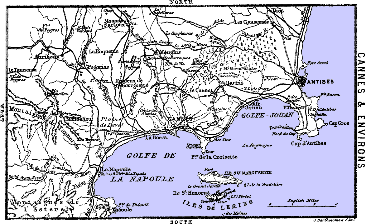
opp. 155 CANNES & ENVIRONS __A_TAG_PLACEHOLDER_0__
Cap d’Antibes. Lighthouse.
Cap d’Antibes. Lighthouse.
The Cap d’Antibes affords a delightful little walking excursion. To visit the “Cap” from Antibes, leave the town by the small gate, the 155 Porte Fausse, between the sea and the Porte de France, and then take the first road left by the side of the sea and the telegraph-posts. Ascend the hill, to the church, by the terraced steps of a “Via Crucis,” bordered with the usual 14 chapels, each with a group representing some part of the passion of our Lord. At the top is N. D. d’Antibes, frequented by pilgrims. The north aisle, which is the oldest part of the building, is of the 9th cent. Behind it is the lighthouse built in 1836, on a hill 187 ft. above the sea. The building is 82 ft. higher, and ascended by 115 steps. On the top is a fixed white light, visible at a distance of 28 miles. Fee for one person, ½ fr. The view is splendid. Before descending, observe the road to the Villa Thuret and to the Hôtel du Cap, a first-class house, 10 to 14 frs. Omnibus at station. The villa and grounds of Thuret are now a Government school for the culture and study of semi-tropical trees and shrubs. It is said that the first gum trees introduced into France were planted in 1853, and those in this garden in 1859. (For Antibes, see also p. 169.) The great tower on a rock to the W., overlooking the sea, is a powder-magazine.
The Cap d’Antibes offers a charming walking excursion. To get to the “Cap” from Antibes, exit the town through the small gate, the 155 Porte Fausse, located between the sea and the Porte de France, then take the first road to your left along the sea and the telegraph poles. Climb the hill to the church via the terraced steps of a “Via Crucis,” lined with the usual 14 chapels, each displaying a group representing some aspect of the passion of Christ. At the top is N. D. d’Antibes, a popular spot for pilgrims. The north aisle, the oldest part of the building, dates back to the 9th century. Behind it stands the lighthouse built in 1836, situated on a hill 187 ft. above the sea. The building is 82 ft. taller and accessed by 115 steps. At the top is a fixed white light, visible from 28 miles away. The fee for one person is ½ fr. The view is spectacular. Before heading back down, check out the road leading to the Villa Thuret and the Hôtel du Cap, a top-notch establishment, costing between 10 and 14 frs. Buses are available at the station. The villa and grounds of Thuret now serve as a Government school for the cultivation and study of semi-tropical trees and shrubs. It’s said that the first gum trees brought to France were planted in 1853, with those in this garden planted in 1859. (For Antibes, see also p. 169.) The large tower on a rock to the west, overlooking the sea, is a powder magazine.
Croix des Gardes. Theoule.
Croix des Gardes, Théoule.
Drives to the west of the Hôtel de Ville.—La Croix des Gardes, 2½ m. N.W., and 498 ft. above the sea. The nearest way ramifies from the Frejus road by the E. side of the Belle-Vue hotel. The cross rises from a column on a block of granite. The view is extensive. By the side of the road will be observed considerable plantations of the Acacia farnesiana, from whose flowers a pleasant perfume is distilled.
Drives to the west of the Hôtel de Ville.—La Croix des Gardes, 2½ m. N.W., and 498 ft. above sea level. The easiest route branches off from the Frejus road by the east side of the Belle-Vue hotel. The cross stands on a column made of granite. The view is vast. Along the road, you'll notice substantial plantings of the Acacia farnesiana, which give off a lovely fragrance from their flowers.
Cannes to Napoule, 6 m. W, Cab with 1 horse and 2 seats, 12 frs.; with 2 horses and 4 seats, 16 frs. 1 hour’s rest allowed. By omnibus, 30 c., leaving Cannes at 1 for the Bocca. At the Bocca it corresponds with the omnibus to Napoule, 50 c.; which, as it does not return till 4.30, affords ample time to walk on to Theoule and back, 2 m. W. The Napoule road commences from the western, or what is also called the English, portion of Cannes. It passes the little Scotch church, behind which are the Square Brougham and the public gardens. Farther W. is Christ Church, one of the three Episcopal Chapels. A short distance beyond, on the right side of the road, is the villa Eléonore-Louise, where Lord Brougham died. The house is hidden among the trees, but the garden is easily recognised by 2 large cypress trees growing by the side of the rail. Three m. from Cannes, on an eminence covered with pines, oaks, and cypresses, on the S. side of the road, is the poor little chapel of St. Cassien, the patron saint of Cannes, whose day is held on the 23d of July, in much the same manner as the Pardons in Brittany, called here Roumeiragi. Napoule is a small hamlet by the side of an old castle on the beach, at the foot of wooded hills. From it a very pretty road by the coast, cut in the face of the cliffs, leads to the hamlet of Theoule, on a tiny plateau over the beach, at the foot of the Estérel mountains. The restaurant of Theoule is better than that at Napoule. Between these two hamlets, and spanned by the railway viaduct, a narrow precipitous valley penetrates into the mountains. From Theoule a road extends to Trayas.
Cannes to Napoule, 6 m. W, Cab with 1 horse and 2 seats, 12 frs.; with 2 horses and 4 seats, 16 frs. 1 hour's rest allowed. By bus, 30 c., leaving Cannes at 1 for the Bocca. At the Bocca, it connects with the bus to Napoule, 50 c.; which, since it doesn’t return until 4:30, provides plenty of time to walk on to Theoule and back, 2 m. W. The Napoule road starts from the western, or sometimes called the English, part of Cannes. It goes past the small Scottish church, behind which are Square Brougham and the public gardens. Further W. is Christ Church, one of the three Episcopal chapels. A little beyond that, on the right side of the road, is the villa Eléonore-Louise, where Lord Brougham passed away. The house is tucked away among the trees, but the garden is easily identified by 2 large cypress trees next to the rail. Three m. from Cannes, on a rise covered with pines, oaks, and cypresses, on the S. side of the road, is the small chapel of St. Cassien, the patron saint of Cannes, whose day is celebrated on July 23rd, much like the Pardons in Brittany, referred to here as Roumeiragi. Napoule is a small village by an old castle on the beach, at the base of wooded hills. From there, a lovely coastal road, carved into the cliffs, leads to the village of Theoule, on a little plateau above the beach, at the foot of the Estérel mountains. The restaurant in Theoule is better than the one in Napoule. Between these two hamlets, and crossed by a railway viaduct, a narrow, steep valley cuts into the mountains. From Theoule, a road continues to Trayas.
Estérel. Pégomas.
Estérel. Pégomas.
Cannes to the Inn of Estérel, 12 m. S.W. and 830 ft. above the sea. 156 Carriage there and back, 35 frs. Cab with one horse and two seats, 18 frs.; with two horses and four seats, 22 frs. After passing the Bocca and St. Cassien, the carriage crosses the Siagne, having on the right or north Mandelieu nestling in the sun, at the foot Mt. le Duc, 1265 ft., a little to the east of the flat peak La Gaëte, 1663 ft. Afterwards the Riou is crossed at the village of Le Tremblant, 167 ft. above the sea, whence the ascent is continued by an excellent road amidst picturesque scenery to the Inn and Gendarmerie of Estérel. The inn is situated to the N. of Mt. Vinaigre, having to the east the Plan Pinet, 876 ft. above the inn, and to the west Mt. Vinaigre, 1193 ft. above the inn. The path to the summit of Mt. Vinaigre commences near the inn. The culminating part, 1030 ft., of the carriage-road is about 1¼ m. west from the inn at a place where four roads meet, almost immediately below Mt. Vinaigre, which is ascended from this point also.
Cannes to the Inn of Estérel, 12 m. S.W. and 830 ft. above sea level. 156 Round-trip carriage fare is 35 frs. A cab with one horse and two seats costs 18 frs.; with two horses and four seats, it's 22 frs. After crossing the Bocca and St. Cassien, the carriage goes over the Siagne, with Mandelieu right or north, basking in the sun at the base of Mt. le Duc, which is 1265 ft., slightly east of the flat peak La Gaëte, at 1663 ft. Next, the Riou is crossed at Le Tremblant village, 167 ft. above sea level, from where the ascent continues along a great road through scenic views to the Inn and Gendarmerie of Estérel. The inn is located to the north of Mt. Vinaigre, with Plan Pinet, 876 ft. above the inn, to the east, and Mt. Vinaigre, 1193 ft. above the inn, to the west. The path to the summit of Mt. Vinaigre starts near the inn. The highest part of the carriage road, at 1030 ft., is about 1¼ m. west from the inn at a spot where four roads meet, almost directly below Mt. Vinaigre, which can also be climbed from this point.
7 m. N. from Cannes by the Plaine de Laval and the wide valley of the Siagne, passing the Hôtel Garibondy, is the village of Pégomas, pop. 1350, on the Mourachone, a slow-running stream, in some parts hidden among bamboos. Beyond the mill of the village is a pretty but difficult walk up the ravine of the stream. Omnibus, 75 c. Cab, 12 or 16 frs.; 1 hour’s rest.
7 km north of Cannes, through the Plaine de Laval and the wide valley of the Siagne, past the Hôtel Garibondy, is the village of Pégomas, with a population of 1,350, located by the Mourachone, a slow-moving stream that is partly concealed by bamboos. Beyond the village mill, there’s a lovely but challenging walk up the ravine of the stream. Bus fare is 75 cents. A cab costs between 12 and 16 francs; allow for a 1-hour rest.
About 3 m. N.W. is Auribeau, pop. 480, prettily situated on the Siagne. Cab, 18 or 22 frs., with 2 hours’ rest.
About 3 miles northwest is Auribeau, population 480, beautifully located on the Siagne. Taxi fare is 18 or 22 francs, with a 2-hour break.
Mougins. Castelaras.
Mougins. Castelaras.
4¾ m. N. from Cannes, on a hill 820 ft. above the sea, is Mougins, pop. 1680. The road ascends all the way, passing by the cemetery and traversing vineyards and large olive groves. The omnibus goes no farther than Les Baraques, about ¼ m. below the town. Fare, 75 c. Cab there and back, one horse, 12 frs.; two horses, 16 frs.; 1 hour’s rest. Mougins still retains a few low portions of its walls and one gate, just behind the church. In the shop near the gate is the key of the church tower. The church dates from the 12th cent. From the tower, ascended by 75 steps, is a beautiful view. To the west is La Roquette, N.W. Mouans-Sartoux, and beyond Grasse. To the S.W. near the sea, and on the border of the Estérels, is the village of Mandelieu.
4¾ miles north of Cannes, on a hill 820 feet above the sea, is Mougins, with a population of 1,680. The road goes up all the way, passing by the cemetery and winding through vineyards and large olive groves. The bus only goes as far as Les Baraques, about a quarter mile below the town. The fare is 75 cents. A round trip by cab costs 12 francs for one horse and 16 francs for two horses, with an hour's wait. Mougins still has a few low sections of its walls and one gate, just behind the church. In the shop near the gate is the key to the church tower. The church dates back to the 12th century. From the tower, which you reach by climbing 75 steps, there’s a beautiful view. To the west is La Roquette, northwest is Mouans-Sartoux, and further beyond is Grasse. To the southwest, near the sea and on the edge of the Estérels, is the village of Mandelieu.
4 m. N. from Mougins, by the stony old road, or a little farther by the new road, is Castelaras, 1050 ft. above the sea. It is half a villa and half a farmhouse, commanding from the tower a splendid view of Grasse, Le Bar, the valley of the Loup, Tourettes, Vence, etc., to the north; Biot, Antibes, Nice, etc., to the east; Mouans, Auribeau, and the Estérel mountains to the west; and Cannes with its islands to the south. The easiest way to approach Castelaras on foot is to take the train to Mouans-Sartoux, pop. 1010, then ascend the hill by the steep road to the east of the station. When on the top the farmhouse and tower are distinctly seen. Carriage there and back, 35 frs. The column farther north marks the tomb of a gentleman who died at Grasse in 1883.
4 m. N. from Mougins, along the old rocky road, or a bit further via the new road, is Castelaras, 1050 ft. above sea level. It's part villa and part farmhouse, offering a stunning view from the tower that overlooks Grasse, Le Bar, the valley of the Loup, Tourettes, Vence, etc., to the north; Biot, Antibes, Nice, etc., to the east; Mouans, Auribeau, and the Estérel mountains to the west; and Cannes with its islands to the south. The easiest way to get to Castelaras on foot is to take the train to Mouans-Sartoux, pop. 1010, then hike up the steep road east of the station. Once you reach the top, the farmhouse and tower are clearly visible. A round trip by carriage costs 35 frs. The column further north marks the grave of a gentleman who passed away in Grasse in 1883.
Sail by steamboat to the Iles de Lerins. Time, 1 hr. The steamer makes two trips, so that passengers may land by the first at Ste. Marguerite, and by the second be carried on to St. Honorat, where the steamer remains sufficient time to visit the castle.
Sail by steamboat to the Iles de Lerins. Time, 1 hr. The steamer makes two trips, allowing passengers to land first at Ste. Marguerite, and on the second trip to be taken to St. Honorat, where the steamer stays long enough to visit the castle.
ILES DE LERINS.
The Island of Ste. Marguerite, 4½ m. in circumference and 1½ m. from the mainland, is covered entirely with a pine forest, except at Point Croisette, on which stands the fort founded by Richelieu, containing the apartments in which Marshal Bazaine was confined and the far more interesting vaulted cell in which the Man of the Iron Mask was closely guarded. The present entrance did not exist at that time, the only communication then being by the now walled-up door which led into the house of the governor, M. de St. Mars. From behind the prison a road, bordered by the Eucalyptus globulus, goes right through the pine plantation to the other side of the island.
The Island of Ste. Marguerite, 4½ miles in circumference and 1½ miles from the mainland, is entirely covered by a pine forest, except at Point Croisette, where there's a fort established by Richelieu. This fort includes the rooms where Marshal Bazaine was held and the much more fascinating vaulted cell where the Man in the Iron Mask was kept under tight security. The current entrance didn’t exist back then; the only access was through the now sealed door that led to the governor's house, M. de St. Mars. Behind the prison, a road lined with Eucalyptus globulus runs straight through the pine forest to the other side of the island.
The name of the Man of the Iron Mask was Hercules Anthony Matthioli, a Bolognese of ancient family, born on the 1st December 1640. On the 13th of January 1661 he married Camilla, daughter of Bernard Paleotti, by whom he had two sons, one of whom only had posterity, which has long since been extinct. Early in life Matthioli was public reader in the University of Bologna, which he soon quitted to enter the service of Charles III., Duke of Mantua, by whom he was finally made Secretary of State. The successor of Charles III., Ferdinand Charles IV., the last sovereign of Mantua, of the house of Gonzaga, created Matthioli supernumerary senator of Mantua, and gave him the title of Count. Towards the end of 1677 the Abbé d’Estrades, ambassador from France to the Republic of Venice, conceived the idea, which he was well aware would be highly acceptable to the insatiable ambition of his master, Louis XIV., of inducing the weak and unfortunate Duke Ferdinand Charles to allow of the introduction of a French garrison into Casale, a strongly-fortified town, in a great measure the key of Italy. The cession of the fortress of Pinerolo to the French by Victor Amadeus, Duke of Savoy, in 1632, had opened to them the entrance into Piedmont, while the possession of Casale would have opened to them the broad and fertile plains of Milan.
The name of the Man in the Iron Mask was Hercules Anthony Matthioli, a Bolognese from an old family, born on December 1, 1640. On January 13, 1661, he married Camilla, daughter of Bernard Paleotti, with whom he had two sons, though only one of them had descendants, which have long since died out. Early in his life, Matthioli served as a public reader at the University of Bologna, but he soon left that position to work for Charles III, Duke of Mantua, who eventually appointed him Secretary of State. Charles III's successor, Ferdinand Charles IV, the last sovereign of Mantua from the Gonzaga family, made Matthioli a supernumerary senator of Mantua and gave him the title of Count. Towards the end of 1677, Abbé d’Estrades, the French ambassador to the Republic of Venice, thought of a plan he knew would appeal to his powerful but greedy master, Louis XIV: to persuade the weak and unfortunate Duke Ferdinand Charles to allow a French garrison into Casale, a heavily fortified town that was crucial to Italy. The cession of the fortress of Pinerolo to the French by Victor Amadeus, Duke of Savoy, in 1632, had opened the way for them into Piedmont, while controlling Casale would have given them access to the vast and fertile plains of Milan.
The great difficulty Estrades had to encounter at first in the prosecution of this intrigue was to find a medium of communication between himself and the Duke. This channel was at last found in the person of Matthioli, who enjoyed the Duke’s confidence and favour, and was besides a complete master of Italian politics. Through him the schemes of Estrades progressed so well that he was invited to the French court, where he was received and rewarded by Louis XIV., 158 who at the same time presented him with a valuable diamond ring. Shortly after Matthioli’s return to Italy he allowed himself to be bought over by the Austrian party, which frustrated the French negotiations and so exasperated the vindictive Louis that he sent orders to the Abbé Estrades to have him kidnapped at all hazards. For this purpose Matthioli was induced to go to the frontier beyond Turin, where he was arrested as a traitor to France by the Abbé, accompanied by four soldiers, on 2d May 1679. Such a scandalous breach of international law required the adoption of extraordinary precautionary means of concealment. His name was changed to Lestang, he was compelled to wear a black velvet mask, and when he travelled armed attendants on horseback were ready to despatch him if he made any attempt to escape, or even to reveal himself.
The major challenge Estrades faced at the start of this scheme was finding a way to communicate with the Duke. Eventually, he found that channel in Matthioli, who had the Duke’s trust and was well-versed in Italian politics. Thanks to Matthioli, Estrades's plans moved forward impressively enough that he was invited to the French court, where Louis XIV. welcomed and rewarded him, 158 presenting him with a valuable diamond ring. Shortly after Matthioli returned to Italy, he allowed himself to be swayed by the Austrian party, disrupting the French negotiations and infuriating the vengeful Louis, who ordered Abbé Estrades to have him kidnapped at any cost. To execute this plan, Matthioli was lured to the border near Turin, where the Abbé, along with four soldiers, arrested him as a traitor to France on May 2, 1679. This shocking breach of international law required drastic measures for secrecy. His name was changed to Lestang, he was made to wear a black velvet mask, and when he traveled, armed attendants on horseback were prepared to eliminate him if he tried to escape or even disclose his identity.
By the direction of Estrades he was comfortably lodged and fed in prison, till orders came from Paris, stating— “It is not the intention of the king that the Sieur de Lestang should be well treated, nor receive anything beyond the absolute necessaries of life, nor anything to make his time pass agreeably.” He was handed over to the charge of St. Mars, who took him to the castle of Pinerolo, whence in 1681 they removed to the castle of Exiles. From Exiles St. Mars removed his unfortunate and now crazy prisoner to the Island of Ste. Marguerite, where they arrived 30th April 1687, after a journey of twelve days.
By Estrades' orders, he was comfortably housed and fed in prison until orders came from Paris, stating— “The king does not intend for Sieur de Lestang to be treated well or to receive anything beyond the bare necessities of life, nor anything to make his time more pleasant.” He was handed over to St. Mars, who took him to the castle of Pinerolo, where in 1681 they moved to the castle of Exiles. From Exiles, St. Mars moved his unfortunate and now insane prisoner to the Island of Ste. Marguerite, where they arrived on April 30, 1687, after a twelve-day journey.
Among the erroneous anecdotes told of Matthioli during his ten years’ sojourn on the island are:—On one occasion he is alleged to have written his name and rank on a silver plate, which he threw out of the window. A fisherman picked it up and brought it to St. Mars, who, on finding the man could not read, let him go. On another occasion Matthioli is said to have covered one of his shirts with writing, which he likewise threw out of the window. It was found by a monk, who, when he delivered it to St. Mars, assured him that he had not read it. Two days afterwards the monk was found dead. The origin of these stories is to be found in a letter from St. Mars to the Minister, dated 4th June 1692, in which he informs him that he has been obliged to inflict corporeal punishment upon a Protestant clergyman named Salves, also in his keeping, because he would write things on his pewter vessels and linen, to make known that he was imprisoned unjustly on account of the purity of his faith.
Among the false stories told about Matthioli during his ten years on the island are:—At one point, he supposedly wrote his name and rank on a silver plate, which he then tossed out of the window. A fisherman found it and brought it to St. Mars, who, upon discovering the man couldn't read, let him go. On another occasion, Matthioli supposedly wrote all over one of his shirts and also threw it out the window. A monk found it and, when he handed it to St. Mars, assured him he hadn't read it. Two days later, the monk was found dead. The source of these stories is in a letter from St. Mars to the Minister, dated June 4, 1692, in which he informs him that he had to punish a Protestant clergyman named Salves, who was also in his custody, because he would write messages on his pewter dishes and linen to communicate that he was unjustly imprisoned due to his faith.
In 1697 Matthioli with his keeper left for the Bastile, of which place St. Mars had been appointed governor. They arrived on 18th September 1698.
In 1697, Matthioli and his guard set out for the Bastille, where St. Mars had been made governor. They arrived on September 18, 1698.
On the 19th November 1703, about 10 P.M., Matthioli died in the Bastile, after a few hours’ illness, and was buried next day at 4 P.M. in the cemetery of St. Paul.—Extracted from the History of the Bastile, by R. A. Davenport.
On November 19, 1703, around 10 PM, Matthioli died in the Bastille after a brief illness and was buried the next day at 4 PM in the cemetery of St. Paul.—Extracted from the History of the Bastile, by R. A. Davenport.
The Island of St. Honorat. Abbey. Massacre.
The Island of St. Honorat. Abbey. Massacre.
The Island of St. Honorat contains 97 acres, or is ¼ the size of Ste. Marguerite, from which it is 750 yards distant. A pleasant road of 2½ m., shaded by umbrella pines, leads round the island. Straight 159 from the landing-place is a convent of Cistercian monks, settled here only since 1859. The original monastery was founded by St. Honorat in 410. In 730 and 891 the Saracens invaded the island, pillaged the establishment, and massacred the monks. In the 10th century the again flourishing brotherhood received Cannes as a gift from Guillaume Gruetta, son of Redouard, Count of Antibes. In 1073 they built the tower on the island, and in 1080 the Abbé Adalbert II. commenced the castle of Cannes. In 1148 the monks strengthened and enlarged the fortifications of their tower. In 1788 the monastery was suppressed on account of the irregularities of the inmates. In 1791 the island and buildings were sold. In 1859 they were finally bought by the Bishop of Frejus, who handed them over to the present occupiers, a colony of Cistercian monks, 50 in number, of whom about two-thirds are lay brethren.
The Island of St. Honorat covers 97 acres, which is ¼ the size of Ste. Marguerite, located 750 yards away. A pleasant road 2½ m. long, shaded by umbrella pines, circles the island. Directly 159 from the landing area is a convent of Cistercian monks, who have been here since 1859. The original monastery was founded by St. Honorat in 410. In 730 and 891, the Saracens raided the island, looted the establishment, and killed the monks. During the 10th century, the thriving brotherhood received Cannes as a gift from Guillaume Gruetta, the son of Redouard, Count of Antibes. In 1073, they constructed the tower on the island, and in 1080, Abbé Adalbert II began work on the castle of Cannes. In 1148, the monks reinforced and expanded the defenses of their tower. The monastery was shut down in 1788 due to the misconduct of the residents. In 1791, the island and its buildings were sold. Finally, in 1859, they were purchased by the Bishop of Frejus, who transferred them to the current occupants, a colony of 50 Cistercian monks, about two-thirds of whom are lay brethren.
“What Iona was to the ecclesiastical history of northern England, what Fulda and Monte Cassino were to the ecclesiastical history of Germany and southern Italy, St. Honorat was to the church of southern Gaul. For nearly two centuries the civilisation of the great district between the Loire and the Mediterranean rested mainly on the Abbey of Lerins. Sheltered by its insular position from the ravages of the barbaric hordes who poured down the valleys of the Rhône and of the Garonne, it exercised over Provence and Aquitaine a supremacy such as Iona, till the Synod of Whitby, exercised over Northumbria. All the more illustrious sees of southern Gaul were filled by prelates who had been reared at Lerins. To Arles (p. 70) it gave in succession Hilary, Cæsarius, and Virgilius.
“What Iona was to the church history of northern England, what Fulda and Monte Cassino were to the church history of Germany and southern Italy, St. Honorat was to the church of southern Gaul. For nearly two centuries, the culture of the vast area between the Loire and the Mediterranean relied heavily on the Abbey of Lerins. Protected by its island location from the attacks of the barbaric groups that descended through the Rhône and Garonne valleys, it held a dominant influence over Provence and Aquitaine, similar to how Iona influenced Northumbria until the Synod of Whitby. All the prominent bishoprics of southern Gaul were occupied by leaders who had been educated at Lerins. To Arles (p. 70) it provided in succession Hilary, Cæsarius, and Virgilius.
“The present cloister of the abbey is much later than the date of the massacre of the monks, which took place, according to tradition, on the little piece of green sward in the centre of the cloister.
“The current cloister of the abbey was built long after the massacre of the monks, which, according to tradition, happened on the small patch of green grass in the center of the cloister."
“With the exception of the masonry of the side walls, there is nothing in the abbey church earlier than the close of the 11th cent.” —J. R. Green’s Stray Studies.
“With the exception of the stonework on the side walls, nothing in the abbey church dates back earlier than the end of the 11th century.” —J. R. Green’s Stray Studies.
The tower or rather castle, as it now stands, represents two tall rectangular elevations of unequal magnitude, crowned by projecting cornices. On the ground-floor, with entrance from the beach, is a large hall with groined roof, said by some to have been a chapel, and by others a bakery, but most likely a “parloir” or reception-room. In the wall, a little to the left or west, and about 30 ft. from the ground, is a cannon-ball fired by the English when they took possession of the islands in 1746. The interior of the castle is shown by the concierge of the convent. The first part entered is the oblong cloister, in three stories, of which two remain entire. The corridor of the first is supported on short columns standing round the edge of a cistern. From this corridor open the doors into the bedrooms and refectory. From the upper corridor is the entrance to the chapel, which opened into the library. Above the library was the infirmary, of which not a vestige remains. A good view is had from the top. Visitors are next taken to the convent. The church and buildings are 160 modern, excepting one of the cloisters. It is therefore a pity to spend much time there, especially for those who have arrived by the last steamer, and have consequently little time to spare.
The tower, or rather castle, as it currently stands, features two tall rectangular structures of different heights, topped with protruding cornices. On the ground floor, accessible from the beach, there's a large hall with a groined roof, which some say was a chapel and others claim was a bakery, but it was most likely a “parloir” or reception room. In the wall, a bit to the left or west, and about 30 feet up, is a cannonball fired by the English when they took control of the islands in 1746. The castle's interior is shown by the concierge of the convent. The first area you enter is the long cloister, which has three stories, of which two are still intact. The corridor on the first floor is supported by short columns surrounding a cistern. From this corridor, doors lead to the bedrooms and refectory. From the upper corridor, you can enter the chapel, which connected to the library. Above the library was the infirmary, but no trace of it remains. You can get a good view from the top. Visitors are then taken to the convent. The church and buildings are 160 modern, except for one of the cloisters. It’s unfortunate to spend too much time here, especially for those who arrived on the last steamer and have little time to spare.
Chapel of the Trinity.
Trinity Chapel.
By the road round the island are the remains of chapels of the 7th cent., or even earlier. Going from west to east there is, against the wall of the convent, a little to the west of the castle, the Chapel of St. Porcaire (restored), where, it is said, the saint was buried. At the western extremity of the island, within an old fort, is the Chapel of St. Sauveur. To the west of the landing-place, near the large gateway, are little better than the foundations of the Chapel of St. Pierre. Farther east, beside the Orphanage, is St. Justine, now a stable. The Orphanage contains about 25 boys. They are taught different trades. The franc charged for showing the castle goes to their support. On the eastern point of the island, beside a fort, is the most interesting chapel of all, the Chapel of the *Trinity, 35 ft. long by about 25 wide, placed from east to west. The great corner-stones of this small temple, by their size and solidity, are the main supports of the building, illustrating thereby the reason why in Scripture so much importance and honour are attached to them in edifices. The roof of the nave is semicircular, strengthened by three arches, the centre one springing from two round columns. The roofs of the three apsidal chapels are semispherical.
By the road around the island, you'll find the remains of chapels from the 7th century or even earlier. Moving from west to east, there's, against the wall of the convent and a little to the west of the castle, the restored Chapel of St. Porcaire, where it's said the saint was buried. At the western end of the island, within an old fort, is the Chapel of St. Sauveur. To the west of the landing area, near the large gateway, are little more than the foundations of the Chapel of St. Pierre. Further east, next to the Orphanage, is St. Justine, which is now a stable. The Orphanage houses about 25 boys, and they learn different trades. The franc charged for tours of the castle helps support them. On the eastern tip of the island, beside a fort, is the most interesting chapel of all, the Chapel of the *Trinity, measuring 35 feet long by about 25 feet wide, oriented from east to west. The large cornerstones of this small temple, due to their size and strength, are the main supports of the building, demonstrating why Scripture assigns so much importance and honor to them in structures. The roof of the nave is semicircular, reinforced by three arches, with the center arch rising from two round columns. The roofs of the three apsidal chapels are domed.
Cannes to Grasse, 12½ m. N. by rail, pop. 12,100. Hotels: the G. H. International, 9 to 12 frs., a first-class house on the road to Le Bar. In the town, H. Muraour and the Poste, 8 to 10 frs. Their omnibuses await passengers. Those who wish to walk commence by the stair to the right of the station, and then the steep road on the other side of the highway. Grasse, a town of charming views, delicious water, and the best of air, makes an excellent and beneficial change from Cannes. The town, with its terraces and labyrinth of narrow, crooked, steep streets, is situated 1090 ft. above the sea, on the southern slope of Mt. Rocavignon, which rises almost perpendicularly 695 ft. above the town. To the N.E. of Rocavignon is the Marbrière, 2920 ft. above the sea. The short but stony road to the top of Rocavignon commences opposite the fountain used by the washerwomen. On the summit is a stony plateau, commanding extensive and exquisite views. Plain of Napoleon. A little way inland is a grassy plot, called the Plain of Napoleon, because here, on 2d March 1815, he breakfasted at the foot of the three tall cypresses, and then went on to St. Vallier. In the face of the large calcareous cliff a few yards beyond the trees is a cavern or “foux,” whence, after heavy rains, a large body of water issues in the form of a roaring cascade. The path which leads down into the beautiful valley below commences about 500 yards farther inland. It joins that very pretty road among olive trees, seen from the plateau, which, after passing the large white house, a hospice for the aged, enters Grasse by the powder-house, formerly the chapel of St. Sauveur, a little circular building with flat shallow buttresses, built in the early part of the 10th cent. On entering Grasse by this way, and just at the commencement of the promenade called the Cours, is the hospital. The large door gives access to the chapel, 161 in which are hung, at the west end, three pictures attributed to Rubens—the Crown of Thorns, the Elevation of the Cross, and the Crucifixion. The concierge uncovers them. Immediately below, and opposite the entrance into the public gardens, is the house of M. Malvillan, containing paintings by a native of Grasse, Jean Fragonard. Jean Horace Fragonard, who died at Paris in 1806. The best of them are five pictures, which were painted for Madame Dubarry, representing frolicsome scenes, young people playing games. At the foot of the Rue des Dominicains, in a large house with bulging iron grating, are some decorative paintings attributed to Flemish artists. These pictures are shown by courtesy. In the centre of the old town is the parish church, built in the 11th cent., but altered and repaired in the 17th. It contains several pictures, but the only good one is an Ascension of Mary, by Subleyras, behind the high altar. From the terrace at the east end of the church is one of the many beautiful views. Adjoining is the Hôtel de Ville, and attached to it is a great square tower of the 11th cent.
Cannes to Grasse, 12½ m. N. by rail, pop. 12,100. Hotels: the G. H. International, 9 to 12 frs., a top-notch hotel on the road to Le Bar. In the town, H. Muraour and the Poste, 8 to 10 frs. Their shuttles are ready for passengers. Those who want to walk start by taking the stairs to the right of the station, then the steep road on the other side of the highway. Grasse, a town with stunning views, refreshing water, and great air, is a perfect and healthy getaway from Cannes. The town, with its terraces and maze of narrow, winding, steep streets, is located 1090 ft. above sea level on the southern slope of Mt. Rocavignon, which rises almost straight up 695 ft. above the town. To the N.E. of Rocavignon is the Marbrière, standing 2920 ft. above sea level. The short but rocky road to the top of Rocavignon starts opposite the fountain where the washerwomen gather. At the summit is a rocky plateau offering wide and beautiful views. Plain of Napoleon. A little way inland is a grassy area called the Plain of Napoleon, because here, on March 2, 1815, he had breakfast at the base of three tall cypress trees before heading to St. Vallier. In front of the large limestone cliff just past the trees is a cave or “foux,” from which, after heavy rains, a large volume of water flows out as a roaring cascade. The path leading down into the beautiful valley below starts about 500 yards further inland. It connects with the charming road among olive trees, visible from the plateau, which, after passing the large white building, a hospice for the elderly, enters Grasse by the powder-house—once the chapel of St. Sauveur, a small circular structure with flat, shallow buttresses built in the early 10th century. As you enter Grasse this way, right at the start of the promenade known as the Cours, is the hospital. The large door leads into the chapel, 161 where, at the west end, hang three paintings attributed to Rubens: the Crown of Thorns, the Elevation of the Cross, and the Crucifixion. The concierge reveals them. Directly below, opposite the entrance to the public gardens, is the home of M. Malvillan, which features paintings by a local artist, Jean Horace Fragonard, who passed away in Paris in 1806. The best of his works are five paintings created for Madame Dubarry, depicting lively scenes of young people playing games. At the end of the Rue des Dominicains, in a large house with bulging iron grates, are some decorative paintings attributed to Flemish artists. These artworks are displayed by courtesy. In the center of the old town is the parish church, built in the 11th century but altered and repaired in the 17th. It contains several paintings, but the only notable one is an Ascension of Mary by Subleyras, located behind the high altar. From the terrace at the east end of the church, one can enjoy one of the many beautiful views. Next door is the Hôtel de Ville, which is connected to a large square tower from the 11th century.
A stair at the head of the main street leads down to the principal square and market-place, with a fountain at one end and one of the sides arcaded. The best promenades are the Cours, the terrace of the Palais de Justice above it, and the Jardin des Plantes below it.
A staircase at the top of the main street goes down to the main square and marketplace, featuring a fountain at one end and an arcade along one side. The best places to walk are the Cours, the terrace of the Palais de Justice above it, and the Jardin des Plantes below it.
Perfumery.
Fragrance.
PERFUMERY.
The standard industries of Grasse are the distilling of perfumes and the preserving of fruits. The flowers are cultivated on terraces resembling great nursery-beds. Of the perfumes, the most precious are the Otto of Roses and the Néroly. It requires 45 lbs. avoirdupois of rose leaves (petals) to make 1 gramme, or 15½ grains troy of the Otto of Roses, which costs from 2½ to 3 frs. the gramme; and 2¾ lbs. troy of the petals of orange flowers to make 1 gramme of Néroly, which costs 8 to 10 sous the gramme. The best Néroly, the Néroly Bigarrade, is made from the flowers of the bitter orange tree. It is used principally in the manufacture of Eau de Cologne, of which it constitutes the base. In colour it resembles sherry, and the odour is that of Eau de Cologne. The water that comes off in distilling Néroly forms the orange-water of the cafés. The Otto of Roses of Grasse is superior to that of Turkey. Extracts for scenting pocket-handkerchiefs are made from freshly-gathered flowers laid between two sheets of glass, held by their frames 4 inches apart, and piled one above the other, without pressing the flowers. On each side of the glass is a layer of lard ⅓ of an inch thick, which, in 12 to 24 hours, absorbs completely the odoriferous oil. When the flowers are abundant they are renewed every 12 hours, sometimes even every 6. The operation is repeated several times on the same lard with fresh flowers. Jonquilles are changed 30 times, the cassia and violet 60, the tuberose (a kind of hyacinth) and the jasmine, both 80 times. The lard is then melted in a large iron vessel, and mixed with spirits made from grain, which, combining with the volatile oil, rises to the top. The fluid is then filtered. 162 This is called the cold method. Orange and rose petals require the hot methods, either by the still or by the “bain-marie.” The distilling of the fragrant oil from the petals requires the most vigilant attention, and the maintenance of the same degree of heat. Rose and orange pomade are made by the bain-marie method by submerging a large iron pot full of lard in boiling water. When the lard is melted the petals are added, and after having remained there for 12 or 24 hours the mass is filtered to remove the now inodorous petals. The operation is repeated from 30 to 60 times, according to the required strength of the perfume. The red Turkey rose is the only rose used.
The main industries in Grasse are perfume distilling and fruit preserving. The flowers are grown on terraces that look like large nursery beds. The most valuable perfumes are Otto of Roses and Néroly. It takes 45 pounds of rose petals to produce 1 gram of Otto of Roses, which costs between 2.5 to 3 francs per gram; and 2.75 pounds of orange flower petals to make 1 gram of Néroly, which costs 8 to 10 sous per gram. The best Néroly, known as Néroly Bigarrade, is made from the flowers of the bitter orange tree. This is mainly used as a base in Eau de Cologne, giving it a sherry-like color and the same scent as Eau de Cologne. The water that is produced during the distillation of Néroly becomes the orange water used in cafés. The Otto of Roses from Grasse is considered to be better than that from Turkey. Scented extracts for handkerchiefs are created by layering freshly picked flowers between two sheets of glass, kept 4 inches apart in their frames, and stacked without compressing the flowers. Each side of the glass has a ⅓ inch thick layer of lard, which absorbs the fragrant oil completely in 12 to 24 hours. When there are plenty of flowers, they are replaced every 12 hours, sometimes even every 6. This process is repeated several times with fresh flowers on the same lard. Jonquilles can be replaced 30 times, while cassia and violet 60 times, and tuberose (a type of hyacinth) and jasmine up to 80 times. The lard is then melted in a large iron pot and mixed with grain alcohol, which combines with the volatile oil that rises to the surface. The liquid is then filtered. 162 This process is known as the cold method. Orange and rose petals require hot methods, either through the still or the “bain-marie.” Distilling the fragrant oil from the petals demands careful monitoring and consistent heat. Rose and orange pomade are created using the bain-marie method by placing a large iron pot filled with lard in boiling water. Once the lard is melted, the petals are added, and after 12 to 24 hours, the mixture is filtered to remove the now odorless petals. This process is repeated 30 to 60 times, depending on the desired strength of the perfume. Only the red Turkey rose is used for this.
At the very foot of the Rue des Cordeliers is the confectionery of *Negre. He has showrooms and priced catalogues of his preserved fruits, which are made up in the candied (cristallisé) state, in the glazed-sugar (glacé) state, whole and in syrup (compotes), or as jams and jellies (confitures). At No. 22 Rue des Cordeliers is the perfumery of Bruno-Court, where purchases of the best material may be made from a franc upwards. Below the church is the perfumery of Warwick and Co., and in the B. Fragonard that of Pilar Frères, both of whom supply Atkinson of London with the raw material.
At the very end of Rue des Cordeliers is the candy shop of *Negre. He has showrooms and price lists for his preserved fruits, which come in candied, glazed-sugar, whole in syrup, or as jams and jellies. At No. 22 Rue des Cordeliers is the perfumery of Bruno-Court, where you can buy quality materials starting from a franc. Below the church is the perfumery of Warwick and Co., and in B. Fragonard is that of Pilar Frères, both of which supply Atkinson of London with raw materials.
St. Cesaire. Cannes Canal. Callian.
St. Cesaire. Cannes Canal. Callian.
Grasse to St. Cesaire.—9 m. W. by a beautiful road. Carriage there and back, 20 frs. Diligence, 1½ fr. Time, 2 hours. This little village, pop. 350, is situated on an eminence above the Siagne, 1560 feet above the sea, or 470 feet higher than Grasse. In front of a large elm in the “Place” is a plain but clean inn, the Hôtel de la Siagne (pension from 6 to 8 frs.), where those who desire to fish in the river or ramble in the environs can live comfortably. From the end of the street, right from the inn, is a terrace, left hand, whence there is a view of the valley of the Siagne, with the Cannes canal on its eastern side. The path to the cave “Grotto de la Foux” goes by the upper side of this canal, and requires 1½ hour’s easy walking. The commencement of the Cannes Canal is about a half-hour’s walk farther up. No guide is necessary, unless it be desired to inspect the cave with lights. Guide, 5 frs. Like the more famous caves of Cahors and of Vaucluse (p. 64), this cavern or “foux,” at the base of a calcareous cliff, contains a great basin of limpid water, but no stalactites. The Cannes Canal is a narrow uncovered conduit 31 m. long, exposed to animal and vegetable impurities throughout nearly its entire course. Of greater interest is the commencement of the Roman aqueduct, which conveyed water from the Siagnole to Frejus (p. 146, and map, p. 129) by a channel covered with bricks, and stones of the size of bricks, through the Roquotaillado tunnel, 164 ft. long, 27 wide, and 82 high, in all probability originally a cave, but adapted by the Roman engineers to their requirements. It is most easily visited from Montauroux, on the hill opposite, 3 m. distant by a bridle-path, Inn: Bourgarenne, where pass the night. From this village the tunnel is about 9 m. distant by an excellent carriage-road. 1½ m. from Montauroux is the village Callian, Inn: Castel, 1200 ft., supplied with water by the Roman aqueduct.
Grasse to St. Cesaire.—9 miles west along a beautiful road. Round trip by carriage costs 20 francs. Diligence fare is 1.5 francs. Travel time is about 2 hours. This small village, with a population of 350, is located on a hill above the Siagne River, 1560 feet above sea level, or 470 feet higher than Grasse. In front of a large elm in the "Place" stands a simple but tidy inn, the Hôtel de la Siagne (prices from 6 to 8 francs), where visitors can comfortably stay if they want to fish in the river or explore the surroundings. At the end of the street, to the right of the inn, there's a terrace offering a view of the Siagne valley with the Cannes canal on its eastern edge. The path to the “Grotto de la Foux” runs along the upper side of this canal and takes about 1.5 hours of easy walking. The start of the Cannes Canal is about a half-hour walk further up. A guide isn't necessary unless you want to explore the cave with lights. Guide fees are 5 francs. Like the more famous caves of Cahors and Vaucluse (p. 64), this cavern or “foux,” located at the base of a limestone cliff, features a large pool of clear water, but no stalactites. The Cannes Canal is a narrow open channel 31 meters long, susceptible to animal and plant contamination nearly throughout its entire length. More interesting is the start of the Roman aqueduct, which carried water from the Siagnole to Frejus (p. 146, and map, p. 129) using a channel covered with bricks and stones the size of bricks, passing through the Roquotaillado tunnel, which is 164 feet long, 27 feet wide, and 82 feet high. This was likely originally a cave but was modified by Roman engineers to suit their needs. It's easiest to visit from Montauroux, on the opposite hill, 3 miles away via a bridle path, Inn: Bourgarenne, where you can stay overnight. From this village, the tunnel is about 9 miles away on a good carriage road. 1.5 miles from Montauroux is the village Callian, Inn: Castel, at 1200 feet, receiving water from the Roman aqueduct.
opp. 163
THE DURANCE, THE VAR,
the col di tenda, san remo
For continuation northwards see map, page 327.
For continuation eastwards see map, page
211.

For continuation westwards see map, page 66.
For continuation southwards see map, page
123.
opp. 163
THE DURANCE, THE VAR,
the Col di Tenda, San Remo
For continuation northwards see map, page 327.
For continuation eastwards see map, page
211.
For continuation westwards see map, page 66.
For continuation southwards see map, page
123.
Nearly 2 hours’ walk from the Cannes Canal up the Siagne, and 163 situated at a considerable elevation, is the stalactite cave of Mons. Those who have already seen such caves will find in this one nothing new nor striking. To visit it not only is a guide necessary, but the keeper of the cave at Mons must be advised beforehand, that he may be at the mouth of the cave with the key. It is much the better plan to return from the commencement of the Cannes Canal to St. Cesaire, and drive back to Grasse. The olives of St. Cesaire are considered among the best flavoured of the Riviera.
Almost a 2-hour walk from the Cannes Canal up the Siagne, and 163 located at a significant height, is the stalactite cave of Mons. Those who have seen such caves before will find nothing new or remarkable in this one. To visit, you not only need a guide, but you must also inform the cave keeper in Mons ahead of time so he can be at the cave entrance with the key. A much better plan is to return from the start of the Cannes Canal to St. Cesaire and then drive back to Grasse. The olives from St. Cesaire are considered some of the best tasting on the Riviera.
Grasse by Coach to Cagnes Station.
Grasse to the railway station of Cagnes by the Pont du Loup and Vence, 21 m. By omnibus, 3 frs. By private carriage, 30 frs. This drive is generally taken in two parts—Grasse to the Pont du Loup; then from the Pont du Loup to Vence or Cagnes.
Grasse to the Cagnes railway station via the Pont du Loup and Vence, 21 m. By bus, 3 frs. By private car, 30 frs. This trip is usually made in two segments—Grasse to the Pont du Loup; then from the Pont du Loup to Vence or Cagnes.
Pont du Loup. Tourette.
Pont du Loup. Tourette.
Grasse to the Pont du Loup by Le Bar, 7½ m. N.E. Carriage with two horses there and back, 15 frs. Omnibus to Le Bar 3 times daily, 1 fr. Distance, 5½ m. N.E.; whence it is a pleasant walk of 2 m. up the valley of the Loup to the inn and Pont du Loup, at the mouth of the Gorge du Loup. From the Pont 2½ hours of fatiguing walking up the ravine of the Loup brings the traveller to the falls of the Loup, which requires a good deal of rain to make them imposing. The whole way from Grasse to Vence is by a beautiful Corniche road, nearly on the same level (1090 ft.) throughout its entire course, disclosing at every turn exquisite views towards the sea. The Pont du Loup, with its little cluster of houses and orange-gardens, is at the top of a long narrow valley, just at the point where the Loup rushes forth from a rocky gorge. On the top of a plateau, about 500 ft. over the Pont du Loup, is the village of Gourdon. From the terrace adjoining the church of Le Bar there is an excellent view of Gourdon, the valley of the Loup, and of the carriage-road on both sides of it. Those who visit the Pont du Loup generally content themselves with a ramble in the gorge, and then, after having taken some refreshments, either return to Grasse or go on to the railway station of Vence-Cagnes (see p. 169), 13½ m. farther, or 21 m. from Grasse. The drive from Grasse to Vence-Cagnes station in a private carriage costs 30 frs. The very same road is traversed by the omnibus from Grasse to Vence, 15 m. eastward. Fare, 2 frs. Time, 4 hours. A seat should be taken in the “Imperial.” Next day, at one, start from Vence to Cagnes railway station by another omnibus. Fare, 1 fr. Time, 1 hour. Distance, 6 m. The road from the Pont to Vence continues to follow the course of the Loup till within a few miles of the village of Tourette, pop. 980, at the foot of Le Puy de Tourette, 4158 ft. above the sea, where the omnibus halts.
Grasse to the Pont du Loup by Le Bar, 7½ m. N.E. A carriage with two horses round trip costs 15 frs. There's an omnibus to Le Bar three times a day for 1 fr. The distance is 5½ m. N.E.; from there, it's a nice 2 m. walk up the Loup valley to the inn and Pont du Loup, at the entrance of the Gorge du Loup. From the Pont, a 2½-hour strenuous walk up the Loup ravine leads travelers to the falls of the Loup, which require a decent amount of rain to look impressive. The entire route from Grasse to Vence follows a beautiful Corniche road, consistently at about the same elevation (1090 ft.), offering stunning sea views at every turn. The Pont du Loup, with its small cluster of houses and orange gardens, is located at the top of a long, narrow valley, right where the Loup cascades out of a rocky gorge. Perched on a plateau about 500 ft. above the Pont du Loup is the village of Gourdon. From the terrace next to the church of Le Bar, there’s a fantastic view of Gourdon, the Loup valley, and the carriage road on both sides. Most visitors to the Pont du Loup usually enjoy a stroll in the gorge and then, after having some refreshments, either head back to Grasse or continue to the railway station of Vence-Cagnes (see p. 169), which is 13½ m. away or 21 m. from Grasse. The private carriage drive from Grasse to Vence-Cagnes station costs 30 frs. The same route is also taken by the omnibus from Grasse to Vence, 15 m. east. The fare is 2 frs, and it takes 4 hours. It’s advisable to secure a seat in the “Imperial.” The following day, at one, you can take another omnibus from Vence to Cagnes railway station. The fare is 1 fr. and the journey takes 1 hour. The distance from the Pont to Vence continues along the Loup until just a few miles from the village of Tourette, population 980, at the base of Le Puy de Tourette, which is 4158 ft. above sea level, where the omnibus stops.
Vence.
Vence.
Vence, 1100 ft. above the sea, pop. 2800. Inn: Lion d’Or, pension 9 frs. Picturesquely situated on a hill in the midst of mountains clothed with olive trees and studded with houses standing singly and in clusters. This, the ancient Vintium, has still large portions of its 164 old walls and ramparts, with massive square towers (11th cent.) next the gates. At the northern entrance is the ancient palace of the Lords of Vence, with a beautiful tower, built in the 15th cent., in the style of the palaces of Florence, only without a court, for which there was no space. In front is a fine old ash tree, sadly mutilated.
Vence, 1100 ft. above sea level, pop. 2800. Inn: Lion d’Or, room rate 9 frs. Picturesquely located on a hill surrounded by mountains covered in olive trees and dotted with houses that stand alone and in groups. This is the ancient Vintium, which still has large parts of its 164 old walls and ramparts, with massive square towers (11th century) next to the gates. At the northern entrance is the old palace of the Lords of Vence, featuring a beautiful tower built in the 15th century, styled like the palaces of Florence but without a courtyard due to space limitations. In front stands a splendid old ash tree, unfortunately damaged.
The bishopric of Vence, founded in 374, was afterwards united to that of Frejus. In the centre of the town is the cathedral, 110 ft. long, 68 ft. wide, and about 70 high, inside measure. Two aisles with massive piers and semicircular arches (slightly stilted) are on each side of the nave. Above is a triforium 15 ft. wide. Roof waggon-vaulted. The choir, containing 50 stalls in dark carved oak, is in a gallery opposite the altar, in the position usually occupied by the organ. At the N.E. corner of the church is an ancient and beautiful baptismal font, of which, unfortunately, a large piece of the pedestal is sunk into the ground. The chancel was formerly a Roman temple. The column now in the square behind the church, and the other over a well at the west end, stood formerly at the entrance into the temple. On the table of the second altar right is part of a sculptured stone which formerly adorned this temple. In the next chapel is the tomb of St. Lambert, many years Bishop of Vence, with Latin inscription on table of altar. Under the chancel is the vault in which the bishops were buried, while the vault of the Lords of Vence was under the nave. The present “Place” behind the chancel was the public cemetery. Several stones with inscriptions are on the walls. One slab bears an eagle in relief, and under it is a still larger stone sculptured in a diaper pattern, with a stork and crowing cocks worked into the design. The style resembles that of the old carved door in the first chapel right of altar, all probably of the 14th or 15th cent.
The bishopric of Vence, established in 374, later merged with that of Frejus. In the center of the town stands the cathedral, which is 110 feet long, 68 feet wide, and about 70 feet high on the inside. There are two aisles with sturdy piers and slightly stilted semicircular arches on either side of the nave. Above is a triforium that is 15 feet wide. The roof is waggon-vaulted. The choir, featuring 50 stalls made of dark carved oak, is positioned in a gallery opposite the altar, where the organ is typically located. In the northeast corner of the church is an ancient and beautiful baptismal font, though unfortunately, a large section of the pedestal is buried in the ground. The chancel was once a Roman temple. The column located in the square behind the church, along with another one over a well at the west end, were originally at the entrance of the temple. On the table of the second altar on the right is a fragment of a sculptured stone that once decorated this temple. The next chapel contains the tomb of St. Lambert, who was Bishop of Vence for many years, along with a Latin inscription on the altar table. Beneath the chancel is the vault where the bishops were buried, while the burial place for the Lords of Vence was under the nave. The current “Place” behind the chancel used to be the public cemetery. Several stones with inscriptions line the walls. One slab features an eagle in relief, and underneath it, there's a larger stone intricately designed with a stork and crowing cocks. The style resembles that of the old carved door in the first chapel to the right of the altar, all likely dating from the 14th or 15th century.
Roche-Blanche. Rocher-Noir.
Roche-Blanche. Rocher-Noir.
To the N. of Vence is a row of four calcareous mountain cliffs, extending eastward to the Var, and each about 2000 ft. above the sea. The most prominent is the mighty cliff above Vence called the Roche-Blanche, commanding a superb view. On the summit are the remains of a walled village and castle, and less than half-way up the ruins of a castle of the Knight-Templars. The road up to the summit is by the first narrow path beyond the castle, ascending through beds of wild thyme and bushes of the prickly broom. The next hill is the Rocher-Noir, having on its eastern side, right above the bed of the Cagnes, a “foux,” an immense cave called the Riou, containing a large basin of water, whence flows a copious stream. It is 3½ m. from Vence. The next cliff rises over St. Jeannet, and bears its name. The most easterly is La Gaude, with vineyards producing one of the better wines of Provence, drank as vin ordinaire during the first year, when still sweet and unripe, but of good body and agreeable in the fifth and sixth years, when it costs 1½ to 2 frs. the litre bottle. Vence is famous for double violets. They are cultivated in hollows between furrows, and are sold to the makers of perfumes at the rate of 3s. 8d. the pound. A woman will gather 4 kilogrammes (8 lbs. 13 oz.) in a day, for which she is paid at the rate of 2½d. the kilo.
To the north of Vence is a row of four limestone mountain cliffs, stretching eastward to the Var, each about 2,000 feet above sea level. The most notable is the impressive cliff above Vence, called the Roche-Blanche, which offers a stunning view. On top, there are the remnants of a walled village and a castle, and less than halfway up, the ruins of a castle belonging to the Knights Templar. The road to the summit starts with a narrow path just past the castle, climbing through patches of wild thyme and prickly broom bushes. The next hill is named Rocher-Noir, which has a “foux” on its eastern side, right above the Cagnes riverbed, an enormous cave called the Riou that contains a large pool of water, from which a plentiful stream flows. It’s 3.5 miles from Vence. The next cliff is over St. Jeannet and bears its name. The most easterly cliff is La Gaude, known for its vineyards that produce one of the better wines of Provence. This wine is consumed as vin ordinaire during its first year when it is still sweet and unripe, but develops a nice body and becomes enjoyable in the fifth and sixth years, selling for 1.5 to 2 francs per liter bottle. Vence is also famous for double violets. They are grown in hollows between furrows and sold to perfume makers for 3s. 8d. per pound. A woman can gather 4 kilograms (8 lbs. 13 oz.) in a day, earning 2.5d. per kilo.
Cagnes.
Cagnes.
The road from Vence to the Cagnes railway station descends the whole way, passing at some distance the village of St. Paul, pop. 700, with part of its old walls, and below it the village of La Colle, pop. 1500. The coach drives through the low or modern town of Cagnes. Inn: Savournin, not comfortable during the mosquito season. The real town occupies, as usual, a hill, on the summit of which is a castle built by the Grimaldi, a polygonal tower bought by the present owner at an auction; who has restored the painting by Carloni on the ceiling of the Salle Dorée, representing the Flight of Phaeton, and has also added a small picture gallery. A little way down from the castle are the ruins of the small abbey church of St. Veran, 6th cent. The chancel is still in good preservation. From Cagnes the views are not equal to those from Vence. (For the Vence-Cagnes station, see p. 169.)
The road from Vence to the Cagnes railway station slopes downward the entire way, passing fairly close to the village of St. Paul, population 700, with remnants of its old walls, and below it the village of La Colle, population 1500. The coach drives through the modern town of Cagnes. Inn: Savournin, not very comfortable during mosquito season. The actual town is situated, as usual, on a hill, where a castle built by the Grimaldi family stands at the top, featuring a polygonal tower recently bought by the current owner at auction; he has restored Carloni's painting on the ceiling of the Salle Dorée, which depicts the Flight of Phaeton, and has also added a small art gallery. A short distance down from the castle are the ruins of the small abbey church of St. Veran from the 6th century. The chancel is still well preserved. The views from Cagnes aren't as impressive as those from Vence. (For the Vence-Cagnes station, see p. 169.)
St. Vallier.
St. Vallier.
ST. VALLIER.
Grasse to Digne, 63 m. north.—By the courrier 16 frs., changing coach at Castellane. Fare to St. Vallier, 2½ frs., Escragnolles 4 frs., Castellane 8½ frs., Barrème 11½ frs., and Digne 16 frs. By private coach from Grasse, with two horses, 100 frs. Dining first day at Escragnolles, and passing the night at Castellane. Next day breakfasting at Barrème, and then driving down to Digne (see map, p. 165).
Grasse to Digne, 63 miles north.—Traveling by coach costs 16 francs, changing coaches at Castellane. The fare to St. Vallier is 2.5 francs, Escragnolles 4 francs, Castellane 8.5 francs, Barrème 11.5 francs, and Digne 16 francs. A private coach from Grasse with two horses costs 100 francs. On the first day, dining in Escragnolles and staying overnight in Castellane. The next day, having breakfast in Barrème and then driving down to Digne (see map, p. 165).
The road between Grasse and Digne is broad, well constructed, and rises at an angle from 5 to 7 in the 100. From Grasse to St. Vallier (2350 ft. above the sea, or 1260 ft. above Grasse, and 6½ m. distant, population 536) the ascent is continuous, disclosing all the way grand views of Cannes, the sea, and the Estérel and the Tanneron mountains. The courrier and private carriages halt generally a few minutes in the “Place,” near the column with a marble bust of Napoleon I., indicating the spot where he reposed “2 Mars 1815.” The Hôtel du Nord is about 100 yards from this. The house is pretty comfortable, and charges per day from 8 to 9 frs. A carriage from this hotel, towards the Ponte-à-Dieu, as far as it can go, 3½ m., costs 5 frs. The remainder can be walked in about half an hour. A carriage from Grasse to St. Vallier, and towards the Pont-à-Dieu and back, 20 frs. The Pont-à-Dieu is a calcareous rock which spans the Siagne in the form of a bridge, like the “Pont” across the Ardèche.
The road between Grasse and Digne is wide, well-built, and slopes at an angle of 5 to 7 degrees per 100. From Grasse to St. Vallier (2350 ft. above sea level, or 1260 ft. above Grasse, and 6.5 miles away, population 536) the climb is steady, offering stunning views of Cannes, the sea, and the Estérel and Tanneron mountains along the way. The coach and private carriages usually stop for a few minutes in the “Place,” near the column with a marble bust of Napoleon I, marking the spot where he rested on “2 Mars 1815.” The Hôtel du Nord is about 100 yards from there. The place is fairly comfortable and charges between 8 to 9 francs per day. A carriage from this hotel to Ponte-à-Dieu, as far as it can go, 3.5 miles, costs 5 francs. The rest can be walked in about half an hour. A carriage from Grasse to St. Vallier, then toward the Pont-à-Dieu and back, costs 20 francs. The Pont-à-Dieu is a limestone rock that spans the Siagne like a bridge, similar to the “Pont” across the Ardèche.
From St. Vallier the road makes very circuitous windings on the steep sides of the mountains, ascending nearly all the way to Escragnolles, a hamlet, pop. 320, consisting of a few houses and a small roadside inn, with clean but hard beds, and plain and scanty fare, situated 3282 ft. above the sea, or 2192 ft. above and 18 m. north from Grasse. A little before arriving at Escragnolles is seen, in a deep valley, one of the principal sources of the river Siagne. The views from Escragnolles and Castellane exhibit lofty, wild, and partially-wooded mountains, with fields of wheat on laboriously-terraced ground.
From St. Vallier, the road winds steeply along the mountains, climbing almost all the way to Escragnolles, a small village with a population of 320, made up of a few houses and a small roadside inn. The inn has clean but hard beds and simple, limited food, situated 3,282 feet above sea level, or 2,192 feet above and 18 miles north of Grasse. Just before reaching Escragnolles, you can see, in a deep valley, one of the main sources of the river Siagne. The views from Escragnolles and Castellane feature tall, wild, and somewhat wooded mountains, with wheat fields on carefully terraced land.
Castellane. Taulanne. Barrème.
Castellane. Taulanne. Barrème.
19 m. N.W. from Escragnolles, or 37¼ from Grasse, is Castellane, 2370 ft. above the sea. Pop. 2000. Inns: Levant; Commerce. A village of crooked streets on the Verdon, crossed by a bridge of one 166 arch. A narrow path leads to the top of the lofty cliff on which is the chapel of Notre Dame, rebuilt in 1703, commanding a most extensive prospect. Napoleon I. descended into Italy by the road on the left bank of the river. Those in private carriages generally spend the night here. A small coach runs between Castellane and Digne, which, although not very comfortable, is much better than the courrier in bad weather. 18 m. W. from Castellane by a mountain-road is Moustiers Sainte Marie (see p. 167). From Castellane the road by a series of zigzags reaches the top of the Col St. Pierre, 3600 ft., and then descends to Taulanne, 7 m. N.W. from Castellane. From Taulanne the road descends 5 m. S., chiefly through a picturesque ravine, to Senez, pop. 620, among wild barren mountains, at the foot of Mont La Combe, on the river Asse. The hamlet has a poor inn, and a cathedral built during 1130 to 1242.
19 miles northwest of Escragnolles, or 37¼ miles from Grasse, is Castellane, 2,370 feet above sea level. Population: 2,000. Inns: Levant; Commerce. It’s a village with winding streets along the Verdon River, crossed by a single-arch bridge. A narrow path leads to the top of the steep cliff where the chapel of Notre Dame, rebuilt in 1703, offers a stunning view. Napoleon I descended into Italy via the road on the left bank of the river. Those traveling in private carriages often stay overnight here. A small coach service operates between Castellane and Digne, which, while not very comfortable, is much better than the mail coach in bad weather. 18 miles west of Castellane on a mountain road is Moustiers Sainte Marie (see p. 167). From Castellane, the road winds in zigzags to the summit of Col St. Pierre, 3,600 feet, before descending to Taulanne, 7 miles northwest of Castellane. From Taulanne, the road drops 5 miles south, mainly through a scenic ravine, to Senez, with a population of 620, nestled among rugged barren mountains at the foot of Mont La Combe, by the river Asse. The hamlet has a modest inn and a cathedral built between 1130 and 1242.
44¼ m. N.W. from Grasse, and 18¾ m. S. from Digne, is Barrème, pop. 1100, on the confluence of the Clumane with the Asse. Breakfast is taken here, and the diligence changes horses. Cloth-mills and trade in dried fruits, especially prunes. In the neighbourhood is a saline spring. The road from Barrème to Digne descends by a ridge between the valleys of the Asse and the Clumane.
44¼ miles northwest of Grasse, and 18¾ miles south of Digne, is Barrème, population 1100, located at the meeting point of the Clumane and Asse rivers. Breakfast is served here, and the coach stops to change horses. There are cloth mills and a trade in dried fruits, especially prunes. Nearby, there's a salt spring. The road from Barrème to Digne descends along a ridge between the valleys of the Asse and the Clumane.
Digne.
Dignified.
Digne, pop. 8000, 2000 ft. above the sea, 14 m. E. by loop-line from the station St. Auban on the main line. St. Auban is 80½ m. N. from Marseilles, 62¼ m. N. from Aix, and 20½ m. N. from Manosque. It is 109½ m. S. from Grenoble; 45½ m. S. from Aspres, the terminus of the road from Die; 41 m. S. from Veynes, whence commences the loop-line to Gap; and 31¾ m. S. from Serre, the terminus of the road from Nyons (see map of Rhône and Savoy). Hotels: Boyer; Remusat, both in the Boulevard Gassendi, near the statue of Pierre Gassendi (1592-1655), one of the most eminent philosophers of France. This, the ancient Dinia, the capital of the Avantici, is situated chiefly on hilly ground rising from the Bléonne and the Eaux-Chaudes. On the highest part is the cathedral, and on the plain up the river, near the seminary, the much more interesting church of Notre Dame, 12th cent., numbered among the historic monuments of France. 1¼ m. up the Eaux-Chaudes, at the foot of Mt. St. Pancras, are sulphurous springs, temp. 115° Fahr., efficacious in the cure of wounds and rheumatism. Bath, 2 frs. From Digne Napoleon issued his proclamation of March 1815. Digne makes a good resting-place and good headquarters. Both of the hotels are comfortable and moderate, 8 to 10 frs. per day, and both supply carriages at so much per day (see map, p. 165).
Digne, population 8,000, 2,000 ft. above sea level, 14 miles east via loop-line from the St. Auban station on the main line. St. Auban is 80½ miles north of Marseilles, 62¼ miles north of Aix, and 20½ miles north of Manosque. It is 109½ miles south of Grenoble; 45½ miles south of Aspres, the end of the road from Die; 41 miles south of Veynes, where the loop-line to Gap begins; and 31¾ miles south of Serre, the end of the road from Nyons (see map of Rhône and Savoy). Hotels: Boyer; Remusat, both located on Boulevard Gassendi, near the statue of Pierre Gassendi (1592-1655), one of France's most notable philosophers. This city, formerly known as Dinia, was the capital of the Avantici and is mainly built on hilly terrain rising from the Bléonne and the Eaux-Chaudes. At the highest point is the cathedral, and on the flat land by the river, close to the seminary, lies the much more interesting church of Notre Dame, dating from the 12th century, recognized as a historic monument of France. 1¼ miles up the Eaux-Chaudes, at the base of Mt. St. Pancras, there are sulfur springs, with a temperature of 115°F, known to be effective for treating wounds and rheumatism. Bathing costs 2 francs. From Digne, Napoleon issued his proclamation in March 1815. Digne is a great place to rest and serves as a good base for exploration. Both hotels are comfortable and reasonably priced, 8 to 10 francs per day, and both provide carriages at a daily rate (see map, p. 165).
Riez. Barjols.
Riez. Barjols.
Among the many diligences that start from Digne, the most important is to Riez, 26 m. S.W., fare 4 frs., time 4½ hrs., a great diligence centre. Riez, pop. 3000, on the Colostre, at the foot of Mont St. Maxime. Inn: H. des Alpes, whence start coaches daily for Manosque, 22 m. W., by Allemagne, 5 m.; St. Martin, 8 m.; and to Gréoulx (see p. 167), 12½ m. S.W. from Riez, and 9½ m. E. from Manosque, fare 4 frs. For Moustiers Sainte Marie (see p. 167), 9 m. E., 167 by Roumoulles, fare 2 frs. For Montmelian, 18 m. S., by Quinson. Travellers on their way to Draguignan spend the night at Montmelian, H. Sicard, and proceed next morning to Aups, 9½ m. E., Inn: H. du Cours, and thence to Draguignan. From Montmelian a coach runs to Barjols, Inn: H. Pont d’Or, 9½ m. S., whence other coaches run to Brignoles (see p. 142). For Valensole, 7½ m. W., whence to Volx railway station, other 7 m. W. From Volx coach to Digne, 25 m. N., by Puymoisson, 3¾ m. N.; Le Begude, 8 m.; Estoublon, 11¾ m.; Mezèl on the Asse, Inn: H. du Cours, 15¾ m.; and Châteauredon, 7½ m. S. from Digne. All these roads traverse sometimes deep valleys and at other times extend across wide elevated tablelands. Down in the valleys are olive trees, in the higher regions quinces, plums, walnuts, and cherries (see map, p. 165).
Among the many buses that leave from Digne, the most significant is to Riez, 26 miles southwest, costing 4 francs, taking 4½ hours, and serving as a major bus hub. Riez, with a population of 3,000, is located on the Colostre River, at the base of Mont St. Maxime. Inn: H. des Alpes, where coaches depart daily for Manosque, 22 miles west, via Allemagne, 5 miles; St. Martin, 8 miles; and to Gréoulx (see p. 167), 12½ miles southwest of Riez, and 9½ miles east of Manosque, costing 4 francs. For Moustiers Sainte Marie (see p. 167), 9 miles east, 167 by Roumouilles, the fare is 2 francs. For Montmelian, 18 miles south, via Quinson. Travelers heading to Draguignan spend the night at Montmelian, H. Sicard, and continue the next morning to Aups, 9½ miles east, Inn: H. du Cours, and then to Draguignan. From Montmelian, a coach goes to Barjols, Inn: H. Pont d’Or, 9½ miles south, where other coaches also run to Brignoles (see p. 142). For Valensole, 7½ miles west, from where you can reach the Volx railway station, another 7 miles west. From Volx, a coach goes to Digne, 25 miles north, passing through Puymoisson, 3¾ miles north; Le Begude, 8 miles; Estoublon, 11¾ miles; Mezèl on the Asse, Inn: H. du Cours, 15¾ miles; and Châteauredon, 7½ miles south of Digne. All these routes go through sometimes deep valleys and at other times across wide elevated plateaus. In the valleys, there are olive trees, while in the higher areas, you can find quinces, plums, walnuts, and cherries (see map, p. 165).
Riez, the Colonia Julia-Augusta of the Romans, is still partly surrounded by its old fortifications, of which the highest of the towers has been converted into a belfry. Up the main street, through either of the gateways, are houses with sculptured doors and transomed windows which tell of better days. Near the two inns, but on the other side of the river, is La Rotonde, a temple, square externally, enclosing a peristyle of 8 monolith granite Corinthian columns, bearing an elongated octagonal dome. The diameter of the circle is about 23 ft. Near it are the remains of a colonnade consisting of 4 composite monolith granite columns. On the top of Mont St. Maxime is the chapel St. Maxime, 10th cent., restored and altered in 1857. It is 17 yds. long and 10 wide, outside measure. On each side of the chancel are three Corinthian columns similar to those in the round chapel. At the S.W. corner is a short square tower with a spire. From the brow of the eminence, where there is a statue of Mary, there is an excellent view of the dingy town and of the pleasing valley of the Colostre.
Riez, the Roman Colonia Julia-Augusta, is still partially surrounded by its old walls, with the tallest tower now serving as a bell tower. Up the main street, through either of the gateways, there are houses with ornate doors and transomed windows that hint at better times. Near the two inns, but across the river, stands La Rotonde, a temple that’s square on the outside and has a peristyle of 8 granite Corinthian columns, supporting an elongated octagonal dome. The diameter of the dome is about 23 feet. Nearby, you can find the remnants of a colonnade that features 4 composite granite columns. On top of Mont St. Maxime is the chapel of St. Maxime, built in the 10th century and restored in 1857. It measures 17 yards long and 10 yards wide from the outside. On each side of the chancel, there are three Corinthian columns similar to those in the round chapel. At the southwest corner, there's a small square tower topped with a spire. From the top of the hill, where there’s a statue of Mary, you get a great view of the rundown town and the lovely valley of the Colostre.
Moustiers Ste. Marie.
Moustiers Sainte-Marie.
A very pleasant drive of 9½ m. E., fare 2 frs., is to the curious village of Moustiers Ste. Marie by the courrier, starting at 2 and returning at 4. Inn: H. du Mouton Couronné. The village consists of poor dingy houses, partly in a narrow gully and partly on the slopes, at the base of vertical calcareous sandstone cliffs, rising to the height of from 500 to 1000 ft. Between two opposite points of these precipices is a chain 745 ft. long, from which was suspended a gilt iron star which fell in 1878. Up the cliffs, by the stair of the “Via Crucis,” is the chapel of Notre Dame, almost immediately below the chain. Several caves are in the neighbourhood. Lower down is the parish church of the 10th and 13th cents. From the S. side rises a square belfry in three diminishing stages. Between Moustiers and Riez is Roumoulles, with the ruins of a castle. 18 m. E. from Moustiers is Castellane, but no public coach runs between them.
A pleasant drive of 9½ miles east, costing 2 francs, will take you to the interesting village of Moustiers Ste. Marie by courier, departing at 2 and returning at 4. Inn: H. du Mouton Couronné. The village has run-down houses, some located in a narrow gully and others on the slopes, at the foot of steep calcareous sandstone cliffs that rise between 500 and 1,000 feet. Between two opposite points of these cliffs is a chain 745 feet long that once held a gilded iron star, which fell in 1878. Up the cliffs, via the staircase of the “Via Crucis,” you’ll find the chapel of Notre Dame, situated just below the chain. There are several caves nearby. Lower down stands the parish church from the 10th and 13th centuries. On the south side, a square belfry rises in three decreasing levels. Between Moustiers and Riez lies Roumoulles, where you'll find the ruins of a castle. 18 miles east from Moustiers is Castellane, but no public coach runs between them.
Gréoulx. Baths.
Gréoulx. Spas.
12½ m. W. from Riez, and 9½ m. E. from Manosque, is Gréoulx, pop. 1400, a dirty village on a hill rising from the Verdon. On the top are the gaunt ruins of a castle built by the Knight-Templars. Less than ½ m. from the village is the hotel and the bathing establishment. The rooms cost from 2 to 5 frs. Coffee in the morning, 60 cents. 168 Breakfast and dinner, 7 frs. Service, ½ fr. Or the lowest price per day, 10 frs., which is dear considering the quality of the house and furniture. Bath, 2 frs. Cure lasts 25 days. The establishment is 1150 ft. above the sea. The mineral water, of which there is a most abundant supply, is limpid and unctuous, and tastes like slightly salt new milk. Temp. 95° to 100° Fahr. The principal ingredient is the chloride of soda, and, in less quantities, the chloride of magnesia, the carbonate of lime, and the sulphate of lime and soda. The water is also rich in organic substances, such as baregine and glairine along with other sulphurous compounds, which develop themselves rapidly when the water is exposed to the action of the air. This organic matter is used in the mud-baths for the cure of sores and tumours. The baths are partially sunk into the floor, and are easily entered. The flow of water into and out of them is constant. Coaches daily from Gréoulx to Manosque, Mirabeau, and Riez (map, p. 165).
12½ miles west of Riez and 9½ miles east of Manosque is Gréoulx, a village with a population of 1,400 that sits dirty on a hill rising from the Verdon. At the top are the stark ruins of a castle built by the Knights Templar. Less than half a mile from the village is the hotel and the bathing facility. Rooms range from 2 to 5 francs. Morning coffee costs 60 cents. 168 Breakfast and dinner cost 7 francs. There’s a 50-cent service charge. The lowest daily rate is 10 francs, which is steep considering the quality of the accommodations and furnishings. Baths cost 2 francs. The treatment lasts 25 days. The establishment is situated 1,150 feet above sea level. The mineral water, of which there is a plentiful supply, is clear and smooth, tasting like slightly salty fresh milk. The temperature ranges from 95° to 100° Fahrenheit. The main component is sodium chloride, with smaller amounts of magnesium chloride, calcium carbonate, and calcium and sodium sulfate. The water is also rich in organic compounds, such as baregine and glairine, along with other sulfurous compounds that quickly develop when exposed to air. This organic matter is used in mud baths for treating sores and tumors. The baths are partially sunk into the floor for easy access, with a constant flow of water in and out. Coaches run daily from Gréoulx to Manosque, Mirabeau, and Riez (map, p. 165).
Manosque.
Manosque.
Manosque, pop. 6200, on the railway between Marseilles and Grenoble, 22 m. north from Pertuis, 41½ m. from Aix, 48½ m. from Gardanne, and 59½ m. from Marseilles. 4½ m. south from Volx, 20½ m. from St. Auban, 31 m. from Sisteron, 61½ m. from Veynes, 66 m. from Aspres, and 130½ m. from Grenoble (see map of Rhône and Savoy).
Manosque, population 6,200, located on the railway line between Marseilles and Grenoble, 22 miles north of Pertuis, 41.5 miles from Aix, 48.5 miles from Gardanne, and 59.5 miles from Marseilles. It is also 4.5 miles south of Volx, 20.5 miles from St. Auban, 31 miles from Sisteron, 61.5 miles from Veynes, 66 miles from Aspres, and 130.5 miles from Grenoble (see map of Rhône and Savoy).
Hotels: Pascal; Eymon, commanding an extensive view of the surrounding mountains; near it the G. H. de Versailles; and the Poste. Manosque is situated on an eminence rising from the plain of the Durance, nearly surrounded by hills covered with vineyards and olive trees. Portions of the town walls and towers still remain, and the eastern and western gateways have been repaired and restored. Entering the town by the gate close to the hotels, we ascend the narrow and badly-paved principal street to the church of St. Sauveur, easily recognised by the square belfry attached to the S.E. end. Within the main entrance are two large caryatides. The windows of the façade are circular, the others small and round-headed with modern glass. On each side of the nave are semicircular arches of a great span; the chancel is extremely shallow, the roof 4 partite, and the floor considerably lower than the street. The narrow lane opposite the corner of the façade leads to the principal “Place,” where there is a fountain, and whence there is a good view. Higher up the principal street is Notre Dame, in exactly the same style as St. Sauveur. The table or altar in the chapel to the left of the high altar is formed of a marble sarcophagus, 5th cent., with figures, in bold relief, of the apostles, and in the centre a crucifixion. Above is a black image of Mary and child, supposed to date from the 6th cent. In the Hôtel de Ville is a silver bust by Puget of Gérard Jung, the founder of the order of the Hospitallers, a religious community whose office was to relieve the stranger, the poor, and the sick. In the neighbourhood are deposits of gypsum and lignite. Coach daily to Riez, 5 hrs., 22 m. E.; to the baths of Gréoulx, in the same direction; to Apt (see index), 26 m. W., by Reillane 15½ m., and Céreste 20½ m. W. Volx station is the intended terminus of the rail from Apt.
Hotels: Pascal; Eymon, which offers a wide view of the surrounding mountains; nearby are the G. H. de Versailles and the Poste. Manosque is located on a rise above the plain of the Durance, nearly surrounded by hills covered with vineyards and olive trees. Parts of the town walls and towers still exist, and the eastern and western gates have been repaired and restored. Entering the town through the gate near the hotels, we climb the narrow, uneven main street to the church of St. Sauveur, easily identified by the square bell tower at the southeast end. Inside the main entrance are two large caryatids. The windows on the façade are circular, while the others are smaller and round-topped with modern glass. On either side of the nave are wide semicircular arches; the chancel is very shallow, the roof is divided into four parts, and the floor is significantly lower than the street. The narrow alley opposite the façade leads to the main “Place,” which has a fountain and provides a good view. Further up the main street is Notre Dame, designed in exactly the same style as St. Sauveur. The table or altar in the chapel to the left of the high altar is made from a 5th-century marble sarcophagus, featuring bold relief figures of the apostles and a crucifixion in the center. Above it is a black image of Mary and child, believed to be from the 6th century. In the Hôtel de Ville, there’s a silver bust by Puget of Gérard Jung, the founder of the Hospitallers, a religious community dedicated to helping strangers, the poor, and the sick. Nearby are deposits of gypsum and lignite. Coaches run daily to Riez, 5 hours away, 22 miles east; to the baths of Gréoulx in the same direction; and to Apt (see index), 26 miles west, passing through Reillane at 15½ miles and Céreste at 20½ miles west. The Volx station is the planned terminus of the train from Apt.
Vallauris. Antibes.
Vallauris. Antibes.
MARSEILLES
MENTON
124
31
GOLF JOUAN or
VALLAURIS. A few
yards straight up from the station is a short column, which marks the
spot where Napoleon bivouacked after his arrival from Elba on March 1,
1815. A very pleasant road, lined with villas, connects this small
port with Cannes. Opposite station are pottery showrooms.
Marseille MENTON 124 31 GOLF JOUAN or VALLAURIS. Just a few yards uphill from the station, there's a short column that marks the spot where Napoleon camped after arriving from Elba on March 1, 1815. A very nice road, lined with villas, connects this small port to Cannes. Across from the station are pottery showrooms.
MARSEILLES
MENTON
127
28
ANTIBES, pop. 6000.
Hotels: Escouffier, Aigles d’Or. A fortified port founded by
the Greeks, but, with the exception of two old towers, without any mark
of antiquity. The streets are lined with tolerable houses. In the square
the inhabitants have erected a monument to their valour. Those wishing a
bird’s-eye view of the town should ascend the tower beside the church.
The bellman’s house is close by. The wine of Antibes is of superior
quality (see p. 154). From Antibes
station omnibus to Biot, pop. 1400.
Marseille Menton 127 28 ANTIBES, pop. 6000. Hotels: Escouffier, Aigles d’Or. A fortified port established by the Greeks, but aside from two old towers, there’s not much left from ancient times. The streets are lined with decent houses. In the square, the locals have built a monument to their bravery. Those who want a bird’s-eye view of the town should climb the tower next to the church. The bellman’s house is nearby. The wine from Antibes is of high quality (see p. 154). From the Antibes station, take the bus to Biot, pop. 1400.
MARSEILLES
MENTON
132
23
VENCE-CAGNES. At
this station coaches await passengers for Cagnes, pop. 3000, about
1 mile distant. It is built on the slope of a hill, and contains
the old mansion of the Grimaldi. Six miles northwards by the same road
is Vence, pop. 3000, with an old cathedral and several
interesting antiquities. It is famous for figs, and flowers for
perfumery. One mile distant is St. Martin, with a splendid view from the
terrace, and most picturesque environs. Between Vence-Cagnes and Nice
runs a diligence (see p. 165).
Marseille Menton 132 23 VENCE-CAGNES. At this station, buses are waiting for passengers heading to Cagnes, which has a population of 3,000 and is about 1 mile away. It's built on the side of a hill and features the old mansion of the Grimaldi family. Six miles north on the same road is Vence, also with a population of 3,000, known for its old cathedral and several interesting historical artifacts. It's famous for its figs and flowers used in perfumery. One mile away is St. Martin, which offers a fantastic view from the terrace and a very scenic environment. A bus runs between Vence-Cagnes and Nice (see p. 165).
MARSEILLES
MENTON
136
19
VAR. This station is on the left
or Nice side of the river Var, at the eastern end of the viaduct over
the mouth of the river. ¾ m. N.W. from the station by the road to
St. Martin are the Nice nurseries or pépinières, extensive, but not well
kept. About 2 m. N.E. from the station, up on the hill, is the
Caucade cemetery, in three stages. The first is used by the French, the
next by the English, and the highest by the Russians. The last two
contain many beautiful marble monuments.
Marseilles Menton 136 19 VAR. This station is on the left or Nice side of the Var River, at the eastern end of the viaduct over the river's mouth. ¾ m. N.W. from the station by the road to St. Martin are the Nice nurseries or pépinières, which are extensive but not well-maintained. About 2 m. N.E. from the station, up on the hill, is the Caucade cemetery, which has three levels. The first is for the French, the second for the English, and the top one for the Russians. The last two have many beautiful marble monuments.
At the mouth of the Var is the racecourse. The races take place in January.
At the mouth of the Var is the racetrack. The races happen in January.
Nice.
Nice.
opp. 171

opp. 171 __A_TAG_PLACEHOLDER_0__
NICE
is 140 m. N.E. from Marseilles, 95½ m. N.E. from Toulon, 95¼ m. N.E. from Hyères, 39 m. N.E. from St. Raphael, and 19¼ m. N.E. from Cannes. It is 9½ m. W. from Monaco, 15 m. S.W. from Menton, 23½ m. S.W. from Bordighera, and 30 m. S.W. from San Remo (see railway map, fly-leaf). Situated on the Bay des Anges and on the embouchure of the Paillon, mostly covered over, pop. 66,300.
is 140 km N.E. from Marseille, 95.5 km N.E. from Toulon, 95.25 km N.E. from Hyères, 39 km N.E. from St. Raphael, and 19.25 km N.E. from Cannes. It is 9.5 km W. from Monaco, 15 km S.W. from Menton, 23.5 km S.W. from Bordighera, and 30 km S.W. from San Remo (see railway map, fly-leaf). Located on the Bay des Anges at the mouth of the Paillon, mostly covered over, population 66,300.
Hotels and Pensions on the Promenade des Anglais, taking them in the order of east to west. The Hôtel des Anglais, with one side to the “Jardin Public.” Next it is the Cercle (club) de la Méditerranée; and opposite it, projecting into the sea, a casino. On the other side of the cercle is the H. Luxembourg. Then follow the Pension Rivoir, 13 to 18 frs.; the H. Méditerranée, H. Westminster, and the H. West End, all first-class houses charging from 15 to 25 frs. per day.
Hotels and Pensions on the Promenade des Anglais, listed from east to west. The Hôtel des Anglais, with one side facing the “Jardin Public.” Next is the Cercle de la Méditerranée (club); across from it, extending into the sea, is a casino. On the other side of the cercle is the H. Luxembourg. Then comes the Pension Rivoir, 13 to 18 frs.; followed by the H. Méditerranée, H. Westminster, and the H. West End, all premier establishments charging between 15 and 25 frs. per day.
The following are at the western end of the Promenade, and, as they have considerable gardens in front, the inmates do not hear the noise of the sea so much. The H. de l’Elysée, No. 59; the Pension *Anglaise, 8 to 11 frs., No. 77; the H. Continental, 10 to 15 frs. On the Boulevard du Midi, the eastern prolongation of the Promenade des Anglais, are the Beau Rivage; the H. des Princes, 12 to 15 frs.; and on the Quai des Pouchettes, the *H. et P. Suisse, 8½ to 12 frs.
The following places are at the western end of the Promenade, and since they have large gardens in front, the residents don’t hear the noise of the sea as much. The H. de l’Elysée, No. 59; the Pension *Anglaise, 8 to 11 frs., No. 77; the H. Continental, 10 to 15 frs. On Boulevard du Midi, the east extension of the Promenade des Anglais, are the Beau Rivage; the H. des Princes, 12 to 15 frs.; and on the Quai des Pouchettes, the *H. et P. Suisse, 8½ to 12 frs.
Around the “Jardin Public” are the first-class houses, the Angleterre and the Bretagne. On the Quai Massena the H. de France; while in the Place Massena are the best cafés and restaurants, large cab-stands, and the terminus of the trams. Over the river near the Place Massena is the Casino Municipal, fronting the Quai St. Jean Baptiste, on which are the hotels Cosmopolitain; the Paix; and the Grand Hotel, fronting the garden in the Square Massena. These hotels are first-class, and charge from 10 to 20 frs. Higher up is a second-class house, frequented chiefly by French, the H. Ferrand, 8 to 10 frs.
Around the “Jardin Public” are the upscale houses, the Angleterre and the Bretagne. On the Quai Massena is the H. de France; while in the Place Massena, you’ll find the best cafés and restaurants, large taxi stands, and the tram terminus. Across the river near the Place Massena is the Casino Municipal, facing the Quai St. Jean Baptiste, where the hotels Cosmopolitain, the Paix, and the Grand Hotel overlook the garden in Square Massena. These hotels are top-notch and charge between 10 to 20 frs. Further up is a mid-range hotel, mostly frequented by French visitors, the H. Ferrand, which costs 8 to 10 frs.
On and near the Avenue de la Gare are some excellent hotels and pensions. Taking them in the order of the Place Massena towards the railway station we have, under the arches, the hotels Meublés, Deux Mondes, and opposite the Univers. Then follow the hotels Ambassadeurs with garden, Iles Britanniques, Prince of Wales, all the three from 10 to 20 frs. Opposite, at No. 42, is the H. and R. Duval, 9 to 12 frs. At the top of the R. de la Gare, the H. National, 9 to 12 frs., and the Hotel des Alpes.
On and around the Avenue de la Gare, there are some great hotels and guesthouses. Starting from Place Massena and moving towards the train station, you'll find the Meublés, Deux Mondes hotels under the arches, and across from them is the Univers. Next are the hotels Ambassadeurs with a garden, Iles Britanniques, and Prince of Wales, all ranging from 10 to 20 francs. Across the street at No. 42 is the H. and R. Duval, costing 9 to 12 francs. At the end of R. de la Gare, you'll find the H. National, also 9 to 12 francs, and the Hotel des Alpes.
In the streets at right angles to the R. de la Gare near the H. Iles Britanniques are the Russian, German, English, and Scotch churches, and some comfortable hotels and pensions, mostly with gardens. The best of the hotels are the *Paradis and the *Louvre, in the Boul. Longchamp, near the Scotch Church. At the western end of the Boul. Longchamp, the H. et P. des Palmiers, and the H. Splendide, all from 10 to 20 frs. Near the Splendide is the P. Java, 9 to 11 frs.
In the streets intersecting with R. de la Gare near H. Iles Britanniques, you'll find the Russian, German, English, and Scottish churches, along with some nice hotels and guesthouses, most of which have gardens. The top hotels are *Paradis and *Louvre, located on Boul. Longchamp, close to the Scottish Church. At the western end of Boul. Longchamp, there's H. et P. des Palmiers and H. Splendide, with prices ranging from 10 to 20 francs. Nearby the Splendide is P. Java, priced at 9 to 11 francs.
Behind the Scotch Church are the P. Internationale and the H. et 171 P. de Genève. Next the Russian Church is the P. Helvétique. Near it the H. Royal; the H. et P. Mignon and the P. *Millet, entered from R. St. Etienne, 8 to 12 frs.
Behind the Scotch Church are the P. Internationale and the H. de Genève. Next to the Russian Church is the P. Helvétique. Near it are the H. Royal, the H. et P. Mignon, and the P. *Millet, accessed from R. St. Etienne, 8 to 12 frs.
At W. end of the R. de la Paix the H. Raissan, 10 to 12 frs.; near it the Russie and the Beau Site, both quiet houses with gardens.
At the west end of the Rue de la Paix, the Hôtel Raissan costs 10 to 12 francs; nearby are the Russie and the Beau Site, both peaceful hotels with gardens.
Opposite the station the H. et P. du Midi, 9 to 11 frs. Farther down the H. et P. Interlaken, 8 to 11 frs. with wine.
Opposite the station is the H. et P. du Midi, 9 to 11 frs. Further down is the H. et P. Interlaken, 8 to 11 frs. with wine.
From the E. side of the Avenue de la Gare parallel streets extend to the Boulevard Carabacel. In the first of these, the Rue Carnieri, is the Theatre Français. In the Rue Pastorelli the Pension St. Etienne and the H. Négociants, 8 to 12 frs. In the broad B. Dubouchage are the first-class houses—the H. Littoral; *Empereurs; *Albion. Behind the Albion, in the Rue Alberti, the H. et P. d’Orient. The large building in the B. Dubouchage is the Bourse. Near it is the American Episcopal Church. In the Avenue Beaulieu are the H. Central and the G. H. *Rubion.
From the east side of Avenue de la Gare, parallel streets run to Boulevard Carabacel. On the first of these, Rue Carnieri, is the Théâtre Français. On Rue Pastorelli, you'll find Pension St. Etienne and H. Négociants, which costs 8 to 12 francs. In the wide Boulevard Dubouchage are the first-class hotels—the H. Littoral; *Empereurs; *Albion. Behind the Albion, on Rue Alberti, is H. et P. d’Orient. The large building on Boulevard Dubouchage is the Bourse. Nearby is the American Episcopal Church. On Avenue Beaulieu, you'll find H. Central and the G. H. *Rubion.
The hotels, pensions, and villas at the end of the B. Dubouchage, and about the B. Carabacel, are frequented by delicate people, who sun themselves in the gardens and boulevards of this quarter. At the Carabacel end of the B. Dubouchage are the first-class houses—the H. Hollande; H. *Windsor; and opposite, the H. *Julien. On an eminence in a garden off the B. Carabacel is the H. *Nice. Then follow, on the B. Carabacel, the H. Bristol, P. Londres, H. de Paris, and houses with furnished apartments. In this quarter is the Carabacel Episcopal Church, and near it the Hôtel Carabacel.
The hotels, guesthouses, and villas at the end of B. Dubouchage and around B. Carabacel attract refined people who relax in the gardens and boulevards of this area. At the Carabacel end of B. Dubouchage, you’ll find top-tier hotels—the H. Hollande, H. *Windsor, and across the street, the H. *Julien. On a hill in a garden off B. Carabacel is the H. *Nice. Next, on B. Carabacel, are the H. Bristol, P. Londres, H. de Paris, and various places with furnished apartments. In this area is the Carabacel Episcopal Church, and nearby is the Hôtel Carabacel.
On the way up to Cimiès, the G. H. Windsor. On Cimiès Hill, near the Convent of St. Barthélemy, is the H. et P. *Barthélemy, on the road to the Val Obscur, and near many pleasant rambles. On the Cimiès Hill, on opposite sides of the Amphitheatre, are the H. et P. Cimiès, and the Pension Anglaise, in the three houses from 9 to 12 frs. They are about 2 m. from Nice, and 430 ft. above it. The tram from the Place Massena has its terminus near the P. Barthélemy. The H. Cimiès has its own omnibus. The town omnibus runs within a short distance of the P. Anglaise.
On the way up to Cimiès, the G. H. Windsor. On Cimiès Hill, close to the Convent of St. Barthélemy, is the H. et P. *Barthélemy, along the road to Val Obscur, and near many lovely walks. On Cimiès Hill, on opposite sides of the Amphitheatre, are the H. et P. Cimiès and the Pension Anglaise, in three houses ranging from 9 to 12 francs. They are about 2 km from Nice, and 430 ft. above it. The tram from Place Massena has its terminus near the P. Barthélemy. The H. Cimiès has its own shuttle service. The town shuttle runs a short distance from the P. Anglaise.
In the street behind the Promenade des Anglais, the R. de France, and its continuation the R. Massena, are hotels and pensions, with moderate prices. Commencing at west end and going eastward—at No. 100, in garden, the P. Torelli. On the hill behind the H. de Rome, 12 frs. At No. 121 is the H. de l’Elysée, with front to the Promenade des Anglais. At No. 46 the P. *Metropole, 8 to 10 frs.; 172 and opposite, the H. du Pavillon, with front to the Promenade des Anglais. At No. 34 the P. Lampiano, 9 to 11 frs. At No. 30 R. Massena the H. St. André, 8 frs. In the Place Massena the H. et R. Helder, 18 frs. For commercial gentlemen the best is the H. des Étrangers, R. Pont Neuf, 9 to 10 frs.
In the street behind the Promenade des Anglais, R. de France, and its continuation R. Massena, there are hotels and guesthouses with reasonable rates. Starting from the west end and moving eastward—at No. 100, in a garden, is P. Torelli. On the hill behind H. de Rome, it's 12 frs. At No. 121 is H. de l’Elysée, facing the Promenade des Anglais. At No. 46, P. Metropole charges 8 to 10 frs.; 172 and across from it is H. du Pavillon, also facing the Promenade des Anglais. At No. 34, P. Lampiano costs 9 to 11 frs. At No. 30 R. Massena, H. St. André is 8 frs. In Place Massena, H. et R. Helder is 18 frs. For business travelers, the best choice is H. des Étrangers, R. Pont Neuf, which is 9 to 10 frs.
Those requiring to study economy will, by a little search through the private pensions, find very comfortable and moderately-priced lodgings. In the meantime they may alight at any of the following houses, where they can arrange at the prices given:—H. du Midi, opp. station, 8 to 11 frs., 3 meals, wine extra. At the head of the Avenue de la Gare the H. des Alpes and the H. National, 9 to 12 frs. At 17 B. Carabacel H. et P. de Londres, 8 to 10 frs. with wine. In the Rue de France the P. *Metropole, 8 to 10 frs. At the west end of the Promenade des Anglais the Pension Anglaise, 8 to 10 frs. In the Rue Massena the H. St. André, 8 frs., including everything. In the R. Gioffredo the H. and R. Montesquieu, 8 to 9 frs.
Those looking to study economics will find some comfortable and reasonably priced accommodations with a bit of searching through the private pensions. In the meantime, they can stay at any of the following places, where they can book at the listed prices:—H. du Midi, opposite the station, 8 to 11 euros, with 3 meals, wine extra. At the top of Avenue de la Gare, H. des Alpes and H. National, 9 to 12 euros. At 17 B. Carabacel, H. et P. de Londres, 8 to 10 euros with wine. In Rue de France, P. *Metropole, 8 to 10 euros. At the west end of the Promenade des Anglais, Pension Anglaise, 8 to 10 euros. In Rue Massena, H. St. André, 8 euros, all-inclusive. In Rue Gioffredo, H. and R. Montesquieu, 8 to 9 euros.
Nice: Cafés. Banks.
Nice: Cafés. Banks.
Cafés.—The best in the Place Massena. Restaurants.—The *London House, Pl. du Jardin Public. Restaurant *Française, 3 Av. de la Gare, and at No. 11 Rest. d’Europe. Clubs or Cercles.—The Cercle de la Méditerranée in the Prom. des Anglais. Cercle Massena, Quai St. Jean.
Cafés.—The best in Place Massena. Restaurants.—The *London House, Pl. du Jardin Public. Restaurant *Française, 3 Av. de la Gare, and at No. 11 Rest. d’Europe. Clubs or Cercles.—The Cercle de la Méditerranée on Prom. des Anglais. Cercle Massena, Quai St. Jean.
Banks.—The Banque de France, 6 Quai du Midi. The best for all kinds of banking business and money changing is the “Credit Lyonnais,” 15 Avenue de la Gare. Other banks—the Banque de Nice, 6 P. Massena; Lacroix et Roissard, 2 P. Massena; Viterbo, 13 Avenue de la Gare.
Banks.—The Banque de France, 6 Quai du Midi. For all your banking needs and currency exchange, the best option is “Credit Lyonnais,” located at 15 Avenue de la Gare. Other banks include the Banque de Nice at 6 P. Massena; Lacroix et Roissard at 2 P. Massena; and Viterbo at 13 Avenue de la Gare.
House Agents.—John Arthur and Co., 1 Place Jardin Public; C. Jougla, 55 R. Gioffredo; Salvi and Co., 2 R. du Temple.
House Agents.—John Arthur and Co., 1 Place Jardin Public; C. Jougla, 55 R. Gioffredo; Salvi and Co., 2 R. du Temple.
Post Office, 20 Rue St. François de Paul, behind the Quai du Midi. Most of the clocks have two minute-hands, one for railway or Paris time, the other for Nice time. The railway time is 20 minutes behind the Nice time. In the same street is the excellent public library, with 45,000 volumes. Open from 10 to 3 and 7 to 10 P.M. It contains a few antiquities, some Roman milestones, a collection of medals, and a bust of Caterina Segurana. The Museum of Natural History is in No. 6 Place Garibaldi. Observatory on the top of Mont Gros, 1201 ft. above the sea.
Post Office, 20 Rue St. François de Paul, behind the Quai du Midi. Most of the clocks have two minute hands, one for railway time or Paris time, and the other for Nice time. The railway time is 20 minutes behind Nice time. In the same street is the great public library, with 45,000 books. It's open from 10 AM to 3 PM and 7 PM to 10 PM. It has a few antiques, some Roman milestones, a collection of medals, and a bust of Caterina Segurana. The Museum of Natural History is at 6 Place Garibaldi. There's an observatory on top of Mont Gros, which is 1201 ft. above sea level.
Booksellers.—Galignani, 15 Quai Massena, with well-supplied reading-room; Barbery, Place du Jardin Public; Visconti, 2 Rue du Cours. Cook’s office adjoins Galignani’s. Gaze’s is at No. 13, and Caygill’s No. 15 Avenue de la Gare.
Booksellers.—Galignani, 15 Quai Massena, with a well-stocked reading room; Barbery, Place du Jardin Public; Visconti, 2 Rue du Cours. Cook’s office is next to Galignani’s. Gaze’s is at No. 13, and Caygill’s is at No. 15 Avenue de la Gare.
Druggists.—Of these there are excellent English establishments in the principal streets.
Pharmacies.—There are great English stores on the main streets.
Confectioneries and Perfumeries.—Of the confections the specialité of Nice is candied Parma violets, sold in little round boxes weighing 100 grammes, or 3½ oz., for 5 frs. the box. The most expensive of the glazed fruits are pine-apple, 10 frs. the kilogramme (2 lbs. 3¼ oz.), strawberries, 10 frs., and apricots, without the stones, 8 frs. All the others cost either 5 or 6 frs. the kilo. The best shops are— *Caëtan Féa, 4 Avenue de la Gare; Guitton and Rudel, 23 same street; and *Escoffier, in the Place Massena. Rimmel’s garden and perfume distillery are near the slaughter-house, on the left bank of the Paillon.
Confectioneries and Perfumeries.—In Nice, the specialty confection is candied Parma violets, sold in small round boxes that weigh 100 grams, or 3½ oz., priced at 5 frs. each. The priciest glazed fruits are pineapple, costing 10 frs. per kilogram (2 lbs. 3¼ oz.), strawberries at 10 frs., and pitted apricots at 8 frs. All other varieties are either 5 or 6 frs. per kilo. The best shops are— *Caëtan Féa, 4 Avenue de la Gare; Guitton and Rudel, 23 the same street; and *Escoffier, in Place Massena. Rimmel’s garden and perfume distillery is located near the slaughterhouse, on the left bank of the Paillon.
Nice: Churches. Conveyances.
Nice: Churches. Transportation.
Churches.—Temple Évangélique or Vaudois in the Rue Gioffredo; Russian Memorial Chapel, N.W. from the station; Russian Church, Rue Longchamp; German Church, Rue Adelaide; American Church, Rue Carabacel. Trinity Church, Rue de France; St. Michael’s, Rue St. Michel; Carabacel Episcopal Church, at the east end of the Rue Notre Dame. Scotch Church, in the Rues St. Etienne and Adelaide.
Churches.—Evangelical or Waldensian Temple on Rue Gioffredo; Russian Memorial Chapel, northwest of the station; Russian Church, Rue Longchamp; German Church, Rue Adelaide; American Church, Rue Carabacel. Trinity Church, Rue de France; St. Michael’s, Rue St. Michel; Carabacel Episcopal Church, at the east end of Rue Notre Dame. Scottish Church, at the intersection of Rue St. Etienne and Rue Adelaide.
Steamers to Marseilles, Genoa, Leghorn, and Corsica once weekly.
Steamers to Marseille, Genoa, Livorno, and Corsica once a week.
Coach hire.—A carriage with coachman and 2 horses, 750 frs. per month. Per day, 30 frs. There are many excellent livery stables, where carriages and riding horses can be had per day or per month.
Coach hire.—A carriage with a driver and 2 horses, 750 frs. per month. Per day, 30 frs. There are many great livery stables where you can rent carriages and riding horses by the day or by the month.
Cabs.—Drivers have to produce their tariffs. Cab with 1 horse and seat for 2, the course 75 c.; seats for 4, 1 fr. The hour, seat for 2, 2½ frs.; seats for 4, 3 frs. Cabs with 2 horses, the course 1½ fr.; the hour, 3½ frs.
Cabs.—Drivers must display their rates. A cab with 1 horse and room for 2 costs 75 cents for a ride; for 4 seats, it's 1 franc. For an hour, a cab for 2 is 2.5 francs; for 4 seats, it's 3 francs. Cabs with 2 horses charge 1.5 francs for a ride; for an hour, it's 3.5 francs.
To or from the station. Cab with seat for 2, 1 fr.; with seats for 4, 1½ fr. Cab with 2 horses, 1 fr. 15 sous. Each article on top of cab 25 c., and 25 c. for each stoppage. It is better, if not sure of a hotel, to engage the cab by the hour.
To or from the station. Cab for 2 people, 1 fr.; for 4 people, 1½ fr. Cab with 2 horses, 1 fr. 15 sous. Each item on top of the cab is 25 c., and 25 c. for each stop. If you're not sure about a hotel, it's better to hire the cab by the hour.
All the tram cars start from the Place Massena.
All the trams start from Place Massena.
Diligences.—From the office, No. 34 Boulevard du Pont Neuf, start daily:—Coach to St. Martin Lantosque, 3117 ft. above the sea, and 37 m. N. from Nice. Fare 6 frs., time 10 hrs. (see p. 180). Coach to Puget-Théniers, 1476 ft. above the sea, and 42 m. N.W. from Nice. Fare 2½ frs., time 9 hrs. (see p. 182). To St. Sauveur, 40½ m. N. (p. 182). Omnibus twice daily during the winter season to Monte Carlo, by the low Corniche road. From the office, Place St. François, start:—Coach to Cuneo, 80 m. N., by Tenda and the Col di Tenda tunnel. Fare 16 frs., time 18 hrs. Coach to Tenda alone, 2680 ft. above the sea, and 51 m. N. from Nice. Fare 9 frs., time 11 hrs. (see p. 182). From Hôtel Chapeau Rouge, Quai St. Jean Baptiste, coach to Levens, 1916 ft. above the sea, and 15 m. N. from Nice. Fare 3 frs., time 4 hrs. From the Cloche d’Or, Rue de l’Aqueduct, 174 coach to Contes, fare 1½ fr., time 2 hrs., 10½ m. N. up the valley of the Paillon, passing the pretty village of Trinité—Victor, 5½ m. N., pop. 1300; Drap, on both sides of the Paillon; and then on a hill to the left, 2½ hrs. distant by a path, the ruins of the village Châteauneuf, abandoned on account of the want of water. Contes. Contes, pop. 1700, has good country inns, gardens full of orange trees, and vineyards producing good wine. Cab with 1 horse and 2 seats to Trinité-Victor and back, 5 frs.; ½ hour’s rest allowed.
Diligences.—From the office, No. 34 Boulevard du Pont Neuf, departures daily:—Coach to St. Martin Lantosque, 3117 ft. above sea level, and 37 km N. of Nice. Fare 6 frs., duration 10 hrs. (see p. 180). Coach to Puget-Théniers, 1476 ft. above sea level, and 42 km N.W. of Nice. Fare 2½ frs., duration 9 hrs. (see p. 182). To St. Sauveur, 40½ km N. (p. 182). Omnibus twice daily during the winter season to Monte Carlo, via the low Corniche road. From the office, Place St. François, departures:—Coach to Cuneo, 80 km N., via Tenda and the Col di Tenda tunnel. Fare 16 frs., duration 18 hrs. Coach to Tenda alone, 2680 ft. above sea level, and 51 km N. of Nice. Fare 9 frs., duration 11 hrs. (see p. 182). From Hôtel Chapeau Rouge, Quai St. Jean Baptiste, coach to Levens, 1916 ft. above sea level, and 15 km N. of Nice. Fare 3 frs., duration 4 hrs. From the Cloche d’Or, Rue de l’Aqueduct, 174 coach to Contes, fare 1½ fr., duration 2 hrs., 10½ km N. up the valley of the Paillon, passing the charming village of Trinité—Victor, 5½ km N., pop. 1300; Drap, on both sides of the Paillon; and then on a hill to the left, a 2½ hr. walk by path to the ruins of the village Châteauneuf, abandoned due to lack of water. Contes. Contes, pop. 1700, features good country inns, gardens filled with orange trees, and vineyards that produce quality wine. Cab with 1 horse and 2 seats to Trinité-Victor and back, 5 frs.; ½ hour’s rest included.
Nice: Climate.
Nice: Weather.
Climate.—If I should be asked to draw a comparison between Nice and Cannes with respect to climate, I should be inclined to call Nice a trifle colder in winter, especially if there be much snow on the mountains. M. Teysseire has preserved and published records of twenty years’ meteorological observations taken at Nice with instruments placed outside his window, on a fourth floor facing the north-north-east. His mean results for the twenty years are as follow; to which, for the sake of comparison, I append the means of my six winter seasons at Cannes:—
Climate.—If someone asked me to compare the climate of Nice and Cannes, I would say that Nice is a bit colder in winter, especially when there's a lot of snow on the mountains. M. Teysseire has kept and published records of twenty years of weather observations taken in Nice with instruments set up outside his window on the fourth floor facing north-north-east. His average results for those twenty years are as follows; for comparison, I will also include the averages from my six winter seasons in Cannes:—
| Nice. | Cannes. | |
| November | 53.8 | 52.6 |
| December | 48.5 | 46.3 |
| January | 47.1 | 48 |
| February | 46.2 | 48.8 |
| March | 51.8 | 51 |
| April | 58.1 | 55.5 |
The mistral is as well known at Nice as it is at Cannes.—Health Resorts, by M. Marcet, M.D.
The mistral is as famous in Nice as it is in Cannes.—Health Resorts, by M. Marcet, M.D.
Nice occupies a plain bounded by the limestone summits of the Maritime Alps, whence descend fertile wooded ridges composed of a reddish conglomerate and a gray-blue clay of the Pleiocene period. Between these ridges are deep vallons, gullies, or furrows, with precipitous sides, scooped out to a great depth by the intermittent action of torrents, the breadth and depth of the valleys depending on the volume of water in the stream and the degree of consistence of the conglomerate. The great vallons have tributary vallons. The pleasant Vallon de Magnan exemplifies both kinds. From the Pont de Magnan (near which a tram stops) the first tributary is nearly a mile up the stream, opening from the right or west side. This vallon is short, the walls nearly perpendicular, and in some parts scarcely 2 ft. apart. Higher up the Magnan, and opening from the left or east side, next a church, is the more beautiful and more extensive tributary vallon, the Madeleine, which high up becomes so narrow and so choked with troublesome brambles as to be almost impassable. The banks are covered with vegetation, and the more level parts with maritime pines and olive trees. At the entrance are beds of clay of immense thickness, of which 175 fire-bricks are made. The Mantéga Vallon, entered from the Chemin de Mantéga (see plan), has great walls of clay and conglomerate. The softer conglomerate is quarried and broken up for its sandy dolomitic material, which, mixed with lime, makes excellent mortar.
Nice sits in a flat area surrounded by the limestone peaks of the Maritime Alps, where fertile, wooded ridges made of reddish conglomerate and gray-blue clay from the Pliocene period slope down. Between these ridges are deep valleys, gullies, or furrows with steep sides, carved out over time by the sporadic flow of torrents. The width and depth of the valleys depend on the amount of water in the stream and the sturdiness of the conglomerate. The large valleys have smaller, branching valleys. The charming Vallon de Magnan showcases both types. From the Pont de Magnan (where a tram stops), the first tributary is nearly a mile upstream, coming in from the right or west side. This valley is short, with nearly vertical walls that are sometimes less than 2 feet apart. Further up the Magnan, on the left or east side next to a church, is the more beautiful and larger tributary valley, the Madeleine, which narrows significantly and becomes so congested with thorny brambles that it’s nearly impossible to navigate. The banks are lush with vegetation, and the flatter areas are filled with maritime pines and olive trees. At the entrance, there are thick layers of clay, which are used to make bricks. The Mantéga Vallon, accessed from the Chemin de Mantéga (see plan), features tall walls of clay and conglomerate. The softer conglomerate is mined and crushed for its sandy dolomitic material, which, when mixed with lime, becomes excellent mortar.
The city of Nice consists of three distinct parts:—1st, the new or fashionable quarter, stretching westwards from the Paillon, containing avenues and gardens, and broad and well-paved streets bordered with large and elegant buildings, of which a large proportion are hotels and “pensions;” 2d, the Old Town, a perfect labyrinth of narrow, dirty, steep streets, radiating from the Cathedral as a sort of centre, and running up the sides of the Château hill, which separates it from, 3d, the Port, with its seafaring population, and about 16 acres of harbour.
The city of Nice has three distinct areas: 1st, the new or trendy district, extending west from the Paillon, featuring avenues and gardens, along with wide and well-paved streets lined with large, elegant buildings, many of which are hotels and guesthouses; 2nd, the Old Town, a perfect maze of narrow, dirty, steep streets that radiate from the Cathedral like a hub, climbing up the slopes of the Château hill, which separates it from 3rd, the Port, home to its maritime community and covering about 16 acres of harbor.
During the season, from November to April, Nice is a luxurious city, with the attractions and resources of the great northern capitals. In winter the population may be estimated at 90,000, whereas in summer it is only about 54,000, a diminution in numbers apparent only in the largest and most elegant part of the city. The non-fluctuating population inhabit the crowded tenements in the narrow streets huddled together between the Paillon and the Château hill.
During the season, from November to April, Nice is a vibrant city, offering the attractions and amenities of major northern capitals. In winter, the population can be estimated at 90,000, while in summer it drops to around 54,000, a decrease in numbers that's mostly noticeable in the largest and most upscale part of the city. The stable population lives in the crowded apartments along the narrow streets packed between the Paillon and Château hill.
The glory of Nice is the Promenade des Anglais, commenced by the English in 1822 to employ the poor during a season of scarcity. This beautiful terraced walk, 85 ft. broad, extends 2 m. along the beach of the Baie des Anges, from the Quai Lunel of the Port to the mouth of the Magnan, whence it will be continued other 3 m. west to the mouth of the river Var, near the Racecourse.
The highlight of Nice is the Promenade des Anglais, started by the English in 1822 to provide work for the poor during a time of shortage. This stunning walkway, 85 ft. wide, stretches 2 miles along the beach of the Baie des Anges, from the Quai Lunel of the Port to the mouth of the Magnan, and it will be extended another 3 miles west to the mouth of the river Var, near the Racecourse.
Over the Port rises the Castlehill, 315 ft., commanding from the platform, in every direction, the most charming views. To the E. are the peninsula of St. Jean and Cape Boron, and rising from it, Fort Montalban, Mt. Vinaigrier, and the Observatory residence and buildings. To the N. is Mt. Chauve; to the E. the roofs of Nice; and in the distance the Roche-Blanche (p. 164), the peninsula of Antibes, and the Estérels. This fortress, founded by the early Phœnician colonists, and destroyed and rebuilt at various periods afterwards, was finally razed to the ground in 1706, by order of Louis XIV., by Maréchal Berwick. Now it has become the great park of Nice. A round tower that still remains, over the Hôtel des Princes, called the Tour Bellanda, was probably added to the Castle by Emmanuel Philibert in 1560. On the W. side of the hill (see plan) is the cemetery in five stages. At the entrance is the monument to the “Victimes de l’Incendie du Theatre, 23d March 1881.” Towards the E. end, at the wall, is the grave of 176 Rosa Garibaldi, d. 19th March 1852. The tombstone was placed by her son, General Garibaldi. In the highest terrace is the grave containing Gambetta and his mother. In a terrace by itself in the eastern end is the Protestant cemetery.
Above the port stands the Castlehill, rising 315 ft., offering stunning views in every direction from its platform. To the east are the peninsula of St. Jean and Cape Boron, with Fort Montalban, Mt. Vinaigrier, and the Observatory residence and buildings emerging from it. To the north is Mt. Chauve; to the east are the roofs of Nice, and in the distance, the Roche-Blanche (p. 164), the peninsula of Antibes, and the Estérels. This fortress, established by the early Phoenician colonists, was destroyed and rebuilt several times over the years but was ultimately torn down in 1706 by order of Louis XIV, executed by Maréchal Berwick. Today, it has become the main park of Nice. A round tower that still stands, above the Hôtel des Princes, known as the Tour Bellanda, was likely added to the castle by Emmanuel Philibert in 1560. On the west side of the hill (see plan) is the cemetery, featuring five levels. At the entrance is the monument to the “Victimes de l’Incendie du Theatre, 23rd March 1881.” Towards the east end, by the wall, lies the grave of 176 Rosa Garibaldi, who passed away on 19th March 1852. The tombstone was placed by her son, General Garibaldi. In the highest terrace rests the grave of Gambetta and his mother. In a separate terrace at the eastern end is the Protestant cemetery.
Near the harbour, and above the Quai Lunel, is the statue of King Charles Felix. In the Rue du Murier, leading down from the Rue Segurane to the Port, is the mulberry tree where Caterina Segurana had her tent. On the 15th of August 1543 she, at the head of a devoted band, attacked the allied French and Turkish forces commanded by François de Bourbon and the Turk Barbarossa, struck down with her own hand the standard-bearer, and put the enemy to flight. Giuseppe Garibaldi was born, 19th July 1807, in a house which stood at the head of the Port before its enlargement. In a small street, ramifying from the Rue Segurane, is the church of St. Augustin, in which Luther preached in 1510. At the east end of the R. de la Préfecture, last street left, No. 15 R. Droite, is the Palais des Lascaris, with ceilings painted in fresco by Carlone. It is now the “École Professionnelle.” This is also the street of the jewellers patronised by the peasantry. Paganini died (1840) in the house No. 14 R. de la Préfecture. The jambs and lintels of the doorway are slightly decorated. The Cathedral and the other churches in the old town are in the Italian style, ornamented with gilding and variously-coloured marbles. The new church, Notre Dame, in the Avenue de la Gare, is Gothic in style. The first non-Romanist church erected in Nice was the Episcopal chapel of the Trinity in 1822. As it became too small, the present church was built on the same site in 1856 at a cost of £6000. To the N.W. of the railway station, by the Chemin St. Etienne, in an orange grove, is the Nice: Memorial Chapel. Russian Memorial Chapel, a series of ascending domes, built over the spot on which stood the villa in which the Prince Imperial of Russia died, April 24, 1865. The interior is covered with designs in gold leaf, varied here and there by a light-blue ground. Round the base runs a white marble panelling, enclosing frescoes of saints in niches.
Near the harbor, above Quai Lunel, stands the statue of King Charles Felix. On Rue du Murier, which leads from Rue Segurane down to the Port, is the mulberry tree where Caterina Segurana pitched her tent. On August 15, 1543, she led a brave group to attack the combined French and Turkish forces commanded by François de Bourbon and the Turk Barbarossa; she personally killed the standard-bearer and sent the enemy fleeing. Giuseppe Garibaldi was born on July 19, 1807, in a house that was located at the head of the Port before it was expanded. A small street branching off from Rue Segurane features the church of St. Augustin, where Luther preached in 1510. At the east end of R. de la Préfecture, the last street on the left, number 15 R. Droite, is the Palais des Lascaris, with ceilings painted in fresco by Carlone. It now serves as the “École Professionnelle.” This street is also known for the jewelers favored by the local peasantry. Paganini died in 1840 in the house at number 14 R. de la Préfecture. The jambs and lintels of the doorway are slightly decorated. The Cathedral and other churches in the old town are designed in the Italian style, adorned with gilding and variously-colored marbles. The new church, Notre Dame, located on Avenue de la Gare, is in the Gothic style. The first non-Romanist church built in Nice was the Episcopal chapel of the Trinity in 1822. As it became too small, the current church was constructed on the same site in 1856 at a cost of £6000. To the northwest of the railway station, along Chemin St. Etienne, in an orange grove, is the Nice: Memorial Chapel. Russian Memorial Chapel, featuring a series of ascending domes built over the spot where the Prince Imperial of Russia died on April 24, 1865. The interior is decorated with gold leaf designs, accented here and there by a light blue backdrop. Around the base, white marble paneling encloses frescoes of saints in niches.
The principal thoroughfares in Nice are the Place Massena and the handsome broad street the “Avenue de la Gare,” extending in a straight line northward from the “Place” to the station. Next in importance are the Quais Massena and St. Jean Baptiste. In the above are all the best shops. The Rue Massena, and its continuation the Rue de France, behind the Promenade des Anglais, contain shops principally of the provision kind, British stores, grocers, wine merchants, confectioners, 177 and dressmakers. At the east end of the Rue de France is the Croix de Marbre, a marble crucifix under a canopy on four marble columns, erected in 1568 to commemorate the visit of Charles V., Francis I., and Paul III. in 1538, and the partial reconciliation of the two potentates through the intervention of the Pope. The column opposite commemorates the visits of Pio VII. in 1809 and in February 1814. Near this is Trinity Church, and in the Rue Gioffredo the Temple Évangélique, the second Protestant church built in Nice.
The main streets in Nice are Place Massena and the wide, attractive Avenue de la Gare, which runs straight north from the square to the station. Next in importance are Quais Massena and St. Jean Baptiste. These areas house all the best shops. Rue Massena, and its continuation Rue de France, located behind the Promenade des Anglais, mostly feature shops for provisions, British stores, grocers, wine merchants, confectioners, 177 and dressmakers. At the eastern end of the Rue de France is the Croix de Marbre, a marble crucifix under a canopy supported by four marble columns, erected in 1568 to commemorate the visit of Charles V., Francis I., and Paul III. in 1538, and the partial reconciliation of the two rulers through the Pope's intervention. The column across from it honors the visits of Pio VII. in 1809 and February 1814. Nearby is Trinity Church, and on Rue Gioffredo is the Temple Évangélique, the second Protestant church built in Nice.
On the arched part of the Paillon, fronting the Quai St. Jean, is the large and handsome Casino, and a little farther up the river the pretty public garden called the Square Massena, with a statue in the centre, in an animated posture, of André Massena, Prince of Essling and Marshal of France, who was born on May 7, 1758, in a house now demolished, which stood on the Quai St. Jean Baptiste. In 1810 he was chosen by Napoleon to stop the advance of Wellington in Portugal, and was commissioned “to drive the English and their Sepoy general into the sea.” But the wary strategy and imperturbable firmness of the British general proved resistless, and Massena was compelled to save his military fame by a masterly retreat. On the pedestal Clio is seen writing his name in the chronicles of his native city. This garden forms a pleasant lounge, but it is not so fashionable as the other farther down, at the mouth of the river, called the “Jardin Public,” planted with magnolias, acacias, Japan medlars, and gum, cork, camphor, and pepper trees. The band plays here in the afternoon. The most beautiful of the public gardens is on the Castlehill, intersected by footpaths and carriage-roads up to the summit. On one side of the hill is the public cemetery.
On the curved part of the Paillon, facing Quai St. Jean, is the large and attractive Casino, and a bit further up the river is the lovely public garden known as Square Massena, featuring a statue at its center of André Massena, Prince of Essling and Marshal of France, who was born on May 7, 1758, in a now-demolished house that used to stand on Quai St. Jean Baptiste. In 1810, Napoleon selected him to halt Wellington's advance in Portugal, with orders “to drive the English and their Sepoy general into the sea.” However, the cautious tactics and unwavering resolve of the British general proved unyielding, and Massena was forced to preserve his military reputation through a skilled retreat. On the pedestal, Clio can be seen inscribing his name in the records of his hometown. This garden is a nice place to relax, but it’s not as trendy as the other one further down, at the river’s mouth, called the “Jardin Public,” which is filled with magnolias, acacias, Japanese medlars, and gum, cork, camphor, and pepper trees. A band plays here in the afternoons. The most stunning of the public gardens is on Castlehill, crisscrossed by walking paths and roads leading to the top. On one side of the hill is the public cemetery.
Cimiès.
Cimiès.
All the side streets which ramify eastward from the Avenue de la Gare lead to the Quartier Carabacel, one of the most sheltered parts of Nice, and inhabited by the most delicate invalids. Above it, about 2 m. distant, or 3 from the Place Massena, is Cimiès (430 ft. above the sea), another favoured spot, frequented principally by nervous invalids requiring a sedative climate. On the top of this hill stood the Roman city Cemenelium, of which all that remains are the ruins of an amphitheatre 210 ft. long by 175 wide. Just under the Boulevard Prince de Galles are artistic ruins composed of ancient material gathered in this neighbourhood. They stand in the spacious grounds of the superb villa Val Rose, which in shape resembles Noe’s ark. Entrance from behind G. H. Windsor. The first road right from the theatre leads to a Franciscan convent built in 1543 on the site of a temple of Diana. 178 The altar-pieces of the two chapels to the right of the altar were painted by Ludovico Brea, a contemporary of Raphael, and the only artist of eminence Nice has produced. The cemetery contains some beautiful tombstones. In the centre of the “Place,” on a spiral marble column, is a crucifix with a winged J. C. Above is a pelican feeding its young, a favourite Christian symbol of charity during the Middle Ages.
All the side streets branching east from Avenue de la Gare lead to Quartier Carabacel, one of the most sheltered areas of Nice, home to the most delicate invalids. Above it, about 2 meters away, or 3 from Place Massena, is Cimiès (430 ft. above sea level), another favored spot mainly visited by nervous invalids needing a calming climate. On top of this hill stood the Roman city of Cemenelium, of which all that’s left are the ruins of an amphitheater measuring 210 ft. long by 175 ft. wide. Just below Boulevard Prince de Galles are artistic ruins made from ancient materials collected from this area. They are located in the spacious grounds of the magnificent villa Val Rose, which resembles Noah’s ark in shape. Entrance is from behind G. H. Windsor. The first road to the right of the theater leads to a Franciscan convent built in 1543 on the site of a temple dedicated to Diana. 178 The altarpieces of the two chapels to the right of the altar were painted by Ludovico Brea, a contemporary of Raphael and the only notable artist Nice has produced. The cemetery contains some beautiful tombstones. In the center of the “Place,” on a spiral marble column, is a crucifix with a winged J. C. Above it is a pelican feeding its young, a popular Christian symbol of charity during the Middle Ages.
A path in the corner of the “Place” leads down to St. Pons (p. 179).
A path in the corner of the “Place” leads down to St. Pons (p. 179).
At No. 6 Place Garibaldi is the Museum of Natural History. The first hall contains a collection of the fungi growing in the department; and separate, under a glass case, specimens of those allowed to be sold in the market for food.
At No. 6 Place Garibaldi is the Museum of Natural History. The first hall features a collection of the fungi found in the area, and separately, under a glass case, are specimens of those permitted for sale in the market as food.
The best of the drives from Nice is to Menton, 20 m. east, either by the high Corniche road along the flanks of the mountains, passing above Monaco, or by the beautiful new road which seldom rises much above the coast, and passes through La Condamine to Monte Carlo. An omnibus runs daily between the Boul. du Pont Neuf and Monte Carlo by this road (see p. 187).
The best drive from Nice is to Menton, 20 miles east, either along the high Corniche road that winds through the mountains, passing above Monaco, or via the beautiful new road that stays close to the coast and goes through La Condamine to Monte Carlo. A bus runs daily between Boul. du Pont Neuf and Monte Carlo on this route (see p. 187).
Cab with 1 horse and 2 seats to Villefranche and back, 5 frs.; ½ hour’s rest allowed. With 2 horses and 4 seats, 7 frs. Above the Pont Neuf, near the Place St. François, omnibuses (without fixed time) start for Villefranche, ½ fr.; St. Jean, 15 sous; and Beaulieu, 15 sous. On feast-days a steamer generally sails to Monaco. In the village of St. Jean there is a very comfortable country inn, H. Victoria, where bouillabaisse can always be had. Pension, 8½ frs. And at Beaulieu, close to the station, is the *H. et P. des Anglais, pension 9½ to 12 frs. Those who go from Nice to St. Jean with luggage should leave in the omnibus, but for Beaulieu the rail should be taken. A carriage with 2 horses to St. Jean and Beaulieu and back, 25 frs. The tour round Mt Boron, ascending by the new and descending by the old road, costs, in a coach with 2 horses, 15 frs. Time, 1½ hour.
Cab with 1 horse and 2 seats to Villefranche and back, 5 frs.; ½ hour’s rest allowed. With 2 horses and 4 seats, 7 frs. Above the Pont Neuf, near the Place St. François, buses (without fixed times) leave for Villefranche, ½ fr.; St. Jean, 15 sous; and Beaulieu, 15 sous. On holidays, a steamer usually sails to Monaco. In the village of St. Jean, there's a very comfortable country inn, H. Victoria, where you can always get bouillabaisse. Pension, 8½ frs. And at Beaulieu, close to the station, is the H. et P. des Anglais, pension 9½ to 12 frs. Those traveling from Nice to St. Jean with luggage should take the bus, but for Beaulieu, the train should be used. A carriage with 2 horses to St. Jean and Beaulieu and back, 25 frs. The tour around Mt Boron, going up by the new road and down by the old road, costs 15 frs in a coach with 2 horses. Timing, 1½ hour.
Val-Obscur.
Val-Obscur.
Nice to the Val-Obscur, 4 m. N.—Take tram from the Place Massena to St. Maurice, 2 m. N. It stops in front of the gate of the Villa Chambrun, by the side of the Octroi. For the Vallon des Fleurs ascend by the road to the right. For the Val-Obscur ascend by the road to the left, passing the Chapelle du Ray. Carriages can drive the length of the water-conduit. From this part the bed of the stream may be followed, but as it is very stony it is better to keep on the path by the side of the conduit as long as possible. The Val-Obscur is a deep ravine, 440 yards long, between cliffs of an earthy 179 conglomerate from 200 to 300 ft. high, and 7 ft. apart at their narrowest point. By continuing this path for a little distance past a house on the side of the hill, then crossing over by a path to the right, we reach the chapel of St. Sebastien, whence a road ascends to Mt. Chauve, passing by Le Ray, with an inn, 1446 ft. above the sea, or only 1324 ft. below the summit of Mt. Chauve.
Nice to the Val-Obscur, 4 m. N.—Take the tram from Place Massena to St. Maurice, 2 m. N. It stops right in front of the Villa Chambrun gate, next to the Octroi. To get to Vallon des Fleurs, follow the road to the right. To reach Val-Obscur, take the road to the left, passing the Chapelle du Ray. Carriages can drive along the water conduit. You can follow the stream from this section, but since it’s very rocky, it’s better to stick to the path by the conduit for as long as you can. Val-Obscur is a deep ravine, 440 yards long, between cliffs made of earthy conglomerate ranging from 200 to 300 ft. high, and 7 ft. apart at their narrowest point. If you continue on this path for a little while past a house on the hillside, and then cross over by a path to the right, you’ll reach the chapel of St. Sebastien, from where a road leads up to Mt. Chauve, passing by Le Ray, which has an inn, sitting at 1446 ft. above sea level, or just 1324 ft. below the summit of Mt. Chauve. 179
The Vallon des Fleurs ou des Hepatiques is renowned for its olive trees and its wild flowers in early spring. The commencement of the valley is about 10 minutes’ walk from the St. Maurice terminus of the tram. A path leads to the top of the valley. From the summit it leads round by the head of other two vallons to the Cimiès road, which it joins nearly opposite to the observatory, only a little higher up the valley of the Paillon. The whole forms a very agreeable walk. (For Cimiès, see p. 177.)
The Vallon des Fleurs or the Valley of Hepatica is famous for its olive trees and wildflowers in early spring. The start of the valley is about a 10-minute walk from the St. Maurice tram stop. A path takes you to the top of the valley. From the summit, it continues around to the heads of the other two valleys and connects to the Cimiès road, which it meets nearly directly across from the observatory, just a bit higher up the Paillon valley. Overall, it’s a very pleasant walk. (For Cimiès, see p. 177.)
A much-frequented drive or walk is to the Grotte St. André, about 3¾ m. N. from Nice by the west bank of the Paillon and the Vallon St. André. A cab with 1 horse and 2 seats there and back, 5 frs.; with 2 horses and 4 seats, 7 frs.; ½ hour’s stay allowed. Carriage, 15 frs. But if the return to Nice be made by Falicon, 25 frs. When about 1½ m. up the Paillon there is a large gate which gives access to the orchard of the Villa Clery, containing some orange trees above 100 years old, yet in the whole plantation there is not one well-developed specimen. The oranges are sold at from 4½ to 6 frs. the 100, and packed and despatched to order. Almost opposite, on the east side of the Paillon, are the more beautiful gardens and perfume distillery of Rimmel. On the top of the hill (430 ft.), above the Clery orchard, is seen the monastery of Cimiès, built in 1543 after the original house, which stood near the Croix de Marbre, had been destroyed by the Turks. The next large edifice passed on the west bank is the monastery of St. Pons, built in 775 by St. Syagrius, a contemporary of Charlemagne, on the spot where the Roman senator St. Pontius suffered martyrdom. The emperor is said to have spent some days here in 777 while on his way to Rome. In 890 it was destroyed by the Saracens, and in 999 rebuilt by Fredericus, Bishop of Nice. In 1388 the treaty was signed here by which Nice was annexed to the house of Savoy. A short distance beyond, at the part where the stream St. André unites with the Paillon, 3 m. from the Place Massena, is the asylum for the insane. First-class boarders pay 4 frs. per day, second 3 frs. A little higher up the stream are the village, pop. 660, and (on a hill) the château of St. André. The château is a plain house with a small chapel at the west end, 180 fronted by a terrace built by the brothers Thaon of Lantosque in 1685. Part is occupied by a school and part is let. The chapel is now the parish church. At the east end is a small petrifying spring. From the château an avenue of ill-conditioned cypresses (the best have been cut down) leads to the Grotte St. André. Fee, ½ fr. each. It is a natural tunnel, 114 ft. long and 25 ft. high, through the limestone rock, under which flows the stream St. André, dammed up at the outer end to enable the man to take visitors through it in a boat. Near it are a restaurant and shop in which petrifactions are sold.
A popular drive or walk is to the Grotte St. André, about 3¾ miles north of Nice along the west bank of the Paillon and the Vallon St. André. A cab with one horse and two seats round trip costs 5 francs; with two horses and four seats, it’s 7 francs, allowing for a half-hour stay. A carriage costs 15 francs, but if you return to Nice via Falicon, it’s 25 francs. About 1½ miles up the Paillon, there’s a large gate that leads to the orchard of the Villa Clery, which has some orange trees over 100 years old, but there’s not a single well-developed tree in the entire orchard. The oranges are sold for 4½ to 6 francs per hundred, packed and shipped upon request. Almost directly across on the east side of the Paillon are the more beautiful gardens and perfume distillery of Rimmel. On top of the hill (430 ft.) above the Clery orchard is the monastery of Cimiès, built in 1543 after the original building, which stood near the Croix de Marbre, was destroyed by the Turks. The next large structure on the west bank is the monastery of St. Pons, built in 775 by St. Syagrius, a contemporary of Charlemagne, on the spot where the Roman senator St. Pontius was martyred. It is said that the emperor spent a few days here in 777 while on his way to Rome. In 890 it was destroyed by the Saracens, and in 999 it was rebuilt by Fredericus, Bishop of Nice. In 1388, the treaty was signed here that annexed Nice to the house of Savoy. A short distance further, where the stream St. André meets the Paillon, 3 miles from the Place Massena, is the asylum for the insane. First-class boarders pay 4 francs per day, while second-class boarders pay 3 francs. A little higher up the stream is the village with a population of 660, and on a hill is the château of St. André. The château is a simple house with a small chapel at the west end, 180 , fronted by a terrace built by the Thaon brothers of Lantosque in 1685. Part of it is occupied by a school, and part is rented out. The chapel now serves as the parish church. At the east end is a small petrifying spring. From the château, a path lined with scraggly cypress trees (the best have been cut down) leads to the Grotte St. André. Fee: ½ franc each. It’s a natural tunnel, 114 ft. long and 25 ft. high, through limestone rock, beneath which flows the stream St. André, dammed at the outer end so that the guide can take visitors through in a boat. Near it are a restaurant and a shop where petrified items are sold.
From the “Grotte” up to the 8th kilomètre stone the ravine becomes so narrow that there is barely room between the high cliffs for the road and the stream. It is so picturesque that those who have come to visit the cave should walk up this distance, 1 mile, before returning. Those in carriages generally pass up this way and return by Falicon, a village perched on the top of a steep hill above the river St. André.
From the “Grotte” up to the 8th kilometer stone, the ravine gets so narrow that there's hardly any space between the tall cliffs for the road and the stream. It's so beautiful that visitors to the cave should take a walk this distance, 1 mile, before heading back. People in carriages usually go this route and come back via Falicon, a village situated on a steep hill above the St. André river.
To the Observatory, 1215 ft. above the sea, constructed in 1881 at the expense of M. Bischoffsheim. Take the Abbatoir tram the length of the Place Risso (see plan), where take the corner to the right and ascend by the Corniche road. If on foot, on arriving at a well beside a house, ascend the hill by the mule-path. The views are charming. The establishment possesses 1235 acres of land. On the highest part are the various buildings for astronomical purposes. A few yards below, on the west side of the mountain, is a handsome building 228 ft. long and 46 broad. In the centre is the library, and the wing at each end dwelling-houses.
To the Observatory, 1215 ft. above sea level, built in 1881 at the expense of M. Bischoffsheim. Take the Abbatoir tram along the Place Risso (see plan), then turn right at the corner and go up the Corniche road. If you're walking, when you reach a well next to a house, follow the mule-path up the hill. The views are lovely. The facility covers 1235 acres of land. At the highest point are various buildings for astronomy. A few yards below, on the west side of the mountain, there's a beautiful building that's 228 ft. long and 46 ft. wide. In the center is the library, and there are living quarters in the wings on each end.
Nice to Cuneo by St. Martin Lantosque.
(Map, page 165, and Map of Rhône and Savoy.)
(Map, page 165, and Map of Rhône and Savoy.)
Nice to Cuneo by St. Martin Lantosque.—Diligence from Nice to St. Martin, 37 m. N. From St. Martin to Entraque, on the north side of the Col di Finestra, 8 hrs. by mule, considered equal to 25 m. From Entraque to Cuneo by Valdieri and Dalmazzo, 24 m. N. by coach.
Nice to Cuneo by St. Martin Lantosque.—Bus from Nice to St. Martin, 37 miles north. From St. Martin to Entraque, on the north side of the Col di Finestra, 8 hours by mule, considered equal to 25 miles. From Entraque to Cuneo by Valdieri and Dalmazzo, 24 miles north by coach.
Levens. Lantosque.
Levens. Lantosque.
The diligence from Nice ascends by the west side of the river Paillon,
and after passing the villages of St.
André (p. 179) and Tourette, near the ruins of Châteauneuf,
arrives at Levens, 1826 ft.
above the sea, pop. 1560, Inn: H. des Étrangers, where the
coach halts a short time. After Levens it crosses the Col du Dragon, and
then descends into the prettiest part of the valley of the Vesubie,
where it passes through the village of Duranus, 18 m. from Nice,
pop. 1500. Then, after having traversed a tunnel 88 yds. long, crossed
the Vesubie, and passed by the hamlet of Le Suque (Suchet), 25 m.
from Nice, it reaches the village of Lantosque, 28½ m. from Nice, 1640
181
ft. above the sea, pop. 1910, Inn: H. des Alpes Maritimes.
On a plateau 765 ft. above Lantosque, and 1¼ m. distant, is La
Bollène, with a large hotel, charmingly situated amidst hills covered
with chestnut trees. The coach next halts at Roquebillère, pop. 1800, on
the Vesubie, 3½ m. from Lantosque, 32 from Nice, and 1968 ft. above
the sea. It is the station for the village of Belvédère, pop. 1250, with
a comfortable hotel on a plateau 755 ft. above Roquebillère.
St. Martin Lantosque.
Col di Finestra.
From Roquebillère the coach proceeds up the valley of the Vesubie by the
villages of Berguerie, St. Bernard, and St. Sebastien, to St. Martin
Lantosque, 37 m. from Nice, pop. 1956, and 3117 ft. above
the sea. An ancient village at the junction of the Vesubie with the
Salèses. In the “Place” where the diligence stops is a very good inn,
the H. des Alpes. Down in the town is the Belle-Vue pension,
6 frs. Up by the side of the promenade are some good pensions. On
the opposite hill, ½ hour walk from St. Martin, and 700 ft. higher, is
the village of Venanson, pop. 250, commanding splendid views of the
surrounding valleys. The lower parts of the mountains are covered with
chestnut and cherry trees, and the higher with large firs. From St.
Martin commences the bridle-path to Entraque, by the valley of the
Vesubie and the Col di
Finestra, 8269 ft. above the sea, called thus from a fancied
resemblance of a cleft in the peak to a window. Mule and guide to
Entraque, 22 frs.; time, 8 hrs. 1¼ m. up the Vesubie is the stone
which marks the boundary between France and Italy, and 6¼ m.
farther the inn and the chapel of the Madonna di Finestra, 6234 ft.
above the sea. Many rare plants are found here, especially the
remarkable Saxifraga florulenta, on the ridges of rock above the
sanctuary. Half an hour beyond, a lake is passed among jagged
peaks, and, in about another ½ hour more, the summit of the pass, 8269
ft., is attained, commanding an extensive view both towards Italy and
France. At Entraque there is an inn, and a coach daily to Cuneo.
The bus from Nice goes up the west side of the Paillon River, and after passing the villages of St. André (p. 179) and Tourette, near the ruins of Châteauneuf, it arrives at Levens, 1826 ft. above sea level, population 1560, Inn: H. des Étrangers, where the bus stops for a short time. After Levens, it crosses the Col du Dragon and then descends into the most beautiful part of the Vesubie valley, passing through the village of Duranus, 18 m. from Nice, population 1500. After going through an 88-yard-long tunnel, crossing the Vesubie, and passing the hamlet of Le Suque (Suchet), 25 m. from Nice, it reaches the village of Lantosque, 28½ m. from Nice, 1640 ft. above sea level, population 1910, Inn: H. des Alpes Maritimes. On a plateau 765 ft. above Lantosque and 1¼ m. away is La Bollène, featuring a large hotel, beautifully located among hills covered with chestnut trees. The bus next stops at Roquebillère, population 1800, by the Vesubie, 3½ m. from Lantosque, 32 from Nice, and 1968 ft. above sea level. This is the station for the village of Belvédère, population 1250, with a comfortable hotel on a plateau 755 ft. above Roquebillère. St. Martin Lantosque. Col di Finestra. From Roquebillère, the bus continues up the Vesubie valley through the villages of Berguerie, St. Bernard, and St. Sebastien, to St. Martin Lantosque, 37 m. from Nice, population 1956, and 3117 ft. above sea level. It’s an old village at the junction of the Vesubie with the Salèses. In the “Place” where the bus stops, there's a very good inn, H. des Alpes. In the town, there's the Belle-Vue pension, for 6 frs. Along the promenade, there are several good pensions. Across the hill, a ½ hour walk from St. Martin, and 700 ft. higher, is the village of Venanson, population 250, offering stunning views of the surrounding valleys. The lower slopes of the mountains are covered with chestnut and cherry trees, while the higher areas are filled with large fir trees. From St. Martin, the bridle path to Entraque begins, going through the Vesubie valley and up to Col di Finestra, 8269 ft. above sea level, named for its resemblance to a window due to a cleft in the peak. Mule and guide to Entraque cost 22 frs.; duration is 8 hrs. 1¼ m. up the Vesubie is the stone marking the boundary between France and Italy, and 6¼ m. farther is the inn and the chapel of the Madonna di Finestra, 6234 ft. above sea level. Many rare plants can be found here, especially the notable Saxifraga florulenta, on the rocky ridges above the sanctuary. Half an hour further along, there's a lake among jagged peaks, and in about another ½ hour, you reach the summit of the pass at 8269 ft., offering an expansive view towards both Italy and France. In Entraque, there's an inn, and a bus goes daily to Cuneo.
Valdieri.
Valdieri.
A mule-path from St. Martin extends to the Baths of Valdieri, about 20 m. distant, time 7 to 8 hrs., by the Salèses, which it follows all the way to the Col de Moulières, 6890 ft. A few miles farther northward it crosses also the Col di Fremamorta, a depression between two mountains, 8745 ft. and 8964 ft. respectively above the sea. It then descends by a long dreary road to the Val di Vallaso, where it turns eastwards to the river Valletta and the Baths of Valdieri. From the baths a carriage-road extends 24 m. N.E. to Cuneo, passing by the village of Valdieri on the Gesso, 2493 ft. above the sea, 10 m. N. from the baths, and 7½ m. S. from the next village, Roccavione, in the picturesque valley of the Vermanagna. The coach then passes through the Borgo San Dalmazzo, 5 m. from Cuneo, in a well-cultivated plain at the junction of the Vermanagna with the Gesso.
A mule path from St. Martin leads to the Baths of Valdieri, about 20 miles away, taking 7 to 8 hours, following the Salèses all the way to the Col de Moulières, which is 6,890 feet high. A few miles further north, it also crosses the Col di Fremamorta, a dip between two mountains, 8,745 feet and 8,964 feet above sea level, respectively. It then descends along a long, dreary road to the Val di Vallaso, where it turns east towards the river Valletta and the Baths of Valdieri. From the baths, a carriage road extends 24 miles northeast to Cuneo, passing through the village of Valdieri on the Gesso, which is 2,493 feet above sea level, 10 miles north from the baths, and 7.5 miles south from the next village, Roccavione, located in the picturesque valley of the Vermanagna. The coach then travels through Borgo San Dalmazzo, 5 miles from Cuneo, in a well-cultivated plain at the junction of the Vermanagna and the Gesso.
A more direct but not such a good path separates from the Fremamorta road at a small hamlet about 4 m. N. from St. Martin, whence it ascends northwards by the Col de Cerise, 8500 ft., and then follows the course of the Valletta to the baths. “The Baths of Valdieri make excellent headquarters for exploring this part of the Western 182 Alps. In every village an inn of more or less humble pretensions is to be found; and, though the first impressions may be very unfavourable, the writer [Ed.] has usually obtained food and a bed such as a mountaineer need not despise. Apart also from the advantage of being accessible at seasons when travellers are shut out by climate from most other Alpine districts, this offers special attractions to the naturalist. Within a narrow range may be found a considerable number of very rare plants, several of which are not known to exist elsewhere. The geology is also interesting, and would probably repay further examination. A crystalline axis is flanked on both sides by highly-inclined and much-altered sedimentary rocks, which probably include the entire series from the carboniferous to the cretaceous rocks, in some parts overlaid by nummulitic deposits.” —The Western Alps, by John Ball.
A more direct but not as good path branches off from the Fremamorta road at a small village about 4 miles north of St. Martin, where it climbs northward by the Col de Cerise, 8500 ft., and then follows the Valletta river to the baths. “The Baths of Valdieri serve as great headquarters for exploring this region of the Western 182 Alps. Each village has an inn of varying quality; and although the initial impressions might not be very favorable, the writer [Ed.] has generally found food and a bed that a mountaineer wouldn't turn down. Additionally, aside from the benefit of being accessible during seasons when travelers are kept away by climate from most other Alpine areas, this region holds special appeal for naturalists. Within a limited area, you can find a significant number of rare plants, some of which are not found anywhere else. The geology is also intriguing and would likely benefit from further study. A crystalline axis is bordered on both sides by highly inclined and heavily altered sedimentary rocks, which probably include the entire range from carboniferous to cretaceous rocks, with some areas covered by nummulitic deposits.” —The Western Alps, by John Ball.
Puget-Theniers. Saint Sauveur.
Puget-Théniers. Saint Sauveur.
Nice to Puget-Theniers, 42 m. N.W. by the Vallon du Var, which does not become picturesque till Chaudan, 22 m. N. from Nice, at the junction of the Tinée with the Var, where the horses are changed and where the coach from St. Sauveur (18¼ m. N. from Chaudan) meets the Puget coach. Puget-Theniers (Castrum de Pogeto de Thenariis, pop. 1450, 1476 ft. above the sea, Inn: *Croix de Malte) is a dirty village on the confluence of the Roudoule with the Var at the foot of bare precipitous mountains. Coach daily from the inn to Guillaumes, pop. 1300, on the Var, 22 m. N., Inn: Ginié. The roads beyond are traversed by mules. Coach also to Entrevaux, 3¾ m. W. from Puget.
Nice to Puget-Theniers, 42 miles northwest of the Vallon du Var, which doesn't get scenic until Chaudan, 22 miles north of Nice, at the junction of the Tinée and Var rivers, where you can change horses and where the coach from St. Sauveur (18¼ miles north of Chaudan) meets the Puget coach. Puget-Théniers (Castrum de Pogeto de Thenariis, population 1450, 1476 feet above sea level, Inn: *Croix de Malte) is a run-down village at the point where the Roudoule meets the Var, located at the base of steep, bare mountains. There's a daily coach from the inn to Guillaumes, population 1300, on the Var, 22 miles north, Inn: Ginié. Beyond that, the roads are traversed by mules. There’s also a coach to Entrevaux, 3¾ miles west of Puget.
The banks of the Tinée are more picturesque than those of the Var. On the Tinée, 40½ m. N. from Nice, is Saint Sauveur, pop. 800, Inn: Vial, with Romanesque church containing a statue of St. Paul, dating from 1309. Hot and cold sulphurous springs issue from a granite rock called the Guez. From St. Sauveur a good road extends northwards by the Tinée to St. Etienne, where there is an inn. From St. Etienne, pop. 150, a good mule-path leads by the Col Valonet to Vinadio (see map, p. 165).
The banks of the Tinée are more scenic than those of the Var. On the Tinée, 40½ miles north of Nice, is Saint Sauveur, with a population of 800, Inn: Vial, which features a Romanesque church housing a statue of St. Paul, dating back to 1309. Hot and cold sulfur springs flow from a granite rock known as the Guez. From St. Sauveur, a well-maintained road goes north along the Tinée to St. Etienne, where there is an inn. From St. Etienne, with a population of 150, a good mule path leads over the Col Valonet to Vinadio (see map, p. 165).
Nice to Turin by the Col di Tenda.
Nice to the village of Tenda, by coach, 51 m., 11 hours,
9 frs.; Tenda to Cuneo, 29 m., 7 hours, 7 frs.; Cuneo to
Turin, by rail, 3 hours (see maps, pp. 165 and
107). This is rather a
fatiguing journey. The most beautiful views are seen during the descent
from Tenda to the Mediterranean. Nice.—Start from the Place
St. François. The road ascends the E. bank of the Paillon by the
villages of Trinité-Victor, pop. 1300, and Drap,
pop. 800, with a sulphurous spring called Eau de Lagarde. Beyond this it
leaves the Paillon and crosses over to Escarène on the Braus,
12½ m. N.E. from Nice, pop. 1500. About 1½ m. farther is
Touet, pop. 400, whence commences the tedious ascent of the Col
di Braus, 3300 ft, between the Tête Lavine on the S. and Mt. Ventabren
on the N. The road now descends to Sospel, 1125 ft., pop. 3500, on the Bevera, an
affluent of the Roja, 25½ m. N.E. from Nice. H. Carenio; coach
daily to and from Menton, 14 m. S. The
183
road now ascends the Col di Brouis, 2871 ft., whence passengers in this
direction have their last view of the Mediterranean.
Giandola.
Saorgio.
The descent is now made through bleak and barren mountains to Giandola, 39¼ m. N.E. from Nice,
1247 ft., at the base of lofty frowning rocks. Inns: Étrangers,
Poste. Coach daily between this and Ventimiglia. To the E., on the Roja,
are Breglio, pop. 2580, and the ruins of the castle of Trivella. The
road now ascends a narrow defile of the Roja, which, suddenly widening, discloses Saorgio, pop. 1600, 400 ft. above
the torrent, composed of parallel rows of dingy houses among almond and
olive trees. On the top of the hill is the castle of Malemort, destroyed
by the French in 1792. From this the valley contracts so much that the
road has repeatedly to cross and re-cross the river on its way to
Fontana on the Italian frontier, 43 m. from Nice, pop. 1230.
Luggage and passports are examined here. Almost the only habitat of the
curious plant Ballota spinosa is between Fontana and Breglio. The
road from this to St. Dalmazzo, 5 m. N., passes through one of the
most formidable defiles in the Alps, the Gorge de Berghe, between steep
massive walls of igneous rock. “The bold forms of the cliffs, and the
luxuriant vegetation which crowns every height and fills every hollow,
make the scenery of this road worthy to compare with almost any other
more famous Alpine pass.” —Ball. At St. Dalmazzo is a
hydropathic establishment, pension 8 frs. Coach daily between
Ventimiglia and Tenda.
Nice to the village of Tenda, by coach, 51 miles, 11 hours, 9 francs; Tenda to Cuneo, 29 miles, 7 hours, 7 francs; Cuneo to Turin, by rail, 3 hours (see maps, pp. 165 and 107). This journey can be quite exhausting. The most stunning views are seen during the descent from Tenda to the Mediterranean. Nice.—Begin at the Place St. François. The road climbs along the east bank of the Paillon through the villages of Trinité-Victor, population 1300, and Drap, population 800, which has a sulphurous spring called Eau de Lagarde. After this, the route leaves the Paillon and crosses to Escarène on the Braus, 12½ miles northeast of Nice, population 1500. About 1½ miles farther is Touet, population 400, where the tiring climb of the Col di Braus begins, reaching 3300 ft, between Tête Lavine to the south and Mt. Ventabren to the north. The road then descends to Sospel, at 1125 ft, population 3500, located by the Bevera, a tributary of the Roja, 25½ miles northeast of Nice. Hotel Carenio; coach service daily to and from Menton, 14 miles south. The road now ascends the Col di Brouis, 2871 ft, where passengers in this direction get their final view of the Mediterranean.
Giandola.
Saorgio.
The descent continues through bare mountains to Giandola, 39¼ miles northeast of Nice, at 1247 ft, situated at the base of towering, imposing rocks. Inns: Étrangers, Poste. Daily coach service between here and Ventimiglia. To the east, on the Roja, are Breglio, population 2580, and the ruins of the castle of Trivella. The road now climbs through a narrow gorge of the Roja, which suddenly opens up to reveal Saorgio, with its population of 1600, located 400 ft above the river, consisting of rows of weathered houses among almond and olive trees. At the top of the hill stands the castle of Malemort, destroyed by the French in 1792. From here, the valley narrows significantly, forcing the road to cross the river multiple times on its way to Fontana on the Italian border, 43 miles from Nice, population 1230. Luggage and passports are checked here. The rare plant Ballota spinosa mostly grows between Fontana and Breglio. The road from there to St. Dalmazzo, 5 miles north, passes through one of the most daunting gorges in the Alps, the Gorge de Berghe, flanked by steep, massive walls of volcanic rock. “The bold shapes of the cliffs, along with the lush vegetation that crowns every height and fills every crevice, make the scenery of this road comparable to almost any other more famous Alpine pass.” —Ball. At St. Dalmazzo, there is a hydrotherapy center, pension 8 francs. Daily coach service between Ventimiglia and Tenda.
Limone. Cuneo.
Limone, Cuneo.
51 m. N.E. from Nice, 2 m. S. from the tunnel, and 12 m. S. from Limone, is the village of Tenda, pop. 1800; Inn: H. National; 2680 ft. above the sea, and 1516 ft. below the tunnel; situated on the Roja at the base of a rock, on which are the picturesque ruins of the castle of Beatrice di Tenda, executed on the 13th Sept. 1418 by her jealous and tyrannical husband, Duke Fil. Maria Visconti. Many rare plants are to be found on the rocks over the village. The village church (1476-1518) is a good specimen of Lombardian architecture. The tunnel, opened in 1882—4196 ft. above the sea at the Tenda end, and 4331 ft. at the Limone end—is 9844 ft. long and 23 ft. high. The Tenda end of the tunnel is at the hamlet called La Punta, and the Cuneo end at the hamlet La Panice. From La Panice the road descends rapidly by the Vermanagna to Limone, 3668 ft., 63 m. N.E. from Nice and 17 m. S. from Cuneo; Inn: H. de la Poste; pleasantly situated in the valley of the Vermanagna, from which an occasional glimpse may be had of Monte Viso, 12,670 ft. The road, after passing Robillante, Roccavione, and Borgo-San-Dalmazzo, pop. 4600, arrives at Cuneo, 80 m. N.E. from Nice, 1500 ft. above the sea, pop. 1200; Inns: Barra di Ferro, Albergo di Superga; situated at the confluence of the Stura with the Gesso. 55 m. N. by rail is Turin.
51 m. N.E. from Nice, 2 m. S. from the tunnel, and 12 m. S. from Limone, is the village of Tenda, population 1800; Inn: H. National; 2680 ft. above sea level and 1516 ft. below the tunnel; located on the Roja River at the base of a rock, on which are the picturesque ruins of the castle of Beatrice di Tenda, executed on September 13, 1418, by her jealous and tyrannical husband, Duke Fil. Maria Visconti. Many rare plants can be found on the rocks above the village. The village church (1476-1518) is a fine example of Lombardian architecture. The tunnel, opened in 1882—4196 ft. above sea level at the Tenda end and 4331 ft. at the Limone end—is 9844 ft. long and 23 ft. high. The Tenda end of the tunnel is located at the hamlet called La Punta, and the Cuneo end at the hamlet La Panice. From La Panice, the road quickly descends by the Vermanagna to Limone, 3668 ft., 63 m. N.E. from Nice and 17 m. S. from Cuneo; Inn: H. de la Poste; nicely situated in the valley of the Vermanagna, with occasional glimpses of Monte Viso, 12,670 ft. The road, after passing Robillante, Roccavione, and Borgo-San-Dalmazzo, population 4600, arrives at Cuneo, 80 m. N.E. from Nice, 1500 ft. above sea level, population 1200; Inns: Barra di Ferro, Albergo di Superga; located at the junction of the Stura and the Gesso rivers. 55 m. N. by rail is Turin.
Mondovi. Acqui.
Mondovi. Acqui.
The easiest way to go to Turin from Nice is to take the rail to Savona, whence rail to Turin, 91 m. N.W. by Carru, Bra, and Cavallermaggioré. On this rail, 4 m. W. from Savona, is the Santuario di Savona, a pilgrimage church with large hospice for poor devotees (p. 210). From Carru station, 50 m. N., a branch line extends 8 m. S. 184 to Mondovi, pop. 17,000, on the Ellero. Inns: Croce di Malta; Tré Limoni d’Oro. From Mondovi is visited the Cave of Bossea, about 15 m. S., in the valley of the Corsaglia. Each seat in the conveyance, 8 frs.; cave, 2½ frs. each, shown from June to October. 12 m. S.W. from Mondovi, and about the same S.E. by coach from Cuneo, is the Certosa di Val Pésio, formerly a monastery, founded in 1173, now a hydropathic establishment, open from 1st June to 30th September. Pension, 8 to 10 frs. It is well managed, and well situated for botanists, fishers, and sketchers.
The easiest way to go to Turin from Nice is to take the train to Savona, then catch another train to Turin, which is 91 miles northwest, passing through Carru, Bra, and Cavallermaggiore. On this train route, just 4 miles west of Savona, is the Santuario di Savona, a pilgrimage church with a large hospice for needy visitors (p. 210). From Carru station, 50 miles north, a branch line extends 8 miles south to Mondovi, with a population of 17,000, located by the Ellero River. Inns: Croce di Malta; Tré Limoni d’Oro. From Mondovi, you can visit the Cave of Bossea, about 15 miles south, in the Corsaglia valley. Each seat on the transport costs 8 francs; entrance to the cave is 2½ francs each, with tours available from June to October. 12 miles southwest of Mondovi, and about the same distance southeast by coach from Cuneo, is the Certosa di Val Pésio, which used to be a monastery founded in 1173 and is now a hydrotherapy center open from June 1 to September 30. The cost for accommodations ranges from 8 to 10 francs. It is well-managed and well-suited for botanists, anglers, and artists.
At the station S. Giuseppe di Cairo, 13 m. W. from Savona, is the junction with line to Alessandria, 52 m. N., by Acqui, 31 m. N., traversing a picturesque country, between S. Giuseppe and Acqui, where it passes down the beautiful valley of the Bormida.
At the S. Giuseppe di Cairo station, 13 miles west of Savona, is the junction for the line to Alessandria, 52 miles north, via Acqui, 31 miles north, traveling through a scenic countryside between S. Giuseppe and Acqui, where it runs through the beautiful Bormida valley.
Acqui, pop. 8000, on the Bormida, and 21 m. S. by rail from Alessandria. Hotels: Italia; Moro. The town is partly on and partly round the Castello. On the other side of the river is the bathing establishment, a large building with abundant accommodation. The pension price per day is from 9 to 12 frs., including the use of the water, which, besides being drank, is employed both in water and in mud baths. The waters are sulphurous and alkaline, temp. 120°, and were known to the Romans under the name of the Aquæ Statielæ, yet of their times nothing exists but the ruins of an aqueduct. The mud-baths of Acqui are remedies of considerable power. The patient remains immersed for about half an hour in the humus or mineralised mud of a temperature as hot as he can bear. Immediately after he receives a warm mineral water bath. “The therapeutic influence of this application is most evident in chronic articular enlargements, rheumatic arthritis, some indolent tumours, intractable cases of secondary syphilis, and rheumatism.” —Dr. Madden’s Health Resorts.
Acqui, population 8,000, located on the Bormida River, and 21 miles south by rail from Alessandria. Hotels: Italia; Moro. The town is partly situated on and around the Castello. Across the river is the bathing facility, a large building with plenty of accommodations. The daily pension price ranges from 9 to 12 francs, including the use of the water, which, aside from being drinkable, is used for water and mud baths. The waters are sulphurous and alkaline, with a temperature of 120°F, and were known to the Romans as the Aquæ Statielæ; however, nothing from their era remains except the ruins of an aqueduct. The mud baths in Acqui are highly effective treatments. The patient stays submerged for about half an hour in the humus or mineralized mud at a temperature as warm as they can tolerate. Immediately after, they receive a warm mineral water bath. “The therapeutic effect of this treatment is clearly seen in chronic joint swelling, rheumatic arthritis, some sluggish tumors, stubborn cases of secondary syphilis, and rheumatism.” —Dr. Madden’s Health Resorts.
Villefranche.
Villefranche.
MARSEILLES
MENTON
142½
12½
VILLEFRANCHE,
pop. 3500. Approached by omnibuses from the Pont Vieux at Nice, also by
rail. Station at the head of the bay. Hotel: Marine. Pleasant
boating excursions may be taken here to the peninsulas of St. John and
the Hospice. The climate of Villefranche resembles that of Cimiès and
Carabacel. 2 m. E. from Nice, at the head of a deep narrow bay,
2 m. long, are the arsenal, fortress, and port of
Villefranche, founded in the 13th cent. by Charles II., King
of Naples.
The bay is a favourite place of anchorage of the French squadron, as
well as of other ships of war and yachts. Boat from the mole to the
little pier on the peninsula of St. Jean, 1 fr. each person. From
Villefranche commences the splendid Road to Monaco, 8 m.
long and 18 ft. wide, exclusive of the space for foot-passengers. This
most enjoyable carriage-drive skirts with the railway the base of the
precipitous cliffs which rise from the sea. 1 m. from Villefranche
by rail, or 1¾ by road, is
Marseille Menton 142.5 12.5 VILLEFRANCHE, population 3,500. Accessible by buses from the Pont Vieux in Nice and by train. The station is at the end of the bay. Hotel: Marine. You can enjoy nice boating trips here to the peninsulas of St. John and the Hospice. The climate in Villefranche is similar to that of Cimiès and Carabacel. 2 miles east of Nice, at the head of a deep, narrow bay, which is 2 miles long, you'll find the arsenal, fortress, and port of Villefranche, established in the 13th century by Charles II, King of Naples. The bay is a favorite spot for the French navy, along with other military ships and yachts. A boat ride from the mole to the small pier at St. Jean peninsula costs 1 franc per person. From Villefranche begins the beautiful Road to Monaco, which is 8 miles long and 18 feet wide, not counting space for pedestrians. This charming drive follows the base of the steep cliffs that rise from the sea, and is 1 mile from Villefranche by train, or 1¾ miles by road.
opp. 185
THE CORNICHE ROAD
NICE to MENTON

opp. 185
The Corniche Road
Nice to Menton
Beaulieu.
Beaulieu.
MARSEILLES
MENTON
143½
11½
BEAULIEU, famed for its
large olive trees. A little above
185
the station is one of the oldest trees, and near it the H. des
Anglais among “countless terraces, where olives rise unchilled by
autumn’s blast or wintry skies.” Down towards the village is another old
olive tree, not far from a restaurant. Near the Church on the Monaco
road is the Restaurant Beau-Rivage, where a Bouillabaisse lunch can be
had. In the creek below are small boats for hire. Beaulieu is really a
beautiful place. It is situated in one of the most sheltered nooks of
the Riviera, at the foot of gigantic cliffs with patches of strata of
reddish sandstone. The edges of this grand precipice are fringed with
trees, which in the bright atmosphere look almost as if they were
transparent; while below, groves of stately olive trees cover the base
and struggle as far up as they can by the fissures in the rocks. Behind
the olives, and intermixed with them, are orchards of orange and lemon
trees, bending under the weight of their beautiful fruit. Trees and tall
shrubs hang over the edges of the abrupt banks, which enclose the tiny
creeks and bays bordered with diminutive sandy beaches, or with long
ledges of marble rocks, dipping gradually down into the deep-blue water,
carpeted in some places with the thin flat siliceous leaves of the
Posidonia Caulini, a Naiad not an alga, which covers the shore of
the Mediterranean, and of which great accumulations are seen thrown up
at various parts. It makes a poor manure, but prevents in some degree
evaporation.
Marseille Menton 143.5 11.5 BEAULIEU, known for its large olive trees. Just above 185 the station is one of the oldest trees, and nearby is the H. des Anglais among “countless terraces, where olives flourish unaffected by autumn’s chill or winter’s skies.” Down towards the village, there’s another old olive tree, close to a restaurant. Near the Church on the Monaco road is the Restaurant Beau-Rivage, where you can enjoy a Bouillabaisse lunch. In the creek below, small boats are available for rent. Beaulieu is truly a beautiful place. It’s located in one of the most sheltered spots on the Riviera, at the base of massive cliffs with layers of reddish sandstone. The edges of this majestic cliff are lined with trees that, in the bright atmosphere, appear almost transparent; while below, groves of impressive olive trees cover the ground and reach as far up as they can through the crevices in the rocks. Behind the olives, and mixed in with them, are orchards of orange and lemon trees, weighed down by their luscious fruit. Trees and tall shrubs hang over the edges of the steep banks, which surround the small creeks and bays lined with tiny sandy beaches or with long ledges of marble rocks, gradually sloping down into the deep blue water, some areas covered with the thin flat siliceous leaves of the Posidonia Caulini, a naiad rather than an alga, which blankets the Mediterranean shore and is often seen in large piles washed up in various spots. It makes poor fertilizer but helps reduce evaporation somewhat.
Port of St. Jean.
Port of St. Jean.
A charming road, at some parts rather narrow for a carriage, leads from Beaulieu round by the edge of the bay and east side of the peninsula to the Port of St. Jean. The real carriage-road commences at the railway bridge, goes round by the west side of the peninsula, and descends to St. Jean, a little before reaching the chapel of St. Francis. The continuation past the chapel, of the road, extends to the lighthouse, passing the signal-tower to the right.
A lovely road, which is a bit narrow for a carriage in some spots, goes from Beaulieu around the edge of the bay and the east side of the peninsula to the Port of St. Jean. The main carriage road starts at the railway bridge, goes around the west side of the peninsula, and slopes down to St. Jean just before you get to the chapel of St. Francis. The road continues past the chapel all the way to the lighthouse, passing the signal tower on the right.
The port of St. Jean, Inn: H. Victoria, is used principally by the tunny fishing-boats from February to April. It makes a very pleasant residence for artists and naturalists. It is situated among creeks and bays, gardens, orchards, villas, and woods, in the most fertile part of the peninsula. Beyond, on the highest point of the peninsula of St. Hospice, is a round tower, the remains of the fortifications razed by the Duke of Berwick in 1706. The more ancient crumbling masonry around belonged to a stronghold of the Saracens, whence they were driven in the 10th cent. “A fir-clad mound amid the savage wild bears on its brow a village, walled and isled in lone seclusion round its ancient tower. It was a post of Saracens, whose 186 fate made them the masters for long years of lands remote and scattered o’er a hundred strands.” —Guido and Lita, by the Marquis of Lorne. Below, towards the point, are a cemetery, a church, 11th cent., visited by Victor Emmanuel in 1821, and a battery.
The port of St. Jean, Inn: H. Victoria, is mainly used by tunny fishing boats from February to April. It’s a really nice place for artists and nature lovers to live. It’s located among creeks and bays, gardens, orchards, villas, and woods, in the most fertile area of the peninsula. On the highest point of the St. Hospice peninsula stands a round tower, the remnants of the fortifications destroyed by the Duke of Berwick in 1706. The older, crumbling stone around it belonged to a stronghold of the Saracens, who were driven out in the 10th century. “A fir-clad mound amid the savage wild bears on its brow a village, walled and isled in lone seclusion round its ancient tower. It was a post of Saracens, whose 186 fate made them the masters for long years of lands remote and scattered o’er a hundred strands.” —Guido and Lita, by the Marquis of Lorne. Below, towards the point, are a cemetery, a church from the 11th century visited by Victor Emmanuel in 1821, and a battery.
At the south extremity of the peninsula of St. Jean is the lighthouse (second-class), built in the 17th cent., but repaired, and the top story added, in 1836. It is 98 ft. high, or 196 ft. above the sea, and is ascended by 120 steps. The light is white and revolving, and is seen at a distance of 20 m. The Antibes light is fixed, and is of the first-class. By the east side of the lighthouse is the grave of Charles Best, who died at Tenda, on the 30th day of July 1817, aged 38. The tomb is hewn in the rock and arched over. His friends have laid him in a grand place to await the call of the resurrection trumpet. Large euphorbias and myrtles cover this stony part of the peninsula.
At the southern tip of the St. Jean peninsula stands the lighthouse (second-class), built in the 17th century but renovated and with an additional top floor added in 1836. It reaches a height of 98 ft., or 196 ft. above sea level, and visitors can climb it via 120 steps. The light is white and rotates, visible from up to 20 miles away. The Antibes light is fixed and classified as first-class. Next to the lighthouse is the grave of Charles Best, who passed away in Tenda on July 30, 1817, at the age of 38. His tomb is carved out of the rock and has an arch above it. His friends placed him in a beautiful spot to wait for the call of the resurrection trumpet. Large euphorbias and myrtles cover this rugged area of the peninsula.
Petite Afrique. Eze.
Petite Afrique. Eze.
EZE.
The most picturesque part of the Monaco road is between Beaulieu and Eze, the next station, 2 m. distant by road, but only 1½ by rail. The steep flanks of the mountains between Beaulieu and Cape Roux are so exposed to the sun, and so protected from the cold, that this region has been called the Petite Afrique. Cape Roux itself, the abrupt termination of a lofty ridge, looks as if it would topple over into the sea, to which it is so close that both the rail and the road have to pass through it by tunnels. On the eastern side of this cape is the equally picturesque and sheltered bay, the Mer d’Eze, backed by a phalanx of lofty stalwart cliffs and mountains. On the peak (1300 ft. high) of one of this confused assemblage of lofty calcareous rocks is the nearly deserted village of Eze, pop. 770, with the ruins of its castle founded by the Saracens in 814, and its small church, recently restored, built on the foundations of a temple of Isis, whence the name Eza or Eze is said to be derived. From the floor of rock of the castle, under the remains of a vaulted roof, a charming marine landscape displays itself, while inland is seen the Pass or highest part (1750 ft.) of the Corniche road, which here crosses the ridge terminated by Mt. Roux. At the Pass are an inn and a few houses. The road up to Eze commences near the station. In some parts it is steep, and much exposed to the sun, and throughout very picturesque and stony, passing through plantations of firs, olives, and carouba or locust trees. The ascent requires, doing it leisurely, 75 minutes. From Eze a road ascends to the Corniche road, and another descends to St. Laurent, on the road to Monaco. A little beyond Eze is the station for La Turbie.
The most scenic part of the Monaco road is between Beaulieu and Eze, the next stop, 2 miles away by road, but only 1½ by rail. The steep sides of the mountains between Beaulieu and Cape Roux get plenty of sunshine and are sheltered from the cold, which is why this area is known as the Petite Afrique. Cape Roux itself, the sharp end of a tall ridge, seems like it might fall into the sea, which is so close that both the rail and the road have to go through it via tunnels. On the eastern side of this cape is the equally beautiful and sheltered bay, the Mer d’Eze, surrounded by a line of tall cliffs and mountains. At the peak (1300 ft. high) of this chaotic collection of high limestone rocks is the nearly abandoned village of Eze, population 770, featuring the ruins of a castle founded by the Saracens in 814, and a small church, recently restored, built on the foundations of a temple of Isis, which is said to be where the name Eza or Eze comes from. From the rock floor of the castle, under the remains of an arched roof, a lovely marine landscape unfolds, while inland you can see the Pass or highest point (1750 ft.) of the Corniche road, which crosses the ridge that ends with Mt. Roux. At the Pass are an inn and a few houses. The road up to Eze starts near the station. In some areas, it is steep and quite sunny, and overall it is very picturesque and rocky, passing through plantations of firs, olives, and carob or locust trees. The climb takes about 75 minutes if you go at a relaxed pace. From Eze, one road leads up to the Corniche road, and another goes down to St. Laurent, on the way to Monaco. Just beyond Eze is the station for La Turbie.
Monaco.
Monaco.
100 min. from Cannes, 35 from Nice, and 44 from Menton, is
100 minutes from Cannes, 35 minutes from Nice, and 44 minutes from Menton, is
MARSEILLES
MENTON
149
6
MONACO station, situated in
La Condamine. At the station (6) an omnibus awaits passengers for Monaco
on the top of the S.W. promontory, 195 ft. above the sea. For Monte
Carlo, on the top of the N.E. promontory, alight at the next station,
1¼ m. N.E.
Marseille Menton 149 6 MONACO station, located in La Condamine. At the station (6), a bus is waiting for passengers traveling to Monaco on the southwest promontory, which is 195 ft. above sea level. For Monte Carlo, which is on the northeast promontory, get off at the next station, 1¼ m. northeast.
Monaco proper, pop. 1200. Hôtel de la Paix, 7½ frs., splendid view from the square. Pharmacies under the direction of MM. Cruzel and Muratore. Till the arrival of F. Blanc in 1860, Monaco was a poor place, where the Prince and his subjects had to maintain themselves from the produce of a few small vineyards and orchards scattered over patches of scanty soil on the slopes of the mountains. But now that the gambling-tables have brought a flood of gold into the principality, wealth has taken the place of poverty, the palace has been furnished anew, the humble Grimaldi church, 13th cent., thrown down, and in its stead a majestic cathedral erected, the barns have been filled with plenty, costly roads have been cut through the cliffs, the formerly arid hills clothed with exuberant verdure, and beautiful villas have been built in the midst of enchanting gardens, in places where, only a few years ago, hardly enough of short wiry grass could grow to feed a goat. The gambling establishment of Monaco was opened in 1856 by a company with the sanction of Prince Charles III. The first house was in the Place du Château; whence, after sundry changes, the company commenced to build a house in 1858 on Monte Carlo. Becoming short of funds, they sold their rights and property in 1860 to François Blanc.
Monaco proper, pop. 1200. Hôtel de la Paix, 7½ frs., great view from the square. Pharmacies run by MM. Cruzel and Muratore. Until F. Blanc arrived in 1860, Monaco was a struggling area where the Prince and his people relied on a few small vineyards and orchards on the thin soil of the mountainsides. But now that the casinos have brought in a wealth of money, prosperity has replaced poverty, the palace has been refurbished, the modest Grimaldi church from the 13th century has been torn down and replaced with a grand cathedral, the barns are filled with abundance, expensive roads have been carved through the cliffs, the once-barren hills are lush with greenery, and beautiful villas have sprung up amidst stunning gardens, in places where only a few years ago barely enough tough grass could grow to feed a goat. The Monaco gambling establishment opened in 1856 by a company with the approval of Prince Charles III. The first casino was in the Place du Château; after a number of changes, the company started building a casino in 1858 in Monte Carlo. Facing a shortage of funds, they sold their rights and property in 1860 to François Blanc.
The Grimaldi family have been in possession of this small territory since 968, when the Emperor Otto I. gave it to Grimaldi I., Lord of Antibes and father of Giballin Grimaldi, who drove the Saracens from the Grand-Fraxinet of St. Tropez (p. 145). The greatest length of the principality, from the cemetery wall at the western extremity to the brook St. Roman at the eastern, is (including curves) 3½ m., and the greatest breadth, from Point St. Martin northwards, 1 m. Population 10,000, distributed among four different centres—the city, or Monaco proper; the port, or La Condamine; Monte Carlo; and Les Moulins. They are all united excepting the city, which, like an eagle’s nest, occupies its own isolated rock, and is the one clean old town on the whole coast of the Mediterranean, and, although about 200 ft. above the sea, is most easily accessible by well-planned and gently-sloping roads. Monaco: The Palace. At the landward or north end of the promontory is the palace, of which the rooms in the upper floor on the west side are shown to the public on 188 certain days. The earliest parts, including the crenellated towers, date from the commencement of the 13th cent., but the rest is much more modern and of different dates. It is in the form of an oblong rectangle, the south small side being occupied by the entrance and the north by the chapel, sumptuously decorated with marble, gilding, and mosaics. Within the entrance is the Cour d’Honneur, decorated on the east side with friezes and designs in fresco by Caravaggio, retouched in 1865, representing the triumphal procession of Bacchus. On the opposite side a horse-shoe marble staircase, of 30 steps in each branch, leads up to an arcaded corridor. Under the 12 inner arches are frescoes by Carloni, representing the feats of Hercules. The rooms shown are to the left and right of the entrance passage, at the north end of the corridor. To left the first room is the usher’s room. The second is in blue satin; hangings and furniture in style Louis XV.; some family portraits on the walls. 3. Reception-room in red; handsome chimney-piece of one stone. Bust and full-length portrait of Charles III., Prince of Monaco. Ceiling painted in fresco by Horace Ferrari. 4. Room with brown hangings and green furniture. On the walls are some indifferently executed pictures representing the exploits of the Grimaldis. 5. Bedroom with red furniture; style Louis XIII.
The Grimaldi family has owned this small territory since 968, when Emperor Otto I gave it to Grimaldi I, Lord of Antibes and father of Giballin Grimaldi, who drove the Saracens from the Grand-Fraxinet of St. Tropez (p. 145). The longest stretch of the principality, from the cemetery wall at the western end to the St. Roman brook at the eastern end, is about 3½ miles (including curves), and the greatest width, from Point St. Martin heading north, is 1 mile. The population is 10,000, spread across four different areas—the city, or Monaco itself; the port, or La Condamine; Monte Carlo; and Les Moulins. All are connected except for the city, which, like an eagle's nest, sits on its own isolated rock, and is the only clean old town along the entire Mediterranean coast. Even though it’s about 200 feet above sea level, it’s very easy to reach via well-designed and gently sloping roads. Monaco: The Palace. At the northern end of the promontory is the palace, which has rooms on the upper floor on the west side open to the public on 188 certain days. The oldest parts, including the crenellated towers, date back to the early 13th century, but the rest is much newer and from various periods. It’s shaped like an oblong rectangle, with the southern small side being the entrance and the northern side housing the chapel, lavishly decorated with marble, gold, and mosaics. Inside the entrance is the Cour d’Honneur, decorated on the east side with friezes and fresco designs by Caravaggio, retouched in 1865, illustrating Bacchus's triumphal procession. On the opposite side, a horseshoe-shaped marble staircase, with 30 steps on each side, leads up to an arcaded corridor. Below the 12 inner arches are frescoes by Carloni, depicting the feats of Hercules. The rooms open to the public are located to the left and right of the entrance passage, at the north end of the corridor. To the left, the first room is the usher’s room. The second room features blue satin hangings and Louis XV style furniture, along with some family portraits on the walls. 3. Reception room in red with a striking stone chimney. It has a bust and full-length portrait of Charles III, Prince of Monaco, and the ceiling is adorned with frescoes by Horace Ferrari. 4. Room with brown hangings and green furniture, showcasing some poorly executed paintings of the Grimaldi family exploits on the walls. 5. Bedroom with red furniture in the Louis XIII style.
Rooms on right hand of passage. 1. Sitting-room of the Duke of York, brother of George III.; red furniture and hangings; family portraits, some very good, and frescoes by Annibale Carracci. 2. The bedroom in which he died, 1760; the walls hung with rich embroidered scarlet satin; ceiling painted in fresco by Ann. Carracci. Table in mosaic. Elegant bedstead, shut off by a richly-gilt banister or low screen. 3. Sitting-room in pale yellow; style Louis XV. 4. Bedroom. Furniture and walls covered with white satin richly embroidered.
Rooms on the right side of the hallway. 1. Duke of York's sitting room, brother of George III.; red furniture and drapes; family portraits, some of them very impressive, and frescoes by Annibale Carracci. 2. The bedroom where he died in 1760; the walls are draped in richly embroidered scarlet satin; ceiling painted in fresco by Ann. Carracci. Mosaic table. Elegant bed frame, separated by a richly-gilt banister or low screen. 3. Sitting room in pale yellow; Louis XV style. 4. Bedroom. Furniture and walls covered in white satin with rich embroidery.
The door in the N.W. corner of the court gives access to a very pretty garden, 130 ft. above the sea, full of palms, orange trees, and flowers. Below, near the beach, is the kitchen garden.
The door in the northwest corner of the courtyard leads to a lovely garden, 130 feet above sea level, filled with palm trees, orange trees, and flowers. Down below, near the beach, is the kitchen garden.
At the southern part of the town is the cathedral, built with money bequeathed by Blanc. It is placed from north to south, is 75 yards long, and at the transepts 32 yards. In front, handsome terrace and good view. Northward, in the Rue de Lorraine, is the Church des Penitents Noirs, and a little way farther down the same street are the Église de la Visitation, founded in 1663, its schools, and the Hôtel Dieu. Down on the face of the southern cliffs is the domain of the washerwomen. They spread their clothes to dry on the hot rocks, or 189 over the prickly pear plants, here very abundant. At this end is also the Jardin St. Martin, a very pretty promenade, with charming views. 500 yards west from the foot of the Monaco rock, on the splendid road to Villefranche, is the cemetery, whose wall forms the western limit of the principality. Among the many tombs there is a beautiful marble monument to Pierre and Modestine Neri, brother and sister.
At the southern part of the town is the cathedral, which was built with money left by Blanc. It runs from north to south, is 75 yards long, and 32 yards wide at the transepts. In front, there’s a nice terrace with a good view. Northward, on Rue de Lorraine, is the Church des Penitents Noirs, and a bit further down the same street are the Église de la Visitation, founded in 1663, its schools, and the Hôtel Dieu. On the southern cliffs, you'll find the area where the washerwomen work. They hang their clothes to dry on the hot rocks or over the prickly pear plants, which are very abundant here. This end also features Jardin St. Martin, a lovely promenade with charming views. About 500 yards west from the foot of the Monaco rock, along the beautiful road to Villefranche, is the cemetery, with its wall marking the western boundary of the principality. Among the many graves, there's a beautiful marble monument to Pierre and Modestine Neri, brother and sister.
La Condamine. St. Devota.
La Condamine. St. Devota.
On the little plain between the promontories of Monaco and Monte Carlo is La Condamine, whose handsome houses extend, where practicable, a considerable way up the surrounding mountains. In the picturesque gully, entered from beneath the railway viaduct, is the parish church, on the spot where the body of Santa Devota, a Roman martyr, the patroness of Monaco, was washed ashore. In 1070 Hugues, Prince of Monaco, caused the nose and ears of Captain Antinopes to be cut off for having stolen the relics of St. Devota. La Condamine contains the harbour and the principal railway station, as well as the less expensive hotels, such as the G. H. des Bains between the sea and the gas-works, and the Bristol on the terrace. Within the town, the Condamine; Étrangers; Angleterre; Beau-Séjour; Beau Site; France; Marseille; in all, board and lodging from 8 to 10 frs. At the station the H. Nice and Des Voyageurs. On the road up to Monte Carlo are the first-class hotels: Princes; *Beau Rivage; *Monte Carlo, occupying the house the late Madame Blanc built for herself. On Monte Carlo are the first-class houses: the Paris; the *Grand Hotel; *Des Anglais; Russie; Londres; Colonies; still higher up, the *Victoria in the principality, but on the confines of France; in all, 15 to 20 frs. per day. Behind the Londres a narrow lane leads up to the Corniche road by the village of Le Carniet. Those hotels marked in this instance with an asterisk do not receive promiscuous company. Abundance of excellent restaurants, cafés, and furnished rooms. English chapel in France, above the Hôtel Victoria. Mean winter temperature, 49°.3. Cabs.—The course, within the principality, 1½ fr.; the hour, 3 frs. To Menton and back, 15 frs. The omnibus that runs between Monte Carlo and Nice by the new road starts from the Casino (see page 178).
On the small plain between the cliffs of Monaco and Monte Carlo is La Condamine, where attractive houses stretch, as far as possible, up into the surrounding mountains. In the picturesque valley, accessible from beneath the railway bridge, is the parish church, located at the site where the body of Santa Devota, a Roman martyr and the patron saint of Monaco, washed ashore. In 1070, Hugues, the Prince of Monaco, ordered Captain Antinopes to have his nose and ears cut off for stealing the relics of St. Devota. La Condamine features the harbor and the main railway station, along with more budget-friendly hotels, such as G. H. des Bains, located between the sea and the gas works, and the Bristol on the terrace. Within the town, there are the Condamine; Étrangers; Angleterre; Beau-Séjour; Beau Site; France; Marseille; with board and lodging available from 8 to 10 frs. At the station, you'll find H. Nice and Des Voyageurs. On the way up to Monte Carlo, you’ll find first-class hotels: Princes; *Beau Rivage; *Monte Carlo, which occupies the property that the late Madame Blanc built for herself. Within Monte Carlo, the top-tier accommodations include the Paris; *Grand Hotel; *Des Anglais; Russie; Londres; Colonies; and even higher up, the *Victoria in the principality, but right on the edge of France; generally, prices range from 15 to 20 frs. per day. Behind the Londres, a narrow lane leads up to the Corniche road by the village of Le Carniet. The hotels marked with an asterisk do not allow random guests. There are plenty of excellent restaurants, cafés, and furnished rooms. There’s an English chapel in France, located above the Hôtel Victoria. The average winter temperature is 49.3°. Cabs.—The fare, within the principality, is 1½ fr.; for the hour, it’s 3 frs. A round trip to Menton costs 15 frs. The bus running between Monte Carlo and Nice via the new road departs from the Casino (see page 178).
Monte Carlo is not an isolated rock like Monaco, but the abrupt termination of a ridge sloping upwards from Point Focinana to the Corniche road and the Château Mountains, both a considerable way beyond the territory of Monaco. On the face of Monte Carlo, or rather of Focinana Point, is the Casino, a large and showy building, erected in 1862 by F. Blanc (d. 1877), a native of Avignon, and formerly the 190 proprietor of the Cursaal of Homburg. To the right of the entrance into the Casino are the cloak-rooms, the ladies’ (dames) and gentlemen’s (hommes) lavatories, and the reading-room. Fronting the entrance is the concert-room—a superb rectangular hall profusely decorated with gilt ornaments intermingled with paintings in fresco representing the Muses and mythological subjects. It is furnished with 600 cushioned arm-chairs covered with scarlet velvet. The stage, or the part occupied by the orchestra, is less ornamented, and the colours are more subdued. Directly opposite is a sumptuous gallery for the use of the prince and his suite, entered from the large door at the west side of the Casino. The orchestra consists of nearly 80 first-class musicians, of whom about three-fourths play on stringed instruments. To the left of the entrance are the gambling-rooms and the office where visitors give their names and addresses before entering. In the first three rooms are the tables for roulette, which is played with one zero, and at which the smallest sum admitted is 5 frs., and the largest 6000 frs. or £240. The fourth room, ornamented with panel paintings by Clairin and Boulanger, representing young lady riders, croquet-players, fencers, fishers, archers, mountaineers, shooters, and sailors, is devoted to trente-et-quarante, at which the smallest sum admitted is 20 frs., and the largest 12,000 frs. or £480. Only French coin and notes taken at the tables.
Monte Carlo isn't just a stand-alone rock like Monaco; it's the steep end of a ridge that rises from Point Focinana to the Corniche road and the Château Mountains, which are quite a distance beyond Monaco. On the face of Monte Carlo, or more specifically the Focinana Point, stands the Casino, a large and flashy building built in 1862 by F. Blanc (d. 1877), who was originally from Avignon and previously owned the Cursaal of Homburg. To the right of the Casino entrance are the cloakrooms, ladies’ and gentlemen’s restrooms, and the reading room. Directly in front of the entrance is the concert hall—a stunning rectangular space lavishly decorated with gold ornaments mixed with fresco paintings of the Muses and various mythological themes. It has 600 cushioned armchairs covered in scarlet velvet. The stage, or the area for the orchestra, is less ornate, with more muted colors. Right across from it is an opulent gallery reserved for the prince and his entourage, accessible through a large door on the west side of the Casino. The orchestra features nearly 80 top-notch musicians, about three-quarters of whom play string instruments. To the left of the entrance are the gambling-rooms and the reception where visitors register their names and addresses before entry. The first three rooms have roulette tables, played with a single zero, where the minimum bet is 5 frs., and the maximum is 6000 frs. or £240. The fourth room, decorated with panel paintings by Clairin and Boulanger depicting young female riders, croquet players, fencers, fishermen, archers, mountaineers, shooters, and sailors, is dedicated to trente-et-quarante, where the minimum bet is 20 frs., and the maximum is 12,000 frs. or £480. Only French coins and notes are accepted at the tables.
Les Moulins.
The Mills.
Charming gardens and lawns with exquisite turf surround the Casino, and under it, at the foot of the cliff, is a large pigeon-shooting gallery. Entrance, 5 frs. Well-constructed carriage-drives and footpaths ramify in all directions, up the hill to the Corniche road, and along the coast either to Menton or to Nice by the magnificent coast-road to Villefranche (see p. 184). The whole hill itself, or rather slope, is studded, even beyond the boundaries of Monaco, with beautiful villas, partially hidden among orange, lemon, and olive trees. On the eastern side of Monte Carlo is Les Moulins, now quite a town, with shops, hotels, restaurants, and furnished lodgings. Up on the main road is the Hôtel de la Terrasse, 20 frs., dear. Down below on the coast-road, fronting the sea, is a small house, the Hôtel du Parc.
Charming gardens and lawns with beautiful grass surround the Casino, and at the base of the cliff, there's a large pigeon-shooting gallery. Entrance fee: 5 frs. Well-made carriage drives and walkways spread out in all directions, up the hill to the Corniche road, and along the coast towards Menton or Nice via the stunning coast road to Villefranche (see p. 184). The entire hill, or rather slope, is dotted, even beyond the borders of Monaco, with lovely villas, partly obscured by orange, lemon, and olive trees. On the eastern side of Monte Carlo is Les Moulins, now a full-fledged town, with shops, hotels, restaurants, and furnished rentals. Up on the main road is the Hôtel de la Terrasse, 20 frs., quite pricey. Down below on the coast road, facing the sea, is a small house, the Hôtel du Parc.
At the Casino it is not necessary to gamble, while those inclined to that horrid vice will find more dangerous traps laid to catch them in the clubs of the principal towns on the Riviera. In Monte Carlo no one can gamble on credit. Lemons. About a quarter of an hour eastward from Moulins by the main road is the valley of 191 St. Roman, with some very large olive and locust trees. In the principality are also large groves of lemon trees. They flower and bear fruit throughout the whole year. The lemons, which ripen in spring, are called graneti, and those which ripen in summer verdami. They are the juiciest, and as they keep longest, are the most suitable for exportation. The best paper for wrapping them in is that made from old tarry ropes. The manure preferred for the lemon and olive trees is composed of the waste of horns, woollen rags, and refuse.
At the Casino, you don’t have to gamble, but those who are drawn to that terrible addiction will find even riskier traps set for them in the clubs of the main towns on the Riviera. In Monte Carlo, no one can gamble on credit. Lemons. About fifteen minutes east of Moulins along the main road is the valley of 191 St. Roman, which has some very large olive and locust trees. The principality also has extensive groves of lemon trees. They bloom and produce fruit all year round. The lemons that ripen in spring are called graneti, while the ones that ripen in summer are called verdami. They are the juiciest, and since they last the longest, they are the best for export. The ideal wrapping paper for them is made from old tarry ropes. The preferred fertilizer for lemon and olive trees consists of horn waste, wool rags, and other refuse.
Excursions.—1640 feet above Monaco is La Turbie, ascended by a road containing 860 terraced steps, of which the best are 14 feet long by 9 feet wide, but a great many are smaller, and the most are in bad condition. The ascent, walking leisurely, requires one hour. It commences from the Rue de Turbie, the second street left from the railway station. At Turbie, pop. 2400, there are three restaurants—the France, Paris, and Ancre; the first is the most frequented. Bedrooms, 2 frs. Delicious lemonade, most grateful after a hot climb. When up at La Turbie ascend by the tower of Augustus to the little knoll close by and take a seat under the rock at the top, whence “From ancient battlements the eye surveys a hundred lofty peaks and curving bays.” But the one great view, which excels all the others, is from the
Excursions.—1640 feet above Monaco is La Turbie, reached by a road that has 860 terraced steps. The best of these steps are 14 feet long and 9 feet wide, but many are smaller, and most are in poor condition. The climb takes about an hour if you walk at a leisurely pace. It starts from Rue de Turbie, the second street to the left from the train station. In Turbie, which has a population of 2400, there are three restaurants—the France, Paris, and Ancre; the France is the most popular. Rooms cost 2 frs. Their refreshing lemonade is especially nice after a hot climb. Once you're up at La Turbie, head up the tower of Augustus to the nearby knoll and sit under the rock at the top, where “From ancient battlements the eye surveys a hundred lofty peaks and curving bays.” But the one great view, which stands out among all the others, is from the
Tête de Chien.
Tête de Chien.
Tête de Chien.
The road to it ramifies from the Corniche road at the west end of La Turbie. Carriages drive all the way. As there is a Fort on the top, permission must be procured from the captain to approach the brow of the mighty projecting precipice, which by its position commands a splendid uninterrupted view east and west, but spoils that from the other places. From the Tête de Chien eastward are seen every mountain, town, village, cape, creek, and bay the length of San Remo. On the western side the view is much more extensive, reaching to St. Tropez and the Maure mountains. The east side embraces Monaco, Monte Carlo, Les Moulins, Mt. de la Justice, Mt. Gros, Roquebrune, Cape St. Martin, Menton, Ventimiglia, Braja and Bordighera on the Cape San Ampeglio, which conceals San Remo, but not the entrance into the bay. The western side embraces Eze, Cape Roux, Beaulieu, the whole of the peninsula of St. Jean, a piece of Villefranche, the greater part of Nice, Antibes, the lighthouse and peninsula, the Lerins islands, the Esterel mountains, and the Maures above Saint Tropez, which close the view. A good opera-glass should be taken. A stony road leads down the west side of the Tête, through a plantation of firs, to the Monaco road, which it joins near the battery (see map, p. 185).
The road to it branches off from the Corniche road at the west end of La Turbie. Carriages can travel the whole way. Since there’s a Fort at the top, you need to get permission from the captain to go up to the edge of the impressive cliff, which offers a stunning, unobstructed view to the east and west, but blocks views from other spots. From the Tête de Chien heading east, you can see every mountain, town, village, cape, creek, and bay all the way to San Remo. The view to the west is much broader, stretching to St. Tropez and the Maure mountains. The east side includes Monaco, Monte Carlo, Les Moulins, Mt. de la Justice, Mt. Gros, Roquebrune, Cape St. Martin, Menton, Ventimiglia, Braja, and Bordighera on Cape San Ampeglio, which hides San Remo but not the entrance to the bay. The western side includes Eze, Cape Roux, Beaulieu, the entire St. Jean peninsula, part of Villefranche, most of Nice, Antibes, the lighthouse and peninsula, the Lerins islands, the Esterel mountains, and the Maures above Saint Tropez, which block the view. Make sure to bring a good pair of opera glasses. A rocky path leads down the west side of the Tête, through a fir plantation, connecting to the Monaco road near the battery (see map, p. 185).
La Turbie.
La Turbie.
La Turbie, the ancient Trophræa Augusti station, on the Via Julia, is a poor village, composed of narrow streets, old houses, and gateways close to the massive Roman fort, which, after having stood nearly intact for 1700 years, was reduced to its present dilapidated condition by a prince of Monaco in the reign of Louis XIV. The village is supplied with excellent water from a spring to the N.W. of Mt. Agel. To the west of Turbie, at the Colonna del Ré, a road descends northwards to the sanctuary of Notre Dame de Laguet, at the foot of Mt. Sembole, 13 m. from Nice, but scarcely 2 from La Turbie.
La Turbie, the old Trophræa Augusti station on the Via Julia, is a small village with narrow streets, aging houses, and entrances near the large Roman fort, which, after standing nearly intact for 1700 years, was brought to its current run-down state by a prince of Monaco during the reign of Louis XIV. The village gets excellent water from a spring to the northwest of Mt. Agel. To the west of Turbie, at the Colonna del Ré, a road goes down northward to the sanctuary of Notre Dame de Laguet, located at the base of Mt. Sembole, 13 miles from Nice but only about 2 miles from La Turbie.
The conical hill, rising over La Turbie, is Mt. la Bataille, and the long ridge farther east, leading up to Mt. Agel, 3771 ft., are the Château mountains. The view from none of these mountains equals that from the Tête de Chien; moreover, the ascent is uninteresting, by stony paths. Ascend by the first road east from Turbie, and when at the Turbie reservoir turn to the left for the Montagne de la Bataille; but for the Chateau mountains take the path to the right. This path leads round into a narrow ascending valley, at the top of which is the summit of the Château mountains, and the commencement of the peak of Mt. Agel, one half-hour higher. The mountain immediately over Monte Carlo and Les Moulins is La Justice, 911 ft., used as a quarry. On the top is a pillar of rough stones, rudely plastered together. By the side of it are the remains of a similar column. At the chapel of St Roch a road leads up to the Corniche road (see map, page 185).
The conical hill rising above La Turbie is Mt. la Bataille, and the long ridge further east, leading up to Mt. Agel at 3,771 ft., is the Château mountains. The view from none of these mountains compares to the one from the Tête de Chien; plus, the climb is pretty dull, with rocky paths. Take the first road east from Turbie, and when you reach the Turbie reservoir, turn left for Montagne de la Bataille; for the Château mountains, take the path to the right. This path winds around into a narrow valley going up, at the top of which lies the summit of the Château mountains and the start of the peak of Mt. Agel, half an hour higher. The mountain just above Monte Carlo and Les Moulins is La Justice, at 911 ft., which is used as a quarry. At the top, there’s a pillar made of rough stones stuck together without much care. Next to it are the remains of a similar column. There's a road leading up to the chapel of St Roch that connects to the Corniche road (see map, page 185).
MARSEILLES
MENTON
150¼
4¾
MONTE
CARLO station. Alight here for the Casino, for the hotels on
Monte Carlo, and for Les Moulins and its hotels.
Marseille MENTON 150.25 4.75 MONTE CARLO station. Get off here for the Casino, the hotels in Monte Carlo, and Les Moulins with its hotels.
Roquebrune.
Roquebrune.
MARSEILLES
MENTON
152½
2½
ROQUEBRUNE station,
where the Corniche road from La Turbie joins the low road from
Menton.
Marseille Menton 152.5 2.5 ROQUEBRUNE station, where the Corniche road from La Turbie meets the lower road from Menton.
Roquebrune, pop. 1080, is 150 ft. above the station and the sea, among great masses of brown conglomerate rocks. From the main road a series of paved steps leads up to the village through a plantation of lemon trees. The streets are steep and narrow, but the houses are better and more comfortable than those of the villages similarly situated in the neighbourhood of Menton, Bordighera, and San Remo. Near the terrace is a small restaurant. On the summit of the hill are the ruins of the great castle built by the Lascaris of Ventimiglia, who, in 1363, ceded it to Charles Grimaldi. On a lintel on the eastern square tower is the almost defaced sculpture representing a bishop’s mitre, with the armorial bearings of the Grimaldis, and the date August 17, 1528. This bishop is supposed to have been Augustine 193 Grimaldi, councillor to Francis I. of France, who repaired this castle in 1528. A broken staircase leads up to the top. “No warrior’s tread is echoed by their halls, no warder’s challenge on the silence falls. Around, the thrifty peasants ply their toil, and pluck in orange groves the scented spoil from trees that have for purple mountains made a vestment bright, of green and gold inlaid.” —Guido and Lita, by the Marquis of Lorne.
Roquebrune, pop. 1080, is 150 ft. above the station and the sea, nestled among large masses of brown conglomerate rocks. From the main road, a series of paved steps leads up to the village through a lemon tree plantation. The streets are steep and narrow, but the houses are nicer and more comfortable than those in nearby villages like Menton, Bordighera, and San Remo. Near the terrace, there's a small restaurant. At the top of the hill, you'll find the ruins of the grand castle built by the Lascaris of Ventimiglia, who ceded it to Charles Grimaldi in 1363. On a lintel of the eastern square tower, an almost defaced sculpture depicts a bishop’s mitre along with the Grimaldi coat of arms and the date August 17, 1528. This bishop is believed to have been Augustine 193 Grimaldi, a counselor to Francis I of France, who renovated the castle in 1528. A broken staircase leads up to the top. “No warrior’s tread echoes in their halls, no guard’s challenge disturbs the silence. Around, the hardworking peasants toil and gather the fragrant bounty from orange groves, with trees that have adorned the purple mountains in a vibrant outfit of green and gold.” —Guido and Lita, by the Marquis of Lorne.
Menton. Hotels.
Menton. Hotels.
699 m. S.E. from Paris, 155 m. N.E. from Marseilles, 34½ m. N.E. from Cannes, and 15½ m. N.E. from Nice, is
699 m. S.E. from Paris, 155 m. N.E. from Marseilles, 34½ m. N.E. from Cannes, and 15½ m. N.E. from Nice, is
MENTON,
population 11,100, 16 miles S.W. from San Remo. Hotels and Pensions.—Commencing with those at the west end of the Promenade du Midi, near the Gorbio, and going eastward through the town to the Garavan. Those hotels with ² prefixed have a front to the sea and esplanade, and another to the Avenue Victor Emmanuel II. The asterisk signifies recommended. W signifies bottle of wine, and the price given that of the cheapest quality. P signifies pension or boarding-house. At the west end of the esplanade the ²H. du Pavilion; the H. St. George, 9-12 frs., W 1½ fr., by the side of the Borrigo; ²*P. Condamine; *H. et P. Londres. These 4 houses charge from 9 to 12 frs., W from 1½ to 2 frs. Near the Carrei and the Episcopal Church of St. John are the *H. Splendide, 9-12 frs., W 1½ fr.; the Parc, 8-10 frs., W 1½ fr.; and the ²*Russie, 9-12 frs., W 1½ fr. Now cross the Carrei, on which is a very sheltered promenade up the eastern bank. By the side of the Place (where the band plays), built over the mouth of the torrent, is the ²*H. de Paris, 10-14 frs., W 1½ fr. Same side, ²H. et P. d’Angleterre, 9-12 frs. Opposite, the H. Camous, 9-12 frs.; and the Banque Bottini. Situated in the busiest part of Menton are the *P. and H. Méditerranée, 9-12 frs., W 1½ fr. Next it the house agencies of Amaranté et Cie and Tonin-Amaranté; and a little farther, the Menton Bank of Biovès et Cie. Opposite, the ²H. Westminster, ²H. Victoria, and ²*H. de Menton, all large good houses, charging 9-15 frs. The H. Menton is patronised by Messrs. Cook. Nearer the harbour, but with a front only to the sea, is the Midi, same price. We now enter the eastern or most sheltered quarter, called the Garavan. The hotels are large and first-class, and charge from 10 to 20 frs., and wine from 1½ to 2½ frs. The most westerly is the H. Italie, and, about 100 feet up the bank behind, the principal house of the hotel. A little farther east, on the same eminence, is the *Belle-Vue. Near the Belle-Vue, and on 194 the same level, is the Villa Helvetia, a benevolent home for ladies not younger than 18 nor older than 40, who are received for 20s. a week, which includes everything “except laundress and fire in bedroom.” For conditions of admission apply to Ransom, Bouverie, and Co., bankers, London; Mrs. Seton Karr, 30 Lancaster Gate, Hyde Park; or Miss Mackenzie, 16 Moray Place, Edinburgh. Below, on the terrace along the beach, is Christ Church, and adjoining is the Paix, a well-furnished house. Then follow the *H. des Anglais, the H. et P. Santa Maria, *Beau Rivage, Grand Hotel, Beau Site, Britannia. Queen Victoria spent the spring of 1882 in the Châlet des Rosiers, about 200 yards from the H. des Anglais.
population 11,100, 16 miles S.W. from San Remo. Hotels and Pensions.—Starting from the west end of the Promenade du Midi, near the Gorbio, and moving east through the town to the Garavan. Hotels marked with ² have a sea view and a front on the esplanade, along with another entrance to the Avenue Victor Emmanuel II. An asterisk indicates a recommendation. W indicates the price of a bottle of wine, specifically the cheapest quality. P denotes a pension or boarding house. At the west end of the esplanade, there’s the ²H. du Pavilion; the H. St. George, 9-12 frs., W 1½ fr., next to the Borrigo; ²*P. Condamine; *H. et P. Londres. These 4 establishments charge between 9 and 12 frs., with wine between 1½ and 2 frs. Close to the Carrei and the Episcopal Church of St. John are the *H. Splendide, 9-12 frs., W 1½ fr.; the Parc, 8-10 frs., W 1½ fr.; and the ²*Russie, 9-12 frs., W 1½ fr. Now cross the Carrei, where there’s a very sheltered promenade along the eastern bank. Adjacent to the Place (where the band plays), built over the mouth of the torrent, is the ²*H. de Paris, 10-14 frs., W 1½ fr. On the same side, there’s the ²H. et P. d’Angleterre, 9-12 frs. Opposite, the H. Camous, 9-12 frs.; and the Banque Bottini. Located in the busiest part of Menton are the *P. and H. Méditerranée, 9-12 frs., W 1½ fr. Next to it are the real estate agencies of Amaranté et Cie and Tonin-Amaranté; a bit farther along is the Menton Bank of Biovès et Cie. Across from there are the ²H. Westminster, ²H. Victoria, and ²*H. de Menton, all large, good establishments charging between 9 and 15 frs. The H. Menton is frequented by Messrs. Cook. Closer to the harbor, but with only a sea view, is the Midi, with the same pricing. Now we enter the eastern or most sheltered area, known as the Garavan. The hotels here are large and top-tier, charging between 10 and 20 frs., and wine from 1½ to 2½ frs. The westernmost is the H. Italie, and about 100 feet up the bank behind it is the main hotel. Further east, on the same rise, is the *Belle-Vue. Near the Belle-Vue, at the same level, is the Villa Helvetia, a charitable home for ladies aged between 18 and 40, accepted for 20s. a week, which includes everything “except laundry and heating in the bedroom.” For admission conditions, contact Ransom, Bouverie, and Co., bankers in London; Mrs. Seton Karr, 30 Lancaster Gate, Hyde Park; or Miss Mackenzie, 16 Moray Place, Edinburgh. Below, on the beach terrace, is Christ Church, and next to it is the Paix, a well-furnished establishment. Following that are the *H. des Anglais, the H. et P. Santa Maria, *Beau Rivage, Grand Hotel, Beau Site, and Britannia. Queen Victoria spent the spring of 1882 in the Châlet des Rosiers, about 200 yards from the H. des Anglais.
Inland, on the east side of the Carrei, in a warm nook, under the shelter of a high hill, is a cluster of large and small hotels, just behind the busiest part of the town. Of these the most prominent are the first-class houses of the *H. des Iles Britanniques (expensive), *H. National, *Orient, *Louvre, and Princes. Rather lower down are the Ambassadeurs, Turin, Venise, Malte, Alpes, 9-15 frs., W 1-2 frs.; the last five being less costly. Up the west side of the Carrei is the P. des Orangers, pleasantly situated. On the road down from the station, on the right or west bank of the Carrei, is the H. de l’Europe, 9-14 frs., W 2 frs. Almost adjoining is a second-class house, the H. and P. des Deux-Mondes, 6-7 frs. The above prices include service, coffee in the morning, and meat breakfast and dinner, but never wine, excepting the G. H. de Menton, whose price includes wine but not coffee.
Inland, on the east side of the Carrei, in a warm spot under the shelter of a high hill, there's a mix of large and small hotels, just behind the busiest part of town. The most prominent ones are the upscale places like *H. des Iles Britanniques (expensive), *H. National, *Orient, *Louvre, and Princes. A bit lower down are the Ambassadeurs, Turin, Venise, Malte, and Alpes, priced at 9-15 frs., W 1-2 frs.; the last five are more affordable. On the west side of the Carrei is the P. des Orangers, which has a nice location. On the way down from the station, on the right or west bank of the Carrei, is the H. de l’Europe, 9-14 frs., W 2 frs. Right next to it is a second-class hotel, the H. and P. des Deux-Mondes, at 6-7 frs. The prices above include service, morning coffee, and a breakfast and dinner with meat, but never wine, except for the G. H. de Menton, where the price includes wine but not coffee.
Menton has certainly some very sheltered nooks, but this only renders the more exposed parts the more dangerous. The distinguishing feature of the neighbourhood is the abundance of lemon trees in the small valleys watered by mountain streams. The annual yield of the trees amounts to 30 million lemons, of which the minimum price is from 12 to 15 frs. the thousand.
Menton has some really sheltered spots, but that just makes the more exposed areas even riskier. The defining characteristic of the area is the numerous lemon trees in the small valleys fed by mountain streams. Each year, these trees produce about 30 million lemons, with a minimum price ranging from 12 to 15 francs per thousand.
Menton: Bankers. Churches. Conveyances.
Menton: Bankers. Churches. Transport.
Bankers.—Bank of France, Maison Palmaro. In the Av. Victor Emmanuel are: Biovès et Cie, Credit Lyonnais, A. Bottini, and Credit de Nice. In 17 R. St. Michel, the Palmaro Bank and the English Consulate. House Agents.—G. Amaranté and T. Amaranté, 12 and 19 Av. V. Emmanuel; Willoughby, R. St. Michel. English doctors, chemists, and grocers.
Bankers.—Bank of France, Maison Palmaro. On Av. Victor Emmanuel, you'll find: Biovès et Cie, Credit Lyonnais, A. Bottini, and Credit de Nice. At 17 R. St. Michel, there's the Palmaro Bank and the English Consulate. Real Estate Agents.—G. Amaranté and T. Amaranté, 12 and 19 Av. V. Emmanuel; Willoughby, R. St. Michel. English doctors, pharmacists, and grocery stores.
Protestant Churches.—Christ Church, adjoining the H. de la Paix; St. John’s, near the Pont Carrei; Presbyterian, above H. Italie; Vaudois, R. du Castellar; German Church, R. Partouneaux.
Protestant Churches.—Christ Church, next to H. de la Paix; St. John’s, close to the Pont Carrei; Presbyterian, above H. Italie; Vaudois, R. du Castellar; German Church, R. Partouneaux.
Cabs.—One-horse cab—the course, 1 fr. 25 c.; the hour, 2¾ frs. Two-horse cab—the course, 1 fr. 75 c.; the hour, 3 frs. 75 c. A one-horse cab for the whole day costs 20 frs.; a two-horse cab, 25 frs. Donkey for the whole day, 5 frs.; gratuity, 1 fr. Boats, 2 frs. the hour.
Cabs.—Single-horse cab—the fare, 1 fr. 25 c.; the hour, 2¾ frs. Two-horse cab—the fare, 1 fr. 75 c.; the hour, 3 frs. 75 c. A single-horse cab for the whole day costs 20 frs.; a two-horse cab, 25 frs. Donkey for the whole day, 5 frs.; tip, 1 fr. Boats, 2 frs. per hour.
Menton is situated round a large bay, bounded on the west by Cape St. Martin, and on the east by Mortola Point. This bay is divided into two smaller bays by the hill, 130 ft. high, on which the old town is built. The platform of the parish church, St. Michel, is reached by 95 steps in 8 divisions. All the streets about it are narrow, dirty, steep, and even slippery. The new town stretches out a great way along the beach. The public promenade (about 40 ft. wide) bends round the west bay from the town to Cape St. Martin. A kind of gloom pervades Menton. The strip of ground on which it stands is narrow, and so are the streets. Immediately behind rise great mountains with dark gray limestone cliffs, intermingled with deep green olive trees and stiff straggling pines. The valleys are narrow and sombre. The roads up the mountains are steep, badly paved, and are generally traversed on unwilling donkeys.
Menton is located around a large bay, bordered on the west by Cape St. Martin and on the east by Mortola Point. This bay is divided into two smaller bays by the hill, which is 130 ft. high, where the old town is built. You reach the platform of the parish church, St. Michel, by climbing 95 steps in 8 sections. All the surrounding streets are narrow, dirty, steep, and even slippery. The new town extends quite a distance along the beach. The public promenade, about 40 ft. wide, curves around the west bay from the town to Cape St. Martin. A sort of gloom hangs over Menton. The piece of land it occupies is narrow, and so are the streets. Right behind are towering mountains with dark gray limestone cliffs mixed with deep green olive trees and stiff, straggly pines. The valleys are narrow and gloomy. The roads up the mountains are steep, poorly paved, and are usually traveled on reluctant donkeys.
The pleasantest walks and drives are those along the coast, extending from Cape St. Martin to the Italian frontier, to which there are two roads, an upper and a lower. The former, the main road, crosses the bridge of St. Louis, while the latter skirts the beach to the famous bone-caverns. The débris found in these caves, like the shell-banks in the north of Scotland, consisted of the waste accumulation from the food of the early inhabitants, together with the stone implements they had employed. Four of the caves are above the railway, a little beyond the viaduct under the Italian custom-house, and two are just below the line close to the beach.
The most enjoyable walks and drives are along the coast, stretching from Cape St. Martin to the Italian border, where there are two roads: an upper one and a lower one. The upper road, the main route, goes over the St. Louis bridge, while the lower one runs along the beach to the famous bone caverns. The debris found in these caves, similar to the shell banks in northern Scotland, was made up of discarded remnants from the diets of early inhabitants, along with the stone tools they used. Four of the caves are located above the railway, just past the viaduct near the Italian customs office, and two are right below the line, close to the beach.
Cape St. Martin. Gorbio. St. Agnès.
Cape St. Martin. Gorbio. St. Agnès.
Cape St. Martin, 2 m. W. Tram from Garavan to St. Martin, 50 c. The tram stops at the N.E. corner of the cape. On the road northward from the cape leading to Roquebrune is, right hand, a Roman sepulchre, consisting of a centre arch with a smaller arch on each side, all that remains of the Roman settlement Lumone, mentioned by Antoninus. From this a straight road leads directly S. through a grove of large olive trees to the signal-tower in the centre of the peninsula. Beside it are the ruins of a nunnery, which was connected with the monastery of St. Honorat (p. 158). Afterwards the road leading westward joins the carriage-way, which sweeps round the peninsula. A stony path on the W. side, parallel to the road, extends along the coast by the rocks and cliffs (see map, p. 185).
Cape St. Martin, 2 miles west. Tram from Garavan to St. Martin, 50 cents. The tram stops at the northeast corner of the cape. On the road north from the cape, heading toward Roquebrune, there is a Roman tomb on the right, featuring a central arch with a smaller arch on either side, which is all that remains of the Roman settlement Lumone, mentioned by Antoninus. From here, a straight road goes directly south through a grove of large olive trees to the signal tower in the center of the peninsula. Next to it are the ruins of a nunnery, which was connected to the monastery of St. Honorat (p. 158). After this, the road headed west joins the carriageway that curves around the peninsula. A stony path on the west side, running parallel to the road, stretches along the coast by the rocks and cliffs (see map, p. 185).
Gorbio, 2½ hrs. or 5 m. N. up the valley of the Gorbio, and 1427 ft. above the sea. Take the road E. from the Pont de l’Union, passing by the entrance into the Villa (Palais) Carnolès, and, traversing groves of lemon and olive trees. When about 1 hr. from the village the road 196 becomes steep, and pines take the place of lemon trees. Gorbio, pop. 500, occupies the summit of a hill rising from a valley formed by the stream Gorbio and by one of its affluents. The streets are narrow, steep, and roughly paved; the houses poor but substantial; and the little church, built in 1683, is dedicated “Soli Deo.” At the upper end of the village is a beautiful tulip tree. The path northward from the tree leads to Mt. Gorbio, 2707 ft., and to Mt. Baudon, 7144 ft. The rough stony road leading to the right or eastward from the tree ascends, in less than 2 hrs., to St. Agnès. It is easily followed, and unfolds lovely views. St. Agnès, pop. 580, is situated 2180 ft. above the sea, or 330 ft. below the mountain peak, crowned with the ruins of the castle built in the 10th cent. by Haroun, a bold Saracen chief. A narrow path leads up to the top in 45 minutes, whence there is an extensive prospect.
Gorbio, 2½ hrs. or 5 m. N. up the valley of the Gorbio, and 1427 ft. above sea level. Take the road E. from the Pont de l’Union, passing by the entrance to Villa (Palais) Carnolès, and traversing groves of lemon and olive trees. About 1 hr. from the village, the road 196 becomes steep, and pines replace the lemon trees. Gorbio, with a population of 500, sits at the top of a hill rising from a valley formed by the Gorbio stream and one of its tributaries. The streets are narrow, steep, and roughly paved; the houses are modest but solid; and the small church, built in 1683, is dedicated “Soli Deo.” At the upper end of the village is a beautiful tulip tree. The path north from the tree leads to Mt. Gorbio, 2707 ft., and to Mt. Baudon, 7144 ft. The rough, stony road that goes to the right or east from the tree climbs, in less than 2 hrs., to St. Agnès. It is easy to follow and offers lovely views. St. Agnès, with a population of 580, is located 2180 ft. above sea level, or 330 ft. below the mountain peak, topped with the ruins of the castle built in the 10th century by Haroun, a daring Saracen leader. A narrow path leads up to the top in 45 minutes, where there is an expansive view.
From the village descend to Menton by the path on the W. side of the village, which, after innumerable windings, reaches the road by the side of the Gorbio. On the way down it is difficult, among the network of execrable paths, to follow the right one, which in descending is not of much consequence, but in ascending adds immensely to the fatigue. If the traveller should stray into the Vallon Castagnec or Primevères, the bed of the stream should be followed as much as possible. One excursion should be made of Gorbio and St. Agnès, commencing with Gorbio.
From the village, take the path on the west side that leads down to Menton. After countless twists and turns, it connects to the road by the Gorbio. While going down, it’s tricky to navigate through the maze of terrible paths. This isn’t a big deal when descending, but it can really wear you out when coming back up. If you accidentally wander into the Vallon Castagnec or Primevères, try to stay close to the stream bed as much as you can. One trip you should definitely take is to Gorbio and St. Agnès, starting with Gorbio.
Annonciade. Castellar.
Annonciade. Castellar.
Convent and Chapel of the Annonciade, 722 ft. above the sea, on the ridge between the Carrei and the Borrigo. Walk up the right or west bank of the Carrei to beyond the railway bridge, the length of the Hôtel Beau-Séjour, whence the path commences. Opposite, on the other side of the river, is seen the Hôtel des Iles Britanniques. The object of this easy excursion is the charming view from the terrace in front of the convent. The walls of the church are covered with votive offerings.
Convent and Chapel of the Annonciade, 722 ft. above sea level, on the ridge between the Carrei and the Borrigo. Walk up the right or west bank of the Carrei past the railway bridge, along the length of the Hôtel Beau-Séjour, where the path starts. On the opposite side of the river, you can see the Hôtel des Iles Britanniques. The goal of this easy outing is the lovely view from the terrace in front of the convent. The walls of the church are adorned with votive offerings.
Castellar, 1280 ft. above the sea, 4 m. north, pop. 770. The road commences from the narrow street, R. de la Caserne, a few yards W. from the Place du Marché. Having passed a church, it enters on the broad highway which skirts the flanks of the steep mountains, covered with lemon and olive trees, rising from the left or east side of the stream Menton. With a few interruptions the road is excellent all the way. Castellar, on the plateau of St. Sebastian, surrounded by olive trees, is a poor village, consisting of three narrow dirty parallel streets lined with ugly dingy houses, and terminating 197 at the N. end with the parish church, rebuilt in 1867. Near the church are the crumbling ruins of a castle of the Lascaris, descendants of the Byzantine Emperors. From the terrace, where there are some beautiful elm trees, is a charming view. Here also the village feast-day is held on the 20th of January. From Castellar 2 to 3 hrs. are required for the ascent of the Berceau, 3640 ft. above the sea, commanding a magnificent prospect. Guide advisable.
Castellar, 1280 ft. above sea level, 4 m. north, pop. 770. The road starts from the narrow street, R. de la Caserne, a few yards west of the Place du Marché. After passing a church, it leads onto the wide highway that runs along the steep mountainside, lined with lemon and olive trees, rising from the left or east side of the Menton stream. The road is generally excellent along the way, with only a few interruptions. Castellar, located on the St. Sebastian plateau and surrounded by olive trees, is a small village with three narrow, dirty parallel streets filled with unattractive, shabby houses, ending at the north end with the parish church, which was rebuilt in 1867. Close to the church are the crumbling ruins of a castle belonging to the Lascaris, descendants of the Byzantine Emperors. The terrace, shaded by beautiful elm trees, offers a lovely view. The village also celebrates its feast day on January 20th. It takes about 2 to 3 hours to climb from Castellar to the Berceau, which is 3640 ft. above sea level and provides a breathtaking view. A guide is recommended.
Bennet’s Garden.
Bennet's Garden.
Pont St. Louis, Bennet’s Garden, Hamlets of Grimaldi and Ciotti.—At the east end of the Garavan is the boundary between France and Italy, a narrow ravine with cliffs 215 ft. high, spanned by a bridge of one arch 72 ft. wide. From this, on the first projecting point, are an Italian custom-house station and the two entrances into the Bennet Garden. The lower entrance is just before reaching the top of the point, the other is by the path ascending from the point to Grimaldi. The upper entrance is by the side of the square tower converted into a villa. The garden on terraces is an oasis among cliffs, rocks, and stones, and is chiefly remarkable for the number of English garden flowers in full bloom in the middle of winter. The views from the walks are charming.
Pont St. Louis, Bennet’s Garden, Hamlets of Grimaldi and Ciotti.—At the east end of the Garavan is the border between France and Italy, a narrow ravine with cliffs 215 ft. high, spanned by a bridge with a single arch that is 72 ft. wide. From this point, on the first ledge, there is an Italian customs station and two entrances to the Bennet Garden. The lower entrance is just before reaching the top of the ledge, while the other is along the path that goes from the ledge up to Grimaldi. The upper entrance is next to the square tower that has been turned into a villa. The terraced garden is like an oasis among the cliffs, rocks, and stones, notable mainly for the many English garden flowers blooming in the middle of winter. The views from the paths are lovely.
The continuation of the path, or rather stair, up the steep rocky hill leads to Grimaldi, a few straggling cottages among olive and lemon trees. After Grimaldi the path crosses the top of the ridge, and having passed up by the E. or left side of the Vallon St. Louis, ascends the hill, on the top of which is the hamlet of Ciotti (1090 ft.), consisting of some 20 houses compactly grouped together. N.E. from Ciotti is Mt. Belinda, 1837 ft.
The path, or rather staircase, continues up the steep rocky hill and leads to Grimaldi, which has a few scattered cottages among olive and lemon trees. After Grimaldi, the path crosses the top of the ridge and, having gone up the east or left side of Vallon St. Louis, climbs the hill where the hamlet of Ciotti is located (1090 ft.), made up of about 20 houses closely grouped together. Northeast of Ciotti is Mt. Belinda, at 1837 ft.
La Mortola. Hanbury Grounds.
La Mortola. Hanbury Grounds.
La Mortola, about 2 m. E. from Garavan. The Menton and Ventimiglia omnibus passes through Mortola by the gate (200 ft. above the sea) of the Hanbury Grounds, consisting of 99 acres, sloping down to the beach by terraces. Large olive trees occupy the larger portion, while in the more sheltered nooks are palms, orange and lemon trees. On a level with the house, the Palazzo Orengo, 150 ft. below the entrance, is the Pergola, a charming walk covered with trelliswork supported by massive pillars, up which climb above 100 different species of creeping plants. Queen Victoria visited the grounds on the 25th March 1882. An excellent view of the house and grounds, as well as of Ventimiglia and Bordighera, is had from the stone seat a little below the Mortola cross, on the highest part of the road, a little to the W. of Mortola. For time and conditions of admission into the Hanbury Grounds apply to the Palmaro Bank, 17 R. St. Michel. The 198 generous founder and father of the present owner died a few years ago. Just beyond is the Piano di Latte, one of the most favoured little valleys in the Riviera. Mortola is nearly an hour’s drive from Bordighera.
La Mortola, about 2 miles east of Garavan. The Menton and Ventimiglia bus goes through Mortola by the gate (200 feet above the sea) of the Hanbury Grounds, which covers 99 acres, sloping down to the beach in terraces. Large olive trees cover most of the area, while more sheltered spots have palm, orange, and lemon trees. On the same level as the house, the Palazzo Orengo, 150 feet below the entrance, is the Pergola, a lovely walkway covered with trellis supported by massive pillars, up which climb over 100 different types of climbing plants. Queen Victoria visited the grounds on March 25, 1882. An excellent view of the house and grounds, as well as Ventimiglia and Bordighera, can be enjoyed from the stone seat just below the Mortola cross, at the highest point of the road, slightly west of Mortola. For visiting hours and details for admission to the Hanbury Grounds, contact the Palmaro Bank, 17 R. St. Michel. The 198 the generous founder and father of the current owner passed away a few years ago. Just beyond is the Piano di Latte, one of the most favored little valleys in the Riviera. Mortola is nearly an hour’s drive from Bordighera.
Les Moulins. Monti. Hermit’s Grotto.
Les Moulins. Monti. Hermit's Cave.
The most important drive towards the interior is to Sospel, 14 m. N., on the road between Nice and Cuneo by the Col di Tenda (see p. 182). Excellent carriage-road all the way, ascending by the western or railway station side of the Carrei. In the lower part of the valley are large plantations of lemon trees. To the left of the road near the octroi are Les Moulins olive-oil mills, with four stages of water-wheels. 4 m. farther up the valley of the Carrei, on a eminence considerably above the stream, are the church and straggling village of Monti. The bridle-road that descends here to the Carrei crosses over to Castellar, well seen on the opposite side. About a mile beyond Monti, opposite the part of the road where it makes a sudden bend to the left, is seen a small stone bridge on the other side of the Carrei. This bridge crosses the stream that forms the cascade called the Gourg-d’Ora.
The main route into the interior is to Sospel, 14 m. N., along the road connecting Nice and Cuneo by the Col di Tenda (see p. 182). There's a great carriageway the whole way, climbing up from the western side near the railway station of the Carrei. In the lower part of the valley, you'll find large lemon tree plantations. To the left of the road near the customs station are the Les Moulins olive oil mills, equipped with four stages of water-wheels. Four m. further up the Carrei valley, on a hill well above the stream, are the church and the scattered village of Monti. The bridle-path that descends here to the Carrei crosses over to Castellar, which is clearly visible on the opposite side. About a mile past Monti, just where the road makes a sharp left turn, you can see a small stone bridge on the far side of the Carrei. This bridge crosses the stream that creates the cascade known as the Gourg-d’Ora.
About a hundred yards to the west of the bridge, on the face of an almost vertical rock, and at a considerable height, is a kind of window or cavity called the Hermit’s Grotto. Over the entrance is an illegible inscription in red hieroglyphics. By the side is another inscription giving the name of a hermit who once lived in this cave:—
About a hundred yards west of the bridge, on the side of a nearly vertical rock and at a significant height, is a sort of window or opening known as the Hermit’s Grotto. Above the entrance, there's an unreadable inscription in red hieroglyphics. Next to it is another inscription stating the name of a hermit who once lived in this cave:—
CHRISTO LA FECE. BERNARDO L’ABITO.
1528.
(Christ made it. Bernard inhabits it.)
CHRISTO LA FECE. BERNARDO L’ABITO.
1528.
(Christ made it. Bernard wears it.)
The inside of the grotto is composed of two rooms; the first, 6 yds. by 4½, is continued by steep staircases up into the mountain for about 27 yds. At this extremity a large cavity leads into a second room, 3 yds. long, with a floor sloping in the opposite direction to the opening. Into this cave the crusader Robert de Ferques is said to have retired from grief.
The inside of the grotto has two rooms; the first one is 6 yards by 4.5 yards and connects to steep staircases leading up into the mountain for about 27 yards. At the end of this space, a large cavity opens into a second room, which is 3 yards long, with a floor that slopes away from the entrance. It's said that the crusader Robert de Ferques withdrew to this cave in his sorrow.
At the time when King Philip Augustus had summoned all his nobility to take part in the third crusade, a lord, named Robert de Ferques, hastened to join the banner of the Count of Boulogne, his sovereign. This Robert de Ferques had been recently married, and his young bride, Jehanne de Leulinghem, unable to bear the thought of separation, resolved to follow her lord and share his toils. She succeeded by concealing her sex under a man’s dress, and set out with joy in the capacity of esquire. Unhappily, during the journey she fell from her horse, and was forced to stop at an inn. Robert de 199 Ferques was obliged, with broken heart, to follow the army, and abandon his young wife to the care of a faithful servant. But in a few days the old esquire came with tears in his eyes to announce to his master the death of the courageous Jehanne. The poor knight was so overwhelmed with grief that, with the consent of the Count of Boulogne, he resolved to give up the world, and consecrate to God, in the most austere solitude, a life which he had already almost sacrificed to Him in war with the infidels. In 1528 he seems to have been succeeded by the anchoret Bernard.
When King Philip Augustus called all his nobles to join the third crusade, a lord named Robert de Ferques hurried to join the banner of his sovereign, the Count of Boulogne. Robert de Ferques had recently married, and his young bride, Jehanne de Leulinghem, couldn't bear the thought of being apart from him. She decided to follow her husband and share in his struggles. She managed to disguise herself as a man and set off happily in the role of an esquire. Unfortunately, during the journey, she fell from her horse and had to stop at an inn. Robert de 199 Ferques was heartbroken and had to continue with the army, leaving his young wife in the care of a loyal servant. A few days later, the old squire returned to his master in tears to announce the death of the brave Jehanne. The poor knight was so overwhelmed that, with the Count of Boulogne's approval, he decided to leave the world behind and dedicate himself to God, choosing a strict life of solitude, one he had almost already given to Him in battles against the infidels. In 1528, he seems to have been succeeded by the hermit Bernard.
Castellon. Climate.
Castellon. Weather.
The Sospel road now begins to ascend the Col de Guardia, pierced near the top by a tunnel 260 ft. long, and shortly after it reaches the walled town of Castellon or Castiglione, on an eminence 2926 ft above the sea, commanding an extensive view, 8¼ m. from Menton, pop. 320. 5¾ m. farther is Sospel, pop. 3500 (p. 182).
The Sospel road now starts to climb the Col de Guardia, which has a 260 ft. long tunnel near the top, and soon after, it arrives at the walled town of Castellon or Castiglione, situated at an elevation of 2926 ft above sea level, offering a broad view, 8¼ m. from Menton, pop. 320. Another 5¾ m. further is Sospel, pop. 3500 (p. 182).
Climate.—Menton being protected by an amphitheatre of high hills from the northerly blasts, the winters here are generally milder.
Climate.—Since Menton is sheltered by a circle of tall hills from the northern winds, winters here are usually milder.
“A cool but sunny atmosphere, so dry that a fog is never seen at any period of the winter, whatever the weather, either on sea or on land, must be bracing, invigorating, stimulating. Such, indeed, are the leading characteristics of the climate of this region—the Undercliff of western Europe. Such a climate is perfection for all who want bracing, renovating—for the very young, the invalid middle-aged, and the very old, in whom vitality, defective or flagging, requires rousing and stimulating. The cool but pleasant temperature, the stimulating influence of the sunshine, the general absence of rain or of continued rain, the dryness of the air, render daily exercise out of doors both possible and agreeable. I selected Menton as my winter residence six years ago, because I was suffering from advanced pulmonary consumption, and after six winters passed at Menton I am now surrounded by a little tribe of cured or arrested consumption cases. This curative result has only been attained, in every instance, by rousing and improving the organic powers, and principally those of nutrition. If a consumption patient can be improved in health, and thus brought to eat and sleep well, thoroughly digesting and assimilating food, the battle is half won; and helping the physician to attain this end is the principal benefit of the winter climate of the Riviera.” —Bennet’s Winter Climates.
“A cool but sunny atmosphere, so dry that fog is never seen during winter, no matter the weather, either at sea or on land, must be refreshing, invigorating, and energizing. These are, indeed, the main features of the climate in this area—the Undercliff of western Europe. This climate is ideal for anyone seeking rejuvenation—for the very young, the sick middle-aged, and the elderly, whose vitality, whether lacking or diminishing, needs to be boosted and stimulated. The cool yet pleasant temperatures, the energizing effects of sunshine, the general lack of rain or prolonged rainfall, and the dry air make outdoor exercise both possible and enjoyable. I chose Menton as my winter home six years ago because I was suffering from advanced tuberculosis, and after spending six winters in Menton, I am now surrounded by a small group of people who have either recovered from or managed their tuberculosis. This healing outcome has only been achieved, in every case, by enhancing and improving the body’s functions, especially those related to nutrition. If a tuberculosis patient can improve their health and thereby learn to eat and sleep well, and adequately digest and absorb food, the battle is half won; assisting the doctor in achieving this goal is the main advantage of the winter climate on the Riviera.” —Bennet’s Winter Climates.
“With all its vaunted security from biting winds, and its mountain shelter from the northern blasts, Menton lies most invitingly open to the south, south-east, and south-west, and winter winds from these directions can be chilly enough at times. What tells so keenly upon the weak and susceptible is the land breeze, which regularly at sundown steals from the mountains towards the sea. The mean temperature of November is 54°, December 40°, February 49°, March 53°. When the air is still, a summer heat often prevails during the day, though in the shade and within doors the mercury seldom rises above 60°.” —Wintering at Menton, by A. M. Brown.
"With all its praised protection from biting winds and its mountain shelter from northern blasts, Menton is very invitingly open to the south, southeast, and southwest. Winter winds from these directions can sometimes be quite chilly. What affects the weak and vulnerable the most is the land breeze that regularly moves from the mountains to the sea at sundown. The average temperature in November is 54°F, in December 40°F, in February 49°F, and in March 53°F. When the air is calm, summer heat often lingers during the day, but in the shade and indoors, the temperature rarely goes above 60°F." —Wintering at Menton, by A. M. Brown.
For the trips, see maps __A_TAG_PLACEHOLDER_0__ and __A_TAG_PLACEHOLDER_1__.
opp. 199
ITALIAN RIVIERA, &c.

opp. 199
ITALIAN RIVIERA, etc.
__A_TAG_PLACEHOLDER_0__
The Italian Riviera,
or
Menton to Genoa.
By Ventimiglia, Bordighera, San Remo, and Savona.
By Ventimiglia, Bordighera, San Remo, and Savona.
Distance 100½ miles. See accompanying Map.
Distance 100.5 miles. See __A_TAG_PLACEHOLDER_0__.
GENOA
100½
MENTON. The road from Menton to Genoa crosses the frontier at the
bridge of St. Louis, spanning a ravine 215 ft. deep.
GENOA 100.5 MENTON. The route from Menton to Genoa crosses the border at the St. Louis bridge, which stretches over a ravine that is 215 ft. deep.
6½ m. E. from Menton by the carriage-road, passing the village of Mortola, and traversing the Piano di Latte, is
6½ m. E. from Menton by the carriage road, passing the village of Mortola, and crossing the Piano di Latte, is
MENTON
GENOA
6¾
93¾
VENTIMIGLIA, pop.
8500, on a hill at the mouth of the Roja. Inns: near station, the
Hôtel Suisse; in the low town, the Hôtel Tornaghi. All the trains halt
here ¾ of an hour, and luggage entering France or Italy is examined. The
new station is commodious. At one end of the luggage-room is a clock
with Paris time, and at the other one with the time of Rome, 47 minutes
in advance of Paris. The waiting-rooms, “Sale d’Aspetto,” cloak-rooms,
“Camerini di Toeletta,” and the refreshment rooms are all at the French
end, as well as the way out to the train. The town is well seen from the
station. The church occupies a prominent position; and close to it, in
the Via Lascaris, are the post office, theatre, and the best café. The
walk up this same Via to the town-gate shows the best part of the town,
while the avenues in continuation beyond it lead up to the best sites
for views. Not far from the station, on the right bank of the Nervia,
on a large sandbank, are the remains of a theatre and of a cemetery,
which probably mark the site of the ancient Albintemelium. What remains
of the theatre is composed of large blocks of greenstone from the
quarries of Mortola. The excavations have been carried on under the
direction of the inspector of historic monuments in the province.
Omnibus between Ventimiglia and Bordighera. Diligence once daily between
Ventimiglia and Tenda, p. 183.
Menton GENOA 6.75 93.75 VENTIMIGLIA, population 8500, sits on a hill at the mouth of the Roja. Inns: near the station, the Hôtel Suisse; in the lower town, the Hôtel Tornaghi. All trains stop here for half an hour, and luggage going to France or Italy is checked. The new station is spacious. At one end of the luggage room, there's a clock showing Paris time, and at the other, a clock showing Rome time, which is 47 minutes ahead of Paris. The waiting rooms, "Sale d’Aspetto," cloakrooms, "Camerini di Toeletta," and refreshment rooms are all at the French end, along with the exit to the train. The town is well visible from the station. The church is in a prominent spot; nearby, on Via Lascaris, are the post office, theater, and the best café. Walking up this same Via to the town gate shows off the nicest part of the town, while the avenues that continue from there lead to the best viewpoints. Not far from the station, on the right bank of the Nervia, On a large sandbank, there are the remains of a theater and a cemetery, which probably indicate the site of the ancient Albintemelium. The remnants of the theater are made up of large greenstone blocks from the Mortola quarries. Excavations have been carried out under the supervision of the historic monuments inspector in the province. Buses operate between Ventimiglia and Bordighera. There’s a daily coach service between Ventimiglia and __A_TAG_PLACEHOLDER_0__, p. 183.
Bordighera.
Bordighera.
MENTON
GENOA
10
90½
BORDIGHERA, pop.
2800. The old town, the Bordighera di sopra, is compactly built on the
summit of the eminence rising from the cape S. Ampeglio, whose
sides are covered with olives and palms. Down below, on almost a level
with the sea, is the low or new town, where most of the invalids reside,
though it is doubtful if the site is well chosen. Hotels: the
best is the ¹*H. Angleterre, a first-class house in a garden,
near the station.
Similarly situated is the
201
¹H. Bordighera. Both charge from 10 to 20 frs. Behind the Angleterre is
the Episcopal chapel. West from the Angleterre is ²*Beau Rivage, 6 to 10
frs. Immediately opposite station are ²H. and P. Continental, 9 to
11 frs.; the ²H. and P. Sapia, 8 to 9 frs., and the Bordighera
bank, where money can be changed. Eastward are the hotels ²Victoria and
²Windsor. Admirably situated on an eminence overlooking the Moreno
palm-garden is the ¹*H. and P. Belvédère, 8 to 12 frs. Near it
is the ²*Pension Anglaise, 6 to 9 frs. At the commencement of the
Vallecrosia valley is a Home with industrial school for orphans of poor
Italian Protestants, founded by an English lady. Omnibus between
Bordighera and San Remo, passing through Ospedaletti, a beautiful
drive. Also omnibus every half-hour between Bordighera and Ventimiglia.
It passes through the low town of Ventimiglia and stops at the
commencement of the ascent to the high town.
Menton Genoa 10 90.5 BORDIGHERA, pop. 2800. The old town, Bordighera di sopra, is tightly built on the top of the hill rising from Cape S. Ampeglio, whose slopes are filled with olive and palm trees. Below, close to the sea, is the low or new town, where most of the patients stay, although it’s questionable if the location is ideal. Hotels: the best is the ¹*H. Angleterre, a first-class hotel in a garden, near the station. Similarly located is the 201 ¹H. Bordighera. Both charge between 10 and 20 francs. Behind the Angleterre is the Episcopal chapel. West of the Angleterre is ²*Beau Rivage, costing 6 to 10 francs. Directly across from the station are the ²H. and P. Continental, which charge 9 to 11 francs; the ²H. and P. Sapia, priced at 8 to 9 francs, and the Bordighera bank, where you can exchange money. To the east are the hotels ²Victoria and ²Windsor. Nestled on a hill with a view of the Moreno palm garden is the ¹*H. and P. Belvédère, which costs 8 to 12 francs. Nearby is the ²*Pension Anglaise, priced at 6 to 9 francs. At the beginning of the Vallecrosia valley is a home with an industrial school for orphans of impoverished Italian Protestants, established by an English woman. There is a bus service between Bordighera and San Remo, passing through Ospedaletti, which is a beautiful drive. Additionally, a bus runs every half-hour between Bordighera and Ventimiglia. It travels through the low town of Ventimiglia and stops at the base of the hill leading to the high town.
The great feature of Bordighera are its plantations of palms, whose tufted tops wave above the more lowly lemon trees laden with pale yellow fruit, while the whole of the background is crowded with vigorous olive trees. Some of the palms are 800 years old. The lemon, after the olive, is the most profitable tree.
The standout aspect of Bordighera is its palm plantations, with their tufted tops swaying above the shorter lemon trees heavy with pale yellow fruit, while the entire backdrop is filled with robust olive trees. Some of the palms are 800 years old. After the olive, the lemon is the most profitable tree.
To the Tower of Mostaccini, 1½ hr. there and back, by the Strada Romana, till near Pozzoforte, where ascend by path right hand. This tower, of Roman origin, and still in excellent preservation, served as an “avisium” or watch-tower in the Middle Ages. From it is obtained a delightful view of part of the coast.
To the Tower of Mostaccini, 1½ hours there and back, along the Strada Romana, until close to Pozzoforte, where you take the path on the right. This tower, which dates back to Roman times and is still well-preserved, served as a lookout or watchtower in the Middle Ages. From it, there’s a lovely view of part of the coast.
Isola Buona.
Isola Buona.
2½ m. west from Bordighera is the commencement of the valley of the Nervia, 16 m. long from north to south, with a varying breadth of 1½ to 2½ m. A good carriage-road extends all the way up to Pigna, 11 m. from Bordighera. On this road, 1½ m. up the Nervia, or nearly 4 m. from Bordighera, is Campo-Rosso, on the Nervia, at its junction with the Cantarena, pop. about 250. It possesses two churches, both 12th cent. St. Pierre has frescoes, 15th cent., on principal entrance and on the sacristy, also some pictures attributed to Brea of Nice. The confessionals are in the gallery. From Campo-Rosso a bridle-path leads up to the top of the hill, on which is the chapel of Santa Croce, commanding an extensive view. About 2 m. farther up the valley is Dolce-Acqua, on both sides of the Nervia, crossed here by a stone bridge with a span of 108 ft. Over the village, consisting of houses crowded together and piled above each other, rises the imposing feudal castle of the Dorias, reduced to its present dilapidated condition by the Genoese in 1672. 2¼ m. from Dolce-Acqua, or 8½ m. from Bordighera, is Isola Buona, pop. 1200, with paper and olive mills, heath pipe manufactories, and cold sulphurous springs. From Isola, a little way up the Merdanio or Merdunzo, is Apricale, pop. 1000. South from Apricale is Perinaldo, the birthplace, 8th June 1625, of Giovanni Domenico Cassini, the most famous of a family distinguished as astronomers, who succeeded one another as directors of the observatory at Paris for four generations.
2½ miles west of Bordighera is the beginning of the valley of the Nervia, which is 16 miles long from north to south and varies in width from 1½ to 2½ miles. A good road runs all the way up to Pigna, 11 miles from Bordighera. On this road, 1½ miles up the Nervia, or nearly 4 miles from Bordighera, is Campo-Rosso, located at the junction of the Nervia and Cantarena, with a population of about 250. It has two churches, both from the 12th century. St. Pierre features 15th-century frescoes at the main entrance and on the sacristy, along with some paintings attributed to Brea of Nice. The confessionals are in the gallery. From Campo-Rosso, a bridle-path leads to the summit of the hill, where you’ll find the chapel of Santa Croce, offering a wide view. About 2 miles further up the valley is Dolce-Acqua, situated on both sides of the Nervia, which is crossed here by a stone bridge that spans 108 feet. Over the village, which consists of closely packed houses built on top of each other, stands the impressive feudal castle of the Dorias, which was left in its current dilapidated state by the Genoese in 1672. 2¼ miles from Dolce-Acqua, or 8½ miles from Bordighera, is Isola Buona, with a population of 1200, home to paper and olive mills, heath pipe factories, and cold sulphurous springs. From Isola, a little way up the Merdanio or Merdunzo, is Apricale, with a population of 1000. South of Apricale is Perinaldo, birthplace of Giovanni Domenico Cassini on June 8, 1625, the most renowned member of a family known for their contributions to astronomy, who served as directors of the Paris observatory for four generations.
Pigna.
Pine cone.
A little more than 11 m. from Bordighera is Pigna, on the Nervia, 202 at the foot of Mont Torragio, 3610 ft. above the sea, a village where the principal occupation is the cutting and sawing of the timber from the surrounding forests. The church, built in 1450, has on the rose window a representation of the descent of the Holy Ghost on the apostles. The frescoes on the choir are nearly of the same date as the church, and are attributed to Jean Ranavasio. In the wild and picturesque ravine of the Nervia, above Pigna, is a copious sulphurous spring, temp. 79° Fahr., utilised by a bathing establishment. Near Pigna, on a hill covered with chestnut trees, is the village of Castel-Vittorio or Franco. From Pigna a bridle-path leads, 4 m. N., to Les Beuze, the last village in the valley of the Nervia.
A little more than 11 miles from Bordighera is Pigna, on the Nervia, 202 at the base of Mont Torragio, which is 3,610 feet above sea level. This is a village primarily engaged in cutting and sawing timber from the nearby forests. The church, built in 1450, features a rose window depicting the descent of the Holy Spirit upon the apostles. The frescoes in the choir are nearly as old as the church, attributed to Jean Ranavasio. In the wild and scenic gorge of the Nervia, above Pigna, there is a plentiful sulphur spring with a temperature of 79°F, which is used by a bathhouse. Close to Pigna, on a hill filled with chestnut trees, lies the village of Castel-Vittorio or Franco. From Pigna, a bridle path leads 4 miles north to Les Beuze, the last village in the Nervia valley.
The most pleasant of the drives is to San Remo, 6¾ m. N.E., by Ospedaletti. About a mile from the E. side of Cape S. Ampeglio is the hamlet of Ruota, with a small chapel containing a group in alabaster representing the Annunciation. A short way farther a path descends from the road to a house on the beach in a luxuriant garden of palm and lemon trees. At the inner end of this orchard, near the railway, is an excellent sulphurous spring, temp. 70° F. After this the Corniche road bends round to Ospedaletti (see below). On the hills behind Ospedaletti, about 2 m. N., is La Colla, 1000 ft. above the sea. In the Town Hall is a valuable collection of 120 paintings, mostly by great Italian masters, such as Frà Bartolomeo, I. Bassano, F. Barocci, A. Carracci, Caravaggio, Cortona, C. Dolci, Domenichino, Sasso Ferrati, Reni, Salvator Rosa, Andrea del Sarto, and Spagnoletti. In another room is the library. The pictures and books were collected by the Abbé Paolo Rambaldi during his long stay at Florence, who at his death (1864) bequeathed them to this his native city. In the sacristy of the parish church is a beautifully-carved ivory crucifix, bequeathed, along with some other articles, by the Prelate Stefano Rossi, also a native of this quarter. A coach with 2 horses from Bordighera to La Colla and back costs 20 frs.
The most enjoyable drive is to San Remo, 6¾ miles northeast, via Ospedaletti. About a mile from the east side of Cape San Ampeglio is the hamlet of Ruota, featuring a small chapel that has a group in alabaster depicting the Annunciation. A little further along, a path leads down from the road to a beach house surrounded by a lush garden of palm and lemon trees. At the back end of this orchard, near the railway, there’s a great sulphurous spring with a temperature of 70°F. After this, the Corniche road curves around to Ospedaletti (see below). On the hills behind Ospedaletti, about 2 miles north, is La Colla, 1000 feet above sea level. The Town Hall houses a valuable collection of 120 paintings, mostly by renowned Italian masters such as Frà Bartolomeo, I. Bassano, F. Barocci, A. Carracci, Caravaggio, Cortona, C. Dolci, Domenichino, Sasso Ferrati, Reni, Salvator Rosa, Andrea del Sarto, and Spagnoletti. In another room is the library. The paintings and books were collected by Abbé Paolo Rambaldi during his long stay in Florence, and upon his death in 1864, he left them to his hometown. In the parish church’s sacristy is a beautifully carved ivory crucifix, which was bequeathed, along with a few other items, by Prelate Stefano Rossi, also a local. A coach with 2 horses from Bordighera to La Colla and back costs 20 francs.
La Colla is the native town of the sea-captain Bresca, who, contrary to the orders of Pope Sixtus V., broke the silence by calling aloud to “wet the ropes” when the obelisk was being raised in front of St. Peter’s. 2 m. E. from La Colla is San Remo, which is 3 m. from Ospedaletti.
La Colla is the hometown of the sea captain Bresca, who, going against the orders of Pope Sixtus V, broke the silence by shouting "wet the ropes" when the obelisk was being raised in front of St. Peter’s. 2 m. E. from La Colla is San Remo, which is 3 m. from Ospedaletti.
The climate of Bordighera is similar to that of San Remo; but as a residence it is more rural and has fewer resources. The mistral at Bordighera, instead of being a north-westerly wind, deviates by the configuration of the coast into a west wind.
The climate in Bordighera is similar to that of San Remo, but it's more rural and has fewer amenities for living. The mistral in Bordighera, rather than blowing from the northwest, shifts due to the shape of the coast and comes in from the west.
Bordighera supplies Rome with palm-leaves for the Easter ceremonies, as also the Israelites in Germany and Holland for the feast of Tabernacles.
Bordighera provides Rome with palm leaves for the Easter ceremonies, just like the Israelites in Germany and Holland do for the Feast of Tabernacles.
Ospedaletti.
Ospedaletti.
MENTON
GENOA
13½
87
OSPEDALETTI, pop.
1000, a small village with nearly a mile of frontage towards the sea,
from which it is separated by the railway. In the village is the ²H. and
P. Ospedaletti, room 40 frs. the month.
203
Upon an eminence with garden is the ¹H. de la Reine, 12 to 20 frs.
Adjoining is a handsome Casino, in which there is dancing even during
the day. The gambling is private, and on a small scale.
Menton GENOA 13.5 87 OSPEDALETTI, population 1000, is a small village with nearly a mile of coastline, separated from the sea by the railway. In the village is the ²H. and P. Ospedaletti, costing 40 frs. per month for a room. 203 On a hill with a garden is the ¹H. de la Reine, priced from 12 to 20 frs. Next to it is an attractive Casino, where there's dancing even during the day. The gambling here is private and on a small scale.
San Remo. Hotels.
San Remo. Hotels.
MENTON
GENOA
16½
84
SAN REMO, 16¼ m. E. from
Menton by the coach-road, pop. in winter 18,000. As Italy is entered it
will be observed that the women, the maidens and their mothers, are the
hewers of wood and drawers of water, and that to their lot falls the
menial work of the most laborious trades.
MENTON
GENOA
16.5
84
SAN REMO, 16¼ miles east of Menton by the coach road, population in winter 18,000. As you enter Italy, you'll notice that the women, the young girls, and their mothers are responsible for gathering wood and fetching water, and they take on the most demanding jobs in hard labor trades.
Hotels.—Those with the figure ¹ are first-class houses, with ² second-class. The asterisk signifies that they are especially good of their class. Commencing at the railway station and going eastward by the principal street, the Via Vittorio Emanuele, we have the ¹G. H. de la Paix, close to the station and fronting the public garden. Then follow the ²H. and P. Nationale, 7 to 8 frs.; the ¹*H. San Remo; the ²P. Suisse; the Rubino Bank; the Squire-Pharmacy; the Asquasciate Bank; the Vicario Store; the ²P. Molinari, and the ²H. Bretagne, frequented principally by commercial travellers. Behind Squire’s is the Episcopal Chapel, and a little farther west, left hand, the Post Office.
Hotels.—Those marked with the figure ¹ are first-class hotels, while those with ² are second-class. An asterisk means they are particularly good for their category. Starting at the train station and heading east along the main street, the Via Vittorio Emanuele, we have the ¹G. H. de la Paix, which is near the station and overlooks the public garden. Next are the ²H. and P. Nationale, 7 to 8 frs.; the ¹*H. San Remo; the ²P. Suisse; the Rubino Bank; the Squire Pharmacy; the Asquasciate Bank; the Vicario Store; the ²P. Molinari, and the ²H. Bretagne, which are mostly frequented by business travelers. Behind Squire’s is the Episcopal Chapel, and a little further to the west on the left is the Post Office.
On the Corso Garibaldi, the eastern continuation of Via Vittorio Emanuele, are the ¹H. Nice and the ¹*H. Angleterre. Near the Angleterre are the Pensions ²*Allemagne; ²Rossi; and ²Lindenhof; and the Home for invalid ladies of limited means. Twenty-five shillings the week; which, as at the similar institution at Menton, includes doctors’ fees, comfortable living, wine or beer, and everything except washing and fire in bedroom. For particulars apply to Messrs. Barnetts & Co., bankers, 62 Lombard Street, London.
On Corso Garibaldi, the eastern stretch of Via Vittorio Emanuele, you'll find the ¹H. Nice and the ¹*H. Angleterre. Close to the Angleterre are the guesthouses ²*Allemagne; ²Rossi; and ²Lindenhof; as well as the Home for invalid ladies with limited means. It's twenty-five shillings a week, which, like at the similar place in Menton, covers doctors’ fees, comfortable accommodation, wine or beer, and everything except laundry and heating in the bedroom. For details, contact Messrs. Barnetts & Co., bankers, 62 Lombard Street, London.
At the end of the corso are two large houses in gardens, with one front to the sea and the other to the road—the ¹H. Méditerranée and the ¹*H. Victoria. Near the harbour, behind the Via V. Emanuele, are the ²*Beau-Séjour with garden, and the H. Bains.
At the end of the corso are two large houses in gardens, with one facing the sea and the other facing the road—the ¹H. Méditerranée and the ¹*H. Victoria. Near the harbor, behind Via V. Emanuele, are the ²*Beau-Séjour with a garden, and the H. Bains.
At the west end of San Remo are some good houses, mostly on eminences in gardens. Taking them in the order from E. to W. we have the ²P. Anglo-Americaine; the Presbyterian Chapel; the ²P. Tatlock (German); ¹*Hôtel Royal; ¹*Belle-Vue; ¹Paradis; ¹*Londres; ¹Pavillon (moderate); ¹Anglais; ¹Palmieri; and the ¹*West-End, the most important hotel on this side of San Remo, and situated at the commencement of the pleasant walk by the Strada Berigo. In the first-class hotels the pension is from 9 to 18 frs., in the “pensions” from 7 to 11 frs.
At the west end of San Remo, there are some nice houses, mostly on elevated ground surrounded by gardens. Going from east to west, we have the ²P. Anglo-Americaine, the Presbyterian Chapel, the ²P. Tatlock (German), ¹*Hôtel Royal, ¹*Belle-Vue, ¹Paradis, ¹*Londres, ¹Pavillon (moderate), ¹Anglais, ¹Palmieri, and the ¹*West-End, which is the most important hotel on this side of San Remo and located at the beginning of the lovely walk along the Strada Berigo. In the first-class hotels, the rates range from 9 to 18 francs, while in the “pensions,” they range from 7 to 11 francs.
Omnibuses run between the two ends of the town; also between San Remo and Bordighera; San Remo and Taggia by Bussana; San Remo and Dolce-Acqua; and San Remo and Ceriana, 6½ m. N. (see map, p. 165).
Omnibuses operate between both ends of the town; also between San Remo and Bordighera; San Remo and Taggia via Bussana; San Remo and Dolce-Acqua; and San Remo and Ceriana, 6½ m. N. (see map, p. 165).
Cab Fares.—The course, 1 horse, 1 fr. during the day, and 1½ 204 fr. night. Per hour, 2 frs.; at night, 3 frs. The course, 2 horses, 1½ fr. during the day, and 2½ frs. at night. The hour, 3 frs.; at night, 4 frs.
Cab Fares.—The rate for a horse is 1 franc during the day, and 1½ 204 francs at night. Per hour, it's 2 francs; at night, it's 3 francs. For 2 horses, the rate is 1½ francs during the day and 2½ francs at night. Per hour, it's 3 francs; at night, it's 4 francs.
Old San Remo is built on two hills, and the modern town at the foot of these hills, on the Nice and Genoa road, called at this part the Via Vittorio Emanuele, where are now all the best hotels, restaurants, booksellers, confectioners, and dealers in inlaid woods. “The mean temperature is 49°.1 Fahr. (Sigmund), nearly as high as Dr. Bennet’s estimate of that of Menton; while it would appear, from a comparison of the thermometrical tables kept by Dr. Daubeny with those of Dr. Bennet for the same winter, that the range of temperature at Menton is nearly 3° more than at San Remo. The climate is warm and dry, but from the protecting ranges not rising precipitously as at Menton, the shelter from the northerly winds is less complete. At the same time the vast olive groves screen the locality from cold blasts and temper them into healthful breezes, imparting a pleasing freshness to the atmosphere, and removing sensations of lassitude often experienced in too well-protected spots. The size of the sheltered area gives patients a considerable choice of residences, which can be found either close to or at varying distances from the sea, according to the requirements of the case; while the numerous wooded valleys, abounding in exquisite wild flowers, provide plenty of donkey and foot excursions.” —Williams’ Winter Stations.
Old San Remo is built on two hills, and the modern town at the foot of these hills lies along the Nice and Genoa road, known in this area as the Via Vittorio Emanuele, where you can find all the top hotels, restaurants, bookstores, sweet shops, and stores selling inlaid wood. “The average temperature is 49.1°F (Sigmund), which is almost as high as Dr. Bennet’s estimate for Menton; however, a comparison of the temperature records kept by Dr. Daubeny and Dr. Bennet for the same winter shows that Menton’s temperature range is nearly 3°F higher than San Remo. The climate here is warm and dry, but because the protecting hills don’t rise as sharply as they do at Menton, the shelter from north winds is not as effective. At the same time, the vast olive groves shield the area from cold gusts and turn them into refreshing breezes, adding a pleasant freshness to the air and alleviating the fatigue often felt in overly sheltered spots. The size of the protected area offers patients a wide range of housing options, which can be found either close to or at various distances from the sea, depending on individual needs; while the many wooded valleys filled with beautiful wildflowers offer plenty of opportunities for donkey rides and hiking.” —Williams’ Winter Stations.
San Remo has many pleasant walks, in valleys full of lemon trees, as at Menton, or up mountains covered with olive trees, generally on terraces built up with low stone walls without plaster.
San Remo has many nice walks, through valleys filled with lemon trees like in Menton, or up mountains covered with olive trees, usually on terraces made with low stone walls that aren't plastered.
The best of the drives is to the Madonna della Guardia, on Cape San Martino, by the village of Poggio, and back by the coast-road. From the Hôtel Victoria the Corniche is continued till arriving at a part where the road divides into two; one descends, the other ascends; take the latter, which an inscription on a marble slab indicates to be the “Strada Consortile de San Remo à Ceriana.” This road ascends through olive trees to Poggio. Just before entering Poggio, the carriage-road to the Madonna strikes off to the right by the east side of the promontory, while a stony bridle-path goes right over the centre. The town seen on the opposite side of the valley is Bussana. Poggio, one of the many wretchedly poor villages, has two churches. The road, which has ascended all the way from San Remo to Poggio, still continues to ascend by the Ceriana valley to Ceriana. Inn: H. Etoile d’Italie, 6½ m. from San Remo, commanding ever-extending views, which, together with the profusion of wild flowers, form the principal 205 attraction of the excursion. Cab with 1 horse to Ceriana and back, 14 frs.; 2 horses, 20 frs., with ½ hr. rest. The Madonna road from Poggio is nearly level. The chapel, with a few tall cypresses, stands at the extremity of Cape San Martino. The prospect is extensive. To the east are, on the coast, Arma, Riva, San Stefano, and in the distance San Lorenzo. On the hills behind them are Bussana, Pompeiana, and Lingueglietta. Behind is Poggio. To the west are San Remo, La Colla, and Bordighera. Cab with 1 horse to the chapel and back, 7 frs.; 2 horses, 10 frs., with ½ hr. rest (see maps, pp. 163 and 199).
The best drive is to the Madonna della Guardia on Cape San Martino, passing the village of Poggio, and returning along the coast road. From the Hôtel Victoria, continue along the Corniche until you reach a fork where the road splits into two: one goes down while the other goes up. Take the one that goes up, marked by an inscription on a marble slab that reads “Strada Consortile de San Remo à Ceriana.” This road climbs through olive trees to Poggio. Just before you enter Poggio, the carriage road to the Madonna veers right along the east side of the promontory, while a rocky bridle path cuts straight across the center. The town visible across the valley is Bussana. Poggio, one of the many very poor villages, has two churches. The road, having risen from San Remo to Poggio, continues to climb through the Ceriana valley to Ceriana. Inn: H. Etoile d’Italie, 6½ m. from San Remo, offers expansive views that, combined with the abundance of wildflowers, are the main attractions of the trip. A cab with 1 horse to Ceriana and back costs 14 frs.; with 2 horses, it's 20 frs., with a ½ hr. break. The Madonna road from Poggio is almost flat. The chapel, accompanied by a few tall cypress trees, sits at the far end of Cape San Martino. The view is expansive. To the east, you can see Arma, Riva, San Stefano along the coast, and in the distance, San Lorenzo. On the hills behind them are Bussana, Pompeiana, and Lingueglietta. Behind that is Poggio. To the west are San Remo, La Colla, and Bordighera. A cab with 1 horse to the chapel and back costs 7 frs.; with 2 horses, it’s 10 frs., with a ½ hr. break (see maps, pp. 163 and 199).
A good carriage-road, commencing near Cape Nero, leads up to La Colla, on one of the spurs of the Piano del Carparo, 1000 ft. above the sea, and 2 m. from San Remo, by the bridle-path. Cab with 1 horse, 8 frs.; 2 horses, 12 frs., with ½ hr. repose. See page 199.
A well-maintained road starts near Cape Nero and goes up to La Colla, located on one of the ridges of the Piano del Carparo, which is 1,000 feet above sea level and 2 miles from San Remo via the bridle path. A cab with one horse costs 8 francs; with two horses, it costs 12 francs, including a half-hour break. See page 199.
San Romolo.
San Romolo.
St. Romolo to Monte Bignone.
One of the most frequented excursions is to San Romolo, 1700 ft. above the sea, and 4 m. northwards, either from the Place St. Etienne, or the Place St. Sir. Donkey, there and back, 5 frs. San Romolo consists of some villas, an old convent, and a chapel, built over the cell which was inhabited by the hermit St. Romolo. It commands splendid views, and from it the ascent is made of the Piano del Ré, a ridge 3500 ft. above the sea, between Mounts Caggio or Cuggio and Bignone. To reach the ridge, descend a short way the Romolo road, then take the path to the left, and make for the corner next Monte Bignone, whence the bridle-path ascends to the summit, 4235 ft. above the sea, 5 hrs. from San Remo, or about half that time from San Romolo. “In making the ascent of Monte Bignone, it is always safest to be accompanied by a guide. For those who are strong the ascent on foot is the pleasantest, but the road is quite practicable for sure-footed donkeys, although in places it is somewhat trying for those whose nerves are not strong. The whole route is exceedingly beautiful, glorious prospects meeting the eye at almost every turn; the path sometimes traverses forests of fir trees, with amongst them innumerable bushes of the bright-leaved holly, at others it runs along the edges of steep ravines and precipices: many curious and rare wild flowers attracting the eye on the way; till at length, after an ascent of about two hours from San Romolo and four from San Remo, the broad sloping and grassy summit of the mountain is reached. Continue the ascent until its highest point, marked by a stone obelisk, is gained, and from which one of the most magnificent prospects imaginable 206 lies stretched out on all sides, embracing an area in some directions of more than a hundred and fifty miles, astonishing and enchanting the beholder. To the south, the glorious expanse of the Mediterranean, and in the far distance the island of Corsica, with the snowy peaks of Monte Rotondo; on the right Monte Caggio, and the mountains forming the western half of the San Remo amphitheatre, terminating at Capo Nero surmounted by Colla, and the valleys of San Remo and Bordighera; farther away, the mountains of the Mentonean amphitheatre, and along the coast successively the various capes and promontories as far as Cap d’Antibes and even the Esterels; on the left the Ceriana and Taggia Valleys, with on the farther side of the latter Castellaro and the Madonna di Lampeduza, and Pompeiana and Riva on the seashore; while far away to the east are the mountains of the Eastern Riviera or of the Riviera di Levante, with the Apennines in the distance; lastly, to the north is a broad and deep valley, having on the other side a range of mountains still loftier than the one on which we are standing, and above these again, the snow-capped Alps stretching away in the one direction towards the Esterels, and in the other to Turin. Looking now more closely into the valley below, on a narrow ridge on the near side of the valley, is seen the town of Perinaldo, and on a hill on the opposite side, Apricale; both of a singularly deep red hue, from the fact that the tiled roofs only of the houses are seen from this great altitude. There is a pathway leading down to Bajardo, and thence to Pigna, where accommodation at a small but clean inn may be had for the night; whence the return home can then be made by the Nervia valley and Bordighera, altogether a most beautiful and varied excursion. (For the valley of the Nervia, see p. 201, and map, p. 165.)
One of the most popular trips is to San Romolo, 1700 ft. above sea level, and 4 m north, either from Place St. Etienne or Place St. Sir. A round-trip on a donkey costs 5 francs. San Romolo has some villas, an old convent, and a chapel built over the cell where the hermit St. Romolo lived. It offers stunning views, and from there, you can hike up to the Piano del Ré, a ridge that rises 3500 ft. above the sea, located between Mounts Caggio or Cuggio and Bignone. To reach the ridge, head down the Romolo road for a short distance, then take the left path towards the corner near Monte Bignone, where a bridle-path climbs to the summit, which is 4235 ft. above sea level, taking about 5 hours from San Remo or roughly half that time from San Romolo. "When climbing Monte Bignone, it's safest to go with a guide. For those in good shape, hiking is the most enjoyable way to ascend, but the path is also passable for sure-footed donkeys, although it can be a bit challenging for those with weak nerves. The entire route is incredibly beautiful, with magnificent views around almost every turn; sometimes the path winds through fir tree forests dotted with bright-leaved holly bushes, and at other times it runs along the edges of steep ravines and cliffs. Along the way, you’ll spot many interesting and rare wildflowers until finally, after about two hours of climbing from San Romolo and four from San Remo, you reach the broad, sloping summit covered in grass. Continue upward until you reach the highest point, marked by a stone obelisk, which offers one of the most breathtaking views imaginable, 206 stretching out in all directions, encompassing an area of over a hundred and fifty miles in some places, amazing and enchanting anyone who sees it. To the south lies the beautiful Mediterranean Sea, with the distant island of Corsica and the snowy peaks of Monte Rotondo; to the right is Monte Caggio and the mountains forming the western part of the San Remo amphitheater, ending at Capo Nero with Colla above, along with the valleys of San Remo and Bordighera. Further away, you can see the mountains of the Mentonean amphitheater, and along the coast, various capes and promontories stretch as far as Cap d’Antibes and even the Esterels; to the left are the Ceriana and Taggia Valleys, beyond which are Castellaro and the Madonna di Lampeduza, as well as Pompeiana and Riva on the shore; far to the east are the mountains of the Eastern Riviera or Riviera di Levante, with the Apennines in the distance. Finally, to the north lies a wide and deep valley, beyond which is a range of mountains even higher than the one we’re standing on, and above those, the snow-capped Alps extend in one direction towards the Esterels and in the other towards Turin. Now, if you look more closely into the valley below, you can see the town of Perinaldo on a narrow ridge on our side of the valley, and on a hill across the way is Apricale; both have a distinct deep red color because, from this great height, only the tiled roofs of the houses are visible. There’s a pathway leading down to Bajardo, and from there to Pigna, where you can find a small but clean inn for the night; you can then return home through the Nervia valley and Bordighera, making for a truly beautiful and varied excursion. (For the valley of the Nervia, see p. 201, and map, p. 165.)
“It is impossible to convey in words anything like a correct idea of the splendour of the prospect on a clear day from Monte Bignone; it must be seen to be appreciated; it has been described as one of the finest in Europe. The excursion is one which may be safely undertaken with ordinary precautions, and is within the compass of any person of fair health and strength. An additional charm consists in the number of rare and beautiful wild flowers, which are different from those found at a lower elevation. Amongst the most noticeable of these is the blue Hepatica, Anemone, Hepatica L., a pink variety of which is sometimes met with, the pink cyclamen-like flower, Erythronium Dens Canis L. with its trefoil-like and spotted leaves; in shady places the Primrose, Primula acaulis All.; everywhere over the summit 207 of the mountain the Cowslip, Primula veris; two species of Gentian, Gentiana verna and G. acaulis L.; Ophrys fusca Link, also a species of Asphodel, Asphodelus albus Willd.; Saxifraga cuneifolia; Sempervivum arachnoideum L.; and lastly, in shady dells, Daphne laureola L. With two or three exceptions, these flowers were found in blossom at the end of April, but they had been so for some weeks previously. On my way up the San Romolo valley I noticed many plants of Helleborus fœtidus L., as also for the first time in flower the large and handsome pink Cistus, C. albidus L.; this is the species so commonly found above the region of the olive trees.” —San Remo and the Western Riviera, by Dr. Hassall.
“It’s impossible to describe in words the beauty of the view on a clear day from Monte Bignone; you really have to see it to appreciate it. Many say it’s one of the finest views in Europe. The trip can be safely done with normal precautions and is suitable for anyone in decent health and strength. An extra charm comes from the variety of rare and beautiful wildflowers that differ from those at lower elevations. One of the most notable is the blue Hepatica, Anemone, Hepatica L., and sometimes you’ll find a pink variety. There’s also the pink cyclamen-like flower, Erythronium Dens Canis L., with its trefoil-like spotted leaves; in shady spots, you’ll see the Primrose, Primula acaulis All.; and everywhere on the summit of the mountain, there’s the Cowslip, Primula veris. You can also find two species of Gentian, Gentiana verna and G. acaulis L.; Ophrys fusca Link, and a type of Asphodel, Asphodelus albus Willd.; Saxifraga cuneifolia; Sempervivum arachnoideum L.; and lastly, in shady areas, Daphne laureola L. With a couple of exceptions, these flowers were blooming at the end of April, but they had been out for several weeks before that. On my way up the San Romolo valley, I spotted many plants of Helleborus fœtidus L., and I also saw for the first time the large and beautiful pink Cistus, C. albidus L.; this species is commonly found above the olive tree region.” —San Remo and the Western Riviera, by Dr. Hassall.
San Remo to Taggia, there and back, cab, 1 horse, 8 frs.; 2 horses, 12 frs., with ½ hr. rest; by coach, 2 horses, for the day, 20 frs. Or from San Remo by rail to Arma, whence omnibus to Taggia, 10 sous. Donkey from Taggia to Lampedusa, 2 frs. The best place for refreshments in Taggia is the Albergo d’Italia, formerly the palace of the Marquis Spinola. The stream Taggia or Argentina is crossed by a long curved bridge of unequal arches. From the east end of this bridge a steep road leads up to the town of Castellar, whence a well-kept path ascends to the chapel of the Madonna di Lampedusa. From both places there are charming views. The Taggia road ascends the valley the length of Triora, by the village of Badalucco.
San Remo to Taggia, a round trip by cab, 1 horse, costs 8 frs.; with 2 horses, it costs 12 frs., including a ½ hour break; for a day by coach with 2 horses, the cost is 20 frs. Alternatively, you can take the train from San Remo to Arma, then catch an omnibus to Taggia for 10 sous. A donkey ride from Taggia to Lampedusa costs 2 frs. The best place to grab a drink in Taggia is the Albergo d’Italia, which used to be the palace of the Marquis Spinola. The Taggia or Argentina stream is spanned by a long, curved bridge with uneven arches. From the east end of this bridge, a steep road leads up to the town of Castellar, where a well-kept path goes up to the chapel of the Madonna di Lampedusa. Both spots provide lovely views. The Taggia road winds up the valley all the way to Triora, passing the village of Badalucco.
Taggia.
Taggia.
MENTON
GENOA
21½
79
TAGGIA, pop. 5000, on the
Giabonte, 3 m. from the station. An omnibus awaits passengers
(½ fr.) In Taggia it halts at the Locanda d’Italia, at the
termination of the Via Curlo; whence commences the road to Castellar,
situated upon a hill on the opposite side of the river, and about ½
hour’s walk from Taggia. Castellar is visited on account of the gaudy
sanctuary and the view from the hill. Taggia, though a poor dirty town,
with steep, narrow, and slippery streets, has two very fair churches. At
No. 1 Via Soleri—the principal street in the town—is the
habitation of Giovanni Ruffini (Dr. Antonio). To reach it, on entering
the town, after having passed through the archway, take the street to
the left, the Via Ruffini, then, first left, the Salita Eleonora. On the
beach, near the Taggia station, is the little port of Arma, with the
ruins of a fort built in the 15th cent. 2 m. farther east by rail
is San Stefano, pop. 600, at the foot of Mont Colma, with a climate like
that of San Remo.
Menton GENOA 21.5 79 TAGGIA, population 5000, located on the Giabonte, 3 miles from the station. A bus is available for passengers (½ franc). In Taggia, it stops at the Locanda d’Italia, at the end of the Via Curlo; from there, the road to Castellar begins, which is on a hill across the river and about a ½ hour walk from Taggia. Castellar is worth visiting for its vibrant sanctuary and the view from the hill. Taggia, although a poor and dirty town with steep, narrow, and slippery streets, has two quite nice churches. At No. 1 Via Soleri—the main street in town—is the home of Giovanni Ruffini (Dr. Antonio). To get there, upon entering the town and passing through the archway, take the street to the left, the Via Ruffini, then the first left onto Salita Eleonora. Near the Taggia station, on the beach, is the small port of Arma, which has the ruins of a fort built in the 15th century. 2 miles further east by rail is San Stefano, population 600, located at the foot of Mont Colma, with a climate similar to that of San Remo.
Porto Maurizio. Oneglia.
Porto Maurizio. Oneglia.
MENTON
GENOA
31
69½
PORTO
MAURIZIO, pop. 8000. Hotels: France; Commerce.
MENTON
GENOA
31
69½
PORTO
MAURIZIO, pop. 8000. Hotels: France; Business.
Porto Oneglia, pop. 8000, H. Victoria, on the opposite sides of a small bay. The most important part of San Maurizio is the high town, 208 containing the principal church, of which the porch consists of a double row of Corinthian columns flanked by two square towers. The interior represents the Roman-Greek style met with in all the churches on this coast, only here the details are more elaborate and more highly finished. The roof, instead of being plain barrel-vaulted, is divided into arches, domes, and semi-domes, resting on massive piers with attached Corinthian pillars. The soffits of the arches and domes are covered with diaper mouldings, with rich friezes and dentils along the edges. The form of the pulpit is graceful, and the staircase nearly hidden. Many of the old houses have handsome cornices over their windows and doorways. A good and much-frequented road, or rather promenade, connects Porto Maurizio with Oneglia, about a mile distant, beautifully situated at the mouth of the Impero. This is the birthplace of Admiral Andrea Doria, 1466. After passing through a long tunnel we reach the Port of Diano Marina. The broad valley inland up the Piètro is covered with fine olive trees. Farther east is Cervo, on an eminence overlooking the station and the sea. Then Laigueglia, with gardens full of orange trees. From Laigueglia a fine smooth beach extends all the way to
Porto Oneglia, pop. 8000, H. Victoria, on the opposite sides of a small bay. The most important part of San Maurizio is the high town, 208 which contains the main church, featuring a porch with a double row of Corinthian columns and two square towers on either side. The interior showcases the Roman-Greek style found in all the churches along this coast, but here the details are more elaborate and refined. Instead of a plain barrel-vaulted roof, it has arches, domes, and semi-domes supported by massive piers with Corinthian pillars attached. The soffits of the arches and domes are adorned with patterned moldings, along with rich friezes and dentils along the edges. The pulpit has an elegant design, and the staircase is almost concealed. Many of the old houses feature attractive cornices above their windows and doorways. A well-maintained and frequently used road, more like a promenade, connects Porto Maurizio with Oneglia, about a mile away, beautifully located at the mouth of the Impero. This is the birthplace of Admiral Andrea Doria, 1466. After going through a long tunnel, we arrive at the Port of Diano Marina. The wide valley inland up the Piètro is filled with beautiful olive trees. Further east is Cervo, situated on a hill overlooking the station and the sea. Then there's Laigueglia, with gardens bursting with orange trees. From Laigueglia, a smooth and lovely beach stretches all the way to
Alassio.
Alassio.
Alassio, pop. 5000, a new winter station, 44½ m. east from Menton, and 56 m. west from Genoa, built along the beach, and nearly surrounded by a high wall, with at both ends a suburb beyond the walls. Hotels: H. et P. Suisse, opposite station, 6 to 9 frs. On the beach at the E. end, the *G. H. Alassio, 8 to 9 frs. On the beach at the W. end, the H. Méditerranée, 6 to 8 frs. Near the station, the Episcopal chapel.
Alassio, population 5000, a new winter resort, 44½ miles east of Menton and 56 miles west of Genoa, built along the beach and almost entirely enclosed by a high wall, with a suburb on both ends outside the walls. Hotels: H. et P. Suisse, across from the station, 6 to 9 francs. On the beach at the east end, the *G. H. Alassio, 8 to 9 francs. On the beach at the west end, the H. Méditerranée, 6 to 8 francs. Near the station, the Episcopal chapel.
Alassio and its neighbour Laigueglia are partially protected from some of the cold winds by low but compact mountains belonging to the chain of the Ligurian Alps. Pleasant walks and well-paved causeways extend up the hills, while along the coast are pretty drives to Loano and Ceriale, or up the valley westwards from Albenga. Around both towns are many large carouba and orange trees. Palms are less abundant. Between Alassio and the next station, Albenga, is the small island of Gallinaria, with a castle on the summit of the hill.
Alassio and its neighbor Laigueglia are partly sheltered from some of the cold winds by low but dense mountains that are part of the Ligurian Alps. There are nice walking paths and well-paved walkways that go up the hills, while along the coast, there are scenic drives to Loano and Ceriale, or up the valley westward from Albenga. Both towns are surrounded by many large carob and orange trees, although palms are less common. Between Alassio and the next station, Albenga, is the small island of Gallinaria, which has a castle at the top of the hill.
Albenga.
Albenga.
Albenga is 4 m. N. from Alassio, on the Caprianna, and at a little distance from the coast. Hotels: Hotel d’Albenga; Italia; Vittoria. Their omnibuses await passengers. This, the ancient Albium Ingaunum, the birthplace of the Emperor Proculus, is situated on low ground, in a broad valley watered by the Caprianna. Around Albenga are many deciduous trees, and here and there in the sheltered spots orange and lemon trees trained as espaliers. A good carriage-road 209 extends up the valley of the Nerva and across the Col di S. Bernardo, then by the town of Garessio and the valley of the Tanaro to Ceva, 4 hours by rail from Turin.
Albenga is 4 km north of Alassio, near the Caprianna River, and not far from the coast. Hotels: Hotel d’Albenga; Italia; Vittoria. Their shuttles are ready for guests. This area, the ancient Albium Ingaunum and the birthplace of Emperor Proculus, is located on low land in a wide valley that the Caprianna River flows through. Albenga is surrounded by many deciduous trees, and in some sheltered spots, there are orange and lemon trees trained as espaliers. A good road 209 runs up the Nerva Valley and over the Col di S. Bernardo, passing through Garessio and the Tanaro Valley to Ceva, which is 4 hours by train from Turin.
After Albenga follow Loano, pop. 3800, pleasantly situated on the beach at the foot of a gentle sloping hill, and Pietraligure, on the Isola, pop. 1000, a sheltered town, with abundance of palms, orange, and lemon trees, principally at the eastern end, round the cape.
After Albenga, you'll find Loano, with a population of 3,800, nicely located on the beach at the base of a gently sloping hill, and Pietraligure, on the Isola, with a population of 1,000. It's a cozy town, full of palm trees, orange, and lemon trees, especially at the eastern end, around the cape.
Finalmarina. Noli.
Finalmarina. Noli.
MENTON
GENOA
59½
41
FINALMARINA, pop.
3500. Hotel: Garibaldi. The church of St. John the Baptist, after
the design of Bernini, is richly ornamented with marbles of various
hues, mingled with rich gilding and bright frescoes, presenting a grand
combination of gorgeous colour. In Final Borgo is the church
S. Biaggio, resplendent also with colour, but more subdued. The
pulpit and altar display most delicate workmanship. There is a great
deal of fine scenery in the neighbourhood, and pleasant walks in the
valleys, and up the heights to the numerous dismantled forts (15th
cent.), and to the Castello Gavone, a picturesque ruin. Five miles
N. from Finalmarina is Noli,
pop. 1000, Inn: Albergo del Sole, at the commencement of the
arcade, fronting the beach. This curious town, formerly a republic under
the protection of Genoa, is still partially surrounded by walls
garnished with rectangular towers. It is pierced from E. to W. by narrow
parallel streets, the best being the Via Emanuele II., which
commences at the beach on E. side by the clock-tower, near the inn, and
traverses the town to the W. side by the new church. The continuation,
outside the town, the Via Monasterio, leads up to the mountains covered
with vines, olives, and maritime pines. On the top of the hill are the
ruins of Noli castle, with walls garnished with circular towers. The old
church, 11th cent., is near the station. Fishing is the chief industry.
A beautiful road, 2 m. N. by the coast, leads to Spotorno.
Menton Genoa 59.5 41 FINALMARINA, pop. 3500. Hotel: Garibaldi. The church of St. John the Baptist, designed by Bernini, is beautifully decorated with marbles in various colors, mixed with rich gold plating and vibrant frescoes, creating a stunning blend of colors. In Final Borgo, there’s the church of S. Biaggio, which is also vibrant but with a more muted palette. The pulpit and altar showcase exquisite craftsmanship. The area is full of beautiful scenery, with nice walks in the valleys and up to the heights where several ruined forts from the 15th century are located, as well as the picturesque ruin of Castello Gavone. Five miles north of Finalmarina is Noli, pop. 1000, Inn: Albergo del Sole, at the start of the arcade, facing the beach. This unique town, which was once a republic protected by Genoa, is still partly surrounded by walls decorated with rectangular towers. It has narrow parallel streets running from east to west, with the best being Via Emanuele II., which starts at the beach on the east side by the clock tower near the inn and runs through the town to the west side by the new church. The road continues outside the town, Via Monasterio, leading up to the mountains filled with vines, olive trees, and maritime pines. At the top of the hill are the ruins of Noli castle, with walls adorned with circular towers. The old church from the 11th century is near the station. Fishing is the main industry. A lovely road, 2 miles north along the coast, leads to Spotorno.
opp. 211
GENOA and SAVONA
to SESTRI-LEVANTE

opp. 211
GENOA and SAVONA
to SESTRI-LEVANTE
__A_TAG_PLACEHOLDER_0__
Savona.
Savona.
MENTON
GENOA
74
26½
SAVONA, pop. 17,000.
Hotels: Suisse, a large house in the Piazza di Teatro;
*Roma, under the Arcades; and the Italia, opposite the Suisse. In the
ancient seaport of Savona, Mago the Carthaginian deposited his spoils
after the capture of Genoa. The greater part of the town is now modern,
consisting of handsome gardens, boulevards, and well-paved broad streets
lined with massive arcades, and substantial houses built in enormous
square blocks of from four to five stories high. The rock, the Rupe di
S. Giorgio, on which the acropolis formerly stood, is occupied by
the castle, and pierced by an elliptical tunnel. At both ends are small
harbours with shallow water. The
210
Cathedral, built in 1604, is, in the
interior, entirely covered with ornamental designs in different shades
of brown and orange, relieved here and there by stripes of gilding. The
two large frescoes in the choir, and the other at the western end, are
by V. Garrazino. In the last chapel, N. side nearest the altar, is
a triptych by Brea, 1495. Near the Cathedral, in the Sistina chapel, is
the tomb of the parents of Pope Sixtus IV., the uncle of Julius II.
In the church of San Domenico there is in the first chapel, left on
entering, a “Nativity” by A. Semini. The figure of the Virgin
appears rather large, but the contour and expression of the others are
admirable. In another chapel on the same side of the church is an
“Adoration of the Magi” by Albert Durer, in the form of a triptych. In a
small church, called the Capella di Christo, over the altar within a
niche, is a wooden figure of our Lord, said to be 800 years old. In the
sacristy are two reliefs in black marble from 400 to 500 years old. The
Emperor Pertinax, and the Popes Gregory VII., Sixtus IV., and
Julius II., were born in or in the neighbourhood of Savona.
4 m. from Savona by coach and rail is the sanctuary of Nostra
Signora di Misericordia. The church, built in the 16th cent., is covered
with precious marbles, and ornamented with paintings by Castello, the
intimate friend of Tasso. At Savona junction with line to Turin,
91 m. northwards (see p. 183).
Menton GENOA 74 26.5 SAVONA, pop. 17,000. Hotels: Suisse, a large establishment in the Piazza di Teatro; *Roma, located under the Arcades; and the Italia, facing the Suisse. In the historic port of Savona, Mago the Carthaginian left his spoils after taking Genoa. Most of the town is now modern, featuring beautiful gardens, boulevards, and well-paved wide streets lined with impressive arcades and solid buildings constructed in large square blocks of four to five stories high. The rock, the Rupe di S. Giorgio, where the acropolis once stood, is home to the castle and has an elliptical tunnel running through it. At both ends are small harbors with shallow water. The 210 Cathedral, built in 1604, is entirely decorated on the inside with ornamental designs in various shades of brown and orange, accented here and there by stripes of gold. The two large frescoes in the choir and another at the western end are by V. Garrazino. In the last chapel, on the north side closest to the altar, there is a triptych by Brea, dated 1495. Near the Cathedral, in the Sistina chapel, lies the tomb of Pope Sixtus IV.'s parents, who was the uncle of Julius II. In the church of San Domenico, in the first chapel to the left upon entering, there is a “Nativity” by A. Semini. The Virgin appears quite large, but the shape and expression of the others are remarkable. In another chapel on the same side of the church is an “Adoration of the Magi” by Albert Durer, set up as a triptych. In a small church called the Capella di Christo, over the altar within a niche, is a wooden figure of our Lord, claimed to be 800 years old. The sacristy contains two reliefs in black marble that are 400 to 500 years old. The Emperor Pertinax, along with Popes Gregory VII., Sixtus IV., and Julius II., were born in or around Savona. 4 m. from Savona by coach and rail is the sanctuary of Nostra Signora di Misericordia. The church, built in the 16th century, is adorned with precious marbles and decorated with paintings by Castello, a close friend of Tasso. At Savona, you can connect with the line to Turin, 91 m. northwards (see p. 183).
Albissóla.
Albissola.
MENTON
GENOA
77
23½
ALBISSÓLA, pop. 2000,
on the Sansobbia. This town is about a mile from the Port or Marina.
4½ m. farther eastwards by rail is Varazze, pop. 10,000, a pleasant town at the
head of a large bay. A little shipbuilding is carried on here.
Beautiful palm, lemon, and orange groves. This is the birthplace of
Jacopo di Voragine, the author of the Golden Legend, the reading
of which was the principal means of transforming Ignacio Loyola from an
intrepid soldier into a zealous missionary. Between Varazze, 64 m.
N.E. from San Remo, and Arenzano, 6¼ m. N.E. from Varazze, is
another favoured part of the Riviera, sheltered by a ridge of most
picturesque hills, of which Monte Grosso (1319 ft.) is the culminating
point. The road here passes through firs, umbrella pines, carouba trees,
cypresses, evergreen oaks, arbutus trees, and some fine shrubs of
Phillyrea angustifolia, with here and there just enough olive
trees to afford evidence of the comparative mildness of the climate.
About half-way between Varazze and Cogoleto is the village of
Inoria.
Menton GENOA 77 23.5 ALBISSÓLA, pop. 2000, on the Sansobbia. This town is about a mile from the Port or Marina. 4½ m. further east by rail is Varazze, pop. 10,000, a nice town at the head of a large bay. There is some shipbuilding happening here. It features beautiful palm, lemon, and orange groves. This is the birthplace of Jacopo di Voragine, the author of the Golden Legend, which was the main way of transforming Ignacio Loyola from a brave soldier into a passionate missionary. Between Varazze, 64 m. N.E. from San Remo, and Arenzano, 6¼ m. N.E. from Varazze, is another favored part of the Riviera, protected by a ridge of stunning hills, with Monte Grosso (1319 ft.) being the highest point. The road here winds through firs, umbrella pines, carouba trees, cypresses, evergreen oaks, arbutus trees, and some beautiful shrubs of Phillyrea angustifolia, with just enough olive trees scattered about to show the relatively mild climate. About halfway between Varazze and Cogoleto is the village of Inoria.
Cogoleto. Columbus.
Cogoleto. Columbus.
MENTON
GENOA
85
15½
COGOLETO, pop. 1000.
From the station walk down to the town; and on reaching the main street,
the Via Cristoforo Colombo,
211
turn to the left. In the second division, right hand, at No. 22, is the
house of Columbus, with the
following inscription:—
Menton GENOA 85 15.5 COGOLETO, pop. 1000. From the station, head down to the town, and when you reach the main street, the Via Cristoforo Colombo, 211 turn left. In the second block on the right, at No. 22, is the house of Columbus, with the following inscription:—
Hospes, siste gradum. Fuit hic lux prima Columbo;
Hospes, stop your steps. This was the first light for Columbus;
Orbe viro majori heu nimis arcta domus!
Orbe, the house is too cramped for a bigger man!
Unus erat mundus. Duo sunt, ait iste. Fuere.
Unus erat mundus. Duo sunt, says this guy. They were.
It consists of three stories, with one side fronting the sea, and the other the main street. The rooms are small, and with arched roofs. That in which Columbus was born (1435) is on the first story. Fronting the adjoining room is a large balcony overlooking the Mediterranean, where it is possible the boy Columbus learned to conceive the idea of a continent beyond the Atlantic by having been accustomed to gaze on this sea at his feet, with the knowledge that beyond it there lay the vast continent of Africa. Although his parents were in humble circumstances, they were descended from a family belonging to the most illustrious nobility of Piacenza, who had lost their estates during the wars of Lombardy. Boatbuilding and fishing are the principal industries of Cogoleto. Map, p. 199.
It has three stories, with one side facing the sea and the other facing the main street. The rooms are small and have arched ceilings. The room where Columbus was born (1435) is on the first floor. In front of the adjacent room is a large balcony that overlooks the Mediterranean, where the young Columbus may have first imagined the idea of a continent beyond the Atlantic, having spent time gazing at this sea below him, knowing that the vast continent of Africa lay beyond it. Even though his parents were not wealthy, they came from a family that was part of the most famous nobility in Piacenza, who lost their land during the wars of Lombardy. Boatbuilding and fishing are the main industries in Cogoleto. Map, p. 199.
Arenzano. Pegli.
Arenzano. Pegli.
MENTON
GENOA
87¼
13¼
ARENZANO, pop. 5000.
*H. Arenzano, 7 to 8 frs., near station. One of the cleanest
towns on the Riviera, pleasantly situated in a picturesque country and
commanding extensive views of the coast. The road between Arenzano and
Cogoleto passes by Monte Grosso.
Menton GENOA 87.25 13.25 ARENZANO, pop. 5000. *H. Arenzano, 7 to 8 frs., near the station. One of the cleanest towns on the Riviera, nicely located in a scenic area with great views of the coast. The road between Arenzano and Cogoleto goes by Monte Grosso.
MENTON
GENOA
91¾
8¾
VOLTRI, and the next town,
Pra, may be called one. Paper-making and shipbuilding are the principal
industries. Map, p. 199.
Menton Genoa 91.75 8.75 VOLTRI, and the next town, Pra, can be considered one. The main industries here are paper-making and shipbuilding. Map, p. 199.
MENTON
GENOA
95
5½
PEGLI, pop. 1000. A winter
station. The largest hotel is the *H. Pegli et de la
Méditerranée, with one side to the sea and the other to the public
garden and English chapel. Pension in winter, 9½ to 15 frs. On the beach
the H. Gargini, second class. Pegli is a quiet little village,
prettily situated on the sea, and among hills. It has constant
communication by tram and rail with Genoa, and is visited on account of
the grounds around the Villa Pallavicini, ornamented with
statues of Roman divinities, temples, triumphal arches, huts, and an
obelisk. But the remarkable object is the artificial cave, covered with
large stalactites, in the midst of a lake 5 feet deep, surrounded
by evergreen shrubs and trees so arranged as to produce wonderfully
pretty vistas. At one part the edge of the lake seems to join the sea,
although many miles distant. All this has been created on the formerly
sterile side of a hill, where almost nothing would grow from the want of
water and of soil. Water was brought from a great distance, and caused
to tumble down the mountain in cascades
212
into the lake, which had to be lined with porcelain to retain it. The
cave was then built of brick, and covered with consummate art with
stalactites, as in nature. The visitor is rowed in a boat about this
most curious piece of land and water. In other parts there are a
multitude of surprises, in unexpected jets of water, and in beautiful
peeps of scenery no larger than a picture. Attendant, 1 fr.; for
party, 2 frs.
Menton Genoa 95 5.5 PEGLI, pop. 1000. A winter destination. The biggest hotel is the *H. Pegli et de la Méditerranée, with one side facing the sea and the other overlooking the public garden and English chapel. Winter rates range from 9½ to 15 frs. On the beach is the H. Gargini, a second-class hotel. Pegli is a peaceful little village, nicely located by the sea and surrounded by hills. There's regular tram and train service to Genoa, and it's popular for its gardens around the Villa Pallavicini, adorned with statues of Roman gods, temples, triumphal arches, huts, and an obelisk. The standout feature is the artificial cave, covered with large stalactites, situated in the middle of a 5-foot-deep lake, surrounded by evergreen shrubs and trees arranged to create stunning views. At one point, the lake appears to blend into the sea, even though it's many miles away. All this was created on the formerly barren side of a hill, where nothing could grow due to a lack of water and soil. Water was sourced from far away and was made to cascade down the mountain into the lake, which had to be lined with porcelain to hold it. The cave was then constructed from brick and artfully adorned with stalactites, mimicking nature. Visitors are rowed in a boat around this fascinating landscape. There are also many surprises around, with unexpected jets of water and beautiful glimpses of scenery that are no larger than a picture. Attendant fee is 1 fr.; for a group, 2 frs. 212
Sestri-Ponente. Cornigliano.
Sestri-Ponente. Cornigliano.
1¾ m. E. from Pegli and 3¾ W. from Genoa is Sestri-Ponente, pop. 10,800. Hotel: *G. H. Sestri, 8 to 12 frs., with commodious bathing establishment at the foot of the garden. The beach, composed of small pebbles, has a rapid slope. Good sea water can be brought to bedroom every morning. The station is near the hotel, and the trams pass by the gate. The interior of the parish church is superbly gilt and covered with frescoes. Just under the wide spanned roof are painted statues of the patriarchs and prophets. Sestri makes a better winter station than the next town, Cornigliano, *H. Rachel, 9 to 12 frs., with sheltered garden, 2½ m. W. from Genoa. Both of these towns are considered from 4° to 5° colder than Menton. The tram passes the garden gate of both hotels. After Cornigliano the tram and train traverse the populous suburb of Sampierdarena and arrive at Genoa. The principal railway station is at the W. end of Genoa. The Piazza Annunziata is the terminus of the Pegli, Sestri, and Cornigliano trams.
1¾ m. E. from Pegli and 3¾ W. from Genoa is Sestri-Ponente, population 10,800. Hotel: *G. H. Sestri, 8 to 12 frs., with a spacious bathing area at the bottom of the garden. The beach, made up of small pebbles, has a steep slope. Fresh sea water can be delivered to your room every morning. The train station is close to the hotel, and trams run right by the entrance. The interior of the parish church is beautifully gilded and adorned with frescoes. Just under the wide-spanning roof are painted statues of the patriarchs and prophets. Sestri is a better choice for winter stays compared to the next town, Cornigliano, *H. Rachel, 9 to 12 frs., with a sheltered garden, 2½ m. W. from Genoa. Both towns are considered to be around 4° to 5° colder than Menton. The tram passes by the garden gate of both hotels. After Cornigliano, the tram and train go through the busy suburb of Sampierdarena and reach Genoa. The main railway station is at the W. end of Genoa. The Piazza Annunziata is the final stop for the Pegli, Sestri, and Cornigliano trams.
Genoa.
Genoa.
opp. 214

opp. 214 __A_TAG_PLACEHOLDER_0__
MENTON
100½
GENOA, pop. 145,000. The
hotels most conveniently situated for visitors are the G. H. de
Gènes, 9 to 15 frs., in the Piazza de Ferrari, opposite the theatre and
the post office; the *G. H. Isotta, 10 to 15 frs., No. 7 Via
di Roma, parallel to the glass arcade, and also near the post; the
*Londres, 9 to 10 frs., near the station; the Victoria, in the Piazza
Annunziata, and the H. Étrangers, No. 1 Via Nuovissima. The above are in
a line with the palaces, and cost 8 to 10 frs. Down in the port in the
Via Carlo Alberto, and most conveniently situated for those who have to
embark, are—taking them in the order from W. to E.—the Croix
de Malte, the H. de la Ville, the H. Smith, the
*H. Trombetta, and the *France. They charge from 8 to 14 frs. By
the side of the last two hotels is the Bourse, and in the neighbourhood
of the Bourse are the best money-changers.
Menton 100.5 GENOA, pop. 145,000. The most conveniently located hotels for visitors are the G. H. de Gènes, 9 to 15 frs., in the Piazza de Ferrari, across from the theater and the post office; the *G. H. Isotta, 10 to 15 frs., No. 7 Via di Roma, which runs parallel to the glass arcade and is also close to the post; the *Londres, 9 to 10 frs., near the train station; the Victoria, in the Piazza Annunziata, and the H. Étrangers, No. 1 Via Nuovissima. These are in a row with the palaces and cost 8 to 10 frs. Down at the port, on the Via Carlo Alberto, which is most conveniently located for those who need to embark, are—going from west to east—the Croix de Malte, the H. de la Ville, the H. Smith, the *H. Trombetta, and the *France. Their rates range from 8 to 14 frs. Next to the last two hotels is the Bourse, and in the area around the Bourse, you’ll find the best money-changers.
For Genoa to Turin, see p. 279.
For Genoa to Turin, see __A_TAG_PLACEHOLDER_0__.
Anglican church in the Via Goito, a small street leading northwards from the Acqua Sola Promenade. In the same neighbourhood is the broad street Via Assarotti, with at No. 37 the Valdensian and Presbyterian churches. Shops for filigree work in gold and silver in the Via degli Orefici by the side of the Bourse, and at the foot of the Sestiere 213 della Maddalena, which descends from the Piazza delle Fontane Morose. At No. 17 of that Piazza is a good shop for coral ornaments.
Anglican church on Via Goito, a small street that heads north from the Acqua Sola Promenade. In the same area is the wide Via Assarotti, which has the Valdensian and Presbyterian churches at No. 37. There are shops for gold and silver filigree work on Via degli Orefici next to the Bourse, and at the bottom of the Sestiere della Maddalena, which slopes down from Piazza delle Fontane Morose. At No. 17 in that Piazza, there's a good shop for coral jewelry.
Genoa: Cafés. Cabs. Steamers.
Genoa: Cafés. Taxis. Ferries.
Cafés.— *Café Roma, by the Teatro Carlo Felice; *Stabilimento delle Nazioni, Via Roma; *Concordia, Via Garibaldi. The principal sights are the church of the Annunziata, p. 212; the Cemetery approached by the Staglieno omnibus from the Piazza de Ferrari; the Palaces between the railway station and the Piazza Nuova. The church of Santa Maria in Carignano, approached by the Carignano omnibus from the Piazza de Ferrari, passing through the Acqua Sola Gardens, 138 ft. above the sea (p. 218). North from the Acqua Sola is the Villa Negro, containing the Museum of Natural History. The best of the drives is along the Via di Circonvallazione.
Cafés.— *Café Roma, by the Teatro Carlo Felice; *Stabilimento delle Nazioni, Via Roma; *Concordia, Via Garibaldi. The main attractions are the church of the Annunziata, p. 212; the Cemetery accessed by the Staglieno bus from the Piazza de Ferrari; the Palaces located between the train station and the Piazza Nuova. The church of Santa Maria in Carignano, reachable by the Carignano bus from the Piazza de Ferrari, passing through the Acqua Sola Gardens, 138 ft. above sea level (p. 218). North from the Acqua Sola is Villa Negro, which houses the Museum of Natural History. The most scenic drive is along the Via di Circonvallazione.
Florio-Rubattino have steamers to Bastia (Corsica), Cagliari, Civita-Vecchia, Leghorn, and Porto Torres, in the north of Sicily. Peirano, Danovaro, and Co. have steamers to Ancona, Brindisi, Catania, Gallipoli, Leghorn, Messina, Naples, and Triest. For the English steamers between Liverpool, London, and the ports of the Mediterranean, apply to Lertora Fratelli, No. 2 Via S. Lorenzo.
Florio-Rubattino have routes to Bastia (Corsica), Cagliari, Civita-Vecchia, Leghorn, and Porto Torres, in northern Sicily. Peirano, Danovaro, and Co. operate steamers to Ancona, Brindisi, Catania, Gallipoli, Leghorn, Messina, Naples, and Trieste. For the English steamers between Liverpool, London, and the Mediterranean ports, contact Lertora Fratelli, No. 2 Via S. Lorenzo.
1-horse cabs—the course, 1 fr.; the hour, 1½ fr.; every successive ½ hour, 80 c. 2-horse cabs—the course, 1½ fr.; the hour, 2 frs.; every successive ½ hour, 1 fr. Boats to and from the steamers, 1 fr. each. Rail from Genoa to Turin, 104 m. N.W. (p. 279).
1-horse cabs—the fare for a trip, 1 fr.; for an hour, 1½ fr.; for every additional ½ hour, 80 c. 2-horse cabs—the fare for a trip, 1½ fr.; for an hour, 2 frs.; for every additional ½ hour, 1 fr. Boats to and from the steamers, 1 fr. each. Train from Genoa to Turin, 104 m. N.W. (p. 279).
Post Office in the Galleria Mazzini. Telegraph Office in the Palazzo Ducale. Best money-changers near and around the Bourse.
Post Office in the Galleria Mazzini. Telegraph Office in the Palazzo Ducale. Best currency exchange spots near and around the Bourse.
Genoa is singularly constructed around a small bay on shelving ground, rising rapidly from the water’s edge to the height of from 500 to 600 feet. The old part of the town is a labyrinth of crooked streets from 6 to 12 feet wide, and frequently so steep that steps have to be cut in them. The most remarkable of the new streets is the Via di Circonvallazione, composed of a series of lofty terraced “corsos” skirting the face of the hills, commencing at the E. end from the Piazza Manin, 330 ft. above the sea, and extending westward in a zigzag form to the railway station by the Albergo dei Poveri. They are reached from the upper ends of the Vias Palestro, Mameli, Caffaro, and Brignone di Ferrari, by ramps and long stairs. The palaces, another feature of Genoa, are large gaunt mansions, all similar in style—gates 40 feet high, with marble columns—courts paved with various coloured marbles—broad staircases, all of marble—rooms 30 feet high with arched ceilings, and adorned with gilded columns, large mirrors, crystal lustres, and mosaic floors; the roofs panelled, and the panels 214 divided by sculptured figures, and filled with finely executed paintings in oil. The best churches and palaces are in the streets extending in a continuous and slightly curved line from the railway station, at the west end, to the Piazza de Ferrari at the eastern end of Genoa.
Genoa is uniquely built around a small bay on sloping land, rising quickly from the water’s edge to heights between 500 and 600 feet. The old part of the town is a maze of narrow streets that range from 6 to 12 feet wide and are often so steep that steps have to be carved into them. The most notable new street is the Via di Circonvallazione, which consists of a series of high terraced “corsos” along the hillsides, starting at the eastern end from Piazza Manin, 330 ft. above sea level, and zigzagging westward to the railway station near the Albergo dei Poveri. You can access them from the upper ends of Vias Palestro, Mameli, Caffaro, and Brignone di Ferrari by ramps and long staircases. The palaces, another distinctive feature of Genoa, are large, empty-looking mansions, all similar in style—40-foot high gates with marble columns, courtyards tiled with various colored marbles, wide marble staircases, and rooms 30 feet high with arched ceilings, decorated with gilded columns, large mirrors, crystal chandeliers, and mosaic floors; the roofs are paneled, with sculpted figures dividing the panels, and adorned with finely painted oil artworks. The best churches and palaces are located along the streets that run in a continuous, slightly curved line from the railway station at the western end to Piazza de Ferrari at the eastern end of Genoa.
The visiting of the palaces is rather fatiguing, as the best works of art are preserved in the upper stories, reached by splendid but lofty staircases. The best two are close to each other, the Palazzo Durazzo Pallavicini, No. 1 Via Balbi, and the Palazzo Rosso, No. 18 Via Garibaldi. They contain specimens of everything for which the palaces are remarkable. A fee of 1 fr. is sufficient to leave with the keeper of the gallery. Most of the palaces have each of the rooms provided with a list of the pictures and frescoes it contains printed on a card, which makes the visitor quite independent of the servants and guides.
Visiting the palaces can be quite exhausting, as the best artworks are located on the upper floors, accessed by impressive yet steep staircases. The top two are located close to one another: Palazzo Durazzo Pallavicini at No. 1 Via Balbi and Palazzo Rosso at No. 18 Via Garibaldi. They showcase everything that makes these palaces noteworthy. A fee of 1 franc is enough to give to the gallery keeper. Most of the palaces provide a list of the paintings and frescoes in each room printed on a card, allowing visitors to explore independently without needing the help of staff or guides.
As there are so many places to visit between the railway station and the cathedral, the best plan is to do that portion on foot, and after having visited the cathedral, to take a cab from the stand at the foot of the Via S. Lorenzo, and drive by the Via Vittorio Emanuele, round by the ramparts, and up the Via Rivoli to the church of Sta. Maria di Carignano.
Since there are so many places to see between the train station and the cathedral, the best idea is to walk that part. After visiting the cathedral, you can take a cab from the stand at the bottom of Via S. Lorenzo, and ride along Via Vittorio Emanuele, around the ramparts, and up Via Rivoli to the church of Sta. Maria di Carignano.
The only palace west from the station is the Palazzo Doria, reconstructed by Montorsoli, 1525, and decorated and embellished by Perino del Vaga, a pupil of Raphael’s, and a contributor to the paintings in the Vatican. Perino’s best works here are Jupiter defeating the Giants, in the principal hall, and the Triumph of Scipio, at the entrance. In the centre of the garden is a fountain representing Andrea Doria as Neptune, with his Sea-horses, by P. Carlone. In the garden, on the other side of the railway, are a colossal statue of Hercules, erected by Doria, and a monument to the memory of his dog Rolando, given him by the Emperor Charles, who conferred upon him the title of “Il Principe.” The tomb of Andrea Doria is in the church of San Matteo, and over the altar the sword presented to him by Paul III.
The only palace west of the station is the Palazzo Doria, rebuilt by Montorsoli in 1525 and decorated by Perino del Vaga, a student of Raphael and a contributor to the paintings in the Vatican. Perino’s best works here are "Jupiter Defeating the Giants" in the main hall and "The Triumph of Scipio" at the entrance. In the center of the garden is a fountain depicting Andrea Doria as Neptune, with his sea horses, created by P. Carlone. In the garden, on the other side of the railway, there’s a giant statue of Hercules, erected by Doria, and a monument in memory of his dog Rolando, given to him by Emperor Charles, who also awarded him the title of “Il Principe.” The tomb of Andrea Doria is located in the church of San Matteo, and above the altar is the sword presented to him by Paul III.
Genoa: Via Milano.
Genoa: Milan Street.
Adjoining the Doria palace is the Via Milano, a terraced promenade lining the western side of the harbour, as the less beautiful but more costly terrace by the Via Carlo Alberto lines the eastern front. Walking eastward from the station the first large building is the Royal Palace, No. 10 Via Balbi. This palace, formerly the property of the Durazzo family, was erected after the plans of P. F. Cantone and J. A. Falcone, while the staircases and terraces, which have been so greatly admired, were by the Chevalier Charles Fontane. The accommodation is extensive, but the rooms are small, excepting the principal 215 reception hall, the theatre, and the library. The pictures are indifferent.
Adjoining the Doria palace is the Via Milano, a terraced walkway along the western side of the harbor, while the less attractive but more expensive terrace on Via Carlo Alberto lines the eastern front. Walking east from the station, the first large building is the Royal Palace, located at No. 10 Via Balbi. This palace, once owned by the Durazzo family, was built based on the designs of P. F. Cantone and J. A. Falcone, with the staircases and terraces, which have received much admiration, created by Chevalier Charles Fontane. The accommodations are spacious, but the rooms are small, except for the main reception hall, the theater, and the library. The artwork is pretty average. 215
The Balbi Palace, No. 4 Via Balbi, built after the plans of B. Bianco, and improved by P. A. Corradi, contains a large collection of paintings—among others a Lucrecia, Cleopatra, and a St. Jerome, by Guido; St. Jerome, a Virgin, and Jesus scourged, by Tizziano; a St. George and St. Catherine; and the Infant Jesus, by Correggio.
The Balbi Palace, located at No. 4 Via Balbi, was built according to the designs of B. Bianco and later enhanced by P. A. Corradi. It houses a substantial collection of paintings, including a Lucretia, Cleopatra, and a St. Jerome by Guido; a St. Jerome, a Virgin, and Jesus being scourged by Titian; a St. George and St. Catherine; and the Infant Jesus by Correggio.
Genoa: P. Durazzo Pallavicini.
Genoa: P. Durazzo Pallavicini.
No. 1 Via Balbi is the P. Durazzo Pallavicini, one of the most important to visit. The architect was B. Bianco, but the vestibule and staircases (considered the finest in Genoa) are by A. Tagliafico. The paintings are almost entirely by Italian masters, such as Molinaretti, Guercino, Franceschini, Leida, Carracci, Lanfranco, Procaccini, Cappuccino, Langetti, Castelli, Ferrari, Vercelli, Reni, Merone, Cogorano, Zanotti, and Merighi. In the first room there is a valuable triptych by A. Durer, and the gem of the collection, James I. of England and Family, by Van Dyck. In the reception room are other three choice works by the same master. The frescoes on the roofs are by Boni, Piola, Davolio, and Bazzani. In each room there are cards with the names of the artists and subject.
No. 1 Via Balbi is the P. Durazzo Pallavicini, one of the most important places to visit. The architect was B. Bianco, but the entrance hall and staircases (which are considered the finest in Genoa) are created by A. Tagliafico. The paintings are mostly by Italian masters, including Molinaretti, Guercino, Franceschini, Leida, Carracci, Lanfranco, Procaccini, Cappuccino, Langetti, Castelli, Ferrari, Vercelli, Reni, Merone, Cogorano, Zanotti, and Merighi. In the first room, there's a valuable triptych by A. Durer, and the highlight of the collection is the painting of James I of England and his family by Van Dyck. The reception room also features three notable works by the same artist. The frescoes on the ceilings are by Boni, Piola, Davolio, and Bazzani. In each room, there are cards with the names of the artists and the subjects.
From the Via Balbi we pass into the Piazza dell’ Annunziata, with, on the left hand, the church of that name, the most sumptuous in Genoa, built in 1228 by the Monaci Umiliati, but altered and left in its present state by the Conventurati in 1587. The façade, supported on six stately marble columns, is unfinished. The interior is full of beauty, and resplendent with glowing colours harmoniously blended. Over the entrance is Procaccino’s masterpiece, the Last Supper. The frescoes on the cupola are by A. Ansaldi, those on the choir by J. Benzo, and the remainder principally by the Carloni. Among the other beautiful things are the angels supporting an altar, the spiral pillars in the apse, and the elegant columns of the nave. In front of this church trams start for Cornigliano, Sestri Ponente, and Pegli every 10 minutes.
From the Via Balbi, we enter the Piazza dell’ Annunziata, where on the left is the church of the same name, the most lavish in Genoa, built in 1228 by the Monaci Umiliati, but modified and left in its current state by the Conventurati in 1587. The façade, supported by six impressive marble columns, is unfinished. The interior is stunning, filled with beauty and shining with vibrant colors beautifully blended together. Above the entrance is Procaccino’s masterpiece, the Last Supper. The frescoes on the dome are by A. Ansaldi, those in the choir by J. Benzo, and the rest mainly by the Carloni. Other beautiful features include the angels holding up an altar, the spiral pillars in the apse, and the elegant columns of the nave. In front of this church, trams depart for Cornigliano, Sestri Ponente, and Pegli every 10 minutes.
We now pass along the Via Nuovissima, and at No. 6 descend to San Siro, which was the cathedral church of Genoa till 985. The high altar is by Puget. The fresco on the roof by G. B. Carlone. The marble columns are all of one piece. Near San Siro, in the confined little square No. 6 Piazza Pellicceria, is the Palazzo Spinola, with many beautiful paintings, such as the Martyrdom of St. Barthélemy and St. Laurent by Ribera, the Four Seasons by Bassano, Virgin and Child by Guercino, a Magdalene by Guido, St. Anne and the Virgin 216 by L. Giordano, the Last Supper by G. C. Procaccini, S. Jerome by Spagnolletti, a Holy Family by Albani, the Four Evangelists by Van Dyck. In the fourth room is the gem of the collection, a Holy Family by Rubens. The frescoes are by Tavarone, G. Sebastiano, Ferrari, and Gallery.
We now move along the Via Nuovissima, and at No. 6, we go down to San Siro, which was the cathedral church of Genoa until 985. The high altar is by Puget. The fresco on the ceiling is by G. B. Carlone. The marble columns are all made from a single piece. Near San Siro, in the small, tight square No. 6 Piazza Pellicceria, is the Palazzo Spinola, which features many beautiful paintings, including the Martyrdom of St. Barthélemy and St. Laurent by Ribera, the Four Seasons by Bassano, Virgin and Child by Guercino, a Magdalene by Guido, St. Anne and the Virgin 216 by L. Giordano, the Last Supper by G. C. Procaccini, S. Jerome by Spagnolletti, a Holy Family by Albani, and the Four Evangelists by Van Dyck. In the fourth room is the highlight of the collection, a Holy Family by Rubens. The frescoes are by Tavarone, G. Sebastiano, Ferrari, and Gallery.
Genoa: Palazzo Rosso.
Genoa: Red Palace.
In the Via Garibaldi, No. 18, is the Palazzo Rosso (Galleria Brignoli), with a small but valuable collection of pictures by Italian masters, distributed among the rooms denominated Spring, Summer, Autumn, and Winter. The frescoes on the roofs are by Toila, Ferrari, and Carloni. It contains also a good library.
In Via Garibaldi, No. 18, is the Palazzo Rosso (Galleria Brignoli), featuring a small but valuable collection of paintings by Italian masters, organized among the rooms named Spring, Summer, Autumn, and Winter. The frescoes on the ceilings are by Toila, Ferrari, and Carloni. It also has a nice library.
No. 9 Via Garibaldi is the Municipicio or City Chambers, a splendid building, entirely of marble, and covered with frescoes representing incidents in the history of Genoa. All the rooms and galleries are open to the public excepting the council-chamber, the Sala Rossa, and the Sala Verde. In the first hall (the council-chamber) is a portrait of Columbus in mosaic, and on the roof a fresco representing him in the presence of Ferdinand and Isabella. In the second, among other paintings, is a triptych ascribed to A. Durer, and in the third (the Sala Verde) a beautiful bust of Columbus. The architect was Rocco Lugaro, the ornaments and figures over the windows are by G. T. Carlone, and the frescoes by Pavarone, Paganelli, Passano, and M. Canzio.
No. 9 Via Garibaldi is the Municipicio or City Chambers, a stunning building made entirely of marble, adorned with frescoes that depict key events in Genoa's history. All the rooms and galleries are open to the public except for the council chamber, the Sala Rossa, and the Sala Verde. In the council chamber, there's a mosaic portrait of Columbus, and on the ceiling, a fresco showing him with Ferdinand and Isabella. In the second hall, among other paintings, there's a triptych attributed to A. Durer, and in the third hall (the Sala Verde), there's a beautiful bust of Columbus. The architect was Rocco Lugaro, the decorative figures above the windows are by G. T. Carlone, and the frescoes were done by Pavarone, Paganelli, Passano, and M. Canzio.
Genoa: Palazzo Serra.
Genoa: Serra Palace.
At No. 12 Via Nuova is the P. Serra, built, like most of the other palaces in this street, about the year 1552, by the celebrated architect Galeazzo Alessi. The size and distribution of the principal apartments are excellent, and many are beautifully ornamented in fresco by the brothers Semini, particularly the ceiling in the first antechamber, representing the funeral games instituted by Æneas in honour of Anchises. The dining-room was the work of the famous Genoese architect Tagliafico, and is greatly admired for its simplicity and good taste. But the greatest object of attraction in this palace is the grand salon, shining with gold. Along each side are columns of marble gilt, alternating with lofty mirrors reaching from the floor to the roof. The architraves and panels are curiously carved and gilt. The fresco on the roof is by Leon, and represents the triumph of Spinola over the Turks. The roof of the next room was painted by A. Semini.
At No. 12 Via Nuova is the P. Serra, built, like most of the other palaces on this street, around 1552 by the renowned architect Galeazzo Alessi. The size and layout of the main rooms are excellent, and many are beautifully decorated in fresco by the Semini brothers, especially the ceiling in the first antechamber, which depicts the funeral games organized by Æneas in honor of Anchises. The dining room was designed by the famous Genoese architect Tagliafico and is highly praised for its simplicity and elegance. However, the most striking feature of this palace is the grand salon, gleaming with gold. Along each side are gilt marble columns, alternating with tall mirrors that stretch from the floor to the ceiling. The architraves and panels are intricately carved and gilded. The fresco on the ceiling is by Leon, depicting Spinola's triumph over the Turks. The ceiling of the next room was painted by A. Semini.
The Palazzo Adorno, No. 8 Via Garibaldi, contains a good though smaller display of paintings and frescoes. The same may be said of No. 5 in this same street, the P. Spinola.
The Palazzo Adorno, No. 8 Via Garibaldi, has a decent but smaller collection of paintings and frescoes. The same is true for No. 5 on this street, the P. Spinola.
At No. 6 Via Garibaldi is the P. Doria, with a handsome portico and splendid halls containing a choice collection of paintings by 217 P. Veronese, Guercino, Murillo, Van Dyck, Domenichino, and Tintoretto. We now enter the Piazza de Ferrari, with the post office, the principal theatre, the H. Gènes, and the Accademia delle Belle Arti, where young men assemble at night to study drawing, painting, and sculpture. Important trams start from this Piazza. The Staglieno tram stops at the cemetery; the Carignano tram at the church of Carignano.
At No. 6 Via Garibaldi is the P. Doria, featuring a beautiful portico and impressive halls filled with an excellent collection of paintings by 217 P. Veronese, Guercino, Murillo, Van Dyck, Domenichino, and Tintoretto. We now enter the Piazza de Ferrari, which has the post office, the main theater, the H. Gènes, and the Accademia delle Belle Arti, where young men gather at night to study drawing, painting, and sculpture. Important trams leave from this Piazza. The Staglieno tram goes to the cemetery; the Carignano tram stops at the church of Carignano.
The second street left from the P. de Ferrari leads to S. Matteo, built in 1278, but altered in 1530 by G. A. Montorsoli at the request of Andrea Doria, relating to whose family are the numerous inscriptions on the church. Over the altar is his sword. The “palaces” in front of the church belonged to the Doria family.
The second street on the left from P. de Ferrari leads to S. Matteo, built in 1278, but changed in 1530 by G. A. Montorsoli at the request of Andrea Doria, whose family is associated with the many inscriptions on the church. His sword is displayed above the altar. The “palaces” in front of the church were owned by the Doria family.
Genoa: S. Ambrogio. Cathedral.
Genoa: St. Ambrogio Cathedral.
In the Piazza Nuova is S. Ambrogio, entirely covered with beautiful marbles and adorned in much the same style as the church of the Annunziata. Among other paintings it contains a large picture of the Assumption by G. Reni, third chapel right; St. Ignatius healing one possessed of devils, by Rubens; and over the high altar, by the same master, the Circumcision. The frescoes in the cupolas are by Carloni and Galeotto. The large building to the right is the former Ducal Palace, now the government house. The grand reception room up stairs is ornamented with 54 columns of Brocatello marble, with bases of Siena marble. From the windows is seen the tower of the Embriarci, constructed by Guglielmo Embriarco, the inventor of the movable wooden towers used by Godfrey de Bouillon in his attacks upon Jerusalem.
In the Piazza Nuova is S. Ambrogio, completely covered with beautiful marble and decorated much like the church of the Annunziata. Among other paintings, it features a large depiction of the Assumption by G. Reni in the third chapel on the right; St. Ignatius healing a possessed person by Rubens; and above the high altar, the Circumcision, also by Rubens. The frescoes in the domes are by Carloni and Galeotto. The large building to the right was the former Ducal Palace, now the government house. The grand reception room upstairs is decorated with 54 columns of Brocatello marble, with bases made of Siena marble. From the windows, you can see the tower of the Embriarci, built by Guglielmo Embriarco, the inventor of the movable wooden towers used by Godfrey de Bouillon during his attacks on Jerusalem.
On the other side of the Ducal Palace is the Cathedral, built in the 11th cent., but repeatedly restored. The exterior and interior are of black and white marble in alternate bands. The façade consists of three large portals resting on spiral, plain, and twisted columns. The arch of the centre porch has an immense span, bordered by bold fascicled work, while over the doorway is the Martyrdom of St. Laurence in relief. In the interior there is a strange mixture of styles. The nave is separated from the aisles by sombre coloured pillars supporting pointed arches, over which runs a series of round-headed arches. The roof of the choir has frescoes by Teverone. The marquetry of the stalls was executed in the 16th cent. The leading feature, however, in this church is the chapel of St. John the Baptist, in the centre of the left aisle. It was built in 1490, and ornamented with statues by G. Porta and M. Civitali, of which the best are those representing Zacharias in his official robes, Elizabeth, and Habakkuk. Under a canopy supported by four porphyry columns is the shrine by D. Terrano (1437), said to contain the ashes of John the Baptist, brought from Mirra in 218 1097. At the end of the right or south aisle is the chapel of Mary, with a Crucifixion by Van Dyck. In the sacristy is preserved a vase once famous under the name of the Sacro Catino (sacred vessel). It was found at Cæsarea, in Palestine, and tradition asserted that it had been presented by the Queen of Sheba to Solomon, and that out of it the Saviour had eaten the paschal lamb with his disciples. It was believed to be of emerald; and a law was passed in 1476, declaring that if any one applied a hard substance to the vase he should suffer death, because it was suspected that the material was only glass.
On the other side of the Ducal Palace is the Cathedral, built in the 11th century, but frequently restored. The exterior and interior feature alternating bands of black and white marble. The façade has three large doorways set on spiral, plain, and twisted columns. The arch of the central doorway has a huge span, framed by bold decorative work, while above the entrance is a relief of the Martyrdom of St. Laurence. Inside, there's an unusual blend of styles. The nave is separated from the aisles by darkly colored pillars supporting pointed arches, over which is a series of round-headed arches. The choir’s roof is adorned with frescoes by Teverone. The intricate woodwork of the stalls was crafted in the 16th century. The standout feature of this church, however, is the chapel of St. John the Baptist, located in the center of the left aisle. It was constructed in 1490 and decorated with statues by G. Porta and M. Civitali, with the best ones depicting Zacharias in his official garments, Elizabeth, and Habakkuk. Beneath a canopy held up by four porphyry columns is the shrine by D. Terrano (1437), which is said to hold the ashes of John the Baptist, brought from Mirra in 218 1097. At the end of the right or south aisle is the chapel of Mary, featuring a Crucifixion by Van Dyck. In the sacristy, there's a preserved vase once known as the Sacro Catino (sacred vessel). It was discovered at Caesarea in Palestine, and tradition claimed it was given by the Queen of Sheba to Solomon, and that the Savior shared the paschal lamb from it with his disciples. It was thought to be made of emerald; and in 1476, a law was enacted stating that anyone who applied a hard substance to the vase would face death, as it was suspected that it was only glass.
Below the cathedral at the foot of the Via S. Lorenzo is a cab-stand, whence drive by the church of Carignano and the Acqua Sola Gardens to the Via di Circonvallazione, commanding a series of beautiful views of Genoa. From the P. de Ferrari an omnibus runs to Carignano, passing through the Acqua Sola Gardens, 30 c.
Below the cathedral at the base of Via S. Lorenzo is a taxi stand, from which you can drive by the Church of Carignano and the Acqua Sola Gardens to Via di Circonvallazione, offering a series of stunning views of Genoa. From Piazza de Ferrari, a bus travels to Carignano, going through the Acqua Sola Gardens, costing 30 cents.
Genoa: S. Maria. Campo Santo, or Cemetery.
Genoa: S. Maria. Cemetery.
S. Maria in Carignano, built 1555-1603 after designs of Galeazzo Alessi, is 165 ft. square, and 174 ft. above the sea. The statues above the entrance, of Mary, Peter, and Paul, are by David. Of the four colossal statues below the dome, St. Sebastian and Bishop Sauli are by Puget; the other two are by Parodi and David. The best of the paintings (covered) are—St. Francis by Guercino, Mary with Sts. Francis and Charles by Procaccini, St. Peter by Piola, and a Descent from the Cross by Cambiaso. But better than all the pictures is the view from the highest gallery on the dome, 368 ft. above the sea, ascended by an excellent stair of 249 steps, fee 25 c. each. The omnibus in the square goes to the Acqua Sola Gardens. From the top of the little wooded hill at the N.W. extremity of the Splanata della Acqua Sola is another fine view.
S. Maria in Carignano, was built between 1555 and 1603 based on designs by Galeazzo Alessi. It measures 165 ft. on each side and stands 174 ft. above sea level. The statues above the entrance, depicting Mary, Peter, and Paul, are by David. Of the four large statues beneath the dome, St. Sebastian and Bishop Sauli are by Puget, while the other two are by Parodi and David. The standout paintings (which are covered) include—St. Francis by Guercino, Mary with Sts. Francis and Charles by Procaccini, St. Peter by Piola, and a Descent from the Cross by Cambiaso. However, the best feature is the view from the highest gallery on the dome, which is 368 ft. above sea level and accessed by a fantastic staircase of 249 steps, costing 25 cents each. The bus in the square goes to the Acqua Sola Gardens. From the top of the small wooded hill at the northwest end of the Splanata della Acqua Sola, there’s another great view.
About 2 m. from Genoa by the western side of the Bisagno is the Campo Santo, the Staglieno cemetery, approached by omnibus every ½ hour from the Piazza de Ferrari. The greater part of the road runs parallel to the Genoa aqueduct arches, which follow the sinuosities and inequalities of the mountain sides for nearly 15 miles.
About 2 miles from Genoa on the west side of the Bisagno is the Campo Santo, the Staglieno cemetery, which can be reached by bus every 30 minutes from Piazza de Ferrari. Most of the road runs parallel to the Genoa aqueduct arches, which weave along the curves and slopes of the mountains for nearly 15 miles.
The front portion of the cemetery is rectangular, 656 ft. wide and 820 ft. long, surrounded by a double arcade of marble arches with a span of 21 ft., and 18½ ft. high. Each arch can contain seven tiers of three coffins each, the end space of each narrow cell allowing just room enough to label the date of the death and the name of the occupant. The poorest people are buried in the ordinary way, in the ground surrounded by the arches. The richest have a whole arch to themselves, where all that money can command in talented sculpture is made to 219 do service to the feelings of bereaved friends, by perpetuating the memory of those they have lost, in the choicest and most costly marbles. These lovely statues appeal more to the sympathy of the spectator than the medley contents of even a famous sculpture-gallery. Above this rise other two galleries, and behind the second on the hill side is another large piece of ground. On a level with the first upper gallery, and approached by 77 long white marble steps bounded by a massive parapet of dark greenstone from the quarries of Pegli, is the mortuary chapel, consisting of a great dome supported on 16 round columns, each of one block of black marble 32½ ft. high. In eight niches round the interior are colossal statues of Bible personages, beginning with Eve. The façade rests on six white marble columns 21 ft. high. The whole vast structure of galleries, stairs, walls, and floors is arched into cells and vaults for the dead. Genoa: Albergo dei Poveri. At the N.W. end of Genoa, above the Annunziata, is the workhouse, Albergo dei Poveri, 318 ft. above the sea, on the Via di Circonvallazione, founded in the 17th cent., and containing accommodation for 1300 poor. At the E. end of the city is a large establishment for the insane, called the Regio Manicomio.
The front section of the cemetery is rectangular, 656 ft. wide and 820 ft. long, surrounded by a double row of marble arches that span 21 ft. and stand 18½ ft. high. Each arch can hold seven tiers of three coffins each, with just enough space in each narrow section to label the date of death and the name of the person buried there. The poorest individuals are buried in the usual way, in the ground surrounded by the arches. The wealthiest get an entire arch to themselves, where every luxury that money can buy in skilled sculpture is crafted to honor the feelings of grieving friends by keeping alive the memory of those they’ve lost, using the finest and most expensive marbles. These beautiful statues resonate more with the sympathy of the viewer than the mixed contents of a renowned sculpture gallery. Above this, there are two more galleries, and behind the second on the hillside is another large plot of land. At the same level as the first upper gallery, and accessible by 77 long white marble steps bordered by a massive dark greenstone parapet from the quarries of Pegli, is the mortuary chapel. It features a large dome supported by 16 round columns, each made from a single block of black marble measuring 32½ ft. high. Eight niches around the interior hold colossal statues of biblical figures, starting with Eve. The façade is supported by six white marble columns standing 21 ft. tall. The entire extensive structure of galleries, stairs, walls, and floors is designed with cells and vaults for the deceased. Genoa: Albergo dei Poveri. At the northwest end of Genoa, above the Annunziata, is the workhouse, Albergo dei Poveri, 318 ft. above sea level, located on the Via di Circonvallazione. It was founded in the 17th century and has space for 1,300 poor individuals. At the eastern end of the city is a large facility for the insane, known as the Regio Manicomio.
The Riviera di Levante; or, Genoa to Pisa.
PISA
102½
GENOA.—The best winter stations on the Italian Riviera are,
with the exception of Bordighera and S. Remo, those situated
between Nervi and Rapallo. The coast is exceedingly picturesque and
sheltered from the N. winds by precipitous mountains, covered at the
base with vineyards, orange and lemon trees, and on the higher zones
with olive, peach, and fig trees. Lord Carnarvon has been the first to
take advantage of the superior beauties of this part of the Riviera in
the choice of a site for a villa on Cape Portofino. Map, p. 211.
PISA 102.5 GENOA.—The best winter spots on the Italian Riviera are, except for Bordighera and San Remo, those located between Nervi and Rapallo. The coastline is incredibly scenic and protected from northern winds by steep mountains, which are covered at the bottom with vineyards, orange and lemon trees, and at higher altitudes with olive, peach, and fig trees. Lord Carnarvon was the first to take advantage of the stunning beauty of this area of the Riviera by choosing a location for a villa on Cape Portofino. Map, p. 211.
Nervi.
Nerves.
GENOA
PISA
7½
95
NERVI, pop. 8000. *H. et
P. Anglais, E. from the station, with large garden, 8 to 15 frs.
H. et P. Victoria, on the W. side of station, 9 to 12 frs. On
the face of the mountain, about 100 ft. above the H. et
P. Anglais, the *H. et P. Belle-Vue, 8 to 9 frs.,
including wine; admirably situated. In the Piazza, near the station, and
at the terminus of the Genoa and Nervi trams, is the *P. Suisse, 6 to
8 frs. Opposite, the H. et P. Nervi, 9 to 12 frs. English
doctors. Episcopalian service.
Genoa PISA 7.5 95 NERVI, pop. 8000. *H. et P. Anglais, E. from the station, with a large garden, 8 to 15 frs. H. et P. Victoria, on the W. side of the station, 9 to 12 frs. On the side of the mountain, about 100 ft. above the H. et P. Anglais, is the *H. et P. Belle-Vue, 8 to 9 frs., including wine; perfectly located. In the Piazza, near the station, and at the end of the Genoa and Nervi trams, is the *P. Suisse, 6 to 8 frs. Across the street is the H. et P. Nervi, 9 to 12 frs. English doctors. Episcopalian service.
Nervi, with the neighbouring town of Bogliasco, forms one continuous narrow street 2 m. long, hemmed in between houses and 220 walls. On the S. side is the sea, on the N. high hills covered with olive trees and studded with churches and cottages. Ten m. S.E. from Nervi is Santa Margherita Ligure, pop. 5000. *H. et P. Belle-Vue, 7 to 10 frs. A charmingly situated town at the head of a sheltered tiny bay. In the neighbourhood is the sumptuous villa Spinola, in the midst of beautiful gardens. The prettiest walk is by the road skirting the beach to the village and promontory of Portofino, 3 m. S. To the right or N. is the villa Castello di Pagi, and on the fourth hill from the end of the promontory the villa of Lord Carnarvon overlooking the little fishing village of Portofino, and commanding a glorious view.
Nervi, along with the nearby town of Bogliasco, creates one continuous narrow street that is 2 meters long, squeezed in between houses and 220 walls. On the south side is the sea, and on the north are steep hills blanketed with olive trees and dotted with churches and cottages. Ten meters southeast of Nervi is Santa Margherita Ligure, with a population of 5,000. *H. et P. Belle-Vue, 7 to 10 frs. A beautifully situated town at the top of a sheltered small bay. In the area is the lavish villa Spinola, surrounded by stunning gardens. The most scenic walk is along the road by the beach leading to the village and promontory of Portofino, 3 meters to the south. To the right, or north, is the villa Castello di Pagi, and on the fourth hill from the end of the promontory is Lord Carnarvon’s villa, which overlooks the quaint fishing village of Portofino and offers an amazing view.
GENOA
PISA
18½
84
RAPALLO, pop. 6000.
H. et P. Europe, 8 to 10 frs. At the head of a small bay.
A good deal of lace and olive oil is made here. Among the many
pretty walks is the one to S. Margherita, 2 m. N., by the low
road skirting the beach. The high road is more beautiful, and a trifle
longer.
GENOA PISA 18.5 84 RAPALLO, pop. 6000. H. et P. Europe, 8 to 10 frs. At the edge of a small bay. A lot of lace and olive oil is produced here. Among the many nice paths is the one to S. Margherita, 2 m. N., along the lower road by the beach. The higher road is more scenic and a bit longer.
Chiávari.
Chiavari.
GENOA
PISA
24¼
78¼
CHIÁVARI, pop. 12,000,
at the mouth of the Entella. Inns: Albergo della Fenicé; Locanda
Nazionale; Caffé Ristorante Priario. One of the best towns on the coast,
with well-paved and arcaded streets, substantial houses, and handsome
churches containing a few valuable pictures. The most profusely
ornamented is, close to the station, the church of the Virgin of Orta,
whose “sacred” picture hangs over the high altar. Chiávari manufactures
lace and chairs of light wood with twisted straw seats, plain and
coloured, called Sedié di Chiávari. Many of the organ-grinders are said
to hail from this town. 4½ m. from Chiávari, across the Lavagnaro,
is Sestri Levante, pop. 8000. Hotels: Grand Hotel, with
palm-garden; Italia. Trains halt a few minutes at this pleasant place,
the Segeste of the Romans. Sestri is situated on a bay terminating with
a promontory, on which is a garden commanding a grand view. Shortly
after passing Riomaggiore, 51½ miles from Genoa, the Gulf of Spezia
comes into view, with the promontory of Porto Venere and the island of
Palmaria on the right, and in front numerous capes, the chief of which
is Cape Corvo. From Sestri to Spezia by carriage and pair, 45 frs.
Genoa PISA 24.25 78.25 CHIÁVARI, pop. 12,000, at the mouth of the Entella. Inns: Albergo della Fenicé; Locanda Nazionale; Caffé Ristorante Priario. One of the best towns on the coast, featuring well-paved, arcaded streets, solid houses, and beautiful churches that house a few valuable paintings. The most elaborately decorated is, near the station, the church of the Virgin of Orta, where a “sacred” picture hangs over the high altar. Chiávari is known for its lace and lightweight wooden chairs with twisted straw seats, both plain and colorful, called Sedié di Chiávari. Many of the organ-grinders are said to be from this town. About 4½ miles from Chiávari, across the Lavagnaro, is Sestri Levante, pop. 8000. Hotels: Grand Hotel, featuring a palm garden; Italia. Trains stop for a few minutes at this charming place, the Segeste of the Romans. Sestri is located on a bay ending with a promontory, where a garden offers a stunning view. Just after passing Riomaggiore, 51½ miles from Genoa, the Gulf of Spezia comes into view, with the promontory of Porto Venere and the island of Palmaria to the right, and in front, several capes, the main one being Cape Corvo. From Sestri to Spezia by carriage and pair, 45 frs.
Spezia.
Spezia.
GENOA
PISA
56½
46
SPEZIA, pop. 11,500, 1 m.
from station. Spezia, although near good scenery, has nothing attractive
itself; neither does it make a suitable winter residence. It has some
excellent hotels bordering the spacious corso along the beach, the best
being the “Croce di Malta,” a large and handsome building, 10 to 15
frs. Then follow the H.
221
National; the Italia; and, below the arcade, the Brettagna, all
first-class, but the Brettagna is the most moderate. Boats with one man,
1½ fr. per hour; with two men, 2 frs. In 1861 Spezia was made a
station of the Italian navy. As a harbour it is one of the finest and
largest in the world. Napoleon I. intended to have made it the
Mediterranean harbour of France. The Royal Dockyard, at the southwest
side of the town, occupies 150 acres; while the artillery magazines, in
the bay of S. Vito, cover an area of 100 acres. On the W. side of
the bay is the picturesque Porto Venere, the ancient Portus Veneris,
8 m. distant by land, 10 frs. per carriage 1½ hr., or boat 2½ hrs.
The marble of Porto Venere is black, with gold-coloured veins.
GENOA PISA 56.5 46 SPEZIA, pop. 11,500, 1 m. from the station. Spezia, while close to beautiful scenery, isn’t particularly appealing itself, nor is it a great place for winter living. It has some excellent hotels along the spacious promenade by the beach, with the best being the “Croce di Malta,” a large and attractive building, costing 10 to 15 frs. Next are the H. 221 National; the Italia; and, under the arcade, the Brettagna, all of which are first-class, but Brettagna offers the most reasonable rates. Boats can be hired with one man for 1½ fr. per hour, or with two men for 2 frs. In 1861, Spezia was established as a base for the Italian navy. Its harbor is one of the largest and finest in the world. Napoleon I planned to make it the Mediterranean harbor for France. The Royal Dockyard, located on the southwest side of the town, spans 150 acres, while the artillery magazines in the bay of S. Vito cover 100 acres. On the west side of the bay is the picturesque Porto Venere, the ancient Portus Veneris, located 8 m. away by land, costing 10 frs. for a carriage ride of 1½ hrs., or a boat trip of 2½ hrs. The marble from Porto Venere is black with golden veins.
“To the N.W. and W. of Spezia is a chain of mountains, of which Monte Bergamo, 2109 ft., is the most distant. It may be ascended from the Genoa road, which runs under its N.E. flank. Nearer to Spezia is Monte Parodi with a carriage-road to the top, whence there is a grand panoramic view of the surrounding country. Near this is the village of Biassa, whose inhabitants are supposed to be of Moorish origin. While the N.W. coast of the Gulf of Spezia is rugged and hilly, the northern and eastern portion for about three miles is comparatively level, which renders it a good walking place for invalids. The valleys of the Migliarini, at the northern extremity of the eastern half of the Spezia valley, are also excellently adapted for invalids, especially at that time of the day when the sea-breeze is blowing freshly. A favourite excursion from Spezia by water is to Lerici and San Terenzo, about 6 m. S.E. The steamer sails at noon, and returns at 4. Lerici is in a most sheltered situation, and remains in sunshine an hour after the sun has set at Spezia. The house, a square old-fashioned Italian villa, which Shelley occupied in 1822, is on the shore close to the sea, near the village.” —The Riviera, by Dr. Sparks. After Spezia, the train crosses the Magra, the ancient boundary between Italy and Liguria, and arrives at
“To the northwest and west of Spezia is a mountain range, with Monte Bergamo being the furthest at 2,109 feet. You can climb it from the Genoa road, which runs along its northeast side. Closer to Spezia is Monte Parodi, which has a road leading to the top, offering a stunning panoramic view of the area. Nearby is the village of Biassa, whose residents are thought to be of Moorish descent. While the northwest coast of the Gulf of Spezia is rugged and hilly, the northern and eastern parts for about three miles are relatively flat, making it a good place for those who are unwell to walk. The valleys of the Migliarini, located at the northern end of the eastern half of the Spezia valley, are also very suitable for people who need to recuperate, particularly during the times when the sea breeze is blowing strongly. A popular boat trip from Spezia is to Lerici and San Terenzo, about six miles southeast. The steamer departs at noon and comes back at four. Lerici is in a well-sheltered location and stays sunny for an hour after the sun sets in Spezia. The house, an old square Italian villa that Shelley lived in during 1822, is located right on the shore near the village.” —The Riviera, by Dr. Sparks. After Spezia, the train crosses the Magra, the ancient boundary between Italy and Liguria, and arrives at
Sarzana.
Sarzana.
GENOA
PISA
67¾
34¾
SARZANA, pop. 11,200.
Hotels: New York; Londres. This ancient town, with the
picturesque fortress of Sarzanella, formerly belonged to the Grand Duke
of Tuscany, who, in the 15th century, ceded it to the Genoese in
exchange for Leghorn, at that time a mere village. Sarzana was the
birthplace of Tommaso Parentucelli, who, from a simple monk, was in 1447
elected pope under the title of Nicholas V., and who constituted
his native place into a bishopric. He was a great patron of learning and
founder of the Vatican library.
GENOA PISA 67.75 34.75 SARZANA, pop. 11,200. Hotels: New York; Londres. This historic town, featuring the charming fortress of Sarzanella, used to belong to the Grand Duke of Tuscany, who in the 15th century gave it to the Genoese in exchange for Leghorn, which was then just a small village. Sarzana was the birthplace of Tommaso Parentucelli, who was elected pope in 1447 under the name Nicholas V after starting out as a simple monk, and he established his hometown as a bishopric. He was a major supporter of education and the founder of the Vatican library.
The Bonaparte family lived in this town till 1612, when they removed 222 to Corsica. The cathedral (14th cent.) is a plain cruciform edifice, partly of marble and partly of stone. Behind the cathedral, by the first street right, is the citadel, two minutes’ distant; and about fifteen minutes’ farther, the fortress built by Antelminelli, Lord of Lucca, a beautiful though low machicolated structure on the top of a hill overlooking the railway. Both citadel and castle are partly in ruins, and well seen from the station.
The Bonaparte family lived in this town until 1612, when they moved 222 to Corsica. The cathedral (14th century) is a simple cross-shaped building, made partly of marble and partly of stone. Behind the cathedral, on the first street to the right, is the citadel, just two minutes away; and about fifteen minutes further is the fortress built by Antelminelli, Lord of Lucca, a beautiful but low machicolated structure situated on a hill overlooking the railway. Both the citadel and the castle are partly in ruins and are easily seen from the station.
Avenza. Carrara.
Avenza. Carrara.
GENOA
PISA
74
31
AVENZA. Station for Carrara,
3¼ miles N.E. by branch line. Gigs also for Carrara await passengers at
the station. Fare, 5 fr.
GENOA PISA 74 31 AVENZA. There's a station for Carrara, 3¼ miles northeast on a branch line. Taxis for Carrara are also available at the station. Fare is 5 fr.
Carrara (pop. 14,000), situated on the Carrione, formed by the union of the Torano, Fantiscritti and Colonnata streams, descending valleys with valuable marble strata. Hotels: The Nazionale, close to the theatre; The Posta, adjoining the Post-office and close to the Accademia. Near the Nazionale is the Italian Protestant chapel. At the station great blocks of marble meet the eye. Passing them and crossing the bridge by Walton’s marble works, walk up the Corso Vittorio Emanuele to the Piazza Alberica, with a statue of Maria Beatrice and a short arcade. Near the right side of this piazza are the two hotels. The road to the left leads up the Carrione to the valley of the stream Torano, and the village of the same name, ¾ of a mile from Carrara. The valley now becomes narrower, the road worse, and the heavily laden bullock-carts more numerous, carrying and dragging blocks of marble. To the left rises Mount Crestola, and immediately opposite Poggio Silvestro, Polvaccio di Betogli, and the Mossa del Zampone, from all of which the Romans procured statuary marble, and which still continue to yield some of the finest quality. All the quarries (cavé), of which there are 400, employing 6000 men, are a good way up the face of the mountains. The ascent to them is over steep slippery marble debris. The nearest and the easiest “cavé” to visit are on Mt. Crestola. The other quarries are in the valleys of the Colonnata and of its affluent the Fantiscritti. In the Fantiscritti mines Roman relics have been found. Any boy will do to show the way to the rivers Carrione and Torano, and when there it is impossible to go wrong; but to visit any particular mines a guide is necessary. Fee 4 fr. Besides the common road there is a railway for the conveyance of marble blocks from the valley of the Torano to the Marina or Port of Carrara. Many antique Roman statues are of marble from Carrara, anciently called Luni. The marble of which the Greek statues are made is from Paros, and from Mount Pentelicon, near Athens. Carrara is a healthy and busy town, not troubled in the least with mosquitoes in winter and spring. The great business of the town is the transporting and dressing of marble; and the principal establishments the studios of the artists, where statues, monuments, chimney-pieces, and ornaments are sculptured and exposed for sale. Admission readily granted.
Carrara (pop. 14,000), located on the Carrione, which is formed by the merging of the Torano, Fantiscritti, and Colonnata streams, descends through valleys that contain valuable marble deposits. Hotels: The Nazionale, near the theater; The Posta, next to the post office and close to the Accademia. Near the Nazionale is the Italian Protestant chapel. At the station, large blocks of marble catch your eye. After passing these and crossing the bridge by Walton’s marble works, walk up the Corso Vittorio Emanuele to the Piazza Alberica, which features a statue of Maria Beatrice and a short arcade. On the right side of this piazza are the two hotels. The road to the left leads up the Carrione to the valley of the Torano stream and the village of the same name, ¾ of a mile from Carrara. The valley narrows, the road worsens, and the loaded bullock carts become more frequent, carrying and dragging marble blocks. To the left rises Mount Crestola, and directly across from it are Poggio Silvestro, Polvaccio di Betogli, and Mossa del Zampone, all of which the Romans sourced statuary marble from and which still produce some of the highest quality marble. There are 400 quarries (cavé) employing 6,000 men, located high up on the mountains. The way to reach them is over steep, slippery marble debris. The closest and easiest quarries to visit are on Mt. Crestola. The other quarries are in the valleys of Colonnata and its tributary, Fantiscritti. Roman artifacts have been discovered in the Fantiscritti mines. Any local boy can show you the way to the Carrione and Torano rivers, and once you're there, it’s hard to get lost; however, to visit specific mines, a guide is necessary. Fee: 4 fr. In addition to the main road, there is a railway for transporting marble blocks from the Torano valley to the Marina or Port of Carrara. Many ancient Roman statues are made from Carrara marble, which was originally called Luni. The marble used for Greek statues comes from Paros and Mount Pentelicon near Athens. Carrara is a healthy and bustling town that isn't bothered by mosquitoes in the winter and spring. The main business of the town revolves around the transport and finishing of marble; the major establishments include artists' studios where statues, monuments, fireplace surrounds, and decorative pieces are sculpted and displayed for sale. Admission is readily granted.
The churches present nothing remarkable; the marble of the exterior walls of the cathedral has become brown, while that of the interior is 223 nearly black. In the Accademia delle Belle Arti are some good copies of the works of great artists and a few Roman antiquities found chiefly in the mines of Fantiscritti.
The churches aren't anything special; the marble on the outside of the cathedral has turned brown, while the inside marble is almost black. In the Accademia delle Belle Arti, there are some decent replicas of famous artists' works and a few Roman antiques mostly discovered in the mines of Fantiscritti.
GENOA
PISA
78¼
26¾
MASSA is about a mile from the
railway, by a good road, at the foot of Mt. Castagnola, which, with the
still loftier peaks in the rear, Mts. Tambura and Rotondo, protect it
from the northerly and easterly winds, so that it may be considered one
of the winter stations on the Mediterranean. The climate is mild, as the
vigorous orange trees in the gardens testify. In the neighbourhood are
many pleasant walks, both on the plain and up the valleys. The Hotel
Giappone in the Piazza Aranci, although a plain house, is clean, and is
kept by kindly people. The town is quiet; there are a few workers and
dealers in marble, but the principal occupation is agricultural. The
ducal palace in the square was once the residence of Elisa Bacciocchi,
Napoleon’s sister. Valuable marble quarries. Pop. 5000.
GENOA PISA 78.25 26.75 MASSA is about a mile from the railway, accessible by a good road at the base of Mt. Castagnola, which, along with the even taller peaks of Mts. Tambura and Rotondo behind it, shields the area from northern and eastern winds. Because of this, it can be considered one of the winter resorts on the Mediterranean. The climate is mild, as evidenced by the vigorous orange trees in the gardens. There are many pleasant walking paths nearby, both on the plain and up the valleys. The Hotel Giappone in Piazza Aranci, though simple, is clean and run by friendly people. The town is peaceful, with a few marble workers and dealers, but the main occupation is agriculture. The ducal palace in the square was once the home of Elisa Bacciocchi, Napoleon’s sister. It has valuable marble quarries. Population: 5000.
GENOA
PISA
84¼
20¾
PIETRASANTA, pop.
1000. Inn: Europa. A poor town, with marble works near the
station outside of the walls, where baths are chiefly made. On the first
large house, right hand of square, a tablet informs us that in it
Michael Angelo Buonarrotti, on the 27th April 1518, “strinse nuovi
contratti per la facciata di S. Lorenzo in Firenze.”
S. Martino (13th cent.) has a fine wheel window, of the kind found
in nearly all the churches in this neighbourhood. At the entrance
opposite the Campanile (1380) is a font about the same period. In the
interior of the church are handsome marble columns, confessionals,
pulpit, and font. The domes and semidomes are painted in fresco. Next is
the Uffizio Municipale, with, in front, a statue to
Leopold II., 1848. Then follows St. Agostino (14th cent.), all
within a few yards of each other. In the neighbourhood are quicksilver
and argentiferous mines and the Quarceta marble quarries.
GENOA PISA 84.25 20.75 PIETRASANTA, pop. 1000. Inn: Europa. A small town, with marble shops near the station outside the city walls, mostly making baths. On the first large building on the right side of the square, a plaque tells us that in it Michael Angelo Buonarrotti, on April 27, 1518, “signed new contracts for the façade of S. Lorenzo in Florence.” S. Martino (13th century) has a beautiful wheel window, a style found in almost all the churches in this area. At the entrance across from the Campanile (1380) is a font from around the same time. Inside the church, there are elegant marble columns, confessionals, a pulpit, and a font. The domes and semi-domes are decorated with frescoes. Next is the Uffizio Municipale, with a statue of Leopold II. in front, dated 1848. Then comes St. Agostino (14th century), all within a few yards of each other. In the surrounding area, there are quicksilver and silver mines and the Quarceta marble quarries.
Viareggio.
Viareggio.
GENOA
PISA
90¾
14¼
VIAREGGIO, pop.
20,000. Hotels: Russie; Pension Anglo-Americaine; Commercio.
A favourite sea-bathing station of the inhabitants of Pisa and
Florence. On the 22d of July 1882 the body of Shelley was found cast on
this beach. A few miles eastward, towards Lucca, is Lake
Massaciuccoli, and the Roman ruins called the Bagni di Nerone, about
6 m. W. from Lucca in a beautiful country.
GENOA PISA 90.75 14.25 VIAREGGIO, pop. 20,000. Hotels: Russie; Pension Anglo-Americaine; Commercio. A popular beach spot for the residents of Pisa and Florence. On July 22, 1882, the body of Shelley was discovered washed up on this beach. A few miles to the east, towards Lucca, lies Lake Massaciuccoli, along with the Roman ruins known as the Bagni di Nerone, about 6 miles west of Lucca in a lovely area.
Pisa.
Pisa.
opp. 224

opp. 224 __A_TAG_PLACEHOLDER_0__
Pisa: Piazza del Duomo. Cathedral.
Pisa: Piazza del Duomo. Cathedral.
GENOA
105
PISA, pop. 26,300.
Hotels: On right bank of the Arno, in the Lung’ Arno Regio, the
*Grand Hotel; *Bretagna; *Nettuno; Londra. Close to station, right hand,
the *Minerva et de la Ville; Washington;
224
left hand, Commerce. Behind the H. Bretagna is the Anglican church.
On the left side of the Arno, opposite the Victoria, is the Post-office.
Cab-stand at the station. Fares.—From the station to the
cathedral, with from one to two passengers, 1 fr.; from three to
four, 1 fr. 15 sous. The hour, 2 fr. From the station go
straight up the Via Vittorio Emanuele to the Arno, where cross the
bridge and walk down the river to the fifth street right, the Via Santa
Maria, crossed by an arch at the commencement. The Via Santa Maria leads
directly to the Piazza del Duomo, containing, in a row,
the Leaning Tower, the Cathedral, and the Baptistery, and immediately
behind, the Campo Santo, with frescoes considerably effaced, yet
valuable as specimens of the Tuscan school of the 14th and 15th
centuries. Fee for the Campo Santo 25 cents each.
Genoa 105 PISA, pop. 26,300. Hotels: On the right bank of the Arno, in the Lung’ Arno Regio, the *Grand Hotel; *Bretagna; *Nettuno; Londra. Close to the station, on the right, the *Minerva et de la Ville; Washington; 224 on the left, Commerce. Behind the H. Bretagna is the Anglican church. On the left side of the Arno, across from the Victoria, is the Post-office. Cab stand at the station. Fares.—From the station to the cathedral, for one to two passengers, 1 fr.; for three to four, 1 fr. 15 sous. The hourly rate is 2 fr. From the station, go straight up the Via Vittorio Emanuele to the Arno, where you cross the bridge and walk down the river to the fifth street on the right, the Via Santa Maria, which is marked by an arch at the beginning. The Via Santa Maria leads directly to the Piazza del Duomo, which includes, in order, the Leaning Tower, the Cathedral, and the Baptistery, and immediately behind is the Campo Santo, with frescoes that are quite faded, yet valuable as examples of the Tuscan school of the 14th and 15th centuries. The fee for the Campo Santo is 25 cents each.
The Cathedral, commenced in 1063 by the Greek architect Buschetto, was completed in 1092. The exterior is adorned with a range of blind arches decorated with party-coloured marble. Four open arcades, similarly constructed, rise over the western entrance, with the beautiful bronze doors of John of Bologna, as well as over those at the southern entrance by Bonano. Both doors are covered with a profusion of figures in delicately wrought iron, representing saints, prophets, and various other objects, enclosed in an elegant border of birds, foliage, fruits, and flowers. The internal length of the church is 311½ ft., and of the transepts 252 ft. The roof of the nave is 109 ft. high. A double row of columns runs up the nave, and a single row along the transepts and choir. Sixty of them are of oriental granite, and the rest (14) of fine marble, and each of one piece. The arches resting on them are semicircular, and are mostly in alternate layers of white and black marble. The roof is covered with richly gilt panelling. The altars are by Michael Angelo, and are arranged in pairs, each couple opposite each other being alike, excepting the two at the opposite ends of the transepts, which, however, are similar in design. One represents the fall by woman, and the other the reconciliation by woman in the ascension of the Virgin. Over the high altar, on the semidome, is a colossal Mosaic by G. Gaddi, in 1325. Among the best of the paintings are four of saints by A. del Sarto, near the bishops’ chairs. Here also are paintings of Moses and Aaron, St. Luke and St. John, by Beccafumi, and the Sacrifice of Abraham and the Entombment by Sodoma. Upon a pier of the right transept is a St. Agnes by A. del Sarto, and on the corresponding pier of the left transept a Madonna by Perino del Vaga. In the right 225 transept notice the altar of St. Blaise, the chapel and tomb of S. Ranieri, the great picture of the Virgin with Saints by del Vaga and Sogliani. In the left (north) transept is the chapel of the Holy Sacrament, with a beautiful silver ciborium. The windows are small, but have some fine stained glass of the 14th and 15th cents. Galileo, while a student at Pisa, discovered, by observing the oscillations of the lamp suspended in the nave, that the vibrations of a pendulum are synchronous, or recur at equal intervals whether great or small.
The Cathedral, started in 1063 by the Greek architect Buschetto, was finished in 1092. The exterior features a variety of blind arches decorated with multicolored marble. Four open arcades, similarly built, rise above the western entrance, showcasing the beautiful bronze doors made by John of Bologna, as well as those at the southern entrance made by Bonano. Both doors are embellished with an abundance of intricately crafted iron figures, depicting saints, prophets, and various other objects, framed by an elegant border of birds, foliage, fruits, and flowers. The internal length of the church is 311½ ft., and the transepts measure 252 ft. The roof of the nave is 109 ft. high. A double row of columns runs up the nave, and a single row is along the transepts and choir. Sixty of these columns are made of oriental granite, while the remaining 14 are crafted from fine marble, each made from a single piece. The arches that rest on them are semicircular and mainly feature alternating layers of white and black marble. The roof is adorned with richly gilded panels. The altars, designed by Michelangelo, are arranged in pairs, with each pair directly opposite one another being identical, except for the two at the opposite ends of the transepts, which are similar in design. One altar depicts the fall by a woman, and the other shows the reconciliation by a woman in the ascension of the Virgin. Above the high altar, on the semidome, is a colossal mosaic by G. Gaddi from 1325. Some of the notable paintings include four saints by A. del Sarto, located near the bishops’ chairs. Also present are paintings of Moses and Aaron, St. Luke and St. John, by Beccafumi, and the Sacrifice of Abraham and the Entombment by Sodoma. On a pier in the right transept is a St. Agnes by A. del Sarto, and on the corresponding pier in the left transept is a Madonna by Perino del Vaga. In the right 225 transept, take note of the altar of St. Blaise, the chapel and tomb of S. Ranieri, along with the large painting of the Virgin with Saints by del Vaga and Sogliani. In the left (north) transept is the chapel of the Holy Sacrament, featuring a beautiful silver ciborium. The windows are small but showcase some fine stained glass from the 14th and 15th centuries. Galileo, while studying in Pisa, discovered by observing the oscillations of the lamp hanging in the nave that the vibrations of a pendulum are synchronous, or occur at equal intervals, whether large or small.
Pisa: Leaning Tower. Baptistery.
Pisa: Leaning Tower & Baptistery.
The Campanile or leaning tower is a cylindrical edifice built of square blocks of compact marble, and consisting of a well-designed solid basement, 159 ft. in circumference, with walls 13 ft. thick, above which rise six open arcaded galleries, supported by 200 granite and marble columns. Over the sixth arcade rises a round tower 27 ft. high. The entire height is 183 ft., the mean diameter of the main portion 52 ft., and the deflection from the perpendicular 11 ft. 2 inches, exclusive of the cornice, which projects 32 inches more. It was commenced in 1174, and finished 1350. The ascent is very easy, by a stair 3 ft. wide, formed in the wall; but not fewer than three are allowed to visit the top at the same time. Fee for the party, 1 fr. The keeper lives in one of the small houses (No. 14) nearly opposite.
The Campanile or leaning tower is a cylindrical structure made of square blocks of solid marble, featuring a well-designed, sturdy foundation that has a circumference of 159 ft. and walls 13 ft. thick. Above this base, there are six open arcaded galleries supported by 200 granite and marble columns. Rising above the sixth arcade is a round tower that stands 27 ft. tall. The overall height of the tower is 183 ft., with a mean diameter of the main section measuring 52 ft., and a lean of 11 ft. 2 inches from vertical, not including the cornice that extends an additional 32 inches. Construction began in 1174 and was completed in 1350. The staircase is wide at 3 ft. and built into the wall, making the ascent easy; however, a maximum of three visitors is allowed at the top at a time. The fee for the group is 1 fr. The caretaker resides in one of the small houses (No. 14) located almost directly across.
The Baptistery is a circular building, 361½ feet in circumference, surmounted by a dome 180 feet high, and constructed after the designs of Diotisalvi. It was commenced in 1153 and finished towards the end of the 14th cent. Above the third storey rises the dome, intersected by long lines of very prominent fretwork, meeting in a cornice near the top, and terminating in a small dome crowned with a statue of St. John the Baptist, the titular saint of all such edifices. In the interior eight large Sardinian granite columns and four marble piers support twelve arches, over which rises the tier of piers and arches which support the cupola, within conical, but externally hemispherical. In the centre stands an octagon marble font for the baptism of adults, with four circular compartments at opposite sides for the baptism of infants. The beautiful pulpit by Niccolo da Pisa (1260) is ornamented with bas-reliefs, and supported on seven columns. Pisa: Cemetery. Behind the Baptistery is the Campo Santo, founded about the year 1189 by the Archbishop Ubaldo. It is a rectangle 424 feet long by 145 broad, and surrounded by a broad gallery with a plain wall to the exterior, and 62 mullioned arches with quatrefoil tracery towards the interior. The inner side of the wall is covered with paintings in fresco, begun about the year 1300, and continued till 1670. Immediately to the left on entering is the 226 monument of the oculist Andrea Vacca by Thorwaldsen. To the right commence frescoes illustrating incidents in the life of St. Ranieri, the patron saint of Pisa, by Andrea da Firenzi, 1377. Those beyond the second door illustrate the temptations and miracles of hermits in the Theban wilderness, by the Lorenzetti. Between Nos. 39 and 40, Hell. Above 38, the Day of Judgment. Then, by Orcagna, the Power of Death,—filling those living in pleasure with horror, but those in sorrow with joy. Now follow (in the eastern side) the oldest of the three chapels, and frescoes illustrating the Crucifixion, Resurrection, and Ascension. On the north wall the most interesting frescoes are by Puccio Orvieto, 14th cent., illustrative of events in the Old Testament. On the west wall is hung part of the chain the Pisanos caused to be drawn across the mouth of the harbour, which, however, Conrad Doria broke through in 1290, burnt the fleet of Pisa, and carried off the chain to Genoa. A few years ago, according to the inscription, the Genoese returned it to Pisa. On the wall, under the chain, is the monument to Giov. Niccoli Pisano; and, a little to the right, a Madonna by that famous sculptor. The empty space within the cloisters was once the common burying-ground of the city. It is filled, to the depth of ten feet with earth brought from the Holy Land by the galleys of Pisa. Pisa: S. Maria della Spina. Among the other churches may be mentioned Santa Maria della Spina, on the bank of the Arno (a low square church)—an excellent specimen of the Moorish-Gothic introduced into Italy in the 11th cent. The churches of St. Matteo, St. Pierino, St. Michele in Borgo, St. Andrea, and St. Francisco, contain a few curious and some good paintings, with other antiquities. The church of St. Stephano is reputed to contain the bones of St. Stephen. The palaces of the Cavaliers, Lanfreducci, Seta, and Casa Mecherini, are worthy of notice.
The Baptistery is a circular building, 361½ feet around, topped with a dome that’s 180 feet high, designed by Diotisalvi. Construction began in 1153 and was completed by the end of the 14th century. Above the third story is the dome, featuring long, prominent fretwork that meets in a cornice near the top and ends in a small dome topped with a statue of St. John the Baptist, the patron saint of such buildings. Inside, eight large Sardinian granite columns and four marble piers support twelve arches, over which stands a tier of piers and arches that hold up the cupola, which is conical inside but hemisphere-shaped outside. In the center is an octagonal marble font for adult baptisms, with four circular compartments on opposite sides for infant baptisms. The beautiful pulpit by Niccolo da Pisa (1260) is adorned with bas-reliefs and supported by seven columns. Pisa: Graveyard. Behind the Baptistery is the Campo Santo, founded around 1189 by Archbishop Ubaldo. It's a rectangle measuring 424 feet long by 145 feet wide, surrounded by a wide gallery with a plain outer wall and 62 mullioned arches with quatrefoil tracery facing inwards. The inner wall is decorated with fresco paintings that began around 1300 and continued until 1670. Immediately to the left upon entering is the 226 monument of the oculist Andrea Vacca by Thorwaldsen. To the right are frescoes depicting events in the life of St. Ranieri, the patron saint of Pisa, created by Andrea da Firenzi in 1377. Beyond the second door are illustrations of the temptations and miracles of hermits in the Theban wilderness, painted by the Lorenzetti. Between Nos. 39 and 40 is Hell. Above 38 is the Day of Judgment. Then, by Orcagna, is the Power of Death—sending fear into the lives of those who indulge in pleasure but bringing joy to those in sorrow. Next on the eastern side are the oldest of the three chapels, depicting the Crucifixion, Resurrection, and Ascension. On the north wall, the most interesting frescoes are by Puccio Orvieto from the 14th century, illustrating events from the Old Testament. On the west wall hangs part of the chain that the Pisans drew across the harbour entrance, which was broken through by Conrad Doria in 1290, who then burned the Pisa fleet and took the chain to Genoa. A few years ago, according to the inscription, the Genoese returned it to Pisa. Below the chain is the monument to Giov. Niccoli Pisano; and a little to the right, a Madonna by that famous sculptor. The empty space within the cloisters was once the city’s common burial ground. It is filled to a depth of ten feet with earth brought from the Holy Land by Pisa’s galleys. Pisa: S. Maria della Spina. Among other churches, Santa Maria della Spina, located on the bank of the Arno (a small square church), is an excellent example of Moorish-Gothic architecture introduced into Italy in the 11th century. The churches of St. Matteo, St. Pierino, St. Michele in Borgo, St. Andrea, and St. Francisco contain a few curious and some notable paintings, along with other antiquities. The church of St. Stephano is said to hold the bones of St. Stephen. The palaces of the Cavaliers, Lanfreducci, Seta, and Casa Mecherini are also worth mentioning.
Near the Grand Hotel is the Sapienza or University, founded by the Emperor Henry VII. The quays and bridges of Pisa are extensive, and well-constructed. Four miles from Pisa are the baths of St. Julian, considered beneficial for diseases of the liver and gout (see next page).
Near the Grand Hotel is the Sapienza, or University, established by Emperor Henry VII. The quays and bridges of Pisa are extensive and well-built. Four miles from Pisa are the baths of St. Julian, which are thought to be helpful for liver diseases and gout (see next page).
Leghorn.
Leghorn.
opp. 226

opp. 226 __A_TAG_PLACEHOLDER_0__
Between Pisa and Leghorn there are trains nearly every hour, distance 11¼ miles. Leghorn (pop. 90,000). Hotels: In the Piazza del Cantiere, the Nord, fronting the harbour; and close by, in the Via Vittorio Emanuele, the Bretagne; New York; France; and at No. 59 of the same street, Il Giappone. Anglican church in the Scala degli Hollandesi. Presbyterian church, No. 3 Via degli Elisi. Cabs per hour, 1½ fr. Boat from the hotel to the steamer, 2 fr. Leghorn has many handsome and well-paved streets; among the best of them is the 227 Via Vittorio Emanuele, which, commencing at the head of the harbour from the Piazza dei Cantieri, traverses the principal square, the Piazza d’Armi, with the cathedral, and extends to the Piazza Carlo Alberto. Its continuation, on the other side of the square, the Via Larderel, extends to a large building on the right hand crowned with a semi-dome. This is the grand reservoir, supplied with water from the mountains Colognone by an aqueduct 12 m long. Smollett died at Leghorn just after completing “Humphrey Clinker,” and was buried in the English cemetery. Leghorn: Steamers for Corsica. Steam-boats every week for Bastia in Corsica, for Porto Torres in Sardinia, and for Marseilles and Genoa.
Between Pisa and Livorno, there are trains almost every hour, covering a distance of 11¼ miles. Leghorn (pop. 90,000). Hotels: In the Piazza del Cantiere, the Nord, facing the harbor; and nearby, in Via Vittorio Emanuele, the Bretagne; New York; France; and at No. 59 of the same street, Il Giappone. Anglican church in Scala degli Hollandesi. Presbyterian church, No. 3 Via degli Elisi. Cabs per hour, 1½ fr. Boat from the hotel to the steamer, 2 fr. Livorno has many beautiful and well-paved streets; among the best of them is the 227 Via Vittorio Emanuele, which begins at the harbor from the Piazza dei Cantieri, runs through the main square, the Piazza d’Armi, with the cathedral, and continues to the Piazza Carlo Alberto. Its continuation, on the other side of the square, the Via Larderel, leads to a large building on the right side topped with a semi-dome. This is the grand reservoir, supplied with water from the Colognone mountains by a 12 m long aqueduct. Smollett died in Livorno just after finishing “Humphrey Clinker” and was buried in the English cemetery. Leghorn: Steamers for Corsica. Steamships run weekly to Bastia in Corsica, Porto Torres in Sardinia, and to Marseilles and Genoa.
Pisa to Florence by Lucca and Pistoja.
Distance 62 miles east. See Map of Turin to Florence, page 199.
Distance 62 miles east. See Map of Turin to Florence, page 199.
FLORENCE
62
PISA. The direct line to
Florence is by Pontedera Empoli. Distance, 49 miles. Time, 2 hours and
10 minutes. The first station by the Lucca route is San Giuliano, with its
thermal springs, temp. 109° and 84° Fahr., rising from a calcareous rock
at the foot of the wooded Monti Pisani. The waters “are used internally
in chronic hepatic complaints, in gravel, and some renal affections; in
dysentery, and dyspepsia attended with pain and vomiting.”
—Madden’s Health Resorts. After Giuliano, we reach the
Rigoli station, whence the line extends along the left side of the
Serchio, enclosed within its bed by expensive embankments.
FLORENCE 62 PISA. The direct route to Florence is via Pontedera Empoli. Distance is 49 miles. Travel time is 2 hours and 10 minutes. The first stop on the Lucca route is San Giuliano, known for its thermal springs, at temperatures of 109° and 84° Fahrenheit, rising from a limestone rock at the base of the wooded Monti Pisani. These waters “are used internally for chronic liver issues, kidney stones, and some kidney conditions; for dysentery, and indigestion accompanied by pain and vomiting.” —Madden’s Health Resorts. After Giuliano, we arrive at the Rigoli station, where the line continues along the left bank of the Serchio, contained within its bed by costly embankments.
PISA
FLORENCE
15
47
LUCCA (pop. 22,000). Each
portmanteau taken from the station to the cab, 6 sous; bag, 2 sous. Cabs
await passengers, 1 fr.; portmanteau, 4 sous.
PISA FLORENCE 15 47 LUCCA (pop. 22,000). Each suitcase taken from the station to the taxi costs 6 sous; a bag costs 2 sous. Taxis are ready for passengers, costing 1 fr.; each suitcase costs 4 sous.
Sights.—A walk on the ramparts, 3 miles in circumference, and a visit to the Duomo and to the Picture-Gallery. To the south of Lucca, near the station, is an ancient aqueduct of 459 arches.
Sights.—A walk on the walls, 3 miles around, and a visit to the Cathedral and the Art Gallery. To the south of Lucca, near the train station, there's an ancient aqueduct with 459 arches.
Hotels:
Universo, between the Duomo and the Piazza Napoleone, a first
class-hotel; Croce di Malta, near the Piazza Napoleone; and the Corona,
near the Piazza also, but towards the church of St. Michele. Diligence
to the Baths of Lucca start from a court opposite the H. Corona.
Distance, 17 miles. Fare, 3 fr. Carriage, 15 fr. Money-changer in
the Piazza dell’Erba, off the P. Napoleone. Lucca is one of the
most ancient cities in Italy. Originally it belonged to
228
the Etrurians, but was taken from them by the Ligurians, and colonised
by the Romans about 170 years before the birth of our Lord. The most
remarkable event that distinguished it in ancient times was the
interview which took place here between Cæsar, Pompey, and Crassus, and
which attracted to the town half the senate and nobility of Rome. After
the fall of the Roman empire, Lucca was governed by princes of its own,
from one of whose race, Azon II., of the house of Este, the royal
families of Brunswick and England are descended. The town is in the form
of the letter O, surrounded by ramparts which afford a most agreeable
drive. At the railway end is the Piazza Napoleone, and near it all the
principal sights.
Lucca: Palazzo Ducale.
Picture-Gallery. Cathedral.
One entire side of the Piazza is occupied by the Palazzo Ducale, now the
Palazzo Provinciale, a vast and substantial edifice, built in 1578,
enclosing two large courts, and containing the prefecture, the
post-office, the picture-gallery, and the government offices. The
Picture-Gallery,
open every day (except Mondays), between 10 and 2, although small,
contains some precious works, in handsome halls. In the first room is a
Madonna della Misericordia, and in the second, the Creator with Mary
Magdalene and St. Catherine, both by Fra. Bartolommeo, in 1515 and 1509.
Also pictures by Reni, Zucchero, and Tiziano. In the Sala da Ballo,
painted in fresco by Luigi Adamolli Milanese in 1819, are a Madonna by
Perugini; a full length portrait of Napoleon’s sister Elisa; and
two ancient pictures on wood—a Nativity, and a Christ with Saints.
The remainder of the pictures are in the rooms which were occupied by
Maria Aloysia Borbonia (Marie Louise), whose monument by Bartolini
(1843) stands in the centre of the square. Leaving the Piazza Napoleone,
by the street at the end of the small avenue, we come to another open
space containing San Giovanni and the Duomo, and between the two
churches a house called the “Administrazione del opera della chiesa;”
where, among other things, are preserved La Croce dei Pisani, an
elaborately wrought gilt silver cross, by B. Baroni in 1350, and
the gold lamp, weighing 24 lbs., which formerly hung in front of the
Tempietto in the Duomo. They are shown at any time, but a fr. is
expected. The Cathedral or Duomo of St. Martino was commenced by Anselmo
Badagio, who, three years afterwards, as Pope Alexander II.,
blessed the enterprise of the Norman invader of England. The façade,
with its three tiers of columned galleries, was built in 1204, the choir
in 1308, and the triforium in 1400. The sculptures of the portico are
subjects from the life of St. Martin. Over the door on the left is a
Descent from the Cross, by Nicolo di Pisa, 1233.
Hotels:
Universo, located between the Duomo and the Piazza Napoleone, is a first-class hotel; Croce di Malta is near the Piazza Napoleone; and the Corona is also close to the Piazza, but towards the church of St. Michele. Diligence to the Baths of Lucca departs from a courtyard opposite the H. Corona. The distance is 17 miles. The fare is 3 fr. Carriage costs 15 fr. You can find a money-changer in the Piazza dell’Erba, off the P. Napoleone. Lucca is one of the oldest cities in Italy. It originally belonged to the Etruscans, but was taken over by the Ligurians and colonized by the Romans around 170 years before Christ. The most notable event from ancient times was the meeting that occurred here between Cæsar, Pompey, and Crassus, which drew half the Senate and nobility of Rome to the town. After the fall of the Roman Empire, Lucca was governed by its own princes, and from one of these, Azon II. of the house of Este, the royal families of Brunswick and England are descended. The town is shaped like the letter O, surrounded by ramparts that offer a pleasant drive. At the railway end is the Piazza Napoleone, close to all the main attractions.
Lucca: Palazzo Ducale.
Picture-Gallery. Cathedral.
One entire side of the Piazza is taken up by the Palazzo Ducale, now the Palazzo Provinciale, a large and impressive building constructed in 1578, which includes two spacious courtyards and houses the prefecture, post office, picture gallery, and government offices. The Picture-Gallery, open every day (except Mondays) from 10 to 2, although small, features some valuable works displayed in beautiful halls. In the first room, there’s a Madonna della Misericordia, and in the second room, a depiction of the Creator with Mary Magdalene and St. Catherine, both by Fra Bartolommeo, painted in 1515 and 1509. Additionally, there are works by Reni, Zucchero, and Tiziano. The Sala da Ballo, adorned with frescoes by Luigi Adamolli Milanese in 1819, showcases a Madonna by Perugini, a full-length portrait of Napoleon’s sister Elisa, and two ancient wooden paintings—a Nativity and a Christ with Saints. The rest of the artworks are located in the rooms once occupied by Maria Aloysia Borbonia (Marie Louise), whose monument by Bartolini (1843) is in the center of the square. After leaving the Piazza Napoleone through the street at the end of the small avenue, we reach another open area featuring San Giovanni and the Duomo, and between the two churches, there’s a building called the “Administrazione del opera della chiesa;” where, among other things, the elaborately made gilt silver cross, known as La Croce dei Pisani, created by B. Baroni in 1350, and a gold lamp weighing 24 lbs., that once hung in front of the Tempietto in the Duomo, are preserved. They can be viewed at any time, but a donation of 1 fr. is expected. The Cathedral or Duomo of St. Martino was initiated by Anselmo Badagio, who, three years later, as Pope Alexander II, blessed the undertaking of the Norman invader of England. The façade, with its three levels of columned galleries, was completed in 1204, the choir in 1308, and the triforium in 1400. The sculptures on the portico illustrate scenes from the life of St. Martin. Above the door on the left is a Descent from the Cross, created by Nicolo di Pisa in 1233.
Loftiness and simplicity, verging on plainness, characterise the
interior of this church, as well as those of all the others in Lucca,
with the exception of San Romano, which is profusely decorated. The
windows are small and filled with modern glass, excepting the three at
the eastern end, which are by P. Ugolino. All the pictures are
covered, excepting on Sundays and feast-days, but the custodian can
always be found in the sacristy, who shows the church for a franc.
Commencing at the first altar, right hand from main entrance, Nativity,
by Passignano; second, Adoration of the Magi, P. Zucchero; third,
Last Supper, Tintoretto; fourth, Crucifixion, Passignano; fifth,
Resurrection. In south transept, west side, is the monument to Pietro da
Noceto, one of the many admirable works by Matteo Civitali, to whose
genius the church owes its best sculpture, which he contributed during a
period of nearly thirty years from 1472. The angels on the altar in the
Chapel del Sagramento, opposite the monument, as well as the whole of
the chaste white marble altar in the Chapel of St. Regulus, adjoining
the sacramental chapel, are by him. On the left side of the high altar
is the altar to “Christo Liberatori,” by G. Bologna, and adjoining,
La Cappella del Santuario, where again we find the beautiful handiwork
of Civitali displayed on the altar and reliquaries on both sides. The
Madonna which forms the reredos of the altar is by Fra
Bartolommeo. This picture and the Madonna by Ghirlandaio (1400), in the
sacristy, are the two gems in the church. Just outside the Cappella del
Santuario is a recumbent figure of Ilaria del Carretto by Jacopo
della Quercia (1444), unfortunately slightly mutilated, yet a beautiful
imitation of the repose of nature transferred to statuary.
Lucca: The Tempietto.
S. Giovanni.
S. Frediano.
In the north aisle is the Tempietto, a small octagonal chapel
standing apart, in which is preserved the cedar wood crucifix, 8th or
9th cent., said to have been carved by Nicodemus with the assistance of
an angel. The fresco on the left side of the main entrance into the
Duomo represents him cutting it out. This cross is exhibited three times
a year. The embroidery on the red curtain is an exact copy. The figure
of S. Sebastian on the Tempietto, as well as the elegant pulpit
opposite, are by Civitali. Opposite the cathedral is San Giovanni,
founded in the 12th cent. The baldness of its great walls is partly
relieved by the coloured panelled ceiling. Leaving the Piazza Napoleone
by the western corner of the Palazzo Provinziale, we soon reach the
Piazza and Church of San Michele, founded in the 8th cent., with a lofty
façade composed of tiers of variously shaped columns. Continuing in the
same direction towards the ramparts, we reach S. Frediano, of
the
230
7th cent., with a large Mosaic (12th cent.) over the main entrance. Just
within it, on each side, are frescoes by Ghirlandaio. To the right is an
ancient circular font about 9 feet in diameter, beautifully carved
in relief by Magister Robertus in 1151. The font at present used is
against the wall, and is by N. Civitali, the nephew of Matteo. The
second chapel on the right contains the tomb of St. Zeta, the patroness
of Lucca, in a sarcophagus on the altar. Third chapel beyond this (east
side) is a coronation of the Virgin by Francia, and on the opposite wall
of the same chapel a curious old carving in relief, representing the
assumption of the Virgin. On the opposite side of the church is a chapel
covered with ancient frescoes by Aspertino, one of which represents the
transporting to the church of the cross made by Nicodemus after it had
been found in the sea. By the side of it is St. Augustine being baptised
by St. Ambrosius at Milan; and above them, in the semicircle, an
entombment. Opposite is S. Frediano (who was an Irishman) staying
by prayer an encroachment of the sea, and an Adoration of the Magi.
Above is St. Ambrosius instructing his disciples. On the ceiling, God
surrounded by Angels, Saints, and Prophets. 3½ m. from Lucca is the
Villa di Marlia, in the midst of beautiful grounds.
Loftiness and simplicity, approaching plainness, define the interior of this church, as well as all the others in Lucca, except for San Romano, which is richly decorated. The windows are small and fitted with modern glass, except for the three at the eastern end, which are by P. Ugolino. All the paintings are covered, except on Sundays and feast days, but you can always find the custodian in the sacristy, who will show you around the church for a franc. Starting at the first altar on the right side from the main entrance, we have the Nativity by Passignano; the second, Adoration of the Magi by P. Zucchero; the third, Last Supper by Tintoretto; the fourth, Crucifixion by Passignano; and the fifth, Resurrection. In the south transept, on the west side, is the monument to Pietro da Noceto, one of the many remarkable works by Matteo Civitali, whose talent the church owes its finest sculptures to, contributed over nearly thirty years starting in 1472. The angels on the altar in the Chapel del Sagramento, opposite the monument, as well as the entire elegant white marble altar in the Chapel of St. Regulus, next to the sacramental chapel, were created by him. To the left of the high altar is the altar to “Christo Liberatori,” by G. Bologna, and adjacent is La Cappella del Santuario, where we again see the beautiful craftsmanship of Civitali on the altar and reliquaries on both sides. The Madonna that makes up the reredos of the altar is by Fra Bartolommeo. This painting and the Madonna by Ghirlandaio (1400), located in the sacristy, are the two treasures of the church. Just outside the Cappella del Santuario is a reclining figure of Ilaria del Carretto by Jacopo della Quercia (1444), unfortunately slightly damaged, yet it beautifully captures the tranquility of nature translated into sculpture.
Lucca: The Tempietto.
St. John.
St. Frediano.
In the north aisle is the Tempietto, a small octagonal chapel set apart, which houses the cedar wood crucifix from the 8th or 9th century, believed to have been carved by Nicodemus with the help of an angel. The fresco on the left side of the main entrance to the Duomo depicts him crafting it. This cross is displayed three times a year. The embroidery on the red curtain is an exact replica. The figure of S. Sebastian on the Tempietto, as well as the elegant pulpit opposite, are by Civitali. Across from the cathedral is San Giovanni, founded in the 12th century. The bare walls are partly softened by the colorful paneled ceiling. Leaving the Piazza Napoleone from the western corner of the Palazzo Provinziale, we quickly arrive at the Piazza and Church of San Michele, founded in the 8th century, featuring a tall façade made of tiers of differently shaped columns. Continuing in the same direction toward the ramparts, we reach S. Frediano, from the
230
7th century, with a large mosaic (12th century) above the main entrance. Just inside, on each side, are frescoes by Ghirlandaio. To the right is an ancient circular font about 9 feet in diameter, beautifully carved in relief by Magister Robertus in 1151. The font currently in use is against the wall and is by N. Civitali, the nephew of Matteo. The second chapel on the right contains the tomb of St. Zeta, the patron saint of Lucca, in a sarcophagus on the altar. The third chapel beyond this (east side) features a coronation of the Virgin by Francia, and on the opposite wall of the same chapel is a curious old relief carving representing the assumption of the Virgin. On the opposite side of the church is a chapel decorated with ancient frescoes by Aspertino, one of which shows the transporting of the cross made by Nicodemus after it was found in the sea. Next to it is St. Augustine being baptized by St. Ambrosius in Milan; and above them, in the semicircle, an entombment. Opposite is S. Frediano (who was Irish) preventing the sea from encroaching through prayer, along with an Adoration of the Magi. Above, St. Ambrosius is instructing his disciples. On the ceiling, God is surrounded by Angels, Saints, and Prophets. About 3½ miles from Lucca is the Villa di Marlia, set in lovely grounds.
The Baths of Lucca.
The Lucca Baths.
The Baths of Lucca.
17 miles from Lucca. See Map, page 199.
17 miles from Lucca. See __A_TAG_PLACEHOLDER_0__.
The road ascends by the left bank of the river Serchio, through pleasing scenery, passing the town of Muriano, situated on the right side of the river. About 13 miles from Lucca is the curious bridge of the Maddalena, consisting of four arches, the arch next the village of Borgo being disproportionately large, and with a gradient from the bank to the centre of 60°. It is only 4 feet wide, and, although built in 1322, is the only bridge across the Serchio that withstood uninjured the great flood of 1836, when the Serchio attained in three hours a height till then unknown, and swept away with irresistible fury all the other bridges, and broke up the mounds, dikes, and embankments. The two villages (pop. 9500) which go under the name of the Baths of Lucca are Il Serraglio on the left bank, and Corsena on the right bank of the Lima, near its junction with the Serchio. On the hill behind Corsena are the springs and bathing establishments. By the side of the Lima is the Bagno Cardinali, close to the Casino; and about 100 feet above the Cardinali is the Bagno Bernabó. A short way westward, overlooking the valley of the Lima, is the Bagno Doccebasse, and immediately below it the Bagno dello Spedale-Demidoff, for the exclusive use of the poor. On the top of the hill, among some houses, is the Bagno Caldo, and a little to the east, standing by itself, the Bagno San Giovanni. Hotels: the best are Pagnini’s Hotel and Pension, next the Casino; and the America, nearer the bridge. On the opposite side of the river, in Il Serraglio, 231 are the New York, and the Corona, plainer houses. A mile up the river by the right bank, along a beautiful road, the Strada Elisa, is another village, which is also included in the Baths of Lucca, the Bagno alla Villa, the most beautifully situated of the three. Hotels: At the entrance of the village, the H. and P. Queen Victoria. At the foot of the hill on which the bathing establishment is situated, the H. and P. du Pavilion and the Anglican chapel. Near them the H. and P. du Parc. The pension price in all, both here and at Corsena, is from 7 to 11 frs. Cabs: First hour, 2 fr.; afterwards 1½ fr. Numerous furnished houses to let. From 400 to 1000 fr. for six months.
The road climbs along the left bank of the Serchio River, through beautiful scenery, passing the town of Muriano on the right side. About 13 miles from Lucca is the interesting Maddalena bridge, which has four arches; the arch closest to the village of Borgo is disproportionately large, with a slope from the bank to the center of 60°. It's only 4 feet wide and, though built in 1322, is the only bridge over the Serchio that remained untouched by the massive flood of 1836, when the river reached an unprecedented height in just three hours, destroying all the other bridges and breaking apart the mounds, dikes, and embankments. The two villages (population 9,500) known as the Baths of Lucca are Il Serraglio on the left bank and Corsena on the right bank of the Lima, near where it meets the Serchio. On the hill behind Corsena are the springs and bathing facilities. Next to the Lima is the Bagno Cardinali, close to the Casino; and about 100 feet above Cardinali is the Bagno Bernabó. A short distance westward, overlooking the Lima valley, is the Bagno Doccebasse, and right below it is the Bagno dello Spedale-Demidoff, reserved for the poor. On top of the hill, among some houses, is the Bagno Caldo, and a bit to the east stands alone the Bagno San Giovanni. Hotels: the best options are Pagnini’s Hotel and Pension, next to the Casino, and the America, which is closer to the bridge. On the opposite side of the river, in Il Serraglio, 231 are the New York and the Corona, simpler accommodations. A mile upstream along a lovely road, the Strada Elisa, is another village that is part of the Baths of Lucca, the Bagno alla Villa, the most beautifully located of the three. Hotels: At the entrance of the village, there's the H. and P. Queen Victoria. At the base of the hill housing the bathing establishment are the H. and P. du Pavilion and the Anglican chapel. Nearby is the H. and P. du Parc. The pension prices here and in Corsena range from 7 to 11 frs. Cabs: First hour, 2 fr.; then, 1½ fr. Numerous furnished houses are available for rent, from 400 to 1000 fr. for six months.
The bathing establishments are fitted up with every modern appliance. The baths are rather small. Chemically the different springs are very similar, but in temperature they vary; the coolest is the Doccebasse, 85° Fahr., and the hottest the Bagno Caldo, 133° Fahr. The principal ingredients are sulphates and carbonates of lime, chlorides of soda and magnesia, and carbonate of iron. The total amount of saline matter being 15 grs. to the pint. On a tablet at the entrance to the baths of La Villa is inscribed a list of the diseases cured by the water; but their principal action is on the digestive organs, and through them sympathetically on the whole animal economy. Besides, a great deal of the beneficial effect said to be produced by the water ought with more reason to be ascribed to the delightful mountain air, and the charming walks, drives, and rides, which entice visitors to spend the greater part of the day in healthy rambles. The surrounding country is beautiful—steep mountains covered with vines, chestnuts and oaks rise on each side of the river; while well-made paths and roads wend their way up through these vineyards and forests to multitudes of points of various heights, commanding charming views. Season, May to October.
The bathing facilities are equipped with all the latest amenities. The baths are fairly small. Chemically, the different springs are quite similar, but they vary in temperature; the coolest is the Doccebasse at 85° Fahrenheit, and the hottest is the Bagno Caldo at 133° Fahrenheit. The main components are sulphates and carbonates of lime, chlorides of sodium and magnesium, and carbonate of iron, with a total saline content of 15 grams per pint. At the entrance to the baths of La Villa, there’s a sign listing the ailments the water can treat; however, its main effect is on the digestive system, which in turn positively impacts the entire body. Additionally, much of the positive effects attributed to the water can be more accurately credited to the refreshing mountain air and the lovely walking, driving, and riding paths that encourage visitors to spend most of the day enjoying healthy strolls. The surrounding landscape is stunning—steep mountains blanketed with vineyards, chestnuts, and oaks rise on either side of the river, while well-maintained paths and roads wind through these vineyards and forests to many viewpoints at different elevations, offering beautiful vistas. Season: May to October.
Pistoja. Cathedral. Baptistery.
Pistoia. Cathedral. Baptistery.
PISA
FLORENCE
40½
21½
PISTOJA (pop. 13,600).
Hotels: Globe et Londres; Inghilterra, both in the Piazza Cino.
Cabs from the station to the hotels, 1 fr.; portmanteau, 20 c. Next
the H. Inghilterra is the church of S. Giovanni, erected at
the end of the 12th cent., in alternate layers of black and white
marble. The sculptured pulpit, resting on lions, is supposed to be by
Fra Guglielmo of Pisa, 1270. The centre of interest is in the Piazza
Duomo, easily found from different parts of the town by means of the
lofty Campanile, the “Torre del Podesta,” which rises above all the
other buildings. By the side of it is the Duomo, a plain edifice, built
in 1240. Over the central door is a Madonna, with angels, by
A. della Robbia, and over the side-door frescoes by Balducci and
Giovanni Christiani, 1369. To the right, on entering, is the monument to
the jurist Cino (1336). In the upper tier he is represented addressing
an assembly, accompanied by six other doctors, while below he is
represented in his class-room lecturing to nine students.
232
The altar of the chapel, to the right of the high altar, is of solid
silver. It is generally covered, but by applying at the sacristy a man
will uncover it for 2 fr. It remained unfinished for more than 150
years (1314-1466), and is said to be the finest piece of silversmith’s
work of that time in Italy, and that 416 lbs. of silver were employed in
its execution. Below the chancel is a crypt. Fronting the Duomo is the
Baptistery, begun 1339 (by C. di
Nese), an elegant octagonal structure, also in alternate layers of black
and white marble, each corner terminating in a pinnacle. The font is
quadrangular, of panelled marbles, and constructed in the 13th cent.
Outside, near the door, is a beautiful stone pulpit. Adjoining is the
Palazzo del Podestá (now the seat of the Tribunale Civile), constructed
in 1367, and restored in 1864. The vaults and soffits of the massive
arches are covered with the armorial bearings of the former mayors of
the town; while, to the left of the entrance, are still the stone-seats
and tables where they sat in judgment.
Pistoja: Pal. Municipale.
S. Andrea.
Opposite is the Palazzo Municipale (14th cent.), and a little way down
the street, the Ospedale del Ceppo (13th cent.), with a coloured
terra-cotta frieze. Near the two hotels is the church of
S. Maria dell’ Umilta, built in 1509 by Ventura Vitoni. In
the vestibule are large frescoes by Vasari. Near it is S. Andrea
(12th cent.), with quaint reliefs over the entrance door, and in the
interior a precious marble pulpit, sculptured by Giovanni da Pisa,
1298-1301. The beadle, for a trifle, illuminates this piece of elaborate
sculpture, when it is seen to still greater advantage. Between the two
last churches is S. Filippo da Neri, with such a quantity of
frescoes, representing angels and saints in glory, that even the visitor
on entering feels himself among clouds also. In the Piazza Prato is
S. Francesco, with some good frescoes and altar pieces. In the
centre of the nave is the tomb of an Englishman, Thomas de Weston,
Doctor Legum, 1408. The word pistol is said to be derived from the name
of this town, as they have been manufactured here from a very early
date. Catiline lost his life in a battle fought near Pistoia, B.C. 62, and the precise spot where he is
said to have fallen is marked by a tower.
PISA
FLORENCE
40.5
21.5
PISTOJA (pop. 13,600).
Hotels: Globe et Londres; Inghilterra, both located in Piazza Cino.
Taxi fare from the station to the hotels is 1 fr.; luggage, 20 c. Next to the H. Inghilterra is the church of S. Giovanni, built at the end of the 12th century with alternating layers of black and white marble. The carved pulpit, supported by lions, is believed to be by Fra Guglielmo of Pisa, from 1270. The main attraction is in the Piazza Duomo, easily identifiable from different parts of the town by the tall Campanile, the “Torre del Podesta,” which towers over the other buildings. Next to it is the Duomo, a simple structure built in 1240. Above the central door is a Madonna with angels by A. della Robbia, and over the side door are frescoes by Balducci and Giovanni Christiani, from 1369. To the right upon entering is the monument for the jurist Cino (1336). In the upper section, he is depicted addressing a gathering, joined by six other scholars, while below, he is shown lecturing nine students in his classroom.
232
The altar of the chapel to the right of the high altar is made of solid silver. It is usually covered, but if you ask at the sacristy, a man will uncover it for 2 fr. It was left unfinished for over 150 years (1314-1466) and is said to be the finest piece of silver craftsmanship from that time in Italy, made with 416 lbs. of silver. Below the chancel is a crypt. In front of the Duomo is the Baptistery, initiated in 1339 (by C. di Nese), an elegant octagonal building also made of alternating black and white marble, with each corner ending in a pinnacle. The font is square, made of paneled marbles, and built in the 13th century. Outside, near the door, there is a beautiful stone pulpit. Next to it is the Palazzo del Podestá (now the home of the Tribunale Civile), constructed in 1367 and restored in 1864. The vaults and soffits of the large arches are adorned with the heraldic symbols of former mayors of the town; to the left of the entrance are still the stone seats and tables where they held court.
Pistoja: Pal. Municipale.
S. Andrea.
Across from it is the Palazzo Municipale (14th century), and a little further down the street is the Ospedale del Ceppo (13th century), featuring a colored terracotta frieze. Near the two hotels is the church of S. Maria dell’ Umilta, built in 1509 by Ventura Vitoni. The vestibule has large frescoes by Vasari. Nearby is S. Andrea (12th century), with charming reliefs over the entrance door, and inside, a beautiful marble pulpit sculpted by Giovanni da Pisa, from 1298-1301. The beadle will illuminate this intricate sculpture for a small fee, revealing it in even greater detail. Between the last two churches is S. Filippo da Neri, adorned with numerous frescoes depicting angels and saints in glory, making visitors feel as though they too are among the clouds. In Piazza Prato is S. Francesco, which has some impressive frescoes and altar pieces. In the center of the nave is the tomb of an Englishman, Thomas de Weston, Doctor Legum, from 1408. The word "pistol" is believed to come from the name of this town, as they have been manufactured here for a very long time. Catiline died in a battle fought near Pistoia in BCE 62, and the exact spot where he is said to have fallen is marked by a tower.
Passengers from Pisa to Florence have generally to change carriages at Pistoja.
Passengers traveling from Pisa to Florence usually have to switch trains at Pistoja.
11¼ m. from Florence and 50¼ m. from Pisa is Prato, pop. 13,100. Hotels: Giardinetto, Contrucci, surrounded by ancient walls, and defended by a castle built by the Ghibelines. The interior and exterior of the Cathedral are faced with white and green marble in bands. The nave has columns of serpentine. The elevated choir has good frescoes by Filippo Lippi, and in a chapel are others by Agnolo Gaddi (1365).
11¼ miles from Florence and 50¼ miles from Pisa is Prato, population 13,100. Hotels: Giardinetto, Contrucci, surrounded by ancient walls, and protected by a castle built by the Ghibelines. The inside and outside of the Cathedral are covered with white and green marble in stripes. The nave features columns of serpentine. The raised choir has beautiful frescoes by Filippo Lippi, and in a chapel, there are others by Agnolo Gaddi (1365).
opp. 234

opp. 234 __A_TAG_PLACEHOLDER_0__
61½ m. from Pisa by Lucca, or 49 m. by Empoli, is Florence, 357 m. from Turin, 82 m. from Bologna, 134 m. from Piacenza, 196 m. from Rome, and 60¼ m. from Leghorn.
61½ miles from Pisa via Lucca, or 49 miles via Empoli, is Florence, 357 miles from Turin, 82 miles from Bologna, 134 miles from Piacenza, 196 miles from Rome, and 60¼ miles from Livorno.
Florence: Hotels and Pensions.
Florence: Hotels and B&Bs.
FLORENCE, on the Arno, pop. 169,000. Hotels and Apartments: On the right or north side of the Arno, the Grand Hôtel Royal de la Paix; de la Ville; Grand Hôtel d’Italie; Washington; Grand Hôtel Nueva York; Gran Bretagna; del Arno; and just behind the Paix, the Russie. All these hotels have a south exposure, and are greatly run after in winter. Charge from 10 to 16 frs. per day, according to the room. The following charge from 9 to 13 frs., and are situated in the new streets a little way back from the Arno, and near the Cascine or Park of Florence (north-west side of plan):—Hôtel and Pension Corona d’Italia, Via Montebello; Hôtel and Pension Iles Britanniques in No. 42; and Hôtel and Pension Venise in No. 33 Via della Scala. In the Iles Britanniques are also furnished apartments at from 250 frs. to 400 frs. per month. Hôtel and Pension Couronne d’Angleterre, Via Solferino; Hôtel and Pension Anglo-Americain, Via Garibaldi; and the Universo in the Corso Vitt. Emmanuele. In the busy parts of the town, and charging rather less than the above, the Hôtel Milan No. 12 Via Cerretani; Hôtel and Pension Angleterre, Via Panzani; and at No. 21 of same street, Hôtel Bonciani, with front also to the Piazza S. Maria Novella. Near the bridge La Santa Trinitá, and in the Via Tornabuoni are the Europe and Nord. In the Via Porta Rossa the Hôtel Porta Rossa; in the Via della Spada the Ville de Paris; in the Via Condotta, La Luna; in the Piazza S. Maria Novella (near the station) Hôtel Roma; Minerva; Bonciani, with furnished apartments; and by the side of the station, La Posta and Rebecchino. In the Piazza Maria Novella there are omnibuses for Sesto Fiorentino and a large cab-stand. Conveniently situated for visiting the sights, and not expensive (from 7 to 9 frs. per day), are the H. d’Espagne above the Restaurant Etruria and the Etoile d’Italie in the V. Calzaioli. Pension Suisse, Via Tornabuoni; Le Phœnix, Via dei Martelli; Lion Blanc (in which also single rooms are let), Via Vigna Nuova; Cavour, Via del Proconsolo; Commerce, Piazza di S. Maria Novella; Hôtel and Pension Rudolfo, Via della Scala. Furnished apartments all over the town. Just outside the Porta Romana, in the Viale Petrarcha, furnished apartments cost from 250 to 400 frs. the month. The most expensive as well as the most fashionable are those situated on the right bank of the Arno; but in the streets a little way back from the Arno apartments can be had for less. It is of very great importance in winter to have 234 bedrooms with a south exposure. Those with a north exposure feel cold even on a sunny day. People who take furnished rooms can dine at very moderate rates in restaurants, such as the Toscana or the Etruria, both in the Via Calzaioli. Best money-changers and restaurants in the Via Calzaioli, between the Piazza della Signoria and del Duomo. Fioravanti and Co., 5 Via Cerretani, change circular notes as well.
FLORENCE, on the Arno, pop. 169,000. Hotels and Apartments: On the north side of the Arno, you'll find the Grand Hôtel Royal de la Paix; de la Ville; Grand Hôtel d’Italie; Washington; Grand Hôtel Nueva York; Gran Bretagna; del Arno; and just behind the Paix, the Russie. All these hotels face south and are highly sought after in winter. Prices range from 10 to 16 frs. per day, depending on the room. The following charge between 9 and 13 frs., located a bit back from the Arno in the new streets near the Cascine or Park of Florence (north-west side of plan):—Hôtel and Pension Corona d’Italia, Via Montebello; Hôtel and Pension Iles Britanniques at No. 42; and Hôtel and Pension Venise at No. 33 Via della Scala. The Iles Britanniques also offers furnished apartments for 250 frs. to 400 frs. per month. Hôtel and Pension Couronne d’Angleterre, Via Solferino; Hôtel and Pension Anglo-Americain, Via Garibaldi; and Universo in Corso Vitt. Emmanuele. In the busier parts of town, with slightly lower rates, you’ll find Hôtel Milan at No. 12 Via Cerretani; Hôtel and Pension Angleterre, Via Panzani; and at No. 21 of the same street, Hôtel Bonciani, which also faces Piazza S. Maria Novella. Near the La Santa Trinitá bridge and on Via Tornabuoni are the Europe and Nord. On Via Porta Rossa is Hôtel Porta Rossa; on Via della Spada, Ville de Paris; on Via Condotta, La Luna; and in Piazza S. Maria Novella (close to the station) are Hôtel Roma; Minerva; Bonciani, offering furnished apartments; and next to the station, La Posta and Rebecchino. In Piazza Maria Novella, there are buses to Sesto Fiorentino and a large taxi stand. Convenient for sightseeing and budget-friendly (from 7 to 9 frs. per day) are H. d’Espagne above the Restaurant Etruria and Etoile d’Italie in V. Calzaioli. Pension Suisse, Via Tornabuoni; Le Phœnix, Via dei Martelli; Lion Blanc (which also has single rooms), Via Vigna Nuova; Cavour, Via del Proconsolo; Commerce, Piazza di S. Maria Novella; and Hôtel and Pension Rudolfo, Via della Scala. Furnished apartments are available throughout the city. Just outside the Porta Romana, on Viale Petrarcha, furnished apartments cost between 250 and 400 frs. per month. The priciest and trendiest are on the right bank of the Arno, but you can find cheaper options a little further back from the river. In winter, it's crucial to have bedrooms facing south. Those facing north can feel chilly even on sunny days. People renting furnished rooms can dine affordably at restaurants like Toscana or Etruria, both on Via Calzaioli. The best money-changers and restaurants are on Via Calzaioli, between Piazza della Signoria and del Duomo. Fioravanti and Co., 5 Via Cerretani, also exchanges circular notes.
Protestant Churches.—American Church, 17 Via dei Serragli; American Episcopal, 11 Piazza del Carmine; English Episcopal, 5 Via del Maglio; Scotch Church, 11 Lungarno Guicciardini.
Protestant Churches.—American Church, 17 Via dei Serragli; American Episcopal, 11 Piazza del Carmine; English Episcopal, 5 Via del Maglio; Scottish Church, 11 Lungarno Guicciardini.
Cab Tariff.—The course, 1 fr.; night (between 7 P.M. to 6 A.M.), 1 fr. 30 c. Time, first half-hour, 1 f. 30 c.; every successive half-hour, 70 c. Large trunks, 50 c.; portmanteau, 25 c. Omnibuses run between the Piazza della Signoria and the old city gates. Fare, 10 c.; Sundays, 15 c.
Cab Tariff.—The fare is 1 franc; it's available at night (between 7 PM and 6 AM), 1 franc 30 cents for the first half-hour; every additional half-hour costs 70 cents. For large trunks, it's 50 cents; for a portmanteau, it's 25 cents. Buses operate between the Piazza della Signoria and the old city gates. The fare is 10 cents; on Sundays, it's 15 cents.
Best maps of Italy and of the environs of Florence at the office of the Topografico Militare, No. 8 Via Sapienza, near the Annunziata. Best plans of the town published by Pineider, in the Piazza della Signoria, and Bettini, No. 12 Via Tornabuoni. They also publish excellent little guides to Florence, with complete catalogues of all the pictures and statues in the various museums and churches. Pineider’s is published in English likewise, and costs only a franc. They have a similar one for Rome. For the investigation and study of art in Florence, see the works, Walks in Florence by Susan and Joanna Horner, 2 vols., Isbister and Co., London, and volume 3 of Hare’s Cities of Italy.
Best maps of Italy and the areas around Florence can be found at the Topografico Militare office, located at No. 8 Via Sapienza, near the Annunziata. The best town plans are published by Pineider in Piazza della Signoria and Bettini at No. 12 Via Tornabuoni. They also produce excellent little guides to Florence, which include complete catalogs of all the paintings and statues in the various museums and churches. Pineider’s guide is available in English as well and costs just a franc. They also have a similar guide for Rome. For exploring and studying art in Florence, check out the books Walks in Florence by Susan and Joanna Horner, 2 vols., Isbister and Co., London, and volume 3 of Hare’s Cities of Italy.
It is fatiguing, and unwise in those who are not students, to wander into every part of Florence to gaze upon every picture and every figure by a great master. The best are all in a few places, which, fortunately, are near each other. For oil-paintings the combined galleries of the Uffizi and Pitti are sufficient. In them the most important room is the Tribuna (p. 238), containing the concentrated excellence of both galleries in painting and antique sculpture. Besides what are in the Tribuna, Raphael has eleven pictures in the Pitti, of which the most famous is No. 266 in the Stanza dell’ Educazione di Giove (see p. 244). Michael Angelo’s finest sculpture is in the new sacristy of San Lorenzo (see p. 265), but the best collection of his works is in the National Museum (see p. 261). His David is in the Accademia delle Belle Arti (see p. 272). In the National Museum is the best collection of sculpture by great Italian Artists, such as Michael Angelo, G. Bologna, Luca and Andrea della Robbia, Ghiberti; Brunelleschi, Donatello, Pisano, 235 Benvenuto Cellini, Rossi, Mino da Fiesole, and Verrochino, chiefly in the first and sixth rooms of the first floor, and in the sixth room of the second floor. Of the churches, the most important are the Duomo or Cathedral, the Baptistery and Campanile, Santa Croce, San Lorenzo (but particularly the Sagrestia Nuova and the Cappella dei Principi, attached to St. Lorenzo), S. Maria Novella, and the Annunziata. They are open from early in the morning till mid-day, and again from three till six. The best specimens of fresco painting are in the churches and their cloisters. Remarkable ancient frescoes in the Brancacci chapel of Del Carmine (page 252). Best painting by Cimabue, a Madonna, executed in 1240, in the Rucellai chapel of S. Maria Novella (page 268). Best frescoes by D. Ghirlandaio on the chancel or recess occupied by the high altar in S. Maria Novella (page 268). Best frescoes of A. del Sarto in the narthex of the Annunziata (page 269). Best frescoes of Giotto in the first and second chapels of S. Croce (page 260). Of the palaces the best are the Palazzo Vecchio (page 274), Palazzo Strozzi (page 275), and the Palazzo Corsini (page 275). The best view of Florence is from the top of the dome; the ascent is very easy. The pleasantest drive, with views, is to the Piazza Michel Angiolo, by the Porta Romana and the Boulevards Machiavelli, Galileo, and Michel Angiolo (page 249), studded with handsome villas.
It's tiring and unwise for those who aren't studying art to roam all over Florence just to see every painting and statue by a great master. The best pieces are mostly located in a few places that are thankfully close to one another. For oil paintings, the combined galleries of the Uffizi and Pitti are enough. The most significant room is the Tribuna (p. 238), which holds the highlights of both galleries in painting and ancient sculpture. In addition to the pieces in the Tribuna, Raphael has eleven paintings in the Pitti, with the most famous being No. 266 in the Stanza dell’ Educazione di Giove (see p. 244). Michelangelo's best sculpture is found in the new sacristy of San Lorenzo (see p. 265), but the largest collection of his works is at the National Museum (see p. 261). His David resides in the Accademia delle Belle Arti (see p. 272). The National Museum contains the finest collection of sculptures by notable Italian Artists like Michelangelo, G. Bologna, Luca and Andrea della Robbia, Ghiberti; Brunelleschi, Donatello, Pisano, Benvenuto Cellini, Rossi, Mino da Fiesole, and Verrocchio, mainly found in the first and sixth rooms on the first floor and in the sixth room on the second floor. Among the churches, the key ones are the Duomo or Cathedral, the Baptistery and Campanile, Santa Croce, San Lorenzo (especially the Sagrestia Nuova and the Cappella dei Principi attached to St. Lorenzo), S. Maria Novella, and the Annunziata. They are open from early morning until noon, then again from three to six. The finest examples of fresco painting are in the churches and their cloisters. Notable ancient frescoes can be seen in the Brancacci chapel of Del Carmine (page 252). The best painting by Cimabue, a Madonna done in 1240, is in the Rucellai chapel of S. Maria Novella (page 268). The best frescoes by D. Ghirlandaio are located in the chancel or recess occupied by the high altar in S. Maria Novella (page 268). The top frescoes by A. del Sarto can be found in the narthex of the Annunziata (page 269). The finest frescoes by Giotto are in the first and second chapels of S. Croce (page 260). Among the palaces, the best are the Palazzo Vecchio (page 274), Palazzo Strozzi (page 275), and the Palazzo Corsini (page 275). The best view of Florence is from the top of the dome; the climb is very easy. The nicest drive, with great views, is to Piazza Michel Angiolo, passing by the Porta Romana and the Boulevards Machiavelli, Galileo, and Michel Angiolo (page 249), lined with beautiful villas.
Florence: Piazza della Signoria. Loggia dell’ Orcagna.
Florence: Piazza della Signoria. Loggia dell'Orcagna.
At Florence the Arno is crossed by six bridges. One of these, the Ponte Vecchio, differs from all the rest in having shops on each side. By referring to the plan it will be observed that the road to the Pitti Palace with the Boboli gardens, commences at the south end of this bridge; while, at the northern end, commences the Via Por S. Maria, leading to the Piazza della Signoria. From the north-west corner of the Piazza della Signoria a fine broad street, the Via Calzaioli, leads to the Piazza del Duomo; from the eastern corner the street called the Borgo de’ Greci leads into the Piazza Santa Croce. It is of great importance to understand the relative position of these three squares. The chief feature of the Piazza della Signoria is the Palazzo Vecchio, a fine specimen of the Florentine castles of the Middle Ages (page 274). On either side of the main entrance are the terminal statues of Baucis and Philemon, by Bandinelli, and in front the colossal group of Hercules and Cacus, also by him. Opposite is the spacious Gothic arcade called the Loggia dell’ Orcagna, from the name of the architect, or dei Lanzi, from the name of the watchman who formerly guarded the building. It was usual in the early period of the Republic to provide a space near the government-house where the people 236 could meet and take part in public affairs; and for this purpose this open gallery was built opposite the Palazzo Vecchio about the year 1376. Five steps, running along the front, lead up to the platform, covered by a vaulted roof, supported on four arches, resting on three columns terminating in beautiful capitals of the Corinthian order. Two shaggy lions, in Cipollino marble, ornament the entrance. The lion on the left is by F. Vacca, 17th cent.; the other, on the right, as well as the six statues of Sabine priestesses, along the inner wall, beautiful in attitude and drapery, are antiques, and were brought from the Villa Medici in Rome in 1788. In front, under each arch, stand three separate groups, by celebrated masters of the 16th cent. To the right is the Rape of the Sabines, by G. Bologna, in 1583. Originally this group was intended to represent Youth, Manhood, and Old Age. To the left the statue in bronze of Perseus, with the head of the sorceress Medusa, by B. Cellini. The posture is fine, and full of power and animation, but the head and body of the Medusa are represented streaming with blood with a revolting exaggeration. Also left, Judith and Holofernes in bronze, by Donatello. Behind Perseus is the Rape of Polixena, a marble group, by Pio Fedi, in 1864. In the centre is an antique group supposed to represent Ajax dragging the body of Patrocles—restored by S. Ricci. Next it is the marble group, by G. Bologna, representing Hercules slaying the Centaur. In this Piazza is also the Fountain of Neptune, by Ammanati (pupil of Bandinelli), 1571. It is crowded with nymphs and satyrs, presided over by a statue of Neptune (19½ feet high) in a car drawn by four horses. Adjoining is a superb equestrian statue of Cosmo, by Bologna. The horse is admirable. To the left of the statue is the Palazzo Uguccione (considered to have been designed by Raphael), built in 1551. Adjoining the Loggia dei Lanzi are the extensive buildings “degli Uffizi,” the great storehouse of art treasures. On both sides of the Piazza, along the basement floor, extends a wide and lofty colonnade, by Vasari (1560-74), ornamented with 24 statues of the most eminent Italians. On the same side as the Loggia is the Post-Office (Reale Poste). Florence: National Library. On the opposite side, at the second door from the end, is the entrance to the Galleria degli Uffizi, and six doors farther down, the entrance to the Biblioteca Nazionale, with about 250,000 vols. and 14,000 MSS. Open from 9 to 4. Any book may be had for consultation in the reading-room by writing the name on a slip of paper. The National Library was formed in 1864 by the union of the Palatine Library collected by the Medici with the Magliabecchian Library collected by Antonio Magliabechi in 1700. The arch at the S. end of the colonnade leads to the river Arno and the Ponte Vecchio.
At Florence, the Arno is crossed by six bridges. One of these, the Ponte Vecchio, stands out from the rest because it has shops on each side. If you look at the map, you'll see that the road to the Pitti Palace and the Boboli Gardens starts at the south end of this bridge, while the Via Por S. Maria, which leads to the Piazza della Signoria, begins at the northern end. From the north-west corner of the Piazza della Signoria, a wide street called the Via Calzaioli leads to the Piazza del Duomo; from the eastern corner, the street known as Borgo de’ Greci leads into the Piazza Santa Croce. It's really important to understand where these three squares are located in relation to each other. The main feature of the Piazza della Signoria is the Palazzo Vecchio, a great example of the Florentine castles from the Middle Ages (page 274). Flanking the main entrance are the statues of Baucis and Philemon by Bandinelli, and in front is the massive group of Hercules and Cacus, also by him. Across from it is the spacious Gothic arcade called the Loggia dell’ Orcagna, named after the architect, or dei Lanzi, after the name of the guard who used to watch over the building. In the early days of the Republic, it was common to create a space near the government house where people could gather and engage in public matters; this open gallery was built in front of the Palazzo Vecchio around 1376 for that purpose. Five steps at the front lead up to the platform, covered by a vaulted roof supported by four arches resting on three columns with beautiful Corinthian capitals. The entrance is adorned with two rugged lions made of Cipollino marble. The left lion is by F. Vacca from the 17th century; the right one, along with the six statues of Sabine priestesses along the inner wall—graceful in posture and drapery—are antiques that were brought from the Villa Medici in Rome in 1788. In front of each arch, there are three separate groups created by renowned 16th-century masters. To the right is the Rape of the Sabines by G. Bologna, completed in 1583. This group was originally meant to depict Youth, Manhood, and Old Age. To the left is a bronze statue of Perseus with the head of the sorceress Medusa by B. Cellini. The pose is impressive, full of energy and movement, but the head and body of the Medusa are shown dripping with blood in a gruesome exaggeration. Also to the left is Judith and Holofernes in bronze, created by Donatello. Behind Perseus is the Rape of Polixena, a marble group by Pio Fedi from 1864. In the center is an antique group thought to represent Ajax dragging the body of Patroclus, restored by S. Ricci. Next to it is the marble group by G. Bologna, depicting Hercules slaying the Centaur. This Piazza also features the Fountain of Neptune, created by Ammanati (a student of Bandinelli) in 1571. It is filled with nymphs and satyrs, overseen by a statue of Neptune (19½ feet tall) in a chariot pulled by four horses. Next to it is a magnificent equestrian statue of Cosimo by Bologna. The horse is exceptional. To the left of the statue stands the Palazzo Uguccione (believed to have been designed by Raphael), built in 1551. Adjacent to the Loggia dei Lanzi are the expansive buildings known as “degli Uffizi,” which house a vast collection of art treasures. On both sides of the Piazza, along the basement floor, runs a wide and tall colonnade designed by Vasari (1560-74), decorated with 24 statues of prominent Italians. On the same side as the Loggia is the Post-Office (Reale Poste). Florence: National Library. On the opposite side, at the second door from the end, is the entrance to the Galleria degli Uffizi, and six doors further down is the entrance to the Biblioteca Nazionale, which has about 250,000 volumes and 14,000 manuscripts. It is open from 9 to 4. Any book can be requested for consultation in the reading room by writing the name on a slip of paper. The National Library was established in 1864 by merging the Palatine Library collected by the Medici with the Magliabecchian Library collected by Antonio Magliabechi in 1700. The arch at the south end of the colonnade leads to the Arno River and the Ponte Vecchio.
opp. 237
PLAN of the UFFIZI & PITTI
GALLERIES

opp. 237
PLAN of the UFFIZI & PITTI GALLERIES
Galleria degli Uffizi.
Open daily from 10 to 3. Fee, 1 fr. each. Sundays, free. W.C.’s near the portrait rooms; key with the keepers in the corner of the southern gallery. In the top storey of the Uffizi buildings is the famous collection of paintings, statues, and antiquities, united with a similar collection in the Pitti Palace, by long galleries which cross the Arno by the Ponte Vecchio, and extend along the street Via Guicciardini, by the tops of the houses. The payment of a franc admits to both collections, and the visitor may commence at either end; either from the second door left hand, under the Uffizi colonnade, or from the door at the N.E. corner of the Pitti Palace, next to the iron gate opening into the Boboli gardens. But the easiest plan is to commence with the Uffizi, and to descend towards the Pitti gallery by the stair at the top of the western gallery. The only part of the way in which it is possible to go wrong, is where (after having passed through the gallery of birds, fishes, and plants, admirably drawn in 1695 by Bart. Legozzi, and a small room with a few beautiful miniature paintings representing scenes in the life of our Lord,) we come to a common stone staircase, which, to enter the Pitti galleries, ascend, but to go out, descend. Downstairs, outside, are the Piazza Pitti and the entrance to the Boboli gardens.
Open daily from 10 AM to 3 PM. Admission fee is 1 franc each. Free on Sundays. Restrooms are located near the portrait rooms; a key is available with the attendants in the corner of the southern gallery. On the top floor of the Uffizi buildings is the famous collection of paintings, statues, and antiquities, linked with a similar collection in the Pitti Palace through long galleries that cross the Arno via the Ponte Vecchio and extend along Via Guicciardini, above the rooftops. Paying one franc gives access to both collections, and visitors can start at either end; either from the second left door under the Uffizi colonnade, or from the door at the northeast corner of the Pitti Palace, next to the iron gate leading into the Boboli gardens. The easiest route is to start with the Uffizi and head down toward the Pitti gallery using the stairs at the top of the western gallery. The only place where it's easy to get confused is after passing through the gallery of birds, fish, and plants, beautifully illustrated in 1695 by Bart. Legozzi, and a small room with a few lovely miniatures depicting scenes from the life of Christ, where you’ll come to a common stone staircase. To enter the Pitti galleries, you need to go up, but to exit, you go down. Outside downstairs are the Piazza Pitti and the entrance to the Boboli gardens.
Entering the Uffizi by the second doorway under the colonnade, those who wish to save themselves the fatigue of the 126 steps up to the galleries may, for a franc, be carried up in a lift. In the first vestibule are Roman statues and bas-reliefs representing festivals and sacrifices, and busts of Lorenzo the Magnificent, Cosmo I., Francis I., and of others of the Medici. Second vestibule, more Roman statuary, and an inimitable Greek figure of a wild boar; the whole expressing admirably the growling ire kindling in an irritated animal. Two exquisite wolf-dogs, bold, spirited, and true to nature. The horse, said to have belonged to the Niobes group, does not bear close examination.
Entering the Uffizi through the second doorway under the colonnade, those who want to avoid the climb up 126 steps to the galleries can take a lift for a franc. In the first vestibule, you'll find Roman statues and bas-reliefs showing festivals and sacrifices, along with busts of Lorenzo the Magnificent, Cosimo I, Francis I, and other members of the Medici family. In the second vestibule, there are more Roman statues, including an unmatched Greek figure of a wild boar, perfectly capturing the growling anger of an annoyed animal. Two exquisite wolf-dogs stand there, bold, spirited, and true to life. The horse, believed to have been part of the Niobes group, doesn't hold up under close inspection.
We now enter the eastern corridor, 178 yards long, with the ceiling painted in arabesques by Poccetti. Ranged on both sides are valuable specimens of ancient statuary, and of Roman busts of emperors and members of the imperial family, Augusti et Augustæ. On the walls is hung a valuable and interesting series of pictures, beginning with the stiff gilded Byzantine style of the infancy of the art, as No. 1, a Madonna by Andrea Rico di Candia (1102), and advancing gradually by No. 2, St. Cecilia, by Cimabue, 130 years later. A marked improvement in colour and grouping is seen in No. 6, Christ in Gethsemane, 238 by Giotto, pupil of Cimabue. No. 17 is a beautiful triptych by Fra. Angelico; No. 24 a Madonna by Credi; No. 29 a Battlepiece by P. Uccello; and No. 61 a Crucifixion by Lippi.
We now enter the eastern corridor, 178 yards long, with the ceiling painted in arabesques by Poccetti. On both sides are valuable pieces of ancient statuary and Roman busts of emperors and imperial family members, Augusti et Augustæ. On the walls hangs an impressive and interesting collection of paintings, starting with the rigid gilded Byzantine style from the early days of the art, like No. 1, a Madonna by Andrea Rico di Candia (1102), and gradually progressing to No. 2, St. Cecilia, by Cimabue, 130 years later. A noticeable improvement in color and composition is seen in No. 6, Christ in Gethsemane, 238 by Giotto, a student of Cimabue. No. 17 is a beautiful triptych by Fra. Angelico; No. 24 a Madonna by Credi; No. 29 a Battlepiece by P. Uccello; and No. 61 a Crucifixion by Lippi.
Florence: Uffizi Gallery.—Tuscan School.
Florence: Uffizi Gallery - Tuscan School.
From the two long sides of the gallery large doors open into halls where the pictures are arranged in schools; the first of these being, as is shown on the plan, the Scuola Toscana, contained in three rooms, and consisting of 165 paintings, by M. Albertinelli, A. and C. Allori, B. Angelico, M. A. Anselmi. B. Bandinelli, Fra. Bartolommeo, G. Biliverti, S. Botticelli, A. Bronzino. F. Cambi, J. Casentino, Cigoli, P. di Cosimo, L. di Credi, F. Curradi. C. Dolci. Empoli. P. Francesca, M. A. Franciabigio. A. L. Gentil, D. and R. Ghirlandaio, F. Giorgio, G. S. Giovanni, B. Gozzoli, F. Granacci. Ignoto (unknown). Fra F. Lippi. O. Marinari, Masaccio, T. Manzuoli, G. da Milano, F. Morandini. G. Pagani, M. Pasti, S. Pieri, A. Pollaiolo, Pontormo. G. Ramacciotti, Razzi, Il Rosso, G. F. Rustici. V. Salimbeni, C. Salviati, A. del Sarto, L. Signorelli. Fr. Ubertini. R. Vanni, O. Vannini, G. Vasari, Dom. Veneziano, A. Verrocchio, Leonardo da Vinci, Volterrano. F. Zucchero. The earliest painters are in the inner room. Among the most remarkable of them are, B. Angelico, 1294. A. Botticelli, 1286, a large picture, and 1289 and 1299. Fra. F. Lippi, 1307. D. Ghirlandaio, 1295 and 1297. G. da Milano, 1293, in ten compartments. A. Pollaiolo, 1301 and 1306; D. Veneziano, 1305.
From the two long sides of the gallery, large doors open into halls where the paintings are grouped together; the first of these, as shown on the plan, is the Scuola Toscana, which occupies three rooms and includes 165 paintings by M. Albertinelli, A. and C. Allori, B. Angelico, M. A. Anselmi, B. Bandinelli, Fra. Bartolommeo, G. Biliverti, S. Botticelli, A. Bronzino, F. Cambi, J. Casentino, Cigoli, P. di Cosimo, L. di Credi, F. Curradi, C. Dolci, Empoli, P. Francesca, M. A. Franciabigio, A. L. Gentil, D. and R. Ghirlandaio, F. Giorgio, G. S. Giovanni, B. Gozzoli, F. Granacci, Ignoto (unknown), Fra F. Lippi, O. Marinari, Masaccio, T. Manzuoli, G. da Milano, F. Morandini, G. Pagani, M. Pasti, S. Pieri, A. Pollaiolo, Pontormo, G. Ramacciotti, Razzi, Il Rosso, G. F. Rustici, V. Salimbeni, C. Salviati, A. del Sarto, L. Signorelli, Fr. Ubertini, R. Vanni, O. Vannini, G. Vasari, Dom. Veneziano, A. Verrocchio, Leonardo da Vinci, and Volterrano, F. Zucchero. The earliest painters are in the inner room. Among the most notable are B. Angelico from 1294, A. Botticelli from 1286 with a large picture, and additional works from 1289 and 1299. Fra. F. Lippi from 1307, D. Ghirlandaio from 1295 and 1297, G. da Milano from 1293 in ten compartments, A. Pollaiolo from 1301 and 1306, and D. Veneziano from 1305.
In the middle hall—Albertinelli, 1259. Fra. Bartolommeo, 1265; Bronzini, 1271. Cigoli, 1276 his best work. F. Lippi, 1257 and 1268; Razzi, 1279, formerly a banner carried in processions. Leonardo da Vinci, 1252, an unfinished picture.
In the middle hall—Albertinelli, 1259. Fra. Bartolommeo, 1265; Bronzini, 1271. Cigoli, 1276, his best work. F. Lippi, 1257 and 1268; Razzi, 1279, once a banner used in processions. Leonardo da Vinci, 1252, an unfinished painting.
First hall—Albertinelli, 1259; Allori, 1165; Biliverti, 1261, one of his best works; Bronzino, 1271; Cigoli, 1276; Credi, 1168; Leonardo da Vinci, 1157 and 1159 remarkably fine.
First hall—Albertinelli, 1259; Allori, 1165; Biliverti, 1261, one of his best works; Bronzino, 1271; Cigoli, 1276; Credi, 1168; Leonardo da Vinci, 1157 and 1159 remarkably fine.
Florence: Uffizi Gallery.—Tribuna.
Florence: Uffizi Gallery - Tribuna.
Next to the rooms occupied by the Scuola Toscana is the Tribuna, a plain 8-sided hall, 30 ft. in diameter, designed by B. Buondelmonti, and painted and decorated by Poccetti. In this room are preserved five of the most famous antique statues in the world, and forty-two of the choicest pictures in the collection by Alfani, F. Barocci, Fra. Bartolommeo, A. and L. Caracci, Correggio, Domenichino, A. Durer, Guercino, L. Kranach, F. Francia, Lanfranco, B. Luini, Mantegna, Michael Angelo, L. d’Olanda, P. Perugino, Raphael, G. Reni, Giulio Romano, Rubens, A. del Sarto, Schidone, Spagnoletti, Tiziano, Van Dyck, P. Veronese, and D. Volterra. Facing the door is the Venus de Medici, 4 ft. 11 inches high, supposed to be by Cleomenes, son of Apollodorus, which, along 239 with the statue of the Apollino, were brought from the Villa Hadrian, in Tivoli, during the reign of Cosmo III. The group of the Wrestlers, exquisitely finished, wants animation. The Dancing Fawn, attributed to Praxiteles, is one of the most exquisite works of art that remains of the ancients. The head and arms were restored by Michael Angelo. In the Knife-Grinder, the bony square form, the squalid countenance, and the short neglected hair, express admirably the character of a slave, still more plainly written on his coarse hard hands and wrinkled brow. Among the paintings, six are by Raphael—all gems. 1120 Portrait of a Lady, painted when he was 20; 1123 the Fornarina, every hue as perfect as if transferred to the canvas by the sun—the expression is pert; 1125, the Madonna del Pozzo (Well), attributed also to Franciabigio, beautifully finished; 1127 St. John in the Desert, colouring tawny, but admirable light and shade; 1129 the Madonna del Cardellino (nightingale), one of Raphael’s best works, painted when he was 22; 1131 Portrait of Julius II., considered one of the finest portraits in the world. In the Hall of Saturn, in the Pitti Gallery, and in the National Gallery of London, are likewise portraits by Raphael of this impetuous and warlike pope. 1139 Holy Family by Michael Angelo. This picture, one of the few by him in oil, exhibits powerful drawing with dexterous execution. 1112 the Madonna between St. Francis and St. John, called also the Madonna delle Arpie, by Andrea del Sarto—rich but subdued colouring, very pleasing to the eye. 1117 the famous recumbent Venus, by Tiziano. 1118 the Rest in Egypt, by Correggio—wonderful colouring.
Next to the rooms occupied by the Scuola Toscana is the Tribuna, a simple 8-sided hall, 30 ft. in diameter, designed by B. Buondelmonti, and painted and decorated by Poccetti. This room houses five of the most famous antique statues in the world, along with forty-two of the finest paintings in the collection by Alfani, F. Barocci, Fra. Bartolommeo, A. and L. Caracci, Correggio, Domenichino, A. Durer, Guercino, L. Kranach, F. Francia, Lanfranco, B. Luini, Mantegna, Michelangelo, L. d’Olanda, P. Perugino, Raphael, G. Reni, Giulio Romano, Rubens, A. del Sarto, Schidone, Spagnoletti, Titian, Van Dyck, P. Veronese, and D. Volterra. Facing the door is the Venus de Medici, 4 ft. 11 inches tall, believed to be by Cleomenes, son of Apollodorus, which, along with the statue of the Apollino, was brought from the Villa Hadrian in Tivoli during the reign of Cosimo III. The group of Wrestlers, exquisitely finished, lacks animation. The Dancing Fawn, attributed to Praxiteles, is one of the most exquisite works of art that remains from the ancients. The head and arms were restored by Michelangelo. In the Knife-Grinder, the bony square form, the squalid face, and the short neglected hair vividly express the character of a slave, even more evident in his coarse, hard hands and wrinkled brow. Among the paintings, six are by Raphael—all masterpieces. 1120 Portrait of a Lady, painted when he was 20; 1123 the Fornarina, every hue as perfect as if transferred to the canvas by the sun—the expression is lively; 1125, the Madonna del Pozzo (Well), attributed also to Franciabigio, beautifully finished; 1127 St. John in the Desert, earthy tones, but remarkable light and shade; 1129 the Madonna del Cardellino (Nightingale), one of Raphael’s best works, painted when he was 22; 1131 Portrait of Julius II., considered one of the finest portraits in the world. In the Hall of Saturn, in the Pitti Gallery, and in the National Gallery of London, there are also portraits by Raphael of this fiery and warlike pope. 1139 Holy Family by Michelangelo. This painting, one of the few by him in oil, demonstrates powerful drawing with skillful execution. 1112 the Madonna between St. Francis and St. John, also known as the Madonna delle Arpie, by Andrea del Sarto—rich but subdued coloring, very pleasing to the eye. 1117 the famous reclining Venus by Titian. 1118 the Rest in Egypt by Correggio—stunning coloring.
Florence: Uffizi Gallery.—The Italian School.
Florence: Uffizi Gallery — Italian Art.
Six rooms follow in succession from the south side of the Tribuna, and contain respectively the Italian, Dutch, Flemish-German, and French schools, and the collection of gems. The Italian, or more properly the Lombardo-Venetian Schools contains 115 paintings by Albano, D. Ambrogi. Baroccio, J. Bassano, G. Bonatti. Cagnacci, Canaletto, A. Caracci, G. da Carpi, G. Carpioni, B. Castiglione, M. Cerquozzi, C. Cignani, Correggio. Domenichino, B. and D. Dossi. C. Ferri, D. Feti, L. Fontana. Garofalo, L. Giordano, Giorgione, F. Granacci, J. Guercino. J. Ligozzi, B. Luini. A. Magnasco, A. Mantegna, L. Massari, L. Mazzolini, Fr. Minzocchi, Moretto da Brescia. Palma (both), G. P. Pannini, Parmigianino, P. Piola, C. Procaccino, S. Pulzone. G. Reni, P. Reschi, S. Rosa. E. Savonazzi, J. Scarsellino, B. Schidone, F. Solimena. A. Tiarini, Tinelli, Tintoretto, Tiziano, A. Turchi. G. Vanvitelli, P. Veronese, A. Vicentino. B. Zelotti. S. Zugo. Of those, the most noteworthy are Guido Reni, 998 Madonna; Parmigianino, 240 1006 Madonna, and 1010 Holy Family; Correggio, 1016 Child’s Head; A. Mantegna, 1025 Virgin, with Child in her lap; Caravaggio, 1031 Medusa.
Six rooms line the south side of the Tribuna, showcasing the Italian, Dutch, Flemish-German, and French schools, along with a collection of gems. The Italian, or more accurately the Lombardo-Venetian Schools, features 115 paintings by artists such as Albano, D. Ambrogi, Baroccio, J. Bassano, G. Bonatti, Cagnacci, Canaletto, A. Caracci, G. da Carpi, G. Carpioni, B. Castiglione, M. Cerquozzi, C. Cignani, Correggio, Domenichino, B. and D. Dossi, C. Ferri, D. Feti, L. Fontana, Garofalo, L. Giordano, Giorgione, F. Granacci, J. Guercino, J. Ligozzi, B. Luini, A. Magnasco, A. Mantegna, L. Massari, L. Mazzolini, Fr. Minzocchi, Moretto da Brescia, Palma (both), G. P. Pannini, Parmigianino, P. Piola, C. Procaccino, S. Pulzone, G. Reni, P. Reschi, S. Rosa, E. Savonazzi, J. Scarsellino, B. Schidone, F. Solimena, A. Tiarini, Tinelli, Tintoretto, Tiziano, A. Turchi, G. Vanvitelli, P. Veronese, A. Vicentino, B. Zelotti, and S. Zugo. Among these, the standout works include Guido Reni's 998 Madonna, Parmigianino's 1006 Madonna and 1010 Holy Family, Correggio's 1016 Child’s Head, A. Mantegna's 1025 Virgin with Child in her lap, and Caravaggio's 1031 Medusa.
Florence: Uffizi Gallery.—The Dutch, Flemish, and French Schools.
Florence: Uffizi Gallery.—The Dutch, Flemish, and French Schools.
The Dutch School contains 135 paintings, of which the best are by Berkeyden, Borch, G. Dow, Galle, Hemskerch, Metsu, Mieris, Netscher, O. Paulyn, Poelemburg; Rembrandt, 922 an Interior, with Holy Family. R. Ruysch, Ruysdael, Schalken, Stingelandt, Van Aelst, Van der Heyden, Van der Werf, Van Kessel.
The Dutch School includes 135 paintings, with the finest coming from Berkeyden, Borch, G. Dow, Galle, Hemskerch, Metsu, Mieris, Netscher, O. Paulyn, Poelemburg; Rembrandt, 922 an Interior, featuring the Holy Family. R. Ruysch, Ruysdael, Schalken, Stingelandt, Van Aelst, Van der Heyden, Van der Werf, Van Kessel.
The Flemish and German Schools, in two rooms, consist of 157 paintings, of which the best are by Cranach 822, Catherine Bore, wife of Luther; 838 Luther; 845 John and Frederick, Electors of Saxony; 847 Luther and Melancthon. C. Gellé or Claude Lorraine, 848 Landscape, considered the gem of this department. G. Dow, 786 Schoolmaster. A. Durer, 766 His father; 777 St. James; 851 Madonna. Holbein, 765 Richard Southwell. 784 Zwinglius, and 799 Sir Thomas More. Quintin Matsys, 779 St. Jerome. Rubens, 812 Venus and Adonis, but his best pictures are in the Sala della Niobe. Susterman, 699 and 709 Portraits. Teniers, 742 a Chemist, and 826 a Landscape. Van Dyck, 783 a Madonna.
The Flemish and German Schools, in two rooms, contain 157 paintings, with the most notable being by Cranach 822, Catherine Bore, Luther's wife; 838 Luther; 845 John and Frederick, Electors of Saxony; 847 Luther and Melancthon. C. Gellé or Claude Lorraine, 848 Landscape, regarded as the highlight of this collection. G. Dow, 786 Schoolmaster. A. Durer, 766 His father; 777 St. James; 851 Madonna. Holbein, 765 Richard Southwell; 784 Zwinglius; and 799 Sir Thomas More. Quintin Matsys, 779 St. Jerome. Rubens, 812 Venus and Adonis, though his best works are in the Sala della Niobe. Susterman, 699 and 709 Portraits. Teniers, 742 a Chemist, and 826 a Landscape. Van Dyck, 783 a Madonna.
The French School is represented by 47 paintings, of which the most noteworthy are by Fabres, 679 the poet Alfieri, and 689 the Countess of Albany, wife of, firstly, Prince Charles, the young Pretender, and afterwards of Alfieri. Gagneraux, 690 A Lion-hunt. Mignard, 670 Madame do Grignan and her Mother, and 688, Madame de Sévigné. N. Poussin, 680 Theseus before his Mother. Rigaud, 684 Portrait of Bossuet.
The French School is represented by 47 paintings, with the most notable ones being by Fabres, 679 the poet Alfieri, and 689 the Countess of Albany, who was initially married to Prince Charles, the young Pretender, and later to Alfieri. Gagneraux, 690 A Lion-hunt. Mignard, 670 Madame de Grignan and her Mother, and 688, Madame de Sévigné. N. Poussin, 680 Theseus before his Mother. Rigaud, 684 Portrait of Bossuet.
Florence: Uffizi Gallery.—Room of Gems.
Florence: Uffizi Gallery—Gem Room.
The Room of Gems has six upright glass cases, in which are exposed to view statuettes, vases, cups, caskets, and a variety of ornaments made of lapis lazuli, rock crystal, jasper, agate, aqua marina, turquoise, and gold. In the second glass case is the most valuable article, a casket of rock crystal, with twenty-four events from the life of Christ engraved upon it by Valerio Belli, by order of Clement VII., who presented it to Catherine of Medicis as a wedding present. The Room of Gems opens into the south or connecting corridor, painted in fresco by Ulivelli, Chiavistelli, and Tonelli. The most remarkable sculptures here are 129 reliefs on a sarcophagus, representing the Fall of Phaeton into the Eridanus (the river Po), with the Transformation of his Sisters into Poplar Trees; and the races in the Circus Maximus of Rome; 137 Round altar with reliefs representing the Sacrifice of Iphigenia; 145 Youth extracting a Thorn, a replica of the more famous statue in the Vatican; 145 Venus Anadyomene; 146 Nymph. (The key of the W.Cs. is kept in the little office in the corner of this corridor).
The Room of Gems has six upright glass cases displaying statuettes, vases, cups, caskets, and a variety of ornaments made of lapis lazuli, rock crystal, jasper, agate, aqua marina, turquoise, and gold. The second glass case holds the most valuable item, a casket of rock crystal engraved with twenty-four scenes from the life of Christ by Valerio Belli, commissioned by Clement VII, who gave it to Catherine of Medicis as a wedding gift. The Room of Gems connects to the south corridor, which is painted in fresco by Ulivelli, Chiavistelli, and Tonelli. Among the most notable sculptures here are 129 reliefs on a sarcophagus depicting the Fall of Phaeton into the Eridanus (the river Po) and the transformation of his sisters into poplar trees, as well as the races in the Circus Maximus of Rome; 137 reliefs on a round altar representing the Sacrifice of Iphigenia; 145 Youth Extracting a Thorn, a replica of the more famous statue in the Vatican; 145 Venus Anadyomene; 146 Nymph. (The key to the restrooms is kept in the small office at the end of this corridor).
Florence: Uffizi Gallery—The Venetian School.
Florence: Uffizi Gallery—The Venetian School.
West Corridor and rooms. Rows of Roman statues stand on both
sides, and the walls are covered with Italian paintings of a much later
date than those in the eastern corridor. The first two rooms contain the
Venetian
School, represented by 82 paintings, and the next four contain
portraits of artists, nearly all by themselves. The room behind the
Venetian school contains a collection of 80,000 medals and coins. The 82
pictures which illustrate the Venetian School are by twenty-five
great masters, T. Bassano, G. Bellini, P. Bordone, C. Caliari,
D. Campagnole, Giorgione, L. Lotto, A. Maganza, Moretto,
Morone, G. Muziano, Padovanino, Palma (both), Pini, Porta, Savoldo,
A. Schiavone, Tinelli, Tintoretto, Tiziano, P. Veneziano, C.
Veronese, P. Veronese, A. Vicentino. At the head of all stands the
immortal Tiziano. His finest portraits are those of the Duchess (599)
and of the Duke of Urbino (605), Francesco della Rovere I.; of
“Flora,” called his Mistress (626); of Giovanni, father of
Cosimo I. (614); and of Sansovino (596). Also by Tiziano, 633, Holy
Family; 609 Battle between the Venetians and Austrians; 648 Catherine
Cornaro, Queen of Cyprus; and 618 Sketch of Virgin and Child for his
celebrated picture in Sta. Maria at Venice. P. Veronese, 589
Martyrdom of St. Justina; 596 Esther before Ahasuerus, and 636 The
Crucifixion. Tintoretto, 617 The Marriage in Cana.
Florence: Uffizi Gallery—
Portraits of Artists.
In the next two rooms are Portraits of Artists of all nations,
from the 15th cent. to the present time. In a niche is the statue (338)
of Card. Leopoldo de’ Medici, and in the middle of the hall the
celebrated Medici Vase (339), with the sacrifice of Iphigenia in
relief, by a Greek sculptor. Cardinal Leopold, brother of the Grand Duke
Ferdinand, founded this collection in the 17th cent., and left it with
200 portraits; now it has about 500. Among the most remarkable
are—288 Raphael, by himself, in 1506, when 23; 225 Van Dyck; 228
Rubens; 232 Holbein; 292 Leonardo da Vinci; 384 Tiziano; 378 Tintoretto;
374, 384, and 459 Annibale Caracci; 368 Antonio Caracci; 403 Guido Reni;
546 Sir Joshua Reynolds; 465 Thomas Murray. The door adjoining the hall
of portraits of painters opens into the long series of corridors and
stairs leading to the Pitti
Gallery. See page 243. Sala delle Iscrizione.—The walls
are covered with Greek and Roman inscriptions, arranged in 12 divisions
according to the subject. In this room are also some very interesting
ancient sculptures. Among others (315) the Torso of a Faun. Cabinet
of the Hermaphrodite.—The most important piece of sculpture
here is 306 Hermaphrodite reclining on a lion’s skin, a valuable
Greek work; 318 Bust of Alexander the Great in suffering. Cabinet of
Cameos.—A very
242
precious collection of ancient and modern cameos, statuettes, and
enamels, including those presented by Sir William Currie in 1863.
West Corridor and rooms. Rows of Roman statues are placed on both sides, and the walls are adorned with Italian paintings that are much more recent than those in the eastern corridor. The first two rooms showcase the Venetian School, featuring 82 paintings, while the following four rooms display portraits of artists, mostly presented on their own. The room behind the Venetian school houses a collection of 80,000 medals and coins. The 82 pictures that illustrate the Venetian School are by twenty-five renowned masters: T. Bassano, G. Bellini, P. Bordone, C. Caliari, D. Campagnole, Giorgione, L. Lotto, A. Maganza, Moretto, Morone, G. Muziano, Padovanino, Palma (both), Pini, Porta, Savoldo, A. Schiavone, Tinelli, Tintoretto, Tiziano, P. Veneziano, C. Veronese, P. Veronese, and A. Vicentino. Leading them all is the immortal Tiziano. His best portraits include those of the Duchess (599) and of the Duke of Urbino (605), Francesco della Rovere I.; “Flora,” known as his Mistress (626); Giovanni, father of Cosimo I. (614); and Sansovino (596). Other notable works by Tiziano include 633, Holy Family; 609, Battle between the Venetians and Austrians; 648, Catherine Cornaro, Queen of Cyprus; and 618, a sketch of the Virgin and Child for his famous painting in Sta. Maria at Venice. P. Veronese has 589, Martyrdom of St. Justina; 596, Esther before Ahasuerus; and 636, The Crucifixion. Tintoretto is represented by 617, The Marriage in Cana.
Florence: Uffizi Gallery—
Portraits of Artists.
In the next two rooms are Portraits of Artists from all over the world, spanning the 15th century to the present. In a niche stands the statue (338) of Card. Leopoldo de’ Medici, and in the center of the hall is the famous Medici Vase (339), depicting the sacrifice of Iphigenia in relief, created by a Greek sculptor. Cardinal Leopold, brother of Grand Duke Ferdinand, established this collection in the 17th century, starting with 200 portraits; it now contains around 500. Among the most notable are—288 Raphael, by himself, in 1506 at age 23; 225 Van Dyck; 228 Rubens; 232 Holbein; 292 Leonardo da Vinci; 384 Tiziano; 378 Tintoretto; 374, 384, and 459 Annibale Caracci; 368 Antonio Caracci; 403 Guido Reni; 546 Sir Joshua Reynolds; 465 Thomas Murray. The door next to the hall of portraits of painters leads into a long series of corridors and stairs heading to the Pitti
Gallery. See page 243. Sala delle Iscrizione.—The walls are filled with Greek and Roman inscriptions, organized into 12 divisions by subject. This room also contains some fascinating ancient sculptures, including (315) the Torso of a Faun. Cabinet of the Hermaphrodite.—The most significant sculpture here is 306 Hermaphrodite reclining on a lion’s skin, a valuable Greek work; 318 Bust of Alexander the Great in suffering. Cabinet of Cameos.—A very
242
valuable collection of ancient and modern cameos, statuettes, and enamels, including those donated by Sir William Currie in 1863.
Sala del Baroccio.—Against the walls are beautiful tables in pietradura or Florentine mosaic, and one in the centre of the room by Jacopo Antella, in 1615, from designs of Ligozzi. This hall contains 172 pictures, chiefly by Italian artists. The great picture in size and merit is 169, by Baroccio, The Madonna del Popolo or “The Virgin interceding with her Son;” 163 is Susterman’s portrait of Galileo; 191, by Sassoferrato, a Madonna; 207, one of Carlo Dolce’s best works, “St. Galla Placida.” Sala della Niobe.—The hall of Niobe was built in 1774, by the Grand Duke Pietro Leopoldo, for the famous statues supposed to have been by Scopas or Praxiteles, and found near the Porta S. Paolo at Rome in 1583, representing Niobe and her children struck by thunderbolts from Apollo. They constitute one of the finest and most powerful groups in the world, but stationed as they are round the cold, flat, white wall of an oblong saloon, each on his separate pedestal, the illusion of design and composition is not only destroyed but individual criticism invited, a test all of them cannot bear. It is believed that originally they formed a group on the pediment of a temple. Niobe is rather large, nearly nine heads high, but the child she protects is without a fault in form. This group is of one piece of marble. All the others are in single figures. But the soul and source of all that is interesting in these statues is the wonderful figure of the wounded and dying youth, represented lying on his back, his legs just crossing each other, the left hand reclining on his breast, and his right arm slightly raised. As a statue, it commands the highest admiration, and as a chaste and powerful picture of death, the keenest sympathy. Behind the statue of Niobe is a very large picture by Rubens—Henri IV. at the battle of Ivry—a performance of wonderful spirit, but unfinished; and opposite it, 147 The entry of Henri IV. into Paris; 144 Van Dyck, a portrait; 152 Honthorst, Fortune-teller.
Sala del Baroccio.—Along the walls are stunning tables made of pietradura or Florentine mosaic, with one in the center designed by Jacopo Antella in 1615, based on designs by Ligozzi. This hall features 172 paintings, mainly by Italian artists. The standout piece in size and significance is number 169, by Baroccio, titled The Madonna del Popolo or “The Virgin interceding with her Son;” 163 is Susterman’s portrait of Galileo; 191, by Sassoferrato, depicts a Madonna; 207, from Carlo Dolce, is one of his finest works, “St. Galla Placida.” Sala della Niobe.—The Niobe hall was constructed in 1774 by Grand Duke Pietro Leopoldo to showcase the famous statues believed to be by Scopas or Praxiteles, discovered near the Porta S. Paolo in Rome in 1583, representing Niobe and her children struck by thunderbolts from Apollo. These statues form one of the most magnificent and impactful groups in the world, but because they are placed around the cold, flat, white wall of an elongated room, each on a separate pedestal, the illusion of design and composition is ruined, inviting individual criticism, a challenge that many of them cannot withstand. It is thought that they originally created a group on the pediment of a temple. Niobe is relatively large, nearly nine heads tall, but the child she protects is flawless in form. This group is carved from one piece of marble. All the other statues are individual figures. However, the essence and most fascinating aspect of these statues is the striking representation of the wounded and dying youth, lying on his back, legs slightly crossed, left hand resting on his chest, and right arm slightly raised. As a statue, it earns the highest admiration, and as a pure and powerful depiction of death, the deepest sympathy. Behind the statue of Niobe hangs a large painting by Rubens—Henri IV at the battle of Ivry—a work of incredible energy, albeit unfinished; and opposite it, 147 The entry of Henri IV into Paris; 144 Van Dyck’s portrait; 152 Honthorst’s Fortune-teller.
Florence: Uffizi Gallery—The Hall of Bronzes.
Florence: Uffizi Gallery—The Hall of Bronzes.
Sala dei Bronzi.—In two rooms; among these ancient bronzes the most remarkable are the bronze heads of Sophocles and Homer, and the Torso 428 found near Leghorn—a torso is the trunk of a statue that has lost the arms and legs; 426 The head of a horse; 424 The figure of a youth, 5 feet in height, called the Idolino, found at Pesaro in 1530. The pedestal is attributed to Ghiberti. A tablet containing a list of the Roman Decurions, dated A.D. 223. Galleria Feroni.—In this room are arranged the pictures bequeathed by the Marchese Leopoldo Feroni, of which the best are, an Angel with a Lily, by C. 243 Dolce; A Butcher’s Shop, by Teniers the younger; and a Holy Family, by B. Schidone. Outside, in the corridor, is 131, Portrait of Pasquali Paoli, the Corsican patriot, by Richard Cosway; and 110 and 113, Landscapes, by Agostina Tassi, the master of Claude Lorraine.
Sala dei Bronzi.—In two rooms; among these ancient bronzes the most notable are the bronze heads of Sophocles and Homer, and the Torso 428 found near Leghorn—a torso is the main part of a statue that has lost its arms and legs; 426 The head of a horse; 424 The figure of a youth, 5 feet tall, known as the Idolino, discovered at Pesaro in 1530. The pedestal is attributed to Ghiberti. A tablet containing a list of the Roman Decurions, dated A.D. 223. Galleria Feroni.—In this room are displayed the paintings bequeathed by Marchese Leopoldo Feroni, with the best being an Angel with a Lily, by C. Dolce; A Butcher’s Shop, by Teniers the Younger; and a Holy Family, by B. Schidone. Outside, in the corridor, is 131, Portrait of Pasquali Paoli, the Corsican patriot, by Richard Cosway; and 110 and 113, Landscapes, by Agostina Tassi, the master of Claude Lorraine.
Florence. The Way from the Uffizi to the Pitti Galleries.
Florence. The Path from the Uffizi to the Pitti Galleries.
The Connecting Galleries.
Between the Uffizi and Pitti Galleries is a series of passages and stairs finished in 1564, and opened on the occasion of the marriage of Francesco de’ Medici with Joanna of Austria, of whom the statue of “Abundance” in the Boboli gardens is supposed to be a likeness. The walls of the stairs and corridors on the Uffizi side of the Arno are covered with a rich and valuable collection of engravings, constituting a complete history of the art from the 15th cent. to the present time. The corridor on the Ponte Vecchio crossing the Arno is occupied with a glorious collection of drawings by the great masters. The first part of the corridor on the south side of the Arno contains numerous portraits of the Medicean family, and then follows (on the long passage behind the Via Guicciardini) a vast collection of tapestry, executed in the 16th and 17th cent. in Paris and Florence. The best are those representing the festivities at the marriages of Henry II. with Catherine de’ Medici, and of Henry IV. with Maria de’ Medici, executed in 1560 after designs by Orlay. From the tapestry gallery a short stair ascends to a room hung with pictures painted in chiaroscuro, or in one colour, by several of the old painters. From this another short stair leads to the long narrow gallery on the wall of the Boboli gardens. This gallery is hung with water-colour drawings, by Bartolommeo Ligozzi, in 1695, representing with wonderful truthfulness, figures of birds, fishes, and plants. To these illustrations of natural history succeeds a series of miniature paintings of scenes in the life of our Lord. Now we come to the common stone stair leading upwards to the Pitti Gallery, and downwards to the door fronting the Piazza Pitti, and next the gate leading into the Boboli gardens. At the top of the stair is a large vestibule, with a window looking into the gardens. The names of the Sale and Stanze (Halls and Rooms) are on the catalogues. Each room is provided with two of these catalogues, one in Italian and another in French. The halls are painted in fresco, and adorned with statuary and rich tables of Florentine mosaic.
Between the Uffizi and Pitti Galleries, there's a series of hallways and stairs completed in 1564, which were opened for the marriage of Francesco de’ Medici to Joanna of Austria, who the statue of “Abundance” in the Boboli gardens is said to resemble. The walls of the stairs and corridors on the Uffizi side of the Arno are adorned with a rich and valuable collection of engravings, telling the complete history of art from the 15th century to the present day. The corridor on the Ponte Vecchio that crosses the Arno features an amazing collection of drawings by the great masters. The first part of the corridor on the south side of the Arno holds numerous portraits of the Medici family, and then (along the long passage behind the Via Guicciardini) there’s a vast collection of tapestries made in the 16th and 17th centuries in Paris and Florence. The standout pieces are those depicting the celebrations at the marriages of Henry II to Catherine de’ Medici, and Henry IV to Maria de’ Medici, created in 1560 based on designs by Orlay. From the tapestry gallery, a short staircase leads up to a room decorated with pictures painted in chiaroscuro, or in a single color, by several old artists. From this room, another short staircase takes you to the long narrow gallery on the wall of the Boboli gardens. This gallery is adorned with watercolor drawings by Bartolommeo Ligozzi from 1695, which depict figures of birds, fish, and plants with remarkable accuracy. Following these natural history illustrations, there’s a series of miniature paintings illustrating scenes from the life of Jesus. We then arrive at the common stone staircase that leads upwards to the Pitti Gallery, and downwards to the door facing the Piazza Pitti, and next to the gate that leads into the Boboli gardens. At the top of the stairs is a large vestibule with a window overlooking the gardens. The names of the Sale and Stanze (Halls and Rooms) are listed in the catalogs. Each room has two of these catalogs, one in Italian and another in French. The halls are painted in fresco and are decorated with statues and rich tables made of Florentine mosaic.
Florence: Pitti Gallery. Halls of Saturn and Jupiter.
Florence: Pitti Gallery. Rooms of Saturn and Jupiter.
The Pitti Gallery.
The vestibule opens into the Sala dell’ Illiado, painted by Sabatelli in 1837, and having in the centre a statue of “Charity,” by Bartolini. 244 Nos. 191 and 225 are Assumptions, by Andrea del Sarto, and 184 is his Portrait, painted by himself. No. 185, a Concert, is a remarkable picture, and one of the few existing by Giorgione. Tiziano is represented by some of his best portraits:—No. 200, Philip II. of Spain; 201, Cardinal Ippolito de’ Medici; 215, Portrait; and 228, the Head of Jesus. 208, the Madonna del Trono, by Fra. Bartolommeo. 219, P. Perugino, Adoration of the Child Jesus. 188, S. Rosa, his own Portrait; and 218, Warrior. 190, Sustermans, a Prince of Denmark. 224, Rod. Ghirlandaio, Portrait of a Lady. 230, Parmigianino, the Madonna col lungo Collo. 235, Rubens, Holy Family. 286, Bassano, House of Martha.
The vestibule opens into the Sala dell’ Iliado, painted by Sabatelli in 1837, featuring a statue of “Charity” by Bartolini in the center. 244 Nos. 191 and 225 are Assumptions by Andrea del Sarto, and 184 is his self-portrait. No. 185, a Concert, is an exceptional piece, one of the few remaining by Giorgione. Tiziano is represented by some of his finest portraits:—No. 200, Philip II of Spain; 201, Cardinal Ippolito de’ Medici; 215, Portrait; and 228, the Head of Jesus. 208, the Madonna del Trono, by Fra. Bartolommeo. 219, P. Perugino, Adoration of the Child Jesus. 188, S. Rosa, his own portrait; and 218, Warrior. 190, Sustermans, a Prince of Denmark. 224, Rod. Ghirlandaio, Portrait of a Lady. 230, Parmigianino, the Madonna col lungo Collo. 235, Rubens, Holy Family. 286, Bassano, House of Martha.
Sala di Saturno.—The frescoes on the ceiling are by Pietro da Cortona. The gems of this room may be considered:—151, Portrait of Pope Julius II.; and 165, the Madonna del Baldacchino, by Raphael. The others by Raphael are the Portraits of (158) Card. Bibbiena; and of (171) Inghirami and (174) the Vision of Ezekiel. 150, Charles I. of England and Henrietta Maria, by Van Dyck. 164, a Deposition, by Perugino.
Sala di Saturno.—The ceiling frescoes are by Pietro da Cortona. The highlights of this room include:—151, Portrait of Pope Julius II.; and 165, the Madonna del Baldacchino, by Raphael. Other works by Raphael are the Portraits of (158) Card. Bibbiena; (171) Inghirami; and (174) the Vision of Ezekiel. 150, Charles I. of England and Henrietta Maria, by Van Dyck. 164, a Deposition, by Perugino.
Sala di Giove.—Ceiling painted by P. da Cortona. In the centre of the room statue of “Victory,” by Consani, and at the sides five Tables in Florentine mosaic. The most remarkable picture in this, the Saloon of Jupiter, is 113, the Three Parcæ, or Fates, by Michael Angelo. Then follow Nos. 118, Andrea del Sarto and Wife; and 124, an Annunciation, by A. del Sarto. No. 133 is a Battle-piece, by Salvator Rosa. In the lower corner, right hand, is his own Portrait, with the initials S. A. R. O. No. 140, an exquisitely finished Portrait of G. Benci, by Leonardo da Vinci. 139, Holy Family, by Rubens.
Sala di Giove.—Ceiling painted by P. da Cortona. In the center of the room is the statue of “Victory” by Consani, flanked by five tables with Florentine mosaics. The most notable painting here, in the Saloon of Jupiter, is 113, The Three Parcæ, or Fates, by Michelangelo. Next are Nos. 118, Andrea del Sarto and His Wife; and 124, an Annunciation by A. del Sarto. No. 133 is a battle scene by Salvator Rosa. In the lower right corner is his own portrait, marked with the initials S. A. R. O. No. 140 is a beautifully finished portrait of G. Benci by Leonardo da Vinci. No. 139 is a Holy Family by Rubens.
Florence: Pitti Gallery—Halls of Mars and Apollo.
Florence: Pitti Gallery—Rooms of Mars and Apollo.
Sala di Marte.—Frescoes and decorations by Cortona. Raphael, Rubens, Van Dyck, and A. del Sarto, have in this room some beautiful paintings. The gem is (79) the Madonna della Sedia (chair), by Raphael. 94 is a Holy Family, also by him—called the “Impannata” or cloth window. No. 81, Holy Family; and 87 and 88, Story of Joseph, by A. del Sarto. 82, Card. Bentivoglio, by Van Dyck. No. 86, Peace and War, by Rubens. 96, Judith, by C. Allori.
Sala di Marte.—Frescoes and decorations by Cortona. Raphael, Rubens, Van Dyck, and A. del Sarto have some stunning paintings in this room. The highlight is (79) the Madonna della Sedia (chair), by Raphael. 94 is a Holy Family, also by him—known as the “Impannata” or cloth window. No. 81 features a Holy Family; 87 and 88 depict the Story of Joseph, by A. del Sarto. 82 shows Card. Bentivoglio, by Van Dyck. No. 86 is Peace and War, by Rubens. 96 is Judith, by C. Allori.
Sala di Prometeo.—The Mosaic Table in this room, by Giorgi, occupied him fourteen years. 338, Madonna, by Fra. Filippo Lippi.
Room of Prometheus.—The Mosaic Table in this room, by Giorgi, took him fourteen years to complete. 338, Madonna, by Fra. Filippo Lippi.
Sala di Apollo.—Raphael has three portraits in this room:—59 and 61, M. and A. Doni; and 63, Leo X. Tiziano has some fine works:—No. 67, a Magdalene, shows his power in colour; and 54, Aretino, the poet, is one of his best portraits. 40, Madonna, by Murillo. 58, by 245 A. del Sarto, Descent from the Cross, one of his best works. 64, the same subject admirably treated by Fra. Bartolommeo.
Sala di Apollo.—Raphael has three portraits in this room:—59 and 61, M. and A. Doni; and 63, Leo X. Tiziano has some amazing works:—No. 67, a Magdalene, showcases his skill in color; and 54, Aretino, the poet, is one of his finest portraits. 40, Madonna, by Murillo. 58, by 245 A. del Sarto, Descent from the Cross, one of his best pieces. 64, the same subject beautifully depicted by Fra. Bartolommeo.
Sala di Venere (Venus).—Painted by Cortona. Nos. 4 and 15 are two most charming Sea-pieces, by Salvator Rosa. No. 18, La Bella Donna, by Tiziano. No. 27, Jesus appearing to Peter, by L. Cardi (Il Cigoli).
Sala di Venere (Venus).—Painted by Cortona. Nos. 4 and 15 are two incredibly beautiful seascapes by Salvator Rosa. No. 18, La Bella Donna, is by Tiziano. No. 27, Jesus Appearing to Peter, is by L. Cardi (Il Cigoli).
Galleria Poccetti.—Painted by Poccetti. Bust of Napoleon by Canova. Small corridor, or Corridor of the Columns, with two columns in oriental alabaster, and the walls hung with Florentine mosaics, and admirably executed miniatures in water-colours and oil, collected by Card. Leopold. No. 4, In glass cases are displayed valuable articles in ivory, amber, rock-crystal, and precious stones.
Galleria Poccetti.—Painted by Poccetti. Bust of Napoleon by Canova. Small corridor, or Corridor of the Columns, featuring two columns made of oriental alabaster, and the walls adorned with Florentine mosaics, along with beautifully crafted miniatures in watercolors and oil, gathered by Card. Leopold. No. 4, Valuable items in ivory, amber, rock crystal, and precious stones are showcased in glass cases.
Stanza della Giustizia.—Painted by Fedi. The beautiful ebony cabinet was used by Card. Leopold. The most interesting picture in this room is 408, Portrait of Oliver Cromwell, painted from life by Sir Peter Lely, by request of Ferdinand II. of Tuscany.
Stanza della Giustizia.—Painted by Fedi. The beautiful ebony cabinet was used by Cardinal Leopold. The most interesting artwork in this room is 408, Portrait of Oliver Cromwell, painted from life by Sir Peter Lely, at the request of Ferdinand II of Tuscany.
Florence: Pitti Gallery—Rooms of Flora, Ullisse, Giove.
Florence: Pitti Gallery—Rooms of Flora, Ulysses, Jupiter.
Stanza di Flora.—In the centre is the famous Venus by Canova, called also the Venus Italica from its having been intended to replace the Venus de’ Medici, when that still more famous statue was carried off to Paris, where it remained fifteen years. No. 415, Ferdinand II., by Sustermans. 416 and 421, Landscapes, by Poussin. 423, Adoration of the Shepherds, by Tiziano.
Stanza di Flora.—In the center is the famous Venus by Canova, also known as the Venus Italica because it was meant to replace the Venus de’ Medici when that even more famous statue was taken to Paris, where it stayed for fifteen years. No. 415, Ferdinand II, by Sustermans. 416 and 421, Landscapes, by Poussin. 423, Adoration of the Shepherds, by Tiziano.
Stanza dei Putti.—Painted by Morini. No. 470 is a large picture by Sal. Rosa, called the Philosopher’s Forest—Diogenes throwing away his drinking-cup. No. 465, Landscape, by Ruysdael.
Stanza dei Putti.—Painted by Morini. No. 470 is a large painting by Sal. Rosa, called the Philosopher’s Forest—Diogenes tossing aside his drinking cup. No. 465, Landscape, by Ruysdael.
Stanza d’ Ullisse.—Painted by Martellini. No. 324 is a fine portrait by Rubens of the favourite of James I., George Villiers, Duke of Buckingham, assassinated by Felton in 1628. No. 289, Madonna, by Ligozzi. 297, Paul III., by Bordone. 306 and 312, Landscapes, by Sal. Rosa.
Stanza d’ Ullisse.—Painted by Martellini. No. 324 is an excellent portrait by Rubens of James I's favorite, George Villiers, Duke of Buckingham, who was assassinated by Felton in 1628. No. 289, Madonna, by Ligozzi. 297, Paul III, by Bordone. 306 and 312, Landscapes, by Sal. Rosa.
Stanza del Bagno.—This, the bath-room, is tastefully fitted up with a mosaic pavement. Four handsome columns in verd antique, and four marble statues, by Insom and Bongiovanni.
Stanza del Bagno.—This bathroom is beautifully designed with a mosaic floor. It features four elegant columns in verd antique and four marble statues by Insom and Bongiovanni.
Stanza dell’ educazione di Giove.—Painted by Catani. 266, the Madonna del Granduca, by Raphael, is one of the finest pictures in the Pitti Gallery. 245 is attributed to Raphael. 243, Philip IV. of Spain by Velasquez. 248, a “Descent” by Tintoretto. 256, Holy Family by Fra. Bartolommeo.
Stanza dell’ educazione di Giove.—Painted by Catani. 266, the Madonna del Granduca by Raphael, is one of the best artworks in the Pitti Gallery. 245 is credited to Raphael. 243, Philip IV of Spain by Velasquez. 248, a “Descent” by Tintoretto. 256, Holy Family by Fra. Bartolommeo.
Stanza della Stufa.—The frescoes on the walls, representing the Four Ages of Man, are by Cortona, from sketches by the nephew of Michael 246 Angelo. The frescoes on the ceiling, representing the Virtues, are by Rosselli, in 1622. Among the treasures of this room are four antique statues in niches, a column of green porphyry, bearing a porcelain vase with a likeness of Napoleon I., and two justly celebrated bronze statues of Cain and Abel, modelled by Dupré of Siena, and cast by Papi in 1849.
Stanza della Stufa.—The frescoes on the walls, depicting the Four Ages of Man, are by Cortona, based on sketches by Michael Angelo's nephew. The frescoes on the ceiling, illustrating the Virtues, are by Rosselli, created in 1622. Among the treasures of this room are four ancient statues in niches, a green porphyry column supporting a porcelain vase featuring a likeness of Napoleon I., and two renowned bronze statues of Cain and Abel, sculpted by Dupré of Siena and cast by Papi in 1849.
Florence: Boboli Gardens.
Florence: Boboli Gardens.
The Boboli Gardens.
Now either return to the Uffizi by the very long galleries or descend to the foot of the stairs, and when outside, turn to the left and pass through the gate leading into the Boboli Gardens, open on Thursdays and feast-days. Permission to enter on other days is easily obtained at the office of the Minestero della Casa, under the south corner of the corridor. The gardens are laid out in a stiff style. Clumps of oleanders and oleasters among ilexes, laurels, pines, yews, and cypresses, encircled by tall myrtle hedges, make the grounds in many parts more like a labyrinth than a garden. Near the entrance is an artificial grotto, with, in front, a group by V. Rossi, and a Venus by G. Bologna; and in the four corners unfinished statues by Michael Angelo, intended for the monument of Julius II. at Rome, and presented to Cosmo I. by L. Buonarotti. Opposite the palace is the Amphitheatre; within the centre a granite obelisk and a large granite basin from Egypt, but brought to Florence from Rome. Beyond the palace, near the Porta Romana, is the Piazzale del Lago, with groups in marble by G. Bologna. In the flower-garden “del Cavaliere,” are two more fountains, with monkeys in bronze, by the same artist, and a small villa, from the top of which there is a fine view (entrance 25c.) On the highest part of the gardens, facing the palace, is a colossal statue of Dovizia (Abundance), commenced by Bologna, and finished by his pupil Dacca.
Now you can either head back to the Uffizi through the long galleries or go down the stairs. Once outside, turn left and go through the gate leading to the Boboli Gardens, which are open on Thursdays and holidays. You can easily get permission to enter on other days at the Minestero della Casa office located at the south end of the corridor. The gardens are designed in a formal style. Clumps of oleanders and oleasters among ilexes, laurels, pines, yews, and cypresses, surrounded by tall myrtle hedges, make parts of the grounds feel more like a maze than a garden. Near the entrance is an artificial grotto, featuring a group by V. Rossi and a Venus by G. Bologna. In the four corners are unfinished statues by Michelangelo, originally intended for Julius II's monument in Rome, which were given to Cosimo I by L. Buonarotti. Across from the palace is the Amphitheatre; in the center are a granite obelisk and a large granite basin from Egypt, brought to Florence from Rome. Beyond the palace, near the Porta Romana, is the Piazzale del Lago, featuring marble groups by G. Bologna. In the flower garden "del Cavaliere," there are two more fountains with bronze monkeys, also by the same artist, and a small villa that provides a great view (entrance 25c). At the highest point of the gardens, facing the palace, stands a colossal statue of Dovizia (Abundance), started by Bologna and completed by his pupil Dacca.
Florence: Pitti Palace.
Florence: Palazzo Pitti.
THE PITTI PALACE was begun by Luca Pitti, a Florentine merchant, in 1436, from designs by Brunelleschi. In 1549 the still unfinished building was purchased by the Medici, who advanced it considerably, but not till quite recently was this vast pile finished. The façade is 659 feet in length, 148 feet in height, and the total surface occupied by the building 35,231 yards. Bart. Ammanati added the wings, and enclosed the beautiful court opposite the middle entrance with Doric, Ionic, and Corinthian columns, and placed at the extremity the pretty grotto covered in with Roman mosaic, supported on 16 columns, and ornamented with statues in marble and porphyry, and small trees and satyrs in bronze. To the right of the court is the Royal 247 Chapel. Above the altar is an ivory crucifix by G. Bologna. At the end of the portico, to the left, a door opens into the court, in which is the entrance into the room containing the splendid Collection of Plate by Benvenuto Cellini and Maso Finiguerra, and ivories by Bologna and Donatello. Zumbo, the famous artist in wax, has likewise some of his works here. The state apartments are sumptuously furnished.
THE PITTI PALACE was started by Luca Pitti, a Florentine merchant, in 1436, based on designs by Brunelleschi. In 1549, the still unfinished building was bought by the Medici, who made significant advancements, but it wasn't until recently that this massive structure was completed. The façade measures 659 feet long and 148 feet high, covering a total area of 35,231 square yards. Bart. Ammanati added the wings and enclosed the beautiful courtyard facing the middle entrance with Doric, Ionic, and Corinthian columns. At the end of the courtyard, there's a lovely grotto covered with Roman mosaic, supported by 16 columns, adorned with marble and porphyry statues, as well as small bronze trees and satyrs. To the right of the courtyard is the Royal 247 Chapel. Above the altar is an ivory crucifix by G. Bologna. At the far end of the portico, to the left, a door leads into the courtyard, where there's an entrance to the room featuring the splendid Collection of Plate by Benvenuto Cellini and Maso Finiguerra, along with ivories by Bologna and Donatello. Zumbo, the famous wax artist, also has some of his works displayed here. The state apartments are lavishly furnished.
Florence: Tribuna Galileo—Museum of Natural History.
Florence: Galileo's Trial—Natural History Museum.
Nearly opposite the Pitti palace, at No. 16 Via Guicciardini, is the house in which Machiavelli lived and died in 1527. A little farther up the Via Romana, in the house No. 19, is the
Nearly opposite the Pitti Palace, at No. 16 Via Guicciardini, is the house where Machiavelli lived and died in 1527. A little farther up the Via Romana, in house No. 19, is the
Museo di Storia Naturale,
in the second floor, and the Museo Galileo in the first floor. Both
open on Thursdays and Saturdays, from 10 to nearly 3. In the vestibule
is an old terrestrial globe, black with age, 3 feet in diameter,
probably by Ignazio Dante, a famous astronomer, brought to Florence
by Cosmo I. He died in 1586. Upstairs is the Museo, or
Tribuna di Galileo.* Explanatory catalogues in Italian and French are on the
table. The statue of him is by A. Costoli. In the niche to the
right are his telescopes, of which the lower one was constructed by
himself, and by which he discovered the satellites of Jupiter. In the
niche on the left are his compasses and magnet. The other philosophical
instruments belonged to the Accademia del Cimento, instituted in 1657
and dissolved in 1667. It held its meetings in the palace of Prince
Leopold de’ Medici. All around are beautiful frescoes, illustrating
scenes in the life of Galileo. Among the relics is the forefinger of
Galileo, taken from the body when it was removed to its present
resting-place in the church of Santa Croce. In the second storey is the
excellent and comprehensive Museum of Natural History. The collections
are admirably arranged, and in good condition. The botanical department
contains the herbariums of Andrea Cesalpino, which he is supposed to
have collected about the year 1563; of P. A. Micheli, collected
about the year 1725; of Central Italy, by Parlatore, commenced in 1842;
of Labillardière, who accompanied La Perouse in his expedition to New
Holland; of R. Desfontaines, the master of De Candolle; and of the
Englishman, P. B. Webb, who bequeathed his herbarium to this
248
museum.
Florence: Anatomical
Preparations in Wax.
But the most wonderful objects in the museum are the anatomical
preparations in wax, chiefly by Clemente Sasini and his assistants,
under the direction of Tommaso Bonicoli, 1775 to 1791. Like the great
works of the great painters, they are executed with the most minute care
and truthfulness to nature, whether it be the magnified anatomy of the
cuttle-fish or of the silkworm, or the life-like representation of the
most delicate organs of the human body. They are contained in twelve
rooms, entered from the shell department, by the door lettered
“Ittiologia,” opening into the Zootomia.
on the second floor, and the Museo Galileo on the first floor. Both are open on Thursdays and Saturdays, from 10 to almost 3. In the vestibule is an old terrestrial globe, worn with age, 3 feet in diameter, probably made by Ignazio Dante, a famous astronomer, brought to Florence by Cosmo I. He died in 1586. Upstairs is the Museo, or Tribuna di Galileo.* Explanatory catalogs in Italian and French are on the table. The statue of him is by A. Costoli. In the niche to the right are his telescopes, the lower one constructed by him, with which he discovered the moons of Jupiter. In the niche on the left are his compasses and magnet. The other philosophical instruments belonged to the Accademia del Cimento, founded in 1657 and dissolved in 1667. It held its meetings in the palace of Prince Leopold de’ Medici. All around are beautiful frescoes depicting scenes from Galileo’s life. Among the relics is Galileo's forefinger, taken from the body when it was moved to its current resting place in the church of Santa Croce. On the second floor is the excellent and comprehensive Museum of Natural History. The collections are well organized and in good condition. The botanical department contains the herbariums of Andrea Cesalpino, which he is believed to have gathered around 1563; of P. A. Micheli, collected around 1725; of Central Italy, by Parlatore, started in 1842; of Labillardière, who joined La Perouse on his expedition to New Holland; of R. Desfontaines, the mentor of De Candolle; and of the Englishman, P. B. Webb, who donated his herbarium to this
248
museum.
Florence: Anatomical
Preparations in Wax.
But the most amazing objects in the museum are the wax anatomical preparations, mainly by Clemente Sasini and his assistants, directed by Tommaso Bonicoli, from 1775 to 1791. Like the great works of legendary painters, they are created with incredible detail and fidelity to nature, whether it’s the enlarged anatomy of the cuttlefish or the silkworm, or the lifelike representation of the most delicate organs of the human body. They are housed in twelve rooms, accessed from the shell department, through the door marked “Ittiologia,” which opens into the Zootomia.
* The word tribune is used in Florence to designate any large niche. But the real meaning of the word “Tribuna” is the semicircular cavity at the extremity of a Roman basilica, where the judges sat. In the early ages of the church some of these buildings were given to the Christians for public worship, who still retained their secular name, and worshipped in them without consecration.
* The word tribune is used in Florence to refer to any large niche. But the real meaning of the word “Tribuna” is the semicircular space at the end of a Roman basilica, where the judges sat. In the early days of the church, some of these buildings were given to Christians for public worship, who kept their secular name and worshipped in them without consecration.
Florence: House of Galileo.
Florence: Galileo's House.
The House of Galileo,
at the head of the Via Romana, is the Porta Romana, the city gate by which, in 1536, Charles V. and Pope Leo X. entered Florence. An omnibus runs between it and the Piazza del Duomo. At the outer side there is a cab stand, which is likewise the starting-place of the omnibus for the Certosa (see page 250). Immediately outside the Porta commence three broad roads—the lowest is called the Via Senese and leads to the Certosa; the centre one, bordered with tall cypresses, is the Via del Poggio Imperiale; while to the left is the Viale Machiaveli, the first of a series of magnificent boulevards (viali) leading to that noble terrace the Piazza Michelangiolo. Let us first ascend the Via del Poggio to the Royal Villa, formerly the property of the Medicis, now the Instituto della Annunziata, a boarding-school for girls. From it ascend by the Via del Pian di Giullari, and when at the top of it take the road to the right leading directly to the village of Arcetri, containing the house in which Galileo spent the last years of his life, and in which when blind, and 74 years of age, he was visited by Milton. Galileo was born in 1564, at Pisa, and died in 1642. The house, a plain building, is indicated by a bust and tablet on the wall towards the street. The steep little road to the left leads up to the farmhouse in which is the Tower (Torre del Gallo) from which Galileo made his astronomical observations. It contains several relics of the great astronomer—a telescope, table, and chairs, a bust of him taken after death (il piu antico che si conosca), a pen-and-ink sketch of him on marble by Salvatelli, a smaller portrait of him by P. Leoni, 1624. From the farmhouse 249 a steep narrow road leads down to the Boulevards between the Piazza Michelangiolo and the Porta Romana.
At the beginning of the Via Romana stands the Porta Romana, the city gate through which Charles V and Pope Leo X entered Florence in 1536. An omnibus runs between it and the Piazza del Duomo. On the outside, there’s a cab stand, which is also the starting point for the omnibus to the Certosa (see page 250). Just outside the Porta, three wide roads start—the lowest is called the Via Senese, leading to the Certosa; the middle one, lined with tall cypress trees, is the Via del Poggio Imperiale; and to the left is the Viale Machiaveli, the first of several beautiful boulevards (viali) that lead to the lovely terrace of Piazza Michelangiolo. Let’s first take the Via del Poggio to the Royal Villa, once owned by the Medicis, now the Instituto della Annunziata, a boarding school for girls. From there, go up the Via del Pian di Giullari, and when you reach the top, take the road to the right that goes directly to the village of Arcetri, where Galileo spent the last years of his life and was visited by Milton when he was blind and 74 years old. Galileo was born in 1564 in Pisa and died in 1642. The house, a simple building, is marked by a bust and plaque on the street-facing wall. The steep little road to the left leads up to the farmhouse that houses the Tower (Torre del Gallo) from which Galileo made his astronomical observations. It contains several relics of the great astronomer—a telescope, a table, and chairs, a bust of him taken after his death (the oldest known), a pen-and-ink sketch of him on marble by Salvatelli, and a smaller portrait by P. Leoni from 1624. From the farmhouse, 249 a steep narrow road leads down to the boulevards between the Piazza Michelangiolo and the Porta Romana.
Florence: Piazzale Michelangiolo. San Miniato.
Florence: Piazzale Michelangelo. San Miniato.
The Piazzale Michelangiolo.
There is no place about Florence which affords such an agreeable walk or drive as to the Piazzale Michelangiolo and the church of S. Miniato. They are situated on a hill on the left bank of the Arno, two bridges higher up the river than the Uffizi, and are distinctly seen from the Lung’ Arno. The nearest way to approach them on foot is, having crossed the Ponte alle Grazie (the first bridge above the Ponte Vecchio), walk up the left bank of the Arno, passing the Piazza containing the fine marble monument to Prince Nicholas Demidoff, by L. Bartolini, in 1835, and continue the walk up the river till arrival at a square tower in the Piazza della Molina, whence commence the ascent by the stairs and road the Viale dei Colli. Or approach it from the Porta Romana by the fine avenues the Viali Machiavelli and Galileo, bordered by trees and handsome villas, disclosing as they wind round the steep sides of the hills a succession of ever-varying views. The Piazzale Michelangiolo is a splendid terrace, 165 feet above the Arno, commanding a grand prospect, and adorned with five statues in bronze, copies by C. Papi of Michael Angelo’s famous works. To the right is the Viale Michelangiolo, the carriage road leading down to the Barriera San Niccolo, opposite the suspension-bridge (Ponte Sospenso). Above the Piazzale, by the convent church of San Salvatore del Monte (built in 1504 by Cronaca), is the Basilica of San Miniato, one of the earliest (1013) as well as one of the most perfect structures in the Byzantine style. Internally it is 165 feet long by 70 wide, and is divided longitudinally into aisles by pillars of classical design. The façade is faulty. The tower was erected in 1519. The floor of the nave is considerably under the level of the chancel, which terminates in a semi-dome, covered with mosaics executed in 1247, and of the same kind as those of St. Mark’s at Venice. Behind the altar are five small windows of thin slabs of Pavonazzo marble. Between the stairs leading up to the chancel is the chapel constructed in 1448 by Michelozzi. Here lie the remains of Gualberto, the founder of the church and of the order of Vallombrosa. In the centre of the north aisle is the chapel of Cardinal Ximenes (died 1459). The monument is by B. Rossellino, and the beautiful terra-cottas on the ceiling by Luca della Robbia. On the south side is the Sacristy (built in 1387), exquisitely painted in fresco by Spinello Aretino, representing scenes in the life of St. Benedict. In 250 the centre of the nave is a curious piece of Byzantine pavement, executed in 1207. Below the chancel is the crypt, supported on 38 marble columns, several being prolongations of those above. Under the altar is the tomb of San Miniato. From the terraces of the adjoining cemetery there are splendid views of Florence and of the valley of the Arno.
There’s no better place in Florence for a pleasant walk or drive than to the Piazzale Michelangiolo and the church of S. Miniato. They're located on a hill on the left bank of the Arno, two bridges upstream from the Uffizi, and are clearly visible from the Lung’Arno. The quickest way to get there on foot is to cross the Ponte alle Grazie (the first bridge above the Ponte Vecchio), walk along the left bank of the Arno, passing by the square with the beautiful marble monument to Prince Nicholas Demidoff by L. Bartolini from 1835, and continue up the river until you reach a square tower in the Piazza della Molina, where you can start the ascent via the stairs and road on the Viale dei Colli. Alternatively, you can approach it from the Porta Romana via the lovely streets of the Viali Machiavelli and Galileo, which are lined with trees and elegant villas, revealing a series of constantly changing views as they wind around the steep hillsides. The Piazzale Michelangiolo is a stunning terrace, 165 feet above the Arno, offering an impressive view and decorated with five bronze statues, copies by C. Papi of Michelangelo’s famous works. To the right is the Viale Michelangiolo, the road that leads down to the Barriera San Niccolo, opposite the suspension bridge (Ponte Sospenso). Above the Piazzale, near the convent church of San Salvatore del Monte (built in 1504 by Cronaca), is the Basilica of San Miniato, one of the earliest (1013) and most perfect examples of Byzantine architecture. Inside, it measures 165 feet long by 70 feet wide, divided into aisles by classical design pillars. The façade has its flaws. The tower was built in 1519. The nave floor is lower than the chancel, which ends in a semi-dome adorned with mosaics created in 1247, similar to those in St. Mark’s in Venice. Behind the altar are five small windows made of thin slabs of Pavonazzo marble. Between the stairs leading up to the chancel is the chapel built in 1448 by Michelozzi. Here lie the remains of Gualberto, the church's founder and of the Vallombrosa order. In the center of the north aisle is the chapel of Cardinal Ximenes (who died in 1459). The monument was crafted by B. Rossellino, and the beautiful terra-cottas on the ceiling are by Luca della Robbia. On the south side is the Sacristy (built in 1387), exquisitely painted in fresco by Spinello Aretino, depicting scenes from the life of St. Benedict. In 250 the center of the nave is a unique piece of Byzantine pavement made in 1207. Below the chancel is the crypt, supported by 38 marble columns, several of which extend from those above. Beneath the altar is the tomb of San Miniato. From the terraces of the nearby cemetery, there are magnificent views of Florence and the Arno valley.
Florence: The Certosa.
Florence: The Certosa.
The Certosa.
From outside the Porta Romano a small diligence starts every hour, at the hour, passing by the Carthusian Monastery of the Certosa, 3¼ miles distant; fare, ½ fr. Passengers alight at the great wall enclosing the grounds at the commencement of the small by-road to the right, leading up to the top of the circular hill on which the convent is picturesquely situated. It was erected by Niccolo Acciaiola in the 14th cent., and is now the property of the State, who retain in it some twenty-three friars of the order to take charge of the church, chapels, and buildings. At the entrance-gate is the pharmacy, where the liqueurs made in the convent can be bought and tasted. Their Chartreuse cordial is not equal to that made in France, but the Alkermis is of good quality. Fee to see the convent, ½ fr. At the top of the stair leading up to the church is a fresco by Empoli. The church, paved with marble in the cinque-cento style, has some good stalls (1590), and over the marble altar a fresco by Poccetti. Right hand, chapel with frescoes by Masari on the walls, and on roof by Poccetti and his school. From S. aisle pass to chapel of S. Maria, in the shape of a Greek cross. Here is a curious Trinity of the Giotti school. Descend to the Cappella di Tobia, with the mausoleum of the founder, by Orcagna (1360), and three monumental slabs over the tombs of his father, sister, and son. Next, a narrow cloister with eight small windows, with vignette paintings by Udine, 1560; Cappella del Capitolo, having for the reredos a Crucifixion by Albertinelli, and in the centre of floor the mausoleum of Buonafede by Stogallo, 1545; then the Camere di Pio Sesto, his sitting-room, and bedroom. He was a prisoner here nine months. Beautiful views are obtained from various parts. In passing through the villages women may be seen plaiting straw—a standard occupation in Tuscany.
From outside the Porta Romano, a small shuttle leaves every hour, right on the hour, passing by the Carthusian Monastery of the Certosa, which is 3¼ miles away; the fare is ½ fr. Passengers get off at the large wall surrounding the grounds at the start of the small side road to the right, which leads up to the top of the circular hill where the convent is beautifully located. It was built by Niccolo Acciaiola in the 14th century and is now owned by the State, which keeps about twenty-three friars from the order to take care of the church, chapels, and buildings. At the entrance gate is the pharmacy, where you can buy and sample the liqueurs made in the convent. Their Chartreuse cordial doesn't match the one made in France, but the Alkermis is pretty good. The fee to see the convent is ½ fr. At the top of the stairs leading up to the church is a fresco by Empoli. The church, with its marble floor in the style of the 1500s, has some nice stalls (from 1590), and above the marble altar is a fresco by Poccetti. To the right, there’s a chapel with frescoes by Masari on the walls and a ceiling painted by Poccetti and his school. From the south aisle, you can go to the chapel of S. Maria, shaped like a Greek cross. Here, there's an interesting Trinity from the Giotti school. Go down to the Cappella di Tobia, which houses the mausoleum of the founder, crafted by Orcagna (1360), along with three monumental slabs over the tombs of his father, sister, and son. Next, there’s a narrow cloister with eight small windows, featuring vignette paintings by Udine from 1560; the Cappella del Capitolo has a Crucifixion by Albertinelli as its reredos and the mausoleum of Buonafede by Stogallo, from 1545, at the center of the floor; then you can visit the Camere di Pio Sesto, which includes his sitting room and bedroom. He was a prisoner here for nine months. You can enjoy beautiful views from various spots. As you pass through the villages, you may see women weaving straw—a common activity in Tuscany.
Florence: Bello Sguardo. Monte Oliveto.
Florence: Beautiful View. Monte Oliveto.
Views.—From the Porta Romana commences also the road to the Bello Sguardo and to Monte Oliveto (about a mile distant), both commanding splendid views of the city, of the valley of the Arno, and of the surrounding mountains. Immediately outside the Porta turn to the right, and walk by the side of the city wall by the Via Petrarcha till the second road on the left, the Via de Casone, by which continue 251 to ascend till a road is reached on the left lettered, Via di Bello Sguardo. By it ascend to the next on the left, the Via dell’ Ombrellino, where at the house No. 1 ring the bell. The view is from the pavilion of this house; fee, ½ fr. To go from this to Monte Oliveto descend to the Via di Bello Sguardo, and from a house with a high railing turn to the right by the “Via di Monte Oliveto Per S. Vito,” and descend to a large gateway and house on the left hand. At this house ask for the key of the Monte Oliveto, then walk forward past the old convent, now a military hospital, to the top of the knoll crowned with cypresses, and behold the view. Now descend by the Via di Monte Oliveto, which, at the foot of the hill, enters the Via Pisana opposite house No. 82, near the Porta S. Frediano, whence an omnibus runs to the Piazza della Signoria. If preferred, the tour may be commenced at this end, taking the omnibus from the Piazza to the Porta.
Views.—From the Porta Romana, you can start on the road to Bello Sguardo and Monte Oliveto (about a mile away), both offering stunning views of the city, the Arno valley, and the surrounding mountains. As soon as you exit the Porta, turn right and walk alongside the city wall on the Via Petrarcha until you reach the second road on the left, the Via de Casone. Continue on that road until you reach another road to the left, labeled Via di Bello Sguardo. Take that road and then turn left onto the Via dell’Ombrellino, where you should ring the bell at house No. 1. The view is from the pavilion of this house; there is a fee of ½ fr. To get from here to Monte Oliveto, head back down to the Via di Bello Sguardo, and at a house with a tall railing, turn right onto “Via di Monte Oliveto Per S. Vito,” and descend to a large gate and house on the left. At this house, ask for the key to Monte Oliveto, then continue past the old convent, which is now a military hospital, to the top of the hill lined with cypresses for the view. Then descend via the Via di Monte Oliveto, which, at the foot of the hill, joins the Via Pisana across from house No. 82, near the Porta S. Frediano, from where a bus runs to the Piazza della Signoria. If you prefer, you can start the tour at this end and take the bus from the Piazza to the Porta.
Florence: Santo Spirito.
Florence: Santo Spirito.
Santo Spirito and Santa Maria del Carmine.—By referring to the plan it will be observed that a very short way north from the Pitti Palace are two churches, the Santa Maria del Carmine, containing the famous frescoes of Masaccio (b. 1402, d. 1429), and of Filippino Lippi (b. 1457, d. 1504), and the church of Santo Spirito, in which Luther preached as an Augustinian friar when on his way to Rome. The present church of the S. Spirito was commenced in 1446 by F. Brunelleschi, destroyed by fire in 1470, and rebuilt in 1488 according to Brunelleschi’s design. The belfry, which is of admirable proportions, was erected by B. d’Agnolo. The church is 315 ft. long, and 191 at the transept, and is placed from south to north. The arches of the aisles rest on 47 pilasters and 35 columns, each of one piece of pietra-serena, brought from the quarries of Fiesole. Around the church are 38 semicircular chapels, ornamented with pictures by Alessandro Allori, Fra. Bartolommeo, Sandro Botticelli, Franciabigio, Raff. del Garbio, Rodolfo Ghirlandaio, Giotto, Filippino Lippi, Ant. Pollaiolo, and Cosimo Rosselli. Among the best of these are, in the choir, 12th chapel from entrance to church, a Madonna by Lippi. In left transept, 19th and 20th chapels, Martyrs, and The Adulteress, by Allori. 22d chapel, an Annunciation, by Botticelli. Among the sculptures the most remarkable work is in the 2d chapel, right hand on entering, a Pieta, by Baccio Bigio, a copy of the group by Michael Angelo in St. Peter’s, Rome. The proportions of the dead body of our Lord are admirable, and the ribs, loins, and pectoral muscles skilfully marked. Before the choir is a screen erected in 1599, composed of bronze and rich marbles, and although rather out of place, full of beautiful details. 252 The high altar, under a ciborium or canopy supported on four columns of rare porphyry, is decorated with statuettes and candelabra by Giovanni Caccini. A door in the west aisle opens into the sacristy, the joint work of San Gallo and Pollaiolo, by whom it was finished in 1490. In the sacristy a door to the right opens into the cloisters, by A. Parigi, adorned with frescoes by Perugino, Ulivelli, and Cascetti.
Santo Spirito and Santa Maria del Carmine.—If you take a look at the plan, you'll see that just north of the Pitti Palace are two churches: Santa Maria del Carmine, which has the famous frescoes by Masaccio (b. 1402, d. 1429) and Filippino Lippi (b. 1457, d. 1504), and the church of Santo Spirito, where Luther preached as an Augustinian friar on his way to Rome. The current church of Santo Spirito was started in 1446 by F. Brunelleschi, burned down in 1470, and rebuilt in 1488 according to Brunelleschi’s design. The bell tower, which is beautifully proportioned, was built by B. d’Agnolo. The church measures 315 ft. in length and 191 ft. at the transept, and it runs from south to north. The arches of the aisles are supported by 47 pilasters and 35 columns, each made from a single piece of pietra-serena, sourced from the quarries of Fiesole. Surrounding the church are 38 semicircular chapels, decorated with paintings by Alessandro Allori, Fra. Bartolommeo, Sandro Botticelli, Franciabigio, Raff. del Garbio, Rodolfo Ghirlandaio, Giotto, Filippino Lippi, Ant. Pollaiolo, and Cosimo Rosselli. Some of the highlights include, in the choir, the 12th chapel from the entrance to the church, a Madonna by Lippi. In the left transept, the 19th and 20th chapels contain Martyrs and The Adulteress, both by Allori. The 22nd chapel features an Annunciation by Botticelli. Among the sculptures, the most notable work is in the 2nd chapel on the right side upon entering, a Pieta by Baccio Bigio, which is a copy of Michael Angelo's group in St. Peter’s, Rome. The proportions of Christ's lifeless body are stunning, with the ribs, loins, and pectoral muscles expertly highlighted. Before the choir is a screen built in 1599, made of bronze and lavish marbles, which, while somewhat out of place, showcases beautiful details. 252 The high altar, under a ciborium or canopy supported by four columns of rare porphyry, is decorated with small statues and candelabras by Giovanni Caccini. A door in the west aisle leads to the sacristy, a joint effort by San Gallo and Pollaiolo, completed in 1490. In the sacristy, a door on the right opens to the cloisters, designed by A. Parigi and adorned with frescoes by Perugino, Ulivelli, and Cascetti.
Florence: Santa Maria del Carmine. Brancacci Chapel.
Florence: Santa Maria del Carmine. Brancacci Chapel.
The church Del Carmine was erected in 1475, destroyed by fire in 1771, and rebuilt in 1788 by Ruggieri and Mannaconi. Among the parts which escaped destruction in 1771 was the Brancacci chapel, at the end of the western or right transept, covered with valuable frescoes, in 12 compartments, by Masaccio, Lippi, and Masolino da Panicale. The four principal subjects are (left wall) “Christ directing St. Peter to take a coin from a fish’s mouth to pay the tribute,” by Masaccio, whose portrait is given in the last apostle to the right; “the Restoration to Life of the Emperor’s Nephew,” painted by Filippino Lippi and Masaccio. On the right wall are— “St. Peter raising Tabitha,” by Masolino; “the Crucifixion of St. Peter;” and “St. Paul before the Proconsul,” by Filippino Lippi. These frescoes are said to have been studied by Perugino, Raffaelo, Leonardo da Vinci, and Michael Angelo. Of the eight small subjects, “The Expulsion of Adam and Eve,” and “St. Peter and St. John Healing the Sick by means of their Shadows,” on the left wall; “St. Peter Baptising,” and “St. Peter Distributing Alms,” on the right wall, are all by Masaccio. “The Visit of St. Paul to St. Peter in Prison,” on the left wall, and “the Deliverance of St. Peter from Prison,” on the right wall, are by Lippi. “Adam and Eve under the Tree of Knowledge,” and “St. Peter Healing the Cripple,” are ascribed by some to Masolino, by others to Masaccio. In the opposite arm of the transept is the Corsini chapel, with large marble alti-relievi by Foggini, and frescoes on the ceiling by Luca Giordano. In a chapel in the sacristy are some frescoes discovered in 1858, attributed to Spinello Aretino, but also, and with more probability, to Agnolo Gaddi, representing scenes in the life of St. Cecilia. The old church contained frescoes by Giotto, some fragments of which, removed the year before the fire, are now in the Royal Institution, Liverpool.
The church Del Carmine was built in 1475, destroyed by fire in 1771, and then rebuilt in 1788 by Ruggieri and Mannaconi. One of the parts that survived the 1771 fire was the Brancacci chapel, located at the end of the western or right transept, which is adorned with valuable frescoes in 12 sections, created by Masaccio, Lippi, and Masolino da Panicale. The four main scenes are (left wall) “Christ telling St. Peter to take a coin from a fish’s mouth to pay the tax,” by Masaccio, whose portrait appears in the last apostle on the right; “the Restoration to Life of the Emperor’s Nephew,” painted by Filippino Lippi and Masaccio. On the right wall are— “St. Peter raising Tabitha,” by Masolino; “the Crucifixion of St. Peter;” and “St. Paul before the Proconsul,” by Filippino Lippi. These frescoes are said to have inspired Perugino, Raffaelo, Leonardo da Vinci, and Michelangelo. Of the eight smaller scenes, “The Expulsion of Adam and Eve,” and “St. Peter and St. John Healing the Sick by their Shadows,” on the left wall; “St. Peter Baptizing,” and “St. Peter Distributing Alms,” on the right wall, are all by Masaccio. “The Visit of St. Paul to St. Peter in Prison,” on the left wall, and “the Deliverance of St. Peter from Prison,” on the right wall, are by Lippi. “Adam and Eve under the Tree of Knowledge,” and “St. Peter Healing the Cripple,” are attributed by some to Masolino, and by others to Masaccio. On the opposite arm of the transept is the Corsini chapel, featuring large marble altarpieces by Foggini, and frescoes on the ceiling by Luca Giordano. In a chapel in the sacristy are some frescoes discovered in 1858, attributed to Spinello Aretino, but more likely to Agnolo Gaddi, depicting scenes from the life of St. Cecilia. The old church had frescoes by Giotto, some fragments of which, removed the year before the fire, are now in the Royal Institution, Liverpool.
The Duomo, 252. The Campanile, 255. The Baptistery, 256. Il Bigallo, 257. San Michele, 257. Santa Croce, 258. The National Museum, 261. La Badia, 263. The House of Michael Angelo, 263.
The Duomo, 252. The Campanile, 255. The Baptistery, 256. Il Bigallo, 257. San Michele, 257. Santa Croce, 258. The National Museum, 261. La Badia, 263. The House of Michael Angelo, 263.
Florence: Cathedral—Dome—Ascent.
Florence: Cathedral—Dome—Climb.
The Duomo, or Cathedral Church of Santa Maria del Fiore was commenced by Arnolfo di Cambio, and the foundation-stone laid on 253 the 8th of September 1298, under the auspices of the first papal legate ever sent to Florence, Cardinal Pietro Valeriani. Arnolfo died in 1310. In 1330 Giotto was appointed master-builder, who, assisted by Andrea Pisano, continued the work according to Arnolfo’s design. Giotto died in 1337. To Giotto succeeded Francisco Talenti, Taddeo Gaddi, and Andrea Orcagna. In 1421 Filippo Brunelleschi commenced the dome, and completed it in all its essential parts before his death, which took place in 1446. In 1469 Andrea Verrochio added to the dome the copper ball and cross. The dome, built without timber centrings, consists of two vast vaults, an interior and an exterior, both supported by strong ribs at the right angles, and surrounded at the base by a strong iron chain. From the floor to the top of the dome the height is 300 feet, the lantern 52 more, and to the top of the cross other 35. The total height therefore is, from the floor to the top of the cross, 387 feet. The circumference of the dome is 466 feet. Three galleries are carried round the drum. The first is reached by 153 steps; the next by 62 steps more; and the third, which runs round the top of the drum and the base of the dome, by other 65 steps. The appearance of the church from the first and third galleries is most striking. Outside the third gallery commences the cornice gallery of the dome. From this part 180 steps (between the two vaults) lead to the top of the cupola. From the top of the cupola to the ball the ascent is made up through the lantern by 32 vertical bronze steps, and 13 steps in marble, and 23 in wood. The number of steps, therefore, from the floor into the ball is 528; the only difficult part being the vertical bronze bear-like ladder in the lantern, which is not worth ascending, as little can be seen (and that little with difficulty) from an aperture in the ball. But the view from the gallery at the top of the dome is truly magnificent. Florence and neighbourhood lie stretched out below like on a map, and as the clearness of the Italian air admits of the smallest objects being seen distinctly, the traveller should visit this gallery as early as possible, to gain, by the assistance of the plan (page 234), a practical acquaintance with the topography of the city. To the N.E., by the Piazza Cavour and the stream Mugnone, is Fiesole, 3 miles distant, on an eminence (see page 276). To the west of the town, on the Arno, is the Cascine or Park, and the small hill with the clump of trees, on the other side of the river, is the Monte Oliveto (page 250). To the S.E., on the other side of the Arno, are the Piazzale Michelangiolo and San Miniato (page 249), while a good piece beyond is the Torre del Gallo (page 248). West from the Piazzale are the Boboli Gardens and 254 the Pitti Palace. Fee to ascend tower, 1 fr. Attendant to be found in south sacristy.
The Duomo, or Cathedral Church of Santa Maria del Fiore was started by Arnolfo di Cambio, with the foundation stone laid on the 8th of September 1298, under the guidance of the first papal legate ever sent to Florence, Cardinal Pietro Valeriani. Arnolfo passed away in 1310. In 1330, Giotto was appointed as the master builder, who, with the help of Andrea Pisano, continued the construction according to Arnolfo's design. Giotto died in 1337. Following Giotto were Francisco Talenti, Taddeo Gaddi, and Andrea Orcagna. In 1421, Filippo Brunelleschi began work on the dome and completed its essential parts before he died in 1446. In 1469, Andrea Verrochio added the copper ball and cross to the dome. The dome, constructed without wooden centering, consists of two large vaults, an interior and an exterior, both supported by strong ribs at right angles and held together at the base by a sturdy iron chain. From the floor to the top of the dome, the height is 300 feet, plus an additional 52 feet to the lantern, and another 35 feet to the top of the cross. The total height, therefore, from the floor to the top of the cross is 387 feet. The dome's circumference is 466 feet. Three galleries surround the base of the dome. The first is accessed by 153 steps; the second by 62 more steps; and the third, which encircles the top of the drum and the bottom of the dome, by another 65 steps. The view from the first and third galleries is stunning. Outside the third gallery begins the cornice gallery of the dome. From this area, 180 steps (between the two vaults) lead to the top of the cupola. From the top of the cupola to the ball, the ascent is made through the lantern by 32 vertical bronze steps, 13 marble steps, and 23 wooden steps. Therefore, the total number of steps from the floor to the ball is 528; the most challenging part being the vertical bronze ladder in the lantern, which isn't worth climbing since not much can be seen (and what can be seen is difficult to view) through a small opening in the ball. However, the view from the gallery at the top of the dome is truly breathtaking. Florence and the surrounding area stretch out below like a map, and the clarity of the Italian air allows even the smallest objects to be seen clearly. Visitors should check out this gallery as early as possible, to gain a practical understanding of the city’s layout with the help of the plan (page 234). To the northeast, near Piazza Cavour and the Mugnone stream, lies Fiesole, 3 miles away on a hill (see page 276). To the west of the town, along the Arno River, is the Cascine or Park, and the small hill with a cluster of trees across the river is the Monte Oliveto (page 250). To the southeast, on the other side of the Arno, are the Piazzale Michelangiolo and San Miniato (page 249), while further away is the Torre del Gallo (page 248). West of the Piazzale are the Boboli Gardens and the Pitti Palace. There is a fee of 1 franc to ascend the tower. An attendant can be found in the south sacristy.
The length of the cathedral is 556 feet, and of the transept 342 feet. The breadth, including the aisles, is 132½ feet, and the superficial area 84,802 feet, or about 6000 feet less than the area occupied by Cologne cathedral. In 1860 Victor Emmanuel laid the foundation-stone of the gorgeous new façade, coated, like the whole exterior of the church, with polished white marble, and dark magnesian serpentine disposed in chastely ornamented panelling, an arrangement often met with in the churches of Italy.
The cathedral is 556 feet long and 342 feet wide at the transept. The total width, including the aisles, is 132.5 feet, and the overall area is 84,802 square feet, which is about 6,000 square feet less than the area of the Cologne cathedral. In 1860, Victor Emmanuel laid the foundation stone for the beautiful new façade, covered, like the entire exterior of the church, with polished white marble and dark magnesian serpentine arranged in elegantly decorated panels, a design commonly seen in Italian churches.
In the interior, four arches of enormous span run down each side of the nave to the choir, which expands with unrivalled majesty under the magnificent dome. Walk in and behold its beautiful proportions. Do not struggle to perceive by means of the dim light the few relatively unimportant statues and pictures, or the intricate designs on the marble pavement by Agnolo, San Gallo, and Michael Angelo, but go at once and stand below the second greatest dome in the world, shaped like the narrow end of an egg, or more correctly, in the form of an elongated octagonal elipsoid, resting on six massive piers ornamented with statues of eight of the apostles, by Bandini, Donatello, Bandinelli, and Sansovini. The octagonal balustrade is by Baccio d’Agnolo, and the reliefs on the panels by Bandinelli. The fresco on the roof represents the Judgment Day. The upper portion is by G. Vasari, in 1572, and the rest by Federigo Zucchero, known in England by his portraits of Queen Elizabeth. The drum of the dome is lighted by seven circular windows, which, as well as the three over the main entrance, and the twenty-seven long windows in the choir, were the work of Domenico Livi da Gambassi, Bernardo de’ Vetri, and others, from 1434 to 1460. Behind the altar is the last work of Michael Angelo (when eighty-one years of age), an unfinished Pieta, a heroic group, large but not colossal, composed of four figures, those of our Saviour, the Virgin Mary, Joseph, and an Angel. The interest of the piece lies in the melancholy but placid countenance of the Redeemer, and the inclination of the head lacerated by the crown of thorns. Florence: Michael Angelo’s last Work. The Mask, Michael Angelo’s first work, is in the sixth room of the National Museum, along with some other works of the great sculptor. His greatest productions are in the Sagrestia Nuova, see page 266. The reliefs in terra-cotta, over the elegant bronze gates of the sacristies, are considered amongst the best works of Lucca della Robbia. On the pier at the N.E. end of the nave is the statue of St. James, by Sansovino; and just behind it, on 255 the wall, is a painting by Domenico di Michelino, in 1465, representing Dante (holding in his hands a copy of his poems), with a view of Florence in the background, the only monument the Republic raised to him they had so unjustly banished. In the north transept, covered by the wooden floor, just under the iron bar, is the gnomen and meridian line, formed by P. Toscanelli in 1408, and repaired by A. Ximines in 1756. The line drawn on the true pavement, under the present boarded floor, runs in a direction nearly at right angles to the nave (the nave being nearly east and west). It is only about 30 feet long, and receives the image of the sun, at and near the solstice, in June and July; at other seasons the image is lost on the sides of the cupola. The short diameter of the image in July is about 36 inches. The height of the aperture, through which the ray enters by a window of the cupolina, is 277 feet 4 inches, 9.68 lines French measure; so that, as the inscription states, it is the greatest gnomen existing.
Inside, four huge arches stretch down each side of the nave toward the choir, which soars majestically beneath the beautiful dome. Step inside and admire its lovely proportions. Don’t strain to see the few less significant statues and paintings in the dim light, or the complex designs on the marble floor by Agnolo, San Gallo, and Michelangelo; instead, head straight to stand beneath the second largest dome in the world, which is shaped like the narrow end of an egg, or more accurately, an elongated octagonal ellipsoid, resting on six massive piers adorned with statues of eight apostles by Bandini, Donatello, Bandinelli, and Sansovini. The octagonal balustrade is by Baccio d’Agnolo, and the reliefs on the panels are by Bandinelli. The fresco on the ceiling depicts Judgment Day. The upper section is done by G. Vasari in 1572, with the rest by Federigo Zucchero, known in England for his portraits of Queen Elizabeth. The dome’s drum is lit by seven circular windows, along with the three above the main entrance and the twenty-seven long windows in the choir, created by Domenico Livi da Gambassi, Bernardo de’ Vetri, and others between 1434 and 1460. Behind the altar is Michelangelo’s last work (completed at age eighty-one), an unfinished Pieta, a heroic group made up of four figures: our Savior, the Virgin Mary, Joseph, and an Angel. The piece’s appeal lies in the melancholic yet peaceful expression of the Redeemer, and the tilt of his head marred by the crown of thorns. Florence: Michel Angelo’s last Work. The Mask, Michel Angelo’s first work, is in the sixth room of the National Museum, alongside several other pieces by the great sculptor. His most significant works are in the Sagrestia Nuova, see page 266. The terra-cotta reliefs above the elegant bronze doors of the sacristies are among the finest pieces by Lucca della Robbia. On the pier at the northeast end of the nave stands the statue of St. James by Sansovino; and just behind it, on 255 the wall, is a painting by Domenico di Michelino from 1465, portraying Dante (holding a copy of his poems) with a view of Florence in the background, the only monument the Republic erected for him after they unjustly exiled him. In the north transept, beneath the wooden floor and just below the iron bar, is the gnomon and meridian line created by P. Toscanelli in 1408, and restored by A. Ximines in 1756. The line drawn on the original pavement, beneath the current wooden floor, runs nearly at right angles to the nave (which is oriented nearly east and west). It measures about 30 feet long, capturing the sun's image at and near the solstice in June and July; at other times, the image disappears against the sides of the cupola. The small diameter of the image in July is about 36 inches. The height of the opening through which the ray enters from a window of the cupolina is 277 feet 4 inches, or 9.68 lines in French measure; thus, as the inscription states, it holds the title of the greatest gnomon existing.
Among the most interesting monuments in the church are: at the main entrance, an equestrian portrait, by Uccello, of Sir John Hawkwood, a captain in the army of the Florentine Republic, who died at Florence in 1394. The mosaic, representing the coronation of the Virgin, is by Gaddo Gaddi. At the west end of the south aisle is the marble monument and portrait of Filippo Brunelleschi, by his pupil, And. Cavalcanti. The third monument from the door is to Giotto, by Majano. The beautiful water-stoup in front is by Giotto. Opposite the southern entrance, in front of the Casa dei Canonici, are the statues, in a sitting posture, of Arnolfo di Cambio and Brunelleschi, by Luigi Pampaloni, in 1830. To the right of Arnolfo’s statue, at house No. 29, is a stone in the wall, bearing the words “Sasso di Dante,” because on it the poet used to sit watching the progress of the cathedral from its commencement till 1301, when he was compelled to leave the city.
Among the most interesting monuments in the church are: at the main entrance, an equestrian portrait by Uccello of Sir John Hawkwood, a captain in the army of the Florentine Republic, who died in Florence in 1394. The mosaic depicting the coronation of the Virgin is by Gaddo Gaddi. At the west end of the south aisle is the marble monument and portrait of Filippo Brunelleschi, created by his pupil, And. Cavalcanti. The third monument from the door is to Giotto, made by Majano. The beautiful water-stoup in front is by Giotto as well. Opposite the southern entrance, in front of the Casa dei Canonici, are the statues of Arnolfo di Cambio and Brunelleschi, seated, created by Luigi Pampaloni in 1830. To the right of Arnolfo’s statue, at house No. 29, is a stone in the wall that says “Sasso di Dante,” because the poet used to sit on it watching the construction of the cathedral from its beginning until 1301, when he had to leave the city.
At the southern entrance is the Campanile del Duomo, designed and commenced by Giotto in 1334, and finished by Taddeo Gaddi. This dove-coloured marble gem of architecture, of admirable proportions and beautiful workmanship, towers 276 feet up into the air, by four storeys of elegant windows, and terminates in a grand square cornice projecting from the summit, from which, according to Giotto’s plan, a spire of 94½ feet was to have risen. The niches are peopled with statues of apostles, saints, and philosophers, and the panels with Scripture subjects in bold relief, by Donatello, Giovanni Bartolo, Andrea Pisano, Niccolo Aretino, Lucca della Robbia, Giottino and N. di Bartolo. Ascent by 414 steps. Fee, ½ franc each visitor.
At the southern entrance is the Campanile del Duomo, designed and started by Giotto in 1334, and completed by Taddeo Gaddi. This dove-colored marble masterpiece of architecture, with impressive proportions and beautiful craftsmanship, rises 276 feet into the air across four stories of elegant windows, finishing with a grand square cornice projecting from the top, from which, according to Giotto’s plan, a spire of 94½ feet was supposed to have risen. The niches are filled with statues of apostles, saints, and philosophers, and the panels feature Scripture scenes in bold relief, created by Donatello, Giovanni Bartolo, Andrea Pisano, Niccolo Aretino, Lucca della Robbia, Giottino, and N. di Bartolo. There are 414 steps to climb. Admission fee is ½ franc per visitor.
Florence: The Baptistery—Gates.
Florence: The Baptistery Gates.
Adjoining the cathedral is the church of San Giovanni, the baptistery of the city, founded in 6th cent., and repaired and restored in 1293 by Arnolfo di Cambio. It is an octagonal building, 94 ft. in diameter, covered by a cupola and lantern built in 1550. Three celebrated bronze gates, of admirable workmanship, give access to it. The gate on the S. side (fronting the Via Calzaioli) was modelled by And. Pisano, and, after twenty-two years of incessant labour, cast and gilt in 1330. The architrave, ornamented with foliage, was added by Lor. Ghiberti in 1446, and the group at the top, representing the Beheading of John, by V. Danti, in 1571—a work full of expression. The N. gate is by Lorenzo Ghiberti, commenced by him when twenty-one, and finished (modelled and cast) when forty-one, in the year 1424. It is in twenty compartments, representing scenes from the life of Christ. The three statues above, and the ornaments, are by Rustici, 1511, a fellow-pupil of Michael Angelo, and friend of L. da Vinci. At the eastern end, facing the cathedral, is the bronze gate which Michael Angelo said was worthy to form the entrance into Paradise. This marvel of art was commenced by Lorenzo Ghiberti in 1425, cast in 1439, and finished, with the exception of the lower reliefs, in 1456, when Ghiberti died, and left the remainder to be completed by his pupils, among whom were the brothers Pollaioli. It is in ten compartments, representing as many scenes from the Old Testament. In grouping, drawing, grace, and beauty, the figures are truly admirable. The perspective is well sustained; the distant objects being done in low, the nearer objects in middle, and those close upon the eye in high relief. Over the gate is the Baptism of Christ, by Sansovino, who, when he died, in 1529, had finished only the modelling; but Danti, in 1560, produced it in marble. The Angels, executed nearly a century afterwards, are by Spinazzi, also from Sansovino’s model.
Next to the cathedral is the church of San Giovanni, the city's baptistery, which was founded in the 6th century and was repaired and restored in 1293 by Arnolfo di Cambio. It's an octagonal building, 94 feet in diameter, topped with a dome and lantern built in 1550. Three celebrated bronze gates, which are crafted beautifully, provide access to it. The gate on the south side (facing the Via Calzaioli) was designed by Andrea Pisano and, after twenty-two years of constant work, was cast and gilded in 1330. The architrave, decorated with foliage, was added by Lorenzo Ghiberti in 1446, and the sculpture at the top, depicting the Beheading of John, was created by Vincenzo Danti in 1571—a piece full of expression. The north gate was made by Lorenzo Ghiberti, who started it when he was twenty-one and completed it (modeled and cast) at forty-one, in 1424. It features twenty panels representing scenes from the life of Christ. The three statues above, along with the decorations, were crafted by Rustici in 1511, a fellow student of Michelangelo and friend of Leonardo da Vinci. At the eastern end, facing the cathedral, is the bronze gate which Michelangelo said was worthy to serve as the entrance to Paradise. This work of art was started by Lorenzo Ghiberti in 1425, cast in 1439, and completed, except for the lower reliefs, in 1456, when Ghiberti passed away, leaving the rest to be finished by his students, including the Pollaioli brothers. It's divided into ten panels, illustrating scenes from the Old Testament. The figures are truly remarkable in their grouping, drawing, grace, and beauty. The perspective is well managed, with distant objects rendered in low relief, closer objects in medium relief, and those nearest to the eye in high relief. Above the gate is the Baptism of Christ, created by Sansovino, who, when he died in 1529, had only completed the modeling; however, Danti turned it into marble in 1560. The angels, executed nearly a century later, were made by Spinazzi, also based on Sansovino’s model.
The interior of the Baptistery rests on syenite columns and marble pilasters with gilded capitals. Above them is a triforium, with frescoes of saints on a gold ground painted on the panels. The roof and the soffit of the arch over the altar are covered with mosaics representing the Judgment Day, by Tafi, Torrita, and G. Gaddie, 13th cent. To the right of the altar is the monumental tomb of Pope John XXIII. (d. 1419), by Donatello and Michelozzi. To the left is the font, placed here in 1658, and attributed to G. Pisano. The silver altar of the Baptistery is kept in the “Uffizio del Comitate per la facciata del Duomo” (behind the east end of the cathedral), where it can be seen any day from 9 to 12, for 10 sous. It was constructed, during a long series of 257 years from 1316, by the most eminent artists of the time, and represents in bold relief the story of John the Baptist. It weighs 335 lbs., is 12 ft. long by nearly 4 ft. high. The silver statue of St. John, made in 1452, weighs 14½ lbs., and cross 140 lbs.
The interior of the Baptistery is supported by syenite columns and marble pilasters with gilded capitals. Above them is a triforium featuring frescoes of saints on a gold background painted on the panels. The roof and the soffit of the arch over the altar are adorned with mosaics depicting Judgment Day, created by Tafi, Torrita, and G. Gaddie in the 13th century. To the right of the altar is the grand tomb of Pope John XXIII (d. 1419), designed by Donatello and Michelozzi. To the left is the font, installed here in 1658, attributed to G. Pisano. The silver altar of the Baptistery is housed in the “Uffizio del Comitate per la facciata del Duomo” (behind the east end of the cathedral), where it can be viewed any day from 9 to 12 for 10 sous. It was constructed over many years starting in 1316 by the most renowned artists of the time, and it dramatically illustrates the story of John the Baptist in bold relief. It weighs 335 lbs., measures 12 ft. long and nearly 4 ft. high. The silver statue of St. John, created in 1452, weighs 14½ lbs., while the cross weighs 140 lbs.
Opposite the Baptistery, at the corner of the Via Calzaioli, is the very beautiful little arcade or loggia of the Bigallo, attributed to Orcagna, enclosed with iron gates by F. Petrucci. The oratory contains an image of the Virgin by A. Arnoldo, 1359; and a predella, with paintings, by Ghirlandaio.
Across from the Baptistery, at the corner of Via Calzaioli, is the lovely little arcade or loggia of the Bigallo, attributed to Orcagna, surrounded by iron gates designed by F. Petrucci. The oratory features an image of the Virgin by A. Arnoldo from 1359, and a predella with paintings by Ghirlandaio.
Or San Michele.
Nearly in the centre of the Via Calzaioli, between the Piazzas del Duomo and della Signoria, is the Or San Michele, built at first of undressed stone, by Arnolfo di Cambio in 1282, for a granary or horreum. Having been destroyed by fire in 1304, it was rebuilt in 1337 under the direction of Taddeo Gaddi, the chief architect of the commonwealth. To Gaddi succeeded And. Orcagna, who received orders to transform the lower part (the loggia) into a church. In 1569 the upper storey was converted into government offices. Round the building, in deep niches, are statues in simple attitudes and of noble dignified forms, the result of a decree that each trade should bear the expense of furnishing one statue, which should be the protector and supporter of its own profession. St. Luke, by John of Bologna (good specimen of his style), was executed at the expense of the lawyers. Our Lord and St. Thomas, by Verrochio, for the mercantile tribunal. John the Baptist, by L. Ghiberti, for the guild of foreign wool-merchants. St. Peter, by Donatello, for the butchers. John the Evangelist, by Montelupo, under a graceful canopy of Robbia-ware, for the silk manufacturers. St. George, by Donatello, his noblest work, for the armourers. St. James, by N. Banco, for the tanners and furriers. St. Mark, by Donatello, for the flax-dealers. West front, St. Eloy, by Banco, for the blacksmiths and farriers. St. Stephen, by L. Ghiberti, for the wool-merchants. St. Matthew, by L. Ghiberti and Michelozzo, for the stockbrokers and money-changers. Statues of four canonised sculptors, by Banco, for the builders and carpenters. St. Philip, by Banco, for the hosiers. And inside the church, to the left of the altar of St. Anne, a Madonna, by Simone da Fiesola, for the physicians and apothecaries. These statues are considered the finest works of the ancient Florentine school. Over the niches are the arms of the respective trades, under graceful canopies.
Nearly in the center of Via Calzaioli, between the Piazzas del Duomo and della Signoria, is the Or San Michele, originally built of rough stone by Arnolfo di Cambio in 1282 as a granary. After it was destroyed by fire in 1304, it was rebuilt in 1337 under the guidance of Taddeo Gaddi, the chief architect of the comune. Gaddi was succeeded by And. Orcagna, who was tasked with converting the lower part (the loggia) into a church. In 1569, the upper level was transformed into government offices. Around the building, in deep niches, are statues in simple yet noble and dignified poses, resulting from a decree that required each trade to fund one statue to serve as the protector and supporter of its profession. St. Luke, by John of Bologna (a good example of his style), was created at the expense of the lawyers. Our Lord and St. Thomas, by Verrochio, were made for the mercantile tribunal. John the Baptist, by L. Ghiberti, was produced for the guild of foreign wool-merchants. St. Peter, by Donatello, was for the butchers. John the Evangelist, by Montelupo, with a graceful canopy of Robbia-ware, was made for the silk manufacturers. St. George, by Donatello, his finest work, was for the armorers. St. James, by N. Banco, was for the tanners and furriers. St. Mark, by Donatello, was commissioned by the flax-dealers. On the west front, St. Eloy, by Banco, was created for the blacksmiths and farriers. St. Stephen, by L. Ghiberti, was for the wool-merchants. St. Matthew, by L. Ghiberti and Michelozzo, was made for the stockbrokers and money-changers. Statues of four canonized sculptors, by Banco, were provided for the builders and carpenters. St. Philip, by Banco, was for the hosiers. Inside the church, to the left of the altar of St. Anne, there's a Madonna by Simone da Fiesola, intended for the physicians and apothecaries. These statues are regarded as the finest works of the ancient Florentine school. Above the niches are the coats of arms of the respective trades, beneath elegant canopies.
In the interior the most remarkable object is the canopied high altar, by Orcagna, otherwise called Cionis, with Ugolino’s sacred picture of the Madonna. Inscribed on the altar is “Andreas Cionis pictor Florentinus hujus oratorii archimagister extitit, 1359.” It is ornamented with Scripture histories in relief on marble, the different pieces being fixed together by pins of bronze run in with lead. The small but beautiful stained glass windows do not admit sufficient light into the church. Behind San Michele, in the Mercato Nuovo, is an admirable copy, by Pietro Tacca, of the celebrated Boar, adapted no less admirably to a Fountain.
Inside, the most notable feature is the canopied high altar by Orcagna, also known as Cionis, which displays Ugolino’s revered image of the Madonna. The altar is inscribed with “Andreas Cionis pictor Florentinus hujus oratorii archimagister extitit, 1359.” Its design is enhanced with marble reliefs depicting Biblical stories, with the various pieces joined together by bronze pins sealed with lead. The small yet lovely stained glass windows do not let in enough light into the church. Behind San Michele in the Mercato Nuovo, there is an impressive copy by Pietro Tacca of the famous Boar, beautifully adapted into a fountain.
Florence: Santa Croce.
Florence: Santa Croce.
Santa Croce.
South-east from the fountain, in the Piazza della Signoria, by the narrow street the Borgo dei Greci, is the Piazza Santa Croce, with, in the centre, the fine marble statue of Dante, 16½ feet high, by Enrico Pazzi. It and the new façade of the church were inaugurated in 1865, on the 600th anniversary of the birthday of the poet. The church of Santa Croce was commenced by Arnolfo di Cambio in 1297, to whom succeeded Giotto in 1344. The façade, although only recently finished, is according to the old design of S. Pollaiolo (d. 1509), and owes its erection in a very great measure to the liberality of an English gentleman, the late Francis Sloane, who died at Florence in 1871. The interior is divided into a nave and two aisles by seven acute Gothic arches. The pilasters, supporting columns as well as the roof, are of rude work, while the side chapels are not inclosed, but spread out on the walls of the aisles, an arrangement which greatly favours the display of the magnificent monuments erected in this church. The entire length from west to east is 385 feet, and from north to south at the transepts 128 feet.
South-east of the fountain, in Piazza della Signoria, near the narrow street Borgo dei Greci, is Piazza Santa Croce, featuring a stunning marble statue of Dante, standing 16½ feet tall, created by Enrico Pazzi. This statue and the new façade of the church were unveiled in 1865, marking the 600th anniversary of the poet’s birth. Construction of Santa Croce began in 1297 under Arnolfo di Cambio, who was succeeded by Giotto in 1344. The façade, although recently completed, follows the original design by S. Pollaiolo (d. 1509) and owes much of its funding to the generosity of an English gentleman, the late Francis Sloane, who passed away in Florence in 1871. The interior features a nave and two aisles separated by seven pointed Gothic arches. The supporting pilasters, columns, and roof are roughly finished, while the side chapels are open and integrated into the walls of the aisles, allowing for an impressive display of the magnificent monuments within the church. The total length from west to east is 385 feet, and from north to south at the transepts, it measures 128 feet.
Florence: Santa Croce—Michael Angelo—Dante—Macchiavelli.
Florence: Santa Croce—Michelangelo—Dante—Machiavelli.
Over the principal entrance, in the interior, is the statue of St.
Louis, Bishop of Toulouse (d. 1297), the last work executed by
Donatello. In the right or south aisle, commencing from the main
entrance, after 1st altar, lies the monument and resting-place of Michael
Angelo, who died at Rome in 1563, in his 89th year. The monument was
designed by G. Vasari, and executed by three pupils of Michael
Angelo. The bust, considered an excellent likeness, is by
B. Lorenzione, one of the three. Next follows the great marble
monument by S. Ricci, in 1828, to the memory of Dante, who died when in
exile at Ravenna in 1321, in the 56th year of his age; and 3d,
a monument to the poet Vit. Alfieri (d. 1803), by Canova, in
1809, and one of his best works. Opposite this monument is an
elaborately wrought pulpit, by B. da Majano, in 1470. 4th.
259
Monument and resting-place of Macchiavelli (d. 1527), by Spinazzi,
in 1778. The originator of this monument was Lord Cowper, who, in 1707,
raised a subscription for the medallion. Then follow a fresco of St.
John and St. Francis, by A. Castagno, and an Annunciation in stone
by Donatello;
Florence: Santa Croce—Ketterick—
Countess of Albany.
and opposite it, on the floor, is the tombstone of John Ketterick,
Bishop of Exeter, who died at Florence in 1419, when on a mission from
Henry V. of England to the Pope. Then follow the monument to
L. Bruni (d. 1444), by B. Rossellini. The Virgin, above,
is by A. Verrochio, the master of Leonardo da Vinci. The tomb of
P. A. Micheli, and the mausoleum of Leop. Nobili, by Leop.
Veneziani. Turning to the right by the monument to Neri Corsini (died in
London, 1859), and a slab on the ground, with an inscription by
Boccaccio, in honour of the poet Berberino (14th cent.), we enter the
Chapel of the Castellani, with frescoes by Starnini (the ablest pupil of
Giotto), and reredos by Vasari. Over the altar is a crucifix, by Giotto;
at each side sarcophagi of the Castellani; and statues of St. Bernard
and St. Francis, by L. della Robbia. To the left is the monument to the
Countess of
Albany, widow of the young Pretender, died at Florence January 29,
1824; age, 72 years, 4 months, and 9 days. After the chapel of the
Countess of Albany follows the Baroncelli or Guigni chapel, with reredos
painting by Giotto, frescoes by T. Gaddi, and a Pietà by
Bandinelli.
Over the main entrance inside, there's a statue of St. Louis, Bishop of Toulouse (d. 1297), which is the last piece created by Donatello. In the right or south aisle, starting from the main entrance and after the first altar, lies monument and resting-place of Michael
Angelo, who passed away in Rome in 1563 at the age of 89. The monument was designed by G. Vasari and created by three of Michelangelo's students. The bust, which is regarded as a remarkable likeness, was made by B. Lorenzione, one of the three. Next is the large marble monument by S. Ricci from 1828, honoring Dante, who died in exile in Ravenna in 1321 at the age of 56; and third, there’s a monument for the poet Vit. Alfieri (d. 1803), created by Canova in 1809, considered one of his finest works. Across from this monument is an intricately designed pulpit by B. da Majano from 1470. Fourth.
259
Monument and resting place of Macchiavelli (d. 1527), crafted by Spinazzi in 1778. Lord Cowper initiated this monument, raising funds for the medallion in 1707. Following that is a fresco of St. John and St. Francis by A. Castagno and a stone Annunciation by Donatello;
Florence: Santa Croce—Ketterick—
Countess of Albany.
and opposite it, on the floor, is the tombstone of John Ketterick, Bishop of Exeter, who died in Florence in 1419 while on a mission from Henry V of England to the Pope. Next is the monument to L. Bruni (d. 1444), by B. Rossellini. The Virgin above is by A. Verrochio, who was Leonardo da Vinci's mentor. The tomb of P. A. Micheli and the mausoleum of Leop. Nobili, created by Leop. Veneziani. Turning to the right by the monument to Neri Corsini (who died in London in 1859), and a slab on the ground, inscribed by Boccaccio in honor of the poet Berberino (14th century), we enter the Chapel of the Castellani, featuring frescoes by Starnini (the most skilled student of Giotto) and a reredos by Vasari. Above the altar is a crucifix by Giotto; on each side are the sarcophagi of the Castellani; and statues of St. Bernard and St. Francis by L. della Robbia. To the left is the monument to Countess of
Albany, widow of the young Pretender, who died in Florence on January 29, 1824, at the age of 72 years, 4 months, and 9 days. After the chapel of the Countess of Albany comes the Baroncelli or Guigni chapel, featuring a reredos painting by Giotto, frescoes by T. Gaddi, and a Pietà by Bandinelli.
A handsome door by the side of the Baroncelli chapel opens into the cloisters. In the cloister, the first door left hand opens into the sacristy, built by the Peruzzi family in the 14th cent. Separated from the sacristy by an iron railing is the Rinuccini chapel, with frescoes and altars by Giovanni da Milano (1379), a favourite pupil of T. Gaddi. The reredos painting is by T. Gaddi, 1375. At the extremity of the cloister is the Cappella del Noviziato. At the entrance is a shrine by Mino da Fiesole, and opposite it, and also over the altar, admirable specimens of L. Robbia’s terra-cotta work. The large relief is considered one of Robbia’s masterpieces. The small door to the right of the altar leads to the room where the remains of Galileo were kept many years after his death (in 1642). There are also two mausoleums—one to a young American girl, Fauveau; and another attributed to Donatello, both executed with much expression.
A beautiful door next to the Baroncelli chapel leads into the cloisters. In the cloister, the first door on the left opens into the sacristy, built by the Peruzzi family in the 14th century. Separated from the sacristy by an iron railing is the Rinuccini chapel, featuring frescoes and altars by Giovanni da Milano (1379), a favorite student of T. Gaddi. The reredos painting is by T. Gaddi, 1375. At the end of the cloister is the Cappella del Noviziato. At the entrance is a shrine by Mino da Fiesole, and opposite it, also above the altar, are remarkable examples of L. Robbia's terra-cotta work. The large relief is considered one of Robbia’s masterpieces. The small door to the right of the altar leads to the room where Galileo's remains were kept many years after his death (in 1642). There are also two mausoleums—one for a young American girl, Fauveau; and another attributed to Donatello, both crafted with great expression.
Florence: Santa Croce—Giotto’s Frescoes.
Florence: Santa Croce—Giotto's Murals.
Returning to the church, we have, in the first chapel (right) frescoes of the Giotto school, and an Assumption by Allori. Second chapel, frescoes by Gio. da Giovanni. In the third, the Bonaparte chapel, is, to the left, the monument by Pampaloni, 1839, to the memory of the wife of Joseph Bonaparte; and, to the left, another to the memory of their daughter, Julie Clary Bonaparte (d. 1845). The fourth, or the first to the right of the high altar, is the Peruzzi chapel, with reredos 260 by A. del Sarto. On the walls Giotto’s best frescoes, representing the stories of St. John the Apostle and of John the Baptist. Fifth, the Bardi chapel. The painting on the altar, representing S. Francesco, is by Cimabue. The frescoes are by Giotto, and represent the life and death of San Francesco.
Returning to the church, in the first chapel (to the right) there are frescoes from the Giotto school and an Assumption by Allori. The second chapel features frescoes by Gio. da Giovanni. In the third, the Bonaparte chapel, to the left is the monument by Pampaloni, 1839, honoring the wife of Joseph Bonaparte; and to the left of that is another monument in memory of their daughter, Julie Clary Bonaparte (d. 1845). The fourth chapel, or the first to the right of the high altar, is the Peruzzi chapel, with a reredos by A. del Sarto. On the walls, there are depictions representing the stories of St. John the Apostle and John the Baptist. The fifth is the Bardi chapel. The painting on the altar, depicting St. Francis, is by Cimabue. The frescoes are by Giotto and illustrate the life and death of St. Francis.
Chapels of the Choir.—Over the high altar, painting by
Andrea Orcagna. The walls and ceiling are covered with frescoes by
Agnolo Gaddi, representing the legend of the finding of the cross, and
the life of St. Francis. The five following chapels are not of much
importance, excepting the third, in the north transept, painted in
fresco by Luigi Sabatelli. The sixth is the Niccolini chapel, with
frescoes on the roof, painted in the 17th cent. by Baldassarre
Franceschini, surnamed il Volterrano. This chapel contains five
mediocre statues by Francavilla, and two large paintings on wood by
Alessandro Allori, and is also richly decorated with beautiful marbles.
In the adjoining chapel, belonging to the Bardi family, is a crucifix by
Donatello, one of his earliest and best works, yet not equal to that of
his rival Brunelleschi in S.
Maria Novella (page 267). After the Bardi chapel follow the Zamoyska
mausoleum, with a painted reredos by Ligozzi, and the monument to the
composer Luigi Cherubini (d. 1842), by Fantacchiotti.
Florence: Santa Croce—Galileo—
Bartolini’s Last Work.
Having arrived at the fine monument to Luigi, at the east corner of the
north aisle, to avoid confusion it is better to return to the main
entrance, and walk up the north aisle, commencing with the monument and
resting-place of
Chapels of the Choir.—Above the high altar is a painting by Andrea Orcagna. The walls and ceiling are adorned with frescoes by Agnolo Gaddi, illustrating the legend of the finding of the cross and the life of St. Francis. The next five chapels aren't particularly significant, except for the third one in the north transept, which features frescoes by Luigi Sabatelli. The sixth is the Niccolini chapel, with frescoes on the ceiling painted in the 17th century by Baldassarre Franceschini, known as il Volterrano. This chapel has five average statues by Francavilla and two large wooden paintings by Alessandro Allori, and it's also beautifully decorated with exquisite marbles. In the adjacent chapel, owned by the Bardi family, there’s a crucifix by Donatello, one of his earliest and finest works, although it doesn't quite match that of his rival Brunelleschi in S.
Maria Novella (page 267). Following the Bardi chapel is the Zamoyska mausoleum, featuring a painted reredos by Ligozzi, and the monument to composer Luigi Cherubini (d. 1842), created by Fantacchiotti.
Florence: Santa Croce—Galileo—
Bartolini’s Final Work.
Upon reaching the impressive monument to Luigi at the east corner of the north aisle, to prevent any confusion, it’s best to head back to the main entrance and walk up the north aisle, starting with the monument and resting place of
Galileo Galilei,
who died in the village of Arcetri (p. 248), in 1642. Over the cenotaph is his bust, and a representation of his first telescope. Then follows the monument to Pompeio Josephi, a jurist; 3d, to G. Lani (1770), by Spinazzi,—on the column before this monument is a Pietà by A. Bronzino; 4th, to Angelus Tavantus, sarcophagus below flat pyramid; 5th, to Vitt. Fossombroni, by L. Bartolini, 1846; 6th, to Karolus Marzupinus, the learned secretary of the Florentine Republic, by D. Settignano, 1450; 7th, to Antoni Cocchio, 1773; and 8th, to Raffællo Morghen, the illustrious Neapolitan engraver, a beautiful monument, by Fantacchiotti. Fronting it, on the column, is the monument to L. B. Alberti, the last work of Bartolini.
who died in the village of Arcetri (p. 248), in 1642. Above the cenotaph is his bust and a depiction of his first telescope. Next is the monument to Pompeio Josephi, a jurist; third, to G. Lani (1770), by Spinazzi—on the column before this monument is a Pietà by A. Bronzino; fourth, to Angelus Tavantus, with a sarcophagus beneath a flat pyramid; fifth, to Vitt. Fossombroni, by L. Bartolini, 1846; sixth, to Karolus Marzupinus, the learned secretary of the Florentine Republic, by D. Settignano, 1450; seventh, to Antoni Cocchio, 1773; and eighth, to Raffællo Morghen, the renowned Neapolitan engraver, a beautiful monument by Fantacchiotti. Facing it, on the column, is the monument to L. B. Alberti, the last work of Bartolini.
To the south of the façade a large doorway gives access to the cloisters, around a spacious open court. At the far end, within this enclosure, is the chapel of the Pazzi, one of Brunelleschi’s best works. To 261 the right of the entrance into the cloisters is a building containing the refectory, with a Last Supper, by Giotto, and above it a Crucifixion and Tree of Jesse. In the smaller refectory, adorned with a fine fresco of Gio. di Giovanni, the Inquisition held its tribunals from 1284-1782. The doorkeeper at the gates has the keys of the Pazzi chapel and of the refectory. In the centre of the enclosure is a statue by Bandinelli which originally stood on the high altar of the Duomo.
To the south of the facade, a large doorway leads into the cloisters, surrounding a spacious open courtyard. At the far end of this area is the Pazzi chapel, one of Brunelleschi's finest works. To the right of the entrance to the cloisters is a building that houses the refectory, featuring a Last Supper by Giotto, and above it, a Crucifixion and the Tree of Jesse. In the smaller refectory, decorated with an impressive fresco by Gio. di Giovanni, the Inquisition held its tribunals from 1284 to 1782. The doorkeeper at the gates has the keys to both the Pazzi chapel and the refectory. In the center of the enclosure is a statue by Bandinelli that originally stood on the high altar of the Duomo.
Florence: National Museum.
Florence: National Museum.
The National Museum or Bargello.
At the southern end of the Via del Proconsolo, and between the Piazzas Sta. Croce and Signoria, is the National Museum, in the Palazzo del Podestà, built in the 13th cent. by Lapo Tedesco and two Dominican friars, Fra. Sisto and Fra. Ristoro. It bore various names, according to the functions of the different dignities who occupied it. When, in the 17th cent., it was converted into a prison and became the seat of the head of the police, it was called the Bargello. In 1864 it was chosen for the National Museum. Open from 10 till 3.30, 1 fr. Free on feast-days. The walls of the court are ornamented with the escutcheons of 204 Podestas (chief magistrates). The rooms on the ground floor are filled chiefly with armour, among which are a bronze cannon cast in 1636, and Donatello’s seated lion, the Marzocco, or the Arms of Florence, a seated lion supporting a shield with its left paw. Ascend to the first floor by the outside staircase in the court. It was built by Agnolo Gaddi. At the top, in the vestibule, are two bells, one cast in 1228 by Bart. Pisano, and the other by Cenni in 1670.
At the southern end of the Via del Proconsolo, between the Piazzas Sta. Croce and Signoria, is the National Museum, located in the Palazzo del Podestà, which was built in the 13th century by Lapo Tedesco and two Dominican friars, Fra. Sisto and Fra. Ristoro. It went by various names based on the different dignities who occupied it. In the 17th century, when it was turned into a prison and became the headquarters of the police chief, it was called the Bargello. In 1864, it was designated as the National Museum. It’s open from 10 AM to 3:30 PM, and the entrance fee is 1 franc. Free admission on feast days. The walls of the courtyard are decorated with the coats of arms of 204 Podestas (chief magistrates). The ground floor has mainly armor, including a bronze cannon cast in 1636 and Donatello’s seated lion, the Marzocco, or the Arms of Florence, a seated lion holding a shield with its left paw. To reach the first floor, use the outside staircase in the courtyard. It was built by Agnolo Gaddi. At the top, in the vestibule, are two bells, one cast in 1228 by Bart. Pisano and the other by Cenni in 1670.
Florence: National Museum.—Sculpture—Michael Angelo—Bologna—Cellini.
Florence: National Museum—Sculpture—Michelangelo—Bologna—Cellini.
First saloon.—All labelled. Principal objects—By Michael Angelo, Wounded Apollo, Bacchus and Satyr, Dying Adonis, and an unfinished group of Victory. Donatello, David with the head of Goliath. G. da Bologna, Virtue conquering Vice. A beautiful series of reliefs, illustrating Music and its effects, chiefly by L. Robbia and Donatello. Second room.—Furniture and glass ware. Wax group by Zumbo. Third hall, the audience chamber of the Podestà.—Majolica, porcelain, and enamelled ware. Fourth hall, originally a chapel, but afterwards the room in which prisoners under sentence of death were confined. The frescoes are chiefly by Giotto, 1301. Among the portraits on the fresco of the east wall, representing heaven, are those of Dante, and of his master Brunetto Latini. The St. Jerome and the Madonna are thought to be by Ghirlandaio. In the adjoining Sacristy are two frescoes, one of which is thought to be by Cimabue and the other by Gaddi. Those who wish to see them must request the door to be opened. Fifth 262 saloon.—Two triptychs by Orcagna. Works in ivory and rock crystal by Cellini, Bologna, and N. Pisano. Wood carving by Gibbons. (In this saloon is the stair up to the second floor.) Saloons 6 and 7.—Sculptures by the best Italian artists of the 15th cent., all labelled. Among them may be noted, in the sixth saloon, Donatello’s David, in the centre. In the seventh, in the centre, a Child by Donatello. The famous Mercury, by Bologna. David, by Verrochio. On the wall, a bronze table by Pollaiolo, representing the Crucifixion, and two bas-reliefs, the one on the right by Ghiberti, and the other on the left by Brunelleschi, prepared for the competition for the doors of the Baptistery of Florence, won by Ghiberti. Next, a fine ornament by Donatello. At the beginning of the third wall is a large bas-relief by V. Dante, representing the Brazen Serpent in the Desert; and below it, another representing a Battle, by Bertoldo. These are followed by a cabinet full of sketches by the best artists of the 15th and 16th cents. After these, the famous bust of Cosmo of Medicis in Armour, by Benvenuto Cellini, and his model in bronze of the Perseus, under the loggia. Ascend now to the second floor by the stair in the fifth room. 1st room.—Portraits in fresco by A. Castagno (1450), transferred to canvas a few years ago: viz. Uberti, Acciaoli, Dante, Petrarch, and Boccaccio. Stained glass by Marcilla, 1470-1537. 2d room on the right.—Fine display of glazed terra-cotta work by Luca and Andrea Robbia. Stained glass window by Giovanni da Udini. 3d room (tower).—Tapestry 17th cent. 4th room (on the left of the entrance).—French tapestry and collection of coins. In the next two rooms, 5 and 6, are the Masterpieces of Mediæval Sculpture, which formerly stood in the galleries of the Uffizi. Room 5, in centre, John the Baptist, by Donatello. On the wall, in relief, by B. da Rovezzano, 1507, the Translation of St. Gualberto, on white marble, mutilated. Room 6, in the centre, St. John by Benedetto da Maiano. Young Bacchus, by Sansovino. Apollo, by Michael Angelo. On end wall, the Death of St. Peter, by L. Robbia. By Michael Angelo, the Virgin, Jesus, and St. John (unfinished); the famous Mask of a Satyr (executed in his 15th year); Martyrdom of St. Andrew (unfinished); and Bust of Brutus. Window wall, bust of Battista Sforza, and a Holy Family, by Mino da Fiesole. Entrance wall, Leda, by Michael Angelo. By Mina da Fiesole, a Madonna and a bust of Piero dei Medici. Left wall, by Rossellino, a Madonna and a St. John. Faith, by Civitale, 1484, one of his best works. Five children supporting festoons, by Quercia, 1150, one of his best; and a Madonna, by Verrochio.
First saloon.—All labeled. Main pieces—By Michael Angelo, Wounded Apollo, Bacchus and Satyr, Dying Adonis, and an unfinished group of Victory. Donatello, David with the head of Goliath. G. da Bologna, Virtue conquering Vice. A beautiful series of reliefs, illustrating Music and its effects, mostly by L. Robbia and Donatello. Second room.—Furniture and glassware. Wax group by Zumbo. Third hall, the audience chamber of the Podestà.—Majolica, porcelain, and enamelled ware. Fourth hall, originally a chapel, later the room where prisoners under sentence of death were kept. The frescoes are mainly by Giotto, 1301. Among the portraits on the east wall fresco, representing heaven, are those of Dante and his teacher Brunetto Latini. The St. Jerome and the Madonna are believed to be by Ghirlandaio. In the adjoining Sacristy are two frescoes, one thought to be by Cimabue and the other by Gaddi. Those who wish to see them must ask for the door to be opened. Fifth 262 saloon.—Two triptychs by Orcagna. Works in ivory and rock crystal by Cellini, Bologna, and N. Pisano. Wood carving by Gibbons. (In this saloon is the stair up to the second floor.) Saloons 6 and 7.—Sculptures by the top Italian artists of the 15th century, all labeled. Among them, in the sixth saloon, Donatello’s David, in the center. In the seventh, in the center, a Child by Donatello. The famous Mercury, by Bologna. David, by Verrochio. On the wall, a bronze table by Pollaiolo, depicting the Crucifixion, and two bas-reliefs, one on the right by Ghiberti, and the other on the left by Brunelleschi, created for the competition for the doors of the Baptistery of Florence, which Ghiberti won. Next is a fine ornament by Donatello. At the beginning of the third wall is a large bas-relief by V. Dante, showing the Brazen Serpent in the Desert; below it, another depicting a Battle, by Bertoldo. These are followed by a cabinet full of sketches by the best artists of the 15th and 16th centuries. After these, the famous bust of Cosimo de' Medici in Armor, by Benvenuto Cellini, and his bronze model of Perseus, under the loggia. Ascend now to the second floor via the stair in the fifth room. 1st room.—Portraits in fresco by A. Castagno (1450), transferred to canvas a few years ago: namely, Uberti, Acciaoli, Dante, Petrarch, and Boccaccio. Stained glass by Marcilla, 1470-1537. 2nd room on the right.—Fine display of glazed terra-cotta work by Luca and Andrea Robbia. Stained glass window by Giovanni da Udini. 3rd room (tower).—17th century tapestry. 4th room (on the left of the entrance).—French tapestry and a collection of coins. In the next two rooms, 5 and 6, are the Masterpieces of Medieval Sculpture, which formerly were displayed in the galleries of the Uffizi. Room 5, in the center, John the Baptist, by Donatello. On the wall, in relief, by B. da Rovezzano, 1507, the Translation of St. Gualberto, on white marble, damaged. Room 6, in the center, St. John by Benedetto da Maiano. Young Bacchus, by Sansovino. Apollo, by Michelangelo. On the end wall, the Death of St. Peter, by L. Robbia. By Michelangelo, the Virgin, Jesus, and St. John (unfinished); the famous Mask of a Satyr (created when he was 15); Martyrdom of St. Andrew (unfinished); and the Bust of Brutus. Window wall, bust of Battista Sforza, and a Holy Family, by Mino da Fiesole. Entrance wall, Leda, by Michelangelo. By Mino da Fiesole, a Madonna and a bust of Piero dei Medici. Left wall, by Rossellino, a Madonna and a St. John. Faith, by Civitale, 1484, one of his best works. Five children supporting festoons, by Quercia, 1150, one of his best; and a Madonna, by Verrocchio.
Florence: La Badia. House of Michael Angelo.
Florence: The Abbey. Home to Michelangelo.
At the end of the Via Proconsolo, and opposite the National Museum, is La Badia, founded by Willa, in 978, for the Black Benedictines; rebuilt in 1284 by Arnolfo di Lapo; and again, in part, in 1625 by Segaloni. The church, in the form of a Greek cross, has some good monuments and pictures. The Campanile was built about 1330. The handsome door is by Benedetto da Rovezzano, 1495. The second monument to the right of the entrance is to Gianozzo Pandolfini, by Ferrucci in 1457. On the adjoining altar are beautiful reliefs by Maiano, 1442 to 1497. In the north transept is the mausoleum of the Gonfalonier Bernardo Giugni, d. (1466), by Mino da Fiesole. In the south transept is the mausoleum of Count Ugo of Tuscany (d. 1000). Above is an Assumption, by G. Vasari, and in the Cappella de’ Bianchi, a Madonna appearing to St. Bernard, by F. Lippi.
At the end of Via Proconsolo, across from the National Museum, is La Badia, established by Willa in 978 for the Black Benedictines; rebuilt in 1284 by Arnolfo di Lapo; and partially again in 1625 by Segaloni. The church, shaped like a Greek cross, features some impressive monuments and artworks. The Campanile was constructed around 1330. The attractive door was made by Benedetto da Rovezzano in 1495. The second monument to the right of the entrance is dedicated to Gianozzo Pandolfini, created by Ferrucci in 1457. On the adjacent altar are beautiful reliefs by Maiano, dating from 1442 to 1497. In the north transept is the mausoleum of Gonfalonier Bernardo Giugni, who died in 1466, crafted by Mino da Fiesole. In the south transept lies the mausoleum of Count Ugo of Tuscany (d. 1000). Above it is an Assumption by G. Vasari, and in the Cappella de’ Bianchi, there's a Madonna appearing to St. Bernard, created by F. Lippi.
A little way east from the National Museum, at No. 64 Via Ghibellina, is the house of Michael Angelo Buonarrotti, a plain building, containing a collection of paintings, sculptures, and sundry objects connected with Michael Angelo, bequeathed to the care of the State by the last member of the family, Cosmo Buonarrotti, in 1858. The gallery is open to the public on Mondays and Thursdays, from 9 to 3. Catalogue in Italian or French, ½ fr. The collection is contained in seven rooms, some very small. In the centre of the first room is a small bust of Michael Angelo, and Nos. 1, 2, and 3 portraits of him at different ages. No. 14, Battle of Hercules, and No. 17, Madonna, both in relief, by Michael Angelo. Nos. 11, 13, 15, and 16 are glazed terra-cotta figures by the Robbias, displaying admirably the fine delicate surface of the enamel peculiar to their productions. Amongst those who have distinguished themselves in the manufactory of earthenware is Luca della Robbia, a Florentine goldsmith and statuary, born in 1388. He made heads and human figures in relief, and architectural ornaments of glazed earthenware, terra-cotta invetriata. The colours are white, blue, green, brown, and yellow. The art of making these glazed earthen figures invented by Luca was taught by him to his brothers Ottaviano and Agostino, and was afterwards practised by his nephew Andrea. The rooms to the left contain drawings and plans of Michael Angelo, many being the original sketches of his greatest works. First room right, the principal room of all, contains the statue of Michael Angelo in a sitting posture, by Novelli; and around the room sixteen pictures illustrating scenes in his life. The lower six are in grisaille. The ceiling is painted in fresco. The next or fourth room contains the family history, illustrated by twenty-one fresco paintings. In the small cabinet off this room are, among other things, a two-edged sword with the 264 Buonarrotti arms. In the fifth room, No. 74, Michael Angelo, a Madonna in relief, on marble. 77, a cast in bronze of 74, by Jean Bologna, by whom is also 81, a bust of Michael Angelo. Sixth room (the Library), large frescoes, representing the eminent men of Italy. In the seventh chamber, and in the small room off, are Etruscan antiquities.
A little east of the National Museum, at No. 64 Via Ghibellina, is the house of Michael Angelo Buonarrotti, a simple building that houses a collection of paintings, sculptures, and various objects related to Michelangelo. This collection was left to the State by the last member of the family, Cosmo Buonarroti, in 1858. The gallery is open to the public on Mondays and Thursdays, from 9 to 3. Catalogs are available in Italian or French for ½ franc. The collection is spread over seven rooms, some of which are quite small. In the center of the first room is a small bust of Michelangelo, along with portraits of him at different ages (Nos. 1, 2, and 3). No. 14 features the Battle of Hercules, and No. 17 displays a Madonna, both in relief, created by Michelangelo. Nos. 11, 13, 15, and 16 are glazed terra-cotta figures by the Robbias, showcasing the delicate surface quality of their enamel. Among those noted for their earthenware craftsmanship is Luca della Robbia, a Florentine goldsmith and sculptor born in 1388. He created reliefs of heads and figures, as well as architectural decorations in glazed earthenware (terra-cotta invetriata). The colors used include white, blue, green, brown, and yellow. Luca taught his brothers Ottaviano and Agostino the technique he developed, which his nephew Andrea later practiced. The rooms on the left contain drawings and plans by Michelangelo, many of which are original sketches for his most significant works. The first room on the right, the most important of all, features a sitting statue of Michelangelo by Novelli and showcases sixteen paintings illustrating scenes from his life. The lower six paintings are in grisaille. The ceiling is adorned with frescoes. The next or fourth room tells the family history, illustrated by twenty-one fresco paintings. In the small cabinet off this room, among other items, is a double-edged sword with the Buonarrotti arms. In the fifth room, No. 74, there is a relief of a Madonna by Michelangelo, and No. 77 features a bronze cast of 74 by Jean Bologna, who also created No. 81, a bust of Michelangelo. The sixth room, which is the Library, contains large frescoes depicting notable figures from Italy. The seventh room, along with a small adjacent room, displays Etruscan antiquities.
San Giovannino, 264. San Lorenzo, 264. The Mortuary Chapel. The Sagrestia Nuova, 265. Biblioteca Laurentiana. Etruscan and Egyptian Museum, 267. Santa Maria Novella, 267. Spezeria, 268. See Plan, near station.
San Giovannino, 264. San Lorenzo, 264. The Mortuary Chapel. The Sagrestia Nuova, 265. Biblioteca Laurentiana. Etruscan and Egyptian Museum, 267. Santa Maria Novella, 267. Spezeria, 268. See Plan, near station.
Florence: San Lorenzo. Road to the Sagrestia Nuova.
Florence: San Lorenzo. Way to the Sagrestia Nuova.
North from the baptistery, at the end of the Via de Martelli, and
next the Palazzo Riccardi (see
page 275), is the Church of San Giovannino, rebuilt in the 16th
cent., with frescoes representing scenes in the life of Christ, by
Passignano, Barbieri, Bronzino, Tito, Corradi, and Ligozzi. A few
yards west from San Giovannino is San Lorenzo,
considered in the earlier periods of the Republic the metropolitan
church of Florence. Its existence is traced as far back as the year 393,
when it was consecrated by St. Ambrose. In 1059 it was rebuilt and
consecrated by Pope Nicholas II. Having been destroyed by fire in
1417, during a festival given by the Guelphs of Arezzo and the Guelphs
of Florence, it was again rebuilt by Brunelleschi and Michael Angelo,
and finished by Antonio Manetti in 1461. It is constructed in the form
of a T, 400 feet long from east to west, and 170 from north to south.
The aisles are lofty, and separated from the nave by 14 Corinthian
columns. The two pulpits are adorned with subjects from Scripture, in
relief, by Donatello and his pupil Bertoldo. The cupola is painted by
Meucci. At the north transept is a monument in white marble by
Thorwaldsen to Pietro Benvenuto, the painter of the cupola of the
mortuary chapel. In the south transept is a monument to the memory of a
daughter of General Moltke. A slab at the foot of the high altar
bears the title and age of Cosmo I., but his remains repose in a
black and white marble tomb in the subterranean church. Those pressed
for time should, on arriving at the main or eastern entrance of St.
Lorenzo, turn down to the left by that narrow busy street the Via del
Canto de’ Nelli, to the large folding-doors under the west end or apse
of San Lorenzo,
Florence: Underground Chapel—
Mortuary Chapel.
which gives access to the burial chapel, “Dei Principi,” of the Medici
family, and to the still more famous chapel called the Sagrestia
Nuova. Both open on Sundays from 10, on Mondays from 12, and every
other day from 9 to 3. Having entered the crypt, ascend the stair to the
left, which leads into the mortuary chapel.
265
Guides offer their assistance, but they are of no use, as the sacristan
alone can unlock the doors. The Mortuary Chapel is octagonal, and covered
with polished marbles and other shining stones, glowing with brilliant
harmony of colour, yet chaste and simple. The splendid hues are
continued on the ceiling under the dome by the masterly frescoes of
P. Benvenuti, painted in 1835. In each of six of the sides is a
monument to a member of the Medicean family, from Cosmo I. to
Cosmo III. (d. 1723), whose son, G. Gastone
(d. 1736), has his memorial slab behind the altar in the crypt or
lower church downstairs, where repose the remains of Donatello near
those of his patron Cosmo I., as well as those of 35 other members
of this once powerful family, which gave three popes to the Church of
Rome, two queens to France, and reigned 250 years over the sixteen
cities of Tuscany, whose escutcheons in beautiful mosaic are set in
panels round the mortuary chapel, below the granite mausoleums of these
princes. The Cappella dei Principi was designed by G. de Medici, and
built by M. Nigetti in 1604, for Ferdinand I., Duke of
Tuscany, to receive the “great stone” which Joseph of Arimathea rolled
“to the door of the sepulchre” of our Lord; and which had been promised
him by the Emir Focardino, governor of Jerusalem. The Emir not having
fulfilled his promise, Ferdinand adopted the intention of his
predecessor, Cosmo I., and had it converted into the burial chapel
of the Medicean family.
Florence: Sagrestia Nuova.
From this chapel a short narrow passage leads to the Sagrestia
Nuova, or the Cappella dei Depositi, containing the monuments and
mortal remains of Giuliano, Duke of Nemours, and brother of Pope Leo X.;
and of their nephew Lorenzo, Duke of Urbino, and father of Catherine of
Medicis; these two monuments, with the statue of Moses at Rome, are the
greatest works of Michael Angelo. The plan of the edifice was conceived
by Pope Leo, but the design and execution were entrusted in 1521 to
Michael Angelo. The interior is disappointing. A formal square
chapel, with walls partly encrusted with whitish marble, supported by
two tiers of Corinthian pilasters of that cold grey stone called pietra
dura, and pierced with doors and windows arranged in the same tame, flat
style. To the right on entering is the grand monument of Giuliano. He is
represented in a sitting posture, with his left hand gloved and raised.
The bent forefinger touches the upper lip, which seems to yield to the
pressure. The helmet throws a deep shade on the countenance. The two
statues reclining on the urn represent Day and Night. Day is little more
than blocked, yet most magnificent. To have done more would have
weakened the striking effect of the whole, which is
266
heightened by what is left to the imagination. Night is finely imagined.
The attitude is beautiful, mournful, and full of the most touching
expression—the drooping head and the supporting hand are
unrivalled in the arts. Opposite is the monument of the nephew. The
attitude of Lorenzo is marked by such a cast of deep melancholy brooding
as to have acquired for it the title of “il pensiero.” Beneath are the
personifications of Evening and Dawn. Twilight is represented by a
superb manly figure, reclining and looking down; the breadth of chest
and the fine balance of the sunk shoulder are masterly, while the right
limb, which is finished, is incomparable. The Aurora is a female figure
of exquisite proportions. In its serene countenance a spring of thought,
an awakening principle, seems to breathe life into the face of stone, as
if preparing it to open its eyes with the rising day. In front of the
altar is a striking but unfinished Madonna, by Michael Angelo. On the
right is a statue of San Cosmo, by Montorsoli, a pupil of Michael
Angelo’s, and on the left Santo Damiano, by Montelupo.
North of the baptistery, at the end of Via de Martelli, next to the Palazzo Riccardi (see page 275), is the Church of San Giovannino, rebuilt in the 16th century, featuring frescoes depicting scenes from the life of Christ by Passignano, Barbieri, Bronzino, Tito, Corradi, and Ligozzi. A few yards west of San Giovannino is San Lorenzo, which was regarded as the metropolitan church of Florence during the early Republic. Its origins date back to the year 393, when it was consecrated by St. Ambrose. It was rebuilt and consecrated by Pope Nicholas II in 1059. After being destroyed by fire in 1417 during a festival hosted by the Guelphs of Arezzo and Florence, it was rebuilt once again by Brunelleschi and Michelangelo, with Antonio Manetti completing it in 1461. The church is shaped like a T, measuring 400 feet long from east to west and 170 feet wide from north to south. The aisles are lofty and separated from the nave by 14 Corinthian columns. The two pulpits feature reliefs of biblical subjects created by Donatello and his student Bertoldo. The dome is painted by Meucci. In the north transept, there is a white marble monument by Thorwaldsen honoring Pietro Benvenuto, the painter of the dome in the mortuary chapel. In the south transept, there is a monument commemorating a daughter of General Moltke. A slab at the foot of the high altar bears the name and age of Cosimo I, but his remains lie in a black and white marble tomb in the underground church. Those pressed for time should, upon arriving at the main or eastern entrance of St. Lorenzo, turn left down the narrow, busy street called Via del Canto de’ Nelli, leading to the large folding doors under the west end or apse of San Lorenzo,
Florence: Underground Chapel—
Mortuary Chapel.
which provides access to the burial chapel, “Dei Principi,” of the Medici family, and the even more famous chapel known as the Sagrestia Nuova. Both chapels are open on Sundays from 10, on Mondays from 12, and every other day from 9 to 3. After entering the crypt, ascend the staircase on the left to enter the mortuary chapel.
265
Guides are available for assistance, but they are not helpful since only the sacristan can unlock the doors. The Mortuary Chapel is octagonal and adorned with polished marbles and other shiny stones, radiating a brilliant harmony of color while remaining elegant and simple. The vibrant hues continue on the ceiling beneath the dome with masterful frescoes by P. Benvenuti, painted in 1835. Six of the sides feature monuments to members of the Medici family, from Cosimo I to Cosimo III (d. 1723), whose son, G. Gastone (d. 1736), has his memorial slab behind the altar in the crypt or lower church downstairs, where the remains of Donatello rest alongside those of his patron Cosimo I, as well as 35 other members of this once-powerful family, which produced three popes for the Church of Rome, two queens for France, and ruled for 250 years over the sixteen cities of Tuscany, whose coats of arms in beautiful mosaic are displayed in panels around the mortuary chapel, below the granite mausoleums of these princes. The Cappella dei Principi was designed by G. de Medici and built by M. Nigetti in 1604, intended for Ferdinand I, Duke of Tuscany, to house the “great stone” that Joseph of Arimathea rolled “to the door of the sepulchre” of our Lord; a stone promised to him by the Emir Focardino, governor of Jerusalem. Since the Emir did not fulfill his promise, Ferdinand decided to adopt his predecessor Cosimo I's intention and had it transformed into the burial chapel of the Medici family.
Florence: Sagrestia Nuova.
From this chapel, a short, narrow passage leads to the Sagrestia Nuova, or the Cappella dei Depositi, containing the monuments and remains of Giuliano, Duke of Nemours, and brother of Pope Leo X; along with their nephew Lorenzo, Duke of Urbino, and father of Catherine de’ Medici. These two monuments, along with the statue of Moses in Rome, are among Michelangelo's greatest works. The plan for the building was conceived by Pope Leo, but the design and execution were entrusted to Michelangelo in 1521. The interior is somewhat disappointing, consisting of a formal square chapel with walls partially covered in pale marble, supported by two tiers of Corinthian pilasters made of that cold grey stone known as pietra dura, and featuring doors and windows arranged in a similarly flat, tame style. To the right upon entering is the grand monument of Giuliano. He is depicted sitting, with his left hand gloved and raised. The bent forefinger touches his upper lip, which appears to yield to the pressure. The helmet casts a deep shadow over the face. The two statues reclining on the urn embody Day and Night. Day is only slightly finished, yet is magnificent. To do more would have weakened the striking effect of the entire piece, which is
266
enhanced by what is left to the imagination. Night is beautifully envisioned. Its pose is lovely, mournful, and filled with deep emotional expression—the drooping head supported by a hand is unmatched in art. Opposite is the monument of the nephew. Lorenzo’s posture conveys such profound melancholy that it has earned the nickname “il pensiero.” Below are the representations of Evening and Dawn. Twilight is illustrated by a stunning male figure, reclining and looking down; the broad chest and the fine balance of the lowered shoulder are masterful, while the fully formed right limb is exceptional. Aurora is depicted as a female figure of exquisite proportions. In her serene expression, a glimmer of thought and an awakening essence seem to breathe life into the stone face, as if preparing it to open its eyes with the dawn. In front of the altar stands a striking but unfinished Madonna by Michelangelo. To the right is a statue of San Cosmo, by Montorsoli, a pupil of Michelangelo, and to the left is Santo Damiano, by Montelupo.
Florence: Bibliotheca Laurentiana.
Florence: Laurentian Library.
A door in the middle of the south aisle of the church of S. Lorenzo leads into the cloister, whence ascend the staircase, by Vasari, to the Bibliotheca Mediceo-Laurentiana. The books are kept in desks. Open from 9 to 3. Closed on feast-days. Fee, 1 fr. This library was founded by Cosmo in 1444. Amongst the remarkable manuscripts there is one of Virgil of the 4th cent. in Roman capitals, not very different in form from the letters on ancient Roman marbles; it is on vellum, of the size of a small quarto, with notes; the notes written in the 5th cent. by the Consul Turcius Rufus Apronianus, as his signature attests. This is one of the most ancient legible manuscript books in Europe of which the period is authentic. The manuscript of Virgil, in the Vatican library, with paintings, was said to be of the 4th cent., of the time of Constantine. The manuscripts of the middle ages, instead of being in Roman capitals, are written in letters resembling in some degree the small Roman printed letter now in use; and, at a still later period, they are in a running hand. This library also possesses the celebrated manuscript of the Pandects, supposed to be of the time of Justinian, in the 6th cent., written in capital letters, which vary a little from the capitals on ancient Roman marbles; it is on vellum, of the size of a large folio book; it was brought from Pisa, and Cosmo I. caused an edition to be printed from it by Lelio Torelli. A Tacitus, of the 11th cent. is in a running letter. The library contains 8000 volumes of manuscripts. Many of them are chained to the desks.
A door in the middle of the south aisle of the church of S. Lorenzo leads into the cloister, from where the staircase by Vasari leads to the Bibliotheca Mediceo-Laurentiana. The books are stored in desks. Open from 9 to 3. Closed on feast days. Fee: 1 fr. This library was founded by Cosimo in 1444. Among the notable manuscripts is one of Virgil from the 4th century in Roman capitals, not very different in style from the letters on ancient Roman marbles; it’s on vellum, about the size of a small quarto, with notes; the notes are written in the 5th century by Consul Turcius Rufus Apronianus, as his signature shows. This is one of the oldest legible manuscript books in Europe whose period is confirmed. The manuscript of Virgil in the Vatican library, which has paintings, is said to be from the 4th century, during Constantine's time. Manuscripts from the Middle Ages are not written in Roman capitals but in letters that resemble the small Roman printed letter we use today; and, at a later time, they appear in a cursive style. This library also has the famous manuscript of the Pandects, which is believed to be from Justinian's time in the 6th century, written in capital letters that differ slightly from those on ancient Roman marbles; it’s on vellum and about the size of a large folio book; it was brought from Pisa, and Cosimo I had an edition printed from it by Lelio Torelli. A Tacitus from the 11th century is in a cursive style. The library contains 8,000 volumes of manuscripts. Many of them are chained to the desks.
Florence: Etruscan Museum.
Florence: Etruscan Museum.
Between S. Lorenzo and San Maria Novella in the Via Faenza, No. 267 144, is the Etruscan and Egyptian Museum. Open from 9 to 4. Fee, 1 fr. Free on Sundays.
Between S. Lorenzo and San Maria Novella on Via Faenza, No. 267 144, is the Etruscan and Egyptian Museum. Open from 9 to 4. Admission is 1 franc. Free on Sundays.
First Room, The vases stand round the room in glass cases. The earliest are in the first case to the right. Next, case 11, is the entrance to an Etruscan tomb, which in its main features resembles that in which our Lord lay. From the frescoes, which are copies of the original on the tomb near Orvieto, it will be observed that the Etruscans seem to have treated death as a feast, to which the spirits were invited by the gods. Second Room, In the centre is the vase of Peleus, or vase of François, by whom it was discovered in 1845 near Chiusi. It is supposed to have been modelled by Ergatimos, and painted by Clitias. Third Room, Minor objects. First Octagon Room, Beautiful gold ornaments, beads, and glass bowls. Etruscan coins. From this room a corridor extends to a similar room, in which is a beautiful bronze statue of Pallas Athene with the ægis, and some fine Etruscan mirrors. Fourth Room, In the centre stands the Chimæra, one of the celebrated statues of antiquity. Fifth Room right, Armour. Sixth Room, Etruscan sculpture. Both of the gems of the collection are in this room—The Orator, a bronze statue above life size, discovered near Lake Thrasymene; and an Etruscan Sarcophagus, which lay nearly 2000 years buried in the earth, and is supposed to have been made about 300 years B.C. From this we enter, by a passage covered with inscriptions, into the Egyptian Museum. First Room, In the centre, a Scythian war-chariot (the only specimen known), and by the side of it the remains of the Egyptian soldier who probably captured the chariot in battle. Second Room, The most interesting object here is the fresco of the Last Supper, by Raphael, in 1505, when only twenty-two. On the border of St. Thomas’s dress are the date and name. In the last great hall are sarcophagi, reliefs, statues, obelisks, idols, mummies, portraits, and tabernacles.
First Room: The vases are arranged around the room in glass cases. The earliest ones are in the first case on the right. Next, in case 11, is the entrance to an Etruscan tomb, which resembles the one where our Lord laid. From the frescoes, which are copies of the originals from the tomb near Orvieto, it seems that the Etruscans viewed death as a celebration, inviting spirits by the gods. Second Room: In the center is the vase of Peleus, or François vase, discovered in 1845 near Chiusi. It's believed to have been modeled by Ergatimos and painted by Clitias. Third Room: Minor objects. First Octagon Room: Beautiful gold ornaments, beads, and glass bowls. Etruscan coins. From this room, a corridor leads to a similar room that features a beautiful bronze statue of Pallas Athene with the ægis, along with some fine Etruscan mirrors. Fourth Room: In the center stands the Chimæra, one of the famous statues of antiquity. Fifth Room right: Armor. Sixth Room: Etruscan sculpture. This room holds both gems of the collection—The Orator, a bronze statue larger than life, discovered near Lake Thrasymene, and an Etruscan Sarcophagus, which was buried for nearly 2000 years and is believed to have been made around 300 years BCE From here, we enter the Egyptian Museum through a passage covered with inscriptions. First Room: In the center stands a Scythian war chariot (the only known specimen), alongside the remains of the Egyptian soldier who likely captured it in battle. Second Room: The most interesting object here is the fresco of the Last Supper, by Raphael, created in 1505 when he was only twenty-two. The date and name are inscribed on the border of St. Thomas’s garment. In the last great hall, there are sarcophagi, reliefs, statues, obelisks, idols, mummies, portraits, and tabernacles.
Florence: Santa Maria Novella—Rucellai Chapel.
Florence: Santa Maria Novella—Rucellai Chapel.
Close to the railway station, and a short way west from the cathedral and S. Lorenzo, is the church of Santa Maria Novella, facing the piazza of the same name, adorned with two large obelisks of Serravezza Mischio marble, crowned with Florentine lilies in bronze, by G. Bologna, 1608.
Close to the train station, and just a short distance west of the cathedral and S. Lorenzo, is the church of Santa Maria Novella, facing the square of the same name, decorated with two large obelisks made of Serravezza Mischio marble, topped with bronze Florentine lilies, by G. Bologna, 1608.
This church, standing south and north, was commenced in 1221 and
finished in 1371. The façade was designed by L. Alberti, and
erected at the expense of G. Rucellai, whose name is inscribed on
the frieze, “Joannes Orcellarius, 1470.” Affixed to it are gnomonic
instruments, made by Ignazio Dante in 1573. In the interior, the fresco
over the principal door is after the Lippi school. The crucifix is by a
pupil
268
of Giotto, Puccio Capanna. On the wall to the right of the door is a
remarkable fresco, a Trinity, by Masaccio; opposite is a fresco
attributed to Gaddi. But the most interesting objects are all at the
northern or apsidial end of the church. At the extremity of the east or
right transept, up some steps, is the Rucellai Chapel. On the reredos of the
altar is the Madonna painted by Cimabue, considered his masterpiece.
Florence: S. Maria Novella—
Ghirlandaio—Brunelleschi.
The walls of the chancel, or recess occupied by the high altar, are
covered with exquisite paintings in fresco by D. Ghirlandaio,
nearly all representing scenes from Scripture. The stalls are by
B. d’Agnola, and the windows by G. Fiorentino. In the chapel
on the left, or west from this, the Cappella Gondi, is the famous wooden
Crucifix by Brunelleschi.
A curtain is before it. At the end of the W. transept, up some
steps, is the Strozzi chapel, with frescoes by A. Orcagna and his
brother Nardo, representing the Day of Judgment, Heaven, and Hell. The
open door at the foot of the steps leads into the sacristy, where,
immediately on one side of the door, is a beautiful terra-cotta basin,
by L. Robbia; and, on the other side, one of marble by
G. Fortini. A large door in the west, or left aisle, opens
into the cloister called the Chiostro Verde, because the frescoes on the
walls, by Paolo Uccello, 1390-1470, and Dello Delli, 1401, are painted
in green. Here the keeper, for a few sous, opens the door leading into
the Cappella degli Spagnuoli, designated thus from having been used by
the attendants of Eleonora de Toledo, wife of Cosmo I. The ceiling
and the left wall are covered with admirably conceived and executed
frescoes by Taddeo Gaddi, while those on the right wall are by Simone
Memmi. Adjoining is the Chiostro Grande, ornamented with 52 frescoes, by
Cigoli, Allori, Tito, Poccetti, and other artists of the 15th and 16th
cent., illustrative of the history of the Dominicans, with views of
Florence in the background.
Florence: Spezeria.
At No. 16 Via della Scala is the entrance to the Spezeria, or
pharmacy of the convent, long noted for its perfumes, as well as for a
red liquor called Alkermes, a specialty of Florence, resembling in
taste the liqueur made at the Chartreuse, near Grenoble, only sweeter.
It is also made and sold at the Certosa (see page 250). The chapel contains some
beautiful frescoes, illustrative of the last hours of our Saviour, by
Spinello Aretino.
This church, oriented north to south, started construction in 1221 and was completed in 1371. The façade was designed by L. Alberti and built at the expense of G. Rucellai, whose name is inscribed on the frieze, “Joannes Orcellarius, 1470.” Attached to it are gnomonic instruments made by Ignazio Dante in 1573. Inside, the fresco over the main door comes from the Lippi school. The crucifix is by a pupil of Giotto, Puccio Capanna. To the right of the door is an impressive fresco of the Trinity by Masaccio; opposite it is a fresco attributed to Gaddi. However, the most interesting pieces are located at the northern or apsidal end of the church. At the far end of the east or right transept, up some steps, is the Rucellai Chapel. The reredos of the altar features the Madonna painted by Cimabue, regarded as his masterpiece.
Florence: S. Maria Novella—
Ghirlandaio—Brunelleschi.
The walls of the chancel, the recess housing the high altar, are adorned with exquisite frescoes by D. Ghirlandaio, mostly depicting scenes from Scripture. The stalls are designed by B. d’Agnola, and the windows by G. Fiorentino. In the chapel to the left, or west of this, the Cappella Gondi, is the famous wooden Crucifix by Brunelleschi. There is a curtain in front of it. At the end of the west transept, up some steps, is the Strozzi chapel, featuring frescoes by A. Orcagna and his brother Nardo, illustrating the Day of Judgment, Heaven, and Hell. The open door at the bottom of the steps leads to the sacristy, where immediately to one side of the door is a beautiful terra-cotta basin by L. Robbia; on the other side, there’s a marble one by G. Fortini. A large door in the west, or left aisle, opens into the cloister known as the Chiostro Verde, named for the green frescoes on the walls, painted by Paolo Uccello, 1390-1470, and Dello Delli, 1401. Here, for a small fee, the keeper opens the door to the Cappella degli Spagnuoli, used by the attendants of Eleonora de Toledo, wife of Cosmo I. The ceiling and the left wall are covered with beautifully conceived and executed frescoes by Taddeo Gaddi, while those on the right wall are by Simone Memmi. Adjacent is the Chiostro Grande, decorated with 52 frescoes by Cigoli, Allori, Tito, Poccetti, and other 15th and 16th-century artists, depicting the history of the Dominicans, with views of Florence in the background.
Florence: Spezeria.
At No. 16 Via della Scala is the entrance to the Spezeria, or pharmacy of the convent, well-known for its perfumes, as well as for a red liquor called Alkermes, a Florentine specialty that tastes similar to the liqueur made at the Chartreuse, near Grenoble, but sweeter. It is also produced and sold at the Certosa (see page 250). The chapel contains beautiful frescoes illustrating the last hours of our Savior, by Spinello Aretino.
The Santissima Annunziata, 268. San Marco, 270. Picture-Gallery of San Marco, 270. Academy of Fine Arts, 271. Galleria dei Lavori in Pietre Dure, 273. North-east side of Plan.
The Santissima Annunziata, 268. San Marco, 270. Picture-Gallery of San Marco, 270. Academy of Fine Arts, 271. Galleria dei Lavori in Pietre Dure, 273. North-east side of Plan.
Florence. The Annunziata—Narthex Frescoes.
Florence. The Annunziata—Narthex Murals.
From the N.E. end of the Cathedral the street, the Via dei Servi, leads straight to the Piazza and Church of the Santissima Annunziata 269 the only church in Florence open the whole day. All the others close at 12; but most of them re-open about 2 or 3 P.M. On the right side of the Piazza is the Spedale degli Innocenti, a foundling hospital designed by Brunelleschi, and ornamented in 1470, by Andrea della Robbia, with pretty terra-cotta figures over the columns of the arcade. In the centre of the square is an equestrian statue of the Grand Duke Ferdinand I., by Bologna, in 1608, and two bronze fountains by Pietro Tacca. The Church of the Annunziata was built in 1250 by the Order of the Servi di Maria. At the entrance is a narthex or vestibule decorated with admirable frescoes, protected by glass. To the right, on entering, an Assumption by Il Rosso, 1515; then follow a Visitation, by J. Pontormo, 1516, pupil of A. del Sarto; a Marriage of the Virgin, by Franciabigio, 1513; a Birth of the Virgin, by Andrea del Sarto, as also the next picture, an Adoration of the Magi, both among his greatest works; a Nativity by A. Baldovinetti. The next five are by A. del Sarto; Children being Healed by touching the Dress of the Servite Filippo Benizzi; a Dead Child recalled to life by touching the Bier of Filippo; the Cure of a Woman possessed of a Demon; Men destroyed by Lightning who had insulted Filippo. He parts his Cloak with a Beggar. By Rosselli: Filippo assumes the habit of the Order. In the narthex is also the tomb of Andrea del Sarto (died 1606), with bust by Caccini.
From the northeast end of the Cathedral, the street, Via dei Servi, leads directly to the Piazza and Church of the Santissima Annunziata 269 , the only church in Florence that's open all day. All the others close at noon, but most of them reopen around 2 or 3 PM On the right side of the Piazza is the Spedale degli Innocenti, a foundling hospital designed by Brunelleschi and decorated in 1470 by Andrea della Robbia with charming terra-cotta figures over the columns of the arcade. In the center of the square is an equestrian statue of Grand Duke Ferdinand I, created by Bologna in 1608, along with two bronze fountains by Pietro Tacca. The Church of the Annunziata was established in 1250 by the Order of the Servi di Maria. At the entrance is a narthex or vestibule adorned with impressive frescoes, protected by glass. To the right upon entering, there's an Assumption by Il Rosso, 1515; next is a Visitation by J. Pontormo, 1516, a student of A. del Sarto; followed by a Marriage of the Virgin by Franciabigio, 1513; a Birth of the Virgin by Andrea del Sarto, as well as the next painting, an Adoration of the Magi, both considered among his best works; and a Nativity by A. Baldovinetti. The next five are by A. del Sarto: Children being Healed by touching the Dress of the Servite Filippo Benizzi; a Dead Child brought back to life by touching the Bier of Filippo; the Cure of a Woman possessed by a Demon; Men struck down by Lightning for insulting Filippo; he shares his Cloak with a Beggar. By Rosselli: Filippo takes on the habit of the Order. In the narthex, there's also the tomb of Andrea del Sarto (died 1606), featuring a bust by Caccini.
The design of the interior of the church is by Ant. da S. Gallo.
Gherardo Silvani added the marble decorations. The pictures between the
windows are almost all by C. Ulivelli. On each side of the aisle
are five chapels, and at the termination of the aisle are two short
transepts and a circular tribuna designed by Alberti, covered with a
cupola painted by B. Franceschini and Ulivelli. In the right
transept is the tomb of Bandinelli, with a Pieta by himself. Immediately
behind the high altar, adorned with a ciborium or canopy by
B. Agnolo (1543), is the Cappella del Soccorso, with the tomb of
Gian Bologna (d. 1608), who constructed this chapel for himself,
and ornamented it with some of his best works. Under the organ in the
second chapel is an Assumption by Perugino. In the third chapel is a
Crucifixion by Stradano, his best work. In the fourth, a copy of
Michael Angelo’s “Judgment Day,” by Allori. Next it, and to the left of
the main entrance, is the chapel and shrine of the Annunziata,
built in 1445, by Michelozzi, and lighted by forty-one silver lamps and
one gold lamp glittering among costly polished stones. Over the altar is
an Annunciation in fresco by Pietro Cavallini (d. 1364), said to
have been done by angels.
Florence: The Annunziata—
Sacred Picture.
This picture is shown only once a year; but a duplicate
270
of it, also by Cavallini, is in San Marco, on the wall to the right on
entering. Over the altar is an “Ecce Homo,” by An. del Sarto, in silver.
Adjoining is the cloister built by S. Pollaiolo. Over the door
opening into the church is a “Holy Family,” by A. del Sarto,
a production in the highest style of excellence, called the Madonna
del Saco, as Joseph is seen in the background seated on a sack. The
other fresco paintings in the cloister are by Poccetti,
A. Mascagni, M. Rosselli, and V. Salimbeni (1542-1650), all
displaying rich colouring without gaudiness. In this cloister is also
the chapel of St. Luke, with the fresco of “St. Luke painting the
Virgin,” over the altar, is by Vasari, while those on the walls are by
Bronzino, Pontormo, and Santi di Tito.
The church's interior was designed by Ant. da S. Gallo. Gherardo Silvani added the marble details. Most of the paintings between the windows were done by C. Ulivelli. Each side of the aisle has five chapels, and at the end of the aisle are two short transepts and a circular tribuna designed by Alberti, topped with a dome painted by B. Franceschini and Ulivelli. In the right transept is the tomb of Bandinelli, featuring a Pieta created by him. Right behind the high altar, embellished with a ciborium or canopy by B. Agnolo (1543), is the Cappella del Soccorso, which contains the tomb of Gian Bologna (d. 1608), who built this chapel for himself and decorated it with some of his finest works. Under the organ in the second chapel is an Assumption by Perugino. The third chapel has a Crucifixion by Stradano, his best piece. In the fourth chapel, there's a copy of Michelangelo’s “Judgment Day,” by Allori. Next to it, on the left of the main entrance, is the chapel and shrine of the *Annunziata*, built in 1445 by Michelozzi, illuminated by forty-one silver lamps and one gold lamp sparkling among precious polished stones. Over the altar is a fresco of the Annunciation by Pietro Cavallini (d. 1364), said to have been created by angels.
Florence: The Annunziata—
Sacred Picture.
This painting is displayed only once a year; however, a duplicate of it, also by Cavallini, can be found in San Marco, on the wall to the right as you enter. Over the altar is an “Ecce Homo,” by An. del Sarto, in silver. Next to it is the cloister built by S. Pollaiolo. Above the door leading into the church is a “Holy Family,” by A. del Sarto, a masterpiece known as the Madonna del Saco, where Joseph is seen in the background sitting on a sack. The other frescoes in the cloister were created by Poccetti, A. Mascagni, M. Rosselli, and V. Salimbeni (1542-1650), all showcasing rich colors without being flashy. In this cloister is also the chapel of *St. Luke*, where the fresco of “St. Luke painting the Virgin” above the altar is by Vasari, and the wall paintings are by Bronzino, Pontormo, and Santi di Tito.
Florence: San Marco—Picture-Gallery.
Florence: San Marco Gallery.
By referring to the plan, it will be observed that near to the Annunziata are the Academy of Fine Arts and the Church of S. Marco (standing from S.W. to N.E.) We shall commence with San Marco, erected in 1290, and enlarged in 1427 by Michelozzi. Interior.—Over central door a “Crucifixion” by Giotto. First altar right, Thomas Aquinas before the Cross by S. di Tito, and an Annunciation by P. Cavallini (covered). Second altar, Madonna and Saints, Fra. Bartolommeo. Third, Madonna. Here a small door opens into the sacristy built by Michelozzi, with statue of Christ by Novelli, and of S. Antonino by Montorsoli. To the left of the high altar is the Chapel of the Sacrament, with paintings by Tito, Empoli, Poccetti, and Passignano. In the left transept is the chapel of S. Antonino, with frescoes by Passignano in his best style, and a painting by Bronzino. Between the second and third altars on this the left side of the church, are the graves of the scholar Pico della Mirandola, d. 1494; the poet Girolano Benivieni, d. 1542; and of Poliziano, d. 1494, tutor to the sons of Lorenzo the Magnificent. To the right of the main entrance is the Convent, now the Picture-Gallery, of St. Mark. Open from 10 to 3. Fee, 1 fr. Sundays free. During the 15th and 16th cent. this convent had for its superiors the good Bishop Antonino (d. 1459), Fra. Angelico Fiesole (d. 1455), Fra. Girolamo Savonarola, the great preacher and martyr (1498), and Fra. Bartolommeo della Porta (d. 1517), the best collection of whose works is in this convent. Among the very fine frescoes are—On the door of the church, left hand wall, “St. Peter, martyr, with his hand on his mouth,” B. Angelico. On the end or S.E. wall, “Crucifixion,” with St. Dominic, B. Angelico. The door in the wall opposite the church opens into the refectory, with a fresco representing Angels bringing food to St. Dominic, by Sogliani (d. 1544), pupil of L. Credi. Above is a “Crucifixion” by Fra. Bartolommeo. The door in 271 the south corner of the east wall opens into the chapter-house, with a large fresco of the Crucifixion by B. Angelico. A very famous work. The crucifix on the left is by B. Montelupo, and the other by his son. The door in the middle of the east wall gives access to the picture-gallery in the upper storey. At the foot of this stair is a grand picture, a Last Supper (Cenacolo) by Ghirlandaio, who has dressed the company in the costume of the brotherhood. From this ascend to the first floor to what were the cells or rooms of the monks, ranged on each side of a narrow passage ornamented with paintings in fresco. At the head of the stair is a very beautiful Annunciation by Fra. Angelico, and also by him, on the opposite wall, a St. Dominic embracing the Cross. Opposite the Crucifixion is the best of the corridors. The cells of the right corridor are ornamented with frescoes, principally by Fra. Benedetto, and those of the left principally by his more famous brother, Fra. Angelico. Next the staircase we have the library. Second room, banners used for Dante’s festival in 1865. Next, two frescoes by Benedetto. In the last two rooms, one a little higher than the other, Cosmo de’ Medici (Pater Patriæ) used frequently to reside. His portrait is by Pontormo, “The Jesus of Nazareth” is by Fra. Bartolommeo, and the beautiful fresco by Angelico. In the cell opposite is a Crucifixion by Angelico. In the third room, painted on wood by Angelico, are an “Adoration” and an “Annunciation.” In the fourth, also by him, other two famous pictures on wood, the Madonna della Stella and the Coronation of Mary. Turning to the right we find all the cells (as far as that of Savonarola), with paintings by Fra. Benedetto or some pupil of Angelico. In the middle of this corridor is the beautiful Madonna enthroned, an admirable work of B. Angelico. At the end, in a kind of chapel, are two Madonnas on the wall by Fra. Bartolomeo: a Virgin in terra invetriata, by L. della Robbia; the bust of Savonarola, full of expression, modelled by Bastianini; and a sketch of the bust of Benivieni by Bastianini. In the two little cells at the side, in which dwelt Savonarola, are preserved some manuscripts, a crucifix, and other objects which belonged to him; as also his portrait painted by Fra. Bartolommeo, and a view of the Piazza della Signoria, with the burning of Savonarola and his companions. Proceeding along the corridor, in which there are no cells on the right for some distance, we come to more frescoes by Benedetto, the best being a “Coronation” in the third cell.
By looking at the plan, you'll see that close to the Annunziata are the Academy of Fine Arts and the Church of S. Marco (running from southwest to northeast). We'll start with San Marco, which was built in 1290 and expanded in 1427 by Michelozzi. Inside, over the central door is a “Crucifixion” by Giotto. The first altar on the right features Thomas Aquinas before the Cross by S. di Tito and an Annunciation by P. Cavallini (covered). The second altar showcases Madonna and Saints by Fra. Bartolommeo, and the third altar has a Madonna. Here, a small door leads into the sacristy built by Michelozzi, which contains a statue of Christ by Novelli and one of S. Antonino by Montorsoli. To the left of the high altar is the Chapel of the Sacrament, with paintings by Tito, Empoli, Poccetti, and Passignano. In the left transept is the chapel of S. Antonino, featuring frescoes by Passignano in his best style, along with a painting by Bronzino. Between the second and third altars on the left side of the church lie the graves of scholar Pico della Mirandola, who died in 1494; poet Girolano Benivieni, who died in 1542; and Poliziano, who died in 1494 and was the tutor to the sons of Lorenzo the Magnificent. To the right of the main entrance is the Convent, now the Picture-Gallery, of St. Mark. It's open from 10 to 3. Admission is 1 franc, and it's free on Sundays. During the 15th and 16th centuries, this convent was led by notable figures like Bishop Antonino (died 1459), Fra. Angelico of Fiesole (died 1455), Fra. Girolamo Savonarola, the great preacher and martyr (1498), and Fra. Bartolommeo della Porta (died 1517), whose best collection of works is found in this convent. Among the remarkable frescoes are—on the church door, on the left wall, “St. Peter, martyr, with his hand on his mouth,” by B. Angelico. On the southeast wall, there's a “Crucifixion” featuring St. Dominic, also by B. Angelico. The door on the wall opposite the church leads into the refectory, which has a fresco of Angels bringing food to St. Dominic, painted by Sogliani (died 1544), a student of L. Credi. Above this is a “Crucifixion” by Fra. Bartolommeo. The door in the south corner of the east wall opens into the chapter house, displaying a large fresco of the Crucifixion by B. Angelico, a very famous work. The crucifix on the left is by B. Montelupo, and the other is by his son. The middle door on the east wall leads to the picture gallery on the upper floor. At the bottom of this staircase is a grand painting, a Last Supper (Cenacolo) by Ghirlandaio, who dressed the figures in the costumes of the brotherhood. Ascending to the first floor, you encounter what used to be the cells or rooms of the monks, lined along each side of a narrow passage adorned with frescoes. At the top of the stairs is a stunning Annunciation by Fra. Angelico, and on the opposite wall, another of him depicting St. Dominic embracing the Cross. Across from the Crucifixion is the best of the corridors. The cells in the right corridor are decorated with frescoes, mainly by Fra. Benedetto, while those in the left are mainly by the more famous brother, Fra. Angelico. Next to the staircase is the library. In the second room, there are banners used for Dante’s festival in 1865. Following that are two frescoes by Benedetto. In the last two rooms, one a bit higher than the other, Cosmo de’ Medici (Pater Patriæ) often stayed. His portrait is by Pontormo, “The Jesus of Nazareth” is by Fra. Bartolommeo, and there’s a beautiful fresco by Angelico. In the cell opposite is a Crucifixion by Angelico. In the third room, painted on wood by Angelico, are an “Adoration” and an “Annunciation.” In the fourth, also by him, are two other famous paintings on wood, the Madonna della Stella and the Coronation of Mary. Turning to the right, we find all the cells (up to Savonarola's) decorated with paintings by Fra. Benedetto or some pupil of Angelico. In the middle of this corridor is the lovely Madonna enthroned, an admirable work by B. Angelico. At the end, in a sort of chapel, are two Madonnas on the wall by Fra. Bartolomeo: a Virgin in terra invetriata, by L. della Robbia; the expressive bust of Savonarola, modeled by Bastianini; and a sketch of Benivieni's bust by Bastianini. In the two small cells beside him, where Savonarola lived, some manuscripts, a crucifix, and other personal items are preserved, along with his portrait painted by Fra. Bartolommeo and a view of the Piazza della Signoria featuring the burning of Savonarola and his companions. Continuing along the corridor, where there are no right-side cells for a stretch, we come across more frescoes by Benedetto, the best of which is a “Coronation” in the third cell.
Academy of the Fine Arts.
Fine Arts Academy.
At the south-west corner of the Piazza San Marco, at No. 34 Via Ricasoli, is the entrance to the Academy of Fine Arts. Open from 9 till 3. Fee, 1 fr. Sundays, free. The principal door is by Paoletti. 272 In the vestibule are reliefs and busts of contemporary artists by L. della Robbia. In the cloister are bas-reliefs by the brother and nephew of Robbia, and Bologna’s models for his statues of Virtue and Vice, and of the Rape of the Sabines. A corridor, containing statues in stucco, to the right of the main entrance, leads to the library. Midway, left hand, a door opens into the principal gallery, the hall of the large pictures, with 124 paintings, by the following artists: M. Albertinelli, A. Allori, B. Angelico, Spinello Aretino, Fra. Bartolommeo, Biliverti, F. Boschi, Botticelli, Brina, Bronzino, Buffalmaccio, Calabrese, A. Castagno, Cigoli, Cimabue, Credi, Curradi, C. Dolci, I. Empoli, Gen. da Fabriano, A. and T. Gaddi, R. del Garbo, Ghirlandaio, Giotto, Ligozzi, Fra. F. Lippi, Aur. Lomi, Masaccio, Giov. da Milano, Monaco, S. P. Nelli, L. di Niccolo, D. Passignani, Perugino, F. Pesellino, Fra. P. da Pistoia, Poccetti, Fr. Poppi, C. Rosselli, A. Sacchi, A. del Sarto, L. Signorelli, G. A. Sogliani, A. Squazelli, Santi di Tito, Vasari, Veracini, Verrochio, Vignali. In No. 43, the Baptism of Christ, by Verrochio, the angel to the right of the spectator was painted by Leonardo da Vinci when he was twenty-three years old. No. 115, by Cigoli, St. Francis. It is said that in order to obtain the unearthly expression of the face the painter kept a poor pilgrim for many hours without food, until he fainted from hunger. This room is followed by a chamber communicating with the Tribune, built in 1875, for the celebrated statue of David, sculptured by Michael Angelo when 28 years of age. It was brought here in 1873 from the Piazza della Signoria, where it had stood 369 years. From the library a door opens into the Hall of Ancient Pictures, containing sixty paintings. The artists of a large number are unknown. The others are by B. Angelico, S. Aretino, M. Arezzo, A. Baldovinetti, B. Berlinghieri, Neri di Bicci, Sim. da Bologna, S. Botticelli, P. di Buonaguida, A. Ceraiolo, D. Ghirlandaio, Bicci di Lorenzo, G. Pacchiarotto, and Signorelli. In the hall of the small pictures there are seventy-one paintings, by artists already named, the most important being Fra. and B. Angelico, who, with Sandro Botticelli, Francesco Granacci, Luca Signorelli, and Lorenzo di Credi, are better represented here than anywhere else. The most remarkable are 41, “The Day of Judgment,” by Fra. Angelico. 13, A “Nativity,” by L. di Credi; and 18, Portraits of two Vallombrosian friars, by Raphael or Perugino. Beyond this is a collection of original designs in a room called the Sala dei Cartoni. 2 and 5 are by Raphael. 6, Correggio. 3 and 12, Ben. Poccetti. 1, 4, 9, 10, 11, 18, and 22, Fra. Bartolommeo. 19, Bronzino. 7, 8, and 20, F. Barroccio. 24, Credi, and 23, Carlo Cignani.
At the southwest corner of the Piazza San Marco, at No. 34 Via Ricasoli, is the entrance to the Academy of Fine Arts. Open from 9 AM to 3 PM. Fee, 1 fr. Sundays, free. The main door is by Paoletti. 272 In the vestibule, there are reliefs and busts of contemporary artists by L. della Robbia. In the cloister, you’ll find bas-reliefs by Robbia's brother and nephew, along with Bologna’s models for his statues of Virtue and Vice, and the Rape of the Sabines. A corridor with stucco statues to the right of the main entrance leads to the library. Halfway down, on the left, a door opens into the main gallery, the hall of large paintings, featuring 124 works by the following artists: M. Albertinelli, A. Allori, B. Angelico, Spinello Aretino, Fra Bartolommeo, Biliverti, F. Boschi, Botticelli, Brina, Bronzino, Buffalmaccio, Calabrese, A. Castagno, Cigoli, Cimabue, Credi, Curradi, C. Dolci, I. Empoli, Gentile da Fabriano, A. and T. Gaddi, R. del Garbo, Ghirlandaio, Giotto, Ligozzi, Fra F. Lippi, Aur. Lomi, Masaccio, Giovanni da Milano, Monaco, S. P. Nelli, L. di Niccolo, D. Passignani, Perugino, F. Pesellino, Fra P. da Pistoia, Poccetti, Fr. Poppi, C. Rosselli, A. Sacchi, A. del Sarto, L. Signorelli, G. A. Sogliani, A. Squazelli, Santi di Tito, Vasari, Veracini, Verrocchio, Vignali. In No. 43, the Baptism of Christ by Verrocchio features an angel on the right painted by Leonardo da Vinci when he was twenty-three years old. No. 115, by Cigoli, depicts St. Francis. It is said that to capture the otherworldly expression on the face, the painter made a poor pilgrim go many hours without food until he fainted from hunger. This room leads to a chamber connected to the Tribune, built in 1875 to house the famous statue of David, sculpted by Michelangelo when he was 28 years old. It was moved here in 1873 from Piazza della Signoria, where it had been for 369 years. From the library, a door leads into the Hall of Ancient Pictures, which contains sixty paintings. Many of the artists are unknown, but some are by B. Angelico, S. Aretino, M. Arezzo, A. Baldovinetti, B. Berlinghieri, Neri di Bicci, Sim. da Bologna, S. Botticelli, P. di Buonaguida, A. Ceraiolo, D. Ghirlandaio, Bicci di Lorenzo, G. Pacchiarotto, and Signorelli. In the hall of small pictures, there are seventy-one paintings by the artists previously mentioned, with Fra Angelico and B. Angelico, along with Sandro Botticelli, Francesco Granacci, Luca Signorelli, and Lorenzo di Credi, being especially well represented. The most notable works include 41, “The Day of Judgment,” by Fra Angelico; 13, “Nativity,” by L. di Credi; and 18, portraits of two Vallombrosian friars, by Raphael or Perugino. Following this is a collection of original designs in a room called the Sala dei Cartoni. Works 2 and 5 are by Raphael, 6 by Correggio, 3 and 12 by Ben. Poccetti, and 1, 4, 9, 10, 11, 18, and 22 by Fra Bartolommeo. 19 is by Bronzino, and 7, 8, and 20 by F. Barroccio. 24 is by Credi, and 23 by Carlo Cignani.
From the vestibule a staircase leads up to the Galleria dei Quadri Moderni, a collection of 160 modern paintings, distributed in six rooms. The custodian of the academy keeps the keys of the Cloister dello Scalzo, No. 69 Via Cavour, adorned with fourteen frescoes by A. del Sarto, and two by his friend Franciabigio, in chiaroscuro, during 1517 to 1526, illustrative of the life of John the Baptist. They are not in a good state of preservation.
From the entrance, a staircase goes up to the Gallery of Modern Paintings, which has a collection of 160 modern artworks spread across six rooms. The academy's custodian has the keys to the Cloister of the Scalzo, located at No. 69 Via Cavour, which is decorated with fourteen frescoes by A. del Sarto and two by his friend Franciabigio, created in chiaroscuro between 1517 and 1526, depicting the life of John the Baptist. They are not well-preserved.
Adjoining the Accademia delle belle Arti, at No. 82 Via degli Alfani, is the entrance into the Galleria dei Lavori in Pietre Dure, open from 10 to 3 daily. Entrance free. Rooms 1, 2, and 3 contain, in glass cases, specimens of all the minerals and rocks used in Florence in the manufacture of mosaics. They are numbered, and accompanied with explanatory catalogues. They consist chiefly of varieties of marble and alabaster, agates of different shades, chalcedony, jasper, lapis lazuli, and red porphyry. The large room contains the finished mosaics, all for sale, at prices from £80 upwards. Mosaics are made and sold in numerous establishments throughout the city, but the best and most artistic are sold here.
Next to the Accademia delle belle Arti, at 82 Via degli Alfani, is the entrance to the Galleria dei Lavori in Pietre Dure, which is open daily from 10 AM to 3 PM. Entrance is free. Rooms 1, 2, and 3 house, in glass cases, samples of all the minerals and rocks used in Florence to create mosaics. They are numbered and come with explanatory catalogs. The collection mainly features different varieties of marble and alabaster, various shades of agate, chalcedony, jasper, lapis lazuli, and red porphyry. The large room displays the finished mosaics, all for sale, with prices starting at £80. Mosaics are made and sold in many places throughout the city, but the finest and most artistic pieces are available here.
The Palaces of Florence.
The palaces of Florence are great square edifices of a grand and gloomy aspect, built of dark blue stones (pietra forte) measuring from 3 to 4 feet. The bases, to the height of from 20 to 30 feet, consist of coarsely chiselled rubble work, which lessens the baldness, and contributes character and effect to the from 200 to 300 feet of plain wall. At intervals are strong bronze banner-rings and torch-sockets, while at each corner is a curiously-shaped lamp of wrought-iron. Near the main entrance there is generally a niche, with an opening called a “cantina,” just large enough to allow a quart bottle to pass through, whence various articles of food are transmitted into the house. Those that sell by retail the oil and wine from their estates have painted over this niche “Vino é Olio.” The empty bottle, with the money, having been passed through, it reappears shortly after full. The windows of the first range are generally 10 feet from the ground, and are grated and barred like those of a prison. Under the eaves runs a deep cornice with bold projecting soffits. The roofs of the palaces, as well as those of the smallest houses, are of a low pitch, and covered with tiles of two different forms—a flat tile with ledges on the side, and a tile nearly semi-cylindrical and tapering upwards, which thus covers the interstice between the ledges of the flat tiles. The entrance to the palaces is by a high arched massive gateway, giving access to a court surrounded by 274 an arcade or loggia, whence massive stone staircases lead up to the highest storeys. The lofty ceilings of the principal rooms are decorated, and the beams though displayed, are carved, painted, and gilded, and contribute to the grandeur of the whole. The floors are of thin bricks, either laid flat or edgeways in the herring-bone or spina di pesce fashion. As in Genoa, several of the palaces contain collections of works of art open to the public on certain days. Florence: Palazzo Vecchio. Of these the best are—first, the Palazzo Vecchio, in the Piazza della Signoria, erected in 1218 by Arnolfo di Lapo. It is surmounted by a noble antique tower 305 feet high, commanding an excellent view of Florence. The entrance is through a superb but gloomy court, surrounded by an arcade on massive columns, by Michelozzi, substituted for those of Arnoldo in 1434. They are 8 feet in circumference, and of admirable proportions. In the centre is a neat little fountain by Andrea Verocchio, intended originally for the Villa Careggi. Having traversed this court, ascend first stair left hand, and keep turning to the left the length of the first storey, where take first door right, which opens into the great hall or council chamber, 170 feet long by 77 broad, built in 1495, but altered by Vasari in 1540, who also added the frescoes on the walls and oil-painting on the ceiling illustrative of events in the history of Florence. Now ascend to the second storey, where enter the ante-room to the left, the Sala de’ Gigli, with a grand but injured fresco by Ghirlandaio in 1482. The lintel of the door in this room opening into the next, the Sala d’Udienza, is by Benedetto da Majano. On one of the leaves of the door is a linear drawing of Dante, and on the other one of Petrarch. The Sala d’Udienza is painted in fresco by Salviati, illustrative of Roman history. It communicates with the Cappella S. Bernardo, beautifully painted in imitation of mosaic by R. Ghirlandaio. Near the chapel of St. Bernard (sometimes approached by the four rooms of Eleanora de Toledo, painted by Stradan of Bruges, and at other times by a narrow passage), is a small chapel beautifully painted by Bronzino, and an adjoining chamber painted by Poccetti.
The palaces of Florence are impressive square buildings with a grand and somber look, constructed from dark blue stones (pietra forte) measuring between 3 to 4 feet. The bases, rising 20 to 30 feet high, are made of rough rubble that adds texture and character to the 200 to 300 feet of plain wall above. At intervals, there are strong bronze rings for banners and torch holders, and each corner features a uniquely shaped wrought-iron lamp. Near the main entrance, there’s usually a niche with an opening called a “cantina,” just big enough for a quart bottle to fit through, allowing various food items to be passed into the house. Those selling oil and wine from their estates often have "Vino é Olio" painted above this niche. The empty bottle and money go through, and soon after, a full bottle comes back out. The windows on the first level are typically 10 feet above the ground, barred like prison windows. Beneath the eaves, a deep cornice with bold projecting soffits runs along the edge. The roofs of the palaces, as well as those of smaller houses, have a low pitch and are covered with two types of tiles—a flat tile with side ledges, and a semi-cylindrical tile that tapers upwards, covering the gaps between the flat tiles. The entrance to the palaces is through a grand arched gateway that leads to a courtyard surrounded by an arcade or loggia, from which large stone staircases ascend to the upper floors. The tall ceilings of the main rooms are adorned, with exposed beams that are intricately carved, painted, and gilded, enhancing the overall grandeur. The floors are made of thin bricks, arranged flat or on edge in a herringbone pattern. Like in Genoa, many of the palaces host public art collections accessible on certain days. Among the notable palaces is the Palazzo Vecchio, located in Piazza della Signoria, built in 1218 by Arnolfo di Lapo. It features a majestic ancient tower that stands 305 feet tall, offering a stunning view of Florence. The entrance leads through a magnificent yet somber courtyard, surrounded by an arcade on massive columns designed by Michelozzi, replacing those of Arnoldo in 1434. These columns are 8 feet in circumference and perfectly proportioned. In the center stands a charming little fountain by Andrea Verocchio, originally meant for the Villa Careggi. After crossing this courtyard, go up the first staircase on the left and continue left along the length of the first floor, where you’ll take the first door on the right into the grand hall or council chamber, which measures 170 feet long and 77 feet wide. It was built in 1495 but modified by Vasari in 1540, who also added the frescoes on the walls and oil paintings on the ceiling depicting scenes from Florence's history. Next, head up to the second floor, where you’ll enter the ante-room on the left, the Sala de’ Gigli, which features a grand but damaged fresco by Ghirlandaio from 1482. The door lintel in this room leads to the next, the Sala d’Udienza, crafted by Benedetto da Majano. One side of the door has a linear drawing of Dante, and the other portrays Petrarch. The Sala d’Udienza is painted in fresco by Salviati, illustrating Roman history. It connects to the Cappella S. Bernardo, beautifully painted to mimic mosaic by R. Ghirlandaio. Near St. Bernard's chapel (sometimes accessed through the four rooms of Eleanora de Toledo, painted by Stradan of Bruges, and at other times by a narrow passage), there’s a small chapel splendidly decorated by Bronzino, alongside an adjoining room painted by Poccetti.
Florence: Dante’s House.
Florence: Dante's Home.
North from the palace, by the Via dei Magazzini, is the Via S. Martino, in which is a house with a marble slab over the door, bearing the following inscription: “In questa casa degli Alighieri nacque il Divino Poeta.” —Dante. He was married to Gemma in S. Martino, a humble little church close by, in the Via dei Magazzini. The Beatrice of Dante (like Petrarch’s Laura) lived in the Palazzo Salviati, in the Via del Proconsolo. She married Giovanni delle Bande Nere, and became the mother of Cosmo I.
North of the palace, along the Via dei Magazzini, is the Via S. Martino, which has a house with a marble slab above the door that reads: “In this house of the Alighieri, the Divine Poet was born.” —Dante. He married Gemma in S. Martino, a small church nearby, on the Via dei Magazzini. Dante's Beatrice (like Petrarch’s Laura) lived in the Palazzo Salviati, located on the Via del Proconsolo. She married Giovanni delle Bande Nere and became the mother of Cosimo I.
Florence. Palazzo Strozzi, Corsini, Riccardi.
Florence. Palazzo Strozzi, Corsini, Riccardi.
In the Via Tornabuoni is the Palazzo Strozzi, open on Wednesdays from 11 to 1. It was built in 1489 from designs by Majano. The ironwork, rings, and lanterns are by Grosso di Ferrara, 1510. The picture-gallery on the first floor is contained in four large rooms elegantly and comfortably furnished. In each room there is a list of the paintings on a card. The two most remarkable are—Portrait of one of the ladies Strozzi by Leonardo da Vinci; and another of one of the children, “La Puttina,” by Tiziano. Between the Strozzi Palace and the Arno is the Piazza S. Trinità. In it, opposite the Hotel du Nord, is a column of Oriental granite from the baths of Antoninus, presented to Cosmo I. by Pius IV. A short way down the Arno (see plan), at No. 10 Lungarno Corsini, is the Palazzo Corsini, built (1618-56) by G. Silvani, staircase by Ferri. The collection of paintings, contained in twelve rooms, may be visited on Tuesdays, Thursdays, and Saturdays from 10 till 2. Entrance by No. 7 Via Parione.
In Via Tornabuoni is the Palazzo Strozzi, open on Wednesdays from 11 AM to 1 PM. It was built in 1489 based on designs by Majano. The ironwork, rings, and lanterns are by Grosso di Ferrara from 1510. The picture gallery on the first floor is housed in four large rooms that are elegantly and comfortably furnished. Each room has a card listing the paintings. The two most remarkable are—Portrait of one of the Strozzi ladies by Leonardo da Vinci, and another of one of the children, “La Puttina,” by Tiziano. Between the Strozzi Palace and the Arno is Piazza S. Trinità. In the square, opposite the Hotel du Nord, stands a column of Oriental granite from the baths of Antoninus, gifted to Cosmo I by Pius IV. A short distance down the Arno (see plan), at No. 10 Lungarno Corsini, is the Palazzo Corsini, built from 1618 to 1656 by G. Silvani, with the staircase designed by Ferri. The collection of paintings, located in twelve rooms, is open for visits on Tuesdays, Thursdays, and Saturdays from 10 AM to 2 PM. Entrance is through No. 7 Via Parione.
Next to the church S. Giovannino (see p. 264), at No. 1 Via Cavour, is the Prefettura della Provincia di Firenze, formerly the Palazzo Riccardi, 300 feet long by 90 in height. This, the cradle of the Medicean family, was erected in 1431, after the design of Michelozzi, by Cosmo Pater Patriae, and continued to be the residence of the Medici till 1540, when it was abandoned for the Palazzo Vecchio. The first row of large windows was opened by Michael Angelo; for originally the base, rising to 30 feet, presented one unbroken space, varied only by the projection of the vast and rudely chiselled stones of which it is composed. In the court below the corridor are statues and busts, and the sarcophagi which were formerly outside the baptistery, and a curtain beautifully sculptured in stone over one of the arches. Upstairs are the Biblioteca Riccardi, a picture-gallery, and a small chapel covered with most charming frescoes by Benozzo Gozzoli 1400-1478, painted by lamplight, as the chapel at that time had no window. Palace open from 12.30 till 2.
Next to the church S. Giovannino (see p. 264), at No. 1 Via Cavour, is the Prefettura della Provincia di Firenze, formerly the Palazzo Riccardi, which is 300 feet long and 90 feet high. This was the birthplace of the Medici family and was built in 1431, designed by Michelozzi, under Cosmo Pater Patriae. It remained the residence of the Medici until 1540, when they moved to the Palazzo Vecchio. The first row of large windows was created by Michelangelo; originally, the base rose 30 feet high and was a single unbroken wall, only interrupted by the large, roughly-carved stones of which it was made. In the courtyard beneath the corridor, there are statues and busts, as well as sarcophagi that were once outside the baptistery, and a beautifully sculpted stone curtain over one of the arches. Upstairs, you’ll find the Biblioteca Riccardi, an art gallery, and a small chapel adorned with lovely frescoes by Benozzo Gozzoli (1400-1478), painted by lamplight since the chapel had no windows at the time. The palace is open from 12:30 to 2:00.
Down the Arno, beyond the Ponte alla Carraia (see plan), is the Church of Ognissanti. In the chapel next the door of the sacristy repose the remains of Amerigo Vespucci, who gave his name to America. In the centre of the nave are frescoes by Ghirlandaio and Botticelli. The frescoes in the cloisters illustrating the life of St. Francis are by Giovanni and Ligozzi. The Last Supper, in the refectory, is by Ghirlandaio. A little way up the street called the Borgo Ognissanti is the Hospital S. Giovanni di Dio, founded by Amerigo Vespucci; while the house in which he lived and died stood on the site of the present No. 21 Borgo Ognissanti.
Down the Arno, past the Ponte alla Carraia (see plan), is the Church of Ognissanti. In the chapel next to the sacristy door lie the remains of Amerigo Vespucci, who gave his name to America. In the center of the nave are frescoes by Ghirlandaio and Botticelli. The frescoes in the cloisters illustrating the life of St. Francis are by Giovanni and Ligozzi. The Last Supper, in the dining hall, is by Ghirlandaio. A little way up the street called Borgo Ognissanti is the Hospital S. Giovanni di Dio, founded by Amerigo Vespucci; while the house where he lived and died stood on the site of the current No. 21 Borgo Ognissanti.
Park of Florence. Villa Careggi. Palazzo Torrigiani.
Park in Florence. Villa Careggi. Palazzo Torrigiani.
At the west end of the town, near the Porta Prato, is the Cascine or Park of Florence, on the right or north hank of the Arno, much frequented in the afternoon. An omnibus runs every 10 minutes between the Porta Prato and the Piazza della Signoria. Opposite the Cascine is the hill Monte Oliveto, page 251. Nearly two miles north from the railway station by the Romito road is the Villa Careggi, built by Michelozzi for Cosmo Pater Patriae, in which he died on August 1, 1464, as also Lorenzo the Magnificent, on the 8th of April 1492. At the Ponte alle Grazie, the first bridge above the Ponte Vecchio, is the Palazzo Torrigiani, built by Baccio d’Agnolo, containing a valuable collection of paintings, accompanied with catalogues. Open daily excepting Saturdays and Sundays.
At the west end of the town, near the Porta Prato, is the Cascine or Park of Florence, located on the north bank of the Arno, which is quite popular in the afternoon. A bus runs every 10 minutes between the Porta Prato and the Piazza della Signoria. Across from the Cascine is the hill Monte Oliveto, page 251. About two miles north from the railway station via the Romito road is the Villa Careggi, built by Michelozzi for Cosimo Pater Patriae, where he died on August 1, 1464, as well as Lorenzo the Magnificent, who passed away on April 8, 1492. At the Ponte alle Grazie, the first bridge above the Ponte Vecchio, is the Palazzo Torrigiani, constructed by Baccio d’Agnolo, which houses a valuable collection of paintings, along with catalogues. It's open daily except on Saturdays and Sundays.
Fiesole.
At the east side of the town, by the Via Alfieri or Pinti, is the Protestant cemetery, between the Boulevards Eugenio and Amedeo, the latter leading northwards to the Piazza Cavour with the Porta S. Gallo. From this Porta commences the road to the Etrurian city of Faesula, the modern Fiesole, 3 miles from Florence, and about 600 feet above it, on the summit of a ridge composed of a dark-coloured sandstone. Rail to Fiesole. Carriage there and back, 8 to 10 fr. From the Porta S. Gallo it is an easy walk of about 2½ miles. See the excellent map of the environs (Dintorni) of Florence, published by the “Istituto Topografico Militare,” 1 fr. Beyond the Porta S. Gallo take the road leading up the left or east bank of the Mugnone for about 1 mile, as far as the Villa Palmieri, where, in 1348, Boccaccio wrote his Decameron. From this the road ascends between walls about 1 mile more to the Church and Convent of S. Domenico, in which Beato Angelico was one of the monks. The church contains an Annunciation by Empoli; a Baptism of Christ by Credi; a St. Francis by Cigoli; and in the choir a Virgin with Saints by B. Angelico. Near S. Domenico is the Villa Landore, which was occupied for many years by Walter Savage Landor. The road striking off to the left or towards the Mugnone, leads to the venerable abbey of La Badia di Fiesole, rebuilt in 1462 by Brunelleschi. The road from St. Domenico to Fiesole is rather steep, and passes, at about two-thirds of the way, the beautiful old mansion with terraced gardens called the Villa Mozzi or Spence, once a favourite residence of Lorenzo il Magnifico, and the place in which the Pazzi conspiracy was formed in 1478. A short way beyond, the road enters the Piazza of Fiesole (pop. 11,500. Inns: Locanda 277 Firenze; Trattoria l’Aurora), famous for views and stone-quarries. One side of the Piazza is occupied by the Cathedral, dedicated to St. Romulus, commenced in 1028, and in form resembling S Miniato. To the right of the high altar is the mausoleum of Bishop Salutati, and a marble tabernacle by Mino da Fiesole in 1465. The frescoes on the ceiling of the chancel are by Ferrucci; and the statue of St. Romulus in a sitting posture by Luca della Robbia or his nephew. In a garden behind the church are the remains of a Roman theatre. The road passing this garden leads to the ruins of the ancient walls, formed of huge uncemented blocks, not parallel, but of different sizes, and some of them indented into each other. Fronting the Cathedral is the commencement of a little stony road leading up to the terrace of a Franciscan convent, commanding a glorious view, and to the church of S. Alessandro, with columns of Cipollino marble.
On the east side of town, by the Via Alfieri or Pinti, you’ll find the Protestant cemetery between Boulevards Eugenio and Amedeo, the latter heading north to Piazza Cavour, where the Porta S. Gallo is located. From this gate starts the road to the Etruscan city of Faesula, now known as Fiesole, which is 3 miles from Florence and about 600 feet higher up, on the top of a ridge made of dark sandstone. There’s a train to Fiesole. A round trip by carriage costs 8 to 10 fr. From Porta S. Gallo, it’s an easy walk of about 2½ miles. Check out the excellent map of the areas around Florence (Dintorni) published by the “Istituto Topografico Militare,” just 1 fr. After the Porta S. Gallo, take the road along the left or east bank of the Mugnone for about a mile, reaching the Villa Palmieri—where Boccaccio wrote his Decameron in 1348. From there, the road continues to ascend between walls for another mile to the Church and Convent of S. Domenico, where Beato Angelico was one of the monks. The church features an Annunciation by Empoli; a Baptism of Christ by Credi; a St. Francis by Cigoli; and in the choir, a Virgin with Saints by B. Angelico. Close to S. Domenico is Villa Landore, which was home to Walter Savage Landor for many years. The road veering left toward the Mugnone leads to the historic abbey of La Badia di Fiesole, rebuilt in 1462 by Brunelleschi. The path from St. Domenico to Fiesole is quite steep and passes, about two-thirds of the way, by the beautiful old mansion with terraced gardens known as Villa Mozzi or Spence, once a favorite spot for Lorenzo il Magnifico and the site where the Pazzi conspiracy was hatched in 1478. Just a bit further, the road reaches the Piazza of Fiesole (pop. 11,500. Inns: Locanda 277 Firenze; Trattoria l’Aurora), famous for its views and stone quarries. One side of the Piazza features the Cathedral, dedicated to St. Romulus, which started construction in 1028 and resembles S Miniato in design. To the right of the high altar is the mausoleum of Bishop Salutati, along with a marble tabernacle made by Mino da Fiesole in 1465. The frescoes on the ceiling of the chancel are by Ferrucci, and there’s a statue of St. Romulus seated by Luca della Robbia or his nephew. Behind the church, in a garden, are the remains of a Roman theater. The road past this garden leads to the ruins of the ancient walls, made of large, uncemented blocks that vary in size and sometimes fit into each other. In front of the Cathedral starts a small rocky road leading up to the terrace of a Franciscan convent, which offers a stunning view, and to the church of S. Alessandro, featuring columns made of Cipollino marble.
S. Salvi—Vencigliato—Settignano.
S. Salvi—Vencigliato—Settignano.
S. Salvi. Vencigliato. Settignano.—1¼ mile east from the Porta S. Croce, by the road following the railway, is S. Salvi, containing a Last Supper, by A. del Sarto, in the refectory. From S. Salvi northwards to the Via Settignano, which follow for 1½ mile eastwards, then take the road to the left going northwards, and crossing the Mensola above its union with the Frassinaia, is the Castle of Vencigliato, founded in the 10th cent., 5 miles north-east from the Porta S. Croce, and situated on the summit of a hill commanding a splendid view. In 1860 it was restored at the expense of an Englishman, Temple Leader. 1¼ mile east from the part of Settignano road, whence the Vencigliato road ramifies, is Settignano, the birthplace of Michael Angelo.
S. Salvi. Vencigliato. Settignano.—1¼ miles east from Porta S. Croce, along the road by the railway, is S. Salvi, which has a Last Supper painting by A. del Sarto in the dining hall. From S. Salvi, head north to Via Settignano, follow it for 1½ miles east, then take the road on the left going north. Cross the Mensola river above where it meets the Frassinaia, and you'll find Castle of Vencigliato, founded in the 10th century, 5 miles northeast of Porta S. Croce. It's located on top of a hill that offers a stunning view. In 1860, it was restored at the expense of an Englishman, Temple Leader. 1¼ miles east from the part of Settignano road, where the Vencigliato road branches off, is Settignano, the birthplace of Michelangelo.
Straw-plaiting gives employment to numerous females around Florence. The wheat used is sown in March, and is cut before the grain is ripe. The straw is then divided into pieces from 6 to 8 inches long, and exposed for sale in the markets in small bunches. In this state it is bought by the plaiters, who in their turn expose for sale yards of plaited straw to the hatters.
Straw-plaiting provides jobs for many women around Florence. The wheat is planted in March and harvested before the grain is fully ripe. The straw is then cut into pieces about 6 to 8 inches long and sold in small bundles at the markets. At this stage, it’s purchased by the plaiters, who then sell yards of plaited straw to the hat makers.
The vin ordinaire given at the restaurants of Florence is principally the Vino Monteferrata, which, when two or three years old, resembles an inferior dry claret. In Savoy and Tuscany large flat cakes are made of ground chestnuts. They are sold hot, have a sweetish taste, and are very nourishing to those who can digest them.
The ordinary wine served in the restaurants of Florence is mainly Vino Monteferrata, which, when it's two or three years old, is similar to a lower-quality dry claret. In Savoy and Tuscany, large flat cakes are made from ground chestnuts. They're sold hot, have a slightly sweet taste, and are very filling for those who can digest them.
Excursion to Vallombrosa, Camaldoli, and Alvernia to the east of Florence. (See Map on page 199.)
Trip to Vallombrosa, Camaldoli, and Alvernia to the east of Florence. (See Map on page 199.)
To Vallombrosa. Take rail to Pontassieve, 13 miles east from Florence, pop. 11,000. Inn: Italia; where hire coach for Pelago, 278 6 miles east. Fare, 6 fr. Pelago (pop. 2000). Inn: Buon Cuore; whence mule, 5 fr., guide, 2 fr., to Vallombrosa, 8 miles south. Or coach as far as Tosi, about 5½ miles from Pelago, and the rest by mule or on foot. At Pontassieve a carriage for two at 12 fr. per day, or for four at 20 fr. per day, may be hired for visiting the three sanctuaries. Having visited Vallombrosa, return to Pelago, and proceed to Bibbiena, 15 miles east, by the Consuma, Borgo alla Collina, and Poppi, 4 miles from Bibbiena. From Bibbiena mules or horses must be hired for Alvernia, 2 hours distant. From Alvernia a fatiguing path leads to Camaldoli, in about 6 hours. The better plan is to go to Camaldoli from Bibbiena, distant 4 miles northwards from Bibbiena.
To Vallombrosa. Take the train to Pontassieve, 13 miles east of Florence, population 11,000. Inn: Italia; where you can hire a coach to Pelago, 278 6 miles east. Fare, 6 fr. Pelago (population 2000). Inn: Buon Cuore; from there you can take a mule for 5 fr. and a guide for 2 fr. to Vallombrosa, 8 miles south. Alternatively, take a coach as far as Tosi, about 5½ miles from Pelago, then continue by mule or on foot. At Pontassieve, you can hire a carriage for two at 12 fr. per day, or for four at 20 fr. per day, for visiting the three sanctuaries. After visiting Vallombrosa, return to Pelago, then head to Bibbiena, 15 miles east, via the Consuma, Borgo alla Collina, and Poppi, which is 4 miles from Bibbiena. From Bibbiena, you’ll need to hire mules or horses for Alvernia, 2 hours away. A challenging path leads from Alvernia to Camaldoli in about 6 hours. A better option is to go to Camaldoli directly from Bibbiena, which is 4 miles to the north.
Vallombrosa.
Vallombrosa.
A little beyond Pelago the road to Vallombrosa begins to ascend the Apennines, disclosing in the ascent many charming views of hills crowned with villas, and mountains covered with evergreen oaks, intermingled with bare perpendicular cliffs, and roaring torrents tumbling from the crags. Vallombrosa is situated 2980 feet above the sea, on the side of Mt. Protomagno, which rises 2340 feet higher. Although the scenery does not agree altogether with Milton’s description in Paradise Lost, book iv. lines 131-159, it possesses that charming loveliness which inspired the divine poet with the ideas conveyed in these lines. The steep acclivity is clothed with a “woody theatre” of stateliest chestnuts, oaks, firs, and beeches, which in ranks ascend, waving one above the other, shade above shade; or hang from the very brows of precipices, whose verdant sides are with thicket overgrown, grotesque, and wild. “Higher than their tops” an occasional glade breaks the uniformity of the sylvan scene, while on the summit expands a wide grassy down with enamelled colours mixed, from which there is a “prospect large” over foliaged hills, and the wild, bleak, sterile mountains of Camaldoli and Alvernia. The church and convent were erected in 1637. The latter is now occupied partly by a forestry school and partly by an inn. Nearly 300 feet higher, by a winding path, is Il Paradisino, a little hermitage romantically situated on a projecting rock commanding a grand view. The scagliola decorations in the chapel were by an Englishman, Father Hugford, who excelled in various branches of natural philosophy, and in the art of imitating marble by that composition called scagliola. He died in the last century. The ascent to the summit of the Protomagno occupies 1 hour; guide 2 fr. The road to Camaldoli winds round the mountain that shelters Vallombrosa on the north side, and then descends into the Val d’Arno Inferiore. On a knoll, encircled with trees in the middle of the plain, is the noble now ruined castle of Romena, and behind it the villages of Poppi and Bibbiena.
A little beyond Pelago, the road to Vallombrosa starts to climb the Apennines, revealing many beautiful views of hills topped with villas and mountains filled with evergreen oaks, mixed with steep cliffs and roaring waterfalls crashing down from the rocks. Vallombrosa is located 2,980 feet above sea level, on the side of Mt. Protomagno, which rises another 2,340 feet higher. Although the scenery doesn't completely match Milton’s description in Paradise Lost, book iv, lines 131-159, it has a charming beauty that inspired the poet with the ideas reflected in those lines. The steep slope is covered with a “woody theater” of majestic chestnuts, oaks, firs, and beeches, rising in ranks, each tier growing taller, layering shade upon shade; or hanging from the edges of cliffs, their green sides thickly overgrown and wild. “Higher than their tops,” an occasional clearing breaks the uniformity of the forest scene, while at the top stretches a wide grassy area with a mix of colorful flowers, offering a “large prospect” over lush hills and the rugged, barren mountains of Camaldoli and Alvernia. The church and convent were built in 1637. The latter now houses both a forestry school and an inn. Nearly 300 feet higher, via a winding path, is Il Paradisino, a small hermitage romantically perched on a rock with a stunning view. The scagliola decorations in the chapel were done by an Englishman, Father Hugford, who excelled in various branches of natural science and the art of imitating marble with a technique called scagliola. He passed away in the last century. The climb to the summit of Protomagno takes about 1 hour; a guide costs 2 fr. The road to Camaldoli winds around the mountain that shelters Vallombrosa on its north side, then descends into the Val d’Arno Inferiore. On a small hill, surrounded by trees in the middle of the plain, stands the now-ruined noble castle of Romena, with the villages of Poppi and Bibbiena behind it.
Camaldoli. Sacro Eremo. Alvernia.
Camaldoli. Sacred Hermitage. Alvernia.
The abbey of Camaldoli, founded by S. Romualdo, a Calabrian anchorite, in 1046, is situated on the torrent Giogana, in a valley surrounded by high mountains. About 2 miles above the monastery, on a hill to the north, by a zig-zag path through the forest, is Il Sacro Eremo, the hermitage of the convent. The church is neat, and possesses an Annunciation in relief by Robbia. From the culminating point of the ridge, the Prato al Soglio, is one of the finest views in this part of Italy. 279 About 14 miles from Camaldoli, on Mons Alvernus, a lofty rock towering above the neighbouring eminences, and split into numberless pinnacles of fantastic forms, full of grottoes and galleries hollowed out by nature, is situated the convent of Alvernia, founded by St. Francis in 1213, and inhabited by about 110 monks. From the church a covered gallery leads to the cave with the chapel of the Stemmate, in which St. Francis is said to have received, imprinted on his body, marks similar to those produced on Jesus Christ by the crucifixion. From Camaldoli and from Alvernia return to Bibbiena, where the diligence may be taken to Arezzo, pop. 12,000, whence rail either to Rome, 141 miles south, or to Florence, 54 miles north-west. The drive from Pontassieve to Florence, by the Arno, is very beautiful.
The abbey of Camaldoli, founded by St. Romuald, a Calabrian hermit, in 1046, is located on the Giogana stream in a valley surrounded by tall mountains. About 2 miles above the monastery, on a hill to the north, accessible by a winding path through the forest, is Il Sacro Eremo, the convent's hermitage. The church is tidy and features a relief of the Annunciation by Robbia. From the highest point on the ridge, the Prato al Soglio, you get one of the best views in this part of Italy. 279 About 14 miles from Camaldoli, on Mons Alvernus, a tall rock rising above the nearby hills, which is split into numerous pinnacles with unique shapes, filled with grottos and natural galleries, is the convent of Alvernia, founded by St. Francis in 1213, home to about 110 monks. From the church, a covered walkway leads to the cave with the chapel of the Stemmate, where St. Francis is said to have received, marked on his body, wounds similar to those inflicted on Jesus Christ during the crucifixion. From Camaldoli and Alvernia, you can return to Bibbiena, where you can take a coach to Arezzo, population 12,000, and from there, catch a train either to Rome, 141 miles to the south, or to Florence, 54 miles to the northwest. The drive from Pontassieve to Florence along the Arno River is very beautiful.
(Paragraph shown as printed.)
Understood. Please provide the text for me to modernize.
Florence is 196½ m. N. from Rome by Arezzo, Terontola, Chiusi, Orvieto, and Orte. 8 hrs. by quick train. 1st class, 34 frs. 30 c.; 2d class, 23 frs. 55 c. Florence is 60¼ m. E. from Leghorn by Empoli, Pontedera, and Pisa. 2 hrs. 20 min. by quick train. 1st class, 10 frs. 45 c.; 2d class, 7 frs. 15 c. See the “Indicatore Ufficiale.” To the price given in the Indicatore the amount of the tax has to be added.
Florence is 196.5 km north of Rome via Arezzo, Terontola, Chiusi, Orvieto, and Orte. It takes 8 hours by fast train. First class costs 34.30 francs; second class is 23.55 francs. Florence is 60.25 km east of Livorno via Empoli, Pontedera, and Pisa. It takes 2 hours and 20 minutes by fast train. First class costs 10.45 francs; second class is 7.15 francs. See the “Indicatore Ufficiale.” You need to add the tax amount to the price listed in the Indicatore.
Busalla. Novi.
Busalla. Novi.
Genoa to Turin by Alessandria and Asti.
Distance, 103½ m. N.W. Time by quick trains, 4¼ hrs. Map, page 199.
Distance, 103.5 miles northwest. Travel time by fast trains, 4.25 hours. Map, page 199.
Genoa.—The train after traversing the first tunnel emerges at the busy populous suburb of Sampierdarena, 1¼ m. W. from Genoa and 2½ m. E. from Sestri-Ponente. The rail now turns northward and ascends the valley of the impetuous torrent of the Polcevera, traversing six tunnels. Having passed Rivarolo, Bolzaneto, and Pontedecimo, the train arrives at Busalla, 14¼ m. N. from Genoa and 89¼ m. S. from Turin. Busalla is situated on the culminating part of the line (1192 ft.), on the crest which divides the basin of the Adriatic from the Gulf of Genoa. Here also the gradients of the line are highest, being about 1 in 28½ or 35 in 1000. The longest tunnel on the line, the Galleria dei Giovi, 3390 yards, is just before arriving at Busalla. It perforates calcareous schists, and is ventilated by 14 shafts. The scenery, which has been hitherto very picturesque, becomes tame after traversing the last tunnel at Arquata, 26 m. N. from Genoa, in the narrow valley of the Scrivia. 33½ m. N. from Genoa, and 70 m. S. from Turin, is Novi, H. La Sirena, a town of 11,000 inhabitants, situated among hills; where, in August 15, 1799, a great battle took 280 place between the French under Joubert and the Austrians and Russians under Suwarrow, when the former were defeated and their general killed. Novi is 60 m. S.W. from Milan by Tortana, Voghera, and Pavia.
Genoa.—The train, after going through the first tunnel, comes out in the busy suburb of Sampierdarena, 1¼ m. W. from Genoa and 2½ m. E. from Sestri-Ponente. The tracks now head north and climb the valley of the rushing Polcevera river, passing through six tunnels. After leaving Rivarolo, Bolzaneto, and Pontedecimo, the train reaches Busalla, which is 14¼ m. N. from Genoa and 89¼ m. S. from Turin. Busalla is located at the highest point of the line (1192 ft.), on the ridge that separates the Adriatic basin from the Gulf of Genoa. Here the gradients are also steepest, about 1 in 28½ or 35 in 1000. Just before Busalla is the longest tunnel on the line, the Galleria dei Giovi, which is 3390 yards long. It cuts through calcareous schists and has 14 ventilation shafts. The scenery, which has been quite picturesque up to this point, becomes less interesting after passing through the last tunnel at Arquata, 26 m. N. from Genoa, in the narrow valley of the Scrivia. At 33½ m. N. from Genoa and 70 m. S. from Turin, we find Novi, H. La Sirena, a town of 11,000 residents nestled in the hills; this is where a major battle occurred on August 15, 1799, between the French led by Joubert and the Austrians and Russians under Suwarrow, resulting in a defeat for the French and the death of their general. Novi is 60 m. S.W. from Milan via Tortana, Voghera, and Pavia.
Alessandria.
Alessandria.
47¼ m. N. from Genoa and 56¼ m. S.E. from Turin is Alessandria, pop. 30,000, 234¼ m. N.W. from Florence by Piacenza, Parma, Modena, Bologna, and Pistoja. See Black’s South France, East half. See map, page 199.
47¼ miles north of Genoa and 56¼ miles southeast of Turin is Alessandria, population 30,000, 234¼ miles northwest of Florence via Piacenza, Parma, Modena, Bologna, and Pistoja. See Black’s South France, East half. See map, page 199.
At the Alessandria station hot coffee and chocolate are always ready. Hotels: L’Universo; Italia; Europa. Alessandria received its name in compliment to Pope Alexander III. The citadel, capable of holding 50,000 men, was built in 1728. The cathedral has a façade in the modern taste, with granite columns; in the interior is a colossal statue of St. Joseph by Parodi. The other churches are the Madonna di Loreto and S. Lorenzo. The Ghilino palace, now belonging to the crown, was designed by the elder Alfieri. Two great fairs are held annually at Alessandria—one in April, the other in October. In the neighbourhood is the village of Marengo, near which took place (June 1800) the battle between the French and the Austrians that was first lost by Bonaparte and afterwards won by Desaix and Kellermann. From Alessandria the train ascends the valley of the Tanaro, passing the minor stations of Solero, Felizzano, Cerro, and Annone; then at 34¾ m. E. from Turin, and 68¾ m. N.W. from Genoa, arrives at
At the Alessandria station, hot coffee and chocolate are always available. Hotels: L’Universo; Italia; Europa. Alessandria got its name in honor of Pope Alexander III. The citadel, which can hold 50,000 men, was built in 1728. The cathedral features a modern-style façade with granite columns, and inside there's a colossal statue of St. Joseph by Parodi. Other churches in the area include Madonna di Loreto and S. Lorenzo. The Ghilino palace, now owned by the crown, was designed by the elder Alfieri. Two major fairs are held each year in Alessandria—one in April and the other in October. Nearby is the village of Marengo, where the battle between the French and the Austrians took place in June 1800; Bonaparte initially lost, but Desaix and Kellermann eventually won. From Alessandria, the train heads up the Tanaro valley, passing through the smaller stations of Solero, Felizzano, Cerro, and Annone; then at 34¾ m. E. from Turin, and 68¾ m. N.W. from Genoa, it arrives at
Asti.
Asti.
Asti (the Hasta Pampeia, or Pompey’s Market, of the Latins), a place of 18,000 inhabitants. H. Leone d’Oro. Celebrated for its sparking wines, both red and white. The cathedral is a large and fine Gothic structure (1348). The adjacent church of S. Giovanni is built upon a basilica, of which the existing part is borne by monolithic columns with capitals bearing Christian symbols, 6th cent. Near Porta Alessandria is the small Baptistery of San Pietro, 11th cent., resting on short columns with square capitals. Alfieri, the poet, was born here, in a palace built by his uncle, who was a count and an architect. He died in 1803. The tertiary strata of the neighbourhood are very rich in fossils. Loop-line from Asti to Milan in 3½ hrs.
Asti (the Hasta Pampeia, or Pompey’s Market, of the Latins), a place with 18,000 residents. H. Leone d’Oro. Known for its sparkling wines, both red and white. The cathedral is a large and impressive Gothic structure (1348). The nearby church of S. Giovanni is built on top of a basilica, with the remaining part supported by monolithic columns featuring capitals adorned with Christian symbols from the 6th century. Close to Porta Alessandria is the small Baptistery of San Pietro, from the 11th century, resting on short columns with square capitals. Poet Alfieri was born here in a palace built by his uncle, who was both a count and an architect. He passed away in 1803. The tertiary layers of the area are very rich in fossils. Loop-line from Asti to Milan takes 3½ hours.
Five miles S. from Turin is Moncalieri. On the hill-side, overlooking the town, is the large royal palace in which Victor Emmanuel I. died in 1823.
Five miles south of Turin is Moncalieri. On the hillside overlooking the town stands the large royal palace where Victor Emmanuel I died in 1823.
For Turin, see Black’s South France, East half. Loop-line to Pinerolo, 23½ m. S.W., and to Torre-Pellice, 10½ m. farther west, in the Waldensian valleys. See Black’s South France, East half.
For Turin, check out Black’s South France, East half. There's a loop that goes to Pinerolo, 23½ m. S.W., and then to Torre-Pellice, an additional 10½ m. further west, in the Waldensian valleys. See Black’s South France, East half.
Paragraph shown as printed.
Below is a short piece of text (5 words or fewer). Modernize it into contemporary English if there's enough context, but do not add or omit any information. If context is insufficient, return it unchanged. Do not add commentary, and do not modify any placeholders. If you see placeholders of the form __A_TAG_PLACEHOLDER_x__, you must keep them exactly as-is so they can be replaced with links.
Italy and the Alps: Itineraries
Italy and the Alps: Maps
Italy and the Alps: Text
General Index
Italy and the Alps: Itineraries
Italy and the Alps: Maps
Italy and the Alps: Text
General Index
ITINERARY
(pages 281–end)
Aix-les-Bains to Geneva by Annecy 286
__A_TAG_PLACEHOLDER_0__ by Annecy 286
Turin to Torre-Pellice by Pinerolo 305
Turin to __A_TAG_PLACEHOLDER_0__ via Pinerolo 305
Torre-Pellice to Mont-Dauphin by the Col de la Croix 306
Torre-Pellice to Mont-Dauphin by the Col de la Croix 306
Perosa to Mont-Dauphin by the Col d’Abriés 307
__A_TAG_PLACEHOLDER_0__ near Col d’Abriés 307
Perosa to Cesanne by the Col de Sestrières 307
__A_TAG_PLACEHOLDER_0__ by Col de Sestrières 307
Saluzzo to Mont Dauphin by the Col de la Traversette 308
Saluzzo to Mont-Dauphin by the Col de la Traversette 308
Cuneo to Barcelonnette (see Barcelonnette to Cuneo) 341
__A_TAG_PLACEHOLDER_0__ (see Barcelonnette to Cuneo) 341
TURIN to FLORENCE by Piacenza, Parma, Modena and Bologna 309
TURIN to FLORENCE by Piacenza, Parma, Modena, and Bologna 309
St. Pierre d’Albigny to Courmayeur by the Little Saint Bernard 320
__A_TAG_PLACEHOLDER_0__ by the Little Saint Bernard 320
PARIS to MODANE by Lyons, Voiron and Grenoble. This is the route to take to visit the Grande Chartreuse and the picturesque valleys about the formidable group of the Ecrin mountains 322
PARIS to MODANE by Lyons, Voiron, and Grenoble. This is the best way to visit the Grande Chartreuse and the beautiful valleys surrounding the impressive Ecrin mountains. 322
Grenoble to Briançon by Bourg d’Oisans and the Col de Lautaret. A grand mountain road 328
Grenoble to Briançon by Bourg d’Oisans and the Col de Lautaret. A grand mountain road 328
Bourg d’Oisans to La Berarde, at the base of the Ecrin group, by Vosc and St. Christophe 329
__A_TAG_PLACEHOLDER_0__ to __A_TAG_PLACEHOLDER_1__, at the base of the Ecrin group, by Vosc and St. Christophe 329
Briançon to Mt. Pelvoux by La Bessée and the Val Louise 333, 345
Briançon to Mount Pelvoux by La Bessée and the Val Louise __A_TAG_PLACEHOLDER_0__, __A_TAG_PLACEHOLDER_1__
Briançon to Oulx by Mt. Genèvre and Cesanne 333
__A_TAG_PLACEHOLDER_0__ near Mt. Genèvre and Cesanne 333
Grenoble to Corps by La Mure (map, p. 27). From Corps another diligence proceeds to Gap (p. 340). From Corps the pilgrimage is made to N. D. de la Salette 333
Grenoble to Corps by La Mure (map, p. 27). From Corps, another bus goes to Gap (p. 340). From Corps, the pilgrimage continues to N. D. de la Salette 333
MARSEILLES to GRENOBLE by Gardanne, Aix, St. Auban, Sisteron, Serres, Veynes, Aspres, Clelles and Claix (map, p. 27) 338
MARSEILLES to GRENOBLE by Gardanne, Aix, St. Auban, Sisteron, Serres, Veynes, Aspres, Clelles and Claix (map, p. 27) 338
Digne to Barcelonnette by La Javie and Seyne (map, p. 304) 339
Digne to Barcelonnette by La Javie and Seyne (map, p. 304) 339
Digne to Barcelonnette by Draix, Colmars and Allos 339
__A_TAG_PLACEHOLDER_0__ by Draix, Colmars and Allos 339
__A_TAG_PLACEHOLDER_0__ (__A_TAG_PLACEHOLDER_1__) 341
Gap to Grenoble by Corps (map, p. 304) 342
__A_TAG_PLACEHOLDER_0__ by Corps (__A_TAG_PLACEHOLDER_1__) 342
__A_TAG_PLACEHOLDER_0__ (__A_TAG_PLACEHOLDER_1__) 344
Paris to Lyons by Saint Etienne (map, p. 27) 346
__A_TAG_PLACEHOLDER_0__ by Saint Etienne (__A_TAG_PLACEHOLDER_1__) 346
Paris to Lyons by Tarare (map, p. 27) 348
__A_TAG_PLACEHOLDER_0__ by Tarare (__A_TAG_PLACEHOLDER_1__) 348
Lyons to Clermont-Ferrand by Montbrison (map, p. 27) 349
__A_TAG_PLACEHOLDER_0__ by Montbrison (__A_TAG_PLACEHOLDER_1__) 349
Paris to Marseilles by Clermont-Ferrand and Nîmes (see map on fly-leaf) 351
__A_TAG_PLACEHOLDER_0__ near Clermont-Ferrand and Nîmes (see __A_TAG_PLACEHOLDER_1__) 351
Moulins to the Baths of Bourbon-l’Archambault by Souvigny and Saint Menoux (map, p. 1) 356
Moulins to the Baths of Bourbon-Lancy by Dompierre and Gilly. Beyond Gilly is Paray-le-Monial (p. 27, map p. 1) 357
__A_TAG_PLACEHOLDER_0__ to __A_TAG_PLACEHOLDER_1__ 359
Clermont-Ferrand to Brive by Laqueuille 376
__A_TAG_PLACEHOLDER_0__ by Laqueuille 376
Laqueuille to the Baths of Mont-Dore and Bourboule 377
__A_TAG_PLACEHOLDER_0__ to the Baths of __A_TAG_PLACEHOLDER_1__ 377
Mont-Dore to Issoire by the Baths of St. Nectaire 385
Mont-Dore to Issoire by the Baths of St. Nectaire 385
A diligence runs between St. Nectaire and the Coude railway station.
A bus runs between St. Nectaire and the Coude railway station.
MAPS AND PLANS
(pages 281–end)
PAGE
PAGE
This plan shows the railway from St. Pierre-d’Albigny to Turin by Modane and Susa. Rail from St. Pierre to Albertville; whence coach-road to Courmayeur by Moutiers, Bourg-St. Maurice, Seez and the Little St. Bernard. Coach road from Albertville to Annecy on Lake Annecy.
This plan shows the train route from St. Pierre-d’Albigny to Turin via Modane and Susa. There's a train from St. Pierre to Albertville; from there, you can take a coach road to Courmayeur through Moutiers, Bourg-St. Maurice, Seez, and the Little St. Bernard. There's also a coach road from Albertville to Annecy by Lake Annecy.
Paris to Turin and the Italian Riviera.
By Fontainebleau, Joigny, Dijon, Macon, Bourg, Ambérieux, Culoz, Aix-les-Bains, Chambery, Modane, and Mont Cenis. The continuation of this line southwards from Turin extends to Genoa by Alessandria (page 279).
Part First.—Paris to Modane, 431 miles. Time by the Rapide, 13 hrs. 36 min. Part Second.—Modane to Turin, 58½ miles. Time by Express, 3 hrs. 27 min.
Part First.—Paris to Modane, 431 miles. Time by the Rapide, 13 hrs. 36 min. Part Second.—Modane to Turin, 58½ miles. Time by Express, 3 hrs. 27 min.
Time-tables.—In England, see under “London to Turin” in the Continental Time-tables of the London, Chatham, and Dover Railway, which Company give through tickets. In Paris, start from the station of the Chemins de Fer de Paris à Lyon. At the bookstall buy one of their Time-tables, 40 c. The best resting-places are Dijon, Macon, and Chambery. For the whole route consult the Sketch Map on the fly-leaf. For the northern part, between Paris and Macon, see map, page 1; and from Macon to Turin, map, page 26.
Timetables.—In England, check “London to Turin” in the Continental Timetables of the London, Chatham, and Dover Railway, which offers through tickets. In Paris, depart from the Chemins de Fer de Paris à Lyon station. At the newsstand, purchase one of their Timetables for 40 cents. The best places to rest are Dijon, Macon, and Chambery. For the entire route, refer to the Sketch Map on the fly-leaf. For the northern section, between Paris and Macon, see map, page 1; and from Macon to Turin, map, page 26.
PART I.—PARIS TO MODANE.
MODANE
431
PARIS. In front of the departure side of the Chemins de Fer de
Lyon Station is the Grand Hôtel de l’Univers, and under it a Café
Restaurant. A little farther off is Hôtel Jules César. Good
restaurant also in the station. For the first 274 m. between Paris
and Macon, see pages 1 to 26. At Morel junction the Vichy line separates
from this one. At Montereau, 49½ m. from Paris
(p. 10), the Express halts 4 min.; but not the Rapide. At La Roche (p. 14) both
the Rapide and the Express halt 5 min. At Tonnerre (p. 17) they halt again 5 min.
At Les Laumes
(p. 19) the Express halts 5 min. At Dijon (p. 20) both halt 6 min. At Macon (p. 26) they halt 5
min. At Macon the Turin line separates from the Marseilles line, and
goes 23 m. E. to Bourg, 297 m. from Paris. At Bourg, in the
church of Brou, are sumptuous mausoleums. From Bourg a loop-line
traverses a picturesque country by Nantua to Geneva, 97 m. W. (See
map, p. 27; and
for description, Black’s France, North half.) 5½ m. S.E. from Bourg the
line crosses the Ain at the village of Pont-Ain, and afterwards arrives
at Ambérieu,
316¼ m. S.E. from Paris, and 114¾ m. N.W. from Modane. At
Ambérieu the Rapide halts 10 min., and the Express 15 min. Ambérieu,
pop. 4000, is a pleasant town on the Albarine at the base of the Jura
mountains, and connected by rail with Lyon, 32½ m. west. From
Ambérieu another loop-line extends 11 m. S. through a mountainous
country to Montallieu, pop. 2000, with important quarries, on the Fouron
near its junction with the Rhône. Between Ambérieu and Culoz the rail
passes through the last ramifications of the Jura
282
mountains. In approaching Culoz it winds round the S. base of Mt.
Colombier, 4733 ft., ascended in 4 hrs. either from Culoz or Artemart.
The view is admirable—on one side the Savoy Alps, with the lakes
of Bourget, Annecy, and Geneva; while on the side of France it extends
to Lyons and the mountains of Ardêche.
MODANE 431 PARIS. Right in front of the departure area of the Chemins de Fer de Lyon Station is the Grand Hôtel de l’Univers, with a Café Restaurant located underneath. A bit further away is Hôtel Jules César. There’s also a good restaurant inside the station. For the first 274 miles between Paris and Macon, see pages 1 to 26. At Morel junction, the Vichy line splits off from this one. At Montereau, 49½ miles from Paris (p. 10), the Express stops for 4 minutes; but the Rapide does not stop. At La Roche (p. 14), both the Rapide and the Express stop for 5 minutes. At Tonnerre (p. 17), they stop again for 5 minutes. At Les Laumes (p. 19), the Express stops for 5 minutes. At Dijon (p. 20), both trains stop for 6 minutes. At Macon (p. 26), they stop for another 5 minutes. At Macon, the Turin line separates from the Marseilles line and heads 23 miles east to Bourg, 297 miles from Paris. In Bourg, inside the church of Brou, there are lavish mausoleums. From Bourg, a loop-line takes you through beautiful countryside by Nantua to Geneva, 97 miles west (See map, p. 27; and for description, Black’s France, North half.) 5½ miles southeast of Bourg, the line crosses the Ain River at the village of Pont-Ain, and then arrives at Ambérieu, 316¼ miles southeast of Paris and 114¾ miles northwest of Modane. At Ambérieu, the Rapide stops for 10 minutes, and the Express stops for 15 minutes. Ambérieu, with a population of 4000, is a charming town on the Albarine River at the base of the Jura mountains, connected by rail to Lyon, which is 32½ miles to the west. From Ambérieu, another loop-line extends 11 miles south through mountainous terrain to Montallieu, population 2000, known for its significant quarries, located on the Fouron River near its confluence with the Rhône. Between Ambérieu and Culoz, the railway winds through the last extensions of the Jura mountains. As you approach Culoz, it wraps around the southern base of Mt. Colombier, which stands 4733 feet tall and can be climbed in 4 hours from either Culoz or Artemart. The view is stunning—on one side are the Savoy Alps with the lakes of Bourget, Annecy, and Geneva; on the French side, the view stretches out to Lyon and the mountains of Ardèche.
Lagnieu. Virieu le Grand. Culoz.
Lagnieu. Virieu le Grand. Culoz.
8 m. S. from Ambérieu and 3 m. N. from Montallieu is Lagnieu, pop. 3500, station for La Balme, pop. 1000, 3 m. S.W., on south side of Rhône. There is a cave here with great galleries and stalactites, and a lake 130 yards long, 8 yards wide, and 13 ft. deep. It is easily approached from Aix-les-Bains by the Lyons steamboats. Alight at the Salette station, 20 min. walk from the entrance into the grotto.
8 miles south of Ambérieu and 3 miles north of Montallieu is Lagnieu, population 3,500, a station for La Balme, population 1,000, 3 miles southwest, on the south side of the Rhône. There’s a cave here with impressive galleries and stalactites, and a lake that is 130 yards long, 8 yards wide, and 13 feet deep. It’s easily accessible from Aix-les-Bains by Lyons steamboats. Get off at the Salette station and it's a 20-minute walk to the entrance of the grotto.
From Ambérieu the train ascends the valley of the Albarine, which, after St. Rambert-de-Joux, 7 m. S.E. from Ambérieu, becomes wild and imposing. At Tenay, Inn: Pittion, 4¼ m. farther, the train quits the Albarine and traverses a sequestered valley to
From Ambérieu, the train climbs up the Albarine Valley, which becomes rugged and striking after St. Rambert-de-Joux, 7 miles southeast of Ambérieu. At Tenay, Inn: Pittion, another 4¼ miles ahead, the train leaves the Albarine and crosses into a secluded valley to
Virieu le Grand, 340 m. S.E. from Paris, pop. 1100. Junction with loop-line to Belley, 9½ m. S., pop. 5000; Inns: Rey; Camus, with important quarries of lithographic stones. 442½ m. from Paris and 19¼ m. N. from Aix-les-Bains is Artemart, with the falls of Cerveyrieu.
Virieu le Grand, 340 m. S.E. from Paris, pop. 1100. Junction with loop line to Belley, 9½ m. S., pop. 5000; Inns: Rey; Camus, with significant quarries of lithographic stones. 442½ m. from Paris and 19¼ m. N. from Aix-les-Bains is Artemart, with the Cerveyrieu waterfalls.
347½ m. S.E. from Paris, 14½ m. N. from Aix-les-Bains, and 83½ m. N. from Modane, is Culoz, on the Rhône, about ¾ m. E. from the station, 771 ft. above the sea, pop. 1200. Near the station are the inns *H. Folliet; H. Mémon. A great deal of carriage-changing takes place here. 41 m. N.E. is Geneva; see Black’s North France, and map p. 26. 4½ m. S. from Culoz and 10 m. N. from Aix-les-Bains is Châtillon, 700 ft. above the sea, on the N.E. extremity of Lake Bourget, 2 hrs. distant by row-boat from Aix. In the castle, 13th cent., commanding a charming view of the lake, Pope Celestin was born.
347½ m. S.E. from Paris, 14½ m. N. from Aix-les-Bains, and 83½ m. N. from Modane, is Culoz, on the Rhône, about ¾ m. E. from the station, 771 ft. above sea level, pop. 1200. Near the station are the hotels *H. Folliet; H. Mémon. A lot of carriage-changing happens here. 41 m. N.E. is Geneva; see Black’s North France, and map p. 26. 4½ m. S. from Culoz and 10 m. N. from Aix-les-Bains is Châtillon, 700 ft. above sea level, on the N.E. edge of Lake Bourget, 2 hrs. away by row-boat from Aix. In the castle, dating back to the 13th century, which offers a lovely view of the lake, Pope Celestin was born.
Lake Bourget is 700 ft. above the sea, 10 m. long, from 2 to 3 m. wide, and from 200 to 300 ft. deep. The W. side is bounded by the steep ridge of Mont Chat. Opposite to Aix is a depression, the Col du Mont Chat, 2070 ft., and immediately to the S. a bold craggy peak, La Dent du Chat, 5302 ft., ascended from the little village of Bordeaux in about 4 hrs., after a very fatiguing climb. One of the best points for a view over the lake and the surrounding country is the Revard, 5112 ft., one of the summits of the ridge Mont d’Azy, which bounds the E. side of the plain of Aix (see page 285). It is ascended from the village of Mouxy in about 4 hrs.
Lake Bourget is 700 feet above sea level, 10 miles long, 2 to 3 miles wide, and 200 to 300 feet deep. The west side is bordered by the steep ridge of Mont Chat. Across from Aix is a dip called the Col du Mont Chat, which is at 2070 feet, and just to the south is a striking, rocky peak, La Dent du Chat, standing at 5302 feet. It takes about 4 hours to climb from the small village of Bordeaux, and it's quite a tiring trek. One of the best viewpoints over the lake and the surrounding area is from Revard, which is 5112 feet high, part of the Mont d’Azy ridge that borders the east side of the Aix plain (see page 285). You can reach it from the village of Mouxy in about 4 hours.
The best of the fish caught in the lake is the ombre-chevalier. The lavaret is peculiar to it. There are also trout, perch, pike, shad, carp, gudgeon, tench, and barbel.
The best fish caught in the lake is the grayling. The lavaret is unique to it. There are also trout, perch, pike, shad, carp, gudgeon, tench, and barbel.
Aix-les-Bains. Hotels.
Aix-les-Bains. Hotels.
PARIS
MODANE
362
69
AIX-LES-BAINS,
850 ft. above the sea, 1½ m. from Lake Bourget, pop. 6000. The
Casino is a handsome building, with park of its own extending to the
railway station. First-class hotels—their pension is from 12 to 20
frs., but it is necessary to arrange the price at the commencement. On
each side of the Casino are the *H. Aix, with garden, and the
Univers. Opposite are the H. de la Galerie and the Nord. Then
follow the Hotels: *Europe; *Venat, with large
garden; and opposite, at the end of R. du Casino, the H. Genève.
Second-class houses: in the parallel street, the R. Genève, behind
the R. du Casino, are the H. Durand; *Gaillard; in the Place
Centrale the H. Poste. Opposite the H. Poste is the office
whence the omnibuses start for the lake and the Lyons steamboats, and
for Marlioz. Up by the side of the Bath-house is the H. de
l’Etablissement. In front, the H. de l’Arc Romain. To the left, in
the Rue des Écoles, is a small clean family house, the H. Germain.
A little beyond is the H. Châteaux-Durrieux. Below the last,
the H. Folliet and Italie. The pension price in the above
second-class houses varies from 7 to 11 frs. On road to station, the
H. des Bergues.
Paris MODANE 362 69 AIX-LES-BAINS, 850 ft. above sea level, 1½ miles from Lake Bourget, population 6000. The casino is an impressive building with its own park that extends to the train station. There are first-class hotels with prices ranging from 12 to 20 francs, but you need to discuss the rate when you arrive. On each side of the casino are the *H. Aix, which has a garden, and the Univers. Across from these are the H. de la Galerie and the Nord. Next are the Hotels: *Europe; *Venat, which has a large garden; and at the end of R. du Casino, the H. Genève. For second-class accommodations, on the parallel street R. Genève, behind R. du Casino, you'll find H. Durand; *Gaillard; and in the Place Centrale, the H. Poste. Across from the H. Poste is the office where the buses leave for the lake, the Lyons steamboats, and Marlioz. Next to the Bath-house is the H. de l’Etablissement. In front is the H. de l’Arc Romain. To the left, on Rue des Écoles, is a small, clean family-run place, the H. Germain. A little further down is the H. Châteaux-Durrieux. Below that are the H. Folliet and Italie. The rates for rooms in these second-class hotels vary from 7 to 11 francs. On the road to the station is the H. des Bergues.
On an eminence overlooking the park is the *Splendide Hôtel, a really splendid first-class house. Below it is the H. Beau-Site, also a new but a smaller first-class house.
On a hill overlooking the park is the *Splendide Hôtel, a truly magnificent first-class hotel. Below it is the H. Beau-Site, which is also new but a smaller first-class hotel.
The Port is nearly 2 m. from Aix by the R. de Genève, and then to the left. At the pier is the inn Beau-Rivage, “Poissons frais.”
The port is about 2 miles from Aix via the R. de Genève, and then to the left. At the pier is the inn Beau-Rivage, “Fresh Fish.”
Abundance of furnished lodgings. English chapel, Rue du Temple, behind the H. Venat. Presbyterian chapel in the park.
Abundance of furnished apartments. English church, Rue du Temple, behind H. Venat. Presbyterian church in the park.
Aix-les-Bains: Cabs.
Aix-les-Bains: Taxis.
Cabs or Fiacres.—One-horse cab—3 frs. for the first hour; every succeeding hour, 2 frs.; per day, 20 frs. Two-horse cab—for first hour, 4 frs.; every succeeding hour, 3½ frs.; per day, 20 frs. Riding horses—two hours, 4 frs. Donkeys—one hour, 1 fr.; half-day, 4 frs.
Cabs or Fiacres.—Single-horse cab—3 fr. for the first hour; each additional hour, 2 fr.; per day, 20 fr. Two-horse cab—for the first hour, 4 fr.; each additional hour, 3.5 fr.; per day, 20 fr. Riding horses—two hours, 4 fr. Donkeys—one hour, 1 fr.; half-day, 4 fr.
The bathing establishment is a very large edifice, especially fitted up for the external application of the water, very little being drunk. Mineral water flows from the fountain in front of the building. Behind the establishment are the caverns whence the springs issue. To visit, ½ fr. There are three different springs, their temperatures being 112°, 114°, and 115° Fahrenheit, and their contents carbonates of lime, magnesia, and iron, sulphate of soda, and some phosphates. Ordinary bath with linen, 1½ fr. Opposite the establishment is a Roman arch, 3d cent., with the inscription “Lucius Pompeius, Campanus, Vius fecit.” Behind the arch is the chateau of the Marquis of Aix, now occupied by the Hôtel de Ville and the post and telegraph offices. A handsome 284 stone stair of fifty-eight steps, under a quadripartite roof on round columns, leads up to the various offices. At the top is the museum. On the ground-floor, just beyond the foot of the stair, a door opens into what is called the Temple of Diana, a large rectangular hall of coarse masonry, recently restored. Adjoining are the Hotel de l’Arc Romain, 9-12 frs., the parish church, and the park. The waters used for drinking are the cold sulphur springs, situated a little way out of town.
The bathing facility is a huge building, specifically designed for external water treatments, with very little water consumed. Mineral water flows from the fountain in front of the building. Behind the facility are the caves where the springs originate. Admission is ½ fr. There are three different springs with temperatures of 112°, 114°, and 115° Fahrenheit, containing carbonates of lime, magnesia, iron, sulfate of soda, and some phosphates. A regular bath with linen costs 1½ fr. Across from the facility is a Roman arch from the 3rd century, with the inscription “Lucius Pompeius, Campanus, Vius fecit.” Behind the arch is the château of the Marquis of Aix, which now houses the Hôtel de Ville and the post and telegraph offices. A beautiful stone staircase with fifty-eight steps, sheltered by a roof supported by round columns, leads up to various offices. At the top is the museum. On the ground floor, just beyond the bottom of the stairs, a door leads into what is known as the Temple of Diana, a large rectangular hall made of rough stone, recently renovated. Adjacent are the Hotel de l’Arc Romain, costing 9-12 frs., the parish church, and the park. The drinking water comes from the cold sulfur springs located a bit outside the town.
The most powerful and peculiar is the spring at Challes, 900 ft. above the sea, and 45 min. distant by omnibus from Chambery. Hotels: Château de Challes; Terrason; Ferret. It, like the others, is used for indigestion and liver complaints, but especially for laryngeal affections.
The most powerful and unique is the spring at Challes, 900 ft. above sea level, and a 45-minute bus ride from Chambery. Hotels: Château de Challes; Terrason; Ferret. It, like the others, is used for indigestion and liver issues, but especially for throat problems.
Nearly a mile from Aix by the Chambery road is the Marlioz mineral water establishment, with hotel, furnished apartments, and villas, all within a large park. The water is cold, sulphurous, and alkaline, with bromine and iodine, and costs 10 c. the glass. About 20 min. walk from the town by the Geneva road, near the village of St. Simon, is the Raphy spring, frequently taken at meal-time and prescribed in certain gastric diseases, dyspepsia, and nervous disorders of the stomach.
Almost a mile from Aix on the Chambery road is the Marlioz mineral water facility, featuring a hotel, furnished apartments, and villas, all situated within a large park. The water is cold, sulfurous, and alkaline, containing bromine and iodine, and costs 10 cents per glass. About a 20-minute walk from the town along the Geneva road, near the village of St. Simon, is the Raphy spring, often consumed with meals and recommended for certain gastric issues, dyspepsia, and stomach-related nervous disorders.
Excursions from Aix-les-Bains.—The steamer on certain days makes the tour of the lake, stopping at the principal places, of which the chief is the Abbey of Hautecombe; fare there and back, with small boat and two men, 9 frs. To Bordeaux and back, 5 frs.; Bonport, 4 frs.; Châtillon, 14 frs. Arrange price beforehand. No boat permitted to carry more than six passengers. An hour on shore allowed. Drive round the lake—one horse, 11 frs.; two horses, 15 frs.
Excursions from Aix-les-Bains.—On certain days, the steamer takes a tour of the lake, stopping at the main spots, the most important being the Abbey of Hautecombe; round-trip fare, including a small boat and two crew members, is 9 frs. To Bordeaux and back, it's 5 frs.; to Bonport, 4 frs.; and to Châtillon, 14 frs. Make sure to agree on the price beforehand. No boat is allowed to carry more than six passengers. An hour on shore is permitted. If you want to drive around the lake—one horse costs 11 frs.; two horses, 15 frs.
The Abbey of Hautecombe was founded in the 12th cent., but rebuilt in 1745. The church, containing 300 statues and many frescoes, is 215 ft. long, the transept 85 ft., and the height of the roof 34 ft. The interior, as well as most of the mausoleums, is of a soft white fine-grained magnesian limestone, from the quarries of Seyssel, near Culoz. The best of the statues are those of Charles Felix, King of Sardinia (died 1821), and of Marie Christine, his spouse (died 1849), on the right and left hands of the nave at the entrance. They are of Carrara marble. In the chapel of Notre Dame de Compassion, in the right-hand transept, is another beautiful group in Carrara marble; in the left transept is a wood figure of St. Joseph, well executed.
The Abbey of Hautecombe was established in the 12th century but was rebuilt in 1745. The church is 215 feet long, the transept is 85 feet wide, and the roof height is 34 feet. The interior, along with most of the mausoleums, is made of soft white fine-grained magnesian limestone from the Seyssel quarries near Culoz. The best statues are those of Charles Felix, King of Sardinia (died 1821), and Marie Christine, his wife (died 1849), located on either side of the nave at the entrance. They are made of Carrara marble. In the chapel of Notre Dame de Compassion, in the right transept, there is another stunning group made of Carrara marble; in the left transept, there's a well-crafted wooden statue of St. Joseph.
About half a mile from the convent by a road following the shore of the lake is an intermittent fountain, very irregular in its action. To reach it continue the road till arriving at a clump of chestnut and horse-chestnut trees, some having stone seats round the trunks. The 285 fountain is in the corner under the fourth tree. Near Hautecombe are the village and castle of Bordeaux, founded in the 9th cent., over which rises the Dent du Mont Chat (see p. 282).
About half a mile from the convent, there's a road that runs along the shore of the lake, and at the end of that road, you'll find an intermittent fountain that's quite unpredictable. To get there, keep following the road until you reach a cluster of chestnut and horse-chestnut trees, some of which have stone benches around their trunks. The fountain is located in the corner beneath the fourth tree. Close to Hautecombe, you'll find the village and castle of Bordeaux, which was established in the 9th century, and above it stands the Dent du Mont Chat (see p. 282).
Other Excursions.—To the S.W. the Colline de Tresserve, 1109 ft., good views, chestnut trees, and the castle of Bonport. To the S.E. the Roche du Roi, with quarries, which were worked by the Romans. The Rocher de St. Victor, by the chestnut forest of Mouxy; there and back, 5 hours. The mountains of the Grand-Revard and the Cluse, 5154 ft., by mule-path; there and back, 6 hours. To the N. the cascade of Gresy, 45 minutes, 3 m. Gresy, with its keep, 12th cent. 5 m., the defile of the Combes and the Prime rocks. To the N.N.W. the Montagne de Gigot, 2680 and 2762 ft.
Other Excursions.—To the southwest, the Colline de Tresserve, at 1109 ft., offers nice views, chestnut trees, and the castle of Bonport. To the southeast, there's the Roche du Roi, which has quarries that were worked by the Romans. The Rocher de St. Victor, near the chestnut forest of Mouxy; it's a 5-hour round trip. The mountains of the Grand-Revard and the Cluse rise to 5154 ft. via a mule path; that's a 6-hour round trip. To the north is the cascade of Gresy, which is a 45-minute walk, and 3 miles to Gresy, with its keep from the 12th century, 5 miles away. You can also see the defile of the Combes and the Prime rocks. To the north-northwest, there’s the Montagne de Gigot, at 2680 and 2762 ft.
Grotto of Banges. Le Châtelard.
Grotto of Banges. Le Châtelard.
Aix to the Grotto of Banges, by Gresy and Cusy.— Seat in car there and back, 5 frs. About 3 m. from Aix is Gresy, with its pretty waterfall. Beyond the village the road ascends by the stream Sierroz to an undulating plain, on which is Cusy, 3½ hours from Aix. To the N., on a rock rising from the Chéran, are the extensive ruins of a castle. On the opposite bank are seen the hamlet of Aiguebellette and the castle of St. Jacques, and, rising abruptly from the valley, three singular obelisks of rock. 2 hours from Cusy the Chéran is crossed by the Pont de Banges, and not far from this bridge, where the road is hemmed in between the rocks and the stream, is the entrance to the Grotte de Banges, containing a lake, 216 ft. below the level of the entrance, approached by a gallery 270 yards long, hung with stalactites.
Aix to the Grotto of Banges, by Gresy and Cusy.— The round-trip fare by car is 5 frs. About 3 miles from Aix is Gresy, known for its beautiful waterfall. Past the village, the road climbs alongside the Sierroz stream to a rolling plain where Cusy is located, about 3½ hours from Aix. To the north, on a rock that rises from the Chéran river, are the extensive ruins of a castle. On the opposite bank, you can see the hamlet of Aiguebellette and the St. Jacques castle, along with three unusual rock obelisks that rise sharply from the valley. Two hours from Cusy, the Chéran is crossed by the Pont de Banges, and not far from this bridge, where the road is squeezed between the rocks and the stream, is the entrance to the Grotte de Banges, which has a lake that is 216 feet below the entrance, accessed by a 270-yard-long gallery adorned with stalactites.
This road may be continued to Le Châtelard, 1¾ hour from the bridge, 2500 ft. above the sea; Inns: Des Beauges; De la Poste; pop. 950. This is the capital of the “Pays des Beauges,” occupying a plateau 13 m. long and 8 m. wide, traversed from S.E. to N.W. by the Chéran, and surrounded by steep rocks. Cheese-making, the rearing of cattle, and the manufacture of articles in wood form the industries of the inhabitants, of whom there are 10,000. Châtelard, in its social and geographical position, resembles Le Beage (p. 84).
This road can be continued to Le Châtelard, 1¾ hours from the bridge, 2500 ft. above sea level; Inns: Des Beauges; De la Poste; population 950. This is the capital of the “Pays des Beauges,” sitting on a plateau that is 13 m long and 8 m wide, crossed from southeast to northwest by the Chéran and surrounded by steep rocks. Cheese-making, cattle farming, and woodcraft are the main industries of the locals, who number around 10,000. Châtelard, in its social and geographical position, is similar to Le Beage (p. 84).
The road from Aix to Chambery is through the broad valley which separates the mountains of the Grande Chartreuse from those of the Beauges. Belonging to the former are Mont Grelle, 4649 ft., to the S.W., and Mont Granier, 6348 ft, due S.; while to the N.E. is the Dent de Nivolet, 4597 ft, an advanced bastion of the Beauges.
The road from Aix to Chambery goes through the wide valley that separates the mountains of the Grande Chartreuse from those of the Beauges. To the southwest is Mont Grelle, standing at 4,649 ft, and due south is Mont Granier, rising to 6,348 ft; while to the northeast is the Dent de Nivolet, at 4,597 ft, which serves as a prominent outpost of the Beauges.
At Aix-les-Bains, junction with branch to Annecy, 26 m. N., whence a diligence starts daily for Geneva, 27½ m. farther N. by Brogny, Cruseilles, and St. Julien (see map, p. 27).
At Aix-les-Bains, there's a connection to the branch heading to Annecy, 26 miles north, where a coach departs daily for Geneva, which is 27.5 miles further north via Brogny, Cruseilles, and St. Julien (see map, p. 27).
Aix-les-Bains to Geneva by Annecy and Annemasse, by rail.
21½ m. by rail N. from Aix-les-Bains, and 3½ m. from Annecy, is Lovagny, the station to alight at to visit the “Galeries des Gorges” of the torrent Fier, about 10 minutes distant. From the station take the road to the left, cross a bridge, and walk on to the châlet, where refreshments are sold, and tickets, 1 fr. each, to visit the gorge, which is of the same nature, though much superior, to the galleries of Pfäffers. The gallery, or rather balcony, is 1162 ft. long, and on an average 72 ft. above the torrent. It rests on iron brackets driven into the face of vertical cliffs 310 ft. high, and on an average 8 ft. apart.
21½ miles by train north of Aix-les-Bains and 3½ miles from Annecy, is Lovagny, the station where you should get off to visit the “Galeries des Gorges” of the Fier torrent, which is about a 10-minute walk away. From the station, take the road on the left, cross a bridge, and continue to the chalet, where refreshments are available and tickets costing 1 franc each are sold to visit the gorge, which is similar in nature but much better than the galleries of Pfäffers. The gallery, or more accurately, the balcony, is 1,162 feet long and, on average, 72 feet above the torrent. It is supported by iron brackets drilled into the face of vertical cliffs that are 310 feet high, with an average spacing of 8 feet apart.
3½ m. farther by rail is
3½ miles farther by train is
Annecy, pop. 11,000. Hotels: Angleterre, opposite the post office; Verdun, at the head of the town, near the public gardens and the lake, and not far from the steamboat-pier; Aigle; Savoie.
Annecy, population 11,000. Hotels: Angleterre, across from the post office; Verdun, at the top of the town, close to the public gardens and the lake, and not far from the steamboat pier; Aigle; Savoie.
The steamboat sails from the side of the public gardens opposite the Convent of St. Joseph. It makes the tour of the lake three times daily. Diligence daily to Bonneville, 23 m. N., passing the villages of Plot and La Roche; also to Albertville, 28 m. N., on the road to Italy by the Little St. Bernard (see page 320).
The steamboat departs from the side of the public gardens across from the Convent of St. Joseph. It circles the lake three times a day. There’s a bus service to Bonneville, 23 miles north, passing through the villages of Plot and La Roche; also to Albertville, 28 miles north, on the route to Italy via the Little St. Bernard (see page 320).
This ancient town, with narrow arcaded streets, is situated on the north-west end of Lake Annecy. The two most prominent buildings in Annecy, as seen from the lake, are the Barracks, and the Castle of Tresun, in which St. François de Sales, the founder of the Order of the Visitation, was born August 21, 1567. Opposite the steamboat-pier is another prominent edifice, the Church and Convent of St. Joseph, both modern, but containing, in the garden behind, the first chapel erected by St. Francis, dating from 1610. The house Madame Chantale, his friend, inhabited adjoins this chapel.
This ancient town, with its narrow arcade-lined streets, is located at the northwest end of Lake Annecy. The two most distinctive buildings in Annecy, visible from the lake, are the Barracks and the Castle of Tresun, where St. François de Sales, the founder of the Order of the Visitation, was born on August 21, 1567. Across from the steamboat pier is another notable building, the Church and Convent of St. Joseph, both modern but featuring in the garden behind them the first chapel built by St. Francis, dating back to 1610. The house where Madame Chantale, his friend, lived is next to this chapel.
The mortal remains of St. Francis are in a shrine above the high altar in the Church of the Visitation, at the western side of the Rue Royale. The house in which he resided is in No. 18 Rue St. Claire, entrance at the left-hand corner within the court. The house in which Madame de Warrens first received Rousseau stood in the parallel street, behind the Rue de l’Évêché, on the site of that house next the Episcopal palace, with railings in front. The best promenade is the garden around the Hôtel de Ville at the head of the lake. It contains a statue by Marochetti of the great French chemist, Claude Louis Berthollet, born at Talloires in 1748.
The remains of St. Francis are housed in a shrine above the main altar in the Church of the Visitation, located on the western side of Rue Royale. His residence is at No. 18 Rue St. Claire, with the entrance at the left corner within the courtyard. The house where Madame de Warrens first welcomed Rousseau is on the parallel street, behind Rue de l’Évêché, at the site next to the Episcopal palace, which has railings in front. The best place to stroll is the garden around Hôtel de Ville at the head of the lake. In it, you'll find a statue by Marochetti of the great French chemist, Claude Louis Berthollet, who was born in Talloires in 1748.
The Lake of Annecy is 9 m. long, 2 broad, and 1455 ft. above the sea-level. It is surrounded by vine-clad and wooded mountains, of which the highest is La Tournette, on the eastern shore, 6260 ft. above the lake. To ascend it land at the village of Talloires, where there are a comfortable inn, the Hôtel de l’Abbaye, and guides.
The Lake of Annecy is 9 meters long, 2 meters wide, and 1,455 feet above sea level. It's surrounded by mountains covered in vines and trees, with the tallest being La Tournette on the eastern shore, rising 6,260 feet above the lake. To climb it, stop at the village of Talloires, where you'll find a comfortable inn, the Hôtel de l’Abbaye, and guides.
Near the shore of the lake, on the side of a hill about 2 m. east from Annecy, is the house in which Eugene Sué spent the last years of his life. It is one-storied, with garret-windows, and behind a small square tower. On the morning of August 1, 1857, he took his 287 last walk on the hill, returning from which fatigued he went to bed, and died two days afterwards. The remains of Rousseau’s house are seen a little farther south, above the village of Veyrier.
Near the shore of the lake, on the side of a hill about 2 m east of Annecy, is the house where Eugene Sué spent the last years of his life. It’s a one-story building with garret windows and a small square tower at the back. On the morning of August 1, 1857, he took his last walk on the hill, and when he returned feeling tired, he went to bed and died two days later. The remains of Rousseau’s house are a bit further south, above the village of Veyrier.
South from Veyrier, also on the lake, is the village of Menthon, the birthplace of St. Bernard, the founder, in the 10th cent., of the hospices of the Great and the Little St. Bernard. He is buried on the right-hand side of the choir in the cathedral of Lausanne. At the south extremity of the lake is the village of Doussard, at the entrance into the dark gorge of the Combe Noire. Here a coach awaits passengers for Faverges and Albertville, 18 miles south from Doussard. In this neighbourhood the best mountain to ascend for the view is Semnoz, 4148 ft. above the lake. The ascent is made from the straggling village of Leschaux, 1590 ft. above the lake, 10 m. S. from Annecy, and 14 m. N.E. from Aix-les-Bains. Donkeys can be hired at the village. The ascent takes about 2 hrs. On the top is a comfortable inn. Duingt, at the S.W. end, is the most picturesquely situated village on the lake. (See map of Mt. Cenis, p. 291.)
South of Veyrier, also by the lake, is the village of Menthon, the birthplace of St. Bernard, who founded the hospices of the Great and Little St. Bernard in the 10th century. He is buried on the right side of the choir in the cathedral of Lausanne. At the southern end of the lake is the village of Doussard, where the entrance to the dark gorge of the Combe Noire begins. Here, a coach is waiting for passengers heading to Faverges and Albertville, which is 18 miles south of Doussard. In this area, the best mountain to climb for a view is Semnoz, which rises 4,148 feet above the lake. The hike begins from the scattered village of Leschaux, which sits 1,590 feet above the lake, 10 miles south of Annecy, and 14 miles northeast of Aix-les-Bains. You can hire donkeys in the village. The climb takes about 2 hours. At the top, there's a cozy inn. Duingt, located at the southwest end, is the most picturesque village on the lake. (See map of Mt. Cenis, p. 291.)
3 m. N. from Annecy and 24 m. S. from Geneva is the village of Brogny, where, in 1342, Jean Allarmet the swineherd was born, who became successively Bishop of Geneva, Viviers, and Ostia, Archbishop of Arles, and then a Cardinal. From Brogny the road passes the Pont de la Caille, 18 m. from Geneva, a small village near the suspension bridge, 212 yds. long, across Les Usses, and 665 ft. above the bed of the torrent. Higher up, in a ravine, are the baths of Caille.
3 miles north of Annecy and 24 miles south of Geneva is the village of Brogny, where, in 1342, Jean Allarmet the swineherd was born. He went on to become Bishop of Geneva, Viviers, and Ostia, Archbishop of Arles, and eventually a Cardinal. From Brogny, the road leads to the Pont de la Caille, 18 miles from Geneva, a small village near the suspension bridge, which is 212 yards long and 665 feet above the riverbed. Further up in a ravine are the Caille baths.
16½ m. from Geneva is Cruseilles, pop. 2000, and 2576 ft. above the sea. The road from Cruseilles passes over the top of Mont Zion, 2586 ft., and then descends to Chable. 10 m. farther is St. Julien, 1535 ft., pop. 2500. French custom-house station, 6½ m. from Geneva.
16½ miles from Geneva is Cruseilles, with a population of 2,000, and an elevation of 2,576 feet above sea level. The road from Cruseilles goes over the peak of Mont Zion, which is 2,586 feet high, and then descends to Chable. 10 miles further is St. Julien, at 1,535 feet, with a population of 2,500. This area includes a French customs station, located 6½ miles from Geneva.
Chambery.
Chambery.
PARIS
MODANE
370¾
60¼
CHAMBERY, pop. 20,000,
and 815 ft. above the sea. Passengers arriving late should spend the
night at Chambery, and next morning proceed to Turin.
Hotels.—Princes, in the Rue de Boigne, near the fountain.
France, on the Quai Nezin. In the Rue d’Italie, the Poste and Europe,
near the theatre. In the Rue de la Banque is the Banque; and opposite it
is the Temple Protestant.
Paris MODANE 370.75 60.25 CHAMBERY, population 20,000, and 815 ft. above sea level. Passengers arriving late should stay overnight in Chambery and head to Turin the next morning. Hotels.—Princes, located on Rue de Boigne, close to the fountain. France, situated on Quai Nezin. On Rue d’Italie, you’ll find the Poste and Europe, near the theater. On Rue de la Banque is the Banque, and opposite it is the Protestant Temple.
Chambery is situated in a plain surrounded by high mountains. The first object that strikes the stranger on arriving from the station is the monumental fountain to General Boigne in the Boulevard du Theatre, opposite the termination of the principal street, the Rue de Boigne. It consists of four bronze elephants supporting a column crowned with a statue of the General. At the other extremity of the Rue de Boigne is the Château, formerly the residence of the Dukes of Savoy, built in 1230. The entrance is either by the stair in front or by the road round from behind, which leads also to the Botanic Gardens. Within the precincts of the château is the Préfecture, having 288 attached to it one of the old massive round towers, ascended by a most handsome staircase of 160 low broad steps to within a short distance of the top, attained by 36 more steps in two short flights. In the stair is the entrance to the Museum, chiefly archæological. The Natural History Museum is in the Botanic Garden. The view from the top of the tower is very pleasing, and overlooks the whole of the town. Fee, ½ fr. Opposite the tower is the Chapel of the Dukes of Savoy, 14th cent. Fee, ½ fr. The three tall windows are filled with beautiful old glass. The roof is covered with stone groining, with cleverly-executed arabesque painting between the nervures. The roof of the cathedral is similarly painted, but on a blue ground. It is situated near the Rue de Boigne, and was built in the 14th, 15th, and 16th cents.
Chambery is located in a plain surrounded by tall mountains. The first thing that catches the eye of visitors arriving from the station is the impressive fountain dedicated to General Boigne in the Boulevard du Theatre, right at the end of the main street, the Rue de Boigne. It features four bronze elephants supporting a column topped with a statue of the General. At the other end of the Rue de Boigne is the Château, which used to be the home of the Dukes of Savoy, built in 1230. The entrance can be accessed via the stairs at the front or by the road around from behind, which also leads to the Botanic Gardens. Within the grounds of the château is the Préfecture, which has one of the old massive round towers attached, accessible by a beautiful staircase of 160 low broad steps leading to just below the top, which can be reached by 36 more steps in two short flights. Inside the staircase is the entrance to the Museum, mainly focused on archaeology. The Natural History Museum is located in the Botanic Garden. The view from the top of the tower is quite lovely and overlooks the entire town. Fee, ½ fr. Across from the tower is the Chapel of the Dukes of Savoy, dating back to the 14th century. Fee, ½ fr. The three tall windows are filled with stunning old glass. The roof is adorned with stone vaulting, featuring beautifully executed arabesque paintings between the ribs. The cathedral roof has similar paintings, but on a blue background. It is located near the Rue de Boigne and was built in the 14th, 15th, and 16th centuries.
Chambery: Church of Lemenc. J. J. Rousseau.
Chambery: Church of Lemenc. J. J. Rousseau.
The Rue de Bourgogne, the second street to the right up the Rue de Boigne, leads past the Hôtel de Ville and the post office to the Palais de Justice, with the Jardin Public behind. In front of the Palais is a bronze statue of the jurist, Antoine Favre, who died 1624. On a hill on the other or eastern side of the railway are the Convent de la Visitation and the Church of Lemenc. The upper church of Lemenc is of the 13th or 14th cent., but the under church or crypt is of the 7th cent. In the centre of the crypt is a curious baptistery, six feet in diameter, under a peristyle. Beside it is an Entombment. In the upper Church are the mausoleum of General Boigne and the relics of Saint Concors, an Irish archbishop from Armagh, who died here 600 years ago. His relics are said to have the power of working miracles on children. In the adjoining cemetery, close to a small chapel, is the grave of Madame de Warrens.
The Rue de Bourgogne, the second street on the right after the Rue de Boigne, runs past the Hôtel de Ville and the post office to the Palais de Justice, with the Jardin Public behind it. In front of the Palais is a bronze statue of the jurist Antoine Favre, who died in 1624. On a hill on the eastern side of the railway are the Convent de la Visitation and the Church of Lemenc. The upper church of Lemenc dates back to the 13th or 14th century, but the lower church or crypt is from the 7th century. In the center of the crypt is a unique baptistery, six feet in diameter, underneath a peristyle. Next to it is an Entombment. In the upper church, you can find the mausoleum of General Boigne and the relics of Saint Concors, an Irish archbishop from Armagh who died here 600 years ago. His relics are said to have the power to perform miracles on children. In the nearby cemetery, close to a small chapel, is the grave of Madame de Warrens.
Excursions.—The house which Jean Jacques Rousseau inhabited is on the height called the Charmettes, 395 ft. above and 2 m. from Chambery by a pleasant road shaded with walnut and plane trees. It is a mere cottage. The room to the right on entering was the dining-room. It contains in a drawer his watch, opposite the window his bookcase, and hanging on the walls, facing each other, the portraits of himself and of Madame de Warrens. The next room was their sitting-room; here are his card-table and mirror. The room above was madame’s bedroom, and the one over the dining-room Rousseau’s. From the garden the view extends to the Dent de Nivolet, 4597 ft., ascended from Chambery in between 5 and 6 hrs.; guide advisable. View not equal to that from the Dent du Chat (p. 282). The pretty walk to the Bout du Monde, at the foot of the Dent de Nivolet, by the bank of the Laisse and the gorge of the Doria may be made in little more than an hour. Omnibus in 45 min. to the cold sulphurous iodo-bromuride springs of Challes (p. 284).
Excursions.—The house where Jean Jacques Rousseau lived is on the hill called the Charmettes, 395 ft. above and 2 m. from Chambery along a nice road lined with walnut and plane trees. It's just a small cottage. The room to the right when you enter was the dining room. It has his watch in a drawer, a bookcase opposite the window, and portraits of him and Madame de Warrens hanging on the walls, facing each other. The next room was their sitting room; it has his card table and a mirror. The room above was Madame’s bedroom, and the one over the dining room was Rousseau’s. From the garden, you can see the Dent de Nivolet, which is 4597 ft. high and can be climbed from Chambery in about 5 to 6 hours; having a guide is recommended. The view from there isn't as good as from the Dent du Chat (p. 282). The lovely walk to the Bout du Monde, at the base of the Dent de Nivolet, along the bank of the Laisse and through the gorge of the Doria can be done in just over an hour. You can take a bus to the cold sulphurous iodo-bromuride springs of Challes (p. 284) in 45 minutes.
PARIS
MODANE
376
55
LES MARCHES, a
straggling village at the foot of a hill crowned by the chapel and image
of Notre Dame de Myans. To the S.W., 4 hrs. there and back, are the
Abimes de Myans, lakes between conical hillocks, formed by a partial
landslip of Mt. Granier.
Paris MODANE 376 55 LES MARCHES, a scattered village at the base of a hill topped by the chapel and statue of Notre Dame de Myans. To the southwest, a 4-hour round trip leads to the Abimes de Myans, lakes nestled between cone-shaped hills, created by a partial landslide of Mt. Granier.
PARIS
MODANE
378
53
MONTMÉLIAN,
pop. 1200. Inn: Voyageurs. Junction with line to Grenoble, for
which change carriages (p. 338).
Paris MODANE 378 53 MONTMÉLIAN, population 1200. Inn: Voyageurs. Connection with the line to Grenoble, so transfer carriages (p. 338).
St. Pierre d’Albigny. Aiguebelle.
St. Pierre d'Albigny. Aiguebelle.
PARIS
MODANE
358¼
45¾
ST. PIERRE
D’ALBIGNY, 971 ft. (map, p. 291),
pop. 3300, 1½ m. from its station. Inns: At station:
H. des Voyageurs. In town: Croix-Blanche; Soleil. Junction with
line to Albertville, 14 m. N.E., whence diligences to Annecy,
28 m. N., passing close by Ugine, 1755 ft., and through Faverges;
Inn: Poste. Diligence also to Moutiers and Bourg St. Maurice on
the road to the Little St. Bernard, one of the easiest of the Alpine
passes (see p. 321). From St.
Pierre take the N. window of the carriage to have a proper view of the
immense cones and pinnacles of calcareous rocks, which tower in many
places almost vertically above each other. These lofty walls afford
protection from the chilling blasts to the pretty villages, vineyards,
orchards, and maize fields; which places only at a little distance from
these mountains do not enjoy. Vineyards cease a little above St. Michel,
2400 ft., but patches with vines may be seen within 3 m. of La
Praz. Up to La Praz the mountains are cultivated more or less in
terraces. Higher up the valley of the Arc they are too steep and
arid.
Paris MODANE 358.25 45.75 ST. PIERRE D’ALBIGNY, 971 ft. (map, p. 291), pop. 3300, 1½ miles from its station. Inns: At the station: H. des Voyageurs. In town: Croix-Blanche; Soleil. Junction with the line to Albertville, 14 miles N.E., where you can catch coaches to Annecy, 28 miles N., passing close to Ugine, 1755 ft., and through Faverges; Inn: Poste. There are also coaches to Moutiers and Bourg St. Maurice on the road to the Little St. Bernard, which is one of the easier Alpine passes (see p. 321). From St. Pierre, take the N. window of the carriage to get a good view of the massive cones and peaks of limestone rocks, which rise almost vertically above each other in many places. These high walls protect the charming villages, vineyards, orchards, and cornfields from the cold winds; areas just a little farther from these mountains do not have the same benefit. Vineyards stop a little above St. Michel, 2400 ft., but you can see patches with vines within 3 miles of La Praz. Up to La Praz, the mountains are cultivated in terraces to some extent. Further up the valley of the Arc, they become too steep and dry.
PARIS
MODANE
332
39
AIGUEBELLE, pop.
1100. H. de la Poste. Village close to station. Arch to Charles
Felix. The valley now begins to widen.
Paris MODANE 332 39 AIGUEBELLE, pop. 1100. H. de la Poste. A village near the station. Arch to Charles Felix. The valley is starting to open up.
PARIS
MODANE
409
22
LA CHAMBRE, pop.
800, on the confluence of the Bugion and the Arc. Afterwards, to the
right, is the valley of the Glandon.
Paris MODANE 409 22 LA CHAMBRE, population 800, at the meeting point of the Bugion and the Arc rivers. To the right is the Glandon valley.
PARIS
MODANE
414½
16½
SAINT-JEAN DE MAURIENNE, pop. 3200.
Inns: Europe; Cheval Blanc; Voyageurs. The cathedral, founded in
the 15th cent., contains the mausoleum of Count Humbert, and some
beautifully carved stalls. The arcades of the cloister are of alabaster,
and were constructed in 1452. In the neighbourhood are the argentiferous
mines of Rocheray and the saline thermal springs of Echaillon.
Paris MODANE 414.5 16.5 SAINT-JEAN DE MAURIENNE, pop. 3200. Inns: Europe; Cheval Blanc; Voyageurs. The cathedral, established in the 15th century, houses the mausoleum of Count Humbert and features some beautifully carved stalls. The arcades of the cloister are made of alabaster and were built in 1452. Nearby are the silver mines of Rocheray and the saline thermal springs of Echaillon.
PARIS
MODANE
421
10
ST. MICHEL, pop. 3000.
A village on the Arc, 2323 ft. above the sea-level, in a hollow at the
foot of high mountains. Inn: Poste, near the post office. From
St. Michel the Alpine region commences. The next station is La Praz,
6 m. from St. Michel, 3140 ft. above the sea.
Paris MODANE 421 10 ST. MICHEL, pop. 3000. A village on the Arc, 2323 ft. above sea level, located in a valley at the base of tall mountains. Inn: Poste, near the post office. From St. Michel, the Alpine region begins. The next station is La Praz, 6 miles from St. Michel, 3140 ft. above sea level.
Modane.
Modane.
PARIS
431
MODANE STATION, 3445 ft.
above the sea, and 727 m. from London, is really part of the
village of Fourneaux. Modane is a little farther up, and the train
passes through it on the way to the tunnel. Large refreshment-room at
station. Opposite station—Inn: Hôtel International, where
comfortable lodgings can be had, as well as carriages to visit the
neighbourhood. The river Arc runs by the back of the house. There are
also several restaurants. Luggage from France and Italy is examined
here. In Italy every pound of registered luggage is charged. The scenery
on both the French and Italian sides is beautiful, and the traveller
ought to endeavour to pass through it during the day.
The passage through the tunnel is done in 30 minutes. The air is at no
part disagreeable. The entrance is 492 ft. above the station, and is
reached by a winding railroad of 3-1/10 m., with a gradient of 2½
per cent. The highest part of the tunnel is 4380 ft. above the sea, and
5250 ft. below the summit of the ridge perforated.
Paris 431 MODANE STATION, 3445 ft. above sea level, and 727 m. from London, is actually part of the village of Fourneaux. Modane is a bit further up, and the train goes through it on the way to the tunnel. There’s a large refreshment room at the station. Across from the station—Inn: Hôtel International, where you can find comfortable lodging and carriages to explore the area. The river Arc runs behind the house. There are also several restaurants. Luggage from France and Italy is checked here. In Italy, every pound of registered luggage is charged. The scenery on both the French and Italian sides is stunning, and travelers should try to see it during the day. The tunnel journey takes about 30 minutes. The air is generally comfortable throughout. The entrance is 492 ft. above the station and can be accessed via a winding railway of 3.1 m, with a slope of 2.5 percent. The highest point of the tunnel is 4,380 ft. above sea level and 5,250 ft. below the peak of the ridge it passes through.
From Modane the ascent is made of Mont Thabor, 7100 ft. higher than Modane, in 7½ hrs., by the Col de la Saume. Descent in 6 hrs., or a little over 5, by Bardonnecchia.
From Modane, you can climb Mont Thabor, which is 7,100 feet higher than Modane, in 7½ hours via the Col de la Saume. The descent takes 6 hours, or just a little over 5 hours if you go through Bardonnecchia.
Lans-le-Bourg. Les Tavernettes.
Lans-le-Bourg. The Tavernettes.
Modane to Susa by Mont Cenis.
From Modane a carriage-road leads over the Pass of Mont Cenis to Susa, 40 m. distant by Villarodin, pop. 220. On the right bank of the Arc up the valley is Avrieux, where Charles the Bold was poisoned by his doctor. Near this are passed the forts Esseillon or Bramans, connected with the road by a steep winding path. 8¾ m. from Modane is Le Verney, where the road crosses the Arc; 10¾ m. Solliers; to the left, the valley of the Laisse or Doron; 16¾, Termignon, pop. 1080, and 4251 ft. above the sea, at the confluence of the Laisse with the Arc, church with frescoes and a curious belfry; 18 m. Lans-le-Bourg, pop. 1500, consisting principally of inns, situated on the Arc, 4560 ft. above the sea, at the base of Mont Cenis. After crossing the Arc the ascent of the Pass is commenced. From Lans-le-Bourg to Susa are twenty-three houses of refuge. At the culminating point, 6882 ft. above the sea, is the inn Ramasse. The road now descends. 13 m. from Susa and 27 from Modane is Les Tavernettes, on a terrace 200 ft. above the lake, which is 1¼ m. long and 6234 ft. high, and contains good trout. This is one of the best headquarters in the Alps for a naturalist. 10 m. from Susa and 29½ m. from Modane is the Hospice of Mont Cenis, on the great plateau. 2 m. farther is the hamlet of La Grande Croix, 6069 ft., on the edge of the plateau, and whence the descent becomes more rapid. 4½ m. from Susa is the post-house of Molaret, and about 3 m. more, or 1¼ from Susa, the hamlet of Giaglione, with splendid views and rich vegetation (Susa, see page 291).
From Modane, a road leads over the Pass of Mont Cenis to Susa, 40 miles away via Villarodin, which has a population of 220. Up the valley on the right bank of the Arc is Avrieux, where Charles the Bold was poisoned by his doctor. Nearby are the forts Esseillon or Bramans, which connect to the road through a steep, winding path. 8¾ miles from Modane is Le Verney, where the road crosses the Arc; 10¾ miles is Solliers; to the left is the valley of the Laisse or Doron; at 16¾ miles is Termignon, population 1,080, at an elevation of 4,251 feet, where the Laisse joins the Arc, featuring a church with frescoes and a unique belfry; at 18 miles is Lans-le-Bourg, population 1,500, mainly consisting of inns, located on the Arc, 4,560 feet above sea level, at the base of Mont Cenis. After crossing the Arc, the ascent of the Pass begins. From Lans-le-Bourg to Susa, there are twenty-three refuge houses. At the highest point, 6,882 feet above sea level, is the inn Ramasse. The road then descends. 13 miles from Susa and 27 from Modane is Les Tavernettes, situated on a terrace 200 feet above the lake, which is 1¼ miles long and 6,234 feet high, and has good trout. This is one of the best spots in the Alps for naturalists. 10 miles from Susa and 29½ miles from Modane is the Hospice of Mont Cenis, located on the large plateau. 2 miles farther is the hamlet of La Grande Croix, at 6,069 feet, on the edge of the plateau, where the descent becomes steeper. 4½ miles from Susa is the post-house of Molaret, and about 3 miles more, or 1¼ from Susa, is the hamlet of Giaglione, known for its beautiful views and lush vegetation (Susa, see page 291).
MONT CENIS RAILWAY
St. Pierre to Courmayeur by the Little St. Bernard.
modane to susa by langlebourg
MONT CENIS RAILWAY
From St. Pierre to Courmayeur via the Little St. Bernard.
From Modane to Susa through Langlebourg
opp. 291

opp. 291 __A_TAG_PLACEHOLDER_0__
PART II.—MODANE TO TURIN.
See __A_TAG_PLACEHOLDER_0__.
TURIN
58½
MODANE. At Modane passengers enter the carriages of the Alta
Italia Railway Company.
The Italian time is 47 minutes in advance of the Paris time. The best
time-table for Italy is the “Indicatore Ufficiale delle Strade Ferrate,”
1 fr.; also a smaller edition, 20 c., sold at all the railway
stations. Waiting-room is Sala d’Aspetto. W.-C’s., Cessi, or Latrine, or
Retirate. For ladies, Cessi per le donne. Smoking carriages, Pei
fumatori. Non-smoking carriages, E vietato il fumare. Way out,
Uscita. Way in, Entrata. Station, Stazione or Fermata.
Turin 58.5 MODANE. At Modane, passengers board the trains of the Alta Italia Railway Company. Italian time is 47 minutes ahead of Paris time. The best schedule for Italy is the “Indicatore Ufficiale delle Strade Ferrate,” which costs 1 franc; there’s also a smaller edition for 20 centimes, available at all train stations. The waiting room is called Sala d’Aspetto. Restrooms are Cessi, Latrine, or Retirate. For women, it’s Cessi per le donne. Smoking carriages are Pei fumatori. Non-smoking carriages say E vietato il fumare. Exit is Uscita. Entrance is Entrata. Station is Stazione or Fermata.
MODANE
TURIN
5
53½
BARDONNECCHIA,
4127 ft., pop. 1600. At the station the Albergo della Stazione, and in
the town the Hôtel de France.
Situated near the Italian end of the tunnel, but in a more fertile
country than that above Modane.
MODANE Turin 5 53.5 BARDONNECCHIA, 4127 ft., population 1600. At the station, there's the Albergo della Stazione, and in the town, the Hôtel de France. Situated close to the Italian entrance of the tunnel, but in a more fertile region than the area above Modane.
MODANE
TURIN
12
46½
OULX, pop. 2000, and 3514 ft.
high. Inn: Dell’ Alpi Cozzié, at the station.
At this pretty little village the road from Briançon, 17 m. S.W. by
Mont Genèvre, joins the rail. The mountains, which extend from Monte
Viso to Mont Cenis, were called the Alpes Cottiae, from King Cottius,
who, according to Pliny, reigned over this region some years before the
beginning of the Christian era (Pliny, Hist. Nat., lib. iii. cap.
20). Cottius erected the arch of Susa, and also constructed the road
from that town over the Cottian Alps, by Oulx to Ebrodunum, now Embrun, on the Durance (see page 343).
MODANE Turin 12 46.5 OULX, pop. 2000, and 3514 ft. high. Inn: Dell’ Alpi Cozzié, at the station. In this charming little village, the road from Briançon, 17 miles southwest via Mont Genèvre, connects to the railway. The mountains stretching from Monte Viso to Mont Cenis were known as the Alpes Cottiae, named after King Cottius, who, according to Pliny, ruled this area several years before the Christian era (Pliny, Hist. Nat., lib. iii. cap. 20). Cottius built the arch of Susa and also created the road from that town over the Cottian Alps, passing through Oulx to Ebrodunum, now __A_TAG_PLACEHOLDER_0__, on the Durance (see page 343).
MODANE
TURIN
21¾
36¾
CHIOMONTE, 2526 ft.
Beyond are some charming views.
MODANE Turin 21.75 36.75 CHIOMONTE, 2526 ft. Beyond are some beautiful views.
MODANE
TURIN
25½
33
MEANA, 1 m. from Susa, and 325
ft. above it. The train, having traversed beautiful chestnut woods,
crosses the Dora and arrives at Bussoleno, 30½ m. from Modane,
whence a loop-line of 5 m. extends to Susa, 1625 ft., pop. 5000. Hotels: France;
Soleil.
This, the ancient Segusium, the chief city of the Segusiani, who
inhabited what is now called Savoy, is situated on the Dora, 1625 ft.
above the sea. On the W. side of the town is the Roman Triumphal Arch
erected about 8 B.C. in honour of
Augustus. It is adorned with Corinthian columns and sculptured friezes
on the entablature, but all are in a decayed condition. The cathedral,
San Giusto, dates from the llth cent.
MODANE Turin 25.5 33 MEANA, 1 mile from Susa, and 325 feet above it. The train, after passing through beautiful chestnut woods, crosses the Dora and arrives at Bussoleno, 30½ miles from Modane, where a loop-line of 5 miles leads to Susa, which is 1625 feet high, with a population of 5000. Hotels: France; Soleil. This was the ancient Segusium, the main city of the Segusiani, who lived in what we now refer to as Savoy. It's situated on the Dora River, 1,625 feet above sea level. On the west side of the town stands the Roman Triumphal Arch, built around 8 B.C. in honor of Augustus. It has Corinthian columns and carved friezes on the entablature, although they are all in a deteriorating condition. The cathedral, San Giusto, dates back to the 11th century.
12 m. from Bussoleno and 16 from Turin is San Ambrogio station, at the foot of Monte Pirchiriano, 3150 ft. above the sea and 1500 above the plain. On the summit is the convent of S. Michele della Chiusa, founded by Ugone Marino in 966, and finished in 1000. It was partially repaired by Carlo Alberto and Vittorio Emanuele II. The government intend to establish a meteorological station here. A good mule-path leads to the top in about an hour, passing the village of S. Pietro, with a good inn, 2617 ft. above the sea.
12 km from Bussoleno and 16 km from Turin is San Ambrogio station, located at the base of Monte Pirchiriano, which rises 3150 ft. above sea level and 1500 ft. above the plain. At the summit stands the convent of S. Michele della Chiusa, established by Ugone Marino in 966 and completed in 1000. It was partially restored by Carlo Alberto and Vittorio Emanuele II. The government plans to set up a meteorological station here. A good mule path takes you to the top in about an hour, passing through the village of S. Pietro, which has a nice inn and is 2617 ft. above sea level.
opp. 293

opp. 293 __A_TAG_PLACEHOLDER_0__
TURIN,
pop. 264,000, on the Po and the Dora Riparia, 785 ft. above the sea, and 490 m. S.E. from Paris. The city derives its name from the tribe Taurini, who were first the opponents and then the allies of the Romans. When Hannibal descended from the Alps he destroyed the city, that he might have nothing to dread from its hostility. Having risen speedily from its ruins, it received within its walls the army of reserve of Julius Cæsar when he marched against the Gauls. Under the Lombards it was made the capital of a duchy, and became the favourite residence of Queen Theodolinda, who, in 602, built the church of S. Giovanni Battista, now the cathedral of Turin, reconstructed in 1498. Francis I. so damaged Turin in 1536 that its entire reconstruction became necessary. The streets are wide, clean, and well paved, and pass through spacious squares ornamented with statues and bordered by handsome arcades. The most aristocratic part of Turin is the western end of the Corso Vittorio Emanuele II. and the streets ramifying southwards from this.
pop. 264,000, located on the Po and Dora Riparia rivers, 785 ft. above sea level, and 490 m southeast of Paris. The city gets its name from the Taurini tribe, who were initially enemies and later allies of the Romans. When Hannibal came down from the Alps, he destroyed the city to eliminate any threat from its hostility. Quickly rising from its ashes, it welcomed Julius Caesar's reserve army when he marched against the Gauls. Under the Lombards, it became the capital of a duchy and the favored home of Queen Theodolinda, who built the church of S. Giovanni Battista in 602, now the cathedral of Turin, which was rebuilt in 1498. Francis I caused so much damage to Turin in 1536 that a complete rebuild was necessary. The streets are wide, clean, and well-paved, leading through spacious squares adorned with statues and lined with beautiful arcades. The most upscale area of Turin is the western end of Corso Vittorio Emanuele II and the streets branching south from there.
Hotels.—The *Europa, 19 Piazza Castello. In the same square, and less expensive, is the H. di Londra. This piazza is in the neighbourhood of the principal sights, and is the terminus of the most important trams. The other first-class houses are: the *Torino, opposite the arrival side of the station. The *Liguria, 14 Piazza Bodoni, with one end to the Via Carlo Alberto. Their new house is at 9 Via Madama Cristina, near the English chapel and the Vaudois church. The Liguria is patronised by Messrs. Cook. The H. Feder, 8 Via S. Francesco di Paolo. At 31 and 29 Via Roma, the Angleterre; and the Trombetta. The Albergo Centrale, Via delle Finanze; Bonne Femme (Buona Fama), Via Barbaroux. Less expensive: H. *Suisse; H. Bologna, both opposite arrival side of station; *France et Concorde, Via dell’ Accademia Albertina, with one side to the Via di Po; Albergo del Campo di Marte, 40 Via della Providencia; the Dogana Vecchia, 4 Via Corte d’Appello; Albergo del Gran Mogol, 41 Via Lagrange.
Hotels.—The *Europa, 19 Piazza Castello. In the same square, and at a lower price, is the H. di Londra. This piazza is close to the main attractions and is the terminus for the most important trams. The other top-tier hotels are: the *Torino, located opposite the arrival side of the station; the *Liguria, 14 Piazza Bodoni, with one end facing Via Carlo Alberto. Their new location is at 9 Via Madama Cristina, near the English chapel and the Vaudois church. The Liguria is favored by Messrs. Cook. The H. Feder, 8 Via S. Francesco di Paolo. At 31 and 29 Via Roma, you’ll find the Angleterre and the Trombetta. The Albergo Centrale, Via delle Finanze; Bonne Femme (Buona Fama), Via Barbaroux. More affordable options include: H. *Suisse; H. Bologna, both opposite the arrival side of the station; *France et Concorde, Via dell’ Accademia Albertina, with one side facing Via di Po; Albergo del Campo di Marte, 40 Via della Providencia; the Dogana Vecchia, 4 Via Corte d’Appello; Albergo del Gran Mogol, 41 Via Lagrange.
Cabs.—One horse, from 6 A.M. till midnight, the course, 1 fr. First half-hour, 1 fr. First hour, 1½ fr. Each successive half-hour, 75 c. The course from midnight to 6 A.M., 1¼ fr. From the central station to any part of the town, 1¼ fr. Trunks, 20 c. each. Cabs with 2 horses, ½ fr. additional. Porters, for carrying each portmanteau from the station to a cab, 2 sous. Each small article, either to cab or to the railway carriage, 1 sou.
Cabs.—One horse, from 6 Morning. until midnight, the fare is 1 fr. The first half-hour costs 1 fr. The first hour costs 1½ fr. Each additional half-hour is 75 c. The fare from midnight to 6 AM is 1¼ fr. From the central station to any part of the town, it’s 1¼ fr. Trunks are 20 c. each. Cabs with 2 horses cost an extra ½ fr. Porters charge 2 sous for carrying each suitcase from the station to a cab. Each small item, either to a cab or to the train carriage, costs 1 sou.
Horse-trams traverse Turin in every direction; while the steam-trams 293 run from the city to the towns and villages not only within but beyond the suburbs. The fare of the horse-trams is universally 2 sous; that of the steam-trams from 12 sous to 3 frs. 18 sous. In the horse-trams no more than four may occupy one seat.
Horse-drawn trams cross Turin in every direction, while the steam trams 293 operate from the city to towns and villages both within and beyond the suburbs. The fare for horse-drawn trams is consistently 2 sous, while the fare for steam trams ranges from 12 sous to 3 frs. 18 sous. In the horse-drawn trams, a maximum of four people can occupy one seat.
Turin: Stations.
Turin: Stations.
Stations.—The most important is the Central Station, a well-situated and well-arranged and spacious edifice. On a tablet on the departure side is an inscription to the honour of George and Robert Stephenson. Parallel to the station is the wide and handsome Corso Vittorio Emanuele, which traverses the city from east to west, having at the eastern end the Po and the Giardino Pubblico, and at the western the model prison, the Carcere giudiziario, the artillery barracks, and the cattle-market. In front of the station is a bronze statue of Massimo d’Azeglio, a poet and painter, who died in 1866, one of those who helped to throw off the yoke of Rome. Behind the statue is the garden or Piazza Carlo Felice, and the straight street, the Via Roma, extending to the Piazza Castello, by the Piazza S. Carlo, with, in the centre, a bronze equestrian statue, modelled by Marochetti in 1838, of Emanuele Filiberto, Duke of Savoy, and son of Carlo III. il Buono. He died in 1580. The attitude is rather theatrical. The station for Rivoli, at the west end of the Piazza dello Statuto, communicates with the P. Castello by the Via Garibaldi. The Cirié Lanzo station is on the Dora, N. side of plan, at the Ponte-Mosca. Opposite the Rivoli station, in the Piazza dello Statuto, is a monument to the engineers of Mt. Cenis tunnel, in the shape of a pyramid, 60 ft. high, composed of huge blocks of unhewn granite, up which scramble discomfited, colossal, naked Titans in white marble. On the pinnacle stands the Genius of Science, of a slighter make, and on a tablet the names of the engineers, Sommeiller, Gratoni, and Grandi.
Stations.—The most important is the Central Station, a well-located, well-designed, and spacious building. On a plaque on the departure side, there's an inscription honoring George and Robert Stephenson. Next to the station is the broad and attractive Corso Vittorio Emanuele, which runs through the city from east to west, with the Po River and the Giardino Pubblico at the eastern end, and at the western end, the model prison, the Carcere giudiziario, the artillery barracks, and the cattle market. In front of the station, there's a bronze statue of Massimo d’Azeglio, a poet and painter who died in 1866, and who was one of those who helped liberate Rome. Behind the statue is the garden or Piazza Carlo Felice, and the straight street, Via Roma, leading to Piazza Castello, passing by Piazza S. Carlo, where you'll find a bronze equestrian statue, made by Marochetti in 1838, of Emanuele Filiberto, Duke of Savoy, and son of Carlo III. il Buono, who died in 1580. The pose is somewhat theatrical. The station for Rivoli, at the west end of Piazza dello Statuto, connects to P. Castello via Via Garibaldi. The Cirié Lanzo station is located on the Dora River, on the north side of the plan, at Ponte-Mosca. Across from the Rivoli station, in Piazza dello Statuto, is a pyramid-shaped monument to the engineers of the Mt. Cenis tunnel, standing 60 feet high, made of large, uncut granite blocks, with massive, naked Titans in white marble scrambling up it. At the top stands the Genius of Science, more delicately made, and on a plaque are the names of the engineers, Sommeiller, Gratoni, and Grandi.
Turin: Post Office. Booksellers.
Turin: Post Office. Bookstores.
Post and telegraph offices are in the Piazza Carlo Alberto, by the side of the Palazzo Carignano (p. 297). Stamps are sold at all the tobacco shops. This piazza is close to the P. Castello, and connected with the Via di Po by a lofty arcade, covered with glass, and bordered on both sides with well-stocked shops.
Post and telegraph offices are in Piazza Carlo Alberto, next to the Palazzo Carignano (p. 297). You can buy stamps at any tobacco shop. This square is near P. Castello and linked to Via di Po by a tall arcade, which is covered with glass and lined with well-stocked shops on both sides.
Booksellers.—For maps of Italy, Carlo Crespi, 2 Via Lagrange. For guide-books, Loescher and Brero, both in the Via di Po.
Booksellers.—For maps of Italy, Carlo Crespi, 2 Via Lagrange. For guidebooks, Loescher and Brero, both on Via di Po.
Money-changers in the central railway station and in the principal streets. In the main streets are also elegant Cafés, where the charge in all of them for a good cup of coffee with a piece of ice is 6 sous. The same price for an excellent ice cream heaped up in a glass.
Money changers in the central train station and on the main streets. The main streets also feature elegant cafés, where the price for a good cup of coffee with a piece of ice is 6 sous. The same price applies for an excellent ice cream piled high in a glass.
Theatres.—See list on plan. A short way east from the central 294 station, in the Corso Vittorio Emanuele, is the Vaudois church, built in 1853. Adjoining are the Vaudois schools, and behind, at 15 Via Pio Quinto, the Anglican chapel. Near the chapel is the synagogue, a handsome edifice with square towers crowned with balloon-like cupolas.
Theatres.—See list on plan. A short distance east from the central 294 station, on Corso Vittorio Emanuele, is the Vaudois church, which was built in 1853. Next to it are the Vaudois schools, and behind, at 15 Via Pio Quinto, is the Anglican chapel. Close to the chapel is the synagogue, an impressive building with square towers topped with balloon-like domes.
Turin: Sights.
Turin: Attractions.
Sights.—The museums and picture gallery (Pinacoteca) in the “Accademia delle Scienze,” with one side to the Piazza Carignano and another to the Via dell’ Accademia delle Scienze. Nearly opposite is the Palazzo Carignano, containing the zoological and mineralogical collections. The white marble statue in front represents the philosopher, Vincenzo Gioberti, born 5th April 1801 in the house opposite, 5 Via Lagrange, where a white marble tablet states: “II Conte Camillo di Cavour naque in questa casa, addi 10 Agosto 1810. E vi mori il 6 Giugno 1861.” The armoury, enter by door headed “Reale Armeria Antica” under corridor, 13 Piazza Castello; adjoining is the Royal Palace. On the other side of the palace is the cathedral, San Giovanni. A walk down the Via di Po. Several drives in the horsetrams. All the above places are near each other, around the Piazza Castello. The only one that is at a little distance is the Museo Civico, up the side street, V. Rossini, from the Via di Po. The Superga, by steam tram from the Piazza Castello.
Sights.—The museums and art gallery (Pinacoteca) in the “Accademia delle Scienze” are situated with one side facing the Piazza Carignano and the other facing the Via dell’Accademia delle Scienze. Almost directly across is the Palazzo Carignano, which houses the zoological and mineralogical collections. The white marble statue in front honors the philosopher Vincenzo Gioberti, who was born on April 5, 1801, in the house across the street, 5 Via Lagrange, where a white marble tablet reads: “II Conte Camillo di Cavour naque in questa casa, addi 10 Agosto 1810. E vi mori il 6 Giugno 1861.” The armory, accessible through the door marked “Reale Armeria Antica” under the corridor at 13 Piazza Castello; next to it is the Royal Palace. On the other side of the palace stands the cathedral, San Giovanni. A stroll down the Via di Po offers several horse-drawn tram routes. All of these locations are close to each other, surrounding the Piazza Castello. The only one a bit further away is the Museo Civico, located up the side street, V. Rossini, from the Via di Po. You can reach the Superga by steam tram from the Piazza Castello.
Turin: Palazzo dell’ Accademia. Museum of Antiquities.
Turin: Palazzo dell'Accademia. Museum of Antiquities.
The Museum of Antiquities and the Picture Gallery.
The Palazzo dell’ Accademia delle Scienze, designed by Guarini, was built in 1678 as a college for the sons of noblemen. It is a vast earthy-coloured brick edifice, of which the ornaments, mouldings, and cornices are also of dingy brick. On the ground-floor are the more massive, and in the first story the smaller antiquities. In the second story is the picture gallery, containing about 800 paintings in fifteen rooms. Open daily from 9 to 4, 1 fr. On Sundays and feast-days free, when it is open from 12 to 4. The large antiquities are contained in two halls. Hall 1. Left. In the centre, against the wall, under an inscription in honour of the Egyptologist Champollion, is the gem of the collection, a black basalt statue of Sesostris, Rameses II., 1388 B.C. On his right, in rose-coloured granite, is the colossal statue of Amenophis II., 1565 B.C., and on his left a small black basalt statue of Amenophis II., the god Ptah. Opposite are three figures in a sitting posture, representing the Egyptian Trinity, Osiris, Horus, and Isis. At the head of this hall is the colossal red sandstone statue of Seti II., in whose reign the exodus of the Israelites took place. From 295 this a room ramifies at right angles, containing Greek and Roman statues, busts, friezes, vases, etc.
The Palazzo dell’Accademia delle Scienze, designed by Guarini, was built in 1678 as a college for the sons of noblemen. It’s a large earthy-colored brick building, with ornaments, moldings, and cornices made of dull brick as well. The ground floor houses the larger antiquities, while the first story features the smaller ones. The second story has the picture gallery, which holds about 800 paintings across fifteen rooms. It’s open daily from 9 AM to 4 PM for 1 franc. On Sundays and holidays, entry is free, and the hours are from 12 PM to 4 PM. The larger antiquities are displayed in two halls. Hall 1. Left. In the center, against the wall, under an inscription honoring Egyptologist Champollion, is the highlight of the collection, a black basalt statue of Sesostris, Rameses II, 1388 BCE. To his right, in rose-colored granite, stands the colossal statue of Amenophis II, 1565 B.C., and to his left is a small black basalt statue of Amenophis II, the god Ptah. Across from these are three figures in a sitting position, representing the Egyptian Trinity: Osiris, Horus, and Isis. At the front of this hall is the colossal red sandstone statue of Seti II, during whose reign the exodus of the Israelites occurred. From 295 this room branches off at a right angle, showcasing Greek and Roman statues, busts, friezes, vases, and more.
Parallel to Hall 1 is Hall 2. At the head of this hall, in a sitting posture, is the black basalt statue of Thothmes III., 1591 B.C., who was one of the most powerful of the Pharaohs.
Parallel to Hall 1 is Hall 2. At the front of this hall, seated, is the black basalt statue of Thothmes III, 1591 BCE, one of the most powerful Pharaohs.
Upstairs, first floor, are the smaller antiquities, contained in three large halls and several rooms. Near the centre of the first hall, left, is the oldest of all the articles in the museum, the pedestal of a table covered with hieroglyphics, supposed to have been made about 2654 B.C. A little farther down, in the centre of the hall, under a glass case, No. 13, is the Tabula Isiaca, a bronze tablet, 4 ft. long by 2 ft. 2 in. wide, inlaid with hieroglyphics in silver, made at Rome in the reign of Hadrian. Exactly opposite this tablet commences the passage that leads to the smaller rooms. In the first room, left, in the corner, is a colossal bust of Juno, hollowed, that the priest might the more easily work the oracle. In the first room, right, is a mosaic pavement, found at Stampacci in Sardinia. The rooms contain besides Phoenician terracotta figures, Etruscan vases, statuettes, urns, reliefs, ancient iron ornaments, lamps, etc.
Upstairs, on the first floor, you'll find the smaller antiquities, housed in three large halls and several rooms. Near the center of the first hall, on the left, is the oldest item in the museum: the pedestal of a table covered in hieroglyphics, believed to date back to around 2654 B.C. A little further along, in the center of the hall, under glass case No. 13, is the Tabula Isiaca, a bronze tablet measuring 4 ft. long by 2 ft. 2 in. wide, inlaid with silver hieroglyphics, created in Rome during Hadrian’s reign. Directly opposite this tablet is the entrance to the smaller rooms. In the first room on the left, in the corner, is a colossal hollow bust of Juno, designed so the priest could easily work the oracle. In the first room on the right, there's a mosaic floor, discovered at Stampacci in Sardinia. The rooms also hold Phoenician terracotta figures, Etruscan vases, statuettes, urns, reliefs, ancient iron ornaments, lamps, and more.
The Centre Hall contains idols, jewellery, amulets, sarcophagi, mummies, Egyptian heads with the hair on, and bricks made by the Israelites.
The Centre Hall has idols, jewelry, amulets, sarcophagi, mummies, Egyptian heads with hair, and bricks made by the Israelites.
In the Third Hall are the Papyri, of which the most important are: No. 4, near centre, against left wall, in second row, The Book of the Dead, 35 ft. long and 8 in. wide, illustrated with plain vignettes. Opposite, in centre of hall, is 126, fragments of the famous annals of Manetho, which contained a list of more than 300 kings of Egypt down to the 19th dynasty.
In the Third Hall, you'll find the Papyri, with the most significant being: No. 4, located near the center, against the left wall, in the second row, The Book of the Dead, which is 35 feet long and 8 inches wide, featuring simple illustrations. Across from it, in the center of the hall, is 126, fragments of the renowned annals of Manetho, which included a list of over 300 kings of Egypt up to the 19th dynasty.
Turin: Picture Gallery.
Turin: Art Gallery.
In the second story is the Picture Gallery. All the paintings are labelled. In Room 1 are portraits of princes of the house of Savoy, and battles in which they were engaged. Room 2. In this room are excellent specimens of the Turin painter, Gaudenzio Ferrari, No. 49, St. Peter and Donor; 52, Madonna and St. Elizabeth; 53, God; 54, Descent from Cross; 57, Joachim driven from the Temple. Rooms 3 and 4. Italian pictures, Massimo d’Azeglio, another Turin painter, 90, a Landscape. Room 5. Italian paintings of the 14th, 15th, and 16th cents.: Clovio, 127 bis, an Entombment, painted on silk; Bronzino, 127 and 128, Portraits of Eleonora da Toledo and her husband, Cosimo I. de Medici. Room 6. J. da Ponte (II Bassano), 148, Portrait; P. Caliari (Paolo Veronese), 157, Queen of Sheba presenting 296 gifts to Solomon; A. Carracci, 158, St. Peter; Caravaggio, 161, Musician; J. Robusti (Il Tintoretto), 162, The Trinity. Room 7. Guido Reni, 163, S. Giovanni; Spagnoletto, 174, St. Jerome. Room 8. Enamels and paintings on porcelain by Constantin of Geneva. Room 9. A small room entirely filled with fruit and flower pieces by Dutch artists. Between rooms 9 and 10 is a dark lobby, hung also with pictures. Room 10. Continuation of the Italian school, 16th, 17th, and 18th cents.: B. Strozzi, 232, Portrait of Prelate; 251, Homer singing his own Songs; Paolo Veronese, 234, Mary Magdalene at our Lord’s Feet; Guido Reni, 235, Apollo; 236, Cupids; G. Dughet (Poussin), 237, 238, Tivoli Waterfalls; G. F. Barbieri (Il Guercino), 239, 262, *S. Francesca Romana, and in next room, Return of Prodigal Son. Room 11. A. Canale (Il Canaletto), 257 bis, Ducal Palace, Venice; F. Albani, 260, 264, 271, and 274, The Four Elements; S. Ricci, 272, Hagar sent away; 275, Solomon burns the Idols; C. Dolce, 276, Head of Madonna; B. Bellotto, 283, 288, Royal Palace, Turin; Old Bridge across the Po. Room 12. Flemish and German school: Acken (Bosch), 309, an Adoration; G. Van Eyck, 313, St. Francis; Rogier Van des Weyden, 312, *Madonna; F. Franck, 335, Room with Ladies and Gentlemen; Van Dyck, 338, 351, The three Children of Charles I. of England; *The Princess Clara Eugenia of Spain; Rubens, 340, Sketch of his apotheosis of Henri IV. in the Uffici of Florence. Room 13. Containing the gems of the collection: A. Mantegna, 355, Virgin, Child, and Saints; L. Credi, 356, *Virgin and Child; G. F. Barbieri (Guercino), 357, *Virgin and Child; Hans Memling, 358, *The Seven Sorrows of the Woman Mary; Saenredam, 361, *Interior of a Protestant Church, the figures by A. Ostade; Van Dyck, 363, *Large equestrian portrait of the Principe Tommaso di Savoia; his finest work is **384, Holy Family; D. Teniers, 364, Tavern; G. Ferrari, 371, Jesus giving up the Ghost; Raphael, 373, *La Madonna della Tenda; Donatello, 375, Virgin and child in relief on marble; Sodoma, 376, *Death of Lucretia; P. Potter, 377, *Cattle grazing in a meadow; H. Holbein, 386, Portrait of Erasmus. Room 14. Dutch and German school: Picture by Jordaens; Sallaert, 398, Procession in Brussels; Floris, 410, Adoration; P. P. Rubens, 416, Resurrection of Lazarus; C. Vos, 417, Portraits of Snyders and his wife; Teniers (the younger), 423, Card Players; Schalcken, 458, Old Woman. Room 15. French school: C. Gélée (Claude Lorrain), 478, 483, Landscapes; I. Courtois (Bourguignon), 481, Cavalry Charge. Catalogues sold of the contents of the museums and picture gallery.
In the second story is the Picture Gallery. All the paintings are labeled. In Room 1 are portraits of princes from the house of Savoy and battles they fought in. Room 2. This room showcases excellent works by the Turin painter, Gaudenzio Ferrari: No. 49, St. Peter and Donor; 52, Madonna and St. Elizabeth; 53, God; 54, The Descent from the Cross; 57, Joachim Driven from the Temple. Rooms 3 and 4. Italian paintings, including Massimo d’Azeglio, another Turin painter, 90, a Landscape. Room 5. Italian paintings from the 14th, 15th, and 16th centuries: Clovio, 127 bis, an Entombment painted on silk; Bronzino, 127 and 128, Portraits of Eleonora da Toledo and her husband, Cosimo I de Medici. Room 6. J. da Ponte (II Bassano), 148, Portrait; P. Caliari (Paolo Veronese), 157, Queen of Sheba presenting gifts to Solomon; A. Carracci, 158, St. Peter; Caravaggio, 161, Musician; J. Robusti (Il Tintoretto), 162, The Trinity. Room 7. Guido Reni, 163, S. Giovanni; Spagnoletto, 174, St. Jerome. Room 8. Enamels and paintings on porcelain by Constantin of Geneva. Room 9. A small room completely filled with fruit and flower still lifes by Dutch artists. Between rooms 9 and 10 is a dark lobby, also hung with pictures. Room 10. Continuation of the Italian school from the 16th, 17th, and 18th centuries: B. Strozzi, 232, Portrait of Prelate; 251, Homer Singing his Own Songs; Paolo Veronese, 234, Mary Magdalene at Our Lord’s Feet; Guido Reni, 235, Apollo; 236, Cupids; G. Dughet (Poussin), 237, 238, Tivoli Waterfalls; G. F. Barbieri (Il Guercino), 239, 262, *S. Francesca Romana, and in the next room, Return of the Prodigal Son. Room 11. A. Canale (Il Canaletto), 257 bis, Ducal Palace, Venice; F. Albani, 260, 264, 271, and 274, The Four Elements; S. Ricci, 272, Hagar Sent Away; 275, Solomon Burns the Idols; C. Dolce, 276, Head of Madonna; B. Bellotto, 283, 288, Royal Palace, Turin; Old Bridge across the Po. Room 12. Flemish and German school: Acken (Bosch), 309, an Adoration; G. Van Eyck, 313, St. Francis; Rogier Van der Weyden, 312, *Madonna; F. Franck, 335, Room with Ladies and Gentlemen; Van Dyck, 338, 351, The Three Children of Charles I of England; *The Princess Clara Eugenia of Spain; Rubens, 340, Sketch of his Apotheosis of Henri IV in the Uffizi of Florence. Room 13. This room contains the gems of the collection: A. Mantegna, 355, Virgin, Child, and Saints; L. Credi, 356, *Virgin and Child; G. F. Barbieri (Guercino), 357, *Virgin and Child; Hans Memling, 358, *The Seven Sorrows of the Virgin Mary; Saenredam, 361, *Interior of a Protestant Church, the figures by A. Ostade; Van Dyck, 363, *Large Equestrian Portrait of Principe Tommaso di Savoia; his finest work is **384, Holy Family; D. Teniers, 364, Tavern; G. Ferrari, 371, Jesus Giving Up the Ghost; Raphael, 373, *La Madonna della Tenda; Donatello, 375, Virgin and Child in Relief on Marble; Sodoma, 376, *Death of Lucretia; P. Potter, 377, *Cattle Grazing in a Meadow; H. Holbein, 386, Portrait of Erasmus. Room 14. Dutch and German school: Picture by Jordaens; Sallaert, 398, Procession in Brussels; Floris, 410, Adoration; P. P. Rubens, 416, Resurrection of Lazarus; C. Vos, 417, Portraits of Snyders and his wife; Teniers (the younger), 423, Card Players; Schalcken, 458, Old Woman. Room 15. French school: C. Gélée (Claude Lorrain), 478, 483, Landscapes; I. Courtois (Bourguignon), 481, Cavalry Charge. Catalogues for sale of the contents of the museums and picture gallery.
Palazzo Carignano. Royal Armoury.
Palazzo Carignano. Royal Armory.
Museum of Zoology and Mineralogy.
Opposite the Palazzo dell’ Accademia, but a little to the left, is the Palazzo Carignano, also by Guarini, and also of earthy-coloured brick; but the decorations are superior, more varied, and more pleasing than those of the Palazzo dell’ Accademia. In large gilt letters, on the façade fronting the Piazza Carignano and the statue of Gioberti, are the words, “Qui nacque Vittorio Emanuele II.” Within is a high and spacious court, surrounded by lofty halls, and at the east end, fronting the Piazza Carlo Alberto, with the beautiful bronze monument to him by Marochetti, cast in London, is the more pretentious stone façade, built in 1871, but not in harmony with the rest of the building. (See also p. 293.) In this palace, magnificently housed, are the zoological and mineralogical collections. Open daily, 1 fr. Sundays and feast-days free.
Opposite the Palazzo dell’Accademia, but slightly to the left, is the Palazzo Carignano, also designed by Guarini, and also made of earthy-colored brick; however, its decorations are more impressive, varied, and appealing than those of the Palazzo dell’Accademia. In large gold letters on the facade facing the Piazza Carignano and the statue of Gioberti, it reads, “Qui nacque Vittorio Emanuele II.” Inside, there’s a tall and spacious courtyard surrounded by grand halls, and at the east end, facing the Piazza Carlo Alberto, is the more elaborate stone facade, built in 1871, which doesn’t quite match the rest of the building. (See also p. 293.) This palace houses magnificent zoological and mineralogical collections. Open daily, except Sundays and holidays are free.
Royal Armoury.
No. 13 Palazzo Castello, open on feast-days from 11 to 3 free. On other days procure admission from the secretary. This collection is of great interest only to the inhabitants of northern Italy, as it is filled chiefly with relics of their kings, dukes, and wars. In the first room is “Favorito,” the favourite horse of the magnanimous Ré, Carlo Alberto. Above it, near the roof, are numerous tattered flags taken in battle. In the large hall are two rows of armed knights and foot-soldiers. At the head of this hall, in a glass case, numbered 301, is an embossed oval shield, inlaid with gilding, and surrounded by a fringe of massive gold thread. On five medallions are represented, in alto-relievo, scenes from the war of Marius against Jugurtha. It belongs to the school of Giulio Romano, was executed probably in the latter half of the 16th cent., and was presented to the university of Turin by the Princess Vittoria di Sassonia Hilburghausen. Among the relics are the sword worn by Napoleon at the battle of Marengo, the saddle of Charles V., and some beautifully inlaid body-armour of the Dukes of Savoy. The large door at the end of this hall opens into the “Medagliere del Ré,” containing 30,000 Greek, Roman and ancient coins and medals, including a complete series of those struck in the State of Sardinia; and also 5000 medallions, seals and stamps. In this same part is the Biblioteca del Ré, with 40,000 vols., 1800 MSS., numerous autographs, engravings and drawings by the great masters. To visit these special permission must be obtained. From the windows of the armoury is a view of the palace-gardens. 298 At the N.E. angle of the Piazza Castello is the Teatro Regio, considered the finest work of Benedetto Alfieri. It is seated for 2500, and is open only during carnival and on extraordinary occasions. Turin: Royal Palace. In the absence of the royal family the palace may be visited. It is a plain brick building, commenced in 1646, with the front to the Piazza Castello, plastered to imitate stone. Having passed the main entrance, turn to the left. At the end of this corridor is seen, through a glass door, the equestrian statue of Vittorio Amadeo I. (died 1675) in a niche at the foot of the grand staircase. The rider is in bronze, the horse in marble. Ascend the marble steps, then, to the right, two flights of narrow steps lead to the hall of the palace, where the servants will be found who show the palace. Fee, 1 fr.; party, 2 frs. After the guardroom succeeds a series of rooms with much gilding, inlaid floors, and rich furniture. The pictures are all modern, and of no great merit. The room called Maria Theresa’s contains some fine china vases.
No. 13 Palazzo Castello is open on holidays from 11 AM to 3 PM for free. On other days, you can get admission from the secretary. This collection is mainly interesting to the people of northern Italy, as it primarily holds relics of their kings, dukes, and wars. In the first room, you’ll see “Favorito,” the favorite horse of the noble King Carlo Alberto. Above it, near the ceiling, are many tattered flags taken in battle. In the large hall, there are two rows of armed knights and foot soldiers. At the front of this hall, in a glass case numbered 301, is an embossed oval shield inlaid with gold and surrounded by a fringe of thick gold thread. On five medallions, scenes from the war of Marius against Jugurtha are depicted in high relief. It belongs to the school of Giulio Romano, was probably created in the latter half of the 16th century, and was given to the University of Turin by Princess Vittoria di Sassonia Hilburghausen. Among the relics are the sword worn by Napoleon at the battle of Marengo, the saddle of Charles V, and some beautifully inlaid body armor of the Dukes of Savoy. The large door at the end of this hall leads into the “Medagliere del Ré,” which contains 30,000 Greek, Roman, and ancient coins and medals, including a complete series from the State of Sardinia; plus 5,000 medallions, seals, and stamps. In this same area is the Biblioteca del Ré, with 40,000 volumes, 1,800 manuscripts, many autographs, engravings, and drawings by the great masters. Special permission is needed to visit this. From the windows of the armory, you have a view of the palace gardens. 298 At the northeast corner of Piazza Castello is the Teatro Regio, considered to be the finest work of Benedetto Alfieri. It seats 2,500 people and is only open during carnival and on special occasions. Turin: Royal Palace. If the royal family is not present, you can visit the palace. It’s a simple brick building that started construction in 1646, facing Piazza Castello, plastered to look like stone. After passing the main entrance, turn left. At the end of this corridor, through a glass door, you can see the equestrian statue of Vittorio Amadeo I (died 1675) in a niche at the foot of the grand staircase. The rider is bronze, and the horse is marble. Then, go up the marble steps; to the right, two narrow flights of stairs lead to the palace hall, where the staff will show you around. The fee is 1 franc for an individual; for a group, it’s 2 francs. After the guard room, you’ll find a series of rooms with much gilding, inlaid floors, and rich furniture. The paintings are all modern and not particularly noteworthy. The room called Maria Theresa’s contains some fine china vases.
Turin: The Cathedral.
Turin: The Cathedral.
The Cathedral.
Adjoining the western end of the palace is the Cathedral San Giovanni Battista. To the left of the altar is the pew of the royal family. Behind the altar, and approached by two staircases of 37 steps each, is the Cappella del Sudario (open till 9 A.M.), a circular chapel, separated from the church by a glass screen. It was built by Guarini in 1694, and is encrusted with the dark grayish-blue marble from Fabrosa, near Mondovi, which brings out in striking relief the pure white of the statues and the rich gilding of the ornaments, cornices, capitals, and eight-limbed stars which spangle the interior. Double monolith columns of the same dark marble, with bronze pedestals and capitals, support six arches ornamented with diaper-work on the soffits. Above them rise six smaller arches containing the windows, while the dome or cupola is composed of an intricate series of interlacing zigzag arched ribs rising from the second tier, and intermingled with loopholes, which throw light in such a manner upon the star at the summit as to give it the appearance of being suspended. The beautiful altar, lighted with gold and silver lamps, has two faces, so that two masses are said before it at the same time. The shrine on this altar is said to contain the shroud (Sudario) in which Joseph of Arimathea wrapped the body of our Lord when he laid Him in the tomb. Round the chapel are the beautiful white marble monuments of three kings of the house of Savoy—Em. Filiberto (ob. 1580), by Marchesi; Carlo Emanuele II. (ob. 1675), by Fraccaroli; and Amedeo VIII., first Duke of Savoy (ob. 299 1451), by Cacciatori. One prince, the Principe Tommaso (ob. 1656), by Gaggini. In a sitting posture is the lovely statue of Queen Maria Adelaide, consort of Vit. Em. II. (ob. 1855), by Revelli. The door behind the altar communicates with the upper corridors of the palace. Outside the palace gates is San Lorenzo, designed by Guarini, and finished in 1687. The interior is gorgeous, but it is chiefly distinguished for the boldness of its arches.
Adjoining the western end of the palace is the Cathedral San Giovanni Battista. To the left of the altar is the royal family's pew. Behind the altar, reached by two staircases of 37 steps each, is the Cappella del Sudario (open until 9 AM), a circular chapel separated from the church by a glass screen. It was built by Guarini in 1694 and features dark grayish-blue marble from Fabrosa, near Mondovi, which beautifully contrasts with the pure white of the statues and the rich gilding of the decorations, cornices, capitals, and eight-limbed stars that decorate the interior. Double monolith columns made of the same dark marble, with bronze pedestals and capitals, support six arches adorned with patterned work on the soffits. Above them, six smaller arches contain the windows, while the dome or cupola consists of a complex arrangement of interlaced zigzag arched ribs rising from the second tier, mixed with loopholes that illuminate the star at the top, making it look like it's floating. The stunning altar, lit by gold and silver lamps, has two sides, allowing two masses to be said at the same time. The shrine on this altar is believed to hold the shroud (Sudario) in which Joseph of Arimathea wrapped Jesus' body when he laid Him in the tomb. Around the chapel are beautiful white marble monuments of three kings from the House of Savoy—Em. Filiberto (died 1580), by Marchesi; Carlo Emanuele II (died 1675), by Fraccaroli; and Amedeo VIII, the first Duke of Savoy (died 1451), by Cacciatori. One prince, Principe Tommaso (died 1656), is honored with a monument by Gaggini. Seated is a lovely statue of Queen Maria Adelaide, the consort of Vit. Em. II (died 1855), by Revelli. The door behind the altar connects to the upper corridors of the palace. Outside the palace gates is San Lorenzo, designed by Guarini and completed in 1687. The interior is stunning, particularly noted for the boldness of its arches.
Turin: The Castello. Museo Civico.
Turin: The Castle. Civic Museum.
The Castello.
The large brick building in the centre of the Piazza Castello was erected in the 13th century, and called the Castello till 1718, when it became the favourite residence of the widow of Carlo Emanuele II., Madama M. G. Battista, who built the stone façade, and in honour of whom it has ever since been called the Palazzo Madama. Before the seat of government was removed to Florence the senators assembled in the great hall of this palace. One of the towers is used as an observatory, and another part of the palace by the “Accademia reale di Medicina,” who here hold their meetings, and have also a museum of craniology.
The large brick building in the center of Piazza Castello was built in the 13th century and was known as the Castello until 1718, when it became the favorite residence of Carlo Emanuele II's widow, Madama M. G. Battista, who constructed the stone façade. It has been called the Palazzo Madama ever since. Before the government moved to Florence, senators gathered in the great hall of this palace. One of the towers is used as an observatory, and another part of the palace is home to the "Accademia reale di Medicina," which holds its meetings here and also maintains a museum of craniology.
Museo Civico.
Via Gaudenzio Ferrari, No. 1, near the Via di Po. Open from 12 to 3, 1 fr. Sundays and feast-days free. First room, autographs and MSS. of celebrated Piedmontese. 2. Water-colours, representing landscapes and historical scenes in Piedmont. Under glass frame is a solid oblong chased silver vase, 3 ft. and some inches in its greater diameter, and 2 ft. 8 inches in its smaller. At each of the two long ends is a lion’s head with a ring in his mouth. Near this vase, and also under a glass frame, and also in solid silver, are two candelabra, a vase, and two flower-holders adorned with figures in relief. The first was presented in 1871 by the English Government, and the other by that of the United States to the Count Frederic Sclopis, President of the Geneva arbitration in the Alabama question, and given to this institution by his widow. None of them display much art; as for the English vase, it needs only a lid to turn it into a respectable soup-tureen.
Via Gaudenzio Ferrari, No. 1, near Via di Po. Open from 12 to 3, 1 fr. Sundays and holidays are free. In the first room, you'll find autographs and manuscripts from famous Piedmontese. 2. Watercolors showcasing landscapes and historical scenes in Piedmont. Under a glass display is a solid, rectangular chased silver vase, measuring about 3 ft. in its largest diameter and 2 ft. 8 in. in its smallest. At each of the two longer ends, there's a lion's head with a ring in its mouth. Next to this vase, also under glass, are two silver candelabras, a vase, and two flower holders, all featuring relief figures. The first was a gift from the English Government in 1871, and the other came from the United States, given to Count Frederic Sclopis, President of the Geneva arbitration regarding the Alabama question, and later donated to this institution by his widow. None of these items show much artistic value; the English vase could easily be turned into a respectable soup tureen with just a lid.
The rooms from 4 to 11 contain modern oil-paintings, some very good, and all labelled. Down the centre are white marble statues; among the best are Eve and the Serpent by Fantacchiotti, and the Crucifixion of Eulalia by E. Franceschi. Second story.—Room 12, Embroidery; 13, Miniatures and illustrated MSS.; 14, Iron work; 15, Carving in wood and ivory—notice 947, Judgment of Solomon; 16, Glass and 300 majolica; 17, Italian porcelain; 18, Busts; 19, Small oil-paintings and uniform of Azeglio; *20, Italian painted glass from 1300; 21, Egyptian pottery; 22, Pottery and stone age.
The rooms from 4 to 11 have modern oil paintings, some of which are really good, and all are labeled. In the center, there are white marble statues; among the best are Eve and the Serpent by Fantacchiotti, and the Crucifixion of Eulalia by E. Franceschi. Second story.—Room 12, Embroidery; 13, Miniatures and illustrated manuscripts; 14, Ironwork; 15, Wood and ivory carving—don't miss 947, Judgment of Solomon; 16, Glass and majolica; 17, Italian porcelain; 18, Busts; 19, Small oil paintings and Azeglio's uniform; *20, Italian painted glass from 1300; 21, Egyptian pottery; 22, Pottery and stone age.
Turin: Via di Po. University. Madre di Dio.
Turin: Via Po. University. Mother of God.
The Via di Po.
The finest of the streets is the Via di Po, which extends from the Piazza Castello to the great rectangular square, the Piazza Vittorio Emanuele, on the bank of the Po; and as both of these spacious squares, as well as this magnificent street, are lined throughout with wide and lofty arcades, they form together an excellent and interesting walk in all weathers. The Via di Po is 768 yards long and 19½ wide, and the pavement within the arcade 6½ yards wide. Good shops are ranged on both sides of the street under the arcades. In the Via di Po is also the University, built in 1713 by Vittorio Amedeo II., but founded in 1404 by the Prince Lodovico di Acaia. It is attended by 2500 students, and directed by 70 professors. The Library, open every day from 9 to 4, contains 200,000 volumes and 3000 MSS. In the court are Roman bas-reliefs, inscriptions, and statues, ancient and modern. Between the Via di Po and the Piazza Carlo Emanuele ramifies the Via dell’ Accademia Albertina, containing at No. 6 the Accademia Albertina delle Belle Arti. Open daily. Apply to the custodi.
The best street is the Via di Po, which runs from the Piazza Castello to the large rectangular square, the Piazza Vittorio Emanuele, by the Po River. Both of these spacious squares and this beautiful street are lined with wide, high arcades, making them great for walking in any weather. The Via di Po is 768 yards long and 19½ yards wide, with a 6½-yard-wide pavement inside the arcade. There are great shops on both sides of the street under the arcades. The Via di Po is also home to the University, built in 1713 by Vittorio Amedeo II but originally founded in 1404 by Prince Lodovico di Acaia. It has 2,500 students and is run by 70 professors. The library, open every day from 9 to 4, has 200,000 volumes and 3,000 manuscripts. In the courtyard, you'll find Roman bas-reliefs, inscriptions, and ancient and modern statues. Connecting the Via di Po and the Piazza Carlo Emanuele is the Via dell’ Accademia Albertina, which includes the Accademia Albertina delle Belle Arti at No. 6. Open daily. Check with the custodian for access.
The Piazza Vittorio Emanuele is 394 yards long and 121½ wide. In front, on the other side of the Po, is a conspicuous church, the Gran Madre di Dio, built in 1818, in the style of the Pantheon at Rome, by Bansignori, to commemorate the return of Vittorio Emanuele I. to Turin after the fall of Napoleon. A little to the right on a hill (Il Monte) is a Capuchin convent, built towards the end of the 16th cent. The road up is very easy, and the view from the terrace admirable. Immediately above the Madre di Dio church is the palace, La Vigna della Regina, built by Prince Maurice of Savoy, which after his time was inhabited by one of the queens of Sardinia, from whom it acquired its present name, “The Queen’s Vineyard.” It is now a government school for the education of children of military men. Up the river, beyond the suspension bridge, is the Castello del Valentino, distinguished from a distance by its four pavilions with high-pitched roofs. It was built by the widow of Victor Amadeus I., daughter of Henri IV. of France, and is now used as a government school of civil engineering. It contains a good collection of minerals, the larger part of which, obtained from Sardinian provinces, are topographically arranged. The Botanical Garden belonging to the university is also here.
The Piazza Vittorio Emanuele is 394 yards long and 121½ wide. On the other side of the Po, there's a prominent church, the Gran Madre di Dio, built in 1818, styled after the Pantheon in Rome, by Bansignori, to celebrate Vittorio Emanuele I’s return to Turin after Napoleon's defeat. A little to the right on a hill (Il Monte) is a Capuchin convent built towards the end of the 16th century. The road up is very easy, and the view from the terrace is amazing. Right above the Madre di Dio church is the palace, La Vigna della Regina, built by Prince Maurice of Savoy, which later became home to one of the queens of Sardinia, giving it the name “The Queen’s Vineyard.” It's now a government school for educating military families’ children. Up the river, beyond the suspension bridge, is the Castello del Valentino, recognizable from a distance by its four pavilions with steep roofs. It was built by the widow of Victor Amadeus I, the daughter of Henri IV of France, and is currently a government school for civil engineering. It has a good collection of minerals, mostly sourced from Sardinia, organized by region. The Botanical Garden associated with the university is also located here.
Turin: Monument to Cavour.
Turin: Cavour Monument.
Monuments.
In the Piazza Carlo Emanuele II., a short way S. from Piazza Castello, is the monument to Camillo Cavour, by Dupré of Florence, for which he received £1200, contributed by the inhabitants of every part of Italy in 1872. The statues are in white marble, the tablets and friezes in bronze, and the pedestal in granite. The monument is tame and mystic. Cavour, in an upright position, holds in his hand a scroll bearing the words, “libera chiesa in libero stato.” (See p. 294.) The climate of Turin is more suitable for bronze than for marble statues. To the west is the Piazza S. Carlo, with a bronze monument to Emanuele Filiberto (see p. 293). Farther west, in the Piazza Solferino, is the remarkable, almost painful, bronze group representing Ferdinando di Savoia (brother of V. Emanuele II.) at the battle of Novara in 1848. When about to lead the charge on the Bicocca his horse fell, mortally wounded. The poor animal, on bended knees, with gaping mouth and outstretched neck, seems about to breathe its last in an agony of suffering.
In Piazza Carlo Emanuele II, just south of Piazza Castello, there's a monument to Camillo Cavour, created by Dupré from Florence. He was paid £1200, which was raised by people from all over Italy in 1872. The statues are made of white marble, the plaques and friezes are in bronze, and the pedestal is granite. The monument has a subdued and mystical quality. Cavour, standing tall, holds a scroll that says, “libera chiesa in libero stato.” (See p. 294.) The climate in Turin is better suited for bronze than marble statues. To the west is Piazza S. Carlo, featuring a bronze monument of Emanuele Filiberto (see p. 293). Further west, in Piazza Solferino, there's a striking, almost painful bronze group depicting Ferdinando di Savoia (brother of V. Emanuele II) at the Battle of Novara in 1848. Just as he was about to charge at the Bicocca, his horse fell, fatally injured. The poor creature, on its knees, with a gaping mouth and outstretched neck, appears to be on the verge of death, suffering greatly.
A short way west from the Piazza Castello by the Via Palazzo di Citta is the Piazza del Palazzo di Citta, having on one side the Palazzo di Citta, or the Municipality buildings, designed by Lanfrachi, and erected in 1659. At the entrance to the Palazzo are the marble statues of the celebrated Prince Eugene and the Duke of Genoa, brother of King Victor Emanuel, and under the portico statues of Prince Thomas di Carignano and Victor Emanuel. In the centre of the square is a bronze group representing Count Verde (Amadeus VI.) over a fallen Saracen. Close to this square is the church of Corpus Domini, with the interior encrusted with beautiful marble, and ornamented with frescoes and gilding. From this the Via Milano leads towards the Piazza Em. Filiberto, passing by on the left S. Domenico, and on the right the Basilica. In S. Domenico, in the first chapel to the right of the altar, is a picture of the Virgin by Guercino.
A short walk west from the Piazza Castello along Via Palazzo di Città leads to Piazza del Palazzo di Città, which has the Palazzo di Città, or the Municipal buildings, on one side. These were designed by Lanfrachi and built in 1659. At the entrance to the Palazzo, there are marble statues of the famous Prince Eugene and the Duke of Genoa, who was the brother of King Victor Emanuel. Under the portico, you’ll find statues of Prince Thomas di Carignano and Victor Emanuel. In the center of the square is a bronze statue depicting Count Verde (Amadeus VI) over a fallen Saracen. Close to this square is the church of Corpus Domini, which features a beautifully marble-encrusted interior, adorned with frescoes and gold accents. From there, Via Milano leads toward Piazza Em. Filiberto, passing S. Domenico on the left and the Basilica on the right. In S. Domenico, in the first chapel to the right of the altar, there's a painting of the Virgin by Guercino.
Turin: La Consolata. Cemetery.
Turin: La Consolata Cemetery.
Near the Piazza Em. Filiberto, by the Via Giulio, is the church La Consolata, with an ugly square brick tower. It consists of three churches built at different periods. On the principal altar is a miracle-working image of the Virgin; while a great part of the adjoining walls is hung with pictures illustrating the cures and deliverances effected by it. Two lovely kneeling figures, in the most precious Carrara marble, looking towards the altar, represent respectively Maria Theresa, queen of Carlo Alberto, and Maria Adelaide, queen of Vit. Emanuele, 302 dressed in the same way as they used to be when they attended worship every Sunday in this chapel. They both died in 1855. In the square outside, on a granite column, is a statue of the Virgin, erected in fulfilment of a vow when the cholera raged in 1835.
Near the Piazza Em. Filiberto, on Via Giulio, is the church La Consolata, with an unattractive square brick tower. It consists of three churches built at different times. The main altar features a miracle-working image of the Virgin, while a significant part of the surrounding walls is adorned with pictures showing the cures and miracles attributed to it. Two beautiful kneeling figures, made of the finest Carrara marble and facing the altar, depict Maria Theresa, queen of Carlo Alberto, and Maria Adelaide, queen of Vit. Emanuele, 302 dressed as they would have been when they attended services every Sunday in this chapel. They both passed away in 1855. In the square outside, on a granite column, there's a statue of the Virgin, erected in fulfillment of a vow made during the cholera outbreak in 1835.
In the Piazza Savoia, near the Piazza dello Statuto, is an obelisk 72 ft. high, erected in 1854 to commemorate the abolition of the ecclesiastical courts. On the four sides are the names of the towns which contributed to the monument.
In Piazza Savoia, close to Piazza dello Statuto, there's a 72-foot-high obelisk that was put up in 1854 to celebrate the abolition of ecclesiastical courts. The names of the towns that helped build the monument are engraved on all four sides.
Less than a mile from the Ponte delle Benne is the cemetery or Campo Santo of Turin. (See N.E. corner of plan.) It is badly kept and not worth visiting. The inner or new part is a little better.
Less than a mile from the Ponte delle Benne is the cemetery or Campo Santo of Turin. (See N.E. corner of plan.) It's poorly maintained and not worth a visit. The inner or newer part is slightly better.
A little to the W. of the P. Solferino, and parallel to it, is the citadel and the barracks of the Cernaia. In front of the entrance is the monument to Pietro Mico, who, to save the citadel from the enemy, sprang a mine at the cost of his own life.
A little to the west of the P. Solferino and parallel to it, is the citadel and the barracks of the Cernaia. In front of the entrance is the monument to Pietro Mico, who detonated a mine to protect the citadel from the enemy, sacrificing his own life in the process.
Turin: La Superga.
Turin: La Superga.
La Superga.
Leave by the steam tram starting from the Piazza Castello; the time-table is in the waiting-room, where the tickets are also sold half an hour before starting. As the train can take only a limited number, the tickets are generally all taken in the first 10 minutes. The tram runs down the Via Po, crosses the Ponte Vit. Emanuele I., passes by the western end of the church, the “Great Mother of God,” and descends by the left side of the Po to the Cassale station, whence the ascent commences by the rope and locomotive railway constructed by Agudio, and opened in 1884. The ascent takes 20 minutes, the length is 3500 yards, the average inclination 13%, and the greatest 20%. At the Superga station are waiting-rooms, and a few feet below them a commodious restaurant. On arriving at the station ascend by the road, right hand, for the Superga. The walk down the mountain is very pleasant, and it is probable that the pedestrian will fall in with some tram when on the main road to Turin.
Leave by the steam tram departing from Piazza Castello; the schedule is in the waiting room, where tickets are sold half an hour before departure. Since the tram has a limited capacity, tickets usually sell out within the first 10 minutes. The tram travels down Via Po, crosses the Ponte Vittorio Emanuele I, passes by the western end of the church known as the “Great Mother of God,” and descends along the left side of the Po to the Cassale station, from which the ascent begins via the rope and locomotive railway built by Agudio and opened in 1884. The ascent takes 20 minutes, covers a length of 3,500 yards, with an average incline of 13% and a maximum of 20%. At the Superga station, there are waiting rooms and a spacious restaurant just a short distance below them. Upon arriving at the station, take the road on the right to head for the Superga. The walk down the mountain is very enjoyable, and it's likely that you'll catch a tram on the main road to Turin.
The Superga is situated 4½ m. N.E. from Turin, on a mountain 1420 ft. above the Po, or 2146 ft. above the sea, and cost £100,000. It was commenced by Vittorio Amedeo II. in 1717, and finished in 1731, to fulfil a vow made by him on 7th September 1706, for the victory over the French at the battle of Turin, when the house of Savoy regained the duchy. The architect was Filippo Juvara.
The Superga is located 4½ miles northeast of Turin, on a mountain 1,420 feet above the Po River, or 2,146 feet above sea level, and it cost £100,000. Construction began under Vittorio Amedeo II in 1717 and was completed in 1731, to fulfill a vow he made on September 7, 1706, for the victory over the French at the Battle of Turin, when the House of Savoy regained the duchy. The architect was Filippo Juvara.
Enter by door at the north side of the building, where the men will be 303 found who conduct visitors over the church. Gratuity optional. The first hall shown contains small and indifferent portraits of all the popes. Then down 27 large marble steps to the crypt. At the foot is a white marble group, St. Michael overcoming Satan. None of the monuments are worthy the name of royal mausoleums. The best are: in centre, Carlo Alberto, 1779-1849; at right hand end, Carlo Emanuele III., 1701-1773; towards left, Duke Ferdinando de Genova, a colossal white marble statue; at left end, Vittorio Amedeo II., the founder, 1666-1732. In an adjoining vault children under seven are buried.
Enter through the door on the north side of the building, where the guides will be found who take visitors on a tour of the church. Tips are optional. The first room you’ll see features small and unremarkable portraits of all the popes. Then, go down 27 large marble steps to the crypt. At the bottom, there’s a white marble statue of St. Michael defeating Satan. None of the monuments really deserve to be called royal mausoleums. The best are: in the center, Carlo Alberto, 1779-1849; on the right, Carlo Emanuele III, 1701-1773; on the left, a colossal white marble statue of Duke Ferdinando de Genova; and at the far left, Vittorio Amedeo II, the founder, 1666-1732. In an adjoining vault, children under seven are buried.
From this ascend by 357 steps from floor of church to the gallery outside the lantern. A door about 80 steps up opens into the gallery round the interior of the octagonal dome, whence the church is well seen. The top of the lantern is 229½ ft. above the pavement of the church.
From this point, ascend 357 steps from the church floor to the gallery outside the lantern. A door about 80 steps up leads into the circular gallery around the inside of the octagonal dome, where you can get a good view of the church. The top of the lantern is 229.5 feet above the church floor.
The chief object for visiting the Superga is the splendid view from the outside gallery of the lantern. In one direction is the plain of Piedmont with the Po wandering across it; everywhere else the horizon is bounded by a vast chain of snowy Alps, with Monte Rosa on one side and Mont Blanc on the other.
The main reason to visit the Superga is for the amazing view from the outside gallery of the lantern. In one direction, you see the plain of Piedmont with the Po river winding through it; in every other direction, the horizon is framed by a huge range of snowy Alps, with Monte Rosa on one side and Mont Blanc on the other.
Among the delicacies of Turin are the lamprede, thin eels from 5 to 8 inches long, caught in the Po. They are killed by being plunged into milk. The white truffles are also celebrated, and when cooked “à la Piedmontese” or “à la fonduta,” and taken with a bottle of Asti wine, make most enjoyable dishes. The vermouth of Turin is an agreeable aperitive, and is taken before sitting down to table. The best wines of Piedmont are the Caluzo, a white wine; the Barolo, a dryish red wine with a taste of the soil; the Barbera, a strong red wine; and the Nebrolo. The Gressini are double baked bread in strips 18 inches long and a quarter of an inch thick. In the Italian houses a handful of them is put down to each cover at the dinner-table. They are made at very many places besides Turin; even at Cannes on the Riviera. A great deal of maccheroni (macaroni) is consumed in Italy. In Turin are important silk mills.
Among the delicacies of Turin are the lamprede, thin eels measuring 5 to 8 inches long, caught in the Po River. They are killed by being plunged into milk. The white truffles are also famous, and when cooked “à la Piedmontese” or “à la fonduta,” paired with a bottle of Asti wine, they make for very enjoyable dishes. The vermouth of Turin is a pleasant aperitif, served before sitting down to eat. The best wines from Piedmont include Caluzo, a white wine; Barolo, a dry red wine with a taste reminiscent of the soil; Barbera, a robust red wine; and Nebrolo. Gressini are double-baked bread sticks, 18 inches long and a quarter of an inch thick. In Italian homes, a handful of them is placed at each setting on the dinner table. They are made in many places besides Turin, even in Cannes on the Riviera. A lot of maccheroni (macaroni) is consumed in Italy. Turin is also home to significant silk mills.
Turin to Cuneo, 54¾ m. S., by Cavallermaggiore (see p. 153). Turin to Genoa, 103¼ m. S.E., by Asti, Alessandria, and Novi (see p. 279). Turin to Savona, 91¼ m. S.E., by Carmagnola, Bra, Carru, and Ceva (see p. 183, and map p. 27). Turin to Florence, 291 m. S.E., by Asti, Alessandria, Piacenza, Parma, Modena, Bologna, and Pistoja (see p. 309, and map p. 199).
Turin to Cuneo, 54¾ miles south, via Cavallermaggiore (see p. 153). Turin to Genoa, 103¼ miles southeast, via Asti, Alessandria, and Novi (see p. 279). Turin to Savona, 91¼ miles southeast, via Carmagnola, Bra, Carru, and Ceva (see p. 183, and map p. 27). Turin to Florence, 291 miles southeast, via Asti, Alessandria, Piacenza, Parma, Modena, Bologna, and Pistoja (see p. 309, and map p. 199).
THE WALDENSIAN VALLEYS
and the Passes between France and Italy.
THE WALDENSIAN VALLEYS
and the Passes between France and Italy.
opp. 304
[Northwest] See map, page 291.
[West] For continuation of the French Waldensian Valleys see map, page 326.

For S. continuation see map, page 103.
opp. 304
[Northwest] See map, page 291.
[West] For more about the French Waldensian Valleys, see map, page 326.
For the southern continuation, see the map on page 103.
THE VALLEES VAUDOISES, OR
THE VALLEYS OF THE WALDENSES.
(See accompanying Map.)
(See accompanying __A_TAG_PLACEHOLDER_0__.)
The Waldensian valleys are very beautiful, are drained by splendid trout-streams, and possess a rich variety of rare plants.
The Waldensian valleys are stunning, featuring beautiful trout streams, and they have a wide variety of rare plants.
The chief town, Torre-Pèllice (formerly called Torre-Luserna) is 34¼ miles S.W. from Turin by rail, passing by Pinerolo, 23½ m. S.W. from Turin, and 10¾ m. N.E. from Torre-Pèllice. From Pinerolo a steam tram runs 12 m. N.W. up the valley of the Chisone to Perosa, the second Waldensian town in importance. Time, 1 hr. 30 min. The tram station is near the railway station.
The main town, Torre-Pèllice (previously known as Torre-Luserna), is 34¼ miles southwest of Turin by train, traveling through Pinerolo, which is 23½ miles southwest of Turin and 10¾ miles northeast of Torre-Pèllice. From Pinerolo, a steam tram operates 12 miles northwest up the Chisone Valley to Perosa, the second most important Waldensian town. The journey takes about 1 hour and 30 minutes. The tram station is located near the railway station.
Pinerolo is connected with Saluzzo by steam tram, 2 hrs. 20 min. S., 2 frs. 15 c. and 1 fr. 55 c., passing Osasco and Cavour. This tram station is at some distance from the Pinerolo railway station.
Pinerolo is connected to Saluzzo by a steam tram, taking 2 hours and 20 minutes. The fare is 2 francs 15 centimes and 1 franc 55 centimes, passing through Osasco and Cavour. This tram station is located a bit away from the Pinerolo railway station.
The Italian steam trams run on single lines laid on one side only of the highroads. Some towns they traverse, while others they merely skirt. They afford excellent opportunities for seeing the country, but run neither so quickly nor so smoothly as the railway trains.
The Italian steam trams runs on single lines laid on one side only of the main roads. Some towns they pass through, while others they just go around. They provide great chances to see the countryside, but they don't run as fast or as smoothly as the trains.
Rail between Cuneo and Mondoví, 11½ m. E. and 58 m. S. by rail from Turin. Mondoví, pop. 17,000, on the Ellero; Inn: Tré Limoni d’Oro. On one side of the Ellero is the railway station, and on the other are the inn and town, built on the lower slopes of a wooded hill rising from the river. The Via San Agostino contains the best shops. On the top of the hill is another town nearly as large as Mondoví (see p. 184).
Railway between Cuneo and Mondoví, 11½ miles east and 58 miles south by rail from Turin. Mondoví, with a population of 17,000, is located on the Ellero; Inn: Tré Limoni d’Oro. On one side of the Ellero is the railway station, while the inn and town are situated on the lower slopes of a wooded hill rising from the river. The Via San Agostino has the best shops. At the top of the hill is another town that's nearly as large as Mondoví (see p. 184).
The country of the Italian Waldenses consists of parts of the valleys of Pèllice, San Martino, and Perosa or Chisone, is about 20 m. long from W. to E. by 13 broad, is divided into 15 parishes, exclusive of the isolated parish of Turin, and contains a population of about 25,000. They have besides a thriving colony in Uruguay. Till Cavour in 1848 procured for Italy civil and religious liberty, the Waldenses were confined by law to their valleys; now, however, they have spread themselves over the best parts of Italy, while many emigrate every year to the United States and to Uruguay. Of late mills and manufactories have been established on their rivers, which has caused a large influx of Piedmontese workmen, so that many Waldensian towns and villages which up to 1848 were inhabited almost exclusively by Protestants have now a larger population of Romanists.
The area of the Italian Waldenses includes parts of the valleys of Pèllice, San Martino, and Perosa or Chisone, measuring about 20 miles long from west to east and 13 miles wide. It's divided into 15 parishes, not including the separate parish of Turin, and has a population of around 25,000. They also have a successful community in Uruguay. Until Cavour secured civil and religious freedom for Italy in 1848, the Waldenses were legally restricted to their valleys; however, they have since expanded into the best regions of Italy, with many emigrating each year to the United States and Uruguay. Recently, mills and factories have been set up along their rivers, attracting a significant number of Piedmontese workers, so that many Waldensian towns and villages, which were almost exclusively Protestant up until 1848, now have a larger population of Roman Catholics.
These valleys are very fertile, bearing luxuriant crops of maize, wheat, barley, potatoes, French beans, etc., intersected by long rows 305 of vines on high trelliswork, and studded with mulberry, apricot, peach, apple, pear, and cherry trees, while at the base of the densely-wooded mountains which enclose them are walnut and chestnut trees. The only high mountain in the territory is Monte Meidassa, 10,185 ft., between the valleys of the Pèllice and the Po, which river has its source 6625 ft. above the sea among the snowy summits of Monte Viso, 12,607 ft., a short way south from Monte Meidassa by either the Col dell’ Agnello or the Col Traversette, 9680 ft.
These valleys are very fertile, producing abundant crops of corn, wheat, barley, potatoes, French beans, and more, crossed by long rows of vines on tall trellises, and dotted with mulberry, apricot, peach, apple, pear, and cherry trees. At the base of the dense mountains surrounding them, there are walnut and chestnut trees. The only tall mountain in the area is Monte Meidassa, standing at 10,185 ft., situated between the valleys of the Pèllice and the Po, which river starts 6,625 ft. above sea level among the snowy peaks of Monte Viso, rising to 12,607 ft., a short distance south of Monte Meidassa via either the Col dell’ Agnello or the Col Traversette, which are both 9,680 ft.
The Vaudois inhabited originally not only the valleys on the E. side of the Alps but also those of Louise, Embrun, and Barcelonnette on the French side (pp. 344, 345), and, as there was constant communication between them, French became the common language, as it is still in a great measure. They consider themselves a part of the Apostolic Church, which by its isolated position in the then almost inaccessible ravines had escaped the early innovations introduced by the church of Rome; albeit not altogether, for they admitted confession by contrite prayer to God and the mention aloud of their sins to a priest, the power of priests to bind and to loose, that sins were of two classes, mortal and venial, and the efficacy of fasts and penance. At the Reformation all these were swept away, and the doctrines and church polity of Calvin adopted. The independent church of the Waldenses, or valley-people, existed about a century before the arrival of Pierre Valdo from Lyons in 1180. Their name is supposed to be derived from “valle densa,” contracted into Vallenses, Valdenses, and finally Vaudois. The first serious persecution of the Italian Vaudois was begun at the instigation of Yolande, sister of Louis XI and wife of Amadée IX., Duke of Savoy. By her representation Innocent VIII. in 1487 fulminated against the Waldenses a bull of extermination. Whoever killed any of these heretics were to be absolved from promises they had made, property wrongly obtained by them was to be rendered legal, and they were to have a complete remission of all their sins. Persecution among the French Vaudois commenced in the 13th cent.
The Vaudois originally lived not only in the valleys on the east side of the Alps but also in the valleys of Louise, Embrun, and Barcelonnette in France (pp. 344, 345). Since there was constant communication between them, French became the common language, and it still largely is today. They see themselves as part of the Apostolic Church, which, due to its isolated location in the then nearly inaccessible ravines, avoided the early changes introduced by the Roman Church; however, they did adopt some practices, including confession through earnest prayer to God, publicly naming their sins to a priest, accepting the priest's authority to bind and loose, recognizing two classes of sin—mortal and venial—and believing in the value of fasting and penance. With the Reformation, all of these practices were eliminated, and they adopted the doctrines and church governance of Calvin. The independent church of the Waldenses, or valley people, existed for about a century before Pierre Valdo arrived from Lyons in 1180. Their name is thought to come from “valle densa,” which was shortened to Vallenses, Valdenses, and finally Vaudois. The first serious persecution of the Italian Vaudois began at the urging of Yolande, sister of Louis XI and wife of Amadée IX, Duke of Savoy. Through her influence, Innocent VIII issued a bull of extermination against the Waldenses in 1487. Anyone who killed these heretics would be absolved from any promises they had made, wrongly acquired property would be legalized, and they would receive full remission of all their sins. Persecution against the French Vaudois began in the 13th century.
Torre-Pèllice.
Torre-Pèllice.
Torre-Pèllice, pop. 5200, Inn: H. de l’Ours, good and comfortable, is situated on the Pèllice and its affluent the Angrogna, 34¼ m. S.W. by rail from Turin, 10½ m. from Pinerolo, and 1¼ m. from the station of Luserna-San Giovanni, pop. of both places together, 4200. Luserna is a considerable town to the N. of the station. Inn: Albergo del Belvédère. Opposite is San Giovanni, a large unfinished-looking village, with barracks, a “Tempio Evangelico,” and several elementary Protestant schools.
Torre-Pèllice, pop. 5200, Inn: H. de l’Ours, nice and cozy, is located on the Pèllice and its tributary the Angrogna, 34¼ m. S.W. by rail from Turin, 10½ m. from Pinerolo, and 1¼ m. from the Luserna-San Giovanni station, with a combined population of 4200. Luserna is a significant town to the north of the station. Inn: Albergo del Belvédère. Across the way is San Giovanni, a large village that looks unfinished, featuring barracks, a “Tempio Evangelico,” and several elementary Protestant schools.
Torre-Pèllice is a thriving town in the midst of a fertile valley enclosed within most picturesque mountains. At the west end are the Waldensian church, the manse, the college, and the higher school for girls. At the other end of the town are the inn, the post and telegraph office, the Romanist church and schools, and up by the Angrogna the Baptist chapel and manse. On the rivers are cotton and flour mills, and dye and calico-printing works. These establishments have attracted many Piedmontese to the town, which, from this and other causes, have made the Romanist population more numerous than the Protestant.
Torre-Pèllice is a lively town located in a fertile valley surrounded by stunning mountains. At the western end are the Waldensian church, the manse, the college, and the girls' high school. On the other end of the town are the inn, the post and telegraph office, the Catholic church and schools, and up by the Angrogna, the Baptist chapel and manse. Along the rivers, there are cotton and flour mills, along with dye and calico-printing facilities. These businesses have drawn many people from Piedmont to the town, which, along with other factors, has resulted in a larger Catholic population than Protestant.
The wine made in the valley of Pèllice is principally red, and is drunk in the second year. A beautiful walk extends up the valley of the Angrogna to Perosa, about 6 hrs. N. by the defile of Pra de Tor, 4360 ft., and the village of Pramollo with Waldensian chapel and schools. Pop. of the district of Pramollo, 1350.
The wine produced in the Pèllice valley is mainly red and is usually enjoyed in its second year. There’s a lovely walk that goes up the Angrogna valley to Perosa, taking about 6 hours to get there via the Pra de Tor pass, which is 4,360 ft high. You’ll also find the village of Pramollo, which has a Waldensian chapel and schools. The population of the Pramollo district is 1,350.
Bobbio. Mirabouc. Col de la Croix.
Bobbio. Mirabouc. Col de la Croix.
Torre-Pèllice to Mont Dauphin by Bobbio, Mirabouc, Les Granges des Pras, the Col de la Croix, La Monta, and Abriés, 47 m. W., 16 to 17 hrs. walking. Up to Bobbio, 2838 ft, 7½ m. and 2½ hrs. walking, pop. 1520, Tempio Evangelico, Inns: Camoscio, etc., there is nothing particular. Afterwards the valley gradually contracts till it becomes a mere gorge, having at the entrance the ruins of Fort Mirabouc. At Mirabouc, 4718 ft., the valley turns southward to the inn and custom-house station, 5683 ft., about 3½ hrs. from Bobbio, where provisions and accommodation may be had for the night. From this commences the ascent of the Col, 7576 ft., 17 m. from Torre-Pèllice and 30 from Mont Dauphin, commanding a splendid view of Monte Viso. The top (with an Hospice) is nearly level, and the descent by the French side easy. At La Chalp the track joins the char-à-banc road leading to Mont Dauphin by La Monta, Ristolas, Abriés, and Guillestre. (For Mont Dauphin and Guillestre, see p. 344, and map p. 304.)
Torre-Pèllice to Mont Dauphin by Bobbio, Mirabouc, Les Granges des Pras, the Col de la Croix, La Monta, and Abriés, 47 m. W., 16 to 17 hrs. walking. Up to Bobbio, 2838 ft, 7½ m. and 2½ hrs. walking, pop. 1520, Tempio Evangelico, Inns: Camoscio, etc., there isn't anything special. After that, the valley gradually narrows until it becomes a narrow gorge, with the ruins of Fort Mirabouc at the entrance. At Mirabouc, 4718 ft., the valley shifts southward to the inn and customs station, 5683 ft., about 3½ hrs. from Bobbio, where you can find food and a place to stay for the night. From here begins the climb to the Col, 7576 ft., 17 m. from Torre-Pèllice and 30 from Mont Dauphin, offering a stunning view of Monte Viso. The summit (with a hospice) is almost flat, and the descent on the French side is easy. At La Chalp, the path connects with the char-à-banc road heading to Mont Dauphin via La Monta, Ristolas, Abriés, and Guillestre. (For Mont Dauphin and Guillestre, see p. 344, and map p. 304.)
Pinerolo.
Pinerolo.
PINEROLO.
23½ m. S.W. from Turin by rail and 10¾ m. NE. from Torre-Pèllice is Pinerolo, 1237 ft., pop. 19,000. Inns: *Couronne d’Or; Campana; Cannon d’Oro. A handsome but rather a straggling town, with a large Piazza d’Armi, a good promenade, several hospitals, and representatives of the chief Italian banks. It contains besides a public library, various colleges and schools, including one for cavalry and another for music. The Waldenses have a chapel near the public garden, and a school for girls and another for boys. In the Via Sommeiller is a large seminary. The Cathedral is a handsome building, served by a large staff of dignitaries. In the Piazzetta Santa Croce is 307 the Italian Alpine Club. Cabs—the course, 1 fr.; the hour, 1 fr. 75 c.; each successive half-hour, 1 fr.
23½ miles southwest of Turin by train and 10¾ miles northeast of Torre-Pèllice is Pinerolo, at an elevation of 1237 feet, with a population of 19,000. Hotels: *Couronne d’Or; Campana; Cannon d’Oro. It's an attractive but somewhat sprawling town, featuring a large Piazza d’Armi, a nice promenade, several hospitals, and branches of the main Italian banks. It also has a public library, various colleges and schools, including one for cavalry and another for music. The Waldenses have a chapel near the public garden, along with schools for girls and boys. On Via Sommeiller, there’s a large seminary. The Cathedral is an impressive building supported by a large team of officials. In Piazzetta Santa Croce is the Italian Alpine Club. Taxis: the base fare is 1 franc; for the hour, it's 1 franc 75 cents; each additional half-hour costs 1 franc.
Perosa. Col d’Abriés.
Perosa. Col d’Abriés.
Near the centre of the town is the terminus of the steam tram to Saluzzo, 2¼ hrs. Near the railway station is the terminus of the steam tram to Perosa, 12 m. N.W. from Pinerolo. Perosa, 2015 ft., pop. 2400, Inn: H. National, agreeably situated on the Chisone near its junction with the Germanasca. On the other side of the Chisone is Pomaretto, pop. 760, with a Waldensian chapel and school.
Near the center of town is the terminal for the steam tram to Saluzzo, which takes about 2¼ hours. Close to the train station is the terminal for the steam tram to Perosa, located 12 miles northwest of Pinerolo. Perosa, 2015 ft., pop. 2400, Inn: H. National, nicely located on the Chisone near where it meets the Germanasca. On the other side of the Chisone is Pomaretto, with a population of 760, featuring a Waldensian chapel and school.
Perosa to Mont Dauphin.—There is a post-road up the Germanasca and down the Guil, an affluent of the Durance, to Mont Dauphin, passing by Perrero and Abriés. Abriés is 24 m. S.W. from Perosa and on the S. side of the Col d’Abriés, and 21 m. N.E. from Mont Dauphin. (For Mont Dauphin, see p. 344.) About 7 m. W. from Perosa is Perrero, 931 ft, pop. 560, on the Germanasca at its junction with the Germanasca di Massello. From this the road, still ascending the Germanasca, turns southward, and passing by the hamlets of Pomeifre, Fontana, Gardiola, and Bonous on the Germanasca at its junction with the Rodoretto, arrives at Prali on the Gormanasca, 4502 ft., pop. of district 1370, about 4½ hrs. walk from Perosa. The road from Prali passes Cugno, Ghigo, Orgiere, and Pomé to Giordano, whence it becomes a mule-path, which at the hamlet of Ribba separates from the path to the Pass Giuliano, 8358 ft. to the S.E., and continues in a S.W. direction by the Germanasca to the Col d’Abriés, 8677 ft., frequented even in winter. The summit is 3 hrs. from Prali, and the descent to the village of Abriés by the hamlet of Roux, 2½ hrs. (For Abriés and Mont Dauphin, see p. 344, and map, p. 304.)
Perosa to Mont Dauphin.—There is a road that goes up the Germanasca and down the Guil, which is a tributary of the Durance, to Mont Dauphin, passing through Perrero and Abriés. Abriés is 24 miles southwest from Perosa and on the south side of the Col d’Abriés, and 21 miles northeast from Mont Dauphin. (For Mont Dauphin, see p. 344.) About 7 miles west from Perosa is Perrero, at 931 feet, with a population of 560, located on the Germanasca at its junction with the Germanasca di Massello. From there, the road continues ascending the Germanasca, turns southward, and passing through the hamlets of Pomeifre, Fontana, Gardiola, and Bonous on the Germanasca at its junction with the Rodoretto, arrives at Prali on the Gormanasca, which is 4502 feet high, with a district population of 1370, about 4½ hours’ walk from Perosa. The road from Prali goes through Cugno, Ghigo, Orgiere, and Pomé to Giordano, where it becomes a mule-path, which at the hamlet of Ribba separates from the path to the Pass Giuliano, 8358 feet to the southeast, and continues in a southwest direction along the Germanasca to the Col d’Abriés, 8677 feet, which is popular even in winter. The summit is 3 hours from Prali, and the descent to the village of Abriés by the hamlet of Roux takes 2½ hours. (For Abriés and Mont Dauphin, see p. 344, and map, p. 304.)
Fenestrelle. Col de Sestrières.
Fenestrelle. Sestrières Pass.
Perosa to Cesanne, 28½ m. N.W. by the river Chisone, Fenestrelle, Pragelas, and Sestrières. 9 m. above Perosa is Fenestrelle, pop. 1120, Inns: Croce Bianca; Scudo di Francia, one of the strongest Italian fortresses on the frontier. 7 m. from Fenestrelle is Pragelas, where the valley becomes more Alpine in character. Other 4½ m. is Sestrières, “whence the road mounts in zigzags to the Col de Sestrières, a nearly level plain 2 m. long, commanding a good view of Mont Albergian. The descent is by long windings to the level of the Dora, which is crossed to reach Cesanne, 8 m. from Sestrières” (Ball’s Alps, p. 36). (For Cesanne to Briançon by Mont Genèvre, see under Briançon, p. 333, and map p. 304.)
Perosa to Cesanne, 28½ miles northwest along the Chisone River, are Fenestrelle, Pragelas, and Sestrières. Nine miles above Perosa is Fenestrelle, population 1,120, Inns: Croce Bianca; Scudo di Francia, one of the strongest Italian fortresses on the border. Seven miles from Fenestrelle is Pragelas, where the valley takes on a more Alpine character. Another 4½ miles leads to Sestrières, “from which the road rises in zigzags to the Col de Sestrières, a nearly flat plain 2 miles long that offers a great view of Mont Albergian. The descent winds down to the level of the Dora, which is crossed to reach Cesanne, 8 miles from Sestrières” (Ball’s Alps, p. 36). (For Cesanne to Briançon by Mont Genèvre, see under Briançon, p. 333, and map p. 304.)
SALUZZO.
Saluzzo is 42¼ m. S. by rail from Turin, and 4 hrs. by steam tram from the same city. Saluzzo is 2¼ hrs. N. from Cuneo by steam 308 tram, passing Cavour, pop. of district 7220. Coach daily to Paesana on the Po, 14 m. W., fare 1½ fr.; also to Sampeyre, Albergo della Posta, 6 hrs. S.W., on the Vraita; and to Barge, 1½ fr., Inn: Lion d’Or.
Saluzzo is 42¼ miles south by train from Turin, and 4 hours by steam tram from the same city. Saluzzo is 2¼ hours north from Cuneo by steam tram, passing through Cavour, which has a population of 7,220. There’s a daily coach to Paesana on the Po River, 14 miles west, with a fare of 1½ francs; as well as to Sampeyre, Albergo della Posta, 6 hours southwest, on the Vraita; and to Barge, 1½ francs, Inn: Lion d’Or.
The termini of the Cuneo and Saluzzo, the Pinerolo and Saluzzo, and the Turin and Saluzzo steam trams are just within the town. The tram to Pinerolo leaves Saluzzo near the railway station, passing by the marble statue to the poet Silvio Pellico, born at Saluzzo in 1788, d. 1854. Saluzzo, pop. 18,000, Inns: Corona Grossa; Gallo, is a town of considerable size, possessing great facilities for visiting various places in the neighbourhood, either by tram, rail, or coach.
The endpoints of the Cuneo and Saluzzo, the Pinerolo and Saluzzo, and the Turin and Saluzzo steam trams are located right in town. The tram to Pinerolo departs from Saluzzo near the train station, passing by the marble statue of the poet Silvio Pellico, who was born in Saluzzo in 1788 and died in 1854. Saluzzo, with a population of 18,000, Inns: Corona Grossa; Gallo, is a fairly large town with excellent options for visiting various nearby places by tram, train, or coach.
Saluzzo to Mont Dauphin, 65½ m. W. by Paesana, Crissolo, Col de la Traversette, Abriés, and Queyras. Take the coach which starts in the evening for Paesana on the Po, 1778 ft., with two fair inns, passing Martiniana and Sanfront. Above Paesana the valley becomes very picturesque and the view of Monte Viso gradually more and more imposing. After having passed Ostana, 4266 ft., the road reaches the sanctuary of San Chiaffredo, and a little farther on is Crissolo, 8 m. from Paesana, 4374 ft. Next is the Borgo, 4954 ft., the highest village in the valley of the Po, consisting of three hamlets, the lowest having a small inn. On the opposite side of the valley and about 1 m. farther up is the cave, Balma Rio Martino, 5020 ft., in strata of dolomite. The valley shortly after becomes wild and Alpine, yet enclosing two small oases—the Pian Fiorenza, 6034 ft., and the Pian del Ré, 6625 ft., containing in summer a rich variety of rare Alpine plants. A little to the S.W. of the Pian del Ré is the source of the Po. The road to the Col de la Traversette leads N.W. from the Pian del Ré through a hollow covered with snow the greater part of the year, whence the real ascent commences. About 300 ft. below the crest and 9564 ft. above the sea is the tunnel, generally closed with snow, pierced in 1480 by Ludovico II. The summit of the pass is 9680 ft. and about 4 hrs. ascending from Crissolo. The descent into the valley of the Guil is by the Buco di Viso. On the French side, 1897 ft. below the summit, is La Bergerie du Grand Vallon. (See Mont Dauphin to Saluzzo, p. 344, and map p. 304; also Ball’s Alps, p. 22.)
Saluzzo to Mont Dauphin, 65½ m. W. by Paesana, Crissolo, Col de la Traversette, Abriés, and Queyras. Take the coach that leaves in the evening for Paesana on the Po, which is 1,778 ft. above sea level, with two decent inns. The coach will pass through Martiniana and Sanfront. Above Paesana, the valley becomes very scenic and the view of Monte Viso increasingly impressive. After passing Ostana, which is at 4,266 ft., the road reaches the sanctuary of San Chiaffredo, and a bit further on is Crissolo, 8 m. from Paesana, at 4,374 ft. Next is the Borgo, standing at 4,954 ft., the highest village in the Po valley, made up of three hamlets, the lowest of which has a small inn. On the opposite side of the valley, about 1 m. further up, is the cave Balma Rio Martino, located at 5,020 ft. within layers of dolomite. Soon after, the valley becomes rugged and Alpine, yet there are two small oases—the Pian Fiorenza at 6,034 ft. and the Pian del Ré at 6,625 ft.—which host a diverse range of rare Alpine plants in the summer. A little to the southwest of the Pian del Ré is the source of the Po River. The road to the Col de la Traversette goes northwest from the Pian del Ré through a hollow that's usually covered with snow for most of the year, marking the start of the real climb. About 300 ft. below the peak, at 9,564 ft. above sea level, there’s a tunnel that is often blocked by snow, which was dug in 1480 by Ludovico II. The top of the pass is at 9,680 ft. and takes about a 4-hour climb from Crissolo. The descent into the Guil valley is via the Buco di Viso. On the French side, 1,897 ft. below the summit, is La Bergerie du Grand Vallon. (See __A_TAG_PLACEHOLDER_0__, p. 344, and __A_TAG_PLACEHOLDER_1__; also Ball’s Alps, p. 22.)
Cuneo.
Cuneo.
CUNEO.
54½ m. S. from Turin by rail, and 2½ hrs. S. from Saluzzo by rail, is Cuneo, 1500 ft., pop. 1200, Inns: H. Barra di Ferro; Albergo di Superga. Steam tram to Borgo-San-Dalmazzo, pop. 4600, 45 min. S.W.; also to Dronero on the Maira, 1¼ hr. W. (See also pp. 182 and 279.)
54½ miles south of Turin by train, and 2½ hours south of Saluzzo by train, is Cuneo, 1500 ft., population 1200, Inns: H. Barra di Ferro; Albergo di Superga. There's a steam tram to Borgo-San-Dalmazzo, population 4600, 45 minutes southwest; and also to Dronero on the Maira, 1¼ hours west. (See also pp. 182 and 279.)
Cuneo to Barcelonnette, 61¼ m. W., by Borgo-San-Dalmazzo, Demonte, Vinadio, Bersezio, the Col de Largentière and l’Arche, the frontier village of France, with two inns. (See under Barcelonnette; Cuneo to Nice by the Col di Tenda, see p. 182.)
Cuneo to Barcelonnette, 61¼ miles West, through Borgo-San-Dalmazzo, Demonte, Vinadio, Bersezio, the Col de Largentière, and l’Arche, the border village of France, which has two inns. (See under Barcelonnette; Cuneo to Nice by the Col di Tenda, see p. 182.)
Turin to Florence.
291 miles southwards by Alessandria, Piacenza, Parma, Modena, and Bologna. Time by quick trains, 13 hours. For London to Florence, and through tickets, see the Continental Time-tables of the London, Chatham, and Dover Railway, 3d.
291 miles south of Alessandria, Piacenza, Parma, Modena, and Bologna. Travel time by fast trains is 13 hours. For tickets from London to Florence and connecting routes, check the Continental Time-tables of the London, Chatham, and Dover Railway, 3d.
FLORENCE
291
TURIN. (For Asti, and the route as far as
Alessandria, see p. 280, and map p. 199.)
FLORENCE
291
TURIN. (For __A_TAG_PLACEHOLDER_0__, see p. 280, and __A_TAG_PLACEHOLDER_1__.)
TURIN
FLORENCE
81
210
VOGHERA, pop. 10,000, on
the Staffora. Hotel: H. Italia. Branch to Pavia, 17 m.
N., and Milan. Between Voghera and the next station, Casteggio, is on
the right Montebello, where the battle took place, 9th June 1800, which
preceded that of Marengo by five days.
Turin FLORENCE 81 210 VOGHERA, pop. 10,000, on the Staffora. Hotel: H. Italia. There’s a route to Pavia, 17 m. N., and Milan. Between Voghera and the next station, Casteggio, you’ll see Montebello on the right, where the battle occurred on June 9, 1800, just five days before the battle of Marengo.
Piacenza. Cathedral.
Piacenza Cathedral.
TURIN
FLORENCE
117
174
PIACENZA, pop. 36,000,
on the Po. Hotels: S. Marco; Italia; Croce Bianca.
Cabs—the course, 1 horse, 70 c.; 2 horses, 1 fr. For
the first hour, 1 horse, 1 fr. 50 c.; 2 horses, 1 fr.
80 c.
Turin Florence 117 174 PIACENZA, pop. 36,000, on the Po. Hotels: S. Marco; Italia; Croce Bianca. Taxi—the fare, 1 horse, 70 cents; 2 horses, 1 franc. For the first hour, 1 horse, 1 franc 50 cents; 2 horses, 1 franc 80 cents.
In the middle of the town is the square called the Piazza de’ Cavalli, from the two bronze equestrian statues of Duke Alexander Farnese and his son Duke Ranuccio. On one side is the church of S. Francesco, and on the other the Palazzo del Governo, and opposite it the picturesque Palazzo del Comune, begun in 1281. The portico underneath is used as a market. The upper part of the building is of red brick with handsome windows. The principal street, the Strada Diritta, leads to the Cathedral (1122-1233), containing some admirable paintings. In the interior the arches are round, but the ribs of the roof meet at an angle. At the 3d altar is a picture, by A. Sirani, of the Ten Thousand Martyrs; at the 4th a painting of the Death of a Saint. In the right transept is an altar-piece, Three Saints, by Calisto di Lodi, and on the ceiling frescoes by Agostino and Lodovico Carracci, in Correggio’s style. The Coronation of the Virgin is by Procaccini. The Cupola is divided into eight compartments; six of them were painted by Guercino, with figures of prophets and sybils; the other two figures were by Morazzone. Below are four allegorical paintings by Franceschini. The roof of the crypt under the church rests on 100 columns. S. Antonino (the former cathedral) was commenced in the 10th cent., and restored in 1562. The curious vestibule and the massive columns bearing the tower are relics of the earlier edifice. At the W. end of the town is Sa. Maria di Campagna, famous for paintings by Pordenone. On 310 the left of the chief entrance is a fresco by him of St. Augustine and five Angels; in the 1st chapel left are two large frescoes, the Nativity of the Virgin and the Adoration of the Magi. Crossing the transept we have on the left the “Marriage of St. Catharine,” the faces being portraits of the Pordenone family, and a fine fresco also by him, representing the dispute of St. Catharine. By him are likewise the frescoes in the eight compartments of the cupola; those in the pendentives are by B. Gatti. The most highly decorated church is S. Sisto (built in the 16th cent.), with an Ionic atrium. Raphael’s Madonna, now at Dresden, was taken from S. Sisto.
In the center of the town is the square called Piazza de’ Cavalli, named after the two bronze equestrian statues of Duke Alexander Farnese and his son Duke Ranuccio. On one side is the church of S. Francesco, and on the other is the Palazzo del Governo, opposite the picturesque Palazzo del Comune, which was started in 1281. The portico underneath is used as a market. The upper part of the building is made of red brick with beautiful windows. The main street, Strada Diritta, leads to the Cathedral (1122-1233), which has some remarkable paintings. Inside, the arches are round, but the ribs of the roof meet at an angle. At the third altar is a picture by A. Sirani of the Ten Thousand Martyrs; at the fourth is a painting of the Death of a Saint. In the right transept is an altar-piece, Three Saints, by Calisto di Lodi, and on the ceiling are frescoes by Agostino and Lodovico Carracci in the style of Correggio. The Coronation of the Virgin is by Procaccini. The Cupola is divided into eight sections; six of them were painted by Guercino, featuring figures of prophets and sybils; the other two figures were done by Morazzone. Below are four allegorical paintings by Franceschini. The roof of the crypt under the church rests on 100 columns. S. Antonino (the former cathedral) was begun in the 10th century and restored in 1562. The unique vestibule and the massive columns supporting the tower are remnants of the earlier structure. At the west end of the town is Sa. Maria di Campagna, famous for paintings by Pordenone. On the left of the main entrance is a fresco by him of St. Augustine and five Angels; in the first chapel on the left are two large frescoes, the Nativity of the Virgin and the Adoration of the Magi. Crossing the transept we find on the left the “Marriage of St. Catharine,” with the faces being portraits of the Pordenone family, and a beautiful fresco also by him, depicting the dispute of St. Catharine. He also created the frescoes in the eight sections of the cupola; those in the pendentives are by B. Gatti. The most ornate church is S. Sisto (built in the 16th century), with an Ionic atrium. Raphael’s Madonna, now in Dresden, was taken from S. Sisto.
The Palazzo Farnese is a great, unfinished, building, begun in 1558 by Margaret of Austria, now used as barracks. The Mandelli palace, now the Prefettura, has a handsome façade. 24 miles to the south of Piacenza is the site of Velleia, a town which was overwhelmed by a landslip in the 3d cent. Many interesting objects have been obtained there; which have been deposited in the museum of Parma. In the vicinity are emanations from the ground of carburetted hydrogen gas, which takes fire on the application of a flame.
The Palazzo Farnese is a large, unfinished building that started construction in 1558 under Margaret of Austria and is now used as barracks. The Mandelli palace, which is now the Prefettura, features a beautiful façade. About 24 miles south of Piacenza is the site of Velleia, a town that was buried by a landslide in the 3rd century. Many interesting artifacts have been found there and are now housed in the museum of Parma. Nearby, there are emissions of combustible hydrogen gas from the ground, which ignites when exposed to a flame.
Parma. Museum.
Parma. Museum.
TURIN
FLORENCE
153
138
PARMA, pop. 46,000, on the
Parma. Hotels: Albergo Centrale; Croce Bianca; Leone d’Oro.
Parma, although founded by the Boii, and conquered by the Romans 183
B.C., is a neat clean town of modern
appearance, surrounded by bastioned walls. The most important of the
edifices is the Palazzo Ducale, forming, with the Palazzo
Farnese, a large unsymmetrical assemblage of buildings in the
Piazza del Corte behind the Piazza Grande. In the Ducal Palace is a
collection of paintings belonging to the French school. In the Farnese
are the Museum of Antiquities, the Picture-Gallery, the Library, and the
Farnese Theatre, now in a ruinous condition. It was built in 1620, in
the time of Duke Ranuccio, and for many years was the scene of splendid
spectacles and grand public entertainments.
Turin FLORENCE 153 138 PARMA, pop. 46,000, on the Parma. Hotels: Albergo Centrale; Croce Bianca; Leone d’Oro. Parma, originally established by the Boii and taken over by the Romans in 183 BCE, is a tidy and modern-looking town surrounded by fortified walls. The most notable building is the Palazzo Ducale, which, along with the Palazzo Farnese, creates a large, irregular collection of structures in the Piazza del Corte behind the Piazza Grande. Inside the Ducal Palace, there is a collection of paintings from the French school. The Farnese houses the Museum of Antiquities, the Picture Gallery, the Library, and the Farnese Theatre, which is currently in a state of disrepair. It was built in 1620 during Duke Ranuccio's reign and for many years hosted extravagant performances and major public events.
The Museum of Antiquities embraces a small collection, in four rooms, of Roman altars, bronzes, busts, and mosaics, principally from Velleia and Rome. Among the most remarkable, are “The Theft of the Tripoid,” in 1st room. In the 2d room, a statuette of Hercules intoxicated, and the “Tabula alimentaria,” a rescript of the Emperor Trajan, relating to the support of certain poor children. In 4th room, a bust of Maria Louisa, the first Napoleon’s second wife, by Canova. Higher up on the same staircase is the Library, with 150,000 volumes, and some thousands of MSS., in several large galleries and halls, at the end of one of which is Correggio’s fresco of the Coronation of the Virgin.
The Museum of Antiquities features a small collection across four rooms, showcasing Roman altars, bronzes, busts, and mosaics, mainly from Velleia and Rome. Among the most notable pieces is "The Theft of the Tripoid" in the first room. In the second room, there's a statuette of a drunken Hercules and the "Tabula alimentaria," a decree from Emperor Trajan about providing support for certain poor children. In the fourth room, you'll find a bust of Maria Louisa, the second wife of Napoleon I, created by Canova. Further up the same staircase is the Library, which contains 150,000 volumes and thousands of manuscripts in several large galleries and halls. At the end of one of these spaces is Correggio's fresco of the Coronation of the Virgin.
Parma: Picture-Gallery—Correggio.
Parma: Art Gallery—Correggio.
The Pinacoteca is on the same floor of the palace as the library, and is open daily during the same hours. The collection is not large, but is remarkable for the number and value of Correggio’s pictures. In selecting the best pictures, we shall arrange the names of the painters alphabetically to facilitate reference.
The Pinacoteca is on the same floor of the palace as the library and is open daily during the same hours. The collection isn't large, but it stands out for the number and value of Correggio’s paintings. When choosing the best pictures, we'll list the names of the painters alphabetically to make it easier to reference.
Annibal Caracci.—Pietá. Lodovico Caracci.—Funeral of the Virgin; the Apostles at the tomb of the Virgin (two large pictures). Cima da Conegliano.—Two very good pictures. (Correggio.)—1. The Madonna della Scala, a fresco. 2. The Flight into Egypt, known as the Madonna della Scodella, from the dish in the Virgin’s hand. 3. The Madonna with St. Jerome, sometimes called Il Giorno, from its bright daylight effect and in contrast with La Notte at Dresden—this is Correggio’s best picture here, perhaps it is the best picture he ever painted on canvas, and it is universally considered one of the marvels of art. The letters A. A. (Antonio Allegri) are worked into the silk that covers the walls of the cabinet. 4. The Martyrdom of St. Placidus and St. Flavia (such subjects are not agreeable, however skilfully treated). 5. The Entombment. 6. Christ carrying his Cross (some critics think this to be a work of Anselmi, others that it is an early production of Correggio). 7. A Portrait attributed to him. (On the walls of some of the rooms are the drawings that were made for Toschi the engraver from Correggio’s frescoes at Parma.) Albert Durer.—Man with a Skull. Francesco Francia.—Descent from the Cross; the Virgin enthroned with Saints; the Virgin with the Infant and St. John (most charming). Garofalo.—Virgin and Child in the clouds, with a landscape below. Giovanni di San Giovanni.—A Singing party. Murillo.—St. Jerome. Parmegianino.—The Marriage of St. Catharine (an exquisite picture); Marriage of the Virgin; Portrait of a Man with a music book (marked “incerto” on the frame). Fra Paola da Pistoia.—Adoration of Magi. Pordenone.—Portrait of a Man with an open book. Raffaello(?).—Christ in the clouds with the Virgin and St. John, and Saints below (it is by no means certain that this is a work of Raffaello). Giuseppe Rosa.—Landscape with Cattle. Lionello Spada.—Fortune-telling, three figures; Marriage of St. Catharine. Spagnoletto.—Twelve pictures of Saints. B. Schidone.—The Entombment; the Maries at the Sepulchre; Virgin, Child, and St. John. Vandyck.—Virgin and Child; Portrait of an Old Lady. Velasquez.—Portrait of a Man in a black dress (there are other portraits ascribed to him). L. da Vinci.—Sketch of a Female Head. Zuccarelli.—River Scene.
Annibal Caracci.—Pietà. Lodovico Caracci.—Funeral of the Virgin; the Apostles at the tomb of the Virgin (two large paintings). Cima da Conegliano.—Two really good paintings. (Correggio.)—1. The Madonna della Scala, a fresco. 2. The Flight into Egypt, known as the Madonna della Scodella, from the dish in the Virgin’s hand. 3. The Madonna with St. Jerome, sometimes called Il Giorno, because of its bright daylight effect, in contrast with La Notte at Dresden—this is Correggio’s best painting here; it might be the best painting he ever created on canvas, and it is widely regarded as one of the wonders of art. The initials A. A. (Antonio Allegri) are embroidered into the silk that adorns the walls of the cabinet. 4. The Martyrdom of St. Placidus and St. Flavia (these subjects are not very pleasant, no matter how skillfully depicted). 5. The Entombment. 6. Christ carrying his Cross (some critics believe this is by Anselmi, while others think it’s an early work of Correggio). 7. A portrait attributed to him. (On the walls of some of the rooms are the drawings made for Toschi the engraver from Correggio’s frescoes at Parma.) Albert Durer.—Man with a Skull. Francesco Francia.—Descent from the Cross; the Virgin enthroned with Saints; the Virgin with the Infant and St. John (very charming). Garofalo.—Virgin and Child in the clouds, with a landscape below. Giovanni di San Giovanni.—A Singing party. Murillo.—St. Jerome. Parmegianino.—The Marriage of St. Catharine (an exquisite painting); Marriage of the Virgin; Portrait of a Man with a music book (labeled “incerto” on the frame). Fra Paola da Pistoia.—Adoration of the Magi. Pordenone.—Portrait of a Man with an open book. Raffaello(?).—Christ in the clouds with the Virgin and St. John, and Saints below (it’s not certain that this is a work of Raffaello). Giuseppe Rosa.—Landscape with Cattle. Lionello Spada.—Fortune-telling, three figures; Marriage of St. Catharine. Spagnoletto.—Twelve paintings of Saints. B. Schidone.—The Entombment; the Maries at the Sepulchre; Virgin, Child, and St. John. Vandyck.—Virgin and Child; Portrait of an Old Lady. Velasquez.—Portrait of a Man in a black dress (there are other portraits attributed to him). L. da Vinci.—Sketch of a Female Head. Zuccarelli.—River Scene.
The Ducal Garden, open daily to the public, is on the other side of the river, and may be reached from the palace by a bridge called the Ponte Verde. It is a large piece of ground, laid out in a formal style; but when its chestnuts, limes, and acacias, are in leaf, it affords a pleasant promenade. Within the grounds is a palace called Palazzo di Giardino. The Botanic Gardens are at the other side of the town, 312 near the citadel. The broad road near it, called the Stradone, is planted with trees, and is a favourite place of resort for the town’s-people, both in carriages and on foot.
The Ducal Garden, open to the public every day, is across the river and can be reached from the palace via a bridge known as the Ponte Verde. It's a large area, designed in a formal style; but when the chestnuts, limes, and acacias are in bloom, it offers a lovely place to stroll. Inside the grounds, there's a palace called Palazzo di Giardino. The Botanic Gardens are on the other side of town, 312 close to the citadel. The wide road nearby, called the Stradone, is lined with trees and is a popular spot for locals, whether they are in carriages or walking.
Parma: Cathedral.
Parma: Cathedral.
By a narrow street leading east from the Ducal Palace is the Cathedral, a good specimen of Italian Gothic, built in the 13th and 14th cents. The portals are adorned with lions, by B. da Bisoni, 1281. In the interior, along the top of clustered articulated columns, runs an elegant triforium, and over it extends a lofty elliptical roof, painted by G. Mazzola. The choir is above the level of the nave. Within the great door, left side, is a portrait of Correggio, and on the other, one of Parmegianino. The cupola was painted by Correggio (1526-30), with frescoes representing the Assumption of the Virgin, but they are in a ruined state. Those on the vault of the right transept were by a son of Correggio, while those on the left transept were by Orazio Sammachini. In the Capella dei Canonici, on the right side of the church, at the foot of the choir-steps, is an altar-piece by B. Gatti; and near it a poor bust of Petrarch, with an inscription recording that he was archdeacon here. Beneath the choir is a spacious crypt, supported by thirty-four marble columns. On the walls of the sacristy are frescoes of the 14th century, and intarsias by L. Biancho.
By a narrow street leading east from the Ducal Palace is the Cathedral, a fine example of Italian Gothic architecture, built in the 13th and 14th centuries. The entrances are decorated with lions by B. da Bisoni from 1281. Inside, along the top of clustered decorative columns, runs an elegant triforium, and above it, there's a tall elliptical roof painted by G. Mazzola. The choir is elevated above the nave. Inside the large door on the left side, there's a portrait of Correggio, and on the opposite side, one of Parmigianino. The cupola was painted by Correggio (1526-30), featuring frescoes of the Assumption of the Virgin, but they are in poor condition. The frescoes on the vault of the right transept were created by a son of Correggio, while those on the left transept were done by Orazio Sammachini. In the Capella dei Canonici, on the right side of the church, at the foot of the choir steps, there's an altar piece by B. Gatti; nearby is a modest bust of Petrarch, with an inscription stating that he was the archdeacon here. Beneath the choir is a spacious crypt supported by thirty-four marble columns. On the walls of the sacristy are 14th-century frescoes and inlays by L. Biancho.
Parma: Baptistery. S. Giovanni.
Parma: Baptistery of St. John.
The Baptistery is a lofty octagonal building (1196-1281), with four deeply-recessed doorways, enriched with bas-reliefs. The four tiers of open galleries with columns, and a fifth tier of engaged arches, the pinnacled canopies at the top, and the ring of fantastic carvings below, combine to render this one of the most remarkable buildings of its class in Italy. In the interior there are two tiers of galleries, some rude sculpture, and a profusion of fresco painting—old, but not of much value. At the middle is a great font, hewn out of one piece of marble, and having in the centre a place where the priest could stand, protected from the water, whilst he immersed the child. The font at which the Parmesans are now baptised is at one side, ornamented with carvings, and supported by a marble lion. S. Giovanni Evangelista (1510), a church standing near the cathedral, and much visited on account of the frescoes painted by Correggio (1520-25) in the cupola; they represent the Vision of St. John, and, though blackened and badly lighted, they are fortunately in a better condition than those in the cathedral. The figures are on a large scale, and include the Evangelists and the Fathers of the Church, who look with astonishment at the glory above. Correggio also painted in grey the decorations of the vault of the sanctuary; and over the door of the sacristy in the left transept a fresco of St. John. 313 In the 1st chapel to the right of the principal entrance is a good painting of the Modenese school, and the monument of Sanvitale-Montenuovo; in the 2d an Adoration of the Shepherds, by Giacomo Francia (the painter’s portrait is seen in the old man to the left); in the 6th chapel is a copy of Correggio’s “Night,” now at Dresden. On the arches of the 1st and 2d chapels on the left of the entrance are much-damaged frescoes by Parmegianino (four subjects); and in the 6th chapel is a picture, by Anselmi, of Christ with his Cross. The white marble holy-water fonts deserve notice. In the adjoining convent (now used as barracks) is a damaged fresco of two children by Correggio.
The Baptistery is a tall octagonal building (1196-1281) featuring four deeply recessed doorways decorated with bas-reliefs. It has four tiers of open galleries supported by columns, with a fifth tier of engaged arches. The pinnacled canopies at the top and the ring of intricate carvings below make it one of the most impressive buildings of its kind in Italy. Inside, there are two tiers of galleries, some rough sculptures, and an abundance of fresco paintings—old but not very valuable. In the center, there is a large font carved from a single piece of marble, with a spot in the middle where the priest could stand, sheltered from the water, while baptizing a child. The font currently used for baptisms by the Parmesans is on one side, adorned with carvings and supported by a marble lion. S. Giovanni Evangelista (1510) is a church close to the cathedral, popular for the frescoes painted by Correggio (1520-25) in the cupola; they depict the Vision of St. John and, although darkened and poorly lit, are fortunately in better condition than those in the cathedral. The figures are large and include the Evangelists and the Fathers of the Church, who gaze in amazement at the glory above. Correggio also painted gray decorations on the vault of the sanctuary, and above the door of the sacristy in the left transept is a fresco of St. John. 313 In the first chapel to the right of the main entrance is a nice painting from the Modenese school, along with the monument of Sanvitale-Montenuovo; in the second chapel, there's an Adoration of the Shepherds by Giacomo Francia (the painter’s portrait can be seen in the old man on the left); in the sixth chapel is a copy of Correggio’s “Night,” now in Dresden. On the arches of the first and second chapels on the left of the entrance are badly damaged frescoes by Parmegianino (four subjects); and in the sixth chapel is a painting by Anselmi of Christ with his Cross. The white marble holy-water fonts are worth noting. In the adjacent convent (currently used as barracks) is a damaged fresco of two children by Correggio.
Parma: S. Paolo—Correggio.
Parma: St. Paul—Correggio.
Near the Piazza Grande is the church of the Madonna della Steccata, from designs by F. Zaccagni in 1521. The best frescoes are by Parmeggianino, Moses breaking the Tables of Stone, Adam and Eve, and the Virtues, on the archway of the choir. On the vault over the high altar a Coronation of the Virgin, by Anselmi. Gatti painted the cupola. The wooden pulpit combines elegance with simplicity. A good Madonna in corner chapel left of main entrance. Near the Piazza di Corte is the church of S. Lodovico, and adjoining it the suppressed Convent of S. Paolo, now a school. In this small building are the best preserved works of Correggio, painted for the abbess of the convent on the walls and ceiling of this her reception-room. The subject is Children, or Amoretti, represented as being seen through the openings of a bower or piece of trellis-work. Their varied attitudes are most charmingly portrayed. Diana herself, whose Triumph is thus depicted, is painted over the fireplace. Below the principal subjects are smaller figures in grey. The frescoes in the next room are by Araldi. The custodian is generally to be found in the picture-gallery.
Near the Piazza Grande is the church of the Madonna della Steccata, designed by F. Zaccagni in 1521. The best frescoes are by Parmeggianino, including Moses breaking the Tables of Stone, Adam and Eve, and the Virtues on the archway of the choir. On the vault above the high altar is a Coronation of the Virgin by Anselmi. Gatti painted the dome. The wooden pulpit combines elegance with simplicity. There’s a nice Madonna in the corner chapel to the left of the main entrance. Near the Piazza di Corte is the church of S. Lodovico, and next to it is the suppressed Convent of S. Paolo, which is now a school. In this small building are the best preserved works of Correggio, painted for the abbess of the convent on the walls and ceiling of her reception room. The theme is Children, or Amoretti, shown as if viewed through openings of a bower or trellis. Their various poses are depicted in a really charming way. Diana herself, whose Triumph is portrayed, is painted over the fireplace. Below the main subjects are smaller figures in grey. The frescoes in the next room are by Araldi. The custodian is usually found in the picture gallery.
The famous Parmesan cheese is made chiefly in dairies around Milan, Lodi, and Pavia, and is called Formaggio di grana, because commonly used in a granular form with soup. 17½ miles S.E. from Parma is Reggio Emilia (pop. 24,000). Hotels: Posta; Cavaletto. Cabs—80 c. the course; 1½ fr. the hour. Sights—Cathedral; house of Lodovico Ariosto, born here 1474. His Orlando Furioso went through sixteen editions in the 16th cent. 9 m. N.E. is Correggio, the birthplace of the great painter Antonio Allegri, called Correggio. To the Castle of Canossa and back, 14 frs.
The famous Parmesan cheese is primarily made in dairies around Milan, Lodi, and Pavia, and is known as Formaggio di grana because it's typically used in a granular form with soup. 17½ miles S.E. from Parma is Reggio Emilia (pop. 24,000). Hotels: Posta; Cavaletto. Cabs—80 c. for the trip; 1½ fr. per hour. Sights—Cathedral; the house of Lodovico Ariosto, who was born here in 1474. His Orlando Furioso went through sixteen editions in the 16th century. 9 m. N.E. is Correggio, the birthplace of the great painter Antonio Allegri, known as Correggio. To the Castle of Canossa and back, 14 frs.
Modena. Cathedral.
Modena Cathedral.
TURIN
FLORENCE
185¼
105¾
MODENA, pop. 31,000.
Hotels: Reale; San Marco; Italia. Their omnibuses await the
trains. Cabs—one horse, 80 c. the course, 1 fr. 50 c.
the hour; 2 horses, 1 fr. the course, 1 fr. 70 c. the
hour.
Turin FLORENCE 185.25 105.75 MODENA, pop. 31,000. Hotels: Reale; San Marco; Italia. Their buses are ready for the trains. Cabs—one horse, 80 c. for the ride, 1 fr. 50 c. per hour; 2 horses, 1 fr. for the ride, 1 fr. 70 c. per hour.
Modena (Mutina, Lat.), the capital of the former duchy of Modena, 314 is a clean and well-built town surrounded by ramparts, some of which serve the inhabitants as promenades. The country around is flat and fertile. A canal connects the town with the Panaro, a tributary of the Po, by which means water communication with the Adriatic is obtained.
Modena (Mutina, Lat.), the capital of the former duchy of Modena, 314 is a clean and well-constructed town surrounded by walls, some of which are used by residents as walkways. The area around it is flat and productive. A canal links the town to the Panaro, a tributary of the Po, providing water access to the Adriatic.
The Cathedral, begun in 1099, is in the centre of the city. Its exterior is irregular, and encumbered with houses. The principal façade is small but pleasing, with a large rose window and three doorways. On the side next the Piazza Grande is a handsome porch, with columns resting on rudely-carved lions of red marble. The interior, though low, and destitute of paintings of merit, is interesting, especially for the sub-choral chapel, with a roof supported by many marble columns. At the entrance of this chapel is a group of lions, and in one corner life-size figures in coloured terra-cotta, by Begarelli, representing the Nativity. In the church notice the holy-water fonts, which look as if they were the hollowed capitals of ancient columns, and the stone pulpit with bas-reliefs. On the right side of the choir are some curious old bas-reliefs, including one of the Last Supper; and on the left side of the choir is the mausoleum of the last Duke of the house of Este in the male line, died 1803. The Campanile, one of the finest in Italy, 315 feet high, was erected in the 13th and 14th cents. It received the name of Ghirlandina from its vane being ornamented with a bronze garland. Modena: Ducal Palace. At the head of the Corso Vittorio Emanuele is the Ducal Palace, an immense pile, containing the Picture-Gallery, occupying several halls in the upper stories, with an entrance on the north side. It is open daily from 9 to 4. The collection comprises between 500 and 600 pictures, amongst which, though there are no chefs d’œuvre, are many good ones. The gallery once ranked high amongst Italian galleries, but towards the end of the last century 180 pictures were sold, including five Correggios, to the King of Poland (they are now at Dresden); and the Duke when expelled in 1860 took away with him a few more of the best. In two of the rooms are glazed cases full of drawings and sketches by the old masters. Amongst them is a drawing in sepia for Tintoretto’s masterpiece, the Miracle of St. Mark at Venice. In a room kept locked, but which the custode will open on application, are some interesting cabinets (one designed, it is said, by B. Cellini, another of amber, a third of tortoise-shell); also bronzes, carving in wood and ivory, majolica, enamels, etc. Amongst other curiosities is a “Presepio,” with numerous figures in coral, the metal work being of silver.
The Cathedral, started in 1099, is located in the heart of the city. Its outer appearance is uneven and cluttered with buildings. The main facade is small but attractive, featuring a large rose window and three doorways. Next to the Piazza Grande, there’s a beautiful porch with columns supported by crudely carved lions made of red marble. The interior is low and lacks significant paintings, but it’s interesting, particularly the sub-choral chapel, which has a ceiling held up by numerous marble columns. At the entrance to this chapel, there’s a group of lions, and in one corner, life-size colored terra-cotta figures by Begarelli depict the Nativity. Inside the church, note the holy-water fonts that look like hollowed capitals of ancient columns, and the stone pulpit adorned with bas-reliefs. On the right side of the choir are some intriguing old bas-reliefs, including one of the Last Supper; and on the left side of the choir is the mausoleum of the last Duke of the house of Este in the male line, who died in 1803. The Campanile, one of the finest in Italy, stands at 315 feet high and was built in the 13th and 14th centuries. It’s called Ghirlandina because its weathervane is decorated with a bronze garland. Modena: Ducal Palace. At the top of the Corso Vittorio Emanuele is the Ducal Palace, a massive structure that houses the Picture Gallery, which spans several halls on the upper floors, with an entrance on the north side. It is open daily from 9 to 4. The collection contains between 500 and 600 paintings, many of which are good, although there are no masterpieces. The gallery used to be highly regarded among Italian galleries, but towards the end of the last century, 180 pictures were sold, including five by Correggio, to the King of Poland (they are now in Dresden); and when the Duke was expelled in 1860, he took a few more of the best artworks with him. In two of the rooms, there are glass cases filled with drawings and sketches by the old masters. Among them is a sepia drawing for Tintoretto’s masterpiece, the Miracle of St. Mark at Venice. There is a room that is kept locked, but the custodian will open it upon request; it contains some interesting cabinets (one is said to be designed by B. Cellini, another is made of amber, and a third is of tortoise shell); there are also bronzes, wood and ivory carvings, majolica, enamels, and more. Among other curiosities is a “Presepio,” featuring numerous figures made of coral, with metalwork in silver.
The Library, on the same staircase as the Pinacoteca, contains 315 about 100,000 printed books (including 2500 quattrocentisti) and 3000 MSS. placed in several halls, one of which is very large. Also a few Roman and Etruscan antiquities, and the series of coins and medals struck at Modena. In the suppressed convent of S. Agostino, near the gate of that name, is the Museo Lapidario. Among the articles is a block of stone obtained from the ancient Via Mutina, at a depth of 18 feet below the surface. On the other side is a collection of mediæval tombs. In the church of St. Agostino is a terra-cotta group, by Begarelli, of the Entombment. M. Angelo spoke very highly of this artist’s works.
The Library, located on the same staircase as the Pinacoteca, holds 315 around 100,000 printed books (including 2,500 from the 15th century) and 3,000 manuscripts, arranged in several rooms, one of which is quite large. There are also some Roman and Etruscan antiquities, along with a collection of coins and medals minted in Modena. In the closed convent of S. Agostino, near the gate of the same name, is the Museo Lapidario. Among its exhibits is a stone block taken from the ancient Via Mutina, found 18 feet below ground. On the other side is a collection of medieval tombs. In the church of St. Agostino, there’s a terra-cotta piece by Begarelli depicting the Entombment. Michelangelo praised this artist’s works highly.
The Ducal Garden is a prettily laid out piece of ground, which is open to the public daily from the early morning to the evening.
The Ducal Garden is a beautifully arranged area that is open to the public every day from morning until evening.
Bologna.
Bologna.
opp. 316

opp. 316 __A_TAG_PLACEHOLDER_0__
TURIN
FLORENCE
208¼
82¾
BOLOGNA, pop. 91,000.
Hotels: Brun; Italia; Bologna; Aquila Nera; del Pellegrino; Tre
Re; Venezia; Commercio. Restaurants: Stelloni; Felsineo.
Omnibuses from the hotels meet the trains. Cabs—one horse,
the course, 75 c.; by the hour, 1 fr. 50 c. To or from the railway
station, without luggage, 1 fr.
Turin FLORENCE 208.25 82.75 BOLOGNA, pop. 91,000. Hotels: Brun; Italia; Bologna; Aquila Nera; del Pellegrino; Tre Re; Venezia; Commercio. Restaurants: Stelloni; Felsineo. Shuttles from the hotels meet the trains. Taxis—one horse, the fare is 75 cents; by the hour, 1 franc and 50 cents. To or from the train station, without luggage, 1 franc.
Bologna is a walled city, with twelve gates, situate on a fertile plain near the foot of the Apennine range. The Bolognese school of painting is called the Scuola Caraccesca, from its founders, Lodovico Carracci (b. 1555, d. 1619), and his two cousins Annibale (b. 1560, d. 1609) and Agostino, a man of erudition, who furnished the general plan of the pictures. Their most distinguished pupils were Guido Reni (b. 1575, d. 1642), Domenichino (b. 1581, d. 1641), Lanfranco (b. 1581, d. 1647), G. Barbiere, called Il Guercino, from his squinting (b. 1590, d. 1666), Michel-Angiolo da Caravaggio (b. 1569, d. 1609), and Carlo Cignani (b. 1628, d. 1719); Bologna: Picture-Gallery. beautiful specimens of whose works are to be seen in the various churches, but especially in the picture-gallery of the “Accademia delle Belle Arti,” situated at the north-east end of the town, near the Porta S. Donato (see plan). It occupies eight rooms of the first floor, contains 360 paintings, all bearing the names of the artists, and is open from 9 to 3. Free on Sundays. The gem is St. Cecilia, by Raphael.
Bologna is a walled city with twelve gates, located on a fertile plain near the Apennine Mountains. The Bolognese school of painting is known as the Scuola Caraccesca, named after its founders, Lodovico Carracci (b. 1555, d. 1619), and his two cousins, Annibale (b. 1560, d. 1609) and Agostino, a knowledgeable man who provided the overall design of the artworks. Their most notable students were Guido Reni (b. 1575, d. 1642), Domenichino (b. 1581, d. 1641), Lanfranco (b. 1581, d. 1647), G. Barbiere, known as Il Guercino because of his squint (b. 1590, d. 1666), Michel-Angiolo da Caravaggio (b. 1569, d. 1609), and Carlo Cignani (b. 1628, d. 1719); Bologna: Art Gallery. beautiful examples of their works can be found in various churches, but especially in the picture gallery of the “Accademia delle Belle Arti,” located at the northeast end of the town, near the Porta S. Donato (see plan). It occupies eight rooms on the first floor, contains 360 paintings, all labeled with the names of the artists, and is open from 9 to 3. It's free on Sundays. The highlight is St. Cecilia, by Raphael.
The other best works are:—12. Guercino.—St. William; 13, St. Bruno; 15. St. John the Baptist; 18. St. John the Evangelist. 26. Bugiardini.—Marriage of St. Catharine. 34. Agostino Caracci.—Last Communion of St. Jerome, one of his finest paintings; 35. Assumption. 36. Annibale Caracci.—Virgin and Child, with Angels and Saints; 37 Virgin enthroned, with Saints. 39, 40. Lodovico Caracci.—Assumption; 316 42. Saints (Bargellini portraits) adoring the Virgin and Child; 43. Transfiguration; 44. Calling of St. Matthew; 46. St. John the Baptist; 47 to 53. Pictures by the same artist. 70. M. Desubleo.—Christ appearing as a Pilgrim to St. Augustine. 75. Lavinia Fontana.—St. Francis de Paul. 78. Fr. Francia.—Virgin and Saints (1490), extremely fine; 79. Annunciation; 80. Virgin and Saints; 81. Virgin and Saints. There are several other unnumbered pictures by this master on frames. 84. Giacomo Francia.—Virgin and Saints; 85. Virgin and Saints. 89, 90. Innocenzio da Imola (an imitator of Raffaello).—Virgin and Saints. 122. Nicola da Cremona—Descent from the Cross.. 134. Guido.—Madonna with the Protectors of Bologna; 135. Massacre of the Innocents; 136. Crucifixion; 137. Samson with the Ass’s Jawbone; 138. The Virgin of the Rosary (this is on silk, and was carried in processions); 139. Bishop Corsini; 143. Portrait of a Carthusian. 152. Raphael.—St. Cecilia, with other Saints, listening to the Music of the Angels (the instruments of secular music lie broken on the ground). This celebrated composition, painted in 1515, is well known from copies and engravings. 175. Elisabetta Sirani.—St. Anthony of Padua; 176. Madonna. 181. L. Spada.—Melchisedec blessing Abraham. 183. Tiarini.—St. Catharine of Alexandria. 197. Perugino.—Virgin and Saints. 204. Timoteo delle Vite.—Magdalene. 206. Domenichino.—Martyrdom of St. Agnes; 207. Madonna of the Rosary; 208. Martyrdom of St. Peter of Verona (the same subject as that treated by Titian in a picture lately burnt at Venice). 212. Unknown.—Sleeping Child. 291. Desubleo.—St. John the Baptist. 292. Innocenzio da Imola.—Virgin and Saints. 294. Bugiardini.—Madonna. 360. Aluno (Nicolo da Foligno).—Virgin and Saints (given to the Gallery by Pius IX.)
The other top works are:—12. Guercino.—St. William; 13, St. Bruno; 15. St. John the Baptist; 18. St. John the Evangelist. 26. Bugiardini.—Marriage of St. Catharine. 34. Agostino Caracci.—Last Communion of St. Jerome, one of his best paintings; 35. Assumption. 36. Annibale Caracci.—Virgin and Child, with Angels and Saints; 37 Virgin enthroned, with Saints. 39, 40. Lodovico Caracci.—Assumption; 316 42. Saints (Bargellini portraits) adoring the Virgin and Child; 43. Transfiguration; 44. Calling of St. Matthew; 46. St. John the Baptist; 47 to 53. Pictures by the same artist. 70. M. Desubleo.—Christ appearing as a Pilgrim to St. Augustine. 75. Lavinia Fontana.—St. Francis de Paul. 78. Fr. Francia.—Virgin and Saints (1490), extremely fine; 79. Annunciation; 80. Virgin and Saints; 81. Virgin and Saints. There are several other unnumbered pictures by this master on frames. 84. Giacomo Francia.—Virgin and Saints; 85. Virgin and Saints. 89, 90. Innocenzio da Imola (an imitator of Raffaello).—Virgin and Saints. 122. Nicola da Cremona—Descent from the Cross. 134. Guido.—Madonna with the Protectors of Bologna; 135. Massacre of the Innocents; 136. Crucifixion; 137. Samson with the Ass’s Jawbone; 138. The Virgin of the Rosary (this is on silk, and was carried in processions); 139. Bishop Corsini; 143. Portrait of a Carthusian. 152. Raphael.—St. Cecilia, with other Saints, listening to the Music of the Angels (the instruments of secular music lie broken on the ground). This famous piece, painted in 1515, is well known from copies and engravings. 175. Elisabetta Sirani.—St. Anthony of Padua; 176. Madonna. 181. L. Spada.—Melchisedec blessing Abraham. 183. Tiarini.—St. Catharine of Alexandria. 197. Perugino.—Virgin and Saints. 204. Timoteo delle Vite.—Magdalene. 206. Domenichino.—Martyrdom of St. Agnes; 207. Madonna of the Rosary; 208. Martyrdom of St. Peter of Verona (the same subject as that treated by Titian in a picture recently burned in Venice). 212. Unknown.—Sleeping Child. 291. Desubleo.—St. John the Baptist. 292. Innocenzio da Imola.—Virgin and Saints. 294. Bugiardini.—Madonna. 360. Aluno (Nicolo da Foligno).—Virgin and Saints (given to the Gallery by Pius IX.)
In the same building is a collection of old arms and armour (Oploteca), and on the ground-floor a few good modern pictures. A collection of original drawings is preserved in the library.
In the same building, there's a collection of old weapons and armor (Oploteca), and on the ground floor, a few impressive modern paintings. A collection of original drawings is kept in the library.
Nearly opposite the Accademia is the University, with about 430 students, directed by 59 professors, of whom, among the most famous, have been Galvani, the first that observed the phenomena of Galvanism, Laura Bassi, a lady professor (d. 1778), and Giuseppe Mezzofanti (d. 1849), who spoke fluently upwards of forty-two languages. From the tower is a good view of the town. Attached to the University is a Museum of Antiquities and a Library. The Geological Museum is in a separate building. From the University, walking towards the leaning towers, we pass, in the Strada Donato or Luigi Zamboni (see plan), the oratory of St. Cecilia, the church of S. Giacomo, and (14) the Palazzo Maloezzi-Medici; and shortly after, stand below two of the peculiar kind of watch-towers used in Italy during the middle ages.
Nearly opposite the Accademia is the University, which has about 430 students and is run by 59 professors. Among the most notable are Galvani, the first to observe the phenomena of Galvanism, Laura Bassi, a lady professor (d. 1778), and Giuseppe Mezzofanti (d. 1849), who was fluent in over forty-two languages. The tower offers a great view of the town. Connected to the University are a Museum of Antiquities and a Library. The Geological Museum is in a separate building. From the University, if we walk toward the leaning towers, we pass the oratory of St. Cecilia, the church of S. Giacomo, and (14) the Palazzo Maloezzi-Medici on Strada Donato or Luigi Zamboni (see plan). Shortly after, we find two unique watchtowers that were common in Italy during the Middle Ages.
S. Giacomo Maggiore was built in 1267, but subsequently restored. In the 6th chapel right is a fine work by Bart. Passarotti, the Virgin 317 on a Throne, with Saints; in the 7th, Prospero Montana’s St. Alexis; in the 8th, Innocenzo da Imola’s Marriage of St. Catharine; in the 11th, three pictures by Lor Sabbatini; in the 12th, two frescoes by Pellegrino Tibaldi, the Baptism in the same chapel is by P. Fontana. At the end of the church, to the left of the altar, is the Bentivoglio chapel, with Francesco Francia’s best work, a “Madonna,” the lunette above by Giacomo Francia. The 5th, 7th, and 10th chapels, on the left side of the church, contain good pictures, and in the 9th is Samacchini’s Presentation in the Temple, which was engraved by Agostino Caracci.
S. Giacomo Maggiore was built in 1267 but later restored. In the right side of the 6th chapel is a beautiful piece by Bart. Passarotti, depicting the Virgin 317 on a Throne, along with Saints; in the 7th, there's Prospero Montana’s St. Alexis; in the 8th, Innocenzo da Imola’s Marriage of St. Catharine; in the 11th, three paintings by Lor Sabbatini; in the 12th, two frescoes by Pellegrino Tibaldi, and the Baptism in that chapel is by P. Fontana. At the back of the church, to the left of the altar, is the Bentivoglio chapel, featuring Francesco Francia’s finest work, a “Madonna,” with the lunette above done by Giacomo Francia. The 5th, 7th, and 10th chapels on the left side of the church contain notable paintings, and in the 9th is Samacchini’s Presentation in the Temple, which was engraved by Agostino Caracci.
Bologna: The Two Towers.
Bologna: The Two Towers.
In St. Cecilia are frescoes representing the legend of St. Cecilia and St. Valerian, by F. and G. Francia, Costa and Amico Aspertini. During the French occupation they were considerably damaged. At the commencement of the Strada Donato are the Two Towers (28 in plan), seen from a great distance. The taller, the Torre degli Asinelli, commenced in 1109, is 272 feet high, with an inclination of 3½ feet, and ascended by a rickety dirty staircase of 447 steps to the summit, whence there is the best view of the town. The Torre Garisenda, commenced in 1110, is 139 feet high, with an inclination of 8½ feet. From the towers, the Mercato di Mezzo leads W. to the Piazza Vittorio Emanuele, with, on the S. side, the church of S. Petronio; on the N., the Palazzo del’ Podesta; on the E., the Pal. dei Banchi; and on the W., the Pal. Pubblico, an immense edifice, commenced in 1290, consisting of various buildings thrown together. In front is the Fountain, by Laureti, adorned with a statue of Neptune, by Bologna.
In St. Cecilia, there are frescoes depicting the legend of St. Cecilia and St. Valerian, created by F. and G. Francia, Costa, and Amico Aspertini. They were significantly damaged during the French occupation. At the start of the Strada Donato are the Two Towers (28 in plan), viewed from a distance. The taller one, the Torre degli Asinelli, began construction in 1109 and stands 272 feet high, with a Lean of 3½ feet, accessible via a rickety, dirty staircase of 447 steps leading to the top, where the best view of the town awaits. The Torre Garisenda, which started in 1110, is 139 feet tall and leans at an angle of 8½ feet. From the towers, the Mercato di Mezzo leads west to the Piazza Vittorio Emanuele, featuring the church of S. Petronio on the south side, the Palazzo del’ Podesta on the north, the Pal. dei Banchi to the east, and the Pal. Pubblico, a massive building that began in 1290, comprising a mix of different structures. In front is the Fountain by Laureti, adorned with a statue of Neptune by Bologna.
Bologna: S. Petronio.
Bologna: St. Petronio.
S.
Petronio, commenced in 1390, but still unfinished, is of brick,
and in the pointed arched Gothic style. The doorways of the façade are
remarkable works; the middle one was by Jacopo della Quercia (1425). In
the interior, notice on the right side the stained glass of the 4th
chapel; Sansovino’s statue of St. Anthony of Padua, and Treviso’s
grisaille pictures relating to that saint in the 9th chapel; the windows
are said to be from M. Angelo’s designs; in the 11th chapel,
a bas-relief, an Assumption, by Tribolo, with Angels at the sides,
attributed to Properzia de’ Rossi, a Bolognese lady (d. 1535),
who was at once painter, sculptor, engraver, and musician. The campanile
is over this chapel. The large fresco of the choir is by Franceschini.
On the floor of the left aisle is the meridian line traced by Cassini in
1652. In the 1st chapel, on this side, is some modern Milanese glass; in
the 7th, a Madonna, by L. Costa; and in the 10th, Sa. Barba,
by Tiarini. At the southern end of the church is (29 in
318
plan) the Biblioteca Comunale, in the building called the Archiginnasio
Antico, originally the University, before it was removed to its present
edifice. Besides the Library, open daily from 10 to 4, it contains a
valuable Museum of Antiquities. Between S. Petronio and
S. Stefano are (17) the Pal. della Mercanzia, the Chamber of
Commerce, erected in 1294; (18) the Pal Pepoli, 1344; and (9) the
Casino.
Bologna: Santo Stefano.
Santo Stefano is a combination of ancient churches, chapels, and
courts, on the site of a temple dedicated to Isis. Enter first the
Church of the Crucifix, so named from the old painting at the great
altar. In the 1st chapel on the right is a picture by Muratori; in the
2d on the left St. Elisabetta, by Gessi. Then pass through a small
chapel into the circular chapel styled San Sepolchro, which contains the
tomb of St. Petronius, with curious carvings, and a miraculous well,
considered to have healing virtues. This building is thought to have
been formerly the baptistery of the next chapel (originally, perhaps,
the principal chapel), dedicated to St. Peter and St. Paul. From a small
court, called the Atrium of Pilate, from its alleged resemblance to that
at Jerusalem, we gain access to the chapel of the Trinity, which
contains four marble columns said to have belonged to the temple of
Isis, and some pictures by Tiarini and others. There are ancient mural
paintings in the sanctuary dedicated to Our Lady of Consolation; and in
the subterranean chapel of the Confession, a broken column is shown
which is said to afford the measure of the Saviour’s height. After
visiting a cloister, where the columns show much variety of form, we
have made the complete tour of this singular labyrinth of buildings,
which are of great interest to the ecclesiologist. Behind Santo Stefano
in the Strada Maggiore are (beginning at the leaning-towers’ end, see
plan), 2, S. Bartolommeo; 23, the Pal. Zampieri; 24 is the house of the
celebrated composer Rossini, built by him in 1825. On the opposite side
is the church Ai Servi, and No. 13 the Pal. Hercolani, once famous for
its collection of pictures.
Bologna: San Bartolommeo.
Palazzo Zampieri. San Domenico.
San Bartolommeo, built in 1653, has
some fine marbles and rather a gaudy dome. In 4th chapel right an
“Annunciation,” by Albano. The paintings behind the high altar are by
Franceschini. In the left transept, an oval picture of the Madonna, by
Guido. The Latin inscription on the wall relates how it was returned
from London in 1859. Palazzo Zampieri (admission, ½ fr.),
although deprived of most of the pictures, still retains the admirable
frescoes by Agos. Annibale, and Lod. Caracci and Guercino. The church of
Ai
Servi, built 1393, has a fine interior, with thin columns. In
the 2d chapel left is a “Touch-me-not,” by Albano; and in the 4th,
a St. Andrew, also by him. In the 6th chapel an “Annunciation” by
Inno da
319
Imola. South from the principal square is (No. 1 in plan) the church of
S.
Domenico, attached to a convent where St. Dominic lived and
died. The church dates from the 12th cent., but restored in the 18th.
Interior—2d chapel right, Miracle of Ferrerio, by D. Creti.
Right of south transept—the splendidly decorated chapel of St.
Dominic, with his sarcophagus ornamented with bas-reliefs, by Nic.
di Pisa. The garlands and statuettes were by Nic. di Barri (Arca), 1469.
The kneeling angel on the right, and St. Petronius, over the
sarcophagus, were by Michael Angelo in his youth. The base of the tomb,
with its bas-reliefs illustrating the life of the Saint, was not added
until 1532, a work of Alfonso Lombardi. On the beautiful ceiling of
the chapel is a fresco by Guercino, “The Transformation” of St. Dominic.
The painting of the Saint burning Heretical Books (on the left wall) is
by L. Spada; that of the Saint recalling a Child to Life is by
Tiarini. In a chapel on the right side of the high altar is the Marriage
of Saint Catharine, by Filippino Lippi. The Adoration of the Magi at the
high altar is by Bart. Cesi. In the left transept should be noticed the
tomb of a Pepoli (1348), and on the wall a portrait of St. Thomas
Aquinas, considered here an accurate likeness, though painted 100 years
after the death of the saint.
Bologna: Guido’s Tomb.
Opposite St. Dominic’s chapel, and in the north transept, is the chapel
of the Rosary, containing in the centre, under a slab, the grave of
Guido Reni (b. 1575; d. 1642). Near him lie the remains of his
favourite lady pupil, Elizabeth Sirani, who, with her master and the
Caracci, executed the small paintings which adorn the frame of the
reredos of the altar in this chapel.
S.
Petronio, which began in 1390 but remains unfinished, is made of brick and features a pointed arched Gothic style. The doorways of the façade are notable works; the central one was done by Jacopo della Quercia in 1425. Inside, on the right side, you can see the stained glass in the 4th chapel, Sansovino’s statue of St. Anthony of Padua, and grisaille paintings by Treviso related to that saint in the 9th chapel; the windows are said to be designed by Michelangelo. In the 11th chapel, there's a bas-relief of the Assumption by Tribolo, with angels on the sides, attributed to Properzia de’ Rossi, a Bolognese woman (d. 1535) who was a painter, sculptor, engraver, and musician. The campanile is over this chapel. The large fresco in the choir was painted by Franceschini. On the floor of the left aisle is the meridian line drawn by Cassini in 1652. In the 1st chapel on this side, there’s some modern Milanese glass; in the 7th, a Madonna by L. Costa; and in the 10th, a work by Tiarini called Sa. Barba. At the southern end of the church is (29 in
318
the plan) the Biblioteca Comunale, located in the building called the Archiginnasio Antico, which was originally the University before it moved to its current location. In addition to the Library, which is open daily from 10 to 4, there’s a valuable Museum of Antiquities. Between S. Petronio and S. Stefano are (17) the Pal. della Mercanzia, the Chamber of Commerce, built in 1294; (18) the Pal Pepoli, from 1344; and (9) the Casino.
Bologna: Santo Stefano.
Santo Stefano is a collection of ancient churches, chapels, and courtyards, built on the site of a temple dedicated to Isis. Begin by entering the Church of the Crucifix, named for the old painting at the main altar. In the 1st chapel on the right, there’s a painting by Muratori; in the 2nd on the left, St. Elisabetta by Gessi. Then pass through a small chapel into the circular chapel called San Sepolchro, which holds the tomb of St. Petronius, featuring intricate carvings, and a miraculous well believed to have healing properties. This building is thought to have been the baptistery of the next chapel (originally the main chapel), dedicated to St. Peter and St. Paul. From a small courtyard, known as the Atrium of Pilate due to its supposed resemblance to the one in Jerusalem, we can access the chapel of the Trinity, which has four marble columns believed to have belonged to the temple of Isis, along with some paintings by Tiarini and others. There are ancient mural paintings in the sanctuary dedicated to Our Lady of Consolation; in the subterranean chapel of the Confession, a broken column is displayed, which is said to measure the height of the Saviour. After exploring a cloister where the columns exhibit a variety of forms, we have completed our tour of this unique maze of buildings, which are of great interest to ecclesiology. Behind Santo Stefano on the Strada Maggiore are (starting from the leaning towers’ end, see the plan): 2, S. Bartolommeo; 23, the Pal. Zampieri; and 24, the house of the famous composer Rossini, built by him in 1825. On the opposite side is the church Ai Servi, and at No. 13, the Pal. Hercolani, which was once notable for its collection of paintings.
Bologna: San Bartolommeo.
Palazzo Zampieri. San Domenico.
San Bartolommeo, built in 1653, features some fine marbles and a rather flashy dome. In the 4th chapel on the right, there’s an “Annunciation” by Albano. The paintings behind the high altar were done by Franceschini. In the left transept, there’s an oval picture of the Madonna by Guido. The Latin inscription on the wall tells how it was returned from London in 1859. Palazzo Zampieri (admission, ½ fr.), although lacking most of the pictures, still has the magnificent frescoes by Agos, Annibale, Lod. Caracci, and Guercino. The church of Ai
Servi, built in 1393, has a beautiful interior with slender columns. In the 2nd chapel on the left is a “Touch-me-not” by Albano; in the 4th chapel, a St. Andrew also by him. In the 6th chapel, there’s an “Annunciation” by Inno da
319
Imola. To the south of the main square is (No. 1 in the plan) the church of S.
Domenico, attached to a convent where St. Dominic lived and died. The church dates back to the 12th century but was restored in the 18th. Inside, in the 2nd chapel on the right, is the Miracle of Ferrerio by D. Creti. To the right of the south transept is the beautifully decorated chapel of St. Dominic, featuring his sarcophagus embellished with bas-reliefs by Nic. di Pisa. The garlands and statuettes were created by Nic. di Barri (Arca) in 1469. The kneeling angel on the right and St. Petronius over the sarcophagus were crafted by Michelangelo in his youth. The base of the tomb, showcasing bas-reliefs that illustrate the life of the Saint, wasn’t added until 1532, completed by Alfonso Lombardi. The stunning ceiling of the chapel features a fresco by Guercino depicting “The Transformation” of St. Dominic. The painting of the Saint burning heretical books (on the left wall) is by L. Spada; that of the Saint bringing a child back to life is by Tiarini. In a chapel on the right side of the high altar, you’ll find the Marriage of Saint Catherine by Filippino Lippi. The Adoration of the Magi at the high altar is by Bart. Cesi. In the left transept, take note of the tomb of a Pepoli (1348) and the wall painting of St. Thomas Aquinas, which is considered to be a true likeness, despite being painted 100 years after the saint's death.
Bologna: Guido’s Tomb.
Opposite St. Dominic’s chapel, in the north transept, is the chapel of the Rosary, which contains, in the center, under a slab, the grave of Guido Reni (b. 1575; d. 1642). Nearby are the remains of his favorite female student, Elizabeth Sirani, who, along with her master and the Caracci, created the small paintings that adorn the frame of the altar in this chapel.
Bologna: San Pietro.
Bologna: St. Peter.
Directly north from the Palazzo Pubblico is S. Pietro, rebuilt in 1605, containing, on the arch above the high altar, an Annunciation, the last painting by Lodovico Caracci, who died a few days after finishing it. Near S. Pietro is a small church Madonna di Galleria, with, in 1st chapel left, St. Philip Neri, by Guercino, and in the next, a fine Albani. N.E. from S. Pietro is S. Martino, 1217, restored. In the 1st chapel right, Giorlanno da Carpi’s Adoration of the Magi; and in the 5th chapel on the left side is an Assumption, attributed to Perugino; in the next, a St. Jerome, by L. Caracci; and in the chapel next the entrance, Madonna and Saints, by F. Francia. Old monuments in the cloisters. East from the leaning-towers is S. Vitale, consecrated in the fifth cent., and lately restored. At the 2d altar, right, is a Flight into Egypt, by Tiarini; in a large chapel on the left, Angels, with a beautiful landscape, by F. Francia; and at the first altar in the body of the chapel on the left, an Adoration of the Infant in Perugino’s manner.
Directly north of the Palazzo Pubblico is S. Pietro, rebuilt in 1605. Above the high altar's arch, there’s an Annunciation, the last painting by Lodovico Caracci, who passed away just a few days after completing it. Near S. Pietro is a small church, Madonna di Galleria, which features St. Philip Neri by Guercino in the first chapel on the left, and a fine Albani in the next. Northeast of S. Pietro is S. Martino, built in 1217 and restored. In the first chapel on the right, you'll find Giorlanno da Carpi’s Adoration of the Magi; and in the fifth chapel on the left side, there's an Assumption attributed to Perugino; in the next is a St. Jerome by L. Caracci; and in the chapel next to the entrance, there's a Madonna and Saints by F. Francia. There are old monuments in the cloisters. East of the leaning towers is S. Vitale, consecrated in the fifth century and recently restored. At the second altar on the right is a Flight into Egypt by Tiarini; in a large chapel on the left, there are Angels set against a beautiful landscape by F. Francia; and at the first altar in the body of the chapel on the left, there’s an Adoration of the Infant done in Perugino’s style.
ENVIRONS OF BOLOGNA.
Beyond the Porta Maniola are the convent and church of the Annunziata. In the 2d, 3d, and 4th chapels of the church are three pictures by L. Costa, and in the Chapel of the Sacrament a Madonna by Lippo Dalmasio. In the choir is a very fine work by Fr. Francia (1500), and in the sacristy an Entombment by Giacomo Francia.
Beyond the Porta Maniola are the convent and church of the Annunziata. In the 2nd, 3rd, and 4th chapels of the church are three paintings by L. Costa, and in the Chapel of the Sacrament, there's a Madonna by Lippo Dalmasio. In the choir is a beautiful piece by Fr. Francia (1500), and in the sacristy, there's an Entombment by Giacomo Francia.
Madonna di S. Luca. The Certosa.
Madonna di S. Luca. The Certosa.
Beyond the Porta di Saragossa is the much-visited church of the Madonna di S. Luca, on the top of a hill commanding a beautiful view. It is approached by a portico of 640 arches, which begins just beyond the gate, and extends to the church, a distance of nearly 3 m. This portico was begun in 1672, but many years elapsed before it was finished. The church derives its name from possessing a picture reputed to have been painted by St. Luke. The best pictures have been removed from the church. Outside the same gate is the Certosa, formerly a Carthusian convent, now a cemetery. The church contains some pictures, and the chains of some Algerine slaves with the amount of ransom attached to each.
Beyond the Porta di Saragossa is the popular church of the Madonna di S. Luca, perched on a hill that offers a stunning view. It's accessed via a portico with 640 arches, which starts just past the gate and stretches nearly 3 m to the church. This portico was initiated in 1672, but it took many years to complete. The church is named after a painting that is believed to have been created by St. Luke. The best artworks have been taken out of the church. Right outside the same gate is the Certosa, which used to be a Carthusian convent and is now a cemetery. Inside the church, there are some paintings and the chains of some Algerian slaves along with the ransom amounts attached to each.
St. Pierre to Courmayeur by the
Little St. Bernard.
(74 m. N.E. See Map, page 290.)
(74 miles N.E. __A_TAG_PLACEHOLDER_0__.)
COURMAYEUR
74
ST. PIERRE D’ALBIGNY (see p.
289), 15 m. S.E. from Chambery, and 45½ m. N.W. from
Modane.
COURMAYEUR 74 ST. PIERRE D’ALBIGNY (see p. 289), 15 miles southeast from Chambéry, and 45.5 miles northwest from Modane.
ST. PIERRE
14
60
ALBERTVILLE, pop.
5000 on the Arly, and 1180 ft. above the sea. Inns: Million;
Balances. A diligence runs between Albertville and Annecy,
22 m. N.
St. Pierre 14 60 ALBERTVILLE, population 5000 on the Arly, and 1180 ft. above sea level. Places to Stay: Million; Balances. A coach service operates between Albertville and Annecy, 22 miles north.
22 52 LA ROCHE CEVINS, pop. 1000. Inns: Croix Blanche; Lion d’Or. Hidden and sheltered behind a great rock which closes the valley. 2 m. beyond is the defile Pas de Briançon.
22 52 LA ROCHE CEVINS, population 1000. Inns: Croix Blanche; Lion d’Or. Nestled and protected behind a large rock that borders the valley. 2 miles beyond is the Pas de Briançon pass.
ST. PIERRE
COURMAYEUR
31
43
MOUTIERS, pop. 2100, and
600 ft. above the sea-level, on the confluence of the Doron with the
Isère. Inns: Couronne; Courriers. One mile from the town is the
Roc du Diable, rising to the height of 8200 ft. At the base are the salt
springs, utilised both
321
by salt-works and a bathing establishment. From Moutiers the road
extends up a narrow and picturesque defile, following the course of the
Isère, past St. Marcel, pop. 500, then ascends to the summit of a rock
called the Detroit du Ciel, 945 ft. above the bed of the river, where
the valley is only 145 ft. wide; and after this enters a rich plain with
the village of Centron. On the opposite side of the river is Mont Jovet,
8375 ft., commanding a splendid view. Then, after passing the village of
Villette, pop. 500, we reach
St. Pierre COURMAYEUR 31 43 MOUTIERS, population 2100, located 600 feet above sea level, at the junction of the Doron and the Isère rivers. Inns: Couronne; Courriers. Just a mile from the town is the Roc du Diable, which rises to 8200 feet. At its base are salt springs, used for salt production and a spa. From Moutiers, the road winds through a narrow and scenic gorge, following the Isère River, passing St. Marcel, population 500, then climbs to a rocky outcrop known as the Detroit du Ciel, which is 945 feet above the riverbed, where the valley narrows to just 145 feet. After this, it opens up into a fertile plain featuring the village of Centron. On the opposite bank of the river is Mont Jovet, standing at 8375 feet and offering a fantastic view. After passing the village of Villette, population 500, we arrive at
Aime. Seez.
Aime. Seez.
ST. PIERRE
COURMAYEUR
41
33
AIME, pop. 1100, and 2385 ft.
above the sea-level. Inn: Petit St. Bernard. This, the “Forum
Claudii et Axuma,” possesses remains of extensive Roman fortifications,
and a very ancient church called St. Martin, built of stones from Roman
buildings. 4 m. beyond is Bellentre, pop. 1100, on the Isere, where
the culture of the vine ceases. The Pass of the Little St. Bernard comes
into view.
ST. PIERRE COURMAYEUR 41 33 AIME, population 1100, and 2385 ft. above sea level. Inn: Petit St. Bernard. This, known as the “Forum Claudii et Axuma,” has remains of extensive Roman fortifications, and a very old church called St. Martin, built from stones taken from Roman structures. 4 miles further is Bellentre, population 1100, on the Isere, where vine cultivation ends. The Pass of the Little St. Bernard comes into view.
50 24 BOURG ST. MAURICE, pop. 2600, and 2780 ft. above the sea. Inns: Voyageurs; Royal. A village consisting of one long street, near the confluence of the Isère with the Versoyen and Nantet.
50 24 BOURG ST. MAURICE, population 2600, and 2780 feet above sea level. Inns: Voyageurs; Royal. A village made up of one long street, located near where the Isère meets the Versoyen and Nantet.
52 22 SEEZ, the ancient Sextum, a pretty village between six mountains, pop. 2600, and 2985 ft. above the sea-level. From Seez the road passes the village of Villard-Dessus, and then crosses the Recluse by a lofty bridge near an escarpment of gypsum, called the Roche Blanche, supposed to be the place noticed by Polybius, where Hannibal posted himself to protect his cavalry and beasts of burden. 3 m. beyond is St. Germain; the last inhabited village during the winter. From St. Germain the ascent is easy to the
52 22 SEEZ, the ancient Sextum, a charming village nestled between six mountains, with a population of 2600, sitting at 2985 ft. above sea level. From Seez, the road passes the village of Villard-Dessus and then crosses the Recluse via a tall bridge near a gypsum escarpment known as Roche Blanche, thought to be the site mentioned by Polybius, where Hannibal stationed himself to protect his cavalry and pack animals. Just 3 miles beyond is St. Germain; the last village inhabited during the winter. From St. Germain, the climb is easy to the
ST. PIERRE
COURMAYEUR
58½
15½
HOSPICE, 7077 ft., founded
by St. Bernard of Menthon, on a grassy plain 3 m. long, and about a
mile from the summit (7193 ft.), indicated by the Colonne de Joux,
Jovis, or Jupiter, 23 ft. high, of Cipolino marble. From the Hospice,
Mont Belvidere, 10,093 ft, may be ascended. About 300 paces from the
column is the Cirque d’Annibal, consisting of a circle of large stones
lying on the ground, where Hannibal is said to have held a council of
war, 218 B.C. A few miles below
are Cantine des Eaux Kousses, with a small inn, and Thuile,
a hamlet, 4685 ft. above the sea-level, 9 m. from
Courmayeur.
St. Pierre COURMAYEUR 58.5 15.5 HOSPICE, 7077 ft., established by St. Bernard of Menthon, sits on a grassy plain that stretches 3 miles long, about a mile from the summit (7193 ft.), marked by the Colonne de Joux, Jovis, or Jupiter, which is 23 ft. tall and made of Cipolino marble. From the Hospice, you can climb Mont Belvidere, which rises to 10,093 ft. Roughly 300 paces from the column is the Cirque d’Annibal, a circle of large stones on the ground where Hannibal is said to have held a war council in 218 BCE A few miles below are Cantine des Eaux Kousses, featuring a small inn, and Thuile, a hamlet located 4685 ft. above sea level, 9 miles from Courmayeur.
Pré St. Didier.
Pré St. Didier.
ST. PIERRE
COURMAYEUR
70
4
PRÉ ST.
DIDIER, pop. 1300, on the Doire. Inns: Poste; Pavilion.
Junction with road to Aosta, 23 m. E. (See map,
p. 290.)
ST. PIERRE Courmayeur 70 4 PRÉ ST. DIDIER, pop. 1300, on the Doire. Inns: Poste; Pavilion. Junction with the road to Aosta, 23 m. E. (See map, p. 290.)
74 COURMAYEUR, 4211 ft., the highest considerable village in the valley of Aosta. Inns: Royal; Angelo; Mont Blanc; Union. A public coach leaves daily for Aosta by St. Didier. Fare, 7 frs.; time, 5 hrs. Courmayeur is frequented by Piedmontese in considerable numbers every summer, both on account of the mineral springs in its neighbourhood and for the sake of the exquisite freshness of its climate. The waters, which rise from alluvium, are saline and purgative. Those of La Saxe are sulphureous. All who have visited Courmayeur, under favourable circumstances, agree in considering its position one of the finest in the Alps. Six different routes diverge from Courmayeur—the road to Aosta; that of the Little St. Bernard; the Allée Blanche; the Col du Géant; the Col Ferret; and the Col de Serène, leading to the Great St. Bernard.
74 COURMAYEUR, 4211 ft., the highest notable village in the Aosta Valley. Inns: Royal; Angelo; Mont Blanc; Union. A public coach departs daily for Aosta via St. Didier. Fare is 7 francs; travel time is 5 hours. Courmayeur is popular among Piedmontese visitors every summer, both because of the mineral springs nearby and for the refreshing climate. The waters, which come from sedimentary deposits, are salty and have a cleansing effect. The waters of La Saxe are sulfurous. Everyone who has visited Courmayeur under good conditions agrees that its location is one of the most beautiful in the Alps. Six different routes lead from Courmayeur—the road to Aosta; the Little St. Bernard route; the Allée Blanche; the Col du Géant; the Col Ferret; and the Col de Serène, which leads to the Great St. Bernard.
Paris to Modane by Lyons, Voiron, and Grenoble.
From Paris to Modane by this route the distance is 476 m., and Modane to Turin 50 m. farther. This is the route to take for the Baths of Allevard, the Monastery of the Grande Chartreuse, and for Grenoble, which is one of the nearest railway stations to Mont Pelvoux and the other lofty mountains in the Dauphiny. The best resting-places are Dijon, Lyon, and Grenoble.
From Paris to Modane, this route covers 476 miles, and Modane to Turin is another 50 miles. This is the way to go for the Baths of Allevard, the Monastery of the Grande Chartreuse, and Grenoble, which is one of the closest train stations to Mont Pelvoux and the other tall mountains in the Dauphiné. The best places to rest are Dijon, Lyon, and Grenoble.
(__A_TAG_PLACEHOLDER_0__.)
MODANE
476
PARIS. Start from the station of the Chemins de Fer de Paris à
Lyon, where buy one of their Time-tables, 40 c. From Paris to Lyons
follow pp. 1 to 29, and examine the maps referred to.
MODANE 476 PARIS. Begin at the Chemins de Fer de Paris à Lyon station, where you can purchase one of their timetables for 40 cents. To travel from Paris to Lyon, refer to pages 1 to 29 and check the associated maps.
PARIS
318
158
LYONS. Perrache station. (See p. 29.)
PARIS
318
158
LYONS. Perrache station. (See __A_TAG_PLACEHOLDER_0__.)
325½ 150½ ST. PRIEST, pop. 2800. In the old castle here Charles VII. confined his son Louis XI., then the Dauphin.
325.5 150.5 ST. PRIEST, pop. 2800. In the old castle here, Charles VII kept his son Louis XI, who was then the Dauphin.
Bourgoin. Virieu.
Bourgoin. Virieu.
PARIS
MODANE
344
132
BOURGOIN, pop. 5200.
Inns: Europe; Parc. Situated among 16,000 acres of bog, producing
large quantities of peat. 10 m. farther is La Tour-du-Pin, pop.
3200. Inn: Poste. On the Bourbre.
Paris MODANE 344 132 BOURGOIN, pop. 5200. Inns: Europe; Parc. Located in the middle of 16,000 acres of marshland, producing large amounts of peat. 10 miles further is La Tour-du-Pin, pop. 3200. Inn: Poste. On the Bourbre.
358 118 ST. ANDRE-LE-GAZ. A coach at this station awaits passengers for Chambery, 32 m. E., passing by Les Echelles, whence the Chartreuse may be visited.
358 118 ST. ANDRE-LE-GAZ. A coach at this station is waiting for passengers heading to Chambery, 32 miles east, passing through Les Echelles, which is the gateway to visit the Chartreuse.
363 113 VIRIEU, pop. 2000. With a large old 14th and 16th cent. castle, in good preservation, containing tapestry and portraits, 16th cent.
363 113 VIRIEU, population 2000. Features a well-preserved large old castle from the 14th and 16th centuries, filled with tapestries and portraits from the 16th century.
Chabons. Rives. Voiron.
Chabons. Rives. Voiron.
PARIS
MODANE
368
108
CHABONS, pop. 2000. 5 m.
distant is Lac Paladru, 3 m. long and 160 ft. deep, surrounded by
wooded slopes studded with villages. At the N. end of the lake is
Paladru, pop. 1000.
Paris MODANE 368 108 CHABONS, population 2000. Located 5 miles away is Lac Paladru, which is 3 miles long and 160 feet deep, surrounded by wooded hills dotted with villages. At the northern end of the lake is Paladru, which has a population of 1000.
PARIS
MODANE
371
105
RIVES, pop. 2900. Inn:
Poste. Situated about 1 m. from the station, on the Fure. It has
some of the largest paper-mills in France, as well as some considerable
forges. A great proportion of the inhabitants employ themselves in
the weaving of silk and linen by hand-looms. The parish church was built
in the 14th cent. Here are the ruins of the castle of Châteaubourg,
destroyed by Richelieu in 1626. Branch line from Rives to St. Rambert,
35 m. W., on the Lyons and Marseilles line (see page 43).
Paris MODANE 371 105 RIVES, pop. 2900. Inn: Poste. Located about 1 mile from the station, on the Fure. It has some of the largest paper mills in France, as well as some significant forges. A large portion of the locals work in weaving silk and linen by hand looms. The parish church was built in the 14th century. Here are the ruins of the castle of Châteaubourg, destroyed by Richelieu in 1626. There’s a branch line from Rives to St. Rambert, 35 miles west, on the Lyons and Marseilles line (see page 43).
PARIS
MODANE
378
98
VOIRON, 939 ft., pop.
12,000. Hotels: Louvre; Cours; Poste. Coaches and gigs await
passengers for the Grande Chartreuse, 15 m. distant by the
village of St. Laurent-du-Pont, which is 9 m. from Voiron and
6 from the Grande Chartreuse. Fare, 5 frs. Voiron is a busy
town on the river Morge, with important silk, linen, and cloth
manufactories. Here the monks of the Grande Chartreuse have large
premises for the sale of their famous cordials, which they distil, not
in the monastery itself, but in a large building a little beyond St.
Laurent. The road from Voiron to the Grande Chartreuse joins the road
from Voreppe just before reaching the village of St. Laurent-du-Pont,
distant from both stations 9 m., 1344 ft., pop. 2000. Inns:
Princes; Nord. After leaving St. Laurent we pass on our right the
distillery of the monks, and then ascend by a narrow gorge, among fine
woods and perpendicular cliffs, to the convent, consisting of an immense
square building, garnished with pavilions, situated on a narrow plateau
3200 ft. above the sea-level, at the base of the Grand Som, which towers
3460 ft. higher, easily ascended from this place in about 3 hrs. This
monastery, the head establishment of the Carthusian friars, was founded
by St. Bruno, the originator of the order, in 1084. At first it
consisted only of a small chapel, with six poor cells, the habitations
of St. Bruno and his followers, built in what was then an almost
inaccessible spot among rocks and forests.
Paris MODANE 378 98 VOIRON, 939 ft., pop. 12,000. Hotels: Louvre; Cours; Poste. Coaches and carriages are ready for passengers to the Grande Chartreuse, 15 miles away via the village of St. Laurent-du-Pont, which is 9 miles from Voiron and 6 from the Grande Chartreuse. Fare is 5 francs. Voiron is a bustling town on the river Morge, with major silk, linen, and textile factories. Here, the monks of the Grande Chartreuse have a large facility for selling their famous cordials, which they distill not in the monastery itself, but in a large building a bit past St. Laurent. The road from Voiron to the Grande Chartreuse connects with the road from Voreppe just before reaching the village of St. Laurent-du-Pont, which is 9 miles from both stations, 1344 ft., pop. 2000. Inns: Princes; Nord. After leaving St. Laurent, we pass the monks' distillery on our right, then climb through a narrow gorge, surrounded by beautiful woods and steep cliffs, to the convent, which is an enormous square building, featuring pavilions, located on a narrow plateau 3200 ft. above sea level, at the base of the Grand Som, which rises 3460 ft. higher and can be easily climbed from here in about 3 hours. This monastery, the main site of the Carthusian order, was founded by St. Bruno, the order's founder, in 1084. Initially, it only included a small chapel and six simple cells, which were the homes of St. Bruno and his followers, built in what was then an almost inaccessible area among rocks and forests.
The Grande Chartreuse now contains from 70 to 75 monks, each provided with a suite of three small upper and two lower chambers, and a small garden. They pray 3 hrs. every day, the rest of their time being occupied in cultivating their gardens and working at any of the handicrafts they understand, and in the preparation of their simple vegetable fare. On Thursdays they take together a 3 hrs. 324 walk in the surrounding woods, during which time they may converse; and on feast-days they all dine together, when also they may converse. Animal food and linen clothing are prohibited. At 7 A.M. they attend mass, excepting on Sundays, when the hour is 8 A.M. Vespers are said at 4 P.M., and matins at a quarter to 12 midnight. Visitors who wish to see the monks should endeavour to be at the chapel-door at any of these hours. For gentlemen guests there is ample accommodation in the convent, clean beds, three large dining-rooms, good wholesome food and excellent water. The men-servants, of whom there are 59, inhabit the top story; the wives, however, of these servants, not being allowed to enter the convent, dwell in a house a few yards distant kept by nuns. It is in this house also that ladies who accompany gentlemen must lodge, as no female is allowed to enter the monastery.
The Grande Chartreuse now has about 70 to 75 monks, each with a small suite that includes three upper and two lower rooms, as well as a small garden. They pray for three hours every day, and the rest of their time is spent tending to their gardens, working on various crafts they know, and preparing their simple vegetable meals. On Thursdays, they take a three-hour walk in the nearby woods, where they can talk to each other; on feast days, they all eat together and can also converse. They are not allowed to eat meat or wear linen clothing. Mass is held at 7 A.M., except on Sundays when it’s at 8 A.M. Vespers are at 4 P.M., and matins are at quarter to midnight. Visitors who want to see the monks should try to be at the chapel door during these times. There’s plenty of room for male guests at the convent, with clean beds, three large dining rooms, wholesome food, and great water. The male servants, of which there are 59, live on the top floor; however, the wives of these servants aren’t allowed to enter the convent and live in a house a few yards away that is run by nuns. Ladies who accompany men must also stay in this house, as no women are allowed in the monastery.
Their principal revenue is derived from the sale of the liqueurs they distil at St. Laurent, and which are sold both wholesale and retail at Voiron, at the following prices:—Liqueur verte, 8 frs. the litre bottle; liqueur jaune, 6 frs.; liqueur blanche, 4 frs.
Their main income comes from selling the liqueurs they distill at St. Laurent, which are available both in bulk and individually at Voiron, priced as follows:—Green liqueur, 8 fr. per liter bottle; yellow liqueur, 6 fr.; white liqueur, 4 fr.
From the monastery the ascent is made of the Grand Som, 6660 ft., in about 3 hrs. It is necessary to make a considerable detour before commencing the ascent. The first point reached is the Chapelle St. Bruno, erected on the supposed site of the Hermitage. The view from the top, though limited, is very beautiful. Coach to Grenoble, 17½ m. S., 5 frs. Guests in the monastery should pay 6 to 7 frs. per day.
From the monastery, the climb up the Grand Som, which is 6,660 ft., takes about 3 hours. You have to make a significant detour before starting the ascent. The first stop is the Chapelle St. Bruno, built on what is believed to be the site of the Hermitage. The view from the top, though not extensive, is really beautiful. There’s a coach to Grenoble, 17.5 miles south, costing 5 francs. Guests staying at the monastery should expect to pay between 6 and 7 francs per day.
Moirans. Voreppe. Grenoble.
Moirans. Voreppe. Grenoble.
PARIS
MODANE
381½
94½
MOIRANS, pop. 1000.
Inn: H. de Paris. Junction with branch line to Valence,
50 m. S.W., passing, at about half-way, St. Marcellin, pop. 4000. Inns:
Poste; Courriers. From St. Marcellin a coach runs daily to the
picturesque village of Pont-en-Royan, on the Saône, 11 m. S.,
whence another coach runs to Die by the Grands Goulets and Chapelle.
(For Die, see
p. 47.)
Paris MODANE 381.5 94.5 MOIRANS, pop. 1000. Inn: H. de Paris. It’s the junction for the branch line to Valence, which is 50 miles southwest. About halfway, you'll pass St. Marcellin, pop. 4000. Inns: Poste; Courriers. A coach departs daily from St. Marcellin to the charming village of Pont-en-Royan, located on the Saône, 11 miles south. From there, another coach goes to Die via the Grands Goulets and Chapelle. (For Die, see p. 47.)
385 91 VOREPPE, pop. 3000. Inn: Paris. Passengers for the Grande Chartreuse may alight here also, from which it is 15 m. distant.
385 91 VOREPPE, pop. 3000. Inn: Paris. Passengers heading to the Grande Chartreuse can get off here as it is 15 miles away.
PARIS
MODANE
394
82
GRENOBLE, pop. 46,000,
and 702 ft. above the sea, beautifully situated on the Isère, by far the
greater part being on the left bank, while on the other there is a mere
strip hemmed in between the river and the steep declivities of the
Bastile. Hotels: in the Place Grenette, the *Monnet; Europe; the
two principal hotels. Fronting the promenade, in the Rue Montorge, is
the Trois Dauphins, frequented by commercial travellers.
Napoleon I. on his way from Elba lodged in this house from the 7th
to the 9th March 1815. He slept in room
325
No. 9. Among the cheaper second-class houses are the H. des Alpes;
Marseille; *Bayard; all near each other and to the Place Grenette. Of
the small houses at the station, the best is the H. Savoie. Temple
Protestant at the W. end of the Rue Lesdiguières. Pleasant excursions
for a very small sum may be taken to all the important places in the
neighbourhood by means of the rail and the diligences and omnibuses
which start from the Place Grenette. On the road to the railway station
is a large and handsome hospital, founded in the 11th cent, by St.
Hugues. A little way down, on the other side of the river, is the
Esplanade, a very large oblong square, 430 yards by 120, surrounded
by trees, much frequented on feast-days. The band plays in the Jardin de
Ville, off the Place Grenette.
Paris MODANE 394 82 GRENOBLE, pop. 46,000, located 702 ft. above sea level, is beautifully set on the Isère River, with most of the area on the left bank, while the other side is just a narrow strip squeezed between the river and the steep slopes of the Bastile. Hotels: in Place Grenette, you’ll find the *Monnet; Europe; the two main hotels. Facing the promenade, in Rue Montorge, is the Trois Dauphins, popular with business travelers. Napoleon I stayed at this hotel from March 7 to 9, 1815, after returning from Elba. He slept in room No. 9. 325 Among the more affordable second-class hotels are the H. des Alpes; Marseille; *Bayard; all located close to each other and to Place Grenette. The best of the smaller hotels at the station is the H. Savoie. There’s a Protestant temple at the west end of Rue Lesdiguières. You can take enjoyable excursions to all the major nearby attractions for a very low cost using the trains and the coaches and buses that leave from Place Grenette. On the way to the train station, there is a large, beautiful hospital established in the 11th century by St. Hugues. A little further down, on the other side of the river, is the Esplanade, a large rectangular square measuring 430 yards by 120, surrounded by trees and often busy on holidays. The band plays in the Jardin de Ville, located off Place Grenette.
From the Place de la Halle coaches start for Sassenage, Nogarey, Seyssenet, and Seyssins; from the P. Notre Dame for Domene and Gières; from the P. Grenette for La Chartreuse, time 4 to 5 hrs., fare 5 frs.; also to Briançon by Bourg d’Oisans, 6 frs., 7 hrs.
From the Place de la Halle, buses leave for Sassenage, Nogarey, Seyssenet, and Seyssins; from the P. Notre Dame for Domene and Gières; from the P. Grenette for La Chartreuse, taking about 4 to 5 hours, with a fare of 5 frs.; also to Briançon via Bourg d’Oisans, 6 frs., 7 hours.
The most important place to visit in the neighbourhood is the summit of the Bastile, 915 ft. above the river. To reach it cross the river by the bridge highest up, then ascend by the first road to the left in the village of La Tronche, beyond the gate. After numerous windings by a bullock-cart-road through vineyards, on the side of the mountain exposed to the S., a square house is attained on the plateau behind the fort. The view is magnificent, but it is still better from the peak immediately above, where there is one of the quarries of argillaceous siliceous limestone, extensively used for making cement. Ascend either by the continuation of the same bullock-road or by the steep footpath. The isolated mountain, so prominent from the village of La Tronche, is Mt. Eynard, 4846 ft. Although Grenoble is of great antiquity, all that remains of its early history are some fragments of the walls built by Diocletian. The most interesting of the buildings is the Palais des Dauphins, now the Palais de Justice. Grenoble: Bayard. St. André. In the square in front is a bronze statue of Bayard, one of the most illustrious heroes of a chivalrous age, esteemed by his contemporaries the model of soldiers and of men of honour. Born in 1476 at the neighbouring castle of Pontcharrá, he died at Rebecq on the 30th April 1524 from wounds received at the battle of Romagnane, and was buried in the church of the Minimes, 1¼ m. from Grenoble, whence in 1823 his ashes were removed to the church of St. André and deposited in the tomb in the N. transept. St. André, founded in the 13th cent., was the private chapel of the Dauphins. From the intersection of the transepts rises 326 a fine tower, terminating with a steeple 183 ft. high. Adjoining is the Hôtel de Ville, fronting the promenade. The tower of the 12th cent, attached to the Hôtel de Ville stands on foundations laid by Diocletian.
The most important spot to check out in the neighborhood is the top of the Bastile, which is 915 ft. above the river. To get there, cross the river using the bridge that’s furthest upstream, then take the first road to the left in the village of La Tronche, just past the gate. After winding through a bullock-cart road that goes through vineyards on the south side of the mountain, you’ll reach a square house on the plateau behind the fort. The view is amazing, but it’s even better from the peak right above, where there's one of the quarries of argillaceous siliceous limestone, which is widely used to make cement. You can climb either by continuing on the same bullock road or by taking the steep footpath. The isolated mountain that stands out from the village of La Tronche is Mt. Eynard, which is 4846 ft. tall. While Grenoble has a long history, all that’s left of its early past are some remnants of the walls built by Diocletian. The most interesting building is the Palais des Dauphins, now known as the Palais de Justice. Grenoble: Bayard. St. André. In the square out front, there’s a bronze statue of Bayard, one of the most famous heroes from a chivalrous time, recognized by his peers as a model soldier and honorable man. Born in 1476 at the nearby castle of Pontcharrá, he died in Rebecq on April 30, 1524, from wounds he received at the battle of Romagnane, and he was buried in the church of the Minimes, about 1¼ miles from Grenoble, where in 1823 his remains were moved to the church of St. André and placed in a tomb in the north transept. St. André, established in the 13th century, was the private chapel of the Dauphins. From the intersection of the transepts rises 326 a beautiful tower that ends with a steeple 183 ft. high. Next to it is the Hôtel de Ville, facing the promenade. The tower from the 12th century attached to the Hôtel de Ville stands on foundations laid by Diocletian.
Grenoble: Library.
Grenoble: Library.
E. by the Rues du Palais and Brocherie is Notre Dame, from the 10th to the 15th cent. Next the altar is a beautifully-wrought stone tabernacle, and behind it, in the aisle, the chapel of St. Hugues, 13th cent. At the S. end of the town are the best streets and houses, the Place de la Constitution, and the Botanic Gardens. The Préfecture occupies the entire S. side of the “Place.” Behind are the Botanic Gardens and the Natural History Museum. Opposite the Prefecture, in a handsome building, are the class-rooms of law, science, and literature. On the E. side are the Artillery School and a large handsome edifice containing the public library and the picture gallery. It is 279 ft. long and 156 ft. wide, and cost £67,585. The Library, open every day except Monday, contains 150,000 vols. and nearly 2000 manuscripts. There is a comfortable reading-room open to all. The great hall, 204 ft. long and 44 ft. wide, is lined with shelves of books in three stages, and lighted by handsome cupolas. Round the sides, under glass, are displayed richly-illuminated manuscripts, while down the centre are other glass cases containing medals and antiquities, many belonging to prehistoric times. Among the MSS. is a Bible (imperfect) translated into French by Raoul de Sestre in 1377 by order of Charles V.; also a New Testament, 12th cent., and another in Vaudois, 13th cent.
E. by the Rues du Palais and Brocherie is Notre Dame, from the 10th to the 15th century. Next to the altar is a beautifully crafted stone tabernacle, and behind it, in the aisle, is the chapel of St. Hugues, from the 13th century. At the south end of the town are the best streets and houses, the Place de la Constitution, and the Botanic Gardens. The Préfecture occupies the entire south side of the “Place.” Behind it are the Botanic Gardens and the Natural History Museum. Across from the Prefecture, in an elegant building, are classrooms for law, science, and literature. On the east side are the Artillery School and a large beautiful building that houses the public library and the art gallery. It is 279 feet long and 156 feet wide, and cost £67,585. The Library, open every day except Monday, contains 150,000 volumes and nearly 2,000 manuscripts. There is a comfortable reading room open to everyone. The great hall, 204 feet long and 44 feet wide, is lined with shelves of books on three levels and is illuminated by beautiful domes. Along the sides, under glass, are displays of richly illuminated manuscripts, while down the center are glass cases containing medals and artifacts, many from prehistoric times. Among the manuscripts is an imperfect Bible translated into French by Raoul de Sestre in 1377 by order of Charles V.; a New Testament from the 12th century; and another in Vaudois from the 13th century.
The Picture Gallery, open also every day excepting Monday, contains 550 paintings in four spacious halls, of which the centre one is the largest and contains likewise the best pictures. The principal artists are:—Albani, Alfani, Allori, Battoni, Bellini, Blanc-Fontaine, Bloemaert, Bloemen, Bol, Bonifazio, Bouchet, Breughel, Bronzino, Canaletto, Ph. Champaigne, Cock, Coypel, Crayer, Dagnan, Desportes, C. Dolce, Gustave Doré (landscape), Dubuisson, Faure, Feti, Flink, Foschi, Fouquières, Fragonard, Franquelin, Tadeo Gaddi, Gautier, Claude Gellée, Gerard, Giordano, Glauber, Guardi, E. Hebert, Heusch, Holbeina, Jordaens, Jouvenet, G. Lacroix, Lafosse, Lanfranc, Lepic, Licinio, Maltais Le, G. Manni, Massé, Meulen, P. Mignard, Millet, Monnayer, Montessuy, Moor, J. Ouvrié, Pannini, Parrocel, Perugino, Piombo, Procaccini, Rigaud, Rivera, Romano, Roos, Rubens, Ruisdael, Rysbraek, Salvator Rosa, Sassoferrato, Sneyders, Sueur, D. Teniers, Terburg, Thielen, Thulden, Tintoretto, Uden, Valentin, Van den 327 Veldt, Van Loo, P. Vannucci, Verelst, P. Veronese, Vos. Off the last room of the picture gallery is a chamber containing the busts and portraits of the most famous Dauphinois. Round the room are the Dauphins, Dukes Guigues I. to VI., Jean I. and II., Humbert I. and II.—Bayard, 1476-1524; Lesdiguières, 1543-1626; Vauconson, 1709- 1782; Condillac, 1715-1780; Champollion, 1791-1831, etc. Upstairs is a collection of valuable antique furniture, porcelain, carved ivory, and other ornaments; also one of those models of the Bastile which were distributed among the eighty-three departments of France after the fall of that stronghold of despotism on the 14th of July 1790. On one side of the picture gallery is the Rue Lesdiguières leading to the Temple Protestant. Grenoble: Museum. On the way is passed the entrance to the Botanic Gardens, with the Museum of Mineralogy and Natural History. The great interest of the museum consists in the well-arranged collection of specimens illustrating the organic and inorganic products of this part of the Alps. The birds and ores are well represented. Near the gate leading out to La Tronche is the church of St. Laurent, 11th cent. The crypt, 6th cent., is supported on twenty-four slender marble columns from 4 to 5 ft. high.
The Picture Gallery is open every day except Monday and has 550 paintings in four spacious halls, with the center hall being the largest and home to the best artworks. The main artists include: Albani, Alfani, Allori, Battoni, Bellini, Blanc-Fontaine, Bloemaert, Bloemen, Bol, Bonifazio, Bouchet, Breughel, Bronzino, Canaletto, Ph. Champaigne, Cock, Coypel, Crayer, Dagnan, Desportes, C. Dolce, Gustave Doré (landscape), Dubuisson, Faure, Feti, Flink, Foschi, Fouquières, Fragonard, Franquelin, Tadeo Gaddi, Gautier, Claude Gellée, Gerard, Giordano, Glauber, Guardi, E. Hebert, Heusch, Holbeina, Jordaens, Jouvenet, G. Lacroix, Lafosse, Lanfranc, Lepic, Licinio, Maltais Le, G. Manni, Massé, Meulen, P. Mignard, Millet, Monnayer, Montessuy, Moor, J. Ouvrié, Pannini, Parrocel, Perugino, Piombo, Procaccini, Rigaud, Rivera, Romano, Roos, Rubens, Ruisdael, Rysbraek, Salvator Rosa, Sassoferrato, Sneyders, Sueur, D. Teniers, Terburg, Thielen, Thulden, Tintoretto, Uden, Valentin, Van den Veldt, Van Loo, P. Vannucci, Verelst, P. Veronese, Vos. Off the last room of the Picture Gallery is a chamber with busts and portraits of the most famous Dauphinois. Around the room are the Dauphins, Dukes Guigues I to VI, Jean I and II, Humbert I and II—Bayard, 1476-1524; Lesdiguières, 1543-1626; Vauconson, 1709-1782; Condillac, 1715-1780; Champollion, 1791-1831, etc. Upstairs is a collection of valuable antique furniture, porcelain, carved ivory, and other ornaments; also, one of those models of the Bastille that were distributed among the eighty-three departments of France after the fall of that fortress of despotism on July 14, 1790. On one side of the Picture Gallery is Rue Lesdiguières, which leads to the Protestant Temple. Grenoble: Museum. On the way, you pass the entrance to the Botanic Gardens, which includes the Museum of Mineralogy and Natural History. The great interest of the museum lies in the well-organized collection of specimens showcasing the organic and inorganic products from this part of the Alps. The birds and ores are well represented. Near the gate leading out to La Tronche is the church of St. Laurent, built in the 11th century. The crypt, from the 6th century, is supported by twenty-four slender marble columns, each 4 to 5 feet high.
Twelve million pairs of gloves are manufactured annually at Grenoble, representing a value of £1,600,000. The material is given out to the workmen, both men and women, upwards of 25,000, who make it into gloves in their own houses. Certain improvements introduced by Xavier Jouvin in 1840 gave a great impulse to the glove trade and manufacture of Grenoble, but for some years both have been seriously on the decline. Excellent liqueurs, principally of cherries, are made in the department. The wines are indifferent, chiefly because the vines are not well selected.
Twelve million pairs of gloves are produced each year in Grenoble, worth £1,600,000. The materials are handed out to over 25,000 workers, both men and women, who make them into gloves in their own homes. Some improvements introduced by Xavier Jouvin in 1840 significantly boosted the glove trade and manufacturing in Grenoble, but for several years, both have been in serious decline. Excellent liqueurs, mainly made from cherries, are produced in the area. The wines are mediocre, primarily because the vines are poorly chosen.
Courrier every night at 9 to La Motte, 15 m. N., for 2 frs. Returns next day at 8. Coach daily to Barcelonnette, time 11 hrs. (see p. 341), passing Monètier, Allemont, the ancient Roman station of Mutatio on the Roman road and the Durance. 7½ m. N.E. are the ruins of N. D. de Chardavan, in a narrow valley. 1¼ m. N.E. is St. Geniès, with a saline sulphurous spring, and strata of anhydrite gypsum, black marble, anthracite, and lead ore.
Every night at 9, there's a courier to La Motte, 15 miles north, for 2 francs. It returns the next day at 8. There's a daily coach to Barcelonnette, leaving at 11 hours (see p. 341), passing through Monètier, Allemont, the ancient Roman station of Mutatio on the Roman road, and the Durance. 7.5 miles northeast are the ruins of N. D. de Chardavan, located in a narrow valley. 1.25 miles northeast is St. Geniès, which has a saline sulfur spring, along with layers of anhydrite gypsum, black marble, anthracite, and lead ore.
opp. 326
the french
WALDENSIAN VALLEYS

opp. 326
the french
WALDENSIAN VALLEYS
__A_TAG_PLACEHOLDER_0__
Sassenage.
Sassenage.
3¾ m. N. from Grenoble by the Pont du Drac is Sassenage. Omnibuses start from the Place Grenette, fare 40 c. The Sassenage et Noyarez omnibuses leave their passengers at the entrance into the town near the H. Faure, but the Sassenage-Fontaine omnibuses go up to the “Place” and stop before the inn *H. du Commerce. To the left of the inn is the house of the guide for Les Cuves, whose services are necessary to be able to cross the Furon and the torrent from the Cuves. 328 This is a most enjoyable little trip from Grenoble, and Sassenage itself makes a very pleasant residence in May. An immense number of small vehicles are constantly running to the Pont du Drac; whence it is a very pleasant walk of a little more than 2½ m. to Sassenage. The suspension bridge over the Drac was one of the first of this kind constructed in France, but instead of being hung on chains it is supported by long narrow plates held together by strong pivots. The gigantic and lofty cliffs about Sassenage are composed of limestone strata of great thickness, much valued for building purposes. The path to the Cuves commences at the left side (approaching) of the H. du Commerce, and, having passed through a doorway, enters a kind of park and ascends by the right side of the Furon. About 1½ m. up is a great cavern, so sharply cut that it looks as if it had been made artificially, out of which rushes a copious stream of pure water. After crossing the torrent, an ascent is made of a little more than 150 ft. to an enormous vault, within which are two caves, called Les Cuves, out of each of which rushes a great volume of water, which united passes under the cavern below called the Four des Fées. After this two or three beautiful cascades, quite near, are visited, and the Furon is crossed and the return made by the left side of this most picturesque river. From the Cuves side is seen part of the ruins of the old castle of the Berangers, to which a series of steps leads up, commencing near the mills, left bank. Their modern castle, built in the 17th cent., stands within a large park adjoining the village. The large halls are furnished with antique furniture and hung with paintings, a large proportion being family and historical portraits. The bedrooms of the marquis and marchioness are hung with old tapestry. The so-called Sassenage cheese is made in the mountains around Villard and Lans, some miles to the south of Grenoble. The general quality is not so good as formerly, as more of the cream now is used for making butter.
3¾ km north of Grenoble via the Pont du Drac is Sassenage. Buses leave from Place Grenette, costing 40 cents. The Sassenage et Noyarez buses drop passengers at the town entrance near the H. Faure, while the Sassenage-Fontaine buses go all the way to the “Place” and stop right in front of the inn *H. du Commerce. To the left of the inn is the house of the guide for Les Cuves, whose help is essential for crossing the Furon and the torrent from the Cuves. 328 This is a delightful little trip from Grenoble, and Sassenage itself is a charming place to stay in May. A huge number of small vehicles are constantly going to the Pont du Drac; from there, it's a lovely walk of just over 2½ km to Sassenage. The suspension bridge over the Drac was one of the first of its kind built in France, but instead of being hung on chains, it's supported by long narrow plates held together by strong pivots. The giant, towering cliffs around Sassenage are made of thick layers of limestone, highly valued for construction. The path to the Cuves begins on the left side (approaching) of the H. du Commerce and, after passing through a doorway, enters a park and ascends along the right side of the Furon. About 1½ km up is a large cavern, so sharply defined that it seems to have been artificially made, from which flows a large stream of pure water. After crossing the torrent, there's a climb of a little over 150 feet to a massive vault containing two caves, called Les Cuves, from which a substantial volume of water gushes, merging and flowing beneath the cavern called the Four des Fées. After this, two or three beautiful nearby cascades are visited, and the Furon is crossed to return along the left side of this picturesque river. From the Cuves side, you can see part of the ruins of the old Berangers castle, which is accessed by a series of steps starting near the mills on the left bank. Their modern castle, constructed in the 17th century, sits within a large park next to the village. The spacious halls are decorated with antique furniture and paintings, a significant number being family and historical portraits. The bedrooms of the marquis and marchioness are adorned with old tapestries. The so-called Sassenage cheese is produced in the mountains around Villard and Lans, a few miles south of Grenoble. The overall quality isn’t as good as it used to be, as more of the cream is now used for butter production.
Grenoble to Briançon.
Grenoble to Briançon.
Grenoble to Briançon by Bourg d’Oisans and the Col de Lautaret (see map p. 304). Distance, 69 m. E. Diligence daily. When there is much snow, the Col is passed on sledges. Time, 15 to 18 hrs., according to the state of the road. Fare, 16 and 14 frs. As the diligence from Briançon to Grenoble stops several hours at Bourg d’Oisans, it is a good plan to alight there for the night. This magnificent mountain-road, commenced by Napoleon I. in 1804, opened in 1842, and finished in 1868, makes a charming walking excursion; while from almost every village grand mountain tours may be made. Bourg d’Oisans, with a comfortable inn, the H. de France, makes capital quarters. There are besides very fair inns at Le Freney, H. d’Europe; La Grave, H. Juge; Le Dauphin, Inn Dode; Le Monètier, H. Alliey, and even in the Hospice itself on the top of the Pass, where beds and food may be had at most reasonable charges.
Grenoble to Briançon by Bourg d’Oisans and the Col de Lautaret (see map p. 304). Distance, 69 m. E. Daily coach service. When there's a lot of snow, the Col is crossed on sledges. Travel time is 15 to 18 hrs., depending on the road conditions. Fares are 16 and 14 frs. Since the coach from Briançon to Grenoble stops for several hours at Bourg d’Oisans, it's a good idea to get off there for the night. This beautiful mountain road, started by Napoleon I in 1804, opened in 1842, and completed in 1868, offers a lovely walking excursion; and from nearly every village, you can embark on grand mountain tours. Bourg d’Oisans, with a comfortable inn, the H. de France, provides excellent accommodations. There are also decent inns at Le Freney, H. d’Europe; La Grave, H. Juge; Le Dauphin, Inn Dode; Le Monètier, H. Alliey, and even in the Hospice itself at the top of the Pass, where you can find beds and food at very reasonable prices.
Claix. Vizille. Séchilienne.
Claix. Vizille. Séchilienne.
5 m. from Grenoble by a straight road bordered with elms, between the river Drac and the railway, is the village of Claix. Inn: H. de France, with a bridge across the Drac, having a span of 85 ft. and 53 ft. above the river, built in 1611 by Lesdiguières. 5½ m. 329 farther S. by a road between poplars is Vizille, pop. 3900. Inns: Imbert; Lion d’Or, near each other; their omnibuses await passengers at the station. A manufacturing town on the Romanche, in a valley between high mountains. 15 m. from Grenoble is Séchilienne, pop. 1300. Inn: Petit Versailles, where the horses are changed. A village of one street, magnificently situated, 1182 ft. above the sea, in the valley of the Romanche, surrounded by steep mountains towering above each other. To the S. is Mont Taillefer, 9390 ft., ascended from Séchilienne in about 6 hrs. In 1½ hr. the hamlet of La Morte is reached, whence the ascent lies through pastures and pine woods to some steep rocks. The track then, leaving on the right a small tarn, keeps along the base of the rocks to an abandoned mine, where it runs along the ridge called the Arete de Brouffier, overlooking the valley of the Combe de Valloire on the right and the Combe de Gavet on the left. The ridge leads to a small plateau, usually covered with snow; whence a second ridge leads up to the highest peak.
5 miles from Grenoble, there's a straight road lined with elm trees that runs between the Drac River and the railway, leading to the village of Claix. Inn: H. de France, featuring a bridge over the Drac, which spans 85 feet and is 53 feet above the river, built in 1611 by Lesdiguières. 5.5 miles further south, along a road flanked by poplar trees, you'll find Vizille, with a population of 3,900. Inns: Imbert; Lion d’Or, located near each other, where their omnibuses wait for passengers at the station. This area is a manufacturing town situated on the Romanche River, nestled in a valley surrounded by high mountains. Located 15 miles from Grenoble is Séchilienne, which has a population of 1,300. Inn: Petit Versailles, where the horses are changed. It’s a village with just one street, beautifully situated at 1,182 feet above sea level, in the valley of the Romanche, encircled by steep mountains that rise above one another. To the south is Mont Taillefer, reaching 9,390 feet, which can be climbed from Séchilienne in about 6 hours. In 1.5 hours, you can reach the hamlet of La Morte, from where the ascent continues through pastures and pine forests to some steep rocks. The path then passes on the right side of a small tarn, following alongside the base of the rocks to an abandoned mine, where it runs along the ridge known as Arete de Brouffier, overlooking the valley of Combe de Valloire to the right and Combe de Gavet to the left. The ridge leads to a small plateau, typically covered in snow; from there, a second ridge ascends to the highest peak.
From Séchilienne the diligence passes through the hamlet of Riouperoux, in a narrow defile, among broken masses of rocks brought down by the terrible flood of the 14th September 1219, which desolated the plain from Oisans to Grenoble. 22 m. from Grenoble is the hamlet of Livet at the foot of the Grand Galbert, on the Romanche near its junction with the Olle. Up the Olle are the foundries of Allemont and the argentiferous lead mines of Chalanche. Here is also the Pointe de l’Infernet, 8184 ft., at the entrance to the defile leading up to the Bella Donna.
From Séchilienne, the coach passes through the small village of Riouperoux, in a narrow gorge, among jagged pieces of rock caused by the massive flood on September 14, 1219, which devastated the area from Oisans to Grenoble. 22 miles from Grenoble is the hamlet of Livet at the base of Grand Galbert, on the Romanche River near its confluence with the Olle. Up the Olle are the foundries of Allemont and the silver-lead mines of Chalanche. There's also Pointe de l’Infernet, rising to 8,184 feet, at the entrance to the gorge that leads up to Bella Donna.
29 m. from Grenoble is Le Bourg d’Oisans, 2190 ft, pop. 3100. Inns: France; Milan; Poste. As the diligence from Briançon remains at the Bourg some hours, it is a good plan to break the journey here and start next morning. The village is situated near the Romanche, surrounded either by the vertical cliffs of mountains, upwards of 1000 ft. high, or by their steep but carefully-cultivated slopes studded with houses and hamlets. An easy excursion of 4 hrs. may be made to Lac Blanc, 6170 ft. above Le Bourg, one of the highest lakes for its dimensions in the Alps. It is nearly ½ m. long and 110 yds. wide, and commands an extensive view. From the Bourg a tract mounts nearly due N. in 3 hrs. by the villages of La Garde and Huez to the plateau of Brandes with ruins attributed to the Romans, abandoned mines and valuable deposits of anthracite worked in several places. 1 hr. farther is Lake Blanc.
29 miles from Grenoble is Le Bourg d’Oisans, 2190 ft, population 3100. Inns: France; Milan; Poste. Since the bus from Briançon stays in the Bourg for several hours, it’s a good idea to break your journey here and head out the next morning. The village is located near the Romanche River, surrounded either by vertical mountain cliffs over 1000 ft high or by their steep, carefully-farmed slopes dotted with houses and small communities. A short excursion of about 4 hours can take you to Lac Blanc, which sits at 6170 ft above Le Bourg, one of the highest lakes of its size in the Alps. It’s nearly half a mile long and 110 yards wide, offering expansive views. From the Bourg, a path leads almost directly north in 3 hours through the villages of La Garde and Huez to the Brandes plateau, where you can find ruins believed to be Roman, abandoned mines, and valuable anthracite deposits that have been worked in several areas. Another hour will bring you to Lake Blanc.
Many interesting mountain excursions may be taken from this town, of
which the most important is to the Ecrin Group, by Vosc, 7½ m., St. Christophe
13 m., and La Berarde other 10½ m. Entire distance to La
Berarde from Oisans, 23½ m. A few miles above Oisans we leave
the narrow gorge of the Romanche and follow the course of the Venéon to
the hamlet of Pont Ecofier, commanding a magnificent view of the whole
valley of Oisans, confined in its mural precipices, terminated by the
distant peaks of the Bella Donna. In the extreme distance a glacier
summit rises in glorious perspective precisely in the
330
prolongation of the valley; while midway stands Venosc, pop. 900;
Inn: Paquet, on an elevated slope, clothed with exquisite verdure
and noble walnut woods, on the right bank of the Venéon. Exactly
opposite Venose are the green pastures leading to the Col de la Muselle,
8300 ft. As the tributary valleys do not join the principal valley at
common level, but are considerably higher, a waterfall, often of
great beauty, almost invariably accompanies the meeting of the streams.
In ascending the valley of St. Christophe the gorge soon becomes
narrower, the rounded forms characterising the intruded lias are quickly
left, and, the torrent having been passed on a substantial bridge,
a very short distance brings us to a scene of sublime desolation.
A mountain on the right hand has at some remote time crumbled into
fragments and literally filled the valley from side to side with a
colossal heap of ruins. Through and amongst these winds a narrow path
practicable for mules, whilst the river dashes from rock to rock with
excessive commotion, sometimes passing under the fragments which it was
unable to displace. One huge slab of granite, wide enough for three
carriages to pass abreast, forms a natural and ponderous bridge,
harmonising with the desolation of the scene. On the right stands the
romantic village of Enchastraye, a hamlet consisting of a few
houses perched on a projecting rock in a tributary valley above one of
the beautiful cascades.
St. Christophe.
La Berarde.
Not much farther on, the road leaves the stream and leads up the face of
a rough hill to St.
Christophe, pop. 600, which gives its name to the valley. Just
before reaching the hamlet a bridge crosses a very wild and narrow
cleft, through which foams a wild glacier stream called the Torrent du
Diable. 2 hrs. farther up the valley is the village of Les Etages,
commanding one of the finest Alpine views which the admirers of Swiss
scenery can desire, terminated by the Montagne d’Arsine, standing
immediately above the hamlet of La Berarde. It presents a series of
rocky pinnacles in manifold rows, between which the snow can scarcely
adhere; and as seen from Les Etages, especially by the morning light, is
comparable to the Aiguilles of Mont Blanc, while the valley which
stretches beyond it to the foot of Mont Pelvoux may almost rival the
scenery of the Allée Blanche. La Berarde, which is placed in the midst of this
savage landscape, consists of a few poor houses, with a small chapel
distinguished from the rest by a belfry. Cultivation ceases just at the
village; a few stunted pines are found still higher up, but there
is no wood worth mentioning in the valley above Venose. This excessive
sterility peculiarly characterises the valleys of Dauphiné. The village
of La Berarde is at a height of only 5710 ft., that of St. Christophe is
4825, and of Venose 3365, but the character of the scenery is, like that
of Switzerland, at a greater elevation. The unbroken rocky surfaces
deceive the eye to such an extent that it is difficult to realise the
enormous scale of these mountains. To ascertain their height we must
attempt to mount them, and even then the eye has some difficulty to
submit to the testimony of the limbs. The ascent of the Pointe des
Ecrins is made from La Berarde, but it is extremely dangerous. Mont
331
Pelvoux is not accessible from La Berarde, but is ascended from Val Louise (see p. 333, and map p. 304).
Many exciting mountain trips can be taken from this town, the most significant being to the Ecrin Group, via Vosc, 7½ m, St. Christophe 13 m, and another 10½ m to La Berarde. The total distance from Oisans to La Berarde is 23½ m. Just a few miles past Oisans, we leave the narrow gorge of the Romanche and follow the Venéon River to the hamlet of Pont Ecofier, which offers a stunning view of the entire Oisans valley, surrounded by sheer cliffs and ending with the distant Bella Donna peaks. In the far distance, a glacier rises majestically at the end of the valley; and halfway along stands Venosc, with a population of 900. The Inn: Paquet is located on a high slope, lush with beautiful greenery and tall walnut trees, on the right bank of the Venéon. Directly across from Venosc are grassy meadows leading to the Col de la Muselle, 8300 ft. Since the tributary valleys meet the main valley at higher elevations, a waterfall, often stunning, typically accompanies the convergence of the streams. As we ascend the valley of St. Christophe, the gorge quickly narrows, and the rounded shapes of the intruding lias are soon left behind. After crossing a solid bridge over the torrent, we shortly reach a scene of striking desolation. A mountain to the right has crumbled at some distant time, completely filling the valley with a massive pile of debris. A narrow path, suitable for mules, winds through the ruins, while the river rushes energetically from rock to rock, at times flowing beneath the debris it can't move. One enormous slab of granite, wide enough for three carriages to pass side by side, acts as a natural, heavy bridge that fits perfectly with the desolate surroundings. To the right lies the picturesque village of Enchastraye, a small hamlet of a few houses perched on a rocky outcrop in a side valley above one of the lovely cascades.
St. Christopher.
La Berarde.
Not long after, the road leaves the stream and climbs a rugged hill to St. Christophe, which has a population of 600 and gives its name to the valley. Just before reaching the hamlet, a bridge crosses a wild and narrow gorge through which a fierce glacier stream called the Torrent du Diable rushes. Two hours further up the valley is the village of Les Etages, which boasts one of the most beautiful Alpine views for those who love Swiss scenery, culminating in the Montagne d’Arsine, located directly above the hamlet of La Berarde. The rugged peaks rise in various rows, with snow clinging only sparingly, and from Les Etages, particularly in the morning light, it can resemble the Aiguilles of Mont Blanc, while the valley that stretches beyond to the foot of Mont Pelvoux can nearly rival the beauty of the Allée Blanche. La Berarde, set in this wild landscape, consists of a few simple houses, with a small chapel marked by a belfry. Farming stops right at the village; a few stunted pines are found higher up, but there is hardly any notable wood in the valley above Venosc. This extreme barrenness is typical of the valleys in Dauphiné. La Berarde is at an elevation of only 5710 ft, St. Christophe is 4825, and Venosc is 3365, but like in Switzerland, the scenery appears more dramatic at these greater elevations. The continuous rocky surfaces can deceive the eye, making it hard to grasp the vast scale of these mountains. To truly appreciate their height, we have to attempt to climb them, and even then, it can be difficult for our eyes to accept what our bodies tell us. The ascent of the Pointe des Ecrins starts from La Berarde, but it is very risky. Mont 331
Pelvoux can’t be reached from La Berarde; it is accessed from Val Louise (see p. 333, and map p. 304).
Le Freney. La Grave.
Le Freney. La Grave.
Continuation of Road from Grenoble to Briançon.
After Le Bourg d’Oisans the road ascends by the side of the Romanche flowing several hundred feet below in a deep narrow ravine, by the side of La Combe de Malaval. 8 m. from Le Bourg and 37¼ from Grenoble is Le Freney, 3085 ft., pop. 900; Inn: H. Europe, with mines up in the mountains but of difficult access. It is in these mines that the crystals and the species of quartz containing gold are found, for which the Dauphiné is so celebrated among mineralogists.
After Le Bourg d’Oisans, the road climbs alongside the Romanche, which flows several hundred feet below in a deep, narrow ravine, next to La Combe de Malaval. 8 m. from Le Bourg and 37¼ from Grenoble is Le Freney, 3085 ft., pop. 900; Inn: H. Europe, with mines high up in the mountains that are hard to reach. It is in these mines that the crystals and the types of quartz containing gold are found, which make Dauphiné so famous among mineralogists.
2 m. farther, among masses of rocks, is the hamlet of Le Dauphin, with a small inn. From this place, until the summit of the Col de Lautaret is passed, every gap in the mountains shows a glittering glacier or a soaring peak. About 3½ m. farther up, near the hamlet of Les Freaux, a tributary of the Romanche pours its torrent over a precipice of granite, forming a beautiful cascade. 45 m. from Grenoble and 24 m. from Briançon is
2 miles farther, among piles of rocks, is the village of Le Dauphin, featuring a small inn. From this spot, until you pass the summit of the Col de Lautaret, every gap in the mountains reveals a sparkling glacier or a towering peak. About 3.5 miles further up, near the village of Les Freaux, a tributary of the Romanche rushes over a granite cliff, creating a stunning waterfall. 45 miles from Grenoble and 24 miles from Briançon is
La Grave, 5000 ft.; Inn: H. Juge; pop. 1500. Built on a slope rising from the road, with, behind, almost inaccessible cliffs containing copper mines, and opposite, on the other side of the river, the great glacier which streams from the summit of the Meije, 13,080 ft. To the E. of the Meije is the Bec de l’Homme, 11,372 ft., with a smaller glacier. The ridge called La Meije runs from E.S.E. to W.N.W., and is crowned by numerous aiguilles of tolerably equal elevation. The two highest are towards the eastern and western ends of the ridge, and are rather more than a mile apart. Any attempts to ascend the highest or western aiguille must be made from the northern side. The view of this mountain from the village of La Grave can hardly be praised too highly; it is one of the very finest road views in the Alps, and one cannot speak in exaggerated terms of its jagged ridges, torrential glaciers, and tremendous precipices. The perpendicular cliff, extending from the Glacier des Etançons to the summit of the Meije, is about 3200 ft. From La Grave the road leads through a bleak region and several tunnels to Villard d’Arene, 4½ m. from La Grave and 32 from Briançon, a miserable hamlet, considerably under the high road, at the foot of the Bec de l’Homme.
La Grave, 5000 ft.; Inn: H. Juge; pop. 1500. Built on a slope rising from the road, with almost unreachable cliffs behind it containing copper mines, and across the river, the massive glacier flowing from the summit of the Meije, 13,080 ft. To the east of the Meije is the Bec de l’Homme, 11,372 ft., with a smaller glacier. The ridge known as La Meije runs from the east-southeast to the west-northwest and is topped by several aiguilles of roughly equal height. The two tallest peaks are located at the eastern and western ends of the ridge and are just over a mile apart. Any attempts to climb the highest or western aiguilles must start from the northern side. The view of this mountain from the village of La Grave is nothing short of breathtaking; it’s one of the most stunning roadside views in the Alps, and it's hard to overstate the beauty of its jagged ridges, rushing glaciers, and massive cliffs. The sheer cliff stretching from the Glacier des Etançons to the top of the Meije is about 3200 ft. From La Grave, the road goes through a desolate area and several tunnels to Villard d’Arene, 4½ m. from La Grave and 32 from Briançon, a rundown hamlet, well below the main road, at the foot of the Bec de l’Homme.
Col de Lautaret. Le Casset.
Col de Lautaret. Le Casset.
51¾ m. E. from Grenoble and 17¼ m. W. from Briançon is the Hospice of the Col de Lautaret, a very fair inn on the summit of Pass, 6791 ft., where refreshments are taken and the horses changed. The two diligences pass it daily. An iron plate on the house indicates that it is 11 kilomètres (6⅘ m.) from La Grave and 13 kilomètres (8 m.) from Le Monètier. The pass commands a grand view down the gorge of Malaval and towards the lofty towering Meije or Aiguille du Midi, 13,081 ft. above the sea. From one side of the pass the Romanche descends to Grenoble, and from the other the Guisanne to Briançon. From the Hospice the road traverses several galleries, and passes by a mine of anthracite coal not far from the village of Lauzet. 332 The discovery of this mine has been a great boon to the inhabitants of this region, where wood is so scarce and where the winter is so long and inclement. 2½ m. from Lauzet and considerably below the road is the hamlet of Le Casset, at the foot of Mt. Vallon, 10,136 ft., at the entrance to the ravine of the Torrent Tabue, descending from the great glaciers which spread themselves over the eastern slopes of Mont Pelvoux. When the snow is melted the effect of the sun upon them is splendid. 60 m. from Grenoble and 9 from Briançon is
51¾ miles east of Grenoble and 17¼ miles west of Briançon is the Hospice of the Col de Lautaret, a nice inn at the summit of the Pass, 6,791 ft., where you can grab refreshments and switch out horses. Two coaches pass by daily. An iron plate on the building shows that it is 11 kilometers (6⅘ miles) from La Grave and 13 kilometers (8 miles) from Le Monêtier. The pass offers a stunning view down the Malaval gorge and towards the towering Meije or Aiguille du Midi, which rises 13,081 ft. above sea level. On one side of the pass, the Romanche River flows down to Grenoble, while on the other side, the Guisanne River heads to Briançon. From the Hospice, the road goes through several galleries and passes by an anthracite coal mine not far from the village of Lauzet. 332 The discovery of this mine has been extremely helpful for the local residents in this area, where wood is quite rare and winters are long and harsh. 2½ miles from Lauzet and significantly below the road is the hamlet of Le Casset, located at the foot of Mt. Vallon, which stands at 10,136 ft., at the entrance to the ravine of the Torrent Tabue. This torrent flows down from the massive glaciers covering the eastern slopes of Mont Pelvoux. When the snow melts, the effect of sunlight on the glaciers is breathtaking. 60 miles from Grenoble and 9 miles from Briançon is
Le Monètier. Briançon.
Le Monètier. Briançon.
Le Monètier de Briançon, 4898 ft. above the sea, surrounded with barley-fields, pop. 2600, on the Guisanne, near the foot of St. Marguerite, 8328 ft., which, like Mont Vallon, belongs to the Pelvoux group. Horses changed here. Inn: Alliey; mineral bath establishment, with hot sulphurous springs. Mines of anthracite. The road then passes the villages of Les Guibertes, 4689 ft.; La Salle, with cloth and night-cap manufactories; and St. Chaffrey, 3¼ m. from Briançon and 4299 ft. above the sea. 69 m. E. from Grenoble is
Le Monètier de Briançon, 4898 ft. above sea level, surrounded by barley fields, has a population of 2600, located by the Guisanne River, near the base of St. Marguerite, which rises to 8328 ft. and, like Mont Vallon, is part of the Pelvoux group. Horses are changed here. Inn: Alliey; a mineral bath facility with hot sulfur springs. There are anthracite mines nearby. The road then passes through the villages of Les Guibertes, at 4689 ft.; La Salle, known for its cloth and nightcap production; and St. Chaffrey, 3¼ miles from Briançon and 4299 ft. above sea level. It is 69 miles east of Grenoble.
Briançon, 4335 ft., pop. 6000. Inn: H. de la Paix. Temple Protestant. The Brigantium of the Romans, and now a fortified town of the first class, with eight strong fortresses, which guard this important entrance into France from Italy. The town stands on the steep sides of an eminence rising vertically from the Durance, here a roaring mountain torrent hemmed in between the cliffs of the Mont Infernet, with strong forts on all the salient points up to the very summit, 7810 ft. above the sea. At this part the Durance is spanned by a bridge of one arch, 120 ft. wide and 108 ft. above the river, erected in 1734, in the reign of Louis XV. On the right side of the river, above the town, is the Fort du Château, and opposite, on the left side of the river, are the Trois Têtes, the largest of the forts. The views from them are very extensive, especially from the fort Pointe du Jour. Carriage up to it, 30 frs. Permission to visit the forts must be procured from the commandant. The large building down the Durance seen from the bridge, in the suburb called St. Catherine, is a manufactory where the waste of silk on cocoons is carded and prepared for spinning. About 800 people are employed. The women earn 14d. per day, working from 5 in the morning to 6 P.M., 1½ hr. allowed for meals. The longitudinal streets of Briançon are narrow and steep, little better than staircases, down the centre of each of which runs a stream of water in a marble gutter, with such an impulse that all manner of garbage thrown into it quickly disappears. At the foot of Briançon is the fertile valley formed by the union of the Guisanne with the Durance, surrounded by carefully-cultivated mountains studded with villages. All the Briançon coaches start from the Place du Temple, in front of the church. “The neighbourhood of Briançon abounds in rare plants. Amongst them may be mentioned Astragalus austriacus and A. vesicarius, Oxytropus Halleri, Prunus brigantiaca, Telephium Imperati, Brassica repanda, Berardia subacaulis, Rhaponticum heleniifolium, Crepis pygmæa, Androsace septentrionalis, and Bulbocodium vernum.” —Ball’s Western Alps.
Briançon, 4335 ft., pop. 6000. Inn: H. de la Paix. Protestant Temple. The Brigantium of the Romans is now a fortified town of the first class, with eight strong fortresses that protect this important entry into France from Italy. The town is built on the steep sides of a hill that rises directly from the Durance, a roaring mountain river squeezed between the cliffs of Mont Infernet, with strong forts at all the key points up to the summit, 7810 ft. above sea level. Here, the Durance is crossed by a bridge with a single arch, 120 ft. wide and 108 ft. above the river, built in 1734 during the reign of Louis XV. On the right side of the river, above the town, is the Fort du Château, and across on the left is the Trois Têtes, the largest of the forts. The views from these forts are very extensive, especially from the Pointe du Jour fort. A carriage ride up costs 30 frs. You need to get permission from the commandant to visit the forts. The large building seen from the bridge in the suburb called St. Catherine is a factory where silk waste from cocoons is processed and prepared for spinning. About 800 people work there. The women earn 14d. per day, working from 5 AM to 6 PM., with 1½ hours for meals. The long streets of Briançon are narrow and steep, almost like staircases, with a stream of water running in a marble gutter down the center, moving fast enough that any garbage thrown in quickly disappears. At the foot of Briançon lies a fertile valley formed by the joining of the Guisanne with the Durance, surrounded by well-tended mountains dotted with villages. All the coaches to Briançon leave from the Place du Temple, in front of the church. “The area around Briançon is rich in rare plants. Among them you can find Astragalus austriacus and A. vesicarius, Oxytropus Halleri, Prunus brigantiaca, Telephium Imperati, Brassica repanda, Berardia subacaulis, Rhaponticum heleniifolium, Crepis pygmæa, Androsace septentrionalis, and Bulbocodium vernum.” —Ball’s Western Alps.
Val Louise. Grand Pelvoux.
Val Louise. Grand Pelvoux.
The great excursion from Briançon is the ascent of the Pelvoux group, whose highest peak is 12,975 ft. It can only be effected, however, in favourable weather and with experienced guides. A wheel-road extends by the village of La Bessée to Val Louise, 3780 ft., whence a path ascends by the hamlets of Claux and Aléfroide. The Ville de Val Louise lies near the union of the Valley des Entraigues with the principal branch of the Val Louise, called the Aléfroide, stretching up to the foot of the monarch of the group, the Grand Pelvoux itself, which, although at no great distance, cannot be seen from the village on account of the hill which rises immediately behind. (See p. 345, and map p. 304.)
The great trip from Briançon is the climb of the Pelvoux group, which has its highest peak at 12,975 ft. However, it can only be done in good weather and with experienced guides. A road goes from the village of La Bessée to Val Louise, which is at 3,780 ft., from where a path leads up through the hamlets of Claux and Aléfroide. The Ville de Val Louise is located near where the Valley des Entraigues meets the main branch of Val Louise, known as the Aléfroide, stretching up to the base of the king of the group, the Grand Pelvoux itself. Though it's not far away, it can't be seen from the village due to the hill that rises right behind it. (See p. 345, and map p. 304.)
Cesanne.
Cesanne.
Briançon to Oulx, 17 m. N.E. by diligence, 4 hrs., 7 frs., by a beautiful road winding up fir-clad mountains disclosing charming views of the valley of the Durance and of the Mont Pelvoux group. On the summit of the Pass or of Mont Genèvre, the Mons Jovis of the Romans, is the village of Genèvre (pop. 400), with the French custom-house, 6476 ft. above the sea or 2141 ft. above Briançon, and 7 m. from it and 10 m. from Oulx. An iron plate indicates that it is 11 kilomètres from Briançon, 61 from Embrun, 10 from Cesanne, and 40 or almost 25 m. from Susa (p. 291). A few yards beyond is an obelisk which marks the boundary between France and Italy, and which commemorates in French, Latin, and Italian the opening of this road in 1807 under Napoleon I., and its restoration or rather repair in 1835. 5 m. farther is Cesanne, at the confluence of the Dora with the Ripa, 4420 ft., or nearly at the same height as Briançon. Italian custom-house. Inn: Croix Blanche, where the horses are changed. A post-road leads from Cesanne to Perosa, 28 m. E. (p. 307). 5 m. from Cesanne is Oulx, 3514 ft., with a good inn, the Dell’ Alpi Cozzié, close to the station. The diligence halts at and starts from the station. (See also p. 291. From Oulx rail to Turin, p. 291.) The road between Briançon and Oulx forms a pleasant and easy walking excursion, which can be considerably shortened on the French side by following the footpath.
Briançon to Oulx, 17 miles N.E. by bus, 4 hours, 7 francs, along a beautiful road that winds up fir-covered mountains, revealing lovely views of the Durance valley and the Mont Pelvoux range. At the top of the Pass or Mont Genèvre, known as Mons Jovis to the Romans, lies the village of Genèvre (population 400), featuring the French customs house, 6476 feet above sea level or 2141 feet above Briançon, located 7 miles away and 10 miles from Oulx. An iron sign indicates it is 11 kilometers from Briançon, 61 from Embrun, 10 from Cesanne, and 40 or almost 25 miles from Susa (p. 291). A few yards further is an obelisk marking the border between France and Italy, commemorating the opening of this road in 1807 under Napoleon I, and its restoration, or rather repair, in 1835. 5 miles further is Cesanne, at the confluence of the Dora and Ripa rivers, at 4420 feet, nearly the same height as Briançon. Italian customs house. Inn: Croix Blanche, where the horses are changed. A postal route leads from Cesanne to Perosa, 28 miles E. (p. 307). 5 miles from Cesanne is Oulx, 3514 feet, with a good inn, the Dell’ Alpi Cozzié, close to the station. The bus stops at and departs from the station. (See also p. 291. From Oulx rail to Turin, p. 291.) The road between Briançon and Oulx offers a pleasant and easy walking trip, which can be significantly shortened on the French side by taking the footpath.
Grenoble to Gap by diligence, 62 m. S. The Grenoble diligence goes only the length of Corps, where the Gap passengers enter the diligence for Gap.
Grenoble to Gap by bus, 62 miles south. The Grenoble bus only goes as far as Corps, where the passengers heading to Gap get on the bus for Gap.
Grenoble to Corps.
By diligence, 39½ m. S., 9 hrs., 9 frs., by a very beautiful road. From Grenoble the road extends nearly in a straight line between the railway and the Drac to Claix, 5 m. S. (pp. 328 and 345), and thence in another straight line between poplars to Vizille, 5½ m. farther. Coach from Vizille to La Motte les Bains. From Vizille the diligence takes nine horses, and having crossed the Romanche, ascends by the flanks of Mont Conex in 2 hrs. to the village of La Frey or Laffrey, 2000 ft. above, and 4½ m. from Vizille, and 15 from Grenoble, in a cold situation on the top of this pass, about 3000 ft. above the sea; the horses 334 are changed, and time given to take a cup of coffee. On this plateau, immediately beyond the village, is Lake Laffrey, 3050 ft. above the sea, 2 m. long and 875 yards wide. At its S. end is the village of the Petit-Chat, whence commences the Lake Pierre-Châtel. To the right or west of the road is Mt. Peychagnard, with rich anthracite coalmines, some of the beds being from 10 to 15 yards thick. The diligence next passes through Pierre-Châtel, 20 m. from Grenoble, a considerable village, with to the E. Mont Tabor, 7829 ft.
By coach, 39½ miles south, 9 hours, 9 francs, along a very scenic route. From Grenoble, the road runs nearly straight between the railway and the Drac River to Claix, 5 miles south (pp. 328 and 345), and then continues in another straight line through poplar trees to Vizille, another 5½ miles further. There’s a coach from Vizille to La Motte les Bains. From Vizille, the coach uses nine horses and, after crossing the Romanche River, climbs the slopes of Mont Conex in 2 hours to the village of La Frey or Laffrey, which is 2000 feet up, 4½ miles from Vizille, and 15 miles from Grenoble, situated in a chilly spot at the top of this pass, about 3000 feet above sea level; the horses are changed, and there's time to grab a cup of coffee. On this plateau, just beyond the village, is Lake Laffrey, 3050 feet above sea level, 2 miles long and 875 yards wide. At its southern end is the village of Petit-Chat, from where Lake Pierre-Châtel begins. To the right, or west of the road, is Mt. Peychagnard, with rich anthracite coal mines, some of the seams being 10 to 15 yards thick. The coach then passes through Pierre-Châtel, which is 20 miles from Grenoble, a sizable village, with Mont Tabor, 7829 feet, to the east.
La Mure. Corps.
La Mure. Body.
23¾ m. S. from Grenoble and 38¼ m. N. from Gap is La Mure, 2860 ft., pop. 3800, the largest town on the road, with the ancient castle of Beaumont, nail manufactories, and the anthracite mines of Availlans, 3½ m. distant. Horses changed. Between La Mure and La Salle, the next village, is perhaps the grandest scenery, the road running along the edges of high cliffs or in the profound depths of the ravine of the Bonne, which it crosses by the Pont-Haut. The hamlet of La Salle is exactly half-way between Grenoble and Gap, 31 m. from each, and 8½ m. from Corps. The road, after passing the village of Quet and the gorge of La Salette, arrives at
23¾ miles south of Grenoble and 38¼ miles north of Gap is La Mure, 2860 ft. elevation, population 3800, the largest town along the route. It features the ancient castle of Beaumont, nail factories, and the anthracite mines of Availlans, located 3½ miles away. Horses are changed here. Between La Mure and La Salle, the next village, the scenery is perhaps the most spectacular, with the road winding along the edges of high cliffs or deep within the ravine of the Bonne, which it crosses via the Pont-Haut. The hamlet of La Salle is exactly halfway between Grenoble and Gap, 31 miles from each, and 8½ miles from Corps. After passing through the village of Quet and the gorge of La Salette, the road arrives at
Corps, 39½ m. from Grenoble, on a plateau 814 ft. above the confluence of the Drac with the Souloise, or 3156 ft. above the sea. Pop. 1500. Inns: *Poste; Palais; next each other. Mules for La Salette with man, 4½ frs. Vehicles, 5 frs. the seat, or 15 frs. the whole. La Salette is 5½ m. from Corps, and 2750 ft. above it, by a wheel-road. The ascent by mule takes 2½ hrs. It is better to descend on foot. The excursion to La Salette is very picturesque, and, like all the journeys among the mountains of the department of Isère, of great interest to the botanist and geologist. The inhabitants of these mountains wander in winter to distant parts selling their plants, bulbs, and seeds. From the aromatic varieties most justly famous liqueurs are distilled at the Chartreuse, La Salette, Grenoble, and elsewhere. The rocks produce nearly every kind of metal, one of the best cements, and many beautiful crystals and marbles, of which the black variety of Beaumont is the most celebrated.
Corps, 39½ miles from Grenoble, on a plateau 814 feet above where the Drac meets the Souloise, or 3156 feet above sea level. Population 1500. Inns: *Poste; Palais; located next to each other. Mules to La Salette with a guide cost 4½ francs. Vehicles are 5 francs per seat, or 15 francs for the whole vehicle. La Salette is 5½ miles from Corps and 2750 feet above it, accessible by a paved road. The mule ride takes 2½ hours. It’s better to walk down. The trip to La Salette is very scenic and, like all the journeys in the mountains of the Isère department, it’s also of great interest to botanists and geologists. In winter, the locals venture to distant areas to sell their plants, bulbs, and seeds. From the aromatic varieties, highly regarded liqueurs are produced at Chartreuse, La Salette, Grenoble, and other places. The rocks yield nearly every type of metal, one of the finest cements, and many stunning crystals and marbles, with the black variety from Beaumont being the most famous.
La Salette. Church of Notre Dame de la Salette.
La Salette. Church of Our Lady of La Salette.
LA SALETTE.
This place, formerly a dreary and desolate mountain plateau, is now visited by thousands of pilgrims, especially on the great feast-day of Notre Dame de la Salette, sanctioned by Pio IX. himself. The church, a handsome and substantial edifice, built in 1860, of unpolished marble, is 146 ft. long and 49 ft. wide, and 60 ft. high, inside measure. Eighteen columns surround the nave and choir, while attached pillars support the walls, all covered with votive offerings. The pulpit was a gift from Belgian votaries. The façade, with three doorways, has on each corner a handsome square tower. The expenses, which were very great in a region of such difficult access, and where winter lasts six months, were defrayed by spontaneous contributions. Opposite the façade are well-executed colossal figures in bronze, the gift of a Spaniard, representing the events of the story. On the south side of the choir 335 a door opens into the large and spacious building occupied by the nuns, and on the north side another door opens into a similar building occupied by the monks. The hotel accommodation in each is exactly the same. The pension price, including wine and everything else, is 5½ frs. per day. Visitors can have a good meat breakfast for 1½ fr., dinner 2½ frs., supper 2 frs., a bowl of café au lait ½ fr., a cup of café noir 25 c. Both the monks and the nuns are very obliging. Books approved of by the bishop of Grenoble are sold in the “magasin” of the establishment, giving the history of the apparition, from which the following is extracted:— “On the 19th of September 1846, at 2.30 P.M., was seen by a girl and a boy in the place where the statue now is, a figure seated on a stone shedding tears so copiously that they caused a dried-up spring, about 2 ft. in diameter and 2½ ft. deep, a little to her left, to flow forth freely. Since then it has been fed by a pipe, and has been called the miraculous fountain. The girl’s name was Fraçoise-Melanie Calvat Mathieu, 15 years old, and the boy’s Pierre-Maximin Giraud, 11 years old, both employed as cowherds, and both so ignorant that they could neither read nor write. They understood only the patois, and had such frail memories that the girl had as yet been hardly able to remember a few lines of the catechism, while it had taken the boy three years to learn the Pater Noster and the Avé Maria. The statues of the children in the path between the railings indicate the place where they were standing when they first saw the figure. When the apparition became aware of their presence it arose, and calling them to her, said in French, shedding tears abundantly all the time, ‘If my people will not submit, I shall be obliged to let loose the arm of my son; it is so heavy and weighty that I cannot retain it any longer. You may pray and do what you like, you will never be able to recompense the labour I have taken for you. I have given you six days for work, and have reserved for myself the seventh, but they will not grant me it; it is that that makes the arm of my son so heavy. Those who drive carts cannot swear without using (inserting) the name of my son. These are the two things which make the arm of my son so burdensome.’ She continued a little longer in French till, observing the children did not understand her, she added in patois a long harangue in the same strain, a diatribe on the blasphemy of the age and the desecration of the Sabbath— ‘only some old women go to mass.’ After her speech, and having twice charged the children to make known her discourse, ‘a tout mon peuple,’ she glided up the path between the railings, followed by the children, to the eminence where the colossal statue stands with the statues of the children before it, and, having ascended 5 ft., she disappeared, looking to the S.E.” That this being was really Mary was acknowledged by Pio IX., who sanctioned the institution of a feast-day in her honour, and several plenary indulgences for pilgrimages and other acts of devotion, to Notre Dame de la Salette. On the 6th August 1867 the worship (culte) of her was publicly established in Rome. The first stone of the church, up on the mountain near the site where Mary appeared to the children, 336 was laid by Bruillard, bishop of Grenoble, on 25th May 1852, assisted by Chatrousse, bishop of Valence, in the presence of 15,000 pilgrims. In the churches all over France and in many of those in Belgium are pictures representing N. D. de la Salette addressing the children. In the litany addressed to Mary of Salette she is appealed to as “the tower of David,” “the gate of heaven,” “the morning star,” “the refuge of sinners,” “the queen conceived without sin,” “the healer of diseases,” “thou by whose supplications the arm of the irritated Lord against us is held back,” “thou who hast said, If my people will not submit I shall be forced to let go the arm of my son,” “thou who continually beseechest thy divine son to have mercy upon us, pray for us.”
This place, once a bleak and desolate mountain plateau, now attracts thousands of pilgrims, especially on the major feast day of Notre Dame de la Salette, recognized by Pio IX himself. The church, a beautiful and solid building, constructed in 1860 from unpolished marble, measures 146 ft long, 49 ft wide, and 60 ft high inside. Eighteen columns surround the nave and choir, while attached pillars support the walls, all adorned with votive offerings. The pulpit was a gift from Belgian devotees. The façade features three doorways, with a handsome square tower at each corner. The substantial costs, which were significant in such a hard-to-reach area where winter lasts six months, were covered by voluntary donations. In front of the façade are impressive bronze statues, a gift from a Spaniard, depicting the events of the story. On the south side of the choir, 335 a door leads to a large and spacious building occupied by the nuns, and on the north side, another door opens into a similar building for the monks. The accommodations in each building are the same. The cost for boarding, including wine and other amenities, is 5½ frs per day. Visitors can enjoy a hearty meat breakfast for 1½ fr., dinner for 2½ frs., supper for 2 frs., a bowl of café au lait for ½ fr., and a cup of café noir for 25 c. Both the monks and nuns are very accommodating. Books approved by the bishop of Grenoble are sold in the establishment’s “magasin,” detailing the history of the apparition, from which the following is taken: “On September 19, 1846, at 2:30 P.M., a girl and a boy saw a figure seated on a stone where the statue now stands, shedding tears so profusely that they caused a once-dry spring, about 2 ft in diameter and 2½ ft deep, a little to her left, to flow freely. Since then, it has been supplied by a pipe and is known as the miraculous fountain. The girl’s name was Fraçoise-Melanie Calvat Mathieu, 15 years old, and the boy’s Pierre-Maximin Giraud, 11 years old, both cowherds, and both so uneducated that they could neither read nor write. They understood only the local dialect and had such poor memories that the girl could hardly remember a few lines of catechism, while it took the boy three years to learn the Pater Noster and the Avé Maria. The statues of the children along the path between the railings mark the spot where they were standing when they first saw the figure. When the apparition noticed them, it stood up and, with tears flowing, called them to her, saying in French, ‘If my people will not submit, I will have to unleash the arm of my son; it is so heavy that I can’t hold it any longer. You may pray and do whatever you wish, but you will never be able to repay the effort I have made for you. I have given you six days for work and reserved the seventh for myself, but they will not grant it to me; this is what makes the arm of my son so heavy. Those who drive carts cannot swear without using the name of my son. These are the two things that make the arm of my son so burdensome.’ She continued speaking for a bit longer in French until she saw the children didn’t understand her, then shifted to the local dialect for an extended sermon about the blasphemy of the age and the desecration of the Sabbath—‘only some old women go to mass.’ After speaking and urging the children to share her message ‘to all my people,’ she floated up the path between the railings, followed by the children, to the high ground where the large statue stands with the children’s statues in front of it, and after climbing 5 ft, she vanished, looking southeast.” This being was indeed recognized as Mary by Pio IX, who approved the establishment of a feast day in her honor, along with several plenary indulgences for pilgrimages and acts of devotion to Notre Dame de la Salette. On August 6, 1867, her worship was publicly established in Rome. The first stone of the church, located on the mountain near where Mary appeared to the children, 336 was laid by Bruillard, bishop of Grenoble, on May 25, 1852, with assistance from Chatrousse, bishop of Valence, in the presence of 15,000 pilgrims. In churches throughout France and many in Belgium, there are images depicting N. D. de la Salette speaking to the children. In the litany addressed to Mary of Salette, she is called “the tower of David,” “the gate of heaven,” “the morning star,” “the refuge of sinners,” “the queen conceived without sin,” “the healer of diseases,” “you by whose pleas the arm of the angered Lord against us is restrained,” “you who have said, If my people will not submit, I shall be forced to let go the arm of my son,” “you who continually beseech your divine son to have mercy on us, pray for us.”
The lad, Pierre Maximin, after serving his time in the army, kept a shop at Corps, upon which was written, “Objets de Piété vendus par Maximin Giraud.” He died about the year 1880. Melanie, the girl, was sent to a nunnery at Naples. A priest is said to have affirmed that the pretended Mary was an eccentric lady called Mlle. Lamerlière, born near Saint-Marcellin, Isère.
The young man, Pierre Maximin, after finishing his service in the army, ran a shop in Corps with a sign that said, “Religious Items Sold by Maximin Giraud.” He passed away around the year 1880. The girl, Melanie, was sent to a convent in Naples. A priest reportedly claimed that the supposed Mary was actually an eccentric woman named Mlle. Lamerlière, who was born near Saint-Marcellin, Isère.
From Corps either return to Grenoble or take the diligence to Gap, 22½ m. S. (See p. 333, and map p. 304.)
From Corps, either head back to Grenoble or take the bus to Gap, 22½ m. S. (See p. 333, and map p. 304.)
Gières. Domene. Goncelin.
Gières. Domene. Goncelin.
PARIS
MODANE
398
78
GIÈRES. At this station
omnibuses await passengers for the baths of Uriage, 4 m. N., and
1358 ft. Hotels: Grand Hôtel; Cercle; Ancien Hôtel; Des Bains; Du
Rocher. The bathing establishment is comfortable and commodious, and is
pleasantly situated in a narrow wooded valley, about 400 ft. higher than
Grenoble. The water contains common salt, sulphates of magnesia and
soda, and carbonate of lime, and rises in a deep valley at the junction
of granite and lias, which is, however, concealed for some way by an
immense mass of detritus, through which the spring forces itself. It is
conveyed 700 yards in a subterraneous conduit to the establishment,
whence it issues with a temp. of 71° Fahr.
Paris MODANE 398 78 GIÈRES. At this station, buses are waiting for passengers heading to the Uriage baths, 4 miles north and 1358 feet above sea level. Hotels: Grand Hôtel; Cercle; Ancien Hôtel; Des Bains; Du Rocher. The spa is comfortable and spacious, located in a lovely narrow wooded valley about 400 feet higher than Grenoble. The water is rich in common salt, magnesium and sodium sulfates, and limestone, rising in a deep valley at the point where granite and lias meet, though it's mostly hidden by a large mass of debris that the spring pushes through. The water travels 700 yards through an underground channel to the facility, where it comes out at a temperature of 71° Fahrenheit.
PARIS
MODANE
401
75
DOMENE, pop. 2000.
Inn: Hôtel du Commerce. From this village is generally made the
laborious ascent of the Pic de Belledonne, 9780 ft. above the sea-level.
Guides necessary. The first night is generally spent at the village of
Revel. Two days required.
Paris MODANE 401 75 DOMENE, pop. 2000. Inn: Hôtel du Commerce. From this village, the challenging climb of the Pic de Belledonne, 9780 ft. above sea level, typically begins. Guides are required. The first night is usually spent in the village of Revel. Two days are needed for the ascent.
PARIS
MODANE
412
64
GONCELIN, pop. 1600.
Station for Allevard-les Bains, 6¼ m. distant by an excellent road
through a beautiful country, in comfortable omnibuses awaiting
passengers at the station, fare 2 frs. Here also a coach awaits
passengers for Tourettes, pop. 400, in the opposite direction, upon the
right bank of the Isére.
Paris MODANE 412 64 GONCELIN, pop. 1600. There’s a station for Allevard-les-Bains, which is 6¼ miles away via a great road through a beautiful area, with comfortable shuttles waiting for passengers at the station; the fare is 2 francs. A coach is also available for passengers heading to Tourettes, pop. 400, in the opposite direction on the right bank of the Isère.
Allevard on the Breda, 1837 ft. above the sea, pop. 4000. The 337 three principal hotels are within the park, and the prices are from 8½ frs. to 12½ frs. per day, including everything. The Hôtel des Bains, with the casino, theatre, and mineral water establishment. At the other end of the park are the Louvre and the H. Parc. In the Place contiguous to the Temple Protestant is the H. du Rhône, 8½ to 10½ frs. In a garden of its own, Le Châlet. Near the diligence office, the France. The H. Very. Nearly a mile from Allevard at the junction of the lias with the primitive talc-slate rise the springs, temp. 61° Fahr., with a great deal of free sulphuric acid gas, especially efficacious in diseases of the throat and the respiratory organs, for the cure of which the establishment is especially adapted, the apparatus for inhalation and gargling being both complete and varied.
Allevard on the Breda, 1837 ft. above sea level, pop. 4000. The 337 three main hotels are located within the park, with prices ranging from 8½ frs. to 12½ frs. per day, all-inclusive. The Hôtel des Bains features a casino, theater, and mineral water facility. At the opposite end of the park are the Louvre and the H. Parc. In the square next to the Protestant Temple is the H. du Rhône, priced at 8½ to 10½ frs. In its own garden is Le Châlet. Near the coach office is the France. The H. Very. Almost a mile from Allevard, at the junction of the lias and primitive talc-slate, the springs emerge, temp. 61° Fahr., rich in free sulphuric acid gas, particularly effective for throat and respiratory diseases, for which the facility is especially equipped, with comprehensive and varied inhalation and gargling apparatus.
Allevard possesses also important ironworks, where the rich carbonate of iron ores from the neighbouring mountains are smelted.
Allevard also has significant ironworks, where the valuable carbonate of iron ores from the nearby mountains is smelted.
Among the easiest of the many delightful walks around Allevard is the road that leads up the gorge of the Breda to what is called the “Fin du Monde,” 1 m. distant, where masses of rock render it impracticable to proceed farther. To reach it, walk up the left bank to a bridge at the upper ironworks. Do not cross it, but continue on the left bank and ascend the road to the right. Finger-posts indicate the rest of the way. At one part of the road travellers are requested to pay a toll of 10 sous.
Among the easiest of the many enjoyable walks around Allevard is the road that leads up the Breda gorge to what’s known as the “Fin du Monde,” which is 1 m. away, where large rocks make it impossible to go further. To get there, walk along the left bank to a bridge at the upper ironworks. Don’t cross it; continue on the left bank and take the road to the right. Signposts indicate the remaining route. At one point along the road, travelers are asked to pay a toll of 10 sous.
The ascent of the Brame Farine, 3983 ft., takes 1¾ hr. It is an elevated point on the ridge between the valleys of the Breda and the Isère. 25 min. from Allevard is the Tour de Treuil, 10th cent., the remains of a castle belonging to the family of Crouy Chanel. From this a path ascends through a ravine planted with walnut trees to the hamlet of Crozet. Descend by sledge, 2 frs.
The climb to Brame Farine, 3,983 ft., takes about 1¾ hours. It’s a high point on the ridge between the Breda and Isère valleys. Just 25 minutes from Allevard is the Tour de Treuil, dating back to the 10th century, which are the ruins of a castle that belonged to the Crouy Chanel family. From here, a trail leads up through a ravine filled with walnut trees to the village of Crozet. You can come down by sled for 2 frs.
There are a great many other excursions into the valleys and up the mountains, either by carriage or on horseback, for which there is a tariff by the authorities of the place.
There are plenty of other trips into the valleys and up the mountains, either by carriage or on horseback, for which the local authorities have set a rate.
Sept Laux. Pontcharrá.
Sept Laux. Pontcharrá.
The most remarkable of these excursions, and at the same time the most difficult, is 9 m. up the valley of the Breda by the hamlet of La Ferrière, to the Sept Laux or Lakes, 7144 ft. above the sea-level, and the Glacier of Gleyzin, 9480 ft. above the sea-level. Time required to go, 14 hrs. constant walking, but to the lakes only, about half that time. This series of lakes, above 30 in all, lies in a wild gloomy ravine, shut in on all sides by low bare peaks. They are fed by springs, and are not accumulations of stagnant water derived from the melting snow. The banks are surrounded with fragments of rock, covered with snow nearly the whole year, while the highest of the lakes, Lake Blanc, is almost always frozen over. Some of them contain trout, and a sluggish frog inhabits the marshy margins.
The most remarkable of these trips, and at the same time the most challenging, is a 9-mile hike up the valley of the Breda to the Sept Laux or Lakes, which are 7,144 feet above sea level, and the Glacier of Gleyzin, at 9,480 feet above sea level. It takes about 14 hours of continuous walking to reach them, but to get just to the lakes, it’s about half that time. This group of over 30 lakes is located in a wild, gloomy ravine, surrounded on all sides by low, bare peaks. They are fed by springs and aren’t just stagnant water from melting snow. The shores are lined with rock fragments, and they are covered in snow for almost the entire year, while the highest lake, Lake Blanc, is almost always frozen. Some of the lakes have trout, and a sluggish frog lives along the marshy edges.
PARIS
MODANE
418
58
PONTCHARRÁ station.
An omnibus awaits passengers for the village of Pontcharrá, pop. 2800,
Inn: Domenjon, 1¼ m. distant.
From Pontcharrá the coach proceeds 5 m. E. to the village of La
338
Rochette, in a beautiful valley. Near Pontcharrá, and seen distinctly
from the station, is the castle in which Bayard was born.
Paris MODANE 418 58 PONTCHARRÁ station. A bus is waiting for passengers heading to the village of Pontcharrá, population 2800, Inn: Domenjon, 1¼ m. away. From Pontcharrá, the coach goes 5 miles east to the village of La Rochette, which is nestled in a beautiful valley. Near Pontcharrá, and easily seen from the station, is the castle where Bayard was born.
PARIS
MODANE
426
50
LES MARCHES, a
straggling village overlooked by a hill, on which stands the church of
Notre Dame de Myans, with a colossal statue of the Virgin. Beyond are
some small lakes and mounds formed by landslips from Mt. Granier, 6520
ft. 2½ m. from Les Marches is Montmélian, where passengers by this
route for Modane and Turin change carriages and join the direct
line. For the rest of the journey to Modane (53 miles), see from Montmélian, p. 289.
PARIS MODANE 426 50 LES MARCHES, a scattered village beneath a hill where the church of Notre Dame de Myans stands, featuring a massive statue of the Virgin. Beyond this point are a few small lakes and hills created by landslides from Mt. Granier, 6520 ft. 2½ m. from Les Marches is Montmélian, where travelers on this route to Modane and Turin change coaches and board the direct line. For the remainder of the journey to Modane (53 miles), see from Montmélian, p. 289.
Marseilles to Grenoble,
190 m. N., by Gardanne, Aix, Pertuis, St. Auban, Veynes, and Clelles. Fare—first class, 36 frs. 70 c.; second, 27 frs. 55 c. Grenoble is 394 m. S.E. from Paris by Lyons (see p. 324).
190 m. N., by Gardanne, Aix, Pertuis, St. Auban, Veynes, and Clelles. Fare—first class, 36 frs. 70 c.; second, 27 frs. 55 c. Grenoble is 394 m. S.E. from Paris by Lyon (see p. 324).
GRENOBLE
190
MARSEILLES. There are two ways from Marseilles to Aix, either by
Rognac 33 m., or by Gardanne 16¾ m. The Rognac route must be
chosen by those who desire to visit the aqueduct of Roquefavour (see p. 77).
GRENOBLE 190 MARSEILLES. There are two routes from Marseilles to Aix: one via Rognac (33 miles) and the other via Gardanne (16.75 miles). Travelers who want to see the aqueduct of Roquefavour should take the Rognac route (see p. 77).
Gardanne. Pertuis.
Gardanne. Pertuis.
MARSEILLES
GRENOBLE
11
179
GARDANNE, pop. 3500, on
the stream Jaret. Both here and at Septêmes are important coal-fields.
Southwards, towards the Bouches du Rhône, are seen the chimneys of
numerous tile, brick, and pottery works. From Gardanne a branch line
extends to Carnoules, 52 m. S.E., on the line between Marseilles
and Cannes (p. 142), on which the only towns of
interest are Brignoles and St. Maximin.
Marseille GRENOBLE 11 179 GARDANNE, population 3,500, located by the Jaret stream. Both here and at Septêmes have significant coal reserves. Going south toward the Bouches du Rhône, you can see the chimneys of various tile, brick, and pottery factories. From Gardanne, a branch line goes to Carnoules, 52 miles southeast, along the route between Marseilles and Cannes (__A_TAG_PLACEHOLDER_0__), where the only significant towns are Brignoles and St. Maximin.
MARSEILLES
GRENOBLE
18½
171½
AIX-en-provence (see p. 78). At Aix
change carriages for Rognac. 5 m. N. from Aix is La Calade station,
where a coach awaits passengers for St. Cannat, 5 m. N.W. (p. 80); and
Lambesc, 3½ m.
farther (p. 80). 5 m. S.W. from Lambesc is Pelissanne.
16 m. N. from Aix, or 34½ m. N. from Marseilles, is Meyrargues (see
p. 79).
MARSEILLE GRENOBLE 18.5 171.5 Aix-en-Provence (see p. 78). At Aix, switch carriages for Rognac. 5 miles north of Aix is La Calade station, where a coach is available for St. Cannat, 5 miles northwest (p. 80); and Lambesc, 3½ miles further (p. 80). 5 miles southwest of Lambesc is Pelissanne. 16 miles north of Aix, or 34½ miles north of Marseilles, is Meyrargues (see p. 79).
MARSEILLES
GRENOBLE
38
152
PERTUIS, pop. 5800.
Hotels: Reynaud; Thomas; both near each other.
Their omnibuses await passengers at the station. Situated 2 m. from
the Durance, at the junction of the branch line from Avignon, 48 m.
W., passing Cavaillon, the station for Apt, and L’Isle, the station for Vaucluse
(see pp. 64 and 66). The Marseilles canal from the Durance commences
near Pertuis
(p. 77). In the centre of Pertuis is the Tour d’Aigues, which was
part of the old fortifications. From Pertuis the country becomes
picturesque. 10 m. N. is the station of Mirabeau, pop. 800, with
the castle in which Mirabeau spent his boyhood, and in which his father
was born.
Marseille Grenoble 38 152 PERTUIS, pop. 5800. Hotels: Reynaud; Thomas; both close to each other. Their shuttles are waiting for passengers at the station. It's located 2 miles from the Durance, at the intersection of the branch line from Avignon, which is 48 miles to the west, passing __A_TAG_PLACEHOLDER_0__, the station for Apt, and __A_TAG_PLACEHOLDER_1__, the station for Vaucluse (see pp. 64 and 66). The Marseilles canal from the Durance begins near __A_TAG_PLACEHOLDER_2__ (p. 77). In the center of Pertuis is the Tour d’Aigues, which was part of the old fortifications. From Pertuis, the landscape becomes picturesque. 10 miles north is the Mirabeau station, with a population of 800, featuring the castle where Mirabeau spent his childhood and where his father was born.
60 m. N. from Marseilles, and 130 m. S. from Grenoble, is Manosque, pop. 6200 (see pp. 166 and 168). 4½ m. N. from Manosque is Volx village and station, with beds of lignite. 69½ m. N. from Marseilles is La Brillanne, pop. 400, on the Oraison. 3½ m. N. from Brillanne is the station and village of Lurs, pop. 1000, on a hill overlooking the Durance. It contains the convent of Alaun, visited by pilgrims, and a Roman road called the Chemin-Seinet.
60 miles north of Marseilles and 130 miles south of Grenoble is Manosque, with a population of 6,200 (see pp. 166 and 168). 4.5 miles north of Manosque is Volx village and station, which has lignite deposits. 69.5 miles north of Marseilles is La Brillanne, with a population of 400, located on the Oraison. 3.5 miles north of Brillanne is the station and village of Lurs, which has a population of 1,000 and sits on a hill overlooking the Durance. It features the Alaun convent, which is visited by pilgrims, and an ancient Roman road known as the Chemin-Seinet.
Peyruis.
Peyruis.
MARSEILLES
GRENOBLE
77½
112½
PEYRUIS, pop. 1000;
Inn: Latil; curiously situated on the Durance, at the base of
cliffs of conglomerate more than 1000 ft. high, which by the action of
water have been cut up into tall pinnacles.
Marseille GRENOBLE 77.5 112.5 PEYRUIS, pop. 1000; Inn: Latil; interestingly located by the Durance River, at the foot of cliffs made of conglomerate rock that rise over 1000 ft. high, shaped into tall spires by the erosive power of water.
Digne to Barcelonnette by La Javie, Seyne, Le Lauzet, and Thuiles, 53 m. E., by coach; time, 11 hrs.; fare, 10 frs. 9 m. from Digne is La Javie, famous for plums; pop. 500; H. de France, at the junction of the Bléonne with the Arigeol. 2 m. beyond is Beaujeu, pop. 400, on the Combefère, whence a narrow valley leads to the Col de Labouret, 3990 ft. Thence descend to Le Vernet, pop. 300, on the Besse, with beds of gypsum, 19 m. from Digne and 33 from Barcelonnette. Near Le Vernet is commenced the ascent of the Col de Maure, 4708 ft.; from which descend to Seyne-les-Alpes, pop. 2800, on the flanks of a mountain, and half-way between Digne and Barcelonnette. It contains a church of the 11th and 12th cents. 18 m. from Barcelonnette, and 5 from Le Lauzet, is St. Vincent, pop. 600, situated on a grassy eminence overlooking the Ubaye. From Le Lauzet to Barcelonnette, see Gap to Barcelonnette, p. 341.
Digne to Barcelonnette via La Javie, Seyne, Le Lauzet, and Thuiles, 53 miles E., by coach; travel time, 11 hrs.; fare, 10 fr. 9 miles from Digne is La Javie, known for its plums; population 500; H. de France, at the junction of the Bléonne and the Arigeol. 2 miles further is Beaujeu, population 400, by the Combefère, where a narrow valley leads to the Col de Labouret, 3990 ft. From there, descend to Le Vernet, population 300, on the Besse, with beds of gypsum, 19 miles from Digne and 33 from Barcelonnette. Near Le Vernet begins the climb to the Col de Maure, 4708 ft.; from which you descend to Seyne-les-Alpes, population 2800, on the slopes of a mountain, halfway between Digne and Barcelonnette. It has a church dating back to the 11th and 12th centuries. 18 miles from Barcelonnette and 5 from Le Lauzet is St. Vincent, population 600, located on a grassy hill overlooking the Ubaye. From Le Lauzet to Barcelonnette, see Gap to Barcelonnette, p. 341.
Colmars. Sisteron.
Colmars. Sisteron.
Digne to Barcelonnette by Draix, St. Thomas, Colmars, and Allos, 55 m. N.E. 10½ m. from Digne and 4 from La Javie is Draix, pop. 200, on a confluent of the Bléonne. 21¼ m. beyond is Colmars, pop. 1100, at the foot of Mts. Meunier and Draye, on the Sence at its junction with the Verdon. Excellent cheese, called Thorame. Cloth and saw mills. 5 m. beyond is Allos, pop. 1400, with a small inn, 18 m. from Barcelonnette. A short way from Allos by the hamlet Champ Richard, in one of the wildest and most sequestered valleys of the Alps, is Lake Allos, 7346 ft. above the sea, 4 m. in circumference, 140 ft. deep, containing capital trout, and surrounded by cliffs in some places 590 ft. high, over which tower bleak mountains, of which the most lofty is Mt. Pela, 8600 ft. The lake discharges its surplus water through a subterranean canal 1640 ft. long, whence it issues under the name of the torrent Chadoulin. From the village of Allos proceed to Barcelonnette by La Foux, pop. 150, with an interesting church, and Mourjouan, both on the Verdon, a tributary of the Ubaye. (For Barcelonnette, see p. 341. For Cannes and Grasse to Digne, see p. 165.)
Digne to Barcelonnette by Draix, St. Thomas, Colmars, and Allos, 55 m. N.E. 10½ m. from Digne and 4 from La Javie is Draix, population 200, on a fork of the Bléonne. 21¼ m. further is Colmars, population 1100, at the base of the Meunier and Draye Mountains, at the point where the Sence joins the Verdon. Known for its excellent cheese called Thorame, there are also cloth and saw mills here. 5 m. further is Allos, population 1400, which has a small inn and is 18 m. from Barcelonnette. Just a bit from Allos, near the hamlet Champ Richard, lies Lake Allos, 7346 ft. above sea level, with a circumference of 4 m. and a depth of 140 ft., home to great trout and surrounded by cliffs that reach heights of 590 ft., with the towering Mt. Pela rising to 8600 ft. The lake drains its excess water through a 1640 ft. long underground channel, which flows out as the Chadoulin torrent. From the village of Allos, you can travel to Barcelonnette via La Foux, population 150, which features an interesting church, and Mourjouan, both located on the Verdon, a tributary of the Ubaye. (For Barcelonnette, see p. 341. For Cannes and Grasse to Digne, see p. 165.)
MARSEILLES
GRENOBLE
91
99
SISTERON, pop. 5000.
Good resting-place. Hotels: Vassail; Negre; their omnibuses await
passengers at station.
Picturesquely
340
situated, 1575 ft. above the sea, on both sides of the Durance at its
confluence with the Buech. At the railway end of the town are the church
of Notre Dame, 11th cent., and three towers, part of the fortifications
built by the Counts of Provence. Notre Dame has been very much altered
externally by restoration and repairs. The effect of the graceful
octagonal tower has been destroyed by the square tower adjoining. In the
interior the arches are early pointed, inclining to the stilted form.
The three apsidal terminations are semicircular. The small window at the
end of each is closed. The end of the town farthest from the railway is
picturesque. From the gateway rise perpendicular cliffs of blue
limestone, on the top of which is a fortress of the third class.
Immediately opposite, on the other side of the Durance, are similar
strata heaved up and twisted into an enormous pyramid. A little
beyond the gateway, a good road leads up by the cemetery to a place
where there is a good view of the valleys of the Durance and the Buech.
7 m. N. from Sisteron is Mison station, 2002 ft. above the
sea, on the border of the Hautes-Alpes. 5 m. farther, Laragne
station, 1883 ft. 34 m. N. from Laragne is Eyguians-Orpier station,
1979 ft.
Marseille GRENOBLE 91 99 SISTERON, pop. 5000. Good place to rest. Hotels: Vassail; Negre; their buses are waiting for passengers at the station. Beautifully located at 1,575 ft. above sea level, on both sides of the Durance River where it meets the Buech. At the train station end of the town, you'll find the Notre Dame church, which dates back to the 11th century, along with three towers that were built as part of the fortifications by the Counts of Provence. The outside of Notre Dame has been heavily modified due to restoration and repairs. The impact of the elegant octagonal tower has been overshadowed by the square tower next to it. Inside, the arches are early pointed and lean towards a stilted style. Each of the three semicircular apse endings has a small window at the end that is closed. The part of the town furthest from the railway is quite charming. From the gateway, steep cliffs of blue limestone rise, topped by a third-class fortress. Just across the Durance, there are similar rock formations twisted into a massive pyramid. A little beyond the gateway, a good road leads up by the cemetery to a viewpoint with a stunning view of the valleys of the Durance and the Buech. About 7 miles north of Sisteron is Mison station, at 2,002 ft. above sea level, on the edge of Hautes-Alpes. Another 5 miles further is Laragne station, at 1,883 ft. And 34 miles north of Laragne is Eyguians-Orpier station, at 1,979 ft.
Serres. Veynes.
Serres. Veynes.
MARSEILLES
GRENOBLE
121½
68½
VEYNES, 2614 ft. above the
sea, pop. 1800. Inns: At station, H. and Rest, de la Gare;
in town, H. Dousselin.
Marseille GRENOBLE 121.5 68.5 VEYNES, 2614 ft. above the sea, population 1800. Hotels: At the station, Hotel and Restaurant de la Gare; in town, Hotel Dousselin.
Junction with rail to Mont Dauphin-Guillestre, 51 m. N.E. This branch line extends to the passes leading to the roads which traverse the valleys of the Waldenses.
Junction with rail to Mont Dauphin-Guillestre, 51 m. N.E. This branch line goes to the passes that connect with the roads crossing the valleys of the Waldenses.
Gap. Le Lauzet.
Gap. Le Lauzet.
On this branch line, 16¾ m. E. from Veynes and 34¼ m. S.W. from Mont Dauphin, is Gap, on the Luye, 2895 ft. above the sea, pop. 9300. Inns: Poste; Nord; Provence; France. This, the ancient Civitas Vappium, has a large Champ de Mars, extensive barracks, long avenues of walnut trees, and a handsome modern cathedral, built on the site of one of the 11th cent. In the Préfecture is the mausoleum of the Connetable Lesdiguières, originally one of the leaders of the Protestants. In the hamlet of Tareau, close to Gap, Guillaume Farel, a celebrated French reformer, was born in 1489. He died on the 13th Sept. 1565. The most remarkable features of his character were dauntlessness and untiring energy and zeal. He possessed a sonorous and tuneful voice, fluency of language, and passionate earnestness; yet, although seldom failing to arrest the attention of large audiences, he often, by imprudent torrents of denunciation, aroused against his doctrines unnecessary opposition.
On this branch line, 16¾ miles east of Veynes and 34¼ miles southwest of Mont Dauphin, is Gap, located by the Luye River, 2895 feet above sea level, with a population of 9,300. Inns: Poste; Nord; Provence; France. This place, the ancient Civitas Vappium, features a large Champ de Mars, extensive barracks, long avenues of walnut trees, and a beautiful modern cathedral built on the site of an 11th-century church. In the Préfecture, you can find the mausoleum of Connetable Lesdiguières, who was originally one of the leaders of the Protestants. In the nearby hamlet of Tareau, close to Gap, renowned French reformer Guillaume Farel was born in 1489. He passed away on September 13, 1565. The most notable traits of his character were his fearlessness, tireless energy, and zeal. He had a strong and melodious voice, was articulate, and spoke with fervent passion; however, despite often capturing the attention of large audiences, he sometimes provoked unnecessary opposition to his ideas through his reckless outbursts of denunciation.
Gap to Barcelonnette, coach daily; distance, 42 m.; fare, 8 frs.; time, 8 to 9 hrs. The road follows the Luye to its confluence with the Durance, 5 m. S. from Gap. From this point it ascends by the N. side 341 of the Durance, passing the pretty village of Remollons, 10 m. from Gap. 3½ m. farther is the roadside station of Espinasse, where the horses are changed. 300 yds. above the confluence of the Ubaye with the Durance the road crosses the Durance by the bridge of Saulze, and ascends by the right side of the Ubaye to the village of Ubaye, 23 m. from Gap, producing large quantities of walnuts, of which oil is made. The apples of this neighbourhood were once famous. From almost every part of the road between Espinasse and Ubaye are seen the picturesque fort and extensive forest of St. Vincent. 28½ m. from Gap is Le Lauzet, pop. 1000, Inn: France, surrounded by great mountains, with narrow gorges and lofty waterfalls. In the neighbourhood is a lake abounding with trout. 3 m. higher up is the hamlet of Martinet, at the entrance to the beautiful valley of the Laverq, extending to the S. side of Mt. Siolane, on whose slopes the spire of the church of Meolans occupies a prominent position. From Martinet the road crosses to the right side of the Ubaye, whence, passing by Les Thuiles. 4½ m. from Barcelonnette, and St. Pons, 1½ m., arrives at Barcelonnette. St. Pons contains the ruins of a castle, a church said to be of the 7th cent., and a Via Crucis up a steep hill. The most curious part of the church is the S. portal, under a soffit, having pillars on each side. Above the pillars are small quaint figures of the apostles, and over the door one of J. C. On the tympanum is a fresco representing the presentation of the kings to the child Jesus. On N. side of chancel is a square tower with short spire, which seems to have served as a pattern to all the church towers in, the department of the Alps, the characteristics being that the height of the tower is proportionally great to the height of the spire.
Gap to Barcelonnette, coaches run daily; distance, 42 m.; fare, 8 frs.; travel time, 8 to 9 hours. The road follows the Luye River until it meets the Durance, 5 m. south of Gap. From there, it climbs along the north side of the Durance, passing the charming village of Remollons, which is 10 m. from Gap. Another 3½ m. ahead is the roadside station of Espinasse, where the horses are switched out. 300 yards above where the Ubaye River joins the Durance, the road crosses the Durance via the Saulze Bridge and ascends along the right side of the Ubaye to the village of Ubaye, 23 m. from Gap, known for producing large quantities of walnuts, which are used to make oil. The apples from this area used to be famous. Almost everywhere along the road between Espinasse and Ubaye, you can see the picturesque fort and extensive forest of St. Vincent. 28½ m. from Gap is Le Lauzet, population 1000, Inn: France, surrounded by towering mountains with narrow gorges and tall waterfalls. Nearby, there's a lake filled with trout. 3 m. further up is the hamlet of Martinet, at the entrance to the beautiful Laverq Valley, which extends to the south side of Mt. Siolane, where the spire of the church in Meolans stands out prominently. From Martinet, the road crosses to the right side of the Ubaye, passing by Les Thuiles, 4½ m. from Barcelonnette, and St. Pons, 1½ m., until it reaches Barcelonnette. St. Pons features the ruins of a castle, a church thought to be from the 7th century, and a Via Crucis up a steep hill. The most interesting part of the church is the southern portal, which has pillars on each side beneath a soffit. Above the pillars are small, quaint figures of the apostles, and over the door is one of Jesus Christ. On the tympanum, there's a fresco depicting the presentation of the kings to the child Jesus. On the north side of the chancel is a square tower with a short spire, which seems to have inspired all the church towers in the Alps department, as its height is proportionally greater compared to that of the spire.
Barcelonnette. St. Paul.
Barcelonnette. St. Paul.
Barcelonnette, 3718 ft. above the sea, pop. 2100, Hotels: Nord; France; on the Ubaye, in the midst of meadows, surrounded by mountains clothed with walnut, larch, and fir trees. The present village was built in 1230 on ground given by Reymond Beranger, in honour of whose ancestors, the Counts of Barcelona in Spain, the newly-erected town received its name. The parish church, begun in 1230, was, on account of a conflagration, nearly rebuilt in the 16th and 17th cents. The tour de l’horloge at the corner of the “Place” is all that remains of the church of N. D. de Confort, built in 1290 and destroyed in 1789.
Barcelonnette, 3718 ft. above sea level, population 2100, Hotels: Nord; France; on the Ubaye, in the heart of meadows, surrounded by mountains covered with walnut, larch, and fir trees. The current village was established in 1230 on land donated by Reymond Beranger, in honor of whose ancestors, the Counts of Barcelona in Spain, the newly-built town was named. The parish church, which began construction in 1230, was almost entirely rebuilt in the 16th and 17th centuries due to a fire. The tour de l’horloge at the corner of the “Place” is the only remnant of the church of N. D. de Confort, built in 1290 and destroyed in 1789.
From Barcelonnette, besides the coaches daily to Gap and Digne, there is also one to the village of St. Paul, 4730 ft. above the sea, and 13½ m. N.E. from Barcelonnette, fare, 2½ frs.; time, 3 hrs., by the Maddalena road, the length of 2 m. above La Condamine, where it diverges 6½ m. N. up the narrow and picturesque gorge of the Ubaye. The wheel-road continues 10 m. beyond St. Paul to Maurin, 6565 ft. above the sea. From this a bridle-road enters Italy by the Col Longet, 8767 ft., and the hamlets of Chenal (Italian custom-house with a fair inn) and Château Dauphin and the river Vraita.
From Barcelonnette, in addition to the daily coaches to Gap and Digne, there's also one to the village of St. Paul, which is 4,730 ft. above sea level and 13½ miles northeast of Barcelonnette, costing 2½ francs; it takes about 3 hours via the Maddalena road, which is 2 miles above La Condamine, where it diverges 6½ miles north up the narrow and scenic gorge of the Ubaye. The road continues 10 miles beyond St. Paul to Maurin, which sits at 6,565 ft. above sea level. From there, a bridle path leads into Italy via Col Longet, which is 8,767 ft., passing through the hamlets of Chenal (which has an Italian customs house and a decent inn) and Château Dauphin, along with the river Vraita.
Jausiers.
Jausiers.
Barcelonnette to Cuneo by the Col della Maddalena, Vinadio, Demonte, and Dalmazzo, 62 m. E., 12 hours’ walk to Vinadio; whence there is a diligence to Cuneo. Wheel-road all the way (see map, p. 304). 342 Guide not necessary. 3¼ m. from Barcelonnette is the hamlet of Faucon. 3¾ m. more, Jausiers, pop. 1000, on the confluence of the Ubaye with the Sanières and the Verdon. Church of the 14th cent. The road, to avoid the narrow passage called the Pas de Grégoire, ascends to a considerable elevation, and then descends to the village of Condamine-Châtelard, 7 m. from Barcelonnette, under the fortress of Tournoux, with remarkable excavations and stairs. 2 m. beyond La Condamine the road divides into two. One goes northward up the valley of the Ubaye to St. Paul (see p. 341), the other goes to the Pass of La Maddalena. 7 m. beyond Chatelard, or 14¼ m. from Barcelonnette, is Larche, pop. 800, Inns: Alpes; Italie; 5570 ft., the last French village. 5 m. beyond, or 19 m. from Barcelonnette, is the culminating point of the Pass of the Maddalena or Argentière, 6548 ft. above the sea, between Mt. Mourre and the Punta della Signora, 7190 ft. The mule-path on the S.E. side now descends 850 ft. by the Lago della Maddalena, the source of the Stura, to the hamlets of Maddalena and Argentiera, 5596 ft., with an inn and Italian custom-house. Bersezio. A little distance farther, or about 7 m. from the Col and 24 from Barcelonnette, is Bersezio, with an inn situated amidst much fine wild scenery. 14 m. from Bersezio is Vinadio, with an inn. The Baths are up a steep glen, which ramifies southward from the Stura at the hamlet of Plancies, about 4 m. beyond the village of Vinadio. 8 m. from Vinadio is Demonte, near the junction of the Staura with the stream di Valcorera, descending from the pass of the Colle del Mulo, 8422 ft., leading over to the picturesque valley of the Grana, about 25 m. W. from Cuneo. 12 m. from Demonte, 5 from Cuneo, and 57 from Barcelonnette is S. Dalmazzo, whence steam tram to Cuneo. (For Cuneo, see pp. 182 and 279.)
Barcelonnette to Cuneo via the Col della Maddalena, Vinadio, Demonte, and Dalmazzo, 62 miles east, 12 hours’ walk to Vinadio; from there, catch a bus to Cuneo. The road is suitable for vehicles all the way (see map, p. 304). 342 A guide is not necessary. 3¼ miles from Barcelonnette is the village of Faucon. Another 3¾ miles brings you to Jausiers, population 1000, where the Ubaye river meets the Sanières and the Verdon. There’s a church from the 14th century. To bypass the narrow section known as the Pas de Grégoire, the road climbs to a decent height and then descends to the village of Condamine-Châtelard, 7 miles from Barcelonnette, located beneath the Tournoux fortress, featuring notable excavations and stairs. 2 miles past La Condamine, the road splits into two. One route heads north up the Ubaye valley to St. Paul (see p. 341), while the other leads to the Pass of La Maddalena. 7 miles beyond Chatelard, or 14¼ miles from Barcelonnette, is Larche, population 800, Inns: Alpes; Italie; 5570 feet, the last French village. 5 miles further, or 19 miles from Barcelonnette, is the highest point of the Pass of the Maddalena or Argentière, 6548 feet above sea level, situated between Mt. Mourre and Punta della Signora, 7190 feet. The mule path on the southeast side now descends 850 feet past Lago della Maddalena, the source of the Stura, to the hamlets of Maddalena and Argentiera, 5596 feet, which has an inn and Italian customs office. Bersezio. A short distance further, about 7 miles from the Col and 24 miles from Barcelonnette, is Bersezio, home to an inn in a region of beautiful wild landscapes. 14 miles from Bersezio is Vinadio, with an inn. The baths are located up a steep valley, branching south from the Stura at the village of Plancies, roughly 4 miles past Vinadio. 8 miles from Vinadio is Demonte, near where the Stura meets the stream from Valcorera, descending from the Colle del Mulo pass, 8422 feet, which leads into the scenic Grana valley, about 25 miles west of Cuneo. 12 miles from Demonte, 5 miles from Cuneo, and 57 miles from Barcelonnette is S. Dalmazzo, from where a steam tram goes to Cuneo. (For Cuneo, see pp. 182 and 279.)
Gap to Grenoble by Laye, Corps, and La Mure, 62 m. Diligence to Vizille, the remaining 8 m. by rail.
Gap to Grenoble by Laye, Corps, and La Mure, 62 miles. Drive to Vizille, the last 8 miles by train.
From Gap the diligence road extends 62 m. northwards to Grenoble, by Laye, 6½ m. N., where the Col de Bavard, 4088 ft., is traversed. On the summit is a house of refuge. 4½ m. beyond Laye is Les Barraques, Inn: H. Gentillon, near which is, at the mouth of the valley of the Drac, St. Bonnet, 3350 ft., pop. 2200, the birthplace of Lesdiguières, in a most fertile district. 23 m. from Gap is Corps (see p. 333).
From Gap, the road continues 62 m north to Grenoble, passing through Laye, which is 6½ m to the north, where you cross the Col de Bavard at 4088 ft. At the top, there's a shelter. About 4½ m beyond Laye is Les Barraques, Inn: H. Gentillon, located near the entrance of the Drac valley. St. Bonnet sits at 3350 ft with a population of 2200; it’s the birthplace of Lesdiguières and is in a very fertile area. Corps is 23 m from Gap (see p. 333).
La Mure. Chorges.
La Mure. Chorges.
23¾ m. from Grenoble and 38¼ from Gap is La Mure, pop. 3800, and 2860 ft. above the sea-level. Inns: Pelloux; Commerce. A coach runs between La Mure and Grenoble by La Motte. Situated on the Jonche. There is a large trade carried on here in cattle and grain. 3½ m. distant are the anthracite mines of Availlans. 20½ m. from Grenoble is Pierre-Châtel, pop. 1200, to the E. of Mont Tabor, 7829 ft. 10 m. W. by a branch road is Motte-les-Bains. 16 m. from Grenoble is Laffrey (see p. 333).
23¾ miles from Grenoble and 38¼ miles from Gap is La Mure, population 3,800, and it sits at an elevation of 2,860 feet above sea level. Inns: Pelloux; Commerce. A coach operates between La Mure and Grenoble via La Motte. It’s located on the Jonche. There is a significant trade in cattle and grain here. 3½ miles away are the anthracite mines of Availlans. 20½ miles from Grenoble is Pierre-Châtel, population 1,200, to the east of Mont Tabor, which is 7,829 feet high. 10 miles west by a branch road is Motte-les-Bains. 16 miles from Grenoble is Laffrey (see p. 333).
26¾ m. from Veynes junction is Chorges, pop. 1900. Inn: H. de la Poste. This, the ancient capital of the Caturiges, occupies a marshy unhealthy situation. The parish church was originally a temple to Diana. In the “Place” is a marble pedestal with the name of Nero. In and around the town are fragments of Roman 343 buildings. The chapel of Notre-Dame-de-Bon-Rencontre, in the valley of Chorges, is visited by pilgrims.
26¾ m. from Veynes junction is Chorges, pop. 1900. Inn: H. de la Poste. This, the ancient capital of the Caturiges, is situated in a marshy, unhealthy area. The parish church was originally a temple dedicated to Diana. In the “Place,” there’s a marble pedestal with Nero's name on it. In and around the town, you can find remnants of Roman buildings. The chapel of Notre-Dame-de-Bon-Rencontre, located in the valley of Chorges, is a pilgrimage site.
Savines. Embrun.
Savines. Embrun.
34¼ m. from Veynes is Savines, pop. 1300. Inn: H. de la Poste, on the Réallon. This is the place to alight to visit the forest and valley of the Boscodon, with splendid gorges. The road extends all the way to the valley of the Ubaye, which it enters near Martinet and Meolan. 6¼ m. beyond Savines is
34¼ m. from Veynes is Savines, pop. 1300. Inn: H. de la Poste, on the Réallon. This is the spot to get off to explore the forest and valley of the Boscodon, featuring stunning gorges. The road continues all the way to the valley of the Ubaye, which it reaches near Martinet and Meolan. 6¼ m. beyond Savines is
Embrun, 3014 ft. above the sea, pop. 4000. Inns: Thouard; Poste; 8¾ m. S.E. from Réallon and 12½ from Pruntères. This, the Ebrodunum of the Romans and one of their important military stations, is situated on an eminence in the midst of mountains on the Durance, and the S. side of Mont St. Guillaume, 5550 ft. above the town. In a conspicuous situation stands the church of Notre Dame, said to have been founded in the time of Charlemagne. The walls, pierced with small round-headed deep-set windows with sculptured arches resting on colonnettes, are supported by flat buttresses rising to the eaves. The façade or west end consists of a flat gable with a 4-storied spired tower rising from the N. side. Above the portal is a rose window with valuable old painted glass. The N. portal is within a portico on four columns. The two outer rest on lions; the two inner, each a cluster of four slender columns, rest on the shoulders of men in a sitting posture. The apse with its two apsidal chapels and part of the adjoining wall are probably the only parts of the church which date from the time of Charlemagne. The interior is about 60 yds. long and 25 wide. On each side of the nave are four wide spanned early pointed arches resting on massive rectangular piers. Above each arch is a small roundheaded deeply-recessed window within a corniced arch resting on colonnettes. Below in the aisles are their exact counterparts, only about double the size. The roof of the nave is quadripartite, and that of the aisle semicircular. The high altar and angels are of white marble. The organ and most of the ornaments date from the time of Louis XI., who frequently visited this church to pray to Notre Dame d’Embrun, that white marble image of the Virgin and Child over the altar fronting the northern entrance. On the inside of the northern doorway (left hand) are two horseshoes, not exactly of the same size. It is said that Lesdiguières, the Protestant leader, attempting to ride into the church to the altar of the image of Notre Dame, the horse reared, and the shoes of its hind hoofs sticking to the pavement, the animal could proceed no farther.
Embrun, 3014 ft. above sea level, pop. 4000. Inns: Thouard; Poste; 8¾ m. S.E. from Réallon and 12½ from Pruntères. This is the Ebrodunum of the Romans and one of their key military bases, located on a height among the mountains by the Durance River, on the south side of Mont St. Guillaume, which rises to 5550 ft. above the town. Dominating the area is the church of Notre Dame, believed to have been founded during Charlemagne's era. The walls have small, round-headed, deep-set windows with sculptured arches supported by slender columns, and they are reinforced by flat buttresses that reach up to the eaves. The west end features a flat gable with a four-story spire rising from the north side. Above the entrance is a rose window with valuable old stained glass. The north entrance is framed by a portico with four columns. The outer columns rest on lion statues, while the inner columns, each forming a cluster of four slender pillars, rest on the shoulders of seated figures. The apse, along with its two semicircular chapels and part of the adjacent wall, are likely the oldest sections of the church, dating back to Charlemagne. The interior is about 60 yards long and 25 wide. On either side of the nave are four wide early pointed arches that rest on strong rectangular piers. Above each arch is a small round-headed, deeply recessed window topped with a corniced arch on slender columns. Below these in the aisles are their exact counterparts, though they are about twice the size. The nave features a quadripartite roof, while the aisle has a semicircular ceiling. The high altar and angels are made of white marble. The organ and most of the decorations date back to the time of Louis XI., who frequently visited this church to pray to Notre Dame d’Embrun, the white marble statue of the Virgin and Child located over the altar facing the northern entrance. Inside the northern doorway (on the left) are two horseshoes, which are not quite the same size. Legend has it that Lesdiguières, the Protestant leader, tried to ride into the church toward the altar of the Notre Dame image, but when the horse reared, its hind hooves became stuck to the pavement, preventing it from going any further.
Behind the cathedral is the archbishop’s palace, now a barrack. In the centre rises a lofty square machicolated tower called the Tour Brune. 3 m. S. the road passes the village of Les Crottes.
Behind the cathedral stands the archbishop's palace, which is now a barrack. In the center rises a tall, square tower with machicolation called the Tour Brune. 3 m S, the road passes the village of Les Crottes.
After Embrun the rail passes Châteauroux, 3¾ m. N.E. from Embrun, with a bridge over the ravine of the Rabious, and St. Clement, 3¾ m. farther, near the Plan-de-Phazy, a poor village with a bathing establishment supplied by four hot mineral springs.
After Embrun, the train goes through Châteauroux, 3¾ miles northeast of Embrun, with a bridge over the Rabious ravine, and then St. Clement, another 3¾ miles further, close to the Plan-de-Phazy, a small village with a spa that gets its water from four hot mineral springs.
Mont Dauphin. Guillestre. Queyras.
Mont Dauphin. Guillestre. Queyras.
51 m. N.E. from Veynes is Mont Dauphin, an isolated rock of coarse reddish conglomerate rising from the junction of the Guil with 344 the Durance to the height of 3445 ft. above the sea, or 496 ft. above the road, the railway, and the rivers. A carriage-road leads up to the summit, where to the right are large barracks with the stables on the top story. To the left is the promenade, consisting of a group of stunted elms and horse-chestnuts, and immediately above is the village, which, like the other parts of the fort, has an untidy appearance. From the ramparts are magnificent views of valleys and mountains, including Mont Pelvoux. In the village is the inn Univers, and down at the foot of the rock is the inn St. Guillaume.
51 m. N.E. from Veynes is Mont Dauphin, a solitary rock of coarse reddish conglomerate rising at the junction of the Guil with 344 the Durance to a height of 3445 ft. above sea level, or 496 ft. above the road, the railway, and the rivers. A road leads up to the summit, where to the right are large barracks with stables on the top floor. To the left is the promenade, featuring a group of stunted elms and horse-chestnuts, and just above is the village, which, like the other parts of the fort, looks rather messy. From the ramparts, there are stunning views of valleys and mountains, including Mont Pelvoux. In the village is the inn Univers, and down at the bottom of the rock is the inn St. Guillaume.
2 m. from Mont Dauphin, up the Rioubel, an affluent of the Guil, is the
village of Guillestre, 3116 ft., pop. 1000, with an inn and
church of the 16th cent. The road now ascends the valley of the Guil,
passing through La Gorge de Chapelue, bounded by precipices from 700 to
800 ft. high. At the hamlet of Veyr, 9 m. from Mont Dauphin, is a
cascade. 3 m. farther up the Guil, at the upper end of the defile,
are the fort and village of Queyras, 17 m. S. from Briançon and 14 m.
N.E. from Mont Dauphin, with an inn. “In the valleys around Queyras
Protestants are numerous, especially in the Val d’Arvieux,
reached by a road branching off on the left about 1½ m. below
Château Queyras; as well as in the Commune of Molines, and its hamlets,
St. Veran, Pierre Grosse, and Fontgillarde. They have churches at
Arvieux, St. Veran, and Fousillarde, in all of which service is
performed once in three weeks by a pastor who resides alternately for a
week in each parish” (see p. 304, and
Murray, p. 216).
Aiguilles.
Abriés.
A little higher up the left or S. bank of the Guil is the
Ville-la-Vieille, with a church, 10th cent., and an inn. 18 m. from
Mont Dauphin is Aiguilles, pop. 700, with an inn, on the right
bank of the Guil. 21 m. from Mont Dauphin, and 5½ hrs. walk from
the foot of Monte Viso, is Abriés, with an inn and Romanesque church,
the highest village in the valley of the Guil. Although Abriés is a
convenient halting-place, it is a most unattractive spot as
headquarters. 4 m. S.E. from Abriés on the Guil is La Monta, with custom-house,
where France is left.
2 miles from Mont Dauphin, up the Rioubel, a tributary of the Guil, is the village of Guillestre, at 3116 ft., with a population of 1000, featuring an inn and a church from the 16th century. The road now climbs the valley of the Guil, passing through La Gorge de Chapelue, which is surrounded by cliffs that rise 700 to 800 ft. high. At the hamlet of Veyr, 9 miles from Mont Dauphin, there is a waterfall. 3 miles further up the Guil, at the end of the gorge, are the fort and village of Queyras, located 17 miles south of Briançon and 14 miles northeast of Mont Dauphin, which has an inn. "In the valleys around Queyras, there are many Protestants, especially in the Val d’Arvieux, accessible by a road that branches off to the left about 1½ miles below Château Queyras; as well as in the Commune of Molines, and its hamlets, St. Veran, Pierre Grosse, and Fontgillarde. They have churches in Arvieux, St. Veran, and Fousillarde, where services are held once every three weeks by a pastor who alternates spending a week in each parish” (see p. 304, and Murray, p. 216). Aiguille. Sheltered. A little higher up the left or south bank of the Guil is Ville-la-Vieille, which has a church from the 10th century and an inn. 18 miles from Mont Dauphin is Aiguilles, with a population of 700, and featuring an inn on the right bank of the Guil. 21 miles from Mont Dauphin, and a 5½-hour walk from the base of Monte Viso, is Abriés, which has an inn and a Romanesque church, being the highest village in the valley of the Guil. Although Abriés is a convenient stopping point, it is quite an unattractive place for a base. 4 miles southeast from Abriés on the Guil is La Monta, which has a customs house where you leave France.
For Perosa to Mont Dauphin, see p. 307; Torre-Pèllice to Mont Dauphin, p. 306; Saluzzo to Mont Dauphin, p. 308, and map p. 304.
For Perosa to Mont Dauphin, see p. 307; Torre-Pèllice to Mont Dauphin, p. 306; Saluzzo to Mont Dauphin, p. 308, and map p. 304.
Mont Dauphin to Saluzzo and Mont Viso, 65 m. E. From Mont Dauphin a good road extends 21 m. E. to Abriés, the highest village in the valley of the Guil, 5 hrs. walk from the foot of Monte Viso. From Abriés a mule-path leads over the Col de la Traversette, 9680 ft., on the S. flank of Monte Meidassa, 10,185 ft., to Crissolo, 7½ m. E. from the Col. 8 m. beyond by post-road is the village of Paesana, the chief town in the valley, and 1778 ft. above the sea. 5 m. farther E., on the road to Saluzzo, is Sanfront, whence a road strikes off, about 17 m. S., to Sampeyre, 3205 ft., the principal village in the valley of the Vraita. Saluzzo is 14 m. E. by coach from Paesana and 25 m. N.E. from Sampeyre (see p. 307, and map p. 304).
Mont Dauphin to Saluzzo and Mont Viso, 65 m. E. From Mont Dauphin, there’s a decent road that goes 21 m. E. to Abriés, the highest village in the Guil valley, about a 5-hour walk from the base of Monte Viso. From Abriés, a mule path takes you over the Col de la Traversette, at 9,680 ft., on the south side of Monte Meidassa, which is 10,185 ft., down to Crissolo, 7½ m. E. from the Col. Another 8 m. along the post road is the village of Paesana, the main town in the valley, located 1,778 ft. above sea level. Another 5 m. further E., on the way to Saluzzo, is Sanfront, from which a road leads off, about 17 m. S., to Sampeyre, at 3,205 ft., the main village in the Vraita valley. Saluzzo is 14 m. E. by coach from Paesana and 25 m. N.E. from Sampeyre (see p. 307, and map p. 304).
Mont Pelvoux.
Mont Pelvoux.
45¼ m. N.E. from Gap, and 9½ m. N.E. from Mont Dauphin, is La Bessée, 3420 ft. above the sea, pop. 1000. Inn: H. de la Poste. Here passengers alight for Mont Pelvoux, and proceed to the village of 345 Val Louise, about 6½ m. W. by the Col de la Batie, 3445 ft. (see p. 333). 10½ m. N. from La Bessée is Briançon (see p. 333). “Nearly opposite La Bessée to the N.W. opens out the Val Louise, which terminates in the glaciers and peaks of the Mont Pelvoux, whose top, rising 12,973 ft. above the sea-level, is visible from the road in clear weather. The Val Louise branches into two; that on the right leads to Mt. Pelvoux. Its summit, or Pic des Arcines, is a mass of ice. By the other branch there is a difficult pass, called Col de Celar, into the Val Godemar. Within the Val Louise was a cavern called Baume des Vaudois, from a number of these people having concealed themselves within it in 1488, carrying with them their children and as much food as they could collect, relying on its inaccessible position and the snows around for their defence. When the officer despatched by Charles VIII. arrived with his soldiers in the valley, none of its inhabitants could be found; but at length tracing out their hiding-place, he commanded a quantity of wood to be set fire to at the mouth of the cave to burn or smoke them out. Some were slain in attempting to escape, others threw themselves headlong on the rocks below, others were smothered; there were afterwards found within the caverns 400 infants stifled in the arms of their dead mothers. It is believed that 3000 [French Vaudois] perished on that occasion in this valley. The cavern has fallen, and is nearly buried in the débris. The present inhabitants are all Roman Catholics, and a miserable goitred race.” —Murray, p. 218.
45¼ m. N.E. from Gap, and 9½ m. N.E. from Mont Dauphin, is La Bessée, 3420 ft. above sea level, pop. 1000. Inn: H. de la Poste. Here, passengers get off for Mont Pelvoux and head to the village of 345 Val Louise, about 6½ m. W. by the Col de la Batie, 3445 ft. (see p. 333). 10½ m. N. from La Bessée is Briançon (see p. 333). “Almost directly opposite La Bessée to the N.W. opens the Val Louise, which ends in the glaciers and peaks of the Mont Pelvoux, whose summit, rising 12,973 ft. above sea level, is visible from the road in clear weather. The Val Louise splits into two branches; the one on the right leads to Mt. Pelvoux. Its summit, or Pic des Arcines, is a mass of ice. The other branch has a challenging pass called Col de Celar, leading into the Val Godemar. Within Val Louise was a cave known as Baume des Vaudois, where a number of these people hid in 1488, bringing their children and as much food as they could gather, relying on its remote location and the surrounding snow for protection. When the officer sent by Charles VIII. arrived with his soldiers in the valley, none of the locals could be found; but eventually, after discovering their hiding place, he ordered a large amount of wood to be set on fire at the cave's entrance to smoke them out. Some were killed trying to escape, others jumped from the rocks below, while others were suffocated; later, 400 infants were found dead in the arms of their mothers in the caves. It’s estimated that 3000 [French Vaudois] perished that day in this valley. The cave has since collapsed and is nearly buried in the débris. The current residents are all Roman Catholics and are described as a miserable goitrous population.” —Murray, p. 218.
154½ 35½ CLELLES, 2400 ft., pop. 1000. Inn: Lion d’Or. Station to alight at to make the ascent of Mont Aiguille, a limestone rock 6880 ft. high, near Chichiliane, about 7 m. distant towards Die.
154.5 35.5 CLELLES, 2400 ft., pop. 1000. Inn: Lion d’Or. This is the station to get off at if you want to climb Mont Aiguille, a limestone rock that rises 6880 ft. high, located near Chichiliane, about 7 miles away towards Die.
163 27 MONESTIER DE CLERMONT, pop. 1000. Inns: Europe; France. Cold acidulous spring for diseases of the kidneys and stomach.
163 27 MONESTIER DE CLERMONT, pop. 1000. Inns: Europe; France. Cold sour spring for kidney and stomach issues.
Vif. Vizille.
Vif. Vizille.
MARSEILLES
GRENOBLE
177
13
VIF, pop. 3000. At the foot of a
calcareous ridge, which connects Mt. Moucherotte, 7454 ft., with Mt.
Moucherolle, 7509 ft.
Marseille GRENOBLE 177 13 VIF, pop. 3000. At the base of a limestone ridge that links Mt. Moucherotte, 7454 ft., with Mt. Moucherolle, 7509 ft.
185 5 PONT DE CLAIX, pop. 2500, at the foot of mountains from 5000 to 6000 ft. high (see p. 328).
185 5 PONT DE CLAIX, population 2500, located at the base of mountains ranging from 5000 to 6000 ft. high (see p. 328).
190 GRENOBLE. (See p. 324.)
190 GRENOBLE. (See __A_TAG_PLACEHOLDER_0__.)
Paris to Lyons by St. Etienne.
LYONS
349
PARIS. For time-tables, see under Paris, Roanne à Lyon par Saint
Etienne. For the first 200 miles, between Paris and the important
junction of St. Germain-des-Fossés, see pp. 351 to 358.
LYONS 349 PARIS. For timetables, check under Paris, Roanne to Lyon via Saint Etienne. For the first 200 miles, between Paris and the key junction of St. Germain-des-Fossés, see pp. 351 to 358.
PARIS
220
129
ST.
GERMAIN-DES-FOSSES. All the trains halt here.
Paris 220 129 ST. GERMAIN-DES-FOSSES. All the trains stop here.
231 118 LA PALISSE, pop. 3000, on the Bèbre. The ruined castle on the eminence overlooking the town was built in the 14th century.
231 118 LA PALISSE, pop. 3000, on the Bèbre. The neglected castle on the hill overlooking the town was constructed in the 14th century.
235½ 113½ ARFEUILLES, pop. 3400, on the Barbenant. Fine waterfall, and castle of Montmorillon, 15th cent.
235.5 113.5 ARFEUILLES, population 3400, on the Barbenant. Beautiful waterfall and the castle of Montmorillon, 15th century.
PARIS
LYONS
262
87
ROANNE, pop. 20,000.
Hotels: Centre; Commerce; *Nord. A busy, well-built,
manufacturing town, on the Loire and the canal of Digoin, possessing
many interesting Roman remains. Among the buildings the most noteworthy
are—the church of St. Etienne, built in the 15th cent.; the ruins
of the ancient feudal castle, and the college built by the Jesuit
Cotton, the confessor of Henri IV. The cotton-mills employ 1200 workmen,
and the annual value of the produce is £1,120,000. After Roanne, the
line to St. Etienne and Le Puy passes through a picturesque country
among the Cevennes and their offshoots.
Paris LYONS 262 87 ROANNE, pop. 20,000. Hotels: Centre; Commerce; *Nord. A bustling, well-constructed manufacturing town located on the Loire and the canal of Digoin, featuring many fascinating Roman remnants. Notable buildings include the church of St. Etienne, built in the 15th century; the ruins of the ancient feudal castle; and the college established by the Jesuit Cotton, who was the confessor of Henri IV. The cotton mills employ 1,200 workers, and the annual value of their output is £1,120,000. After Roanne, the route to St. Etienne and Le Puy goes through scenic countryside among the Cevennes and their foothills.
PARIS
LYONS
282
67
FEURS, pop. 4000, on the
Loire. Inn: Poste. This, the ancient Forum Segusinorum, contains
several antiquities, and a church partly of the 12th century. In the
neighbourhood is a chalybeate spring, called La Fontaine des Quatre.
Many Roman remains.
Paris LYONS 282 67 FEURS, pop. 4000, on the Loire. Inn: Poste. This was the ancient Forum Segusinorum, which has several historical artifacts and a church that's partially from the 12th century. Nearby is a mineral spring called La Fontaine des Quatre. There are many Roman ruins.
PARIS
LYONS
297½
51½
SAINT GALMIER, pop.
3100, on the Coise. Hotel: Poste. Springs of mineral water of
great repute, called by the Romans Aquae Segestae. It is exported, and
not utilised on the spot (see p. 348).
Paris LYONS 297½ 51.5 SAINT GALMIER, population 3100, located by the Coise River. Hotel: Poste. Known for its famous mineral springs, called Aquae Segestae by the Romans. The water is exported and not consumed locally (see p. 348).
St. Etienne.
St. Etienne.
PARIS
LYONS
312
37
SAINT ETIENNE, 1770
ft. above the sea, pop. 127,000. Hotels: Nord; France; both
first-class. The Poste; Europe; Des Arts; Paris, are less expensive, and
frequented by commercial travellers. From the Europe the diligences
start for Annonay. In the Rue de la Paix is the Temple Protestant. East
from the temple, in the Rue des Jardins, is the Palais de Justice,
a large handsome building.
Paris LYONS 312 37 SAINT ETIENNE, 1770 ft. above sea level, pop. 127,000. Hotels: Nord; France; both are first-class. The Poste; Europe; Des Arts; Paris, are more affordable and popular with business travelers. From the Europe, the stagecoaches depart for Annonay. In the Rue de la Paix is the Protestant Temple. East of the temple, in the Rue des Jardins, is the Palais de Justice, a large, attractive building.
This great manufacturing town, cold and muddy in winter, and dusty in summer, was founded by the Romans B.C. 56, and from a very early period became famous for forges and the manufacture of cables, ribbons, firearms, and “faïence” or crockery. It is situated in the long narrow valley of the Furens, amidst productive coal-beds. One long street, bearing the names of the Rues de Roanne, Paris, Foy, St. Louis, and Annonay, extends from west to east, dividing the city into two nearly equal parts. Off this street are the principal squares or “Places.” In nearly the centre of this street, where it is intersected by the Rue des Jardins and the Rue Royale, leading northwards to the railway station, is the Hotel de Ville, with, at the west end, the Post 347 and Telegraph Offices. On the south side of the part of the street called the Rue St. Louis are: the Theatre, and on the hill behind, the Ecole de Dessin, reached by 53 steps, passing an artificial grotto. Above the Ecole, in the Rue St. Barbe, reside some of the many weavers of ribbons, who exhibit their looms with pleasure to visitors. On the summit of this hill is a Capuchin convent and church, surmounted with a gilded image of the Virgin. The road from this convent, down the hill, passes the church of St. Etienne, built in the 12th cent., containing some beautiful glass, and a relief representing the martyrdom of St. Etienne.
This big manufacturing town, cold and muddy in winter and dusty in summer, was founded by the Romans in 56 B.C. It quickly became known for its forges and the production of cables, ribbons, firearms, and crockery. It's located in the long, narrow valley of the Furens, surrounded by rich coal deposits. A long street, featuring the names of the Rues de Roanne, Paris, Foy, St. Louis, and Annonay, runs from west to east, splitting the city into two nearly equal sections. Off this street are the main squares or "Places." Near the center of this street, where it crosses the Rue des Jardins and the Rue Royale leading north to the railway station, is the Hotel de Ville, with the Post and Telegraph Offices at the west end. On the south side of the section called Rue St. Louis are the Theatre, and on the hill behind it, the Ecole de Dessin, accessible by 53 steps that pass an artificial grotto. Above the Ecole, on Rue St. Barbe, live some of the many ribbon weavers who are happy to show their looms to visitors. At the top of this hill is a Capuchin convent and church, topped with a gilded statue of the Virgin. The road from this convent down the hill passes the church of St. Etienne, built in the 12th century, which has some beautiful stained glass and a relief depicting the martyrdom of St. Etienne.
St. Etienne: Museums.
St. Etienne: Museums.
A little to the east, and also on the side of the hill, is the PALAIS DES
ARTS, open from 10 to 12 and from 2 to 4. It contains The
Picture Gallery, The Museum of Natural History, and complete collections
of specimens of the manufactures of St. Etienne. On the ground-floor are
the fire arms, labelled and ranged in rows. Under glass-cases are the
separate pieces, from the smallest screw to the barrel; including locks,
triggers, cartridges, percussion-caps, shot, and balls. The centre room
upstairs contains the Picture Gallery, nearly all modern. The most
striking is, “Nero beholding the effect of poison on slaves.” On one
side of the Picture Gallery is the Natural History Museum, and on the
other, collections of ancient tapestry, enamels, cabinets, and
furniture. In a separate saloon is the faïence, consisting chiefly of
plates. In the second storey is the MUSEE DE FABRIQUE. In the
centre of the room are models of the ribbon-looms, and round the walls,
under glass, specimens of the ribbons, which, from their small size and
arrangement, do not show to advantage. Even the portraits, although most
remarkable specimens of silk-weaving, are apt to be passed by, as simply
very good engravings. Among them is a group in a sitting posture
representing the Queen, Prince Albert, and the Prince of Wales, woven by
Carquillat, who has several other works of art in this room. In the
lower cases, in pattern books, are specimens of all the varied fabrics
from the looms of St. Etienne.
St. Etienne:
Manufactures.
The annual value of the silk manufactures is estimated at £3,300,000,
employing 40,000 workmen and 280,000 spindles (broches), of which
165,000 work organzines and trames, and 114,000 work the silk intended
for crapes and gauze ribbons. The number of looms has been estimated in
all at 65,000 for weaving silks, and 80,000 for ribbons. The coalfields
occupy nearly 85 square miles, employ 5000 miners, and produce on an
average annually £1,600,000 worth of coal. At the west end of the long
street, opposite the gas-works, are the Manufacture d’Armes of the
Government, and adjoining their coal-pits (puits). This large
establishment is under the superintendence of artillery officers of high
rank, and employs about 2800 men. There are, besides, several private
gun manufactories throughout the town, which turn out annually as many
as 300,000 stand of arms, including pistols and revolvers. The Promenade
of St. Etienne is the Cours Fauriel. It adjoins the Jardin des Plantes,
and is north from the Place du Palais des Arts, by the straight street,
the Rue de la Badouillière.
A little to the east, on the hillside, is the PALAIS DES
ARTS, open from 10 AM to 12 PM and from 2 PM to 4 PM. It features The Picture Gallery, The Museum of Natural History, and complete collections of items made in St. Etienne. On the ground floor, there are firearms, displayed and labeled in rows. Under glass cases are individual components, from the smallest screw to the barrel; including locks, triggers, cartridges, percussion caps, shot, and bullets. The central room upstairs houses the Picture Gallery, which is mostly modern. The most striking piece is "Nero watching the effects of poison on slaves." On one side of the Picture Gallery is the Natural History Museum, while on the other side are collections of ancient tapestries, enamels, cabinets, and furniture. In a separate room, you'll find faïence, mainly consisting of plates. On the second floor is the MUSEE DE FABRIQUE. In the center of the room are models of ribbon looms, and around the walls, under glass, are samples of ribbons that, due to their small size and arrangement, don’t display well. Even the portraits, although they are excellent examples of silk weaving, tend to be overlooked as just very good engravings. Among them is a seated group representing the Queen, Prince Albert, and the Prince of Wales, woven by Carquillat, who has several other artworks displayed in this room. In the lower cases, in pattern books, are samples of the various fabrics produced in the looms of St. Etienne.
St. Etienne:
Manufactures.
The annual value of silk manufacturing is estimated at £3,300,000, employing 40,000 workers and 280,000 spindles, of which 165,000 produce organzines and trames, and 114,000 are for silk intended for crapes and gauze ribbons. The total number of looms is estimated to be 65,000 for weaving silks and 80,000 for ribbons. The coalfields span nearly 85 square miles, employ 5,000 miners, and produce an average of £1,600,000 worth of coal annually. At the western end of the long street, opposite the gas works, is the Government's Manufacture d’Armes, next to their coal pits. This large facility is overseen by high-ranking artillery officers and employs about 2,800 men. In addition, there are several private gun manufacturers throughout the town, producing up to 300,000 firearms each year, including pistols and revolvers. The promenade in St. Etienne is the Cours Fauriel. It is next to the Jardin des Plantes, north of the Place du Palais des Arts, along the straight street, Rue de la Badouillière.
Rochetaillée.
Rochetaillée.
Excursions.—Nearly 2 m. S. is Valbenoite, pop. 7000, with large hardware manufactories, and the great reservoir of the city called the Gouffre d’Enfer. 2½ m. farther by the same road is the village of Rochetaillée. This is also the road to take to ascend Mont Pilat. A carriage-road reaches the length of Bessat, 10 m. from St. Etienne. Thence a path leads to the farm of the Perdrix, 7 m. farther, where pass the night. Mont Pilat has two peaks—the Trois Dents, 4480 ft., and the Crête de la Perdrix, 4705 ft.
Excursions.—About 2 miles south is Valbenoite, population 7,000, which has large hardware factories and the city's main reservoir known as the Gouffre d’Enfer. Continuing along the same road for another 2½ miles brings you to the village of Rochetaillée. This is also the route to take if you want to climb Mont Pilat. A carriage road extends to Bessat, 10 miles from St. Etienne. From there, a path leads to the Perdrix farm, 7 miles further, where you can spend the night. Mont Pilat features two peaks—the Trois Dents, standing at 4,480 ft, and the Crête de la Perdrix, which is 4,705 ft tall.
14½ m. by rail from St. Etienne is the St. Galmier station, 1260 ft. above the sea (see p. 346). An omnibus awaits passengers for the town, 1½ m. distant, on a hill 200 ft. above the station. It is a poor place with poor inns, the Commerce and Voyageurs. At the foot of the hill are the mineral springs and the establishments for bottling the water. The springs are at a considerable distance below the surface, reached by deep shafts, like the “Source Remy,” cased with masonry, and furnished with spiral staircases.
14½ miles by train from St. Etienne is the St. Galmier station, 1260 feet above sea level (see p. 346). A bus is ready to take passengers to the town, which is 1½ miles away on a hill 200 feet above the station. It's a small, run-down place with basic inns, the Commerce and Voyageurs. At the foot of the hill, you'll find mineral springs and facilities for bottling the water. The springs are quite deep underground, accessed by deep shafts, like the “Source Remy,” lined with masonry and equipped with spiral staircases.
From Roannes (p. 346), on the St. Galmier branch line, an omnibus starts for St. Alban, 6¼ m. distant, with a hotel and bathing establishment possessing cold acidulous chalybeate springs.
From Roannes (p. 346), on the St. Galmier branch line, a bus departs for St. Alban, which is 6¼ miles away, featuring a hotel and a bathing facility with cold, fizzy mineral springs.
Nearer St. Germains, at the station of St. Martin d’Estreaux, a coach awaits passengers for Sail-les-Bains, 3¼ m. from the station. The bath-house has a hotel of its own. The establishment is supplied by six springs containing bicarbonate of soda, sulphur, and iron.
Near St. Germains, at the St. Martin d’Estreaux station, a coach is waiting for passengers heading to Sail-les-Bains, which is 3¼ miles from the station. The bathhouse has its own hotel. The facility is fed by six springs that contain bicarbonate of soda, sulfur, and iron.
Paris to Lyons by Tarare.
Distance, 318 miles. Time, 17½ hours.
Distance: 318 miles. Time: 17.5 hours.
LYONS
318
PARIS. This route is the same as the preceding as far as Roanne.
For time-tables, see under “Paris, Tarare, et Lyon.” The route becomes
picturesque after Roanne.
LYONS 318 PARIS. This route is the same as the previous one up to Roanne. For schedules, refer to “Paris, Tarare, and Lyon.” The route becomes more scenic after Roanne.
Roanne. Tarare.
Roanne. Tarare.
PARIS
LYONS
262
56
ROANNE. (See p. 346.) 5 m. S.E. is
L’Hôpital, and 19 m. more the manufacturing town of Amplepuis, pop.
7000, at the foot of a hill 1525 ft. above the sea-level, producing
considerable quantities of muslin, calico, cotton, and linen cloth.
3 m. from Amplepuis commences the tunnel, 3200 yards, which pierces
the ridge that separates the basin of the Loire from the Rhône. The
temperature of the Rhône basin in winter is rawer and colder than that
of the Loire.
Paris LYONS 262 56 ROANNE. (See p. 346.) 5 miles southeast is L’Hôpital, and another 19 miles further is the manufacturing town of Amplepuis, population 7000, located at the base of a hill that stands 1525 feet above sea level, producing significant amounts of muslin, calico, cotton, and linen fabric. 3 miles from Amplepuis, the tunnel begins, stretching 3200 yards, which cuts through the ridge that divides the Loire basin from the Rhône. The winter temperature in the Rhône basin is harsher and colder than that of the Loire.
PARIS
LYONS
288
30
TARARE, pop. 15,000.
Hotel: Europe; an uninteresting and unattractive manufacturing
town on the Turdine, surrounded by steep mountains, among which is Mont
Chevrier, one of the highest summits of the Beaujolais range. At the low
end of the town is the
349
railway station, and at the high end the viaduct of 21 arches across the
valley of the Turdine. The arch which crosses the road has a span of 95
ft., the others average 35 ft. About 60,000 men in the town and environs
are employed in the manufacture of velvet, embroidery, trimming, and
especially in the particular kind of muslin called “tarlatan,”
a thin gauze-like fabric, for which it is celebrated.
Paris LYONS 288 30 TARARE, pop. 15,000. Hotel: Europe; a dull and unappealing manufacturing town on the Turdine River, surrounded by steep mountains, including Mont Chevrier, one of the highest peaks in the Beaujolais range. At the lower end of the town is the 349 railway station, and at the upper end, a viaduct with 21 arches spans the Turdine valley. The arch that crosses the road measures 95 ft. wide, while the others average 35 ft. About 60,000 people in the town and surrounding areas work in the production of velvet, embroidery, trimming, and particularly in a specific type of muslin known as “tarlatan,” a thin gauze-like fabric that the town is known for.
PARIS
LYONS
318
LYONS (see p.
29).
PARIS
LYONS
198 miles
LYONS (see __A_TAG_PLACEHOLDER_0__).
Lyons to Clermont-Ferrand,
121 m. W. by Givors-Canal, St. Etienne, Montbrison, and Thiers.
121 m. W. by Givors Canal, Saint-Étienne, Montbrison and Thiers.
Montbrison.
Montbrison.
At Givors-Canal passengers for stations on the west side of the Rhône change carriages. From Givors-Canal to St. Etienne the train passes towns with coal-mines and large smelting works and foundries. At St. Etienne (p. 346) a long halt is generally made. A little way up from the station will be found the steam tram, which, after traversing the best part of the town, returns to this terminus. 56½ m. W. from Lyons and 64½ m. E. from Clermont is Montbrison on the Vizezy, pop. 6700. Inn: H. Lion d’Or. An uninteresting town, whose public buildings occupy religious edifices, secularised after the revolution of 1793. Of these the most prominent is the Palais de Justice, in the convent and church of the nuns of “Sainte Marie.”
At Givors-Canal, passengers traveling to stations on the west side of the Rhône switch trains. The journey from Givors-Canal to St. Etienne takes the train through towns with coal mines and large smelting works and foundries. At St. Etienne (p. 346), there is usually a long stop. A short walk from the station leads to the steam tram, which, after covering the main parts of the town, returns to this terminal. Located 56½ miles west of Lyons and 64½ miles east of Clermont is Montbrison on the Vizezy, with a population of 6,700. Inn: H. Lion d’Or. Montbrison is an unremarkable town, with public buildings that have taken over religious sites, secularized after the revolution of 1793. The most notable of these is the Palais de Justice, found in the convent and church of the nuns of “Sainte Marie.”
Behind the inn is the parish church of N. D. d’Esperance, founded in 1223, but recently repaired. The west portal (restored), with its heavy square tower and buttresses, was built in 1443 by order of Charles I. de Bourbon. The most interesting part is the five-sided apse, with in each side one long lancet window, and above it two small windows separated by an impost colonnette. To each corner is attached diagonally a long, narrow, slightly receding buttress. The church is 206 ft. long, and 62 ft. high from the pavement to the roof. At the E. end of the N. aisle is the mausoleum to Count “Fores and Niver, Guigo IV.,” who founded the church in MCCXXIII. Opposite is the monument to the jurist Vernato, d. MCCCLVIII.
Behind the inn is the parish church of N. D. d’Esperance, founded in 1223, but recently renovated. The west portal (restored), with its heavy square tower and buttresses, was built in 1443 by order of Charles I. de Bourbon. The most interesting part is the five-sided apse, with one long lancet window on each side, and above it, two small windows separated by a slim column. A long, narrow, slightly receding buttress is attached diagonally to each corner. The church is 206 ft. long and 62 ft. high from the pavement to the roof. At the east end of the north aisle is the mausoleum of Count “Fores and Niver, Guigo IV.,” who founded the church in 1223. Opposite is the monument to the jurist Vernato, d. 358.
Montbrison: Salle des Etats.
Montbrison: States Room.
Fronting the E. end of the church is the Salle des Etats (house of Parliament) du Forez, built about the year 1300 by Jean I., Comte de Forez, and recently restored by the Duc de Persigny from plans by Violet-le-Duc. The name was afterwards changed into the Salle de la Diana (decana), from having been converted into the chapter-house of the church. It now contains the library of the Diana society, who also hold their meetings here. It is 64 ft. long, 26¼ ft. wide, and 26¼ ft. high. The roof is entirely covered with small painted representations of the escutcheons of the Counts of Forez, and of every family that has possessed land in the territory. The large end windows are modern 350 additions. The chimney-piece, though modern, occupies the place of the original one.
At the eastern end of the church stands the Salle des Etats (house of Parliament) du Forez, built around the year 1300 by Jean I., Count of Forez, and recently restored by the Duke de Persigny based on designs by Violet-le-Duc. The name was later changed to the Salle de la Diana (decana) after it was converted into the chapter house of the church. It now houses the library of the Diana society, which also holds its meetings here. The room is 64 ft. long, 26¼ ft. wide, and 26¼ ft. high. The roof is fully covered with small painted depictions of the coats of arms of the Counts of Forez and every family that has owned land in the area. The large end windows are modern additions. 350 The chimney piece, although modern, replaces the original one.
Less than ½ m. from the inn, by the Clermont road, is a cold mineral spring, containing bicarbonates of lime, magnesia, and soda, with free carbonic acid gas. It makes a refreshing drink, as well as a tonic and diuretic. A little farther, about a mile from the town, is the old untidy village of Moingt, with church 12th cent., and in front of it a ruined gateway and round tower 13th cent. Montbrison is 49¼ m. W. from Lyons by the Dombes railway. The Lyons terminus of the Dombes railway is the station of St. Paul (p. 30).
Less than half a mile from the inn, along the Clermont road, there's a cold mineral spring that has bicarbonates of lime, magnesia, and soda, along with free carbonic acid gas. It offers a refreshing drink and acts as a tonic and diuretic. A bit farther, about a mile from town, lies the old, messy village of Moingt, featuring a 12th-century church and a ruined gateway with a round tower from the 13th century in front of it. Montbrison is 49.25 miles west of Lyons via the Dombes railway. The Lyons terminus for the Dombes railway is the St. Paul station (p. 30).
Between Montbrison and Thiers there is nothing remarkable till just after St. Remay, the station before Thiers, when the train passes by the gorge of the Durolle at an immense depth below. At this part the train traverses eight tunnels, and crosses the valley of the Durolle by a viaduct of seven arches. 24¼ m. E. from Clermont, 40½ m. W. from Montbrison, 60 m. W. from St. Etienne, and 96¾ m. W. from Lyons is
Between Montbrison and Thiers, there isn't much of interest until just after St. Remay, the station before Thiers. Here, the train goes past the Durolle gorge, which is far below. In this section, the train goes through eight tunnels and crosses the Durolle valley on a viaduct with seven arches. It is 24¼ miles east of Clermont, 40½ miles west of Montbrison, 60 miles west of St. Etienne, and 96¾ miles west of Lyons.
Thiers. Vertaizon. Billom.
Thiers. Vertaizon. Billom.
Thiers is 72¼ m. N. from Darsac by coach, passing Olliergues, Vertolaye, Ambert, Marsac, Arlanc, and Chaise-Dieu (see p. 89).
Thiers is 72¼ miles north of Darsac by coach, passing through Olliergues, Vertolaye, Ambert, Marsac, Arlanc, and Chaise-Dieu (see p. 89).
Thiers makes a pleasant railway excursion either from Vichy or Clermont-Ferrand.
Thiers offers a nice train trip from either Vichy or Clermont-Ferrand.
1¼ m. W. from Thiers and 23 m. E. from Clermont-Ferrand is
1¼ miles west of Thiers and 23 miles east of Clermont-Ferrand is
Courty. Junction with line to St. Germain des Fossés, 27½ m. W., passing Vichy, 21½ m. N.
Courty. Junction with line to St. Germain des Fossés, 27½ m. W., passing Vichy, 21½ m. N.
13 m. W. from Courty and 10 m. E. from Clermont is Vertaizon, pop. 2200, situated 1¼ m. S. from the station. Junction with branch line to Billom, 5½ m. S., pop. 4300. Inns: Voyageurs; Commerce. A prettily situated town among hills crowned with ruins of castles from 12th to 16th cents. Church St. Cerneuf, 11th to 13th cents.
13 miles west of Courty and 10 miles east of Clermont is Vertaizon, population 2,200, located 1¼ miles south of the station. It connects with a branch line to Billom, 5½ miles south, population 4,300. Inns: Voyageurs; Commerce. A charming town nestled among hills topped with the ruins of castles from the 12th to 16th centuries. The Church of St. Cerneuf dates back to the 11th to 13th centuries.
The train from Vertaizon takes 30 minutes to reach Clermont-Ferrand (see p. 369).
The train from Vertaizon takes 30 minutes to get to Clermont-Ferrand (see p. 369).
Paris to Marseilles by Clermont and Nîmes.
MARSEILLES
530
PARIS. Start from the station of the Chemins de Fer de Paris à
Lyon, and request a ticket for Nîmes by Clermont-Ferrand. The first
stations passed are Brunoy (p. 2), Melun (p. 2), and Fontainebleau (p. 3). At Moret,
42 m. S.E. from Paris, the rail to Marseilles by Nevers and Nîmes
separates from the rail to Marseilles by Dijon and Lyon. (For Moret, see p. 10.)
Marseille 530 PARIS. Start at the Chemins de Fer de Paris à Lyon station and ask for a ticket to Nîmes via Clermont-Ferrand. The first stations you'll pass are Brunoy (p. 2), Melun (p. 2), and Fontainebleau (p. 3). At Moret, located 42 miles southeast of Paris, the line to Marseilles via Nevers and Nîmes splits from the line to Marseilles via Dijon and Lyon. (For Moret, see p. 10.)
PARIS
MARSEILLES
73
457
MONTARGIS, pop.
10,000, on the Loing and the canal Briare. Inns: Poste; France.
The principal street leads directly from the station to the Hôtel de la
Poste at the opposite end of the town. The streets about the old castle
are narrow and dirty, and some of them steep. This castle, rebuilt by
Charles V., called formerly the “berceau des enfants de France,”
became private property in 1809. A house has been built within the
circle of the crumbling walls, of which a 14th cent, gateway still
stands.
Paris Marseille 73 457 MONTARGIS, pop. 10,000, on the Loing and the Briare Canal. Inns: Poste; France. The main street goes straight from the station to the Hôtel de la Poste at the other end of town. The streets around the old castle are narrow, dirty, and some are steep. This castle, rebuilt by Charles V., was once known as the “cradle of the children of France” and became private property in 1809. A house has been constructed within the remaining walls, and a 14th-century gateway still stands.
The parish church is of different epochs—the nave and the aisles belong to the 12th cent., and the chancel, which is four steps higher, to the 16th. It is supported on ten tall slender columns, from which the groining of the roof ramifies in all directions.
The parish church is from different periods—the nave and the aisles are from the 12th century, while the chancel, which is four steps higher, dates back to the 16th century. It is supported by ten tall, slender columns, from which the vaulted roof branches out in all directions.
The town fairs are held in the promenade, called the Patis. In the adjoining forest, covering 21,030 acres, is the Dolmen of Paucourt. Montargis is a great railway junction on one of the main lines between Paris and the south of France.
The town fairs take place on the promenade known as the Patis. Nearby, in the forest spanning 21,030 acres, is the Dolmen of Paucourt. Montargis is a major railway hub on one of the main routes between Paris and the south of France.
10 m. S. by rail from Montargis is Nogent-sur-Vernisson, station for Châtillon-sur-Loing. Time, 75 minutes; fare, 1 fr. Admiral Coligny was born in 1516 in the old castle of this place, situated in the midst of the hereditary domain of the family.
10 m. S. by rail from Montargis is Nogent-sur-Vernisson, the station for Châtillon-sur-Loing. Time, 75 minutes; fare, 1 fr. Admiral Coligny was born in 1516 in the old castle of this place, located in the center of the family’s ancestral estate.
PARIS
MARSEILLES
96
434
GIEN, pop. 7600. Inns:
Poste; Paris. An old town on the Loire, and an important railway
junction. On the hill rising from the town is the church of St. Pierre,
flanked by a square tower, 15th cent., commanding an admirable view.
Adjoining is the château, a handsome edifice built in 1494 by Anne
de Beaujeu, daughter of Louis XI. It is now occupied by the Préfecture.
Below, in the town, is the church of St. Louis, 17th cent. 38 m.
N.W. by branch line is Orleans (see pp. 148 and 151 in Black’s
Normandy).
Paris MARSEILLE 96 434 GIEN, pop. 7600. Inns: Poste; Paris. An old town on the Loire and a key railway junction. On the hill overlooking the town stands the church of St. Pierre, with a square tower from the 15th century that provides a great view. Next to it is the château, an impressive building constructed in 1494 by Anne de Beaujeu, the daughter of Louis XI. It is currently used by the Préfecture. Below, in the town, is the church of St. Louis, built in the 17th century. 38 m. N.W. by branch line is Orleans (see pp. 148 and 151 in Black’s Normandy).
Briare. Cosne.
Briare. Cosne.
PARIS
MARSEILLES
102½
427½
BRIARE, pop. 5200.
Inn: H. de la Poste. A pleasant town on the Loire,
where large quantities of buttons are manufactured. 3 m. farther S.
by rail is Châtillon-sur-Loire, pop. 3300. Inn: H. des Trois Rois;
omnibus awaits passengers.
Paris Marseille 102.5 427.5 BRIARE, pop. 5200. Inn: H. de la Poste. A nice town on the Loire, where a lot of buttons are made. 3 miles further south by train is Châtillon-sur-Loire, pop. 3300. Inn: H. des Trois Rois; a bus is waiting for passengers.
PARIS
MARSEILLES
121
409
COSNE, pop. 7000. Inns:
Grand Cerf; Belle Étoile. This little town, with ironworks of
considerable importance, and still retaining parts of its old
fortifications and castle, is situated on the Loire at its junction with
the Nohain. The best of the churches is St. Aignan, of which the portal
and apse are of the 11th cent.; the rest is modern. 6½ m. farther
S. by rail is Sancerre on the Loire, pop. 3700. Inn: Pointe du
Jour. With castle, 13th cent., on a hill 987 ft. above the sea. In the
neighbourhood are important quarries.
Paris Marseille 121 409 COSNE, pop. 7000. Inns: Grand Cerf; Belle Étoile. This small town, known for its significant ironworks and still featuring parts of its old fortifications and castle, is located on the Loire River at the point where it meets the Nohain. The best church here is St. Aignan, which has an 11th-century portal and apse; the rest of the structure is recent. Six and a half miles further south by train is Sancerre, also on the Loire, pop. 3700. Inn: Pointe du Jour. It has a 13th-century castle situated on a hill 987 ft. above sea level. Nearby, there are important quarries.
PARIS
MARSEILLES
138
392
POUILLY-SUR-LOIRE, pop. 3500. Inn:
Écu. The surrounding vineyards produce a famous white wine, with a
peculiar flavour. It is drinkable in the second year, and deteriorates
after the 15th.
Paris MARSEILLE 138 392 POUILLY-SUR-LOIRE, pop. 3500. Inn: Écu. The nearby vineyards produce a well-known white wine with a unique flavor. It’s good to drink in the second year, but it starts to spoil after the 15th.
PARIS
MARSEILLES
141
389
LA CHARITÉ, built on
a hill sloping down from the railway to the Loire, crossed by both a
stone and suspension bridge. Inns: Poste et G. Monarque;
Dauphin; omnibuses await passengers. It has still part of its
fortifications and towers of the 14th cent. Of the church St. Croix,
consecrated in 1107 by Pope Pascal II., there remain a vast
narthex, the choir, and a high and profusely ornamented tower. This
church belonged to a Benedictine convent, whose deeds of charity gave to
the town its name. The convent is now occupied by the order of the
Visitandines (Visitation). In the treasury are the chasuble and mitre of
St. François de Sales.
Paris Marseille 141 389 LA CHARITÉ, built on a hill that slopes down from the railway to the Loire, is crossed by both a stone bridge and a suspension bridge. Inns: Poste et G. Monarque; Dauphin; buses are waiting for passengers. It still has part of its fortifications and 14th-century towers. The church of St. Croix, consecrated in 1107 by Pope Pascal II, has a large narthex, the choir, and a tall, richly decorated tower. This church was part of a Benedictine convent, whose charitable acts gave the town its name. The convent is now occupied by the order of the Visitandines (Visitation). In the treasury are the chasuble and mitre of St. François de Sales.
Pougues les Eaux. Fourchambault.
Pougues-les-Eaux. Fourchambault.
PARIS
MARSEILLES
150
380
POUGUES LES
EAUX, pop. 1400. Hotels: Near the station, the H. du
Châlet. At the entrance into the avenue, the H. de l’Etablissement,
and opposite the “Etablissement,” the Hôtel Thermal. Pougues, being a
quiet place, can be recommended only to those in search of repose, whose
stomach or other internal organs have become weak or deranged. The
establishment, which has every kind of apparatus for administering the
water, is situated in a park extending to the Loire, where fair
rod-fishing may be had. The water, principally used internally, is cold,
has a pungent taste, and contains a large amount of carbonic acid gas,
both free and in combination with lime, soda, potash, magnesia, and
iron, and is serviceable in the cure of dyspepsia, enlargement of the
liver, gall-stones, and diseases of the kidneys. Douche baths of
carbonic acid gas are employed.
Paris Marseille 150 380 POUGUES LES EAUX, pop. 1400. Hotels: Near the station, there's the H. du Châlet. At the entrance to the avenue, you'll find the H. de l’Etablissement, and right across from the “Etablissement,” is the Hôtel Thermal. Pougues, being a quiet spot, is only recommended for those looking to relax and who have stomach issues or other internal problems. The facility has all kinds of equipment for administering the water and is located in a park that stretches to the Loire, where you can find decent rod fishing. The water, mainly used for drinking, is cold, has a sharp taste, and contains a high level of carbonic acid gas, both free and combined with lime, soda, potash, magnesia, and iron, making it effective for curing dyspepsia, liver enlargement, gallstones, and kidney diseases. They also offer carbonic acid gas douche baths.
PARIS
MARSEILLES
154
376
FOURCHAMBAULT,
pop. 6500. Inns: H. Bourges at station; in town,
H. Berry. A town on the Loire full of large ironworks,
employing above 5000 workmen. The Colonne de Juillet and the Pont du
Carrousel were cast here. Omnibus at station.
Paris Marseille 154 376 FOURCHAMBAULT, population 6,500. Inns: H. Bourges at the station; in town, H. Berry. A town on the Loire, home to large ironworks employing over 5,000 workers. The Colonne de Juillet and the Pont du Carrousel were cast here. Bus available at the station.
Nevers.
Nevers.
PARIS
MARSEILLES
158
372
NEVERS, pop. 20,400.
Hotels: at the station, H. de la Paix; H. du Chemin de
Fer. In the town the France, Europe, and Nièvre. A short distance
N.W. from the station, or from the N.W. corner of the Park, is the
nunnery of St. Giddard, containing the tomb of Bernadette Soubirous, to
which establishment she was entrusted after her reported interviews with
the “immaculately conceived one,” and where she died, after a lingering
illness, caused, it is said, by the knowledge that the present pope had
not the same implicit faith in her story as his predecessor Pio IX.
entertained (see under Lourdes, in Black’s South France, West
Half). In the garden of the convent, in a small chapel, is her grave,
covered by a marble slab bearing the following inscription:— “Ici
repose, dans la paix du Seigneur, Bernadette Soubirous, honorée à
Lourdes en 1858 de plusieurs apparitions de la Très Sainte Vierge. En
religion Sœur Marie Bernard, décédée à Nevers, à la Maison-Mère des
Sœurs de la Charité, le 16 Avril 1879 dans le 35e année de
son age et la 12me de sa profession religieuse. C’est ici le
lieu. Psalm 131, v. 15.”
Paris Marseille 158 372 NEVERS, pop. 20,400. Hotels: at the station, H. de la Paix; H. du Chemin de Fer. In the town, the France, Europe, and Nièvre. A short distance Northwest from the station, or from the Northwest corner of the Park, is the St. Giddard nunnery, which houses the tomb of Bernadette Soubirous. She was entrusted to this establishment after her reported encounters with the “immaculately conceived one,” and she died here after a long illness, which is said to have been caused by the understanding that the current pope did not have the same unwavering faith in her story as his predecessor Pio IX did (see under Lourdes, in Black’s South France, West Half). In the convent's garden, in a small chapel, lies her grave, covered by a marble slab inscribed with:— “Ici repose, dans la paix du Seigneur, Bernadette Soubirous, honorée à Lourdes en 1858 de plusieurs apparitions de la Très Sainte Vierge. En religion Sœur Marie Bernard, décédée à Nevers, à la Maison-Mère des Sœurs de la Charité, le 16 Avril 1879 dans le 35e année de son age et la 12me de sa profession religieuse. C’est ici le lieu. Psalm 131, v. 15.”
Julius Cæsar kept his military stores in Nevers; but after his defeat at Gergovia (p. 372) the inhabitants plundered his camp and massacred the soldiers. Of the old fortifications there remain the tower of the Loire, of which the lower part is of the 11th cent.; the tower of St. Eloi, 16th cent.; the tower Goguin, 12th cent.; and the Porte du Croux, a square tower of the 12th cent., but rebuilt in 1393, now containing an antiquarian museum. At the entrance into the town by the Paris road is a triumphal arch, erected in 1746 to commemorate the victory of Fontenoy, 12th May 1745, when the French defeated the Anglo-German and Dutch forces under the Duke of Cumberland. Nevers stands on the slope of a hill rising from the Loire in the midst of a flat country abounding with iron, giving employment to important ironworks. In the most elevated part is the Grande Place, with the Palais de Justice, formerly the Palais Ducal, a stately edifice built in 1475 by Jean de Clamecy, Comte de Nevers, but altered and enlarged during the 16th cent. by his successors, belonging to the families of Clèves and Gonzaga. It is in the form of a parallelogram, flanked with four towers, each containing 354 a staircase. In the centre turret is the “Escalier d’honneur,” ornamented with sculpture representing scenes connected with the history of the house of Clèves. The market-place occupies the site of the old Palais de Justice, built in 1400 by Philippe de Bourgogne. Opposite the Palais de Justice is a fountain by Lequesne. Nevers: Faïence. In the Hôtel de Ville are the Library, the Picture Gallery, and an interesting collection of faïence, which has been manufactured at Nevers for eight centuries. Faïence is the French term for all descriptions of glazed earthenware, and corresponds nearly to the English word “crockery.” The manufacture of majolica or enamelled pottery was introduced into France by Catherine de Médicis and her kinsman Louis Gonzaga, who, by marriage with Henrietta of Clèves in 1565, became Duke of Nevers. There are still important pottery works in the town.
Julius Caesar stored his military supplies in Nevers, but after his defeat at Gergovia (p. 372), the locals looted his camp and killed the soldiers. Some of the old fortifications still exist, including the tower of the Loire, which dates back to the 11th century; the tower of St. Eloi from the 16th century; the tower Goguin from the 12th century; and the Porte du Croux, a square tower from the 12th century that was rebuilt in 1393 and now houses an antiquarian museum. At the entrance to the town from the Paris road stands a triumphal arch, built in 1746 to celebrate the victory at Fontenoy on May 12, 1745, when the French defeated the Anglo-German and Dutch forces under the Duke of Cumberland. Nevers is situated on the slope of a hill rising from the Loire in a flat area rich in iron, supporting significant ironworks. At the highest point is the Grande Place, home to the Palais de Justice, previously the Palais Ducal, a grand building constructed in 1475 by Jean de Clamecy, Comte de Nevers, which was later modified and expanded during the 16th century by his successors from the families of Clèves and Gonzaga. The building is shaped like a parallelogram and is flanked by four towers, each with a staircase. The central turret features the “Escalier d’honneur,” decorated with sculptures depicting scenes from the history of the Clèves family. The market square is located where the old Palais de Justice stood, built in 1400 by Philippe de Bourgogne. Across from the Palais de Justice is a fountain created by Lequesne. Nevers: Faïence. In the Hôtel de Ville, there is a library, a picture gallery, and an intriguing collection of faïence, which has been made in Nevers for eight centuries. Faïence refers to all types of glazed earthenware in French, which is similar to the English word “crockery.” The production of majolica or enamelled pottery was brought to France by Catherine de Médicis and her relative Louis Gonzaga, who became Duke of Nevers in 1565 by marrying Henrietta of Clèves. The town still has significant pottery works.
Nevers: Cassini.
Nevers: Cassini.
Opposite the Palais de Justice is the Cathedral of St. Cyr, reconstructed in the 13th cent., with parts belonging to other epochs. The nave was rebuilt in 1188, the N. portal in 1240, the choir in the 14th cent., and the S. portal, which is flamboyant in style, adorned with complicated mouldings, in the 15th cent. In the interior we find a western and eastern apse; the former, 16th cent., covers a crypt of the 11 th cent. Statuettes like Caryatides sustain the columns of the triforium. On the floor of the western end is the meridian traced by the astronomer Cassini while engaged in the triangulation of France.
Across from the Palais de Justice is the Cathedral of St. Cyr, rebuilt in the 13th century, with parts from different periods. The nave was reconstructed in 1188, the northern portal in 1240, the choir in the 14th century, and the southern portal, which features flamboyant style with intricate moldings, in the 15th century. Inside, there are western and eastern apses; the former, from the 16th century, covers an 11th-century crypt. Statues resembling Caryatids support the columns of the triforium. On the floor at the western end is the meridian drawn by the astronomer Cassini while he was working on the triangulation of France.
The church of St. Etienne, 1097, is in the Romanesque style. St. Père was built in 1512, St. Genest, now in ruins, in the 12th cent., and the chapel of the Visitandines in 1639.
The Church of St. Etienne, built in 1097, is in the Romanesque style. St. Père was constructed in 1512, St. Genest, which is now in ruins, dates back to the 12th century, and the chapel of the Visitandines was completed in 1639.
32½ m. E. by rail is Cercy la Tour, where a coach awaits passengers for the comfortable bathing establishment of St. Honoré. The water is hot, and in chemical composition resembles very much the springs in the Pyrenees. Hotel at the establishment. (See map, p. 1.)
32½ miles east by train is Cercy la Tour, where a coach waits to take passengers to the comfortable spa at St. Honoré. The water is hot and has a chemical makeup similar to the springs in the Pyrenees. There’s a hotel at the spa. (See map, p. 1.)
Varzy. Clamecy.
Varzy. Clamecy.
Junction with branch to La Roche, 108 m. N. on the direct line between Paris and Turin (see p. 14). On this branch line, 8¾ m. N. from Nevers, is Guerigny, pop. 3050, on the Nièvre, with the important ironworks called the Forges de la Chaussade, employing upwards of 1300 men. 24¼ m. farther by the same line is Varzy, pop. 2890; Inn: H. de la Poste; with a very beautiful church, St. Père, 13th and 14th cents., surmounted by two square towers. In the interior are an elegant triforium and a beautiful Flemish painting (1535) of the Martyrdom of St. Eugenie. 44 m. S. from La Roche and 64 m. N. from Nevers is Clamecy, pop. 5400 (p. 15); Inns: Boule d’Or; Univers; *Poste; on the junction of the Yonne with the Beuvron. On 355 the bridge across the Yonne is a bronze bust by David of Jean Rouvet, the inventor of those large rafts by which the wood from the forests is floated down to Paris and other parts. In the church of St. Martin, 12th to 15th cent., are a statue of Ste. Geneviève by Simart, a handsome organ-case of the 16th cent., and a beautiful reredos on the high altar. Under the markets are the vaults of the old castle of the Dukes of Nevers. The Palais de Justice, the gendarmerie, and the prison occupy one large building.
Junction with the branch to La Roche, 108 m. N. on the direct line between Paris and Turin (see p. 14). On this branch line, 8¾ m. N. from Nevers, is Guerigny, pop. 3050, on the Nièvre, with the significant ironworks called the Forges de la Chaussade, employing over 1300 men. 24¼ m. further along the same line is Varzy, pop. 2890; Inn: H. de la Poste; featuring a very beautiful church, St. Père, from the 13th and 14th centuries, topped with two square towers. Inside are an elegant triforium and a stunning Flemish painting (1535) of the Martyrdom of St. Eugenie. 44 m. S. from La Roche and 64 m. N. from Nevers is Clamecy, pop. 5400 (p. 15); Inns: Boule d’Or; Univers; *Poste; located at the junction of the Yonne with the Beuvron. On the bridge across the Yonne is a bronze bust by David of Jean Rouvet, the inventor of those large rafts used to float wood from the forests down to Paris and other places. In the church of St. Martin, dating from the 12th to the 15th century, there is a statue of Ste. Geneviève by Simart, a beautiful organ-case from the 16th century, and an elegant reredos on the high altar. Beneath the markets are the vaults of the old castle of the Dukes of Nevers. The Palais de Justice, the gendarmerie, and the prison occupy one large building.
Saincaize. Moulins.
Saincaize. Moulins.
PARIS
154
SAINCAIZE, 600 ft.
above sea; junction with line to Bourges, 38 m. W. (See Black’s
South France, West Half.)
Paris 154 SAINCAIZE, 600 ft. above sea level; connection with the line to Bourges, 38 miles west. (See Black’s South France, West Half.)
MARSEILLES
195
335
MOULINS, pop. 22,000.
Hotels: At the station, H. du Chemin de Fer; in. the town,
Dauphin, Paris, France, Allier. Omnibuses at the station.
A cheerful town with extensive boulevards and pleasant walks along
the banks of the Allier, crossed by a bridge built in 1763, of 13
arches, and 328 yards long. In the centre of the town is the Cathedral
of Notre Dame, in the transition florid style of the 15th cent. The
façade, over which rise two handsome spires, is of white sandstone, with
colonnettes of dark Volvic lava. The tops of the buttresses are adorned
with statues. The choir, which is seven steps higher than the nave, is
lighted by windows containing valuable 16th cent. glass, and covered
with a curious roof. In the chapel to the right of the altar is a small
mausoleum with a recumbent figure illustrating the condition of even the
fairest forms after death. Under the altar, in a little crypt, is an
Entombment. In the first chapel, N. side of the choir, is an “Adoration
of the Virgin” of considerable merit. Opposite the main entrance is a
large square tower called “La tour mal coiffée,” 15th cent., now a
prison, which, with the handsome portico of the Gendarmerie, formed part
of the famous castle of the Dukes of Bourbon. The most interesting old
houses are within and around the Place de l’Allier. In that square is
also the church of St. Nicolas, built in the style of the 13th cent. In
the chapel of the Lycée, No. 15 Rue de Paris, a little beyond the
Palais de Justice, is the marble mausoleum, by Coustou, Anguier,
Renaudan and Poipant, of Henri II., Duc de Montmorenci, godson of
Henri IV., and one of the bravest marshals of France. He had the
misfortune to draw upon himself the enmity of Cardinal Richelieu and the
displeasure of Louis XIII., which
356
led to his execution in the Capitole of Toulouse on the 30th October
1632, where the knife is still preserved. His widow, Maria Orsini,
caused his body to be brought to this chapel, then belonging to the
convent of the nuns “de la Visitation.” The statues, all of the finest
Carrara marble, represent the duke in a half-recumbent posture and the
duchess seated near him. Fee, ½ fr. In the Hôtel de Ville is the public
library, with 25,000 vols. and a manuscript Bible of the 12th cent,
called the Souvigny Bible. The town clock, with its moving statues, is
mounted on a square tower, 15th cent., 40 ft. high.
MARSEILLE 195 335 MOULINS, pop. 22,000. Hotels: At the station, H. du Chemin de Fer; in the town, Dauphin, Paris, France, Allier. Buses at the station. A lively town with wide boulevards and nice walks along the banks of the Allier, crossed by a bridge built in 1763, featuring 13 arches and measuring 328 yards long. In the heart of the town is the Cathedral of Notre Dame, showcasing a blend of styles from the 15th century. The façade, topped with two elegant spires, is made of white sandstone and includes columns of dark Volvic lava. The tops of the buttresses are decorated with statues. The choir, which is elevated by seven steps above the nave, is illuminated by windows featuring valuable 16th-century glass and has a unique roof. In the chapel to the right of the altar is a small mausoleum with a reclining figure depicting the state of even the most beautiful forms after death. Beneath the altar, in a small crypt, is an Entombment. In the first chapel on the north side of the choir, there is an “Adoration of the Virgin” of notable quality. Across from the main entrance stands a large square tower known as “La tour mal coiffée,” dating from the 15th century and now functioning as a prison. This tower, along with the elegant portico of the Gendarmerie, was part of the historic castle of the Dukes of Bourbon. The most fascinating old houses can be found within and around the Place de l’Allier. Also located in that square is the church of St. Nicolas, built in the style of the 13th century. In the chapel of the Lycée, located at No. 15 Rue de Paris, just beyond the Palais de Justice, is a marble mausoleum by Coustou, Anguier, Renaudan, and Poipant, dedicated to Henri II., Duc de Montmorenci, godson of Henri IV. and one of France's bravest marshals. He unfortunately earned the animosity of Cardinal Richelieu and the displeasure of Louis XIII., which 356 led to his execution in the Capitole of Toulouse on October 30, 1632, where the knife used is still kept. His widow, Maria Orsini, arranged to have his body brought to this chapel, which was then part of the convent of the “de la Visitation” nuns. The statues, all made of exquisite Carrara marble, depict the duke in a half-reclining position and the duchess seated beside him. Fee, ½ fr. In the Hôtel de Ville, there is a public library with 25,000 volumes, including a manuscript Bible from the 12th century known as the Souvigny Bible. The town clock, featuring moving statues, is mounted on a square tower from the 15th century, standing 40 feet tall.
Lord Clarendon, while on his way from Montpellier to Rouen, stayed some time at Moulins, where he wrote a part of his History of the Rebellion, which he finished while resident in Rouen, where he died on the 9th of December 1674, after having appealed twice in vain to Charles II. to be allowed to return to England. James Fitz-James, Duke of Berwick, a marshal and peer of France, natural son of James Duke of York, afterwards James II., by Arabella Churchill, sister of the great Duke of Marlborough, was born at Moulins on the 21st of August 1670, and died 12th June 1734. Montesquieu said of him: “In the works of Plutarch I have seen at a distance what great men were; in Marshal Berwick I have seen what they are.” By the side of the Paris road, under a tree at the northern entrance into Moulins, the forlorn Maria, with her lute and her dog Sylvie, used to sit. Thwarted in love by the intrigues of the parish curate, she became the prey to a deep-seated melancholy. (See Sterne’s Sentimental Journey, “Maria.”)
Lord Clarendon, while traveling from Montpellier to Rouen, spent some time in Moulins, where he wrote part of his History of the Rebellion, which he completed while living in Rouen, where he died on December 9, 1674, after appealing twice in vain to Charles II for permission to return to England. James Fitz-James, Duke of Berwick, a marshal and peer of France, was the illegitimate son of James, Duke of York, later James II, by Arabella Churchill, sister of the famous Duke of Marlborough. He was born in Moulins on August 21, 1670, and died on June 12, 1734. Montesquieu remarked about him: “In the works of Plutarch I have seen at a distance what great men were; in Marshal Berwick I have seen what they are.” By the side of the Paris road, under a tree at the northern entrance to Moulins, the sorrowful Maria, with her lute and her dog Sylvie, would often sit. Heartbroken by the machinations of the local curate, she fell into a deep and lasting melancholy. (See Sterne’s Sentimental Journey, “Maria.”)
Souvigny.
Souvigny.
9 m. W. from Moulins by rail is Souvigny, pop. 4000. Hotel: Croix d’Or. At the end of the village farthest from the station is a beautiful basilica, commenced in the 10th cent and rebuilt and restored at various periods. It is 275 ft. long, 125 broad, and 56 high. In the Chapelle Vieille, to the right of the high altar, is the mausoleum of Louis II., Duc de Bourbon, and Anne his wife. On the other side is that of Duc Charles I. and Anne de Bourgogne his wife. Both chapels are enclosed in a stone screen with delicate flamboyant tracery. To the left of the principal entrance is an ancient column with the signs of the Zodiac sculptured on it. N. from the church, on the opposite side of the street, is the old castle of the Bourbons, occupied by people of humble rank. From the Souvigny station an omnibus runs 10 m. N. to Bourbon l’Archambault, passing at about half-way St. Menoux (Hôtel de l’Écu). It stops in front of the church just sufficient time to allow the traveller to cast a rapid glance over this 357 pleasing specimen of Aquitaine and Auvergne architecture of the 11th cent. (See map, p. 1.)
9 miles west of Moulins by train is Souvigny, population 4000. Hotel: Croix d’Or. At the far end of the village, away from the station, is a stunning basilica, started in the 10th century and rebuilt and restored at various times. It's 275 feet long, 125 feet wide, and 56 feet high. In the Chapelle Vieille, to the right of the high altar, is the mausoleum of Louis II, Duc de Bourbon, and his wife Anne. On the other side is the mausoleum of Duc Charles I and his wife Anne de Bourgogne. Both chapels are enclosed by a stone screen with intricate flamboyant tracery. To the left of the main entrance is an ancient column with the signs of the Zodiac carved into it. North of the church, across the street, is the old castle of the Bourbons, now inhabited by people of modest means. From the Souvigny station, an omnibus travels 10 miles north to Bourbon l’Archambault, stopping at about halfway at St. Menoux (Hôtel de l’Écu). It stops in front of the church just long enough for travelers to take a quick look at this charming example of 11th-century Aquitaine and Auvergne architecture. (See map, p. 1.) 357
Bourbon-l’Archambault Baths.
Bourbon-l'Archambault Spa.
Bourbon-l’Archambault, pop. 4500. Hotels: Close to the bathing establishment, the Hôtel Montespan, on the site of the house which used to be occupied by Madame de Montespan and Louis XIV. About 100 yds. distant the Hôtel de France. On a hill at the northern side of this ancient town are the ruins of the once strong feudal castle of Bourbon, commenced by Louis I. in 1321, and finished in the 15th cent, by Duc Pierre II. Four massive towers, built of stone, with projecting points, still remain of the twenty-four which it had originally. On a hill at the opposite side of the town is the parish church, commenced in the 12th cent., resembling the church of St. Menoux. In the centre of the town is the copious spring of mineral water which, besides supplying the bathing establishment, is largely used for drinking and domestic purposes. It is clear, inodorous, unctuous, easily digested, slightly saline and aperient, and 128° Fahr. One-sixth of its volume is free carbonic acid gas, besides the same acid in combination with lime, magnesia, and soda; and some salts of bromine, iodine, and iron. It is eminently diaphoretic, diuretic, and tonic, and excellent for rheumatism, rheumatic gout, and scrofula. Between the bathing establishment and the church is the cold water spring called the “Source de Jonas,” containing bicarbonates of lime and magnesia, chlorides of soda and magnesia, silicates of lime, alumina, and soda, the carbonate of iron and the oxide of manganese. The water is tonic and slightly laxative. St. Pardoux Spring. 9½ m. S. from Bourbon is St. Pardoux, in a wooded and hilly country, forming one of the best drives from Bourbon. There is here a spring of remarkably sparkling water, ⅚ths of its volume being free carbonic acid gas. It contains the bicarbonates of lime, magnesia, and soda, silicates of lime and alumina, and the oxide of iron. It is delightful to the taste, very pungent, and, owing to the presence of so much carbonic acid gas, slightly heady. It is an excellent tonic, highly diuretic, and stimulates the secretion of bile. It is sold in litre bottles at Bourbon at 3d. per bottle. Madame Montespan, when in the height of her power, used regularly to visit Bourbon to recruit her health, and here she died, in solitude, on the 25th of May 1707, cast off and deserted by Louis XIV. 33 m. W. from Souvigny by rail is Commentry (see map, p. 1).
Bourbon-l’Archambault, pop. 4500. Hotels: Near the spa, there's the Hôtel Montespan, located where Madame de Montespan and Louis XIV once lived. About 100 yards away is the Hôtel de France. On a hill on the north side of this historic town are the ruins of the once-impressive feudal castle of Bourbon, started by Louis I. in 1321 and completed in the 15th century by Duc Pierre II. Four massive stone towers with projecting points still stand from the original twenty-four. On a hill on the other side of town is the parish church, which started being built in the 12th century, resembling the church of St. Menoux. In the center of town is a plentiful mineral water spring that not only supplies the spa but is also widely used for drinking and household needs. The water is clear, odorless, oily, easy to digest, slightly salty, and has a laxative effect, with a temperature of 128° F. One-sixth of its volume consists of free carbonic acid gas, along with the same acid combined with lime, magnesia, and soda, and some salts of bromine, iodine, and iron. It is particularly effective as a diaphoretic, diuretic, and tonic, making it great for rheumatism, rheumatic gout, and scrofula. Between the spa and the church is a cold water spring called the “Source de Jonas,” which contains bicarbonates of lime and magnesia, chlorides of soda and magnesia, silicates of lime, alumina, and soda, along with iron carbonate and manganese oxide. The water is tonic and slightly laxative. St. Pardoux Spring. 9½ miles south of Bourbon is St. Pardoux, located in a wooded and hilly area, making it one of the best drives from Bourbon. Here, there's a spring with exceptionally sparkling water, with ⅚ths of its volume being free carbonic acid gas. It contains bicarbonates of lime, magnesia, and soda, silicates of lime and alumina, and iron oxide. The taste is delightful and very sharp, and the presence of such carbonic acid gas gives it a slightly intoxicating effect. It’s an excellent tonic, highly diuretic, and promotes bile secretion. It's sold in liter bottles in Bourbon for 3d. per bottle. Madame Montespan, at the height of her influence, regularly visited Bourbon to restore her health, and she died here in solitude on May 25, 1707, abandoned by Louis XIV. 33 miles west from Souvigny by rail is Commentry (see __A_TAG_PLACEHOLDER_0__).
From Moulins branch line extends 73 m. E. to Montchanin, passing, at 17½ m. E. from Moulins, Dompierre; at 23 m. E., Gilly, station for Bourbon-Lancy; 29¼ m. E., Saint Agnan; 35 m. E., Digoin; and 41½ m. E., Paray-le-Monial (see p. 27, and map, p. 1).
From the Moulins branch line, it extends 73 miles east to Montchanin, passing Dompierre at 17.5 miles east from Moulins; Gilly, which is the station for Bourbon-Lancy, at 23 miles east; Saint Agnan at 29.25 miles east; Digoin at 35 miles east; and Paray-le-Monial at 41.5 miles east (see p. 27, and map, p. 1).
Dompierre-sur-Bebre, pop. 2230. Inns: Commerce; Lion d’Or. Coal and iron found in this neighbourhood. The country is undulating and well cultivated. Near the next station, Diou on the Loire, is the Cistercian abbey of Sept-Fonds, founded in 1132, rebuilt in the 17th cent., and now an agricultural school.
Dompierre-sur-Bebre, pop. 2230. Inns: Commerce; Lion d’Or. Coal and iron can be found in this area. The land is rolling and well-farmed. Close to the next station, Diou on the Loire, is the Cistercian abbey of Sept-Fonds, established in 1132, rebuilt in the 17th century, and now serves as an agricultural school.
Gilly.
Gilly.
Gilly, station for Bourbon-Lancy, pop. 3300, 8¾ m. N. by the Loire. Coach awaits passengers at station, fare 1½ fr. Inn:: H. Trois Barbeaux, where carriages for drives can be had. The village, situated on an eminence, is full of old houses, of which the best are near the clock-tower, 15th cent. In the valley at the foot of the eminence is the suburb of St. Leger, with an excellent small Bathing Establishment, supplied by five alkaline springs, temp. 132° Fahrenheit, which flow into large basins in the court fronting the baths. The water contains free carbonic acid gas and 19 grains of the chloride of sodium to the pint. In lesser quantities the chlorides of calcium and magnesium, the sulphate of soda, the carbonates of lime and magnesia, and the oxide of iron. In Vichy the drinking of the water is the most important, but here it is the external application by baths and other means. They are very serviceable in the cure of nervous and cutaneous diseases, in neuralgia of the face, and in every form of rheumatism. The baths are of marble and easily entered, and furnished with ingenious contrivances to facilitate the application of the water to any particular part. Near the Casino, and standing by itself, is a swimming bath, 62 ft. long by 29½ wide and 5 deep, filled with the mineral water cooled down to 90° Fahr. The surplus water is still carried off by the underground channels constructed by the Romans. At intervals along their course perpendicular shafts are sunk down to the bed of the outlet.
Gilly, station for Bourbon-Lancy, pop. 3300, 8¾ m. N. by the Loire. A coach is waiting for passengers at the station, fare 1½ fr. Inn:: H. Trois Barbeaux, where you can get carriages for drives. The village, perched on a hill, is filled with old houses, the best of which are near the clock tower from the 15th century. In the valley at the base of the hill is the suburb of St. Leger, which has a great small Bathing Establishment supplied by five alkaline springs with a temperature of 132° Fahrenheit that flow into large basins in front of the baths. The water contains free carbonic acid gas and 19 grains of sodium chloride per pint. It also has lesser amounts of calcium and magnesium chlorides, sodium sulfate, lime and magnesia carbonates, and iron oxide. In Vichy, drinking the water is the main focus, but here, the emphasis is on external application through baths and other methods. They are very effective for treating nervous and skin diseases, facial neuralgia, and all forms of rheumatism. The baths are made of marble, easily accessible, and equipped with clever devices to direct the water to specific areas. Near the Casino, there is a standalone swimming bath that is 62 ft. long, 29½ ft. wide, and 5 ft. deep, filled with mineral water cooled to 90° Fahr. The excess water is still channeled away through the underground systems built by the Romans. At intervals along the route, vertical shafts are sunk down to the outlet's bed.
On a height near the bathing establishment is a hospital built by M. and Mme. Aligre, and given by them to the town. A monument to their memory is in the Place of St. Leger, and a replica of the statue of Madame in silver is in the hospital. Inns: Opposite the establishment, the *Grand Hotel, 12 frs., and the G. H. des Termes, pension 8½ frs. A little farther, the G. H. des Bains, 7½ frs.; for a lady, 6 frs. Opposite, the H. Allier. The charge for the baths and Casino is very reasonable. For particulars write to M. Le Regisseur des Bains de Bourbon-Lancy. The surrounding country is of considerable interest, the Loire is within an easy walk, while several important cities are within a few hours by rail.
On a hill near the spa, there's a hospital built by M. and Mme. Aligre, which they donated to the town. A monument in their honor is located in the Place of St. Leger, and a silver replica of Madame's statue is in the hospital. Inns: Across from the spa are the *Grand Hotel, 12 frs., and the G. H. des Termes, with a pension rate of 8½ frs. A bit further away is the G. H. des Bains, 7½ frs.; for a lady, it's 6 frs. Across the street is the H. Allier. The prices for the baths and Casino are very reasonable. For more details, write to M. Le Regisseur des Bains de Bourbon-Lancy. The surrounding area is quite interesting, the Loire is a short walk away, and several major cities are just a few hours away by train.
A little beyond Gilly is Saint Agnan on the Loire. Inn: H. de Marion. A small town in the midst of iron and coal mines. 6 m. farther is Digoin, pop. 3300. Inns: H. des Diligences, in the town; at the station, the H. de la Gare. Church of the llth cent. Suspension bridge across the Loire.
A short distance past Gilly is Saint Agnan on the Loire. Inn: H. de Marion. It's a small town surrounded by iron and coal mines. 6 miles further is Digoin, population 3,300. Inns: H. des Diligences, located in the town; at the station, the H. de la Gare. Church from the 11th century. Suspension bridge over the Loire.
St. Germain-des-Fossés.
St. Germain-des-Fossés.
PARIS
MARSEILLES
220
310
ST.
GERMAIN-DES-FOSSES, 845 ft. above the sea. Large refreshment
rooms. Always a great deal of traffic at this station. Change carriages
for Vichy. Behind the station, on a little eminence, is the inn G.
H. du Pare (bed 2 frs.), with garden. At the warehouse end of
the station is the inn H. de la Gare. In the village, the Paix.
7 m. S. from St. Germain and 227 m. S. from Paris is
Paris Marseille 220 310 ST. GERMAIN-DES-FOSSES, 845 ft. above sea level. There are large refreshment rooms. This station always sees a lot of traffic. Change carriages for Vichy. Behind the station, on a small rise, is the G. H. du Pare inn (rooms starting at 2 frs.), which has a garden. At the warehouse end of the station is the H. de la Gare inn. In the village, there’s the Paix. It is 7 m. S. of St. Germain and 227 m. S. of Paris.
VICHY
on the Allier, pop. 7000, 8 hrs. by express from Paris. Hotels: The largest and best are around the Parc. Of them the most elegantly furnished are:—The Nouvel Hôtel, pension 25 frs.; the H. Parc, 12 to 20 frs.; Ambassadeurs, 12 to 20 frs.; Mombrun, 12 to 20 frs.; and the Grand Hôtel, 12 to 16 frs., all first-class.
on the Allier, population 7000, 8 hours by express from Paris. Hotels: The largest and best are near the Parc. Among them, the most elegantly furnished are: The Nouvel Hôtel, room rate 25 frs.; H. Parc, 12 to 20 frs.; Ambassadeurs, 12 to 20 frs.; Mombrun, 12 to 20 frs.; and the Grand Hôtel, 12 to 16 frs., all top-quality.
opp. 359

opp. 359 __A_TAG_PLACEHOLDER_0__
The following, also round the Parc, are equally comfortable, but the furniture is not so costly. The H. des Thermes, 10 to 12 frs., adjoining the Villa Strauss, in which Napoleon III. resided; Cherbourg, 9½ to 15½ frs.; the Princes, 9½ to 15½ frs.; the G. H. de la Paix, 12¾ to 15¾ frs.; the G. H. Velay et des Anglais, 9½ to 13½ frs.; Royal Hotel, Amirauté, 7½ to 10½ frs.; and H. de la Restauration. Almost adjoining the Ambassadeurs, the H. Moliere, 8½ to 12½ frs., a smaller house. In all the above hotels, excepting in the first three, servants are taken at the rate of 6 frs. per day. The above prices include everything except the charge of 1 fr. for candles at the end of the stay.
The following hotels around the park are also comfortable, but the furniture isn't as pricey. The Hôtel des Thermes, 10 to 12 francs, located next to Villa Strauss where Napoleon III stayed; Cherbourg, 9½ to 15½ francs; the Princes, 9½ to 15½ francs; the Grand Hôtel de la Paix, 12¾ to 15¾ francs; the Grand Hôtel Velay et des Anglais, 9½ to 13½ francs; Royal Hotel, Amirauté, 7½ to 10½ francs; and Hôtel de la Restauration. Almost next to the Ambassadeurs, the Hôtel Moliere, 8½ to 12½ francs, is a smaller hotel. In all the above hotels, except for the first three, the rate for servants is 6 francs per day. The prices listed include everything except a 1 franc charge for candles at the end of your stay.
Adjoining the north corner of the Etablissement, near the Grande Grille, is the G. H. des Bains, 9 to 14 frs. Opposite the Etablissement, the H. Britannique, 7½ to 10 frs.; the Richelieu, 8½ to 10½ frs.; and behind it the H. Grande Grille, 8½ to 11½ frs., a more handsome house.
Adjoining the north corner of the facility, near the Grand Gate, is the G. H. des Bains, 9 to 14 francs. Across from the facility, there's the H. Britannique, 7½ to 10 francs; the Richelieu, 8½ to 10½ francs; and behind it, the H. Grande Grille, 8½ to 11½ francs, which is a more elegant hotel.
In the Rue Petit, near the Châlets in the Boulevard National, *H. d’Amerique, 9 to 10 frs., a clean quiet house, generally full.
In Rue Petit, close to the Châlets on Boulevard National, *H. d’Amerique, 9 to 10 francs, a clean, quiet place, usually full.
In the Place de l’Hôtel de Ville at the south end of the Parc are the H. d’Espagne, 6½ to 10 frs., a small house served principally by the family; and the Deux-Mondes, 8½ to 10½ frs., fronting likewise the Place Rosalie. The fraction in the prices is for service.
In the Place de l’Hôtel de Ville at the south end of the Parc are the H. d’Espagne, 6½ to 10 frs., a small house mainly run by the family; and the Deux-Mondes, 8½ to 10½ frs., also facing the Place Rosalie. The decimal in the prices is for service.
In the Place Rosalie are the Source de l’Hôpital and the Banque de Vichy, where circular notes are cashed and money changed.
In Place Rosalie, you'll find the Source de l’Hôpital and the Banque de Vichy, where you can cash circular notes and exchange money.
In the Rue de Nîmes, a busy street, separated from the Parc by a row of houses, is the H. de Nice, 8½ to 10 frs.; one side faces the church. On the other side of the church is the *H. Notre Dame, 9½ to 10½ frs. Then follow the G. H. du Centre, 7 to 10 frs.; H. Fénélon; H. du Regence, 8 to 9½ frs.; Orleans and Milan same price.
On Rue de Nîmes, a busy street separated from the park by a row of houses, is the H. de Nice, costing 8½ to 10 frs.; one side faces the church. On the other side of the church is the H. Notre Dame, which costs 9½ to 10½ frs. Next is the G. H. du Centre, priced between 7 to 10 frs.; followed by H. Fénélon; H. du Regence, which ranges from 8 to 9½ frs.; and Orleans and Milan, both at the same price.
In the Rue de Paris, the street between the town and the railway station, are the G. H. du Louvre et de Reims, 7 to 10 frs., open all the year; Univers, 8 to 10 frs.; *Rome, 7½ to 9½ frs.; the Suisse; H. Dubessay; *Couronne, 8½ to 9½ frs.; Beaujolais; Brest, 7 to 8½ frs.; Cote d’Or, 7 to 7½ frs.; Globe, 7 frs., open all the year—all between the railway station and the Etablissement.
In the Rue de Paris, the street connecting the town and the train station, you'll find the G. H. du Louvre et de Reims, priced at 7 to 10 francs, open year-round; Univers, 8 to 10 francs; *Rome, 7½ to 9½ francs; the Suisse; H. Dubessay; *Couronne, 8½ to 9½ francs; Beaujolais; Brest, 7 to 8½ francs; Cote d’Or, 7 to 7½ francs; and Globe, 7 francs, also open year-round—all located between the train station and the establishment.
At the end of the Rue de Paris, in the Rue de Ballore, the G. Hôtel Maussant, 8 to 10 frs. In the Avenue Victoria, behind the military hospital, and in front of the petrifying spring, is the H. de Provence, 6 to 9 frs. In front of hospital, Hotel Lucas.
At the end of Rue de Paris, on Rue de Ballore, is the G. Hotel Maussant, costing between 8 to 10 francs. On Avenue Victoria, behind the military hospital and in front of the petrifying spring, you'll find the H. de Provence, which costs 6 to 9 francs. Across from the hospital is Hotel Lucas.
There are a great many maisons meublées, in which furnished rooms are let at prices varying from 4 to 8 frs., and ½ fr. for service. Lodgers can always have a breakfast prepared for them of coffee, bread, and eggs, without any extra charge, but the dinner is more troublesome. Among the maisons meublées are the Villa Sévigné (in which Madame resided) in the Boulevard National, near the Source Larbaud.
There are many furnished houses where rooms are rented for prices ranging from 4 to 8 francs, with an additional ½ franc for service. Guests can always have breakfast made for them, which includes coffee, bread, and eggs, at no extra cost, but dinner is a bit more complicated. Among the furnished houses is the Villa Sévigné (where Madame stayed) on Boulevard National, close to the Source Larbaud.
Travellers wishing to inspect the hotels and maisons meublées before deciding which to take should alight at one of the hotels in the Rue de Paris, as they are nearest the station, and sufficiently comfortable without being expensive.
Travellers who want to check out the hotels and furnished homes before making a decision should get off at one of the hotels on Rue de Paris, since they are closest to the station and quite comfortable without being pricey.
Close to the principal establishment, in the Rue Lucas, is one of the best apothecary shops, the Pharmacie Durin, where information regarding the different doctors can be had.
Close to the main establishment, on Rue Lucas, is one of the best pharmacies, Pharmacie Durin, where you can get information about the different doctors.
Vichy, during the season, from 15th May till the end of September, forms a most enjoyable residence. It is full of comfortable hotels presided over by civil landlords, charging various prices from 6½ to 25 frs. per day, which includes wine, service, and everything else. The best situations are the Parc and in the contiguous streets. Tastefully-planned grounds, called the Neuf Parc, extend between the town and the Allier, crossed here by a handsome bridge, on the site where Caesar built his wooden bridge. On an eminence at the southern end of Vichy are the old town and the old parish church of St. Blaise, 13th and 14th cents. In works undertaken for the railway numerous coins have been dug up bearing the effigy of the Gallic chief Vercingetorix, as well as many Roman objects belonging to all the epochs of the empire. In 1402 Louis II., Duke of Bourbon, surrounded Vichy with a moat and fortified walls, within which he erected his castle; but of it all that remains is the great clock-tower or belfry.
Vichy, during the season from May 15th to the end of September, is a very nice place to stay. It's filled with comfortable hotels run by friendly owners, with prices ranging from 6.50 to 25 francs per day, which includes wine, service, and everything else. The best locations are around the Parc and in the nearby streets. Beautifully designed grounds, known as the Neuf Parc, stretch between the town and the Allier River, which is crossed by a lovely bridge, located where Caesar built his wooden bridge. At the southern end of Vichy, there’s the old town and the historic St. Blaise parish church, dating back to the 13th and 14th centuries. During railway construction, many coins featuring the image of the Gallic chief Vercingetorix were discovered, along with various Roman artifacts from all periods of the empire. In 1402, Louis II, Duke of Bourbon, surrounded Vichy with a moat and fortified walls, within which he built his castle; the only remnant of it now is the impressive clock tower or belfry.
Vichy: Mineral Water Establishment.
Vichy: Mineral Water Spa.
At the head of the Rue de Paris, on the north end of the Pare, is the Mineral Water Establishment, composed of two large buildings—1st, The “Grand Etablissement,” containing only first-class baths; a parallelogram 167 ft. long by 250 broad, provided with 100 cabinets with baths, and traversed by a gallery from N. to S., having on the western side the gentlemen’s baths, and on the eastern side the ladies’. At the extremity of this passage is an inhaling-room. Each bath costs 2½ frs., including service and linen. An hour and a quarter is allowed, including dressing. Below the baths are large reservoirs. In front of the entrance to the central gallery, near the spring Chomel, is the office for the taking down of the bathers’ names and for the sale of the bath tickets.
At the top of Rue de Paris, at the north end of the park, is the Mineral Water Establishment, made up of two large buildings. The first is the “Grand Etablissement,” which has only first-class baths; it’s a rectangle 167 feet long and 250 feet wide, featuring 100 bathing rooms, and has a gallery running from north to south. On the western side are the men’s baths, while the ladies’ baths are on the eastern side. At the end of this hallway is an inhalation room. Each bath costs 2.5 francs, which includes service and linens. You have an hour and fifteen minutes, including time to get dressed. Below the baths are large reservoirs. In front of the entrance to the central gallery, near the Chomel spring, is the office where bathers' names are taken and where bath tickets are sold.
2d, Separated by a narrow street is a similar edifice in which second and third class baths are given, costing respectively 1½ frs. and 60 c. each. The difference in the price of the baths arises from the quality of the accommodation and the amount of linen and towels supplied. The baths themselves are the same, and are filled too from the same springs. The two buildings contain together 350 baths and 150 361 shower-baths, and during the season as many as 4000 baths can be given in a single day. They commence at 3.30 A.M. and continue till 5 P.M., but at one part of the season till even later. But it must always be remembered that the external application of the water is not nearly so important as the internal. Patients may visit Vichy, at any time; but the season suited to follow with success the course of treatment is from the 15th May till the beginning of October. The month of May is sometimes rainy. August and September are generally the driest months, and the most equable. The Vichy treatment lasts from 3 to 4 weeks. The waters are taken in the morning and during the day, and baths daily or every second day. For elderly people with sanguine and irritable temperaments and delicate constitutions the duration of the bath should not be more than 20 or even 15 minutes.
2d, Separated by a narrow street is a similar building that offers second and third class baths, costing 1.5 francs and 60 cents each, respectively. The price difference is due to the quality of the facilities and the amount of linens and towels provided. The baths themselves are identical and filled from the same springs. Together, the two buildings have 350 baths and 150 shower-baths, and during the season, they can accommodate up to 4,000 baths in a single day. They start at 3:30 AM and go until 5 PM, with extended hours at certain times of the season. However, it's important to remember that the external application of the water is not nearly as crucial as the internal. Patients can visit Vichy at any time, but the best time to follow the treatment is from May 15 until the beginning of October. May can sometimes be rainy. August and September are typically the driest and most stable months. The Vichy treatment lasts from 3 to 4 weeks, with the waters taken in the morning and throughout the day, and baths scheduled daily or every other day. For older individuals with sensitive tempers and delicate health, bath durations should not exceed 20 minutes, or even 15 minutes.
Vichy: Casino. The Vichy Springs.
Vichy: Casino. Vichy Springs.
At the south or opposite end of the Parc is the Casino, a handsome comfortably-furnished edifice. The ballroom is 60 ft. long by 38 wide and 45 high, and lighted by five large bay windows looking into the park. The decorations are of the period of Louis XIV., with elegantly-painted walls and ceiling. A gallery, running across the building in a lateral direction, separates the ballroom from the theatre, which occupies the centre of the Casino and contains seats for 800 persons. The remainder of the building is occupied by the reading, billiard, and gambling rooms, and a saloon for ladies. One entrance ticket, 2 frs.; a month, 25 frs. There is music every morning, a concert in the afternoon, and theatricals in the evening. A great quantity of journals and reviews are at the disposal of members; also books, pianos, and music. A professor of billiards is attached to the Casino.
At the south or opposite end of the park is the Casino, a stylish and comfortably furnished building. The ballroom measures 60 feet long, 38 feet wide, and 45 feet high, with five large bay windows that overlook the park. The décor is from the Louis XIV era, featuring elegantly painted walls and ceilings. A gallery runs across the building horizontally, separating the ballroom from the theater, which is located in the center of the casino and has seating for 800 people. The rest of the building includes reading, billiard, and gambling rooms, as well as a lounge for women. An entrance ticket costs 2 frs; a monthly pass is 25 frs. There is music every morning, a concert in the afternoon, and theater performances in the evening. A large number of journals and reviews are available for members, along with books, pianos, and music. A billiards instructor is associated with the casino.
The Vichy Springs.—The Vichy waters are stimulating, but not tonic. They are gaseous and alkaline, their principal constituents being carbonic acid and the bicarbonate of soda. They differ materially from each other only in temperature. They are easily digested and readily eliminated into the system, where they restore the vitality of the organs below the diaphragm. None of the springs possess any special specific property, the best for the patient being that which agrees best with him. Nevertheless, experience has detected certain peculiarities which may assist him to discover the most suitable spring. The maximum quantity which can be taken daily with advantage is from 24 to 28 oz. The usual dose is four glasses of 5 or 6 oz., taken at different times throughout the day, and not necessarily from the same spring. The water may with advantage be mixed with the wine taken at dinner. Carafes are filled at the springs without any charge. In the shops are sold graduated glasses of 150 to 180 grammes, divided into three equal parts. 30 grammes equal 1 oz.
The Vichy Springs.—The Vichy waters are invigorating, but not a cure-all. They are bubbly and alkaline, with their main components being carbonic acid and baking soda. They mainly differ in temperature. They are easy to digest and quickly absorbed by the body, helping to rejuvenate the organs below the diaphragm. None of the springs have any unique healing properties; the best one for the patient is simply the one that suits them best. Still, experience has revealed certain traits that can help someone find the most appropriate spring. The optimal amount to consume daily for benefit is between 24 to 28 oz. The typical dosage is four glasses of 5 or 6 oz., taken at various times throughout the day, and not necessarily from the same spring. The water can also be mixed with the wine served at dinner. Carafes are filled at the springs at no cost. In the shops, you can buy measuring glasses that hold 150 to 180 grams, divided into three equal parts. 30 grams equal 1 oz.
The Springs and their peculiarities.—Under the vestibule of the principal establishment are three important springs—the Grande Grille, the Puits-Chomel, and the Mesdames (see plan).
The Springs and their peculiarities.—Under the entrance of the main building, there are three significant springs—the Grande Grille, the Puits-Chomel, and the Mesdames (see plan).
Vichy: Grande-Grille, Chomel, Mesdames.
Vichy: Grande-Grille, Chomel, Ladies.
The Grande-Grille, 110° Fahr., is slightly aperient, and is employed 362 with success by persons suffering from indigestion, obstructions of the viscera, congestion of the liver, spleen, biliary calculi, and gravel.
The Grande-Grille, 110° F, has mild laxative effects and is successfully used by people dealing with indigestion, blockages in the intestines, liver congestion, spleen issues, gallstones, and kidney stones. 362
The Puits-Chomel, 113° Fahr. The water of this spring possesses marked anodyne properties, which render it very valuable whenever the weakened state of the constitution or its irritability requires to be moderately excited. Of all the Vichy waters it contains the least carbonic acid without being more difficult of digestion, and as, on the other hand, it is the most mineralised, it can in many cases profitably replace the other springs.
The Puits-Chomel, 113° F. The water from this spring has notable soothing properties, making it very useful when the body is weak or overly sensitive and needs a gentle boost. Of all the Vichy waters, it has the least carbonic acid while still being easy to digest, and since it is the most mineralized, it can often effectively replace the other springs.
Mesdames, 61° Fahr., highly chalybeate, is beneficial in cases of chlorosis, amenorrhœa, and in debility following loss of blood. In cases where the constitution has been weakened without any evident derangement it stimulates the energy of the digestive functions so as to enable the patient to recover his usual strength.
Mesdames, 61° F, rich in iron, is helpful for conditions like chlorosis, absent menstruation, and weakness after blood loss. In situations where someone's health has declined without clear issues, it boosts the digestive system's energy to help the patient regain their typical strength.
The only other spring in the establishment is the Puits-Carré, 113° Fahr., which rises in the centre of the building, and is used for supplying the baths.
The only other spring in the place is the Puits-Carré, 113° Fahr., which comes up in the middle of the building and is used for providing water for the baths.
Vichy: Prunelle, Parc, Hôpital, Celestins.
Vichy: Prunelle, Park, Hospital, Celestins.
About 100 yards E. from the principal establishment, in a building opposite the military hospital, is the Source Prunelle, a cold spring, recommended for diseases of the liver, gravel, and calculi. A little farther E. is the Source Lucas, 84° Fahr., principally employed in baths for diseases of the skin. As a drink it is beneficial where the organs are more disturbed than diseased. In the park, opposite the Hôtel de la Paix, is the Source du Parc, 71° Fahr., recommended for sluggish action of the digestive organs, atonic derangement of the intestines, and affections of the bronchial tube caused by chronic irritation or catarrh. At the N. end of the Casino, in front of the town hospital, is the Source de l’Hôpital or Rosalie, 89° Fahr., resembling very much the Grande Grille, but less exciting. It is recommended to those affected with diseases of the digestive organs, dyspepsia, gastritis, obstinate diarrhœa, and dysentery; and is particularly useful to literary men whose digestive functions are deranged from mental labour. It renders important service in ovarian tumours and other diseases of females.
About 100 yards east of the main establishment, in a building across from the military hospital, is the Source Prunelle, a cold spring noted for treating liver diseases, kidney stones, and gravel. A bit further east is the Source Lucas, 84° F., mainly used for baths to treat skin conditions. It is also helpful as a drink when the organs are more upset than actually diseased. In the park, across from the Hôtel de la Paix, is the Source du Parc, 71° Fahr., recommended for sluggish digestion, problems with the intestines, and bronchial issues caused by chronic irritation or colds. At the north end of the Casino, in front of the town hospital, is the Source de l’Hôpital or Rosalie, 89° F., which is quite similar to the Grande Grille but less stimulating. It is suggested for people suffering from digestive issues, dyspepsia, gastritis, persistent diarrhea, and dysentery; and it is particularly beneficial for writers whose digestion is affected by mental work. It also provides significant relief for ovarian tumors and other women's health issues.
A short way up the river by the Boulevard des Celestins are the five important springs, the Sources des Celestins, 54° and 58° Fahr., of which the nearest is under a handsome artificial grotto. They are largely exported, and have the same action, the only question being their respective degree of efficacy. Those who chiefly frequent these springs are invalids suffering from gout, gravel, and affections of the urinary organs, whose stomachs are sufficiently sound to be able to digest the water easily. Otherwise it is best to commence with either the “Hôpital” or the “Grande Grille” spring. In all cases the water of the Springs Celestins should be drunk moderately and with caution. Just beyond the Celestins, at the end of the Boulevard and near the Parc des Celestins, are the Lardy springs and establishment. The water, 77° Fahr., which rises from a depth of 620 ft., has a stimulating 363 action on the mucous membrane of the stomach, is easily eliminated, and is generally drunk after meals by the Vichy invalids. “Stomach disorder, attended with heartburn and acidity, is in many cases capable of being cured or materially relieved by the use of one or other of the Vichy waters. When complicated with pain (gastralgia) and diminished power of the stomach, the Hôpital spring in some cases, the Lardy and Mesdames in others, would be most likely to have a beneficial effect: in other cases, where a more energetic action is required, the Grande Grille would be preferable.” —Dr. E. Lee.
A short distance up the river by the Boulevard des Celestins are the five important springs, the Sources des Celestins, at 54° and 58° Fahrenheit, with the closest one located under a beautiful artificial grotto. They are widely exported and have similar effects, with the only difference being their specific levels of effectiveness. The main visitors to these springs are people suffering from gout, kidney stones, and urinary issues, who have healthy stomachs that can easily handle the water. Otherwise, it's best to start with either the “Hôpital” or the “Grande Grille” spring. In all cases, the water from the Springs Celestins should be consumed moderately and with care. Just past the Celestins, at the end of the Boulevard and near the Parc des Celestins, are the Lardy springs and facility. The water, at 77° Fahrenheit, which comes from a depth of 620 feet, has a stimulating effect on the stomach's mucous membrane, is easily eliminated, and is generally consumed after meals by those seeking treatment in Vichy. “Stomach issues, accompanied by heartburn and acidity, can often be treated or significantly improved by using one of the Vichy waters. When pain (gastralgia) and reduced stomach power are involved, the Hôpital spring may help in some cases, while the Lardy and Mesdames springs may work better in others. In cases where a stronger effect is needed, the Grande Grille would be the better choice.” —Dr. E. Lee.
Source Hauterive. Influence of Vichy Water.
Source Hauterive. Effects of Vichy Water.
3 m. S. from Vichy, on the W. bank of the Allier, is the Source Hauterive, 57° Fahr., used principally for exportation. In therapeutical qualities it resembles the Celestins.
3 m. S. from Vichy, on the W. bank of the Allier, is the Source Hauterive, 57° F, primarily used for export. In therapeutic qualities, it is similar to the Celestins.
The principal use of the Vichy waters is in the treatment of gout, and in chronic diseases of the stomach and abdominal viscera, such as dyspepsia, chronic hepatic disease, biliary calculi, fatty degeneration or cirrhosis, and in hæmorrhoidal affections, which are so often connected with congestion of the liver. They are equally serviceable in enlargements of the spleen and in many cases of hypochondriasis. Moreover, this spa is specially adapted for the cure of some of the chronic diseases of women connected with disordered menstruation, and for the anomalous “critical complaints” which often set in at the period of life when this function ceases. “The complaint for which nine-tenths of the English visitors drink these springs is gout; but it should be distinctly understood that Vichy water is not a specific for gout; it can only act on the gouty diathesis by improving the tone of the digestive organs, augmenting the secretions, and correcting the abnormally acid condition of the blood.” —Madden’s Health Resorts. “The Vichy waters do not cure gout. They have, however, a very beneficial effect when administered with caution in cases of either hereditary or acquired gout, whether articular or internal, acute or chronic. The proper time to use the waters is in the interval of attacks, and as far as possible from the last attack. If too near the last attack, a repetition is to be feared, and there is almost as much danger in provoking nature as in resisting its action in a crisis.” —Dr. Daumas. “We may then sum up the effects of a Vichy course, when judiciously prescribed, as restorative to the digestive and assimilative functions, and invigorative to the general health. The tone of the stomach is soon improved, digestion becomes easier and more rapid, pain and weight after food disappearing. The bile flows more freely. The bowels become regular. Diarrhœa, if previously present, ceases. The consequence of these changes is better assimilation, and therefore flesh is often gained. With the improvement in nutrition the colour returns to the cheeks and energy to the mind.” —Dr. P. James.
The principal use of the Vichy waters is in treating gout, as well as chronic stomach and abdominal conditions like dyspepsia, chronic liver disease, gallstones, fatty liver, cirrhosis, and hemorrhoids, which are often linked to liver congestion. They are also helpful for spleen enlargement and many cases of hypochondria. Additionally, this spa is particularly suitable for treating some chronic women's health issues related to irregular menstruation and the unusual "critical complaints" that often arise when this function stops. "The primary reason nine-tenths of English visitors drink these springs is gout; however, it should be clearly understood that Vichy water is not a cure for gout; it only acts on the gouty constitution by improving digestive organ function, increasing secretions, and correcting the overly acidic condition of the blood." —Madden’s Health Resorts. "The Vichy waters do not cure gout. They can, however, have a very positive effect when used carefully for cases of either hereditary or acquired gout, whether it's in the joints or internal, acute or chronic. The best time to use the waters is during the breaks between attacks and as far as possible from the last attack. If used too soon after the last attack, there's a risk of it recurring, and provoking nature can be just as dangerous as resisting its action during a crisis." —Dr. Daumas. "In summary, the effects of a Vichy course, when carefully prescribed, are restorative to digestive and assimilative functions and boost overall health. The stomach's function improves quickly, digestion becomes easier and faster, and discomfort and heaviness after meals disappear. Bile production increases. Bowel movements become regular. Diarrhea, if previously present, stops. These changes lead to better nutrient absorption, resulting in weight gain. With improved nutrition, color returns to the cheeks, and mental energy increases." —Dr. P. James.
CHEMICAL ANALYSIS of the Principal Springs.
|
GG = Grande Grille. Ch = Chomel. Md = Mesdames. L = Lucas. |
P = Park. H = Hopital. Ce = Célestins. Hr = Hauterive. |
|
Acids and Bases contained in each litre. |
NAMES OF THE SPRINGS. |
|||||||||
| GG | Ch | Md | L | P | H | Ce | Hr | |||
| Carbonic Acid | 4.418 | 4.429 | 5.029 | 5.348 | 5.071 | 4.719 | 4.705 | 5.640 | ||
| Sulphuric „ | .164 | .164 | .141 | .164 | .177 | .164 | .164 | .164 | ||
| Phosphoric „ | .070 | .038 | traces | .038 | .076 | .025 | .050 | .625 | ||
| Arsenic „ | .001 | .001 | .002 | .001 | .001 | .001 | .001 | .001 | ||
| Hydrochloric Acid | .332 | .334 | .222 | .324 | .344 | .324 | .234 | .334 | ||
| Silica | .070 | .070 | .032 | .050 | .055 | .050 | .060 | .071 | ||
| Protoxide of Iron | .002 | .002 | .012 | .002 | .002 | .002 | .002 | .008 | ||
| Lime | .169 | .169 | .235 | .212 | .239 | .222 | .180 | .168 | ||
| Strontia | .002 | .002 | .002 | .008 | .003 | .003 | .003 | .002 | ||
| Magnesia | .097 | .108 | .134 | .088 | .068 | .064 | .105 | .160 | ||
| Potash | .182 | .192 | .098 | .146 | .151 | .228 | .163 | .098 | ||
| Soda | 2.488 | 2.536 | 1.957 | 2.501 | 2.500 | 2.500 | 2.560 | 2.368 | ||
| Totals | 7.997 | 8.043 | 7.866 | 8.877 | 8.687 | 8.302 | 8.327 | 9.039 | ||
| 1.2345 | 1.2345 | 1.2345 | ||||||||
|
Saline ingredients in each litre. |
||||||||||
| Free Carbonic Acid | .908 | .768 | 1.908 | 1.751 | 1.555 | 1.067 | 1.049 | 2.183 | ||
| Bicarb. of Soda | 4.883 | 5.091 | 4.016 | 5.004 | 4.857 | 5.029 | 5.103 | 4.687 | ||
| „Potash | .352 | .371 | .185 | .282 | .292 | .440 | .315 | .189 | ||
| „Magnesia | .303 | .338 | .429 | .275 | .213 | .200 | .328 | .501 | ||
| „Strontia | .303 | .003 | .003 | .005 | .005 | .005 | .005 | .003 | ||
| „Lime | .434 | .427 | .604 | .545 | .614 | .570 | .462 | .432 | ||
„ Protox. of Iron „ Iron Protox. |
.004 | .004 | .026 | .004 | .004 | .004 | .004 | .017 | ||
| Sulphate of Soda | .291 | .291 | .250 | .291 | .314 | .291 | .291 | .291 | ||
| Phosphate | .130 | .070 | traces | .070 | .140 | .046 | .091 | .046 | ||
| Arseniate | .002 | .002 | .003 | .002 | .002 | .002 | .002 | .002 | ||
Chloride of Sodium Sodium Chloride |
.534 | .534 | .355 | .518 | .550 | .518 | .534 | .534 | ||
| Silica | .070 | .070 | .032 | .050 | .055 | .050 | .060 | .071 | ||
| Totals | 7.914 | 7.959 | 7.811 | 8.797 | 8.601 | 8.222 | 8.244 | 8.956 | ||
The Larbaud spring, which is not given in this analysis, differs only slightly from the Célestins.
The Larbaud spring, which isn't included in this analysis, differs only a little from the Célestins.
In a garden of a house in the Boulevard Victoria is a petrifying spring, containing a large quantity of the carbonate of lime.
In the garden of a house on Boulevard Victoria, there is a stunning spring filled with a lot of calcium carbonate.
Vichy: Drives.
Vichy: Promotions.
Excursions.
CAB FARES.—The course within the town from 6 A.M. to 12 P.M. with 1 horse, 1½ fr.; 2 horses, 2½ frs. By time, carriage and 1 horse, first hour, 3 frs., and 2 frs. each successive hour. Half the day, 9 frs.; the day, 18 frs. Carriage with 2 horses, first hour, 4 frs., the following hours, 3 frs. each. The half-day, 12 frs. 50 c.; the day, 25 frs.
CAB FARES.—The rate for a ride around town from 6 A.M. to 12 P.M. is 1 horse for 1.5 francs; 2 horses for 2.5 francs. For time-based hire, with 1 horse, the cost for the first hour is 3 francs, and then 2 francs for each additional hour. The half-day rate is 9 francs; the full day is 18 francs. For a carriage with 2 horses, the first hour costs 4 francs, and each following hour is 3 francs. The half-day rate is 12.50 francs; the full day is 25 francs.
Art. 17—The price for the first hour, in or outside Vichy, is always fully charged although the coachman has not been employed the entire hour. All the other hours are divided and paid by quarters.
Art. 17—The cost for the first hour, whether in or outside Vichy, is always fully charged even if the coachman isn’t hired for the entire hour. All subsequent hours are divided and billed in fifteen-minute increments.
Art. 18.—The day is fixed at 12 hrs., which comprises 2 hrs. for rest; the half-day at 6 hrs., and 1 hr. for rest.
Art. 18.—The day is set at 12 hours, which includes 2 hours for breaks; the half-day is 6 hours, with 1 hour for a break.
For drives with a fixed destination the price should be settled beforehand. The following are the usual prices. To the Casino des Justices (about 2 m. beyond Gusset), there and back, 1 horse, 7 frs.; 2 horses, 10 frs. The same prices are charged, there and back, from Vichy to Charmeil, Côte St. Amand, Hauterive, Les Malavaux, and Montagne-Verte. To the Ardoisière, there and back, 1 horse, 8 frs.; 2 horses, 12 frs. To Chateldon and back, 1 horse, 15 frs.; 2 horses, 20 frs. To Busset and back by the Ardoisière, 1 horse, 16 frs.; 2 horses, 20 frs. To Maulmont and back, 1 horse, 15 frs.; 2 horses, 20 frs. To Randan by Bois-Randenez, return by Maulmont, 1 horse, 18 frs.; 2 horses, 24 frs.
For trips with a specific destination, the price should be agreed upon in advance. Here are the usual rates. For a round trip to the Casino des Justices (about 2 miles beyond Gusset), it's 7 francs for 1 horse and 10 francs for 2 horses. The same rates apply for round trips from Vichy to Charmeil, Côte St. Amand, Hauterive, Les Malavaux, and Montagne-Verte. For a round trip to the Ardoisière, it's 8 francs for 1 horse and 12 francs for 2 horses. To Chateldon and back, it costs 15 francs for 1 horse and 20 francs for 2 horses. To Busset and back via the Ardoisière, it's 16 francs for 1 horse and 20 francs for 2 horses. A round trip to Maulmont costs 15 francs for 1 horse and 20 francs for 2 horses. For a trip to Randan via Bois-Randenez, returning through Maulmont, it's 18 francs for 1 horse and 24 francs for 2 horses.
Cusset.
Cusset.
Cusset, pop. 6200, on the Sichon, 2 m. E. from Vichy. Inn: H. du Centre, in the Place de la Halle, near the church. Omnibus, 20 c. At the entrance into the town is the Etablissement Thermal Ste. Marie, a neat building of red and black brick, with a large entrance flanked with turrets. Opposite are the “Sources Ste. Marie” and Elizabeth, both cold. The baths cost 1½ fr. From 9 in the morning till 2 in the afternoon only 1 fr. is charged. The waters are of the same class as those of Vichy, but have a little more soda and iron.
Cusset, population 6,200, located 2 miles east of Vichy on the Sichon River. Inn: Hotel du Centre, situated in Place de la Halle, close to the church. Bus fare is 20 cents. At the town entrance is the Etablissement Thermal Ste. Marie, a tidy building made of red and black brick, featuring a large entrance with turrets on either side. Across from it are the “Sources Ste. Marie” and Elizabeth, both offering cold springs. The bath fee is 1.5 francs, but from 9 a.m. to 2 p.m., only 1 franc is charged. The waters are similar to those of Vichy, but they contain slightly more sodium and iron.
From Cusset a pleasant road leads to Les Malavaux, 2½ m. S.E. Take the road to Les Guitons the length of the bridge, which do not cross, but walk up by the course of the stream Joland. The hill to the right is called the “Côte des Justices,” because on it criminals suffered the extreme penalty of the law. Shortly afterwards the valley narrows into a miniature gorge between basaltic rocks, and situated in the prettiest part, 1¼ m. from the bridge, is an inn with refreshment rooms. Pension per day, 10 frs. Beyond the inn the valley gradually widens and flattens. From the inn are visited the Puits du Diable; and on the Malavaux the Fontaine des Sarrasins and the scanty ruins of a castle said to have been built by the Knight Templars; admission, 1 fr. each.
From Cusset, a nice road leads to Les Malavaux, 2½ m. S.E. Take the road to Les Guitons to the end of the bridge, which you don’t cross, but instead walk along the stream Joland. The hill on the right is called the “Côte des Justices” because criminals faced the ultimate penalty of the law there. Soon after, the valley narrows into a little gorge between basalt rocks, and nestled in the prettiest spot, 1¼ m. from the bridge, is an inn with refreshment rooms. The rate is 10 frs per day. Beyond the inn, the valley gradually opens up and flattens out. From the inn, you can visit the Puits du Diable, and at Malavaux, the Fontaine des Sarrasins and the remains of a castle said to have been built by the Knights Templars; admission is 1 fr. each.
2½ m. N. from Vichy by the Rue de Ballore is the Montagne-Verte, 1288 ft. above the sea, with a restaurant on the top, whence there is a good view of the surrounding country. This road makes the nicest walk in the neighbourhood of Vichy. At about a mile it passes by the cemetery.
2½ miles north of Vichy on Rue de Ballore is Montagne-Verte, which rises 1288 feet above sea level and features a restaurant at the top, offering a great view of the surrounding area. This road provides the best walking route near Vichy. About a mile in, it goes past the cemetery.
Vichy to Busset by Cusset and the Ardoisière, 10 m. S. Return by St. Yorre, where the rail may be taken.
Vichy to Busset by Cusset and the Ardoisière, 10 m. S. Return by St. Yorre, where you can take the train.
The road passes by Cusset and then extends southwards by the side of the Sichon. The first village passed on the Sichon is Grivats, famous for the manufacture of the Toiles de Vichy, called also Grivats, a variegated cotton stuff used for gowns and petticoats. The best quality, made only at Grivats, costs 1½ fr. the mètre (1 ⅛ yard); the inferior qualities, made chiefly at Roanne, cost from 75 c. to 1 fr. the mètre. At Grivats they are all made by handlooms in the houses of the weavers. Among the best shops in Vichy for this article is that of Delorme-Desfougères, Rue de l’Hôpital.
The road goes past Cusset and then continues south along the Sichon River. The first village along the Sichon is Grivats, known for producing Toiles de Vichy, also called Grivats, a colorful cotton fabric used for dresses and petticoats. The top-quality version, made only in Grivats, costs 1½ fr. per meter (1 ⅛ yard); the lower-quality ones, made mainly in Roanne, range from 75 c. to 1 fr. per meter. In Grivats, everything is handmade on looms in the weaver's homes. One of the best places to buy this fabric in Vichy is Delorme-Desfougères, located on Rue de l’Hôpital.
From Grivats the road, after passing through a fertile country, reaches the Ardoisière, situated at the foot of Mont Peyroux, 7½ m. S. from Vichy. Inn with refreshment rooms. Here there is an abandoned slate quarry, charge to visit 1 fr., but it is not worth entering. The favourite excursions here are to the falls of the Sichon or the Cascade du Gourre-Saillant, fee 1 fr., which, unless after heavy rains, are very small; and to the ruins of the Château des Templiers on the top of Mont Peyroux, whence there is a beautiful and extensive view.
From Grivats, the road, after going through productive farmland, leads to the Ardoisière, located at the base of Mont Peyroux, 7½ miles south of Vichy. There’s an inn with snack areas. Here, you’ll find an abandoned slate quarry with an entry fee of 1 franc, but it’s not really worth visiting. Popular trips from here include the falls of the Sichon or the Cascade du Gourre-Saillant, which also has a fee of 1 franc, though they’re usually quite small unless there have been heavy rains. Another favorite is the ruins of the Château des Templiers at the top of Mont Peyroux, where you can enjoy a beautiful and wide-ranging view.
Busset. Randan.
Busset. Randan.
The road now leaves the banks of the Sichon and extends due S. towards Busset, 2½ m. from the Ardoisière, or 10 m. from Vichy by this road. Busset is a poor village at the foot of a hill, on which is the Château Bourbon-Busset, built in 1319, but restored since. Admission readily granted. Splendid view from the Tour de Riom. W. from Busset, on the E. side of the Allier, is St. Yorre (see below), where the rail may be taken to Vichy, 5 m. N.
The road now leaves the banks of the Sichon and heads straight south towards Busset, 2½ miles from the Ardoisière, or 10 miles from Vichy via this route. Busset is a small village at the base of a hill, where the Château Bourbon-Busset is located, built in 1319 but restored since then. Admission is easily granted. There's a fantastic view from the Tour de Riom. West of Busset, on the east side of the Allier, is St. Yorre (see below), where you can catch the train to Vichy, 5 miles north.
Nearly 8 m. S.E. from the Ardoisière by the valley of the Suhan and the village of Arronnes is Ferrières, with, in the neighbourhood, the ruins of the old feudal castle of Mont Gilbert, the Roc St. Vincent, the Pierre-Encise, the Grotte des Fées, and the Puy-Montoncel. Time required from Vichy and back, 8 hrs.
Nearly 8 miles southeast from the Ardoisière through the Suhan valley and the village of Arronnes is Ferrières, where you'll find the ruins of the old feudal castle of Mont Gilbert, along with Roc St. Vincent, Pierre-Encise, Grotte des Fées, and Puy-Montoncel nearby. The total time needed for the trip from Vichy and back is 8 hours.
Vichy to Randan.—Coach daily from the Place de la Marine at 11.20 A.M.; arrives at Randan at 1 P.M.; leaves Randan at 3.20, and is back to Vichy by 5. Fare there and back, 2½ frs. The castle of Randan is open on Thursdays and feast-days. The return journey, 4 m., by Maulmont costs 3½ frs.
Vichy to Randan.—Buses leave daily from Place de la Marine at 11:20 AM; arrive at Randan at 1 PM; leave Randan at 3:20 and return to Vichy by 5. The round trip fare is 2½ frs. The castle of Randan is open on Thursdays and holidays. The return trip, 4 m., via Maulmont costs 3½ frs.
Vesse-Intermittent-Spring.
Vesse-Intermittent-Spring.
The coach, having crossed the bridge of the Allier, passes on the left hand a small house with the sign Source Intermittente. In the garden is the very interesting intermittent spring of Vesse, which acts every 6 or 7½ hours, when it rises from a depth of 375 ft. to the height of 16 ft. above the surface. During the irruption, which lasts 30 minutes, the water has a milky hue, from the quantity of air it contains. Admission, 25 c.
The coach, after crossing the Allier bridge, passes on the left a small house with the sign Intermittent. In the garden is the fascinating intermittent spring of Vesse, which erupts every 6 to 7½ hours, rising from a depth of 375 ft. to 16 ft. above the surface. During the eruption, which lasts for 30 minutes, the water appears milky due to the amount of air it holds. Admission is 25 cents.
From this spring the road follows at a little distance the course of the stream Sermon, passing the villages of Les Séchauds and the Bois Randenez, and then enters the forest of Boucharde, at the southern extremity of which is situated Randan, with its large modern mansion belonging to the Orleans family. It contains a picture gallery with several drawings by the gifted Marie d’Orleans, the rooms of Madame Adelaide and of her brother Louis Philippe, a beautiful little chapel, and a large kitchen (see p. 368). From Randan the road leads due E. through the woods to the hunting-seat of Maulmont, constructed by Madame Adelaide in the Gothic style, on the site of an old commandery of the Knight Templars. From this the Allier is crossed by the suspension bridge of Ris, whence the return journey may be made by rail or by the high road along the E. side of the river.
From this spring, the road follows the stream Sermon at a slight distance, passing the villages of Les Séchauds and Bois Randenez, before entering the Boucharde forest. At the southern end of this forest lies Randan, featuring a large modern mansion belonging to the Orleans family. It includes a picture gallery showcasing several drawings by the talented Marie d’Orleans, as well as the rooms of Madame Adelaide and her brother Louis Philippe, a charming little chapel, and a spacious kitchen (see p. 368). From Randan, the road goes east through the woods to the hunting lodge of Maulmont, built by Madame Adelaide in Gothic style, on the site of an old Knights Templar commandery. From there, the Allier is crossed by the suspension bridge of Ris, from which you can head back by train or take the main road along the east side of the river.
St. Yorre. Ris. Chateldon.
St. Yorre. Ris. Chateldon.
Vichy to Thiers by rail, 22 m. S., changing at Courty. 5 m. S. from Vichy are the village of St. Yorre and the Larbaud mineral 367 water establishment, with an intermittent spring in the grounds. The water, which is bottled here, rises from a depth of 340 ft.
Vichy to Thiers by train, 22 miles south, transferring at Courty. 5 miles south of Vichy is the village of St. Yorre and the Larbaud mineral 367 water facility, featuring an intermittent spring on the property. The water, which is bottled here, comes from a depth of 340 feet.
The next station S. from St. Yorre is the station Ris-Chateldon, 5 m. from St. Yorre and 10 from Vichy. About 200 yards N. from the station the road that crosses the rail leads directly to the suspension bridge, or the Pont de Ris, over the Allier, about 1 m. W. The broad road opposite the station leads to Ris (pronounce the s) about 1 m. E. It is a large village, with dunghills, geese, and ducks in the principal street. The church, 12th and 13th cents., has narrow aisles and nave and semicircular apse.
The next station south of St. Yorre is Ris-Chateldon, 5 miles from St. Yorre and 10 from Vichy. About 200 yards north of the station, the road that crosses the train tracks leads directly to the suspension bridge, or Pont de Ris, over the Allier, about 1 mile west. The wide road across from the station goes to Ris (pronounce the s), about 1 mile east. It's a large village, with manure heaps, geese, and ducks in the main street. The church, dating from the 12th and 13th centuries, has narrow aisles, a nave, and a semicircular apse.
For Chateldon, 3¼ m. S.E. from station, take the road that follows the rail southward to second road left. This village, more interesting than Ris, is situated in the little valley of the stream Vauziron, surrounded by hills covered with vineyards. In the “Place” is the principal inn, the H. Camin, pension 6 to 7 frs., whence the coach starts for the station, but not for every train. The house with the mineral water springs is up at the other end of the village, by the side of the Vauziron.
For Chateldon, 3¼ m. S.E. from the station, take the road that goes south along the tracks to the second road on your left. This village, which is more interesting than Ris, is located in the small valley of the Vauziron stream, surrounded by hills covered in vineyards. In the "Place" is the main inn, the H. Camin, which charges 6 to 7 frs. for a room, and from there, the coach departs for the station, but not for every train. The building with the mineral water springs is at the other end of the village, next to the Vauziron.
Maringues is 11½ m. W. from the station by the Pont de Ris. Puy de Guillaume, 3¼ m. S. from the station.
Maringues is 11½ miles west from the station by the Pont de Ris. Puy de Guillaume is 3¼ miles south from the station.
Thiers.
Thiers.
23½ m. S. from Vichy by rail is the picturesquely-situated town of Thiers, pop. 16,230. Inns: *Paris; Aigle d’Or; Univers; all near each other, and on almost the same level as the station. Also approached by rail from Clermont, passing through a mountainous country.
23½ miles south of Vichy by train is the charming town of Thiers, with a population of 16,230. Inns: *Paris; Aigle d’Or; Univers; all close together and nearly at the same level as the station. It's also accessible by train from Clermont, traveling through a hilly region.
Thiers, with its old houses, and steep, tortuous, dirty streets, is built on the side of Mt. Besset, which rises to the height of 1716 ft. above the sea, but only 405 ft. above the old prison near the “Place.” At the foot of this mountain flows the impetuous Durolle, which turns the wheels of the paper-mills and forges in the low town. From the different terraces are splendid views of the curiously-shaped surrounding mountains and of the plains of the Limagne. The manufacture of cutlery (coutellerie) is the standard occupation of the inhabitants. The steel is made in the forges; all the rest is done in the houses of the workmen, each individual of the family taking the part in the manufacture corresponding to his or her ability. At the foot of Mt. Besset, near the Durolle, is the church of St. Moutiers, of the 11th cent., excepting the square apse, which is of the 7th. From the chancel a very pretty road leads up the valley of the Durolle to the Margeride. The church in the high part of the town to the left is St. Jean, 14th cent., with a cemetery. Considerably higher than St. Jean is St. Genest, built in about 1020. It has been recently restored. Over the second altar, left or north of the high altar, is a fresco, 16th cent., representing Mary among angels entering heaven. The painted glass is modern. 3 m. S.E. from Thiers is the village of Escoutoux, where a pleasant sparkling wine is made called Champagne de la Dore. Excellent butter and cheese are made at Thiers. The richest are flat and thin, but the most pungent is a cheese not unlike the Stilton in shape and colour. The best of the thin moist cheeses are those of 368 Mont d’Or, near Lyons, not the Mt. Dore of Clermont. From Thiers the country becomes most picturesque all the way to St. Etienne, the line winding its way around the steep sides of lofty mountains with roaring torrents in the deep ravines below. After leaving Thiers it follows the course of the Durolle to its source. 3¼ m. from Thiers by rail is the station for St. Remy, pop. 5000 (see below).
Thiers, with its old houses and steep, winding, dirty streets, is built on the side of Mt. Besset, which rises to a height of 1,716 feet above sea level, but only 405 feet above the old prison near the “Place.” At the foot of this mountain flows the rushing Durolle, which powers the wheels of the paper mills and forges in the lower town. From the various terraces, there are stunning views of the uniquely shaped surrounding mountains and the plains of Limagne. The production of cutlery is the main occupation of the residents. The steel is made in the forges; everything else is done in the workers’ homes, with each family member contributing to the manufacturing according to their abilities. At the foot of Mt. Besset, near the Durolle, stands the church of St. Moutiers, dating back to the 11th century, except for the square apse, which is from the 7th century. From the chancel, a lovely road leads up the valley of the Durolle to the Margeride. The church in the upper part of town to the left is St. Jean, from the 14th century, which has a cemetery. Much higher than St. Jean is St. Genest, built around 1020. It has recently been restored. Above the second altar, to the left or north of the high altar, is a beautiful 16th-century fresco depicting Mary among angels entering heaven. The stained glass is modern. Three miles southeast of Thiers is the village of Escoutoux, where a nice sparkling wine called Champagne de la Dore is produced. Thiers also makes excellent butter and cheese. The richest cheese is flat and thin, while the strongest is similar in shape and color to Stilton. The best of the thin, moist cheeses comes from Mont d’Or, near Lyon, not the Mt. Dore of Clermont. From Thiers, the landscape becomes extremely picturesque all the way to St. Etienne, with the train winding around the steep slopes of tall mountains and roaring streams in the deep ravines below. After leaving Thiers, it follows the path of the Durolle to its source. Three and a quarter miles from Thiers by rail is the station for St. Remy, population 5,000 (see below).
Vichy to the Château d’Effiat, 18 m. S.W. by the villages of Vesse (or Vaisse) and Serbannes, and the forest of Montpensier.
Vichy to the Château d’Effiat, 18 miles southwest by the villages of Vesse (or Vaisse) and Serbannes, and the Montpensier forest.
The Château d’Effiat (15th cent.) belonged in the 16th cent. to Antoine Coiffier Ruse, a marshal of France, whose eldest son was the unfortunate Cinq-Mars. It was afterwards purchased by the famous Scotch financier Law of Lauriston, who had to give it up to his creditors. The castle was dismantled by order of the State, but is now partially restored. 3¾ m. W., on the line between Gannat and Clermont, is Aigueperse, pop. 2600. Inn: St. Louis. A coach runs between Aigueperse and Randan, 8 m. E. (see below). Between Vichy and the railway station of St. Remy is the modernised Château of Charmeil on the Allier, 3¾ m. N. from Vichy. It forms a pleasant afternoon drive.
The Château d’Effiat (15th century) belonged in the 16th century to Antoine Coiffier Ruse, a marshal of France, whose eldest son was the unfortunate Cinq-Mars. It was later bought by the famous Scottish financier Law of Lauriston, who had to surrender it to his creditors. The castle was ordered to be dismantled by the State, but it has now been partially restored. 3¾ miles west, on the line between Gannat and Clermont, is Aigueperse, population 2,600. Inn: St. Louis. A coach runs between Aigueperse and Randan, 8 miles east (see below). Between Vichy and the railway station of St. Remy is the renovated Château of Charmeil on the Allier, 3¾ miles north of Vichy. It makes for a nice afternoon drive.
2 m. N. from St. Germain-des-Fosses railway station are the ruins of the Château de Billy (14th cent.), formerly one of the strongest and most imposing in the Bourbonnais. In the village are some old houses.
2 m. N. from St. Germain-des-Fosses train station are the ruins of the Château de Billy (14th century), which used to be one of the strongest and most impressive in Bourbonnais. In the village, there are some old houses.
17 m. N.E. by rail from Vichy, on the, Lyons line, is La Palisse on the Bèbre, pop. 2830; Inn: H. de l’Écu; with a castle (14th cent.) on an eminence overlooking the town (see p. 346).
17 miles northeast by rail from Vichy, along the Lyons line, is La Palisse on the Bèbre, population 2,830; Inn: H. de l’Écu; with a castle (14th century) on a hill overlooking the town (see p. 346).
PARIS
224
SAINT-REMI-EN-ROLLAT, 867 ft. above the
sea.
Paris
224
SAINT-REMI-EN-ROLLAT, 867 ft. above the
sea.
Gannat. Aigueperse.
Gannat. Aigueperse.
PARIS
MARSEILLES
235½
294½
GANNAT, pop. 6000.
Inns: Nord; Poste. A town of crooked streets, on the
Andelot, at the confines of the plain of La Limagne. The church of St.
Croix (choir 11th cent., nave reconstructed in the 14th cent.), is a
good specimen of the architecture of Auvergne. Some of the windows are
by J. du Paroy. In the “Place” are two houses, one belonging to the
Dukes of Bourbon, the other to the Fontanges family, both 15th cent.
Gannat is famous for beer. Junction at Gannat with the railway system of
the Chemins de Fer d’Orleans, leading to Orleans and Tours, and the
Feudal Castles on the Loire. See Black’s Normandy, Brittany, and
Touraine.
Paris Marseille 235.5 294.5 GANNAT, pop. 6000. Inns: Nord; Poste. A town of winding streets, located on the Andelot, at the edge of the La Limagne plain. The church of St. Croix (choir from the 11th century, nave rebuilt in the 14th century) is a great example of Auvergne architecture. Some of the windows are by J. du Paroy. In the "Place," there are two houses, one belonging to the Dukes of Bourbon and the other to the Fontanges family, both from the 15th century. Gannat is known for its beer. Junction at Gannat with the railway system of the Chemins de Fer d’Orleans, which leads to Orleans and Tours, and the Feudal Castles on the Loire. See Black’s Normandy, Brittany, and Touraine.
PARIS
MARSEILLES
242
288
AIGUEPERSE, pop.
2600. Hotels: St. Louis; Lion d’Or. The finest building is the
Sainte Chapelle, built in 1475. The Hôtel de Ville is in a convent of
the Ursulines, built in 1650. A coach from this station goes to
Randan in the Limagne, 8 m. E., pop. 2000, with a beautiful castle
of bright and dark coloured bricks, reconstructed in
369
1822 by Mme. Ad. d’Orleans. 2½ m. distant, on the border of the forest
of Randan, is another castle constructed by Mme. in the style of the
Middle Ages. See under excursions from Vichy.
Paris Marseille 242 288 AIGUEPERSE, pop. 2600. Hotels: St. Louis; Lion d’Or. The best building here is the Sainte Chapelle, built in 1475. The Hôtel de Ville is located in a convent of the Ursulines, built in 1650. A coach from this station goes to Randan in the Limagne, 8 m. E., pop. 2000, featuring a stunning castle made of both bright and dark bricks, reconstructed in 1822 by Mme. Ad. d’Orleans. Just 2½ m. away, on the edge of the forest of Randan, there’s another castle built by her in a medieval style. Check out excursions from Vichy for more details.
Riom.
Riom.
PARIS
MARSEILLES
253
277
RIOM, 1105 ft. above the sea,
pop. 11,000. Inns: H. Paris; Poste; Puy-de-Dome. Diligences
to Volvic, 3¼ m. S.W.; to Châtelguyon, 5 m. N.; and to
Châteauneuf, 20 m. N.W. The most interesting church in Riom is St.
Amable, 12th cent., with a large nave supported on 14 piers, each pier
having three engaged columns. On the tower and south transept is the
same kind of rude mosaic which ornaments the church of Issoire. Near St.
Amable is the Tour de l’Horloge, 16th cent., and close to it a few 15th
and 16th cent. houses. Down this same street, the Rue de l’Horloge, is
the church of Notre Dame, 15th cent. Attached to the west end of the
Palais de Justice is the Ste. Chapelle, 14th cent., consisting of a
choir, with a pinnacle at each corner of the west end. In the building
called the “Hôtel Chabrol” is the museum and picture gallery.
Paris Marseille 253 277 RIOM, 1105 ft. above sea level, pop. 11,000. Inns: H. Paris; Poste; Puy-de-Dome. Buses to Volvic, 3¼ m. S.W.; to Châtelguyon, 5 m. N.; and to Châteauneuf, 20 m. N.W. The most interesting church in Riom is St. Amable, built in the 12th century, featuring a large nave supported by 14 piers, each with three engaged columns. The tower and south transept display a similar rough mosaic that decorates the church of Issoire. Near St. Amable is the Tour de l’Horloge, from the 16th century, along with a few 15th and 16th-century houses nearby. Down the same street, Rue de l’Horloge, is the church of Notre Dame, dating back to the 15th century. Attached to the west end of the Palais de Justice is the Ste. Chapelle, from the 14th century, which has a choir with a pinnacle at each corner of the west end. The building known as the “Hôtel Chabrol” houses the museum and art gallery.
20 m. N.W. from Riom, by diligence starting at 6 A.M., are the mineral baths of Châteauneuf, pop. 1000. Hotels: Viple; Denys; Mossier. Water saline. Temperature of the fourteen springs from 60° to 102° Fahr. Recommended for obstruction of the liver, neuralgia, nervous affections of the heart, cutaneous diseases, glandular swellings. Bath, 1 fr.
20 miles northwest of Riom, accessible by coach leaving at 6 A.M., are the mineral baths of Châteauneuf, population 1000. Hotels: Viple; Denys; Mossier. The water is saline. The temperature of the fourteen springs ranges from 60° to 102° Fahrenheit. They are recommended for liver issues, neuralgia, heart-related nervous conditions, skin diseases, and swollen glands. Bathing costs 1 franc.
5 m. N. from Riom by omnibus are the hot mineral springs of Châtelguyon, most picturesquely situated among mountains. Hotels: Bains; Thermes; Barthélemy; Marret; Lacroix. Bathing establishment with every accessory. Recommended for dyspepsia, constipation of the bowels, gall-stones, chronic bronchitis, syphilis. Water saline. Temp. 100° Fahr.
5 miles north of Riom by bus are the hot mineral springs of Châtelguyon, beautifully located among the mountains. Hotels: Bains; Thermes; Barthélemy; Marret; Lacroix. Bathing facility with all amenities. Recommended for indigestion, constipation, gallstones, chronic bronchitis, and syphilis. Saline water. Temperature 100° Fahrenheit.
Clermont-Ferrand.
Clermont-Ferrand.
PARIS
MARSEILLES
260½
269½
CLERMONT-FERRAND, 1335 ft. above the sea,
pop. 43,000, on an eminence crowned by the cathedral, of which the
principal façade, the west entrance, is towards the Place de Jaude,
while the chancel or eastern end is towards the railway station.
Hotels: in the Place de Jaude are the *Univers; *Poste, for
commercials; Europe. Just off the Place de Jaude are the Paix; France.
All the above are large houses. Near the Académie and the Botanic
Gardens, the H. des Facultés, a small but good house. Among
the hotels in front of the station the best is the H. des
Voyageurs.
370
Coaches from the Place de Jaude for Saint Mart, Royat, St. Amand, and
Champeix. During summer, coach to nearly the top of the Puy-de-Dome (see page 372). In the “Place” are a
large cabstand and offices where carriages may be hired for
excursions.
Paris Marseille 260.5 269.5 CLERMONT-FERRAND, 1335 ft. above sea level, pop. 43,000, located on a hill topped by the cathedral, with the main facade, the west entrance, facing the Place de Jaude, while the chancel or east end faces the train station. Hotels: In the Place de Jaude, you'll find *Univers; *Poste, suitable for business travelers; and Europe. Just off the Place de Jaude are the Paix and France. All of these are large establishments. Near the Académie and the Botanic Gardens is the H. des Facultés, a small but quality hotel. Among the hotels in front of the station, the best option is the H. des Voyageurs. 370 Buses leave from the Place de Jaude for Saint Mart, Royat, St. Amand, and Champeix. In the summer, there's a bus service that goes nearly to the top of the Puy-de-Dome (see page 372). In the “Place,” there's a large taxi stand and offices where you can hire carriages for excursions.
Clermont-Ferrand: Post Office. Cathedral.
Clermont-Ferrand: Post Office. Cathedral.
The general post office is in the Place St. Herem, down from the N. side of the cathedral, just under the Promenade de la Poterne, whence there is a charming view of the Puy-de-Dome mountains. In the Place St. Herem is a bronze statue of Blaise Pascal, 1623-1662, in a sitting posture. A little beyond the foot of the stairs to the right of the statue is the Temple Protestant, service 1 P.M. The first narrow street beyond the post office leads down to the Fontaine Petrifiante.
The general post office is located in Place St. Herem, just down from the north side of the cathedral, right below the Promenade de la Poterne, where there's a beautiful view of the Puy-de-Dome mountains. In Place St. Herem, there’s a bronze statue of Blaise Pascal, 1623-1662, seated. A bit further down the stairs to the right of the statue is the Temple Protestant, which has services at 1 PM The first narrow street past the post office leads down to the Fontaine Petrifiante.
Large quantities of fruit are preserved in Clermont, both in the moist and crystalline (glacé) state.
Large amounts of fruit are preserved in Clermont, both in moist and crystallized (glacé) forms.
The most prominent edifice in Clermont is the Cathedral, founded in the 9th and rebuilt in the 14th cent. The material is basalt and Volvic lava, which admits of a very sharp edge. The narrow round belfry on the N. side is 165 ft. high. Round the nave and choir are twenty-eight, or, including those of the transepts, thirty-six fascicled piers, which rise nearly to the roof. Between are pointed arches, and immediately above, the triforium, having over each arch a treble window resting on four fascicled and three impost colonnettes. As the choir contracts towards the apsidal termination the piers become less massive and the arches ⅓ narrower. The stained glass of the clerestory windows of the nave dates from the 15th cent.; but only a few are complete, having been injured by a hailstorm in 1835. The best glass is in the apse and in the N. transept, dating from the 13th cent. The glass in the rose of the S. transept, which is also beautiful, is modern. The clock, with its three men to strike the hours and quarters, dates from the 16th cent. Ten chapels radiate from the choir. In the first on the N. side is a miracle-working image of Mary and Child.
The most prominent building in Clermont is the Cathedral, founded in the 9th century and rebuilt in the 14th century. It’s made of basalt and Volvic lava, which can have a very sharp edge. The narrow round bell tower on the north side is 165 feet tall. Around the nave and choir are twenty-eight, or thirty-six including those of the transepts, grouped piers that rise nearly to the roof. Between them are pointed arches, and just above, the triforium has a triple window over each arch, resting on four grouped columns and three impost colonnettes. As the choir narrows towards the rounded end, the piers become less massive and the arches a third narrower. The stained glass in the clerestory windows of the nave dates back to the 15th century; however, only a few pieces are complete, having been damaged by a hailstorm in 1835. The best glass is found in the apse and in the north transept, dating from the 13th century. The glass in the rose window of the south transept, which is also beautiful, is modern. The clock, featuring three figures that strike the hours and quarters, dates from the 16th century. Ten chapels extend from the choir. In the first one on the north side, there is a miracle-working image of Mary and Child.
The house in which Blaise Pascal was born in 1623 is No. 2 Passage Vernines, a small kind of court near the right or S. angle of the principal entrance into the cathedral. It is more easily found by going to the front, No. 2 Place de la Cathedral, on the third story of which is a bust of Pascal. This part of the building is modern. Through the shop in a little room up a few steps is the exact spot where he was born.
The house where Blaise Pascal was born in 1623 is located at No. 2 Passage Vernines, a small courtyard near the right or southeast corner of the main entrance to the cathedral. It's easier to find if you go to the front, at No. 2 Place de la Cathedral, where you'll see a bust of Pascal on the third floor. This section of the building is modern. Through the shop, in a small room up a few steps, is the exact spot where he was born.
Clermont-Ferrand: Notre Dame Du Port.
Clermont-Ferrand: Notre Dame du Port.
The Rue des Notaires leads down from the cathedral to the Place de la Poterne, where there is a good view of the surrounding mountains. 371 The large block of buildings passed on the right includes the Palais de Justice, the Hôtel de Ville, and the prison. The second street beyond these buildings, the Rue du Port, leads down to Notre Dame du Port, built in 578, destroyed by the Normans in 853 and restored in 866, according to the inscriptions on the tablet in the N. transept. The exterior is decorated with blind arches, mouldings, and dental friezes, while the apse and its radiating chapels have besides patterns in mosaic. From the intersection of the transept rises an octagonal tower.
The Rue des Notaires goes down from the cathedral to the Place de la Poterne, where you can see a great view of the surrounding mountains. 371 The large block of buildings on the right includes the Palais de Justice, the Hôtel de Ville, and the prison. The second street past these buildings, the Rue du Port, leads down to Notre Dame du Port, built in 578, destroyed by the Normans in 853, and restored in 866, according to the inscriptions on the tablet in the northern transept. The exterior is adorned with blind arches, moldings, and dental friezes, while the apse and its radiating chapels also feature mosaic patterns. An octagonal tower rises from the intersection of the transept.
In the interior the roof is waggon-vaulted with no groining. Round the nave are fourteen piers with attached columns, having on their capitals sculptured figures of men, animals, and plants. The chancel is surrounded by columns of the same kind, on which rest arches more or less stilted according to the width of the space. The triforium is massive and on short columns. All the glass is modern, excepting in the window behind the high altar and in each of the windows in the S. and N. ends of the chancel, which date from the beginning of the 13th cent.
Inside, the roof has a wagon vault without any groining. Around the nave, there are fourteen piers with attached columns, each featuring sculpted figures of people, animals, and plants on their capitals. The chancel is surrounded by similar columns, supporting arches that vary in height based on the width of the area. The triforium is substantial and set on short columns. All the glass is modern, except for the window behind the high altar and in each window at the south and north ends of the chancel, which are from the early 13th century.
Below the chancel is the crypt, supported on twelve massive columns. Over the altar is a miracle-working image, about 6 inches high, of Mary and child Jesus, found at the bottom of the well, 18 ft. deep, in 578, when the foundations of the first church were being laid. The well, which is covered, is in front of the altar. Its water is endowed with miraculous properties. The walls are lined with expressions of gratitude for favours obtained by praying to this tiny representative of the woman Mary.
Below the chancel is the crypt, supported by twelve massive columns. Above the altar is a miracle-working image, about 6 inches tall, of Mary and the child Jesus, which was discovered at the bottom of a well, 18 ft. deep, in 578, when the foundations of the first church were being laid. The well, which is covered, is located in front of the altar. Its water is believed to have miraculous properties. The walls are adorned with expressions of gratitude for favors received through prayers to this small representation of Mary.
It was within the walls of the upper church, when Pope Urban II. and Peter the Hermit were exhorting their hearers in 1096 to undertake the first crusade, that the whole assembly, as if impelled by an immediate inspiration, exclaimed with one voice, “It is the will of God!” which words became the signal of battle in all the future exploits of the Crusaders.
It was inside the upper church when Pope Urban II and Peter the Hermit were urging their audience in 1096 to join the first crusade, that the entire assembly, as if driven by a sudden inspiration, shouted in unison, “It is the will of God!” These words became the rallying cry for all the subsequent battles of the Crusaders.
The open space behind the statue of General Desaix leads to the wide Rue Lagarlaye and to the Boulevard du Taureau, in which is situated the Académie or College of Clermont, containing, besides the class-rooms, the picture gallery, the museum of natural history, and the Public Library founded by Massillon when bishop of this diocese.
The open area behind the statue of General Desaix connects to the broad Rue Lagarlaye and the Boulevard du Taureau, where the Académie or College of Clermont is located. Along with the classrooms, it features an art gallery, a natural history museum, and the Public Library established by Massillon when he was the bishop of this diocese.
Clermont-Ferrand: Botanic Gardens.
Clermont-Ferrand: Botanical Gardens.
Behind the Academy are the Botanic Gardens, in which a considerable part is wisely devoted to the training, grafting, and pruning of fruit trees and vines. Attached is the École de Pisciculture, with tanks and a small aquarium. Near the Academy is the Hôtel Dieu. 372 Tolerable wine is made at Puy-de-Dome, but it is generally cold and flat, and does not sit easily on the stomach.
Behind the Academy are the Botanic Gardens, where a significant portion is thoughtfully dedicated to training, grafting, and pruning fruit trees and vines. Attached is the Fishery School, featuring tanks and a small aquarium. Close to the Academy is the Hôtel Dieu. 372 Decent wine is produced at Puy-de-Dome, but it's usually cold and flat, and doesn't settle well in the stomach.
Romagnat.
Romagnat.
3¾ m. S. from Clermont is Romagnat, pop. 2000, at the foot of M. Rognon, 1875 ft., and 1½ m. more is Mt. Gergovia, 2240 ft., the site of the principal city of the Averni, which was successfully defended by Vercingetorix against a powerful army commanded by Cæsar, whom he compelled to retreat with great loss. The Roman headquarters are supposed to have been on a lower hill called Le Crest. (See also under Les Laumes, p. 19.)
3¾ miles south of Clermont is Romagnat, population 2000, at the base of M. Rognon, which is 1875 feet high. Another 1½ miles away is Mt. Gergovia, standing at 2240 feet, the location of the main city of the Averni, where Vercingetorix successfully defended against a powerful army led by Caesar, forcing him to retreat with heavy losses. It's believed that the Roman headquarters were located on a lower hill called Le Crest. (See also under Les Laumes, p. 19.)
Coach to the Puy-de-Dome from Clermont. The road from Royat up to the Puy-de-Dome passes by Fontanat and the poor village of Font-de-l’Arbre; or, if preferred, the road to Fontgieve may be taken as far as the Baraque, and ascend by the S. side, which is easier.
Coach to the Puy-de-Dome from Clermont. The road from Royat up to the Puy-de-Dome goes by Fontanat and the small village of Font-de-l’Arbre; or, if you prefer, you can take the road to Fontgieve as far as the Baraque, and then go up the south side, which is easier.
The Puy-de-Dome is 4806 ft. above the level of the sea, has no crater, and is covered with a long tufted grass, with here and there a rough spongy rock cropping out, of volcanic origin, and called trachyte, of which the variety found here, and almost here alone, has been named domite. It is grayish-white, fine grained, compact, earthy, often friable, and with flakes of brown mica. It appears to be a decomposed trachyte, in which the feldspar has been affected, but not the mica. The most perfect craters here are the Puy-de-Pariou, 3970 ft. high, and the Nid de la Poule. On the top of the Puy-de-Dome is an observatory, connected with the keeper’s house by an underground way. On the Puy are also the ruins of the chapel of St. Bernabé, 2d or 3d cent., and of a Gallo-Roman temple to Mercury.
The Puy-de-Dome is 4,806 feet above sea level, has no crater, and is covered with long tufted grass, with rough, spongy rocks peeking out here and there. These rocks are of volcanic origin and are called trachyte; the specific type found here, which is nearly unique to this area, is known as domite. It's grayish-white, fine-grained, compact, earthy, often crumbly, and has flakes of brown mica. It seems to be a decomposed trachyte where the feldspar has weathered, but the mica remains intact. The most distinctive craters in the area are the Puy-de-Pariou, which is 3,970 feet high, and the Nid de la Poule. At the top of the Puy-de-Dome is an observatory, linked to the keeper’s house by an underground passage. Additionally, on the Puy, there are the ruins of the chapel of St. Bernabé, dating back to the 2nd or 3rd century, and a Gallo-Roman temple dedicated to Mercury.
For Clermont-Ferrand to Brive by Royat, Mont-Dore, and Bourboule, see p. 376. Junction at Clermont with rail to Lyons, 121 m. E. by Courty (where change for Thiers), Montbrison, St. Etienne, and Givors-Canal (see p. 349).
For Clermont-Ferrand to Brive by Royat, Mont-Dore, and Bourboule, see p. 376. Junction at Clermont with rail to Lyon, 121 m. E. by Courty (where change for Thiers), Montbrison, St. Étienne, and Givors-Canal (see p. 349).
From Clermont-Ferrand the railway to Nîmes ascends the course of the Allier to La Bastide, 116 m. S. Some parts of the valley are very picturesque. The train after Clermont passes, 267 m., Le Cendre, 1145 ft.; 270¼ m., Les Martres-de-Veyre, 1148 ft.; 272 m., Vie-le-Comte, 1164 ft.; 276½ m., Coudes. The station is near the Allier, 1173 ft., but the town is on the top of an adjoining hill, with the tower of Montpeyroux, 13th cent.
From Clermont-Ferrand, the train to Nîmes follows the Allier River to La Bastide, 116 m. S. Some areas of the valley are quite scenic. After Clermont, the train passes by Le Cendre at 267 m, 1145 ft.; Les Martres-de-Veyre at 270¼ m, 1148 ft.; Vie-le-Comte at 272 m, 1164 ft.; and Coudes at 276½ m. The station is close to the Allier, at 1173 ft., but the town is situated on the top of a nearby hill, where you can see the tower of Montpeyroux, built in the 13th century.
Issoire.
Issoire.
PARIS
MARSEILLES
282½
247½
ISSOIRE, pop. 6400, and
1200 ft. above the sea-level. Hotels: Poste; Pezissat; opposite
each other in the principal street. It is a clean little town. The
principal church, founded in the 10th cent., is a highly interesting
specimen of the architecture of Auvergne. The
373
exterior is plain, but the plan admirable. The transepts are just
sufficiently developed to give expression to the edifice; while the
elegant projection of the five apsidal chapels illustrates one of the
characteristic beauties of the style. A mosaic decoration of
differently-coloured lavas under a handsome cornice runs round the
chancel, resembling what is seen on the south transept and tower of St.
Amable at Riom. The interior is beautiful and harmonious, but the gaudy
painting on the walls of an edifice of such a severe style surprises the
eye on entering. The crypt (10th cent.), below the chancel, but not
below the ground, consists of many short massive columns, bearing a
complex series of arches around a central arch, under which is the
altar.
Paris Marseille 282.5 247.5 ISSOIRE, pop. 6400, and 1200 ft. above sea level. Hotels: Poste; Pezissat; located opposite each other on the main street. It's a tidy little town. The main church, established in the 10th century, is a fascinating example of Auvergne architecture. The 373 exterior is plain, but the layout is outstanding. The transepts are developed enough to add character to the building; while the elegant projection of the five apsidal chapels showcases one of the defining beauties of the style. A mosaic decoration made of differently colored lavas runs along the chancel under a beautiful cornice, similar to what can be seen on the south transept and tower of St. Amable in Riom. The interior is lovely and harmonious, but the bright wall paintings in such a severe-style building are a surprising sight upon entering. The crypt (10th century), located under the chancel but not below ground, features many short, sturdy columns supporting a complex series of arches around a central arch, beneath which is the altar.
Le Breuil. Ardes.
Le Breuil. Ardes.
PARIS
MARSEILLES
287¾
242¼
LE BREUIL, 1287 ft.,
pop. 1000. Opposite station, Inn: H. Beranger. Coaches await
passengers for St. Germain-Lembron, an agricultural town, 2 m. W.,
and Ardes. The road to Ardes from St. Germain ascends through a hilly
and well-cultivated country, passing, at 4¼ m. from St. Germain,
a bathing establishment, possessing a copious spring containing the
carbonate of iron and a large quantity of free carbonic acid gas.
2½ m. farther is Ardes;
Inns: Paillardin; Barreyre; on an eminence rising from the Couze.
In the low part of the village is the church, 11th cent., but restored
and repaired. In the cemetery is a stone cross (1519) with Mary and
Child against it, resting on a demure-looking figure holding an open
book. The valley of the Couze, between high wooded mountains and great
basaltic cliffs, offers an excellent field for geological and botanical
rambles, while the river itself, which runs in a narrow bed at the foot
of the mountains, through little meadows by the side of the road,
contains excellent trout. High up are firs and forest trees, but below
are apricot, apple, pear, quince, cherry, and walnut trees interspersed
among small vineyards and meadows. The best display of the basaltic
formation is between the first bridge and the village of Rentière,
perched on a basalt cliff rising from the road. A little way
beyond, on the right or opposite bank of the river, is an isolated cliff
resembling a statue of Mary with the back towards the spectator. About
4½ m. up the valley are the ruins of a mill, La Gravière, destroyed
by lightning in 1881. This is considered the commencement of the widest
and most imposing part of the valley, which extends to the Cantal. About
5 m. up, on the top of a hill on the right bank, is the chapel of
St. Pesade.
Paris Marseille 287.75 242.25 LE BREUIL, 1287 ft., pop. 1000. Across from the station, Inn: H. Beranger. Buses are ready to take passengers to St. Germain-Lembron, a farming town, 2 m. W., and Ardes. The route to Ardes from St. Germain climbs through a hilly and well-farmed area, passing, 4¼ m. from St. Germain, a bathing facility with a plentiful spring that has carbonate of iron and a large amount of free carbonic acid gas. 2½ miles farther is Ardes; Inns: Paillardin; Barreyre; on a hill rising from the Couze. In the lower section of the village is the church, dating back to the 11th century, though it has been restored and renovated. In the cemetery, there is a stone cross from 1519 featuring Mary and Child carved on it, resting on a modest figure holding an open book. The Couze valley, surrounded by tall, wooded mountains and dramatic basalt cliffs, is a fantastic spot for geological and botanical exploration. The river itself, flowing through a narrow bed at the foot of the mountains and along small meadows beside the road, is known for its excellent trout. Up high are firs and forest trees, while lower down you’ll find apricot, apple, pear, quince, cherry, and walnut trees mixed with small vineyards and meadows. The best view of the basalt formation is between the first bridge and the village of Rentière, which is perched on a basalt cliff rising from the road. A little further on, on the right or opposite bank of the river, there is a solitary cliff that resembles a statue of Mary facing away from the viewer. About 4½ miles up the valley are the ruins of a mill, La Gravière, which was destroyed by lightning in 1881. This marks the beginning of the widest and most impressive part of the valley, which extends to the Cantal. About 5 miles up, on top of a hill on the right bank, is the chapel of St. Pesade.
2½ m. S. from Le Breuil is Le Saut du Loup, a village with mineral waters, picturesquely situated on the Allier, 1277 ft. above the sea. Between Brassal, Inn: Chevalier, 3¾ m. farther S., 1322 ft. above the sea, and Arvant are valuable coal-fields and a bed of kaolin clay.
2½ miles south of Le Breuil is Le Saut du Loup, a village known for its mineral waters and beautifully located on the Allier, 1277 feet above sea level. Between Brassal, Inn: Chevalier, which is 3¾ miles further south at 1322 feet above sea level, and Arvant, there are valuable coal fields and a deposit of kaolin clay.
Arvant. Brioude.
Arvant. Brioude.
PARIS
MARSEILLES
298
232
ARVANT, 1400 ft., a dirty
hamlet on the Vergonghéon, an affluent of the Allier. The best of the
inns is the H. Voyageurs.
374
Junction here with the line to Capdenac, 110 m. S.W., traversing
the whole of the interesting geological region of the Cantal. (See
Black’s South France, West Half.)
Paris Marseille 298 232 ARVANT, 1400 ft., a rundown village on the Vergonghéon, a tributary of the Allier. The best inn is the H. Voyageurs. 374 This is where the line connects to Capdenac, 110 m. S.W., covering the entire fascinating geological area of the Cantal. (See Black’s South France, West Half.)
From the hamlet of Neussargues, 30½ m. S.W. from Arvant, commences the loop-line of the Chemins de Fer du Midi, which traverses the lofty woodless highlands of Lozère, the coal-region of Aveyron, and the wine and olive department of Herault to Beziers on the Mediterranean line, between Cette and Narbonne. On this line, 11¾ m. S. from Neussargues, 7 m. S. from St. Flour, and 37½ m. N. from Marvejols, is the highest bridge in the world, the Pont de Garabit, which crosses the ravine of the Truyère 400 ft. above the river. The span of the great arch is 541½ ft., and the length of the viaduct 1851 ft.
From the village of Neussargues, 30½ miles southwest of Arvant, the loop line of the Chemins de Fer du Midi begins. This line travels through the high, treeless plateaus of Lozère, the coal region of Aveyron, and the wine and olive region of Hérault, leading to Béziers on the Mediterranean route between Sète and Narbonne. Along this line, 11¾ miles south of Neussargues, 7 miles south of Saint-Flour, and 37½ miles north of Marvejols, is the highest bridge in the world, the Pont de Garabit, which spans the Truyère gorge 400 feet above the river. The main arch has a span of 541½ feet, and the viaduct measures 1851 feet in length.
PARIS
MARSEILLES
304
226
BRIOUDE, 1430 ft. above
the sea, pop. 5000. Inns: *Nord; Commerce. A dirty town on a
tableland, 1¼ m. from the Allier. The parish church St. Julien
(restored) dates from the 11th and 12th cents. The W. façade, of red
sandstone, is flat, with round-headed windows over the three portals.
The largest, the centre one, is between two thick plain buttresses, over
which rises a low square tower. On the S. side of the church is another
portal, preceded by a massive portico on three large semicircular
arches, resting on short square piers with attached columns bearing
large foliaged capitals. On the N. side is a similar entrance, but
plainer. From the choir rises a square tower, becoming octagonal in the
two upper stages. From the apse, which is semicircular, radiate at a
lower level five semicircular chapels, their roofs terminating in a
cornice of tiny stone interlaced arches. The wall of the apse above the
chapels is ornamented with a mosaic, chiefly stars, in black and white
stones.
Paris MARSEILLE 304 226 BRIOUDE, 1430 ft. above the sea, population 5000. Inns: *Nord; Commerce. It's a gritty town on a plateau, located 1¼ miles from the Allier River. The parish church St. Julien (restored) dates back to the 11th and 12th centuries. The west façade, made of red sandstone, is flat, with rounded windows above the three entrances. The largest entrance, the center one, is flanked by two thick plain buttresses, over which a low square tower rises. On the south side of the church is another entrance, featuring a massive portico supported by three large semicircular arches resting on short square piers with attached columns that have large leafy capitals. On the north side, there is a similar entrance, but it's simpler. A square tower rises from the choir, which transitions to an octagonal shape in the top two stages. From the semicircular apse, five semicircular chapels extend at a lower level, with roofs that end in a cornice of tiny interlaced stone arches. The wall of the apse above the chapels is decorated with a mosaic, mainly of stars, using black and white stones.
The interior of the church is surrounded by great, tall, square piers with attached columns and vaulting shafts bearing grotesque foliaged capitals. Over the arches, which are early pointed, run a built-up triforium and circular clerestory windows. The five chapels have a profusion of colonnettes, three round-headed windows each, and some beautiful sculpture in relief. Under the chancel is a crypt.
The inside of the church is surrounded by large, tall, square pillars with attached columns and vaulting shafts that have strange leaf-like capitals. Above the early pointed arches, there’s a built-up triforium and circular clerestory windows. The five chapels feature numerous small columns, three round-headed windows each, and some lovely relief sculptures. Below the chancel, there is a crypt.
Behind the church is the covered market, and a little farther the Hôtel de Ville, with the town promenade on a terrace overlooking the plain.
Behind the church is the covered market, and a bit further along is the City Hall, with the town promenade on a terrace that overlooks the plain.
St. Georges-d’Aurac. Langeac.
St. Georges-d’Aurac, Langeac.
PARIS
MARSEILLES
318½
211½
ST.
GEORGES-D’AURAC, 1872 ft. above the sea. Inn: Lombardin,
near the station. Change carriages for Le Puy, 32 m. E., and for
St. Etienne 54½ m. farther. (See p. 91, and map p. 46.)
Paris Marseille 318.5 211.5 ST. GEORGES-D’AURAC, 1872 ft. above sea level. Inn: Lombardin, near the station. Change carriages for Le Puy, 32 miles east, and for St. Etienne, 54½ miles farther. (See p. 91, and map p. 46.)
PARIS
MARSEILLES
323
207
LANGEAC, pop. 4800.
Inns: H. Lombardin; Pascon. (See p. 91, and map p. 46.) Between Langeac and Langogne the
train passes through a most picturesque country. Rich vegetation amidst
vast masses of basalt, either continuous or isolated, either rugged or
grooved with pentagonal columns; sometimes also rent into deep dark
ravines, between vertical cliffs of which the eye just catches a glance
while being hurried past in the train. 3¾ m. S. from Langeac is
Chanteuges, 1800 ft., pop. 1000, on an eminence above the station. The
fortified tower, the remains of the old abbey, is well seen from the
rail. Just before arriving at the next station, Chazes, 8½ m. S.
from Langeac, is an interesting church, 11th cent., against a rock. Then
follow the stations of Monistrol-d’Allier, 2000 ft. (p. 91);
Alleyras, 2195 ft.; and Jonchure, 2238 ft.
Paris Marseille 323 207 LANGEAC, pop. 4800. Inns: H. Lombardin; Pascon. (See p. 91, and map p. 46.) Between Langeac and Langogne, the train travels through some incredibly scenic countryside. Lush vegetation among massive basalt formations, whether they are continuous or isolated, rough or shaped with pentagonal columns; at times, these formations also split into deep, dark ravines, where you can catch a glimpse between vertical cliffs as the train rushes by. About 3¾ miles south of Langeac is Chanteuges, at 1800 ft., with a population of 1000, situated on a hill above the station. The fortified tower and the remains of the old abbey are clearly visible from the train. Just before reaching the next station, Chazes, which is 8½ miles south of Langeac, there is an interesting 11th-century church built against a rock. The stations that follow are Monistrol-d’Allier, at 2000 ft. (p. 91); Alleyras, at 2195 ft.; and Jonchure, at 2238 ft.
Langogne.
Langogne.
PARIS
MARSEILLES
364½
165½
LANGOGNE, 2940 ft. above
the sea, pop. 4000. Inns: Cheval Blanc; Chambon. Pleasantly
situated on the Langouyrou. All the trains halt here. (See pp. 88 and 94, and map p. 46.) 7½ m.
farther S. is Luc station, 2900 ft.; and 4½ m. farther S., La
Bastide, 3070 ft., the culminating point of the line. A few miles
to the W. of the station is the source of the Allier. At Prevenchères,
6 m. S., the station is only 2580 ft. above the sea. The line now
passes by immense rocks and cliffs of granite.
Paris Marseille 364.5 165.5 LANGOGNE, 2940 ft. above the sea, population 4000. Inns: Cheval Blanc; Chambon. Nicely located by the Langouyrou. All trains stop here. (See pp. 88 and 94, and map p. 46.) 7½ miles further south is Luc station, 2900 ft.; and 4½ miles farther south is La Bastide, 3070 ft., the highest point of the line. A few miles west of the station is the source of the Allier. At Prevenchères, 6 miles south, the station is only 2580 ft. above sea level. The line now goes by massive rocks and granite cliffs.
PARIS
MARSEILLES
390
140
VILLEFORT, 1820 ft.,
pop. 2000. A poor village on the Devèze, in a deep valley at the
foot of Mt. Lozère. Diligences at this station for Mende, passing
through, at about half-way, Bagnols les Bains, 23½ m. W.
Paris Marseille 390 140 VILLEFORT, 1820 ft., population 2000. A small village on the Devèze River, located in a deep valley at the base of Mt. Lozère. There are coaches available at this station for Mende, passing through Bagnols les Bains, which is 23½ miles to the west.
Bagnols les Bains, pop. 500. Inns: Lacombe; Des Bains; Midi. A poor village 3087 ft. above the sea, at the confluence of the Villaret and the Lot. It has a thermal establishment supplied by an unctuous and clear water, temperature 100° Fahr., efficacious in rheumatic affections, cutaneous diseases, bruises, etc. In the neighbourhood are pleasant excursions, good fishing in the Lot, and plenty of game on the mountains.
Bagnols les Bains, pop. 500. Inns: Lacombe; Des Bains; Midi. A small village located 3087 ft. above sea level, at the meeting point of the Villaret and the Lot rivers. It features a spa with smooth and clear water, at a temperature of 100° F, effective for treating rheumatic conditions, skin diseases, bruises, and more. Nearby, there are enjoyable hiking spots, great fishing in the Lot, and plenty of game in the mountains.
From Villefort to Alais the line penetrates a very mountainous country by numerous tunnels and viaducts. At La Grande Combe, with the two stations of La Levade and La Pise, the important coal, iron, and zinc mines commence which extend to Alais.
From Villefort to Alais, the route goes through a highly mountainous area with lots of tunnels and bridges. At La Grande Combe, the two stations of La Levade and La Pise, the significant coal, iron, and zinc mines begin, stretching all the way to Alais.
Alais.
Alais.
PARIS
MARSEILLES
419
111
ALAIS, pop. 22,000, on the
Gardon. Hotels: Commerce; *Luxembourg; Champagne. Situated, like
Sainte Cecile, La Levade, La Pise, and Tamaris, among coal-fields,
iron-works, and manufactories.
376
This is the best station from which to enter the mountainous regions of
Lozère, traversed easily by diligences corresponding with each other.
Some very capital wine is made at Alais.
Paris Marseille 419 111 ALAIS, population 22,000, on the Gardon. Hotels: Commerce; *Luxembourg; Champagne. Located, like Sainte Cecile, La Levade, La Pise, and Tamaris, among coal fields, iron works, and factories. 376 This is the best station for accessing the mountainous areas of Lozère, which can be easily navigated by coaches that connect with one another. Some excellent wine is produced in Alais.
PARIS
MARSEILLE
450
80
NÎMES (see __A_TAG_PLACEHOLDER_0__, and __A_TAG_PLACEHOLDER_1__).
467
63
TARASCON (see
__A_TAG_PLACEHOLDER_0__, and __A_TAG_PLACEHOLDER_1__).
470
60
ARLES (see __A_TAG_PLACEHOLDER_0__, and __A_TAG_PLACEHOLDER_1__).
499½
30½
ST. CHAMAS (see __A_TAG_PLACEHOLDER_0__, and __A_TAG_PLACEHOLDER_1__).
512½
17½
ROGNAC (see __A_TAG_PLACEHOLDER_0__, and __A_TAG_PLACEHOLDER_1__).
518
12
PAS-DES-LANCIERS.
518
12
PAS-DES-LANCIERS.
PARIS
530
MARSEILLES (see p. 111, and map p. 123).
PARIS
530
MARSEILLES (see __A_TAG_PLACEHOLDER_0__, and __A_TAG_PLACEHOLDER_1__).
Clermont-Ferrand to Brive-la-Gaillard,
122 m. W. by rail, passing Royat 3¾ m., Durtol 5 m., Volvic 12½ m., Vauriat 17½ m., St. Ours-les-Roches 20 m., Pont-Gibaud 24 m., La Miouze-Rochefort 28½ m., Bourgheade-Herment 35½ m., Laqueuille 40½ m., Meymac 73 m., and Tulle 105¾ m. S.W. from Clermont and 16¼ m. N.E. from Brive.
122 miles west by rail, passing Royat 3¾ miles, Durtol 5 miles, Volvic 12½ miles, Vauriat 17½ miles, St. Ours-les-Roches 20 miles, Pont-Gibaud 24 miles, La Miouze-Rochefort 28½ miles, Bourgheade-Herment 35½ miles, Laqueuille 40½ miles, Meymac 73 miles, and Tulle 105¾ miles southwest from Clermont and 16¼ miles northeast from Brive.
From Clermont station the train describes a semicircle as it ascends the highly-cultivated vineclad mountains rising from Clermont. The first station is Royat, with the hotels Univers; Monnet; Nice; St. Mart, adjoining the Casino; Grand Hotel; Continental Hotel. On the road up to Royat are H. Chabassière; Victoria; Paix; Paris; Europe; Lyons. Higher up beyond the hotels is the village of Royat. The parish church, founded in the 7th cent, and rebuilt in the 10th and 11th, was heightened and fortified in the 12th cent. In the centre of the transept is a low tower, square in the first stage and octagonal in the second. Under the small chancel, raised 5 ft. above the floor of the nave, is a crypt supported on six colonnettes.
From Clermont station, the train makes a semicircle as it climbs the beautifully cultivated, vine-covered mountains that rise from Clermont. The first stop is Royat, where you'll find hotels like Univers, Monnet, Nice, St. Mart near the Casino, Grand Hotel, and Continental Hotel. Along the way to Royat are H. Chabassière, Victoria, Paix, Paris, Europe, and Lyons. Higher up beyond the hotels is the village of Royat. The parish church, originally established in the 7th century and rebuilt in the 10th and 11th centuries, was also raised and fortified in the 12th century. In the center of the transept, there is a low tower that is square at the base and octagonal above. Beneath the small chancel, which is elevated 5 feet above the nave floor, lies a crypt supported by six small columns.
In the “Place” is a crucifix of lava erected in 1486. At the back of J. C. is Mary with the child, and the apostles standing on consoles. The narrow steep road from in front of the Mary side leads 377 down to the Grotte des Sources, a cave in basalt, whence gush forth sundry springs of crystal water. Only those, however, are seen which are allowed to flow into the receptacle used by the washerwomen; the others are led to Clermont, where they supply the fountains. St. Mart. The road, after crossing the Tirtaine, enters the territory of St. Mart. In the lower part of the valley, in a small park on the right side of the Tirtaine, is the bathing establishment, supplied by five springs, of which the most important is the Eugenie, which rises in front of the establishment; temperature, 100° Fahr. The principal ingredients are the chlorate of sodium, mixed with the bicarbonates of lime, soda, and magnesia, and a little iron. The baths are made of volcanic tufa. The charge is from 1½ fr. to 2½ frs. according to the season.
In the “Place,” there's a crucifix made of lava that was put up in 1486. Behind J. C., there's Mary with the child and the apostles standing on ledges. The narrow, steep road in front of the Mary side goes down to the Grotte des Sources, a cave made of basalt, where several sources of crystal-clear water flow. However, only the springs that are allowed to flow into the area used by the washerwomen can be seen; the others are directed to Clermont, where they supply the fountains. 377 The road, after crossing the Tirtaine, enters the territory of St. Mart. In the lower part of the valley, in a small park on the right side of the Tirtaine, there’s a bathing facility supplied by five springs, the most important of which is the Eugenie, located right in front of the establishment; its temperature is 100° Fahrenheit. The main components include sodium chlorate, along with the bicarbonates of lime, soda, and magnesia, plus a bit of iron. The baths are made from volcanic tufa. The cost ranges from 1.5 to 2.5 francs depending on the season. St. Mart.
Besides the hotels already mentioned there are around the establishment the H. St. Mart; the H. Splendide; Bains; Bristol, all large first-class houses. On the road up the left bank of the Tirtaine are the Louvre; Richelieu; Belle Vue; France et Angleterre; Sources. St. Mart is 1¼ m. from Clermont by omnibus, passing through Chamalières. A great variety of excursions in the neighbourhood.
Besides the hotels already mentioned, there are around the establishment the H. St. Mart; the H. Splendide; Bains; Bristol, all large, first-class hotels. On the road up the left bank of the Tirtaine are the Louvre; Richelieu; Belle Vue; France et Angleterre; Sources. St. Mart is 1¼ miles from Clermont by bus, passing through Chamalières. There are a great variety of excursions in the area.
CLERMONT
MARSEILLES
5
117
DURTOL, situated among high
wooded mountains.
CLERMONT
Marseille
5
117
DURTOL, located among tall wooded mountains.
Volvic. Pont-Gibaud. Laqueuille.
Volvic. Pont-Gibaud. Laqueuille.
CLERMONT
MARSEILLES
12½
109½
VOLVIC. In the neighbourhood
of the station are large quarries of lava, the produce of the extinct
crater Puy de la Nugère, 3261 ft. Through the gap in the hill in front
of the station is an excellent view of Riom, 3½ m. E. from Volvic
by coach. Volvic, pop. 4000, is partly on an eminence at the foot of Le
Puy de la Bannière. The parish church dates from the 13th cent.
Quarrying, stonecutting, and agriculture are the principal industries
(see p. 369).
CLERMONT Marseille 12.5 109.5 VOLVIC. Near the station, there are large lava quarries from the extinct crater Puy de la Nugère, which is 3,261 ft high. There's a great view of Riom through the gap in the hill in front of the station, located 3½ m E from Volvic by coach. Volvic has a population of 4,000 and is partially set on an elevated area at the base of Le Puy de la Bannière. The parish church dates back to the 13th century. The main industries here are quarrying, stonecutting, and agriculture (see p. 369).
The train still ascending passes Vauriat 17½ m., St. Ours-les-Roches 20 m., and then arrives at the station for Pont-Gibaud, pop. 1300, 24 m. distant. Inns: H. Johannel; H. Beraud. Their omnibuses await passengers. Pont-Gibaud and its castle, 14th cent., are situated on the Sioule, which traverses by a deep ravine a bed of lava from the crater of Puy de Dome. Near the castle are the smelting-houses of the important argentiferous mines in the neighbourhood.
The train continues to rise, passing Vauriat 17½ m, St. Ours-les-Roches 20 m, and then arrives at the station for Pont-Gibaud, which has a population of 1300 and is 24 m away. Inns: H. Johannel; H. Beraud. Their shuttles are ready for passengers. Pont-Gibaud and its 14th-century castle are located on the Sioule, which cuts through a deep ravine made of lava from the Puy de Dome crater. Near the castle, you'll find the smelting houses of the significant silver mines in the area.
CLERMONT
MARSEILLES
40½
81½
LAQUEUILLE, 3624 ft.
above the sea. Change here for Mont-Dore-les-Bains 10½ m. S.E., and
for Bourboule 8 m. S.W. The beautiful mountain-road to Mont Dore
passes through at about halfway the village of Le Quaire, 3620 ft. above
the sea. Immediately below Le Quaire is Bourboule. The road to Bourboule
passes through the village of St. Sauves, 2838 ft. above the sea.
CLERMONT MARSEILLE 40.5 81.5 LAQUEUILLE, 3624 ft. above sea level. You can change here for Mont-Dore-les-Bains, 10½ m. S.E., and Bourboule, 8 m. S.W. The scenic mountain road to Mont Dore goes through the village of Le Quaire, which is 3620 ft. above sea level. Just below Le Quaire is Bourboule. The road to Bourboule goes through the village of St. Sauves, which is 2838 ft. above sea level.
opp. 378
Environs of
MONT DORE
and LA BOURBOULE

opp. 378
Surroundings of
MONT DORE
and LA BOURBOULE
MONT-DORE-LES-BAINS
is situated among high mountains, in the narrow valley of the Dordogne, 3402 ft. above the sea. Hotels.—Considering the style of their furniture and of the meals, they are rather dear. The charge in the first-class houses is from 12 to 18 frs. per day, which includes coffee or tea in the morning, two meals with wine and service. The difference in the price is caused by the position of the room. Around the “Place” of the bathing establishment are the first-class houses, Chabaury ainé; Paris; Poste. By the side of the Casino, the H. du Parc and the Grand Hotel, which last charges from 16 to 21 frs. as it is rather better furnished. Around these hotels are what may be considered second-class houses, but if no agreement is made they are apt to charge as much as those of the first class: H. Bardet-Chanonat; H. Boyer-Bertrand; the Paix, open all the year; H. Ramade; H. Parisien; France; Nord; Madeuf-Baraduc; Thermes. The Casino is a handsome edifice, the greatest part being occupied by the theatre and the halls connected with it. The Mineral Bath Establishment and the Inhaling Establishment occupy two sides of the principal square; the other two are occupied by the first-class hotels.
is located in a high mountain area, in the narrow Dordogne valley, 3,402 feet above sea level. Hotels.—Given the style of their furnishings and meals, they are quite pricey. The rates at first-class hotels range from 12 to 18 francs per day, which includes coffee or tea in the morning, two meals with wine and service. The price difference comes from the room's location. Around the main “Place” of the spa are the first-class hotels, Chabaury ainé; Paris; Poste. Next to the Casino are the H. du Parc and the Grand Hotel, which charges between 16 to 21 francs as it is better furnished. Surrounding these hotels are what can be considered second-class accommodations, but if no agreement is reached, they tend to charge as much as the first-class ones: H. Bardet-Chanonat; H. Boyer-Bertrand; the Paix, open all year; H. Ramade; H. Parisien; France; Nord; Madeuf-Baraduc; Thermes. The Casino is an impressive building, mostly occupied by the theater and related halls. The Mineral Bath Establishment and the Inhaling Establishment are located on two sides of the main square, while the other two sides are taken up by the first-class hotels.
The bathing establishment is slightly lugubrious; otherwise it is well adapted for the cure or alleviation of the diseases it professes to treat. The springs for drinking are arranged in the vestibule just within the entrance. In the right-hand corner is the Source de la Madeleine or Bertrand, temperature 113° Fahr. Besides containing the usual quantity of the arseniate of soda, about one-thousandth part in two pints, it contains more than any of the other springs of the bicarbonate of soda, lime, and magnesia. Next it is the Source Ramond, temperature 107°, containing the greatest quantity of iron. It rises in an octagonal basin built of large stones by the Romans. Then the Source César, temperature 113°, used chiefly for baths. Towards the left-hand end is the Source Sainte Marguerite, temperature 55°, used at table mixed with the wine.
The bathing facility has a somewhat dreary vibe; otherwise, it's well-suited for curing or easing the ailments it claims to address. The drinking springs are set up in the entrance hall just inside the door. In the right corner is the Source de la Madeleine or Bertrand, with a temperature of 113°F. In addition to the typical amount of arseniate of soda, about one-thousandth part in two pints, it contains more bicarbonate of soda, lime, and magnesia than any of the other springs. Next is the Source Ramond, at 107°, which has the highest iron content. It flows from an octagonal basin made of large stones built by the Romans. Then there's the Source César, also at 113°, which is mainly used for baths. On the left side is the Source Sainte Marguerite, at 55°, which is served at the table mixed with wine.
Among the baths there are five upstairs supplied directly from some little springs which rise through the fissures of the rock. The flow in and out is constant. These baths are made of stone; all the others are of iron. Besides the usual appliances for making the water act upon the more delicate parts of the body, there are also elaborate arrangements for foot-bathing and for douching the nose.
Among the baths, there are five upstairs that are supplied directly from small springs that rise through the cracks in the rock. The water flows in and out constantly. These baths are made of stone; all the others are made of iron. In addition to the usual equipment for treating the more sensitive areas of the body, there are also detailed setups for foot baths and for rinsing the nose.
The tariffs of everything at Bourboule and Mont-Dore depend on the month. The hotels, baths, casinos, etc., are at their dearest during July, the height of the season. An ordinary bath with towels costs then 2 frs., at other times 1½ fr.; a nose douche, 50 c. to 75 c. Baths from 92° to 100° should be continued from 30 to 40 minutes; from 109° to 112°, from 10 to 15 minutes. The charge for drinking the water in July is 10 frs., in other months 5 frs. The men who carry the sedan-chairs between the hotels and the establishment are paid by tickets bought at the office of the baths.
The prices for everything in Bourboule and Mont-Dore vary by month. Hotels, baths, casinos, and more are most expensive in July, which is peak season. An ordinary bath with towels costs 2 fr. then, but at other times it’s 1½ fr.; a nose douche is 50 c. to 75 c. Baths at temperatures between 92° and 100° should last 30 to 40 minutes; for temperatures between 109° and 112°, they should last 10 to 15 minutes. In July, the cost for drinking the water is 10 frs., while in other months it's 5 frs. The men who carry the sedan chairs between the hotels and the spa are paid with tickets purchased at the bath office.
Mont-Dore: Analysis of the Water.
Mont-Dore: Water Analysis.
Contents of the Springs of Mont-Dore and Bourboule.
|
MdS = Madeleine Spring. PvS = Pavillon Spring. RiS = Rigny Spring. |
CsS = Caesar Spring. RaS = Ramond Spring. BPC = Bourboule, Perrière and Choussy Springs. BPC = Bourboule, Perrière, and Choussy Springs. |
| 0.1234 |
0.1234 | 0.1234 | MdS | PvS | RiS | CsS | RaS | BPCS |
| Free carbonic acid gas | 0.3552 | 0.3810 | 0.3644 | 0.5967 | 0.4997 | 0.0518 | ||
| Bicarbonate of soda | 0.5362 | 0.5452 | 0.5375 | 0.5361 | 0.5362 | 2.8920 | ||
| „of potash | 0.0309 | 0.0309 | 0.0232 | 0.0212 | 0.0212 | .... | ||
| „of lime | 0.3423 | 0.3142 | 0.3092 | 0.3209 | 0.2720 | 0.1905 | ||
| „of magnesia | 0.1757 | 0.1676 | 0.1628 | 0.1676 | 0.1647 | .... | ||
„ of protoxide of iron protoxide of iron |
0.0207 | 0.0235 | 0.025 | 0.0258 | 0.0317 | 0.0021 | ||
| Chloride of Sodium | 0.3685 | 0.3630 | 0.3599 | 0.3587 | 0.3578 | 2.8406 | ||
| Sulphate of soda | 0.0761 | 0.0761 | 0.0761 | 0.0756 | 0.0737 | 0.2084 | ||
| Arseniate of soda | 0.00096 | 0.00096 | 0.00096 | 0.0009 | 0.00095 | 0.02847 | ||
| Silicic acid | 0.1654 | 0.1686 | 0.1653 | 0.1552 | 0.1550 | 0.1200 | ||
| Alumina | 0.0112 | 0.0094 | 0.0101 | 0.0083 | 0.0065 | Traces. | ||
Bourboule contains, besides what is given here, the chloride of potassium and magnesium. The active and special principle of both waters is the arseniate of soda, which, it will be observed, is 29 times more abundant in the Bourboule water than in that of Mont-Dore. The temperature of the two hottest Bourboule springs is 140° F., or 27° above the hottest of Mont-Dore.
Bourboule also has potassium and magnesium chloride. The main active ingredient in both waters is sodium arsenate, which is 29 times more prevalent in Bourboule water than in Mont-Dore water. The temperature of the two hottest springs in Bourboule is 140° F., which is 27° higher than the hottest spring in Mont-Dore.
These waters are recommended for certain forms of chronic bronchitis, asthma, and laryngeal complaints, gastro-enteric and uterine disorders marked by congestion, similar cases in which the liver is implicated, nervous maladies, and scrofulous diseases.—Madden’s Health Resorts. Three or four glasses of the Madeleine water are taken daily by the majority of patients. It produces an increase of appetite, and is often attended with diarrhœa about the fifth or sixth day; this is mostly succeeded by a certain degree of constipation, which frequently lasts to the end of the course. About the twentieth day a disgust of the water is generally experienced, which is an indication that the saturation point has been obtained.—Lee’s Baths.
These waters are recommended for certain types of chronic bronchitis, asthma, laryngeal issues, digestive and uterine disorders characterized by congestion, similar cases involving the liver, nervous conditions, and scrofulous diseases.—Madden’s Health Resorts. Most patients drink three or four glasses of Madeleine water daily. It increases appetite and often causes diarrhea around the fifth or sixth day; this is usually followed by a certain level of constipation that can last until the end of the treatment. Around the twentieth day, patients generally start to dislike the water, which indicates that they have reached their saturation point.—Lee’s Baths.
As the weather of Mont-Dore is changeable, a supply of warm clothing is necessary. For excursions, a vehicle with 2 horses costs per day 20 to 25 frs.; saddle-horses, 5 to 10 frs. per day.
As the weather in Mont-Dore can be unpredictable, it's essential to have warm clothing on hand. For outings, hiring a carriage with two horses costs between 20 to 25 francs per day; saddle horses are available for 5 to 10 francs per day.
Mont-Dore: Excursions. Queureuilh.
Mont-Dore: Trips. Queureuilh.
Excursions.—There are many pleasant and beautiful excursions around Mont-Dore, among the volcanic hills clothed with sombre pine forests and verdant meadows, rent at intervals by deep gullies with sullen waters or roaring torrents in the dark depths below, chafing against the jagged vertical cliffs of the ravines. Lakes sleep placidly in the craters which vomited forth these confused masses of rocks and knolls over which in many places now rush and tumble superb waterfalls. The Alpine Club have distributed over the district a liberal supply of finger-posts, which indicate the distance as well as the way to the different places.
Excursions.—There are many nice and beautiful trips around Mont-Dore, among the volcanic hills covered with dark pine forests and lush meadows, interrupted at intervals by deep gorges with gloomy waters or roaring torrents in the dark depths below, crashing against the jagged vertical cliffs of the ravines. Lakes rest peacefully in the craters that once erupted these chaotic masses of rocks and hills over which, in many places, stunning waterfalls now rush and tumble. The Alpine Club has placed plenty of signposts throughout the area, showing both the distance and directions to various locations.
One of the first excursions undertaken is to the Cascade du Queureuilh, about 2 m. N. by the village of Le Queureuilh, half-way between the falls and Mont-Dore. This cascade, one of the most beautiful in this region, is formed by the outlet of the Enfer from Lake Guéry (see below), 5 m. N. from Mont-Dore, or 3 from the falls. The stream, after rushing through the ravines of Blaise and Queue, tumbles over a hard basaltic precipice 98 ft. high. From the falls of Queureuilh tourists often return by what is incorrectly called the falls of the Rossignolet, a placid stream which enters the ravine of Enfer about half a mile below the falls of Queureuilh. This excursion may be made in a carriage. On foot it is easily walked in 4 hrs.
One of the first trips taken is to the Cascade du Queureuilh, about 2 miles north of the village of Le Queureuilh, halfway between the falls and Mont-Dore. This waterfall, one of the most beautiful in the area, is created by the outlet of the Enfer from Lake Guéry (see below), which is 5 miles north of Mont-Dore, or 3 miles from the falls. The stream, after rushing through the ravines of Blaise and Queue, cascades over a hard basalt cliff that is 98 feet high. From the Queureuilh falls, tourists often return by what is mistakenly called the falls of the Rossignolet, a calm stream that flows into the ravine of Enfer about half a mile below the Queureuilh falls. This trip can be made by carriage. On foot, it can be easily completed in 4 hours.
Excursions of much the same character, and in the same direction, are made to the Cascades de l’Angle 1¾ m., to the Saut-du-Loup 1¾ m., and to the Pré du Barbier.
Excursions similar in nature and heading in the same direction are made to the Cascades de l’Angle 1¾ m., to the Saut-du-Loup 1¾ m., and to the Pré du Barbier.
Lake Guéry. Orcival.
Lake Guéry, Orcival.
The excursion to Lake Guéry, 5 m. N., commences by the new road to Randanne, cut in the flanks of the prettily-wooded Mt. Angle. At a turning of the road, just over the village of Queureuilh, there is a charming panoramic view of the valleys of Mont-Dore and of Sauves. To the W. are the towns of Le Quaire and Bourboule. Southwards are the Capucin, 4807 ft., the Aiguilles d’Enfer, and the giant peak De Sancy. Lake Guéry, one of the shallowest of the lakes, 4062 ft., is 1½ m. W. from the main road, in a desolate region, surrounded by arid rugged peaks. N. from the lake, at the entrance to a picturesque defile, stand like sentries, on the left the Roche Tuillière, 4246 ft., one side a vertical cliff, the other clothed with verdure; on the right the Roche Sanadoire, with huge basaltic columns, resembling those of the Giant’s Causeway.
The trip to Lake Guéry, 5 miles north, starts on the new road to Randanne, which winds through the beautifully wooded Mt. Angle. At a bend in the road, just above the village of Queureuilh, there's a lovely panoramic view of the Mont-Dore and Sauves valleys. To the west are the towns of Le Quaire and Bourboule. To the south are Capucin, 4,807 feet, the Aiguilles d’Enfer, and the towering peak of De Sancy. Lake Guéry, one of the shallower lakes at 4,062 feet, is 1.5 miles west of the main road, in a desolate area surrounded by barren, rugged peaks. North of the lake, at the entrance to a scenic gorge, stand like sentinels: to the left is Roche Tuillière, 4,246 feet, with one side a sheer cliff and the other covered in greenery; to the right is Roche Sanadoire, featuring massive basalt columns similar to those found at the Giant’s Causeway.
4½ m. N. from Lake Guéry is the ancient village of Orcival, with an inn and a church of the 9th and 10th cents., containing a miraculous image found near it under the earth. 2½ m. W. from the Orcival road is the Pierre-Branlante, a slightly movable overhanging rock. From Orcival return by the Randanne road to Mont-Dore, 11 m. S.
4½ miles north of Lake Guéry is the old village of Orcival, featuring an inn and a church from the 9th and 10th centuries, which houses a miraculous image discovered nearby underground. 2½ miles west of the Orcival road is the Pierre-Branlante, a slightly movable overhanging rock. From Orcival, head back via the Randanne road to Mont-Dore, 11 miles south.
N.E. from Lake Guéry, or 9½ m. N.E. from Mont-Dore by Mt. Aiguiller, 5076 ft., is Lake Servières, 3939 ft. above the sea, 75 ft. deep, in an extinct crater. On the N. margin are a tumulus and an ancient camp.
N.E. from Lake Guéry, or 9½ miles N.E. from Mont-Dore by Mt. Aiguiller, 5076 ft., is Lake Servières, 3939 ft. above sea level, 75 ft. deep, in an extinct crater. On the northern edge, there are a burial mound and an ancient camp.
9 m. E., at the village of Fohet, S. from Lake Aydat, are some menhirs.
9 m. E., at the village of Fohet, S. from Lake Aydat, are some standing stones.
The village and lake of Chambon, 2881 ft. above the sea, are 12 m. E. from Mont-Dore by the valleys of Moneau and Chaudefour, and rather less by the highway passing Diane or Dyanne.
The village and lake of Chambon, 2881 ft. above sea level, are 12 m. E. from Mont-Dore via the valleys of Moneau and Chaudefour, and slightly less by the highway that goes through Diane or Dyanne.
From Murols the road ascends 5¾ m. S. to Besse, whence it passes by Lake Pavin to Vassivières, 5¼ m. W. from Besse. At Vassivières a bridle-path diverges N. to the Pics of Ferrand and Sancy (see p. 381).
From Murols, the road climbs 5¾ miles south to Besse, then continues past Lake Pavin to Vassivières, which is 5¼ miles west of Besse. At Vassivières, a bridle path branches off to the north towards the Pics of Ferrand and Sancy (see p. 381).
Pic de Sancy.
Pic de Sancy.
The most important excursion is to the summit of the Pic de 381 Sancy, 6188 ft. above the sea, or 2786 ft. above the village of Mont-Dore, and 5 m. S. from it by the valley of the Dordogne. Guide unnecessary. Good bridle-road till within 20 minutes of the top. Horse, 6 frs. From the Grande Rue enter the Pic de Sancy road, leave the Château-d’Eau on the left. At about a third of the way the Dordogne is crossed, and shortly afterwards is passed the ravine of the Egravats, formed by a landslip of the trachytic mountain, the Roc de Cuzeau, 5706 ft.; and a little farther S. on the same (E.) side the Puy de Carcadogne, 5890 ft. To the right or W. side are the valleys of Lacour and Enfer, separated from each other by a dyke of dark porphyritic trachyte. Shortly after, the Dore is crossed where it joins the Dogne, 4420 ft. above the sea. A little farther is the cascade of the Serpent, where the Dogne, descending by a tortuous course, has been likened to a serpent. Opposite are the more noisy falls of the Dore. A path at the foot leads to an old alum mine.
The most important hike is to the summit of the Pic de 381 Sancy, which stands 6188 ft. above sea level, or 2786 ft. above the village of Mont-Dore, and is located 5 km south of it, through the Dordogne valley. No guide is needed. There’s a good bridle path until you’re about 20 minutes from the top. Horse rental is 6 frs. From the Grande Rue, take the Pic de Sancy road, passing the Château-d’Eau on your left. About a third of the way, you’ll cross the Dordogne, and shortly after, you’ll pass the ravine of the Egravats, created by a landslide from the trachytic mountain, the Roc de Cuzeau, which is 5706 ft. tall. A little further south on the same (east) side is the Puy de Carcadogne, standing at 5890 ft. On the right, or west side, are the valleys of Lacour and Enfer, which are separated by a dyke of dark porphyritic trachyte. Soon after, you'll cross the Dore at its joining point with the Dogne, which is 4420 ft. above sea level. A bit further is the cascade of the Serpent, where the Dogne winds down its path, resembling a serpent. Opposite are the louder falls of the Dore. A path at the bottom leads to an old alum mine.
The road, cut in the sides of the mountain, now ascends by the course of the Dogne, which rises between two large blocks. Then having crossed the infant Dore we arrive at the Buffet, 5863 ft., situated in the marshy meadow of the Dore. The horses are left here—25 c. charged for taking care of each. From this to the top on foot requires about 20 minutes. The view is splendid and of immense extent from this the highest mountain in central France and the culminating point of that great volcanic eruption called the Mounts Dore, 54 m. in circumference, which have broken their way through the early and solid granite rocks. A half-hour is sufficient to descend Sancy and mount the Puy Ferrand, 6066 ft. Return to Mont-Dore, 6 m. N., by the Chemin des Crètes.
The road, carved into the side of the mountain, now climbs along the Dogne River, which flows between two large boulders. After crossing the young Dore River, we reach the Buffet, at 5,863 feet, located in the marshy meadow of the Dore. The horses stay here—25 cents charged for each one taken care of. It takes about 20 minutes to walk from here to the top. The view is stunning and stretches far from this highest peak in central France, the highest point of the huge volcanic formation known as the Mounts Dore, which measures 54 miles in circumference and has pushed through the ancient, solid granite rocks. A half-hour is enough to go down Sancy and climb the Puy Ferrand, at 6,066 feet. Return to Mont-Dore, 6 miles north, via the Chemin des Crètes.
Pic de Ferrand. Lake Pavin.
Pic de Ferrand. Lake Pavin.
3 m. S. from Sancy or 8 from Mont-Dore is Vassivières, a poor hamlet on a tableland, 4266 ft., with a church built in 1595, containing a miracle-working image, discovered while digging for water a little to the W. of the church. It spends four months of the year at Vassivières, and the rest in the church of Besse. It is carried between the two places with all the pomp possible; the iron crosses on the road indicate the resting stations. 2¼ m. E. from Vassivières, or 10¼ m. from Mont-Dore, on the road to Besse, is the Lac-de-Pavin, 3928 ft. above the sea, in the crater of an extinct volcano, but not full to the brim. It is 2625 ft. long, 2462 ft. wide, and 315 ft. deep, completely surrounded, excepting at the outlet, by vertical cliffs from 300 to 500 ft. high. Boats are let for sailing and fishing on this singular lake. At the S. end rises the Puy Montchal, 4629 ft. At the foot of Montchal, S. side, is the Creux-de-Sancy, a circular cavity 55 ft. deep, at the bottom of which a stream of water is seen, supposed to come from Lake Pavin.
3 m. S. from Sancy or 8 from Mont-Dore is Vassivières, a small, struggling hamlet on a plateau, 4266 ft. high, featuring a church built in 1595 that houses a miracle-working image, found while digging for water a little to the W. of the church. The image stays in Vassivières for four months of the year and spends the rest of the time in the church of Besse. It is transported between the two locations with as much ceremony as possible; the iron crosses along the road mark the resting spots. 2¼ m. E. from Vassivières, or 10¼ m. from Mont-Dore, along the route to Besse, is the Lac-de-Pavin, 3928 ft. above sea level, located in the crater of an extinct volcano, although it isn’t completely full. It measures 2625 ft. long, 2462 ft. wide, and 315 ft. deep, surrounded by sheer cliffs ranging from 300 to 500 ft. high, except at the outlet. Boats are available for sailing and fishing on this unique lake. At the S. end rises the Puy Montchal, 4629 ft. high. At the foot of Montchal, on the S. side, is the Creux-de-Sancy, a circular depression 55 ft. deep, where a stream of water can be seen at the bottom, believed to come from Lake Pavin.
3 m. E., or 13 from Mont-Dore by an excellent road, is Besse-en-Chandesse, 3399 ft., on the slope of a mountain. Inns: Voyageurs; Commerce; pop. 2000, the wealthiest town in the neighbourhood, and excellent headquarters for visiting this region. It contains some 14th and 15th cent. houses and most of its old gates, one having the belfry or Tour du Beffroi built over it. In the centre of the town is 382 the house Queen Marguerite de Navarre inhabited; now it is converted into shops and dwellings.
3 m. E., or 13 from Mont-Dore via a great road, is Besse-en-Chandesse, 3399 ft., positioned on the side of a mountain. Inns: Voyageurs; Commerce; pop. 2000, the richest town in the area, and a fantastic base for exploring this region. It features some houses from the 14th and 15th centuries and most of its old gates, one of which has the bell tower or Tour du Beffroi built above it. In the center of the town is 382 the house where Queen Marguerite de Navarre once lived; it has now been converted into shops and residences.
Murols.
Murols.
From Besse go 5¾ m. N. to Murols, 13 m. E. from Mont-Dore, on the highway between Mont-Dore and Issoire. The road to Murols discloses beautiful views of Limagne as it passes Montredon, Chomeilles, Breuil, St. Victor, and Bessoles. As most of the houses in Murols (Inn: Nierat, pop. 700) have been built of material taken from the castle, many have escutcheons and sculptured stones on their walls. On a cone of basalt, 3186 ft., overlooking the village, are the ruins of a formerly important castle, 12th or 13th cent., and favourite residence of the lords of Murols et d’Estaing. From the top of the repaired tower is a beautiful and extensive view, embracing Besse, St. Victor, Lake Pavin, the Chaudefour valley, Chambon with its lake, Varennes, the Dent-de-Marais, and Tartaret. 13 m. W. from Murols is Mont-Dore, passing on the left the Puy du Tartaret, 2953 ft., Lake Chambon, 2625 ft. above the sea, considered one of the prettiest lakes in Auvergne. A little farther W. is the village of Chambon, 40 ft. higher than the lake, pop. 1000, on the Couze and Surrain at the foot of a granite mountain.
From Besse, travel 5¾ miles north to Murols, which is 13 miles east of Mont-Dore, along the highway connecting Mont-Dore and Issoire. The road to Murols offers stunning views of Limagne as it passes through Montredon, Chomeilles, Breuil, St. Victor, and Bessoles. Since most of the houses in Murols (Inn: Nierat, population 700) were constructed using materials from the castle, many feature coat-of-arms and carved stones on their walls. On a basalt cone, rising to 3186 ft., overlooking the village, are the ruins of a once-significant castle from the 12th or 13th century, which was a favorite residence of the lords of Murols and d’Estaing. From the top of the restored tower, there’s a beautiful and expansive view that includes Besse, St. Victor, Lake Pavin, the Chaudefour valley, Chambon with its lake, Varennes, the Dent-de-Marais, and Tartaret. Mont-Dore is 13 miles west of Murols, passing the Puy du Tartaret, which rises to 2953 ft., and Lake Chambon, which is 2625 ft. above sea level and is considered one of the prettiest lakes in Auvergne. A little farther west is the village of Chambon, situated 40 ft. higher than the lake, with a population of 1000, located on the Couze and Surrain at the base of a granite mountain.
The journey from Mont-Dore to the Pics de Sancy and Ferrand and back is 11 m.; but if it be prolonged round by Vassivières, Besse, and Murols the entire distance is 32 m.
The trip from Mont-Dore to Pics de Sancy and Ferrand and back is 11 miles; however, if you take the longer route through Vassivières, Besse, and Murols, the total distance comes to 32 miles.
Salon du Capucin. Vallée d’Enfer.
Salon du Capucin. Vallée d’Enfer.
A very pleasant promenade is to the Salon du Capucin, recommended as well as the Salon de Mirabeau for the breathing of the air from the pine forest. If on foot, cross the suspension bridge, and having reached the Jubilee cross about 600 yards from Mont-Dore, take the road to the left which enters the forest, and after having ascended a few minutes, a stone to the right will be seen bearing the inscription: “Petit Chemin du Capucin,” which take. Shortly after it divides, when take the left. At last the path enters a large open space surrounded by beeches, where several roads meet. The road to the left goes to the Vallée d’Enfer, to the right to the Rigolet, and the road in front to the Salon, which is quite near. The path which divides the Salon into two parts leads up to the top of the Rocher du Capucin, 4807 ft. above the sea, about 2 m. S. from Mont-Dore, commanding a charming view. It owes its name to the detached pinnacle, like a monk’s hood, called the Aiguille du Capucin, which is rather difficult to ascend.
A really nice stroll is at the Salon du Capucin, along with the Salon de Mirabeau, where you can enjoy the fresh air from the pine forest. If you're walking, cross the suspension bridge, and once you reach the Jubilee cross about 600 yards from Mont-Dore, take the road on the left that leads into the forest. After climbing for a few minutes, you'll see a stone on the right that says: “Petit Chemin du Capucin,” which you should take. Shortly after, the path forks, so take the left. Eventually, the trail opens up into a large space surrounded by beeches, where several paths meet. The left path leads to Vallée d’Enfer, the right to Rigolet, and the straight path goes to the Salon, which is quite close. The path that splits the Salon into two parts leads up to the top of Rocher du Capucin, 4807 ft. above sea level, about 2 m S. from Mont-Dore, offering a beautiful view. It gets its name from the detached peak that resembles a monk’s hood, called the Aiguille du Capucin, which is somewhat challenging to climb.
To go to the Vallée d’Enfer return to the open glade and take the Enfer path which leads to the valley by the Vallée Lacour, ¾ m. long, near the top of which, at the Rocher de Courlande, 5325 ft., is the opening where those on foot climb over to the Vallée d’Enfer; those on horseback have to pass round by Burens. The Vallée d’Enfer is an arid narrow gorge between naked volcanic cliffs traversed by vertical dykes. From the valley continue southwards to the Pic de Sancy, or return to Mont-Dore, 4¾ m. N.
To get to the Vallée d’Enfer, return to the open glade and take the Enfer path that leads to the valley by the Vallée Lacour, ¾ mile long. Near the top, at the Rocher de Courlande, 5,325 feet, is the opening where people on foot climb over to the Vallée d’Enfer; those on horseback need to go around by Burens. The Vallée d’Enfer is a dry, narrow gorge between bare volcanic cliffs with vertical dykes. From the valley, continue south to the Pic de Sancy, or go back to Mont-Dore, 4¾ miles north.
Bourboule. Hotels.
Bourboule. Hotels.
BOURBOULE.
8 m. from Laqueuille, surrounded by wooded mountains, in the valley of the Dordogne, is Bourboule, pop. 1600, 2796 ft. above the sea, or 606 ft. lower than Mont-Dore. The rapid increase of Bourboule is due to the excellence of its mineral waters, of the same nature as those of Mont-Dore, but richer in the chief ingredient to which they owe their especial virtue—the arseniate of soda. The climate too is a little milder, and the valley of the Dordogne wider and more open than it is at Mont-Dore.
8 miles from Laqueuille, nestled among wooded mountains in the Dordogne valley, is Bourboule, with a population of 1,600 and an elevation of 2,796 feet above sea level, or 606 feet lower than Mont-Dore. The rapid growth of Bourboule is attributed to the quality of its mineral waters, which are similar to those of Mont-Dore but have a higher concentration of the main ingredient that gives them their unique healing properties—the arseniate of soda. The climate is also slightly milder, and the Dordogne valley is wider and more open than it is at Mont-Dore.
Hotels.—Around the principal establishment, called the Etablissement des Thermes, are the ¹Grand Hotel; H. ¹Bellon; ¹Univers; Bains; Europe; Globe; Étrangers; H. de ¹l’Etablissement; ¹Paris; ¹Sources. On the other side of the Dordogne, by the side of the Parc de Fenestre, are the Angleterre; France; ¹Parc; Beausejour; and also the Casino, Theatre, and Gambling-rooms.
Hotels.—Surrounding the main place, known as the Etablissement des Thermes, are the ¹Grand Hotel; H. ¹Bellon; ¹Univers; Bains; Europe; Globe; Étrangers; H. de ¹l’Etablissement; ¹Paris; ¹Sources. On the opposite side of the Dordogne, next to the Parc de Fenestre, are the Angleterre; France; ¹Parc; Beausejour; and also the Casino, Theatre, and Gambling-rooms.
At the east end of the town, on the road to Mont-Dore, are the ¹Poste; Bourboule; Helder; ¹Louvre; Nice; ¹Ambassadeurs; ¹Continental.
At the east end of the town, on the road to Mont-Dore, are the ¹Poste; Bourboule; Helder; ¹Louvre; Nice; ¹Ambassadeurs; ¹Continental.
Abundance of furnished lodgings (Maisons Meublées) and villas to let.
Plenty of furnished apartments and villas available for rent.
The figure (¹) indicates that the hotel is first-class, with first-class prices, which vary according to the month and the story in which the room is situated. From the 25th of June to the 10th of August the charge is from 11 to 15 frs. the day, which includes room and two meals with wine. Coffee or tea in the morning, 1 fr. extra. Service, ½ to 1 fr. per day. Candles, 3 frs. at end of season. From the 25th of May to the 25th of June, and from the 10th of August to the 30th of September, the charges are less. Intending visitors should bear this in mind in their correspondence with the hotel-keepers.
The figure (¹) shows that the hotel is top-notch, with prices to match, which change depending on the month and the floor the room is on. From June 25 to August 10, the rate is between 11 and 15 francs per day, including the room and two meals with wine. Coffee or tea in the morning costs an extra 1 franc. Service is an additional ½ to 1 franc per day. Candles are 3 francs at the end of the season. From May 25 to June 25 and from August 10 to September 30, the rates are lower. Prospective guests should keep this in mind when communicating with the hotel owners.
The other hotels should charge less; but unless the price be agreed upon beforehand it will be much the same.
The other hotels should charge less, but if the price isn’t agreed upon in advance, it will end up being about the same.
The bath charges are rather complicated. There are three bathing-houses, of which the most important is the Etablissement des Thermes, a very large, well-arranged, and handsome building by the side of the Dordogne, opposite the park, near the springs Fenestre and Plage. Behind it, and more hidden among houses, are the Etablissement Chaussy and the Etablissement Mabru, both under the same roof. A part of the latter establishment is portioned off for the indigent.
The bath fees are pretty complicated. There are three bathhouses, with the most significant being the Etablissement des Thermes, a large, well-designed, and attractive building next to the Dordogne, across from the park, close to the Fenestre and Plage springs. Behind it, more tucked away among the houses, are the Etablissement Chaussy and the Etablissement Mabru, both under the same roof. A section of the latter establishment is set aside for those in need.
In the Etablissement des Thermes a bath with linen, from 16th June to 31st August, 3 frs.; from 25th May to 15th June, and from the 1st to the 30th September, 2½ frs.
In the Etablissement des Thermes, a bath with linen costs 3 francs from June 16 to August 31; it costs 2½ francs from May 25 to June 15 and from September 1 to September 30.
In the Etablissement Choussy the charges are ½ fr. less than in the Thermes. In the Mabru they are ½ fr. less than in the Choussy.
In the Choussy establishment, the prices are 50 cents cheaper than at the Thermes. In the Mabru, they are 50 cents cheaper than in the Choussy.
The pump-rooms of the Thermes and Choussy cost the season 10 frs., and in the indigent department of Mabru 5 frs.
The pump rooms of the Thermes and Choussy cost the season 10 francs, and in the needy area of Mabru, 5 francs.
Bourboule: Springs.
Bourboule: Hot Springs.
The Springs.
Bourboule possesses seven mineral springs, of which five are on the right bank of the Dordogne, and two, the Sources Fenestre on the left, in the Park. The three most important, the Perrière, the Choussy, and Sédaiges, are within a few feet of each other, near the Mabru bathhouse. They rise from the place where the trachytic rocks overlap the granite, and were obtained by boring to the depth of from 82 to 92 ft. The water pumped up by steam-engines has, above ground, a temperature of 140° F.
Bourboule has seven mineral springs, with five located on the right bank of the Dordogne and two, the Sources Fenestre, on the left side in the Park. The three most significant springs—Perrière, Choussy, and Sédaiges—are just a few feet apart, close to the Mabru bathhouse. They emerge from the point where the trachytic rocks meet the granite and were accessed by drilling down to depths of 82 to 92 ft. The water pumped up by steam engines has a surface temperature of 140°F.
These three springs produce the strongest arsenical water as yet discovered. Near them, but still on the same side of the river, are the springs of the Puits de la Plage, 81°, and of the Puits Central, 104°, mineralised more feebly, but in the same proportions. The two springs Fenestre, on the opposite side of the river, are cold (64° F.), and as they contain more free carbonic acid gas than the others, are drunk with wine at dinner.
These three springs produce the strongest arsenic-containing water discovered so far. Nearby, still on the same side of the river, are the Puits de la Plage springs, 81°, and the Puits Central springs, 104°, which are mineralized less intensely, but in similar proportions. The two Fenestre springs, located on the opposite side of the river, are cold (64° F.), and since they contain more free carbonic acid gas than the others, they are enjoyed with wine at dinner.
Their Constituents and Effects.
Of the springs, Perrière, Choussy, and Sédaiges, each litre (11/50 of a gallon) contains 82 grains of mineral substances, of which nearly one half is the bicarbonate of soda, and the other half the chloride of sodium; and every 28 ounces contains the third of a grain of the arseniate of soda (see p. 379). Besides the special uses of these waters arising from the arsenic, their composition, resembling that of the serum of the blood, makes them applicable to cases of arrested development, defective nutrition, cases of slow convalescence, and other forms of general debility. In all scrofulous affections, such as enlarged glands, scrofulous discharges from mucous membranes, diseases of the bones, etc., these waters produce great benefit. But it is more especially in the chronic forms of skin disease that La Bourboule claims to effect the most remarkable cures, and chiefly when they arise in connection with a rheumatic or scrofulous constitution, or as the result of simple debility. The scrofulous form of pulmonary consumption, nasal and pharyngeal catarrhs, asthma, and chronic bronchitis, are all alleviated by the use of the Bourboule waters.
Of the springs, Perrière, Choussy, and Sédaiges, each liter (11/50 of a gallon) contains 82 grains of minerals, nearly half of which is bicarbonate of soda, and the other half is sodium chloride; and every 28 ounces contains a third of a grain of sodium arseniate (see p. 379). Besides the specific uses of these waters due to the arsenic, their composition, which is similar to that of blood serum, makes them suitable for cases of stunted growth, poor nutrition, slow recovery, and other types of general weakness. They are particularly effective for scrofulous conditions, such as swollen glands, scrofulous discharges from mucous membranes, and bone diseases. However, La Bourboule especially claims remarkable cures for chronic skin diseases, especially when they occur alongside a rheumatic or scrofulous background, or as a result of simple weakness. Conditions like scrofulous pulmonary consumption, nasal and throat catarrhs, asthma, and chronic bronchitis are all relieved by using the Bourboule waters.
Bourboule: Excursions.
Bourboule: Adventures.
Bourboule Excursions.
On the wall of the Etablissement des Thermes a notice indicates that it is 2¼ m. from the Cascade de la Vernière, 2½ m. from the Cascade du Plat-a-Barbe, 3-1/10 m. from Murat-le-Quaire, 5½ m. from Mont-Dore-les-Bains, 4⅓ m. from the Cascade du Queureuilh, 4½ m. from the Cascade de Rossignolet, 4¾ m. from the summit of the Puy Gros, 2½ m. from the petrifying spring, 3½ m. from the village of St. Sauves, and 10⅘ m. from Latour. The most of these places are between Mont-Dore and Bourboule.
On the wall of the Thermal Establishment, there's a sign saying it's 2.25 km from the Cascade de la Vernière, 2.5 km from the Cascade du Plat-a-Barbe, 3.1 km from Murat-le-Quaire, 5.5 km from Mont-Dore-les-Bains, 4.33 km from the Cascade du Queureuilh, 4.5 km from the Cascade de Rossignolet, 4.75 km from the peak of Puy Gros, 2.5 km from the petrifying spring, 3.5 km from the village of St. Sauves, and 10.8 km from Latour. Most of these places are located between Mont-Dore and Bourboule.
The only promenade of interest which may be said to belong especially to Bourboule is to the top of the Roche-Vendeix, with splendid specimens of basaltic columns, 2¼ m. S. by a path following the right or east bank of the stream Vendeix. About ¼ m. beyond, the Vendeix path joins the high road between Latour and Mont-Dore, which traverses the forest of La Reine and the forest of Bozat. Near the point of junction, in a glade of the forest, are a large sawmill and Mont Bozat. About 1¼ m. E. from the junction the high road crosses the Clergue, where a path descends northwards by the stream passing the Cascade Plat-a-Barbe, about 4½ m. from Bourboule by this roundabout way, but only 2½ m. by the direct path. The falls, 60 ft. high, tumble into a cavity bearing some resemblance to a barber’s shaving basin. A little way farther down through the woods the Clergue makes the cascade of La Vernière, consisting of a sheet of water 26 ft. high, 2¼ m. from Bourboule.
The only interesting walk in Bourboule is to the top of Roche-Vendeix, which has amazing basalt columns, located 2¼ miles south via a path along the eastern bank of the Vendeix stream. About a quarter of a mile further, the Vendeix path connects with the main road between Latour and Mont-Dore, which goes through the La Reine and Bozat forests. Near where they meet, in a clearing within the forest, you'll find a large sawmill and Mont Bozat. About 1¼ miles east from the junction, the main road crosses the Clergue River, where a path leads north alongside the stream, passing the Cascade Plat-a-Barbe, approximately 4½ miles from Bourboule via this winding route, but only 2½ miles by the direct path. The falls are 60 feet high and drop into a basin that looks a bit like a barber’s shaving bowl. A little further down through the woods, the Clergue creates the cascade of La Vernière, which is a waterfall 26 feet high, located 2¼ miles from Bourboule.
On the way between Bourboule and Mont-Dore, 1½ m. from Bourboule and 4 m. from Mont-Dore, a road extends 2½ m. N. to the summit of the Puy Gros, 5003 ft. above the sea.
On the route from Bourboule to Mont-Dore, 1½ miles from Bourboule and 4 miles from Mont-Dore, a road stretches 2½ miles north to the top of Puy Gros, which is 5003 feet above sea level.
Saint-Nectaire.
Saint-Nectaire.
Mont-Dore to Issoire,
31¾ m. E., by Saint Nectaire 15½ m. E., and Champeix other 8¾ m. Diligence from St. Nectaire to Coudes railway station, 12½ m. E. The Mont-Dore coach, after having passed by the cascades of the Saut-du-Loup and of the Barbier, the village of Diane, the castle of Murols, and traversed the village of Sachapt and its narrow gorge, arrives at Saint-Nectaire-le-Bas, with a large bathing establishment. Hotels: Paris; Madeuf; Mandon, etc.
31¾ miles east, by Saint Nectaire 15½ miles east, and Champeix another 8¾ miles. Bus from St. Nectaire to Coudes railway station, 12½ miles east. The Mont-Dore coach, after passing the waterfalls of the Saut-du-Loup and the Barbier, the village of Diane, the castle of Murols, and going through the village of Sachapt and its narrow gorge, arrives at Saint-Nectaire-le-Bas, which has a large bathing facility. Hotels: Paris; Madeuf; Mandon, etc.
N. from St. Nectaire-le-Bas is Saint-Nectaire-le-Haut, also with a large bathing establishment, supplied with similar mineral waters. Hotels: Mont Cornadore; France. The waters are alkaline, ferruginous, and stimulant, temperature between 75° F. and 110° F., and are recommended for renal and hepatic diseases, amenorrhœa, leucorrhœa, and gout. The specialité may be said to be baths and douches of carbonic acid gas. In Mont Cornadore are large caves.
N. from St. Nectaire-le-Bas is Saint-Nectaire-le-Haut, which also has a large spa facility with similar mineral waters. Hotels: Mont Cornadore; France. The waters are alkaline, iron-rich, and invigorating, with temperatures ranging from 75° F. to 110° F., and are recommended for kidney and liver diseases, missed periods, vaginal discharge, and gout. The highlight here is the carbonic acid gas baths and showers. Mont Cornadore features large caves.
The parish church, built on a rock, 11th cent., is a curious specimen of Auvergnian architecture. In the neighbourhood, at Pernay, is a dolmen, of which the horizontal surface is 13 ft. by 6½ ft.; and 2½ m. distant the cascade of the Granges. 8¾ m. beyond, towards Issoire, is Champeix, pop. 2100, most picturesquely situated in the valley of the Couze. From Champeix the plateau of Pardines, 1620 ft., may be ascended; whence continue to the Tour de Maurifolet, and descend by the stair in the cliff to Perrier, pop. 600, among rocks pierced with caves, 3 m. from Issoire (p. 372).
The parish church, built on a rock in the 11th century, is an interesting example of Auvergne architecture. Nearby, in Pernay, there's a dolmen with a horizontal surface measuring 13 ft. by 6½ ft.; and 2½ m. away is the Granges waterfall. 8¾ m. further along, towards Issoire, is Champeix, with a population of 2100, beautifully located in the Couze valley. From Champeix, you can climb up to the Pardines plateau at 1620 ft.; from there, head to the Tour de Maurifolet, and then descend the stairs in the cliff to Perrier, which has a population of 600, nestled among rocks with caves, 3 m. from Issoire (p. 372).
Continuation of Route—Clermont to Brive.
14 m. S.W. from Laqueuille by rail, 54 m. S.W. from Clermont, and 68 m. N.E. from Brive, is Eyguirande, pop. 1150. Junction here with loop-line to Largnac, 30 m. S. Coach daily to Murat 41 m. S., passing Mauriac 12 m. S. (see Black’s South France, West Half).
14 miles southwest from Laqueuille by train, 54 miles southwest from Clermont, and 68 miles northeast from Brive, is Eyguirande, with a population of 1,150. There’s a junction here with a loop-line to Largnac, 30 miles south. A coach runs daily to Murat, 41 miles south, passing through Mauriac, 12 miles south (see Black’s South France, West Half).
31 m. S.W. from Eyguirande station is Meymac, pop. 3200, on the Lozege. Romanesque church, tower 15th cent.; remains of fortifications. Junction here with loop-line to Puy-Imbert, 9½ m. N., and close to Limoges. (See South France, West Half.)
31 miles southwest from Eyguirande station is Meymac, population 3,200, located on the Lozege. It features a Romanesque church with a 15th-century tower and remnants of fortifications. There’s a junction here with a loop line to Puy-Imbert, which is 9.5 miles north and near Limoges. (See South France, West Half.)
Tulle. Brive-la-Gaillarde.
Tulle. Brive-la-Gaillarde.
16¼ m. N.E. from Brive, and 105¾ m. S.W. from Clermont, is Tulle, pop. 15,500, on the Corrèze. Hotels: Notre Dame; Lyon; Charles. Firearms and coarse woollens are made here, but not an inch of the fabric called tulle.
16¼ miles N.E. from Brive, and 105¾ miles S.W. from Clermont, is Tulle, pop. 15,500, on the Corrèze. Hotels: Notre Dame; Lyon; Charles. Firearms and coarse wool fabrics are produced here, but there's not a bit of the fabric called tulle.
122 m. S.W. from Clermont, 311 m. S. from Paris, 156 m. N. from Toulouse, and 45 m. E. from Perigueux, is Brive-la-Gaillarde, pop. 12,000, on the Corrèze. Hotels: Bordeaux; Toulouse (see Black’s South France, West Half).
122 m. S.W. from Clermont, 311 m. S. from Paris, 156 m. N. from Toulouse, and 45 m. E. from Perigueux, is Brive-la-Gaillarde, pop. 12,000, on the Corrèze. Hotels: Bordeaux; Toulouse (see Black’s South France, West Half).
INDEX.
When an Index entry is mentioned on more than one page, the primary reference is listed first. As in the rest of the text, links are visually coded; since everything in the Index is a hyperlink, color has been omitted. Visual details may be overridden by your browser settings, but the links will still work.
When an Index entry appears on multiple pages, the main reference is listed first. Just like in the rest of the text, links are visually indicated; since everything in the Index is a hyperlink, color has been left out. Visual details might be altered by your browser settings, but the links will still function.
Most Index entries have direct anchors; the rest are linked to the top of the page. Page numbers in b and c indicate columns in the printed book; the location of the page number—left or right margin—depends on columns in the e-text.
Most index entries have direct links; the rest are connected to the top of the page. Page numbers in b and c represent columns in the printed book; the position of the page number—left or right margin—depends on the columns in the e-text.
| A–Ap | |
|
__A_TAG_PLACEHOLDER_0__, __A_TAG_PLACEHOLDER_1__ |
__A_TAG_PLACEHOLDER_0__, __A_TAG_PLACEHOLDER_1__ |
| Ar–Av | |
| 387b | |
| B–Be | |
|
387c
__A_TAG_PLACEHOLDER_0__, __A_TAG_PLACEHOLDER_1__ —— Allevard 336 —— Allevard 336 —— Bagnols 375 —— Bagnols 375 —— Balaruc 76 —— Balaruc 76 —— Challes 284, 288 ——__A_TAG_PLACEHOLDER_0__, __A_TAG_PLACEHOLDER_1__ —— Cusset 365 —— Cusset 365 —— Foncaude 75 —— Foncaude 75 —— Gréoulx 168 —— Gréoulx 168 —— La Motte 327 —— La Motte 327 —— Marlioz 284 —— Marlioz 284 |
—— St. Mart 377 —— St. Mart 377 —— Uriage 336 —— Uriage 336 —— Vinadio 183 —— Vinadio 183 __A_TAG_PLACEHOLDER_0__, __A_TAG_PLACEHOLDER_1__, __A_TAG_PLACEHOLDER_2__ |
| Bi–Br | |
|
388b
——__A_TAG_PLACEHOLDER_0__, __A_TAG_PLACEHOLDER_1__ —— to Oulx 333 —— to Oulx 333 __A_TAG_PLACEHOLDER_0__, __A_TAG_PLACEHOLDER_1__ __A_TAG_PLACEHOLDER_0__, __A_TAG_PLACEHOLDER_1__, __A_TAG_PLACEHOLDER_2__ |
|
| C–Ce | |
|
__A_TAG_PLACEHOLDER_0__, __A_TAG_PLACEHOLDER_1__ __A_TAG_PLACEHOLDER_0__, __A_TAG_PLACEHOLDER_1__ __A_TAG_PLACEHOLDER_0__, __A_TAG_PLACEHOLDER_1__ |
Cannes— Cannes— __A_TAG_PLACEHOLDER_0__, __A_TAG_PLACEHOLDER_1__ __A_TAG_PLACEHOLDER_0__, __A_TAG_PLACEHOLDER_1__ |
| Ch–Cl | |
|
__A_TAG_PLACEHOLDER_0__, __A_TAG_PLACEHOLDER_1__ |
__A_TAG_PLACEHOLDER_0__, __A_TAG_PLACEHOLDER_1__ |
| Co–Cr | |
|
—— Brouis 183 —— Brouis 183 —— Cerise 181 —— Cerise 181 —— Chavade 89 —— Chavade 89 —— Finestra 181 —— Finestra 181 —— Lautaret 331 —— Lautaret 331 —— Longet 341 —— Longet 341 —— Muselle 330 —— Muselle 330 —— Ribeyret 51 —— Ribeyret 51 —— Traversette 308, 344 ——__A_TAG_PLACEHOLDER_0__, __A_TAG_PLACEHOLDER_1__ |
389b
__A_TAG_PLACEHOLDER_0__, __A_TAG_PLACEHOLDER_1__ —— to Aspres 47 —— to Aspres 47 __A_TAG_PLACEHOLDER_0__, __A_TAG_PLACEHOLDER_1__ —— to Nice 182 —— to Nice 182 |
| D | |
| E | |
| 389c |
__A_TAG_PLACEHOLDER_0__, __A_TAG_PLACEHOLDER_1__ |
| F | |
| Florence (A-N) | |
|
Florence— Florence— __A_TAG_PLACEHOLDER_0__, __A_TAG_PLACEHOLDER_1__ —— of Dante 274 —— of Dante 274 |
|
| Florence (O-V) | |
|
Florence— Florence— —— Riccardi 275 —— Riccardi 275 —— Strozzi 275 —— Strozzi 275 —— Vecchio 274 —— Vecchio 274 —— S. Croce 258 —— S. Croce 258 —— Signoria 235 —— Signoria 235 —— palace 246 —— palace 246 |
Florence— Florence— —— Novella 267 —— Novella 267 |
| Fo–Fr | |
| G–Ge | |
|
__A_TAG_PLACEHOLDER_0__, __A_TAG_PLACEHOLDER_1__, __A_TAG_PLACEHOLDER_2__ —— —— (Giorgio) 216 —— —— __A_TAG_PLACEHOLDER_0__ |
Genoa— Genoa— —— Durazzo 215 —— Durazzo 215 —— Spinola 216 —— Spinola 216 |
| Gi–Gu | |
|
__A_TAG_PLACEHOLDER_0__, __A_TAG_PLACEHOLDER_1__ |
__A_TAG_PLACEHOLDER_0__, __A_TAG_PLACEHOLDER_1__ |
| H | |
|
Hyères— Hyères— |
|
| I | |
| 391b |
__A_TAG_PLACEHOLDER_0__, __A_TAG_PLACEHOLDER_1__ |
| J | |
|
__A_TAG_PLACEHOLDER_0__, __A_TAG_PLACEHOLDER_1__, __A_TAG_PLACEHOLDER_2__ |
|
| La | |
|
__A_TAG_PLACEHOLDER_0__, __A_TAG_PLACEHOLDER_1__ __A_TAG_PLACEHOLDER_0__, __A_TAG_PLACEHOLDER_1__ |
—— Annecy 286 —— Annecy 286 —— Bourget 282 —— Bourget 282 —— Paladru 323 —— Paladru 323 __A_TAG_PLACEHOLDER_0__, __A_TAG_PLACEHOLDER_1__ __A_TAG_PLACEHOLDER_0__, __A_TAG_PLACEHOLDER_1__ —— to Le Puy 88 —— to Le Puy 88 |
| Le–Lu | |
|
Lemons 191, 194, 201 __A_TAG_PLACEHOLDER_0__, __A_TAG_PLACEHOLDER_1__, __A_TAG_PLACEHOLDER_2__ __A_TAG_PLACEHOLDER_0__, __A_TAG_PLACEHOLDER_1__ |
|
| Lyons | |
|
392
—— Lapidaire 35 —— Lapidaire 35 —— of Silk 38 —— of Silk 38 |
Lyons— Lyons— |
| Ma | |
|
392b
Manosque 168, 66, 166, 339 __A_TAG_PLACEHOLDER_0__, __A_TAG_PLACEHOLDER_1__, __A_TAG_PLACEHOLDER_2__, __A_TAG_PLACEHOLDER_3__ __A_TAG_PLACEHOLDER_0__, __A_TAG_PLACEHOLDER_1__ |
Marseilles— Marseille— __A_TAG_PLACEHOLDER_0__, __A_TAG_PLACEHOLDER_1__ |
| Me–Mons | |
| 392c |
__A_TAG_PLACEHOLDER_0__, __A_TAG_PLACEHOLDER_1__ |
| Mont–Mu | |
|
—— —— Hospice 290 —— —— Hospice 290 —— Chenavari 93 —— Chenavari 93 —— Coudon 128, 125 ——__A_TAG_PLACEHOLDER_0__, __A_TAG_PLACEHOLDER_1__ —— Ferrand 331 —— Ferrand 331 —— Genèvre 333 —— Genèvre 333 —— Gergovia 372 —— Gergovia 372 —— Gravenne 96 —— Gravenne 96 —— Meidassa 305, 344 ——__A_TAG_PLACEHOLDER_0__, __A_TAG_PLACEHOLDER_1__ —— Pelvoux 345, 333, 344 ——__A_TAG_PLACEHOLDER_0__, __A_TAG_PLACEHOLDER_1__, __A_TAG_PLACEHOLDER_2__ —— Semnoz 287 —— Semnoz 287 —— Ventoux 57, 56 ——__A_TAG_PLACEHOLDER_0__, __A_TAG_PLACEHOLDER_1__ —— Vestide 96 —— Vestide 96 |
__A_TAG_PLACEHOLDER_0__, __A_TAG_PLACEHOLDER_1__, __A_TAG_PLACEHOLDER_2__ __A_TAG_PLACEHOLDER_0__, __A_TAG_PLACEHOLDER_1__ __A_TAG_PLACEHOLDER_0__, __A_TAG_PLACEHOLDER_1__, __A_TAG_PLACEHOLDER_2__ __A_TAG_PLACEHOLDER_0__, __A_TAG_PLACEHOLDER_1__ |
| N–Ne | |
| Nice | |
|
Nice— Great— __A_TAG_PLACEHOLDER_0__, __A_TAG_PLACEHOLDER_1__ |
|
| Nicholas–Ny | |
|
—— to Vigan 105 —— to Vigan 105 |
—— to Serres 51 —— to Serres 51 |
| O | |
|
393c
—— Prince of 52 —— Prince of 52 |
__A_TAG_PLACEHOLDER_0__, __A_TAG_PLACEHOLDER_1__ |
| P–Pi | |
|
—— Directions 1 —— Directions 1 __A_TAG_PLACEHOLDER_0__, __A_TAG_PLACEHOLDER_1__, __A_TAG_PLACEHOLDER_2__ __A_TAG_PLACEHOLDER_0__, __A_TAG_PLACEHOLDER_1__ |
__A_TAG_PLACEHOLDER_0__, __A_TAG_PLACEHOLDER_1__ —— del Ré 308 —— del Ré 308 |
| Po–Pu | |
|
—— du-Gard 104 —— du-Gard 104 —— Ecofier 329 —— Ecofier 329 —— Gibaud 377 —— Gibaud 377 —— —— to Arles 76 —— —— __A_TAG_PLACEHOLDER_0__ —— St. Louis 72 —— St. Louis 72 |
—— Oneglia 208 —— Oneglia 208 —— Venere 220 —— Venere 220 __A_TAG_PLACEHOLDER_0__, __A_TAG_PLACEHOLDER_1__ |
| Q | |
| R | |
|
__A_TAG_PLACEHOLDER_0__, __A_TAG_PLACEHOLDER_1__ __A_TAG_PLACEHOLDER_0__, __A_TAG_PLACEHOLDER_1__ __A_TAG_PLACEHOLDER_0__, __A_TAG_PLACEHOLDER_1__ |
__A_TAG_PLACEHOLDER_0__, __A_TAG_PLACEHOLDER_1__ |
| S–St. N | |
|
__A_TAG_PLACEHOLDER_0__, __A_TAG_PLACEHOLDER_1__ __A_TAG_PLACEHOLDER_0__, __A_TAG_PLACEHOLDER_1__ __A_TAG_PLACEHOLDER_0__, __A_TAG_PLACEHOLDER_1__ __A_TAG_PLACEHOLDER_0__, __A_TAG_PLACEHOLDER_1__ __A_TAG_PLACEHOLDER_0__, __A_TAG_PLACEHOLDER_1__ |
__A_TAG_PLACEHOLDER_0__, __A_TAG_PLACEHOLDER_1__ __A_TAG_PLACEHOLDER_0__, __A_TAG_PLACEHOLDER_1__ __A_TAG_PLACEHOLDER_0__, __A_TAG_PLACEHOLDER_1__ __A_TAG_PLACEHOLDER_0__, __A_TAG_PLACEHOLDER_1__ |
| St. P–San | |
|
__A_TAG_PLACEHOLDER_0__, __A_TAG_PLACEHOLDER_1__ |
__A_TAG_PLACEHOLDER_0__, __A_TAG_PLACEHOLDER_1__ —— to Cuneo 307 —— to Cuneo 307 —— to Sampeyre 308, 344 ——__A_TAG_PLACEHOLDER_0__, __A_TAG_PLACEHOLDER_1__ |
| Saou–Su | |
|
__A_TAG_PLACEHOLDER_0__, __A_TAG_PLACEHOLDER_1__ |
—— Ponente 212 —— Ponente 212 __A_TAG_PLACEHOLDER_0__, __A_TAG_PLACEHOLDER_1__ __A_TAG_PLACEHOLDER_0__, __A_TAG_PLACEHOLDER_1__ __A_TAG_PLACEHOLDER_0__, __A_TAG_PLACEHOLDER_1__ |
| T–Turbie | |
|
395b
__A_TAG_PLACEHOLDER_0__, __A_TAG_PLACEHOLDER_1__ __A_TAG_PLACEHOLDER_0__, __A_TAG_PLACEHOLDER_1__ __A_TAG_PLACEHOLDER_0__, __A_TAG_PLACEHOLDER_1__ |
Toulon— Toulon— __A_TAG_PLACEHOLDER_0__, __A_TAG_PLACEHOLDER_1__ __A_TAG_PLACEHOLDER_0__, __A_TAG_PLACEHOLDER_1__ |
| Turin | |
|
395c
—— monument 301 —— monument 301 __A_TAG_PLACEHOLDER_0__, __A_TAG_PLACEHOLDER_1__ |
Turin— Turin— —— di Citta 301 —— di Citta 301 |
| U | |
| V–Ve | |
|
__A_TAG_PLACEHOLDER_0__, __A_TAG_PLACEHOLDER_1__ __A_TAG_PLACEHOLDER_0__, __A_TAG_PLACEHOLDER_1__ |
—— (Digne) 339 —— (__A_TAG_PLACEHOLDER_0__ |
| Vi–Vo | |
| 396c |
__A_TAG_PLACEHOLDER_0__, __A_TAG_PLACEHOLDER_1__ __A_TAG_PLACEHOLDER_0__, __A_TAG_PLACEHOLDER_1__, __A_TAG_PLACEHOLDER_2__ __A_TAG_PLACEHOLDER_0__, __A_TAG_PLACEHOLDER_1__ |
| W | |
|
__A_TAG_PLACEHOLDER_0__, __A_TAG_PLACEHOLDER_1__ |
|
THE END.
Printed by R. & R. Clark, Edinburgh.
Printed by R. & R. Clark, Edinburgh.
Download ePUB
If you like this ebook, consider a donation!