This is a modern-English version of The Caravan Route between Egypt and Syria, originally written by Ludwig Salvator, Archduke of Austria.
It has been thoroughly updated, including changes to sentence structure, words, spelling,
and grammar—to ensure clarity for contemporary readers, while preserving the original spirit and nuance. If
you click on a paragraph, you will see the original text that we modified, and you can toggle between the two versions.
Scroll to the bottom of this page and you will find a free ePUB download link for this book.

THE CARAVAN ROUTE
BETWEEN
EGYPT AND SYRIA
TRANSLATED FROM THE GERMAN

WITH TWENTY-THREE FULL-PAGE ILLUSTRATIONS BY THE AUTHOR
London
CHATTO & WINDUS, PICCADILLY
1881
All rights reserved.
London
CHATTO & WINDUS, PICCADILLY
1881
All rights reserved.
PREFACE TO THE TRANSLATION.
The present work is by His Imperial Highness the Archduke Ludwig Salvator of Austria, by whom also the accompanying sketches were drawn.
The current work is by His Imperial Highness Archduke Ludwig Salvator of Austria, who also created the accompanying sketches.
By his numerous travels and scientific labours, the name of this Prince has become well known and highly appreciated among the geographers of all nations; and only a short time ago His Imperial Highness was elected an honorary member of the Royal Geographical Society, of whom there are but eight others, in a total list of some 3500 Fellows.
By his extensive travels and scientific work, this Prince's name has become well-known and highly regarded among geographers from all over the world. Not long ago, His Imperial Highness was elected as an honorary member of the Royal Geographical Society, of which there are only eight others among a total of about 3,500 Fellows.
His works of travel—comprising parts of America, Africa, and the Mediterranean coasts—have also attracted so much attention, that their translation into the English language seemed to be justified.
His travel writings—covering areas in America, Africa, and the Mediterranean coasts—have gained so much interest that translating them into English seemed warranted.
The list of these works, together with some details regarding the life of their illustrious author, appeared in the translator's introduction to the first work published in English;[1] and in referring to it the translator of the present volume confidently expects a continuation of the friendly reception accorded to "Levkosìa, the Capital of Cyprus."
The list of these works, along with some details about the life of their renowned author, was included in the translator's introduction to the first work published in English;[1] and in mentioning it, the translator of this volume hopes for a continued warm reception for "Levkosìa, the Capital of Cyprus."
German Athenæum Club,
October 1881.
German Athenæum Club,
October 1881.
PREFACE.
Once more I had traced my way to Egypt to pass the winter there. Like every European who makes a lengthened sojourn in that ancient but renewed land, I was led to recall the great engineering and other achievements accomplished within our own time, and also to consider future projects of development for which the country seems to present so wide a scope. A great deal has been heard of late on the subject of improved communication between Egypt and Southern Syria. Proposals for the construction of a new harbour at Jaffa, for a railway through the valley of the Jordan, and for harbour works at Beyrout, exercised my mind in succession; and during my frequent walks in the beautiful Esbekieh my thoughts were more particularly occupied with the overland route between Syria and Egypt. Since the wanderings of the Israelites through the desert, and the flight of the child Jesus, of how many great events have these countries been the scenes, and what various recollections are awakened by their names!
Once again, I made my way to Egypt to spend the winter there. Like every European who stays for an extended period in that ancient yet revitalized land, I found myself thinking about the impressive engineering and other achievements accomplished in our own time, as well as the future development projects that the country seems to have so much potential for. Recently, there has been a lot of talk about improving communication between Egypt and Southern Syria. Plans for building a new harbor in Jaffa, a railway through the Jordan Valley, and port expansions in Beirut occupied my thoughts one after another; and during my frequent walks in the beautiful Esbekieh, I found myself especially pondering the overland route between Syria and Egypt. Since the Israelites wandered through the desert and the child Jesus fled, how many significant events have taken place in these lands, and what a variety of memories their names evoke!
Former travels had rendered me familiar with both Egypt and Syria, as well as with the different lines of communication between them, excepting the old caravan route over Wadi el Harish, the ancient Torrens Egyptii. Bearing in mind the bad harbours and dangerous anchorages of Southern Palestine, I speculated upon the feasibility of a railway connection round the coast, and, in view of that object, resolved personally to examine the ground.
Previous travels had made me familiar with both Egypt and Syria, and with the various communication routes between them, except for the old caravan path over Wadi el Harish, the ancient Torrens Egyptii. Considering the poor harbors and risky anchor points of Southern Palestine, I thought about the possibility of a railway connection along the coast, and to that end, decided to personally explore the area.
Many obstacles, however, presented themselves to the execution of my intention. One of these arose from the circumstance that, since the opening of the Suez Canal, the greater part of the traffic between Syria and Egypt is carried on by the short water route viâ Jaffa and Port Said, in consequence of which the old highway, formerly so frequented by caravans, travellers, and pilgrims, is now deserted and forgotten. Even the cattle-dealers now prefer to send their stock by steamer from the great export harbour of Jaffa to Alexandria, so that only a few camel-drivers are to be met with on the once favourite route. I therefore found it more expedient to order a caravan of horses and mules from Jaffa to meet me in El Kantara, which I fixed upon as my starting point for the desert. The following pages contain a narrative of the expedition, which was undertaken in March 1878, as noted down in the tent on the evening of each day. My investigation convinced me that the railway communication so often dreamed of is absolutely impracticable, chiefly on account of the easily movable character of the sands of the desert. The line would become completely buried beneath them after every storm of any degree of violence, and could therefore only be kept clear by constant labour and expense. Of all proposals for the attainment of the object in question the most promising appeared to me to be the formation of a good harbour at Beyrout, to which all the trade of Syria might be directed by means of two railways, one along the rich coast of Southern Syria, and the other to pass down the valley of the Jordan. Beyrout offers greater advantages for the purpose than Jaffa, inasmuch as the harbour works would be easier, and therefore less costly; and the town itself, besides being far richer, already possesses established communications with Damascus and the inland trade.
Many obstacles, however, got in the way of carrying out my plan. One issue was that, since the opening of the Suez Canal, most of the traffic between Syria and Egypt now uses the short water route via Jaffa and Port Said. As a result, the old highway, once heavily traveled by caravans, travelers, and pilgrims, is now deserted and forgotten. Even cattle dealers now prefer to ship their livestock by steamer from the main export harbor of Jaffa to Alexandria, so only a few camel drivers are found on the once-popular route. I decided it would be better to arrange for a caravan of horses and mules from Jaffa to meet me in El Kantara, which I chose as my starting point for the desert. The following pages detail the expedition that I undertook in March 1878, as recorded in the tent on the evening of each day. My research convinced me that the railway connection often dreamed about is totally impractical, mainly because of the shifting sands of the desert. The track would be completely buried under them after any significant storm, and could only be kept clear with constant work and expense. Of all the proposals for achieving this goal, the most promising seemed to be the development of a good harbor at Beyrout, to which all trade from Syria could be directed via two railroads—one along the wealthy southern coast of Syria and the other down the Jordan Valley. Beyrout offers more advantages for this purpose than Jaffa, as building the harbor would be easier and therefore less expensive; plus, the city is much wealthier and already has established connections with Damascus and the internal trade.
The accomplishment of this work seems to me so important in view of the welfare and commercial development of Syria, that I cannot conclude without expressing a wish that it may be soon undertaken under the auspices of those Powers in whose interests it may be.
The achievement of this work feels so important to me for the welfare and commercial growth of Syria that I can't wrap up without expressing a hope that it will be started soon with the support of those Powers who have a stake in it.
Zindis, near Trieste,
October 1879.
Zindis, near Trieste,
October 1879.
CONTENTS.
| PAGE | ||
| I. | El Kantara | 1 |
| II. | To Bir el Nus and Katya | 5 |
| III. | From Katya to Bir el Abd | 11 |
| IV. | From Bir el Abd to Bir el Magara | 18 |
| V. | From Bir el Magara to El Harish | 25 |
| VI. | El Harish | 30 |
| VII. | From El Harish to Sheikh el Zvoyed | 47 |
| VIII. | From Sheik el Zvoyed to Khanyunis | 52 |
| IX. | Khanyunis | 57 |
| X. | From Khan Younis to Gaza | 65 |
LIST OF ILLUSTRATIONS.[2]
| 1. Jebel el Magara | Frontispiece. |
| 2. Jebel Abu Assab | 6 |
| 3. El Guja | 8 |
| 4. Rumman | 9 |
| 5. Katya | 10 |
| 6. Sheik el Mzeyen, in Katya | 12 |
| 7. Lehochomu-Melleha | 18 |
| 8. Jebel el Magara (taken from El Brej) | 22 |
| 9. Koubba el Magara | 23 |
| 10. Jebel el Halal (taken from Ard el Murrah) | 26 |
| 11. Wadi Abou-Sbeh | 28 |
| 12. El Harish | 30 |
| 13. The El Harish Bazaar | 40 |
| 14. El Harish (View on the Northern Side) | 42 |
| 15. Koubba of Nabi Gasser | 44 |
| 16. El Harrouba | 48 |
| 17. Melleha, Sheik el Zvoyed | 50 |
| 18. Our Camp in Sheikh El Zwayyed | 52 |
| 19. Sager the Emir | 54 |
| 20. Rafah Pillars | 55 |
| 21. Kala of Khan Younis | 58 |
| 22. Gaza neighborhood | 66 |
| 23. Bazaar Entrance, Gaza | 68 |
THE CARAVAN ROUTE
BETWEEN
EGYPT AND SYRIA.
I.
EL KANTARA.
One of the Suez Canal Company's tugs soon took us down the canal from Ismailia to El Kantara (the bridge), where we were to meet our caravan. Just as we were landing we observed the first few horses of the latter crossing by the ferry which plies between the two sides of the canal. The boat had to go over three times to get all our animals and luggage, and we found it no easy work on the other side to strap up all our things ready for the journey. Matters seldom go altogether smoothly on the first day of a caravan expedition. At length a start was made, the mules laden with our tents and luggage going on[Pg 2] in front, and ourselves bringing up the rear. The little hotel of El Kantara, with the few patches of vegetation surrounding it, was the last sight we had of civilised life. Following the telegraph posts, which mark the route from Egypt to Syria, we then entered the rolling desert, and soon began to enjoy that feeling of freedom which a boundless plain always inspires. Only life on the sea, with all its wonderful charms, is to be compared to a journey through the desert. In the midst of its vast and solitary expanse the traveller feels himself overwhelmed, and his imagination conjures up strange forms on the far horizon. The desert is to the Arab what the sea is to the sailor; for both, their proper element has a permanent and irresistible attraction. Old Abou Nabout, the leader of our caravan, rode on quietly in front, his eyes gazing steadfastly across the sandy plain, and dreams of his youth doubtless floated through his mind as his horse threw up clouds of sand with his hoofs.
One of the Suez Canal Company's tugs soon took us down the canal from Ismailia to El Kantara (the bridge), where we were supposed to meet our caravan. Just as we were landing, we saw the first few horses from the caravan crossing on the ferry that runs between the two sides of the canal. The boat had to make three trips to get all our animals and luggage across, and it was no easy task on the other side to secure all our things for the journey. Things rarely go smoothly on the first day of a caravan trip. Finally, we set off, with the mules loaded up with our tents and luggage going ahead, while we followed behind. The little hotel in El Kantara, along with the few patches of greenery around it, was the last glimpse we had of civilization. Following the telegraph poles that mark the route from Egypt to Syria, we then entered the rolling desert and soon began to feel the sense of freedom that a vast plain always brings. Only life at sea, with all its amazing charms, compares to a journey through the desert. In the midst of its wide and lonely expanse, travelers can feel overwhelmed, and their imagination conjures strange shapes on the distant horizon. The desert is to the Arab what the sea is to the sailor; for both, their natural element has a lasting and irresistible pull. Old Abou Nabout, the leader of our caravan, rode steadily ahead, his eyes fixed across the sandy plain, and memories of his youth probably drifted through his mind as his horse kicked up clouds of sand with its hooves.
Our first ride soon came to a pause, for instead of encamping at two hours' distance from El Kantara, as I had ordered, the moukri (mule-driver) unpacked our tents in a small sandy valley which we reached in half an hour only. Knowing from experience how necessary it is to insist[Pg 3] upon the execution of orders once issued, especially at the commencement of a caravan journey, I made the moukri pack up again, at which he was evidently not best pleased. We then continued our course until we came to a shallow depression of the sandy ground, where I directed our tents to be pitched. We travelled in a comparatively comfortable manner, being furnished with two tents for sleeping, and a third in which we took our meals. Besides these, we had a smaller tent for a kitchen.
Our first ride quickly came to a stop because instead of setting up camp two hours away from El Kantara, as I had instructed, the mule driver unpacked our tents in a small sandy valley that we reached in just half an hour. Knowing from experience how important it is to enforce orders once given, especially at the start of a caravan journey, I had the mule driver pack everything up again, which he clearly didn’t like. We then continued on until we found a low area in the sandy ground, where I told them to set up our tents. We traveled fairly comfortably, as we had two tents for sleeping and a third for meals. In addition, we had a smaller tent for the kitchen.
Everything was unpacked—our stores, the forage for our animals, and the water casks. These had to pass a careful inspection by our old leader, who repaired those which were leaky. The thirsty mules and donkeys were taken back to El Kantara to drink, and the camels were driven to graze in the neighbourhood, where were a few tamarisks, Salsola echinus, Portulaca, and other plants of the desert.
Everything was unpacked—our supplies, the feed for our animals, and the water barrels. These had to pass a thorough inspection by our old leader, who fixed any that were leaking. The thirsty mules and donkeys were taken back to El Kantara to drink, and the camels were driven to graze nearby, where there were a few tamarisks, Salsola echinus, Portulaca, and other desert plants.
Our tents were soon in order, and under their shelter we at last enjoyed our rest. Before sunset we saw our animals return from El Kantara. Horses and mules were then re-saddled and fastened together in a straight line to a long rope. Their shadows, thrown by the moon upon the sand, were extremely grotesque. We could now[Pg 4] count them at our leisure. There were seven horses, five mules, and three donkeys. The camels, seven in number, were allowed to wander freely over the desert. To an inexperienced traveller their huge forms on the vast plain, in a dark night, have the appearance of ghastly phantoms. Our moukri and the camel-drivers had lighted a big fire, and were now stretched out at full length around it. We had four moukri, one of whom was a Persian named Ahsen, and two camel-drivers, Daud and Hassan, both from El Harish. We heard Abou Nabout's voice every now and then in the kitchen tent for some little time, but complete peace soon reigned, and it was not long before our little camp were fast asleep.[Pg 5]
Our tents were soon set up, and under their shelter, we finally enjoyed our rest. Before sunset, we saw our animals return from El Kantara. Horses and mules were re-saddled and tied together in a straight line to a long rope. Their shadows, cast by the moon on the sand, looked really strange. We could now[Pg 4] count them at our leisure. There were seven horses, five mules, and three donkeys. The camels, seven in total, roamed freely across the desert. To an inexperienced traveler, their large shapes on the vast plain in the dark night appeared like spooky ghosts. Our moukri and the camel drivers had built a big fire and were now lying down around it. We had four moukri, one of whom was a Persian named Ahsen, and two camel drivers, Daud and Hassan, both from El Harish. We heard Abou Nabout’s voice occasionally in the kitchen tent for a little while, but soon everything fell silent, and it wasn't long before our little camp was fast asleep.[Pg 5]
II.
TO BIR EL NUS AND KATYA.
The camels left the camp the first thing in the morning, that they might have a good start of us, and by half-past seven o'clock the luggage was disposed of, and we were again in the saddle. The traces of our sojourn were still visible upon the moving sand, but would in all probability become obliterated soon after our departure. It was a glorious day, and we felt braced and invigorated by the pure air of the desert. Proceeding through a uniform plain covered with purslane bushes, we saw rising in the distance to our right, or south-east, the Jebel Abou Assab, "Mountains of the father of the sugar-cane." From the more elevated spots of the undulating surface we could see two steamers passing up the canal, one of which was Austrian. The spectacle of these enormous vessels, with their tall masts, majestically advancing to all appearance through a sea of sand (for the canal itself was invisible),[Pg 6] had a most singular effect, and made us appreciate anew the wonderful character of M. De Lesseps's grand undertaking. It was not long, however, before the highest masts disappeared like phantoms behind the sandy waves through which our path lay. After passing a small hillock on our right, called Gerba—"water skin," we reached an undulating piece of ground commanding a view of the mountains above referred to, and of the group of palms known as Zaega—"the Beautiful." At the same time the scene was agreeably relieved by one of those phenomena so common in the desert. A beautiful mirage became gradually developed to our left, displaying the reflection of a large lake, with its irregular outline, and even showing with marvellous vividness the ruffled surface of the water. At some distance we observed several Bedouins, and not far from us some of their women, most of whom were engaged in leading black goats to their scanty pasturage.
The camels left the camp first thing in the morning so they could get a good head start on us, and by 7:30, the luggage was loaded up, and we were back in the saddle. The marks of our stay could still be seen on the moving sand, but they would likely disappear soon after we left. It was a beautiful day, and we felt refreshed and energized by the clean air of the desert. As we moved across a flat area covered in purslane bushes, we spotted in the distance to our right, or southeast, the Jebel Abou Assab, "Mountains of the Father of the Sugar Cane." From some higher spots on the undulating terrain, we could see two steamers traveling up the canal, one of which was Austrian. The sight of these massive vessels with their tall masts appearing to sail through a sea of sand (since the canal itself was hidden) had a really striking effect, making us appreciate the remarkable nature of M. De Lesseps's grand project even more. However, it wasn't long before the tallest masts vanished like ghosts behind the sandy waves we were traveling through. After passing a small hill on our right called Gerba—"water skin," we reached a rolling piece of land that offered a view of the aforementioned mountains and a group of palms known as Zaega—"the Beautiful." At the same time, the scene was pleasantly enhanced by one of those phenomena common in the desert. A stunning mirage gradually appeared to our left, showing a reflection of a large lake, with its irregular edges, and even vividly displaying the rippled surface of the water. A bit further away, we saw several Bedouins, and not far from us, some of their women, most of whom were busy leading black goats to their sparse pastures.
A little further on, we came to a small hollow where at one time a little water was to be met with, but which is now quite dry. We then met a caravan of people from Ramleh, in Syria, who were taking a few wretched horses and mules to Egypt for sale, and subsequently two Bedouins, who applied to us for the customary backshish.
A little further on, we came to a small dip where there used to be some water, but now it’s completely dry. Then we encountered a caravan of people from Ramleh, in Syria, who were bringing a few miserable horses and mules to Egypt to sell. After that, we ran into two Bedouins who asked us for the usual tip.
 Jebel Abou Assab.
Monotonous as our route was, we were not without entertainment and sources of interest. Soon after starting we were joined by a remarkably lean dromedary, bearing the mails from El Harish. We learned from his rider, who, as may be imagined, was glad enough of the company of a caravan, that the post went each way once a week, and so kept up some degree of communication between El Harish and the outer world. The ease with which the fleet animal strode across the sandy ground was quite delightful to witness. Now and again he got some distance ahead, and our horses had some difficulty in overtaking him. The entomology, too, of the desert did not escape our attention. We collected several specimens of Anthia, Asida, and Scarabæus sacer, the historical Scarabæus of the Egyptians.
As monotonous as our route was, we still found entertainment and things to интерес. Shortly after we started, we were joined by a remarkably slim dromedary carrying the mail from El Harish. We learned from his rider, who was understandably happy to have the company of a caravan, that the post traveled both ways once a week, which maintained some level of communication between El Harish and the outside world. It was quite delightful to see how easily the agile animal moved across the sandy ground. Every now and then, he would get a bit ahead of us, and our horses had some trouble catching up. We also paid attention to the insects of the desert. We collected several specimens of Anthia, Asida, and Scarabæus sacer, the famous Scarabæus of the Egyptians.
After going slightly up hill for some distance further through the wearisome sand, our eyes were gladdened by the sight of the group of palms "El Guja"—"the snail," at the foot of the sand-hills, towards which we turned that we might take our lunch beneath their grateful shade. As one descends, a charming desert scene is presented by this oasis, with the Jebel Abou Assab in the background. As soon as we reached the spot, at half-past eleven o'clock, we pitched our little tent,[Pg 8] and, soothed by the gentle rustling of the breeze through the leafy crowns of the tall and slender palms, enjoyed a delightful rest. I afterwards made a sketch of a portion of the group (see illustration), while Vives (one of our party) shot a couple of Calander larks and captured a snake. Striking our tent at two o'clock, we went, before continuing our journey, to look at the little well, which is lined with palm-stems to keep out the sand. We found the water saline, as is usual with desert springs.
After walking uphill for a bit further through the tiring sand, we were delighted to see the group of palm trees "El Guja"—"the snail," at the base of the sand hills. We headed there to enjoy our lunch in their refreshing shade. As we descended, a beautiful desert view unfolded with this oasis and the Jebel Abou Assab in the background. When we got to the spot at 11:30 AM, we set up our little tent,[Pg 8] and, comforted by the gentle breeze rustling through the leafy tops of the tall, slim palms, we had a lovely rest. I later drew a sketch of part of the group (see illustration), while Vives (one of our group) shot a couple of Calander larks and caught a snake. After packing up our tent at 2 PM, we went to check out the small well, which is lined with palm trunks to keep the sand out. We found the water salty, as is typical with desert springs.
 EL GUJA.
Again, proceeding upward across the sandy ground, we obtained a view on our right of the summit of Jebel Abou Assah. Further on, we reached an extended range of sand-hills, the tops of which had, from the action of the wind, become as angular as though they had been cut with a knife. In every direction were to be seen scattered about carcasses and skeletons of camels, the most recent of which our horses passed with great reluctance. The only living creatures to be met with in this still desert region are a few king-ravens, two of which came within range, but we did not feel tempted to take a shot at them. To our right we passed, at the foot of low sand-hills, another small group of palms, called by the natives El Garabiyat—"the foreign woman," with an[Pg 9] enclosure made by the Bedouins for the storage of dates.
Again, moving upward across the sandy ground, we caught a glimpse on our right of the peak of Jebel Abou Assah. As we continued, we reached a long stretch of sand dunes, the tops of which had become as jagged as if they had been sliced with a knife due to the wind. Everywhere we looked, we saw scattered carcasses and skeletons of camels, the most recent of which our horses passed with noticeable reluctance. The only living creatures we encountered in this quiet desert area were a few king ravens, two of which came close enough, but we weren’t tempted to take a shot at them. To our right, we passed at the base of low sand dunes another small group of palm trees, known to the locals as El Garabiyat—"the foreign woman," with an[Pg 9] enclosure built by the Bedouins for storing dates.
 RUMMAN.
Our poor horses continued toiling along, alternately up and down hill, across this chain of sand-hills, the sharp peaks of which stood out with remarkable clearness against the dark blue sky. Here and there tufts of grass, called Sabad, growing out between the sand, provide a welcome fodder for the camels. Imposing in its wild solitude is the view backward over the desert scene, with the palm group of Rumman—"pomegranate," to the right (see illustration). Soon, however, to our great joy, we came upon the palm group of Bir el Nus, signifying "Half-way Well," with a tamarisk growing near. The well itself, the water of which is slightly saline, is placed under a small group of palms to the left. This little oasis, situated at three-fourths of the distance from Kantara to Katya, is an inviting resting-place, but we decided to go on; and, continuing our progress along the well-marked road across the deep sandy ground, reached the small palm group of Tahte—"subjacent," from which that of El Garif may be seen to the left and that of Abou Raml to the right. These groups of verdure form a most enlivening contrast to the dreary scene around.[Pg 10]
Our poor horses kept laboring along, going up and down hills across this series of sand dunes, their sharp peaks standing out clearly against the dark blue sky. Here and there, tufts of grass called Sabad grew between the sand, providing welcome food for the camels. The view back over the desert is striking in its wild solitude, with the palm cluster of Rumman—meaning "pomegranate"—to the right (see illustration). Soon, to our great relief, we spotted the palm group of Bir el Nus, which means "Half-way Well," with a tamarisk tree nearby. The well itself, with slightly salty water, is located under a small group of palms to the left. This little oasis, about three-quarters of the way from Kantara to Katya, is a nice resting spot, but we decided to keep going. Continuing along the well-marked path across the deep sand, we reached the small palm group of Tahte—meaning "subjacent"—from which El Garif is visible to the left and Abou Raml to the right. These patches of greenery provide a vibrant contrast to the dreary surroundings.[Pg 10]
From Tahte the ground gradually rises, and we soon saw over the sandy undulations the countless palms of Katya. Upon this, our Bedouins, who were quite exhausted from their toilsome journey through the sand and the scorching sun, expatiated in glowing terms upon the refreshing shade and abundant water awaiting us. We then went on through a plain and small coppice into a kind of Melleha, or saline plain, where we could see in the distance gleaming between the palm stems the white canvas of our tents, which we at length reached just before dusk.
From Tahte, the ground gradually rises, and we soon spotted the countless palms of Katya over the sandy hills. Our Bedouins, who were pretty worn out from their tough journey through the sand and the blazing sun, spoke enthusiastically about the refreshing shade and plentiful water that awaited us. We then continued through a flat area and a small thicket into a kind of Melleha, or salt flat, where we could see in the distance the white canvas of our tents glimmering between the palm trees, which we finally reached just before dusk.
Our horses were much in need of rest after their laborious day's work, and it may be imagined how welcome the flaming fire close to the tents was to ourselves, and how heartily we enjoyed the evening meal which we found ready laid for us, and the repose upon the soft outspread carpets. All around us were encamped troops of Bedouins, the song of whose women resounded far away in the stillness of the night.
Our horses really needed a break after their long day’s work, and you can imagine how welcome the blazing fire near the tents was for us. We thoroughly enjoyed the evening meal that was prepared for us and the comfort of the soft laid-out carpets. All around us, groups of Bedouins were camped, and the singing of their women echoed through the stillness of the night.
 KATYA.
III.
FROM KATYA TO BIR EL ABD.
We awoke in sunny Katya, a delicious oasis of the most beautiful and shady of palms! While the tents were being packed, that they might be sent on to Bir el Abd, I reconnoitred the immediate neighbourhood. In the middle of the zone of palms which encircle Katya like a girdle, is an elevation covered with fragments of tiles, between which grow numerous plants of Sedum, some of which are very thick-leaved. Near an old tamarisk stands a very peculiar ruin of turret-like appearance, called by the Arabs Burj—"castle." It is built of tiles and stones, horizontally and vertically placed, and has a spiral staircase inside. Not far off is a Koubba, containing a tomb, a defaced marble inscription in Arabian, and two ancient columns, from one of which a garland hangs. The palm-leaf stalks stuck in the ground outside indicate the sites of various graves. Scattered about are[Pg 12] several enclosures formed with stalks of palm leaves, for the storage of ripe dates. The ground on which the ruin stands is picturesquely surrounded with palms, of which there are four principal groups, the total number of trees being perhaps 1500, for which the resident Bedouins have to pay the Government 1600 piastres a year.
We woke up in sunny Katya, a lovely oasis filled with the most beautiful and shady palms! While the tents were being packed up to be sent to Bir el Abd, I explored the nearby area. In the center of the palm zone that surrounds Katya like a belt, there's a small hill covered with bits of tiles, where many plants of Sedum grow, some with very thick leaves. Next to an old tamarisk tree stands a unique ruin that looks like a turret, called by the Arabs Burj—meaning "castle." It's constructed from tiles and stones arranged both horizontally and vertically, and it has a spiral staircase inside. Not far away is a Koubba, which holds a tomb, a damaged marble inscription in Arabic, and two ancient columns, from one of which a garland hangs. The palm leaf stalks stuck in the ground outside mark the spots of various graves. Scattered around are[Pg 12] several enclosures made with palm leaf stalks for storing ripe dates. The ground on which the ruin sits is beautifully surrounded by palms, with four main clusters, adding up to around 1500 trees, for which the local Bedouins pay the government 1600 piastres each year.
In the first group of palms near the Koubba is the telegraph station, or little house of the Arab watchmen who see to the maintenance of the telegraph posts and wires. Behind a small hillock south of this house there is another Koubba called Sheik el Mzeyen (see illustration), with a doorstep of apparently old marble stone and an ornamental cupola. It is surrounded by a great number of aloes, and contains a simple tomb. Here, too, is a burial-place, with the graves indicated either by two stones, a piece of palm stem, or a leaf stalk, and, in some cases, by a fragment of camel bone. From this Koubba, the palm plantations extend southward and form a kind of festoon with the Keteya group, which is protected on the south-west by a hill of white sand.
In the first cluster of palms near the Koubba is the telegraph station, or the little house of the Arab watchmen who take care of the telegraph posts and wires. Behind a small hill south of this house, there's another Koubba called Sheik el Mzeyen (see illustration), featuring what looks like an old marble doorstep and an ornamental cupola. It's surrounded by many aloes and has a simple tomb inside. There’s also a burial site here, with graves marked by either two stones, a piece of palm stem, or a leaf stalk, and in some cases, by a fragment of camel bone. From this Koubba, the palm plantations stretch southward, forming a sort of curve with the Keteya group, which is sheltered to the southwest by a hill of white sand.
 SHEIK EL MZEYEN, IN KATYA.
In the course of our ramble we met several Bedouins, who hailed us from a distance with a friendly Marhaba—"Welcome!" With one or[Pg 13] two of them I exchanged a few words. Vives meanwhile shot a beautiful tufted cuckoo (Cuculus glandarius), a splendid bird, which habitually flies from the crown of one palm to that of another, and also a brace of shrikes, or butcher birds (Lanius minor), and some black and white chats (Saxicola).
During our walk, we encountered several Bedouins who greeted us from a distance with a friendly "Marhaba"—"Welcome!" I chatted briefly with one or two of them. Meanwhile, Vives caught a stunning tufted cuckoo (Cuculus glandarius), a magnificent bird that typically flies from the top of one palm tree to another, as well as a pair of shrikes, or butcher birds (Lanius minor), and some black and white chats (Saxicola).
After resting awhile under the shady palms, we resumed our journey towards noon, passing on the way the large well of Katya. This well is the great feature of the beautiful oasis. It is of large dimensions, lined with tiles, and provided with a gutter or trench to conduct the water drawn to the different watering-places. There we found a caravan from Damascus, with a number of horses and mules in the charge of several lank moukri, who were bound for Cairo. This herd, together with the tall drivers, with their fine swarthy features, and the background of gigantic palms, made up a strikingly harmonious and characteristic picture, the effect of which was greatly enhanced by the fragrant aroma of the desert, and the various colours it presented under the bright rays of the morning sun.
After resting for a bit under the shady palms, we continued our journey around noon, passing the large well of Katya along the way. This well is the main feature of the beautiful oasis. It's quite large, lined with tiles, and has a gutter to direct the water to various watering spots. There, we encountered a caravan from Damascus, with several horses and mules attended by a few thin moukris who were headed to Cairo. This group, along with the tall drivers and their striking swarthy features, set against the backdrop of massive palms, created a stunning and typical scene, made even more impressive by the fragrant aroma of the desert and the vibrant colors that emerged under the bright rays of the morning sun.
Having no more time to spare, we resumed our way across the sandy plain, and beautiful Katya soon vanished from our view like the fabric[Pg 14] of a vision. Here and there the uniformity and loneliness of the desert scene were varied and enlivened by small groups of palms, beneath one of which, after a long march, we fixed our midday station. The breeze rustled gently through the crowns of the trees high over our heads, while we lay on the ground gazing dreamily towards the yellowish horizon clearly defined against the deep blue sky. All around reigned perfect stillness. Now and then a party of Bedouin women, laden with water-skins, passed us on the way to their tents, which probably were at some hours' distance.
Having no time left to waste, we continued our journey across the sandy plain, and beautiful Katya quickly disappeared from sight like a fleeting vision. Here and there, the sameness and solitude of the desert landscape were brightened by small groups of palm trees. Under one of these, after a long trek, we set up our midday stop. A gentle breeze rustled through the tops of the trees high above us, while we lay on the ground, dreamily gazing toward the yellowish horizon clearly outlined against the deep blue sky. All around, there was complete stillness. Occasionally, a group of Bedouin women, carrying water-skins, passed by on their way to their tents, which were probably several hours away.
After a brief rest we again went forward through the sandy tract, diversified only by occasional groups of palms, and after proceeding some distance reached a gentle slope, which brought us to the sandy hill of Bar Sat Man, half-way to Bir el Abd. From there the road alternately rises and descends over bare sand ridges, and then passes down a declivity overgrown with rushes and grass to Bir el Aafin—"the stinking well," which contains but little water, and that almost putrid. In the distance we saw several flocks of goats in the charge of Bedouins, who inhabit the whole tract of country right up to the sea. We also met a caravan with horses, asses, and mules,[Pg 15] which some Kurds were taking to Cairo, the leader himself—a man advanced in years, wearing a green turban—riding at their head on a handsome bay.
After a short break, we continued on through the sandy area, which was only broken up by occasional groups of palm trees. After traveling a bit further, we came to a gentle slope leading us to the sandy hill of Bar Sat Man, halfway to Bir el Abd. From there, the road goes up and down over bare sand ridges before descending into a low area filled with rushes and grass, leading to Bir el Aafin—"the stinking well," which has very little water, and it’s almost rotten. In the distance, we spotted several flocks of goats tended by Bedouins who live throughout the area all the way to the sea. We also encountered a caravan loaded with horses, donkeys, and mules, which some Kurds were taking to Cairo, with the leader—an older man wearing a green turban—riding at the front on a beautiful bay horse.[Pg 15]
After reaching a point from which we could see in the distance the Jebel el Magara, a mountain spur of soft outline, we descended into a hollow. To our right, between sandy ridges, lay Garif Bir el Abd, an extensive Melleha, overgrown with rushes and purslane, and containing a small quantity of rain-water. The action of this water on the soil produces an excellent salt, which the Bedouins collect after evaporation at the beginning of the summer. The smooth firm surface of the salty ground of the Melleha, with bushes of purslane and Caucalis on either side, is a welcome change to both man and beast after so much laborious marching through the bare sand. The purslane, when fresh and green, is much relished by camels. In the Melleha we saw two laden with straw, with their Bedouin keepers.
After we got to a point where we could see the Jebel el Magara in the distance, a mountain with soft outlines, we went down into a hollow. To our right, nestled between sandy ridges, was Garif Bir el Abd, a large Melleha filled with rushes and purslane, and holding a small amount of rainwater. This water, interacting with the soil, creates excellent salt that the Bedouins collect after it evaporates at the start of summer. The smooth, firm surface of the salty ground in the Melleha, flanked by bushes of purslane and Caucalis, is a welcome relief for both people and animals after so much tiring walking through the barren sand. Camels enjoy fresh, green purslane. In the Melleha, we saw two camels loaded with straw alongside their Bedouin handlers.
Proceeding on our way, we soon found ourselves again in deep sand, and a little further came to a small Sepha. The road then rises gently over another sandy ridge to the funnel-shaped hollow of Bir el Abd—"the negro's well," where we were to stay the night. The place[Pg 16] had also been chosen by some Bedouins for their encampment. As it was not at all late when we arrived, I climbed the sandy hill near, in order to make a sketch of the chain of the Magara, then illuminated by the setting sun (see illustration); and we afterwards went on to one of the cottages of the telegraph watchmen, who came forward to give us a friendly welcome. These men are Arabs, and live there with their families. They are provided with a small store of wire and a few insulators to enable them to keep the telegraph in working order. They are placed at intervals all along the line to Syria, the first station being the one I mentioned at Katya, each man having a separate section to superintend. This arrangement is absolutely necessary in consequence of the damage occasioned by the violent winds which sometimes sweep over the desert. At Bir el Abd there are two men, each with a separate house, built of tiles, and a flat roof of the stalks of palm leaves. The lonesome and uneventful life of these men seems strange enough when one thinks of the important news constantly flashing over their heads, for the uninterrupted transmission of which they are chiefly responsible. We conversed with them for some little time, and gathered that they would be well contented with their lot[Pg 17] but for their anxiety on account of the frequent danger to which their dwellings are exposed from the strong, sand-bearing wind, called Hampsin. Little indeed is requisite to satisfy the frugal and pious Arab. Bidding them farewell, we returned to the tents and retired to rest soon after our meal.[Pg 18]
Continuing on our journey, we quickly found ourselves back in deep sand, and shortly after, we arrived at a small Sepha. The road then gently rises over another sandy ridge to the funnel-shaped hollow of Bir el Abd—"the negro's well," where we planned to spend the night. The spot[Pg 16] had also been chosen by some Bedouins for their camp. Since it wasn’t late when we got there, I climbed the nearby sandy hill to sketch the chain of the Magara, illuminated by the setting sun (see illustration); after that, we went to one of the cottages of the telegraph watchmen, who greeted us warmly. These men are Arabs and live there with their families. They have a small supply of wire and a few insulators to keep the telegraph working. They are stationed at intervals along the line to Syria, with the first station being the one I mentioned at Katya, each man responsible for a separate section. This structure is crucial due to the damage caused by the strong winds that occasionally sweep across the desert. In Bir el Abd, there are two men, each with their own house made of tiles and a flat roof built of palm leaf stalks. The isolated and uneventful life of these men seems quite strange when you think about the important news constantly being transmitted just above them, for which they are mainly responsible. We chatted with them for a while and learned that they would be satisfied with their lives[Pg 17] if it weren't for their worries about the frequent danger posed to their homes by the powerful, sand-laden wind known as Hampsin. The frugal and devout Arab requires little to be content. Saying goodbye to them, we returned to our tents and went to sleep shortly after our meal.[Pg 18]
IV.
FROM BIR EL ABD TO BIR EL MAGARA.
 LEHOCHOMU-MELLEHA.
By six o'clock the next morning all were stirring, and at seven we struck our tents. Ascending from the hollow in which Bir el Abd is situated, we came to an acclivity known as El Homda Bir el Abd, overlooking the extended chain of Jebel el Magara in the distance. This was followed by a flat piece of ground, upon which little was growing beyond a number of plants of wormwood (Artemisia monosperma), and a kind of prickly gray-leaved shrub with blue blossoms. Our path then brought us to a Melleha with a few rushes, where the water was almost entirely dried up, leaving a bed of salt. A little later we passed across a plain of an almost uniform level, which appeared bounded to the right by the high hills in the distance. On the same side is situated Bir el Mabruka—"Well of the Mabruka," towards which we saw a party of Bedouins making their way. This plain is succeeded by hilly[Pg 19] ground, distinguished as El Bassoul—"the onions," where white-blossomed broom with thin leaves is met with, and, in a slight declivity, a few bushes. From El Bassoul the road descends gently through a sandy tract, from which to the left we saw the great Lehochomu Melleha, with a mirage effect of such remarkable vividness as to make us think we had the open sea before us (see illustration). At this part of our journey we met two Bedouins, who greeted us with much ceremony. Here too, scattered about, we found specimens of Caucalis. Our course then lay through drearily uniform sandy ground, of somewhat broken configuration, and covered with bushy vegetation, where we passed a telegraph post bearing the notice that it was half-way between Bir el Abd and Bir el Magara. Here we overtook our camels, which, as usual, had preceded us; but we sent them on again, as we decided to pause for our midday meal. The wind being in the south, the air was terribly oppressive, and I felt some apprehension of the Hampsin. We accordingly pitched our tent in a hollow, overgrown with rushes, where we were to some extent protected from the scorching blasts. All our provisions were covered with the fine sand with which the air was filled. We[Pg 20] were passed by two travelling companies of Bedouins, whom we had already seen on the road taking their scanty meal. An old woman came up to us to ask for a drop of water. Glad as we should have been to accommodate the poor creature, we dared not do so, lest we should have had a visit from the whole troop of Bedouins on the same errand, when our store would very soon have been exhausted. A youth of eighteen, to whom we gave a pipeful of tobacco, also begged for a little water, but we had to refuse him too.
By six o'clock the next morning, everyone was awake, and by seven we were packing up our tents. Climbing up from the low area where Bir el Abd is located, we reached a slope called El Homda Bir el Abd, which overlooked the long line of Jebel el Magara in the distance. This was followed by a flat area with very little vegetation, just a few wormwood plants (Artemisia monosperma) and a type of prickly gray-leaved shrub with blue flowers. Our route then led us to a Melleha with a few rushes, where the water was nearly all gone, leaving a salt bed. Shortly after, we crossed a mostly level plain that seemed to be bordered on the right by the high hills in the distance. On that side was Bir el Mabruka—"Well of the Mabruka"—toward which we saw a group of Bedouins heading. Next, the plain transitioned to hilly[Pg 19] terrain known as El Bassoul—"the onions," where we encountered white-blooming broom with slender leaves and, in a slight dip, a few bushes. From El Bassoul, the road gradually descended through a sandy area, from which we spotted the large Lehochomu Melleha on the left, creating a mirage so vivid that it made us think we were seeing the open sea (see illustration). During this part of our journey, we met two Bedouins who greeted us with great formality. We also came across some Caucalis scattered around. Our path then took us through monotonously flat sandy ground, which was somewhat uneven and dotted with bushy vegetation. We passed a telegraph pole that indicated we were halfway between Bir el Abd and Bir el Magara. Here, we caught up with our camels, which had gone ahead as usual; however, we sent them on again because we decided to stop for our lunch. With the wind blowing from the south, the air was incredibly stifling, and I worried about the Hampsin. So, we set up our tent in a hollow filled with rushes, which offered us some protection from the scorching winds. All our supplies were covered in the fine sand that filled the air. We[Pg 20] were passed by two groups of Bedouins, whom we had seen earlier on the road while they were having their meager meal. An old woman approached us, asking for a drop of water. While we would have been happy to help her, we were afraid that it would lead to a visit from the whole group of Bedouins with the same request, quickly depleting our supplies. A young man, about eighteen, to whom we offered a pipeful of tobacco, also asked for a bit of water, but we had to refuse him as well.
Being anxious to get on, we did not rest more than an hour. Continuing to follow the telegraph posts, we came to a hilly, sandy district, called El Brej, a most fatiguing section of the route, and much dreaded by the Bedouins on account of the almost entire absence of water. To the right is a small hollow where, by digging to some depth, just enough may be found to moisten the sand, but it is so saline that it aggravates the thirst instead of appeasing it. As we went on, the wind increased in violence. We met a number of Bedouins greatly suffering from thirst and heat, who asked us for a little water. It was most heartrending to see young children toiling along, and to hear them entreating their parents for a draught. Even now I can fancy I hear their[Pg 21] piteous lamentations, as one after the other they tried to drain a drop from the empty clay bottles. One family I remember particularly; it consisted of an old man and three little children, the two younger of whom were mounted upon an emaciated old donkey, while the eldest, a thin, sunburnt lad, walked with the old man behind. As the poor beast was struggling up a sandy slope, its two little riders holding tight on, with their wan faces fixed on the distant goal, it came down all at once with a deep groan. The poor children rolled off terrified on to the sand. I shall never forget the eyes of the old man as he came up panting. "Allah! Allah!" he cried, with a supplicating glance heavenward. He then sat on the sand, and took the children in his arms, leaving the ass to recover itself. We were obliged to go on, and could do nothing for him but hope that his prayer for help had been heard.
Being eager to move on, we didn't rest for more than an hour. Continuing to follow the telegraph poles, we reached a hilly, sandy area called El Brej, a very exhausting part of the journey, much feared by the Bedouins due to the almost complete lack of water. To the right was a small depression where, by digging down a bit, you could find just enough moisture to dampen the sand, but it was so salty that it made the thirst worse instead of quenching it. As we moved forward, the wind picked up its strength. We encountered several Bedouins who were suffering greatly from thirst and heat, asking us for some water. It was heartbreaking to see young children struggling along and hear them begging their parents for a drink. Even now, I can almost hear their[Pg 21] sorrowful cries as they each tried to squeeze a drop from their empty clay bottles. One family I particularly remember consisted of an old man and three small children, two of whom were riding on a thin, old donkey, while the eldest, a frail, sunburned boy, walked alongside the old man. As the poor animal struggled up a sandy incline, the two little riders holding on tight, with their pale faces set on the distant goal, it suddenly collapsed with a deep groan. The frightened children tumbled off into the sand. I will never forget the look in the old man's eyes as he approached, panting. "Allah! Allah!" he cried, with a pleading glance up at the sky. He then sat on the sand, gathering the children in his arms, leaving the donkey to recover on its own. We had to keep going, and could do nothing for him except hope that his prayer for help was heard.
A little further we passed a spot where we were told a wandering Hindoo had four years ago succumbed from exhaustion and thirst. As may be imagined, the account of his sufferings was anything but cheering. Shortly after, we came upon our kitchen-boy, a native of Cairo, who could go no further. All our people had become so worn out that they had gone forward on the[Pg 22] baggage mules, leaving the poor lad, as the humblest among them, to make his way on foot through the deep sand as best he could. He had besought our moukri to allow him to ride, but in vain; every one cared only for himself. I ordered some bread, meat, and water to be given to him, and we then had to leave him to shift for himself. It was not until after midnight that he came into camp.
A little further, we passed a spot where we were told a wandering Hindu had, four years ago, died from exhaustion and thirst. As you can imagine, the story of his suffering was anything but uplifting. Shortly after, we found our kitchen boy, a native of Cairo, who couldn't go any further. Everyone had become so worn out that they moved on with the baggage mules, leaving the poor kid behind to make his way through the deep sand on foot. He begged our guide to let him ride, but it was no use; everyone was only looking out for themselves. I ordered some bread, meat, and water to be given to him, and we had to leave him to fend for himself. It wasn't until after midnight that he finally made it into camp.
We then descended slowly between roundish sand-ridges to the great Melleha, El Mestebak—"Melleha of the wall-seat," where the deep sand ceases. At a spot close to the entrance of the Melleha a little water may usually be obtained by digging, but our camel-drivers, after trying in vain to get some, had to content themselves with cooling their arms and feet with the moist sand. This Melleha is of great length, interrupted in one place only by a small saddle-shaped sand-hill, and is bounded on both sides by ridges of sand. It gradually slopes into a great flat plain with but one slight elevation in the centre, near which lies the grave of a soldier of the time of Ibrahim Pacha, marked by wooden pegs. This spot is also frequently used by the Bedouins as a burial-place. Beyond this part the Melleha increases in width, and the enclosing ridges become gradually[Pg 23] lower, until a view is obtained over those to the right of the extended Jebel el Magara. Only at the time of heavy rainfalls does this Melleha contain much water. The sandy tract which follows contains a great deal of white-blossomed broom, which also grows further on in abundance.
We then gradually made our way down between rounded sand ridges to the large Melleha, El Mestebak—"Melleha of the wall-seat," where the deep sand ends. Near the entrance of the Melleha, you can usually find a little water by digging, but our camel-drivers, after trying unsuccessfully to get some, had to settle for cooling their arms and feet in the damp sand. This Melleha is quite long, interrupted only by a small saddle-shaped sand dune, and is surrounded on both sides by sand ridges. It gently slopes into a wide flat plain with just one slight rise in the center, where there’s the grave of a soldier from the time of Ibrahim Pacha, marked by wooden pegs. This spot is also commonly used by the Bedouins as a burial site. Beyond this area, the Melleha widens, and the surrounding ridges gradually become lower, allowing a view over to the right of the extended Jebel el Magara. The Melleha only has much water during heavy rainfalls. The sandy area that follows is filled with a lot of white-blooming broom, which also grows abundantly further along.
 JEBEL EL MAGARA (TAKEN FROM EL BREJ).
 KOUBBA EL MAGARA.
The wind having gradually abated, a cool afternoon breeze sprang up from the direction of the sea. "Riyeh Bahri! Riyeh Bahri" (sea breezes), cried our camel-drivers, delighted. It was not long before the Koubba of Magara was within sight. Cheered with the thought of the approaching end of our journey, we pushed briskly on, and at five o'clock reached the camp, which had been pitched close to Bir el Magara—"Well of the visit," in a hollow entirely surrounded by sand-hills, similar to that of Bir el Abd.
The wind had slowly died down, and a cool afternoon breeze kicked up from the sea. "Riyeh Bahri! Riyeh Bahri" (sea breezes), shouted our camel-drivers, thrilled. It wasn’t long before we could see the Koubba of Magara. Excited by the thought of our journey coming to an end, we pushed on quickly and arrived at the camp at five o'clock, which had been set up near Bir el Magara—"Well of the visit," in a hollow completely surrounded by sand-dunes, just like Bir el Abd.
Situated upon rising ground at a short distance from the spot is the half ruinous Koubba of the Sheik Suleiman, built about sixty years ago of fossiliferous limestone, in which shells of Cardium edule are particularly prominent. On the side next to the sea is a pointed arch. In the interior is a simple tomb covered with a linen cloth, an inscription in the recess of the outer window, a green flag, and two white[Pg 24] bannerets. There are two papers bearing inscriptions affixed to the wall, which is also painted in many places with red letters and several crosses.
Situated on elevated ground not far from the site is the partially ruined Koubba of Sheik Suleiman, built about sixty years ago from fossil-rich limestone, where shells of Cardium edule are especially noticeable. On the side facing the sea is a pointed arch. Inside, there's a simple tomb covered with a linen cloth, an inscription in the recess of the outer window, a green flag, and two white[Pg 24] bannerets. Two papers with inscriptions are attached to the wall, which is also painted in many places with red letters and various crosses.
Not far from the Koubba is the cottage occupied by the telegraph people, natives of Cairo, who showed themselves very friendly, and gave us some coffee, which a handsome boy handed round. After staying some little time with them we returned to our tents, where we found a good dinner ready for us.
Not far from the Koubba is the cottage where the telegraph workers live, locals from Cairo, who were really friendly and offered us some coffee, which a handsome boy served. After spending some time with them, we went back to our tents, where we found a nice dinner waiting for us.
At a very late hour, the kitchen-boy whom we had left on the road came into camp, accompanied by two Persian knife-grinders, with a young Dervish from Eastern Asia. The Dervish wore long hair, and was dressed in a garment entirely made up of patches of cloth of various colours. These people had travelled with our caravan for two days, each carrying the heavy grindstone in turns. It had often much amused us to watch the care of the young Dervish, despite his fatigue, not to part with his alms bag, attached to the end of a long staff, when taking the stone upon his strong shoulders.[Pg 25]
At a very late hour, the kitchen boy we had left on the road arrived at camp, accompanied by two Persian knife grinders and a young Dervish from Eastern Asia. The Dervish had long hair and wore a garment made entirely of various colored patches of cloth. These people had traveled with our caravan for two days, each taking turns carrying the heavy grindstone. We often found it amusing to see how, despite his fatigue, the young Dervish was careful not to let go of his alms bag, which was attached to the end of a long staff, while lifting the stone onto his strong shoulders.[Pg 25]
V.
FROM BIR EL MAGARA TO EL HARISH.
At a quarter past seven the next morning, we took our departure from Bir el Magara and ascended the gently-rising ground by which it is enclosed. Leaving to our left a large Melleha, called El Berdovil, which at high tides is filled with sea water, we followed a smaller one to our right, and came into a sandy, undulating, shrubby, and generally uniform tract of ground, which, after many hours' ride, brought us to a valley or Melleha-bottom, called Garif el Jemel—"Garif of the camel," lying between ridges of steep hills. Here we found the whole landscape in all the beauty of the early year, with the Bedouins' herds grazing upon the fresh green grass, which was covered with primroses and other spring flowers. On ascending the ridge to the right we enjoyed a most extensive view. To the left lay the Melleha, the broad sea Bahr el Kebir, as the Bedouins call it, the invigorating breezes of which[Pg 26] reached us, and the uniform plain, with the mountains of El Magara and El Halal. We lunched on the ridge, feasting our eyes once more upon the distant sea, which we had not seen for so long. A Bedouin came and sat by us without speaking a word. We gave him a piece of bread, which, I suppose, satisfied him, as he then left us and went down the hill.
At a quarter past seven the next morning, we left Bir el Magara and climbed the gently rising ground that surrounded it. To our left was a large Melleha called El Berdovil, which fills with sea water at high tides. We followed a smaller one to our right and entered a sandy, rolling landscape that eventually led us to a valley or Melleha-bottom called Garif el Jemel—"Garif of the camel," nestled between steep hills. The entire landscape was vibrant with the beauty of early spring, with the Bedouins' herds grazing on the fresh green grass, which was sprinkled with primroses and other spring flowers. Climbing the ridge to the right gave us a breathtaking view. To the left lay the Melleha and the broad sea, Bahr el Kebir, as the Bedouins called it, with its refreshing breezes that reached us, and the flat plain stretching out towards the mountains of El Magara and El Halal. We had lunch on the ridge, taking in the sight of the distant sea that we hadn't seen in so long. A Bedouin came and sat with us without saying a word. We offered him a piece of bread, which seemed to satisfy him, as he then left us and walked down the hill.
It was soon time for us, too, to descend into the valley and resume our course. Still following the telegraph posts through a uniformly undulating plain, overgrown with shrubs, we reached a long Melleha enclosed by low hills, beyond which are the so-called "steps" of Adam Abou Zeit, the hero of Arabian legend, which are kept marked in the moving sand by passing Bedouins. A heap of stones near indicates the spot where Abou Zeit is said to have slain a Berdovil. On the left is a ruined castle, built of shelly marlstone, which, according to Arabian tradition, once belonged to the Berdovil in question. Thus does the imagination of these children of the desert clothe even these desolate places of the earth with interest, and connect ruins of diverse origin with the heroes of their traditions. A step or two further are similar ruins, known as Berj el Hashish—"the grass tracts," alleged by the[Pg 27] Arabs to be the remains of an old town. The great Melleha of Berdovil extends along the foot of these ruins, and attains a considerable width in the centre. We there saw a complete camel-skeleton, apparently of somewhat recent date, which our horses scented from a distance, and took care to keep a good way off in passing.
It wasn't long before we had to head down into the valley and continue our journey. We followed the telegraph poles across a gently rolling plain covered in shrubs until we arrived at a long stretch of Melleha surrounded by low hills. Beyond that, we saw the "steps" of Adam Abou Zeit, a legendary figure in Arabian folklore, marked in the shifting sand by passing Bedouins. A pile of stones nearby marks the spot where Abou Zeit is said to have killed a Berdovil. To the left, there’s a ruined castle made of shelly marlstone, which, according to Arabian stories, once belonged to the Berdovil. This shows how the imaginative minds of these desert inhabitants give life and interest to even the most desolate places, linking various ruins to the heroes of their tales. A little further along, we found similar ruins, known as Berj el Hashish—"the grass tracts," believed by the Arabs to be remnants of an old town. The great Melleha of Berdovil stretches along the base of these ruins and widens significantly in the center. There, we spotted a complete camel skeleton, seemingly of recent origin, which our horses detected from a distance and wisely kept their distance as we passed.
On both sides of the road, which here runs along a small ridge (see illustration), we saw several herds of cattle and troops of Bedouins. Among them were two children trying in vain to recapture a stray camel. It was very amusing to watch them as they alternately employed stratagem and agility in order to effect their object.
On both sides of the road, which runs along a small ridge here (see illustration), we saw several herds of cattle and groups of Bedouins. Among them were two children trying unsuccessfully to catch a stray camel. It was quite entertaining to watch them as they took turns using tricks and quick movements to achieve their goal.
 JEBEL EL HALAL (TAKEN FROM ARD EL MURRAH).
Going on we passed Nahle Abou Sheh—"the palms of Abou Sheh," and, in a declivity, several small palm groups. These, together with the asphodels, which literally whiten the ground, indicate the neighbourhood of the sea. The large picturesque group, Etmil et te Jaber, is named after a young man, belonging to a distinguished family, by whom they were planted. The valley, our course through which I have described, is of great length, and opens out widely on each side. It contains several groves of palms in most picturesque groups, three of the principal[Pg 28] of which are situated in a small valley to the left.
Going forward, we passed Nahle Abou Sheh—"the palms of Abou Sheh," and in a dip, several small clusters of palm trees. These, along with the asphodels that practically whitewash the ground, signal that we’re near the sea. The large, scenic group called Etmil et te Jaber is named after a young man from a distinguished family who planted them. The valley that I’ve described as our route is quite long and opens up widely on both sides. It has several groves of palms arranged in very picturesque groups, with three of the main ones located in a small valley to the left.
Beyond, the road leads, between roundish ridges of moving sand, through the most complete desert, utterly desolate and bare, with scarcely a bush to be seen. These ridges form a continuous line, with dales and hollows between them. There is nothing to disturb the sublime stillness of the scene. Not a creature is visible, and not a sound heard excepting that of the distant breakers.
Beyond, the road continues, winding between rounded ridges of shifting sand, through the most barren desert, completely empty and desolate, with hardly a bush in sight. These ridges create a continuous line, with valleys and dips in between. There’s nothing to interrupt the peaceful stillness of the scene. Not a single creature can be seen, and the only sound heard is that of the distant waves.
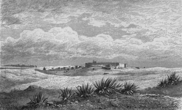
Still keeping to the telegraph posts, we soon came within sight of the castle of El Harish, the last outpost eastward of the Egyptian Government. As we advanced over ridges and then over heaps of ruins, the view of the castle became more and more distinct, and at length we could overlook the palm-wood towards the sea, the beauty and shade of which had been so frequently enlarged upon by the camel-drivers. There can indeed be no more attractive picture for the mind of an Arab to dwell upon, when toiling over shifting sands under a scorching sun, than that of a plantation of palms, with abundant supply of water, on the shores of an invigorating sea!
Still following the telegraph posts, we soon caught sight of the castle of El Harish, the last stronghold east of the Egyptian Government. As we moved over hills and piles of ruins, the view of the castle became clearer, and finally, we could see the palm grove stretching toward the sea, the beauty and shade of which the camel drivers had often talked about. There really is no more appealing image for an Arab to imagine while trudging through shifting sands under a blazing sun than a palm plantation with plenty of water on the shores of a refreshing sea!
 Wadi Abou-Sbeh.
As we approached El Harish, a row of men gathered outside the town wall. After saluting[Pg 29] them we proceeded to our tents at the south-east end of the town. Having reached them we were congratulated by Abou Nabout upon having safely accomplished our journey across the desert.
As we got closer to El Harish, a line of men gathered outside the town wall. After greeting[Pg 29] them, we made our way to our tents at the southeast end of the town. Once we arrived, Abou Nabout congratulated us on successfully completing our journey across the desert.
After dinner we were visited by some of the authorities, who were extremely cordial. As usual we offered them coffee and cigars. Their stay, however, was but short, as they rightly presumed that we needed repose.[Pg 30]
After dinner, some officials came to see us, and they were very friendly. As always, we offered them coffee and cigars. However, their visit was brief, as they rightly thought we needed to rest.[Pg 30]
VI.
EL HARISH.
El Harish is the town of the desert which forms the most advanced post of the Khedive in the direction of Turkish territory, and, as it possesses many remarkable features, is worthy of a detailed description. As the point of convergence of the caravan routes, the entire life of the place is bound up with the caravan traffic, carried on by the resident population with their camels; it is, in a word, a place of camel-keepers. It is situated at about two miles from the sea, on the outskirts of the desert, the daily advancing sands of which threaten in time to cover a considerable portion of the town, and indeed have already overwhelmed many houses in the south-west quarter of it.
El Harish is a desert town that serves as the Khedive's most forward outpost toward Turkish territory and has many notable features that deserve a detailed description. As the meeting point of caravan routes, the town's entire life revolves around caravan traffic, which is managed by the local population and their camels; in short, it's a place full of camel herders. It’s located about two miles from the sea, on the edge of the desert, where the ever-encroaching sands threaten to bury a significant part of the town over time, and have already buried many houses in the southwestern area.
The climate is extremely salubrious. Snow is never to be seen; but there are frequent hailstorms and heavy falls of rain, particularly in February. The temperature is highest imme[Pg 31]diately after the Hampsin, that is, at the beginning of the summer, and the very hot season lasts four months. The strongest wind is the Hampsin, which prevails for fifty days, and is here particularly disagreeable from the quantity of sand which it brings.
The climate is very healthy. Snow is never seen, but there are frequent hailstorms and heavy rain, especially in February. The temperature is highest right after the Hampsin, which means at the start of summer, and the extremely hot season lasts for four months. The strongest wind is the Hampsin, which lasts for fifty days, and is particularly unpleasant here because of the amount of sand it brings.
 EL HARISH.
The population numbers 2800 souls, exclusive of the Bedouins living in the neighbourhood. With scarcely an exception, the people are Mussulmans, and extremely fanatical; some portion of them are of Turkish origin, but none speak Arabic. There are but eight Christians in the place—three of whom are women. The garrison consists of sixty soldiers, including ten artillery-men, commanded by the governor of the fortress, whose especial task it is to restrain the excesses of the Bedouin tribes. The latter have a great dread of the military, as immediately a Sheik lays himself open to suspicion he is arrested and despatched to Cairo. Their conduct has consequently of late been very circumspect, particularly since their last outbreak, which was severely punished.
The population is 2,800 people, not counting the Bedouins living nearby. With hardly any exceptions, the residents are Muslims, and they are very fanatical; some of them have Turkish roots, but none speak Arabic. There are only eight Christians in the area—three of whom are women. The garrison has sixty soldiers, including ten artillerymen, led by the governor of the fortress, whose main job is to keep the Bedouin tribes in check. The Bedouins are very fearful of the military, because as soon as a Sheikh raises any suspicion, he gets arrested and sent to Cairo. As a result, their behavior has been quite cautious lately, especially after their last uprising, which was harshly dealt with.
There are no rich people in Harish, the richest possessing at the most not more than twenty camels; many persons are, on the contrary, so poor as to be forced to procure their camels on credit.[Pg 32] Should an animal come to grief under such circumstances, the poor debtor is a ruined man. Altogether there are 500 camels in the place—60 of which are for the use of the soldiers; also 60 hayin or dromedaries, one only of which is assigned to them. There is an almost incredible difference between the capabilities of the camel and the dromedary, as much as between those of the English draught-horse and race-horse. An idea of the extraordinary fleetness of dromedaries may be gathered from the fact that there are several in Harish who can run easily in one day from Harish to Kantara. A very serviceable animal, suitable either for draught purposes or for running, results from a cross between the dromedary and camel.
There are no wealthy people in Harish; the richest own at most twenty camels. Many people, on the other hand, are so poor that they have to buy their camels on credit.[Pg 32] If an animal were to suffer an accident in such cases, the poor debtor would be ruined. Overall, there are 500 camels in town—60 of which are used by the soldiers, with only one of the 60 dromedaries assigned to them. The difference in capabilities between a camel and a dromedary is as significant as that between an English draft horse and a racehorse. The incredible speed of dromedaries is illustrated by the fact that some in Harish can easily run from Harish to Kantara in one day. A hybrid between a dromedary and a camel produces a highly useful animal, suitable for both pulling and running.
There are but ten horses in Harish; but, on the other hand, no less than 150 asses, of the black or black-and-white-spotted Bedouin race; about 200 goats, 100 sheep, and 35 cows. The sheep and cows are mostly from Syria. Pigeons and fowls are largely kept, but only a few turkeys, and still fewer ducks. Dogs are also not numerous.
There are only ten horses in Harish; however, there are around 150 donkeys, from the black or black-and-white-spotted Bedouin breed; about 200 goats, 100 sheep, and 35 cows. The sheep and cows mostly come from Syria. Pigeons and chickens are commonly raised, but there are only a few turkeys and even fewer ducks. Dogs are also not very common.
The game of the district comprises quails (during the migratory season), hares, and gazelles. The last named are caught by the Bedouins when young, at some distance in the interior, but frequently die when their horns begin to grow. They[Pg 33] are transported long distances, without injury, in a basket of palm leaves, the small feet being tucked up under the belly, and the head only peering out of the basket, which of course is firmly fastened with cord.
The local game includes quails (during migration season), hares, and gazelles. The Bedouins catch the young gazelles further inland, but many of them unfortunately die when their horns start to grow. They[Pg 33] are transported over long distances safely in a basket made of palm leaves, with their small feet tucked under their bellies and only their heads peeking out. The basket is securely tied with cord.
Fish abound in the neighbouring sea, and are caught by moonlight, with a bell-shaped net only, draw-nets being not used here. In Harish itself there are not more than fifteen or twenty persons who follow fishery as a calling. There are, however, many fishermen engaged in the preparation of salt fish, who come over from Damietta and live behind the Berdovil. In the same way they fish the Melleha, referred to above, in which are a large number of mullet. The fishing-ground has been rented from the Government by an Arab, who is even thinking of setting up a boat. Hitherto the fishermen have always come here from Port Said, along the shore, on foot.
Fish are plentiful in the nearby sea, and they're caught by moonlight using only a bell-shaped net; they don't use draw-nets here. In Harish itself, there are only about fifteen to twenty people who fish for a living. However, many fishermen come from Damietta to prepare salted fish and live behind the Berdovil. They also fish in the Melleha mentioned earlier, which has a lot of mullet. An Arab has rented the fishing area from the government and is even considering setting up a boat. Until now, fishermen have always walked here from Port Said along the shore.
The palm trees of Harish, of which there are about 6000, are the principal basis of the local product. No impost whatever is paid for them to the Government, the concession being presumably accorded to the population, in consideration of their being inhabitants of a frontier station. No wine is made from the palms of Harish, the sap being principally used for the[Pg 34] preparation of sugar. The black and red dates are retained for home consumption, while the yellow, as also the Agua dates (pounded date cakes), are exported in sacks. The fruit of the place consists principally of figs and grapes, the latter being chiefly grown in the western portion of the district. For the most part they are white table grapes, but we heard that the under health officer of Harish was attempting to make wine from some of them. Melons are also extensively cultivated here, more particularly in Wadi, and are preserved for some time by hanging. The vegetables include tomatoes, garlic, onions, and carrots; barley, wheat, maize, and small sweet vetches are also grown, more or less.
The palm trees of Harish, numbering around 6,000, are the main source of local products. No taxes are paid to the government for them, as this concession is likely granted to the community since they live in a border area. No wine is produced from the Harish palms; instead, the sap is mainly used for the[Pg 34] production of sugar. The black and red dates are kept for local use, while the yellow ones and Agua dates (pounded date cakes) are exported in sacks. The main fruits grown here are figs and grapes, with the grapes mostly cultivated in the western part of the district. Most of them are white table grapes, but we heard that the local health officer was trying to make wine from some of them. Melons are also widely grown, particularly in Wadi, and they are preserved for a while by hanging them. The vegetables grown include tomatoes, garlic, onions, and carrots; barley, wheat, maize, and small sweet vetches are also cultivated to some extent.
Industrial pursuits are almost entirely neglected. A few articles of clothing, etc., are made for actual home use, but nothing more. These comprise, for instance, winter jackets of sheepskins (made with the bare skin outside, the hair being worn next the body); camel's-hair sacks; close-fitting camel's-hair caps (a very warm and practical head-gear, and consequently worn by the military and officials under their fez); and black and striped cloaks of sheep's wool, such as are seen in Syria.
Industrial activities are almost completely overlooked. A few items of clothing, etc., are produced for actual home use, but nothing beyond that. These include, for example, winter jackets made from sheepskin (with the bare skin on the outside and the hair next to the body); camel-hair bags; snug-fitting camel-hair caps (which are very warm and practical headwear, often worn by the military and officials under their fez); and black and striped wool cloaks, similar to those found in Syria.
The commerce of the place is insignificant,[Pg 35] and what there is consists chiefly of a transit trade, for, being really little more than a large station of camel-keepers, Harish has no trade of its own. It has, therefore, much suffered from the construction of the Suez Canal, since which, almost the entire trade between the south of Syria and Egypt goes by water, leaving but a small portion for the once famous caravan route. From Harish itself no goods whatever are exported by land, excepting, occasionally, dates for Gaza. There are no boats at Harish, as the shore is bad and full of reefs. Corn and fruit often come by ship from Jaffa, and sometimes timber for building purposes, but this does not happen very often, as most of the timber required at Harish is brought from Wadi. Altogether, ships do not come more than fifteen or sixteen times in the year, when they are either laden as described, or simply ballasted, and return with cargoes of melons, dates, and Agua dates. Sometimes shipwrecks occur on these inhospitable coasts. As has been already mentioned, the postal service between Harish and the outer world is provided for by a weekly mail to Kantara, by means of a dromedary.
The local trade is minimal,[Pg 35] and what little exists mainly involves transit trade, as Harish is essentially just a large stop for camel herders and has no commerce of its own. It has suffered significantly since the Suez Canal was built because now almost all trade between southern Syria and Egypt is conducted by water, leaving only a small share for the once-popular caravan route. No goods are exported from Harish by land except occasionally some dates for Gaza. There are no boats in Harish due to the poor shoreline and numerous reefs. Grains and fruits sometimes arrive by ship from Jaffa, and occasionally timber for construction, but this isn’t very frequent since most of the wood needed in Harish comes from Wadi. In total, ships visit Harish about fifteen or sixteen times a year, either loaded as mentioned or just carrying ballast, and leave with loads of melons, dates, and Agua dates. Occasionally, shipwrecks occur along these harsh coasts. As previously stated, the postal service connecting Harish to the outside world consists of a weekly mail service to Kantara using a dromedary.
I will now give some description of the place itself. Harish lies along the side of an undulat[Pg 36]ing hill fronting the sea, at the foot of the large quadrangular castle, a substantial building of calcareous marlstone. The only entrance to the castle is by a great gate opening from the town, and, therefore, upon the side next the sea. On either side of the gate is a round tower, with a marble pillar—the capital of which is inverted—built into the stone. Above are five marble tablets with inscriptions. A sixth tablet stands below the loophole, from which the standard-bearer (whose grave will be mentioned presently) was killed by the French. From the lower inscription we learn that the castle is 327 years old, and was built by the Sultan Suleiman. The upper tablets bear the name of the Sultan Selim. A gate with iron mountings leads into the T-shaped entrance-hall, in the centre of which is an oval cupola, and on either side slightly pointed arches. At the entrance is a circular arch, and a similar one at the opposite end of the hall, in which a lamp is suspended, and where there are three marble steps leading up to the mosque. This is a very simple edifice, covered by a flat roof of palm-leaf stalks, and containing two rows of four pointed arches, with four ancient marble pillars built into the stone. To the left of the Mihrab, which has two marble pillars, and is also[Pg 37] distinguished by simplicity, is a mural inscription. The Mem Ber is of the same character, and is constructed of red and green painted wood. Four men are set apart for the service of the mosque, one only of whom is a priest.
I will now describe the place itself. Harish is located on the side of a rolling hill overlooking the sea, at the base of a large rectangular castle, a solid structure made of limestone. The only entrance to the castle is through a large gate that opens from the town, thus facing the sea. On either side of the gate are round towers, each featuring a marble pillar—its capital turned upside down—built into the stone. Above are five marble tablets with inscriptions. A sixth tablet is positioned below a loophole, where the standard-bearer (whose grave will be mentioned shortly) was killed by the French. From the lower inscription, we learn that the castle is 327 years old and was built by Sultan Suleiman. The upper tablets bear the name of Sultan Selim. A gate with iron fittings leads into the T-shaped entrance hall, where there is an oval cupola in the center and slightly pointed arches on either side. At the entrance is a circular arch, and a similar one at the opposite end of the hall, where a lamp is suspended, and three marble steps lead up to the mosque. This is a very simple building, covered by a flat roof made of palm fronds, featuring two rows of four pointed arches, with four ancient marble pillars built into the stone. To the left of the Mihrab, which has two marble pillars and is also characterized by its simplicity, there is a wall inscription. The Mem Ber is of the same style, made of red and green painted wood. Four men are designated for the service of the mosque, with only one serving as a priest.
Passing out through a side-door to the left, we found, opposite to the Jama, an old Egyptian sarcophagus of black granite, now used as a water trough, covered within and without with very small hieroglyphics.
Passing out through a side door to the left, we found, across from the Jama, an old Egyptian sarcophagus made of black granite, now being used as a water trough, covered inside and out with tiny hieroglyphics.
The interior of the fortress has a very deserted air. We found there dilapidated clay houses for the soldiers, and, somewhat to the side, the divan of the governor, which consists of a hall with two circular arches, the interior containing low sofas covered with rich carpets. There we waited upon the governor, who, according to invariable custom, ordered coffee to be served. He then took us over the armoury, in which was a small field-piece for mounting on camels, and afterwards conducted us over the fortress. The entire castle, as already mentioned, forms a quadrangle, and has four hexagonal towers, with embrasures, and a few bronze cannons. A gallery in a ruinous condition runs round the entire length of the walls, with a parapet of some six feet in height and embrasures. The[Pg 38] towers of the castle command an extensive view of the desert, with the distant mountain chains of El Halal and El Magara in the south-east, the magnificent palm plantation towards the sea, and the town of Harish itself spread out below.
The inside of the fortress feels very deserted. We found some rundown clay houses for the soldiers, and off to the side was the governor's divan, which is a hall with two circular arches, featuring low sofas covered with luxurious carpets. We waited for the governor, who, as is customary, had coffee served. He then showed us the armory, which had a small field gun designed for camels, and afterward he took us on a tour of the fortress. As mentioned earlier, the whole castle forms a quadrangle and has four hexagonal towers with embrasures and a few bronze cannons. A gallery in poor condition runs the entire length of the walls, with a parapet about six feet high and embrasures. The[Pg 38] towers of the castle offer a wide view of the desert, with the distant mountain ranges of El Halal and El Magara to the southeast, the beautiful palm plantation near the sea, and the town of Harish itself spread out below.
To the left hand of the castle gate, on passing out, is a small enclosure overgrown with shrubs, in which is the tomb, already referred to, of the Piraktar, or standard-bearer, who was killed by the French in the time of Napoleon. It is of simple clay, ornamented at the corners with ancient pillars.
To the left of the castle gate, as you exit, there's a small area covered with shrubs, where the tomb of the Piraktar, or standard-bearer, is located. He was killed by the French during the time of Napoleon. The tomb is made of simple clay and has ancient pillars at the corners.
Altogether, El Harish has a poverty-stricken appearance, with rugged uneven streets, formed merely of a sandy earth. Gray is the prevailing hue, relieved only in a few places by the green of one of the loftier palm trees projecting above the buildings. These are of clay and straw,—the clay tiles being cemented with sand and clay; the roofs are flat and very roughly finished. Most of the houses have small courtyards communicated with by rough sliding doors. It is very seldom that one sees curved arches over these; they are almost invariably quadrangular, with a wooden bar as head piece. To many of the doors camels' skulls have been attached by the[Pg 39] occupiers, who for the most part are camel-keepers, as a protection against evil spirits. Over the entrance doors large branches of the tamarisk are frequently hung for a shade. These plain courtyards, which contain nothing but a few indispensable things, are, as it were, the private domain of the inhabitants, in which they often keep their cattle. They rarely communicate with each other, and of course are closed to strangers, unless accompanied by the proprietor. The chattels they usually contain are a few large clay water-pitchers, clay vessels in the form of casks, for the storage of grain, which, after being filled from the top, are closed and the grain afterwards drawn off as required from an opening in the bottom; a bell-shaped poultry-coop made of clay, with a lid, which is kept down by a stone when necessary; pigeon-holes either in the clay wall round the yard, or in the wall of the house itself; and small baking ovens with side-door and place under for fire. In the kitchens, too, which are as a rule wretched holes, there are small baking ovens with flat tops, such as are common throughout Egypt. The houses of the more prosperous inhabitants are not unfrequently provided with a raised space, railed on both sides, and sometimes latticed in[Pg 40] front, which is fitted with receptacles for jars and other domestic articles.
Overall, El Harish looks very poor, with rough, uneven streets made of just sandy soil. Gray is the main color, only broken up in a few spots by the green of taller palm trees standing over the buildings. These buildings are made from clay and straw, with clay tiles stuck together using sand and clay; the roofs are flat and quite poorly finished. Most of the houses have small courtyards accessed by rough sliding doors. It’s rare to see curved arches over these doors; they are almost always rectangular, topped with a wooden bar. Some doors have camel skulls attached by the[Pg 39] residents, who are mostly camel keepers, to ward off evil spirits. Large branches from the tamarisk tree are often hung over the entrance doors for shade. These simple courtyards contain just a few essential items and serve as the private space of the residents, where they often keep their livestock. They rarely connect with each other and are usually closed to strangers unless they’re with the owner. The usual items found in them include a few large clay water pitchers, clay containers shaped like barrels for storing grain (which are filled from the top and have a bottom opening to draw out the grain as needed), a bell-shaped clay poultry coop with a lid that’s kept shut by a stone when necessary, pigeon holes either in the clay wall surrounding the yard or in the house wall itself, and small baking ovens with a side door and a spot for a fire underneath. The kitchens, which are generally miserable little spaces, also contain small baking ovens with flat tops, similar to those found throughout Egypt. More affluent residents' houses often have a raised area, fenced on both sides and sometimes with lattice in the[Pg 40] front, which holds storage for jars and other household items.
Ancient columns and pedestals are sometimes built into the houses. There are usually several wooden doors between these and the courtyards, which also serve as windows. Light is also provided for in many rooms by small wood lattices or jalousies, firmly built into the wall, the lattices often consisting of nothing but palm-leaf stalks stuck into the clay wall. When there is an upper story, which is rarely the case, it is approached from the courtyard by a staircase, usually dilapidated, with stairs of shelly marlstone. The stairs and floors of the interior, when there are any, are of clay. The roofs are formed with cross beams connected by palm-leaf stalks and pegs, which are then covered with palm leaves, and clay finally thrown over the whole. Those provided with an upper story live there in the summer, as it usually contains several latticed windows, and is consequently cooler. Most of the houses have a partition for sheep and goats.
Ancient columns and pedestals are sometimes built into the houses. There are usually several wooden doors between these and the courtyards, which also serve as windows. Light is also provided in many rooms by small wooden lattices or jalousies, securely built into the wall, with the lattices often made of palm-leaf stalks inserted into the clay wall. When there is an upper floor, which is rare, access is usually from the courtyard via a staircase, typically in disrepair, with steps made of shelly marlstone. The stairs and floors inside, when they exist, are made of clay. The roofs consist of cross beams connected by palm-leaf stalks and pegs, which are then covered with palm leaves, and finally coated with clay. Those who have an upper floor live there in the summer, as it typically has several latticed windows, making it cooler. Most houses contain a partition for sheep and goats.
 EL HARISH MARKET.
There is but little in the whole town worthy of a visit. East of the fortress is the simple quadrangular tomb of Mahomet el Domiats, which bears a Greek inscription. Facing this is[Pg 41] a house of refuge for casual passers-by, with a subterranean cistern, still containing water. Upon a small uneven piece of ground, called Ard Sheik el Kashif, is a Kittabia, or children's school, a roughly built house like the rest, where the lively youngsters assemble to be taught by their half blind master.
There isn't much in the whole town that's worth a visit. East of the fortress is the simple square tomb of Mahomet el Domiats, which has a Greek inscription. Across from this is[Pg 41] a place of refuge for passing travelers, featuring an underground cistern that still holds water. On a small uneven patch of land called Ard Sheik el Kashif, there’s a Kittabia, or children's school, a roughly constructed building like the others, where energetic kids gather to learn from their half-blind teacher.
About the centre of the town is situated the little Souk or bazaar, with a number of miserable booths (see illustration), which I searched in vain for specimens of native industry. While engaged on my sketch I had an opportunity of seeing some old coins found in the neighbourhood.
About the center of town is the small souk or bazaar, with several rundown booths (see illustration), where I looked in vain for examples of local craftsmanship. While I was working on my sketch, I had the chance to see some old coins discovered in the area.
The cemetery is situated beyond a piece of land fenced with a prickly hedge, at a short distance from which there is a very old Nebke tree. It has a most neglected aspect. There are a large number of tombs in the form of steps, and here and there various kinds of pedestals, some of which are fluted. It also contains the roughly constructed Koubba of the Sheik Ghebara, with a pyramidical cupola coated with clay.
The cemetery is located behind a patch of land surrounded by a thorny hedge, not far from a very old Nebke tree. It looks quite run-down. There are many step-like tombs, along with different types of pedestals, some of which are fluted. It also features the roughly built Koubba of Sheik Ghebara, topped with a pyramid-shaped dome covered in clay.
On the opposite or east side of the cemetery there is a slight rise in the ground affording a good view of the entire place, as well as of the large palm wood towards the sea, and the extensive plain planted with fig trees between the[Pg 42] dunes of the coast and the cemetery. While I was sketching there, an old man approached and looked at the grave of some children, which no doubt were his own. He then looked up and enquired whether I was a father, and on my replying in the negative, ejaculated in a tone of the deepest sympathy, "Poor man!" An instance, this, of the high value set by these people upon the blessings of family life. "But," he added after a pause, "we must submit to God's will."
On the east side of the cemetery, there's a slight hill that offers a great view of the whole area, including the large palm forest toward the sea and the wide plain filled with fig trees between the[Pg 42] dunes by the coast and the cemetery. While I was sketching there, an old man walked up and looked at the grave of some children, which were surely his own. He then looked up and asked if I was a father, and when I replied no, he exclaimed sympathetically, "Poor man!" This shows how much these people value the blessings of family life. "But," he added after a moment, "we must accept God's will."
Here and there we remarked tombs in a better condition, with aloes planted around, and one or two that were even whitewashed. Many "Haddayas" (Milvus ater, or black kite) and kestrels (Falco tinnunculus) were flying about this deserted burial-place, which one might almost have fancied to be the spirits of the departed.
Here and there, we noticed some tombs in better shape, surrounded by aloes, and a few that were even freshly whitewashed. Many black kites and kestrels were flying around this empty burial site, which one might almost think were the spirits of the departed.
Westward of the cemetery and below the town is a kind of vale or declivity planted with tamarisks and fig trees, and containing three wells provided with handspikes. Numbers of women and children with black jugs from Gaza go there to draw water, giving, as may be imagined, great life and animation to the scene. The water, like that of all the wells of the place, is somewhat saline. At Wadi the water is perfectly fresh.
West of the cemetery and downhill from the town is a sort of valley or slope filled with tamarisks and fig trees, and it has three wells equipped with hand pumps. Lots of women and children with black jugs from Gaza come to draw water, which, as you can imagine, brings a lot of life and energy to the scene. The water, like that from all the wells in the area, is a bit salty. At Wadi, the water is completely fresh.
 EL HARISH (NORTHERN VIEW).
Proceeding still in a westerly direction, we[Pg 43] came to the telegraph posts and the beginning of the route leading through the desert, which now lay unrolled before us. This road is the same by which we came to El Harish. Ruins of old buildings, asserted by the inhabitants to date from the time of the crusades, strewed the ground in every direction. In some cases the foundations might be clearly traced. It is said that old coins are still found now and then under the ruins. From the numerous aloes growing, it is perhaps to be inferred that graves once existed at this spot. A good view is obtained there of the place and its surroundings, including the sea and the verdant edge of the palm wood near it.
Proceeding still westward, we[Pg 43] came to the telegraph poles and the start of the route leading through the desert, which now stretched out before us. This road is the same one we took to El Harish. Ruins of old buildings, claimed by the locals to be from the time of the Crusades, scattered the ground in every direction. In some cases, the foundations could be clearly seen. It's said that old coins are still occasionally found beneath the ruins. The numerous aloes growing here might suggest that graves once existed at this site. There is a great view of the area and its surroundings, including the sea and the lush edge of the palm grove nearby.
The lazaretto is a wretched building, with a flagstaff and two houses projecting on the two sides. The entrance is from the side fronting the road towards Syria. In the rear is a yard, containing a small garden but no supply of water, which has therefore to be brought from the Wadi. The houses are of the same character as those of El Harish generally, but slightly more European in style. In the larger lives the deputy commissioner, the smaller being occupied by his adjutant, who is a remarkable example of the mixture of races so common in this country. His father was a Dalmatian, whose family came from Sebenico,[Pg 44] and he himself was born in Egypt of a Nubian mother, being therefore almost a mulatto. He was educated in Dalmatia, and is a Christian.
The lazaretto is a miserable building, featuring a flagpole and two houses sticking out on either side. The entrance is on the side facing the road to Syria. At the back, there's a yard with a small garden but no water supply, so it has to be brought in from the Wadi. The houses are similar to those in El Harish but slightly more European in style. The larger house is where the deputy commissioner lives, while the smaller one is occupied by his adjutant, who is a remarkable example of the racial mix that’s common in this country. His father was from Dalmatia, with roots in Sebenico, and he was born in Egypt to a Nubian mother, making him almost a mulatto. He was educated in Dalmatia and is a Christian.
The quarantine processes do not take place in the building, but are performed in tents, which are kept in readiness on the premises, and erected as occasion requires.
The quarantine procedures don't happen inside the building; instead, they are carried out in tents that are kept ready on the property and set up as needed.
From the lazaretto we proceeded in the afternoon towards the sea, which is beyond the beautiful palm plantations, and not more than half-an-hour's ride from El Harish. Our path first brought us to the Koubba of Nebi Gasser (see illustration). This is a quiet burial-place planted round with dark green tamarisks, strongly contrasting with the yellow sands, which again are well set off by the background of sea and sky. The repose and peace of this little spot are intensified by the neighbourhood of the vast expanses of desert and sea, which here meet as though to rival each other.
From the lazaretto, we headed in the afternoon toward the sea, just beyond the beautiful palm plantations, and only about a half-hour's ride from El Harish. Our route first led us to the Koubba of Nebi Gasser (see illustration). This is a serene burial site surrounded by dark green tamarisks, creating a striking contrast with the yellow sands, which are beautifully set off by the backdrop of the sea and sky. The tranquility and peace of this small spot are heightened by the vast stretches of desert and sea that converge here, as if competing with each other.
 Tomb of Nabi Gasser.
Upon the hill of the Koubba, fragments of old masonry lie scattered about. In the interior of the somewhat large building, the door of which bears an Arabian inscription, is a conical cupola upon four roughly constructed arches. To the right, on entering, is the tomb of Nebi Gasser, over which is a canopy of green cloth upon a[Pg 45] framework of wood. To the left is that of one of his followers. There are in the sand, on the land side, many traces of graves, which may be known by the aloes growing near. In many places a piece of marble column or of stone still projects, but it cannot be long before all such vestiges disappear under the ever advancing sands. At the side of the Koubba is an old tamarisk of the thick-leaved sort, called by the people Atel, those with the thin leaves, of which there are many examples here, being known as Tarfa.
Upon the hill of the Koubba, pieces of old stonework are scattered around. Inside the fairly large building, which has a door with an Arabic inscription, there's a conical dome supported by four roughly built arches. To the right, upon entering, is the tomb of Nebi Gasser, covered by a canopy of green cloth on a[Pg 45] wooden framework. To the left is the tomb of one of his followers. On the land side, there are many signs of graves in the sand, identifiable by the aloes growing nearby. In various spots, a piece of marble column or stone still sticks out, but it won't be long before all these remnants are buried under the ever-advancing sands. Next to the Koubba is an old tamarisk tree with thick leaves, called Atel by locals, while the thinner-leaved variety, which is also common here, is known as Tarfa.
Going eastward from the Koubba of Nebi Gasser, we soon reached the broad Wadi, which still brings water down from the hills. It may be crossed either close to the sea-shore, or at a shallower spot not far distant. To the left of the Wadi are many vegetable gardens, with numerous wells. The large palm wood lies to the right of the Wadi, and stretches down nearly to the sea. The trees generally are of slender dimensions, but of gigantic height. The scene altogether is one calculated powerfully to stimulate the imagination. The solemn stillness which prevails it is impossible to describe. The regular sound of the distant breakers, mingled with the gentle whisperings of the breeze through the palms; the flights of kites floating aimlessly in the air; the pecu[Pg 46]liar character of the shade of the palm, through the leafy crowns of which the light penetrates in trembling waves; the dark green tints of the foliage against the transparently blue Egyptian sky;—all combine to produce an effect which must be experienced to be realised.
Going east from the Nebi Gasser shrine, we soon reached the wide Wadi, which still carries water from the hills. You can cross it either close to the shoreline or at a shallower spot not far away. To the left of the Wadi, there are many vegetable gardens with numerous wells. The large palm grove is on the right side of the Wadi, stretching down almost to the sea. The trees are generally slender but extremely tall. The whole scene is incredibly inspiring for the imagination. The profound stillness is hard to describe. The rhythmic sound of the distant waves, mixed with the soft rustling of the breeze through the palms; the kites soaring aimlessly in the sky; the unique shade cast by the palms, where light filters through the leaves in shimmering waves; the dark green hues of the foliage against the clear blue Egyptian sky—all come together to create an experience that you have to feel to truly understand.
The different groups of the palm wood are interspersed with pieces of meadow land, watered by seven wells, and upon which are ten mean huts occupied by Arab herdsmen. The wood stretches for some distance over the broad surface of the Wadi, which, when swollen, frequently uproots many trees. In the entire Wadi there are some thirty fresh-water wells for the supply of the vegetable gardens, where onions, tomatoes, melons, etc., are grown. It contains, too, numerous young palm groves of recent plantation. Immediately beyond the point to which irrigation extends, the barren desert again commences.[Pg 47]
The different groups of palm trees are mixed in with patches of meadowland, supplied by seven wells, where ten small huts are home to Arab herders. The forest covers a large area across the wide valley, which, when flooded, often uproots many trees. Throughout the valley, there are about thirty freshwater wells that support the vegetable gardens, where they grow onions, tomatoes, melons, and more. There are also many young palm groves that were recently planted. Right beyond the area reached by irrigation, the barren desert begins again.[Pg 47]
VII.
FROM EL HARISH TO SHEIK EL ZVOYED.
But at length the time came to take leave of El Harish and its friendly inhabitants. Early on the morning of our departure the governor and all our acquaintances came once more to greet us, and, on our moving away eastward, stood until we were out of sight, making signs of farewell and other demonstrations of goodwill. The governor strongly counselled us not to stop until we reached Sheik el Zvoyed, as he judged the road between El Harish and that place to be unsafe for encampment, and also furnished us with an attendant, named Ramadan, a powerfully built man, with sunburnt features, as a guard in case of our meeting with hostile Bedouins. Our escort, who was mounted upon a cross-bred camel, and armed with a long sword and Arabian firearms, proved to be a most obliging and serviceable companion.[Pg 48]
But eventually, the time came to say goodbye to El Harish and its friendly residents. Early on the morning of our departure, the governor and all our friends came once more to see us off, and as we headed eastward, they stood until we were out of sight, waving goodbye and showing other signs of goodwill. The governor strongly advised us not to stop until we reached Sheik el Zvoyed, as he believed the road between El Harish and that place was unsafe for camping. He also provided us with a companion, named Ramadan, a tall, muscular man with sunburned skin, as a guard in case we encountered hostile Bedouins. Our escort, who rode a cross-bred camel and carried a long sword and Arabian firearms, turned out to be a very helpful and accommodating companion.[Pg 48]
Soon after quitting El Harish we advanced upward into the broad clayey bed of the Wadi, upon the opposite bank of which we found the burial-place of the Bedouins, containing several tombs and a large number of aloes. Then we reached the opposite side of the Wadi, of cliff-like character, the clay of which is much worn away by the water.
Soon after leaving El Harish, we moved up into the wide, clay-rich bed of the Wadi, where we discovered the burial site of the Bedouins on the other side, featuring several tombs and a large number of aloes. Then we arrived at the opposite edge of the Wadi, which had steep cliffs, with the clay significantly eroded by water.
A guardhouse is situated there, occupied by three soldiers, who demanded from us certificates of health. On our telling them that everything had been arranged at El Harish, and that we had but just left there, we were allowed to proceed without further question.
A guardhouse is located there, manned by three soldiers, who asked us for health certificates. When we informed them that everything had been sorted out at El Harish and that we had just left, we were allowed to continue without any further questions.
Beyond the guardhouse the road passes through a bare plain, and then rises for some distance over sandy hills into undulating ground, where the hill ridges run parallel to the sea. We observed a number of asphodels growing, and here and there patches of corn land. As we advanced further the vegetation became thicker and thicker, the bare sand-hills continuing on our left only. We saw many Bedouins at work on the land—of which many extensive tracts are under cultivation—with no other implements than ordinary hoes and a one-horse "camel." In many places there grows an inferior kind of grass,[Pg 49] called Hafour, which, however, makes excellent pasturage. We saw a good number of goats and sheep about, evidently in a thriving condition.
Beyond the guardhouse, the road goes through an empty plain and then rises over sandy hills into rolling terrain, where the hill ridges run parallel to the sea. We noticed several asphodels growing, along with some patches of farmland. As we continued, the vegetation got thicker, while the bare sand hills remained on our left. We saw many Bedouins working on the land—where large areas are cultivated—with nothing but regular hoes and a one-horse "camel." In many spots, there’s a lower quality of grass, [Pg 49] called Hafour, which, nonetheless, provides excellent grazing. We observed a good number of goats and sheep around, clearly in good health.
 EL HARROUBA.
After passing through the large fruitful valleys of Wadi el Geradi (valley of the earth), and Wadi el Harrouba (valley of the St. John's bread—the Locust or Carob tree), we ascended a hill from which there is an extensive view (see illustration). From there the road runs through a short valley past some cultivated tracts, the land being elsewhere overgrown with Artemisia monosperma. To the right a tree may be observed, which marks the scene of a terrible battle that took place fifteen years ago between the Tarabin Bedouins from Gaza and the Zowarka Bedouins from El Harish.
After passing through the large, fertile valleys of Wadi el Geradi (valley of the earth) and Wadi el Harrouba (valley of the St. John's bread—the Locust or Carob tree), we climbed a hill that offers a wide view (see illustration). From there, the road goes through a short valley past some farmed areas, while the rest of the land is covered with Artemisia monosperma. To the right, there's a tree that marks the site of a brutal battle that took place fifteen years ago between the Tarabin Bedouins from Gaza and the Zowarka Bedouins from El Harish.
We found the land improve as we went on, and in many places observed well-cultivated fields. Some attempts, moreover, had been made to define and improve the road by the construction of ditches on each side. Continuing to follow the telegraph posts, we came, after some distance, to rising ground, from which we had a wide view of the almost flat valley, which was covered with the above-named shrubs. In the distance, to the left of the valley, we could see,[Pg 50] along the borders of an utter desert, the palms and the Koubba of Sheik el Zvoyed.
We noticed the land got better as we traveled, and in many spots, we saw well-tended fields. Some efforts had also been made to improve the road by digging ditches on either side. As we continued following the telegraph poles, we eventually reached a higher area, where we had an expansive view of the nearly flat valley filled with the mentioned shrubs. In the distance, to the left of the valley, we could see,[Pg 50] along the edge of a barren desert, the palm trees and the Koubba of Sheik el Zvoyed.
At the foot of the partially cultivated hill to the left, is a large Melleha filled with rain-water, and bounded on the other side by bare sand-hills, in the midst of which are three beautiful palm groups. For a full view of this characteristic picture, rendered remarkably effective by the solitude of the scene, it is necessary to cross the hill. On the east side the Melleha is shallow, and ends in marshy ground, overgrown with rushes, beyond which is a plain extending to the desert. So exhilarated were our horses by the taste of the green herbage, of which they had so long been deprived, that many got away from us and galloped wildly across the Melleha. It took us nearly an hour to secure them, which we ultimately did by hemming them in between the water and ourselves. Flights of kites passed over our heads, probably attracted by some carcass not far distant.
At the bottom of the partially farmed hill to the left, there's a large Melleha filled with rainwater, bordered on the other side by bare sand dunes, among which are three beautiful groups of palm trees. To get a full view of this typical scene, made even more striking by the solitude around it, you need to cross the hill. On the east side, the Melleha is shallow and ends in marshy land covered with reeds, beyond which a plain stretches out toward the desert. Our horses were so excited by the taste of the green grass, which they hadn't had in a while, that many broke free and galloped wildly across the Melleha. It took us almost an hour to round them up, which we finally did by cornering them between the water and ourselves. Flocks of kites flew overhead, likely drawn by some carcass nearby.
From the Melleha we soon reached Sheik el Zvoyed, where we found to our delight the tents already pitched upon the emerald green sward.
From the Melleha, we soon arrived at Sheik el Zvoyed, where we were thrilled to find the tents already set up on the lush green grass.
 Melleha, Sheik El Zvoyed.
We were met in a friendly way by the man in charge of the telegraph posts of the district; and several Bedouins, attracted either by curiosity or[Pg 51] the hope of a "backshish" in some shape or other, came and seated themselves around us in picturesque groups. After remaining a short time longer, to enable me to complete a sketch of this bright little spot (see illustration), we returned to our tents, which we were very glad to reach after our long ride.[Pg 52]
We were warmly welcomed by the man in charge of the telegraph poles in the area, and several Bedouins, drawn in by curiosity or the hope of some kind of tip, gathered around us in charming groups. After staying a little longer so I could finish a sketch of this lovely spot (see illustration), we headed back to our tents, which we were really happy to reach after our long ride.[Pg 52]
VIII.
FROM SHEIK EL ZVOYED TO KHANYUNIS.
The meadows lay smiling in the morning sun, and their fresh pasture appeared greatly to strengthen and invigorate our animals. While the packing was being done I went to take a look round Sheik el Zvoyed. The first thing I came to was the house, built of clay and straw, similar to that described at El Harish, where the man lives who keeps the telegraph posts and wires in working order. Attached to it is a small courtyard, in the peaceable possession of fowls, turkeys, pigeons, and even ducks. Not far off is a smaller house, where oil and various wares from Gaza are sold for the benefit of the neighbouring Bedouins, who all belong to the Zowarkas. Behind the houses are a number of slender palms, and at a short distance lies the burial-ground, containing a few graves, with numerous aloes growing between them. In the centre stands[Pg 53] the Koubba of Sheik el Zvoyed, built of square stones, with an inscription in Arabic over the door. The interior of the Koubba is cupola-shaped, and it contains a tomb covered with green cloth stretched over a wooden frame.
The meadows were basking in the morning sun, and their fresh grass seemed to really boost our animals' energy. While the packing was happening, I decided to explore Sheik el Zvoyed. The first thing I encountered was the house, made of clay and straw, similar to the one at El Harish, where the guy who maintains the telegraph posts and wires lives. Attached to it is a small courtyard, happily occupied by chickens, turkeys, pigeons, and even ducks. Not far away is a smaller house that sells oil and various goods from Gaza for the benefit of the nearby Bedouins, all of whom belong to the Zowarkas. Behind the houses are several slender palm trees, and a short distance away is the burial ground, which has a few graves and plenty of aloes growing in between them. In the center stands[Pg 53] the Koubba of Sheik el Zvoyed, made of square stones, with an inscription in Arabic above the door. The interior of the Koubba is dome-shaped, and it contains a tomb draped with green cloth stretched over a wooden frame.
 OUR CAMP IN SHEIK EL ZVOYED.
Water is procurable from the sand-hills somewhat to the west behind the houses, not saline, but not of good flavour. The Bedouins of the neighbourhood go there with their donkeys to draw it in black Gaza jars. Both men and boys may be constantly seen threading their way along the sandy path; many of the boys have fine regular features, with sparkling eyes, but of that melancholy expression so peculiar to Bedouin children. In many parts of the country surrounding Sheik el Zvoyed, ruins and heaps of stones are to be met with, telling of places formerly inhabited.
Water can be found in the sand hills just west of the houses. It's not salty, but it doesn't taste great. The local Bedouins head there with their donkeys to fetch it in black Gaza jars. You can often see both men and boys making their way along the sandy path; many of the boys have nice, regular features and bright eyes, but they carry that sad look unique to Bedouin children. In many areas around Sheik el Zvoyed, there are ruins and piles of stones that indicate places that used to be inhabited.
On returning to the camp I found the packing completed, and after shaking hands with the telegraph man we at once continued our journey. At first we passed through meadows, partially bordered with trees, and across sandy hills, and then descended a grassy slope called Lazga, from which we surveyed the extensive plain before us, with the sandy hills on the left projecting into the bright green surface like islets in the sea (see sketch). To the right are two large "Sidr" trees[Pg 54] called Sager el Emir (the tree of the Emir) or Magrunte.[3] In the gently undulating plain there are many daffodils and blue-flowering Iris. The pretty meadows then alternated with barley fields, where numerous birds, such as larks, large buntings, and quails, are constantly to be seen. From a slight elevation we could overlook the whole of the plain stretching away beneath us, and in the distance we saw three Bedouin tents, and some cows grazing on the rich meadow land. We then passed the road leading to Arfeh, about two miles distant, where good water is to be had in the very middle of the sand.
On returning to the camp, I found the packing done, and after shaking hands with the telegraph guy, we continued our journey right away. At first, we walked through meadows, partly lined with trees, and across sandy hills, then descended a grassy slope called Lazga, from which we looked out over the vast plain ahead, with sandy hills on the left jutting into the bright green landscape like islands in the sea (see sketch). To the right are two large "Sidr" trees[Pg 54] known as Sager el Emir (the tree of the Emir) or Magrunte.[3] In the gently rolling plain, there are many daffodils and blue-flowering Iris. The lovely meadows alternated with barley fields, where numerous birds, like larks, large buntings, and quails, can be seen all the time. From a slight rise, we could see the entire plain stretching out below us, and in the distance, we spotted three Bedouin tents and some cows grazing on the lush meadow land. We then passed the road leading to Arfeh, about two miles away, where good water is available right in the middle of the sand.
Fragments of gray granite pillars, still standing, are here to be met with about the road, the fields, and the sand, and we saw one lying on the ground half buried. On one side stands a "Sidr" tree (see sketch), and to the right in the other hollow of the valley is another. The pillars are the remains of an ancient temple, Raphia, and are of special importance in the eyes of the Arabs, who call them Rafah, as they mark the boundary between Egypt and Syria.
Fragments of gray granite pillars, still upright, can be found along the road, in the fields, and among the sand, and we noticed one lying on the ground, partially buried. On one side is a "Sidr" tree (see sketch), and to the right in the other dip of the valley stands another. The pillars are remnants of an ancient temple, Raphia, and hold special significance for the Arabs, who refer to them as Rafah, as they mark the border between Egypt and Syria.
 Sager Al Emir.
 RAFAH COLUMNS.
We took our midday meal close to the pillars, being now within the Holy Land, and after a short rest resumed our journey. Leaving a green sloping valley on the left, and passing sandy hills, we went over gently undulating grass-land, and saw before us the township of Benishaela, situated on the flat crest of a hill. Numerous cows grazing, and flocks of kites soaring in the air, enlivened the otherwise monotonous landscape.
We had our lunch near the pillars, now that we were in the Holy Land, and after a quick break, we continued our journey. Leaving a lush, sloping valley to our left and passing sandy hills, we crossed rolling grassland and saw the town of Benishaela ahead, perched on the flat top of a hill. Many cows grazed, and flocks of kites flew in the sky, bringing some life to the otherwise dull landscape.
But here the aspect of the country suddenly changed, and we saw that we had entered the Land of Promise. Mud walls, with thorn bushes and prickly pears, enclosed the fields, in which almonds, apricots, and figs, sycamores, locust, and "Sidr" trees, vied with each other in a luxuriance all the more cheering to the eyes of the traveller from the barren desert. Passing several small houses built of clay, straw, and stones, we reached at three o'clock Khanyunis, the picturesque Kala of which seemed to invite our approach. We found that our camps had been pitched opposite to it in a field surrounded by opuntias.
But here the landscape changed dramatically, and we realized we had entered the Promised Land. Mud walls, along with thorn bushes and prickly pears, surrounded the fields where almonds, apricots, figs, sycamores, locusts, and "Sidr" trees flourished, making the view even more uplifting after the barren desert. After passing several small homes made of clay, straw, and stones, we arrived in Khanyunis at three o'clock, its picturesque fortress seeming to beckon us closer. We discovered that our camps had been set up across from it in a field bordered by opuntias.
The governor Chaker Effendi, whose family were still in El Halil (Hebron), where he formerly resided, came to welcome us. He was very friendly, and ordered our camp to be guarded[Pg 56] by three cavalry and four infantry soldiers, who relieved each other every two hours. There were one or two negroes amongst them, but the greater number were slim and muscular Arabs, and some of them remarkably handsome men. The governor personally conducted us afterwards over the Kala. Before describing this, however, I must give the reader some general account of Khanyunis.[Pg 57]
The governor Chaker Effendi, whose family was still in El Halil (Hebron), where he used to live, came to greet us. He was very welcoming and arranged for our camp to be protected[Pg 56] by three cavalry and four infantry soldiers, who took turns every two hours. Among them were one or two Black soldiers, but most were slim, muscular Arabs, and some of them were quite striking. The governor personally took us on a tour of the Kala. Before I describe that, though, I need to give the reader some general information about Khanyunis.[Pg 57]
IX.
KHANYUNIS.
Khanyunis (or Khan Yunas) is the furthest Syrian place in the direction of Egypt, and in some respects the last outpost of the immediate authority of the Porte, as El Harish is of that of the Khedive. Between the two lies that desert tract in which the Rafah pillars stand, indicating the supposed boundary between the two countries. The Bedouin, however, wanders at will over the waste land, caring little whether he happens to be in Egypt or Syria.
Khanyunis (or Khan Yunas) is the farthest Syrian location towards Egypt, and in some ways, it’s the last point of direct control by the Porte, just as El Harish is for the Khedive. Between them is the desert area where the Rafah pillars are located, marking the supposed border between the two nations. The Bedouin, however, roams freely across the wasteland, indifferent to whether he’s in Egypt or Syria.
As in El Harish, the Kala constitutes the castle of the place, and is at the same time the nucleus around which the other buildings have gradually clustered.
As in El Harish, the Kala serves as the castle of the area and is also the center around which the other buildings have slowly gathered.
Khanyunis is now a pleasant village, but does not at present contain more than 1000 inhabitants. Formerly the population was larger, having reached 1800, but it has decreased owing to the frequent inroads of the Tarabin Bedouins, who[Pg 58] only three years ago set fire to the crops of the poor villagers. All the Bedouins who haunt the neighbourhood are Tarabins. They are generally well provided with horses and asses, some of the former being fine animals, of great powers of endurance. Since Khanyunis has been supplied with a stronger garrison, they are kept in check, and the state of affairs is consequently much improved. There are now fifty foot and fifty horse soldiers, almost exclusively sons of the desert, who look quite picturesque with their Koufi as head-dress, and Arabian costume. They are fine muscular fellows, and extremely courteous in manner. The villagers wear the usual South Syrian costume, and are of fairly strong build. Some of the boys have two ringlets hanging at the sides of their heads,—a fashion not uncommon among the Bedouins. There are two schools for the instruction of youth, and, judging from the fact that nearly every one can read, they must be well attended.
Khanyunis is now a nice village, but it currently has no more than 1,000 residents. In the past, the population was larger, hitting 1,800, but it has decreased due to repeated attacks from the Tarabin Bedouins, who[Pg 58] just three years ago burned the crops of the struggling villagers. All the Bedouins in the area are Tarabins. They are generally well-equipped with horses and donkeys, some of which are impressive animals known for their endurance. Since Khanyunis has been fortified with a stronger military presence, they are better controlled, and the situation has improved significantly. There are now fifty infantry and fifty cavalry soldiers, mostly local men from the desert, who look quite striking in their Koufi headwear and traditional Arabian attire. They are strong and very polite. The villagers wear the typical South Syrian clothing and are generally sturdy. Some boys sport two ringlets on the sides of their heads, a style not uncommon among the Bedouins. There are two schools for educating the youth, and judging by the fact that nearly everyone can read, they must be quite popular.
 Kala from Khanyunis.
The interior of the village presents but a poor appearance, the streets being dirty and disfigured by numerous trenches for carrying off the rain. The houses, between which lofty palms raise their towering heads, are built of mud and stone. The inferior quality of stone consists of shell[Pg 59] detritus and shale conglomerate from the neighbouring sea-shore, and the better material is brought from different ruins, sometimes from a distance of ten to twelve hours' journey. The roofs of the houses are flat, and over many of the entrances, which have wooden lintels, a piece of bone is fixed as a protection against the influence of the Evil eye. For the better defence of the inhabitants against the incursions of the Bedouins, the houses have loopholes; ventilation is provided for by a number of round holes arranged either in rows or tasteful designs. As has been said, the principal feature of Khanyunis is its Kala (see sketch), which abuts on a broad place or square, the left side of which still shows traces of a former enclosure. On either side of the entrance is a hall, with a fragment of a pedestal. That on the left contains the modest dwelling of the governor, who lives quite alone here, with but one servant. The Kala, which is 850 years old, once formed a square, at the corners of which were circular towers, with oval cupolas, and three embrasures. The two front towers only now remain, the back wall having been quite destroyed, and the once enclosed square is now filled with a wild confusion of wretched houses, half in ruins, which serve the soldiers as a place of habitation.[Pg 60] In the centre of the front side is a gate with loopholes within the pointed arch, above which is a Moorish frieze crowned with lilies. On both sides of the gate, and on the broad front wall, are pyramidical battlements with tapering ends. Inside the archway is an inscription of Sultan Bargut of Cairo, and either side is ornamented with a lion, rudely sculptured in relief. Arabic inscriptions are cut in the walls on both sides of the gate, and in the gateway itself; no regard having been paid to keeping within the stone rows. To the right of the gate, within the Kala, rises the octagonal minaret of the mosque, from which is obtained a fine view of the ruinous interior, with its labyrinth of dilapidated houses, as well as of the whole village. From here four roads can be seen diverging from Khanyunis, namely the El Harish road, the road leading to Suez viâ Akaba, the Benishaela road, and lastly, the Gaza road. At the entrances to these roads are grouped the houses of the village. Raising our eyes towards the horizon we saw the yellow sand-hills which bound the plantations towards the sea, strikingly contrasting with the bright green trees, and on the other side the rich verdant plain stretching away towards Gaza, which may be discerned in the distance. The[Pg 61] numerous prickly-pear bushes surrounding the village on the Gaza side are a conspicuous feature in the landscape.
The village's interior looks quite shabby, with dirty streets marred by many trenches for draining rainwater. The houses, nestled among tall palm trees, are made of mud and stone. The lower-quality stone comes from shell detritus and shale conglomerate from the nearby beach, while better material is sourced from various ruins, sometimes as far as a ten to twelve-hour journey away. The roofs are flat, and many entrances have wooden lintels topped with a piece of bone for protection against the Evil Eye. To help defend the residents against Bedouin raids, the houses have loopholes; ventilation is provided by several round holes arranged in neat rows or attractive patterns. As previously mentioned, the main feature of Khanyunis is its Kala (see sketch), which borders a large open area or square, the left side of which still shows remnants of an old enclosure. On either side of the entrance is a hall with a fragment of a pedestal. The left side houses the modest dwelling of the governor, who lives here alone with just one servant. The Kala, which is 850 years old, used to be square, with circular towers at the corners, topped with oval domes and three openings. Only the two front towers remain now, as the back wall has been completely destroyed, and the once-enclosed square is now filled with a chaotic mix of run-down houses that serve as quarters for the soldiers. In the center of the front side is a gate featuring loopholes within a pointed arch, adorned above with a Moorish frieze decorated with lilies. On both sides of the gate, and on the wide front wall, are pyramid-shaped battlements with tapering tops. Inside the archway is an inscription of Sultan Bargut of Cairo, flanked on either side by a lion, crudely sculpted in relief. Arabic inscriptions are etched into the walls on both sides of the gate and within the entrance itself, without much attention to alignment with the stonework. To the right of the gate, inside the Kala, stands the octagonal minaret of the mosque, which offers a great view of the rundown area filled with its maze of dilapidated houses, as well as the entire village. From this vantage point, you can see four roads branching out from Khanyunis: the El Harish road, the route to Suez via Akaba, the Benishaela road, and finally, the Gaza road. The village houses are clustered at the entrances to these roads. Looking up at the horizon, we noticed the yellow sand mounds that border the plantations toward the sea, strikingly contrasting with the bright green trees, while on the opposite side the lush, green plain stretches toward Gaza, visible in the distance. The numerous prickly-pear bushes surrounding the village on the Gaza side are a prominent feature in the landscape.
We now descended to complete our inspection of the Kala. In the interior the mosque, with its oval dome, has almost gone to ruin; but the fine though simple marble pulpit still stands in good preservation. In the midst of the ruins, which have a somewhat picturesque appearance, is a house in a very dangerous condition, in consequence of a considerable portion of the mosque having fallen on it a short time since. Notwithstanding this, however, the people are heedless enough to continue occupying it. Only a few steps' distance a lofty palm was recently blown down by a violent storm. Thus the works both of man and nature meet with a common destruction, the inhabitants not thinking it worth while to do the least in the way of repair, or to make the slightest attempt to protect themselves against impending danger. Lethargy and nonchalance are the leading characteristics of Eastern nations, and a certain evidence of the gradual decay of their religion and race.
We now went down to finish our inspection of the Kala. Inside the mosque, the oval dome is almost in ruins, but the simple yet beautiful marble pulpit is still in good condition. Amid the ruins, which have a somewhat picturesque look, there's a house that's in very bad shape because a large part of the mosque collapsed on it not long ago. Despite this, the residents are careless enough to keep living there. Just a short distance away, a tall palm tree was recently knocked down by a strong storm. Thus, both human efforts and nature face common destruction, with the locals not bothering to make any repairs or trying to protect themselves from potential danger. Apathy and indifference are the main traits of Eastern nations, which is a clear sign of the slow decline of their religion and culture.
There is another mosque in the village opposite the Kala, but without a minaret. From its exterior it is scarcely to be recognised as a Jama.[Pg 62] Near one of the ruined towers of the Kala's outer enclosure, and at the corner of a house on the road to Gaza, stand ancient pedestals, serving as seats for the Mayor, Sheik el Beled.
There’s another mosque in the village across from the Kala, but it doesn’t have a minaret. From the outside, it’s hardly recognizable as a Jama.[Pg 62] Next to one of the crumbled towers of the Kala’s outer wall, and at the corner of a house on the way to Gaza, there are old pedestals that are used as seats for the Mayor, Sheik el Beled.
The Souk or Bazaar of Khanyunis is formed by two streets lined with wretched Turkish shops, with mud or clay projections for seats. The doors are made to flap upward, but they close imperfectly; the roofs are, as usual, made of the Artemisia shrub. The goods exposed in these shops come for the most part from Gaza and Jaffa; but the caps of camel's hair and of cotton, as well as the white and black Syrian mantles, are made by the villagers themselves. At the end of the village, near the Souk, and on the road to El Harish, is the second public well, about 18 fathoms deep, and built entirely of ancient marble fragments. At the side is a cistern with cattle-troughs of the same material, which evidently belongs to a more flourishing period than the present. Somewhat further on, behind a slight hollow with stagnant water and a few palm trees, in the Akaba and Suez road, is the burial-ground, containing a few whitewashed tombs of step-like construction. At the opposite end of the village, where the road is open to the surrounding country, we came upon a hollow with embank[Pg 63]ments, and then took the road leading to Benishaela.
The Souk or Bazaar of Khanyunis consists of two streets filled with rundown Turkish shops, with mud or clay benches for seating. The doors are designed to open upward but don’t close properly; the roofs are typically made from Artemisia shrubs. Most of the goods displayed in these shops come from Gaza and Jaffa, but the camel hair and cotton caps, as well as the white and black Syrian mantles, are made by the local villagers. At the edge of the village, near the Souk and on the road to El Harish, there’s a second public well, about 18 fathoms deep, made entirely from ancient marble fragments. Next to it is a cistern with cattle troughs made of the same material, which clearly belongs to a more prosperous time than now. A bit further on, behind a low spot with stagnant water and a few palm trees, along the Akaba and Suez road, there’s a burial ground with a few whitewashed tombs built in a step-like style. At the other end of the village, where the road opens up to the surrounding countryside, we came across a low area with embankments, and then we took the road leading to Benishaela.
In the neighbourhood of Benishaela there are many gardens, which bear witness to the extreme fertility of the soil; though unfortunately there is not a single well among them. Almonds and apricots are the chief productions, and the raised ground enclosing them is often covered with small branches of the thorny "Sidr." Near the village we saw several "Sidr" trees, as well as tamarisks (Atel) and sycamores. The most numerous class are the thorny Opuntias, which grow round some of the gardens in rank luxuriance.
In the neighborhood of Benishaela, there are many gardens that show how fertile the soil is; unfortunately, there isn’t a single well among them. Almonds and apricots are the main crops, and the elevated ground around them is often covered with small branches of the thorny "Sidr." Near the village, we saw several "Sidr" trees, along with tamarisks (Atel) and sycamores. The most common type is the thorny Opuntias, which grow abundantly around some of the gardens.
The people of Khanyunis do not live exclusively from the cultivation of the ground; they are also largely engaged in cattle-breeding, and a great many cows are to be seen in the neighbourhood. Of camels there are but few; horses, on the other hand, are numerous. I also saw four greyhounds of the Syrian breed. As is well known, it is Richard Cœ]ur de Lion to whom is ascribed the introduction into the Holy Land of the greyhound, which, crossing with the ordinary street dog, originated the above-mentioned breed. These dogs were not of pure blood; they were spotted white and yellow, with shaggy hair and blue stripes, studded with cowries, on their[Pg 64] haunches. They are used for hunting gazelles, which are frequently caught alive when very young. One of these graceful creatures was brought to us and offered for a sum equal to six shillings; it was very tame, and we carried it for some distance. But at length it died, in consequence, as was said, of having eaten bread, which, according to Abou Nabout's assertion, is very unwholesome for these animals. The more probable cause was the trying journey it made in a basket on a camel's back. There are only a few street dogs in Khanyunis; but, as a compensation, any quantity of kites, kestrels, and crows, which alight in hundreds on the loftier sidr or sycamore trees in the neighbourhood, and may often be seen hovering over the village on the look-out for prey and carrion.[Pg 65]
The people of Khanyunis don’t rely solely on farming; they also engage in cattle-breeding, and you can see many cows in the area. There are only a few camels, but there are plenty of horses. I also spotted four greyhounds of the Syrian breed. It is well-known that Richard Cœur de Lion is credited with bringing the greyhound to the Holy Land, which, when crossed with the local street dogs, created the mentioned breed. These dogs weren’t purebred; they had white and yellow spots, shaggy fur, and blue stripes adorned with cowries on their[Pg 64] hindquarters. They are used to hunt gazelles, which are often caught alive when they are very young. One of these graceful animals was brought to us and offered for six shillings; it was very tame, and we carried it for some distance. However, it eventually died, allegedly from eating bread, which Abou Nabout claimed is very unhealthy for these dogs. A more likely reason was the difficult journey it took in a basket on a camel’s back. There are only a few street dogs in Khanyunis, but, on the bright side, there are plenty of kites, kestrels, and crows that land in hundreds on the tall sidr or sycamore trees nearby and can often be seen soaring over the village looking for food and carrion.[Pg 65]
X.
FROM KHANYUNIS TO GAZA.
The broad sandy road from Khanyunis to Gaza passes for some distance through gardens with Opuntia hedges, and embankments crowned with thorn bushes. To the left, the gardens extend to sandy hills; and to the right as far as Benishaela, a village standing on an elongated hill, and containing 500 inhabitants. Behind this is another village called Abansan, with many cultivated tracts in the neighbourhood. On the uniform hill-range on which Benishaela is situated, and which bounds the valley on the land side, is the grave of Sheik Mohammed, at the foot of an old tree, and adjoining a small house which serves as the Koubba. To the right are the tents of the Bedouins, who are numerous here, and are the sole proprietors of the rich meadow lands.
The wide sandy road from Khanyunis to Gaza runs for a stretch through gardens lined with Opuntia hedges and embankments topped with thorn bushes. On the left, the gardens lead to sandy hills, while on the right, they extend all the way to Benishaela, a village situated on a long hill with around 500 residents. Behind this is another village called Abansan, surrounded by many cultivated fields. On the consistent hill range where Benishaela sits, which borders the valley on the land side, lies the grave of Sheik Mohammed, at the base of an old tree, next to a small house that functions as the Koubba. To the right, you’ll find the tents of the Bedouins, who are plentiful in this area and are the sole owners of the fertile meadows.
After keeping for some distance to the telegraph posts across the sand, we again passed through meadows, and then reached the dry sandy[Pg 66] bed of a brook called Wadi Selga, bordered on the left by earth banks and on the right by meadows. After heavy rainfalls the stream of this brook extends from the mountains to the sea.
After keeping a distance from the telegraph posts across the sand, we went through meadows again and then reached the dry sandy[Pg 66] bed of a brook called Wadi Selga, with earth banks on the left and meadows on the right. After heavy rains, the stream from this brook flows from the mountains to the sea.
On the left hand, about half-an-hour's ride from the main road, is the village of Der el Belah (enclosure of date-trees), the only one we met with before reaching Gaza. It lies in a valley, on a Melleha, which is only separated from the sea by a rather low shore, and bounded at the lower end by sand and clay hills. The village is recognised from a distance by the numerous slender palm trees, which give it a particularly charming and picturesque appearance. It contains about 100 inhabitants, and consists of a few ruinous houses, the mud roofs of which are covered with grass. Between the buildings are cultivated pieces of ground, fenced with mud walls. Here and there we met with fragments of ancient pillars. There is also a rudely-built and dilapidated tower, tapering upward, and provided with loopholes, which is occasionally occupied by soldiers. To the north of the hamlet there is another Melleha, enclosed by beautiful groups of palms, and on the seaside by sandy hills. Not far from this a direct road leads from Der el Belah to Gaza, but[Pg 67] we wished to follow the main road, and therefore crossed the hills behind Der el Belah, over green meadows, where we saw plenty of daffodils and squills. From the top of the hills we had a view of the luxuriant meadows of the valley, where many cows of the small South Syrian breed were grazing, and in which we observed an old "Sidr" tree, called El Jemeter, near which there are said to be some ruins. On the other side we had before us the wide sea, separated from the meadows by sand-hills only, on which is a group of trees called Em Maharnes.
On the left, about a half-hour ride from the main road, is the village of Der el Belah (enclosure of date-trees), the only one we encountered before reaching Gaza. It sits in a valley on a Melleha, which is only separated from the sea by a low shore and bordered at the lower end by sand and clay hills. The village is recognizable from a distance by the many slender palm trees, which give it a charming and picturesque look. It has about 100 residents and consists of a few rundown houses, their mud roofs covered in grass. Between the buildings are cultivated plots of land, fenced with mud walls. Here and there, we found fragments of ancient pillars. There’s also a crudely built and dilapidated tower that tapers upward, equipped with loopholes, which is sometimes occupied by soldiers. To the north of the village, there's another Melleha, surrounded by beautiful clusters of palms and sandy hills by the sea. Nearby, a direct road leads from Der el Belah to Gaza, but[Pg 67] we wanted to stick to the main road, so we crossed the hills behind Der el Belah, over green meadows where we saw plenty of daffodils and squills. From the top of the hills, we had a view of the lush meadows in the valley, where many small South Syrian cows were grazing, and we spotted an old "Sidr" tree called El Jemeter, near which some ruins are said to be located. On the other side, we looked out over the vast sea, separated from the meadows by sand hills, where a group of trees called Em Maharnes stands.
 GAZA NEIGHBORHOOD.
Having reached the road, we continued to advance across the plain, where we met with numerous tents of Tarabin Bedouins and several head of cattle. We remained but a short time for breakfast on the open meadow land, being anxious to get to Gaza. Soon after we came to the dry sandy bed of the Wadi Gaza, and, climbing the low hills lying behind it, we could see in the distance the minarets and palms of Gaza, the sight of which cheered the last steps of our journey. The town is situated to the right, commanded by the Mountar Hill, so called from the Sheik who is buried there. This hill is the principal feature in the landscape. Leaving to the left the path which we have mentioned as[Pg 68] joining the main road from Der el Belah, we followed the sandy path along the telegraph posts. We then passed through fields and gardens fenced by thorny Opuntias, and planted with almonds, figs, olives, sycamores, and a few tamarisks, and finally reached the Quarantine Building of Gaza by half-past two o'clock.
Having reached the road, we continued to move across the plain, where we encountered many tents of Tarabin Bedouins and several heads of cattle. We stayed for just a short time for breakfast on the open meadow, eager to get to Gaza. Shortly after, we arrived at the dry sandy bed of the Wadi Gaza, and, climbing the low hills behind it, we could see in the distance the minarets and palm trees of Gaza, which cheered us on for the last part of our journey. The town is located to the right, overlooked by Mountar Hill, named after the Sheik who is buried there. This hill is the main feature of the landscape. Leaving to the left the path we mentioned as[Pg 68] connecting to the main road from Der el Belah, we followed the sandy path along the telegraph posts. We then passed through fields and gardens surrounded by thorny Opuntias, and filled with almonds, figs, olives, sycamores, and a few tamarisks, and finally reached the Quarantine Building of Gaza by half-past two o'clock.
Here we had to take leave of our camel-drivers; and not without regret did I grasp the hand of honest old Daud, who had accompanied me the whole distance from El Kantara.
Here we had to say goodbye to our camel drivers; and not without regret did I shake the hand of honest old Daud, who had accompanied me the whole way from El Kantara.
All our superfluous luggage was here disposed of, for we were now in the Holy Land, the land of Plenty and Wealth. After a few days' rest in Gaza we started again with our horses and mules to make for the third time the pilgrimage to Jerusalem.
All our unnecessary baggage was taken care of, since we were now in the Holy Land, the land of abundance and riches. After a few days of rest in Gaza, we set out again with our horses and mules to make our pilgrimage to Jerusalem for the third time.
 Entrance to Bazaar, Gaza.
FOOTNOTES
[1] Levkosìa, the Capital of Cyprus, with an Introduction by the Chevalier de Krapf-Liverhoff, Imp. and Roy. Austro-Hung. Ministerial Councillor, etc. etc. London: Kegan Paul and Co. 1881.
[1] Nicosia, the Capital of Cyprus, with an Introduction by the Chevalier de Krapf-Liverhoff, Imperial and Royal Austro-Hungarian Ministerial Councillor, etc. etc. London: Kegan Paul and Co. 1881.
[2] All the illustrations were drawn by the author from nature, reproduced on wood by Frederick Havranek, and engraved by F. Stolarz and J. Jass of Prague.
[2] All the illustrations were created by the author from nature, printed on wood by Frederick Havranek, and engraved by F. Stolarz and J. Jass from Prague.
[3] Large specimens of Zizyphus Spina-Christi, Willdenow, called "Sidr" in Egypt, where its fruit is called "Nabak." In Palestine, the tree is named "Doom," and the fruit "Sidr." Magrunte or Magroonât (in Syriac "Madjroonât") means "the female neighbours."
[3] Large specimens of Zizyphus Spina-Christi, Willdenow, known as "Sidr" in Egypt, where its fruit is referred to as "Nabak." In Palestine, the tree is called "Doom," and its fruit "Sidr." Magrunte or Magroonât (in Syriac "Madjroonât") means "the female neighbors."
THE END.
Download ePUB
If you like this ebook, consider a donation!