This is a modern-English version of The Panama Canal: A history and description of the enterprise, originally written by Mills, J. Saxon (John Saxon).
It has been thoroughly updated, including changes to sentence structure, words, spelling,
and grammar—to ensure clarity for contemporary readers, while preserving the original spirit and nuance. If
you click on a paragraph, you will see the original text that we modified, and you can toggle between the two versions.
Scroll to the bottom of this page and you will find a free ePUB download link for this book.
THE PANAMA CANAL

[Clinedinst--Washington, D.C.
Clinedinst--Washington, D.C.
Col. George W. Goethals, U.S.A.,
Chairman and Chief Engineer Isthmian Canal Commission.
Col. George W. Goethals, U.S. Army,
Chairman and Chief Engineer Isthmian Canal Commission.
THE PANAMA CANAL
A HISTORY AND DESCRIPTION OF THE ENTERPRISE
BY
J. SAXON MILLS, M.A.
BARRISTER-AT-LAW
WITH MAPS AND ILLUSTRATIONS
THOMAS NELSON AND SONS
LONDON, EDINBURGH, DUBLIN, MANCHESTER, LEEDS
PARIS, LEIPZIG, MELBOURNE, AND NEW YORK
PREFACE.[Pg 5]
The literature on the subject of the Panama Canal is rather dispersed. A full and entertaining history of the project will be found in Mr. W. F. Johnson's "Four Centuries of the Panama Canal" (Cassell and Co., 1907), a work to which I am greatly indebted. Dr. Vaughan Cornish has given the results of much research and several visits to the canal in "The Panama Canal and its Makers" (T. Fisher Unwin, 1909), and in several lectures, especially one before the Royal Colonial Institute, June 11, 1912. An inexhaustible mine of information will be found in Mr. Emory R. Johnson's Official Report on Panama Canal Traffic and Tolls (Washington, 1912). The Report on the Trade and Commerce of the Republic of Panama for the year 1911, by Mr. H. O. Chalkley, Acting British Consul at Colon, contains useful information. A valuable series of articles on[Pg 6] the Panama Canal appeared in The Times of 1912. The National Geographic Magazine of February 1911 contains an authoritative article by Colonel G. W. Goethals, Chief Engineer of the Canal, and the number for February 1912 an interesting appreciation by Mr. W. J. Showalter. In Scribner's Magazine for February 1913, Mr. J. B. Bishop, Secretary of the Isthmian Canal Commission, writes a very useful paper on the Sanitation of the Isthmus. In his recent work on South America Mr. Bryce devotes one of his delightful chapters to the Isthmus of Panama. A chapter on the Panama Canal will be found in Mr. A. E. Aspinall's "The British West Indies," and many references in Mr. C. G. Murray's "A United West Indies." I must thank Mr. G. E. Lewin, the Librarian of the Royal Colonial Institute, for his unfailing help and courtesy.
The literature on the Panama Canal is quite widespread. A comprehensive and engaging history of the project can be found in Mr. W. F. Johnson's "Four Centuries of the Panama Canal" (Cassell and Co., 1907), which I greatly appreciate. Dr. Vaughan Cornish has compiled insights from extensive research and several visits to the canal in "The Panama Canal and its Makers" (T. Fisher Unwin, 1909), along with various lectures, especially one delivered before the Royal Colonial Institute on June 11, 1912. An invaluable source of information is Mr. Emory R. Johnson's Official Report on Panama Canal Traffic and Tolls (Washington, 1912). Mr. H. O. Chalkley, Acting British Consul at Colon, offers helpful insights in the Report on the Trade and Commerce of the Republic of Panama for the year 1911. A valuable series of articles on[Pg 6] the Panama Canal was published in The Times in 1912. The National Geographic Magazine for February 1911 features an authoritative piece by Colonel G. W. Goethals, Chief Engineer of the Canal, and the February 1912 issue includes an interesting appreciation by Mr. W. J. Showalter. In Scribner's Magazine for February 1913, Mr. J. B. Bishop, Secretary of the Isthmian Canal Commission, presents a very useful discussion on the Sanitation of the Isthmus. In his recent book on South America, Mr. Bryce dedicates one of his delightful chapters to the Isthmus of Panama. A chapter on the Panama Canal can be found in Mr. A. E. Aspinall's "The British West Indies," along with many references in Mr. C. G. Murray's "A United West Indies." I would like to thank Mr. G. E. Lewin, the Librarian of the Royal Colonial Institute, for his unwavering assistance and courtesy.
Bushey, 1913.
Bushey, 1913.
CONTENTS.
| Preface | 5 | |
| Date History of the Canal | 11 | |
| I. | The Secret of the Strait | 15 |
| II. | Canal Projects | 23 |
| III. | The Clayton-Bulwer Treaty and the Suez Canal | 42 |
| IV. | The French Failure | 52 |
| V. | The Hay-Pauncefote Treaty | 64 |
| VI. | The United States and Colombia | 77 |
| VII. | A Miniature Revolution | 88 |
| VIII. | The Battle of the Levels | 112 |
| IX. | Man and the Gnat | 129 |
| X. | Life at the Isthmus | 153 |
| XI. | The Problem of Construction | 172 |
| XII. | The Culebra Cut | 186 |
| XIII. | The Locks | 195 |
| XIV. | The Completed Canal | 207 |
| XV. | Panama and the Isthmus | 226 |
| XVI. | [Pg 8]The New Ocean Highways | 242 |
| XVII. | The Canal and the Americas | 265 |
| XVIII. | The Canal and the British Empire | 284 |
| XIX. | The New Pacific | 316 |
| Appendix I.—Hay-Pauncefote Treaty | 323 | |
| Appendix II.—Panama Declaration of Independence | 327 | |
| Appendix III.—Hay-Bunau-Varilla Treaty Clauses 1-9 and 23 | 332 | |
| Appendix IV.—Proclamation as to Canal Toll Rates | 343 | |
LIST OF ILLUSTRATIONS.
| Col. George W. Goethals, U.S.A. | Frontispiece |
| Chairman and Chief Engineer Isthmian Canal Commission. | |
| Col. William C. Gorgas | 144 |
| Medical Department, U.S. Army, Head of the Department of Sanitation, Ancon. | |
| Culebra Cut, from West Bank | 192 |
| Gatun Locks, looking South-West | 201 |
| Gatun Upper Lock, looking North | 208 |
| Gatun Upper Lock—West Chamber | 216 |
| Pedro Miguel Locks | 224 |
DATE HISTORY OF THE CANAL.
| Conquest of Constantinople by Turks | 1453 |
| Columbus discovers Bay of Limon | 1492 |
| Rodrigo de Bastidas, Balboa, and La Cosa reach the Isthmus | 1500 |
| Columbus's Fourth Voyage, vainly seeks the strait | 1502 |
| Balboa sights the Pacific | Sept. 25, 1513 |
| Pedrarias founds the old town of Panama | 1519 |
| Magellan discovers the straits that bear his name | 1519-21 |
| Gonzalez de Avila discovers Lake Nicaragua | 1522 |
| The quest of Isthmian Strait given up as hopeless | circa 1532 |
| Gomara appeals to Charles V. to construct canal | 1551 |
| Drake sights the Pacific | 1573 |
| Philip III. directs surveys for Darien Canal | 1616 |
| English seize Jamaica | 1655 |
| [Pg 12]Henry Morgan destroys old Panama | 1671 |
| Paterson's settlement at Panama | 1698 |
| Spanish surveys of Tehuantepec and Nicaragua | 1771 and 1779 |
| Von Humboldt's residence in Central America | 1799-1804 |
| Panama declares its independence and joins New Granada | 1822 |
| Overtures made by Central America to United States for canal | 1825 |
| Goethe's prophecies | 1827 |
| Dutch canal concession from Nicaraguan Government, 1829; abandoned | 1830 |
| British Honduras annexed by Great Britain | 1835 |
| United States Treaty with New Granada | 1846 |
| Clayton-Bulwer Treaty | 1850 |
| Panama Railway opened to traffic | 1855 |
| Dickinson-Ayon Treaty between United States and Nicaragua | 1868 |
| President Grant recommends canal under United States control | 1869 |
| Apppoints Interoceanic Canal Commission | 1869 |
| Suez Canal opened | 1869 |
| La Société Civile Internationale du Canal Interocéanique founded | 1876 |
| [Pg 13]Grant's Commission reports in favour of Nicaraguan route | 1876 |
| The De Lesseps Company formed | 1878 |
| Company starts work | 1881 |
| Bankruptcy of French company | 1889 |
| New Panama Company formed | 1889 |
| Construction work at Nicaragua | 1890-3 |
| Ferdinand de Lesseps died | 1894 |
| Hay-Pauncefote Treaty | 1901 |
| Spooner Act | 1902 |
| Panama revolts from Colombia | 1903 |
| Hay-Bunau-Varilla Treaty | 1904 |
| American occupation of Isthmus begins | 1904 |
| Completion of canal | 1914 |
| Formal opening | 1915 |
THE PANAMA CANAL.
CHAPTER I.
THE SECRET OF THE STRAIT.
It was either very careless or very astute of Nature to leave the entire length of the American continent without a central passage from ocean to ocean, or, having provided such a passage at Nicaragua, to allow it to be obstructed again by volcanic action. This imperviousness of the long American barrier had, as we shall see, important economic and political results, and the eventual opening of a waterway will have results scarcely less important. The Panama Canal will achieve, after more than four centuries, the object with which Columbus spread his sails westwards from the port of Palos—the provision of a sea-route westwards to China and the Indies. [Pg 16]The capture of Constantinople in 1453 by the Turks interrupted the ancient trade routes between East and West. Brigands held up the caravans which plodded across the desert sands from the Euphrates and the Indus, and pirates swarmed in the Mediterranean and Red Sea, intercepting the precious cargoes of silks and jewels and spices consigned to the merchants of Italy. The eyes of all Europe were turned to the Atlantic, and an ocean route westwards to India and the Orient, the existence of which had been fabled from the days of Aristotle, became an economic necessity.
It was either very careless or very clever of Nature to leave the entire American continent without a central passage from ocean to ocean, or, having created such a passage at Nicaragua, to let it be blocked again by volcanic activity. This barrier along the American landmass had, as we will see, significant economic and political consequences, and the eventual opening of a waterway will have nearly as important results. The Panama Canal will achieve, after more than four centuries, the goal with which Columbus set sail westward from the port of Palos—the establishment of a sea route west to China and the Indies. [Pg 16]The capture of Constantinople in 1453 by the Turks disrupted the ancient trade routes between East and West. Brigands attacked the caravans that trudged across the desert sands from the Euphrates and the Indus, and pirates infested the Mediterranean and the Red Sea, intercepting the valuable cargoes of silks, jewels, and spices meant for the merchants of Italy. The eyes of all Europe were focused on the Atlantic, and an ocean route westward to India and the East, a concept that had been fantasized since the days of Aristotle, became an economic necessity.
Columbus, as every one knows, died in the belief that he had discovered this route, and that the lands he had visited were fringes and islands of the Eastern Asiatic continent. The geographers of those days greatly exaggerated the eastern extension of Asia, with the result that the distance from Europe to China and India was underestimated by at least one-half. This was a fortunate mistake, for it is improbable that if Columbus had known that Cathay and Cipangu (Japan) were a good 12,000 miles westwards from the coast of Spain he would have ventured upon [Pg 17]a continuous voyage of that length in the vessels of his time.
Columbus, as everyone knows, died believing he had discovered this route and that the lands he visited were just fringes and islands of the Eastern Asian continent. The geographers of his time greatly exaggerated the eastern reach of Asia, which led to the distance from Europe to China and India being underestimated by at least half. This was a lucky mistake because it’s unlikely that Columbus would have dared to embark on [Pg 17]a continuous voyage of that distance—about 12,000 miles to Cathay and Cipangu (Japan)—if he had known how far west they truly were from the coast of Spain.
It was in his fourth voyage (1502) that Columbus first reached and explored the coastline of the isthmus and Central America. He was apparently not the first to land on the isthmus. That distinction belongs either to Alfonso Ojeda, who is said to have reached "Terra Firma" earlier in 1502, or to Rodrigo de Bastidas, who, we are told, set sail from Cadiz with La Cosa in 1500, and, reached the isthmus somewhere near Porto Bello. About the doings of Columbus on the mainland we get some detailed information from the Portuguese historian and explorer of the sixteenth century, Galvano. It is interesting to read that the great navigator visited the exact spot where the newly-constructed canal starts from the Caribbean coast. From the Rio Grande, we read, Columbus "went to the River of Crocodiles which is now called Rio de Chagres, which hath its springs near the South Sea, within four leagues of Panama, and runneth into the North Sea." It was this same river, as we shall see, that became the feeder of the canal when the high-level scheme was adopted. So [Pg 18]far out of his reckoning was Columbus that at Panama he imagined himself to be ten days' journey from the mouth of the Ganges! One of his objects, as we know from his own journal, was to convert the Great Khan of Tartary to the Christian faith, and this entanglement in what he called "the islands of the Indian Sea" was a sore hindrance to that and all his other purposes. He began that search for the strait which engaged the attention and tried the temper of Spanish, Portuguese, and English navigators for the next thirty years. He had heard from the natives of the coast of "a narrow place between two seas." They probably meant a narrow strip of land as at Panama. But Columbus understood them to mean a narrow waterway, and rumours of such a passage no doubt existed then, as they still do among the isthmian tribes. He must also have heard accounts of the great ocean only thirty miles away, and it is rather surprising he should not have made a dash across and anticipated Balboa and Drake. In May 1503, however, he quitted the "Terra Firma" without solving the great secret, and he never returned to the mainland. [Pg 19]He died in 1506, still in complete ignorance of the nature of his discovery. He knew nothing of the continent of America or of that seventy million square miles of ocean beyond, to which Magellan gave the name of "Pacific."
It was during his fourth voyage (1502) that Columbus first reached and explored the coastline of the isthmus and Central America. He was apparently not the first to land on the isthmus. That honor belongs either to Alfonso Ojeda, who is said to have reached "Terra Firma" earlier in 1502, or to Rodrigo de Bastidas, who reportedly set sail from Cadiz with La Cosa in 1500 and arrived at the isthmus near Porto Bello. We get some detailed information about Columbus's activities on the mainland from the Portuguese historian and explorer of the sixteenth century, Galvano. It's interesting to note that the great navigator visited the exact spot where the newly constructed canal begins from the Caribbean coast. From the Rio Grande, it is noted that Columbus "went to the River of Crocodiles which is now called Rio de Chagres, which has its springs near the South Sea, within four leagues of Panama, and flows into the North Sea." This same river, as we will see, eventually became the source for the canal when the high-level plan was adopted. So [Pg 18]far off was Columbus in his calculations that at Panama he thought he was ten days' journey from the mouth of the Ganges! One of his goals, as we know from his own journal, was to convert the Great Khan of Tartary to Christianity, and this entanglement in what he called "the islands of the Indian Sea" greatly hindered that and all his other objectives. He began the search for the strait that would occupy and challenge Spanish, Portuguese, and English navigators for the next thirty years. He had heard from the native people along the coast about "a narrow place between two seas." They likely meant a narrow strip of land like that at Panama. However, Columbus interpreted this to mean a narrow waterway, and rumors of such a passage definitely existed then, just as they do among the isthmian tribes today. He must have also heard about the great ocean just thirty miles away, making it surprising that he didn't make a dash across and anticipate Balboa and Drake. In May 1503, though, he left "Terra Firma" without uncovering the great secret, and he never returned to the mainland. [Pg 19]He died in 1506, still completely unaware of the true nature of his discovery. He knew nothing of the continent of America or the seventy million square miles of ocean beyond, which Magellan named "Pacific."
The Holy Grail itself was not pursued with more persistence and devotion than this mythical, elusive strait by the navigators of the early years of the sixteenth century. The isthmian governor sent out from Spain went with urgent instructions to solve the "secret of the strait." In 1513 Balboa set himself to the great enterprise. If he could not discover a waterway he would at least see what lay beyond the narrow land barrier. From Coibo on the Gulf of Darien he struck inland on September 6 with a hundred Indian guides and bearers. It is eloquent of the difficulties of the country which he had to traverse that it was not until September 26 that he won, first of European men, his distant view of the nameless and mysterious ocean.[1] It was [Pg 20]he, and not Cortéz, who "with eagle eyes, stared at the Pacific."
The Holy Grail itself was not sought after with more determination and dedication than this legendary, elusive strait by the navigators of the early sixteenth century. The governor from Spain was sent out with urgent instructions to uncover the "secret of the strait." In 1513, Balboa took on this great undertaking. If he couldn't find a waterway, at least he would discover what lay beyond the narrow land barrier. From Coibo on the Gulf of Darien, he headed inland on September 6 with a hundred Indian guides and porters. It highlights the challenges of the terrain he had to cross that it wasn't until September 26 that he became the first European to catch a distant glimpse of the unnamed and mysterious ocean.[1] It was [Pg 20] him, and not Cortés, who "with eagle eyes, stared at the Pacific."
They stared at each other with wild guesses,
"Quiet on a mountain in Darien."
Cortéz was himself a persistent searcher for the mythical strait. He wrote home to the King of Spain saying, "If the strait is found, I shall hold it to be the greatest service I have yet rendered. It would make the King of Spain master of so many lands that he might call himself the lord of the whole world."
Cortéz was a determined seeker of the legendary strait. He wrote to the King of Spain saying, "If the strait is found, I will consider it the greatest service I have ever provided. It would make the King of Spain the ruler of so many lands that he could claim to be the lord of the entire world."
These vain attempts had very important results. They led incidentally to the exploration of the whole coastline of the American continent. For example, Jacques Cartier, who was sent out by the King of France about this time to find "the shorter route to Cathay," searched the coast northwards as far as Labrador and thus prepared the way for the planting of a French colony in Canada. At last, in 1520, a sea-passage from the Atlantic to the Pacific was actually discovered by the first great circumnavigator, Magellan, but it was far away from the narrow lands between North and South America. [Pg 21]Through the perilous straits that have ever since borne his name at the southern extremity of the continent, Magellan pushed his venturous way into the great ocean beyond. But even Magellan had no idea that a few miles south of his strait the land ended and Atlantic and Pacific mingled their waters in one great flood. That truth was accidentally discovered by the English Drake more than fifty years afterwards (1579). Drake had been driven southward by stormy weather when he made the discovery which almost eclipsed in its importance even Magellan's exploit. In his exultation, we are told, he landed on the farthest island, and walking alone with his instruments to its extremity threw himself down, and with his arms embraced the southernmost point of the known world. From that point Drake sailed up the western coast of South America, engaged mainly in his favourite pursuit of "singeing the King of Spain's beard"—capturing, that is, the treasure-ships bound to Panama. But he did not forget the more scientific duty of searching for the strait. Far northward he held his course, past the future California, till he must have [Pg 22]been off the coastline of what is now British Columbia, ever hoping to find the Pacific outlet of the famous North-West Passage. But always the coast trended to the north-west, and Drake, giving up the quest, turned his prow westward and continued his voyage of circumnavigation.
These futile efforts had significant outcomes. They inadvertently led to the exploration of the entire coastline of the American continent. For instance, Jacques Cartier, sent by the King of France around this time to find "the shorter route to Cathay," explored the coast northward as far as Labrador, paving the way for the establishment of a French colony in Canada. Eventually, in 1520, a sea route from the Atlantic to the Pacific was discovered by the first great circumnavigator, Magellan, but it was far from the narrow lands between North and South America. [Pg 21] Through the treacherous straits that would come to bear his name at the southern tip of the continent, Magellan bravely navigated into the vast ocean beyond. However, even Magellan was unaware that just a few miles south of his strait, the land ended and the Atlantic and Pacific merged in one massive expanse. That fact was accidentally uncovered by the Englishman Drake more than fifty years later (1579). Drake had been pushed south by rough weather when he made a discovery that nearly overshadowed even Magellan’s achievement. In his excitement, it’s said that he landed on the furthest island, walked alone to its edge with his instruments, and threw himself down, embracing the southernmost point of the known world. From there, Drake sailed up the western coast of South America, largely engaging in his favorite activity of "singeing the King of Spain's beard"—capturing treasure ships headed to Panama. But he did not overlook the more scientific task of searching for the strait. He traveled far northward, past what would become California, until he was likely [Pg 22] off the coast of what is now British Columbia, always hoping to find the Pacific outlet of the famous North-West Passage. Yet the coast consistently veered northwest, and Drake, abandoning the search, turned his ship westward and continued his journey of circumnavigation.
But we are over-running our dates and must return to events at the isthmus. It was about the year 1530 that the non-existence of a natural waterway became recognized. And no sooner was this fact accepted than projects for an artificial canal began to be put forward. It was clear to the geographers and traders of those days that an isthmian route westward offered great advantages to the routes via the Cape of Good Hope, Magellan Straits, or the problematical North-West Passage.
But we are running behind schedule and need to get back to events at the isthmus. Around the year 1530, it became clear that there wasn't a natural waterway. As soon as this fact was accepted, proposals for an artificial canal started to emerge. It was obvious to the geographers and traders of that time that a westward route across the isthmus had significant advantages over the routes via the Cape of Good Hope, the Strait of Magellan, or the uncertain Northwest Passage.
FOOTNOTE:
[1] The eminence known as "Balboa Hill" in the American canal zone is certainly not that from which Balboa first sighted the Pacific, though very likely a tradition to that effect will now gradually be established.
[1] The prominent spot called "Balboa Hill" in the American canal zone is definitely not where Balboa first saw the Pacific, although it's likely that a belief to that effect will eventually take hold.
CHAPTER II.
CANAL PROJECTS.
It appears that the honour of first conceiving and proposing the project of an artificial waterway through the isthmus belongs to Álvaro de Saavedra Cerón, a cousin of Cortéz, who had been with Balboa at Panama. Cerón had been for twelve years engaged in the search for the strait, and had finally begun to doubt its existence. His thoughts turned to the isthmus at Panama, where the narrowness and low elevation of the land seemed to offer the likeliest chance of an artificial canal. We learn from the old historian Galvano that Cerón prepared plans for the construction of a waterway there—almost precisely along the route chosen for the American canal nearly four hundred years later. Cerón's death, however, put an end to this early project.
It seems that the credit for first imagining and proposing the project of an artificial waterway through the isthmus goes to Álvaro de Saavedra Cerón, a cousin of Cortés, who had been with Balboa in Panama. Cerón spent twelve years searching for the strait and eventually started to doubt it existed. He then focused on the isthmus at Panama, where the narrow and low-lying land appeared to be the best chance for an artificial canal. According to the early historian Galvano, Cerón made plans for building a waterway there—almost exactly along the path later chosen for the American canal nearly four hundred years later. Unfortunately, Cerón's death ended this early project.
It is interesting to find the Portuguese historian [Pg 24]Galvano, who flourished in the middle of the sixteenth century, mentioning four possible routes for the canal—namely, Darien, Panama, Nicaragua, and Tehuantepec. The choice, however, quickly confined itself to the Panama and Nicaraguan lines. The reader may feel some surprise that at such an early date as this an engineering project should be seriously considered which was only accomplished in the end by the wealth and mechanical resources of one of the greatest of modern Powers. The explanation is that the tiny vessels of the early sixteenth century could have taken advantage of the natural rivers and lakes in the isthmus, especially those on the Nicaraguan route, and that far less artificial construction would have been necessary than in these days of the mammoth liner and warship.
It’s interesting to see the Portuguese historian [Pg 24] Galvano, who was active in the mid-sixteenth century, mention four possible routes for the canal—Darien, Panama, Nicaragua, and Tehuantepec. However, the focus soon narrowed down to the Panama and Nicaraguan options. Readers might be surprised that such an ambitious engineering project was seriously considered so early, given that it was ultimately achieved later by the wealth and technological capabilities of one of the greatest modern powers. The reason is that the small vessels of the early sixteenth century could have utilized the natural rivers and lakes in the isthmus, particularly those on the Nicaraguan route, meaning much less artificial construction would have been needed compared to today's massive liners and warships.
Charles V., King of Spain, seems to have been quite alive to the importance of these canal projects. In 1534 he directed the Governor of Costa Firme, the old name for the Panama district, to survey the valley of the Chagres, the river which supplies the water for the upper reaches of the American canal. This gentleman, [Pg 25]however, seems scarcely to have shared the royal enthusiasm. He may be supposed to have known the isthmus at these points very well, and his scepticism about the prospect of canal construction there in those days was not wholly groundless. The Spanish historian Gomara, who wrote a history of the Indies in 1551 and dedicated it to Charles V., declared a canal to be quite feasible along any of the four routes mentioned by Galvano. It is true he recognized obstacles. "There are mountains," he wrote, "but there are also hands. If determination is not lacking, means will not fail; the Indies, to which the way is to be made, will furnish them. To a king of Spain, seeking the wealth of Indian commerce, that which is possible is also easy."
Charles V, King of Spain, clearly understood the significance of these canal projects. In 1534, he instructed the Governor of Costa Firme, the former name for the Panama region, to explore the Chagres Valley, the river that provides water for the upper section of the American canal. This individual, [Pg 25]however, didn’t seem to share the king’s enthusiasm. It's likely he was quite familiar with the isthmus in those areas, and his doubts about the feasibility of building a canal there back then were not entirely unfounded. The Spanish historian Gomara, who wrote a history of the Indies in 1551 and dedicated it to Charles V, claimed that a canal was definitely doable along any of the four routes that Galvano mentioned. He did acknowledge some challenges, saying, “There are mountains, but there are also hands. If there is determination, resources will not be lacking; the Indies, for which the path is to be cleared, will provide them. For a king of Spain, pursuing the wealth of Indian trade, what is possible is also easy.”
But Charles V. died without making any practical advance in this enterprise, and a rather remarkable reaction took place under his successor, Philip II. It should be noted that by this time a permanent roadway had been established across the isthmus from Panama to Porto Bello, along which the Spanish treasure-convoys passed from sea to sea without much interruption. The [Pg 26]rapidly growing power of the English at sea made Philip fear that, if a canal were built, he would be unable to control it, and would probably lose his existing monopoly of isthmian transit. So he issued a veto against all projects of canal construction. He even persuaded himself that it would be contrary to the Divine purpose to link together two great oceans which God had set asunder, and that any such attempt would be visited by a terrible nemesis.[2] So his Majesty not only forbade all such schemes but declared the penalty of death against any one who should attempt to make a better route across Central America than the land-route between Panama and Porto Bello.
But Charles V died without making any significant progress on this project, and a notable shift occurred under his successor, Philip II. By this time, a permanent road had been established across the isthmus from Panama to Porto Bello, allowing Spanish treasure convoys to pass between the two seas with minimal interruption. The rapidly growing power of the English at sea made Philip worried that if a canal were built, he wouldn't be able to control it and would likely lose his current monopoly on isthmian transit. So, he issued a ban on all canal construction projects. He even convinced himself that it would go against Divine will to connect two great oceans that God had separated, and that any attempt to do so would result in terrible consequences. So, his Majesty not only prohibited all such plans but also declared the death penalty for anyone who tried to create a better route across Central America than the existing land route between Panama and Porto Bello.
In course of time the king's beard was so horribly singed by English navigators and adventurers in the Caribbean Sea that the Atlantic end of the overland trail became almost [Pg 27]useless, and the Spanish argosies were compelled to sail homewards round the far Magellan Straits. But in 1579, as we have seen, Sir Francis Drake ("El Draque" as he was called by the terrified Spaniards) had suddenly attacked, captured, and scattered the Spanish ships off the Pacific coast of South America. So the isthmian land-route was once more resumed, and it took the Spaniard all his time to hold that open.
Over time, the king's beard was so badly scorched by English sailors and adventurers in the Caribbean Sea that the Atlantic end of the overland trail became almost [Pg 27]useless, forcing Spanish ships to sail home around the far Magellan Straits. But in 1579, as we’ve seen, Sir Francis Drake ("El Draque," as the terrified Spaniards called him) suddenly attacked, captured, and scattered the Spanish ships off the Pacific coast of South America. This meant that the land route was reopened, and it took all of the Spaniards' effort to keep it open.
For many years no progress was made with the idea of an isthmian canal. War between England and Spain was the natural order of things in these Central American regions. In 1655 the English seized Jamaica, and soon afterwards established themselves on the coast of Honduras and Nicaragua. The old city of Panama, of which only a picturesque church-tower remains to-day, had been founded by a Spanish governor named Pedrarias in 1519. In 1671 the city was destroyed by that wicked Welsh buccaneer, Sir Henry Morgan. The town was rebuilt two years later by Alonzo Mercado de Villacorta, five miles west of the old site.
For many years, no progress was made on the idea of building a canal through the isthmus. Conflict between England and Spain was the norm in these Central American areas. In 1655, the English took over Jamaica, and shortly after, they established themselves along the coasts of Honduras and Nicaragua. The old city of Panama, which now only has a picturesque church tower left, was founded by a Spanish governor named Pedrarias in 1519. In 1671, the city was destroyed by the notorious Welsh pirate, Sir Henry Morgan. The town was rebuilt two years later by Alonzo Mercado de Villacorta, five miles west of the original location.
The project of a canal across the isthmus was never allowed entirely to disappear. In [Pg 28]1694 a very determined attempt was made to plant a British colony on the isthmus at Darien, a little east of the Panama route. The pioneer was William Paterson, a Scotsman, who founded "the Company of Scotland Trading to Africa and the Indies." Sir Walter Scott, in his "Tales of a Grandfather," thus describes the project:—
The idea of building a canal across the isthmus was never completely forgotten. In [Pg 28] 1694, there was a serious attempt to establish a British colony on the isthmus at Darien, just east of the Panama route. The leader of this effort was William Paterson, a Scotsman, who started "the Company of Scotland Trading to Africa and the Indies." Sir Walter Scott, in his "Tales of a Grandfather," describes the project this way:—
The produce of China, Japan, the Spice Islands, and Eastern India, brought to the Bay of Panama, were to be transferred across the isthmus to the new settlement, and exchanged for the commodities of Europe. In Paterson's enthusiastic words, "This door of the seas and key of the universe will enable its possessors to become the legislators of both worlds and the arbitrators of commerce. The settlers at Darien will acquire a nobler empire than Alexander or Cæsar, without fatigue, expense, or danger, as well as without incurring the guilt and bloodshed of conquerors."
The goods from China, Japan, the Spice Islands, and Eastern India, brought to the Bay of Panama, were to be moved across the isthmus to the new settlement and traded for European products. In Paterson's enthusiastic words, "This door of the seas and key of the universe will allow its owners to become the lawmakers of both worlds and the decision-makers of trade. The settlers at Darien will gain a greater empire than Alexander or Caesar, without the effort, cost, or risk, and without the guilt and violence of conquerors."
So 1,200 settlers set sail from Leith in July 1698, no doubt with a high hope and courage. In November the expedition arrived and [Pg 29]established itself at a point of the coast still called Puerto Escoces, or Scotch Port, in Caledonian Bay, also named from the same event. "New Edinburgh" and "New St. Andrews" were founded, but the settlers soon got into difficulties. The climate was intolerable, and the project was opposed from the outset by the English and Dutch East India Companies, who were alarmed on the score of their own exclusive rights, while Spaniards and Indians were a perpetual menace. Broken down by these adversities the original settlers left the place, but were succeeded at once by another company which, after some successful fighting with the Spaniards, were compelled by the superior forces of the enemy to evacuate the settlements in the year 1700. It is possible that if this attempt at colonization had been made after and not before the Union of Scotland and Ireland it would have met with much less opposition in England, perhaps would have received government sympathy and support. In that case the isthmus would have been added to the British dominions, and a waterway might have been constructed under the British flag. It should be added that Paterson, [Pg 30]who had personally surveyed the isthmus, positively declared that the construction of a canal was a feasible undertaking.
So, 1,200 settlers set sail from Leith in July 1698, undoubtedly with great hope and determination. By November, the expedition arrived and [Pg 29] established itself at a coastal site still known as Puerto Escoces, or Scotch Port, in Caledonian Bay, named after the same event. "New Edinburgh" and "New St. Andrews" were founded, but the settlers quickly faced challenges. The climate was unbearable, and the English and Dutch East India Companies opposed the project from the beginning, worried about their exclusive rights, while the Spaniards and Indigenous people posed a constant threat. Overwhelmed by these challenges, the original settlers abandoned the place, but they were immediately followed by another group that, after some successful battles with the Spaniards, were forced by stronger enemy forces to evacuate the settlements in 1700. It’s possible that if this colonization attempt had occurred after the Union of Scotland and Ireland instead of before, it would have faced much less opposition in England and might have received government support. If that had happened, the isthmus could have become part of the British Empire, and a waterway might have been built under the British flag. Additionally, Paterson, [Pg 30] who personally surveyed the isthmus, firmly claimed that building a canal was doable.
During the eighteenth century, though surveying was carried out in many parts of the isthmus by European engineers, the project of a canal was never seriously taken up. It may be remembered that in 1780 our own Nelson was at Nicaragua, annexing the lake and getting control of the interoceanic route in this region, but doing little more than injuring his own health. With the nineteenth century, however, events began to move at the isthmus. The great scientist, Alexander von Humboldt, spent the first few years of the new century in Mexico and Central America. In his "Political Essay on New Spain" he described the impervious isthmus, "the barrier against the waves of the Atlantic," as for ages "the bulwark of the independence of China and Japan."
During the 18th century, even though European engineers surveyed many areas of the isthmus, the idea of building a canal was never seriously pursued. It’s worth noting that in 1780, our own Nelson was in Nicaragua, taking control of the lake and the interoceanic route in the region but ended up doing little more than harming his own health. However, with the arrival of the 19th century, things started to change in the isthmus. The notable scientist, Alexander von Humboldt, spent the early years of the new century in Mexico and Central America. In his "Political Essay on New Spain," he described the unyielding isthmus, "the barrier against the waves of the Atlantic," as a longstanding "bulwark of the independence of China and Japan."
The absence of any water communication at the isthmus between the two oceans has indeed had highly important political and economic results. It kept East and West far asunder. It removed the west coast of North America from [Pg 31]the colonizing rivalries of the Old World. England and the United States seemed for long ages only semiconscious of their territories on the Pacific which were awaiting colonization. Even in recent times very few emigrants from Europe, who went out with the intention of going far west, penetrated much further than Chicago or Manitoba. Population and industrial enterprise were concentrated in the east of Canada and the United States, and have only begun within modern times to move effectually westwards. England was indeed so indifferent about her territories along a far coast, which could be reached only round the Horn or by an almost impossible land-transit, that in the settlement of the Oregon boundary in the middle of last century she accepted a Canadian frontier-line much further north than would otherwise have contented her. She had at least as good a right to California and the territories to the northwards as the descendants of her revolted colonists. The absence of a waterway at the narrow lands secured to the United States and to England their expansion westwards, but imposed on the westward movement a very slow [Pg 32]and gradual pace. One result of the new canal will be a very rapid development of these Pacific slopes, especially those of British Columbia.
The lack of any waterway at the isthmus between the two oceans has really had significant political and economic effects. It kept the East and West far apart. It separated the west coast of North America from [Pg 31]the colonizing competition of the Old World. For a long time, England and the United States seemed hardly aware of their territories on the Pacific that were waiting for colonization. Even in recent years, very few immigrants from Europe who intended to go far west got much further than Chicago or Manitoba. Population and industrial activity were concentrated in the eastern parts of Canada and the United States, and it's only in modern times that they have started to move effectively to the west. England was so unconcerned about her territories along a distant coast, accessible only via Cape Horn or an almost impossible land route, that during the settlement of the Oregon boundary in the mid-19th century, she accepted a Canadian border much further north than she would have otherwise preferred. She had as much right to California and the territories further north as the descendants of her rebellious colonists. The lack of a waterway at the narrow land connected the United States and England to their westward expansion, but it forced that movement to be very slow [Pg 32]and gradual. One effect of the new canal will be a rapid development of these Pacific regions, especially those in British Columbia.
The effect on South America of this complete severance of East and West has also been very important. The republics on the Pacific have been sheltered as much as possible from European influences. Immigration has been naturally restricted, the population, especially that of Chile, kept free from negro admixture, and the development of the countries effectually checked. The opening of the canal will, of course, have a contrary effect all along these lines.
The impact on South America from this total split between East and West has been significant. The countries along the Pacific have been mostly protected from European influences. Immigration has been naturally limited, and the population, particularly in Chile, has remained free from African descent, which has hindered the development of these nations. The opening of the canal will, of course, have the opposite effect on all these aspects.
But, to return from this digression, Humboldt described six routes in Central America where a canal would be practicable, including that which was afterwards adopted at Panama. He investigated and discussed many physiographical questions in connection with the subject. There had arisen a general belief that the level of the Pacific was much higher than that of the Atlantic, and that a sea-level canal would therefore be impossible. Humboldt declared against this theory. But it is curious to find him favouring the idea that the construction of a tide-level [Pg 33]canal might have the effect of diverting the Gulf Stream from our shores, and thus making the climate of our British islands much more rigorous and inhospitable.
But, to get back on track, Humboldt described six potential routes in Central America where a canal could work, including the one that was later built in Panama. He looked into and discussed many geographical questions related to the topic. There was a widespread belief that the Pacific was significantly higher in elevation than the Atlantic, which made the idea of a sea-level canal seem impossible. Humboldt disagreed with this theory. Interestingly, he also supported the notion that building a tide-level [Pg 33]canal might redirect the Gulf Stream away from our shores, potentially making the climate of the British islands much harsher and less hospitable.
The researches of Humboldt in the West Indies and Central America much interested the scientist's great fellow-countryman, Goethe. A passage from Goethe's "Conversations with Eckermann" is worth quoting as an example of prophecy wonderfully fulfilled:—
The research that Humboldt conducted in the West Indies and Central America really intrigued his fellow countryman, Goethe. A quote from Goethe's "Conversations with Eckermann" is worth sharing as an example of a prophecy that was impressively fulfilled:—
Humboldt [said Goethe] has with great practical knowledge mentioned other points where, by utilizing some of the rivers which flow into the Gulf of Mexico, the end could perhaps be more advantageously attained than at Panama. Well, all this is reserved for the future, and for a great spirit of enterprise. But so much is certain: if a project of the kind succeeded in making it possible for ships of whatever lading or size to go through such a canal from the Gulf of Mexico to the Pacific Ocean, quite incalculable results would ensue for the whole of civilized and uncivilized humanity. [Pg 34]I should be surprised, however, if the United States were to let the opportunity escape them of getting such an achievement into their own hands. We may expect this youthful Power, with its decided tendency westwards, in thirty or forty years to have also occupied and peopled the extensive tracts of land beyond the Rocky Mountains. We may further expect that along the whole Pacific coast, where Nature has already formed the largest and safest harbours, commercial cities of the utmost importance will gradually arise, to be the medium of trade between China, together with the East Indies, and the United States. Were this to happen, it would be not alone desirable but even almost necessary that merchantmen as well as men-of-war should maintain a more rapid connection between the west and east coasts of North America than has previously been possible by the wearisome, disagreeable, and costly voyage round Cape Horn. I repeat, then: it is absolutely indispensable for the United States to effect a way through from the [Pg 35]Gulf of Mexico to the Pacific Ocean, and I am certain they will compass it. This I should like to live to see, but I shall not. Secondly, I should like to live to see a connection established between the Danube and the Rhine. But this, too, is an undertaking so gigantic that I doubt its being accomplished, especially when I consider our German means. Thirdly and lastly, I should like to see the English in possession of a Suez Canal. These three great things I should like to live to see, and it would almost be worth while for their sakes to hold out for some fifty years.
Humboldt [said Goethe] has pointed out, with considerable practical insight, that there are other ways—by using some of the rivers flowing into the Gulf of Mexico—where the goal might be achieved even better than at Panama. Well, all this is for the future and requires a strong sense of adventure. But one thing is for sure: if a project like this successfully enables ships of any cargo or size to travel through such a canal from the Gulf of Mexico to the Pacific Ocean, it would lead to countless consequences for both civilized and uncivilized societies. [Pg 34] However, I would be surprised if the United States let the chance slip away to take on such an accomplishment. We can expect this young power, with its clear inclination toward the west, in thirty or forty years to have settled and populated the vast lands beyond the Rocky Mountains. We can also anticipate that along the entire Pacific coast, where nature has already created the largest and safest harbors, important commercial cities will gradually emerge, facilitating trade between China, the East Indies, and the United States. If this happens, it would not only be desirable but also almost essential for merchant ships and naval vessels to establish a quicker connection between the east and west coasts of North America than what has previously been possible through the tedious, uncomfortable, and expensive journey around Cape Horn. I insist: it is absolutely essential for the United States to create a passage from the [Pg 35] Gulf of Mexico to the Pacific Ocean, and I am confident they will achieve it. I wish I could witness this, but I won’t. Secondly, I would love to see a connection established between the Danube and the Rhine. But this is such a monumental task that I doubt it will be completed, especially considering our German resources. Lastly, I would like to see the British in control of a Suez Canal. These three major accomplishments are what I would like to see in my lifetime, and it would almost be worthwhile to endure for fifty more years just for them.
Many projects for canal construction, chiefly by the Nicaraguan route, were started and failed during the first half of the nineteenth century. The second decade of that century witnessed the revolt one by one of all the Spanish provinces in Central and South America. The Colombian Confederation, comprising Venezuela, Ecuador, and New Granada, achieved their independence in 1821. Panama quickly followed, and allied itself with New Granada (now [Pg 36]Colombia). In 1825 the Central American envoy to the United States urged the American government to co-operate in the canal enterprise with the states he represented. The result was that Henry Clay, the American Secretary of State, ordered an official survey at Nicaragua, and scheme followed scheme in quick succession. In 1829 the King of Holland was granted a canal concession by the Nicaraguan government. This enterprise was frustrated by the outbreak of the revolution in the Netherlands and Belgium. It would be tedious to enumerate the many projects started during the following years. But it is worth recalling that Louis Napoleon Bonaparte, who was then a prisoner in the fortress of Ham, became interested in the subject, and while still a captive obtained a concession and franchise for a canal company from the Nicaraguan government. He published a pamphlet on the Isthmian Canal question which aroused a good deal of attention, though its author's interest was soon diverted to political events nearer home. A passage from his little book is interesting for its strong advocacy of the Nicaraguan route by the San Juan River and the lakes:—
Many canal construction projects, mainly along the Nicaraguan route, were initiated and failed during the first half of the nineteenth century. The second decade of that century saw all the Spanish provinces in Central and South America rebel one by one. The Colombian Confederation, which included Venezuela, Ecuador, and New Granada, gained their independence in 1821. Panama quickly followed and allied itself with New Granada (now [Pg 36]Colombia). In 1825, the Central American envoy to the United States urged the American government to collaborate on the canal enterprise with the states he represented. As a result, Henry Clay, the American Secretary of State, ordered an official survey of Nicaragua, and various schemes emerged in rapid succession. In 1829, the King of Holland was granted a canal concession by the Nicaraguan government. This project was derailed by the outbreak of revolution in the Netherlands and Belgium. It would be tedious to list the many projects started over the following years. However, it's worth noting that Louis Napoleon Bonaparte, who was then imprisoned in the fortress of Ham, became interested in the topic. While still a captive, he secured a concession and franchise for a canal company from the Nicaraguan government. He published a pamphlet on the Isthmian Canal issue that garnered considerable attention, although his focus soon shifted to political events closer to home. A passage from his small book is notable for its strong support of the Nicaraguan route via the San Juan River and the lakes:—
The geographical position of Constantinople rendered her the[Pg 37] queen of the ancient world. Occupying, as she does, the central point between Europe, Asia, and Africa, she could become the entrepot of the commerce of all these countries, and obtain over them immense preponderance; for in politics, as in strategy, a central position always commands the circumference. This is what the proud city of Constantine could be, but it is what she is not, because, as Montesquieu says, "God permitted that the Turks should exist on earth, as a people most fit to possess uselessly a great empire." There exists in the New World a state as admirably situated as Constantinople, and we must say, up to this time, as uselessly occupied. We allude to the State of Nicaragua. As Constantinople is the centre of the Ancient World, so is the town of Leon the centre of the New, and if the tongue of land which separates its two lakes from the Pacific Ocean were cut through, she would command by virtue of her central position the entire coast of North and South America. The State of Nicaragua [Pg 38]can become, better than Constantinople, the necessary route of the great commerce of the world, and is destined to attain an extraordinary degree of prosperity and grandeur. France, England, and Holland have a great commercial interest in the establishment of a communication between the two oceans, but England has more than the other Powers—a political interest in the execution of this project. England will see with pleasure Central America becoming a powerful and flourishing state, which will establish a balance of power by creating in Spanish America a new centre of active enterprise, powerful enough to give rise to a feeling of nationality, and to prevent, by backing Mexico, any further encroachments from the north.
The location of Constantinople made it the[Pg 37]queen of the ancient world. Sitting at the crossroads of Europe, Asia, and Africa, it could have been a hub for trade among these regions, gaining significant influence over them; in both politics and strategy, a central location always dominates the surrounding areas. This is the potential of the proud city of Constantine, but it has not realized this potential, because, as Montesquieu noted, "God allowed the Turks to exist on earth, as a people most suited to hold a vast empire without purpose." In the New World, there is a state just as ideally located as Constantinople, and we have to say, until now, just as uselessly occupied. We refer to the State of Nicaragua. Just as Constantinople is the center of the Ancient World, the town of Leon is the center of the New World, and if the narrow strip of land separating its two lakes from the Pacific Ocean were to be cut through, it would control the entire coast of North and South America thanks to its central position. The State of Nicaragua [Pg 38]could surpass Constantinople as the essential route for global trade and is on the path to extraordinary prosperity and greatness. France, England, and Holland all have significant commercial interests in creating a connection between the two oceans, but England has a more pressing political interest in seeing this project come to fruition. England will be pleased to see Central America become a powerful and thriving state, which will help establish a balance of power by fostering a new center of active enterprise in Spanish America, strong enough to cultivate a sense of national identity and to prevent any further encroachments from the north by supporting Mexico.
The idea of a trans-isthmian canal seemed likely in the 'fifties of last century to prove a cause of discord, if not of war, between England and the United States. Under the rather "pushful" foreign policy of Lord Palmerston, England rapidly increased her influence and possessions [Pg 39]in Central America. In 1835 "British Honduras" was practically constituted a British colony, and British influence was subsequently extended into Nicaragua and Mosquitia, thus covering the favourite route for an isthmian waterway. The United States were establishing themselves on the Pacific through their encroachments on Mexico. In 1846 they acquired the states of California, Nevada, Arizona, and New Mexico, and naturally began to attach more importance to the canal project and to feel more sensitive as regards rival ambitions in Central America. Soon after they had acquired these Pacific territories, began the great rush for gold to California, and some shorter way from east to west became necessary than the sea-trail round the Horn or the weary wagon-trek over the broad North American continent. Already in 1846, before the Mexican War and the discovery of gold in California, the United States had made a treaty with New Granada, by which the former secured rights of transit over the isthmus "upon any modes of communication that now exist or may hereafter be constructed," and by which they guaranteed the sovereignty [Pg 40]of New Granada over all the territories at the isthmus.
The idea of a trans-isthmian canal seemed likely in the 1850s to create tension, if not outright war, between England and the United States. Under the rather aggressive foreign policy of Lord Palmerston, England quickly expanded its influence and territory [Pg 39] in Central America. In 1835, "British Honduras" was effectively established as a British colony, and British influence later spread into Nicaragua and Mosquitia, encompassing the preferred route for an isthmian waterway. The United States was solidifying its presence on the Pacific through its encroachment on Mexico. In 1846, they gained control of California, Nevada, Arizona, and New Mexico, prompting them to place greater importance on the canal project and to become more sensitive to competing interests in Central America. Shortly after acquiring these Pacific territories, the gold rush to California began, making a quicker route from east to west essential compared to the lengthy sea passage around Cape Horn or the exhausting wagon trek across the expansive North American continent. Even back in 1846, before the Mexican War and the discovery of gold in California, the United States had signed a treaty with New Granada, which granted them transit rights over the isthmus "via any modes of communication that currently exist or may be built in the future," while also ensuring the sovereignty [Pg 40] of New Granada over all territories in the isthmus.
It was under this treaty that the Panama Railway was constructed which brought the town of Colon (formerly Aspinwall) into existence, and was subsequently taken over by the United States government. This railroad made the isthmus for the first time a highway of world-traffic. It had a monopoly of isthmian transportation, and was able to make any charges it pleased. Steamship services to the southern and northern coasts of America from Panama were developed, and the railway succeeded so well that it paid down to 1895 an average dividend of 15 per cent. It was bought by the first French Panama Company for the outrageously high sum of £5,100,000. The existence of the railway really determined De Lesseps' choice of the Panama route, and the immense amount of excavation done by the French had a great deal to do in turn with the American choice of the same route, so that the construction of the Panama Railway was a highly important event at the isthmus. The United States took over the railroad from the French with the [Pg 41]unfinished canal, together with a steamship service from Colon to New York, owned by the railroad.
It was through this treaty that the Panama Railway was built, which led to the creation of the town of Colon (formerly Aspinwall), and it was later taken over by the United States government. This railroad made the isthmus a significant route for global trade for the first time. It held a monopoly on transportation across the isthmus and could set any fares it wanted. Steamship services to the southern and northern coasts of America from Panama were established, and the railway was so successful that it paid an average dividend of 15 percent until 1895. It was purchased by the first French Panama Company for the incredibly high price of £5,100,000. The existence of the railway really influenced De Lesseps' choice of the Panama route, and the vast amount of excavation done by the French also played a major role in the American decision to follow the same route, making the construction of the Panama Railway a crucial event in the isthmus. The United States took over the railroad from the French along with the [Pg 41] unfinished canal, along with a steamship service from Colon to New York, which was owned by the railroad.
The rivalry between England and the United States along the Nicaraguan route became so acute and dangerous that a very important treaty was concluded between the two countries in 1850, when we may say that the Panama Canal question entered the domain of modern politics. The Clayton-Bulwer Treaty, so-called from Mr. John M. Clayton, the American Secretary of State, and Sir Henry Bulwer, British Minister at Washington, who negotiated it, held the field for fifty years, and became the subject of endless discussion between England and the United States.
The rivalry between England and the United States over the Nicaraguan route became so intense and risky that a crucial treaty was signed between the two countries in 1850, marking the moment the Panama Canal issue entered the realm of modern politics. The Clayton-Bulwer Treaty, named after Mr. John M. Clayton, the American Secretary of State, and Sir Henry Bulwer, the British Minister in Washington who negotiated it, remained in effect for fifty years and sparked countless debates between England and the United States.
FOOTNOTE:
[2] Herodotus tells a story how the people of Knidos were forbidden by the Delphic oracle to make a canal through the isthmus, along which their Persian enemies could advance by land to attack them. The oracle said that if Zeus had wished the place to be an island he would have made it one. There is a curious resemblance between this story and that related in the text.
[2] Herodotus shares a story about how the people of Knidos were warned by the Delphic oracle not to build a canal across the isthmus, which would allow their Persian enemies to come at them by land. The oracle declared that if Zeus had intended for it to be an island, he would have created it as one. This story bears an interesting resemblance to the one told in the text.
CHAPTER III.
THE CLAYTON-BULWER TREATY AND
THE SUEZ CANAL.
The treaty of 1850 was concerned primarily with a canal along the Nicaraguan route—that is, as the preamble expresses it, a canal "between the Atlantic and Pacific Oceans by way of the river San Juan de Nicaragua and either or both of the lakes of Nicaragua or Managua to any port or place on the Pacific Ocean." But as Article VIII. says, it established "a general principle" relating to any waterway across the isthmus between North and South America. The two contracting parties undertook in the treaty that neither should "obtain or maintain for itself any exclusive control over the said canal," or "maintain any fortifications commanding the same, or in the vicinity thereof," or "occupy, or fortify, or colonize, or assume, [Pg 43]or exercise any dominion over Nicaragua, Costa Rica, the Mosquito Coast, or any part of Central America." This agreement, as I said, subsisted for fifty years, but it was scarcely concluded when it was found inconsistent with the growing importance and ambition of the United States, where a demand quickly arose for an American-owned canal.
The treaty of 1850 was mainly focused on a canal along the Nicaraguan route—that is, as the preamble states, a canal "between the Atlantic and Pacific Oceans by way of the river San Juan de Nicaragua and either or both of the lakes of Nicaragua or Managua to any port or place on the Pacific Ocean." But as Article VIII. mentions, it established "a general principle" regarding any waterway across the isthmus between North and South America. The two parties involved in the treaty agreed that neither would "obtain or maintain for itself any exclusive control over the said canal," or "maintain any fortifications commanding the same, or in the vicinity thereof," or "occupy, or fortify, or colonize, or assume, [Pg 43]or exercise any dominion over Nicaragua, Costa Rica, the Mosquito Coast, or any part of Central America." This agreement, as I mentioned, lasted for fifty years, but it was barely in place when it became clear that it conflicted with the growing significance and ambition of the United States, where there was quickly a demand for an American-owned canal.
Again there followed a series of schemes for canal construction at various points of the isthmus. For example, Dr. Edgar Cullen created some excitement in England in the early Victorian days by giving a very favourable account of the Caledonian route across the isthmus at Darien, in a lecture to the Royal Geographical Society. The doctor was received by the young queen and the Prince Consort, a corporation was formed, and an engineer sent out to make surveys from Caledonian Bay. A British and a French man-of-war were dispatched to the isthmus to make investigations. But the surveyor was driven from Caledonian Bay by local tribes, and so went on to Panama, giving a favourable report of that route on his return to England. But nothing came of these incidents, [Pg 44]and the American Civil War in the early 'sixties diverted the attention of the United States from isthmian affairs. At the end of the war American interest revived, and public opinion set more and more against the idea of sharing a canal with any other Power. In 1869 President Grant gave the first public expression to the demand for an American canal under American control. "I regard it," he said, "as of vast political importance to this country that no European government should hold such a work." Later, in an article in the North American Review, he said, "I commend an American canal, on American soil, to the American people."
Again, there followed a series of plans for building canals at various locations across the isthmus. For instance, Dr. Edgar Cullen sparked some interest in England during the early Victorian era by presenting a very positive account of the Caledonian route across the isthmus at Darien, in a lecture to the Royal Geographical Society. The doctor was welcomed by the young queen and the Prince Consort, a corporation was established, and an engineer was sent out to conduct surveys from Caledonian Bay. A British and a French warship were dispatched to the isthmus to carry out investigations. However, the surveyor was driven away from Caledonian Bay by local tribes and continued on to Panama, returning to England with a favorable report regarding that route. But nothing came of these events, [Pg 44] and the American Civil War in the early '60s shifted the focus of the United States away from isthmian matters. After the war ended, American interest picked up again, and public opinion increasingly opposed the idea of sharing a canal with any other power. In 1869, President Grant first publicly expressed the demand for an American canal under American control. "I see it," he said, "as immensely important for this country that no European government should control such a project." Later, in an article in the North American Review, he stated, "I recommend an American canal, on American soil, to the American people."
Just before the President's declaration of policy the United States had concluded an important treaty, known as the "Dickinson-Ayon Treaty," with Nicaragua, securing a right of way for a canal over the Nicaraguan route; and, just afterwards, President Grant appointed an Interoceanic Canal Commission which investigated four routes for a canal, and finally, in 1875, reported unanimously in favour of the Nicaraguan route from Grey town to the San Juan River, to Lake Nicaragua, through the Rio del [Pg 45]Medio and Rio Grande valleys, to Brito on the Pacific coast.
Just before the President announced the policy, the United States finalized an important treaty, called the "Dickinson-Ayon Treaty," with Nicaragua, which granted a right of way for a canal along the Nicaraguan route. Shortly after, President Grant set up an Interoceanic Canal Commission that explored four different routes for the canal, and ultimately, in 1875, they unanimously recommended the Nicaraguan route from Greytown to the San Juan River, to Lake Nicaragua, through the Rio del [Pg 45] Medio and Rio Grande valleys, to Brito on the Pacific coast.
In 1869 an event occurred which was to have a very decisive effect on isthmian affairs—the opening for traffic of the Suez Canal. These two isthmuses in the eastern and western hemispheres have some obvious features in common. They both link two vast continents and form a barrier between two oceans or oceanic systems. They are fairly equal in breadth—Suez, sixty miles, and Panama about fifty-four. The shortest line across each runs almost exactly north and south. And they were both until recent times uninhabited country. But there are many dissimilarities. The isthmus at Suez is a flat and sterile desert; that at Panama is hilly and covered with an almost impenetrable jungle of tropical vegetation. Again, Suez is a healthy district, whereas Panama was, until recent years, a pest-house as deadly as Sierra Leone or the Guinea coast.
In 1869, an event took place that would significantly impact isthmian affairs—the opening of the Suez Canal to traffic. These two isthmuses in the eastern and western hemispheres share some clear similarities. They both connect two enormous continents and act as a barrier between two oceans or oceanic systems. They are relatively similar in width—Suez is sixty miles, and Panama is about fifty-four. The shortest route across each is almost exactly north and south. Up until recently, both were uninhabited areas. However, there are many differences. The isthmus at Suez is a flat and barren desert, while the one at Panama is hilly and covered with an almost impenetrable jungle of tropical plants. Additionally, Suez is a healthy region, while Panama was, until recent years, a deadly place as dangerous as Sierra Leone or the Guinea coast.
Mr. Bryce in his charming book on "South America" compares these two inter-continental causeways from a more historical point of view. He writes:—
Mr. Bryce, in his engaging book on "South America," compares these two intercontinental pathways from a more historical perspective. He says:—
A still more remarkable contrast, between these two necks of[Pg 46] land, lies in the part they have respectively played in human affairs. The isthmus of Panama in far-off prehistoric days has been the highway along which those wandering tribes whose forefathers had passed in their canoes from North-eastern Asia along the Aleutian Isles into Alaska found their way, after many centuries, into the vast spaces of South America. But its place in the annals of mankind, during the four centuries that have elapsed since Balboa gazed from a mountain top rising out of the forest upon the far-off waters of the South Sea, has been small indeed compared to that which the isthmus of Suez has held from the beginning of history. It echoed to the tread of the armies of Thothmes and Rameses marching forth on their invasions of Western Asia. Along the edge of it Israel fled forth before the hosts of Pharaoh. First the Assyrian and afterwards the Persian hosts poured across it to conquer Egypt; and over its sands Bonaparte led his regiments to Palestine [Pg 47]in that bold adventure which was stopped at St. Jean d'Acre. It has been one of the great highways for armies for forty centuries, as the canal cut through it is now one of the great highways for commerce.
An even more striking contrast between these two stretches of land is the role they've played in human history. The isthmus of Panama, back in prehistoric times, was the route taken by wandering tribes whose ancestors traveled from North-eastern Asia through the Aleutian Islands into Alaska, eventually reaching the vast lands of South America after many centuries. However, its significance in human history over the past four centuries—since Balboa first looked out from a mountain peak into the distant waters of the South Sea—has been quite minor compared to the long history of the isthmus of Suez. That land resonated with the footsteps of the armies of Thothmes and Rameses as they invaded Western Asia. It was along its borders that Israel fled before Pharaoh's armies. First the Assyrians and then the Persians crossed it to conquer Egypt, and it was over these sands that Bonaparte marched his troops toward Palestine in a daring campaign that was halted at St. Jean d'Acre. For forty centuries, it has served as a major route for armies, just as the canal cutting through it is now a key artery for commerce.
The turn of the isthmus of Panama is now come, and, curiously enough, it is the isthmus of Suez that brought that turn, for it was the digging of a ship canal from the Mediterranean to the Red Sea, and the vast expansion of Eastern trade which followed, that led to the revival of the old designs, mooted as far back as Philip II. of Spain, of piercing the American isthmus. Thus the comparison of the two isthmuses becomes now more interesting than ever, for our generation will watch to see whether the commerce and politics of the Western World will be affected by this new route which is now being opened, as those of the Old World have been affected by the achievement of Ferdinand de Lesseps.
The moment has arrived for the isthmus of Panama, and interestingly, it’s the isthmus of Suez that triggered this moment. The construction of a ship canal from the Mediterranean to the Red Sea and the subsequent boom in Eastern trade revived the old plans, discussed all the way back in the time of Philip II of Spain, to create a passage through the American isthmus. Therefore, comparing the two isthmuses is now more relevant than ever, as our generation will witness whether the commerce and politics of the Western World will be influenced by this new route, just as those of the Old World were shaped by Ferdinand de Lesseps's accomplishments.
It will be seen from this quotation how the completion of the Suez Canal affected the Panama [Pg 48]project. Lesseps, fresh from his success at Suez and not contented with his great achievement there, was easily attracted by the schemes which were afoot for constructing a ship canal at another land-barrier which, like the isthmus at Suez, had obstructed the quickest lines of communication between East and West. In 1876 a corporation was established, called "La Société Civile Internationale du Canal Interocéanique," for the purpose of promoting canal schemes on the lower isthmus. Its head was Lieutenant Lucien Napoleon Bonaparte Wyse, who easily obtained a canal concession at Bogotá from the Colombian government. In 1879 an International Engineering Congress was assembled at Paris by Lesseps, whose partisans compelled a decision in favour of the Panama route.
It can be seen from this quote how the completion of the Suez Canal influenced the Panama [Pg 48] project. Lesseps, coming off his success at Suez and not satisfied with just that achievement, was easily drawn to the plans that were in motion to build a ship canal at another land barrier that, like the isthmus at Suez, had hindered the fastest routes for communication between the East and the West. In 1876, a company was established called "La Société Civile Internationale du Canal Interocéanique" to promote canal projects on the lower isthmus. Its leader was Lieutenant Lucien Napoleon Bonaparte Wyse, who quickly secured a canal concession in Bogotá from the Colombian government. In 1879, an International Engineering Congress was held in Paris by Lesseps, and his supporters pushed for a decision favoring the Panama route.
But the United States, determined by this time to construct a canal for themselves without any joint control or international guarantee of neutrality, opposed the French scheme from the outset. No amount of bluff from the French promoters affected this opposition. The American people had indeed some right to complain. The Colombian concession to the French was quite [Pg 49]inconsistent with the treaty of 1846 between this South American republic and the United States. This treaty Lesseps tried to induce Colombia to abrogate, and every effort, fair and foul, was employed to overcome the American objection to the scheme. In 1880 Lesseps was fêted at a public banquet at New York, but even the personal presence of the great man failed to have the desired effect. President Hayes addressed a strong message to the Senate on the subject, a few passages of which are interesting as showing the very decided views now held by the American government and people:—
But by this time, the United States was determined to build a canal on their own without any joint control or international guarantee of neutrality, so they opposed the French plan from the very beginning. No amount of bluster from the French promoters changed this opposition. The American public had some reason to be upset. The concession the Colombians gave to the French was quite [Pg 49]inconsistent with the 1846 treaty between this South American country and the United States. Lesseps tried to persuade Colombia to cancel the treaty, using every tactic, both fair and unfair, to get past the American objections to the plan. In 1880, Lesseps was celebrated at a public banquet in New York, but even having the great man there wasn’t enough to make a difference. President Hayes sent a strong message to the Senate on the matter, and some parts of it are interesting as they reflect the strong stance now held by the American government and public:—
An interoceanic canal across the American isthmus will essentially change the geographical relations between the Atlantic and Pacific coasts of the United States, and between the United States and the rest of the world. It will be the great ocean thoroughfare between our Atlantic and our Pacific shores, and virtually a part of the coastline of the United States. Our mere commercial interest in it is larger than that of all other countries, while its relation to [Pg 50]our power and prosperity as a nation, to our means of defence, our unity, peace, and safety, are matters of paramount concern to the people of the United States. No other great Power would, under similar circumstances, fail to assert a rightful control over a work so closely and vitally affecting its interests and welfare.
An interoceanic canal across the American isthmus will fundamentally change the geographical relationship between the Atlantic and Pacific coasts of the United States and between the United States and the rest of the world. It will become the main ocean route connecting our Atlantic and Pacific shores, essentially becoming part of the coastline of the United States. Our commercial interest in it is greater than that of all other countries, while its impact on [Pg 50] our power and prosperity as a nation, our defense capabilities, our unity, peace, and safety are critical concerns for the people of the United States. No other major power would, in similar circumstances, hesitate to assert rightful control over a project that is so closely and significantly tied to its interests and well-being.
Without urging further the grounds of my opinion, I repeat, in conclusion, that it is the right and the duty of the United States to assert and maintain such supervision and authority over any interoceanic canal across the isthmus that connects North and South America as will protect our national interests. This, I am quite sure, will be found not only compatible with, but promotive of, the widest and most permanent advantage to commerce and civilization.
Without going into more detail about my viewpoint, I’ll simply restate that it’s the right and responsibility of the United States to have oversight and control over any interoceanic canal across the isthmus that links North and South America in a way that safeguards our national interests. I am confident that this will not only align with but also enhance the greatest and most lasting benefits for trade and civilization.
The reader will see that all this is inconsistent with the Clayton-Bulwer Treaty, under which the United States had actually undertaken to claim no such exclusive control as was now desired. Lengthy negotiations were now set [Pg 51]on foot with England for the abrogation of a treaty which forbade the United States to build a canal of their own and prevented them from effectually opposing the French scheme. Lord Granville, however, saw no reason why England should abandon the treaty solely in the interests of the United States, and the negotiations were fruitless.
The reader will notice that all this contradicts the Clayton-Bulwer Treaty, under which the United States had actually promised not to claim any exclusive control like the one now being sought. Lengthy negotiations were now initiated with England to cancel a treaty that prohibited the United States from building its own canal and prevented them from effectively opposing the French plan. Lord Granville, however, felt there was no reason for England to abandon the treaty just for the benefit of the United States, and the negotiations were unproductive.
Meantime the French persisted in their undertaking. Their canal was to be tide-level, twenty-eight feet deep, costing £26,400,000. A corporation entitled the Compagnie Universelle du Canal Interocéanique de Panama was formed in 1881, and in the same year the work of construction was begun. So it looked as though the Americans were to lose all chance of constructing an isthmian canal under their own control. Events, however, were to decide otherwise.
Meantime, the French continued with their project. Their canal was intended to be at tide level, twenty-eight feet deep, costing £26,400,000. A corporation called the Compagnie Universelle du Canal Interocéanique de Panama was set up in 1881, and that same year, construction work began. It seemed like the Americans were going to lose all opportunity to build an isthmian canal on their own terms. However, events were destined to unfold differently.
CHAPTER IV.
THE FRENCH FAILURE.
The French company began work on the isthmus in February, and such a rake's progress set in as the world has seldom seen. The name of Ferdinand de Lesseps inspired such confidence that plenty of money was forthcoming from the French people. A great deal of it was subscribed by small investors who could ill afford to lose their savings, and no fewer than 16,000 women took shares in their own names. The beginning of the excavations was celebrated with a "gala" performance in the little theatre at Panama, among the artistes being Sarah Bernhardt. Then began a drama or a melodrama of extravagance and profligacy lasting seven years. Money was poured out like the torrential flood-waters down the river Chagres. I have mentioned the exorbitant sum [Pg 53]which the company paid for the Panama Railway. All the expenditure was on the same scale. Princely salaries were paid to the managers and directors, and elegant mansions erected for their accommodation. Building operations—warehouses, hospitals, hotels, etc.—were carried on "regardless." Mr. W. F. Johnson tells of a man who owned thirty acres of land useful mainly as a breeding-place for mosquitoes, but lying right across the route of the canal. It was worth perhaps 300 dollars. The man demanded just a thousand times that sum; the Colombian courts awarded it, and the French paid it. For one great mistake the French made was that they failed to secure a canal zone in which they would have exercised full powers of administration. They began to build their canal on Colombian territory, under Colombian control, and the consequence was that they were fleeced on every side. Probably this mistake was inevitable, as the United States would have vetoed any territorial concession by Colombia to France as a transgression of the Monroe doctrine.
The French company started working on the isthmus in February, and the pace of progress was unlike anything the world had seen before. Ferdinand de Lesseps's name inspired so much confidence that a lot of money flowed in from the French people. Many small investors, who could barely afford to lose their savings, contributed, and no fewer than 16,000 women took shares in their own names. The excavation's start was marked by a fancy performance in the small theater in Panama, featuring artists like Sarah Bernhardt. Then began a saga of extravagance and waste that lasted seven years. Money was spent like the rushing floodwaters of the Chagres River. I previously mentioned the exorbitant amount [Pg 53] that the company paid for the Panama Railway. All expenditures were on the same scale. Huge salaries were given to managers and directors, and luxurious mansions were built for their housing. Construction of warehouses, hospitals, hotels, etc., went on without restraint. Mr. W. F. Johnson speaks of a man who owned thirty acres of land that mostly served as a breeding ground for mosquitoes, but it sat right in the canal's path. It was worth maybe 300 dollars. The man demanded a thousand times that amount; the Colombian courts granted it, and the French paid up. One major mistake the French made was not securing a canal zone where they would have had full administrative powers. They began building the canal on Colombian territory, under Colombian control, which meant they were taken advantage of at every turn. This mistake was likely unavoidable, as the United States would have blocked any territorial concession from Colombia to France, viewing it as a violation of the Monroe Doctrine.
The isthmus rapidly degenerated into a moral as well as a climatic pest-house. Froude described [Pg 54]the condition of things at Panama in one terrible sentence: "In all the world there is perhaps not now concentrated in any single spot so much swindling and villainy, so much foul disease, such a hideous dung-heap of moral and physical abomination." In fairness, however, it must be said that Lesseps himself cannot be held directly responsible for this state of affairs. He lived in Paris, and had probably little notion of what was happening at Panama. He furnished an example of the proverbial effects of too much success and prosperity. He seems to have become a superstitious believer in his own star, and to have thought that nothing could fail with which he was associated. Still less can the French nation be blamed for the wild doings of their representatives at the isthmus. And there is at least one redeeming feature in the conduct of this enterprise. In the midst of the moral and physical abominations that infested the isthmus during the French occupation, the engineering work went on steadily and conscientiously. Much of the French work was available for the Americans when they took over the task, and the engineers of the United [Pg 55]States have always testified generously to the excellence of the French excavation and construction along the Canal route.
The isthmus quickly turned into a place of moral decay as well as a health crisis. Froude summed up the situation at Panama in one shocking sentence: "There’s probably no place in the world right now that has so much fraud and wickedness, so much terrible disease, and such a disgusting pit of moral and physical corruption." However, it's important to note that Lesseps himself can't be directly blamed for this mess. He lived in Paris and likely had no idea what was happening in Panama. He set an example of the classic effects of too much success and prosperity. He seems to have become a superstitious believer in his own luck, thinking that nothing associated with him could fail. Likewise, the French nation cannot be held responsible for the reckless actions of their representatives at the isthmus. At least there's one positive aspect of this undertaking: despite the moral and physical corruption that plagued the isthmus during the French occupation, the engineering work continued steadily and diligently. Much of the French work was helpful for the Americans when they took over the project, and engineers from the United [Pg 55] States have consistently praised the quality of the French excavation and construction along the Canal route.
It must be carefully noted that the French canal was to be sea-level like the Suez, Corinth, and Kiel Canals. The construction of such a waterway differed in many important ways from that of the high-level lock canal which the United States have completed. To understand this we must consider briefly the character of the country which lies between Panama and Colon. The dominant and decisive features of the isthmus at this point are the Chagres River and the Culebra Mountains. The Chagres enters the Caribbean a little west of Colon. Its valley runs right across the isthmus south-south-eastwardly towards Panama for about twenty-six miles, then, at a place called Bas Opisbo, suddenly swerves away to the north-east into the trackless and jungle-clad hill country. This valley is the only transverse trench which the isthmus affords at this stretch, and it has always fixed the attention of surveyors looking out for a canal site. If the isthmus had been a rainless desert like that of Suez, a canal could have been [Pg 56]constructed by a further preparation of this river valley and some heavy excavations along the nine-mile reach from Obispo to the Pacific. The sea would then have been admitted, the ebb and flow of the Pacific (the Atlantic shore is almost tideless) being regulated by a tidal lock. But the problem is not nearly so simple. The isthmus is one of the rainiest places in the world, enjoying on the Atlantic side 140 inches of rain a year. At Panama the rate is much smaller, not more than 60 inches. In the central hills the rainfall averages 90 to 95 inches. The average number of rainy days in the year is 246 at Bohio (inland on the Atlantic side), 196 at Colon, and 141 at Panama. The reader must not imagine a perpetual downpour or drizzle. The rain comes down in thundering tropical cataracts, leaving spaces of fine weather between the storms. Still, the isthmus is undoubtedly rainy and damp, and it is this humidity which makes the climate so trying, though the variations of the thermometer are by no means extreme and the average air temperature not particularly high. For example, the average temperature at Panama ranges [Pg 57]from 81.6 Fahrenheit in November to 86.1 in March—that is, during the hottest time of the day, from two to four o'clock p.m. The coolest time is from six to seven a.m., when the average temperature ranges between 74.0 in January to 76.6 in June. The yearly average daily temperature is 79.6. The thermometer seems never to have recorded 100 degrees Fahrenheit at Panama, whereas 104 has been touched even at Washington.
It’s important to note that the French canal was intended to be at sea level, similar to the Suez, Corinth, and Kiel Canals. Building this type of waterway was quite different in many significant ways from the high-level lock canal that the United States completed. To grasp this, we need to briefly look at the landscape between Panama and Colon. The main features of the isthmus in this area are the Chagres River and the Culebra Mountains. The Chagres flows into the Caribbean just west of Colon. Its valley stretches across the isthmus, heading south-southeast toward Panama for about twenty-six miles. Then, at a point called Bas Opisbo, it suddenly turns north-east into the dense, jungle-covered hilly region. This valley is the only cross-section available along the isthmus at this point, and it has always caught the attention of surveyors searching for a canal location. If the isthmus had been a rainless desert like Suez, a canal could have been [Pg 56]constructed by further developing this river valley and doing some heavy digging along the nine-mile stretch from Obispo to the Pacific. The sea would then have been integrated, with the ebb and flow of the Pacific (since the Atlantic coast is nearly tideless) managed by a tidal lock. But the situation is much more complex. The isthmus is one of the wettest places on the planet, receiving 140 inches of rain annually on the Atlantic side. In Panama, the amount is significantly less, at only about 60 inches. In the central hills, rainfall averages between 90 to 95 inches. The average number of rainy days each year is 246 at Bohio (inland on the Atlantic side), 196 at Colon, and 141 at Panama. However, it’s important to note that it’s not a constant downpour or drizzle. Rain falls in immense tropical downpours, with breaks of clear weather between storms. Still, the isthmus is undeniably wet and humid, and this moisture makes the climate quite challenging, although temperature variations are not extreme, and the average air temperature isn’t particularly high. For instance, the average temperature in Panama ranges from [Pg 57]81.6 degrees Fahrenheit in November to 86.1 in March—this is during the hottest part of the day, from two to four p.m. The coolest time is from six to seven a.m., when the average temperature ranges from 74.0 in January to 76.6 in June. The yearly average daily temperature is 79.6. The thermometer has rarely recorded 100 degrees Fahrenheit in Panama, while 104 has been reached even in Washington.
But to return to the Chagres River. The tropical rains convert this stream very quickly into a raging torrent. The Chagres is capable of rising over forty feet in twenty-four hours. If the Chagres valley was to be the site of the canal, as was obviously necessary, how did the French propose to "care for" this tremendous and capricious flow of water? Mr. Johnson remarks that "those who have seen the antics of the Chagres under the stress of a characteristic isthmian rain must be pardoned if they regard the harnessing of the Chagres to the canal as something much like the harnessing of a mad elephant to a family carriage." The only course open to the French with their sea-level project [Pg 58]was to divert the Chagres with its twenty-six tributaries, chief of which are the Gatun and the Trinidad, from its old valley into another channel, along which it could rage as it pleased on its short journey to the Caribbean. This would have been a tremendous, though probably not an impossible, task. The New Panama Company, which took the French work from the Lesseps Company in 1893, dropped the tide-level in favour of a lock or high-level canal, and adopted the plan of a dam across the river valley at Bohio, creating a lake above this point and discharging the flood waters to the level below by means of a spillway in the adjacent hills. We shall see later how the Americans adopted the same principle but modified it in practice.
But back to the Chagres River. The tropical rains quickly turn this stream into a raging torrent. The Chagres can rise over forty feet in just twenty-four hours. If the Chagres valley was to be the location of the canal, which was clearly necessary, how did the French plan to "manage" this massive and unpredictable flow of water? Mr. Johnson notes that "those who have witnessed the behavior of the Chagres under the pressure of typical isthmian rain must be forgiven if they view the idea of controlling the Chagres for the canal as something similar to trying to harness a mad elephant to a family carriage." The only option available to the French with their sea-level project [Pg 58] was to redirect the Chagres with its twenty-six tributaries, primarily the Gatun and the Trinidad, from its original valley into another channel, where it could surge as it wished on its short journey to the Caribbean. This would have been a monumental, albeit likely feasible, endeavor. The New Panama Company, which took over the French work from the Lesseps Company in 1893, abandoned the sea-level plan in favor of a lock or high-level canal and adopted the proposal of building a dam across the river valley at Bohio, creating a lake upstream and releasing the floodwaters to the lower level through a spillway in the nearby hills. We'll later see how the Americans adopted the same concept but adjusted it in practice.
So much at present for the Chagres problem. The other main feature of the isthmus is met with about the point where the river suddenly changes its direction—that is at Bas Obispo, or Gamboa, about nine miles from the Pacific outlet. Here are the hills, the backbone or "continental divide," averaging over 300 feet high but rising to much higher points, which connects the Cordilleras of South with the Sierras of North America. [Pg 59]For eight or nine miles the canal must run through this central barrier on its way to the Pacific. The earliest French notion was for a ship tunnel—a project perhaps never seriously contemplated. The only other course was to cut right down through this hilly country. That was a tremendous undertaking, which required, even for its inception, a good deal of the faith which is said to be able to "remove mountains." We shall look more closely at the famous "Culebra Cut" when we come to the American canal. Most of the work of the French companies consisted of the dredging of the sea-level channels at the Atlantic and Pacific ends. But they drove a pretty deep furrow as well through the Culebra Mountains, excavating in all about 22,600,000 cubic yards.
So much for the Chagres problem. The other main feature of the isthmus appears where the river abruptly changes direction—at Bas Obispo, or Gamboa, about nine miles from the Pacific outlet. Here, the hills form the backbone or "continental divide," averaging over 300 feet high but reaching even higher points, linking the Cordilleras of South America with the Sierras of North America. [Pg 59]For eight or nine miles, the canal needs to pass through this central barrier on its way to the Pacific. The earliest French idea was for a ship tunnel—an idea that was likely never taken seriously. The only other option was to cut straight through this hilly terrain. That was a massive project that required, even to get started, a lot of the kind of faith that is said to be able to "move mountains." We will look more closely at the famous "Culebra Cut" when we discuss the American canal. Most of the work by the French companies involved dredging the sea-level channels at both the Atlantic and Pacific ends. But they also dug quite a deep trench through the Culebra Mountains, excavating around 22,600,000 cubic yards in total.
With their sea-level scheme the French had, of course, a bigger proposition before them at the hills than their American successors. They would have had to cut right down below sea-level, whereas the bottom of the cut in the American lock-canal is forty feet above that level. Considering the difficulty the United States engineers have had with "slides" and "breaks" along the sides of their cutting, one suspects [Pg 60]that the much deeper and narrower channel of the French would have proved impracticable. The French scheme gave a width to the channel at this point of only 74 feet, while the bottom width of the American canal is 300 feet. The French work at the "Cut" was all utilizable by the Americans, who, though with different machinery, adopted the same general method of excavation.
With their sea-level plan, the French clearly had a larger challenge ahead of them with the hills than their American counterparts. They would have needed to dig down below sea level, while the lowest point in the American lock-canal is forty feet above that level. Given the difficulties that U.S. engineers have faced with "slides" and "breaks" along their excavation, it's reasonable to think that the much deeper and narrower French channel would have been unworkable. The French plan only allowed for a channel width of 74 feet at this point, whereas the American canal has a bottom width of 300 feet. The French efforts at the "Cut" were fully usable by the Americans, who, despite using different machinery, followed the same general digging method.
In 1888 the French company suspended payments and went into bankruptcy. The canal was completed to the extent of about two-fifths, and had already cost nearly £80,000,000. It was said at the time that about one-third of this sum was spent on the canal, one-third wasted, and one-third stolen. The original capital with the eight subscription lists between 1882 and 1888 produced nominally £78,701,020, but actually only £40,309,348, the loss in discounts, etc., amounting to £38,391,672. The collapse of the company was followed by investigations and trials in France. Ten senators and deputies, together with the directors, were brought to trial. Ferdinand and his son Charles de Lesseps were, among others, condemned to fines and [Pg 61]imprisonment, but the sentences upon the Lesseps were never carried out. Neither the son nor the father was probably responsible for the iniquities which had marked the history of the company. The genius who had created the Suez Canal was indeed completely broken down by the tragical conclusion of his second venture, and died in 1894 in a condition of mental and physical collapse.
In 1888, the French company stopped making payments and went bankrupt. The canal was about two-fifths complete and had already cost nearly £80,000,000. At the time, it was said that about one-third of this amount was spent on the canal, one-third was wasted, and one-third was stolen. The original capital from the eight subscription lists between 1882 and 1888 looked like £78,701,020, but in reality, it was only £40,309,348, with losses from discounts and other factors totaling £38,391,672. The company's collapse led to investigations and trials in France. Ten senators and deputies, along with the directors, were put on trial. Ferdinand and his son Charles de Lesseps were among those fined and sentenced to imprisonment, but the sentences for the Lesseps were never carried out. Neither the son nor the father was likely responsible for the wrongdoings that plagued the company’s history. The genius who had created the Suez Canal was deeply affected by the tragic end of his second venture, and he died in 1894 in a state of mental and physical breakdown.
But financial profligacy was not the only cause of the French failure. Disease and death fought against the enterprise from the first. Yellow fever and malaria caused as much mortality among the French employees as would suffice for a great military campaign. Sir Ronald Ross, the great expert in tropical diseases, was told in 1904, when at the isthmus, that the French attempt cost at least 50,000 lives. This may have been an over-estimate, but there is no doubt that the mortality was terrible, and would probably have brought the French operations to an end even if greater economy and honesty had prevailed in the administration. It must not be supposed that the French made no provision for the victims of these endemic diseases. [Pg 62]Excellent hospitals were built at Ancon, near Panama, at a cost of over a million of money; while those at Colon cost more than a quarter of a million—in both cases about three times a fair and honest price. At the time of the French occupation of the isthmus nothing was known of the real nature and cause of yellow fever and malaria, of the manner in which they are transmitted, and the only effective means of prevention. All the recent and marvellous advance in scientific knowledge of these diseases was available when the Americans began their work, and was applied with the greatest efficiency and success. Medical science, quite as much as engineering skill, made a Panama canal possible, and we shall have a good deal more to say on this subject when we come to describe the American operations.
But financial mismanagement wasn't the only reason for the French failure. Disease and death challenged the effort from the start. Yellow fever and malaria caused as many deaths among the French workers as would be typical in a large military campaign. Sir Ronald Ross, a leading expert on tropical diseases, was informed in 1904, while at the isthmus, that the French effort resulted in at least 50,000 fatalities. This might have been an exaggeration, but there's no doubt the death toll was horrific, and it likely would have halted the French operations even if greater frugality and integrity had been practiced in the administration. It shouldn’t be assumed that the French didn’t care for the victims of these endemic diseases. [Pg 62]Outstanding hospitals were established at Ancon, near Panama, costing over a million dollars; while those in Colon cost more than a quarter of a million—both instances about three times a fair and reasonable price. During the French control of the isthmus, there was no understanding of the true nature and causes of yellow fever and malaria, how they were transmitted, or the only effective prevention methods. All the recent, remarkable advances in scientific knowledge regarding these diseases were available when the Americans began their work and were applied with great efficiency and success. Medical science, just as much as engineering expertise, made the Panama Canal possible, and we will have much more to say on this topic when we discuss the American operations.
Let us not forget, then, that despite their failure the French did a great deal of good work, which they passed on many years afterwards to their American successors. A quantity of the French machinery, tools, and hardware was also available. It is true that among this was included a large consignment of snow-shovels [Pg 63](for use at sea-level less than 10 degrees from the Equator!), and a quantity of petroleum torches for the festivities which were one day to celebrate the completion of the canal. But a great deal of the plant was in good condition. The extravagance and corruption which prevailed at the isthmus during the first French company were almost incredible. But it may be doubted whether any other nation could have succeeded in the 'eighties of last century where the French failed.
Let’s not forget that, despite their failures, the French accomplished a lot of good work, which they later passed on to their American successors. A lot of French machinery, tools, and hardware were also available. This included a large shipment of snow shovels [Pg 63] (meant for use at sea level less than 10 degrees from the Equator!) and some petroleum torches for the celebrations that were eventually planned to mark the completion of the canal. However, much of the equipment was in good condition. The extravagance and corruption that were rampant at the isthmus during the initial French company were almost unbelievable. Yet, it’s questionable whether any other nation could have succeeded in the '80s of the last century where the French had failed.
CHAPTER V.
THE HAY-PAUNCEFOTE TREATY.
In 1893 a new corporation, known as the New Panama Canal Company, took over all the assets of the De Lesseps Company, including the railway, and the work of construction was continued, or at least not wholly interrupted. Meanwhile the people of the United States were not greatly displeased at the collapse of the great French enterprise. They became more and more determined to construct an American canal under American control. The Nicaraguan route was still favoured by many as compared with that at Panama. In 1887 a surveying party was sent to Nicaragua, and the next year the Maritime Canal Company was established to promote the building of a canal there. It is important to notice this particular scheme, for under it work was actually begun. Wharves, warehouses, and [Pg 65]a breakwater were constructed at Greytown, a railway was built, and some progress made with the canal itself. Outside the Panama route this was the only actual work of canal construction performed in Isthmian and Central America. The project failed owing to the great depression of trade which occurred in 1893 and the impossibility of getting more capital. It should be noticed that these projects of constructing an American canal at Nicaragua quite independently of Great Britain were right in the teeth of the Clayton-Bulwer Treaty of 1850, which still remained in force. Most sensible persons saw that the first preliminary to an American canal was to get this treaty abrogated or modified. But this purpose and canal schemes in general were delayed by the outbreak in 1898 of the Spanish-American War.
In 1893, a new company called the New Panama Canal Company took over all the assets of the De Lesseps Company, including the railway, and construction work continued, or at least wasn't entirely interrupted. Meanwhile, the people in the United States weren't too unhappy about the failure of the massive French project. They became increasingly determined to build an American canal under American control. The Nicaraguan route was still preferred by many compared to the one at Panama. In 1887, a surveying team was sent to Nicaragua, and the following year, the Maritime Canal Company was established to promote building a canal there. It’s important to note this particular plan because actual work started under it. Wharves, warehouses, and a breakwater were built at Greytown, a railway was constructed, and some progress was made on the canal itself. Outside of the Panama route, this was the only real canal construction work done in Isthmian and Central America. The project failed due to the severe trade depression that occurred in 1893 and the inability to secure more funds. It's worth mentioning that these plans for creating an American canal in Nicaragua, independent of Great Britain, directly conflicted with the Clayton-Bulwer Treaty of 1850, which was still in effect. Most reasonable people understood that the first step to an American canal was to get this treaty canceled or modified. However, these efforts and canal plans in general were postponed by the outbreak of the Spanish-American War in 1898.
This was a naval war, and the United States were to feel the inconvenience and danger of having no sea communication between their eastern and western coasts except via the far southern extremity of the continent. United fleet action over the whole theatre of the war was rendered impossible. An event soon occurred [Pg 66]which finally completed the conviction of the American people that, in the words of President Grant, "an American canal on American soil" was a national necessity. At the beginning of the war the battleship Oregon, one of the finest ships in the United States navy, lay off San Francisco. She was not wanted there, but she was very badly wanted at the West Indies, the main scene of the naval struggle. To get there the Oregon had to sail 13,400 miles round Cape Horn instead of 4,600 miles via a Panama canal, if there had been one. Everybody in the United States knew that the precious warship was making that perilous journey exposed all the way to the attack of the enemy. If she had been lost, the course of the war might have been very different, and even the delay of this long passage was a serious consideration at so critical a time. However, the vessel arrived safely and in a record time off Florida, and the suspense and anxiety of the American people were changed into jubilation. But "never again" was the moral they drew from this painful and exciting experience.
This was a naval war, and the United States felt the inconvenience and danger of having no sea communication between their eastern and western coasts except via the far southern tip of the continent. Coordinated fleet action across the entire theater of the war was impossible. An event soon occurred [Pg 66] that finally convinced the American people that, in the words of President Grant, "an American canal on American soil" was a national necessity. At the start of the war, the battleship Oregon, one of the best ships in the United States navy, was stationed off San Francisco. She wasn't needed there, but she was urgently required in the West Indies, the main battleground of the naval conflict. To reach there, the Oregon had to travel 13,400 miles around Cape Horn instead of 4,600 miles via a Panama canal, if one had existed. Everyone in the United States knew that the valuable warship was making that dangerous journey, fully exposed to enemy attacks. If she had been lost, the outcome of the war could have been very different, and even the delay caused by this long trip was a serious concern at such a critical time. However, the ship arrived safely and in record time off Florida, turning the suspense and anxiety of the American people into joy. But the lesson they learned from this difficult and thrilling experience was "never again."
At the end of the war a fresh canal campaign broke out in Congress, the claims of Nicaragua [Pg 67]and Panama being urged by their respective champions. The outcome of this rivalry was the appointment of a commission, the third of the kind, to go to the isthmus and investigate both Nicaragua and Panama. We shall have something to say about the report of this commission, which was issued in December 1900. But already, before that appeared, negotiations had been set on foot between the United States and Great Britain with regard to the Clayton-Bulwer Treaty. Allusions to the subject by Mr. M'Kinley in his second message to Congress had brought the question prominently before the people of both countries. The president had spoken thus:—
At the end of the war, a new canal debate sparked in Congress, with supporters pushing for Nicaragua [Pg 67] and Panama. This competition led to the appointment of a third commission to go to the isthmus and investigate both Nicaragua and Panama. We'll discuss the report from this commission, which was released in December 1900. However, even before that, discussions had already begun between the United States and Great Britain regarding the Clayton-Bulwer Treaty. Mentions of the topic by President McKinley in his second message to Congress had brought the issue to the forefront for people in both countries. The president stated:—
That the construction of such a maritime highway is now more than ever indispensable to that intimate and ready communication between our eastern and western seaboards demanded by the annexation of the Hawaiian Islands and the prospective expansion of our influence and commerce in the Pacific, and that our national policy now more imperatively than ever calls for its control by this [Pg 68]government, are propositions which I doubt not the Congress will duly appreciate and wisely act upon.
The construction of this maritime highway is now more essential than ever for the close and efficient communication between our eastern and western coasts, especially with the annexation of the Hawaiian Islands and our expected growth in influence and trade in the Pacific. Our national policy now urgently calls for it to be managed by this [Pg 68] government, and I have no doubt that Congress will recognize this and respond wisely.
It is obvious that the annexation by the United States of Hawaii and the Philippines, the beginnings of an American oversea empire, had greatly strengthened the case for a canal owned and controlled by the United States, and bringing the eastern coasts, the governmental centre of the States, into far more direct communication with these new acquisitions in the west.
It’s clear that the U.S. taking over Hawaii and the Philippines, marking the start of an American overseas empire, significantly bolstered the argument for a canal owned and managed by the United States. This would allow the eastern coasts, the government's center of the country, to connect much more directly with these new western territories.
Mr. M'Kinley's pronouncement was soon followed by conversations between Mr. John Hay, the American Secretary of State, and Lord Pauncefote, British Ambassador at Washington. The result was a treaty which was laid before the Senate in February 1900. This first attempt, however, was unsuccessful. The American people were annoyed to find that it did not abrogate the Clayton-Bulwer Treaty, but left the United States with something very short of that independent control which they desired. Amendments were introduced, and, so altered, the treaty was ratified by the Senate on December 20, [Pg 69]1900. But in this new shape it proved unacceptable to the British government, and it was permitted to lapse; Lord Lansdowne, however, suggesting that another attempt at agreement should be made.
Mr. M'Kinley's announcement was quickly followed by talks between Mr. John Hay, the American Secretary of State, and Lord Pauncefote, the British Ambassador in Washington. This led to a treaty that was presented to the Senate in February 1900. However, this first attempt was unsuccessful. The American public was frustrated to see that it did not cancel the Clayton-Bulwer Treaty, leaving the United States without the independent control they wanted. Amendments were made, and with those changes, the treaty was approved by the Senate on December 20, [Pg 69]1900. But in this revised form, it was ultimately unacceptable to the British government, and it was allowed to expire; Lord Lansdowne, however, suggested that another attempt at an agreement should be made.
It may be asked why Great Britain, who had hitherto taken the view that it had nothing to gain, and perhaps much to lose, from the reconsideration of the Clayton-Bulwer Treaty, should now have been so willing to bring it under review. There was a variety of reasons. The government of the United States had protested for nearly fifty years against the agreement, and this pertinacity, together with the changed conditions since the Spanish-American War, may have weighed with the British government. Then the Alaskan boundary question was at that time still under discussion between the two countries, and a settlement was proving difficult. An obstinate resistance to the United States over the canal question might have continued that deadlock indefinitely. At this time, too, England was at the beginning of the Boer War, and finding that business a good deal more intricate than she had expected. The sentiment [Pg 70]of Anglo-American friendship had also grown much warmer since the days when Lord Granville had repulsed the advances of Mr. Blaine.
It might be asked why Great Britain, which had previously believed it had nothing to gain and possibly a lot to lose from reassessing the Clayton-Bulwer Treaty, was now so willing to review it. There were several reasons. The U.S. government had protested against the agreement for nearly fifty years, and this persistence, along with the changed circumstances since the Spanish-American War, might have influenced the British government. Additionally, the Alaskan boundary dispute was still under discussion between the two countries, and reaching a resolution was proving challenging. A stubborn refusal to cooperate with the United States over the canal issue could have prolonged that deadlock indefinitely. At this time, England was also at the start of the Boer War and realizing that this situation was much more complicated than anticipated. The feeling of Anglo-American friendship had also grown much warmer since the days when Lord Granville had turned down the offers from Mr. Blaine.
In November 1901 a new treaty made its appearance. This was ratified by the Senate without amendment, and was ultimately concluded between the two Powers, being known as the Hay-Pauncefote Treaty.[3]
In November 1901, a new treaty was introduced. The Senate approved it without changes, and it was finally agreed upon by the two countries, becoming known as the Hay-Pauncefote Treaty.[3]
It is very important to note the provisions of this treaty, because it establishes what is known as the political "status" of the new canal. The Hay-Pauncefote expressly supersedes the Clayton-Bulwer Treaty and provides for the construction of a canal (mentioning no particular route) "under the auspices of the government of the United States," which country is "to have and enjoy all the rights incident to such construction, as well as the exclusive right of providing for the regulation and management of the canal." It adopts the principles of "neutralization" which were embodied in the Treaty of Constantinople of 1888 in connection with the Suez Canal. Both treaties provide for:—
It’s really important to pay attention to the details of this treaty because it establishes what’s known as the political "status" of the new canal. The Hay-Pauncefote Treaty replaces the Clayton-Bulwer Treaty and allows for the construction of a canal (not specifying any particular route) "under the authority of the United States government," which country "will have and enjoy all the rights associated with such construction, as well as the exclusive right to regulate and manage the canal." It embraces the principles of "neutralization" that were included in the Treaty of Constantinople of 1888 regarding the Suez Canal. Both treaties provide for:—
[Pg 71]1. Freedom of transit in time of peace or war for the vessels of all nations.
[Pg 71]1. Freedom of passage during peace or war for the ships of all nations.
2. Freedom of the canal and its terminals from blockade.
2. Freedom of the canal and its terminals from blockades.
3. A code of procedure for war-vessels entering or leaving the canal.
3. A set of rules for military ships entering or leaving the canal.
No special reference is made to the question of fortification, but the United States are to be at liberty to maintain such military police along the canal as may be necessary to protect it against lawlessness and disorder. A treaty, however, subsequently concluded between the United States and the Republic of Panama (known as the Hay-Bunau-Varilla Treaty) contains the following provision:—
No specific mention is made about fortification, but the United States can maintain any military police along the canal that they deem necessary to protect it from lawlessness and disorder. However, a treaty later finalized between the United States and the Republic of Panama (known as the Hay-Bunau-Varilla Treaty) includes the following provision:—
If it should become necessary at any time to employ armed forces for the safety and protection of the canal, or of the ships that make use of the same, or the railways and auxiliary works, the United States shall have the right, at all times and in its discretion, to use its police and its land and naval forces or to establish fortifications for these purposes.
If it ever becomes necessary to use armed forces for the safety and protection of the canal, or the ships that use it, or the railways and related structures, the United States will have the right, at any time and at its discretion, to use its police and land and naval forces or to build fortifications for these purposes.
[Pg 72]But the most important provision of all related to the question of the charges and other conditions of traffic through the canal. The meaning of the section seems plain enough, though it became a subject of rather acute controversy:—
[Pg 72]But the most important provision of all was about the fees and other conditions for using the canal. The meaning of this section appears straightforward, although it became a topic of considerable debate:—
The canal shall be free and open to the vessels of commerce and war of all nations observing these rules, on terms of entire equality; so that there shall be no discrimination against any such nation, or its citizens or subjects, in respect of the conditions and charges of traffic, or otherwise. Such conditions and charges of traffic shall be just and equitable.
The canal will be open and accessible to commercial and military vessels from all nations that follow these rules, ensuring complete equality; no discrimination against any nation or its citizens or subjects will be allowed regarding traffic conditions and fees, or anything else. These traffic conditions and fees will be fair and reasonable.
This provision is reaffirmed in Article XVIII. of the Hay-Bunau-Varilla Treaty. There is no doubt that the British government regarded this promise of equal treatment as some compensation for the surrender of those rights of joint construction and control which Great Britain enjoyed under the Clayton-Bulwer Treaty. In fact, Mr. Hay, in a memorandum he sent to the Senate Committee on Foreign Relations, described [Pg 73]the treaty as a sort of contract between Great Britain and the United States by which the former gave up those rights just mentioned in return for the "rules and principles" included in the new treaty, the chief among these being, of course, the provision about equality of treatment for all nations.
This provision is reaffirmed in Article XVIII of the Hay-Bunau-Varilla Treaty. There's no doubt that the British government saw this promise of equal treatment as some compensation for giving up those rights to joint construction and control that Great Britain had under the Clayton-Bulwer Treaty. In fact, Mr. Hay, in a memorandum he sent to the Senate Committee on Foreign Relations, described [Pg 73] the treaty as a kind of contract between Great Britain and the United States, in which the former gave up those rights in exchange for the "rules and principles" included in the new treaty, with the key one being, of course, the provision about equality of treatment for all nations.
It was, therefore, a surprise when the United States government decided that the expression "all nations" did not include the United States themselves, and that it was quite open to them to give preferential treatment to their "coastwise" traffic. Under the term "coastwise" the United States include the sea-traffic not only between ports along a continuous coast, but between such points as San Francisco or Washington and the Philippine Islands. As a matter of fact, an amendment proposed by Mr. Burd in the Senate, reserving to the United States the right of favouring its "coastwise" traffic, had been defeated, when the new treaty was under discussion.
It was a surprise when the U.S. government decided that the term "all nations" didn’t include the United States itself and that it was completely fine for them to prioritize their "coastwise" traffic. The term "coastwise" refers to sea traffic not just between ports along a continuous coast, but also between locations like San Francisco or Washington and the Philippine Islands. In fact, an amendment proposed by Mr. Burd in the Senate, which aimed to reserve the right for the U.S. to favor its "coastwise" traffic, had been rejected during the discussions of the new treaty.
But, leaving these controversial questions, the most important thing for us to notice is that the Panama Canal has what is known as [Pg 74]an "international status." It is not quite the sole and absolute property of the United States in the sense in which the Kiel Canal belongs to Germany, the Corinth Canal to Greece, and the Amsterdam or North Sea Canal to the Netherlands. Its status is governed by treaties which impose certain obligations and restrictions upon the United States and lay down certain rules of administration. It was intended at first to make the status of the Panama and the Suez Canal identical. But there are considerable differences. The "neutrality" of the Suez Canal is guaranteed by all the Powers of Europe, that of the Panama Canal by two only, England and the United States, and it is safeguarded and maintained by the United States alone. Then the Suez Canal is and must remain unfortified, while the Panama Canal will be strongly fortified by the United States.
But setting aside these controversial questions, the most important thing to note is that the Panama Canal has what is known as [Pg 74]an "international status." It isn't totally and exclusively owned by the United States like the Kiel Canal is owned by Germany, the Corinth Canal by Greece, and the Amsterdam or North Sea Canal by the Netherlands. Its status is governed by treaties that impose specific obligations and restrictions on the United States and establish certain rules for its administration. Initially, the intention was to make the statuses of the Panama and Suez Canals identical. However, there are significant differences. The Suez Canal's "neutrality" is guaranteed by all the European Powers, while the Panama Canal's neutrality is guaranteed by only two countries, England and the United States, and it is protected and maintained solely by the United States. Additionally, the Suez Canal must remain unfortified, whereas the Panama Canal will be heavily fortified by the United States.
The reader may wonder what precisely is meant by the word "neutral" as applied to the new waterway. The position will be as nearly as possible that indicated by Dr. Vaughan Cornish in the following passage:—
The reader might be curious about what exactly the term "neutral" means regarding the new waterway. The stance will be as close as possible to what Dr. Vaughan Cornish described in the following passage:—
If there be a war in which the United States is not a party,[Pg 75] the canal will be used by belligerents in exactly the same way as was the Suez Canal—for example, in the Russo-Japanese War—and the government of the United States has pledged itself to see that such neutrality is preserved. But if there be a war in which the United States is a party, the circumstances of fortification and operation by the United States in fact render it impossible for the other belligerent to use the canal, and are intended to have that effect. This being so, the United States is preparing to defend the canal from attack. Thus it is important to the proper understanding of the undertaking on which the United States government has embarked that we should clearly realize that the canal is only neutral in a restricted sense.[4]
If there is a war where the United States isn't involved,[Pg 75] the canal will be used by the warring sides just like the Suez Canal was—for example, during the Russo-Japanese War—and the United States government has committed to ensuring that neutrality is maintained. However, if the United States is part of a war, the way it fortifies and operates the canal makes it effectively impossible for the opposing side to use it, and that is the intended outcome. Given this, the United States is getting ready to defend the canal from any attacks. Therefore, it's crucial to understand that the canal is only neutral in a limited sense.[4]
As a matter of fact the status of the Panama Canal lies somewhere between neutralization and American control. The Hay-Pauncefote Treaty also lays down the rules which are to be observed [Pg 76]by the ships of war of a belligerent using the canal and the waters adjacent to the canal—that is, within three marine miles of either end. They are similar to those in force at Suez, and need not be repeated here.
As a matter of fact, the status of the Panama Canal is somewhere between being neutral and under American control. The Hay-Pauncefote Treaty also establishes the rules that must be followed [Pg 76] by the warships of a country at war using the canal and the waters nearby—that is, within three nautical miles of either end. These rules are similar to those in effect at Suez, so there’s no need to repeat them here.
FOOTNOTES:
[3] Appendix i.
__A_TAG_PLACEHOLDER_0__ Appendix I.
CHAPTER VI.
THE UNITED STATES AND COLOMBIA.
Those citizens of the United States who thought that with the disappearance of the Clayton-Bulwer Treaty all the difficulties in the way of obtaining a canal of their own had also disappeared were doomed to a severe disappointment. They had not reckoned with a South American republic on the verge of bankruptcy and suddenly presented with a glorious opportunity to fill its empty treasury. Two preliminaries were necessary before the United States could settle down at the isthmus of Panama to the work of canal construction. They had to purchase the concession, the unfinished works and the other assets of the New Panama Company, at as reasonable a price as they could obtain; and, secondly, it was necessary to conclude a treaty with Colombia, securing to the United [Pg 78]States on satisfactory terms the perpetual control of a strip of territory on the isthmus from sea to sea within which the canal could be constructed.
Those citizens of the United States who believed that the end of the Clayton-Bulwer Treaty meant all the obstacles to creating their own canal had vanished were in for a big letdown. They hadn't considered a South American country on the brink of financial collapse and suddenly faced with an amazing chance to boost its empty treasury. Before the United States could get to work on building a canal at the isthmus of Panama, two things had to happen. First, they needed to buy the concession, the unfinished projects, and other assets of the New Panama Company for as low a price as possible. Secondly, they had to finalize a treaty with Colombia that would guarantee the United States satisfactory terms for permanent control of a stretch of land on the isthmus from coast to coast where the canal could be built.
The first of these undertakings presented, as it turned out, no great difficulty. The New Panama Company had begun to despair of its own ability to get a canal finished across the isthmus, and to realize that their best course was to transfer the whole business to the United States. This disposition had been greatly strengthened by the Report of the Third Canal Commission, issued in December 1900. Probably the members of the commission were convinced of the advantages of the Panama route and the desirability of continuing the work of the French engineers. But they were shrewd people. They dwelt in their report on the improbability that the New Panama Company would sell its property to the United States, and on the difficulty of getting the Colombian concession transferred. They decided, therefore, that "the most practicable and feasible route for an isthmian canal to be under the control, management, and ownership of the United States is that known as the Nicaraguan route."
The first of these efforts turned out to be quite manageable. The New Panama Company had started to lose hope in their ability to complete a canal across the isthmus and realized that their best option was to hand over the whole project to the United States. This shift in thinking was largely influenced by the Report of the Third Canal Commission, released in December 1900. The commission members were likely convinced of the benefits of the Panama route and the need to continue the work of the French engineers. However, they were savvy individuals. In their report, they emphasized the unlikelihood that the New Panama Company would sell its assets to the United States and the challenges of transferring the Colombian concession. As a result, they concluded that "the most practicable and feasible route for an isthmian canal to be under the control, management, and ownership of the United States is that known as the Nicaraguan route."
[Pg 79]The commission probably foresaw the effect such a decision was likely to have on the directors and shareholders of the New Panama Company. If an American canal were constructed at Nicaragua, all the property and work of the company at Panama would be thrown on the scrap-heap. The company estimated the value of its property at $109,141,500, a price which the commission, representing the American government, declined to look at. The commission thought $40,000,000 quite enough for the property, and so completely were the Americans master of the situation that that price was agreed upon in January 1902. The commission thereupon issued a supplementary report, which reversed the former decision and recommended the Panama route and the purchase of the French property.
[Pg 79]The commission likely anticipated the impact that such a decision would have on the directors and shareholders of the New Panama Company. If a canal were built in Nicaragua, all of the company's assets and operations in Panama would be rendered worthless. The company valued its property at $109,141,500, an amount that the commission, representing the American government, refused to consider. The commission believed that $40,000,000 was more than enough for the property, and the Americans had such control over the situation that this price was settled in January 1902. The commission then issued a supplementary report that overturned the previous decision and endorsed the Panama route and the acquisition of the French property.
Then arose in the Congress of the United States a tremendous conflict between the Nicaraguans and the Panamanians, the champions of the two routes which had so long been in rivalry. The former party insisted that Panama was farther from the United States than Nicaragua, and therefore the journey from the eastern to the [Pg 80]western seaboard of the States would be longer. They argued that Panama was unfavourable to sailing vessels on account of the prevailing calms on that coast; that it would be easier to deal with Costa Rica and Nicaragua than with Colombia; and that Nicaragua was "the traditional American route" as compared with the Frenchified Panama. The claims of the old Darien route were also advanced. This was probably done by American railway people who were against any canal, for the Darien route would have involved a rock tunnel five miles long and three hundred feet broad, the attempt to achieve which would probably have ended all canal adventures at the isthmus.
Then a huge conflict arose in the Congress of the United States between the Nicaraguans and the Panamanians, who were supporters of the two competing routes. The Nicaraguan side argued that Panama was farther from the United States than Nicaragua, making the trip from the eastern to the [Pg 80] western coast of the States longer. They contended that Panama was not ideal for sailing vessels due to the calm conditions on that coast; that it would be easier to negotiate with Costa Rica and Nicaragua than with Colombia; and that Nicaragua was "the traditional American route" compared to the French-influenced Panama. The claims for the old Darien route were also put forward. This was likely promoted by American railway interests who opposed any canal project, as the Darien route would have required a rock tunnel five miles long and three hundred feet wide, the construction of which would probably have put an end to all canal efforts at the isthmus.
From these discussions emerged the celebrated "Spooner Bill," under which the Panama Canal has been constructed. It empowered the American government to secure the rights and property of the Panama Company for not more than $40,000,000; to obtain from Colombia the perpetual control of a strip of land, not less than six miles wide, in which the canal should run; and then to proceed with the work. But if it should prove impossible to come to terms with [Pg 81]Colombia and the New Panama Company, then the Nicaraguan project was to be revived. We shall see how, in the sequel, this latter proviso came very near fulfilment. But, as a matter of fact, the Spooner Bill marks the end of the great battle of the routes which had lasted for four centuries.
From these discussions came the famous "Spooner Bill," which allowed the American government to acquire the rights and assets of the Panama Company for no more than $40 million; to gain from Colombia the permanent control of a land strip at least six miles wide for the canal; and then to move forward with the construction. However, if it turned out to be impossible to reach an agreement with [Pg 81]Colombia and the New Panama Company, then the Nicaraguan project would be brought back into play. We will see how, later on, this condition almost came true. But, in reality, the Spooner Bill signifies the conclusion of the significant competition for routes that had been ongoing for four hundred years.
The purchase price of the New Panama Company's property was happily settled, but the purchase was of course conditional on the conclusion of a satisfactory agreement between the United States and Colombia. It was no use for the United States to acquire unfinished canal-works if they were to be prevented from continuing and completing them. The situation was interesting. The Republic of Colombia was extremely "hard up." Its currency was debased, its treasury empty, its debt rapidly increasing through a large annual deficit. The government, if one may so express it, of the Colombian Republic was therefore not likely to overlook the chance of "making a bit" out of the necessities of the bigger and richer republic farther north. The United States wished to get their concession as cheaply as possible; Colombia wished to sell as [Pg 82]dearly as possible. This is not infrequently the case with buyers and sellers; but Colombia pushed her haggling a little too far, and in the end very badly overreached herself.
The purchase price of the New Panama Company's property was happily agreed upon, but the deal was conditional on reaching a satisfactory agreement between the United States and Colombia. It wouldn’t make sense for the United States to acquire incomplete canal works if they were going to be blocked from continuing and finishing them. The situation was intriguing. The Republic of Colombia was in dire financial straits. Its currency was worthless, its treasury was empty, and its debt was rapidly growing due to a large annual deficit. The government of the Colombian Republic, if you can call it that, was not likely to miss the opportunity to profit from the needs of the larger and wealthier nation to the north. The United States wanted to secure their concession for as little as possible; Colombia wanted to sell for as much as possible. This is often the case with buyers and sellers, but Colombia took their bargaining a bit too far and ultimately ended up hurting themselves.
The United States began by proposing terms on which they might obtain the desired strip of territory. The conditions were carefully laid down. The territory was to remain under Colombian sovereignty, but to be administered by the United States. Sanitary and police services were to be maintained by both governments jointly. Colombia was to police the zone, with the help of the United States if necessary. But the business terms were chiefly interesting to Colombia. The United States were to pay Colombia a bonus of $7,000,000 in cash, and after fourteen years an annuity of $250,000. These terms, which were not ungenerous, the Colombian minister at Washington declined to accept.
The United States started by suggesting terms for acquiring the desired strip of land. The conditions were clearly outlined. The territory would stay under Colombian sovereignty but would be managed by the United States. Both governments were to jointly maintain sanitary and police services. Colombia would handle the policing of the area, with assistance from the United States if needed. However, the financial terms were what really caught Colombia’s interest. The United States would pay Colombia a cash bonus of $7,000,000 and, after fourteen years, an annual payment of $250,000. The Colombian minister in Washington rejected these terms, which were quite generous.
A brilliant idea had, indeed, struck the statesmen of the Colombian Republic. They had remembered that the concession to the Panama Company lapsed in October 1904, and that all its property that could not be carried away would revert to the Colombian government. Only defer [Pg 83]any agreement with the United States till then, and the $40,000,000 to be paid to the New Panama Canal Company by the United States would drop like a golden nest-egg into the empty exchequer of the Colombian Republic. It was a brilliant idea, but the Colombian method of pursuing it was rather too crude and obvious.
A great idea had, in fact, occurred to the leaders of the Colombian Republic. They had realized that the concession to the Panama Company expired in October 1904, meaning all its property that couldn't be taken would return to the Colombian government. If they just postponed [Pg 83] any agreement with the United States until then, the $40,000,000 that the United States would pay to the New Panama Canal Company would drop like a golden nest egg into the empty treasury of the Colombian Republic. It was a clever idea, but the Colombian approach to achieving it was a bit too straightforward and obvious.
In order to meet the Colombian government the United States improved their offer, considerably increasing the bonus and making other changes. An agreement, known as the Hay-Herran Treaty, was actually arranged between the United States and Colombia, the latter represented by her minister at Washington, Dr. Tomas Herran. This treaty, before it became operative, had to be ratified by the Congress of Colombia, and the president of that state took care that a congress should be elected which would do no such thing. Meantime all kinds of influences, secret and open, were at work. The German "colonial party" had become interested in the question, and had conceived the possibility of Germany, rather than the United States, succeeding to the French concession. It is quite certain that the United States would have [Pg 84]resisted any such proceeding, if necessary by actual war. There is little doubt, also, that the party in the United States which had supported the Nicaraguan scheme were throwing every obstruction in the way of a satisfactory agreement between the big and the little republic.
To meet with the Colombian government, the United States enhanced their offer by significantly increasing the bonus and making additional changes. An agreement, called the Hay-Herran Treaty, was arranged between the United States and Colombia, with Colombia represented by their minister in Washington, Dr. Tomas Herran. This treaty needed to be ratified by the Congress of Colombia before it could take effect, and the president of that country ensured that a congress was elected that would do no such thing. Meanwhile, all sorts of influences, both secret and open, were at play. The German "colonial party" had become interested in the issue and had imagined the possibility of Germany, instead of the United States, taking over the French concession. It’s quite likely that the United States would have opposed any such development, even if it meant going to war. There’s also little doubt that the faction in the United States that had backed the Nicaraguan plan was putting up every obstacle to a satisfactory agreement between the larger and smaller republics.
The reader may guess what was the anxiety of the New Panama Canal Company during all this diplomacy and intrigue. They knew that the completion of the sale of its property to the United States depended on an agreement being concluded between that country and Colombia; and they also knew that unless they sold before October 1904, they would have practically nothing to sell, because the franchise and possessions of the company would be forfeited to the Colombian government at that date. It would be better to sell on the best terms they could obtain to Germany or anybody else before the fatal day arrived. Meantime the United States brought every force of argument and menace to bear on the Colombian government. Secretary Hay sent urgent dispatches to the American minister at Bogotá. He reminded Colombia that the decision to adopt the Panama route was not [Pg 85]irrevocable. The Spooner law authorized the American president to await only "a reasonable time" for an agreement with Colombia. Having waited so long, he was able and indeed bound to resume the Nicaraguan project.
The reader can imagine the anxiety of the New Panama Canal Company during all this diplomacy and intrigue. They knew that finalizing the sale of their property to the United States depended on reaching an agreement between that country and Colombia; they also knew that if they didn’t sell before October 1904, they would have almost nothing left to sell, since the franchise and assets of the company would be forfeited to the Colombian government on that date. It would be better to sell on the best terms they could get to Germany or anyone else before that critical day arrived. In the meantime, the United States used every argument and threat at its disposal against the Colombian government. Secretary Hay sent urgent messages to the American minister in Bogotá. He reminded Colombia that the choice to go with the Panama route was not [Pg 85]final. The Spooner law allowed the American president to wait only “a reasonable time” for an agreement with Colombia. Having waited so long, he was able and indeed compelled to restart the Nicaraguan project.
When the Colombian Congress duly rejected the Hay-Herran Treaty in August 1903, the New Panama Company became very seriously alarmed. Other offers of purchase were renewed, and the situation became critical for the United States. The American counsel for the company, Mr. William Nelson Cromwell, who had done his utmost to promote the agreement, had the utmost difficulty in keeping his clients to their compact with the United States. He made a hurried trip to Paris, where he said something which had the desired effect. There is no reason to believe that Mr. Cromwell took any part in the surprising events which were soon to alter the entire situation. But he had heard the proverbial "little bird," and the tidings he passed on brought the New Panama directors to the desired mood of patience and expectancy.
When the Colombian Congress officially rejected the Hay-Herran Treaty in August 1903, the New Panama Company became extremely worried. Other purchase offers were put back on the table, and the situation became critical for the United States. The American counsel for the company, Mr. William Nelson Cromwell, who had done everything he could to support the agreement, had a hard time keeping his clients committed to their deal with the United States. He made a quick trip to Paris, where he said something that had the intended effect. There's no reason to believe that Mr. Cromwell was involved in the shocking events that were about to change everything. But he had heard the proverbial "little bird," and the news he shared got the New Panama directors into the necessary mindset of patience and anticipation.
Colombia meanwhile kept on marking time. She suggested that a new treaty should be [Pg 86]negotiated between the United States and Colombia, to be ratified by the Colombian Senate some time in 1904. That would have put the clock forward splendidly, but the device was duly understood at Washington. In October a committee of the Colombian Senate reported to the Senate a recommendation that no agreement should be concluded with the United States until the French concession had lapsed. This recommendation was not acted upon by the Colombian Senate, nor yet were any steps taken towards the negotiation of a new treaty. The American government gave a generous interpretation to the "reasonable time" specified in the Spooner Bill, and kept on waiting in the hope that the Colombian Congress would still change its mind and ratify the Hay-Herran Treaty, whose terms, as we have seen, were liberal to the Colombian Republic. But when the congressional session at Bogotá came to an end on October 31, 1903, without any further action over the Hay-Herran Treaty, the Americans concluded that the whole business was over so far as negotiations with Colombia on the Panama question were concerned. Obviously the only course was to turn [Pg 87]to the Nicaraguan alternative. And the Colombian government no doubt thought it had won the day by sheer force of astute statesmanship.
Colombia, meanwhile, continued to stall. She proposed that a new treaty should be [Pg 86]negotiated between the United States and Colombia, to be ratified by the Colombian Senate sometime in 1904. That would have significantly advanced the timeline, but the plan was well understood in Washington. In October, a committee of the Colombian Senate reported to the Senate a recommendation that no agreement should be made with the United States until the French concession had expired. This recommendation wasn't acted upon by the Colombian Senate, and no steps were taken toward negotiating a new treaty. The American government interpreted the "reasonable time" mentioned in the Spooner Bill generously and continued to wait, hoping that the Colombian Congress would change its mind and approve the Hay-Herran Treaty, whose terms, as we noted, were favorable to the Colombian Republic. However, when the congressional session in Bogotá ended on October 31, 1903, without any further action on the Hay-Herran Treaty, the Americans concluded that the negotiations with Colombia regarding the Panama issue were effectively over. Clearly, the only option left was to consider the Nicaraguan alternative. And the Colombian government likely believed it had triumphed through clever statesmanship.
Then came a coincidence more astonishing than any since the day when Mr. Weller, senior, upset the Eatanswill outvoters (purely by accident) into another canal. The Panama revolution broke out, and the United States suddenly and without further difficulty obtained all they wanted of the isthmus. And Colombia? She lost every stick and stone of the canal which was to have been hers in October 1904, never made a farthing on a Panama deal, got no thanks from Germany or anybody else, and lost a whole province into the bargain. Such were the results of very astute statesmanship at Bogotá.
Then came a coincidence more surprising than any since the day Mr. Weller, senior, accidentally knocked the Eatanswill outvoters into another canal. The Panama revolution broke out, and the United States suddenly and effortlessly got everything they wanted from the isthmus. And Colombia? They lost every bit of the canal that was supposed to be theirs in October 1904, didn’t make a dime on a Panama deal, received no thanks from Germany or anyone else, and lost an entire province on top of that. Such were the results of very clever political maneuvering in Bogotá.
CHAPTER VII.
A MINIATURE REVOLUTION.
It was not to be expected that Panama, one of the constituent provinces of the United States of Colombia, would be very enthusiastic about all this haggling and intriguing at Bogotá. Panama asked for nothing better than that a rich and powerful country like the United States should continue the French enterprise and carry it through. The canal would run right through the province, and would bring it into the main stream of the world's traffic and commerce. No doubt the central government at Bogotá would skim off as much as possible of this new wealth and prosperity at the isthmus; but even so, Panama would reap a great advantage from the running of this new and much-frequented highway of communication between east and west through its territory. The dealings of the [Pg 89]central government with the United States had roused a growing disgust and resentment at the isthmus.
It was hard to expect that Panama, one of the provinces of the United States of Colombia, would be very excited about all the negotiations and scheming happening in Bogotá. Panama wanted nothing more than for a rich and powerful country like the United States to take over the French project and see it through. The canal would go straight through the province, bringing it into the main flow of global trade and commerce. Sure, the central government in Bogotá would probably take as much as it could from this new wealth and prosperity for the isthmus; still, Panama would benefit greatly from having this busy new route for communication between east and west running through its land. The interactions of the [Pg 89] central government with the United States had stirred up growing disgust and resentment on the isthmus.
The relations between the province of Panama with New Granada and its successor Colombia had been very chequered ever since the revolt of the Spanish colonies in Central and South America in the early years of last century. Panama declared her independence in 1821, and allied herself at once with New Granada. But troubles began forthwith. Again and again the isthmian province seceded from New Granada or Colombia, and was induced to return by promises of more favourable terms of union, these always remaining unfulfilled. In his annual message to Congress in 1903, President Roosevelt enumerated some fifty-three "revolutions, rebellions, insurrections, riots, and other outbreaks" that had occurred at the isthmus in fifty-seven years. Not long before these difficulties between the United States and Colombia, Panama had received a new constitution which was far from satisfactory to the people of the province. There was in truth little to be gained by a continued allegiance to the government at Bogotá. Some [Pg 90]idea of the depths to which Colombia had sunk through a long course of bad administration and corruption may be gathered from a passage in the official address of Dr. Marroquin on his becoming vice-president of Colombia in 1898. He said:—
The relationship between the province of Panama and New Granada, and later Colombia, has been complicated ever since the Spanish colonies in Central and South America revolted in the early 1800s. Panama declared its independence in 1821 and quickly aligned itself with New Granada. However, problems arose almost immediately. The isthmian province repeatedly seceded from New Granada or Colombia, only to be lured back by promises of better terms for their union, which were never fulfilled. In his annual message to Congress in 1903, President Roosevelt listed about fifty-three "revolutions, rebellions, insurrections, riots, and other outbreaks" that took place in the isthmus over fifty-seven years. Not long before the tensions between the United States and Colombia, Panama received a new constitution that most residents found unsatisfactory. In fact, there was little benefit to staying loyal to the government in Bogotá. Some [Pg 90]idea of how far Colombia had fallen due to years of poor governance and corruption can be gleaned from a statement made by Dr. Marroquin when he became vice-president of Colombia in 1898. He said:—
Hatred, envy, and ambition are elements of discord; in the political arena the battle rages fiercely, not so much with the idea of securing the triumph of principles as with that of humbling, and elevating persons and parties; public tranquillity, indispensable to every citizen for the free enjoyment of what he possesses either by luck or as the fruit of his labour, is gradually getting unknown; we live in a sickly atmosphere; crisis is our normal state; commerce and all other industries are in urgent need of perfect calmness for their development and progress; poverty invades every home. The notion of mother country is mistaken or obliterated, owing to our political disturbances. The conception of mother country is so intimately associated with that of [Pg 91]political disorders, and with the afflictions and distrust which they engender, that it is not unusual to hear from one of our countrymen what could not be heard from a native of any other country: "I wish I had been born somewhere else." Could many be found among us who would feel proud when exclaiming, "I am a Colombian," in the same way as a Frenchman does when exclaiming, "I am a Frenchman"?
Hatred, envy, and ambition create conflict; in politics, the fight is intense, focused more on defeating individuals and parties than on upholding principles. Public peace, essential for every citizen to freely enjoy what they have, whether by chance or hard work, is slowly disappearing. We live in a toxic environment where crisis feels normal; businesses and all industries urgently need calm for their growth and advancement. Poverty has crept into every home. The concept of homeland has either been distorted or erased due to our political turmoil. The idea of homeland is closely tied to political chaos and the hardships and mistrust it brings, making it common for our fellow citizens to express something you wouldn't hear from someone in another country: "I wish I had been born somewhere else." Are there many among us who would proudly say, "I am Colombian," like a French person does when they declare, "I am French"?
This was a cheerful pronouncement for a people to hear from the lips of a man who was just assuming high office in their midst. It suggests some further reasons why the Panamanians should have so readily asserted their independence once more when the negotiations between Colombia and the United States fell through.
This was a happy statement for the people to hear from a man who was just taking on a prominent role among them. It implies some additional reasons why the Panamanians were so quick to declare their independence again when the talks between Colombia and the United States broke down.
Long before that happened, before the Colombian Congress which was to deal with the Hay-Herran Treaty had assembled, a much-respected citizen of Panama, Dr. Manuel Amador (Guerrero), had written to the Colombian president warning him that serious consequences would [Pg 92]follow at Panama if that treaty were not ratified. For answer the central government foisted on Panama a candidate for Congress who was well known as an enemy of the United States and of the isthmian canal scheme. Representations to the government at Bogotá were useless, and Panama saw the prospect of a canal being constructed through her territory fading into distance.
Long before that, before the Colombian Congress met to discuss the Hay-Herran Treaty, a respected citizen of Panama, Dr. Manuel Amador (Guerrero), wrote to the Colombian president warning him that serious consequences would [Pg 92] occur in Panama if the treaty wasn't ratified. In response, the central government imposed a candidate for Congress on Panama who was widely known as an opponent of the United States and the isthmian canal project. Efforts to communicate with the government in Bogotá were ineffective, and Panama watched as the hope of a canal being built through its territory slipped away.
Then it was that an eminent Panamanian, José Agustin Arango, a senator at the Colombian Congress of 1903, who had vainly urged the ratification of the Hay-Herran Treaty, conceived the idea that Panama might declare her independence and then make her own treaty with the United States regarding a trans-isthmian canal. It soon turned out that the same idea had struck many others, and a junta of zealous conspirators was quickly formed. Señor Arango chanced to meet Dr. Amador one day at the offices of the Panama Railroad, and unfolded his revolutionary design to that gentleman. The doctor proved highly sympathetic. There was indeed no difficulty in finding adherents. Señor Arango, Dr. Amador, and C. C. Arosemena undertook the [Pg 93]conduct of the movement, and among the other leaders were Señor Arango's sons and sons-in-law, Nicanor A. de Obarrio, Federico Boyd, Tomas and Ricardo Arias, and Manuel Espinosa. A very important person, General Esteban Huertas, commander of the troops in Panama, was easily enrolled, as were also alcaldes, chiefs of police, and other important officials.
Then an influential Panamanian, José Agustin Arango, a senator in the Colombian Congress of 1903, who had unsuccessfully pushed for the ratification of the Hay-Herran Treaty, came up with the idea that Panama could declare its independence and then negotiate its own treaty with the United States for a trans-isthmian canal. It soon became clear that many others had the same thought, and a group of eager conspirators quickly formed. Señor Arango happened to meet Dr. Amador one day at the Panama Railroad offices and shared his revolutionary plan with him. The doctor was very supportive. It was not difficult to find followers. Señor Arango, Dr. Amador, and C. C. Arosemena took charge of the movement, and among the other leaders were Señor Arango's sons and sons-in-law, Nicanor A. de Obarrio, Federico Boyd, Tomas and Ricardo Arias, and Manuel Espinosa. A very significant figure, General Esteban Huertas, the commander of the troops in Panama, was easily convinced to join, along with mayors, police chiefs, and other key officials.
The first thing to do was to sound official opinion in Washington as to what treatment the revolted province might expect from the American government. Moreover, revolutions cost money, and supplies must be obtained from somewhere. So Dr. Amador and Ricardo Arias were deputed to go to the United States. There they called on Mr. Cromwell, the counsel of the New Panama Company, who gave them very little encouragement. Moreover, they were carefully "shadowed" by Colombian agents, so that they were able to cable to their expectant friends at the isthmus only the single depressing word, "desanimado" (disappointed).
The first thing to do was to check the official opinion in Washington about what support the rebellious province might expect from the American government. Also, revolutions are expensive, and supplies need to come from somewhere. So, Dr. Amador and Ricardo Arias were assigned to go to the United States. There, they met with Mr. Cromwell, the counsel for the New Panama Company, who gave them very little hope. Additionally, Colombian agents were closely monitoring them, so they could only send their anxious friends on the isthmus the single discouraging word, "desanimado" (disappointed).
Then Dr. Amador called at the office of a Panamanian friend and sympathizer, Joshua Lindo, and asked for counsel in his difficulties. Mr. [Pg 94]Lindo at once suggested that the likeliest person to help was Mr. Bunau-Varilla, who had been chief engineer under the French Canal Company. It is interesting to know that this gentleman had been a fellow-student of Alfred Dreyfus, and had given effective help in the campaign which ended in that officer's liberation from the island prison not so very far from the isthmus of Panama. Unfortunately, said Mr. Lindo, Mr. Bunau-Varilla was in Paris; but even as the friends deplored his absence the telephone rang, Mr. Lindo answered the call, and lo! Mr. Bunau-Varilla announced his return to New York. Such a coincidence might well seem providential, for Mr. Varilla proved a friend in need and in deed. He promised the necessary funds as well as other practical help, and asked for only one return—that he might be appointed minister of the reconstituted Panama to the United States for just so long a time as was necessary for the arrangement of the new treaty between the two countries for the construction of the isthmian canal.
Then Dr. Amador visited the office of his Panamanian friend and supporter, Joshua Lindo, seeking advice for his troubles. Mr. Lindo immediately suggested that the best person to help was Mr. Bunau-Varilla, who had been the chief engineer for the French Canal Company. It’s interesting to note that this man had been a classmate of Alfred Dreyfus and had provided significant support in the campaign that led to Dreyfus's release from the prison island not far from the Panama isthmus. Unfortunately, Mr. Lindo said, Mr. Bunau-Varilla was in Paris; but just as they lamented his absence, the phone rang. Mr. Lindo answered, and to their surprise, Mr. Bunau-Varilla announced he was returning to New York. This coincidence felt almost miraculous, as Mr. Varilla turned out to be a true friend in both intention and action. He promised to provide the necessary funds and other practical assistance, asking for just one favor in return: that he be appointed minister of the newly formed Panama to the United States for the duration needed to finalize the new treaty between the two countries for building the isthmian canal.
It is not surprising, therefore, that the next telegram sent home by the revolutionary agents [Pg 95]was more cheerful. It consisted of the single word "esperanzas" (hopes). Dr. Amador now made some efforts to ascertain the sentiment and intentions of the United States government. He called on Mr. Hay, the Secretary of State, at the state department. Now it is obvious that when a gentleman calls at a foreign office and announces himself as a conspirator against a government with which that office has friendly relations, the visitor cannot expect much practical help and sympathy. But the authorities at Washington, whose nerves were raw from the prolonged struggle with Colombia, would scarcely have been human if they had not felt a secret joy at a movement which promised such an ample retribution on Colombia and so easy a settlement of the Panama problem. Dr. Amador was politely informed that he must pay no more calls at the department. But he had seen and heard enough to assure him that the United States would at least remain neutral, and, if the revolution succeeded, would conclude a canal treaty with the new republic. He felt that there were two very important conditions to be fulfilled. Firstly, the revolution must be effected without [Pg 96]bloodshed, for public sympathy in the United States would be alienated by any fighting or violent disturbance. The conspirators were also not without a certain natural solicitude for their own skins. Secondly, there must be a brand-new government ready to take the place of the Colombian administration so soon as this was abolished.
It’s not surprising, therefore, that the next telegram sent home by the revolutionary agents [Pg 95] was more upbeat. It simply said "esperanzas" (hopes). Dr. Amador now made some attempts to understand the feelings and intentions of the United States government. He visited Mr. Hay, the Secretary of State, at the State Department. It’s clear that when someone walks into a foreign office and introduces themselves as a conspirator against a government that maintains friendly relations with that office, they can’t expect much real support or sympathy. However, the officials in Washington, already on edge from the lengthy conflict with Colombia, would hardly have seemed human if they didn't feel a hidden satisfaction at a movement that promised significant retribution against Colombia and an easier resolution to the Panama issue. Dr. Amador was politely told that he should make no further visits to the department. But he had seen and heard enough to reassure him that the United States would at least stay neutral, and if the revolution succeeded, they would make a canal treaty with the new republic. He believed that two essential conditions needed to be met. First, the revolution had to happen without [Pg 96]bloodshed, as any fighting or violence would turn public opinion in the United States against them. The conspirators were also naturally concerned for their own safety. Second, there needed to be a new government ready to take over from the Colombian administration as soon as it was dissolved.
The scene now changes to the isthmus. The conspirators were inclined at first to be sceptical about Dr. Amador's report of the probable attitude of the United States, but on November 2, 1903, the arrival of the American gunboat Nashville at Colon reassured them. The Nashville had come, as American men-of-war had frequently come in the past to Colon or Panama, not to take sides with any party in a scrimmage, but calmly and impartially to maintain order and keep transit open at the isthmus, in accordance with treaty obligations. The orders to the Nashville, as subsequently to the Boston and the Dixie, were these:—
The scene now shifts to the isthmus. At first, the conspirators were skeptical about Dr. Amador's report on how the United States would react, but on November 2, 1903, the arrival of the American gunboat Nashville in Colon reassured them. The Nashville had arrived, as American warships often had in the past, not to take sides in any conflict, but calmly and fairly to maintain order and keep transit open at the isthmus, as per treaty obligations. The orders to the Nashville, as later given to the Boston and the Dixie, were as follows:—
A similar order was sent to Rear-Admiral Glass at Acapulco, who was to proceed to Panama with the same object.
A similar order was sent to Rear Admiral Glass at Acapulco, who was to head to Panama for the same purpose.
But the coming coup d'état was known at Bogotá as well as at Washington. The date fixed for the outbreak was November 4. General Huertas was to be ready with his troops, and the signal to be given by the blowing of bugles by the firemen. But the Colombian government at last decided to act, and on November 3 the steamer Carthagena arrived at Colon, having on board General Tovar with a force of about four hundred and fifty men. The commander with three other resplendent warriors, Generals Castro, Alban, and Amaya, at once took train for Panama; while their troops, many of whom had brought their wives, camped out in the streets of Colon. These events were duly telephoned to Panama. The news [Pg 98]reached Dr. Amador and his friends at ten o'clock, just an hour before the arrival of the Colombian officers. It was "a crowded hour of glorious life" for the conspirators, some of whom found the excitement too much for their nerves, disappeared from the scene, and gave up the conspiracy business altogether. But the leaders were of better mettle, and while the trans-isthmian train was rapidly bringing the representatives of the established government to Panama a good many plans were discussed. The desperate nature of the occasion may be gathered from the fact that one of the proposals was to drug the Colombian officers, and when thus disabled convey them to durance vile. In great perplexity Dr. Amador sought General Huertas; but he had put on his dress uniform and gone to the station to meet his superiors. So matters were to be allowed to take their own course.
But the upcoming coup d'état was known in Bogotá as well as in Washington. The planned date for the uprising was November 4. General Huertas was supposed to be ready with his troops, and the signal would be given by the sound of bugles from the firemen. However, the Colombian government finally decided to take action, and on November 3, the steamer Carthagena arrived in Colon, carrying General Tovar and about four hundred and fifty men. The commander, along with three other distinguished generals—Castro, Alban, and Amaya—immediately took a train to Panama, while their troops, many of whom had brought their wives, camped out in the streets of Colon. These events were promptly communicated to Panama. The news [Pg 98] reached Dr. Amador and his associates at ten o'clock, just an hour before the Colombian officers arrived. It was "a crowded hour of glorious life" for the conspirators, some of whom found the excitement too overwhelming and left the scene, giving up on the conspiracy altogether. But the leaders were made of tougher stuff, and while the inter-isthmian train was swiftly bringing the representatives of the established government to Panama, many plans were debated. The urgent nature of the situation can be understood from the fact that one of the proposals was to drug the Colombian officers and, when incapacitated, transport them to imprisonment. In great confusion, Dr. Amador sought out General Huertas; but he had put on his dress uniform and gone to the station to meet his superiors. So, the situation was set to unfold on its own.
At eleven o'clock a gush of glittering uniforms, fifteen in all, counting the generals and the staffs, descended upon the Panama platform. One might almost have expected them to advance to the footlights and announce their arrival and [Pg 99]intentions in a four-part chorus. Here obviously were the properties, the stage scenery, and the artistes, principals and chorus, of a first-rate comic opera. In the harbour lay three Colombian gunboats whose political views were not fully ascertained, though it was thought the commanders had been won over to the revolutionary cause. The new arrivals were welcomed by General Huertas and conducted to headquarters, while the conspirators, no doubt with quickened pulses, awaited subsequent events from a distance.
At eleven o'clock, a flurry of shiny uniforms—fifteen in total, including the generals and their staff—showed up on the Panama platform. One might have expected them to step forward and announce their presence and [Pg 99] intentions in a lively four-part song. Clearly, they had the props, the stage set, and the performers, both lead and ensemble, of a top-notch comic opera. In the harbor, there were three Colombian gunboats whose political beliefs were not entirely clear, although it was believed the commanders had sided with the revolutionaries. The newcomers were greeted by General Huertas and taken to headquarters, while the plotters, surely feeling a rush of excitement, waited anxiously for what would happen next from a distance.
The Colombian officers wished to be conducted forthwith to the fortifications and the sea-wall. Now this was precisely what General Huertas, whose heart beat loyally under his official gold braid to the cause of freedom and independence, wished to avoid, and for two reasons: firstly, it would have been easy for the federal generals to signal to the gunboats in the harbour and thus get command of the entire situation; secondly, on that same sea-wall there were some modern quick-firing guns, behind which even fifteen men might quickly get the whole city at their mercy. So General Huertas determined that on the whole [Pg 100]he would conduct his guests anywhere but to the sea-wall. He suggested that there were better ways of spending the hot hours of the day than in going round fortifications in stiff and sweltering uniforms. After luncheon, followed by a little siesta behind sun-shutters, would be a better time for the business of inspection. The generals were probably both hot and hungry, and they allowed themselves to be persuaded.
The Colombian officers wanted to be taken immediately to the fortifications and the sea-wall. This was exactly what General Huertas, who felt a deep loyalty to the cause of freedom and independence, wanted to avoid, and for two reasons: first, the federal generals could easily signal the gunboats in the harbor and seize control of the whole situation; second, there were some modern quick-firing guns on that sea-wall, behind which even fifteen men could put the entire city at risk. So General Huertas decided that overall, [Pg 100] he would take his guests anywhere but to the sea-wall. He suggested that there were better ways to spend the hot hours of the day than marching around fortifications in stiff, sweaty uniforms. After lunch, followed by a short nap behind sun-shutters, would be a better time for the inspection. The generals were probably both hot and hungry, and they agreed to his suggestion.
But even as they lunched their suspicions seemed to have awakened. Some one, it is said, warned them of the trap into which they had walked. And moreover, why did the Bogotá troops not arrive from Colon? What exactly happened is not recorded, but it is a fact that the generals suddenly insisted on the Panama troops being paraded and themselves being conducted to the fortifications.
But even while they were having lunch, their suspicions seemed to stir. Someone reportedly warned them about the trap they had stepped into. Plus, why hadn’t the Bogotá troops come from Colon? What exactly happened isn’t documented, but it’s clear that the generals suddenly pushed for the Panama troops to be paraded and for them to be taken to the fortifications.
General Huertas made some excuse for leaving the luncheon room, and outside the door found Dr. Amador, the respectable physician of Panama, now an arch-conspirator, though without the black mantle and stiletto. "The contrast between these two men," writes Mr. Johnson, "was most striking. The one was advanced in [Pg 101]years, venerable and stately in aspect, and yet impetuous as youth. The other was only a boy in stature and scarcely more than a boy in years, yet at the time deliberate and dilatory. The latter, however, quickly responded to the zealous initiative of the former. 'Do it,' exhorted Dr. Amador in an impassioned whisper, 'do it now.'"
General Huertas made up an excuse to leave the lunchroom, and outside the door, he ran into Dr. Amador, the respected doctor of Panama, now a key conspirator, though he wasn’t wearing a black cloak or carrying a dagger. "The contrast between these two men," writes Mr. Johnson, "was incredibly striking. One was older, dignified, and commanding in presence, yet fiery and impulsive like a youth. The other was short and barely more than a teenager, yet at that moment, he was careful and slow to act. However, he quickly reacted to the eager urgency of the first. 'Do it,' urged Dr. Amador in an intense whisper, 'do it now.'"
The business was soon over. Huertas ordered out his soldiers, who knew well enough what was going to happen. Then, as the military swells from Bogotá came on the ground, the little general gave the order, the rifles were levelled on the Colombians, and they were walked off to police headquarters and safely locked up. Then Governor Obaldia was also arrested and taken to prison, but this was only a formality. He was an ardent conspirator, but as he represented the central government, it was thought desirable to perform the symbolical act of arresting and deposing him. He was at once released.
The business was soon finished. Huertas sent out his soldiers, who knew exactly what was about to happen. Then, as the military bigwigs from Bogotá arrived, the little general gave the order, the rifles were aimed at the Colombians, and they were escorted to police headquarters and securely locked up. Governor Obaldia was also arrested and taken to prison, but this was just a formality. He was a passionate conspirator, but since he represented the central government, it was deemed necessary to carry out the symbolic act of arresting and removing him. He was immediately released.
There was now no going back. The next step was to announce the fact of the revolution to the gunboats, in the harbour, which were still a [Pg 102]doubtful factor. Two of them, the Padilla and the Chucuito, remained silent; but the third, the Bogotá, sent word that if the generals were not released by ten o'clock it would turn its guns on to the city. The generals were, of course, not released, so at ten o'clock the Bogotá launched three shells into the city. One of these killed an unfortunate and innocent Chinese coolie near the barracks, and that was the only casualty that occurred during the whole course of the great Panama revolution. Then the Bogotá, that deed of slaughter accomplished, steamed out of the harbour.
There was no turning back now. The next step was to inform the gunboats in the harbor, who were still a [Pg 102] uncertain factor. Two of them, the Padilla and the Chucuito, stayed quiet; but the third, the Bogotá, warned that if the generals weren't released by ten o'clock, it would aim its guns at the city. Since the generals weren't released, at ten o'clock, the Bogotá fired three shells into the city. One of them tragically killed an innocent Chinese laborer near the barracks, and that was the only casualty throughout the entire Panama revolution. After that act of violence, the Bogotá left the harbor.
The next morning the gunboat Padilla, which had been considering the situation during the night, suddenly made up its mind, steamed in to a snug anchorage under the fortified sea-wall, and hoisted the flag of free and independent Panama. The Padilla might have been called upon to make good its new allegiance, for a report was spread that the terrible Bogotá was returning to bombard, this time to good purpose. So a letter was drawn up by the consuls of the United States, Great Britain, France, Germany, Italy, Spain, Holland, Ecuador, Guatemala, Salvador, [Pg 103]Denmark, Belgium, Cuba, Mexico, Brazil, Honduras, and Peru, protesting against the bombardment of a defenceless city without due notice to the consular corps as contrary to the rights and practices of civilized nations. What answer the justly enraged commander of the Bogotá would have returned to this rather representative address cannot be known, for the Bogotá, no doubt unnerved by the sensation of casting three live shells into a live town, never returned to witness the devastation it had wrought.
The next morning, the gunboat Padilla, which had been assessing the situation overnight, suddenly made a decision. It steamed into a secure anchorage beneath the fortified sea wall and raised the flag of free and independent Panama. The Padilla could have been called to prove its new allegiance, as rumors spread that the infamous Bogotá was coming back to bombard the area, this time likely with serious intent. So, the consuls of the United States, Great Britain, France, Germany, Italy, Spain, Holland, Ecuador, Guatemala, Salvador, [Pg 103]Denmark, Belgium, Cuba, Mexico, Brazil, Honduras, and Peru drafted a letter protesting against the bombardment of a defenseless city without proper notice to the consular corps, arguing that it was against the rights and practices of civilized nations. What response the understandably furious commander of the Bogotá would have given to this representative address is unclear, for the Bogotá, probably shaken by the idea of firing three live shells into a populated town, never returned to see the destruction it had caused.
What in the meantime was occurring at Colon? Why had the 450 Colombian soldiers not flown to the rescue and vengeance of their captured officers? The explanation is simple, though perhaps unexpected—they could not pay their railway fares! After the departure of the generals for Panama on November 3, Colonel Torres, who had been left in charge of the government troops, demanded a "special" to take them across the isthmus. The superintendent of the line intimated that specials were procurable, but that fares must be paid. And the fares of 450 persons ran into money, in fact nearly $2,000 in gold, or quite a little wheelbarrowful of [Pg 104]the depreciated Colombian silver. Anywhere but in Panama or Ruretania the plea of state necessity, which in presence of the 450 needed no demonstration, would have procured some concession from the railway authorities. But the railway rules provided for no such emergencies. No fare, no journey—that was the immutable railway law, and Colonel Torres had to lead his men back to their street encampments. It is one of the many remarkable coincidences at this juncture that the telegraphic and telephonic system also broke down, the wires refusing to transmit any messages from Colon to the officers at Panama.
What was happening in Colon during this time? Why didn’t the 450 Colombian soldiers rush to rescue their captured officers? The answer is straightforward, though somewhat surprising—they couldn't afford their train tickets! After the generals left for Panama on November 3, Colonel Torres, who was in charge of the government troops, requested a special train to cross the isthmus. The railway superintendent suggested that special trains could be arranged, but the tickets had to be paid for. The cost for 450 people added up to nearly $2,000 in gold, or quite a hefty sum in [Pg 104] depreciated Colombian silver. In any other place besides Panama or Ruretania, the plea of state necessity, which needed no proof with those 450 soldiers present, would have secured some concession from the railway officials. But the railway rules accounted for no such exceptions. No ticket, no trip—that was the unchanging railway law, and Colonel Torres had to send his men back to their street encampments. It's one of the many strange coincidences at this time that the telegraph and telephone systems also failed, with the wires unable to send any messages from Colon to the officers in Panama.
At last, on November 4, Colon received the news of the revolution and the impounding of the Colombian officers. Some little impatience then appeared among the Colombian troops. They actually threatened to seize the railway and go across in spite of regulations. Also it was rumoured that Colonel Torres, losing for a moment his self-command, threatened to kill every American citizen in Colon unless his fellow-officers were at once liberated. At any rate, that rumour was duly reported to the commander [Pg 105]of the Nashville, who, on the strength of it, at once landed fifty bluejackets to preserve the peace of the town. The commander also wrote to the alcalde of Colon and the chief of the police, giving the gist of an official order he had received from Washington. The order pointed out that to allow the passage of Colombian troops from Colon to Panama would excite a conflict between the forces of the two parties, and would thus interrupt the free and open transit of the isthmus which the United States was bound to maintain. The commander had therefore instructed the superintendent of the railways to afford carriage to the troops of neither party. Never was officer so outrageously impeded in the performance of his obvious duty as Colonel Torres. And right in the middle of the situation thus created the Carthagena, which had brought the Colombian troops to Colon, sailed demurely home.
At last, on November 4, Colon got word of the revolution and the detention of the Colombian officers. Some impatience started to show among the Colombian troops. They even threatened to take over the railway and cross over regardless of the rules. There were also rumors that Colonel Torres, losing his cool for a moment, threatened to kill every American citizen in Colon unless his fellow officers were released immediately. In any case, that rumor was reported to the commander [Pg 105] of the Nashville, who, based on that information, quickly landed fifty sailors to keep the peace in the town. The commander also wrote to the mayor of Colon and the chief of police, summarizing an official order he had received from Washington. The order pointed out that allowing Colombian troops to travel from Colon to Panama would spark a conflict between the two sides and disrupt the free and open transit of the isthmus that the United States was obligated to maintain. The commander had therefore instructed the superintendent of the railways not to provide transportation for the troops of either side. Never had an officer been more obstructed in carrying out his clear duty than Colonel Torres. And right in the midst of this situation, the Carthagena, which had brought the Colombian troops to Colon, quietly sailed back home.
In a few days there assembled some nine or ten vessels of the United States navy at Colon or Panama. On November 4 it was announced that the United States would permit the landing of no forces hostile to Panama within fifty miles of the city of Panama or anywhere at all on the [Pg 106]Caribbean coast. Was not the United States government compelled by treaty obligations to preserve peace, the paying of fares, and "free and uninterrupted transit" at the isthmus? How unreasonable to suggest that the great and grown-up republic was protecting and taking the side of the little baby republic which had just been born at Panama!
In a few days, about nine or ten ships from the United States Navy gathered at Colon or Panama. On November 4, it was announced that the United States would not allow any hostile forces to land within fifty miles of Panama City or anywhere along the [Pg 106] Caribbean coast. Wasn't the U.S. government bound by treaty to maintain peace, ensure the payment of fares, and guarantee "free and uninterrupted transit" across the isthmus? How unreasonable to suggest that the big, established republic was protecting and siding with the newly formed little republic of Panama!
But the 450 soldiers encamped with their wives in the streets of Colon were becoming an inconvenience, and it was highly desirable to remove this substantial lump of grit from the machinery of revolution. The commander of these troops himself helped to effect that object. He, in fact, offered to take his little army away in return for a satisfactory honorarium. The Panama treasury fortunately contained at that time a sum of $140,000 in debased Colombian coinage, worth about $56,000 in gold. A little of this might well be expended on clearing the country of the Colombian troops. The commander accepted $8,000 in gold, and quickly bundled the loyal troops and their spouses on board the Royal Mail steamship Orinoco for passage homewards. He himself did not propose [Pg 107]to return home and report himself. His scheme was to go to Jamaica and spend his suddenly acquired wealth in "that loveliest of the Antilles." Then a cruel thing happened. The 450 got wind of the bargain their commander had made with the Panama government, and by a swift logical process concluded that the $8,000 which had been paid for their departure belonged to themselves as well as to their commander. So they laid hands on the hapless officer and took all the money from him. We may imagine the annoyance of the gentleman who had betrayed his country, dishonoured his name, and then lost the "tip" which had made it all worth while. His subsequent proceedings are nowhere recorded.
But the 450 soldiers camped with their wives in the streets of Colon were becoming a problem, and it was really important to get rid of this significant obstacle to the revolution. The commander of these troops himself helped make that happen. In fact, he offered to take his small army away in exchange for a nice payment. At that time, the Panama treasury had about $140,000 in devalued Colombian currency, worth around $56,000 in gold. A bit of this could certainly be used to clear the area of Colombian soldiers. The commander accepted $8,000 in gold and quickly loaded the loyal troops and their families onto the Royal Mail steamship Orinoco for their journey home. He didn’t plan to go back home and report. His plan was to head to Jamaica and spend his suddenly acquired wealth in "the loveliest of the Antilles." Then something unfortunate happened. The 450 found out about the deal their commander had struck with the Panama government, and through some quick reasoning, they concluded that the $8,000 that had been paid for their departure belonged to them as well as to their commander. So, they seized the unfortunate officer and took all the money from him. We can imagine the frustration of the man who had betrayed his country, tarnished his name, and then lost the "tip" that had made it all worthwhile. His later actions are not documented anywhere.
Just after the Colombian troops had set sail homewards a special train arrived at Colon bringing the captive generals, who had promised to go home without further fuss. They left Colon on November 12, so that they had plenty of time to contemplate the beginnings of the new régime in Panama. All kinds of reports began to arrive about the intentions of the government at Bogotá. A naval expedition was said to be on the way from Buenaventura, but the United [Pg 108]States navy had instructions to take care of any experiments of that sort. Then the news came that a land expedition was approaching along the isthmus. That would have implied a real triumph of original exploration. It would have meant clearing a road for troops through impenetrable jungle, through which it is hard to cut the narrowest track by means of the machete or the long Spanish cutlass. The untamed San Blas Indians, who permit no white man to spend a single night in their territory, would have mobilized against the invasion, and so would the wild cats and anacondas and monkeys, who share with the Indians the sovereignty of that tangled wilderness.
Just after the Colombian troops had set sail for home, a special train arrived at Colon bringing the captive generals, who had agreed to return without causing any further trouble. They left Colon on November 12, allowing them plenty of time to reflect on the start of the new regime in Panama. All sorts of reports began to come in about the intentions of the government in Bogotá. It was said that a naval expedition was on its way from Buenaventura, but the United [Pg 108]States navy had orders to deal with any attempts like that. Then news arrived that a land expedition was approaching along the isthmus. That would have suggested a real breakthrough in exploration. It would have meant clearing a path for troops through impenetrable jungle, where it's tough to cut even the narrowest trail with a machete or a long Spanish cutlass. The wild San Blas Indians, who allow no white person to spend even a single night in their territory, would have rallied against the invasion, along with the wild cats, anacondas, and monkeys that share that tangled wilderness with the Indians.
The revolution was an accomplished fact, and Colombia could do nothing but accept the inevitable and reflect on the disappointment of her golden dreams. The revolutionists had been ready with their constitutional arrangements. The municipal council of Panama had met immediately after the coup d'état. It was unanimously voted that Panama should be a free and independent republic, and a provisional ministry was at once appointed. These proceedings were [Pg 109]ratified the same afternoon at a mass meeting of the people of Panama held in the cathedral square. A formal manifesto was also issued, constituting a declaration of independence and a justification of the revolt. It opens magniloquently: "The transcendental act that by a spontaneous movement the inhabitants of the isthmus of Panama have just executed is the inevitable consequence of a situation which has become graver daily." It goes on to set forth the grievances of Panama under the Colombian connection and the events which had led to the revolution. It ends in an almost pathetic note:—
The revolution had happened, and Colombia could do nothing but accept what was inevitable and reflect on the disappointment of its golden dreams. The revolutionaries were prepared with their constitutional plans. The municipal council of Panama convened right after the coup d'état. They unanimously voted for Panama to become a free and independent republic, and a temporary government was immediately appointed. These actions were [Pg 109]ratified that same afternoon at a mass meeting held in the cathedral square. A formal manifesto was also released, declaring independence and justifying the revolt. It begins grandly: "The significant act that the people of Panama have just carried out is the unavoidable result of a situation that has worsened daily." It continues to list Panama's grievances under Colombian rule and the events that led to the revolution. It concludes on a nearly sorrowful note:—
At separating from our brothers of Colombia we do it without hatred and without any joy. Just as a son withdraws from his paternal roof, the isthmian people in adopting the lot it has chosen have done it with grief, but in compliance with the supreme and inevitable duty it owes to itself—that of its own preservation and of working for its own welfare. We therefore begin to form a part among the free nations of the world, considering Colombia as a sister nation, [Pg 110]with which we shall be whenever circumstances may require it, and for whose prosperity we have the most fervent and sincere wishes.[6]
At the time of parting from our Colombian brothers, we do so without hate and without any joy. Just like a child leaves their family home, the people of the isthmus have chosen their path with sadness, but in fulfillment of the important and unavoidable duty they have to themselves—of ensuring their own survival and working for their own well-being. We now begin to stand among the free nations of the world, viewing Colombia as a sister nation, [Pg 110]with whom we will unite whenever circumstances demand it, and for whose success we hold the most heartfelt and genuine wishes.[6]
By November 7 the new government had settled down so steadily to its work, and so obviously commanded the adherence of the whole people, that it received formal recognition from the United States in these words:—
By November 7, the new government had become so stable in its work, and so clearly had the support of the entire population, that it received official recognition from the United States with these words:—
As it appears that the people of Panama have, by unanimous movement, dissolved their political connection with the Republic of Colombia and resumed their independence, and as there is no opposition to the provisional government in the state of Panama, I have to inform you that the provisional government will be held responsible for the protection of the persons and property of citizens of the United States, as well as to keep the isthmian transit free, in accordance with the obligations of existing treaties relative to the isthmian territory.
As it seems that the people of Panama have, by unanimous decision, ended their political connection with the Republic of Colombia and regained their independence, and since there is no opposition to the provisional government in the state of Panama, I must inform you that the provisional government will be responsible for protecting the lives and property of U.S. citizens, as well as ensuring that transit through the isthmus remains free, in line with the obligations of current treaties regarding the isthmian territory.
[Pg 111]We need not dwell upon the desperate efforts made by the Colombian government to retrieve the situation. A respected Colombian, General Reyes, was sent to Washington to offer to revive the old Hay-Herran Treaty, with modifications greatly in the American interest, if the United States would help to restore Colombian sovereignty at the isthmus. But all was in vain. Colombia must lie on the bed she had made, and before the end of the year the new republic had been recognized by all the leading Powers of the world. The new government was true to the undertaking on the strength of which Mr. Bunau-Varilla had given his help and support to the movement. On November 7 he was appointed minister of Panama to the United States, and on November 18 the Hay-Bunau-Varilla Treaty[7] was signed at Washington, which finally placed the United States in a position to begin the work of canal construction at the isthmus.
[Pg 111]We don't need to focus on the desperate attempts made by the Colombian government to fix the situation. A respected Colombian, General Reyes, was sent to Washington to propose reviving the old Hay-Herran Treaty, with modifications that would greatly favor American interests, if the United States would help restore Colombian sovereignty at the isthmus. But it was all in vain. Colombia had to deal with the consequences of its actions, and by the end of the year, the new republic was recognized by all the major powers of the world. The new government honored the commitment that Mr. Bunau-Varilla relied on to support the movement. On November 7, he was appointed minister of Panama to the United States, and on November 18, the Hay-Bunau-Varilla Treaty[7] was signed in Washington, which finally enabled the United States to start the work of canal construction at the isthmus.
FOOTNOTES:
[7] Appendix iii.
CHAPTER VIII.
THE BATTLE OF THE LEVELS.
By the Hay-Bunau-Varilla Treaty the United States guaranteed and undertook to maintain the independence of the Republic of Panama. The new republic granted to the United States in perpetuity the use, occupation, and control of a strip ten miles wide and extending three nautical miles into the sea at either terminal, with all lands lying outside of the zone necessary for the construction of the canal, and with the islands in the Bay of Panama. The cities of Panama and Colon were not embraced in the canal zone, but the United States assumed their sanitation and, in case of need, the maintenance of order therein. All railway and canal property rights belonging to Panama and needed for the canal passed to the United States, including any property of the railway and canal [Pg 113]companies in the cities of Panama and Colon. The works, property, and personnel of the canal and railways were exempted from taxation in the cities of Colon and Panama as well as in the actual canal zone. Free immigration of the workers and free importation of supplies for the construction and operation of the canal were granted. Provision was made for the use of military force and the building of fortifications by the United States for the protection of the transit. The United States were to pay $10,000,000 down on exchange of ratifications and an annuity of $250,000, beginning nine years from the same date. It will be noticed that the United States enjoyed in the canal zone all the rights, though not the name and title, of sovereignty.
By the Hay-Bunau-Varilla Treaty, the United States guaranteed and committed to maintaining the independence of the Republic of Panama. The new republic granted the United States the right to use, occupy, and control a strip ten miles wide that extended three nautical miles into the sea at both ends, along with all lands outside of the zone necessary for the canal's construction, and the islands in the Bay of Panama. The cities of Panama and Colon were not included in the canal zone, but the United States took responsibility for their sanitation and, if necessary, maintaining order there. All railway and canal property rights belonging to Panama and required for the canal were transferred to the United States, including any property of the railway and canal [Pg 113] companies in the cities of Panama and Colon. The works, property, and personnel of the canal and railways were exempt from taxes in Colon and Panama, as well as in the actual canal zone. Free immigration for workers and free import of supplies for the canal's construction and operation were allowed. There were provisions for the use of military force and the construction of fortifications by the United States to protect the transit. The United States was to pay $10,000,000 upfront upon the exchange of ratifications and an annual payment of $250,000 starting nine years from that date. It's important to note that the United States enjoyed all the rights of sovereignty in the canal zone, although not the name and title.
The treaty was finally ratified on February 26, 1904, and four days later the first Isthmian Canal Commission, consisting of seven members, was appointed by President Roosevelt to arrange for the conduct of the great enterprise. Careful instructions were given to the commission. The Isthmian Canal Commission were authorized and directed:—
The treaty was finally approved on February 26, 1904, and four days later, President Roosevelt appointed the first Isthmian Canal Commission, made up of seven members, to oversee the project. The commission was given detailed instructions. The Isthmian Canal Commission was authorized and directed:—
First.—To make all needful rules and regulations for the[Pg 114] government of the zone, and for the correct administration of the military, civil, and judicial affairs of its possessions until the close of the fifty-eighth session of Congress. Second.—To establish a civil service for the government of the strip and construction of the canal, appointments to which shall be secured as nearly as practicable by merit system. Third.—To make, or cause to be made, all needful surveys, borings, designs, plans, and specifications of the engineering, hydraulic, and sanitary works required, and to supervise the execution of the same. Fourth.—To make, and cause to be executed after due advertisement, all necessary contracts for any and all kinds of engineering and construction works. Fifth.—To acquire by purchase or through proper and uniform expropriation proceedings, to be prescribed by the commission, any private lands or other real property whose ownership by the United States is essential to the excavation and completion of the canal. [Pg 115]Sixth.—To make all needful rules and regulations respecting an economical and correct disbursement and an accounting for all funds that may be appropriated by Congress for the construction of the canal, its auxiliary works, and the government of the canal zone; and to establish a proper and comprehensive system of bookkeeping showing the state of the work, the expenditures by classes, and the amounts still available. Seventh.—To make requisition on the Secretary of War for funds needed from time to time in the proper prosecution of the work, and to designate the disbursing officers authorized to receipt for the same.
First.—To create all necessary rules and regulations for the[Pg 114] governance of the zone and for the proper management of military, civil, and judicial matters regarding its territories until the end of the fifty-eighth session of Congress. Second.—To set up a civil service for the management of the strip and construction of the canal, with appointments that should be made as much as possible based on a merit system. Third.—To conduct, or have conducted, all necessary surveys, borings, designs, plans, and specifications for the engineering, hydraulic, and sanitary projects required, and to oversee their execution. Fourth.—To enter into, and ensure the execution of, all necessary contracts for any kind of engineering and construction works, following proper advertisement. Fifth.—To acquire by purchase or through appropriate and uniform expropriation procedures, as outlined by the commission, any private lands or other real estate whose ownership by the United States is necessary for the excavation and completion of the canal. [Pg 115]Sixth.—To establish all necessary rules and regulations regarding the economical and accurate spending and accounting for all funds that Congress may allocate for the construction of the canal, its support projects, and the governance of the canal zone; and to set up an effective and thorough bookkeeping system to show the status of the work, the expenditures by category, and the funds still available. Seventh.—To request funds from the Secretary of War as needed from time to time for the proper advancement of the work, and to designate the authorized disbursing officers who can receive those funds.
The work of this commission was not wholly satisfactory, and in April 1905 another was appointed, which was ordered to meet at Panama quarterly, the first commission having conducted its operations from Washington.
The work of this commission was not entirely satisfactory, so in April 1905, another one was appointed. This new commission was instructed to meet in Panama every three months, while the first commission had conducted its activities from Washington.
The first two and a half years of the American occupation were spent mainly in preparing for the great task. One very important question had now to be finally decided. The battle of [Pg 116]the routes was over, and now began the battle of the levels. We have seen that the French began with the idea of a tide-level canal. The New Panama Canal Company had changed to the lock or high-level plan, but the French had not advanced in their work to the point when the one or the other scheme must be definitively adopted. The excavation they had carried out was all available for either type of canal. But the Americans had now to come to a decision.
The first two and a half years of American occupation were mostly focused on getting ready for the major task ahead. One crucial question needed to be settled once and for all. The debate over the routes was done, and now it was time to tackle the levels. We saw that the French initially envisioned a tide-level canal. The New Panama Canal Company switched to the lock or high-level plan, but the French hadn’t progressed far enough in their work to require a definitive choice between the two approaches. The excavation they had done could work for either type of canal. But now, the Americans had to make a decision.
A few more words about the main physical features of the isthmus are necessary for the reader to understand the nature of the problem. The two most important factors in the problem, as we have seen, are, firstly, the river Chagres with its tributaries, the Trinidad, Gatun, and twenty others; and, secondly, the range of low hills on the Pacific side through which any canal from Colon to Panama must pass. The river Chagres is a great mountain torrent which enters the Caribbean Sea a little west of Colon. The canal follows its course inland for about 26 miles, when the river valley turns sharply north-east and the canal continues [Pg 117]straight on to the Pacific. The Chagres is not a river to be despised. The rainfall on the isthmus is very heavy, especially on the Atlantic side, where 140 inches per annum have been recorded. The isthmian rivers are all liable to quickly-swelling floods, the Chagres at Gamboa having been known to rise 35½ feet in twenty-four hours. The two different types of canal involve equally different methods of dealing with this formidable stream. It must either be harnessed to the work or firmly and finally shut off from any interference with the canal. De Lesseps, who had chosen the tide-level scheme, proposed to turn the Chagres and other rivers into diversion channels, so that they could get safely to the sea without crossing the line of the canal or having any connection with it. This would have involved a work of excavation and construction scarcely less gigantic than the building of the canal itself.
A few more words about the main physical features of the isthmus are needed for the reader to understand the nature of the problem. The two most important factors in the issue are, first, the Chagres River and its tributaries, including the Trinidad, Gatun, and twenty others; and second, the range of low hills on the Pacific side through which any canal from Colon to Panama must pass. The Chagres River is a powerful mountain torrent that flows into the Caribbean Sea just west of Colon. The canal follows its path inland for about 26 miles, where the river valley turns sharply northeast, and the canal continues [Pg 117]straight to the Pacific. The Chagres is not a river to underestimate. The rainfall on the isthmus is very heavy, especially on the Atlantic side, where 140 inches per year have been recorded. The rivers in the isthmus are all prone to sudden floods, with the Chagres at Gamboa known to rise 35½ feet in just twenty-four hours. The two different types of canal involve equally different methods of dealing with this challenging river. It must either be harnessed for use or completely and permanently shut off from interfering with the canal. De Lesseps, who had chosen the tide-level scheme, proposed to divert the Chagres and other rivers into channels, so they could safely reach the sea without crossing the canal or connecting with it. This would have required excavation and construction work almost as massive as building the canal itself.
On the other plan, the Chagres and its tributaries would be made the feeders of the upper reaches of the canal. So far from being politely shown off the premises, the question rather was whether they would be able to supply sufficient [Pg 118]water all the year round for the needs of the canal. Then this harnessing of the Chagres meant the taming of its waters in a huge artificial lake, in which the impetuous current would be quenched and through which the dredged channel of the waterway would run. The New Panama Company had recommended the construction of a huge dam for this purpose at Bohio towards the Atlantic end of the canal, and this plan had been adopted by the first American Isthmian Commission, which issued its report in 1901. I may add that the Spooner Act, which authorized the construction of a canal, also contemplated a lock or high-level waterway. As we shall see, Bohio was not in the end adopted as the site of the big dam, but Gatun, where it is now constructed, with its concrete spillway carrying away the overflow waters of the lake down the old Chagres channel to the near Atlantic. I need not say that these were two very different ways of "caring for" the Chagres and its affluents. The tide-level canal would also, of course, be supplied with sea-water, while the high-level will be a fresh-water canal. Colonel Goethals, the chief engineer of the canal, anticipates rather a curious [Pg 119]result from this latter circumstance. He thinks the bed of the upper reaches of the canal will in course of time be quite paved with the barnacles washed by the fresh-water from the bottoms of the great ocean-going vessels passing through the canal.
On the other hand, the Chagres River and its tributaries would be used as the water source for the upper sections of the canal. Instead of being showcased nicely, the real issue was whether they could provide enough [Pg 118]water year-round to meet the canal's demands. Harnessing the Chagres meant creating a massive artificial lake to calm its rushing waters, through which the dredged waterway would flow. The New Panama Company proposed building a large dam at Bohio, near the Atlantic end of the canal, and this plan was approved by the first American Isthmian Commission, which published its report in 1901. Additionally, the Spooner Act, which authorized the canal's construction, also planned for a lock or high-level waterway. As we will see, Bohio was ultimately not chosen for the dam's location; instead, it was built at Gatun, featuring a concrete spillway that directs overflow from the lake down the old Chagres channel to the nearby Atlantic. It’s worth noting that these were two very different approaches to managing the Chagres and its tributaries. The tide-level canal would also be filled with seawater, while the high-level canal would use freshwater. Colonel Goethals, the chief engineer of the canal, expects an interesting [Pg 119] outcome from this difference. He believes that over time, the bed of the upper sections of the canal will become covered with barnacles brought by the freshwater from the bottoms of large ocean-going ships passing through.
The second physical feature is the hill country or the "Continental Divide" which the canal enters near the point where the Chagres River crosses its course. Here runs the famous Culebra Cut, the nine-mile-long artificial canyon, the biggest excavation in the world. Now the highest elevation of these hills along the centre line of the canal was 312 feet above sea-level. The bottom of the canal at the cutting is 40 feet, so that the vertical depth of the cut on the centre line is 272 feet. The engineers of the tide-level scheme would have had not only to excavate 85 feet deeper—that is, to 45 feet below sea-level—but to make the cutting immensely wider in order to avoid the danger of disastrous landslides. This would have meant an enormous amount of additional work, as well as expense. Nevertheless, the controversy between the two principles was very warmly and [Pg 120]equally sustained. It may be mentioned that Mr. Bunau-Varilla was an especially ardent advocate of the tide-level scheme. In fact, he was not for calling the waterway a canal at all; he would have christened it "the Straits of Panama."
The second physical feature is the hill country or the "Continental Divide," which the canal enters near where the Chagres River crosses its path. Here runs the famous Culebra Cut, a nine-mile-long artificial canyon, the largest excavation in the world. The highest point of these hills along the center line of the canal is 312 feet above sea level. The bottom of the canal at the cut is 40 feet, so the vertical depth of the cut on the center line is 272 feet. The engineers of the tide-level plan would have had to excavate 85 feet deeper—that is, to 45 feet below sea level—but they also needed to make the cut significantly wider to avoid the risk of major landslides. This would have required a massive amount of extra work and money. However, the debate between the two approaches was very heated and [Pg 120] equally supported. It's worth mentioning that Mr. Bunau-Varilla was a particularly passionate supporter of the tide-level plan. In fact, he didn't want to call the waterway a canal at all; he would have named it "the Straits of Panama."
However, a decision was necessary, and in 1905 a board of consulting or advisory engineers was appointed, mainly to consider whether the canal should be constructed at high-level or sea-level. Five members were appointed by European governments, and the president was Major-General George W. Davis, formerly of the United States army. The instructions given to this board by President Roosevelt will afford a very clear idea of the problem it had to solve:—
However, a decision was needed, and in 1905 a board of consulting or advisory engineers was appointed, primarily to evaluate whether the canal should be built at a high level or at sea level. Five members were selected by European governments, and the president was Major-General George W. Davis, who had previously served in the United States army. The instructions given to this board by President Roosevelt will provide a clear understanding of the problem it had to address:—
There are two or three considerations which I trust you will steadily keep before your minds in coming to a conclusion as to the proper type of canal. I hope that ultimately it will prove possible to build a sea-level canal. Such a canal would undoubtedly be best in the end, if feasible; and I feel that one of the chief advantages of the [Pg 121]Panama route is that ultimately a sea-level canal will be a possibility. But while paying due heed to the ideal perfectibility of the scheme from an engineer's standpoint, remember the need of having a plan which shall provide for the immediate building of a canal on the safest terms and in the shortest possible time. If to build a sea-level canal will but slightly increase the risk, then, of course, it is preferable. But if to adopt the plan of a sea-level canal means to incur a hazard, and to insure indefinite delay, then it is not preferable. If the advantages and disadvantages are closely balanced, I expect you to say so. I desire also to know whether, if you recommend a high-level multi-lock canal, it will be possible, after it is completed, to turn it into or substitute for it, in time, a sea-level canal without interrupting the traffic upon it. Two of the prime considerations to be kept steadily in mind are:
There are a couple of points I hope you'll keep in mind as you decide on the best type of canal. I hope it will eventually be possible to build a sea-level canal. That would definitely be the best option in the long run, if it's feasible; and I believe one of the main advantages of the [Pg 121] Panama route is that a sea-level canal could be a possibility in the future. However, while considering the ideal design from an engineering perspective, keep in mind the need for a plan that allows for the immediate construction of a canal that is safe and can be built in the shortest time frame. If building a sea-level canal only slightly increases the risk, then it's obviously the better choice. But if choosing the sea-level option means facing greater hazards and potential delays, then it’s not the better choice. If the pros and cons are closely matched, I expect you to point that out. I also want to know if you recommend a high-level multi-lock canal, whether it would be possible to later turn it into a sea-level canal without disrupting traffic. Two of the main considerations to keep in mind are:
First.—The utmost practicable speed of construction. Second.—Practical certainty that the plan proposed will be feasible; that [Pg 122]it can be carried out with the minimum risk.
First.—The fastest possible construction speed. Second.—Practical assurance that the proposed plan will work; that [Pg 122] it can be executed with the least amount of risk.
The quantity of work and the amount of work should be minimized as far as possible.
The amount of work and the workload should be reduced as much as possible.
There may be good reason why the delay incident to the adoption of a plan for an ideal canal should be incurred; but if there is not, then I hope to see the canal constructed on a system which will bring to the nearest possible date in the future the time when it is practicable to take the first ship across the isthmus—that is, which will in the shortest time possible secure a Panama waterway between the oceans of such a character as to guarantee permanent and ample communication for the greatest ships of our navy and for the larger steamers on either the Atlantic or the Pacific. The delay in transit of the vessels owing to additional locks would be of small consequence when compared with shortening the time for the construction of the canal or diminishing the risks in its construction.
There may be a good reason for the delay in adopting a plan for an ideal canal; however, if there isn't, I want to see the canal built using a system that will allow us to get the first ship across the isthmus as soon as possible. This means creating a Panama waterway between the oceans that ensures reliable and sufficient communication for our navy's largest ships and the bigger steamers on both the Atlantic and Pacific. Any delays in vessel transit due to extra locks would be minor compared to the benefits of speeding up the canal's construction or reducing the risks involved in building it.
In short, I desire your best judgment on all the various questions to be [Pg 123]considered in choosing among the various plans for a comparatively high-level multi-lock canal; for a lower level, with fewer locks; and for a sea-level canal. Finally, I urge upon you the necessity of as great expedition in coming to a decision as is compatible with thoroughness in considering the conditions.
In short, I ask for your best judgment on all the different questions to be [Pg 123]considered when choosing between the various plans for a relatively high-level multi-lock canal, a lower-level canal with fewer locks, and a sea-level canal. Finally, I emphasize the need to make a decision as quickly as possible while still thoroughly considering the conditions.
The board went to the isthmus and investigated the subject with great care. In January 1906 they issued three reports. A majority of eight to five pronounced in favour of the sea-level scheme "as the only one giving reasonable assurance of safe and uninterrupted navigation." "Such a canal," it said, "can be constructed in twelve or thirteen years' time; the cost will be less than $250,000,000; it will endure for all time."
The board went to the isthmus and examined the matter very thoroughly. In January 1906, they released three reports. A majority of eight to five supported the sea-level plan "as the only option that provides a reasonable guarantee of safe and continuous navigation." "This canal," it stated, "can be built in twelve or thirteen years; the cost will be under $250,000,000; it will last forever."
The minority were just as confidently in favour of a high-level canal. They concluded:—
The minority were equally confident in supporting a high-level canal. They concluded:—
In view of the unquestioned fact that the lock canal herein advocated will cost about $100,000,000 less than the proposed sea-level canal; believing that it can be built in much less time; that it will afford a [Pg 124]better navigation; that it will be adequate for all its uses for a longer time, and can be enlarged, if need should arise, with greater facility and less cost, we recommend the lock canal at elevation 85 for adoption by the United States.
In light of the undeniable fact that the lock canal we're proposing will cost about $100 million less than the suggested sea-level canal; believing that it can be built in much less time; that it will provide a [Pg 124]better navigation experience; that it will meet all its uses for a longer period, and can be expanded, if necessary, more easily and at a lower cost, we recommend the lock canal at elevation 85 for the United States to adopt.
The third report was made by the chief engineer, Mr. Stevens, who, quite apart from all considerations of expense, was strongly in favour of the high-level plan.
The third report was presented by the chief engineer, Mr. Stevens, who, regardless of any cost concerns, was firmly in favor of the high-level plan.
The three reports were considered by the canal commissioners, a majority of whom ultimately agreed with the minority of the advisory board. They admitted that a sea-level canal was ideally the best, but considered that the cost of making such a canal sufficiently wide would be prohibitive. They declared therefore for a lock canal at an elevation of 85 feet above sea-level. They gave their decision thus:—
The canal commissioners reviewed the three reports, and most of them ended up agreeing with the minority of the advisory board. They acknowledged that a sea-level canal would be the best option but felt that the expense of building such a wide canal would be too high. Therefore, they opted for a lock canal at an elevation of 85 feet above sea level. They made their decision clear:—
It appears that the canal proposed by the minority of the board of consulting engineers can be built in half the time and at a little more than half the cost of the canal proposed by the majority of the board, and that when [Pg 125]completed it will be a better canal, for the following reasons:
It seems that the canal suggested by the minority of the consulting engineers can be constructed in half the time and for just over half the cost of the canal put forward by the majority of the board. Additionally, once [Pg 125] is finished, it will be a superior canal for the following reasons:
1. It provides greater safety for ships and less danger of interruption to traffic by reason of its wider and deeper channels.
1. It offers increased safety for ships and reduces the risk of disruptions to traffic due to its wider and deeper channels.
2. It provides quicker passage across the isthmus for large ships or a large traffic.
2. It offers a faster route across the isthmus for large ships or heavy traffic.
3. It is in much less danger of damage to itself or of delays to ships from the flood-waters of the Chagres and other streams.
3. It is much less likely to suffer damage or cause delays to ships from the floodwaters of the Chagres and other streams.
4. Its cost of operation and maintenance, including fixed charges, will be less by some $2,000,000 or more per annum.
4. Its operating and maintenance costs, including fixed charges, will be reduced by around $2,000,000 or more each year.
5. It can be enlarged hereafter much more easily and cheaply than can a sea-level canal.
5. It can be expanded later on much more easily and cheaply than a sea-level canal can.
6. Its military defence can be effected with as little or perhaps less difficulty than the sea-level canal.
6. Its military defense can be achieved with as little or maybe even less difficulty than the sea-level canal.
7. It is our opinion that the plan proposed by the minority of the board of consulting engineers is a most satisfactory solution of an isthmian canal, and therefore we recommend that the plan of the minority be adopted.
7. We believe that the plan suggested by the minority of the board of consulting engineers is a very satisfactory solution for an isthmian canal, and we therefore recommend adopting the minority's plan.
[Pg 126]In February 1906 the president referred the question for final decision to Congress. In his message on the subject he spoke thus:—
[Pg 126]In February 1906, the president sent the question to Congress for a final decision. In his message on the topic, he stated:—
It must be borne in mind that there is no question of building what has been picturesquely termed "the Straits of Panama"—that is, a waterway through which the largest vessels could go with safety at uninterrupted high speed. Both the sea-level canal and the proposed lock canal would be too narrow and shallow to be called with any truthfulness a strait, or to have any of the properties of a wide, deep water strip. Both of them would be canals, pure and simple. Each type has certain disadvantages and certain advantages. But, in my judgment, the disadvantages are fewer and the advantages very much greater in the case of a lock canal substantially as proposed in the papers forwarded herewith; and a careful study of the reports seems to establish a strong probability that the following are the facts: The sea-level canal would be slightly less exposed to damage in the event [Pg 127]of war; the running expenses, apart from the heavy cost of interest on the amount employed to build it, would be less; and for small ships the time of transit would probably be less. On the other hand, the lock canal, at a level of 80 feet or thereabouts, would not cost much more than half as much to build, and could be built in about half the time, while there would be very much less risk connected with building it, and for large ships the transit would be quicker; while, taking into account the interest on the amount saved in building, the actual cost of maintenance would be less. After being built, it would be easier to enlarge the lock canal than the sea-level canal.
It should be noted that we are not talking about creating what has been vividly described as "the Straits of Panama"—that is, a waterway that would allow the largest ships to travel safely at high speeds without interruptions. Both the sea-level canal and the proposed lock canal would be too narrow and shallow to genuinely be called a strait or to have any characteristics of a wide, deep waterway. They would simply be canals. Each type has its own drawbacks and benefits. However, I believe the downsides are fewer and the advantages much greater for the lock canal as suggested in the documents included here; and a thorough review of the reports strongly suggests the following facts: The sea-level canal would be slightly less vulnerable to damage in the event of war; its operating costs, excluding the heavy interest expenses on the construction loan, would be lower; and it would likely allow for faster transit times for smaller ships. On the flip side, the lock canal, at about 80 feet high, would cost roughly half as much to construct and could be completed in around half the time, with significantly less risk involved in its construction, while providing quicker transit times for larger ships; and when you factor in the interest on the money saved during construction, the overall maintenance costs would be lower. Once built, it would also be easier to expand the lock canal than the sea-level canal.
The law now on our statute books seems to contemplate a lock canal. In my judgment a lock canal as herein recommended is advisable. If the Congress directs that a sea-level canal be constructed, its direction will, of course, be carried out. Otherwise, the canal will be built on substantially the plan for a lock canal outlined in the accompanying papers, such changes being [Pg 128]made, of course, as may be found actually necessary.
The law currently in our statutes appears to consider a lock canal. In my opinion, a lock canal as suggested here is a good idea. If Congress decides to build a sea-level canal, we will, of course, follow that direction. Otherwise, the canal will be built mainly according to the plan for a lock canal described in the attached documents, with any necessary adjustments being [Pg 128] made as needed.
In June 1906 Congress finally decided for a high-level canal, and the controversy was officially closed. But the friends of the sea-level scheme were by no means silenced. Whenever any serious difficulty occurred in the construction of the canal on the lock principle their voices were heard again. In fact, the conflict cannot be said to have ended until 1909, and even then it is not certain that the sea-levellers modified their convictions.
In June 1906, Congress finally chose to go with a high-level canal, and the debate was officially settled. However, supporters of the sea-level plan were far from quiet. Whenever there was a significant issue during the construction of the lock-based canal, they voiced their opinions again. In fact, the disagreement can't be considered resolved until 1909, and even then, it's unclear if the advocates for the sea level changed their beliefs.
CHAPTER IX.
MAN AND THE GNAT.
Almost at the beginning of their great task the Americans were faced with a problem which involved the success or failure of the whole enterprise. I have said something about the climate and health conditions at the isthmus. It is fairly certain that yellow fever and malaria would have wrecked the French undertaking even if there had been no other obstacles to its success. It is not less probable that if the Americans had been in no better a position to wage war with these plagues, their work at the isthmus would also have been in vain. The French had built excellent hospitals and provided efficiently for the comfort and recovery of those who were stricken with these diseases. But being totally ignorant of the sources and method of transmission of malaria and yellow fever, they could [Pg 130]do nothing effectual in the way of prevention and eradication. They could only take the individual victim when they found him and do their best to cure him. They still believed that malaria was produced by climatic conditions, by marshy emanations, mists, and so forth. The fleecy clouds which gather round the isthmian hills in the rainy season were given the very undeserved title of "the white death" by the French workers at the isthmus. Yellow fever, again, was just as mistakenly attributed to the climate, and especially to filthy ways of living. It is not surprising that, with these misconceptions, medical skill should have been almost useless during the French occupation, and that the employees at the isthmus should have died in their thousands.
Almost at the start of their big project, the Americans encountered a problem that could determine the success or failure of the entire venture. I’ve talked about the climate and health conditions at the isthmus. It's pretty clear that yellow fever and malaria would have derailed the French effort even if there hadn’t been any other challenges to overcome. It seems likely that if the Americans hadn’t been any better prepared to fight these diseases, their work at the isthmus would also have been futile. The French constructed excellent hospitals and provided well for the comfort and recovery of those affected by these illnesses. However, being completely unaware of the sources and transmission methods of malaria and yellow fever, they could [Pg 130] do nothing effective for prevention and eradication. They could only treat each individual patient as they found them and do their best to heal them. They still thought malaria was caused by environmental conditions, by marshy vapors, mist, and so on. The fluffy clouds that gather around the hills of the isthmus during the rainy season were wrongly labeled "the white death" by the French workers at the site. Yellow fever, similarly, was incorrectly blamed on the climate and especially on poor living conditions. It’s not surprising that, with these misconceptions, medical expertise proved almost useless during the French occupation, leading to thousands of employees at the isthmus dying.
But since the days of the Lesseps company, science had thrown a flood of light on the nature of these tropical scourges and the secret of their transmission. As these medical and scientific pioneers made a Panama Canal possible, though their names are not directly linked with its construction, we may look back for a few moments at their triumphs of discovery. The credit for [Pg 131]first discovering that malaria is not due to poisonous emanations or contagion but is carried from people infected with the disease by the anopheles mosquito belongs to Major (now Sir) Ronald Ross, formerly of the Indian Medical Service, who devoted himself to this subject during the last years of the 19th century. By a series of experiments he proved that malaria is due to the presence in the human blood of an organism which is conveyed from person to person by this mosquito, and that the mosquito is harmless unless it has become infected with the germ by biting a person who has caught malaria. The value of this discovery was soon shown by practical applications. Major Ross was engaged by the Suez Canal Company to deal with the malaria which had become firmly established at Ismailia, a little town of 10,000 inhabitants on that canal. No fewer than 2,500 cases had been supplied in one year by this small population. The new methods founded on the new discovery proved so effectual that in three years the disease was stamped out, and there has been no relapse ever since. The same results were achieved at Port Said.
But since the days of the Lesseps company, science has shed a lot of light on these tropical diseases and how they spread. Even though the names of these medical and scientific pioneers are not directly associated with the construction of the Panama Canal, we can take a moment to recognize their groundbreaking discoveries. The credit for [Pg 131] first discovering that malaria isn’t caused by poisonous gases or contagion but is spread by infected individuals through the anopheles mosquito goes to Major (now Sir) Ronald Ross, who was part of the Indian Medical Service and dedicated his last years of the 19th century to this research. Through a series of experiments, he demonstrated that malaria comes from an organism found in human blood that is transmitted from one person to another by this mosquito, and that the mosquito is not harmful unless it has been infected by biting someone with malaria. The significance of this discovery quickly became clear through practical applications. Major Ross was hired by the Suez Canal Company to address the malaria that had become prevalent in Ismailia, a small town of 10,000 residents on the canal. This small population had reported no fewer than 2,500 cases in just one year. The new methods based on Ross’s discovery proved so effective that within three years, the disease was eliminated, and there hasn’t been a recurrence since. The same results were achieved in Port Said.
[Pg 132]Now, if malaria is thus caused by mosquito bite, there was some à priori reason for thinking that yellow fever might be transmitted in the same way. At any rate the insect was again laid under a very grave suspicion. The opportunity for studying this further question was afforded during the Spanish-American war, when a serious outbreak occurred among the troops occupying Havana, in Cuba. The doctors were quite unable to deal with this most terrible of all diseases. Knowing nothing whatever of its cause, their treatment of it could be only experimental and casual. So a board of inquiry was formed consisting of four army surgeons serving in Cuba—Walter Reed, James Carroll, Jesse W. Lazear, and Aristides Agramonte. The experiments were begun in June 1900, and continued into the next year. Of these four, Dr. Agramonte was not liable to the disease, and Dr. Reed was called away on duty to Washington. The other two determined to experiment on their own persons rather than risk the lives of other people.
[Pg 132]Now, since malaria is caused by mosquito bites, there was some reason to believe that yellow fever might be spread in a similar way. At the very least, the insect was again taken seriously. The chance to study this further came during the Spanish-American War when a severe outbreak happened among the troops in Havana, Cuba. The doctors were unable to manage this terrible disease. With no understanding of its cause, their treatment could only be experimental and random. So, a board of inquiry was formed, made up of four army surgeons stationed in Cuba—Walter Reed, James Carroll, Jesse W. Lazear, and Aristides Agramonte. The experiments started in June 1900 and continued into the following year. Of the four, Dr. Agramonte was not susceptible to the disease, and Dr. Reed was called away on duty to Washington. The other two decided to experiment on themselves instead of putting others at risk.
Dr. Carroll first allowed himself to be bitten by the mosquitoes, not the anopheles but another variety known as the stegomyia. He fell ill [Pg 133]with a bad attack of yellow fever, which very nearly cost him his life. Later, in the yellow fever hospital, Dr. Lazear deliberately allowed a mosquito to feed on his hand. In four days he was down with the disease in so acute a form that he died of it—a true martyr, if ever there was, to the cause of science and the welfare of mankind. These and other experiments proved conclusively that yellow fever, like malaria, is transmitted by mosquito bites, but it was still uncertain how soon after biting an infected person the mosquito becomes itself harmful and how soon a person stricken with malaria is able to infect a healthy mosquito. So further experiments were necessary, and volunteers were invited to offer themselves for this service. Everybody in the army knew what had happened to Doctors Carroll and Lazear, but in spite of this plenty of willing martyrs appeared. The first to present themselves were two young soldiers from Ohio, John R. Kissinger and John J. Moran. Dr. Reed talked the matter over with them, explaining fully the danger and suffering involved, and stating the money consideration offered by General Wood. Both young men [Pg 134]declared that they were prepared to undergo the experiment, but only on condition that they should receive no pecuniary reward. When he heard this declaration, Dr. Reed touched his hat with profound respect, saying, "Gentlemen, I salute you!"[8] Kissinger took the disease from the mosquito bites, and recovered. A room was prepared for Moran, a sort of mosquito den into which fifteen gnats, all suffering from yellow fever, had been admitted. Major Reed describes what happened:—
Dr. Carroll first let mosquitoes bite him, not the anopheles, but a different type called stegomyia. He got really sick [Pg 133] with a severe case of yellow fever that almost took his life. Later, in the yellow fever hospital, Dr. Lazear intentionally let a mosquito feed on his hand. Within four days, he was sick with the disease in such a severe form that he died from it—a true martyr, if there ever was one, for the sake of science and the well-being of humanity. These and other experiments showed clearly that yellow fever, like malaria, is spread by mosquito bites, but it was still unclear how quickly an infected mosquito becomes dangerous after biting an infected person and how soon someone sick with malaria can infect a healthy mosquito. So more experiments were needed, and volunteers were invited to step forward for this purpose. Everyone in the army knew what had happened to Doctors Carroll and Lazear, but despite this, many willing martyrs came forward. The first ones to volunteer were two young soldiers from Ohio, John R. Kissinger and John J. Moran. Dr. Reed discussed the situation with them, fully explaining the risks and suffering involved, along with the financial incentive offered by General Wood. Both young men [Pg 134]said they were willing to undergo the experiment, but only on the condition that they would not receive any monetary reward. When Dr. Reed heard this, he tipped his hat with deep respect, saying, "Gentlemen, I salute you!"[8] Kissinger contracted the disease from the mosquito bites but recovered. A room was set up for Moran, a sort of mosquito den where fifteen gnats, all infected with yellow fever, were placed. Major Reed recounts what happened:—
At noon on the same day, five minutes after the mosquitoes had been placed therein, a plucky Ohio boy, Moran by name, clad only in his night-shirt and fresh from a bath, entered the room containing the mosquitoes, where he lay down for a period of thirty minutes. Within two minutes of Moran's entrance he was being bitten about the face and hands by the insects, that had promptly settled down upon him. Seven, in all, bit him at this visit. At 4.30 [Pg 135]p.m. the same day, he again entered and remained twenty minutes, during which time five others bit him. The following day, at 4.30 p.m., he again entered and remained fifteen minutes, during which time three insects bit him; making the number fifteen that had fed at these three visits. On Christmas morning, at 11 a.m., this brave lad was stricken with yellow fever, and had a sharp attack, which he bore without a murmur.
At noon on the same day, five minutes after the mosquitoes were put in, a brave Ohio boy named Moran, wearing only his nightshirt and just out of the bath, entered the room with the mosquitoes, where he lay down for thirty minutes. Within two minutes of Moran’s entrance, he was being bitten on the face and hands by the insects that quickly settled on him. In total, seven mosquitoes bit him during this visit. At 4:30 p.m. the same day, he entered again and stayed for twenty minutes, during which time five more mosquitoes bit him. The next day, at 4:30 p.m., he entered again and remained for fifteen minutes, during which three mosquitoes bit him; bringing the total to fifteen that had fed during these three visits. On Christmas morning, at 11 a.m., this brave boy contracted yellow fever and had a severe attack, which he endured without complaint.
But still the demonstration was not complete. It was necessary to prove by equally undeniable evidence that yellow fever is not conveyed by contagion with the clothes and persons of infected people. These experiments were even more trying and heroic than those which preceded. A small wooden hut, 14 by 20 feet, was prepared, and into this was stored a large amount of bedding and clothes which had been used and worn by persons suffering from the fever. The building was carefully guarded against the intrusion of mosquitoes, and a temperature of seventy-six degrees, with a sufficient moisture, [Pg 136]maintained. For twenty consecutive days Dr. Clarke and his men went into this room, handled, wore, and slept in the contaminated clothing, although the stench was so offensive as to be almost appalling. They emerged from the ordeal in perfect health, proving beyond possibility of dispute that the disease was not contagious, and that the mosquito was the sole method of transmission.
But still, the demonstration wasn’t complete. It was necessary to show with equally undeniable evidence that yellow fever is not spread through contact with the clothes and people infected with it. These experiments were even more challenging and brave than the ones that came before. A small wooden hut, 14 by 20 feet, was set up and filled with a large amount of bedding and clothes that had been used by people suffering from the fever. The building was carefully protected from mosquitoes, and a temperature of seventy-six degrees, with enough moisture, [Pg 136] was maintained. For twenty straight days, Dr. Clarke and his team entered this room, handled, wore, and slept in the contaminated clothing, even though the smell was so foul it was nearly unbearable. They came out of the experience in perfect health, proving beyond any doubt that the disease was not contagious and that mosquitoes were the only way it was transmitted.
When distributing the credit for the new channel of world-traffic through the isthmus of Panama, let us not forget Dr. Lazear who sacrificed his life and the many others who cheerfully risked their lives to establish truths and facts without which the construction and continued operation of the canal would almost certainly have been impossible.
When crediting the new international traffic route through the Panama isthmus, let's remember Dr. Lazear, who lost his life, along with many others who willingly put themselves at risk to uncover the truths and facts that made the construction and ongoing operation of the canal possible.
One mosquito may look very much like another, but the stegomyia and the anopheles differ in many important respects. The latter finds its most favourable breeding-places in stagnant pools of fresh water, such as are left by the heavy rains of the isthmus. It is essentially a gnat of the country-side. The stegomyia, on the other hand, inclines to a more frivolous town life. [Pg 137]Cisterns and tanks and other receptacles for storing water are his favourite haunts. In length of life and power of flight the species also differ, though these details are not yet fully ascertained. The stegomyia is said to live three months. Dr. Cornish states that it becomes dangerous only by attacking man during the first three days of yellow fever, and that, even then, twelve days elapse before its bite is infectious. Six days after a man has been bitten by an infected stegomyia he falls ill with yellow fever, and for the next three days he is capable of transmitting it to the healthy mosquito. Mr. Bishop informs us that if there is no fresh case of yellow fever within a period of sixty days after the latest one in an epidemic, it is a safe conclusion that the disease has been stamped out, because there is no mosquito alive to carry the parasite. After a period of ninety days all doubt on the subject is removed.[9] If a community, therefore, which has thus got rid of its last case of yellow fever could be completely isolated, yellow fever could never possibly return. It could only be reintroduced from outside. It [Pg 138]should be possible, with a proper system of sanitation and quarantine, to free any district entirely from this awful scourge.
One mosquito might look a lot like another, but the stegomyia and the anopheles vary in many significant ways. The latter prefers to breed in stagnant pools of fresh water, such as those left by heavy rains in the isthmus. It's essentially a country gnat. The stegomyia, on the other hand, tends to favor a more urban lifestyle. [Pg 137]It loves to hang out in cisterns, tanks, and other containers for storing water. The lifespan and flight capability of these species also differ, though those details aren’t fully understood yet. The stegomyia is said to live for three months. Dr. Cornish notes that it only becomes dangerous when it bites humans within the first three days of yellow fever, and even then, it takes twelve days after the bite for it to become infectious. Six days after a person gets bitten by an infected stegomyia, they can become ill with yellow fever, and for the next three days, they can transmit it to healthy mosquitoes. Mr. Bishop tells us that if there are no new cases of yellow fever within sixty days after the last one in an outbreak, it’s safe to conclude that the disease has been eliminated since there are no mosquitoes left to carry the parasite. After ninety days, all uncertainty is removed.[9] Therefore, if a community that has eliminated its last case of yellow fever could isolate itself completely, the disease could never come back. It could only be brought in from outside. With a proper system of sanitation and quarantine, it should be possible to completely rid any area of this terrible disease.
The case of the anopheles and his little contribution to human suffering is very different. Whereas the victim of yellow fever either dies or gets better and quickly ceases to be a source of infection to the mosquito, the victim of malaria seldom dies of the disease, but he remains infectious to the anopheles for three years. The disease does not simply attack new-comers or white people. Natives of the isthmus and the West Indies are subject to it, and, indeed, seem to be in a chronically malarious condition. It is said that 50 per cent. of the population of the isthmus were found in 1904-5 to have the parasite of malaria in their systems. It is difficult to estimate or imagine the part played by this widespread malady on conditions of life and civilization within the tropics.
The situation with the anopheles mosquito and its small role in human suffering is quite different. While a person infected with yellow fever either dies or recovers, quickly stopping the spread of infection to mosquitoes, a malaria patient usually doesn’t die from the illness but can remain infectious to the anopheles for up to three years. The disease doesn't only affect newcomers or white people. Residents of the isthmus and the West Indies are also at risk and often seem to be in a constant state of malaria infection. Reports from 1904-5 indicated that 50 percent of the population on the isthmus had malaria parasites in their systems. It's hard to gauge or even imagine how this widespread illness impacts life and civilization in tropical regions.
Sir Ronald Ross, the greatest living authority on the subject, made some interesting remarks in an address at the Royal Colonial Institute in January of this year. He said:—
Sir Ronald Ross, the top expert on the topic, made some interesting comments in a speech at the Royal Colonial Institute in January of this year. He said:—
Nothing has been more carefully studied of recent years than[Pg 139] the existence of malaria amongst indigenous populations. It often affects every one of the children, probably kills a large proportion of the new-born infants, and renders the survivors ill for years; only a partial immunity in adult life relieves them of the incessant sickness. Here in Europe nearly all our children suffer from certain diseases—measles, scarlatina, and so on. But these maladies are short and slight compared with the enduring infection of malaria. When I was studying malaria in Greece in 1906, I was struck with the impossibility of conceiving that the people who are now intensely afflicted with malaria could be like the ancient Greeks who did so much for the world; and I therefore suggested the hypothesis that malaria could only have entered Greece at about the time of the great Persian wars. One can scarcely imagine that the physically fine race and the magnificent athletes figured in Greek sculpture could ever have spent a malarious and splenomegalous childhood. And, [Pg 140]conversely, it is difficult to imagine that many of the malarious natives in the tropics will ever rise to any great height of civilization while that disease endures amongst them. I am aware that Africa has produced some magnificent races, such as those of the Zulus and Masai, but I have heard that the countries inhabited by them are not nearly so disease-ridden as many of the larger tracts. At all events, whatever may be the effect of a malarious childhood upon the physique of adult life, its effects on the mental development must certainly be very bad, while the disease always paralyzes the material prosperity of the country where it exists in an intense form.
Nothing has been more thoroughly studied in recent years than[Pg 139] the existence of malaria among indigenous populations. It often affects all the children, probably kills a large proportion of newborn infants, and makes the survivors sick for years; only a partial immunity in adulthood allows them some relief from the constant illness. Here in Europe, nearly all our children suffer from certain diseases—measles, scarlet fever, and so on. But these illnesses are short and mild compared to the persistent infection of malaria. When I studied malaria in Greece in 1906, I was struck by how hard it was to believe that the people who are now severely affected by malaria could have been like the ancient Greeks who contributed so much to the world; and so I suggested the hypothesis that malaria might have only arrived in Greece around the time of the great Persian wars. One can hardly imagine that the physically impressive race and the magnificent athletes shown in Greek sculptures could have ever experienced a childhood plagued by malaria and spleen enlargement. And, [Pg 140] conversely, it's difficult to envision that many of the malaria-affected locals in the tropics will ever achieve significant levels of civilization while that disease persists among them. I know that Africa has produced some remarkable races, like the Zulus and Masai, but I've heard that the regions they inhabit are not nearly as afflicted by disease as many larger areas. In any case, regardless of how a childhood affected by malaria might impact adult physical health, its effects on mental development must surely be very negative, while the disease always hinders the economic prosperity of the countries where it exists in severe forms.
The isthmus of Panama was beautifully adapted to the breeding of the anopheles and the widest dissemination of malaria. In fact, the canal zone taken over by the Americans was perhaps the most malarial strip of territory in the world. The heavy rains leave the country covered with those marshes and pools from which these little ghostly insects are always rising in swarms, ready to [Pg 141]carry the germs of disease from the sick to the healthy and thus perpetuate and extend the domain of this distressing malady. The reader will notice that, as the yellow fever victim is only infectious to the mosquito for three days, while the malarial person can convey the poison for three years, it is a much more practical problem to eradicate yellow fever than to stamp out malaria. It is true the causes of malaria are now fully known and the only effective methods of propagation ascertained. If one could isolate all malarial patients, including all who are capable of transmitting the disease, in buildings screened with fine copper-gauze to keep out the mosquitoes and thus gradually diminish the area of infection to vanishing point, it would not be necessary to deal with the breeding-places of the mosquitoes, and man and the gnat might live together in perfect amity. But with fifty and even seventy per cent. of the people malarially infected, such a heroic course is obviously impossible, and one can hope only to diminish to a considerable degree the prevalence of the disease.
The isthmus of Panama was perfectly suited for breeding anopheles mosquitoes and spreading malaria. In fact, the canal zone that the Americans took over was probably the most malarial area in the world. Heavy rains leave the land covered in marshes and pools, where these ghostly insects emerge in swarms, ready to [Pg 141]carry disease germs from the sick to the healthy, thus perpetuating and spreading this distressing illness. You’ll notice that a yellow fever victim is only infectious to mosquitoes for three days, while a person with malaria can transmit the disease for three years, making it much more practical to eliminate yellow fever than to eradicate malaria. It’s true that the causes of malaria are well understood, and the effective methods of propagation have been identified. If one could isolate all malaria patients, including everyone who can spread the disease, in buildings screened with fine copper mesh to keep out mosquitoes, we could gradually reduce the area of infection to nothing, allowing humans and mosquitoes to coexist peacefully. However, with fifty to seventy percent of the population infected with malaria, such a drastic approach is clearly impossible, and we can only hope to significantly reduce the prevalence of the disease.
The first two and a half years of the American occupation of the isthmus was spent in looking [Pg 142]round and preparing for the great work. It soon became evident that the most pressing and immediate task was one of cleaning up and sanitation. In July 1904, Colonel W. C. Gorgas, whose name will always be associated with the triumphs won over disease at the isthmus, became the head of the department of sanitation under the Canal Commission. He quickly recognized that everything depended on the efficiency and success of his own department. "The experience of our predecessors," he wrote, "was ample to convince us that unless we could protect our force against yellow fever and malaria we would be unable to accomplish the work."[10] When the Americans took over, yellow fever, though present, was quiescent, but the figures began almost at once to mount up. In December 1904 there were six cases on the isthmus and one death. In January 1905 there were nineteen cases and eight deaths, seven and one respectively among the canal employees. In May there were thirty-three cases, twenty-two on the canal, with seven deaths in all, including three employees. In June there was an alarming advance. Sixty-two cases [Pg 143]occurred on the isthmus, thirty-four of them among the employees. There were nineteen deaths, six on the canal. Something like a panic then set in among the Americans engaged on the canal works. Many threw up their positions, and the homeward-bound steamers were filled with employees fleeing from this real "yellow peril." In the annual report of the Commission for 1905 we read:—
The first two and a half years of the American occupation of the isthmus were spent getting organized and preparing for the major project. It quickly became clear that the most urgent task was cleaning up and ensuring proper sanitation. In July 1904, Colonel W. C. Gorgas, whose name will always be linked to the victories over disease at the isthmus, became the head of the sanitation department under the Canal Commission. He quickly realized that everything hinged on the effectiveness and success of his department. "The experience of our predecessors," he wrote, "was ample to convince us that unless we could protect our workforce against yellow fever and malaria, we wouldn't be able to get the job done." When the Americans took charge, yellow fever was present but not active, but cases started to rise almost immediately. In December 1904, there were six cases on the isthmus and one death. In January 1905, there were nineteen cases and eight deaths, with seven cases and one death among the canal workers. By May, there were thirty-three cases, twenty-two on the canal, and a total of seven deaths, including three workers. In June, there was a troubling increase: sixty-two cases were reported on the isthmus, thirty-four of them among the workers. There were nineteen deaths, six of which were on the canal. A sort of panic then set in among the Americans working on the canal. Many quit their jobs, and the ships heading home were full of employees escaping the real "yellow peril." In the annual report of the Commission for 1905, we read:—
A feeling of alarm, almost amounting to panic, spread among the Americans on the isthmus. Many resigned their positions to return to the United States, while those who remained became possessed with a feeling of lethargy or fatalism, resulting from a conviction that no remedy existed for the peril. There was a disposition to partly ignore or openly condemn all preventive measures. The gravity of the crisis was apparent to all.
A sense of alarm, nearing panic, spread among the Americans on the isthmus. Many quit their jobs to head back to the United States, while those who stayed felt a mix of lethargy and fatalism, believing that there was no solution to the danger. There was a tendency to partially ignore or outright criticize any preventive measures. The seriousness of the situation was clear to everyone.
This loss of moral tone was the most dangerous symptom of all. A feeling of "let us eat and drink, for to-morrow we die" gained possession [Pg 144]of the canal workers, and in the indifference of despair many tore down the nettings over the windows of the canal building and began to neglect all the sanitary precautions enjoined on them by the department. Evidently a calamity was in prospect which would have brought to an end, perhaps for ever, American canal ambitions at the isthmus. The restoration of public confidence and sense of responsibility seems to have been due largely to Mr. Charles E. Magoon, governor of the canal zone. He set himself to rebuke and remove the morbid bravado then prevailing. "He began by frankly and publicly declaring that he, personally, was afraid of the fever, and that in his opinion all non-immunes who professed not to be afraid were 'talking rot!' Then he ordered all the window-screens to be repaired and kept in place, and announced that if any man was caught leaving them open or tearing holes in them, something uncommonly unpleasant would happen to him. Now when a man of Judge Magoon's mental and physical stature admits that he is afraid, any lesser man is a fool to say he isn't; and when a man of Judge Magoon's resolution gives an order [Pg 145]and prescribes a penalty for its violation, that order is very likely to be obeyed."[11]
This loss of moral integrity was the most dangerous sign of all. A mentality of "let’s eat and drink, for tomorrow we die" took over the canal workers, and in their despair, many ripped down the screens from the windows of the canal building and began to ignore all the health precautions mandated by the department. Clearly, a disaster was imminent that could have ended, maybe forever, American ambitions for the canal at the isthmus. The restoration of public confidence and accountability seemed to be largely thanks to Mr. Charles E. Magoon, the governor of the canal zone. He made it his mission to challenge and eliminate the prevailing reckless attitude. "He started by openly admitting that he was personally afraid of the fever, and that in his view, all non-immunes who claimed not to be scared were just 'talking nonsense!' Then he ordered all the window screens to be repaired and kept in place, and announced that anyone caught leaving them open or tearing holes in them would face serious consequences. Now, when someone like Judge Magoon, with his mental and physical presence, admits fear, anyone less significant is foolish to say they aren’t scared; and when someone like Judge Magoon issues an order and sets a penalty for breaking it, that order is very likely to be followed."
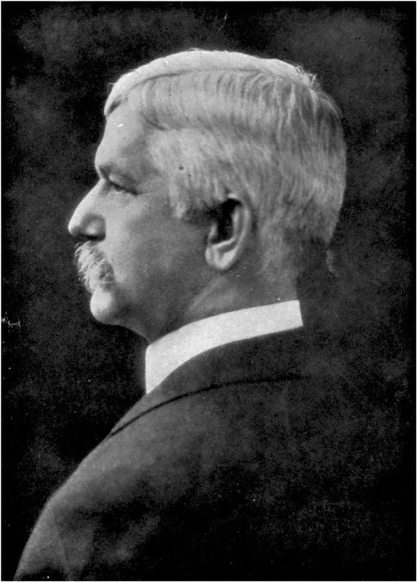
[Clinedinst--Washington, D.C.
Clinedinst—Washington, D.C.
Col. William C. Gorgas,
Medical Dept., U.S. Army, Head of the Department of Sanitation, Ancon.
Col. William C. Gorgas
Medical Dept., U.S. Army, Head of the Sanitation Department, Ancon.
Governor Magoon arrived at the isthmus in May 1905, just as the yellow fever epidemic was reaching its climax. From that moment he and Colonel Gorgas, to whom he gave the most complete support, set themselves to fight the fever. The first thing to do was to get all the patients within screened buildings, whether the hospital or their own homes, so that no stegomyia mosquitoes could saunter in and take the poison. Then the towns of Colon and Panama were handed over to a campaign of spring-cleaning such as the world has never witnessed. Then the canal building was thoroughly fumigated with pyrethrum powder or sulphur, and not simply the official building but every single house in the city of Panama was similarly disinfected. Dust and refuse were everywhere burnt. A very efficient system of inspection was adopted, and a rigid quarantine enforced against all foreign places whence the yellow plague could be imported into the zone.
Governor Magoon arrived at the isthmus in May 1905, just as the yellow fever epidemic was peaking. From that moment, he and Colonel Gorgas, whom he fully supported, began their fight against the fever. The first step was to get all patients inside screened buildings, whether in the hospital or their own homes, so no stegomyia mosquitoes could come in and spread the disease. Then, the towns of Colon and Panama were subjected to an extensive spring-cleaning campaign like the world had never seen. The canal construction sites were thoroughly fumigated with pyrethrum powder or sulfur, and not just the official buildings, but every single house in Panama was disinfected as well. Dust and refuse were burned everywhere. An effective inspection system was implemented, and strict quarantine measures were enforced against all foreign areas from which the yellow fever could spread into the zone.
But more important than the immediate [Pg 146]expedients were the more permanent sanitary improvements carried out in Colon and Panama. These towns were repaired with brick or cement, and provided with what they had never yet enjoyed, a proper system of drainage. Waterworks were also constructed outside the towns, and a supply of pure water made available for every household. Hitherto water had had to be stored during the dry season in tanks and cisterns, in which the stegomyia mosquito revelled exceedingly. These were now no longer necessary, and stagnant water, wherever it collected in the town, was drained away. In order to expedite these splendid reforms, Governor Magoon withdrew the workers from the canal and concentrated all efforts on the sewers and waterworks. So speedily was the work carried forward that the water was turned on for public use from the main in the Cathedral Plaza on July 4.
But more important than the immediate [Pg 146] solutions were the more lasting sanitary improvements made in Colon and Panama. These towns were rebuilt with brick or cement and provided with something they had never had before: a proper drainage system. Waterworks were also set up outside the towns, ensuring a supply of clean water for every household. Until then, water had to be stored during the dry season in tanks and cisterns, where the stegomyia mosquito thrived. These were no longer necessary, and stagnant water, wherever it collected in the town, was drained away. To speed up these amazing changes, Governor Magoon pulled workers from the canal and focused all efforts on the sewer and water systems. The work progressed so quickly that water was made available for public use from the main in the Cathedral Plaza on July 4.
The results of this drastic campaign were soon apparent in the dwindling of the yellow fever returns. In July there were still forty-two cases and thirteen deaths on the isthmus, with twenty-seven cases and ten deaths among the employees. August showed a great improvement, with [Pg 147]twenty-seven cases and nine deaths on the isthmus, and twelve cases and only one death on the canal. The improvement continued through September, October, November, and in December only one case was reported on the isthmus and one on the canal. Three months having elapsed since the last case, and, therefore, every stegomyia which could possibly be infected with malaria having departed this life, the epidemic was entirely past and over. As I have pointed out, there cannot possibly be any return of it under these conditions unless the infection is brought from without. And if any new cases are at once isolated and screened from afternoon calls of the mosquito, the outbreak may be easily and infallibly suppressed. We may say, therefore, that the yellow spectre at the isthmus has been shorn of all its terrors.
The results of this intense campaign quickly became clear with the decline in yellow fever cases. In July, there were still forty-two cases and thirteen deaths on the isthmus, with twenty-seven cases and ten deaths among the workers. August showed significant improvement, with [Pg 147] twenty-seven cases and nine deaths on the isthmus, and twelve cases with only one death on the canal. The improvement continued through September, October, November, and by December, only one case was reported on the isthmus and one on the canal. Three months had passed since the last case, and with every stegomyia that could have possibly been infected with malaria having died, the epidemic was completely over. As I've mentioned, there can't be a return of it under these circumstances unless the infection is introduced from elsewhere. If any new cases are immediately isolated and protected from mosquito bites, the outbreak can be easily and certainly controlled. So, we can say that the yellow spectre at the isthmus has lost all its power to terrify.
Malaria is, however, a very different proposition. A corresponding crusade has been carried on for six years against the little anopheles gnat, the little criminal who carries the malarial poison. His happy breeding-grounds are in open country marshes and pools, and there is no lack of these in the canal zone. It was impossible to deal with [Pg 148]the entire three-quarters of a million acres of that territory, but wherever the canal workers were settled determined war was waged against the mosquitoes. It should be remembered that the anopheles can fly only about a hundred or two hundred yards. The jungle was therefore cleared away for a few hundred yards round each village and settlement, marshes and pools in this area were drained off, and into all the ditches where stagnant water had collected oil was poured, which so effectually turns the mosquito's stomach that it never recovers. Some 1,200 acres of the zone were thus treated, and of course the regulations as to house-screening applied to malaria no less than to yellow fever. The employees were also supplied freely and generously with quinine.
Malaria, however, is a very different issue. An ongoing campaign has been waged for six years against the tiny anopheles gnat, the little culprit that carries the malarial virus. Its ideal breeding spots are found in open marshes and pools, and there’s no shortage of these in the canal zone. It was impossible to tackle [Pg 148] the entire three-quarters of a million acres of land, but wherever the canal workers lived, a determined fight was launched against the mosquitoes. It's important to note that the anopheles can only fly about one hundred to two hundred yards. Consequently, the jungle was cleared for a few hundred yards around each village and settlement, marshes and pools in this area were drained, and oil was poured into all the ditches where stagnant water had collected, which effectively destroys the mosquitoes’ larvae. About 1,200 acres of the zone were treated this way, and the regulations regarding house screening applied to malaria just as they did to yellow fever. The workers were also provided with quinine freely and generously.
The result has been not the eradication of malaria, but the reduction of the cases to about one-third the number at which they stood in 1906. Yet even so, among the 40,000 employees on the canal during the year ending June 30, 1912, there were 7,000 malaria cases in the hospitals, with 32 deaths, 22 of these being white people. The heavy rainfalls at the isthmus will probably [Pg 149]prevent the complete sanitation of the country in this respect, for the simple reason that the destruction of the anopheles mosquito or the eradication of the malarial germ can never be complete. There will always be people going about with the malarial organism in their blood, and always anopheles mosquitoes ready to become infected with it and to carry the infection about. But, as we have seen, much can be done by the means described to reduce the ravages of the disease. In 1906, out of a working force of 26,000, there were 21,739 cases of malaria. We have seen how this figure had been brought down in 1912. In 1906 it was almost certain that any white person coming to reside at the isthmus would catch malaria. Now it is quite possible to live there in perfect health, quite free from any malarial infection.
The outcome hasn't been the complete elimination of malaria, but rather a reduction in cases to about one-third of what they were in 1906. Even so, among the 40,000 workers on the canal during the year ending June 30, 1912, there were 7,000 malaria cases reported in hospitals, resulting in 32 deaths, 22 of whom were white. The heavy rainfall in the isthmus will likely [Pg 149] hinder the full sanitation of the area, simply because the destruction of the anopheles mosquito or the eradication of the malaria germ can never be absolute. There will always be people carrying the malarial organism in their blood, and there will always be anopheles mosquitoes ready to get infected and spread the disease. However, as we've seen, a lot can be done through the methods described to lessen the impact of the illness. In 1906, out of a workforce of 26,000, there were 21,739 malaria cases. We've noted how this number decreased by 1912. Back in 1906, it was nearly guaranteed that any white person moving to the isthmus would contract malaria. Now, it’s very possible to live there in perfect health, completely free from any malarial infection.
It may be useful to mention that the entire death-roll among the employees on the Panama Canal and railway from the American occupation down to June 30, 1912—that is, about eight years—was 5,141, of whom 284 were Americans. Of this total, 4,119 died of disease and 1,022 from violence or accident. During the same period [Pg 150]49 American women and 87 American children died.[12] Sir Ronald Ross, as I have said, was told by the British Consul at Panama in 1904 that the French lost in the nine years of their occupancy some 50,000 lives, principally from malaria and yellow fever. This may be an over-estimate, but there is no doubt that the American figure shows an enormous improvement on the French.
It might be worth noting that the total death toll among employees on the Panama Canal and railway from the start of American occupation until June 30, 1912—about eight years—was 5,141, of which 284 were Americans. Out of this total, 4,119 died from disease and 1,022 from violence or accidents. During the same period [Pg 150]49 American women and 87 American children also died.[12] Sir Ronald Ross, as mentioned, was informed by the British Consul in Panama in 1904 that the French lost around 50,000 lives during their nine years of occupation, mainly due to malaria and yellow fever. This might be an overestimate, but it's clear that the American numbers indicate a significant improvement compared to the French.
It is easy to conclude that what has been done in sanitation at the isthmus of Panama may be done anywhere else in the tropics, where malaria and yellow fever prevail. That may be true, but we must also remember that the work of Panama had behind it all the wealth and resources of a mighty republic of 90,000,000 citizens. The expenditure on these hygienic purposes at the isthmus has been enormous, though not a penny has been wasted. Down to the end of December, 1912, the total outlay of the Department of Sanitation was $15,500,000. Waterworks, sewers, etc., accounted for another $2,500,000, so that we get a grand total expenditure on sanitation of $18,000,000. This will certainly rise to $20,000,000 before the canal is finished, so that [Pg 151]for the ten and a half years of its construction there will have been an annual expenditure for all health purposes of $1,900,000. It is not likely that there will be many tropical areas of this kind with so large a sum available for the luxury of scientific sanitation. Again, it must be noticed that the administration had special advantages at the isthmus. It exercised something like military authority. It had absolute powers of deportation, and could enforce its regulations as it pleased. And in considering the statistics it must also be borne in mind that not only the physical but the moral and mental health of the work-people at the isthmus was promoted in every way. We shall look into the life of the Panama construction camps in the next chapter. The social interest and amusement provided for the employee must have counted for something beside the sewering and screening and mosquito-hunting. All the same, the success achieved at Panama is full of hope and promise for tropical life in the future. Colonel Gorgas writes encouragingly:—
It’s easy to assume that the sanitation efforts at the Panama Isthmus could be replicated elsewhere in tropical regions where malaria and yellow fever are common. While that might be true, we also need to consider that Panama had the backing of a wealthy and powerful republic with 90 million citizens. The spending for sanitary improvements on the isthmus has been substantial, yet not a single penny has been wasted. As of December 1912, the total expenditure by the Department of Sanitation was $15,500,000. Additionally, waterworks and sewer systems accounted for another $2,500,000, bringing the total sanitation expenditure to $18,000,000. This amount is likely to reach $20,000,000 by the time the canal is completed; thus, over the ten and a half years of its construction, there will have been an annual investment of $1,900,000 for health purposes. It’s doubtful that many tropical areas will have such a significant sum available for advanced sanitation. Furthermore, the administration had unique advantages at the isthmus, exercising a sort of military authority. It had absolute deportation powers and could enforce regulations as it saw fit. When looking at the statistics, it's important to remember that both the physical and the moral and mental health of the workers at the isthmus were nurtured in every possible way. We will explore life in the Panama construction camps in the next chapter. The social support and entertainment provided for employees must have played a significant role in addition to sewage management and mosquito control. Nevertheless, the achievements at Panama offer great hope and potential for future tropical living. Colonel Gorgas writes positively:—
I think the sanitarian can now show that any population[Pg 152] coming into the tropics can protect itself against these two diseases (malaria and yellow fever) by measures that are both simple and inexpensive; that with these two diseases eliminated life in the tropics for the Anglo-Saxon will be more healthful than in the temperate zones; that gradually, within the next two or three centuries, tropical countries, which offer a much greater return for man's labour than do the temperate zones, will be settled up by the white races, and that again the centres of wealth, civilization, and population will be in the tropics, as they were in the dawn of man's history, rather than in the temperate zone, as at present.
I believe the health official can now demonstrate that any population[Pg 152] moving to the tropics can protect itself from these two diseases (malaria and yellow fever) through methods that are both straightforward and low-cost; that with these two diseases tackled, life in the tropics for people of Anglo-Saxon descent will be healthier than in temperate regions; and that over the next two or three centuries, tropical countries, which provide a much higher return for human labor than temperate regions, will be settled by white populations, shifting the centers of wealth, civilization, and population back to the tropics, as they were in the early stages of human history, instead of remaining in the temperate zones as they are now.
Apart from the question of disease, it is far from certain that the white man can ever remain as "fit," as capable of bodily labour, in equatorial regions as in his native temperate conditions, or that his descendants will also maintain the same standard of health and strength. Ordinary non-professional opinion would perhaps discount Colonel Gorgas's forecast as a little too optimistic.
Aside from the issue of disease, it's not at all clear that white people can ever stay as "fit" or as capable of physical labor in equatorial regions as they are in their native temperate climates, nor that their descendants will keep the same level of health and strength. Most everyday non-professional opinions would likely consider Colonel Gorgas's prediction to be a bit too optimistic.
FOOTNOTES:
CHAPTER X.
LIFE AT THE ISTHMUS.
Before we go on to describe the canal and its method of construction, we must look at the sort of social life and civil administration which has prevailed since the Americans arrived. Construction camps in tropical climes are not usually distinguished for order and good morals. The Americans determined to make an exception at Panama. They had a perfectly free hand and the enjoyment of all sovereign rights at the isthmus, and were able to construct a brand-new little state on the most approved and ideal principles. We have seen what instructions were given by President Roosevelt to the first commission. An entire administrative system had to be established within this little plot 10 miles wide and 50 long. Laws had to be framed and civil government established, with all the needful [Pg 154]accessories of judicial courts, police force, fire-brigades, customs and revenue service, post-offices, public works and financial department. The administration carried what is known as "paternalism" to all lengths. That is, it did all the catering and providing itself, and left little or nothing to private companies. Of course, everything had to be imported, for the little territory itself produced nothing. Whole villages and settlements with all the accessories of social life had to be built along the line of works. Over 2,000 structures, including offices, hospitals, hotels, messes, kitchens, shops, storehouses, and living quarters, were constructed, and more than 1,500 buildings taken over from the French, which were made available by necessary repairs.
Before we dive into the details of the canal and how it was built, we need to take a look at the type of social life and civil administration that has existed since the Americans arrived. Construction camps in tropical regions aren't usually known for being organized or having good morals. The Americans aimed to change that in Panama. They had complete freedom and all the rights to govern the isthmus, which allowed them to create a brand-new little state based on the best and most ideal principles. We've seen the instructions that President Roosevelt gave to the first commission. An entire administrative system needed to be set up within this small area, 10 miles wide and 50 miles long. Laws had to be written, and a civil government established, along with all the necessary [Pg 154] components like judicial courts, a police force, fire brigades, customs and revenue services, post offices, public works, and a financial department. The administration practiced what is known as "paternalism" to the fullest extent. In other words, they took charge of everything and left little to private companies. Naturally, everything had to be imported since the small territory produced nothing. Entire villages and communities had to be built along the work sites. Over 2,000 buildings, including offices, hospitals, hotels, dining halls, kitchens, shops, storage facilities, and living spaces, were constructed, in addition to more than 1,500 buildings taken over from the French, which were made usable after necessary repairs.
Colonel Goethals gives us a brief insight into the work of the Commissary Department of the Panama Railroad:—
Colonel Goethals provides a quick look into the work of the Commissary Department of the Panama Railroad:—
The Commissary Department of the Panama Railroad Company was enlarged until it is now [1911] a great department store, supplying to the employees whatever may be necessary for their comfort and [Pg 155]convenience. Manufacturing, cold-storage, and laundry plants were established, and turn out each day about 90 tons of ice, 14,000 loaves of bread, 2,400 rolls, 250 gallons of ice-cream, 1,000 pounds of roasted coffee, and 7,500 pieces of laundry. Four or five refrigerator cars, loaded with meats, vegetables, and such fruits as can be obtained, are sent out on the night freight to distant points, and every morning a supply train of about 16 cars, of which number six to eight are refrigerator cars, leaves Cristobal at 4.30 to distribute foodstuffs and laundry to the local commissaries along the line, where the employees make their purchases, and where the hotels, messes, and kitchens secure their supplies for the day.
The Commissary Department of the Panama Railroad Company has grown into a large department store, providing employees with everything they need for their comfort and [Pg 155]convenience. They established manufacturing, cold storage, and laundry facilities, which produce about 90 tons of ice, 14,000 loaves of bread, 2,400 rolls, 250 gallons of ice cream, 1,000 pounds of roasted coffee, and 7,500 pieces of laundry each day. Four or five refrigerated cars filled with meats, vegetables, and available fruits are dispatched on the night freight to distant locations, and every morning, a supply train consisting of about 16 cars, including six to eight refrigerated ones, departs Cristobal at 4:30 a.m. to deliver food and laundry to local commissaries along the route, where employees make their purchases and hotels, messes, and kitchens stock up for the day.
A graphic and representative picture of one of the construction settlements along the canal was given by the correspondent of The Times at Panama.[13] He chose "Emperador," or "Empire," as the typical village. This is the headquarters of the central division of the [Pg 156]construction work, and is situated about halfway along the great Culebra Cut. The correspondent writes:—
A vivid and accurate description of one of the construction settlements along the canal was provided by the correspondent of The Times in Panama.[13] He picked "Emperador," or "Empire," as the representative village. This is the main base for the central division of the construction efforts and is located roughly halfway through the large Culebra Cut. The correspondent writes:—
According to the census just completed, it contains 7,152 inhabitants, of whom 1,757 are whites, 3,701 negroes, 1,569 mestizos, 101 Chinese, and 24 East Indians. North of the main street is a section called the "native town," apparently because it is inhabited by natives of other countries than Panama, but really because here was situated the native hamlet alongside which the French built their construction camp in 1881. It is occupied by the part of the population not employed by the government, and here are the American saloons, the Spanish cantinas and restaurants, Chinese shops, East Indian fancy-work shops, and negro tailoring and shoemaking places. On the south side of the American settlement are the labour "camps," consisting of barracks and eating-places. All the buildings are of wood, constructed to last not over ten years; and none are large, excepting the [Pg 157]administration buildings and the club-house. On three sides of the village are the huts of the labourers who prefer the half-jungle life with its freedom; and here, with discomfort and squalor and liberty, is the only picturesque part of the settlement; all else is orderly, of one pattern, almost smug. On the fourth side the village is limited by the canal itself.
According to the recently completed census, the population is 7,152, including 1,757 white residents, 3,701 Black residents, 1,569 mestizos, 101 Chinese, and 24 East Indians. North of the main street lies an area known as the "native town," probably because it’s home to people from countries other than Panama, but really because this is where the native settlement was located next to the French construction camp built in 1881. It's inhabited by those who aren’t employed by the government and is home to American saloons, Spanish cantinas and restaurants, Chinese shops, East Indian craft shops, and Black-owned tailoring and shoemaking businesses. On the southern side of the American settlement are the labor "camps," which consist of barracks and dining areas. All the buildings are made of wood, built to last no more than ten years, and none are large, except for the administration buildings and the club-house. On three sides of the village, there are the huts of laborers who prefer the half-jungle life with its freedom; this area, though uncomfortable and rundown, is the only visually interesting part of the settlement; the rest is neat, uniform, and almost complacent. The fourth side of the village borders the canal itself.
In the centre of the village is the commissariat, where the canal and railroad workers buy their food and clothing. Here congregate every morning the housewives of the village to do their shopping, and at night, after work, the men, to complete the family purchases. There is a similar store in each canal village—eighteen in all. The commissariat does away with the middleman's profit and buys in such large quantities, and for cash, that it obtains the lowest prices, while the many ways in which the materials purchased can be used prevent waste. If there is cause for complaint on the part of any class in the canal workers, that class is the bachelors, for they are discriminated against in the matter of quarters. But good [Pg 158]provision is made for their meals, at the so-called "hotels" for the white employees, and the messes and kitchens for Spanish and negro labourers.
In the center of the village is the commissary, where the canal and railroad workers buy their food and clothing. Every morning, the housewives of the village gather here to do their shopping, and at night, after work, the men come to finish the family purchases. There's a similar store in each canal village—eighteen in total. The commissary eliminates the middleman's profit and buys in such large quantities, paying in cash, that it gets the lowest prices. The various ways the purchased materials can be used help prevent waste. If any group of canal workers has a reason to complain, it's the bachelors, as they face discrimination regarding housing. However, there are good provisions made for their meals at the so-called "hotels" for the white employees and in the mess halls and kitchens for the Spanish and Black laborers.
Another remarkable evidence of how the canal administration stands in loco parentis to all its work-people is that it has provided twenty-six churches and maintains fifteen ministers of religion. This is interesting because it shows how the state, when conducted on common-sense principles, may provide for religious instruction without causing any offence or inflicting any injustice. The administration treated all denominations with perfect impartiality. Of the fifteen ministers it supported, four were Episcopalian, four Baptist, three Roman Catholic, one Wesleyan, and one Presbyterian. But this was not the entire provision of churches and chapels on the isthmus. There were fourteen other churches not under direct government control, but assisted by the government in many ways. Of the forty in all, thirteen were Episcopalian, seven Baptist, seven Roman Catholic, two Wesleyan, and eight undenominational.
Another remarkable example of how the canal administration acts in loco parentis to all its workers is that it has provided twenty-six churches and supports fifteen ministers of religion. This is significant because it illustrates how the state, when run on common-sense principles, can facilitate religious instruction without causing any offense or injustice. The administration treated all denominations with complete fairness. Of the fifteen ministers it supported, four were Episcopalian, four were Baptist, three were Roman Catholic, one was Wesleyan, and one was Presbyterian. But this wasn't the only provision of churches and chapels on the isthmus. There were fourteen other churches not under direct government control, but the government assisted them in many ways. Of the total forty, thirteen were Episcopalian, seven were Baptist, seven were Roman Catholic, two were Wesleyan, and eight were non-denominational.
[Pg 159]As I have pointed out, the moral sanitation of the isthmus was cared for as well as the physical. For example, in September 1905, a man living in the canal zone was charged with running a roulette table. He pleaded that he owned a concession from the Republic of Panama. That excuse was not allowed, and he was sentenced to fine and imprisonment for transgressing one of the canal zone laws. Gambling, which had always been one of the Panamanian vices, was quite forbidden within the zone. Remembering the descriptions given of the state of morals at the isthmus during the French occupation, one cannot help being struck with the contrast afforded by the American regime. Criticisms of the canal scheme, of climatic and social conditions in the zone, appeared in the early days from time to time. Mr. Johnson quotes an example which is so amusing as to bear repetition:—
[Pg 159]As I’ve mentioned, the moral cleanliness of the isthmus was taken care of just as much as the physical aspects. For instance, in September 1905, a man living in the canal zone was charged with running a roulette table. He claimed he had a concession from the Republic of Panama. That excuse wasn’t accepted, and he was sentenced to pay a fine and serve time for breaking one of the canal zone laws. Gambling, which had always been one of the vices in Panama, was completely banned in the zone. Considering the descriptions of the moral state of the isthmus during the French occupation, the contrast with the American rule is striking. Criticisms of the canal project, as well as of the climate and social conditions in the zone, occasionally emerged in the early days. Mr. Johnson shares an example that is so amusing it deserves to be repeated:—
A land as feverish to the imagination as to the body is Panama. It is a land making a fitting environment to the deeds of conspiracy, piracy, loot, cruelty, and blood that have principally made its history for [Pg 160]centuries. This gloomy, God-forsaken isthmus is a nightmare region. One descriptive writer has truly said of it that it is a land where the flowers have no odour, the birds no song; where the men are without honour and the women without virtue. He is not far wrong. The birds, brilliant as is their plumage, have no musical notes. The dense forests teem with bright-hued parrots, parroquets, and other birds, which squeak and scream but do not sing. There are beautiful orchids to be found in the swamps and jungles—fair to look upon, but they have no odour. The oranges have green skins instead of golden, the plantains must be fried to make them fit to eat, the reptiles and insects are often venomous, and myriads of parasites are ever ready to invade the human body and bring disease and death. In the atmosphere itself is something suggestive of the days of the old pirates and their fiendish cruelties and orgies. There is no life in the air; it is depressing, damp, miasmatic, and intensely hot. For a great part of the year thunder-showers succeed each other all day [Pg 161]long and half the night, with sheet lightning all around the horizon after dark. There is practically no twilight, day passing almost instantly into night. It is no wonder that this uncanny land has made its residents degenerate into plotters, revolutionists, murderers, and thieves. Its aspect is one of darkness, treachery, and curse.
A place as intense for the imagination as for the body is Panama. It’s an environment that’s perfect for conspiracy, piracy, looting, cruelty, and bloodshed that have mainly shaped its history for [Pg 160]centuries. This grim, desolate isthmus feels like a nightmare. One writer has accurately described it as a land where the flowers lack fragrance, and the birds have no song; where men are dishonorable, and women lack virtue. He’s not far off. The birds, despite their bright colors, don’t sing. The thick forests are full of colorful parrots and other birds, which squawk loudly but don’t actually sing. There are stunning orchids in the swamps and jungles—pretty to look at, but odorless. The oranges have green skins instead of golden ones, and plantains must be fried before they’re edible. Many reptiles and insects are venomous, and countless parasites are always ready to invade the human body, bringing sickness and death. The atmosphere holds a reminder of the days of old pirates and their gruesome acts and orgies. There’s no vitality in the air; it feels oppressive, humid, unhealthy, and extremely hot. For much of the year, thunder showers come one after another all day [Pg 161]long and half the night, with lightning flashing all around the horizon after dark. There’s hardly any twilight; day transitions almost immediately into night. It’s no surprise that this eerie land has turned its residents into schemers, revolutionaries, murderers, and thieves. Its appearance is one of darkness, betrayal, and curse.
President Roosevelt had something to say on these recurring criticisms in a message to Congress in January 1906. He wrote:—
President Roosevelt addressed these ongoing criticisms in a message to Congress in January 1906. He wrote:—
From time to time various publications have been made, and from time to time in the future various similar publications, doubtless, will be made, purporting to give an account of jobbing or immorality or inefficiency or misery as obtaining on the isthmus. I have carefully examined into each of these accusations which seemed worthy of attention. In every instance the accusations have proved to be without foundation in any shape or form. They spring from several sources. Sometimes they take the shape of statements by irresponsible [Pg 162]investigators of a sensational habit of mind, incapable of observing or repeating with accuracy what they see, and desirous of obtaining notoriety by widespread slander. More often they originate with or are given currency by individuals with a personal grievance. The sensation mongers, both those who stay at home and those who visit the isthmus, may ground their accusations on false statements by some engineer who, having applied for service on the commission and been refused such service, now endeavours to discredit his successful competitors, or by some lessee or owner of real estate who has sought action or inaction by the commission to increase the value of his lots, and is bitter because the commission cannot be used for such purposes, or on the tales of disappointed bidders for contracts, or of office-holders who have proved incompetent, or who have been suspected of corruption and dismissed, or who have been overcome by panic and have fled from the isthmus. Every specific charge relating to jobbery, to immorality, or to inefficiency, [Pg 163]from whatever source it has come, has been immediately investigated, and in no single instance have the statements of these sensation mongers and the interested complainants behind them proved true. The only discredit adhering to these false accusations is to those who originate and give them currency, and who, to the extent of their abilities, thereby hamper and obstruct the completion of the great work in which both the honour and the interest of America are so deeply involved. It matters not whether those guilty of these false accusations utter them in mere wanton recklessness and folly, or in a spirit of sinister malice to gratify some personal or political grudge.
From time to time, various publications have been released, and in the future, similar publications will likely be made, claiming to report on corruption, immorality, inefficiency, or suffering on the isthmus. I have closely investigated each of these accusations that seemed significant. In every case, the accusations have been found to be baseless in any form. They come from several sources. Sometimes, they are made by irresponsible [Pg 162] investigators who have a sensational mindset, are unable to accurately observe or relay what they see, and are eager to gain attention through widespread slander. More often, they are fueled by individuals with personal grievances. The sensationalists, whether they stay at home or visit the isthmus, may base their claims on false statements from an engineer who applied for a position on the commission and was turned down, now trying to undermine his successful competitors, or from a lessee or real estate owner who sought action or inaction from the commission to boost the value of his property and is frustrated that the commission can't be used for that purpose. They may also come from disappointed bidders for contracts or from office-holders who have shown incompetence, been suspected of corruption and dismissed, or fled the isthmus out of panic. Every specific charge related to corruption, immorality, or inefficiency, [Pg 163] regardless of its origin, has been promptly investigated, and not once have the statements from these sensationalists and the interested complainants proved to be true. The only discredit from these false accusations falls on those who create and spread them, who, to the extent of their abilities, hinder and obstruct the completion of the significant work in which both America's honor and interests are deeply invested. It doesn't matter whether those making these false accusations do so out of reckless folly or with malicious intent to settle a personal or political score.
The soundness and purity of the canal zone administration has long ago been established beyond all question and cavil. The Americans have given an example to the world how a great work of this kind, involving the gathering together of a large multitude of workers from many races and nations, may be carried on without those moral and physical evils which have marked [Pg 164]too many enterprises of the kind. In fact, the way in which the Americans have arranged and controlled the life of the canal zone stands quite as much to their credit as the skill and determination they have shown in the actual construction of the canal.
The effectiveness and integrity of the canal zone administration have long been established without any doubt. The Americans have shown the world how to manage a large project, involving a diverse group of workers from various races and nations, without the moral and physical issues that have plagued too many similar projects. In fact, the way the Americans have organized and managed life in the canal zone reflects just as much on their abilities as the skill and determination they've demonstrated in building the canal.
But we have said nothing yet about the workers themselves on the canal. The Americans, on taking over the work from the French, found about 700 West Indian negroes engaged in excavating the Culebra Cut. From this contingent as a nucleus a much larger army of workers was built up. The numbers rapidly grew. In December 1905 there were 5,000 employees; in 1906, 24,000; in 1908, 31,000; the highest figure being reached in 1910, when there were 50,000 workers available for duty. Of the employees, speaking roughly, one-seventh have been white Americans, all, of course, skilled workers, one-seventh European labourers, and five-sevenths West Indian negroes. The British West Indies, especially Barbados, have continued to be the main source of labour supply. But the West Indian at the outset left a great deal to be desired in his work and efficiency. In 1905 complaints [Pg 165]were made on the subject by the chairman of the canal commission to the President of the United States. In 1906 the chief engineer reported:—
But we haven't mentioned the workers on the canal yet. When the Americans took over the project from the French, they found around 700 West Indian Black workers digging the Culebra Cut. From this group as a starting point, a much larger workforce was built up. The numbers grew rapidly. By December 1905, there were 5,000 employees; in 1906, 24,000; in 1908, 31,000; peaking in 1910 with 50,000 workers available for duty. Of the employees, roughly one-seventh were white Americans, all skilled workers; one-seventh were European laborers, and five-sevenths were West Indian Black workers. The British West Indies, especially Barbados, continued to be the main source of labor. However, the West Indian workers at the beginning had a lot to improve in terms of their work and efficiency. In 1905, the chairman of the canal commission made complaints about this to the President of the United States. In 1906, the chief engineer reported:—
The criticisms of the character of the common labour which were made in last year's report still hold good. Our labour consists almost entirely of West Indian negroes, and their efficiency is very low, although we have a few of this class who are fairly steady workers—by this it is meant that they average to work all the time, but the great body of them do not. The majority work just long enough to get money to supply their actual bodily necessities, with the result that, while we are quartering and caring for twenty odd thousand of these people, our daily effective force is many thousands less. Preliminary steps have been taken toward securing a large number of Spanish labourers direct from the north-west provinces of Spain, also for the securing of a trial shipment of Cantonese Chinese, as it is believed that the introduction of labourers of different nationalities will be beneficial.
The criticisms regarding the quality of common labor from last year's report are still valid. Our workforce is mostly made up of West Indian Black workers, and their efficiency is quite low, although there are a few who are reasonably reliable—by this, we mean they tend to show up consistently for work, but the majority do not. Most work just long enough to earn enough to cover their basic needs, which means that, even though we are housing and taking care of over twenty thousand people, our actual working force is several thousand short. Preliminary steps have been taken to bring in a large number of Spanish workers directly from the north-west provinces of Spain, as well as to arrange for a trial shipment of Cantonese Chinese laborers, believing that introducing workers from different nationalities will be beneficial.
[Pg 166]The Chinese project was frustrated through the influence of trade unions in the United States, backed up by representations from the Pacific coast states. The West Indian labourer quickly began to earn a better report. It was found that his inefficiency was largely due to insufficient and improper food. He speedily improved when turned on to the generous and nourishing diet provided in the zone. In order to be certain that he had the full advantage of the provided meals, the price of them was very wisely deducted from his wages. Moreover, the American foremen soon began to learn that the men from Barbados, Trinidad, and elsewhere were British subjects and could not be treated as though they were southern state "coons." With a better understanding and more sympathetic treatment of the black employees, much more work was got out of them, and a good deal of the credit for the building of the Panama Canal is due to the 30,000 workers[14] who have been recruited mainly from the British islands in the West Indies.
[Pg 166]The Chinese project faced setbacks due to the influence of trade unions in the United States, supported by representatives from the Pacific coast states. The West Indian laborer quickly started receiving better recognition. It turned out that his lack of efficiency was mainly due to insufficient and poor-quality food. He improved rapidly when provided with the substantial and nutritious diet available in the zone. To ensure he received the full benefit of the provided meals, the cost of them was wisely deducted from his wages. Additionally, American foremen soon came to understand that the workers from Barbados, Trinidad, and other places were British subjects and should not be treated like southern state "coons." With better understanding and more considerate treatment of the Black employees, productivity increased significantly, and much of the credit for the construction of the Panama Canal goes to the 30,000 workers[14] who were primarily recruited from the British islands in the West Indies.
But the southern European contingent has [Pg 167]been found to be excellent material. It was thought that the work-people of Spain, Italy, and Greece would take more easily to navvying work in the tropics than people from more northerly regions of the temperate zone. The results were, on the whole, satisfactory. The Greeks were, it is true, not equal to the Italians or the Spaniards, and very few of them were recruited for canal work. The Italians, also, though several thousands of them were engaged, proved rather hard to handle. They were bitten with collectivist ideas, and inclined to act on trade union lines. The Spaniard was, in every way, the most satisfactory workman introduced from Europe. He was taken in an unsophisticated state directly from his village in Galicia or Castile. He was tractable and orderly, and quick and ready to learn. Hard labour under the tropical sun and in the hot damp of the isthmus seemed to have no exhausting or enervating influence whatever upon him. The Spaniard shows no sign of settling down on the isthmus. He either goes home with his savings or on to railway work in Brazil. Some 9,000 have been directly recruited, but this number does not include all the Spanish [Pg 168]labourers whose muscle has helped to the completion of this great work.
But the southern European group has [Pg 167]proven to be excellent labor. It was believed that workers from Spain, Italy, and Greece would adapt more easily to manual labor in tropical regions than those from the cooler northern areas. Overall, the results were satisfactory. The Greeks, it's true, weren't as capable as the Italians or Spaniards, and very few were recruited for canal work. The Italians, while several thousand were employed, proved somewhat difficult to manage. They had strong collectivist ideas and tended to act in line with trade unions. The Spaniard was, by far, the most reliable worker brought in from Europe. He arrived in a straightforward, unsophisticated state straight from his village in Galicia or Castile. He was compliant and organized, eager and quick to learn. Intense work under the tropical sun and in the humid heat of the isthmus didn't seem to wear him out at all. The Spaniard shows no intention of settling down in the isthmus. He either returns home with his savings or moves on to railway work in Brazil. About 9,000 have been directly recruited, but this number doesn't include all the Spanish [Pg 168]laborers whose strength has contributed to the completion of this significant project.
A word or two should be said about the wages earned on the canal. The West Indian recruit was offered 6½d. an hour for common labour and an eight-hour day, in addition to free quarters, medical care, and repatriation. Meals were supplied to him at the rate of 1s. 2½d. per day. Later the pay of all not under contract was reduced to 5d. per hour, and the price of the three meals to 1s. 1½d. Negro artisans, such as carpenters, masons, blacksmiths and others, of whom there were some 5,000 employed in connection with the canal works, received pay varying from 8d. to 22d. per hour. There were in 1912 4,400 negro artisans receiving 8d. an hour or more, while 400 received 1s. an hour, and the work was constant.
A few words should be said about the pay earned on the canal. The West Indian worker was offered 6½d. an hour for general labor and an eight-hour day, along with free housing, medical care, and repatriation. Meals were provided at the cost of 1s. 2½d. per day. Later, the pay for all workers not under contract was reduced to 5d. per hour, and the price of the three meals dropped to 1s. 1½d. Black workers, like carpenters, masons, blacksmiths, and others, of whom there were about 5,000 involved with the canal projects, earned between 8d. and 22d. per hour. In 1912, there were 4,400 black artisans earning 8d. an hour or more, while 400 earned 1s. an hour, and the work was steady.
The European labourer, in addition to free quarters, received $1.60 per eight-hour day, and more for overtime work. He was charged 40 cents a day for his three meals, which left him a minimum net wage per day of $1.20, or a little less than thirty shillings a week. Many, however, received more, and a good number of Spanish [Pg 169]work-people must have gone home with a nice little nest-egg in their pockets.
The European worker, in addition to free housing, earned $1.60 for an eight-hour workday, with extra pay for overtime. He paid 40 cents a day for three meals, which left him with a minimum net wage of $1.20 per day, or just under thirty shillings a week. Many, however, earned more, and a good number of Spanish [Pg 169] workers likely went home with a nice little savings in their pockets.
The skilled labour was done almost entirely by United States employees, though the "gold roll," as it was called, included at first some Europeans. The pay was excellent, the social life, with its gymnasia, billiard-rooms, concerts and so forth, attractive, and the commissariat, with its three good meals at a fixed charge, quite up to the standard of a good hotel. The billets on the isthmus were therefore popular, and about 7,000 Americans on an average have been in employment there.
The skilled labor was mostly done by U.S. workers, although the "gold roll," as it was called, originally included some Europeans. The pay was great, the social life—with gyms, pool rooms, concerts, and more—was appealing, and the dining services, offering three good meals for a set price, were on par with a nice hotel. The accommodations on the isthmus were popular, and about 7,000 Americans have typically been employed there.
As I have pointed out, the responsibility for the construction of the canal was vested in the President of the United States, who acted through an executive commission resident in the canal zone. The work was organized in a large number of departments, each responsible for a big task. These were excavation and dredging; locks and dams; machinery and buildings (also responsible for paving and other improvements in Colon and Panama); labour, subsistence, and quarters; material and supplies; sanitation (responsible also for hygiene in Panama and Colon, which [Pg 170]towns are technically outside the zone); civil administration; the Panama railroad. There were also some smaller divisions, such as accounts and an office of a purchasing officer in Washington, nearly all the supplies for the canal being obtained in the United States. It should be added that the Republic of Panama is responsible for the policing of the two big towns, but the department of civil administration of the Panama Canal Commission employed 200 police, 88 of which were native West Indians.
As I mentioned, the responsibility for building the canal was given to the President of the United States, who carried it out through an executive commission located in the canal zone. The work was divided into many departments, each in charge of a major task. These included excavation and dredging; locks and dams; machinery and buildings (also responsible for paving and other improvements in Colon and Panama); labor, food, and housing; materials and supplies; sanitation (which also handled hygiene in Panama and Colon, which [Pg 170] towns are technically outside the zone); civil administration; and the Panama railroad. There were also some smaller divisions, like accounts and a purchasing office in Washington, with nearly all the supplies for the canal being sourced from the United States. It’s worth noting that the Republic of Panama is in charge of policing the two large towns, but the civil administration department of the Panama Canal Commission employed 200 police officers, 88 of whom were native West Indians.
This busy hive of labour will soon present a very different aspect. With the approach of the canal to completion the numbers of the workmen will gradually be reduced. A drastic process of sifting and selection will be carried out among the Americans employed on the works. Only about 2,500 men will be necessary to operate the canal, when it is in full working order. These will be established at the locks and other important points. In fact, the canal authorities recommend a complete depopulation of the isthmus except, of course, the terminal cities and the operating stations on the canal. Otherwise, they think, a large expense for [Pg 171]sanitation will be necessary which might thus be avoided. But the question of defence must not be forgotten. It will certainly be found advisable to maintain a pretty large American garrison at the isthmus, and to the population we have mentioned perhaps even 8,000 American troops must be added. The busy scenes still prevailing in the canal zone will now soon have disappeared like a dream, and the future traveller who looks from the ship-rail over the shining waters of Gatun Lake or beyond to the vast and silent tropical forest will have difficulty in reconstructing the spectacle which the narrow lands presented during the ten strenuous years of construction.
This busy hub of activity will soon look very different. As the canal nears completion, the number of workers will gradually decrease. A rigorous process of filtering and selection will take place among the Americans employed on the project. Only about 2,500 people will be needed to operate the canal once it’s fully up and running. They will be stationed at the locks and other key locations. In fact, the canal authorities suggest completely depopulating the isthmus, except for the terminal cities and the operational stations along the canal. Otherwise, they believe a significant sanitation expense will be required, which could be avoided. However, we must not overlook the issue of defense. It will likely be necessary to keep a sizable American garrison at the isthmus, and in addition to the population we’ve mentioned, maybe even 8,000 American troops will need to be included. The busy scenes currently prevailing in the canal zone will soon vanish like a dream, and future travelers looking from the ship's rail over the shimmering waters of Gatun Lake or beyond to the vast, silent tropical forest will struggle to imagine the sights that the narrow lands displayed during the intense ten years of construction.
FOOTNOTES:
[13] The Times, September 26, 1912.
CHAPTER XI.
THE PROBLEM OF CONSTRUCTION.
We may now begin to consider the canal itself, the problems which its designers had to solve, the methods of construction, and the features of the completed work. As we have seen, the first two and a half years were a time mainly of preparation for the titanic enterprise of excavation and construction. In fact, it might have been better if the work during that period had been entirely restricted to scavenging, sewering, and so forth. The labourers were hurried a little too fast to the isthmus, before the isthmus was properly cleaned up to receive them. Hence the yellow fever panic and difficulties which might have been avoided. The people of the United States were responsible for this over-haste at the start. The great thing, they cried, is to "make the dirt fly." They wanted evidence [Pg 173]that the steam-navvies were actually at work in the bed of the canal and that the task was well in hand. In fact, the public at home took an interest in the canal operations which was sometimes embarrassing. Some newspaper man at the isthmus would report an accident or unforeseen difficulty, probably with a good deal of exaggeration, an anxious excitement sprang up among the people, and special commissions had to go to the isthmus in order to investigate the true state of affairs and if possible restore confidence at home.
We can now begin to look at the canal itself, the challenges its designers faced, the construction methods used, and the features of the finished project. As we've seen, the first two and a half years were mainly a time of preparation for the massive excavation and construction effort. In fact, it might have been better if the work during that time had focused entirely on clearing and sewering, and so on. The workers were rushed to the isthmus a little too quickly, before the area was properly cleaned up to accommodate them. This led to the yellow fever panic and other issues that could have been avoided. The people of the United States were responsible for this rush at the beginning. They kept insisting that the important thing was to "make the dirt fly." They wanted proof [Pg 173] that the steam shovels were actually working in the canal bed and that progress was on track. In fact, public interest in the canal operations was sometimes a bit too intense. If a newspaper reporter at the isthmus reported an accident or unexpected problem, probably exaggerating it, a wave of anxiety would spread among the public, and special commissions had to be sent to the isthmus to check on the situation and try to restore confidence back home.
As the reader knows, the Americans had no clean slate on which to write at Panama. They succeeded two French companies which had been at work for twenty years. True, the New Panama Canal Company which succeeded the Lesseps Company had not greatly perspired over the undertaking. It had kept a certain amount of work going, chiefly in order to maintain its concession. All the same, the French had ploughed a pretty deep furrow between Colon and Panama, and much of the work they had done was fortunately available whichever type of canal should be adopted, high-level or tide-level. They had [Pg 174]carried out a good deal of dredging for the channel through the tidal flats at either end of the canal, and they had made a very visible impression on the "continental divide" at what is known as the Culebra Cut. Altogether the French companies excavated 81,548,000 cubic yards. The Americans inherited from their predecessors a large amount of machinery and tools, in addition to a great deal of work well done. Much of the machinery, even of the Lesseps Company, was found to be in serviceable condition, and operations could be continued with it, though the extent and efficiency of the plant was, of course, as time went on, greatly increased.
As readers know, the Americans didn’t start from scratch in Panama. They took over from two French companies that had been working there for twenty years. true, the New Panama Canal Company that replaced the Lesseps Company didn’t put in a huge effort on the project. It had maintained some work mainly to keep its concession active. Still, the French had created a significant path between Colon and Panama, and a lot of the work they completed was beneficial regardless of whether a high-level or tide-level canal was chosen. They had done a substantial amount of dredging for the channel through the tidal flats at both ends of the canal and had made a noticeable impact on the "continental divide" at what’s known as the Culebra Cut. In total, the French companies excavated 81,548,000 cubic yards. The Americans inherited a lot of machinery and tools from their predecessors, along with a significant amount of well-completed work. Much of the machinery, even from the Lesseps Company, was found to be in usable condition, allowing operations to continue with it, although the scale and efficiency of the equipment were, of course, greatly expanded over time.
The main problem which the American engineers had to solve was how to deal with the Chagres River. On the tide-level scheme, that violent and capricious stream, which in the rainy season was navigable for half its length of 100 miles, would have had to be diverted into another channel or ponded back in its upper waters by a high dam at Gamboa, some of the overflow of which might perhaps have been permitted to pass into the canal. But, as we have seen, the Chagres would have to be utilized and at the same [Pg 175]time controlled if the high-level plan was adopted. A river which is capable of rising 35½ feet in twenty-four hours needed a great deal of regulation and discipline before it could be used as the feeder of the upper reaches of a lock canal. The only way to do this was to diffuse its waters over a vast artificial lake which it would keep full, but in which its floods and current would be effectually tamed. This could only be done by a huge dam intercepting the course of the river in its lower reaches, at some point before it entered the Caribbean Sea. When the New Panama Canal Company changed its plans and decided for an elevated waterway, it was intended to construct such a barrier at Bohio, a point much higher up stream than Gatun, the site ultimately chosen by the American engineers. The Isthmian Canal Commission which reported in 1901, also arranged for a dam at Bohio to control the Chagres River. On this plan the river would have been intercepted much higher up, and the artificial lake would have been much smaller. But when the Americans finally decided on the high-level type in 1906, the site of the proposed dam was shifted from Bohio to [Pg 176]Gatun, nearer the river's mouth, which involved the inundation of a much vaster area of country. This position for the dam was first suggested by a French engineer, Godin de Lépinay, who, in a paper read before the congress of engineers in Paris in 1879, advocated a lock canal with a dam controlling the Chagres River at Gatun. This, then, was the biggest problem peculiar to the high-level scheme, for the cutting through the "continental divide," though an even more titanic labour, would have had to be accomplished whatever type of canal had been adopted.
The main challenge the American engineers had to figure out was how to manage the Chagres River. With the tide-level plan, that unpredictable and violent river, which could be navigated for half of its 100-mile length during the rainy season, would have had to be redirected into a different channel or held back in its upper waters by a high dam at Gamboa, allowing some overflow to possibly flow into the canal. However, as we’ve seen, the Chagres would need to be harnessed and controlled if the high-level plan was going to be used. A river that could rise 35½ feet in just twenty-four hours needed significant regulation and discipline before it could serve as the source for the upper parts of a lock canal. The only way to achieve this was by spreading its waters over a vast artificial lake that it would keep filled, but where its floods and current could be effectively managed. This could only happen with a massive dam blocking the river's flow in its lower reaches, before it entered the Caribbean Sea. When the New Panama Canal Company changed its plans and opted for an elevated waterway, they intended to build such a barrier at Bohio, a point much further upstream than Gatun, the location ultimately selected by the American engineers. The Isthmian Canal Commission, which reported in 1901, also planned for a dam at Bohio to control the Chagres River. In this plan, the river would have been intercepted much earlier, and the artificial lake would have been much smaller. But when the Americans finally decided on the high-level option in 1906, they moved the proposed dam site from Bohio to Gatun, closer to the river's mouth, which meant flooding a much larger area of land. This dam site was first suggested by French engineer Godin de Lépinay, who advocated for a lock canal with a dam regulating the Chagres River at Gatun in a paper he presented to the engineering congress in Paris in 1879. So, this was the biggest problem unique to the high-level plan, as cutting through the "continental divide," although an even more massive task, would have needed to be completed regardless of the type of canal chosen.
No feature of the construction has been subject to so much criticism and anxious solicitude as this Gatun dyke. On it depends the maintenance of Gatun Lake and the supply of water for the canal. If the dam fails, everything fails. The real cause of the difficulty was the foundation upon which this big artificial hill had to be laid. The great dam at Assouan in Egypt is based upon the eternal granite, upon which masonry of natural stone is built. It is, therefore, part and parcel of the solid framework of our planet, and will probably last as long. The Gatun dam is, however, founded upon the alluvial deposits of the [Pg 177]Chagres River. This alluvium consists of gravel firmly cemented with mud and clay, and is unquestionably water-tight. These deposits go down in places to a depth of 280 feet before the solid rock is reached. The dam had, therefore, to be laid down on the top of them.
No aspect of the construction has faced as much criticism and concern as the Gatun dyke. Its stability is crucial for maintaining Gatun Lake and providing water for the canal. If the dam fails, everything fails. The main issue was the foundation on which this large artificial hill had to be built. The massive dam at Assouan in Egypt rests on solid granite, which serves as the basis for natural stone masonry. This foundation is an integral part of the Earth's solid structure and is likely to last for a very long time. In contrast, the Gatun dam is built on the alluvial deposits of the [Pg 177] Chagres River. This alluvium, made up of gravel tightly bound with mud and clay, is definitely waterproof. In certain areas, these deposits extend down to 280 feet before reaching solid rock. Therefore, the dam had to be constructed atop these layers.
Now this foundation, though water-tight, is soft. It would have been impossible to place upon it a massive structure of rock or concrete. The deposits would have given way under its weight. The only plan was to dump down in the valley an earthen dam, making it very broad so as to distribute the weight over as large a space as possible of the alluvium underneath. A steep slope would have been impossible, for the weight of the central portion would have pushed the clay and gravel outwards, and the whole mass would have subsided. The earth-dam was to block the valley through which the Chagres had hitherto flowed uninterruptedly to the sea. This valley is a mile and a half wide, and this is, therefore, the length of the dam. Its base is 2,100 feet wide. It is 398 feet through at the surface of the water, 100 feet wide at the top, and was to be 115 feet above sea-level. The last figure has, it [Pg 178]seems, been brought down to 104 feet, which will be an advantage, as the weight upon the foundations will be proportionately less.
Now, this foundation, while water-tight, is soft. It would have been impossible to build a massive structure of rock or concrete on it. The materials would have given way under the weight. The only plan was to create an earthen dam in the valley, making it very broad to distribute the weight over as large an area as possible of the alluvium underneath. A steep slope would have been unfeasible, as the weight of the center would have pushed the clay and gravel outwards, causing the whole mass to settle. The earth dam was meant to block the valley through which the Chagres River had previously flowed uninterrupted to the sea. This valley is a mile and a half wide, so that’s the length of the dam. Its base is 2,100 feet wide. It is 398 feet at the surface of the water, 100 feet wide at the top, and was intended to be 115 feet above sea level. It seems this last figure has been reduced to 104 feet, which will be beneficial, as the weight on the foundations will be proportionately less.
In the middle of the dam the level of the lake is controlled by a channel called the "spillway," with walls and floor of concrete, by which the surplus waters will be sluiced off into the old bed of the Chagres River and so passed on to the sea. The entrance to this channel is closed with falling gates or doors. This safety-valve will no doubt be capable of dealing with the biggest and quickest rise of the lake-level that is ever likely to take place. It can pass off 137,000 cubic feet of water a second, the water issuing at a speed of 35 feet a second. But, to complete the security, the big culverts of the mighty Gatun locks close by can be turned open, and 170,000 cubic feet a second carried off there. Indeed, as regards the Gatun Lake the anxiety, if there be any, is that the water-supply will be insufficient rather than dangerously excessive.
In the middle of the dam, the lake's level is managed by a channel called the "spillway," which has concrete walls and floor. This channel directs excess water into the old bed of the Chagres River before it flows to the sea. The entrance to this channel is secured with descending gates or doors. This safety valve is definitely designed to handle the largest and fastest increases in the lake level that could occur. It can discharge 137,000 cubic feet of water per second, with the water flowing out at a speed of 35 feet per second. Additionally, to enhance safety, the large culverts of the nearby Gatun locks can be opened, allowing 170,000 cubic feet per second to be released there. In fact, concerning Gatun Lake, the worry, if there is any, is that the water supply will be too low rather than dangerously high.
The level of the lake is to be kept at 85 feet above mean sea-level—that is, the dam, or a considerable length of it, will be exposed to what is called a "head" of water of 85 feet. The [Pg 179]lake itself will be 164 square miles in extent. There have been many rational anxieties on the sufficiency of the dam. A certain American senator, however, who visited the works during the construction, worried himself rather unnecessarily on this last figure. Colonel Goethals was showing a congressional delegation round the works, and in the course of the survey they came to the dam with the broad expanse of water behind it. "Colonel," he said, "how is it that so small a body of earth as the Gatun dam can hold in check such a tremendous body of water as the Gatun Lake?" The chief engineer explained that the pressure of a body of water is determined by its height and not by its volume. The inquirer seems not to have been satisfied with the statement of this hydrostatic law. Senator Knox, afterwards Secretary of State, then came to his aid. "Senator," he said, "if your theory were true, how could the dykes of Holland hold in check the Atlantic Ocean?" This was a clincher, and the sceptic joined in the laugh at his own expense.
The lake level needs to be maintained at 85 feet above mean sea level—meaning that the dam, or a large part of it, will be under a "head" of water of 85 feet. The [Pg 179]lake itself will cover 164 square miles. Many reasonable concerns have been raised about the dam's adequacy. However, a certain American senator who visited the site during construction worried unnecessarily about this measure. Colonel Goethals was showing a congressional delegation around the site, and during their tour, they arrived at the dam with the vast area of water behind it. "Colonel," the senator asked, "how can such a small amount of earth like the Gatun dam hold back such a huge body of water as Gatun Lake?" The chief engineer clarified that the pressure of water is determined by its height, not its volume. The senator didn’t seem convinced by this explanation of hydrostatic law. Senator Knox, who later became Secretary of State, then offered his support. "Senator," he said, "if your theory were correct, how could the dikes in Holland hold back the Atlantic Ocean?" This was a decisive point, and the skeptic ended up laughing at his own expense.
All the same, the Gatun dam has two extremely [Pg 180]responsible and heavy duties to perform. It has to withstand the horizontal thrust of a head of 85 feet of water so as not to be carried bodily down the Chagres bed into the Atlantic. And it has to block up the valley so effectually that the water of the lake shall not percolate through at any point. There is every reason to believe that, in spite of all alarums and excursions during its construction, it will fulfil both these requirements. Its composition and construction may be briefly described. Two bulwarks of big rocky fragments were built up on either outer line or "toe" of the structure. This rough material was obtained from the lock site, or Mindi, or the Culebra Cut twenty-six miles away. The area between these piles is filled with silt, and water pumped into it by hydraulic dredges from the Chagres valley. The surplus water is carried off through pipes. The sodden silt remains and is packed down and consolidated by atmospheric pressure. Such a "hydraulic fill" is impervious to water, the thrust or "head" of which is very quickly lost in the minute interstices or pores of the material. It will be seen how such a structure differs from a dam of concrete [Pg 181]or stone masonry. It is porous, while at the same time impervious to water.
All the same, the Gatun dam has two extremely [Pg 180]important and heavy responsibilities to fulfill. It has to withstand the horizontal pressure of an 85-foot head of water so it won't be swept away into the Atlantic via the Chagres riverbed. And it has to seal the valley effectively so that the lake's water can’t seep through anywhere. There’s every reason to believe that, despite all the alarms and issues during its construction, it will meet both of these requirements. Its makeup and construction can be briefly explained. Two bulwarks of large rocky fragments were constructed along each outer line or "toe" of the structure. This rough material was sourced from the lock site, Mindi, or the Culebra Cut, which is twenty-six miles away. The space between these piles is filled with silt and water that is pumped in by hydraulic dredges from the Chagres valley. The excess water is drained away through pipes. The wet silt remains and is compressed and solidified by atmospheric pressure. This "hydraulic fill" is water-resistant, and the pressure or "head" of the water is rapidly dissipated in the tiny gaps or pores of the material. You can see how such a structure is different from a dam made of concrete [Pg 181]or stone masonry. It is porous, yet at the same time, it is waterproof.
The future traveller through the Panama Canal will probably never guess the immensity of the labour that has gone to the building of the Gatun dam. Already, indeed, it looks so much like a part of the natural landscape that it might well escape special observation altogether. Yet nothing less than 21,145,931 cubic yards of material were laid down—enough to make a wall of earth three feet high and three feet thick reaching nearly halfway round the world. The spillway itself contains 225,485 cubic yards of concrete.
The future traveler through the Panama Canal will likely never realize the immense amount of work that went into building the Gatun dam. It already blends so seamlessly into the natural landscape that it could easily go unnoticed. Yet, a staggering 21,145,931 cubic yards of material were used—enough to create a three-foot-high and three-foot-thick wall of earth that would stretch nearly halfway around the world. The spillway itself is made up of 225,485 cubic yards of concrete.
It will be noticed that in the dam proper there is no core of masonry or puddled chalk or clay whatever. It was at one time intended that there should be. I have alluded to the alarmist rumours that were raised again and again at Panama and created much uneasiness in the United States. These were especially concerned with the great dam, and that word must have frequently been on the lips of the engineers in more than one significance. Every possible test was applied to determine the exact character of the underlying materials, to ascertain whether [Pg 182]there was any connection between the swamp areas to the north and south through the deposits in the gorges which the earthwork was to bridge, to prove the ability of the material below to support the structure, and to find out whether suitable material for the dam could be found in its neighbourhood. "As the result of all these investigations," wrote Colonel Goethals,[15] "it may be briefly stated that the underlying material is impervious to water; that it possesses ample strength to uphold the structure that will be placed upon it, and, the subsoil being impervious, that there is no connection between the swamps above and the sea below."
It will be noted that the dam itself has no core of masonry or puddled chalk or clay at all. At one point, there was a plan for that to be the case. I have mentioned the alarmist rumors that kept coming up at Panama and caused a lot of concern in the United States. These rumors were especially focused on the massive dam, and that term must have often been on the engineers' lips in more than one sense. Every possible test was done to identify the exact nature of the underlying materials, to see if there was any link between the swamp areas to the north and south through the deposits in the gorges that the earthwork was meant to span, to confirm the ability of the material below to support the structure, and to check if suitable material for the dam could be found nearby. "As a result of all these investigations," wrote Colonel Goethals, "it may be briefly stated that the underlying material is impervious to water; that it has sufficient strength to support the structure that will be built on it, and, since the subsoil is impervious, there is no connection between the swamps above and the sea below."
In order to make assurance doubly sure, Colonel Goethals planned the dam so as to include triple interlocking steel sheet-piling across the valley, driven down to bedrock, and decided to carry the dam to a height of 135 feet. Even so, the news of a collapse was wired home, and this so impressed President Roosevelt that he sent a commission of engineers to the isthmus accompanied by President-elect Taft. The investigations had a different result from what had been expected. [Pg 183]Instead of being dissatisfied with the size and strength of the dam, the engineers declared that it was being built too high and that the steel piling was unnecessary. It must be admitted, therefore, that the efficiency of the Gatun dam has been subjected to the most rigorous tests, and that no further anxiety on the subject need be felt.
To be extra sure, Colonel Goethals designed the dam to include triple interlocking steel sheet-piling across the valley, driven down to bedrock, and chose to raise the dam to a height of 135 feet. Even so, news of a collapse was sent back home, and this made such an impression on President Roosevelt that he dispatched a commission of engineers to the isthmus, accompanied by President-elect Taft. The findings turned out differently than expected. Instead of finding fault with the size and strength of the dam, the engineers stated that it was being built too high and that the steel piling was unnecessary. It must be acknowledged, therefore, that the efficiency of the Gatun dam has gone through the most rigorous tests, and there’s no need for further concern on the matter.
With the blocking of the Chagres outlet at Gatun, the waters of the lake have gradually accumulated until they cover an area of 164 square miles. Not only the Chagres itself but its tributaries, the Trinidad and others, are thus ponded back. The reservoir extends up a number of long and winding arms, and is thus very irregular in shape. The bed of the channel itself was cleared of brushwood and trees, but the rest of the valley was thickly overgrown. As the waters rose, therefore, and gradually submerged this primeval forest, a rather dismal spectacle was presented of decay and destruction. The lake has, indeed, completely altered the aspect of the country. Villages and even small towns, whose names had come down from the days of the old navigators, lie buried for ever beneath the waters [Pg 184]of Lake Gatun. Even now the great expanse of water with its wooded islands looks like a natural feature of the landscape rather than yesterday's creation of engineering enterprise. The vessels in transit will, of course, keep to the dredged and buoyed channel, but the channel will itself be invisible, and the traveller, after tossing on the restless Caribbean Sea, will enjoy the full sensation of a cruise over a landlocked fjord or lake. Lake Gatun is indeed twice the size of Lago Maggiore and four-fifths the size of Lake Geneva. The journey from Gatun to Bas Obispo, where the waterway again assumes the appearance of a canal and enters the Culebra gorge, is 22 miles, but the same 85-foot level is maintained right to the locks at Pedro Miguel, where the waters of Lake Gatun are again retained by a dam connecting the walls of the lock with a hill to the west. The rest of the lake is held in by the natural configuration of the country, the only outlets being at the Gatun spillway and, of course, through the locks.
With the blockage of the Chagres outlet at Gatun, the waters of the lake have slowly built up to cover an area of 164 square miles. Not just the Chagres, but also its tributaries like the Trinidad are now backed up. The reservoir stretches up several long and winding arms, making it quite irregular in shape. The channel bed was cleared of brush and trees, but the rest of the valley was heavily overgrown. As the water level rose and submerged this ancient forest, it created a rather gloomy scene of decay and destruction. The lake has completely changed the landscape of the area. Villages and even small towns, whose names date back to the time of the old navigators, are now forever submerged under the waters of Lake Gatun. Even now, the vast expanse of water with its wooded islands appears to be a natural part of the landscape rather than the result of recent engineering efforts. Vessels in transit will obviously navigate the dredged and buoyed channel, but the channel itself will be out of sight, and travelers, after a bumpy ride on the restless Caribbean Sea, will feel like they're cruising over a landlocked fjord or lake. Lake Gatun is twice the size of Lago Maggiore and four-fifths the size of Lake Geneva. The journey from Gatun to Bas Obispo, where the waterway looks like a canal again as it enters the Culebra gorge, is 22 miles, but the elevation of 85 feet is maintained all the way to the locks at Pedro Miguel, where the waters of Lake Gatun are held back by a dam connecting the lock walls to a hill to the west. The rest of the lake is contained by the natural layout of the land, with the only outlets being the Gatun spillway and, of course, the locks.
But we must not overlook the main purpose of the lake, which is to supply the water for the canal and the lockages. For this purpose [Pg 185]everything, of course, depends on the rainfall at the isthmus, and the question arises whether this may be relied upon to replenish the canal with the needful water-supply. Colonel Goethals estimates that in an average dry season 58 "lockages," or transits of the canal, per day would be possible, which is a greater number than the twenty-four hours of the day would permit, allowing vessels to follow each other at intervals of one hour. Happily, a resource is still left if the supply of water should show signs of proving insufficient. At Alhajuela, on the Chagres River, some nine or ten miles above Obispo, there is an excellent site for a dam, forming a reservoir where some of the surplus water of the rainy season could be stored and supplied to the canal as required in the dry months. Details of the construction of such a dam were prepared in connection with a former canal-scheme, and would be available in case of need.
But we shouldn't forget the primary purpose of the lake, which is to provide water for the canal and the locks. For this to work, of course, everything relies on the rainfall at the isthmus, raising the question of whether we can count on it to refill the canal with the needed water supply. Colonel Goethals estimates that during an average dry season, up to 58 lockages, or transits through the canal, could occur each day, which exceeds what the 24 hours in a day can accommodate, assuming ships can only follow each other at one-hour intervals. Fortunately, there’s still a backup plan if the water supply appears to be insufficient. At Alhajuela, on the Chagres River, about nine or ten miles above Obispo, there’s a great spot for a dam, which could create a reservoir to store some of the extra water from the rainy season and release it to the canal as needed during the dry months. Plans for building such a dam were made in relation to an earlier canal project and would be ready to go if necessary.
FOOTNOTE:
CHAPTER XII.
THE CULEBRA CUT.
The most famous section of work on the canal has been that at the vertebra or "continental divide," which runs along the isthmus on the Pacific side and had to be pierced through by any canal running from Colon to Panama. This tremendous work, known as the "Culebra Cut," from the name of one of the hills, extends for nine miles from Bas Obispo to Pedro Miguel. Mr. Bryce has truly said, referring to this section, that "never before on our planet have so much labour, so much scientific knowledge, and so much executive skill been concentrated on a work designed to bring the nations nearer to one another and serve the interests of all mankind."[16] The bottom of the canal in the cut, as in the channel through Lake Gatun, [Pg 187]is 40 feet above sea-level. The highest elevation of the original surface of the ground above the centre line of the canal was 312 feet above sea-level, so that the total excavation along this saddle was 312 minus 40, or 272 feet. This was, however, not actually the highest point of excavation. Gold Hill, close to the canal line, is 534 feet above sea-level, and from the top of this hill a new and steeper slope had to be made. The surface of the water is 85 feet above sea-level, and so is 227 feet below the original saddle at its highest elevation. We have already noticed that a tide-level canal would have involved an excavation 85 feet deeper, and the width of the cutting would have had to be immensely wider. The slides and breaks which have rendered the American excavation so much more difficult lead one to suppose that the tide-level cutting might have proved impracticable.
The most well-known part of the work on the canal is the area at the vertebra, or "continental divide," which runs along the isthmus on the Pacific side and needed to be excavated for any canal stretching from Colon to Panama. This massive project, called the "Culebra Cut," named after one of the hills, spans nine miles from Bas Obispo to Pedro Miguel. Mr. Bryce accurately remarked about this section that "never before on our planet have so many labor, so much scientific knowledge, and so much executive skill been focused on a project aimed at bringing nations closer together and benefiting all of humanity."[16] The bottom of the canal in the cut, like in the channel through Lake Gatun, [Pg 187]is 40 feet above sea level. The highest elevation of the original ground surface above the center line of the canal was 312 feet above sea level, meaning the total excavation in this area was 312 minus 40, or 272 feet. However, that wasn’t actually the highest point of excavation. Gold Hill, located near the canal line, stands at 534 feet above sea level, and from the top of this hill, a new and steeper slope had to be created. The water surface is 85 feet above sea level, which is 227 feet below the original saddle at its highest elevation. We previously noted that a tide-level canal would have required digging 85 feet deeper, and the width of the cut would have to be significantly wider. The landslides and collapses that complicated the American excavation suggest that the tide-level cutting might have turned out to be impractical.
All the work at Culebra performed by the French was available for their successors. The French companies accounted for 18,646,000 cubic yards of material on this section. They had already cut down 152 feet below the original surface at its highest elevation, and the cliff [Pg 188]they had cut in the face of Gold Hill was 374 feet in vertical height. It is well to mention such figures, as some people imagine that the French wasted all their time and resources at Panama. It may be added that the bottom width of the channel adopted by the French engineers was 74 feet, whereas that of the American canal will be 300 feet.
All the work done by the French at Culebra was available for those who came after them. The French companies moved 18,646,000 cubic yards of material in this section. They had already excavated 152 feet below the original surface at its highest point, and the cliff [Pg 188] they cut into Gold Hill was 374 feet tall. It's important to mention these numbers, as some people think the French wasted all their time and resources in Panama. Additionally, the bottom width of the channel chosen by the French engineers was 74 feet, while the American canal will have a width of 300 feet.
Many descriptions have been given by visitors of the spectacle presented in this long and deep gash through the mountains during the progress of the excavations. From these and the numerous photographs taken at that stage the traveller will be able to reconstruct the scene—the two hundred miles of railroad construction track, laid down tier above tier at different levels; the thousands of men busily at work; the roar and smoke of the dynamite tearing the rock into fragments; the mighty steam-shovels like great dragons burying their iron teeth in the surface of the bank, engulfing a huge mouthful, then swinging round and belching it all into the dirt trucks, to be carried off to the dumping-ground at Gatun near the Atlantic or Balboa at the Pacific end of the canal. At Culebra, Colonel Goethals made the [Pg 189]"dirt fly" to the full satisfaction of public opinion in the United States. All sorts of devices and machinery were employed to hasten and economize the process. For example, there was the Ledgerwood Unloader. Railway trucks provided with flaps were used, these flaps making a single platform of the whole train. At the rear of the train was a plough which could be drawn by a wire rope attached to a drum carried on a special car in the fore part of the train. When the train arrived at the dumping-ground the drum was started, and the plough, advancing from the rear, swept the 320 cubic yards and rock from the sixteen cars in seven minutes. Then there was a "track-shifter," invented by an employee on the isthmus, which lifted and relaid the railway lines as the spoil-tracks had to be shifted. This powerful engine raised the track and ties clear of the ground and deposited them from three to nine feet sideways.
Many visitors have described the amazing sight of this long and deep cut through the mountains during the excavation process. With these accounts and the many photographs taken at the time, travelers can envision the scene—two hundred miles of railroad tracks laid tier upon tier at different levels; thousands of workers busily toiling away; the roar and smoke of dynamite blasting rocks into pieces; and the mighty steam shovels, like massive dragons, sinking their iron teeth into the embankment, gulping down huge chunks, then swinging around and dumping everything into dirt trucks, which would carry the loads off to the dumping ground at Gatun near the Atlantic or Balboa at the Pacific end of the canal. At Culebra, Colonel Goethals made the “dirt fly” to everyone's satisfaction back home in the United States. Various tools and machines were used to speed up and economize the process. For instance, there was the Ledgerwood Unloader. Railway trucks equipped with flaps created a single platform for the entire train. At the back of the train was a plow that could be pulled by a wire rope connected to a drum on a special car at the front of the train. When the train reached the dumping ground, the drum was activated, and the plow, moving from the back, cleared 320 cubic yards of dirt and rock from the sixteen cars in just seven minutes. There was also a "track-shifter," invented by an employee on the isthmus, which lifted and repositioned the railway lines as the spoil tracks needed to be moved. This powerful machine raised the track and ties off the ground and shifted them from three to nine feet sideways.
The "spoil trains" were treated with all the respect which is accorded to the fastest mail trains of the day on an English main line. They followed one another from the cutting at intervals of three minutes, and any delay, of course, [Pg 190]balked the mammoth steam-shovel of its gluttonous meal on the stones and rubble of the mountain-side. Any cause of delay was at once reported by telephone to the superintendent of transportation at Empire, and the obstruction was immediately dealt with. By this persistent concentration on the main object the dirt has been made to fly not only more speedily but more cheaply.
The "spoil trains" were treated with all the respect given to the fastest mail trains of the day on a British main line. They left the cutting every three minutes, and any delay, of course, [Pg 190]stopped the massive steam shovel from gobbling up the stones and rubble of the mountain-side. Any reason for delay was immediately reported by phone to the transportation superintendent at Empire, and the issue was quickly resolved. By consistently focusing on the main goal, the dirt has been moved not only faster but also at a lower cost.
One of the most serious causes of anxiety and difficulty along the canal line were the "slides" and "breaks" which kept occurring in the Culebra Cut. To use a condensed Americanism, the sides would not "stay put." Large masses of material would slide or move from the banks into the excavated area, closing off the drainage, upsetting the steam-shovels, and tearing up the tracks. A very unpleasant phenomenon was the lifting of the shovels in the bottom of the canal due to the bulgings of the earth there. It is not necessary to enter into the distinction between "slides" and "breaks," or into the learned disquisitions that have been written about them. It is sufficient for us to note that they added immensely to the amount of material which had to be got out of the Culebra gorge. Colonel [Pg 191]Goethals tells us that of the 14,325,876 cubic yards removed during the year 1909, 884,530 cubic yards, or 6 per cent., were due to slides; that in 1910 of 14,921,750 cubic yards removed, 2,649,000, or 18 per cent., came from slides or breaks that had previously existed or that had developed during the year.
One of the biggest causes of anxiety and difficulty along the canal line were the "slides" and "breaks" that kept happening in the Culebra Cut. To put it simply, the sides wouldn't "stay put." Large chunks of material would slide or shift from the banks into the excavated area, blocking the drainage, messing up the steam shovels, and ripping up the tracks. A particularly unpleasant issue was the lifting of the shovels at the bottom of the canal because of the earth bulging there. There’s no need to get into the differences between "slides" and "breaks," or the academic discussions that have been written about them. It's enough to note that they significantly increased the amount of material that had to be removed from the Culebra gorge. Colonel [Pg 191] Goethals tells us that of the 14,325,876 cubic yards removed during the year 1909, 884,530 cubic yards, or 6 percent, were from slides; that in 1910, out of 14,921,750 cubic yards removed, 2,649,000, or 18 percent, came from slides or breaks that had either existed before or developed during the year.
It might have been imagined that these discouraging additions to the work would have seriously delayed progress on the canal and put forward the date of its completion. But able and economic organization triumphed over all these lets and hindrances. At the beginning of the American excavations the engineers estimated that 103 million cubic yards of "dirt" had still to be removed, and that this work would take nine years to accomplish. But that estimate of material proved to be greatly below the mark. Enlargements of the canal and the unforeseen collapses in the Culebra Cut brought up the total to 195 million cubic yards. It is a remarkable evidence of the efficiency and economy of the American organization that this immense task will have been completed in about six years of actual full-swing work.
It might have been thought that these discouraging additions to the project would seriously delay progress on the canal and push back its completion date. However, effective and efficient organization overcame all these obstacles. At the start of the American excavations, the engineers estimated that 103 million cubic yards of "dirt" still needed to be removed, and that this work would take nine years to finish. But that estimate turned out to be significantly underestimated. Expansions of the canal and unexpected collapses in the Culebra Cut increased the total to 195 million cubic yards. It’s remarkable evidence of the efficiency and cost-effectiveness of the American organization that this massive task will have been completed in about six years of actual intensive work.
[Pg 192]Some idea of the way in which Colonel Goethals made the dirt fly may be gathered from the fact that in the first five years of his directorship, down to April 1912, he removed 160 million cubic yards of material. "If all this material," writes Mr. Showalter, "could be placed in a solid shaft of the shape of the Washington Monument, with a base as large as an average city block, it would tower more than six miles skyward, overtopping the earth's loftiest mountain peak by more than a mile. Again, if it were to be loaded on to the big Lidgerwood dirt cars used on the canal, it would make a string of them reaching over two and a half times around the earth, and requiring a string of engines reaching from New York to Sac Francisco to move them." It is indeed a remarkable achievement that, while the amount of material to be removed was increased by about 90 per cent., the time of removal was cut down by 30 per cent. Nor has the increase of the work added to the estimate of cost. The total cost of the completed canal was fixed in 1908 at 375 million dollars. Yet, in spite of the increased excavations, enough of this sum, it is calculated, will be left over to build a new [Pg 193]breakwater, and perhaps a big storage reservoir at Alhajuela on the upper reaches of the Chagres River. In the Culebra Cut, despite the landslides, the cost of excavation has actually been reduced by more than one-third.
[Pg 192]Some idea of how Colonel Goethals made the earth move can be gathered from the fact that in the first five years of his leadership, up to April 1912, he removed 160 million cubic yards of material. "If all this material," writes Mr. Showalter, "could be piled into a solid column the size of the Washington Monument, with a base as large as a typical city block, it would reach over six miles high, surpassing the world's tallest mountain by more than a mile. Moreover, if it were loaded onto the large Lidgerwood dirt cars used on the canal, the line would stretch over two and a half times around the planet, needing a string of engines stretching from New York to San Francisco to pull them." It is truly an impressive accomplishment that, while the volume of material to be removed increased by about 90 percent, the removal time was reduced by 30 percent. Furthermore, the rise in work has not raised the estimated cost. The total cost of the completed canal was set in 1908 at 375 million dollars. Yet, despite the increased excavations, enough of this budget is expected to remain to build a new [Pg 193]breakwater, and possibly a large storage reservoir at Alhajuela on the upper reaches of the Chagres River. In the Culebra Cut, despite the landslides, the excavation cost has actually been decreased by more than one-third.

Culebra Cut, from West Bank, showing Shovels at Work.
Culebra Cut, from the West Bank, showing shovels at work.
The pessimists have of course been busy with these landslides in the "Cut." They predicted that the canal along this section would always be exposed to danger from that source. But here, too, every precaution has been taken. The engineers have given a much lower slope to the sides of the canal, which is therefore wider at the top than had been originally planned. The slopes will also be sown with creeping grasses and other plants, which will bind down the surface soil. When the forty-five feet of water are in the canal, the bottom will be held down by the weight, and the bulgings no longer take place. Moreover, any earth that, in spite of all precautions, still manages to slide into the canal should be easily dealt with by the big 20-inch suction dredges, which can be brought up through the locks and set to work. So we need not trouble much about the stability of things along this nine-mile section through the Culebra Mountains.
The pessimists have certainly been busy with these landslides in the "Cut." They claimed that the canal in this area would always be at risk from that issue. But here, too, every precaution has been taken. The engineers have made the sides of the canal much less steep, so it’s wider at the top than originally planned. The slopes will also be planted with creeping grasses and other plants to help keep the surface soil in place. When the canal is filled with forty-five feet of water, the weight will keep the bottom settled, preventing any bulging. Plus, any dirt that still manages to slide into the canal, despite all the precautions, should be easy to remove with the large 20-inch suction dredges, which can be brought up through the locks and put to work. So we don’t need to worry too much about the stability of this nine-mile stretch through the Culebra Mountains.
[Pg 194]Here as elsewhere it is possible to give only a very general idea of the difficulties which were encountered and overcome in the course of construction. The drainage of the "Cut" during the work was in itself a heavy and important task. It was necessary to keep out the water of the surrounding country and to rid the excavated area of water collecting in it. A system of diversion channels, carrying off the Obispo River and its tributaries, effected the first object, and the second problem was solved by gravity drains and pumps. On the whole, this mighty trench through the isthmian hills is not only the biggest thing to the credit of a nation which delights in bigness, but the greatest achievement of its kind the world has ever seen.
[Pg 194]Here and elsewhere, we can only provide a very broad overview of the challenges that were faced and overcome during construction. Managing the drainage of the "Cut" throughout the project was a significant and critical task. It was essential to keep out the water from the surrounding area and to remove the water that collected in the excavated space. A system of diversion channels, directing the flow of the Obispo River and its tributaries, addressed the first issue, while gravity drains and pumps tackled the second. Overall, this massive trench through the isthmian hills is not only the largest achievement of a nation that prides itself on size but is also the greatest feat of its type the world has ever seen.
FOOTNOTE:
[16] "South America," p. 26.
"South America," p. 26.
CHAPTER XIII.
THE LOCKS.
The Panama Canal belongs to the "age of concrete." All other vast works of construction, such as the Pyramids of antiquity and the Assouan Dam of to-day, have been built of live natural rock. At Panama everything—locks, wharves, piers, breakwaters—has been constructed of concrete. The Americans have not only built these incomparable piles of masonry; they have manufactured the material out of which they are built. This circumstance makes the rapid completion of the canal all the more wonderful. Not less than four and a half million cubic yards of artificial stone have been produced for the built portions of the canal and its accessories. This amount of concrete, we are informed, would make an ordinary sidewalk nine feet wide [Pg 196]by six inches thick reaching more than twice round the earth.
The Panama Canal is a product of the "age of concrete." Unlike other massive constructions, like the ancient Pyramids and today's Aswan Dam, which are made from natural stone, everything in Panama—locks, wharves, piers, and breakwaters—has been made from concrete. The Americans didn't just build these impressive structures; they also produced the concrete used to create them. This fact makes the quick completion of the canal even more remarkable. Around four and a half million cubic yards of artificial stone have been produced for the canal and its components. This amount of concrete, we are told, would create a standard sidewalk nine feet wide by six inches thick that could wrap more than twice around the Earth. [Pg 196]
The broken stone which is one of the ingredients of concrete was quarried and transported from Porto Bello—a name famous in the annals of West Indian romance—20 miles to the east of Colon; while the sand came mostly from Nombre de Dios, also a celebrated place 20 miles further to the east, the Atlantic terminal of the old paved trans-isthmian road along which the Spanish mule convoys brought the silver of the Incas from Panama. Millions of yards of stone came from Porto Bello. Hundreds of bargeloads of sand came from Nombre de Dios and from islands in the Atlantic and Pacific. Myriads of barrels of cement were shipped from the United States to Cristobal, an outskirt of Colon, thence carried by barges to Gatun or by railway to the Pedro Miguel and Miraflores lock sites. Dozens of mighty "mixers" were ready to receive these diverse materials. Each of these could accommodate ten tons of sand, cement, crushed stones, and water. This indigestible mixture the machine would toss and churn round for a minute or so in its interior and then belch [Pg 197]it all out in the shape of unhardened artificial stone.
The broken stone, one of the key components of concrete, was quarried and transported from Porto Bello—a name well-known in West Indian lore—20 miles east of Colon. The sand mainly came from Nombre de Dios, another famous location 20 miles further east, which served as the Atlantic endpoint of the old paved trans-isthmian road used by Spanish mule convoys to carry the Incas' silver from Panama. Millions of yards of stone came from Porto Bello, while hundreds of barge loads of sand were sourced from Nombre de Dios and various islands in the Atlantic and Pacific. Myriads of barrels of cement were shipped from the United States to Cristobal, a suburb of Colon, and then taken by barges to Gatun or by train to the Pedro Miguel and Miraflores lock sites. Dozens of large "mixers" were on hand to process these different materials. Each could hold ten tons of sand, cement, crushed stone, and water. This mixture, which seemed impossible to blend, would be tossed and churned inside the machine for about a minute before being released [Pg 197] as soft, unhardened artificial stone.
The belief in concrete among the builders of the Panama Canal has been almost a superstition. They invented a sort of cement gun to shoot sand and water against the sides of the Culebra Cut, so as to form a coating of solid artificial rock, but the experiment rather deserved than achieved success. Of course all such structures as lighthouses were built wholly of concrete, and it is reported that even barges were constructed of this adaptable material. As regards concrete and its nature and behaviour nothing was taken for granted. Every means was taken of testing such important matters as the effect of sea-water on this material, the time it takes for these huge masses of artificial stone to settle, and many other questions on the answer to which the permanence and stability of the locks and the entire waterway would depend. The Panama Canal, writes Mr. Showalter, is "the greatest effort man ever has made, and perhaps ever will make, to simulate the processes of geologic ages, and do in days what Nature required unreckoned years to accomplish."
The belief in concrete among the builders of the Panama Canal became almost a superstition. They created a kind of cement gun to blast sand and water against the sides of the Culebra Cut to form a layer of solid artificial rock, but the experiment achieved more hype than actual success. Naturally, structures like lighthouses were entirely made of concrete, and it’s said that even barges were built from this versatile material. When it came to concrete and its properties, nothing was assumed. They took every possible measure to test crucial issues like the impact of sea water on this material, the time it takes for these massive blocks of artificial stone to settle, and many other questions that the durability and stability of the locks and the whole waterway depended on. The Panama Canal, Mr. Showalter writes, is "the greatest effort man ever has made, and perhaps ever will make, to simulate the processes of geologic ages, and do in days what Nature required unreckoned years to accomplish."
These remarks about concrete naturally lead [Pg 198]us to the subject of the Panama locks, the magnificent stairway at Gatun, the single-step locks at Pedro Miguel (or, as the worker quickly Anglicized it, Peter Magill), and the double-step flight at Miraflores. The most impressive of these is the colossal duplicated three-step flight at Gatun, up which the vessel in transit is lifted from the end of the sea-level seven-mile-long entrance channel through Limon Bay to Gatun up to the surface of Gatun Lake, 85 feet above the level of the sea. This giant staircase has been constructed in a cutting through the hill which retains at this end the waters of the artificial lake. A tremendous amount of excavation, upwards of 5,000,000 cubic yards, was necessary, and the locks, which are constructed entirely of concrete, contain about 2,046,100 cubic yards of that material. The chambers of all the locks in the canal will have a usable length of 1,000 feet and a width of 110 feet. These dimensions should prove large enough for the largest ships not only existing but likely to be constructed for many years to come. They satisfy the requirement of the Spooner Act that the canal shall be "of sufficient capacity and [Pg 199]depth to afford convenient passage for vessels of the largest tonnage and greatest draft now in use, and such as may reasonably be expected." More than 95 per cent. of the ships now afloat are less than 600 feet in length, so that a good margin is allowed. We may be certain that the American government has given the closest attention to the question of the length and breadth of the lock-chambers, for the canal, we must remember, is primarily a military passage for the purpose of transferring, if need be, the entire American fleet from the Atlantic to the Pacific seaboard. The locks of the Kiel Canal, it may be added for purposes of comparison, have an available length of 492 feet and a width of 82 feet.
These comments about concrete naturally lead [Pg 198]us to discuss the Panama locks, the impressive staircase at Gatun, the single-step locks at Pedro Miguel (or, as the worker quickly called it, Peter Magill), and the double-step flight at Miraflores. The most remarkable of these is the massive duplicated three-step flight at Gatun, which lifts vessels in transit from the end of the seven-mile-long sea-level entrance channel through Limon Bay to Gatun Lake, 85 feet above sea level. This giant staircase has been built in a cut through the hill that holds back the water of the artificial lake. A significant amount of excavation, over 5,000,000 cubic yards, was needed, and the locks, made entirely of concrete, contain about 2,046,100 cubic yards of that material. The chambers of all the locks in the canal will be 1,000 feet long and 110 feet wide. These dimensions should be sufficient for the largest ships both currently in operation and those likely to be built for many years to come. They meet the Spooner Act's requirement that the canal be "of sufficient capacity and [Pg 199]depth to afford convenient passage for vessels of the largest tonnage and greatest draft now in use, and such as may reasonably be expected." More than 95 percent of the ships currently in operation are less than 600 feet long, so a good margin is allowed. We can be sure that the American government has carefully considered the dimensions of the lock chambers, as the canal is primarily a military route for moving the entire American fleet from the Atlantic to the Pacific if necessary. For comparison, the locks of the Kiel Canal offer a usable length of 492 feet and a width of 82 feet.
The vessel, then, in order to gain the level of Gatun Lake from the Atlantic entrance, has to pass through a flight of three successive locks. The maximum lift is 32 feet, or about four feet higher than at any other locks now in use. All the locks along the Panama Canal are duplicated—that is, there are two parallel sets with a common centre-wall—so that two ships could be simultaneously put through both flights in the same or [Pg 200]in opposite directions. This "double-tracking" is in itself one of the many precautions taken against accidents at the locks. There are no locks in the world where these precautions are so minute and numerous. It is all of course in the interests of the owners to inspire the maximum of confidence in maritime circles. Complete efficiency in the operation of the canal, absolute safety for the vessels and cargoes entrusted for ten or twelve hours to its keeping, are the elementary conditions of success. Each lock through which the vessel passes is equipped with two pairs of mitre gates—that is, double swinging doors—the biggest lock-gates in the world; but in all cases the uppermost locks have a second pair of gates, so that if some unruly vessel were to ram open one set of gates there would still be another set ready to receive it. But even this is not all. Heavy chains are stretched across the channel with the ends attached to hydraulic paying-out machinery. These chains and their attachments are capable of bringing to a dead stop a vessel of 10,000 tons moving at the rate of five miles an hour. And still the precautionary devices are not exhausted. Let us suppose that all these [Pg 201]barriers were broken down, though such a disaster is almost beyond the bounds of things possible. At the head of each flight of locks there are provided great cantilever swing-bridges which can be thrown across the channel in case of accident. From these bridges a series of nickel-steel wicket girders could be let down. The lower ends of these girders would drop into a sort of sill at the bottom of the rushing waters. The girders would then act as small perpendicular runways, down which large steel sheets on rollers would be let down, gradually damming back the escaping waters.
The vessel, to reach the level of Gatun Lake from the Atlantic entrance, has to go through a set of three consecutive locks. The maximum rise is 32 feet, which is about four feet higher than at any other locks currently in use. All the locks along the Panama Canal are duplicated—that is, there are two parallel sets with a shared center wall—so two ships can be processed at the same time through both flights in the same or [Pg 200]opposite directions. This "double-tracking" is one of many safety measures taken against accidents at the locks. There are no locks in the world where these safety precautions are as detailed and numerous. This is all, of course, to build maximum confidence among maritime circles. Complete efficiency in the operation of the canal, and absolute safety for the vessels and cargoes entrusted to it for ten or twelve hours, are the essential conditions for success. Each lock that the vessel passes through is equipped with two pairs of mitre gates—that is, double swinging doors—the largest lock gates in the world; but in all cases, the uppermost locks have a second pair of gates, so if an unruly vessel were to burst open one set of gates, there would still be another set ready to receive it. But that’s not all. Heavy chains are stretched across the channel with the ends connected to hydraulic release machinery. These chains and their fittings can stop a 10,000-ton vessel moving at five miles an hour in its tracks. And still, the safety measures aren't finished. Let’s imagine all these [Pg 201]barriers were breached, though such a disaster is nearly unimaginable. At the beginning of each flight of locks, there are large cantilever swing bridges that can be swung across the channel in case of an accident. From these bridges, a series of nickel-steel wicket girders could be lowered. The lower ends of these girders would drop into a sill at the bottom of the rushing waters. The girders would then serve as small vertical runways, down which large steel sheets on rollers would be lowered, gradually blocking back the escaping waters.
And lastly, in order to avoid all recourse to these emergency contrivances, it is ordained that no vessel shall enter any chamber of any locks under its own steam. Nearly all the accidents that happen in locks are due to the vessels being worked independently of the lock authorities when passing through. Captains may be as anxious as possible to avoid mistakes, but there is many a slip possible between an order and its fulfilment. So the lock operators are not going to be responsible for the safety of a vessel which is not entirely under their own control. None [Pg 202]will be allowed to negotiate the locks under its own motive-power. A series of electric towing-stations will be set up on the side walls of the locks. When a vessel approaches it will be brought to a standstill outside the locks. Then four of these towing engines will be fastened to it by means of hawsers—two at the stem, in order to draw the vessel into the locks, and two at the stern, to check its speed and bring it to a standstill when necessary. And this control will of course be exercised all through its passage to the upper or lower levels. We should certainly not hear of any accidents in the lock-chambers of the Panama Canal.
And finally, to avoid relying on these emergency measures, it's essential that no vessel enters any lock chamber under its own power. Most accidents that occur in locks happen because the vessels are operated independently of the lock authorities while passing through. Captains may be eager to avoid mistakes, but there are often miscommunications between an order and its execution. Therefore, the lock operators can't be held responsible for the safety of a vessel that isn't completely under their control. No vessel will be allowed to navigate the locks using its own engine. A series of electric towing stations will be installed on the walls of the locks. When a vessel approaches, it will be stopped outside the locks. Then, four towing engines will be attached to it using hawsers—two at the front to pull the vessel into the locks, and two at the back to control its speed and bring it to a stop when needed. This control will be maintained throughout its passage to the upper or lower levels. We certainly shouldn’t expect any accidents in the lock chambers of the Panama Canal.

Gatun Locks, looking South-West, showing North End of the Locks.
Gatun Locks, facing South-West, showcasing the North End of the Locks.
It is expected that a vessel will be passed through the three locks at Gatun in about fifty minutes, though some delay may be caused in the approach. On the Atlantic side the water of the canal will be smooth, and the ship will be in some degree sheltered from the winds, so that there should be no difficulty in the approach from that direction. Coming from Lake Gatun to the locks the vessel may experience a little rough water, though there is seldom a great force of wind there, and the lake will be free from currents. [Pg 203]As regards the Pacific side, the ocean there fully corresponds with its name. It is always calm, and not the slightest difficulty may be anticipated from either winds or waves or currents.
It’s expected that a ship will pass through the three locks at Gatun in about fifty minutes, although there might be some delays in getting there. On the Atlantic side, the water in the canal will be smooth, and the ship will be somewhat protected from the winds, so there shouldn’t be any issues approaching from that direction. Coming from Lake Gatun to the locks, the ship might encounter a bit of rough water, but there’s usually not a strong wind there, and the lake will be free from currents. [Pg 203] As for the Pacific side, the ocean is true to its name. It’s always calm, and there shouldn’t be any problems from winds, waves, or currents.
Over thirty miles away at the southern extremity of the Culebra Cut the vessel in transit will be lowered from the high-level lake 30 feet down to the surface of another artificial lake much smaller in content, held at a surface-height of 55 feet above sea-level. These are the single-step duplicate locks known as the Pedro Miguel or "Peter Magill." The construction of these locks required 770,000 cubic yards of cement. On the west side of these locks is the other dam which, with the mighty Gatun dam at the other end, holds up the waters of Lake Gatun. This smaller dam is also of earth, and is about 1,400 feet long and 40 feet wide at the top. It is subjected to a maximum "head" of water of 40 feet, but the average is from 25 to 30 feet. The length of the lake, which is known by the pretty name of "Miraflores," between the Peter Magill and the next set of locks, is about 2,000 yards, and the lake itself covers about 1,200 acres. Its waters are held up at 55 feet [Pg 204]above sea-level by two dams at the Miraflores locks.
Over thirty miles away at the southern end of the Culebra Cut, the vessel in transit will be lowered 30 feet from the high-level lake to the surface of another smaller artificial lake, which sits 55 feet above sea level. These are the single-step duplicate locks known as the Pedro Miguel or "Peter Magill." Building these locks required 770,000 cubic yards of cement. On the west side of these locks is another dam, which, along with the massive Gatun dam at the other end, holds back the waters of Lake Gatun. This smaller dam is also made of earth and is about 1,400 feet long and 40 feet wide at the top. It experiences a maximum water pressure of 40 feet, but the average is between 25 to 30 feet. The length of the lake, charmingly named "Miraflores," between the Peter Magill and the next set of locks, is about 2,000 yards, and the lake itself covers around 1,200 acres. Its waters are held at 55 feet [Pg 204]above sea level by two dams at the Miraflores locks.
These are the third and last set of locks for a ship proceeding from the Atlantic to the Pacific. They are in two steps, or, to use the more technical expression, "two in flight," and they drop the vessel from the Miraflores Lake at 55 feet elevation down to sea-level. It must be noticed, however, that the fluctuations in the tide of the Pacific end are about 20 feet, and that the height of the lake is given for mean tide. In other words low water during "spring" tides is 10 feet below the average sea-level. The maximum lift for these locks therefore will be 65 feet. There are two dams holding up the waters of the Miraflores Lake, one to the west of earth, and one to the east of concrete. The former is 2,300 feet long and 40 feet wide at the top. The average "head" to which it is subjected is 30 feet, the maximum 40. Its construction is similar to that at Gatun. The concrete dam is about 500 feet long, and is provided with regulating works similar to and of the same dimensions as those at Gatun, the crest in this instance being 39 feet above mean tide-level, with seven openings, [Pg 205]allowing a discharge of 7,500 cubic feet per second. The locks themselves will require 1,312,000 cubic feet of concrete. I should add that these dams at Pedro Miguel and Miraflores are, unlike their big brother at Gatun, founded upon the solid bedrock. There has, therefore, been no question as to their permanence and stability. Moreover, as will have been noticed, the pressure of water is only about a half of that at Gatun.
These are the third and final set of locks for a ship traveling from the Atlantic to the Pacific. They operate in two stages, or, to use the more technical term, "two in flight," lowering the vessel from Miraflores Lake at an elevation of 55 feet down to sea level. It's important to note that the fluctuations in the tide at the Pacific end are about 20 feet, and the lake's height is given for mean tide. In other words, low water during "spring" tides is 10 feet below the average sea level. Thus, the maximum lift for these locks will be 65 feet. There are two dams holding back the water of Miraflores Lake: one on the west made of earth and one on the east made of concrete. The earthen dam is 2,300 feet long and 40 feet wide at the top, with an average "head" of 30 feet and a maximum of 40 feet. Its construction is similar to that at Gatun. The concrete dam is about 500 feet long and features regulating works comparable in design and size to those at Gatun, with the crest in this case being 39 feet above mean tide level and seven openings, [Pg 205], allowing a discharge of 7,500 cubic feet per second. The locks themselves will require 1,312,000 cubic feet of concrete. I should add that these dams at Pedro Miguel and Miraflores, unlike their larger counterpart at Gatun, are built on solid bedrock. As a result, there are no concerns about their permanence and stability. Furthermore, as has been noted, the pressure of the water is only about half of that at Gatun.
The relaying of most of the old Panama railroad was proceeding pari passu with the construction of the canal. Two sections of the old line, one from Colon to Mindi at the Atlantic end, the other from Corozal to Panama at the Pacific end, could be used for the new. All the rest had to be built. The greater portion of the old track was, indeed, submerged beneath the waters of Lake Gatun. The line is also being doubled throughout almost its entire length. It was originally intended to carry the line through the Culebra Cut along a berm 10 feet above the water surface, to be left for this purpose during the excavations of the channel; but the "slides" interfered with this project, and a new line to the east of the Cut was selected. The heavy embankments along the [Pg 206]railway were among the most useful and convenient "dumps" for the material taken out of the Culebra cutting. As a great part of the railroad passes through the lake, culverts of reinforced concrete are provided to equalize the water on both sides of the embankments. South of Miraflores the new railway passes through a tunnel 800 feet long, and a striking feature of the canal is a steel bridge across the Chagres River near Gamboa, almost a quarter of a mile long. We need not dwell on the excavations of the tidal stretches of the canal on the Atlantic and Pacific ends or through Lake Gatun. A good deal of the French work was available at the tidal levels, but a vast amount of excavation had still to be done by steam-shovels as well as dredges, rocky elevations being found in both channels. Below the Miraflores locks a million and a half cubic yards of rock had to be removed. There will be some tidal current at the Pacific end, but as the sea-level section here will be 500 feet wide, the current will never run faster than about one foot per second. The sea is practically tideless at the Atlantic terminal, the variation being only 2.5 as a maximum, whereas at the Pacific it is 21.1.
The construction of most of the old Panama railroad was moving forward alongside the canal's development. Two sections of the old line—one from Colon to Mindi at the Atlantic end and the other from Corozal to Panama at the Pacific end—could be utilized for the new infrastructure. The rest of the track needed to be rebuilt. In fact, a large portion of the old track is submerged under Lake Gatun. The entire line is also being doubled. Initially, it was planned to run the line through the Culebra Cut along a berm 10 feet above the water level, which was to be preserved during the channel excavations; however, "slides" complicated this plan, leading to the selection of a new route east of the Cut. The heavy embankments along the [Pg 206] railway served as some of the most practical "dumps" for the materials removed from the Culebra cut. Since much of the railroad runs through the lake, culverts made of reinforced concrete are installed to balance the water levels on both sides of the embankments. South of Miraflores, the new railway goes through a tunnel that's 800 feet long, and a notable feature of the canal is a steel bridge spanning the Chagres River near Gamboa, which is nearly a quarter of a mile long. We don’t need to focus on the excavations of the tidal sections of the canal at the Atlantic and Pacific ends or through Lake Gatun. A significant amount of the French work was usable at the tidal levels, but extensive excavation remained to be done using steam-shovels and dredges, with rocky outcrops found in both channels. Below the Miraflores locks, a million and a half cubic yards of rock had to be cleared. There will be some tidal current at the Pacific end, but since the sea-level section here will be 500 feet wide, the current will never exceed about one foot per second. The sea is practically tideless at the Atlantic terminal, with a maximum variation of only 2.5, while at the Pacific, it is 21.1.
CHAPTER XIV
THE COMPLETED CANAL.
We may now begin to consider the canal as a whole and in its completed state. From deep water in Limon Bay, 41-foot depth at mean tide, to deep water outside Panama, 45-foot depth at mean tide, is just about 50 miles. The greater part of the canal is at high elevation, only 15 miles of it being at sea-level. We shall note the varying depths and widths of the channel when we take our imaginary journey along it. Here it is enough to say that the minimum width will be 300 feet, the minimum depth 41 feet, the breadth and depth being, however, for the greater portion of its course, greater than these dimensions. Its highest point above sea-level, as the reader already knows, is 85 feet—that is, 85 feet at the surface of the water, and 40 feet at the canal bottom. The depth along this [Pg 208]stretch is therefore 45 feet. The Panama Canal, though not so long as the Kiel and Suez Canals, is very much broader and deeper. Suez is 108 feet wide and 31 feet deep as minima; Kiel, 72 feet and 29½ feet. The Manchester Ship Canal is 120 feet by 26 feet. In length Panama, with its 50 miles, comes third, Suez being 90, Kiel 61, and Manchester 35½ miles long.
We can now look at the canal as a whole and in its finished state. From deep water in Limon Bay, with a depth of 41 feet at mean tide, to deep water outside Panama, which is 45 feet at mean tide, is about 50 miles. Most of the canal is at a high elevation, with only 15 miles at sea level. We'll note the different depths and widths of the channel as we take our imaginary journey along it. For now, it's enough to say that the minimum width will be 300 feet, and the minimum depth is 41 feet, although for most of its length, both the width and depth are greater than these measurements. Its highest point above sea level, as you already know, is 85 feet—that is, 85 feet at the water's surface and 40 feet at the bottom of the canal. The depth along this [Pg 208]stretch is therefore 45 feet. The Panama Canal, while not as long as the Kiel and Suez Canals, is much wider and deeper. Suez has a minimum width of 108 feet and a depth of 31 feet; Kiel has 72 feet wide and 29½ feet deep. The Manchester Ship Canal is 120 feet wide and 26 feet deep. In terms of length, Panama, at 50 miles, ranks third, with Suez at 90 miles, Kiel at 61 miles, and Manchester at 35½ miles long.
During the building of the canal the department of construction and engineering was arranged in three divisions—the Atlantic, embracing the engineering construction from deep water in the Caribbean Sea to include the Gatun locks and dam; the central division, extending from Gatun to Pedro Miguel; and the Pacific division, from Pedro Miguel to deep water in the Pacific Ocean. For the ordinary student, however, the channel divides naturally into four sections, the Atlantic level, the lake, the cutting, and the Pacific section (in two levels separated by locks).
During the construction of the canal, the construction and engineering department was divided into three sections—the Atlantic division, which handled the engineering work from deep water in the Caribbean Sea to the Gatun locks and dam; the central division, which stretched from Gatun to Pedro Miguel; and the Pacific division, which ran from Pedro Miguel to deep water in the Pacific Ocean. For the average student, though, the channel is more easily understood in four parts: the Atlantic level, the lake, the cutting, and the Pacific section (which has two levels separated by locks).
The invisible channel of the waterway begins at the mouth of Limon Bay, about eight miles from Gatun locks. Limon, also known as Colon or Navy Bay, is about three miles wide and three and a half miles long from north to south. It [Pg 209]is shallow, from three to seven fathoms deep, and seems to be steadily growing shallower. This is not surprising, as it is fully exposed to the "northers," which blow with terrific force from the Caribbean, and no doubt carry into the bay a good deal of detritus from the bottom of the sea. The heavy rains of the isthmus must also scour the land perpetually down into the bay. On the east side of the bay is the flat Manzanillo Island, a mile long by three-quarters broad, on which stands the city of Colon. This town, which was once known as Aspinwall, owes its existence to the Panama Railway, of which it is the northern or Caribbean terminus. Its position on the railway gave it an advantage over the old town of Chagres, a little distance along the coast to the west, which, though once a flourishing port, has now fallen on evil days. Near Colon is Cristobal, the new Atlantic terminal of the canal.
The hidden channel of the waterway starts at the mouth of Limon Bay, about eight miles from Gatun locks. Limon, also called Colon or Navy Bay, is roughly three miles wide and three and a half miles long from north to south. It [Pg 209]is shallow, ranging from three to seven fathoms deep, and seems to be getting shallower over time. This isn’t surprising, as it is completely exposed to the "northers," which blow fiercely from the Caribbean and likely bring in a lot of material from the sea floor. The heavy rains of the isthmus also continuously wash sediment into the bay. To the east of the bay is the flat Manzanillo Island, a mile long and three-quarters of a mile wide, where the city of Colon is located. This town, once known as Aspinwall, was established due to the Panama Railway, which is its northern or Caribbean terminus. Its location on the railway gave it an edge over the old town of Chagres, a short distance along the coast to the west, which, although it was once a thriving port, has fallen on hard times. Close to Colon is Cristobal, the new Atlantic terminal of the canal.

Gatun Upper Lock, looking North from Lighthouse.
Gatun Upper Lock, looking north from the lighthouse.
Without some protection the entrance to the canal would have been exposed to the extremely violent storms which occur in the Caribbean during the winter months. During these storms vessels cannot lie safely in Colon harbour, and could not [Pg 210]safely enter or issue from the canal. So a breakwater two miles long has been run out from Toro point in an easterly direction, covering the extremity of the canal. A glance at the map will suggest a thought that this barrier will not provide sufficient protection, and that another breakwater will have to be run out from the eastern shore. Such a further protection will be provided if the need should arise.
Without some protection, the entrance to the canal would be vulnerable to the extremely violent storms that occur in the Caribbean during the winter months. During these storms, vessels cannot safely stay in Colon harbor and cannot [Pg 210] safely enter or leave the canal. So, a breakwater two miles long has been extended from Toro Point in an easterly direction, covering the end of the canal. A quick look at the map might suggest that this barrier won't provide enough protection and that another breakwater will need to be built from the eastern shore. Such additional protection will be provided if the need arises.
At this point then, west of Colon and at the mouth of Limon Bay, our vessel enters the buoyed submarine channel of the canal and speeds onwards along the first section of the waterway, 500 feet in bottom-width and 41 feet deep, towards the locks at Gatun. But the locks are not yet visible. It is not until the fifth mile—that is, at Mindi—that a bend of the canal opens that gigantic structure to view, and by that time the vessel has left the broad waters and is enclosed within banks. The experience which awaits the traveller who has looked forward with some excitement to see the world's greatest wonder of to-day has been vividly imagined by Mr. Bryce. Our late American Ambassador writes:—
At this point, west of Colon and at the entrance of Limon Bay, our ship enters the marked underwater channel of the canal and speeds ahead along the first section of the waterway, which is 500 feet wide and 41 feet deep, heading toward the locks at Gatun. However, the locks aren’t visible yet. It isn’t until the fifth mile—specifically at Mindi—that a curve in the canal reveals that massive structure, and by then, the ship has left the open waters and is surrounded by banks. The experience that awaits travelers who have been eagerly anticipating seeing the world’s greatest marvel of today has been vividly envisioned by Mr. Bryce. Our former American Ambassador writes:—
The voyager of the future, in the ten or twelve hours of his[Pg 211] passage from ocean to ocean, will have much variety. The level light of the fiery tropic dawn will fall on the houses of Colon as he approaches it in the morning, when vessels usually arrive. When his ship has mounted the majestic staircase of the three Gatun locks from the Atlantic level, he will glide slowly and softly along the waters of a broad lake which gradually narrows toward its head—a lake enclosed by rich forests of that velvety softness one sees in the tropics, with vistas of forest-girt islets stretching far off to right and left among the hills; a welcome change from the restless Caribbean Sea which he has left. Then the mountains will close in upon him, steep slopes of grass or brushwood rising two hundred feet above him as he passes through the great Cut. From the level of the Miguel lock he will look southward down the broad vale that opens on the ocean flooded with the light of the declining sun, and see the rocky islets rising, between which in the twilight his course will [Pg 212]lie out into the vast Pacific. At Suez the passage from sea to sea is through a dreary and monotonous waste of shifting sand and barren clay. Here one is for a few hours in the centre of a verdant continent, floating on smooth waters, shut off from sight of the ocean behind and the ocean before—a short sweet present of tranquillity between a stormy past and a stormy future.
The traveler of the future, during the ten or twelve hours of his[Pg 211]journey from ocean to ocean, will experience a lot of variety. The soft light of the fiery tropical dawn will shine on the houses of Colon as he approaches in the morning when ships typically arrive. Once his vessel has ascended the impressive staircase of the three Gatun locks from the Atlantic level, he will glide gently and smoothly along the waters of a wide lake that gradually narrows toward its source—a lake surrounded by lush forests that have the velvety softness characteristic of the tropics, with views of forest-covered islets stretching far off to the sides among the hills; a welcome change from the restless Caribbean Sea he has just left. Then the mountains will close in around him, steep slopes of grass or brush rising two hundred feet above as he passes through the great Cut. From the height of the Miguel lock, he will gaze southward down the wide valley that opens toward the ocean, bathed in the light of the setting sun, and see rocky islets rising between which, in the twilight, his path will [Pg 212]lead out into the vast Pacific. At Suez, the journey from sea to sea is through a dull and monotonous expanse of shifting sand and barren clay. Here, for a few hours, he is in the heart of a green continent, floating on calm waters, cut off from the sight of the ocean behind and the ocean ahead—a brief, sweet moment of peace between a stormy past and a stormy future.
The Gatun locks, each chamber of which is a sort of "canyon of cement," will almost oppress the imagination with the sense of immensity. At the foot of the locks the vessel will surrender its own volition and entrust itself wholly to the canal operators. It will be attached to the electric apparatus ashore and gently towed into the lock-chambers. In less than an hour it should have climbed the three gigantic steps and be afloat on the surface of the lake, 85 feet above sea-level. The traveller might fail even to notice of himself the great dam which abuts on the locks to the west. He may be surprised to hear that the whole being of the canal depends upon that earthwork, and that with the Culebra [Pg 213]Cut it absorbed the greater part of the labour and skill and solicitude of the canal-builders. The Gatun dam has indeed been so adopted and transfigured by Nature that it appears only a part, and not a very conspicuous part, of the landscape. Nor would our traveller, without previous information, guess the history of the great expanse of water which stretches to right and left up many a distant arm or loch and round many a picturesque island, and over which his vessel, once more resuming its own power and control, begins to advance. The buoys alone indicate that the channel, the true and well-wrought link between the two oceans, still holds its course through the bed of the lake. Mr. Bryce has pointed out what a pleasant interlude in a long ocean journey will be afforded by this placid glide of 22 miles over the inland lake from Gatun to Gamboa. The bottom widths through the lake are 1,000 feet for 16 miles, 800 feet for 4 miles, and 500 feet for about 3 miles.
The Gatun locks, each chamber resembling a "cement canyon," will almost overwhelm the imagination with their vastness. At the base of the locks, the ship will give up its own control and fully rely on the canal operators. It will be connected to the electric system onshore and gently pulled into the lock chambers. In less than an hour, it should have ascended the three enormous steps and be floating on the surface of the lake, 85 feet above sea level. Travelers might not even notice the large dam that lies to the west of the locks. They may be surprised to learn that the entire function of the canal relies on that earthwork, and that with the Culebra [Pg 213] Cut, it took up most of the effort, skill, and care of the canal builders. The Gatun dam has been so integrated and reshaped by nature that it seems like just a part—and not a very noticeable one—of the landscape. Without prior knowledge, our traveler would not guess the history behind the vast body of water that stretches to the right and left into many distant arms or inlets, around many picturesque islands, and over which their ship, regaining its own power and control, starts to move forward. The buoys are the only indication that the channel, the true and carefully constructed connection between the two oceans, still runs through the lakebed. Mr. Bryce pointed out that this calm 22-mile glide over the inland lake from Gatun to Gamboa will be a pleasant break in a long ocean journey. The lake's bottom widths are 1,000 feet for 16 miles, 800 feet for 4 miles, and 500 feet for about 3 miles.
At Gamboa the vessel enters the eight-mile section of the Culebra Cut. Here again, though the traveller in future days will need no reminding [Pg 214]of the enterprise represented by this tremendous trench driven through the backbone of the isthmus, he will have to imagine the busy scene during the days of construction which will then have disappeared. He must try to reproduce what was little less than a manufacturing town at Gorgona, just near the entrance to the Cut, where stood the machine shops, boiler shops, smith shops, car shops, pattern shops, where repairs of all kinds were made and machines of all sorts and sizes constructed. He should think of that model residential town to the west of the Cut where the chief engineer and his assistants lived, surrounded by the quarters of the men, each dwelling protected with its fine wire netting to exclude the mosquitoes, the whole settlement scrupulously clean and bright with well-kept lawns and flowerbeds. All this will have passed away with the crowds of workers who interrupted for a dozen years the stillness of the primeval forest. Nature and silence will in a large degree have resumed their sway, but the world will not forget the debt it owes to that conquering industrial army which divided the land here in order to unite the nations.
At Gamboa, the vessel enters the eight-mile stretch of the Culebra Cut. Here, while travelers in the future won’t need a reminder of the monumental effort behind this massive trench carved through the heart of the isthmus, they will need to picture the bustling scene during the construction days that will have long since vanished. They should try to envision what was almost a manufacturing town at Gorgona, just near the Cut’s entrance, where there were machine shops, boiler shops, blacksmith shops, car shops, and pattern shops, all dedicated to repairs and the construction of various machines of all types and sizes. They should think of that ideal residential town to the west of the Cut, where the chief engineer and his team lived, surrounded by the quarters of the workers, each home protected with fine wire netting to keep out mosquitoes, all in a settlement that was meticulously clean and bright, with well-maintained lawns and flower beds. All of this will have disappeared along with the throngs of workers who disrupted the tranquility of the primal forest for over a decade. Nature and silence will largely have reclaimed the area, but the world will not forget the debt it owes to the industrious army that split the land here to bring the nations together.
[Pg 215]Through the cutting the bottom width of the canal is 300 feet. Having accomplished the eight or nine mile passage through the deep gorge, the vessel reaches the end of the high-level section at the Pedro Miguel locks. Here she is gently lowered 30 feet down to the bosom of little Miraflores Lake, held at 55 feet above sea-level. The length of this subsection is about a mile and a half, and it ends at the Miraflores locks, where the ship is lowered by two steps to the level of the Pacific. Then follows the last stage of this eventful transit—the eight-mile tidal section along which the vessel glides between low swamps to her own element of deep sea-water beyond the new port of Balboa, west of Panama, whose wharves are being constructed from the waste material of the inland excavations. The new breakwater which runs out from Balboa to Naos Island suggests wind and storm. But eternal calm reigns along these shores, and the object of the breakwater is to protect the line of the canal, not from heavy seas, but from the silt-bearing currents from the east which set at right angles to the channel. Constant dredging was necessary to prevent the bed of the canal becoming filled [Pg 216]with this sediment. The dyke has proved very effectual for this purpose.
[Pg 215]By cutting through, the canal's bottom width is 300 feet. After making the eight or nine-mile journey through the deep gorge, the vessel arrives at the end of the high-level section at the Pedro Miguel locks. Here, it is gently lowered 30 feet down into the small Miraflores Lake, which is kept at 55 feet above sea level. This subsection is about a mile and a half long, ending at the Miraflores locks, where the ship is lowered in two steps to the level of the Pacific. Next comes the final stage of this significant transit—the eight-mile tidal section where the vessel glides between low swamps until it reaches the deep sea waters beyond the new port of Balboa, located west of Panama, where wharves are being built from the excess material of the inland excavations. The new breakwater extending from Balboa to Naos Island is a response to wind and storm. However, calm prevails along these shores, and the purpose of the breakwater is to safeguard the canal line, not from heavy seas, but from the silt-bearing currents from the east that flow at right angles to the channel. Continuous dredging is essential to keep the canal bed from filling [Pg 216]with this sediment. The dyke has been very effective for this purpose.
Such is the Panama Canal which has for so many centuries been the desire of the nations, and which is now one of the permanent geographical features of the globe. It is so well and truly constructed that nothing short of an earthquake could ever seriously damage it. The question naturally arises whether this ultimate danger needs to be seriously considered. Panama is rather suspiciously close to a region where geological conditions are not remarkable for stability. The earthquake at Kingston a few years ago was as destructive a calamity as those of Messina and San Francisco. Costa Rica, too, almost an isthmian country, enjoys a very bad reputation for this kind of friskiness. Panama, however, seems happily to lie outside the zone of such disturbances. Slight earthquake shocks have been felt, probably only the reflections of severer shocks elsewhere. But there is no record or tradition of a really serious convulsion. There is, indeed, one visible and reassuring evidence of the self-possession of the earth's surface in this region. To the east of the modern city of [Pg 217]Panama is the site of old Panama, of which the lofty tower of the old cathedral—a pathetic and picturesque object—is still standing. This shows that there has been no serious earthquake here for the greater part of four centuries. Still, the danger—great or small—does exist, and it threatens a high-level canal, with its elaborate lock-machinery and masonry, far more than it would have affected a canal at sea-level. No very severe convulsion might be necessary to throw one of these locks out of gear, and the entire canal, therefore, out of operation for a considerable time. But against such perils there is no guarding, and every precaution having been taken against foreseeable and preventable dangers, all else must be left to the disposal of that Providence "which by his strength setteth fast the mountains," "who laid the foundations of the earth, that it should not be removed for ever."
Such is the Panama Canal, which has been the goal of nations for centuries and is now a permanent feature on the globe. It’s so well constructed that nothing short of an earthquake could seriously damage it. The question arises whether this ultimate danger needs to be taken seriously. Panama is suspiciously close to a region known for its unstable geological conditions. The earthquake in Kingston a few years ago was as destructive as those in Messina and San Francisco. Costa Rica, which is almost an isthmian country, also has a poor reputation for this kind of seismic activity. However, Panama seems to lie outside the area of such disturbances. Minor earthquake tremors have been felt, likely just reflections of stronger shocks happening elsewhere. But there’s no record or tradition of a major quake. In fact, there is visible and reassuring evidence of the earth's stability in this region. East of the modern city of [Pg 217]Panama is the site of old Panama, where the tall tower of the old cathedral—a beautiful and nostalgic sight—still stands. This indicates that there hasn't been a serious earthquake here for nearly four centuries. Still, the danger—whether great or small—does exist, and it poses a greater threat to a high-level canal, with its complex lock systems and masonry, than it would to a canal at sea level. Even a moderately severe earthquake could disrupt one of these locks, rendering the entire canal inoperable for a significant time. But there’s no way to guard against such risks, and after taking every precaution against foreseeable and avoidable dangers, we must leave the rest to the care of that Providence "which by his strength setteth fast the mountains," "who laid the foundations of the earth, that it should not be removed for ever."

It seems incredible that the canal should ever be in danger of injury or destruction from the attack of any civilized Power, because all nations are apparently interested in its preservation. What, then, is the meaning of these slopes which are being prepared for forts and batteries at [Pg 218]either end of the canal? "With the two great forts at the two ends of the canal," writes Mr. Showalter, "fitted with four 14-inch guns, six 6-inch guns, and twelve 12-inch mortars, with twelve companies of coast artillery, one battery of field artillery, four regiments of infantry, and one squad of cavalry, there is not likely to arise a time when these fortifications, backed up by the American navy, will fail to command a proper and wholesome respect from other nations." Yet if the object were simply to maintain the neutrality of the canal, the best course would seem to have been to leave the canal entirely unfortified, as is the case at Suez, and trust to the moral influence of the great Powers and their common interest in keeping the canal free and open to the world's traffic. Obviously the idea of making the canal zone a big military camp and arsenal is not so much to "police" the passage as a great international waterway, but to defend it and the zone as a position of immense strategic importance to the United States. President Hayes, in a message to the Senate in 1880, spoke of the canal as "the great ocean thoroughfare between our Atlantic and Pacific ports, and [Pg 219]virtually a part of the coastline of the United States." The words I have italicized seem to show that the United States regard the new passage rather as wholly proprietary, like those of Kiel and Corinth, than as international in status, like the Suez Canal.
It seems hard to believe that the canal could ever be at risk of damage or destruction from an attack by any civilized nation, since all countries seem to care about its preservation. So, what do we make of the slopes being readied for forts and batteries at [Pg 218] both ends of the canal? "With the two major forts at each end of the canal," writes Mr. Showalter, "equipped with four 14-inch guns, six 6-inch guns, and twelve 12-inch mortars, along with twelve companies of coast artillery, one battery of field artillery, four regiments of infantry, and one squad of cavalry, it’s unlikely that a time will come when these fortifications, supported by the American navy, will not command proper and healthy respect from other nations." Yet if the goal were just to maintain the canal's neutrality, it would make sense to leave it completely unfortified, like the Suez Canal, and rely on the moral influence of the major Powers and their shared interest in keeping the canal free and open for global trade. Clearly, the plan to turn the canal zone into a large military base and arsenal isn't just about "policing" this key international waterway, but about defending it and the area as a strategically vital position for the United States. President Hayes, in a message to the Senate in 1880, referred to the canal as "the great ocean thoroughfare between our Atlantic and Pacific ports, and [Pg 219]virtually a part of the coastline of the United States." The words I italicized seem to indicate that the United States considers this new passage more as a proprietary territory, similar to those of Kiel and Corinth, rather than as an international passage like the Suez Canal.
In the Hay-Pauncefote Treaty there is no specific reference to fortification. The only allusion to the defence of the canal occurs in the second subsection of the third clause: "The United States shall be at liberty to maintain such military police along the canal as may be necessary to protect it against lawlessness and disorder." The Hay-Bunau-Varilla Treaty is rather more specific in its provisions on this subject, though even that instrument seems scarcely to have contemplated an armament and garrison on the large and permanent scale intended at the isthmus.[17]
In the Hay-Pauncefote Treaty, there’s no specific mention of fortification. The only reference to the defense of the canal is in the second subsection of the third clause: "The United States shall be free to maintain any military police along the canal that may be necessary to protect it against lawlessness and disorder." The Hay-Bunau-Varilla Treaty is a bit more detailed in its provisions on this topic, although even that document doesn't seem to have expected an armament and garrison on the large and permanent scale planned for the isthmus.[17]
England has, however, acquiesced in the proposed fortification. The decision is not likely to be challenged in any other quarter. The United States have built the canal with their own money and enterprise. They are more [Pg 220]closely and immediately interested in the passage than any other Power, and so long as they fulfil their undertaking to afford equal treatment in tolls and other respects to the commerce of all nations, nobody is likely to protest against the presence of American men and guns at the isthmus.
England has agreed to the proposed fortification. This decision is unlikely to be challenged by anyone else. The United States has built the canal using their own funds and initiative. They are more [Pg 220] closely and directly invested in the passage than any other country, and as long as they uphold their commitment to provide equal treatment in tolls and other matters for the trade of all nations, no one is likely to object to the presence of American personnel and military at the isthmus.
Indeed, there is some force in the plea that the complete neutralization of the canal would be inconsistent with American control and operation. In time of war the Americans would have had either to refrain from using the canal for their warships (an unthinkable proposition) or to permit their enemy or enemies to use it on equal terms. This would have meant a rather painful experience for the American engineers, managers, workmen, and others on the isthmus. They would have been obliged to put the enemy's vessels through the canal, and thus commit a sort of legalized treason against their own government by giving "aid and comfort" to the enemy. So it comes to this—that the canal will be neutral at all times except when the United States are themselves a belligerent. Then it will become part and parcel of the sovereign dominions of the great American Republic.
Indeed, there is some merit to the argument that fully neutralizing the canal would contradict American control and operation. In wartime, the Americans would either have had to avoid using the canal for their warships (an unimaginable idea) or allow their enemies to use it under the same conditions. This would have resulted in a rather difficult situation for the American engineers, managers, workers, and others on the isthmus. They would have been required to pass enemy vessels through the canal, effectively committing a form of legalized treason against their own government by providing “aid and comfort” to the enemy. So it boils down to this— the canal will be neutral at all times except when the United States themselves are involved in conflict. Then, it will become an integral part of the sovereign territory of the great American Republic.
[Pg 221]But the United States will have to stand all the ulterior possibilities of this position. If they were at war the canal would be at once liable to attack. In fact it would invite attack as a very vulnerable point in their armour. It has been truly said that the canal zone will have all the disadvantages, without any of the advantages, of an island. It will be entirely dependent on imported supplies and isolated from the centre of American power. If the American fleet lost the command of the sea even for a short time, the enemy could land troops at any part of the isthmus, march them against any point of the extended canal line and inflict on the United States a wound in a very sensitive, if not a vital region. So that instead of simply doubling the efficiency of the existing American fleet, by enabling it to be transferred swiftly and bodily from the western to the eastern coast, it may rather add to the naval responsibilities of the States and compel a considerable increase in their sea-power. To Englishmen, however, this development of the power and resources of the United States ought to bring no feelings but those of pleasure and satisfaction. In view of the [Pg 222]great secular struggle between East and West for supremacy in the Pacific, which some people think will fill the pages of future world history, anything that strengthens the position and prestige of Anglo-Saxondom as the main guardian of Western ideas and principles should be welcome to all the members of that race.
[Pg 221]But the United States will need to consider all the potential consequences of this situation. If they were at war, the canal would be vulnerable to attack right away. In fact, it would draw attention as a weak point in their defenses. It's been accurately pointed out that the canal zone will carry all the downsides without any of the benefits of an island. It will rely entirely on imported supplies and be isolated from the core of American power. If the American fleet were to lose control of the seas, even temporarily, the enemy could land troops at any part of the isthmus, move them against any section of the extended canal line, and cause significant harm to the United States in a very sensitive, if not critical, area. So, rather than simply doubling the effectiveness of the existing American fleet by allowing it to move quickly and fully from the western to the eastern coast, it might actually increase the naval responsibilities of the States and necessitate a significant boost in their naval power. However, for the English, this growing power and resources of the United States should only bring feelings of happiness and satisfaction. Considering the [Pg 222]major ongoing struggle between East and West for dominance in the Pacific, which some believe will shape future world history, anything that bolsters the position and reputation of Anglo-Saxons as the primary defenders of Western ideas and values should be welcomed by all members of that race.
It is estimated that the fortification of the canal will cost about $12,000,000. This added to the $375,000,000, the estimated cost of construction, will bring the entire bill up to the round and goodly sum of $400,000,000 or £80,000,000. This puts all other expenditure on artificial water-channels into the shade, as the Suez Canal cost only £19,000,000, the Manchester Ship Canal £15,000,000, and the Kiel Canal £8,000,000. As regards this expense and the possibilities of revenue returns, Colonel Goethals has written an interesting passage:—
It’s estimated that strengthening the canal will cost around $12,000,000. When added to the $375,000,000 construction costs, the total comes to a substantial $400,000,000 or £80,000,000. This amount overshadows all other spending on artificial waterways, as the Suez Canal only cost £19,000,000, the Manchester Ship Canal £15,000,000, and the Kiel Canal £8,000,000. Regarding this expense and the potential for revenue, Colonel Goethals has written an interesting passage:—
Much has been said and predicted as to the commercial value of the canal to the United States. In this connection it must be remembered that the commercial shipping of this country never required the canal. [Pg 223]The trip of the Oregon in 1898 settled the question of the advisability of constructing an isthmian canal, and had the canal been built at that time, thereby saving that trip around the Horn, there is no question that it would have been agreed generally that the canal, even at an expenditure of $375,000,000, was worth while.
Much has been discussed and anticipated regarding the canal's commercial value to the United States. It's important to keep in mind that commercial shipping in this country never needed the canal. [Pg 223]The journey of the Oregon in 1898 settled the debate on whether building an isthmian canal was a good idea, and if the canal had been completed back then, avoiding the trip around the Horn, there’s no doubt that most people would have agreed it was worth it, even with an investment of $375,000,000.
In whatever light the Panama Canal is viewed, it will have paid for itself if in time of war or threatened war a concentration of the fleet is effected without that long, tedious, uncertain route followed by the Oregon.
In any situation, the Panama Canal will have justified its cost if, during war or the threat of war, the fleet can gather without going through the long, tedious, and unpredictable route taken by the Oregon.
It will practically double the efficiency of that fleet, and, notwithstanding the fact that we are a peaceful nation, our outlying possessions make the Panama Canal a military necessity, and it must be so recognized. From this point of view the debt should be charged to the account which necessitated its construction, and whatever revenues are derived from other sources are so much to the good. The traffic that will utilize the canal depends upon the tolls [Pg 224]that will be charged, and the President has asked the Congress for legislation which will enable the establishment of rates.
It will almost double the efficiency of that fleet, and even though we are a peaceful nation, our distant territories make the Panama Canal a military necessity, and it needs to be acknowledged as such. From this perspective, the debt should be charged to the account that required its construction, and any revenue generated from other sources is just a bonus. The traffic using the canal will depend on the tolls [Pg 224] that will be set, and the President has requested Congress to pass legislation that will allow for the establishment of those rates.
There is another policy which, if adopted, will have a material bearing on the revenues of the enterprise. Through the Panama railroad a large expenditure of money has been made for providing the present working forces with supplies of all kinds. Though the railroad has been reimbursed for this plant through fixed charges on sales, it should not be abandoned, but utilized for furnishing shipping with its needed supplies. Suitable coaling plants should be erected for the sale of coal to vessels touching at or passing through the canal. In addition, since oil is now used on a number of ships plying in the Pacific, such fuel should also be on hand for sale by the canal authorities.
There’s another policy that, if put into action, will significantly impact the enterprise's revenues. A large amount of money has been spent through the Panama railroad to provide the current workforce with all kinds of supplies. Even though the railroad has been repaid for this setup through fixed charges on sales, it shouldn’t be discarded but should instead be used to supply shipping with the necessary provisions. Appropriate coaling facilities should be built to sell coal to vessels that stop at or pass through the canal. Additionally, since oil is now used on many ships operating in the Pacific, that fuel should also be available for sale by the canal authorities.
The extensive machine shops now located at Gorgona must be moved before the completion of the canal, and they should be established in connection with a dry dock that will be needed for commercial purposes, and utilized as a revenue producer for the [Pg 225]canal. This policy also needs Congressional action.
The large machine shops currently at Gorgona need to be relocated before the canal is finished, and they should be set up alongside a dry dock that will be necessary for commercial reasons and can serve as a source of income for the [Pg 225] canal. This plan also requires Congressional approval.
With properly regulated tolls, and with facilities for fully equipping, supplying, and repairing ships, the Panama route would offer many advantages and bring to it a sufficiently remunerative return to pay, not only the operating expenses, but to gradually absorb the debt which the United States has incurred by its construction.
With well-regulated tolls and facilities for fully equipping, supplying, and repairing ships, the Panama route would provide many advantages and generate enough profit to cover not just the operating costs, but also gradually pay off the debt the United States has taken on for its construction.
We shall return to the question of tolls in a later chapter.
We will come back to the topic of tolls in a later chapter.

FOOTNOTE:
[17] See ante, page 71.
__A_TAG_PLACEHOLDER_0__ See above, page 71.
CHAPTER XV.
PANAMA AND THE ISTHMUS.
It may be convenient to deal here with a few detached questions before inquiring into the commercial and maritime changes likely to be produced by the canal. The reader understands the position of the United States at the isthmus. They control a zone of territory ten miles wide running across from Panama to Colon. These two towns are, however, not included politically, though they are geographically, within the zone. This narrow strip of territory with its precious canal runs right through a foreign country in which the social and political conditions existing must be a matter of importance to the canal-owners. One cannot help wondering how long this state of things is likely to continue. Panama, the youngest of the South and Central American [Pg 227]republics, is no better than the rest in its governmental principles. Indeed, the republic had scarcely got into being when it was threatened with a military revolution. A pompous and polysyllabic self-importance, coupled with a levantine standard of business and financial ethics, scarcely promises a long continuance of the present political relations with a great republic which is not likely to see its achievement at the isthmus in the smallest degree prejudiced or endangered.
It might be helpful to address a few separate issues before looking into the commercial and maritime changes that the canal is likely to bring about. The reader is aware of the United States' position at the isthmus. They control a ten-mile-wide stretch of land that goes from Panama to Colon. However, these two towns are not politically included within this zone, even though they are geographically part of it. This narrow strip of territory, along with its valuable canal, runs right through a foreign country, and the social and political conditions there are crucial for the canal owners. One can't help but wonder how long this situation will last. Panama, the youngest of the South and Central American [Pg 227] republics, is no different from the others in terms of its government principles. In fact, the republic had barely come into existence when it was already threatened by a military coup. A pretentious and overly complex sense of self-importance, combined with a lax standard of business and financial ethics, doesn't bode well for the long-term stability of the current political relationship with a major republic that is unlikely to let its interests at the isthmus be compromised or put at risk.
Some interesting little details of Panamanian manners have been reported. For example, Chinese immigration is forbidden by law, yet, strange to say, most of the retail trade of the isthmus is in Celestial hands. This is because the law against immigration gave the opportunity for the formation of a syndicate with the collusion of the authorities, by which Chinese were introduced at a rate of $200 entrance fee. The judicial standards which prevail in this little Bumbledom may be gathered from another story. The mate of a British ship was recently sentenced to twelve years' hard labour for manslaughter, because he was held responsible on no evidence whatever [Pg 228]for the loss of a ship and the lives of several relatives of those serving on the jury.
Some interesting details about Panamanian customs have been reported. For example, Chinese immigration is banned by law, yet, oddly enough, most of the retail business on the isthmus is in the hands of Chinese individuals. This is because the immigration ban allowed for the creation of a syndicate with the support of the authorities, where Chinese immigrants were brought in for an entrance fee of $200. The legal standards in this small territory can be illustrated by another story. The mate of a British ship was recently sentenced to twelve years of hard labor for manslaughter because he was held accountable with no evidence at all for the loss of a ship and the lives of several family members of those serving on the jury.[Pg 228]
It is scarcely to be expected that a people for whom ideals and standards of this kind are good enough will take much trouble to develop their country. An efficient and responsible administration might make a good deal of these narrow lands between the two oceans, a territory of 33,000 square miles, larger, that is, than Scotland or Ireland. It is perhaps as well that the construction of the canal has not made many Panamanian fortunes or produced any great boom in trade. Otherwise the withdrawal of the industrial army from the zone might have had the effect produced when the French canal works were shut down. A grievous famine desolated the whole country. This is not likely to happen again. The zone has been largely an independent and detached enclave, such as never existed during the French occupation, when the Panamanians became dependent for work and wage on the industrial invaders. The American canal employees have done very little shopping in Panama and Colon, because they could buy every necessity and luxury duty-free in the United States [Pg 229]government stores. Some trade may be lost owing to the departure of the workers, but it is hoped that this will be more than replaced by the growing stream of tourists who will come to visit the "big ditch," and increased business brought by the shipping which will pass through the canal.
It’s hardly surprising that a people with such low ideals and standards won’t put much effort into developing their country. A capable and responsible government could turn these narrow lands between the two oceans, covering 33,000 square miles—bigger than Scotland or Ireland—into something substantial. It might actually be a good thing that the canal hasn’t created many fortunes for Panamanians or sparked a major trade boom. Otherwise, the withdrawal of the workforce from the area could have led to a crisis like the one that occurred when the French canal project stopped, which caused devastating famine across the country. That’s not likely to happen again. The area has mostly been an independent and separate enclave, unlike during the French occupation when Panamanians relied on the industrial outsiders for jobs and wages. American canal workers haven’t done much shopping in Panama and Colon because they can buy all their essentials and luxuries duty-free at U.S. government stores. Some business might decline due to the workers leaving, but hopefully, that’ll be more than offset by the increasing number of tourists visiting the "big ditch" and the boost in business from the shipping passing through the canal. [Pg 229]
With a little thrift and enterprise the Panamanians might have profited much more from the long period of construction. They might have supplied the zone with a good many more articles. As it was, the only contribution the country made to the zone or to the towns was about 28,000 head of cattle killed annually. The country is almost entirely dependent on imported supplies, only a small fraction of which it pays for by exports. Here is a little instructive table of the Panamanian commerce:—
With a bit of frugality and initiative, the Panamanians could have benefited much more from the lengthy construction period. They could have provided the zone with many more goods. Instead, the only contribution the country made to the zone or to the towns was about 28,000 cattle slaughtered each year. The country relies almost entirely on imports, with only a small portion paid for through exports. Here’s a useful table of Panamanian commerce:—
| Imports. | Exports. | |
| 1908 | £1,561,362 | £365,410 |
| 1909 | £1,751,261 | £300,495 |
| 1910 | £2,008,679 | £353,866 |
| 1911 | £1,980,488 | £179,941[18] |
[Pg 230]The excess of imports over exports looks rather alarming, but it is adequately explained by the British Consul at Colon as "a measure of the commercial value to Panama of its transit trade and of the trade with canal employees and tourists." The great bulk of the imports is consumed in the two towns of Panama and Colon, for, as in most of the South American republics, the interior is undeveloped and therefore self-supporting, being still in the "pack-mule" stage of civilization.
[Pg 230]The high level of imports compared to exports seems quite concerning, but the British Consul in Colon explains it well as "a reflection of the commercial value of Panama's transit trade and its trade with canal workers and tourists." Most of the imports are used in the two cities of Panama and Colon because, like in many South American countries, the interior is not developed and remains self-sufficient, still relying on "pack-mule" transportation.
In 1911 the imports into Panama from the United States amounted to £1,024,589, from the United Kingdom to £454,541, and from Germany to £223,845. France, Italy, and Spain exported to Panama smaller quantities. The exports from Panama to the United States amounted in 1910 to £301,684 (1911, first six months, £150,990); to the United Kingdom, to £33,055 (1911, first six months, £15,921), with smaller values to Germany and France. The reader will be interested to learn what sort of things Panama exports. Here, then, is a list of the principal exports for 1910, the last full year available:—
In 1911, Panama imported £1,024,589 from the United States, £454,541 from the United Kingdom, and £223,845 from Germany. France, Italy, and Spain exported smaller amounts to Panama. The exports from Panama to the United States were £301,684 in 1910 (with £150,990 in the first six months of 1911); to the United Kingdom, £33,055 (with £15,921 in the first six months of 1911), and smaller amounts to Germany and France. You might be curious about what Panama exports. Here’s a list of the main exports for 1910, the last complete year available:—
| 1910 | £[Pg 231] | ||
| Bananas | Bunches | 3,643,900 | 184,257 |
| Cacao | Kilos | 18,021 | 940 |
| Cocoanuts | Kilos | 6,305,238 | 31,534 |
| Cocobolo | Kilos | 1,203,522 | 7,132 |
| Gold | Kilos | 2,748 | 26,995 |
| Hides | Kilos | 567,454 | 16,973 |
| Horns | Kilos | 6,893 | 1,410 |
| Ivory Nuts | Kilos | 2,102,743 | 26,527 |
| Mother-of-pearl shell | Kilos | 625,008 | 10,183 |
| Rubber | Kilos | 6,305,238 | 31,534 |
| Sarsaparilla | Kilos | 32,553 | 2,099 |
| Skins | Kilos | 257,740 | 4,750 |
| Tortoise shell | Kilos | 3,829 | 3,334 |
The United Fruit Company has now, in the province of Bocas del Toro, 32,000 acres of bananas under cultivation and 1,000 acres planted in cacao, with about 165,000 trees; the bananas being exported to the United States, and the chocolate to the United States and Europe. There should be a considerable increase in rubber production during the next few years, as 150,000 rubber trees have been recently planted in this [Pg 232]province, and these will soon be ready for tapping. Nearly all the rubber exported at present is taken from the wild trees growing in the virgin forests of this province. A curious article of exportation is the ivory nut, or tagua, which in value now comes next after bananas. These nuts are collected by Indians on the Caribbean coast, brought to Colon, and there bought by merchants and shipped to New York and Hamburg. They are used to make the big buttons which are now so fashionable, and probably a good many English girls who are wearing coats "made in Germany," are carrying about a number of these ivory nuts which not long ago were lying on the tropical shores of the Caribbean. The timber exports from Panama would grow rapidly with proper exploitation. Exports of mahogany, cedar, and cocobolo have already begun.
The United Fruit Company currently has 32,000 acres of bananas being cultivated and 1,000 acres planted with cacao, which includes about 165,000 trees, in the province of Bocas del Toro. The bananas are being exported to the United States, while the chocolate goes to both the United States and Europe. There is expected to be a significant increase in rubber production over the next few years, as 150,000 rubber trees have recently been planted in this [Pg 232] province, and they will soon be ready for tapping. Most of the rubber currently exported is sourced from wild trees in the untouched forests of this province. An interesting export item is the ivory nut, or tagua, which is now the second most valuable export after bananas. These nuts are gathered by Indigenous people on the Caribbean coast, taken to Colon, and sold to merchants who ship them to New York and Hamburg. They are used to create the large buttons that are now trendy, and many English girls wearing coats labeled "made in Germany" might be carrying some of these ivory nuts that were recently found on the tropical shores of the Caribbean. The export of timber from Panama could rapidly increase with better management. Exports of mahogany, cedar, and cocobolo have already started.
The gold exports come mainly from the mines of the Darien Company, a French company which has been working for years. The whole isthmus is strongly under suspicion of gold. All the streams show evidence of it, and prospectors are always searching the Darien country and the provinces of Los Santos and Veraguas for the [Pg 233]saint-seducing metal. No other minerals are worked in the isthmus. There are "coal-deposits" of a sort in the canal zone, but the coal is of no commercial value.
The gold exports primarily come from the mines of the Darien Company, a French company that has been operating for years. The entire isthmus is highly suspected of containing gold. All the streams show signs of it, and prospectors are constantly searching the Darien region and the provinces of Los Santos and Veraguas for the [Pg 233] tempting metal. No other minerals are being mined in the isthmus. There are "coal deposits" of a sort in the canal zone, but the coal isn't commercially viable.
The only railway at present existing in the republic is that between Colon and Panama, the entire stock of which is owned by the United States government, and is worked as a company under the laws of the state of New York. This line, which has had to be largely reconstructed owing to the course of the new canal, was opened in 1855. It is rather surprising that it should not have been more extensively employed for traffic between the Atlantic and Pacific coasts of America. As a matter of fact, it was the main highway of transcontinental traffic until 1869, when the Missouri River was first linked up with the Pacific coast by the Union and Central Pacific Railroads, and the first continuous line across the States came into existence. After that date the traffic fell off very rapidly. The causes of this decline are various. To begin with, the great trunk-lines across the States competed ruthlessly with the old isthmian route, getting control of the Pacific Mail Steamship Company, which was [Pg 234]for long the only regular line between the west coasts of the United States and Panama. Then the French and American construction work has seriously interfered with the route by limiting the amount of commercial freight that could be handled across the isthmus.
The only railway currently in operation in the republic is the one between Colon and Panama, which is entirely owned by the United States government and operates as a company under New York state laws. This line, which had to be mostly rebuilt due to the new canal's route, opened in 1855. It's quite surprising that it hasn't been used more extensively for trade between the Atlantic and Pacific coasts of America. In fact, it was the main route for transcontinental traffic until 1869 when the Missouri River was first connected to the Pacific coast by the Union and Central Pacific Railroads, marking the creation of the first continuous line across the States. After that, traffic declined rapidly. There are several reasons for this drop. First, the major trunk lines across the States aggressively competed with the old isthmian route, gaining control of the Pacific Mail Steamship Company, which was [Pg 234] for a long time the only regular service connecting the west coasts of the United States and Panama. Additionally, the construction work by the French and Americans has significantly disrupted the route by limiting the amount of commercial freight that could be moved across the isthmus.
Another cause of depression has been the opening of the Tehuantepec route in South Mexico. In 1906 the American-Hawaiian Steamship Company made an agreement with the Tehuantepec National Railway, which runs across the isthmus, and withdrew its vessels from the old Magellan route, establishing regular services between New York and Puerto Mexico on the Atlantic side, and on the Pacific between Salina Cruz, the Pacific terminal of the canal, and the west coast ports of the United States and Hawaii. The route so organized was opened in 1907, and has proved very successful, chiefly owing to the enormous increase in the sugar exports from Hawaii. The intercoastal traffic by Tehuantepec from New York to Pacific ports advanced from 114,900 tons in 1906 to 295,800 tons in 1911, and from Pacific ports to New York from 32,000 tons in 1906 to 162,500 in 1911.
Another cause of depression has been the opening of the Tehuantepec route in South Mexico. In 1906, the American-Hawaiian Steamship Company made a deal with the Tehuantepec National Railway, which runs across the isthmus, and pulled its ships from the old Magellan route, setting up regular services between New York and Puerto Mexico on the Atlantic side, and on the Pacific between Salina Cruz, the Pacific terminal of the canal, and the west coast ports of the United States and Hawaii. The organized route started operating in 1907 and turned out to be very successful, mainly because of the huge increase in sugar exports from Hawaii. The intercoastal traffic by Tehuantepec from New York to Pacific ports jumped from 114,900 tons in 1906 to 295,800 tons in 1911, and from Pacific ports to New York went up from 32,000 tons in 1906 to 162,500 in 1911.
[Pg 235]All this competition hit the Panama route very badly. The Atlantic to Pacific traffic by that railroad rose from 25,914 tons in 1906 to 46,394 tons in 1910, and the Pacific to Atlantic from 24,937 tons to 32,482 tons between the same years. But in 1911 there came a sudden expansion to 96,420 tons (Atlantic to Pacific), and to 115,508 tons (Pacific to Atlantic), owing largely to the development of shipping services on both isthmian terminals. In fact, the commercial freight has had to be seriously held up and restricted in the interests of canal construction and the shipment of canal material.
[Pg 235]All this competition negatively impacted the Panama route. Traffic from the Atlantic to the Pacific by that railroad increased from 25,914 tons in 1906 to 46,394 tons in 1910, and from the Pacific to the Atlantic it grew from 24,937 tons to 32,482 tons during the same period. However, in 1911, there was a sudden jump to 96,420 tons (Atlantic to Pacific) and 115,508 tons (Pacific to Atlantic), mainly due to the growth of shipping services at both isthmus terminals. In fact, commercial freight has had to be significantly restricted to prioritize canal construction and the transportation of canal materials.
The reader will perhaps ask whether the Tehuantepec route is likely to compete seriously in the future with the Panama Canal. The distance from New York to San Francisco is 1,016 nautical miles less via Tehuantepec than via Panama, and from New Orleans 1,573 miles less. The difference to Honolulu in favour of the Tehuantepec transit is almost exactly the same. But the difference in time will be a good deal less than these figures indicate. The cargo has to be transferred from shipboard to railroad on one side of the isthmus of Tehuantepec and [Pg 236]retransferred on the other. This means on the average about four days' delay. At Panama, a vessel can pass through the canal in half a day, or, reckoning other causes of detention, coaling, etc., the total isthmian transit should not take more than one day. Then there is the question of expense. The cost of transferring freight at Tehuantepec could not be less than $2.50 per cargo ton. A Panama toll of $1.20 per vessel ton, net register, would be equivalent to about $0.60 per cargo ton, giving Panama an advantage of $2 over Tehuantepec. And the inconvenience and damage resulting from transhipment, from which a through service through the canal is free, will also be a considerable point in favour of the waterway. It is not likely, however, that Tehuantepec will be ruined by the opening of the canal. Considerable short-distance coasting trade is sure to continue along that route, and it will share in the general benefit of the developments which await Isthmian and Central America.
The reader might wonder if the Tehuantepec route will seriously compete with the Panama Canal in the future. The distance from New York to San Francisco is 1,016 nautical miles shorter via Tehuantepec than via Panama, and from New Orleans, it’s 1,573 miles shorter. The difference to Honolulu is practically the same in favor of the Tehuantepec route. However, the actual time difference will be considerably less than these numbers suggest. Cargo has to be transferred from ship to train on one side of the isthmus and then transferred again on the other side. This usually causes about four days of delay. At Panama, a vessel can pass through the canal in half a day, and taking into account other delays like coaling, the total time for crossing the isthmus should not exceed one day. Then there's the issue of cost. Transferring freight at Tehuantepec can't be less than $2.50 per cargo ton. The Panama toll of $1.20 per vessel ton, net register, amounts to about $0.60 per cargo ton, giving Panama a $2 advantage over Tehuantepec. Additionally, the inconvenience and potential damage from transshipment, which isn’t a concern with a continuous service through the canal, will also be a significant advantage for the waterway. However, it’s unlikely that Tehuantepec will be adversely affected by the opening of the canal. A substantial amount of short-distance coastal trade is expected to continue along that route, and it will benefit from the general development expected in the Isthmian and Central America regions.
Has Panama any danger to fear from its old rival the Nicaraguan canal project? The United States seems to have forestalled this possible challenge of Panama's monopoly of water transit [Pg 237]over the isthmus. Just as I write comes the news of a new treaty between the United States and Nicaragua, securing to the former, for the payment of $3,000,000, the exclusive rights to construct a canal through Nicaraguan territory. The United States are reported also to have obtained under the treaty possession of Fonseca Bay, one of the few places on the west coast of Central America affording ample deep water facilities.
Does Panama have anything to worry about from its old rival, the Nicaraguan canal project? The United States seems to have prevented this potential threat to Panama's control of water transit [Pg 237] across the isthmus. Just as I'm writing this, I hear about a new treaty between the United States and Nicaragua, which gives the U.S., in exchange for $3,000,000, exclusive rights to build a canal through Nicaraguan land. It's also reported that the U.S. has gained possession of Fonseca Bay under the treaty, which is one of the few locations on the west coast of Central America with sufficient deep water facilities.
Moreover, the Colombian Chargé d'Affaires in London recently made the following communication to the press:—
Moreover, the Colombian Chargé d'Affaires in London recently made the following statement to the press:—
I have received from my government the following information respecting certain propositions made to Colombia by the government of the United States, which the government of Colombia has not accepted. The American propositions were as follows:
I have received the following information from my government regarding some proposals made to Colombia by the United States government, which Colombia has not accepted. The American proposals were as follows:
1. That Colombia should grant the United States an option for the construction of an interoceanic canal, starting from the Gulf of Uraba on the Atlantic to the Pacific Ocean, through the region of the Atrato River.
1. Colombia should give the United States the option to build an interoceanic canal that would stretch from the Gulf of Uraba on the Atlantic to the Pacific Ocean, passing through the Atrato River region.
[Pg 238]2. That Colombia should give to the American government the right to establish coaling stations in the islands of San Andres and Providencia, which are located in the Caribbean Sea.
[Pg 238]2. That Colombia should grant the American government the right to set up refueling stations on the islands of San Andres and Providencia, which are situated in the Caribbean Sea.
3. In consideration of the above, the United States to pay to Colombia $10,000,000 and to use their good influence for the settlement of pending differences between Colombia and Panama. Also to grant Colombia preferential rights for the use of the canal and the settlement by arbitration of the claims of Colombia against the Panama Railroad Company.
3. In light of the above, the United States will pay Colombia $10,000,000 and will use its influence to help settle ongoing issues between Colombia and Panama. Additionally, the U.S. will grant Colombia preferential rights to use the canal and will settle any claims Colombia has against the Panama Railroad Company through arbitration.
The government of Colombia declined to accept the above proposals, insisting, at the same time, that all questions pending between Colombia and the United States should be settled by arbitration.
The government of Colombia refused to accept the proposals mentioned above, insisting at the same time that all outstanding issues between Colombia and the United States should be resolved through arbitration.
It is evident that the United States are not going to permit any competitive canal scheme in Central America if they can help it.
It’s clear that the United States isn’t going to allow any competing canal projects in Central America if they can avoid it.
What will be the effect of the opening of the canal on Panamanian prosperity? The local [Pg 239]merchants fear that the system of state-supply, which has prevailed in the zone during the constructional period, will be continued after completion and extended to the shipping which will pass through the canal, and that coal and ship-chandlery will become American government monopolies. Much depends on whether the Panamanian merchant will be allowed to import freely through Colon and compete in the supplying of the ships in transit.
What will be the impact of the canal opening on Panamanian prosperity? Local [Pg 239]merchants are worried that the state-supply system, which has been in place during the construction period, will continue after completion and be expanded to include the shipping that will pass through the canal, leading to coal and ship supplies becoming American government monopolies. A lot hinges on whether Panamanian merchants will be permitted to import freely through Colon and compete in supplying ships in transit.
No serious development can be expected in Panama until the country is better provided with railways. The only other line in contemplation is one from Empire, on the Culebra Cut, to David, a town close to the Pacific near the far western frontier, in the province of Chiriqui. This line would be 289 miles in length, and branches from it are proposed to Anton, 5 miles, and to Los Santos, about 67 miles.
No significant development can be expected in Panama until the country has more railways. The only other line being considered is one from Empire, on the Culebra Cut, to David, a town near the Pacific at the far western border in the province of Chiriqui. This line would be 289 miles long, and there are proposals for branches to Anton, 5 miles away, and to Los Santos, about 67 miles away.
It is pretty safe to prophesy that the blue streak through the isthmus of Panama will have a gradual but sure effect on the politics of Central America. The need to protect the canal, and to surround it with orderly conditions, social and political, will compel a good many states to [Pg 240]put themselves to amendment or force the big republic responsible for the canal to provide them with good government whether they like it or not. If the United States had to intervene in Cuba in order to put down anarchy or misrule, they may be persuaded by an even stronger necessity to intervene in the affairs of Central America in the defence of the Panama Canal. It would be no surprise, especially after recent events in Mexico, if the south-western frontier of the States gradually advanced down the broad and narrow isthmus until it reached and passed the line of the canal. This would be quite in accordance with the law which makes it almost inevitable that a great and well-governed Power should absorb weaker states along its borders, especially when these are unable to keep their houses in order.
It’s pretty safe to say that the blue streak through the isthmus of Panama will gradually but surely impact the politics of Central America. The need to protect the canal and establish orderly social and political conditions will force many states to [Pg 240] either make changes or push the big country responsible for the canal to ensure they have good governance, whether they want it or not. If the United States had to step in in Cuba to restore order, they might feel even more compelled to get involved in Central America to defend the Panama Canal. It wouldn’t be surprising, especially after recent events in Mexico, if the southwestern border of the U.S. gradually moved down the broad and narrow isthmus until it reached and surpassed the canal line. This aligns with the principle that a strong, well-governed nation tends to absorb weaker states along its borders, particularly when those states can’t maintain order.
There is always the danger that foreign Powers will intervene in the affairs of these republics in the interests of their bondholders, and this would compel in turn the intervention of the United States in order to make good the Monroe doctrine, which is directed against any such foreign interference in American affairs. In order to avoid [Pg 241]these complications Mr. Taft actually proposed not long ago to refund the debts of Honduras and Nicaragua, placing the custom-houses under the control of American officials. The object was partly to secure loans advanced by American bankers, but partly also to satisfy European bondholders and to make the politics of these republics more stable. Nothing came of this significant project. But I should not care to ensure, except at a very high premium, the permanence of the political arrangements now existing in these regions when the Panama Canal is in working order and becomes more and more essential to the safety and prosperity of the great republic. The canal may in the long run be not "virtually" but actually "a part of the coastline of the United States."
There’s always a risk that foreign powers will get involved in the affairs of these republics to protect their bondholders, which would then force the United States to step in to uphold the Monroe Doctrine, aimed at preventing any foreign interference in American matters. To avoid [Pg 241] these issues, Mr. Taft recently suggested refinancing the debts of Honduras and Nicaragua, with American officials overseeing the customs houses. This plan was partly to secure loans from American bankers, but also to appease European bondholders and create more stable politics in those republics. However, nothing came of this important proposal. Still, I wouldn't want to guarantee the stability of the current political situation in these areas, especially with the Panama Canal operational and increasingly crucial to the safety and prosperity of the great republic. In the long run, the canal may not just be "virtually" but actually "a part of the coastline of the United States."
FOOTNOTE:
[18] Six months.
Six months.
CHAPTER XVI.
THE NEW OCEAN HIGHWAYS.
I have already mentioned that England and Europe gained much more from the opening of the Suez Canal than the United States. Before the Suez Canal was opened, the voyage both from Liverpool and from New York to Asia and Australia was made via the Cape of Good Hope. Liverpool had then an advantage over New York of 480 miles in the journey to all Asiatic and Australian as well as East African ports. When the Suez Canal was opened the route to Asia was via the Mediterranean and Red Seas for both Liverpool and New York. But New York is 3,207 miles from Gibraltar, while Liverpool is only 1,283, so that Liverpool has had an advantage of 1,924 miles instead of 480, as formerly, on the voyage to Asiatic ports. In other words, [Pg 243]Liverpool gained a competitive benefit of 1,444 miles from the opening of the Suez Canal.
I’ve already pointed out that England and Europe benefited much more from the opening of the Suez Canal than the United States did. Before the Suez Canal opened, the trip from both Liverpool and New York to Asia and Australia had to go around the Cape of Good Hope. At that time, Liverpool had a 480-mile advantage over New York on the journey to all Asiatic and Australian ports, as well as East African ports. When the Suez Canal opened, the route to Asia became through the Mediterranean and Red Seas for both Liverpool and New York. However, New York is 3,207 miles from Gibraltar, while Liverpool is only 1,283 miles away, which means Liverpool has had a 1,924-mile advantage instead of the previous 480 miles on the journey to Asiatic ports. In other words, [Pg 243]Liverpool gained a competitive edge of 1,444 miles with the opening of the Suez Canal.
Now let us take the voyage to Australia from New York and Liverpool. From New York the journey is still made via the Cape of Good Hope, but from Liverpool chiefly via Suez. Liverpool is 1,622 miles nearer than New York to Australia via Suez, but only 480 miles nearer round the Cape. Liverpool therefore has owed a competitive "pull" of 1,142 miles over New York to the Suez Canal.
Now let's discuss the trip to Australia from New York and Liverpool. From New York, the journey is still made via the Cape of Good Hope, but from Liverpool, it primarily goes via Suez. Liverpool is 1,622 miles closer than New York to Australia via Suez, but only 480 miles closer around the Cape. Therefore, Liverpool benefits from a competitive advantage of 1,142 miles over New York thanks to the Suez Canal.
Let us remember, therefore, that the Suez Canal has largely diminished the advantage which the western route sought by Columbus and his successors would once have conferred upon England and Europe in the voyage to the Far East. The opening of the Panama Canal will readjust the balance which was tilted against the United States when the Suez Canal was opened in 1869. The United States will gain far more than the western ports of Europe from the new highway through the American isthmus. Speaking broadly, Suez was a British, Panama is an American proposition.
Let’s keep in mind that the Suez Canal has greatly reduced the advantage that the western route aimed for by Columbus and his followers would have given to England and Europe in traveling to the Far East. The opening of the Panama Canal will restore the balance that was tipped against the United States when the Suez Canal opened in 1869. The United States will benefit much more than the western ports of Europe from this new route through the American isthmus. Generally speaking, Suez was a British project, while Panama is an American one.
There are so many facts and figures in [Pg 244]connection with the changes in distances and sea-routes as the result of the construction of the Panama Canal that it may save the reader's attention to lay down a few more obvious effects in succession. We can then go on to look at the subject in closer detail.
There are so many facts and figures in [Pg 244] connection with the changes in distances and sea routes due to the construction of the Panama Canal that it might be helpful for the reader to outline a few more obvious effects one after the other. We can then dive deeper into the subject.
1. The canal reduces the distance between New York on the eastern and all ports on the western seaboard of America north of Panama by 8,415 geographical miles. The saving from New Orleans is much greater.
1. The canal shortens the distance between New York on the east coast and all the ports on the west coast of America north of Panama by 8,415 miles. The savings from New Orleans are even greater.
2. Liverpool is brought 6,046 miles nearer to all ports on the western seaboard of America (of course including Canada) north of Panama.
2. Liverpool is now just 6,046 miles away from all the ports on the western coast of America (including Canada) north of Panama.
3. The saving between New York and the Pacific ports of America south of Panama depends how far south those ports are. But on the average the shortening of distance is 4,709 miles. The saving varies from 8,415 miles at Panama to about 1,004 miles at Punta Arenas, the strange little town on the Straits of Magellan. New Orleans and the Gulf ports benefit still more.
3. The savings between New York and the Pacific ports of America south of Panama depend on how far south those ports are located. On average, the distance is shortened by 4,709 miles. The savings range from 8,415 miles at Panama to about 1,004 miles at Punta Arenas, the peculiar little town on the Straits of Magellan. New Orleans and the Gulf ports benefit even more.

4. Liverpool is brought on an average about 2,600 miles nearer to Pacific ports of America south of Panama. The shortening of distance varies [Pg 247]from 6,046 miles at Panama itself down to zero at a point between Punta Arenas and Coronel (the most southerly commercial port of Chile).
4. Liverpool is on average about 2,600 miles closer to Pacific ports in America south of Panama. The reduction in distance ranges [Pg 247] from 6,046 miles at Panama itself down to zero at a point between Punta Arenas and Coronel (the southernmost commercial port in Chile).
5. All the Pacific ports of the Americas are, via Panama, 2,759 miles nearer to New York than to Liverpool.
5. All the Pacific ports of the Americas are, via Panama, 2,759 miles closer to New York than to Liverpool.
6. The Panama Canal will not bring any port in Australia or the East Indies, nor any ice-free port in Asia or Asiatic islands, nearer to any European port. Of all ports on the western Pacific coasts, only those of New Zealand and a few very chilly ones in Siberia will be brought nearer to Liverpool.
6. The Panama Canal won't make any ports in Australia or the East Indies, or any ice-free ports in Asia or Asian islands, closer to any European port. Of all the ports on the western Pacific coasts, only those in New Zealand and a few very cold ones in Siberia will be closer to Liverpool.
7. All of Asia and all of Australia, with the exception of New Zealand, will be nearer Europe by way of the Suez Canal than by way of the Panama route.
7. All of Asia and all of Australia, except for New Zealand, will be closer to Europe through the Suez Canal than through the Panama route.
8. Nearly all Japan, Shanghai, Hong-kong, the Philippines, New Guinea, all Australia (save a far western strip), and all New Zealand are brought nearer the Atlantic and Gulf ports of the United States and the Atlantic ports of Canada.
8. Almost all of Japan, Shanghai, Hong Kong, the Philippines, New Guinea, all of Australia (except for a small area in the far west), and all of New Zealand are now closer to the Atlantic and Gulf ports of the United States, as well as the Atlantic ports of Canada.
9. The relative distances from New York and Liverpool to the Atlantic coast of South America [Pg 248](nearly all way down), to Africa, and to Asiatic ports south of Hong-kong are unchanged.
9. The distances from New York and Liverpool to the Atlantic coast of South America [Pg 248](almost all the way down), to Africa, and to Asian ports south of Hong Kong remain the same.
10. It is New York and not Liverpool which is now nearer to Yokohama, Sydney, and Melbourne. Wellington, in New Zealand, formerly equidistant between the two great ports, is now 2,739 miles nearer to New York than to Liverpool. Sydney, which was formerly over 1,500 miles nearer Liverpool (via Suez) than New York (via Cape of Good Hope), now becomes 2,424 miles nearer New York (via Panama) than Liverpool (via Suez).
10. It's New York, not Liverpool, that’s now closer to Yokohama, Sydney, and Melbourne. Wellington, in New Zealand, which used to be equally distant from both major ports, is now 2,739 miles closer to New York than to Liverpool. Sydney, which used to be over 1,500 miles closer to Liverpool (via Suez) than to New York (via Cape of Good Hope), is now 2,424 miles closer to New York (via Panama) than to Liverpool (via Suez).
11. Nearly the whole of the Atlantic seaboard in the Old World and the New is brought nearer to the Pacific ports of the United States and Canada.
11. Almost the entire Atlantic coast in both the Old World and the New is made closer to the Pacific ports of the United States and Canada.
12. The Panama Canal cannot invade the main traffic field of the Suez route—the countries of Southern Asia, East Africa, the Red Sea, and the Persian Gulf. The competitive region of the two canals lies east of Singapore.
12. The Panama Canal cannot compete with the main traffic flow of the Suez route—the countries of Southern Asia, East Africa, the Red Sea, and the Persian Gulf. The area where the two canals compete is east of Singapore.

The reader will gather from the last proposition that the scene of the new battle of the routes will lie in the Western Pacific, and this probably will also be the scene of the main industrial and commercial competitions of the future. It is in these regions, [Pg 251]Australasia and the countries along the Pacific Asiatic coasts, that the traffic zones of the Suez and Panama Canals touch or overlap. The positive effect on relative distances from American and European ports is of great importance to commercial developments in these regions. Let us look at the geographical results of the Panama Canal a little more closely. On pages 252, 253 are two tables transcribed from the official report of 1912 on Panama Canal Traffic and Tolls, by Mr. Emory R. Johnson.
The reader will understand from the last statement that the new battleground for routes will be in the Western Pacific, and this will likely also be where the main industrial and commercial rivalries of the future take place. It's in these areas, [Pg 251]Australasia and the countries along the Pacific Asian coasts, that the trade zones of the Suez and Panama Canals intersect or overlap. The positive impact on relative distances from American and European ports is crucial for commercial growth in these regions. Let's take a closer look at the geographical outcomes of the Panama Canal. On pages 252, 253, you will find two tables taken from the official report of 1912 on Panama Canal Traffic and Tolls, by Mr. Emory R. Johnson.
The following tables are given by Dr. Vaughan Cornish:—
The following tables are provided by Dr. Vaughan Cornish:—
| New York to— | Reduction miles (geog.). | ||
| Yokohama | by Suez | 13,564 | |
| by Panama | 9,835 | 3,729 | |
| Shanghai | by Suez | 12,514 | |
| by Panama | 10,855 | 1,629 | |
| Sydney | by Cape of Good Hope | 13,658 | |
| by Panama (via Tahiti) | 9,852 | 3,806 | |
| Melbourne | by Cape of Good Hope | 13,083 | |
| by Panama (via Tahiti) | 10,427 | 2,656 | |
| Wellington, N.Z. | by Straits of Magellan | 11,414 | |
| by Panama | 8,872 | 2,542 | |
| Hong-kong | by Suez | 11,655 | |
| by Panama | 11,744 | ||
| Manila | by Suez | 11,601 | |
| (Philippines) | by Panama via San Francisco and Yokohama | 11,585 | 16 |
| Manila | by Panama, Honolulu and Guam | 11,729 |
[Pg 252]Comparative distances (in nautical miles) from New York and Liverpool to New Zealand, Australia, Philippines, China and Japan, via Suez and Panama Canals.
[Pg 252]Comparative distances (in nautical miles) from New York and Liverpool to New Zealand, Australia, the Philippines, China, and Japan, via the Suez and Panama Canals.
| To | New York via Panama Canal. | Liverpool via Suez Canal. | Difference in favour of Suez -, Panama + | ||
| Ports of Call. | Distance. | Ports of Call. | Distance. | ||
| Wellington | Panama and Tahiti | 8,851 | Aden, Colombo, King George Sound, and Melbourne | 12,889 | +4,138 |
| Sydney | Panama and Tahiti | 9,811 | Aden, Colombo, King George Sound, Adelaide, and Melbourne | 12,235 | +2,424 |
| Adelaide | Panama, Tahiti, Sydney, and Melbourne | 10,904 | Aden, Colombo, and King George Sound | 11,142 | +238 |
| Manila | Panama, San Francisco, and Yokohama | 11,548 | Aden, Colombo, and Singapore | 9,701 | -1,847 |
| Hong-kong | Panama, San Francisco, and Yokohama | 11,383 | Aden, Colombo, and Singapore | 9,785 | -1,598 |
| Shanghai | Panama, San Francisco, and Yokohama | 10,839 | Aden, Colombo, Singapore, and Hong-kong | 10,637 | -202 |
| Tientsin | Panama, San Francisco, and Yokohama | 11,248 | Aden, Colombo, Singapore, Hong-kong, and Shanghai | 11,377 | +129 |
| Yokohama | Panama and San Francisco | 9,798 | Aden, Colombo, Singapore, Hong-kong, and Shanghai | 11,678 | +1,880 |
[Pg 253]Distances (in nautical miles) from Liverpool via the Panama and Suez routes to Australia, New Zealand, the Philippine Islands, China, and Japan.
[Pg 253]Distances (in nautical miles) from Liverpool via the Panama and Suez routes to Australia, New Zealand, the Philippines, China, and Japan.
| To | Suez Route. | Distance. | Panama Route. | Distance. | In favour of Suez -, Panama +. |
| Adelaide | Aden, Colombo, and King George Sound | 11,142 | Panama, Tahiti, Sydney, and Melbourne | 13,478 | -2,336 |
| Melbourne | Aden, Colombo, King George Sound, and Adelaide | 11,654 | Panama, Tahiti, and Sydney | 12,966 | -1,312 |
| Sydney | Aden, Colombo, King George Sound, Adelaide, and Melbourne | 12,235 | Panama and Tahiti | 12,385 | -150 |
| Wellington | Aden, Colombo, King George Sound, and Melbourne | 12,989 | Panama and Tahiti | 11,425 | +1,564 |
| Manila | Aden, Colombo, and Singapore | 9,701 | Panama, San Francisco, and Yokohama | 14,122 | -4,421 |
| Hong-kong | Aden, Colombo, and Singapore | 9,785 | Panama, San Francisco, and Yokohama | 13,957 | -4,172 |
| Tientsin | Aden, Colombo, Singapore, Hong-kong, and Shanghai | 11,377 | Panama, San Francisco, and Yokohama | 13,822 | -2,445 |
| Yokohama | Aden, Colombo, Singapore, Hong-kong, and Shanghai | 11,678 | Panama and San Francisco | 12,372 | -694 |
[Pg 254]As figures are rather confusing and difficult to retain in the memory, let us find a more graphic way of indicating this zone in the Western Pacific where the chief conflict of canal and commerce is likely to take place in the future. Let us mark out a block of sea and land between the lines of latitude 40° north and 40° south and the lines of longitude 120° east and 160° east of Greenwich. This zone includes Japan and Korea, Shanghai and the Philippines, New Guinea, and all Australia except the farthest western coastline. New Zealand lies outside it. Now along its western margin, the Suez and Panama routes to New York are equal in length. Along its eastern margin, which lies outside Japan and Australia (not New Zealand), and only traverses the scattered islets of the Pacific, the Suez and Panama routes to Liverpool are equal in length. Now look down an imaginary line near the centre of the zone but running rather west of north and east of south. Along this line all places are the same distance from New York and Liverpool by Panama and Suez respectively.
[Pg 254]Since numbers can be pretty confusing and hard to remember, let’s find a clearer way to indicate the area in the Western Pacific where the main conflict between canals and trade is likely to happen in the future. Let’s outline a section of sea and land between the latitudes of 40° north and 40° south and the longitudes of 120° east and 160° east of Greenwich. This area includes Japan and Korea, Shanghai and the Philippines, New Guinea, and all of Australia except for its most western coastline. New Zealand is outside this area. Now, along its western edge, the Suez and Panama routes to New York are the same length. On its eastern edge, which is outside Japan and Australia (but not New Zealand), only crossing over the scattered islands of the Pacific, the Suez and Panama routes to Liverpool are also the same length. Now, look down an imaginary line near the center of the area that runs slightly west of north and east of south. Along this line, all locations are equidistant from New York and Liverpool by Panama and Suez, respectively.
Can we, then, roughly forecast the changes in ocean trade-routes which will result from this [Pg 255]new channel of communication between East and West? For this purpose we may divide the world traffic into three parts—firstly, that part of it which the canal is almost certain to secure; secondly, that for which it will have to fight with competitive routes; thirdly, that which it will have no chance of securing.
Can we, then, reasonably predict the changes in ocean trade routes that will come from this [Pg 255] new communication channel between the East and the West? For this purpose, we can divide global trade into three parts: first, the portion that the canal will definitely secure; second, the section that it will have to compete for against other routes; and third, the part that it will have no chance of capturing.
As regards the first, Panama will almost certainly attract most, if not all, the traffic which flows from the eastern American and Gulf ports to Hawaii and the west coast of North and South America, and of the traffic from the United Kingdom and the west of Europe to the whole western seaboard of America. We have already seen the regions where the Panama Canal will have to compete with the existing routes. Roughly, they comprise Pacific Asia, a part of the East Indies, and Australasia. These regions represent an enormous volume of traffic from which Panama will have to try to detach as large a share as possible. The third part is the main traffic-field of Suez—that is, Southern Asia, East Africa, the Red Sea, and the Persian Gulf. No efforts on the part of Panama, no reductions of canal tolls, could possibly lure any of this traffic from its [Pg 256]determination to Suez; the competitive region of the two canals lies all east of Singapore, and the greater part of the commerce of that region with Western Europe will still continue to move via Suez.
As for the first point, Panama will likely attract most, if not all, of the traffic coming from the eastern American and Gulf ports to Hawaii and the west coast of North and South America, as well as traffic from the United Kingdom and western Europe to the entire western coast of America. We’ve already identified the areas where the Panama Canal will need to compete with existing routes. These primarily include Pacific Asia, parts of the East Indies, and Australasia. These regions represent a massive volume of traffic that Panama will need to try to capture as much of as possible. The third area is the main traffic zone for Suez—that is, Southern Asia, East Africa, the Red Sea, and the Persian Gulf. No amount of effort from Panama, nor any reductions in canal tolls, could possibly attract this traffic away from its commitment to Suez; the competitive area of the two canals lies east of Singapore, and the majority of commerce from that region to Western Europe will still continue to move via Suez.
The question of tolls at Panama is, of course, very important in its bearing upon the future popularity of the canal. It would certainly not have done to make the Panama charges higher than those at Suez. These latter have been reduced as from January 1, 1912. They are now 6.25 francs ($1.206) per net ton for loaded vessels. The passenger tolls are 10 francs a passenger above twelve years of age, and 5 francs for each child from three to twelve years old. If these figures had been exceeded at Panama the traffic there would have suffered. On the other hand, the attempt to attract traffic by a great reduction on tolls would have involved a loss on the assured traffic between the eastern and western coasts of America which would have more than counterbalanced the probable gain.
The issue of tolls at Panama is obviously very significant for the future appeal of the canal. It definitely wouldn't have been wise to set the Panama fees higher than those at Suez. The Suez charges were reduced starting January 1, 1912. They are now 6.25 francs ($1.206) per net ton for loaded ships. The passenger fees are 10 francs per passenger over twelve years old, and 5 francs for each child aged three to twelve. If Panama's fees had been higher, it would have hurt traffic there. On the flip side, trying to boost traffic with a huge discount on tolls would have led to losses on the guaranteed traffic between the eastern and western coasts of America, which would have outweighed any potential gains.
Mr. Taft's proclamation fixing the Panama tolls will be found at the end of the book. It will be seen that the charge of $1.20 is almost identical [Pg 257]with the Suez toll. There are, however, to be no passenger tolls at Panama. It must not be forgotten that the Suez Canal could very well afford to lower its charges to meet the new competition. A dividend of 30 per cent. leaves a considerable margin for this purpose.
Mr. Taft's announcement about the Panama tolls is at the end of the book. You'll see that the fee of $1.20 is nearly the same [Pg 257] as the Suez toll. However, there will be no passenger fees at Panama. It's important to remember that the Suez Canal can easily reduce its charges to compete with the new rates. A 30 percent profit allows for a significant cushion for this.

And we must remember that tolls, however important, are not by any means the only determinants of traffic-routes. All sorts of commercial and freight considerations come into play. For example, the shortest way from Japan to the eastern coasts of North America will be via Panama. Fully loaded vessels will certainly go that way. But the ship that leaves the land of the cherry blossom only partly loaded and wanting to make up a full freight may choose the route past Asia and through the Suez Canal as being more likely to serve that object.
And we need to keep in mind that tolls, while important, are not the only factors affecting traffic routes. Various commercial and shipping considerations come into play. For instance, the quickest route from Japan to the eastern shores of North America is through Panama. Fully loaded ships will definitely take that route. However, a ship leaving the land of cherry blossoms that is only partially loaded and looking to fill its cargo might opt for the route past Asia and through the Suez Canal, as it’s more likely to achieve that goal.
Then the cost of coal is an important point. Other things being equal, shipowners will select the routes by which coal is cheapest and the coaling stations nearest each other. With plenty of cargo coming along and good freight rates it is desirable to reserve as little bunker space as possible. I cannot go into this question at any [Pg 258]great length, but in the competition with the Suez route it will be quite as important to have abundant and cheap coal at Colon (the pun is accidental!) and Panama as to keep the transit dues moderate.
Then the cost of coal is a crucial factor. With everything else being equal, shipowners will choose routes where coal is cheapest and coaling stations are closest together. When there’s a lot of cargo coming in and good freight rates, it’s best to reserve as little bunker space as possible. I can't dive into this topic in too much detail at this [Pg 258], but in the competition with the Suez route, having plenty of affordable coal at Colon (the pun is unintentional!) and Panama is just as important as keeping the transit fees low.
But we have not yet exhausted the motives which may help to prompt the choice of one route rather than another. There is the question of climatic conditions—storms and winds and currents. In this respect Panama should have a decided advantage over Suez. The Red Sea, as everybody knows, is red hot. This is not good for some sorts of cargo, and so terrible is the heat at times that the stokers are said to be unable to maintain the steam at full pressure. This may involve an appreciable delay in the 1,310-mile run from Suez to Aden. Moreover, from a temper and character point of view, the North Pacific and Caribbean are distinctly superior to the Indian Ocean and the North Atlantic. The deliverance which the Panama Canal will afford to many vessels and steamship lines from the perils and savageries of "Cape Stiff," as the sailors call the Horn, or the reefs and currents of Magellan's Straits, is in itself one of the blessings [Pg 259]of the new route. Travellers tell us that the biggest ocean rollers in the world are found on the Pacific coast of America just a little north of the southern straits. For these reasons insurance rates via Panama are likely to be lower than those round the far south of the American continent.
But we haven't yet explored all the reasons that might lead someone to choose one route over another. There's the issue of weather conditions—storms, winds, and currents. In this regard, Panama has a clear advantage over Suez. The Red Sea, as everyone knows, is extremely hot. This isn't ideal for certain types of cargo, and the heat can become so intense at times that the stokers reportedly struggle to keep the steam at full pressure. This could cause significant delays during the 1,310-mile journey from Suez to Aden. Additionally, in terms of temperament and character, the North Pacific and Caribbean are definitely preferable to the Indian Ocean and the North Atlantic. The relief that the Panama Canal will provide to many ships and shipping lines from the dangers and harsh conditions of "Cape Stiff," as sailors refer to the Horn, or the reefs and currents of Magellan's Straits, is one of the many benefits of this new route. Travelers tell us that the biggest ocean waves in the world can be found on the Pacific coast of America just a little north of the southern straits. Because of these factors, insurance rates for routes via Panama are likely to be lower than those around the southern tip of the American continent.
There is good reason to believe that the Panama Canal will pay its way without imposing any new burden on the taxpayers of the United States. It will probably not produce the dividends of the Suez Canal. It will have cost four times as much, and is unlikely for many years to command quite as large a volume of traffic. The increase in the traffic at Suez has been enormous during the last fifteen years, owing largely to the development of the resources of the Far East with the help of western capital. The net tonnage of vessels passing through the canal in 1911 was 18,324,794, and the total passengers were 275,651. All forecasts of the traffic via Panama must, of course, be speculative, but it may be mentioned that the net register tonnage of vessels that might have advantageously used a Panama Canal in 1910 is officially estimated at 8,328,029.
There’s good reason to believe that the Panama Canal will be financially self-sustaining without placing any new burden on U.S. taxpayers. It probably won’t generate the same profits as the Suez Canal. It will have cost four times more and is unlikely to handle as much traffic for many years. The increase in traffic at Suez has been massive over the last fifteen years, mainly due to the development of Far East resources with help from Western investment. The net tonnage of ships passing through the canal in 1911 was 18,324,794, and there were a total of 275,651 passengers. All predictions about the traffic via Panama are, of course, speculative, but it’s worth noting that the net register tonnage of vessels that could have effectively used a Panama Canal in 1910 is officially estimated at 8,328,029.
[Pg 260]Before discussing the more economic and commercial results likely to follow from the opening of the canal, there are one or two subsidiary questions we may consider. Is the Panama Canal likely to be used by sailing vessels? The prevailing idea is that it will be no more practicable a route for such craft than the Suez Canal. Winds, tides, and currents have much more to say to the sailing vessel than to the steamer, and the terminals of the canal, especially on the Pacific end, are not always easy of approach to wind-driven ships. One effect of the opening of the Panama Canal will be to hasten the decline of these old-fashioned and more beautiful craft. It must not be imagined that the "windjammer" or "limejuicer," in the sea-going vernacular, has already nearly disappeared from the seven seas. A great deal of the world's commerce is still carried on in such vessels. They still battle their way round the Horn laden with the timber of Oregon or British Columbia and the nitrates of Chile. But the unsuitability of the Panama transit for sailing vessels will unquestionably lead to their quicker decline. It is interesting to see how steam has [Pg 261]gradually ousted sail in the world's shipping. In 1873-4 the sea-going sail tonnage of the world was 14,185,836 tons. This declined to 11,636,289 in 1888-9; to 8,693,769 in 1898-9; and to 6,412,211 in 1910-11; while steam tonnage increased from 4,328,193 in 1873-4 to 41,061,077 in 1910-11. For many reasons, climatic and economic, we may safely assume that the Panama Canal will be confined exclusively to "steam circles." Steamers will be substituted for the "limejuicers" in every canal-using line, and the snowy canvas will be banished to other regions. Hitherto, such freights as coal, lumber, grain, nitrate of soda, and sugar have been considered specially suited for sail transportation, because they are shipped as full vessel cargoes and do not require rapid transportation or delivery. But even such cargoes are certain to be largely transferred to the steamship when it is realized that the Panama Canal is "no road" for sailing vessels.
[Pg 260]Before diving into the economic and commercial impacts expected from the opening of the canal, there are a couple of related questions worth considering. Will sailing ships be using the Panama Canal? The common belief is that it won't be a practical route for those vessels any more than the Suez Canal. Winds, tides, and currents affect sailing ships much more than steamers, and the terminals of the canal, especially on the Pacific side, aren't always easy for wind-powered ships to access. One result of the Panama Canal's opening will be to speed up the decline of these traditional and more elegant vessels. It's a misconception that the "windjammer" or "limejuicer," as they're called in nautical language, have nearly vanished from the oceans. A significant portion of global trade still relies on such ships. They continue to navigate around the Horn, carrying timber from Oregon or British Columbia and nitrates from Chile. However, the impracticality of the Panama route for sailing vessels will undoubtedly accelerate their decline. It’s fascinating to note how steam has [Pg 261]slowly replaced sail in maritime transport. In 1873-4, the total sailing tonnage worldwide was 14,185,836 tons. This dropped to 11,636,289 in 1888-9; further to 8,693,769 in 1898-9; and to 6,412,211 in 1910-11, while steam tonnage soared from 4,328,193 in 1873-4 to 41,061,077 in 1910-11. For various climatic and economic reasons, we can confidently predict that the Panama Canal will primarily serve "steam circles." Steamers will replace "limejuicers" in every canal-using line, and the white sails will be limited to other areas. Up until now, cargoes like coal, lumber, grain, sodium nitrate, and sugar have been seen as especially suitable for sailing transport because they can be shipped as full vessel loads and don’t require fast delivery. Yet, even these goods are likely to be shifted to steamships once it's understood that the Panama Canal is "no road" for sailing vessels.
Another interesting question is the probable effect of the canal on the American mercantile marine. The ocean-going merchantmen of the United States engaged in the foreign trade are [Pg 262]practically non-existent, though the "coasting" trade, which includes the trade of Hawaii and the Philippines with the United States, is strictly reserved to American vessels, ships flying foreign flags being entirely excluded. But these latter, which are in the main British, carry on all the foreign trade of the United States with South America, New Zealand, Australia, Northern China and Japan. It is almost unbelievable that in 1908 there was not a single steamship flying the flag of the United States between the United States ports and those of Brazil, the Argentine, Chile, or Peru. The mails from New York and the other Atlantic ports of the American republic go, or went until quite recently, via Europe, though New York is 370 miles nearer Brazil, etc., than the Old World coasts.[19] The reasons for this want of a foreign-trade mercantile marine [Pg 263]are chiefly the greater cost of shipbuilding in the United States and the requisitions with regard to wages and food of the American trade-unions. The result of the high standards of comfort thus imposed has been that the cost in wages and food to run American ships under American conditions across the Pacific is double that in European or Japanese steamers. It is scarcely to be wondered at, therefore, that some people in the United States regard the Panama Canal as a very disinterested gift from the United States to humanity at large, especially perhaps to Great Britain and Japan—as an example of altruism run mad. But while the United States may not be ready to reap the full advantage of the canal at the start, it is highly probable that its opening will lead to a rapid growth in the United States merchant service. A larger coasting fleet will be required with larger vessels, and this will lead to a general development of the larger classes of shipbuilding.
Another interesting question is the likely impact of the canal on American trade ships. The ocean-going merchant ships of the United States involved in foreign trade are [Pg 262]virtually nonexistent, although the "coasting" trade, which includes trade with Hawaii and the Philippines, is exclusively reserved for American vessels, completely excluding ships with foreign flags. However, these foreign ships, mostly British, handle all of the United States' foreign trade with South America, New Zealand, Australia, Northern China, and Japan. It’s hard to believe that in 1908 there wasn't a single steamship flying the U.S. flag between American ports and those of Brazil, Argentina, Chile, or Peru. The mail from New York and other Atlantic ports was sent, or still is sent until very recently, via Europe, even though New York is 370 miles closer to Brazil, etc., than the European coasts.[19] The reasons for this lack of a foreign-trade merchant marine [Pg 263]mostly stem from the higher costs of shipbuilding in the United States and the demands for wages and food by American trade unions. The result of the high comfort standards imposed is that the costs for wages and food to operate American ships under American conditions across the Pacific are double those of European or Japanese steamers. It’s no surprise, then, that some people in the United States see the Panama Canal as a very selfless gift from the U.S. to humanity, especially perhaps to Great Britain and Japan—as an example of extreme altruism. But while the United States may not be ready to fully benefit from the canal at first, it’s highly likely that its opening will lead to a rapid growth in the U.S. merchant fleet. A larger fleet will be needed with bigger vessels, which will encourage general development in larger shipbuilding.
At present no vessels are permitted to fly the American flag unless American-built. A large number of American-owned vessels are therefore registered under the flags of some foreign nation. [Pg 264]As the United States begins to compete in cheapness and efficiency of shipbuilding with other countries, the chief motive for this foreign registration will be removed. Great Britain cannot expect to be the chief carrier of United States trade for ever. This is indeed one of many directions in which the opening of the Panama Canal may tend rather to the disadvantage than to the benefit of the United Kingdom. There is no reason why the United States should not build up a mercantile marine as swiftly as Germany and Japan have done. England will have to consider seriously this and many other probable effects of the canal closely touching her most important interests.
Right now, no ships are allowed to fly the American flag unless they are built in America. A lot of American-owned ships are registered under foreign flags. [Pg 264]As the United States starts competing with other countries in affordable and efficient shipbuilding, the main reason for this foreign registration will disappear. Great Britain can't expect to always be the top carrier of U.S. trade. This is just one of many ways the opening of the Panama Canal may actually hurt the United Kingdom rather than help it. There's no reason the United States shouldn't be able to build up its merchant fleet just as quickly as Germany and Japan have. England will have to seriously consider this and many other potential impacts of the canal that are closely tied to its most important interests.
I will conclude this chapter with an interesting little fact which may already have occurred to the reader. From the moment the Panama Canal is opened it will be possible for the first time to sail all round the world from England wholly in the northern hemisphere and without crossing the Equator. Who will be the first circumnavigator along the all-northern trail?
I’ll wrap up this chapter with an intriguing fact that might have already crossed your mind. Once the Panama Canal opens, it will be possible for the first time to sail all the way around the world from England entirely in the northern hemisphere without crossing the Equator. Who will be the first to make the journey along this all-northern route?
FOOTNOTE:
[19] Many persons may have expected these countries to be much nearer New York. They do not realize that nearly all South America lies east of North America. Washington is on the same meridian as Callao on the coast of Peru. Antofagasta and Iquique, the chief nitrate ports of Chile, have the longitude of Boston. The eastern point of Brazil lies 2,600 miles east of New York, and is equidistant from New York Bay and the English Channel.
[19] Many people might have thought these countries were much closer to New York. They don't realize that almost all of South America is to the east of North America. Washington is on the same line of longitude as Callao on the coast of Peru. Antofagasta and Iquique, the main nitrate ports of Chile, share the same longitude as Boston. The eastern tip of Brazil is 2,600 miles east of New York and is equidistant from New York Bay and the English Channel.
CHAPTER XVII.
THE CANAL AND THE AMERICAS.
The likely effects of the Panama Canal on international commerce and the development of the world's resources is so big a subject that one can do little more than indicate the larger probabilities. The influence of the canal on the British Empire must be left to another chapter. Here we shall have to consider mainly the case of the United States, the country which stands to gain far more than any other from this new link between East and West.
The potential impacts of the Panama Canal on global trade and the development of the world's resources is such a vast topic that one can only outline the main possibilities. The canal's effect on the British Empire will be discussed in another chapter. Here, we will mainly focus on the United States, the country that stands to benefit the most from this new connection between the East and West.
The most obvious result of the new event, as it was the main object of the canal's construction, must be the immensely quickened all-sea communication between the eastern and western coasts of North America. The motive for the building of the canal was military rather than commercial. It was rendered necessary by painful [Pg 266]experience during the Spanish-American War of the effects of the 14,000-mile sea journey between the two seaboards of the republic. But the commercial results will not be the less important because they were not foremost in the object and motive of the canal-builders. It is pretty clear that what we may call the main developmental effect of the canal will be felt along that Pacific coast of the Americas which has been so long shut out from the great centres of industrial enterprise in the New World and the Old.
The most obvious outcome of the new event, which was the primary purpose of the canal's construction, is the significantly faster all-sea communication between the eastern and western coasts of North America. The reason for building the canal was military rather than commercial. It became necessary due to the painful [Pg 266] experiences during the Spanish-American War, highlighting the impact of the 14,000-mile sea journey between the two coasts of the country. However, the commercial impacts will be just as important, even if they weren't the main focus of the canal builders. It's quite clear that the main developmental effect of the canal will be felt along the Pacific coast of the Americas, which has been isolated from the major centers of industrial activity in both the New World and the Old.
We are so accustomed to regard the United States as a fully developed and fully equipped country that we forget how slowly her population and industries advanced westward from the Atlantic coasts. Even now it cannot be said that the railroad communications between the east and the Pacific states beyond the great mountain-divide of the Rockies are fully equal to the carriage of the produce which is or should be exchanged between east and west. The transcontinental lines have scarcely yet furnished a cheap and satisfactory connection between the Pacific coast states and their largest and most [Pg 267]natural markets. Hitherto the railways have had to compete with only three alternative routes: (1) the all-sea route round Cape Horn for sailers, and through Magellan Straits for steamers; (2) the route via Panama, with railroad transit over the isthmus; (3) the route via Tehuantepec, with railroad transit over that isthmus from Puerto Mexico on the Gulf to Salina Cruz on the Pacific. The new canal will be a much more formidable competitor. It is highly important that the industries of the United States should have the benefit of this healthy tug-of-war between railroad and canal, and the government is perfectly justified in keeping that competition open, even to the length of forbidding the use of the canal to ships owned, controlled, or operated by railway companies.
We are so used to seeing the United States as a fully developed and equipped country that we forget how slowly its population and industries moved westward from the Atlantic coast. Even now, we can't say that the railroad connections between the East and the Pacific states, beyond the Rocky Mountain divide, are fully capable of handling the amount of goods that are or should be exchanged between east and west. The transcontinental lines have barely provided a cheap and efficient link between the Pacific states and their largest and most [Pg 267]natural markets. Until now, the railways have only had to compete with three alternative routes: (1) the all-sea route around Cape Horn for sailing ships and through the Magellan Straits for steamers; (2) the route via Panama, which includes a railroad across the isthmus; (3) the route via Tehuantepec, with a railroad across that isthmus from Puerto Mexico on the Gulf to Salina Cruz on the Pacific. The new canal will be a much tougher competitor. It's very important that the industries of the United States benefit from this healthy competition between railroads and canals, and the government is completely justified in keeping that competition open, even to the extent of banning the use of the canal by ships owned, controlled, or operated by railway companies.
There is no fear that the Panama Canal, even if it prospers exceedingly, will ruin the transcontinental railroads. The report of the Isthmian Canal Commission in 1901 made some interesting remarks on this subject, and they are as pertinent to-day:—
There’s no concern that the Panama Canal, even if it becomes incredibly successful, will put the transcontinental railroads out of business. The 1901 report from the Isthmian Canal Commission had some interesting points on this topic, and they’re just as relevant today:—
The competition of the canal will affect, first, the volume[Pg 268] and rates of the through business of the Pacific railroads, and secondly, the amount of their local traffic. At the beginning of their existence these railways depended almost entirely upon their through traffic; but their chief aim throughout their history has been to increase the local business, which is always more profitable than the through traffic; and although the great stretch of country crossed by them is still in the infancy of its industrial development, the local traffic of some, if not all, of the Pacific roads has already become of chief importance. A vice-president of one of the railway systems states that since 1893 "the increase in business of the transcontinental lines has not come from the seaports, but from the development of the intermediate country." The canal can certainly in no wise check the growth of this local traffic, and the evidence strongly supports the belief entertained by many persons that the canal will assist largely in the industrial expansion of the territory served by the Pacific railways.
The competition from the canal will impact, first, the volume[Pg 268] and rates of the through business for the Pacific railroads, and second, their local traffic. When these railways started, they relied almost entirely on through traffic; however, their main goal has always been to boost local business, which is generally more profitable than through traffic. Even though the vast areas they cover are still in the early stages of industrial development, the local traffic for some, if not all, of the Pacific railroads has already become extremely important. A vice-president of one of the railway systems notes that since 1893, "the increase in business for the transcontinental lines has not come from the seaports, but from the growth of the intermediate areas." The canal will definitely not hinder the growth of this local traffic, and the evidence strongly supports the belief held by many that the canal will significantly contribute to the industrial growth of the regions served by the Pacific railways.
If this be true, the proximate effect of the isthmian canal in compelling a reduction and readjustment of the rates on the share of the transcontinental railway business that will be subject to the competition of the new water route, will be more than offset by the ultimate and not distant expansion of the through and local traffic, that must necessarily be handled by rail. It seems probable that the increase in the population of the country, and the growth in our home and foreign trade, will early demonstrate the need of the transportation service of both the canal and the railways.
If this is true, the immediate effect of the isthmian canal on reducing and adjusting the rates for the transcontinental railway business that will face competition from the new water route will be more than outweighed by the eventual and not far-off increase in both long-distance and local traffic that will need to be handled by rail. It seems likely that the growth in the country's population and the expansion of our domestic and international trade will soon show the necessity for the transportation services of both the canal and the railways.
The reduction of freight through the use of the canal is sure to give a big stimulus to many leading industries of the Pacific states. One of the most important is the lumber industry. California and Oregon are very rich in forests of pine, spruce, cedar, and redwood, the last being much in demand in Atlantic countries. A good deal of this timber is exported to Europe and the eastern states, and it has all to be carried in sailing ships round Cape Horn. It is calculated that the [Pg 270]opening of the Panama Canal will reduce the freight by 50 per cent., which means that all this Pacific coast timber will be correspondingly increased in value. The exports eastwards are sure to advance rapidly with the new means of transport. Grain, wine, and fruit will benefit, and the manufactured goods from the industrial states of the east will flow through the same channel to the western states in an ever-increasing volume.
The decrease in shipping costs thanks to the canal is definitely going to boost many major industries in the Pacific states. One of the most significant is the lumber industry. California and Oregon have abundant forests filled with pine, spruce, cedar, and redwood, the latter being highly sought after in Atlantic states. A substantial amount of this timber is shipped to Europe and the eastern states, and it all has to be transported by sailing ships around Cape Horn. It's estimated that the [Pg 270]opening of the Panama Canal will cut freight costs by 50%, which means the value of all this timber from the Pacific coast will rise accordingly. Exports to the east are expected to grow rapidly with the new transportation methods. Grain, wine, and fruit will benefit, and manufactured goods from the industrial eastern states will also flow through the same route to the western states in increasing quantities.
Every staple industry of the United States will feel the new stimulus, and England and Europe generally are certain to feel the pressure of this new competitive power of the American republic. In cotton and iron goods especially the exports from the eastern and southern states are bound to forge ahead. Manufactured cotton goods exported from the southern states have had to be carried by rail to the western ports, and thence by steamer to China and Japan, or else eastward by the Suez Canal, sometimes even via England or Germany. We may imagine what a boon the Panama Canal will be to this trade, and how conveniently it will lie for the Gulf ports and all their raw and manufactured exports. [Pg 271]American iron and steel will also be immensely strengthened for competition with those of England and Europe in the markets of China, Japan, British Australasia, and along the coast of South America. We need not describe in detail effects which are likely to be felt over the entire range of American industry.
Every major industry in the United States will feel the impact of the new stimulus, and England and Europe are sure to experience the competitive pressure from the American republic. Exports from the eastern and southern states, especially in cotton and iron goods, are set to advance significantly. Manufactured cotton goods from the southern states currently have to be transported by train to the western ports, then by steamer to China and Japan, or eastward through the Suez Canal, sometimes even via England or Germany. We can only imagine how beneficial the Panama Canal will be for this trade and how conveniently it will serve the Gulf ports and all their raw and manufactured exports. [Pg 271]American iron and steel will also be greatly enhanced for competition with those from England and Europe in the markets of China, Japan, British Australasia, and along the coast of South America. We don’t need to detail the effects likely to be felt across the entire spectrum of American industry.
The United States appears, indeed, to be on the verge of tremendous developments. In a paper read before the Royal Colonial Institute,[20] that well-known physical geographer and economist, Dr. F. B. Vrooman, gave us a hint of further American enterprises in civil engineering, after the Panama Canal is opened:—
The United States seems to be on the brink of major developments. In a paper presented at the Royal Colonial Institute,[20] the well-known physical geographer and economist, Dr. F. B. Vrooman, hinted at more American projects in civil engineering following the opening of the Panama Canal:—
The isthmian canal is but a part of the greater American waterways project. As soon as this is finished it is possible that the United States will start in a large way with the project of the artificial canalization of the Mississippi with its 16,000 miles of already navigable waters and a drainage basis of 1,280,000 square miles. The cutting-through of an ocean-ship canal to the Great Lakes [Pg 272]will make seaport towns of the Canadian cities on the Lakes Ontario, Erie, and Superior. The Saskatchewan and the Red River can be canalized for 1,000 miles, and a short haul from Winnipeg will open the whole Saskatchewan valley from near the foot-hills of the Rocky Mountains—downstream, but for this short portage—all the way to the Gulf of Mexico, and thence to Panama and the Pacific ports. Every transcontinental freight-rate in Canada and the United States will be reduced, and perhaps some in the middle interior. As this great southern movement starts up the industries of the southern states will receive a new impulse. The Gulf of Mexico and the Caribbean Sea will spring into a new life, together with the West Indies and Central America and the vast and fertile interior drained by the Orinoco and the Amazon.
The isthmian canal is just one part of the larger American waterways project. Once this is completed, it's likely that the United States will take significant steps toward the artificial canalization of the Mississippi, which has 16,000 miles of already navigable waters and a drainage area of 1,280,000 square miles. Constructing an ocean-shipping canal to the Great Lakes [Pg 272] will turn Canadian cities on Lakes Ontario, Erie, and Superior into seaport towns. The Saskatchewan and Red River can be canalized for 1,000 miles, and a short trip from Winnipeg will open up the entire Saskatchewan valley, from near the foothills of the Rocky Mountains—downstream, except for this short portage—all the way to the Gulf of Mexico, and from there to Panama and the Pacific ports. Every transcontinental freight rate in Canada and the United States will decrease, and possibly some in the central interior. As this major southern movement kicks off, the industries of the southern states will gain a new boost. The Gulf of Mexico and the Caribbean Sea will come to life again, along with the West Indies and Central America, and the vast and fertile interior drained by the Orinoco and the Amazon.
CENTRAL AND SOUTHERN AMERICA.
Central and South America.
But there are no countries which will hear the call of the canal so nearly and clearly as those of Central and Southern America. It is astonishing [Pg 273]how that forty-mile wide land barrier between the two oceans has isolated all the western shore of the continent. The Panama Canal Railroad has done very little to modify the situation. The Pacific coast of America has looked westwards over its waste of waters, and has scarcely been reached by the industrial and economic forces at work behind it in the Old and New Worlds. Its trade has been carried on mostly with Europe, and especially England, in sailing vessels that have plodded round the distant Horn. An interesting example of this geographical and commercial detachment of the west coast of Central and South America is furnished by the port of Mazatlan in Western Mexico. From this place there are considerable exports of logwood and mahogany. But thirty times as much of this lumber has gone to Europe as to the east of the American continent. On the opposite or eastern side of Mexico is Tampico, where the returns of trade are just the reverse, the United States being the largest customer for its exports. Despite the old Spanish paved roads across the isthmus at Panama, by which the silver and pearls of Peru and the Pacific were conveyed to [Pg 274]Nombre de Dios and Porto Bello, for shipment to Spain, despite the sixty years of the little Panama Railway, the American continent even in its narrowest parts has been something like an impenetrable screen between east and west. Four centuries of continued agitation and effort to get the water through show how seriously this physical divorce has been felt, and give an earnest of the large results which are sure to follow the completion of the task.
But there are no countries that will respond to the call of the canal as closely and clearly as those in Central and South America. It’s remarkable [Pg 273] that this forty-mile-wide land barrier between the two oceans has cut off the entire western shore of the continent. The Panama Canal Railroad hasn’t changed much in this situation. The Pacific coast of America has faced west over its vast waters and has hardly been influenced by the industrial and economic forces at play behind it in both the Old and New Worlds. Most of its trade has been with Europe, especially England, via sailing ships that have made their slow journey around the distant Horn. A notable example of this geographical and commercial isolation of the west coast of Central and South America can be seen in the port of Mazatlán in Western Mexico. From there, substantial amounts of logwood and mahogany are exported. However, thirty times more of this timber has gone to Europe than to the eastern side of the American continent. On the other hand, on the eastern side of Mexico is Tampico, where trade works the opposite way, with the United States being the largest buyer of its exports. Even with the old Spanish roads across the isthmus at Panama, which were used to transport the silver and pearls from Peru and the Pacific to [Pg 274]Nombre de Dios and Porto Bello for shipping to Spain, and despite the sixty years of the small Panama Railway, the American continent, even at its narrowest points, has acted like an impenetrable barrier between east and west. Four centuries of ongoing efforts to create a water route show how deeply this physical separation has been felt and promise significant changes that are sure to follow the completion of this project.
There have been other reasons for the backward development of western South America. To begin with, the Spanish, not a progressive and pioneering race, laid their hands on these countries four hundred years ago, and have held them politically or racially ever since. This would not in itself have kept out the Anglo-Saxon or the German. But these countries have not yet been greatly needed as an outlet of the surplus populations of Europe. Even the United States is very far from being filled up, and Canada is likely to be giving away farms for many years to come. The Teutonic race, to which above all others the trusteeship of Western civilization is committed, has left these Spanish Americas, [Pg 275]with their revolutions coming almost as frequently and regularly as the seasons, comparatively unvisited. As yet the North European emigration to the southern continent has been mainly confined to Argentina and Southern Brazil.
There are several other reasons for the slow development of western South America. First of all, the Spanish, who were not a particularly progressive or pioneering group, took control of these countries four hundred years ago and have maintained political and racial dominance ever since. This alone wouldn't have necessarily prevented Anglo-Saxon or German settlement. However, these countries haven’t been seen as essential for absorbing the surplus populations of Europe. Even the United States isn’t fully populated yet, and Canada will likely be offering land for many more years. The Teutonic race, which holds the primary responsibility for the advancement of Western civilization, has largely overlooked these Spanish-speaking Americas, [Pg 275] where revolutions occur almost as regularly as the seasons. So far, North European immigration to the southern continent has mostly been limited to Argentina and Southern Brazil.
In one respect the isthmian breakwater has been profitable to these states of the Pacific coast. It has sheltered them largely from the negro element which has spread so widely over the West Indies and the southern United States. But Japan and China are already there, and the yellow will be laid on more and more thickly unless these countries are brought quickly within the zone of Western ideas and enterprise. And that process is likely to begin with the opening of the canal.
In one way, the isthmian breakwater has been beneficial for the Pacific coast states. It has mostly protected them from the significant presence of the Black community that has spread extensively throughout the West Indies and the southern United States. However, Japan and China are already established there, and their influence will continue to grow unless these countries are integrated quickly into Western ideas and initiatives. This process is likely to start with the opening of the canal.
The backwardness of these regions is indeed almost unbelievable. Most people think of them as producing mainly nitrates and revolutions. But their possible resources and products are illimitable, and are only awaiting the organized capital of the West to be made available for human service. As yet these Latin republics are in their middle ages of development. There are few railways, only one continuous [Pg 276]transcontinental line having been completed between Valparaiso, through Mendoza, to Buenos Aires. Their internal communications are carried on mainly by the pack mule, as they have been since the days of Pizarro and Valdivia. Each country, of course, has a foreign trade, but the people of the interior, the Indians or mixed breeds, live in isolated communities which are self-sufficing, raise their own food and make their own simple manufactures, knowing little or nothing of the products of foreign countries.
The underdevelopment of these regions is truly hard to believe. Most people see them as primarily producing nitrates and revolutions. However, their potential resources and products are endless, just waiting for organized capital from the West to be put to use for the benefit of humanity. These Latin American republics are still in the early stages of development. There are very few railways, with only one continuous [Pg 276] transcontinental line that runs from Valparaiso, through Mendoza, to Buenos Aires. Their internal transportation mainly relies on pack mules, just as it has since the times of Pizarro and Valdivia. Each country has foreign trade, but the people in the interior, including indigenous people and mixed heritage communities, live in isolated areas that are self-sufficient, growing their own food and making their own basic goods, knowing little or nothing about products from other countries.
The whole coast and its hinterland is engaged almost solely in what are known as "extractive" industries—that is, in mining or agriculture. The exports consist mainly of foodstuffs and raw materials, nitrate, ores of copper, silver, and gold, grain, sugar, cotton, cocoa, coffee, wool, hides, rubber, and woods. With these the people pay for their manufactured goods, and these come mainly from Europe, and chiefly also from the United Kingdom. The mineral wealth of the northern parts, especially the Andean plateau, is still enormous, though vast quantities have been extracted. For centuries the Andes furnished the civilized world with [Pg 277]most of the bullion used for its current coinage. Between 1630 and 1803 Peru alone sent out £250,000,000 worth of silver. Bolivia has contributed £800,000,000 worth; the famous mines of Potosi alone accounted for £600,000,000 worth of this metal. The nitrate works of Chile are in the hands of Englishmen and Germans, and American and other foreigners hold the sugar plantations of Peru. But, as I have said, the range of production is enormous and only awaits the stimulus of imported capital. To give one example of the variety of products, it is said that the Aconcagua valley in Chile would alone furnish annually from its vineyards 1,000,000 gallons of claret, if the grapes were not used to produce a local drink named "chica." There is no sign of the exhaustion of any of the natural products of these regions. Even the nitrate of soda, that most valuable of fertilizers, though it is being shovelled out at a great rate, covers about 220,000 acres, or about 400 miles from north to south, and is sufficient to last for a very long time to come.
The entire coast and its surrounding areas are primarily involved in what are called "extractive" industries—specifically, mining or agriculture. The exports mainly include food products and raw materials, such as nitrate, copper, silver, and gold ores, grain, sugar, cotton, cocoa, coffee, wool, hides, rubber, and timber. The people use these exports to pay for manufactured goods, which mostly come from Europe, particularly the United Kingdom. The mineral resources in the northern regions, especially the Andean plateau, are still vast, even though large amounts have already been extracted. For centuries, the Andes supplied the civilized world with [Pg 277] most of the bullion used in its currency. Between 1630 and 1803, Peru alone exported £250,000,000 worth of silver. Bolivia contributed £800,000,000 worth, with the famous mines of Potosi accounting for £600,000,000 worth of this metal. The nitrate mines in Chile are managed by the English and Germans, while American and other foreign owners oversee the sugar plantations in Peru. However, as I mentioned, the potential for production is vast and just needs the boost of incoming capital. For example, it’s said that the Aconcagua valley in Chile could produce 1,000,000 gallons of claret annually from its vineyards if the grapes weren't being used to make a local drink called "chica." There are no signs of depletion of any natural products in these areas. Even nitrate of soda, the most valuable fertilizer, while being extracted at a high rate, covers about 220,000 acres, or around 400 miles from north to south, and is enough to last for a long time.
Nitrate, minerals, wheat, barley, wool, hides—these are the main exports of the Pacific west, the returning imports being cotton goods, [Pg 278]machinery, steel rails, woollens, coal, and all sorts of miscellaneous manufactures and supplies. But, as I said, the trade has been almost wholly with Europe, England enjoying a very predominant position. The United States have competed with Europe at great disadvantages. The trade has been mostly carried on in sailing vessels. Now such craft, to get from New York to South America, have been obliged to sail eastwards almost as far as the Canaries in order to catch the trade winds and weather Cape St. Roque on the coast of Brazil. The sailing vessel from Europe, on the other hand, sails right past the Canaries, and can give the American ship ten days' start in the journey to any part of South America south or west of the most easterly point of Brazil. If the reader will turn back to the chapter on the new distances he will see how the little streak of blue water at Panama will alter all this. Take one little fact to illustrate the change. Callao, on the coast of Peru, is, before the opening of the canal, farther by steam from New York than is the South Pole, but the Panama Canal will bring the city 1,000 miles nearer to New York by steam than San Francisco will then be. The canal [Pg 279]will reduce the distance from New York to the Chilean nitrate port of Iquique by 5,139 miles (nautical), to Valparaiso by 3,747, to Coronel (farther south) by 3,296, to Valdivia (about 1,000 miles north of Magellan's Straits, nearly at the farthest southern limit of the commercially important part of western South America) by 2,900. Take Iquique, an important North Chilean nitrate port. By Panama this place is 4,004 miles from New York, but 6,578 from Liverpool. Their respective distances via Magellan were 9,143 and 9,510.
Nitrate, minerals, wheat, barley, wool, hides—these are the main exports of the Pacific West, with the imports being cotton goods, [Pg 278] machinery, steel rails, woolens, coal, and a variety of other manufactured goods and supplies. However, the trade has mostly been with Europe, where England has a very dominant position. The United States has competed with Europe under significant disadvantages. Most of the trade has been conducted using sailing vessels. To get from New York to South America, these ships have had to sail eastward almost as far as the Canaries to catch the trade winds and make it around Cape St. Roque on the coast of Brazil. In contrast, sailing vessels from Europe sail right past the Canaries and can give the American ship a ten-day head start on the journey to any part of South America south or west of the most easterly point of Brazil. If the reader flips back to the chapter on the new distances, they will see how the small stretch of blue water at Panama will change all this. Consider one small fact to illustrate the change. Callao, on the coast of Peru, is farther by steam from New York than the South Pole before the canal opens, but the Panama Canal will bring the city 1,000 miles closer to New York by steam than San Francisco will be. The canal [Pg 279] will reduce the distance from New York to the Chilean nitrate port of Iquique by 5,139 nautical miles, to Valparaiso by 3,747 miles, to Coronel (further south) by 3,296 miles, and to Valdivia (about 1,000 miles north of Magellan's Straits, nearly at the farthest southern limit of the commercially important part of western South America) by 2,900 miles. Take Iquique, an important North Chilean nitrate port. By way of Panama, this place is 4,004 miles from New York, but 6,578 miles from Liverpool. Their respective distances via Magellan were 9,143 and 9,510 miles.
It looks, therefore, as though the United States, with its new advantages, which begin when the first vessel is passed through the Panama locks, would have a good chance of securing for the future the main share of the South American trade. Its cotton, iron and steel goods, electrical machinery, etc., will be able to compete on very different terms with those of England and Germany. Cotton manufactures have reached Chile and the other countries of Pacific South America by a rather absurdly roundabout route. The raw cotton has been grown in the southern parts of the United States, carried to Europe [Pg 280]for manufacture, and brought back to South America via the Straits of Magellan. These goods will, we may be sure, tend in future to go direct from the American factories via New York, Charleston, or New Orleans, without trans-shipment, thus saving about 7,000 miles of transportation. A very small part of the American trade with these countries has passed by the Panama railroad. The rates charged by the steamers which have picked up the goods for the west coast at Panama have been kept so high as to be practically prohibitive. It has actually been cheaper to send goods from the United States by way of England or Germany—that is, a journey of 14,000 miles—than by way of Panama, a journey of three or four thousand. One of the surest results, then, of the Panama Canal opening will be a rapid development of the Pacific coasts of America, especially of South America, and a great expansion of trade between these countries and the United States.
It seems that the United States, with its new advantages that start as soon as the first ship goes through the Panama locks, has a strong chance of securing a major portion of South American trade in the future. Its cotton, iron and steel products, electrical machinery, and more will be able to compete much more effectively against those from England and Germany. Cotton products have reached Chile and other Pacific South American countries through a highly inefficient route. The raw cotton is grown in the southern parts of the United States, shipped to Europe [Pg 280] for manufacturing, and then sent back to South America via the Straits of Magellan. In the future, these products will likely go straight from American factories via New York, Charleston, or New Orleans without the need for trans-shipment, saving about 7,000 miles in transportation. Only a small fraction of American trade with these countries has used the Panama railroad. The shipping rates charged by steamers that have picked up goods for the west coast at Panama have been so high that they are almost prohibitive. Surprisingly, it has sometimes been cheaper to send goods from the United States through England or Germany—covering a distance of 14,000 miles—than through Panama, which is a distance of only three or four thousand. One of the most certain outcomes of the Panama Canal opening will be the rapid development of the Pacific coasts of America, particularly South America, and significant growth in trade between these countries and the United States.
The effect of the canal on the Atlantic coasts and hinterland of South America will naturally be less striking. There has never been much interchange of trade between the two coasts [Pg 281]of the southern continent, for the simple reason that their products are not complementary but mostly identical. Most of the trade of the eastern coast states is with the countries of the North Atlantic. But some trade to the more northerly and tropical parts of this coast is certain to flow through the canal. Lumber from the Pacific coasts of North America is used in Atlantic South America, and a part of this trade, which is likely to grow in extent, will be passed through the canal. It should be noticed, however, that the temperate reaches of the eastern coast of South America farther to the south will be nearer the Pacific coasts of the United States and Canada via the Horn and the Straits of Magellan owing to the big easterly projection of Brazil.
The impact of the canal on the Atlantic coasts and inland areas of South America will likely be less significant. There hasn't been much trade exchange between the two coasts [Pg 281] of the southern continent, mainly because their products are not complementary but mostly the same. Most of the trade from the eastern coast states is with countries in the North Atlantic. However, some trade to the northern and tropical parts of this coast is expected to go through the canal. Lumber from the Pacific coasts of North America is used in Atlantic South America, and this trade, which is likely to increase, will be routed through the canal. It's important to note, though, that the temperate areas of the eastern coast of South America further south will be closer to the Pacific coasts of the United States and Canada via the Horn and the Straits of Magellan due to the large easterly extension of Brazil.
We must leave the probable effects of the Panama Canal on the British possessions in America to another chapter. It has not been possible to deal with prospective commercial developments in great detail. Only some general idea could be given of the vast changes and developments in progress. On the day on which I am writing the Washington correspondent of The Times summarizes the meaning and [Pg 282]effect of the Panama Canal in three rather formidable words. He says it "symbolizes commercial Pan-Americanism." The canal is going to help America to keep its trade more to itself. It represents in commerce and economics what the Monroe doctrine represents in politics. It will immensely assist the United States to become the chief industrial supplier of the great continent, with the other states mainly as agricultural or mining annexes. One incident in the furthering of this ambition was the attempt to conclude a treaty of reciprocity with Canada, the effect of which, as Mr. Taft admitted, would have been to make Canada such an "annexe" of the republic. The Canadian people, however, realizing the ulterior political and commercial effects of such a treaty, refused to ratify it. Canada, in fact, belongs to another political and economic system. She gives valuable trade-preference to the manufactures of the mother-country in the Old World, and there is happily no reason to believe that she will abandon the Imperial ideals for the objects of continental Pan-Americanism. After all, the citizens of Canada and the United States are mostly of the [Pg 283]same stock, speaking the same language and cherishing the same great traditions. The two branches of the Anglo-Saxon family ought to be able, while each maintaining its own life and growth, to remain happily side by side, sharing in the new prosperity which the world owes to this latest achievement of the great republic.
We’ll save the possible effects of the Panama Canal on British territories in America for another chapter. We haven't been able to dive deep into potential commercial developments. We can only provide a general idea of the massive changes and progress happening. As I write this, the Washington correspondent for The Times sums up the significance and [Pg 282]impact of the Panama Canal in three pretty powerful words. He says it "symbolizes commercial Pan-Americanism." The canal is going to help America focus its trade more internally. It stands for what the Monroe Doctrine represents in politics but in commerce and economics. It will significantly help the United States become the primary industrial supplier for the entire continent, with other countries mostly serving as agricultural or mining sidekicks. One step toward this goal was the attempt to finalize a reciprocity treaty with Canada, which, as Mr. Taft acknowledged, would have made Canada an "annex" of the republic. However, Canadians, understanding the underlying political and commercial implications of such a treaty, refused to ratify it. Canada actually belongs to a different political and economic system. It provides favorable trade terms to the manufacturers of the mother country in the Old World, and thankfully, there's no reason to think it will give up its Imperial ideals for the goals of continental Pan-Americanism. After all, the citizens of Canada and the United States are mostly from the [Pg 283]same heritage, speaking the same language and valuing the same proud traditions. The two branches of the Anglo-Saxon family should be able to, while each maintaining its own life and growth, happily coexist side by side, sharing in the new prosperity that the world owes to this latest achievement of the great republic.
FOOTNOTE:
[20] March 19, 1912.
March 19, 1912.
CHAPTER XVIII.
THE CANAL AND THE BRITISH EMPIRE.
One of the most important results of the Panama Canal, one which is likely to have the largest influence on future political history, seems scarcely to have been noticed by writers on this subject. I have shown how much nearer Australia and New Zealand are brought to New York than to Liverpool, owing to the isthmian passage. They are brought of course proportionately nearer to the eastern provinces, which are also the governmental headquarters of Canada. But the moving away, so to speak, of these great countries from England, and their closer approximation to the great and growing branches of the Anglo-Saxon stock in America, has the effect of locating the centre of gravity of the English-speaking races more firmly and permanently than ever in the New World. When Canada, [Pg 285]Australia, and New Zealand have grown for another quarter of a century, and the United States have reaped for so long the advantage in wealth and power of the new waterway, the little islands of the United Kingdom may begin to appear as a detached and distant fragment, rather than as the "heart and hearth," of the British Empire and the English-speaking world. In the eighteenth century, when the English plantations in America began to develop their manufactures and had increased rapidly in population, the question was discussed in England how long she could continue to control an oversea empire, likely to be in time more populous and prosperous than the home-country itself, from these far-away islands of the Old World. It was actually suggested at that time that the King of England should carry his crown and throne where the most part of his subjects were congregated. That suggestion is not likely to be repeated. We have found a way of harmonizing local self-government with imperial unity. But the position of England in her empire is sure to be greatly modified as time goes on, and the Panama Canal, by bringing these vast and [Pg 286]undeveloped continents and isles of the far south-west so much nearer to North America than to the imperial centre, cannot fail to have some influence in this direction. From a commercial point of view, its effect will be to increase the value and importance of those trade preferences which Australia gives the home country in her markets.
One of the most significant outcomes of the Panama Canal, which will likely have the biggest impact on future political history, seems to have been overlooked by writers on this topic. I have demonstrated how much closer Australia and New Zealand are to New York than to Liverpool, thanks to the canal. They are, of course, also closer to the eastern provinces, which are the governmental headquarters of Canada. However, the shift of these major nations away from England and their closer ties to the expanding Anglo-Saxon communities in America firmly and permanently relocates the center of gravity for English-speaking populations in the New World. As Canada, [Pg 285]Australia, and New Zealand continue to grow over the next 25 years, and the United States benefits from the wealth and power of the new waterway, the small islands of the United Kingdom may start to seem like a detached and distant remnant rather than the “heart and hearth” of the British Empire and the English-speaking world. In the 18th century, when the English colonies in America began to develop their manufacturing sector and rapidly increased in population, there was a discussion in England about how long she could maintain control over an overseas empire that was likely to become more populous and prosperous than the home country itself, all the way from these far-off islands of the Old World. At that time, it was even suggested that the King of England should move his crown and throne to where most of his subjects lived. That suggestion is unlikely to be made again. We have found a way to balance local self-government with imperial unity. However, England's position in her empire is sure to change significantly over time, and the Panama Canal, by connecting these vast and [Pg 286]underdeveloped continents and islands in the far southwest much closer to North America than to the imperial center, will undoubtedly have some effect in this direction. From a commercial standpoint, its impact will enhance the value and significance of the trade preferences that Australia offers the home country in its markets.
Probably no single country in the world, certainly no portion of the British Empire, stands to gain so tremendously from the opening of the canal as British Columbia. England has not yet realized what enormous resources are locked up in this province of the furthest west, which looks out from a hundred harbours to the Pacific and across to the awakening East. The long haul across the continent, the interminable sea-trail round the Horn, twice crossing the equator, kept British Columbia, until lately, outside the thought and interest, not only of Englishmen, but even of the Canadians of the administrative East. Even with the gradual filling of the empty middle and west, geography would have continued to be against British Columbia. But the Panama Canal makes all the difference. This province will no longer look vaguely and dreamily to the [Pg 287]western sea-spaces and a still half-slumbering Orient. She will suddenly find herself at one end of a sea-route which will shorten her distance from New York by 8,415 miles and from Liverpool by 6,046 miles.
Probably no single country in the world, and certainly no part of the British Empire, stands to benefit as greatly from the opening of the canal as British Columbia. England has not yet understood the vast resources locked away in this province at the far west, which looks out from a hundred harbors to the Pacific and across to the rising East. The long journey across the continent, the endless sea route around the Horn, and crossing the equator twice kept British Columbia, until recently, out of the thoughts and interests of not just Englishmen, but even of the Canadians living in the administrative East. Even with the gradual settlement of the empty middle and west, geography would have continued to work against British Columbia. But the Panama Canal changes everything. This province will no longer gaze vaguely and dreamily at the [Pg 287]western sea-spaces and a still half-asleep Orient. It will suddenly find itself at one end of a sea route that will cut its distance to New York by 8,415 miles and to Liverpool by 6,046 miles.
Her timber and other produce will no longer toil wearily in the holds of the "windjammer" down the whole length of Northern, Central, and Southern America. There at Balboa, less than halfway down, is the entrance of the long-desired short-cut to the world-centres of progress and enterprise. The electric thrill of this new circuit will be felt not only along the havens and fjords of the British Columbian coast, but nearly a thousand miles inland. We may say that almost the whole western half of Canada, where the golden wheat frontiers are ever advancing, will face about and henceforth look west instead of east. All the corn and produce of Alberta and Western Saskatchewan will flow, not eastwards as heretofore, but to the Pacific shores, there to be shipped for transit via the canal to the southern and eastern United States, to the north and east of South America, and to the Old World over the Atlantic. Even the [Pg 288]eastern and western fronts of the Dominion will feel the grip of a new link, which may serve important naval and defensive interests for Canada.
Her timber and other products will no longer struggle in the holds of the "windjammer" traveling the entire length of Northern, Central, and Southern America. There at Balboa, less than halfway down, is the entrance to the long-awaited shortcut to the world centers of progress and enterprise. The electric excitement of this new route will be felt not only along the ports and fjords of the British Columbian coast but nearly a thousand miles inland. We can say that almost the entire western half of Canada, where the golden wheat frontiers are always expanding, will turn around and start looking west instead of east. All the corn and produce of Alberta and Western Saskatchewan will flow, not eastward as before, but to the Pacific coast, where it will be shipped for transit via the canal to the southern and eastern United States, to the north and east of South America, and to the Old World across the Atlantic. Even the [Pg 288]eastern and western fronts of the Dominion will feel the impact of a new connection, which may support important naval and defense interests for Canada.
The new Pacific outlet will have many advantages over the eastern. For one thing, it is always ice-free, whereas the eastern route is icebound for five months in the year. Even now, I understand, it is appreciably cheaper in winter to send wheat from Calgary to Liverpool by Vancouver than by St. John's, New Brunswick. The freight-rate between British Columbian and United Kingdom ports should be at least halved when the canal is in operation. Of all cities in any clime or hemisphere, Vancouver seems to stand most surely on the threshold of a new and mighty future. She will have "greatness thrust upon her." Her citizens are preparing for the spacious days that are about to set in. A "Great Vancouver" will probably arise from the nine local municipalities, to provide an area and administration worthy of the dawning era. Dr. F. B. Vrooman eloquently voiced the sentiment of the great port and of British Columbia at a recent luncheon of the Progress Club at Vancouver. He said:—
The new Pacific outlet will have many advantages over the eastern one. For starters, it’s always free of ice, while the eastern route is icebound for five months each year. Even now, I hear it’s significantly cheaper in winter to ship wheat from Calgary to Liverpool via Vancouver than through St. John’s, New Brunswick. The freight rate between British Columbia and UK ports should be at least cut in half once the canal is in operation. Of all cities in any region or hemisphere, Vancouver seems to be the one most ready for a new and powerful future. "Greatness will come to her." Her residents are gearing up for the expansive times that are just around the corner. A "Great Vancouver" will likely emerge from the nine local municipalities, creating an area and administration worthy of the new era ahead. Dr. F. B. Vrooman passionately expressed the sentiment of the great port and British Columbia at a recent luncheon of the Progress Club in Vancouver. He said:—
We are on the verge of nothing less than a revolution of the[Pg 289] world's commerce, and industry, and finance, which now, as sure as fate, are destined to be transferred to the lands of the Pacific Ocean. It is not only revolution. It is such a revolution as never has been and never again can be foreordained before chaos primeval for this twentieth century of the Christian era, for there are no more hemispheres to cut in two. There are no more oceans, with half the water area on the world and twenty million square miles more than all the land surface of the globe, to be suddenly transferred into the arena of world trade. There are no more continents with the widest reaches, the richest resources, and the densest populations of the world to be awakened and developed after Asia has achieved its resurrection.
We are on the brink of nothing less than a revolution in the[Pg 289]world's commerce, industry, and finance, which are undoubtedly destined to move to the lands of the Pacific Ocean. This isn’t just any revolution. It’s a transformation unlike any we’ve seen before and one that can’t be repeated, especially as we face the chaos of this twentieth century in the Christian era. There are no more hemispheres to divide. There are no more oceans, with half the water area of the world and twenty million square miles more than all the land on the globe, waiting to be suddenly added to global trade. There are no more continents with the vastest expanses, the richest resources, and the highest populations yet to be awakened and developed once Asia has undergone its revival.
Therefore I say to you that there has got to be one port at least in the British Empire big enough to be equal to the greatest opportunity the world ever offered any city since time began. And if that city is [Pg 290]not destined to be Vancouver, it will be for one, and for only one, reason—because the men of Vancouver have been too timid and feeble, too shortsighted and too little to take hold of what the good God has offered them.
Therefore, I say to you that there has to be at least one port in the British Empire large enough to match the greatest opportunity the world has ever offered any city since the beginning of time. If that city is [Pg 290] not meant to be Vancouver, it will be for one reason only—because the people of Vancouver have been too timid and weak, too shortsighted and too unwilling to seize what the good God has provided them.
I have already alluded to the question of coal in connection with the new canal. All the new routes will have to be cheaply and abundantly "coaled," or they will be at a great disadvantage in the competition for traffic with Suez. The Isthmian Canal Commission of 1899-1901 pointed out that the coaling stations at San Francisco, Seattle, and Vancouver will in the future bear about the same relation to the route via the Panama Canal to the Orient as the coaling stations at or near the Suez Canal bear to the route from Europe via Suez to the Orient. Among the Pacific Islands, at Colon and Panama, and among the West Indies coal will have to be stored in big quantities for the tramps and liners and warships which will soon be drawn along these seaways by the new canal. British Columbia has coal illimitable, and this interest alone ought [Pg 291]to be quickly and mightily developed in the coming years. Happily there are men of imagination and public spirit in this great Pacific province of the empire who understand what the canal means to it in future wealth and welfare, and are preparing its people to take advantage of the new opportunities. Let an eloquent British Columbian, Dr. Vrooman again, open for us the broad and bright prospect:—
I’ve already hinted at the issue of coal in relation to the new canal. All the new routes will need to be supplied with coal cheaply and abundantly, or they will struggle to compete with Suez for traffic. The Isthmian Canal Commission of 1899-1901 noted that the coaling stations in San Francisco, Seattle, and Vancouver will, in the future, have a similar significance to the route through the Panama Canal to the Orient as the coaling stations around the Suez Canal do for the route from Europe through Suez to the Orient. In the Pacific Islands, at Colon and Panama, and in the West Indies, coal will need to be stored in large quantities for the cargo ships, passenger liners, and warships that will soon navigate these routes thanks to the new canal. British Columbia has an endless supply of coal, and this resource alone should be rapidly and significantly developed in the coming years. Fortunately, there are visionaries and community-minded individuals in this vast Pacific province of the empire who recognize the canal's potential for future wealth and prosperity and are preparing the population to seize the new opportunities. Let an inspiring British Columbian, Dr. Vrooman, once again share with us the broad and bright outlook:—
New markets will be found on the Atlantic for British Columbia lumber and paper. This new large demand will increase the price. But the saving of freight is an enormous item. The present freight-rates from Vancouver to Liverpool are sixteen dollars per 1,000 feet. The canal will give British Columbia a rate of about eight dollars per 1,000 feet. This difference per 1,000 will add to the value of British Columbia timber destined for Europe. But it is for more reasons than this that British Columbia is destined to be a vast Imperial industrial workshop. While her agricultural and horticultural possibilities are far beyond what [Pg 292]is generally supposed, British Columbia is in natural resources and raw materials of industry one of the richest areas on the globe. But above all is she rich in mechanical power—water-power and coal. These are about to be opened up and developed. Their development soon will be beyond computation, for, roughly speaking, there is not an investment in British Columbia to-day which will not be directly increased in value by the new canal; but also much indirectly in the impetus given to development. This one thing—this canal—costing us nothing—will double, quadruple, and quintuple values out there in a few brief years. With easier access will come new trade, and new demands will create new products, and soon the innumerable water-powers of British Columbia will start the wheels of a thousand new industries. The illimitable resources of the province will be opened up, developed, and utilized at home or shipped abroad. The value of every town lot and of every acre of land of the 395,000 square miles of the province will be greatly enhanced; [Pg 293]town sites will be hewed out of the forests, and the forests themselves—every stick of wood of their 182,000,000 acres of forest and woodland—will be increased in value directly, by reason of cheaper shipping alone, to the extent of several dollars per 1,000 feet; and in the items of lumber and wood-pulp alone the Panama Canal will make as a free gift to British Columbia considerably more than the United States is spending on the whole canal.
New markets for British Columbia lumber and paper will emerge on the Atlantic. This increased demand will drive up prices. Additionally, the savings from shipping costs are significant. Currently, the freight rates from Vancouver to Liverpool are sixteen dollars per 1,000 feet. With the canal, British Columbia will see a rate of about eight dollars per 1,000 feet. This difference will enhance the value of British Columbia timber meant for Europe. However, there are more reasons why British Columbia is set to become a major industrial hub. Its agricultural and horticultural potential is much greater than generally believed, and in terms of natural resources and raw materials, British Columbia is one of the richest places on the planet. Most notably, it has abundant mechanical power—water power and coal—which are about to be explored and developed. The impact of this development will be huge, as nearly every investment in British Columbia today will see a direct increase in value from the new canal, along with an indirect boost to overall development. This single factor—the canal—costing us nothing—will multiply property values many times over in just a few years. With improved access will come new trade, and emerging demands will lead to new products. Soon, the countless water powers of British Columbia will fuel a thousand new industries. The province's vast resources will be explored, developed, and utilized domestically or exported. The value of every town lot and every acre of the 395,000 square miles of the province will significantly rise; new town sites will be carved out of the forests, and the forests themselves—every stick of wood from their 182,000,000 acres—will gain considerable value simply from reduced shipping costs, potentially increasing several dollars per 1,000 feet. In terms of lumber and wood pulp alone, the Panama Canal will offer British Columbia a considerable windfall, far surpassing what the United States is spending on the entire canal.
The mines of British Columbia, which have already produced over £70,000,000, will leap forward with renewed prosperity. Her fisheries, which have produced £21,000,000, will be more extensively developed and, let us hope, be made again a British asset—since they are wholly in the hands of the Japanese, who not only send their earnings home to Japan, but are criminally wasteful in their methods. The coal deposits of the province, which promise to be the most extensive in the world, will, with immense deposits of iron, be opened to the world's markets. It is said that the [Pg 294]coal-fields of one small district in the Kootenay are capable of yielding 10,000,000 tons of coal a year for over seven thousand years, and a new district has been discovered within a twelvemonth which the provincial mineralogist told me on Christmas Eve was the most important economic discovery ever made in British Columbia, where there are known to be 1,000 square miles of the best of anthracite, and which is probably the richest known anthracite district in the New World west of Pennsylvania.[21]
The mines of British Columbia, which have already generated over £70,000,000, are set to experience renewed prosperity. The fisheries, which have brought in £21,000,000, will be further developed and, hopefully, be returned to British control—since they are currently entirely managed by the Japanese, who not only send their profits back to Japan but are also reckless in their methods. The province's coal deposits, expected to be some of the largest in the world, along with significant iron deposits, will be made available to global markets. It's reported that the coal fields in a small area of Kootenay could produce 10,000,000 tons of coal annually for over seven thousand years, and a new area was discovered within the past year that the provincial mineralogist mentioned to me on Christmas Eve is the most significant economic find ever made in British Columbia, where there are approximately 1,000 square miles of premium anthracite, likely the richest known anthracite region in the New World west of Pennsylvania.[Pg 294][21]
The references to coal are especially interesting in this passage. It is an evidence of the public alertness in this matter that the British Columbian government has just appointed a special commissioner "to investigate and report upon all circumstances and conditions incident to the production and sale or other disposition of coal in British Columbia."
The references to coal are particularly noteworthy in this passage. It shows how alert the public is about this issue that the British Columbian government has recently appointed a special commissioner "to investigate and report on all circumstances and conditions related to the production and sale or other distribution of coal in British Columbia."
It may be certain, therefore, that the opening of the canal will be followed by a rapid growth of [Pg 295]exports from Canadian ports, serving a thousand miles of hinterland, many of the vessels returning laden with the manufactures of the eastern United States and Europe, both streams of traffic flowing through the isthmian canal. But we must not overlook the growth in passenger traffic. The sea-passage round by the canal from Europe to the Pacific states of North America will be much cheaper and to many people more pleasant than the fatiguing transcontinental railway journey. Fresh brain and muscle will enter Canada by its western portals, new needs will arise, new industries spring up, a new æon of progress and enterprise begin on the far Pacific slopes when the first vessel mounts and descends the mighty steps of this wonder-working isthmian highway.
It’s clear that once the canal opens, there will be a quick increase in [Pg 295] exports from Canadian ports, which serve a vast area of a thousand miles. Many ships will return loaded with products from the eastern United States and Europe, with both flows of goods moving through the canal. We also need to consider the increase in passenger traffic. Traveling by sea through the canal from Europe to the Pacific states of North America will be much cheaper and, for many, more enjoyable than the exhausting journey across the continent by train. Fresh talent and resources will arrive in Canada through its western ports, creating new demands and leading to the rise of new industries. A new era of progress and opportunity will begin on the Pacific coast when the first ship navigates the remarkable steps of this transformative canal.
THE WEST INDIES.
Caribbean.
But there is another region of the British Empire which will benefit only less, if less at all, than the Pacific province of Canada. The West Indies will feel at once the throb of a new life and interest when the canal is thrown open to the world's traffic. These "pearls of ocean," the oldest of England's oversea possessions, have [Pg 296]lain hitherto in what the Americans call a "dead end." They are thrown across the entrances to a land-girt sea, the Mediterranean of the New World, from which there has hitherto been no exit to the west or the south, but only a return by the same passages to east and north. A glance at a map will show how these islands, the Greater and Lesser Antilles,[22] cluster round the Atlantic end of the canal and beset all the possible sea-routes from east and north and south-east. Every vessel that makes from the Atlantic for the canal entrance or quits the canal for the Atlantic will have to pass through this star-thick storied archipelago.
But there’s another part of the British Empire that will benefit, if not as much as, then barely less than the Pacific province of Canada. The West Indies will immediately feel the pulse of new life and interest when the canal opens to global traffic. These "pearls of the ocean," the oldest of England’s overseas territories, have [Pg 296]previously been in what the Americans call a "dead end." They lie at the entrances to a land-locked sea, the Mediterranean of the New World, from which there has been no way out to the west or south, only a return by the same routes to the east and north. A look at a map will reveal how these islands, the Greater and Lesser Antilles,[22] cluster around the Atlantic end of the canal and surround all the potential sea routes from the east, north, and southeast. Every ship that heads from the Atlantic to the canal entrance or leaves the canal for the Atlantic must navigate this star-studded archipelago.
The islands naturally fall into two groups, with the names I have just mentioned. The Greater Antilles, lying further to the west and north-west, consist of Jamaica, the Bahamas, and the Turks and Caicos Islands, these last being administered by Jamaica. To this group belongs, geographically and historically, the mainland [Pg 297]colony of British Honduras, a territory rather larger than Wales, whose great value England has scarcely begun to appreciate. The Lesser Antilles, stretched like a jewelled coronet round the eastern entrance to the Caribbean, consist, north to south, of the Virgin Islands, St. Kitts and Nevis, Antigua, Montserrat, Dominica (these forming the Leeward Islands Confederation), St. Lucia, Barbados, St. Vincent, Grenada, Trinidad, and Tobago (the Windward Islands). With this group goes naturally British Guiana, on the continent east of the Spanish Main, a territory much larger than Great Britain, which should also begin to develop its vast resources more adequately when the canal is opened.
The islands naturally fall into two groups, as I just mentioned. The Greater Antilles, located further to the west and northwest, include Jamaica, the Bahamas, and the Turks and Caicos Islands, the last of which are administered by Jamaica. This group also includes, both geographically and historically, the mainland colony of British Honduras, a territory larger than Wales, whose great value England has barely started to recognize. The Lesser Antilles, arranged like a jeweled crown around the eastern edge of the Caribbean, consist, from north to south, of the Virgin Islands, St. Kitts and Nevis, Antigua, Montserrat, Dominica (which make up the Leeward Islands Confederation), St. Lucia, Barbados, St. Vincent, Grenada, Trinidad, and Tobago (the Windward Islands). This group naturally includes British Guiana, located on the continent east of the Spanish Main, a territory much larger than Great Britain, which should also start to develop its vast resources more effectively once the canal is opened.
These islands, being largely inhabited by black people, cannot be entrusted with complete self-government like purely white communities. They are under various forms of what is known as crown colony government. For example, Trinidad and the Windward Islands are under the complete control of the British Colonial Office, while Barbados and Jamaica enjoy a large measure of self-rule. But this division into a large number of small governments without any [Pg 298]connection with each other is extremely expensive, and proposals have been made for a federation of the British West Indies either in one great system, including them all, with British Honduras and Guiana thrown in, or in two systems embracing respectively the Greater and the Lesser Antilles.
These islands, mostly populated by black residents, can't be fully trusted with self-governance like entirely white communities. They are managed under different versions of what's known as crown colony government. For instance, Trinidad and the Windward Islands are totally controlled by the British Colonial Office, while Barbados and Jamaica have a good amount of self-rule. However, this split into many small governments that don't have any [Pg 298]connection with each other is really costly, and there have been suggestions for a federation of the British West Indies, either as one large system including all of them along with British Honduras and Guiana, or as two systems covering the Greater and Lesser Antilles.
England, it must be confessed, has treated her splendid West Indian empire very badly. In order that she might have sugar "dirt-cheap" at home she allowed the great staple product of the isles and mainland, cane-sugar, to be brought to the verge of ruin by the competition of European bounty-fed beet-sugar. Happily there was a statesman of strong imperial sympathies in England, Mr. Joseph Chamberlain, who arranged the Brussels Sugar Convention with certain Powers of Europe, all of which agreed to suppress their own bounties and to impose countervailing duties on bounty-fed sugar imported from countries outside the convention. This gave the West Indies a fairer chance of competition, and they quickly felt the benefit. But the convention was always opposed in England by certain industries in which sugar is used and is therefore wanted as cheap as [Pg 299]possible, and notice has recently been given, despite the protests and alarms of the West Indies, that England intends to withdraw from the convention. And this, too, without any sort of compensation for the sugar-islands, which had begun to rely upon the protection against unfair competition afforded by that instrument.
England, it has to be said, has treated her impressive West Indian empire very poorly. To get sugar "dirt-cheap" at home, she let the main product of the islands and mainland, cane sugar, nearly collapse under the competition of European subsidized beet sugar. Fortunately, there was a statesman in England with strong imperial beliefs, Mr. Joseph Chamberlain, who organized the Brussels Sugar Convention with several European powers. They all agreed to get rid of their own subsidies and to impose countervailing duties on subsidized sugar imported from countries not part of the convention. This gave the West Indies a better chance to compete, and they soon started to see the benefits. However, the convention has always faced opposition in England from certain industries that use sugar and want it as cheap as possible, and a notice has recently been given, despite the protests and concerns of the West Indies, that England plans to withdraw from the convention. And this is happening without any compensation for the sugar islands, which had started to depend on the protection against unfair competition provided by that agreement.
England has withdrawn her garrisons and, what is still more serious, almost her entire navy from the West Indies. When the terrible earthquake occurred at Kingston in Jamaica in 1907, there was no English ship-of-war anywhere near to render help and to maintain order, and this duty had to be performed by vessels of the American fleet. Five days after that disaster the correspondent of The Times wrote: "It is difficult to describe the sense of humiliation with which an Englishman surveys Kingston harbour this evening—two American battleships, three German steamers, a Cuban steamer, and one British ship; she leaves to-night, and the white ensign and the red ensign will be as absent from Kingston harbour as from the military basins of Kiel and Cherbourg." And this is what England calls ruling the waves and being mistress [Pg 300]of the seas! Later in the same year she had another lesson. Rioting broke out in St. Lucia, once, but no longer, an important naval base. It was a whole week before an English cruiser arrived, though a Dutch man-of-war, the Gelderland, was anchored in the spacious harbour of Castries, St. Lucia's capital.
England has pulled back her troops and, even more importantly, almost her entire navy from the West Indies. When the devastating earthquake hit Kingston in Jamaica in 1907, there wasn’t a single British warship nearby to provide assistance and maintain order; this responsibility fell to the American fleet. Five days after the disaster, a reporter for The Times wrote: "It’s hard to express the humiliation an Englishman feels while looking at Kingston harbor this evening—two American battleships, three German ships, a Cuban ship, and one British ship; it’s leaving tonight, making the white ensign and the red ensign just as absent from Kingston harbor as they are from the military docks of Kiel and Cherbourg." And this is what England calls ruling the waves and being the mistress [Pg 300] of the seas! Later that same year, she received another wake-up call. Rioting erupted in St. Lucia, which used to be an important naval base but isn’t anymore. It took a full week for a British cruiser to arrive, even though a Dutch warship, the Gelderland, was already anchored in the spacious harbor of Castries, the capital of St. Lucia.
This, one must allow, is a slovenly way of conducting a great empire. If these methods are pursued after the Panama Canal is opened, the results will be disastrous. A complete change will have to be made in the attitude of England and the Colonial Office to the British West Indian Islands. For these islands, instead of being tucked away in a sort of cul-de-sac, or inland lake, will henceforth be thrown right across or alongside the main highways of the world's ocean-traffic. Look again at the map and see how the most direct sea-route from New York, the eastern states and Canada to Colon and Cristobal comes down through the Windward Passage, between Cuba and Haiti, and then right past the eastern end of Jamaica, quite close to the magnificent bay on which Kingston stands.
This is clearly a careless way to manage a large empire. If these strategies continue after the Panama Canal opens, the results will be disastrous. There will need to be a total shift in how England and the Colonial Office view the British West Indian Islands. These islands, instead of being isolated in a sort of dead end or inland lake, will now be positioned directly along the main shipping routes of global ocean traffic. Look at the map again and notice how the most direct sea route from New York, the eastern states, and Canada to Colon and Cristobal goes through the Windward Passage, between Cuba and Haiti, and then right past the eastern coast of Jamaica, very close to the beautiful bay where Kingston is located.
Look again and see how the routes from [Pg 301]Liverpool, Southampton, and the Old World pass through the Lesser Antilles, either Leeward or Windward, further east. The most direct of these trails passes through the Virgin Islands, the most northerly group, and one of these is said to possess a harbour of which a good deal might be made. But this is not by any means the only line of approach to the entrance of the canal. A more southerly route near Barbados or Trinidad might be chosen, and certainly would be chosen by vessels intending to call at ports along the old Spanish Main.
Look again and see how the routes from [Pg 301]Liverpool, Southampton, and the Old World go through the Lesser Antilles, either the Leeward or Windward Islands, further east. The most direct of these paths goes through the Virgin Islands, the northernmost group, and one of these is said to have a harbor with great potential. But this isn't the only way to approach the entrance of the canal. A more southern route near Barbados or Trinidad could also be taken, and vessels intending to stop at ports along the old Spanish Main would definitely opt for it.
Trinidad will indeed lie right across the direct route from ports on the Pacific coasts of the United States and Canada, as well as from the Far East, to Brazil and the Atlantic coast of South America—a trade which may well grow to very large proportions, considering the vast undeveloped resources of the Orinoco and Amazon basins. Valuable deposits of petroleum have also been discovered in Trinidad, and this should add greatly to the wealth and importance of that island as oil replaces coal for fuel. Oil-bunkering stations will be wanted at many points in the West Indies.
Trinidad will definitely lie directly along the main route from ports on the Pacific coasts of the United States and Canada, as well as from the Far East, to Brazil and the Atlantic coast of South America—trade that could potentially grow significantly, given the vast untapped resources of the Orinoco and Amazon basins. Valuable oil deposits have also been found in Trinidad, which should greatly increase the wealth and significance of the island as oil takes the place of coal as a fuel source. Oil-bunkering stations will be needed in many locations throughout the West Indies.
[Pg 302]Trinidad and Kingston seem likely to benefit most from the traffic to and from Cristobal, the new Atlantic terminal of the canal. Both are splendidly equipped by Nature to act as coaling and repairing stations as well as centres for the distribution of goods. Kingston has a superb harbour, and so also has Port of Spain (the capital of Trinidad) in the Gulf of Paria, a natural landlocked harbour in which the fleets of the whole world could lie in safety—and, it is important to add, outside the hurricane zone. Trinidad lies right athwart the mouths of the Orinoco River. The years that are coming will see a tremendous development of the resources of these rich tropical basins, and Port of Spain is a natural port of exit and entry for the trade of regions where Raleigh sought the fabled Manoa or El Dorado.
[Pg 302]Trinidad and Kingston are likely to gain the most from the traffic to and from Cristobal, the new Atlantic terminal of the canal. Both locations are beautifully suited by nature to serve as coaling and repair stations, as well as hubs for the distribution of goods. Kingston boasts an excellent harbor, and so does Port of Spain (the capital of Trinidad) in the Gulf of Paria, a natural landlocked harbor where fleets from around the world can anchor safely—and importantly, it's outside the hurricane zone. Trinidad sits right at the mouth of the Orinoco River. In the coming years, there will be massive development of the resources in these rich tropical areas, and Port of Spain is a natural point of entry and exit for trade in regions where Raleigh searched for the legendary Manoa or El Dorado.
It is too soon to try to indicate in detail the effects which the Panama Canal is likely to have on the trade and production of the islands themselves. The sugar industry is reviving under the influence of the Treaty of Reciprocity concluded between a large number of the islands and the Dominion of Canada. Probably the [Pg 303]sugar for the tea-tables and apple-tarts of Vancouver, and a good many places far to the north and east, will be brought from the West Indies to Vancouver. But the islands will benefit more directly and immediately through the immense growth of traffic in the Caribbean Sea, the supply of coal and other necessities to this increased shipping, and in general through the publicity the islands will enjoy, which will mean a growing invasion of "globe-trotters," and consequently a big development of agricultural resources and an influx of new capital.
It’s too early to fully understand the details of how the Panama Canal is going to impact trade and production in the islands. The sugar industry is bouncing back thanks to the Reciprocity Treaty made between many of the islands and Canada. Most likely, the [Pg 303] sugar for the tea tables and apple tarts in Vancouver, along with many other places to the north and east, will come from the West Indies. However, the islands will see more direct benefits from the huge increase in traffic in the Caribbean Sea, the supply of coal and other essentials for this shipping growth, and generally from the exposure the islands will get, which will lead to more tourists and a significant advancement in agricultural resources, along with an influx of new investment.
An almost certain and immediate result of the new route, I may say in passing, will be a large increase of the tourist traffic to England and Europe from the western coasts of North and South America. When the fares are lowered, and the traveller can do the journey wholly by water, without the trouble of changing from railroad to steamer, we may be sure that a rapidly growing tide of passengers will set eastwards as well as westwards through the canal.
An almost certain and immediate outcome of the new route, I can mention in passing, will be a significant rise in tourist traffic to England and Europe from the western coasts of North and South America. When ticket prices go down, and travelers can make the journey entirely by water without the hassle of switching from train to ship, we can be sure that a rapidly increasing flow of passengers will head east as well as west through the canal.
But, to return to the West Indies, every nation is preparing to develop or establish in these regions harbours and coaling-stations and other [Pg 304]facilities for its trade. For example, a Danish company proposes to establish connection between Copenhagen and San Francisco through the island of St. Thomas, one of the Virgin group. At St. Thomas, by the way, is shown the castle of Edward Teach, or "Blackbeard," the very beau ideal of a skull and crossbones pirate who, according to "Tom Cringle's Log," wore a beard in three plaits a foot long, and a full-dress purple velvet coat, under which bristled many pistols and two naked daggers over eighteen inches long, and who had generally a lighted match in his cocked hat with which he lit his pipe or fired a cannon, as the occasion demanded. "One of his favourite amusements when he got half-slewed was to adjourn to the hold with his compotators, and, kindling some brimstone matches, to dance and roar as if he had been the devil himself, until his allies were nearly suffocated. At another time he would blow out the candles in the cabin and blaze away with his loaded pistols at random right and left.... He was kind to his fourteen wives as long as he was sober, and never murdered above three of them." This very improper, but picturesque, gentleman was run down at last by [Pg 305]H.M. frigates the Lime and the Pearl to a creek of North Carolina, where, with thirty men in an eight-gun schooner, he made a desperate fight for life, killing and wounding more than the number of his own crew, and dying where he fell, faint with the loss of blood, overcome by superior numbers alone. Whether "Blackbeard" ever inhabited the castle at St. Thomas may be questioned, but the island ought to benefit from the canal, as it lies right across the main entrance to the Caribbean from the Atlantic.
But, back to the West Indies, every nation is getting ready to develop or set up harbors, coaling stations, and other [Pg 304] facilities for its trade in these areas. For example, a Danish company plans to create a route between Copenhagen and San Francisco via the island of St. Thomas, which is part of the Virgin Islands. Speaking of St. Thomas, it’s home to the castle of Edward Teach, known as "Blackbeard," the ultimate archetype of a skull and crossbones pirate who, according to "Tom Cringle's Log," had a beard styled into three one-foot-long braids and wore a full-dress purple velvet coat that concealed numerous pistols and two naked daggers over eighteen inches long. He usually had a lit match in his cocked hat, which he used to light his pipe or fire a cannon, depending on the situation. "One of his favorite pastimes when he got a bit tipsy was to head to the hold with his drinking buddies, light some brimstone matches, and dance and shout like he was the devil himself until his companions could hardly breathe. At other times, he would blow out the candles in the cabin and shoot his loaded pistols off randomly to the right and left.... He was nice to his fourteen wives as long as he was sober and only killed about three of them." This very improper, yet colorful, character was eventually hunted down by [Pg 305]H.M. frigates the Lime and the Pearl to a creek in North Carolina, where, with thirty men on an eight-gun schooner, he fought desperately for his life, inflicting more casualties than he had crew members, and dying on the spot, weak from blood loss and overwhelmed by superior numbers. Whether "Blackbeard" ever actually lived in the castle at St. Thomas is debatable, but the island stands to benefit from the canal since it lies directly across the main entrance to the Caribbean from the Atlantic.
The German steamship lines are awake to the new opportunities, the Hamburg-Amerika preparing for the new emigrant traffic between Europe and Western America. Germany, it is said, is negotiating for a coaling-station in Hayti, which, with its two negro republics, stands to profit immensely from the new conditions. No one has troubled much about this splendid island of late. It has had a dark and terrible history. Discovered by Columbus, who called it Hispaniola, it was occupied by the Spanish adventurers who found alluvial gold there. Then it became the headquarters of the "buccaneers" who succeeded to the gallant and courtly sea-rovers of the [Pg 306]Elizabethan period and became formidable about the year 1630. One of these buccaneers was that Henry Morgan who sacked the old town of Panama in 1671, and then became quite a respectable character, governor of Jamaica, and dubbed knight by Charles II. It was in Hispaniola, or Hayti, that this species of Western viking got their name. The island had been depopulated by the Spaniards, but the cattle and hogs they had introduced became wild and repopulated the land in their own kind. Thus Hispaniola became a splendid provisioning base for the ships of the buccaneers. They hunted the cattle and preserved the meat, smoke-drying it in the Indian fashion. This industry was called boucanning, and from it the buccaneers were named.
The German steamship companies are recognizing new opportunities, with Hamburg-Amerika gearing up for the upcoming emigrant traffic between Europe and Western America. It’s rumored that Germany is in talks for a coaling station in Haiti, which, along with its two Black republics, stands to benefit greatly from these new developments. Recently, not much attention has been given to this remarkable island. It has a dark and harrowing history. Discovered by Columbus, who named it Hispaniola, it was taken over by Spanish adventurers who found alluvial gold there. Later, it became the base for the "buccaneers," who followed in the footsteps of the gallant and chivalrous sea-rovers of the [Pg 306]Elizabethan era and became a force to be reckoned with around 1630. One of these buccaneers was Henry Morgan, who raided the old town of Panama in 1671 and went on to become quite a respectable figure, serving as governor of Jamaica and being knighted by Charles II. It was in Hispaniola, or Haiti, that this type of Western Viking earned their name. The island had been largely emptied of its population by the Spaniards, but the cattle and hogs they introduced went feral and repopulated the land. Thus, Hispaniola turned into an excellent provisioning base for buccaneer ships. They hunted the cattle and preserved the meat by smoking it in the traditional Indian way. This practice was called boucanning, which is where the name for the buccaneers came from.
Hispaniola was the mother colony of the Spanish Empire in the West Indies which has now wholly disappeared, very unfortunately for Spain in view of the enhanced value these islands will now soon acquire. In 1795 it was ceded to France, and soon afterwards the emancipated slaves gained possession of the island, and after a period of anarchy and bloodshed established their [Pg 307]independence. It is divided into two negro and mulatto republics, Hayti and San Domingo, and, as might have been expected, has sunk to the lowest depths of possible human degradation. Fetishism, human sacrifice, and even cannibalism prevail in this sea-girt Paradise, placed right among the possessions of the most civilized Powers of the world and now across the main ocean routes from the West to the United States, Canada, and the Old World. Can anybody believe that beautiful Hispaniola, an island 30,000 square miles in extent, whose economic and strategic value will be increased a hundredfold in the years that are coming, will long remain under this blighting shadow of ignorance and barbarism? Here certainly the Panama Canal will work a beneficent political change.
Hispaniola was the main colony of the Spanish Empire in the West Indies, which has now completely vanished, unfortunately for Spain, considering the increased value these islands will soon acquire. In 1795, it was handed over to France, and shortly after, the freed slaves took control of the island. After a time of chaos and violence, they established their [Pg 307] independence. It is divided into two republics made up of Black and mixed-race people, Haiti and Santo Domingo, and, as might be expected, has fallen to the lowest levels of human degradation. Fetishism, human sacrifice, and even cannibalism are common in this island paradise, situated right among the possessions of the most civilized powers in the world and now along the main ocean routes from the West to the United States, Canada, and Europe. Can anyone believe that beautiful Hispaniola, an island covering 30,000 square miles, whose economic and strategic value will increase a hundredfold in the coming years, will remain for long under this oppressive shadow of ignorance and barbarism? Here, the Panama Canal will surely bring about a positive political change.
France, too, is beginning to look up her possessions and opportunities in the Caribbean. Here her two islands, Martinique and Guadeloupe, are placed most conveniently for her ships coming westwards from Havre, Bordeaux, and St. Nazaire, while Tahiti and New Caledonia will pass them on over the Pacific to the Far East. M. Gilquin, writing in La vie Maritime, says:—
France is also starting to explore her assets and opportunities in the Caribbean. Her two islands, Martinique and Guadeloupe, are perfectly situated for ships traveling west from Havre, Bordeaux, and St. Nazaire, while Tahiti and New Caledonia will carry them across the Pacific to the Far East. M. Gilquin, writing in La vie Maritime, says:—
In Martinique, Guadeloupe, New Caledonia, and Tahiti our[Pg 308] commerce—that is to say, exports and imports together—was, in the year 1909, ninety millions of francs; this rose to one hundred and twenty-two millions in 1910, and it is probable that when we get the figures for 1911 they will be found to be even more favourable. It is certain that with the opening of the Panama Canal a great increase in traffic will take place, and possessing, as we do, ports so advantageously placed on the principal lines of route, we should benefit extensively by that development of traffic between Europe and the western coasts of both North and South America. In order that we may reap the benefit, however, of the situation of our colonial harbours, it is necessary that these be taken in hand at once and rendered fit for the commerce they will be called upon to handle.
In Martinique, Guadeloupe, New Caledonia, and Tahiti, our[Pg 308] total trade—meaning exports and imports combined—was ninety million francs in 1909. This increased to one hundred and twenty-two million in 1910, and it’s likely that when we get the numbers for 1911, they’ll be even more positive. It’s clear that with the opening of the Panama Canal, there will be a significant rise in traffic, and since we have ports that are strategically located on the main shipping routes, we should benefit greatly from the increase in trade between Europe and the western coasts of both North and South America. However, to take full advantage of the opportunity presented by our colonial ports, we need to address their conditions immediately and prepare them for the commerce they will be expected to handle.
And what is England doing to prepare for the new epoch in these regions where she has planted her flag on so many rich and beautiful islands, [Pg 309]strung like pearls of necklace and tiara over these warm tropical seas? We hear of Jamaica providing a new site for coaling and ships' repairs near Kingston, of harbour improvements at Port of Spain (Trinidad) and St. George (Grenada), of oil-bunkering stations at Barbados and St. Lucia. All this is good, but England will have to enter upon a very different policy for the future with regard to her West Indian empire. She must show that she values her priceless inheritance in and round the Caribbean; that she is determined to maintain her position, to promote her commerce, and to further the interests of all her subjects in these regions.
And what is England doing to get ready for the new era in the areas where she has set her flag on so many rich and beautiful islands, [Pg 309]strung like pearls on a necklace and tiara across these warm tropical seas? We hear that Jamaica is creating a new site for coaling and ship repairs near Kingston, there are harbor improvements happening at Port of Spain (Trinidad) and St. George (Grenada), and oil-bunkering stations are being set up in Barbados and St. Lucia. All of this is good, but England will need to adopt a very different approach for the future concerning her West Indian empire. She must demonstrate that she values her invaluable heritage in and around the Caribbean; that she is committed to maintaining her position, boosting her commerce, and advancing the interests of all her citizens in these regions.
What the West Indies need in order to be able to take the new opportunity by the forelock are organization and combination. Schemes have been proposed for federalizing the constitution of the islands—placing them, that is, under a strong central government for those purposes that are common to them all. There are many difficulties in the way of such proposals. The nearest island of the Greater Antilles is 1,000 miles away from the nearest of the Lesser, so that Nature seems to have pronounced for the [Pg 310]present against any federal scheme embracing all the islands. But space is always shrinking. Wireless telegraphy and aeroplanes may make 1,000 miles an inconsiderable distance for such political purposes. The Leeward Islands have already been organized under a single federal government, and it ought to be possible to extend the system. Moreover, the islands and the colonies on the continent are learning the value of common consultation and action in such matters as quarantine, and they meet together in annual agricultural conferences.
What the West Indies need to seize this new opportunity are organization and teamwork. Plans have been suggested to federalize the constitution of the islands, essentially placing them under a strong central government for issues that affect them all. There are many challenges to these proposals. The closest island in the Greater Antilles is 1,000 miles from the nearest one in the Lesser Antilles, suggesting that nature is against any federal scheme that includes all the islands. However, distances are shrinking. Wireless technology and airplanes could make 1,000 miles seem trivial for political purposes. The Leeward Islands have already been organized under a single federal government, so it should be possible to extend this system. Additionally, the islands and the continental colonies are recognizing the importance of working together on issues like quarantine, and they gather for annual agricultural conferences.
We need not wait for a formal and complete federal constitution. Some central council for consultation on the best means of taking advantage of the new opportunities, some central fund for promoting common objects, such as advertising the wonderful attractions of the islands and preparing for the birds of passage that will soon be coming from every civilized country in the Old and New World—all this is possible now. It is important, too, that the West Indian colonies should have some assembly or council through which they can address the Imperial Power with a single voice. England can give [Pg 311]these colonies invaluable help. She can assist them to develop those steamship and telegraphic communications between the islands which are still so inadequate. She can indicate the best locations for harbours, coaling and repairing stations, and the other facilities which the new traffic will require. In view of the certain growth in wealth and prosperity, the colonies ought to be able by contributions among themselves to provide a substantial fund for objects they can carry out in common for the advantage of each and all.
We don’t need to wait for a formal and complete federal constitution. A central council for discussing the best ways to take advantage of new opportunities, along with a central fund for promoting shared goals—like advertising the amazing attractions of the islands and preparing for the influx of travelers from every civilized country in the Old and New World—can all happen now. It’s also important for the West Indian colonies to have a council or assembly that can speak to the Imperial Power with one voice. England can give [Pg 311] these colonies invaluable support. She can help them develop the steamship and telecommunication connections between the islands, which are still quite lacking. She can suggest the best spots for harbors, coaling and repair stations, and other facilities that the new traffic will need. Given the expected growth in wealth and prosperity, the colonies should be able to pool resources to create a significant fund for projects they can undertake together for everyone's benefit.
Some valuable information and very practical suggestion will be found in the report of the West Indian Commission presided over by Lord Balfour of Burleigh which was issued in 1910. Besides recommending a system of reciprocal trade preference between Canada and the West Indies, the commissioners made important proposals with regard to steamship and telegraphic communications. They favoured the public ownership and operation of the West Indian cables and possibly of the whole system northward to Halifax. They wrote:—
Some useful information and practical suggestions can be found in the report of the West Indian Commission led by Lord Balfour of Burleigh, which was released in 1910. In addition to recommending a system of reciprocal trade preferences between Canada and the West Indies, the commissioners made significant proposals regarding steamship and telegraphic communications. They supported public ownership and operation of the West Indian cables and potentially the entire system extending northward to Halifax. They wrote:—
The single cables now connecting Halifax with Bermuda and[Pg 312] Bermuda with Jamaica ought either to be duplicated or supplemented by wireless. A cable should be laid between Bermuda and Barbados, with a branch to Trinidad, and perhaps another to British Guiana. The cables which run from Jamaica to the eastern islands and British Guiana, sometimes single and sometimes duplicate, are very old. The bed of this part of the Caribbean being trying for cables, we believe it would be found advantageous in most cases not to renew them, but to replace them by wireless installations. If these were well arranged, they might form a satisfactory connection between the eastern islands and Jamaica and an alternative route to Bermuda, and render unnecessary duplication of the suggested Bermuda-Barbados cable. While it is desirable to connect British Honduras with Jamaica, we consider that the probable volume of traffic would not warrant the cost of a cable. We therefore recommend the employment of wireless for this purpose. Small installations should [Pg 313]also be supplied to the outlying Leeward and Bahamas Islands.
The single cables currently linking Halifax with Bermuda and Bermuda with Jamaica should either be duplicated or added to with wireless connections. A cable should be laid between Bermuda and Barbados, with a branch to Trinidad, and possibly another to British Guiana. The cables that run from Jamaica to the eastern islands and British Guiana, which are sometimes a single line and sometimes duplicated, are very old. The ocean floor in this part of the Caribbean poses challenges for cables, so we believe it would be better in most cases not to replace them, but to switch to wireless installations. If these are well set up, they could provide a reliable connection between the eastern islands and Jamaica, offering an alternative route to Bermuda, thereby eliminating the need for a duplicate Bermuda-Barbados cable. Although connecting British Honduras with Jamaica is ideal, we think the expected traffic volume wouldn’t justify the expense of a cable. Therefore, we recommend using wireless technology for this connection. Small installations should also be provided to the remote Leeward and Bahamas Islands.
England will have to foster the welfare of her possessions in these regions as she has never done before. The Brussels Convention forbade her to give any preference to sugar produced in her own dominions. But she is about to step out of that agreement, and will be at liberty, if she thinks fit, to encourage by preferential favours the one great staple for which these colonies can find no substitute. There may be differences of opinion on the fiscal question, but surely everybody must agree that the naval power and political prestige of the British Empire must be represented in the Caribbean Sea by something rather more impressive than two small and obsolete cruisers. If England is to maintain her position against the severer competition she will now have to face, if she is to get her share of the new commerce now in prospect, she will have to give her traders, and shippers, and merchants all the confidence and encouragement which her flag should inspire. One or two well-equipped naval bases, a squadron [Pg 314]of up-to-date cruisers for police and patrol work in the Caribbean and down the Pacific coasts of America, are indispensable. There must be no more earthquakes and destructions of British cities with never a British vessel to bring the sorely-needed help, no more riots in British islands with only a Dutch warship standing helplessly by.
England needs to prioritize the well-being of her territories in these areas like never before. The Brussels Convention prevented her from favoring sugar made in her own territories. However, she is about to exit that agreement, allowing her to support with special perks the one key crop that these colonies can't replace. There might be differing views on the tax issue, but everyone should agree that the naval strength and political status of the British Empire should be symbolized in the Caribbean Sea by something more formidable than just two small, outdated cruisers. If England wants to keep her competitive edge against tougher competition and secure her share of the upcoming trade opportunities, she must instill confidence and support in her traders, shippers, and merchants, which her flag should naturally command. She needs one or two well-equipped naval bases and a squadron [Pg 314] of modern cruisers for law enforcement and patrolling in the Caribbean and along the Pacific coasts of America. There can be no more disasters and destruction of British cities without a British vessel providing urgently needed assistance, and no more riots in British territories with only a Dutch warship standing by helplessly.
Both British Columbia and the West Indies have complained with reason of the absenteeism of the British fleet from their shores. The necessity for concentrating all our naval power in the North Sea to meet the German menace has no doubt been the cause of these withdrawals from the outer sea-marches of the empire. But at any cost this wrong will have to be righted in the future. The West Indies and British Columbia are just the two portions of the empire which the Panama Canal may benefit most and most immediately, and they have a right to expect the support and co-operation of the imperial government wherever it can be given. All the Powers of the world will be afloat on the Caribbean and along the Pacific sea-trails to Balboa. Let the white ensign return to these seas and shores [Pg 315]as an earnest to all that the same national spirit that won for England her political and commercial supremacy avails to maintain it now and in the new era which is just dawning.
Both British Columbia and the West Indies have justifiably complained about the absence of the British fleet from their waters. The need to focus all our naval strength in the North Sea to confront the German threat has undoubtedly led to these withdrawals from the outer maritime boundaries of the empire. However, this issue must be addressed in the future, no matter the cost. The West Indies and British Columbia stand to benefit the most and the quickest from the Panama Canal, and they deserve the support and cooperation of the imperial government wherever possible. All the world’s powers will be navigating the Caribbean and along the Pacific routes to Balboa. It's time for the white ensign to return to these seas and shores [Pg 315] as a promise that the same national spirit that secured England's political and commercial dominance will continue to uphold it now and in the new era that is just beginning.
FOOTNOTES:
[22] Marco Polo, following Aristotle's nomenclature, had given the name of "Antilla" to an island off the eastern coast of Asia. The name was transferred by Columbus, or Peter Martyr, to the islands of the Caribbean.
[22] Marco Polo, using Aristotle's naming system, called an island off the eastern coast of Asia "Antilla." Columbus, or Peter Martyr, later applied this name to the islands in the Caribbean.
CHAPTER XIX.
THE NEW PACIFIC.
Some readers may perhaps think that these forecasts of the results of running a canal through the isthmus of Panama are somewhat exaggerated. It is sufficient to point out to such a critic how different the course of American and world history might have been if Nature had left a practicable channel between the two Americas. The effect of erecting an artificial passage there in these days may be even greater than at present we can imagine. Some of these results will be apparent at once; others may take decades or even centuries to materialize. Many of the commercial and political results which have followed the construction of the Suez Canal were quite unforeseen in 1869. We may be similarly mistaken in our forecast with regard to the Panama Canal. Mr. Bryce suggests that [Pg 317]if a dozen experts were, in 1914, to write out and place in the libraries of the British Museum and of Congress their respective forecasts bearing on this subject, sealed up and not to be opened till A.D. 2000, they might make curious reading in that year. We may venture to predict that the results of Panama will be much more profound and revolutionary than those of Suez. The Panama Canal, says Mr. Bryce, is "the greatest liberty man has ever taken with Nature." It will involve a far greater shifting of centres of gravity, political and commercial, a more radical readjustment of ideas and points of view than the Suez Canal.
Some readers might think that predictions about the impact of building a canal through the isthmus of Panama are a bit exaggerated. It's enough to point out how different American and world history could have been if there had been a navigable channel between the two Americas. The impact of creating an artificial passage there today could be even greater than we can currently imagine. Some of these outcomes will be obvious right away, while others might take decades or even centuries to unfold. Many of the commercial and political effects that followed the construction of the Suez Canal were completely unexpected in 1869. We could also be wrong in our predictions about the Panama Canal. Mr. Bryce proposes that [Pg 317] if a dozen experts were to write their forecasts on this topic in 1914, seal them, and place them in the libraries of the British Museum and Congress to be opened in CE 2000, those predictions would make for interesting reading. We can confidently predict that the results of the Panama Canal will be much more significant and transformative than those of Suez. The Panama Canal, according to Mr. Bryce, is "the greatest liberty man has ever taken with Nature." It will lead to a much greater shift in political and commercial power and a more radical change in ideas and perspectives than the Suez Canal did.
As the past four hundred years have belonged to the Atlantic, the present century and others to come may belong to the Pacific. That area of 70,000,000 square miles may become the main theatre of the rivalries—commercial, political, and racial—of the most powerful nations of East and West. Some believe that the world is advancing to that loud and fateful day when East and West will fight out their long difference in some naval and aerial Armageddon on and above this miscalled Pacific. Without straining our imaginations to this extent, we may well observe [Pg 318]that the canal brings Eastern and Western civilizations into much closer contact and competition than before. Mr. Kipling has informed us that East is East and West is West, and never the twain shall meet; and a still earlier author, desiring to give the penitent sinner the uttermost consolation, declared that the Lord removes his transgressions from him "as far as the east is from the west."
As the last four hundred years have belonged to the Atlantic, the current century and those to come might belong to the Pacific. This area of 70,000,000 square miles could become the main stage for the rivalries—commercial, political, and racial—of the most powerful nations from both East and West. Some think we are heading toward a loud and fateful day when East and West will settle their long-standing differences in some naval and aerial showdown over this misnamed Pacific. Without pushing our imaginations that far, we can observe [Pg 318] that the canal brings Eastern and Western civilizations into much closer contact and competition than ever before. Mr. Kipling has told us that East is East and West is West, and they will never meet; and an even earlier writer, aiming to give comfort to the penitent sinner, said that the Lord removes his sins from him "as far as the east is from the west."
The new canal rather diminishes the force of such similitudes. It is not simply that the east of Canada and the United States, as representing Western civilization, is brought much closer to China and Japan; that the passage from West to East which the early navigators vainly sought is now thrown open. The important thing is that the Pacific is going to be the scene of commercial and political rivalries in which the slowly awakening people of China and the already wide-awake people of Japan will take part. All the Pacific Ocean westward to 160 degrees of longitude east of Greenwich is brought nearer to England and the western coasts of Europe. The entire ocean right back to the western extremity of Australia is brought closer to the governmental and industrial centres of the United States and Canada.
The new canal significantly reduces the impact of such comparisons. It's not just that the eastern parts of Canada and the United States, as representatives of Western civilization, are now much closer to China and Japan; the route from West to East that early navigators sought in vain is now accessible. The key point is that the Pacific will become a stage for commercial and political rivalries involving the slowly emerging populace of China and the already alert citizens of Japan. The entire Pacific Ocean, stretching westward to 160 degrees of longitude east of Greenwich, is now closer to England and the western coasts of Europe. The whole ocean all the way back to the western edge of Australia is closer to the governmental and industrial centers of the United States and Canada.
[Pg 319]English people have been thinking "Atlantically" up to now. The Pacific, held at an unimaginable distance by a broad continent or an abyss of ocean, has been known to them chiefly through stories of adventure among its coral islands familiar to their childhood. Yet England is the greatest Pacific Power in the world. British Columbia alone has a Pacific sea-front longer than the United States, and holds 383,000 square miles, an area as large as France and Spain put together. And yet the population of that vast and fertile province is only 134,000. And what of the lonely continent that bounds this oceanic abyss in the far south-west? Australia, without New Zealand, is about 3,000,000 square miles in extent, and has to-day a white population of about 4,600,000, or about 4,700,000 people all told. The northern part of this mighty island-continent, known as the "Territory," 560 miles wide, 900 miles long, and 523,620 square miles in extent, a region of great potential wealth, has a total European population of 1,274! And to the north and north-west there are a billion (1,000,000,000) brown and yellow people, packed together in crowded islands and [Pg 320]territories, whose mere overspill would quickly fill that delectable island-continent to the south where England has done so little to make good her nominal title to sovereignty by actual and effective settlement.
[Pg 319]People in England have been thinking "Atlantically" until now. The Pacific, separated by a vast continent or an ocean abyss, has primarily been known to them through childhood stories of adventures on its coral islands. Yet, England is the greatest Pacific Power in the world. British Columbia alone has a Pacific coastline longer than that of the United States and covers 383,000 square miles, an area comparable to France and Spain combined. Still, this large and fertile province has just 134,000 residents. And what about the isolated continent that lies at the edge of this oceanic abyss in the far south-west? Australia, excluding New Zealand, spans about 3,000,000 square miles and currently has a white population of about 4,600,000, or roughly 4,700,000 overall. The northern part of this vast island-continent, known as the "Territory," measures 560 miles wide, 900 miles long, and covers 523,620 square miles, a region rich in potential wealth, yet has only 1,274 European inhabitants! To the north and north-west, there are a billion (1,000,000,000) brown and yellow people crowded together in islands and [Pg 320]territories, whose overflow could swiftly populate that attractive island-continent to the south, where England has done so little to substantiate its nominal claim to sovereignty through actual and effective settlement.
Such a possession, an empire in itself, held so precariously and offering such a ceaseless temptation to swarming land-hungry hordes, is rather a weakness than a strength to England on the threshold of the new era. And from all this Pacific region and its adjuncts where she has secured all the empty and desirable plots and pegged out so many claims for posterity, she has had to withdraw her fleets, as Rome had to draw in her legions from the outer provinces to defend the central heart of her empire. We may hope that this North Sea danger, so embarrassing and disastrous in its strategic needs to a power like England, whose empire is scattered over every ocean and continent, may disappear through the growth of better relations between the German and Anglo-Saxon branches of the Teutonic race. To that stock more than any other is committed the defence of Western and Christian ideas, and the great issues of the future may compel a [Pg 321]Pan-Teutonic alliance, embracing the British and German Empires and the United States.
Such a possession, an empire in itself, held so precariously and offering constant temptation to swarming land-hungry groups, is more of a weakness than a strength for England at the start of the new era. From all this Pacific region and its neighbors, where she has claimed all the empty and desirable land and secured so many plots for the future, she has had to pull back her fleets, just as Rome had to withdraw her legions from the outer provinces to defend the heart of her empire. We can hope that this North Sea threat, which is so challenging and damaging strategically for a power like England, whose empire spreads across every ocean and continent, may vanish through improved relations between the German and Anglo-Saxon branches of the Teutonic race. To that group more than any other is entrusted the defense of Western and Christian ideals, and the major issues of the future may push for a [Pg 321]Pan-Teutonic alliance, including the British and German Empires and the United States.
England has two responsibilities in the Pacific—the one to herself and her empire, and the other to Christendom and Western civilization. If she is true to the former, she cannot well be false to the latter. She must bring her fleets back to this great ocean and assert an influence in its politics proportionate to her territorial domains and the extent of her commerce in those regions. But there are objects more important than the interests of any single Power. The entire coast of the Pacific from Behring Straits to the Horn, and round south by New Zealand and Australia, must be kept "white"—reserved, that is, for the Occidental and Christian races. Perhaps the United States may one day so far modify the Monroe doctrine as to welcome Germany to a sovereign foothold among the unstable politics of South America, in order to strengthen still more the outposts of Christian civilization in the Western hemisphere.
England has two responsibilities in the Pacific: one to itself and its empire, and the other to Christendom and Western civilization. If it stays true to the first, it can’t betray the second. It must return its fleets to this great ocean and assert an influence in its politics that matches its territorial holdings and the scale of its commerce in those areas. However, there are goals that are more important than the interests of any single nation. The entire Pacific coast from the Bering Straits to Cape Horn, and down by New Zealand and Australia, must remain "white"—reserved, in other words, for Western and Christian races. Maybe one day the United States will adjust the Monroe Doctrine enough to allow Germany a sovereign position in the unstable politics of South America, to further strengthen the outposts of Christian civilization in the Western Hemisphere.
It is possible to talk great nonsense about what is called the "yellow peril." No sensible person imagines that the nimble Japanese, the inscrutable [Pg 322]Chinaman, and the subtle Hindoo are suddenly going to rise as one man and throw down the gage of challenge to Christianity and the West. East, like West, has its own political and religious divisions; nevertheless it is impossible to foresee what the results of the Oriental resurgence may mean, and England and the United States, and perhaps Germany, may some day have a joint responsibility in the Pacific compared with which their rivalries among themselves may seem trifling and irrational.
It’s possible to say a lot of nonsense about what’s referred to as the "yellow peril." No rational person thinks that the quick Japanese, the mysterious Chinese, and the clever Indians will suddenly unite and challenge Christianity and the West. Just like the West, the East has its own political and religious divisions; however, it’s hard to predict what the outcomes of the Eastern resurgence might be. One day, England, the United States, and maybe Germany could share a responsibility in the Pacific that makes their rivalries with each other seem insignificant and ridiculous.
But I do not wish to end this little book with presages of future discord. We must all hope that the Panama Canal will prove a new and powerful influence for peace, that it will bring even East and West together, not in strife and suspicion, but in friendship and a better mutual understanding. There is surely a human interest and sympathy transcending even those racial divisions which may seem most insuperable. The great nation which has given this splendid gift to the world should ask no better or more selfish reward than that it may contribute to the welfare and progress of humanity at large.
But I don't want to end this little book on a note of future conflict. We should all hope that the Panama Canal will serve as a strong new force for peace, bringing the East and West together, not in battles and distrust, but in friendship and better understanding of one another. There is certainly a shared human interest and empathy that goes beyond even the racial divisions that may seem impossible to overcome. The great nation that has offered this magnificent gift to the world should expect no better or more selfish reward than to help improve the welfare and progress of all humanity.
APPENDIX I.
THE ISTHMIAN CANAL CONVENTION (COMMONLY CALLED THE HAY-PAUNCEFOTE TREATY), 1901.
1. The high contracting parties agree that the present treaty shall supersede the aforementioned (Clayton-Bulwer) convention of April 19, 1850.
1. The parties involved agree that this treaty will replace the previously mentioned (Clayton-Bulwer) convention from April 19, 1850.
2. It is agreed that the canal may be constructed under the auspices of the government of the United States either directly at its own cost, or by gift or loan of money to individuals or corporations, or through subscription to or purchase of stock or shares, and that, subject to the provisions of the present treaty, the said government shall have and enjoy all the rights incident to such construction, as well as the exclusive right of providing for the regulation and management of the canal.
2. It is agreed that the canal can be built under the authority of the government of the United States, either directly at its own expense, or by giving or lending money to individuals or companies, or by buying stock or shares. And, according to the terms of this treaty, the government will have all the rights associated with such construction, along with the exclusive right to regulate and manage the canal.
3. The United States adopts as the basis of [Pg 324]the neutralization of such ship canal the following rules substantially as embodied in the Convention of Constantinople, signed the 28th October, 1888, for the free navigation of the Suez Canal; that is to say:
3. The United States establishes as the foundation of [Pg 324]the neutralization of that ship canal the following rules largely as outlined in the Convention of Constantinople, signed on October 28, 1888, for the free navigation of the Suez Canal; that is to say:
First.—The canal shall be free and open to the vessels of commerce and of war of all nations observing these rules, on terms of entire equality, so that there shall be no discrimination against any such nation or its citizens or subjects in respect of the conditions or charges of traffic, or otherwise. Such conditions and charges of traffic shall be just and equitable.
First.—The canal shall be free and open to commercial and military vessels from all nations that follow these rules, ensuring complete equality so that no nation or its citizens or subjects face discrimination regarding traffic conditions or charges, or anything else. These conditions and charges for traffic must be fair and reasonable.
Second.—The canal shall never be blockaded, nor shall any right of war be exercised nor any act of hostility be committed within it. The United States, however, shall be at liberty to maintain such military police along the canal as may be necessary to protect it against lawlessness and disorder.
Second.—The canal must never be blocked, and no acts of war or hostility should occur within it. The United States, however, is allowed to keep a military police presence along the canal as needed to safeguard it from lawlessness and disorder.
Third.—Vessels of war of a belligerent shall not revictual nor take any stores in the canal except so far as may be strictly necessary; and the transit of such vessels through the canal shall be effected with the least possible delay in [Pg 325]accordance with the regulations in force, and with only such intermission as may result from the necessities of the service. Prizes shall be in all respects subject to the same rules as vessels of war of the belligerents.
Third.—Military vessels of a warring nation shall not stock up or take any supplies in the canal except as absolutely necessary; the passage of these vessels through the canal shall occur with the least possible delay in [Pg 325]accordance with the current regulations, and only with interruptions that may arise from the needs of the service. Captured ships shall be subject to the same rules as military vessels of the warring nations.
Fourth.—No belligerent shall embark or disembark troops, munitions of war or warlike materials in the canal except in case of accidental hindrance of the transit, and in such case the transit shall be resumed with all possible despatch.
Fourth.—No warring party shall load or unload troops, weapons, or military supplies in the canal, except in the event of an accidental disruption of transit. In that case, transit should resume as quickly as possible.
Fifth.—The provisions of this article shall apply to waters adjacent to the canal, within three marine miles of either end. Vessels of war of a belligerent shall not remain in such waters longer than twenty-four hours at any one time except in case of distress, and in such case shall depart as soon as possible, but a vessel of war of one belligerent shall not depart within twenty-four hours from the departure of a vessel of war of the other belligerent.
Fifth.—The rules in this article apply to waters near the canal, within three nautical miles from either end. Warships belonging to a warring nation cannot stay in these waters for more than twenty-four hours at a time, unless there's an emergency, in which case they must leave as soon as possible. However, a warship from one side cannot leave until twenty-four hours after a warship from the opposing side has departed.
Sixth.—The plant, establishment, buildings and all works necessary to the construction, maintenance and operation of the canal shall be deemed to be parts thereof for the purpose [Pg 326]of this treaty, and in time of war, as in time of peace, shall enjoy complete immunity from attack or injury by belligerents, and from acts calculated to impair their usefulness as part of the canal.
Sixth.—The plant, facilities, buildings, and all works necessary for the construction, maintenance, and operation of the canal will be considered as parts of it for the purpose [Pg 326] of this treaty. In both wartime and peacetime, they will have complete protection from any attacks or damage by warring parties and from actions intended to reduce their effectiveness as part of the canal.
4. It is agreed that no change of territorial sovereignty or of international relations of the country or countries traversed by the before-mentioned canal shall affect the general principle of neutralization or the obligation of the high contracting parties under the present treaty.
4. It is agreed that no change in territorial sovereignty or the international relations of the country or countries crossed by the aforementioned canal shall affect the general principle of neutralization or the obligations of the high contracting parties under this treaty.
5. The present treaty shall be ratified by the President of the United States by and with the advice and consent of the Senate thereof, and by His Britannic Majesty; and the ratifications shall be exchanged at Washington or at London at the earliest possible time within six months from the date thereof.
5. This treaty will be ratified by the President of the United States with the advice and consent of the Senate, and by His Britannic Majesty. The ratifications will be exchanged in Washington or London as soon as possible, within six months from the date of ratification.
APPENDIX II.
THE PANAMA DECLARATION OF INDEPENDENCE, 1903.
The transcendental act that by a spontaneous movement the inhabitants of the isthmus of Panama have just executed is the inevitable consequence of a situation which has become graver daily.
The profound action that the people of the Panama isthmus have just taken is the unavoidable result of a situation that has worsened every day.
Long is the recital of the grievances that the inhabitants of the isthmus have suffered from their Colombian brothers; but those grievances would have been withstood with resignation for the sake of harmony and national union had its separation been possible and if we could have entertained well-founded hopes of improvement and of effective progress under the system to which we were submitted by that republic. We have to solemnly declare that we have the sincere and profound conviction that all the hopes [Pg 328]were futile and useless, all the sacrifices on our part.
The list of complaints that the people of the isthmus have faced from their Colombian counterparts is long; however, these complaints could have been endured with patience for the sake of harmony and national unity if separation had been possible and if we could have had realistic hopes for improvement and genuine progress under the system imposed on us by that republic. We must firmly state that we truly and deeply believe that all our hopes [Pg 328] were in vain and pointless, just like all the sacrifices we made.
The isthmus of Panama has been governed by the Republic of Colombia with the narrow-mindedness that in past times was applied to their colonies by the European nations—the Isthmian people and territory were a source of fiscal resources and nothing more. The contracts and negotiations regarding the railroad and the Panama Canal and the national taxes collected in the isthmus have netted to Colombia tremendous sums which we will not detail, not wishing to appear in this exposition which will go down to posterity as being moved by a mercenary spirit, which has never been nor is our purpose; and of these large sums the isthmus has not received the benefit of a bridge for any of its numerous rivers, nor the construction of a single road between its towns, nor of any public building nor of a single college, and has neither seen any interest displayed in advancing her industries, nor has a most infinite part of those sums been applied toward her prosperity.
The isthmus of Panama has been ruled by the Republic of Colombia with the same narrow-mindedness that European nations once showed to their colonies—the people and land of the isthmus were seen just as sources of financial resources. The contracts and negotiations for the railroad and the Panama Canal, along with the national taxes collected in the isthmus, have resulted in significant profits for Colombia, which we won’t go into detail about, as we don’t want this account to come off as driven by a mercenary mindset, which has never been our intention. Despite these large sums, the isthmus has not benefited from a bridge over any of its many rivers, nor has there been a single road built between its towns, nor any public buildings or colleges. There has been no interest in advancing its industries, and a large part of those funds has not been used for its prosperity.
A very recent example of what we have related above is what has occurred with the negotiations [Pg 329]of the Panama Canal, which, when taken under consideration by Congress, was rejected in a summary manner. There were a few public men who expressed their adverse opinion, on the ground that the isthmus of Panama alone was to be favoured by the opening of the canal by virtue of a treaty with the United States, and that the rest of Colombia would not receive any direct benefits of any sort by that work, as if that way of reasoning, even though it be correct, would justify the irreparable and perpetual damage that would be caused to the isthmus by the rejection of the treaty in the manner in which it was done, which was equivalent to the closing of the doors to future negotiations.
A very recent example of what we’ve discussed above is what happened with the negotiations [Pg 329] for the Panama Canal, which Congress dismissed quickly. A few public figures voiced their opposition, arguing that only the isthmus of Panama would benefit from the canal’s opening due to a treaty with the United States, and that the rest of Colombia would gain no direct advantages from it. As if that line of reasoning, even if valid, could justify the irreversible and lasting damage that the isthmus would suffer from the rejection of the treaty in such a way, which essentially shut the door on future negotiations.
The people of the isthmus, in view of such notorious causes, have decided to recover their sovereignty and begin to form a part of the society of the free and independent nations, in order to work out its own destiny, to insure its future in a stable manner, and discharge the duties which it is called on to do by the situation of its territory and its immense richness.
The people of the isthmus, given such well-known reasons, have decided to regain their sovereignty and become part of the community of free and independent nations. They aim to shape their own future, ensure stability, and fulfill the responsibilities expected of them due to their territory and its vast resources.
To that we, the initiators of the movement [Pg 330]effected, aspire and have obtained a unanimous approval.
To that we, the founders of the movement [Pg 330] made, aim for and have received unanimous support.
We aspire to the formation of a true republic, where tolerance will prevail, where the law shall be the invariable guide of those governing and those governed, where effective peace be established, which consists in the frequent and harmonious play of all interests and all activities, and where, finally, civilization and progress will find perpetual stability.
We aim to create a real republic, where tolerance thrives, where the law consistently guides both those in power and those being governed, where lasting peace is achieved through the regular and harmonious interaction of all interests and activities, and where, ultimately, civilization and progress will achieve lasting stability.
At the commencement of the life of an independent nation we fully appreciate the responsibilities that state means, but we have profound faith in the good sense and patriotism of the Isthmian people, and we possess sufficient energy to open our way by means of labour to a happy future without any worry or any danger.
At the beginning of the life of an independent nation, we completely understand the responsibilities that come with statehood, but we have deep faith in the wisdom and patriotism of the Isthmian people, and we have enough determination to work our way toward a bright future without any fear or risk.
At separating from our brothers of Colombia we do it without hatred and without any joy. Just as a son withdraws from his paternal roof, the Isthmian people in adopting the lot it has chosen have done it with grief, but in compliance with the supreme and inevitable duty it owes to itself—that of its own preservation and of working for its own welfare.
At the time of parting from our brothers in Colombia, we do so without hatred and without any joy. Just like a child leaves their family home, the Isthmian people have made this choice with sadness, but in fulfillment of the ultimate and unavoidable responsibility they have to themselves—that of ensuring their own survival and working towards their own well-being.
[Pg 331]We therefore begin to form a part among the free nations of the world, considering Colombia as a sister nation, with which we shall be whenever circumstances may require it, and for whose prosperity we have the most fervent and sincere wishes.
[Pg 331]We are starting to take our place among the free nations of the world, viewing Colombia as a sister nation, with which we will stand together whenever needed, and for whose prosperity we have the deepest and most genuine wishes.
Federico Boyd,
Tomás Arias.
APPENDIX III.
THE PANAMA CANAL CONVENTION (COMMONLY CALLED THE HAY-BUNAU-VARILLA TREATY), 1904.
The United States of America and the Republic of Panama being desirous to insure the construction of a ship-canal across the isthmus of Panama to connect the Atlantic and Pacific Oceans, and the Congress of the United States of America having passed an Act approved June 28, 1902, in furtherance of that object, by which the President of the United States is authorized to acquire within a reasonable time the control of the necessary territory of the Republic of Colombia, and the sovereignty of such territory being actually vested in the Republic of Panama, the high contracting parties have resolved for that purpose to conclude a convention and have accordingly appointed as their plenipotentiaries—
The United States of America and the Republic of Panama, wanting to ensure the construction of a ship canal across the isthmus of Panama to connect the Atlantic and Pacific Oceans, and the Congress of the United States having passed an Act approved on June 28, 1902, to support this goal, which authorizes the President of the United States to acquire control of the necessary territory of the Republic of Colombia within a reasonable time, and since the sovereignty of that territory is currently held by the Republic of Panama, the high contracting parties have decided to finalize a convention for this purpose and have appointed their representatives—
[Pg 333]The President of the United States of America, John Hay, Secretary of State, and the government of the Republic of Panama, Philippe Bunau-Varilla, Envoy Extraordinary and Minister Plenipotentiary of the Republic of Panama, thereunto specially empowered by said government, who after communicating with each other their respective full powers found to be in good and due form, have agreed upon and concluded the following articles:
[Pg 333]The President of the United States, John Hay, Secretary of State, and the government of the Republic of Panama, represented by Philippe Bunau-Varilla, Extraordinary Envoy and Plenipotentiary Minister of Panama, who is specifically authorized by that government, have communicated their respective full powers, which were found to be in proper order, and have agreed on and finalized the following articles:
Article 1.
Article 1.
The United States guarantees and will maintain the independence of the Republic of Panama.
The United States promises to protect and uphold the independence of the Republic of Panama.
Article 2.
Article 2.
The Republic of Panama grants to the United States in perpetuity the use, occupation and control of a zone of land and land under water for the construction, maintenance, operation, sanitation and protection of said canal of the width of ten miles extending to the distance of five miles on each side of the centre line of the route of the canal to be constructed; the said zone beginning in the Caribbean Sea three marine [Pg 334]miles from mean low water mark, and extending to and across the isthmus of Panama into the Pacific Ocean to a distance of three marine miles from mean low water mark, with the proviso that the cities of Panama and Colon and the harbours adjacent to said cities, which are included within the boundaries of the zone above described, shall not be included within this grant. The Republic of Panama further grants to the United States in perpetuity the use, occupation and control of any other lands and waters outside of the zone above described which may be necessary and convenient for the construction, maintenance, operation, sanitation and protection of the said canal or of any auxiliary canal or other works necessary and convenient for the construction, maintenance, operation, sanitation and protection of the said enterprise.
The Republic of Panama grants the United States forever the right to use, occupy, and control a strip of land and water for the construction, maintenance, operation, sanitation, and protection of the canal. This strip is ten miles wide and extends five miles on either side of the canal's center line. It starts in the Caribbean Sea, three marine miles from the average low water mark, and stretches across the isthmus of Panama into the Pacific Ocean to a distance of three marine miles from the average low water mark. However, the cities of Panama and Colon, along with their nearby harbors, which fall within the boundaries of this zone, are not included in this grant. Additionally, the Republic of Panama grants the United States forever the right to use, occupy, and control other lands and waters outside of the aforementioned zone that may be necessary and convenient for the construction, maintenance, operation, sanitation, and protection of the canal or any auxiliary canals or other required works.
The Republic of Panama further grants in like manner to the United States in perpetuity all islands within the limits of the zone above described and in addition thereto the group of small islands in the Bay of Panama, named Perico, Naos, Culebra, and Flamenco.
The Republic of Panama also grants to the United States forever all the islands within the boundaries of the zone mentioned above, as well as the group of small islands in the Bay of Panama, called Perico, Naos, Culebra, and Flamenco.
The Republic of Panama grants to the United States all the rights, power and authority within the zone mentioned and described in Article 2 of this agreement and within the limits of all auxiliary lands and waters mentioned and described in said Article 2 which the United States would possess and exercise if it were the sovereign of the territory within which said lands and waters are located to the entire exclusion of the exercise by the Republic of Panama of any such sovereign rights, power or authority.
The Republic of Panama gives the United States all rights, powers, and authority within the area mentioned and described in Article 2 of this agreement and within the boundaries of all related lands and waters detailed in that Article 2. The United States will have the rights and powers as if it were the sovereign of the territory where those lands and waters are located, completely excluding the Republic of Panama from exercising any of those sovereign rights, powers, or authority.
Article 4.
Article 4.
As rights subsidiary to the above grants the Republic of Panama grants in perpetuity to the United States the right to use the rivers, streams, lakes and other bodies of water within its limits for navigation, the supply of water or water-power or other purposes, so far as the use of said rivers, streams, lakes and bodies of water and the waters thereof may be necessary and convenient for the construction, maintenance, operation, sanitation and protection of the said canal.
As additional rights related to the above grants, the Republic of Panama permanently grants the United States the right to use the rivers, streams, lakes, and other bodies of water within its borders for navigation, water supply, hydropower, or other purposes, as far as the use of those rivers, streams, lakes, and bodies of water is necessary and convenient for the construction, maintenance, operation, sanitation, and protection of the canal.
[Pg 336]Article 5.
Article 5.
The Republic of Panama grants to the United States in perpetuity a monopoly for the construction, maintenance and operation of any system of communication by means of canal or railroad across its territory between the Caribbean Sea and the Pacific Ocean.
The Republic of Panama gives the United States a permanent monopoly to build, maintain, and operate any communication system, whether it’s a canal or railroad, across its territory between the Caribbean Sea and the Pacific Ocean.
Article 6.
Article 6.
The grants herein contained shall in no manner invalidate the titles or rights of private landholders or owners of private property in the said zone or in or to any of the lands or waters granted to the United States by the provisions of any Article of this treaty, nor shall they interfere with the rights of way over the public roads passing through the said zone or over any of the said lands or waters unless said rights of way or private rights shall conflict with rights herein granted to the United States, in which case the rights of the United States shall be superior. All damages caused to the owners of private lands or private property of any kind by reason of the grants contained in this treaty or by reason of [Pg 337]the operations of the United States, its agents or employees, or by reason of the construction, maintenance, operation, sanitation and protection of the said canal or of the works of sanitation and protection herein provided for, shall be appraised and settled by a joint commission appointed by the governments of the United States and the Republic of Panama, whose decisions as to such damages shall be final and whose awards as to such damages shall be paid solely by the United States. No part of the work on said canal or the Panama railroad or on any auxiliary works relating thereto and authorized by the terms of this treaty shall be prevented, delayed or impeded by or pending such proceedings to ascertain such damages. The appraisal of the said private lands and private property and the assessment of damages to them shall be based upon their value before the date of this convention.
The grants included here will not invalidate the titles or rights of private landowners or owners of private property in the specified area or to any of the lands or waters granted to the United States under any article of this treaty. They also won't interfere with the rights of way over public roads that go through the area or over any of the lands or waters, unless those rights of way or private rights conflict with the rights granted to the United States, in which case the United States' rights will take precedence. Any damages caused to private landowners or property owners due to the grants in this treaty or due to [Pg 337] the actions of the United States, its agents, or employees, or from the construction, maintenance, operation, sanitation, and protection of the canal or related works, will be assessed and settled by a joint commission appointed by the governments of the United States and the Republic of Panama. Their decisions on such damages will be final, and any awarded damages will be paid solely by the United States. No aspect of the work on the canal, the Panama railroad, or any related auxiliary works authorized by this treaty will be delayed or impeded because of ongoing proceedings to determine damages. The appraisal of the private lands and properties and the assessment of damages will be based on their value before the date of this convention.
Article 7.
Article 7.
The Republic of Panama grants to the United States within the limits of the cities of Panama and Colon and their adjacent harbours and within the territory adjacent thereto the right to acquire [Pg 338]by purchase or by the exercise of the right of eminent domain, any lands, buildings, water rights or other properties necessary and convenient for the construction, maintenance, operation and protection of the canal and of any works of sanitation, such as the collection and disposition of sewage and the distribution of water in the said cities of Panama and Colon, which, in the discretion of the United States, may be necessary and convenient for the construction, maintenance, operation, sanitation and protection of the said canal and railroad. All such works of sanitation, collection and disposition of sewage and distribution of water in the cities of Panama and Colon shall be made at the expense of the United States, and the government of the United States, its agents or nominees shall be authorized to impose and collect water rates and sewage rates which shall be sufficient to provide for the payment of interest and the amortization of the principal of the cost of said works within a period of fifty years, and upon the expiration of said term of fifty years the system of sewers and water works shall revert to and become the properties of the cities [Pg 339]of Panama and Colon respectively; and the use of the water shall be free to the inhabitants of Panama and Colon, except to the extent that water rates may be necessary for the operation and maintenance of said system of sewers and water.
The Republic of Panama gives the United States the right to acquire within the cities of Panama and Colon and their nearby harbors, as well as the surrounding territory, any lands, buildings, water rights, or other properties needed for the construction, maintenance, operation, and protection of the canal and sanitation projects. This includes the collection and disposal of sewage and the distribution of water in the cities of Panama and Colon, as determined necessary by the United States. All sanitation projects, as well as the sewage collection and water distribution in Panama and Colon, will be funded by the United States. The U.S. government, its agents, or representatives will have the authority to set and collect water and sewage rates adequate enough to cover interest payments and amortization costs over a span of fifty years. After this fifty-year period, the sewer and water systems will be transferred back to the cities of Panama and Colon, respectively, and the use of water will be free for the residents of Panama and Colon, except for any rates necessary for the operation and maintenance of the sewer and water systems.
The Republic of Panama agrees that the cities of Panama and Colon shall comply in perpetuity with the sanitary ordinances whether of a preventive or curative character prescribed by the United States, and in case the government of Panama is unable or fails in its duty to enforce this compliance by the cities of Panama and Colon with the sanitary ordinances of the United States the Republic of Panama grants to the United States the right and authority to enforce the same.
The Republic of Panama agrees that the cities of Panama and Colon will always follow the health regulations set by the United States, whether they are preventive or remedial. If the government of Panama is unable or fails to ensure that the cities of Panama and Colon follow these health regulations from the United States, the Republic of Panama gives the United States the right and authority to enforce them.
The same right and authority are granted to the United States for the maintenance of public order in the cities of Panama and Colon and the territories and harbours adjacent thereto in case the Republic of Panama should not be, in the judgment of the United States, able to maintain such order.
The same rights and authority are granted to the United States to maintain public order in the cities of Panama and Colon, as well as in the surrounding territories and harbors, if the Republic of Panama is deemed, in the judgment of the United States, unable to maintain such order.
The Republic of Panama grants to the United States all rights which it now has or hereafter may acquire to the property of the New Panama Canal Company and the Panama Railroad Company as a result of the transfer of sovereignty from the Republic of Colombia to the Republic of Panama over the isthmus of Panama, and authorizes the New Panama Canal Company to sell and transfer to the United States its rights, privileges, properties and concessions, as well as the Panama Railroad and all the shares or part of the shares of that company; but the public lands situated outside of the zone described in Article 2 of this treaty now included in the concessions to both said enterprises and not required in the construction or operation of the canal shall revert to the Republic of Panama except any property now owned by or in the possession of said companies within Panama or Colon or the ports or terminals thereof.
The Republic of Panama gives the United States all rights that it currently has or may acquire in the property of the New Panama Canal Company and the Panama Railroad Company due to the transfer of sovereignty from the Republic of Colombia to the Republic of Panama over the isthmus of Panama. It also allows the New Panama Canal Company to sell and transfer its rights, privileges, properties, and concessions to the United States, including the Panama Railroad and all or part of the shares of that company. However, any public lands located outside the zone described in Article 2 of this treaty, which are currently included in the concessions to both companies and are not needed for the construction or operation of the canal, will go back to the Republic of Panama, except for any property that is currently owned or possessed by those companies within Panama or Colon or their ports or terminals.
Article 9.
Article 9.
The United States agrees that the ports at either entrance of the canal and the waters thereof, [Pg 341]and the Republic of Panama agrees that the towns of Panama and Colon shall be free for all time, so that there shall not be imposed or collected custom-house tolls, tonnage, anchorage, lighthouse, wharf, pilot, or quarantine dues or any other charges or taxes of any kind upon any vessel using or passing through the canal or belonging to or employed by the United States, directly or indirectly, in connection with the construction, maintenance, operation, sanitation and protection of the main canal, or auxiliary works, or upon the cargo, officers, crew, or passengers of any such vessels, except such tolls and charges as may be imposed by the United States for the use of the canal and other works, and except tolls and charges imposed by the Republic of Panama upon merchandise destined to be introduced for the consumption of the rest of the Republic of Panama, and upon vessels touching at the ports of Colon and Panama and which do not cross the canal.
The United States agrees that the ports at each end of the canal and the waters around them, [Pg 341], and the Republic of Panama agrees that the towns of Panama and Colon will be free forever, meaning no customs fees, tonnage fees, anchorage fees, lighthouse fees, wharf fees, pilot fees, quarantine fees, or any other kind of charges or taxes will be imposed on any vessel using or passing through the canal or owned by or employed by the United States, whether directly or indirectly, in relation to the construction, maintenance, operation, sanitation, and protection of the main canal or its auxiliary works, or on the cargo, officers, crew, or passengers of those vessels, except for tolls and charges set by the United States for the use of the canal and related works, and except for tolls and charges set by the Republic of Panama on goods intended for consumption within the rest of the Republic of Panama, and on vessels visiting the ports of Colon and Panama that do not cross the canal.
The government of the Republic of Panama shall have the right to establish in such ports and in the towns of Panama and Colon such houses and guards as it may deem necessary to collect duties on importations destined to other portions [Pg 342]of Panama and to prevent contraband trade. The United States shall have the right to make use of the towns and harbours of Panama and Colon as places of anchorage, and for making repairs, for loading, unloading, depositing, or transshipping cargoes either in transit or destined for the service of the canal and for other works pertaining to the canal.
The government of the Republic of Panama has the right to set up any necessary offices and security in the ports and in the towns of Panama and Colon to collect customs duties on imports going to other parts [Pg 342] of Panama and to stop smuggling. The United States has the right to use the towns and harbors of Panama and Colon for anchoring, making repairs, and for loading, unloading, storing, or transferring cargo, whether it's in transit or intended for the canal's operations and related works.
Article 23.
Article 23.
If it should become necessary at any time to employ armed forces for the safety or protection of the canal, or of the ships that make use of the same, or the railways and auxiliary works, the United States shall have the right, at all times and in its discretion, to use its police and its land and naval forces or to establish fortifications for these purposes.
If it ever becomes necessary to use military forces for the safety or protection of the canal, the ships using it, or the railways and related facilities, the United States shall have the right, at any time and at its discretion, to deploy its police, land, and naval forces or to build fortifications for these purposes.
APPENDIX IV.
PANAMA CANAL TOLL RATES.
By the President of the United States of America,
Washington, November
14, 1912.
A PROCLAMATION.
A Declaration.
I, William Howard Taft, President of the United States of America, by virtue of the power and authority vested in me by the Act of Congress, approved August twenty-fourth, nineteen hundred and twelve, to provide for the opening, maintenance, protection and operation of the Panama Canal and the sanitation and government of the canal zone, do hereby prescribe and proclaim the following rates of toll be paid, by vessels using the Panama Canal.
I, William Howard Taft, President of the United States, by the authority granted to me by the Act of Congress, approved August 24, 1912, to establish the opening, maintenance, protection, and operation of the Panama Canal as well as the sanitation and governance of the canal zone, hereby set and announce the following toll rates to be paid by vessels using the Panama Canal.
1. On merchant vessels carrying passengers or cargo one dollar and twenty cents ($1.20) per net vessel ton—each one hundred (100) cubic feet—of actual earning capacity.
1. On commercial ships that transport passengers or cargo, the rate is one dollar and twenty cents ($1.20) for each net ton of actual earning capacity, calculated per one hundred (100) cubic feet.
[Pg 344]2. On vessels in ballast without passengers or cargo forty (40) per cent. less than the rate of tolls for vessels with passengers or cargo.
[Pg 344]2. For ships in ballast without passengers or cargo, the tolls are forty (40) percent lower than the rates for ships with passengers or cargo.
3. Upon naval vessels, other than transports, colliers, hospital ships, and supply ships, fifty (50) cents per displacement ton.
3. For naval ships, excluding transports, colliers, hospital ships, and supply ships, it's fifty (50) cents per displacement ton.
4. Upon army and navy transports, colliers, hospital ships and supply ships one dollar and twenty cents ($1.20) per net ton, the vessels to be measured by the same rules as are employed in determining the net tonnage of merchant vessels.
4. On army and navy transports, colliers, hospital ships, and supply ships, the rate is one dollar and twenty cents ($1.20) per net ton, with the vessels being measured by the same rules used for determining the net tonnage of merchant vessels.
The Secretary of War will prepare and prescribe such rules for the measurement of vessels and such regulations as may be necessary and proper to carry this proclamation into full force and effect.
The Secretary of War will create and set rules for measuring vessels and any regulations that are needed to fully implement this proclamation.
THE END.
THE END.
Download ePUB
If you like this ebook, consider a donation!