This is a modern-English version of The Colonization of North America, 1492-1783, originally written by Bolton, Herbert Eugene, Marshall, Thomas Maitland.
It has been thoroughly updated, including changes to sentence structure, words, spelling,
and grammar—to ensure clarity for contemporary readers, while preserving the original spirit and nuance. If
you click on a paragraph, you will see the original text that we modified, and you can toggle between the two versions.
Scroll to the bottom of this page and you will find a free ePUB download link for this book.
THE COLONIZATION OF NORTH AMERICA
1492-1783
BY
HERBERT EUGENE BOLTON, Ph.D.
PROFESSOR OF AMERICAN HISTORY IN THE UNIVERSITY OF CALIFORNIA
AND
THOMAS MAITLAND MARSHALL, Ph.D.
PROFESSOR OF HISTORY IN WASHINGTON UNIVERSITY
THE MACMILLAN COMPANY
1920
PREFACE
This book represents an attempt to bring into one account the story of European expansion in North America down to 1783. Text-books written in this country as a rule treat the colonization of the New World as the history, almost solely, of the thirteen English colonies which formed the nucleus of the United States. The authors have essayed to write a book from a different point of view. It has been prepared in response to a clear demand for a text written from the standpoint of North America as a whole, and giving a more adequate treatment of the colonies of nations other than England and of the English colonies other than the thirteen which revolted. This demand is the inevitable result of the growing importance of our American neighbors and of our rapidly growing interest in the affairs of the whole continent, past as well as present.
This book seeks to provide a comprehensive account of European expansion in North America up to 1783. Textbooks written in this country typically focus on the colonization of the New World primarily through the lens of the thirteen English colonies that became the foundation of the United States. The authors aim to create a book from a different perspective. It has been developed in response to a clear need for a text that considers North America as a whole, offering a more thorough look at the colonies of nations other than England, as well as the English colonies beyond the thirteen that revolted. This need arises from the increasing significance of our American neighbors and our growing interest in the history and affairs of the entire continent, both past and present.
The book is divided into three main parts: I. The Founding of the Colonies; II. Expansion and International Conflict; III. The Revolt of the English Colonies. The keynote is expansion. The spread of civilization in America has been presented against a broad European background. Not only colonial beginnings but colonial growth has been traced. This method accounts for the development of all geographical sections, and shows the relation of each section to the history of the continent as a whole. When thus presented the early history of Massachusetts, of Georgia, of Arkansas, of Illinois, or of California is no longer merely local history, but is an integral part of the general story. The colonies of the different nations are treated, in so far as practicable, in the chronological order of their development, the desire being to give a correct view of the time sequence in the development of the different regions.
The book is divided into three main parts: I. The Founding of the Colonies; II. Expansion and International Conflict; III. The Revolt of the English Colonies. The central theme is expansion. The growth of civilization in America is presented against a broad European backdrop. It traces not only the beginnings of the colonies but also their growth. This approach accounts for the development of all geographical areas and shows how each area relates to the overall history of the continent. When presented this way, the early history of Massachusetts, Georgia, Arkansas, Illinois, or California becomes more than just local history; it becomes an essential part of the larger narrative. The colonies of different nations are discussed, as much as possible, in the chronological order of their development, aiming to provide an accurate view of the timeline in which the various regions developed.
A principal aim of the authors has been to make the book comprehensive. The activities of the Dutch and Swedes on the Atlantic mainland are given a large setting in both Europe and[Pg vi] the New World. The account of French expansion in North America has been extended beyond the conventional presentation to embrace the West Indies, the founding of Louisiana, and the advance of the French pioneers across the Mississippi and up its tributaries, and up the Saskatchewan to the Rocky Mountains. The story of English expansion embraces not only the thirteen colonies which revolted, but also the Bermudas, the West Indies, Hudson Bay, Canada, and the Floridas. The treatment of the new British possessions between 1763 and 1783 aims to present in one view the story of the expansion of the whole English frontier, from Florida to Hudson Bay.
A main goal of the authors has been to make the book thorough. The activities of the Dutch and Swedes on the Atlantic mainland are set against a broad backdrop of both Europe and [Pg vi] the New World. The account of French expansion in North America has been expanded beyond the usual narrative to include the West Indies, the founding of Louisiana, and the movement of French pioneers across the Mississippi and up its tributaries, as well as up the Saskatchewan to the Rocky Mountains. The story of English expansion covers not just the thirteen colonies that rebelled, but also the Bermudas, the West Indies, Hudson Bay, Canada, and Florida. The discussion of the new British territories from 1763 to 1783 aims to provide a unified view of the entire English frontier's expansion, from Florida to Hudson Bay.
The Spanish colonies of North America, in particular, have been accorded a more adequate treatment than is usual in textbooks. To writers of United States history the Spaniards have appeared to be mere explorers. Students of American history in a larger sense, however, know that Spain transplanted Spanish civilization and founded vast and populous colonies, represented to-day by some twenty republics and many millions of people. The notion, so widely current in this country, that Spain "failed" as a colonizer, arises from a faulty method. In treating Spain's part in the New World it has been customary, after recounting the discovery of America, to proceed at once to territory now within the United States—Florida, New Mexico, Texas—forgetting that these regions were to Spain only northern outposts, and omitting the wonderful story of Spanish achievement farther south. This book being a history of the colonization of North America, Spain's great colonies in South America, now powerful nations, fall beyond our geographical limits.
The Spanish colonies in North America, especially, have received better coverage than usual in textbooks. To writers of U.S. history, Spaniards often seem like just explorers. However, students of American history in a broader sense understand that Spain brought its civilization and established large, thriving colonies, which today are represented by about twenty republics and millions of people. The widespread belief in this country that Spain "failed" as a colonizer stems from a flawed perspective. When discussing Spain's role in the New World, it's common to recount the discovery of America and then jump straight to areas that are now part of the United States—like Florida, New Mexico, and Texas—overlooking that these regions were merely northern outposts for Spain and ignoring the remarkable history of Spanish accomplishments further south. Since this book focuses on the colonization of North America, Spain's significant colonies in South America, which are now powerful nations, are outside our geographical scope.
When approached from a new viewpoint many familiar things appear in a new light. Hitherto, for example, the inter-colonial wars in North America have been regarded mainly as a struggle between France and England, and as confined chiefly to the Canadian border. By following the larger story of European expansion, however, it becomes plain that there was an Anglo-Spanish and a Franco-Spanish, as well as a Franco-English struggle for the continent, not to mention the ambitions and efforts of Dutch, Swedes, Russians, and Danes. In nearly all the general inter-colonial wars the Caribbean area and the Carolina-Florida frontier were scenes of frequent conflicts quite as important[Pg vii] as those waged on the Canadian border. Between France and Spain a border contest endured for more than a century and extended all the way from the Lesser Antilles to the Platte River. The Anglo-French contest ended in 1763; but the Anglo-Spanish conflict, which began in the sixteenth century, endured to the end of the eighteenth and, in the hands of the American offspring of Spain and England, to the middle of the nineteenth century.
When looked at from a new perspective, many familiar things seem different. Until now, for example, the inter-colonial wars in North America have mostly been seen as a conflict between France and England, primarily focused on the Canadian border. However, by exploring the broader narrative of European expansion, it becomes clear that there was an Anglo-Spanish and a Franco-Spanish struggle for the continent, as well as a Franco-English conflict, not to mention the ambitions and efforts of the Dutch, Swedes, Russians, and Danes. In almost all the general inter-colonial wars, the Caribbean region and the Carolina-Florida frontier saw frequent conflicts that were just as significant[Pg vii] as those fought on the Canadian border. A border dispute between France and Spain lasted for over a century, stretching from the Lesser Antilles to the Platte River. The Anglo-French conflict ended in 1763; however, the Anglo-Spanish conflict, which started in the sixteenth century, lasted until the end of the eighteenth century and, in the hands of the American descendants of Spain and England, continued into the middle of the nineteenth century.
Some teachers may for special reasons wish to treat the development of the colonies of a single nation as a continuous movement, or in longer periods, less frequently broken by happenings in the colonies of other nations. This can be done conveniently by grouping the chapters in the desired order. A continuous account of Spanish expansion is given in Chapters II, III, XIII, XVI, and XXI. A connected story of French America is told in Chapters IV, XIV, XV, XX. By omitting these and Chapter IX a continuous narrative of English expansion is obtained.
Some teachers might want to view the growth of the colonies of a single nation as a continuous trend or across longer periods that aren't frequently interrupted by events in the colonies of other nations. This can be easily achieved by organizing the chapters in the preferred sequence. A continuous account of Spanish expansion is provided in Chapters II, III, XIII, XVI, and XXI. A connected story of French America is presented in Chapters IV, XIV, XV, and XX. By skipping these and Chapter IX, a seamless narrative of English expansion is created.
TABLE OF CONTENTS
Table of Contents
THE FOUNDING OF THE COLONIES
The founding of the colonies
I. THE BACKGROUND AND THE DISCOVERY
Growth of Geographical Knowledge
Portuguese Discoveries
Columbus and the Discovery of America
II. THE FOUNDING OF NEW SPAIN (1492-1543)
Spain during the Conquest
The Occupation of the West Indies
Beginnings of Colonial Administration and Policy
Exploration of the Mainland Coasts and the Search for a Strait
The Mayas and the Nahuas
The Conquest of Central America
The Conquest of the Valley of Mexico
The Spread of the Conquest
Explorations in the Northern Interior and on the Pacific
The Establishment of the Viceroyalty of New Spain
III. THE EXPANSION OF NEW SPAIN (1543-1609)
Old and New Spain under Philip II
The Mines of Northern Mexico
The Settlement of the Atlantic Seaboard
Foreign Intrusions in the Atlantic
The Philippines and California
The Founding of New Mexico
Spanish Achievements in the 16th Century
IV. THE ESTABLISHMENT OF THE FRENCH COLONIES (1500-1700)
The French Background
Early Explorations and Colonizing Efforts
Acadia
The St. Lawrence Valley
Reorganization and the Iroquois Wars
The West Indies
Opening the Upper Lake Region and the Mississippi Valley
[Pg x]
V. THE BEGINNINGS OF ENGLISH EXPANSION (1485-1603)
The Tudor Period
Commercial Expansion
The Elizabethan Sea-dogs
The Search for a Northwest Passage
Attempts at Colonization
VI. THE CHESAPEAKE BAY AND INSULAR COLONIES (1603-1640)
England under the Early Stuarts, 1603-1640
The Colonial Administrative System of the Early Stuarts
The Founding of Virginia
The Founding of Maryland
The Bermudas
Guiana
The Lesser Antilles
The Providence Island Company
VII. THE BEGINNINGS OF NEW ENGLAND (1606-1640)
The Puritan Movement in England
The Plymouth Colony
Colonizing Activities on the New England Coast
The Massachusetts Bay Colony
Expansion of the Massachusetts Bay Colony
Rhode Island
Settlements in the Connecticut Valley
VIII. THE ENGLISH COLONIES DURING THE REVOLUTIONARY PERIOD (1640-1660)
Politics, Administration, and Expansion
New England Development
Virginia and Maryland
IX. THE DUTCH AND SWEDISH COLONIES (1609-1664)
Dutch Expansion
New Netherlands
The Dutch and the Swedes on the Delaware
Absorption of New Netherlands by the English
X. THE OLD ENGLISH COLONIES UNDER THE LATER STUARTS (1660-1689)
Colonial Policy and Administration
Machinery of Government
Misrule and Rebellion in Virginia
Discontent in Maryland
Royal Interference in New England
[Pg xi]
XI. EXPANSION UNDER THE LATER STUARTS (1660-1689)
New York
The Jerseys
Pennsylvania
The Insular Colonies
The Carolinas
Western Trade and Exploration
Hudson's Bay Company
XII. THE ENGLISH MAINLAND COLONIES AT THE CLOSE OF THE SEVENTEENTH
CENTURY
New England
New York and East New Jersey
Colonies along Delaware River and Bay
The Chesapeake Bay Region
South Carolina
EXPANSION AND INTERNATIONAL CONFLICT
XIII. THE SPANISH ADVANCE IN THE SEVENTEENTH CENTURY
Spain and the Colonies in the Seventeenth Century
Frontier Administration
The Missions
The Jesuits in Sinaloa and Sonora
Efforts to Occupy Lower California
The Settlement of Chihuahua
New Mexico in the Seventeenth Century
Coahuila Occupied
First Attempts in Eastern Texas
The Struggle with Rivals in the West Indies
The Struggle with the English on the Carolina Border
XIV. THE WARS OF THE ENGLISH AND SPANISH SUCCESSIONS (1684-1713)
The Preliminary Struggle for the Northern Fur Country
The War of the English Succession
The War of the Spanish Succession
The Peace of Utrecht
XV. THE FRENCH IN LOUISIANA AND THE FAR NORTHWEST (1699-1762)
The Founding of Louisiana
Louisiana under the Company of the Indies
Louisiana under the Royal Governors
The Trans-Mississippi West
The Advance Toward New Mexico
[Pg xii]The Far Northwest
XVI. TEXAS, PIMERÍA ALTA, AND THE FRANCO-SPANISH BORDER CONFLICT
(1687-1763)
Northeastward Advance of the Spanish Frontier
The Founding of Texas
War with France
The Expansion of Texas
The Franco-Spanish Border
Pimería Alta
The Jesuits in Lower California
XVII. THE ENGLISH ADVANCE INTO THE PIEDMONT (1715-1750)
The Westward Movement
Defence of the Northern Frontier
Reorganization of the Carolinas
The Founding of Georgia
The German and Swiss Migration
The Scotch-Irish
Significance of the Settlement of the Piedmont
XVIII. ENGLISH COLONIAL SOCIETY IN THE MIDDLE EIGHTEENTH CENTURY
General Features
New England Industry
The Middle Colonies
The Southern Colonies
Labor Systems
Features of Society
Barbados, the Leeward Isles, and Jamaica
XIX. THE ENGLISH COLONIAL SYSTEM (1689-1763)
The First Reorganization of William III
William's Second Reorganization
The Colonial System During the Reign of Anne
The Colonial System Under the Whigs
XX. A QUARTER-CENTURY OF CONFLICT: THE EXPULSION OF THE FRENCH
(1715-1763)
Spain and the Powers, 1715-1739
The War of Jenkins' Ear
The War of the Austrian Succession
The Approach of Another Conflict
The French and Indian War
XXI. THE RUSSIAN ADVANCE: THE OCCUPATION OF ALTA CALIFORNIA AND
LOUISIANA BY SPAIN (1763-1783)
Readjustment in Spanish North America
The Russian Menace
[Pg xiii]The Founding of Alta California
Northern Explorations
Louisiana under Spain, 1762-1783
XXII. THE NEW BRITISH POSSESSIONS (1763-1783)
Provisions for Defence, Government, and the Fur Trade
The Occupation of the Floridas
Military Occupation of the Illinois Country
Land Speculation and Plans for Western Colonies
Trans-Alleghany Settlement
The Province of Quebec
The Northern Fur Traders
THE REVOLT OF THE ENGLISH COLONIES
XXIII. THE CONTROVERSY OF THE ENGLISH COLONIES WITH THE HOME
GOVERNMENT (1763-1775)
The Background of the Contest
Reforms of the Grenville Ministry
Repeal of the Stamp Act
The Townshend Acts
Beginning of Organized Resistance
The Tea Controversy
Lord North's Coercive Policy
The First Continental Congress
XXIV. FROM LEXINGTON TO INDEPENDENCE (1775-1776)
The Opening of Hostilities
The Second Continental Congress
Progress of the War
The Loyalists
The Declaration of Independence
XXV. THE STRUGGLE FOR THE MIDDLE STATES (1776-1777)
The Contest for New York
The New Jersey Campaign
The Struggle with Burgoyne
The Contest for Philadelphia
XXVI. THE WAR AS AN INTERNATIONAL CONTEST (1778-1781)
The French Alliance
The War in the West
Spain in the War
The War on the Sea and the Dutch Alliance
XXVII. THE CLOSING YEARS OF THE REVOLUTION (1778-1783)
The War in the South
The Yorktown Campaign
[Pg xiv]The Treaty of Peace
XXVIII. GOVERNMENTAL DEVELOPMENT DURING THE REVOLUTION
The Second Continental Congress
Financial Affairs
State Governments during the Revolution
The Articles of Confederation
[Pg xv]Governmental Reorganization
__A_TAG_PLACEHOLDER_0__ THE BACKGROUND AND DISCOVERY
Growth of Geographical Knowledge
Portuguese Discoveries
Columbus and the Discovery of America
__A_TAG_PLACEHOLDER_0__ THE ESTABLISHMENT OF NEW SPAIN (1492-1543)
Spain during the Conquest
The Occupation of the West Indies
Beginnings of Colonial Administration and Policy
Exploration of the Mainland Coasts and the Search for a Strait
The Mayas and the Nahuas
The Conquest of Central America
The Conquest of the Valley of Mexico
The Spread of the Conquest
Explorations in the Northern Interior and on the Pacific
The Establishment of the Viceroyalty of New Spain
__A_TAG_PLACEHOLDER_0__ THE GROWTH OF NEW SPAIN (1543-1609)
Old and New Spain under Philip II
The Mines of Northern Mexico
The Settlement of the Atlantic Seaboard
Foreign Intrusions in the Atlantic
The Philippines and California
The Founding of New Mexico
Spanish Achievements in the 16th Century
__A_TAG_PLACEHOLDER_0__ THE ESTABLISHMENT OF THE FRENCH COLONIES (1500-1700)
The French Background
Early Explorations and Colonizing Efforts
Acadia
The St. Lawrence Valley
Reorganization and the Iroquois Wars
The West Indies
Opening the Upper Lake Region and the Mississippi Valley
[Pg x]
__A_TAG_PLACEHOLDER_0__ THE START OF ENGLISH EXPANSION (1485-1603)
The Tudor Period
Commercial Expansion
The Elizabethan Sea-dogs
The Search for a Northwest Passage
Attempts at Colonization
__A_TAG_PLACEHOLDER_0__ THE CHESAPEAKE BAY AND INSULAR COLONIES (1603-1640)
England under the Early Stuarts, 1603-1640
The Colonial Administrative System of the Early Stuarts
The Founding of Virginia
The Founding of Maryland
The Bermudas
Guiana
The Lesser Antilles
The Providence Island Company
__A_TAG_PLACEHOLDER_0__ THE EARLY DAYS OF NEW ENGLAND (1606-1640)
The Puritan Movement in England
The Plymouth Colony
Colonizing Activities on the New England Coast
The Massachusetts Bay Colony
Expansion of the Massachusetts Bay Colony
Rhode Island
Settlements in the Connecticut Valley
__A_TAG_PLACEHOLDER_0__ THE ENGLISH COLONIES IN THE REVOLUTIONARY PERIOD (1640-1660)
Politics, Administration, and Expansion
New England Development
Virginia and Maryland
__A_TAG_PLACEHOLDER_0__ THE DUTCH AND SWEDISH COLONIES (1609-1664)
Dutch Expansion
New Netherlands
The Dutch and the Swedes on the Delaware
Absorption of New Netherlands by the English
__A_TAG_PLACEHOLDER_0__ THE OLD ENGLISH COLONIES UNDER THE LATER STUARTS (1660-1689)
Colonial Policy and Administration
Machinery of Government
Misrule and Rebellion in Virginia
Discontent in Maryland
Royal Interference in New England
[Pg xi]
__A_TAG_PLACEHOLDER_0__ EXPANSION UNDER THE LATER STUARTS (1660-1689)
New York
The Jerseys
Pennsylvania
The Insular Colonies
The Carolinas
Western Trade and Exploration
Hudson's Bay Company
__A_TAG_PLACEHOLDER_0__ THE ENGLISH MAINLAND COLONIES AT THE END OF THE SEVENTEENTH CENTURY
Century
New England
New York and East New Jersey
Colonies along Delaware River and Bay
The Chesapeake Bay Region
South Carolina
Expansion and Global Conflict
__A_TAG_PLACEHOLDER_0__ THE SPANISH EXPANSION IN THE SEVENTEENTH CENTURY
Spain and the Colonies in the Seventeenth Century
Frontier Administration
The Missions
The Jesuits in Sinaloa and Sonora
Efforts to Occupy Lower California
The Settlement of Chihuahua
New Mexico in the Seventeenth Century
Coahuila Occupied
First Attempts in Eastern Texas
The Struggle with Rivals in the West Indies
The Struggle with the English on the Carolina Border
__A_TAG_PLACEHOLDER_0__ THE ENGLISH AND SPANISH SUCCESSION WARS (1684-1713)
The Preliminary Struggle for the Northern Fur Country
The War of the English Succession
The War of the Spanish Succession
The Peace of Utrecht
__A_TAG_PLACEHOLDER_0__ THE FRENCH IN LOUISIANA AND THE FAR NORTHWEST (1699-1762)
The Founding of Louisiana
Louisiana under the Company of the Indies
Louisiana under the Royal Governors
The Trans-Mississippi West
The Advance Toward New Mexico
[Pg xii]The Far Northwest
__A_TAG_PLACEHOLDER_0__ TEXAS, PIMERÍA ALTA, AND THE FRANCO-SPANISH BORDER CONFLICT
(1687-1763)
Northeastward Advance of the Spanish Frontier
The Founding of Texas
War with France
The Expansion of Texas
The Franco-Spanish Border
Pimería Alta
The Jesuits in Lower California
__A_TAG_PLACEHOLDER_0__ THE ENGLISH MOVE INTO THE PIEDMONT (1715-1750)
The Westward Movement
Defence of the Northern Frontier
Reorganization of the Carolinas
The Founding of Georgia
The German and Swiss Migration
The Scotch-Irish
Significance of the Settlement of the Piedmont
__A_TAG_PLACEHOLDER_0__ English Colonial Society in the Mid-Eighteenth Century
General Features
New England Industry
The Middle Colonies
The Southern Colonies
Labor Systems
Features of Society
Barbados, the Leeward Isles, and Jamaica
__A_TAG_PLACEHOLDER_0__ THE ENGLISH COLONIAL SYSTEM (1689-1763)
The First Reorganization of William III
__A_TAG_PLACEHOLDER_0__n
The Colonial System During the Reign of Anne
The Colonial System Under the Whigs
__A_TAG_PLACEHOLDER_0__ TWENTY-FIVE YEARS OF CONFLICT: THE REMOVAL OF THE FRENCH
(1715-1763)
Spain and the Powers, 1715-1739
The War of Jenkins' Ear
The War of the Austrian Succession
The Approach of Another Conflict
The French and Indian War
__A_TAG_PLACEHOLDER_0__ THE RUSSIAN ADVANCE: THE OCCUPATION OF ALTA CALIFORNIA AND
Louisiana Under Spanish Rule (1763-1783)
Readjustment in Spanish North America
The Russian Menace
[Pg xiii]The Founding of Alta California
Northern Explorations
Louisiana under Spain, 1762-1783
__A_TAG_PLACEHOLDER_0__ THE NEW BRITISH TERRITORIES (1763-1783)
Provisions for Defence, Government, and the Fur Trade
The Occupation of the Floridas
Military Occupation of the Illinois Country
Land Speculation and Plans for Western Colonies
Trans-Alleghany Settlement
The Province of Quebec
The Northern Fur Traders
THE REVOLT OF THE ENGLISH COLONIES
__A_TAG_PLACEHOLDER_0__ THE CONTROVERSY BETWEEN THE ENGLISH COLONIES AND THE HOMELAND
GOVERNMENT (1763-1775)
The Background of the Contest
Reforms of the Grenville Ministry
Repeal of the Stamp Act
The Townshend Acts
Beginning of Organized Resistance
The Tea Controversy
Lord North's Coercive Policy
The First Continental Congress
__A_TAG_PLACEHOLDER_0__ FROM LEXINGTON TO INDEPENDENCE (1775-1776)
The Opening of Hostilities
The Second Continental Congress
Progress of the War
The Loyalists
The Declaration of Independence
__A_TAG_PLACEHOLDER_0__ THE FIGHT FOR THE MIDDLE STATES (1776-1777)
The Contest for New York
The New Jersey Campaign
The Struggle with Burgoyne
The Contest for Philadelphia
__A_TAG_PLACEHOLDER_0__ THE WAR AS AN INTERNATIONAL COMPETITION (1778-1781)
The French Alliance
The War in the West
Spain in the War
The War on the Sea and the Dutch Alliance
__A_TAG_PLACEHOLDER_0__ THE FINAL YEARS OF THE REVOLUTION (1778-1783)
The War in the South
The Yorktown Campaign
[Pg xiv]The Treaty of Peace
__A_TAG_PLACEHOLDER_0__ Government Development During the Revolution
The Second Continental Congress
Financial Affairs
State Governments during the Revolution
The Articles of Confederation
[Pg xv]Governmental Reorganization
LIST OF MAPS
MAPS LIST
Portuguese Expansion and Magellan's Voyage
The Four Voyages of Columbus
The Unification of Spain
The Development of the West Indies, 1492-1519
The Development of Central America, 1500-1543
The Development of Southern Mexico, 1519-1543
Explorations in the Northern Interior, 1513-1543
The Advance into Northern Mexico, 1543-1590
Spanish Florida
Explorations on the California Coast, 1542-1603
New Mexico in Oñate's Time
Cartier's Explorations, 1534-1542
The French in Canada in the Seventeenth Century
The Caribbean Area in the Seventeenth Century
La Salle's Colony on the Texas Coast, 1684-1689
Settlements in Virginia, 1634
Settlements in Maryland, 1634
The Bermudas
Principal Settlements in Massachusetts, 1630
Settled Areas in New England, about 1660
Settled Areas in Virginia and Maryland, about 1660
Van Der Donck's Map of New Netherland, 1656
New Sweden
The Delaware River Region, 1665-1774
The Southern Colonies, 1607-1735
Hudson's Bay Company Posts
Settled Areas in New England and on Long Island, about 1700
Settled Areas in the Middle Colonies, about 1700
Settled Areas in the Southern Colonies, about 1700
Sinaloa and Sonora in the Seventeenth Century
A Dutch Map Illustrating the Insular Theory of California's Geography (1624-1625)
New Mexico in the Seventeenth Century
The Beginnings of Coahuila and Texas
The Intercolonial Wars
The French in Louisiana and the Far Northwest
Texas in the 18th Century
Father Kino's Map of Pimería Alta
Mainland Regions occupied by the English, 1700-1760
[Pg xvi]
Principal Areas of German Settlement before 1763
The Areas Largely Populated by Scotch-Irish before 1763
The Western English Frontier, 1763
Alta California Settlements
The Spanish Frontier in the Later Eighteenth Century
The New British Possessions, 1763-1783
Boston with Environs During the Revolution
Northern New Jersey, New York and Its Environs during the Revolution
The Region of Burgoyne's Invasion (1777)
Morristown, New Jersey, to Head of Elk, Maryland (1777)
The War in the South (1778-1781)
THE COLONIZATION OF NORTH AMERICA
THE FOUNDING OF THE COLONIES
CHAPTER I
THE BACKGROUND AND THE DISCOVERY
The fifteenth century witnessed the culmination of the Renaissance, the rise of the Turkish Empire, the shifting of the commercial center from the Mediterranean to the Atlantic, the discovery of America and the opening of the Cape route to India. Portugal and Spain started on their careers as great commercial and colonizing nations, the former destined for a time to control the commerce of the Far East, the other to possess more than half of the Americas and to dominate the Pacific.
The fifteenth century saw the peak of the Renaissance, the growth of the Turkish Empire, the shift of the commercial center from the Mediterranean to the Atlantic, the discovery of America, and the opening of the route around the Cape to India. Portugal and Spain began their journeys as major commercial and colonizing powers, with Portugal poised to control trade in the Far East for a time, while Spain was set to claim more than half of the Americas and dominate the Pacific.
GROWTH OF GEOGRAPHICAL KNOWLEDGE
Classical ideas of the world.—The discoveries of the century completely transformed the conceptions of geography. Greek and Roman scholars had agreed that there were three continents, Europe, Asia, and Africa, encircled by the ocean. Aristotle, Strabo, and others accepted the theory that the earth was a sphere, but they usually underestimated its size. Ptolemy, the greatest of the ancient geographers, made two fundamental errors, which most of the Arab and Christian scholars accepted. He depicted the Indian Ocean as an inland sea, and greatly extended Africa until it filled the entire southern hemisphere, China and Africa being connected.
Classical Ideas of the World.—The discoveries of the century completely changed how we understand geography. Greek and Roman scholars agreed there were three continents: Europe, Asia, and Africa, surrounded by the ocean. Aristotle, Strabo, and others accepted that the earth was a sphere but often underestimated its size. Ptolemy, the most prominent ancient geographer, made two major mistakes that most Arab and Christian scholars accepted. He portrayed the Indian Ocean as a closed sea and exaggerated Africa’s size until it covered the entire southern hemisphere, suggesting that China and Africa were connected.
Arab theories and Christian scholars.—The Arabs believed that the earth was a disc or ball, which was the center of the universe. The center of the earth's surface they called Arim, meaning the cupola of the earth. At the eastern extremity stood[Pg 2] the pillars of Alexander, at the western the pillars of Hercules, while the north and south poles were equally distant from Arim. The Ptolemaic idea of Africa was accepted by most of the Arabs, but many of their later map makers decreased its size, cutting it off in the neighborhood of Cape Bojador on the African coast, and calling the region beyond the "Green Sea of Darkness." Others sketched in a great southern continent below Africa. The "Green Sea of Darkness" was filled with terrors, whirlpools ready to destroy the adventurous mariner, a sea of mist, fog, and vapor, peopled by monsters. If he escaped these as he ventured southward, he would come to a zone of torrid heat where no man could survive. Roger Bacon, the great Christian scientist, accepted the Arabian theories but supplemented them by a study of the classics. He believed that the habitable world was more than half of the whole circuit, an idea which was repeated in the Imago Mundi of Pierre d'Ailly, a work which may have influenced Columbus.
Arab theories and Christian scholars.—The Arabs thought that the earth was a disc or ball, which was the center of the universe. They referred to the center of the earth's surface as Arim, meaning the dome of the earth. At the eastern edge stood the pillars of Alexander, while at the western edge were the pillars of Hercules, with the north and south poles equally distant from Arim. Most Arabs accepted the Ptolemaic view of Africa, but many later map makers reduced its size, cutting it off around Cape Bojador on the African coast, and labeled the area beyond it as the "Green Sea of Darkness." Others drew a large southern continent below Africa. The "Green Sea of Darkness" was thought to be full of dangers, with whirlpools ready to destroy daring sailors, a sea filled with mist, fog, and vapor, inhabited by monsters. If one managed to avoid these perils while heading south, they would reach a scorching zone where no man could survive. Roger Bacon, the renowned Christian scientist, accepted the Arabian theories but enriched them with studies of the classics. He believed that the habitable world was more than half of the entire circumference, an idea that was echoed in the Imago Mundi by Pierre d'Ailly, a work that may have influenced Columbus.
Early Asiatic contact with America.—Some scholars believe that the western coast of North America was visited by Asiatics long before the eastern shores were reached by Europeans. In 499 a Buddhist priest returned from a voyage claiming to have been to a country called Fusang, lying far to the east. The location of Fusang has interested numerous students, whose conjectures have been marshalled by Vining to prove that it was Mexico. Some have attributed the remarkable sporadic growth of cypress trees below Monterey, California, to this episode. The trend of opinion accepts ethnographic and linguistic similarities as of greater conclusiveness than recorded Chinese history. Belief in early Japanese contact with America rests on a similar basis.
Early Asian contact with America.—Some scholars think that the western coast of North America was visited by Asians long before Europeans reached the eastern shores. In 499, a Buddhist monk returned from a journey claiming to have been to a place called Fusang, located far to the east. The location of Fusang has intrigued many researchers, whose theories have been compiled by Vining to suggest that it was Mexico. Some have linked the unusual sporadic growth of cypress trees south of Monterey, California, to this event. The prevailing opinion favors ethnographic and linguistic similarities as more convincing evidence than recorded Chinese history. The belief in early Japanese contact with America is based on similar grounds.
The Northmen.—The first Europeans to venture far out on the Atlantic were the Northmen, a people but little touched by classical, Arabic, or Christian culture before their great period of expansion. The western sea to them had no terrors. Near the close of the eighth century they appeared in England; in 860 they sighted Iceland and in 874 commenced its colonization. Three years later they discovered Greenland, but it was not until 986 that Eric the Red colonized it. In the year 1000, Leif, the son of Eric, went in quest of a land to the west, of which he had[Pg 3] heard report. The result of the voyage was the discovery of Vinland, the exact whereabouts of which has been one of the puzzles of history, some scholars claiming it to have been Nova Scotia, others New England. Wherever it may have been, it probably played no part in the Columbian discovery of America, for though the settlements in Greenland continued until early in the fifteenth century, scientists and mariners remained in almost complete ignorance of the far-off activities of the Northmen.
The Northmen.—The first Europeans to venture far out into the Atlantic were the Northmen, a people who had very little influence from classical, Arabic, or Christian culture before their major expansion period. They had no fear of the western sea. Near the end of the eighth century, they appeared in England; in 860, they spotted Iceland and started colonizing it in 874. Three years later, they discovered Greenland, but it wasn't until 986 that Eric the Red established a colony there. In the year 1000, Leif, the son of Eric, went in search of a land to the west that he had[Pg 3] heard about. The outcome of this journey was the discovery of Vinland, the exact location of which has puzzled historians, with some claiming it was Nova Scotia and others arguing it was New England. Wherever it was, it likely had no impact on the Columbian discovery of America, because although the settlements in Greenland lasted until the early fifteenth century, scientists and sailors remained mostly unaware of the Northmen's distant activities.
Mediæval travelers.—During the period of the Crusades, travel became more and more extensive. Returning crusaders told of their adventures and of the lands which they had visited. Pilgrims returning from the East increased the store of geographical knowledge and repeated marvelous tales of Russia, China, and India, although none of them had first-hand knowledge. But during the thirteenth century accurate information was obtained. John de Plano Carpini, a Neapolitan Franciscan, went as a legate of Pope Innocent IV to the Great Khan in Tartary. His Book of the Tartars is the first reliable account of the empire of the Great Mogul. A few years later William de Rubruquis was sent by St. Louis of France to the same court, and returned to tell a tale of wonders.
Mediæval travelers.—During the time of the Crusades, travel became increasingly widespread. Returning crusaders shared stories of their adventures and the places they had visited. Pilgrims coming back from the East added to the geographical knowledge and recounted amazing tales of Russia, China, and India, even though none of them had firsthand experience. However, during the thirteenth century, more accurate information began to emerge. John de Plano Carpini, a Franciscan from Naples, traveled as a representative of Pope Innocent IV to the Great Khan in Tartary. His Book of the Tartars is the first trustworthy account of the Great Mogul's empire. A few years later, William de Rubruquis was sent by St. Louis of France to the same court and returned with a story full of wonders.
Between 1255 and 1265 two Venetians, Nicolo and Matteo Polo, were trading in southern Russia, and eventually they visited the court of Kublai Khan in Mongolia, later returning to Europe. In 1271 they again visited the Far East, this time accompanied by their nephew, Marco, whose account of their journeyings is the most famous book of travel. Marco became an official at the Mongol court and was sent on various missions which carried him over a large part of China. He also learned of the wonders of Cipango or Japan. In 1292 the Polos left China, visited Java, India, and Ceylon, and eventually returned to Europe. Their travels made known a vast region which had previously lain almost outside the reckoning of geographers, and gave to Europeans a fairly accurate as well as a fascinating account of the Far East.
Between 1255 and 1265, two Venetians, Nicolo and Matteo Polo, were trading in southern Russia and eventually visited Kublai Khan's court in Mongolia before returning to Europe. In 1271, they went back to the Far East, this time with their nephew, Marco, whose writings about their travels became the most famous travel book. Marco became an official at the Mongol court and undertook various missions throughout much of China. He also learned about the wonders of Cipango, or Japan. In 1292, the Polos left China, visited Java, India, and Ceylon, and eventually returned to Europe. Their travels revealed a vast region that had previously been largely uncharted by geographers, providing Europeans with a fairly accurate and fascinating account of the Far East.
Early maritime activities on the African coast.—While the Polos were in Asia, mariners were beginning to explore outside the Pillars of Hercules. In 1270 the Canaries were discovered by Malocello and a few years later Genoese galleys reached Cape[Pg 4] Nun. In 1341 the Canaries were again visited, this time by an expedition from Lisbon, and in 1370 an Englishman, Robert Machin, who had eloped from Bristol with Anne d'Arfet, was driven from the French coast in a storm and came to Madeira where they both died from exposure. Some of the crew, however, returned to tell the tale. In 1402 a Norman, De Béthencourt, reached the Canaries and several of the islands were soon colonized.
Early maritime activities on the African coast.—While the Polos were in Asia, sailors started exploring beyond the Pillars of Hercules. In 1270, Malocello discovered the Canaries, and a few years later, Genoese galleys made it to Cape[Pg 4] Nun. In 1341, the Canaries were visited again, this time by an expedition from Lisbon, and in 1370, an Englishman named Robert Machin, who had run away from Bristol with Anne d'Arfet, was caught in a storm off the French coast and ended up in Madeira, where both of them died from exposure. Some of the crew, however, made it back to share the story. In 1402, a Norman named De Béthencourt arrived in the Canaries, and several of the islands were soon colonized.
Advance of maritime science.—As sea voyaging progressed, maritime science was also advancing. A large number of coast charts called Portoláni were made, which plotted with remarkable accuracy the coast lines of Europe and northern Africa. Over four hundred of these charts are still in existence. Their accuracy was largely due to the use of the compass and astrolabe, which are known to have been invented before 1400.
Advance of maritime science.—As sea travel improved, maritime science was also developing. A significant number of coastal maps called Portoláni were created, accurately charting the coastlines of Europe and northern Africa. More than four hundred of these maps still exist today. Their precision was largely thanks to the use of the compass and astrolabe, which are known to have been invented before 1400.
PORTUGUESE DISCOVERIES
The rise of Portugal.—In the work of geographical and commercial expansion Portugal now took the lead. The little kingdom, from a small territory to the north of the Douro, had gradually extended its domain to the southward by driving out the Moors. Its commercial importance began by the opening of a trade with England. From 1383 to 1433 Portugal was ruled by John the Great, and during his reign the oversea expansion of the country began.
The rise of Portugal.—In terms of geographical and commercial growth, Portugal took the lead. The small kingdom, starting from a territory north of the Douro, gradually expanded southward by pushing out the Moors. Its commercial significance began with the establishment of trade with England. From 1383 to 1433, Portugal was ruled by John the Great, and during his reign, the country's overseas expansion started.
Henry the Navigator.—The greatness of Portugal was largely due to one of King John's sons, Prince Henry. He was born in 1394 and at an early age became interested in furthering trade with the interior of Africa. In 1410 or 1412 he is said to have sent caravels down the coast. In 1415 he assisted in the capture of the Moorish stronghold of Ceuta, where he gained great military renown. In 1419 he was made governor of Algarve, the southern province of Portugal. He established himself at Sagres, on Cape St. Vincent, where he enlarged the old naval arsenal, built a palace, chapel, study, and observatory, and here it was that he spent the greater portion of his life.
Henry the Navigator.—The greatness of Portugal was largely due to one of King John's sons, Prince Henry. He was born in 1394 and became interested in boosting trade with the interior of Africa at a young age. Around 1410 or 1412, he is said to have sent caravels down the coast. In 1415, he helped capture the Moorish stronghold of Ceuta, earning significant military fame. In 1419, he was appointed governor of Algarve, the southern province of Portugal. He set up at Sagres, on Cape St. Vincent, where he expanded the old naval arsenal, built a palace, chapel, study, and observatory, and it was there that he spent most of his life.
Henry had three main objects: first, to open trade with the[Pg 5] interior of Africa; second, to found a colonial empire; third, to spread the Christian faith. A tale was current that somewhere in Africa lived a Christian king called Prester John, who was cut off from the world by Islam. To find his kingdom and unite with him in the overthrow of the Mohammedans was a natural ambition in a prince who had already assisted in the capture of Ceuta.
Henry had three main goals: first, to establish trade with the[Pg 5] interior of Africa; second, to create a colonial empire; and third, to promote the Christian faith. There was a popular story that somewhere in Africa, there was a Christian king named Prester John, who was isolated from the world by Islam. For a prince who had already helped capture Ceuta, seeking out his kingdom and teaming up with him to overthrow the Muslims was a natural ambition.
Henry gathered about him a group of trained mariners, some of whom were Italians, made a study of geography and navigation, instructed his captains, and sent them out from Lagos to find new markets. Between 1420 and 1430 Cape Blanco was discovered and the first slaves were brought back, this being the beginning of an extensive traffic. Four years later Cape Verde was reached, and in 1455 the Cape Verde Islands were discovered and the coast of Senegal explored. The results of the Portuguese explorations under Prince Henry were incorporated in a map of the world, made by Fra Mauro in the convent of Murano, near Venice.
Henry gathered a group of skilled sailors, including some Italians, studied geography and navigation, trained his captains, and sent them out from Lagos to find new markets. Between 1420 and 1430, Cape Blanco was discovered and the first slaves were brought back, marking the start of a large-scale trade. Four years later, Cape Verde was reached, and in 1455, the Cape Verde Islands were discovered and the coast of Senegal was explored. The results of the Portuguese explorations under Prince Henry were included in a world map created by Fra Mauro in the convent of Murano, near Venice.
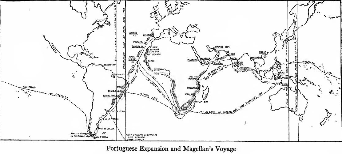
Discovery of a route to India.—During the sixty years which followed the death of Prince Henry, 1460-1520, the Portuguese completed the exploration of the west coast of Africa, discovered a route to India, explored a considerable part of the eastern coast of North and South America, and founded a colonial empire. In 1486 Bartholomew Díaz passed the Cape of Good Hope and in 1498 Vasco da Gama, spurred on by the discoveries of Columbus, crossed the Indian Ocean to Calicut.
Discovery of a route to India.—In the sixty years after Prince Henry's death, from 1460 to 1520, the Portuguese finished exploring the west coast of Africa, found a route to India, explored a significant part of the eastern coasts of North and South America, and established a colonial empire. In 1486, Bartholomew Díaz rounded the Cape of Good Hope, and in 1498, Vasco da Gama, inspired by Columbus’s discoveries, sailed across the Indian Ocean to Calicut.
It has been customary to ascribe the diversion of trade from the eastern Mediterranean to the Cape of Good Hope route to the rise of the Turkish Empire, which was supposed to have cut the old lines of communication to the Far East. Recent investigation has shown that such is not the case. As Professor Lybyer says, "They [the Turks] were not active agents in deliberately obstructing the routes.... Nor did they make the discovery of new routes imperative. On the contrary they lost by the discovery of a new and superior route." This superiority was due to the fact that the Cape route was an all-water route which did not require the rehandling of goods and expensive caravan transportation. Not the Turk, but cheap freight rates, diverted trade from the Mediterranean to the Cape route.
It has been common to attribute the shift of trade from the eastern Mediterranean to the Cape of Good Hope route to the rise of the Turkish Empire, which was believed to have disrupted the traditional routes to the Far East. However, recent research has shown that this isn't true. As Professor Lybyer states, "They [the Turks] were not active agents in deliberately obstructing the routes.... Nor did they make the discovery of new routes necessary. On the contrary, they lost out because of the discovery of a new and better route." This advantage was due to the fact that the Cape route was an all-water route that didn’t require the transfer of goods and costly caravan transport. It wasn't the Turks, but lower shipping rates, that shifted trade from the Mediterranean to the Cape route.
COLUMBUS AND THE DISCOVERY OF AMERICA
Early life of Columbus.—Meanwhile America had been discovered by Christopher Columbus, in the service of Spain. Much that was formerly believed to be true concerning the early life of Columbus recent research has proved to be false or to rest upon doubtful evidence. He was born at or near Genoa, probably in 1452, and was the son of a woolen weaver. Little is known of his education, but in some manner he acquired a knowledge of Latin, read the principal geographical works then accessible, and acquired a wide knowledge of navigation. Three books which he studied with care were the General History and Geography by Æneas Sylvius, the Imago Mundi of Pierre d'Ailly, and the Travels of Marco Polo.
Early life of Columbus.—Meanwhile, America had been discovered by Christopher Columbus while serving Spain. Much of what was once believed about Columbus's early life has been shown to be false or based on questionable evidence through recent research. He was born in or near Genoa, probably in 1452, and was the son of a wool weaver. Little is known about his education, but somehow he learned Latin, read the main geographical works available at the time, and gained extensive knowledge of navigation. Three books he studied closely were the General History and Geography by Æneas Sylvius, the Imago Mundi by Pierre d'Ailly, and the Travels by Marco Polo.
He entered the marine service of Portugal, probably lived for a time on the island of Porto Santo, one of the Madeiras, visited the coast of Guinea, and sailed as far north as England. He married Felipa Moniz, a niece of Isabel Moniz, whose husband was Bartholomew Perestrello, who served under Prince Henry. It is probable that a correspondence occurred between Columbus and the Florentine geographer, Toscanelli, who is said to have suggested to the navigator the possibility of reaching the Indies by sailing west and to have sent him a copy of a chart which he had prepared. The Toscanelli map has not come down to us, the so-called reproduction of it being an adaptation of Behaim's globe of 1492. Through these various influences Columbus conceived the plan of seeking new lands in the Atlantic and became convinced of the feasibility of opening a western route to the Indies.
He joined the Portuguese maritime service, likely spent some time on the island of Porto Santo, one of the Madeiras, explored the coast of Guinea, and sailed as far north as England. He married Felipa Moniz, a niece of Isabel Moniz, whose husband was Bartholomew Perestrello, who served under Prince Henry. It's likely that there was communication between Columbus and the Florentine geographer, Toscanelli, who is said to have suggested to Columbus the idea of reaching the Indies by sailing west and sent him a copy of a chart he had created. The Toscanelli map hasn't survived, and what we have as a reproduction is actually an adaptation of Behaim's globe from 1492. Influenced by these various factors, Columbus developed the plan to seek new lands in the Atlantic and became convinced that opening a western route to the Indies was possible.
His sojourn in Spain.—After unsuccessfully urging his views in Portugal, in 1484 Columbus went to Spain, where he presented himself at the court and made the acquaintance of many influential persons. He also sent his brother Bartholomew to obtain assistance in western exploration from Henry VII of England. Columbus met with slight encouragement in Spain, and decided to seek French aid, but just as he was making his departure he was recalled, Queen Isabella having been brought to a favorable decision by Fray Juan Pérez, a former confessor, by Luis de Santangel, the treasurer of Aragon, by the Count of Medina-Celi, and by the Marquesa de Moya.[Pg 8]
His time in Spain.—After failing to get support for his ideas in Portugal, in 1484 Columbus traveled to Spain, where he appeared at court and met several influential figures. He also sent his brother Bartholomew to seek help with western exploration from Henry VII of England. Columbus received little encouragement in Spain and decided to look for support from France, but just as he was about to leave, he was called back. Queen Isabella had been persuaded to support him by Fray Juan Pérez, a former confessor, by Luis de Santangel, the treasurer of Aragon, by the Count of Medina-Celi, and by the Marquesa de Moya.[Pg 8]
His commission.—Columbus was given a commission authorizing him to explore and trade. It said nothing of a route to the Indies. The enterprise of discovery was essentially a new one, and it was natural that the first patent should contain only general provisions. Indeed, the document was so brief and incomplete that many supplementary orders had to be issued before the expedition was ready. In return for services and to provide a representative of Spanish authority in anticipated discoveries, Columbus was ennobled and made admiral, viceroy, and governor-general in such lands as he might add to the Castilian realm. These offices were patterned after well-known institutions then in use in Spain. The titles were to be hereditary in Columbus's family. The admiral was to have a tenth of the net profits of trade and precious metals within his discoveries. By contributing an eighth of the expense of commercial ventures, he was entitled to an additional eighth of the profits from trade. To encourage the expedition all duties on exports were remitted.
His commission.—Columbus was given a commission that allowed him to explore and trade. It didn’t mention a route to the Indies. The idea of discovery was pretty new, so it made sense that the first document only included general terms. In fact, the document was so short and lacking that many additional orders had to be issued before the expedition was ready. In exchange for his services and to appoint a representative of Spanish authority in the new territories he was expected to find, Columbus was granted nobility and made admiral, viceroy, and governor-general of any lands he added to the Castilian realm. These positions were modeled after well-known institutions in use in Spain at the time. The titles would be passed down through Columbus's family. The admiral was entitled to a tenth of the net earnings from trade and precious metals found in his discoveries. By covering an eighth of the costs for commercial ventures, he was also entitled to an extra eighth of the profits from trade. To support the expedition, all export duties were waived.
Outfitting the expedition.—The story that Isabella pawned her jewels to equip the expedition is now disproved, the royal share of the money apparently being loaned to the Castilian treasury by Luis de Santangel. The total cost of outfitting was probably somewhat less than $100,000, of which Columbus or his friends furnished an eighth. Three vessels, the Santa Maria, the Pinta, and the Niña, were provided. The number who sailed is variously estimated at from ninety to one hundred and twenty men.
Outfitting the expedition.—The story that Isabella sold her jewelry to fund the expedition has now been disproven; the royal portion of the money seems to have been loaned to the Castilian treasury by Luis de Santangel. The total cost for outfitting was probably under $100,000, with Columbus or his associates covering about one-eighth of that amount. Three ships, the Santa Maria, the Pinta, and the Niña, were provided. The number of men who set sail is estimated to range from ninety to one hundred and twenty.
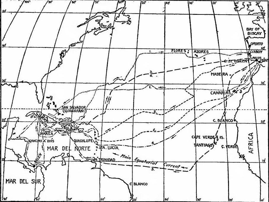
The discovery.—In August, 1492, the three vessels sailed from Palos to the Canaries, those islands then being a possession of Spain which she had acquired from Portugal in 1479. During the entire colonial period they were an important factor in navigation, being a place for refitting before the long trans-Atlantic voyage. The vessels left the Canaries on September 6 and sailed almost due west. They met with fair weather, but the length of the voyage caused much complaint, which resulted in a plot to get rid of Columbus. The Admiral succeeded in quelling the mutiny, however, and shortly afterward land was sighted.
The discovery.—In August 1492, the three ships left Palos for the Canaries, which were then a Spanish possession acquired from Portugal in 1479. Throughout the colonial period, they played a crucial role in navigation, serving as a stop for repairs before the long transatlantic journey. The ships departed the Canaries on September 6 and headed almost directly west. They encountered good weather, but the long journey led to a lot of complaints, which sparked a plan to get rid of Columbus. However, the Admiral managed to suppress the mutiny, and soon after, land was spotted.
 The Four Voyages of Columbus.
On the evening of October 11 a light in the distance was twice seen by the commander, and before morning the moonlight disclosed to the lookout of the Pinta a sandy beach. The landfall was a small coral island of [Pg 10] the Bahamas, which Columbus named San Salvador and which was probably the one now called Watling's Island. Believing that he had reached the Indies, he called the inhabitants Indians, a name which has clung ever since to American aborigines.
On the evening of October 11, the commander spotted a light in the distance twice, and before morning, the moonlight revealed a sandy beach to the lookout of the Pinta. The landfall was a small coral island of [Pg 10] in the Bahamas, which Columbus named San Salvador and which is likely the island now known as Watling's Island. Thinking he had arrived in the Indies, he referred to the inhabitants as Indians, a term that has stuck with the indigenous peoples of America ever since.
Sojourn in the West Indies.—Through all of his sojourn in the West Indies, Columbus was filled with the idea that he had found the Indies. Hearing of Cuba and believing that it was Cipango, he planned to visit the mainland and go to the city of Guisay, the Quinsai of Marco Polo. From the Bahamas he proceeded to Cuba and explored the eastern third of its northern coast. He despatched an interpreter to the Grand Khan, but instead of a mighty city, an Indian village was discovered. There Europeans first saw the smoking of tobacco. From Cuba the expedition went to Haiti, which Columbus named Española (Little Spain), corrupted in English to Hispaniola, and there the Santa Maria was wrecked.
Sojourn in the West Indies.—Throughout his stay in the West Indies, Columbus was convinced that he had discovered the Indies. After hearing about Cuba and thinking it was Cipango, he planned to head to the mainland and visit the city of Guisay, which Marco Polo referred to as Quinsai. From the Bahamas, he went to Cuba and explored the eastern third of its northern coast. He sent an interpreter to the Grand Khan, but instead of finding a grand city, they came across an Indian village. That’s where Europeans first encountered the smoking of tobacco. After Cuba, the expedition traveled to Haiti, which Columbus named Española (Little Spain), later corrupted in English to Hispaniola, and there the Santa Maria was wrecked.
The return voyage.—Having built a fort on the northern shore of Española not far from its westernmost point, which he named La Navidad (the Nativity) because the neighboring harbor was entered on Christmas day, Columbus left forty-four of the crew with ample provisions, implements, and arms, and began the return voyage on January 4, 1493. Two violent storms were encountered, but both were weathered, and on March 4 the vessels came to anchor in the mouth of the Tagus.
The return voyage.—After constructing a fort on the northern shore of Española, not far from its westernmost point, which he named La Navidad (the Nativity) because they entered the nearby harbor on Christmas day, Columbus left forty-four crew members with plenty of supplies, tools, and weapons, and started the return journey on January 4, 1493. They faced two violent storms but managed to survive both, and on March 4, the ships anchored at the mouth of the Tagus.
His reception.—In Lisbon the news of the discovery created great excitement. The King of Portugal invited Columbus to court and entertained him royally. On March 13 he sailed for Spain, arriving at Palos two days later. The citizens adjourned business for the day; bells were rung, and at night the streets were illumined with torches. From there he proceeded to Seville and then to the court at Barcelona, where the greatest honors were bestowed upon him. He was allowed to be seated in the presence of the sovereigns, who showed the keenest interest in his specimens of flora and fauna, pearls and golden trinkets, but especially in the Indians whom he had brought from Española. The theory that he had reached the outlying parts of the Indies was readily accepted, and the sovereigns at once prepared to take possession of the newly discovered lands.[Pg 11]
His reception.—In Lisbon, the news of the discovery created a huge stir. The King of Portugal invited Columbus to court and treated him like royalty. On March 13, he sailed for Spain, arriving in Palos two days later. The local citizens stopped their work for the day; bells rang, and at night the streets were lit with torches. From there, he went to Seville and then to the court in Barcelona, where he received the highest honors. He was allowed to sit in the presence of the rulers, who showed great interest in his samples of plants and animals, pearls, and gold trinkets, but especially in the Native Americans he had brought from Española. The idea that he had reached the outer regions of the Indies was quickly accepted, and the rulers immediately began to prepare to claim the newly discovered lands.[Pg 11]
The line of Demarcation.—The king of Portugal, jealous of Spain's triumph, is said to have planned to send a fleet across the Atlantic to dispute the Spanish claims. Ferdinand and Isabella hurried a messenger to Rome asking the pope to confirm their rights to the new discoveries. Accordingly, on May 4, 1493, Pope Alexander VI assigned to Spain all lands west of a meridian one hundred leagues west of the Azores and Cape Verde Islands. King John was not satisfied, and a year later, by the treaty of Tordesillas, a division line was fixed at 370 leagues west of Cape Verde Islands. This change gave Portugal title to her later discoveries on the Brazilian coast, though it lessened her possessions in the Orient.
The Line of Demarcation.—The king of Portugal, envious of Spain's success, is reported to have planned to send a fleet across the Atlantic to challenge Spain’s claims. Ferdinand and Isabella quickly sent a messenger to Rome asking the pope to confirm their rights to the new discoveries. As a result, on May 4, 1493, Pope Alexander VI assigned all lands west of a line one hundred leagues west of the Azores and Cape Verde Islands to Spain. King John was not satisfied, and a year later, with the Treaty of Tordesillas, a dividing line was established at 370 leagues west of the Cape Verde Islands. This change granted Portugal rights to its later discoveries along the Brazilian coast, although it reduced its possessions in the East.
READINGS
GROWTH OF GEOGRAPHICAL KNOWLEDGE
Beazley, C.R., The Dawn of Modern Geography; Prince Henry the Navigator, 1-105; Fischer, J., The Discoveries of the Northmen in America; Fiske, John, The Discovery of America, I, 151-255, 363-381; Hovgaard, W., The Voyages of the Norsemen to America, 221-255; Marco Polo, The Book of Ser Marco Polo the Venetian, Yule ed.; Olson, J.E., and Bourne, E.G., eds., The Northmen, Columbus, and Cabot (Original Narratives of Early American History), 3-84; Vining, E.J., An Inglorious Columbus; or evidence that Hwi Shan ... discovered America in the Fifth Century; Winsor, Justin, Narrative and Critical History of America, I, 1-58; Fossum, A., The Norse Discovery of America; Steensby, H.P., The Norsemen's Route to Wineland; Larson, L.M., "The Church in North America (Greenland) in the Middle Ages," in The Catholic Historical Review, V, 175-194.
Beazley, C.R., The Dawn of Modern Geography; Prince Henry the Navigator, 1-105; Fischer, J., The Discoveries of the Northmen in America; Fiske, John, The Discovery of America, I, 151-255, 363-381; Hovgaard, W., The Voyages of the Norsemen to America, 221-255; Marco Polo, The Book of Ser Marco Polo the Venetian, Yule ed.; Olson, J.E., and Bourne, E.G., eds., The Northmen, Columbus, and Cabot (Original Narratives of Early American History), 3-84; Vining, E.J., An Inglorious Columbus; or evidence that Hwi Shan ... discovered America in the Fifth Century; Winsor, Justin, Narrative and Critical History of America, I, 1-58; Fossum, A., The Norse Discovery of America; Steensby, H.P., The Norsemen's Route to Wineland; Larson, L.M., "The Church in North America (Greenland) in the Middle Ages," in The Catholic Historical Review, V, 175-194.
PORTUGUESE DISCOVERIES
Beazley, C.R., Prince Henry the Navigator, 123-307; Bourne, E.G., "Prince Henry the Navigator," in Essays in Historical Criticism, 173-189; Cheyney, E.P., European Background of American History, 60-70; Helps, Arthur, The Spanish Conquest in America, I, 1-54; Jayne, K.G., Vasco da Gama and his Successors, 7-240; Lybyer, A.H., "The Ottoman Turks and the Routes of Oriental Trade," in The English Historical Review, XXX, 577-588; Major, R.H., The Discoveries of Prince Henry the Navigator; Martins, J.P.O., The Golden Age of Prince Henry the Navigator, 66-84, 205-231; Stephens, H.M., Portugal, 115-248; Vander Linden, H., "Alexander VI., and the Demarcation of the Maritime and Colonial Dominions of Spain and Portugal," in American Historical Review, XXII, 1-20.
Beazley, C.R., Prince Henry the Navigator, 123-307; Bourne, E.G., "Prince Henry the Navigator," in Essays in Historical Criticism, 173-189; Cheyney, E.P., European Background of American History, 60-70; Helps, Arthur, The Spanish Conquest in America, I, 1-54; Jayne, K.G., Vasco da Gama and his Successors, 7-240; Lybyer, A.H., "The Ottoman Turks and the Routes of Oriental Trade," in The English Historical Review, XXX, 577-588; Major, R.H., The Discoveries of Prince Henry the Navigator; Martins, J.P.O., The Golden Age of Prince Henry the Navigator, 66-84, 205-231; Stephens, H.M., Portugal, 115-248; Vander Linden, H., "Alexander VI, and the Demarcation of the Maritime and Colonial Dominions of Spain and Portugal," in American Historical Review, XXII, 1-20.
COLUMBUS
Biggar, H.P., "The New Columbus," in Am. Hist. Assoc., Ann. Rpt., 1912, pp. 97-104; Bourne, E.G., Spain in America, 8-32; Channing, Edward,[Pg 12] History of the United States, I, 14-25; Hart, A.B., American History told by Contemporaries, I, 28-48; Helps, Arthur, The Spanish Conquest in America, I, 55-88; Herrera, Antonio, Historia General; Las Casas, Bartholomew, Historia de las Indias; Major, R.H., Select Letters of Columbus; Markham, Clements, Life of Columbus; Navarrete, M.F., Colección de los Viages y Descubrimientos; Olson, J.E., and Bourne, E.G., eds., The Northmen, Columbus, and Cabot (Original Narratives), 80-383; Peter Martyr, De Orbe Novo (F.A. McNutt, trans.); Richman, L.B., The Spanish Conquerors, 1-63; Thacher, J.B., Columbus; Vignaud, Henry, Toscanelli and Columbus: Winsor, Justin, Columbus.
Biggar, H.P., "The New Columbus," in Am. Hist. Assoc., Ann. Rpt., 1912, pp. 97-104; Bourne, E.G., Spain in America, 8-32; Channing, Edward, [Pg 12] History of the United States, I, 14-25; Hart, A.B., American History Told by Contemporaries, I, 28-48; Helps, Arthur, The Spanish Conquest in America, I, 55-88; Herrera, Antonio, Historia General; Las Casas, Bartholomew, Historia de las Indias; Major, R.H., Select Letters of Columbus; Markham, Clements, Life of Columbus; Navarrete, M.F., Colección de los Viages y Descubrimientos; Olson, J.E., and Bourne, E.G., eds., The Northmen, Columbus, and Cabot (Original Narratives), 80-383; Peter Martyr, De Orbe Novo (F.A. McNutt, trans.); Richman, L.B., The Spanish Conquerors, 1-63; Thacher, J.B., Columbus; Vignaud, Henry, Toscanelli and Columbus; Winsor, Justin, Columbus.
CHAPTER II
THE FOUNDING OF NEW SPAIN (1492-1543)
SPAIN DURING THE CONQUEST
The discoveries of Columbus opened to Spain the opportunity to found a great colonial empire in the new world. For this work Spain had been prepared by the welding of the nation which was perfected during the reign of Ferdinand and Isabella.
The discoveries of Columbus gave Spain the chance to build a huge colonial empire in the New World. Spain was ready for this task thanks to the unification of the nation that was completed during the reign of Ferdinand and Isabella.
The Christian reconquest.—In the eighth century the Mohammedan Berbers had overthrown the Visigothic kingdom, the unconquered Christian princes retiring to the mountain regions of the north. Gradually they reconquered the country. By 910 they had established the kingdoms of León and Navarre, and the county of Barcelona. By 1037 León and Castile had united and conquered a wide tract south of the Douro River. Aragon, originally a Frankish country, had also become an independent kingdom. By 1150 almost two-thirds of the peninsula had been conquered; Portugal now extended from the Minho River to the Tagus; Castile occupied the central region, and Aragon had incorporated Barcelona and Catalonia. During the next two centuries the rest of the peninsula, except the small kingdom of Granada, was conquered, and Aragon established her power in the Balearic Isles, Sardinia, and southern Italy. In 1469 Isabella of Castile married Ferdinand of Aragon, thus uniting the two great states. In 1481 they made war upon Granada, completing its conquest in the year of the discovery of America. All of these changes had been chiefly of rulers, the great body of the people remaining of the original Iberian stock.
The Christian reconquest.—In the eighth century, the Muslim Berbers had overthrown the Visigothic kingdom, forcing the unconquered Christian princes to retreat to the northern mountain regions. Gradually, they reconquered the territory. By 910, they had established the kingdoms of León and Navarre, along with the county of Barcelona. By 1037, León and Castile had united and conquered a large area south of the Douro River. Aragon, originally a Frankish territory, had also become an independent kingdom. By 1150, nearly two-thirds of the peninsula had been reclaimed; Portugal now stretched from the Minho River to the Tagus; Castile occupied the central area, and Aragon had taken over Barcelona and Catalonia. Over the next two centuries, the rest of the peninsula, except for the small kingdom of Granada, was conquered, and Aragon asserted its power in the Balearic Islands, Sardinia, and southern Italy. In 1469, Isabella of Castile married Ferdinand of Aragon, thereby uniting the two great states. In 1481, they waged war against Granada, completing its conquest in the same year as the discovery of America. Throughout all these changes, the rulers were mainly different, while the great majority of the people remained of the original Iberian stock.
Lack of unity.—But there was neither unity of speech, customs, nor institutions. There were three main religious groups, Christians, Mohammedans, and Jews. The people were also divided into social classes, nobility, clergy, common people, and slaves. The ranks and privileges of the nobility varied greatly, some having immense estates and almost sovereign powers, others[Pg 14] being landless soldiers of fortune. Castile was the land of castles. The nobles were turbulent and warlike. They delighted in chivalry, which probably attained a higher development in Spain than in any other country. Furthermore, there were three great military orders, which had grown in strength during the Moorish wars; these were the Knights of Santiago, of Calatrava, and of Alcántara, at the head of each of which was a grand master. The orders, the landed nobility, and the church owned about one-third of the land and controlled large military forces. The cities were also powerful; they were strongly fortified, regulated their own affairs, and many of them had great fleets and extensive commerce. Life outside of the cities was largely pastoral, wool, growing being the principal industry. Both Castile and Aragon contained governing bodies called Cortes, to which some of the larger cities sent representatives, but they were of little importance, most of the work of lawmaking being done by the sovereign acting with his Council of State.
Lack of unity.—However, there was a complete lack of unity in language, customs, and institutions. There were three main religious groups: Christians, Muslims, and Jews. The people were also divided into social classes: nobility, clergy, common people, and slaves. The wealth and privileges of the nobility varied widely; some had vast estates and almost sovereign powers, while others[Pg 14] were landless soldiers seeking fortune. Castile was known for its castles. The nobles were rebellious and warlike, cherishing chivalry, which likely developed further in Spain than anywhere else. Additionally, there were three major military orders that gained power during the Moorish wars: the Knights of Santiago, Calatrava, and Alcántara, each led by a grand master. These orders, along with the landed nobility and the church, owned about a third of the land and commanded large military forces. The cities were also influential; they were well-fortified, managed their own affairs, and many boasted significant fleets and extensive trade. Life outside the cities was mostly pastoral, with wool production being the main industry. Both Castile and Aragon had governing bodies called Cortes, to which some of the larger cities sent representatives, but they held little power, as most lawmaking was done by the sovereign in conjunction with his Council of State.
Establishment of unity.—To bring the entire country into religious and political unity was the great task of Ferdinand and Isabella. This was accomplished partly through the Hermandad and the organization of several royal councils. The Hermandad, originally a local police, was organized as a state police; captured offenders were punished before local officers of the crown called alcaldes. Turbulent nobles and brigands were made to feel the long arm of the royal power. The nobles were also curbed by transferring the grand masterships of the military orders to the crown and the sovereigns resumed control of many estates which had been granted to churches and nobles. The royal council of twelve had been the principal governing body. Under Ferdinand and Isabella it was divided into three councils, justice, state, and finance. Other councils were added from time to time; among these was the Council of the Inquisition, whose business it was to stamp out heresy. By its efforts unbaptized Jews and Moors were expelled. The rulers also sent royal officers called corregidores into the local communities, who gradually extended the powers of the crown at the expense of local government. Thus were laid the foundations of an absolute monarchy, which, in the sixteenth century, became the most influential in Europe.
Establishment of unity.—The major goal for Ferdinand and Isabella was to unify the entire country both religiously and politically. They achieved this in part through the Hermandad and the creation of several royal councils. The Hermandad, which started as a local police force, was restructured into a state police; offenders were punished by local representatives of the crown known as alcaldes. Disruptive nobles and bandits felt the reach of royal authority. The nobles were further restrained by transferring control of the grand masterships of military orders to the crown, and the sovereigns reclaimed many estates that had been given to churches and nobles. The royal council of twelve had served as the main governing body. Under Ferdinand and Isabella, it was split into three councils: justice, state, and finance. Additional councils were formed over time, including the Council of the Inquisition, which aimed to eliminate heresy. Through its efforts, unbaptized Jews and Moors were expelled. The rulers also appointed royal officers called corregidores to local communities, gradually extending the crown's power at the expense of local governance. This set the stage for an absolute monarchy, which emerged as the most influential in Europe by the sixteenth century.
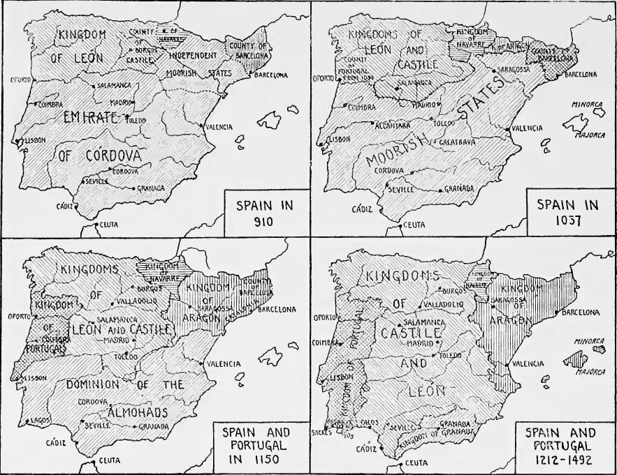 The Unification of Spain. (Based on Maps in Shepherd, W.R., Historical Atlas, pp. 82-83.)
Charles V.—The prestige of Spain was greatly enhanced in the[Pg 16] sixteenth century by the Emperor Charles V, the grandson of Ferdinand and Isabella. From his mother he inherited Spain, Naples, and Sicily, and possessions in the new world and the Far East; from his father the Netherlands; from his grandfather, Maximilian I, the Hapsburg inheritance in Germany. By election he became Holy Roman Emperor. The larger part of the reign was occupied by three great European contests; a series of struggles with Francis I of France for the control of Italy, the Reformation in Germany, and the curbing of the westward advance of the Turks. The almost constant wars of the Emperor kept him away from Spain nearly his entire time, but he used the centralized system of Ferdinand and Isabella to supply him with soldiers and money. The constant drain of treasure overtaxed the resources of Spain, but the rich mines of the new world furnished the surplus for his vast undertakings. The fact that Charles was successful in retaining his power in Italy, coupled with his struggle against the Protestants and the Turks, made him the recognized protector of the Catholic church. His reign, marked by many sad failures in Europe, witnessed a phenomenal expansion of Spain's colonies.
Charles V.—The prestige of Spain was greatly enhanced in the[Pg 16] sixteenth century by Emperor Charles V, the grandson of Ferdinand and Isabella. He inherited Spain, Naples, and Sicily, along with territories in the New World and the Far East from his mother; the Netherlands from his father; and the Hapsburg lands in Germany from his grandfather, Maximilian I. He was elected Holy Roman Emperor. Most of his reign was spent in three major European conflicts: a series of battles with Francis I of France over control of Italy, the Reformation in Germany, and efforts to halt the westward expansion of the Turks. The nearly constant wars kept the Emperor away from Spain for most of his rule, but he relied on the centralized system established by Ferdinand and Isabella for troops and funding. The ongoing demand for resources strained Spain’s economy, but the rich mines in the New World provided the extra wealth needed for his extensive campaigns. Charles's success in maintaining his power in Italy, along with his battles against Protestants and Turks, solidified his role as the recognized protector of the Catholic Church. His reign, though filled with many disappointments in Europe, also saw an extraordinary expansion of Spain's colonies.
THE OCCUPATION OF THE WEST INDIES
The rule of Columbus in the Indies.—When Columbus discovered a new world for Spain, that country was placed in a new situation, and a settled colonial policy was developed only with experience. A department of Indian affairs was created at once and put in charge of Fonseca, a member of the royal council. A combined interest in commerce, religion, and colonization was shown in all the arrangements for a second voyage by Columbus, but commerce was the primary object. At first it was planned to send a thousand colonists, but so eager were the applicants that fifteen hundred embarked. The expedition was equipped at the queen's expense, and most of the colonists were in her pay.
The rule of Columbus in the Indies.—When Columbus discovered a new world for Spain, the country found itself in a new situation, and a stable colonial policy was developed only through experience. A department for Indian affairs was created immediately and placed under the leadership of Fonseca, a member of the royal council. There was a clear interest in commerce, religion, and colonization in all the plans for Columbus's second voyage, but commerce was the primary focus. Initially, it was planned to send a thousand colonists, but so many people wanted to join that fifteen hundred ended up embarking. The expedition was funded by the queen, and most of the colonists were on her payroll.
Reaching Española in November, 1493, Columbus found Navidad destroyed by Indians; he accordingly established a new settlement, named Isabella, at a point farther east. Leaving his brother Diego in charge, Columbus explored the southern coast of Cuba, discovered Jamaica, and circumnavigated Española.[Pg 17] Complaints being made against his administration, in 1495 Columbus returned to Spain to defend himself. Shortly after his departure, gold being found in the southern part of Española, the new town of Santo Domingo was founded there and became the capital. Other men were eager for commercial adventure, and, in response to their demands, in 1495 trade in the Indies was opened to all Spaniards, at their own expense. Columbus regarded this an infringement upon his rights, and on his return to Spain he protested, but to little purpose.
Reaching Española in November 1493, Columbus found Navidad destroyed by the indigenous people; so he set up a new settlement called Isabella further east. He left his brother Diego in charge and explored the southern coast of Cuba, discovered Jamaica, and circumnavigated Española.[Pg 17] After receiving complaints about his administration, Columbus returned to Spain in 1495 to defend himself. Shortly after he left, gold was discovered in the southern part of Española, leading to the founding of the new town of Santo Domingo, which became the capital. Other men were eager for commercial opportunities, and in response to their demands, trade in the Indies was opened to all Spaniards at their own expense in 1495. Columbus saw this as a violation of his rights, and when he returned to Spain, he protested, but it didn't have much effect.
In 1498 Columbus sailed on a third voyage, taking some two hundred colonists. On the way he discovered the mainland of South America near the Orinoco River, and, farther west, valuable pearl fisheries. During his absence a civil war had occurred in Española, and, at the end of two years of trouble with the contending factions, Columbus was sent to Spain in chains by Bobadilla, a royal commissioner, who remained to govern in his place. The charges against Columbus were dismissed, but he was not restored to his rule in the Indies. In 1502 Nicolás de Ovando was sent to replace Bobadilla, taking with him 2500 new colonists.
In 1498, Columbus set out on his third voyage, bringing along around two hundred colonists. During the journey, he discovered the mainland of South America near the Orinoco River and, further west, valuable pearl fisheries. While he was away, a civil war broke out in Española, and after two years of conflict between the opposing factions, Columbus was sent back to Spain in chains by Bobadilla, a royal commissioner, who took over his governance. The charges against Columbus were eventually dropped, but he wasn’t reinstated as the ruler in the Indies. In 1502, Nicolás de Ovando was appointed to replace Bobadilla, bringing with him 2,500 new colonists.
Spread of settlement in the West Indies.—After 1496 Santo Domingo became the chief town of Española and the seat of Spanish rule in America. In rapid succession posts and mining camps were established in various parts of the island, and by 1513 there were seventeen chartered towns in Española alone. Santo Domingo at that time had a population of fifteen hundred persons. It was some fifteen years after the settlement of Española before the other islands began to be occupied, attention being first given to making cruises along the southern mainland. Ovando began the conquest of the other islands, however, and Diego Columbus, his successor, prosecuted the work with more vigor. In 1508 Ponce de León was sent to conquer Porto Rico, and in 1511 the present city of San Juan was founded. The settlement of Jamaica was begun in 1509 by Esquivel, under orders of Diego Columbus. Several towns were soon established, and a shipyard opened. In 1537 Jamaica became a possession of the family of Columbus, with the title of Marquis till 1557, then of Duke of La Vega. In 1508 Ocampo circumnavigated Cuba and in 1511 Velasquez began the conquest of the island. Santiago was founded in 1514 and Havana a year later. Thus the West Indies became the nursery of Spanish culture and institutions in America.
Spread of settlement in the West Indies.—After 1496, Santo Domingo became the main town of Española and the center of Spanish rule in America. Quickly, outposts and mining camps were set up in various areas of the island, and by 1513 there were seventeen chartered towns in Española alone. At that time, Santo Domingo had a population of about fifteen hundred people. It took around fifteen years after the settlement of Española for the other islands to start being occupied, with the initial focus on making voyages along the southern mainland. However, Ovando began the conquest of the other islands, and his successor, Diego Columbus, pursued the effort with more determination. In 1508, Ponce de León was sent to conquer Puerto Rico, and in 1511, the current city of San Juan was established. The settlement of Jamaica started in 1509 by Esquivel, under the orders of Diego Columbus. Several towns were quickly founded, and a shipyard was opened. In 1537, Jamaica became a possession of the Columbus family, first holding the title of Marquis until 1557, and then of Duke of La Vega. In 1508, Ocampo circumnavigated Cuba, and in 1511, Velasquez began the conquest of the island. Santiago was founded in 1514, and Havana a year later. Thus, the West Indies became the birthplace of Spanish culture and institutions in America.
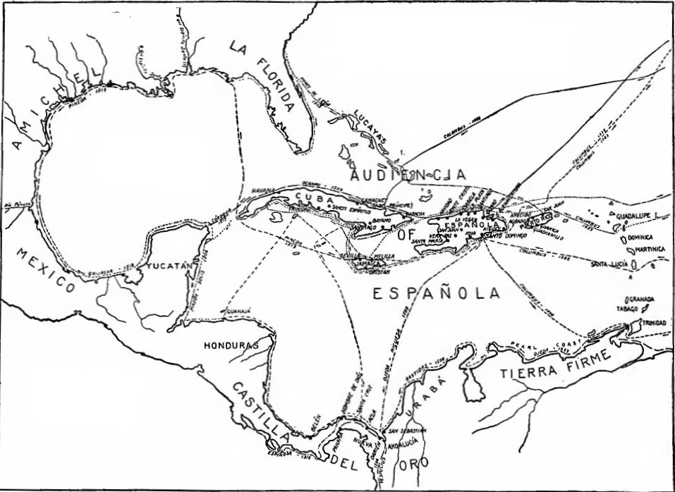 The Growth of the West Indies, 1492-1519.
Gold mining was important in Española for a time, but the mines were soon exhausted. In all the islands cotton, sugar, and cattle raising soon acquired some proportions, but the native population rapidly decreased, negro slaves were expensive, and rich profits attracted the settlers to the mainland; consequently, after the first quarter century the islands declined in prosperity and Porto Rico was for a time actually abandoned.
Gold mining was significant in Española for a while, but the mines ran out quickly. On all the islands, cotton, sugar, and cattle farming eventually grew, but the native population dropped rapidly, enslaved people were costly, and the promise of huge profits drew settlers to the mainland. As a result, after the first 25 years, the islands lost their wealth, and Porto Rico was actually abandoned for a time.
BEGINNINGS OF COLONIAL ADMINISTRATION AND POLICY
The Casa de Contratación.—For ten years Fonseca remained at the head of American affairs, being in effect colonial minister. In 1503 the Casa de Contratación or House of Trade was established at Seville, to direct commerce, navigation, and all related matters of the Indies. In charge of the Casa was a board of officials, including factors, treasurer, auditor, and notary. They maintained a warehouse for receiving all goods and treasure going to or from the islands. They were required to keep informed of the needs of the Indies, assemble and forward supplies, organize trading expeditions, and instruct and license pilots. Later on a professorship of cosmography was established for the purpose of instructing pilots, who were required to keep diaries of their voyages. This provision resulted in the accumulation of a vast amount of historical and geographical information in the government archives, much of which is still extant.
The Casa de Contratación.—For ten years, Fonseca was in charge of American affairs, effectively acting as the colonial minister. In 1503, the Casa de Contratación, or House of Trade, was established in Seville to oversee commerce, navigation, and all related matters concerning the Indies. A board of officials, including factors, a treasurer, an auditor, and a notary, managed the Casa. They had a warehouse for receiving all goods and treasure going to or from the islands. They needed to stay informed about the Indies' needs, gather and send supplies, organize trading expeditions, and train and license pilots. Eventually, a chair of cosmography was created to teach pilots, who were required to keep records of their voyages. This led to the accumulation of significant historical and geographic information in the government archives, much of which still exists today.
The Council of the Indies.—Spanish America was a possession of the sovereigns of Castile, as heirs of Queen Isabella, under whose patronage America had been discovered. At first, legislative and political matters relating to the Indies had been considered by the sovereigns in consultation with Fonseca and other personal advisors, but to supervise these matters a new board was gradually formed. In 1517 it was formally organized, among the members being Fonseca and Peter Martyr, the historian. In 1524 the board was reorganized as the Council of the Indies. This body was the supreme legislative and judicial authority, under the king, of Spanish-America. The Casa de Contratación[Pg 20] was subordinate to the Council, which likewise supervised all civil and ecclesiastical appointments in the colonies. Usually some of the members of the Council had served in the Indies.
The Council of the Indies.—Spanish America was a territory controlled by the rulers of Castile, as heirs of Queen Isabella, who had sponsored the discovery of America. Initially, legislative and political issues related to the Indies were discussed by the sovereigns along with Fonseca and other personal advisors, but a new board was gradually established to oversee these matters. In 1517, it was formally organized, with members including Fonseca and Peter Martyr, the historian. By 1524, the board was reorganized as the Council of the Indies. This body was the highest legislative and judicial authority, under the king, for Spanish America. The Casa de Contratación[Pg 20] was subordinate to the Council, which also oversaw all civil and church appointments in the colonies. Typically, some members of the Council had experience serving in the Indies.
The governors-general and the audiencia.—Ovando ruled in Española until 1509, when Diego Columbus, son of Christopher, after a struggle for his hereditary rights, was made admiral and governor-general of the Indies. Complaint against Diego's administration led to the establishment at Santo Domingo of a superior court with appeals from the decisions of the governor-general. This was the germ of the Audiencia of Santo Domingo, which, for a time, was the administrative head of the greater part of the Indies. By decree of September 14, 1524, the Audiencia was formally established, with a president, four judges, a fiscal, a deputy grand-chancellor, and other officers.
The governors-general and the audiencia.—Ovando governed in Española until 1509, when Diego Columbus, the son of Christopher, was appointed admiral and governor-general of the Indies after a fight for his inherited rights. Complaints about Diego's administration resulted in the creation of a higher court in Santo Domingo that handled appeals from the governor-general's decisions. This laid the groundwork for the Audiencia of Santo Domingo, which for a period served as the administrative authority over most of the Indies. By a decree on September 14, 1524, the Audiencia was officially established, with a president, four judges, a fiscal, a deputy grand-chancellor, and other officials.
The towns.—In the early sixteenth century the colonial towns showed some political activity. In 1507 the municipalities of Española sent delegates to Spain to petition for the rights enjoyed by Spanish towns. The request was granted, and, among other privileges, fourteen towns were granted coats-of-arms. Conventions of delegates from the towns were often held in these early days, to consider common needs and to draw up memorials to the home government. In 1530 Charles V decreed that such conventions should not be held without his consent, and the tendency thereafter was toward stronger absolutism and away from local political life. But there never was a time when the right of petition was not freely exercised, and with great effect on actual administration. In the sixteenth century the towns sometimes elected proctors to represent them before the Council of the Indies. In the seventeenth century they sometimes employed residents of Spain for this purpose.
The towns.—In the early 1500s, the colonial towns showed some political activity. In 1507, the municipalities of Española sent delegates to Spain to request the rights that Spanish towns had. The request was approved, and, among other privileges, fourteen towns were given coats of arms. During these early days, conventions of delegates from the towns were often held to discuss common needs and to draft memorials to the home government. In 1530, Charles V declared that such conventions should not occur without his approval, leading to a shift towards stronger absolutism and away from local political life. However, there was never a time when the right to petition wasn't actively used, and it had a significant impact on actual governance. In the sixteenth century, the towns sometimes elected representatives to speak for them before the Council of the Indies. In the seventeenth century, they occasionally hired residents of Spain for this role.
In the colonial towns, both Spanish and native, there was some degree of self-government. Each Spanish town had its cabildo composed of regidores. In 1523 the regidores were made elective, but the tendency was to secure the office by purchase or inheritance, as was the case in Spain. The functions of the cabildos were similar to those of a New England town council, embracing legislation, police matters, care of highways, sanitation, and analogous functions.[Pg 21]
In the colonial towns, both Spanish and Native, there was a certain level of self-government. Each Spanish town had its cabildo made up of regidores. In 1523, the regidores were allowed to be elected, but the trend was to acquire the position through purchase or inheritance, just like in Spain. The roles of the cabildos were similar to those of a New England town council, covering legislation, policing, road maintenance, sanitation, and other related responsibilities.[Pg 21]
Emigration.—The notion sometimes voiced that Spain did not "colonize" America is unfounded. Emigration to America was encouraged by subsidies and other means, and in early days large colonies were sent by government authority. It has been seen, for example, that on his first three voyages Columbus took over about 100, 1500, and 200 colonists respectively, and that Ovando took 2500. During the entire sixteenth century the emigration to America averaged from 1000 to 2000 persons per year. In general, emigration was restricted to Spaniards of undoubted orthodoxy, hence Jews, Moors, and recent converts were excluded. Naturalization was relatively easy, however, and by means of it many foreigners were admitted. Portuguese, for example, were numerous in the Indies, especially among the seamen. Charles V adopted the liberal policy of opening the Indies to subjects of all parts of his empire, but Philip II returned to the more exclusive practice. Later on, as the trade monopoly broke down, it became necessary to admit foreign traders to American ports, but they were required to return within specified periods.
Emigration.—The idea that Spain didn't "colonize" America is incorrect. Emigration to America was promoted through subsidies and other methods, and in the early days, large groups were sent with government approval. For instance, on his first three voyages, Columbus brought around 100, 1,500, and 200 colonists respectively, while Ovando brought 2,500. Throughout the entire sixteenth century, emigration to America averaged between 1,000 and 2,000 people each year. Generally, emigration was limited to Spaniards of unquestionable faith, which meant Jews, Moors, and recent converts were excluded. However, naturalization was relatively easy, allowing many foreigners to settle. Portuguese, for example, were quite common in the Indies, especially among sailors. Charles V adopted a more open policy, allowing subjects from all parts of his empire into the Indies, but Philip II returned to a more exclusive approach. Later, as the trade monopoly began to weaken, it became necessary to allow foreign traders into American ports, but they had to leave within set timeframes.
Married Spaniards emigrating from Spain were urged or even required to take their families but the emigration of unmarried Spanish women was discouraged. Intermarriage of Spaniards with native women was favored by the authorities and, as a large majority of the immigrants were single men, the practice was common, either with or without formal sanction. An effort to supply the lack of women by sending white slaves to the islands failed, and in 1514 marriage with Indian women was approved by royal order. With the opening of Mexico and Peru the island colonies were in danger of depopulation. To prevent this from happening, migration to the mainland was forbidden under heavy penalties (1525-1526), and the recruiting of new conquering expeditions in the islands was prohibited. To secure settlers for Española, in 1529 attractive feudal lordships were offered to founders of colonies.
Married Spaniards moving from Spain were encouraged or even required to bring their families, but the emigration of single Spanish women was discouraged. Authorities favored intermarriage between Spaniards and native women, and since most immigrants were single men, this practice was common, whether formally sanctioned or not. An attempt to address the shortage of women by sending white slaves to the islands failed, leading to a royal order in 1514 that approved marriage with Indian women. With the expansion of Mexico and Peru, the island colonies faced the risk of losing population. To stop this from occurring, migration to the mainland was banned under severe penalties (1525-1526), and recruitment for new conquest expeditions in the islands was prohibited. To attract settlers to Española, in 1529 appealing feudal lordships were offered to founders of colonies.
Agriculture.—Agriculture in the West Indies was encouraged by all means available. Duties on imports were remitted for a term of years. In 1497 the sovereigns ordered a public farm established to provide loans of stock and seed, to be paid back by colonists within a term of years. Free lands were granted to[Pg 22] settlers, with a reservation of the precious metals to the crown. Special orders were given for mulberry and silkworm culture. These efforts to promote agriculture in the West Indies, however, were made largely nugatory by commercial restrictions and the superior attractions of the mainland.
Agriculture.—Agriculture in the West Indies was supported by every possible means. Import duties were eliminated for a number of years. In 1497, the rulers ordered the establishment of a public farm to provide loans of livestock and seeds, which colonists were expected to repay within a set period. Free land was granted to[Pg 22] settlers, with the crown reserving the rights to any precious metals found. Special instructions were given for the cultivation of mulberry and silkworms. However, these efforts to boost agriculture in the West Indies were largely undermined by trade restrictions and the more appealing opportunities available on the mainland.
Indian policy.—Columbus found Española inhabited, it was estimated, by a quarter of a million of Indians, and the other islands similarly populated. He was instructed to treat the natives well and to do all in his power to convert them. The sovereigns frequently repeated these orders, and commanded that the natives be treated as free men and paid for their work. But the shortage of a labor-supply and the relative position of the two races led quickly and almost inevitably to the practical enslavement of the weaker.
Indian policy.—Columbus discovered Española was home to an estimated quarter of a million Indians, and the other islands had similar populations. He was directed to treat the natives kindly and to do everything he could to convert them. The monarchs often reiterated these instructions, insisting that the natives be treated as free individuals and compensated for their labor. However, the lack of labor supply and the unequal standing of the two races quickly and almost inevitably resulted in the practical enslavement of the weaker group.
Encomiendas.—Following the rebellion of 1495, the subdued natives were put under tribute in the form of specified amounts of products, commutable to labor. In 1497 a practice was begun of allotting lands to Spaniards, the forced labor of the natives going with the land. Complaint being made by priests and seculars that the Indians could neither be made to work, nor be taught or converted without restraint, in 1503 it was ordered that they should be congregated (congregados) in permanent villages and put under protectors (encomenderos), who were obliged to teach and protect them, and were empowered to exact their labor, though for pay and as free men. This provision contained the essence of the encomienda system, which was designed to protect and civilize the native, as well as to exploit him. But there was always danger that the former aim would yield to the latter, and, contrary to royal will, the condition of the natives fast became one of practical slavery.
Encomiendas.—After the rebellion of 1495, the subdued natives were put under tribute, requiring them to provide specific amounts of products that could be exchanged for labor. In 1497, a practice started where lands were allocated to Spaniards, with the forced labor of the natives being tied to the land. Priests and secular leaders complained that the Indians couldn’t be made to work or taught or converted without force. So, in 1503, it was ordered that they should be gathered (congregados) into permanent villages and placed under protectors (encomenderos), who were responsible for teaching and protecting them and were authorized to require their labor, although for pay and as free individuals. This system contained the essence of the encomienda, which aimed to protect and civilize the native while also exploiting them. However, there was always a risk that the original intention would give way to exploitation, and against royal intentions, the situation of the natives quickly became one of practical slavery.
Depopulation of the islands.—Moreover, in a very short time the islands became nearly depopulated of natives. Many were slain in the wars of conquest and during rebellions, or died of starvation while in hiding. Perhaps a greater number died of smallpox, measles, and other diseases brought from Europe. The result was that by 1514 the native population of Española was reduced to 14,000. A similar reduction of native population occurred in the other islands as they were successively occupied.
Depopulation of the islands.—In a very short time, the islands became almost empty of natives. Many were killed in the wars of conquest and during rebellions, or died of starvation while hiding. Perhaps even more died from smallpox, measles, and other diseases brought over from Europe. As a result, by 1514, the native population of Española had dropped to 14,000. A similar decline in native population happened in the other islands as they were gradually occupied.
Indian slavery.—Indian slavery was not generally allowed in[Pg 23] theory. But the Lesser Antilles, the Bahamas, and Florida were found to be inhabited by hostile cannibals, who were regarded as fair prize for enslavement. As early as 1494 Columbus suggested that permission be given to sell Caribs. In 1498 he took a cargo of six hundred of them to Spain. Soon it became an accepted legal principle that cannibals and rebellious Indians could be enslaved. The idea was encouraged by the lack of Spanish laborers, and by the disappearance of the native population of Española. Slave-hunting was soon extended, therefore, to the coasts of Florida, Pánuco, and other parts of the mainland. The practice was continued, as the frontier advanced, to the eighteenth century when, for example, Apaches of Texas and Pawnees of Kansas were often sold to Work on plantations in Louisiana or Cuba.
Indian slavery.—Indian slavery was not generally allowed in[Pg 23] theory. However, the Lesser Antilles, the Bahamas, and Florida were inhabited by hostile cannibals, who were seen as fair game for enslavement. As early as 1494, Columbus suggested that it should be permissible to sell Caribs. In 1498, he transported a cargo of six hundred of them to Spain. It soon became an accepted legal principle that cannibals and rebellious Indians could be enslaved. This idea was fueled by the lack of Spanish laborers and the decline of the native population of Española. Slave-hunting quickly expanded to the coasts of Florida, Pánuco, and other areas of the mainland. The practice continued as the frontier moved forward, extending into the eighteenth century when, for example, Apaches from Texas and Pawnees from Kansas were often sold to work on plantations in Louisiana or Cuba.
Las Casas.—Numerous prominent Spaniards in the Indies early opposed encomiendas on moral grounds. Among them the most aggressive was Father Bartolomé de las Casas. He had come to the Indies as a layman, had held an encomienda after becoming a priest, but in 1514 had renounced it. In the following year he went to Spain, secured the appointment of a commission of Geronymite friars to enforce the laws regarding Indians in the islands, and was himself made Protector of the Indians. In 1516 he returned to Española, but, being dissatisfied with the work of the commission, he returned to Spain, where he favored negro slavery as a means of sparing the natives. In 1521 he tried to found a Utopian colony on Tierra Firme, to furnish an humane example, but through unfortunate circumstances it failed completely.
Las Casas.—Many notable Spaniards in the Indies opposed encomiendas early on for moral reasons. The most vocal among them was Father Bartolomé de las Casas. He had arrived in the Indies as a layperson, had held an encomienda after becoming a priest, but in 1514 he gave it up. The following year, he went to Spain to secure the appointment of a group of Geronymite friars tasked with enforcing laws regarding the treatment of Indians in the islands, and he was appointed as the Protector of the Indians. In 1516, he returned to Española, but after being unhappy with the commission's efforts, he went back to Spain, where he supported black slavery as a way to protect the natives. In 1521, he attempted to establish a Utopian colony in Tierra Firme to set a humane example, but due to unfortunate circumstances, it failed completely.
EXPLORATION OF THE MAINLAND COASTS AND THE SEARCH FOR A STRAIT
Voyages toward the South.—The discovery by Columbus (1498) of pearls on the southern mainland, combined with the Portuguese successes in India, gave new incentive to voyages, and within the next few years many thousands of miles of coastline of South and Central America were explored in the interest of trade, discovery, and international rivalry. In 1499 Ojeda explored from near Paramaribo to the Gulf of Maracaibo. In 1500[Pg 24] Pinzón and DeLepe sailed north to the Pearl Coast from points near 8° and 10° south, respectively, and Bastidas made known the coast from the Gulf of Maracaibo to Nombre de Diós, on the Isthmus of Panamá. The chain of discoveries was carried in 1502 from the north shore of Honduras to Nombre de Diós by the fourth voyage of Columbus, made primarily in search of a strait through the troublesome lands which he had discovered. In 1504 La Cosa and Vespucius, during a trading voyage on the Gulf of Urabá, ascended the Atrato River two hundred miles by a route which has since been proposed as an interoceanic canal. Meanwhile numerous other voyages were made to the Pearl Coast for commercial purposes. They added little more to geographical knowledge, but led to colonization on the southern mainland.
Voyages to the South.—Columbus's discovery of pearls on the southern mainland in 1498, along with the Portuguese successes in India, sparked new interest in exploration. Over the next few years, thousands of miles of coastline in South and Central America were explored for trade, discovery, and international competition. In 1499, Ojeda explored from near Paramaribo to the Gulf of Maracaibo. In 1500[Pg 24], Pinzón and DeLepe sailed north to the Pearl Coast from locations near 8° and 10° south, respectively, while Bastidas mapped the coast from the Gulf of Maracaibo to Nombre de Diós on the Isthmus of Panamá. The chain of discoveries continued in 1502 when Columbus made his fourth voyage, primarily searching for a strait through the difficult lands he had encountered, exploring from the north shore of Honduras to Nombre de Diós. In 1504, La Cosa and Vespucius, during a trading trip in the Gulf of Urabá, traveled up the Atrato River for two hundred miles, a route later proposed for an interoceanic canal. Meanwhile, numerous other voyages to the Pearl Coast for commercial reasons were undertaken. While these journeys contributed little to geographical knowledge, they led to colonization on the southern mainland.
Portuguese competition.—Spanish efforts to find a passage to the Indian Ocean by going to the southward were stimulated by the Portuguese voyages in the same direction. In 1500 Cabral, on his way to India, took possession for Portugal at a point near 18° south latitude on the Brazilian coast. In the following year a Portuguese expedition, in which Americus Vespucius was pilot, explored the coast from 5° to 32° south latitude, discovering the La Plata River on the way. It was to this voyage of Vespucius, made in the interest of Portugal, that America owes its name. First applied to South America, it was soon extended to the northern continent. A Portuguese voyage made in 1503 by Jaques, in search of a passage to the East, is said to have reached 52° south.
Portuguese competition.—Spanish attempts to find a route to the Indian Ocean by going south were encouraged by the Portuguese voyages in that direction. In 1500, Cabral, while heading to India, claimed territory for Portugal at a location near 18° south latitude along the Brazilian coast. The following year, a Portuguese expedition, with Americus Vespucius as the pilot, explored the coastline from 5° to 32° south latitude, discovering the La Plata River during the journey. It was this voyage of Vespucius, undertaken for Portugal, that gave America its name. Initially applied to South America, the name was soon adopted for the northern continent as well. A Portuguese expedition in 1503 by Jaques, which sought a route to the East, is reported to have reached 52° south.
Establishment of the Portuguese Empire in the East.—Gama's voyage was promptly followed by the founding of Portuguese colonies in the East. The chief actor in this work was Alburquerque, who accompanied an expedition to India in 1503 and became viceroy in 1509, an office which he held until his death in 1515. During his rule the Portuguese established themselves at Goa, which gave them control of the Malabar coast, and at Malacca, from which point they were able to control the trade of the Malay Peninsula and the Spice Islands. Ormuz was captured, making them supreme in the commerce of the Persian Gulf. In succeeding years they acquired Ceylon and established trading settlements in Burma, China, and Japan.[Pg 25]
Establishment of the Portuguese Empire in the East.—Gama's journey was quickly followed by the creation of Portuguese colonies in the East. The key figure in this effort was Alburquerque, who joined an expedition to India in 1503 and became viceroy in 1509, a position he held until his death in 1515. During his leadership, the Portuguese settled in Goa, giving them control over the Malabar coast, and in Malacca, from where they could manage the trade of the Malay Peninsula and the Spice Islands. Ormuz was captured, securing their dominance in the trade of the Persian Gulf. In the following years, they took over Ceylon and set up trading posts in Burma, China, and Japan.[Pg 25]
Continued quest for a strait.—These Portuguese successes were an incentive to further Spanish efforts to find the strait. In 1506 Vicente Yáñez Pinzón, accompanied by Juan de Solís, in search of a passage explored the Gulf of Honduras and eastern Yucatán from Guanajá Islands, the western limit of Columbus's voyage, to the Island of Caría. In 1509 Solís, in the service of Spain, reached 42° south, while in search of the desired route. The discovery of the Pacific Ocean by Balboa in 1513 aroused Spain to renewed efforts to find the strait. Exploration was at once undertaken on the southern shores of Panamá, and in 1515 Solís again was sent down the Brazilian coast. Reaching the La Plata River, he was killed and eaten by the savages.
Continued search for a strait.—These Portuguese achievements motivated Spain to intensify its efforts to locate the strait. In 1506, Vicente Yáñez Pinzón, alongside Juan de Solís, explored the Gulf of Honduras and the eastern Yucatán, from the Guanaja Islands, the westernmost point of Columbus's journey, to the Island of Caría. In 1509, Solís, working for Spain, traveled as far as 42° south while searching for the desired route. The discovery of the Pacific Ocean by Balboa in 1513 inspired Spain to ramp up its efforts to find the strait. Exploration immediately began along the southern shores of Panamá, and in 1515, Solís was once again sent down the Brazilian coast. When he reached the La Plata River, he was killed and eaten by the natives.
Magellan and Elcano.—The solution of the problem of the southern strait was left for Ferdinand Magellan, a Portuguese who had seen service in the Far East. Returning to Portugal, he proposed to the king the opening of a route to the East by going west. His offer being refused, like Columbus he turned to Spain, where his plan found favor. Sailing with five vessels in 1519, he discovered the Straits of Magellan and crossed the Pacific Ocean to the Philippines, where he was killed in 1521. Part of the crew, led by Elcano, continued round the world and reached Spain in September, 1522, after one of the most remarkable voyages in all history.
Magellan and Elcano.—The challenge of finding the southern strait was taken on by Ferdinand Magellan, a Portuguese who had served in the Far East. After returning to Portugal, he suggested to the king a new route to the East by traveling west. His proposal was rejected, so like Columbus, he sought support from Spain, where his idea gained approval. In 1519, he set sail with five ships, discovered the Straits of Magellan, and crossed the Pacific Ocean to the Philippines, where he was killed in 1521. A part of his crew, under Elcano's leadership, continued their journey around the world and arrived back in Spain in September 1522, completing one of the most remarkable voyages in history.
The mapping of the Gulf coast.—Meanwhile the outlines of the Gulf of Mexico had been made known, and by 1525 the continued search for the strait and efforts to settle on the mainland had carried Spanish, explorers nearly the whole length of the North Atlantic coast. In 1508 Ocampo had circumnavigated Cuba. Sailing from Porto Rico in 1513 Juan Ponce de León, who was interested in slave-hunting and exploration, discovered and coasted the Peninsula of Florida.
The mapping of the Gulf coast.—Meanwhile, the shapes of the Gulf of Mexico had become known, and by 1525 the ongoing search for the strait and attempts to settle on the mainland had taken Spanish explorers nearly the entire length of the North Atlantic coast. In 1508, Ocampo had sailed around Cuba. Departing from Puerto Rico in 1513, Juan Ponce de León, who was focused on capturing slaves and exploration, discovered and mapped the coast of Florida.
Four years later Córdova, under a license from Velásquez, governor of Cuba, explored Yucatán, finding signs of large cities and of wealth. The reports aroused new interest in the mainland, and Velásquez sent out Grijalva, who coasted the shore from Yucatán to Pánuco River, securing on the way twenty thousand dollars' worth of gold. To take advantage of Grijalva's discoveries, Velásquez organized another expedition and put it in charge of Hernando Cortés. Garay, governor of Jamaica,[Pg 26] also sent out an expedition, under Pineda, with instructions to seek new lands and look for a strait. Sailing north to the mainland in 1519, Pineda completed the mapping of the Gulf by coasting from Florida to Vera Cruz and back. On the way west he discovered the Mississippi River, which he called Río del Espíritu Santo. On the strength of Pineda's discoveries, Garay now secured a patent to the northern Gulf shore, and undertook to colonize the province of Amichel.
Four years later, Córdova, authorized by Velásquez, the governor of Cuba, explored Yucatán and found signs of large cities and wealth. These reports sparked new interest in the mainland, prompting Velásquez to send out Grijalva, who sailed along the coast from Yucatán to the Pánuco River, collecting around twenty thousand dollars' worth of gold along the way. To take advantage of Grijalva's findings, Velásquez organized another expedition and put Hernando Cortés in charge. Garay, the governor of Jamaica, also launched an expedition led by Pineda, with orders to find new lands and look for a strait. In 1519, Pineda sailed north to the mainland and completed mapping the Gulf by traveling from Florida to Vera Cruz and back. On his journey west, he discovered the Mississippi River, which he named Río del Espíritu Santo. Based on Pineda's discoveries, Garay secured a patent for the northern Gulf shore and set out to colonize the province of Amichel.
The North Atlantic coast.—The exploration of the North Atlantic coast soon followed. In 1513 De León had rounded the Peninsula of Florida. Eight years later Gordillo, sailing from Española in the employ of Ayllón, and Quexos, a slave hunter whom Gordillo met on the way, reached the mainland at 33° 30', near Cape Fear in a region called Chicora. Ayllón in 1523 secured a patent authorizing him to seek a strait in the north and found a colony. In Ayllon's employ, Quexos in 1525 coasted north perhaps to 40°. In the same year Stephen Gómez, under contract to seek a northern strait, descended the coast from Nova Scotia to Florida. Over the northern part of his route he had been preceded by the English explorer John Cabot (1497). With the return of Gómez the entire Atlantic shore from the Straits of Magellan to Nova Scotia had been explored by expeditions made in the name of Spain.
The North Atlantic coast.—The exploration of the North Atlantic coast quickly followed. In 1513, De León had rounded the Peninsula of Florida. Eight years later, Gordillo, sailing from Española for Ayllón, along with Quexos, a slave hunter he encountered on the way, reached the mainland at 33° 30', near Cape Fear in an area known as Chicora. In 1523, Ayllón obtained a patent that allowed him to look for a northern strait and start a colony. Working for Ayllón, Quexos in 1525 traveled north up to possibly 40°. That same year, Stephen Gómez, contracted to find a northern strait, traveled down the coast from Nova Scotia to Florida. He was preceded on the northern part of his route by the English explorer John Cabot (1497). With Gómez's return, the entire Atlantic coast from the Straits of Magellan to Nova Scotia had been explored by expeditions undertaken in the name of Spain.
THE MAYAS AND THE NAHUAS
A Double Movement.—Having subdued the islands and run the eastern coastline, the Spaniards proceeded to take possession of the mainland. To the southward they were attracted by trade, rumors of gold, and the hope of finding a strait leading to the East. To the westward they were drawn by the semi-civilized Nahuas and Mayas, who lived in substantial towns, possessed accumulated wealth, had a stable population used to hard labor, and were worth exploiting. The advance into the interior was a double movement, one proceeding north from a base on the Isthmus of Panamá, the other radiating in all directions from the Valley of Mexico.
A Double Movement.—After conquering the islands and navigating the eastern coastline, the Spaniards moved on to claim the mainland. To the south, they were enticed by trade, stories of gold, and the hope of finding a passage to the East. To the west, they were drawn in by the semi-civilized Nahuas and Mayas, who lived in well-established towns, had accumulated wealth, maintained a stable population accustomed to hard work, and were seen as opportunities for exploitation. Their advance into the interior was a two-pronged approach: one group moved north from a base on the Isthmus of Panamá, while the other spread out in all directions from the Valley of Mexico.
Two Civilizations.—The Nahuas occupied Mexico south of a line drawn roughly from Tampico through Guadalajara to the Pacific Ocean. The Mayas lived principally in Yucatán and[Pg 27] Guatemala. The Nahuas had acquired much of their culture from the Mayas, and the cultural areas overlapped. These peoples had several features in common. They lived in substantial pueblos, or towns, and practiced agriculture by means of irrigation, raising extensively maize, beans, potatoes, and tobacco. Maguey was a staple crop in the Valley of Mexico and henequén in Yucatán. Mayas and Nahuas both lacked important domestic animals. They were dominated by a powerful priesthood and practiced slavery and human sacrifice.
Two Civilizations.—The Nahuas lived in Mexico south of a line that roughly runs from Tampico through Guadalajara to the Pacific Ocean. The Mayas primarily inhabited Yucatán and[Pg 27] Guatemala. The Nahuas had adopted much of their culture from the Mayas, leading to overlapping cultural regions. These groups shared several common characteristics. They resided in large towns and practiced agriculture using irrigation, extensively growing maize, beans, potatoes, and tobacco. Maguey was a key crop in the Valley of Mexico, while henequén was important in Yucatán. Both the Mayas and Nahuas lacked significant domesticated animals. They were under the control of a powerful priesthood and engaged in slavery and human sacrifice.
Maya Characteristics.—Certain features distinguished the two civilizations. The Mayas had imposing architectural structures devoted to religion, notably at Palenque, Uxmal, and Chichén Itza. They had made considerable advance toward written records in the form of ideograms. More than 1500 Maya manuscripts, written on henequén, have been preserved but are as yet in the main undeciphered.
Maya Characteristics.—Certain features distinguished the two civilizations. The Mayans had impressive architectural structures dedicated to religion, especially at Palenque, Uxmal, and Chichén Itza. They had made significant progress toward written records in the form of ideograms. More than 1,500 Maya manuscripts, written on henequén, have been preserved but are mostly still undeciphered.
The Nahuas.—The Nahuas had made remarkable progress in astronomical calculations, and their worship was closely connected with the planetary system. The most notable religious monuments were the pyramids which are widely scattered over the country. Some of these, it is believed, are of Maya origin. Calendars of great perfection had been devised, the famous Calendar Stone now preserved in the National Museum at Mexico being one of the rare treasures of archæology. The Nahuas had achieved a more highly developed agriculture than the Mayas, had a stronger military and political organization, and larger and better constructed towns. Of these the most notable was Mexico (Tenochtitlán). It was built in a lake in the center of the great valley of Anáhuac, and had a population of perhaps 60,000 when the Spaniards came.
The Nahuas.—The Nahuas had made impressive advancements in astronomy, and their religious practices were closely tied to the planets. The most significant religious structures were the pyramids scattered throughout the country, some of which are believed to be of Maya origin. They developed highly sophisticated calendars, with the famous Calendar Stone now housed in the National Museum in Mexico being one of the prized archaeological artifacts. The Nahuas had a more advanced agricultural system than the Mayas, a stronger military and political structure, and larger, better-built cities. The most notable of these was Mexico (Tenochtitlán), which was situated in a lake in the heart of the great valley of Anáhuac and had a population of perhaps 60,000 when the Spaniards arrived.
Nahua History.—The Nahuas had come from the north about the time when the Germanic tribes were overrunning southern Europe. According to their own traditions the first Nahua tribe, the Toltecs, entered the Valley of Mexico in 596 A.D., and were overpowered by the barbarians whom they found there, but civilized them. In succeeding centuries they were followed by other Nahua tribes, whose names are now borne by numerous cities in the Valley of Mexico. Among the late comers were the Aztecs, who, according to tradition, founded their lake-city[Pg 28] in 1325 A.D. Their military stronghold was the crag of Chapultepec, where the presidential mansion of Mexico now stands.
Nahua History.—The Nahuas arrived from the north around the same time the Germanic tribes were invading southern Europe. According to their own legends, the first Nahua tribe, the Toltecs, entered the Valley of Mexico in 596 A.D. They were overpowered by the local tribes but managed to civilize them. In the following centuries, other Nahua tribes came, and many of their names are now associated with various cities in the Valley of Mexico. Among the later arrivals were the Aztecs, who, as the story goes, founded their lake-city[Pg 28] in 1325 A.D. Their military stronghold was the hill of Chapultepec, where Mexico's presidential mansion now stands.
The Triple Alliance.—Among the numerous cities or pueblos built by these struggling tribes four emerged into prominence. First Atzcapotzalco, then Tezcuco, then Mexico acquired supremacy. Placing itself at the head of a triple alliance (Mexico, Tezcuco, and Tacuba), Mexico in the fifteenth century engaged in a series of conquests which carried the Aztec power to the Gulf of Mexico, to the Pacific Ocean, and well into the Maya regions of Central America. War became a national impulse, closely identified with the religion of which human sacrifice was a central feature. The "empire" was but a military overlordship, however, and had for its chief objects tribute and human beings for sacrifice.
The Triple Alliance.—Among the many cities or towns established by these struggling tribes, four stood out. First Atzcapotzalco, then Tezcuco, and finally Mexico gained dominance. By leading a triple alliance (Mexico, Tezcuco, and Tacuba), Mexico engaged in a series of conquests in the fifteenth century that extended Aztec power to the Gulf of Mexico, the Pacific Ocean, and deep into the Maya regions of Central America. War became a national drive, closely tied to the religion that featured human sacrifice as a central element. However, the "empire" was essentially a military control, primarily focused on collecting tribute and obtaining people for sacrifice.
The hegemony was not secure, nor did it embrace all of the semi-civilized peoples. The Tarascans and other tribes to the west had resisted its power, and shortly before the advent of the Spaniards the Tlascalans to the east had defeated the Aztecs in battle. At the coming of the Europeans the "empire" was losing its hold. The subject peoples were becoming more restless under the burden of tribute; and the ruler, Montezuma II, was a superstitious fatalist. The Spanish conquerors arrived at the opportune moment for success.
The dominance was not secure, nor did it include all of the semi-civilized peoples. The Tarascans and other tribes to the west had resisted its power, and just before the Spaniards arrived, the Tlascalans to the east had defeated the Aztecs in battle. By the time the Europeans came, the "empire" was losing its grip. The subject peoples were growing more restless under the burden of tribute, and the ruler, Montezuma II, was a superstitious fatalist. The Spanish conquerors arrived at the perfect moment for success.
THE CONQUEST OF CENTRAL AMERICA
Castilla del Oro.—At the same time that the islands other than Española were being occupied, beginnings of settlement were made in Central America. In 1503 Christopher Columbus had attempted to establish a colony on the Veragua coast, but had failed. After several successful trading voyages had been made, however, two colonies were planned for the southern mainland. Ojeda received a grant called Urabá, east of the Gulf of Darién, and Nicuesa obtained a grant called Veragua, lying west of that Gulf. Ojeda founded a colony at San Sebastián (1509), which was shortly afterward moved to Darién, where Vasco Nuñez de Balboa soon became the leading figure and governor ad interim (1511). Nicuesa's colony was founded at Nombre de Diós (1510), but it did not flourish. The Darién region became known as[Pg 29] Nueva Andalucía, and in 1513 the whole southern mainland, excepting Veragua, Honduras and Yucatán, to the west and Paria, to the east, was reorganized into one grand jurisdiction called Castilla del Oro, and made independent of Española.
Castilla del Oro.—At the same time that the other islands besides Hispaniola were being settled, the first attempts at settlement were made in Central America. In 1503, Christopher Columbus tried to set up a colony on the Veragua coast, but he was unsuccessful. After several successful trading voyages, two colonies were planned for the southern mainland. Ojeda received a grant called Urabá, located east of the Gulf of Darién, while Nicuesa obtained a grant called Veragua, to the west of that Gulf. Ojeda established a colony at San Sebastián (1509), which was soon moved to Darién, where Vasco Núñez de Balboa quickly became the main figure and interim governor (1511). Nicuesa's colony was set up at Nombre de Diós (1510), but it didn’t thrive. The Darién region became known as[Pg 29] Nueva Andalucía, and in 1513, the entire southern mainland, except for Veragua, Honduras, and Yucatán to the west and Paria to the east, was reorganized into a single large territory called Castilla del Oro, which was made independent of Hispaniola.
Balboa.—Hearing of gold and a sea toward the south, Balboa led a band of men in 1513 across the Isthmus of Panamá and discovered the Pacific Ocean. The discovery was an important factor in leading to Magellan's great voyage, already recounted, and it set in motion a wave of explorations both up and down the Pacific coast, and led to the conquest of Peru. Balboa had made enemies, and he fell under the suspicion of the new governor of Castilla del Oro, Pedrárias de Ávila, who arrived at Darién in 1514 with a colony of fifteen hundred persons; but a conciliation occurred, and in 1515 Balboa was made Adelantado of the Island of Coíba, in the South Sea. To explore that water he built vessels on the north coast and had them transported across the Isthmus on the backs of Indians. The vessels proved unseaworthy, and while Balboa was building two more at the Isle of Pearls, he was summoned by Pedrárias, charged with treason, and beheaded (1519).
Balboa.—Hearing about gold and a sea to the south, Balboa led a group of men in 1513 across the Isthmus of Panamá and discovered the Pacific Ocean. This discovery was a crucial factor that led to Magellan's great voyage, as previously mentioned, and it kicked off a wave of explorations along the Pacific coast, resulting in the conquest of Peru. Balboa made some enemies, and he came under suspicion from the new governor of Castilla del Oro, Pedrárias de Ávila, who arrived in Darién in 1514 with a colony of fifteen hundred people. However, a reconciliation took place, and in 1515, Balboa was made Adelantado of the Island of Coíba in the South Sea. To explore those waters, he built ships on the north coast and transported them across the Isthmus on the backs of local people. The ships turned out to be unseaworthy, and while Balboa was constructing two more at the Isle of Pearls, he was summoned by Pedrárias, accused of treason, and executed by beheading in 1519.
Exploration on the South Sea.—Balboa was succeeded by Espinosa in charge of the southern coast. He at once began plundering raids westward by land, seeking gold and slaves. The South Sea now became the chief center of interest, and, to provide a better base, in 1519 Pedrárias founded Panamá, moved his capital thither, refounded Nombre de Diós, and opened a road across the Isthmus between the two places.
Exploration of the South Sea.—Balboa was followed by Espinosa, who took control of the southern coast. He immediately started raiding westward by land, looking for gold and slaves. The South Sea became the main focus, and in 1519, Pedrárias established Panamá as a better base, moved his capital there, rebuilt Nombre de Diós, and opened a route across the Isthmus connecting the two locations.
Rapidly now the conquerors and explorers, under Pedrárias, pushed their way westward, by water and by land. With two of the vessels built by Balboa, in 1519 Espinosa sent an expedition under Castañeda which reached the Gulf of Nicoya, some five hundred miles from Panamá. In 1522 Andrés Niño and Gil González Dávila fitted out a joint expedition, planning to sail west one thousand leagues, to seek spices, gold, and silver. After sailing one hundred leagues westward, González proceeded west by land, while Niño continued with the fleet. González reached and conquered the country bordering on the Gulf of Nicoya and Lake Nicaragua, places so named from local chieftains. Niño sailed west to Fonseca Bay, thus coasting the entire length of Nicaragua. When the commanders returned to Panamá they reported thirty-two thousand baptisms, and presents in gold and pearls worth more than $112,000.
Quickly, the conquerors and explorers, led by Pedrárias, moved westward, both by water and by land. With two of the ships built by Balboa, Espinosa sent an expedition under Castañeda in 1519, which made it to the Gulf of Nicoya, about five hundred miles from Panamá. In 1522, Andrés Niño and Gil González Dávila organized a joint expedition, planning to sail west for a thousand leagues to search for spices, gold, and silver. After sailing one hundred leagues west, González continued overland, while Niño stayed with the fleet. González reached and conquered the areas around the Gulf of Nicoya and Lake Nicaragua, named after local chiefs. Niño sailed west to Fonseca Bay, effectively traveling the entire length of Nicaragua. When the commanders returned to Panamá, they reported thirty-two thousand baptisms and gifts of gold and pearls valued at over $112,000.
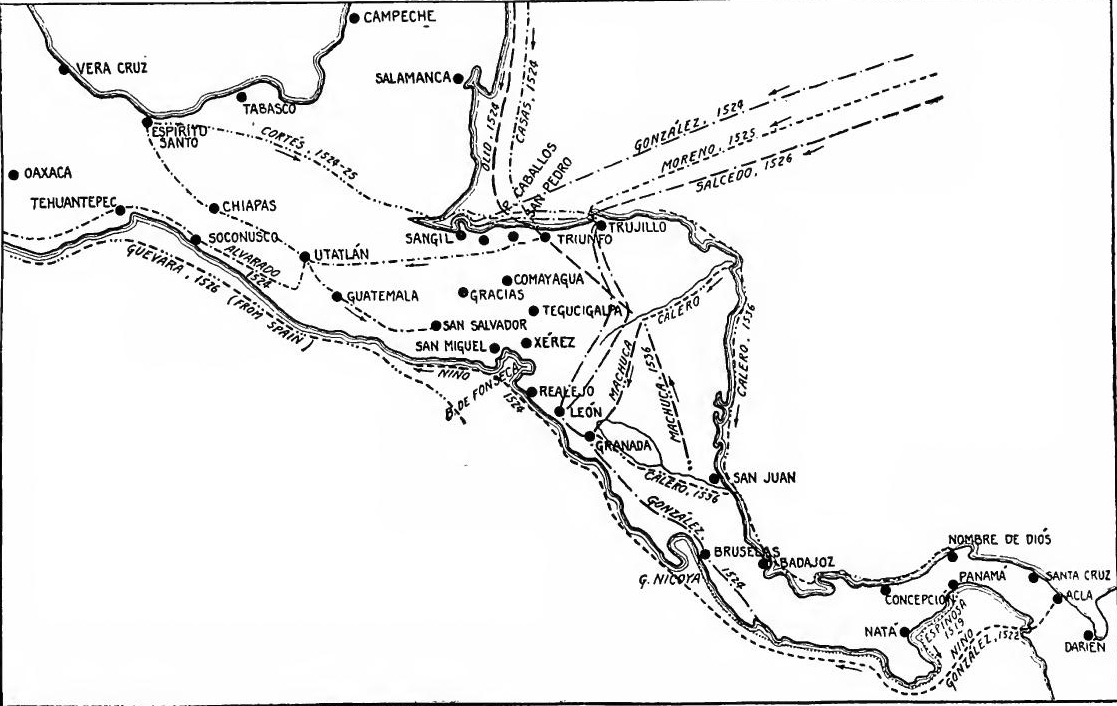 The Development of Central America, 1509-1543.
The Conquest of Costa Rica and Nicaragua.—These profitable explorations stimulated renewed interest, and were followed by conquest and settlement in Costa Rica and Nicaragua. González desired to return at once to occupy the country which he had explored, and, meeting hindrance from Pedrárias, he went to Española to organize another expedition, while awaiting royal consent. Meanwhile Pedrárias set about conquering Nicaragua for himself. With funds borrowed from Francisco Pizarro and others, he equipped a small expedition and sent it under Francisco Hernández de Córdova. One of the commanders was Hernando de Soto, who later became famous in Peru and Florida. Proceeding westward, in 1524 Córdova founded Bruselas, on the Gulf of Nicoya, and parceled out the natives among the settlers. Continuing into Nicaragua, he founded the cities of León and Granada. In the struggle which followed, Bruselas was abandoned and the settlement of Costa Rica proceeded slowly.
The Conquest of Costa Rica and Nicaragua.—These lucrative explorations sparked renewed interest and were followed by conquest and settlement in Costa Rica and Nicaragua. González wanted to return immediately to take possession of the land he had explored, but faced obstacles from Pedrárias. He then went to Española to organize another expedition while waiting for royal approval. In the meantime, Pedrárias began conquering Nicaragua for himself. With money borrowed from Francisco Pizarro and others, he equipped a small expedition and sent it under Francisco Hernández de Córdova. One of the commanders was Hernando de Soto, who later gained fame in Peru and Florida. Heading westward, in 1524 Córdova established Bruselas on the Gulf of Nicoya and distributed the native population among the settlers. Continuing into Nicaragua, he founded the cities of León and Granada. In the ensuing conflict, Bruselas was abandoned, and the settlement of Costa Rica progressed slowly.
González in 1524, having secured royal permission, entered Honduras from the northeast, with an expedition destined for Nicaragua. De Soto, sent against him by Córdova, was easily subdued, but González was defeated by the agents of Cortés, who was now engaged in the conquest of Mexico. In Nicaragua Córdova revolted against Pedrárias and was executed. In 1527 Pedrárias became governor of Nicaragua, where he ruled till 1531. During all these wranglings the Indians were the chief sufferers. They were granted in encomienda, employed as beasts of burden, or branded and sold as slaves in Panamá, Peru, or the West Indies.
González in 1524, having received royal approval, entered Honduras from the northeast with an expedition meant for Nicaragua. De Soto, sent against him by Córdova, was easily defeated, but González was overpowered by Cortés's agents, who were busy conquering Mexico. In Nicaragua, Córdova rebelled against Pedrárias and was executed. In 1527, Pedrárias became the governor of Nicaragua, where he ruled until 1531. Throughout all this conflict, the Indigenous people were the main victims. They were given in encomienda, used as pack animals, or branded and sold as slaves in Panamá, Peru, or the West Indies.
Guatemala, San Salvador, and Honduras.—Meanwhile the north-moving conquerors who went out from Panamá had met and struggled in Guatemala, San Salvador, and Honduras with the companions of Cortés, moving southward from Mexico. The history of the conquest of these disputed regions, therefore, becomes a part of the story of the exploits of Cortés and his lieutenants, recounted below.
Guatemala, San Salvador, and Honduras.—Meanwhile, the north-bound conquerors who set out from Panamá encountered and battled in Guatemala, San Salvador, and Honduras against Cortés's men, who were heading south from Mexico. The history of the conquest of these contested areas is thus intertwined with the story of Cortés and his lieutenants, detailed below.
Exploration of San Juan River.—One of the acts which relieve the bloody story of the career of Pedrárias was the sending in[Pg 32] 1529 of an expedition under Estete to find the outlet to Lake Nicaragua. Estete descended the San Juan River until a glimpse was had of the sea, but hostile Indians prevented him from reaching it. It was believed that the lake and river drained a country rich with gold, and explorations continued. In 1536 the San Juan, with tributary branches, was explored by Alonso Carrero and Diego Machuco, under orders from the new governor of Nicaragua. Soon the lake and river became the principal highway from Nicaragua to the Atlantic Ocean, and to the Porto Bello fairs.
Exploration of San Juan River.—One of the things that brightens the grim history of Pedrárias was the expedition sent in [Pg 32] 1529 by Estete to find the outlet to Lake Nicaragua. Estete traveled down the San Juan River until he caught sight of the sea, but hostile Indigenous people stopped him from reaching it. People believed that the lake and river flowed through a land rich in gold, so explorations continued. In 1536, Alonso Carrero and Diego Machuco explored the San Juan and its tributaries under the direction of the new governor of Nicaragua. Soon, the lake and river became the main route from Nicaragua to the Atlantic Ocean and to the Porto Bello fairs.
The Dukedom of Veragua.—It was a long time after Nicuesa's failure in 1510 before another attempt was made to settle Veragua, one reason being that the region was tenaciously claimed by the heirs of Columbus. In 1535 Alonso Gutiérrez was made governor of Veragua, as agent of the widow of Diego Columbus, but misfortune attended his efforts to found a colony. Shortly afterward (1537) the discoverer's grandson, Luis, was made Duke of Veragua; several attempts to colonize it failed, however, and in 1556 the region was surrendered for a small pension.
The Dukedom of Veragua.—It was quite some time after Nicuesa's failure in 1510 before another effort was made to settle Veragua, partly because the heirs of Columbus were still stubbornly claiming the area. In 1535, Alonso Gutiérrez was appointed governor of Veragua as a representative of the widow of Diego Columbus, but he faced many difficulties in his attempts to establish a colony. A little while later (1537), the discoverer's grandson, Luis, became the Duke of Veragua; however, despite several attempts to colonize it, all failed, and in 1556, the region was surrendered in exchange for a small pension.
Continued struggle in Central America.—These conquests were but the beginning of a long struggle of the Spaniards with the natives in Central America. The first stages of the conquest were over by the middle of the sixteenth century, but many parts of the country were still unconquered at the end of the seventeenth. Some tribes, indeed, are unsubdued and uncivilized to this day.
Continued struggle in Central America.—These conquests were just the start of a long fight between the Spaniards and the native people in Central America. The initial phases of the conquest wrapped up by the middle of the sixteenth century, but many areas of the country remained unconquered by the end of the seventeenth century. Some tribes, in fact, are still ungoverned and uncivilized to this day.
THE CONQUEST OF THE VALLEY OF MEXICO
The revolt of Cortés.—In the very year of the founding of Panamá Hernando Cortés entered Mexico. The return of the expeditions of Córdova and Grijalva to the Mexican coast had caused excitement in Cuba. Governor Velásquez prepared an expedition to follow them up, and appointed Cortés to lead it. Becoming distrustful of his lieutenant, Velásquez sent messengers to recall him, but Cortés set forth, nevertheless. In defiance of the governor, on February 18, 1519, he left Cuba, a rebel, with eleven vessels, some six hundred men, and sixteen horses. Proceeding[Pg 33] to Tabasco and up the coast, he founded Vera Cruz, by whose cabildo he was chosen captain-general and justicia mayor, and his position was thus given the color of legality. By this act Cortés placed himself under the immediate protection of the king.
The revolt of Cortés.—In the very year that Panamá was founded, Hernando Cortés entered Mexico. The return of the expeditions of Córdova and Grijalva to the Mexican coast had stirred excitement in Cuba. Governor Velásquez organized another expedition to follow them and appointed Cortés as the leader. Distrustful of his lieutenant, Velásquez sent messengers to recall him, but Cortés set out anyway. Defying the governor, on February 18, 1519, he left Cuba as a rebel with eleven ships, around six hundred men, and sixteen horses. After going to Tabasco and up the coast, he established Vera Cruz, where he was chosen as captain-general and chief justice by the local council, which gave his position a semblance of legality. With this act, Cortés put himself under the direct protection of the king.
The march to Mexico.—On the way and while at Vera Cruz Cortés had learned that the Aztec "empire" was honeycombed with dissension, and that the subject peoples were burdened with tribute and filled with hatred for Montezuma, the native ruler at the city of Mexico. He therefore assumed the rôle of deliverer, and the Indians rallied to his standard. At Cempoalla he connived at a revolt against Montezuma's tax gatherers. Scuttling his ships and thus cutting off all chance for retreat, in August he set out for Mexico. His march was a succession of audacious deeds. At Cempoalla he threw down heathen idols and imprisoned the chiefs. At Tlascala he was attacked by several thousand warriors, but his genius changed them into allies in his train. At Cholula, discovering a conspiracy, he raked the streets with cannon shot and burned the leaders at the stake. In triumph he entered the great pueblo of Tenochtitlán or Mexico. While lodged as a guest of Montezuma in the center of the city, he seized the Aztec ruler and held him prisoner.
The march to Mexico.—On the way and while at Vera Cruz, Cortés learned that the Aztec "empire" was filled with internal conflict and that the subject peoples were weighed down by tribute and had a strong dislike for Montezuma, the native ruler of Mexico City. He took on the role of a savior, and the Indians rallied to him. At Cempoalla, he supported a revolt against Montezuma's tax collectors. By scuttling his ships and cutting off any chance of retreat, he set out for Mexico in August. His march was marked by a series of bold actions. At Cempoalla, he destroyed pagan idols and imprisoned the chiefs. At Tlascala, he was attacked by several thousand warriors, but his brilliance turned them into allies. At Cholula, discovering a plot against him, he fired cannon shots into the streets and burned the leaders alive. He triumphantly entered the great city of Tenochtitlán, or Mexico. While staying as a guest of Montezuma in the heart of the city, he captured the Aztec ruler and took him prisoner.
The loss and recapture of the city.—In the spring of 1520 Cortés learned that Pánfilo de Narváez had arrived at Vera Cruz with nearly a thousand men, under orders from Velasquez to arrest him. Leaving Pedro de Alvarado in charge, he hastened to the coast, won over most of Narváez's men, and then hurried back to Mexico. During his absence the Aztecs had revolted, through the rashness of Alvarado. Soon after the return of Cortés the natives rose again, killed Montezuma, and replaced him by Cuauhtemoc, a more vigorous leader. Cortés now sought safety in flight, but during the night retreat he lost more than half his men. This "unfortunate night" became known as "Noche Triste." But the defeat was only temporary. Raising new allies, Cortés conquered the towns round about Mexico, built a fleet at Tlascala, launched it on Lake Tezcuco, besieged the city, and by a combined attack, by land and water, on August 13, 1521, he recaptured Mexico, the most important native town in all America.[Pg 34]
The loss and recapture of the city.—In the spring of 1520, Cortés found out that Pánfilo de Narváez had arrived at Vera Cruz with nearly a thousand men, sent by Velasquez to arrest him. He left Pedro de Alvarado in charge and quickly went to the coast, winning over most of Narváez's men, and then rushed back to Mexico. While he was gone, the Aztecs revolted due to Alvarado's reckless actions. Shortly after Cortés returned, the natives rose up again, killed Montezuma, and replaced him with Cuauhtemoc, a stronger leader. Cortés tried to escape, but during the night retreat, he lost more than half his men. This "unfortunate night" became known as "Noche Triste." However, the defeat was only temporary. By gathering new allies, Cortés conquered the towns around Mexico, built a fleet at Tlascala, launched it on Lake Tezcuco, besieged the city, and through a combined land and water attack, on August 13, 1521, he recaptured Mexico, the most significant native town in all of America.[Pg 34]
Cortés's contest with Velásquez.—Knowing that Velásquez would oppose him, Cortés, while at Vera Cruz in 1519, had at once sent agents, bearing rich presents, to represent him at the court of Charles V. Then began a three-year contest with the agents of the Cuban governor. The delay was fortunate for Cortés, for in the course of it he won favor by his remarkable feats of conquest. Through the influence of Fonseca, Velásquez secured the appointment of Cristóbal de Tápia, an official of Española, as governor of New Spain, to take charge of the government and investigate Cortés. But Cortés got rid of him as he had disposed of Narváez. Arriving at Vera Cruz in December, 1521, Tápia was met by a council of delegates from the conqueror and practically driven from the country, on the ground that new orders were expected from the king.
Cortés's rivalry with Velásquez.—Knowing that Velásquez would stand in his way, Cortés, while in Vera Cruz in 1519, quickly sent agents with valuable gifts to represent him at Charles V's court. Thus began a three-year struggle with the agents of the Cuban governor. The delay turned out to be beneficial for Cortés, as he gained support through his impressive conquest achievements. With the help of Fonseca, Velásquez managed to appoint Cristóbal de Tápia, an official from Española, as governor of New Spain to oversee the government and investigate Cortés. However, Cortés dealt with him the same way he had with Narváez. When Tápia arrived in Vera Cruz in December 1521, he was met by a council of delegates from the conqueror and effectively driven out of the country, on the pretext that new orders were anticipated from the king.
Cortés made Governor and Captain-General.—Before this Cortés had sent Avila to the Audiencia of Santo Domingo to obtain its favor. Scarcely had Tápia been ejected when Avila returned with tentative authority for Cortés, subject to royal approval, to continue his conquests and to grant encomiendas. This greatly strengthened Cortés's position. Having succeeded so well in Española, Avila was now sent to Spain. Here he triumphed also, for on October 15, 1522, the emperor approved the acts of Cortés and made him governor and captain-general of New Spain. The victory of Cortés was as complete as the discomfiture of Velásquez and Fonseca.
Cortés was appointed Governor and Captain-General. Before this, Cortés had sent Avila to the Audiencia of Santo Domingo to gain its support. Just after Tápia was removed, Avila returned with provisional authority for Cortés, pending royal approval, to continue his conquests and to grant encomiendas. This greatly strengthened Cortés's position. Having achieved great success in Española, Avila was then sent to Spain. There, he also succeeded, for on October 15, 1522, the emperor approved Cortés's actions and officially made him governor and captain-general of New Spain. Cortés's victory was as complete as the defeat of Velásquez and Fonseca.
Mexico rebuilt. Encomiendas granted.—The work of conquest on the mainland was accompanied by the evolution of government and the establishment of Spanish civilization, just as had been the case in the West Indies during the earlier stages of the struggle. Wherever the Spaniards settled, they planted their political, religious, economic, and social institutions. Mexico was rebuilt in 1522 as a Spanish municipality, Pedro de Alvarado, the most notable of Cortés's lieutenants, being made first alcalde mayor. In the regions subdued the principal provinces were assigned to the conquerors as encomiendas. Much of the actual work of control was accomplished through native chiefs, who were assigned Spanish offices and held responsible for good order and the collection of tribute. This method was later adopted by the British in India.
Mexico was rebuilt. Encomiendas granted.—The conquest of the mainland went hand in hand with the development of government and the establishment of Spanish civilization, similar to what had occurred in the West Indies during the early phases of the conflict. Wherever the Spaniards settled, they introduced their political, religious, economic, and social systems. Mexico was reconstructed in 1522 as a Spanish municipality, with Pedro de Alvarado, the most prominent of Cortés's lieutenants, appointed as the first alcalde mayor. In the conquered regions, the main provinces were given to the conquerors as encomiendas. Much of the actual administration was carried out through native chiefs, who were assigned Spanish roles and held accountable for maintaining order and collecting tribute. This approach was later adopted by the British in India.
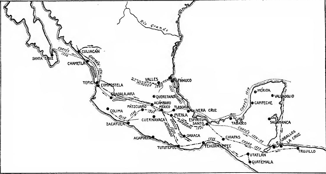 The Development of Southern Mexico, 1519-1543.
THE SPREAD OF THE CONQUEST
The semi-civilized tribes.—With the fall of the city the first stage of the conquest had ended. Within the following decade most of the semi-civilized tribes of southern Mexico and Central America were brought under the dominion of Spain. During this period Spanish activities were directed from the Valley of Mexico to the eastward, southward and westward. From the south came rumors of gold and reports of the South Sea, while to the north, among the barbarian tribes, there was little, at this stage of the conquest, to attract the conquerors.
The semi-civilized tribes.—With the fall of the city, the first stage of the conquest was complete. In the next decade, most of the semi-civilized tribes in southern Mexico and Central America fell under Spanish control. During this time, Spanish efforts were focused eastward, southward, and westward from the Valley of Mexico. From the south came rumors of gold and news about the South Sea, while to the north, among the more primitive tribes, there was nothing at this stage of the conquest to draw in the conquerors.
Factors in the conquest.—Several factors explain the marvelous rapidity with which Spanish rule was extended. The conquerors were looking for gold and accumulated treasure; not finding it in one place they hastened to another, led off by any wild tale of riches. The fame of the Spaniards preceded them and paralyzed resistance. They were everywhere aided by great armies of allies, eager to help destroy their hated enemies. Finally, Cortés, himself a genius, was assisted by an able body of lieutenants; in the spread of the conquest Cortés remained the central figure, but the actual work fell mainly to Orozco, Alvarado, Olid, Sandoval, Chico, Avalos, Montejo and other subordinates.
Factors in the conquest.—Several factors explain the incredible speed with which Spanish rule was established. The conquerors were searching for gold and treasure; when they didn’t find it in one place, they quickly moved to another, driven by any wild story of riches. The reputation of the Spaniards preceded them and intimidated resistance. They were consistently supported by large armies of allies, eager to help eliminate their hated foes. Finally, Cortés, who was a brilliant leader, was supported by a capable group of lieutenants; while Cortés was the central figure in the expansion of the conquest, most of the actual work was carried out by Orozco, Alvarado, Olid, Sandoval, Chico, Avalos, Montejo, and other subordinates.
Vera Cruz, Oaxaca, and Tehuantepec.—In the fall of 1520 Sandoval, in search of gold and to punish rebellious Indians, invaded southern Vera Cruz with a handful of soldiers, aided by thirty thousand Indian allies. To hold the district he founded the towns of Medellin and Espíritu Santo. Before the expulsion of Cortés from the city, goldseekers had been sent to Oaxaca and Tehuantepec and were well received, but the "Noche Triste" was followed by a reaction. Orozco was sent, therefore, to subdue Oaxaca, which he reported to be rich in gold. In 1522 an attack by hostile neighbors called Alvarado to Tehuantepec. Gold was found, and as the district bordered on the South Sea, settlements were formed to hold it.
Vera Cruz, Oaxaca, and Tehuantepec.—In the fall of 1520, Sandoval invaded southern Vera Cruz with a small group of soldiers, aiming to find gold and punish rebellious Indigenous people, supported by thirty thousand Indian allies. To secure the area, he established the towns of Medellin and Espíritu Santo. Before Cortés was expelled from the city, gold seekers were sent to Oaxaca and Tehuantepec and were welcomed, but after the "Noche Triste," there was a backlash. Orozco was then sent to conquer Oaxaca, which he reported to be rich in gold. In 1522, an attack by hostile neighbors summoned Alvarado to Tehuantepec. Gold was discovered, and since the area was close to the South Sea, settlements were created to secure it.
Olid in Michoacán.—The same year, 1522, marks the extension of Spanish rule into Michoacán, the territory of the hitherto independent Tarascans. The cacique Tangaxoan visited Cortés and made submission, and in return Olid was sent to found a settlement at Pátzcuaro on Lake Chápala. Before the end of the year[Pg 37] part of the settlers moved to the seacoast and settled at Zacatula, in the modern state of Guerrero, where a post had been established.
Olid in Michoacán.—The same year, 1522, marks the expansion of Spanish control into Michoacán, the land of the previously independent Tarascans. The leader Tangaxoan visited Cortés and pledged loyalty, and in return, Olid was sent to establish a settlement at Pátzcuaro on Lake Chápala. Before the year ended[Pg 37], part of the settlers moved to the coast and settled at Zacatula, in present-day Guerrero, where a post had been set up.
Colima and Jalisco.—From Michoacán the conquest at once spread north into Colima and Jalisco. Gold being reported in Colima, Avalos and Chico, lieutenants of Olid entered the country, but were defeated by the natives. Thereupon Olid followed, subdued the mountain region by force, and founded the town of Colima (1524), which became a base for new advances. On his return to Mexico, Olid brought samples of pearls from Colima, and reports of an Amazon Island ten days up the coast, where there were said to be great riches. To investigate these reports, in 1524 Francisco Cortés was sent north. He reached Río de Tololotlán, and secured the allegiance of the "queen" of Jalisco, but found little gold and no Amazon Island.
Colima and Jalisco.—From Michoacán, the conquest quickly moved north into Colima and Jalisco. After gold was reported in Colima, Avalos and Chico, lieutenants of Olid, entered the area but were defeated by the local people. Following this, Olid came in, took control of the mountainous region by force, and established the town of Colima (1524), which became a base for further advances. On his way back to Mexico, Olid brought samples of pearls from Colima and news of an island inhabited by Amazons, ten days along the coast, rumored to be rich in resources. To look into these claims, Francisco Cortés was sent north in 1524. He reached Río de Tololotlán and gained the loyalty of the "queen" of Jalisco but found little gold and no Amazon Island.
Amichel and Pánuco.—In 1522 the Huasteca country, to the northeast, came under the control of Cortés. It was three years before this that Pineda, as representative of Garay, governor of Jamaica, had visited the region. Garay applied for a grant of a province called Amichel, extending from Florida to Mexico, and set about colonizing it. In 1520, before the patent was secured, a party of his men met disaster near Pánuco River. Hearing of Garay's operations, in 1522 Cortés led forty thousand allies into the country, subdued it, and founded San Estéban, on Pánuco River. In 1523 Garay led a colony to the same region, but found himself forestalled by Cortés, by whom he was sent to Mexico, where he soon died. The rivalry of the Spaniards encouraged an Indian revolt, but Sandoval, as agent of Cortés, put down the disturbance with extreme cruelty. In 1527 the Pánuco district, under the name of Victoria Garayana was separated from Mexico, Nuño de Guzmán being made governor, while the region called Florida, further north, was assigned to Pánfilo de Narváez. Guzmán's rule of six months was characterized by attempts to extend conquests northward into Narváez's territory, by wars with the Huasteca chieftains, and by constant slave-hunting raids, through which the country was nearly depopulated.
Amichel and Pánuco.—In 1522, Cortés took control of the Huasteca region in the northeast. Three years earlier, Pineda, representing Garay, the governor of Jamaica, had visited the area. Garay requested a grant for a province called Amichel, stretching from Florida to Mexico, and began the colonization process. In 1520, before he secured the grant, some of his men faced disaster near the Pánuco River. When Cortés learned about Garay's efforts, he led forty thousand allies into the region in 1522, conquered it, and founded San Estéban on the Pánuco River. In 1523, Garay attempted to establish a colony in the same area but was blocked by Cortés, who sent him to Mexico, where he soon died. The competition between the Spaniards triggered an Indian revolt, but Sandoval, acting on Cortés's behalf, brutally suppressed the upheaval. In 1527, the Pánuco district was separated from Mexico and renamed Victoria Garayana, with Nuño de Guzmán appointed governor, while the area known as Florida further north was given to Pánfilo de Narváez. Guzmán's six-month rule was marked by efforts to expand into Narváez's territory, conflicts with Huasteca leaders, and relentless slave raids, which nearly emptied the region of its population.
Alvarado in Guatemala and San Salvador.—By this time the conquests of Cortés and his lieutenants had extended into Central America, where they encountered, the agents of Pedrárias.[Pg 38] In 1522 embassies from the large cities of Utatlán and Guatemala had visited Cortés and made submission. In the following year Alvarado, with four hundred Spaniards and twenty thousand allies, entered the region and conquered the Quichés and Cakchiquels. This task partially completed, he continued south and extended his conquests into San Salvador (1524).
Alvarado in Guatemala and San Salvador.—At this point, Cortés and his officers had expanded their conquests into Central America, where they ran into the agents of Pedrárias.[Pg 38] In 1522, envoys from the major cities of Utatlán and Guatemala came to see Cortés and pledged their allegiance. The following year, Alvarado, with four hundred Spaniards and twenty thousand allies, entered the area and conquered the Quichés and Cakchiquels. Once he had made some progress, he continued south and pushed his conquests into San Salvador (1524).
Olid and Casas in Honduras.—Cortés believed that Honduras was rich, and that a strait lay between it and Guatemala. Moreover, Gil González and the agents of Pedrárias had begun to operate there. Consequently, at the same time that Alvarado went to Guatemala, Olid was despatched to Honduras. Reaching there in 1524 he tried to imitate his master's example by making a conquest for himself. He succeeded in defeating González, as has been seen, but was in turn beheaded by Francisco de las Casas, who was sent by Cortés to overthrow him. During this struggle the city of Trujillo was founded.
Olid and Casas in Honduras.—Cortés thought Honduras was wealthy and that there was a strait between it and Guatemala. Additionally, Gil González and Pedrárias' agents had started to operate there. So, at the same time Alvarado went to Guatemala, Olid was sent to Honduras. He arrived in 1524 and tried to follow in his master's footsteps by making his own conquest. He managed to defeat González, as noted, but was ultimately beheaded by Francisco de las Casas, who Cortés sent to take him down. During this conflict, the city of Trujillo was established.
The march of Cortés to Honduras.—In doubt as to the wisdom of sending Las Casas after Olid, in October, 1524, Cortés set out for Honduras in person, with about one hundred and forty Spaniards and three hundred Indians in his train, the latter led by three famous Aztec chiefs. In his rear was driven a herd of swine. The route lay through southern Vera Cruz, Tabasco, and Chiapas, to Golfo Dulce, his way being obstructed by vast morasses, swollen streams, and flint-strewn mountains. In a single province fifty bridges had to be constructed in a journey of as many miles. In Chiapas it became necessary to bridge with trees a channel five hundred paces wide. On the way the Aztec chieftains, including the noble Cuauhtemoc, being charged with conspiracy, were hanged, an act which is variously characterized as a "necessary punishment" and a "foul murder." Leaving his cousin, Hernando Saavedra, in command as captain-general in Trujillo, Cortés sent his men home by way of Guatemala and returned by sea to Mexico in May, 1526. After attempting for two years to explore on the South Sea, in 1528 he went to Spain to refute his enemies, chief of whom was Nuño de Guzmán, now president of the recently established Audiencia of Mexico. He returned two years later.
The march of Cortés to Honduras.—Unsure about the wisdom of sending Las Casas after Olid, Cortés set out for Honduras himself in October 1524, accompanied by about one hundred and forty Spaniards and three hundred Indians, led by three prominent Aztec chiefs. Driving behind them was a herd of pigs. The route took them through southern Vera Cruz, Tabasco, and Chiapas to Golfo Dulce, facing obstacles like vast swamps, swollen streams, and rocky mountains. In one province, they had to build fifty bridges over the course of just as many miles. In Chiapas, they had to use trees to bridge a channel five hundred paces wide. Along the way, the Aztec leaders, including the noble Cuauhtemoc, were accused of conspiracy and hanged, an act seen by some as a "necessary punishment" and by others as a "foul murder." After leaving his cousin, Hernando Saavedra, in charge as captain-general in Trujillo, Cortés sent his men home via Guatemala and returned to Mexico by sea in May 1526. After two years of trying to explore the South Sea, he went to Spain in 1528 to defend himself against his enemies, primarily Nuño de Guzmán, who was then the president of the newly established Audiencia of Mexico. He returned two years later.
Yucatán.—The conquest of Yucatán was begun in 1527 by Francisco de Montejo, an agent of Cortés. Initial success was[Pg 39] followed by native revolts, and it was 1541 before the conquest was made secure. There were frequent rebellions thereafter, but never again united resistance.
Yucatán.—The conquest of Yucatán started in 1527 by Francisco de Montejo, an agent of Cortés. Initial success was[Pg 39] followed by native uprisings, and it wasn't until 1541 that the conquest was secured. There were frequent rebellions after that, but never again was there a united resistance.
Las Casas in Guatemala.—Thus far the conquest had been one of force. But now an example of the power of gentleness was furnished by Father Las Casas, the Dominican friar who had opposed encomiendas so vigorously in Española. About 1532 he entered Nicaragua as a missionary, where he attacked the ill-treatment of the Indians. Being opposed by the governor, in 1536 he went to Guatemala. Shortly before this he had written a treatise to prove that conversion by force was wrong, and that only persuasion should be used. To test his views he was granted sole control for five years of a hostile region known as "the Land of War," and by mild means he and his companions soon converted the district into a land of True Peace (Vera Paz), as it is still called.
Las Casas in Guatemala.—So far, the conquest had been all about force. But now, Father Las Casas, the Dominican friar who had strongly opposed encomiendas in Española, showed the power of gentleness. Around 1532, he arrived in Nicaragua as a missionary, where he spoke out against the mistreatment of the Indians. After clashing with the governor, he moved to Guatemala in 1536. Just before this, he had written a treatise arguing that forcing conversion was wrong and that only persuasion should be used. To put his beliefs to the test, he was given complete control for five years over a hostile area known as "the Land of War," and through gentle methods, he and his companions quickly transformed the region into what is now known as the land of True Peace (Vera Paz).
Guzmán in Sinaloa.—While Cortés was in Spain Guzmán, fearing his own downfall, and hoping to save himself by offering new provinces to the king, undertook the conquest of northern Jalisco and of Sinaloa. Leaving Mexico in December, 1529, with ten thousand allies, he marched through Michoacán and Jalisco, leaving behind a trail of fire and blood, for which he has ever since been execrated. Part of Sinaloa was explored, and Culiacán was founded as an outpost in 1531. The region subdued by Guzmán was named Nueva Galicia, of which the conqueror became governor and Compostela the capital.
Guzmán in Sinaloa.—While Cortés was in Spain, Guzmán, fearing for his own safety and hoping to save himself by offering new territories to the king, set out to conquer northern Jalisco and Sinaloa. He left Mexico in December 1529 with ten thousand allies and marched through Michoacán and Jalisco, leaving a path of destruction and bloodshed that has led to him being condemned ever since. Part of Sinaloa was explored, and Culiacán was established as an outpost in 1531. The area conquered by Guzmán was called Nueva Galicia, where he became governor and Compostela was designated as the capital.
Buffer province of Querétaro.—At the coming of the Spaniards the country north of the valley of Mexico had never been conquered by the Aztecs. The Spaniards, in turn, adopted the policy of entrusting its subjugation to native caciques, treating the region as a buffer Indian state. The leading figure in the conquest was a Christianized Otomi chief, named Nicolás de San Luis. By Charles V he was made a knight of the Order of Santiago and a captain-general in the army. Another Otomi cacique who played a similar though less conspicuous part was Fernando de Tapia. The most notable event in the conquest was the reduction of Querétaro in 1531. For thirty years San Luis served the Spaniards in the control of the Querétaro border.[Pg 40]
Buffer province of Querétaro.—When the Spaniards arrived, the area north of the valley of Mexico had never been conquered by the Aztecs. The Spaniards decided to let local leaders handle the conquest, treating the region as a buffer Indian state. The main figure in the conquest was a Christianized Otomi chief named Nicolás de San Luis. He was made a knight of the Order of Santiago and a captain-general in the army by Charles V. Another Otomi leader who played a similar but less prominent role was Fernando de Tapia. The most significant event in the conquest was the reduction of Querétaro in 1531. San Luis served the Spaniards for thirty years in managing the Querétaro border.[Pg 40]
The Mixton War.—The first half century of expansion toward the north was closed by a widespread native uprising in Nueva Galicia which for a time checked advance in that direction and even caused a contraction of the frontier. Guzmán had left Nueva Galicia in a deplorable condition. After several minor uprisings, the rebellious natives broke forth in 1541, during the absence of Governor Coronado and his army in New Mexico. The Indians refused to pay tribute, killed their encomenderos and the missionaries, destroyed the crops, and took refuge in the peñoles or cliffs of Mixton, Nochistlán, Acatic, and other places near Guadalajara. The defence fell to Cristóbal de Oñate, lieutenant governor of Nueva Galicia. Pedro de Alvarado, who chanced to arrive from Guatemala at Navidad with a force of men, led them against Nochistlán and lost his life in the encounter. Viceroy Mendoza at last took the field with four hundred and fifty Spaniards and thirty thousand allies, and crushed the revolt.
The Mixton War.—The first fifty years of northward expansion ended with a widespread native uprising in Nueva Galicia that temporarily halted progress in that direction and even pulled back the frontier. Guzmán had left Nueva Galicia in terrible shape. After several smaller rebellions, the angry natives rebelled in 1541 while Governor Coronado and his army were away in New Mexico. The Indians refused to pay tribute, killed their encomenderos and missionaries, destroyed crops, and took refuge in the peñoles or cliffs of Mixton, Nochistlán, Acatic, and other areas near Guadalajara. The defense was led by Cristóbal de Oñate, lieutenant governor of Nueva Galicia. Pedro de Alvarado, who happened to arrive from Guatemala at Navidad with a group of men, led an attack on Nochistlán and lost his life in the battle. Viceroy Mendoza eventually took command with four hundred and fifty Spaniards and thirty thousand allies, and crushed the revolt.
EXPLORATIONS IN THE NORTHERN INTERIOR AND ON THE PACIFIC
FLORIDA
De León.—While some conquerors were struggling in Central America, Mexico, and Peru, others were trying to subdue the vast northern region called Florida. In 1514 Juan Ponce de León secured a patent to colonize Florida and Bimini, which he had explored in the previous year. Instead of proceeding to the task, however, he engaged in a war against the Caribs, and it was not until 1521 that he attempted to carry out his project. In that year he led a colony of two hundred men to the Peninsula, landed on the west coast, and tried to establish a settlement. But he was attacked by natives, and driven back to Cuba, mortally wounded.
De León.—While some conquerors were battling in Central America, Mexico, and Peru, others were working to conquer the huge northern area known as Florida. In 1514, Juan Ponce de León obtained permission to colonize Florida and Bimini, which he had explored the year before. However, instead of moving forward with this task, he got involved in a conflict with the Caribs, and it wasn’t until 1521 that he tried to carry out his plan. That year, he led a group of two hundred men to the Peninsula, landed on the west coast, and attempted to establish a settlement. But he was attacked by the natives and forced back to Cuba, where he was mortally wounded.
Ayllón's colony on the Carolina coast.—To carry out his contract to colonize Chicora, in July, 1526, Ayllón sailed from Española with six vessels and a colony of five hundred men and women, Dominican friars, and supplies, prepared to find a new home in Carolina. But the experiment was doomed to be another failure. Landing was first made on the river called the Jordan, perhaps[Pg 41] Cape Fear River. On another stream; perhaps the Peedee, the settlement of San Miguel de Gualdape was begun. But supplies gave out, and at the end of two years Ayllón died (October, 1528). Quarrels ensued, and in midwinter the survivors, only about one hundred and fifty now, returned to Santo Domingo.
Ayllón's colony on the Carolina coast.—To fulfill his plan to colonize Chicora, in July 1526, Ayllón set sail from Española with six ships and a group of five hundred men and women, Dominican friars, and supplies, ready to find a new home in Carolina. However, the venture was bound to fail again. They first landed on the river called the Jordan, possibly[Pg 41] Cape Fear River. On another stream, maybe the Peedee, the settlement of San Miguel de Gualdape was established. But supplies ran out, and by the end of two years, Ayllón passed away (October 1528). Conflicts broke out, and in the middle of winter, the survivors, who were now down to about one hundred and fifty, returned to Santo Domingo.
Narváez.—At the same time the conquest of Florida was attempted by Pánfilo de Narváez, the man who had been sent to Vera Cruz to arrest Cortés. In 1526 he secured a patent to the lands of Ponce de León and Garay. Raising a colony of six hundred persons in Spain, in 1528 he reached Florida, landing near Tampa Bay. Hearing of a rich province called Apalachen (Apalache), he sent his vessels along the coast and himself marched up the peninsula at the head of three hundred men to find the Promised Land. He found the place sought near modern Tallahassee, but it proved to be a squalid Indian village of forty huts. A few weeks having been spent in exploration and warfare, Narváez went to the coast near St. Marks Bay, built a fleet of horse-hide boats, and set out for Pánuco. After passing the mouth of the Mississippi a storm arose, and all were wrecked on the coast of Texas.
Narváez.—At the same time, Pánfilo de Narváez was trying to conquer Florida. He had been sent to Vera Cruz to arrest Cortés. In 1526, he received a grant for the lands of Ponce de León and Garay. After gathering a colony of six hundred people in Spain, he arrived in Florida in 1528, landing near Tampa Bay. Hearing about a wealthy area called Apalachen (Apalache), he sent his ships along the coast while he marched up the peninsula with three hundred men in search of the Promised Land. He located the area near modern Tallahassee, but it turned out to be a rundown Indian village with just forty huts. After spending a few weeks exploring and fighting, Narváez went to the coast near St. Marks Bay, built a fleet of boats from horse hides, and set out for Pánuco. After passing the mouth of the Mississippi, a storm hit, and they were all wrecked on the coast of Texas.
Cabeza de Vaca.—In a short time most of the survivors of Narváez's party died of disease, starvation, and exposure, or at the hands of the savages. Having passed nearly six years of slavery among the Indians, Alvar Núñez Cabeza de Vaca, the treasurer of the colony of Florida, with three companions, escaped westward, crossed Texas, Coahuila, Chihuahua, and Sonora, and in 1536 reached Culiacán, the northern outpost of Sinaloa, after a most remarkable journey.
Cabeza de Vaca.—Before long, most of the survivors from Narváez's group died from disease, starvation, exposure, or were killed by the natives. After spending nearly six years in captivity among the Indians, Alvar Núñez Cabeza de Vaca, the treasurer of the Florida colony, along with three companions, managed to escape westward, traveling across Texas, Coahuila, Chihuahua, and Sonora, and in 1536 arrived in Culiacán, the northern edge of Sinaloa, after an incredible journey.
De Soto.—Vaca went to Spain (1537) to apply for the governorship of Florida, but it had already been conferred on Hernando de Soto, who had taken a prominent part in the conquest of both Central America and Peru. In 1539 De Soto reached Florida with a colony of six hundred persons. Landing at Tampa Bay, as Narváez had done, he soon set out to look for a rich province called Cale. This was the beginning of an expedition lasting nearly four years, during which the Spaniards were led on by tales of gold and treasure from one district to another, hoping to repeat the exploits of Cortés and Pizarro. As he passed through the country De Soto imitated those captains by capturing the chiefs,[Pg 42] holding them as hostages, and compelling them to provide food and men to carry the baggage. Going to Apalachen he wintered there, meanwhile discovering Pensacola Bay. From Apalachen he went to the Savannah River, thence northwest to the North Carolina Piedmont, south toward Mobile Bay, northwest to the Mississippi near modern Memphis, westward across Arkansas into Oklahoma, thence down the Arkansas River to its mouth, where he died, in May, 1542, being buried in the Mississippi.
De Soto.—Vaca went to Spain in 1537 to apply for the governorship of Florida, but it had already been given to Hernando de Soto, who had played a key role in the conquest of both Central America and Peru. In 1539, De Soto arrived in Florida with a colony of six hundred people. Landing at Tampa Bay, just like Narváez did, he quickly set out to find a wealthy province called Cale. This marked the start of an expedition that lasted nearly four years, during which the Spaniards were driven by stories of gold and treasure from one area to another, hoping to replicate the successes of Cortés and Pizarro. As he traveled through the country, De Soto followed the example of those captains by capturing the chiefs, holding them as hostages, and forcing them to provide food and men to carry the supplies. He went to Apalachen and spent the winter there, while also discovering Pensacola Bay. From Apalachen, he traveled to the Savannah River, then northwest to the North Carolina Piedmont, south toward Mobile Bay, northwest to the Mississippi near what is now Memphis, westward across Arkansas into Oklahoma, and then down the Arkansas River to its mouth, where he died in May 1542 and was buried in the Mississippi.
Moscoso in Arkansas and Texas.—De Soto's followers, led by Luis de Moscoso, now set out for Pánuco, crossing Arkansas to the Red River, then turning southwest through eastern Texas, perhaps reaching the Brazos River. Giving up the attempt by land, they returned to the Mississippi, built a fleet of boats, descended the river, and skirted the Texas coast, reaching Pánuco in 1543. Thus ended the fourth attempt to colonize Florida.
Moscoso in Arkansas and Texas.—De Soto's followers, led by Luis de Moscoso, set out for Pánuco, crossing Arkansas to the Red River, then turning southwest through eastern Texas, possibly reaching the Brazos River. After giving up the attempt by land, they returned to the Mississippi, built a fleet of boats, traveled down the river, and followed the Texas coast, reaching Pánuco in 1543. This marked the end of the fourth attempt to colonize Florida.
CÍBOLA AND QUIVIRA
Cortés on the South Sea and in California.—Another line of advance toward the northern interior had been made by way of the Pacific slope. The discovery of the South Sea was followed immediately by exploration along the western coast. Balboa himself had begun that work, before his death in 1519. Espinosa had reached Nicaragua in 1519, and three years later Niño had reached Guatemala. By this time Cortés had also begun operations on the South Sea by building a shipyard at Zacatula, hoping, to discover a strait, find rich islands and mainland, reach India by way of the coast, and open communication with the Moluccas. In 1527 he sent three vessels under Saavedra across the Pacific: The operations of a new fleet built by him were hindered by the Audiencia of Mexico, but in 1532 he sent an expedition north under Hurtado de Mendoza, which reached Río Fuerte in northern Sinaloa. In the following year another expedition sent by Cortés, under Jiménez discovered Lower California, which was thought to be an island and where pearls were found. The discovery of an island with pearls confirmed the geographical ideas of Cortés, and in 1535 he himself led a colony to La Paz, but within a few months it was abandoned. This was the first of a long series of efforts to colonize California.
Cortés on the South Sea and in California.—Another route into the northern interior had been taken via the Pacific slope. The discovery of the South Sea was quickly followed by explorations along the western coast. Balboa had started this work before his death in 1519. Espinosa reached Nicaragua in 1519, and three years later Niño arrived in Guatemala. By this time, Cortés was also getting involved on the South Sea by building a shipyard in Zacatula, hoping to find a strait, discover rich islands and mainland, reach India along the coast, and establish communication with the Moluccas. In 1527, he dispatched three ships under Saavedra across the Pacific. The operations of a new fleet he built were complicated by the Audiencia of Mexico, but in 1532 he sent an expedition north under Hurtado de Mendoza, which reached Río Fuerte in northern Sinaloa. The following year, another expedition sent by Cortés, under Jiménez, discovered Lower California, which was thought to be an island and where pearls were found. The discovery of an island with pearls confirmed Cortés’s geographical notions, and in 1535 he personally led a colony to La Paz, but it was abandoned within a few months. This marked the beginning of a long series of attempts to colonize California.
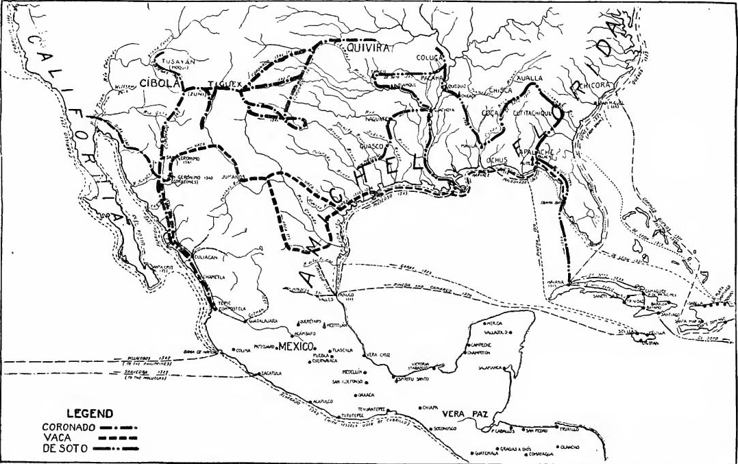
[Pg 44] Friar Marcos discovers Cíbola.—Interest in the north country, both in Spain and America, was greatly quickened by the arrival of Cabeza de Vaca in Mexico after his journey across the continent. He had seen no great wonders, but he had heard of large cities to the north of his path, and it was thought that they might be the famed Seven Cities. The viceroy took into his service the negro Stephen, one of Vaca's companions, and sent him with Friar Marcos, a Franciscan missionary, to reconnoitre. In March, 1539, they set out with guides from Culiacán. Going ahead, Stephen soon sent back reports of Seven Cities, called Cíbola, farther on. Friar Marcos hastened after him, and reached the border of the Zuñi pueblos in western New Mexico, where he learned that Stephen had been killed. Returning to the settlement, he reported that Cíbola was larger and finer than Mexico. This story, of course, was the signal for another "rush," like that to Peru a few years before.
[Pg 44] Friar Marcos discovers Cíbola.—Interest in the northern territories, both in Spain and America, was greatly heightened by the arrival of Cabeza de Vaca in Mexico after his journey across the continent. He hadn’t encountered any significant wonders, but he had heard of large cities to the north of where he traveled, and it was believed that they might be the legendary Seven Cities. The viceroy enlisted the help of a man named Stephen, a Black man who was one of Vaca's companions, and sent him along with Friar Marcos, a Franciscan missionary, to explore the area. In March 1539, they set out with guides from Culiacán. Stephen quickly sent back reports of the Seven Cities, known as Cíbola, further ahead. Friar Marcos hurried after him and reached the edge of the Zuñi pueblos in western New Mexico, where he learned that Stephen had been killed. Returning to the settlement, he reported that Cíbola was larger and more impressive than Mexico. This story, of course, prompted another "rush," similar to the one that occurred in Peru a few years earlier.
Ulloa rounds the peninsula of California.—Rivalry between Cortés and the viceroy regarding exploration was now keen, and about the time of the return of Fray Marcos, Cortés, hoping to forestall his competitor, sent three vessels north to explore under Francisco de Ulloa. One of the vessels was lost, but with two of them Ulloa succeeded in reaching the head of the Gulf of California, and learned that California was a peninsula. Descending the Gulf he proceeded up the outer coast of California to Cabo del Engaño.
Ulloa rounds the peninsula of California.—The competition between Cortés and the viceroy over exploration was intense. Around the time Fray Marcos returned, Cortés, eager to get ahead of his rival, sent three ships north to explore with Francisco de Ulloa in charge. One of the ships was lost, but with the other two, Ulloa managed to reach the top of the Gulf of California and discovered that California was a peninsula. After exploring the Gulf, he continued up the outer coast of California to Cabo del Engaño.
The contest for leadership.—While Ulloa's voyage was still in progress, Cortés hurried to Spain to present his claim of exclusive right to conquer the country discovered by Fray Marcos and Ulloa. He never returned to Mexico. Other contestants arose. The agents of De Soto, who at the time was in Florida, claimed Cibola as a part of the adelantado's grant. Guzmán claimed it on the basis of explorations in Sinaloa. Pedro de Alvarado claimed it on the ground of a license to explore north and west, for which purpose he had prepared a fleet.
The contest for leadership.—While Ulloa's voyage was still ongoing, Cortés rushed to Spain to assert his exclusive right to conquer the land discovered by Fray Marcos and Ulloa. He never came back to Mexico. Other contenders emerged. The agents of De Soto, who was in Florida at the time, claimed Cibola as part of the adelantado's grant. Guzmán asserted his claim based on explorations in Sinaloa. Pedro de Alvarado claimed it due to a license to explore north and west, for which he had prepared a fleet.
The Coronado expedition.—But the royal council decided that the exploration should be made on behalf of the crown, in whose name the viceroy had already sent out an expedition under Francisco Vásquez Coronado, governor of Nueva Galicia. To[Pg 45] coöperate with Coronado by water, Alarcón was sent up the coast from Acapulco with two vessels.
The Coronado expedition.—However, the royal council determined that the exploration should be conducted on behalf of the crown, under whose authority the viceroy had already dispatched an expedition led by Francisco Vásquez Coronado, the governor of Nueva Galicia. To[Pg 45] support Coronado by water, Alarcón was sent up the coast from Acapulco with two ships.
In February, 1540, Coronado left Compostela with some two hundred horsemen, seventy foot soldiers, and nearly one thousand Indian allies and servants. So eager were the volunteers that it was complained that the country would be depopulated. The expedition was equipped at royal expense with a thousand horses, fine trappings, pack-mules, several cannon, and with droves of cattle, sheep, goats, and swine for food. From Culiacán Coronado went ahead with about one hundred picked men and four friars. Following behind their leader, the main army moved up to Corazones, in the Yaqui River valley, where the town of San Gerónimo was founded and left in charge of Melchor Díaz.
In February 1540, Coronado set out from Compostela with around two hundred cavalry, seventy infantry soldiers, and nearly one thousand Native American allies and servants. The volunteers were so eager that people complained the area might become deserted. The expedition, funded by the crown, was supplied with a thousand horses, impressive gear, pack mules, several cannons, and large herds of cattle, sheep, goats, and pigs for food. From Culiacán, Coronado moved ahead with about one hundred selected men and four friars. Following their leader, the main army advanced to Corazones in the Yaqui River valley, where the town of San Gerónimo was established and entrusted to Melchor Díaz.
Zuñi, Moqui, the Colorado, and the Rio Grande.—In July Coronado reached the Zuñi pueblos, which he conquered with little difficulty. But the country was disappointing and the expedition resulted only in explorations. These, however, were of great importance. At Culiacán Alarcón procured a third vessel, then continued to the head of the Gulf, and ascended the Colorado (1540) eighty-five leagues, perhaps passing the Gila River. Shortly afterward Melchor Díaz went by land from San Gerónimo to the Colorado to communicate with Alarcón, but failed and lost his life. During the journey, however, he crossed the Colorado and went some distance down the Peninsula of California.
Zuñi, Moqui, the Colorado, and the Rio Grande.—In July, Coronado arrived at the Zuñi pueblos, which he conquered easily. However, the area was underwhelming, and the expedition only led to explorations. These explorations turned out to be very significant. At Culiacán, Alarcón acquired a third ship, then continued to the upper part of the Gulf and traveled up the Colorado River (1540) for eighty-five leagues, possibly passing the Gila River. Soon after, Melchor Díaz traveled overland from San Gerónimo to the Colorado to meet Alarcón, but he was unsuccessful and lost his life. During his journey, he crossed the Colorado and ventured some distance down the California Peninsula.
Hearing of the Moqui pueblos, to the north of Zuñi, in July Coronado sent Tobar to find them, which he succeeded in doing. Shortly afterward Cárdenas went farther northwest and reached the Grand Canyon of the Colorado. Moving to the Rio Grande, Coronado visited the pueblos in its valley and camped at Tiguex above Isleta. In the course of the winter the Indians revolted and were put down with great severity.
Hearing about the Moqui pueblos north of Zuñi, Coronado sent Tobar to find them in July, and he was successful. Soon after, Cárdenas traveled further northwest and reached the Grand Canyon of the Colorado. After that, Coronado moved to the Rio Grande, visited the pueblos in its valley, and set up camp at Tiguex above Isleta. During the winter, the Native Americans revolted and were dealt with very harshly.
Gran Quivira.—Meanwhile Coronado heard of a rich country northeastward called Gran Quivira, and in April, 1541, he set out to find it. Crossing the mountains and descending the Pecos, he marched out into the limitless buffalo-covered plains, the "Llanos del Cíbola," inhabited by roving Apaches. Near the upper Brazos he turned north, crossed the Texas Panhandle and Oklahoma, and reached Quivira in eastern Kansas. It was probably a settlement of Wichita Indians. Disappointed, and urged[Pg 46] by his men, Coronado now returned to Mexico. Three fearless missionaries remained to preach the gospel, and soon achieved the crown of martyrdom. Coronado had made one of the epochal explorations of all history.
Gran Quivira.—Meanwhile, Coronado heard about a wealthy region to the northeast called Gran Quivira, and in April 1541, he set off to find it. He crossed the mountains and descended the Pecos River, marching into the vast buffalo-covered plains, the "Llanos del Cíbola," which were inhabited by roaming Apaches. Near the upper Brazos River, he turned north, crossed the Texas Panhandle and Oklahoma, and reached Quivira in eastern Kansas. It was likely a settlement of Wichita Indians. Feeling let down, and encouraged by his men, Coronado then returned to Mexico. Three brave missionaries stayed behind to spread the gospel, and eventually met their fate as martyrs. Coronado had undertaken one of the most significant explorations in history.
The Pueblo Indians of New Mexico.—Coronado found large parts of New Mexico and adjacent regions inhabited by Indians who dwelt in substantial towns (pueblos) and possessed a civilization similar to that of the Aztecs. Their terraced dwellings, which were also fortifications, were built of stone or adobe, and were several stories high. The inhabitants lived a settled life, practiced agriculture by means of irrigation, and raised cotton for clothing. They were constantly beset by the more warlike tribes all about them, and were already declining under their incursions. At the time of the conquest there were some seventy inhabited pueblos, whose population may have been from 30,000 to 60,000. The principal pueblo regions were the upper Rio Grande, the upper Pecos, Ácoma, and the Zuñi and Moqui towns. Remains of prehistoric pueblos occupy a much wider range in the Southwest, and are now the scene of important archaeological research.
The Pueblo Indians of New Mexico.—Coronado discovered that many areas of New Mexico and nearby regions were home to Indians living in substantial towns (pueblos) who had a civilization similar to that of the Aztecs. Their multi-story homes, which also served as fortifications, were made of stone or adobe. The people led a settled lifestyle, practiced agriculture using irrigation, and grew cotton for clothing. They were continually threatened by more aggressive tribes surrounding them and were already in decline due to these attacks. At the time of the conquest, there were around seventy inhabited pueblos, with a population estimated between 30,000 and 60,000. The main pueblo regions included the upper Rio Grande, the upper Pecos, Ácoma, and the Zuñi and Moqui towns. Remnants of ancient pueblos can be found over a much larger area in the Southwest and are currently the focus of significant archaeological research.
CALIFORNIA AND THE PHILIPPINES
Alvarado's fleet.—Shortly after Coronado left New Mexico, two important expeditions were despatched by Viceroy Mendoza to explore in the Pacific. Magellan's voyage had been a signal for a bitter conflict between Spain and Portugal in the East, in which Portugal long had the upper hand. After the failures of Loaisa (1525) and Saavedra (1527) Charles V sold Spain's claims on the Moluccas to Portugal, but continued to claim the Philippines. In spite of former disasters to eastern expeditions, both Cortés and Pedro de Alvarado planned discoveries in the South Sea. In 1532 Alvarado made a contract for the purpose, but was led off by the gold "rush" to Peru. In 1538 he obtained a new grant, authorizing him to explore "in the west toward China or the Spice Islands," or toward the north at the "turn of the land to New Spain." Early in 1539 he left Spain with equipment nor a fleet, which he transported across Honduras and Guatemala on the backs of natives. On hearing of the discoveries of[Pg 47] Fray Marcos, he hastened north with his fleet, but stopped in Mexico, where he and Mendoza, who had already sent out Coronado, made an agreement, as mutual insurance, to divide the profits of their respective explorations. Before continuing his expedition Alvarado was killed in the Mixton War (1541). This left the fleet in Mendoza's hands, and with it he carried out Alvarado's plans by despatching two expeditions, one up the California coast, the other across the Pacific.
Alvarado's fleet.—Shortly after Coronado left New Mexico, Viceroy Mendoza sent out two significant expeditions to explore the Pacific. Magellan's voyage had sparked a fierce conflict between Spain and Portugal in the East, where Portugal had long been dominant. After the failures of Loaisa (1525) and Saavedra (1527), Charles V sold Spain's claims on the Moluccas to Portugal but continued to claim the Philippines. Despite earlier disasters in eastern expeditions, both Cortés and Pedro de Alvarado planned expeditions to the South Sea. In 1532, Alvarado made a contract for this purpose, but he was sidetracked by the gold rush to Peru. In 1538, he received a new grant allowing him to explore "westward toward China or the Spice Islands" or north at the "turn of the land to New Spain." Early in 1539, he left Spain without a fleet, transporting equipment across Honduras and Guatemala on the backs of local people. After hearing about the discoveries of[Pg 47] Fray Marcos, he quickly headed north with his fleet but stopped in Mexico, where he and Mendoza, who had already sent out Coronado, agreed to split the profits from their explorations as mutual insurance. Before he could continue his expedition, Alvarado was killed in the Mixton War (1541). This left the fleet in Mendoza's control, and he proceeded with Alvarado's plans by sending out two expeditions, one up the California coast and the other across the Pacific.
Cabrillo and Ferrelo.—The coast voyage was conducted by Juan Rodríguez Cabrillo, and was especially designed to look for a northern strait. Leaving Navidad in June, 1542, Cabrillo explored the outer coast of the Peninsula, discovered San Diego Bay, reached Northwest Cape (latitude 38°31'), descended to Drake's Bay, and then returned to the Santa Barbara Channel, where he died. Sailing north again in 1543, his pilot, Ferrelo, reached the Oregon coast (42 1/2°), returning thence to Navidad. Cabrillo and Ferrelo had explored the coast for more than twenty-three degrees, but had missed both San Francisco and Monterey bays.
Cabrillo and Ferrelo.—The coastal voyage was led by Juan Rodríguez Cabrillo and was specifically aimed at finding a northern strait. Departing from Navidad in June 1542, Cabrillo explored the outer coast of the Peninsula, discovered San Diego Bay, reached Northwest Cape (latitude 38°31'), went down to Drake's Bay, and then returned to the Santa Barbara Channel, where he died. Sailing north again in 1543, his pilot, Ferrelo, reached the Oregon coast (42 1/2°) before returning to Navidad. Cabrillo and Ferrelo had explored the coast for over twenty-three degrees but missed both San Francisco and Monterey bays.
Villalobos.—The other expedition was led by López de Villalobos, who was instructed to explore the Philippines and to reach China, but not to touch at the Moluccas. Sailing in November, 1542, he took possession of the Philippines, but, being forced to leave on account of native hostility, he was captured by the Portuguese. Villalobos died in the Moluccas, where the enterprise went to pieces. The expeditions of Coronado, De Soto, Cabrillo, and Villalobos brought to an end a remarkable half century of Spanish expansion in North America and in the Pacific Ocean.
Villalobos.—The other expedition was led by López de Villalobos, who was tasked with exploring the Philippines and reaching China, but not stopping at the Moluccas. Setting sail in November 1542, he claimed the Philippines, but had to leave due to local resistance and was captured by the Portuguese. Villalobos died in the Moluccas, where the mission fell apart. The expeditions of Coronado, De Soto, Cabrillo, and Villalobos marked the end of a remarkable fifty-year period of Spanish expansion in North America and the Pacific Ocean.
THE ESTABLISHMENT OF THE VICEROYALTY OF NEW SPAIN
Cortés as administrator.—Cortés was not a mere conqueror. He appointed officers, and issued general ordinances affecting nearly all lines of activity. Encomenderos were required to equip themselves for defense and to promote agriculture. Cortés himself became a great planter, notably at Oaxaca. He introduced agricultural implements, opened a port at Vera Cruz, and established markets in Mexico City. In 1523 the king had forbidden[Pg 48] encomiendas, but Cortés made so strong a protest on the grounds of policy and royal interest that the order was withdrawn.
Cortés as administrator.—Cortés wasn’t just a conqueror. He appointed officials and issued general orders that impacted almost all activities. Encomenderos had to prepare for defense and promote farming. Cortés himself became a significant planter, especially in Oaxaca. He introduced farming tools, opened a port in Vera Cruz, and set up markets in Mexico City. In 1523, the king banned[Pg 48] encomiendas, but Cortés protested so vigorously, citing policy and royal interests, that the order was reversed.
Royal officials arrive.—In 1524 a corps of royal officials arrived to take the places of those appointed by Cortés. Estrada came as treasurer, Salazar as factor, Albórnoz, as contador, and Chirinos as veedor. They came empowered to interfere in the government of Cortés, especially in matters of finance, a policy quite in keeping with the general Spanish practice of setting one officer to watch another.
Royal officials arrive.—In 1524, a group of royal officials arrived to replace those appointed by Cortés. Estrada came as treasurer, Salazar as factor, Albórnoz as accountant, and Chirinos as inspector. They were given the authority to interfere in Cortés's government, particularly in financial matters, following the common Spanish practice of having one officer oversee another.
The powers of Cortés curtailed.—The new officials were not slow to make trouble for Cortés. While he was in Honduras his enemies set about undermining him, both in Mexico and Spain. Salazar and Chirinos usurped authority, persecuted the conqueror's partisans, confiscated his property, and spread reports that he was dead. At last the friends of Cortés rebelled, overthrew the usurpers, Salazar and Chirinos, and sent for Cortés to return from Honduras. In May, 1526, he reached Vera Cruz. Two years of investigation and persecution by other crown officials followed.
The powers of Cortés were limited. The new officials quickly began to cause trouble for Cortés. While he was in Honduras, his enemies worked to undermine him in both Mexico and Spain. Salazar and Chirinos took over authority, targeted Cortés' supporters, seized his property, and spread rumors that he was dead. Eventually, Cortés' allies rebelled, overthrew the usurpers Salazar and Chirinos, and called for Cortés to return from Honduras. In May 1526, he arrived in Vera Cruz. This was followed by two years of investigation and harassment by other crown officials.
In response to complaints in Spain, Luis Ponce de León was sent early in the same year as governor and to hold a residencia of Cortés, while the latter's jurisdiction as captain-general was lessened by the appointment of Nuño de Guzmán as governor of Pánuco. Ponce de León died in July, leaving Aguilar as governor. Aguilar died early in 1527 and Estrada became governor. He interfered with Cortés's explorations in the South Sea, and banished him from Mexico City as dangerous, but the breach was soon healed when both were threatened by the usurpations of Guzmán. It was at this time that Cortés, finding his position unbearable, went to Spain for redress and to answer charges.
In response to complaints in Spain, Luis Ponce de León was appointed early that year as governor and to oversee a residencia of Cortés, while Cortés's authority as captain-general was reduced by the appointment of Nuño de Guzmán as governor of Pánuco. Ponce de León passed away in July, leaving Aguilar in charge as governor. Aguilar died early in 1527, and Estrada took over as governor. He interfered with Cortés's explorations in the South Sea and banished him from Mexico City as a threat, but their rift was quickly mended when both faced the encroachments of Guzmán. During this time, feeling his position was intolerable, Cortés went to Spain to seek redress and respond to charges against him.
The first Audiencia of New Spain.—In view of the disturbed conditions in New Spain, in 1528 Charles V created an Audiencia or supreme court for Mexico, and empowered it to investigate the disorders and hold the residencia of Cortés. It was composed of four oidores and a president. To the latter office was appointed Nuño de Guzmán. He proved to be an extreme partisan against Cortés, and so avaricious that he soon won the hatred of almost everyone except a few favorites. The old friends of Cortés stood by him and he secured the support of Bishop Zumárraga.[Pg 49]
The first Audiencia of New Spain.—Due to the unstable situation in New Spain, in 1528 Charles V established an Audiencia, or supreme court, for Mexico and gave it the authority to investigate the unrest and evaluate Cortés’s actions. It was made up of four judges, or oidores, and a president. Nuño de Guzmán was appointed to the presidency. He turned out to be a strong supporter against Cortés and was so greedy that he quickly earned the dislike of almost everyone except a few close allies. Cortés’s old friends stood by him, and he gained the backing of Bishop Zumárraga.[Pg 49]
Cortés made Marquis of the Valley.—The arrival of Cortés in Spain caused his detractors to slink from sight, and he was conducted to court with almost royal honors. In consideration of his brilliant services, in 1529 he was granted twenty-two towns, with twenty-three thousand vassals, with full civil and criminal jurisdiction and rentals for himself and his heirs. With these honors he was given the titles of Marquis of the Valley of Oaxaca, captain-general of New Spain, and governor of such islands as he might still discover in the South Sea. In 1530 he returned to New Spain, where he was acclaimed by the people, though opposed by the Audiencia.
Cortés became Marquis of the Valley. — When Cortés arrived in Spain, his critics quickly disappeared, and he was brought to court with almost royal treatment. In recognition of his outstanding achievements, in 1529 he was granted twenty-two towns and twenty-three thousand vassals, along with complete civil and criminal jurisdiction and income for himself and his heirs. With these honors, he received the titles of Marquis of the Valley of Oaxaca, captain-general of New Spain, and governor of any islands he might discover in the South Sea. In 1530, he returned to New Spain, where he was celebrated by the people, although he faced opposition from the Audiencia.
The second Audiencia.—The abuses of the first Audiencia led to its replacement in 1530 by a new corps of judges, of whom the president was Sebastián Ramirez de Fuenleal. The oidores appointed were Salmerón, Maldonado, Ceynos, and Quiroga. They were especially instructed to hold the residencias of their predecessors, restore the estates of Cortés, and consider the abolition of encomiendas. To replace control by encomenderos, local magistrates called corregidores were introduced. A few of these functionaries were appointed, but the colonists raised such a cry that little change was accomplished, and the Audiencia confined itself, in this particular, to checking abuses of the encomienda system. Quiroga later became bishop and civilizer of Michoacán, where he is still gratefully remembered.
The second Audiencia.—The issues with the first Audiencia resulted in its replacement in 1530 by a new group of judges, led by President Sebastián Ramirez de Fuenleal. The appointed judges were Salmerón, Maldonado, Ceynos, and Quiroga. They were specifically instructed to conduct the residencias of their predecessors, restore Cortés's estates, and consider abolishing encomiendas. To replace the control held by encomenderos, local magistrates known as corregidores were introduced. A few of these officials were appointed, but the colonists protested so much that little change occurred, and the Audiencia mostly focused on addressing abuses within the encomienda system. Quiroga later became bishop and reformer of Michoacán, where he is still fondly remembered.
The viceroyalty established.—The difficulties of government and the spread of conquests made closer centralization necessary, and New Spain was now made a viceroyalty. The first incumbent of the office of viceroy was Antonio de Mendoza, a nobleman of fine character and ability. He arrived in 1535. As viceroy he was president of the Audiencia, governor, and captain-general, personally representing the king in all branches of government.
The viceroyalty established.—The challenges of governance and the expansion of territories made closer centralization essential, so New Spain was turned into a viceroyalty. The first person to hold the position of viceroy was Antonio de Mendoza, a nobleman with great character and skill. He arrived in 1535. As viceroy, he served as president of the Audiencia, governor, and captain-general, personally representing the king in all areas of government.
The Audiencias of Panamá and Guatemala.—Alvarado served as governor and captain-general of Guatemala through appointment by Cortés till 1528, when he was commissioned directly by the emperor. Though frequently absent, he continued in office till his death in 1541. In 1537 Panamá and Veragua were erected into the Audiencia of Panamá, which was later attached to the viceroyalty of Peru, because the commerce of Peru crossed the[Pg 50] Isthmus. Six years later the Audiencia of the Confines of Panamá and Nicaragua was established. After various changes, by 1570 Guatemala became the seat of an Audiencia embracing all of Central America except Panamá, Veragua, and Yucatán.
The Audiencias of Panamá and Guatemala.—Alvarado was the governor and captain-general of Guatemala, appointed by Cortés until 1528 when he was directly commissioned by the emperor. Although he was often away, he held the position until his death in 1541. In 1537, Panamá and Veragua were made into the Audiencia of Panamá, which later became part of the viceroyalty of Peru because Peru's trade passed through the[Pg 50] Isthmus. Six years later, the Audiencia of the Confines of Panamá and Nicaragua was created. After several changes, by 1570, Guatemala became the center of an Audiencia that covered all of Central America except for Panamá, Veragua, and Yucatán.
The New Laws.—Las Casas and others continued to oppose the encomienda system. In 1539 the great missionary returned to Spain to conduct the fight. While there he wrote his celebrated works called The Destruction of the Indies and the Twenty Reasons why Indians should not be enslaved. His pleadings were not in vain, for in 1542 the Council issued a new Indian code called the New Laws, which provided that encomiendas should be abolished on the death of the present holders. But so great was the opposition that in 1545 the vital clauses of the ordinance were repealed. In Peru the attempt to enforce the laws even led to bloodshed.
The New Laws.—Las Casas and others kept opposing the encomienda system. In 1539, the great missionary returned to Spain to continue the fight. While there, he wrote his famous works called The Destruction of the Indies and Twenty Reasons why Indians should not be enslaved. His arguments were not in vain, because in 1542, the Council issued a new Indian code called the New Laws, which stated that encomiendas should be abolished upon the death of the current holders. However, the opposition was so strong that in 1545, the key clauses of the ordinance were repealed. In Peru, attempts to enforce the laws even led to violence.
Mendoza sent to Peru.—Viceroy Mendoza continued to rule for fifteen years. He proved to be a wise, able, and honest administrator, who tried to improve the condition of both the colonists and the helpless natives. He prohibited the use of the Indians as beasts of burden. In 1536 he established the printing press in Mexico, the first book published on the continent appearing in 1537. In that year he founded the college of Santa Cruz de Tlatelalco for the education of noble Indians. He opened roads from Mexico to Oaxaca, Tehuantepec, Acapulco, Michoacán, Colima, Jalisco, and other distant points. In 1550 he was sent to rule in troubled Peru, where the Spaniards were duplicating the brilliant exploits of Cortés and his followers.
Mendoza sent to Peru.—Viceroy Mendoza continued to lead for fifteen years. He was a wise, competent, and honest administrator who aimed to improve conditions for both the colonists and the vulnerable natives. He banned the use of Indians as pack animals. In 1536, he set up the printing press in Mexico, with the first book published on the continent coming out in 1537. That same year, he founded the College of Santa Cruz de Tlatelalco to educate noble Indians. He also opened roads connecting Mexico to Oaxaca, Tehuantepec, Acapulco, Michoacán, Colima, Jalisco, and other far-off locations. In 1550, he was appointed to govern troubled Peru, where the Spaniards were replicating the impressive feats of Cortés and his followers.
READINGS
SPAIN DURING THE CONQUEST
Armstrong, E., The Emperor Charles V.; Bourne, E.G., Spain in America, Ch. I; Chapman, Charles E., A History of Spain, 1-246, especially Chapters X-XXII; Cheyney, E.P., European Background of American History, Ch. V; Hume, M.A.S., Spain, its Greatness and Decay; Hume, M.A.S., The Spanish People; Lane-Poole, S., The Moors in Spain; Lowery, W., Spanish Settlements within the present limits of the United States, 1513-1565, pp. 79-101; Merriman, R.B., The Rise of the Spanish Empire; Prescott, W.H., Ferdinand and Isabella; Haring, C.H., Trade and Navigation between Spain and the Indies in the Time of the Hapsburgs.[Pg 51]
Armstrong, E., The Emperor Charles V.; Bourne, E.G., Spain in America, Ch. I; Chapman, Charles E., A History of Spain, 1-246, especially Chapters X-XXII; Cheyney, E.P., European Background of American History, Ch. V; Hume, M.A.S., Spain, its Greatness and Decay; Hume, M.A.S., The Spanish People; Lane-Poole, S., The Moors in Spain; Lowery, W., Spanish Settlements within the present limits of the United States, 1513-1565, pp. 79-101; Merriman, R.B., The Rise of the Spanish Empire; Prescott, W.H., Ferdinand and Isabella; Haring, C.H., Trade and Navigation between Spain and the Indies in the Time of the Hapsburgs.[Pg 51]
THE WEST INDIES, CENTRAL AMERICA, AND MAGELLAN
Altolaguirre y Davale, D. Angel de, D. Pedro de Alvarado, Conquistador de Guatemala y Honduras; Vasco Nuñez de Balboa; Bancroft, H.H., Central America, I, 183-247, 321-412, 478-511; Bourne, E.G., Spain in America, 20-53; 115-132; Fiske, John, The Discovery of America, I, 465-512, II, 184-212; Fortier, A., and Ficklen, J.R., Mexico and Central America, 1-102; Guardia, R.F., History of the Discovery and Conquest of Costa Rica; Guillemand, F.H.H, Life of Magellan; Helps, Arthur, The Spanish Conquest, I, 89-142, 193-320; Lowery, Woodbury, Spanish Settlements within the present Limits of the United States, 102-122; Richman, L.B., The Spanish Conquerors, 64-91, 139-154; Wright, L.A., The early History of Cuba, 1492-1586.
Altolaguirre and Davale, D. Angel de, D. Pedro de Alvarado, Conquistador of Guatemala and Honduras; Vasco Nuñez de Balboa; Bancroft, H.H., Central America, I, 183-247, 321-412, 478-511; Bourne, E.G., Spain in America, 20-53; 115-132; Fiske, John, The Discovery of America, I, 465-512, II, 184-212; Fortier, A., and Ficklen, J.R., Mexico and Central America, 1-102; Guardia, R.F., History of the Discovery and Conquest of Costa Rica; Guillemand, F.H.H, Life of Magellan; Helps, Arthur, The Spanish Conquest, I, 89-142, 193-320; Lowery, Woodbury, Spanish Settlements within the present Limits of the United States, 102-122; Richman, L.B., The Spanish Conquerors, 64-91, 139-154; Wright, L.A., The Early History of Cuba, 1492-1586.
CORTES AND HIS FOLLOWERS
Bancroft, H.H., Central America, I, 522-643; Díaz del Castillo, Bernal, True History of the Conquest of New Spain; Fortier and Ficklen, Mexico and Central America, 181-238; Helps, Arthur, Life of Cortés; Life of Las Casas; The Spanish Conquest, III, 23-67, 164-289; McNutt, F.A., Cortés and the Conquest of Mexico, 43-67; The Letters of Cortés to Charles V.; Prescott, W.H., The Conquest of Mexico, Bks. II-IV; Bolton, H.E., The Spanish Borderlands; Means, P.A., History of the Spanish Conquest of Yucatán and of the Itzas.
Bancroft, H.H., Central America, I, 522-643; Díaz del Castillo, Bernal, True History of the Conquest of New Spain; Fortier and Ficklen, Mexico and Central America, 181-238; Helps, Arthur, Life of Cortés; Life of Las Casas; The Spanish Conquest, III, 23-67, 164-289; McNutt, F.A., Cortés and the Conquest of Mexico, 43-67; The Letters of Cortés to Charles V.; Prescott, W.H., The Conquest of Mexico, Bks. II-IV; Bolton, H.E., The Spanish Borderlands; Means, P.A., History of the Spanish Conquest of Yucatán and of the Itzas.
EXPLORATIONS TO THE NORTH AND IN THE PACIFIC
Bancroft, H.H., History of California, I, 64-81; Bandelier, A.D.F., The Gilded Man; Journey of Cabeza de Vaca (Trail Makers' Series); Blair and Robertson, The Philippine Islands, I-II; Bolton, H.E., Spanish Exploration in the Southwest, 1542-1706 (Original Narratives Series), 1-39; Bourne, E.G., Spain in America, 158-174; Narratives of the Career of Hernando de Soto (Trail Makers' Series); Brittain, Alfred, Discovery and Exploration, 343-361; Hodge, F.W., and Lewis, T.H., The Spanish Explorers in the Southern United States, 1528-1543 (Original Narratives Series); Irving, Theodore, The Conquest of Florida; Lowery, Woodbury, Spanish Settlements within the present Limits of the United States, 130-350; Richman, L.B., California under Spain and Mexico, 3-11; Schafer, Joseph, Pacific Coast and Alaska, 3-23; Winship, G.P., The Coronado Expedition (Bureau of American Ethnology, 14th Report, Part I.); The Journey of Coronado (Trail Makers' Series), Richman, I.B., The Spanish Conquerors, 91-139.
Bancroft, H.H., History of California, I, 64-81; Bandelier, A.D.F., The Gilded Man; Journey of Cabeza de Vaca (Trail Makers' Series); Blair and Robertson, The Philippine Islands, I-II; Bolton, H.E., Spanish Exploration in the Southwest, 1542-1706 (Original Narratives Series), 1-39; Bourne, E.G., Spain in America, 158-174; Narratives of the Career of Hernando de Soto (Trail Makers' Series); Brittain, Alfred, Discovery and Exploration, 343-361; Hodge, F.W., and Lewis, T.H., The Spanish Explorers in the Southern United States, 1528-1543 (Original Narratives Series); Irving, Theodore, The Conquest of Florida; Lowery, Woodbury, Spanish Settlements within the present Limits of the United States, 130-350; Richman, L.B., California under Spain and Mexico, 3-11; Schafer, Joseph, Pacific Coast and Alaska, 3-23; Winship, G.P., The Coronado Expedition (Bureau of American Ethnology, 14th Report, Part I.); The Journey of Coronado (Trail Makers' Series), Richman, I.B., The Spanish Conquerors, 91-139.
CHAPTER III
THE EXPANSION OF NEW SPAIN (1543-1609)
OLD AND NEW SPAIN UNDER PHILIP II
Philip's inheritance.—Charles V's stormy reign came to a close in 1556, when he abdicated in favor of his son, Philip II, who inherited Spain with its colonies, Naples, Milan, Franche Comté, and the Netherlands. The imperial office and the Hapsburg possessions went to Charles's brother, Ferdinand I.
Philip's inheritance.—Charles V's turbulent reign ended in 1556, when he stepped down in favor of his son, Philip II, who inherited Spain along with its colonies, Naples, Milan, Franche Comté, and the Netherlands. The imperial office and the Hapsburg lands went to Charles's brother, Ferdinand I.
The Protestant movement.—The Protestant movement, which began in Germany and Switzerland, spread into France, England, Scotland, the Netherlands, and the Scandinavian countries. The Catholic church saw itself in danger of losing the religious supremacy in Europe, and put forth all its power to check it. Its three great agencies in the Counter-Reformation were the Council of Trent, the Jesuits, and Philip II.
The Protestant movement.—The Protestant movement, which started in Germany and Switzerland, spread to France, England, Scotland, the Netherlands, and the Scandinavian countries. The Catholic Church feared it was at risk of losing its religious dominance in Europe and used all its resources to stop it. Its three main efforts during the Counter-Reformation were the Council of Trent, the Jesuits, and Philip II.
The Revolt of the Netherlands.—The Spanish king devoted all his resources to stamping out Protestantism in the Netherlands, France, and England. To the wealthy Dutch burghers Philip was a foreigner; they resented the quartering of his soldiers and they objected to his regent, the duchess of Parma, the king's half sister. The Inquisition had been introduced into the Netherlands by Charles V. and it became more active under his son. In 1566 the Dutch nobles headed a revolt, which was furthered by the Protestant preachers. The Duke of Alva was sent with an army to suppress it. William of Orange and other leaders fled the country, as did many Flemish weavers. Alva established a special court which became known as the Council of Blood; a reign of terror followed, thousands being executed. William of Orange, known as the Silent, in 1568 collected a small army and began the struggle for independence. After many years of warfare the Protestant provinces in the north gained their autonomy.
The Revolt of the Netherlands.—The Spanish king dedicated all his resources to eliminating Protestantism in the Netherlands, France, and England. To the wealthy Dutch citizens, Philip was an outsider; they resented his soldiers being stationed in their towns and opposed his regent, the duchess of Parma, who was the king's half-sister. The Inquisition had been brought to the Netherlands by Charles V, and it became more intense under his son. In 1566, the Dutch nobles led a revolt, supported by Protestant preachers. The Duke of Alva was sent with an army to crush it. William of Orange and other leaders fled the country, along with many Flemish weavers. Alva set up a special court that became known as the Council of Blood; this initiated a reign of terror, with thousands executed. William of Orange, known as the Silent, gathered a small army in 1568 and began the fight for independence. After many years of conflict, the Protestant provinces in the north achieved autonomy.
The Defeat of the Armada.—In France the Protestant leader, Coligny, attempted to unite both Catholics and Protestants in a[Pg 53] national war against Spain. This was frustrated by the Guises. Later, when they intrigued to place Mary Queen of Scots upon the English throne, Philip entered into their designs, but was prevented from giving much assistance by the revolt in the Netherlands. The English retaliated by raiding the Spanish Main. The culmination of the struggle was the defeat of the Spanish Armada, in 1588, which freed England from the danger of invasion. In Spain Philip carried out his policy of expelling the rest of the Moors, the most industrious and enlightened of his subjects, and by rigorously pushing the work of the Inquisition.
The Defeat of the Armada.—In France, the Protestant leader Coligny tried to bring Catholics and Protestants together in a[Pg 53] national war against Spain. This effort was blocked by the Guises. Later, when they schemed to place Mary Queen of Scots on the English throne, Philip got involved in their plans but couldn’t offer much help due to the revolt in the Netherlands. The English struck back by attacking the Spanish Main. The peak of the conflict came with the defeat of the Spanish Armada in 1588, which relieved England from the threat of invasion. In Spain, Philip continued his policy of driving out the remaining Moors, the most hardworking and educated of his subjects, and aggressively pursued the work of the Inquisition.
Spanish weakness.—The reign of Philip II had witnessed a vast change in Europe. England had become a Protestant country. In France the wars of religion had culminated by Henry IV ascending the throne. In the Netherlands the northern half had risen into an independent state. Portugal had become a Spanish province. In Spain the expulsion of the Moors, the constant drain upon the country to carry on Philip's foreign enterprises, and the commercial losses inflicted by the English, had weakened the country to such an extent that it could no longer be looked upon as preëminent in Europe. Nevertheless, the Spanish colonies continued to develop and expand. The story of that expansion is the subject of this chapter.
Spanish weakness.—The reign of Philip II saw a huge shift in Europe. England had turned into a Protestant nation. In France, the religious wars had ended with Henry IV taking the throne. The northern part of the Netherlands had become an independent state. Portugal was now a Spanish territory. In Spain, the expulsion of the Moors, the ongoing financial strain from Philip's foreign ventures, and the economic losses caused by the English had weakened the country to the point that it was no longer considered dominant in Europe. Still, the Spanish colonies continued to grow and thrive. The story of that expansion is the focus of this chapter.
Luis de Velasco, second viceroy (1551-1564).—Viceroy Mendoza was succeeded by Luis de Velasco, a member of a noble Castilian family, who took possession in Mexico in 1551 and ruled till 1564. Velasco installed his rule by releasing 160,000 natives from forced labor in the mines. To put down disorder and protect the natives in 1552 he established in Mexico the Tribunal de la Santa Hermandad. A year later the royal University of Mexico was founded, the first in North America. During Velasco's rule the great canal of Huehuetoca for draining the City of Mexico was begun, 6000 Indians being employed in the work. Velasco was an expansionist, and vigorously promoted the colonization of Florida, the Philippines, and Nueva Vizcaya.
Luis de Velasco, second viceroy (1551-1564).—Viceroy Mendoza was followed by Luis de Velasco, a member of a noble Castilian family, who took office in Mexico in 1551 and ruled until 1564. Velasco strengthened his leadership by freeing 160,000 natives from forced labor in the mines. To restore order and protect the natives in 1552, he set up the Tribunal de la Santa Hermandad in Mexico. A year later, the royal University of Mexico was established, making it the first university in North America. During Velasco's tenure, the major canal of Huehuetoca for draining the City of Mexico was initiated, employing 6,000 Indians for the project. Velasco was an expansionist and actively encouraged the colonization of Florida, the Philippines, and Nueva Vizcaya.
Martin Cortés, second Marquis of the Valley.—At the same time with Velasco came Martin Cortés, son of the conqueror, and second Marquis of the Valley of Oaxaca. He possessed city property in Mexico, Oaxaca, Toluca, and Cuernavaca, and his estates were the richest in New Spain. Other encomenderos[Pg 54] looked to him as their protector against the royal officials and induced him to conspire for an independent crown. He yielded, but with six others was arrested in 1568. Two of the conspirators were executed, Cortés and the rest being sent to Spain.
Martin Cortés, the second Marquis of the Valley. — At the same time as Velasco, Martin Cortés, the son of the conqueror, arrived as the second Marquis of the Valley of Oaxaca. He owned property in Mexico City, Oaxaca, Toluca, and Cuernavaca, making his estates the wealthiest in New Spain. Other encomenderos[Pg 54] looked to him for protection against royal officials and persuaded him to plot for an independent crown. He agreed, but was arrested in 1568 along with six others. Two of the conspirators were executed, while Cortés and the others were sent to Spain.
Expansion of the frontiers.—Having exploded for the time being some of the notions of great wonders in the far distant interior, the Spanish pioneers fell back on the established frontiers, and by a more gradual and rational process extended them northward, much as the English a century later slowly pushed their settlements from the Atlantic shoreline across the Tidewater and up into the Piedmont.
Expansion of the frontiers.—After debunking some of the myths about incredible wonders in the remote interior, the Spanish pioneers returned to the established frontiers and gradually and logically expanded them northward, similar to how the English, a century later, slowly moved their settlements from the Atlantic coastline across the Tidewater and into the Piedmont.
On the Atlantic seaboard Spanish outposts were advanced from the West Indies into what are now Florida, Georgia, South Carolina, and, momentarily, into Virginia. In Mexico, missions, mines, farms, and stock ranches advanced northward in regular succession or side by side. Between the return of Coronado and the end of the century the frontiers of actual occupation moved forward, roughly speaking, from Guadalajara, Querétaro, and Pánuco, to a line drawn irregularly through the mouth of the Rio Grande westward to the Pacific, with many large spaces, of course, left vacant to be filled in by subsequent advances. The Spanish pioneers, like those of England and France, recorded their home attachments by the place names given their new abodes, and thus the whole northern district of Mexico was comprised within the three provinces of New Galicia, New Vizcaya, and New León. During the same period the Philippine Islands had been occupied as an outpost of Mexico.
On the Atlantic coast, Spanish outposts were established from the West Indies into what is now Florida, Georgia, South Carolina, and briefly, Virginia. In Mexico, missions, mines, farms, and ranches moved northward in a consistent manner. Between the return of Coronado and the end of the century, the borders of actual settlement shifted approximately from Guadalajara, Querétaro, and Pánuco, to an irregular line stretching from the mouth of the Rio Grande westward to the Pacific, with many large areas, of course, left unoccupied to be filled in by future expansions. The Spanish pioneers, similar to those from England and France, marked their connections to home by naming their new locations, which is why the entire northern region of Mexico was divided into the three provinces of New Galicia, New Vizcaya, and New León. During the same period, the Philippine Islands were also settled as an outpost of Mexico.
The Adelantados.—The latter sixteenth century was still within the age of the adelantados, when the development of the Spanish frontiers was left largely to men of means, obligated to bear most of the expense of conquering and peopling the wilderness, in return for wide powers, extravagant titles, and extensive economic privileges. As types of these proprietary conquerors of the period there stand out Ibarra in Nueva Vizcaya, Menéndez in Florida, Legazpi in the Philippines, Carabajal in Nuevo León, and Oñate in New Mexico. The period likewise was still within the age of the encomienda, when the right to parcel out the natives was inherent in the privilege of conquest. With the turn of the century the custom practically ceased, a fact which sharply[Pg 55] distinguishes Florida and New Mexico from the later frontier Spanish provinces of Texas, California, and Louisiana.
The Adelantados.—The late sixteenth century was still during the time of the adelantados, when the expansion of the Spanish frontiers was mainly in the hands of wealthy individuals who had to cover most of the costs of conquering and settling the wilderness, in exchange for significant power, lavish titles, and broad economic benefits. Key figures of these proprietary conquerors from that time include Ibarra in Nueva Vizcaya, Menéndez in Florida, Legazpi in the Philippines, Carabajal in Nuevo León, and Oñate in New Mexico. This period was also still within the age of the encomienda, where the right to distribute the native population was part of the conquest privileges. By the turn of the century, this practice nearly disappeared, which sharply[Pg 55]sets apart Florida and New Mexico from the later Spanish frontier provinces of Texas, California, and Louisiana.
A new spirit.—The age of wanton bloodshed, too, had largely passed. The New Laws, promulgated in 1543, stood for a new spirit, and royal authority had by now become somewhat established on the frontiers. In proportion as the encomenderos were discredited for their abuses and as their power over the Indians was checked, a larger and larger place was found on the frontier for the missionaries, to whom passed much of the actual work of subduing and controlling the natives.
A new spirit.—The era of reckless violence was mostly over. The New Laws, introduced in 1543, represented a new attitude, and royal authority had begun to establish itself on the frontiers. As the encomenderos lost credibility due to their abuses and their control over the Indigenous peoples was limited, there was increasing room on the frontier for missionaries, who took on much of the actual work of pacifying and managing the natives.
THE MINES OF NORTHERN MEXICO
Audiencia and diocese of Nueva Galicia.—In 1544 Compostela became the seat of the new diocese of Nueva Galicia. Four years later the new Audiencia of Nueva Galicia was established there. About 1550 Guadalajara became the seat of both jurisdictions, and the judicial and ecclesiastical capital of all the country to the north and northeast, a position which it long occupied. The Audiencia district was subdivided into corregimientos, each under an alcalde, subject to the Audiencia. Within the corregimientos were Indian partidos, each under a native alcalde, subject to the encomenderos or the missionaries.
Audiencia and diocese of Nueva Galicia.—In 1544, Compostela became the center of the new diocese of Nueva Galicia. Four years later, the new Audiencia of Nueva Galicia was set up there. Around 1550, Guadalajara became the hub for both jurisdictions and the judicial and religious capital of all the territories to the north and northeast, a role it held for a long time. The Audiencia district was divided into corregimientos, each led by an alcalde, who was accountable to the Audiencia. Within the corregimientos were Indian partidos, each managed by a local alcalde, who reported to the encomenderos or the missionaries.
The Zacatecas mines.—In spite of the check caused by the Mixton War, northward expansion in Mexico was soon stimulated by the discovery of rich mines, and by the ambitions of the new viceroy. Mines developed in southern Nueva Galicia were soon eclipsed by those of Zacatecas, which were opened in 1548 by Juan de Tolosa, Cristóbal de Oñate, Diego de Ibarra, and Baltasar Treviño. These men soon became the richest in America, and Zacatecas the first mining town in New Spain. The fame of the "diggins" spread, and other parts of the country were for a time nearly depopulated by the rush of miners.
The Zacatecas mines.—Despite the setback caused by the Mixton War, the northward expansion in Mexico was quickly boosted by the discovery of rich mines and the ambitions of the new viceroy. The mines that had developed in southern Nueva Galicia were soon overshadowed by those in Zacatecas, which were opened in 1548 by Juan de Tolosa, Cristóbal de Oñate, Diego de Ibarra, and Baltasar Treviño. These men quickly became the wealthiest in America, and Zacatecas became the first mining town in New Spain. The reputation of the "diggins" spread, causing other areas of the country to become nearly depopulated by the influx of miners.
Francisco de Ibarra.—Inspired by the "boom" at Zacatecas, the Audiencia of Nueva Galicia planned to subdue the districts of Sinaloa and Durango. Ginés Vázquez de Mercado, sent for this purpose in 1552, wasted his energies in a fruitless search for a fabled mountain of pure silver, and was defeated by the Indians near Sombrerete. Martin Pérez, sent by the Audiencia to the[Pg 56] same district in 1558, came into conflict with Francisco de Ibarra, agent of the viceroy. In 1554 Ibarra began a series of explorations by means of which, in the course of eight years, he and his men opened in northern Zacatecas the mines of San Martin, San Lucas, Sombrerete, Chalchuites, Aviño, Fresnillo, and other places. To make these expeditions, he equipped himself at his own or his uncle's expense with soldiers, horses, Negro slaves, Indian servants, and droves of stock for food. He attracted miners and settlers by furnishing them with outfits and by giving them free use of mineral deposits.
Francisco de Ibarra.—Motivated by the excitement in Zacatecas, the Audiencia of Nueva Galicia aimed to conquer the regions of Sinaloa and Durango. Ginés Vázquez de Mercado, sent for this task in 1552, wasted his efforts searching for a legendary mountain of pure silver and was defeated by the Indigenous people near Sombrerete. Martin Pérez, dispatched by the Audiencia to the[Pg 56] same area in 1558, clashed with Francisco de Ibarra, the viceroy's agent. In 1554, Ibarra began a series of explorations that over eight years led him and his team to discover the mines of San Martin, San Lucas, Sombrerete, Chalchuites, Aviño, Fresnillo, and other locations in northern Zacatecas. To conduct these expeditions, he funded them out of his own pocket or with his uncle's money, providing soldiers, horses, enslaved Africans, Indigenous workers, and large amounts of livestock for food. He attracted miners and settlers by supplying them with equipment and allowing them free access to mineral deposits.
Nueva Vizcaya founded.—In 1558 Velasco planned to send Ibarra northward to pacify a region called Copala, but his departure was delayed by the sending of the De Luna expedition to Florida. In 1562 Ibarra was made governor and captain-general of a new province called Nueva Vizcaya, comprising the unconquered districts beyond Nueva Galicia, to which Zacatecas remained attached. In the following year he founded Nombre de Diós and Durango, the latter of which became and long remained the military capital of all the northern country. In the same year Rodrigo del Rio de Losa was sent with soldiers and miners to open the mines of Indé, and of Santa Barbara and San Juan in southern Chihuahua. The shortage of Indian labor in the mines there resulted by 1580 in slave hunting raids down the Conchos River and across the Rio Grande into modern Texas.
Nueva Vizcaya founded.—In 1558, Velasco planned to send Ibarra north to pacify a region called Copala, but his departure was delayed because the De Luna expedition was sent to Florida. In 1562, Ibarra was appointed governor and captain-general of a new province called Nueva Vizcaya, which included the unconquered areas beyond Nueva Galicia, with Zacatecas still attached. The following year, he established Nombre de Diós and Durango, the latter of which became and remained the military capital of the northern territories for a long time. In the same year, Rodrigo del Rio de Losa was dispatched with soldiers and miners to open the mines at Indé, Santa Barbara, and San Juan in southern Chihuahua. The lack of Indian labor in those mines led to slave-hunting raids by 1580 down the Conchos River and across the Rio Grande into what is now Texas.
Ibarra on the Pacific slope.—Amid extreme hardships in 1564 Ibarra crossed the mountains to the westward, and conquered Topia, which he had hoped would prove to be "another Mexico." Disappointed in this, he spent two or three years in developing Sinaloa. Beyond Culiacán, on the Río Fuerte (then called Río Sinaloa) he founded the Villa of San Juan. From here with new recruits from Mexico and Guadalajara, in June, 1567, he set out northward. Ascending the Yaqui valley, at Zaguaripa he defeated the very Indians who had destroyed Coronado's town of San Gerónimo. Crossing the sierra eastward, he emerged on the plains at the river and ruined pueblo of Paquimé (Casas Grandes) in northern Chihuahua. Turning back along the eastern slope of the Sierras, he recrossed them, with terrible hardship, into the lower Yaqui valley. Returning to Chiametla, he died about 1570, after twenty years of exploring, mining, colonizing, and administration. He was one, of the ablest of the second generation of colonizers in New Spain.
Ibarra on the Pacific slope.—Facing extreme challenges in 1564, Ibarra crossed the mountains to the west and conquered Topia, which he had hoped would be "another Mexico." Disappointed by this, he spent two or three years developing Sinaloa. Beyond Culiacán, along the Río Fuerte (then known as Río Sinaloa), he established the Villa of San Juan. From there, with new recruits from Mexico and Guadalajara, he set out northward in June 1567. Ascending the Yaqui valley, he defeated the very Indians who had destroyed Coronado's town of San Gerónimo at Zaguaripa. Crossing the sierra to the east, he emerged onto the plains at the river and ruined pueblo of Paquimé (Casas Grandes) in northern Chihuahua. Turning back along the eastern slope of the Sierras, he crossed them again, enduring severe hardships, into the lower Yaqui valley. Returning to Chiametla, he died around 1570, after twenty years of exploration, mining, colonization, and governance. He was one of the most skilled colonizers of the second generation in New Spain.
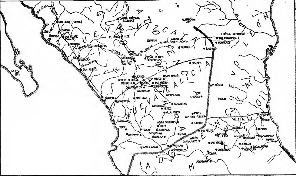
[Pg 58] Development of Nueva Vizcaya.—Shortly after Ibarra left Sinaloa the Indians of San Juan revolted, drove out the encomenderos, and murdered the friars; the settlement was therefore moved to the Petatlán (Sinaloa) River, and named San Felipe. In the last decade of the century a presidio and an Aztec-Tlascaltec colony were founded at San Felipe, and Jesuit missions were planted in the vicinity. East of the mountains, in Durango and southern Chihuahua, mining, stock raising, and agriculture developed side by side. In 1586, for example, Diego de Ibarra branded 33,000 head of cattle, and Rodrigo del Rio, then governor, 42,000 head. Several new mining districts were opened before the end of the century. In 1574 Nueva Galicia and Nueva Vizcaya (including Zacatecas and Sinaloa) had a population of 1500 Spanish families, perhaps 10,000 persons living in some thirty settlements, about half of which were mining camps. Guadalajara had a population of one hundred and fifty families and Culiacán about thirty. The Franciscan missionaries had played an important part in the founding of Nueva Vizcaya. They accompanied or went before the explorers and established themselves at the principal mining camps and towns. In 1590 the custodia of San Francisco de Zacatecas embraced ten monasteries east of the Sierras. In 1591 the Jesuits entered the province.
[Pg 58] Development of Nueva Vizcaya.—Shortly after Ibarra left Sinaloa, the people of San Juan revolted, expelled the encomenderos, and killed the friars; as a result, the settlement was relocated to the Petatlán (Sinaloa) River and named San Felipe. In the last decade of the century, a military garrison and an Aztec-Tlascaltec colony were established at San Felipe, and Jesuit missions were set up in the area. East of the mountains, in Durango and southern Chihuahua, mining, cattle ranching, and agriculture developed simultaneously. For instance, in 1586, Diego de Ibarra branded 33,000 head of cattle, while then-governor Rodrigo del Rio branded 42,000. Several new mining districts were opened before the century ended. In 1574, Nueva Galicia and Nueva Vizcaya (including Zacatecas and Sinaloa) had a population of 1,500 Spanish families, about 10,000 people living in around thirty settlements, with roughly half of them being mining camps. Guadalajara had a population of one hundred and fifty families, and Culiacán had about thirty. The Franciscan missionaries played a significant role in the establishment of Nueva Vizcaya. They accompanied or preceded the explorers and settled in the main mining camps and towns. By 1590, the custodia of San Francisco de Zacatecas included ten monasteries east of the Sierras. In 1591, the Jesuits entered the province.
Querétaro, Guanajuato, and Aguas Calientes.—For twenty years after the battle at Querétaro (1531) the Chichimec border was left practically unsettled, under the control of native leaders. But the need of communication with the Zacatecas veins made its complete subjugation necessary, and Viceroy Velasco undertook the task. In or about 1550 the town of Querétaro was founded, and Silao three years later. The marvelous Guanajuato mines were now opened; in 1554 the city of Santa Fé de Guanajuato was founded; and shortly afterward rich veins were opened at Aguas Calientes. These "strikes" caused "rushes," just as those in Zacatecas had done, but they were offset by others in Durango, where Ibarra was operating. To secure further the roads to the mines, new towns and presidios were established[Pg 59] along the way, and thus San Miguel el Grande (Allende), San Felipe, Santa Maria de Lagos, Aguas Calientes, Ojuelos, Portezuelos, Jérez, and Celaya came into being. To supplement the presidios, strong houses (casas fuertes) were provided as camping stations for travelers and silver trains, and parties were equipped with fortified wagons or movable strong houses.
Querétaro, Guanajuato, and Aguas Calientes.—For twenty years after the battle at Querétaro (1531), the Chichimec border remained mostly unsettled, controlled by local leaders. However, the need for communication with the Zacatecas mines made full subjugation essential, and Viceroy Velasco took on this responsibility. Around 1550, the town of Querétaro was established, followed by Silao three years later. The incredible Guanajuato mines were opened; in 1554, the city of Santa Fé de Guanajuato was founded, and shortly after, rich veins were discovered at Aguas Calientes. These discoveries created "rushes," just like those in Zacatecas, but they were countered by others in Durango, where Ibarra was active. To better secure the routes to the mines, new towns and military outposts were set up along the way, leading to the establishment of San Miguel el Grande (Allende), San Felipe, Santa Maria de Lagos, Aguas Calientes, Ojuelos, Portezuelos, Jérez, and Celaya. To support the military outposts, strong houses (casas fuertes) were built as camping spots for travelers and silver caravans, and groups were equipped with fortified wagons or movable strong houses.
San Luis Potosí and Southern Coahuila.—For some time the region of Charcas, now called San Luis Potosí, was a sort of No-man's-land between the westward, eastward, and northward moving columns of frontiersmen. It was the home of the powerful but savage Guachichiles. The definite conquest of the region, already known to explorers and missionaries, was begun about 1550 by Francisco de Urdiñola, who operated under Velasco's orders, and who is said to have reached the vicinity of Saltillo and Monterey. The settlement of the district soon followed. Matehuala was founded in 1550, San Gerónimo in 1552, Charcas in 1564, and the San Pedro mines about 1568. By 1576 San Luis Potosí, the site of rich ores, had become a villa, and before long was the seat of an alcaldía mayor.
San Luis Potosí and Southern Coahuila.—For a while, the area of Charcas, now known as San Luis Potosí, was a kind of no-man's-land amidst the advancing frontiersmen moving west, east, and north. It was inhabited by the powerful but fierce Guachichiles. The formal conquest of the area, which was already known to explorers and missionaries, began around 1550 with Francisco de Urdiñola, who was operating under Velasco's orders and is said to have reached the area near Saltillo and Monterey. Settlement of the region soon followed. Matehuala was established in 1550, San Gerónimo in 1552, Charcas in 1564, and the San Pedro mines around 1568. By 1576, San Luis Potosí, rich in ores, had become a villa and soon after became the seat of an alcaldía mayor.
Mining developments spread northeastward from Zacatecas to Mazapil and Saltillo. By 1568 Mazapil was the seat of an alcaldía mayor, under the Audiencia of Nueva Galicia. In that year Francisco del Cano, sent by the "very magnificent alcalde mayor," went north and discovered the "Lake of New Mexico," perhaps Laguna de Parras. In 1575 Francisco de Urdiñola, son of the former conqueror, is said to have settled sixty families at Saltillo, within the jurisdiction of Nueva Vizcaya. As early as 1582 a Franciscan monastery was established there, and in 1592 Saltillo was created a villa.
Mining developments expanded northeast from Zacatecas to Mazapil and Saltillo. By 1568, Mazapil was the seat of an alcaldía mayor, under the Audiencia of Nueva Galicia. In that year, Francisco del Cano, sent by the "very magnificent alcalde mayor," traveled north and discovered the "Lake of New Mexico," possibly Laguna de Parras. In 1575, Francisco de Urdiñola, son of the former conqueror, is said to have settled sixty families in Saltillo, which was under the jurisdiction of Nueva Vizcaya. As early as 1582, a Franciscan monastery was established there, and in 1592, Saltillo was designated as a villa.
The Tlascaltecan colonies.—Querétaro had been the scene of one interesting experiment in utilizing the natives as agents of control; in San Luis Potosí another was now tried. As a means of reducing the great central region, the plan was devised of planting in it colonies of Tlascaltecan Indians, to defend the settlers and to teach the rude tribes the elements of civilization. The Tlascaltecans had proved their loyalty in the days of Cortés, and this loyalty was insured by their exemption from tribute and by other privileges. The practice of using them as colonists in San Luis Potosí seems to have been begun as early as 1580.[Pg 60] In 1591 four hundred families were sent northward, most of them being distributed at various places in modern San Luis Potosí, but eighty families were established at Saltillo in a separate pueblo called San Estéban. Thence in later days little colonies were detached to all parts of Coahuila, Nuevo León, and Texas.
The Tlascaltecan colonies.—Querétaro had been the site of an interesting experiment in using native people as control agents; now, a similar approach was being tried in San Luis Potosí. To help manage the vast central region, the plan was to settle Tlascaltecan Indians there to protect the settlers and teach the local tribes the basics of civilization. The Tlascaltecans had shown their loyalty during Cortés's time, and this loyalty was secured through their exemption from taxes and other benefits. The practice of using them as colonists in San Luis Potosí began as early as 1580.[Pg 60] In 1591, four hundred families were sent north, with most settling in various locations in what is now San Luis Potosí, while eighty families established a separate community in Saltillo called San Estéban. From there, smaller colonies were later formed and spread throughout Coahuila, Nuevo León, and Texas.
Parras; Urdiñola the Younger.—In 1594 Jesuits from Durango founded the mission of Santa Maria de Parras, and shortly afterward a colony of Spaniards and Tlascaltecans was established there. Of this district Urdiñola the Younger, lieutenant-governor of Nueva Vizcaya, became the magnate. He opened mines, subdued Indians, established immense ranches, and was veritable feudal lord. His principal hacienda was at Patos, but he had others, as at Parras and Bonanza. In 1594 he secured a commission to conquer New Mexico which was subsequently rescinded. A female descendant of his became the wife of the first Marquis of San Miguel de Aguayo, a title created in 1682 and long held by the leading men of the northeastern frontier.
Parras; Urdiñola the Younger.—In 1594, Jesuits from Durango established the mission of Santa Maria de Parras, and soon after, a colony of Spaniards and Tlaxcalans was set up there. In this area, Urdiñola the Younger, who was the lieutenant-governor of Nueva Vizcaya, became a prominent figure. He opened mines, conquered Indigenous tribes, set up large ranches, and acted like a true feudal lord. His main estate was at Patos, but he owned others as well, such as in Parras and Bonanza. In 1594, he obtained a commission to conquer New Mexico, but it was later revoked. A female descendant of his married the first Marquis of San Miguel de Aguayo, a title created in 1682 and held for a long time by the prominent leaders of the northeastern frontier.
Nuevo León.—A new jurisdiction was now carved out on the Gulf coast. In 1579 Luis de Carabajal, a Portuguese of Jewish extraction, secured a patent naming him governor and captain-general of the Kingdom of Nuevo León, a region extending two hundred leagues north and west from Pánuco, and delimiting Nueva Vizcaya and Nueva Galicia on the north and east. Carabajal's was the first conquistador's patent issued for New Spain based on the general ordinance of 1573 regulating new conquests. He was made governor and alguacil-mayor "for two lives," with a salary of 20,000 pesos and two encomiendas for himself. He had authority to grant encomiendas, and was obligated to make new conquests and settlements. Raising two hundred men in Spain and Mexico, he established headquarters for a time at Pánuco, whence he made exploring, gold hunting, and slave hunting expeditions.
Nuevo León.—A new jurisdiction was established on the Gulf coast. In 1579, Luis de Carabajal, a Portuguese man of Jewish descent, obtained a patent that appointed him governor and captain-general of the Kingdom of Nuevo León, an area stretching two hundred leagues north and west from Pánuco, bordered by Nueva Vizcaya and Nueva Galicia to the north and east. Carabajal received the first conquistador patent issued for New Spain under the 1573 ordinance regulating new conquests. He was appointed governor and alguacil-mayor "for two lives," with a salary of 20,000 pesos and two encomiendas for himself. He had the power to grant encomiendas and was required to lead new conquests and settlements. After raising two hundred men in Spain and Mexico, he established his headquarters for a time at Pánuco, from where he conducted expeditions for exploration, gold hunting, and slave hunting.
León and Monterey.—Discovering minerals in the Sierra de San Gregorio, near the Rio Grande, in (or by) 1583, Carabajal founded there the city of León (now Cerralvo). Securing other families from Saltillo, in 1584 he founded San Luis, near the later Monterey, and appointed Castaño de Sosa alcalde mayor. Slave hunting expeditions from León proved so profitable that soon two hundred or more adventurers were attracted to the[Pg 61] place, for the slaves found ready market at the mines of the interior. When the viceroy checked the abuse, León was gradually abandoned. With another colony from Saltillo, Carabajal founded Nuevo Almadén, near the present Monclova. While thus engaged he was charged with heresy, arrested, and condemned by the Inquisition together with almost his entire family. In 1596 Luis de Montemayor, lieutenant-governor of the province, founded Monterey with families from León and Saltillo. Three years later Montemayor was made governor, directly under the viceroy. In 1603 a Franciscan monastery was founded at Monterey, and became a new missionary center. Conflicts of jurisdiction between Nuevo León and Nueva Vizcaya became chronic and a serious hindrance to prosperity.
León and Monterey.—In 1583, Carabajal discovered minerals in the Sierra de San Gregorio, near the Rio Grande, and established the city of León (now Cerralvo). He brought in more families from Saltillo, and in 1584, he founded San Luis, close to what would later become Monterey, appointing Castaño de Sosa as the mayor. Slave hunting expeditions from León were so lucrative that over two hundred adventurers flocked to the[Pg 61] area, since the slaves sold well in the mines inland. When the viceroy intervened to stop the abuses, León was gradually deserted. Carabajal then founded Nuevo Almadén with another group from Saltillo, near modern Monclova. While working on this, he was accused of heresy, arrested, and condemned by the Inquisition, along with nearly his entire family. In 1596, Luis de Montemayor, the lieutenant-governor of the province, established Monterey with families from León and Saltillo. Three years later, Montemayor became the governor, directly under the viceroy. In 1603, a Franciscan monastery was founded in Monterey, which became a new center for missionary activities. Ongoing jurisdiction conflicts between Nuevo León and Nueva Vizcaya created chronic issues that severely hindered prosperity.
THE SETTLEMENT OF THE ATLANTIC SEABOARD
Fray Luís Cancer.—Meanwhile Florida and the Philippines had been conquered and colonized. Shortly after Coronado returned from New Mexico, the Moscoso party reached Pánuco. Viceroy Mendoza, in spite of previous failures, was willing to try his hand in ill-fated Florida, and he offered to equip Moscoso and his men for another attempt, but they declined. Florida had been "running with the blood of Indians," but Fray Luís Cancer, a disciple of Las Casas, offered to try to subdue it by peaceful methods. With a royal license he equipped a vessel at Vera Cruz, and with a few companions went in 1549 to Florida to convert the natives. He was murdered by them, however, and his companions returned.
Fray Luís Cancer.—Meanwhile, Florida and the Philippines had been conquered and colonized. Shortly after Coronado returned from New Mexico, the Moscoso group reached Pánuco. Viceroy Mendoza, despite previous failures, was eager to make another attempt in troubled Florida, and he offered to provide Moscoso and his men with resources for another venture, but they turned him down. Florida had been "running with the blood of Indians," yet Fray Luís Cancer, a follower of Las Casas, was willing to try to bring peace to the region. With a royal license, he outfitted a ship in Vera Cruz and, along with a few companions, set out in 1549 for Florida to convert the natives. However, he was murdered by them, and his companions returned home.
De Luna and Villafañe.—But Florida was thought to be rich, especially at Coca, in northern Alabama, and new attempts at settlement were made. In 1558 the new viceroy was ordered to colonize Santa Elena, the scene of Ayllón's failure on the Carolina coast, and some other point not specified, the missionary work to be entrusted to the Dominicans. In the following year, therefore, Velasco sent Tristán de Luna, Coronado's second in command, from Vera Cruz with thirteen vessels and 1500 soldiers and colonists. Of the six captains three had been with De Soto, a fact which indicates the continuity of frontier interests.
De Luna and Villafañe.—But Florida was believed to be wealthy, especially at Coca in northern Alabama, prompting new settlement efforts. In 1558, the new viceroy was instructed to colonize Santa Elena, the site of Ayllón's failure on the Carolina coast, along with another unspecified location, with the Dominican missionaries taking charge of the religious work. The next year, Velasco sent Tristán de Luna, Coronado's second-in-command, from Vera Cruz with thirteen ships and 1500 soldiers and settlers. Of the six captains, three had previously served with De Soto, which shows the ongoing interest in the frontier.
The expedition landed at Pensacola Bay. Three vessels sent[Pg 62] on to Santa Elena were storm-driven and returned to Vera Cruz. Establishing a garrison at Pensacola (Ichuse), De Luna moved about a thousand colonists inland to Nanipacna on the Alabama River, whence an expedition was sent north to Coça. In 1560 the colony returned to Pensacola, where De Luna was replaced by Villafañe, who had been sent with supplies from Mexico. In the following year Villafañe went with most of his colony to Santa Elena, but failed to make a settlement, and the Pensacola garrison was soon withdrawn. In view of these repeated disasters, in 1561 Philip II declared that for the present no further attempt should be made to colonize Florida.
The expedition arrived at Pensacola Bay. Three ships sent[Pg 62] to Santa Elena were caught in a storm and returned to Vera Cruz. After setting up a garrison at Pensacola (Ichuse), De Luna moved about a thousand colonists inland to Nanipacna on the Alabama River, from where an expedition was sent north to Coça. In 1560, the colony returned to Pensacola, where De Luna was replaced by Villafañe, who had come from Mexico with supplies. The following year, Villafañe took most of his colony to Santa Elena but was unable to establish a settlement, leading to the quick withdrawal of the Pensacola garrison. Due to these ongoing failures, in 1561, Philip II declared that no further attempts should be made to colonize Florida for the time being.
The French in Florida.—Notwithstanding this decision, there were reasons why Florida should be occupied. The route of the treasure and merchant ships lay through the Bahama channel, and French and English pirates had begun to attack them. To lessen the danger, vessels were ordered to go in company, and as early as 1552 a fleet of war vessels was sent to escort them to Havana. But a port was needed to give aid against the pirates, as well as to provide refuge from the violent storms on the Florida coast. Moreover, the French were operating on the northern Atlantic, and it was feared that they would occupy this region.
The French in Florida.—Despite this decision, there were reasons for occupying Florida. The paths of treasure and merchant ships went through the Bahama channel, and French and English pirates had started attacking them. To reduce the risk, ships were instructed to travel in groups, and as early as 1552, a fleet of warships was sent to escort them to Havana. However, a port was necessary to provide assistance against the pirates and offer shelter from the fierce storms on the Florida coast. Additionally, the French were active in the northern Atlantic, and there were concerns that they would take over this area.
This fear was realized in 1562 when Jean Ribaut led a French Huguenot colony to Port Royal, South Carolina. The colony miserably failed, but in 1564 another, led by Laudonnière, settled on St. John's River and built Fort Caroline. Just as Laudonnière was about to abandon the place, Ribaut arrived with a third colony, bearing instructions to fortify a position that would enable him to command the route of the Spanish treasure fleets.
This fear became a reality in 1562 when Jean Ribaut led a French Huguenot colony to Port Royal, South Carolina. The colony failed miserably, but in 1564, another one, led by Laudonnière, settled on the St. John's River and built Fort Caroline. Just as Laudonnière was about to give up on the place, Ribaut showed up with a third colony, bringing orders to strengthen a position that would allow him to control the route of the Spanish treasure fleets.
Menéndez de Avilés, and the expulsion of the French.—Philip decided now to eject the French and colonize Florida, and entrusted the task to Menéndez de Avilés, a great naval officer. He was made adelantado of Florida, and promised a private estate twenty-five leagues square, or some 300,000 acres. In return he agreed to take a colony of five hundred persons to Florida, build at least two fortified towns, and expel foreign "settlers and corsairs." In September, 1565, Menéndez reached Florida and founded St. Augustine. Ten days later he marched overland against Fort Caroline, surprised and captured it, and mercilessly slew most of its defenders. On the spot the garrison of San Mateo was established.
Menéndez de Avilés and the expulsion of the French.—Philip decided to remove the French and colonize Florida, assigning the task to Menéndez de Avilés, a skilled naval officer. He was made the governor of Florida and promised a private estate of twenty-five leagues square, or about 300,000 acres. In return, he agreed to bring a colony of five hundred people to Florida, build at least two fortified towns, and eliminate foreign "settlers and pirates." In September 1565, Menéndez arrived in Florida and established St. Augustine. Ten days later, he advanced overland against Fort Caroline, caught it by surprise, and captured it, mercilessly killing most of its defenders. He then established the garrison of San Mateo on the spot.
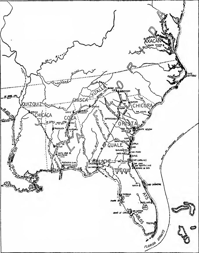 Florida, Spain.
[Pg 64] Menéndez's relentless deed caused an outburst of indignation in France, and perhaps only Catherine's reliance on Philip in her troubles with the Huguenots prevented war. Vengeance was left to a private individual, Dominique de Gourgues. Getting up an expedition ostensibly to trade, in 1567 he went to Florida, and slew the garrison at San Mateo. The prisoners taken were hanged "not as Spaniards" but "as traitors, robbers, and murderers."
[Pg 64] Menéndez's relentless actions sparked outrage in France, and maybe Catherine's dependence on Philip during her struggles with the Huguenots kept war at bay. Retribution fell to a private individual, Dominique de Gourgues. Under the pretense of a trading expedition, he went to Florida in 1567 and killed the garrison at San Mateo. The captured soldiers were hanged "not as Spaniards" but "as traitors, robbers, and murderers."
New settlements in Florida.—Menéndez planned great things. He would fortify the Bahama Channel, occupy Santa Elena and Chesapeake Bay, and in the latter seek the northern strait. As a base for expanding toward Pánuco, he would occupy the Bay of Juan Ponce, and he had great hopes of agricultural prosperity.
New settlements in Florida.—Menéndez had big plans. He aimed to strengthen the Bahama Channel, take control of Santa Elena and Chesapeake Bay, and in the latter, look for the northern strait. To expand towards Pánuco, he would establish a presence in the Bay of Juan Ponce, and he was very optimistic about agricultural success.
To carry out these plans, active steps were taken. Before Menéndez returned to Spain in 1567, several new Spanish posts were founded between the point of the peninsula and South Carolina. San Mateo was reoccupied. At Charlotte Bay Menéndez made an alliance with the much-feared Chief Carlos by marrying his sister, and founded there the presidio of San Antonio. Other garrisons were established on the peninsula at Ays, Santa Lucía, Tocobaga, and Tegesta. At Santa Elena, in South Carolina, Menéndez founded the colony of San Felipe, and in Guale (northern Georgia) he founded a presidio.
To carry out these plans, active steps were taken. Before Menéndez returned to Spain in 1567, several new Spanish posts were established between the tip of the peninsula and South Carolina. San Mateo was reoccupied. At Charlotte Bay, Menéndez formed an alliance with the feared Chief Carlos by marrying his sister and founded the presidio of San Antonio there. Other garrisons were set up on the peninsula at Ays, Santa Lucía, Tocobaga, and Tegesta. At Santa Elena, in South Carolina, Menéndez established the colony of San Felipe, and in Guale (northern Georgia), he founded a presidio.
Explorations in the Alleghanies.—In November, 1566, Menéndez sent Juan Pardo from Santa Elena "to discover and conquer the interior country from there to Mexico," to join the two frontiers. Going northwest, he reached the snow covered Alleghanies in western North Carolina, established two garrisons on the way, and returned. Boyano, left at one of the garrisons, made expeditions into the mountains, and in 1567 marched southwest to Chiaha near Rome, Georgia. Being joined there by Pardo, they set out "in the direction of Zacatecas and the mines of San Martin," in Mexico, but were turned back by Indian hostility. On his way to San Felipe Pardo left two garrisons, which were soon massacred by Indians.
Explorations in the Alleghanies.—In November 1566, Menéndez sent Juan Pardo from Santa Elena "to explore and conquer the interior region all the way to Mexico," aiming to connect the two frontiers. Heading northwest, he reached the snow-covered Alleghanies in western North Carolina, established two garrisons along the route, and then returned. Boyano, who was stationed at one of the garrisons, ventured into the mountains and in 1567 marched southwest to Chiaha near Rome, Georgia. There, he joined Pardo, and they set out "toward Zacatecas and the San Martin mines," in Mexico, but they were forced to turn back due to hostility from the Native Americans. On his way to San Felipe, Pardo established two more garrisons, which were soon attacked and massacred by Native Americans.
The Jesuit missions in Florida.—In 1566 Menéndez secured three Jesuit missionaries for Florida. Another band arrived in 1568, and went to Santa Elena, Orista, and Guale, where they[Pg 65] founded missions. At first they were successful, but in 1570 they were driven out by native opposition. By this time the garrison at Tocobaga had been massacred and those at San Antonio and Tegesta withdrawn on account of Indian hostility.
The Jesuit missions in Florida.—In 1566, Menéndez brought three Jesuit missionaries to Florida. Another group arrived in 1568 and went to Santa Elena, Orista, and Guale, where they[Pg 65] established missions. Initially, they were successful, but in 1570, they were expelled due to resistance from the natives. By this time, the garrison at Tocobaga had been killed, and those at San Antonio and Tegesta had been removed due to hostility from the Indians.
The Virginia mission.—Father Segura, the Jesuit superior, now transferred his efforts to Chesapeake Bay, whither he went in 1570 with six missionaries. They founded a mission, perhaps on the Rappahannock, but soon all were slain. In 1571 Menéndez went in person to avenge the outrage. Two years later his nephew explored the entire coast from the Florida Keys to Chesapeake Bay. In 1573, the year before his death, Menéndez's grant was extended west to Pánuco.
The Virginia mission.—Father Segura, the Jesuit leader, shifted his focus to Chesapeake Bay, where he traveled in 1570 with six missionaries. They established a mission, possibly on the Rappahannock, but were quickly killed. In 1571, Menéndez personally went to seek revenge for the attack. Two years later, his nephew explored the entire coastline from the Florida Keys to Chesapeake Bay. In 1573, the year before his death, Menéndez's land grant was expanded westward to Pánuco.
Franciscans on the Georgia coast.—The martyrdom of Father Segura and his band caused the Jesuits to abandon the field for Mexico, but in 1573 Franciscans began work in the province. Twenty years later (1593) twelve more arrived under Father Juan de Silva. From the central monastery at St. Augustine they set forth and founded island missions all up the Florida and Georgia coast, on Amelia, Cumberland, St. Simon, San Pedro and Ossabua islands. Fray Pedro Chozas made inland explorations, and Father Pareja began his famous work on the Indian languages. Owing to an Indian uprising in 1597 the missions were abandoned for a time, but were soon restored as a check against the English, who now entered Virginia.
Franciscans on the Georgia coast.—The martyrdom of Father Segura and his group led the Jesuits to leave for Mexico, but in 1573, Franciscans started their mission in the province. Twenty years later (1593), twelve more arrived with Father Juan de Silva. From the central monastery in St. Augustine, they set out and established island missions along the Florida and Georgia coast, on Amelia, Cumberland, St. Simon, San Pedro, and Ossabua islands. Fray Pedro Chozas conducted inland explorations, while Father Pareja began his well-known work on the Indian languages. Due to an Indian uprising in 1597, the missions were temporarily abandoned but were soon revived to counter the English, who had just entered Virginia.
FOREIGN INTRUSIONS IN THE ATLANTIC
The Spanish trade monopoly.—The French had been expelled from Florida, and the coast occupied up to Port Royal Sound, but freebooters continued to prey on treasure and merchant vessels. Spain undertook to preserve the trade and wealth of the Indies as an absolute monopoly. All trade must be conducted by Spaniards in Spanish vessels, from specified Spanish ports to specified American ports. This monopoly was objectionable not only to the traders of other nations but to the Spanish colonists as well. To this economic grievance was added the bitter hatred felt by Protestant Frenchmen, Englishmen and Dutchmen for Catholic Spain, whose subjects were regarded as lawful prey.[Pg 66]
The Spanish trade monopoly.—The French had been kicked out of Florida, and the coast was taken over up to Port Royal Sound, but pirates kept attacking treasure and merchant ships. Spain tried to maintain control over the trade and riches of the Indies as a complete monopoly. All trading had to be done by Spaniards in Spanish ships, traveling from designated Spanish ports to specific American ports. This monopoly was not only a problem for traders from other countries but also for Spanish colonists. On top of this economic issue was the deep resentment felt by Protestant French, English, and Dutch against Catholic Spain, whose people were seen as fair game.[Pg 66]
The merchant fleets.—To prevent the plundering of commerce in the Indies, by French, English, and Dutch, Spain was forced to adopt a system of fleets sailing periodically and protected by convoys of armed galleons. After 1561 it became unlawful for vessels to sail alone to the Indies, except under special circumstances. Two fleets left Spain each year, one for Tierra Firme and Nombre de Diós (later Porto Bello) and the other for Vera Cruz. In the later sixteenth century the Nombre de Diós fleet comprised as many as forty armed galleons, but thereafter the number was much smaller, as foreigners cut into Spanish trade. The Vera Cruz fleet comprised fifteen or twenty merchantmen convoyed by two galleons. At Nombre de Diós goods and treasure from Peru and Chile were taken on. At Vera Cruz were gathered the exports from New Spain, the cargo from the Manila galleon brought overland from Acapulco, and the ten or twelve million dollars of royal revenues from the mines and taxes.
The merchant fleets. — To stop the looting of trade in the Indies by the French, English, and Dutch, Spain had to set up a system of fleets that sailed regularly, protected by armed galleons. After 1561, it became illegal for ships to sail alone to the Indies, unless in special situations. Two fleets left Spain each year: one headed to Tierra Firme and Nombre de Diós (later known as Porto Bello), and the other to Vera Cruz. In the late sixteenth century, the Nombre de Diós fleet had as many as forty armed galleons, but this number dropped significantly as foreign nations encroached on Spanish trade. The Vera Cruz fleet included fifteen or twenty merchant ships, guarded by two galleons. At Nombre de Diós, goods and treasures from Peru and Chile were loaded. At Vera Cruz, exports from New Spain were gathered, along with cargo from the Manila galleon that was brought overland from Acapulco and the ten to twelve million dollars in royal revenue from mines and taxes.
The freebooters.—This arrangement was an improvement, but French, Dutch, and English freebooters hung in the wake of the fleets to plunder any vessel which fell behind the galleons, while smuggling and town-sacking grew in frequency with the growing jealousy and hatred of Spain. The prototype of the English freebooters was John Hawkins, whose fleet was destroyed by the Spaniards at Vera Cruz in 1567. More famous was Francis Drake, who in 1585, during his third marauding expedition, went to the West Indies with twenty-five vessels, captured Santo Domingo, held Cartagena for ransom, and in May, 1586, sacked and burned St. Augustine, Florida. Hawkins and Drake were only two of a score of English freebooters who in the later sixteenth century harried Spanish commerce and plundered the coast towns. In the list are the names of Oxenham. Raleigh. Grenville. Clifford, Knollys, Winter, and Barker. The last exploit of the century was Clifford's capture of San Juan, Porto Rico, in 1598.
The freebooters.—This arrangement was an improvement, but French, Dutch, and English pirates trailed behind the fleets to loot any ship that fell behind the galleons, while smuggling and raiding towns became more common as jealousy and hatred of Spain intensified. The first English pirate was John Hawkins, whose fleet was destroyed by the Spaniards at Vera Cruz in 1567. More famous was Francis Drake, who in 1585, during his third raid, went to the West Indies with twenty-five ships, captured Santo Domingo, held Cartagena for ransom, and in May 1586, sacked and burned St. Augustine, Florida. Hawkins and Drake were just two of many English pirates who troubled Spanish trade and plundered coastal towns in the late sixteenth century. Included in the list are the names of Oxenham, Raleigh, Grenville, Clifford, Knollys, Winter, and Barker. The last major act of the century was Clifford's capture of San Juan, Puerto Rico, in 1598.
The English in the north Atlantic.—The voyages of Frobisher. Davis, and Gilbert in the northern Atlantic between 1576 and 1587, in search of the northwest passage, caused uneasiness for the security of Florida and of the northern strait. Equally disturbing were the efforts of Raleigh and his associates to colonize Roanoke Island and Guiana.[Pg 67]
The English in the North Atlantic.—The journeys of Frobisher, Davis, and Gilbert in the northern Atlantic from 1576 to 1587, searching for the northwest passage, raised concerns about the safety of Florida and the northern strait. Equally troubling were Raleigh and his team's attempts to establish a colony on Roanoke Island and in Guiana.[Pg 67]
Decline of the West Indies.—-The raids of the freebooters, the restrictions placed on commerce, the decline of mining and of the native population, and the superior attractions of Peru, Central America, and Mexico, had greatly reduced the prosperity of the West Indies. In 1574 Española had ten towns with 1000 Spanish families, and 12,000 negro slaves. The native population had dwindled to two villages. Santo Domingo, seat of the Audiencia and of the archdiocese, had seven hundred families. Cuba was less prosperous than Española, and population was still declining. The island had eight Spanish towns with a total population of some three hundred families and about an equal number of Indians. Santiago, once with a population of one thousand families, now had thirty. Havana, somewhat larger, was the residence of governor and bishop. Jamaica had three Spanish settlements and no Indians. Porto Rico, with three Spanish towns, had a population of some two hundred and eighty families, of whom two hundred lived at San Juan. The principal industries in all of the islands were sugar and cattle raising. There being no Indians in the West Indies now, there were no encomiendas.
Decline of the West Indies.—-The attacks by pirates, the restrictions on trade, the decrease in mining and the native population, and the greater appeal of Peru, Central America, and Mexico had significantly diminished the prosperity of the West Indies. In 1574, Española had ten towns with 1,000 Spanish families and 12,000 enslaved Africans. The native population had shrunk to just two villages. Santo Domingo, home to the Audiencia and the archdiocese, had seven hundred families. Cuba was less prosperous than Española, with its population still on the decline. The island had eight Spanish towns with a total population of about three hundred families and a similar number of Indigenous people. Santiago, which once had a population of one thousand families, now had thirty. Havana, slightly larger, was the residence of the governor and bishop. Jamaica had three Spanish settlements and no Indigenous people. Puerto Rico, with three Spanish towns, had a population of around two hundred eighty families, of which two hundred lived in San Juan. The main industries across the islands were sugar production and cattle farming. With no Indigenous people left in the West Indies now, there were no encomiendas.
THE PHILIPPINES AND CALIFORNIA
A new attempt in the East.—At the same time that Menéndez was establishing the province of Florida, the right wing of the Indies, Legazpi was conquering the Philippines, the left wing. The principal result of the Villalobos expedition (1542) had been to give the name of the Philippines to the Lazarus, or Western Islands. For nearly two decades thereafter nothing was done to advance the interests of Spain in the Far East, but Portuguese profits in the spice trade were tempting to both sovereign and subject, and the king set about making a new effort to share in these advantages.
A new attempt in the East.—At the same time that Menéndez was establishing the province of Florida, Legazpi was conquering the Philippines, which were the left wing of the Indies. The main outcome of the Villalobos expedition (1542) was that the Lazarus Islands, or Western Islands, were named the Philippines. For nearly twenty years after that, nothing was done to promote Spain's interests in the Far East, but the profits that Portugal was making in the spice trade were tempting for both the king and his subjects, leading the king to make a new effort to join in on these benefits.
The obvious base for such a trade was Mexico, and in 1559 Philip ordered Velasco to equip two vessels for discovery in the western islands, to test the chance for profits and the possibility of a return voyage across the Pacific. This order was issued just at the time when Spain was attempting to occupy the Carolina coasts, with a view, in part, to finding a northern strait leading[Pg 68] to the Spice Islands. Thus were all these widely separated enterprises unified.
The clear starting point for this trade was Mexico, and in 1559, Philip instructed Velasco to prepare two ships for exploration in the western islands, to evaluate the potential for profits and the possibility of a return trip across the Pacific. This directive was given at a time when Spain was trying to establish a presence along the Carolina coasts, partly in hopes of discovering a northern passage leading[Pg 68] to the Spice Islands. In this way, all these far-flung ventures were brought together.
The Legazpi expedition.—To lead the expedition, Miguel López de Legazpi was chosen, with Fray Andrés de Urdaneta as chief navigator. The spiritual work was entrusted to Urdaneta and a band of Augustinians. Owing to many delays it was November, 1564, when the fleet left Navidad. In February, 1565, seven months before Menéndez reached Florida, Legazpi reached the Philippines. Three of the vessels were sent back with Urdaneta on board to discover a return route to New Spain. Instead of sailing east against wind and current, he turned northward beyond the trade belt, and entered that of the westerly winds. After a long and hard voyage he reached the American continent off the northern California coast, which he descended to Mexico. At last the Spaniards had discovered a way to return from the East safe from the Portuguese attacks.
The Legazpi expedition.—Miguel López de Legazpi was appointed to lead the expedition, with Fray Andrés de Urdaneta as the chief navigator. The spiritual mission was assigned to Urdaneta and a group of Augustinians. Due to various delays, the fleet finally left Navidad in November 1564. In February 1565, seven months before Menéndez arrived in Florida, Legazpi reached the Philippines. Three of the ships were sent back with Urdaneta on board to find a return route to New Spain. Instead of sailing east against the wind and current, he headed north beyond the trade wind zone and entered the zone of westerly winds. After a long and tough journey, he reached the American continent off the northern California coast, then traveled down to Mexico. Finally, the Spaniards had found a safe way to return from the East without facing Portuguese attacks.
Meanwhile Legazpi had occupied Cebú. Portuguese resistance caused a removal to Panay, but in 1571 Cebú was reoccupied and Manila founded. In the previous year Legazpi had received a commission as adelantado of the Islands, subject to the viceroy of Mexico. When Legazpi died in 1572 the conquest of the principal islands had been effected and with little bloodshed. In 1583 the Audiencia of Manila was established, subordinate to Mexico.
Meanwhile, Legazpi had taken over Cebu. Portuguese resistance led to a move to Panay, but in 1571, Cebu was reoccupied and Manila was established. The year before, Legazpi had received a commission as adelantado of the Islands, under the viceroy of Mexico. When Legazpi died in 1572, the conquest of the main islands had been accomplished with minimal bloodshed. In 1583, the Audiencia of Manila was set up, answering to Mexico.
The Manila galleon.—In 1580 Portugal was united with Spain, and, until 1640, when Portugal regained her independence, Manila was an important center for the commerce of the combined Spanish and Portuguese colonies. A regular trade was established from Manila to Mexico and Spain, but was restricted to one or two annual galleons each way between Manila and Acapulco.
The Manila galleon.—In 1580, Portugal joined with Spain, and until 1640, when Portugal regained its independence, Manila became a key hub for trade among the combined Spanish and Portuguese colonies. A regular trade route was set up from Manila to Mexico and Spain, but it was limited to just one or two ships traveling each year between Manila and Acapulco.
New interest in the California coast.—The development of the Philippine trade, the necessity of protecting it from other nations, continued interest in the Northern Mystery, and the opening of pearl fisheries in the Gulf of California, led to renewed exploration of the northern Pacific coasts and to renewed attempts to settle and develop California.
New interest in the California coast.—The growth of the Philippine trade, the need to safeguard it from other countries, ongoing curiosity about the Northern Mystery, and the start of pearl fisheries in the Gulf of California spurred renewed exploration of the northern Pacific coasts and fresh efforts to settle and develop California.
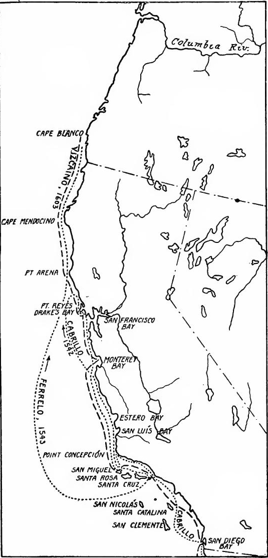 Explorations of the California Coast, 1542-1603.
[Pg 70] The regular course of the east-bound Manila galleon lay along the path marked out by Urdaneta northeastward from Manila to about latitude 42,° thence across the Pacific to the American continent off Cape Mendocino, and down the coast to Acapulco. The voyage was arduous. By the time the vessels reached the American coast half of the scurvy-afflicted crew and passengers were dead, and the vessels needed repairs. Hence a port of call was gravely needed for the Manila galleons.
[Pg 70] The usual route for the east-bound Manila galleon followed the path laid out by Urdaneta, traveling northeast from Manila to about latitude 42°, then across the Pacific to the American coast near Cape Mendocino, and down the coast to Acapulco. The journey was tough. By the time the ships reached the American coast, half of the crew and passengers suffering from scurvy were dead, and the ships required repairs. Therefore, a port of call was badly needed for the Manila galleons.
The Strait of Anian.—Moreover, Spanish interests in the Pacific, were insecure. The Portuguese were no longer rivals, but French and English freebooters were active on the Atlantic and might venture upon the Pacific. Besides, there was the fear that the French, English, or Dutch, operating in the northern Atlantic, would discover the Strait of Anian and secure control of the direct route to the Spice Islands, just as Portugal had monopolized the African route.
The Strait of Anian.—Additionally, Spanish interests in the Pacific were unstable. The Portuguese were no longer competitors, but French and English pirates were active in the Atlantic and could easily move into the Pacific. Moreover, there was a concern that the French, English, or Dutch, operating in the northern Atlantic, would find the Strait of Anian and take control of the direct route to the Spice Islands, just like Portugal had dominated the African route.
Drake and Cavendish.—These fears were made realities in 1579 when Drake appeared on the California coast. In 1577 he had passed through the Straits of Magellan. Reaching the Pacific with only one vessel of the five with which he had started, he proceeded up the coast of South America, plundering as he went. In the harbour now known as Drake's Bay, just north of San Francisco, he refitted, claiming the country for England and calling it New Albion. Drake then sailed to the East Indies, obtained a cargo of spices, crossed the Indian Ocean, rounded the Cape of Good Hope, and reached Plymouth in November, 1580. He claimed to have discovered the Strait of Anian, and this further disturbed the minds of the Spaniards. For his daring voyage he was knighted by Queen Elizabeth.
Drake and Cavendish.—These fears became real in 1579 when Drake showed up on the California coast. In 1577, he had made his way through the Straits of Magellan. Arriving in the Pacific with just one ship out of the five he had originally started with, he moved up the South American coast, looting as he traveled. In the harbor now known as Drake's Bay, just north of San Francisco, he repaired his ship, claimed the land for England, and named it New Albion. Drake then sailed to the East Indies, acquired a cargo of spices, crossed the Indian Ocean, rounded the Cape of Good Hope, and arrived in Plymouth in November 1580. He claimed to have discovered the Strait of Anian, which further unsettled the Spaniards. For his bold voyage, he was knighted by Queen Elizabeth.
In 1586 Thomas Cavendish followed Drake's course. Reaching the point of California, he plundered the Manila galleon, the Santa Ana, and burned it to the water's edge. The voyages of Drake and Cavendish were soon followed by the formation of the British East India Company (1600) and by conflicts with the Spanish merchants in the Orient. In the wake of the English came the Dutch, who had passed the Straits of Magellan before the end of the sixteenth century.
In 1586, Thomas Cavendish followed Drake's path. When he reached California, he attacked the Manila galleon, the Santa Ana, and burned it down to the waterline. Drake's and Cavendish's voyages were soon followed by the creation of the British East India Company in 1600 and battles with Spanish merchants in the East. After the English, the Dutch arrived, having navigated the Straits of Magellan before the end of the sixteenth century.
Gali and Cermeño.—With the needs of the Pacific coast in, view. Viceroy Moya Contreras (1584-1585) instructed Francisco de Gali to explore the northwestern coasts of America on his return from Manila in the galleon. Nothing came of Gali's orders, and Moya's successor discouraged further exploration. The second[Pg 71] Viceroy Velasco (1590-1595), however, took up Moya's plan, and in 1595 Sebastian Rodríguez Cermeño undertook to carry out the project on his return from Manila. He was wrecked at Drake's Bay, however, and his crew made their way to Mexico in an improvised craft. The plan of reconnoitering the coast with laden Manila galleons was now given up for one of exploring in light vessels sent out from the ports of Mexico.
Gali and Cermeño.—Considering the needs of the Pacific coast, Viceroy Moya Contreras (1584-1585) directed Francisco de Gali to explore the northwestern coasts of America during his return from Manila on the galleon. Gali's orders went unfulfilled, and Moya's successor discouraged any further exploration. The second[Pg 71] Viceroy Velasco (1590-1595), however, decided to continue Moya's plan, and in 1595, Sebastian Rodríguez Cermeño set out to execute the project on his return from Manila. Unfortunately, he was shipwrecked at Drake's Bay, and his crew managed to make their way to Mexico in a makeshift vessel. The original plan to scout the coast with loaded Manila galleons was now abandoned in favor of exploring with smaller vessels sent out from the ports of Mexico.
Vizcaíno's colony.—Royal interest in the protection of California was now combined with private interest in the pearl-fisheries of the Gulf of California. Occasional expeditions had been made for this purpose since the days of Cortés and Alarcón. In 1595 Sebastián Vizcaíno, who had been engaged in the Manila trade, and, indeed, had been on the Santa Ana when it was captured by Cavendish, secured a contract authorizing him to gather pearls, in return for subduing and colonizing California. Leaving Acapulco late in 1596 with three vessels and a good-sized company, he established a colony at La Paz and explored some distance up the Gulf. But disaster soon followed, and early in 1597 the survivors returned to Mexico.
Vizcaíno's colony.—Royal interest in protecting California was now mixed with private interest in the pearl fisheries of the Gulf of California. There had been occasional expeditions for this purpose since the times of Cortés and Alarcón. In 1595, Sebastián Vizcaíno, who had been involved in the Manila trade and had actually been on the Santa Ana when it was captured by Cavendish, obtained a contract that allowed him to gather pearls in exchange for conquering and colonizing California. He left Acapulco in late 1596 with three ships and a decent-sized crew, established a colony at La Paz, and explored some distance up the Gulf. However, disaster struck soon after, and by early 1597, the survivors returned to Mexico.
Vizcaíno's exploring expedition.—Vizcaíno attributed his failure to ignorance of the seasons, and proposed making another attempt at settlement and pearl fishing. While this question was being discussed, the king in 1599 ordered the outer coast of California explored again, with a view to finding a port for the Manila galleons. To conduct the expedition Vizcaíno was chosen. Leaving Acapulco in May, 1602, with three vessels, he ran all the coasts covered by Cabrillo and Ferrelo sixty years before. At Magdalena Bay, Cerros Island, San Diego Bay, and Santa Catalina Island extensive explorations were made. The capital event of the expedition, however, was the exploration of the Bay of Monterey (probably entered by Cermeño) and its designation as the desired port. One of the vessels reached Cape Blanco, but San Francisco Bay was missed, as before.
Vizcaíno's exploring expedition. — Vizcaíno blamed his failure on a lack of understanding of the seasons and suggested making another attempt at settling and pearl fishing. While this was being discussed, in 1599, the king ordered another exploration of the outer coast of California to find a port for the Manila galleons. Vizcaíno was chosen to lead the expedition. He left Acapulco in May 1602 with three ships and retraced the coasts explored by Cabrillo and Ferrelo sixty years earlier. Extensive explorations were conducted at Magdalena Bay, Cerros Island, San Diego Bay, and Santa Catalina Island. The highlight of the expedition was the exploration of the Bay of Monterey (which was likely entered by Cermeño) and its identification as the desired port. One of the vessels made it to Cape Blanco, but San Francisco Bay was overlooked, just like before.
Plans to Occupy Monterey Bay.—Plans were now made for occupying the port of Monterey, but delays ensued and a new viceroy concluded that a port in the mid-Pacific was more needed than one on the California coast. Accordingly, in 1611 Vizcaíno was sent to explore certain islands called Rica de Oro and Rica de Plata, but the expedition failed.
Plans to Occupy Monterey Bay.—Plans were made to take control of the port of Monterey, but delays occurred, and a new viceroy decided that a port in the mid-Pacific was more necessary than one on the California coast. As a result, in 1611, Vizcaíno was sent to explore some islands known as Rica de Oro and Rica de Plata, but the expedition didn't succeed.
THE FOUNDING OF NEW MEXICO
Renewed exploration of New Mexico.—The expansion of Nueva Vizcaya and renewed activities on the Pacific coast in the later sixteenth century stimulated a new advance into New Mexico. Coronado's expedition had proved disappointing, and for four decades no further explorations had been made in the region. Nevertheless, the tales of great cities had not been forgotten, and in the meantime a new line of approach to New Mexico had been opened by way of the central plateau. By 1580 mines and missions had reached Santa Bárbara, while slave hunting expeditions had descended the Conchos to the Rio Grande. Through reports given by the outlying tribes, a new interest in the Pueblo region was aroused.
Renewed exploration of New Mexico.—The expansion of Nueva Vizcaya and increased activities on the Pacific coast in the late sixteenth century spurred a renewed push into New Mexico. Coronado's expedition had been disappointing, and for forty years, no further explorations were conducted in the area. However, the stories of great cities were still alive, and a new route to New Mexico had opened up through the central plateau. By 1580, mines and missions had reached Santa Bárbara, and slave hunting expeditions had traveled down the Conchos to the Rio Grande. Reports from the surrounding tribes sparked a renewed interest in the Pueblo region.
Rodríguez and Espejo.—To follow up these reports, with a view to missionary work, trade, and exploration, an expedition was organized at Santa Bárbara in 1580 by Fray Augustin Rodríguez, a Franciscan lay brother, and Francisco Sánchez Chamuscado. In the next year the party of three friars and nine soldiers and traders descended the Conchos River, ascended the Rio Grande to the Pueblo region, visited the buffalo plains, Ácoma, and Zuñi, and returned, leaving two friars at Puaray, one having been killed. In the following year a rescue and trading party was led to New Mexico over the same trail by Fray Bernaldino Beltrán and Antonio de Espejo. The friars had already been slain by the natives, but before returning Espejo went to Zuñi, Moqui, and western Arizona, where he discovered mines, returning to Santa Bárbara by way of the Pecos River.
Rodríguez and Espejo.—To follow up on these reports, aiming for missionary work, trade, and exploration, an expedition was organized in Santa Bárbara in 1580 by Fray Augustin Rodríguez, a Franciscan lay brother, and Francisco Sánchez Chamuscado. The next year, a group of three friars and nine soldiers and traders traveled down the Conchos River, went up the Rio Grande to the Pueblo region, visited the buffalo plains, Ácoma, and Zuñi, and returned, leaving behind two friars at Puaray, one of whom had been killed. The following year, a rescue and trading party was led to New Mexico along the same trail by Fray Bernaldino Beltrán and Antonio de Espejo. The friars had already been killed by the natives, but before returning, Espejo visited Zuñi, Moqui, and western Arizona, where he discovered mines, and returned to Santa Bárbara via the Pecos River.
Plans to colonize New Mexico.—The expeditions of Rodríguez and Espejo aroused new zeal for northern exploration and settlement, and there were dreams now, not only of conquering New Mexico, but of going beyond to colonize Quivira and the shores of the Strait of Anian. The king ordered a contract made for the purpose, and soon there was a crowd of applicants for the honor. While these men were competing for the desired contract, Castaño de Sosa in 1590 led a colony from Nuevo León up the Pecos to the Pueblos and began their conquest, but was soon arrested and taken back. Some three years later two men named Leyva and Gutiérrez de Humana led an unlicensed expedition[Pg 73] from Nueva Vizcaya to New Mexico, whence Gutiérrez went to northeastern Kansas, and apparently reached the Platte River.
Plans to colonize New Mexico. — The expeditions of Rodríguez and Espejo sparked new enthusiasm for exploring and settling in the north, and now there were aspirations not just to conquer New Mexico, but to go further and colonize Quivira and the shores of the Strait of Anian. The king ordered a contract to be drawn up for this purpose, and soon there was a wave of applicants eager for the opportunity. While these men competed for the coveted contract, Castaño de Sosa led a colony from Nuevo León up the Pecos to the Pueblos in 1590 and started their conquest, but was quickly arrested and sent back. About three years later, two men named Leyva and Gutiérrez de Humana led an unauthorized expedition[Pg 73] from Nueva Vizcaya to New Mexico, from where Gutiérrez headed to northeastern Kansas and apparently reached the Platte River.
Oñate and the founding of New Mexico.—The contract to colonize New Mexico was finally assigned in 1595 to Juan de Oñate, son of Cristóbal, one of the founders of Zacatecas. In accordance with the ordinances of 1573 he was made governor, adelantado, and captain-general, granted extensive privileges, lands, and encomiendas, while his colonists were given the usual privileges of first settlers (primeros pobladores). It was February, 1598, when Oñate left northern Nueva Vizcaya with his colony. It included one hundred and thirty soldiers, some with their families, a band of Franciscans under Father Martinez, and more than seven thousand head of stock. Previous expeditions had followed the Conchos, but Oñate opened a more direct route through El Paso. Without difficulty he secured the submission of the tribes, settled his colony at San Juan, and distributed the friars among the pueblos.
Oñate and the Founding of New Mexico.—The contract to colonize New Mexico was finally given to Juan de Oñate in 1595, the son of Cristóbal, one of the founders of Zacatecas. According to the laws of 1573, he was appointed governor, adelantado, and captain-general, and he received extensive privileges, lands, and encomiendas, while his colonists were granted the usual rights of first settlers (primeros pobladores). In February 1598, Oñate departed from northern Nueva Vizcaya with his colony. It included one hundred and thirty soldiers, some with their families, a group of Franciscans led by Father Martinez, and more than seven thousand livestock. Previous expeditions had followed the Conchos River, but Oñate took a more direct route through El Paso. He easily secured the submission of the tribes, established his colony at San Juan, and assigned the friars to the pueblos.
Oñate's explorations.—Having established his colony, Oñate turned to exploration in the east and the west. In the fall of 1598 Vicente Zaldivar was sent to the Buffalo Plains, while the governor set out for the South Sea. At Moqui he turned back, but Marcos Farfán continued west with a party, and staked out mining claims on Bill Williams Fork. Ácoma rebelled at this time and as a punishment was razed. In 1599 Zaldivar was sent to the South Sea and seems to have reached the lower Colorado. Early in 1601 Oñate, with seventy men, descended the Canadian River and crossed the Arkansas to an Indian settlement called Quivira, apparently at Wichita, Kansas. During Oñate's absence most of the colonists deserted, but they were brought back, with reinforcements. Still bent on reaching the South Sea, in 1604 Oñate descended Bill Williams Fork and the Colorado to the Gulf of California, where he got the idea that California was an island. He had reëxplored most of the ground covered by Coronado and had opened new trails. But he had lost the confidence and support of the authorities, and in 1608 resigned and was displaced by a royal governor.
Oñate's explorations.—After establishing his colony, Oñate focused on exploring east and west. In the fall of 1598, Vicente Zaldivar was sent to the Buffalo Plains while the governor set out for the South Sea. He turned back at Moqui, but Marcos Farfán continued west with a group and staked out mining claims on Bill Williams Fork. During this time, Ácoma rebelled and was destroyed as punishment. In 1599, Zaldivar was sent to the South Sea and seems to have reached the lower Colorado River. Early in 1601, Oñate, along with seventy men, went down the Canadian River and crossed the Arkansas River to an Indian settlement called Quivira, likely in Wichita, Kansas. While Oñate was away, most of the colonists deserted, but they were brought back along with reinforcements. Still determined to reach the South Sea, in 1604 Oñate traveled down Bill Williams Fork and the Colorado River to the Gulf of California, where he thought California was an island. He had re-explored much of the land Coronado had covered and had opened new routes. However, he had lost the trust and support of the authorities, and in 1608 he resigned and was replaced by a royal governor.
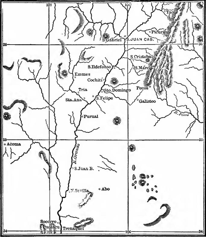 New Mexico During Oñate's Era (From Bancroft, Arizona and New Mexico, p. 137).
[Pg 75] Santa Fé founded.—In 1609 Santa Fé was founded and became the new capital. This event, which occurred just a hundred years after the occupation of Darién, may be regarded as the culmination of a century of northward expansion.
[Pg 75] Santa Fé founded.—In 1609, Santa Fé was established and became the new capital. This event, happening just a hundred years after the occupation of Darién, can be seen as the peak of a century of moving northward.
SPANISH ACHIEVEMENTS IN THE SIXTEENTH CENTURY
Population and industries.—The heroic age of Spanish colonization had now passed. The surprising results achieved in the New World during the first eighty years, not counting the work of exploration, are set forth in a description of the colonies in 1574 written by López de Velasco, official geographer. At that time there were in North and South America about two hundred Spanish towns and cities, besides numerous mining camps, haciendas, and stock ranches. The Spanish population was 32,000 families, or perhaps from 160,000 to 200,000 persons. Of these about five-eighths lived in North America. In the two Americas there were 4000 encomenderos, the rest being mainly miners, merchants, ranchers, and soldiers, with their families. The population included 40,000 negro slaves, and a large element of mulattoes and mestizos. About 1,500,000 male Indians paid tribute, representing a population of 5,000,000. In many parts occupied by Spaniards there were no encomiendas, for the Indians had died out. Mining, commerce, cattle ranching, grain and sugar raising had been established on a considerable scale.
Population and industries.—The golden era of Spanish colonization was now over. The remarkable outcomes in the New World during the first eighty years, not including exploration efforts, are detailed in a 1574 report on the colonies by López de Velasco, the official geographer. At that time, there were about two hundred Spanish towns and cities in North and South America, along with many mining camps, haciendas, and ranches. The Spanish population consisted of 32,000 families, approximately between 160,000 and 200,000 individuals. About five-eighths of them lived in North America. In both Americas, there were 4,000 encomenderos, with the remaining population primarily comprising miners, merchants, ranchers, and soldiers, along with their families. The population included 40,000 Black slaves and a significant number of mulattoes and mestizos. About 1,500,000 male Indigenous people paid tribute, which indicated a total population of 5,000,000. In many areas occupied by Spaniards, there were no encomiendas because the Indigenous people had died off. Mining, trade, cattle ranching, and the cultivation of grains and sugar had been established on a considerable scale.
Cities and towns.—Before the end of the sixteenth century most of the present-day state capitals and other large cities in Spanish North America had been founded. Mexico City had a population of over 2000 Spanish families (perhaps 15,000 persons), Santo Domingo, Puebla, and Guatemala 500 families each, Trinidad (in Guatemala) and Panamá 400 each, Oaxaca 350, Zacatecas 300, Toluca, Zultepec, Vera Cruz, Granada, Chiapas, and Nombre de Diós 200 each, Guadalajara and San Salvador 150 each, and many others lesser numbers.
Cities and towns.—By the end of the sixteenth century, most of the present-day state capitals and other major cities in Spanish North America had been established. Mexico City had a population of over 2,000 Spanish families (around 15,000 people), Santo Domingo, Puebla, and Guatemala each had 500 families, Trinidad (in Guatemala) and Panamá each had 400, Oaxaca had 350, Zacatecas had 300, and Toluca, Zultepec, Vera Cruz, Granada, Chiapas, and Nombre de Diós each had 200. Guadalajara and San Salvador had 150 each, along with many others with smaller populations.
Administrative divisions.—Spanish America was now divided into two viceroyalties, New Spain and Peru. New Spain included all of the American mainland north of Panamá, the West Indies, part of the northern coast of South America, the Islas del Poniente, and the Philippines. It comprised the four audiencias of Española, Mexico, Guatemala, and Nueva Galicia, the Audiencia of Panamá being a part of the viceroyalty of Peru. The four[Pg 76] northern audiencia districts were subdivided into seventeen or eighteen gobiernos or provinces, corresponding closely to the modern states. The provinces were divided into corregimientos embracing Indian partidos. North America embraced twelve dioceses and the two archdioceses of Santo Domingo and Mexico.
Administrative divisions.—Spanish America was now divided into two viceroyalties: New Spain and Peru. New Spain included all of the American mainland north of Panamá, the West Indies, part of the northern coast of South America, the Islas del Poniente, and the Philippines. It comprised the four audiencias of Española, Mexico, Guatemala, and Nueva Galicia, with the Audiencia of Panamá being part of the viceroyalty of Peru. The four[Pg 76] northern audiencia districts were subdivided into seventeen or eighteen gobiernos or provinces, which closely matched the modern states. The provinces were divided into corregimientos that included Indian partidos. North America included twelve dioceses and the two archdioceses of Santo Domingo and Mexico.
Churches and monasteries.—Many fine churches, some of them still standing, had been built in the larger towns. The Franciscans, Dominicans, and Augustinians were well established in New Spain, and the Jesuits had just begun their work. The friars were subject to their chapters and the Jesuits to their general in Spain. The Franciscans already had four provinces in New Spain, the Dominicans and Augustinians only one each. Hundreds of monasteries had been established, especially wherever there were Indians in encomienda. The expense of erecting them was borne jointly by king, encomenderos, and Indians.
Churches and monasteries.—Many beautiful churches, some still standing today, were built in the larger towns. The Franciscans, Dominicans, and Augustinians were well established in New Spain, and the Jesuits had just started their mission. The friars were accountable to their chapters, while the Jesuits reported to their general in Spain. The Franciscans already had four provinces in New Spain, while the Dominicans and Augustinians had just one each. Hundreds of monasteries were set up, especially wherever there were Indians under encomienda. The costs of building them were shared by the king, encomenderos, and the Indians.
The Universities.—"Enthusiasm for education characterizes the earliest establishment of the Spanish colonies in America. Wherever the priests went, a school was soon established for the instruction of the natives or a college for its clericals who were already at work as well as for those who were soon to take holy orders. From the colleges sprang the universities which, in all the Spanish dominions, were founded at a very early date for the pursuit of the 'general studies' which were at that time taught in the great peninsular universities of Alcalá and Salamanca. Half a century before Jamestown was founded by the English, the University of Mexico was conferring degrees upon graduates in law and theology. Before the seventeenth century closed, no less that seven universities had been erected in Spanish America, and their graduates were accepted on an equality with those of Spanish institutions of like grade." (Priestley.)
The Universities.—"A strong passion for education marked the initial establishment of the Spanish colonies in America. Wherever the priests traveled, they quickly set up a school to teach the locals or a college for the clergy who were already working and for those who would soon take holy orders. From these colleges, universities emerged, established early on in all Spanish territories to pursue the 'general studies' that were taught at the prestigious universities in Alcalá and Salamanca. Half a century before the English founded Jamestown, the University of Mexico was already granting degrees to graduates in law and theology. By the end of the seventeenth century, seven universities had been established in Spanish America, and their graduates were recognized on par with those from similar Spanish institutions." (Priestley.)
READINGS
THE REIGN OF PHILIP II
Chapman, Charles E., A History of Spain, Chapter XXXIII; Gayarré, C.E.A., Philip II of Spain; Hume, M.A.S., Philip II of Spain; Hume, M.A.S., Spain, Its Greatness and Decay; Hume, M.A.S., The Spanish People; Lea, H.C., A History of the Inquisition of Spain; Merriman, R.B., The Rise of the Spanish Empire; Prescott, W.H., History of the Reign of[Pg 77] Philip the Second; Cheyney, E.P., European Background of American History, Chapter X.
Chapman, Charles E., A History of Spain, Chapter XXXIII; Gayarré, C.E.A., Philip II of Spain; Hume, M.A.S., Philip II of Spain; Hume, M.A.S., Spain, Its Greatness and Decay; Hume, M.A.S., The Spanish People; Lea, H.C., A History of the Inquisition of Spain; Merriman, R.B., The Rise of the Spanish Empire; Prescott, W.H., History of the Reign of[Pg 77] Philip the Second; Cheyney, E.P., European Background of American History, Chapter X.
ADVANCE INTO NORTHERN MEXICO
Bancroft, H.H., History of Mexico, II, chs. 22, 24, 34; North Mexican States and Texas, I, ch. 5; Cavo, Andrés, Tres Siglos de Mexico; Coroléu, José, America, Historia de su Colonización; Frejes, Fr. F., Conquista de los Estados; Gonzales, J.E., Colleción de Noticias; Historia de Nuevo León; León, A., Historia de Nuevo León; Mota Padilla, M., Historia de Nueva Galicia, ch. 23; Ortega, Fr. Joseph, Apostólica Afanes.
Bancroft, H.H., History of Mexico, II, chs. 22, 24, 34; North Mexican States and Texas, I, ch. 5; Cavo, Andrés, Tres Siglos de Mexico; Coroléu, José, America, Historia de su Colonización; Frejes, Fr. F., Conquista de los Estados; Gonzales, J.E., Colleción de Noticias; Historia de Nuevo León; León, A., Historia de Nuevo León; Mota Padilla, M., Historia de Nueva Galicia, ch. 23; Ortega, Fr. Joseph, Apostólica Afanes.
SETTLEMENT OF FLORIDA
Hamilton, P.J., The Colonization of the South, chs. 1-2; Lowery, Woodbury, Spanish Settlements, I, ch. 8, II; Shea, J.G., The Catholic Church in Colonial Days, pp. 100-183.
Hamilton, P.J., The Colonization of the South, chs. 1-2; Lowery, Woodbury, Spanish Settlements, I, ch. 8, II; Shea, J.G., The Catholic Church in Colonial Days, pp. 100-183.
SETTLEMENT OF NEW MEXICO
Bancroft, H.H., Arizona and New Mexico, 74-146; Bandelier, A.D.F., Final Report of Investigations among the Indians of the Southwestern United States (Papers of the Archæological Institute of America, III-IV); Benavides, Memorial on New Mexico (Mrs. E.E. Ayer, trans.); Bolton, H.E., ed., Spanish Exploration in the Southwest, 135-278; Davis, W.H.H., Spanish Conquest in New Mexico, 234-407; Farrand, Livingston, The Basis of American History, 176-187; Lummis, C.F., Spanish Pioneers in the Southwest, 125-143; Prince, L.B., Historical Sketches of New Mexico, 149-166; Twitchell, R.E., Leading Facts of New Mexican History, I, 7-45, 252-333; Vulagrá, Gaspar de, Historia de Nuevo Mexico.
Bancroft, H.H., Arizona and New Mexico, 74-146; Bandelier, A.D.F., Final Report of Investigations among the Indians of the Southwestern United States (Papers of the Archæological Institute of America, III-IV); Benavides, Memorial on New Mexico (Mrs. E.E. Ayer, trans.); Bolton, H.E., ed., Spanish Exploration in the Southwest, 135-278; Davis, W.H.H., Spanish Conquest in New Mexico, 234-407; Farrand, Livingston, The Basis of American History, 176-187; Lummis, C.F., Spanish Pioneers in the Southwest, 125-143; Prince, L.B., Historical Sketches of New Mexico, 149-166; Twitchell, R.E., Leading Facts of New Mexican History, I, 7-45, 252-333; Vulagrá, Gaspar de, Historia de Nuevo Mexico.
THE PHILIPPINES AND CALIFORNIA
Barrows, D.P., A History of the Philippines; Blair and Robertson, Philippine Islands, II, 23-330; Bolton, H.E., Spanish Exploration in the Southwest, 41-133; Carrasco y Guisasola, Francisco, Documentos Referentes al Reconocimiento de las Costas de las Californias; Hittell, T.H., History of California, I, 79-111; Richman, L.B., California under Spain and Mexico, 12-24; Robertson, J.A., "Legazpi and Philippine Island Colonization," in American Historical Association, Rpt., 1907, I, 145-165; Zárate, Salmerón, "Relation," in Land of Sunshine, XI, 336-346, XII, 39-48, 104-114, 180-187.
Barrows, D.P., A History of the Philippines; Blair and Robertson, Philippine Islands, II, 23-330; Bolton, H.E., Spanish Exploration in the Southwest, 41-133; Carrasco y Guisasola, Francisco, Documentos Referentes al Reconocimiento de las Costas de las Californias; Hittell, T.H., History of California, I, 79-111; Richman, L.B., California under Spain and Mexico, 12-24; Robertson, J.A., "Legazpi and Philippine Island Colonization," in American Historical Association, Rpt., 1907, I, 145-165; Zárate, Salmerón, "Relation," in Land of Sunshine, XI, 336-346, XII, 39-48, 104-114, 180-187.
CHAPTER IV
THE ESTABLISHMENT OF THE FRENCH COLONIES (1500-1700)
THE FRENCH BACKGROUND
Mediæval France and the Italian wars.—The history of Mediæval France is largely the story of the struggle of the French kings to overthrow the feudal nobility and to perfect the governmental machinery of absolutism. The process which began with the accession of Hugh Capet in 987 was practically completed by the end of the reign of Louis XI, in 1483. During the reigns of Charles VIII, Louis XII, and Francis I, the great ambition of the French monarchs was to get control of Italy, a policy which brought them into conflict with Spain. The wars were barren of results as far as conquests in Italy were concerned, but the dangers to which France was exposed united the French people into a great nation, which was destined to be the leading continental power.
Mediæval France and the Italian Wars.—The history of Mediæval France mainly revolves around the struggle of the French kings to overthrow the feudal nobility and to refine the governmental structure of absolutism. This process, which started with Hugh Capet's rise to power in 987, was largely completed by the end of Louis XI's reign in 1483. During the reigns of Charles VIII, Louis XII, and Francis I, the main goal of the French monarchs was to gain control of Italy, a strategy that put them in conflict with Spain. The wars did not yield significant territorial gains in Italy, but the threats facing France united the French people into a strong nation, destined to become the leading power on the continent.
The religious wars.—The Reformation spread into France, Calvinism being the form of Protestantism which there took root. Calvin's religious system had three distinguishing features: (1) the church was to be independent of any temporal power, (2) laymen and ministers were to join in the government of the church, and (3) a strict moral discipline was to be enforced. This program was distinctly democratic, and was certain to come into conflict with the absolutism of the crown. France became divided into two great parties. The Huguenots, as the French Protestants were called, were found mainly among the rich burghers of the towns and the nobles of the country districts, their chief power being in southwestern France. They were also strong in Dauphiné and Normandy. Their great leaders were Coligny and the Bourbon princes, the most distinguished of whom was Henry of Navarre. The Catholic party was headed by the Guises and Catherine de Medici. The kings during this period were mere puppets, who were used by the leaders to further their political ends.
The religious wars.—The Reformation spread to France, with Calvinism being the form of Protestantism that took hold there. Calvin's religious system had three key features: (1) the church was to operate independently of any secular authority, (2) laypeople and ministers were to participate in the governance of the church, and (3) strict moral discipline was to be enforced. This approach was clearly democratic and was bound to clash with the absolute power of the monarchy. France became divided into two major factions. The Huguenots, as the French Protestants were known, were mainly found among the wealthy townspeople and the nobles in rural areas, with their primary strength in southwestern France. They were also strong in Dauphiné and Normandy. Their prominent leaders included Coligny and the Bourbon princes, the most notable being Henry of Navarre. The Catholic faction was led by the Guises and Catherine de Medici. The kings during this time were essentially puppets, manipulated by the leaders to pursue their political agendas.
[Pg 79] War broke out in 1562 and continued with occasional intermissions until 1596. The most important events were the assassination of Francis of Guise in 1563, the ascendency of Coligny, during which he tried to unite the nation in a war against Spain, the massacre of St. Bartholomew's in 1572, the organization of the Catholic League headed by Henry of Guise, his assassination in 1588, and the murder of Henry III the following year, which made the way clear for Henry of Navarre to ascend the throne. In 1593 he accepted Catholicism. The last resistance in France was overcome in 1596, but war with Philip II continued two years longer. In 1598 Henry issued the Edict of Nantes, which secured toleration to the Huguenots.
[Pg 79] War started in 1562 and went on with some breaks until 1596. The key events included the assassination of Francis of Guise in 1563, Coligny's rise to power as he attempted to unite the country to fight against Spain, the St. Bartholomew's Day massacre in 1572, the formation of the Catholic League led by Henry of Guise, his assassination in 1588, and the murder of Henry III the next year, which cleared the path for Henry of Navarre to take the throne. In 1593, he embraced Catholicism. The last resistance in France was defeated in 1596, but the war with Philip II continued for another two years. In 1598, Henry issued the Edict of Nantes, which granted religious tolerance to the Huguenots.
Reforms of Henry IV.—During the religious wars, the nobles had regained some of their former power, and the ravages of war had almost ruined the industries of the country. Henry set to work to repair these conditions. The lesser nobles were forced to submit and the privileges of the more powerful were purchased. The king's great minister, Sully, carried out many of the economic reforms. The land tax called the taille, which rested most heavily upon the peasants, was more equitably distributed, and the hunting privileges of the nobles were decreased. New lines of agriculture were introduced, marshes were reclaimed, and restrictions on the marketing of grain were removed. The king encouraged manufactures, especially of the more expensive fabrics, glass, and metal work. Commerce was stimulated by securing safe transportation along the post roads, by a system of canals connecting the Seine and the Loire, and by commercial treaties with foreign states. Attempts were also made to stimulate commerce and colonization by the formation of mercantile companies, and from this period date the first successful French colonies in America.
Reforms of Henry IV.—During the religious wars, the nobles had regained some of their previous power, and the destruction caused by the fighting had nearly devastated the country’s industries. Henry took action to fix these issues. The lesser nobles had to accept their position, and the privileges of the more powerful ones were bought off. The king’s chief minister, Sully, implemented many of the economic reforms. The land tax known as the taille, which burdened the peasants the most, was redistributed more fairly, and the hunting rights of the nobles were scaled back. New agricultural practices were introduced, marshes were drained, and restrictions on grain marketing were lifted. The king promoted manufacturing, particularly of more expensive fabrics, glass, and metalwork. Trade was boosted by ensuring safe transport on the post roads, creating a system of canals linking the Seine and the Loire, and establishing trade agreements with other countries. Efforts were also made to encourage commerce and colonization through the creation of merchant companies, marking the beginning of successful French colonies in America.
Richelieu.—Henry IV was assassinated in 1610, and his son, who ascended the throne as Louis XIII, was a child of nine years. During the regency of his mother, Mary de Medici, the nobles again became turbulent, the Huguenots revolted, and the policy of hostility toward Spain was reversed. The regent was under the influence of favorites who looted the treasury. Under such conditions a strong leader was greatly needed; the man of the hour was Richelieu. In 1624 he was placed in control of[Pg 80] public affairs, and for the next twenty years practically ruled France. His policy aimed to make France the first power in Europe. To accomplish this he worked at home to strengthen the power of the crown. Abroad he aimed to weaken the power of the Hapsburgs, to extend the boundaries of France, and to build up a colonial empire.
Richelieu.—Henry IV was assassinated in 1610, and his son, who became Louis XIII, was just nine years old. During the regency of his mother, Mary de Medici, the nobles grew restless, the Huguenots revolted, and the policy of hostility toward Spain was changed. The regent was swayed by favorites who plundered the treasury. Given these circumstances, a strong leader was urgently needed; that leader was Richelieu. In 1624, he took charge of[Pg 80] public affairs and effectively ruled France for the next twenty years. His goal was to make France the top power in Europe. To achieve this, he worked domestically to strengthen the power of the crown. Internationally, he aimed to diminish the influence of the Hapsburgs, expand France's borders, and develop a colonial empire.
The chief steps by which his policy was carried out were as follows: La Rochelle, the great Huguenot stronghold, was captured and the power of the Protestants was curbed effectually; the intrigues of Mary de Medici were thwarted; an alliance was made with Sweden, and to weaken the Hapsburgs the power of France was used to assist the Protestants in Germany in the Thirty Years' War; a navy was built and important ports were fortified; to extend commerce and colonies, colonial enterprises were entrusted to exclusive corporations. During the administration of Richelieu the French hold upon eastern Canada was strengthened, settlements were made in Guiana and the West Indies, and an attempt was made to occupy Madagascar.
The main steps taken to implement his policy were as follows: La Rochelle, a major Huguenot stronghold, was taken, effectively limiting Protestant power; Mary de Medici's schemes were countered; an alliance was formed with Sweden, and to weaken the Hapsburgs, France's power was used to support Protestants in Germany during the Thirty Years' War; a navy was established and key ports were fortified; to expand trade and colonies, colonial ventures were assigned to exclusive companies. Under Richelieu's administration, France's control over eastern Canada was strengthened, settlements were established in Guiana and the West Indies, and there was an attempt to occupy Madagascar.
The Council of State.—The work of strengthening the crown at the expense of the nobility was continued. The power of the nobles was maintained by their fortified castles and by their position as governors of provinces. An edict was issued for the destruction of all but the frontier fortifications. Most of the work of administration was centered in the conseil d'état, or council of state, which was the highest judicial tribunal. It also issued edicts, made peace or war, determined the amount and method of taxation, and acted as a high court of justice. In appearance this body was supreme, but in reality the power centered in the king and the chief minister, the other ministers being merely advisers. Local administration was taken from the nobles and was placed almost wholly in the hands of intendants, who were officers of justice, police, and finance.
The Council of State.—The effort to strengthen the crown at the expense of the nobility continued. The nobles retained their power through their fortified castles and their roles as governors of provinces. An edict was issued to dismantle all but the frontier fortifications. Most of the administration was centered in the conseil d'état, or council of state, which was the highest judicial court. It also issued edicts, decided on war or peace, determined tax amounts and methods, and served as a high court of justice. On the surface, this body appeared to be supreme, but in reality, the power was held by the king and the chief minister, with the other ministers acting merely as advisers. Local administration was taken away from the nobles and nearly entirely placed in the hands of intendants, who were officers of justice, police, and finance.
Mazarin.—Richelieu died in November, 1642, and Louis XIII a few months later. Louis XIV was a child of five years and his mother, Anne of Austria, became regent. Mazarin, who was probably secretly married to her, was to rule France during the troubled minority of the king. It was a period of civil and foreign war, in which the minister found no time to devote to the development of colonies. The importance of the period lies in[Pg 81] the fact that the great nobles were effectually quelled, that the absolutism of the crown was completely established, and that France proved herself superior to the power of Spain and the Hapsburgs. When Louis XIV took the reins of power in 1661 he was the most absolute and most powerful monarch in Europe.
Mazarin.—Richelieu passed away in November 1642, and Louis XIII followed a few months later. Louis XIV was just five years old, and his mother, Anne of Austria, became regent. Mazarin, who was likely secretly married to her, would govern France during the king's troubled childhood. This was a time of civil and foreign wars, leaving the minister no opportunity to focus on expanding colonies. The significance of this period lies in[Pg 81] the fact that the great nobles were effectively suppressed, the absolute power of the crown was firmly established, and France demonstrated her superiority over Spain and the Hapsburgs. When Louis XIV assumed power in 1661, he was the most absolute and powerful monarch in Europe.
Colbert.—Colonial development during the reign of Louis XIV was due mainly to Colbert, who was given charge of the finances, of the navy, and of the colonies. The finances had become deranged under Mazarin, and Colbert attacked the abuses. To stimulate commerce and manufactures, he established a protective system, furnished governmental aid to companies, and granted monopolies. The royal navy and mercantile marine were greatly increased. To develop foreign trade, corporations were granted monopolies of the commerce of the West Indies, the East Indies, Senegal, and Madagascar. Colonies were fostered by paternalistic regulations. The system of Colbert, as time proved, was founded on mistaken principles, for monopoly and overregulation stifled the growth of trade and of the colonies. Although a vast area was brought under control, the colonies never attracted a large population, or were allowed a free growth of institutions.
Colbert.—Colonial development during Louis XIV's reign was largely thanks to Colbert, who managed the finances, the navy, and the colonies. The financial situation had deteriorated under Mazarin, and Colbert worked to fix the problems. To boost trade and manufacturing, he set up a protective system, provided government support to companies, and granted monopolies. The royal navy and merchant fleet were significantly expanded. To promote foreign trade, corporations were given monopolies on trade with the West Indies, the East Indies, Senegal, and Madagascar. Colonies were supported through paternalistic regulations. However, as time revealed, Colbert's system was based on flawed principles since monopolies and excessive regulation hindered the growth of trade and the colonies. Despite controlling a large area, the colonies never attracted a significant population or allowed for the free development of institutions.
EARLY EXPLORATIONS AND COLONIZING EFFORTS
First French voyages.—The first Frenchmen who visited America appear to have been Norman and Breton fishermen, who engaged in fishing off the Newfoundland coast perhaps as early as 1500. Sailors from Dieppe also visited the coasts of North and South America. Vague accounts have come down to us of attempts to explore the Gulf of St. Lawrence in 1506 and 1508, and of an unsuccessful colony on Sable Island in 1518. The first expedition under the government sanction was that of the Florentine, Verrazano, sent out by Francis I in 1524. The details of the voyage are somewhat obscure. He probably explored the coast from Cape Fear to Newfoundland.
First French voyages.—The first French people to visit America were likely Norman and Breton fishermen, who started fishing off the Newfoundland coast maybe as early as 1500. Sailors from Dieppe also checked out the shores of North and South America. We have vague accounts of efforts to explore the Gulf of St. Lawrence in 1506 and 1508, and of a failed colony on Sable Island in 1518. The first expedition officially sanctioned by the government was that of the Florentine, Verrazano, sent by Francis I in 1524. The details of the voyage are a bit unclear. He probably explored the coastline from Cape Fear to Newfoundland.
Cartier and Roberval.—The wars between Francis I and Charles V prevented the French king from giving further attention to exploration until 1534, when Cartier was sent out with[Pg 82] two ships from St. Malo. He sighted land on the Labrador coast, passed through the straits of Belle Isle, and explored the Gulf of St. Lawrence, locating the Bay of Chaleurs, Cape Gaspé, and Anticosti Island, thence returning to France.
Cartier and Roberval.—The conflicts between Francis I and Charles V kept the French king from focusing on exploration until 1534, when Cartier was sent out with[Pg 82] two ships from St. Malo. He spotted land on the Labrador coast, navigated through the straits of Belle Isle, and explored the Gulf of St. Lawrence, identifying the Bay of Chaleurs, Cape Gaspé, and Anticosti Island, before returning to France.
In 1535 he again visited America in search of a passage to China. He sailed along the northern shore of the Gulf of St. Lawrence and entered the mouth of the river, soon becoming convinced that the passage did not lead to the Far East. He stopped at the site of Quebec and later proceeded to the La Chine rapids, and to a hill which he named Montreal. He wintered at Quebec where twenty-five persons died of scurvy. The return to France was made the following summer.
In 1535, he visited America again looking for a route to China. He sailed along the northern shore of the Gulf of St. Lawrence and entered the river's mouth, quickly realizing that the passage didn’t lead to the Far East. He stopped at what is now Quebec and later continued to the La Chine rapids and a hill that he named Montreal. He spent the winter in Quebec, where twenty-five people died from scurvy. He returned to France the following summer.
Exploration was again interrupted by the wars, and it was not until 1541 that Cartier's third expedition sailed. Francis I had granted a commission to Roberval, a Picardy nobleman, as viceroy and lieutenant-general in Canada, Newfoundland, Labrador, and neighboring lands, this being the first time that the name Canada was officially used. In the king's proclamation Canada was mentioned as the extremity of Asia. The objects of the expedition were discovery, settlement, and conversion of the Indians. Cartier was appointed captain-general. He sailed in 1541, but Roberval remained in France to collect supplies and materials for defence. Cartier wasted six weeks in Newfoundland and then proceeded to Quebec, where the winter was spent in great hardship.
Exploration was once again interrupted by wars, and it wasn’t until 1541 that Cartier's third expedition set sail. Francis I had given a commission to Roberval, a nobleman from Picardy, as viceroy and lieutenant-general of Canada, Newfoundland, Labrador, and nearby lands, marking the first official use of the name Canada. In the king's proclamation, Canada was referred to as the edge of Asia. The goals of the expedition were discovery, settlement, and converting the Indigenous peoples. Cartier was named captain-general. He set sail in 1541, but Roberval stayed in France to gather supplies and materials for defense. Cartier spent six weeks in Newfoundland and then went to Quebec, where the winter was tough and filled with hardships.
The colonists started to return to France, but at St. Johns, Newfoundland, they met Roberval, who ordered them to return to Quebec. Cartier, however, disobeyed, and returned to France. Roberval proceeded to Quebec, where habitations were erected and the forts of Cartier repaired. Supplies, however, ran short, and during the following winter a third of the settlers died. A mutiny threatened and Roberval checked it with great harshness. After lingering a little longer, the unfortunate remnant returned to France. In 1543 Francis I declared the Western Sea to be open to his subjects, but advantage of it was not taken, and it was over a half century before another attempt was made to colonize in the St. Lawrence Valley.
The colonists began returning to France, but in St. Johns, Newfoundland, they encountered Roberval, who insisted they go back to Quebec. Cartier, however, ignored this order and went back to France. Roberval continued on to Quebec, where they built settlements and repaired Cartier's forts. Unfortunately, supplies ran low, and during the following winter, a third of the settlers died. A mutiny was looming, and Roberval managed to suppress it with strict measures. After staying a little longer, the remaining settlers left for France. In 1543, Francis I declared that the Western Sea was open to his subjects, but no one took advantage of this, and it was over fifty years before another attempt was made to settle in the St. Lawrence Valley.
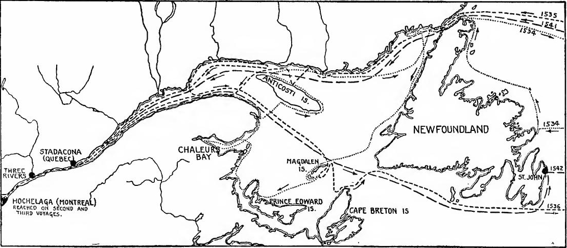
[Pg 84] Ribaut and Laudonnière.—The next colonizing efforts were of Huguenot origin, and were made at the suggestion of Coligny. In 1555 an attempt was made to found a colony in Brazil, but it was destroyed by the Portuguese. When Coligny developed his plan for an attack upon Spain, he determined to found a colony in the region then known as Florida. A Huguenot from Dieppe named Jean Ribaut was placed in command of the expedition, which set sail from Havre in 1562. Land was seen not far from the site of St. Augustine; they sailed northward and planted a settlement on Port Royal Sound, where thirty men were left. Ribaut explored the coast as far as the fortieth degree and returned to France. Misfortune beset the colonists, and after great suffering they built a rude vessel and succeeded in getting back to Europe.
[Pg 84] Ribaut and Laudonnière.—The next colonization efforts came from the Huguenots and were initiated by Coligny. In 1555, there was an attempt to establish a colony in Brazil, but it was destroyed by the Portuguese. When Coligny outlined his plan to attack Spain, he decided to create a colony in the area known at that time as Florida. A Huguenot from Dieppe named Jean Ribaut was appointed to lead the expedition, which set sail from Havre in 1562. They spotted land near what would become St. Augustine; then they went north and established a settlement at Port Royal Sound, leaving thirty men there. Ribaut explored the coastline up to the fortieth parallel before returning to France. The colonists faced many hardships, and after enduring significant suffering, they built a makeshift boat and managed to return to Europe.
In 1564 a large expedition was sent out under Laudonnière, which erected Fort Caroline on St. John's River. Dissensions and starvation played havoc with the colony, and when the English Captain John Hawkins offered to sell them a ship and provisions, they eagerly embraced the opportunity. When they were about to depart, Ribaut with seven vessels and six hundred soldiers hove in sight, and the idea of returning to France was abandoned.
In 1564, a large expedition was launched under Laudonnière, which built Fort Caroline on the St. John's River. Infighting and starvation severely impacted the colony, and when English Captain John Hawkins offered to sell them a ship and supplies, they jumped at the chance. Just as they were about to leave, Ribaut arrived with seven ships and six hundred soldiers, and the plan to return to France was dropped.
Philip II learned of the French colony, probably from Catherine de Medici, and in 1565 sent an expedition of nineteen vessels and fifteen hundred men under Menéndez to destroy it. Ribaut's fleet was found near the mouth of the river but the larger craft escaped and Menéndez, finding the rest in a secure position, proceeded southward about fifty miles and founded St. Augustine.
Philip II heard about the French colony, likely from Catherine de Medici, and in 1565 sent an expedition of nineteen ships and fifteen hundred men led by Menéndez to wipe it out. Ribaut's fleet was spotted near the river's mouth, but the bigger ships got away. Menéndez, finding the rest in a safe spot, continued south for about fifty miles and established St. Augustine.
Ribaut followed but failed to attack, and shortly afterwards a hurricane dispersed the fleet. Taking advantage of the misfortune, Menéndez marched overland and surprised and captured Fort Caroline, putting most of the prisoners to the sword. A little later Ribaut and his followers fell into the hands of Menéndez, and most of them were put to death. To avenge the butchery, the Chevalier de Gourgues, at his own expense, fitted out three small ships in 1567 and attacked the Spanish forts on the St. John's. They were captured and the garrisons slain. His force being too small to risk an attack on St. Augustine, De Gourgues returned to France, and Florida ceased to be a scene of French activity.
Ribaut followed but didn’t launch an attack, and shortly after, a hurricane scattered the fleet. Taking advantage of this disaster, Menéndez marched overland and caught Fort Caroline by surprise, killing most of the prisoners. Soon after, Ribaut and his men fell into Menéndez's hands, and most were executed. To seek revenge for the massacre, Chevalier de Gourgues personally funded three small ships in 1567 and assaulted the Spanish forts on the St. John's. They were taken, and the garrisons were killed. With his forces too small to risk an attack on St. Augustine, De Gourgues returned to France, and Florida stopped being a center of French activity.
ACADIA
Colonization renewed.—The scene of the next colonization by the French was the region about the Bay of Fundy. After the religious wars, in 1598, the Marquis de la Roche landed two shiploads of colonists on Sable Island. Going in search of a site on the mainland, he encountered severe storms and returned to France. Five years later the survivors were rescued.
Colonization renewed.—The next colonization by the French took place around the Bay of Fundy. After the religious wars, in 1598, the Marquis de la Roche brought two shiploads of colonists to Sable Island. While searching for a location on the mainland, he faced intense storms and went back to France. Five years later, the survivors were rescued.
The fur monopoly.—In 1600 a partnership was formed between Pontgravé, a St. Malo mariner, and two Huguenot friends of Henry IV, Chauvin, a merchant of Harfleur, and Sieur de Monts, the associates being granted a fur-trading monopoly. A settlement was made at Tadoussac, on the lower St. Lawrence, but it did not prosper; two trading voyages, however, proved profitable. Shortly afterward the company was reorganized, the king making De Chastes, the governor of Dieppe, his representative. An expedition commanded by Pontgravé was sent out in 1603. Associated with him was Samuel de Champlain, who had already gained fame by a voyage to Spanish America and by his writings. A profitable trade in furs was carried on, and the St. Lawrence was explored as far as the La Chine rapids. Champlain also examined the Acadian coast as far as the Bay of Chaleurs.
The fur monopoly.—In 1600, a partnership was formed between Pontgravé, a St. Malo sailor, and two Huguenot friends of Henry IV, Chauvin, a merchant from Harfleur, and Sieur de Monts, who were granted a monopoly on fur trading. They established a settlement at Tadoussac, on the lower St. Lawrence, but it didn't thrive; however, two trading voyages turned out to be profitable. Soon after, the company was reorganized, with the king appointing De Chastes, the governor of Dieppe, as his representative. An expedition led by Pontgravé was launched in 1603, with Samuel de Champlain joining him. Champlain had already gained recognition from a voyage to Spanish America and his writings. They engaged in a profitable fur trade and explored the St. Lawrence as far as the La Chine rapids. Champlain also investigated the Acadian coast up to the Bay of Chaleurs.
Port Royal.—Upon the return of the traders, De Chastes having died, the king issued a patent to De Monts granting him viceregal powers and a trade monopoly between the fortieth and forty-sixth degrees. Settlements were to be founded and the savages were to be instructed in Christianity. In 1604 De Monts and Champlain sailed for Acadia. An unsuccessful attempt at settlement was made at St. Croix Island and later the survivors moved to Port Royal. De Monts then returned to France to defend his rights against those who objected to his patent, and Champlain busied himself with the exploration of the New England coast, on one expedition rounding Cape Cod. In 1607 it became known that De Monts's patent had been revoked, and Champlain returned to France.
Port Royal.—After the traders returned and De Chastes passed away, the king granted De Monts a patent giving him viceregal powers and a trade monopoly between the fortieth and forty-sixth degrees. Settlements were to be established, and the indigenous people were to be taught Christianity. In 1604, De Monts and Champlain set sail for Acadia. They made an unsuccessful attempt to settle at St. Croix Island, and the survivors later moved to Port Royal. De Monts then went back to France to defend his rights against those challenging his patent, while Champlain focused on exploring the New England coast, even rounding Cape Cod on one expedition. In 1607, it was revealed that De Monts's patent had been revoked, and Champlain returned to France.
Acadia, 1610-1632.—In 1610 Poutrincourt reëstablished Port Royal and soon afterward his son, Biencourt, was placed in command. The coast was surveyed as far as the Kennebec.[Pg 86] Pontgravé had a trading post at St. John, and this Biencourt captured. In 1613 Port Royal was taken and burned by a Virginia expedition under Argall, but was soon rebuilt. In 1623 or 1624 Biencourt died and his lieutenant, Charles de la Tour, succeeded him. Before his powers could be confirmed, Acadia, in 1628, fell into English hands, but was restored in 1632.
Acadia, 1610-1632.—In 1610, Poutrincourt reinstated Port Royal, and shortly after, his son, Biencourt, took command. The coast was explored all the way to the Kennebec.[Pg 86] Pontgravé had a trading post at St. John, which Biencourt seized. In 1613, Port Royal was captured and burned by a Virginia expedition led by Argall, but it was quickly rebuilt. Biencourt died around 1623 or 1624, and his lieutenant, Charles de la Tour, took over. Before his authority could be confirmed, Acadia fell into English hands in 1628 but was returned in 1632.
Charnisay and La Tour.—Isaac de Rezilly was sent to receive the submission of the English, being shortly afterward succeeded by Charnisay. La Tour soon afterward received from the company of New France a grant at the mouth of the St. John's River, where he built Fort St. Jean. A civil war broke out in which La Tour finally secured aid from Boston. For a time he was successful, but Charnisay obtained help from France and La Tour was defeated. From 1645 to 1650 Charnisay was supreme in Acadia. Upon his death La Tour was made governor and lieutenant-general, and the animosities of the past were dissipated by his marriage to Charnisay's widow.
Charnisay and La Tour.—Isaac de Rezilly was sent to get the English to surrender, and shortly afterward, Charnisay took over. La Tour later received a grant from the New France company at the mouth of the St. John's River, where he built Fort St. Jean. A civil war broke out, and La Tour eventually got support from Boston. For a while, he was successful, but Charnisay got help from France, leading to La Tour's defeat. From 1645 to 1650, Charnisay was in charge in Acadia. After his death, La Tour became governor and lieutenant-general, and the old rivalries were eased by his marriage to Charnisay's widow.
English Rivalry.—In 1654 an English fleet captured the French forts, and Acadia remained under English rule until 1667, when it was restored to France by the treaty of Breda.
English Rivalry.—In 1654, an English fleet captured the French forts, and Acadia stayed under English control until 1667, when it was returned to France by the treaty of Breda.
THE ST. LAWRENCE VALLEY
The founding of Quebec.—In 1608 De Monts obtained a renewal of his patent for one year, and, after consulting Champlain, he decided to found a settlement at Quebec. Champlain was appointed his lieutenant with full powers, and with two vessels he arrived at Quebec on July 3. A storehouse and dwelling were built surrounded by a palisade and ditch. Of the twenty-eight men who began the settlement, only eight survived the first winter, but considerable reinforcements arrived in the spring. In the summer of 1609 Champlain accompanied a war party of Algonquins and Hurons up the Richelieu River to the lake which bears his name, where a successful attack was made upon the Iroquois. The consequences of this act were far reaching, for from that time the Iroquois confederation was hostile to the French, crippling the colony for many years.
The founding of Quebec.—In 1608, De Monts got a one-year renewal of his patent and, after talking with Champlain, decided to establish a settlement at Quebec. Champlain was appointed as his lieutenant with full authority, and he arrived at Quebec on July 3 with two ships. They built a storehouse and residence enclosed by a palisade and ditch. Out of the twenty-eight men who started the settlement, only eight survived the first winter, but a significant number of reinforcements came in the spring. In the summer of 1609, Champlain joined a war party of Algonquins and Hurons and traveled up the Richelieu River to the lake named after him, where they successfully attacked the Iroquois. The impact of this action was significant, as from that point on, the Iroquois confederation became hostile toward the French, hindering the colony for many years.
A new company formed.—De Monts's exclusive privileges were not renewed, but he was allowed to retain his position of king's representative. Seeing no chance for profit, he withdrew[Pg 87] from further activities in the New World. Another company was at once formed, composed of traders of Rouen and St. Malo. Champlain was retained by the new company.
A new company was created. De Monts's exclusive privileges weren't renewed, but he could keep his role as the king's representative. Seeing no opportunity for profit, he stepped back[Pg 87] from any further activities in the New World. Another company was quickly established, made up of traders from Rouen and St. Malo. Champlain was hired by the new company.
Champlain's explorations.—In 1613 Champlain explored the Ottawa River to a point about one hundred miles above the modern capital of Canada. In 1615 four Recollet friars were induced to come to Quebec, this being the beginning of missionary activities in New France. The same year Champlain joined a Huron war party, passed up the Ottawa to Lake Nipissing, thence by the French River to Georgian Bay, being the first white man to find the way which eventually became the regular fur trader's route to the interior. Lake Ontario was also seen and crossed for the first time on this expedition. Fur trading was actively carried on, but because of dishonest dealings the company gradually lost influence with the Indians, a condition which also hampered the missionaries. As the Recollets met with little success, in 1625 the Jesuits were induced to send out five representatives, thus beginning the activities of that order in New France.
Champlain's explorations.—In 1613, Champlain explored the Ottawa River up to about one hundred miles above what is now the capital of Canada. In 1615, four Recollet friars were persuaded to come to Quebec, marking the start of missionary efforts in New France. That same year, Champlain joined a Huron war party, traveled up the Ottawa to Lake Nipissing, and then by the French River to Georgian Bay, becoming the first white person to discover the route that later became the main path for fur traders heading inland. Lake Ontario was also seen and crossed for the first time during this trip. Fur trading was thriving, but due to dishonest practices, the company gradually lost its influence with the Indigenous peoples, which also made it difficult for the missionaries. As the Recollets had little success, in 1625, the Jesuits were encouraged to send five representatives, thus starting their work in New France.
The Company of the Hundred Associates.—In spite of all the efforts which had been made, the financial results were trifling. So badly were affairs going that Richelieu determined to change the organization; in 1627 he established the Company of the Hundred Associates, who were to send out annually from two to three hundred settlers and a sufficient number of clergy to meet the needs. The company was to possess all lands between Florida and the Arctic Circle, and from Newfoundland as far west as it was able to take possession. With the exception of the cod and whale fisheries, the company was granted a complete monopoly of trade.
The Company of the Hundred Associates.—Despite all the efforts that had been made, the financial results were minimal. Things were going so poorly that Richelieu decided to change the organization; in 1627, he established the Company of the Hundred Associates, which was to send out two to three hundred settlers each year and a sufficient number of clergy to meet the needs. The company was granted ownership of all lands between Florida and the Arctic Circle, and from Newfoundland as far west as they could claim. Except for the cod and whale fisheries, the company was given a complete trade monopoly.
The English occupation.—Before the company could land colonists, difficulties arose between France and England, and a fleet of privateers under Captain David Kirke raided the French possessions off Gaspé, capturing eighteen vessels which were carrying colonists and supplies to Quebec; after destroying the settlements in Acadia, Kirke sailed for England. The following year he landed at Tadoussac and sent three vessels to Quebec to demand its surrender. The place capitulated and over a hundred of the inhabitants were sent to England. Upon their arrival,[Pg 88] it was found that peace had been made. Negotiations were terminated in 1632, Canada and Acadia being restored to France.
The English occupation.—Before the company could bring in colonists, conflicts arose between France and England, and a fleet of privateers led by Captain David Kirke attacked the French territories off Gaspé, capturing eighteen ships that were on their way to Quebec with colonists and supplies; after destroying the settlements in Acadia, Kirke headed back to England. The next year, he landed at Tadoussac and sent three ships to Quebec to demand its surrender. The city gave in, and over a hundred of the residents were sent to England. Upon their arrival,[Pg 88] it was discovered that peace had been established. The negotiations concluded in 1632, with Canada and Acadia being returned to France.
Last years of Champlain. Nicolet.—Upon his return Champlain immediately repaired the buildings at Quebec, and established a fort at Three Rivers to protect the Hurons against the Iroquois. From time to time Champlain had heard of a great waterway in the west. Believing that it might be a route to China, in 1634 he sent Nicolet on an exploring expedition. Nicolet passed up the Ottawa, traversed Georgian Bay, and reached Sault Ste. Marie. He then explored the south shore of the upper peninsula of Michigan, and reached the southern extremity of Green Bay. From the Winnebagoes he learned of a "great water" three days' journey toward the south. After visiting the Illinois country, he returned without having reached the Mississippi. In 1635 Champlain died; there was no master mind to direct operations, and the colony languished.
Last years of Champlain. Nicolet.—Upon his return, Champlain quickly fixed up the buildings at Quebec and set up a fort at Three Rivers to protect the Hurons from the Iroquois. From time to time, Champlain had heard about a great waterway to the west. Thinking it might be a route to China, he sent Nicolet on an exploration mission in 1634. Nicolet traveled up the Ottawa River, crossed Georgian Bay, and reached Sault Ste. Marie. He then explored the southern shore of the upper peninsula of Michigan and made it to the southern tip of Green Bay. From the Winnebagoes, he heard about a "great water" three days' journey to the south. After visiting the Illinois country, he returned without making it to the Mississippi. In 1635, Champlain died; without a strong leader to guide them, the colony struggled.
The Jesuits.—The first Jesuit superior was Father Le Jeune, who in 1632 was stationed at Quebec in the residence of Notre Dame des Anges, the parent establishment of the missions of New France. Le Jeune ministered to the Algonquins of the neighborhood. In 1633 Bréboeuf headed a group of missionaries to the Huron villages at the southern end of Georgian Bay, and in 1641 a mission was founded at Sault Ste. Marie, but it was not permanent. Pestilence and the war parties of the Iroquois gradually destroyed the Hurons; the Jesuits toiled amid scenes of famine, disease, and death, several succumbing to the hardships, others suffering martyrdom. So constant were the attacks of the Iroquois, that in 1649 it was determined to establish a more sheltered mission on the Island of St. Joseph in Georgian Bay. The missions on the mainland being destroyed by the Iroquois, and the Hurons having been greatly reduced in numbers, in 1650 the Jesuits abandoned that region. Attempts to establish missions among the Iroquois also failed completely at this time. In the settlements the Jesuits were the most important social factor, until 1665 practically controlling the life of the people. At Quebec they established schools for Huron and French boys, and at their suggestion the Ursulines opened a convent. Private endowments made possible a school for girls near Quebec and a hospital at Montreal.
The Jesuits.—The first Jesuit leader was Father Le Jeune, who in 1632 was based in Quebec at the Notre Dame des Anges residence, the main hub for missions in New France. Le Jeune served the local Algonquins. In 1633, Bréboeuf led a group of missionaries to the Huron villages at the southern end of Georgian Bay, and in 1641, a mission was set up at Sault Ste. Marie, though it wasn’t permanent. Disease and the Iroquois war parties gradually wiped out the Hurons; the Jesuits worked through famine, illness, and death, with some succumbing to the harsh conditions while others died as martyrs. The Iroquois attacks were so relentless that in 1649, it was decided to create a safer mission on St. Joseph Island in Georgian Bay. With the missions on the mainland destroyed by the Iroquois and the Huron population greatly diminished, the Jesuits left that area in 1650. Attempts to set up missions among the Iroquois at this time were also unsuccessful. In the settlements, the Jesuits were the most significant social influence, practically controlling the community's life until 1665. In Quebec, they established schools for Huron and French boys, and at their recommendation, the Ursulines opened a convent. Private donations enabled the creation of a school for girls near Quebec and a hospital in Montreal.
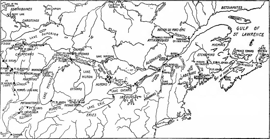
[Pg 90]The founding of Montreal.—For the purpose of founding an evangelical colony, a group of religious persons at Paris formed an association called the Association of Montreal. The island on which the city now stands was purchased, and in 1641 De Maisonneuve, with a Jesuit priest and thirty-seven laymen, sailed from La Rochelle. After taking formal possession of the island, the party wintered at Quebec, and the following spring founded the town of Montreal.
[Pg 90]The founding of Montreal.—To establish an evangelical colony, a group of religious individuals in Paris created an organization called the Association of Montreal. They purchased the island where the city now stands, and in 1641, De Maisonneuve, along with a Jesuit priest and thirty-seven laymen, sailed from La Rochelle. After officially taking possession of the island, they spent the winter in Quebec, and the following spring, they founded the town of Montreal.
The New Company.—The Hundred Associates not having fulfilled their agreement regarding settlers, and the colony having proved a financial failure, an arrangement was made in 1645 between the company and the inhabitants acting as a corporation, henceforth known as the New Company. The old company retained its governmental rights, but the fur trade was thrown open to the New Company on condition that it would assume the expenses of civil administration, defence, and religion, that it would bring in twenty settlers annually, and would pay to the old company a thousand pounds of beaver skins every year.
The New Company.—Since the Hundred Associates didn't meet their agreement about settlers, and the colony turned out to be a financial failure, an arrangement was made in 1645 between the company and the residents, who acted as a corporation, now known as the New Company. The old company kept its governmental rights, but the fur trade was opened up to the New Company on the condition that it would cover the costs of civil administration, defense, and religion, bring in twenty settlers each year, and pay the old company a thousand pounds of beaver skins every year.
Coureurs de bois.—Up to this time the fur trade had been carried on mainly at the settlements, but after the New Company was formed a larger number of men began to frequent the forests, giving rise to the type known as coureurs de bois. These were of two classes, those who merely traded with the Indians for peltries, and those who attached themselves to native tribes. This latter class lapsed into barbarism and became a lawless element which gave great annoyance to the officials. Later a third class of traders appeared when the governors were allowed to grant licenses to frequent the forests. Great abuses crept into the fur trade, large quantities of spirits being sold to the Indians, who were roundly cheated when intoxicated. It was the intention of the French government to restrict the trade to the settlements, but the officials usually winked at violations of the law, and some of them shared in the illicit trading. The most famous of the fur traders of this period were Radisson and Groseilliers, who, in 1658-1659 and possibly earlier, traded and explored in the country at the western end of Lake Superior.
Coureurs de bois.—Until now, the fur trade mostly happened at the settlements, but after the New Company was established, more men started venturing into the forests, leading to the rise of the type known as coureurs de bois. There were two main groups: those who just traded with the Indigenous people for furs, and those who integrated with native tribes. The latter group often regressed into a wild lifestyle and became a troublemaking presence that frustrated the officials. Eventually, a third group of traders emerged when governors were permitted to issue licenses to access the forests. Significant issues arose in the fur trade, with large amounts of alcohol being sold to Indigenous people, who were often cheated while intoxicated. The French government aimed to limit trade to the settlements, but officials typically overlooked breaches of the law, and some even participated in the illegal trade. The most notable fur traders during this time were Radisson and Groseilliers, who, between 1658 and 1659 and maybe even earlier, traded and explored in the area at the western end of Lake Superior.
REORGANIZATION AND THE IROQUOIS WARS
A centralist system established.—As complaints arose regarding the last governmental arrangements, the king changed the form of control, creating a council to consist of the governor, any ex-governor who might be in the country, and the superior of the Jesuits, who was later to give way to a bishop when one was appointed; these were to select for membership two inhabitants, or three if no ex-governor was in the colony. Quebec, Montreal, and Three Rivers were each to select a syndic, who could hold office for three years and could deliberate with but could not vote in the council. The centralist system, which Mazarin was perfecting in France, was thus established in Canada.
A centralist system was established. As complaints about the previous governmental arrangements arose, the king changed the way control was managed. He created a council made up of the governor, any ex-governor who happened to be in the country, and the superior of the Jesuits, who would later be replaced by a bishop when one was appointed. These members would select two local residents, or three if there was no ex-governor in the colony. Quebec, Montreal, and Three Rivers each had to choose a syndic, who could serve for three years. The syndic could participate in discussions but could not vote in the council. Thus, the centralist system that Mazarin was refining in France was established in Canada.
Laval.—New France had been attached to the archbishopric of Rouen, and De Queylus, a Sulpician priest at Montreal, had acted as vicar-general for the whole colony. His followers hoped that he would be created bishop, but instead, in 1659 a Jesuit, the Abbé Laval, was appointed vicar-apostolic and Bishop of Petraea in partibus. After a spirited contest with De Queylus, Laval was successful in establishing his supremacy, the power of the Jesuits thus being assured.
Laval.—New France had been linked to the archbishopric of Rouen, and De Queylus, a Sulpician priest in Montreal, had served as the vicar-general for the entire colony. His supporters hoped he would be made bishop, but instead, in 1659, a Jesuit, Abbé Laval, was appointed vicar-apostolic and Bishop of Petraea in partibus. After a heated competition with De Queylus, Laval succeeded in asserting his authority, thereby securing the power of the Jesuits.
War with the Iroquois.—The following year witnessed a serious Iroquois outbreak. News arrived that twelve hundred warriors had gathered to wipe out the settlements. A young nobleman, popularly known as Dollard, conceived the quixotic scheme of intercepting a large force of Iroquois who had wintered on the Ottawa. With sixteen enlisted men and a few Hurons and Algonquins he proceeded to a palisade at the great rapids of the Ottawa, and there met the Indians. Dollard and his followers were slain to a man, but so stubborn had been their resistance that the Iroquois retired to the forests and New France was saved. A regiment was sent out to protect the colony, forts were established along the Richelieu, and two expeditions were sent into the Iroquois country, the result being that a peace was made with the Indians which lasted for several years. Later an expedition was sent to the outlet of Lake Ontario to impress the savages with the power of France.
War with the Iroquois.—The following year saw a serious uprising by the Iroquois. News came that twelve hundred warriors had gathered to attack the settlements. A young nobleman, widely known as Dollard, came up with a bold plan to intercept a large group of Iroquois who had spent the winter on the Ottawa. With sixteen enlisted men and a few Hurons and Algonquins, he went to a fort at the great rapids of the Ottawa, where he confronted the Indians. Dollard and his men were all killed, but their fierce resistance was so strong that the Iroquois retreated to the forests, saving New France. A regiment was dispatched to protect the colony, forts were set up along the Richelieu, and two expeditions were launched into Iroquois territory, resulting in a peace treaty with the Indians that lasted for several years. Later, another expedition was sent to the outlet of Lake Ontario to demonstrate France's power to the native tribes.
The West India Company.—In 1663 the company of New France surrendered its rights to the king, who created a council[Pg 92] to consist of the governor, bishop, and five councillors chosen by them jointly. The following year, at the suggestion of Colbert, he chartered a new corporation known as the West India Company, to which was given a monopoly of all the trade of New France and the west coast of Africa, with the privilege of nominating the governor of Canada. The office of intendant was also created to act as a check upon the governor. This official was to act as a legal and financial officer who was to report directly to the crown. The first intendant was Talon, who was a prominent figure for several years. The governor who was the military, political, and administrative agent of the king, the intendant, and the bishop were the real rulers of New France. Their divided authority and jealousies later led to frequent disputes, which greatly retarded the development of the colonies.
The West India Company.—In 1663, the company of New France gave up its rights to the king, who established a council[Pg 92] made up of the governor, bishop, and five councillors chosen by them together. The next year, at Colbert's suggestion, he created a new organization called the West India Company, which was granted a monopoly on all trade in New France and the west coast of Africa, along with the authority to appoint the governor of Canada. The position of intendant was also introduced to keep the governor in check. This official was meant to serve as a legal and financial officer who reported directly to the crown. The first intendant was Talon, who played a significant role for several years. The governor, who acted as the king's military, political, and administrative representative, along with the intendant and the bishop, were the actual leaders of New France. Their shared power and rivalries later led to frequent conflicts, which significantly slowed the growth of the colonies.
Talon.—It was Talon who first realized the possibilities of New France. To promote commerce he built a vessel which he despatched to the West Indies with a cargo of fish, staves, and lumber. He planned an overland road to Acadia and urged the occupation of the Hudson River Valley, projects, however, which were not realized. At Quebec he erected a brewery and tannery. Young women were brought from France as wives for the colonists and soldiers, and bounties were offered for the birth of children. In 1666 the total population was 3418; five years later it had increased to 6000.
Talon.—It was Talon who first saw the potential of New France. To boost trade, he built a ship and sent it to the West Indies loaded with fish, staves, and lumber. He planned a land route to Acadia and encouraged settling the Hudson River Valley, though those projects never happened. In Quebec, he set up a brewery and a tannery. Young women were brought over from France to marry the colonists and soldiers, and rewards were offered for having children. In 1666, the total population was 3,418; five years later, it had grown to 6,000.
Seignorial grants.—To aid in colonization and protection Talon established a type of feudalism. Along the Richelieu River as high up as Chambly and along the St. Lawrence from the neighborhood of Montreal to a point several miles below Quebec, most of the lands were portioned out. The majority of these seignorial grants were made to officers of the regiment of Carrigan, which had been stationed in Canada. Discharged soldiers were settled on the grants as tenant farmers. The seignorial holdings varied in size from half a league to six leagues on the river and extended back from half a league to two leagues. The buildings of the seigniory were the "mansion," which was usually a log house, a fort, chapel, and mill. The poverty of the proprietor, however, frequently prevented the erection of some of the buildings, the mill sometimes being lacking or serving the double duty of fort and mill; on other grants chapel, mill, and[Pg 93] fort were never built. In the more exposed localities the houses of the tenants were built together in palisaded villages. On other grants the dwellings lined the shore, forming what were called cotes. Near Quebec Talon laid out a model seigniory and three model villages, each village being provided with a carpenter, mason, blacksmith, and shoemaker. But the settlers did not profit by the example and continued to build near the rivers. With the exception of Talon's villages, one could have seen nearly every house in Canada by paddling a canoe up the St. Lawrence and the Richelieu. One of the most famous seigniories in Canada was that of the Le Moyne family.
Seignorial grants.—To assist with colonization and protection, Talon set up a form of feudalism. Along the Richelieu River as far as Chambly and along the St. Lawrence from the area around Montreal to a point several miles below Quebec, most of the land was divided up. Most of these seignorial grants were given to officers of the Carrigan regiment, which had been stationed in Canada. Discharged soldiers settled on the grants as tenant farmers. The seignorial holdings varied in size from half a league to six leagues along the river and extended back from half a league to two leagues. The buildings of the seigniory included a "mansion," which was usually a log house, a fort, a chapel, and a mill. However, the owner's poverty often prevented the construction of some of these buildings; sometimes there was no mill at all, or it served both as a fort and a mill; in other cases, the chapel, mill, and fort were never built. In more exposed areas, the tenants' houses were clustered together in palisaded villages. In other grants, the dwellings lined the shore, forming what were called cotes. Near Quebec, Talon created a model seigniory and three model villages, each equipped with a carpenter, mason, blacksmith, and shoemaker. But the settlers did not take advantage of this example and continued to build close to the rivers. Except for Talon’s villages, you could have seen nearly every house in Canada by paddling a canoe up the St. Lawrence and the Richelieu. One of the most famous seigniories in Canada was that of the Le Moyne family.
THE WEST INDIES
The Company of St. Christopher.—In 1625 a small brigantine commanded by Pierre d'Esnambuc and Urbain de Roissey, "the pirate of Dieppe," sailed to the West Indies. After escaping from a Spanish galleon near Jamaica, they proceeded to St. Christopher, where a settlement was begun. The following year the Company of St. Christopher was formed, and three vessels with over five hundred men set sail from France in 1627, but only half of them survived the voyage. Two settlements were formed, one at each end of the island, the English having already occupied the middle. In 1628 and 1629 about five hundred more were sent out, and in the latter year ten vessels were despatched to defend the colonists. In spite of this a Spanish fleet broke up the settlements; the fugitives fled to St. Martin, and after a vain attempt to settle Antigua and Montserrat, most of them returned to St. Christopher, which had been abandoned by the Spanish. Only three hundred and fifty survived.
The Company of St. Christopher.—In 1625, a small brigantine captained by Pierre d'Esnambuc and Urbain de Roissey, known as "the pirate of Dieppe," set sail for the West Indies. After narrowly avoiding a Spanish galleon near Jamaica, they headed to St. Christopher, where they started a settlement. The following year, the Company of St. Christopher was established, and three ships with over five hundred men departed from France in 1627, but only about half of them made it through the journey. Two settlements were created, one at each end of the island, since the English had already taken over the middle. In 1628 and 1629, around five hundred more people were sent out, and in 1629, ten ships were sent to protect the colonists. Despite this, a Spanish fleet destroyed the settlements; the survivors fled to St. Martin, and after a failed attempt to settle Antigua and Montserrat, most returned to St. Christopher, which the Spanish had abandoned. Only three hundred and fifty survived.
Santo Domingo.—A few of them went to the northern coast of Santo Domingo, whence they carried on buccaneering enterprises against the Spaniards. After the Spanish attack the company did little to assist, and the colony was left to its own devices. Trade with the Dutch immediately sprang up and the settlers began to make a profit from tobacco.
Santo Domingo.—A few of them went to the northern coast of Santo Domingo, where they started pirate ventures against the Spaniards. After the Spanish attack, the group did little to help, leaving the colony to fend for itself. Trade with the Dutch quickly began, and the settlers started making a profit from tobacco.
Guadeloupe, Martinique, and Tortuga.—In 1634 the Company of St. Christopher was bankrupt, and the following year it was reorganized as the Company of the Isles of America. Guadeloupe and Martinique were immediately occupied. In 1640 the[Pg 94] English were expelled from Tortuga, and the island was occupied by Levasseur, who soon broke loose from the control of the company and conducted a pirate haven. Several of the smaller islands were also occupied. The French West Indies soon attracted a considerable immigration, in 1642 the population being estimated at more than seven thousand. The tobacco business not continuing profitable, sugar began to take its place as the staple product. Due mainly to the clash of authority among officials, a condition which led to anarchy, by 1648 the company was bankrupt.
Guadeloupe, Martinique, and Tortuga.—In 1634, the Company of St. Christopher went bankrupt, and the next year it was restructured as the Company of the Isles of America. Guadeloupe and Martinique were quickly occupied. In 1640, the[Pg 94] English were kicked out of Tortuga, and the island was taken over by Levasseur, who soon broke free from the company’s control and established a pirate haven. Several smaller islands were also occupied. The French West Indies attracted a significant number of immigrants, with the population estimated at over seven thousand by 1642. Since the tobacco business was no longer profitable, sugar began to replace it as the main product. Due mainly to conflicts among officials, which led to chaos, the company went bankrupt by 1648.
Other Islands occupied.—Between 1649 and 1651 the various islands were sold to proprietors who ruled them until 1664. Between 1648 and 1656 settlements were made on St. Martin, St. Bartholomew, St. Croix, The Saints, Marie Galante, St. Lucia, and Granada, and by 1664 the French flag floated over fourteen of the Antilles. The sugar business proved to be exceedingly profitable and cultivation of the cane made slave-labor desirable. Population increased rapidly, in 1655 the whites numbering about fifteen thousand and slaves being almost as numerous. During the period of the proprietors there was little restriction on commerce, most of the carrying trade passing into the hands of the Dutch.
Other Islands Occupied.—Between 1649 and 1651, various islands were sold to owners who governed them until 1664. Between 1648 and 1656, settlements were established on St. Martin, St. Bartholomew, St. Croix, The Saints, Marie Galante, St. Lucia, and Grenada, and by 1664, the French flag was flying over fourteen of the Antilles. The sugar industry turned out to be extremely profitable, and the cultivation of sugar cane made slave labor appealing. The population grew quickly; in 1655, there were about fifteen thousand whites and nearly as many slaves. During the owners' period, there were few restrictions on trade, with most of the shipping business falling into Dutch hands.
The Crown assumes control.—Colbert became controller-general of the finances in 1662, one of his functions being the control of the colonies. He determined to send a representative to assert the king's authority; in 1663 De Tracy was made lieutenant-general in all the French colonies and was given supreme executive and judicial powers. The following year he sailed with De La Barre who was about to establish a colony at Cayenne. De Tracy soon established the king's authority and corrected abuses in the West Indies, and then proceeded to Quebec, where he remained until 1667.
The Crown takes charge.—Colbert became the controller-general of finances in 1662, one of his roles being the oversight of the colonies. He decided to send a representative to affirm the king's authority; in 1663, De Tracy was appointed lieutenant-general in all the French colonies and was given full executive and judicial powers. The next year, he set sail with De La Barre, who was about to create a colony at Cayenne. De Tracy quickly established the king's authority and addressed issues in the West Indies, then moved on to Quebec, where he stayed until 1667.
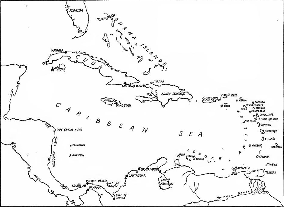 The Caribbean in the 17th Century.
[Pg 96] The West India Company.—In 1664 Louis chartered the great company which was granted the mainland of South America from the Orinoco to the Amazon, the island of Cayenne, the French West Indies, Newfoundland, Acadia, Canada, the rest of the mainland of North America as far south as Florida, and the African coast from Cape Verde to the Cape of Good Hope. Former proprietors were to be compensated, and with the exception of the fisheries of Newfoundland, the company was to have a monopoly of trade and colonization for forty years. After considerable opposition the company succeeded in establishing its authority in the islands, but the war which broke out in 1666 between France, and England and Holland proved disastrous, a French fleet which was sent to protect the Antilles being destroyed by the English. Colbert assisted the company financially, but it failed to become a profitable undertaking and in 1674 was dissolved. The inhabitants, however, continued to prosper, mainly because of the increasing number of independent merchants who traded with the islands and the growing importance of the sugar industry.
[Pg 96] The West India Company.—In 1664, Louis established a major company that was given control of the mainland of South America from the Orinoco to the Amazon, the island of Cayenne, the French West Indies, Newfoundland, Acadia, Canada, and the rest of the mainland of North America down to Florida, as well as the African coast from Cape Verde to the Cape of Good Hope. Previous owners were to be compensated, and apart from the fisheries of Newfoundland, the company was granted a monopoly on trade and colonization for forty years. Despite facing significant opposition, the company managed to assert its control over the islands. However, the war that broke out in 1666 between France and England and Holland was disastrous; a French fleet sent to protect the Antilles was destroyed by the English. Colbert provided financial support to the company, but it failed to become profitable and was dissolved in 1674. Meanwhile, the residents continued to thrive, mainly due to the increasing number of independent merchants trading with the islands and the growing significance of the sugar industry.
OPENING THE UPPER LAKE REGION AND THE MISSISSIPPI VALLEY
Two Lines of Approach.—The French had now established themselves firmly in the lower St. Lawrence basin and in the Caribbean area. From these two bases they now proceeded to the Mississippi Valley and the northern Gulf littoral. From the St. Lawrence they made their way over the portages to the tributaries of the Father of Waters. From the West Indies the Gulf of Mexico served as a highway.
Two Lines of Approach.—The French had now firmly established themselves in the lower St. Lawrence basin and the Caribbean region. From these two bases, they proceeded into the Mississippi Valley and the northern Gulf coast. From the St. Lawrence, they navigated over the portages to the tributaries of the Father of Waters. From the West Indies, the Gulf of Mexico acted as a highway.
Occupation of the upper lakes.—After the failure of the Huron missions, the Jesuits extended their field of operations to the shores of Lake Superior and Lake Michigan. The mission at Sault Ste. Marie was revived; in 1665 La Pointe mission near the western end of Lake Superior was established by Father Allouez, who was succeeded by Marquette four years later. Between 1670 and 1672 St. Ignace, at Michillimackinac, and St. Xavier on Green Bay (at De Pere) were established. In 1670 Talon despatched Saint Lusson to take possession of the Northwest; at a meeting of the tribes at Sault Ste. Marie the following year the sovereignty of the king over that region was proclaimed. Albanel was also sent to open communication between the St. Lawrence and Hudson Bay.
Occupation of the Upper Lakes.—After the Huron missions failed, the Jesuits expanded their work to the shores of Lake Superior and Lake Michigan. The mission at Sault Ste. Marie was revived; in 1665, the La Pointe mission near the western end of Lake Superior was established by Father Allouez, who was followed by Marquette four years later. Between 1670 and 1672, St. Ignace, at Michillimackinac, and St. Xavier on Green Bay (at De Pere) were established. In 1670, Talon sent Saint Lusson to claim the Northwest; at a gathering of the tribes at Sault Ste. Marie the following year, the sovereignty of the king over that region was declared. Albanel was also sent to create a communication link between the St. Lawrence and Hudson Bay.
Marquette and Joliet.—In 1672 Count Frontenac became governor and lieutenant-general of New France. Shortly after his arrival at Quebec, at the suggestion of Talon, he sent the fur trader Joliet to find the Mississippi. At Michillimackinac[Pg 97] he met the missionary Marquette, who decided to accompany him. On May 17, 1673, they started westward; after reaching Green Bay, they followed the Fox and Wisconsin rivers to the Mississippi, which they descended to the mouth of the Arkansas, just at the time when Father Larios was founding Spanish missions near the Rio Grande. Being convinced that the Mississippi emptied into the Gulf of Mexico, and fearing that they might fall into the hands of the Spaniards, they determined to turn back. The return was by the Mississippi, the Illinois, and Chicago rivers and the western shores of Lake Michigan. Father Marquette returned to work among the Illinois, but was soon forced by illness to abandon the field. On his way north he died at the site of Ludington. His work among the Illinois was taken up by others, among them being Fathers Allouez and Hennepin.
Marquette and Joliet.—In 1672, Count Frontenac became the governor and lieutenant-general of New France. Shortly after arriving in Quebec, he sent the fur trader Joliet to find the Mississippi, following Talon's suggestion. At Michillimackinac[Pg 97], he met the missionary Marquette, who decided to join him. On May 17, 1673, they set off westward; after reaching Green Bay, they followed the Fox and Wisconsin rivers to the Mississippi, which they traveled down to the mouth of the Arkansas, just as Father Larios was establishing Spanish missions near the Rio Grande. Believing that the Mississippi flowed into the Gulf of Mexico and fearing they might be captured by the Spaniards, they decided to turn back. Their return route was along the Mississippi, the Illinois, and Chicago rivers and the western shores of Lake Michigan. Father Marquette went back to work with the Illinois but was soon forced to stop due to illness. On his way north, he died at the site of Ludington. Others, including Fathers Allouez and Hennepin, continued his work among the Illinois.
Fort Frontenac.—While Joliet and Marquette were exploring the Mississippi, the governor was engaged in founding Fort Frontenac, on the northern shore of the outlet of Lake Ontario, near modern Kingston, his purpose being to overawe the Iroquois, and to divert their trade and allegiance from the English. With the governor was La Salle, who later became commandant of the new fort.
Fort Frontenac.—While Joliet and Marquette were exploring the Mississippi, the governor was busy establishing Fort Frontenac on the northern shore of the outlet of Lake Ontario, near present-day Kingston. His goal was to intimidate the Iroquois and redirect their trade and loyalty away from the English. Accompanying the governor was La Salle, who later became the commander of the new fort.
Frontenac's quarrels.—Shortly after Frontenac became governor the king again changed the form of government. The council was increased to seven members who held office directly from the king. Its chief function was judicial. A minor court called the prévôté, having original jurisdiction in civil and criminal cases, was reëstablished, appeals being taken from the prévôté to the council. Frontenac, who was of an imperious nature and exceedingly jealous of his authority, quarreled with the officials and clergy of Montreal, with Laval who had recently been made Bishop of Quebec, with the new intendant Duchesneau, and with the council. Regulation of the fur trade and questions of authority were the fruitful sources of disagreement. Under such conditions the colony did not advance rapidly. As Le Sueur says in his life of Frontenac, "The great trouble in Canada was that it was an overgoverned country.... What these people needed in the first place was freedom to seek their living in their own way, and secondly, an extremely simple form of government." The constant bickering finally exhausted the patience of the[Pg 98] home government, and in 1682 both Frontenac and Duchesneau were recalled.
Frontenac's Conflicts.—Shortly after Frontenac became governor, the king changed the government structure again. The council expanded to seven members who were appointed directly by the king. Its main role was judicial. A minor court called the prévôté, which handled civil and criminal cases, was reestablished, with appeals going from the prévôté to the council. Frontenac, who was authoritarian and very protective of his power, clashed with the officials and clergy of Montreal, with Laval, who had recently become Bishop of Quebec, with the new intendant Duchesneau, and with the council. Issues regarding the fur trade and questions of authority were the main causes of these conflicts. Under these circumstances, the colony didn't progress quickly. As Le Sueur notes in his biography of Frontenac, "The great problem in Canada was that it was an overgoverned country.... What these people needed first was the freedom to make a living in their own way, and second, a very simple form of government." The ongoing disputes eventually wore out the patience of the[Pg 98] home government, leading to the recall of both Frontenac and Duchesneau in 1682.
La Salle's fur trade monopoly.—During Frontenac's administration La Salle was engaged in the exploration of the Illinois country and the Mississippi. Having secured a royal patent to build forts and engage in the fur trade in the interior, La Salle, with a party which included Tonty, an Italian soldier of fortune, and the Recollet Hennepin, erected a fort at Niagara Falls and built a vessel called the Griffon, on which in 1679 they sailed up the lakes to Green Bay. The boat was sent back with a cargo of furs, but never reached its destination. The shores of Lake Michigan and the Illinois country were explored and Fort Crêvecœur was erected near the site of Peoria. From there Accau and Hennepin were sent to explore the upper Mississippi. La Salle then returned to Fort Frontenac, crossing lower Michigan and following Lake Erie and Lake Ontario.
La Salle's fur trade monopoly.—During Frontenac's time in office, La Salle was exploring the Illinois area and the Mississippi River. After securing a royal patent to build forts and participate in the fur trade inland, La Salle, along with a group that included Tonty, an Italian adventurer, and the Recollet Hennepin, built a fort at Niagara Falls and constructed a vessel called the Griffon. In 1679, they sailed up the lakes to Green Bay. The boat was sent back with a load of furs but never made it to its destination. They explored the shores of Lake Michigan and the Illinois region, where they built Fort Crêvecœur near Peoria. From there, Accau and Hennepin were sent to explore the upper Mississippi. La Salle then returned to Fort Frontenac, traveling through lower Michigan and along Lake Erie and Lake Ontario.
Exploration of the Mississippi.—While La Salle was gone, Tonty occupied Starved Rock, later known as Fort St. Louis, but a mutiny and an Iroquois invasion forced the French to return to Green Bay, so that when La Salle returned he found the country abandoned. After a fruitless search, he heard from the Indians of Tonty's whereabouts and hastened north to meet him. Together they returned to Fort Frontenac. Nothing daunted, they again sought the Mississippi. On December 21, 1681, they were again at Fort Miami, at the mouth of the St. Joseph River. On February 6, 1682, they reached the Mississippi, and arrived at its mouth in April, when they took formal possession of the great valley, naming it Louisiana in honor of the king. By the end of September they were back at Fort Miami, and in 1683 the leader returned to Quebec.
Exploration of the Mississippi.—While La Salle was away, Tonty took control of Starved Rock, which later became Fort St. Louis, but a revolt and an Iroquois attack forced the French to head back to Green Bay. When La Salle returned, he found the area deserted. After an unsuccessful search, he learned from the Indians about Tonty's location and quickly went north to find him. Together, they went back to Fort Frontenac. Undeterred, they set out again for the Mississippi. On December 21, 1681, they were back at Fort Miami, at the mouth of the St. Joseph River. On February 6, 1682, they reached the Mississippi and arrived at its mouth in April, where they officially claimed the vast region, naming it Louisiana in honor of the king. By the end of September, they were back at Fort Miami, and in 1683, the leader returned to Quebec.
La Salle's Colony on the Gulf.—La Salle now planned a colony at the mouth of the Mississippi River, as a means of developing the fur trade, controlling the Mississippi Valley, providing a base for commanding the Gulf, and, in case of war, for attack on the coveted mines of New Spain. France and Spain were on the verge of war, and in 1683 French buccaneers three times sacked the Spanish settlement of Apalache. La Salle's proposals were favored, therefore, by Louis XIV. In the summer of 1684 La Salle left France with a colony of some four hundred[Pg 99] people. In the autumn he reached the West Indies, the ketch St. François having been captured by the Spaniards on the way. Continuing the voyage in November, La Salle missed the mouth of the Mississippi and landed on the Texas coast at Matagorda Bay. Tonty descended the Mississippi to coöperate (1686), but did not find his chief. On the way he built a small post on the Arkansas.
La Salle's Colony on the Gulf.—La Salle was now planning a colony at the mouth of the Mississippi River to develop the fur trade, control the Mississippi Valley, establish a base for commanding the Gulf, and potentially launch an attack on the lucrative mines of New Spain if war broke out. France and Spain were on the brink of conflict, and in 1683, French pirates raided the Spanish settlement of Apalache three times. Because of this, Louis XIV supported La Salle's proposals. In the summer of 1684, La Salle left France with a group of about four hundred[Pg 99] people. By autumn, he reached the West Indies, although the ketch St. François had been captured by the Spaniards during the journey. Continuing the voyage in November, La Salle missed the mouth of the Mississippi and ended up on the Texas coast at Matagorda Bay. Tonty traveled down the Mississippi to collaborate with him (1686) but did not find his leader. Along the way, he built a small post on the Arkansas.
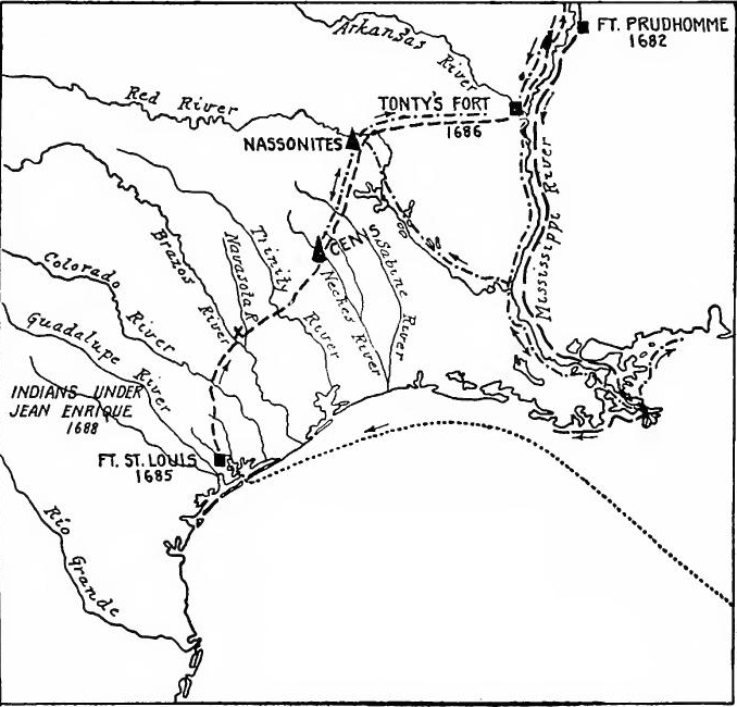 La Salle's Colony on the Texas Coast, 1684-1689.
Failure.—The expedition rapidly went to pieces. One vessel was wrecked in landing, and Beaujeu, the naval commander, returned to France with a second, and part of the men and supplies. La Salle moved his colony inland to the Garcitas River, near the head of the Lavaca Bay, where he founded Fort St. Louis, and then began a series of expeditions northeastward in the hope of finding the Mississippi River. While engaged in[Pg 100] exploring, the last of his vessels was wrecked. Through desertion and sickness the colony rapidly dwindled. On his third expedition northeastward, in 1687, La Salle reached the Hasinai (Cenis) Indians, east of the Trinity River. On his fourth expedition he was murdered by his companions near the Brazos River. The remainder of his party, led by Joutel, made their way to the Arkansas post and to Canada. In the fall of 1689 Tonty, in an effort to rescue La Salle's colonists, descended the Mississippi River, and made his way to the Cadodacho and Hasinai villages. Meanwhile the colony on the Gulf had been completely wiped out by an Indian massacre which occurred early in 1689. La Salle's occupation of Matagorda Bay later became a basis of the claim of the United States to Texas.
Failure.—The expedition quickly fell apart. One ship was wrecked during landing, and Beaujeu, the naval commander, returned to France with a second ship, along with some of the men and supplies. La Salle moved his colony inland to the Garcitas River, near the head of Lavaca Bay, where he established Fort St. Louis, and then began a series of journeys northeast, hoping to find the Mississippi River. While he was engaged in[Pg 100] exploring, his last ship was wrecked. The colony rapidly decreased in number due to desertion and sickness. On his third journey northeast in 1687, La Salle reached the Hasinai (Cenis) Indians, east of the Trinity River. On his fourth journey, he was murdered by his companions near the Brazos River. The rest of his group, led by Joutel, made their way to the Arkansas post and then to Canada. In the fall of 1689, Tonty, attempting to rescue La Salle's colonists, went down the Mississippi River and reached the Cadodacho and Hasinai villages. Meanwhile, the colony on the Gulf had been completely destroyed by an Indian massacre that occurred early in 1689. La Salle's occupation of Matagorda Bay later became part of the basis for the United States' claim to Texas.
Explorers in the Southwest.—The failure of La Salle's colony did not put an end to exploration in the Southwest. Interest in a passage to the South Sea was perennial, and no tale of Spanish treasure was too guttering to find credence on the French frontier. Mathieu Sagean told of a golden country of the Accanibas, and Baron La Hontan of a Long River. The coureurs de bois were ever led west and southwest in their fur trading operations. The result was that in this western country traders from Canada roamed far and wide at an early date. A Canadian is known to have reached the Rio Grande overland before 1688 and by 1694 Canadian traders were among the Missouri and Osage tribes.
Explorers in the Southwest.—The failure of La Salle's colony didn’t stop exploration in the Southwest. Interest in a route to the South Sea was constant, and no story of Spanish treasure was too wild to be believed along the French border. Mathieu Sagean spoke of a golden land of the Accanibas, and Baron La Hontan described a Long River. The coureurs de bois were always moving west and southwest in their fur trading efforts. As a result, traders from Canada ventured far and wide in this western region at an early stage. A Canadian is known to have reached the Rio Grande overland before 1688, and by 1694, Canadian traders had connected with the Missouri and Osage tribes.
The upper Mississippi—Duluth.—While La Salle was operating in the Illinois country, others were at work in northern Wisconsin and Minnesota. In 1678 Duluth, a cousin of Tonty, left Montreal for the west. For several years he traded among the tribes west of Lake Superior. Hearing in 1680 that Frenchmen were near, he went in search of them, and found Accau and Hennepin, who had explored the upper Mississippi. Duluth went to France, where he secured a license to trade with the Sioux. In 1683 he returned to Wisconsin with thirty men, proceeded to the north shore of Lake Superior, and built forts near Lake Nipigon and Pigeon River. The highway from Brulé River to the St. Croix became known as Duluth's Portage. In 1686 he erected a temporary fort near Detroit to bar the English traders.
The upper Mississippi—Duluth.—While La Salle was active in the Illinois area, others were busy in northern Wisconsin and Minnesota. In 1678, Duluth, a cousin of Tonty, left Montreal to head west. He spent several years trading with the tribes west of Lake Superior. In 1680, after hearing that Frenchmen were nearby, he went to find them and discovered Accau and Hennepin, who had explored the upper Mississippi. Duluth went to France, where he obtained a license to trade with the Sioux. In 1683, he returned to Wisconsin with thirty men, headed to the north shore of Lake Superior, and built forts near Lake Nipigon and Pigeon River. The route from Brulé River to the St. Croix became known as Duluth's Portage. In 1686, he established a temporary fort near Detroit to prevent English traders from coming in.
[Pg 101] Le Sueur.—Between 1683 and 1700 Le Sueur, a prominent fur trader, operated in Minnesota and Wisconsin. In 1683 he was at St. Anthony's Falls. The Fox Indians of Wisconsin opposed the passage of the French to the Sioux and practically cut off their trade route. For this reason Le Sueur protected the Brulé-St. Croix highway. To effect this, in 1693 he built a fort at Chequamegon Bay, on the south shore of Lake Superior, and another on the Mississippi near the mouth of the St. Croix. This post became a center of commerce for the western posts. In 1697 Le Sueur was in France, where he secured permission to work copper mines near Lake Superior. In 1699 he went from France to Louisiana with Iberville. Thence, with twenty-nine men, he ascended the Mississippi to Blue River, Minnesota, and built Fort L'Huiller (1700) at Mankato, where he traded with the Sioux.
[Pg 101] Le Sueur.—Between 1683 and 1700, Le Sueur, a key fur trader, worked in Minnesota and Wisconsin. In 1683, he was at St. Anthony's Falls. The Fox Indians in Wisconsin resisted the French moving toward the Sioux and nearly shut down their trade route. Because of this, Le Sueur safeguarded the Brulé-St. Croix highway. To do this, in 1693 he built a fort at Chequamegon Bay on the south shore of Lake Superior, and another on the Mississippi near the confluence with the St. Croix. This post became a hub for trade for the western locations. In 1697, Le Sueur went to France, where he got permission to mine copper near Lake Superior. In 1699, he traveled from France to Louisiana with Iberville. From there, with twenty-nine men, he navigated up the Mississippi to Blue River, Minnesota, and established Fort L'Huiller (1700) at Mankato, where he traded with the Sioux.
Perrot.—In 1685 Nicholas Perrot, who had been in Wisconsin as early as 1665, and had acquired great influence over the western tribes, was made "commander of the west" and sent among the Sioux. In 1686 he built Fort St. Antoine on the Mississippi near Trempealeau, Wisconsin. Other posts established by him were Fort Perrot on the west side of Lake Pepin, Fort Nicholas at Prairie du Chien, and one farther down the Mississippi near the Galena lead mines, which he discovered and worked.
Perrot.—In 1685, Nicholas Perrot, who had been in Wisconsin as early as 1665 and had gained significant influence over the western tribes, was appointed "commander of the west" and sent to work with the Sioux. In 1686, he built Fort St. Antoine on the Mississippi near Trempealeau, Wisconsin. Other forts established by him included Fort Perrot on the west side of Lake Pepin, Fort Nicholas at Prairie du Chien, and another one further down the Mississippi near the Galena lead mines, which he discovered and operated.
The Illinois and Detroit.—In the Illinois country the French Jesuits labored from the time of Marquette, among his successors being Fathers Allouez and Hennepin. In 1699 a Sulpician mission was established at Cahokia and in 1700 the Jesuits moved down the Illinois River to Kaskaskia. A year later Detroit was founded to protect the route from Lake Erie to Lake Huron, cut off English trade with the Indians, and afford a base for the Illinois trade. Missionaries entered the region of the lower Mississippi and the lower Ohio, where Tonty and other Frenchmen maintained a considerable trade.
The Illinois and Detroit.—In the Illinois area, the French Jesuits worked from the time of Marquette, with his successors including Fathers Allouez and Hennepin. In 1699, a Sulpician mission was set up in Cahokia, and in 1700, the Jesuits moved down the Illinois River to Kaskaskia. A year later, Detroit was established to safeguard the route from Lake Erie to Lake Huron, block English trade with the Indigenous peoples, and provide a base for trade in Illinois. Missionaries ventured into the lower Mississippi and lower Ohio regions, where Tonty and other French traders engaged in significant commerce.
Traders on the Tennessee.—Because of Iroquois control of the country south of the Great Lakes and as far as the Tennessee River, the French in La Salle's time had little knowledge of the Ohio and its tributaries. At that period the Shawnee of the Tennessee and Cumberland Rivers were declining under Iroquois[Pg 102] attacks. On the upper Tennessee lived the Cherokees. In spite of the Iroquois, however, by the end of the century several coureurs de bois of Canada had ascended the Ohio and Tennessee Rivers, crossed the divide, and descended the Savannah River into South Carolina, in defiance of the government, which tried to maintain a trade monopoly. Their activities brought them into rivalry with the English on the Carolina frontier.
Traders on the Tennessee.—Due to Iroquois control of the land south of the Great Lakes and extending to the Tennessee River, the French had limited knowledge of the Ohio River and its tributaries during La Salle's time. At that time, the Shawnee along the Tennessee and Cumberland Rivers were weakening from Iroquois[Pg 102] attacks. The Cherokees lived in the upper Tennessee region. Nonetheless, by the end of the century, several coureurs de bois from Canada had traveled up the Ohio and Tennessee Rivers, crossed the divide, and journeyed down the Savannah River into South Carolina, defying the government that sought to maintain a trade monopoly. Their actions led to competition with the English on the Carolina frontier.
Couture and Bellefeuille.—Among these pathfinders was Jean Couture, who had been left by Tonty at the Arkansas post. As early as 1693 he deserted the French colony and made his way overland to the English. In 1699 he was on the Savannah, where he proposed to lead the English to certain mines in the west. Returning, he led a party of English traders, sent by Governor Blake of South Carolina, up the Savannah, and down the Tennessee and Ohio, in an attempt to divert the western trade from Canada to the English. In February, 1700, they reached the Arkansas River, where they were met by Le Sueur on his way up the river to Minnesota. At the request of Iberville, the new governor of Louisiana, the government now permitted Illinois traders to sell their peltry in Louisiana, to prevent them from earning it over the mountains to the English. In 1701 a party of Frenchmen under Bellefeuille and Soton crossed the mountains to South Carolina, and attempted to open up trade. Returning they descended the Mississippi and visited Biloxi. It was now proposed, in order to stop the road to Carolina, that posts be established on the Miami and the lower Ohio. For this purpose Juchereau de St. Denis established a post at Cairo in 1702. Through the establishment of Louisiana and the opening of trade with Canada, this danger was largely averted.
Couture and Bellefeuille.—Among these pioneers was Jean Couture, who had been left by Tonty at the Arkansas post. As early as 1693, he abandoned the French colony and traveled overland to the English. In 1699, he was on the Savannah River, where he proposed to lead the English to some mines in the west. Returning, he guided a group of English traders, sent by Governor Blake of South Carolina, up the Savannah and down the Tennessee and Ohio rivers, in an effort to shift the western trade from Canada to the English. In February 1700, they reached the Arkansas River, where they encountered Le Sueur on his way up the river to Minnesota. At the request of Iberville, the new governor of Louisiana, the government allowed Illinois traders to sell their furs in Louisiana, to prevent them from hauling them over the mountains to the English. In 1701, a group of Frenchmen led by Bellefeuille and Soton crossed the mountains to South Carolina and tried to establish trade. On their way back, they traveled down the Mississippi and visited Biloxi. It was then suggested that in order to cut off the route to Carolina, trading posts be set up on the Miami and the lower Ohio. For this purpose, Juchereau de St. Denis established a post at Cairo in 1702. With the establishment of Louisiana and the opening of trade with Canada, this threat was largely mitigated.
READINGS
EARLY EXPLORATIONS AND COLONIZING EFFORTS
Baird, C.W., Huguenot Emigration; Brevoort, J.C., Verrazano the Navigator; Channing, Edward, History of the United States, I, 90-112; De Costa, B.F., Verrazano the Explorer; French, B.F., Historical Collections of Louisiana and Florida, 117-362; Hamilton, P.J., The Colonization of the South, 27-41; Hart. A.B., Contemporaries, I, 102-112; Leacock, Stephen, The Mariner of St. Malo; Lescarbot, Marc, History of New France; Munro, W.B., Crusaders of New France, 11-32; Murphy, H.C., Voyage of Verrazano; Parkman, Francis, The Pioneers of France in the New World, 1-228; Shea, J.G., in[Pg 103] Winsor, Narrative and Critical History, II, 260-283; Tracy, F.B., Tercentenary History of Canada, I, 20-37; Winsor, Justin, Cartier to Frontenac, 1-47; Biggar, H.P., The Precursors of Jacques Cartier.
Baird, C.W., Huguenot Emigration; Brevoort, J.C., Verrazano the Navigator; Channing, Edward, History of the United States, I, 90-112; De Costa, B.F., Verrazano the Explorer; French, B.F., Historical Collections of Louisiana and Florida, 117-362; Hamilton, P.J., The Colonization of the South, 27-41; Hart, A.B., Contemporaries, I, 102-112; Leacock, Stephen, The Mariner of St. Malo; Lescarbot, Marc, History of New France; Munro, W.B., Crusaders of New France, 11-32; Murphy, H.C., Voyage of Verrazano; Parkman, Francis, The Pioneers of France in the New World, 1-228; Shea, J.G., in[Pg 103] Winsor, Narrative and Critical History, II, 260-283; Tracy, F.B., Tercentenary History of Canada, I, 20-37; Winsor, Justin, Cartier to Frontenac, 1-47; Biggar, H.P., The Precursors of Jacques Cartier.
ACADIA AND THE ST. LAWRENCE VALLEY
Biggar, H.P., Early Trading Companies of New France; Bourne, E.G., Voyages and Explorations of Champlain (Trail Makers' Series); Champlain, Samuel, Œuvres (Laverdière, ed.); Colby, C.W., The Founder of New France; Dionne, N.E., Champlain; Grant, W.L., Voyages of Champlain (Original Narratives Series); Kingsford, William, The History of Canada, I, 147-294; Le Sueur, W.D., Frontenac, 1-60; Marquis, T.G., The Jesuit Missions; Parkman, Francis, Old Régime in Canada, 3-168; Pioneers of New France, 324-454; The Jesuits in North America; Thwaites, R.G., France in America, 10-48; Tracy, F.B., Tercentenary History of Canada, I, 41-279; Winsor, Justin, From Cartier to Frontenac, 77-183; Munro, W.B., Crusaders of New France.
Biggar, H.P., Early Trading Companies of New France; Bourne, E.G., Voyages and Explorations of Champlain (Trail Makers' Series); Champlain, Samuel, Œuvres (Laverdière, ed.); Colby, C.W., The Founder of New France; Dionne, N.E., Champlain; Grant, W.L., Voyages of Champlain (Original Narratives Series); Kingsford, William, The History of Canada, I, 147-294; Le Sueur, W.D., Frontenac, 1-60; Marquis, T.G., The Jesuit Missions; Parkman, Francis, Old Régime in Canada, 3-168; Pioneers of New France, 324-454; The Jesuits in North America; Thwaites, R.G., France in America, 10-48; Tracy, F.B., Tercentenary History of Canada, I, 41-279; Winsor, Justin, From Cartier to Frontenac, 77-183; Munro, W.B., Crusaders of New France.
REORGANIZATION AND THE WEST INDIES
Chapais, Thomas, The Great Intendant; Haring, C.H., The Buccaneers in the West Indies in the XVII Century; Mims, S.L., Colbert's West India Policy; Munro, W.B., The Seigneurs of Old Canada; Parkman, Francis, The Old Régime, 169-330.
Chapais, Thomas, The Great Intendant; Haring, C.H., The Buccaneers in the West Indies in the 17th Century; Mims, S.L., Colbert's West India Policy; Munro, W.B., The Seigneurs of Old Canada; Parkman, Francis, The Old Régime, 169-330.
THE UPPER LAKES AND THE MISSISSIPPI VALLEY
Bolton, H.E., "The Location of La Salle's Colony on the Gulf of Mexico," in Mississippi Valley Historical Review, II, 165-182; Charlevoix, P.F.X., Histoire Générale de la Nouvelle France (J.G. Shea, trans.): Cox, I.J., Journeys of La Salle (Trail Makers' Series); Folwell, W.W., Minnesota, 59-65; Hamilton, P.J., The Colonization of the South, 187-196; Kellogg, L.P., ed., Early Narratives of the Northwest (Original Narratives Series): Le Sueur, W.D., Frontenac, 61-169; Ogg, F.A., The Opening of the Mississippi, 59-163; Parish, J.C., The Man with the Iron Hand; Parkman, Francis, La Salle and the Discovery of the Great West; Phelps, Albert, Louisiana, 6-20; Shea, J.G., Exploration of the Mississippi Valley; Thwaites, R.G., France in America, 48-71; Wisconsin, 40-71; Winsor, Justin, Cartier to Frontenac, 183-295.
Bolton, H.E., "The Location of La Salle's Colony on the Gulf of Mexico," in Mississippi Valley Historical Review, II, 165-182; Charlevoix, P.F.X., Histoire Générale de la Nouvelle France (J.G. Shea, trans.); Cox, I.J., Journeys of La Salle (Trail Makers' Series); Folwell, W.W., Minnesota, 59-65; Hamilton, P.J., The Colonization of the South, 187-196; Kellogg, L.P., ed., Early Narratives of the Northwest (Original Narratives Series): Le Sueur, W.D., Frontenac, 61-169; Ogg, F.A., The Opening of the Mississippi, 59-163; Parish, J.C., The Man with the Iron Hand; Parkman, Francis, La Salle and the Discovery of the Great West; Phelps, Albert, Louisiana, 6-20; Shea, J.G., Exploration of the Mississippi Valley; Thwaites, R.G., France in America, 48-71; Wisconsin, 40-71; Winsor, Justin, Cartier to Frontenac, 183-295.
CHAPTER V
THE BEGINNINGS OF ENGLISH EXPANSION (1485-1603)
THE TUDOR PERIOD
Periods of English activities.—While the French were colonizing Canada and the West Indies, and the Spaniards were opening mines and ranches in northern Mexico, the English were founding still more vigorous settlements on the Atlantic seaboard, in the islands, and in the region of Hudson Bay.
Periods of English activities.—While the French were colonizing Canada and the West Indies, and the Spaniards were opening mines and ranches in northern Mexico, the English were establishing even more robust settlements along the Atlantic coast, in the Caribbean islands, and around Hudson Bay.
The history of English activities in America before 1783 may be divided into four periods: (1) The Tudor epoch (1485-1603), which was a period of commercial expansion, exploration, and attempted colonization; (2) the Stuart and Cromwellian era (1603-1689), the period of colony planting; (3) the international struggle for territory (1689-1763); and (4) the struggle of a part of the English colonists for independence (1763-1783).
The history of English activities in America before 1783 can be divided into four periods: (1) The Tudor era (1485-1603), which was a time of commercial growth, exploration, and attempts at colonization; (2) the Stuart and Cromwellian period (1603-1689), characterized by the establishment of colonies; (3) the international competition for territory (1689-1763); and (4) the fight for independence by some English colonists (1763-1783).
Henry VII.—When Henry Tudor ascended the throne of England a new era was ushered in. The continental possessions except Calais had been swept away in the Hundred Years' War. The Wars of the Roses had broken the power of the feudal barony, and the middle class Englishman had become the most important political element in the nation. The general form of the constitution had become fixed, the functions of the three branches of the government, the king and his council, parliament, and the courts, having become fairly well defined. The work of Henry Tudor was to restore the finances, to build up commerce and industry, to keep England at peace, and at the same time, by a series of marriage alliances and by adroit diplomacy to raise England to her former position as a great European power. He also built up the kingship at the expense of a subservient parliament.
Henry VII.—When Henry Tudor became king of England, it marked the start of a new era. The country's territories on the continent, except for Calais, had been lost during the Hundred Years' War. The Wars of the Roses had weakened the power of the feudal nobility, and the middle class became the most crucial political force in the nation. The general structure of the constitution was established, with the roles of the three branches of government—the king and his council, parliament, and the courts—becoming quite clear. Henry Tudor's goals included restoring the finances, boosting commerce and industry, maintaining peace in England, and using a series of marriage alliances and skilled diplomacy to elevate England back to its former status as a major European power. He also strengthened the monarchy at the expense of a compliant parliament.
The English Reformation.—During the three succeeding reigns, England played little part in exploration. While Spain was founding her vast colonial empire, the attention of Englishmen[Pg 105] was centered on the European situation created by Charles V and on the great religious controversy, which resulted in the break with Rome and the establishment of the Anglican church.
The English Reformation.—During the next three reigns, England did not play a significant role in exploration. While Spain was establishing its massive colonial empire, the focus of the English people[Pg 105] was on the European issues caused by Charles V and on the major religious controversy that led to the split with Rome and the formation of the Anglican church.
Queen Elizabeth.—With the accession of Queen Elizabeth a new situation arose. To the Catholic powers, Elizabeth had no right to the throne of England. Philip II of Spain hoped to restore the country to the Catholic fold; his first wife was Queen Mary of England, and under his influence a short-lived Catholic reaction had been produced; if Elizabeth could now be induced to turn Catholic and marry Philip, England might be won back to the Roman church. Elizabeth, however, followed an independent course, dangling before the eyes of the Spanish ambassador the possibility of a marriage with Philip, while perfecting the organization of the Anglican church, increasing her hold upon the affections of her subjects, strengthening her treasury, army, navy, and defences, and stimulating industry and commerce. Her path was beset with additional difficulties, for the powerful Catholic party in France was intriguing to place Mary Stuart, the queen of Scotland, on the English throne. To weaken her foes, Elizabeth aided the Huguenots, assisted the Dutch in their war against Spain, and connived with English mariners to raid the Spanish Main. In 1588 the patience of Philip was exhausted, and he sought to humble the haughty queen by sending the Invincible Armada against England. A running fight occurred in the Channel and several of the galleons were sunk or driven on shore. The Armada entered the roads of Calais but a great storm shattered the fleet. Of the original one hundred and thirty vessels only one-third returned to Spain. The defeat of the Armada marks a turning point in Spanish and English history. From that time Spain was thrown on the defensive and her power on the continent gradually declined, though her colonies continued to expand. England followed up her success by taking the offensive; an era of greater commercial activity followed, and she soon entered upon her rôle of a colonizing nation.
Queen Elizabeth.—With Queen Elizabeth's rise to the throne, a new situation emerged. To the Catholic powers, Elizabeth had no legitimate claim to the English throne. Philip II of Spain aimed to bring the country back into the Catholic fold; his first wife was Queen Mary of England, and under his influence, a brief Catholic revival had occurred. If Elizabeth could be persuaded to convert to Catholicism and marry Philip, England might be reclaimed for the Roman Church. However, Elizabeth pursued an independent course, teasing the Spanish ambassador with the possibility of a marriage to Philip while organizing the Anglican Church, winning the affection of her subjects, strengthening her treasury, army, navy, and defenses, and boosting industry and commerce. She faced additional challenges, as the powerful Catholic faction in France was plotting to place Mary Stuart, the queen of Scotland, on the English throne. To weaken her enemies, Elizabeth supported the Huguenots, aided the Dutch in their struggle against Spain, and collaborated with English sailors to raid the Spanish Main. In 1588, Philip's patience wore thin, and he attempted to subdue the proud queen by sending the Invincible Armada to England. A battle broke out in the Channel, leading to the sinking or grounding of several galleons. The Armada reached the waters of Calais, but a violent storm devastated the fleet. Of the original one hundred thirty vessels, only one-third returned to Spain. The defeat of the Armada marks a pivotal moment in both Spanish and English history. From that point on, Spain was put on the defensive, and its power on the continent gradually diminished, although its colonies continued to grow. England built on its victory by taking the initiative; an era of increased commercial activity followed, and it soon began to establish itself as a colonizing nation.
COMMERCIAL EXPANSION
John Cabot.—The discovery of new lands in the west soon became known in England, and when the Venetian citizen, John Cabot, applied for letters patent to go on a western voyage,[Pg 106] Henry VII readily complied. In May, 1497, his single ship with eighteen men set sail from Bristol and crossed the north Atlantic. It is impossible to state with certainty what part of the coast was visited, but it appears to have been in the neighborhood of Cape Breton Island. The idea that Sebastian Cabot accompanied his father is generally rejected by the best authorities. The importance of the voyage lies in the fact that it was used at a later date to strengthen the English claim to a large part of North America. The following year John Cabot sailed for the new found land but never returned.
John Cabot.—The discovery of new lands in the west quickly became known in England, and when the Venetian citizen, John Cabot, applied for permission to embark on a western voyage,[Pg 106] Henry VII readily agreed. In May 1497, his single ship with eighteen men set sail from Bristol and crossed the North Atlantic. It's impossible to say for sure what part of the coast was visited, but it seems to have been around Cape Breton Island. The idea that Sebastian Cabot joined his father is mostly dismissed by reputable historians. The significance of the voyage lies in the fact that it was later used to bolster the English claim to a large portion of North America. The following year, John Cabot sailed to the newly found land but never returned.
The Newfoundland fisheries.—Cabot's voyage had another important result. He had discovered a convenient trade route to the fisheries of Newfoundland, and English, French, Spanish, and Portuguese fishing vessels soon swarmed the region. English ships are thought to have traded there regularly after 1502. Expeditions are known to have been made thither in 1527 and 1536, and before 1550 fishing fleets went from southern England to Newfoundland every spring and autumn.
The Newfoundland fisheries.—Cabot's journey had another significant outcome. He found an accessible trade route to the fisheries of Newfoundland, and soon, English, French, Spanish, and Portuguese fishing boats flooded the area. English ships are believed to have traded there regularly after 1502. Expeditions are known to have taken place in 1527 and 1536, and by 1550, fishing fleets were leaving southern England for Newfoundland every spring and autumn.
The Muscovy Company.—The latter half of the Tudor period witnessed the formation of great companies which reached out for foreign trade. In 1553 a group of London merchants decided to make an attempt to reach China and the East Indies by a northern route. Under the command of Willoughby and Chancellor, three ships sailed along the Norway coast and rounded the North Cape. Willoughby and the crews of two of the ships perished on the coast of Lapland, but Chancellor entered the White Sea and penetrated to Moscow, where he was promised trading privileges by Ivan the Terrible. In 1555 the merchants who were interested in the expedition were granted a royal charter, the company being familiarly known as the Muscovy Company. Annual fleets were despatched to the White and Baltic seas; warehouses were established at various points in Russia, and the agents of the company extended their activities to the Caspian Sea, to Bokhara, and to Persia. In 1580 the Turks cut them off from the region outside of European Russia. Occasional unsuccessful attempts were also made by the company to reach China by the northern route. In 1579 the Eastland Company, a rival organization, was chartered to trade in the Baltic, and developed an extensive trade in Poland.
The Muscovy Company.—The second half of the Tudor period saw the creation of large companies that sought foreign trade. In 1553, a group of London merchants decided to try reaching China and the East Indies via a northern route. Led by Willoughby and Chancellor, three ships sailed along the coast of Norway and around the North Cape. Willoughby and the crews of two of the ships died on the coast of Lapland, but Chancellor made it into the White Sea and traveled to Moscow, where he was promised trading rights by Ivan the Terrible. In 1555, the merchants involved in the expedition were granted a royal charter, and the company became commonly known as the Muscovy Company. Annual fleets were sent to the White and Baltic seas; warehouses were set up at various locations in Russia, and the company’s agents expanded their operations to the Caspian Sea, Bokhara, and Persia. In 1580, the Turks blocked their access to areas outside European Russia. The company also made occasional unsuccessful attempts to reach China using the northern route. In 1579, the Eastland Company, a competing organization, was chartered to trade in the Baltic and established a significant trade presence in Poland.
[Pg 107] The Levant Company.—English merchants also turned their attention to the Mediterranean to renew a trade which had formerly been of some importance. In 1581 a charter was issued to the Levant Company, which engaged in trading with the Turkish ports along the southern and eastern shores of the Mediterranean. The same year a charter was granted to the Venetian Company and in 1592 the two were combined as the Levant Company. Among those interested in the Mediterranean commerce were Sir Thomas Smythe and Sir Walter Raleigh, both of whom were important figures in the colonization of Virginia. Other groups of merchants opened trade with Morocco, and the Senegambia and Guinea coasts. In all of these enterprises Englishmen were reaching out for the trade with the East Indies, which had long been monopolized by the Portuguese. In 1581, the year in which the Levant Company was chartered, Portugal was incorporated with Spain, and hostility to that power added another incentive to reach the East.
[Pg 107] The Levant Company.—English merchants also shifted their focus to the Mediterranean to revive a trade that had once been quite significant. In 1581, a charter was issued to the Levant Company, which engaged in trading with the Turkish ports along the southern and eastern coasts of the Mediterranean. The same year, a charter was granted to the Venetian Company, and in 1592, the two were merged into the Levant Company. Notable figures interested in Mediterranean trade included Sir Thomas Smythe and Sir Walter Raleigh, both of whom played important roles in the colonization of Virginia. Other groups of merchants established trade with Morocco, as well as the Senegambia and Guinea coasts. In all these ventures, the English were pursuing trade with the East Indies, which had long been dominated by the Portuguese. In 1581, the same year the Levant Company was chartered, Portugal was united with Spain, and hostility towards that power provided another motivation to access the East.
THE ELIZABETHAN SEA-DOGS
John Hawkins.—Among those interested in the African trade was William Hawkins, who filled the important positions of mayor of Plymouth and member of parliament. He made three voyages to Guiana and Brazil. His son, John Hawkins, became one of the most famous mariners of his time. In 1562 he sailed for Africa to obtain slaves, which he disposed of in Española. In 1564-1565 he engaged in a second voyage which resulted in great profit. A third voyage in 1567-1568 ended disastrously. The Spanish government had sent a fleet to stop the traffic; but in spite of it he forced an entrance to the West Indian ports and disposed of his cargo. Being driven by a storm into the harbor of Vera Cruz, he was attacked by a Spanish fleet and but two of the English vessels escaped.
John Hawkins.—Among those involved in the African trade was William Hawkins, who held significant roles as mayor of Plymouth and a member of parliament. He made three trips to Guiana and Brazil. His son, John Hawkins, became one of the most renowned sailors of his time. In 1562, he sailed to Africa to acquire slaves, which he sold in Española. In 1564-1565, he went on a second voyage that was highly profitable. A third voyage in 1567-1568 ended in disaster. The Spanish government had sent a fleet to stop the trade, but despite that, he managed to enter the West Indian ports and sell his cargo. After being forced by a storm into the harbor of Vera Cruz, he was attacked by a Spanish fleet, and only two of the English ships made it out.
Drake and Cavendish.—Francis Drake, a nephew of John Hawkins, had accompanied him on his third expedition and had suffered the loss of his investment. He soon began a series of reprisals. In 1572 he made an unsuccessful attack on Nombre de Diós and ascended the Chagres River where he waylaid a train of mules laden with bullion. The example set by him was frequently followed by raids of English mariners in the following[Pg 108] decade. In 1577 another fleet sailed under Drake's command. After capturing several Spanish and Portuguese vessels on the African coast, the fleet crossed the Atlantic and attempted to pass through the Straits of Magellan. Only one vessel reached the Pacific. Drake proceeded up the western coast, plundering as he went. In a harbor known as Drake's Bay, north of San Francisco Bay, he refitted, and claimed the California region for the queen, calling it New Albion. He then sailed to the East Indies where a cargo of spice was obtained. From Java, Drake crossed the Indian Ocean, rounded the Cape of Good Hope, and proceeded to England, entering the harbor of Plymouth in November, 1580, having completed the first English circumnavigation of the globe. In 1586 Thomas Cavendish followed almost the same course, plundered the Spanish commerce in the Pacific, and in 1588 completed the circumnavigation of the world. Besides Hawkins, Drake, and Cavendish a score of English mariners engaged in raiding the Spanish Main. They were assisted financially by the queen and by many of her councillors who considered the raiding of Spanish commerce good business as well as good state policy.
Drake and Cavendish.—Francis Drake, a nephew of John Hawkins, had joined him on his third expedition and had lost his investment. He quickly started a series of retaliatory actions. In 1572, he launched an unsuccessful attack on Nombre de Diós and traveled up the Chagres River, where he ambushed a train of mules carrying gold and silver. His actions inspired many English sailors to carry out similar raids over the next[Pg 108] decade. In 1577, another fleet set sail under Drake's command. After capturing several Spanish and Portuguese ships along the African coast, the fleet crossed the Atlantic and tried to navigate through the Straits of Magellan. Only one ship made it to the Pacific. Drake continued up the western coast, plundering along the way. In a harbor known as Drake's Bay, north of San Francisco Bay, he made repairs and claimed the California area for the queen, naming it New Albion. He then sailed to the East Indies and secured a cargo of spices. From Java, Drake crossed the Indian Ocean, rounded the Cape of Good Hope, and returned to England, entering Plymouth harbor in November 1580, having completed the first English circumnavigation of the globe. In 1586, Thomas Cavendish followed a nearly identical route, raiding Spanish commerce in the Pacific, and in 1588 completed his own circumnavigation of the world. Alongside Hawkins, Drake, and Cavendish, numerous English sailors participated in raiding the Spanish Main. They received financial support from the queen and many of her advisors, who viewed these attacks on Spanish trade as both profitable and beneficial to national policy.
East Indian trade.—A party of English merchants had also succeeded in penetrating from the Syrian coast to India. The report of their journey and the voyages of Drake and Cavendish stimulated the desire to open trade with the Far East. The result was that in 1591 an expedition was fitted out which rounded the Cape of Good Hope and reached Ceylon, India, and the Malay Peninsula. Reports of the successes of the Dutch in the East Indies increased the interest of the English merchants, and in 1600 the East India Company was formed.
East Indian trade.—A group of English merchants had managed to travel from the Syrian coast to India. Their journey, along with the voyages of Drake and Cavendish, sparked the desire to establish trade with the Far East. As a result, in 1591, an expedition was organized that sailed around the Cape of Good Hope and reached Ceylon, India, and the Malay Peninsula. News of the Dutch successes in the East Indies further piqued the interest of English merchants, leading to the formation of the East India Company in 1600.
SEARCH FOR A NORTHWEST PASSAGE
Frobisher.—The unsuccessful attempts of the Muscovy Company to reach the East by a northeast passage led to the search for a northwestern route. The great exponent of the idea was Martin Frobisher. After vainly seeking many years for a patron who would furnish funds, in 1574 he received the support of Michael Lock, a member of the Muscovy Company, and the following year a royal license was granted to undertake the work.[Pg 109]
Frobisher.—The failed efforts of the Muscovy Company to find a route to the East via a northeast passage prompted the quest for a northwestern route. The main proponent of this idea was Martin Frobisher. After years of unsuccessfully searching for a sponsor to provide funding, he finally got support from Michael Lock, a member of the Muscovy Company, in 1574. The next year, he was granted a royal license to start the project.[Pg 109]
In June, 1576, Frobisher sailed from England in command of three small vessels, only one of which reached America. The vessel passed along the Labrador coast, crossed the entrance of Hudson Strait, and coasted Baffin Land, entering the inlet now known as Frobisher's Bay. Upon his return to England, Frobisher took back a large stone, which an assayer claimed contained gold. In consequence the queen and many influential men subscribed liberally for another voyage. The Company of Cathay was formed which was to have a monopoly in all lands to the westward where Englishmen had not traded before. Expeditions in search of gold were sent out under Frobisher in 1577 and 1578, but the rocks which were brought back proved to be worthless.
In June 1576, Frobisher set sail from England in charge of three small ships, but only one made it to America. The ship traveled along the Labrador coast, crossed the entrance of Hudson Strait, and went along Baffin Land, entering the bay now known as Frobisher's Bay. When he returned to England, Frobisher brought back a large stone that an assayer claimed contained gold. As a result, the queen and many influential figures invested generously for another voyage. The Company of Cathay was established, granting it a monopoly over all lands to the west where English traders had not previously engaged. Expeditions seeking gold were sent out under Frobisher in 1577 and 1578, but the rocks that were returned turned out to be worthless.
Gilbert.—Among those interested in the search for a northwest passage was Raleigh's half-brother, Sir Humphrey Gilbert, who believed that a colony might be established on the American coast. In 1578 he obtained a six-year monopoly of discovery and settlement in America. A fleet was equipped, but being twice scattered by storms, the attempt was abandoned. In 1583 Gilbert made a second venture. Arriving at St. Johns, Newfoundland, Gilbert informed the crews of the fishing fleet of his commission, and took possession in the name of Elizabeth. On the return voyage the Squirrel with Gilbert and all on board was lost in a storm just north of the Azores.
Gilbert.—Among those interested in the search for a northwest passage was Raleigh's half-brother, Sir Humphrey Gilbert, who believed that a colony could be established on the American coast. In 1578, he secured a six-year monopoly for exploration and settlement in America. A fleet was assembled, but after being scattered by storms twice, the attempt was called off. In 1583, Gilbert made a second attempt. Upon arriving in St. John's, Newfoundland, he informed the crews of the fishing fleet about his mission and took possession in the name of Elizabeth. On the return voyage, the Squirrel, with Gilbert and everyone on board, was lost in a storm just north of the Azores.
Davis.—In 1584 John Davis, Walter Raleigh, and others were granted a charter to explore a route to China and to trade in lands which might be discovered. Command of an expedition was given to Davis, who sailed from Dartmouth in 1585. The southern coast of Greenland was explored and Davis Strait was crossed, but the illusive opening was not found. In 1586 and 1587 Davis sought the passage but without success.
Davis.—In 1584, John Davis, Walter Raleigh, and others received permission to explore a route to China and trade in any lands they might find. Davis was put in charge of an expedition and set sail from Dartmouth in 1585. They explored the southern coast of Greenland and crossed Davis Strait, but they didn’t find the elusive passage. Davis continued to search for the passage in 1586 and 1587, but he had no luck.
ATTEMPTS AT COLONIZATION
Raleigh and the attempted colonization of Virginia.—England's struggle with Spain for empire did not end with an attack on her fleets and her colonies. Men soon arose who dared to dispute Spain's monopoly by planting colonies in the lands claimed by His Catholic Majesty. The leader in the enterprise was Sir[Pg 110] Walter Raleigh. In 1584 he received a patent similar to that of Gilbert. Two vessels were soon despatched under Amadas and Barlowe. They followed the southern route by the Canaries and the West Indies, and finally landed on Roanoke Island, taking possession of that region, which was named Virginia in honor of Elizabeth, a name which was soon applied to the country from the Spanish settlements to Newfoundland. In April of the following year Grenville commanded a second expedition which took out the first colonists, who made a settlement on Roanoke Island. In 1586 supply ships were sent out, but they found the settlement deserted. Wearied by the hard winter, the settlers had accepted an offer from Sir Francis Drake, who had been raiding in the Caribbean, to carry them back to England.
Raleigh and the attempted colonization of Virginia.—England's fight with Spain for empire didn't just stop with attacks on their fleets and colonies. Soon, people emerged who dared to challenge Spain's control by establishing colonies in territories claimed by His Catholic Majesty. The leader of this effort was Sir[Pg 110] Walter Raleigh. In 1584, he received a patent similar to Gilbert's. Two ships were quickly dispatched under Amadas and Barlowe. They took the southern route by the Canaries and the West Indies, eventually landing on Roanoke Island, claiming the area, which was named Virginia in honor of Elizabeth; this name soon referred to the land stretching from the Spanish settlements to Newfoundland. In April of the following year, Grenville led a second expedition that brought the first colonists to settle on Roanoke Island. In 1586, supply ships were sent out, but they found the settlement abandoned. Tired from the harsh winter, the settlers had accepted an offer from Sir Francis Drake, who had been raiding in the Caribbean, to take them back to England.
In 1587 another group of colonists including almost a hundred men, seventeen women, and several children, was sent out under Governor John White and landed at Roanoke. White returned to England, but owing to the naval war with Spain and other difficulties he was unable to go to Virginia again until 1591, when he found only deserted ruins. News of the English intrusion caused alarm on the Spanish frontier, and the governor of Florida in person led a counter expedition up the coast as far as Chesapeake Bay. To this day the fate of the Roanoke colony is a mystery, but light on the matter may yet be shed by the Spanish archives.
In 1587, another group of colonists, which included almost a hundred men, seventeen women, and several children, was sent out under Governor John White and landed at Roanoke. White returned to England, but due to the naval war with Spain and other challenges, he couldn't go back to Virginia until 1591, when he found only abandoned ruins. News of the English presence raised concerns on the Spanish frontier, and the governor of Florida personally led a counter expedition up the coast as far as Chesapeake Bay. To this day, the fate of the Roanoke colony remains a mystery, but the Spanish archives may still provide some insight.
Raleigh's Orinoco expedition.—The discoveries of the Spaniards in Mexico and Peru spurred the Englishman to attempt to find similar lands of treasure. A story became current that in the interior of South America on the upper waters of the Amazon and the Orinoco was a great kingdom, which contained a powerful city called Manoa. It was also believed that in the interior there was a mountain of sapphire and a land ruled by female warriors called Amazons. After the failure of the Roanoke enterprise, Raleigh became interested in this land of wonders, and in 1594 sent a vessel to the Guiana coast to obtain information. The following year Raleigh himself made an exploration of the delta of the Orinoco and ascended the main stream a considerable distance. But the city of Manoa proved elusive, supplies ran short, and the expedition returned to England.
Raleigh's Orinoco expedition.—The discoveries made by the Spanish in Mexico and Peru motivated the Englishman to try to find similar treasure-filled lands. A legend circulated that deep in South America, along the upper Amazon and Orinoco rivers, was a great kingdom with a powerful city called Manoa. It was also rumored that there was a mountain of sapphire in the interior and a land ruled by female warriors known as Amazons. After the failure of the Roanoke venture, Raleigh became intrigued by this land of wonders and in 1594 sent a ship to the Guiana coast to gather information. The next year, Raleigh himself explored the delta of the Orinoco and traveled up the main river a significant distance. However, the city of Manoa remained elusive, supplies dwindled, and the expedition returned to England.
READINGS
CABOT
Bourne, E.G., Spain in America, 54-61; Channing, Edward, History of the United States, I, 33-42; Fiske, John, Discovery of America, II, 2-15; Markham, C.R., Columbus, 226-233; Olson, J.E., ed., The Northmen, Columbus and Cabot.
Bourne, E.G., Spain in America, 54-61; Channing, Edward, History of the United States, I, 33-42; Fiske, John, Discovery of America, II, 2-15; Markham, C.R., Columbus, 226-233; Olson, J.E., ed., The Northmen, Columbus and Cabot.
COMMERCIAL COMPANIES
Cheyney, E.P., A History of England from the Defeat of the Armada to the Death of Elizabeth, I, 309-348, 375-422, 433-459; Cunningham, William, The Growth of English Industry and Commerce in Modern Times—The Mercantile System, 214-279; Scott, W.R., The Constitution and Finance of English, Scottish and Irish Joint-Stock Companies to 1720, II, 3-11, 36-52, 83-89; Tilby, A.W., The English People Overseas, I, 38-43.
Cheyney, E.P., A History of England from the Defeat of the Armada to the Death of Elizabeth, I, 309-348, 375-422, 433-459; Cunningham, William, The Growth of English Industry and Commerce in Modern Times—The Mercantile System, 214-279; Scott, W.R., The Constitution and Finance of English, Scottish and Irish Joint-Stock Companies to 1720, II, 3-11, 36-52, 83-89; Tilby, A.W., The English People Overseas, I, 38-43.
SEA ROVERS, THE NORTHWEST PASSAGE, AND RALEIGH
Buchan, J., Sir Walter Ralegh; Channing, Edward, History of the United States, I, 115-140; Cheyney, E.P., A History of England from the Defeat of the Armada to the Death of Elizabeth, I, 349-374, 423-459; Corbett, J.S., Drake and the Tudor Navy; Sir Francis Drake; Hume, M.A.S., Sir Walter Ralegh; Nuttall, Zelia, New Light on Drake; Payne, E.J., Elizabethan Sea-men; Scott, W.R., The Constitution and Finance of English, Scottish and Irish Joint-Stock Companies to 1720, II, 76-82, 241-245; Tilby, A.W., The English People Overseas, I, 24-38; Woodward, W.H., A Short History of the Expansion of the British Empire, 17-63; Wood, W., Elizabethan Sea-Dogs.
Buchan, J., Sir Walter Ralegh; Channing, Edward, History of the United States, I, 115-140; Cheyney, E.P., A History of England from the Defeat of the Armada to the Death of Elizabeth, I, 349-374, 423-459; Corbett, J.S., Drake and the Tudor Navy; Sir Francis Drake; Hume, M.A.S., Sir Walter Ralegh; Nuttall, Zelia, New Light on Drake; Payne, E.J., Elizabethan Sea-men; Scott, W.R., The Constitution and Finance of English, Scottish and Irish Joint-Stock Companies to 1720, II, 76-82, 241-245; Tilby, A.W., The English People Overseas, I, 24-38; Woodward, W.H., A Short History of the Expansion of the British Empire, 17-63; Wood, W., Elizabethan Sea-Dogs.
CHAPTER VI
THE CHESAPEAKE BAY AND INSULAR COLONIES (1603-1640)
ENGLAND UNDER THE EARLY STUARTS, 1603-1640
James I.—When James Stuart came to the throne, he had an exalted idea of the kingship, believing that he ruled by divine right. The Tudors had wielded almost absolute power, the privy council overshadowing parliament. James naturally intended to rule in a similar manner, and resented any legislative action which tended to decrease his prerogative. He also stood as a staunch supporter of the English church. His foreign policy was based upon a sincere desire for peace. With this in view he ended the war with Spain and projected a marriage between his son and a Spanish princess. In the latter part of James' reign, when the Thirty Years' War broke out, the king hoped to become the arbiter of Europe. Though he failed in this, he at least had the satisfaction of keeping his country out of war.
James I.—When James Stuart came to the throne, he had an elevated view of kingship, believing he ruled by divine right. The Tudors had exercised almost absolute power, with the privy council overshadowing parliament. James naturally intended to rule in a similar way and resented any legislative action that seemed to reduce his authority. He was also a strong supporter of the English church. His foreign policy was driven by a genuine desire for peace. With this in mind, he ended the war with Spain and planned a marriage between his son and a Spanish princess. In the later part of James' reign, when the Thirty Years' War began, the king hoped to become the mediator of Europe. Although he didn’t succeed in this, he at least took satisfaction in keeping his country out of war.
Charles I.—The Parliamentarians who had nursed their wrath during the reign of James, soon clashed with his successor. Charles I was a man of staunch self-righteousness, who had little of pliability and much of stubbornness in his nature. His idea of the royal prerogative was fully as exalted as that of his father. From the beginning of the reign, king and parliament clashed. When a war, which broke out with France and Spain, went badly, the unpopularity of the king increased. When he summoned parliament in 1628 to ask for supplies, he found that body unwilling to comply with his demands until he had signed the Petition of Right.
Charles I.—The Parliamentarians who had been holding onto their anger during James’s reign quickly found themselves at odds with his successor. Charles I was a man of strong self-righteousness, showing little flexibility and a lot of stubbornness in his character. His view of royal authority was just as high-minded as his father’s. Right from the start of his reign, the king and parliament were in conflict. When a war against France and Spain went poorly, the king became increasingly unpopular. When he called parliament in 1628 to request funds, he discovered that they were unwilling to meet his demands until he agreed to the Petition of Right.
The experience which the king had with parliament determined him to rule without it, and from 1629 to 1640 he carried on a personal government. Acting through his privy council, the king ruled England. His chief difficulty was to secure sufficient revenue to carry on the government. Ancient feudal laws were resurrected and put into force. So long as no extraordinary[Pg 113] emergency arose the king was able to carry on the government. During this period the religious controversy was also becoming acute, the tyranny of Laud, the Archbishop of Canterbury, constantly adding fuel to the fire. Puritans and Parliamentarians found a common ground of opposition. When the king attempted to force the English prayer book and church organization on the Scotch Prebysterians, war broke out. Charles found it necessary to summon parliament, whereupon he found religious and political opponents united against him.
The experience the king had with parliament led him to decide to rule without it, and from 1629 to 1640, he governed personally. Working through his privy council, the king ruled England. His main challenge was to secure enough revenue to run the government. Old feudal laws were revived and enforced. As long as no extraordinary[Pg 113] emergencies arose, the king was able to manage the government. During this time, the religious conflict was also intensifying, with the oppression of Laud, the Archbishop of Canterbury, constantly fueling the fire. Puritans and Parliamentarians found common ground in their opposition. When the king tried to impose the English prayer book and church structure on the Scottish Presbyterians, war broke out. Charles felt it necessary to summon parliament, only to find both religious and political opponents united against him.
THE COLONIAL ADMINISTRATIVE SYSTEM OF THE EARLY STUARTS
Early experiments.—During the reigns of the first two Stuarts a colonial administrative policy was developed. With James I permanent settlements began. They were regarded as dependent upon the crown rather than as an integral part of the state. The king created a Council of Virginia which was to have general control over settlements between 34° and 45° north latitude. But the council was short lived and the privy council soon became the center of the colonial system. The connecting links between the settlers and the crown were the corporations which were granted jurisdiction over more or less definite areas. Both king and parliament claimed to have jurisdiction over the colonies, but the first two Stuarts were able to keep control in their hands.
Early experiments.—During the reigns of the first two Stuarts, a colonial administration policy took shape. With James I, permanent settlements began to form. These were seen as dependent on the crown instead of being an essential part of the state. The king established a Council of Virginia that was meant to oversee settlements between 34° and 45° north latitude. However, the council was short-lived, and the privy council soon became the hub of the colonial system. The links between the settlers and the crown were the corporations that were given jurisdiction over specific areas. Both the king and parliament claimed authority over the colonies, but the first two Stuarts managed to maintain control in their hands.
The privy council in charge.—The charters of the commercial companies could be annulled by the courts in suits brought by the crown. Such was the method followed when the charter of the Virginia Company was revoked; the work of administration then passed into the hands of the privy council. As this council was large and its duties numerous, the actual work was usually done by committees, such a committee being appointed to look after Virginia. Late in the reign of James I the crown also appointed commissioners to examine the state of the colony, and report on a form of government.
The Privy Council in Charge.—The charters of commercial companies could be canceled by the courts in cases brought by the crown. This was the process used when the charter of the Virginia Company was revoked; the responsibility for administration then transferred to the Privy Council. Since this council was large and its responsibilities varied, the actual tasks were typically handled by committees, with one committee specifically assigned to oversee Virginia. Toward the end of James I's reign, the crown also appointed commissioners to assess the condition of the colony and report on a potential form of government.
Policy of Charles I.—Under Charles I, though the commissioners continued to attend to some business, most of the work of administration devolved upon the privy council. In 1631 the commission was revived, but in 1634 it was superseded[Pg 114] by another at whose head was Archbishop Laud. This was made up of the highest officers of church and state, and it was given jurisdiction over all dependencies. Its chief acts required the approval of the crown, and as this could only be obtained through the privy council, it was responsible to that body. A standing committee of the privy council for foreign plantations was also appointed, the membership of this committee and the commission headed by Laud being identical. Sub-committees composed of men of lower rank but who had expert knowledge of colonial affairs were also appointed to assist the higher bodies.
Policy of Charles I.—During Charles I's reign, while the commissioners still handled some tasks, most of the administration workload fell on the privy council. In 1631, the commission was brought back, but in 1634, it was replaced[Pg 114] by another led by Archbishop Laud. This new commission included the top officials from both the church and state and was given authority over all dependencies. Its main actions needed the crown's approval, and since that could only be secured through the privy council, it was accountable to that body. A permanent committee of the privy council for foreign plantations was also created, with the same members as the commission led by Laud. Additionally, sub-committees made up of lower-ranking individuals who had expertise in colonial matters were appointed to support the higher authorities.
Special administrative bodies.—From time to time special bodies were created for aiding the development of commerce and industry. In 1622 James constituted a council of trade for investigating commerce, shipping, and industry. Charles I, in 1625, created a similar council, but it did not become very active, and soon its duties devolved upon a committee of the privy council, which investigated all phases of economic activity, the regulation of the tobacco industry of Virginia being one of the important subjects which occupied its attention.
Special administrative bodies.—From time to time, special organizations were established to support the growth of commerce and industry. In 1622, James set up a council of trade to look into commerce, shipping, and industry. Charles I, in 1625, created a similar council, but it didn’t become very effective, and soon its responsibilities were taken over by a committee of the privy council, which examined all aspects of economic activity, including the regulation of Virginia's tobacco industry, which was one of the key issues it focused on.
THE FOUNDING OF VIRGINIA
Opposition of the Early Stuarts to Spain.—The settled policy of Spain was to maintain a territorial and commercial monopoly in all the lands west of the line of the treaty of Tordesillas. During the reign of Elizabeth, the mariners of England had struck at Spanish commerce and had made unsuccessful attempts at colonization; in the reigns of the first two Stuarts, serious attempts were made by Englishmen to wrest from the Spanish colossus some of his island possessions, and to occupy Guiana and portions of North America. The attitude of James I toward these enterprises depended upon the state of his negotiations with Spain. In 1604 a treaty was signed which brought the long war between the countries to an end. By the treaty the English crown surrendered the right of trade to the Indies. The English mariners snapped their fingers at the treaty and continued to visit the Indies, either running the chance of being taken as pirates, or registering their vessels under the flags of Holland or Savoy. The difficulties besetting this trade led some of the merchants to invest their capital in enterprises of colonization.
Opposition of the Early Stuarts to Spain.—Spain's established policy was to maintain a territorial and commercial monopoly in all the lands west of the Tordesillas treaty line. During Elizabeth's reign, English sailors attacked Spanish trade and made unsuccessful attempts at colonization. During the first two Stuarts' reigns, serious efforts were made by the English to take some of Spain's island possessions and to settle in Guiana and parts of North America. James I's support for these ventures depended on the status of his negotiations with Spain. In 1604, a treaty was signed that ended the long war between the two countries. Under the treaty, the English crown gave up the right to trade with the Indies. However, English sailors ignored the treaty and continued going to the Indies, risking being captured as pirates or registering their ships under the flags of Holland or Savoy. The challenges of this trade led some merchants to invest their money in colonization efforts.
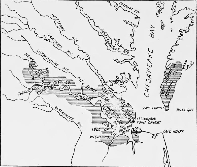 Virginia Settlements, 1634.
[Pg 116] The charter of 1606.—Between 1602 and 1606 several voyages were made to America, the most important being that of George Weymouth, who visited the New England coast in 1604; his favorable report greatly stimulated the desire to plant colonies. In April, 1606, a charter was drawn up which provided for two companies; one composed of men from London, familiarly known as the London Company, which was to operate between the thirty-fourth and forty-first degrees of latitude; the other made up of men from Plymouth, Bristol, and Exeter, known as the Plymouth Company, which was to plant colonies between the thirty-eighth and forty-fifth degrees. Each company was to have control of fifty miles both north and south of its first settlement, a hundred miles out to sea, and a hundred miles inland. Neither was to settle within one hundred miles of the other. Each company was to have a council of thirteen persons, and each was to have the right to mine gold, silver, and copper; the king was to receive one-fifth of all the precious metals and one-fifteenth of the copper. No import duties were to be levied for seven years. The charter also provided that the Christian religion was to be spread among the natives. Colonists who went to the New World were guaranteed all the privileges of Englishmen.
[Pg 116] The charter of 1606.—Between 1602 and 1606, there were several voyages to America, with the most significant being George Weymouth's trip to the New England coast in 1604; his positive report greatly increased interest in establishing colonies. In April 1606, a charter was created that set up two companies: one made up of men from London, commonly known as the London Company, which was to operate between the thirty-fourth and forty-first degrees of latitude; the other consisted of men from Plymouth, Bristol, and Exeter, known as the Plymouth Company, which was to establish colonies between the thirty-eighth and forty-fifth degrees. Each company would control fifty miles both north and south of its first settlement, a hundred miles out to sea, and a hundred miles inland. Neither company could settle within one hundred miles of the other. Each company would have a council of thirteen people and would have the right to mine gold, silver, and copper; the king would receive one-fifth of all precious metals and one-fifteenth of the copper. No import duties would be charged for seven years. The charter also mandated that the Christian religion be spread among the natives. Colonists going to the New World were guaranteed all the rights of English citizens.
Founding of Jamestown.—In August, 1606, Henry Challons was sent ahead in the Richard to select a site for the London Company, but was captured off Florida by a Spanish fleet and taken a prisoner to Seville. In December, three vessels, which belonged to the Muscovy Company, the Susan Constant, the Godspeed, and the Discovery, sailed for Virginia under the command of Sir Christopher Newport. They followed the southern route by the Canaries and the West Indies, arriving in Chesapeake Bay in May, 1607. Of the hundred and twenty colonists who had embarked, sixteen died during the voyage. Sealed instructions had been sent for the government and management of Virginia. When opened, they disclosed the names of the members of the council, a body possessed of executive, legislative, and judicial powers, presided over by a president. A site was to be selected on an island in a navigable river, marshy or heavily wooded ground to be avoided. Contrary to instructions, the site selected was on a swampy peninsula, located near the mouth[Pg 117] of the James River. Near the western end of the peninsula a triangular log fort was laid out. The settlement was in the district known to the Spaniards as Axacan, and not far from the site of the Jesuit mission founded in 1570. While the fortification was being built, Newport explored the James River as far as the site of Richmond. While he was gone, the Indians attacked the fort but were driven off. Besides the fortification, a church and storehouse were erected. In July Newport sailed for England, taking with him worthless specimens of rock which were believed to contain gold.
Founding of Jamestown.—In August 1606, Henry Challons was sent ahead on the Richard to choose a location for the London Company, but he was captured off Florida by a Spanish fleet and taken as a prisoner to Seville. In December, three ships owned by the Muscovy Company—the Susan Constant, the Godspeed, and the Discovery—set sail for Virginia under the command of Sir Christopher Newport. They took the southern route through the Canaries and the West Indies, arriving in Chesapeake Bay in May 1607. Of the 120 colonists who set out, sixteen died during the journey. Sealed instructions had been sent for the governance and management of Virginia. When opened, they revealed the names of the council members, a group with executive, legislative, and judicial powers, led by a president. A site was to be chosen on an island in a navigable river, avoiding marshy or heavily wooded areas. Contrary to these instructions, the site selected was on a swampy peninsula located near the mouth[Pg 117] of the James River. At the western end of the peninsula, a triangular log fort was established. The settlement was in the area known to the Spaniards as Axacan and not far from the site of the Jesuit mission founded in 1570. While the fort was being constructed, Newport explored the James River as far as the location of Richmond. During his absence, the Indians attacked the fort but were repelled. In addition to the fort, a church and storehouse were built. In July, Newport sailed back to England, taking with him some worthless rock samples that were thought to contain gold.
Early difficulties.—Shortly after the departure of Newport the colonists began to suffer from famine, malaria, and Indian attacks. President Wingfield husbanded the stores left by Newport, an action which angered the settlers, and he was soon deposed. John Smith was sent to secure food from the Indians, and succeeded in obtaining a considerable supply. When Newport returned in January, 1608, he found only forty survivors. During 1608 and 1609 the little settlement was barely able to hold its own. The few additional settlers who came merely offset the ravages of disease and starvation. During this period John Smith appears to have been the chief factor in keeping the colony alive. So precarious had conditions become by May, 1609, that he dispersed the colonists in groups, one being sent to live among the Indians, another to fish at Point Comfort, and a third to obtain oysters. In July a vessel commanded by Samuel Argall arrived with supplies, bringing the news that the first charter had been repealed and a new one granted.
Early difficulties.—Shortly after Newport left, the colonists started to face hunger, malaria, and attacks from Native Americans. President Wingfield controlled the supplies left by Newport, which upset the settlers, leading to his removal from power. John Smith was sent to get food from the Native Americans and successfully secured a good amount. When Newport returned in January 1608, he found only forty survivors. Throughout 1608 and 1609, the tiny settlement was just managing to survive. The few new settlers who arrived only balanced out the losses from disease and starvation. During this time, John Smith seemed to be the main reason the colony stayed alive. Conditions had become so unstable by May 1609 that he split the colonists into groups, sending one to live among the Native Americans, another to fish at Point Comfort, and a third to gather oysters. In July, a ship captained by Samuel Argall arrived with supplies, bringing news that the first charter had been canceled and a new one issued.
Charter of 1609.—The lack of success in the original venture had caused those interested to make an effort to enlarge the company. The incorporators of the charter of 1609 were fifty-six of the guilds and companies of London, and six hundred and fifty-nine persons, among whom were included twenty-one peers, ninety-six knights, eleven professional men, and fifty-three captains. The new company was to have the land two hundred miles north and two hundred miles south of Point Comfort and stretching from sea to sea west and northwest, and the islands within one hundred miles of the coast. The government was vested in a council, which was given power to appoint its own officers, to make laws for the government of the colony, and to[Pg 118] take in new stockholders. The English church was established as the religion of the colony.
Charter of 1609.—The lack of success in the original venture led those involved to try to expand the company. The charter of 1609 was incorporated by fifty-six guilds and companies from London, along with six hundred and fifty-nine individuals, which included twenty-one peers, ninety-six knights, eleven professionals, and fifty-three captains. The new company was granted land extending two hundred miles north and two hundred miles south of Point Comfort, running from sea to sea to the west and northwest, along with the islands within one hundred miles of the coast. Governance was entrusted to a council with the authority to appoint its own officers, create laws for the colony's administration, and[Pg 118] add new stockholders. The English church was established as the official religion of the colony.
The starving time.—In June, 1609, nine vessels commanded by Newport sailed from England with the new governor, Sir Thomas Gates, and about five hundred emigrants. Beset by pestilence and storms, many died on the voyage, about four hundred being landed at Jamestown in August. The vessel carrying the governor was stranded in the Bermudas, and he did not arrive at Jamestown until May, 1610. There he found the colonists in a frightful condition, dissensions among the officers, Indian attacks, disease, and starvation having brought the colony to the brink of destruction. Gates decided to give up the ill-fated attempt, and taking all the settlers on board, sailed down the James River, but met a vessel bearing the news that a new governor, Lord Delaware, had arrived at Point Comfort with supplies and a hundred and fifty emigrants. Gates immediately returned to Jamestown. Of the nine hundred persons who had been landed in Virginia during the first three years, only one hundred and fifty were alive upon the arrival of Delaware.
The starving time.—In June 1609, nine ships led by Newport set sail from England with the new governor, Sir Thomas Gates, and about five hundred settlers. Struck by disease and storms, many died during the journey, and around four hundred arrived in Jamestown in August. The ship carrying the governor got stuck in the Bermudas, and he didn’t reach Jamestown until May 1610. When he arrived, he found the colonists in terrible shape, with conflicts among the leaders, attacks from Native Americans, disease, and starvation pushing the colony to the edge of collapse. Gates decided to abandon the doomed endeavor and took all the settlers on board to sail down the James River, but encountered a ship bringing news that a new governor, Lord Delaware, had arrived at Point Comfort with supplies and one hundred fifty settlers. Gates quickly returned to Jamestown. Of the nine hundred people who had been brought to Virginia during the first three years, only one hundred fifty were still alive when Delaware arrived.
Spanish resistance.—Spain regarded the Jamestown colony as an intruder, and both Spaniards and Englishmen considered it as a menace to Spain's northern outposts, and to her merchant fleets, which passed close by on their homeward voyage. Dale remarked that the settlement "wyll put such a byt in our ainchent enemyes mouth as wyll curb his hautynes of monarchie." Zúñiga, Spanish ambassador to England, urged that "such a bad project should be uprooted now, while it can be done so easily."
Spanish resistance.—Spain viewed the Jamestown colony as an intruder, and both Spaniards and Englishmen saw it as a threat to Spain's northern outposts and to her merchant fleets that passed nearby on their way home. Dale noted that the settlement "will put such a bite in our ancient enemy's mouth as will curb his arrogance of monarchy." Zúñiga, the Spanish ambassador to England, urged that "such a bad project should be uprooted now, while it can be done so easily."
At Jamestown fear of a Spanish attack was almost constant, and Newport sought aid in England lest the "all devouring Spaniard lay his ravenous hands" upon the infant colony. Spanish resistance had already been felt by way of vigorous diplomatic protest and through the capture of the Richard in 1606. In 1609 a Spanish expedition was sent to Jamestown under Captain Ecija, commander of the garrison at St. Augustine. On July 24 Ecija entered Chesapeake Bay. Concluding that the settlement was too strong to capture with one small vessel, he withdrew, but on his way down the coast he conferred with the Indian tribes, and sent a delegation of natives overland to spy upon the[Pg 119] English. On Ecija's return to St. Augustine another native delegation was sent to Virginia from Florida by Governor Ybarra. The success of these embassies has been inferred from the Indian massacres at Jamestown in the following winter. Two years later another Spanish expedition was sent to Jamestown. Captures were made on both sides and the episode was followed by a demand at the English settlement for reinforcements.
At Jamestown, the fear of a Spanish attack was almost constant, and Newport sought help in England to prevent the "all-devouring Spaniard from laying his ravenous hands" on the young colony. Spanish resistance had already been felt through strong diplomatic protests and the capture of the Richard in 1606. In 1609, a Spanish expedition was sent to Jamestown under Captain Ecija, who was in charge of the garrison at St. Augustine. On July 24, Ecija entered Chesapeake Bay. Realizing that the settlement was too strong to capture with just one small ship, he withdrew. However, on his way down the coast, he met with the Indian tribes and sent a group of natives overland to spy on the[Pg 119] English. When Ecija returned to St. Augustine, another native delegation was sent to Virginia from Florida by Governor Ybarra. The success of these missions can be inferred from the Indian massacres at Jamestown the following winter. Two years later, another Spanish expedition was sent to Jamestown. There were captures on both sides, and this incident led to a request for reinforcements at the English settlement.
Zúñiga continued to urge the destruction of the colony, but Philip III temporized, allured by the hope of an English alliance and encouraged by his informants to believe that the struggling colony would fail through misery. Instead of dying out, however, as time went on Virginia waxed stronger, and soon became a base for attacks on Spanish commerce, as had been predicted. The founding of Jamestown in Axacan was the first English nibble at the Spanish mainland possessions, a process which continued for a century and a half.
Zúñiga kept pushing for the colony's destruction, but Philip III hesitated, tempted by the possibility of an alliance with England and encouraged by his informants to think that the struggling colony would eventually collapse due to hardship. However, instead of fading away, Virginia grew stronger over time and soon turned into a launch point for attacks on Spanish trade, just as predicted. The establishment of Jamestown in Axacan was the first small step by the English into the Spanish mainland territories, a trend that continued for a hundred and fifty years.
Delaware's governorship.—Delaware remained in Virginia less than a year, during which period new colonists arrived, the settlement at Jamestown was rebuilt, the Indians were driven from Kecoughtan, and forts Charles and Henry were established at the mouth of the James River. An expedition was also sent to the falls in search of a gold mine, but it found none. Delaware was unable to check the ravages of disease, and during the summer a hundred and fifty died. The governor left the colony in March, 1611, but remained in office until his death in 1618, during which period the government was administered by deputy governors.
Delaware's governorship.—Delaware was in Virginia for less than a year, during which new colonists arrived, the settlement at Jamestown was rebuilt, the Indians were pushed out of Kecoughtan, and forts Charles and Henry were established at the mouth of the James River. An expedition was also sent to the falls looking for a gold mine, but none was found. Delaware couldn't stop the spread of disease, and over the summer, one hundred and fifty people died. The governor left the colony in March 1611 but stayed in office until his death in 1618, during which time deputy governors ran the government.
Dale's strong hand.—Sir Thomas Dale was left in charge. He was a brusque old soldier who had seen service in the Netherlands, and during his administration, the colony was governed by military law. The men were forced to work like slaves, and those who rebelled were punished with the greatest severity, several captured runaways being burned at the stake. The Indians along the James and York rivers were attacked; Pocahontas, the daughter of Powhatan, was captured, and the hostage was used to force that powerful chief to make peace. Hearing of the French occupation of Acadia, Dale sent Captain Argall to destroy the settlements.
Dale's strong hand.—Sir Thomas Dale was put in charge. He was a tough old soldier who had served in the Netherlands, and during his time in charge, the colony was run under military law. The men were made to work like slaves, and those who resisted faced harsh punishments, with several captured runaways being burned at the stake. The Native Americans along the James and York rivers were attacked; Pocahontas, the daughter of Powhatan, was captured, and she was held as a hostage to force that powerful chief to make peace. After hearing about the French taking over Acadia, Dale sent Captain Argall to destroy the settlements.
[Pg 120] Charter of 1612.—During the administration of Dale, a change was made in the charter, the powers of the council being considerably enlarged. The Bermudas were also placed under its jurisdiction. The rights in the islands, however, were subsequently sold to some of the members of the London Company, who obtained a charter in 1614 under the name of the Somers Island Company.
[Pg 120] Charter of 1612.—During Dale's leadership, the charter was revised, significantly expanding the powers of the council. The Bermudas were also added to its authority. However, the rights to the islands were later sold to some members of the London Company, who received a charter in 1614 under the name of the Somers Island Company.
Change in the management of the company.—Sir Thomas Smythe had been the moving spirit of the company, but in spite of his efforts, the colony had proved a financial failure, and he was willing to let others carry on the enterprise. The central figure in the company after 1618 was Sir Edwin Sandys. Smythe had realized that it was necessary to change the communal form of ownership to one of landed proprietorship, and had issued instructions that fifty acres of land be assigned to every person who would transport one person to the colony. This policy was carried out by Sandys, and the "old colonists" were allowed to obtain larger tracts of land.
Change in the management of the company.—Sir Thomas Smythe had been the driving force behind the company, but despite his efforts, the colony ended up being a financial failure, and he was ready to let others take over the enterprise. The key figure in the company after 1618 was Sir Edwin Sandys. Smythe understood that it was essential to shift from the communal ownership model to individual land ownership, and he issued instructions to assign fifty acres of land to anyone who brought one person to the colony. This policy was implemented by Sandys, and the "old colonists" were permitted to acquire larger plots of land.
House of Burgesses.—In April, 1619, Sir George Yeardley assumed control as governor of Virginia. He brought out instructions by which the inhabitants of each place and plantation were to elect two burgesses, who were to meet at Jamestown in a general assembly. This first representative assembly in America met in the church at Jamestown on July 30. It was composed of the governor, councilors, and twenty-two burgesses. At the first session, the assembly sat in the two-fold capacity of law makers and court of law.
House of Burgesses.—In April 1619, Sir George Yeardley took over as governor of Virginia. He issued instructions that required the settlers of each location and plantation to elect two representatives, who would meet in Jamestown for a general assembly. This first representative assembly in America convened in the church at Jamestown on July 30. It consisted of the governor, councilors, and twenty-two representatives. During the first session, the assembly functioned both as lawmakers and as a court of law.
Agricultural development.—The original instructions had provided that the products of labor should belong to the community instead of to the individual, an arrangement by which the slothful profited at the expense of the industrious. During the first season, only four acres were cleared and planted. The insufficiency of the supply of grain made it necessary to depend upon the Indians for maize. In 1608 John Smith succeeded in getting forty acres of land broken, and the following year this was planted to maize. Just before the arrival of Delaware, the attempts at agriculture were abandoned, the colonists relying for subsistence on roots, herbs, nuts, berries, and fish. Delaware immediately set to work to right conditions, the hours of labor[Pg 121] being set from six to ten in the morning, and from two to four in the afternoon.
Agricultural development.—The original guidelines stated that the products of labor should belong to the community rather than to individuals, a setup that allowed lazy people to benefit at the expense of hardworking ones. In the first season, only four acres were cleared and planted. The lack of grain supply made it necessary to rely on the Indigenous people for maize. In 1608, John Smith managed to have forty acres of land cultivated, and the next year it was planted with maize. Just before Delaware's arrival, agricultural efforts were halted, with the colonists depending on roots, herbs, nuts, berries, and fish for food. Delaware immediately got to work to fix the situation, setting work hours[Pg 121] from six to ten in the morning and from two to four in the afternoon.
When Dale took charge he forced the men to plant seed and assigned to each a garden. Livestock had been imported, and were allowed to roam at large in the woods. Dale erected a blockhouse on the mainland to protect them, and warned the settlers against letting stock wander. Henrico was selected as the site for another settlement and the town site of seven acres he caused to be fenced in. Other palings back of the settlement were erected and within the fenced areas corn was planted. On the south side of the river fences were built which protected a circuit of twelve miles, the enclosed land being used for a hog range. The lands of the Indians near the mouth of the Appamatox River were seized, fenced, and planted with maize.
When Dale took over, he made the men plant seeds and assigned each of them a garden. Livestock was brought in and allowed to roam freely in the woods. Dale built a blockhouse on the mainland for their protection and warned the settlers not to let the animals wander off. Henrico was chosen as the location for another settlement, and he had a seven-acre town site fenced in. Additional fencing was put up behind the settlement, and corn was planted within the fenced areas. On the south side of the river, fences were constructed to protect a twelve-mile area used for hogs. The lands of the Indians near the mouth of the Appamatox River were taken, fenced, and planted with corn.
In 1612 the cultivation of tobacco began, the first tobacco planter being John Rolfe, who had married Pocahontas. Tobacco soon became the only export, its cultivation absorbing the economic fife of the colony. To make certain of the food supply, Dale commanded that no one should be permitted to plant tobacco until he had planted two acres of grain. To encourage industry, Dale allowed some of the "old colonists" to lease three acres. He also put in force a rule that every man with a family who arrived in the colony should be provided with a house free of rent, tools, and livestock, and with subsistence for himself and family for the first year. If he confined himself to the planting of grain and vegetables, he was given twelve acres of fenced land. At the time of Dale's departure in 1616 there were three hundred and fifty inhabitants settled at Henrico, Bermuda, West and Shirley Hundreds, Jamestown, Kecoughtan, and Dale's Gift.
In 1612, tobacco cultivation started, with John Rolfe, who married Pocahontas, as the first tobacco planter. Tobacco quickly became the only export, and its growth took over the colony's economy. To ensure a steady food supply, Dale ordered that no one could plant tobacco until they had first planted two acres of grain. To promote hard work, Dale allowed some of the "old colonists" to lease three acres. He also implemented a rule that every man with a family who arrived in the colony would receive a house rent-free, along with tools, livestock, and enough food for himself and his family for the first year. If he focused on planting grain and vegetables, he was given twelve acres of fenced land. By the time Dale left in 1616, there were three hundred and fifty residents settled in Henrico, Bermuda, West and Shirley Hundreds, Jamestown, Kecoughtan, and Dale's Gift.
Immigration.—In 1619 twenty negroes were brought into Virginia, the first blacks to be introduced. Up to this time there were few women in the colony, but the company succeeded in sending over several ship-loads of unmarried women. Upon arrival there was à speedy courtship, and the lucky swain gladly paid a hundred and twenty pounds of the best tobacco for the cost of transportation. In general the type of settler was excellent, but in the later years of the company convicted felons and a large number of waifs and vagabonds from the streets of London[Pg 122] were sent. The emigrants who had no capital were usually indented servants, the terms of indenture varying from two to seven years.
Immigration.—In 1619, twenty Black people were brought to Virginia, marking the arrival of the first African individuals in the colony. Up until that point, there were very few women in the settlement, but the company managed to send several ships full of unmarried women. Upon their arrival, there was a quick courtship, and the fortunate suitor happily paid one hundred and twenty pounds of the best tobacco for the transportation costs. Overall, the type of settler was quite good, but in later years, the company sent convicted felons and a large number of homeless people and drifters from the streets of London[Pg 122]. The emigrants who had no money were typically indentured servants, with the length of their indenture ranging from two to seven years.
Growth of large estates.—In this early period began the formation of great estates. The company retained twelve thousand acres for itself. As new officers were created lands were set aside to support them. The treasurer, marshal, and cape merchant were each granted fifteen hundred acres, the physician and secretary five hundred acres each. The large estates were worked by tenants, the number on each estate being fixed by the company. Grants of large tracts were also made to groups of capitalists who agreed to bring out settlers.
Growth of large estates.—During this early period, the creation of large estates began. The company kept twelve thousand acres for itself. As new positions were established, land was allocated to support them. The treasurer, marshal, and cape merchant were each given fifteen hundred acres, while the physician and secretary received five hundred acres each. The large estates were farmed by tenants, with the number on each estate determined by the company. Grants of large land parcels were also given to groups of investors who agreed to bring in settlers.
The Indian massacre of 1622.—The reaching out for new lands for tobacco culture resulted in encroachment upon the fields of the Indians. Angered by this the Indians suddenly attacked the outlying plantations, killing between three and four hundred persons, nearly one-fourth of the entire population. The planting of the crops was interrupted and a winter of hardship followed. When the Indian maize crop was nearly ripe, the settlers retaliated, almost exterminating the natives along the lower courses of the James and York rivers.
The Indian massacre of 1622.—The push for new land for tobacco farming led to encroachment on Indian territories. This angered the Indians, who suddenly attacked the nearby plantations, killing about three to four hundred people, which was nearly a quarter of the total population. Crop planting was disrupted, and a harsh winter followed. When the Indian maize crop was almost ready for harvest, the settlers retaliated, nearly wiping out the natives along the lower reaches of the James and York rivers.
Crown regulation of the tobacco industry.—To free himself from parliamentary control and to regulate industry, James I granted monopolies to private individuals. Royal commissioners were appointed to inspect the tobacco and to prevent smuggling, and planting in England was prohibited. In 1620 the London Company petitioned the king to do away with the tobacco monopoly and as a result the London and Bermuda companies were allowed to import fifty-five thousand pounds annually. The companies immediately attempted to ship Virginia tobacco to Holland; this led to a dispute with the privy council and the matter was discussed in parliament, where Sandys defended the right of free shipment. The dispute was settled by a compromise, by which the companies agreed to ship the entire product to England, and no restriction was placed upon the amount which they might import.
Crown regulation of the tobacco industry.—To escape parliamentary control and manage industry, James I granted monopolies to private individuals. Royal commissioners were appointed to inspect tobacco and prevent smuggling, and planting in England was banned. In 1620, the London Company asked the king to eliminate the tobacco monopoly, and as a result, the London and Bermuda companies were permitted to import fifty-five thousand pounds each year. The companies quickly tried to ship Virginia tobacco to Holland; this led to a dispute with the privy council, and the issue was addressed in parliament, where Sandys defended the right to free shipping. The dispute was resolved through a compromise, where the companies agreed to ship all their products to England, and no limits were placed on the amount they could import.
Neither side was entirely pleased with the arrangement and in November, 1622, an agreement was reached by the Lord Treasurer and the companies. The companies were given the[Pg 123] sole right for seven years to import tobacco into England and Ireland; they were to pay into the royal exchequer the net proceeds of one-third of all tobacco imported; no tobacco was to be planted in England and Ireland, and a small amount of Spanish tobacco was to be imported for three years. Like previous arrangements, this did not meet with the approval of all, and it was annulled in 1623, the companies being allowed the exclusive right to import tobacco into England and Ireland, except a small amount of Spanish tobacco, and to pay a duty of nine pence a pound.
Neither side was entirely happy with the arrangement, and in November 1622, an agreement was reached by the Lord Treasurer and the companies. The companies were granted the[Pg 123] exclusive right to import tobacco into England and Ireland for seven years; they were required to pay into the royal exchequer one-third of the net proceeds from all tobacco imported; no tobacco was to be grown in England and Ireland, and a small amount of Spanish tobacco was to be imported for three years. Like previous arrangements, this did not gain everyone's approval, and it was canceled in 1623, with the companies being allowed the exclusive right to import tobacco into England and Ireland, except for a small amount of Spanish tobacco, and to pay a duty of nine pence per pound.
End of the London Company.—The king had looked with scant favor upon the administration of Sandys, for popular government was not to the liking of James. Friction between the king and the company also added to the royal displeasure. James, who was personally opposed to the use of tobacco, was also trying to please the Spanish court, which made frequent protests against the Virginia enterprise. Internal dissensions also disturbed the company, a group headed by Sir Thomas Smythe being opposed to the Sandys faction. Royal commissioners were appointed to examine the condition of affairs, and as a result of their report, in 1624 the charter of the London Company was annulled, the colony passing under the direct control of the crown.
End of the London Company.—The king had viewed Sandys's leadership with little approval, as popular government wasn’t something James appreciated. Tensions between the king and the company added to his dissatisfaction. James, who was personally against tobacco use, was also trying to win over the Spanish court, which consistently complained about the Virginia venture. Internal conflicts also troubled the company, with one faction led by Sir Thomas Smythe opposing Sandys's group. Royal commissioners were appointed to investigate the situation, and as a result of their findings, in 1624, the charter of the London Company was revoked, placing the colony directly under royal control.
Increase of population by 1625.—When Charles I came to the throne Virginia contained about twelve hundred inhabitants, of whom nearly five hundred were servants, and about a hundred were children. They were scattered through nineteen settlements, the largest being Elizabeth City, which contained two hundred and fifty-seven inhabitants. Jamestown had thirty-three houses and a population of one hundred and seventy-five.
Increase of population by 1625.—When Charles I became king, Virginia had about twelve hundred residents, nearly five hundred of whom were servants, and around a hundred were children. They were spread out across nineteen settlements, with the largest being Elizabeth City, which had two hundred and fifty-seven residents. Jamestown had thirty-three houses and a population of one hundred and seventy-five.
Population in 1635.—By 1635 the population had increased to five thousand. The country had been divided into shires, which later were called counties. The six counties along the James River contained about four thousand inhabitants; Charles River County on the York River five hundred, and Accomac County on the opposite side of the bay four hundred. By 1640 the population had increased to seven thousand five hundred.
Population in 1635.—By 1635, the population had grown to five thousand. The country had been divided into shires, which were later referred to as counties. The six counties along the James River had around four thousand residents; Charles River County on the York River had five hundred, and Accomac County on the other side of the bay had four hundred. By 1640, the population had risen to seven thousand five hundred.
Tobacco lands.—The most desirable lands for tobacco were the bottoms along the streams. Tobacco exhausted the soil[Pg 124] rapidly, three years being the usual life of a field. This made it necessary for the planter to take up new lands and increased his desire for larger holdings. Land patents were issued for large tracts, usually of from one hundred to three hundred acres, although many obtained patents for a thousand acres.
Tobacco lands.—The best lands for growing tobacco were the bottoms along the streams. Tobacco quickly depleted the soil[Pg 124], with the average lifespan of a field being about three years. This meant that the planter had to look for new lands, which increased their desire for larger holdings. Land patents were issued for large areas, typically ranging from one hundred to three hundred acres, although many secured patents for up to a thousand acres.
Charles I and the tobacco business.—Charles was opposed to the tobacco business, but he realized that it was necessary to the colony. The king favored Virginia by reducing the duty on tobacco and excluding the Spanish leaf from England and Ireland. But in 1627, when parliament had not granted adequate supplies to the crown, he renewed the monopoly. To put it in force, a proclamation was issued which forbade the annual importation of more than fifty thousand pounds of Spanish tobacco, prohibited the growing of the plant in England and Ireland, and made London the only port of entry. As the colonists objected to the monopoly, the king issued another proclamation, which provided that no colonial tobacco should be imported without special license and should be delivered to tobacco commissioners, who were to have the sole right of disposing of the product. The price was to be fixed by agreement between the shippers and commissioners. Efforts were made to have the colony engage in the production of more substantial commodities, the planters being commanded to produce pitch, tar, potash, timber, iron, and salt, to plant vines and grain, and to search for minerals. The efforts of the king, however, were but partially successful, and tobacco remained the great staple. It had also become the medium of exchange, and though attempts were made to introduce a metallic currency, they did not succeed, in spite of the fact that the fluctuating price of the staple made financial transactions difficult.
Charles I and the Tobacco Business.—Charles was against the tobacco industry, but he recognized its importance to the colony. The king supported Virginia by reducing the tax on tobacco and banning Spanish tobacco from England and Ireland. However, in 1627, when Parliament didn’t provide enough funds to the crown, he reinstated the monopoly. To enforce it, he issued a proclamation that limited the annual import of Spanish tobacco to no more than fifty thousand pounds, banned the cultivation of the plant in England and Ireland, and declared London the only port of entry. Since the colonists opposed the monopoly, the king issued another proclamation stating that no colonial tobacco could be imported without a special license and that it had to be delivered to tobacco commissioners, who alone had the right to sell the product. The price would be set through an agreement between the shippers and commissioners. There were efforts to encourage the colony to produce more essential goods, with planters being ordered to make pitch, tar, potash, timber, iron, and salt, grow grapes and grains, and look for minerals. However, the king's efforts were only somewhat successful, and tobacco remained the primary crop. It had also become the main medium of exchange, and although there were attempts to introduce a metal currency, they failed, despite the fact that the fluctuating price of tobacco made financial transactions challenging.
Harvey's tobacco policy.—In 1630 Governor Harvey commenced his administration. He immediately began to encourage the planting of grain and the raising of stock. The low price of tobacco at this time assisted him, and in 1631 the colony was able to export a large quantity of grain. Efforts were also made to improve the quality of tobacco. A law of the colonial legislature of 1632 provided for five points of inspection. Storehouses were built where inspectors examined the stock and condemned the poorer qualities. The number of plants to be raised by each family was limited to two thousand, and not more than nine[Pg 125] leaves were allowed to be taken from a plant. In 1633 the number of plants per family was reduced to fifteen hundred. English merchants trading to the colonies purchased a considerable amount of tobacco, which they took in exchange for other commodities, for which they charged abnormally high prices. To right this and to increase the royal revenues, in 1634 the king again renewed the monopoly. When Governor Harvey attempted to contract for the crop, an acrimonious debate ensued. This, coupled with the fact that the governor attempted to assist Lord Baltimore's colonists, caused the council illegally to depose the governor.
Harvey's tobacco policy.—In 1630, Governor Harvey started his administration. He quickly began promoting the planting of grain and raising livestock. The low price of tobacco at the time helped him, and by 1631, the colony was able to export a significant amount of grain. Efforts were also made to enhance the quality of tobacco. A law from the colonial legislature in 1632 established five points of inspection. Storehouses were built where inspectors examined the crops and rejected the lower-quality ones. Each family was limited to growing two thousand plants, and no more than nine [Pg 125] leaves could be taken from a single plant. In 1633, the limit on plants per family was reduced to fifteen hundred. English merchants trading with the colonies bought a large amount of tobacco in exchange for other goods, which they sold at excessively high prices. To correct this and boost royal revenues, in 1634, the king renewed the monopoly once again. When Governor Harvey tried to secure a contract for the crop, a heated debate broke out. This, along with the fact that the governor tried to help Lord Baltimore's colonists, led the council to illegally depose him.
Continued efforts to enforce the monopoly.—The king continued to make efforts to enforce the monopoly. In 1638 he issued another proclamation, stating that it was necessary to regulate tobacco planting, to decide how much was to be imported, and to handle the product. The colony as usual objected. Owing to the troublous times in England, the proclamation was not strictly enforced and much tobacco was sold to other than government agents.
Continued efforts to enforce the monopoly.—The king kept trying to enforce the monopoly. In 1638, he issued another proclamation, saying that it was important to regulate tobacco planting, determine how much should be imported, and manage the product. As usual, the colony objected. Due to the turbulent times in England, the proclamation wasn't strictly enforced, and a lot of tobacco was sold to parties other than government agents.
THE FOUNDING OF MARYLAND
Calvert's attempted settlement in Newfoundland.—The northern end of Chesapeake Bay was soon occupied by a rival tobacco colony, the proprietary province of Lord Baltimore. In 1609 George Calvert became a stockholder of the Virginia Company, and ten years later was made secretary of state by James I. His new office gave him an opportunity to begin an independent colony. In 1620 he bought the southeastern peninsula of Newfoundland from Sir William Vaughan, to whom it had previously been granted, and the following year sent out a few colonists. In 1623 the king granted him a charter for his colony, which was called Avalon. Two years later Calvert resigned the secretaryship. In spite of the fact that he had recently become a Catholic, he was raised to the Irish peerage with the title of Baron of Baltimore. In 1627 he visited Newfoundland with his family, but the inclemency of the climate convinced him of the undesirability of Avalon.
Calvert's attempted settlement in Newfoundland.—The northern end of Chesapeake Bay was soon taken over by a competing tobacco colony, the proprietary province of Lord Baltimore. In 1609, George Calvert became a shareholder in the Virginia Company, and ten years later, he was appointed secretary of state by James I. This new position allowed him to start an independent colony. In 1620, he purchased the southeastern peninsula of Newfoundland from Sir William Vaughan, who had received it as a grant earlier, and the next year he sent out a small group of colonists. In 1623, the king granted him a charter for his colony, named Avalon. Two years later, Calvert resigned from his position as secretary. Even though he had recently converted to Catholicism, he was elevated to the Irish peerage with the title of Baron of Baltimore. In 1627, he visited Newfoundland with his family, but the harsh climate convinced him that Avalon was not a suitable place to settle.
Application for land in Virginia.—In 1629 Baltimore applied for a grant in Virginia, to which colony he immediately proceeded.[Pg 126] There he met with a cold reception and shortly departed for England, where he made every effort to obtain a charter. The Virginians opposed him strongly, but in April, 1632, his suit was successful and the grant was made. George Calvert died the same month and the charter was drawn in the name of his son Cecilius.
Application for land in Virginia.—In 1629, Baltimore applied for a land grant in Virginia and immediately went to the colony. [Pg 126] There, he received a chilly welcome and soon left for England, where he worked hard to secure a charter. The people of Virginia strongly opposed him, but in April 1632, he succeeded and the grant was issued. George Calvert died that same month, and the charter was established in the name of his son, Cecilius.
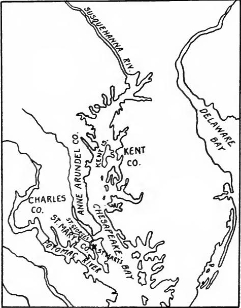 Settlements in Maryland, 1634.
The charter.—The province was named Maryland in honor of Henrietta Maria, the wife of Charles I. In general it extended from the fortieth parallel to the southern bank of the Potomac River, and from the meridian which crossed the source of that river to the Atlantic; but the description of boundaries was so indefinite, because of the lack of precise geographical knowledge, that many disputes soon arose over ownership of territory.
The charter.—The province was named Maryland in honor of Henrietta Maria, the wife of Charles I. Generally, it stretched from the fortieth parallel to the southern bank of the Potomac River, and from the meridian that crossed the source of that river to the Atlantic; however, the boundary descriptions were so vague due to limited geographical knowledge that many disputes quickly emerged over land ownership.
The government of Maryland was modeled upon that of the Palatinate of Durham, a feudatory on the border of Scotland[Pg 127] in which the bishop had almost absolute powers; but the lord proprietor of Maryland was restricted by several clauses in the charter. He was given the right to ordain, make, and enact laws, provided they were approved by the freemen of the province, or by a majority of them, or by their delegates, and were not contrary to the laws of England. Baltimore was given very large judicial powers, such as the creation of courts and the pardoning of criminals. He was also given the right to make ordinances, provided they did not deprive any person of use, limb, or property. The proprietor could collect taxes, make grants of lands, and create manors, over which the lord of the manor would have the rights of a feudal baron. The proprietor was also given control of ecclesiastical matters such as the power of appointing ministers and founding churches, which were "to be dedicated and consecrated according to the Ecclesiastical Laws of our Kingdom of England." The charter did not prohibit him from permitting the establishment of other churches, an omission which Baltimore used to assist the Catholics. The proprietor's motives, however, were not entirely religious; he no doubt desired to found an asylum for people of his own faith, but he was also a keen business man and desired to increase his worldly goods.
The government of Maryland was based on that of the Palatinate of Durham, a territory on the border of Scotland[Pg 127] where the bishop had almost absolute powers. However, the lord proprietor of Maryland was limited by several clauses in the charter. He had the right to create, make, and enact laws, as long as they were approved by the freemen of the province, a majority of them, or their delegates, and didn’t contradict the laws of England. Baltimore was granted significant judicial powers, including the ability to establish courts and grant pardons to criminals. He could also create ordinances, as long as they did not take away anyone's use, limb, or property. The proprietor was able to collect taxes, grant lands, and create manors, over which the lord of the manor would have the rights of a feudal baron. The proprietor also had authority over ecclesiastical matters, such as appointing ministers and founding churches, which were “to be dedicated and consecrated according to the Ecclesiastical Laws of our Kingdom of England.” The charter did not prevent him from allowing the establishment of other churches, an omission that Baltimore took advantage of to help Catholics. However, the proprietor’s motivations were not purely religious; he certainly wanted to create a refuge for people of his own faith, but he was also a savvy businessman who aimed to increase his wealth.
The first settlers.—In October, 1633, Baltimore sent two small vessels, the Ark and the Dove, to Maryland. On board there were about twenty gentlemen, most of whom were Catholics, and probably two hundred laborers, the majority of whom were Protestants. Among the influential members were the governor, Leonard Calvert, the brother of Lord Baltimore, and the two councilors who were to assist him in the government. Three Jesuit priests accompanied the expedition, which arrived at the mouth of the Potomac in March, 1634. The site for a settlement was selected nine miles up St. George's River, a small stream which flows into the north side of the Potomac near its mouth, the place being named St. Mary's. The location was favorable, for it was surrounded by fields cleared by the Indians. The tribes in the neighborhood had been at war with the Susquehannas, and were glad to sell their lands and move across the Potomac.
The first settlers.—In October 1633, Baltimore sent two small ships, the Ark and the Dove, to Maryland. On board were about twenty gentlemen, most of whom were Catholics, and probably two hundred laborers, the majority of whom were Protestants. Among the key members were the governor, Leonard Calvert, the brother of Lord Baltimore, and the two councilors who would assist him in the government. Three Jesuit priests accompanied the expedition, which arrived at the mouth of the Potomac in March 1634. The site for a settlement was chosen nine miles up St. George's River, a small stream that flows into the north side of the Potomac near its mouth, and the place was named St. Mary's. The location was favorable, as it was surrounded by fields that had been cleared by the Indians. The tribes in the area had been at war with the Susquehannas and were eager to sell their lands and move across the Potomac.
Trouble with Virginia.—William Claiborne had been the principal opponent of George Calvert, when he attempted to obtain the charter for Maryland. In 1631 Claiborne had established[Pg 128] a settlement on Kent Island in Chesapeake Bay, which fell within the bounds of Maryland. In 1634 Governor Calvert informed Claiborne that he would not molest the settlement, but that the owner of Kent Island must be considered as a tenant of the proprietor. Claiborne laid the matter before the Virginia council, which decided that the Maryland charter infringed upon the rights of Virginia. A miniature war followed which was ended by a decision of the king, who ruled that the Virginia charter of 1609 had become null when the crown took over the colony in 1624, and that Kent Island belonged to Maryland.
Trouble with Virginia.—William Claiborne was the main opponent of George Calvert when he tried to get the charter for Maryland. In 1631, Claiborne established[Pg 128] a settlement on Kent Island in Chesapeake Bay, which was within Maryland’s boundaries. In 1634, Governor Calvert told Claiborne that he wouldn’t interfere with the settlement, but that the owner of Kent Island had to be regarded as a tenant of the proprietor. Claiborne presented the issue to the Virginia council, which ruled that the Maryland charter violated Virginia's rights. A small conflict followed, which was resolved by a decision from the king, who declared that the Virginia charter of 1609 had become invalid when the crown took control of the colony in 1624, and that Kent Island belonged to Maryland.
Religious, economic, and social life.—The religious life of the colony was greatly influenced by the presence of the Jesuits. Father White and his colleagues labored incessantly to convert the Protestant colonists and to establish missions among the Indians. In 1641 the Catholics made up about one-fourth of the population but included most of the influential families. The economic life of the colony developed much like that of Virginia, although unaccompanied by the great hardships of the James River settlements. Nor did the Indians prove as troublesome, although from 1639 to 1644 an expedition was sent against them each year. Tobacco cultivation became the principal occupation. The plantations developed along the rivers and the shore of the bay, for many years extending but a few miles inland. The manors usually contained from one thousand to two thousand acres, although a few contained five thousand acres or more, the lords of the manors being granted lands in proportion to the number of colonists they provided. Many of the large grants were later divided, and small proprietors increased in number. There was practically no town life, the seat of government containing only a few houses. There were few mills and no factories. Few roads were built, the water courses and the bay affording the principal means of communication.
Religious, economic, and social life.—The colony's religious life was heavily shaped by the Jesuits' presence. Father White and his team worked tirelessly to convert the Protestant settlers and establish missions among the Native Americans. By 1641, Catholics made up about a quarter of the population, but they included most of the influential families. The colony's economy developed similarly to Virginia's, but without the severe challenges faced by the James River settlements. The Native Americans were also less of a threat, though from 1639 to 1644, there was an annual expedition against them. Tobacco farming became the main occupation. Plantations grew along the rivers and the bay, typically extending only a few miles inland for many years. Most manors ranged from one thousand to two thousand acres, with some spanning five thousand acres or more, as land grants were based on the number of settlers they brought. Many of the large land grants were later divided, leading to an increase in small landowners. There was virtually no town life, and the government seat consisted of just a few houses. There were few mills and no factories. Few roads were constructed, with waterways and the bay serving as the primary means of communication.
The government.—Cecilius Calvert never visited the colony, but he appointed all the important officers, who resided in the province. The chief of these was the governor, to whom the proprietor delegated most of his powers. He was at the head of military affairs. As chancellor he was the keeper of the seal and issued patents for land, commissions for office, and other[Pg 129] legal documents. As chief magistrate he appointed officers for the preservation of peace and the administration of justice, and had power to issue and enforce ordinances, to establish ports, fairs and markets, to remit fines, and pardon all offenses except high treason. He could summon the legislative assembly, prepare bills for its consideration, assent to the laws, and dissolve the assembly. He also acted as chief justice. Leonard Calvert occupied the position until 1647. Assisting the governor was a council. In 1636 it contained three members, but was gradually increased in size in later years. Before this body the governor brought matters of importance, such as the creation of offices, establishment of courts, granting of pardons, levying of taxes, issuing of ordinances, and military expeditions.
The government.—Cecilius Calvert never visited the colony, but he appointed all the important officials who lived in the province. The main one was the governor, to whom the proprietor gave most of his powers. He was in charge of military affairs. As chancellor, he was the keeper of the seal and issued land patents, office commissions, and other[Pg 129] legal documents. As the chief magistrate, he appointed officers to maintain peace and administer justice, and he had the authority to issue and enforce ordinances, establish ports, fairs, and markets, remit fines, and pardon all offenses except high treason. He could call the legislative assembly, prepare bills for consideration, approve laws, and dissolve the assembly. He also served as chief justice. Leonard Calvert held the position until 1647. Assisting the governor was a council. In 1636, it had three members, but it gradually grew larger in later years. The governor presented important matters to this body, such as creating offices, establishing courts, granting pardons, levying taxes, issuing ordinances, and planning military expeditions.
The legislative assembly at first was made up of all the freemen, but as the colonists took up more distant lands, a custom of giving proxies grew up. The first assembly met in 1635, but about all that is known of it is that it attempted to initiate legislation, to which the proprietor objected. The second assembly, which met in 1638, consisted of the governor and council, freemen especially summoned by the governor, freemen present of their own will, and proxies. The governor presented a code approved by the proprietor, but it was rejected by the assembly. The same year the proprietor temporarily yielded the right of initiating legislation, authorizing the governor to consent to laws enacted by the assembly until the proprietor could examine them. In 1639 the local divisions, which were called hundreds, sent representatives. This assembly fixed its own membership, which was to be composed of councilors, persons especially summoned, and burgesses elected in hundreds. The assembly sat at times as a law court, but most of the cases were brought before the governor and his councilors, who acted as associate justices, or before the local courts.
The legislative assembly initially included all the freemen, but as the colonists expanded into more remote areas, a practice of appointing proxies developed. The first assembly convened in 1635, but all that is known about it is that it tried to propose legislation, which the proprietor opposed. The second assembly, which met in 1638, was made up of the governor and council, freemen specifically called by the governor, voluntary freemen, and proxies. The governor put forth a code that the proprietor had approved, but the assembly rejected it. That same year, the proprietor temporarily gave up the right to propose legislation, allowing the governor to agree to laws passed by the assembly until the proprietor could review them. In 1639, the local divisions, known as hundreds, sent representatives. This assembly determined its own membership, which would consist of councilors, specially summoned individuals, and burgesses elected from the hundreds. The assembly sometimes acted as a law court, but most cases were presented to the governor and his councilors, who served as associate justices, or were handled by local courts.
THE BERMUDAS
The Somers Islands Company.—Almost simultaneously with the occupation of the Atlantic seaboard, the English had been establishing vigorous colonies in the islands adjacent to North America. In 1609 a Virginia supply ship commanded by Sir George Somers was wrecked on one of the Bermuda Islands.[Pg 130] Upon his return to England, he interested people in the islands and in 1612 the Somers Islands Company was formed, most of the stockholders being members of the Virginia Company.
The Somers Islands Company.—Almost at the same time as settling the Atlantic coast, the English were actively establishing strong colonies in the islands near North America. In 1609, a supply ship from Virginia, led by Sir George Somers, was wrecked on one of the Bermuda Islands.[Pg 130] When he got back to England, he got people interested in the islands, and in 1612, the Somers Islands Company was created, with most of the stockholders being members of the Virginia Company.
Settlement and economic development of the Bermudas.—Settlers were immediately sent out and the colony prospered from the first. In 1614 it contained six hundred persons. Fortifications were built, some tobacco was shipped, and a land survey begun which was completed in 1617. By 1625 the population had increased to between two and three thousand and a larger supply of tobacco was being produced than in Virginia. As in the James River settlements, there was considerable opposition to the government monopoly of tobacco, and in 1628 a petition against it was addressed to the crown. In 1631 the privy council decreed that only a moderate amount of tobacco should be planted, and the company succeeded in getting a complete monopoly of the trade. The low price of tobacco at that time caused the colonists to devote themselves less exclusively to that business, and corn, potatoes, hogs, fowls, and fruit were produced in such quantities that the islands were able to export large amounts to the colonies on the mainland. The cedar forests also began to be utilized for ship-building. With the growth of the mainland colonies, the Bermudas became of relatively less economic importance, but they continued to be considered an important naval base.
Settlement and economic development of the Bermudas.—Settlers were quickly sent out, and the colony thrived right from the start. By 1614, it had a population of six hundred people. Fortifications were constructed, some tobacco was shipped, and a land survey began, which was completed in 1617. By 1625, the population had grown to between two and three thousand, and a larger supply of tobacco was being produced than in Virginia. Similar to the settlements along the James River, there was significant resistance to the government’s tobacco monopoly, leading to a petition against it being submitted to the crown in 1628. In 1631, the privy council ruled that only a limited amount of tobacco should be planted, and the company managed to gain a complete monopoly of the trade. The low price of tobacco at that time caused the colonists to focus less solely on that crop, and they began producing corn, potatoes, pigs, poultry, and fruit in such large quantities that the islands could export considerable amounts to the mainland colonies. The cedar forests were also started to be used for shipbuilding. With the expansion of the mainland colonies, the Bermudas became relatively less economically significant, but they remained an important naval base.
Representative government.—The Bermudas were the second English colony to receive representative government. Besides the governor and council there was a general assembly, the first being held but a year after the establishment of the Virginia house of burgesses.
Representative government.—The Bermudas were the second English colony to get a representative government. In addition to the governor and council, there was a general assembly, with the first meeting taking place just a year after the Virginia House of Burgesses was established.
GUIANA
For a hundred years the Caribbean had been a Spanish sea. Hardy English mariners had frequently penetrated it, but always at their peril, and they had never seriously injured the Spanish colossus. To gain a foothold on its shores and to appropriate a portion of the commerce of tropical America became powerful forces in English activities.
For a hundred years, the Caribbean had been a Spanish sea. Tough English sailors had often ventured into it, but always at great risk, and they had never really harmed the Spanish giant. Establishing a presence on its shores and claiming part of the trade in tropical America became significant motivations for English efforts.
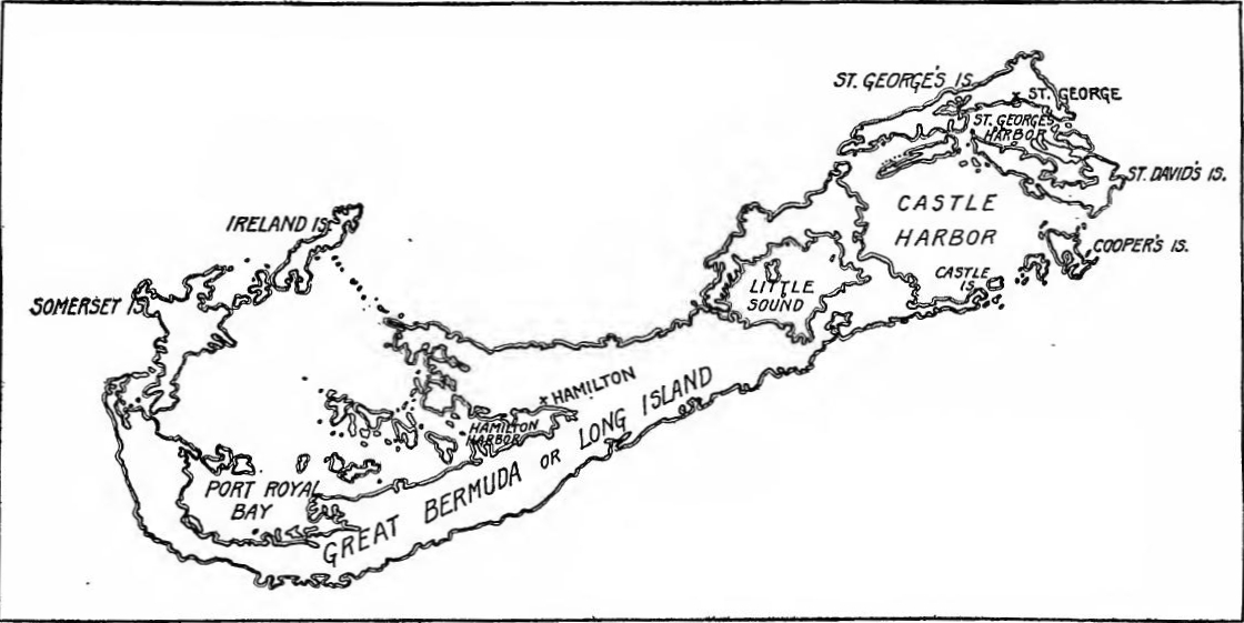 The Bermuda Islands.
[Pg 132] Expeditions.—During the closing years of the reign of Elizabeth, many English ships visited the coast of Venezuela to procure salt, and after the treaty of 1604 with Spain, to obtain tobacco. Several attempts were also made to explore and colonize Guiana. In 1604 Captain Charles Lea planted a colony on the Wyapoco, but in two years abandoned the enterprise. During 1606-1607 Sir Thomas Roe traded along the Guiana coast and explored the swamps of the Cuyuni and Wyapoco. In 1608 Robert Harcourt and two associates received a patent to lands between the Amazon and Essequibo rivers. Harcourt with ninety-seven men landed in Guiana, but after a sojourn of three years he returned to England. Part of the settlers remained and scattered among the Indians. Harcourt attempted to obtain more capital, and in 1616 another expedition was sent out but without success.
[Pg 132] Expeditions.—In the final years of Queen Elizabeth's reign, many English ships sailed to the coast of Venezuela to gather salt, and after the 1604 treaty with Spain, to collect tobacco. There were also several efforts to explore and settle in Guiana. In 1604, Captain Charles Lea established a colony on the Wyapoco River, but he abandoned the project after two years. Between 1606 and 1607, Sir Thomas Roe traded along the Guiana coast and explored the wetlands of the Cuyuni and Wyapoco Rivers. In 1608, Robert Harcourt and two partners received a grant for lands situated between the Amazon and Essequibo rivers. Harcourt, along with ninety-seven men, landed in Guiana, but after three years, he returned to England. Some settlers stayed behind and integrated with the local tribes. Harcourt sought additional funding, and in 1616 another expedition was launched, but it was unsuccessful.
Raleigh's last attempt.—Since the first year of the reign of James I, Raleigh had been imprisoned on a charge of conspiring against the king. But in 1616 he was released, and having obtained a commission as admiral, sailed for Guiana the following year with a fleet of fourteen vessels. Attacked by the Spaniards, he lost several vessels and returned to England, where, upon complaint of the Spanish ambassador, Gondomar, he was again imprisoned and soon after executed.
Raleigh's last attempt.—Since the first year of James I's reign, Raleigh had been imprisoned for allegedly plotting against the king. However, in 1616 he was released and, having secured a commission as admiral, set sail for Guiana the following year with a fleet of fourteen ships. After being attacked by the Spaniards, he lost several ships and returned to England, where, after a complaint from the Spanish ambassador, Gondomar, he was imprisoned again and soon executed.
North's expedition.—In 1620 an attempt was made to reorganize Raleigh's company, and Captain Roger North was sent with one hundred and twenty men to Guiana, where they joined the remnant of Harcourt's colonists. But the attempt again failed because of opposition of the Spanish ambassador.
North's expedition.—In 1620, there was an effort to reorganize Raleigh's company, and Captain Roger North was sent with 120 men to Guiana, where they joined the remaining members of Harcourt's colonists. However, the attempt failed once more due to the opposition from the Spanish ambassador.
THE LESSER ANTILLES
The English occupation.—In a great half circle at the eastern end of the Caribbean are the Lesser Antilles. After the failures on the South American coast, the English grasped these outposts of the tropics and, side by side with the French, were soon firmly established across one of the principal highways of Spanish commerce. In 1623 St. Christopher was temporarily occupied and was actually settled in 1625. The same year (1625) Sir William Courten started the first colony in Barbados. In 1627 Lord Carlisle received a grant which covered the Caribbees, and the following year the Earl of Pembroke and Montgomery also obtained rights to Trinidad. Tobago, and Barbados. In[Pg 133] the contest between the claimants Carlisle won. He ejected Courten's settlers and established his own colonists. In 1628 Nevis was occupied. The following year the settlers on St. Christopher and Nevis were evicted by the Spaniards, but upon the retirement of the fleet the colonists returned to their plantations. In 1632 settlements were made on Antigua and Montserrat. As in the Bermudas, tobacco became the leading crop, but later the production of sugar cane superseded it. Barbados soon contained 6,000 inhabitants and in 1639, when Virginia had a total population of about 7,000, there were 20,000 planters in the islands governed by Carlisle. In the Lesser Antilles the proprietary form of government prevailed for half a century.
The English occupation.—In a large half-circle at the eastern end of the Caribbean are the Lesser Antilles. After failing on the South American coast, the English seized these tropical outposts and, alongside the French, quickly established themselves along one of the main routes of Spanish trade. In 1623, St. Christopher was temporarily occupied and actually settled in 1625. The same year (1625), Sir William Courten started the first colony in Barbados. In 1627, Lord Carlisle received a grant covering the Caribbees, and the following year, the Earl of Pembroke and Montgomery also obtained rights to Trinidad, Tobago, and Barbados. In[Pg 133], the competition between the claimants ended with Carlisle winning. He removed Courten's settlers and established his own colonists. In 1628, Nevis was occupied. The following year, the settlers on St. Christopher and Nevis were expelled by the Spaniards, but after the fleet left, the colonists returned to their plantations. In 1632, settlements were made on Antigua and Montserrat. Like in the Bermudas, tobacco became the leading crop, but later the production of sugar cane took over. Barbados soon had 6,000 residents, and in 1639, when Virginia's total population was about 7,000, there were 20,000 planters in the islands governed by Carlisle. In the Lesser Antilles, a proprietary form of government was in place for half a century.
THE PROVIDENCE ISLAND COMPANY
The Puritan leaders.—During the great struggle between king and parliament, several of the merchant princes were on the Puritan side. One of the most powerful of these was Robert Rich, Lord Warwick. He had been an active member of the Virginia and Somers Islands companies, of the Guinea and Guiana companies, and of the Council of New England. Closely associated with Warwick were Lord Saye and Sele, Lord Brooke, Sir Nathaniel Rich, and John Pym. As the parliamentary contest increased in intensity, these leaders decided to plant a Puritan colony in the Caribbean.
The Puritan leaders.—During the major conflict between the king and parliament, several wealthy merchants supported the Puritans. One of the most influential among them was Robert Rich, Lord Warwick. He had been actively involved with the Virginia and Somers Islands companies, the Guinea and Guiana companies, and the Council of New England. Closely linked with Warwick were Lord Saye and Sele, Lord Brooke, Sir Nathaniel Rich, and John Pym. As the parliamentary struggle escalated, these leaders chose to establish a Puritan colony in the Caribbean.
The Providence Island Company.—The site selected was on one of the Mosquito Islands off the coast of Nicaragua. In 1629 a company was formed which was granted the greater part of the Caribbean Sea, from Haiti to the coast of Venezuela and to the mainland of Central America. Besides Jamaica, then in the possession of Spain, the Caymán Islands fell within these limits. The English fleet which was sent out in 1630 temporarily occupied Tortuga, where colonists from Nevis had recently arrived, and the company asked that this island be included in the patent. The request was granted, but the English were able to hold the island only until 1635 when they were driven out by the Spaniards. The islands along the Mosquito coast were occupied by the company, and a project was formed to colonize the mainland. In 1635 Providence Island was unsuccessfully[Pg 134] attacked by a Spanish fleet, but in 1641 the Spaniards succeeded in overcoming the colony, thus for the time ending English operations on the Central American coast.
The Providence Island Company.—The location chosen was on one of the Mosquito Islands off the coast of Nicaragua. In 1629, a company was formed that was granted most of the Caribbean Sea, stretching from Haiti to the coast of Venezuela and the mainland of Central America. Besides Jamaica, which was then under Spanish control, the Cayman Islands were also included in this area. The English fleet sent out in 1630 temporarily occupied Tortuga, where colonists from Nevis had recently arrived, and the company requested that this island be included in the patent. The request was approved, but the English could only hold the island until 1635, when they were expelled by the Spaniards. The company occupied the islands along the Mosquito coast and initiated a plan to colonize the mainland. In 1635, Providence Island was unsuccessfully[Pg 134] attacked by a Spanish fleet, but in 1641, the Spaniards managed to conquer the colony, effectively ending English operations on the Central American coast for the time being.
READINGS
VIRGINIA
Becker, Carl, The Beginnings of the American People, pp. 65-80; Beer, G.L., The Origins of the British Colonial System, 78-175; Brown, Alexander, Genesis of the United States; The First Republic in America; Bruce, P.A., Economic History of Virginia in the Seventeenth Century, I, 189-330; Institutional History of Virginia in the Seventeenth Century, II, 229-262; Channing, Edward, History of the United States, I, 143-224; Doyle, J.A., English Colonies in America, I, 101-184; Eggleston, Edward, The Beginners of a Nation, 25-97; Fiske, John, Old Virginia and her Neighbors, I, 40-222; Hamilton, P.J., Colonization of the South, 55-119; MacDonald, William, Select Charters Illustrative of American History, 1-23; Osgood, H.L., The American Colonies in the Seventeenth Century, I, 23-97; Scott, W.R., The Constitution and Finance of English, Scottish, and Irish Joint-Stock Companies to 1720, II, 246-289; Tyler, L.G., England in America, 34-103; Tyler, L.G., ed., Narratives of Early Virginia; Wertenbaker, T.J., Virginia under the Stuarts, 1-84; Johnston, Mary, Pioneers of the Old South; Flippin, P.S., The Royal Government in Virginia, 1624-1775.
Becker, Carl, The Beginnings of the American People, pp. 65-80; Beer, G.L., The Origins of the British Colonial System, 78-175; Brown, Alexander, Genesis of the United States; The First Republic in America; Bruce, P.A., Economic History of Virginia in the Seventeenth Century, I, 189-330; Institutional History of Virginia in the Seventeenth Century, II, 229-262; Channing, Edward, History of the United States, I, 143-224; Doyle, J.A., English Colonies in America, I, 101-184; Eggleston, Edward, The Beginners of a Nation, 25-97; Fiske, John, Old Virginia and her Neighbors, I, 40-222; Hamilton, P.J., Colonization of the South, 55-119; MacDonald, William, Select Charters Illustrative of American History, 1-23; Osgood, H.L., The American Colonies in the Seventeenth Century, I, 23-97; Scott, W.R., The Constitution and Finance of English, Scottish, and Irish Joint-Stock Companies to 1720, II, 246-289; Tyler, L.G., England in America, 34-103; Tyler, L.G., ed., Narratives of Early Virginia; Wertenbaker, T.J., Virginia under the Stuarts, 1-84; Johnston, Mary, Pioneers of the Old South; Flippin, P.S., The Royal Government in Virginia, 1624-1775.
MARYLAND
Brown, W.H., Maryland, 1-50; Channing, Edward, History of the United States, I, 241-268; Doyle, J.A., English Colonies in America, I, 275-296; Eggleston, Edward, Beginners of a Nation, 220-257; Fiske, John, Old Virginia and her Neighbors, I, 255-275; Hall, C.C., ed., Narratives of Early Maryland; MacDonald, William, Select Charters, 53-59; Mereness, N.D., Maryland as a Proprietary Province; Osgood, H.L., The American Colonies in the Seventeenth Century, II, 58-79; Tyler, L.G., England in America, 118-132.
Brown, W.H., Maryland, 1-50; Channing, Edward, History of the United States, I, 241-268; Doyle, J.A., English Colonies in America, I, 275-296; Eggleston, Edward, Beginners of a Nation, 220-257; Fiske, John, Old Virginia and her Neighbors, I, 255-275; Hall, C.C., ed., Narratives of Early Maryland; MacDonald, William, Select Charters, 53-59; Mereness, N.D., Maryland as a Proprietary Province; Osgood, H.L., The American Colonies in the Seventeenth Century, II, 58-79; Tyler, L.G., England in America, 118-132.
THE BERMUDAS AND THE CARIBBEAN
Beer. G.L., The Origins of the British Colonial System, 12-20; Cunningham, William, The Growth of English Industry and Commerce in Modern Times, I, 331-339: Lucas, C.P., A Historical Geography of the British Colonies, II, 5-14, 43-50; Newton, A.P.. The Colonizing Activities of the English Puritans, 13-282; Scott, W.R., The Constitution and Finance of English, Scottish, and Irish Joint-Stock Companies to 1720, II, 259-299, 327-337; Tilby, A.W., Britain in the Tropics, 44-50.
Beer. G.L., The Origins of the British Colonial System, 12-20; Cunningham, William, The Growth of English Industry and Commerce in Modern Times, I, 331-339; Lucas, C.P., A Historical Geography of the British Colonies, II, 5-14, 43-50; Newton, A.P., The Colonizing Activities of the English Puritans, 13-282; Scott, W.R., The Constitution and Finance of English, Scottish, and Irish Joint-Stock Companies to 1720, II, 259-299, 327-337; Tilby, A.W., Britain in the Tropics, 44-50.
CHAPTER VII
THE BEGINNINGS OF NEW ENGLAND (1606-1640)
THE PURITAN MOVEMENT IN ENGLAND
The Puritans.—While the planting of colonies on the shores of Chesapeake Bay and on the Caribbean islands was in progress, other settlements were being formed in New England by English Separatists and Puritans. By the beginning of the reign of Elizabeth the Anglican church was firmly established, but it was not long before groups within the church began to show dissatisfaction. At first protests were made against some of the ceremonies and formulas of the service. After 1570 the Puritans, as they were derisively called, began to object to the episcopal form of government and to advocate the Presbyterian or Calvinistic system, which was based upon the idea of a representative form of church government. During the later years of the reign the Puritans laid more and more stress on morals. They believed that life should be sternly ascetic, that the Sabbath should be kept strictly, and that pleasures and extravagance should be suppressed.
The Puritans.—While colonies were being established along the shores of Chesapeake Bay and the Caribbean islands, other settlements were emerging in New England, formed by English Separatists and Puritans. By the start of Queen Elizabeth's reign, the Anglican Church was firmly in place, but it didn't take long for groups within the church to express their dissatisfaction. Initially, there were protests against certain ceremonies and aspects of the service. After 1570, the Puritans, as they were mockingly called, began to oppose the episcopal governance and advocated for the Presbyterian or Calvinistic system, which was based on the idea of a representative form of church government. In the later years of Elizabeth's reign, the Puritans increasingly emphasized moral conduct. They believed in leading a disciplined, ascetic life, strictly observing the Sabbath, and suppressing pleasures and extravagance.
The Independents.—Most of the Puritans had no wish to withdraw from the church, but desired to reform it. A more radical group, however, who became known as Independents, looked upon the national church as an unholy institution contrary to scripture. They wished to reëstablish the church as it was believed to be in the days of the Apostles. There were several groups of Independents or Separatists, the various groups being named after their leaders, the followers of Robert Brown being known as Brownists, those of Henry Barrow as Barrowists. They met in small groups which were called conventicles. The English church, through the Court of High Commission, proceeded with considerable severity against the Puritans, whom they attempted to make conform, but against the Separatists they showed no mercy, breaking up the conventicles, imprisoning many, and hanging some of the leaders.
The Independents.—Most of the Puritans didn’t want to leave the church; they wanted to reform it. However, a more radical group, known as Independents, saw the national church as an unholy institution that went against scripture. They aimed to restore the church to the way it was believed to be in the days of the Apostles. There were several groups of Independents or Separatists, each named after their leaders; the followers of Robert Brown were called Brownists, and those of Henry Barrow were known as Barrowists. They gathered in small groups called conventicles. The English church, through the Court of High Commission, took severe action against the Puritans, trying to force them to conform, but they were especially harsh towards the Separatists, breaking up their conventicles, imprisoning many, and executing some of the leaders.
[Pg 136] James I and the Non-Conformists.—Soon after James I became king, the Puritans presented a petition asking for changes in the church. The king called the Hampton Court Conference that he might hear the views of the various parties. James soon found that many of the Puritans believed in presbyteries, a form of government with which he had had unpleasant experiences in Scotland, and he angrily ended the conference. Shortly afterward, because of the so-called "Gunpowder Plot," the king became convinced that he was personally in danger. From this time on he supported the Anglican church. Severe laws were passed against the Catholics, and the laws against Non-Conformists were enforced with greater vigor.
[Pg 136] James I and the Non-Conformists.—Soon after James I became king, the Puritans submitted a petition requesting changes in the church. The king called the Hampton Court Conference to hear the perspectives of different groups. James quickly realized that many Puritans supported presbyteries, a type of governance that he had found troublesome in Scotland, and he abruptly ended the conference in anger. Shortly after, due to the so-called "Gunpowder Plot," the king became convinced that he was in personal danger. From that point on, he backed the Anglican church. Harsh laws were enacted against Catholics, and the enforcement of laws against Non-Conformists intensified.
PLYMOUTH COLONY
Failures of the Plymouth Company.—The Plymouth Company, which received its charter in 1606, took immediate measures to occupy its territories. In that year two unsuccessful attempts were made to found colonies. The information brought back, however, so interested the company that another expedition was fitted out the following year. Colonists were landed at the mouth of the Kennebec River; but great hardships were experienced during the winter, and in the spring the discouraged settlers abandoned the enterprise.
Failures of the Plymouth Company.—The Plymouth Company, which got its charter in 1606, quickly took steps to settle its territories. That year, two attempts to establish colonies failed. The reports returned, however, intrigued the company enough to launch another expedition the following year. Colonists were put ashore at the mouth of the Kennebec River; but they faced severe hardships during the winter, and by spring, the disheartened settlers gave up on the venture.
Activity on the New England Coast, 1607-1619.—No successful settlement in New England was made until 1620, but in the meantime the coast was frequently visited. In 1613 Captain Argall attacked the French settlements at Mount Desert, Port Royal, and St. Croix. The following year John Smith explored and mapped the New England coast. In 1615 he was made Admiral of New England by the Plymouth Company and he attempted to found a colony, but it proved a failure. Several fishing and trading voyages were also made under the direction of Sir Ferdinando Gorges, an influential member of the Plymouth Company.
Activity on the New England Coast, 1607-1619.—No successful settlement in New England was established until 1620, but in the meantime, the coast was frequently visited. In 1613, Captain Argall attacked the French settlements at Mount Desert, Port Royal, and St. Croix. The following year, John Smith explored and mapped the New England coast. In 1615, he was made Admiral of New England by the Plymouth Company and attempted to start a colony, but it ended up being a failure. Several fishing and trading voyages were also conducted under the direction of Sir Ferdinando Gorges, a key member of the Plymouth Company.
The Council for New England.—The failure of the company to plant a colony led Gorges and others who were still interested to petition for a new charter; on November 13, 1620, the document passed the seals incorporating the Council for New England,[Pg 137] which was given jurisdiction over the territory from 40° to 48° north latitude.
The Council for New England.—The company's failure to establish a colony prompted Gorges and others who were still interested to request a new charter; on November 13, 1620, the document was officially approved, creating the Council for New England,[Pg 137] which was granted authority over the area from 40° to 48° north latitude.
Origin of the Pilgrims.—The first permanent settlement in New England was not the work of the Council, but of a group of Independents. Separatist congregations were located at Scrooby, Gainsborough, and Austerfield, villages in Nottinghamshire, Lincolnshire, and Yorkshire. In the Scrooby congregation were three men of unusual ability, Pastor John Robinson, Elder William Brewster, and William Bradford. To avoid persecution many Separatists had migrated to Amsterdam, and there in 1608 Robinson and his followers gathered, removing later to Leyden. From time to time a few others joined them, among the late comers being John Carver and Miles Standish. Most of the congregation found the making of a livelihood among the Dutch extremely difficult. In spite of this, some of them enrolled in the University of Leyden and Brewster set up a printing press from which appeared several theological works.
Origin of the Pilgrims.—The first permanent settlement in New England wasn’t established by the Council, but by a group of Independents. Separatist congregations were located in Scrooby, Gainsborough, and Austerfield, villages in Nottinghamshire, Lincolnshire, and Yorkshire. The Scrooby congregation included three exceptionally skilled men: Pastor John Robinson, Elder William Brewster, and William Bradford. To escape persecution, many Separatists moved to Amsterdam, where in 1608 Robinson and his followers came together before later relocating to Leyden. Occasionally, a few others joined them, including newcomers John Carver and Miles Standish. Most of the congregation struggled to make a living in the Dutch community. Despite this, some of them enrolled at the University of Leyden, and Brewster set up a printing press that produced several theological works.
Reasons for removal from Holland.—By 1617 the leaders determined to seek new lands. Bradford in his History of Plymouth Plantation gives the following reasons for removal: (1) Daily life was so hard in Holland that few cared to emigrate there and in consequence the congregation did not grow; (2) many were growing old, and there was fear that the congregation would soon break up; (3) life was too hard for the children, and in addition many were slipping away, some becoming soldiers and sailors; it was also found that the morals of the young were endangered in the gay city of Leyden; (4) it was hoped to spread the gospel in remote lands. In addition, intermarriage with the Dutch had begun and it was evident that the little community would soon lose its English identity.
Reasons for removal from Holland.—By 1617, the leaders decided to look for new lands. Bradford, in his History of Plymouth Plantation, provides the following reasons for this decision: (1) Daily life in Holland was so difficult that few wanted to immigrate there, resulting in the congregation not growing; (2) many were getting older, and there was a concern that the congregation might break apart soon; (3) life was too tough for the children, and many were drifting away, some becoming soldiers and sailors; it was also found that the morals of the youth were at risk in the lively city of Leyden; (4) they hoped to spread the gospel in distant lands. Additionally, intermarriage with the Dutch had begun, and it was clear that the little community would soon lose its English identity.
Removal to America.—Guiana, New Netherlands, and Virginia were discussed as possible places for settlement, the last named being the final choice. A patent was obtained from the Virginia Company, and John Carver was made governor. Seven thousand pounds were raised by Thomas Weston and other merchant adventurers to back the enterprise. A portion of the Leyden congregation sailed for England, and at Southampton met with others from London, who had determined to join them. The company, including Carver, Brewster, Bradford, and Standish,[Pg 138] left England in the Mayflower and the Speedwell, but the latter proving unseaworthy, about twenty abandoned the enterprise. The Mayflower arrived at Cape Cod in November, 1620.
Removal to America — Guiana, New Netherlands, and Virginia were talked about as possible settlement locations, with Virginia ultimately being the chosen one. A patent was obtained from the Virginia Company, and John Carver was appointed governor. Thomas Weston and other merchant adventurers raised seven thousand pounds to support the project. Some of the Leyden congregation sailed to England and met others from London in Southampton who had decided to join them. The group, which included Carver, Brewster, Bradford, and Standish, [Pg 138] left England on the Mayflower and the Speedwell, but since the latter was found to be unseaworthy, about twenty people dropped out of the venture. The Mayflower reached Cape Cod in November 1620.
The Mayflower Compact.—As the region was outside of the jurisdiction of the Virginia Company, the colonists on their own initiative drew up what is known as the Mayflower Compact, by which they combined into a civil body politic, and agreed to enact such just and equitable laws as were for the general welfare of the colony. After the signing of the compact, Governor Carver was confirmed in his office. The Mayflower Compact marks the origin of the English colony based upon a social compact the basis of which was the will of the colonists rather than that of the sovereign. Of a similar nature were Rhode Island, Connecticut, New Haven, and New Hampshire in their inception, and in the latter half of the eighteenth century, when the frontiersman had crossed the mountains and freed himself from the restraints of the tidewater governments, the social compact became the basis of western state making.
The Mayflower Compact.—Since the area was outside the control of the Virginia Company, the colonists took the initiative to create what is known as the Mayflower Compact. This document established a civil body politic and committed to enacting just and fair laws for the general welfare of the colony. After signing the compact, Governor Carver was reaffirmed in his role. The Mayflower Compact signifies the beginning of the English colony based on a social contract grounded in the colonists' will rather than that of the sovereign. Similarly, Rhode Island, Connecticut, New Haven, and New Hampshire were founded in this way. In the latter half of the eighteenth century, as settlers moved beyond the mountains and freed themselves from the constraints of the tidewater governments, the social contract became the foundation for state creation in the West.
Settlement at Plymouth.—Exploring parties were sent along the shores of Massachusetts Bay, and Plymouth was selected as the site for the colony, but the classic story of the landing on Plymouth Rock is now known to be only a romance. From the first, settlers suffered exceedingly. Bradford describes the situation as follows: "But that which was most sadd and lamentable was, that in 2. or 3. moneths time halfe of their company dyed, espetialy in Jan: and February, being the depth of winter, and wanting houses and other comforts; being infected with the scurvie and other diseases...; so as ther dyed some times 2. or 3. of a day, in the foresaid time; that of 100 and odd persons, scarce 50. remained. And of these in the time of most distres, ther was but 6. or 7. sound persons."
Settlement at Plymouth.—Exploring teams were sent along the shores of Massachusetts Bay, and Plymouth was chosen as the location for the colony, but the classic tale of landing on Plymouth Rock is now recognized as more of a myth. From the start, the settlers faced extreme hardships. Bradford describes the situation like this: "But the most sorrowful and tragic part was that within 2 or 3 months, half of their group died, especially in January and February, during the harshest part of winter, lacking shelter and other comforts; being afflicted with scurvy and other illnesses...; so that sometimes 2 or 3 died in a day during that time; out of more than 100 people, hardly 50 remained. And of these, during the time of greatest distress, there were only 6 or 7 healthy individuals."
Indians, fur trade and maize.—The region which the Pilgrims had selected for their first settlement was almost deserted by the Indians, many of them having been swept away by a plague. At some distance to the southward lived the Wampanoags, whose chief was Massasoit. Shortly after the arrival of the Pilgrims an Indian named Squanto, who previously had been carried to Europe by one of Smith's captains, appeared in the settlement. Squanto prevailed upon Massasoit to come to Plymouth,[Pg 139] where a treaty of peace was made which lasted for fifty years. This led to the opening of a fur trade, which became the chief source of wealth for the colony. Squanto proved to be of great service, teaching the settlers the planting of maize and instructing them in hunting and fishing. Carver died in the spring of 1621, and William Bradford was elected governor, a position which he held almost continually until 1657. In the fall the Fortune, poorly provisioned, arrived with thirty-five settlers, an influx which led to another winter of hardship. The boat also brought a patent from the Council for New England.
Indians, fur trade, and corn.—The area the Pilgrims chose for their first settlement was mostly empty of Indians, as many had died from a plague. To the south lived the Wampanoags, led by Chief Massasoit. Shortly after the Pilgrims arrived, an Indian named Squanto, who had been taken to Europe by one of Smith's captains, showed up in the settlement. Squanto convinced Massasoit to come to Plymouth,[Pg 139] where they made a peace treaty that lasted for fifty years. This treaty opened up a fur trade, which became the main source of wealth for the colony. Squanto was incredibly helpful, teaching the settlers how to plant corn and guiding them in hunting and fishing. Carver died in the spring of 1621, and William Bradford was elected governor, a role he held almost continuously until 1657. In the fall, the Fortune, which was poorly stocked with supplies, arrived with thirty-five new settlers, causing another harsh winter. The ship also brought a patent from the Council for New England.
"Weston's rude fellows."—In May, 1622, sixty-seven persons arrived, having been sent out by Thomas Weston, who had obtained a grant from the Council for New England. Later they moved to Wessagusset, where they lived a turbulent life. In 1623 the Indians to the northward planned to exterminate the Wessagusset settlers, who appealed to Plymouth for aid. Captain Miles Standish led a force against the Indians, who were so severely punished that peace was established.
"Weston's rude fellows."—In May 1622, sixty-seven people arrived, sent by Thomas Weston, who had received a grant from the Council for New England. They later moved to Wessagusset, where they lived a chaotic life. In 1623, the Indians to the north planned to wipe out the Wessagusset settlers, who turned to Plymouth for help. Captain Miles Standish led a force against the Indians, who were punished so severely that peace was restored.
Expansion of Plymouth.—At first the wealth of the colony was held in a common stock. Bradford determined to assign a tract of land to each family, an experiment which greatly stimulated industry. From this time the colonists were never in danger of starvation, and in a few years they were able to pay off their debts to the English merchants. To increase the fur trade, posts were established on Buzzard's Bay, on the Kennebec River, at Penobscot, and at Machias Bay, the two latter posts, however, being soon broken up by the French. A group of traders who established themselves at Merry Mount under Thomas Morton shocked the austere people of Plymouth, who in 1628 broke up Morton's establishment. A trade was opened with the Dutch, and in 1636 a fur trading post was established on the Connecticut River. In 1624 there were one hundred and eighty settlers in the Plymouth colony, and in 1630 only three hundred; but after that the number increased rapidly, by 1642 the population being three thousand.
Expansion of Plymouth.—At first, the wealth of the colony was shared among everyone. Bradford decided to allocate a piece of land to each family, which really boosted productivity. From that point on, the colonists were never at risk of starving, and in just a few years, they were able to pay off their debts to English merchants. To enhance the fur trade, trading posts were set up on Buzzard's Bay, the Kennebec River, Penobscot, and Machias Bay, although the French soon dismantled the latter two. A group of traders led by Thomas Morton at Merry Mount disturbed the strict settlers of Plymouth, who closed down Morton's operation in 1628. A trade route was established with the Dutch, and in 1636, a fur trading post was built on the Connecticut River. In 1624, there were one hundred and eighty settlers in the Plymouth colony, and by 1630, the number had only risen to three hundred; but after that, the population grew quickly, reaching three thousand by 1642.
Government of the colony.—The first governor exercised executive and judicial powers, and the same powers were vested in Bradford and an assistant. The number of assistants was increased[Pg 140] in 1624 to five and in 1633 to seven. The freemen composed the legislative body, which was called the General Court, one of its sessions being devoted annually to the election of officers. In 1638 a representative system was introduced, Plymouth being allowed four delegates and other towns two each. Legally every freeman could vote, but in practice the suffrage was restricted to church members. Pastors and elders were elected by the adult males of each congregation, and attendance at church meetings was vigorously enforced.
Government of the colony.—The first governor had executive and judicial powers, which were also given to Bradford and an assistant. The number of assistants increased[Pg 140] to five in 1624 and to seven in 1633. The freemen made up the legislative body, known as the General Court, with one of its sessions held each year for officer elections. In 1638, a representative system was introduced, allowing Plymouth four delegates and other towns two each. Legally, every freeman could vote, but in practice, voting was limited to church members. Pastors and elders were chosen by the adult males of each congregation, and attendance at church meetings was strictly enforced.
COLONIZING ACTIVITIES ON THE NEW ENGLAND COAST
Land grants and settlements.—While Plymouth was developing, the Council for New England was attempting to settle the New England coast. The region from the Bay of Fundy to Narragansett Bay was divided among twenty patentees. Captain John Mason and Sir Ferdinando Gorges procured a patent to lands between the Kennebec and Merrimac rivers; Mason received lands between Salem and the Merrimac; Sir Robert Gorges ten miles of coast lands along "the north east side of Boston Bay," and Lord Sheffield and Lord Edward Gorges extensive tracts to the south of Sir Robert Gorges's lands. Lord Warwick also received lands on Massachusetts Bay. The grantees obtained the assistance of English merchants, who, in 1623 established small settlements at Portsmouth and Dover, within the present state of New Hampshire, and at Saco Bay, Monhegan Island, and Casco Bay, within the modern state of Maine. Sir Robert Gorges made an unsuccessful attempt to plant a settlement at Weymouth, and a group of Dorchester merchants planted a settlement on Cape Ann.
Land grants and settlements.—While Plymouth was growing, the Council for New England was working to settle the New England coast. The area from the Bay of Fundy to Narragansett Bay was divided among twenty patentees. Captain John Mason and Sir Ferdinando Gorges obtained a patent for lands between the Kennebec and Merrimac rivers; Mason received lands between Salem and the Merrimac, Sir Robert Gorges got ten miles of coastal land along "the northeast side of Boston Bay," and Lord Sheffield and Lord Edward Gorges were granted extensive tracts south of Sir Robert Gorges's lands. Lord Warwick also received land on Massachusetts Bay. The grantees gained support from English merchants, who in 1623 established small settlements at Portsmouth and Dover, in what is now New Hampshire, and at Saco Bay, Monhegan Island, and Casco Bay, in present-day Maine. Sir Robert Gorges made an unsuccessful attempt to establish a settlement at Weymouth, while a group of Dorchester merchants founded a settlement on Cape Ann.
Lyford, Oldham, and Morton.—In 1624 a group of colonists, including a minister named John Lyford, arrived at Plymouth. There he joined with John Oldham to get control of the government. They were banished from the colony and went to Weymouth, where they joined with Roger Conant and others, and moved to Nantasket. The following year, on the invitation of the Dorchester men, Lyford, Conant, and Oldham moved to Cape Ann. This angered the Plymouth people, who had obtained a tract on Cape Ann from Lord Sheffield. Difficulties over fishing rights soon developed, and Miles Standish was sent to the cape[Pg 141] with a troop of soldiers. A compromise was effected, but the Plymouth men soon abandoned the enterprise. The Dorchester men found little profit in the business and in 1626 most of them departed. Oldham returned to Plymouth. Conant and three others remained, but shortly afterward removed to Naumkeag, the modern Salem. In 1625 a settlement was established a little north of Weymouth, where Thomas Morton became the leader. He established the Episcopalian service, set up a May-pole which became the scene of gaiety, and engaged in the fur trade, but Plymouth men soon broke up the settlement.
Lyford, Oldham, and Morton.—In 1624, a group of colonists, including a minister named John Lyford, arrived in Plymouth. There, he teamed up with John Oldham to take control of the government. They were kicked out of the colony and went to Weymouth, where they joined Roger Conant and others, and then moved to Nantasket. The next year, invited by the Dorchester men, Lyford, Conant, and Oldham moved to Cape Ann. This upset the Plymouth settlers, who had obtained land on Cape Ann from Lord Sheffield. Soon, disputes over fishing rights arose, and Miles Standish was sent to the cape[Pg 141] with a group of soldiers. A compromise was reached, but the Plymouth settlers eventually gave up on the venture. The Dorchester men found little profit in it and most left in 1626. Oldham returned to Plymouth. Conant and three others stayed behind but soon moved to Naumkeag, which is present-day Salem. In 1625, a settlement was established a bit north of Weymouth, where Thomas Morton became the leader. He set up the Episcopalian service, erected a May-pole that became a place of festivities, and got involved in the fur trade, but the Plymouth settlers soon dismantled the settlement.
The Canada and Laconia companies.—When war broke out between England and France in 1628, Sir Ferdinando Gorges and Captain John Mason organized the Canada Company to conquer the French fur-trading colonies of Acadia and Canada, and in 1629 a fleet under Captain Kirke captured the French colonies, but in 1632 they were restored to France. The Maine proprietors also attempted to tap the fur trade of the Lake Champlain region and accordingly, in 1629, obtained a grant embracing the lake country and a thousand acres of sea coast land, the territory being known as Laconia. A governor was appointed and attempts made to penetrate the fur country in the interior, but the efforts proved abortive.
The Canada and Laconia companies.—When war broke out between England and France in 1628, Sir Ferdinando Gorges and Captain John Mason set up the Canada Company to take over the French fur-trading colonies of Acadia and Canada. In 1629, a fleet led by Captain Kirke captured the French colonies, but they were returned to France in 1632. The Maine owners also tried to access the fur trade in the Lake Champlain area, and in 1629, they secured a grant that included the lake region and a thousand acres of coastline, known as Laconia. A governor was appointed, and attempts were made to enter the fur territory in the interior, but these efforts failed.
THE MASSACHUSETTS BAY COLONY
Rev. John White's association.—The Reverend John White of Dorchester interested people in Lincolnshire and London, and formed an association, which, through the assistance of Warwick, in 1628 procured a patent for lands between the parallel which passed three miles north of the source of the Merrimac to that which passed three miles south of the head of the Charles River, and from the Atlantic to the Pacific. In September, 1628, John Endicott with about fifty followers arrived at Salem.
Rev. John White's association.—The Reverend John White from Dorchester got people in Lincolnshire and London interested and formed a group that, with help from Warwick, secured a patent in 1628 for land between the line that went three miles north of the Merrimac's source and the line that went three miles south of the head of the Charles River, stretching from the Atlantic to the Pacific. In September 1628, John Endicott and about fifty followers arrived in Salem.
The Massachusetts Bay Company.—Trouble for the new association was brewing in England. Members of the Gorges family attempted to interfere with the new settlement, and Morton and Oldham joined with them. The new association, however, succeeded in defeating the former patentees, and in March, 1629, a royal charter was obtained which confirmed the grant made to Endicott and his partners. The new corporation was called the[Pg 142] "Governor and Company of Massachusetts Bay in New England." The administration was placed in the hands of a governor, deputy governor, and eighteen assistants, who were to be elected annually by the freemen or members of the corporation. Four times a year the officers and freemen were to meet in a general court at which new freemen might be admitted to membership, subordinate officers might be appointed, and laws and ordinances enacted. On June 27, 1629, five ships with about four hundred settlers arrived at Salem.
The Massachusetts Bay Company.—Issues for the new group were emerging in England. Members of the Gorges family tried to disrupt the new settlement, and Morton and Oldham teamed up with them. However, the new group managed to overcome the previous patentees, and in March 1629, they obtained a royal charter that confirmed the grant made to Endicott and his partners. The new corporation was named the[Pg 142] "Governor and Company of Massachusetts Bay in New England." The leadership was entrusted to a governor, a deputy governor, and eighteen assistants, who would be elected each year by the freemen or members of the corporation. Four times a year, the officers and freemen were to gather in a general court where new freemen could be admitted, subordinate officers could be appointed, and laws and ordinances could be established. On June 27, 1629, five ships carrying about four hundred settlers arrived at Salem.
The Cambridge agreement.—At this time Laud had begun his persecution of the Puritans and the king had started on his career of personal government. Under these circumstances the Puritan leaders looked to the New World for an asylum. John Winthrop, a wealthy gentleman of Groton in Suffolk, who had been a follower of Warwick in parliament, now became interested in the Massachusetts enterprise. Winthrop and several prominent men of Cambridge met and agreed to emigrate to New England provided the charter and government might be legally transferred to America. The company decided to transfer the government. Winthrop was made governor, and Thomas Dudley deputy governor.
The Cambridge Agreement. — During this time, Laud had begun his persecution of the Puritans, and the king had embarked on his path of personal rule. In light of these circumstances, the Puritan leaders turned to the New World for refuge. John Winthrop, a wealthy gentleman from Groton in Suffolk, who had previously supported Warwick in parliament, became interested in the Massachusetts project. Winthrop and several prominent figures from Cambridge met and agreed to move to New England, provided that the charter and government could be legally transferred to America. The group decided to transfer the government. Winthrop was appointed governor, and Thomas Dudley was named deputy governor.
The "Great Migration."—In June, 1630, eleven ships anchored at Salem and before the winter six more arrived, bringing in all over a thousand people. They found Endicott's followers in a deplorable condition. About one-fourth had died during the previous winter; many of the survivors were sick and there was a shortage of provisions. The new arrivals had brought only a limited supply and for the first year famine stalked in the land. The dreary prospect caused about a hundred of the newcomers to return immediately to England. Winthrop and most of his followers removed to Charlestown. By December two hundred had died. Believing that the inadequate water supply at Charlestown was the main cause of sickness, the settlers began to scatter, and before the new year settlements had been started at Dorchester, Boston, Watertown, Roxbury, Mystic, and Lynn.
The "Great Migration."—In June 1630, eleven ships arrived in Salem, and before winter, six more came, bringing the total to over a thousand people. They found Endicott's group in terrible shape. About a quarter had died the previous winter; many of the survivors were sick, and there was a food shortage. The new arrivals only brought a limited supply, and for the first year, famine was widespread. This grim situation caused around a hundred newcomers to head back to England right away. Winthrop and most of his followers moved to Charlestown. By December, two hundred had died. Believing that the lack of clean water in Charlestown was the main reason for the sickness, the settlers started to spread out, and before the new year, settlements had been established at Dorchester, Boston, Watertown, Roxbury, Mystic, and Lynn.
The hardships endured by the followers of Endicott and Winthrop prevented many from coming during 1631 and 1632, but in 1633 a new wave of migration set in. Laud became arch-bishop in that year and began a rigorous enforcement of the laws[Pg 143] against nonconformists. Many ministers with their congregations in consequence migrated. By the end of 1634 there were nearly four thousand settlers in Massachusetts. The migration continued until the outbreak of war in 1642, by which time the population had increased to about sixteen thousand.
The difficulties faced by the followers of Endicott and Winthrop kept many from coming in 1631 and 1632, but in 1633, a new wave of migration began. Laud became archbishop that year and started strictly enforcing the laws[Pg 143] against nonconformists. As a result, many ministers and their congregations migrated. By the end of 1634, there were nearly four thousand settlers in Massachusetts. The migration continued until the start of war in 1642, by which time the population had grown to about sixteen thousand.
The form of government.—The charter vested the government in the governor, deputy governor, assistants, and freemen of the company but not more than twelve of the colonists were legally eligible to membership in the general court. Before disembarking this little group decided that each of the assistants should exercise the same powers as an English justice of the peace. The colony was to be governed by the common law of England, which was to be supplemented by biblical law. At the first general court, held at Boston, October 19, 1630, one hundred and nine men applied for admission as freemen of the corporation. This Winthrop and his associates hesitated to grant, but finally they agreed to admit them, allowing them to elect assistants, but not to hold office. It was also provided that in future no person should be admitted as a freeman unless a member of some church within the colony. Though Winthrop and his followers at first claimed to be members of the Church of England, the necessities of the frontier soon asserted themselves, and each community became a political, economic, and a religious unit.
The form of government.—The charter placed the government in the hands of the governor, deputy governor, assistants, and freemen of the company, but only up to twelve of the colonists were legally eligible for membership in the general court. Before they got off the ship, this small group agreed that each assistant should have the same powers as an English justice of the peace. The colony would be run according to the common law of England, which would be supplemented by biblical law. At the first general court, held in Boston on October 19, 1630, one hundred and nine men applied to become freemen of the corporation. Winthrop and his associates were hesitant to approve this request, but eventually, they agreed to let them in, allowing them to elect assistants but not to hold office. It was also established that moving forward, no one could be admitted as a freeman unless they were a member of a church within the colony. Although Winthrop and his followers initially claimed to be members of the Church of England, the realities of frontier life soon took hold, and each community formed a political, economic, and religious unit.
The New England towns.—The New England towns were based upon the idea of group settlement and wherever New Englanders migrated the local organization was reproduced. As Professor Osgood says, "The settlement of a town normally began with the laying out of a village plot and the assignment of home lots. This to an extent determined the location of highways, of the village common, and of some of the outlying fields. On or near the common the church was built, and in not a few cases the site that was chosen for this building went far toward determining the entire lay-out of the town. The idea of a home lot was a plot of ground for a dwelling-house and outbuildings, for a dooryard and garden, and usually also an enclosure for feeding cattle and raising corn."
The New England towns.—The towns in New England were created around the concept of community settlement, and wherever New Englanders moved, they recreated their local organization. As Professor Osgood notes, "The process of establishing a town typically started with laying out a village area and assigning home lots. This, in part, influenced the placement of roads, the village common, and some surrounding fields. A church was built on or near the common, and often the location chosen for this building significantly shaped the overall layout of the town. A home lot was a piece of land for a house, outbuildings, a dooryard and garden, and usually included an area for keeping cattle and growing corn."
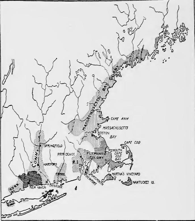 Major Settlements in Massachusetts, 1630.
The first settlers located wherever they pleased, but the Massachusetts general court soon took over the superintendence of town founding and prescribed more or less definitely the boundaries of each town. The grants were made in tracts of thirty-six square miles or more. Within a town there were many common fields which were handled by associated proprietors. The fields were surrounded by common fences and were cultivated by a joint system. The herds were also held in common. The original grantees and their legal heirs or successors made up the commoners or proprietors. Originally the town and the proprietors were[Pg 145] approximately the same. An important function of the town meeting was in allotting land. Soon each community began to receive newcomers who were freemen but not proprietors. At first the proprietors were in control, but as the freemen increased in number frequent struggles occurred over the arrangement of town lands.
The first settlers settled wherever they wanted, but the Massachusetts General Court soon took charge of founding towns and set clear boundaries for each one. The land grants were made in areas of thirty-six square miles or more. Within a town, there were many common fields managed by groups of owners. The fields were enclosed by shared fences and farmed using a collective system. The livestock was also shared. The original grantees and their legal heirs or successors were known as the commoners or proprietors. Initially, the town and the proprietors were about the same group. An important role of the town meeting was to allocate land. Before long, each community started to welcome newcomers who were free but not landowners. At first, the proprietors held power, but as the number of freemen grew, there were frequent conflicts over the distribution of town lands.
The meeting house was the center of local life. There the town meeting was held and there the people repaired on the Sabbath. In early days the military stores and equipment were usually kept in the edifice and the men attended service with arms in hand. The town constructed and took care of the meeting house and the minister was supported by taxation. One of the early acts of each town was to establish a school, the meeting house frequently being used as a school-house.
The meeting house was the hub of community life. That’s where the town meetings took place, and it’s where people gathered on Sundays. In the early days, military supplies and equipment were usually stored in the building, and men would attend services with weapons in hand. The town built and maintained the meeting house, and the minister was funded through taxes. One of the first actions of each town was to set up a school, often utilizing the meeting house as a classroom.
A representative system introduced.—The governor and assistants soon found their power challenged. In 1632 a tax was voted for fortifying Newtown, the modern Cambridge. The tax caused considerable grumbling, and the general court decided that, in future, the governor and assistants should be advised in matters of taxation by two delegates from each town, and that all magistrates should be elected by the entire body of freemen. In 1634 a committee of two freemen from each town demanded larger rights. The result was a representative system, each town sending representatives according to its size to meet with the general court. This system was in no sense a popular government, the franchise continuing to be restricted to a limited number of church members, the leaders of whom were distinctly aristocratic.
A representative system was introduced.—The governor and assistants quickly found their authority challenged. In 1632, a tax was proposed for fortifying Newtown, now known as Cambridge. This tax led to a lot of complaints, and the general court decided that, moving forward, the governor and assistants should be advised on taxation by two delegates from each town, and that all magistrates should be elected by the entire body of freemen. In 1634, a committee of two freemen from each town demanded greater rights. The outcome was a representative system, with each town sending representatives based on its population to meet with the general court. This system was not a popular government; the right to vote continued to be limited to a small number of church members, whose leaders were clearly aristocratic.
The struggle with Laud.—The patentees who had been deprived of their rights found a ready listener in Archbishop Laud, who disliked the Puritan commonwealth growing so lustily on the shores of Massachusetts Bay. Grounds for accusation were found in the fact that the Massachusetts magistrates expelled those who disagreed with their religious ideas. Complaints were filed with the privy council by Gorges and Mason, but a committee of the council in 1633 made a report which was favorable to the colony. In 1634 the attack was renewed, and this time with better success, for the king appointed the Commission for Foreign Plantations, headed by Laud, to take over the general[Pg 146] supervision of all the colonies. Immediately a demand was made for the charter of the Massachusetts Bay Colony. Governor Dudley and the assistants replied that the charter could not be returned except by order of the general court, which was not in session. They immediately fortified Castle Island, Dorchester, and Charlestown.
The struggle with Laud.—The patentees who had lost their rights found a sympathetic ear in Archbishop Laud, who disliked the rapidly growing Puritan community along the shores of Massachusetts Bay. They accused the Massachusetts magistrates of expelling those who disagreed with their religious beliefs. Gorges and Mason filed complaints with the privy council, but a committee of the council reported in 1633 that was favorable to the colony. In 1634, the attack was renewed, this time with more success, as the king appointed the Commission for Foreign Plantations, led by Laud, to take over the overall supervision of all the colonies. Almost immediately, a demand was made for the charter of the Massachusetts Bay Colony. Governor Dudley and his assistants responded that the charter could only be returned by order of the general court, which was not in session. They quickly fortified Castle Island, Dorchester, and Charlestown.
In 1635 the coast of New England was reapportioned, Sir Ferdinando Gorges receiving the lands in Maine between the Penobscot and the Piscataqua, Mason receiving New Hampshire and northern Massachusetts as far as Cape Ann, and Lord Edward Gorges from Cape Ann to Narragansett Bay. The same year the Council for New England resigned its charter, and the king decided to seize the charter of the Massachusetts Bay Company. The pecuniary difficulties of the king, the destruction of a boat which was built by Mason and Gorges, and the death of Mason combined to help the colony. Though the charter was again demanded in 1638 by the lord commissioners, the general court refused to recognize the order, and the increasing difficulties of the king made it possible for the Massachusetts authorities to continue their independent course.
In 1635, the coastline of New England was redrawn, with Sir Ferdinando Gorges getting the lands in Maine between the Penobscot and the Piscataqua rivers, Mason obtaining New Hampshire and northern Massachusetts up to Cape Ann, and Lord Edward Gorges taking the area from Cape Ann to Narragansett Bay. That same year, the Council for New England gave up its charter, and the king decided to take control of the Massachusetts Bay Company's charter. The king's financial troubles, the destruction of a boat built by Mason and Gorges, and Mason's death all worked in favor of the colony. Although the lord commissioners demanded the charter again in 1638, the general court refused to comply, and the king’s growing difficulties allowed the Massachusetts authorities to keep operating independently.
EXPANSION OF THE MASSACHUSETTS BAY COLONY
RHODE ISLAND
Roger Williams.—The power of the Massachusetts magistrates was exercised to maintain the ideal of a biblical commonwealth, whose principles were expounded by John Cotton of the Boston church. Those who did not agree were in danger. Among the dissenters was Roger Williams, a brilliant young student from Cambridge, who arrived at Boston in 1631, where he was invited to become one of the ministers. He refused to commune with those who had not broken with the English church and repaired to Salem where he was invited to become the minister, but the general court prevented his ordination. Williams soon departed for Plymouth, where he devoted much time to the study of the Indians. He concluded that the title to land belonged to the natives and that the king had no right to grant it away, a view which somewhat disturbed Brewster and Bradford.
Roger Williams.—The power of the Massachusetts magistrates was used to uphold the ideal of a biblical commonwealth, whose principles were explained by John Cotton from the Boston church. Those who disagreed were at risk. Among the dissenters was Roger Williams, a bright young student from Cambridge, who arrived in Boston in 1631, where he was invited to be one of the ministers. He refused to associate with those who hadn't separated from the English church and went to Salem, where he was invited to become the minister, but the general court blocked his ordination. Williams soon left for Plymouth, where he spent a lot of time studying the Native Americans. He concluded that the title to land belonged to the natives and that the king had no right to give it away, a view that unsettled Brewster and Bradford.
He returned to Salem where, during the illness of Skelton, the[Pg 147] pastor, he occasionally preached; when Skelton died, Williams became the teacher of the organization. In his sermons he argued that church and state should be separate, and denied the right of the magistrates to regulate churches. He also considered it a sin to follow the forms of the established church. When the colony was attacked by Laud, the general court ordered that a new oath of fidelity be taken. Williams objected to enforced oaths, as he thought that they obliged wicked men to perform a religious act, thus invading the freedom of the soul.
He went back to Salem where, during Skelton's illness, the[Pg 147] pastor, he sometimes preached; when Skelton died, Williams became the leader of the group. In his sermons, he argued that church and state should be separate and rejected the authority of the magistrates to control churches. He also believed it was wrong to follow the rituals of the established church. When the colony faced pressure from Laud, the general court ordered a new oath of loyalty to be taken. Williams opposed enforced oaths, as he believed they forced immoral people to engage in a religious act, violating the freedom of the soul.
Providence plantation.—To punish Salem for harboring Williams, title to its lands on Marble Neck was refused by the general court and the town was denied the right of representation. Endicott yielded but Williams remained obdurate. In a letter to the churches he protested against the arbitrary act. Williams was summoned before the magistrates and in October, 1635, was sentenced to banishment. The sentence was not immediately enforced and at Salem he continued to be the center of a group of Separatists, who proposed to remove in the spring to the shores of Narragansett Bay. This again alarmed the magistrates, and they decided to send Williams to England. Hearing of the project, he fled from his persecutors and found refuge among the Narragansett Indians. He was warned away from the territory of Plymouth, and in June, 1636, settled at Providence, where he soon had a considerable following, this being the first settlement in Rhode Island.
Providence plantation.—To punish Salem for supporting Williams, the general court refused to recognize its land ownership on Marble Neck and the town was stripped of its right to representation. Endicott gave in, but Williams stood his ground. In a letter to the churches, he protested against this unjust action. Williams was called before the magistrates and in October 1635, was sentenced to banishment. However, the sentence wasn’t enforced right away, and in Salem, he remained the leader of a group of Separatists who planned to move to the shores of Narragansett Bay in the spring. This again alarmed the magistrates, and they decided to send Williams to England. When he heard about the plan, he escaped from his pursuers and found safety among the Narragansett Indians. He was told to stay away from Plymouth territory, and in June 1636, he settled in Providence, where he quickly gained a significant following, marking the first settlement in Rhode Island.
Title to the land was obtained from the Indians. As the Providence people were outside of any special jurisdiction, they established a government on democratic lines. Church and state were kept separate, no one being forced to support religion. In 1640 an agreement was drawn up which served as a form of government for several years. The governing body was composed of five men called disposers, who were chosen four times in each year. They disposed of the land and managed the common stock. The freeholders retained the right to ratify or disavow, in general meetings, the acts of the disposers. There was a lack of a strong executive and judiciary. Disputes were usually settled by arbitration, but as there was no authority to enforce the settlement, disorders frequently occurred.
Title to the land was obtained from the Native Americans. Since the people of Providence were outside any specific jurisdiction, they set up a government based on democratic principles. Church and state were kept separate, and no one was required to support any religion. In 1640, an agreement was created that acted as a form of government for several years. The governing body consisted of five men called disposers, who were elected four times a year. They handled the land and managed the communal resources. The landowners had the right to approve or reject the actions of the disposers during general meetings. There was a lack of a strong executive and judicial system. Disputes were usually resolved through arbitration, but since there was no authority to enforce the decisions, disagreements often arose.
[Pg 148] Anne Hutchinson.—No sooner had Williams been driven from Massachusetts Bay Colony than a second controversy shook the commonwealth. In the congregation of John Cotton was Mrs. Anne Hutchinson. She became popular by ministering to the sick, and began to hold meetings for women, where the sermons were discussed. Mrs. Hutchinson assumed the roll of teacher, discussing the questions of "a covenant of works" and "a covenant of grace," By the covenant of works she referred to the practice of the Catholic church, which considered penance, confession, and pilgrimages as means of salvation. By a covenant of grace she meant that condition of mind of Protestant Christians which found peace in the thought of the holiness of Christ. She believed that the divine spirit existed in every true Christian. John Cotton and her brother-in-law, John Wheelwright, were held up as examples of those who lived in the covenant of grace. To many of the Boston leaders it seemed as if Mrs. Hutchinson claimed to be inspired, and they feared that her teachings would endanger the authority of the church.
[Pg 148] Anne Hutchinson.—As soon as Williams was forced out of Massachusetts Bay Colony, a new controversy shook the community. In John Cotton's congregation was Mrs. Anne Hutchinson. She became well-known for helping the sick and started holding meetings for women to discuss sermons. Mrs. Hutchinson took on the role of a teacher, addressing topics like "a covenant of works" and "a covenant of grace." By the covenant of works, she referred to the practices of the Catholic Church, which viewed penance, confession, and pilgrimages as pathways to salvation. By a covenant of grace, she meant the mindset of Protestant Christians who found peace in the holiness of Christ. She believed that the divine spirit was present in every true Christian. John Cotton and her brother-in-law, John Wheelwright, were seen as examples of those living in the covenant of grace. To many Boston leaders, it seemed that Mrs. Hutchinson claimed to be inspired, and they worried that her teachings would threaten the authority of the church.
The Boston congregation split into two factions. In Mrs. Hutchinson's party was Governor Harry Vane. On the other side were John Winthrop and the pastor, John Wilson. Cotton attempted to remain neutral but favored the Hutchinsonian party. The question soon became a bitter political quarrel between Winthrop and Vane. At the election in 1637 Vane was defeated. Without the support of the chief executive the followers of Mrs. Hutchinson soon lost power. A synod of ministers was held at Cambridge to root out the heresies. Cotton succeeded in making his peace with the magistrates, but Wheelwright was banished, as was Mrs. Hutchinson. She was allowed to remain in the colony during the winter, but early in the spring of 1638 Winthrop ordered her to depart.
The Boston congregation split into two groups. Governor Harry Vane was part of Mrs. Hutchinson's faction. On the other side were John Winthrop and the pastor, John Wilson. Cotton tried to stay neutral but leaned toward the Hutchinsonians. The situation quickly turned into a heated political fight between Winthrop and Vane. In the 1637 election, Vane lost. Without the backing of the governor, Mrs. Hutchinson's followers soon lost influence. A gathering of ministers was held in Cambridge to eliminate heresies. Cotton managed to make peace with the officials, but Wheelwright and Mrs. Hutchinson were both banished. She could stay in the colony for the winter, but in early spring 1638, Winthrop ordered her to leave.
Settlements on Rhode Island.—She found a temporary asylum at Providence, but soon went to the island of Aquidneck, afterward called Rhode Island, where she joined her husband and some of her friends. The little group of nineteen settlers constituted themselves a body politic, electing William Coddington chief magistrate. Many emigrants joined the people of Portsmouth and in 1639 a new settlement was founded at Newport.
Settlements on Rhode Island.—She found a temporary refuge in Providence, but soon moved to Aquidneck Island, later known as Rhode Island, where she reunited with her husband and some friends. This small group of nineteen settlers established themselves as a governing body, electing William Coddington as their chief magistrate. Many more immigrants joined the residents of Portsmouth, and in 1639, a new settlement was established in Newport.
SETTLEMENTS IN THE CONNECTICUT VALLEY
Early claimants.—One of the patentees who had received lands from the Council of New England was the Earl of Warwick, whose grant covered a large part of the Connecticut Valley. In 1631 he transferred his rights to Lord Saye and Sele, Lord Brooke and others, who contemplated founding a Puritan colony, but for several years they did nothing to settle their domain. In 1633 the Dutch erected a fort where Hartford now stands, and shortly afterward men from Plymouth built a trading post ten miles farther up the river. In 1635 the English patentees, wearied with the Providence Island project, sent out settlers under John Winthrop, Jr., who erected Fort Saybrook at the mouth of the river. Scarcely were the cannon in place when a Dutch vessel appeared, but finding the English strongly posted, the Dutch made no attempt to take possession.
Early claimants.—One of the patent holders who received land from the Council of New England was the Earl of Warwick, whose grant covered a large portion of the Connecticut Valley. In 1631, he transferred his rights to Lord Saye and Sele, Lord Brooke, and others, who planned to establish a Puritan colony, but for several years they did nothing to set up their territory. In 1633, the Dutch built a fort where Hartford is now located, and shortly after, men from Plymouth built a trading post ten miles further up the river. In 1635, the English patent holders, frustrated with the Providence Island project, sent settlers led by John Winthrop, Jr., who built Fort Saybrook at the river's mouth. Just as the cannons were installed, a Dutch ship appeared, but upon seeing the English were well positioned, the Dutch made no attempt to take control.
The migration of 1635-36.—A more important movement came from Massachusetts. Congregations from Watertown, Dorchester, and Cambridge, desiring better lands, migrated to the rich Connecticut Valley. The first Dorchester men arrived at Windsor in the summer of 1635. In June, 1636, the Rev. Thomas Hooker led the Cambridge people to Hartford, the rest of the Dorchester congregation joined those already at Windsor, and the people of Watertown settled at Wethersfield. By the end of 1636 eight hundred people were living in the three towns. Another congregation from Roxbury settled at Springfield.
The migration of 1635-36.—A significant movement took place from Massachusetts. Congregations from Watertown, Dorchester, and Cambridge, seeking better land, migrated to the fertile Connecticut Valley. The first group from Dorchester arrived in Windsor during the summer of 1635. In June 1636, Rev. Thomas Hooker led the Cambridge folks to Hartford, while the rest of the Dorchester congregation joined those already in Windsor, and the people from Watertown settled in Wethersfield. By the end of 1636, eight hundred people were living in the three towns. Another group from Roxbury settled in Springfield.
The Pequot War.—The Pequot Indians saw with chagrin the increasing numbers of the whites. The settlers also angered them by purchasing lands from the Mohegans, and ignoring the Pequot chiefs. In 1633 the Pequots had murdered a Virginia sea-captain named Stone, and Governor Winthrop had inquired concerning the homicide. In 1634, fearing the Dutch and the Narragansetts, the Pequots had sought an alliance with Massachusetts Bay Colony. As a price of forgiveness for Stone's murder and for protection, Winthrop demanded heavy tribute. In 1636 John Oldham, who had come to collect the tribute, was murdered at Block Island. Though the Pequots were probably not guilty, Endicott led a force against them, destroying several wigwams and seizing considerable maize. Angered by the raid,[Pg 150] the Pequots attempted to form an alliance with the Narragansetts, but Williams prevented it, and in the ensuing war Mohegans and Narragansetts fought on the white man's side. In the spring of 1637 Pequots attacked Wethersfield. A general court was immediately convened at Hartford to take measures for protection, and an expedition was sent against the Pequot fort on the Mystic River, where the defenders were exterminated. Another stronghold to the westward was also destroyed. A remnant of the tribe was wiped out near New Haven by Connecticut and Massachusetts troops and the captives were made slaves, some being retained in New England, others being shipped to the West Indies. The Indian menace was thus removed and the settlers were free to push farther into the wilderness.
The Pequot War.—The Pequot Indians were frustrated by the growing number of white settlers. The settlers also upset them by buying land from the Mohegans and ignoring the Pequot leaders. In 1633, the Pequots killed a Virginia sea captain named Stone, prompting Governor Winthrop to investigate the murder. In 1634, worried about the Dutch and the Narragansetts, the Pequots tried to form an alliance with the Massachusetts Bay Colony. Winthrop demanded a heavy tribute as a condition for forgiveness for Stone's murder and for protection. In 1636, John Oldham, who came to collect the tribute, was killed at Block Island. Although the Pequots were likely not responsible, Endicott led a force against them, destroying several wigwams and seizing a lot of corn. Angered by this raid,[Pg 150] the Pequots tried to ally with the Narragansetts, but Williams stopped them, and in the subsequent war, the Mohegans and Narragansetts fought alongside the white settlers. In the spring of 1637, the Pequots attacked Wethersfield. A general court was quickly called in Hartford to arrange for protection, and an expedition was sent against the Pequot fort on the Mystic River, where the defenders were wiped out. Another stronghold to the west was also destroyed. A remnant of the tribe was eliminated near New Haven by troops from Connecticut and Massachusetts, and the captives were enslaved, with some staying in New England and others being shipped to the West Indies. The threat from the Indians was thus eliminated, allowing the settlers to expand further into the wilderness.
"The Fundamental Orders."—In 1639 Hartford, Windsor, and Wethersfield formed a constitution, which provided that the freemen were to hold two general meetings each year. At one of these meetings the governor and assistants were elected, who, with four representatives from each town, were to make up a general court with legislative and judicial powers.
"The Fundamental Orders."—In 1639, Hartford, Windsor, and Wethersfield created a constitution that stipulated the freemen would hold two general meetings each year. At one of these meetings, the governor and assistants were elected, who, along with four representatives from each town, would form a general court with legislative and judicial powers.
New Haven.—The successful issue of the Pequot War opened the Connecticut Valley to another important migration. This was led by Rev. John Davenport and Theophilus Eaton, who had come to New England to plant a colony on purely theocratic lines. In 1638 they founded New Haven, and the following year drew up a form of government. Citizenship was restricted to church membership and an annual general court of freemen was to elect a governor and assistants, who were to conduct all governmental affairs, the only restriction on their authority being the law of Moses. Guilford, Milford, and Stamford sprang up in the neighborhood, and each adopted a similar form of government.
New Haven.—The successful outcome of the Pequot War opened up the Connecticut Valley to another significant wave of migration. This was led by Rev. John Davenport and Theophilus Eaton, who had come to New England to establish a colony based on strictly theocratic principles. In 1638, they founded New Haven, and the following year, they created a form of government. Citizenship was limited to church members, and an annual general court of freemen would elect a governor and assistants to oversee all government affairs, with the only limitation on their authority being the law of Moses. Guilford, Milford, and Stamford emerged nearby, each adopting a similar form of government.
Settlement of Long Island.—English settlements also appeared on Long Island. In 1632 Sir Edmund Plowden obtained a grant from Charles I of Long Island and a portion of the adjoining coasts. Three years later the Council for New England assigned Long Island to Sir William Alexander. In 1640 settlers from New Haven obtained a title to Long Island from Alexander's representative and settled at Southold. Others from Massachusetts attempted a settlement opposite Manhattan, but, being[Pg 151] driven away by the Dutch, moved to Southampton at the eastern end of the island.
Settlement of Long Island.—English settlements also emerged on Long Island. In 1632, Sir Edmund Plowden received a grant from Charles I for Long Island and part of the surrounding coasts. Three years later, the Council for New England assigned Long Island to Sir William Alexander. In 1640, settlers from New Haven acquired a title to Long Island from Alexander's representative and established themselves at Southold. Others from Massachusetts attempted to settle across from Manhattan, but, being[Pg 151] driven away by the Dutch, moved to Southampton at the eastern end of the island.
READINGS
GENERAL
Andrews, C.M., The Fathers of New England, passim; Becker, Carl, The Beginnings of the American People, 80-124.
Andrews, C.M., The Fathers of New England, passim; Becker, Carl, The Beginnings of the American People, 80-124.
THE PURITAN MOVEMENT AND THE PLYMOUTH COLONY
Adams, C.F., Three Episodes of Massachusetts History, I, 1-182; Arber, Edward, The Story of the Pilgrim Fathers; Bradford, William, History of Plymouth Plantation; Channing, Edward, History of the United States, I, 271-321; Cheyney, E.P., European Background of American History, 216-239; Dexter, Morton, The England and Holland of the Pilgrims; The Story of the Pilgrims; Doyle, J.A., The Puritan Colonies, I, 11-81; Eggleston, Edward, The Beginners of a Nation, 98-181; Fiske, John, The Beginnings of New England, 60-87; Griffis, W.E., The Pilgrims in their Three Homes; Neal, D., History of the Pilgrims; Osgood, H.L., The American Colonies in the Seventeenth Century, I, 98-137; Palfrey, J.G., History of New England, I, 101-238; Tyler, L.G., England in America, 148-182; Weeden, W.B., Economic and Social History of New England, I, 8-45; Young, Alexander, Chronicles of the Pilgrim Fathers; Usher, R.G., The Pilgrims and Their History.
Adams, C.F., Three Episodes of Massachusetts History, I, 1-182; Arber, Edward, The Story of the Pilgrim Fathers; Bradford, William, History of Plymouth Plantation; Channing, Edward, History of the United States, I, 271-321; Cheyney, E.P., European Background of American History, 216-239; Dexter, Morton, The England and Holland of the Pilgrims; The Story of the Pilgrims; Doyle, J.A., The Puritan Colonies, I, 11-81; Eggleston, Edward, The Beginners of a Nation, 98-181; Fiske, John, The Beginnings of New England, 60-87; Griffis, W.E., The Pilgrims in their Three Homes; Neal, D., History of the Pilgrims; Osgood, H.L., The American Colonies in the Seventeenth Century, I, 98-137; Palfrey, J.G., History of New England, I, 101-238; Tyler, L.G., England in America, 148-182; Weeden, W.B., Economic and Social History of New England, I, 8-45; Young, Alexander, Chronicles of the Pilgrim Fathers; Usher, R.G., The Pilgrims and Their History.
MASSACHUSETTS BAY COLONY
Buffington, A.H., "New England and the Western Fur Trade, 1629-1675," in Colonial Society of Massachusetts, Publications, XXVIII, 160-192; Channing, Edward, History of the United States, I, 322-351; Doyle, J.A., The Puritan Colonies, I, 83-112; Eggleston, Edward, Beginners of a Nation, 188-215; Ellis, G.E., The Puritan Age and Rule; Fiske, John, The Beginnings of New England, 88-111; Johnson, Edward, Wonder-Working Providence; Newton, A.P., The Colonizing Activities of the English Puritans; Osgood, H.L., The American Colonies in the Seventeenth Century, I, 141-199, 424-467; Palfrey, J.G., History of New England, I, 283-405; A Compendious History of New England, I, 91-133; Tyler, L.G., England in America, 183-209; Weeden, W.B., Economic and Social History of New England, I, 47-164; Winthrop, John, Journal.
Buffington, A.H., "New England and the Western Fur Trade, 1629-1675," in Colonial Society of Massachusetts, Publications, XXVIII, 160-192; Channing, Edward, History of the United States, I, 322-351; Doyle, J.A., The Puritan Colonies, I, 83-112; Eggleston, Edward, Beginners of a Nation, 188-215; Ellis, G.E., The Puritan Age and Rule; Fiske, John, The Beginnings of New England, 88-111; Johnson, Edward, Wonder-Working Providence; Newton, A.P., The Colonizing Activities of the English Puritans; Osgood, H.L., The American Colonies in the Seventeenth Century, I, 141-199, 424-467; Palfrey, J.G., History of New England, I, 283-405; A Compendious History of New England, I, 91-133; Tyler, L.G., England in America, 183-209; Weeden, W.B., Economic and Social History of New England, I, 47-164; Winthrop, John, Journal.
RHODE ISLAND AND THE CONNECTICUT VALLEY
Channing, Edward, History of the United States, I, 362-411; Doyle, J.A., The Puritan Colonies, I, 113-199; Eggleston, Edward, Beginners of a Nation, 266-346; Osgood, H.L., The American Colonies in the Seventeenth Century, I, 224-254, 301-370; Richman, I.B., Rhode Island, a Study in Separatism, 13-61; Rhode Island, its Making and its Meaning, 3-62; Tyler, L.G., England in America, 210-264; Weeden, W.B., Early Rhode Island.
Channing, Edward, History of the United States, I, 362-411; Doyle, J.A., The Puritan Colonies, I, 113-199; Eggleston, Edward, Beginners of a Nation, 266-346; Osgood, H.L., The American Colonies in the Seventeenth Century, I, 224-254, 301-370; Richman, I.B., Rhode Island, a Study in Separatism, 13-61; Rhode Island, its Making and its Meaning, 3-62; Tyler, L.G., England in America, 210-264; Weeden, W.B., Early Rhode Island.
CHAPTER VIII
THE ENGLISH COLONIES DURING THE REVOLUTIONARY PERIOD (1640-1660)
POLITICS, ADMINISTRATION, AND EXPANSION
Attitude of the colonies during the Puritan Revolution.—The personal rule of Charles I came to an end in 1641 and for eight years England was convulsed with civil war. During the struggle both Royalists and Parliamentarians claimed jurisdiction over the colonies, but neither was able to exert authority, and each colony followed its own course. The New England settlements were largely Puritan and naturally sided with parliament. In Maryland two factions formed, one Protestant, the other in favor of the Catholic proprietor. Virginia and the West Indies were almost entirely on the king's side. Incapable of rendering assistance, they attempted to maintain neutrality until the contest in England was decided.
Attitude of the colonies during the Puritan Revolution.—The personal rule of Charles I ended in 1641, and for eight years, England was torn apart by civil war. During this conflict, both Royalists and Parliamentarians tried to assert control over the colonies, but neither succeeded, and each colony went its own way. The New England settlements were mostly Puritan and naturally supported Parliament. In Maryland, two factions emerged, one Protestant and the other backing the Catholic proprietor. Virginia and the West Indies were almost entirely loyal to the king. Unable to provide support, they tried to remain neutral until the outcome in England was determined.
The Bermudas and expansion in the West Indies.—In the Bermudas the colonists were divided, but the company leaders were Puritans. In 1643 the Independents seceded from the established Church, and two years later parliament granted freedom of worship in the islands. Religious feeling in the Bermudas led to a migration to a new asylum. In 1646 Captain William Sayle, who had been governor, led a colony to Segatoo, one of the Bahamas, which he now called Eleutheria, in allusion to the aim of the project. Later on Bermudans conducted extensive salt works in the Turks Islands in spite of frequent attacks by the Spaniards.
The Bermudas and expansion in the West Indies.—In the Bermudas, the colonists were divided, but the company leaders were Puritans. In 1643, the Independents broke away from the established Church, and two years later, Parliament granted freedom of worship in the islands. Religious tensions in the Bermudas prompted a migration to a new refuge. In 1646, Captain William Sayle, who had previously served as governor, led a group to Segatoo, one of the Bahamas, which he renamed Eleutheria, reflecting the goal of the venture. Later, people from Bermuda carried out extensive salt production in the Turks Islands despite frequent attacks by the Spaniards.
The Commonwealth, 1649-1653.—The military party, dominated by Cromwell, drove from parliament all those who hesitated to execute the king, the remnant being known as the Rump Parliament. It named a Council of State which was to carry on the executive work. The Commonwealth proceeded at once to[Pg 153] overthrow its enemies outside of England. Rebellions in Ireland and Scotland were ruthlessly put down; the navy was greatly strengthened, and Admiral Sir George Ayscue was sent to the West Indies and Virginia to overthrow the Royalists. Friction with the Dutch had been growing for some time, due mainly to rivalry for the commerce of the East and West Indies and the growing trade of the Dutch along the Atlantic seaboard. Navigation laws were passed in 1650 and 1651 which were intended to deprive the Dutch of the trade of England and her possessions. War followed in 1652 and lasted for two years with varying success.
The Commonwealth, 1649-1653.—The military faction, led by Cromwell, expelled from Parliament anyone who was hesitant to execute the king, leaving behind what became known as the Rump Parliament. It appointed a Council of State to handle the executive duties. The Commonwealth quickly set out to[Pg 153] eliminate its enemies outside of England. Rebellions in Ireland and Scotland were brutally crushed; the navy was significantly strengthened, and Admiral Sir George Ayscue was dispatched to the West Indies and Virginia to defeat the Royalists. Tensions with the Dutch had been escalating for some time, mainly due to competition for trade in the East and West Indies and the increasing trade of the Dutch along the Atlantic coast. Navigation laws were enacted in 1650 and 1651 aimed at cutting the Dutch off from the trade of England and its territories. War broke out in 1652 and lasted for two years with mixed outcomes.
Colonial administration during the Commonwealth.—Colonial administration was carried on by various committees of parliament or of the Council of State. On March 2, 1650, the Council of State ordered that the entire council or any five of the members, should be a Committee for Trade and Plantations. In 1652 the Council of State appointed a standing committee of Trade, Plantations, and Foreign Affairs of which Cromwell and Vane were members. Special committees were also appointed from time to time to handle special colonial business or committees already in existence discussed matters referred to them.
Colonial administration during the Commonwealth.—Colonial administration was managed by various parliamentary committees or the Council of State. On March 2, 1650, the Council of State declared that the entire council or any five of its members would form a Committee for Trade and Plantations. In 1652, the Council of State established a permanent committee for Trade, Plantations, and Foreign Affairs, which included Cromwell and Vane as members. Special committees were also created as needed to address specific colonial issues, or existing committees discussed matters assigned to them.
Acquisition of Jamaica.—In December, 1653, Cromwell was made Lord Protector for life and in 1654 the war with the Dutch was brought to a close. To divert attention from home affairs Cromwell desired a foreign war. West Indian expansion had brought England into close contact with Spain. The aggressive acts of the latter against the Providence Island Company and the intercepting of English ships, gave a ready excuse for reprisals. Admiral Penn sailed from England on Christmas Day, 1654, in command of a large fleet to attack the Spanish. An attempt to gain a footing in Española was a complete failure, but Jamaica proved to be an easy prize and became a permanent English possession.
Acquisition of Jamaica.—In December 1653, Cromwell was appointed Lord Protector for life, and by 1654 the war with the Dutch had ended. To shift focus from domestic issues, Cromwell wanted to pursue a foreign war. England's expansion in the West Indies had put it in close contact with Spain. The aggressive actions of Spain against the Providence Island Company and the seizure of English ships provided a convenient excuse for retaliation. Admiral Penn set sail from England on Christmas Day 1654, leading a large fleet to attack the Spanish. While an attempt to establish a foothold in Española failed completely, Jamaica turned out to be an easy target and became a permanent English territory.
Colonial administration during the Protectorate.—The Council of State lost most of its powers and became simply the advisory council of Cromwell. The committee system of the council was continued. In 1655 a special committee for Jamaica was appointed, and about the same time a Committee for Foreign Plantations. The Protector also obtained the assistance of a body of officers and merchants to advise regarding colonial affairs.
Colonial administration during the Protectorate.—The Council of State lost most of its powers and became just an advisory council for Cromwell. The committee system of the council continued. In 1655, a special committee for Jamaica was appointed, and around the same time, a Committee for Foreign Plantations was established. The Protector also got help from a group of officers and merchants to provide advice on colonial matters.
NEW ENGLAND DEVELOPMENT
The period from 1640 to 1660 was one of practical independence for the New England colonies. This neglect and freedom from interference gave rise to three distinct developments: the formulation of provincial codes of law, the confederation of the colonies and of settlements within colonies, and territorial expansion.
The time between 1640 and 1660 was a period of practical independence for the New England colonies. This lack of attention and freedom from outside influence led to three key developments: the creation of provincial laws, the unification of the colonies and settlements within those colonies, and the expansion of territory.
Settled areas in New England, around 1660.
The Massachusetts Body of Liberties.—The first of the colonial codes to be formulated was the Massachusetts Body of Liberties[Pg 155] adopted by the general court in 1641. It provided for the protection of the private and political rights of the individual, methods of judicial procedure, rights of women, children, servants, foreigners, and strangers, the protection of animals, and the rights of the churches. Death penalties were specified, the capital crimes being the worshiping of false gods, witchcraft, blasphemy, murder, manslaughter, kidnaping, bearing false witness, and treason. Provision was also made for trial by jury. The code was amended from time to time, arson, cursing or smiting of parents, burglary, and highway robbery being added to the fist of capital crimes. The Massachusetts code became the basis of the Connecticut code of 1650 and the New Haven code of 1656.
The Massachusetts Body of Liberties.—The first colonial code to be created was the Massachusetts Body of Liberties[Pg 155], which was adopted by the general court in 1641. It established protections for individual private and political rights, judicial procedures, rights for women, children, servants, foreigners, and strangers, as well as animal protection and church rights. It outlined death penalties for capital offenses such as worshiping false gods, witchcraft, blasphemy, murder, manslaughter, kidnapping, giving false testimony, and treason. The code also included provisions for trial by jury. Over time, it was amended, adding arson, cursing or assaulting parents, burglary, and highway robbery to the list of capital crimes. The Massachusetts code served as the foundation for the Connecticut code of 1650 and the New Haven code of 1656.
Causes of federation.—The development of self-government was fostered not only by neglect on the part of England, but also by the necessity of protection. Being hedged in on the north by the French and on the west by the Dutch, and with hostile Indian tribes encircling the English frontiers, the various groups of settlements were in danger. Massachusetts was strong enough to protect herself, but the settlements in the Connecticut Valley and on Long Island were menaced by the Dutch and Indians.
Causes of federation.—The growth of self-government was encouraged not just by England's neglect, but also by the need for protection. With the French to the north and the Dutch to the west, along with hostile Indian tribes surrounding the English frontiers, the different groups of settlements were at risk. Massachusetts was strong enough to defend itself, but the settlements in the Connecticut Valley and on Long Island were threatened by the Dutch and Indians.
One of the fruitful causes of dispute between New England and the Dutch was the fur-trade. The choicest hunting grounds to the west were possessed by the Dutch and Swedes. To obtain a foothold on the Delaware, the upper Connecticut, and the Hudson became a settled economic policy of several of the New England colonies and was a potent factor in the formation of the New England Confederation. To exploit the Delaware River trade a company was formed at New Haven and in 1641 a settlement was made at Varkens Kill on the site of modern Salem, New Jersey, and later another post was established at the mouth of the Schuylkill, above the Dutch and Swedish forts. The Dutch, probably assisted by the Swedes, destroyed the Schuylkill fort, and the settlement at Varkens Kill did not prosper, most of the settlers dying or removing to New Haven. Massachusetts also attempted to obtain a share in the Delaware trade. In 1644 prominent merchants of Boston formed a company, but when their pinnace appeared in the Delaware, it was turned back by the Dutch, and shortly afterwards a small group of Boston traders were severely handled by the Indians.
One of the main reasons for conflict between New England and the Dutch was the fur trade. The best hunting grounds to the west were controlled by the Dutch and Swedes. Establishing a presence on the Delaware, upper Connecticut, and Hudson rivers became a key economic strategy for several New England colonies and played a significant role in the creation of the New England Confederation. To take advantage of the Delaware River trade, a company was established in New Haven, and in 1641, a settlement was founded at Varkens Kill, on the site of modern Salem, New Jersey. Later, another outpost was set up at the mouth of the Schuylkill, above the Dutch and Swedish forts. The Dutch, likely with help from the Swedes, destroyed the Schuylkill fort, and the settlement at Varkens Kill struggled, with most settlers either dying or moving to New Haven. Massachusetts also sought to get a piece of the Delaware trade. In 1644, prominent merchants from Boston formed a company, but when their small ship arrived in the Delaware, the Dutch turned them away. Soon after, a small group of Boston traders was seriously attacked by the Indians.
[Pg 156] The New England Confederation.—For several years plans for a confederation had been discussed, but the Dutch war against the Indians in 1642 and the struggle between De la Tour and D'Aulnay in Acadia brought matters to a head. At the general court which met at Boston on May 10, 1643, commissioners from Massachusetts, Plymouth, Connecticut, and New Haven signed a compact, Rhode Island and the settlements in Maine being excluded. The government of the confederation was placed in the hands of two commissioners from each of the four colonies. Internal affairs were not to be interfered with, but the confederation was to determine matters of war and foreign relations. Expenses were to be assessed on the colonies according to population. A vote of six commissioners was necessary to determine matters, the three small colonies thus being able to override Massachusetts. The confederation contained two serious defects which eventually led to its abandonment. The central government had no authority over individuals, and the equal vote of each colony violated the principle of representative government, Massachusetts having no more power then her weaker neighbors.
[Pg 156] The New England Confederation.—For several years, there had been discussions about forming a confederation, but the Dutch war against the Indians in 1642 and the conflict between De la Tour and D'Aulnay in Acadia pushed things to a breaking point. At the general court that gathered in Boston on May 10, 1643, representatives from Massachusetts, Plymouth, Connecticut, and New Haven signed a compact, excluding Rhode Island and the settlements in Maine. The confederation's government was entrusted to two commissioners from each of the four colonies. While internal matters were to be left alone, the confederation was responsible for issues related to war and foreign relations. Costs were to be divided among the colonies based on their population. A vote from six commissioners was required to make decisions, allowing the three smaller colonies to outvote Massachusetts. However, the confederation had two significant flaws that ultimately led to its collapse. The central government lacked authority over individuals, and the equal voting power of each colony undermined the principle of representative government, meaning Massachusetts had no more influence than its weaker neighbors.
Work of the Confederation.—No incident occurred to require action on the part of the confederation until 1645, when the Narragansetts attacked the Mohegans. A force of three hundred men was raised by the confederation, an action which brought the Narragansetts to terms without hostilities. When a society for the propagation of the faith was incorporated in England to assist the missionary efforts of John Eliot and Thomas Mayhew, the commissioners handled the funds. When questions of boundaries and customs arose, they were settled by the commissioners. When Massachusetts assisted De la Tour against D'Aulnay, the commissioners exerted their influence to keep the colony from interfering in French affairs. In 1650 a treaty was made between Stuyvesant, the Dutch governor, and the commissioners, with the result that the Dutch retained their fort at Hartford, but were otherwise excluded from the Connecticut Valley and the eastern part of Long Island. The English were granted the right of colonization on the Delaware, but when New Haven men attempted to found a settlement, they were turned back by the Dutch and the confederation failed to take action. When hostilities[Pg 157] broke out between the Dutch and English in 1651, the three smaller colonies desired war, but the Massachusetts general court refused, and when Cromwell's fleet appeared at Boston in 1654 on its way to attack the Dutch settlements, Massachusetts continued her opposition. Possible complications were averted by the treaty of peace. The action of Massachusetts in the relations with the Dutch so weakened the confederation that it soon ceased to be an important factor in New England history.
Work of the Confederation.—No event required action from the confederation until 1645, when the Narragansetts attacked the Mohegans. A force of three hundred men was raised by the confederation, which brought the Narragansetts to terms without fighting. When a society was formed in England to support the missionary efforts of John Eliot and Thomas Mayhew, the commissioners managed the funds. Issues regarding boundaries and customs were settled by the commissioners. When Massachusetts supported De la Tour against D'Aulnay, the commissioners worked to prevent the colony from getting involved in French affairs. In 1650, a treaty was made between Stuyvesant, the Dutch governor, and the commissioners, resulting in the Dutch keeping their fort at Hartford but being otherwise excluded from the Connecticut Valley and the eastern part of Long Island. The English were given the right to colonize along the Delaware, but when settlers from New Haven tried to start a settlement, they were turned back by the Dutch, and the confederation did not take action. When hostilities[Pg 157] broke out between the Dutch and English in 1651, the three smaller colonies wanted war, but the Massachusetts general court refused. When Cromwell's fleet arrived in Boston in 1654 on its way to attack the Dutch settlements, Massachusetts continued to oppose it. Potential complications were avoided by the peace treaty. Massachusetts' actions regarding the Dutch weakened the confederation to the point that it soon stopped being a significant factor in New England history.
The Puritan movement into New Hampshire.—Massachusetts took advantage of the disturbed conditions in England to absorb the territory to the northward. In 1629 Mason had obtained a second patent for a tract extending sixty miles inland and lying between the Merrimac and Piscataqua rivers, which he named New Hampshire, and Mason and Gorges obtained title to lands between the Merrimac and Kennebec. In 1631 the two patentees and others obtained a tract of twenty thousand acres which included the Portsmouth settlement. In 1633 the English merchants who had founded Dover sold their shares in the settlement to Lord Saye and Sele, Lord Brooke, and others, a transaction which was followed by a Puritan migration. The same noblemen also obtained title to the Portsmouth settlement. During the Hutchinsonian controversy, Wheelwright and others found refuge at Dover, but shortly afterward established themselves at Exeter. Massachusetts claimed that the New Hampshire settlements fell within her boundaries, and in 1641, upon the suggestion of Lord Saye and Sele and Lord Brooke, extended her jurisdiction over Portsmouth and Dover. In 1643 Exeter also came under the protection of Massachusetts.
The Puritan movement into New Hampshire.—Massachusetts took advantage of the chaos in England to expand into the territory to the north. In 1629, Mason secured a second patent for a tract that extended sixty miles inland and lay between the Merrimack and Piscataqua rivers, which he named New Hampshire. Mason and Gorges also claimed lands between the Merrimack and Kennebec rivers. In 1631, the two patentees and others acquired a tract of twenty thousand acres that included the Portsmouth settlement. In 1633, the English merchants who had started Dover sold their shares in the settlement to Lord Saye and Sele, Lord Brooke, and others, which led to a wave of Puritan migration. These noblemen also claimed ownership of the Portsmouth settlement. During the Hutchinsonian controversy, Wheelwright and others found refuge in Dover but soon established themselves in Exeter. Massachusetts asserted that the New Hampshire settlements were within its boundaries, and in 1641, upon the recommendation of Lord Saye and Sele and Lord Brooke, extended its jurisdiction over Portsmouth and Dover. By 1643, Exeter also came under Massachusetts' protection.
The incorporation of Maine with Massachusetts.—Several conflicting patents to lands in Maine were issued between 1630 and 1645. Few settlers came, the only new group of importance being the three towns of Georgiana (York), Welles, and Kittery on the Piscataqua. Massachusetts claimed that her charter entitled her to the Maine region, and in 1639 took the first step toward ownership by purchasing a tract on the Androscoggin River. When the region about Saco and Casco bays became a matter of dispute between rival patentees in 1644, the case was referred to the Massachusetts general court, but no decision was reached. When referred to the English commissioners for plantations,[Pg 158] the Gorges estate lost most of its property, being left only the settled region near the Piscataqua. In 1647 Gorges died and the settlers were left without guidance. Two years later the three towns declared themselves a body politic. In 1651 Massachusetts asserted her claim to the Maine region, and the Royalists there found themselves powerless. The following year the Massachusetts authorities ordered the survey of the Merrimac and established civil government at York. In 1653 all the settlements in southern Maine accepted the jurisdiction of Massachusetts. The settlements about Casco Bay refused to submit until 1658, when they also acknowledged the authority of Massachusetts.
The incorporation of Maine with Massachusetts.—Between 1630 and 1645, several conflicting land patents in Maine were issued. Few settlers arrived, with the only significant new groups being the three towns of Georgiana (York), Welles, and Kittery on the Piscataqua. Massachusetts claimed that its charter entitled it to the Maine region and, in 1639, took the first step toward ownership by purchasing land on the Androscoggin River. When the areas around Saco and Casco bays became a point of contention between rival patentees in 1644, the case was brought to the Massachusetts general court, but no decision was made. When it was referred to the English commissioners for plantations,[Pg 158] the Gorges estate lost most of its property, retaining only the settled areas near the Piscataqua. Gorges died in 1647, leaving the settlers without guidance. Two years later, the three towns declared themselves a political entity. In 1651, Massachusetts asserted its claim to the Maine region, leaving Royalists there powerless. The next year, Massachusetts authorities ordered a survey of the Merrimac and established civil government at York. By 1653, all the settlements in southern Maine accepted Massachusetts' jurisdiction. The settlements around Casco Bay resisted submission until 1658, when they too acknowledged Massachusetts' authority.
Massachusetts hopes to obtain the trade on the Hudson.—In 1657 the general court of Massachusetts declared that the fur-trade ought to be controlled by the commonwealth and in the following year a report was made which showed that fur-trading privileges at Springfield, Concord, Sudbury, Lancaster, Groton, Marlborough, and Cambridge were farmed out to various individuals. In 1659 a company was formed whose main purpose was to obtain access to the fur-trade of the upper Hudson, but it failed to carry out the project.
Massachusetts wants to gain control of the trade on the Hudson. In 1657, the general court of Massachusetts announced that the fur trade should be managed by the state, and the following year, a report showed that fur-trading rights in Springfield, Concord, Sudbury, Lancaster, Groton, Marlborough, and Cambridge were leased out to different people. In 1659, a company was created with the main goal of accessing the fur trade of the upper Hudson, but it was unable to complete the project.
Connecticut.—In the Connecticut colony the period from 1640 to 1660 was one of expansion and consolidation. Southampton and East Hampton on Long Island, and on the mainland Farmington, Saybrook, New London, and Norwalk were brought under the jurisdiction of the colony.
Connecticut.—In the Connecticut colony, the time from 1640 to 1660 was one of growth and unity. Southampton and East Hampton on Long Island, as well as Farmington, Saybrook, New London, and Norwalk on the mainland, were incorporated into the colony's jurisdiction.
New Haven.—In the New Haven colony the danger from the Dutch and Indians in 1643 brought about a union of the isolated units. A constitution was adopted which restricted the suffrage to church membership. Minor cases were to be judged in each town, and a governor, deputy-governor, and three associates were to judge the more important cases. No provision for trial by jury was made. The general court, consisting of the magistrates and two deputies from each of the towns, was to meet at New Haven twice a year to enact laws. In 1649 Southold on Long Island, in 1651 Bradford, and in 1656 Greenwich were added to the New Haven confederation.
New Haven.—In the New Haven colony, the threat from the Dutch and Native Americans in 1643 led to a merging of the separate communities. A constitution was adopted that limited voting rights to those who were members of the church. Minor disputes were to be settled in each town, while a governor, a deputy-governor, and three associates would handle more serious cases. There was no provision for a trial by jury. The general court, made up of the magistrates and two deputies from each town, was to gather in New Haven twice a year to create laws. In 1649, Southold on Long Island, in 1651 Bradford, and in 1656 Greenwich joined the New Haven confederation.
Rhode Island.—Admission to the New England Confederation was denied to the Narragansett Bay settlements. Providence,[Pg 159] Portsmouth, and Newport had all been founded by outcasts from Massachusetts, and a fourth settlement of a similar nature was founded at Shawomet, now Warwick, in 1643 by Samuel Gorton. The danger from powerful and grasping neighbors caused Williams to seek a patent to the lands about Narragansett Bay, and on March 14, 1644, a patent was granted which allowed the inhabitants of Providence, Portsmouth, and Newport to form their own government. The Warwick settlers were asked to join the others.
Rhode Island.—The Narragansett Bay settlements were denied entry into the New England Confederation. Providence,[Pg 159] Portsmouth, and Newport were all established by outcasts from Massachusetts, and a fourth settlement with a similar background was founded at Shawomet, now Warwick, in 1643 by Samuel Gorton. Concerned about the threat from powerful and greedy neighbors, Williams sought a grant for the lands around Narragansett Bay. On March 14, 1644, a patent was issued that allowed the residents of Providence, Portsmouth, and Newport to establish their own government. The settlers of Warwick were invited to join the others.
In 1647 a code remarkable for its mildness was adopted, and by 1650 the government had been formed. The legislative powers were vested in a general court composed of six representatives from each town, the presiding officer of which was called a president. In executive matters he was to be aided by an assistant from each town. Provision was also made for a treasurer, sergeant, general recorder, attorney-general, and solicitor-general. The president and assistants acted as a court for important cases, which were to be tried by jury. The legislative body and the court made the circuit of the towns. The initiative and referendum were introduced, each settlement having the right to propose legislation, and acts of the general court were referred to the towns for ratification or rejection. Membership in a particular church was not made the basis of citizenship as in the other New England colonies. The disturbing element in Rhode Island at this time was Coddington. In 1651 he obtained from the Council of State a commission as governor of the islands in Narragansett Bay, but his power was short-lived, for the following year Williams obtained a revocation of the Coddington patent and in 1654 was elected president of the confederation.
In 1647, a surprisingly lenient code was adopted, and by 1650, the government was established. Legislative authority was given to a general court made up of six representatives from each town, with a president overseeing it. For executive matters, he was supported by an assistant from each town. There were also positions for a treasurer, sergeant, general recorder, attorney general, and solicitor general. The president and assistants served as a court for important cases, which were tried by jury. The legislative body and the court traveled between the towns. The initiative and referendum were introduced, allowing each settlement the right to propose legislation, and acts of the general court had to be approved or rejected by the towns. Membership in a specific church was not a requirement for citizenship, unlike in other New England colonies. At this time, the main source of conflict in Rhode Island was Coddington. In 1651, he received a commission from the Council of State as governor of the islands in Narragansett Bay, but his authority was short-lived. The following year, Williams successfully revoked the Coddington patent and was elected president of the confederation in 1654.
VIRGINIA AND MARYLAND, 1640-1660
Virginia Loyalists.—During the civil war Virginia remained loyal to the king. The large plantation owners, who were almost all members of the Established Church, were in control of the house of burgesses. The small landowners made up the minority. In this class were a few Puritans and many freemen who had formerly been indented servants. Their sympathies were on the side of parliament. Sir William Berkeley, who was appointed in 1642, was a staunch supporter of the king. His administration[Pg 160] seems to have been tempered with justice, and he showed little of the arbitrary attitude which appeared in his later career.
Virginia Loyalists.—During the Civil War, Virginia stayed loyal to the king. The large plantation owners, who were mostly members of the Established Church, controlled the House of Burgesses. The small landowners were in the minority. This group included a few Puritans and many freemen who had previously been indentured servants. Their sympathies lay with Parliament. Sir William Berkeley, who was appointed in 1642, was a strong supporter of the king. His administration[Pg 160] seems to have been marked by fairness, and he showed little of the arbitrary attitude that appeared in his later career.
Opechancanough's War.—The chief event in Berkeley's administration was the Indian war of 1644. The plantations had gradually spread up the James and Rappahannock, encroaching upon the Indian lands. The chief Opechancanough planned to massacre the whites. On April 18 the outlying settlements were attacked and five hundred people were massacred. The governor led several expeditions against the Indians, their crops and villages were destroyed, and their chief became a captive. While in captivity he was foully murdered. The Indians sued for peace, and in a treaty acknowledged the rights of the white man to all the lands between the York and the James as far as the falls.
Opechancanough's War.—The main event during Berkeley's administration was the Indian war of 1644. The plantations had gradually expanded up the James and Rappahannock rivers, encroaching on Indian territories. Chief Opechancanough planned to wipe out the white settlers. On April 18, the surrounding settlements were attacked, resulting in the massacre of five hundred people. The governor led several campaigns against the Indians, destroying their crops and villages, and capturing their chief. While in captivity, he was brutally murdered. The Indians sought peace, and in a treaty, they recognized the rights of the white settlers to all the lands between the York and James rivers up to the falls.
Berkeley's struggle with the Commonwealth.—When the news of the death of Charles I reached Virginia, Berkeley proclaimed Charles II as king and the assembly declared it high treason to question his right to Virginia. Parliament decided to punish the colony by blockading it. Berkeley, nowise daunted, delivered a defiant address to the assembly, which warmly supported him. The blockade proved a failure, for Dutch traders sailed unmolested into Chesapeake Bay. A group of Virginia parliamentarians visited England and demanded that Berkeley be overthrown. The Council of State responded by sending out a fleet to subdue both Barbados and Virginia. Commissioners were also sent to Virginia to persuade the colony to submit peaceably. In the spring of 1652 when the fleet appeared in the James River, it found the governor prepared for resistance. The commissioners intervened, and by offering lenient terms, bloodshed was avoided. It was agreed that the colony should "voluntarily" acknowledge the authority of the Commonwealth, that the Virginians should have as free trade as the people of England, and that taxation was to be in the hands of the house of burgesses. Neither Berkeley nor his councilors were to be compelled to take the oath of allegiance for a year, and the use of the Book of Common Prayer was permitted for a similar length of time. Berkeley retired from the governorship but remained in the colony.
Berkeley's struggle with the Commonwealth.—When the news of Charles I's death reached Virginia, Berkeley declared Charles II as king, and the assembly stated it was high treason to question his claim to Virginia. Parliament decided to punish the colony by blockading it. Berkeley, undeterred, gave a bold speech to the assembly, which strongly supported him. The blockade failed since Dutch traders sailed freely into Chesapeake Bay. A group of Virginia parliamentarians traveled to England and demanded that Berkeley be removed. The Council of State responded by sending a fleet to subdue both Barbados and Virginia. Commissioners were also sent to Virginia to persuade the colony to comply peacefully. In the spring of 1652, when the fleet arrived in the James River, it found the governor ready to fight back. The commissioners intervened, and by offering lenient terms, they avoided bloodshed. They agreed that the colony would "voluntarily" recognize the authority of the Commonwealth, that Virginians would have free trade like the people of England, and that taxation would be managed by the House of Burgesses. Neither Berkeley nor his councilors would be forced to take the oath of allegiance for a year, and the use of the Book of Common Prayer was allowed for the same period. Berkeley stepped down from the governorship but stayed in the colony.
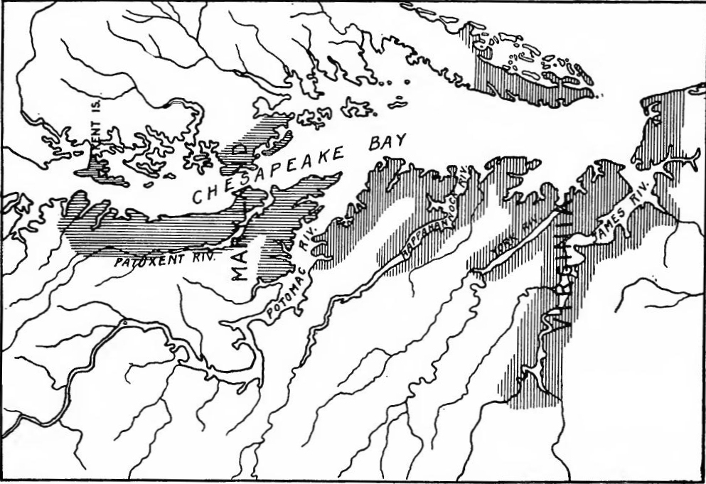 Settled Locations in Virginia and Maryland, 1660.
[Pg 162] Government under the commonwealth.—The burgesses and commissioners proceeded to remodel the government. The house of burgesses was made the chief governing body, with unlimited powers except the veto of the English government. It was to elect the governor and council, specify their duties and remove them if they proved unsatisfactory. All officials were also appointed by the burgesses.
[Pg 162] Government under the commonwealth.—The burgesses and commissioners started to reshape the government. The house of burgesses became the main governing body, with full authority except for the veto from the English government. It was responsible for electing the governor and council, defining their roles, and dismissing them if they were found lacking. All officials were also appointed by the burgesses.
A period of prosperity.—The kingless period was one of prosperity for Virginia. In 1649 the colony contained about 15,000 people; in 1666 the population was estimated at 40,000. This great migration was recruited from various classes: Cavaliers who sought refuge after the death of the king, people who fled from the horrors of civil war, prisoners who were sent as indented servants, gentlemen, tradesmen, and laborers, all found room in the abundant lands of tide-water Virginia.
A time of prosperity.—The period without a king was one of prosperity for Virginia. In 1649, the colony had about 15,000 people; by 1666, the population was estimated at 40,000. This large migration included various groups: Cavaliers seeking refuge after the king's death, people escaping the horrors of civil war, prisoners sent as indentured servants, gentlemen, tradesmen, and laborers, all found space in the plentiful lands of tide-water Virginia.
Maryland during the civil war.—During the first part of the civil war, Lord Baltimore leaned toward the royalist side, but in the colony there was a strong Protestant element, augmented by this time by Puritans from Virginia. In 1645 they got control and expelled the Jesuits. The following year Governor Calvert, who had been in England, returned and reëstablished his authority, but his rule was shortlived, for he died in 1647.
Maryland during the Civil War.—In the early stages of the Civil War, Lord Baltimore favored the royalist side, but there was a significant Protestant presence in the colony, bolstered by Puritans from Virginia. In 1645, they seized control and expelled the Jesuits. The next year, Governor Calvert, who had been in England, came back and restored his authority, but his leadership was brief, as he passed away in 1647.
Puritan rule in Maryland.—Fearing that he would be deprived of Maryland, Baltimore veered to the parliamentary side and appointed as governor William Stone, a prominent Virginia planter, and invited Virginia Puritans to settle in his territory. This was followed by a religious toleration act passed by the Maryland assembly in 1649. Baltimore's trimming, however, did not save him from trouble, for in 1650, when the Commonwealth expedition was sent out, the commissioners were instructed to reduce all the Chesapeake Bay plantations. For a time Stone was left in authority, but in 1654 he was deposed and the government was placed in the hands of a council, at the head of which was a Puritan, William Fuller. In the ensuing assembly the Royalists and Catholics were barred. Baltimore ordered Stone to recover his authority by force, but he was defeated and imprisoned by the forces of Fuller, and four of his followers executed. Baltimore appears to have ingratiated himself with Cromwell, for in 1657 he was restored to power.
Puritan rule in Maryland.—Worried about losing Maryland, Baltimore switched to the parliamentary side and appointed William Stone, a well-known planter from Virginia, as governor. He also invited Virginia Puritans to settle in his area. This led to a religious toleration act passed by the Maryland assembly in 1649. However, Baltimore's political maneuvering didn't keep him out of trouble. In 1650, when the Commonwealth expedition was launched, the commissioners were ordered to take control of all the Chesapeake Bay plantations. Stone was initially left in charge, but in 1654, he was ousted, and a council, led by Puritan William Fuller, took over the government. In the following assembly, Royalists and Catholics were excluded. Baltimore instructed Stone to reclaim his authority by force, but he was defeated and imprisoned by Fuller’s forces, and four of his supporters were executed. Baltimore seems to have won Cromwell’s favor, as he was restored to power in 1657.
READINGS
NEW ENGLAND
Channing, Edward, History of the United States, I, 414-420; Doyle, J.A., The Puritan Colonies, I, 220-319; Frothingham, Richard, The Rise of the Republic, 33-71; James, B.B., The Colonization of New England, 119-157; Mathews, L.K., The Expansion of New England, 31-34; Osgood, H.L., The American Colonies in the Seventeenth Century, I, 392-423; Palfrey, J.G., A Compendious History of New England, I, 247-268; Tyler, L.G., England in America, 266-281, 297-317.
Channing, Edward, History of the United States, I, 414-420; Doyle, J.A., The Puritan Colonies, I, 220-319; Frothingham, Richard, The Rise of the Republic, 33-71; James, B.B., The Colonization of New England, 119-157; Mathews, L.K., The Expansion of New England, 31-34; Osgood, H.L., The American Colonies in the Seventeenth Century, I, 392-423; Palfrey, J.G., A Compendious History of New England, I, 247-268; Tyler, L.G., England in America, 266-281, 297-317.
VIRGINIA AND MARYLAND
Beer, G.L., The Origins of the British Colonial System, 340-424; Browne, W.H., Maryland, 72-104; Channing, Edward, History of the United States, I, 485-507; Doyle, J.A., Virginia, Maryland, and the Carolinas, 207-228, 314-327; Hamilton, P.J., The Colonization of the South, 118-122; Mereness, M.D., Maryland as a Proprietary Province; Osgood, H.L., The American Colonies in the Seventeenth Century, II, 58-87; Tyler, L.G., England in America, 105-117, 140-148; Wertenbaker, T.J., Virginia under the Stuarts, 85-114.
Beer, G.L., The Origins of the British Colonial System, 340-424; Browne, W.H., Maryland, 72-104; Channing, Edward, History of the United States, I, 485-507; Doyle, J.A., Virginia, Maryland, and the Carolinas, 207-228, 314-327; Hamilton, P.J., The Colonization of the South, 118-122; Mereness, M.D., Maryland as a Proprietary Province; Osgood, H.L., The American Colonies in the Seventeenth Century, II, 58-87; Tyler, L.G., England in America, 105-117, 140-148; Wertenbaker, T.J., Virginia under the Stuarts, 85-114.
CHAPTER IX
THE DUTCH AND SWEDISH COLONIES (1609-1644)
DUTCH EXPANSION
Commercial expansion of the Netherlands.—During the reign of Philip II occurred the revolt in the Netherlands. Spanish political and commercial restrictions, and the establishment of the Inquisition, united the great commercial cities, the nobles, and the common people of the northeastern provinces in a rebellion which did not cease until the Hollanders had secured virtual independence by the truce of 1609. During the struggle Dutch ships raided the Spanish and Portuguese trade routes. As early as 1577 a trade to the White Sea was begun. Soon Dutch ships were trading to Italy and the Baltic, and by 1598 they had extended their commerce to Alexandria, Tripoli on the Syrian coast, and Constantinople, to the Cape Verde Islands and the Guinea coast. The desire to reach India influenced Dutch statesmen to attempt to find a northeast passage. Between 1594 and 1597 four expeditions were sent out; they failed to find the passage but gained considerable knowledge of Nova Zembla and Spitzbergen.
Commercial expansion of the Netherlands. — During the reign of Philip II, the revolt in the Netherlands took place. Spanish political and trade restrictions, along with the establishment of the Inquisition, united the major commercial cities, the nobles, and the common people of the northeastern provinces in a rebellion that didn’t stop until the Dutch secured virtual independence with the truce of 1609. Throughout the conflict, Dutch ships attacked Spanish and Portuguese trade routes. As early as 1577, they began trading to the White Sea. Soon, Dutch ships were trading with Italy and the Baltic, and by 1598, they had expanded their trade to Alexandria, Tripoli on the Syrian coast, and Constantinople, as well as the Cape Verde Islands and the Guinea coast. The desire to reach India prompted Dutch leaders to try to find a northeast passage. Between 1594 and 1597, four expeditions were sent out; while they did not find the passage, they gained significant knowledge about Nova Zembla and Spitzbergen.
East Indian trade.—For years Dutch sailors had been employed by the Portuguese and were well acquainted with the routes to India and America. In 1596 a company was organized to open a trade with the Far East; their fleet sailed around the Cape of Good Hope, stopped at Madagascar, and then proceeded to Java and the Moluccas, returning home the next year. Several companies were immediately formed, and in 1598 twenty-two vessels sailed by the Cape of Good Hope route for the East, and Olivier van Noort passed through the Straits of Magellan and circumnavigated the earth. In 1602 the States General chartered the United East India Company. Several fleets were despatched and succeeded in gaining a foothold in Ceylon and along the coasts of India, in Java, the Moluccas, and various[Pg 165] other places. The traders met with great opposition from the Portuguese and Spaniards, but when peace was made in 1609 the Dutch were given the right of trading to Spanish ports outside of Europe, and they soon firmly established their power in the Far East where they absorbed much of Portugal's commerce.
East Indian trade.—For years, Dutch sailors had worked for the Portuguese and knew the routes to India and America well. In 1596, a company was formed to start trade with the Far East; their fleet sailed around the Cape of Good Hope, made a stop in Madagascar, and then went on to Java and the Moluccas, returning home the following year. Several companies were quickly established, and in 1598, twenty-two ships set out via the Cape of Good Hope to the East, while Olivier van Noort navigated through the Straits of Magellan and circumnavigated the globe. In 1602, the States General granted a charter to the United East India Company. Several fleets were dispatched and successfully established a presence in Ceylon and along the coasts of India, in Java, the Moluccas, and various[Pg 165] other locations. The traders faced strong opposition from the Portuguese and Spaniards, but after peace was established in 1609, the Dutch were permitted to trade at Spanish ports outside of Europe, and they soon solidified their power in the Far East, taking over much of Portugal's commerce.
Henry Hudson.—The East India Company hoped to find a shorter route to India and in 1609 employed an English mariner, Henry Hudson, to search for a northwest passage. Meeting with ice and storms, he headed his ship, the Half Moon, toward the west. Sighting land at Newfoundland, he examined the New England coast, rounded Cape Cod, and sailed to Virginia and southward. Turning north, he probably ran into Chesapeake Bay, certainly entered Delaware Bay, and then sailed northward to what is now New York harbor. The Hudson River was explored to a point above Albany and friendly relations with the Iroquois were established. The East India Company, however, was making such handsome profits in the East that the furs of New Netherlands failed to attract it.
Henry Hudson.—The East India Company wanted to discover a shorter route to India and in 1609 hired an English sailor, Henry Hudson, to look for a northwest passage. Facing ice and storms, he directed his ship, the Half Moon, westward. After spotting land at Newfoundland, he explored the New England coast, went around Cape Cod, and traveled down to Virginia and further south. Heading back north, he likely entered Chesapeake Bay, definitely went into Delaware Bay, and then continued north to what is now New York harbor. The Hudson River was explored up to a point above Albany, and good relations were established with the Iroquois. However, the East India Company was making such great profits in the East that the furs of New Netherlands didn't appeal to them.
The Cape Horn route discovered.—The Dutch were still hopeful of finding another route to India, and when Jacques le Maire quarreled with the directors of the East India Company, he planned to form a separate corporation and seek a route south of the Straits of Magellan. The people of Hoorn assisted him in fitting out two vessels which were placed under the command of William Corneliaz Schouten. On the long voyage the smaller vessel was destroyed, but Schouten with the larger one in 1616 discovered Cape Horn.
The Cape Horn route discovered.—The Dutch still hoped to find another way to India, and when Jacques le Maire had a falling out with the directors of the East India Company, he decided to create a separate company and look for a route south of the Straits of Magellan. The people of Hoorn helped him outfit two ships, which were placed under the command of William Corneliaz Schouten. During the long voyage, the smaller ship was lost, but Schouten, with the larger one, discovered Cape Horn in 1616.
Dutch activities in the Hudson River region, 1610-1621.—The Hudson River region was visited by traders in 1610-1611, and in 1612 Dutch merchants sent Christianson and Block to Manhattan Island to engage in the fur trade. In 1613 Cornelius May was also sent over. The next year Fort Nassau, later named Fort Orange, was built near the present site of Albany. An extensive exploration of the coast was also made, Block sailing along the northern shore of Long Island, examining the lower waters of the Connecticut River, and exploring Narragansett Bay and Cape Cod. The result of these activities was the formation, in 1614, of the New Netherlands Company, which was[Pg 166] given the monopoly of the trade between the fortieth and forty-fifth parallels. An important fur trade was rapidly developed in the Hudson Valley and exploration of the coast was continued. In 1616 Hendrickson examined Delaware Bay, and in 1620 the same region and Chesapeake Bay were visited by May. The southern extremity of New Jersey still bears the name of the Dutch explorer.
Dutch activities in the Hudson River region, 1610-1621.—The Hudson River area was visited by traders between 1610 and 1611, and in 1612, Dutch merchants sent Christianson and Block to Manhattan Island to participate in the fur trade. Cornelius May was also sent over in 1613. The following year, Fort Nassau, later known as Fort Orange, was constructed near what is now Albany. There was also extensive exploration of the coast, with Block sailing along the northern shore of Long Island, checking out the lower waters of the Connecticut River, and exploring Narragansett Bay and Cape Cod. These activities led to the creation, in 1614, of the New Netherlands Company, which was[Pg 166] granted the exclusive rights to trade between the fortieth and forty-fifth parallels. A significant fur trade quickly developed in the Hudson Valley, and exploration of the coast continued. In 1616, Hendrickson explored Delaware Bay, and in 1620, May visited the same area and Chesapeake Bay. The southern tip of New Jersey still carries the name of the Dutch explorer.
The West India Company.—One of the most enterprising Dutch merchants was William Usselincx, who had long hoped to profit by the opening of West Indian trade. The idea was opposed by the East India Company and by some of the Dutch statesmen, especially Olden Barnevelt, who feared that it would bring about new difficulties with Spain. In spite of this, Dutch vessels appeared in Guiana and the Antilles, and in 1613 settlements were attempted in Guiana at Essequibo and Berbice. In 1618 Olden Barnevelt fell from power and Usselincx immediately became active in the formation of a company. In 1621 the West India Company was chartered, receiving a monopoly of Dutch trade for twenty-four years on the coast of Africa as far as the Cape, and for America and the islands east of New Guinea. Usselincx, believing that the directors had too much power and the shareholders too little, and desiring a colonizing rather than a trading corporation, severed his connection with the company and departed for Sweden, where he interested Gustavus Adolphus in commercial enterprises.
The West India Company.—One of the most ambitious Dutch merchants was William Usselincx, who had long wanted to take advantage of the opening of West Indian trade. This idea faced opposition from the East India Company and some Dutch politicians, particularly Olden Barnevelt, who worried it would create new conflicts with Spain. Despite this, Dutch ships began arriving in Guiana and the Antilles, and in 1613, attempts were made to establish settlements in Guiana at Essequibo and Berbice. In 1618, Olden Barnevelt lost his power, and Usselincx quickly became active in forming a company. In 1621, the West India Company was officially established, receiving a 24-year monopoly on Dutch trade along the coast of Africa up to the Cape, as well as for America and the islands east of New Guinea. Usselincx, believing that the directors had too much authority and the shareholders too little, and wanting a colonizing rather than a trading corporation, cut ties with the company and moved to Sweden, where he engaged Gustavus Adolphus in commercial ventures.
Dutch settlements in Brazil, Guiana, and the Antilles.—Settlements were now established by the "Beggars of the Sea" all the way from Brazil to Hudson River, and there were prospects that the Caribbean Sea would become a Dutch instead of a Spanish lake. Brazil was the most important base. Bahía, taken in 1624, lost in 1625, and recaptured in 1627 by the celebrated Piet Heyn, was again lost, but by 1637 Olinda, Recife and Pernambuco had been captured in spite of determined resistance. Prince Maurice of Nassau now took possession of Brazil from Bahía to the Amazon River, and established there a Dutch state, with its capital at Mauritiópolis. In spite of liberal Dutch rule, however, and of an alliance now with Holland against Spain (1641), the Brazilians arose, and after years of heroic fighting expelled the intruders (1661). Meanwhile the Dutch had established[Pg 167] colonies in Guiana at Berbice, Aprouage, and Pomeroon, as well as at Essequibo. In the Antilles they had settlements at Curaçao, Buen Aire, Aruba (1634), St. Eustatius, Saba (1635), and St. Martin (1638). During the same period the West India Company had established a flourishing colony on the northern mainland and called it New Netherlands.
Dutch settlements in Brazil, Guiana, and the Antilles. — Settlements were now set up by the "Beggars of the Sea" from Brazil all the way to the Hudson River, and there were hopes that the Caribbean Sea would turn into a Dutch, rather than a Spanish, territory. Brazil was the most significant base. Bahía was captured in 1624, lost in 1625, and then retaken in 1627 by the famous Piet Heyn, but was lost again. However, by 1637, Olinda, Recife, and Pernambuco had been secured despite fierce resistance. Prince Maurice of Nassau then took control of Brazil from Bahía to the Amazon River and established a Dutch state with its capital at Mauritiópolis. Despite relatively progressive Dutch rule and an alliance with Holland against Spain (1641), the Brazilians revolted, and after years of courageous fighting, they successfully expelled the intruders in 1661. Meanwhile, the Dutch had established[Pg 167] colonies in Guiana at Berbice, Aprouage, Pomeroon, and Essequibo. In the Antilles, they set up settlements at Curaçao, Buen Aire, Aruba (1634), St. Eustatius, Saba (1635), and St. Martin (1638). During the same time, the West India Company established a thriving colony on the northern mainland and named it New Netherlands.
NEW NETHERLANDS
Activities of the company.—Licenses were at once granted to several traders, who in 1622 visited the Hudson, Delaware, and Connecticut rivers and trafficked with the Indians as far east as Buzzard's Bay. Thirty families of Walloons, Protestants from Flanders, were sent over in 1623, these being the first colonists. Most of them settled on Manhattan Island, at Brooklyn, and on Staten Island. A few migrated to the vicinity of Fort Orange near Albany, and others settled near the present site of Gloucester on the Delaware, where a new fort named Nassau was erected. Other settlers soon followed; the fur trade was developed; and by 1625 the success of the colony seemed assured.
Activities of the company.—Licenses were quickly granted to several traders, who in 1622 explored the Hudson, Delaware, and Connecticut rivers and traded with the Native Americans as far east as Buzzard's Bay. Thirty families of Walloons, Protestants from Flanders, were brought over in 1623, making them the first colonists. Most of them settled on Manhattan Island, in Brooklyn, and on Staten Island. A few moved to the area around Fort Orange near Albany, and others established themselves near where Gloucester is today on the Delaware, where a new fort called Nassau was built. More settlers soon arrived; the fur trade thrived; and by 1625, the success of the colony seemed certain.
Government of the colony.—The West India Company was governed by a board of directors called the College of Nineteen; of these eight were from Amsterdam, and to them was given the control of New Netherlands. In the colony the chief officer was the director-general. To assist him was a council invested with local legislative, executive, and judicial powers, subject to the supervision and appellate jurisdiction of the Amsterdam directors. There were two minor officials, the "koopman" acting as commissary, bookkeeper, and secretary, and the "schout-fiscal" as an attorney and sheriff.
Government of the colony.—The West India Company was run by a board of directors known as the College of Nineteen; eight of them were from Amsterdam, and they controlled New Netherlands. In the colony, the top official was the director-general. He was supported by a council that had local legislative, executive, and judicial powers, but they were still under the oversight and appellate authority of the Amsterdam directors. There were also two minor officials: the "koopman," who served as a commissary, bookkeeper, and secretary, and the "schout-fiscal," who acted as an attorney and sheriff.
Administration of Peter Minuit.—In 1626 Peter Minuit became the director-general. One of his first acts was to secure a title to Manhattan Island by purchasing it from the Indians at the nominal price of twenty-four dollars' worth of goods. A fort, the location of which is known to-day as The Battery, was immediately constructed. Near by was built the stone counting house with a thatched roof, and thirty bark houses straggled along the east side of the river, the meager beginnings of a great metropolis. Fearing for the safety of the little groups of settlers at Fort Orange and Fort Nassau, Minuit brought them to New Amsterdam, leaving only a few soldiers and traders at Fort Orange.
Administration of Peter Minuit.—In 1626, Peter Minuit became the director-general. One of his first actions was to secure ownership of Manhattan Island by purchasing it from the Native Americans for just twenty-four dollars' worth of goods. A fort, now known as The Battery, was built right away. Nearby, a stone counting house with a thatched roof was constructed, and thirty bark houses lined the east side of the river, marking the humble beginnings of a great city. Concerned for the safety of the small groups of settlers at Fort Orange and Fort Nassau, Minuit moved them to New Amsterdam, leaving only a few soldiers and traders at Fort Orange.
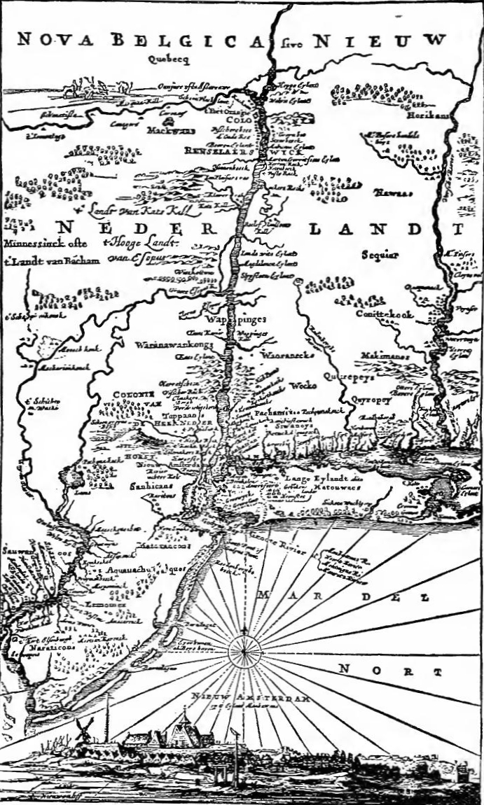 Van Der Donck's Map of New Netherland, 1656.
[Pg 169] Minuit's preparations for defence were not confined to fortifying the land. Conscious of foreign danger, inspired perhaps by the victories which Heyn was just now winning over Spaniards and Portuguese in the southern waters, and aided by two Belgian shipbuilders, the governor built and launched the New Netherland, a vessel of eight hundred tons and carrying thirty guns. The ship cost more than had been expected, and the bills were severely criticized by the West India Company.
[Pg 169] Minuit's efforts to defend the area weren’t just about strengthening the land. Aware of foreign threats, and likely inspired by Heyn's recent victories against the Spaniards and Portuguese in the southern waters, the governor partnered with two Belgian shipbuilders to construct and launch the New Netherland, a ship weighing eight hundred tons and equipped with thirty guns. The ship turned out to be more expensive than anticipated, leading to harsh criticism of the expenses by the West India Company.
The patroon system.—The returns from the southern raids made the small income from New Netherlands appear paltry, and the company decided to attempt an extensive colonization with a view to larger profit. A type of feudalism known as the patroon system was decided upon. The company reserved Manhattan Island, but other regions were opened to settlement. Each patroon was to receive lands four leagues along one side of a navigable river or two leagues on both sides and extending "so far into the country as the situation of the occupiers will permit," provided that within four years he settled fifty people over fifteen years of age upon his lands. Patroons were forever to "possess and enjoy all the lands lying within the aforesaid limits, together with the fruits, rights, minerals, rivers, and fountains thereof," and were to have complete control over "fishing, fowling, and grinding."
The patroon system.—The profits from the southern raids made the small income from New Netherlands seem insignificant, so the company decided to pursue large-scale colonization for greater profit. They opted for a type of feudalism called the patroon system. The company kept Manhattan Island for itself, but other areas were opened for settlement. Each patroon would receive land extending four leagues along one side of a navigable river or two leagues on both sides, going "as far into the country as the situation of the occupiers allows," as long as within four years, they settled fifty people over fifteen years old on their land. Patroons were to "own and enjoy all the lands within these limits, along with the fruits, rights, minerals, rivers, and springs found there," and would have total control over "fishing, fowling, and milling."
The fur trade was reserved by the company, but the patroons were allowed to trade on the coast from Newfoundland to Florida and to ship goods to neutral powers; they could also engage in fishing and the making of salt. They were to satisfy the Indians regarding land titles and were given the right to establish their own courts, from which appeal might be made to the director-general and his council. The colonists were exempt from taxation for ten years, but they could not leave the service of the patroon without his consent. The system was not intended to exclude other colonists who might come over and take up as much land as they could improve, but no colonists were to "be permitted to make any woolen, linen or cotton cloth, nor weave any other stuffs there." Patroons and colonists were "to find out ways and[Pg 170] means whereby they may support a Minister and Schoolmaster." The company promised to defend the colonists and to endeavor to supply them "with as many Blacks as they conveniently can."
The fur trade was controlled by the company, but the patroons were allowed to trade along the coast from Newfoundland to Florida and ship goods to neutral parties; they could also fish and make salt. They had to address the Indians' concerns about land titles and were granted the right to set up their own courts, with appeals going to the director-general and his council. The colonists were exempt from taxes for ten years, but they couldn't leave the patroon’s service without permission. The system wasn't meant to block other colonists who might arrive and settle as much land as they could cultivate, but no colonists were allowed to “make any woolen, linen or cotton cloth, nor weave any other stuffs there.” Patroons and colonists were "to find out ways and[Pg 170] means whereby they may support a Minister and Schoolmaster." The company promised to protect the colonists and to try to provide them "with as many Blacks as they conveniently can."
The patroons.—While the details of the charter were being discussed, several directors took advantage of the intended system to secure large grants. Samuel Godyn and Samuel Blommaert and several associates secured practically all of what is now Delaware and that part of the Jersey shore extending twelve miles north from Cape May and twelve miles inland. Kiliaen van Rensselaer obtained the lands about Fort Orange, comprising what is now a large part of Albany and Rensselaer counties. Michael Pauw received title to Staten Island and the region where Jersey City is now situated. Godyn and Blommaert sent colonists to Swannendael on the present site of Lewiston, but they were massacred by the Indians, the colonization of the grant was abandoned, and in 1635 the company purchased the lands of the patroons on the Delaware. In 1637 Pauw sold his holdings to the company. The Van Rensselaer tract remained in the possession of that family until after the American Revolution. Jealousies in the company, due to the securing of patroonships by some of the directors, and to the fact that the patroons attempted to obtain a share in the fur trade, and that Minuit appeared to be working in the interest of the great land holders, led to the recall of the director-general.
The patroons.—While the details of the charter were being discussed, several directors seized the opportunity to secure large land grants. Samuel Godyn and Samuel Blommaert, along with a few associates, obtained almost all of what is now Delaware and the part of the Jersey shore that stretches twelve miles north from Cape May and twelve miles inland. Kiliaen van Rensselaer acquired the lands around Fort Orange, which now includes a large portion of Albany and Rensselaer counties. Michael Pauw received title to Staten Island and the area where Jersey City is now located. Godyn and Blommaert sent colonists to Swannendael, on what is now the site of Lewiston, but they were killed by the Indians, which led to the abandonment of the colonization efforts. In 1635, the company bought the lands from the patroons in Delaware. In 1637, Pauw sold his properties to the company. The Van Rensselaer tract stayed in that family’s possession until after the American Revolution. Rivalries within the company, due to some directors securing patroonships and the patroons trying to get a share of the fur trade, along with Minuit appearing to favor the big landowners, led to the recall of the director-general.
Attempts to secure the frontiers.—The new director-general was Wouter van Twiller. He had been a clerk in the West India Company's warehouse at Amsterdam, and probably owed his appointment to the fact that he was married to a niece of Van Rensselaer. One of his first acts was to secure possession of the Delaware. In 1633 a tract along the Schuylkill was purchased from the Indians and a trading house was erected, the first in the present state of Pennsylvania. In 1635 a party of Virginians attempted to gain a foothold on the Delaware, but were expelled. On the Connecticut the Dutch had profited by the fur trade, but had never sent colonists to that region. In 1633 lands were purchased from the Indians, and Fort Good Hope was built at modern Hartford, but the Puritan migration soon secured the Connecticut Valley for the English.
Attempts to secure the borders.—The new director-general was Wouter van Twiller. He had been a clerk in the West India Company's warehouse in Amsterdam and likely got his position because he was married to a niece of Van Rensselaer. One of his first actions was to take control of the Delaware. In 1633, a piece of land along the Schuylkill was bought from the Native Americans, and a trading post was set up, the first in what is now Pennsylvania. In 1635, a group of Virginians tried to establish a presence on the Delaware but were driven out. In Connecticut, the Dutch had benefited from the fur trade but had never sent settlers to that area. In 1633, lands were purchased from the Native Americans, and Fort Good Hope was built at present-day Hartford, but soon the Puritan migration secured the Connecticut Valley for the English.
[Pg 171] Reforms.—Van Twiller and other officials appear to have profited by securing extensive land holdings on the islands at the mouth of the Hudson, Governor's Island deriving its name from the fact that Van Twiller owned it. Complaints began to be heard in the Amsterdam chamber and in 1637 Van Twiller was removed from office, his successor being William Kieft, who arrived in 1638. The new director-general immediately set about correcting abuses. Illicit fur trading and the sale of firearms to the Indians were prohibited. The Amsterdam chamber removed some of the trade restrictions and made easier the acquisition of land. The result was a considerable increase in the number of settlers, who came not only from the Netherlands, but from New England and Virginia as well. Restrictions on manufactures were abolished and the Dutch Reformed Church was established.
[Pg 171] Reforms.—Van Twiller and other officials seemed to have benefited by securing large land holdings on the islands at the mouth of the Hudson, with Governor's Island named after the fact that Van Twiller owned it. Complaints started coming in to the Amsterdam chamber, and in 1637, Van Twiller was removed from his position, with William Kieft taking over in 1638. The new director-general quickly began to fix issues. Illegal fur trading and selling firearms to the Native Americans were banned. The Amsterdam chamber lifted some trade restrictions and made it easier to acquire land. As a result, there was a significant increase in the number of settlers, who came not just from the Netherlands but also from New England and Virginia. Restrictions on manufacturing were lifted, and the Dutch Reformed Church was established.
Difficulties.—Kieft's administration was beset by difficulties. In the Connecticut Valley and on Long Island the English settlements were increasing, and on the Delaware the Swedes had gained a footing. In the colony a disastrous Indian war brought devastation and ruin. The Indians on the lower Hudson and on Long Island had watched the growing settlements with alarm, an alarm which turned to resentment when they found the Iroquois supplied with firearms from Fort Orange, a privilege which was denied to them at New Amsterdam. Kieft increased the ill-feeling by demanding a contribution of corn, fur, and wampum. He also accused the Raritans of attacking fur trading vessels, and sent an expedition to punish them. In 1641 the Indians retaliated by killing several settlers.
Difficulties.—Kieft's administration faced numerous challenges. In the Connecticut Valley and on Long Island, English settlements were expanding, while the Swedes had established a presence on the Delaware. A devastating war with the Indians brought chaos and destruction to the colony. The Native Americans along the lower Hudson and on Long Island watched the growing settlements with concern, which turned to anger when they noticed that the Iroquois were getting firearms from Fort Orange, a privilege they were denied at New Amsterdam. Kieft fueled this resentment by demanding contributions of corn, fur, and wampum. He also accused the Raritans of attacking fur trading vessels and sent an expedition to punish them. In 1641, the Indians struck back by killing several settlers.
Kieft and the twelve men.—Kieft promptly called together the settlers, who chose a committee of twelve to advise the director-general. Much to his disappointment, they counseled delay. In January, 1642, he again summoned the twelve, who consented to send an expedition against the Indians, provided Kieft should command it. At the same time they demanded that the council should contain at least five members and that the inhabitants should be allowed greater freedom of trade. To these demands Kieft assented grudgingly, and to save further embarrassment, dissolved the committee. An expedition was sent against the Indians, but it accomplished nothing.
Kieft and the twelve men.—Kieft quickly gathered the settlers, who appointed a committee of twelve to advise the director-general. To his disappointment, they suggested waiting. In January 1642, he called the twelve together again, and they agreed to send an expedition against the Indians, as long as Kieft was in charge. At the same time, they insisted that the council have at least five members and that the residents should have more freedom to trade. Kieft reluctantly agreed to these demands and, to avoid any more issues, disbanded the committee. An expedition was sent against the Indians, but it achieved nothing.
[Pg 172] Indian hostilities, 1643-1645.—Early in 1643 the Mohawks attacked the river Indians who sought refuge near New Amsterdam. Kieft determined to attack the fugitives, and eighty of them were massacred. The Long Island Indians were also plundered. Aroused by these acts, the Indians united and attacked the settlers. The colonists who escaped fled to Fort Amsterdam. A lull occurred in the fighting while the Indians planted their crops, but hostilities were soon renewed. Kieft again summoned the people and a committee of eight Was chosen who counseled war. Settlers and servants of the company were drilled, and fifty English also enlisted. A series of expeditions were despatched against the Indians, whose villages were ruthlessly destroyed. In 1645 treaties were made with the various tribes, and the long war came to an end. One of the incidents of the war was the building of a wall across the lower end of Manhattan Island. It is from this that Wall Street takes its name.
[Pg 172] Indian hostilities, 1643-1645.—In early 1643, the Mohawks attacked the river Indians who were seeking refuge near New Amsterdam. Kieft decided to strike against the fugitives, resulting in the massacre of eighty of them. The Long Island Indians also faced plundering. Angered by these actions, the Indians banded together and attacked the settlers. Those colonists who managed to escape fled to Fort Amsterdam. There was a brief pause in the fighting while the Indians planted their crops, but hostilities resumed soon after. Kieft again called on the people, and a committee of eight was chosen to advise on the war. Settlers and company servants were trained for battle, and fifty English volunteers also signed up. A series of expeditions were sent out against the Indians, leading to the ruthless destruction of their villages. In 1645, treaties were established with the various tribes, bringing the long conflict to an end. One notable event of the war was the construction of a wall at the southern end of Manhattan Island, which is where Wall Street gets its name.
Stuyvesant, 1647.—Both in New Amsterdam and the Netherlands Kieft was blamed for the war. The West India Company decided to remove him, and Peter Stuyvesant, the director of Curaçao, was appointed to succeed him. The first important act of Stuyvesant was to organize the council. Police regulations were made to control Sabbath-breakers, brawlers, and the sale of liquors. The court of justice was also organized, but the director-general required that his opinion be asked in all important cases, and reserved the right to preside in person when he saw fit.
Stuyvesant, 1647.—Both in New Amsterdam and the Netherlands, Kieft was held responsible for the war. The West India Company decided to replace him, and Peter Stuyvesant, the director of Curaçao, was chosen to take over. Stuyvesant's first major action was to set up the council. He implemented police regulations to manage Sabbath-breakers, bar fights, and the sale of alcohol. The court of justice was also established, but the director-general insisted that his input be sought in all significant cases, and he reserved the right to preside personally when he found it necessary.
Popular representation.—While Kieft was director-general, he had appealed to the people on several occasions. In answer to the public demand for representation, the council recommended to Stuyvesant that it be granted. Accordingly, the director-general ordered an election at which eighteen were chosen, from whom Stuyvesant and the council selected nine. The nine were to advise and assist, when called upon, in promoting the welfare of the province, and were to nominate their successors. The director-general retained the right to preside at meetings.
Popular representation.—While Kieft was the director-general, he reached out to the people several times. In response to the public demand for representation, the council suggested to Stuyvesant that it should be provided. As a result, the director-general ordered an election where eighteen representatives were chosen, from which Stuyvesant and the council selected nine. These nine were to advise and assist, when needed, in promoting the province's welfare, and were responsible for nominating their successors. The director-general kept the right to lead meetings.
Struggle for municipal rights.—The trade restrictions of the West India Company were irksome to the people of New Amsterdam, who hoped to right conditions by obtaining a larger share[Pg 173] in the government. After considerable trouble with Stuyvesant, the nine men submitted to the States General a remonstrance setting forth their grievances and a memorial suggesting remedies. They asked that the States General establish a citizens' government, that colonists be sent over, and that the boundaries of New Netherlands be definitely established. The Amsterdam chamber opposed the petitioners, but in 1652 it decided to make concessions. The export duty on tobacco was removed, the cost of passage to New Netherlands was reduced, and the colonists were allowed to procure negroes from Africa. A "burgher" government was allowed for New Amsterdam, the citizens being allowed a schout, two burgomasters, and five schepens, who were to form a municipal court of justice. They were not to be popularly elected, however, Stuyvesant being allowed to appoint the members. No sooner were municipal rights granted to New Amsterdam than the settlements at the western end of Long Island demanded a larger share in government. A convention was held at the capital to formulate grievances. This was brought to an end by Stuyvesant, but a little later municipal rights were granted to several of the towns.
Struggle for municipal rights.—The trade restrictions imposed by the West India Company were frustrating for the people of New Amsterdam, who wanted to improve their situation by gaining a bigger role in the government. After facing a lot of difficulties with Stuyvesant, the nine men presented a complaint to the States General outlining their issues and proposing solutions. They requested that the States General set up a citizens' government, send more colonists, and clearly define the boundaries of New Netherlands. The Amsterdam chamber opposed their requests, but in 1652 it decided to make some concessions. The export tax on tobacco was lifted, the cost of traveling to New Netherlands was lowered, and the colonists were allowed to bring enslaved people from Africa. A "burgher" government was established for New Amsterdam, with citizens electing a schout, two burgomasters, and five schepens to create a municipal court. However, these officials were not elected by popular vote; Stuyvesant was permitted to appoint them. As soon as New Amsterdam received its municipal rights, the settlements at the western end of Long Island sought a greater role in governance. A convention was organized in the capital to discuss grievances. Stuyvesant put an end to this, but later on, municipal rights were granted to several towns.
A provincial assembly.—In 1664, during the war between England and the Dutch, so great was the alarm at New Amsterdam, that a provisional assembly was elected, composed of two delegates from each of the Dutch settlements, twenty-four representatives in all. Little was accomplished by this body, however, for shortly afterward the colony passed into English hands.
A provincial assembly.—In 1664, during the war between England and the Dutch, there was so much fear in New Amsterdam that a temporary assembly was elected, made up of two delegates from each of the Dutch settlements, totaling twenty-four representatives. However, this group didn’t achieve much, as shortly after, the colony came under English control.
Economic development.—During the administration of Stuyvesant the material prosperity of New Netherlands steadily increased. He found New Amsterdam a town with straggling fences and crooked streets, and containing about five hundred people. Under his supervision it took on the appearance of a well-kept Dutch town. In 1656 it contained a hundred and twenty houses and a thousand people. By 1660 it had three hundred and fifty houses. By 1664 the population increased to fifteen hundred. The area of settlement in New Netherlands had gradually expanded, covering Manhattan and Staten islands, the opposite Jersey shore, the western end of Long Island, both banks of the lower Hudson, a considerable district about Ft. Orange, and scattering settlements on the Delaware. The chief[Pg 174] source of wealth was the fur trade which was carried on largely with the Iroquois who were friendly to the Dutch and hostile to the French. In 1656 Ft. Orange alone exported thirty-five thousand beaver and otter skins, but soon afterward the trade began to decline and agriculture increased in importance. When the province passed into English hands, the population had reached ten thousand.
Economic development.—During Stuyvesant's administration, New Netherlands saw steady growth in material prosperity. He found New Amsterdam to be a town with disorganized fences and winding streets, inhabited by about five hundred people. Under his guidance, it transformed into a well-maintained Dutch town. By 1656, it had one hundred and twenty houses and a population of a thousand. By 1660, the number of houses grew to three hundred and fifty. By 1664, the population rose to fifteen hundred. The area settled in New Netherlands gradually expanded to include Manhattan and Staten Islands, the opposite Jersey shore, the western part of Long Island, both sides of the lower Hudson River, a significant area around Ft. Orange, and scattered settlements along the Delaware. The main source of wealth was the fur trade, which was largely conducted with the Iroquois, who were friendly to the Dutch and hostile to the French. In 1656, Ft. Orange alone exported thirty-five thousand beaver and otter skins, but shortly after, the trade started to decline, and agriculture gained importance. When the province came under English control, the population had reached ten thousand.
THE DUTCH AND THE SWEDES ON THE DELAWARE
Swedish territorial and commercial expansion.—In the first half of the seventeenth century Sweden rose to the position of a first class power. When Gustavus Adolphus ascended the throne in 1611, Sweden was at war with Denmark, Russia, and Poland. After defeating each power, the king entered the Thirty Years' War as the champion of Protestantism, his victorious career coming to an untimely end at Lützen. Until 1654 Christina was queen but the real ruler was Oxenstierna, who piloted Sweden through the closing years of the war and secured advantageous terms in the treaty of peace. From 1648 until 1654, Sweden enjoyed peace, but the frivolities of the court ruined the possibilities of greatness and the decline began. Charles X became king in 1654, and his brilliant but disastrous military ventures reduced his country to a third-rate power. At the beginning of the period of Swedish greatness, her commerce was confined to the Baltic, but when nearly all the lands on its shores had been acquired, Swedish statesmen looked forward to a wider commerce, a policy which brought them into rivalry with Holland and England. Numerous trading companies were formed, among the most important being the African and Russian companies, and the various organizations which operated on the Delaware River and in the West Indies.
Swedish territorial and commercial expansion.—In the first half of the seventeenth century, Sweden became a major power. When Gustavus Adolphus took the throne in 1611, Sweden was at war with Denmark, Russia, and Poland. After defeating each of these countries, the king entered the Thirty Years' War as the defender of Protestantism, but his successful campaign was cut short at Lützen. Christina was queen until 1654, but the real power was held by Oxenstierna, who guided Sweden through the final years of the war and secured favorable terms in the peace treaty. From 1648 to 1654, Sweden was at peace, but the extravagance of the court undermined its potential for greatness, leading to a decline. Charles X became king in 1654, and his ambitious yet disastrous military campaigns reduced the country to a third-rate power. At the start of Sweden’s period of greatness, its trade was limited to the Baltic Sea, but once nearly all the lands along its coast were acquired, Swedish leaders aimed for broader trade, which put them in competition with Holland and England. Many trading companies were established, with significant ones including the African and Russian companies, as well as various organizations that operated on the Delaware River and in the West Indies.
Usselincx.—The attention of Sweden was drawn to the Delaware by Usselincx, the promoter of the Dutch West India Company, who had left Holland in disgust and who hoped to interest the Swedes. In 1624 he laid his plans before Gustavus Adolphus; this resulted in the granting of a charter to The South Company to establish trade "for Asia, Africa, America and Magellanica." Usselincx experienced great difficulty in raising money, and the directors ruined his schemes by diverting the capital to commercial[Pg 175] enterprises in Sweden. In 1629 the company was reorganized and an attempt was made to trade with Spain, but this ended in disaster. Usselincx continued his endeavors, and in 1633 The New South Company was organized, but this like its predecessors came to naught.
Usselincx.—Sweden's attention was brought to the Delaware by Usselincx, the promoter of the Dutch West India Company, who had left Holland in frustration and wanted to engage the Swedes. In 1624, he presented his plans to Gustavus Adolphus, which led to the granting of a charter to The South Company to establish trade "for Asia, Africa, America, and Magellanica." Usselincx faced significant challenges in raising funds, and the directors undermined his efforts by redirecting the capital to commercial[Pg 175] ventures in Sweden. In 1629, the company was reorganized, and an attempt was made to trade with Spain, but this ended in failure. Usselincx persisted with his efforts, and in 1633, The New South Company was formed, but like its predecessors, it also came to nothing.
The New Sweden Company.—The settling of the Swedes on the Delaware was directly due to the Dutchmen, Samuel Blommaert and Peter Minuit. Blommaert held out the idea that the West Indies would be a market for Swedish copper; Minuit that the Delaware region offered a place for the fur trade and colonization. Several other Dutch merchants were interested, and half of the capital of the Swedish company was furnished by Hollanders. By 1637 the company was organized and the first expedition set sail.
The New Sweden Company.—The settlement of the Swedes on the Delaware was primarily due to the Dutch men, Samuel Blommaert and Peter Minuit. Blommaert suggested that the West Indies would be a market for Swedish copper; Minuit believed that the Delaware area provided opportunities for the fur trade and colonization. Several other Dutch merchants were interested, and half of the capital for the Swedish company came from the Dutch. By 1637, the company was formed and the first expedition set off.
Fort Christina.—The two vessels arrived in the spring of 1638, lands were purchased from the Indians, fur trade opened, and a fort established on Christina Creek two miles from the Delaware. The Dutch at Ft. Nassau protested, but were too weak to oust the newcomers. In 1640 two boats arrived with settlers and goods, large tracts of land at various points on both sides of the bay and river as far as Trenton were purchased, and farms and tobacco plantations were started.
Fort Christina.—The two ships arrived in the spring of 1638, land was bought from the Native Americans, the fur trade began, and a fort was set up on Christina Creek, two miles from the Delaware River. The Dutch at Ft. Nassau complained, but they were too weak to drive the newcomers away. In 1640, two boats came with settlers and supplies, large areas of land on both sides of the bay and river as far as Trenton were purchased, and farms and tobacco plantations were started.
Governor Printz.—In 1642 the company was reorganized, the Swedish government taking part of the stock, the Dutch being eliminated. At the request of the Swedish council of state Johan Printz, a prominent officer in the army, became governor, a post which he filled until 1653. He erected Ft. Elfsborg and established his capital at New Gothenborg, where a fort was built. A blockhouse was also erected on the Schuylkill, other vantage points were occupied, and the Swedes soon secured the fur trade of the Delaware. From the first the weakness of the Swedish project was the lack of colonists, a few hundred being the total migration in the first ten years. In 1644 there were only one hundred and twenty men and a few women and children in the colony. During the next five years not a vessel arrived, and when Printz retired in 1653 there were only two hundred people in the colony.
Governor Printz.—In 1642, the company was reorganized, with the Swedish government acquiring part of the stock and the Dutch being removed. At the request of the Swedish council of state, Johan Printz, a well-known military officer, became governor, a role he held until 1653. He built Ft. Elfsborg and made New Gothenborg his capital, where a fort was constructed. A blockhouse was also built on the Schuylkill, other strategic locations were taken, and the Swedes quickly gained control of the fur trade in the Delaware area. From the beginning, the main issue with the Swedish settlement was the lack of colonists, with only a few hundred migrating in the first ten years. By 1644, there were just one hundred and twenty men along with a small number of women and children in the colony. Over the next five years, no ships arrived, and when Printz left in 1653, the colony had only two hundred residents.
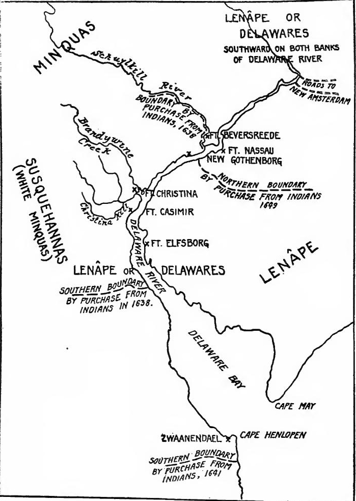 New Sweden.
[Pg 177] End of Swedish power on the Delaware.—Stuyvesant determined to get control of the river trade. In 1651 he went to the Delaware with a considerable force. In spite of protests from Printz, lands were purchased from the Indians, and Ft. Casimir was built near the present site of New Castle, the other Dutch forts being abandoned. In 1653 the Swedish crown planned to help New Sweden. In the spring of 1654 about three hundred and fifty colonists were sent over under John Rising. He immediately seized Ft. Casimir. At Ft. Christina a town was laid out, new tracts were purchased from the Indians, and lands were assigned to the colonists. The action of the Swedes in seizing Ft. Casimir angered Stuyvesant, and he urged the West India Company to occupy New Sweden. In September, 1655, a Dutch fleet appeared in the Delaware, and the forts surrendered, thus ending the colony of New Sweden.
[Pg 177] The End of Swedish Control on the Delaware.—Stuyvesant was determined to gain control of the river trade. In 1651, he went to the Delaware with a significant force. Despite objections from Printz, lands were bought from the Native Americans, and Ft. Casimir was constructed near what is now New Castle, while the other Dutch forts were abandoned. In 1653, the Swedish crown planned to support New Sweden. In the spring of 1654, around three hundred fifty colonists were sent over under John Rising. He quickly took over Ft. Casimir. At Ft. Christina, a town was laid out, new lands were purchased from the Native Americans, and land was assigned to the colonists. The Swedes' action in taking Ft. Casimir frustrated Stuyvesant, and he urged the West India Company to take control of New Sweden. In September 1655, a Dutch fleet arrived in the Delaware, and the forts surrendered, marking the end of the New Sweden colony.
ABSORPTION OF NEW NETHERLANDS BY THE ENGLISH
Boundary treaty with New England.—On the eastern frontier Stuyvesant had another difficult problem. English settlers were crowding into the Connecticut Valley and onto Long Island. In 1647 Stuyvesant informed the New England officials that the Dutch claimed all lands between the Connecticut and Delaware rivers, but the New Englanders ignored the claim. In 1650 Stuyvesant visited Hartford, where commissioners were appointed who agreed that Long Island should be divided by a line running along the western part of Oyster Bay; that on the mainland the fine was "to begin at the west side of Greenwich Bay, being four miles from Stamford and so to run a northerly line twenty miles up into the country, and after as it shall be agreed by the two governments of the Dutch and New Haven; provided the said line come not within ten miles of Hudson's River;" and that the Dutch were to keep their holdings at Hartford.
Boundary treaty with New England.—On the eastern frontier, Stuyvesant faced another tough issue. English settlers were moving into the Connecticut Valley and onto Long Island. In 1647, Stuyvesant told the New England officials that the Dutch claimed all the land between the Connecticut and Delaware rivers, but the New Englanders dismissed this claim. In 1650, Stuyvesant went to Hartford, where commissioners were appointed and agreed that Long Island would be divided by a line running along the western part of Oyster Bay; that on the mainland, the line would "start at the west side of Greenwich Bay, four miles from Stamford, and extend a northerly line twenty miles into the country, and then continue as agreed by the two governments of the Dutch and New Haven; provided that this line does not come within ten miles of Hudson's River;" and that the Dutch would retain their holdings in Hartford.
The end of Dutch rule.—In 1659 Massachusetts asserted her claim to a sea to sea grant, and in 1662 the charter of Connecticut extended the bounds of the colony to the Pacific. In 1663 Stuyvesant visited Boston to attempt a settlement of existing difficulties, but to no avail, and upon his return he found that some of the Long Island settlements west of the line claimed to be under the jurisdiction of Connecticut. Dutch commissioners were sent to Hartford, but without result, and the following year Connecticut asserted her rights to the whole of Long[Pg 178] Island. In 1664 Charles II granted to his brother, James, the Duke of York, the whole of Long Island and all the lands from the Connecticut River to Delaware Bay. A fleet was despatched to New Amsterdam, which surrendered without bloodshed, and Dutch rule in North America came to an end three years after it had failed in Brazil.
The end of Dutch rule.—In 1659, Massachusetts claimed a grant stretching from sea to sea, and in 1662, Connecticut's charter expanded the colony's boundaries to the Pacific. In 1663, Stuyvesant visited Boston to try to resolve ongoing issues, but he had no success. Upon his return, he discovered that some settlements on Long Island were claiming to fall under Connecticut's jurisdiction. Dutch commissioners were sent to Hartford, but it led to nothing, and the next year, Connecticut claimed the entire Long[Pg 178] Island. In 1664, Charles II granted his brother, James, the Duke of York, all of Long Island and the lands from the Connecticut River to Delaware Bay. A fleet was sent to New Amsterdam, which surrendered without any fighting, marking the end of Dutch rule in North America, three years after it had ended in Brazil.
READINGS
THE DUTCH
Blok, P.J., History of the People of the Netherlands, III, 267-303; Brodhead, J.R., History of the State of New York, I; Channing, Edward, History of the United States, I, 438-484; Fiske, John, The Dutch and Quaker Colonies in America, I; Goodwin, M.W., Dutch and English on the Hudson; Innes, J.H., New Amsterdam and its People; Jameson, J.F., ed., Narratives of New Netherlands; Janvier, T.A., Dutch Founding of New York; MacDonald, William, Select Charters. 43-50; O'Callaghan, E.B., History of New Netherlands; Roberts, E.H., New York, I, 10-119; Van Loon, H.W., The Golden Book of the Dutch Navigators.
Blok, P.J., History of the People of the Netherlands, III, 267-303; Brodhead, J.R., History of the State of New York, I; Channing, Edward, History of the United States, I, 438-484; Fiske, John, The Dutch and Quaker Colonies in America, I; Goodwin, M.W., Dutch and English on the Hudson; Innes, J.H., New Amsterdam and its People; Jameson, J.F., ed., Narratives of New Netherlands; Janvier, T.A., Dutch Founding of New York; MacDonald, William, Select Charters. 43-50; O'Callaghan, E.B., History of New Netherlands; Roberts, E.H., New York, I, 10-119; Van Loon, H.W., The Golden Book of the Dutch Navigators.
THE SWEDES
Acrelius, Israel, History of New Sweden (Pennsylvania Historical Society, Memoirs, XI); Holm, T.C., Description of the Province of New Sweden (Pennsylvania Historical Society, Memoirs, VII); Johnson, Amandus, The Swedish Settlements on the Delaware; Keen, G.B., in Winsor, Narrative and Critical History, III, 469-495.
Acrelius, Israel, History of New Sweden (Pennsylvania Historical Society, Memoirs, XI); Holm, T.C., Description of the Province of New Sweden (Pennsylvania Historical Society, Memoirs, VII); Johnson, Amandus, The Swedish Settlements on the Delaware; Keen, G.B., in Winsor, Narrative and Critical History, III, 469-495.
CHAPTER X
THE OLD ENGLISH COLONIES UNDER THE LATER STUARTS (1660-1689)
COLONIAL POLICY AND ADMINISTRATION
The Restoration.—In 1660 Charles II was restored to the English throne and ruled until 1685, when his brother, James, the Duke of York, became king, ruling until deposed in 1688. In England the period was characterized by a reaction against Puritanism and the firm establishment of the English church. Abroad the Restoration was an era of commercial and colonial expansion. On the coasts of Asia, Africa, and America, the great trading companies were active, and powerful English nobles strove for possessions beyond the seas. To this era belong the occupation of New Netherlands, the founding of the Carolinas, the Jerseys, and Pennsylvania, and the establishment of the Hudson's Bay Fur Company. The activities of Englishmen led to clashes with rival commercial peoples, especially the Dutch, with whom two naval wars were fought in which England maintained her supremacy upon the seas. In the handling of her colonies previous to the Restoration, her efforts had been largely experimental. Under the later Stuarts colonial management was molded into a system. In private life Charles II was a man of pleasure. In his dealings with parliament he was tenacious, but when pushed to extremities, he preferred to yield rather than to "go again on his travels.". In matters which affected the material prosperity of his country the king was a hard-headed man of business, warmly supporting commercial and colonial enterprises.
The Restoration.—In 1660, Charles II was restored to the English throne and ruled until 1685, when his brother James, the Duke of York, became king, ruling until he was deposed in 1688. In England, this period was marked by a reaction against Puritanism and the solid establishment of the Church of England. Internationally, the Restoration was a time of commercial and colonial growth. On the coasts of Asia, Africa, and America, major trading companies were active, and powerful English nobles sought to acquire lands overseas. This era saw the occupation of New Netherlands, the founding of the Carolinas, the Jerseys, and Pennsylvania, and the establishment of the Hudson's Bay Fur Company. The efforts of Englishmen led to conflicts with rival trading nations, especially the Dutch, resulting in two naval wars in which England maintained its dominance at sea. Prior to the Restoration, England's approach to managing its colonies was mostly experimental. Under the later Stuarts, colonial management was organized into a system. In his personal life, Charles II was a man who enjoyed pleasure. In his relations with Parliament, he was persistent, but when pushed to the limit, he preferred to give in rather than "go on his travels" again. In matters that affected his country's economic prosperity, the king was a pragmatic businessman, strongly supporting commercial and colonial ventures.
The Mercantilist system.—The economic theory of the time was expressed in the Mercantilist system. The welfare of the state was the main object of statesmen; this they believed required a full treasury, a large population, and extensive shipping. Specie was looked upon as the principal form of wealth; therefore exports must exceed imports so that coin would flow into the realm. In order that it might have a large amount of goods to[Pg 180] sell, the state desired to import raw materials, which could be manufactured and exported. The ideal colony was to be a source of supply of raw materials, and was to be a market for goods of the mother country, but was not to be a manufacturing competitor. The state policy was shaped to shut out the foreigner and to build up the productivity of the colonies.
The Mercantilist system.—The economic theory of the time was represented in the Mercantilist system. The main goal of state leaders was the welfare of the nation; they believed this required a full treasury, a large population, and extensive shipping. Precious metals were seen as the primary form of wealth; therefore, exports needed to exceed imports so that money would flow into the country. To ensure a large supply of goods to sell, the state aimed to import raw materials that could be manufactured and exported. The ideal colony was meant to be a source of raw materials and a market for goods from the mother country, but it was not supposed to compete in manufacturing. State policy was designed to exclude foreign competition and boost the productivity of the colonies.
Attitude toward emigration.—The desire for a larger population in England caused statesmen to view emigration with disfavor. During the period the number going to the colonies was relatively small. The government, however, encouraged the emigration of Scotch, Irish, and Huguenots, and sent over many political prisoners, non-conformists, and criminals. Many of those who emigrated were too poor to pay for their passage and bound themselves for a period of years, a form of temporary bondage known as indenture. Many servants and children were also kidnaped and sent to the colonies. Because the colonies in the West Indies and the South mainly produced raw materials and used slave labor, thus drawing relatively less population from England, they were looked upon with the greater favor by the home government. The northern colonies produced little except fish, furs, and naval stores, which could be of use to England. The free labor system of the North was likely to drain the population of England. For these reasons the northern colonies were looked upon with scant favor.
Attitude toward emigration.—The wish for a larger population in England led politicians to view emigration negatively. During this time, the number of people moving to the colonies was relatively small. However, the government encouraged the emigration of Scots, Irish, and Huguenots, and sent many political prisoners, non-conformists, and criminals over as well. Many of those who emigrated were too poor to pay for their passage and agreed to work for a number of years in a type of temporary bondage called indenture. Numerous servants and children were also kidnapped and sent to the colonies. Since the colonies in the West Indies and the South mainly produced raw materials and relied on slave labor, which attracted fewer people from England, they were viewed more favorably by the home government. The northern colonies generated little beyond fish, furs, and naval supplies, which were useful to England. The free labor system of the North was likely to take people away from England. For these reasons, the northern colonies were not favored.
Navigation Act of 1660.—During the Cromwellian period, parliament had asserted the right to legislate for the colonies and the restored Stuarts accepted the principle. In 1660 a new navigation act was passed which was intended to give English shipping an advantage over competitors, especially the Dutch. The act provided that goods carried to or from English possessions in America, Africa, or Asia, must be carried in English, Irish, or colonial vessels. Under penalty of forfeiture, cargoes of sugar, tobacco, indigo, and several other products could not be shipped to any ports except in England, Ireland, or some English colony.
Navigation Act of 1660.—During the time of Cromwell, Parliament claimed the right to make laws for the colonies, and the restored Stuarts accepted this principle. In 1660, a new navigation act was passed aimed at giving English shipping an edge over competitors, especially the Dutch. The act stated that goods transported to or from English territories in America, Africa, or Asia must be carried on English, Irish, or colonial ships. Failing to comply could result in the loss of the cargo. Cargoes of sugar, tobacco, indigo, and other products couldn’t be shipped to any ports except those in England, Ireland, or another English colony.
Staple Act of 1663.—Under the navigation act of 1660 alien merchants could send foreign goods to the colonies in English ships. To obviate this the Staple Act was passed, which, with a few exceptions, such as Portuguese wines, salt, and horses,[Pg 181] prohibited the importation into the colonies of goods which had not been loaded in England.
Staple Act of 1663.—According to the navigation act of 1660, foreign merchants could ship their goods to the colonies using English ships. To address this, the Staple Act was enacted, which, with some exceptions like Portuguese wines, salt, and horses,[Pg 181] banned the import of goods into the colonies that weren't loaded in England.
Plantation Duties Act of 1673.—Under the previous acts goods shipped from colony to colony escaped paying duties. In 1673 an act was passed which imposed duties on sugar, tobacco, and many other products of intercolonial trade.
Plantation Duties Act of 1673.—Under the earlier laws, goods shipped from one colony to another were exempt from duties. In 1673, a law was enacted that imposed duties on sugar, tobacco, and many other products involved in intercolonial trade.
Imperial defence.—The burden of defence of the empire against foreign powers fell upon England. Ships of the navy were stationed in the West Indies, Chesapeake Bay, and at Boston to protect the colonies, and suppress piracy and illegal trade. The buccaneers of the West Indies were brought under control. The Barbary pirates also were frequently attacked, and convoys for merchant vessels and fishing fleets were often furnished. Garrisons were usually stationed in Barbados, Jamaica, and St. Kitts, but on the mainland soldiers were not regularly maintained.
Imperial defense.—The responsibility for defending the empire against foreign powers fell on England. Navy ships were stationed in the West Indies, Chesapeake Bay, and Boston to protect the colonies and combat piracy and illegal trade. The buccaneers of the West Indies were brought under control. The Barbary pirates were also frequently attacked, and protection for merchant vessels and fishing fleets was often provided. Garrisons were typically stationed in Barbados, Jamaica, and St. Kitts, but soldiers were not regularly deployed on the mainland.
The fiscal system.—By the civil war parliament made good its contention that it alone had the right to levy taxes. In 1660 a general taxation act was passed by which Charles II was granted for life the income from tonnage and poundage; the former being a duty on imported wines, the latter a five per cent duty on imports and exports, whose valuation was fixed in a book of rates. To compensate the colonies somewhat for the resulting higher prices, a preferential system was introduced. By this system the valuation of the principal products of the colonies was made lower than on the same products coming from foreign countries.
The fiscal system.—During the civil war, Parliament established that it alone had the authority to impose taxes. In 1660, a general taxation act was enacted that granted Charles II a lifetime income from tonnage and poundage; the former was a duty on imported wines, and the latter was a five percent duty on imports and exports, with the valuation determined in a rates book. To somewhat offset the increased prices for the colonies, a preferential system was introduced. With this system, the valuation of the main products from the colonies was set lower than that of the same products coming from foreign countries.
MACHINERY OF GOVERNMENT
Council for Foreign Plantations.—The work of enforcing the laws devolved upon the crown and privy council. The accumulation of business and the specialized knowledge required in colonial matters made it desirable to have a body created which might handle the business in a more efficient manner. Accordingly in December, 1660, a Council for Foreign Plantations was commissioned. Members of the council were to inform themselves regarding the colonies, were to introduce a more uniform system of government, and were to see that the navigation acts were enforced.
Council for Foreign Plantations.—The responsibility for enforcing the laws fell to the crown and privy council. The growing amount of work and the specialized knowledge needed for colonial affairs made it necessary to establish a group that could manage these issues more effectively. So, in December 1660, a Council for Foreign Plantations was set up. Council members were expected to learn about the colonies, implement a more uniform system of governance, and ensure the navigation acts were upheld.
[Pg 182] Council of Trade.—From the English standpoint the colonies were mainly commercial enterprises. To foster commerce a Council of Trade was created. The work of the two bodies was to sift the mass of business so that matters of first importance only might come before the privy council. Lack of authority interfered with the interest of the members of the minor councils; the sessions became less and less frequent, and by 1665 both had ceased.
[Pg 182] Council of Trade.—From England’s perspective, the colonies were primarily business ventures. To promote trade, a Council of Trade was established. The job of the two groups was to filter through the vast amount of business so that only the most important issues would be presented to the privy council. A lack of authority affected the engagement of the members of the smaller councils; meetings became increasingly rare, and by 1665, both had stopped entirely.
Council for Trade and Plantations.—Supervision of the colonies again devolved upon a committee of the privy council. In 1667 Clarendon fell and the small group known as the Cabal came into power. The following year the privy council was reorganized, four standing committees being constituted, one of which had charge of trade and plantations. The need of experts, however, continued to be felt, and in 1668 a new Council of Trade was appointed. In 1670 the Council for Plantations was also revived, and in 1672 the two councils were consolidated as the Council for Trade and Plantations. The council prepared preliminary drafts of instructions to governors, examined colonial legislation, and investigated questions which arose.
Council for Trade and Plantations.—Supervision of the colonies was handed over to a committee of the privy council again. In 1667, Clarendon fell from power, and a small group known as the Cabal took over. The following year, the privy council was reorganized, creating four standing committees, one of which handled trade and plantations. However, there was still a need for experts, so in 1668, a new Council of Trade was established. In 1670, the Council for Plantations was also revived, and in 1672, the two councils were merged into the Council for Trade and Plantations. The council drafted initial instructions for governors, reviewed colonial laws, and looked into various issues that came up.
Lords of Trade.—Executive powers remained in the privy council, and this necessarily curbed the Council for Trade and Plantations, which was purely an advisory body. In 1674 the latter council was abolished, and the following year the king again committed its work to the Committee for Trade and Plantations of the privy council. This committee, known henceforth as the Lords of Trade, was a permanent body with its own clerks. William Blathwayt soon became the secretary and for twenty years he held the position. The efficiency of the body and the development of the colonial policy was due more to him than to any other person. The Lords of Trade prepared the instructions to governors, supervised the development of the colonies, examined colonial questions, and enforced the navigation laws.
Lords of Trade.—Executive powers remained with the privy council, which limited the Council for Trade and Plantations, as it was just an advisory group. In 1674, this council was dissolved, and the next year, the king entrusted its responsibilities to the Committee for Trade and Plantations of the privy council. This committee, now referred to as the Lords of Trade, became a permanent body with its own staff. William Blathwayt quickly became the secretary and held that position for twenty years. The effectiveness of the group and the development of colonial policy were largely due to him more than anyone else. The Lords of Trade created instructions for governors, oversaw the growth of the colonies, addressed colonial issues, and enforced the navigation laws.
The Admiralty.—After the Restoration the Duke of York was appointed Lord High Admiral of England and in 1662 his powers were extended to the colonies. Cases concerning vessels seized for violating some of the clauses of the commercial laws were tried in admiralty courts which were established in the[Pg 183] crown colonies, deputies were appointed by the admiral to attend to the business, and ships were stationed in the colonies to seize illegal traders.
The Admiralty.—After the Restoration, the Duke of York became the Lord High Admiral of England, and in 1662, his authority was expanded to include the colonies. Cases about ships that were seized for breaking certain parts of commercial laws were handled in admiralty courts set up in the[Pg 183] crown colonies. Deputies were appointed by the admiral to manage these matters, and ships were deployed in the colonies to arrest illegal traders.
Governors and customs officials.—In the colony the chief executive officer was the governor. He was expected to enforce the trade laws, but outside of the crown colonies there was great, laxity in this regard. The work of enforcing the navigation laws was usually entrusted by the governor to a clerk called the naval officer but at a later period these officials were appointed by the crown. The right of collection of the English customs was leased to certain individuals who were known as farmers of the customs. They frequently complained that the governors were remiss in enforcing the navigation laws. Accordingly, the farmers of the customs were allowed to send, at their own expense, officers who would attend to the collection of duties. The farming system was soon abandoned and commissioners of customs were appointed, who sent out collectors, usually one to each colony. To examine the collector's accounts and act as a check upon him, officials called comptrollers were placed in most of the colonies, and in 1683 a superintendent for all the colonies, called the surveyor-general of the customs, was appointed. The activities of these officials led to considerable friction with colonial governors and proprietors, who resented the interference of the customs officials.
Governors and customs officials.—In the colony, the main executive officer was the governor. He was responsible for enforcing trade laws, but outside the crown colonies, there was a lot of leniency regarding this. The governor typically delegated the enforcement of navigation laws to a clerk known as the naval officer, but later on, these officials were appointed by the crown. The right to collect the English customs was leased to certain individuals known as customs farmers. They often complained that the governors were neglectful in enforcing the navigation laws. Therefore, the customs farmers were permitted to send their own officers at their own expense to handle the collection of duties. This farming system was eventually abandoned, and customs commissioners were appointed, who sent out collectors, usually one for each colony. To review the collector's accounts and provide oversight, officials called comptrollers were established in most colonies, and in 1683, a superintendent for all colonies, known as the surveyor-general of the customs, was appointed. The actions of these officials led to significant friction with colonial governors and proprietors, who resented the intrusion of the customs officials.
MISRULE AND REBELLION IN VIRGINIA
Effect of the trade laws.—In 1660 Sir William Berkeley began his second administration, which proved to be as unsuccessful as his first administration had been successful. Economic distress and arbitrary misrule beset Virginia for sixteen years, culminating in a popular outbreak known as Bacon's rebellion. The navigation acts fell heavily upon the tobacco planters, who were deprived of the Dutch trade. The population at the same time rapidly increased. In 1671 the inhabitants numbered about forty thousand, and nearly doubled in the next decade. The increasing population meant an increasing acreage of tobacco. The price of tobacco fell, while freight rates increased and imported goods went up in price. To alleviate the situation the assembly passed several acts to encourage new industries, but[Pg 184] the planters held to their one great staple. Several attempts were made to limit the production of tobacco, a policy in which the Virginians asked the people of Maryland and the Albemarle district to the south to coöperate, but the efforts failed. The act of 1673 worked an added injury, for it deprived the planters of the New England market.
Effect of the trade laws.—In 1660, Sir William Berkeley began his second administration, which turned out to be as unsuccessful as his first one had been successful. Virginia experienced economic hardship and arbitrary mismanagement for sixteen years, leading to a popular uprising known as Bacon's Rebellion. The navigation acts heavily impacted the tobacco planters, who lost access to the Dutch trade. At the same time, the population was rapidly growing. By 1671, the number of inhabitants was around forty thousand and nearly doubled in the following decade. A growing population meant more land was needed for tobacco. The price of tobacco dropped, while shipping costs rose and the prices of imported goods increased. To address the situation, the assembly passed several acts to promote new industries, but[Pg 184] the planters clung to their main cash crop. Several attempts were made to limit tobacco production, with the Virginians asking the people of Maryland and the Albemarle district to the south for cooperation, but these efforts failed. The act of 1673 caused additional harm by cutting the planters off from the New England market.
Wars and other misfortunes.—The wars with Holland increased the economic distress. In 1667 a Dutch fleet entered the James River, captured an English frigate, and destroyed several trading vessels. Soon afterward a hurricane destroyed hundreds of houses and ruined the crops. In the winter of 1672-1673 a disease carried off fifty thousand cattle, more than half of all the stock in Virginia. A second Dutch raid in 1673 destroyed a large part of the tobacco fleet.
Wars and other troubles.—The wars with Holland worsened the economic hardship. In 1667, a Dutch fleet came into the James River, captured an English frigate, and destroyed several trading ships. Shortly after, a hurricane wiped out hundreds of houses and ruined the crops. During the winter of 1672-1673, a disease killed off fifty thousand cattle, which was more than half of all the livestock in Virginia. A second Dutch raid in 1673 wiped out a significant portion of the tobacco fleet.
Governmental abuses.—Berkeley was a firm believer in the divine right of kings, and looked with disfavor upon any interference from the people. To him it seemed fitting that, as the king's representative, he should control every branch of governmental activity. His council was entirely subservient and he gained control of the house of burgesses by controlling the county elections through dishonest officials. In 1670 the assembly limited the franchise to freeholders; thus depriving the poor of voting. In the counties the justices of the peace were appointed by the governor. They exercised judicial, executive, and legislative functions. The county courts settled the more important suits and the individual justices determined minor cases. The courts also levied the direct taxes, which were very heavy. In addition, the local church divisions were governed by vestries which were selected by the governor. These bodies levied the taxes to pay the church expenses. The whole machinery of government was thus controlled by the governor. The form of taxation aggravated the situation. Instead of a property tax, which would throw the burden upon the great landholders, the poll-tax was the usual method of raising money, the poor man thus having to pay as much as the wealthy. There was also much bad judgment displayed in the use of public funds. In a period of low prices and overproduction, the heavy expenditures proved a serious burden, and discontent gradually developed into rebellion.
Governmental abuses.—Berkeley strongly believed in the divine right of kings and disapproved of any interference from the public. He thought it was only right that, as the king's representative, he should control every aspect of government. His council was completely submissive, and he took control of the House of Burgesses by manipulating county elections through corrupt officials. In 1670, the assembly restricted voting rights to landowners, effectively disenfranchising the poor. In the counties, justices of the peace were appointed by the governor. They held judicial, executive, and legislative powers. The county courts handled the more significant cases, while individual justices dealt with minor ones. The courts also collected direct taxes, which were quite burdensome. Additionally, local church divisions were managed by vestries selected by the governor. These groups imposed taxes to cover church expenses. Consequently, the entire machinery of government was controlled by the governor. The method of taxation made matters worse. Instead of a property tax that would have placed the burden on wealthy landowners, a poll tax was typically used to raise funds, meaning that poor people had to pay as much as the rich. There was also a significant lack of sound judgment in the use of public funds. During a time of low prices and overproduction, the heavy spending became a serious burden, and growing discontent eventually led to rebellion.
[Pg 185] Proprietary grants.—The action of the English government also alarmed the colonists. In 1660 an attempt was made to renew the old Virginia Company. Berkeley visited England to prevent it and his mission proved successful. In 1649 the king had granted the region between the Potomac and the Rappahannock rivers to several of his supporters, and after the Restoration they leased their rights to Sir Humphrey Hooke and two others. In 1669 the grant was renewed. The Virginia assembly immediately sent agents to England to obtain the annulment of the patent or to allow the colony to purchase the tract. Before a settlement was made the king in 1673 granted the whole of Virginia to the Earl of Arlington and Lord Culpeper with full proprietory rights for thirty-one years. The assembly was greatly alarmed and directed its agents to seek the annulment of this patent also. The matter was finally settled by an arrangement with the proprietors by which they agreed to relinquish the patent provided the colony paid them the quit-rents and assured them the escheated property. The agents then asked the government that they be assured that no portion of the colony would be granted in future to any proprietors and that taxation would not be imposed without the consent of the house of burgesses. Before a settlement was reached Bacon's rebellion occurred.
[Pg 185] Proprietary grants.—The actions of the English government also worried the colonists. In 1660, there was an attempt to revive the old Virginia Company. Berkeley traveled to England to stop it, and his efforts were successful. In 1649, the king had given the area between the Potomac and Rappahannock rivers to several of his supporters, and after the Restoration, they leased their rights to Sir Humphrey Hooke and two others. In 1669, the grant was renewed. The Virginia assembly quickly sent representatives to England to either cancel the patent or allow the colony to buy the land. Before a resolution was reached, in 1673 the king granted all of Virginia to the Earl of Arlington and Lord Culpeper with full proprietary rights for thirty-one years. The assembly was very concerned and instructed its agents to seek the cancellation of this patent as well. Ultimately, the issue was resolved through an agreement with the proprietors, where they agreed to give up the patent if the colony paid them the quit-rents and assured them the escheated property. The agents then requested that the government guarantee that no part of the colony would be granted to any proprietors in the future and that taxes would not be levied without the approval of the house of burgesses. Before a settlement was reached, Bacon's rebellion took place.
Indian war.—The spark that kindled the rebellion was an Indian war. The Senecas, pressing upon the Susquehannas, forced them into Maryland and Virginia, where they committed depredations in the summer of 1675. The settlers retaliated by killing several Indians. The Susquehannas joined with the native tribes and harried the frontiers. Berkeley sent Colonel John Washington in command of several hundred men to join the Marylanders against an Indian fort on the Potomac, but after several weeks of fighting the red men escaped. This was followed by renewed depredations. Early in 1676 the governor prepared a second expedition but suddenly abandoned the project. In March the assembly met and decided to wage a defensive war. Forts were to be built upon the upper waters of the rivers and heavy taxes were demanded to pay for them.
Indian war.—The trigger for the rebellion was an Indian war. The Senecas pushed the Susquehannas into Maryland and Virginia, where they caused damage during the summer of 1675. The settlers fought back by killing several Indians. The Susquehannas teamed up with other native tribes and attacked the frontiers. Berkeley sent Colonel John Washington with several hundred men to join the Marylanders against an Indian fort on the Potomac, but after several weeks of fighting, the Native Americans escaped. This led to more attacks. Early in 1676, the governor planned a second expedition but suddenly dropped the idea. In March, the assembly convened and decided to launch a defensive war. Forts were to be constructed along the upper rivers, and heavy taxes were imposed to fund them.
Bacon's rebellion.—The people were greatly incensed at the policy, and demanded that the assembly be dissolved and a free[Pg 186] election held. The frontiersmen also demanded that they be allowed to go against the Indians. Both of these demands the governor stubbornly refused. A rebellion immediately broke out in Charles City County, and Nathaniel Bacon, of Henrico, a member of Berkeley's council, was induced to lead it. The governor was asked to grant Bacon a commission to proceed against the Indians. Without waiting for the governor's decision, Bacon led his men against the Pamunkeys. Bacon's act angered Berkeley, who refused the commission and ordered Bacon and his men to lay down their arms. This they refused to do and retired beyond the frontier, where they destroyed an Indian stronghold on an island in the Roanoke River. Berkeley issued a proclamation declaring Bacon's acts disloyal and rebellious. To obtain popular support he dismantled the forts, dissolved the assembly, and called an election.
Bacon's rebellion.—The people were really upset with the policy and demanded that the assembly be dissolved and a free[Pg 186] election be held. The frontiersmen also insisted that they should be allowed to take action against the Indians. The governor stubbornly refused both of these requests. A rebellion quickly broke out in Charles City County, and Nathaniel Bacon from Henrico, a member of Berkeley's council, was persuaded to lead it. The governor was asked to give Bacon a commission to take action against the Indians. Without waiting for the governor's response, Bacon led his men against the Pamunkeys. Bacon's actions angered Berkeley, who denied the commission and ordered Bacon and his men to surrender their weapons. They refused and retreated beyond the frontier, where they destroyed an Indian stronghold on an island in the Roanoke River. Berkeley issued a proclamation labeling Bacon's actions as disloyal and rebellious. To gain public support, he dismantled the forts, dissolved the assembly, and called for an election.
Bacon was elected in Henrico County and an armed guard accompanied him to the capital. Berkeley's troops fired upon Bacon's sloop, but that night Bacon entered the town to consult with friends. He was discovered, and eventually captured and brought before the governor, who, in view of the popular clamor, became lenient, granting him a pardon and promising him a commission as general. As the commission was not forthcoming, Bacon collected several hundred men and marched upon Jamestown, which he entered without opposition, and forced Berkeley to sign the commission and to write a letter to the king justifying Bacon's acts. The assembly now passed several bills which struck at the governor's power, and repealed the act which restricted the franchise to freeholders.
Bacon was elected in Henrico County, and an armed guard took him to the capital. Berkeley's troops fired on Bacon's sloop, but that night Bacon entered the town to meet with friends. He was discovered, captured, and brought before the governor, who, facing public outrage, became more lenient, granting him a pardon and promising him a general's commission. When the commission didn't come through, Bacon gathered several hundred men and marched to Jamestown, entering without resistance. He forced Berkeley to sign the commission and write a letter to the king justifying Bacon's actions. The assembly then passed several bills that limited the governor's power and repealed the law that restricted voting rights to landowners.
The burgesses had just completed their work when news came that the Indians were again on the warpath, and Bacon hastened with his volunteers to the frontier. No sooner was he gone than the governor began to enlist troops to proceed against the popular leader. Hearing of this Bacon returned and Berkeley fled to the eastern shore of Chesapeake Bay. Bacon was now in full control of the larger part of the colony. To justify his acts he took the oath of allegiance, imposed it upon his followers, and called an election. He then organized two expeditions, one against the governor, the other against the Indians. An English ship was seized and two hundred men[Pg 187] were sent to capture Berkeley, but the governor's followers surprised the crew and captured the leaders. Berkeley then returned to Jamestown. While these events were occurring, Bacon marched against the Indians and captured a stronghold of the Pamunkeys. He then captured Jamestown and burned it, soon afterward retiring into Gloucester County, where he was taken sick and died. In a few months the people wearied of anarchy, many of the leaders surrendered, and Berkeley was again in control.
The burgesses had just finished their work when they heard that the Indians were on the warpath again, so Bacon rushed to the frontier with his volunteers. As soon as he left, the governor started recruiting troops to go after the popular leader. When Bacon found out about this, he returned, and Berkeley fled to the eastern shore of Chesapeake Bay. Bacon was now in control of most of the colony. To legitimize his actions, he took an oath of allegiance, required his followers to do the same, and called for an election. He then organized two campaigns, one against the governor and the other against the Indians. An English ship was seized, and two hundred men[Pg 187] were sent to capture Berkeley, but the governor's supporters surprised the crew and captured the leaders. Berkeley then went back to Jamestown. While all this was happening, Bacon marched against the Indians and took a stronghold of the Pamunkeys. He then captured Jamestown and burned it, before retreating to Gloucester County, where he became ill and died. Within a few months, the people grew tired of the chaos, many of the leaders surrendered, and Berkeley regained control.
Berkeley's revenge.—In June, 1676, Berkeley had tendered his resignation to the king. Charles decided to allow him to retain the title of governor, but to have him return to England, leaving the government to a lieutenant-governor, Colonel Jeffreys being appointed. He was assisted by two commissioners, Berry and Moryson. A general pardon for the rebels was also drawn up. Berry and Moryson arrived in the colony and found the governor intractable. Jeffreys, with about a thousand troops, arrived soon afterward, but instead of asserting his authority, he allowed Berkeley to ignore the pardon proclamation and many were hung. Knowledge of Berkeley's disobedience reached the king, who ordered him to return to England at once, but before the order arrived Berkeley had embarked. He died soon after reaching England, and Lord Culpeper was appointed governor, but he did not reach Virginia until 1680.
Berkeley's revenge.—In June 1676, Berkeley had submitted his resignation to the king. Charles decided to let him keep the title of governor but ordered him to go back to England, leaving the government in the hands of a lieutenant-governor, Colonel Jeffreys, who was appointed. He was supported by two commissioners, Berry and Moryson. A general pardon for the rebels was also prepared. Berry and Moryson came to the colony and found the governor uncooperative. Jeffreys, who brought about a thousand troops, arrived shortly after, but instead of enforcing his authority, he let Berkeley disregard the pardon proclamation, and many people were hanged. News of Berkeley's defiance reached the king, who commanded him to return to England immediately, but before the order arrived, Berkeley had already set sail. He died soon after arriving in England, and Lord Culpeper was appointed governor, but he didn't arrive in Virginia until 1680.
Culpeper and Howard.—In the meantime the commissioners investigated the causes of the rebellion, and in July, 1677, Berry and Moryson took their report to England where it was laid before the privy council. Jeffreys, who was left in control, had little authority, and the government again fell into the hands of Berkeley's friends. Culpeper arrived in 1680, but he proved to be a weak individual who spent most of his time in England and did little when in the colony. In 1684 a new governor, Lord Howard of Effingham, proceeded at once to curb the powers of the house of burgesses. The right of appealing cases from the lower courts to the assembly was denied, henceforth the governor and council being the final court of appeal. The right of the king to annul laws passed by the assembly was also asserted in spite of violent opposition. The session of 1685 proved a stormy one. An attempt was made to take the power of taxation away[Pg 188] from the assembly. The king, who had taken over the proprietory rights of Arlington and Culpeper, demanded that the quit-rents be paid in specie instead of tobacco. This the burgesses violently opposed, but they finally compromised by agreeing to pay somewhat less than the governor had demanded. A "bill of ports" was introduced which was intended to fix the points at which ships might load and unload. Another violent struggle occurred. Finally, on recommendation of the governor, the king dissolved the assembly. Lord Howard unseated several members and appointed the clerk of the assembly. The governor also collected certain fees, an act which the burgesses claimed was an encroachment upon the power of taxation. The colony was nearing another rebellion. In 1688 the assembly drew up a statement of grievances, which they sent to the king, but by the time it reached England James II had been driven from the throne and Effingham was soon recalled.
Culpeper and Howard.—Meanwhile, the commissioners looked into the reasons behind the rebellion, and in July 1677, Berry and Moryson brought their report to England, where it was presented to the privy council. Jeffreys, who was left in charge, had little power, and the government once again fell into the hands of Berkeley's allies. Culpeper arrived in 1680, but he turned out to be ineffective, spending most of his time in England and doing little while in the colony. In 1684, a new governor, Lord Howard of Effingham, immediately set out to limit the powers of the House of Burgesses. The right to appeal cases from the lower courts to the assembly was denied, making the governor and council the final court of appeal. The king's right to annul laws passed by the assembly was also enforced despite strong opposition. The 1685 session was tumultuous. An attempt was made to strip the assembly of its taxation power[Pg 188]. The king, who had taken over the proprietary rights of Arlington and Culpeper, demanded that rent be paid in cash instead of tobacco. The burgesses strongly opposed this, but they eventually compromised by agreeing to pay slightly less than what the governor had requested. A "bill of ports" was introduced to determine where ships could load and unload. Another fierce struggle ensued. Ultimately, on the governor's advice, the king dissolved the assembly. Lord Howard removed several members and appointed the clerk of the assembly. The governor also collected certain fees, which the burgesses claimed infringed on their taxing authority. The colony was on the brink of another rebellion. In 1688, the assembly drafted a statement of grievances to send to the king, but by the time it arrived in England, James II had been overthrown, and Effingham was soon recalled.
DISCONTENT IN MARYLAND
Conditions in Maryland.—Economic conditions in Maryland were similar to those in Virginia, the navigation laws affecting the colony in a similar manner, the price of tobacco falling continually after 1660 for many years. Political discontent also manifested itself, but the religious element played a larger part in Maryland than in Virginia. No widespread rebellion occurred, however, for Baltimore's government was more temperate than that of Berkeley, the settlements were more compact, frontier dangers were less acute, and no popular leader of great ability arose to lead the malcontents.
Conditions in Maryland.—Economic conditions in Maryland were similar to those in Virginia, with the navigation laws impacting the colony in a comparable way, leading to a continuous drop in tobacco prices after 1660 for many years. Political discontent was also present, but religion played a larger role in Maryland than in Virginia. However, there was no widespread rebellion, as Baltimore's government was more moderate than Berkeley's, the settlements were denser, frontier dangers were less severe, and no charismatic leader emerged to rally the dissatisfied.
Charles Calvert's administration.—After the turmoil of the Cromwellian period, the Restoration brought comparative security to the proprietor of Maryland, who succeeded in ingratiating himself with Charles II. In 1675 Charles Calvert succeeded to the proprietorship. Previously for several years he had personally directed the governorship and had worked conscientiously to bring about prosperity in the colony. He was less tactful than his father and was exceedingly strong-willed. He placed his relatives in the important positions, restricted the suffrage, and frequently summoned to the assembly only half of the elected delegates, thus keeping out influential opponents. In[Pg 189] 1676, while Baltimore was in England, a few malcontents attempted an uprising, but Notley, the acting governor, overthrew and hanged two of the leaders, nipping the rebellion in the bud. The proprietor and assembly continued to have difficulties, but in the main Baltimore succeeded in maintaining his power. He also had trouble with William Penn over the northern boundary, and with the Lords of Trade over the right of collecting the customs. Baltimore's Catholic leanings naturally made him support James II. When that monarch was driven from the throne, a miniature bloodless revolution occurred in Maryland. An Association for the Defense of the Protestant Religion was formed. In July, 1689, the leaders seized St. Mary's and held a representative assembly. But to their chagrin, William and Mary restored the old colonial system, and Baltimore was soon back in power.
Charles Calvert's administration.—After the chaos of the Cromwellian period, the Restoration brought some stability to the owner of Maryland, who managed to win favor with Charles II. In 1675, Charles Calvert took over as the proprietor. For several years before that, he had personally led the governorship and worked diligently to improve the colony's prosperity. He was not as diplomatic as his father and was very determined. He appointed his family members to key positions, limited voting rights, and often only called half of the elected delegates to the assembly, effectively excluding influential opponents. In[Pg 189] 1676, while Baltimore was in England, a few discontented individuals attempted a rebellion, but Notley, the acting governor, crushed it and executed two of the leaders, stopping the uprising before it grew. The proprietor and assembly continued to face challenges, but for the most part, Baltimore managed to retain his power. He also had conflicts with William Penn over the northern border and with the Lords of Trade regarding customs collection rights. Baltimore's Catholic beliefs naturally led him to support James II. When that king was overthrown, a small, bloodless revolution took place in Maryland. An Association for the Defense of the Protestant Religion was formed. In July 1689, the leaders took control of St. Mary's and held a representative assembly. However, much to their disappointment, William and Mary restored the old colonial system, and Baltimore was soon back in charge.
ROYAL INTERFERENCE IN NEW ENGLAND
Massachusetts and the king.—During the Cromwellian period the New England colonies had followed their own devices, but when Charles II came to the throne, they could not expect to pursue their independent course. To forestall trouble, Massachusetts hastened to acknowledge the king's authority, and none too soon, for numerous complaints had been lodged against her. The most forceful of these came from the Quakers. In 1655 Mary Fisher and Ann Austin, two Quaker missionaries, had landed in Barbados, the first of that sect to come to the colonies. The following year they went to Boston from which they were promptly expelled. Rhode Island proved hospitable. Those who had believed in Anne Hutchinson's "covenant of grace" found the Quaker idea of the "inner fight" an acceptable doctrine. From Rhode Island Quakers frequently penetrated the neighboring colonies which took violent means to expel them. The Massachusetts persecution reached its height in 1660 when three Quakers were hanged, one of them being Mary Dyer, a former friend of Anne Hutchinson. This high-handed proceeding reached the ear of the king, who was in no amiable frame of mind toward the Puritan colonists, who were believed to be sheltering two of the regicides. He accordingly ordered the Boston authorities to send Quakers to England for trial, but[Pg 190] Massachusetts sent representatives to England, who succeeded in getting the king to grant the colony free hand in dealing with Quakers. Charles also confirmed the Massachusetts charter, but changed the basis of voting from church membership to a property qualification.
Massachusetts and the king.—During the Cromwellian period, the New England colonies operated autonomously, but when Charles II took the throne, they could not expect to maintain that independence. To avoid conflicts, Massachusetts quickly recognized the king's authority, which was timely since there were many complaints against her. The most significant complaints came from the Quakers. In 1655, Mary Fisher and Ann Austin, two Quaker missionaries, arrived in Barbados, being the first from their sect to reach the colonies. The following year, they traveled to Boston, where they were immediately expelled. Rhode Island welcomed them. Those who had supported Anne Hutchinson's "covenant of grace" found the Quaker belief in the "inner light" appealing. From Rhode Island, Quakers often ventured into neighboring colonies, which employed harsh methods to drive them out. The persecution in Massachusetts peaked in 1660 when three Quakers were hanged, including Mary Dyer, a former associate of Anne Hutchinson. This heavy-handed action caught the attention of the king, who was already displeased with the Puritan colonists, believed to be harboring two regicides. He subsequently instructed the Boston authorities to send Quakers to England for trial, but Massachusetts sent representatives to England who managed to convince the king to allow the colony to handle Quakers as they saw fit. Charles also reaffirmed the Massachusetts charter but changed the voting requirements from church membership to property ownership.
The Connecticut charter.—Connecticut fared well with Charles II. When the king's messengers visited the colony in search of the regicides, they were given assistance, while New Haven aided the fugitives in escaping. The results of this were soon apparent. In 1661 when Connecticut sent Governor John Winthrop to England to obtain a charter, he was graciously received and the following year the document was issued. It provided for a popularly elected governor, a deputy-governor, council, and assembly. The boundaries were described as "All that part of our Dominions ... bounded on the East by the Narrogancett River, commonly called Narrogancett Bay..., and on the North by the lyne of the Massachusetts Plantation, and on the South by the Sea, and ... from the said Narrogancett Bay on the East to the South Sea on the West parte, with the Islands thereunto adjoyneinge." The boundaries included a part of the territory of Rhode Island and the whole of New Haven, and entirely ignored the Dutch possessions in the Hudson Valley. New Haven protested violently, but in 1664, when the king granted the lands between the Connecticut and Delaware rivers to the Duke of York, the New Haven towns submitted to Connecticut rather than be annexed to New York.
The Connecticut charter.—Connecticut had a good relationship with Charles II. When the king's messengers came to the colony looking for the regicides, they received help, while New Haven assisted the fugitives in escaping. The impact of this was clear soon after. In 1661, when Connecticut sent Governor John Winthrop to England to secure a charter, he was received warmly, and the following year, the charter was issued. It called for a governor, a deputy governor, a council, and an assembly, all to be elected by the people. The boundaries were defined as "All that part of our Dominions ... bounded on the East by the Narrogancett River, commonly called Narrogancett Bay..., and on the North by the line of the Massachusetts Plantation, and on the South by the Sea, and ... from the said Narrogancett Bay on the East to the South Sea on the West part, with the Islands thereunto adjoining." These boundaries included part of Rhode Island and all of New Haven, completely disregarding the Dutch holdings in the Hudson Valley. New Haven strongly protested, but in 1664, when the king granted the lands between the Connecticut and Delaware rivers to the Duke of York, the towns of New Haven agreed to join Connecticut rather than be annexed to New York.
The Rhode Island charter.—Fearful that Charles II might divide her territory among her neighbors, Rhode Island hastened to proclaim the king and petitioned that she be granted a charter. The Rhode Island representative protested against the inclusion of Narragansett Bay territory in Connecticut and the difficulty was adjusted by fixing the boundary at the Pawtucket River, which was renamed the Narragansett. The form of government was similar to that of Connecticut, but in Rhode Island religious freedom was established.
The Rhode Island charter.—Worried that Charles II might split her territory with nearby states, Rhode Island quickly declared loyalty to the king and requested a charter. The Rhode Island representative objected to the inclusion of Narragansett Bay territory in Connecticut, and the issue was resolved by setting the boundary at the Pawtucket River, which was renamed the Narragansett. The government structure was similar to Connecticut's, but Rhode Island established religious freedom.
The royal commissioners.—In 1664, when the English government had determined upon the seizure of New Netherlands, commissioners were sent to America. Respecting New England, their duties were to settle boundary questions, to consider local[Pg 191] disputes, and to see how the colonies might be made more profitable. The commissioners visited Boston in July, 1664, where they obtained troops and demanded the repeal of the law which restricted the franchise to church membership. After the conquest of New Netherlands, three of them returned to New England. They were well received in Connecticut and Rhode Island. Plymouth at this time was attempting to obtain a charter, and the commissioners suggested that the colony might have its lands confirmed without cost if it would receive a royal governor, an offer which was declined? In Boston their reception was stormy, the Massachusetts authorities denying that the commission had any right of jurisdiction. Nicolls, the fourth commissioner, soon arrived and the debates continued, but without result. The king rebuked Massachusetts for its lack of respect, but took no immediate steps to coerce the colony.
The royal commissioners.—In 1664, when the English government decided to seize New Netherlands, commissioners were sent to America. Regarding New England, their tasks were to settle boundary issues, address local[Pg 191] disputes, and explore how the colonies could become more profitable. The commissioners visited Boston in July 1664, where they gathered troops and demanded the repeal of the law that limited voting rights to church members. After the conquest of New Netherlands, three of them returned to New England. They were welcomed in Connecticut and Rhode Island. At that time, Plymouth was trying to get a charter, and the commissioners suggested that the colony could have its lands confirmed at no cost if it accepted a royal governor, which was refused. In Boston, their reception was tumultuous, with the Massachusetts authorities denying that the commission had any jurisdiction. Nicolls, the fourth commissioner, arrived soon after, and the debates continued, but without any resolution. The king scolded Massachusetts for its disrespect, but took no immediate action to force the colony.
The frontier on the eve of King Philip's War.—In 1675 the Penobscot marked the most northern settlement. Along the coasts and in the lower valleys of the short New England streams settlements had been planted. Eastern Massachusetts and Plymouth contained numerous towns. In Rhode Island the island was fairly well-settled, but with the exception of Providence and Warwick, the mainland had attracted few. Other settlements were located near the mouth of the Thames, and in the valley of the Connecticut as far up as Northfield. The coast lands of western Connecticut had also been occupied. The total population of New England did not exceed fifty thousand. The lands beyond the fringe of settlement were occupied by powerful Indian tribes, which could muster about thirty-five hundred fighting men.
The frontier right before King Philip's War.—In 1675, the Penobscot represented the northernmost settlement. Along the coasts and in the lower valleys of the short New England rivers, settlements had been established. Eastern Massachusetts and Plymouth had many towns. Rhode Island was fairly settled, but except for Providence and Warwick, the mainland attracted very few people. Other settlements were near the mouth of the Thames and in the Connecticut River valley, reaching as far as Northfield. The coastal areas of western Connecticut were also occupied. The total population of New England did not go over fifty thousand. The lands beyond the edge of settlement were home to powerful Native American tribes, who could field about thirty-five hundred warriors.
Causes of the war.—The encroachment of the frontiers on the Indian hunting ground was the primary cause of the war, but other events were contributory. By 1660 the fur trade had declined, fish and lumber having become the important exports. This trade brought in silver, and wampum ceased to be the medium of exchange. With the passing of furs and wampum, the Indian became less and less useful to the white man, who looked upon him with contempt. The christianizing of the Cape Cod Indians by the Reverend John Eliot and other missionaries was viewed sullenly by the Wampanoags, who saw in it an attempt[Pg 192] to weaken their power. Massasoit, Sachem of the Wampanoags, died in 1662, leaving two sons, called by the whites Alexander and Philip. The sudden death of Alexander gave rise to a belief among the Indians that he had been poisoned.
Causes of the war.—The encroachment of borders on the Indian hunting grounds was the main reason for the war, but other factors contributed as well. By 1660, the fur trade had declined, and fish and lumber became the main exports. This trade brought in silver, and wampum stopped being used as currency. With the decline of furs and wampum, the Indian became less and less valuable to the white man, who viewed him with disdain. The Christianization of the Cape Cod Indians by Reverend John Eliot and other missionaries was met with resentment by the Wampanoags, who saw it as an attempt[Pg 192] to weaken their influence. Massasoit, the Sachem of the Wampanoags, died in 1662, leaving behind two sons, known to the whites as Alexander and Philip. The sudden death of Alexander led to a belief among the Indians that he had been poisoned.
The war.—In the summer of 1675, outbreaks occurred in Rhode Island, and a settler was killed. An expedition was immediately sent against the Wampanoags, but Philip succeeded in escaping with his followers. The Nipmucks attacked Deerfield, Northfield. Springfield, and Hatfield, spreading terror in the Connecticut Valley. Believing that the Narragansetts were about to enter the war, Massachusetts, Plymouth, and Connecticut joined forces, and in December attacked their stronghold. After a bloody battle they captured it and dispersed the tribe. The survivors joined the other hostiles and harried the frontiers as far north as the Maine settlements. In April, 1676, Chief Canonchet, of the Narragansetts, was captured and shot, and the following month the Indians were decisively defeated near the falls of the Connecticut. After that the Indian confederation broke up and effective resistance came to an end in August with the death of Philip. The power of the tribes was broken and the way cleared for the advancement of the frontier.
The war.—In the summer of 1675, there were outbreaks in Rhode Island, and a settler was killed. An expedition was quickly sent against the Wampanoags, but Philip managed to escape with his followers. The Nipmucks attacked Deerfield, Northfield, Springfield, and Hatfield, causing panic in the Connecticut Valley. Suspecting that the Narragansetts were about to join the war, Massachusetts, Plymouth, and Connecticut banded together and attacked their stronghold in December. After a fierce battle, they captured it and scattered the tribe. The survivors joined forces with other hostile groups and raided the frontiers as far north as the Maine settlements. In April 1676, Chief Canonchet of the Narragansetts was captured and executed, and the following month the Indians faced a decisive defeat near the falls of the Connecticut. After that, the Indian confederation fell apart, and effective resistance ended in August with Philip's death. The power of the tribes was shattered, paving the way for the expansion of the frontier.
Complaints against Massachusetts.—The independent course which Massachusetts had followed in her dealings with the home government had irritated Charles and the privy council, but the fall of Clarendon and the Dutch war of 1673 had kept the king from taking action against the headstrong colony. Complaints continued to be made. The heirs of Mason and Gorges claimed that Massachusetts had usurped their rights; London merchants complained that the colony was evading the navigation acts by carrying tobacco and sugar directly to Europe from other colonies; lack of respect for the king's authority, the exercising of powers not warranted by her charter, and numerous other complaints were lodged against her.
Complaints Against Massachusetts — The independent approach that Massachusetts took in its dealings with the home government annoyed Charles and the privy council, but the downfall of Clarendon and the Dutch war of 1673 prevented the king from acting against the rebellious colony. Complaints kept coming in. The heirs of Mason and Gorges argued that Massachusetts had taken their rights; London merchants complained that the colony was avoiding the navigation acts by shipping tobacco and sugar directly to Europe from other colonies; there was a lack of respect for the king's authority, the exercise of powers not allowed by its charter, and many other complaints were filed against it.
Edward Randolph.—In 1676 the king sent Edward Randolph to Massachusetts with an order that the colony send agents to England within six months to answer the Mason and Gorges claims an order which was tardily fulfilled. He was also empowered to collect information which might be useful to the Lords of Trade. Randolph was not well received, being looked[Pg 193] upon as an agent of the Mason and Gorges heirs. When he complained to Governor Leverett of the violation of the navigation laws, the governor boldly asserted that parliament had no power to legislate for Massachusetts, and denied that appeals might be made to the king. Randolph returned to England convinced that a change of government was necessary.
Edward Randolph.—In 1676, the king sent Edward Randolph to Massachusetts with a mandate that the colony send representatives to England within six months to respond to the claims of Mason and Gorges, an order that was fulfilled late. He was also given the authority to gather information that could be useful to the Lords of Trade. Randolph was not welcomed, as he was seen as an agent for the heirs of Mason and Gorges. When he complained to Governor Leverett about the violations of navigation laws, the governor boldly claimed that Parliament had no power to make laws for Massachusetts and rejected the idea that appeals could be made to the king. Randolph returned to England convinced that a change in government was necessary.
In 1678 Randolph was appointed collector of the customs, but he did not arrive in Boston until the following year. In the meantime the Massachusetts title to New Hampshire had been examined. Randolph bore a letter from the king which commanded the colony to give up its jurisdiction over both New Hampshire and Maine. The former command Massachusetts immediately obeyed, but the latter was ignored as the agents of Massachusetts had recently purchased the Gorges title.
In 1678, Randolph was appointed as the customs collector, but he didn’t arrive in Boston until the next year. Meanwhile, the Massachusetts claim to New Hampshire had been reviewed. Randolph carried a letter from the king that ordered the colony to relinquish its control over both New Hampshire and Maine. Massachusetts immediately complied with the first order, but the second was disregarded since Massachusetts agents had recently bought the Gorges title.
Annulment of the charter.—As collector of the customs Randolph's course was beset with difficulties, and his reports were filled with complaints of frequent violations of the navigation acts. In 1681 he returned to England and advised that the charter of Massachusetts be abrogated and that all the New England colonies be united under one administrative head. Randolph soon returned to the colony, but the friction continued and his complaints became more and more violent. The king and the Lords of Trade finally wearied of the strong-willed colony, legal action was taken, and in 1684 the charter was annulled.
Annulment of the charter.—As the customs collector, Randolph faced many challenges, and his reports were full of complaints about regular violations of the navigation acts. In 1681, he went back to England and recommended that the Massachusetts charter be revoked and that all the New England colonies be united under one administrative leader. Randolph returned to the colony soon after, but the tensions continued, and his complaints grew more intense. Eventually, the king and the Lords of Trade became tired of the headstrong colony, legal action was undertaken, and in 1684, the charter was annulled.
Temporary government.—The annulment of the charter did not bring about an insurrection in Massachusetts, for the colonial leaders realized that the protection of the mother country was necessary to preserve them from being conquered by the French. While the Lords of Trade were considering a form of government, a temporary plan was put in operation. Joseph Dudley was made president, Randolph secretary, and a council was appointed, but no provision was made for a legislative assembly. To enforce the laws of trade, in 1686 an admiralty court was established.
Temporary government.—The cancellation of the charter did not lead to an uprising in Massachusetts, as the colonial leaders understood that the support of the mother country was essential to protect them from being overtaken by the French. While the Lords of Trade were discussing a form of government, a temporary plan was put into effect. Joseph Dudley was appointed president, Randolph served as secretary, and a council was set up, but there was no plan for a legislative assembly. To enforce trade laws, an admiralty court was established in 1686.
Affairs in New Hampshire.—Since New Hampshire was separated from Massachusetts, affairs in the northern colony had been going badly. A president and council had been established,[Pg 194] but when Randolph attempted to enforce the trade laws, he had met with difficulties. The colonists also objected to paying quit-rents to the Mason heirs. In 1682 Edward Cranfield was appointed governor and was soon at loggerheads with the people over the Mason right, and in 1685 he left the colony in disgust.
Affairs in New Hampshire.—Since New Hampshire separated from Massachusetts, things in the northern colony had been going poorly. A president and council were set up,[Pg 194] but when Randolph tried to enforce the trade laws, he faced challenges. The colonists also resisted paying quit-rents to the Mason heirs. In 1682, Edward Cranfield was appointed governor and quickly got into conflict with the people over the Mason claims, and in 1685 he left the colony in frustration.
Dominion of New England.—The Lords of Trade for some time had been considering the advisability of consolidating the New England colonies in order to cut down expense, to make the enforcement of the navigation acts more effective, and to bring the colonies into a closer dependence on the crown. When James became king, the plan was put into operation. In the new form of government the central figure was a governor-general who was to be assisted by a council, but no provision was made for a popular assembly.
Dominion of New England.—The Lords of Trade had been discussing whether to combine the New England colonies to reduce costs, improve the enforcement of navigation laws, and create a stronger dependence on the crown. When James became king, the plan was put into action. In the new government structure, the key role was a governor-general supported by a council, but there was no setup for a popular assembly.
Edmund Andros.—Andros, the former governor of New York, was appointed governor-general and arrived at Boston in December. 1686. In a businesslike manner he organized his government. Boston was made the seat of power. Andros acted as commander of the army and Vice-admiral, and exercised the pardoning power. With the advice and consent of the council he made laws, levied taxes, and administered justice. He also made land grants and collected quit-rents. He demanded that Plymouth, Rhode Island, and Connecticut surrender their charters. Plymouth and Rhode Island complied and their representatives were admitted to the council, but Connecticut temporized. Finally Andros visited the obdurate colony, dissolved the government, and admitted representatives to his council. The charter, however, according to Connecticut tradition, was hidden in an oak tree and never left the colony. In 1688 the Lords of Trade determined to bring all the territory from the St. Croix and the St. Lawrence to the Delaware under the supervision of Andros.
Edmund Andros.—Andros, the former governor of New York, was appointed governor-general and arrived in Boston in December 1686. He efficiently organized his government, establishing Boston as the center of power. Andros took on the roles of army commander and Vice-admiral, and he had the authority to grant pardons. With the advice and consent of his council, he made laws, imposed taxes, and administered justice. He also issued land grants and collected quit-rents. He demanded that Plymouth, Rhode Island, and Connecticut surrender their charters. Plymouth and Rhode Island complied, allowing their representatives to join the council, while Connecticut delayed. Eventually, Andros visited the resistant colony, dissolved its government, and allowed representatives into his council. According to Connecticut tradition, however, the charter was hidden in an oak tree and never left the colony. In 1688, the Lords of Trade decided to bring all the land from the St. Croix to the St. Lawrence and down to the Delaware under Andros's supervision.
Overthrow of Andros.—The system aroused the anger of the colonists, who looked upon the governor-general as a tyrant. Mutterings of discontent grew louder and louder, and when news reached Massachusetts that James II had fled from England, the people of Boston rose in revolt, seized the fortifications and royal frigate, and imprisoned Andros and Randolph. A[Pg 195] council was established, a convention was summoned, and the old charter government was reëstablished. Connecticut and Rhode Island also restored the charter governments.
Overthrow of Andros.—The system sparked outrage among the colonists, who viewed the governor-general as a tyrant. Whispers of discontent grew increasingly loud, and when news came to Massachusetts that James II had fled England, the people of Boston rebelled, took control of the fortifications and royal ship, and imprisoned Andros and Randolph. A[Pg 195] council was formed, a convention was called, and the old charter government was restored. Connecticut and Rhode Island also reinstated their charter governments.
READINGS
COLONIAL POLICY AND ADMINISTRATION
Andrews, C.M., Colonial Self-Government, 1-40; Beer, G.L., The Old Colonial System, I, 1-315; "The Commercial Policy of England toward the American Colonies," in Columbia University, Studies in History, Economics, and Public Law, III, Pt. 2, pp. 29-54; Channing, Edward, History of the United States, II, 1-13; Egerton, H.E., A Short History of British Colonial Policy, 66-80; MacDonald, William, Select Charters, 106-115, 119-120, 133-136; Osgood, H.L., The American Colonies in the Seventeenth Century, III, 143-241.
Andrews, C.M., Colonial Self-Government, 1-40; Beer, G.L., The Old Colonial System, I, 1-315; "The Commercial Policy of England toward the American Colonies," in Columbia University, Studies in History, Economics, and Public Law, III, Pt. 2, pp. 29-54; Channing, Edward, History of the United States, II, 1-13; Egerton, H.E., A Short History of British Colonial Policy, 66-80; MacDonald, William, Select Charters, 106-115, 119-120, 133-136; Osgood, H.L., The American Colonies in the Seventeenth Century, III, 143-241.
VIRGINIA AND MARYLAND
Andrews, C.M., Colonial Self-Government, 202-251; Andrews, C.M., ed., Narratives of the Insurrections, 11-141, 299-314; Channing, Edward, History of the United States, II, 80-91, 209-213; Fiske, John, Old Virginia and her Neighbors, II, 45-107, 131-173; Osgood, H.L., The American Colonies in the Seventeenth Century, III, 242-308; Wertenbaker, T.J., Virginia under the Stuarts, 115-259.
Andrews, C.M., Colonial Self-Government, 202-251; Andrews, C.M., ed., Narratives of the Insurrections, 11-141, 299-314; Channing, Edward, History of the United States, II, 80-91, 209-213; Fiske, John, Old Virginia and her Neighbors, II, 45-107, 131-173; Osgood, H.L., The American Colonies in the Seventeenth Century, III, 242-308; Wertenbaker, T.J., Virginia under the Stuarts, 115-259.
NEW ENGLAND
Andrews, C.M., Colonial Self-Government, 41-73, 252-287; Andrews, C.M., ed., Narratives of the Insurrections, 165-297; Andrews, C.M., The Fathers of New England; Channing, Edward, History of the United States, II, 65-79, 155-203; Doyle, J.A., The Puritan Colonies, II, 190-276; Ellis, G.W., and Morris, J.E., King Philip's War; Fiske, John, The Beginnings of New England, 199-278; James, B.B., The Colonization of New England, 213-295; Osgood, H.L., The English Colonies in the Seventeenth Century, III, 309-335, 378-443; Palfrey, J.G., Compendious History of New England, II, 1-20; History of New England, III, chs. 3, 7-9, 12-14.
Andrews, C.M., Colonial Self-Government, 41-73, 252-287; Andrews, C.M., ed., Narratives of the Insurrections, 165-297; Andrews, C.M., The Fathers of New England; Channing, Edward, History of the United States, II, 65-79, 155-203; Doyle, J.A., The Puritan Colonies, II, 190-276; Ellis, G.W., and Morris, J.E., King Philip's War; Fiske, John, The Beginnings of New England, 199-278; James, B.B., The Colonization of New England, 213-295; Osgood, H.L., The English Colonies in the Seventeenth Century, III, 309-335, 378-443; Palfrey, J.G., Compendious History of New England, II, 1-20; History of New England, III, chs. 3, 7-9, 12-14.
CHAPTER XI
EXPANSION UNDER THE LATER STUARTS (1660-1689)
NEW YORK
The period of the later Stuarts was remarkable for colonial expansion. New Netherlands was acquired, the Jerseys, Pennsylvania, and the Carolinas were founded, the Hudson's Bay Fur Company was formed, and new settlements were made in the West Indies.
The era of the later Stuarts was notable for colonial expansion. New Netherlands was acquired, the Jerseys, Pennsylvania, and the Carolinas were established, the Hudson's Bay Fur Company was created, and new settlements were formed in the West Indies.
Causes of the attack upon the Dutch.—In 1664 New Netherlands was seized. This was not an isolated event but was a part of a general plan to weaken Dutch power. England had three main objects: to cripple the Dutch carrying trade, to get control of the slave trade, and to obtain New Netherlands, an acquisition which would give geographical unity to the colonies on the Atlantic seaboard. The navigation acts were weapons against the carrying trade. The African Company was organized to strike at the slave trade.
Causes of the attack upon the Dutch.—In 1664, New Netherlands was taken over. This wasn't just a random occurrence; it was part of a broader strategy to undermine Dutch power. England had three main goals: to damage the Dutch shipping industry, to take control of the slave trade, and to gain New Netherlands, which would create geographical continuity for the colonies along the Atlantic coast. The navigation acts were tools used against the shipping industry. The African Company was formed to target the slave trade.
The African Company.—During the first half of the seventeenth century, the Dutch had obtained a monopoly of the trade in slaves to the Spanish and Portuguese colonies in America. To break this monopoly the African Company was formed in 1660, headed by the Duke of York. During the next two years the Dutch vigorously opposed the English Company, soon convincing its officers that it must be organized on a larger scale if it would succeed. In 1663 the Company of Royal Adventurers trading to Africa was organized, being granted the coast from Sallee to the Cape of Good Hope. Vessels sent to the African coast encountered such opposition that in 1664 a squadron was sent to protect them and succeeded in capturing several Dutch forts, but Admiral DeRuyter soon recaptured them.
The African Company.—In the first half of the seventeenth century, the Dutch had a monopoly on the slave trade to the Spanish and Portuguese colonies in America. To break this monopoly, the African Company was established in 1660, led by the Duke of York. Over the next two years, the Dutch fiercely challenged the English Company, soon convincing its leaders that they needed to expand their operations if they wanted to succeed. In 1663, the Company of Royal Adventurers trading to Africa was formed, receiving the exclusive rights to trade along the coast from Sallee to the Cape of Good Hope. Ships sent to the African coast faced significant resistance, leading to the dispatch of a squadron in 1664 to protect them, which managed to capture several Dutch forts, but Admiral DeRuyter quickly reclaimed them.
Seizure of New Netherlands, 1664.—At the same time England prepared to seize New Netherlands, a territory which she had always claimed. The king granted to the Duke of York the[Pg 197] northern part of Maine, Long Island, Martha's Vineyard, Nantucket, and New Netherlands. The Duke in turn granted the Jerseys to Carteret and Lord Berkeley. A royal commission was despatched to America with three war vessels and several hundred men. At Boston the expedition was reinforced and then proceeded to New Amsterdam, which surrendered without a struggle. One member of the commission went to the Delaware and took possession. In the Treaty of Breda (1667) the English were given important slave trading privileges, their conquests between the Hudson and the Delaware were confirmed, and Lord Willoughby's colony of Surinam was ceded to the Dutch, who had captured it in the course of the recent war.
Seizure of New Netherlands, 1664.—At the same time, England was getting ready to take over New Netherlands, a territory it had always claimed. The king granted the Duke of York the[Pg 197] northern part of Maine, Long Island, Martha's Vineyard, Nantucket, and New Netherlands. The Duke then gave the Jerseys to Carteret and Lord Berkeley. A royal commission was sent to America with three warships and several hundred men. They stopped in Boston for reinforcements before heading to New Amsterdam, which surrendered without a fight. One member of the commission went to the Delaware and took control. In the Treaty of Breda (1667), the English were given significant slave trading rights, their conquests between the Hudson and the Delaware were confirmed, and Lord Willoughby's colony of Surinam was handed over to the Dutch, who had taken it during the recent war.
Administration of Nicolls.—Nicolls was made governor and his administration was conducted with tact and firmness. In dealing with Connecticut he insisted upon the Duke's right to Long Island. In New Netherlands several Dutch place names were changed, New Amsterdam becoming New York, and Ft. Orange, Albany. The right of property was not disturbed; judicial districts were organized; and to New York City he granted a charter which provided for a mayor, aldermen, and sheriff, whom he appointed. Nicolls drew up a code, known as the Duke's Laws, which was a combination of portions of the codes of Massachusetts and New Haven, Dutch customs, and original ideas. Religious toleration was allowed, and landholding was made the basis for voting. The lack of a representative assembly was a noticeable feature, which led to discord when taxes were demanded.
Administration of Nicolls.—Nicolls was appointed governor, and he managed his administration with skill and decisiveness. When it came to Connecticut, he asserted the Duke's claim to Long Island. In New Netherlands, several Dutch place names were changed, with New Amsterdam becoming New York and Fort Orange becoming Albany. Property rights were not disturbed; judicial districts were established; and he granted a charter to New York City that included provisions for a mayor, aldermen, and a sheriff, all of whom he appointed. Nicolls created a code known as the Duke's Laws, which combined elements from the codes of Massachusetts and New Haven, Dutch customs, and original concepts. He allowed religious toleration and made land ownership the basis for voting. The absence of a representative assembly was a significant issue, which caused conflict when taxes were imposed.
Representative government demanded.—Lovelace became governor in 1668, and during his administration of five years friction increased, but he managed to maintain his authority. In 1673 when war broke out between England and Holland, New York was captured by the Dutch, but the following year it was restored to the English. Edmund Andros was then appointed governor. He informed the proprietor of the desire for a representative assembly, but James stubbornly refused. In 1681, when James neglected to renew the customs duties, the merchants refused to pay them. Because of the resulting loss of revenue Andros was ordered to England, and during his absence the disaffection greatly increased. Thomas Dongan[Pg 198] was appointed governor in 1682. He was instructed to call a representative assembly to advise the governor and council regarding taxation and law making. In October, 1683, seventeen representatives met at New York and drew up a Charter of Franchises and Liberties. This was sent to the Duke, who signed it, but when he became king he rejected it.
Representative government demanded.—Lovelace became governor in 1668, and during his five-year term, tension grew, but he managed to keep his authority. In 1673, when war broke out between England and Holland, New York was captured by the Dutch, but the following year it was returned to the English. Edmund Andros was then appointed governor. He informed the proprietor about the people's demand for a representative assembly, but James stubbornly refused. In 1681, when James failed to renew the customs duties, the merchants refused to pay them. Because of the resulting loss of revenue, Andros was ordered to England, and during his absence, discontent significantly increased. Thomas Dongan[Pg 198] was appointed governor in 1682. He was instructed to call a representative assembly to advise the governor and council on taxation and lawmaking. In October 1683, seventeen representatives met in New York and drafted a Charter of Franchises and Liberties. This was sent to the Duke, who signed it, but when he became king, he rejected it.
Dongan's administration.—Dongan administered the province of New York with marked ability. He granted a new charter to New York City by which the mayor, recorder, and sheriff were appointed by the governor, and the aldermen were popularly elected. He maintained the boundaries of the province against the claims of Penn on the west and Connecticut on the east. In 1684 he made a treaty with the Iroquois, and henceforth they sided with the English in the great international struggle for trade and territory.
Dongan's administration.—Dongan ran the province of New York with notable skill. He issued a new charter for New York City that allowed the governor to appoint the mayor, recorder, and sheriff, while the aldermen were elected by the people. He upheld the province's borders against the claims from Penn on the west and Connecticut on the east. In 1684, he made a treaty with the Iroquois, and from then on, they aligned with the English in the major global conflict over trade and territory.
Leisler's rebellion.—When James II attempted to consolidate all of the northern provinces under one head New York was included. But when the king was overthrown, Jacob Leisler led a rebellion and drove out Nicholson, the royal representative. Leisler summoned a convention which gave him dictatorial powers. He maintained authority until 1691, when Henry Sloughter arrived as governor. Leisler surrendered, but was tried and hanged.
Leisler's rebellion.—When James II tried to unify all the northern provinces under a single leader, New York was part of the plan. However, after the king was overthrown, Jacob Leisler led a rebellion and ousted Nicholson, the king's representative. Leisler called a convention that granted him dictatorial powers. He held onto his authority until 1691, when Henry Sloughter arrived as the new governor. Leisler surrendered but was later tried and executed by hanging.
THE JERSEYS
Settlements in the Jerseys.—When the Jerseys passed into the hands of Carteret and Berkeley, there were two settled areas, one of Dutch origin about Bergen, Hoboken, and Wiehawken, the other of Dutch, Swedish, and Finnish settlements on the Delaware. When Nicolls came to New York he was not aware that part of the province had been granted to others. He immediately sought to bring in settlers; about two hundred people, descendants of New Englanders, moved from Long Island to the neighborhood of what was later known as Elizabethtown. Others, most of whom were Quakers, settled at Middletown and Shrewsbury under a special grant from Nicolls.
Settlements in the Jerseys.—When the Jerseys came under the control of Carteret and Berkeley, there were two established areas: one of Dutch origin around Bergen, Hoboken, and Weehawken, and the other consisting of Dutch, Swedish, and Finnish settlements along the Delaware River. When Nicolls arrived in New York, he didn’t realize that part of the province had already been granted to others. He quickly tried to attract settlers; about two hundred people, descendants of New Englanders, moved from Long Island to the area that would later be known as Elizabethtown. Others, mostly Quakers, settled in Middletown and Shrewsbury thanks to a special grant from Nicolls.
Government in East New Jersey.—In 1665 Philip Carteret, probably a brother of the proprietor, arrived with a governor's[Pg 199] commission. With him were about thirty persons, most of whom were French people from the Island of Jersey. Elizabethtown was made the capital. Carteret brought with him a plan of government, which provided that the governor was to choose a council of not less than six, nor more than twelve members. The freemen were to choose twelve representatives, who were to join with the governor and council in law-making. When local divisions were established each division was to elect a representative to an assembly, which would then take the place of the twelve. The assembly could pass laws subject to certain restrictions, create local divisions, incorporate towns, erect forts, provide for a militia, wage war, naturalize foreigners, and perform many other acts. Religious liberty and property rights were carefully protected. The enforcement of laws, appointment of officers, and pardoning power were left in the hands of the governor and council.
Government in East New Jersey.—In 1665, Philip Carteret, likely a brother of the proprietor, arrived with a governor's[Pg 199] commission. He brought along about thirty people, mostly French from the Island of Jersey. Elizabethtown was established as the capital. Carteret had a government plan that stated the governor would choose a council with a minimum of six and a maximum of twelve members. The freemen would elect twelve representatives to work with the governor and council in creating laws. Once local divisions were set up, each division would elect a representative to an assembly, which would replace the twelve. The assembly had the power to pass laws with certain limitations, create local divisions, incorporate towns, build forts, maintain a militia, declare war, naturalize foreigners, and carry out various other actions. Religious freedom and property rights were well protected. The governor and council held the authority to enforce laws, appoint officers, and grant pardons.
Difficulties with New Englanders.—During 1666 many families from the Connecticut Valley migrated to East New Jersey, most of them settling on the Passaic River, Bradford and Guilford being founded. Newark was also settled. The settlers drew up a form of government copied from New Haven, which restricted the franchise to membership in the Congregational church. In April, 1668, the first assembly was called by Carteret, but the people from Middletown and Shrewsbury did not send delegates. To a session held in October these towns sent representatives, but they were not allowed to sit in the meeting. A quarrel ensued between the governor and assembly, which soon adjourned and did not convene again for seven years. In 1670, when Carteret attempted to collect quit-rents, the settlers refused to pay, and for two years the colony was in turmoil. Middletown and Shrewsbury, acting under their original patent from Nicolls, set up an independent government, but the governor refused to recognize it and was sustained by the proprietors, who, however, granted some concessions, whereupon the difficulties subsided.
Difficulties with New Englanders.—In 1666, many families from the Connecticut Valley moved to East New Jersey, with most settling along the Passaic River, where Bradford and Guilford were established. Newark was also founded. The settlers created a form of government modeled after New Haven, which limited the right to vote to members of the Congregational church. In April 1668, Carteret called the first assembly, but the people from Middletown and Shrewsbury did not send delegates. In October, these towns sent representatives, but they were not allowed to participate in the meeting. A conflict arose between the governor and the assembly, which quickly adjourned and did not meet again for seven years. In 1670, when Carteret tried to collect quit-rents, the settlers refused to pay, leading to two years of chaos in the colony. Middletown and Shrewsbury, acting under their original patent from Nicolls, established an independent government, but the governor refused to recognize it and was supported by the proprietors, who eventually granted some concessions, which helped ease the tensions.
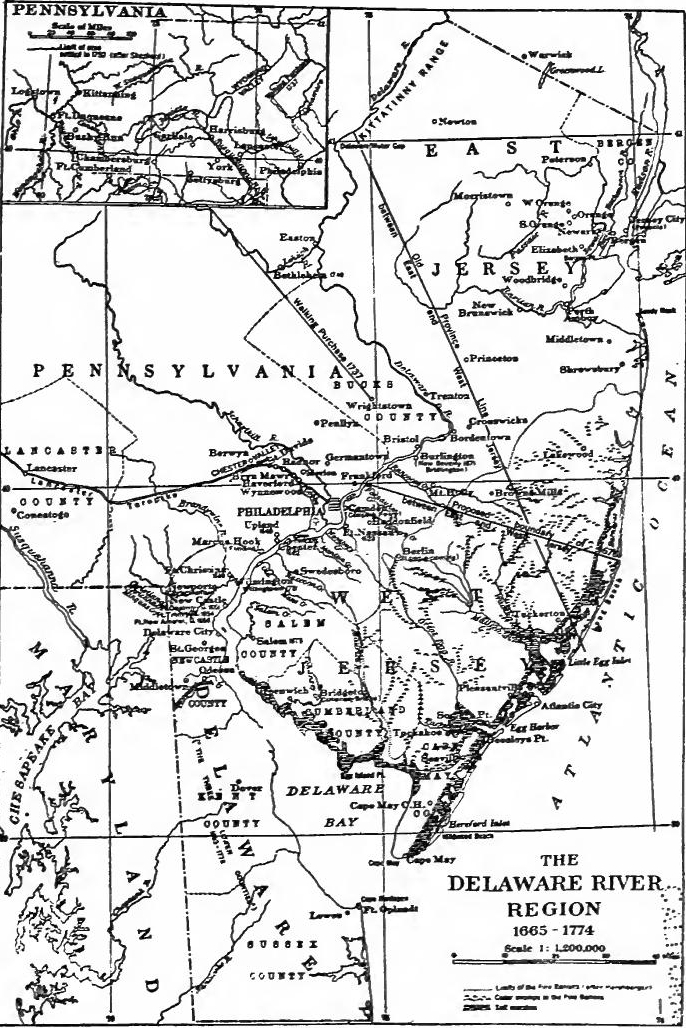 The Delaware River Region. (From Fisher, The Quaker Colonies, in the Series, "The Chronicles of America," Yale University Press).
[Pg 201] The Quakers in West New Jersey.—In 1672 George Fox, the founder of the Quaker sect, crossed New Jersey and visited the Quakers in the eastern part. To this visit Penn's interest in the region may be traced. In 1674 Berkeley disposed of his share of the colony to two Quakers, Edward Byllynge and John Fenwick, this transaction being due to a desire on the part of the Society of Friends to establish an independent colony. Byllynge and Fenwick became involved in a dispute over property rights, and William Penn was made arbiter. Penn awarded one-tenth to Fenwick, who, after considerable litigation, accepted it. Byllynge shortly afterward conveyed his holdings to Penn, Lawrie, and Lucas, who soon acquired Fenwick's interests. In 1676 Carteret and the Quaker proprietors fixed the line of demarcation between East and West New Jersey. It was to run from the most southwardly point of the east side of Little Egg Harbor to the point where the Delaware River crossed the forty-first parallel. The Quaker migration to West New Jersey began in 1675, when Fenwick led a group to Salem. In 1677 two hundred and thirty more settled at Burlington. During the next two years eight hundred arrived, and by 1681 nearly fourteen hundred had come to the colony. In every case title to the soil was obtained by purchase from the Indians.
[Pg 201] The Quakers in West New Jersey.—In 1672, George Fox, the founder of the Quaker movement, traveled across New Jersey and visited the Quakers in the eastern part of the state. This visit sparked William Penn's interest in the area. In 1674, Berkeley sold his share of the colony to two Quakers, Edward Byllynge and John Fenwick, as the Society of Friends aimed to create an independent colony. Byllynge and Fenwick got into a dispute over property rights, and William Penn was asked to mediate. Penn awarded one-tenth to Fenwick, who eventually accepted it after a lengthy legal battle. Shortly afterward, Byllynge transferred his holdings to Penn, Lawrie, and Lucas, who soon took over Fenwick's interests. In 1676, Carteret and the Quaker proprietors established the boundary line between East and West New Jersey. This line would extend from the southernmost point on the east side of Little Egg Harbor to where the Delaware River crossed the forty-first parallel. The Quaker migration to West New Jersey started in 1675 when Fenwick led a group to Salem. In 1677, another two hundred and thirty settled in Burlington. Over the next two years, eight hundred more arrived, and by 1681, nearly fourteen hundred had come to the colony. In every case, land was acquired through purchases from the Native Americans.
Government of West New Jersey.—The original Burlington colonists brought with them a body of laws which have been described as "the broadest, sanest, and most equitable charter draughted for any body of colonists up to that time." No doubt Penn played the principal rôle in the draughting. It provided for a board of commissioners to be appointed by the proprietors and an assembly chosen by the people, which was to have full rights of making laws if they were not contrary to the charter or the laws of England. The charter provided for public trials by jury and assured the right of petition. Capital punishment was prohibited.
Government of West New Jersey.—The original Burlington colonists brought with them a set of laws that have been described as "the broadest, sanest, and most equitable charter drafted for any group of colonists up to that time." It's clear that Penn played the main role in drafting it. The charter established a board of commissioners appointed by the proprietors and an assembly elected by the people, which had full authority to create laws as long as they didn't contradict the charter or the laws of England. It also ensured public trials by jury and guaranteed the right to petition. Capital punishment was forbidden.
Trouble with the Duke of York.—After the expulsion of the Dutch in 1674, the Duke of York attempted to regain control of the Jerseys and refused to recognize the validity of Berkeley's sale to Byllynge. When Andros became governor of New York he attempted to assert the authority of James over the Jerseys, but the courts refused to uphold the claims of the Duke, and in 1680 he finally gave up the struggle.
Trouble with the Duke of York.—After the Dutch were expelled in 1674, the Duke of York tried to take back control of the Jerseys and wouldn’t acknowledge Berkeley's sale to Byllynge. When Andros became governor of New York, he tried to enforce James's authority over the Jerseys, but the courts turned down the Duke's claims, and in 1680 he finally gave up the fight.
Later history of West New Jersey.—In 1680 Byllynge obtained a title to West New Jersey from the Duke of York and the charter of 1677 was put into effect, with the exception that the[Pg 202] executive was vested in a single person instead of in commissioners. In 1687 Byllynge died and Daniel Coxe, a London merchant, acquired his properties. Burlington was made the capital, and Coxe bent his efforts to make it a commercial center. In 1688 the colony was placed under the jurisdiction of Andros as a part of the northern administrative unit which included New York and New England, but Coxe was restored to his rights after the dethronement of James, though he soon sold out to the West New Jersey Society.
Later history of West New Jersey.—In 1680, Byllynge secured a title to West New Jersey from the Duke of York, and the charter from 1677 was put into action, except that the[Pg 202] executive authority was given to a single individual instead of a group of commissioners. In 1687, Byllynge passed away, and Daniel Coxe, a merchant from London, took over his properties. Burlington became the capital, and Coxe focused on developing it into a commercial hub. In 1688, the colony came under the authority of Andros as part of a northern administrative region that included New York and New England, but Coxe regained his rights after James was ousted, although he soon sold his interests to the West New Jersey Society.
Later history of East New Jersey.—In 1682 Philip Carteret resigned, and the board of trustees who controlled the estate of Sir George Carteret sold East New Jersey to William Penn and eleven other Quakers. Shortly afterwards twelve others were taken into the company, several of whom were Scotch Presbyterians. In 1683 the twenty-four men received a deed from the Duke of York. Under these proprietors the colony prospered, and population increased rapidly. In 1688 the province came under royal jurisdiction and it was annexed to New York, but after the revolution it was restored to the proprietors.
Later history of East New Jersey.—In 1682, Philip Carteret stepped down, and the board of trustees managing Sir George Carteret's estate sold East New Jersey to William Penn and eleven other Quakers. Shortly after, twelve more joined the group, some of whom were Scottish Presbyterians. In 1683, the twenty-four men received a deed from the Duke of York. Under these owners, the colony thrived, and the population grew rapidly. In 1688, the province came under royal control and was annexed to New York, but after the revolution, it was returned to the proprietors.
PENNSYLVANIA
The Quaker faith.—The Reformation produced many religious sects. Writh the breaking down of one authoritative church and the substitution of the idea that any one might read and interpret the Bible, religious groups began forming. Among the numerous sects were the Quakers, the followers of George Fox. Seventeenth century religion was based upon the fundamental idea that the universe was dualistic, natural and supernatural. The question on which men split was how the chasm was to be bridged. Most of the Protestant sects believed that the crossing was made by a definite revelation of the word of God. Fox believed "that it was bridged by the communication of a supernatural Light given to each soul."
The Quaker faith.—The Reformation led to the emergence of many religious groups. With the decline of a single authoritative church and the belief that anyone could read and interpret the Bible, various religious communities began to form. Among these groups were the Quakers, followers of George Fox. Seventeenth-century religion was centered around the core idea that the universe was both natural and supernatural. The debate that divided people was about how to bridge the gap between the two. Most Protestant groups thought that the gap was crossed through a clear revelation of God's word. Fox believed that it was bridged by a supernatural Light communicated to each soul.
The coming of the Quakers.—Most of the seventeenth century religious sects, once in power, were as intolerant as the Catholics had been. The Quaker was looked upon with disfavor and persecution was his lot. In America he hoped to find an abiding place. Between 1655 and 1680 Quakers appeared in[Pg 203] nearly all the colonies. Fox came to America in 1671 and in the course of the following year visited the Quaker communities from Barbados to Rhode Island.
The arrival of the Quakers.—Most of the religious groups in the seventeenth century, once they gained power, were just as intolerant as the Catholics had been. Quakers were viewed negatively, and persecution was common for them. In America, they hoped to find a place where they could settle. Between 1655 and 1680, Quakers emerged in[Pg 203] almost all the colonies. Fox traveled to America in 1671, and over the next year, he visited Quaker communities from Barbados to Rhode Island.
Penn obtains lands on the Delaware.—The desire to obtain lands where they would be in complete control was long in the minds of the Quaker leaders. In 1680 William Penn petitioned for lands along the Delaware north of Maryland, in payment of a debt of 16,000 pounds. In spite of his faith Penn stood well at court, and on March 4, 1681, the charter of Pennsylvania was signed. The extent of the grant was defined as follows: "All that Tract or parte of land in America, with all the Islands therein conteyned, as the same is bounded on the East by Delaware River, from twelve miles distance, Northwarde of New Castle Towne unto the three and fortieth degree of Northerne Latitude if the said River doeth extend soe farre Northwards; But if the said River shall not extend soe farre Northward, then by the said River soe farr as it doth extend, and from the head of the said River the Easterne Bounds are to bee determined by a Meridian Line, to bee drawne from the head of the said River unto the said three and fortieth degree, The said lands to extend westwards, five degrees in longitude, to bee computed from the said Eastern Bounds, and the said lands to bee bounded on the North, by the beginning of the three and fortieth degree of Northern latitude, and on the South, by a Circle drawne at twelve miles, distance from New Castle Northwards, and Westwards unto the beginning of the fortieth degree of Northerne Latitude; and then by a streight Line westwards, to the Limitt of Longitude above mentioned."
Penn acquires land on the Delaware.—The desire to gain control over land had been a long-standing goal of the Quaker leaders. In 1680, William Penn requested lands along the Delaware to the north of Maryland, as payment for a debt of 16,000 pounds. Despite his Quaker beliefs, Penn was well-regarded at court, and on March 4, 1681, the charter for Pennsylvania was signed. The boundaries of the grant were defined as follows: "All that tract or part of land in America, with all the islands contained therein, as the same is bounded on the east by the Delaware River, from a distance of twelve miles north of New Castle Town to the forty-third degree of northern latitude, if the said river extends that far north; but if the said river does not extend that far north, then by the said river as far as it does extend, and from the head of the said river, the eastern boundaries are to be determined by a meridian line, to be drawn from the head of the said river to the said forty-third degree. The said lands are to extend westward, five degrees in longitude, to be calculated from the said eastern boundaries, and the said lands to be bounded on the north by the beginning of the forty-third degree of northern latitude and on the south by a circle drawn at a distance of twelve miles from New Castle northward, and westward to the beginning of the fortieth degree of northern latitude; and then by a straight line westward, to the limit of longitude mentioned above."
Both the northern and southern boundaries caused future disputes. Penn claimed as far north as the forty-third parallel, while New York insisted on the forty-second, a difference which was settled a century later in favor of New York. On the south the boundaries conflicted with the claims of Baltimore. In 1682 the question was further complicated by a grant to Penn from the Duke of York of the territory on the western shore of Delaware Bay. The difficulty was finally settled in 1760, and seven years later two surveyors, Mason and Dixon, ran the present line between Maryland and Pennsylvania at 39° 44', and erected the present boundaries of the state of Delaware.
Both the northern and southern boundaries led to future conflicts. Penn claimed land up to the forty-third parallel, while New York argued for the forty-second, a dispute that was resolved a century later in favor of New York. To the south, the boundaries clashed with Baltimore's claims. In 1682, the situation was made more complicated by a grant to Penn from the Duke of York for the land on the western shore of Delaware Bay. The issue was finally resolved in 1760, and seven years later, two surveyors, Mason and Dixon, established the current line between Maryland and Pennsylvania at 39° 44', and set the current boundaries of the state of Delaware.
[Pg 204] Powers of the proprietor.—By the charter Penn was made a proprietor, having the right to make laws with the advice and consent of the freemen. The proprietor was given power to execute the laws, issue ordinances, appoint judges and magistrates, pardon criminals except in cases of treason and willful murder, erect municipalities, and grant manors. The form of government in the colony was left to the proprietor. Laws had to be sent to the privy council for approval, but if action were not taken within six months, they were valid. The king reserved the right of hearing appeals. The navigation laws were to be enforced, and if damages accrued from non-enforcement and were not settled within a year, the king had the right to take over the government of the colony until payment was made.
[Pg 204] Powers of the proprietor.—According to the charter, Penn became a proprietor, which meant he had the authority to create laws with the advice and consent of the free citizens. The proprietor was granted the power to enforce the laws, issue ordinances, appoint judges and magistrates, grant pardons to criminals except in cases of treason and intentional murder, establish municipalities, and grant lands. The structure of government in the colony was determined by the proprietor. Laws had to be sent to the privy council for approval, but if no action was taken within six months, they became valid. The king retained the right to hear appeals. The navigation laws needed to be enforced, and if damages resulted from not enforcing them and weren't resolved within a year, the king had the authority to take control of the colony's government until payment was made.
The founding of Philadelphia.—Penn published a prospectus of his colony which was widely circulated, and drew up a body of conditions and concessions which dealt with the division and settlement of the province and with Indian relations. In 1681 he sent to America as deputy-governor his cousin, William Markham, who received the allegiance of the settlers already within the colony. Shortly afterward the first body of colonists arrived bearing instructions to lay out a town. The site of Philadelphia was surveyed the following year, a symmetrical plan being adopted which made Penn's capital the best-arranged city in colonial America.
The founding of Philadelphia.—Penn published a prospectus for his colony that circulated widely and created a set of terms and agreements regarding the division and settlement of the province and its relations with Native Americans. In 1681, he sent his cousin, William Markham, to America as deputy governor, who gained the loyalty of the settlers already in the colony. Soon after, the first group of colonists arrived with orders to establish a town. The site for Philadelphia was surveyed the following year, adopting a layout that made Penn's capital the most well-organized city in colonial America.
The "frame of government."—The government devised by Penn consisted of "the Governor and freemen of the said province, in form of a Provincial Council and General Assembly, by whom all laws shall be made, officers chosen, and publick affairs transacted." An elective council was to consist of seventy-two persons "of most note for their wisdom, virtue and ability." This body, with the governor, was to prepare and propose all bills, and together they were to share executive powers. They were to erect courts of justice, elect county officers, provide schools, and perform numerous other duties. The assembly, which was to consist at first of not more than two hundred members, was to be elected annually. Its chief business was to consider and pass upon bills prepared by the governor and council.
The "frame of government."—The government created by Penn included "the Governor and the freemen of the province, organized as a Provincial Council and General Assembly, responsible for making all laws, selecting officers, and managing public affairs." An elected council was to be made up of seventy-two individuals "noted for their wisdom, virtue, and ability." This group, along with the governor, was tasked with preparing and proposing all bills, and together they would exercise executive powers. They were responsible for establishing courts of justice, electing county officials, providing education, and handling various other responsibilities. The assembly would initially have no more than two hundred members, elected annually. Its main job was to review and decide on bills prepared by the governor and council.
Penn's first sojourn in the province.—Penn arrived on the ship Welcome in the fall of 1682 and immediately called an[Pg 205] election for an assembly, in this case ignoring the details of the frame of government. The first assembly annexed the territory on the western shore of Delaware Bay, naturalized foreigners, and adopted a set of laws proposed by the proprietor, which provided for liberty of conscience, a strict code of morals, and for capital punishment for treason and murder only. Penn inspected his province, watched the building of Philadelphia, and visited New York, Maryland, and West New Jersey. He also held several meetings with the Indians, entering in June, 1683, into a treaty with them which had the salutary effect of keeping Pennsylvania free from Indian war. The number of representatives provided for in the frame of government proving too large, a new frame was drawn up by which the council was reduced to eighteen and the lower house to thirty-six members.
Penn's first stay in the province.—Penn arrived on the ship Welcome in the fall of 1682 and immediately called an [Pg 205] election for an assembly, disregarding the specifics of the government's framework. The first assembly claimed the territory on the western shore of Delaware Bay, naturalized foreigners, and adopted a set of laws suggested by the proprietor, which allowed for freedom of conscience, a strict moral code, and capital punishment for treason and murder only. Penn inspected his province, observed the construction of Philadelphia, and visited New York, Maryland, and West New Jersey. He also held several meetings with the Native Americans, entering into a treaty with them in June, 1683, which successfully kept Pennsylvania free from Indian wars. The original number of representatives specified in the government framework turned out to be too large, so a new framework was created that reduced the council to eighteen members and the lower house to thirty-six members.
Penn's activities in England.—In August, 1684, Penn went to England to obtain a settlement of his disputes with Baltimore and to aid the persecuted Quakers. His claim to the Delaware tract was confirmed and he secured the release from English jails of more than twelve hundred Quakers. In 1688 he also succeeded in keeping his province from being incorporated within the jurisdiction of Andros.
Penn's activities in England.—In August 1684, Penn traveled to England to resolve his conflicts with Baltimore and to support the persecuted Quakers. His claim to the Delaware land was confirmed, and he managed to secure the release of over twelve hundred Quakers from English prisons. In 1688, he also succeeded in preventing his province from being included under Andros's jurisdiction.
Friction in the colony.—The political peace for which Penn had hoped was soon disturbed. Friction over the right to initiate legislation broke out between the council and assembly. Trouble with one of the justices also occurred. Hoping to quiet affairs, Penn took away the executive powers of the council and appointed a commission of five councillors who were to compel all to do their duty. As trouble continued, he did away with the commission and appointed Captain Blackwell, a Puritan, to act for him. This choice proved unfortunate, for the Puritan could not get along with the Quakers. In despair, Penn recalled Blackwell and allowed the council to select its own executive. The council again assumed the governorship, and chose Thomas Lloyd president. Friction also existed between the settlers along the shore of Delaware Bay and those in the river settlements, a difficulty which eventually led to the separation of Delaware from Pennsylvania.
Friction in the colony.—The political peace that Penn had hoped for was quickly disrupted. Tensions over who had the right to propose legislation arose between the council and assembly. Problems with one of the justices also surfaced. In an attempt to calm the situation, Penn stripped the council of its executive powers and appointed a commission of five councillors to ensure everyone fulfilled their duties. As the issues persisted, he dissolved the commission and appointed Captain Blackwell, a Puritan, to represent him. This decision turned out poorly, as the Puritan struggled to get along with the Quakers. In frustration, Penn recalled Blackwell and allowed the council to choose its own leader. The council took back the governorship and selected Thomas Lloyd as president. There was also tension between the settlers along the shore of Delaware Bay and those in the river settlements, a conflict that eventually led to Delaware separating from Pennsylvania.
Growth of the colony.—In spite of frictions the colony prospered. When Penn acquired his province, it contained about a[Pg 206] thousand Swedes, Finns, and Dutch, and a few Quakers. By 1685 the population had increased to more than eight thousand, made up of diverse elements; Quakers, mostly from central and southwestern England and from Wales, Mennonites from the Rhineland, Swedes, Scotch, Irish, and French. Philadelphia soon boasted a tannery, sawmill, and kiln; linen manufacture began; and the colony entered upon a prosperous intercolonial trade in flour, staves, and horses. A weekly post and a school were established, and a printing press installed. It was evident that Penn's "holy experiment" had justified itself.
Growth of the colony.—Despite some tensions, the colony thrived. When Penn took over his province, it had about a[Pg 206] thousand Swedes, Finns, Dutch, and a few Quakers. By 1685, the population grew to over eight thousand, made up of various groups: Quakers primarily from central and southwestern England and from Wales, Mennonites from the Rhineland, as well as Swedes, Scots, Irish, and French. Philadelphia quickly became known for its tannery, sawmill, and kiln; linen production started; and the colony engaged in a successful intercolonial trade in flour, staves, and horses. A weekly post and a school were set up, along with a printing press. It was clear that Penn's "holy experiment" had proven itself.
THE INSULAR COLONIES
Reorganization in the Bermudas.—Complaints by the settlers against the rule of the Somers Islands Company in the Bermudas had been common since its foundation. As time went on it became composed of men who had little interest in the colony. The settlers, on the other hand, grew in numbers and independence. Under the circumstances, in the general reorganization by the later Stuarts, the company was dissolved, and in 1679 the Bermudas became a crown colony.
Reorganization in the Bermudas.—Settlers had often complained about the control of the Somers Islands Company in the Bermudas since it was established. Over time, the company became made up of individuals who had little interest in the colony. Meanwhile, the settlers increased in number and independence. Given these circumstances, during the overall reorganization by the later Stuarts, the company was dissolved, and in 1679 the Bermudas became a crown colony.
Reorganization in the West Indies.—Down to 1671 the English Caribbean island possessions were all included in one government within the Carlisle grant. In that year they were separated into two governments, St. Kitts, Nevis. Montserrat, Antigua, Barbuda, Anguilla and "all other the Leeward islands" to the north of French Guadeloupe were separated from Barbados and the Windward Islands, and erected into the government of the Leeward Islands, the islands to the south of Guadeloupe being formed into the government of the Windward Islands. The Leeward Islands were put under one governor-in-chief, each island being given a deputy governor, council, assembly, and courts. In 1689 the islands together were granted a general assembly, which first met in 1690.
Reorganization in the West Indies.—Up until 1671, all of England's Caribbean island territories were managed under a single government as part of the Carlisle grant. In that year, they were divided into two separate governments: St. Kitts, Nevis, Montserrat, Antigua, Barbuda, Anguilla, and all the other Leeward Islands north of French Guadeloupe were separated from Barbados and the Windward Islands, establishing the government of the Leeward Islands. The islands to the south of Guadeloupe were organized into the government of the Windward Islands. The Leeward Islands were placed under one governor-in-chief, with each island receiving a deputy governor, council, assembly, and courts. In 1689, the islands together were given a general assembly, which held its first meeting in 1690.
New settlements in the West Indies.—During the period of the later Stuarts the Leeward Islands extended their influence among the smaller islands to the northwest In 1665 a buccaneering expedition from Jamaica captured St. Eustatius and Saba. In 1666 settlers from the Bermudas settled on New Providence, one of the Bahamas, and elected a governor. Four years later six of the[Pg 207] Carolina proprietors secured a patent to the island but did little toward colonizing it. In 1672 Tortola was taken from the Dutch and added to the Leeward Islands.
New settlements in the West Indies.—During the time of the later Stuarts, the Leeward Islands expanded their influence among the smaller islands to the northwest. In 1665, a pirate expedition from Jamaica captured St. Eustatius and Saba. In 1666, settlers from the Bermudas established themselves on New Providence, one of the Bahamas, and elected a governor. Four years later, six of the[Pg 207] Carolina proprietors obtained a patent for the island but did very little to colonize it. In 1672, Tortola was taken from the Dutch and added to the Leeward Islands.
Unrest in Barbados.—The first important movement to settle Carolina came from Barbados, the most populous of the English colonies. A spirit of unrest pervaded the island. During the Commonwealth it had been a refuge for both Cavaliers and Roundheads, and the newcomers had taken up lands without securing titles. When the Stuarts were restored, the former proprietors attempted to regain their possessions. A lively controversy ensued. The king settled it by establishing his authority in the island, but levied a tax of four and one-half per cent. on its products to be applied to satisfy in part the claims of the proprietors, an arrangement which pleased no one. The navigation acts also considerably interfered with the trade of the island which had previously been carried on largely with the Dutch. As a result many settlers were anxious to leave. Between 1643 and 1667 at least twelve hundred Barbadians went to fight or settle in Jamaica, Tobago, St. Lucia, Trinidad, Surinam, New England, Virginia, or Carolina.
Unrest in Barbados.—The first significant movement to settle Carolina came from Barbados, the most populated of the English colonies. A sense of unrest filled the island. During the Commonwealth, it had been a safe haven for both Cavaliers and Roundheads, and the newcomers had occupied land without securing titles. When the Stuarts were restored, the former owners tried to reclaim their properties. A heated debate followed. The king resolved it by asserting his authority over the island but imposed a tax of four and a half percent on its products to partly fulfill the claims of the proprietors, an arrangement that satisfied no one. The navigation acts also greatly disrupted the island's trade, which had previously been largely conducted with the Dutch. Consequently, many settlers were eager to leave. Between 1643 and 1667, at least twelve hundred Barbadians went to fight or settle in Jamaica, Tobago, St. Lucia, Trinidad, Surinam, New England, Virginia, or Carolina.
THE CAROLINAS
The Carolina coast.—From the James River region to the Spanish settlements in Florida, stretched a vast territory, which, with the single exception of a settlement on the Chowan River, was unoccupied by white men when Charles II came to the throne. After Raleigh's ill-starred venture it had received little attention until 1629, when Sir Robert Heath obtained a patent to lands between 31° and 36° north latitude, but he did nothing to improve the territory. The coasts were occasionally visited by mariners, but there is no definite knowledge of any settlement until 1653, when colonists from Virginia appear to have started a settlement at Albemarle on the Chowan River. About 1660 some New Englanders inspected the Cape Fear River mouth but departed soon afterward.
The Carolina coast.—From the James River area to the Spanish settlements in Florida, there was a huge stretch of land that, except for a settlement on the Chowan River, was unoccupied by white settlers when Charles II took the throne. After Raleigh's unfortunate attempt, it received little attention until 1629, when Sir Robert Heath got a patent for lands between 31° and 36° north latitude, but he did nothing to develop the area. The coasts were occasionally visited by sailors, but there’s no clear record of any settlement until 1653, when colonists from Virginia seemingly started a settlement at Albemarle on the Chowan River. Around 1660, some New Englanders checked out the Cape Fear River mouth but left shortly afterward.
The charters.—In 1660 Sir John Colleton, a prominent resident of Barbados, went to England where he became a member of the Council for Foreign Plantations. He soon interested Anthony Ashley Cooper, later known as Lord Ashley, in the Carolinas.[Pg 208] In 1663 a charter was granted to eight proprietors, Cooper, Clarendon, Craven, Albemarle, Carteret, Lord Berkeley, Colleton, and Sir William Berkeley. The territory granted extended from the thirty-sixth to the thirty-first parallel and from sea to sea. Over this region the proprietors were given practically the same rights as Baltimore possessed in Maryland. In 1665 a second patent was granted to the proprietors, extending the boundaries to 36° 30' on the north and to 29° on the south.
The charters.—In 1660, Sir John Colleton, a well-known resident of Barbados, traveled to England and became a member of the Council for Foreign Plantations. He quickly caught the interest of Anthony Ashley Cooper, later known as Lord Ashley, in the Carolinas.[Pg 208] In 1663, a charter was granted to eight proprietors: Cooper, Clarendon, Craven, Albemarle, Carteret, Lord Berkeley, Colleton, and Sir William Berkeley. The land given to them extended from the thirty-sixth to the thirty-first parallel and from ocean to ocean. The proprietors received nearly the same rights that Baltimore had in Maryland. In 1665, a second patent was issued to the proprietors, expanding the boundaries to 36° 30' in the north and 29° in the south.
The fundamental constitutions.—The philosopher, John Locke, drew up a constitution for the province. It provided for a high official called the palatine, and minor officials designated as admiral, chamberlain, chancellor, constable chief justice, steward, and treasurer. The province was to be divided into counties, and each county into seigniories, baronies, and precincts. On these divisions were to be based the ranks of the nobility to be designated as land-graves, caciques, and lords of manors. An elaborate system of courts was provided; also a grand council and a parliament. This archaic feudal document is of interest mainly as a study in the political philosophy of the time, but it was of little real importance as it was totally unsuited to the needs of a frontier community. It was never put in force except in certain minor particulars, the settlers themselves soon solving their problems of government in their own way.
The Fundamental Constitutions — The philosopher John Locke created a constitution for the province. It established a high official known as the palatine, along with minor officials called admiral, chamberlain, chancellor, constable, chief justice, steward, and treasurer. The province was to be divided into counties, with each county subdivided into seigniories, baronies, and precincts. These divisions were intended to determine the ranks of nobility, referred to as land-graves, caciques, and lords of manors. An extensive system of courts was outlined, as well as a grand council and a parliament. This outdated feudal document is mainly of interest for studying the political philosophy of the time, but it was largely irrelevant since it didn't meet the needs of a frontier community. It was only partially implemented, as the settlers quickly figured out their own governance.
Beginnings of settlement.—In 1663-1664 an expedition from Barbados examined the Carolina coast, and in 1665 Sir John Yeamans conducted a group of settlers to the mouth of Cape Fear River. Yeamans soon returned to Barbados and the settlers, left to their own devices, in 1667 abandoned the settlement, most of them going to Albemarle, Virginia, and Boston. In 1669 vessels carrying ninety-two colonists sailed from England to Barbados, where Sir John Yeamans, who had been appointed governor, joined them. They then proceeded to the Bermudas, where Yeamans handed over the authority to William Sayle and abandoned the expedition. The colonists under Sayle then went to Port Royal, but finally settled on the Ashley River, where they laid out old Charles Town (1670). Political strife soon developed, owing mainly to the incompetence of the aged executive. In 1671 he died and Joseph West was chosen governor by the people.
Beginnings of settlement.—In 1663-1664, an expedition from Barbados explored the Carolina coast, and in 1665, Sir John Yeamans led a group of settlers to the mouth of Cape Fear River. Yeamans quickly returned to Barbados, leaving the settlers to fend for themselves. In 1667, they abandoned the settlement, with most moving on to Albemarle, Virginia, and Boston. In 1669, ships carrying ninety-two colonists set sail from England to Barbados, where Sir John Yeamans, who had been made governor, joined them. They then traveled to the Bermudas, where Yeamans handed over authority to William Sayle and left the expedition. The colonists under Sayle went to Port Royal but ultimately settled on the Ashley River, where they established old Charles Town (1670). Political conflicts soon arose, mainly due to the incompetence of the elderly governor. He died in 1671, and the people chose Joseph West as the new governor.
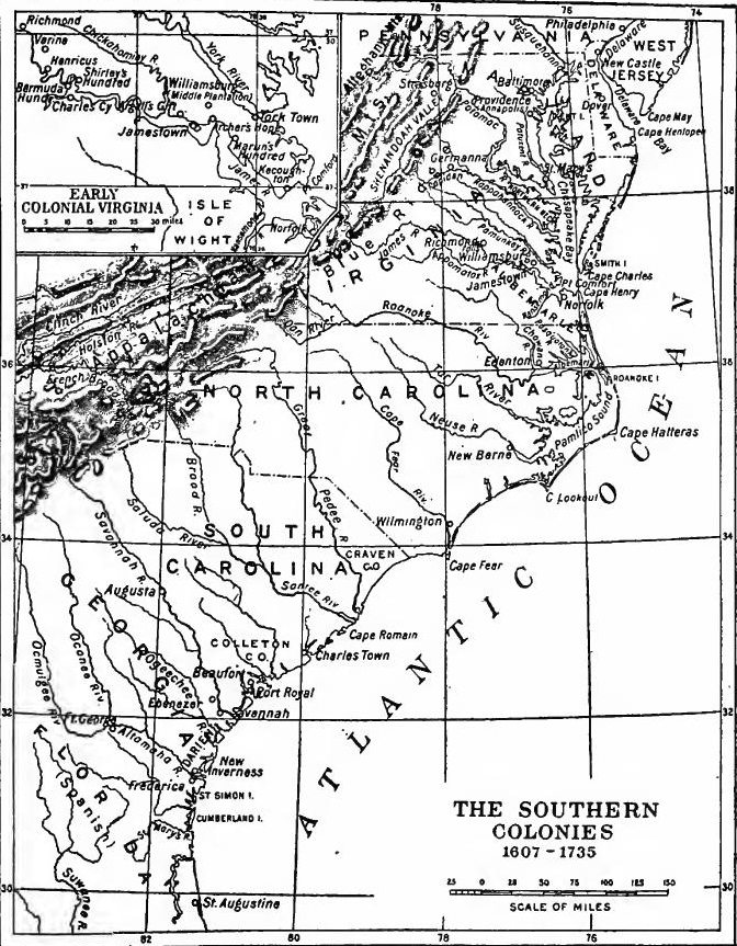 The Southern Colonies, 1607-1735. (From Johnston, Pioneers of the Old South, in the series "The Chronicles of America," Yale University Press).
[Pg 210] Plans of the proprietors.—In 1670 the proprietors obtained a grant of the Bahamas and planned to build up trade between the island and mainland settlements. They also planned to improve the Charles Town settlement and in 1671 secured settlers from Barbados. Yeamans came over and claimed the governorship, but West succeeded in keeping the office for several months. In 1672 Yeamans was again appointed governor, but he managed things so badly that in 1674 West was reappointed and remained governor for eight years.
[Pg 210] Plans of the proprietors.—In 1670, the proprietors received a grant for the Bahamas and aimed to boost trade between the islands and the mainland settlements. They also intended to develop the Charles Town settlement and, in 1671, brought in settlers from Barbados. Yeamans arrived and claimed the governorship, but West managed to hold the position for several months. In 1672, Yeamans was appointed governor again, but he handled things so poorly that in 1674, West was reappointed and served as governor for eight years.
Development of the Charles Town region.—Colonists came in considerable numbers; in 1672 there were about four hundred people in the colony, and by 1685 the population had increased to about twenty-five hundred. Among the immigrants were a hundred French Protestants, and a colony of Scots who settled at Port Royal in 1683. Other colonists came from Barbados and many from western England. In 1680 the seat of government was moved from old Charles Town to the junction of the Ashley and Cooper Rivers. After 1680 settlements began to expand into the back country. This soon brought on the inevitable Indian war, which continued intermittently for three years. In 1685 the Spaniards raided the settlements, burning many houses, and the following year destroyed the Scotch settlement at Port Royal.
Development of the Charles Town region.—Colonists arrived in large numbers; in 1672, there were about four hundred people in the colony, and by 1685, the population had grown to around twenty-five hundred. Among the immigrants were a hundred French Protestants and a colony of Scots who settled at Port Royal in 1683. Other colonists came from Barbados and many from western England. In 1680, the government's seat was moved from old Charles Town to where the Ashley and Cooper Rivers meet. After 1680, settlements began to spread into the backcountry. This quickly led to the inevitable Indian war, which lasted intermittently for three years. In 1685, the Spaniards attacked the settlements, burning many houses, and the following year destroyed the Scottish settlement at Port Royal.
Unrest at Charleston.—During West's administration the colony was not greatly disturbed by political difficulties, the proprietors making little attempt to enforce the Locke constitution. The colony was governed by a popularly elected "parliament," which chose a council of five men. The chief executive was the governor commissioned by the proprietors. From 1682 to 1689 proprietary interference increased, bringing the colony to the verge of rebellion. The colonial parliament had steadily refused to confirm the constitution. During 1682 it was revised by the proprietors, more power being placed in the hands of the people, but still the colonists refused to confirm it. This irritated the proprietors, who retaliated by introducing a new form of land tenure, which required the colonists to pay a cash quit-rent. When James II came to the throne, Governor Morton demanded that they swear allegiance to the king and accept the constitution, whereupon twelve members of the parliament[Pg 211] refused and were excluded. The colonists also took with ill grace the attempt to collect the customs. In 1688 the governor and council found themselves at complete loggerheads with parliament, and legislation stopped. James Colleton, the governor, proclaimed martial law. This led to an open rebellion, and in 1691 Colleton was expelled, but the proprietary power was soon restored.
Unrest in Charleston.—During West's administration, the colony wasn’t significantly troubled by political issues, as the proprietors made little effort to enforce the Locke constitution. The colony was managed by a popularly elected "parliament," which selected a council of five men. The main leader was the governor appointed by the proprietors. From 1682 to 1689, proprietary interference grew, pushing the colony to the brink of rebellion. The colonial parliament consistently refused to approve the constitution. In 1682, it was revised by the proprietors, giving more power to the people, yet the colonists still would not approve it. This frustrated the proprietors, who retaliated by introducing a new land tenure system that required the colonists to pay a cash quit-rent. When James II ascended the throne, Governor Morton insisted that they pledge allegiance to the king and accept the constitution, leading to the exclusion of twelve parliament members[Pg 211] who refused. The colonists also reacted poorly to the attempt to collect customs duties. In 1688, the governor and council found themselves in a complete deadlock with parliament, and legislative action came to a halt. James Colleton, the governor, declared martial law. This resulted in an open rebellion, and in 1691, Colleton was ousted, but proprietary power was quickly reinstated.
The Albemarle colony.—During these troublous times the Albemarle settlement was slowly developing. The colony was mainly recruited from Virginia, but there was also a considerable influx of Quakers. In 1682 the Albemarle settlement contained about twenty-five hundred inhabitants. When an attempt was made in 1677 to collect the customs and to shut off the New England trade, about a hundred colonists led by John Culpeper rebelled and imprisoned Miller, who was the collector of customs and acting governor. They also arrested the president of the assembly and all but one of the deputies. The proprietors removed Miller from office and appointed Seth Sothell governor, but the people soon drove him from the colony. The turbulence did not quiet down until the appointment of Governor Ludwell, who from 1691 resided at Charleston, Albemarle being governed henceforth by a deputy.
The Albemarle colony.—During these tumultuous times, the Albemarle settlement was gradually taking shape. The colony was primarily made up of people from Virginia, but there was also a significant influx of Quakers. By 1682, the Albemarle settlement had about twenty-five hundred residents. When an attempt was made in 1677 to collect customs duties and cut off trade with New England, around a hundred colonists, led by John Culpeper, rebelled and imprisoned Miller, the customs collector and acting governor. They also arrested the president of the assembly and all but one of the deputies. The proprietors removed Miller from his position and appointed Seth Sothell as governor, but the people quickly ousted him from the colony. The unrest didn't settle down until Governor Ludwell was appointed, who resided in Charleston from 1691, with Albemarle being governed by a deputy from then on.
WESTERN TRADE AND EXPLORATION
By now English explorers and fur traders had crossed the Alleghanies. As early as 1648 Governor Berkeley was preparing an expedition to the southwest, where red capped Spaniards riding "long eared beasts," came to trade with the natives. Twenty-five years later (1673) two Virginians, James Needham and Gabriel Arthur, reached the Cherokees on the Upper Tennessee. To these mountain dwellers on the "western waters" the Englishmen were a novel sight, but they had long been acquainted with the Spaniards and possessed "some sixty Spanish flintlocks," and among them lived Spanish mulatto women. Before the end of the century South Carolina traders had established the "Chickasaw Trail" through the Creek and Chickasaw country, and had crossed the Mississippi. In 1699-1700 Carolinians ascended the Savannah, descended the Tennessee, Ohio, and Mississippi to the mouth of the Arkansas. Frontiersmen had[Pg 212] gone northwest as well as southwest, and before the end of the century had begun to make their way among the Indians on both sides of the upper Ohio River.
By this time, English explorers and fur traders had crossed the Appalachian Mountains. As early as 1648, Governor Berkeley was getting ready for an expedition to the southwest, where red-capped Spaniards riding "long-eared beasts" came to trade with the Native Americans. Twenty-five years later (1673), two Virginians, James Needham and Gabriel Arthur, reached the Cherokees in the Upper Tennessee area. For these mountain dwellers by the "western waters," the Englishmen were a new sight, but they had already known the Spaniards for a long time and had “about sixty Spanish flintlocks,” and among them lived Spanish mulatto women. Before the century ended, South Carolina traders had established the "Chickasaw Trail" through Creek and Chickasaw territories and had crossed the Mississippi River. In 1699-1700, Carolinians traveled up the Savannah River, down the Tennessee, Ohio, and Mississippi Rivers to the mouth of the Arkansas. Frontiersmen had[Pg 212] moved northwest as well as southwest, and by the end of the century, they had started to make their way among the Native Americans on both sides of the upper Ohio River.
HUDSON'S BAY COMPANY
Continued search for the Northwest Passage.—Some of the same men who represented the Carolinas now extended English enterprises to the region of Hudson Bay. The English search for the Northwest Passage had not ended with the sixteenth century. Henry Hudson, who in 1609 had explored Hudson River in an attempt to find the passage, made further attempts in the following year. Finding his way in the Discovery through Hudson Strait, he wintered at the southern extremity of James Bay. He paid dearly for his discoveries, for he was cast adrift by mutinous followers and perished. In Hudson's wake went numerous explorers, backed by syndicates of merchants and sometimes with royal support, still seeking the passage. In 1612 Button crossed Hudson Bay and entered the mouth of Nelson River. At the same time a company was formed to seek the passage. In 1616 Bylot and Baffin discovered Baffin Bay, and in 1631 Foxe made new discoveries in Fox Channel. Denmark also entered the field of northwestern discovery and in 1619-1620 Jens Munck explored Hudson Bay, wintering at Churchill Harbor.
Continued search for the Northwest Passage.—Some of the same people who represented the Carolinas now expanded English ventures to the Hudson Bay area. The English search for the Northwest Passage didn’t end in the sixteenth century. Henry Hudson, who explored the Hudson River in 1609 in an effort to find the passage, made more attempts the following year. Navigating his ship, the Discovery, through Hudson Strait, he spent the winter at the southern end of James Bay. He paid a high price for his discoveries, as he was abandoned by mutinous crew members and ultimately died. After Hudson, many explorers followed, supported by merchant groups and sometimes with royal backing, still on the hunt for the passage. In 1612, Button crossed Hudson Bay and reached the mouth of the Nelson River. Meanwhile, a company was established to look for the passage. In 1616, Bylot and Baffin discovered Baffin Bay, and in 1631, Foxe made new discoveries in Fox Channel. Denmark also joined the race for northwest exploration, and in 1619-1620, Jens Munck explored Hudson Bay, spending the winter at Churchill Harbor.
Radisson, Groseilliers, and Gillam.—The primary purpose of the foregoing voyages had been to find a passage to the Far East. They were followed, after an interval, by trading enterprises. The operations of the French fur traders. Radisson and Groseilliers, have been mentioned previously. Having been imprisoned and fined for illicit trading, they left Canada, went to New England, and got up an expedition to Hudson Bay to gather furs. Sailing in 1664 with Captain Zachariah Gillam, they reached Hudson Strait but not the bay. After another failure in 1665, they met Sir George Carteret whom they interested in their project. Going to England, through Carteret's influence they organized a company among whose stockholders were the Duke of York, Prince Rupert, Carteret, the Duke of Albemarle, and the Earls of Craven, Arlington, and Shaftesbury, several of whom were already influential in colonial enterprises. In 1668[Pg 213] the company again sent Gillam to Hudson Bay, where he built Charles Fort on Rupert's River, and traded profitably in furs. The part played by Radisson and Groseilliers in this enterprise became a basis for French claims to the Hudson Bay region.
Radisson, Groseilliers, and Gillam.—The main goal of the previous voyages had been to find a route to the Far East. After some time, they transitioned to trading ventures. The activities of the French fur traders, Radisson and Groseilliers, were mentioned earlier. After being imprisoned and fined for illegal trading, they left Canada, traveled to New England, and organized an expedition to Hudson Bay to collect furs. In 1664, they sailed with Captain Zachariah Gillam, reaching Hudson Strait but not the bay itself. Following another unsuccessful attempt in 1665, they met Sir George Carteret, who became interested in their project. They went to England, and thanks to Carteret's influence, they set up a company that included shareholders like the Duke of York, Prince Rupert, Carteret, the Duke of Albemarle, and the Earls of Craven, Arlington, and Shaftesbury, many of whom were already significant figures in colonial ventures. In 1668[Pg 213], the company sent Gillam back to Hudson Bay, where he built Charles Fort on Rupert's River and successfully traded in furs. The roles played by Radisson and Groseilliers in this venture formed the foundation for French claims to the Hudson Bay area.
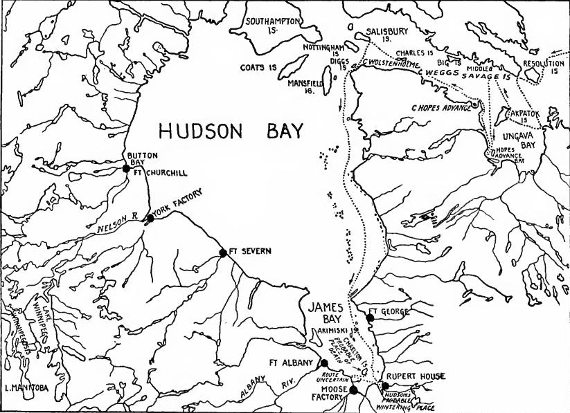 Hudson's Bay Company Posts.
Hudson's Bay Company.—The return of Gillam to London in 1669 was followed by the formation of a new Company. On May 2, 1670, Charles II issued a royal charter to "The Governor and Company of Adventurers of England trading into Hudson's Bay." The Company was made absolute proprietor with a complete[Pg 214] monopoly of all trade of the Hudson Bay basin. The government was centered in a governor, deputy-governor, and committee of seven, who were empowered to make laws and were given judicial and military authority. They lost no time in establishing posts, and by 1685 there were trading houses at Albany River, Hayes Island, Rupert's River, Port Nelson, Moose River, and New Severn.
Hudson's Bay Company.—After Gillam returned to London in 1669, a new Company was formed. On May 2, 1670, Charles II issued a royal charter to "The Governor and Company of Adventurers of England trading into Hudson's Bay." The Company became the sole owner with a total[Pg 214] monopoly over all trade in the Hudson Bay area. The leadership included a governor, a deputy-governor, and a committee of seven, who had the power to create laws and were given judicial and military authority. They quickly established trading posts, and by 1685, there were trading houses at Albany River, Hayes Island, Rupert's River, Port Nelson, Moose River, and New Severn.
Trading methods.—Ships were fitted out annually in London with merchandise, and brought back rich cargoes of furs. In contrast with the French traders and with the English of the Atlantic seaboard colonies, the Hudson's Bay Company did not penetrate the interior, but depended upon the natives to bring their peltry to the posts on the Bay. In the spring, therefore, after the break-up of the ice, Crees, Chipewyans, and Eskimos came down the rivers in fleets of canoes laden with furs, traded them for merchandise, and returned for another season's hunt. In London the furs were sold at auction at the Company's headquarters, where the annual fair took on the nature of a social function. Gradually the markets widened, agents being sent to establish trade with Holland, Russia, and other parts of Northern Europe. Profits were large, the dividend in 1690 being seventy-five per cent. of the original stock.
Trading methods.—Ships were outfitted every year in London with goods and returned with valuable cargoes of furs. Unlike the French traders and the English from the Atlantic coast colonies, the Hudson's Bay Company didn’t venture into the interior but relied on the natives to bring their pelts to the posts on the Bay. Therefore, in the spring, after the ice melted, Crees, Chipewyans, and Eskimos would come down the rivers in groups of canoes filled with furs, trade them for goods, and head back out for another season of hunting. In London, the furs were auctioned off at the Company's headquarters, turning the annual fair into a social event. Over time, the markets expanded, and agents were sent to create trade links with Holland, Russia, and other areas in Northern Europe. Profits were significant, with the dividend in 1690 reaching seventy-five percent of the original investment.
French Rivalry.—The success of the English aroused the jealousy of the French traders in the St. Lawrence Valley, and there ensued a rivalry which constituted one of the important episodes of the intercolonial wars which now occurred. In the contest Radisson, who had aided in the formation of the Company, played fast and loose between the English and the French. Before the end of the century French rivalry in the interior, beyond Lake Superior, did much to shake the "H.B.C." from its exclusive, seaboard policy. By 1691 Henry Kelsey, an employe of the Company, had made an expedition to the Winnipeg district.
French Rivalry.—The success of the English sparked jealousy among the French traders in the St. Lawrence Valley, leading to a rivalry that became one of the significant episodes of the intercolonial wars that followed. In this competition, Radisson, who helped establish the Company, played both sides against each other. Before the century ended, French competition in the interior, beyond Lake Superior, significantly challenged the "H.B.C."'s exclusive coastal policy. By 1691, Henry Kelsey, an employee of the Company, had undertaken an expedition to the Winnipeg area.
READINGS
NEW YORK
Andrews, C.M., Colonial Self-Government, 74-100, 273-287; Andrews, C.M., ed., Narratives of the Insurrections, 315-401; Brodhead, J.R., History of New York, II; Channing, Edward, History of the United States, II, 31-60, 203-209; Doyle, J.A., The Middle Colonies, 78-223; Fiske, John, Dutch and[Pg 215] Quaker Colonies, II, 1-98, 168-208; New York Historical Society, Collections, 1st Series, I, 307-428; Osgood, H.L., The English Colonies in the Seventeenth Century, II, 119-168; Winsor, Justin, Narrative and Critical History, III, 385-411.
Andrews, C.M., Colonial Self-Government, 74-100, 273-287; Andrews, C.M., ed., Narratives of the Insurrections, 315-401; Brodhead, J.R., History of New York, II; Channing, Edward, History of the United States, II, 31-60, 203-209; Doyle, J.A., The Middle Colonies, 78-223; Fiske, John, Dutch and[Pg 215] Quaker Colonies, II, 1-98, 168-208; New York Historical Society, Collections, 1st Series, I, 307-428; Osgood, H.L., The English Colonies in the Seventeenth Century, II, 119-168; Winsor, Justin, Narrative and Critical History, III, 385-411.
THE JERSEYS AND PENNSYLVANIA
Andrews, C.M., Colonial Self-Government, 101-128, 162-201; Channing, Edward, History of the United States, II, 31-62, 94-130; Clarkson, Thomas, Memoirs of Pennsylvania; Doyle, J.A., The Middle Colonies, 287-350, 379-410; Fiske, John, Dutch and Quaker Colonies, II, 115-194; Fisher, Sidney, The Quaker Colonies; Hodgkin, Thomas, George Fox; Holder, C.F., The Quakers in Great Britain and America, 169-217; Janney, S.M., Life of Penn; Jones, R.M., The Quakers in the American Colonies, 357-371, 417-436; MacDonald, William, Select Charters, 139-149, 171-204; Osgood, H.L., The English Colonies in the Seventeenth Century, II, 169-197, 252-276; Sharpless, Isaac, A Quaker Experiment in Government; Two Centuries of Pennsylvania History, 17-77; Smith, Samuel, The History of the Colony of Nova-Cæsaria or New Jersey, 35-207; Tanner, E.P., The Province of New Jersey, 1-147; Whitehead, W.A., East Jersey under the Proprietary Governments.
Andrews, C.M., Colonial Self-Government, 101-128, 162-201; Channing, Edward, History of the United States, II, 31-62, 94-130; Clarkson, Thomas, Memoirs of Pennsylvania; Doyle, J.A., The Middle Colonies, 287-350, 379-410; Fiske, John, Dutch and Quaker Colonies, II, 115-194; Fisher, Sidney, The Quaker Colonies; Hodgkin, Thomas, George Fox; Holder, C.F., The Quakers in Great Britain and America, 169-217; Janney, S.M., Life of Penn; Jones, R.M., The Quakers in the American Colonies, 357-371, 417-436; MacDonald, William, Select Charters, 139-149, 171-204; Osgood, H.L., The English Colonies in the Seventeenth Century, II, 169-197, 252-276; Sharpless, Isaac, A Quaker Experiment in Government; Two Centuries of Pennsylvania History, 17-77; Smith, Samuel, The History of the Colony of Nova-Cæsaria or New Jersey, 35-207; Tanner, E.P., The Province of New Jersey, 1-147; Whitehead, W.A., East Jersey under the Proprietary Governments.
THE CAROLINAS
Andrews, C.M., Colonial Self-Government, 129-161; Andrews, C.M., ed., Narratives of the Insurrections, 143-164; Ashe, S.A., North Carolina, I; Channing, Edward, History of the United States, II, 13-25; Hamilton, P.J., Colonization of the South, 133-135; McCrady, Edward, The History of South Carolina under the Proprietary Government, I, 1-209; Osgood, H.L., The American Colonies in the Seventeenth Century, II, 200-225; Ramsay, David, South Carolina.
Andrews, C.M., Colonial Self-Government, 129-161; Andrews, C.M., ed., Narratives of the Insurrections, 143-164; Ashe, S.A., North Carolina, I; Channing, Edward, History of the United States, II, 13-25; Hamilton, P.J., Colonization of the South, 133-135; McCrady, Edward, The History of South Carolina under the Proprietary Government, I, 1-209; Osgood, H.L., The American Colonies in the Seventeenth Century, II, 200-225; Ramsay, David, South Carolina.
HUDSON'S BAY COMPANY
Burpee, Laurence J., The Search for the Western Sea, 64-95; Bryce, George, The Remarkable History of the Hudson's Bay Company, 1-55; Laut, Agnes, The Conquest of the Great Northwest, I, 1-255; Laut, Agnes, The Adventurers of England on Hudson Bay; Willson, Beckles, The Great Company, 1-181; Winsor, J., Narrative and Critical History, VIII, 1-34.
Burpee, Laurence J., The Search for the Western Sea, 64-95; Bryce, George, The Remarkable History of the Hudson's Bay Company, 1-55; Laut, Agnes, The Conquest of the Great Northwest, I, 1-255; Laut, Agnes, The Adventurers of England on Hudson Bay; Willson, Beckles, The Great Company, 1-181; Winsor, J., Narrative and Critical History, VIII, 1-34.
WESTERN EXPLORATION
Alvord and Bidgood, First Explorations of the Trans-Alleghany Region ... 1650-1674; Crane, V.W., "The Tennessee River as the Road to Carolina," in Miss. Valley Hist. Rev., III, 3-18.
Alvord and Bidgood, First Explorations of the Trans-Alleghany Region ... 1650-1674; Crane, V.W., "The Tennessee River as the Road to Carolina," in Miss. Valley Hist. Rev., III, 3-18.
CHAPTER XII
THE ENGLISH MAINLAND COLONIES AT THE CLOSE OF THE SEVENTEENTH CENTURY
At the close of the Stuart period the English mainland colonies stretched along the Atlantic coast from Pemaquid to Port Royal. The settlements nestled close to the coasts, in the tide-water region, or along the lower waters of the navigable streams. The total population probably did not exceed 225,000, one-half of whom were in Massachusetts and Virginia. At the same period Barbados alone contained over 50,000 white settlers and more than 100,000 slaves.
At the end of the Stuart period, the English mainland colonies extended along the Atlantic coast from Pemaquid to Port Royal. The settlements were located near the coasts, in the tidal regions, or along the lower parts of navigable rivers. The total population was likely no more than 225,000, with half of that residing in Massachusetts and Virginia. During this time, Barbados alone had over 50,000 white settlers and more than 100,000 enslaved people.
NEW ENGLAND
Population.—New England contained some 80,000 white inhabitants. About 5,000 were in New Hampshire; Massachusetts, including the Maine and Plymouth settlements, contained about 55,000; Rhode Island probably 5,000, and Connecticut about 17,000. By far the larger part were of English stock, although there were a few Huguenots, Scotch, Irish, and Jews. The settled area extended from the Pemaquid region along the coast in an almost unbroken line to the New York border. In Maine the settled region seldom extended more than ten miles back from the coast, and between Casco and Saco bays there were large unsettled tracts. In New Hampshire the frontier line ran back from the coast fifteen to thirty miles and eastern Massachusetts was settled fifty miles inland. All of Rhode Island except some tracts in the southern part had been occupied. Portions of northeastern and northwestern Connecticut were wilderness, but in the Connecticut Valley the settlers had begun to occupy the valley lands just to the north of the Massachusetts line.
Population.—New England had around 80,000 white residents. About 5,000 were in New Hampshire; Massachusetts, including the Maine and Plymouth areas, had about 55,000; Rhode Island probably had 5,000, and Connecticut had about 17,000. Most were of English descent, although there were a few Huguenots, Scots, Irish, and Jews. The settled area stretched from the Pemaquid region along the coast in an almost continuous line to the New York border. In Maine, the settled region rarely extended more than ten miles inland from the coast, and between Casco and Saco bays there were large unsettled areas. In New Hampshire, the frontier line ran back from the coast fifteen to thirty miles, while eastern Massachusetts was settled fifty miles inland. All of Rhode Island, except for some areas in the southern part, had been populated. Parts of northeastern and northwestern Connecticut were still wilderness, but in the Connecticut Valley, settlers had started to occupy the valley lands just north of the Massachusetts line.
Agriculture.—The mass of the population was agricultural. The clearing of the land and the securing of a food supply were[Pg 217] the natural pursuits of the new communities. The small farm was the prevailing type, as neither climate, crops, nor soil were suitable for the large plantation. Corn, wheat, fruits, and vegetables were the principal agricultural products, and cattle, swine, sheep, and poultry were raised for domestic use.
Agriculture.—Most of the population was engaged in farming. Clearing the land and securing a food supply were[Pg 217] the natural activities of the new communities. The small farm was the most common type since the climate, crops, and soil weren't suitable for large plantations. Corn, wheat, fruits, and vegetables were the main agricultural products, while cattle, pigs, sheep, and chickens were raised for household use.
Furs and fish.—The forests and the sea were the principal sources of New England prosperity. In the early part of the century the fur trade was an important factor, but by the end of the century it had considerably decreased. As it declined the fishing business increased. On the Newfoundland banks the boats of the New Englanders were the most numerous. The catch of cod and mackerel was dried and salted, and became a leading export.
Furs and fish.—The forests and the ocean were the main sources of New England's wealth. In the early part of the century, the fur trade played a significant role, but by the end of the century, it had significantly declined. As that happened, the fishing industry grew. On the Newfoundland banks, the boats from New England were the most common. The catches of cod and mackerel were dried and salted, becoming a major export.
Lumbering and ship-building.—The uncleared back country was a continual source of profit. Logging became a regular winter pursuit. From the felled timber were produced lumber, staves, shingles, masts, and spars. The fishing business conducted close to a lumbering region led to ship-building, and almost every seacoast town engaged in the industry. Most of the boats were small, swift-sailing craft, used in the fisheries or in the coasting and West Indian trade. So well-built were they that the New Englander found a ready market in the West Indies for vessel as well as cargo.
Lumbering and shipbuilding.—The uncleared backcountry was a consistent source of profit. Logging became a regular winter activity. From the cut timber, they produced lumber, staves, shingles, masts, and spars. The fishing business near a lumbering area led to shipbuilding, and almost every coastal town got involved in the industry. Most of the boats were small, fast-sailing vessels, used in fishing or in coastal and West Indian trade. They were built so well that New Englanders found a strong market in the West Indies for both the ships and their cargo.
Commerce.—Fish, furs, and lumber were the principal products which the New Englanders produced for outside consumption. Most of the carrying business was conducted by Massachusetts men, although Rhode Island also handled a considerable trade. The navigation laws were intended to keep commerce in the hands of English merchants, but in spite of them colonial vessels kept up a coast-wise trade, and shipped fish, lumber, and staves to the West Indies and Madeira. Return vessels brought wine, rum, molasses, sugar, cotton, and wool. The greater part of New England commerce was handled through Boston, although Salem and Newport were rivals. Newport traders carried on a large slave traffic from Guinea and Madagascar, but most of their cargoes were sold in the West Indies.
Commerce.—Fish, fur, and lumber were the main products that New Englanders produced for outside markets. Most of the shipping business was run by people from Massachusetts, although Rhode Island also engaged in significant trade. The navigation laws were meant to keep commerce in the hands of English merchants, but despite this, colonial ships maintained a coastal trade and shipped fish, lumber, and staves to the West Indies and Madeira. Return ships brought back wine, rum, molasses, sugar, cotton, and wool. The majority of New England’s commerce was handled through Boston, although Salem and Newport were competitors. Traders in Newport conducted a large slave trade from Guinea and Madagascar, but most of their cargoes were sold in the West Indies.
Manufactures.—In Massachusetts and Connecticut manufacturing for the home market developed at an early date. Grist[Pg 218] and saw-mills, tanneries, glass and pottery works, brick yards, and salt works were commonly found in the tide-water region, and at least two iron works were in operation in Massachusetts before 1700. Every village had its cobbler and blacksmith, and the housewives did the spinning and weaving. Most of the people wore homespun, but finer fabrics were also in demand, and at an early date the manufacture of cotton and woolen goods on a more elaborate scale was undertaken in Massachusetts.
Manufacturing.—In Massachusetts and Connecticut, manufacturing for the local market began early on. Grist [Pg 218] and sawmills, tanneries, glass and pottery shops, brick yards, and salt production facilities were commonly found in the coastal areas, and at least two ironworks were operational in Massachusetts before 1700. Every village had its cobbler and blacksmith, and the housewives took care of spinning and weaving. Most people wore homespun fabric, but there was also a demand for finer materials, and early on, Massachusetts started producing cotton and woolen goods on a larger scale.
Standard of living.—Practically all New Englanders were free settlers, but a limited number of indented servants and a few hundred slaves were intermixed with the population. In the regions near the coast the standard of living had materially improved. In the larger towns the inhabitants enjoyed even a degree of luxury in dress and table, and the log huts of the first settlers had almost disappeared, frame, shingled, and even brick houses having taken their place. Most of the houses of the well-to-do had a second floor, attic, and lean-to. Every community had its meeting house, and in 1670 Boston had three places of worship. As the traveler passed into the back country, he found roads growing poorer and poorer, gradually deteriorating into mere trails. The clearings and log cabins became less and less frequent until he finally reached the wilderness, which was penetrated only by the hunter and trader. When the settlements extended a considerable distance from the coast, they were usually along a navigable stream, the indispensable means of communication in a newly settled community.
Standard of living.—Almost all New Englanders were free settlers, but there were a few indentured servants and a couple of hundred slaves mixed in with the population. In the coastal areas, the standard of living had significantly improved. In the larger towns, people enjoyed a certain level of luxury in their clothing and meals, and the log cabins of the first settlers had mostly been replaced by frame, shingled, and even brick houses. Most of the homes of wealthier residents had a second floor, attic, and lean-to. Every community had its meeting house, and by 1670, Boston had three places of worship. As travelers moved into the backcountry, they found the roads getting worse and eventually turning into simple trails. Clearings and log cabins became less common until they finally reached the wilderness, which was only accessed by hunters and traders. When settlements spread far from the coast, they were typically located along navigable streams, which were the essential means of communication in a newly settled community.
Social standards.—Daily life was simple and devoid of ostentation, but in the older communities social lines were rigidly drawn. An austere aristocracy ruled. Admitted to the inner circle were the descendants of the early leaders or of families of rank in England, Oxford and Cambridge men, and those who were selected through natural worth to fill high positions in church and state. Intelligence and piety were more potent factors than wealth in the attainment of position. Of professional men the ministers held an exalted place, exerting a powerful influence socially, religiously, and politically. There were few doctors and lawyers, the latter being looked upon as undesirable trouble makers.
Social standards.—Daily life was simple and without show, but in the older communities, social divisions were very strict. An austere aristocracy was in charge. The inner circle included the descendants of early leaders, families of high rank from England, graduates from Oxford and Cambridge, and those who were recognized for their natural abilities to hold prominent positions in the church and government. Intelligence and piety were more important than wealth when it came to achieving status. Among professional roles, ministers held a high position, wielding significant social, religious, and political influence. There were few doctors and lawyers, with the latter viewed as undesirable troublemakers.
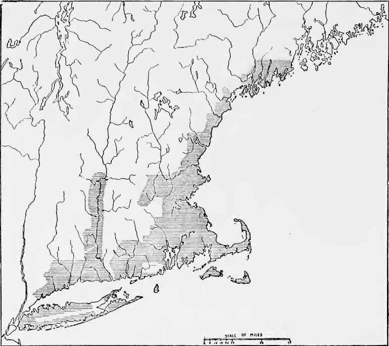 Settled Areas in New England and on Long Island, around 1700.
[Pg 220] Religion.—Throughout New England, except in Rhode Island, church and state were united, the Congregational church being in the ascendency. Though in 1660 Charles II commanded that the Anglican church be tolerated in Massachusetts, the authorities resisted its introduction, and not until 1686 was an Episcopalian church established in Boston. In Connecticut there were a few Presbyterians and Quakers. In Rhode Island the Baptists and Quakers were the most important element.
[Pg 220] Religion.—In New England, except for Rhode Island, church and state were combined, with the Congregational church in the dominant position. Even though Charles II ordered the Anglican church to be accepted in Massachusetts in 1660, the local authorities resisted its establishment, and it wasn't until 1686 that an Episcopalian church was set up in Boston. Connecticut had a small number of Presbyterians and Quakers. In Rhode Island, the Baptists and Quakers were the most significant groups.
Superstitions.—The seventeenth century Puritan was intolerant and superstitious. Men must conform or be persecuted. Signs and portents were believed in, and strange and often filthy concoctions and ointments were administered at the suggestion of midwives or knowing housewives. Belief in witchcraft was usual both in Europe and America, and such learned men as Increase and Cotton Mather, prominent clergymen of Boston, wrote treatises to prove its truth. The Massachusetts laws recognized it as a capital offense. In 1692 occurred the famous outbreak at Salem in which nineteen innocent persons were executed.
Superstitions.—The Puritans of the seventeenth century were intolerant and superstitious. People had to conform or face persecution. They believed in signs and omens, and strange, often disgusting remedies and ointments were used based on advice from midwives or knowledgeable housewives. Belief in witchcraft was common in both Europe and America, and well-respected figures like Increase and Cotton Mather, important clergymen from Boston, wrote essays to validate its existence. The laws in Massachusetts recognized witchcraft as a capital crime. In 1692, the infamous Salem outbreak occurred, resulting in the execution of nineteen innocent people.
Education.—In the English colonies New England took the lead in provision for popular education. Men who believed that the Bible was the source of authority naturally thought that every man should have sufficient intellectual training to enable him to read the word of God. In 1635 the first Latin grammar school in the English colonies was started at Boston, and several other towns soon followed the example. In 1647 Massachusetts enacted a general education law which required every town of fifty or more freeholders to appoint a teacher to instruct children to read and write. Every town of one hundred or more freeholders was required to support a Latin grammar school which would prepare students for college. Connecticut and New Haven soon followed the lead of Massachusetts. In Rhode Island and Plymouth each community was allowed to follow its own course. In Rhode Island the few schools were usually private enterprises. In Plymouth the first public school was not opened until 1671. Higher education was not neglected, Harvard being founded in 1636. In that year Massachusetts voted £400 toward the support of a college. Two years later John Harvard bequeathed his library and one-half of his estate for the erection of a college,[Pg 221] and Harvard College came into existence. For many years it was devoted mainly to the training of religious leaders, and its curriculum reflected the classical viewpoint of the great English universities.
Education.—In the English colonies, New England took the lead in providing for public education. People who believed that the Bible was the ultimate authority thought that everyone should have enough education to be able to read it. In 1635, the first Latin grammar school in the English colonies was established in Boston, and several other towns soon followed suit. In 1647, Massachusetts passed a general education law that required every town with fifty or more freeholders to appoint a teacher to instruct children in reading and writing. Every town with one hundred or more freeholders was required to support a Latin grammar school to prepare students for college. Connecticut and New Haven quickly followed Massachusetts's example. In Rhode Island and Plymouth, each community was allowed to choose its own path. In Rhode Island, the few schools that existed were mainly private ventures. In Plymouth, the first public school didn't open until 1671. Higher education wasn’t ignored, as Harvard was founded in 1636. That year, Massachusetts allocated £400 for the support of a college. Two years later, John Harvard left his library and half of his estate to help establish a college,[Pg 221] leading to the creation of Harvard College. For many years, it was primarily focused on training religious leaders, and its curriculum reflected the classical views of the great English universities.
Literature.—The literature of the first century of New England was permeated with a gloomy religious viewpoint, but it was not lacking in dignity or power. It reflected the sternness of standards and purpose of the founders, who saw little of the humor, or of the lighter side of existence. The strongest of the writings were the histories, the best being the History of Plymouth by Governor Bradford and The History of New England by Governor Winthrop. Of less interest to the present day mind are the controversial religious tracts and sermons of Roger Williams and Cotton Mather, or the crude poetry of Mrs. Anne Bradstreet.
Literature.—The literature from the first century of New England was filled with a serious religious perspective, but it still had dignity and impact. It mirrored the strict standards and intentions of the founders, who didn’t really appreciate humor or the lighter aspects of life. The most compelling writings were the histories, with the best being the History of Plymouth by Governor Bradford and The History of New England by Governor Winthrop. The controversial religious tracts and sermons by Roger Williams and Cotton Mather, or the simplistic poetry of Mrs. Anne Bradstreet, are of less interest to today’s readers.
NEW YORK AND EAST NEW JERSEY
Population.—Economically and socially New York and East New Jersey were closely related. At the end of the Andros régime the population of New York was probably 18,000, and that of East New Jersey about 10,000. More than half of the New Yorkers were Dutch. The rest were mainly English, but there were some Huguenots and a few Jews. The settled area covered almost all of Long Island and the Hudson Valley to a point a few miles north of Albany. Most of the population of East New Jersey was along the coast opposite New York harbor. The English predominated, but there was a sprinkling of Dutch, Scotch, and Huguenots.
Population.—Economically and socially, New York and East New Jersey were closely connected. By the end of the Andros administration, the population of New York was probably around 18,000, while East New Jersey had about 10,000 residents. More than half of New Yorkers were Dutch, and the rest were mainly English, along with some Huguenots and a few Jews. The settled area included almost all of Long Island and the Hudson Valley up to a few miles north of Albany. Most of East New Jersey's population was along the coast facing New York harbor. The English made up the majority, but there was also a mix of Dutch, Scots, and Huguenots.
Industry in New York.—During the first decades of the Dutch occupation of the Hudson Valley the fur trade had been almost the only business, but after 1638 many settlers came who began general farming. Lumbering also developed. The general lines of industry thus begun were carried on after the English occupation. The fur trade was greatly stimulated by Dongan and it was probably the chief source of wealth in the colony. Population increased slowly. The advantageous position of New York attracted shipping, and the merchants developed a commerce with the West Indies and the Dutch possessions in the Caribbean to which were shipped bread stuffs, pease, meat, and horses.[Pg 222] The returning vessels brought wine, rum, molasses, and various tropical products. To England the New Yorkers shipped furs, oil, and naval supplies in return for manufactured goods.
Industry in New York.—In the early years of Dutch rule in the Hudson Valley, the fur trade was nearly the only business. However, after 1638, many new settlers arrived and began general farming. Lumbering also grew. These initial industries continued after the English took over. The fur trade saw significant growth under Dongan and likely became the main source of wealth in the colony. The population grew slowly. New York’s strategic location drew shipping, and merchants established trade with the West Indies and the Dutch territories in the Caribbean, exporting grain, peas, meat, and horses.[Pg 222] The returning ships brought back wine, rum, molasses, and various tropical goods. To England, New Yorkers exported furs, oil, and naval supplies in exchange for manufactured items.
 Populated regions in the Middle Colonies around 1700.
A contemporary description of New York.—Governor Dongan wrote concerning the province in 1687: "The principal towns within the Govermt are New York Albany & Kingston at Esopus. All the rest are country villages. The buildings in New York & Albany are generally of stone & brick. In the country the houses are mostly new built, having two or three rooms on a floor. The Dutch are great improvers of land. New York and Albany live wholly upon trade with the Indians England and the West Indies.... I believe for these 7 years last past, there has not come over into this province twenty English Scotch or Irish familys. But on the contrary on Settled Areas in the Middle Colonies Long Island the people about 1700 encrease soe fast that they complain for want of land and many remove from thence into the neighboring province."
A modern description of New York.—Governor Dongan wrote about the province in 1687: "The main towns within the government are New York, Albany, and Kingston at Esopus. All the others are rural villages. The buildings in New York and Albany are mostly made of stone and brick. In the countryside, houses are mostly newly built, typically having two or three rooms per floor. The Dutch are excellent at improving land. New York and Albany rely entirely on trade with the Indians, England, and the West Indies... I believe that over the last seven years, less than twenty English, Scottish, or Irish families have settled in this province. On the other hand, in the settled areas of the Middle Colonies, particularly Long Island, people around 1700 are increasing so rapidly that they complain about a lack of land, and many are moving into the neighboring province."
Religion and education in New York.—Regarding religion Dongan wrote. "Every Town ought to have a Minister. New York has first a Chaplain belonging to the Fort of the Church of England; secondly, a Dutch Calvinist; thirdly a French Calvinist; fourthly a Dutch Lutheran—Here bee not many of the[Pg 223] Church of England; few Roman Catholicks; abundance of Quakers preachers men & Women especially; Singing Quakers, Ranting Quakers, Sabbatarians; anti-sabbatarians; Some Anabaptists some Independents; some Jews; in short of all sorts of opinions there are some, and the most part of none at all.... The most prevailing opinion is that of the Dutch Calvinists." This description applied to religious conditions in New York City, then as now a cosmopolitan place. On Long Island, where New Englanders were predominant, the Congregational church held sway, while in the Hudson Valley, where most of the settlers were Dutch, the Dutch Reformed church was in the ascendency. The Dutch had maintained elementary schools, but when the English occupied the country, most of the school-masters left, and little was done by the authorities to stimulate education. Such schools as existed were established by the local communities.
Religion and education in New York.—Regarding religion, Dongan wrote, "Every town should have a minister. New York has, first, a chaplain belonging to the Fort of the Church of England; second, a Dutch Calvinist; third, a French Calvinist; fourth, a Dutch Lutheran—There are not many of the [Pg 223] Church of England; few Roman Catholics; plenty of Quaker preachers, both men and women, especially Singing Quakers, Ranting Quakers, Sabbatarians; anti-sabbatarians; some Anabaptists, some Independents; some Jews; in short, there are some of all sorts of opinions, and most people hold none at all.... The most common opinion is that of the Dutch Calvinists." This description applied to the religious conditions in New York City, which has always been a cosmopolitan place. On Long Island, where New Englanders were dominant, the Congregational church was influential, while in the Hudson Valley, where most of the settlers were Dutch, the Dutch Reformed church was ascendant. The Dutch had established elementary schools, but when the English took over, most of the schoolmasters left, and little was done by the authorities to promote education. The schools that existed were set up by the local communities.
Large estates.—During the Dutch régime many large estates had been created, the most important being the patroonship of Van Rensselaer about Albany. Although the other patroons had surrendered their rights, the Dutch governors, officials, and merchants had acquired vast estates, which continued in their families after the English occupation. The English governors followed the example, and several large holdings were created, the most famous of these being the Livingston manor on the east bank of the Hudson below the Van Rensselaer tract.
Large estates.—During the Dutch period, many large estates were established, the most significant being the Van Rensselaer patroonship around Albany. Although the other patroons had given up their rights, the Dutch governors, officials, and merchants amassed huge estates that remained in their families even after the English took over. The English governors emulated this practice, resulting in the creation of several large properties, the most well-known being the Livingston manor on the east bank of the Hudson River, just south of the Van Rensselaer tract.
Conditions in East New Jersey.—The people of East New Jersey came mainly from New England and Long Island, and they built up a miniature New England, each village being an entity surrounded by tributary farm lands. Garden truck, fish, oysters, and fruits were the principal products. The proprietors hoped to develop commerce, but the Duke of York's restrictions throttled it, and East New Jersey was forced into the position of a supply station for New York. Gawen Laurie, the deputy-governor, described conditions as follows in 1684: "There is great plenty of oysters, fish, fowl; pork is two pennies the pound, beef and venison one penny the pound, a whole fat buck for five or six shillings; Indian corn for two shillings and six pence per bushel, oats twenty pence, and barley two shillings per bushel: We have good brick earth, and stones for building at Amboy, and elsewhere: The country farm houses are built very cheap:[Pg 224] A carpenter, with a man's own servants, builds the house; they have all materials for nothing, except nails, their chimnies are of stones; they make their own ploughs and carts for the most part, only the iron work is very dear: The poor sort set up a house of two or three rooms themselves, after this manner; the walls are of cloven timber, about eight or ten inches broad, like planks, set one end to the ground, and the other nailed to the raising, which they plaster within; they build a barn after the same manner, and these cost not above five pounds a piece; and then to work they go: Two or three men in one year will clear fifty acres, in some places sixty, and in some more: They sow corn the first year, and afterwards maintain themselves; and the increase of corn, cows, horses, hogs and sheep comes to the landlord;... the servants work not so much by a third as they do in England, and I think feed much better; for they have beef, pork, bacon, pudding, milk, butter and good beer and cyder for drink; when they are out of their time, they have land for themselves, and generally turn farmers for themselves."
Conditions in East New Jersey.—The people of East New Jersey primarily came from New England and Long Island, creating a small-scale version of New England where each village was a distinct community surrounded by farms. Their main products included vegetables, fish, oysters, and fruits. The landowners aimed to boost trade, but the Duke of York's restrictions held them back, forcing East New Jersey to become a supply station for New York. Gawen Laurie, the deputy-governor, described the situation in 1684: "There is a great abundance of oysters, fish, and birds; pork costs two pennies per pound, while beef and venison cost one penny per pound, and a whole fat deer goes for five or six shillings; Indian corn is priced at two shillings and six pence per bushel, oats are twenty pence, and barley costs two shillings per bushel: We have excellent clay for bricks and stones for building in Amboy and elsewhere: The country farmhouses are built very cheaply:[Pg 224] A carpenter, along with a man’s servants, constructs the house; they have all materials for free except for nails, and their chimneys are made of stone; they mostly make their own plows and carts, though the ironwork is quite expensive: The poorer folks build a house with two or three rooms like this; the walls are made of split timber, about eight or ten inches wide, placed upright on the ground and nailed together at the top, which they plaster inside; they build a barn in the same way, and these only cost about five pounds each; then they get to work: Two or three men in a year can clear fifty acres, sometimes sixty, or even more in certain areas: They plant corn the first year and then sustain themselves; the surplus of corn, cows, horses, pigs, and sheep goes to the landlord;... the laborers don't work as hard as they do in England, and I think they eat much better; they have beef, pork, bacon, pudding, milk, butter, and good beer or cider to drink; when their service is done, they receive land for themselves and generally become farmers."
Religion and education in East New Jersey.—Another letter of the same date says: "There be people of several sorts of religions, but few very zealous; the people, being mostly New-England men, do mostly incline to their way; and in every town there is a meeting-house, where they worship publickly every week: They have no publick laws in the country for maintaining publick teachers, but the towns that have them, make way within themselves to maintain them; we know none that have a settled preacher, that follows no other employment, save one town, Newark."
Religion and education in East New Jersey.—Another letter from the same date states: "There are people of various religions, but few are very passionate; most of the residents, being primarily from New England, tend to follow their practices. In every town, there is a meeting house where they worship publicly every week. There are no public laws in the country to support public teachers, but the towns that do have them provide for their maintenance internally; the only place we know of that has a settled preacher who doesn't engage in other work is Newark."
COLONIES ALONG DELAWARE RIVER AND BAY
Population.—The settlements along Delaware River and Bay formed an industrial and social group. In 1700 the population numbered less than 20,000, from 12,000 to 15,000 being in Pennsylvania which included Delaware. The interior of West New Jersey was unoccupied, the population remaining close to the coast. From Barnegat to Cape May the settled area was about ten miles wide. Along the eastern shore of the bay and river the population belt widened to twenty-five or thirty miles. In Pennsylvania and Delaware the settled area[Pg 225] was continuous from the mouth of the Lehigh River to the southern boundary of Delaware. Back from the river the habitations extended for forty or fifty miles, but on the bay shore none of the settlers were more than ten or fifteen miles inland. The population of the Delaware region was composed of many nationalities. West New Jersey contained many English, but the descendants of the early Swedish and Dutch settlers were there in considerable numbers. Pennsylvania contained about 1,000 Swedes, Dutch, and Finns, the remnant of the early occupations. Penn's advertising and reputation for philanthropy brought to his colony English, Germans, Scotch, and Welsh.
Population.—The communities along the Delaware River and Bay created an industrial and social group. By 1700, the population was less than 20,000, with about 12,000 to 15,000 in Pennsylvania, which included Delaware. The inland areas of West New Jersey were uninhabited, with the population staying close to the coast. From Barnegat to Cape May, the settled region was about ten miles wide. Along the eastern shore of the bay and river, the population area expanded to twenty-five or thirty miles. In Pennsylvania and Delaware, the settled area[Pg 225] stretched continuously from the mouth of the Lehigh River to Delaware's southern border. Inland from the river, homes extended for forty or fifty miles, but along the bay shore, none of the settlers lived more than ten or fifteen miles in. The population of the Delaware region included many nationalities. West New Jersey had a significant number of English settlers, but descendants of early Swedish and Dutch settlers were also present in large numbers. Pennsylvania had around 1,000 Swedes, Dutch, and Finns, remnants of the early settlements. Penn's advertising and reputation for philanthropy attracted English, Germans, Scots, and Welsh to his colony.
Conditions in West New Jersey.—The following description of West New Jersey, written in 1698, gives an excellent picture of the colony: "In a few Years after [1675] a Ship from London, and another from Hull, sail'd thither with more People, who went higher up into the Countrey, and built there a Town, and called it Burlington which is now the chiefest Town in that Countrey though Salem is the ancientest; and a fine Market-Town it is, Having several Fairs kept yearly in it; likewise well furnished with good store of most Necessaries for humane Support, as Bread, Beer, Beef, and Pork; as also Butter and Cheese, of which they freight several Vessels and send them to Barbadoes, and other islands.
Conditions in West New Jersey.—The following description of West New Jersey, written in 1698, gives an excellent picture of the colony: "A few years after [1675], a ship from London and another from Hull sailed there with more people, who went further into the countryside and built a town called Burlington, which is now the main town in that area, although Salem is the oldest. It’s a great market town, hosting several fairs each year; it is well-stocked with all the essentials for human survival, like bread, beer, beef, and pork; as well as butter and cheese, with which they fill several ships to send to Barbados and other islands.
"There are very many fine stately Brick-Houses built [at Salem], and a commodious Dock for Vessels to come in at, and they claim equal Privilege with Burlington for the sake of Antiquity; tho' that is the principal Place, by reason that the late Governor Cox, who bought that Countrey of Edward Billing, encouraged and promoted that Town chiefly, in settling his Agents and Deputy-governors there, (the same Favours are continued by the New-West-Jersey Society, who now manage Matters there) which brings their Assemblies and chief Courts to be kept there; and by that means it is become a very famous Town, having a great many stately Brick-Houses in it, (as I said before) with a great Market-House...; It hath a noble and spacious Hall over-head, where their Sessions is kept, having the Prison adjoining to it....
There are a lot of impressive brick houses built [in Salem], and a comfortable dock for ships to come in, and they claim the same rights as Burlington because of their history; although Burlington is the main place, since the former Governor Cox, who purchased that land from Edward Billing, mainly encouraged and promoted that town by establishing his agents and deputy governors there. (The same support continues from the New-West-Jersey Society, which currently oversees things there), which leads to their assemblies and main courts being held there; thus, it has become a well-known town, having many grand brick houses in it, as I mentioned earlier, along with a large market house...; It features a grand and spacious hall upstairs, where their sessions are held, with the prison attached to it....
"A Ship of Four Hundred Tuns may sail up to this Town in the River Delaware; for I my self have been on Board a Ship of[Pg 226] that Burthen there: and several fine Ships and Vessels (besides Governour Cox's own great Ship) have been built there.... There are Water-Men who constantly Ply their Wherry Boats from that Town to the City of Philadelphia in Pensilvania, and to other places. Besides there is Glocester-Town, which is a very Fine and Pleasant Place, being well stored with Summer Fruits, as Cherries, Mulberries, and Strawberries whither Young People come from Philadelphia in the Wherries to eat Strawberries and Cream, within sight of which city it is sweetly Situated, being but about three Miles distant from thence."
"A ship of four hundred tons can sail up to this town in the River Delaware; because I have been on board a ship of[Pg 226] that size. Several fine ships and vessels (besides Governor Cox's own large ship) have been built there.... There are watermen who constantly operate their wherry boats from that town to the city of Philadelphia in Pennsylvania, and to other places. Also, there is Gloucester Town, which is a very nice and pleasant place, being well-stocked with summer fruits, like cherries, mulberries, and strawberries, where young people come from Philadelphia in the wherries to enjoy strawberries and cream, sweetly situated within sight of the city, about three miles away."
Economic conditions in Pennsylvania.—When Penn's colonists arrived they found many farms under cultivation. Many of the new arrivals took up farming, and the lower counties became a supply region for Philadelphia. Under Penn's direction. Philadelphia soon became a trading center, and as it grew Burlington declined. Furs and food-stuffs were exchanged for manufactured articles from Europe, and for sugar and other West Indian produce. With the exception of the making of coarse cloth and cordage, there was little manufacturing. Practically all of the settlers were freemen, although slavery and indenture gradually crept in. The standard of living was higher than in most of the colonies, for Indian wars did not disturb pursuits, the lands were fertile, and the climatic conditions less rigorous than along the New England coast. Most of the early accounts tell of well-built houses, and productive gardens and orchards.
Economic conditions in Pennsylvania.—When Penn's colonists arrived, they found many farms already in use. Many of the newcomers started farming, and the lower counties became a supply area for Philadelphia. Under Penn's guidance, Philadelphia quickly grew into a trading hub, leading to the decline of Burlington. Furs and food were traded for manufactured goods from Europe, as well as sugar and other West Indian products. Besides coarse cloth and rope production, there was little manufacturing. Almost all of the settlers were free people, though slavery and indentured servitude gradually emerged. The standard of living was higher than in most other colonies since Indian wars didn't disrupt activities, the land was fertile, and the climate was milder than along the New England coast. Most early accounts describe well-built houses, along with productive gardens and orchards.
Religion and education.—In church affiliation the Delaware River country was a mixture. In West New Jersey were found Presbyterians, Baptists, Quakers, and Lutherans. In Pennsylvania there were the same denominations, but religiously and politically the Quakers were in the ascendency. In 1695 an Episcopal church was established at Philadelphia, but the Anglican church made slow progress along the Delaware. The Dutch and Swedes had established schools under the direction of the ministers. The Quakers were also keenly interested in education, and schools were immediately established. In 1682 the West New Jersey assembly granted three hundred acres for the support of a school at Burlington, and one of the first acts of the Pennsylvania assembly was intended to begin elementary education.[Pg 227] In 1689 the Friends' Public School at Philadelphia was founded and was open to all sects. But most of the schools were founded by churches or private individuals.
Religion and education.—The Delaware River region had a diverse mix of religious affiliations. In West New Jersey, there were Presbyterians, Baptists, Quakers, and Lutherans. Pennsylvania had the same denominations, but the Quakers were the dominant group both religiously and politically. In 1695, an Episcopal church was established in Philadelphia, but the Anglican Church grew slowly along the Delaware. The Dutch and Swedes had set up schools run by ministers. The Quakers were also very interested in education and quickly established schools. In 1682, the West New Jersey assembly granted three hundred acres to support a school in Burlington, and one of the first actions of the Pennsylvania assembly aimed to promote elementary education.[Pg 227] In 1689, the Friends' Public School in Philadelphia was founded and welcomed all religious groups. However, most schools were started by churches or private individuals.
THE CHESAPEAKE BAY REGION
The settled area.—The Chesapeake Bay country formed another economic unit. By the end of the Stuart régime Maryland contained about 30,000 people, Virginia nearly 60,000, and North Carolina perhaps 3,000, practically all of English extraction. From Cape Charles northward for fifty miles the peninsula was settled. Then came an uninhabited region until opposite Kent Island, where the settlements began again and extended northward to the Pennsylvania line. On the western side of the bay a population belt about twenty-five miles wide extended from the northern boundary of Maryland as far as the Potomac. On the right bank of the Potomac from a point ten miles above Alexandria to the place where the river made its great bend to the eastward the plantations covered a strip about five miles wide. From the great bend the frontier ran almost straight south to the neighborhood of Richmond and then gradually curved to the southeast, enclosing a settled area about twenty-five miles wide on the south side of the James River.
The settled area.—The Chesapeake Bay region formed another economic unit. By the end of the Stuart period, Maryland had about 30,000 residents, Virginia nearly 60,000, and North Carolina around 3,000, mostly of English descent. From Cape Charles northward for fifty miles, the peninsula was populated. Then there was an uninhabited section until reaching Kent Island, where settlements started again and extended northward to the Pennsylvania border. On the western side of the bay, a population belt about twenty-five miles wide stretched from Maryland's northern boundary all the way to the Potomac. On the right bank of the Potomac, from a point ten miles above Alexandria to where the river makes its significant bend to the east, the plantations covered a strip about five miles wide. From the great bend, the frontier ran almost straight south to near Richmond and then gradually curved southeast, enclosing a settled area about twenty-five miles wide on the south side of the James River.
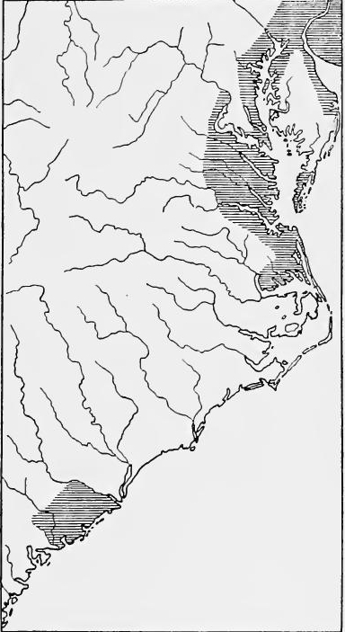 Settled Regions in the Southern Colonies around 1700.
[Pg 228] The frontier line crossed the North Carolina boundary about forty miles from the coast and ran southwestward to the Chowan River, which with the northern shore of Albemarle Sound formed the limits of the settled region of North Carolina, then politically united but economically and socially separated from the Charleston district.
[Pg 228] The boundary line crossed into North Carolina about forty miles from the coast and went southwest to the Chowan River, which along with the northern shore of Albemarle Sound marked the edges of the settled area of North Carolina. At that time, North Carolina was politically united but was economically and socially divided from the Charleston area.
The plantations.—The Chesapeake Bay country was almost entirely devoted to agriculture. The small land holdings of the early period were rapidly disappearing and great plantations had taken their place. The average land patent in Virginia in the last decades of the century gave title to from six hundred to eight hundred acres, but many of the plantations covered from ten thousand to twenty thousand acres. So plentiful was land and so easily obtained that the planters preferred to take up new acreage rather than resort to fertilization, the result being that the plantations were widely scattered, an important factor in making each estate a social and economic unit.
The Plantations.—The Chesapeake Bay area was almost entirely focused on farming. The small land holdings from earlier times were quickly disappearing, replaced by large plantations. In the last decades of the century, the average land patent in Virginia granted ownership of between six hundred and eight hundred acres, but many plantations stretched from ten thousand to twenty thousand acres. Land was so abundant and easily obtainable that the planters opted to take on new land instead of using fertilizers, which resulted in the plantations being widely spread out, making each estate a distinct social and economic unit.
Tobacco.—The great staple was tobacco. The plantations were usually located near a creek, river, or the bay shore. Each had its wharf or flatboat from which the trader could load his vessel. Most of the crop was shipped to England, and the price obtained determined the year's prosperity or depression. The large plantation owner usually dealt with some London house, which kept an open account with him, crediting his tobacco against orders for the manufactured articles and luxuries which the Virginia and Maryland gentlemen demanded.
Tobacco.—The main crop was tobacco. The plantations were typically situated near a creek, river, or the bay shore. Each had its own wharf or flatboat for loading goods onto ships. Most of the crop was shipped to England, and the price received determined whether the year would be prosperous or not. The large plantation owner usually worked with a London merchant, who kept an open account with him, crediting his tobacco against orders for the manufactured goods and luxuries that the gentlemen of Virginia and Maryland wanted.
Other industrial activity.—Some writers have held that there must have been much poverty in the plantation country because of the uncertain market for tobacco, but such statements do not take into account the fact that the plantations produced an abundance of food products. Wheat, oats, barley, and maize were grown in large quantities, the cereals usually being planted after the third crop of tobacco. At times wheat was exported. Almost every estate had its garden and orchard, and live stock was abundant, horses, cattle, and hogs usually ranging in the woods. So numerous did the hogs become that pork was an item of exportation. New England coasting vessels ran into the rivers and took on wheat, pork, and tobacco, which, were exchanged for West Indian slaves, rum, and sugar. There was[Pg 229] but little manufacturing. Cotton and woolen cloths were made for home use, and brick-making was carried on to a limited extent, but most of the manufactured articles were brought from England.
Other industrial activity.—Some writers have argued that there must have been a lot of poverty in the plantation areas because of the unpredictable market for tobacco, but these claims overlook the fact that the plantations produced a surplus of food. Wheat, oats, barley, and corn were grown in large amounts, with cereals typically planted after the third crop of tobacco. At times, wheat was even exported. Almost every estate had its own garden and orchard, and livestock was plentiful, with horses, cattle, and pigs usually roaming in the woods. The number of pigs became so high that pork became an exported item. New England coastal ships sailed into the rivers to pick up wheat, pork, and tobacco, which were traded for West Indian slaves, rum, and sugar. There was[Pg 229] very little manufacturing. Cotton and woolen fabrics were made for personal use, and brick-making was done on a small scale, but most manufactured goods were imported from England.
The system of labor.—The large plantations were worked either by indented servants or slaves. In 1671 Governor Berkeley estimated that there were 6,000 white servants and 2,000 slaves in Virginia. By 1683 there were about 12,000 indented servants and perhaps 3,000 slaves, and by the end of the century the slaves had probably doubled. In proportion to population the indented servants and slaves in Maryland and North Carolina were in similar ratio to the free white population.
The system of labor.—The large plantations were operated by either indentured servants or slaves. In 1671, Governor Berkeley estimated that there were 6,000 white servants and 2,000 slaves in Virginia. By 1683, there were about 12,000 indentured servants and around 3,000 slaves, and by the end of the century, the number of slaves had likely doubled. In relation to the population, the ratios of indentured servants and slaves in Maryland and North Carolina were similar to that of the free white population.
Social position of the planter.—At the top of the social and political structure of society was the planter, his position depending largely upon his acreage. Already in Virginia and Maryland the "great-house" or manor house had made its appearance, a rather unpretentious rambling frame house with a brick chimney at either end, the splendor of which was largely due to comparison with the quarters of the slaves. Articles of luxury such as musical instruments, mirrors, brass fixtures, silverware, table linen, and damask hangings were frequently found in the houses of the wealthier planters. These were by no means typical, for pewter was far more common than silver, and in the home of recently released indented servants or small landholders there was little more than bare necessity demanded.
Social position of the planter.—At the top of the social and political structure of society was the planter, and his position largely depended on how much land he owned. In Virginia and Maryland, the "great house" or manor house had started to appear, which was a fairly simple, sprawling frame house featuring a brick chimney at each end. Its impressive nature was mainly highlighted when compared to the living quarters of the slaves. Luxurious items like musical instruments, mirrors, brass fixtures, silverware, table linens, and damask curtains were often found in the homes of wealthier planters. However, these were not the norm; pewter was much more common than silver, and the homes of recently freed indentured servants or small landholders had little more than what was absolutely necessary.
Religion and education.—In religion there was less uniformity than in industry. In Maryland probably three-fourths of the inhabitants belonged to various dissenting sects. Most of the great landholders were members of the Anglican church, but many were Catholics. Most of the Virginians were Episcopalians, while in North Carolina the Quakers were predominant. Popular education in the South was far below that of the North. Public sentiment was against free schools, and the few secondary educational institutions were conducted through private enterprise. The planters frequently secured educated indented servants who acted as tutors. In 1691 the Virginia legislature sent Dr. William Blair to England to secure a charter for a college and the following year he returned with it, this being the legal beginning of William and Mary College.
Religion and education.—In religion, there was less uniformity than in industry. In Maryland, about three-quarters of the population belonged to various dissenting sects. Most of the major landowners were members of the Anglican Church, but many were Catholics. Most Virginians were Episcopalians, while in North Carolina, Quakers were the majority. Popular education in the South was significantly behind that of the North. Public opinion was against free schools, and the few secondary educational institutions were run by private entities. The planters often hired educated indentured servants who served as tutors. In 1691, the Virginia legislature sent Dr. William Blair to England to secure a charter for a college, and the following year he returned with it, marking the official founding of William and Mary College.
SOUTH CAROLINA
Population.—Economically and socially South Carolina was associated with the West Indies rather than with the mainland colonies. At the close of the seventeenth century the white population was about 5,500. Most of the inhabitants came from Barbados, but other Caribbean Islands, England, Ireland, the New England colonies, and France furnished colonists. The settled area extended from the Santee to the mouth of the Edisto, included several of the islands, and reached back from the coast about fifty miles. The social and economic center was Charleston. In the back country there were only two small towns, most of the people being located on plantations along the rivers and on the islands. The Barbadian planters had settled mainly on the Cooper River, Goose Creek, and Ashley River, and on James, John's and Edisto Islands. Four or five hundred Huguenots, most of whom had left their country because of the revocation of the Edict of Nantes, had located on the Santee, where they had received land grants aggregating over 50,000 acres, nearly half of this being the property of two individuals, the other Huguenot estates varying from 100 to 3,000 acres.
Population.—Economically and socially, South Carolina was more connected to the West Indies than to the mainland colonies. By the end of the seventeenth century, the white population was about 5,500. Most of the residents came from Barbados, but other Caribbean islands, England, Ireland, the New England colonies, and France also supplied settlers. The settled area stretched from the Santee to the mouth of the Edisto, included several islands, and extended about fifty miles inland from the coast. Charleston was the social and economic hub. In the backcountry, there were only two small towns, with most people living on plantations along the rivers and on the islands. The Barbadian planters primarily settled along the Cooper River, Goose Creek, and Ashley River, as well as on James, John's, and Edisto Islands. Four or five hundred Huguenots, who mostly left their country due to the revocation of the Edict of Nantes, settled on the Santee, where they received land grants totaling over 50,000 acres; nearly half of this land belonged to two individuals, while other Huguenot estates ranged from 100 to 3,000 acres.
The plantations.—At the end of the century rice culture, which was destined to furnish the most important staple, was in its infancy, and a little silk and cotton were produced. The chief business of the planters was the raising of cattle and hogs, corn, and pease. The Barbadians brought in the economic system of the West Indies, which was based upon slavery, and the harsh slave code of Barbados was adopted in the colony. Accurate statistics regarding the number of slaves are inaccessible, but an apparently authentic letter of 1708 states that in that year there were 4,100 negro slaves and 1,400 Indian slaves in the colony, numbers probably in excess of those in 1700, as it was the development of the rice industry which made slaves highly profitable.
The plantations.—By the end of the century, rice farming, which was set to become the most significant crop, was just starting out, with only a small amount of silk and cotton being produced. The main focus for the planters was raising cattle and pigs, as well as growing corn and peas. The Barbadians introduced the economic system of the West Indies, which relied on slavery, and the strict slave code from Barbados was adopted in the colony. While exact statistics on the number of slaves are hard to find, a seemingly credible letter from 1708 claims there were 4,100 black slaves and 1,400 Indian slaves in the colony that year. These figures were likely higher than those in 1700, as the growth of the rice industry made slavery very profitable.
Commerce.—Charleston was the great market town. There the trader stocked for the Indian trade, which, at the close of the century was the chief source of wealth of South Carolina. Goods from Charleston are said to have penetrated a thousand[Pg 231] miles into the interior. To the West Indies were shipped beef, pork, butter, tallow, and hides, rice and pease, lumber, staves, pitch, and tar; returning vessels brought rum, sugar, molasses, and other West Indian products. To England were shipped furs, rice, silk, and naval stores, in return for manufactured goods.
Commerce.—Charleston was the main market town. There, traders stocked up for the Indian trade, which, by the end of the century, was the primary source of wealth for South Carolina. Goods from Charleston are said to have reached a thousand[Pg 231] miles into the interior. To the West Indies, they shipped beef, pork, butter, tallow, hides, rice, and peas, along with lumber, staves, pitch, and tar; returning ships brought back rum, sugar, molasses, and other West Indian products. To England, they shipped furs, rice, silk, and naval supplies in exchange for manufactured goods.
Religion and education.—The Episcopalian was the established church of the colony, and probably forty-five per cent. of the population belonged to that denomination. An equal per cent. was divided between Congregationalists and Presbyterians, and there were a few Baptists and Quakers. No public school system had been established, but many of the wealthier families employed tutors. A public library was started at Charleston in 1698, but no institution of higher learning had been established.
Religion and education.—The Episcopalian church was the official church of the colony, and about forty-five percent of the population belonged to that denomination. An equal percentage was split between Congregationalists and Presbyterians, with a few Baptists and Quakers as well. There was no public school system in place, but many wealthier families hired private tutors. A public library was started in Charleston in 1698, but no higher education institution had been established.
Society.—Already in South Carolina an aristocratic society was forming which was distinctly different from that of any other mainland colony. When the Barbadians came they brought with them the social viewpoint of the West Indian planter. As soon as the discovery was made that the swampy river bottoms were adapted to rice and indigo, slavery received a great impetus and the Barbadian social system was almost duplicated. In no other colony was such a large part of the population concentrated in a single city. In Charleston lived the merchants, and there the planter built his town house and remained with his family a portion of the year. The gathering of the wealthy classes developed a social atmosphere of gaiety which was in marked contrast to the soberness of Boston or the conservatism of Philadelphia.
Society.—In South Carolina, an aristocratic society was emerging that was quite different from any other mainland colony. When the Barbadians arrived, they brought with them the social perspective of the West Indian planter. Once it was discovered that the swampy river bottoms were suitable for rice and indigo, slavery gained significant momentum, and the Barbadian social structure was largely replicated. No other colony had such a large portion of the population concentrated in a single city. Charleston was home to the merchants, and there the planters built their townhouses and spent part of the year with their families. The gathering of the wealthy classes created a lively social scene that contrasted sharply with the seriousness of Boston or the conservatism of Philadelphia.
READINGS
Andrews, C.M., Colonial Self-Government, 288-336; Colonial Folkways; Brodhead, J.R., History of the State of New York, II; Bruce, P.A., Economic History of Virginia in the Seventeenth Century; Burr, G.L., ed., Narratives of the Witchcraft Cases; Dexter, E.G., A History of Education in the United States, 24-71; Dexter, F.B., "Estimates of Population in the American Colonies," in American Antiquarian Society; Proceedings, New Series, V, pt. 1; Eggleston, E., The Transit of Civilization; Fiske, J., Old Virginia and her Neighbors, II, 174-269; McCrady, E., South Carolina under the Proprietary Government, I, 314-363; Mereness, N.D., Maryland as a Proprietary Province; Smith, S., The History of the Colony of Nova Cæsaria, or New Jersey; Walker, W., A History of the Congregational Churches in the United States: Weeden, W.B., Economic and Social History of New England, I; Phillips, U.B., American Negro Slavery, 67-84, 98-114.
Andrews, C.M., Colonial Self-Government, 288-336; Colonial Folkways; Brodhead, J.R., History of the State of New York, II; Bruce, P.A., Economic History of Virginia in the Seventeenth Century; Burr, G.L., ed., Narratives of the Witchcraft Cases; Dexter, E.G., A History of Education in the United States, 24-71; Dexter, F.B., "Estimates of Population in the American Colonies," in American Antiquarian Society; Proceedings, New Series, V, pt. 1; Eggleston, E., The Transit of Civilization; Fiske, J., Old Virginia and her Neighbors, II, 174-269; McCrady, E., South Carolina under the Proprietary Government, I, 314-363; Mereness, N.D., Maryland as a Proprietary Province; Smith, S., The History of the Colony of Nova Cæsaria, or New Jersey; Walker, W., A History of the Congregational Churches in the United States; Weeden, W.B., Economic and Social History of New England, I; Phillips, U.B., American Negro Slavery, 67-84, 98-114.
EXPANSION AND INTERNATIONAL CONFLICT
CHAPTER XIII
THE SPANISH ADVANCE IN THE SEVENTEENTH CENTURY
SPAIN AND THE COLONIES IN THE SEVENTEENTH CENTURY
Decline of Spanish power in Europe.—After the reign of Philip II the power of Spain steadily declined. The long period of hostility with the Dutch and the war with Cromwell greatly weakened her power upon the sea. The continental wars sapped her military strength and France superseded her as the first power of Europe. Gradually Spain's continental possessions slipped from her. The first loss was the Protestant Netherlands. Nominally independent from 1609, their complete independence was acknowledged in 1648. By the Treaty of the Pyrenees, Roussillon became French territory, and the Spanish power in the Rhineland and Italy had been practically annulled. In 1640 Portugal threw off the Spanish yoke, and when Philip IV tried to reconquer it (1661-1665), he failed completely. With Portugal, Spain lost Brazil and the Portuguese colonies in the Far East.
Decline of Spanish power in Europe.—After Philip II's reign, Spain's power gradually declined. The long-standing conflict with the Dutch and the war with Cromwell significantly weakened its naval strength. Ongoing wars on the continent drained its military resources, and France emerged as the dominant power in Europe. Slowly, Spain's territories on the continent began to slip away. The first loss was the Protestant Netherlands. While they were nominally independent from 1609, their full independence was recognized in 1648. The Treaty of the Pyrenees transferred Roussillon to France, effectively ending Spanish influence in the Rhineland and Italy. In 1640, Portugal broke free from Spanish control, and when Philip IV attempted to reclaim it (1661-1665), he completely failed. With Portugal's independence, Spain also lost Brazil and the Portuguese colonies in the Far East.
Colonial expansion.—Nevertheless, the frontiers of the Spanish colonies slowly expanded, and slowly Spain extended her laws, her language, and her faith over lands and tribes more and more remote from the Mexican capital, the struggle with the natives becoming sterner at each step in advance. In the course of the seventeenth century northern Sinaloa and Sonora were colonized; permanent missionary occupation, after many failures, was effected in Lower California; southern, western, and eastern Chihuahua were settled; the new province of Coahuila was established athwart the Rio Grande, and a new and flourishing missionary district was opened in western Florida. In the course of the century the Spanish colonial frontiers began[Pg 234] to clash with those of France and England, on the mainland now as well as in the islands, and there ensued a series of border struggles, all a part of the international conflict for the continent. To restrain the encroaching French and English, Texas was occupied temporarily and Pensacola permanently. The principal setbacks on the borders were the loss of Jamaica to England (1655), the contraction of the Florida frontier through the founding of Virginia and the Carolinas, and the temporary loss of New Mexico through the Pueblo Revolt in 1680. Thus the Spanish frontier line swung round as on a pivot, the gains in the west being partly offset by the losses in the east. Meanwhile the English, French, and Dutch occupied most of the lesser islands of the Caribbean, which had been neglected by Spain. At the same time, Spain's hold on her colonial commerce became more and more precarious through the encroachments of her national enemies.
Colonial expansion.—Despite everything, the boundaries of the Spanish colonies gradually grew, and Spain slowly imposed her laws, language, and faith over lands and tribes that were increasingly distant from the Mexican capital, with conflicts with the natives getting tougher at each advance. During the seventeenth century, northern Sinaloa and Sonora were colonized; after many attempts, permanent missionary settlements were established in Lower California; southern, western, and eastern Chihuahua were settled; a new province called Coahuila was created across the Rio Grande, and a new and thriving missionary district was opened in western Florida. Throughout the century, the Spanish colonial frontiers began[Pg 234] to intersect with those of France and England, both on the mainland and in the islands, leading to a series of border conflicts that were part of the international struggle for control of the continent. To stop the advancing French and English, Texas was temporarily occupied and Pensacola permanently established. The main setbacks at the borders included the loss of Jamaica to England in 1655, the shrinking of the Florida frontier due to the founding of Virginia and the Carolinas, and the temporary loss of New Mexico during the Pueblo Revolt in 1680. Thus, the Spanish border shifted like a pivot, with gains in the west being partially offset by losses in the east. Meanwhile, the English, French, and Dutch took over most of the smaller islands in the Caribbean that Spain had ignored. At the same time, Spain's control over her colonial trade became increasingly unstable due to the advances of her national rivals.
FRONTIER ADMINISTRATION
The governors.—The old days of the adelantados, with unlimited powers, had passed, and the royal arm now reached the farthest outposts. The secular government of the frontier provinces was almost wholly military. A few villas or towns had their elective cabildos, or town councils, and a modicum of self government. The official heads of the provinces were the governors, who held office by royal appointment; ad interim governors might be appointed by the viceroys. Governors, like other prominent officials, frequently purchased their offices, a practice not confined at that time to Spanish America. The governor was also capitán general of his province, and his capital was usually at the principal presidio or garrison. In these capacities he exercised both civil and military authority. Under the governors there were usually lieutenant-governors in the sub-districts, who as a rule commanded the troops of some presidio.
The governors.—The old days of the adelantados, with their unlimited powers, were over, and royal authority now extended to the farthest outposts. The secular government in the frontier provinces was mostly military. A few towns had their elected cabildos, or town councils, and a bit of self-government. The official heads of the provinces were the governors, who were appointed by the crown; ad interim governors could be named by the viceroys. Governors, like other high-ranking officials, often bought their positions, a practice that wasn't unique to Spanish America at that time. The governor was also the capitán general of his province, and he typically had his capital at the main presidio or garrison. In these roles, he held both civil and military authority. Below the governors, there were usually lieutenant-governors in the sub-districts, who typically commanded the troops of a presidio.
The positions of governor and presidial commander were made attractive largely by the opportunity which they afforded for making money in addition to the fixed salaries. The payment of soldiers was made chiefly in supplies, purchased by the governor and commanders, and charged to the soldiers at enormous[Pg 235] profits. Thus the post of governor or captain was almost as much that of merchant as of soldier. Provincial administration was often corrupt with "graft," as in English and French America. Checks upon the governors were furnished through visitas or inspections, and through the residencia, or inquiry at the end of the governor's term. As a rule the residencia was formal, but sometimes it was a serious matter.
The roles of governor and presidial commander were appealing mainly because they offered chances to earn additional money beyond their fixed salaries. Soldiers were mostly paid in supplies, which were bought by the governor and commanders and then charged back to the soldiers at huge[Pg 235] profits. So, being a governor or captain was nearly as much about being a merchant as it was about being a soldier. Provincial administration was often tainted by corruption, or "graft," similar to what was seen in English and French America. Oversight of the governors came through visitas or inspections, as well as the residencia, which was an inquiry conducted at the end of the governor's term. Generally, the residencia was a formal process, but at times it could be quite serious.
Central control.—All important matters of frontier administration, such as the founding of new colonies, presidios, or missions, or the making of military campaigns, were referred by the governors to the viceroy of Mexico. He in turn customarily sought the advice of the fiscal of the real audiencia, and of the auditor de guerra. In case these two functionaries disagreed, or in matters of unusual moment, a junta de guerra y hacienda, composed of the leading officials of the different branches of the central administration, was called. In all matters of consequence the decisions of the viceroy were made subject to royal approval, but it frequently happened that the act for which approval was asked had already been performed. In ordinary affairs of provincial administration the fiscal really controlled the government, for the viceroy usually despatched business with a laconic "as the fiscal says."
Central control.—All important matters of frontier administration, like establishing new colonies, military forts, or missions, as well as planning military campaigns, were referred by the governors to the viceroy of Mexico. He would typically seek advice from the fiscal of the real audiencia and the auditor de guerra. If these two officials disagreed, or in cases of significant importance, a junta de guerra y hacienda, made up of key officials from different branches of the central administration, was convened. In all important matters, the viceroy’s decisions were subject to royal approval, but it often happened that the action for which approval was sought had already been taken. In routine provincial administration, the fiscal effectively controlled the government, as the viceroy usually addressed business with a succinct "as the fiscal says."
Frontier Autonomy.—The government of New Spain was highly centralized in theory, but the effects of centralization were greatly lessened by distance. Through the right of petition, which was freely exercised, the local leaders in the frontier provinces often exerted a high degree of initiative in government, and, on the other hand, through protest and delay, they frequently defeated royal orders.
Frontier Autonomy.—The government of New Spain was very centralized in theory, but the actual impact of that centralization was significantly reduced by distance. Local leaders in the frontier provinces often took a lot of initiative in governance, thanks to the right of petition, which they used freely. On the flip side, they often stalled royal orders through protests and delays.
THE MISSIONS
The Missionaries on the frontiers.—In extending the sway of Spain, as time went on a constantly larger part was played by the missionaries. During the early days of the conquest the natives had been largely in the hands of the encomenderos. But abuses arose and the encomienda system was gradually abolished. Moreover, the wild tribes of the northern frontier, unlike the Mayas and Aztecs, were considered hardly worth exploiting. This left an opening for the missionary, and to him was entrusted[Pg 236] not only the work of conversion, but a larger and larger share of responsibility and control. Since they served the State, the missions were largely supported by the royal treasury, which was most liberal when there was some political end to be gained.
The Missionaries on the frontiers.—As time went on, missionaries played an increasingly important role in expanding Spain's influence. In the early days of the conquest, the natives were mostly under the control of the encomenderos. However, as abuses occurred, the encomienda system was gradually phased out. Additionally, the wild tribes of the northern frontier, unlike the Mayas and Aztecs, were seen as not worth exploiting. This created an opportunity for missionaries, who were given not just the task of conversion but also a greater share of responsibility and control. Since they served the State, the missions received significant funding from the royal treasury, which was especially generous when there were political advantages to be gained.
The principal missionary orders.—Under these circumstances, in the seventeenth and eighteenth centuries, on the expanding frontiers of Spanish America, missions became well-nigh universal. The work on the northern borders of New Spain was conducted largely by Franciscans, Jesuits, and Dominicans. The northeastern field fell chiefly to the Franciscans, who entered Florida, New Mexico, Nuevo León, Coahuila, Nuevo Santander, and Texas. To the northwest went the Jesuits, who, after withdrawing from Florida, worked especially in Sinaloa, Sonora, Chihuahua, Lower California, and Arizona. After the expulsion of the Jesuits the Dominicans and Franciscans took their places.
The main missionary groups.—During the seventeenth and eighteenth centuries, as Spanish America expanded, missions became almost universal. The work along the northern borders of New Spain was mostly carried out by Franciscans, Jesuits, and Dominicans. The northeastern area was mainly the responsibility of the Franciscans, who established missions in Florida, New Mexico, Nuevo León, Coahuila, Nuevo Santander, and Texas. The Jesuits headed northwest, and after leaving Florida, they focused their efforts in Sinaloa, Sonora, Chihuahua, Lower California, and Arizona. After the Jesuits were expelled, the Dominicans and Franciscans took over their missions.
The missions as civilizing agencies.—The missionaries were a veritable corps of Indian agents, serving both Church and State. Their first duty was to teach the Gospel. In addition they disciplined the savage in the rudiments of civilized life. The central feature of every successful Spanish mission was the Indian pueblo, or village. If he were to be disciplined, the Indian must be kept in a definite spot where discipline could be impressed upon him. The settled Indians, such as the Pueblo Indians of New Mexico, could be instructed in their native towns, but the wandering or scattered tribes must be assembled and established in pueblos, and kept there by force if necessary. To make the Indians self-supporting as soon as possible, and to afford them the means of discipline, the missions were provided with communal lands for gardens, farms, and ranches, and with workshops in which to practice the crafts.
The missions as civilizing agencies.—The missionaries were basically a group of Indian agents, working for both the Church and the State. Their main job was to teach the Gospel. Additionally, they aimed to instruct the native people in the basics of civilized life. The key aspect of every successful Spanish mission was the Indian pueblo, or village. To bring about discipline, the native people needed to be settled in a specific location where they could be taught. The settled Indians, like the Pueblo Indians of New Mexico, could be educated in their own communities, but the nomadic or dispersed tribes had to be gathered and established in pueblos, and kept there by force if necessary. To make the native people self-sufficient as quickly as possible and to provide them with the means for discipline, the missions were equipped with communal lands for gardens, farms, and ranches, as well as workshops for crafting skills.
Defence of the frontier.—The missionaries were highly useful likewise as explorers and as diplomatic agents amongst the tribes. As defenders of the frontier they held the allegiance of the neophytes and secured their aid against savages and foreign intruders. Sometimes the mission plants were veritable fortresses.
Defending the frontier. — The missionaries were also very valuable as explorers and diplomats among the tribes. As protectors of the frontier, they maintained the loyalty of the new converts and gained their support against hostile tribes and outside invaders. At times, the mission sites functioned as true fortresses.
Missions designedly temporary.—Like the presidios, or garrisons, missions were intended to be temporary. As soon as his[Pg 237] pioneer work was finished on one frontier the missionary was expected to move on to another, his place being taken by the secular clergy and the mission lands distributed among the Indians. The result, almost without fail, was a struggle over secularization.
Missions intentionally temporary.—Just like the presidios or garrisons, missions were meant to be temporary. As soon as his[Pg 237] pioneering work was done on one frontier, the missionary was expected to move on to another place, with the secular clergy stepping in to take over, and the mission lands being given to the Indians. This almost always led to a conflict over the secularization process.
THE JESUITS IN SINALOA AND SONORA
The Jesuit advance up the slope.—The advance up the Pacific coast mainland was led throughout the seventeenth century by the Jesuit missionaries, supported by presidial soldiers and small citizen colonies. In 1591 the Jesuits entered Sinaloa. Beginning in the valley of the Petatlan and Mocorito rivers, their progress was gradual but steady, river by river, tribe by tribe, to the Fuerte, Mayo, Yaqui, and Sonora valleys, till by the middle of the century they had nearly reached the head of the last named stream.
The Jesuit advance up the slope.—The movement up the Pacific coast mainland was led throughout the seventeenth century by Jesuit missionaries, backed by presidial soldiers and small groups of settlers. In 1591, the Jesuits arrived in Sinaloa. Starting in the valley of the Petatlan and Mocorito rivers, their progress was slow but consistent, advancing river by river, tribe by tribe, through the Fuerte, Mayo, Yaqui, and Sonora valleys, until by the middle of the century they had almost reached the source of the last river mentioned.
Fathers Tapia and Pérez.—The first missionaries sent were Fathers Gonzalo de Tapia and Martin Pérez, who began their work among the tribes of the Petatlan and Mocorito rivers, near San Felipe, then the northern outpost of Sinaloa. From time to time they were joined by other small bands of missionaries. The natives were generally friendly at first, here as elsewhere, and were assembled in villages, baptized, and taught agriculture and crafts. Father Tapia was murdered in 1594 and was succeeded as rector by Father Pérez. By 1604 there had been 10,000 baptisms, the Jesuits had a school for boys at San Felipe, and Father Velasco had written a grammar in the native tongue. In 1600 regular missionary work was begun in Topia. What was done there is a good example of the way the Spaniards often uprooted native society by trying to improve it. Villages were transplanted at will, the chiefs replaced by alcaldes, and native priests suppressed.
Fathers Tapia and Pérez.—The first missionaries sent were Fathers Gonzalo de Tapia and Martin Pérez, who started their work among the tribes of the Petatlan and Mocorito rivers, near San Felipe, which was then the northern outpost of Sinaloa. Occasionally, they were joined by small groups of other missionaries. The natives were generally friendly at first, just as in other places, and were gathered into villages, baptized, and taught agriculture and various crafts. Father Tapia was murdered in 1594, and Father Pérez took over as rector. By 1604, there had been 10,000 baptisms, the Jesuits had established a school for boys at San Felipe, and Father Velasco had written a grammar in the native language. In 1600, regular missionary work began in Topia. What happened there is a good example of how the Spaniards often disrupted native society while trying to improve it. Villages were moved at will, chiefs were replaced by alcaldes, and native priests were suppressed.
Captain Hurdaide, defender of the Faith.—The year 1600 was marked also by the appointment of Captain Diego Martinez de Hurdaide, as commander of the presidio of San Felipe. By the Jesuits he was regarded as the ideal defender of the Faith, and for a quarter of a century he and his soldiers made way for and protected the missionaries in their northward advance.
Captain Hurdaide, defender of the Faith.—The year 1600 also saw the appointment of Captain Diego Martinez de Hurdaide as the commander of the presidio of San Felipe. The Jesuits viewed him as the perfect defender of the Faith, and for twenty-five years, he and his soldiers paved the way for and protected the missionaries in their northward expansion.
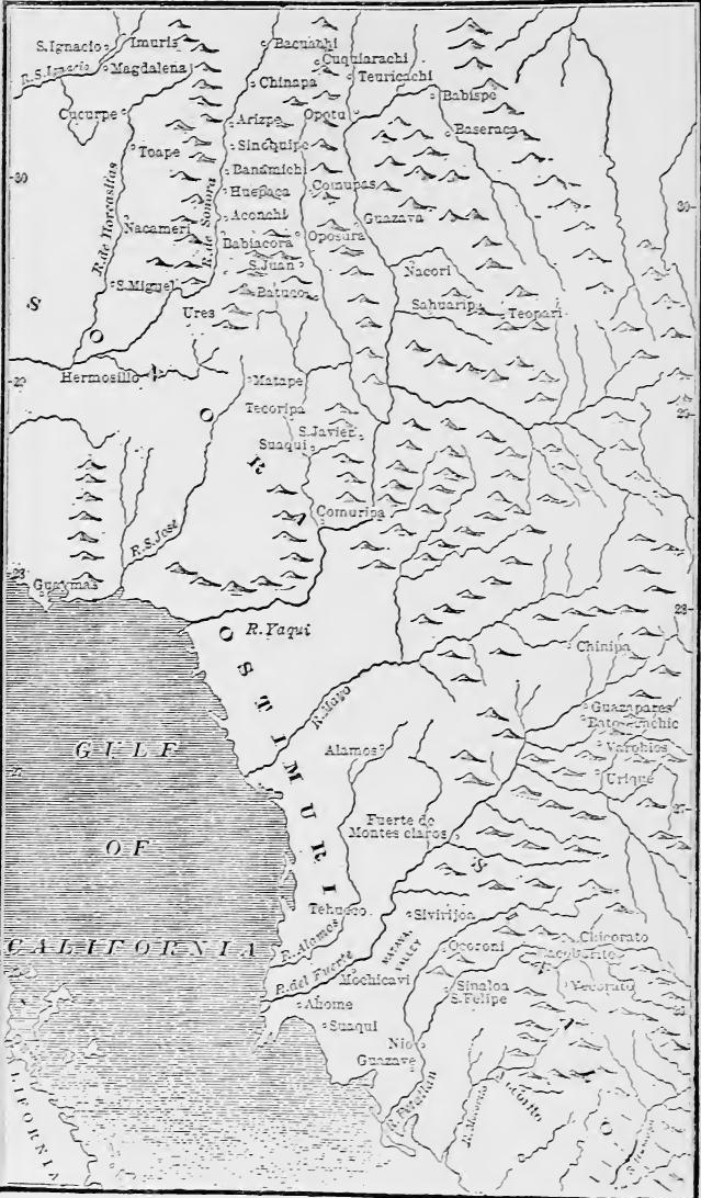 Sinaloa and Sonora in the 17th Century (From Bancroft, North Mexican States and Texas, 1208).
[Pg 239] Missions in the Fuerte valley.—The subjugation of the Suaques and Tehuecos by Hurdaide opened the way for missions in the Fuerte River valley in 1604. Among the founders was Father Pérez de Ribas, later famed as the historian. The initial success of these missions was remarkable, but it was followed by apostasy, revolts, an increase of military forces, and wars of subjugation. This, indeed, was quite the typical succession of events. Apostates fled to the Yaquis, who defeated Hurdaide in three campaigns. Having shown their mettle, in 1610 the Yaquis made peace and asked for missionaries. The Yaqui war was followed by the establishment in 1610 of the new presidio of Montesclaros near the site of the former San Juan. In spite of this new defence, the Tehuecos, led by native priests, revolted. Hurdaide went to the rescue in 1613 with forty soldiers and two thousand allies, restored order, and reëstablished the missions.
[Pg 239] Missions in the Fuerte valley.—The defeat of the Suaques and Tehuecos by Hurdaide cleared the way for missions in the Fuerte River valley in 1604. Among the founders was Father Pérez de Ribas, who later became known as a historian. The early success of these missions was impressive, but it was soon followed by disloyalty, uprisings, increased military presence, and wars of conquest. This was, indeed, the usual pattern of events. Those who abandoned the faith escaped to the Yaquis, who defeated Hurdaide in three campaigns. Proving their strength, the Yaquis made peace in 1610 and requested missionaries. After the Yaqui war, the new presidio of Montesclaros was established in 1610 near the location of the former San Juan. Despite this new defense, the Tehuecos, led by local priests, rebelled. Hurdaide came to the rescue in 1613 with forty soldiers and two thousand allies, restored order, and reestablished the missions.
In the Mayo and Yaqui valleys.—In the same year Father Méndez and some companions advanced the mission frontier to the Mayo valley, where success was gratifying. Four years later Fathers Pérez and Pérez de Ribas founded missions among the Yaquis, where eight pueblos soon flourished. By 1621 missions had reached the Nevomes and Sahuaripas in the upper Yaqui River valley. A revolt among the Nevomes in 1622 was put down by Hurdaide. The Mayo and Yaqui valleys were now made a separate rectorate.
In the Mayo and Yaqui valleys.—In the same year, Father Méndez and some of his companions pushed the mission boundary to the Mayo valley, where they experienced great success. Four years later, Fathers Pérez and Pérez de Ribas established missions among the Yaquis, where eight towns quickly thrived. By 1621, missions had expanded to the Nevomes and Sahuaripas in the upper Yaqui River valley. A revolt among the Nevomes in 1622 was suppressed by Hurdaide. The Mayo and Yaqui valleys were then designated as a separate rectorate.
Several of the pioneers now left the scene. In 1620 Ribas went to Mexico as provincial; in 1625 Father Pérez died, after thirty-five years, of service, and in 1626 Hurdaide was succeeded by Captain Pérea. One of the great monuments to the work of these Jesuit pioneers is Father Pérez de Ribas's history, The Triumph of the Faith, published in 1644.
Several of the pioneers have now departed. In 1620, Ribas went to Mexico as the provincial; in 1625, Father Pérez passed away after thirty-five years of service, and in 1626, Hurdaide was succeeded by Captain Pérea. One of the significant monuments to the work of these Jesuit pioneers is Father Pérez de Ribas's history, The Triumph of the Faith, published in 1644.
In the Sonora valley.—By 1636 Jesuit missions were extended to Ures, in Sonora River valley, a step which was aided by the discovery of mines. Pérea was made captain and justicia mayor of the Sonora district, called Nueva Andalucía, and established his capital at the mining town of San Juan. By 1650 mission stations had reached Cucurpe and Arispe in the upper Sonora valley. Of the northern district the new rectorate of San Francisco Xavier was now formed. In 1679 thirty missionaries in[Pg 240] the Mayo, Yaqui, and Sonora valleys were serving about 40,000 neophytes in seventy-two pueblos.
In the Sonora valley.—By 1636, Jesuit missions had expanded to Ures, in the Sonora River valley, a move that was supported by the discovery of mines. Pérea became the captain and chief justice of the Sonora district, known as Nueva Andalucía, and set up his capital in the mining town of San Juan. By 1650, mission stations had reached Cucurpe and Arispe in the upper Sonora valley. From the northern district, a new rectorate of San Francisco Xavier was established. In 1679, thirty missionaries in[Pg 240] the Mayo, Yaqui, and Sonora valleys were serving around 40,000 new converts in seventy-two pueblos.
Spanish settlements.—By the end of the seventeenth century Sinaloa had passed beyond the frontier stage. The population of pure Spanish blood numbered only six hundred families in 1678, but the half-caste Christian population was much larger, there being twelve hundred persons of Spanish or mixed blood at San Felipe alone. In Sonora the people of Spanish or mixed blood numbered about five hundred families. Mining and stock-raising were the principal and by no means inconsiderable industries in both districts.
Spanish settlements.—By the end of the seventeenth century, Sinaloa had moved beyond the frontier stage. The population of people with pure Spanish ancestry numbered only six hundred families in 1678, but the mixed-race Christian population was much larger, with twelve hundred individuals of Spanish or mixed heritage just in San Felipe. In Sonora, the Spanish or mixed-race population made up about five hundred families. Mining and livestock raising were the main and quite significant industries in both regions.
EFFORTS TO OCCUPY LOWER CALIFORNIA
Pearl fishing and efforts to colonize.—Interest in California did not cease with Vizcaíno's failures. On the contrary, private interest in the pearl fisheries of the Gulf of California continued throughout the seventeenth century, and the government endeavored to utilize it as means of planting colonies. Numerous pearl fishing contracts were granted on condition that the beneficiaries should establish settlements. Other colonizing expeditions were fitted out at royal expense. In nearly every case missionaries were sent with the settlers to help to subdue and teach the Indians.
Pearl fishing and efforts to colonize.—Interest in California didn’t stop with Vizcaíno's failures. In fact, private interest in the pearl fisheries of the Gulf of California continued throughout the seventeenth century, and the government tried to use it as a way to establish colonies. Numerous pearl fishing contracts were issued on the condition that the beneficiaries would set up settlements. Other colonizing expeditions were funded by the crown. In almost every case, missionaries were sent with the settlers to help subdue and educate the Indigenous people.
Iturbi's voyages.—In 1614 Thomas Cardona was granted a monopoly of pearl fishing in both the Caribbean Sea and the Gulf of California. A year later Juan de Iturbi, in Cardona's employ, made a voyage to the head of the Gulf, and like Oñate concluded that California was an island. On his return one of his vessels was captured by the Dutch freebooter Spillberg. In the following year Iturbi made another successful voyage to the Gulf, though he again lost a vessel to freebooters. The pirates in the Gulf in this century were known as the Pichilingues. Iturbi's success inspired numerous unlicensed pearl hunting voyages in the Gulf from the ports of Sinaloa, which were attended by many abuses of the natives. California came now to be commonly regarded as an island.
Iturbi's voyages.—In 1614, Thomas Cardona was given exclusive rights to pearl fishing in both the Caribbean Sea and the Gulf of California. A year later, Juan de Iturbi, working for Cardona, took a trip to the head of the Gulf and, like Oñate, concluded that California was an island. On his way back, one of his ships was captured by the Dutch pirate Spillberg. The following year, Iturbi made another successful trip to the Gulf, although he lost another ship to pirates. The pirates roaming the Gulf during this time were known as the Pichilingues. Iturbi's success led to many unauthorized pearl hunting trips from the ports of Sinaloa, which caused significant harm to the native populations. By this time, California was widely believed to be an island.
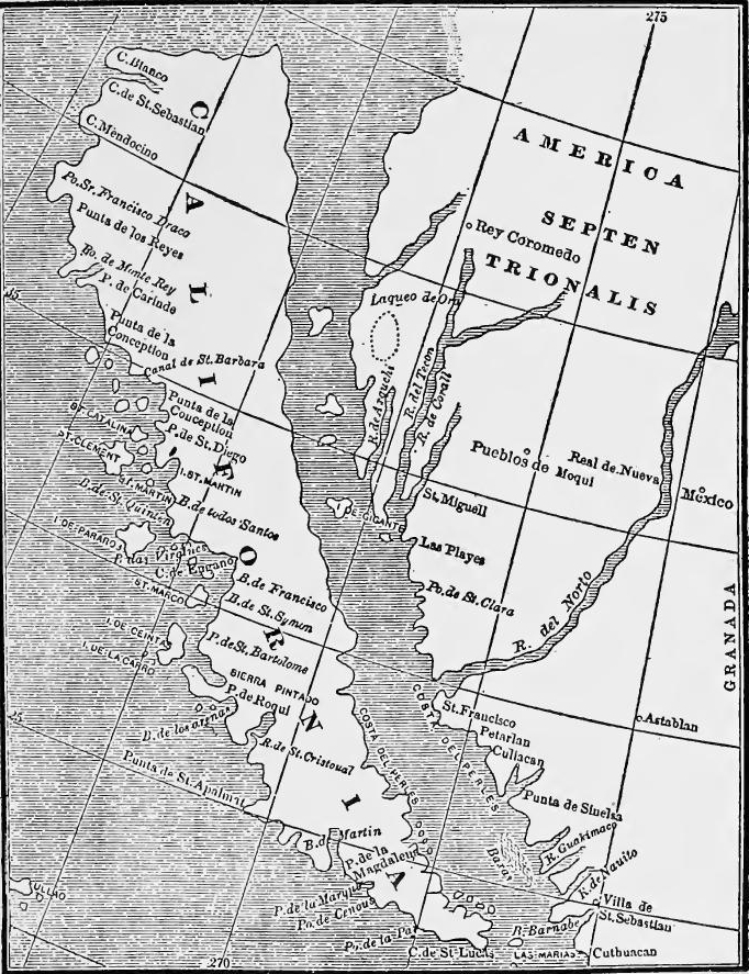 A Dutch map showing the insular theory of California's geography (1624-1625). (From Bancroft, North Mexican States and Texas, I, 169).
Later attempts.—In 1633 Francisco de Ortega, another contractor, founded a colony at La Paz, but it was short-lived. Like failures were experienced by Porter y Casante in 1648, by Piñadero in 1664 and 1667, and by Lucenilla in 1668. The failures were due to the barrenness of the country and to the fact that colonizing was made secondary to pearl fishing. Somewhat more successful was Admiral Atondo y Antillón, with whom a contract was made in 1679, the superior of the missionaries being[Pg 242] the Jesuit Father Kino. For two years (1683-1685) settlements were maintained at La Paz and San Bruno, explorations were made, and Kino achieved some missionary success, but in 1685 Atondo, like his predecessors, abandoned the enterprise. No other serious attempt was made until 1697, when the Jesuits took charge of California.
Later attempts.—In 1633, Francisco de Ortega, another contractor, established a colony at La Paz, but it didn't last long. Similar failures occurred with Porter y Casante in 1648, Piñadero in 1664 and 1667, and Lucenilla in 1668. These failures were due to the barren land and the fact that colonization was considered less important than pearl fishing. A bit more successful was Admiral Atondo y Antillón, with whom a contract was signed in 1679, and the main missionary was[Pg 242] Jesuit Father Kino. For two years (1683-1685), settlements were maintained at La Paz and San Bruno, explorations took place, and Kino had some missionary success, but in 1685, Atondo, like his predecessors, abandoned the venture. No other serious attempts were made until 1697, when the Jesuits took control of California.
THE SETTLEMENT OF CHIHUAHUA
New Mexico isolated.—In the central plateau the infant colony of New Mexico, as at first established, had been a detached group of settlements, separated from Nueva Vizcaya by an uninhabited, area of five or six hundred miles in breadth. But while the New Mexicans were gradually making their way into the plains of western Texas, missionaries, miners, and settlers were slowly advancing up the plateau into Chihuahua, by way of the Conchos River and by the eastern slope of the Sierra Madre.
New Mexico was isolated.—In the central plateau, the early colony of New Mexico was initially just a scattered group of settlements, cut off from Nueva Vizcaya by an uninhabited area of five or six hundred miles wide. While the New Mexicans were gradually moving into the plains of western Texas, missionaries, miners, and settlers were slowly moving up the plateau into Chihuahua, following the Conchos River and the eastern slope of the Sierra Madre.
Advance of settlement.—The Franciscans, in general, followed the eastern half of the plateau, working among the Conchos tribes; the Jesuits mainly followed the mountain slopes, among the Tarahumares. Advance of settlement was marked by the founding of the town and garrison of Parral, established in 1631-1632. By 1648 missions had been established at San Pablo, Parral, San Gerónimo, San Francisco Borja, Satevó, San Francisco de Conchos, San Pedro, Atotonilco, Mescomaha, and Mapimî. Advance was interrupted by two savage Indian wars, in the decade following 1644, in the course of which most of the missions in Chihuahua were destroyed. As soon as peace was restored, however, both orders reoccupied their abandoned establishments and founded new ones. By 1680 missionaries, miners, and settlers had reached Cusihuiriáchic, Janos, and Casas Grandes, and the last named place had for some time been the seat of an alcaldía mayor.
Advance of settlement.—The Franciscans generally worked in the eastern part of the plateau, engaging with the Conchos tribes, while the Jesuits primarily operated along the mountain slopes among the Tarahumares. The advancement of settlement was marked by the establishment of the town and garrison of Parral, founded in 1631-1632. By 1648, missions had been set up at San Pablo, Parral, San Gerónimo, San Francisco Borja, Satevó, San Francisco de Conchos, San Pedro, Atotonilco, Mescomaha, and Mapimî. This progress was interrupted by two brutal Indian wars in the decade after 1644, during which most of the missions in Chihuahua were destroyed. However, once peace was restored, both orders returned to their abandoned posts and created new ones. By 1680, missionaries, miners, and settlers reached Cusihuiriáchic, Janos, and Casas Grandes, with the latter having served as the seat of an alcaldía mayor for some time.
The Diocese of Guadiana.—As the frontier advanced new administrative subdivisions were carved out. The official capital of Nueva Vizcaya was still at Durango, but during the later seventeenth century the governor resided much of the time at Parral, a point near the military frontier. In 1620 the diocese of Guadiana, including Durango, Chihuahua, and New Mexico was formed out of the northern portion of that of Guadalajara.[Pg 243]
The Diocese of Guadiana.—As the border expanded, new administrative divisions were created. The official capital of Nueva Vizcaya was still in Durango, but during the late seventeenth century, the governor spent a lot of time in Parral, which was close to the military frontier. In 1620, the diocese of Guadiana was established, encompassing Durango, Chihuahua, and New Mexico, formed from the northern part of the diocese of Guadalajara.[Pg 243]
NEW MEXICO IN THE SEVENTEENTH CENTURY
The missions.—Hopes of finding rich mines and fabulous treasures in New Mexico had failed, and for a long time after Oñate's conquest that province remained chiefly a missionary field, the only Spanish settlement being Santa Fé, founded in 1609. By 1617 eleven churches had been built and 14,000 natives baptized. Four years later the missions were organized into the custodia of San Pablo, under the Franciscan province of the Holy Evangel of Mexico, whence came most of the missionaries. The first custodian was Fray Alonso de Benavides, who later, became bishop of Goa, in India. Besides Benavides, the best known missionary of this period was Father Gerónimo de Zárate Salmerón, who between 1618 and 1626 labored at Jémez, Cía, Sandía, and Ácoma.
The missions.—Hopes of discovering rich mines and incredible treasures in New Mexico didn't pan out, and for a long time after Oñate's conquest, that area was mainly a mission field, with Santa Fé being the only Spanish settlement, founded in 1609. By 1617, eleven churches were built, and 14,000 natives were baptized. Four years later, the missions were organized into the custodia of San Pablo, under the Franciscan province of the Holy Evangel of Mexico, which provided most of the missionaries. The first custodian was Fray Alonso de Benavides, who later became the bishop of Goa in India. In addition to Benavides, the most well-known missionary from this time was Father Gerónimo de Zárate Salmerón, who worked at Jémez, Cía, Sandía, and Ácoma between 1618 and 1626.
New Mexico in 1630.—In 1630 Benavides made a famous report on New Mexico. The only Spanish settlement was still Santa Fe, where lived two hundred and fifty Spaniards and some seven hundred and fifty half-breeds and Indian servants. The Indians of the province who were not personal servants paid tribute of a yard of cotton cloth and two bushels of maize each year, burdens which they resented and resisted. There were now friars at work in twenty-five missions, which served ninety pueblos comprising 60,000 Indians. At each mission there were schools and workshops where the neophytes were taught reading, writing, singing, instrumental music, and manual arts.
New Mexico in 1630.—In 1630, Benavides wrote a well-known report on New Mexico. The only Spanish settlement was still Santa Fe, home to two hundred and fifty Spaniards and about seven hundred and fifty mestizos and Indian servants. The Indians in the province who were not servants had to pay a tribute of one yard of cotton cloth and two bushels of corn each year, burdens they resented and resisted. There were now friars active in twenty-five missions, serving ninety pueblos with a population of 60,000 Indians. Each mission included schools and workshops where the newcomers were taught reading, writing, singing, playing instruments, and practical skills.
Expeditions to the east.—The subjugation of the pueblos did not exhaust the energies of the conquerors and the friars, and they turned from time to time to exploration. To the east they were interested in Quivira, the "Seven Hills of the Aijados," and the Jumano Indians of the Colorado River. In the pursuit of these objects they heard of the "kingdom of the Texas" farther east. Missionary and trading expeditions were made to the Jumanos in 1629 and 1632. At this time (1630) Benavides proposed opening a direct route from the Gulf coast to New Mexico through the country of the Quiviras and Aijados. In 1634 Alonso de Vaca is said to have led an expedition three hundred leagues eastward to Quivira, apparently on the Arkansas. In 1650 captains Martin and Castillo visited the Jumanos and gathered[Pg 244] pearls in the Nueces (probably the Concho) River. Four years later the viceroy, interested in the pearls, sent another expedition, under Guadalajara, to the same place. During the next thirty years small parties of private traders frequently visited the Jumanos. In this way western Texas became known to the Spaniards of New Mexico.
Expeditions to the East.—The conquering forces and friars weren't done after taking over the pueblos; they often ventured into exploration. In the east, they were interested in Quivira, the "Seven Hills of the Aijados," and the Jumano Indians along the Colorado River. While searching for these places, they learned about the "kingdom of the Texas" even further east. Missionary and trading trips were made to the Jumanos in 1629 and 1632. At that time (1630), Benavides suggested creating a direct route from the Gulf coast to New Mexico through the lands of the Quiviras and Aijados. In 1634, Alonso de Vaca is said to have led an expedition three hundred leagues east to Quivira, likely along the Arkansas River. In 1650, captains Martin and Castillo visited the Jumanos and gathered[Pg 244] pearls from the Nueces (probably the Concho) River. Four years later, the viceroy, intrigued by the pearls, sent another expedition, led by Guadalajara, to the same area. Over the next thirty years, small groups of private traders frequently visited the Jumanos. This way, western Texas became known to the Spaniards from New Mexico.
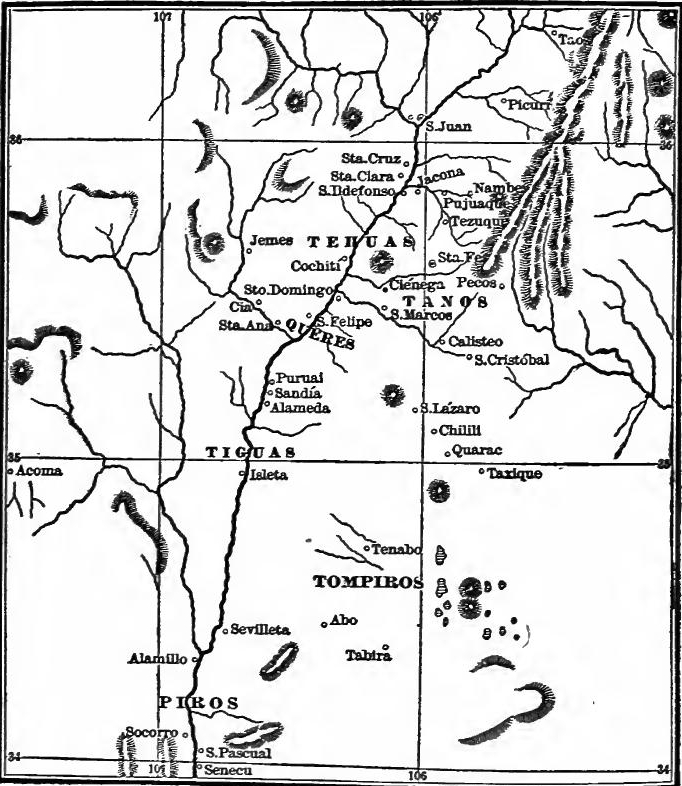 New Mexico in the 17th Century (From Bancroft, Arizona and New Mexico, p. 176).
New Mexico in 1680.—Meanwhile the Spanish population of the province had slowly increased till in 1680 there were over 2500 settlers in the upper Rio Grande valley, mainly between[Pg 245] Isleta and Taos. The upper settlements were known as those of Río Arriba and the lower as those of Río Abajo. The settlers were engaged principally in farming and cattle ranching.
New Mexico in 1680.—Meanwhile, the Spanish population in the province steadily grew until, by 1680, there were over 2,500 settlers in the upper Rio Grande valley, mainly between [Pg 245] Isleta and Taos. The upper settlements were referred to as Río Arriba, while the lower ones were called Río Abajo. The settlers were primarily involved in farming and cattle ranching.
The beginnings of El Paso.—As a result of the northward advance from Nueva Vizcaya and of a counter movement from New Mexico, the intermediate district of El Paso was now colonized. After several unsuccessful attempts, in 1659 missionaries from New Mexico founded the mission of Guadalupe at the ford (El Paso). Before 1680 Mission San Francisco had been founded twelve leagues below, settlers had drifted in, and the place had an alcalde mayor. To these small beginnings there was now suddenly added the entire population of New Mexico.
The beginnings of El Paso.—Due to the northward expansion from Nueva Vizcaya and a counter movement from New Mexico, the area of El Paso was eventually settled. After several failed attempts, in 1659, missionaries from New Mexico established the mission of Guadalupe at the crossing (El Paso). By 1680, Mission San Francisco had been set up twelve leagues downstream, settlers had come in, and the area had an alcalde mayor. Suddenly, the entire population of New Mexico was added to these modest beginnings.
The Pueblo revolt.—The Pueblo Indians, led by their native priests, had long been restless under the burden of tribute and personal service, and the suppression of their native religion. On August 9, 1680, under the leadership of Popé, a medicine man of San Juan, they revolted in unison, slew four hundred Spaniards, including twenty-one missionaries, and drove the remaining 2200 Spaniards from the Pueblo district. Under Governor Otermin and Lieutenant Garcia the settlers retreated to El Paso. In 1681 Otermin made an attempt to reconquer the Pueblos, but it proved futile and the El Paso settlement was made permanent and attached to New Mexico. To hold the outpost a presidio was established there in 1683.
The Pueblo revolt.—The Pueblo Indians, led by their native priests, had been unhappy for a long time with the demands for tribute and personal service, along with the suppression of their native religion. On August 9, 1680, under the leadership of Popé, a medicine man from San Juan, they revolted together, killing four hundred Spaniards, including twenty-one missionaries, and drove the remaining 2200 Spaniards out of the Pueblo area. Under Governor Otermin and Lieutenant Garcia, the settlers retreated to El Paso. In 1681, Otermin tried to take back control of the Pueblos, but it failed, and the settlement in El Paso became permanent and was incorporated into New Mexico. To secure the outpost, a presidio was established there in 1683.
The La Junta missions and the Mendoza expedition to the Jumanos.—From El Paso missions were extended in 1683 to the La Junta district, as the junction of the Conchos and Rio Grande was called. Within a year seven churches had been built for nine tribes, living on both sides of the Rio Grande. At the same time Juan Dominguez de Mendoza and Fray Nicolás López led an expedition from El Paso to the Jumanos of central Texas, where they were to meet Tejas Indians from the east. On their return Mendoza and López went to Mexico to appeal for a new outpost of settlement among the Jumanos. This would probably have been established had not attention been called to eastern Texas through the activities of the French.
The La Junta missions and the Mendoza expedition to the Jumanos.—From El Paso, missions were expanded in 1683 to the La Junta area, which is where the Conchos and Rio Grande rivers meet. Within a year, seven churches had been built for nine tribes living on both sides of the Rio Grande. At the same time, Juan Dominguez de Mendoza and Fray Nicolás López led an expedition from El Paso to the Jumanos in central Texas, where they were set to meet Tejas Indians from the east. On their way back, Mendoza and López went to Mexico to request a new settlement among the Jumanos. This would likely have been established if it weren't for the increased focus on eastern Texas due to the activities of the French.
Indian uprisings.—The Pueblo revolt was followed by a general wave of Indian resistance, and the late years of the century were marked by raids all along the northern frontier,[Pg 246] from Nuevo León to Sonora, in the course of which mines, missions, haciendas, and towns were destroyed, and travelers and merchant caravans raided. To defend the frontier, in 1685 three new presidios were established at Pasage, El Gallo, and Conchos, and two years later one was erected at Monclova. By 1690 two others were added at Casas Grandes and Janos in Chihuahua and shortly afterward (1695) another at Fronteras in Sonora. In 1690 a revolt in the Tarahumara country destroyed settlements in all directions, and was put down only by the efforts of soldiers from all the presidios from El Gallo to Janos.
Indian uprisings.—The Pueblo revolt led to a widespread wave of Indian resistance, and the later years of the century saw raids all along the northern frontier,[Pg 246] from Nuevo León to Sonora, during which mines, missions, haciendas, and towns were destroyed, and travelers and merchant caravans were attacked. To protect the frontier, in 1685, three new military forts were established at Pasage, El Gallo, and Conchos, and two years later, one was built at Monclova. By 1690, two more were added at Casas Grandes and Janos in Chihuahua, and shortly after (1695), another was set up at Fronteras in Sonora. In 1690, a revolt in the Tarahumara region destroyed settlements in all directions and was only suppressed through the combined efforts of soldiers from all the forts from El Gallo to Janos.
Vargas and the reconquest of the Pueblos.—After expelling the Spaniards, the Pueblos, under the lead of Popé, returned to their tribal ways, and destroyed most of the signs of the hated Spanish rule. During the next decade and a half several efforts were made to reconquer the Pueblo region. Otermin was succeeded by Crúzate and he by Reneros, who was in turn followed by Crúzate. In 1688 Crúzate led an expedition against the Queres. At Cía six hundred apostates were killed in battle and seventy captured and shot, or sold into slavery. In 1691 Diego de Vargas Zapata Luján Ponce de León was made governor especially to reconquer the Pueblos. In 1692 he led an expedition against them. As far as Sandía the towns had already been destroyed. Santa Fé he found fortified and occupied by Tanos, but they yielded without a blow, as did all of the pueblos from Pecos to Moqui. Meanwhile the friars with him baptized over two thousand native children.
Vargas and the reconquest of the Pueblos.—After driving out the Spaniards, the Pueblos, led by Popé, returned to their tribal traditions and destroyed most of the symbols of the despised Spanish rule. Over the next fifteen years, there were several attempts to reconquer the Pueblo area. Otermin was replaced by Crúzate, who was then succeeded by Reneros, followed again by Crúzate. In 1688, Crúzate led an expedition against the Queres. At Cía, six hundred people who had turned away from their culture were killed in battle, and seventy were captured and either executed or sold into slavery. In 1691, Diego de Vargas Zapata Luján Ponce de León was appointed governor specifically to reconquer the Pueblos. In 1692, he led an expedition against them. By the time he reached Sandía, the towns had already been destroyed. He found Santa Fé fortified and occupied by Tanos, but they surrendered without resistance, as did all the pueblos from Pecos to Moqui. Meanwhile, the friars accompanying him baptized over two thousand native children.
A new colony.—Submission having been secured, in 1693 Vargas led a colony of eight hundred soldiers and settlers to reoccupy the pueblo region. But submission had been a hollow formality. The Tanos who held Santa Fé were evicted only after a battle, at the conclusion of which seventy warriors were shot and four hundred women and children enslaved. At the mesa of San Ildefonso. Vargas met the combined resistance of nine towns. A second siege in March, 1694, resulted in a repulse. In the course of the summer the pueblos of Cieneguilla and Jémez were defeated, and abandoned Taos was sacked and burned. A third attack on the mesa of San Ildefonso was successful. Resistance now appeared to be over, the pueblos were rebuilt,[Pg 247] captives returned, missions reëstablished, and the Spanish régime restored. A number of the pueblos were consolidated and rebuilt on new sites. In 1690 the new Spanish villa of Santa Cruz de la Cañada was founded with seventy families on the lands of San Cristóbal and San Lázaro.
A new colony.—After securing submission, in 1693, Vargas led a group of eight hundred soldiers and settlers to take back the pueblo region. However, that submission was just a shallow formality. The Tanos who controlled Santa Fé were removed only after a battle, during which seventy warriors were killed and four hundred women and children were enslaved. At the mesa of San Ildefonso, Vargas faced the united resistance of nine towns. A second siege in March 1694 ended in a setback. Over the summer, the pueblos of Cieneguilla and Jémez were defeated, and the abandoned town of Taos was sacked and burned. A third attack on the mesa of San Ildefonso succeeded. Resistance seemed to be over; the pueblos were rebuilt,[Pg 247] captives were returned, missions were reestablished, and the Spanish regime was reinstated. Several pueblos were combined and rebuilt in new locations. In 1690, the new Spanish village of Santa Cruz de la Cañada was founded with seventy families on the lands of San Cristóbal and San Lázaro.
The conquest completed.—In 1696 a new revolt occurred, in which five missionaries and twenty-one other Spaniards were killed, and Vargas conducted another series of bloody campaigns, with partial success. In the following year he was succeeded by Governor Cubero, who secured the formal submission of the rest of the pueblos. The reconquest was now complete and the Spanish rule secured.
The conquest was completed. In 1696, a new uprising took place, resulting in the deaths of five missionaries and twenty-one other Spaniards. Vargas led another round of violent campaigns, achieving some success. The next year, he was replaced by Governor Cubero, who ensured the official submission of the remaining pueblos. The reconquest was now finished, and Spanish rule was established.
COAHUILA OCCUPIED
The Nuevo León frontier.—While there had been definite progress eastward from New Mexico during the first three-fourths of the seventeenth century, and considerable contact between that province and what is now the western half of Texas, from Nuevo León, on the natural line of advance from Mexico to Texas, progress was slow. For nearly a century the northeastern outpost on the lower Rio Grande frontier was León (Cerralvo), founded in the later sixteenth century. Temporarily a more northern outpost had been established in 1590 at Nuevo Almadén (now Monclova), but it was soon abandoned. Again in 1603 and 1644 the place was temporarily reoccupied, but without permanent success.
The Nuevo León frontier.—While there was significant progress eastward from New Mexico during the first three-quarters of the seventeenth century, and notable interaction between that region and what is now the western part of Texas, progress from Nuevo León, which was the natural route from Mexico to Texas, was slow. For almost a century, the northeastern outpost on the lower Rio Grande frontier was León (Cerralvo), which was established in the late sixteenth century. A more northern outpost was temporarily set up in 1590 at Nuevo Almadén (now Monclova), but it was quickly abandoned. The site was reoccupied again in 1603 and 1644, but these attempts did not lead to permanent settlement.
Zavala's rule, 1626-1664.—Hostile Indians troubled the border, and the intrusions of English, French, and Dutch colonies into the Lesser Antilles awakened fears for the safety of the western Gulf shores. In 1625 Nuevo León, therefore, was again entrusted to a conquistador, when a contract similar to that of Carabajal in 1579 was made with Martín de Zavala. At the same time the Florida missions 'were extended west to the Apalache district. For thirty-eight years Zavala controlled and governed the frontier with exemplary zeal, subduing Indians, granting encomiendas, operating mines, founding new towns, and opening highways to Pánuco and the interior. His most able lieutenant after 1636 was Alonso de León, one of the founders and first citizens of Cadereyta.
Zavala's rule, 1626-1664.—Hostile Native Americans posed a threat along the border, while the encroachments of English, French, and Dutch colonies into the Lesser Antilles raised concerns about the safety of the western Gulf shores. In 1625, Nuevo León was once again placed in the hands of a conquistador, with a contract similar to that made with Carabajal in 1579, signed with Martín de Zavala. At the same time, the Florida missions were expanded westward to the Apalache district. For thirty-eight years, Zavala effectively controlled and managed the frontier with remarkable dedication, subduing Native Americans, granting encomiendas, operating mines, establishing new towns, and creating roads to Pánuco and the interior. His most capable assistant after 1636 was Alonso de León, one of the founders and first citizens of Cadereyta.
[Pg 248] Looking northward.—By the middle of the seventeenth century, explorations beyond the Nuevo León frontier had been made on a small scale in all directions. That they were not more extensive was due to Indian troubles and the feebleness of the frontier settlements. To the north the Spaniards were led short distances by a desire to establish communication with Florida, by rumors of a silver deposit called Cerro de la Plata (perhaps the later San Sabá mines), and in pursuit of Indians. No doubt the Franciscan missionaries made many unrecorded visits to the outlying tribes. In 1665 Fernando de Azcué led soldiers from Saltillo and Monterey across the Rio Grande against the Cacaxtle Indians. This is the first expedition to cross the lower Rio Grande from the south of which we have any definite record.
[Pg 248] Looking northward.—By the mid-seventeenth century, there had been small-scale explorations beyond the Nuevo León frontier in all directions. The limited extent of these explorations was mainly due to conflicts with Native Americans and the vulnerability of frontier settlements. To the north, the Spaniards were motivated by the desire to connect with Florida, by rumors of a silver source known as Cerro de la Plata (likely the later San Sabá mines), and in pursuit of Indigenous groups. It's likely that Franciscan missionaries made many undocumented visits to the nearby tribes. In 1665, Fernando de Azcué led soldiers from Saltillo and Monterey across the Rio Grande to confront the Cacaxtle Indians. This is the first recorded expedition to cross the lower Rio Grande from the south.
The founding of Coahuila.—Another forward step was now taken with the founding of the new province of Coahuila, a step made necessary by Indian depredations. In 1670 Father Juan Larios, a Franciscan from Guadalajara, began missionary work on the troubled frontier. In 1673-1674, aided by other missionaries and by soldiers from Saltillo, he established two missions between the Sabinas River and the Rio Grande.[1] In the course of this work Fray Manuel de la Cruz visited tribes north of the Rio Grande. In 1674 Coahuila was made an alcaldía mayor of Nueva Vizcaya, with Antonio de Valcárcel as first alcalde mayor. A colony was now established at thrice abandoned Almadén and later became Monclova.
The founding of Coahuila.—Another forward step was now taken with the founding of the new province of Coahuila, a step made necessary by Indian depredations. In 1670 Father Juan Larios, a Franciscan from Guadalajara, began missionary work on the troubled frontier. In 1673-1674, aided by other missionaries and by soldiers from Saltillo, he established two missions between the Sabinas River and the Rio Grande.[1] In the course of this work Fray Manuel de la Cruz visited tribes north of the Rio Grande. In 1674 Coahuila was made an alcaldía mayor of Nueva Vizcaya, with Antonio de Valcárcel as first alcalde mayor. A colony was now established at thrice abandoned Almadén and later became Monclova.
The Bosque-Lários expedition across the Rio Grande.—In 1675 Valcárcel sent Fernando del Bosque and Father Larios on a tour among the tribes north of the Rio Grande. In the following year (the very year when Bishop Calderón was in Florida) the bishop of Guadalajara visited Coahuila, and urged its further reduction, with a view to passing beyond, to the settled Tejas Indians, across the Trinity River. In 1687 a presidio was established at Monclova, and Coahuila was made a province, with Alonso de León, the younger, as first governor.
The Bosque-Lários expedition across the Rio Grande.—In 1675, Valcárcel sent Fernando del Bosque and Father Larios on a journey among the tribes north of the Rio Grande. The following year (the same year that Bishop Calderón was in Florida), the bishop of Guadalajara visited Coahuila and encouraged its further development, aiming to reach the settled Tejas Indians across the Trinity River. In 1687, a fort was established at Monclova, and Coahuila was made a province, with Alonso de León the younger serving as the first governor.
The college of the Holy Cross.—The development of Coahuila and Nuevo León was given an impetus by the coming of a new[Pg 249] group of Franciscan friars from the recently founded missionary college of Santa Cruz at Querétaro. Among these friars were Fathers Hidalgo, Massanet, and Olivares, all of whom figured prominently in the later development of the frontier. Beside the Querétaro friars, to the westward worked the friars of the Province of Santiago de Xalisco with its seat at Guadalajara.
The College of the Holy Cross.—The growth of Coahuila and Nuevo León was boosted by the arrival of a new[Pg 249] group of Franciscan friars from the recently established missionary college of Santa Cruz in Querétaro. Among these friars were Fathers Hidalgo, Massanet, and Olivares, who all played significant roles in the later development of the frontier. Alongside the Querétaro friars, to the west, the friars of the Province of Santiago de Xalisco, based in Guadalajara, were also active.
FIRST ATTEMPTS IN EASTERN TEXAS
Plans to occupy the mouth of the Mississippi.—The aggressive policy of the French, English, and Dutch in the West Indies, the raids of freebooters on the Spanish settlements, the occupation of Carolina by England, and the advance of the French into the Mississippi Valley caused Spain great uneasiness for the northern Gulf Coast. As a defensive measure missions had been extended to the Apalache district at the same time that Nuevo León had been strengthened. In 1673 Joliet and Marquette descended the Mississippi to the Arkansas, and in 1682 La Salle explored it to its mouth. Four years earlier news had reached the Spanish court that Peñalosa, a discredited ex-governor of New Mexico, had proposed to attack New Spain in the name of France. Spanish officials therefore at once planned to occupy the Bay of Espíritu Santo (Mobile Bay, or perhaps the mouth of the Mississippi) and in 1695 Echagaray, an officer at St. Augustine, was ordered to explore it for the purpose.
Plans to take control of the mouth of the Mississippi. The aggressive actions of the French, English, and Dutch in the West Indies, the raids by pirates on Spanish settlements, England's occupation of Carolina, and the French moving into the Mississippi Valley made Spain very anxious about the northern Gulf Coast. As a defensive strategy, missions were expanded into the Apalache area while Nuevo León was fortified. In 1673, Joliet and Marquette traveled down the Mississippi to Arkansas, and in 1682, La Salle explored it all the way to the mouth. Four years earlier, the Spanish court had learned that Peñalosa, a disgraced former governor of New Mexico, had suggested attacking New Spain in the name of France. Consequently, Spanish officials immediately began making plans to take control of the Bay of Espíritu Santo (Mobile Bay, or possibly the mouth of the Mississippi), and in 1695, Echagaray, an officer in St. Augustine, was ordered to explore it for that purpose.
The search for La Salle's colony.—A few months later the authorities learned with alarm that in November, 1684, La Salle had left France with a colony to occupy the same spot. Immediately several expeditions were sent out by land and sea to learn where La Salle had landed and, if necessary, to occupy the danger point. In 1686 Marcos Delgado explored west by land from Apalache to the neighborhood of Mobile Bay. In 1686-1688 five coastwise expeditions (under Barroto, Rivas, Iriarte, Pez, and Gámara) explored the Gulf between Vera Cruz and Apalache. They discovered the wrecks of La Salle's vessels at Matagorda Bay, and it was concluded that the French expedition had been destroyed.
The search for La Salle's colony.—A few months later, the authorities were alarmed to learn that in November 1684, La Salle had left France with a colony to occupy the same area. Immediately, several expeditions were sent out by land and sea to find out where La Salle had landed and, if necessary, to secure the critical location. In 1686, Marcos Delgado traveled west by land from Apalache to the Mobile Bay area. From 1686 to 1688, five coastal expeditions (led by Barroto, Rivas, Iriarte, Pez, and Gámara) explored the Gulf between Veracruz and Apalache. They discovered the wrecks of La Salle's ships at Matagorda Bay, leading to the conclusion that the French expedition had been lost.
 The Origins of Coahuila and Texas.
Eastern Texas occupied.—While these coastwise voyages were being made, Alonso de León was leading expeditions from Monterey and Monclova by land. In 1686 he descended the[Pg 251] Rio Grande to the coast. In 1687 and again in 1688 he crossed the Rio Grande, and in the latter expedition captured a stray Frenchman. Shortly afterward a party of soldiers and Indians from far distant Nueva Vizcaya crossed the Upper Rio Grande to seek out the French intruders. In 1689 De León succeeded in finding the remains of La Salle's settlement near Matagorda Bay, a few weeks after it had been destroyed by Indians. In the following year De León and Father Massanet, one of the Coahuila missionaries, led an expedition across Texas and founded two missions among the Asinai (Tejas) Indians, on Neches River. Texas was now erected into a province and Domingo de Terán made governor.
Eastern Texas occupied.—While these coastal voyages were happening, Alonso de León was leading land expeditions from Monterey and Monclova. In 1686, he traveled down the[Pg 251] Rio Grande to the coast. In 1687 and again in 1688, he crossed the Rio Grande, and in the latter expedition, he captured a lone Frenchman. Soon after, a group of soldiers and Indians from far-off Nueva Vizcaya crossed the Upper Rio Grande to track down the French trespassers. In 1689, De León managed to locate the remains of La Salle's settlement near Matagorda Bay, just a few weeks after it had been destroyed by Indians. The following year, De León and Father Massanet, one of the Coahuila missionaries, led an expedition across Texas and established two missions among the Asinai (Tejas) Indians along the Neches River. Texas was now established as a province, and Domingo de Terán was appointed governor.
And then abandoned.—In 1691 Terán led an expedition designed to strengthen the outpost on the Neches, explore and occupy the Cadodacho country (near Texarkana) and, if time permitted, to reëxplore the coast as far as Florida. He reached the Red River but accomplished little else that was new. The Asinai Indians proved hostile, and in 1693 the missionaries withdrew. The Texas project was now abandoned for a time, and attention centered instead on western Florida, which was in danger not only from the French, but also from the English in Carolina, who were visiting the Georgia and Alabama Indians.
And then abandoned.—In 1691, Terán led an expedition aimed at strengthening the outpost on the Neches, exploring and occupying the Cadodacho territory (near Texarkana), and, if time allowed, re-exploring the coast as far as Florida. He reached the Red River but achieved little else that was new. The Asinai Indians were hostile, and in 1693, the missionaries pulled out. The Texas project was now put on hold for a while, and focus shifted instead to western Florida, which was threatened not only by the French but also by the English in Carolina, who were interacting with the Georgia and Alabama Indians.
THE STRUGGLE WITH RIVALS IN THE WEST INDIES
Intruding colonies in the West Indies.—In the early years of the conquest Spain had occupied the larger West Indian islands—Cuba, Española, Porto Rico, and Jamaica—but had neglected the lesser islands. They thus became a field for colonization by Spain's enemies. In the seventeenth century the subjects of Holland, France, and England began to establish settlements in the West Indies, in the heart of the Spanish sea, while England intruded in the northern mainland.
Intruding colonies in the West Indies.—In the early years of the conquest, Spain had taken control of the larger West Indian islands—Cuba, Española, Puerto Rico, and Jamaica—but had overlooked the smaller islands. This oversight allowed Spain's rivals to start colonizing those territories. In the seventeenth century, settlers from Holland, France, and England began to establish communities in the West Indies, right in the middle of the Spanish sea, while England also started encroaching on the northern mainland.
Between 1555 and 1562 the French had made unsuccessful attempts to colonize Brazil, Carolina, and Florida. Between 1585 and 1595 Raleigh had attempted to settle on Roanoke Island and in Guiana. In 1607 Jamestown was founded within Spanish dominions at Chesapeake Bay, and Spain's possessions thus delimited on the north. Between 1609 and 1612 English settlers occupied the Bermudas. Between 1609 and 1619 English, Dutch,[Pg 252] and French all established posts in Guiana. In 1621 the Dutch West India Company was incorporated for trade and settlement. Between 1623 and 1625 both English and French settled on St. Kitts (St. Christopher). During the same period Barbados was settled by the English, and Santa Cruz by English and Dutch. By 1632 English settlements had been made at Nevis, Barbuda, Antigua, Providence Island, and Montserrat. By 1634 the Dutch had established trading stations on St. Eustatius, Tobago, and Curaçao, while in 1635 the French West India Company began the settlement of Guadeloupe, Martinique, and other Windward Islands.
Between 1555 and 1562, the French made unsuccessful attempts to colonize Brazil, Carolina, and Florida. Between 1585 and 1595, Raleigh tried to settle on Roanoke Island and in Guiana. In 1607, Jamestown was founded within Spanish territory at Chesapeake Bay, marking the northern boundary of Spain's possessions. Between 1609 and 1612, English settlers occupied the Bermudas. From 1609 to 1619, the English, Dutch, and French all set up posts in Guiana. In 1621, the Dutch West India Company was established for trade and settlement. Between 1623 and 1625, both the English and French settled on St. Kitts (St. Christopher). During this time, Barbados was settled by the English, and Santa Cruz was occupied by both English and Dutch settlers. By 1632, English settlements had been established at Nevis, Barbuda, Antigua, Providence Island, and Montserrat. By 1634, the Dutch had set up trading stations on St. Eustatius, Tobago, and Curaçao, while in 1635, the French West India Company began the settlement of Guadeloupe, Martinique, and other Windward Islands.
Privateers.—Meanwhile French, Dutch, and English privateers swarmed the Spanish waters. Early in the century Dutch ships harassed the coasts of Chile and Peru. In 1628 Peter Heyn with thirty-one vessels pursued the Vera Cruz fleet into Matanzas River, Cuba, and captured most of a cargo worth $15,000,000. "It was an exploit which two generations of English mariners had attempted in vain." After 1633 the Dutch West India Company carried on active war against Spanish and Portuguese colonies. Within two years it sent eighty ships and nine thousand men to American waters, and its agents captured Bahía (Brazil), Pernambuco, and San Juan (Porto Rico).
Privateers.—Meanwhile, French, Dutch, and English privateers flooded the Spanish waters. Early in the century, Dutch ships targeted the coasts of Chile and Peru. In 1628, Peter Heyn and thirty-one vessels chased the Vera Cruz fleet into the Matanzas River, Cuba, and seized most of a cargo valued at $15,000,000. "It was an achievement that two generations of English sailors had tried and failed to accomplish." After 1633, the Dutch West India Company waged an active war against Spanish and Portuguese colonies. Within two years, it sent eighty ships and nine thousand men to American waters, and its agents captured Bahía (Brazil), Pernambuco, and San Juan (Puerto Rico).
English privateers in the early seventeenth century did their part. In 1642 Captain William Jackson, with a commission from the Earl of Warwick, made a raid that reminds one of Drake. With eleven hundred men he cruised the coast from Caracas to Honduras, plundering Maracaibo and Trujillo on the way. Landing at Jamaica he captured Santiago and held it for ransom.
English privateers in the early 1600s played their role. In 1642, Captain William Jackson, armed with a commission from the Earl of Warwick, launched a raid reminiscent of Drake's exploits. With 1,100 men, he sailed along the coast from Caracas to Honduras, looting Maracaibo and Trujillo along the way. After landing in Jamaica, he took Santiago and held it for ransom.
Spanish retaliation.—The Spaniards often repaid these aggressions with good interest, and frequent raids were made on the foreign colonies. In 1629 Toledo nearly destroyed the English and French settlements on St. Kitts. Tortuga was several times assaulted. In 1635 a Spanish fleet made a five days' attack on the English colony on Providence Island but was beaten back. In 1641 Pimienta with two thousand men destroyed the forts there and captured seven hundred and seventy colonists. Ten years later a force of eight hundred men from Porto Rico destroyed the English colony on Santa Cruz Island, killing the governor and over one hundred settlers.
Spanish retaliation.—The Spaniards often responded to these attacks with significant force, and there were frequent raids on foreign colonies. In 1629, Toledo nearly wiped out the English and French settlements on St. Kitts. Tortuga was attacked several times. In 1635, a Spanish fleet launched a five-day assault on the English colony on Providence Island but was pushed back. In 1641, Pimienta, leading two thousand men, destroyed the forts there and captured seven hundred seventy colonists. Ten years later, a force of eight hundred men from Puerto Rico destroyed the English colony on Santa Cruz Island, killing the governor and over one hundred settlers.
[Pg 253] The English conquest of Jamaica.—Thus far the English settlements had been made chiefly on unoccupied islands. But in 1654 Cromwell sent an expedition under Venables and Penn to gain Spanish territory by conquest. They failed to take Santo Domingo but succeeded at Jamaica (1655). Twice Spain attempted to recover the island but failed (1657-1658), and in 1670 she acknowledged England's right to all her island possessions.
[Pg 253] The English conquest of Jamaica.—Up to this point, the English had mostly settled on unoccupied islands. However, in 1654, Cromwell launched an expedition led by Venables and Penn to acquire Spanish territory through conquest. They were unsuccessful in capturing Santo Domingo but succeeded in Jamaica (1655). Spain made two attempts to reclaim the island but failed (1657-1658), and in 1670, they recognized England's ownership of all her island territories.
The Danes and Brandenburgers.—Under their absolute monarch, Frederick III, the Danes organized a West India Company, which in 1671 secured the abandoned island of St. Thomas, using it as a planting colony and a distributing center for Guinea slaves. Porto Rico and the Spanish mainland were the principal Danish markets. Even the Brandenburgers, during the latter days of the Great Elector (1685) secured a thirty-year lease of a part of the Danish island of St. Thomas, with a view to using it as a slave-trading station for supplying the Spanish colonies. But the jealousy of other European powers, especially England, prevented their securing a permanent foothold.
The Danes and Brandenburgers.—Under their absolute monarch, Frederick III, the Danes set up a West India Company, which in 1671 took control of the abandoned island of St. Thomas, turning it into a plantation colony and a hub for distributing slaves from Guinea. Puerto Rico and the Spanish mainland were the main markets for the Danes. Even the Brandenburgers, in the later years of the Great Elector (1685), managed to get a thirty-year lease on part of the Danish island of St. Thomas, intending to use it as a slave-trading post for the Spanish colonies. However, the rivalry from other European powers, especially England, stopped them from establishing a permanent presence.
THE STRUGGLE WITH THE ENGLISH ON THE CAROLINA BORDER
The Georgia missions restored.—After the massacre of 1597, the Florida missions seem to have been practically abandoned for a time. But new missionaries, requested by the governor in 1601, reoccupied the abandoned sites, pushed farther up the coast, and entered the interior. The settlement of Virginia by the English was followed by remonstrance and a new wave of missionary activity. In 1612 Fray Luis de Oré came with twenty-three friars and Florida was erected into the province of Santa Elena, with the mother house at Havana. In less than two years the new missionaries had established twenty mission residences among the tribes, especially on the Guale (Georgia) coast. In 1612 was published the first of Father Pareja's numerous books in the Timuquanan language. By 1634 some thirty Franciscans were ministering to 30,000 converts in forty-four missions and mission stations. The success was parallel to that of the Franciscans in New Mexico at the same time.
The Georgia missions were revived. After the massacre in 1597, the Florida missions were virtually abandoned for a while. However, new missionaries, requested by the governor in 1601, returned to the deserted sites, moved further up the coast, and ventured into the interior. The English settlement of Virginia sparked protests and a new surge of missionary efforts. In 1612, Fray Luis de Oré arrived with twenty-three friars, and Florida became the province of Santa Elena, with its main base in Havana. In less than two years, the new missionaries had set up twenty mission residences among the tribes, particularly along the Guale (Georgia) coast. In 1612, the first of Father Pareja's many books in the Timuquanan language was published. By 1634, around thirty Franciscans were serving 30,000 converts in forty-four missions and mission stations. Their success was similar to that of the Franciscans in New Mexico during the same period.
The Apalachee and the Creek missions.—The simultaneous intrusion of the English, French, and Dutch into the Caribbean[Pg 254] waters was a new threat at Spain's Gulf possessions, and it was followed by the advance of her outposts into western Florida. Throughout the sixteenth century the warlike Apalachees had resisted Spanish authority, but in 1633 successful missionary work was begun among them by the guardian of the monastery of St. Augustine and one companion. Within two years they had baptized five thousand natives. In 1638 the Apalachees revolted, but they were defeated, and the presidio of San Luis was established among them. This district now became one of the most important missionary centers of Florida, missions being extended to the Creeks of western Georgia.
The Apalachee and the Creek missions.—The simultaneous arrival of the English, French, and Dutch in the Caribbean[Pg 254] posed a new threat to Spain's holdings in the Gulf, which was soon followed by the expansion of her outposts into western Florida. Throughout the sixteenth century, the aggressive Apalachees had resisted Spanish control, but in 1633, successful missionary efforts began among them led by the head of the monastery of St. Augustine and one companion. Within two years, they had baptized five thousand natives. In 1638, the Apalachees revolted, but they were defeated, leading to the establishment of the presidio of San Luis among them. This area then became one of the most important missionary centers in Florida, with missions expanding to the Creeks in western Georgia.
The missions in 1647.—By 1647 St. Augustine was headquarters for fifty Franciscans, who worked among the neighboring tribes. Northward a line of ten missions extended up the Georgia coast to Chatuache near the Savannah River. Toward the western interior, within a radius of one hundred and fifty miles there were ten more, and toward the south four. In the Apalachee district there were eight in eight large towns, with three more on the way to St. Augustine. At these thirty-five missions 26,000 converted Indians were served.
The missions in 1647.—By 1647, St. Augustine was the headquarters for fifty Franciscans who worked among the local tribes. Northward, a line of ten missions stretched along the Georgia coast to Chatuache near the Savannah River. Toward the western interior, within a radius of one hundred and fifty miles, there were ten more, and to the south, four. In the Apalachee district, there were eight missions in eight large towns, with three more on the way to St. Augustine. These thirty-five missions served 26,000 converted Indigenous people.
The Apalachee revolt.—Just now, however, the prosperous Apalachee missions suffered a severe blow. The chiefs, refusing to render personal sendee and tribute, headed a rebellion in which several Spaniards were slain. The governor led a campaign against them, several battles were fought, and a number of chiefs hanged. The Indians were subdued, but they were so embittered that the Franciscans abandoned the missions.
The Apalachee revolt.—At this moment, the thriving Apalachee missions experienced a serious setback. The chiefs, refusing to provide personal service and tribute, led a revolt that resulted in the deaths of several Spaniards. The governor organized a military campaign against them; several battles took place, and a number of chiefs were hanged. The Indians were defeated, but they were so angry that the Franciscans left the missions.
The English in the Carolinas.—In 1653 English settlers from Virginia began to establish themselves in North Carolina, and in 1670 the English settlement of South Carolina was begun near Charleston. This intrusion into the old Spanish province of Santa Elena was viewed with alarm by Spain, and, as always in the border Spanish colonies, the foreign danger was followed by renewed missionary activity on the threatened frontiers. Missionary work received an impetus in 1674 by the visitation of Bishop Calderón, of Cuba, who spent eight months in a tour of Florida. In that year and the next, five new missions were founded, and in 1676 Father Moral took to Florida twenty-four additional missionaries. Six or more missions were now in operation[Pg 255] on the northern Georgia coast between Jekyl Island and the Savannah River, besides those farther south.
The English in the Carolinas.—In 1653, English settlers from Virginia started to establish themselves in North Carolina, and in 1670, the English settlement of South Carolina began near Charleston. This encroachment into the old Spanish province of Santa Elena alarmed Spain, and as always in the border Spanish colonies, the foreign threat was followed by renewed missionary efforts on the endangered frontiers. Missionary work received a boost in 1674 when Bishop Calderón from Cuba visited, spending eight months touring Florida. In that year and the following year, five new missions were established, and in 1676 Father Moral brought twenty-four more missionaries to Florida. Six or more missions were now operating[Pg 255] on the northern Georgia coast between Jekyl Island and the Savannah River, in addition to those further south.
English incursions and the Yamassee revolt.—Hostilities with the English on the border began at once. In 1680 a force of three hundred Indians and Englishmen invaded Santa Catalina Island and expelled the garrison and mission Indians. Governor Marquez Cabrera sent soldiers to build a fort, and asked the king for Canary Island families to hold the country. The families were ordered sent (1681), but plans were changed and the Indians of the northernmost missions were moved southward. The Yamassees refused to move, joined the English, and aided them in a raid on Mission Santa Catalina (1685). In the following year Spaniards sent by Governor Marquez retaliated by sacking Carolina plantations and carrying off negro slaves. Another expedition of the same year landed at Edisto Island, burned the country residence of Governor Morton, and destroyed Stuart Town (Port Royal).
English incursions and the Yamassee revolt.—Conflicts with the English on the border started immediately. In 1680, a group of three hundred Indians and Englishmen invaded Santa Catalina Island, forcing out the garrison and mission Indians. Governor Marquez Cabrera dispatched soldiers to construct a fort and requested the king to send families from the Canary Islands to settle the area. The families were ordered to be sent (1681), but plans changed and the Indians from the northernmost missions were relocated southward. The Yamassees refused to move, allied with the English, and assisted them in a raid on Mission Santa Catalina in 1685. The following year, Spaniards sent by Governor Marquez retaliated by attacking Carolina plantations and capturing enslaved Africans. Another expedition that same year landed on Edisto Island, burned Governor Morton's country home, and destroyed Stuart Town (Port Royal).
The English among the Creeks.—The English now threatened the Spaniards on another frontier. Fur traders from South Carolina had pushed south and west across Georgia and were becoming active among the Creeks of western Georgia and eastern Alabama. In 1685 Governor Marquez sent Lieutenant Matheos, commander at Apalachee, with twenty soldiers and four hundred allies to capture traders operating at Kawita, Kasihta, and Kulumi, Creek towns on the Chatahootchee and Talapoosa Rivers. The expedition failed but it was repeated, and Marquez called on the home government for help.
The English among the Creeks.—The English were now a threat to the Spaniards on a different front. Fur traders from South Carolina had moved south and west across Georgia and were becoming active among the Creeks in western Georgia and eastern Alabama. In 1685, Governor Marquez sent Lieutenant Matheos, the commander at Apalachee, with twenty soldiers and four hundred allies to capture traders operating in the Creek towns of Kawita, Kasihta, and Kulumi, located on the Chattahoochee and Talapoosa Rivers. The mission failed, but it was attempted again, and Marquez reached out to the home government for assistance.
Plans to occupy Pensacola.—It was just at this time that La Salle formed his establishment in Texas. The combined danger from the English and the French now made it necessary to protect the northern Gulf coast. La Salle's intrusion was followed by the temporary Spanish occupation of eastern Texas in 1690, already described. At the same time (1689) the viceroy sent Andrés de Pez to Spain to urge the occupation of Pensacola Bay (Santa Maria de Galve). The council approved the plan and authorized the withdrawal from Texas. In 1693 Pez explored Pensacola and Mobile bays with a view to settlement. Thus, in a sense, the defence of eastern Texas was given up for the founding of Pensacola. A new French intrusion was necessary,[Pg 256] however, to bring about the permanent occupation of either Texas or Pensacola.
Plans to occupy Pensacola.—Around this time, La Salle established his settlement in Texas. The combined threat from the English and the French made it essential to protect the northern Gulf coast. La Salle's actions were followed by the brief Spanish occupation of eastern Texas in 1690, which has already been discussed. At the same time (1689), the viceroy sent Andrés de Pez to Spain to advocate for the occupation of Pensacola Bay (Santa Maria de Galve). The council approved the plan and permitted the withdrawal from Texas. In 1693, Pez explored Pensacola and Mobile bays with the intention of settling there. In this way, the defense of eastern Texas was sacrificed for the establishment of Pensacola. However, a new French incursion was needed[Pg 256] to enable the permanent occupation of either Texas or Pensacola.
READINGS
Bancroft, H.H., Arizona and New Mexico, 146-224; Bolton, H.E., Spanish Exploration in the Southwest, 279-340; "The Spanish Occupation of Texas, 1510-1690," in Southwestern Historical Quarterly, XVI, 1-26; Cavo, Andres, Tres Siglos de Mexico; Chapman, C.E., The Founding of Spanish California, 1-44; Clark, R.C., The Beginnings of Texas; Coroléu, José, America, Historia du Colonización; Davis, W.H.H., Spanish Conquest in New Mexico, 276-407; Dunn, W.E., Spanish and French Rivalry in the Gulf Region, 5-215; Frejes, Fr. F., Conquista de Los Estados; Garrison, G.P., Texas, 10-19; Gonzales, J.E., Colección de Noticias; Historia de Nuevo León; Hackett, C.W., "The Pueblo Revolt of 1680," in Texas State Historical Association, Quarterly, XV, 93-143; Hughes, Anne, Beginnings of Spanish Settlement in the El Paso District; Leon, A., Historia de Nuevo León; Ortega, Fr. Joseph, Apostólicos Afanes; Portillo, Esteban, Apuntes para la Historia de Coahuila y Texas; Prince, L.B., Historical Sketches of New Mexico, 176-220; Twitchell, R.E., Leading Facts of New Mexico History, I, 333-413; Villagrá, Gaspar de, Historia de Nuevo Mexico; Wright, L.A., The Early History of Cuba, ch. 17.
Bancroft, H.H., Arizona and New Mexico, 146-224; Bolton, H.E., Spanish Exploration in the Southwest, 279-340; "The Spanish Occupation of Texas, 1510-1690," in Southwestern Historical Quarterly, XVI, 1-26; Cavo, Andres, Tres Siglos de Mexico; Chapman, C.E., The Founding of Spanish California, 1-44; Clark, R.C., The Beginnings of Texas; Coroléu, José, America, Historia du Colonización; Davis, W.H.H., Spanish Conquest in New Mexico, 276-407; Dunn, W.E., Spanish and French Rivalry in the Gulf Region, 5-215; Frejes, Fr. F., Conquista de Los Estados; Garrison, G.P., Texas, 10-19; Gonzales, J.E., Colección de Noticias; Historia de Nuevo León; Hackett, C.W., "The Pueblo Revolt of 1680," in Texas State Historical Association, Quarterly, XV, 93-143; Hughes, Anne, Beginnings of Spanish Settlement in the El Paso District; Leon, A., Historia de Nuevo León; Ortega, Fr. Joseph, Apostólicos Afanes; Portillo, Esteban, Apuntes para la Historia de Coahuila y Texas; Prince, L.B., Historical Sketches of New Mexico, 176-220; Twitchell, R.E., Leading Facts of New Mexico History, I, 333-413; Villagrá, Gaspar de, Historia de Nuevo Mexico; Wright, L.A., The Early History of Cuba, ch. 17.
CHAPTER XIV
THE WARS OF THE ENGLISH AND SPANISH SUCCESSIONS (1684-1713)
The impending conflict.—Before the close of the Stuart period, it was evident that a great international struggle was at hand. Louis XIV of France aspired to overshadow England, Austria, and Spain. The dependence of the later Stuarts upon Louis temporarily delayed the outbreak of hostilities, but when James II was driven from the English throne the contest broke forth and continued intermittently until France was humbled and England had become the foremost commercial and colonial power.
The impending conflict.—Before the end of the Stuart era, it was clear that a major international struggle was coming. Louis XIV of France wanted to dominate England, Austria, and Spain. The reliance of the later Stuarts on Louis temporarily postponed the start of hostilities, but once James II was removed from the English throne, the conflict erupted and continued sporadically until France was defeated and England emerged as the leading commercial and colonial power.
THE PRELIMINARY STRUGGLE FOR THE NORTHERN FUR COUNTRY
Sphere of French influence.—When Frontenac returned to France in 1682, the French were predominant in Acadia, in the St. Lawrence Valley, in the region of the Great Lakes, and in the Illinois country, and were extending their power into the lower valley of the Mississippi. In the West Indies they had secured a foothold. The missionary and the fur-trader had been the instruments of interior expansion, the Indian the source of wealth. To keep control of the natives and to win new tribes to church and trade was the settled policy of France. The Abenaki of Maine were between Acadia and Massachusetts and were friends of the French. To the south of Lake Ontario were the Iroquois, the friends of the English. In the upper lake region the various Algonquin tribes had long been subservient to the French. Their furs were brought to Three Rivers, Montreal, or Quebec, or were traded to the coureurs de bois.
Sphere of French influence.—When Frontenac returned to France in 1682, the French were dominant in Acadia, throughout the St. Lawrence Valley, in the Great Lakes region, and in Illinois, and they were expanding their influence into the lower Mississippi Valley. In the West Indies, they had established a presence. Missionaries and fur traders were key to this internal expansion, while the Native Americans provided wealth. France's established policy was to maintain control over the natives and attract new tribes for both religious conversion and trade. The Abenaki of Maine, located between Acadia and Massachusetts, were allies of the French. South of Lake Ontario lived the Iroquois, who were aligned with the English. In the upper lake region, various Algonquin tribes had long been loyal to the French. Their furs were delivered to Three Rivers, Montreal, or Quebec, or traded to the coureurs de bois.
The English policy.—To wrest the fur monopoly of the north from the French was one of the mainsprings of Stuart policy. The establishment of the Hudson's Bay Company posts, an alliance with the Iroquois, and the attempt to gain control of the Huron region, thus cutting off the French from the upper lakes[Pg 258] and the Illinois country, were the means adopted to carry out the policy. To defeat it was the problem of the governors of New France. A similar conflict was in process in the southwest.
The English policy.—One of the key goals of Stuart policy was to take control of the fur monopoly in the north from the French. The creation of the Hudson's Bay Company posts, forming an alliance with the Iroquois, and trying to gain control of the Huron region to block the French from accessing the upper lakes[Pg 258] and the Illinois area were the strategies used to implement this policy. The challenge was to thwart this effort, which was the task of the governors of New France. A similar struggle was happening in the southwest.
La Barre and the Iroquois, 1684.—The successor of Frontenac was La Barre. Upon arrival he found conditions deplorable. A disastrous fire had devastated Quebec and the Iroquois were on the warpath against the Illinois, Hurons, Ottawas, and other "children of the French." La Barre at first temporized with the Iroquois, but their depredations continued, fostered by Dongan, the governor of New York. La Barre finally realized that his policy was alienating the interior tribes and he determined upon war. He gathered a force of Indians and French and entered the Iroquois country where he was met by a deputation of Iroquois chiefs. After an extended conference, instead of a war of extermination, peace was ignominiously agreed upon, in spite of the fact that the Iroquois refused to desist from war on the Illinois. In the meantime Duluth and other leaders had brought five hundred warriors to Niagara, who arrived at the rendezvous only to learn that peace had been made. With sullen hatred in their hearts, the disappointed warriors returned to their haunts. French influence in the region of the lakes had suffered a severe blow.
La Barre and the Iroquois, 1684.—The successor to Frontenac was La Barre. Upon his arrival, he found the situation dire. A devastating fire had destroyed Quebec, and the Iroquois were on the warpath against the Illinois, Hurons, Ottawas, and other "children of the French." La Barre initially tried to compromise with the Iroquois, but their attacks continued, supported by Dongan, the governor of New York. La Barre eventually realized that his approach was pushing away the interior tribes, so he decided to go to war. He assembled a group of Indians and French and entered Iroquois territory, where he was met by a delegation of Iroquois chiefs. After a lengthy discussion, instead of declaring a war of annihilation, they shamefully agreed to peace, even though the Iroquois refused to stop their attacks on the Illinois. In the meantime, Duluth and other leaders had brought five hundred warriors to Niagara, who arrived at the meeting point only to find out that peace had been achieved. With resentment in their hearts, the disappointed warriors returned to their homes. French influence in the Great Lakes region had taken a serious hit.
Denonville and Dongan.—The king had determined upon the recall of La Barre, and Denonville, "a pious colonel of dragoons," assumed the governorship. He at once entered into a correspondence with Dongan. Both governors lacked resources to carry out an effective campaign; both resorted to Jesuit influence to obtain control of the Iroquois; and both determined to build a fort at Niagara. Denonville, in addition, planned to erect forts at Toronto, on Lake Erie, and at Detroit, and Duluth actually erected a stockade at the lower end of Lake Huron. Dongan in 1685 eleven canoes to the upper lakes where a successful trade was carried on. The following year a larger flotilla was despatched, followed by an expedition which was intended to make a treaty of trade and alliance with the lake Indians.
Denonville and Dongan.—The king decided to recall La Barre, and Denonville, "a devout colonel of dragoons," took over as governor. He immediately started communicating with Dongan. Both governors lacked the resources for an effective campaign; they both relied on Jesuit influence to gain control over the Iroquois; and they both planned to build a fort at Niagara. On top of that, Denonville aimed to set up forts in Toronto, on Lake Erie, and Detroit, while Duluth actually built a stockade at the southern tip of Lake Huron. In 1685, Dongan sent eleven canoes to the upper lakes, where successful trade was conducted. The next year, a larger fleet was sent out, followed by an expedition aimed at establishing a trade and alliance treaty with the lake Indians.
French attack on the Iroquois.—Dongan, however, received despatches from England which led him to believe that his policy might not meet with the entire approval of his government.[Pg 259] He accordingly wrote a conciliatory letter to Denonville, accompanied by a present of oranges. Denonville replied, "Monsieur, I thank you for your oranges. It is a great pity that they were all rotten." His sarcasm was the more effective when it is known that eight hundred French regulars were in the colony, and that as many more were on the way. In the spring of 1687 Denonville was prepared to strike. Leaving eight hundred regulars to protect the settlements, he gathered two thousand men at Ft. Frontenac. In addition Tonty and other post commanders had raised a considerable force in the interior which captured the canoes sent by Dongan. The combined forces of French and Indians, totaling nearly three thousand, penetrated the country of the Sénecas, defeated them, and burned their villages. But instead of completing the conquest of the Iroquois country, Denonville led his forces to Niagara where a fort was erected, and then returned to Montreal. The expedition served merely to set the Iroquois hive buzzing, and to increase the influence of the English.
French attack on the Iroquois.—However, Dongan received messages from England that made him think his approach might not be fully supported by his government.[Pg 259] So, he wrote a friendly letter to Denonville, along with a gift of oranges. Denonville replied, "Monsieur, thank you for the oranges. It's a real shame that they were all spoiled." His sarcasm was even stronger considering that eight hundred French regulars were already in the colony, with as many more on the way. In the spring of 1687, Denonville was ready to attack. Leaving eight hundred regulars to protect the settlements, he gathered two thousand men at Ft. Frontenac. Additionally, Tonty and other commanders had raised a sizeable force in the interior that captured the canoes sent by Dongan. The combined French and Indian forces, numbering nearly three thousand, moved into the territory of the Sénecas, defeated them, and burned their villages. But instead of finishing the conquest of the Iroquois territory, Denonville took his forces to Niagara where a fort was built, and then returned to Montreal. The expedition only served to agitate the Iroquois and strengthen the English influence.
Iroquois reprisals.—The Iroquois soon began a war of reprisal, raid after raid being made on the French settlements. Denonville's courage seemed to be paralyzed. He sent an agent to Albany to make an arrangement with Dongan, who insisted that Forts Niagara and Frontenac be abandoned. Denonville hesitated until the summer of 1688, when Big Mouth, an Onondaga chief, appeared at Montreal. An understanding was reached by which the governor agreed to abandon Niagara and restore captives, no provision being made for protection of the interior tribes. A Huron chief, the Rat, hearing of the treaty, determined that the war should continue. Ascertaining that a party of Onondagas were on their way to the French settlements to complete the peace arrangements, the Rat and his followers ambushed them. The attack had the desired effect, the Iroquois concluding that the treaty was a ruse. An ominous peace prevailed until the French believed that danger had passed. Suddenly in the summer of 1689 a force of fourteen hundred Iroquois attacked the settlements. Instead of retaliating, the frightened governor ordered the abandonment of Ft. Frontenac. This was his last important act, for he was recalled and Count Frontenac was sent to save the colony.
Iroquois reprisals.—The Iroquois quickly launched a series of revenge attacks, striking French settlements one after another. Denonville appeared to be frozen in fear. He sent an agent to Albany to negotiate with Dongan, who insisted on abandoning Forts Niagara and Frontenac. Denonville hesitated until the summer of 1688, when Big Mouth, an Onondaga chief, showed up in Montreal. They reached an agreement where the governor consented to abandon Niagara and return captives, without making any arrangements to protect the interior tribes. A Huron chief known as the Rat, upon hearing about the treaty, decided the war should go on. Learning that a group of Onondagas was heading to the French settlements to finalize peace talks, the Rat and his followers ambushed them. The attack had the intended effect, leading the Iroquois to believe the treaty was a trick. A tense peace settled over the region until the French thought the danger had passed. Then, suddenly in the summer of 1689, a force of fourteen hundred Iroquois launched an attack on the settlements. Instead of retaliating, the frightened governor ordered the abandonment of Ft. Frontenac. This was his final significant decision, as he was recalled, and Count Frontenac was sent in to save the colony.
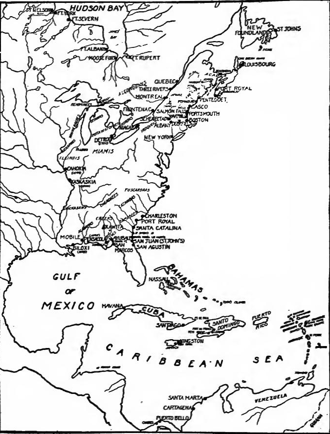 The Intercolonial Wars.
The Hudson Bay posts.—While these events had been taking place, in the far north another conflict was waged. No attempt was made to impede the English on Hudson Bay until 1682, when Radisson and Groseilliers, now turned French, with two vessels took possession of the English post at the mouth of the[Pg 261] Nelson River, but the Frenchmen soon transferred their allegiance once more to the English. La Barre was instructed to check English encroachments and to propose that neither nation establish new posts. In 1685 a Canadian company was formed to trade in the north. Denonville considered this an excuse for attacking the English. In 1686 a hundred men commanded by De Troyes, one of his lieutenants being Iberville, the future founder of Louisiana, were sent overland to make the attack. Fort Hayes, Ft. Rupert, and Ft. Albany were captured, Fort Nelson being the only post left in English hands. French ascendency for the time being was established on Hudson Bay.
The Hudson Bay posts.—While these events were happening, there was another conflict taking place in the far north. No attempt was made to stop the English at Hudson Bay until 1682, when Radisson and Groseilliers, now aligned with the French, seized the English post at the mouth of the[Pg 261] Nelson River with two ships. However, the Frenchmen soon shifted their loyalty back to the English. La Barre was instructed to prevent English expansion and to suggest that neither country set up new posts. In 1685, a Canadian company was established to trade in the north. Denonville viewed this as a justification for attacking the English. In 1686, a hundred men led by De Troyes, with Iberville—who would later found Louisiana—as one of his lieutenants, were sent overland to launch the attack. Fort Hayes, Fort Rupert, and Fort Albany were captured, leaving Fort Nelson as the only post still in English hands. French dominance was temporarily secured at Hudson Bay.
THE WAR OF THE ENGLISH SUCCESSION
William's accession precipitates war.—In spite of these conditions in America, England and France at home had been at peace. It was of more importance to Louis XIV to support a Catholic king of England than to wage open war for the control of the Indian country. But with the overthrow of James II the political situation in Europe was completely changed. William of Orange ascended the throne of England, and Holland, England, several of the German states, Austria, and Spain were welded into a great coalition. Louis XIV championed the Stuart cause and the War of the English Succession was on. In America the struggle is known as King William's War; in Europe it is usually referred to as the War of the Palatinate. In the course of it the Caribbean Sea was the scene of constant conflict. The hostile zones on the mainland had been established in the struggle for the fur trade—the lands of the Abenaki, Iroquois, and upper lake tribes, and the Hudson Bay country.
William's rise to power triggers war.—Despite the situation in America, England and France had been at peace. Louis XIV found it more important to support a Catholic king in England than to openly fight for control of the Indian territories. However, with the ousting of James II, the political landscape in Europe shifted dramatically. William of Orange took the English throne, forming a major coalition with Holland, England, several German states, Austria, and Spain. Louis XIV backed the Stuart cause, resulting in the War of the English Succession. In America, this conflict is known as King William's War; in Europe, it's usually called the War of the Palatinate. Throughout this war, the Caribbean Sea saw continuous battles. The main areas of conflict on the mainland emerged from the struggle for the fur trade—specifically, the territories of the Abenaki, Iroquois, upper lake tribes, and the Hudson Bay region.
THE WAR IN THE CARIBBEAN
Four years of war.—In 1689 the French inhabitants of St. Christopher rose against the English inhabitants and expelled them from the island. The French also broke up a Dutch station in Guiana. Early in 1690 England sent Commodore Wright to the West Indies. Convoying a large fleet, his squadron reached Barbados on May 11. Being reinforced by Barbadian troops he reoccupied St. Christopher, the reduction being completed[Pg 262] July 16. A few days later St. Eustatius surrendered to the English. In 1690 Trinidad was also attacked by the French. In March, 1691, Wright attacked Guadeloupe but failed to take it or to capture the French squadron under M. Ducasse. Commodore Ralph Wrenn took command of the English fleet in January, 1692, and the following month fought an indecisive battle near Jamaica with a superior French force. In that year a great earthquake destroyed Port Royal, the English capital of Jamaica. The refugees founded Kingston which eventually superseded Port Royal as the seat of government.
Four years of war.—In 1689, the French residents of St. Christopher revolted against the English residents and drove them off the island. The French also dismantled a Dutch station in Guiana. Early in 1690, England sent Commodore Wright to the West Indies. Leading a large fleet, his squadron arrived in Barbados on May 11. After gaining support from Barbadian troops, he regained control of St. Christopher, with the operation finished[Pg 262] on July 16. A few days later, St. Eustatius surrendered to the English. In 1690, Trinidad was also attacked by the French. In March 1691, Wright targeted Guadeloupe but was unable to capture it or the French squadron led by M. Ducasse. Commodore Ralph Wrenn took charge of the English fleet in January 1692, and the following month engaged in an inconclusive battle near Jamaica against a larger French force. That year, a massive earthquake devastated Port Royal, the English capital of Jamaica. The survivors founded Kingston, which eventually replaced Port Royal as the center of government.
Martinique, Santo Domingo, and Jamaica.—In 1693 nine vessels reinforced the West Indian fleet and the combined forces, backed by Barbadian troops, attacked Martinique, but failed to take it. In September of the following year a squadron attacked Léogane, a French town in Santo Domingo, but was repulsed. A French expedition from Santo Domingo also desolated the southeastern coast of Jamaica but at Carlisle Bay was beaten off by the colonial militia. In March, 1695, an English and Spanish fleet attacked the French settlements in Santo Domingo and succeeded in forcing the abandonment of Cape François and Port de Paix.
Martinique, Santo Domingo, and Jamaica.—In 1693, nine ships joined the West Indian fleet, and together with troops from Barbados, they launched an attack on Martinique, but they were unable to capture it. In September of the next year, a squadron assaulted Léogane, a French town in Santo Domingo, but they were driven back. A French expedition from Santo Domingo also ravaged the southeastern coast of Jamaica but was repelled at Carlisle Bay by the colonial militia. In March 1695, an English and Spanish fleet targeted the French settlements in Santo Domingo and successfully forced the evacuation of Cape François and Port de Paix.
Cartagena and Petit Gouave.—In April, 1697, a great English fleet under Vice-Admiral John Neville rendezvoused at Barbados to forestall a rumored enterprise of the enemy. M. de Pointas had been sent with large reinforcements to assist M. Ducasse. The combined French fleet attacked Cartagena, took much booty, and eluded Neville. The English commander visited Cartagena, which he found had again been despoiled by buccaneers. He then despatched Captain Mees with nine vessels to burn Petit Gouave, a mission which he accomplished.
Cartagena and Petit Gouave.—In April 1697, a large English fleet led by Vice-Admiral John Neville gathered at Barbados to prevent a rumored attack from the enemy. M. de Pointas had been sent with significant reinforcements to support M. Ducasse. The united French fleet launched an attack on Cartagena, captured a lot of loot, and managed to slip away from Neville. The English commander visited Cartagena and discovered that it had once again been raided by buccaneers. He then sent Captain Mees with nine ships to burn Petit Gouave, a mission he successfully completed.
THE WAR OF THE CANADIAN FRONTIERS
The Maine frontier.—Andros had sent an expedition against the Abenaki and had fortified the frontier, his most northern fort being at Pemaquid, but with his fall the garrison had been reduced. During the summer of 1689 the Indians destroyed Pemaquid and killed most of the settlers in that region. Casco (Portland) was then attacked but was relieved by a counter expedition.
The Maine frontier.—Andros had sent a mission against the Abenaki and had strengthened the frontier, with his northernmost fort located at Pemaquid; however, after his downfall, the garrison was weakened. In the summer of 1689, the Native Americans destroyed Pemaquid and killed most of the settlers in that area. Casco (Portland) was then attacked but was saved by a counter mission.
[Pg 263] The French attack.—In August Frontenac was sent to assume the governorship of Canada. In New France he found despair and desolation. He decided to send out three expeditions, one from Montreal into the upper Hudson Valley, the others from Three Rivers and Quebec to raid the New England frontier. The three expeditions started about February 1, 1690. The Montreal party surprised Schenectady, where sixty persons were massacred. A party from Albany started in pursuit and succeeded in killing about twenty of the retreating French and Indians. The Three Rivers expedition attacked Salmon Falls, where thirty persons were killed and about fifty made prisoners. A relief party from Portsmouth caught up with the raiders at Wooster River, but after a spirited fight the French and Indians escaped. Being reinforced by Indians they joined the party from Quebec. The united force of four or five hundred men in May attacked the fort and blockhouses on Casco Bay, killing or capturing the garrison, massacring or carrying into captivity most of the inhabitants, and burning the settlements.
[Pg 263] The French attack.—In August, Frontenac was appointed as the governor of Canada. In New France, he discovered widespread despair and devastation. He decided to launch three expeditions: one from Montreal into the upper Hudson Valley and the others from Three Rivers and Quebec to raid the New England frontier. The three expeditions began around February 1, 1690. The Montreal group caught Schenectady by surprise, resulting in the massacre of sixty people. A group from Albany set out in pursuit and managed to kill about twenty of the retreating French and Indians. The Three Rivers expedition attacked Salmon Falls, where thirty people were killed and about fifty taken prisoner. A rescue party from Portsmouth intercepted the raiders at Wooster River, but after a fierce battle, the French and Indians escaped. Reinforced by local tribes, they joined forces with the group from Quebec. Together, this combined force of four to five hundred men attacked the fort and blockhouses on Casco Bay in May, killing or capturing the garrison, massacring or taking captive most of the inhabitants, and setting the settlements ablaze.
Frontenac's Indian policy.—Frontenac also sent an expedition of one hundred men to Michilimackinac to keep control of the upper lake Indians. On the way an Iroquois war party was defeated at Sand Point on the Ottawa River. The French victory and news of the successful raids on the English frontier had far-reaching effects, for they kept the Hurons and Ottawas in subjection.
Frontenac's Indian policy.—Frontenac also dispatched a hundred-man expedition to Michilimackinac to maintain control over the upper lake Indians. Along the way, an Iroquois war party was defeated at Sand Point on the Ottawa River. The French victory and reports of successful raids on the English frontier had significant effects, as they kept the Hurons and Ottawas under control.
The English defence.—The attack upon the English colonies was well-timed, for confusion prevailed in New England and New York. Andros had been overthrown and Leisler's rebellion was in full swing. Little help could be expected from England, for James II, with French and Irish aid, was battling to regain his throne. In May, 1690, the New England colonies sent delegates to a congress at New York to determine on a military policy. A two-fold attack was planned; a land expedition against Montreal and a naval expedition against Quebec.
The English defense.—The attack on the English colonies was well-timed, as there was chaos in New England and New York. Andros had been ousted, and Leisler's rebellion was in full effect. Little assistance could be expected from England since James II, with support from the French and Irish, was fighting to reclaim his throne. In May 1690, the New England colonies sent delegates to a congress in New York to decide on a military strategy. A two-part attack was planned: a land mission against Montreal and a naval mission against Quebec.
The Montreal fiasco.—The expedition against Montreal was placed under Fitz-John Winthrop of Connecticut, who led his men as far as the southern end of Lake Champlain. Here smallpox broke out, disagreements with the Indians ensued, and provisions ran short. Winthrop soon discovered that a descent on[Pg 264] Montreal was impossible, and he ingloriously led most of his men back to Albany. Captain John Schuyler, however, with a small detachment proceeded northward and raided the village of Laprairie near Montreal.
The Montreal fiasco.—The mission against Montreal was led by Fitz-John Winthrop from Connecticut, who took his troops all the way to the southern tip of Lake Champlain. There, smallpox broke out, tensions with the Indigenous people arose, and food supplies ran low. Winthrop quickly realized that launching an attack on[Pg 264] Montreal was impossible, and he shamefully led most of his men back to Albany. Captain John Schuyler, however, with a small group, moved north and raided the village of Laprairie near Montreal.
The capture of Port Royal.—While New England delegates were at New York a preliminary expedition was sent against Acadia, Sir William Phips, a New Englander who had achieved great renown and wealth by locating a Spanish treasure ship which had been wrecked off the Bahamas, was placed in command of seven vessels. On May 11, 1690, the fleet appeared before Port Royal, which surrendered without a shot being fired. One of the vessels under Captain Alden captured a French post on the Penobscot and seized several settlements on the southern shore of Nova Scotia.
The capture of Port Royal.—While New England representatives were in New York, an initial mission was launched against Acadia. Sir William Phips, a New Englander who gained significant fame and fortune by finding a Spanish treasure ship that had sunk off the Bahamas, was appointed to command seven ships. On May 11, 1690, the fleet arrived at Port Royal, which gave up without firing a shot. One of the ships led by Captain Alden took over a French outpost on the Penobscot and captured several towns along the southern coast of Nova Scotia.
The expedition against Quebec.—In the meantime Massachusetts was preparing for her great attempt on Quebec Thirty vessels were gathered, but the fleet was short of ammunition, due to the fact that the French had gained temporary control of the sea by defeating the English and Dutch fleets at Beachy Head. The fleet commanded by Phips sailed from Boston on August 9, 1690, but it was not until October 16 that it came in sight of Quebec. The slow progress prevented a surprise and gave Frontenac time to complete his defences. When Phips demanded that Quebec surrender, he received a haughty refusal. Phips then attempted to capture the town, but the plan was poorly executed, ammunition ran short, and reinforcements poured into the city so rapidly that the defenders soon outnumbered the English. A council of war was held, and it was decided to abandon the undertaking. A week of intermittent fighting had brought nothing but failure, which was made the more trying by the loss of several vessels on the return voyage.
The expedition against Quebec.—Meanwhile, Massachusetts was gearing up for its ambitious attempt on Quebec. Thirty ships were assembled, but the fleet lacked ammunition because the French had temporarily taken control of the sea after defeating the English and Dutch fleets at Beachy Head. The fleet led by Phips set sail from Boston on August 9, 1690, but it wasn't until October 16 that they spotted Quebec. Their slow progress spoiled any chance for a surprise attack and gave Frontenac time to strengthen his defenses. When Phips demanded Quebec's surrender, he received a dismissive refusal. Phips then tried to take the town, but the execution of the plan was poor, they ran low on ammunition, and reinforcements entered the city so quickly that the defenders soon outnumbered the English. A war council was called, and it was decided to abandon the mission. A week of sporadic fighting had led to nothing but failure, which was made even more frustrating by the loss of several ships on the journey home.
Frontenac's policy in 1691.—After the attack on Quebec, the war developed into a desultory frontier conflict in which the French were usually on the offensive. The Iroquois continued to raid the French settlements, but they were soon severely chastised, when forty or fifty warriors were surrounded at Repentigny, near Montreal, and killed or captured. This event and the timely arrival of several French vessels impressed[Pg 265] an Ottawa deputation which had come to Quebec, and the French power among the interior tribes was greatly strengthened.
Frontenac's policy in 1691.—After the attack on Quebec, the war turned into a scattered conflict along the frontier, with the French usually taking the offensive. The Iroquois continued to raid French settlements, but they faced a harsh response when forty or fifty warriors were surrounded at Repentigny, near Montreal, and either killed or captured. This incident, along with the timely arrival of several French ships, made a strong impression on[Pg 265] an Ottawa delegation that had come to Quebec, significantly boosting French influence among the interior tribes.
Schuyler's expedition.—The English influence among the Iroquois was waning; to reassert it an expedition under Peter Schuyler was sent from Albany. It traversed Lake Champlain and the Richelieu and proceeded toward Laprairie de la Madeleine where it was attacked by a superior force. After stubborn fighting, Schuyler made an orderly retreat.
Schuyler's expedition.—The English influence over the Iroquois was fading; to reinforce it, an expedition led by Peter Schuyler was dispatched from Albany. They traveled across Lake Champlain and the Richelieu and moved toward Laprairie de la Madeleine, where they were confronted by a larger force. After intense fighting, Schuyler executed a strategic retreat.
Acadia and the Abenaki.—In Acadia Phips had made the blunder of leaving no garrison; the French accordingly reoccupied it. Deeming the location of Port Royal too exposed, M. de Villebon, the lieutenant-governor of Acadia, moved his headquarters to Naxouat on the St. John's River, from which vantage point he was able to direct attacks on New England. In February, 1692, a band of Abenaki wiped out the settlement at York, and later unsuccessfully attacked Wells. Minor raids were also made on the towns of central Massachusetts. To protect the frontier Phips ordered the rebuilding of Fort Pemaquid and the erection of a fort at the falls of the Saco. Scarcely were they completed, when Iberville, in command of two French vessels, attacked Pemaquid but failed to capture it.
Acadia and the Abenaki.—In Acadia, Phips made the mistake of not leaving a garrison, so the French took control again. Thinking that the location of Port Royal was too vulnerable, M. de Villebon, the lieutenant-governor of Acadia, moved his headquarters to Naxouat on the St. John's River, from where he could launch attacks on New England. In February 1692, a group of Abenaki completely destroyed the settlement at York and later attempted, but failed, to attack Wells. There were also smaller raids on towns in central Massachusetts. To defend the frontier, Phips ordered the rebuilding of Fort Pemaquid and the construction of a fort at the falls of the Saco. Just as these were finished, Iberville, commanding two French ships, attacked Pemaquid but couldn't capture it.
The Iroquois frontier.—The Iroquois continued to infest the region between the St. Lawrence and Ottawa rivers, but during 1692 and 1693 they were severely punished, and ceased to be an important factor in the war. Frontenac then determined to reopen the fur trade. He accordingly sent a detachment to Michilimackinac asking that furs be sent to Montreal. In August, 1693, a flotilla of two hundred canoes arrived and shortly afterward Tonty, with a large body of coureurs de bois came to discuss matters. Tonty soon returned to the Illinois country well equipped to strengthen his hold on the natives. The fortifications at Quebec were also remodeled. In 1695 Fort Frontenac was reëstablished and the following year an expedition of over two thousand men was sent against the Onondagas and Oneidas. They abandoned their villages and the French destroyed their crops. Though no battle was fought the expedition served its end, for the Iroquois were duly impressed by the power of the French.
The Iroquois frontier.—The Iroquois continued to disrupt the area between the St. Lawrence and Ottawa rivers, but during 1692 and 1693 they faced serious consequences and stopped being a significant player in the war. Frontenac then decided to revive the fur trade. He sent a team to Michilimackinac requesting that furs be sent to Montreal. In August 1693, a fleet of two hundred canoes arrived, and soon after, Tonty, with a large group of coureurs de bois, came to discuss matters. Tonty quickly returned to the Illinois country well-equipped to strengthen his influence over the natives. The fortifications at Quebec were also updated. In 1695, Fort Frontenac was reestablished, and the following year, an expedition of over two thousand men was sent to confront the Onondagas and Oneidas. They abandoned their villages, and the French destroyed their crops. Although no battle occurred, the expedition achieved its goal, as the Iroquois were clearly impressed by the power of the French.
[Pg 266] The New England frontier.—In 1693 an English fleet from the West Indies arrived at Boston and the idea of an expedition against Quebec was revived, but there was so much sickness among the men that the plan was abandoned. During 1693 and 1694 both English and French sought to control the Abenaki, but in spite of a treaty made by Phips, the French succeeded in holding their allies. In July, 1694, the Indians attacked Durham, massacring over a hundred of the inhabitants, and a few days later killed about forty people at Groton. Two years later Iberville again appeared before Pemaquid and this time succeeded in capturing it. He then sailed to Newfoundland, captured and burned St. Johns, and plundered the settlements on the coast. The English retaliated by burning the French settlement at Beaubassin but were repulsed at Naxouat. In March, 1697, Haverhill was raided by the Indians, and in February, 1698, after the treaty of peace, they attacked Andover. In the last year of the war an attack upon Boston and New York by land and sea was determined upon and a fleet set sail from France, but the treaty of peace ended hostilities.
[Pg 266] The New England frontier.—In 1693, an English fleet from the West Indies arrived in Boston, and the idea of launching an expedition against Quebec was brought up again. However, due to widespread illness among the crew, the plan was dropped. In 1693 and 1694, both the English and the French tried to gain control over the Abenaki, but despite a treaty made by Phips, the French managed to keep their allies. In July 1694, the Indians attacked Durham, killing over a hundred residents, and a few days later, around forty people were killed in Groton. Two years later, Iberville returned to Pemaquid and this time successfully captured it. He then headed to Newfoundland, captured and burned St. Johns, and looted the coastal settlements. The English responded by burning the French settlement at Beaubassin but were thwarted at Naxouat. In March 1697, Haverhill was raided by the Indians, and in February 1698, after the peace treaty, they attacked Andover. In the final year of the war, there were plans for an assault on Boston and New York by land and sea, and a fleet set sail from France, but the peace treaty put an end to the fighting.
ACTIVITIES ON HUDSON BAY; PEACE
Operations of Iberville.—When the war opened, the French were in control of the posts about James Bay, while Fort Nelson, commanding the great interior water-ways, was in the hands of the Hudson's Bay Company. In 1689 Fort Albany was captured by the English. The following year Iberville recaptured it, but in 1692 it again passed out of French hands. In 1694 the French government determined to assist the Compagnie du Nord; Iberville, being sent to the bay with two frigates, captured Fort Nelson. Two years later it was retaken by the English. In 1697 Iberville penetrated the bay, this time with five vessels. Becoming separated from the rest of the fleet, Iberville encountered three armed vessels of the Hudson's Bay Company. After a thrilling naval battle the English were worsted, and the French once more took possession of Fort Nelson. At the end of the war the only important post left in English hands was Fort Albany.
Operations of Iberville.—When the war started, the French controlled the posts around James Bay, while Fort Nelson, which oversaw the major interior waterways, was held by the Hudson's Bay Company. In 1689, the English captured Fort Albany. The following year, Iberville recaptured it, but in 1692 it fell out of French control again. In 1694, the French government decided to support the Compagnie du Nord; Iberville was sent to the bay with two frigates and captured Fort Nelson. Two years later, the English took it back. In 1697, Iberville entered the bay with five vessels. Separated from the rest of his fleet, Iberville faced three armed vessels from the Hudson's Bay Company. After an exciting naval battle, the English were defeated, and the French regained control of Fort Nelson. By the end of the war, the only significant post remaining in English hands was Fort Albany.
The Peace of Ryswick.—In 1697 the war was brought to an end by the peace of Ryswick, by which Louis XIV acknowledged[Pg 267] William III as king of England. The results of the fighting in America were ignored, the powers agreeing to restore to each other all places taken in the war. The ownership of the Abenaki and Iroquois lands, and of the Hudson Bay country was left unsettled.
The Peace of Ryswick.—In 1697, the war ended with the peace of Ryswick, in which Louis XIV recognized[Pg 267] William III as the king of England. The outcomes of the battles in America were overlooked, and the countries agreed to return all territories they had captured during the war. The ownership of the Abenaki and Iroquois lands, as well as the Hudson Bay region, was left unresolved.
THE WAR OF THE SPANISH SUCCESSION
French expansion.—The peace of Ryswick was only a truce. France took advantage of the peace to begin to establish her power in the Mississippi Valley and to strengthen her hold upon the Northwest. In 1699 Biloxi was founded on the Gulf and in succeeding years France brought under control most of the tribes of the lower Mississippi Valley. In 1701 the French occupied Detroit to cut off the English from one of the routes to the fur country, and strengthened their hold on the Illinois country.[1]
French expansion.—The peace of Ryswick was only a truce. France took advantage of the peace to begin to establish her power in the Mississippi Valley and to strengthen her hold upon the Northwest. In 1699 Biloxi was founded on the Gulf and in succeeding years France brought under control most of the tribes of the lower Mississippi Valley. In 1701 the French occupied Detroit to cut off the English from one of the routes to the fur country, and strengthened their hold on the Illinois country.[1]
The Spanish Succession.—Upon the death of Philip IV in 1665 the incompetent Charles II came to the throne of Spain. Court intrigues stimulated by France and Austria, and utter lack of statesmanship at a time when France was reaching out in every direction, brought Spain to the lowest point in her history. Fearing that she would pass under French control, thereby destroying the balance of power in Europe, William III of England sought to check French power by the so-called Second Treaty of Partition, by which the Austrian Archduke Charles was to inherit the crown of Spain upon the death of Charles II, Spanish possessions in Italy were to go to the Dauphin of France, and Spanish and Austrian possessions were never to be united. To this arrangement France, Austria, and England agreed, but the treaty proved to be but a scrap of paper. In 1700 Charles II died and his will designated Philip of Anjou, a grandson of Louis XIV, as his heir.
The Spanish Succession.—After the death of Philip IV in 1665, the ineffective Charles II took the throne of Spain. Court intrigues fueled by France and Austria, along with a complete lack of statesmanship at a time when France was expanding aggressively, brought Spain to its lowest point in history. Concerned that Spain would fall under French control and disrupt the balance of power in Europe, William III of England attempted to curb French influence with the Second Treaty of Partition. This treaty stipulated that the Austrian Archduke Charles would inherit the Spanish crown upon Charles II's death, Spanish territories in Italy would go to the Dauphin of France, and Spanish and Austrian possessions would never be joined. France, Austria, and England agreed to this arrangement, but the treaty turned out to be nothing more than a piece of paper. In 1700, Charles II died, and his will named Philip of Anjou, a grandson of Louis XIV, as his heir.
England determines upon war.—War was not at once declared, for the English people were slow to recognize the danger. But when French troops occupied the border fortresses in the Spanish Netherlands, when French edicts excluded British manufactures, when the English and Dutch trade, especially the slave[Pg 268] trade, was hampered in the Spanish colonies, and when Louis XIV acknowledged the son of James II as king of England, English statesmen were convinced that war was necessary. When Anne ascended the throne in 1702, war was a foregone conclusion.
England decides on war.—War wasn't declared right away, as the English people were slow to see the threat. But when French troops took over the border fortresses in the Spanish Netherlands, when French laws prohibited British goods, when English and Dutch trade, especially the slave[Pg 268] trade, faced obstacles in the Spanish colonies, and when Louis XIV recognized James II's son as king of England, English leaders became sure that war was essential. When Anne became queen in 1702, war was already inevitable.
War zones in America.—The war areas were even more extensive in America than in the War of the English Succession. In the South, the West Indies, and the Carolina, Florida, and Louisiana frontiers, and in the North, the New England border, Acadia, Newfoundland, and Hudson Bay were the scenes of conflict.
War zones in America.—The war areas were even larger in America than during the War of the English Succession. In the South, the West Indies, and along the frontiers of Carolina, Florida, and Louisiana, and in the North, the New England border, Acadia, Newfoundland, and Hudson Bay saw significant conflict.
[1] For details see Chapter XV.
For details, see Chapter 15.
THE WAR IN THE WEST INDIES
An indecisive struggle.—When William III became convinced that the war was inevitable, he proposed to strike at Spanish commerce. In furtherance of this policy a squadron was sent in 1701 to the West Indies under Vice-Admiral John Benbow. In July, 1702, Benbow destroyed or captured several vessels near Port-au-Prince, and supported by troops under Major-General Hamilton, he occupied St. Christopher. The fleet in August encountered that of Ducasse off Santa Marta to the northeast of Cartagena and in a running fight which lasted several days the English were worsted. In 1703 General Codrington attacked Guadeloupe but a French reinforcement forced the English to retire. The same year a combined French and Spanish force drove the English inhabitants from New Providence and destroyed Fort Nassau, but it was soon reoccupied by the English Vice-Admiral John Graydon who had been placed in command of the West Indian fleet. Before his arrival several privateers had been destroyed near the island of Santo Domingo and descents had been made on St. Christopher and Guadeloupe. Graydon accomplished nothing and soon sailed to Newfoundland, where his operations were also fruitless.
An indecisive struggle.—When William III realized that war was unavoidable, he suggested targeting Spanish trade. To support this plan, a squadron was sent to the West Indies in 1701 led by Vice-Admiral John Benbow. In July 1702, Benbow destroyed or captured several ships near Port-au-Prince and, with troops led by Major-General Hamilton, took control of St. Christopher. In August, the fleet encountered Ducasse's fleet off Santa Marta, northeast of Cartagena, and after several days of running battles, the English were defeated. In 1703, General Codrington attacked Guadeloupe, but French reinforcements forced the English to withdraw. That same year, a combined French and Spanish force expelled the English settlers from New Providence and destroyed Fort Nassau, which was quickly retaken by the English Vice-Admiral John Graydon, who was in charge of the West Indian fleet. Before he arrived, several privateers had been destroyed near Santo Domingo, and assaults had been made on St. Christopher and Guadeloupe. Graydon achieved nothing and soon headed to Newfoundland, where his efforts were also unsuccessful.
1705-1708.—During 1705 several prizes were taken and in 1706 the French made a descent on St. Christopher. Their attack on the fort failed, but they burned and plundered several plantations. Hearing that an English fleet was expected, the French repaired to Nevis, which they occupied. The English fleet under Commodore Kerr attacked Petit Gouave but failed to capture it. In 1708 Commodore Charles Wager won an important[Pg 269] engagement when he attacked a Spanish fleet near. Cartagena. New Providence was a second time attacked by the French and Spanish, which led to the English abandonment of the island.
1705-1708.—In 1705, several prizes were captured, and in 1706, the French launched an assault on St. Christopher. Their attack on the fort was unsuccessful, but they burned and looted several plantations. After hearing that an English fleet was on the way, the French moved to Nevis, which they took control of. The English fleet, led by Commodore Kerr, attacked Petit Gouave but could not seize it. In 1708, Commodore Charles Wager achieved a significant[Pg 269] victory when he attacked a Spanish fleet near Cartagena. New Providence was attacked for a second time by the French and Spanish, resulting in the English abandoning the island.
1711-1712.—In 1710 the Spaniards attacked the salt rakers on Turk's Island but were driven off. In 1711 Commodore James Littleton attempted to find the French fleet, which he located in the harbor of Cartagena. Finding it too strong to attack, he loafed in the neighborhood, picking up an occasional prize. Ducasse, who was convoying a fleet of Spanish galleons, succeeded in getting them out of the harbor without being observed and got them safely to Havana. A French squadron which made an attempt against Antigua was driven into St. Pierre by the English fleet, and a similar expedition against Montserrat was foiled. The following year the French nearly ruined Berbice, a Dutch settlement in Guiana.
1711-1712.—In 1710, the Spanish attacked the salt rakers on Turk's Island but were driven away. In 1711, Commodore James Littleton tried to locate the French fleet, which he found in the harbor of Cartagena. Realizing it was too strong to attack, he hung around the area, occasionally capturing a prize. Ducasse, who was escorting a fleet of Spanish galleons, managed to get them out of the harbor without being noticed and brought them safely to Havana. A French squadron that tried to attack Antigua was forced into St. Pierre by the English fleet, and another similar attempt on Montserrat was thwarted. The following year, the French nearly destroyed Berbice, a Dutch settlement in Guiana.
THE WAR ON THE FLORIDA BORDER
The southern border.—On the mainland the South Carolina settlements formed the southern English frontier. The Spaniards occupied St. Augustine, contiguous territory up the Georgia coast, Pensacola, and intermediate points. To the west on the Gulf coast were the recently established French settlements. In the interior lived the Apalachees, Creeks, Cherokees, Choctaws, and Chickasaws. To control the trade of the Indians and use them as allies was the policy of English, Spanish, and French alike. The first blow fell on the Apalachee. In 1702 a force of Apalachicolas, allies of the English, destroyed the mission of Santa Fé in the Apalachee district, and a Spanish force was met at the Flint River by Englishmen and Creek allies, and driven back.
The southern border.—On the mainland, the South Carolina settlements made up the southern English frontier. The Spaniards held St. Augustine and the surrounding areas along the Georgia coast, Pensacola, and other nearby locations. To the west, on the Gulf coast, were the newly established French settlements. In the interior lived the Apalachees, Creeks, Cherokees, Choctaws, and Chickasaws. Controlling trade with the Native Americans and using them as allies was the strategy of the English, Spanish, and French. The first attack targeted the Apalachee. In 1702, a group of Apalachicolas, allies of the English, destroyed the Santa Fé mission in the Apalachee area, and an English and Creek force pushed back a Spanish contingent at the Flint River.
Siege of St. Augustine.—The next attack of the English was directed against St. Augustine. Hearing of their plans, Governor Zuñiga sent to Havana for reinforcements, abandoned the town of St. Augustine, and provisioned the castle. The Carolina force of about twelve hundred militia and Indians rendezvoused at Port Royal in September, 1702. Colonel Robert Daniel, conducting the land forces, destroyed the mission settlements on St. Mark's Island, captured the villages of St. Johns and St.[Pg 270] Marys, and plundered St. Augustine. Governor Moore conducted the fleet, and the combined forces besieged the castle. Governor Zuñiga bravely withstood the siege for fifty days, and when Spanish vessels arrived, Moore destroyed his ships, burned St. Augustine, and retreated to Carolina.
Siege of St. Augustine.—The next attack by the English was focused on St. Augustine. Learning about their plans, Governor Zuñiga requested reinforcements from Havana, abandoned the town of St. Augustine, and stocked up the castle. The Carolina force of around twelve hundred militia and Indians gathered at Port Royal in September 1702. Colonel Robert Daniel, leading the land forces, destroyed the mission settlements on St. Mark's Island, captured the villages of St. Johns and St.[Pg 270] Marys, and plundered St. Augustine. Governor Moore led the fleet, and the combined forces laid siege to the castle. Governor Zuñiga bravely resisted the siege for fifty days, and when Spanish ships finally arrived, Moore destroyed his vessels, burned St. Augustine, and retreated to Carolina.
Destruction of the Apalachee Missions.—Moore was superseded as governor by Sir Nathaniel Johnson, who immediately strengthened the fortifications at and near Charleston. Moore, desiring to build up his waning reputation, persuaded Johnson to send him against the Apalachee. Setting out with a force of fifty Carolinians and a thousand Creek allies, in January, 1704, he captured the Apalachee town of Ayubale, burned the mission, and then defeated a force of Spaniards and Apalachee. The Indian villages were next destroyed; of thirteen Apalachee towns, each with its mission, only one was spared. When Moore withdrew he carried off fourteen hundred Apalachee prisoners and slaves.
Destruction of the Apalachee Missions.—Moore was replaced as governor by Sir Nathaniel Johnson, who immediately reinforced the fortifications in and around Charleston. Wanting to restore his fading reputation, Moore convinced Johnson to send him against the Apalachee. In January 1704, he set out with a group of fifty Carolinians and a thousand Creek allies, captured the Apalachee town of Ayubale, burned the mission, and then defeated a group of Spaniards and Apalachee. The Indian villages were then destroyed; out of thirteen Apalachee towns, each with its mission, only one was left standing. When Moore retreated, he took fourteen hundred Apalachee prisoners and slaves with him.
Spanish expedition against Charleston.—In 1706 the French and Spaniards at Havana organized an expedition to attack Carolina. In August a frigate and four sloops, after taking on men and supplies at St. Augustine, sailed to Charleston and demanded its surrender. A small landing party was repulsed; six Carolina vessels sallied out, and after an engagement the enemy withdrew.
Spanish expedition against Charleston.—In 1706, the French and Spanish in Havana planned an attack on Carolina. In August, a frigate and four sloops, after gathering men and supplies in St. Augustine, set sail for Charleston and demanded its surrender. A small landing party was turned back; six Carolina vessels came out, and after a clash, the enemy retreated.
Indian policy of the French.—To use the Indian allies to prevent the spread of English settlement was a fundamental of French policy. Iberville, the founder of Louisiana, planned to obtain control of the great interior rivers by establishing forts, and to weld the Indians into an alliance with the French by treaties and by trade. He even contemplated moving some of the tribes to points of greater commercial vantage. He also believed that he could obtain the aid of several thousand warriors in attacking Maryland, Virginia, and Carolina. Realizing the danger, the English traders were active among the tribes. In 1708, probably at the instigation of the English, the Cherokees, Arikas, Catawbas, and Alabamas formed an alliance. Four thousand warriors descended on the French settlements, but lack of leadership destroyed the effectiveness of the attack and but little damage was done.
Indian policy of the French.—Using Indian allies to stop the spread of English settlements was a key part of French strategy. Iberville, who founded Louisiana, aimed to take control of the major interior rivers by building forts and uniting the Indians with the French through treaties and trade. He even considered relocating some tribes to better trading areas. He also thought he could enlist several thousand warriors to attack Maryland, Virginia, and Carolina. Recognizing the threat, English traders engaged actively with the tribes. In 1708, likely influenced by the English, the Cherokees, Arikas, Catawbas, and Alabamas formed an alliance. Four thousand warriors launched an attack on the French settlements, but the lack of leadership undermined the effectiveness of the assault, resulting in minimal damage.
[Pg 271] The Tuscarora War.—In 1711 the Tuscaroras, a North Carolina tribe, went on the warpath and massacred about two hundred settlers. Virginia and South Carolina sent aid, and in 1712 the Indians were defeated. The Tuscaroras continued their depredations and in 1713 they were almost annihilated. The remnant made their way to New York and were incorporated with the Iroquois as a sixth nation.
[Pg 271] The Tuscarora War.—In 1711, the Tuscaroras, a tribe from North Carolina, went on the attack and killed around two hundred settlers. Virginia and South Carolina provided assistance, and in 1712, the Indians were defeated. The Tuscaroras kept raiding, and by 1713, they were nearly wiped out. The survivors moved to New York and joined the Iroquois as their sixth nation.
THE WAR ON THE CANADIAN BORDER
Newfoundland and the New England frontier.—To deprive the French of the profitable Newfoundland fisheries was the first endeavor of England in the north. Captain John Leake arrived at St. Johns in August, 1702. He cruised off Placentia Bay, making several small prizes and destroying fishing craft. Before the end of October he had captured twenty-nine sail, burned two vessels, and destroyed St. Peter's Fort. The New England frontier was harried by the French and Abenaki. In 1699 Massachusetts had made a treaty at Casco Bay with the Maine Indians, but the Jesuits soon brought them back to French allegiance. In 1703 a second peace treaty was made with them, but within two months they were on the warpath, almost wiping out the Maine settlements. In 1704 the French and Indians surprised Deerfield in the Connecticut Valley, killing about fifty and carrying off more than one hundred captives. Almost every frontier settlement was attacked. Even Reading, Sudbury, and Haverhill, within a short distance of Boston, were raided. To add to the distress French privateers did serious damage to commerce and fisheries.
Newfoundland and the New England frontier.—The first goal of England in the north was to take away the profitable Newfoundland fisheries from the French. Captain John Leake arrived in St. John's in August 1702. He cruised off Placentia Bay, capturing several small prizes and destroying fishing boats. By the end of October, he had taken twenty-nine ships, burned two vessels, and destroyed St. Peter's Fort. The New England frontier was troubled by the French and Abenaki. In 1699, Massachusetts had made a treaty at Casco Bay with the Maine Indians, but the Jesuits quickly brought them back under French influence. In 1703, a second peace treaty was signed, but within two months they were on the warpath, nearly annihilating the Maine settlements. In 1704, the French and Indians surprised Deerfield in the Connecticut Valley, killing about fifty people and capturing more than one hundred. Almost every frontier settlement was attacked. Even Reading, Sudbury, and Haverhill, which were close to Boston, were raided. To make matters worse, French privateers dealt serious blows to commerce and fisheries.
Acadia.—The New Englanders retaliated with small counter raids, but succeeded in inflicting little damage. It was finally determined to strike at Acadia. An expedition was placed under Benjamin Church, a veteran of King Philip's War. French settlements on the Bay of Fundy were ravaged, but he failed to attack Port Royal. In 1707 an expedition, recruited by Massachusetts, New Hampshire, and Rhode Island, was again sent against Port Royal, but the stubborn defense discouraged the attacking force and the siege was abandoned. English vessels under Captain John Underwood raided the Newfoundland coast, destroying many settlements and fishing craft.
Acadia.—The New Englanders hit back with small counterattacks, but they managed to cause little harm. It was eventually decided to go after Acadia. An expedition was led by Benjamin Church, a veteran of King Philip's War. French settlements on the Bay of Fundy were devastated, but he didn't attack Port Royal. In 1707, another expedition, organized by Massachusetts, New Hampshire, and Rhode Island, was sent to Port Royal, but the strong defense discouraged the attackers, and the siege was called off. English ships under Captain John Underwood raided the Newfoundland coast, destroying many settlements and fishing boats.
[Pg 272] Plan to conquer Canada.—The conquest of Canada was urged by many of the colonial leaders, the most active of whom was Colonel Samuel Vetch, a Scotchman who had formerly seen service in the English army. In 1709 his plan was endorsed by the British government, and preparations were made to send a large force against Quebec by sea and a land expedition against Montreal. But after great efforts had been made by the New England colonies and New York, the British regulars were diverted to Portugal, and the conquest of Canada had to be abandoned.
[Pg 272] Plan to conquer Canada.—The takeover of Canada was pushed by many of the colonial leaders, with Colonel Samuel Vetch, a Scotsman who had previously served in the English army, being the most proactive. In 1709, his plan received support from the British government, and preparations were set in motion to dispatch a large force by sea to Quebec, along with a land campaign against Montreal. However, after significant efforts by the New England colonies and New York, the British regulars were redirected to Portugal, forcing the abandonment of the Canadian conquest.
Conquest of Acadia.—The following year a force of four thousand colonials, commanded by Francis Nicholson, aided by British men-of-war and a regiment of marines, attacked and captured Port Royal. Acadia became the British province of Nova Scotia, and the name of its capital was changed to Annapolis Royal. The following year the English again raided the French fishing stations in Newfoundland.
Conquest of Acadia.—The next year, a group of four thousand colonials, led by Francis Nicholson and supported by British warships and a regiment of marines, attacked and took Port Royal. Acadia became the British province of Nova Scotia, and its capital was renamed Annapolis Royal. The year after that, the English launched another raid on the French fishing stations in Newfoundland.
Failure of Walker's expedition.—In 1710 a Tory ministry came into power, its chief members being the Earl of Oxford and Viscount Bolingbroke. They were opposed to carrying on the war in Europe, believing that England's best policy lay in colonial undertakings. The conquest of Canada became the great object. As before, the attack was to be by land and sea. Under Nicholson the land force, composed mainly of colonials and eight hundred Iroquois, prepared to attack Montreal. The expedition against Quebec was entrusted to Admiral Sir Bovenden Walker and General Sir John Hill; a court favorite. Seven of Marlborough's best regiments, veterans of Oudenarde and Ramillies, were placed on transports which were convoyed by a large fleet of war vessels. The great force gathered at Boston, where it was reinforced by fifteen hundred colonials. In August, 1711, the fleet entered the St. Lawrence, but there it met disaster. Sailing too close to the northern shore, ten vessels were wrecked on the reefs and shoals of the Egg Islands. Stunned by the calamity, the faint-hearted commander gave up the enterprise. News of the disaster reached Nicholson at Lake Champlain. His force was not strong enough to accomplish the conquest alone, and the attack on Montreal was abandoned.
Failure of Walker's expedition.—In 1710, a Tory government came into power, led by the Earl of Oxford and Viscount Bolingbroke. They were against continuing the war in Europe, believing that England's best strategy was in colonial ventures. The conquest of Canada became the main goal. Like before, the attack was planned by both land and sea. Under Nicholson, the land force, mostly made up of colonials and eight hundred Iroquois, prepared to assault Montreal. The expedition against Quebec was given to Admiral Sir Bovenden Walker and General Sir John Hill, a favorite of the court. Seven of Marlborough's best regiments, veterans of Oudenarde and Ramillies, were placed on transports that were escorted by a large fleet of warships. The massive force gathered at Boston, where it was bolstered by fifteen hundred colonials. In August 1711, the fleet entered the St. Lawrence, but disaster struck. Sailing too close to the northern shore, ten vessels were wrecked on the reefs and shoals of the Egg Islands. Shocked by the catastrophe, the timid commander abandoned the mission. News of the disaster reached Nicholson at Lake Champlain. His force was not strong enough to achieve the conquest on its own, and the attack on Montreal was called off.
THE HUDSON BAY COMPANY
The Hudson's Bay Company had been sadly crippled at the end of the War of the English Succession. Its shares fell in value and most of the original owners sold their holdings. The only post which the company held was Fort Albany, and in 1704 this was unsuccessfully attacked by a party of French and Indians. The same year an English frigate captured the principal ship of the Compagnie du Nord, causing great hardship in the French forts. The Hudson's Bay Company during the war frequently petitioned the Board of Trade for assistance, but, as they received none, they appealed directly to the queen. When the final treaty was made, the Hudson Bay country was taken into account.
The Hudson's Bay Company was badly weakened at the end of the War of the English Succession. Its shares dropped in value, and most of the original owners sold their stakes. The only outpost the company had was Fort Albany, which was unsuccessfully attacked by a group of French and Indians in 1704. That same year, an English frigate captured the main ship of the Compagnie du Nord, causing significant hardship in the French forts. Throughout the war, the Hudson's Bay Company often asked the Board of Trade for help, but since they received none, they appealed directly to the queen. When the final treaty was signed, the Hudson Bay region was considered.
THE PEACE OF UTRECHT
At the end of the war a series of agreements was drawn up by the various powers. The treaties involving America dealt both with territory and commerce. England obtained a recognition of her claims in the Hudson Bay country and the possession of Newfoundland and Acadia. The claim of the English to the Iroquois country was also admitted, and they were given St. Christopher. Commercially the agreements dealt with the fisheries and Spanish trade. The French were excluded from fishing on the Acadian coast, but were allowed to keep Cape Breton Island and were given certain fishing privileges on the Newfoundland coasts. An agreement with Spain, known as the Asiento or contract, gave the English the exclusive right for thirty years of bringing negroes into the Spanish possessions. The English were also allowed to send an annual merchant ship of five hundred tons burden to trade with Spanish ports.
At the end of the war, a series of agreements was created by the various powers. The treaties involving America addressed both territory and trade. England secured recognition of its claims in the Hudson Bay area and gained control of Newfoundland and Acadia. The English claim to the Iroquois territory was also acknowledged, and they received St. Christopher. The agreements also touched on commerce, particularly fisheries and Spanish trade. The French were banned from fishing along the Acadian coast but were allowed to retain Cape Breton Island and granted certain fishing rights on the Newfoundland coasts. An agreement with Spain, known as the Asiento or contract, gave the English the exclusive right for thirty years to bring enslaved Africans into Spanish territories. The English were also permitted to send an annual merchant ship of five hundred tons to trade with Spanish ports.
READINGS
THE STRUGGLE FOR THE FUR COUNTRY
Bryce, George, The Remarkable History of the Hudson's Bay Company, 1-46; Kingsford, William, The History of Canada, II, 36-107; Laut, Agnes, The Conquest of the Great Northwest, I, 97-255; Le Sueur, W.D., Count Frontenac, 170-228; Lorin, Henri, Le Comte de Frontenac, 275-352; Parkman, Francis, Count Frontenac and New France under Louis XIV, 72-183; Thwaites, R.G., ed., The Jesuit Relations, LXII-LXIV.[Pg 274]
Bryce, George, The Remarkable History of the Hudson's Bay Company, 1-46; Kingsford, William, The History of Canada, II, 36-107; Laut, Agnes, The Conquest of the Great Northwest, I, 97-255; Le Sueur, W.D., Count Frontenac, 170-228; Lorin, Henri, Le Comte de Frontenac, 275-352; Parkman, Francis, Count Frontenac and New France under Louis XIV, 72-183; Thwaites, R.G., ed., The Jesuit Relations, LXII-LXIV.[Pg 274]
THE WAR OF THE ENGLISH SUCCESSION
Bryce, George, The Remarkable History of the Hudson's Bay Company, 47-55; Clowes, W.L., The Royal Navy, II, 462-472, 492-495; Kingsford, William, The History of Canada, II, 198-386; Laut, A.C., The Conquest of the Great Northwest, I, 228-255; Le Sueur, W.D., Count Frontenac, 229-362; Lorin, Henri, Le Comte de Frontenac, 353-488; Manan, A.T., The Influence of Sea Power upon History, 1660-1783, pp. 173-198; Parkman, Francis, Count Frontenac and New France under Louis XIV, 184-427; Willson, Beckles, The Great Company, 182-197.
Bryce, George, The Remarkable History of the Hudson's Bay Company, 47-55; Clowes, W.L., The Royal Navy, II, 462-472, 492-495; Kingsford, William, The History of Canada, II, 198-386; Laut, A.C., The Conquest of the Great Northwest, I, 228-255; Le Sueur, W.D., Count Frontenac, 229-362; Lorin, Henri, Le Comte de Frontenac, 353-488; Manan, A.T., The Influence of Sea Power upon History, 1660-1783, pp. 173-198; Parkman, Francis, Count Frontenac and New France under Louis XIV, 184-427; Willson, Beckles, The Great Company, 182-197.
WAR OF THE SPANISH SUCCESSION
Clowes, W.L., The Royal Navy, II, chs. 23-24; Greene, E.B., Provincial America, 136-165; Kingsford, William, The History of Canada, III; Crady, Edward, The History of Carolina under the Proprietary Government, 1670-1719, pp. 364-548; Parkman, Francis, A Half-Century of Conflict, I, 1-297; Shea, J.G., Catholic Church in Colonial Days, 454-479; Hamilton, P.J., Colonization of the South, ch. 15.[Pg 275]
Clowes, W.L., The Royal Navy, II, chs. 23-24; Greene, E.B., Provincial America, 136-165; Kingsford, William, The History of Canada, III; Crady, Edward, The History of Carolina under the Proprietary Government, 1670-1719, pp. 364-548; Parkman, Francis, A Half-Century of Conflict, I, 1-297; Shea, J.G., Catholic Church in Colonial Days, 454-479; Hamilton, P.J., Colonization of the South, ch. 15.[Pg 275]
CHAPTER XV
THE FRENCH IN LOUISIANA AND THE FAR NORTHWEST (1699-1762)
THE FOUNDING OF LOUISIANA
Applicants for La Salle's grant.—During the War of the Palatinate Louis XIV showed little desire to develop La Salle's plan for a colony on the Gulf. In the interim, however, a number of individuals proposed taking up La Salle's work. In 1690 his brother, the Abbé Cavelier, strongly urged that it be continued. In 1694 Tonty asked permission to carry out the project. In 1697 De Louvigny, Captain of Marines in Canada, proposed making an expedition against the Spanish mines by way of the Rio Bravo. In the same year Sieur de Argaud, at Paris, sought a grant of the territory between Florida and New Mexico, the Gulf and the Illinois River. The control of the Gulf and the checking of the Spanish advance were prominent among the arguments for all these projects.
Applicants for La Salle's grant.—During the War of the Palatinate, Louis XIV showed little interest in moving forward with La Salle's plan for a colony on the Gulf. In the meantime, a number of people suggested picking up where La Salle left off. In 1690, his brother, Abbé Cavelier, strongly advocated for continuing the work. In 1694, Tonty requested permission to pursue the project. In 1697, De Louvigny, Captain of Marines in Canada, proposed launching an expedition against the Spanish mines via the Rio Bravo. That same year, Sieur de Argaud, in Paris, sought a grant for the territory between Florida and New Mexico, from the Gulf to the Illinois River. Controlling the Gulf and halting the Spanish advance were key arguments for all these initiatives.
Iberville.—But not until the treaty of Ryswick was signed did the king again take up the plan. The founding of the proposed colony was then entrusted to Iberville, a son of Charles Le Moyne, one of the great seigniors of Canada. Iberville and his brother Bienville had already distinguished themselves in their attacks upon the English on Hudson Bay. Activities were hastened by reports that the English were preparing to take possession of the mouth of the Mississippi. To forestall them, Pontchartram, the Minister of Marine, in 1698 sent an expedition to the Gulf of Mexico.
Iberville.—It wasn't until the Treaty of Ryswick was signed that the king revisited the plan. The establishment of the proposed colony was then entrusted to Iberville, a son of Charles Le Moyne, one of the prominent landowners in Canada. Iberville and his brother Bienville had already made a name for themselves by attacking the English in Hudson Bay. Efforts were ramped up due to reports that the English were getting ready to take control of the mouth of the Mississippi. To prevent that, Pontchartrain, the Minister of Marine, sent an expedition to the Gulf of Mexico in 1698.
Pensacola founded by Spain.—News of Iberville's preparations reached Madrid early in 1698, and again Spain proved that in an emergency she could act. Assuming that Pensacola was the French objective, the viceroy sent Andres de Arriola to intercept them, and in November he fortified the place.
Pensacola was founded by Spain.—News of Iberville's plans reached Madrid early in 1698, and once again, Spain showed that it could take action when it mattered. Believing that Pensacola was the target for the French, the viceroy sent Andres de Arriola to stop them, and in November, he strengthened the fortifications at the location.
[Pg 276] Biloxi founded by France.—The movement was timely. Two months behind Arriola Iberville's fleet appeared before the harbor and demanded admission (January, 1699). The request being politely refused, Iberville established himself at Biloxi, after which he returned to France, leaving Bienville in command. During Iberville's absence, the coast and the lower courses of the Mississippi and Red Rivers were thoroughly explored and friendly relations with the Indian tribes promoted. Shortly afterward Iberville returned to the colony, and in 1702 the settlement was moved to Mobile Bay where the Spaniards at Pensacola could be more effectually checked, the new settlement being called St. Louis.
[Pg 276] Biloxi was founded by France.—The timing couldn't have been better. Two months later, Arriola Iberville's fleet arrived at the harbor and asked for entry (January, 1699). When the request was politely denied, Iberville set up camp at Biloxi and then returned to France, leaving Bienville in charge. While Iberville was away, the coast, along with the lower parts of the Mississippi and Red Rivers, were thoroughly explored, and friendly relations with the Native American tribes were fostered. Soon after, Iberville came back to the colony, and in 1702 the settlement was moved to Mobile Bay to better counter the Spaniards in Pensacola, with the new settlement being named St. Louis.
Alliance with the tribes.—An Indian policy was also developed. Tonty, who had found it to his advantage to divert his fur trade to Louisiana, was sent on a peace mission to the Chickasaws. This resulted in a conference of Chickasaws and Choctaws at Mobile Bay, at which the friendship and trade of those powerful tribes were assured. By alliances with the interior tribes, Iberville hoped to be able eventually to check and, if possible, annihilate the English settlements of Maryland, Virginia, and Carolina. After the conference at Mobile Bay, Iberville left the colony, and Bienville became the central figure in Louisiana.
Alliance with the tribes.—A policy toward Native Americans was also established. Tonty, who discovered it was beneficial to shift his fur trade to Louisiana, was sent on a peace mission to the Chickasaws. This led to a meeting between the Chickasaws and Choctaws at Mobile Bay, where they secured friendship and trade relations with these powerful tribes. Through alliances with the interior tribes, Iberville aimed to ultimately curb and, if possible, eliminate the English settlements in Maryland, Virginia, and Carolina. After the meeting at Mobile Bay, Iberville left the colony, and Bienville became the main leader in Louisiana.
Bienville's first administration.—The government of the colony was of a military type. At the head was the governor, who was assisted by a commissaire who had charge of the stores. A council with judicial powers was also established. Like Frontenac, Bienville was beset by many difficulties, quarrels with officials and clergy being frequent. The colony was threatened by an alliance of Cherokees, Choctaws, and other tribes who were instigated to hostility by the English. In 1710 a new site for St. Louis was selected, the settlement being located on the present site of Mobile, and by that name it became known.
Bienville's first administration.—The government of the colony was military in nature. At the top was the governor, supported by a commissaire who managed the supplies. A council with judicial authority was also created. Like Frontenac, Bienville faced numerous challenges, with frequent conflicts involving officials and clergy. The colony was under threat from an alliance of Cherokees, Choctaws, and other tribes encouraged to be hostile by the English. In 1710, a new location for St. Louis was chosen, with the settlement established at what is now Mobile, and it became known by that name.
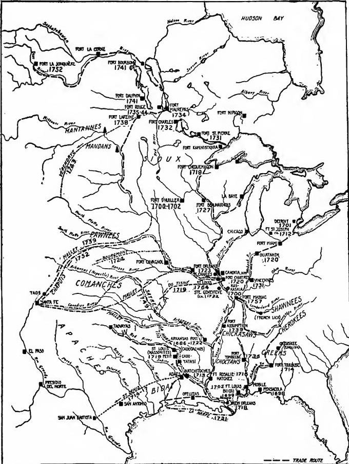 The French in Louisiana and the Pacific Northwest.
Crozat.—The colony had not prospered, and the government desired to rid itself of the expense of the establishment. In 1712 the king therefore granted to Antoine Crozat, a wealthy merchant, a fifteen-year monopoly of trade in the vast territory from Illinois to the Gulf and from the Carolinas to New Mexico. He was also permitted to send a ship annually to the Guinea coast for negro slaves. On the other hand, Crozat agreed to send out two shiploads of settlers yearly. The executive powers were vested in a council appointed by the king from nominations made by Crozat; it consisted of a governor, intendant, and two agents of the proprietor. The first governor was Lamothe Cadillac, the founder of Detroit. At first a considerable number[Pg 278] of colonists were sent over, but the French commercial laws, the monopoly of Crozat, and the low prices offered for peltries crippled the colony.
Crozat.—The colony hadn't thrived, and the government wanted to cut the costs of maintaining it. In 1712, the king granted a fifteen-year monopoly on trade in the vast area from Illinois to the Gulf and from the Carolinas to New Mexico to Antoine Crozat, a wealthy merchant. He was also allowed to send a ship every year to the Guinea coast for enslaved people. In return, Crozat agreed to send two shiploads of settlers each year. The executive powers were given to a council appointed by the king based on nominations from Crozat; it included a governor, an intendant, and two agents of the proprietor. The first governor was Lamothe Cadillac, the founder of Detroit. Initially, a significant number[Pg 278] of colonists were sent over, but the French commercial laws, Crozat's monopoly, and the low prices offered for furs hurt the colony.
Natchitoches.—Cadillac attempted to open a trade with the Spanish colonies. With this in view in 1713 St. Denis, the younger, was sent to take possession of the Natchitoches country on the Red River and to open an overland trade route across Texas into Mexico. A trading post was established at Natchitoches, but the commercial results of the expedition to Mexico were slight. St. Denis was arrested and the Spaniards, alarmed at the French encroachments, began the permanent occupation of Texas.
Natchitoches.—Cadillac tried to establish trade with the Spanish colonies. To do this, in 1713, St. Denis the younger was sent to take control of the Natchitoches area along the Red River and to create an overland trade route across Texas into Mexico. A trading post was set up in Natchitoches, but the commercial outcomes of the expedition to Mexico were minimal. St. Denis was arrested, and the Spaniards, worried about the French advances, began permanently occupying Texas.
Fort Toulouse.—In 1714 Bienville built Fort Toulouse, on the Alabama River, near the junction of the Coosa and Talapoosa Rivers, in the country of the upper Creeks, Mandeville being made first commander. Fort Toulouse was a depot where furs were bought from the Indians and floated down the river to Mobile. Round about it the Jesuit missionaries worked among the Creeks. The fort became the base for the control of these tribes, and an outpost against the English of the Carolinas. When the latter settled Georgia, feeling the menace of the French outposts, they built Fort Okfuskee, on the Talapoosa River, fort miles away, and induced the Creeks to destroy the Jesuit missions.
Fort Toulouse.—In 1714, Bienville built Fort Toulouse on the Alabama River, close to where the Coosa and Talapoosa Rivers meet, in the territory of the upper Creeks, with Mandeville appointed as the first commander. Fort Toulouse served as a hub where furs were bought from the Native Americans and sent down the river to Mobile. Jesuit missionaries worked among the Creeks in the surrounding area. The fort became the foundation for controlling these tribes and a stronghold against the English from the Carolinas. When the latter settled in Georgia and felt threatened by the French outposts, they constructed Fort Okfuskee on the Talapoosa River, just a few miles away, and persuaded the Creeks to dismantle the Jesuit missions.
Natchez.—Difficulties arose with the Natchez Indians; in 1716 Bienville was sent to subdue them, and Fort Rosalie was erected on the site of Natchez. Cadillac was shortly afterward recalled. Crozat had found his colony merely a bill of expense and in 1717 he surrendered his patent. At that time there were about seven hundred Frenchmen in Louisiana.
Natchez.—Issues developed with the Natchez Indians; in 1716, Bienville was dispatched to deal with them, and Fort Rosalie was built on the location of Natchez. Cadillac was soon recalled. Crozat discovered that his colony was just a financial burden, and in 1717 he gave up his patent. At that point, there were around seven hundred Frenchmen in Louisiana.
LOUISIANA UNDER THE COMPANY OF THE INDIES (1717-1731)
The Mississippi Bubble.—When Crozat surrendered his patent John Law was ushering in his era of speculation. Louisiana was taken over by the Compagnie d'Occident, which was granted complete political and commercial powers. The capital of the Company, amounting to one hundred million livres, was divided into two hundred thousand shares. In 1719 the company received, in addition, a monopoly of the trade of Africa and the Orient,[Pg 279] and increased its capital by fifty thousand shares, thenceforth being known as the Compagnie des Indies. Law made Louisiana the center of his system, and represented the country as an earthly paradise, fabulous in mines.
The Mississippi Bubble.—When Crozat handed over his patent, John Law was kickstarting his era of speculation. Louisiana was taken over by the Compagnie d'Occident, which was given full political and commercial authority. The Company's capital, totaling one hundred million livres, was divided into two hundred thousand shares. In 1719, the company also received a monopoly on trade in Africa and the Orient,[Pg 279] and increased its capital by fifty thousand shares, thereafter being known as the Compagnie des Indies. Law made Louisiana the focal point of his system and portrayed the region as an earthly paradise, rich in mines.
New Orleans founded.—Bienville was made governor and the capital was established at New Biloxi. In 1718 New Orleans was laid out and named in honor of the regent. A garrison was established at the Natchitoches trading post, and Fort Chartres was built in the Illinois country. Feudal seignories were not extended as in Canada, but extensive tracts were granted to concessionaires, who agreed to bring out settlers. In a short time many tracts had been granted on Red River, on the Mississippi, and on the Yazoo. As colonists did not volunteer in sufficient numbers, emigrants were secured from hospitals and jails, or were spirited away from France. A few negro slaves had been previously introduced, but Law's company brought large numbers; the first cargo, landed in 1719, contained two hundred and fifty. With this introduction of slavery, agriculture developed rapidly.
New Orleans founded.—Bienville was appointed governor, and the capital was established in New Biloxi. In 1718, New Orleans was planned and named after the regent. A military garrison was set up at the Natchitoches trading post, and Fort Chartres was built in Illinois. Unlike in Canada, feudal seignories weren't expanded, but large areas were granted to concessionaires who agreed to bring in settlers. Soon, many plots had been allocated along the Red River, Mississippi, and Yazoo. Since not enough colonists volunteered, emigrants were sought from hospitals and jails, or were smuggled out of France. A few enslaved Africans had been brought in earlier, but Law's company introduced large numbers; the first shipment, which arrived in 1719, had two hundred and fifty. With this introduction of slavery, agriculture grew rapidly.
War with Spain.—At this time a brief period of war ensued between Spain and France, due to the ambitions of Elizabeth Farnese and her advisor Alberoni. An expedition from Mobile captured Pensacola, but it was soon after retaken by the Spanish, who also attacked Mobile. Shortly afterward the French again captured Pensacola, but at the end of the war it was restored to Spain. At the same time the Spaniards were driven out of eastern Texas and an expedition under Villazur was defeated by French allies on the Platte River.
War with Spain.—During this time, a short war broke out between Spain and France, fueled by the ambitions of Elizabeth Farnese and her advisor Alberoni. A mission from Mobile took control of Pensacola, but it was quickly reclaimed by the Spanish, who also launched an attack on Mobile. Soon after, the French recaptured Pensacola, but when the war ended, it was returned to Spain. Meanwhile, the Spaniards were pushed out of eastern Texas, and an expedition led by Villazur was defeated by French allies on the Platte River.
Growth of population.—In 1720 the Mississippi Bubble burst, stock in Law's numerous enterprises fell rapidly, and the great financier left France a ruined man. Though Louisiana ceased to be the center of the financial system of France, the Company continued operations with considerable success. The white population had increased to about five thousand. New Orleans had a considerable population, and in 1722 it was made the capital.
Growth of population.—In 1720, the Mississippi Bubble burst, causing stocks in Law's numerous businesses to plummet, and the great financier left France a broken man. Although Louisiana stopped being the center of France's financial system, the Company continued to operate with notable success. The white population had grown to around five thousand. New Orleans had a significant population and was made the capital in 1722.
The government.—In order that the country might be better governed, it was divided into the nine judicial departments of Biloxi, Mobile, Alibamon, New Orleans, Yazoo, Natchez, Natchitoches,[Pg 280] Arkansas, and Illinois. The negro population increased so rapidly that there was considerable fear of an uprising. To govern them, in 1724 a set of laws known as the Black Code was promulgated by the governor. The legal religion of the colony was decreed to be Catholic, and masters were to give religious instruction to slaves. Intermarriage of whites and blacks was prohibited. The slaves were forbidden to carry weapons or to gather in assemblies. Masters were bound to clothe, protect, and give subsistence to slaves, and negro families were not to be broken up by sales. Masters were also responsible for acts of their slaves. The crimes of those in bondage were punished by whipping, branding, or, in extreme cases, by death. This code was the last important act of Bienville, who shortly afterward returned to France. The central government under the company was practically the same as that of Canada in the time of Frontenac, and similar quarrels between governor and intendant ensued. Ecclesiastically Louisiana was divided roughly into three districts; the Mobile region was under the Carmelites, the Jesuits ministered to those in the Illinois country and along the lower Ohio, and the rest was under the Capuchins.
The government.—To improve governance in the country, it was divided into nine judicial departments: Biloxi, Mobile, Alibamon, New Orleans, Yazoo, Natchez, Natchitoches,[Pg 280] Arkansas, and Illinois. The Black population grew so quickly that there were significant concerns about a potential uprising. To address this, a set of laws known as the Black Code was established by the governor in 1724. The colony's official religion was declared to be Catholicism, and masters were required to provide religious education to their slaves. Intermarriage between whites and blacks was banned. Slaves were not allowed to carry weapons or gather in groups. Masters were obligated to provide clothing, protection, and basic needs for their slaves, and slave families were not to be separated by sales. Additionally, masters were held accountable for their slaves' actions. Punishments for crimes committed by slaves included whipping, branding, or, in severe cases, death. This code was the last major action taken by Bienville, who soon returned to France. The central government, under the company, was practically identical to that of Canada during Frontenac's time, leading to similar conflicts between the governor and the intendant. From an ecclesiastical perspective, Louisiana was roughly divided into three districts: the Mobile area was overseen by the Carmelites, the Jesuits served in the Illinois region and along the lower Ohio, while the rest fell under the Capuchins.
The Natchez War.—Owing to the French occupation of Natchez lands, the tribe in 1729 formed a conspiracy, which embraced the Choctaws and other tribes, for the purpose of exterminating the whites. In the first attack two hundred and fifty French at Fort Rosalie were killed, and many women and children taken into captivity. The Choctaws turned against the Natchez. An army of French and Choctaws was collected, and finally succeeded in dispersing the hostile tribe. A second expedition pursued the fugitives, and the Natchez were so severely chastised that they ceased to exist as a unit.
The Natchez War.—Due to the French taking over Natchez lands, the tribe formed a conspiracy in 1729 that included the Choctaws and other tribes, aiming to wipe out the white settlers. In the first attack, two hundred and fifty French soldiers at Fort Rosalie were killed, and many women and children were captured. The Choctaws then turned against the Natchez. A combined force of French and Choctaws was gathered and eventually managed to scatter the hostile tribe. A second expedition chased the survivors, and the Natchez were punished so severely that they ceased to exist as a group.
LOUISIANA UNDER THE ROYAL GOVERNORS
Bienville again governor.—The expense of the Natchez War convinced the directors of the company that the Louisiana project could not be made a paying investment, and in 1731 the king released them from their charter. In 1731 the Company of the Indies withdrew from Louisiana and it became a royal province. A council was organized to replace the company and Bienville was again made governor.
Bienville as governor again.—The costs from the Natchez War made the company's directors realize that the Louisiana venture wouldn't be a profitable investment, so in 1731 the king freed them from their charter. In 1731, the Company of the Indies pulled out of Louisiana, and it turned into a royal province. A council was set up to take the place of the company, and Bienville was appointed governor once more.
[Pg 281] The Chickasaw War: Fort Tombecbé.—After the Natchez War the remnant of the tribe had fled to the Chickasaws. In 1736 Bienville made war on the latter tribe, who had not only harbored the Natchez, but were in alliance with the English and had formed a league to cut off French activities along the Mississippi, Mobile, and Tombigbee Rivers. Bienville led troops from Natchitoches, Natchez, Mobile, and New Orleans, while D'Artaguette from the Illinois coöperated. As a base of attack Fort Tombecbé was built on the Tombigbee River in the Choctaw country. The expedition against the Chickasaws ended in disaster, but Fort Tombecbé continued to be important as a base for the control of the Choctaws, who were kept hostile toward Chickasaws and English. In 1740 a second attempt was made. At Fort Assumption, on the site of Memphis, a force of thirty-six hundred was gathered. The size of the army frightened the Chickasaws, who sued for peace. The French, however, failed to secure their friendship, and they remained allies of the English.
[Pg 281] The Chickasaw War: Fort Tombecbé.—After the Natchez War, what was left of the tribe fled to the Chickasaws. In 1736, Bienville declared war on the Chickasaws, who not only offered refuge to the Natchez but also allied with the English to cut off French activities along the Mississippi, Mobile, and Tombigbee Rivers. Bienville led troops from Natchitoches, Natchez, Mobile, and New Orleans, while D'Artaguette cooperated from Illinois. To launch their attack, Fort Tombecbé was constructed on the Tombigbee River in Choctaw territory. The expedition against the Chickasaws ended disastrously, but Fort Tombecbé remained significant as a base to control the Choctaws, keeping them hostile toward both the Chickasaws and the English. In 1740, a second attempt was made. At Fort Assumption, where Memphis is now located, a force of three thousand six hundred was assembled. The large size of the army intimidated the Chickasaws, who sought peace. However, the French couldn't gain their trust, and the Chickasaws continued to be allies of the English.
End of Bienville's rule.—In 1743 Bienville retired from the governorship without having succeeded in making the colony a success. The white population near the Gulf had declined to thirty-two hundred and there were about two thousand slaves in the colony, while the Illinois country contained about fifteen hundred people. During the remaining twenty years of French rule in Louisiana the New Orleans region showed but slight development.
End of Bienville's rule.—In 1743, Bienville stepped down from the governorship without achieving success for the colony. The white population near the Gulf had dropped to three thousand two hundred, and there were about two thousand slaves in the colony, while the Illinois area had around fifteen hundred people. During the next twenty years of French rule in Louisiana, the New Orleans region saw only minimal growth.
The Illinois.—The Illinois district throve especially under the Company of the Indies. At first the settlements had been governed from Canada, but because of the Fox wars and difficulties of transportation, there was little connection with Canada, and after 1717 the Illinois district was attached to Louisiana. The settlement profited by the John Law "boom" in 1719, eight hundred new colonists coming, chiefly from Canada and New Orleans. In 1720 Fort Chartres, in 1723 St. Philippe, and ten years later Prairie du Rocher, were established. Across the river St. Genevieve and St. Charles were founded. Further east, the Wabash was fortified to keep out the advancing English traders. In 1720 Ouiatanon post was established at Lafayette. This post and Fort Miami, at Fort Wayne, were attached to[Pg 282] Canada, while Vincennes, founded in 1731, belonged to Louisiana, as did Fort Massac founded later on the Ohio. The dividing line between the districts was Terre Haute, or the highlands. Ouiatanon was at the head of navigation on the Wabash for larger pirogues. Here peltries for Canada were reshipped in canoes. Twenty thousand skins a year were sent from Ouiatanon in the decade after 1720.
The Illinois.—The Illinois region thrived especially under the Company of the Indies. Initially, the settlements were governed from Canada, but due to the Fox wars and transportation issues, there was minimal connection with Canada, and after 1717, the Illinois area became part of Louisiana. The settlement benefited from the John Law "boom" in 1719, bringing eight hundred new colonists, mainly from Canada and New Orleans. In 1720, Fort Chartres was established, followed by St. Philippe in 1723, and Prairie du Rocher ten years later. Across the river, St. Genevieve and St. Charles were founded. Further east, the Wabash was fortified to fend off advancing English traders. In 1720, the Ouiatanon post was set up in Lafayette. This post and Fort Miami at Fort Wayne were part of[Pg 282] Canada, while Vincennes, founded in 1731, was part of Louisiana, along with Fort Massac, which was established later on the Ohio. The dividing line between the two districts was Terre Haute, or the highlands. Ouiatanon was the head of navigation on the Wabash for larger pirogues. Here, pelts bound for Canada were transferred into canoes. Twenty thousand skins a year were shipped from Ouiatanon in the decade after 1720.
The Garden of New France.—The Illinois district became an important agricultural center, whence large shipments of grain were made to Detroit, the Ohio River posts, New Orleans, Mobile, and Europe. Negro slaves were introduced and tobacco-raising was begun. At Kaskaskia there was a Jesuit academy for white boys, and at Cahokia a Sulpician Indian school.
The Garden of New France.—The Illinois area became a significant agricultural hub, sending large shipments of grain to Detroit, the Ohio River posts, New Orleans, Mobile, and Europe. Enslaved Black people were brought in, and tobacco cultivation started. In Kaskaskia, there was a Jesuit school for white boys, and in Cahokia, a Sulpician school for Native Americans.
The Missouri lead mines.—During the rule of the Company of the Indies lead mines were opened in Missouri, where lead had been early discovered, especially on Maramec River. While governor, Cadillac had made a personal visit to inspect them. Mining was begun on an important scale by Renault, who received grants on the Missouri in 1723. He is said to have taken to these mines two hundred miners from France, and five hundred negroes from Santo Domingo. He was actively engaged in mining until 1746.
The Missouri lead mines.—Under the Company of the Indies, lead mines were established in Missouri, where lead had been discovered early on, particularly along the Maramec River. While serving as governor, Cadillac personally visited to inspect them. Mining began on a significant scale by Renault, who received land grants in Missouri in 1723. He is reported to have brought two hundred miners from France and five hundred enslaved people from Santo Domingo to work in the mines. He was actively involved in mining until 1746.
THE TRANS-MISSISSIPPI WEST
French advance into the Far West.—Meanwhile the French explorers had reached the Rocky Mountains. In or before 1703 twenty Canadians went from the Illinois country toward New Mexico to trade and learn about the mines. By 1705 Laurain had been on the Missouri and in 1708 Canadians are said to have explored that stream for three hundred or four hundred leagues. By 1712 salines were being worked in Missouri and settlers were living about them. Under the Company of the Indies exploration and trade were pushed for a time with vigor in the trans-Mississippi West, all along the border from the Gulf of Mexico to Nebraska. From Natchitoches French traders made their way among the tribes of eastern and northern Texas, and sometimes reached the Spanish settlements. In 1717 St. Denis the younger and several partners made a second trading expedition overland from Mobile via Natchitoches to San Juan Bautista[Pg 283] on the Rio Grande. His goods being seized, he went to Mexico, where he was imprisoned, though his goods were sold with profit. His associates, who reached the border somewhat after him, made their way to Presidio del Norte, disposed of their goods, and returned to Louisiana.
French advance into the Far West.—Meanwhile, French explorers had reached the Rocky Mountains. In or before 1703, twenty Canadians traveled from the Illinois region toward New Mexico to trade and learn about the mines. By 1705, Laurain had been on the Missouri River, and by 1708, Canadians are reported to have explored that river for three hundred or four hundred leagues. By 1712, saltworks were being operated in Missouri, and settlers were living nearby. Under the Company of the Indies, exploration and trade were actively promoted for a time in the trans-Mississippi West, along the border from the Gulf of Mexico to Nebraska. From Natchitoches, French traders navigated among the tribes of eastern and northern Texas, occasionally reaching the Spanish settlements. In 1717, St. Denis the younger and several partners undertook a second overland trading expedition from Mobile via Natchitoches to San Juan Bautista[Pg 283] on the Rio Grande. After his goods were seized, he went to Mexico, where he was imprisoned, but his goods were sold for a profit. His associates, who arrived at the border somewhat later, managed to reach Presidio del Norte, sold their goods, and returned to Louisiana.
La Harpe on the Red River.—While St. Denis was in Mexico, Bénard de la Harpe was sent to establish a post on the Red River above Natchitoches. He was urged to inform himself concerning the source of the Red River and the tribes near New Mexico, and to open commerce with the Spanish provinces. In 1719 he established his post among the Cadodachos. Du Rivage was sent up the Red River, and La Harpe made an expedition to the Touacaras near the mouth of the Canadian River, where he proposed to found a post as a base for trade with New Mexico, the Padoucas, and the Aricaras.
La Harpe on the Red River.—While St. Denis was in Mexico, Bénard de la Harpe was sent to set up a post on the Red River above Natchitoches. He was encouraged to learn about the source of the Red River and the tribes near New Mexico, and to start trade with the Spanish provinces. In 1719, he established his post among the Cadodachos. Du Rivage was sent up the Red River, and La Harpe led an expedition to the Touacaras near the mouth of the Canadian River, where he planned to establish a post as a base for trade with New Mexico, the Padoucas, and the Aricaras.
Du Tisné on the Osage and the Arkansas.—At the same time (1719) Du Tisné was on the Missouri, Osage, and Arkansas rivers. He ascended the Missouri River to the Missouri Indian village, on his way to the Pawnees, but was unable to proceed. He returned to the Illinois, and went to the Osage tribe on the Osage River. From there he continued southwest to the Pawnees on the Arkansas. He made an alliance with the Pawnees, bought Spanish horses from them, and established a French flag in their villages. He was prevented by his hosts from going to the Padouca, but he inquired about New Mexico.
Du Tisné on the Osage and the Arkansas.—At the same time (1719), Du Tisné was exploring the Missouri, Osage, and Arkansas rivers. He traveled up the Missouri River to the Missouri Indian village while heading toward the Pawnees, but he couldn't continue. He returned to the Illinois and then went to the Osage tribe along the Osage River. From there, he moved southwest to the Pawnees on the Arkansas. He formed an alliance with the Pawnees, purchased Spanish horses from them, and set up a French flag in their villages. His hosts prevented him from going to the Padouca, but he asked about New Mexico.
La Harpe on the Gulf Coast.—In 1718 the company was ordered to occupy the Bay of St. Bernard, discovered by La Salle. In 1719 and 1720 preliminary expeditions were made, and in 1721 La Harpe himself led an expedition to a bay on the Texas coast, but he was expelled by the Indians. The bay reached by him was the Bay of the Bidayes (Galveston Bay) and not the St. Bernard of La Salle. La Harpe urged a new attempt, to keep out the Spaniards, but the company abandoned the project.
La Harpe on the Gulf Coast.—In 1718, the company was instructed to settle the Bay of St. Bernard, which had been discovered by La Salle. In 1719 and 1720, initial expeditions were conducted, and in 1721, La Harpe himself led an expedition to a bay on the Texas coast, but he was driven out by the Indians. The bay he reached was the Bay of the Bidayes (Galveston Bay) and not the St. Bernard that La Salle had mentioned. La Harpe pushed for a new effort to keep the Spaniards out, but the company decided to drop the project.
La Harpe on the Arkansas.—After returning from the Gulf coast expedition, La Harpe was sent from Mobile in December, 1721, to explore the Arkansas River, with the idea of developing Indian trade, preventing Spanish encroachment, and opening commerce with New Mexico. He ascended the Arkansas about halfway to the mouth of the Canadian River, and on his return[Pg 284] recommended establishing posts at Little Rock, the mouth of the Canadian, and the Touacara villages.
La Harpe on the Arkansas.—After coming back from the Gulf Coast expedition, La Harpe was sent from Mobile in December 1721 to explore the Arkansas River, aiming to develop trade with Native Americans, stop Spanish expansion, and open up commerce with New Mexico. He traveled up the Arkansas River approximately halfway to the mouth of the Canadian River, and on his return[Pg 284] he suggested setting up posts at Little Rock, the mouth of the Canadian, and the Touacara villages.
Bourgmont on the Missouri and Kansas Rivers.—In the years immediately following the Spanish expedition under Villazur (1720), the French made active efforts to communicate with New Mexico on the one hand, and to forestall any hostile movement of the Spaniards on the other. Having heard that Spaniards were preparing to return to avenge their defeat and to occupy the Kansas River country, Bienville in 1722 ordered Boisbriant, commander at the Illinois, to anticipate the Spaniards and build a fort. The person sent was Bourgmont, who had lived among the Missouris fifteen or more years, and had been made commander on the Missouri. Late in 1723 he established Fort Orleans above the mouth of the Grand River, in modern Carroll County, Missouri. From there in 1724 he went up the river among the Otos and Iowas, and then southwest to the Padoucas in Western Kansas, taking with him Missouris, Osages, Kansas, Otos, and Iowas. He made peace between these tribes and the Padoucas, and arranged to send traders to the last named. A primary object was to open a way to New Mexico. Shortly afterward Fort Orleans was destroyed by an Indian massacre, and wars of the Foxes for several years practically closed the lower Missouri.
Bourgmont on the Missouri and Kansas Rivers.—In the years right after the Spanish expedition led by Villazur (1720), the French actively tried to connect with New Mexico on one side and prevent any aggressive moves from the Spaniards on the other. When Bienville heard that the Spaniards were planning to return to retaliate and take over the Kansas River area, he ordered Boisbriant, the commander at Illinois, in 1722 to beat the Spaniards to it and build a fort. Bourgmont, who had lived among the Missouris for over fifteen years and had been made commander on the Missouri, was the one sent for the task. Late in 1723, he established Fort Orleans above the Grand River's mouth, in what is now Carroll County, Missouri. From there, in 1724, he traveled up the river to connect with the Otos and Iowas, then southwest to the Padoucas in Western Kansas, bringing along Missouris, Osages, Kansas, Otos, and Iowas. He brokered peace between these tribes and the Padoucas and organized to send traders to them. One of his main goals was to create a route to New Mexico. Shortly after, Fort Orleans was destroyed in an Indian massacre, and the Fox wars led to several years of conflict that effectively shut down the lower Missouri.
THE ADVANCE TOWARD NEW MEXICO
The western fur trade.—For a decade and a half after the Bourgmont expedition the French made no noteworthy western exploration. Meanwhile, however, the traders quietly carried on their trade among the western tribes. Important items in this trade were Indian captives, and mules stolen from the Spaniards. French traders sometimes found a ready market for goods smuggled into Spanish settlements on the northern frontier of New Spain. From New Orleans, Opelousas, Natchitoches, Yatasi, Petit Caddo, and Cadadocho posts they worked among the tribes of eastern and northern Texas. By 1730 they had reached the lower Trinity to trade among the Orcoquiza and Bidai tribes. Further north they traded with the Asinai and Cadadochos, in the very face of the Spanish posts. By the middle of the century they were well established among the Wichita tribes of the Red River Valley, and northeastern Texas was virtually under French[Pg 285] control. The way to western Texas and the upper Red River was barred by the hostile Apaches, but in 1753 Governor Kerlérec proposed breaking through this strong barrier.
The western fur trade.—For about fifteen years after the Bourgmont expedition, the French didn’t carry out any significant exploration in the west. In the meantime, however, traders continued their business among the western tribes. Key items in this trade included Indian captives and mules taken from the Spaniards. French traders sometimes found a ready market for goods smuggled into Spanish settlements along the northern border of New Spain. From locations like New Orleans, Opelousas, Natchitoches, Yatasi, Petit Caddo, and Cadadocho posts, they engaged with the tribes of eastern and northern Texas. By 1730, they had reached the lower Trinity River to trade with the Orcoquiza and Bidai tribes. Further north, they dealt with the Asinai and Cadadochos, right in front of the Spanish posts. By the middle of the century, they were well established among the Wichita tribes of the Red River Valley, and northeastern Texas was essentially under French[Pg 285] control. The path to western Texas and the upper Red River was blocked by the hostile Apaches, but in 1753, Governor Kerlérec suggested breaking through this strong barrier.
From the Arkansas post traders worked among the Quapaws and Jumanos, and other tribes adjacent to the Arkansas River. From the Illinois, and from lesser posts among the Osages, Missouris, and Kansas, traders worked among these tribes, the Iowas, Otos, Pawnees of the Platte, and other more northern bands of Indians.
From the Arkansas post, traders worked with the Quapaws, Jumanos, and other tribes near the Arkansas River. From Illinois and smaller posts among the Osages, Missouris, and Kansas, traders engaged with these tribes, including the Iowas, Otos, Pawnees of the Platte, and other northern Native American groups.
Interest in New Mexico.—French voyageurs, chasseurs, and traders of Louisiana and Canada continued to look with covetous eyes toward New Mexico. To the adventurer it was a land promising gold and silver and a path to the South Sea; to the merchant it offered rich profits in trade. The natural avenues of approach to this Promised Land were the Red, Arkansas, and Missouri Rivers. But there were obstacles to expeditions bound for New Mexico. One was the jealous and exclusive policy of Spain, which made the reception of such Frenchmen as might reach Santa Fé a matter of uncertainty; another was the Indian barrier which stood in the way. The Red River highway was effectually blocked by the Apaches, mortal enemies of all the tribes along the lower valley; the Arkansas and Missouri avenues were impeded by the Comanches for analogous reasons. The Apaches and Comanches opposed the passage of the trader to their foes with supplies of weapons. As the fur traders and official explorers pushed rapidly west, one of their constant aims was to open the way to New Mexico by effecting peace between the Comanche and the tribes further east, an attempt at which had been made by Du Tisné and Bourgmont at an earlier day.
Interest in New Mexico.—French voyageurs, hunters, and traders from Louisiana and Canada continued to eye New Mexico with envy. To the adventurer, it was a land filled with the promise of gold and silver and a route to the South Sea; to the merchant, it provided the potential for huge profits in trade. The natural routes to this promised land were the Red, Arkansas, and Missouri Rivers. However, there were challenges for expeditions heading to New Mexico. One was Spain's jealous and exclusive policies, which made it uncertain how Frenchmen reaching Santa Fé would be received; another was the barrier posed by Native American tribes. The Red River route was effectively blocked by the Apaches, who were sworn enemies of all tribes in the lower valley; the Arkansas and Missouri routes faced similar obstacles from the Comanches. The Apaches and Comanches resisted traders passing through to their enemies with supplies of weapons. As fur traders and official explorers rushed westward, one of their ongoing goals was to clear the path to New Mexico by negotiating peace between the Comanche and tribes further east, an effort that had been attempted earlier by Du Tisné and Bourgmont.
The Mallet brothers.—After the cessation of the Fox wars, which had closed the lower Missouri, traders again frequented the Pawnees and Aricaras, and in 1734 one is known to have ascended the Missouri to the Mandans, from whose villages a trade route was soon opened to western Canada. In 1739 a party led by the Mallet brothers made their way, by the Missouri and Platte Rivers, across Nebraska, Kansas, and Colorado to Santa Fé. After a nine months' stay they returned, part going northeastward to the Illinois and part down the Canadian and Arkansas to New Orleans.
The Mallet brothers.—After the end of the Fox wars, which had shut down lower Missouri, traders started visiting the Pawnees and Aricaras again, and in 1734, one trader is known to have traveled up the Missouri to the Mandans, from whose villages a trade route was soon opened to western Canada. In 1739, a group led by the Mallet brothers traveled along the Missouri and Platte Rivers, crossing through Nebraska, Kansas, and Colorado to Santa Fé. After staying for nine months, they returned, with some heading northeast to Illinois and others going down the Canadian and Arkansas Rivers to New Orleans.
[Pg 286] Fabry's attempt: Fort Cavagnolle.—The Mallet party had succeeded in getting through the Comanche country to New Mexico and had returned safely and with good prospects for trade. Immediately there was renewed interest in the Spanish border on the part of both government officials and private adventurers. At once, in 1741 Governor Bienville sent Fabry de la Bruyère with members of the Mallet party to open a trade route to New Mexico up the Canadian River, and to explore the Far West. He failed to reach New Mexico. Fort Cavagnolle was established among the Kansas, and the Arkansas route was made safe by effecting a much-desired treaty (1746 or 1747) between the Comanches and their eastern enemies.
[Pg 286] Fabry's attempt: Fort Cavagnolle.—The Mallet group managed to travel through Comanche territory into New Mexico and returned safely with promising trade opportunities. This sparked fresh interest in the Spanish border from both government officials and private adventurers. In 1741, Governor Bienville promptly sent Fabry de la Bruyère along with members of the Mallet group to establish a trade route to New Mexico via the Canadian River and to explore the Far West. He was unable to reach New Mexico. Fort Cavagnolle was set up among the Kansas tribes, and the Arkansas route was secured by achieving a long-awaited treaty (1746 or 1747) between the Comanches and their eastern adversaries.
New expeditions to New Mexico.—The effect of this treaty was immediate, and at once there were new expeditions to New Mexico by deserters, traders, and official agents. In 1748 thirty-three Frenchmen were reported among the Xicarillas. Early in 1749 a party led by Pierre Satren reached Santa Fé by way of the Arkansas River, conducted by Jumano and Comanche Indians. They were kept in New Mexico to work at their trades. Early in 1750 another party arrived by way of the Arkansas. They were ordered sent to Sonora to prevent their return to Illinois. In the meantime peace had been made between the Comanches and Pawnees, and in 1751 traders reached New Mexico by way of the Missouri. In the same year Jean Chapuis led a party of nine from Illinois with a commission from St. Clair, the commander of Fort Chartres. Arriving at Santa Fé in 1752, via Platte River, he proposed a regular caravan trade with military escort. The intruders were arrested and sent to Mexico, where they languished in prison for many months, and were finally sent to Spain.
New expeditions to New Mexico.—The impact of this treaty was immediate, leading to new expeditions to New Mexico by deserters, traders, and official agents. In 1748, thirty-three Frenchmen were reported among the Xicarillas. Early in 1749, a group led by Pierre Satren reached Santa Fé via the Arkansas River, guided by Jumano and Comanche Indians. They were kept in New Mexico to work at their trades. Early in 1750, another group arrived via the Arkansas. They were ordered to be sent to Sonora to prevent their return to Illinois. Meanwhile, peace had been established between the Comanches and Pawnees, and in 1751, traders reached New Mexico via the Missouri. In the same year, Jean Chapuis led a group of nine from Illinois with a commission from St. Clair, the commander of Fort Chartres. Arriving in Santa Fé in 1752, via the Platte River, he suggested a regular caravan trade with military escort. The intruders were arrested and sent to Mexico, where they remained in prison for many months before being finally sent to Spain.
The French advance through the Comanche country gives significance to the proposal of Governor Kerlérec in 1753 to break through the Apache barrier and open up a trade with Nuevo León, Coahuila, and New Mexico. As a means of doing so he proposed securing an alliance between the Apaches and their eastern enemies. These intrusions of Frenchmen into New Mexico were closely bound up in their effect on Spanish policy, with similar infringements upon the Texas border.
The French push into Comanche territory highlights Governor Kerlérec's 1753 proposal to break through the Apache barrier and establish trade with Nuevo León, Coahuila, and New Mexico. To achieve this, he suggested forming an alliance between the Apaches and their eastern rivals. These French incursions into New Mexico were closely connected to their impact on Spanish policy, paralleling similar violations along the Texas border.
THE FAR NORTHWEST
The Fox wars.—By the end of the seventeenth century Fox hostilities had practically closed the Fox-Wisconsin trade route to the Mississippi. Hostility was increased by the massacre of many Fox Indians at Detroit in 1712. In 1715 De Lignery led a futile expedition against the tribe at Green Bay. In the following year Louvigny with eight hundred men won a partial victory at Butte des Morts, near Lake Winnebago. The European war had now closed, and the Lake Superior posts—Green Bay, La Pointe, Pigeon River, and Lake Nepigon—were reoccupied. The Fox-Wisconsin route being closed, the western trade was divided between the Lake Superior district and that of the Illinois.
The Fox Wars. — By the end of the 17th century, hostilities with the Fox tribe had effectively shut down the Fox-Wisconsin trade route to the Mississippi. Tensions escalated after many Fox Indians were massacred in Detroit in 1712. In 1715, De Lignery led an unsuccessful expedition against the tribe at Green Bay. The following year, Louvigny and eight hundred men achieved a partial victory at Butte des Morts, near Lake Winnebago. The European war had now ended, and the Lake Superior posts—Green Bay, La Pointe, Pigeon River, and Lake Nepigon—were reoccupied. With the Fox-Wisconsin route closed, western trade was split between the Lake Superior area and Illinois.
The new Sioux posts.—A new movement into the Sioux country was stimulated by the long standing desire to find a route to the Pacific. In 1723 Father Charlevoix suggested finding it either by means of a line of posts through the Sioux country or by way of the Missouri and over the mountains. The former plan was adopted, and in 1727 Fort Beauharnois was built on the west bank of Lake Pepin, with Perrière in command, and with new missions in the vicinity. But, through another uprising of the Fox Indians, the post was soon abandoned. New expeditions against the Foxes and the Sauks, their allies, broke their resistance, and after 1733 the Fox-Wisconsin trade route to the Iowa and Minnesota country was again open. After 1750 the Foxes were regular allies of the French in their wars with the British.
The new Sioux posts.—A fresh push into the Sioux region was driven by the long-held goal of finding a route to the Pacific. In 1723, Father Charlevoix proposed establishing it either through a line of posts in Sioux territory or via the Missouri and over the mountains. The first option was chosen, and in 1727, Fort Beauharnois was constructed on the west bank of Lake Pepin, with Perrière in charge, along with new missions nearby. However, due to another uprising by the Fox Indians, the post was quickly abandoned. New efforts against the Foxes and their allies, the Sauks, broke their resistance, and after 1733, the Fox-Wisconsin trade route to Iowa and Minnesota reopened. After 1750, the Foxes regularly allied with the French in their conflicts with the British.
The Vérendrye and the Post of the Western Sea.—The search for the route to the Western Sea was taken up by Gaultier de Varennes (the elder La Vérendrye), commander at Fort Nepigon, who planned a fine of posts through the waterways northwest of Lake Superior. His movements were stimulated by the activities of the Hudson's Bay Company in Canada, and by those of the Spaniards in the Southwest. To pay the expenses of his scheme he was granted a monopoly of the northwestern fur trade. In the course of ten years he founded posts on Rainy Lake (St. Pierre, 1731), Lake of the Woods (St. Charles, 1731), Lake Winnipeg (Maurepas, 1732), Assiniboine River (La Reine),[Pg 288] and on the Saskatchewan (Fort Dauphin, 1741). In 1742 La France had penetrated the Hudson's Bay Company territory by crossing from Lake Winnipeg to York Factory.
The Vérendrye and the Post of the Western Sea.—The search for the route to the Western Sea was taken up by Gaultier de Varennes (the elder La Vérendrye), who commanded Fort Nepigon. He planned a series of posts through the waterways northwest of Lake Superior. His efforts were motivated by the activities of the Hudson's Bay Company in Canada and by Spanish actions in the Southwest. To cover the costs of his project, he was granted a monopoly on the northwestern fur trade. Over the course of ten years, he established posts on Rainy Lake (St. Pierre, 1731), Lake of the Woods (St. Charles, 1731), Lake Winnipeg (Maurepas, 1732), Assiniboine River (La Reine),[Pg 288] and on the Saskatchewan (Fort Dauphin, 1741). In 1742, La France entered Hudson's Bay Company territory by crossing from Lake Winnipeg to York Factory.
From this line of posts the elder La Vérendrye turned his attention to the upper Missouri, leading an expedition southwestward to the Mantannes in 1738. Four years later his son, Pierre de Varennes, made another expedition to the Mantannes, where they heard of bearded white men to the west. Setting out southwestward, they visited the Cheyennes, Crows, Little Foxes, and Bows. On January 1, 1743, when in the neighborhood of the North Platte River, they saw the Rocky Mountains.
From this series of posts, the elder La Vérendrye shifted his focus to the upper Missouri, leading an expedition southwest to the Mantannes in 1738. Four years later, his son, Pierre de Varennes, took another expedition to the Mantannes, where they learned about bearded white men to the west. Heading southwest, they visited the Cheyennes, Crows, Little Foxes, and Bows. On January 1, 1743, while near the North Platte River, they spotted the Rocky Mountains.
After Vérendrye died, his successor, Legardeur St. Pierre, extended the line of posts up the Saskatchewan to the foot of the Rockies, where in 1752 he founded Fort La Jonquiere. The French had thus reached the Rockies by way of nearly every important stream between the Red River and the Saskatchewan.
After Vérendrye died, his successor, Legardeur St. Pierre, extended the line of posts up the Saskatchewan to the foot of the Rockies, where in 1752 he founded Fort La Jonquiere. The French had thus reached the Rockies by way of nearly every important stream between the Red River and the Saskatchewan.
READINGS
Bolton, H.E., Athanase de Mézières, I, Introduction; Texas in the Middle Eighteenth Century, 1-133; "French Intrusions into New Mexico," in The Pacific Ocean in History; Dunn, W.E., Spanish and French Rivalry in the Gulf Region of the United States, 1678-1702: The Beginnings of Texas and Pensacola; Fortier, Alcée, History of Louisiana, I, 30-140; French, B.F., Historical Collections of Louisiana and Florida; Gayarré, Charles, History of Louisiana, French Domination; Hamilton, P.J., Colonial Mobile; The Colonization of the South, 197-275; Heinrich, Pierre, La Louisiane sous la compagnie des Indies, 1717-1731; King, Grace, New Orleans; Sieur de Bienville; King, Grace, and Ficklen, John, History of Louisiana; LePage du Pratz, Histoire de la Louisiane; Martin, F.X., History of Louisiana; Ogg, F.A., The Opening of the Mississippi, 169-237; Parkman, Francis, A Half-Century of Conflict, I, 298-368, II, 3-44; Phelps, Albert, Louisiana, 20-105; Shea, J.G., Exploration of the Mississippi Valley; The Catholic Church in the United States; Thwaites, R.G., France in America, 72-88; Villiers du Terrage, Marc de, Les Dernières Années de la Louisiane Française, 1-48; Winsor, Justin, The Mississippi Basin, 1-217; Burpee, Lawrence, Pathfinders of the Great Plains.
Bolton, H.E., Athanase de Mézières, I, Introduction; Texas in the Middle Eighteenth Century, 1-133; "French Intrusions into New Mexico," in The Pacific Ocean in History; Dunn, W.E., Spanish and French Rivalry in the Gulf Region of the United States, 1678-1702: The Beginnings of Texas and Pensacola; Fortier, Alcée, History of Louisiana, I, 30-140; French, B.F., Historical Collections of Louisiana and Florida; Gayarré, Charles, History of Louisiana, French Domination; Hamilton, P.J., Colonial Mobile; The Colonization of the South, 197-275; Heinrich, Pierre, La Louisiane sous la compagnie des Indies, 1717-1731; King, Grace, New Orleans; Sieur de Bienville; King, Grace, and Ficklen, John, History of Louisiana; LePage du Pratz, Histoire de la Louisiane; Martin, F.X., History of Louisiana; Ogg, F.A., The Opening of the Mississippi, 169-237; Parkman, Francis, A Half-Century of Conflict, I, 298-368, II, 3-44; Phelps, Albert, Louisiana, 20-105; Shea, J.G., Exploration of the Mississippi Valley; The Catholic Church in the United States; Thwaites, R.G., France in America, 72-88; Villiers du Terrage, Marc de, Les Dernières Années de la Louisiane Française, 1-48; Winsor, Justin, The Mississippi Basin, 1-217; Burpee, Lawrence, Pathfinders of the Great Plains.
CHAPTER XVI
TEXAS, PIMERÍA ALTA AND THE FRANCO-SPANISH BORDER CONFLICT (1687-1763)
The advance of the French into Louisiana and the Trans-Mississippi West stimulated a new counter movement northeastward by the Spaniards from Chihuahua, New Mexico, and Coahuila, and there ensued on the Franco-Spanish border a contest for the control of Texas and all the plains country as far north as the Platte River—a contest much like the better-known "half-century of conflict" between the English and the French on the other border. At the same time, the Spanish frontier forged slowly northwestward into Lower California and southern Arizona. On the other hand, the Florida frontier, which in the seventeenth century had been pushed back by the English colonies of Virginia and the Carolinas, was now still further contracted by the establishment of French Louisiana and English Georgia, while in the West Indies and Honduras Spanish rule suffered a like diminution through the continued advance of the English, French, and Dutch. The Asiento of 1713 with Great Britain was a particularly hard blow at Spain's commercial independence, and was made worse by England's gross violation of the compact.
The French push into Louisiana and the Trans-Mississippi West sparked a new movement from the Spaniards in Chihuahua, New Mexico, and Coahuila, leading to a struggle along the Franco-Spanish border for control of Texas and all the plains up to the Platte River—much like the better-known "half-century of conflict" between the English and the French on the other side. Meanwhile, the Spanish frontier gradually expanded northwest into Lower California and southern Arizona. Conversely, the Florida frontier, which had been pushed back in the seventeenth century by the English colonies of Virginia and the Carolinas, was now further reduced by the establishment of French Louisiana and English Georgia. Additionally, in the West Indies and Honduras, Spanish rule faced similar setbacks due to the ongoing expansion of the English, French, and Dutch. The Asiento of 1713 with Great Britain dealt a particularly heavy blow to Spain's commercial independence, made worse by England's blatant violation of the agreement.
NORTHEASTWARD ADVANCE OF THE SPANISH FRONTIER
The Chihuahua mines.—In Nueva Vizcaya two notable forward steps north were taken in the early eighteenth century. These were the opening of the Chihuahua silver deposits and the advance down the Conchos valley. In 1703-1704 rich ores were discovered near the recently founded mission of Nombre de Diós. The mines proved to be among the best in America, and, it has been estimated, produced silver worth from $50,000,000 to $100,000,000 in the eighteenth century. Two reales de minas, Chihuahua and Santa Eulalia, were established near by, and became the most thriving centers on the northern frontier. By[Pg 290] 1763 each had a population of 5000, and the church at Chihuahua was one of the finest in the new world.
The Chihuahua mines.—In Nueva Vizcaya, two significant advancements to the north took place in the early 1700s. These were the opening of the Chihuahua silver deposits and the expansion down the Conchos valley. In 1703-1704, rich ores were found near the newly established mission of Nombre de Diós. The mines turned out to be among the best in America and are estimated to have produced silver worth between $50 million and $100 million in the eighteenth century. Two reales de minas, Chihuahua and Santa Eulalia, were established nearby, becoming the most prosperous centers on the northern frontier. By[Pg 290] 1763, each had a population of 5,000, and the church in Chihuahua was one of the finest in the new world.
Advance down the Conchos Valley.—At the same time the frontier advanced down the fertile Conchos River Valley and across the Rio Grande into western Texas. In 1715 the abandoned missions at La Junta were reëstablished. Soon six missions were in operation and serving Indian towns on both sides of the Rio Grande. For ten years they succeeded, and then, in 1725, the Indians revolted and deserted. During the subsequent years the padres made them occasional visits, while settlement pushed down the Conchos Valley. In 1753 the La Junta missions were restored, and in 1760 were protected by the new presidio of Belén.
Advance down the Conchos Valley.—At the same time, the frontier moved down the fertile Conchos River Valley and crossed the Rio Grande into western Texas. In 1715, the abandoned missions at La Junta were reestablished. Soon, six missions were operating and serving Indigenous communities on both sides of the Rio Grande. They thrived for ten years, and then, in 1725, the Indigenous people revolted and abandoned the missions. In the following years, the padres made occasional visits while settlements expanded down the Conchos Valley. In 1753, the La Junta missions were restored, and by 1760, they were safeguarded by the new presidio of Belén.
The New Mexico border. Moqui and Zuñi resistance.—The reconquest of the New Mexico pueblos had been effected by Vargas at the end of the seventeenth century. The Moquis and Zuñis, however, stubbornly resisted Spanish influence and harbored apostates. In 1726 and again in 1741 the Moqui district was assigned to the Jesuits of Sonora, but they accomplished little. Rivalry led to new Franciscan visits, and in 1742 the missionaries recovered more than four hundred Tigua fugitives who had fled during the great revolt of sixty years before. In 1745 the field was restored to the Franciscans, but they were unable to make permanent establishments.
The New Mexico border. Moqui and Zuñi resistance.—Vargas had successfully reconquered the New Mexico pueblos at the end of the seventeenth century. However, the Moquis and Zuñis stubbornly resisted Spanish influence and supported those who defected from the church. In 1726 and again in 1741, the Moqui area was given to the Jesuits from Sonora, but they achieved very little. Competition resulted in renewed visits from the Franciscans, and in 1742, the missionaries recovered over four hundred Tigua fugitives who had escaped during the major uprising sixty years earlier. In 1745, the area was returned to the Franciscans, but they couldn't establish a lasting presence.
Xicarrilla and Navajo missions.—In 1733 a mission was founded near Taos for the Xicarrilla Apaches who were hard pressed by the Comanches. Between 1744 and 1750 efforts were made to convert the Navajo, but without avail.
Xicarrilla and Navajo missions.—In 1733, a mission was established near Taos for the Xicarrilla Apaches, who were under pressure from the Comanches. Between 1744 and 1750, attempts were made to convert the Navajo, but they were unsuccessful.
New settlements.—The population of New Mexico grew slowly but steadily. In 1706 Governor Cubero founded the new villa of Albuquerque and reëstablished La Cañada. In 1760 there were 7666 Spaniards in fourteen settlements in the upper district and 3588 about El Paso. This was a population larger than that of English Georgia at the same time. The largest towns were Albuquerque (1814). La Canada (1515), and Santa Fé (1285). At the same time the Christian Indians in the province numbered 10,000.
New settlements.—The population of New Mexico grew slowly but steadily. In 1706, Governor Cubero founded the new town of Albuquerque and reestablished La Cañada. By 1760, there were 7,666 Spaniards in fourteen settlements in the upper district and 3,588 around El Paso. This was a larger population than that of English Georgia at the same time. The largest towns were Albuquerque (1,814), La Canada (1,515), and Santa Fé (1,285). At the same time, the Christian Indians in the province numbered 10,000.
Indian depredations.—New Mexico was constantly harassed by Navajos on the west, Yutas and Comanches on the north, and Apaches on the east and south. The main object of the[Pg 291] savages was to steal stock and other property, but they often shed human blood freely. On the basis of horses and mules stolen in New Mexico, a regular trade was maintained by Indians across the country to Louisiana. The exterior tribes attacked the Pueblo Indians even more freely than the Spaniards. The Spanish soldiery, with Indian allies, often retaliated with telling effect and recovered stolen horses and mules. Captives taken were sold as slaves to the settlers or in the interior. Yet there were truces between campaigns, and by the middle of the century the Comanches and Yutas in large numbers attended the annual Taos fair, where they sold skins and captives.
Indian raids.—New Mexico was continually troubled by Navajos to the west, Yutas and Comanches to the north, and Apaches to the east and south. The main goal of the[Pg 291]
Rumors of the French.—The French advance up the Missouri stimulated a counter movement of the Spaniards of the New Mexico border. Before the end of the seventeenth century wild rumors of the approaching French had reached Santa Fé. Other interests, especially Indian relations, furnished motives for northeastward expeditions early in the eighteenth century. In 1706 Juan de Urribarri was sent by Governor Cubero "to the unknown land of the plains" to ransom Christian captives from the northern tribes. He crossed the Napestle (Arkansas) River, near the present city of Pueblo, Colorado, and reached the Indian settlement of El Cuartelejo, near the Colorado-Kansas border, where he heard new reports of the French among the Pawnees.
Rumors of the French.—The French moving up the Missouri sparked a response from the Spaniards along the New Mexico border. Before the end of the seventeenth century, wild rumors about the arriving French had made it to Santa Fé. Other interests, particularly relations with Native Americans, motivated expeditions to the northeast early in the eighteenth century. In 1706, Juan de Urribarri was sent by Governor Cubero "to the unknown land of the plains" to rescue Christian captives from the northern tribes. He crossed the Napestle (Arkansas) River, near what is now Pueblo, Colorado, and reached the Native American settlement of El Cuartelejo, near the Colorado-Kansas border, where he heard new reports about the French among the Pawnees.
Expeditions to the northeast and north.—The frequent campaigns against the Indians were occasions for new exploration. In 1715 Juan Paez Hurtado, with two hundred and fifty men, pursued Apaches into western Texas. During the next four years several expeditions were made northeast against Comanches and Yutas, in the course of which new reports were heard of the French, who were now pushing up all the western tributaries of the Mississippi. In 1719 a campaign against the Yutas and Comanches led Governor Valverde across the Arkansas. In 1720 occurred the disastrous Villazur expedition to the Platte described later. About 1750 Bustamente y Tagle pursued Comanches down the Arkansas nearly to the Jumanos.
Expeditions to the northeast and north.—The frequent campaigns against the Native Americans provided opportunities for exploration. In 1715, Juan Paez Hurtado, with two hundred and fifty men, chased the Apaches into western Texas. Over the next four years, several expeditions were conducted northeast against the Comanches and Yutas, during which new reports came in about the French, who were advancing up all the western tributaries of the Mississippi. In 1719, a campaign against the Yutas and Comanches took Governor Valverde across the Arkansas River. In 1720, the disastrous Villazur expedition to the Platte took place, which is described later. Around 1750, Bustamente y Tagle chased the Comanches down the Arkansas River almost to the Jumanos.
Explorers in Colorado.—Explorers also entered the Utah Basin. Juan María Rivera, sent out by Governor Cachupín in search of ore, visited and named the La Plata (Silver) Mountains, and continued to the junction of the Uncompahgre River with[Pg 292] the Gunnison (1765). In the following year Nicolás de la Fora, writing in New Mexico, stated that the Spaniards were acquainted with the country along the Cordillera de las Grullas (in western Colorado) for a hundred leagues above Santa Fé. A decade later (1779) Anza ascended the San Luis Valley, descended the Arkansas River, and returned to Santa Fé over the mountains.
Explorers in Colorado.—Explorers also ventured into the Utah Basin. Juan María Rivera, sent by Governor Cachupín in search of minerals, visited and named the La Plata (Silver) Mountains, then continued to where the Uncompahgre River meets[Pg 292] the Gunnison (1765). The next year, Nicolás de la Fora, writing from New Mexico, noted that the Spaniards were familiar with the area along the Cordillera de las Grullas (in western Colorado) for about a hundred leagues north of Santa Fé. A decade later (1779), Anza traveled up through the San Luis Valley, descended the Arkansas River, and made his way back to Santa Fé over the mountains.
THE FOUNDING OF TEXAS
The Coahuila frontier.—In 1693 eastern Texas, after a temporary occupation, had been abandoned, and the frontier fell back to Coahuila. In the course of the next decade, however, it was gradually extended until it crossed the Rio Grande. A most important factor in the work were the Querétaro friars, who ever urged the government forward. By 1698 Boca de Leones and Lampazos had become the seats of flourishing mines, missions, and ranches. Between 1699 and 1703 three missions and a presidio had been established on the Rio Grande at San Juan Bautista, below modern Eagle Pass. The site, being a great rendezvous and trading place for the tribes, was known as the "Cádiz of the interior." Near most of the missions small colonies of Spaniards and Tlascaltecans settled. These missions served many Indians from beyond the Rio Grande, and frequent expeditions were made into the outlying country.
The Coahuila frontier.—In 1693, eastern Texas was temporarily occupied but then abandoned, causing the frontier to revert back to Coahuila. However, over the next decade, it gradually expanded until it crossed the Rio Grande. A key factor in this effort was the Querétaro friars, who continuously encouraged the government to push forward. By 1698, Boca de Leones and Lampazos had turned into thriving centers for mines, missions, and ranches. Between 1699 and 1703, three missions and a presidio were established on the Rio Grande at San Juan Bautista, just below modern Eagle Pass. This location became a major meeting and trading spot for the tribes and was referred to as the "Cádiz of the interior." Near most of the missions, small settlements of Spaniards and Tlascaltecans were established. These missions supported many Indians from beyond the Rio Grande, and frequent expeditions took place into the surrounding areas.
Plans to reoccupy Texas.—During all this time the missionaries were desirous of returning to the Asinai or Texas Indians, whom they had left in '93, and with whom they had since maintained communication. In 1706 the governor of Coahuila urged the founding of a mission on the Rio Frio as a means of securing the road to the Asinai. Three years later Fathers Olivares and Espinosa made an expedition to the Colorado River, where they hoped to meet the tribe. Father Hidalgo long made strenuous efforts to get permission to return to his former charges, and Father Olivares went to Spain to procure it. Frequent rumors of French incursions from Louisiana were discussed in government circles, but it required an actual danger to cause the government to act.
Plans to reoccupy Texas.—During this time, the missionaries wanted to return to the Asinai or Texas Indians, whom they had left in '93 and had kept in touch with since then. In 1706, the governor of Coahuila pushed for establishing a mission on the Rio Frio to secure the route to the Asinai. Three years later, Fathers Olivares and Espinosa embarked on an expedition to the Colorado River, hoping to meet the tribe. Father Hidalgo made significant efforts to get permission to go back to his former charges, while Father Olivares traveled to Spain to obtain it. There were frequent discussions in government circles about the possibility of French incursions from Louisiana, but it took a real threat to prompt the government to take action.
St. Denis in Mexico.—In 1714, led by two survivors of La Salle's expedition, St. Denis made his expedition across Texas to trade. At San Juan Bautista he was arrested and taken to[Pg 293] Mexico, where it was realized by the officials that a real menace had arisen. In a council of war held on August 22, 1715, it was decided to reoccupy Texas with missions, a garrison, and a small colony. Domingo Ramón, a frontier officer, was put in charge of the expedition, and the missionary field was assigned to the two Franciscan colleges de Propaganda Fide of Querétaro and Zacatecas. Of the missions of the former, Father Espinosa, later known as the historian, was made president; of the latter the president appointed was the still more renowned Father Antonio Margil.
St. Denis in Mexico.—In 1714, guided by two survivors of La Salle's expedition, St. Denis embarked on his journey across Texas to engage in trade. At San Juan Bautista, he was captured and taken to[Pg 293] Mexico, where officials recognized that a genuine threat had emerged. In a war council held on August 22, 1715, it was decided to reestablish a presence in Texas with missions, a military post, and a small settlement. Domingo Ramón, a frontier officer, was appointed to lead the expedition, and the missionary activities were given to the two Franciscan colleges de Propaganda Fide in Querétaro and Zacatecas. For the missions from the former, Father Espinosa, later known as the historian, was chosen as president; from the latter, the appointed president was the even more famous Father Antonio Margil.
Eastern Texas reoccupied.—In February, 1716, the expedition left Saltillo, and in April it crossed the Rio Grande at San Juan Bautista. In the party were nine friars, twenty-five soldiers, six women, and enough other persons to make a total of sixty-five. They drove with them more than 1000 head of cattle and goats, and an outfit for missions, farms, and a presidio. A direct northeast route was followed, through San Pedro Springs, where the city of San Antonio later grew up. By the Asinai Indians they were given a warm welcome, and four missions were at once founded near the Neches and Angelina Rivers. Near the latter stream the presidio of Dolores was established. At the same time an attempt was made to establish a mission on the Red River among the Cadodachos, but it was frustrated by the Indians, who were under French influence.
Eastern Texas reoccupied.—In February 1716, the expedition left Saltillo, and in April it crossed the Rio Grande at San Juan Bautista. The group included nine friars, twenty-five soldiers, six women, and enough other people to total sixty-five. They brought along over 1,000 cattle and goats, as well as supplies for missions, farms, and a presidio. They took a direct northeast route through San Pedro Springs, where the city of San Antonio later developed. The Asinai Indians warmly welcomed them, and four missions were quickly established near the Neches and Angelina Rivers. Close to the Angelina River, the presidio of Dolores was founded. At the same time, an attempt was made to set up a mission on the Red River with the Cadodachos, but it was unsuccessful due to the Indians being influenced by the French.
A new base needed.—Eastern Texas had been reoccupied, but the outposts there were weak and isolated. The French were trading among the surrounding tribes; St. Denis was known to be planning another commercial expedition to Mexico; and it was rumored that a large French colony was to be established at the mouth of the Mississippi. This prediction was verified by the founding of New Orleans in 1718. On the other hand, Father Olivares urged advancing from the Rio Grande to the San Antonio. These motives to action coincided with a more aggressive Spanish policy toward the French since the death of Louis XIV, a policy exemplified by the new viceroy Linares.
A new base was needed.—Eastern Texas had been taken back, but the outposts there were weak and isolated. The French were trading with the nearby tribes; St. Denis was known to be planning another trading trip to Mexico; and rumors circulated that a large French colony was to be established at the mouth of the Mississippi. This prediction was confirmed by the founding of New Orleans in 1718. On the other hand, Father Olivares urged moving from the Rio Grande to San Antonio. These motivations for action coincided with a more aggressive Spanish policy toward the French following the death of Louis XIV, a policy exemplified by the new viceroy Linares.
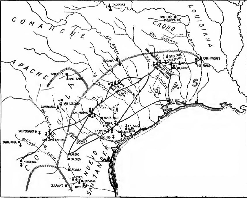 Texas in the 1700s.
[Pg 295] San Antonio founded.—In a junta de guerra held December 2, 1716, it was therefore decided to establish posts on the San Antonio and among the Cadodachos, while Ramón was to destroy the French establishments at Natchitoches. The new enterprise was entrusted to Martin de Alarcón, who was made governor of Texas and, before setting out, of Coahuila. While the expedition was preparing, St. Denis reached the Rio Grande (April, 1717), where his goods were confiscated. Going to Mexico, he was there imprisoned. Meanwhile Ramón had reconnoitered Natchitoches, and on his return early in 1717 two new missions were founded among the Ays and Adaes, the latter being within seven leagues of Natchitoches, and thenceforth a vital spot in the history of international frontiers.
[Pg 295] San Antonio founded.—In a junta de guerra held on December 2, 1716, it was decided to set up posts in San Antonio and among the Cadodachos, while Ramón was tasked with destroying the French settlements at Natchitoches. This new mission was assigned to Martin de Alarcón, who became the governor of Texas and, before departing, of Coahuila. As the expedition was getting ready, St. Denis arrived at the Rio Grande (April, 1717), where his goods were seized. He then went to Mexico and was imprisoned there. Meanwhile, Ramón had explored Natchitoches, and upon his return in early 1717, two new missions were established among the Ays and Adaes, the latter being just seven leagues from Natchitoches, marking it as a key location in the history of international borders.
Early in 1718 Alarcón left Coahuila with a colony of sixty-two persons, besides the neophytes of mission San Francisco Solano, who were to be transferred to the new site on the San Antonio River. Arrived there, a mission, presidio, and town were founded, the beginnings of the modern city of San Antonio. In the east Alarcón accomplished little more than to displease the missionaries and to protest against La Harpe's new French establishment among the Cadodachos.
Early in 1718, Alarcón left Coahuila with a group of sixty-two people, along with the new converts from mission San Francisco Solano, who were set to be moved to the new location by the San Antonio River. Once they arrived, they established a mission, presidio, and town, marking the start of what would become the modern city of San Antonio. In the east, Alarcón achieved little more than upsetting the missionaries and complaining about La Harpe's new French settlement among the Cadodachos.
WAR WITH FRANCE
Attack on Pensacola and Texas.—In January, 1719, as a result of European complications, France declared war on Spain. The war extended at once to the colonies, where a border contest ensued at various points all the way from Pensacola to the Platte River. In the course of the summer Pensacola was captured by the French of Mobile, recaptured by the Spaniards, and again taken by Bienville and Serigney. In June, Blondel, commander at Natchitoches, invaded eastern Texas, whence the Spanish missionaries and garrison retreated to San Antonio without a struggle. For two years thereafter the region was left unoccupied by Spain. While waiting at San Antonio Father Margil in 1720 founded there a new mission called San José, which later was called the finest in New Spain.
Attack on Pensacola and Texas.—In January 1719, due to issues in Europe, France declared war on Spain. This conflict quickly spread to the colonies, leading to border disputes at various locations from Pensacola to the Platte River. During the summer, Pensacola was taken by the French from Mobile, reclaimed by the Spaniards, and then captured again by Bienville and Serigney. In June, Blondel, the commander at Natchitoches, invaded eastern Texas, forcing the Spanish missionaries and troops to retreat to San Antonio without opposition. For the next two years, Spain left the area unoccupied. While waiting in San Antonio, Father Margil founded a new mission there in 1720, called San José, which later became known as the finest in New Spain.
Spanish plans to fortify the Platte River.—In the course of the campaigns against the Indians to the northeast of New Mexico, constantly more disturbing reports had been heard of the French, who were now making their way up all the western tributaries of the Mississippi. In 1719 Governor Valverde pursued Yutas and Comanches across the Napestle (Arkansas) and heard that the French had settled on the Jesus Maria (North[Pg 296] Platte) River. New significance was attached to these reports because of the outbreak of war between France and Spain a short time before. Valverde warned the viceroy of the danger; wild rumors spread through the northern provinces; and measures for defence were taken. In 1720, while plans were being made to recover Texas, the viceroy ordered counter alliances made with the tribes northeast of New Mexico, a Spanish colony planted at El Cuartelejo, in eastern Colorado, and a presidio established on the Jesus Maria River, that is, in Nebraska or Wyoming.
Spanish plans to strengthen the Platte River.—During the campaigns against the Native Americans to the northeast of New Mexico, increasingly alarming reports emerged about the French, who were now advancing up all the western tributaries of the Mississippi. In 1719, Governor Valverde chased the Yutas and Comanches across the Napestle (Arkansas) and learned that the French had settled along the Jesus Maria (North[Pg 296] Platte) River. These reports gained new importance due to the recent outbreak of war between France and Spain. Valverde warned the viceroy of the threat; wild rumors circulated throughout the northern provinces, prompting defensive measures. In 1720, while plans were being developed to reclaim Texas, the viceroy ordered counter alliances to be established with the tribes northeast of New Mexico, a Spanish settlement to be set up at El Cuartelejo in eastern Colorado, and a presidio to be established on the Jesus Maria River, which is in present-day Nebraska or Wyoming.
Destruction of the Villazur Expedition.—Although a truce had already been declared between France and Spain, Governor Valverde, perhaps in ignorance of this fact, sent Pedro de Villazur in June, 1720, at the head of one hundred and ten men to reconnoiter the French. Passing through El Cuartelejo, in August he reached the Jesus Maria. Not finding the French, he set out to return, but on the San Lorenzo (South Platte), in northern Colorado, he was killed and his expedition cut to pieces by Indians using French weapons. There are indications that tribes living as far north as Lake Winnebago in Wisconsin took part in the attack, a fact which illustrates the wide-reaching influence of these international contests. The Spaniards charged the massacre to the French, and there was a new panic on the frontier. But peace had been restored between France and Spain, and, in spite of appeals from New Mexico, the plans for advancing to El Cuartelejo and the Platte were dropped.
Destruction of the Villazur Expedition.—Even though a truce had already been declared between France and Spain, Governor Valverde, possibly unaware of this, sent Pedro de Villazur in June 1720, leading a group of one hundred and ten men to scout the French. Passing through El Cuartelejo, he reached Jesus Maria in August without finding any French troops. While attempting to head back, he was killed on the San Lorenzo (South Platte) in northern Colorado, and his group was wiped out by Indians using French weapons. There are signs that tribes as far north as Lake Winnebago in Wisconsin participated in the attack, highlighting the extensive impact of these international conflicts. The Spaniards blamed the massacre on the French, causing a new wave of panic on the frontier. However, peace had been reestablished between France and Spain, and despite requests from New Mexico, plans to advance to El Cuartelejo and the Platte were abandoned.
The Aguayo Expedition.—An offer to assist in the reconquest of Texas was made by the Marquis of Aguayo, governor and the most prominent figure of Coahuila. Abetted by Father Hidalgo, he had been interested in a new attempt to discover Gran Quivira, and the Texas crisis seemed to give him an opening. His offer was accepted, and before the end of 1720 he had raised, partly at his own expense, eight companies of cavalry, comprising over five hundred men and five thousand horses. By his instructions he was expected to reoccupy and strengthen the abandoned posts and occupy Cadadachos, on the Red River, and Bahía del Espíritu Santo on the Gulf.
The Aguayo Expedition.—The Marquis of Aguayo, the governor and most notable figure of Coahuila, offered to help with the reconquest of Texas. Encouraged by Father Hidalgo, he was interested in making a new attempt to find Gran Quivira, and the Texas crisis seemed to provide him with an opportunity. His offer was accepted, and by the end of 1720, he had raised, partly at his own expense, eight companies of cavalry, totaling over five hundred men and five thousand horses. According to his instructions, he was expected to reoccupy and reinforce the abandoned posts and seize Cadadachos on the Red River and Bahía del Espíritu Santo on the Gulf.
Eastern Texas reoccupied.—The Marquis left Monclova in November, 1720, shortly after Villazur's defeat on the Platte.[Pg 297] From the Rio Grande in January, 1721, he sent Captain Ramón with forty soldiers to take possession of Bahía del Espíritu Santo, to which a supply ship was sent from Vera Cruz. This was shortly before La Harpe attempted to reoccupy the place for the French. Because of swollen streams, Aguayo made a wide detour to the north, crossing the Brazos near Waco. Peace had been declared in Europe, and at the Neches he was met by St. Denis, who agreed to permit an unresisted reoccupation of the abandoned posts. It was learned here that St. Denis had recently assembled Indian allies with a view to seizing Bahía del Espíritu Santo and San Antonio, in coöperation, no doubt, with La Harpe.
Eastern Texas reoccupied.—The Marquis left Monclova in November 1720, shortly after Villazur's defeat on the Platte.[Pg 297] In January 1721, he sent Captain Ramón with forty soldiers to take control of Bahía del Espíritu Santo, to which a supply ship was dispatched from Vera Cruz. This was just before La Harpe tried to reclaim the area for the French. Due to swollen rivers, Aguayo took a wide detour to the north, crossing the Brazos near Waco. With peace declared in Europe, he was met at the Neches by St. Denis, who agreed to allow an unhindered reoccupation of the abandoned posts. It was learned here that St. Denis had recently gathered Indian allies with the aim of seizing Bahía del Espíritu Santo and San Antonio, likely in coordination with La Harpe.
Proceeding east, between August and November Aguayo reëstablished the six abandoned missions and the presidio of Dolores, and added a presidio at Los Adaes, facing Natchitoches, and garrisoned it with one hundred men. To this last act Bienville made vigorous protest. On the return to San Antonio the weather was so severe that of five thousand horses only fifty were left when Aguayo arrived in January, 1722. After establishing there another mission and rebuilding the presidio, he took forty additional men to La Bahía, and erected a presidio on the site of La Salle's fort. Having thus completed his work, he returned to Monclova.
Heading east, between August and November, Aguayo reestablished the six abandoned missions and the presidio of Dolores, and he set up a new presidio at Los Adaes, facing Natchitoches, which he garrisoned with one hundred men. Bienville strongly protested this last action. On the way back to San Antonio, the weather was so harsh that out of five thousand horses, only fifty survived by the time Aguayo arrived in January 1722. After establishing another mission there and rebuilding the presidio, he took an additional forty men to La Bahía and built a presidio on the site of La Salle's fort. Having completed his work, he returned to Monclova.
Texas won for Spain.—Aguayo's expedition fixed the hold of Spain on Texas. He left ten missions where there had been but seven, two hundred and sixty-eight soldiers instead of sixty or seventy, and four presidios instead of two, two of them being at strategic points. Since 1718 Texas and Coahuila had been under the same governor, but now Texas was made independent, with its capital at Los Adaes (now Robeline, Louisiana) where it remained for half a century. The Medina River now became the western boundary of Texas. In 1726 the La Bahía establishment was moved to the lower Guadalupe River.
Texas won for Spain. Aguayo's expedition strengthened Spain's control over Texas. He established ten missions where there had previously been only seven, increased the number of soldiers from sixty or seventy to two hundred and sixty-eight, and set up four presidios instead of two, with two of them located at key points. Since 1718, Texas and Coahuila had shared the same governor, but now Texas was made independent, with its capital at Los Adaes (now Robeline, Louisiana), where it remained for fifty years. The Medina River became the western boundary of Texas. In 1726, the La Bahía settlement was relocated to the lower Guadalupe River.
THE EXPANSION OF TEXAS
Rivera's inspection of the frontiers.—In the years 1724-1728 a general inspection of the frontier defences of New Spain was made by Pedro de Rivera, ex-governor of the province of Tlascala. His remarkable journey of 3082 leagues began at the City[Pg 298] of Mexico on November 21, 1724, and ended there on June 9, 1728. The northern line of military outposts at this time ran from Fronteras through Janos, El Paso, Santa Fé, Conchos, Monclova, San Juan Bautista, Cerralvo, San Antonio, Bahía del Espíritu Santo, Dolores, and Los Adaes. On the whole Rivera found the presidios in fair condition, but encountered many abuses. His reforms in the main were in the direction of retrenchment. This was particularly true regarding Texas, and in 1729 the post on the Angelina was suppressed and the forces of others reduced.
Rivera's inspection of the frontiers.—From 1724 to 1728, Pedro de Rivera, the former governor of the province of Tlascala, conducted a comprehensive inspection of the frontier defenses of New Spain. His impressive journey covered 3,082 leagues, starting in Mexico City on November 21, 1724, and concluding there on June 9, 1728. At that time, the northern line of military outposts extended from Fronteras through Janos, El Paso, Santa Fé, Conchos, Monclova, San Juan Bautista, Cerralvo, San Antonio, Bahía del Espíritu Santo, Dolores, and Los Adaes. Overall, Rivera found the presidios in decent shape but came across many issues. His reforms primarily focused on cutting back expenses. This was especially true for Texas, where in 1729, the post on the Angelina was shut down and the forces at other posts were reduced.
San Antonio strengthened.—Rivera's policy of retrenchment was strongly opposed by the missionaries; among the Indians of eastern Texas they had had little success, and when the garrison of Dolores was withdrawn the Querétaran friars moved their three missions to San Antonio, where they were reëstablished in 1731 and where their ruins still stand. In the same year a colony of Canary Islanders was established beside the presidio and missions, and formed into the Villa of San Fernando. There were now at San Antonio five missions, a presidio, and a municipality. Texas was now definitely formed in outline; Spain had maintained her claim as against France, and had established three centers of occupation, Los Adaes, Bahía del Espíritu Santo, and San Antonio.
San Antonio grew stronger.—Rivera's cost-cutting policy faced strong opposition from the missionaries; they had seen little success among the Indians of eastern Texas, and when the garrison of Dolores was withdrawn, the friars from Querétaro moved their three missions to San Antonio, where they were reestablished in 1731 and where their ruins still stand today. In the same year, a colony of Canary Islanders was formed next to the presidio and missions, creating the Villa of San Fernando. By now, San Antonio had five missions, a presidio, and a municipality. Texas had now taken on a clearer shape; Spain had upheld its claim against France and established three centers of occupation: Los Adaes, Bahía del Espíritu Santo, and San Antonio.
The Apache Wars.—For a decade and a half after the founding of the Villa of San Fernando the province of Texas underwent little expansion. From the beginning of San Antonio its inhabitants were subjected to raids by the Eastern Apaches, who also infested the highways. To check their outrages occasional campaigns were made into their country by the soldiery, supported by contingents of mission Indians. Notable among the forays were those of Captain Flores (1723), Governor Bustillo (1732), Captain José Urrutia (1739), and his son Captain Thoribio Urrutia (1745). These expeditions served not only to punish the enemy and recover stolen horses and mules, but to capture slaves as well, and to make known the northwestern frontier. In the course of them the Spaniards learned of mineral deposits in the Llano River country.
The Apache Wars.—For about fifteen years after the establishment of the Villa of San Fernando, the province of Texas saw little growth. From the start, the people of San Antonio faced raids from the Eastern Apaches, who also plagued the roads. To stop their attacks, troops occasionally launched campaigns into Apache territory, supported by groups of mission Indians. Notable among these raids were those led by Captain Flores (1723), Governor Bustillo (1732), Captain José Urrutia (1739), and his son Captain Thoribio Urrutia (1745). These missions served not only to punish the enemy and recover stolen horses and mules, but also to capture slaves and explore the northwestern frontier. During these expeditions, the Spaniards discovered mineral deposits in the Llano River area.
The work of the missionaries.—In spite of Apache hostilities, the missionaries on the San Antonio and the Guadalupe made[Pg 299] some progress. The leading figures of the period were Fathers Santa Ana and Dolores y Viana, presidents. No new missions were founded in the fifteen years' interval, but the friars improved their buildings and farms, and sought new neophytes in regions constantly more remote from the mission centers. At the mission of San Antonio de Valero alone no less than forty bands or tribes were represented by the baptisms between 1731 and 1745.
The work of the missionaries.—Despite the Apache attacks, the missionaries at San Antonio and Guadalupe made[Pg 299] some progress. The main figures of this time were Fathers Santa Ana and Dolores y Viana, the presidents. No new missions were established in the fifteen-year period, but the friars enhanced their buildings and farms and looked for new converts in areas increasingly farther from the mission centers. At the mission of San Antonio de Valero alone, there were baptisms representing no less than forty bands or tribes between 1731 and 1745.
The Tonkawa missions.—During the next fifteen years the frontiers of Texas were expanded in all directions. Between 1745 and 1749 Fathers Viana and Santa Ana founded three missions on the San Xavier (San Gabriel) River, in the Tonkawa country, and in 1751 a presidio was established there. But quarrels ensued, the location proved unsuitable, and the missions were abandoned, efforts now being transferred to the Apache country.
The Tonkawa missions.—Over the next fifteen years, the frontiers of Texas expanded in every direction. Between 1745 and 1749, Fathers Viana and Santa Ana established three missions along the San Xavier (San Gabriel) River, in the Tonkawa area, and in 1751 a presidio was set up there. However, disputes arose, the location turned out to be unfit, and the missions were abandoned, with efforts now shifting to the Apache region.
The Apache missions.—Under pressure from the southward moving Comanches, the Lipan-Apaches had ceased their hostilities and asked for missions. Minerals had been found near the Llano River, and communication with New Mexico was desired. Accordingly, with the aid of a munificent gift by Don Pedro de Terreros, in 1757 a great plan for reducing the Apaches by means of missions was launched. A presidio and mission had scarcely been founded on the San Sabá, however, when the mission was destroyed by the Comanches and their allies (1758). In the following year Colonel Parrilla, with a force of some six hundred men, raised in various parts of northern New Spain, set out to punish the offenders. At the fortified village of the Taovayas, on the Red River, where French influence was predominant, he was routed and driven back. The Apache mission was now transferred to the Upper Nueces, and for several years the San Sabá post sustained incessant war with the northern tribes.
The Apache missions.—Due to pressure from the Comanches moving south, the Lipan-Apaches stopped their hostilities and requested missions. Minerals had been discovered near the Llano River, and they wanted better communication with New Mexico. Therefore, with a generous gift from Don Pedro de Terreros, a significant plan to reduce the Apaches through missions was initiated in 1757. However, shortly after a presidio and mission were established on the San Sabá, the mission was destroyed by the Comanches and their allies in 1758. The following year, Colonel Parrilla, leading a force of about six hundred men gathered from various areas in northern New Spain, set out to punish the offenders. At the fortified village of the Taovayas on the Red River, where French influence was strong, he was defeated and forced to retreat. The Apache mission was then moved to the Upper Nueces, and for several years, the San Sabá post engaged in constant conflict with the northern tribes.
Nuevo Santander.—Wars with England and Indian hostilities now made imperative the colonization of the Gulf coast between the San Antonio River and Tampico—the eastern portion of Nuevo León—and in 1746 the district was erected into a new colony called Nuevo Santander. Colonel José de Escandón, a distinguished officer of Querétaro, was put in charge of the enterprise,[Pg 300] and the missionary work was entrusted to the Zacatecan friars. Within the next three years the entire region was explored by Escandón and his lieutenants and a number of colonies were planned. In 1749 Escandón led a colony of more than three thousand people from Querétaro, and in a short time established them in more than twenty settlements, most of which persist to-day. North of the Rio Grande the principal ones were Laredo and Dolores, but ranching soon spread as far as the Nueces River. The post and mission of La Bahía were now moved to the lower San Antonio River and a new mission for the Karankawa (Rosario) was established near by. Though legally in Nuevo Santander, this district was administered as a part of Texas, and by 1775 the Texas-Nuevo Santander boundary was officially moved west to the Nueces.
Nuevo Santander.—Conflicts with England and attacks by Native Americans made it essential to settle the Gulf coast between the San Antonio River and Tampico—the eastern part of Nuevo León. In 1746, this area was designated as a new colony called Nuevo Santander. Colonel José de Escandón, a notable officer from Querétaro, was appointed to lead the effort, and the missionary work was assigned to the Zacatecan friars. Over the next three years, Escandón and his team thoroughly explored the entire region and planned several colonies. In 1749, Escandón brought over three thousand people from Querétaro and quickly established them in more than twenty settlements, most of which still exist today. North of the Rio Grande, the main ones were Laredo and Dolores, with ranching expanding as far as the Nueces River. The post and mission of La Bahía were relocated to the lower San Antonio River, and a new mission for the Karankawa (Rosario) was set up nearby. Although this area was officially part of Nuevo Santander, it was managed as part of Texas, and by 1775, the Texas-Nuevo Santander boundary was officially shifted west to the Nueces.
THE FRANCO-SPANISH BORDER
The Texas-Louisiana boundary question.—The proximity of Los Adaes and Natchitoches had furnished numerous grounds for irritation between Texas and Louisiana. French traders engaged in contraband trade, and the international boundary was uncertain. In 1735, when Natchitoches was moved from the island in the Red River to the west bank of the stream, a quarrel ensued. After several years of bickering, the Arroyo Hondo was tentatively adopted as the international boundary in that region.
The Texas-Louisiana boundary issue.—The closeness of Los Adaes and Natchitoches had created many reasons for tension between Texas and Louisiana. French traders were involved in illegal trade, and the international boundary was unclear. In 1735, when Natchitoches was relocated from the island in the Red River to the west bank, a dispute arose. After several years of arguments, the Arroyo Hondo was tentatively agreed upon as the international boundary in that area.
Meanwhile French traders had invaded the coast tribes and monopolized the Indian trade of northern Texas. In 1750 the military strength of Louisiana was considerably augmented, and it was reported in Mexico that the new arrivals were for the western Louisiana frontier. These conditions again brought forward the quiescent boundary question, which was inconclusively discussed in Spanish circles for several years. While the higher authorities debated, residents on the frontier generally agreed on the Arroyo Hondo. In 1754 the King of Spain declared that "boundaries between the Spaniards and the French in that region have never been a subject of treaty nor is it best at present that they should be."
Meanwhile, French traders had invaded the coastal tribes and took control of the Indian trade in northern Texas. In 1750, the military presence in Louisiana was significantly increased, and reports coming from Mexico indicated that the newcomers were headed for the western Louisiana border. These circumstances once again brought up the long-standing boundary issue, which was discussed without resolution among Spanish officials for several years. While the higher-ups debated, those living on the frontier generally agreed on the Arroyo Hondo. In 1754, the King of Spain stated that "the boundaries between the Spaniards and the French in that area have never been a topic of treaty nor is it advisable at this time that they should be."
The New Mexico border.—By this time renewed French intrusions into New Mexico were becoming alarming. The return[Pg 301] of the Mallet party (1739) and the peace between the Comanches and their eastern enemies (ca. 1746) were followed by the arrival in New Mexico of trading parties from Canada and Louisiana under Fébre, Chapuis, and others. A more vigorous policy was now adopted and the recent comers were arrested and sent to Spain. The intrusion into New Mexico found an echo in far western Sonora, where in 1751 the French advance was given by a prominent official as a reason for Spanish haste to occupy the Colorado of the West.
The New Mexico border.—At this point, increasing French intrusions into New Mexico were becoming a serious concern. The return[Pg 301] of the Mallet party (1739) and the peace between the Comanches and their eastern enemies (around 1746) were followed by the arrival of trading groups from Canada and Louisiana led by Fébre, Chapuis, and others. A more proactive strategy was now put in place, and the newcomers were arrested and sent to Spain. The intrusion into New Mexico was also felt in far western Sonora, where in 1751 a key official noted the French advance as a reason for Spain's urgency to occupy the Colorado of the West.
The lower Trinity fortified.—The more stringent policy toward intruders was extended to Texas, where a new outpost was established to ward off French aggression. In the fall of 1754 traders on the lower Trinity were arrested and sent to Mexico, and in 1756-1757 the region was defended by a presidio (San Agustín) and a mission east of the stream among the Orcoquiza Indians. Thus another point on the Texas-Louisiana frontier was occupied and defended by Spain. The site was disputed by Governor Kerlérec, of Louisiana, who proposed a joint boundary commission. The offer was rejected and the viceroy of Mexico, on the contrary, proposed a Spanish post on the Mississippi "to protect the boundaries." With his proposal he sent to Spain a map showing Texas as extending to the Mississippi. Thus the region in dispute extended from the Trinity to the Mississippi, at least.
The lower Trinity fortified.—The stricter policy towards intruders was applied to Texas, where a new outpost was set up to fend off French threats. In the fall of 1754, traders on the lower Trinity were arrested and sent to Mexico, and in 1756-1757, the area was defended by a presidio (San Agustín) and a mission east of the river among the Orcoquiza Indians. This meant that another part of the Texas-Louisiana border was occupied and protected by Spain. The site was contested by Governor Kerlérec of Louisiana, who suggested a joint boundary commission. This offer was declined, and the viceroy of Mexico, instead, proposed a Spanish post on the Mississippi "to protect the boundaries." With his suggestion, he sent a map to Spain showing Texas as stretching to the Mississippi. So, the disputed area extended from the Trinity to at least the Mississippi.
PIMERÍA ALTA
The Jesuits.—The occupation of Texas was contemporaneous with the advance into Pimería Alta (northern Sonora and southern Arizona) and Lower California. The work of the indefatigable Jesuits on the northern frontier of New Spain is admirably illustrated by that of Father Kino and his companions in this region.
The Jesuits.—The settlement of Texas happened at the same time as the expansion into Pimería Alta (northern Sonora and southern Arizona) and Lower California. The tireless efforts of the Jesuits on the northern frontier of New Spain are perfectly exemplified by Father Kino and his colleagues in this area.
Kino.—After the failure of Atondo's enterprise in California in 1685, Father Eusebio Kino entered northern Sonora, arriving in March, 1687, just at the time of La Salle's death in Texas. Mission Dolores, founded by him in the upper Sonora Valley, became his headquarters for twenty-four years of exploration, ranching, and missionary work among the upper Pimas, between the Altar and Gila Rivers.
Kino.—After Atondo's business venture in California failed in 1685, Father Eusebio Kino came into northern Sonora, arriving in March 1687, right around the time of La Salle's death in Texas. Mission Dolores, which he established in the upper Sonora Valley, served as his base for twenty-four years of exploration, ranching, and missionary efforts among the upper Pimas, situated between the Altar and Gila Rivers.
[Pg 302] Explorations in Arizona.—In the Altar Valley Kino and his companions founded a number of missions, which were destroyed during the revolt in 1695 and then rebuilt. In 1691, accompanied by Father Salvatierra, who later went to California, Kino descended the Santa Cruz River to the village of Tumacácori. Three years later, by the same route, he reached the Casa Grande on the Gila. In 1697, with a military escort from Fronteras (Corodéguachi), he again went to the Casa Grande, this time by way of the San Pedro River. In the following year he was again on the Gila, whence he returned across the Papaguería (the country of the Pápagos) by way of Sonóita, Caborca, and the Altar Valley. In 1699 he went to the Gila by way of Sonóita and the Gila Range, and then ascended the Gila.
[Pg 302] Explorations in Arizona.—In the Altar Valley, Kino and his team set up several missions, which were destroyed during the uprising in 1695 but later rebuilt. In 1691, along with Father Salvatierra, who later journeyed to California, Kino traveled down the Santa Cruz River to the village of Tumacácori. Three years later, he took the same route to reach the Casa Grande on the Gila. In 1697, with military support from Fronteras (Corodéguachi), he visited the Casa Grande again, this time via the San Pedro River. The following year, he returned to the Gila and crossed the Papaguería (the land of the Pápagos) through Sonóita, Caborca, and the Altar Valley. In 1699, he traveled to the Gila through Sonóita and the Gila Range, and then went up the Gila.
A land route to California.—The current view still was that California was an island, but during the last journey Kino returned to the peninsular theory. If this were true, he reasoned, it would be possible to find a land route over which to send supplies to Salvatierra's struggling missions just established in Lower California. To test his views he made several more journeys, crossing the lower Colorado in 1701 and reaching its mouth in 1702. He was now convinced that California was a peninsula. In 1705 was published his map of Pimería Alta, setting forth this view.
A land route to California.—People still believed that California was an island, but during his last journey, Kino returned to the idea that it was a peninsula. If that were true, he thought, it would be possible to find a land route to send supplies to Salvatierra's struggling missions that had just been established in Lower California. To test his theories, he made several more trips, crossing the lower Colorado River in 1701 and reaching its mouth in 1702. He was now convinced that California was a peninsula. In 1705, he published his map of Pimería Alta, presenting this view.
Missions and ranches in Arizona.—Meanwhile Kino and his companions had pushed the missionary frontier to the Gila and the Colorado. Kino's exploring tours were also itinerant missions, in the course of which he baptized and taught in numerous villages. During his career in Pimería Alta he alone baptized 4000 Indians. In 1700 he founded the mission of San Xavier del Bac, and within the next two years those of Guebavi and Tumacácori, all in the valley of the Santa Cruz River, and within the present Arizona. To support his missions, near them he established flourishing stock ranches, thus making the beginnings of stock raising in at least twenty places still existing in northern Sonora and southern Arizona.
Missions and ranches in Arizona.—Meanwhile, Kino and his companions pushed the missionary frontier to the Gila and the Colorado. Kino's exploration trips were also traveling missions, during which he baptized and taught in many villages. Throughout his time in Pimería Alta, he personally baptized 4,000 Native Americans. In 1700, he established the mission of San Xavier del Bac, and within the next two years, he founded the missions of Guebavi and Tumacácori, all located in the valley of the Santa Cruz River, which is now part of present-day Arizona. To support his missions, he set up successful cattle ranches nearby, marking the beginning of cattle raising in at least twenty locations that still exist in northern Sonora and southern Arizona.
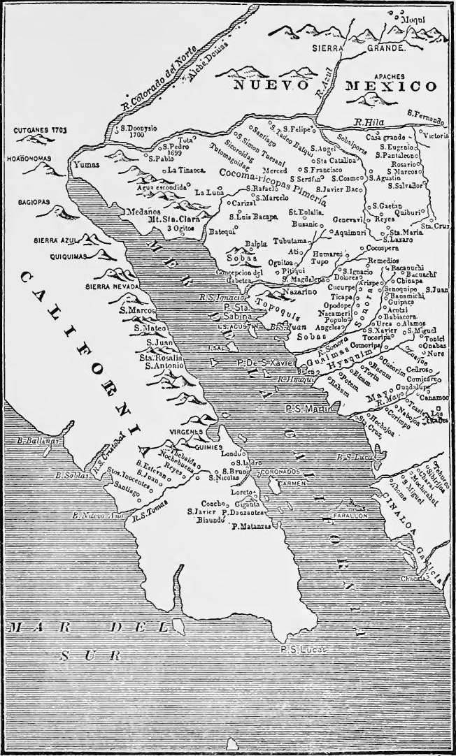 Father Kino's Map of Pimería Alta (Bancroft, Arizona and New Mexico, p. 360).
Decline of the missions.—The power of Spain was now at its lowest ebb, funds were scarce, and Kino's last days were to him a time of stagnation and disappointment. To a certain extent royal support was transferred for the time being to the missions in Lower California. After Kino's death in 1711 stagnation became decline, few new missionaries were sent, and northern tours became infrequent or ceased altogether. Officials and frontier leaders often planned to advance the frontier of settlement to the Colorado River, but other interests interfered.
Decline of the missions.—Spain's power was at its lowest point, funds were limited, and Kino's final days felt like a time of stagnation and disappointment to him. For a while, royal support was redirected to the missions in Lower California. After Kino's death in 1711, stagnation turned into decline, with few new missionaries being sent, and northern expeditions becoming rare or stopping altogether. Officials and frontier leaders frequently aimed to expand settlement to the Colorado River, but other interests got in the way.
[Pg 304] Revival after 1732.—A visit by the bishop of Durango in 1725, the military inspection of that frontier by Rivera in 1726, and a royal decree of 1728 gave new life to the moribund missions. New missionaries arrived in 1732, the northern missions were reoccupied, and journeys to the Gila were renewed after 1736 by Fathers Keller and Sedelmayr.
[Pg 304] Revival after 1732.—A visit from the Bishop of Durango in 1725, a military inspection of the frontier by Rivera in 1726, and a royal decree in 1728 brought new energy to the struggling missions. New missionaries arrived in 1732, the northern missions were reestablished, and trips to the Gila were resumed after 1736 by Fathers Keller and Sedelmayr.
The Arizonac mines.—Interest in the northern frontier was accentuated at this time by a temporary mining excitement at Arizonac in the upper Altar Valley, where in 1736 silver nuggets of astonishing size were discovered. There was a "rush" to the place, and considerable wealth was found, but in 1741 the surface veins were exhausted and the camp was abandoned. The mining incident furnished an occasion for new plans to advance to the Gila. But Indian troubles in Sinaloa and Sonora interfered. These troubles, on the other hand, served to advance the military frontier by the founding of two presidios at Pitiqui (Hermosillo) and Terrenate in 1741.
The Arizonac mines.—Interest in the northern frontier was heightened at this time by a temporary mining boom at Arizonac in the upper Altar Valley, where in 1736, silver nuggets of incredible size were found. There was a "rush" to the area, and considerable wealth was discovered, but by 1741, the surface veins were depleted, and the camp was abandoned. This mining event prompted new plans to move towards the Gila. However, conflicts with Native Americans in Sinaloa and Sonora got in the way. These issues, in turn, led to the expansion of the military frontier with the establishment of two presidios at Pitiqui (Hermosillo) and Terrenate in 1741.
Keller and Sedelmayr.—After much discussion, in 1741 the Moqui district was assigned to the Jesuits, who now tried to reach that region. In 1743 Keller crossed the Gila, but was driven back by the Apaches. In 1744 Sedelmayr ascended the Colorado to Bill Williams Fork. In the following year the Moquis were again assigned to the Franciscans.
Keller and Sedelmayr.—After a lot of discussion, in 1741 the Moqui district was assigned to the Jesuits, who then attempted to reach that area. In 1743, Keller crossed the Gila but was forced back by the Apaches. In 1744, Sedelmayr traveled up the Colorado to Bill Williams Fork. The next year, the Moquis were again assigned to the Franciscans.
Plans to occupy the Gila and Colorado.—Sedelmayr now turned his attention to exploring the lower Gila and Colorado Rivers, and his Order, particularly Father Escobar, the provincial, urged the occupation of these valleys, both as a means of support for Lower California, and as a base for advance to Moqui and Alta California. In 1748 Father Consag of California explored the Gulf to its head in the interest of this plan. Royal interest was aroused also by the entry of the French of Louisiana into New Mexico and the need of protecting California. In 1744 and 1747, therefore, the king approved advancing to the[Pg 305] Gila. Five years later, especially because of emphatic reports of the French advance toward the Pacific Ocean, the king seriously considered occupying the Bay of Monterey.
Plans to occupy the Gila and Colorado.—Sedelmayr now focused on exploring the lower Gila and Colorado Rivers, and his Order, especially Father Escobar, the provincial, encouraged the settlement of these valleys, both to support Lower California and to serve as a base for moving into Moqui and Alta California. In 1748, Father Consag of California explored the Gulf to its source in support of this initiative. Royal interest was also sparked by the French from Louisiana moving into New Mexico and the necessity of protecting California. In 1744 and 1747, the king therefore approved plans to advance to the[Pg 305] Gila. Five years later, particularly due to urgent reports of the French pushing toward the Pacific Ocean, the king seriously considered settling the Bay of Monterey.
The Pima Revolt.—The new viceroy, Revillagigedo, was occupied with founding Nuevo Santander and other absorbing tasks, while new Indian wars in Sonora made advance impossible. In 1750 a war of extermination, led by Governor Diego Parrilla, was begun on the Seris and lasted several years. In 1751 a revolt occurred among the northern Pimas. At Caborca and Sonóita the missionaries were slain, over one hundred settlers were killed on the Arizona border, and missions and ranches were abandoned. The uprising was suppressed by Parrilla without great difficulty; most of the missions were reoccupied; and for greater security two new presidios were founded, at Altar, near Caborca, and at Tubac near San Xavier del Bac. Thus, each uprising helped to advance the military frontier.
The Pima Revolt.—The new viceroy, Revillagigedo, was busy establishing Nuevo Santander and dealing with other pressing tasks, while new conflicts with Indigenous groups in Sonora made progress impossible. In 1750, a brutal campaign led by Governor Diego Parrilla was launched against the Seris and lasted several years. In 1751, a revolt broke out among the northern Pimas. At Caborca and Sonóita, missionaries were killed, over one hundred settlers lost their lives on the Arizona border, and missions and ranches were deserted. The uprising was quickly suppressed by Parrilla without much difficulty; most of the missions were reoccupied; and to ensure greater security, two new military outposts were established, one at Altar, near Caborca, and another at Tubac, near San Xavier del Bac. Thus, each uprising helped to strengthen the military frontier.
Continued obstacles to advance.—For twenty years more the question of advance to the Colorado was subordinate to that of good order and settled conditions in Sonora, necessary preliminaries to advance. The Pima War was followed by a bitter quarrel between Governor Parrilla and the Jesuits. The Seris made constant trouble, and when attacked retreated safely to Cerro Prieto. Apache wars on the northern border were even more severe, and many settlements in Sonora and Nueva Vizcaya were destroyed by them. Nevertheless, within the protection of the presidios several small Spanish settlements grew up, as at Terrenate, Guebavi, Santa Bárbara, Buenavista, Tubac, Saric, Altar, and San Ignacio. The Jesuits continued to appeal, and others, pointing out the danger from advancing Russians, English, and French, urged the settlement of Alta California. But Spain was occupied elsewhere.
Continued obstacles to progress.—For another twenty years, the issue of moving towards Colorado was secondary to establishing law and stability in Sonora, which were essential steps for any advancement. The Pima War was followed by a bitter feud between Governor Parrilla and the Jesuits. The Seris created ongoing problems, and when they were attacked, they safely retreated to Cerro Prieto. Apache conflicts on the northern border were even more intense, leading to the destruction of many settlements in Sonora and Nueva Vizcaya. Despite this, several small Spanish settlements developed under the protection of the presidios, such as at Terrenate, Guebavi, Santa Bárbara, Buenavista, Tubac, Saric, Altar, and San Ignacio. The Jesuits continued to raise concerns, and others highlighted the threat from encroaching Russians, English, and French, urging the colonization of Alta California. However, Spain's attention was focused elsewhere.
The northwestern frontier in 1763.—Sinaloa and Sonora had been detached from Nueva Vizcaya in 1734, when the province of Sinaloa was erected. Both were still within the diocese of Durango. By 1763 Sinaloa and Ostimuri (southern Sonora) had ceased to be frontier regions. Most of the missions had been secularized, the Indians had become assimilated, and there was a considerable white population. In Sinaloa there were six towns with white and mixed populations ranging from 1000 to[Pg 306] 3500 each. In Ostimuri, the part of Sonora south of Yaqui River, there were five towns with populations ranging from 300 to 3400. In the Sonora Valley there was a string of mining towns and small Spanish settlements extending as far north as Fronteras. In Pimería Alta there were eight missions and several Spanish settlements, the latter aggregating, with the garrisons, nearly 1500 persons. In all of the frontier settlements there was a large element of mulattoes and mestizoes.
The northwestern frontier in 1763.—Sinaloa and Sonora were separated from Nueva Vizcaya in 1734 when the province of Sinaloa was established. Both were still part of the diocese of Durango. By 1763, Sinaloa and Ostimuri (the southern part of Sonora) were no longer considered frontier areas. Most of the missions had been secularized, the Indigenous people had assimilated, and there was a significant white population. In Sinaloa, there were six towns with white and mixed populations ranging from 1,000 to [Pg 306] 3,500 each. In Ostimuri, south of the Yaqui River in Sonora, there were five towns with populations varying from 300 to 3,400. The Sonora Valley had a series of mining towns and small Spanish settlements stretching as far north as Fronteras. In Pimería Alta, there were eight missions and several Spanish settlements, which, along with the garrisons, totaled nearly 1,500 people. In all the frontier settlements, there was a large group of mulattos and mestizos.
THE JESUITS IN LOWER CALIFORNIA
California assigned to the Jesuits.—While Kino and his successors were struggling to advance the frontiers of Pimería Alta, another band of Jesuits founded missions and opened trails nearly the whole length of the Peninsula of Lower California, and made explorations northward with a view to meeting the mainland group at the Colorado River. After repeated failures to occupy the Peninsula, the government of Spain turned it over to the Jesuits, with full military and civil authority, as in Paraguay. The missions depended at first mainly on private alms, and in a short time $47,000 were subscribed. This was the beginning of the famous Pious Fund of California.
California was assigned to the Jesuits. While Kino and his successors worked to expand the frontiers of Pimería Alta, another group of Jesuits established missions and opened routes almost throughout the entire Peninsula of Lower California. They also explored north in hopes of connecting with the mainland group at the Colorado River. After several unsuccessful attempts to settle the Peninsula, the Spanish government handed it over to the Jesuits, granting them full military and civil authority, similar to what was done in Paraguay. The missions initially relied mostly on private donations, and within a short time, $47,000 was raised. This marked the start of the well-known Pious Fund of California.
Salvatierra and his companions.—In 1697 Juan Maria Salvatierra, who had been a missionary in Sinaloa, entered the Peninsula with a handful of soldiers, and began work at Loreto, opposite Guaymas, which became the supply base. Missionary work was attended by unusual difficulties, because of the sterility of the country. More than once the abandonment of California was prevented only by the aid of Father Kino, who drove cattle hundreds of miles to Guaymas and shipped them across the Gulf. Transportation was difficult, and many precious cargoes were wrecked. By the time of Salvatierra's death in 1717 he, Picolo, Juan de Ugarte and their companions had planted five missions in the middle region of the Peninsula, and had made extensive explorations, north, south, and across California to the Pacific. In 1701 Salvatierra had explored with Kino in quest of a land route from Sonora. In 1721 Father Ugarte in the same interest explored the Gulf to its head.
Salvatierra and his companions.—In 1697, Juan Maria Salvatierra, who had been a missionary in Sinaloa, entered the Peninsula with a small group of soldiers and started his work in Loreto, across from Guaymas, which became the supply base. Missionary work faced significant challenges due to the barrenness of the land. More than once, the abandonment of California was only avoided thanks to Father Kino, who herded cattle hundreds of miles to Guaymas and shipped them across the Gulf. Transportation was tough, and many valuable shipments were lost at sea. By the time of Salvatierra's death in 1717, he, Picolo, Juan de Ugarte, and their companions had established five missions in the central region of the Peninsula and had conducted extensive explorations to the north, south, and across California to the Pacific. In 1701, Salvatierra had explored with Kino in search of a land route from Sonora. In 1721, Father Ugarte explored the Gulf to its furthest point for the same purpose.
Development in the South.—Salvatierra's death was followed by more liberal royal aid and private alms, and by more rapid[Pg 307] mission extension, particularly in the South. The importance of this step was enhanced by making San Bernabé a stopping place for the Manila galleon. By 1732 Fathers Guillen, Tamaral, and Taraval had explored the west coast as far as Cedros Island. A widespread Indian rebellion in 1734, attended by the martyrdom of Fathers Carranco and Tamaral, caused the founding of the presidio of San José del Cabo, which protected the Cape, but by 1748 Indian disturbances had greatly reduced the southern missions.
Development in the South.—Salvatierra's death led to more generous support from the crown and private donations, and to a quicker[Pg 307] expansion of missions, especially in the South. This progress was further boosted by designating San Bernabé as a stop for the Manila galleon. By 1732, Fathers Guillen, Tamaral, and Taraval had explored the west coast as far as Cedros Island. A widespread Native American uprising in 1734, which resulted in the martyrdom of Fathers Carranco and Tamaral, triggered the establishment of the presidio of San José del Cabo to protect the Cape, but by 1748, unrest among the Indigenous people had significantly diminished the southern missions.
The Jesuits, fearful of interference in their work, as a rule opposed Spanish settlements, presidios, and the development of industries in the Peninsula. In 1716, 1719, 1723, and later, the government urged the founding of forts and colonies on the western coast, with a view to protecting and advancing the frontier, but the Jesuits usually objected, and the settlements were not founded. The Indian revolt, war with England in 1739, Anson's raid on the coast in 1742, and the westward advance of the French toward the Pacific Coast, increased the anxiety, and in 1744 new orders were given looking to the defence of the Peninsula, but nothing came of them.
The Jesuits, worried about interference in their work, generally opposed Spanish settlements, military outposts, and industrial development in the Peninsula. In 1716, 1719, 1723, and later, the government pushed for the establishment of forts and colonies on the western coast to protect and enhance the frontier, but the Jesuits typically objected, so the settlements were never established. The Indian revolt, the war with England in 1739, Anson's raid on the coast in 1742, and the French moving westward toward the Pacific Coast raised concerns, leading to new orders in 1744 aimed at defending the Peninsula, but nothing came of those plans.
By 1750 the exclusive policy of the Jesuits had given way to some extent, pearl fishing was again permitted, private trading vessels came from time to time, and the Manila galleon stopped regularly at San José. Mines were opened in the South, and around them a small Spanish and mixed breed population grew up, La Paz becoming the principal center.
By 1750, the Jesuits' exclusive policy had relaxed to some degree; pearl fishing was allowed again, private trading ships occasionally arrived, and the Manila galleon made regular stops at San José. Mines were opened in the South, leading to the growth of a small Spanish and mixed-race population around them, with La Paz becoming the main center.
Missions in the North.—The conditions which had stimulated efforts to advance to the Gila by the mainland after 1744, had a corresponding effect on California development. Sterile California needed overland communication with a mainland base. It was with this need in view that in 1746 the Jesuit provincial, Escobar, sent Father Consag to reëxplore the Gulf, whose head he reached shortly before Sedelmayr descended the Colorado to the same point.
Missions in the North.—The circumstances that pushed for advancements to the Gila from the mainland after 1744 also influenced development in California. The barren landscape of California required overland communication with a mainland base. Keeping this need in mind, in 1746, the Jesuit provincial, Escobar, sent Father Consag to re-explore the Gulf, which he reached shortly before Sedelmayr traveled down the Colorado to the same location.
The Colorado-Gila base was not supplied, but with new private gifts and royal aid, the Jesuits on the Peninsula pushed northward. Santa Gertrudis (1752), San Francisco Borja (1762), and Santa Maria (1767) were the last Jesuit foundations, while Father Link's land journey to the head of the Gulf in 1766 was the final step in Jesuit explorations.[Pg 308]
The Colorado-Gila base didn't have supplies, but with new private donations and royal support, the Jesuits on the Peninsula moved north. Santa Gertrudis (1752), San Francisco Borja (1762), and Santa Maria (1767) were the last Jesuit missions, while Father Link's land journey to the head of the Gulf in 1766 marked the final phase of Jesuit explorations.[Pg 308]
READINGS
TEXAS
Arricivita, Crónica Serafica y Apostólica, 321-442; Bancroft, H.H., North Mexican States and Texas, I, 391-406, 600-617: Bolton, H.E., Athanase De Mézières, I, 1-66; "The Native Tribes about the East Texas Missions," in Tex. State Hist. Assoc., Quarterly, XI, 249-276; "The Location of La Salle's Colony on the Gulf of Mexico," in The Mississippi Valley Historical Review, II, 165-182; Bolton, H.E., ed., Spanish Exploration in the Southwest, 281-422; Bonilla, Antonio, in Tex. State Hist. Assoc., Quarterly, XIII, 1-78; Buckley, E., "The Aguayo Expedition into Texas and Louisiana, 1721-1722," in Tex. State Hist. Assoc., Quarterly, XV, 1-65; Clark, R.C., The Beginnings of Texas; Cox, I.J.. "The Early Settlers of San Fernando," in Tex. State Hist. Assoc., Quarterly, V, 142-161; "The Louisiana-Texas Frontier," in Tex. State Hist. Assoc., Quarterly, X, 1-76; "The Southwestern Boundary of Texas," in Tex. State Hist. Assoc., Quarterly, VI. 81-103; De León, A., "Itinerary," in Tex. State Hist. Assoc., Quarterly, VIII, 199-224; Historia de Nuevo León, 310-348; Dunn, W.E.. "Apache Relations in Texas, 1718-1750," in Tex. State Hist. Assoc., Quarterly, XIII, 198-274; "The Apache Mission on the San Saba," in Southwestern Historical Quarterly, XVIII, 370-415; Espinosa, Isidro, Chrónica, 1-10, 41-158, 206-227; Garrison, G.P., Texas, 20-96; Manzanet, in Tex. State Hist. Assoc., Quarterly, III, 252-312; Parkman, Francis, La Salle and the Discovery of the Great West, chs. 20-29.
Arricivita, Crónica Serafica y Apostólica, 321-442; Bancroft, H.H., North Mexican States and Texas, I, 391-406, 600-617; Bolton, H.E., Athanase De Mézières, I, 1-66; "The Native Tribes about the East Texas Missions," in Tex. State Hist. Assoc., Quarterly, XI, 249-276; "The Location of La Salle's Colony on the Gulf of Mexico," in The Mississippi Valley Historical Review, II, 165-182; Bolton, H.E., ed., Spanish Exploration in the Southwest, 281-422; Bonilla, Antonio, in Tex. State Hist. Assoc., Quarterly, XIII, 1-78; Buckley, E., "The Aguayo Expedition into Texas and Louisiana, 1721-1722," in Tex. State Hist. Assoc., Quarterly, XV, 1-65; Clark, R.C., The Beginnings of Texas; Cox, I.J., "The Early Settlers of San Fernando," in Tex. State Hist. Assoc., Quarterly, V, 142-161; "The Louisiana-Texas Frontier," in Tex. State Hist. Assoc., Quarterly, X, 1-76; "The Southwestern Boundary of Texas," in Tex. State Hist. Assoc., Quarterly, VI, 81-103; De León, A., "Itinerary," in Tex. State Hist. Assoc., Quarterly, VIII, 199-224; Historia de Nuevo León, 310-348; Dunn, W.E., "Apache Relations in Texas, 1718-1750," in Tex. State Hist. Assoc., Quarterly, XIII, 198-274; "The Apache Mission on the San Saba," in Southwestern Historical Quarterly, XVIII, 370-415; Espinosa, Isidro, Chrónica, 1-10, 41-158, 206-227; Garrison, G.P., Texas, 20-96; Manzanet, in Tex. State Hist. Assoc., Quarterly, III, 252-312; Parkman, Francis, La Salle and the Discovery of the Great West, chs. 20-29.
PIMERÍA ALTA
Alegre, Xavier, Historia de la Compañía de Jesus, III; Bancroft, H.H., Arizona and New Mexico, 344-407; History of the North Mexican States, I, 237-274, 548-580, 660-691; Bolton, H.E., Kino's Historical Memoir of Pimería Alta, especially Vol. I, 27-65; Bolton, H.E., ed., Spanish Exploration in the Southwest, 425-463: Chapman, C.E., The Founding of Spanish California, 1-67; Ortega, José, Apostólicos Afanes, libros II-III; Richman, I.B., California under Spain and Mexico, 42-61.
Alegre, Xavier, History of the Society of Jesus, III; Bancroft, H.H., Arizona and New Mexico, 344-407; History of the North Mexican States, I, 237-274, 548-580, 660-691; Bolton, H.E., Kino's Historical Memoir of Pimería Alta, especially Vol. I, 27-65; Bolton, H.E., ed., Spanish Exploration in the Southwest, 425-463; Chapman, C.E., The Founding of Spanish California, 1-67; Ortega, José, Apostolic Efforts, books II-III; Richman, I.B., California under Spain and Mexico, 42-61.
LOWER CALIFORNIA
Alegre, Xavier, Historia de la Compañía de Jesus, III, 91-309; Bancroft, H.H., History of the North Mexican States. I, 276-304, 407-466, 476-491; Bolton, H.E., Kind's Historical Memoir, consult Index under "California," "Picólo," and "Salvatierra"; Engelhardt, Fr. Zephyrin, Missions and Missionaries of California, I. 61-600: Hittell, T.E., History of California, I, 148-308; North, A.W., Mother of California, 1-78; Richman, I.B., California under Spain and Mexico, 1-41; Venegas, Migual, Natural and Croit History of California, I, 215-455, II, 1-213.
Alegre, Xavier, *History of the Society of Jesus*, III, 91-309; Bancroft, H.H., *History of the North Mexican States*, I, 276-304, 407-466, 476-491; Bolton, H.E., *Kind's Historical Memoir*, see Index under "California," "Picólo," and "Salvatierra"; Engelhardt, Fr. Zephyrin, *Missions and Missionaries of California*, I. 61-600; Hittell, T.E., *History of California*, I, 148-308; North, A.W., *Mother of California*, 1-78; Richman, I.B., *California under Spain and Mexico*, 1-41; Venegas, Migual, *Natural and Croit History of California*, I, 215-455, II, 1-213.
CHAPTER XVII
THE ENGLISH ADVANCE INTO THE PIEDMONT, 1715-1750
THE WESTWARD MOVEMENT
The colonization of North America by the English was not complete with the founding of the seaboard settlements, but continued in a series of steps westward. At each step American society has returned to simple frontier conditions, under which it has been free to try out new experiments in democracy. Each stage of advance has made its special contribution to our institutions.
The colonization of North America by the English didn't stop with the establishment of coastal settlements; it continued in a gradual push westward. With each move, American society returned to basic frontier conditions, allowing it to explore new ideas in democracy. Every stage of progress has added its unique contribution to our institutions.
In a broad way these steps in the westward movement have corresponded with great physiographic areas. The seventeenth century had witnessed the occupation of the Tidewater region, between the coast and the Fall Line. Within that area there had been established two types of society which now projected themselves westward. The New England type was democratic, corporate, theocratic, and industrial, and here the township became the unit of local government. The Southern type, based on a plantation system, staple crops, and dependent labor, was aristocratic, individualistic, and expansive. Here the county became the unit of local government. Intermediate between these types was the society of the middle Tidewater. In spite of these special characteristics, due chiefly to American environment, Tidewater society at the end of the century was still largely European in thought and feeling.
In general, these steps in the westward expansion aligned with significant geographic areas. The seventeenth century saw the settlement of the Tidewater region, situated between the coast and the Fall Line. Within that area, two types of society emerged and began to move westward. The New England style was democratic, corporate, theocratic, and industrial, with the township serving as the local government unit. The Southern style, centered around a plantation system, staple crops, and dependent labor, was aristocratic, individualistic, and expansive, with the county as the local government unit. In between these types was the society of the middle Tidewater. Despite these distinct characteristics, primarily influenced by the American environment, Tidewater society at the century's end still reflected much of the thought and emotion of Europe.
The first half of the eighteenth century witnessed the movement of settlement into the next great physiographic region, the Piedmont, or the area lying between the Fall Line and the Appalachian Mountains. Here, under frontier conditions, was formed a society farther removed from that of Europe, and further modified by American conditions.
The first half of the eighteenth century saw the expansion of settlement into the next major geographical area, the Piedmont, which is the region between the Fall Line and the Appalachian Mountains. Here, in frontier conditions, a society emerged that was more distinct from Europe and shaped more significantly by American circumstances.
This westward movement was the resultant of numerous factors. To the frontier people were attracted by cheap land and unlimited opportunity. From the Tidewater settlements emigrants[Pg 310] were driven by increase of population, scarcity of good land, and class conflicts. The less prosperous everywhere, and in the South indented servants who had served their rime, were glad to begin life anew on the frontier. Prosperous planters whose estates had been exhausted by tobacco sought the Piedmont, and left their former lands to become "old fields." Speculation in frontier lands became a passion, and while John Law floated his Mississippi Bubble in Louisiana, New England deacons and Virginia aristocrats alike built hopes of fortune on tracts purchased for a song on the border. The movement to the frontier was stimulated in some cases by intercolonial and international rivalry; thus the settlement of Georgia was at once a philanthropic experiment and a defensive movement against Spain. Of larger consequence than the emigrants from the Tidewater settlements were the new arrivals from Europe, who came in tens of thousands, attracted by cheap land and opportunity or driven by economic, political, or religious unrest.
This westward movement was the result of many factors. People were drawn to the frontier by affordable land and limitless opportunities. Emigrants from the Tidewater settlements were pushed by rising population, lack of good land, and class conflicts. Those who were less prosperous everywhere, and in the South, indentured servants who had completed their time, were eager to start fresh on the frontier. Wealthy planters whose lands had been depleted by tobacco turned to the Piedmont and abandoned their former lands, which became "old fields." Speculation in frontier lands became a craze, and while John Law promoted his Mississippi Bubble in Louisiana, New England deacons and Virginia aristocrats alike dreamed of fortune from cheap land on the border. The push to the frontier was also fueled by intercolonial and international rivalries; for instance, the settlement of Georgia was both a charitable initiative and a defensive strategy against Spain. More significantly than the emigrants from the Tidewater settlements were the newcomers from Europe, who came in the tens of thousands, attracted by affordable land and opportunities or fleeing economic, political, or religious turmoil.
Trails to the Piedmont had been opened by furtraders, who, even in the seventeenth century, had made their way into the wilderness in all directions: by official explorers, like Governor Spotswood; and by the Southern cattlemen who had established "cowpens" at long distances beyond the frontiers of settlement. The Indian barrier was removed at the turn of the century by a series of frontier wars, which either evicted the natives or broke their resistance. Of these the chief examples are King Philip's War in New England, the Susquehannah War in Virginia, the Tuscarora War in North Carolina, and the Yamassee War in South Carolina. The process of expansion, however, involved further struggles with the Indians, and border conflicts with French neighbors on the north and Spanish neighbors on the south.
Trails to the Piedmont were opened by fur traders, who, even in the seventeenth century, made their way into the wilderness in all directions: by official explorers like Governor Spotswood; and by Southern cattlemen who set up "cowpens" far beyond the settled areas. The Indian barrier was removed at the turn of the century through a series of frontier wars that either forced the natives out or broke their resistance. The major examples include King Philip's War in New England, the Susquehannah War in Virginia, the Tuscarora War in North Carolina, and the Yamassee War in South Carolina. The process of expansion, however, involved more struggles with the Indians, as well as border conflicts with French neighbors to the north and Spanish neighbors to the south.
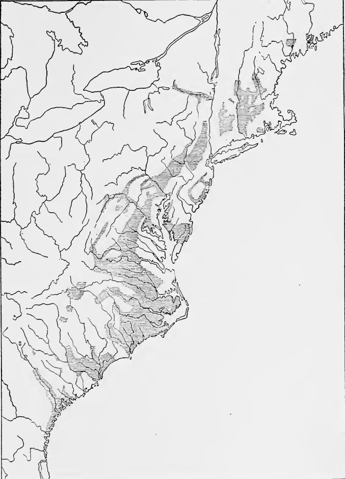 English-occupied Mainland Regions, 1700-1760.
Under these influences the migration took place and by the middle of the century a continuous back-country settlement had been formed, all the way from Maine to Georgia. New England industries were coastwise, the Piedmont was rough and stony, and expansion was consequently slow. But the open spaces were nearly all filled in, to the northern boundary of Massachusetts, while long spurs of settlement were pushed up the rivers into Vermont, New Hampshire, and Maine, where French rivalry was encountered. In New York settlement was retarded by the practice of land leasing instead of sales, a relic of the patroon system. Nevertheless a narrow ribbon of settlement pushed up the Mohawk from Albany nearly to Oneida Lake, while the lower Hudson River settlements widened out toward Pennsylvania and into New Jersey.
Under these influences, migration occurred and by the middle of the century, a continuous settlement had developed in the backcountry, stretching from Maine to Georgia. New England's industries were along the coast, the Piedmont was rough and rocky, and expansion was therefore slow. However, most of the open land was occupied, up to the northern boundary of Massachusetts, while long stretches of settlement extended up the rivers into Vermont, New Hampshire, and Maine, where they faced French competition. In New York, settlement was slowed by the practice of leasing land instead of selling it, a leftover from the patroon system. Still, a narrow band of settlement pushed up the Mohawk River from Albany nearly to Oneida Lake, while the settlements along the lower Hudson River spread out toward Pennsylvania and into New Jersey.
[Pg 312] Into the Southern Piedmont the movement was a double one. Some newcomers and many old settlers crossed the Tidewater and pushed over the Fall Line. But for the Germans, Swiss, and Scotch-Irish, Philadelphia was the chief port of entry and the main distributing point. Thence some pushed up the Delaware into New Jersey and northeastern Pennsylvania; others west into the valleys east of the Kittatiny Range. Those who followed, finding the lands occupied, and meeting here the mountain barrier to the westward march, moved south across the Susquehannah and up the Shenandoah Valley, whence they turned eastward into the Piedmont of Virginia, North Carolina, South Carolina, and even of Georgia. The Scotch-Irish in general kept nearest the outward frontier and became par excellence the Indian fighters.
[Pg 312] The movement into the Southern Piedmont was twofold. Some newcomers and many old settlers crossed the Tidewater and moved over the Fall Line. For the Germans, Swiss, and Scotch-Irish, Philadelphia was the main port of entry and distribution hub. From there, some headed up the Delaware into New Jersey and northeastern Pennsylvania; while others moved west into the valleys east of the Kittatiny Range. Those who followed found the land already occupied and faced the mountain barrier to westward movement, so they moved south across the Susquehanna and into the Shenandoah Valley, from where they turned eastward into the Piedmont regions of Virginia, North Carolina, South Carolina, and even Georgia. Generally, the Scotch-Irish stayed closest to the outer frontier and became the premier Indian fighters.
DEFENCE OF THE NORTHERN FRONTIER
English policy.—After the War of the Spanish Succession the English government was keenly alive to the necessity of defending the colonial frontiers. Although the period has been characterized as one of "salutary neglect" on the part of the home government, nevertheless the frontier defences were greatly strengthened. Soon after the signing of the Treaty of Utrecht, the English government became aware of French activities in Louisiana, and advice was sought from several colonial governors as to the best means of checking French and Spanish advance. A policy of defence was soon developed. It included the erection of forts, exploration of the mountain passes, alliances with Indian tribes, development of trade, reorganization of the incompetent proprietary government of the Carolinas, the establishment of the buffer colony of Georgia, and the encouragement of the settlement of the back country by the Germans and Scotch-Irish.
English policy.—After the War of the Spanish Succession, the English government was very aware of the need to protect the colonial borders. Although this time is often labeled as one of "salutary neglect" by the home government, the frontier defenses were significantly enhanced. Shortly after the Treaty of Utrecht was signed, the English government noticed French activities in Louisiana and sought advice from several colonial governors on the best ways to prevent French and Spanish expansion. A defense policy was quickly created. It included building forts, exploring mountain passes, forming alliances with Native American tribes, developing trade, reorganizing the ineffective proprietary government of the Carolinas, establishing the buffer colony of Georgia, and encouraging German and Scotch-Irish settlement in the backcountry.
Acadia and the Maine border.—A strange apathy regarding[Pg 313] Acadia was shown by the English government. A small garrison was maintained at Annapolis, but the Acadians continued loyal to the French, and French priests and officials from Cape Breton Island and Canada continued to exert influence over them. The Maine border was strongly held. English settlers again appeared on the lower Kennebec and forts were erected at Augusta and at the falls of the Androscoggin. Somewhat later Ft. Richmond was built on the Kennebec. English activity alarmed the Abenaki and the French soon influenced them to go on the warpath. From 1720 to 1725 a border war continued, but after much bloodshed on both sides the Indians sought peace.
Acadia and the Maine border.—The English government showed a strange indifference toward[Pg 313] Acadia. A small military presence was maintained at Annapolis, but the Acadians remained loyal to the French, and French priests and officials from Cape Breton Island and Canada kept influencing them. The Maine border was strongly defended. English settlers returned to the lower Kennebec, and forts were built at Augusta and at the falls of the Androscoggin. Later, Fort Richmond was established on the Kennebec. English activities alarmed the Abenaki, and the French quickly influenced them to take up arms. From 1720 to 1725, a border war raged on, but after much bloodshed on both sides, the Indians sought peace.
The New York border.—On the New York border, efforts of the French to bring the Iroquois into alliance aroused the English and in 1727 Governor Burnet erected a fort at Oswego. Owing to petty strife between New Hampshire and Massachusetts, and between New York and New Jersey, funds were not provided for a fortification on Lake Champlain, an oversight which gave the French an opportunity to erect a fort at Crown Point.
The New York border.—Along the New York border, the French tried to ally with the Iroquois, which alarmed the English. In 1727, Governor Burnet built a fort at Oswego. Because of minor conflicts between New Hampshire and Massachusetts, as well as between New York and New Jersey, the necessary funds for a fort on Lake Champlain weren't allocated. This mistake allowed the French to build a fort at Crown Point.
Pennsylvania and Virginia.—In 1716 Governor Spotswood of Virginia led an expedition to the Blue Ridge and entered the Shenandoah Valley. In his subsequent report he advised the making of settlements on Lake Erie and the securing of the mountain passes. The proposals were not carried out, but soon the back country was settled by Germans and Scotch-Irish, who formed a stronger barrier of defence than walls and palisades.
Pennsylvania and Virginia.—In 1716, Governor Spotswood of Virginia led an expedition to the Blue Ridge and entered the Shenandoah Valley. In his follow-up report, he suggested establishing settlements on Lake Erie and securing the mountain passes. These proposals were not implemented, but soon the region was settled by Germans and Scotch-Irish, who created a stronger line of defense than walls and palisades.
REORGANIZATION OF THE CAROLINAS
Separation of the Carolinas.—Economically the Carolinas had been drifting apart. Between the Albemarle and Cape Fear districts lay a primeval wilderness two hundred miles in width. The northern district was devoted to the production of naval stores and tobacco, the southern more to rice culture. Politically the governments had been practically separate almost from the beginning, the governor being located at Charleston and a deputy governor being appointed for the north. In 1713 the proprietors appointed Charles Eden as governor of North Carolina, and from this time the two provinces were practically separate.[Pg 314]
Separation of the Carolinas.—Economically, the Carolinas had been drifting apart. Between the Albemarle and Cape Fear districts lay a vast wilderness two hundred miles wide. The northern district focused on producing naval stores and tobacco, while the southern was more centered on rice cultivation. Politically, the governments had been almost entirely separate from the start, with the governor based in Charleston and a deputy governor appointed for the north. In 1713, the proprietors appointed Charles Eden as governor of North Carolina, and from that point on, the two provinces were essentially separate.[Pg 314]
The Yamassee War.—Between the South Carolina and Spanish settlements lived the Yamassee Indians. In the War of the Spanish Succession they had remained faithful to the English, but by 1715 they were won over by the St. Augustine officials. The French at Mobile were also working on the Creeks and Cherokees, and a confederation was formed whose object was the destruction of the South Carolina settlements. The war began on April 15, 1715, the Yamassee beginning the attack without the assistance of their allies, and the plantations and settlements were assailed all along the border. Martial law was immediately proclaimed in the province, volunteers were organized, and calls for assistance were sent to North Carolina, Virginia, New England, and England, the two former responding with men and ammunition. Several bloody engagements were fought which turned in favor of the Carolinians. The Yamassees received reinforcements and renewed their incursions, but Governor Craven showed such a superior force that the Indians fled beyond the Edisto and were subsequently driven far back into the interior.
The Yamassee War.—Between the South Carolina and Spanish settlements lived the Yamassee Indians. During the War of the Spanish Succession, they stayed loyal to the English, but by 1715, they were won over by the officials in St. Augustine. The French in Mobile were also trying to recruit the Creeks and Cherokees, forming a coalition aimed at destroying the South Carolina settlements. The conflict began on April 15, 1715, with the Yamassee launching attacks on their own, targeting plantations and settlements along the border. Martial law was quickly declared in the province, volunteers were organized, and requests for help were sent to North Carolina, Virginia, New England, and England, with the first two responding with troops and supplies. Several fierce battles were fought that ultimately favored the Carolinians. The Yamassees received reinforcements and continued their attacks, but Governor Craven demonstrated such a strong force that the Indians retreated beyond the Edisto River and were eventually pushed deep into the interior.
Overthrow of the proprietors.—The responsibility of defence against Indians, and pirates who infested the coast devolved upon the settlers, the proprietors showing little ability to assist. The assembly now took matters in its own hands and changed the method of elections, so that many large landholders were practically disfranchised. The acts were not approved by the proprietors and the slumbering discontent in the province soon approached rebellion. The situation was made worse by the refusal of the proprietors to allow the distribution of the Yamassee lands, and by an order that tracts be set aside for themselves. Rumors spread that another Spanish invasion threatened and Governor Johnson sought means of meeting it, but when he asked advice as to how funds might be raised, he was informed that the duty which had been imposed after the Yamassee War was still in force and that other legislation was unnecessary. The colonists answered the governor's call to arms but soon showed that they were against him. When Johnson refused to act in the name of the king instead of the proprietors, he was set aside. The proprietary government had been in ill favor with the English government for some time. Its incompetence in the Yamassee[Pg 315] War had convinced the Board of Trade that a change was necessary, and it upheld the popular movement. In 1729 an act of parliament established royal governments in both North and South Carolina.
Overthrow of the proprietors.—The responsibility for defending against Indians and pirates along the coast fell to the settlers, as the proprietors showed little ability to help. The assembly took matters into its own hands and changed the election process, which effectively disenfranchised many large landowners. These actions were not approved by the proprietors, and the growing discontent in the province quickly neared rebellion. The situation worsened when the proprietors refused to allow the distribution of the Yamassee lands and ordered that some tracts be set aside for themselves. Rumors spread about another possible Spanish invasion, and Governor Johnson looked for ways to address it. However, when he sought advice on raising funds, he was told that the duty imposed after the Yamassee War was still in effect and that no additional legislation was needed. The colonists responded to the governor's call to arms but soon demonstrated their opposition to him. When Johnson refused to act in the king's name rather than the proprietors', he was sidelined. The proprietary government had been out of favor with the English government for a while. Its incompetence during the Yamassee[Pg 315] War had convinced the Board of Trade that a change was necessary, and it supported the popular movement. In 1729, an act of parliament established royal governments in both North and South Carolina.
THE FOUNDING OF GEORGIA
The debatable land.—In the great triangle formed by the Carolinas, Florida, and southeastern Louisiana, English, Spanish, and French came into close proximity. The international boundaries had never been satisfactorily defined and each power strove to acquire control of the powerful Indian tribes of the interior, thereby gaining territory and trade. To protect the border and to aid the Charleston traders, in 1716 the Carolinians established a fort on the Savannah River, and from 1721 to 1727 maintained Ft. King George on the Altamaha. In 1730 Sir Alexander Cuming was sent on a mission to the Cherokees, on which he succeeded in obtaining an acknowledgment of English supremacy, considerably strengthening the English position.
The contested land.—In the large triangle formed by the Carolinas, Florida, and southeastern Louisiana, English, Spanish, and French interests were very close together. The international borders had never been clearly defined, and each country sought to gain control over the powerful Native American tribes in the interior, thus acquiring more land and trade opportunities. To secure the border and assist the Charleston traders, the Carolinians built a fort on the Savannah River in 1716, and from 1721 to 1727, they operated Ft. King George on the Altamaha. In 1730, Sir Alexander Cuming was sent on a mission to the Cherokees, where he successfully secured recognition of English dominance, significantly boosting the English position.
Azilia.—The need of a buffer colony on the southern border was long realized by English statesmen. In 1717 a project was launched which gave promise of fulfillment. Sir Robert Montgomery secured from the Carolina proprietors a grant of the lands between the Savannah and Altamaha Rivers which was called the Margravate of Azilia. Plans for its settlement were drawn up and an attempt made to obtain colonists, but Sir Robert failed to attract settlers and the grant lapsed.
Azilia.—English statesmen recognized the need for a buffer colony on the southern border for a long time. In 1717, a project was started that seemed promising. Sir Robert Montgomery obtained a grant from the Carolina proprietors for the land between the Savannah and Altamaha Rivers, which was named the Margravate of Azilia. Plans for settling the area were created, and efforts were made to recruit colonists, but Sir Robert couldn't attract any settlers, and the grant eventually expired.
Oglethorpe.—It remained for James Oglethorpe to carry out the project. Oglethorpe had seen considerable military service, and for thirty years was a member of the House of Commons, in the latter capacity advocating an aggressive policy against Spain. Possessed of broadly humanitarian sympathies, he became interested in ameliorating the conditions of imprisoned debtors. He conceived the idea of planting a barrier colony on the southern frontier, which would serve the two-fold purpose of protecting Carolina against Spanish and Indian attacks, and of offering a place of refuge for the debtor class. In 1732 he secured a charter conveying to himself and a group of interested persons the land between the Savannah and Altamaha Rivers and extending westward from their head waters to the sea.[Pg 316]
Oglethorpe.—It fell to James Oglethorpe to bring the project to life. Oglethorpe had significant military experience and was a member of the House of Commons for thirty years, where he promoted an aggressive approach towards Spain. With a strong sense of humanitarianism, he became concerned about the conditions of imprisoned debtors. He came up with the idea of establishing a barrier colony on the southern frontier, which would both protect Carolina from Spanish and Indian attacks and provide a safe haven for debtors. In 1732, he obtained a charter granting him and a group of supporters the land between the Savannah and Altamaha Rivers, extending westward from their headwaters to the ocean.[Pg 316]
The government.—The government was of the proprietary type, but the proprietors were not to receive any profits individually; financial reports and legislation were to be submitted to the crown for approval. The proprietorship was limited to twenty-one years, after which the province was to become a royal colony. Religious liberty was guaranteed to all but Catholics; provision was made to prevent large land holdings; slavery was prohibited, a restriction which was subsequently removed; the importation of rum was forbidden, as was trade with the Indians without a license.
The government.—The government was a proprietary type, but the proprietors weren’t allowed to keep any profits for themselves; financial reports and laws had to be sent to the crown for approval. The proprietorship lasted for twenty-one years, after which the province would become a royal colony. Religious freedom was guaranteed to everyone except Catholics; measures were taken to prevent large land holdings; slavery was banned, though that restriction was later lifted; the import of rum was prohibited, as was trading with the Native Americans without a license.
Savannah.—In the autumn of 1732 about one hundred men, women, and children were sent to America, arriving at Charleston in January, 1733. A treaty was made with the Creeks who surrendered most of their coast lands and the town of Savannah was immediately laid out. The colony was soon strengthened by German and Scotch immigration. In 1737 a fort was established at Augusta and a town grew up which soon developed an important trade with the Cherokees.
Savannah.—In the fall of 1732, around one hundred men, women, and children were sent to America, arriving in Charleston in January 1733. A treaty was signed with the Creeks, who gave up most of their coastal lands, and the town of Savannah was quickly established. The colony was soon boosted by German and Scottish immigration. In 1737, a fort was built in Augusta, and a town emerged that soon developed significant trade with the Cherokees.
Measures of defence.—The Scotch were settled near the mouth of the Altamaha. In 1736 Ft. Frederica was established on St. Simon's Island at the mouth of the river, and military posts were built between the Altamaha and the St. John's Rivers. This encroachment aroused the ire of the Spanish government, which demanded Oglethorpe's recall, but instead, while in Europe, he was given permission to raise a regiment of troops for the protection of Georgia, and upon his return he visited the Creeks, with whom he renewed the former alliance.
Measures of defense.—The Scots had settled near the mouth of the Altamaha. In 1736, Fort Frederica was established on St. Simon's Island at the river's mouth, and military posts were built between the Altamaha and the St. John's Rivers. This encroachment angered the Spanish government, which demanded Oglethorpe's recall. However, while he was in Europe, he was given permission to raise a regiment of troops for Georgia's protection, and upon his return, he visited the Creeks to reaffirm their previous alliance.
THE GERMAN AND SWISS MIGRATION
In 1600 the population of the English colonies on the continent of North America was only two hundred thousand; fifty years later it had increased to a million, and by 1760 another half million had been added. In part this was due to natural increase, but a large population came from the influx of Europeans other than English, the two principal immigrant peoples being the Germans and the Scotch-Irish.
In 1600, the population of the English colonies in North America was just two hundred thousand. Fifty years later, it had grown to a million, and by 1760, another half million had been added. This growth was partly due to natural increase, but a significant portion of the population came from the arrival of Europeans other than the English, with the two main immigrant groups being the Germans and the Scotch-Irish.
The German migration.—The causes of the German migration are to be found in the disturbed condition of Germany. Religious persecution, political oppression, and economic distress caused[Pg 317] by wars and bad seasons, each played its part in the movement. Most of the immigrants came from southwestern Germany, especially from the Palatinate, Württemberg, and Baden, and from Switzerland. The first period of migration, dating from 1683 to 1710, was characterized by a small movement of persecuted sects; but after 1710 an ever-increasing migration took place in which the religious, political, and economic causes blended.
The German migration.—The reasons for the German migration can be found in the troubled state of Germany. Religious persecution, political oppression, and economic hardship caused[Pg 317] by wars and poor harvests all contributed to the movement. Most of the immigrants came from southwestern Germany, particularly from the Palatinate, Württemberg, and Baden, as well as from Switzerland. The first migration period, from 1683 to 1710, saw a small movement of persecuted groups; however, after 1710, migration increased significantly as religious, political, and economic factors came together.
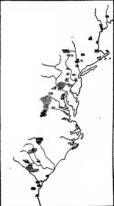 Main Areas of German Settlement before 1763.
The early migration to Pennsylvania.—The first German settlement in the English colonies may be traced directly to William Penn's visit to the Rhineland in 1677. A group of[Pg 318] pietists from Frankfort-on-the-Main purchased fifteen thousand acres of Penn's land and in 1683 sent over a young lawyer, Francis Daniel Pastorius, as advance agent, who became the recognized leader of the Pennsylvania Germans. He was soon followed by a considerable number of emigrants. More land was purchased and the settlement of Germantown begun. In 1684 a group of Labadists settled on the Bohemian River in the present state of Delaware. Every year a few people joined the original group at Germantown. The most important addition was in 1694 when forty Rosicrucians under John Kelpius settled on the banks of the Wissahickon.
The early migration to Pennsylvania.—The first German settlement in the English colonies can be traced directly to William Penn's visit to the Rhineland in 1677. A group of[Pg 318] pietists from Frankfurt am Main bought fifteen thousand acres of Penn's land and in 1683 sent a young lawyer, Francis Daniel Pastorius, as an advance agent, who became the recognized leader of the Pennsylvania Germans. He was soon followed by a significant number of emigrants. More land was bought, and the settlement of Germantown began. In 1684, a group of Labadists settled on the Bohemian River in what is now Delaware. Every year, more people joined the original group in Germantown. The most important addition happened in 1694 when forty Rosicrucians under John Kelpius settled along the banks of the Wissahickon.
The migration to New York.—Not until 1710 did the great flood of migration begin. In 1707 a portion of the Palatinate was devastated. The following year sixty-one homeless people led by Joshua von Kocherthal made their way to London. The Board of Trade sent them to New York, where Governor Lovelace gave them lands on the Hudson, where they began the town of Newburg. Religious persecution, political oppression, the devastation of Württemberg and a part of the Palatinate, and a hard winter caused a great exodus in 1709. In May of that year the Germans began to arrive in London, and by October the numbers had swelled to thirteen thousand. About thirty-five hundred were sent to the colonies. Six hundred and fifty were settled at Newbern near the mouth of the Neuse River in North Carolina, and about three thousand were sent to New York, where Governor Hunter hoped to settle them on lands where tar and pitch could be produced. The story goes that in London the Palatines had met a delegation of Indian chiefs who had promised them lands on the Schoharie, a branch of the Mohawk. Instead of being sent there, however, many were placed on lands along both sides of the Hudson near Saugerties. The colony on the west side was called West Camp, and contained about six hundred people. The East Camp, which was located on the manor of Robert Livingston, received nearly twelve hundred; it was here that difficulties occurred. The attempts to produce tar and pitch failed, and the colonists demanded that they be moved to the Schoharie. After much bickering with the governor, in 1712 and 1713 many of the people from East Camp moved to the Schoharie; but their troubles did not end, for the question of[Pg 319] land title brought them into disputes with certain landowners from Albany. Some of the Palatines moved again, many taking up lands in the Mohawk Valley between Ft. Hunter and Frankfort, while others in 1723 and 1727 migrated to Pennsylvania, settling in Berks County.
The migration to New York.—It wasn’t until 1710 that the major wave of migration started. In 1707, part of the Palatinate was devastated. The next year, sixty-one homeless individuals, led by Joshua von Kocherthal, made their way to London. The Board of Trade sent them to New York, where Governor Lovelace granted them land along the Hudson River, where they began the town of Newburg. Religious persecution, political oppression, the destruction of Württemberg and parts of the Palatinate, along with a harsh winter, triggered a large exodus in 1709. In May of that year, Germans began arriving in London, and by October, their numbers swelled to thirteen thousand. About thirty-five hundred were sent to the colonies. Six hundred and fifty were settled in Newbern, near the mouth of the Neuse River in North Carolina, and about three thousand were sent to New York, where Governor Hunter hoped to settle them on land suitable for producing tar and pitch. It’s said that in London, the Palatines met a group of Indian chiefs who promised them land along the Schoharie, a branch of the Mohawk. However, instead of being sent there, many were placed on land on both sides of the Hudson near Saugerties. The colony on the west side was called West Camp and had about six hundred people. The East Camp, located on Robert Livingston's manor, received nearly twelve hundred, and that’s where issues arose. The attempts to produce tar and pitch failed, and the colonists demanded to be moved to the Schoharie. After much disagreement with the governor, many from East Camp moved to Schoharie in 1712 and 1713; however, their troubles continued, as the issue of land titles led to disputes with certain landowners from Albany. Some of the Palatines moved again, with many settling land in the Mohawk Valley between Ft. Hunter and Frankfort, while others migrated to Pennsylvania in 1723 and 1727, settling in Berks County.
The later Pennsylvania migration.—The harsh treatment in New York and the kind reception of Germans in Pennsylvania made the Quaker colony a favorite place for their coming. Between 1710 and 1727 from fifteen to twenty thousand entered Pennsylvania and settled in Lancaster, Berks, and Montgomery counties. Between 1727 and 1740 the arrivals numbered about fifty-seven thousand, and between 1741 and 1756 about twenty thousand. Many of the newcomers settled in Philadelphia, and neighboring counties, but the desire for cheap land carried a large number into the fertile valleys of the Susquehanna, Lehigh, and Shenandoah. In the words of Professor Faust, "They ... pushed northward and westward to Lehigh, Northampton, and Monroe counties, and to Lebanon and Dauphin; reaching the Susquehanna they crossed and settled the counties of York, Cumberland, and Adams, then following the slopes of the mountains they went southward through Maryland into Virginia, ascending the Shenandoah Valley and settling it from Harpers Ferry to Lexington, Virginia. Using this main avenue for their progress, they settled in North Carolina and Virginia and later in Kentucky and Tennessee. Pennsylvania, therefore, was the distributing center for the German immigrations, whence German settlers spread over all the neighboring provinces."
The later Pennsylvania migration.—The mistreatment in New York and the warm welcome given to Germans in Pennsylvania made the Quaker colony a popular destination for them. Between 1710 and 1727, around fifteen to twenty thousand Germans moved to Pennsylvania and settled in Lancaster, Berks, and Montgomery counties. From 1727 to 1740, about fifty-seven thousand arrived, and between 1741 and 1756, around twenty thousand more came. Many newcomers established themselves in Philadelphia and nearby counties, but the quest for affordable land drew a large number into the rich valleys of the Susquehanna, Lehigh, and Shenandoah. In the words of Professor Faust, "They ... pushed northward and westward to Lehigh, Northampton, and Monroe counties, and to Lebanon and Dauphin; reaching the Susquehanna they crossed and settled the counties of York, Cumberland, and Adams, then following the slopes of the mountains they went southward through Maryland into Virginia, ascending the Shenandoah Valley and settling it from Harpers Ferry to Lexington, Virginia. Using this main avenue for their progress, they settled in North Carolina and Virginia and later in Kentucky and Tennessee. Pennsylvania, therefore, was the distribution center for the German migrations, from which German settlers spread out across all the neighboring provinces."
New Jersey.—As early as 1707 several members of the German Reformed Church appear to have settled in Morris County, and later spread into Somerset, Bergen, and Essex counties. Later groups, mainly of Lutherans or German Reformed, settled in Hunterdon, Somerset, Morris, Sussex, and Warren counties, and there were scattered settlements elsewhere.
New Jersey.—As early as 1707, some members of the German Reformed Church seem to have settled in Morris County, later spreading into Somerset, Bergen, and Essex counties. Additional groups, mostly Lutherans or German Reformed, settled in Hunterdon, Somerset, Morris, Sussex, and Warren counties, with some smaller communities forming in other areas.
Maryland.—A few Germans came to Maryland before 1730, but with the founding of Baltimore in that year a considerable German migration began, enterprising Germans from Pennsylvania finding the new town a place for their capital and energy. At about the same time the Germans were settling in western Maryland. In 1729 Germans from Pennsylvania settled[Pg 320] about ten miles north of the modern town of Frederick, and soon many German settlements dotted Frederick and neighboring counties.
Maryland.—A few Germans arrived in Maryland before 1730, but with the founding of Baltimore that year, a significant wave of German migration started, as ambitious Germans from Pennsylvania saw the new town as a place to invest their energy and resources. Around the same time, Germans were also moving into western Maryland. In 1729, Germans from Pennsylvania settled[Pg 320] about ten miles north of what is now Frederick, and soon many German communities sprang up throughout Frederick and the surrounding counties.
Virginia.—The first Germans in Virginia were skilled iron-workers from Westphalia, brought in by Governor Spotswood to operate his iron works which were located on the Piedmont Plateau at Germanna, in modern Orange County. The settlers at Germanna afterward migrated to Germantown near the Rappahannock and to Madison County. A far more important movement was the migration into the Shenandoah Valley. The northern part was settled almost entirely by Germans, but in the southern part they formed only a small part of the population. The first of the settlers came from Lancaster County, Pennsylvania, in 1726 or 1727, settling near Elkton. They were soon followed by others, among them Joist Hite at the head of sixteen families from York, Pennsylvania, who settled at the site of Winchester. In 1734 Robert Harper founded Harper's Ferry. The most remote settlements were located in the Alleghanies within the present state of West Virginia; one on Patterson's Creek, another on the south branch of the Potomac, and a third on the New River, which with the Greenbrier forms the Great Kanawha. Thus the frontier had already reached the "Western Waters."
Virginia.—The first Germans in Virginia were skilled ironworkers from Westphalia, brought in by Governor Spotswood to run his iron works located on the Piedmont Plateau at Germanna, in what is now Orange County. The settlers at Germanna later moved to Germantown near the Rappahannock and to Madison County. A much more significant movement was the migration into the Shenandoah Valley. The northern part was almost entirely settled by Germans, while in the southern part, they made up only a small portion of the population. The first settlers came from Lancaster County, Pennsylvania, in 1726 or 1727, settling near Elkton. They were quickly followed by others, including Joist Hite, who led sixteen families from York, Pennsylvania, to settle at the site of Winchester. In 1734, Robert Harper founded Harper's Ferry. The most distant settlements were found in the Alleghenies in what is now West Virginia; one on Patterson's Creek, another on the south branch of the Potomac, and a third on the New River, which along with the Greenbrier forms the Great Kanawha. By this point, the frontier had already reached the "Western Waters."
North Carolina.—As already noted, the first migration of Germans into North Carolina was connected with the Palatine movement of 1710; the lands of Baron Graffenried on which they settled being at the confluence of the Neuse and Trent Rivers. In the following year the Tuscaroras went on the warpath; about sixty of the newcomers were slain and their settlement destroyed. The Tuscaroras eventually were incorporated with the Iroquois Confederation and the settlers took advantage of the removal to occupy their lands, soon spreading over a large part of what is now Craven County. About 1745. Germans from Pennsylvania began to arrive in the western part of North Carolina, taking up lands along the Yadkin River. Not until 1750 did the immigrants become numerous. By the time of the Revolution there were important German settlements in Stokes, Forsyth, Guilford, Davidson, Rowan, and Cabarrus counties.
North Carolina.—As mentioned earlier, the first wave of German immigrants to North Carolina was linked to the Palatine movement of 1710; they settled on the lands of Baron Graffenried at the meeting point of the Neuse and Trent Rivers. The following year, the Tuscaroras went to war; around sixty of the newcomers were killed, and their settlement was destroyed. The Tuscaroras eventually joined the Iroquois Confederation, and the settlers took advantage of their removal to claim their land, quickly spreading across a significant part of what is now Craven County. Around 1745, Germans from Pennsylvania began arriving in the western part of North Carolina, settling along the Yadkin River. It wasn't until 1750 that the number of immigrants increased significantly. By the time of the Revolution, there were significant German settlements in Stokes, Forsyth, Guilford, Davidson, Rowan, and Cabarrus counties.
[Pg 321] South Carolina.—In South Carolina the first German colonists settled in or near Charleston. In 1732 a settlement was made in Beaufort County and German villages soon dotted both sides of the Edisto and Congaree Rivers in Orangeburg and Lexington counties and spread out toward the Georgia boundary, Baden, Württemberg, Switzerland, and discontents from Maine furnishing most of the South Carolina Germans.
[Pg 321] South Carolina.—The first German settlers arrived in or near Charleston, South Carolina. In 1732, a community was established in Beaufort County, and soon German villages appeared on both sides of the Edisto and Congaree Rivers in Orangeburg and Lexington counties, extending toward the Georgia border. Most of the Germans in South Carolina came from Baden, Württemberg, Switzerland, and dissatisfied individuals from Maine.
Swiss migration to Carolina and Pennsylvania.—With the exception of Graffenried's project, no large enterprise for bringing Swiss settlers to America was launched until 1725, when Jean Purry of Neufchatel began to advertise for Swiss Protestants to found a colony in Carolina. In 1732 Purry succeeded in establishing Purrysburgh, which soon had several hundred inhabitants. Crop failures in Switzerland coupled with heavy taxation and a dislike for foreign military service caused a large number to migrate between 1730 and 1750. Although accurate statistics are lacking, recent investigation shows that during the eighteenth century probably twenty-five thousand Swiss emigrated to Pennsylvania and the Carolinas.
Swiss migration to Carolina and Pennsylvania.—Except for Graffenried's project, there wasn't any major effort to bring Swiss settlers to America until 1725, when Jean Purry from Neufchatel started advertising for Swiss Protestants to establish a colony in Carolina. In 1732, Purry successfully set up Purrysburgh, which quickly grew to several hundred residents. Crop failures in Switzerland, combined with high taxes and a distaste for foreign military service, prompted many to leave between 1730 and 1750. Although exact statistics are not available, recent research suggests that during the eighteenth century, around twenty-five thousand Swiss emigrated to Pennsylvania and the Carolinas.
Georgia.—In 1731 thirty thousand Protestants of Salzburg were exiled. Some of them made their way to England and eventually became settlers in the newly-constituted colony of Georgia. The first ones arrived at Savannah in 1734 and moved to lands on the Savannah River about forty miles from its mouth, naming their settlement Ebenezer. Others soon followed. Oglethorpe wished some of them to settle about the fort on St. Simon Island, but they objected to bearing arms and were allowed to go to Ebenezer. Others, who had no religious scruples regarding war, were settled at Frederica. The settlers from Ebenezer soon moved down the river eight miles to New Ebenezer, across the river from Purrysburgh. By 1741 over twelve hundred Germans had come to Georgia.
Georgia.—In 1731, thirty thousand Protestants from Salzburg were forced into exile. Some of them traveled to England and eventually became settlers in the newly formed colony of Georgia. The first group arrived in Savannah in 1734 and moved to land on the Savannah River about forty miles from where it meets the ocean, naming their settlement Ebenezer. More people followed soon after. Oglethorpe wanted some of them to settle around the fort on St. Simon Island, but they refused to take up arms and were allowed to go to Ebenezer instead. Others, who had no issues with fighting, settled at Frederica. The settlers from Ebenezer quickly moved down the river eight miles to New Ebenezer, directly across from Purrysburgh. By 1741, over twelve hundred Germans had arrived in Georgia.
New England and Nova Scotia.—A small number of Germans made their way to New England. The head of the movement was Samuel Waldo, who became interested in lands on the shores of Broad Bay in Maine. In 1740 forty families from Brunswick and Saxony founded Waldoborough. In 1749-1750 Massachusetts made an effort to increase German immigration by setting aside lands for their use. One of these districts was near Fort[Pg 322] Massachusetts in modern Franklin County and extended beyond into what is now Vermont. Three years later the first German settlers entered the region. In 1751 Joseph Crellius brought over twenty or thirty families who founded Frankfort, subsequently called Dresden, on the Kennebec River. It has been estimated that fifteen hundred Germans entered New England in 1752-1753, but many of them moved subsequently to South Carolina. Another group settled at Braintree near Boston, but by 1760 they had all moved to the Maine settlements. During 1750-1753 occurred a considerable German migration to Nova Scotia, sixteen hundred settling in Lunenburg County. In the latter year the English Government checked the movement, which was deflected to New England, and the settlements at Broad Bay and on the Kennebec were considerably enlarged.
New England and Nova Scotia.—A small group of Germans made their way to New England. The leader of the movement was Samuel Waldo, who became interested in land along the shores of Broad Bay in Maine. In 1740, forty families from Brunswick and Saxony established Waldoborough. Between 1749 and 1750, Massachusetts tried to boost German immigration by reserving land for their use. One of these areas was near Fort[Pg 322] Massachusetts in what is now Franklin County, extending into present-day Vermont. Three years later, the first German settlers arrived in the region. In 1751, Joseph Crellius brought over twenty or thirty families who founded Frankfort, later renamed Dresden, on the Kennebec River. It's estimated that about fifteen hundred Germans arrived in New England in 1752-1753, but many moved on to South Carolina. Another group settled in Braintree, near Boston, but by 1760, they had all relocated to the Maine settlements. From 1750 to 1753, there was a significant German migration to Nova Scotia, with sixteen hundred settling in Lunenburg County. In that same year, the English Government halted the movement, which shifted to New England, and the settlements at Broad Bay and along the Kennebec expanded significantly.
THE SCOTCH-IRISH
Causes of the Scotch-Irish migration.—Of equal importance with the German migration was that of the Scotch-Irish from Ulster. The causes of the migration to America were both religious and economic. The Presbyterianism of the Scotch found scant favor with the English authorities. The efforts to enforce uniformity, and the various religious laws of the reign of Charles II and Anne were especially obnoxious to Presbyterians. Though few migrated because of them, they left a feeling of injury, which, coupled with industrial hardships, brought about the great migration to America. English restrictive legislation was also an important factor. Laws prohibiting the importation into England of Irish stock and dairy products, acts excluding Irish vessels from American trade and prohibiting direct importation to Ireland from the colonies, and the act of 1699 prohibiting the exportation of Irish wool worked great hardships on the people of Ulster. The enforced payment of tithes to support the Episcopalian clergy touched both the purse and the conscience of the Scotch-Irish. But more important than any of these was the tenant system In 1714-1718 many of the original leases expired and the landlords doubled or trebled the rents. This is the chief explanation of the great acceleration of the movement to America which began in 1714. No doubt the natural business instinct of the Scotch people, and occasional crop failures, such as the potato famine in 1725. 1740-1741, also hastened many who otherwise might have lingered in Ulster.
Causes of the Scotch-Irish migration.—Alongside the German migration, the movement of the Scotch-Irish from Ulster was equally significant. The reasons for their migration to America were both religious and economic. The Presbyterian beliefs of the Scotch were not well-received by the English authorities. The attempts to enforce uniformity and the various religious laws during the reigns of Charles II and Anne were particularly disliked by Presbyterians. While only a few moved solely for these reasons, they created a sense of grievance that, combined with economic struggles, led to the significant migration to America. English restrictive laws also played a crucial role. Legislation prohibiting the import of Irish livestock and dairy products into England, excluding Irish ships from American trade, and banning direct imports to Ireland from the colonies, along with the 1699 law that stopped the export of Irish wool, caused tremendous hardship for the people of Ulster. The mandatory payment of tithes to support the Episcopalian clergy affected both the finances and the conscience of the Scotch-Irish. However, the most important factor was the tenant system. Between 1714 and 1718, many original leases ended, and landlords raised rents significantly. This was the main reason for the sharp increase in migration to America that began in 1714. Additionally, the natural business acumen of the Scotch people and occasional crop failures, like the potato famine in 1725 and again in 1740-1741, also prompted many who might have stayed in Ulster to leave.
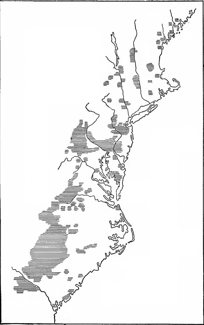 The Regions Mainly Settled by the Scotch-Irish Before 1763.
[Pg 324] Seventeenth century migration.—In 1612 the Rev. George Keith, a Scotchman, went to Bermuda, the first dissenting minister in the English colonies. In 1652 Cromwell sent about two hundred and fifty Scotch prisoners to New England. Before 1669 a considerable number of Scotch and Scotch-Irish settled on the eastern shore of Chesapeake Bay and by 1680 some Scotch Presbyterians were located near Norfolk. In 1683 Scottish colonists landed at Port Royal and Charleston, and others founded Stuartstown. In 1684 and 1685, many Scotch dissenters sought refuge in East New Jersey, the beginning of a movement which eventually made New Jersey one of the strongholds of Presbyterianism.
[Pg 324] Seventeenth century migration.—In 1612, the Rev. George Keith, a Scotsman, arrived in Bermuda as the first dissenting minister in the English colonies. In 1652, Cromwell sent about two hundred and fifty Scottish prisoners to New England. By 1669, a significant number of Scots and Scots-Irish had settled on the eastern shore of Chesapeake Bay, and by 1680, some Scottish Presbyterians were established near Norfolk. In 1683, Scottish colonists arrived at Port Royal and Charleston, while others founded Stuartstown. In 1684 and 1685, many Scottish dissenters sought refuge in East New Jersey, marking the start of a movement that eventually made New Jersey one of the strongholds of Presbyterianism.
The great migration.—Dining the early years of the eighteenth century a few Scotch-Irish made their way to America, but not until after the close of the War of the Spanish Succession did the movement assume large proportions. The tide of immigration which set in brought the Scotch-Irish to every colony. Many of them found homes in the tide-water lands among the older settlements, where vast areas were still thinly settled, but a larger number sought the frontier.
The great migration.—During the early years of the eighteenth century, a few Scotch-Irish people came to America, but it wasn't until after the end of the War of the Spanish Succession that the movement grew significantly. The wave of immigration that began brought the Scotch-Irish to every colony. Many of them settled in the tide-water regions among the older communities, where large areas were still lightly populated, but a greater number headed for the frontier.
New England.—Between 1714 and 1720 fifty-four vessels brought Scotch-Irish immigrants to Boston. The large influx of foreigners began to alarm the authorities. When over five hundred arrived at Boston in the summer of 1718, a shortage of provisions threatened. To place the immigrants on a self-supporting basis was highly desirable. In addition the more remote settlements needed protection. The plan was accordingly adopted of sending the Scotch-Irish to the frontier. About fifty miles from Boston was the post of Worcester containing about two hundred people. Soon its population was doubled by Scotch-Irish. Others came and Worcester became the distributing point for interior settlement. In 1731 Pelham was started thirty miles to the westward, and two years later Colerain, twenty miles farther in the wilderness, was formed. In 1741 Warren and Blandford were incorporated. From western Massachusetts the settlers turned northward, following the Connecticut Valley[Pg 325], forming settlements in Windsor, Orange, and Caledonia counties in Vermont and in Grafton County in New Hampshire.
New England.—Between 1714 and 1720, fifty-four ships brought Scotch-Irish immigrants to Boston. The large number of newcomers started to worry the authorities. When over five hundred arrived in Boston during the summer of 1718, there was a risk of running low on supplies. It was crucial to help the immigrants become self-sufficient. Additionally, the more isolated settlements needed protection. So, the decision was made to send the Scotch-Irish to the frontier. About fifty miles from Boston was Worcester, which had around two hundred residents. Soon, its population doubled with the arrival of Scotch-Irish immigrants. More people continued to arrive, and Worcester became the main hub for settling the interior. In 1731, Pelham was established thirty miles to the west, and two years later, Colerain was formed twenty miles further into the wilderness. In 1741, Warren and Blandford were incorporated. From western Massachusetts, the settlers moved northward, following the Connecticut Valley[Pg 325], establishing communities in Windsor, Orange, and Caledonia counties in Vermont and in Grafton County in New Hampshire.
While Worcester was being settled, other immigrants sought lands in Maine. Thirty families were landed at Falmouth on Casco Bay, another group settled on the Kennebec near its mouth, and by 1720 several hundred families had settled on the Kennebec or the Androscoggin, but soon afterward Indian troubles caused a large part of them to move to New Hampshire Or Pennsylvania. In 1719 Nuffield on the site of modern Manchester was founded. When the town was incorporated in 1722 its name was changed to Londonderry. It became the distributing point for Scotch-Irish in that region; from there Rockingham, Hillsboro, and Merrimack counties in New Hampshire were settled. Emigration spread over into Vermont, joining that from Worcester, and pushed on to the north and west. Still other Scotch-Irish settlements were formed later in Maine. A hundred and fifty families from Nova Scotia in 1729 settled at Pemaquid and Samuel Waldo induced a few to settle on the St. George at Warren. Connecticut and Rhode Island also received an infusion of Scotch-Irish blood but in a much less degree than the northern frontier.
While Worcester was being settled, other immigrants were looking for land in Maine. Thirty families arrived at Falmouth on Casco Bay, another group settled near the mouth of the Kennebec River, and by 1720, several hundred families had established themselves along the Kennebec or the Androscoggin. However, soon after, conflicts with Native Americans forced many of them to move to New Hampshire or Pennsylvania. In 1719, Nuffield was established on the site of what is now Manchester. When the town was incorporated in 1722, its name was changed to Londonderry. It became a key distribution point for Scotch-Irish settlers in that area; from there, Rockingham, Hillsboro, and Merrimack counties in New Hampshire were populated. Migration also spread into Vermont, joining the flow from Worcester, and continued north and west. More Scotch-Irish settlements were established later in Maine. In 1729, one hundred and fifty families from Nova Scotia settled at Pemaquid, and Samuel Waldo encouraged a few to settle on the St. George River at Warren. Connecticut and Rhode Island also welcomed a modest number of Scotch-Irish immigrants, but not to the same extent as the northern frontier.
New York.—About 1718 large numbers of Scotch-Irish came to New York, most of them settling in Orange and Ulster counties. In 1738 John Lindsay and three associates obtained an extensive land grant in Cherry Valley in modern Otsego County. Many settlers were induced to come from Londonderry, New Hampshire, and from Scotland and Ulster, but the exposed position prevented a great influx in succeeding years.
New York.—Around 1718, a significant number of Scotch-Irish immigrants arrived in New York, with many settling in Orange and Ulster counties. In 1738, John Lindsay and three partners secured a large land grant in Cherry Valley, which is now part of Otsego County. Many settlers were encouraged to migrate from Londonderry, New Hampshire, as well as from Scotland and Ulster, but the vulnerable location hindered a large influx in the following years.
Pennsylvania.—As in the German movement, in the Scotch-Irish migration the largest number came to Pennsylvania. The earliest comers appear to have settled on either side of the Pennsylvania-Maryland line in the Susquehanna Valley. The exact date of their arrival is uncertain, but a church had been organized as early as 1708. About 1720 the immigrants began working up the Delaware River, settling in Bucks County and spreading over into Northampton County. Another stream of immigrants passed up the Susquehanna Valley, settling along the creek bottoms on the east side of the river, their chief centers being in Chester, Lancaster, and Dauphin counties in Pennsylvania,[Pg 326] and in Cecil County, Maryland. Before 1730 the settlers pushed over into Cumberland County, Pennsylvania, which gave them access to the valleys of the interior. They spread into Franklin, Adams, and York counties and the later movement carried them southward into the great valleys.
Pennsylvania.—Similar to the German movement, the largest number of Scotch-Irish migrants settled in Pennsylvania. The earliest arrivals seem to have established themselves on either side of the Pennsylvania-Maryland border in the Susquehanna Valley. The exact date when they arrived is unclear, but a church was organized as early as 1708. Around 1720, the immigrants started moving up the Delaware River, settling in Bucks County and spreading into Northampton County. Another group of immigrants traveled up the Susquehanna Valley, settling along the creek bottoms on the east side of the river, with major centers in Chester, Lancaster, and Dauphin counties in Pennsylvania,[Pg 326] and in Cecil County, Maryland. Before 1730, the settlers moved into Cumberland County, Pennsylvania, which allowed them access to the interior valleys. They expanded into Franklin, Adams, and York counties, and later movements took them south into the vast valleys.
The Southern Piedmont—By 1735 or earlier, the Scotch-Irish began moving into the Shenandoah Valley. Some of them remained in Maryland and the most eastern counties of what is now West Virginia, but most of them, moved into Virginia, taking up the lands west of the Blue Ridge Mountains. Many went through the passes and made their homes in the Piedmont region to the east of the Blue Ridge. The movement was greatly stimulated by the fact that several large land grants were made to various Pennsylvanians and Virginians, who encouraged the settlement of their lands. The early records of the Scotch-Irish in the southern Piedmont give us little exact data, but between 1740 and 1760 scattered settlements were made along the frontier from Virginia to Florida. In North Carolina the lands between the Yadkin and Catawba Rivers were settled. By 1750 the vanguard appeared in the western part of South Carolina, and a few years later in the upland country of Georgia.
The Southern Piedmont—By 1735 or earlier, the Scotch-Irish started moving into the Shenandoah Valley. Some stayed in Maryland and the eastern counties of what is now West Virginia, but most moved into Virginia, settling on the lands west of the Blue Ridge Mountains. Many passed through the gaps and established homes in the Piedmont region to the east of the Blue Ridge. This movement was significantly encouraged by several large land grants given to various Pennsylvanians and Virginians, who promoted the settlement of their lands. The early records of the Scotch-Irish in the southern Piedmont provide little specific data, but between 1740 and 1760, scattered settlements were established along the frontier from Virginia to Florida. In North Carolina, the lands between the Yadkin and Catawba Rivers were settled. By 1750, the forefront of the migration appeared in the western part of South Carolina, and a few years later in the upland areas of Georgia.
SIGNIFICANCE OF THE SETTLEMENT OF THE PIEDMONT
By the middle of the century results of great significance had come about. All the way from New England to Georgia a back country society had been formed, with characteristics in many ways distinct from that of the Tidewater settlements. A large portion of the settlers, particularly south of New York, were of non-English stock, and had brought with them diverse notions; but, under the influence of frontier environment, they had been moulded, together with the English stock, into a more or less homogeneous mass. In the main the settlers were persons of slender means, and lived hard, frontier lives. They tilled small farms with their own hands, and indentured servitude and slave-holding were consequently unimportant. Society, on the whole, was democratic, individualistic, tolerant, and self-reliant. In spite of this homogeneity of the frontier, the original traits of the settlers persisted, and can still be found in the Pennsylvania[Pg 327] "Dutch" or in the Scotch Presbyterians of the Southern Piedmont.
By the middle of the century, significant changes had taken place. From New England to Georgia, a frontier society had developed, with characteristics that were quite different from those of the Tidewater settlements. Many of the settlers, especially south of New York, were of non-English descent and brought a variety of ideas with them; however, influenced by the frontier environment, they blended with the English settlers into a somewhat uniform group. Most settlers were people of limited means, living tough, frontier lives. They worked small farms themselves, so indentured servitude and slaveholding were relatively minor. Overall, society was democratic, individualistic, tolerant, and self-reliant. Despite this uniformity on the frontier, the original traits of the settlers remained, and can still be seen in the Pennsylvania[Pg 327] "Dutch" or in the Scotch Presbyterians of the Southern Piedmont.
Being distinct in character and interests, the Piedmont and Tidewater clashed at many points, and thus arose "sectional" contests between the East and the West, a feature which has marked American development down to the present. The simple back country constituted a debtor society, in need of an expanding credit; the coast was more aristocratic and more capitalistic. The East attempted to dominate politics, legislation, and administration. The West resisted, and before the Revolution contests arose in nearly every colony. In many instances the back country won; its victories are reflected in the provisions for religious toleration and in the democratic tendencies of the new state constitutions formed during and after the Revolution.
Being different in character and interests, the Piedmont and Tidewater regions often clashed, leading to "sectional" conflicts between the East and the West, a dynamic that has shaped American development up to today. The simple backcountry made up a debtor society that needed more credit; the coast was more aristocratic and capitalistic. The East tried to control politics, legislation, and administration. The West pushed back, and before the Revolution, conflicts arose in nearly every colony. In many cases, the backcountry came out on top; its victories are evident in the provisions for religious tolerance and the democratic tendencies of the new state constitutions created during and after the Revolution.
There were other important consequences from the settlement of the back country. In spite of divergent interests, there were bonds of union between the East and the Wrest. The new settlements furnished a market for eastern goods and provided commodities in exchange, and thus lessened the dependence of the coast upon Europe. Attended by Indian wars and border hostilities with French and Spanish neighbors, the westward movement had created a fighting frontier. At the same time, by bringing the international frontiers into conflict, it had prepared the way for the final struggle between France and England in America.
There were other significant outcomes from the settlement of the backcountry. Despite differing interests, there were connections between the East and the West. The new settlements created a market for eastern goods and offered commodities in return, reducing the coast’s reliance on Europe. With conflicts involving Indian wars and border clashes with French and Spanish neighbors, the westward expansion had established a conflict-ridden frontier. At the same time, by bringing international borders into conflict, it set the stage for the ultimate battle between France and England in America.
It was the southern Piedmont which furnished leaders for the southwestward movement in the succeeding generations. Says Turner: "Among this moving mass, as it passed along the Valley into the Piedmont, in the middle of the eighteenth century, were Daniel Boone, John Sevier, James Robertson, and the ancestors of John C. Calhoun, Abraham Lincoln, Jefferson Davis, Stonewall Jackson, James K. Polk, Sam Houston, and Davy Crockett; while the father of Andrew Jackson came to the Piedmont at the same time from the coast. Recalling that Thomas Jefferson's home was in this frontier, at the edge of the Blue Ridge, we perceive that these names represent the militant expansive movement in American life. They foretell the settlement across the Alleghanies in Kentucky and Tennessee; the Louisiana Purchase,[Pg 328] the Lewis and Clark's transcontinental exploration; the conquest of the Gulf Plains in the War of 1812-15; the annexation of Texas; the acquisition of California and the Spanish Southwest. They represent, too, frontier democracy in its two aspects personified in Andrew Jackson and Abraham Lincoln. It was a democracy responsive to leadership, susceptible to waves of emotion, of a 'high religious voltage'—quick and direct in action."
It was the southern Piedmont that provided leaders for the westward expansion in the following generations. Turner notes: "Among this moving crowd, as it traveled through the Valley into the Piedmont in the mid-eighteenth century, were Daniel Boone, John Sevier, James Robertson, and the ancestors of John C. Calhoun, Abraham Lincoln, Jefferson Davis, Stonewall Jackson, James K. Polk, Sam Houston, and Davy Crockett; while Andrew Jackson's father arrived in the Piedmont at the same time from the coast. Remembering that Thomas Jefferson's home was on this frontier, at the edge of the Blue Ridge, we can see that these names symbolize the aggressive expansion movement in American life. They foreshadow the settlement across the Alleghanies in Kentucky and Tennessee; the Louisiana Purchase, [Pg 328] Lewis and Clark's cross-country exploration; the conquest of the Gulf Plains during the War of 1812-15; the annexation of Texas; the acquisition of California and the Spanish Southwest. They also embody frontier democracy in its two forms represented by Andrew Jackson and Abraham Lincoln. This was a democracy that responded to leadership, was influenced by emotional waves, with a 'high religious voltage'—quick and direct in action."
READINGS
DEFENCE OF THE FRONTIERS
Channing, Edward, History of the United States, II, 341-365; Dickerson, O.M., American Colonial Government, 326-332; Fiske, John, Old Virginia and her Neighbors, II, 383-389; Greene, E.B.. Provincial America, 181-184, 249-262; Hamilton, P.J., The Colonization of the South, 291-308; Jones, C.C., The History of Georgia, I, 67-313; Kingsford, William, The History of Canada, III, 121-201: McCrady, Edward. A History of South Carolina, I, 531-680; Parkman, Francis, A Half-Century of Conflict, I, 183-271, II, 53-56; McCain, J.R., Georgia as a Proprietary Province.
Channing, Edward, History of the United States, II, 341-365; Dickerson, O.M., American Colonial Government, 326-332; Fiske, John, Old Virginia and her Neighbors, II, 383-389; Greene, E.B., Provincial America, 181-184, 249-262; Hamilton, P.J., The Colonization of the South, 291-308; Jones, C.C., The History of Georgia, I, 67-313; Kingsford, William, The History of Canada, III, 121-201; McCrady, Edward, A History of South Carolina, I, 531-680; Parkman, Francis, A Half-Century of Conflict, I, 183-271, II, 53-56; McCain, J.R., Georgia as a Proprietary Province.
THE GERMAN AND SWISS MIGRATION
Bernheim, G.D., German Settlements in North and South Carolina; Bittinger, L.F., The Germans in Colonial Times, 11-183; Cobb, S.H., The Story of the Palatines; Faust, A.B.. The German Element in the United States, I, 30-262; "Swiss Emigration to the American Colonies in the Eighteenth Century," in The American Historical Review, XXII, 21-44; Jones, C.C., The History of Georgia, I, 163-173. 208-214; Kuhns, O.. The German and Swiss Settlements of Colonial Pennsylvania, 1-192; Wayland, J.W., The German Element of the Shenandoah Valley of Virginia.
Bernheim, G.D., German Settlements in North and South Carolina; Bittinger, L.F., The Germans in Colonial Times, 11-183; Cobb, S.H., The Story of the Palatines; Faust, A.B.. The German Element in the United States, I, 30-262; "Swiss Emigration to the American Colonies in the Eighteenth Century," in The American Historical Review, XXII, 21-44; Jones, C.C., The History of Georgia, I, 163-173. 208-214; Kuhns, O.. The German and Swiss Settlements of Colonial Pennsylvania, 1-192; Wayland, J.W., The German Element of the Shenandoah Valley of Virginia.
THE SCOTCH-IRISH
Campbell, Douglas, The Puritan in Holland, England, and America, II, 460-485; Ford, H.J., The Scotch-Irish in America, 1-290; Hanna, C.A., The Scotch-Irish, II, 6-126; Turner, F.J., "The Old West,"' in Wis. Hist. Soc., Proceedings, 1908.
Campbell, Douglas, The Puritan in Holland, England, and America, II, 460-485; Ford, H.J., The Scotch-Irish in America, 1-290; Hanna, C.A., The Scotch-Irish, II, 6-126; Turner, F.J., "The Old West,"' in Wis. Hist. Soc., Proceedings, 1908.
CHAPTER XVIII
ENGLISH COLONIAL SOCIETY IN THE MIDDLE EIGHTEENTH CENTURY
GENERAL FEATURES
Population and settled area.—By 1760 the population of the English continental colonies was probably 1,650,000; of these the New England colonies contained about a half-million, the middle group about four hundred and fifty thousand, and south of the Mason-Dixon line there were about seven hundred thousand. Nearly half of the inhabitants were in Massachusetts, Pennsylvania and Virginia. The bulk of the population still clung to the coastal regions, but the rivers had pointed the way to the interior; many of the valleys were occupied for a considerable distance, and the Germans and Scotch-Irish had penetrated the great valleys of the central and southern Appalachians. Practically the whole of Massachusetts, Rhode Island, and Connecticut had been occupied; to the northward extended three narrow lines of settlement, one along the New Hampshire and Maine coast as far as the Penobscot and extending fifty miles up the Kennebec, another reaching up the Merrimac for sixty miles into central New Hampshire, and a third following the Connecticut for fifty miles above the northern Massachusetts line. Long Island was almost entirely settled, as was the Hudson Valley to a point a little above Albany, and the lower Mohawk Valley had been settled. New Jersey, except in the central part and a small section of the eastern coast, was occupied. Eastern Pennsylvania, the lower valley of the Susquehanna, and adjacent valleys were peopled, as was the western shore of Delaware Bay. Maryland and Virginia were settled up to the mountains and had overflowed into the valleys of the Blue Ridge. In North Carolina the settlements extended back for a hundred and fifty miles or more from the coast and as far south as the valley of the Cape Fear River. In the back country of North and South Carolina and Georgia the valleys were occupied[Pg 330] and the population had flowed over onto the eastern slopes of the Appalachians. The coast lands of South Carolina and Georgia as far as the Altamaha and the lowlands along the Pedee, Santee, and Savannah Rivers were occupied for a hundred miles from the coast.
Population and Settled Area.—By 1760, the population of the English continental colonies was estimated to be around 1,650,000; of these, the New England colonies had about half a million, the middle colonies had around 450,000, and south of the Mason-Dixon line, there were about 700,000. Nearly half of the inhabitants lived in Massachusetts, Pennsylvania, and Virginia. Most of the population was still concentrated in the coastal areas, but the rivers had opened pathways to the interior; many valleys were settled for quite a distance, and Germans and Scotch-Irish had settled in the great valleys of the central and southern Appalachians. Practically all of Massachusetts, Rhode Island, and Connecticut were occupied; to the north, there were three narrow lines of settlement: one along the New Hampshire and Maine coast as far as the Penobscot and extending fifty miles up the Kennebec, another going up the Merrimac for sixty miles into central New Hampshire, and a third following the Connecticut for fifty miles above the northern Massachusetts border. Long Island was mostly settled, as was the Hudson Valley up to a point just north of Albany, and the lower Mohawk Valley had been populated. New Jersey, except for the central area and a small part of the eastern coast, was settled. Eastern Pennsylvania, the lower Susquehanna Valley, and nearby valleys were inhabited, as was the western shore of Delaware Bay. Maryland and Virginia were settled up to the mountains and had expanded into the valleys of the Blue Ridge. In North Carolina, settlements stretched back for over 150 miles from the coast and as far south as the Cape Fear River valley. In the backcountry of North and South Carolina and Georgia, valleys were inhabited, and the population had spread onto the eastern slopes of the Appalachians. The coastal lands of South Carolina and Georgia, as far as the Altamaha, and the lowlands along the Pedee, Santee, and Savannah Rivers were settled for a hundred miles from the coast.
The older settled areas were below the Fall Line. There the industrial and social life was less in a state of flux than along the ever-advancing frontier. The economic tendencies in the coast country were already fixed and showed little change until machines and transportation worked an industrial revolution early in the nineteenth century. The social life was also comparatively stable and was so to remain until the Revolutionary War.
The older established areas were below the Fall Line. There, industrial and social life was less in a state of change than along the constantly moving frontier. The economic trends in the coastal regions were already established and showed little change until machines and transportation initiated an industrial revolution in the early nineteenth century. The social life was also relatively stable and remained that way until the Revolutionary War.
Manufacturing and mining.—During the colonial period manufacturing made little progress, due mainly to the abundance of cheap land and English restrictions. The colonists depended mainly upon England for manufactured goods. Nevertheless, manufacturing made some headway, especially in the North, where agricultural pursuits brought less profit than in the South. The coarser fabrics, linen, hats, and shoes were produced for the local markets. Mining was also beginning, iron mines having been developed in New England. Pennsylvania, Maryland, and Virginia, and at least one copper mine was worked in New Jersey. Ironworks were established in the neighborhood of the mines and supplied many of the local needs. In 1750 an act was passed by parliament which allowed colonial pig-iron to be imported into England and bar-iron to enter the port of London. The manufacture of rum was an important northern industry.
Manufacturing and mining.—During the colonial period, manufacturing didn’t advance much, mainly because of the availability of cheap land and English restrictions. The colonists mainly relied on England for manufactured goods. However, there were some developments in manufacturing, especially in the North, where farming didn’t yield as much profit as in the South. Coarser fabrics, linen, hats, and shoes were produced for local markets. Mining was also starting, with iron mines being developed in New England. Pennsylvania, Maryland, and Virginia had iron mining, and at least one copper mine operated in New Jersey. Ironworks were set up near the mines to meet many local needs. In 1750, Parliament passed a law allowing colonial pig-iron to be imported into England and bar-iron to be brought into the port of London. The manufacture of rum was also a significant industry in the North.
Farming.—During the colonial period the great mass of the people were engaged in agriculture. In New England, where soil and climate were less favorable than in the South, the small farm with diversified crops was the prevailing type. The supply of labor was limited and wages relatively high. Under such conditions, the farmer, his sons, and the "hired man" worked the place, and by dint of industry made a living. The New England farmer was more nearly self-sufficient that any other class, a condition which no doubt increased his feeling of independence. The products of the farm were usually adequate[Pg 331] for local needs but furnished practically nothing for exportation.
Farming.—During the colonial period, most people were involved in agriculture. In New England, where the soil and climate were not as favorable as in the South, small farms with a variety of crops were the norm. Labor supply was limited, and wages were relatively high. In this environment, the farmer, his sons, and the "hired hand" worked the land and, through hard work, made a living. The New England farmer was more self-sufficient than any other class, a situation that likely boosted his sense of independence. The products of the farm were generally enough for local needs but provided almost nothing for export.[Pg 331]
Lumbering and ship-building.—The New England forests continued to be a source of wealth. Lumber was produced in large quantities and ship-building was carried on extensively in the coast and river towns, the craft being of a somewhat larger type than formerly, vessels of five hundred tons burden frequently leaving the ways. The English navy and merchant marine obtained large quantities of masts and spars from New England.
Lumber and shipbuilding. — The forests of New England remained a valuable resource. Lumber was produced in large amounts, and shipbuilding was widespread in the coastal and river towns, with ships being somewhat larger than before, often launching vessels that weighed five hundred tons. The English navy and merchant fleet sourced a significant number of masts and spars from New England.
The fisheries.—The importance of the fisheries increased greatly after the War of the Spanish Succession. From the Newfoundland banks were derived the chief products for foreign trade. Almost every coast town had its fishing fleet, Gloucester alone boasting nearly a hundred vessels. The cod was the most important catch, but as the century progressed whaling became a more and more important industry.
The fisheries.—The significance of the fisheries grew significantly after the War of the Spanish Succession. The main products for foreign trade came from the Newfoundland banks. Almost every coastal town had its own fishing fleet, with Gloucester alone having nearly a hundred vessels. Cod was the most important catch, but as the century went on, whaling became an increasingly important industry.
Commerce.—With the West Indies the New Englanders carried on an extensive trade, lumber, fish, and rum being exchanged for sugar, molasses, and other tropical products. Rum was also an important factor in the slave trade, which was carried on mainly by the Rhode Islanders, who exchanged the products of the distilleries for negroes on the Guinea Coast and in the West Indies. These in turn were traded to the southern colonies for tobacco, rice, indigo, and naval stores. From the profits of southern commerce and from fish, lumber, and naval stores, the New Englanders were able to purchase English textiles, hardware, glass, and other manufactured articles. The chief port was Boston which contained about twenty thousand inhabitants.
Commerce.—New Englanders conducted extensive trade with the West Indies, exchanging lumber, fish, and rum for sugar, molasses, and other tropical goods. Rum was also a crucial part of the slave trade, primarily run by Rhode Islanders, who traded distillery products for enslaved people on the Guinea Coast and in the West Indies. These individuals were then traded to the southern colonies for tobacco, rice, indigo, and naval supplies. Profits from southern trade, along with revenue from fish, lumber, and naval stores, allowed New Englanders to buy English textiles, hardware, glass, and other manufactured goods. The main port was Boston, which had around twenty thousand residents.
THE MIDDLE COLONIES
Intensive farming was at its best in the middle colonies, which were the great producers of provisions. Live stock, cereals, fruit, and vegetables were raised in large quantities, the animal products and grain furnishing the chief products for exportation. Lumber and furs were also important items of commerce.
Intensive farming thrived in the middle colonies, which were major suppliers of food. Livestock, grains, fruits, and vegetables were grown in large amounts, with animal products and grains being the main exports. Lumber and fur also played significant roles in trade.
New York.—An observant English traveler who visited New York in 1760, gives the following excellent description of the colony: "The province in its cultivated state affords grain of[Pg 332] all sorts, cattle, hogs, and great variety of English fruits.... The people ... export chiefly grain, flour, pork, skins, furs, pig-iron, lumber, and staves.... They make a small quantity of cloth, some linen, hats, shoes, and other articles of wearing apparel. They make glass also, and wampum; refine sugars, which they import from the West Indies; and distil considerable quantities of rum." He also noted that the New Yorkers were engaged in ship-building. The Indian traffic was mainly carried on through Albany. The foreign and coastwise trade was concentrated at New York, a city with a population of sixteen or seventeen thousand.
New York.—An observant English traveler who visited New York in 1760 gives the following excellent description of the colony: "The province in its cultivated state produces grain of[Pg 332] all types, livestock, pigs, and a wide range of English fruits.... The people ... primarily export grain, flour, pork, hides, furs, pig iron, timber, and staves.... They produce a small amount of cloth, some linen, hats, shoes, and other clothing items. They also make glass and wampum; refine sugars that they import from the West Indies; and distill significant quantities of rum." He also noted that the New Yorkers were involved in shipbuilding. The trade with Native Americans mainly occurred through Albany. The foreign and coastal trade was centered in New York, a city with a population of about sixteen or seventeen thousand.
New Jersey.—New Jersey was fortunate in having an historian who has left us an excellent account of the province. Samuel Smith's history gives the following description: "Almost the whole extent of the province adjoining on the atlantick, is barrens, or nearly approaching it; yet there are scattering settlements all along the coast, the people subsisting in great part by raising cattle in the bog undrained meadows and marshes, and selling them to graziers, and cutting down the cedars.... Another means of subsistence along the coast, is the plenty of fish and oysters, these are carried to New-York and Philadelphia markets.... The lands in general, (perhaps something better than two thirds of the whole) are good, and bear wheat, barley, or anything else suitable to the climate, to perfection. As the province has very little foreign trade on bottoms of its own, the produce of all kinds for sale, goes chiefly to New-York and Philadelphia; much of it is there purchased for markets abroad; but some consumed among themselves."
New Jersey.—New Jersey was lucky to have a historian who provided us with a great account of the state. Samuel Smith's history gives the following description: "Almost the entire area of the province along the Atlantic is barren or nearly so; however, there are scattered settlements along the coast. The residents survive mainly by raising cattle in the wet, undrained meadows and marshes, selling them to graziers, and cutting down the cedars.... Another source of income along the coast is the abundance of fish and oysters, which are sent to the markets in New York and Philadelphia.... In general, the land (probably a bit more than two-thirds of it) is good and produces wheat, barley, or anything else suitable for the climate exceptionally well. Since the province has very little foreign trade with its own ships, nearly all kinds of produce for sale go primarily to New York and Philadelphia; much of it is bought there for markets abroad, but some is consumed locally."
Pennsylvania and Delaware.—Agriculture was the mainstay of the people of Pennsylvania and Delaware. The thrifty Quakers, Germans, Scotch-Irish, and Swedes who formed the bulk of the population, produced large quantities of grain and live-stock. The surplus was brought to Philadelphia, a well-built city of nearly twenty thousand inhabitants. Peter Calm has left the following picture of its industrial life: "Several ships are annually built of American oak in the docks.... The town carries on a great trade both with the inhabitants of the country and to other parts of the world, especially to the West Indies, South America, and the Antilles; to England, Ireland,[Pg 333] Portugal, and to several English colonies in North America. Yet none but English ships are allowed to come into this port. Philadelphia reaps the greatest profits from its trade to the West Indies: for thither the inhabitants ship almost every day a quantity of flour, butter, flesh, and other victuals, timber, plank, and the like. In return they receive either sugar, molasses, rum, indigo, mahogany, and other goods, or ready money.... They send both West India goods and their own products to England; the latter are all sorts of woods, especially walnut, and oak planks for ships; ships ready built, iron, hides, and tar.... Ready money is likewise sent over to England; from whence in return they get all sorts of goods there manufactured, viz: fine and coarse cloth, linen, iron ware, and other wrought metals, and East India goods; for it is to be observed, that England supplies Philadelphia with almost all stuffs and manufactured goods which are wanted here. A great quantity of linseed goes annually to Ireland, together with many of the ships which are built here. Portugal gets wheat, flour, and maize which is not ground. Spain sometimes takes some corn. But all the money which is got in these several countries, must immediately be sent to England, in payment for the goods which are got from thence, and yet those sums are not sufficient to pay all the debts."
Pennsylvania and Delaware.—Farming was the main source of income for the people of Pennsylvania and Delaware. The hardworking Quakers, Germans, Scotch-Irish, and Swedes who made up most of the population produced a lot of grain and livestock. The surplus was taken to Philadelphia, a well-structured city with nearly twenty thousand residents. Peter Calm described its industrial life like this: "Every year, several ships are built from American oak in the docks.... The town has a significant trade both with the local residents and with other parts of the world, especially to the West Indies, South America, and the Antilles; to England, Ireland,[Pg 333] Portugal, and various English colonies in North America. However, only English ships are allowed to enter this port. Philadelphia gains the most from its trade with the West Indies: the locals ship a quantity of flour, butter, meat, and other food, timber planks, and similar items almost daily. In exchange, they receive sugar, molasses, rum, indigo, mahogany, and other goods, or cash.... They send both West Indian goods and their own products to England; these include various types of wood, especially walnut, and oak planks for ships; fully built ships, iron, hides, and tar.... Cash is also sent to England; in return, they receive all kinds of manufactured goods, such as fine and coarse cloth, linen, ironware, and other metals, as well as East India goods; it is worth noting that England provides Philadelphia with almost all the fabrics and manufactured goods needed here. A large amount of linseed is shipped to Ireland each year, along with many of the ships built here. Portugal receives wheat, flour, and unground corn. Spain occasionally imports some grain. However, all the money earned in these various countries must be sent immediately to England to pay for the goods received from there, and even then, those amounts are not enough to settle all the debts."
THE SOUTHERN COLONIES
The tobacco colonies.—Maryland, Virginia, and the northeastern part of North Carolina continued to be devoted largely to the raising of tobacco. Except on the frontiers the small farms had disappeared, having been, absorbed by great landholdings. Many of the plantations covered thousands of acres, but probably not more than a tenth of the land was under cultivation. The tobacco crop was extremely exhaustive to the soil, and when the land had been cropped until its productivity decreased, wheat or corn were usually planted, or it was turned into pasturage. The tangled thicket soon sprang up and in the wilderness ranged cattle and hogs. The breeding of horses was attended to with care, for horse-racing and fox-hunting were favorite diversions among the planters, but the cattle and hogs were of inferior quality. The great article of commerce was tobacco, but grain, pork, and lumber were also exported. From[Pg 334] the Madeiras the planters received wines and from the West Indies rum, sugar, molasses, and slaves. Most of the manufactured articles came directly from England. In spite of the considerable trade, no large towns had sprung up, the plantation continuing to be the economic and social unit of the tobacco colonies.
The tobacco colonies.—Maryland, Virginia, and the northeastern part of North Carolina were mostly focused on growing tobacco. Except in the frontier areas, small farms had vanished, taken over by large land holdings. Many plantations spanned thousands of acres, but probably only about 10% of the land was actually cultivated. Tobacco was very hard on the soil, and when the land’s productivity dropped, they usually planted wheat or corn or turned it into pasture. Soon, thick brush would grow back, and cattle and pigs roamed in the wilderness. Raising horses was done with care since horse racing and fox hunting were popular pastimes among the planters, though the cattle and pigs were of lower quality. Tobacco was the main export, but they also shipped out grain, pork, and lumber. The planters received wines from Madeiras and rum, sugar, molasses, and slaves from the West Indies. Most manufactured goods came straight from England. Despite the significant trade, no large towns emerged, and plantations remained the main economic and social unit in the tobacco colonies.
The industries of North Carolina were more diversified than those of the other southern colonies as is shown by the following statement from Edmund Burke's Account of the European Settlements in America: Exported from all the ports of North Carolina in 1753:
The industries of North Carolina were more varied than those in other southern colonies, as indicated by the following statement from Edmund Burke's Account of the European Settlements in America: Exported from all the ports of North Carolina in 1753:
| Tar | 61,528 | barrels |
| Pitch | 12,055 | ditto |
| Turpentine | 10,429 | ditto |
| Staves | 762,330 | no. |
| Shingles | 2,500,000 | no. |
| Lumber | 2,000,647 | feet |
| Corn | 61,580 | bushels |
| Peas, about | 10,000 | ditto |
| Pork & Beef | 3,300 | barrels |
| Tobacco, about | 100 | hogsheads |
| Tanned leather about | 1,000 | hundred weight |
| Deer skins, in all ways, about | 30,000 |
Besides a very considerable quantity of wheat, rice, bread, potatoes, bees-wax, tallow, candles, bacon, hogs lard, some cotton, and a vast deal of squared timber of walnut and cedar, and hoops and headings of all sorts. Of late they raise indigo, but in what quantity I cannot determine, for it is all exported from South Carolina. They raise likewise much more tobacco than I have mentioned, but this, as it is produced on the frontiers of Virginia, so it is exported from thence. They export too no inconsiderable quantity of beaver, racoon, otter, fox, minx, and wild cat skins, and in every ship a good deal of live cattle, besides what they vend in Virginia.
Besides a significant amount of wheat, rice, bread, potatoes, beeswax, tallow, candles, bacon, hog lard, some cotton, and a large amount of squared timber from walnut and cedar, as well as hoops and headings of all kinds. Recently, they’ve also started producing indigo, but I can't say how much because it's all exported from South Carolina. They also grow a lot more tobacco than I've mentioned, but since it's grown on the Virginia frontier, it's exported from there. They also ship a considerable quantity of beaver, raccoon, otter, fox, mink, and wildcat skins, and each ship carries quite a few live cattle, in addition to what they sell in Virginia.
The rice country.—The great staple of South Carolina was rice, which was grown upon the marshy lands. A limited amount was also produced in North Carolina and Georgia. The unhealthfulness of the rice fields, coupled with the large profits from the business, were factors which made negro slavery seem desirable. In 1733 the whites in South Carolina numbered about seven[Pg 335] thousand, in 1748 about twenty-five thousand, and in 1765 about forty thousand, but this increase was due largely to the great migration to the back country. Between 1753 and 1773 it is estimated that about forty-three thousand slaves were brought into the province.
The rice country.—The main crop of South Carolina was rice, which was cultivated in the marshy areas. A small amount was also grown in North Carolina and Georgia. The unhealthy conditions of the rice fields, along with the high profits from the industry, made slavery look appealing. In 1733, the white population in South Carolina was about seven[Pg 335] thousand; by 1748, it had risen to around twenty-five thousand, and by 1765, it reached about forty thousand. This increase was mostly due to a large migration to the backcountry. Between 1753 and 1773, it’s estimated that around forty-three thousand slaves were brought into the province.
Indigo.—In 1741 or 1742 Miss Elizabeth Lucas, the daughter of the governor of Antigua, planted some indigo seed on the Lucas plantation near Charleston. From this beginning the indigo business rapidly developed. In 1747 the colony produced 134,118 pounds; in 1754 over 200,000 pounds were exported, and shortly before the Revolution over 1,000,000 pounds were shipped annually.
Indigo.—In 1741 or 1742, Miss Elizabeth Lucas, the daughter of the governor of Antigua, planted some indigo seeds on the Lucas plantation near Charleston. This marked the start of a booming indigo industry. By 1747, the colony produced 134,118 pounds; in 1754, more than 200,000 pounds were exported, and just before the Revolution, over 1,000,000 pounds were shipped each year.
Commerce.—Charleston was the commercial center. Its white population was about five thousand in 1760 and it contained about an equal number of negroes. In the summer and autumn the population increased, as the planters' families stayed in the metropolis to escape the unhealthfulness of the back country. Hundreds of vessels were engaged in the South Carolina trade, the products being shipped to the northern colonies and to the West Indies, to Holland, Portugal, the Mediterranean, and England. From the profits the planters purchased the necessities and luxuries of English manufacture, the wines of Portugal and Madeira, and the rum, sugar, molasses, and slaves of the West Indies.
Commerce.—Charleston was the commercial hub. Its white population was around five thousand in 1760, and it had about the same number of Black residents. During the summer and fall, the population grew as planters' families lived in the city to avoid the unhealthy conditions of the backcountry. Hundreds of ships were involved in the South Carolina trade, shipping products to the northern colonies and the West Indies, as well as to Holland, Portugal, the Mediterranean, and England. With the profits, the planters bought essential goods and luxury items from England, along with wines from Portugal and Madeira, plus rum, sugar, molasses, and enslaved people from the West Indies.
Georgia.—In 1760 Georgia contained about six thousand whites and thirty-five hundred negroes. Industry was diversified, as is shown by a report of Governor Wright of 1766 which says: "Our whole time and strength ... is applied in planting rice, corn, peas, and a small quantity of wheat and rye, and in making pitch, tar, and turpentine, and in making shingles and staves, and sawing lumber and scantling, and boards of every kind, and in raising stocks of cattle, mules and hogs...." In addition there was considerable fur trade, for which Augusta was the center.
Georgia.—In 1760, Georgia had about six thousand white residents and thirty-five hundred enslaved people. The economy was diverse, as shown by a report from Governor Wright in 1766, which stated: "We dedicate all our time and effort to planting rice, corn, peas, and a small amount of wheat and rye, as well as producing pitch, tar, and turpentine, making shingles and staves, sawing lumber and planks of all kinds, and raising livestock like cattle, mules, and pigs...." There was also a significant fur trade, with Augusta as the focal point.
LABOR SYSTEMS
Free labor.—The preponderance of agriculture and the abundance of cheap land made a continual demand for laborers. The climatic and soil conditions determined the labor system of each[Pg 336] area. In the north the small farm was usually tilled by the owner and his sons, aided by hired help especially during harvest time. The men of a neighborhood frequently combined to do important pieces of work, such as clearing land, house-building, haying, harvesting, and corn-husking.
Free labor.—The dominance of farming and the availability of inexpensive land created a constant need for workers. The climate and soil conditions shaped the labor system in each[Pg 336] region. In the north, small farms were typically worked by the owner and his sons, with additional hired help during harvest season. Local men often came together to tackle major tasks, like clearing land, building houses, haying, harvesting, and corn husking.
Indented servants.—The great plantations of the south demanded large forces of laborers, and there the bond servants and slaves formed the important elements of the laboring classes. The indented servants were of two classes, voluntary and involuntary. The voluntary servants were those who, for transportation and maintenance, willingly bound themselves to a master for a term of years. In the seventeenth century the usual term had been seven years, but in the eighteenth the demand for labor was so strong that the limit was usually four years. At the end of the term of service the servant either worked for hire or "took up" land. Many moved to the frontier where they soon became prosperous farmers.
Indented servants.—The large plantations in the South needed a lot of workers, and there, bond servants and slaves made up the key parts of the labor force. Indented servants were divided into two types: voluntary and involuntary. Voluntary servants were those who willingly agreed to work for a master for a number of years in exchange for transportation and support. In the seventeenth century, the typical term was seven years, but by the eighteenth century, the demand for labor was so high that it usually dropped to four years. Once their service was completed, the servants either worked for pay or “took up” land. Many headed to the frontier, where they quickly became successful farmers.
The involuntary bond servants were paupers, disorderly persons, and criminals. The harsh penal laws of England at that time recognized three hundred capital crimes. Imprisonment for debt and for political offenses swelled the numbers in confinement. To relieve the situation parliamentary acts were passed which allowed the commutation of the death penalty to a service of fourteen years in the colonies, and seven years in place of branding and whipping. We have no data for exact numbers of indented servants, but a careful student of industrial life in the colonies has estimated that they probably constituted one-half of all English immigrants, the middle colonies, Maryland, and Virginia, receiving the larger numbers.
The involuntary bond servants were poor, troubled individuals, and criminals. At that time, England had harsh laws that counted three hundred capital offenses. Imprisonment for debt and political crimes increased the number of people locked up. To address this problem, laws were passed that allowed the death penalty to be swapped for fourteen years of service in the colonies, and seven years instead of branding and whipping. We don’t have precise numbers for indentured servants, but a careful researcher of industrial life in the colonies has estimated that they likely made up about half of all English immigrants, with the middle colonies, Maryland, and Virginia receiving the largest numbers.
Slavery.—In the seventeenth century negro slavery was of minor importance in the mainland colonies, but as the plantation system developed slaves became an ever-increasing element. In the New England colonies and Pennsylvania they were used principally as house servants. In New York and New Jersey they formed from eight to ten per cent. of the population. It has been estimated that in 1760 there were four hundred thousand slaves south of Pennsylvania. In Maryland they constituted about thirty per cent. of the population, probably forty per cent. in Virginia, and sixty per cent. in South Carolina.[Pg 337]
Slavery.—In the seventeenth century, negro slavery was not very significant in the mainland colonies, but as the plantation system grew, the number of slaves increased significantly. In the New England colonies and Pennsylvania, they were mainly used as household servants. In New York and New Jersey, slaves made up about eight to ten percent of the population. It’s estimated that in 1760, there were four hundred thousand slaves living south of Pennsylvania. In Maryland, they accounted for around thirty percent of the population, probably forty percent in Virginia, and sixty percent in South Carolina.[Pg 337]
FEATURES OF SOCIETY
Near the coast.—Colonial society in the older settled regions was aristocratic rather than democratic This was due mainly to English customs and traditions, to an increasing wealth and corresponding raising of the standard of living, to the strength of the religious institutions, and to the colonial system, which provided for a considerable body of officials. In New England the ruling classes were the clergy and the selectmen, who occupied the important places both in the church and in political use; the official class, at the head of whom was the governor; and a third group, the merchants, who usually were not admitted to the governor's circle, and who were apt to voice their social disapprobation in their influence upon legislation. In New York and eastern New Jersey the great landholders and the official group controlled politics and society. In western New Jersey and Pennsylvania the Quakers were politically, socially, and commercially the preponderant element. In the South the plantation owners formed an aristocracy whose social lines were drawn with distinctness.
Near the coast.—Colonial society in the older settled areas was more aristocratic than democratic. This was mainly due to English customs and traditions, the growing wealth and rising standard of living, the influence of religious institutions, and the colonial system, which included a significant number of officials. In New England, the ruling classes included the clergy and the selectmen, who held important positions in both the church and politics; the official class, led by the governor; and a third group, the merchants, who usually weren't part of the governor's inner circle and often expressed their social disapproval through their influence on legislation. In New York and eastern New Jersey, the powerful landowners and the official group dominated politics and society. In western New Jersey and Pennsylvania, the Quakers were the leading political, social, and commercial force. In the South, plantation owners formed a clear aristocracy with well-defined social distinctions.
The frontier.—In contrast to the tide-water country, frontier society was distinctly individualistic and democratic. The Scotch-Irish and Germans had flocked to the mountain country. There they had built their cabins, made their clearings in the forest, and lived a life free from the conventions of the longer settled communities. Hunting, fur-trading, lumbering, and cattle raising were their chief pursuits. The danger from Indian attack was a constant menace, and personal bravery and resourcefulness were strongly marked characteristics. With it all they were a religious people, the Presbyterians and Pietists being predominant.
The frontier.—Unlike the tide-water region, frontier society was clearly individualistic and democratic. The Scotch-Irish and Germans had flocked to the mountain area. There they built their cabins, cleared the forests, and lived a life free from the norms of more established communities. Their main activities included hunting, fur-trading, lumbering, and cattle raising. The threat of Indian attacks was a constant danger, and personal courage and ingenuity were highly valued traits. Despite this, they were a religious group, with Presbyterians and Pietists being the most prominent.
The Anglican church.—The religious lines marked out in the seventeenth century were followed in the eighteenth with one notable exception, namely, the growth of the Anglican church. This was due mainly in the first instance to the efforts of the Bishop of London who sent commissaries to America, the first being James Blair who was sent to Virginia in 1689, and the second Thomas Bray, who in 1695 was sent to inquire into the state of the colonial church. The result of Bray's inquiry was[Pg 338] the founding in 1701 of the Society for Propagating the Gospel. At the time of its foundation nearly all of the Episcopal churches were in Virginia and Maryland. In 1759 Thomas Sherlock, the Bishop of London, reported that, "at least one half of the Plantations are of the established Church.... This is the case of So. Carolina, N. Carolina, Virginia, Maryland, Jamaica, Barbadoes, Antegoa, Nevis, and the rest of the Caribbee Islands. On the other side—Pennsylvania is in the hands and under the governmt of the Quakers, and New England and the adjoining Colonies are in the hands of the Independents. But in some of them are great numbers of Churchmen."
The Anglican church.—The religious divisions established in the seventeenth century continued into the eighteenth, with one significant exception: the growth of the Anglican church. This primarily stemmed from the efforts of the Bishop of London, who sent representatives to America. The first was James Blair, who arrived in Virginia in 1689, followed by Thomas Bray, who was sent in 1695 to assess the state of the colonial church. Bray's inquiry led to[Pg 338] the founding of the Society for Propagating the Gospel in 1701. At that time, nearly all of the Episcopal churches were located in Virginia and Maryland. In 1759, Thomas Sherlock, the Bishop of London, reported that "at least half of the plantations are of the established Church.... This includes South Carolina, North Carolina, Virginia, Maryland, Jamaica, Barbados, Antigua, Nevis, and the other Caribbean Islands. On the other hand, Pennsylvania is controlled by the Quakers, while New England and the nearby colonies are run by the Independents. However, many Church members are present in some of those areas."
The Great Awakening.—The eighteenth century witnessed a great change in the New England churches. After a hundred years the early enthusiasm of the Puritan church had subsided, and though its doctrine had changed but slightly, a marked change in emphasis had taken place. Conversion was still considered a divine work, but the belief had become current that the soul could be put in touch with the spirit of God by prayer, scriptural study, regular church attendance, participation in the Lord's Supper, a moral life, and having been born of parents who belonged to the church, by "owning the covenant." Against these views Jonathan Edwards rebelled. In 1734 at Northampton, Edwards preached a series of sermons in which he defended the doctrine of justification by faith alone. He pleaded for immediate repentance and denied that good deeds would lead to salvation. The religious revival, started at Northampton, soon spread throughout Connecticut, and reverberated in Boston. At the height of the movement George Whitefield, the friend of the Wesleys, after preaching in Georgia and South Carolina, in 1740 visited New England where thousands were converted. By 1744 the movement had somewhat spent itself, and when Whitefield arrived at Boston for a second preaching tour he found that a reaction had set in. The followers of Edwards and Whitefield had come to be known as the "New Light" party, while the reactionaries formed the "Old Light" party. Two generations later this led to the separation of the Congregational body into the "Orthodox" and "Unitarian" groups.
The Great Awakening.—The eighteenth century saw a major shift in the New England churches. After a hundred years, the initial enthusiasm of the Puritan church had faded, and although its beliefs had changed only slightly, its focus had shifted significantly. Conversion was still viewed as a divine act, but it became widely accepted that the soul could connect with God's spirit through prayer, studying the Bible, regular church attendance, taking part in the Lord's Supper, living a moral life, and being born to church members by "owning the covenant." Jonathan Edwards opposed these ideas. In 1734, in Northampton, Edwards delivered a series of sermons defending the idea of justification by faith alone. He called for immediate repentance and rejected the notion that good deeds could lead to salvation. The religious revival that began in Northampton quickly spread through Connecticut and resonated in Boston. At the peak of the movement, George Whitefield, a friend of the Wesleys, after preaching in Georgia and South Carolina, visited New England in 1740 where thousands converted. By 1744, the movement had somewhat run its course, and when Whitefield returned to Boston for a second series of sermons, he found that a backlash had begun. Supporters of Edwards and Whitefield became known as the "New Light" party, while those opposed formed the "Old Light" party. Two generations later, this division led to the split of the Congregational body into "Orthodox" and "Unitarian" groups.
Colleges.—Religion played a large part in eighteenth century education. William and Mary College, founded in Virginia in[Pg 339] 1691 under Anglican influence, was the only institution of advanced learning in the South. Yale, founded in 1701 under strong clerical influence, became the seat of orthodox Calvinism. Harvard also came on apace, in 1721 and 1727 establishing professorships in divinity and natural philosophy. Through the influence of Presbyterian ministers, in 1746 the College of New Jersey was granted a charter. King's College, now Columbia University, founded in New York in 1754, was made possible by the efforts of Dean Berkeley. In 1755, largely through the instrumentality of Benjamin Franklin, the first college was founded in Pennsylvania, the institution being freer from religious influence than any other colonial college.
Colleges.—Religion played a significant role in education during the eighteenth century. William and Mary College, founded in Virginia in[Pg 339] 1691 under Anglican influence, was the only institution of higher learning in the South. Yale, established in 1701 with strong clerical influence, became a center of orthodox Calvinism. Harvard also advanced, establishing professorships in divinity and natural philosophy in 1721 and 1727. Thanks to the influence of Presbyterian ministers, the College of New Jersey received its charter in 1746. King's College, now Columbia University, was founded in New York in 1754 with the help of Dean Berkeley. In 1755, largely due to Benjamin Franklin's efforts, the first college was established in Pennsylvania, making it the least religiously influenced colonial college.
BARBADOS, THE LEEWARD ISLES, AND JAMAICA
West Indian planters.—In the British West Indies, the production of sugar profoundly influenced social and economic conditions. The West Indian planter with his vast estate worked by slaves had crowded out the small landholder. He represented the capitalistic class, belonged to the Anglican church, and held views similar to those of the rural aristocracy of the mother country. It has been customary for historians to paint a roseate picture of life on the West India plantations, and no doubt there were many pretentious homes and many of the planters were possessed of great wealth. But it is a striking fact that a large percentage of the owners spent much of their time in England where their reckless living gave a false impression of West Indian prosperity. Slavery fostered industrial waste, and coupled with a tropical climate, produced a manner of fife which undermined character; drinking, gambling, immorality, and sloth were common vices. Earthquakes and hurricanes frequently devastated the islands, the numerous wars destroyed shipping and cargoes, and slave insurrections were a constant terror. Churches, schools, and newspapers were sadly inadequate. Codrington College in Barbados, the only notable school in the islands, had but fifty students. Children of the planters were frequently sent to England to be educated, but they there acquired a point of view which made plantation life distasteful and tended to swell the large group of absentee landlords.[Pg 340]
West Indian planters.—In the British West Indies, sugar production had a huge impact on social and economic conditions. The West Indian planter with his large estate, worked by slaves, pushed out the small landholder. He represented the capitalist class, was part of the Anglican church, and shared views similar to those of the rural aristocracy in the home country. Historians often create an overly positive image of life on West Indian plantations, and while there were indeed many impressive homes and wealthy planters, it’s notable that a large number of owners spent much of their time in England, where their extravagant lifestyles gave a misleading impression of West Indian prosperity. Slavery led to industrial waste, and combined with the tropical climate, created a lifestyle that weakened character; drinking, gambling, immorality, and laziness were common vices. Earthquakes and hurricanes often devastated the islands, numerous wars destroyed shipping and cargoes, and slave uprisings were a constant fear. Churches, schools, and newspapers were sadly lacking. Codrington College in Barbados, the only significant school in the islands, had only fifty students. Planter children were often sent to England for education, but they gained a perspective that made plantation life unappealing and contributed to the growing number of absentee landlords.[Pg 340]
Barbados and the Leeward Isles.—During the seventeenth century most of the British sugar came from Barbados and the Leeward Isles, but lack of fertilization and slave labor had brought about deterioration on the estates, and during the eighteenth century both population and productivity were on the decline. In 1762 the white population of Barbados was about 18,000 and the blacks numbered 70,000. In 1736 the island produced 22,769 hogsheads of sugar, while during 1740-1748 the average annual production was 13,948 hogsheads. In 1744, Antigua, St. Christopher, Nevis, and Montserrat contained a total of about 11,000 whites and 60,000 slaves. As the lands became less productive, the planters attempted to make up the loss by increasing the number of slaves, a method which probably aggravated the condition.
Barbados and the Leeward Islands.—During the 17th century, most of the British sugar came from Barbados and the Leeward Islands, but the lack of fertilization and slave labor led to a decline on the estates, and throughout the 18th century, both population and productivity fell. By 1762, the white population of Barbados was about 18,000, while the black population numbered 70,000. In 1736, the island produced 22,769 hogsheads of sugar, but from 1740 to 1748, the average annual production dropped to 13,948 hogsheads. In 1744, Antigua, St. Christopher, Nevis, and Montserrat had a total of around 11,000 whites and 60,000 slaves. As the lands became less productive, the planters tried to compensate for the loss by increasing the number of slaves, a strategy that likely made the situation worse.
Jamaica.—In the eighteenth century, Jamaica was the West Indian frontier. There could be found large tracts of unoccupied land suitable for sugar culture. In spite of this the population increased slowly; this was mainly due to slave insurrections which were frequent until 1739, to the fact that there was a constant migration of small landholders from the British West Indies, and to a depressed sugar market. The Island of Jamaica contained 3,840,000 acres; in 1754, 1620 planters had under cultivation 1,671,569 acres. The demand for slaves was keener than in any other British sugar island. During 1702-1775 it has been estimated that the planters purchased about 5,000 negroes a year from the slave traders.
Jamaica.—In the eighteenth century, Jamaica was the front line of the West Indies. There were large areas of unoccupied land that were perfect for growing sugar. Despite this, the population grew slowly; this was largely because of frequent slave uprisings until 1739, the ongoing migration of small landholders from other British West Indies islands, and a struggling sugar market. Jamaica covered 3,840,000 acres; by 1754, 1,620 planters were farming 1,671,569 acres. The demand for slaves was higher here than in any other British sugar island. From 1702 to 1775, it’s estimated that planters bought about 5,000 enslaved people each year from slave traders.
A contemporary description of Jamaica.—Leslie described the island customs in 1740 as follows: "The Gentlemens Houses are generally built low, of one Story, consisting of five or six handsome Apartments, beautifully lined and floored with mahogany, which looks exceeding gay; they have generally a Piazza to which you ascend by several Steps, and serves for a Screen against the Heat.... The Negroes have nothing but a Parcel of poor miserable Huts built of Reeds, any of which can scarce contain upwards of two or three.
A modern description of Jamaica.—Leslie described the island's customs in 1740 like this: "The gentlemen's houses are usually built low, just one story, with five or six nice rooms, beautifully lined and floored with mahogany, which looks really bright; they typically have a porch, which you reach by several steps, and it acts as a shield against the heat.... The Black people have nothing but a bunch of poor, miserable huts made of reeds, each of which can barely hold two or three people."
"The common Dress here is none of the most becoming, the Heat makes many clothes intolerable, and therefore the Men generally wear only Thread Stockings, Linen Drawers, and Vest, a Handkerchief tied around their Head, and a hat above.[Pg 341] ... The negroes go mostly naked, except those who attend Gentlemen.... The Laidies are as gay as any in Europe, dress as richly, and appear with as good a Grace.... Learning is here at the lowest Ebb; there is no publick School in the whole Island, neither do they seem fond of the Thing.... The Office of a Teacher is looked upon as contemptible, and no Gentlemen keeps Company with one of that Character; to read, write, and cast up Accounts is all the Education they desire, and even these are but scurvily taught.... The Gentlemen, whose Fortunes can allow, send their children to Great Britain. ... The Laidies read some, dance a great deal, coquet much, dress for Admirers, and at last, for the most Part, run away with the most insignificant of their humble Servants. Their Education consists entirely in acquiring these little Arts."
"The typical clothing here isn’t very flattering; the heat makes many outfits unbearable, so the men generally just wear thread stockings, linen drawers, and a vest, with a handkerchief tied around their heads and a hat on top.[Pg 341] ... The Black people mostly go without clothes, except for those who serve gentlemen.... The ladies are as stylish as anyone in Europe, dress as richly, and carry themselves with just as much grace.... Education here is at its lowest point; there’s no public school on the entire island, and they don’t seem interested in the idea.... Teaching is seen as a lowly profession, and no gentleman associates with someone in that role; being able to read, write, and do basic accounting is all the education they seek, and even those skills are poorly taught.... Gentlemen who can afford it send their children to Great Britain. ... The ladies read a little, dance a lot, flirt extensively, dress to impress, and often end up running off with the most unremarkable of their servants. Their education consists entirely of learning these small skills."
Emigration.—There was a constant migration of small landholders from the British West Indies to the French and Dutch islands, to Guiana and to the North American colonies. Several acts were passed whose object was to increase the number of colonists, but they had little effect, for the small landowners could not compete with the great slave proprietors. The colonists with small capital preferred to start where lands were cheaper and where social fines were not so tightly drawn.
Emigration.—There was a steady movement of small landowners from the British West Indies to the French and Dutch islands, to Guiana, and to the North American colonies. Several laws were enacted to boost the number of colonists, but they had little impact, as the small landowners couldn't compete with the wealthy slave owners. Colonists with limited capital preferred to settle in areas where land was cheaper and where social restrictions were less strict.
Illicit trade.—The largest market for northern goods was found in the West Indies. Here was a field which required the products of the temperate zone. As Pitman observes, "Its demands upon Northern lumbermen, stock-raisers, and farmers, furnish a powerful incentive for the clearing and settlement of the continent." In spite of legal restrictions the Yankee skipper plied his trade. The planters of the sugar islands believed that the Molasses Act would restore their prosperity, but they soon found that natural economic laws were stronger than parliamentary enactments and that the northern sea-captain smuggled as of old. A considerable inter-island trade which ignored nationality was also carried on. St. Eustatius and the Virgin Isles became important smuggler havens, and even when war was in progress, the British Americans did not hesitate to supply their enemies with provisions and lumber in exchange for sugar, rum, and molasses.
Illicit trade.—The biggest market for northern goods was in the West Indies. This area needed products from the temperate zone. As Pitman points out, "Its demands on Northern lumbermen, stock-raisers, and farmers provide a strong incentive for the clearing and settlement of the continent." Despite legal restrictions, Yankee skippers continued their trade. The sugar island planters thought the Molasses Act would bring back their prosperity, but they quickly realized that natural economic laws were more powerful than parliamentary laws, and northern sea captains smuggled as they always had. There was also a significant inter-island trade that ignored nationality. St. Eustatius and the Virgin Isles became major smuggler hideouts, and even during wartime, the British Americans didn't hesitate to supply their enemies with provisions and lumber in exchange for sugar, rum, and molasses.
READINGS
THE CONTINENTAL COLONIES
Bassett, J.S., ed., The Writings of Colonel William Byrd of Westover in Virginia, Esqr.; Bogart, E.L., The Economic History of the United States, 53-104; Burke, Edmund, An Account of the European Settlements in America, II, 145-273; Burnaby, Andrew, Travels through the Middle Settlements in North America; Callender, G.S., Selections from the Economic History of the United States, 6-84; Clark, V.S., History of Manufactures in the United States, 1607-1860, 73-214; Cross, A.L., The Anglican Episcopate and the American Colonies; Dexter, F.B., "Estimates of Population," in Am. Antiquarian Society, Proceedings, 1887; Fiske, John, Old Virginia and her Neighbors, II, 174-369; Greene, E.B., Provincial America, 270-342; Hart, A.B., Contemporaries, II, 224-311; Johnson, E.R., and others, History of Domestic and Foreign Commerce of the United States, I, 84-121; Kalm, Peter, Travels in North America, in Pinkerton, Travels, XIII, 374-700; McCrady, Edward, The History of South Carolina under the Royal Government, 1719-1776, pp. 376-540; Smith, Samuel, The History of the Colony of Nova Cæsaria, or New Jersey, 419-509; Weeden, W.B., Economic and Social History of New England, II, 449-713; Andrews, C.M., Colonial Folkways; Phillips, U.B., American Negro Slavery, 67-114.
Bassett, J.S., ed., The Writings of Colonel William Byrd of Westover in Virginia; Bogart, E.L., The Economic History of the United States, 53-104; Burke, Edmund, An Account of the European Settlements in America, II, 145-273; Burnaby, Andrew, Travels through the Middle Settlements in North America; Callender, G.S., Selections from the Economic History of the United States, 6-84; Clark, V.S., History of Manufactures in the United States, 1607-1860, 73-214; Cross, A.L., The Anglican Episcopate and the American Colonies; Dexter, F.B., "Estimates of Population," in Am. Antiquarian Society, Proceedings, 1887; Fiske, John, Old Virginia and her Neighbors, II, 174-369; Greene, E.B., Provincial America, 270-342; Hart, A.B., Contemporaries, II, 224-311; Johnson, E.R., and others, History of Domestic and Foreign Commerce of the United States, I, 84-121; Kalm, Peter, Travels in North America, in Pinkerton, Travels, XIII, 374-700; McCrady, Edward, The History of South Carolina under the Royal Government, 1719-1776, pp. 376-540; Smith, Samuel, The History of the Colony of Nova Cæsaria, or New Jersey, 419-509; Weeden, W.B., Economic and Social History of New England, II, 449-713; Andrews, C.M., Colonial Folkways; Phillips, U.B., American Negro Slavery, 67-114.
THE WEST INDIES
Edwards, Bryan, History of the West Indies; Gardner, W.J., History of Jamaica; Long, Edward, History of Jamaica; Pitman, Frank W., The Development of the British West Indies, 1700-1763; Phillips, U.B., American Negro Slavery, 46-66.
Edwards, Bryan, History of the West Indies; Gardner, W.J., History of Jamaica; Long, Edward, History of Jamaica; Pitman, Frank W., The Development of the British West Indies, 1700-1763; Phillips, U.B., American Negro Slavery, 46-66.
CHAPTER XIX
THE ENGLISH COLONIAL SYSTEM (1689-1763)
Before 1689 English colonial administration had been largely a personal matter with the king. Royal control had been exercised through the Privy Council assisted by advisory committees, boards and commissioners, after 1674 the most important of these bodies being the Lords of Trade. Between 1689 and 1714 colonial administration underwent fundamental changes both in theory and organization. By the end of the reign of Anne it had become largely departmental and official rather than personal, and Parliament had begun to take a somewhat larger hand in running affairs than during the former period. The Board of Trade, a body independent of the Privy Council, replaced the Lords of Trade in 1696 and for a time was the chief agency in the direction of colonial affairs. It lacked executive authority but conducted routine business and gathered information on which the Privy Council, Parliament, and the departments of the treasury, admiralty, and war acted. Under the Hanoverians the Secretary of State for the Southern Department became the colonial minister and the Board of Trade lost much of its importance. In America the principal agents of imperial control were the royal governors, judges, customs officials, and naval and military officers.
Before 1689, English colonial administration was mostly a personal matter for the king. Royal control was exercised through the Privy Council, with help from advisory committees, boards, and commissioners, the most significant of which after 1674 were the Lords of Trade. Between 1689 and 1714, colonial administration went through major changes in both theory and organization. By the end of Anne's reign, it had shifted to being largely departmental and official rather than personal, and Parliament began to take a more active role in governance than it had in the past. The Board of Trade, a group independent of the Privy Council, replaced the Lords of Trade in 1696 and for a time served as the main agency overseeing colonial affairs. While it didn't have executive power, it managed routine business and collected information that the Privy Council, Parliament, and the departments of treasury, admiralty, and war acted upon. Under the Hanoverians, the Secretary of State for the Southern Department became the colonial minister, leading to a decline in the Board of Trade's significance. In America, the main representatives of imperial control were the royal governors, judges, customs officials, and naval and military officers.
THE FIRST REORGANIZATION OF WILLIAM III
The system as William found it.—When William III ascended the throne, the later Stuart colonial system had not been perfected. It had been characterized by the principles that the authority of the crown should be strengthened at the expense of the colonial legislatures, that commerce should be regulated by the imperial administration, and that larger governmental units should take the place of the multiplicity of colonies. The colonial governments had gradually evolved toward a common type, composed of governor and council representing the crown[Pg 344] or proprietor, and a legislature in which the council acted as an upper house while the lower elective house represented the interests of the colony.
The system as William found it.—When William III became king, the later Stuart colonial system wasn't fully developed. It focused on strengthening the crown's authority at the expense of colonial legislatures, regulating commerce through imperial administration, and replacing the many individual colonies with larger governmental units. Over time, colonial governments had started to evolve into a common structure, consisting of a governor and council representing the crown[Pg 344] or proprietor, along with a legislature where the council served as an upper house and the lower elective house represented the interests of the colony.
Committee on trade and plantations.—William III at first adopted the machinery of colonial administration as he found it, continuing the committee of the privy council on trade and plantations, but he appointed new members, including leading ministers from both the Whig and Tory parties. The navigation laws were continued in force, and Edward Randolph was retained as surveyor general of the customs.
Committee on trade and plantations.—William III initially kept the existing colonial administration structure, continuing the committee of the privy council on trade and plantations, but he appointed new members, including prominent ministers from both the Whig and Tory parties. The navigation laws remained in effect, and Edward Randolph was kept on as surveyor general of customs.
Governmental changes in New England—-In the colonies several changes were introduced, the most striking being in New England. The idea of a consolidated New England was abandoned. The charters of Rhode Island and Connecticut were restored, and New Hampshire was established as a royal province. In 1691 Massachusetts, Plymouth, Maine, and Acadia were consolidated into the Province of Massachusetts Bay, but the immediate reconquest of Acadia by the French made the new charter inoperative in that region.
Government changes in New England—In the colonies, several changes were made, the most notable being in New England. The plan for a unified New England was dropped. The charters of Rhode Island and Connecticut were reinstated, and New Hampshire was set up as a royal province. In 1691, Massachusetts, Plymouth, Maine, and Acadia were merged into the Province of Massachusetts Bay, but the quick recapture of Acadia by the French rendered the new charter useless in that area.
Massachusetts charter of 1691.—The form of government established in the Province of Massachusetts Bay was a compromise between the old independent form of earlier days and the type of the royal colony. The charter provided for a governor, deputy-governor, and secretary, to be appointed by the crown; a council of twenty-eight; and a lower house composed of freeholders, elected by the people. The general court composed of the governor, council, and lower house, was given the power, after the last Wednesday in May, 1693, of selecting annually the members of the council, at least eighteen of whom were to be from the old colony of Massachusetts, four from New Plymouth, and three from Maine. Legislation which met the approval of the governor was sent to the king in council, who within three years of the passage of the act, could disallow or nullify the colonial legislation. Laws not disallowed within three years remained in force.
Massachusetts charter of 1691.—The government set up in the Province of Massachusetts Bay was a blend of the earlier independent system and the royal colony model. The charter called for a governor, deputy-governor, and secretary, all appointed by the crown; a council of twenty-eight; and a lower house made up of freeholders, elected by the people. The general court, which included the governor, council, and lower house, was given the authority, starting after the last Wednesday in May 1693, to annually select the members of the council, with at least eighteen coming from the old colony of Massachusetts, four from New Plymouth, and three from Maine. Legislation that the governor approved was sent to the king in council, who could disallow or nullify the colonial legislation within three years of the act's passage. Laws not disallowed within three years remained effective.
New York.—The Leisler rebellion in New York complicated the problem of reorganization. Instead of Leisler being countenanced, New York, shorn of New Jersey, was again made a royal colony, with a government composed of governor, council, and[Pg 345] elected assembly. Governor Henry Sloughter arrived on March 19, 1691, and the first assembly met on April 9. It promptly repealed the Duke's Laws, and voted that the revenues be made payable to the receiver-general, a crown appointee, and that issuance of funds be made by the governor's warrant, an action which made the governor for the time being independent and paved the way for future disputes. Sloughter died in July, 1691, and in August, 1692, Colonel Benjamin Fletcher arrived to assume the governorship, Richard Ingoldesby, an appointee of the council, having acted as governor in the interim.
New York.—The Leisler rebellion in New York made the reorganization issue more complicated. Instead of supporting Leisler, New York, separated from New Jersey, was once again made a royal colony, with a government consisting of a governor, council, and [Pg 345] elected assembly. Governor Henry Sloughter arrived on March 19, 1691, and the first assembly convened on April 9. It quickly repealed the Duke's Laws and voted to have revenues paid to the receiver-general, a crown appointee, and that funds be issued via the governor's warrant. This action made the governor, for the time being, independent and set the stage for future conflicts. Sloughter died in July 1691, and in August 1692, Colonel Benjamin Fletcher arrived to take over as governor, with Richard Ingoldesby, an appointee of the council, serving as governor in the meantime.
Virginia.—In Virginia the revolution was effected without violence. Lord Howard of Effingham continued in the governorship but remained in England, Sir Francis Nicholson, who had been deposed in New York, being sent out as governor in 1690. Though he resisted the calling of an assembly, popular clamor forced his hand. A new capital city called Williamsburg was immediately laid out.
Virginia.—In Virginia, the revolution happened without any violence. Lord Howard of Effingham stayed in charge but remained in England, while Sir Francis Nicholson, who had been removed from his position in New York, was sent out as governor in 1690. Even though he tried to avoid calling an assembly, public pressure made him give in. A new capital city named Williamsburg was quickly established.
The Jerseys.—No settled policy regarding the proprietary governments was followed by William. Instead of attempting to readjust them after some formulated plan, each colony was dealt with as an individual unit with its own problem. In the Jerseys William restored the proprietors. Little authority was exercised by them, however, until 1692, when Andrew Hamilton was sent out as governor of both East and West New Jersey, a distinct step toward consolidation into a single province.
The Jerseys.—William didn't have a consistent approach to the proprietary governments. Rather than trying to reorganize them according to a specific plan, each colony was handled as a separate entity with its unique issues. In the Jerseys, William reinstated the proprietors. However, they had little power until 1692, when Andrew Hamilton was appointed governor of both East and West New Jersey, marking a significant move towards unifying them into a single province.
Pennsylvania.—The marked favor with which James II looked upon Penn placed the Pennsylvania proprietor under William's suspicion. Charges of misgovernment on the part of Penn's appointees, bickerings in the colony between the upper and lower counties, controversies among the Quakers, claims of religious intolerance, and the set attitude of the Quakers against war, made an accumulation of troubles for the proprietor. In 1692 he was deprived of his government, Benjamin Fletcher being sent over as governor. Fletcher introduced the royal colony type of government, selecting a council and summoning an elective assembly from both the upper and lower counties. When Fletcher demanded appropriations to assist in the war, the assembly proved factious, claiming that the governor was violating the chartered rights of the colony. Fletcher was unable[Pg 346] to overcome the constitutional objections and withdrew to New York, sending a deputy to the colony to represent him. Penn in the meantime had been pressing his claims, and having succeeded in convincing the king of his loyalty, in 1694 was restored to his rights.
Pennsylvania.—James II's strong support for Penn put the Pennsylvania proprietor under suspicion from William. There were accusations of mismanagement by Penn's appointees, disputes within the colony between the upper and lower counties, conflicts among the Quakers, allegations of religious intolerance, and the Quakers' firm stance against war, all of which created significant issues for the proprietor. In 1692, he lost his government, and Benjamin Fletcher was appointed as governor. Fletcher established a royal colony-style government, appointing a council and calling for an elective assembly from both the upper and lower counties. When Fletcher asked for funding to support the war, the assembly became contentious, arguing that the governor was overstepping the colony's chartered rights. Fletcher couldn't resolve the constitutional objections and retreated to New York, sending a deputy to represent him in the colony. Meanwhile, Penn was actively advocating for his claims, and after convincing the king of his loyalty, he regained his rights in 1694.
Maryland.—The Catholicism of Baltimore placed him under the ban of the government, in spite of the fact that he hastened to proclaim the new sovereigns. A rebellion against the proprietor gave ample excuse for the crown to take over the government of the colony. Baltimore was left in possession of his territorial rights, retaining the quit-rents, ownership of vacant lands, and his share of the customs, but the government was taken from him. In 1692 Sir Lionel Copley came over as royal governor, a council was selected from the anti-Baltimore party, and an assembly was convened. The assembly established the Episcopal church and divided the counties into parishes. Copley died in 1693, and for a brief period Sir Edmund Andros was governor, but Francis Nicholson soon succeeded him, and transferred the capital from St. Mary's to Annapolis.
Maryland.—The Catholic community in Baltimore put him at odds with the government, even though he quickly recognized the new rulers. A rebellion against the landowner gave the crown a good reason to take control of the colony. Baltimore kept his land rights, held onto the quit-rents, maintained ownership of vacant lands, and kept his share of customs revenue, but he lost control of the government. In 1692, Sir Lionel Copley arrived as the royal governor, a council was chosen from the anti-Baltimore faction, and an assembly was called. The assembly established the Episcopal Church and divided the counties into parishes. Copley passed away in 1693, and for a short time, Sir Edmund Andros was the governor, but Francis Nicholson soon took over and moved the capital from St. Mary's to Annapolis.
The Carolinas.—The proprietors of the Carolinas fared better. Though there was much opposition to them in the colonies, they succeeded in ingratiating themselves with William and were left in undisturbed possession. In 1691 the Charleston and Albermarle districts were united under a single government, Philip Ludwell, who in 1689 had been appointed governor of the district north and east of Cape Fear, being made governor of the whole of Carolina.
The Carolinas.—The owners of the Carolinas had a better experience. Even though they faced a lot of opposition in the colonies, they managed to win over William and were allowed to keep their control without any issues. In 1691, the Charleston and Albermarle areas were combined under one government, with Philip Ludwell, who had been appointed governor of the area north and east of Cape Fear in 1689, becoming the governor of all of Carolina.
WILLIAM'S SECOND REORGANIZATION
The Board of Trade.—As the war progressed, the enforcement of the navigation laws became more and more difficult; piracy and smuggling increased, and the Dutch obtained a larger part of the carrying trade than formerly. The complaints of English merchants were voiced in the House of Commons, where an insistent minority demanded a reorganization of the machinery of colonial administration and a revision of the navigation laws. William was opposed to the creation of a new board by parliament, considering that such action would be an encroachment upon the prerogative of the crown. The parliamentary[Pg 347] bill was dropped, and in May, 1696, the king organized the Board of Commissioners for Trade and Plantations. Instead of being a committee of the privy council, the new board was an independent organization. It was composed of nominal and real members. The nominal members were the chief officers of state who seldom attended meetings. The working members of the board were eight non-ministerial paid officials, among those first commissioned being John Locke and William Blathwayt, the efficient secretary of the old committee.
The Board of Trade.—As the war went on, enforcing the navigation laws became more challenging; piracy and smuggling increased, and the Dutch took a bigger share of the trade than before. English merchants expressed their concerns in the House of Commons, where a persistent minority pushed for a reorganization of colonial administration and a revision of the navigation laws. William opposed the establishment of a new board by parliament, believing that it would infringe on the crown's authority. The parliamentary bill was dropped, and in May 1696, the king set up the Board of Commissioners for Trade and Plantations. Rather than being a committee of the privy council, the new board was an independent entity. It included both nominal and real members. The nominal members were the chief state officers who rarely attended meetings. The active members of the board consisted of eight non-ministerial paid officials, among whom were John Locke and William Blathwayt, the capable secretary of the former committee.
The board had general supervision of colonial trade and government, gathered information, and reported on colonial affairs to the king or to parliament. Instructions to royal governors were draughted by them and they made nominations in cases of vacancy in the colonial service. They examined colonial legislation with a view to its confirmation or disallowance, listened to complaints, examined the accounts of the colonial treasuries, and attended to many minor matters. The board was in reality a clearing house for colonial administration; it examined, reported, and recommended, but it could not execute. During the reigns of William and Anne, its recommendations carried great weight, but its importance gradually declined as the cabinet system developed.
The board provided overall oversight of colonial trade and government, collected information, and reported on colonial matters to the king or Parliament. They drafted instructions for royal governors and made nominations when there were vacancies in the colonial service. They reviewed colonial legislation to confirm or reject it, addressed complaints, examined the accounts of the colonial treasuries, and handled many minor issues. The board essentially served as a hub for colonial administration; it examined, reported, and recommended, but it couldn’t execute decisions. During the reigns of William and Anne, its recommendations were very influential, but its significance gradually diminished as the cabinet system evolved.
The secretaries of state.—Of William's ministers, those to whom colonial affairs were usually entrusted were the two secretaries of state, one or the other attending to the work. Governors usually corresponded directly with the secretaries. Questions which involved foreign countries, questions of defence, Indian outbreaks, and violations of the navigation acts were usually handled by the secretaries without being referred to the Board of Trade.
The secretaries of state.—Of William's ministers, the two secretaries of state typically managed colonial affairs, with one or the other overseeing the work. Governors generally communicated directly with the secretaries. Issues involving foreign countries, defense, conflicts with Native Americans, and breaches of navigation laws were usually dealt with by the secretaries without needing to go through the Board of Trade.
The privy council.—The privy council continued to be the executive center of the system. Recommendations which were read before it were usually referred to a committee of the whole, and upon the decision of this committee the council acted. As Dickerson says, "The whole machinery ... for colonial administration included a Board of Trade to investigate, gather facts, and make recommendations; a committee of the Privy Council to act as a board of review and a court of appeals, both administrative and legal; and the privy council, meeting with[Pg 348] the king, before which all final actions of importance were registered."
The Privy Council.—The Privy Council remained the executive hub of the system. Recommendations presented to it were usually sent to a committee of the whole, and the council acted based on this committee's decision. As Dickerson states, "The entire machinery ... for colonial administration included a Board of Trade to investigate, gather facts, and make recommendations; a committee of the Privy Council to serve as a review board and a court of appeals, both administrative and legal; and the Privy Council, meeting with[Pg 348] the king, where all significant final actions were recorded."
The Board of Trade and other departments of government.—The commissioners of the customs worked in close touch with the Board of Trade. The bodies were mutually helpful in collecting information. The admiralty and the treasury were also necessarily in close touch with the Board of Trade as was the Bishop of London. Many members of the Board of Trade occupied seats in parliament and prepared bills which affected the colonies. The board members also furnished information to parliament concerning trade and colonial matters.
The Board of Trade and other government departments.—The customs commissioners worked closely with the Board of Trade. They helped each other gather information. The Admiralty and the Treasury also needed to stay in close contact with the Board of Trade, as did the Bishop of London. Many Board of Trade members held seats in Parliament and drafted bills that impacted the colonies. The board members also provided Parliament with information about trade and colonial issues.
Evasion of the trade laws.—The earlier navigation laws had not been thoroughly enforced. Most of the customs officials and some of the governors exerted themselves to enforce the laws, and several ships were fitted out to stop illicit traffic, but many of the officials were negligent, and several of them no doubt profited by non-enforcement of the laws. When arrests were made convictions proved difficult, for the juries were in sympathy with the law-breakers. In 1693 a Scotch commercial company was organized with the object of trading to India and Africa. This alarmed the English East India and the Royal African companies. The complaints of the customs officials and individual merchants, when reinforced by these powerful corporations, resulted in the passage of "An Act for preventing Frauds and regulating abuses in the Plantation Trade," a law familiarly known as the Navigation Act of 1696.
Evasion of the trade laws.—The earlier navigation laws hadn’t been strictly enforced. Most customs officials and some governors tried to enforce the laws, and several ships were sent out to stop illegal trade, but many officials were careless, and quite a few probably benefitted from not enforcing the laws. When arrests were made, it was hard to get convictions because the juries tended to sympathize with the lawbreakers. In 1693, a Scottish commercial company was set up with the aim of trading with India and Africa. This worried the English East India and Royal African companies. The complaints from customs officials and individual merchants, supported by these powerful corporations, led to the passage of "An Act for preventing Frauds and regulating abuses in the Plantation Trade," commonly known as the Navigation Act of 1696.
Navigation Act of 1696.—The act provided that after March 25, 1698, no goods should be imported into or exported from any English colony in Asia, Africa, or America, or be carried from or to any colony, or England, Wales, or Berwick-upon-Tweed, except in ships built by English subjects and navigated by English masters, with three-fourths of the crews English subjects. Exception was made of prizes condemned in the admiralty courts, and, for three years, of ships which were under contract to deliver supplies to the English navy. All ships engaged in colonial trade were made subject to the same rules of search and the same penalties for violations as prevailed in England. No vessel was allowed to engage in colonial trade until one or more of the owners had registered the vessel and taken a prescribed oath.[Pg 349] The Lord Treasurer, Commissioners of the Navy, and Commissioners of the Customs were allowed to appoint customs officers for any place which they saw fit. Forfeiture of vessel and cargo was the penalty for breach of the law, one-third of the proceeds to go to the crown, one-third to the governor of the colony, and one-third to the informant who brought the suit. Governors or commanders-in-chief of the colonies were required to take oath to enforce the acts of trade, under penalty of a fine of a thousand pounds and removal from office. Naval officers in the customs service were required to give ample security to the Commissioners of the Customs in England. In order to secure convictions, the act provided that in cases arising under the navigation laws, only natives of England, Ireland, or persons born in the English colonies could serve on juries. Those having land grants were forbidden to dispose of any lands to foreigners without an order in council, and the crown reserved the right to approve the nomination of governors in the proprietary colonies. Any colonial act at variance with the navigation laws was declared null and void.
Navigation Act of 1696.—The act stated that after March 25, 1698, no goods could be imported into or exported from any English colony in Asia, Africa, or America, or be transported to or from any colony, or England, Wales, or Berwick-upon-Tweed, except on ships built by English subjects and run by English masters, with at least three-fourths of the crew being English subjects. There were exceptions for prizes condemned in admiralty courts and, for three years, for ships under contract to deliver supplies to the English navy. All ships involved in colonial trade had to follow the same search regulations and face the same penalties for violations as in England. No vessel could participate in colonial trade until one or more of the owners registered the vessel and took a required oath.[Pg 349] The Lord Treasurer, Commissioners of the Navy, and Commissioners of the Customs could appoint customs officers wherever they deemed appropriate. The penalty for violating the law was the forfeiture of the vessel and cargo, with one-third of the proceeds going to the crown, one-third to the governor of the colony, and one-third to the informant who initiated the suit. Governors or commanders-in-chief of the colonies were obligated to take an oath to enforce the trade acts, facing a fine of a thousand pounds and removal from office for failing to do so. Naval officers in the customs service had to provide sufficient security to the Commissioners of the Customs in England. To ensure convictions, the act specified that in cases under the navigation laws, only natives of England, Ireland, or people born in the English colonies could serve on juries. Those with land grants were prohibited from selling any land to foreigners without an order in council, and the crown retained the right to approve the appointment of governors in proprietary colonies. Any colonial law conflicting with the navigation laws was declared null and void.
Woolen Act of 1698.—The frequent interruptions of trade during the War of the English Succession caused the New Englanders to manufacture many woolen goods. In order to retain a monopoly for English manufacturers, in 1698 an act was passed forbidding the colonists to ship wool or woolen products from one colony to another.
Woolen Act of 1698.—The ongoing disruptions in trade during the War of the English Succession prompted New Englanders to produce a lot of woolen goods. To keep a monopoly for English manufacturers, an act was passed in 1698 that prohibited the colonists from shipping wool or woolen products from one colony to another.
Admiralty courts.—The Navigation Act of 1696 presupposed the establishment of admiralty courts in the colonies. The continental colonies were soon organized into two admiralty districts, New England, New York, and after 1702 New Jersey comprising the northern, and the rest the southern district. At a later period the districts were subdivided. In these courts there were no juries, a fact which made the admiralty courts exceedingly unpopular.
Admiralty courts.—The Navigation Act of 1696 assumed the creation of admiralty courts in the colonies. The continental colonies were quickly organized into two admiralty districts: New England, New York, and, after 1702, New Jersey made up the northern district, while the remaining colonies formed the southern district. Later, these districts were further divided. These courts did not have juries, which made the admiralty courts very unpopular.
The Piracy Act.—Piracy had long existed, especially in the West Indies, and though stringent measures were taken to suppress it, the black flag still floated over many a pirate craft. Madagascar became a favorite haven, and from its harbors went forth the sea rovers to prey upon the East and West Indiamen. In many ports of the American colonies they were able to dispose[Pg 350] of their booty, while officials closed their eyes or shared in the profits. Of the pirates of the period, the best known is Captain Kidd, about whose name has clustered much of fable and romance. The Navigation Act of 1696 made smuggling more difficult, and out and out piracy increased greatly after the passage of the act. To protect the merchant ships and make the navigation laws more effective, in 1700 an act was passed which provided that piracy and other felonies committed on the high seas might be tried in special colonial courts created by the crown.
The Piracy Act.—Piracy had been a problem for a long time, especially in the West Indies, and even though strict measures were put in place to stop it, the black flag still flew over many pirate ships. Madagascar became a popular hideout, and from its ports, the sea raiders set out to attack ships from the East and West Indies. In many American colonial ports, they were able to sell off their stolen goods, while officials ignored it or even profited from it. Among the pirates of that time, Captain Kidd is the most famous, with many stories and legends surrounding his name. The Navigation Act of 1696 made it harder to smuggle, and outright piracy grew significantly after the act was passed. To protect merchant ships and make navigation laws more effective, an act was passed in 1700 that allowed piracy and other crimes committed on the high seas to be tried in special colonial courts set up by the crown.
The "Charter of Privileges" and the formation of Delaware.—Near the close of the reign of William III the government of Pennsylvania was changed. In 1701 in the hope of quieting dissension in Pennsylvania, Penn consented to the "Charter of Privileges," which was passed by the council and assembly. The proprietor continued to appoint the governor and councillors, but the assembly was henceforth composed of four representatives from each county who were elected by the freemen. The assembly was allowed to elect its own officers and to initiate legislation. Delaware was allowed to have its own assembly but remained under the jurisdiction of the proprietor.
The "Charter of Privileges" and the formation of Delaware.—Near the end of William III's reign, the government of Pennsylvania changed. In 1701, to help resolve the conflicts in Pennsylvania, Penn agreed to the "Charter of Privileges," which was approved by the council and assembly. The proprietor continued to appoint the governor and council members, but the assembly would now consist of four representatives from each county, elected by the freemen. The assembly could elect its own officers and start legislation. Delaware was allowed to have its own assembly but stayed under the jurisdiction of the proprietor.
New Jersey.—The policy of bringing all the colonies to a common type was evidenced by various attempts to send governors to the chartered and proprietary colonies, but in the end the attempts were abandoned. Various bills were introduced in parliament to make all the colonies royal, but they failed except in the case of New Jersey. The position of the proprietors in East and West New Jersey had always been precarious, and in 1702 they surrendered their rights to the crown. The two colonies were consolidated into the single colony of New Jersey, the royal type of government being established, Governor Cornbury of New York being commissioned as the first royal executive.
New Jersey.—The effort to standardize all the colonies was shown by various attempts to appoint governors to the chartered and proprietary colonies, but in the end, those attempts were dropped. Several bills were introduced in parliament to make all the colonies royal, but they failed except for New Jersey. The owners' position in East and West New Jersey had always been unstable, and in 1702 they gave up their rights to the crown. The two colonies were merged into a single colony of New Jersey, with a royal type of government established, and Governor Cornbury of New York was appointed as the first royal executive.
THE COLONIAL SYSTEM DURING THE REIGN OF ANNE
Cabinet development.—During the reign of Anne the cabinet system was gradually evolving. The privy council continued as the legal advisory body of the crown, but a small group of ministers, the forerunner of the modern cabinet, was in control[Pg 351] Colonial affairs were placed definitely in the hands of the secretary of state for the southern department. The Board of Trade continued, but as the cabinet system developed, it became less important, the secretary of state for the southern department and parliament gradually encroaching upon the activities of the board. The union with Scotland in 1707 profoundly affected the commercial system, for after the union the Scots were no longer excluded from colonial commerce.
Cabinet development.—During Anne's reign, the cabinet system was gradually coming together. The privy council remained the official advisory body of the crown, but a small group of ministers, which was the precursor to the modern cabinet, took charge[Pg 351]. Colonial affairs were officially managed by the secretary of state for the southern department. The Board of Trade continued to exist, but as the cabinet system evolved, it became less significant, with the secretary of state for the southern department and parliament slowly taking over its functions. The union with Scotland in 1707 had a major impact on the commercial system, as the Scots were no longer barred from participating in colonial commerce after the union.
Commercial legislation.—In 1705 another important act of trade was passed which added rice, molasses, and various naval stores to the fist of enumerated articles which must be shipped to England. To offset these new restrictions, bounties were to be given on naval stores produced in the colonies and shipped to England and in 1707 colonial seamen were exempted from impressment in the royal navy. During the reign of William III the Bank of England was established and the financial system was completely renovated. No definite money system had been established in the colonies; Spanish coins were in common use, but they had no fixed value, a condition which greatly hampered commerce. In 1707 parliament passed an act which imposed penalties for taking foreign coins at a rate above the legal ratio. The colonial post-office was also reorganized. Before 1689 each colony had regulated its postal offices. In 1692 a patent for twenty-one years was issued to Thomas Neale to establish colonial post-offices; Neale's deputy, Andrew Hamilton of New Jersey, obtained the support of several of the colonial governments in establishing postal rates, but the arrangements were lacking in uniformity. In 1710 parliament passed an act reorganizing the post-office of the entire realm. In the colonies a post-office was to be established in New York and at other convenient points in each of the colonies on the continent and in each of the Leeward Isles.
Commercial legislation.—In 1705, another significant trade law was passed that included rice, molasses, and various naval supplies in the list of items that had to be shipped to England. To balance out these new restrictions, bounties were to be provided for naval supplies made in the colonies and sent to England, and in 1707, colonial sailors were exempted from being forced into service for the royal navy. During William III's reign, the Bank of England was established, and the financial system was completely overhauled. There was no established currency system in the colonies; Spanish coins were commonly used, but they had no fixed value, which made trade difficult. In 1707, Parliament enacted a law that imposed penalties for accepting foreign coins at rates above the legal value. The colonial post office was also reorganized. Before 1689, each colony managed its own postal services. In 1692, a twenty-one-year patent was granted to Thomas Neale to set up colonial post offices; Neale's deputy, Andrew Hamilton from New Jersey, gained support from several colonial governments to establish postal rates, but the process lacked standardization. In 1710, Parliament passed a law reorganizing the post office for the entire realm. In the colonies, a post office was to be set up in New York and at other convenient locations across the colonies on the continent and in each of the Leeward Islands.
Disallowance and appeals.—During the reigns of William III and Anne the crown was constantly seeking to harmonize the colonial and home governments, both in legislation and administration. The chief crown instrument for achieving harmony was the right of royal disallowance of colonial legislation. By 1692 it had been established in the royal provinces and in Pennsylvania. In 1702 it was extended to New Jersey, and at[Pg 352] various times during the reign of Anne laws of chartered colonies were disallowed, although such action was of doubtful legality. The unity of the English court system was maintained by insistence that cases involving individuals in the colonies might be appealed to the privy council When the colonies attempted to restrict the right, colonial legislation was disallowed.
Disallowance and appeals.—During the reigns of William III and Anne, the crown was constantly trying to align the colonial and home governments, both in laws and administration. The main tool for achieving this harmony was the royal power to disallow colonial laws. By 1692, this power was established in the royal provinces and in Pennsylvania. In 1702, it was extended to New Jersey, and at[Pg 352] various times during Anne's reign, laws of chartered colonies were disallowed, even though such actions were legally questionable. The unity of the English court system was upheld by insisting that cases involving individuals in the colonies could be appealed to the privy council. When the colonies tried to limit this right, their laws were disallowed.
Causes of friction.—The constitutional development in England which followed the Revolution of 1688 was reflected in the colonies, where each lower house was a miniature house of commons representing the will of the enfranchised people, while the governors and proprietors were considered as representatives of the royal will. Struggles between the governor and assembly occurred in almost every colony, the most common causes of quarrel being the control of elections and of the purse, and appointments.
Causes of friction.—The constitutional changes in England after the Revolution of 1688 were mirrored in the colonies, where each lower house functioned like a smaller version of the House of Commons, representing the desires of the eligible voters. Meanwhile, the governors and proprietors were seen as representatives of the royal authority. Conflicts between the governor and the assembly happened in nearly every colony, with the main points of contention being control over elections, financial matters, and appointments.
Control of elections and the purse.—In several of the colonies the popular control of elections was maintained either by specific statements in the charters or by legislative enactment. In Virginia the burgesses in 1692 declared themselves the sole judges of the qualifications of their members. The Massachusetts charter provided for annual elections, and the same right was given to Pennsylvania in 1701. Legislative acts in the Carolinas secured biennial elections. The most potent factor in limiting the power of governors was the control of taxation by the lower house. That money raised by direct taxation should be disbursed by the representatives of the people was a growing idea. The assemblies frequently fixed salaries, refused to provide for fixed civil lists, specified how much should be drawn and spent, and limited grants for governors to annual appropriations. Massachusetts was the most insistent on her rights, but each of the colonies in one way or another sought to curb the executive.
Control of elections and finances.—In several colonies, control over elections was upheld either through explicit statements in their charters or by laws passed by the legislature. In Virginia, the burgesses declared themselves the only judges of their members’ qualifications in 1692. The Massachusetts charter mandated annual elections, and Pennsylvania received the same right in 1701. Legislative actions in the Carolinas ensured elections every two years. The main factor in limiting the governors' power was that the lower house controlled taxation. The idea that money raised through direct taxes should be spent by representatives of the people was becoming increasingly popular. The assemblies often set salaries, refused to establish permanent budgets, decided how much should be raised and spent, and restricted grants for governors to annual budgets. Massachusetts was the most assertive in defending its rights, but each colony found ways to limit executive power.
Appointments.—The appointment of administrative officers by the assemblies became more and more frequent. The theory that the representatives of the people should control taxation and disbursements naturally led to the assertion of the right to appoint financial officers, and by 1715 in most of the colonies the treasurer was appointed by the assembly. The colonies also maintained agents in England who guarded their interests.[Pg 353]
Appointments.—The assemblies increasingly appointed administrative officers. The idea that the people's representatives should oversee taxation and spending naturally led to the claim for the right to appoint financial officers, and by 1715, in most of the colonies, the assembly had the authority to appoint the treasurer. The colonies also kept agents in England to protect their interests.[Pg 353]
THE COLONIAL SYSTEM UNDER THE WHIGS
Whig ascendency.—The peaceful establishment of George I on the English throne marked the downfall of the Tory party. To keep England at peace and at the same time to maintain the balance of power in Europe was the difficult task which the Whig statesmen performed, in the main successfully. To build up English industry and commerce on mercantilist principles was the basis of the Whig economic system.
Whig dominance.—The smooth installation of George I on the English throne signaled the decline of the Tory party. The challenging job of keeping England peaceful while also maintaining the balance of power in Europe was largely accomplished by the Whig leaders. Establishing English industry and commerce based on mercantilist principles formed the foundation of the Whig economic system.
Establishment of the Cabinet system.—The statesmen who had placed a Hanoverian on the throne did not propose to surrender the powers of government. The king, ignorant of English speech and English politics, soon learned that a Whig-made king was also a Whig-ruled king. During the two previous reigns a small group of men within the privy council had invariably directed affairs of state. This group had gradually come to represent the majority in parliament, an arrangement which became a definitely established principle, the ministerial group forming the cabinet. From 1714 to 1721 no one man dominated, but the financial crisis, brought about by the bursting of the South Sea Bubble, gave the great financier, Robert Walpole, his opportunity. As First Lord of the Treasury and Chancellor of the Exchequer, for twenty years he maintained his leadership, the first of the prime ministers.
Establishment of the Cabinet system.—The politicians who placed a Hanoverian on the throne didn’t plan to give up their control over the government. The king, unfamiliar with English language and politics, quickly realized that a king made by the Whigs was also ruled by the Whigs. During the two previous reigns, a small group within the privy council consistently managed state affairs. This group gradually came to represent the majority in parliament, a setup that became a firmly established principle, with the ministerial group forming the cabinet. From 1714 to 1721, no single individual dominated, but the financial crisis caused by the collapse of the South Sea Bubble created an opportunity for the great financier, Robert Walpole. As First Lord of the Treasury and Chancellor of the Exchequer, he maintained his leadership for twenty years, becoming the first of the prime ministers.
The Secretary of State for the Southern Department.—In the evolution of the cabinet system the machinery of colonial government also changed. Under the Whig régime the Board of Trade, which, since 1696 had been the chief instrument of colonial control, soon became of secondary importance, the Secretary of State for the Southern Department being recognized as the responsible head of the colonial system. Until 1724 no one held the office long enough to develop a colonial policy, but in that year the Duke of Newcastle was appointed to the position, which he held for twenty-four years. Newcastle is generally regarded as an inefficient administrator, a politician who found the colonial system a convenient place to reward supporters. In his hands was the power of appointment of colonial governors and other important officials; many of them proved to be excellent officials, but others were corrupt or incapable. Jealous of his authority[Pg 354] and fearful of entrusting power to others, Newcastle attempted to attend to the mass of colonial business, with the result that it was frequently neglected.
The Secretary of State for the Southern Department.—As the cabinet system evolved, the structure of colonial government changed too. Under the Whig regime, the Board of Trade, which had been the main tool of colonial oversight since 1696, became less important, with the Secretary of State for the Southern Department recognized as the key leader of the colonial system. Until 1724, no one held the position long enough to create a colonial policy, but that year the Duke of Newcastle was appointed, serving for twenty-four years. Newcastle is often seen as an ineffective administrator, a politician who used the colonial system as a way to reward his supporters. He had the power to appoint colonial governors and other key officials; some proved to be excellent, while others were corrupt or incompetent. Jealous of his authority[Pg 354] and wary of giving power to others, Newcastle tried to handle the overwhelming amount of colonial work himself, which often led to it being overlooked.
The Board of Trade.—The Board of Trade necessarily lost in power. When the Whigs came in office, they made a clean sweep of the board. The new members were usually friends of the ministers or indigent members of the house of commons, most of whom were ignorant of colonial affairs. The board became mainly an information bureau. At a later period, when Newcastle became prime minister, it regained some of its former prestige under the able leadership of Halifax.
The Board of Trade.—The Board of Trade inevitably lost influence. When the Whigs took over, they completely reorganized the board. The new members were generally allies of the ministers or struggling members of the House of Commons, most of whom had little knowledge of colonial matters. The board primarily became an information resource. Later on, when Newcastle became prime minister, it regained some of its past reputation under the effective leadership of Halifax.
The privy council.—During the reign of Anne the deliberative work of the privy council had been transacted largely by a committee, the council formally approving business settled in committee. This became the uniform rule under George I. Petitions, complaints, and memorials were, usually referred to the Board of Trade for investigation and report, and then considered by a committee, of which the Secretary of State for the Southern Department was invariably a member. Colonial laws were also referred to the board for examination, while appeals were usually handled by a committee of the council. The crown continued to disallow colonial legislation, but exercised the right less frequently under the first two Georges than under William and Anne.
The Privy Council.—During Anne's reign, most of the discussions in the Privy Council were handled by a committee, with the council officially approving matters decided in the committee. This became the standard procedure under George I. Petitions, complaints, and memorials were typically sent to the Board of Trade for investigation and feedback, and then reviewed by a committee that always included the Secretary of State for the Southern Department. Colonial laws were also sent to the board for review, while appeals were generally managed by a council committee. The crown still had the power to reject colonial laws, but used this right less often under the first two Georges compared to William and Anne.
Attitude toward colonial governments.—As compared with earlier periods, little was done to reorganize colonial governments. Though plans for doing away with the charters of Rhode Island and Connecticut were frequently discussed, no action was taken, but in the proprietary colonies changes occurred. In Maryland the Baltimore family was restored to power, and in Pennsylvania the Penn family was confirmed in its rights. In the Carolinas the colonists had grown weary of proprietary neglect in defending the colonies against the Indians, Spanish, and French. Revolutionary movements occurred which resulted in the overthrow of proprietary power and in the complete separation of North and South Carolina, a government of the royal type being established in each colony.
Attitude toward colonial governments.—Compared to earlier times, not much was done to reorganize colonial governments. Although there were frequent discussions about ending the charters of Rhode Island and Connecticut, no action was taken. However, changes did happen in the proprietary colonies. In Maryland, the Baltimore family was restored to power, and in Pennsylvania, the Penn family was confirmed in their rights. In the Carolinas, the colonists became frustrated with the lack of support from the proprietors in defending the colonies against the Indians, Spanish, and French. This led to revolutionary movements that resulted in the overthrow of proprietary power and the complete separation of North and South Carolina, establishing a royal-type government in each colony.
Trade laws.—During the Walpole period the mercantilist economic theories were still the basis of trade regulation. The[Pg 355] colonies continued to be looked upon as a base of supply for raw material. Their industrial and commercial activities were not to interfere with those of English manufacturers and shippers. To prevent smuggling, to provide for the treasury, and at the same time foster the resources of the colonies, were the difficult tasks of Walpole and his colleagues.
Trade laws.—During the Walpole period, mercantilist economic theories were still the foundation of trade regulation. The[Pg 355] colonies continued to be viewed as a source for raw materials. Their industrial and commercial activities were not allowed to disrupt those of English manufacturers and shippers. The challenging tasks for Walpole and his colleagues were to prevent smuggling, ensure revenue for the treasury, and simultaneously support the resources of the colonies.
Naval stores.—The wars of William and Anne had caused a great demand for naval stores, and their production in the colonies had been encouraged. During that period England had drawn her greatest supply from the Baltic countries. But the defeat of Sweden in her wars with Russia meant a decline of English influence in the Baltic, and England turned to the colonies for her ship supplies. In 1721 a new bounty act was accordingly passed to encourage the colonial supply, and the best hemp from the colonies was allowed to come into England free of duty. Eight years later the bounties on pitch, turpentine, and tar were somewhat lessened, the encouragement still being sufficient to give the producers a decided advantage over their competitors, the Carolinas being the principal gainers in the business. In 1731 the drawback on unwrought hemp exported from England to the colonies was removed, an act which also appears to have favored the colonial trade. The production of hemp, however, did not flourish in America as did that of other naval stores. In 1721 copper was placed upon the enumerated list, but every effort to include iron was defeated until 1750. In line with the policy of stimulating the production of naval stores was a provision that timber from the colonies could be imported into England duty free, the result being that New England became the source of supply for masts both in the navy and the mercantile marine.
Naval stores.—The wars under William and Anne created a significant demand for naval supplies, and their production in the colonies was encouraged. During this time, England sourced its largest supply from the Baltic countries. However, Sweden's defeat in its wars with Russia led to a decline in English influence in the Baltic, prompting England to look to the colonies for ship supplies. In 1721, a new bounty act was passed to boost colonial supply, allowing the best hemp from the colonies to enter England duty-free. Eight years later, the bounties on pitch, turpentine, and tar were slightly reduced, but the support was still enough to give producers a clear edge over competitors, with the Carolinas being the primary beneficiaries in this sector. In 1731, the drawback on unwrought hemp exported from England to the colonies was removed, which also seemed to benefit colonial trade. However, hemp production did not thrive in America as much as other naval stores did. In 1721, copper was added to the enumerated list, but attempts to include iron were unsuccessful until 1750. As part of the effort to encourage naval store production, a provision was made for timber from the colonies to be imported into England duty-free, resulting in New England becoming the main supplier of masts for both the navy and commercial shipping.
Furs and hats.—The fur business in the Atlantic seaboard colonies had steadily declined, and the government wished to build it up. To accomplish this beaver and other peltry were placed on the enumerated list, but the duties payable in England were materially decreased. Much of the beaver was used in the colonies in the manufacture of hats. As this was an important English industry, in 1732 an act was passed which stopped the exportation of hats from the colonies and restricted their manufacture.[Pg 356]
Furs and hats.—The fur trade in the Atlantic coastal colonies had been on a steady decline, and the government wanted to revive it. To achieve this, beaver and other furs were added to the list of goods that could be traded, but the taxes owed in England were significantly reduced. A lot of the beaver was used locally in making hats. Since this was a major industry in England, an act was passed in 1732 that banned the export of hats from the colonies and limited their production.[Pg 356]
Rice.—The rice industry had been introduced in Carolina about 1688, and found an important market in Portugal and Spain. Rice being placed on the enumerated list in the reign of Anne, the colonies soon lost the market. To rectify this, in 1730 Carolina was allowed to send rice direct to countries south of Cape Finisterre. Five years later Georgia, and somewhat later the West Indies, were allowed the same privilege. American rice immediately regained its place in the trade of southern Europe and also found a market in Holland and Germany.
Rice.—The rice industry was introduced in Carolina around 1688 and quickly found a significant market in Portugal and Spain. However, when rice was added to the enumerated list during Queen Anne's reign, the colonies lost that market. To fix this, in 1730 Carolina was permitted to ship rice directly to countries south of Cape Finisterre. Five years later, Georgia, and shortly after that the West Indies, received the same permission. American rice quickly reestablished its presence in southern Europe's trade and also found a market in Holland and Germany.
The Molasses Act.—The great staple of the West Indies was sugar. In its production the English Islands had surpassed the French colonies, a condition which was due to the restrictive measures of the French government. But in 1717 France adopted a liberal policy toward her colonies and the production of sugar increased to such an extent that the English sugar-producing islands experienced a financial depression. The thrifty colonial traders from the mainland, especially from New England, took advantage of the low price of French and Dutch sugar, molasses, and rum. To bolster up the West Indian planters and to prevent the trade with foreign colonies, in 1733 the Molasses Act was passed, imposing prohibitory duties on molasses, sugar, and rum imported into the continental colonies from other than English possessions. But in spite of the act the trade continued, and but little effort was made to enforce the law.
The Molasses Act.—Sugar was the main product of the West Indies. The English Islands had outperformed the French colonies in sugar production, thanks to the French government's restrictive measures. However, in 1717, France shifted to a more open policy for its colonies, leading to a significant increase in sugar production that caused financial struggles for the English sugar-producing islands. Meanwhile, resourceful colonial traders from the mainland, particularly from New England, capitalized on the low prices of French and Dutch sugar, molasses, and rum. To support the West Indian planters and to restrict trade with foreign colonies, the Molasses Act was enacted in 1733, imposing heavy duties on molasses, sugar, and rum imported into the continental colonies from non-English territories. Despite this act, trade continued, and there was little effort to enforce the law.
Constitutional principles.—During the period from 1714 to 1740 the constitutional rights of the people in the colonies were defined more clearly than before. In 1720 the principle was established that the common law applied to the colonies as well as to England, but the question of whether English statute law extended to the colonies was not satisfactorily settled. The writ of habeas corpus was usually granted under the common law. Progress was also made toward gaining the freedom of the press. After a struggle in Massachusetts in 1721 the right of the governor to censor books was abridged. In 1735 Zenger, a New York publisher, was tried for libel. The court held that it should decide the libellous nature of the statements made, and that the jury should determine the fact of publication. Zenger's lawyer argued that the jury must decide on whether or not the publication[Pg 357] was libellous. On this ground he won his suit, thereby greatly strengthening the power of the press.
Constitutional principles.—From 1714 to 1740, the constitutional rights of the people in the colonies became clearer than ever. In 1720, it was established that common law applied to the colonies just like it did in England, but it remained unclear whether English statute law also applied to the colonies. The writ of habeas corpus was typically granted under common law. There was also progress toward press freedom. After a conflict in Massachusetts in 1721, the governor's power to censor books was reduced. In 1735, Zenger, a publisher in New York, was put on trial for libel. The court determined that it was responsible for deciding whether the statements were libelous, while the jury's role was to determine if publication occurred. Zenger's lawyer argued that the jury needed to decide if the publication[Pg 357] was libelous. On that basis, he won the case, significantly strengthening the power of the press.
Increasing power of assemblies.—English colonial policy does not appear to have aroused serious opposition. Each colony had its political parties, but no question arose which welded together any group of colonies, or of classes in various colonies. As in the earlier period there were frequent quarrels between the assemblies and the governors, control of finance being the most usual cause of friction. The governors demanded fixed salaries, while the assemblies insisted on making temporary grants. The assemblies also ignored the necessity of the governor's warrant in drawing money, and insisted that the councils should not amend money bills. In these controversies the governors were usually bested, and by the close of the Walpole régime, the principle was well defined that the assemblies should control the purse.
Increasing power of assemblies.—English colonial policy doesn’t seem to have sparked serious opposition. Each colony had its political parties, but no issue brought together any group of colonies or different classes within various colonies. As in earlier times, there were frequent conflicts between the assemblies and the governors, often centered around financial control. The governors wanted fixed salaries, while the assemblies pushed for temporary grants. The assemblies also disregarded the need for the governor's approval to withdraw money and argued that the councils shouldn’t modify money bills. In these disputes, the governors were usually outmaneuvered, and by the end of the Walpole administration, it was well established that the assemblies would control the purse.
Paper money.—Closely allied to the question of control of taxation and the governor's salary was that regarding the issuance of paper money. A shortage of coin was usual, and the issuance of paper money was the remedy by which the assemblies and banks attempted to provide a medium of exchange. In general the governors opposed such issues as financially unsound, but their actions were frequently misunderstood and were considered tyrannous.
Paper money.—Closely related to the issue of controlling taxes and the governor's salary was the question of issuing paper money. There was usually a shortage of coins, and issuing paper money was the solution that assemblies and banks tried to use to create a means of exchange. Generally, governors opposed these issues, viewing them as financially irresponsible, but their decisions were often misinterpreted and seen as oppressive.
Friction between colonies.—The difficulties between the executives and the assemblies might have developed into a general opposition to English control had it not been for the quarrels between colonies over boundaries and trade laws. Boundaries were based upon charters, which in many cases were conflicting and almost every colony had chronic disputes with its neighbors. The trade laws of one colony frequently discriminated against its neighbors, the natural result being retaliatory legislation. The English government was often called in as umpire, but its decisions seldom met with the approval of both parties.
Friction between colonies.—The issues between the governors and the assemblies could have led to a united push against English control if it weren't for the constant conflicts between the colonies over borders and trade laws. Borders were determined by charters, which often contradicted each other, and almost every colony had ongoing disputes with its neighbors. The trade laws in one colony often put its neighbors at a disadvantage, leading to retaliatory laws. The English government was frequently brought in to mediate, but its decisions rarely satisfied both sides.
READINGS
Andrews, C.M., The Colonial Period, 128-154; Beer, G.L., "The Commercial Policy of England toward the American Colonies," in Columbia University, Studies in History, Economics, and Public Law, III, No. 2;[Pg 358] Bingham, H., "Early History of the Scots Danen Company," in The Scottish Historical Review, January, April, July, 1906; Briscoe, N.A., "The Economic Policy of Robert Walpole," in Columbia University, Studies in History, Economics, and Public Law, XXVII, No. 1; Channing, Edward, History of the United States, II, 217-281; Dickerson, O.M., American Colonial Government, 1697-1765; Egerton, H.E., A Short History of British Colonial Policy, 114-152; Greene, E.B., Provincial America, 166-207; The Provincial Governor in the English Colonies of North America; Root, W.T., The Relations of Pennsylvania with the British Government, 1696-1765; Pitman, Frank W., The Development of the British West Indies, 1700-1763, pp. 127-333.[Pg 359]
Andrews, C.M., The Colonial Period, 128-154; Beer, G.L., "The Commercial Policy of England toward the American Colonies," in Columbia University, Studies in History, Economics, and Public Law, III, No. 2;[Pg 358] Bingham, H., "Early History of the Scots Danen Company," in The Scottish Historical Review, January, April, July, 1906; Briscoe, N.A., "The Economic Policy of Robert Walpole," in Columbia University, Studies in History, Economics, and Public Law, XXVII, No. 1; Channing, Edward, History of the United States, II, 217-281; Dickerson, O.M., American Colonial Government, 1697-1765; Egerton, H.E., A Short History of British Colonial Policy, 114-152; Greene, E.B., Provincial America, 166-207; The Provincial Governor in the English Colonies of North America; Root, W.T., The Relations of Pennsylvania with the British Government, 1696-1765; Pitman, Frank W., The Development of the British West Indies, 1700-1763, pp. 127-333.[Pg 359]
CHAPTER XX
A QUARTER-CENTURY OF CONFLICT: THE EXPULSION OF THE FRENCH (1715-1763)
SPAIN AND THE POWERS, 1715-1739
Spanish dynastic ambitions.—From 1715 to 1739 the relations of England and Spain were frequently strained, due to the clashing of commercial and colonial interests, or to the ambitions of Spanish rulers. Philip V hoped to become the king of France. His second wife, Elizabeth Farnese, was ambitious to secure territories in Italy for her sons, the elder, Don Carlos, being destined to play an important part in Italian and Spanish history. The Spanish minister, Alberoni, devoted himself to building up Spanish influence in Italy.
Spanish dynastic ambitions.—From 1715 to 1739, relations between England and Spain were often tense because of conflicts over trade and colonial interests, as well as the ambitions of Spanish rulers. Philip V wanted to become the king of France. His second wife, Elizabeth Farnese, aimed to secure territories in Italy for her sons, with the eldest, Don Carlos, set to play a significant role in Italian and Spanish history. The Spanish minister, Alberoni, focused on increasing Spanish influence in Italy.
The Triple and Quadruple Alliances.—Her Italian policy brought Spain into discord with the Emperor Charles VI, as the House of Austria hoped to remain the dominant factor in Italy. In 1717 Austrian acts in the Milanese provoked hostilities. Spanish forces immediately occupied Sardinia and the following year Sicily. The same year an alliance had been made between England, France, and Holland, and in 1718 Austria joined the alliance. Austrian troops were sent to Italy, a Spanish fleet was defeated by the English Admiral Byng, and in 1719 a French army crossed the Spanish frontier. Spain was brought to terms and Alberoni was dismissed. But before definite terms could be arranged, France opened negotiations with Spain and French influence was greatly strengthened. The war between Spain and France extended to their North American colonies, with important consequences, as has been set forth in an earlier chapter.
The Triple and Quadruple Alliances.—Spain’s policy in Italy caused tension with Emperor Charles VI, as the House of Austria wanted to keep control over Italy. In 1717, actions by Austria in Milan led to conflict. Spanish troops quickly took over Sardinia, and the next year, Sicily. That same year, England, France, and Holland formed an alliance, and in 1718, Austria joined in. Austrian soldiers were sent to Italy, a Spanish fleet was defeated by English Admiral Byng, and in 1719, a French army invaded Spain. Spain was forced to negotiate, and Alberoni was let go. But before a final agreement could be reached, France started talks with Spain, significantly boosting French influence. The war between Spain and France also spread to their North American colonies, leading to significant consequences, as discussed in an earlier chapter.
Spanish-Austrian alliance.—From 1721 to 1724 Elizabeth Farnese depended on the French alliance to attain her ends. But France made no effort to dislodge the English from Gibraltar, and Spanish merchants complained of English smugglers in the[Pg 360] colonies. Furthermore, Don Carlos had not been established in Italy. To bring about the desired ends, in 1725 an alliance between Spain and Austria was formed. This was made possible by the ambitions of the Emperor Charles VI, who had been unable to obtain the adhesion of England, Holland, and France to the Pragmatic Sanction. He also hoped to secure a part of the Oriental trade by the formation of the Ostend East India Company, an enterprise which ran counter to English, Dutch, and French interests. Spain immediately demanded from England the cession of Gibraltar. The reply was the formation of the League of Hanover between England, France, and Prussia, the last named power, however, soon deserting its allies. Hostilities began in 1726 when an English fleet blockaded Puerto Bello and in 1727 the Spanish besieged Gibraltar. Austria was unprepared for war. Powerful parties in England and France did not favor it, and a considerable faction in Spain opposed the Austrian alliance. In consequence a peace was patched up. The operations of the Ostend Company were suspended for seven years, and the siege of Gibraltar was abandoned.
Spanish-Austrian alliance.—From 1721 to 1724, Elizabeth Farnese relied on the French alliance to achieve her goals. However, France made no effort to remove the English from Gibraltar, and Spanish merchants complained about English smugglers in the[Pg 360] colonies. Additionally, Don Carlos had not yet been established in Italy. To achieve her objectives, a Spain-Austria alliance was formed in 1725. This was possible due to the ambitions of Emperor Charles VI, who had been unable to secure support from England, Holland, and France for the Pragmatic Sanction. He also aimed to gain a share of the Eastern trade with the creation of the Ostend East India Company, an initiative that conflicted with English, Dutch, and French interests. Spain immediately demanded that England hand over Gibraltar. In response, the League of Hanover was formed among England, France, and Prussia, though Prussia soon left its allies. Hostilities commenced in 1726 when an English fleet blockaded Puerto Bello, and in 1727 the Spanish laid siege to Gibraltar. Austria was unprepared for war, and there were influential groups in England and France that did not support it, along with significant opposition to the Austrian alliance in Spain. As a result, a truce was established. The operations of the Ostend Company were paused for seven years, and the siege of Gibraltar was called off.
The treaty of Seville.—Abandoned by Austria, Elizabeth Farnese turned to England and Holland. A treaty was made which provided that the privileges of the Ostend Company be revoked, that England's former rights of trade in the Spanish colonies be renewed, that Spain abandon her claims to Minorca and Gibraltar, and that the succession of Don Carlos to the Italian duchies be guaranteed. The Austrian emperor was furious, but was pacified by a recognition of the Pragmatic Sanction on the part of England and Holland. In 1731 Don Carlos became Duke of Parma and Placenzia and was assured the succession to Tuscany.
The Treaty of Seville.—After being abandoned by Austria, Elizabeth Farnese reached out to England and Holland. They agreed on a treaty that revoked the privileges of the Ostend Company, renewed England's previous trading rights in the Spanish colonies, required Spain to give up her claims to Minorca and Gibraltar, and guaranteed Don Carlos's succession to the Italian duchies. The Austrian emperor was furious but was calmed down when England and Holland recognized the Pragmatic Sanction. In 1731, Don Carlos became Duke of Parma and Piacenza and was guaranteed the succession to Tuscany.
French and Spanish alliance.—Walpole was not inclined to strengthen Spanish influence in Italy, so the shifty queen abandoned England and brought about an alliance with France. This was made possible by commercial difficulties in the colonies, and by the fact that French and English colonial interests were approaching a collision. The alliance of France and Spain was not disclosed, however, until 1739. In 1733 the War of the Polish Succession broke out; in the struggle England remained neutral, but France and Spain took an active part against Austria.[Pg 361] At the end of the war Naples and Sicily were united under the rule of Don Carlos and the great ambition of Elizabeth Farnese was attained.
French and Spanish alliance.—Walpole wasn't interested in boosting Spanish influence in Italy, so the cunning queen turned away from England and formed an alliance with France. This happened due to trade issues in the colonies and because French and English colonial interests were on a collision course. However, the alliance between France and Spain wasn't revealed until 1739. In 1733, the War of the Polish Succession started; during this conflict, England stayed neutral, but France and Spain actively fought against Austria.[Pg 361] By the end of the war, Naples and Sicily came under the control of Don Carlos, fulfilling the grand ambition of Elizabeth Farnese.
Commercial relations of Spain and England, 1715-1739.—By the treaty of Utrecht England had gained the right to supply the Spanish colonies with slaves and to send an annual cargo of five hundred tons to Spanish ports. English merchants were not satisfied with this paltry trade, and smuggling increased. Spanish coast guard ships seized many of the English traders, who received rough handling by the Spanish officials. During 1738 and 1739 public opinion in England became more and more inflamed against Spain. A paper presented to parliament in 1738 showed that in recent years fifty-two vessels had been plundered by the Spaniards, and that British seamen had been harshly treated. The most famous case was that of Thomas Jenkins, who declared that a coast guard captain had captured him, cut off his ears, and insolently remarked, "Carry this home to the King, your master, whom, if he were present, I Would serve in like fashion." Attempts to settle difficulties by diplomacy failed, and by the summer of 1739 it became evident that war was at hand. On July 10 George II issued a proclamation authorizing reprisals and letters of marque against Spanish commerce. England declared war on October 23, and Spain on November 28.
Commercial relations between Spain and England, 1715-1739.—The Treaty of Utrecht gave England the right to supply Spanish colonies with slaves and to send an annual cargo of five hundred tons to Spanish ports. English merchants were not happy with this meager trade, leading to an increase in smuggling. Spanish coast guard ships seized many English traders, who were treated roughly by Spanish officials. In 1738 and 1739, public opinion in England grew increasingly hostile towards Spain. A report presented to parliament in 1738 revealed that over the years, fifty-two vessels had been looted by the Spaniards, and British sailors had been mistreated. The most notorious case was that of Thomas Jenkins, who claimed that a coast guard captain had captured him, cut off his ears, and arrogantly said, "Take this back to the King, your master, whom, if he were here, I would treat the same way." Efforts to resolve the issues through diplomacy fell short, and by the summer of 1739, it was clear that war was imminent. On July 10, George II issued a proclamation allowing for reprisals and letters of marque against Spanish commerce. England declared war on October 23, and Spain followed on November 28.
THE WAR OF JENKINS' EAR
Puerto Bello, Cartagena, and Chagres.—As soon as war appeared inevitable, orders were despatched to Jamaica to make reprisals and Admiral Edward Vernon, in command of nine war vessels, was sent to the West Indies. Hearing that the Spanish galleons would rendezvous at Cartagena and then sail to Puerto Bello, where bullion was waiting to be exchanged for merchandise, Vernon determined to attack Puerto Bello. On November 22, 1739, the place was captured and the fortifications demolished. On March 6 and 7, 1740, Cartagena was bombarded, and a part of the fleet then attacked and captured Chagres.
Puerto Bello, Cartagena, and Chagres.—As soon as war seemed unavoidable, orders were sent to Jamaica for retaliation, and Admiral Edward Vernon, in charge of nine warships, was dispatched to the West Indies. When he learned that the Spanish galleons would meet up at Cartagena and then head to Puerto Bello, where gold was waiting to be exchanged for goods, Vernon decided to go after Puerto Bello. On November 22, 1739, the location was taken, and the fortifications were destroyed. On March 6 and 7, 1740, Cartagena was bombarded, and part of the fleet then attacked and captured Chagres.
The Georgia frontier.—While these events were taking place, Oglethorpe was taking measures to strengthen the Georgia frontier. Hearing that the Spanish and French were tampering[Pg 362] with the Indians, he visited Kawita, the principal Lower Creek village, where a conference was held with chieftains of many tribes, who acknowledged the sovereignty of George II. Upon his return to Augusta, Oglethorpe was visited by Chickasaw and Cherokee chiefs, who made complaint against the traders, but he succeeded in appeasing them. By these conferences the frontier was made safe from Indian depredations in the coming war. As soon as Oglethorpe received information that a state of war existed, he recruited his forces and sent runners to the Indian villages asking for a thousand warriors to coöperate against the Spaniards. Fortifications were strengthened and vessels patrolled the coast. In November, 1739, word came that the settlement on Amelia Island had been attacked. In retaliation the Spaniards were driven from their outposts on the St. John's. On January 1, 1740, Oglethorpe proceeded against Fort Picolata on the St. John's River, surprised and captured it, and shortly afterward Fort San Francisco de Papa, only twenty-one miles from St. Augustine, was reduced but later abandoned.
The Georgia frontier.—While these events were happening, Oglethorpe was working to strengthen the Georgia frontier. Learning that the Spanish and French were trying to get the Indians on their side, he visited Kawita, the main Lower Creek village, where he held a conference with leaders from various tribes, who recognized the sovereignty of George II. After returning to Augusta, Oglethorpe met with Chickasaw and Cherokee chiefs, who complained about the traders, but he managed to calm them down. These meetings helped secure the frontier from Indian raids during the upcoming war. Once Oglethorpe received news that war had begun, he recruited his forces and sent messengers to the Indian villages requesting a thousand warriors to join them against the Spaniards. Fortifications were strengthened, and ships patrolled the coast. In November 1739, news arrived that the settlement on Amelia Island had been attacked. In response, the Spaniards were driven away from their outposts on the St. John's. On January 1, 1740, Oglethorpe attacked Fort Picolata on the St. John's River, surprised and captured it, and shortly after, Fort San Francisco de Papa, located just twenty-one miles from St. Augustine, was also taken but later abandoned.
Attack on St. Augustine.—Oglethorpe determined to make an attempt to capture St. Augustine. He repaired to Charleston, where he succeeded in getting the assembly to pass an act to contribute five hundred men and a schooner. The mouth of the St. John's River was to be the rendezvous for the Carolina and Georgia troops. The Indians were asked to send forces to Frederica. Oglethorpe also obtained the coöperation of nine small vessels of the British fleet. Without waiting for a complete concentration of his forces, he entered Florida in May, 1740, and soon captured the Spanish outposts. He then concentrated his forces and moved against St. Augustine. Oglethorpe expected to capture it by a combined sea and land attack, but the fleet failed to coöperate and a siege had to be instituted. The city was closely invested until June 14, when a sortie succeeded in recapturing one of the outposts. A ship of war which had been guarding the Matanzas River was withdrawn and the Spaniards took advantage of the opportunity to land reinforcements and supplies from Havana. After a consultation between the naval and military commanders, Oglethorpe decided to give up the undertaking.
Attack on St. Augustine.—Oglethorpe decided to try to capture St. Augustine. He went to Charleston, where he got the assembly to approve an act to send five hundred men and a schooner. The mouth of the St. John's River was designated as the meeting point for the Carolina and Georgia troops. The Indians were asked to send forces to Frederica. Oglethorpe also secured the cooperation of nine small vessels from the British fleet. Without waiting for all his forces to gather, he entered Florida in May 1740 and quickly took over the Spanish outposts. He then gathered his forces and moved towards St. Augustine. Oglethorpe anticipated capturing the city through a combined sea and land attack, but the fleet didn’t cooperate, forcing him to lay siege. The city was under close watch until June 14, when a counterattack managed to regain one of the outposts. A warship that had been monitoring the Matanzas River was pulled back, allowing the Spaniards to seize the chance to bring in reinforcements and supplies from Havana. After discussing the situation with the naval and military leaders, Oglethorpe chose to abandon the effort.
[Pg 363] Spanish and English preparations.—The Spaniards, alarmed by English activities, in July, 1740, sent out a large squadron under Admiral Don Rodrigo de Torres. France was persuaded to proclaim her close alliance with Spain and she made known her decision not to allow England to make conquests or new settlements in the West Indies, but the death of the Emperor Charles VI determined her to stay out of the war for the time being. When news of Torres' fleet reached England, twenty large vessels, several frigates and small craft, and many transports carrying nine thousand troops were sent to the West Indies, where they arrived in December. "A fleet such as had never before been assembled in the waters of the New World was now at the disposal of the British commander." Commodore George Anson was also despatched around Cape Horn to the Pacific to prey upon Spanish commerce.
[Pg 363] Spanish and English preparations.—In July 1740, the Spaniards, worried about English activities, sent a large squadron led by Admiral Don Rodrigo de Torres. France agreed to publicly support Spain and stated her intention to prevent England from making any conquests or new settlements in the West Indies, but the death of Emperor Charles VI led her to delay involvement in the war for the moment. When news of Torres' fleet reached England, twenty large ships, several frigates and smaller vessels, along with many transports carrying nine thousand troops, were dispatched to the West Indies, arriving in December. "A fleet such as had never before been assembled in the waters of the New World was now at the disposal of the British commander." Commodore George Anson was also sent around Cape Horn to the Pacific to attack Spanish trade.
English failures.—In March, 1740, the English fleet anchored before Cartagena. From March 9 to April 11 the city was besieged, but lack of harmony between the commanders of the land and sea forces, and general mismanagement coupled with sickness among the besiegers, contributed to one of the most striking failures in English naval history. After destroying the works which had been taken, the expedition sailed for Jamaica and shortly afterward eleven of the heavier vessels and five frigates were withdrawn from the West Indian station. The English ministry also hoped to conquer Cuba, but an attack on Santiago failed as dismally as that on Cartagena. In 1742 the capture of Panamá by an overland expedition from Puerto Bello was planned, but after again occupying Puerto Bello the scheme was found to be impossible of attainment. The only success of the year was the occupation of Roatan Island off Honduras Bay. In October Vernon returned to England, leaving Oglethorpe in command of the West Indian station. An expedition along the Venezuelan coast failed as completely as other English ventures on the Spanish main.
English failures.—In March 1740, the English fleet anchored off Cartagena. From March 9 to April 11, the city was under siege, but disagreements between the commanders of the land and sea forces, along with mismanagement and illness among the besiegers, led to one of the most notable failures in English naval history. After destroying the captured fortifications, the expedition sailed to Jamaica, and shortly after, eleven of the larger ships and five frigates were withdrawn from the West Indian station. The English government also aimed to conquer Cuba, but an attack on Santiago turned out to be as disastrous as the one on Cartagena. In 1742, a plan was made to capture Panamá through an overland expedition from Puerto Bello, but after reoccupying Puerto Bello, the plan was deemed impossible. The only success that year was the occupation of Roatan Island off Honduras Bay. In October, Vernon returned to England, leaving Oglethorpe in charge of the West Indian station. An expedition along the Venezuelan coast failed just as miserably as other English attempts in the Spanish main.
The Georgia frontier, 1742-1743.—The failures of the English made it possible for the Spanish to assume the offensive, and forces estimated at about five thousand, besides a large fleet, were collected at St. Augustine for an attack upon Georgia. The Spanish attack was launched against the fortifications on[Pg 364] St. Simon Island, but the spirited defence disheartened the invaders and they soon withdrew to St. Augustine. In March of the following year Oglethorpe retaliated by a descent on Florida and drove the Spanish within their defences at St. Augustine, but being too weak to attack the city, withdrew again to Georgia.
The Georgia frontier, 1742-1743.—The failures of the English allowed the Spanish to take the offensive, gathering forces estimated at around five thousand, along with a large fleet, at St. Augustine to launch an attack on Georgia. The Spanish assault targeted the fortifications on[Pg 364] St. Simon Island, but the strong defense discouraged the invaders, and they quickly retreated to St. Augustine. In March of the next year, Oglethorpe struck back with an incursion into Florida, pushing the Spanish back behind their defenses at St. Augustine, but unable to attack the city due to being outnumbered, he withdrew back to Georgia.
THE WAR OF THE AUSTRIAN SUCCESSION
France enters the war.—The European situation had developed along lines by 1743 which brought France into an offensive alliance with Spain. In 1740 the Emperor Charles VI died and his daughter Maria Theresa became Archduchess of Austria and Queen of Hungary and Bohemia. Portions of her domains were coveted by Prussia and France. Prussia seized Silesia; this was followed by a French attack, and the War of the Austrian Succession was on. England and Holland feared that France might annex the Austrian Netherlands. France found a ready ally in Spain, and the conflict which had been waged between England and Spain since 1739, by 1743 had developed into a great European war.
France enters the war.—By 1743, the European situation had evolved in such a way that France joined an offensive alliance with Spain. In 1740, Emperor Charles VI died, and his daughter Maria Theresa became Archduchess of Austria and Queen of Hungary and Bohemia. Parts of her territory were desired by Prussia and France. Prussia took Silesia, which led to a French attack, igniting the War of the Austrian Succession. England and Holland were concerned that France might take control of the Austrian Netherlands. France found a willing ally in Spain, and the conflict that had been ongoing between England and Spain since 1739 had, by 1743, turned into a major European war.
French attack on Acadia.—Events in Europe and the Mediterranean were far more important in bringing the struggle to a conclusion than those in America, but it is beyond the scope of this work to deal with them. During the peace the French had fortified Louisbourg on Cape Breton Island, making it one of the strongest fortifications in America. The governor of Cape Breton decided to attempt to regain Acadia and sent out an expedition which captured Canso. After destroying the town the French proceeded to Annapolis. The place was saved, however, by the vigilance of the Massachusetts authorities, Governor Shirley and the assembly having despatched a body of volunteers, who arrived before the enemy.
French Attack on Acadia.—Events in Europe and the Mediterranean were much more significant in bringing the conflict to an end than those in America, but this work won't cover those details. During the peace, the French fortified Louisbourg on Cape Breton Island, turning it into one of the strongest fortifications in America. The governor of Cape Breton decided to try to reclaim Acadia and sent an expedition that captured Canso. After destroying the town, the French moved on to Annapolis. However, the place was saved by the alertness of the Massachusetts authorities, as Governor Shirley and the assembly had sent a group of volunteers, who arrived before the enemy.
Capture of Louisbourg.—Governor Shirley then proposed to the assembly the quixotic scheme of capturing Louisbourg. Nearly four thousand volunteers from Connecticut, New Hampshire, and Massachusetts were assembled and placed under the command of William Pepperel of Kittery, Maine. Each of the New England colonies furnished war vessels and transports, and Commodore Peter Warren was sent from the West Indies with[Pg 365] several ships of war. In April, 1745, the great flotilla appeared before Louisbourg and the place was soon invested by land and sea. After one of the most remarkable sieges in American history, in which the untrained colonials acquitted themselves with bravery and efficiency, on June 28 the place surrendered.
Capture of Louisbourg.—Governor Shirley then suggested to the assembly the ambitious plan of capturing Louisbourg. Almost four thousand volunteers from Connecticut, New Hampshire, and Massachusetts gathered and were put under the command of William Pepperell from Kittery, Maine. Each of the New England colonies provided warships and transport vessels, and Commodore Peter Warren was sent from the West Indies with[Pg 365] several warships. In April 1745, the large fleet arrived off Louisbourg, and the area was soon surrounded by both land and sea forces. After one of the most significant sieges in American history, during which the inexperienced colonials demonstrated bravery and effectiveness, the city surrendered on June 28.
Border warfare, 1746-1748.—The success at Louisbourg encouraged the colonists to attempt the conquest of Canada. All of the colonies as far south as Virginia furnished men, and the Duke of Newcastle promised a large force of regulars. But the English troops were diverted to Europe and the plan came to naught. The failure of the projected conquest spurred the French colonists to attack the outlying settlements; from Acadia to the New York border, bands of French and Indians harried the frontier. Grand Pré and Fort Massachusetts were captured but were soon reoccupied. Until the close of the war, the New England borders were harassed by frequent raids. The New York and Pennsylvania frontiers were protected, mainly through the influence of the Indian agent, William Johnson, who kept the Mohawks friendly, and the Pennsylvania interpreter Conrad Weiser, whose policy of favoring the Iroquois land claims in Pennsylvania at the expense of the Delawares held the powerful New York confederation on the English side.
Border warfare, 1746-1748.—The victory at Louisbourg inspired the colonists to try to take over Canada. All the colonies down to Virginia sent troops, and the Duke of Newcastle promised a large number of regular soldiers. However, the English forces were redirected to Europe, and the plan fell apart. This failed attempt at conquest motivated the French colonists to launch attacks on the outlying settlements; from Acadia to the New York border, groups of French and Indigenous people raided the frontier. Grand Pré and Fort Massachusetts were taken but quickly recaptured. Until the end of the war, the New England borders faced ongoing raids. The frontiers of New York and Pennsylvania were kept safe mainly through the efforts of Indian agent William Johnson, who maintained good relations with the Mohawks, and Pennsylvania interpreter Conrad Weiser, whose strategy of supporting the Iroquois land claims in Pennsylvania at the expense of the Delawares kept the influential New York confederation on the English side.
French and English naval activity, 1745-1746.—In March, 1745, a large French fleet under De Caylus was sent to the West Indies. As soon as the English ministry heard of this, Vice-Admiral William Rowley was sent out with large reinforcements. Though De Caylus's fleet was not engaged, on October 31 Rowley fell in with another squadron of war vessels and supply ships, and captured or destroyed thirty out of forty sail. In 1746 France made an attempt to regain Cape Breton and Acadia. Under D'Anville a fleet of eleven large war vessels, several frigates and small craft, and transports carrying thirty-five hundred troops, arrived off the Acadian coast but the fleet was shattered by a storm, and the enterprise was abandoned.
French and English naval activity, 1745-1746.—In March 1745, a large French fleet led by De Caylus was sent to the West Indies. As soon as the English government learned of this, Vice-Admiral William Rowley was dispatched with significant reinforcements. Although De Caylus's fleet never engaged, on October 31, Rowley encountered another squadron of warships and supply vessels, capturing or destroying thirty out of forty ships. In 1746, France attempted to reclaim Cape Breton and Acadia. Under D'Anville, a fleet of eleven large warships, several frigates, small boats, and transports carrying 3,500 troops arrived off the Acadian coast, but the fleet was devastated by a storm, and the mission was abandoned.
Decisive battles off Cape Finisterre.—In 1747 another French fleet was sent out to recapture Cape Breton, but an English fleet under Anson and Warren intercepted it off Cape Finisterre and nearly every French vessel was captured. Later in the year France despatched a fleet to the West Indies convoying[Pg 366] over two hundred merchantmen, but near the scene of the former battle a second great engagement occurred in which the English were again victorious. These two great victories completed the destruction of the French fighting navy.
Decisive battles off Cape Finisterre.—In 1747, another French fleet was sent to recapture Cape Breton, but an English fleet led by Anson and Warren intercepted it off Cape Finisterre, capturing nearly every French ship. Later that year, France sent a fleet to the West Indies escorting[Pg 366] over two hundred merchant ships, but near the site of the previous battle, a second major engagement took place where the English were once again victorious. These two significant victories effectively destroyed the French fighting navy.
Knowles's attack on the Spanish, 1748.—Early in 1748 Rear-Admiral Charles Knowles attacked and captured Port Louis on the southern shore of Española. In April he bombarded Santiago de Cuba. In September an engagement with a Spanish fleet took place off Havana, but he succeeded in capturing only one vessel.
Knowles's attack on the Spanish, 1748.—Early in 1748, Rear-Admiral Charles Knowles attacked and seized Port Louis on the southern shore of Española. In April, he bombarded Santiago de Cuba. In September, he engaged with a Spanish fleet off Havana, but he managed to capture only one ship.
The Peace of Aix-la-Chapelle.—The long war was drawing to an end, neither side having attained unqualified success. In the Peace of Aix-la-Chapelle, signed in October, 1748, all conquests were restored. The peace was but a truce. Both England and France realized it and both put forth efforts to strengthen and extend their colonial possessions.
The Peace of Aix-la-Chapelle.—The long war was coming to a close, with neither side achieving complete victory. In the Peace of Aix-la-Chapelle, signed in October 1748, all territories gained during the conflict were returned. This peace was merely a temporary pause. Both England and France recognized this and both worked to bolster and expand their colonial holdings.
THE APPROACH OF ANOTHER CONFLICT
Acadia.—Acadia, the upper valley of the Ohio, and the Cherokee country were debatable territories. To insure English possession of Acadia, Lord Halifax, the president of the Board of Trade, insisted upon the strengthening of the peninsula of Nova Scotia. In 1749 twenty-five hundred emigrants were sent over and the city of Halifax was founded. Three years later the English population had increased to four thousand. Edward Cornwallis was installed as governor, and the usual form of crown colony government established. Fort Lawrence was erected on the isthmus. Since many of the Acadians had failed to be neutral in the last war, Cornwallis asked that they again take the oath of allegiance, a request which was refused, and three or four thousand emigrated rather than swear allegiance. The policy of France regarding Acadia was to restrict its boundaries to the peninsula of Nova Scotia, to incite the Indians to make depredations, and to keep the Acadians loyal to the French king. Fort Beauséjour on the isthmus was converted into a formidable fortress and Louisbourg was greatly strengthened.
Acadia.—Acadia, the upper valley of the Ohio, and the Cherokee territory were contested areas. To secure English control over Acadia, Lord Halifax, the president of the Board of Trade, pushed for the strengthening of the peninsula of Nova Scotia. In 1749, two thousand five hundred settlers were sent over, and the city of Halifax was established. By three years later, the English population had grown to four thousand. Edward Cornwallis was appointed governor, and the typical form of crown colony government was set up. Fort Lawrence was built on the isthmus. As many of the Acadians had not remained neutral in the previous war, Cornwallis requested that they take the oath of allegiance again, which they refused, and three or four thousand chose to emigrate instead of swearing allegiance. France's policy regarding Acadia was to limit its boundaries to the peninsula of Nova Scotia, encourage the Indians to commit acts of aggression, and keep the Acadians loyal to the French king. Fort Beauséjour on the isthmus was turned into a strong fortress, and Louisbourg was significantly reinforced.
English activities on the Ohio.—Victories on the sea in the recent war had made it possible for English merchants to undersell their French rivals. From Albany and Oswego officials and[Pg 367] traders worked in unison to keep the friendship of the Iroquois. From his estate on the Mohawk, William Johnson, a nephew of Admiral Warren, exerted great influence over the neighboring tribes, an influence which was to increase as the years went by. To the southward the frontiersmen grasped the opportunity for profit, and soon the Ohio country was frequented by many traders from Virginia and Pennsylvania. They penetrated to the Indian villages as far as the Mississippi and even into the country beyond. The principal trading centers were Pickawillany in the Miami confederacy, Logstown on the Ohio, and Venango on the Alleghany. Settlers also began to cross the mountains; in 1748 Virginia frontiersmen made a settlement at Draper's Meadow on the Greenbrier River.
English activities on the Ohio.—Recent victories at sea during the war allowed English merchants to undercut their French competitors. Officials from Albany and Oswego, along with traders, collaborated to maintain friendly relations with the Iroquois. From his estate on the Mohawk, William Johnson, a nephew of Admiral Warren, held significant sway over the nearby tribes, and his influence was set to grow over the years. To the south, frontiersmen seized the opportunity for profit, and soon the Ohio region became a hub for many traders from Virginia and Pennsylvania. They ventured into Indian villages all the way to the Mississippi and even further. The main trading posts were Pickawillany in the Miami confederacy, Logstown on the Ohio, and Venango on the Allegheny. Settlers also started to cross the mountains; in 1748, Virginia frontiersmen established a settlement at Draper's Meadow on the Greenbrier River.
The Ohio Company.—In 1744, at a council held at Lancaster, Pennsylvania, the Iroquois granted to the English the control of the country north of the upper Ohio. By subsequent agreements title was obtained to lands south of the river. In 1749 definite action was taken to occupy the territory. The project was launched by Virginia, partly to check the western pretensions of Pennsylvania. A charter was granted conveying a half-million acres on the upper Ohio to a group of Virginia and English gentlemen, among the stockholders being several of Washington's relatives. The grantees agreed to build a fort on the Ohio and within seven years to settle a hundred families on their lands. In the same year the Loyal Company secured a grant of 800,000 acres in the West. In 1750 Christopher Gist, a well-known fur trader, was sent by the Ohio Company to explore as far as the Falls of the Ohio, the site of modern Louisville. During 1750-1751 he traversed portions of what are now Ohio, Kentucky, West Virginia, Maryland, and Pennsylvania. His favorable report stimulated activity; a trading house was built at Wills' Creek where Cumberland, Maryland, now stands, and a trail was blazed to the junction of Redstone Creek and the Monongahela, the primitive beginning of the Cumberland Pike. A few Virginians immediately settled at the western terminal of the trail.
The Ohio Company.—In 1744, at a council in Lancaster, Pennsylvania, the Iroquois gave the English control of the land north of the upper Ohio River. Through later agreements, they also obtained title to lands south of the river. In 1749, definite steps were taken to settle the territory. The initiative was led by Virginia, partly to counter Pennsylvania's claims to the west. A charter was granted that conveyed half a million acres along the upper Ohio to a group of Virginia and English gentlemen, including several relatives of Washington among the shareholders. The grantees agreed to build a fort on the Ohio and within seven years to settle a hundred families on their land. That same year, the Loyal Company received a grant of 800,000 acres in the West. In 1750, Christopher Gist, a well-known fur trader, was sent by the Ohio Company to explore as far as the Falls of the Ohio, where modern Louisville is located. Between 1750 and 1751, he traveled through parts of what are now Ohio, Kentucky, West Virginia, Maryland, and Pennsylvania. His positive report spurred more action; a trading post was established at Wills' Creek, where Cumberland, Maryland, is now located, and a trail was cut to the junction of Redstone Creek and the Monongahela, marking the early beginnings of the Cumberland Pike. A few Virginians quickly settled at the western end of the trail.
The French frontier strengthened.—In general the Iroquois had been faithful to the English, but the French continued their efforts to gain the support of the powerful confederation. An[Pg 368] Iroquois mission was established near Montreal, and in 1748 Father Piquet founded the mission of La Presentation at modern Ogdensburg. To divert trade from Oswego, in 1749 Fort Rouillé was built where Toronto now flourishes. A new post was established at the Niagara portage, Detroit was strengthened, and a garrison stationed at Sault Ste. Marie. The Marquis de la Galissonière, the governor of Canada, saw the danger of the English occupation of the Ohio country. In 1749 he despatched a force under Céloron de Bienville to take possession. The expedition passed from Lake Erie to Chautauqua Lake and proceeded southward to the Alleghany, where the work of taking formal possession began. The procedure was to proclaim French sovereignty, to nail to a tree a sheet of tin bearing the arms of France, and to bury at the foot of the tree a leaden plate which stated that the land along the Ohio and its tributaries belonged to the King of France. Many Indian villages in the Ohio Valley were visited and several plates buried, but wherever Céloron went he found evidences that the tribes were friendly to the English. At the Great Miami the last plate was buried, and the party proceeded to the French post on the Maumee and then returned to Canada.
The French border was reinforced. Overall, the Iroquois had stayed loyal to the English, but the French continued to work on gaining the support of this powerful confederation. An Iroquois mission was set up near Montreal, and in 1748, Father Piquet established the mission of La Presentation at what is now Ogdensburg. To redirect trade from Oswego, Fort Rouillé was built in 1749, where Toronto is now located. A new outpost was established at the Niagara portage, Detroit was fortified, and a garrison was stationed at Sault Ste. Marie. The Marquis de la Galissonière, the governor of Canada, recognized the threat posed by English control of the Ohio region. In 1749, he sent a force under Céloron de Bienville to claim the territory. The expedition traveled from Lake Erie to Chautauqua Lake and moved south to the Alleghany, where the formal possession process began. The method involved declaring French sovereignty, nailing a tin sheet with the French coat of arms to a tree, and burying a lead plate at the base of the tree stating that the land along the Ohio River and its tributaries belonged to the King of France. Many Indian villages in the Ohio Valley were visited, and several plates were buried, but everywhere Céloron went, he found signs that the tribes were friendly to the English. At the Great Miami, the last plate was buried, and the group then moved to the French post on the Maumee before returning to Canada.
French occupation of the upper Ohio.—In May, 1749, the Marquis de la Jonquiére was appointed governor general. He was instructed to get rid of Oswego by inciting the Iroquois to attack it. Jonquiére found his government permeated with dishonesty, the intendant Bigot having used his official position to fatten the purses of himself and friends. The governor was powerless to occupy the Ohio country, having neither soldiers nor money sufficient for the enterprise. When he ordered Céloron to attack Pickawillany, that officer refused because of disaffection among the neighboring Indians. But help came from an unexpected quarter. A young French trader from Green Bay named Charles Langlade gathered two hundred and fifty Ottawas and Ojibways and destroyed the Miami village. Jonquiére died in 1752; his successor, the Marquis Duquesne, proved to be of sterner stuff. In 1753 he sent an expedition of fifteen hundred men to occupy the Ohio country. Fort Presq'Isle was erected and a road was cut to French Creek, where Fort LeBoeuf was built The French planned to build another fort at the forks[Pg 369] of the Ohio, but sickness and the lateness of the season interrupted their operations.
French occupation of the upper Ohio.—In May 1749, the Marquis de la Jonquiére was appointed governor general. He was told to remove Oswego by encouraging the Iroquois to attack it. Jonquiére discovered that his government was full of corruption, with the intendant Bigot using his position to enrich himself and his friends. The governor was unable to take control of the Ohio area, lacking both soldiers and enough money for the task. When he ordered Céloron to attack Pickawillany, that officer refused due to discontent among the nearby Indians. However, help came from an unexpected source. A young French trader from Green Bay named Charles Langlade gathered two hundred and fifty Ottawas and Ojibways and destroyed the Miami village. Jonquiére died in 1752; his successor, the Marquis Duquesne, turned out to be more determined. In 1753, he sent a group of fifteen hundred men to occupy the Ohio region. Fort Presq'Isle was built, and a road was made to French Creek, where Fort LeBoeuf was established. The French planned to construct another fort at the forks[Pg 369] of the Ohio, but illness and the lateness of the season halted their efforts.
Washington's mission, 1753.—Dinwiddie, the lieutenant-governor of Virginia, realized the import of the French advance. He warned the home government which authorized him to demand the departure of the enemy, and in case of refusal, to drive them out by force. He at once sent an embassy to protest. The bearer of the message was George Washington, a surveyor who had barely reached the age of twenty-one. Guided by Christopher Gist, he proceeded to the forks of the Ohio, then to Logstown where parleys were held with the Indians, and later to Venango. Washington was civilly received but was told that the French intended to keep possession of the Ohio. He then proceeded to Fort LeBoeuf, where he was told that Dinwiddie's letter would be sent to Duquesne and that in the meantime the commander would remain at his post. It was evident that force must be employed if the Ohio country was to become English territory.
Washington's mission, 1753.—Dinwiddie, the lieutenant governor of Virginia, understood the significance of the French advance. He alerted the home government, which authorized him to demand the enemy's departure and, if they refused, to drive them out by force. He immediately sent a delegation to protest. The messenger was George Washington, a surveyor who had just turned twenty-one. Guided by Christopher Gist, he made his way to the forks of the Ohio, then to Logstown, where discussions were held with the Indians, and later to Venango. Washington was treated politely but was informed that the French planned to keep control of the Ohio. He then traveled to Fort LeBoeuf, where he was told that Dinwiddie's letter would be sent to Duquesne and that the commander would remain at his post in the meantime. It was clear that force would need to be used if the Ohio territory was to become English land.
The southern frontier.—The back country of the Carolinas and Georgia was the land of the hunters, cowboys, and Indian traders. The headquarters of the Georgia traders was Augusta, while those of South Carolina had a place of deposit at the residence of Peter St. Julien near Dorchester. From there the caravans followed the Congaree trail or that which led to the Chickasaw. French agents were continually working among the interior tribes and in 1753 a war broke out between the Creeks and Cherokees. Governor Glen of South Carolina called the Indians to conferences and finally succeeded in maintaining peace for the time being. The governor then visited the lower Cherokee and purchased a tract of land on which Fort Prince George was built, one hundred and seventy miles above Augusta on the Savannah River.
The southern frontier.—The backcountry of the Carolinas and Georgia was the territory of hunters, cowboys, and Indian traders. The main hub for Georgia traders was Augusta, while South Carolina's traders settled at Peter St. Julien's residence near Dorchester. From there, the caravans took the Congaree trail or the route to the Chickasaw. French agents were constantly active among the interior tribes, and in 1753, a war broke out between the Creeks and Cherokees. Governor Glen of South Carolina called the tribes to meetings and ultimately managed to keep the peace for a while. The governor then went to the lower Cherokee and purchased a piece of land where Fort Prince George was built, one hundred and seventy miles upstream from Augusta on the Savannah River.
THE FRENCH AND INDIAN WAR
Virginia prepares to attack the French.—When Dinwiddie heard the French reply, he prepared for war. From the house of burgesses he demanded men and money, and messengers were sent to the Catawbas, Cherokees, Chickasaws, and the Iroquois of the Ohio Valley asking them to join in a war against the French.[Pg 370] Dinwiddie also appealed to the governors of Pennsylvania, North and South Carolina, Maryland, and New Jersey for men and he asked the governors of New York and Massachusetts to make a demonstration against Canada to distract forces from the Ohio. The replies proved disappointing. The only outside troops which immediately came were a company of regulars from South Carolina sent by royal order. Two companies of regulars from New York arrived too late to be of service.
Virginia prepares to attack the French. — When Dinwiddie heard back from the French, he got ready for war. He demanded troops and funds from the House of Burgesses, and messengers were sent to the Catawbas, Cherokees, Chickasaws, and the Iroquois in the Ohio Valley, asking them to join the fight against the French. [Pg 370] Dinwiddie also reached out to the governors of Pennsylvania, North and South Carolina, Maryland, and New Jersey for support, and he asked the governors of New York and Massachusetts to stage a show of force against Canada to draw attention away from the Ohio region. The responses were disappointing. The only outside troops that arrived right away were a company of regulars from South Carolina sent by royal order. Two companies of regulars from New York showed up too late to be helpful.
Washington's first campaign.—Three hundred provincial troops were raised in Virginia and placed under Joshua Frye, with Washington second in command. A few backwoodsmen were sent forward in February, 1754, to build a fort at the forks of the Ohio, but were captured by a body of French and Indians. The prisoners were released and brought back the news of their mishap. The French demolished the fortification and built a stronger one which they named Fort Duquesne. Washington pushed on toward the west with a portion of the troops and by the middle of May reached the Great Meadows. Hearing that a party of French were scouting in the neighborhood, Washington, with forty men surprised them, captured twenty-two, and killed ten.
Washington's first campaign.—Three hundred local troops were gathered in Virginia and put under the command of Joshua Frye, with Washington as second-in-command. A few frontiersmen were sent ahead in February 1754 to build a fort at the forks of the Ohio, but they were captured by a group of French soldiers and Native Americans. The prisoners were released and brought back news of their misfortune. The French destroyed the fort and constructed a stronger one, which they named Fort Duquesne. Washington pressed westward with some of the troops and by mid-May reached the Great Meadows. Upon hearing that a group of French scouts were in the area, Washington, with forty men, surprised them, capturing twenty-two and killing ten.
The death of Frye gave Washington the command. Realizing the imminence of an attack, he constructed a rude fortification at Great Meadows, which he called Fort Necessity, and here the rest of the Virginia troops and the regulars from South Carolina were concentrated. From Ft. Duquesne a force variously estimated at from five hundred to seven hundred men under Coulon de Villiers, was despatched to attack Washington's forces, now reduced to about three hundred and fifty effectives. The fortifications proved to be badly constructed and poorly located, and ammunition ran short. In a few hours fifty or sixty men had fallen, and when Villiers proposed terms of surrender it was evident that they must be accepted. "Not an English flag now waved beyond the Alleghanies," and the red warriors of the West and even many of the Iroquois flocked to the standards of France.
The death of Frye gave Washington command. Realizing that an attack was imminent, he built a makeshift fort at Great Meadows, which he named Fort Necessity, where the remaining Virginia troops and regulars from South Carolina gathered. From Ft. Duquesne, a force estimated at around five hundred to seven hundred men led by Coulon de Villiers was sent to attack Washington's troops, which had now shrunk to about three hundred and fifty. The fortifications were poorly constructed and badly located, and they quickly ran out of ammunition. Within a few hours, fifty or sixty men had fallen, and when Villiers offered terms of surrender, it was clear they had no choice but to accept. "Not an English flag now waved beyond the Alleghanies," and the Native warriors of the West, along with many of the Iroquois, rallied to the French banners.
Apathy of the colonial legislatures.—Even Washington's defeat did not greatly arouse the colonial assemblies. After much delay Virginia voted twenty thousand pounds, Pennsylvania[Pg 371] a paltry five hundred pounds for presents to the Indians, New York five thousand pounds, Maryland six thousand. In Massachusetts Governor Shirley used a rumor that the French were seizing places in the back country to obtain a large grant. He also sent eight hundred men to build two forts on the Kennebec. The southern colonies appear to have taken no action.
Apathy of the colonial legislatures.—Even Washington's defeat didn't really stir the colonial assemblies. After a lot of delays, Virginia voted to allocate twenty thousand pounds, Pennsylvania[Pg 371] allocated a measly five hundred pounds for gifts to the Indians, New York gave five thousand pounds, and Maryland provided six thousand. In Massachusetts, Governor Shirley used a rumor that the French were taking over areas in the backcountry to secure a large grant. He also sent eight hundred men to build two forts on the Kennebec. The southern colonies seemed to have taken no action.
The Albany convention.—The encroachments of the French showed the necessity of adopting some plan of defence. In June, 1754, representatives from New York, Pennsylvania, Maryland, and the New England colonies met at Albany. The Indian chiefs stated their grievances and were sent away soothed but hardly satisfied. The representatives then took up the subject of defence. A plan of union, chiefly the work of Franklin, was proposed, but when it was submitted to the colonies they unanimously rejected it. The Board of Trade then formulated a plan of union for military purposes only, but events were occurring which made it necessary to take immediate action. The plan was laid aside, and the board suggested the appointment of a commander-in-chief over all the forces in America, a suggestion which was eventually put into effect.
The Albany convention.—The French advancements highlighted the need for a defense plan. In June 1754, representatives from New York, Pennsylvania, Maryland, and the New England colonies gathered in Albany. The Indian chiefs voiced their concerns and left feeling somewhat reassured but still dissatisfied. The representatives then discussed defense strategies. A plan for unification, primarily crafted by Franklin, was proposed, but when it was presented to the colonies, they all rejected it. The Board of Trade then created a military-only union plan, but events were unfolding that required immediate action. The plan was set aside, and the board recommended appointing a commander-in-chief for all forces in America, a suggestion that was ultimately implemented.
Preparations for war.—In Europe, England and France were nominally at peace. At the head of the English ministry was the Duke of Newcastle, who maintained his control of a parliamentary majority by corruption rather than by statesmanship. Fortunately for England, she had a fleet which was far more numerous than that of her opponent. The strength of France lay in her army which was nearly ten times as strong as that of her rival. Major-General Edward Braddock, a former governor of Gibraltar, stubborn, irascible, and little given to taking advice, was sent to Virginia with two regiments, which embarked at Cork in January, 1755. As soon as the French heard of this, eighteen men-of-war with three thousand soldiers were sent to Canada, followed shortly by nine more war vessels. The English immediately sent twelve vessels under Admiral Boscawen in pursuit, followed shortly by seven more, but only two of the French vessels were captured.
Preparations for war.—In Europe, England and France were officially at peace. Leading the English government was the Duke of Newcastle, who kept his hold on a parliamentary majority through corruption rather than skilled governance. Fortunately for England, it had a fleet that was much larger than that of its rival. France's strength was in its army, which was almost ten times larger than England's. Major-General Edward Braddock, a former governor of Gibraltar who was stubborn, irritable, and not very open to advice, was sent to Virginia with two regiments, which left Cork in January 1755. As soon as the French learned of this, they dispatched eighteen warships with three thousand soldiers to Canada, followed shortly by nine more warships. The English quickly sent twelve ships under Admiral Boscawen to chase them, followed soon by seven more, but only two of the French vessels were captured.
The council of governors.—Braddock summoned the governors for a consultation and they met in April, 1755, at Alexandria in Virginia. Those who responded were the governors of Virginia,[Pg 372] North Carolina, Pennsylvania, Maryland, New York, and Massachusetts. William Johnson was also at Alexandria but was not in the council. A four-fold attack was planned. Braddock was to attack Fort Duquesne; Shirley was to strike at Niagara; Johnson to attack Crown Point; and Lieutenant-Colonel Monckton was to proceed against Beauséjour.
The council of governors.—Braddock called the governors together for a meeting, and they gathered in April 1755 in Alexandria, Virginia. Those who attended included the governors of Virginia,[Pg 372] North Carolina, Pennsylvania, Maryland, New York, and Massachusetts. William Johnson was also in Alexandria but wasn't part of the council. A four-pronged attack was planned. Braddock would attack Fort Duquesne; Shirley would strike at Niagara; Johnson would target Crown Point; and Lieutenant-Colonel Monckton would move against Beauséjour.
Braddock's campaign.—After great difficulty in obtaining wagons and supplies, Braddock moved toward the frontier. In May his forces, composed of about two thousand men, were gathered at Fort Cumberland. At Little Meadows, thirty miles from Fort Cumberland, Braddock left the heavy baggage and marched on, though slowly, to attack Fort Duquesne. On July 9 when the forces were about seven miles from the fort they began to march along a rough path through the forest. As the English advanced forces were crossing a ravine they were attacked by the French and Indians, who spread out on either side and fought from behind trees, while the English regulars wheeled into line and returned the fire. The bravery and discipline of the English regulars proved of little avail against the invisible enemy and they soon broke and fled. Braddock hastened up with the second division, but the troops retreating from the front threw them into hopeless confusion. Braddock realized that his force was in danger of annihilation and ordered a retreat. As he fell back he received a mortal wound. Washington, left in command, extricated the troops as best he could and once more led back the sorry remnant of a defeated force.
Braddock's campaign.—After a lot of trouble getting wagons and supplies, Braddock headed toward the frontier. In May, his forces, made up of about two thousand men, gathered at Fort Cumberland. At Little Meadows, thirty miles from Fort Cumberland, Braddock left behind the heavy baggage and slowly marched on to attack Fort Duquesne. On July 9, when they were about seven miles from the fort, they started to march along a rough path through the forest. As the English forces were crossing a ravine, they were ambushed by the French and Indians, who spread out on either side and fought from behind trees, while the English regulars formed a line and returned fire. The bravery and discipline of the English regulars didn’t help much against the unseen enemy, and they quickly broke and fled. Braddock rushed up with the second division, but the troops retreating from the front threw them into complete confusion. Braddock realized that his force was in danger of being wiped out and ordered a retreat. As he fell back, he was mortally wounded. Washington, left in command, did his best to regroup the troops and led back the unfortunate remnants of a defeated force.
The harrying of the frontiers.—With the defeat of Braddock, the frontiers of Pennsylvania, Maryland, and Virginia were left almost defenceless. Washington could muster barely fifteen hundred men to protect a mountainous frontier nearly four hundred miles long. No assistance was offered by Pennsylvania, whose Quaker representatives, religiously opposed to war, quarreled with the governor over raising money for defence, in every revenue bill asserting the right to tax the lands of the proprietor, a course in which the governor was unable to acquiesce. The deadlock between governor and assembly continued for months, while Indian war bands killed hundreds of settlers. The back country of Virginia was also a scene of massacre and rapine. Under Washington's supervision a plan of defence was devised. Blockhouses were built at advantageous points along the frontier, the most important being Fort Ligonier near the Alleghany River, Fort Chiswell in the Shenandoah Valley, Fort Bird on the Holston River, and Fort Loudoun on the Little Tennessee. Fort Cumberland protected the upper Potomac.
The harassment of the frontiers.—After Braddock's defeat, the frontiers of Pennsylvania, Maryland, and Virginia were left almost defenseless. Washington could barely gather fifteen hundred men to defend a mountainous frontier that was almost four hundred miles long. Pennsylvania offered no help, as its Quaker representatives, who were against war on religious grounds, clashed with the governor over funding for defense. In every revenue bill, they insisted on taxing the lands of the proprietor, which the governor couldn’t agree to. The standoff between the governor and assembly dragged on for months while Indian war bands killed hundreds of settlers. The backcountry of Virginia also saw massacres and looting. Under Washington's guidance, a defense plan was created. Blockhouses were constructed at strategic points along the frontier, with the most important being Fort Ligonier near the Alleghany River, Fort Chiswell in the Shenandoah Valley, Fort Bird on the Holston River, and Fort Loudoun on the Little Tennessee. Fort Cumberland defended the upper Potomac.
![The Western English Frontier (From Thwaites, France in America, opposite p. 256 [Harpers]](images/m-38_west_frontier.jpg) The Western English Frontier (From Thwaites, France in America, facing p. 256 [Harpers]
The Western English Frontier (From Thwaites, France in America, facing p. 256 [Harpers]
[Pg 374] Operations in Acadia.—While the war was going badly on the western frontier Nova Scotia was the scene of victory. In June Monckton with two thousand colonials landed at Fort Lawrence and soon captured Fort Beauséjour. Fort Gaspereau and a fortification at the mouth of the St. John were also occupied. Then followed one of those tragic dramas of war, the removal of the Acadians. They had constantly been in sympathy with France and many of them had broken their neutrality in the recent conflict. When they were again asked to take the oath of allegiance they stubbornly refused. Fearing their defection in case the French attempted to reconquer the peninsula, their deportation was ordered. Over six thousand were sent away, many being placed in the mainland English colonies; others went to Louisiana and the West Indies, and still others to Canada and France. One shipload of the unfortunates landed in Texas and fell into the hands of the Spaniards.
[Pg 374] Operations in Acadia.—While the war was going poorly on the western frontier, Nova Scotia was experiencing victories. In June, Monckton and two thousand colonial troops landed at Fort Lawrence and quickly captured Fort Beauséjour. They also took control of Fort Gaspereau and a fort at the mouth of the St. John River. Following that came one of the tragic events of war: the removal of the Acadians. They had consistently supported France, and many had broken their neutrality during the recent conflict. When they were once again asked to pledge their allegiance, they stubbornly refused. Fearing their disloyalty if the French tried to take back the peninsula, the decision was made to deport them. Over six thousand were sent away, with many being relocated to the English colonies on the mainland; others went to Louisiana and the West Indies, and still others were sent to Canada and France. One ship carrying some of these unfortunate people ended up in Texas and fell into the hands of the Spaniards.
The Crown Point campaign.—For the advance against Crown Point about three thousand men from the New England colonies and New York were brought together at Albany under William Johnson. It was not until August that they encamped at the southern end of Lake George. The slowness of Johnson's movements had given the French ample time for preparation. Baron Dieskau with thirty-four hundred men had been sent to Crown Point. He now moved southward with a part of his force to a point almost east of the English camp. In the first engagement Dieskau scored a success. He then rashly attacked the English camp, but his forces suffered heavily, were finally routed, and the commander captured. After the battle Johnson, who was wounded, decided not to attempt to capture Crown Point.
The Crown Point campaign.—For the advance against Crown Point, about three thousand troops from the New England colonies and New York gathered in Albany under William Johnson. They didn't set up camp at the southern end of Lake George until August. Johnson’s slow progress had given the French plenty of time to prepare. Baron Dieskau, with thirty-four hundred men, was sent to Crown Point. He then moved south with part of his force to a position nearly east of the English camp. In the first engagement, Dieskau achieved a victory. He then recklessly attacked the English camp, but his troops suffered heavily, were ultimately defeated, and he was captured. After the battle, Johnson, who was injured, decided not to try to take Crown Point.
The Niagara campaign.—Governor Shirley undertook the reduction of Niagara. With two regiments of colonials and five hundred New Jersey men he advanced to Oswego. But there Shirley found himself checkmated, for the French had sent fourteen hundred men to Fort Frontenac and had brought twelve hundred[Pg 375] from Fort Duquesne to Niagara. If Shirley attacked, he would be in danger of forces from Fort Frontenac cutting his line of communications. After a summer of inactivity he left a garrison of seven hundred men at Oswego and abandoned the campaign.
The Niagara campaign.—Governor Shirley set out to take control of Niagara. With two regiments of colonials and five hundred soldiers from New Jersey, he moved to Oswego. However, there, Shirley found himself outmaneuvered because the French had dispatched fourteen hundred troops to Fort Frontenac and had sent twelve hundred[Pg 375] from Fort Duquesne to Niagara. If Shirley launched an attack, he risked having his communications line cut by forces from Fort Frontenac. After a summer of no action, he left a garrison of seven hundred men at Oswego and called off the campaign.
The diplomatic revolution.—In 1756 the old alignment of England and Austria against Prussia, France, and Spain changed. Since the War of the Austrian Succession, Maria Theresa had bided her time, until she could recover Silesia. With the aid of her great minister, Kaunitz, she succeeded in forming new alliances, France, Russia, Austria, and some of the minor German states uniting against Frederick the Great. To protect Hanover, the hereditary possession of George II, England made an alliance with Prussia, and thus became a participant in the Seven Years' War. Although a state of war with France had existed in India and America, neither power had made a declaration of war. But there was no longer need for subterfuge; England declared war on May 18, 1756, and France on June 9.
The diplomatic revolution.—In 1756, the previous alliance between England and Austria against Prussia, France, and Spain shifted. Since the War of the Austrian Succession, Maria Theresa had been waiting for the right moment to regain Silesia. With the help of her chief minister, Kaunitz, she managed to create new alliances, bringing together France, Russia, Austria, and a few minor German states against Frederick the Great. To protect Hanover, the land belonging to George II, England formed an alliance with Prussia, thereby joining the Seven Years' War. Although England and France had been in a state of war in India and America, neither side had officially declared war. But the need for deception was over; England declared war on May 18, 1756, and France followed suit on June 9.
French preparations.—Already France had despatched to America the Marquis de Montcalm to take command of the forces, with the Chevalier de Levis as second in command. Almost from the first Montcalm was beset with difficulties. Vaudreuil, who had taken Duquesne's place as governor-general, was a colonial, jealous of any official from France, a man lacking in decision, desirous of appearing as the mainspring of success, but ever ready to blame failure upon others. The Intendant Bigot was entirely venal, a man of low morality, who feathered his nest regardless of the public danger. Montcalm's command contained three thousand French regulars in Canada and eleven hundred at Louisbourg, two thousand trained colonials, and about fifteen thousand militia. The Indian allies furnished varying numbers.
French preparations.—France had already sent the Marquis de Montcalm to America to lead the forces, with the Chevalier de Levis as his second-in-command. Right from the start, Montcalm faced several challenges. Vaudreuil, who had taken over Duquesne's role as governor-general, was a colonial who resented any officials sent from France. He was indecisive, eager to be seen as the key to success but always quick to put the blame for failures on others. The Intendant Bigot was completely corrupt, a morally questionable man who prioritized his own interests over public safety. Montcalm's command included three thousand regular French troops in Canada and eleven hundred at Louisbourg, along with two thousand trained colonial soldiers and about fifteen thousand militia. The Indian allies provided various numbers.
English preparations.—Upon his return from Oswego Shirley planned a new offensive, which included attacks upon Ft. Duquesne, the Lake Ontario and Lake Champlain defences, and the settlements above Quebec. This was approved by a war council at Albany, but the colonies refused to embark in such an extensive scheme and the attack on Ft. Duquesne and Quebec had to be abandoned. John Winslow was commissioned to lead the troops against Ticonderoga and Crown Point, and[Pg 376] Shirley proposed to command against the Ontario strongholds. But before the plan could be executed Shirley was superseded by Colonel Daniel Webb, who in turn was followed by General James Abercromby, with the understanding that Loudoun was soon to take command.
English preparations.—After returning from Oswego, Shirley organized a new offensive that included attacks on Ft. Duquesne, the defenses at Lake Ontario and Lake Champlain, and the settlements above Quebec. This plan was approved by a war council in Albany, but the colonies declined to take on such a large operation, forcing the abandonment of the attacks on Ft. Duquesne and Quebec. John Winslow was appointed to lead the troops against Ticonderoga and Crown Point, and[Pg 376] Shirley intended to command the operation against the Ontario strongholds. However, before the plan could be put into action, Shirley was replaced by Colonel Daniel Webb, who was then succeeded by General James Abercromby, with the understanding that Loudoun would soon take command.
The fall of Oswego.—While the colonial forces were slowly preparing to take the offensive, Montcalm struck at Oswego. A three days' siege made the forts untenable and the place surrendered on August 14, 1756, sixteen hundred prisoners being taken. Montcalm then returned to Ticonderoga, where his garrison of five thousand men defied Loudoun, who dared not attack him. The year had been one of dismal disasters for the English: Oswego fallen, the Ticonderoga attack abandoned, the frontiers from Maine to South Carolina harried by Indian war, Minorca captured by the French, and Calcutta fallen to Sur'a ah Dowlah.
The fall of Oswego.—While the colonial forces were gradually getting ready to go on the attack, Montcalm hit Oswego. After a three-day siege, the forts became unlivable, and the place surrendered on August 14, 1756, with sixteen hundred prisoners taken. Montcalm then went back to Ticonderoga, where his garrison of five thousand men stood firm against Loudoun, who didn’t dare to attack him. The year had been filled with terrible losses for the English: Oswego had fallen, the Ticonderoga attack had been called off, the frontiers from Maine to South Carolina were troubled by Indian attacks, Minorca was captured by the French, and Calcutta fell to Sur'a ah Dowlah.
Pitt becomes the moving spirit.—Newcastle's mismanagement raised a popular outcry and in November, 1756, he resigned. The Duke of Devonshire became Prime Minister, but Pitt was the strong man of the new cabinet. He was not in the king's favor, however, and, by April, 1757, was forced out of office. In July a new ministry was formed. "To Newcastle was given the name of Prime Minister, to Pitt the reality. With the control of foreign affairs as Principal Secretary of State he was also to have control of the war." He saw that England's opportunity was on the seas and in the colonies.
Pitt becomes the driving force. Newcastle's poor leadership sparked public outrage, leading to his resignation in November 1756. The Duke of Devonshire took over as Prime Minister, but Pitt was the real powerhouse of the new cabinet. However, he was not in the king's favor and was pushed out of office by April 1757. A new government was formed in July. "Newcastle was given the title of Prime Minister, while Pitt held the real power. As Principal Secretary of State for foreign affairs, he was also in charge of the war." He recognized that England's chance for success lay at sea and in the colonies.
Louisbourg and Ft. William Henry.—At the advice of Loudoun an attack on Louisbourg had been planned. A part of the troops were withdrawn from the northern frontier and in June eleven or twelve thousand men were gathered at Halifax, where they were joined by a squadron under Vice-Admiral Holburne. The news that Louisbourg had been heavily reinforced alarmed Loudoun and he returned to New York. Holburne cruised off Louisbourg, hoping to attack the French, but his fleet was shattered by a storm. Loudoun had left an insufficient force to defend the Lake George region. Montcalm, ever on the alert to take advantage of the blunders of the enemy, descended from Ticonderoga and attacked Fort William Henry at the southern end of the lake. After a three days' bombardment the English force of about two thousand surrendered. On the continent the[Pg 377] British had failed dismally. An attempt to capture Rochefort had been unsuccessful and the Duke of Cumberland had conducted an inglorious campaign in Germany. The only great British successes of the year were in India where Calcutta and Chandernagore were captured and the battle of Plassey was won.
Louisbourg and Fort William Henry.—Following Loudoun's advice, an attack on Louisbourg was planned. Some troops were pulled from the northern frontier, and in June, about eleven or twelve thousand men gathered at Halifax, where they met up with a squadron led by Vice-Admiral Holburne. The news that Louisbourg had received significant reinforcements worried Loudoun, prompting him to return to New York. Holburne sailed around Louisbourg, hoping to engage the French, but his fleet was wrecked by a storm. Loudoun had left too few troops to defend the Lake George area. Montcalm, always ready to exploit the enemy's mistakes, moved down from Ticonderoga and attacked Fort William Henry at the lake’s southern end. After a three-day bombardment, the English force of about two thousand surrendered. On the continent, the[Pg 377] British had failed miserably. An attempt to capture Rochefort was unsuccessful, and the Duke of Cumberland led a disappointing campaign in Germany. The only major British victories that year occurred in India, where Calcutta and Chandernagore were captured, and the Battle of Plassey was won.
Preparations and plans, 1758.—By 1758 Pitt, ably seconded by Admiral Anson, had brought the army and navy to a high standard. A squadron was sent to watch Brest, flying squadrons attacked several French ports, a fleet was maintained in the Mediterranean to prevent the fleet at Toulon from getting into the Atlantic, and small squadrons were sent to India, to the African coast, and the West Indies. The army was raised to a hundred thousand. In America Loudoun was superseded by Abercromby, Major-General Amherst was sent over, and twenty thousand provincial troops were put in the field. A three-fold offensive was planned. Forbes with about seven thousand men was to attack Fort Duquesne; Abercromby and Howe with fifteen thousand men were to clear the French from Lake Champlain, and Amherst with twelve thousand regulars aided by a powerful fleet under Admiral Boscawen was to attack Louisbourg.
Preparations and plans, 1758.—By 1758, Pitt, effectively supported by Admiral Anson, had brought both the army and navy to a high level of readiness. A squadron was dispatched to monitor Brest, flying squadrons targeted several French ports, a fleet was stationed in the Mediterranean to stop the Toulon fleet from entering the Atlantic, and small squadrons were sent to India, the African coast, and the West Indies. The army was increased to a hundred thousand. In America, Loudoun was replaced by Abercromby, Major-General Amherst was sent over, and twenty thousand provincial troops were deployed. A three-pronged offensive was planned. Forbes, with about seven thousand men, was set to attack Fort Duquesne; Abercromby and Howe, with fifteen thousand men, were assigned to drive the French out of Lake Champlain, and Amherst, with twelve thousand regulars supported by a strong fleet under Admiral Boscawen, was to launch an attack on Louisbourg.
Capture of Louisbourg.—Boscawen and Amherst rendezvoused at Halifax and on June 1, 1758, over a hundred and fifty vessels appeared before Louisbourg. Gradually the English forces encompassed the fortress. The French sunk several war vessels in the harbor mouth to prevent the entrance of the English fleet, but in the course of the bombardment three of the remaining French vessels caught fire and two others were destroyed by a night attack. The defences were battered down one by one and on July 26 Ducour, the French commander, offered to capitulate and six thousand prisoners of war passed into English hands.
Capture of Louisbourg.—Boscawen and Amherst met up at Halifax, and on June 1, 1758, more than a hundred and fifty ships showed up in front of Louisbourg. Gradually, the English forces surrounded the fortress. The French sank several warships in the harbor entrance to block the English fleet, but during the bombardment, three of the remaining French ships caught fire and two others were destroyed in a nighttime attack. The defenses were taken down one by one, and on July 26, Ducour, the French commander, offered to surrender, resulting in six thousand prisoners of war falling into English hands.
Abercromby's defeat.—While the English were besieging Louisbourg, Abercromby led his army of fifteen thousand against Ticonderoga. Montcalm was in command of the French fortress, which was garrisoned by less than four thousand men. The English army crossed Lake George on a great flotilla, and on July 6 was within four miles of Ticonderoga. Abercromby foolishly thought that the fortifications could be rushed with the bayonet and on July 8 the attempt was made. The French[Pg 378] fire mowed down the charging ranks with frightful slaughter. A desultory fight continued, followed by a second charge which also failed, and Abercromby, after losing nearly two thousand men, decided to retreat. In October Amherst took command of the forces which were encamped at the southern end of Lake George, but the season was too far advanced to attempt another great offensive in that region until spring.
Abercromby's defeat.—While the English were laying siege to Louisbourg, Abercromby led his army of fifteen thousand against Ticonderoga. Montcalm was in charge of the French fortress, which had a garrison of fewer than four thousand men. The English army crossed Lake George on a large flotilla and, on July 6, was just four miles from Ticonderoga. Abercromby mistakenly believed that they could overwhelm the fortifications with a bayonet charge, and on July 8, the attempt was made. The French[Pg 378] fire tore through the advancing ranks with devastating results. A sporadic fight continued, followed by a second charge that also failed, and after losing nearly two thousand men, Abercromby decided to retreat. In October, Amherst took command of the forces camped at the southern end of Lake George, but the season had progressed too far to launch another major offensive in that area until spring.
Forts Frontenac and Duquesne.—The French forces on Lake Ontario had been weakened by withdrawals. Taking advantage of this, in August Lieutenant-Colonel Bradstreet led twenty-five hundred men against Fort Frontenac. The feeble garrison of one hundred soon surrendered, and the fort and ships in the harbor were destroyed. Lake Ontario was now in the hands of the English, and French control on the upper Ohio was weakening. General Forbes gathered a force of six or seven thousand men and advanced toward Fort Duquesne. Upon the approach of the English in November, the French destroyed the fortifications and scattered to the various western posts which they still possessed.
Forts Frontenac and Duquesne.—The French forces on Lake Ontario had been reduced due to troop withdrawals. Taking advantage of this, in August, Lieutenant-Colonel Bradstreet led 2,500 men against Fort Frontenac. The weak garrison of 100 soon surrendered, and the fort and ships in the harbor were destroyed. Lake Ontario was now under English control, and French dominance in the upper Ohio was fading. General Forbes assembled a force of 6,000 to 7,000 men and moved toward Fort Duquesne. As the English approached in November, the French destroyed the fortifications and dispersed to the various western posts they still held.
Kerlérec and the southern Indians.—That the English did not carry the war into the Southwest was due in no small part to the Indian policy of Kerlérec, the governor of Louisiana. The Creeks and Choctaws were traditionally favorable to the French, but their loyalty was always strained by the superior quality of English goods. Kerlérec made annual visits to Mobile to distribute presents, and prevented the Choctaws from threatened defection. Through his influence, in 1755 and again in 1757 the Creeks expelled Englishmen sent to establish posts among them, and murdered English traders. In 1757 Fort Massac was built on the Ohio to prevent an English expedition descending that stream or the Cumberland. At the same time the Shawnees returned to French allegiance.
Kerlérec and the southern Indians.—The fact that the English didn’t take the war to the Southwest was largely because of Kerlérec, the governor of Louisiana, and his Indian policy. The Creeks and Choctaws generally supported the French, but their loyalty was always tested by the better quality of English goods. Kerlérec made yearly trips to Mobile to hand out gifts and managed to keep the Choctaws from switching sides. Because of his influence, in 1755 and again in 1757, the Creeks drove out Englishmen who were sent to set up trading posts with them and killed English traders. In 1757, Fort Massac was constructed on the Ohio River to stop an English expedition from moving down that river or the Cumberland. At the same time, the Shawnees turned back to supporting the French.
The Cherokee War.—For three years Kerlérec intrigued with the Cherokees and succeeded in winning them over. He soon incited them to attack the settlements and many depredations occurred. In October, 1759, Governor Lyttleton of South Carolina, after a show of force, patched up a truce, but shortly afterward the Cherokees surrounded Fort Prince George and killed the commander and two others. The garrison then massacred[Pg 379] Indian hostages within the fort, and immediately the southern frontier was ablaze with war. Hostilities assumed such proportions that it was necessary, early in 1760, for Amherst to send twelve hundred men to assist the colony. An expedition under Colonel Montgomery destroyed many Cherokee villages, but Montgomery's orders did not allow him to remain long in the colony, and in August he departed for New York. The Cherokees then captured Fort Loudoun. In 1761 an expedition of twenty-six hundred Highlanders and colonials under Colonel Grant was sent against the Indians. The heart of the Cherokee country was penetrated and the Indians were forced to sue for peace.
The Cherokee War.—For three years, Kerlérec worked to gain the support of the Cherokees and eventually succeeded. He quickly urged them to attack the settlements, leading to numerous raids. In October 1759, Governor Lyttleton of South Carolina, after demonstrating military strength, managed to negotiate a truce. However, shortly after, the Cherokees surrounded Fort Prince George and killed the commander and two others. In retaliation, the garrison executed[Pg 379] Indian hostages within the fort, igniting war across the southern frontier. The conflict escalated to such an extent that, early in 1760, Amherst had to send twelve hundred men to help the colony. An expedition led by Colonel Montgomery destroyed many Cherokee villages, but Montgomery's orders didn’t allow him to stay long in the colony, and he left for New York in August. The Cherokees then captured Fort Loudoun. In 1761, an expedition of twenty-six hundred Highlanders and colonials under Colonel Grant was sent against the Indians. They penetrated deep into Cherokee territory, forcing the Indians to seek peace.
Operations in the West Indies.—Late in 1758 British reinforcements were sent to the West Indies to attempt the capture of the French island possessions, twenty-five vessels being gathered under Commodore John Moore. In January an attempt was made to take Martinique, but the French force of ten thousand regulars and militia prevented the occupation. During the following months Guadeloupe, Marie Galante, the Saintes, La Désirade, and Petit Terre surrendered to the English.
Operations in the West Indies.—Late in 1758, British reinforcements were sent to the West Indies to try to capture the French island territories, with twenty-five ships assembled under Commodore John Moore. In January, an effort was made to take Martinique, but the French force of ten thousand regular troops and militia stopped the occupation. In the following months, Guadeloupe, Marie Galante, the Saintes, La Désirade, and Petit Terre surrendered to the English.
The campaigns of 1759.—Four expeditions against the French in North America were planned for 1759; one under Prideaux against Niagara, a second under Stanwix against settlements on Lake Erie, and a third under Amherst against Ticonderoga and Crown Point. The fourth under Vice-Admiral Saunders and Major-General Wolfe was directed against Quebec.
The campaigns of 1759.—Four missions against the French in North America were organized for 1759; one led by Prideaux targeting Niagara, a second led by Stanwix aimed at settlements on Lake Erie, a third led by Amherst focusing on Ticonderoga and Crown Point. The fourth, led by Vice-Admiral Saunders and Major-General Wolfe, was aimed at Quebec.
Niagara captured.—Prideaux arrived before Niagara in July. In the attack the general was accidentally killed and Sir William Johnson took command. He defeated a relieving force and the fort surrendered. The fall of Niagara made it unnecessary for Stanwix to proceed, and he devoted his energies to the building of Fort Pitt, on the site of modern Pittsburgh.
Niagara captured.—Prideaux arrived at Niagara in July. During the attack, the general was accidentally killed, and Sir William Johnson took over command. He defeated a relief force, and the fort surrendered. The fall of Niagara made it unnecessary for Stanwix to continue his mission, so he focused his efforts on building Fort Pitt, at the site of present-day Pittsburgh.
The fall of Quebec.—While Amherst was slowly moving toward Lake Champlain, the more important operations were proceeding against Quebec. The rendezvous was at Louisbourg. There were gathered nine thousand troops, thirty-nine men-of-war, ten auxiliaries, twenty-six transports, and a hundred and sixty-two other craft, manned by eighteen thousand men. In June the vast armament sailed up the St. Lawrence to attack[Pg 380] the strongest fortification on the continent. For the defence of the city Montcalm was able to muster an army of seventeen thousand, four thousand of whom were French regulars. The city occupies a promontory which juts into the St. Lawrence. Behind it are the Plains of Abraham, a plateau with almost perpendicular cliffs. To the eastward flows the River St. Charles. Between the St. Charles and the Montmorency stretched the fortified French camp. The only weak place in the defence was Point Levis across the river. This Montcalm had wished to fortify but had been overruled by Vaudreuil.
The fall of Quebec.—While Amherst was making his way toward Lake Champlain, the more crucial operations were taking place against Quebec. The meeting point was at Louisbourg. There, nine thousand troops, thirty-nine warships, ten support ships, twenty-six transports, and a hundred and sixty-two other vessels, manned by eighteen thousand men, were assembled. In June, this massive fleet set sail up the St. Lawrence to attack[Pg 380] the strongest fortification on the continent. For the city's defense, Montcalm managed to gather an army of seventeen thousand, with four thousand being French regulars. The city is situated on a promontory that extends into the St. Lawrence. Behind it lie the Plains of Abraham, a plateau with nearly vertical cliffs. To the east runs the River St. Charles. Between the St. Charles and the Montmorency stretched the fortified French camp. The only weak point in the defense was Point Levis across the river, which Montcalm wanted to fortify but was overruled by Vaudreuil.
On June 26 the fleet approached the city and Point Levis was immediately occupied. Then began a series of attacks upon the French positions below the city, but every assault was repulsed and frequently with heavy loss. It became evident that the French encampment could not be taken and the plan of attack was changed. The fleet, which formed a screen for land operations on the southern shore, had gradually succeeded in getting several vessels above the city, intercepting supplies and reinforcements. At a council of war an attack above the city was determined upon. Wolfe withdrew his forces from the Montmorency and they were transferred to a point above the town. This movement was covered by the movement of the ships, which continually passed up and down the river as if to make a landing. On September 12 Saunders bombarded the French camp below the city. Montcalm, completely deceived, hurried reinforcements to that quarter. Before dawn of September 13 Wolfe landed his first detachment at the foot of the cliffs two miles above the city. Up the steep side clambered a small party, who overcame the guard at the top. By sunrise forty-five hundred men had mounted to the Plains of Abraham. Montcalm made a desperate effort to regain the position but the battle went in favor of the English. Both Wolfe and Montcalm were killed. On September 17 the British troops entered Quebec, the key to the St. Lawrence.
On June 26, the fleet arrived at the city and quickly took control of Point Levis. Then a series of attacks on the French positions below the city began, but every assault was pushed back and often with significant losses. It became clear that the French camp couldn’t be captured, so the attack strategy was changed. The fleet, which provided support for land operations on the southern shore, had managed to move several ships above the city, cutting off supplies and reinforcements. During a council of war, it was decided to launch an attack upstream from the city. Wolfe pulled his troops back from Montmorency and moved them to a location above the town. This maneuver was shielded by the ships that kept sailing up and down the river as if preparing for a landing. On September 12, Saunders bombarded the French camp below the city. Montcalm, completely misled, rushed reinforcements to that area. Before dawn on September 13, Wolfe landed his first group at the base of the cliffs two miles above the city. A small party scrambled up the steep side and took out the guard at the top. By sunrise, 4,500 men had reached the Plains of Abraham. Montcalm made a desperate attempt to reclaim the position, but the battle swung in favor of the English. Both Wolfe and Montcalm were killed. On September 17, British troops entered Quebec, the key to the St. Lawrence.
Important naval operations.—Elsewhere the English were equally successful. In 1758 Sénégal and Gorée on the African coast had been captured, and in 1759 on the coast of India a French fleet was bested and abandoned the East Indian waters. Rodney destroyed a French fleet at Havre, Boscawen in August[Pg 381] completely defeated the French Mediterranean fleet, and Hawke in November annihilated the channel fleet in a great battle near Quiberon Bay.
Important naval operations.—Elsewhere, the British were just as successful. In 1758, Sénégal and Gorée on the African coast were captured, and in 1759, a French fleet off the coast of India was defeated and left the East Indian waters. Rodney wiped out a French fleet at Havre, Boscawen completely defeated the French Mediterranean fleet in August[Pg 381], and Hawke destroyed the channel fleet in a major battle near Quiberon Bay in November.
The French fail to recapture Quebec.—Although Quebec had fallen the French still had a formidable force in the field. The troops were withdrawn from Lake Champlain and new levies were raised. By April, 1760, Levis had gathered an army of eleven thousand men and he proceeded boldly to attempt the recapture of Quebec. A hard winter had greatly reduced the effectiveness of the English garrison and General Murray was able to meet the French with only three thousand men. On April 18 occurred the second battle on the Plains of Abraham. The artillery saved the English and the attack failed. An English fleet soon blocked the St. Lawrence and the possibility of aid from France was at an end.
The French's attempt to regain Quebec fails.—Even though Quebec had fallen, the French still had a strong force in the field. Troops were pulled back from Lake Champlain, and new recruits were brought in. By April 1760, Levis had assembled an army of eleven thousand men and boldly moved to try to recapture Quebec. A harsh winter had significantly weakened the English garrison, and General Murray could only face the French with three thousand men. On April 18, the second battle on the Plains of Abraham took place. The artillery saved the English, and the attack was unsuccessful. An English fleet soon blocked the St. Lawrence, eliminating any chance of support from France.
The capture of Montreal.—The last important Canadian stronghold was Montreal, and here Vaudreuil and Levis made their final stand. Three English armies were sent against the place. Murray ascended the St. Lawrence, Haviland advanced from Lake Champlain, and Amherst with eleven thousand men proceeded from Lake Ontario down the St. Lawrence. The French, weakened by desertions and discouraged by defeats, offered little resistance; on September 8 articles of capitulation were signed and the struggle for New France was practically ended. Forts Miami, Detroit, Mackinac, and St. Joseph soon surrendered; of the mainland colonies Louisiana alone remained in the possession of France and this also she was destined to lose.
The capture of Montreal.—The last major Canadian stronghold was Montreal, where Vaudreuil and Levis made their final stand. Three English armies were sent to attack the city. Murray traveled up the St. Lawrence, Haviland moved in from Lake Champlain, and Amherst, with eleven thousand men, came down the St. Lawrence from Lake Ontario. The French, weakened by defections and disheartened by previous losses, put up little fight; on September 8, they signed the articles of capitulation, effectively ending the struggle for New France. Forts Miami, Detroit, Mackinac, and St. Joseph soon surrendered; Louisiana was the last territory in mainland colonies still held by France, and it too was soon to be lost.
George III becomes king.—The year 1760 also saw the breaking of French power in India. Colonel Eyre Coote decisively defeated Count Lally at the battle of Wandewash and the next year Pondicherry was captured, putting an effectual end to French influence in the Carnatic. When English success was at its height George III ascended the throne of England. He opposed the war of conquest which Pitt was waging, desiring to break the power of the Whig oligarchy which long had dominated English politics. In 1761 Pitt resigned but the king was unable to bring the struggle to an immediate close, for Charles III of Spain renewed the family compact with France, and Spain entered the war.[Pg 382]
George III becomes king.—The year 1760 also marked the decline of French power in India. Colonel Eyre Coote achieved a decisive victory over Count Lally at the battle of Wandewash, and the following year, Pondicherry was captured, effectively ending French influence in the Carnatic. As English victories reached their peak, George III took the throne of England. He opposed the war of conquest that Pitt was leading, wanting to weaken the Whig oligarchy that had long controlled English politics. In 1761, Pitt resigned, but the king couldn't bring the conflict to a quick end, as Charles III of Spain renewed the family compact with France, and Spain joined the war.[Pg 382]
Operations in the West Indies and the Philippines.—Against the new antagonist England's sea power was overwhelmingly superior. In 1761 Rodney was sent to take command in the West Indies. He found Dominica already in English hands. Rodney immediately ordered the blockade of Martinique and in February, 1762, the island was surrendered. Shortly afterward Granada, the Grenadines, and St. Lucia were occupied. Admiral Pocock was sent out with reinforcements, and a great fleet of fifty-three war vessels, besides transports and other craft, with an army of fifteen thousand proceeded against Havana. In June the place was invested by land and sea. On July 30 Moro Castle was carried by storm, and on August 13 the city surrendered. Nine ships of the line and loot to the value of £3,000,000 fell into English hands. The extinguishment of French power in India made it possible to turn attention to the Philippines, and a squadron under Draper was sent against Manila. The place was feebly garrisoned and quickly surrendered, the capitulation taking place on October 5.
Operations in the West Indies and the Philippines.—Against the new enemy, England's naval power was overwhelmingly superior. In 1761, Rodney was assigned to take command in the West Indies. He found Dominica already in English hands. Rodney immediately ordered the blockade of Martinique, and in February 1762, the island surrendered. Soon after, Grenada, the Grenadines, and St. Lucia were occupied. Admiral Pocock was sent out with reinforcements, and a large fleet of fifty-three warships, along with transports and other vessels, with an army of fifteen thousand, proceeded against Havana. In June, the city was surrounded by land and sea. On July 30, Moro Castle was captured, and on August 13, the city surrendered. Nine ships of the line and loot worth £3,000,000 fell into English hands. The end of French power in India allowed for a focus on the Philippines, and a squadron under Draper was dispatched against Manila. The city was poorly defended and quickly surrendered, with the capitulation occurring on October 5.
The Peace of Paris.—France, Spain, and England were ready for peace. At the decisive moment Russia had turned to the side of Prussia, and Austria was unable to continue the war alone. France made overtures to England for peace, and on November 3, 1762, the preliminaries were signed. The definitive treaty between England, France, and Spain was signed at Paris on February 10, 1763. France surrendered to England Canada, St. John's, Cape Breton, and all that part of Louisiana which was east of the Mississippi except the Island of Orleans. France retained certain fishing rights on the Newfoundland banks and was given the islands of St. Pierre and Miquelon. She also obtained Martinique, Guadeloupe, Marie Galante, and St. Lucia. Belle Isle and Gorée were restored to France, but England kept Sénégal. Minorca was restored to England. In Asia English conquests were restored to France but no fortifications were to be erected by her in Bengal. The preliminary agreements had arranged matters with Spain. In exchange for Havana, Florida was ceded to England. Manila was eventually restored to Spain as the news of the capture did not arrive until the preliminaries had been signed. Louisiana had been an expensive province, and Louis XV gladly surrendered all the territory west of the[Pg 383] Mississippi and the Isle of Orleans to Spain as a compensation for the losses of his ally. France was virtually eliminated from America. England and Spain stood out as the world's great colonizing powers.
The Peace of Paris.—France, Spain, and England were ready to make peace. At a crucial moment, Russia switched sides to support Prussia, and Austria couldn't carry on the war alone. France reached out to England to negotiate peace, and on November 3, 1762, the preliminary agreements were signed. The final treaty among England, France, and Spain was signed in Paris on February 10, 1763. France gave up Canada, St. John's, Cape Breton, and all of Louisiana east of the Mississippi, except for the Island of Orleans. France kept certain fishing rights in the Newfoundland area and was given the islands of St. Pierre and Miquelon. She also regained Martinique, Guadeloupe, Marie Galante, and St. Lucia. Belle Isle and Gorée were returned to France, but England retained Sénégal. Minorca was returned to England. In Asia, English territories were returned to France, but she was not allowed to build any fortifications in Bengal. The preliminary agreements had settled the details with Spain. In exchange for Havana, Florida was handed over to England. Manila was eventually returned to Spain since the news of its capture arrived only after the preliminary agreements were signed. Louisiana had been a costly territory, and Louis XV willingly surrendered all the land west of the[Pg 383] Mississippi and the Isle of Orleans to Spain as compensation for his ally's losses. France was nearly pushed out of America. England and Spain emerged as the leading colonial powers in the world.
READINGS
THE WARS OF JENKINS' EAR AND THE AUSTRIAN SUCCESSION
Armstrong, E., Elizabeth Farnese; Clowes, W.L., The Royal Navy, III, 50-138, 263-289; Jones, C.C., The History of Georgia, I, 314-369; Mahan, A.T., The Influence of Sea-Power upon History, 1660-1783, pp. 254-279; McCrady, E., The History of South Carolina under the Royal Government, 1719-1776, pp. 187-229; Parkman, F., A Half-Century of Conflict, II, 33-256; Thwaites, R.G., France in America, 105-123; Walton, J.S., Conrad Weiser and the Indian Policy of Colonial Pennsylvania, 9-121; Wood, W., The Great Fortress; Shea, J.G., Catholic Church in Colonial Days, 470-479.
Armstrong, E., Elizabeth Farnese; Clowes, W.L., The Royal Navy, III, 50-138, 263-289; Jones, C.C., The History of Georgia, I, 314-369; Mahan, A.T., The Influence of Sea-Power upon History, 1660-1783, pp. 254-279; McCrady, E., The History of South Carolina under the Royal Government, 1719-1776, pp. 187-229; Parkman, F., A Half-Century of Conflict, II, 33-256; Thwaites, R.G., France in America, 105-123; Walton, J.S., Conrad Weiser and the Indian Policy of Colonial Pennsylvania, 9-121; Wood, W., The Great Fortress; Shea, J.G., Catholic Church in Colonial Days, 470-479.
FRENCH AND INDIAN WAR
Beer, G.L., British Colonial Policy, 1754-1765, pp. 6-77; Casgrain, R.R., Wolfe and Montcalm; Channing, Edward, A History of the United States, II, 550-599; Clowes, W.L., The Royal Navy, III, 138-255; Kingsford, W., The History of Canada, III, 387-568, IV.; Lucas, C.P., A Historical Geography of the British Colonies, V, 216-328; McCrady, Edward, The History of South Carolina under the Royal Government, 1719-1776, pp. 329-352; Mahan, A.T., The Influence of Sea-Power upon History, 1660-1783, pp. 281-329; Parkman, Francis, Montcalm and Wolfe; Short, A., and Doughty, A.G., Canada and its Provinces, I, 231-312; Smith, P.H., Acadia, a lost Chapter in American History, 145-249; Stone, W.L., The Life and Times of Sir William Johnson, I, 327-555, II, 1-213; Thwaites, R.G., France in America, 143-280; Villiers du Terrage, Marc de, Les Dernières Années de la Louisiane Française, 48-108; Walton, J.S., Conrad Weiser and the Indian Policy of Colonial Pennsylvania, 121-381; Wood, W., The Passing of New France; The Winning of Canada; Corbett, J.S., England in the Seven Years' War; Wrong, G.M., The Conquest of New France.
Beer, G.L., British Colonial Policy, 1754-1765, pp. 6-77; Casgrain, R.R., Wolfe and Montcalm; Channing, Edward, A History of the United States, II, 550-599; Clowes, W.L., The Royal Navy, III, 138-255; Kingsford, W., The History of Canada, III, 387-568, IV.; Lucas, C.P., A Historical Geography of the British Colonies, V, 216-328; McCrady, Edward, The History of South Carolina under the Royal Government, 1719-1776, pp. 329-352; Mahan, A.T., The Influence of Sea-Power upon History, 1660-1783, pp. 281-329; Parkman, Francis, Montcalm and Wolfe; Short, A., and Doughty, A.G., Canada and its Provinces, I, 231-312; Smith, P.H., Acadia, a lost Chapter in American History, 145-249; Stone, W.L., The Life and Times of Sir William Johnson, I, 327-555, II, 1-213; Thwaites, R.G., France in America, 143-280; Villiers du Terrage, Marc de, Les Dernières Années de la Louisiane Française, 48-108; Walton, J.S., Conrad Weiser and the Indian Policy of Colonial Pennsylvania, 121-381; Wood, W., The Passing of New France; The Winning of Canada; Corbett, J.S., England in the Seven Years' War; Wrong, G.M., The Conquest of New France.
CHAPTER XXI
THE RUSSIAN ADVANCE: THE OCCUPATION OF ALTA CALIFORNIA AND LOUISIANA BY SPAIN (1763-1783)
READJUSTMENT IN SPANISH NORTH AMERICA
Effect of the Seven Years' War.—The outcome of the Seven Years' War caused several readjustments in Spanish North America. It left Spain in a position where she must restore her colonial power or sink to the rank of a third rate nation. Renewed war with England was regarded as inevitable. Florida was lost, and was poorly compensated for, it was thought, by western Louisiana. The French barrier having been removed, Spain's hold on Louisiana and the Pacific Slope was threatened by the English, advancing both through Canada and from the thirteen colonies. On the Pacific Slope the Russians seemed even more threatening than the English. Added to all this, northern New Spain was overrun by increasingly hostile tribes. Poor and unprepared though she was, therefore, Spain was forced to get ready for another war with England, occupy Louisiana and Alta California, strengthen the frontier defences of New Spain against the Indians, and explore or reëxplore the northern interior.
Effect of the Seven Years' War.—The outcome of the Seven Years' War led to several adjustments in Spanish North America. It put Spain in a position where she had to restore her colonial power or risk becoming a second-rate nation. Renewed conflict with England was seen as unavoidable. Florida was lost, and many thought the gain of western Louisiana didn’t compensate for that loss. With the French barrier gone, Spain's control over Louisiana and the Pacific Coast was threatened by the English, advancing from both Canada and the thirteen colonies. On the Pacific Coast, the Russians seemed even more menacing than the English. To make matters worse, northern New Spain was being overrun by increasingly hostile tribes. Despite being poor and unprepared, Spain was compelled to prepare for another war with England, occupy Louisiana and Alta California, bolster the frontier defenses of New Spain against the Indians, and explore or re-explore the northern interior.
The Reforms of Charles II.—All these demands could be met only by the most heroic measures; and these were applied by the energetic Charles III. This king, a Bourbon, had come to the throne in 1759, after a long and forceful reign as King of Naples. By the time of his accession, Spain had already profited much by the Bourbon reforms which from time to time had been instituted since the opening of the century, but the national revenue was still small, commerce stagnant, the army and navy weak, and colonial administration corrupt. Now came the new demands entailed by the outcome of the great war. To make the program of defence possible, it was necessary to provide revenue. This could be done only by increasing commerce and reforming the fiscal administration of the colonies.[Pg 385]
The Reforms of Charles II.—All these demands could only be fulfilled through extremely bold actions, which were taken by the proactive Charles III. This king, a Bourbon, ascended to the throne in 1759 after a long and impactful reign as King of Naples. By the time he started his rule, Spain had already benefited greatly from the Bourbon reforms that had been introduced intermittently since the start of the century. However, the national revenue was still low, trade was stagnant, the army and navy were weak, and colonial administration was corrupt. Now, new demands arose due to the outcome of the major war. To make the defense program feasible, it was essential to generate revenue. This could only be achieved by boosting trade and reforming the financial management of the colonies.[Pg 385]
Commercial reforms.—Commercial reforms were outlined in a series of decrees enacted between 1764 and 1778. The ends at which they aimed are indicated by the deliberations of the junta held in 1765. This body condemned especially the monopoly enjoyed by Cadiz, delays due to the flota system, the export duties on Spanish goods, restrictions upon intercolonial commerce, the smuggling habit, and the English monopoly of the slave carrying trade.
Commercial reforms.—Commercial reforms were laid out in a series of decrees enacted between 1764 and 1778. The goals they aimed for are shown by the discussions of the junta held in 1765. This group particularly criticized the monopoly held by Cadiz, delays caused by the flota system, export duties on Spanish goods, restrictions on intercolonial trade, the habit of smuggling, and the English monopoly on the slave trade.
Reforms of José de Gálvez.—To carry out the reforms in New Spain King Charles sent José de Gálvez, who, as visitador general, was entrusted with a complete overhauling of the administration. The special function of Gálvez was to increase the revenues from New Spain. The amount collected had been limited by crude fiscal methods and by corrupt officials. Gálvez laid a heavy hand upon "graft," and devised new sources of revenue. Conspicuous among the latter was the tobacco industry, which he made a royal monopoly.
Reforms of José de Gálvez.—To implement the reforms in New Spain, King Charles sent José de Gálvez, who, as visitador general, was tasked with completely overhauling the administration. Gálvez's main goal was to boost the revenues from New Spain. The amount collected had been restricted by outdated fiscal methods and corrupt officials. Gálvez took a firm stance against "graft," and created new sources of income. One of the most notable was the tobacco industry, which he established as a royal monopoly.
Explorations on the Gulf coast.—One of the first steps toward readjustment of the frontier to the new situation was a series of explorations looking to the defence of the northern coast of the Gulf of Mexico against rumored dangers from the English, now in possession of Florida. To this end, in 1766 Colonel Escandón and Colonel Parrilla explored the Nuevo Santander and Texas coasts between Tampico and Matagorda Bay.
Explorations on the Gulf coast.—One of the initial steps to adjust the frontier to the new situation was a series of explorations aimed at defending the northern coast of the Gulf of Mexico against rumored threats from the English, who were now in control of Florida. To achieve this, in 1766, Colonel Escandón and Colonel Parrilla explored the Nuevo Santander and Texas coasts between Tampico and Matagorda Bay.
Rubí's tour.—To inspect and report on the northern outposts of New Spain, the Marqués de Rubí was commissioned. Leaving Mexico in March, 1766, he passed through the frontier establishments from Sonora to the borders of Louisiana. He found the whole northern frontier infested with warlike tribes, especially the Apaches and Comanches, who committed depredations all the way from the Gila to central Texas. Rubí recommended rearranging the northern posts so as to form a cordon of fifteen, extending from Altar in Sonora to La Bahía in Texas. Regarding Texas he recommended that the Comanche harassed district of San Sabá and all of the establishments on the Louisiana border be abandoned, and that a war of extermination be made against the Eastern Apaches, relying for the purpose on the aid of their enemies. In 1772 most of the Rubí recommendations[Pg 386] were adopted in the form of a "New Regulation of Presidios." To Hugo O'Conor, as comandante inspector, fell the task of arranging the line of presidios.
Rubí's tour.—The Marqués de Rubí was tasked with inspecting and reporting on the northern outposts of New Spain. He left Mexico in March 1766 and traveled through the border settlements from Sonora to the borders of Louisiana. He found that the entire northern frontier was plagued by hostile tribes, particularly the Apaches and Comanches, who carried out attacks all the way from the Gila River to central Texas. Rubí suggested reorganizing the northern posts to create a protective line of fifteen, stretching from Altar in Sonora to La Bahía in Texas. Regarding Texas, he advised that the Comanche-affected area of San Sabá and all the settlements on the Louisiana border should be abandoned, and he proposed launching a campaign to eliminate the Eastern Apaches, seeking help from their enemies for this effort. In 1772, most of Rubí's recommendations[Pg 386] were implemented as part of a "New Regulation of Presidios." The responsibility of organizing the line of presidios fell to Hugo O'Conor as comandante inspector.
Expulsion of the Jesuits.—For reasons which need not be discussed here, in 1767 the king of Spain expelled the Jesuits from all of the Spanish dominions. This caused a general shifting of the missionary forces, the places of the Jesuits in the northeastern provinces being taken by the Franciscans. The temporalities were at first put in the hands of soldier commissioners, but were soon turned over to the Franciscan missionaries. To Pimería Alta were sent Franciscans from the College of the Holy Cross of Querétaro. To Lower California went members of the College of San Fernando of Mexico, the president being Junípero Serra, already distinguished for work in Sierra Gorda.
Expulsion of the Jesuits.—For reasons that don't need to be explained here, in 1767 the king of Spain expelled the Jesuits from all Spanish territories. This led to a major realignment of missionary forces, with the Franciscans taking over the Jesuits' positions in the northeastern provinces. Initially, the management of their properties was assigned to military commissioners, but it was quickly handed over to the Franciscan missionaries. Franciscans from the College of the Holy Cross in Querétaro were sent to Pimería Alta. In Lower California, members of the College of San Fernando from Mexico were sent, with Junípero Serra, who was already well-known for his work in Sierra Gorda, as the president.
Gálvez in Lower California.—In 1768 the visitor, Gálvez, was called to California and Sonora. In California he restored the temporalities to the missionaries, consolidated the Indian pueblos, and tried to stimulate Spanish colonization and mining, but without great success. It was while on the Peninsula, too, that he organized the expedition to occupy Alta California.
Gálvez in Lower California.—In 1768, the visitor Gálvez was sent to California and Sonora. In California, he returned the resources to the missionaries, strengthened the Indian villages, and attempted to encourage Spanish settlement and mining, but he didn't have much success. It was also during his time on the Peninsula that he organized the expedition to take control of Alta California.
Gálvez in Sonora.—To end the Indian disturbance which for many years had been menacing Sinaloa and Sonora, Gálvez sent Colonel Domingo Elizondo at the head of eleven hundred men. The war began in 1768. After a year of futile campaigns, chiefly against Cerro Prieto, the landing place of the enemy, Gálvez himself took command for a time, with little better results. Elizondo was restored to the command, and for another year the war continued. By dint of guerrilla warfare, presents, and coaxing, by the middle of 1771 the rebels were pacified and settled in towns.
Gálvez in Sonora.—To put an end to the Indian unrest that had been threatening Sinaloa and Sonora for many years, Gálvez sent Colonel Domingo Elizondo leading eleven hundred men. The war started in 1768. After a year of unsuccessful campaigns, mostly against Cerro Prieto, the enemy's landing site, Gálvez took command himself for a while, but with little better results. Elizondo was reinstated in command, and the war continued for another year. Through guerrilla tactics, gifts, and persuasion, by mid-1771 the rebels were pacified and settled in towns.
The Provincias Internas.—Prominent among the plans of Gálvez were the establishment of the intendant system in New Spain, the erection of the northern provinces into an independent commandancy general, and the establishment there of one or more bishoprics. The project of a separate government for part or all of the northern provinces had often been considered. It was felt that the viceroy was overworked, and too far from the frontier to understand its needs. The demand was sectional,[Pg 387] based on regional interests. In 1760 a separate viceroyalty had been proposed, but Gálvez favored a military commandancy general. In 1776, after he became Minister of the Indies, his ideas were put into effect. Nueva Vizcaya, Sinaloa, Sonora, the Californias, Coahuila, New Mexico, and Texas were put under the military and political government of a comandante general of the Interior Provinces, directly responsible to the king and practically independent of the viceroy, the Audiencia of Guadalajara retaining its judicial authority. Chihuahua became the capital, except for a short time when Arispe was the seat of government (1780-1782). The first comandante general (1776-1783) was Teodoro de Croix, brother of Viceroy Croix, and himself later viceroy of Peru. By writers on California history, with attention fixed on the West, he has been regarded as incompetent.
The Internal Provinces.—Among Gálvez's major plans were the creation of the intendant system in New Spain, the establishment of the northern provinces as an independent command, and the founding of one or more bishoprics there. The idea of a separate government for some or all of the northern provinces had been discussed multiple times. It was believed that the viceroy was overwhelmed and too distant from the frontier to grasp its needs. This demand was regional, based on local interests. In 1760, a separate viceroyalty was suggested, but Gálvez preferred a military command. In 1776, after he became Minister of the Indies, his plans were implemented. Nueva Vizcaya, Sinaloa, Sonora, the Californias, Coahuila, New Mexico, and Texas were placed under the military and political authority of a comandante general of the Interior Provinces, who was directly accountable to the king and largely independent of the viceroy, while the Audiencia of Guadalajara maintained its judicial power. Chihuahua became the capital, except for a brief period when Arispe served as the seat of government (1780-1782). The first comandante general (1776-1783) was Teodoro de Croix, brother of Viceroy Croix, who later became viceroy of Peru. Writers focused on California history have considered him incompetent.
New dioceses in the North.—In 1777 the Diocese of Linares was created to embrace the northeastern provinces of Coahuila, Nuevo León, Nuevo Santander, and Texas. Two years later was formed the Diocese of Sonora, to include Sinaloa, Sonora, and the two Californias.
New dioceses in the North.—In 1777, the Diocese of Linares was established to cover the northeastern provinces of Coahuila, Nuevo León, Nuevo Santander, and Texas. Two years later, the Diocese of Sonora was created to include Sinaloa, Sonora, and the two Californias.
The intendancies.—The primary purpose of the intendancies was to provide for the fiscal administration. A French institution, the system had been established in Spain in 1749 with satisfactory results. In 1764 the intendancy of Havana was established, likewise with good results. In 1768 the system was tentatively established in Sonora. At that time Gálvez favored eleven intendancies, dependent on the viceroy as superintendent general of revenues. The plan was not put into general operation until 1786, when Gálvez was Minister of the Indies.
The intendancies.—The main goal of the intendancies was to manage financial administration. This system, originally French, was set up in Spain in 1749 and worked well. In 1764, the intendancy of Havana was created, also with positive results. In 1768, the system was trialed in Sonora. At that point, Gálvez supported having eleven intendancies that reported to the viceroy as the general supervisor of revenues. The plan didn't become widely implemented until 1786, when Gálvez served as Minister of the Indies.
The captaincy-general of Havana.—Up to the middle of the eighteenth century the audiencia and captaincy-general of Santo Domingo comprised all of the West Indies and Venezuela. Though nominally within the district, Florida was a separate captaincy-general, dependent directly on the Council of the Indies for judicial and military affairs. In other respects it was subject to the Viceroy of Mexico. As a result of the English war, in 1764 Havana was made the seat of an independent captaincy-general and of an intendancy. In 1795 the Audiencia of Santo Domingo was moved to Havana.[Pg 388]
The Captaincy General of Havana.—Until the mid-eighteenth century, the audiencia and captaincy-general of Santo Domingo covered all of the West Indies and Venezuela. Although it was officially part of the district, Florida had a separate captaincy-general that reported directly to the Council of the Indies for judicial and military matters. In other aspects, it was under the authority of the Viceroy of Mexico. Due to the English war, in 1764, Havana became the center of an independent captaincy-general and an intendancy. In 1795, the Audiencia of Santo Domingo was relocated to Havana.[Pg 388]
THE RUSSIAN MENACE
The Russian advance.—Spain had long been uneasy about upper California because of the activities of the English, Dutch, and French. Now the advance of the Russians seemed more threatening, and caused the long contemplated step to be taken. In the seventeenth century the Russians had crossed Siberia and opened up trade with China. In the early eighteenth century large portions of northern Asia were conquered by Russia in the interest of the east-moving fur traders. Before he died Peter the Great set on foot the project of sending an expedition to seek the northern passage from the Pacific to the Atlantic by going east. In pursuance of this task Vitus Bering made his stupendous expeditions into the Pacific (1725-28, 1733-41), in the second of which he discovered Bering Strait, coasted the American mainland, and made known the possibilities of profit in the fur trade.
The Russian advance.—Spain had been feeling uneasy about upper California for a while because of the activities of the English, Dutch, and French. Now, the Russian advance seemed more threatening, prompting the long-considered decision to be taken. In the seventeenth century, the Russians crossed Siberia and opened up trade with China. In the early eighteenth century, Russia conquered large parts of northern Asia to benefit the east-moving fur traders. Before he died, Peter the Great initiated the plan to send an expedition to find a northern passage from the Pacific to the Atlantic by going east. To carry out this mission, Vitus Bering undertook his remarkable expeditions into the Pacific (1725-28, 1733-41), during the second of which he discovered Bering Strait, navigated the American coastline, and highlighted the potential for profit in the fur trade.
Fur trade on the Aleutian Islands.—Bering's voyage was followed by a rush of fur traders to the Aleutian Islands. Companies were formed, vessels built at the port of Okhotsk, and posts established within a few years on Bering, Unalaska, Kadiak, and other islands, for a distance of nearly a thousand miles. The principal market for furs was China. The fur trade was attended by wanton slaughter of animals and harsh treatment of natives, who sometimes rebelled, as at Unalaska in 1761.
Fur trade on the Aleutian Islands.—After Bering's voyage, there was a surge of fur traders heading to the Aleutian Islands. Companies were created, ships built at the port of Okhotsk, and outposts established within a few years on Bering, Unalaska, Kadiak, and other islands, spanning nearly a thousand miles. The main market for furs was China. The fur trade led to reckless killing of animals and mistreatment of the native people, who occasionally revolted, like in Unalaska in 1761.
Decision of Spain to occupy Alta California.—Though Russian activities were as yet confined largely to the Aleutian Islands, the Spanish government feared that they would be extended down the coast. Moreover, there was a growing friendship between Russia and England, Spain's chief enemy. But these dangers, like others discussed during three centuries, might have resulted in nothing but correspondence had there not been on the northern frontier of New Spain a man of action, clothed with full authority to act. This man was the visitor-general, José de Gálvez. On January 23, 1768, Grimaldi, royal minister, sent the viceroy orders to resist any aggressions of the Russians that might arise. This order, which coincided with the views of the visitor and the viceroy, reached Gálvez while on his way to California.[Pg 389]
Decision of Spain to occupy Alta California.—Although Russian activities were still mostly limited to the Aleutian Islands, the Spanish government was concerned that they would spread down the coast. Additionally, the growing friendship between Russia and England, Spain's main rival, heightened these fears. However, like many threats discussed over the past three hundred years, this might have ended up being just talk if it weren't for a decisive figure at the northern border of New Spain, someone with full authority to take action. This figure was the visitor-general, José de Gálvez. On January 23, 1768, Grimaldi, the royal minister, sent orders to the viceroy to counter any Russian aggressions that might occur. This order, which aligned with the views of both the visitor and the viceroy, reached Gálvez while he was en route to California.[Pg 389]
THE FOUNDING OF ALTA CALIFORNIA
The Portolá expedition.—While settling affairs in the Peninsula Gálvez organized the expedition. It was designed to establish garrisons at San Diego and Monterey, and to plant missions, under their protection, to convert and subdue the natives. The command was entrusted to Governor Portolá, and the missionary work to Father Junípero Serra, president of the California missions. The enterprise was carried out in 1769 by joint land and sea expeditions. The San Carlos under Captain Vicente Vila and the San Antonio under Captain Juan Pérez conducted a portion of the party, while the rest marched overland from Lower California, under Captain Rivera and Governor Portolá.
The Portolá Expedition.—While sorting things out in the Peninsula, Gálvez organized the expedition. It aimed to set up garrisons in San Diego and Monterey, and to establish missions, with the intention of converting and controlling the local natives. The mission was led by Governor Portolá, while Father Junípero Serra, the president of the California missions, managed the religious efforts. This venture was carried out in 1769 through a combination of land and sea expeditions. The San Carlos under Captain Vicente Vila and the San Antonio under Captain Juan Pérez carried part of the group, while the remaining members traveled overland from Lower California, led by Captain Rivera and Governor Portolá.
San Diego founded.—By the end of June all but one vessel had arrived at the Bay of San Diego. While Vila, Serra, and some fifty soldiers remained to found a mission and presidio there, Portolá led others to occupy the port of Monterey. Following the coast and the Salinas Valley, he reached Monterey Bay, but failed to recognize it. Continuing up the coast he discovered the present San Francisco Bay and then returned to San Diego.
San Diego Founded.—By the end of June, all but one ship had arrived at the Bay of San Diego. While Vila, Serra, and about fifty soldiers stayed behind to establish a mission and presidio there, Portolá took the others to occupy the port of Monterey. Traveling along the coast and through the Salinas Valley, he got to Monterey Bay but didn’t recognize it. Continuing up the coast, he found what is now San Francisco Bay and then returned to San Diego.
Monterey founded.—At San Diego affairs had gone badly. Many persons had died, provisions were scarce, and Portolá decided to abandon the enterprise. Persuaded by Serra, he deferred the day of departure, and new supplies came. Another expedition to Monterey was successful, and the presidio and mission of San Carlos were founded there in 1770.
Monterey founded.—Things didn’t go well in San Diego. Many people had died, supplies were low, and Portolá decided to give up on the mission. After being convinced by Serra, he delayed the departure, and additional supplies arrived. Another expedition to Monterey was successful, leading to the establishment of the presidio and mission of San Carlos there in 1770.
Plans for expansion.—At last the long talked of ports of San Diego and Monterey had been occupied. But the newly found port of San Francisco, further north, needed protection, the large Indian population called for more missions, settlers were lacking, and permanent naval and land bases were necessary. One by one these matters were considered and adjusted. To assist in the plans for expansion Serra went to Mexico in 1772 and made many recommendations. The temporary naval base at San Blas was made permanent, and thereafter played an important part in the development of California. The new foundations were assured support from the Pious Fund, and in 1771 and 1772 three new missions were founded—San Antonio, San Gabriel, and San Luis Obispo. In 1772 California was divided, the peninsula being assigned to the Dominicans. Politically the two Californias were continued under one governor, with his residence at Loreto, Fages being replaced as commander in the north by Rivera y Moneada.
Plans for expansion.—Finally, the long-discussed ports of San Diego and Monterey were occupied. However, the newly discovered port of San Francisco, further north, needed protection; the large Native American population required more missions, settlers were lacking, and there was a need for permanent naval and land bases. Each of these issues was considered and addressed one by one. To assist with the expansion plans, Serra traveled to Mexico in 1772 and made several recommendations. The temporary naval base at San Blas was made permanent, and it later played a significant role in California's development. The new foundations were guaranteed support from the Pious Fund, and in 1771 and 1772, three new missions were established—San Antonio, San Gabriel, and San Luis Obispo. In 1772, California was divided, with the peninsula assigned to the Dominicans. Politically, the two Californias continued under one governor, who resided in Loreto, with Fages being replaced as commander in the north by Rivera y Moneada.
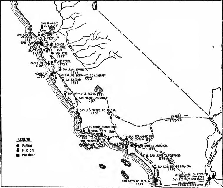 California Settlements.
[Pg 391] A land route to California.—The next step was the opening of a land route from Arizona to California, and was the work especially of two frontier leaders. When the Franciscans in 1768 took the place of the Jesuits in Pimería Alta, Father Francisco Garcés was sent to San Xavier del Bac, the northern outpost. He at once began to make visits to the Gila, and in 1771 alone he crossed the Yuma Desert from Sonóita, and the California Desert to the foot of the western Sierras. Encouraged by these discoveries, Captain Anza of Tubac offered to open a land route to Monterey. The plan was approved by the viceroy, and in 1774 Anza, with Garcés as guide and with twenty soldiers, made the expedition, with great hardships but with notable success.
[Pg 391] A land route to California.—The next step was establishing a land route from Arizona to California, primarily led by two frontier pioneers. When the Franciscans took over from the Jesuits in Pimería Alta in 1768, Father Francisco Garcés was assigned to San Xavier del Bac, the northern outpost. He immediately started visiting the Gila area, and in 1771 alone, he crossed the Yuma Desert from Sonóita and the California Desert to the foot of the western Sierras. Encouraged by these findings, Captain Anza from Tubac proposed creating a land route to Monterey. The plan was approved by the viceroy, and in 1774, Anza, with Garcés as his guide and accompanied by twenty soldiers, undertook the expedition, facing significant challenges but achieving notable success.
San Francisco founded.—The opening of the land route from Sonora facilitated the occupation of the port of San Francisco. Plans for its occupation had been discussed ever since its discovery by Portolá. Meanwhile the region had been throughly explored from Monterey as a base. In December, 1774, Anza was ordered to lead a soldier colony from Sonora to occupy the port, and plans were made for a mission. Enlisting some two hundred and fifty persons, Anza assembled them at Tubac, and in October set out for California. Descending the Santa Cruz and Gila Rivers to the Colorado, thence he followed his former trail to Monterey, where he arrived in March, 1776. Aided by Father Font, he reëxplored the Bay region, selected sites for a presidio and mission, and returned to Sonora. In September the presidio and in October the mission of San Francisco were founded.
San Francisco Founded.—The opening of the land route from Sonora made it easier to settle the port of San Francisco. Plans for settling there had been discussed since its discovery by Portolá. In the meantime, the area had been thoroughly explored using Monterey as a base. In December 1774, Anza was ordered to lead a group of soldiers from Sonora to settle the port, and plans were made for a mission. Gathering around two hundred and fifty people, Anza brought them together at Tubac and set out for California in October. He traveled down the Santa Cruz and Gila Rivers to the Colorado River, then followed his previous trail to Monterey, where he arrived in March 1776. With the help of Father Font, he explored the Bay area again, chose locations for a presidio and mission, and returned to Sonora. In September, the presidio was established, and in October, the mission of San Francisco was founded.
A route from New Mexico.—The Sonora base for California was not altogether satisfactory and some thought that New Mexico would serve better. Among the latter was Father Garcés, and by a most remarkable exploration he put his views to the test. He accompanied Anza's second expedition to the Gila-Colorado junction, but from there set out to explore a new route.[Pg 392] Ascending the Colorado to the Mojave tribe, near Needles he turned west and crossed the Mojave Desert. It was his plan to go straight to San Luis Obispo, but his guides refused, and he threaded Cajón Pass to Mission San Gabriel. From there he continued through Téjon Pass into the San Joaquin Valley, descended it to the Tulare region, emerged through an eastern pass, probably the Tehachapi, and recrossed the desert to the Mojaves. Thence he continued east to the Moquis, reaching Oraibe on July 2. Here he was given a cold reception, so he turned back to the Yumas.
A route from New Mexico.—The Sonora base for California wasn't entirely satisfactory, and some believed that New Mexico would be a better option. Among them was Father Garcés, who put his ideas to the test through a remarkable exploration. He joined Anza's second expedition to the Gila-Colorado junction but then set out to explore a new route.[Pg 392] He traveled up the Colorado River to the Mojave tribe, near Needles, then turned west and crossed the Mojave Desert. He initially planned to go straight to San Luis Obispo, but his guides refused, so he took Cajón Pass to Mission San Gabriel. From there, he continued through Téjon Pass into the San Joaquin Valley, traveled down to the Tulare region, passed through an eastern route, likely the Tehachapi, and recrossed the desert to the Mojaves. Then he headed east to the Moquis, arriving in Oraibe on July 2. He received a cold welcome there, so he turned back towards the Yumas.
Exploration by Escalante and Domínguez.—Shortly after Garcés returned, a party set out from Santa Fé to attempt reaching Monterey by a more northern route. The party consisted of Fathers Domínguez and Escalante, Captain Bernardo de Miera y Pacheco, and nine soldiers. Leaving Santa Fé on July 29, 1776, they went northward into Colorado, followed the western line across the San Juan, Dolores, Grand and Colorado Rivers, turned westward to Utah Lake and south past Sevier Lake. In October, concluding that it was too late to attempt to cross the Sierras, they returned eastward to Moqui, Zuñi, and Santa Fé. Thus had another great feat of exploration resulted from the attempt to find land connection with California.
Exploration by Escalante and Domínguez.—Shortly after Garcés returned, a group set out from Santa Fé to try to reach Monterey by a more northern route. The group included Fathers Domínguez and Escalante, Captain Bernardo de Miera y Pacheco, and nine soldiers. They left Santa Fé on July 29, 1776, headed north into Colorado, followed the western line across the San Juan, Dolores, Grand, and Colorado Rivers, then turned west toward Utah Lake and south past Sevier Lake. In October, realizing it was too late to cross the Sierras, they turned back east to Moqui, Zuñi, and Santa Fé. Thus, another significant exploration effort emerged from the attempt to find land access to California.
Spanish Pueblos.—California still lacked the civil element to make it complete in outline, and this was now provided. In 1777 Governor Neve moved his capital from Loreto to Monterey, where he received orders from the viceroy to take steps toward founding colonies of settlers, as a means toward making the province self-supporting. Neve therefore proceeded to establish two Spanish pueblos.
Spanish Pueblos.—California still needed the civil aspect to be fully developed, and this was now addressed. In 1777, Governor Neve moved his capital from Loreto to Monterey, where he received instructions from the viceroy to begin establishing colonies of settlers to help make the province self-sufficient. Neve then took steps to create two Spanish pueblos.
San José.—With fourteen families from Monterey and San Francisco, in 1777 Lieutenant Moraga founded the Pueblo of San José in the Santa Clara Valley, near the head of San Francisco Bay, and near by the mission of Santa Clara was founded. The pueblo was established according to the general laws of the Indies. Five years later titles were issued to those settlers who had fulfilled their contracts.
San José.—In 1777, Lieutenant Moraga established the Pueblo of San José in the Santa Clara Valley, close to the head of San Francisco Bay, along with fourteen families from Monterey and San Francisco. The mission of Santa Clara was also founded nearby. The pueblo was created according to the general laws of the Indies. Five years later, titles were granted to those settlers who had met their contractual obligations.
Los Angeles.—The second pueblo was located beside Mission San Gabriel, in the southern part of the province. To procure colonists Rivera y Moneada was sent in '79 to Sinaloa and[Pg 393] Sonora. Recruiting fourteen families, Rivera sent them overland by way of Loreto and the Peninsula. Rivera himself, with forty-two soldiers, went with nearly a thousand head of horses and mules over the Anza route by way of the Gila junction, where he and part of his men were massacred. The settlers reached their destination, and in September, 1781, the Pueblo de los Angeles was founded, with eleven families comprising forty-six persons.
Los Angeles.—The second settlement was located next to Mission San Gabriel, in the southern part of the province. To recruit colonists, Rivera y Moneada was sent in '79 to Sinaloa and[Pg 393] Sonora. He gathered fourteen families and sent them overland through Loreto and the Peninsula. Rivera himself, along with forty-two soldiers, traveled with nearly a thousand horses and mules via the Anza route through the Gila junction, where he and some of his men were killed. The settlers arrived at their destination, and in September 1781, the Pueblo de los Angeles was established, consisting of eleven families with a total of forty-six individuals.
Plans for a new outpost.—The old question of advancing the Sonora frontier northward to provide missions for the Pirnas and Yumas, and a halfway station on the road to California, had been much discussed ever since Anza's exploration in '74. Opinions varied as to the best location, one proposing the Gila-Colorado junction, another the middle Gila, another the Colorado above the Yumas, and another even the Moqui country.
Plans for a new outpost.—The ongoing debate about pushing the Sonora border north to establish missions for the Pirnas and Yumas, along with a halfway station on the route to California, had been a hot topic ever since Anza's exploration in '74. People had different opinions on the best location: some suggested the Gila-Colorado junction, others the middle Gila, some the Colorado above the Yumas, and even a few mentioned the Moqui region.
Mission-Pueblos at Yuma.—But the weight of opinion was with the Gila-Colorado junction. The chief advocate of this location was the Yuma chief Ollyquotquiebe. In 1776 he went with Anza to Mexico City to ask for a mission and a presidio, made submission for his tribe, and was baptized as Salvador Palma. In the following year the king ordered the petition granted. Delays ensued and Palma became impatient. In 1779 Fathers Garcés and Díaz were sent, with a small garrison, to Palma's village. Their slender outfit of presents and supplies was disappointing, and the Yumas were dissatisfied. In the following year, at Croix's order, two missions were founded west of the Colorado, at the junction, but not of the usual type. Instead of a presidio, ten families were settled near each mission to serve as a protection to the missionaries and an example to the neophytes, who were to five among the settlers instead of in an Indian pueblo.
Mission-Pueblos at Yuma.—But the majority opinion favored the Gila-Colorado junction. The main supporter of this site was the Yuma chief Ollyquotquiebe. In 1776, he traveled with Anza to Mexico City to request a mission and a presidio, representing his tribe, and he was baptized as Salvador Palma. The following year, the king approved the request. However, there were delays, and Palma grew frustrated. In 1779, Fathers Garcés and Díaz were sent, along with a small garrison, to Palma's village. Their meager supplies and gifts were disappointing, leading to dissatisfaction among the Yumas. The next year, at Croix's command, two missions were established west of the Colorado at the junction, but they were not of the usual kind. Instead of a presidio, ten families were settled near each mission to protect the missionaries and set an example for the neophytes, who were expected to live among the settlers rather than in an Indian pueblo.
The massacre.—Trouble soon ensued, and in July, 1781, while Rivera y Moncada was on his way to found Los Angeles, the Yumas, led by Palma, massacred Father Garcés, his three companions, Rivera and his men, and most of the settlers. The women and children were spared. The experience at the Yuma missions is a pointed commentary on the need of soldiers to control mission Indians, and on the wisdom of the usual Spanish custom of separating the neophytes from the settlers. For his[Pg 394] part in the plan Croix has been severely criticized, but it must be remembered that at the time he needed every soldier available for the Apache wars, and that the Yumas had much vaunted their friendship.
The massacre.—Trouble quickly arose, and in July 1781, while Rivera y Moncada was en route to establish Los Angeles, the Yumas, led by Palma, killed Father Garcés, his three companions, Rivera and his men, and most of the settlers. The women and children were spared. The events at the Yuma missions highlight the necessity of having soldiers to oversee mission Indians and illustrate the wisdom behind the common Spanish practice of keeping neophytes separate from the settlers. For his[Pg 394] involvement in the plan, Croix has faced heavy criticism, but it should be noted that at the time he needed every available soldier for the Apache wars, and the Yumas had loudly proclaimed their friendship.
The Yumas punished.—Learning of the massacre, in September, 1781, Croix sent Pedro Fages to the scene with one hundred and ten men from Pitic and Altar. In the course of two journeys he ransomed some seventy-five captives. In the following year Captain Romeu of Sonora, made a campaign against the Yumas, killed or captured nearly two hundred, and recovered over one thousand horses. But the massacre put an end for the time being to the long series of efforts to establish the Yuma outpost, and practically closed the Anza route to California.
The Yumas punished.—After hearing about the massacre in September 1781, Croix sent Pedro Fages to the location with 110 men from Pitic and Altar. During two trips, he rescued about 75 captives. The next year, Captain Romeu from Sonora launched a campaign against the Yumas, killing or capturing nearly 200 and recovering over 1,000 horses. However, the massacre temporarily halted the ongoing attempts to establish the Yuma outpost and effectively shut down the Anza route to California.
The Santa Barbara Channel occupied.—From the first Father Serra had been anxious to found a group of missions among the numerous Indians along the Santa Barbara Channel, but there had been a lack of funds and soldiers. The reduction of these tribes was important also from a military standpoint, because they held a strategic position on the coast and on the road to the north. With the coming of more soldiers in 1781 the desired step was taken, and in 1782 Mission San Buenaventura and the presidio of Santa Barbara, and in 1786 Mission Santa Barbara were founded.
The Santa Barbara Channel occupied.—From the beginning, Father Serra was eager to establish a network of missions among the various Native American tribes along the Santa Barbara Channel, but there were not enough funds and soldiers. Reducing these tribes was also crucial from a military perspective, as they occupied a key location on the coast and the route to the north. With the arrival of more soldiers in 1781, the intended action was finally taken, leading to the founding of Mission San Buenaventura and the presidio of Santa Barbara in 1782, and Mission Santa Barbara in 1786.
With the occupation of this district California was complete in outline. There were four presidios, each occupying a strategic position and protecting a group of missions. In the succeeding years new missions were planted in the interior valleys, till the total reached twenty-one. They became marvellously prosperous, converting and giving industrial training to thousands of Indians, and acquiring great wealth in farms and herds. In 1784 Father Serra, the master spirit of the missions, died.
With the occupation of this area, California was fully outlined. There were four presidios, each in a strategic location and protecting a group of missions. In the following years, new missions were established in the interior valleys, until the total reached twenty-one. They became incredibly prosperous, converting and providing industrial training to thousands of Indigenous people and acquiring significant wealth in farms and livestock. In 1784, Father Serra, the driving force behind the missions, passed away.
NORTHERN EXPLORATIONS
English and Russian activities.—Continued rumors of Russian and English activities had by now led to a new series of explorations which gave Spain claim to the Pacific Coast for nearly a thousand miles beyond the points reached by Cabrillo and Vizcaíno. In 1773 came rumors that an English expedition was about to attempt to pass through the Northern Strait to California,[Pg 395] and that Russia was planning an expedition from Kamtchatka to the American coast.
English and Russian activities.—Ongoing rumors about Russian and English activities had now sparked a new wave of explorations that allowed Spain to claim nearly a thousand miles of the Pacific Coast beyond where Cabrillo and Vizcaíno had reached. In 1773, there were rumors that an English expedition was gearing up to try to navigate through the Northern Strait to California,[Pg 395] and that Russia was planning an expedition from Kamtchatka to the American coast.
Pérez.—Accordingly, in 1774 Viceroy Bucarely sent Juan Pérez north in the Santiago with orders to take formal possession of the country as far as 60°. Sailing from San Bias, and taking on Fathers Crespi and Peña at Monterey as diarists, Pérez sailed to 55°, exploring Nootka Sound on the way.
Pérez.—In 1774, Viceroy Bucarely sent Juan Pérez north on the Santiago with orders to officially claim the territory up to 60°. Departing from San Bias and picking up Fathers Crespi and Peña in Monterey to keep a record, Pérez sailed to 55°, exploring Nootka Sound along the way.
Heçeta and Bodega.—Pérez having failed to reach 60°, another expedition was sent from San Bias in 1775 in two vessels, under Heçeta and Bodega y Quadra. Heçeta reached 49°, discovering Trinidad Bay and the mouth of the Columbia River on the way (1776). Bodega, in his thirty-six foot schooner, reached 58°, and on the way discovered Bodega Bay.
Heçeta and Bodega.—After Pérez failed to reach 60°, another expedition was sent from San Bias in 1775 with two vessels, led by Heçeta and Bodega y Quadra. Heçeta made it to 49°, discovering Trinidad Bay and the mouth of the Columbia River along the way (1776). Bodega, in his thirty-six-foot schooner, reached 58° and discovered Bodega Bay during his journey.
Arteaga and Bodega.—No Russians had been found, but news had come of the preparations being made by the English captain, James Cook, for a voyage to the northwest coast in search of the strait. Accordingly, another expedition was ordered by the King of Spain to explore to 70°. Through delays it was 1779 before Arteaga and Bodega, in the Favorita and the Princesa, left San Blas. Meanwhile Cook had made his famous voyage to Nootka Sound. Arteaga's expedition reached 60°, where it was forced to return because of scurvy among the crews.
Arteaga and Bodega.—No Russians had been found, but news arrived about the preparations being made by the English captain, James Cook, for a voyage to the northwest coast in search of the strait. As a result, another expedition was ordered by the King of Spain to explore up to 70°. Due to delays, it wasn't until 1779 that Arteaga and Bodega, in the Favorita and the Princesa, left San Blas. In the meantime, Cook had completed his famous voyage to Nootka Sound. Arteaga's expedition reached 60° but had to turn back due to scurvy affecting the crews.
LOUISIANA UNDER SPAIN, 1762-1783
The cession.—On October 9, 1762, Louis XV offered western Louisiana, with New Orleans, to Charles III, king of Spain, both as a compensation for the loss of Florida, and to put an end to the constant Franco-Spanish friction over contraband trade. Charles at first rejected the gift, but reconsidered, and the treaty of cession was signed on November 3, the day of the signature of the preliminaries of the peace with England.
The cession.—On October 9, 1762, Louis XV offered western Louisiana, including New Orleans, to Charles III, the king of Spain, as compensation for the loss of Florida and to stop the ongoing conflicts between France and Spain over illegal trade. Charles initially turned down the offer but later changed his mind, and the treaty of cession was signed on November 3, the same day the preliminary peace agreement with England was signed.
The state of the province.—With Spain's small means and great responsibilities, the gift was not very tempting, and Spain was not eager to take possession of it. The ceded district embraced New Orleans and the western watershed of the Mississippi River. The principal settlements lay along the Mississippi and Missouri, as far as the Kansas post, and along the lower Red River, as far as the Cadadacho post. The bulk of the population lay between Pointe Coupée and New Orleans, where there were[Pg 396] over 7000 persons, of whom nearly two-thirds were colored settlements in the lower district were La Balize, Attakapa, Opelousas, Avoyelle, and Natchitoches. On the way to the Missouri district were the post opposite Natchez and the Arkansas settlement. Near or on the Missouri were St. Charles and Ste. Genevieve. Farther in the interior were slender trading posts, such as St. Louis among the Cadadacho, a post on the Osage, and Ft. Cavagnolle, near the mouth of the Kansas River. The total population of the province ceded to Spain was estimated at from 8250 to 11,500, over half of whom were colored.
The state of the province.—With Spain's limited resources and significant responsibilities, the offer wasn't very appealing, and Spain wasn't eager to take it. The transferred area included New Orleans and the western watershed of the Mississippi River. The main settlements were along the Mississippi and Missouri rivers, reaching as far as the Kansas post, and along the lower Red River up to the Cadadacho post. Most of the population was between Pointe Coupée and New Orleans, where there were[Pg 396] over 7,000 people, nearly two-thirds of whom were of African descent. The settlements in the lower district included La Balize, Attakapa, Opelousas, Avoyelle, and Natchitoches. On the way to the Missouri area were the post across from Natchez and the Arkansas settlement. Near or on the Missouri were St. Charles and Ste. Genevieve. Further inland were smaller trading posts, such as St. Louis among the Cadadacho, a post on the Osage, and Ft. Cavagnolle, near the mouth of the Kansas River. The total population of the province transferred to Spain was estimated to be between 8,250 and 11,500, with over half of them being of African descent.
Industries.—Rice, indigo, tobacco, and grain were cultivated in small quantities, but there was little stock raising. For horses, mules, and cattle dependence was placed upon trade with the Indians and the Spaniards of the West, much of which trade was contraband. The principal industries of the province were the fur trade and commerce with Illinois. The paper money issued during the recent war, of which there was nearly a million unredeemed, had depreciated to 25 per cent, of its face value.
Industries.—Rice, indigo, tobacco, and grains were grown in small amounts, but there wasn't much livestock farming. They relied on trade with the Indians and the Spaniards from the West for horses, mules, and cattle, much of which was illegal trade. The main industries in the province were the fur trade and commerce with Illinois. The paper money issued during the recent war, of which nearly a million was unredeemed, had lost value to just 25 percent of its face value.
Dissatisfaction with the transfer.—It was not till September, 1764, that the cession was known in New Orleans. The news caused consternation and protest. Some of the inhabitants of Illinois, left under English rule, moved across the Mississippi River to La Clede's recently founded fur-trading post of St. Louis. When, in 1765, the British took possession of Fort Chartres, Captain St. Ange, in charge of the latter place, moved with his garrison to St. Louis, where he continued to rule until Spanish possession was taken. Some French settlers from the more southern districts moved across the Mississippi or to New Orleans. There the feeling was intense. In January, 1765, the inhabitants held a meeting and sent a delegate, Jean Milhet, to France to remonstrate, but without avail, for after months of waiting he failed even to get an audience with the king.
Dissatisfaction with the transfer.—It wasn't until September 1764 that the news of the cession reached New Orleans. The announcement caused shock and protest. Some residents of Illinois, still under British control, moved across the Mississippi River to La Clede's newly established fur-trading post in St. Louis. When the British took over Fort Chartres in 1765, Captain St. Ange, who was in charge there, relocated with his troops to St. Louis, where he continued to lead until the Spanish took over. Some French settlers from the more southern areas moved across the Mississippi or to New Orleans. The sentiment there was strong. In January 1765, the residents held a meeting and sent a delegate, Jean Milhet, to France to protest, but it was futile, as he waited for months without ever getting a meeting with the king.
Ulloa expelled.—At last, in March, 1766, Don Antonio de Ulloa arrived at La Balize as Spanish governor. The choice was not a happy one, for although a distinguished scientist and naval officer, Ulloa had an unpleasant and inflexible personality which made him unpopular. In July he reached New Orleans, with ninety soldiers. But the French militia refused to serve him, and Aubry was left in command. Bickerings and dissatisfaction[Pg 397] followed. The colonists demanded the redemption of the depreciated paper money at face value; the recently arrived Acadians, who had become indentured servants, made constant complaint, until at last redeemed by Ulloa.
Ulloa expelled.—Finally, in March 1766, Don Antonio de Ulloa arrived at La Balize as the Spanish governor. This choice wasn't well-received; even though he was a distinguished scientist and naval officer, Ulloa had a harsh and rigid personality that made him unpopular. In July, he arrived in New Orleans with ninety soldiers. However, the French militia refused to serve under him, and Aubry remained in command. Conflicts and dissatisfaction[Pg 397] followed. The colonists demanded that the depreciated paper money be redeemed at face value; the recently arrived Acadians, who had become indentured servants, constantly complained until they were finally redeemed by Ulloa.
Ulloa did not confine his efforts to New Orleans, but established Spanish garrisons at several interior posts and issued ordinances regarding the Indian trade. In the spring of 1766, with Aubry, he visited the settlements between New Orleans and Natchitoches, and sent an officer to report on the best means of defending the upper posts against the English. In 1767 he sent Captain Francisco Ruí to establish posts on the lower Missouri at St. Charles and Bellefontaine.
Ulloa didn’t limit his work to New Orleans; he set up Spanish garrisons at several interior locations and issued rules about the Indian trade. In the spring of 1766, he visited the settlements between New Orleans and Natchitoches with Aubry, and sent an officer to assess the best ways to defend the upper posts from the English. In 1767, he dispatched Captain Francisco Ruí to create posts on the lower Missouri at St. Charles and Bellefontaine.
The prohibition of trade with France, promulgated in October, 1768; caused a veritable insurrection in New Orleans, and Ulloa was expelled from the province. His departure was followed by a removal of the Spanish garrisons from the Missouri and elsewhere in the interior, and there was an interregnum of several months, during which Aubry governed.
The ban on trade with France, issued in October 1768, led to a major uprising in New Orleans, and Ulloa was forced out of the province. After he left, the Spanish military withdrew from Missouri and other areas in the interior, resulting in several months of leadership by Aubry.
O'Reilly.—Charles III now sent a man made of sterner stuff. He was Alexandro O'Reilly, an officer who had served with distinction in Europe, had reorganized the defences of Havana after the recent war, and was now recalled to cope with the situation in Louisiana. With 4500 regulars he reached Balize in July, 1769. There was renewed excitement. Some talked of independence and others of joining the English colonies; but Aubry counselled against resistance and the disturbance subsided.
O'Reilly.—Charles III now sent a more resolute man. He was Alexandro O'Reilly, an officer who had distinguished himself in Europe, had reorganized the defenses of Havana after the recent war, and was now called back to deal with the situation in Louisiana. With 4,500 regulars, he arrived in Balize in July 1769. Excitement soared again. Some discussed independence while others considered joining the English colonies; but Aubry advised against any resistance and the unrest faded away.
His coup d'état.—King Charles had demanded nothing more severe than the sending of the leaders of the opposition to France, but O'Reilly was not so mild. By a ruse he arrested a number of prominent citizens, executed five and imprisoned others. For this violent deed he has become known as "The Bloody O'Reilly." If the government of Charles III had been imbued with a full sense of its responsibility, it would never have left unpunished such a violation of the fundamental rules of justice.
His coup d'état.—King Charles asked for nothing more extreme than to send the opposition leaders to France, but O'Reilly had other plans. Using a trick, he arrested several prominent citizens, executed five, and imprisoned others. Because of this brutal act, he earned the nickname "The Bloody O'Reilly." If Charles III's government had truly understood its responsibilities, it would never have allowed such a blatant disregard for the basic principles of justice to go unpunished.
The Spanish régime installed.—For thirty-four years Louisiana remained under Spanish rule, and during that time it prospered as never before. O'Reilly governed for a year or more with great vigor, not as governor, but as special commissioner to establish Spanish authority. Possession was taken of the[Pg 398] interior posts, and by the end of 1770 the Spanish flag had been raised at Ste. Genevieve, the last place to haul down the French emblem. Having accomplished his coup d'état, O'Reilly was conciliatory, and appointed numerous old French officers, like Villiers and De Mézières, to important positions. After authority had been established, the military force was reduced to 1200 men. Spanish law was installed, although the French Black Code was retained. New Orleans was given a cabildo with direct appeal to the Council of the Indies instead of to the Audiencia of Santo Domingo. Louisiana was put under a governor, the first incumbent being Luis de Unzaga y Amezaga. Each of the principal subdistricts was put under a Lieutenant-governor, Pedro Piernas going to St. Louis, Villiers to the Arkansas Post (now Fort Carlos III), and Athanase De Mézières at Natchitoches. Until 1771 Louisiana was an independent gobierno directly dependent on the Council of the Indies. In 1771 it was attached for military purposes to the captaincy-general of Havana, and for judicial matters to the Audiencia of Santo Domingo. In 1795 it was attached to the Audiencia of Havana. After 1783 West Florida and Louisiana were put under one governor. Later the province was divided into Upper and Lower Louisiana.
The Spanish regime was established. For thirty-four years, Louisiana was under Spanish rule, and during that time it thrived like never before. O'Reilly governed for over a year with strong determination, not as a governor but as a special commissioner to establish Spanish authority. The interior posts were taken over, and by the end of 1770, the Spanish flag was raised at Ste. Genevieve, the last place to lower the French emblem. After successfully implementing his plan, O'Reilly became conciliatory and appointed many former French officers, like Villiers and De Mézières, to key positions. Once authority was established, the military force was reduced to 1,200 men. Spanish law was enforced, although the French Black Code was kept in place. New Orleans was given a cabildo with direct appeal to the Council of the Indies instead of the Audiencia of Santo Domingo. Louisiana was put under a governor, the first being Luis de Unzaga y Amezaga. Each main subdistrict was assigned a Lieutenant-governor: Pedro Piernas in St. Louis, Villiers at the Arkansas Post (now Fort Carlos III), and Athanase De Mézières in Natchitoches. Until 1771, Louisiana was an independent gobierno directly under the Council of the Indies. In 1771, it was assigned for military purposes to the captaincy-general of Havana, and for judicial matters to the Audiencia of Santo Domingo. In 1795, it was attached to the Audiencia of Havana. After 1783, West Florida and Louisiana were governed by one governor. Later on, the province was split into Upper and Lower Louisiana.
Unzaga and Gálvez.—Unzaga ruled till 1776, and proved popular, particularly since he shut his eyes to English smuggling in the lower Mississippi River. Unzaga's successor, Bernardo de Gálvez, nephew of the visitor, son of the viceroy, and himself a viceroy later, was a remarkable man. He too, was popular; he married a French wife, and stimulated tobacco raising by pledging himself to buy each year eight hundred pounds of tobacco.
Unzaga and Gálvez.—Unzaga was in charge until 1776 and was well-liked, especially because he turned a blind eye to English smuggling along the lower Mississippi River. His successor, Bernardo de Gálvez, who was the nephew of the visitor, the son of the viceroy, and later became a viceroy himself, was an impressive figure. He was also popular; he married a French woman and encouraged tobacco farming by promising to buy eight hundred pounds of tobacco every year.
Encouragement of commerce.—Trade regulations, as promulgated by Ulloa in 1766, restricted all trade to Spanish vessels, and certain specified Spanish ports. Under these conditions English smugglers very soon monopolized the trade of the lower Mississippi, and made their way among the tribes of the Gulf coast. This contraband Unzaga tacitly permitted for the good of the colony. In 1776 an agreement was made with France by which Louisiana was permitted to trade with the French West Indies, under the supervision of two French commissioners resident in New Orleans. Gálvez now promptly seized eleven English vessels and the commerce of the colony passed largely into the hands of the French. In 1778 the produce of the colony was admitted to any of the ports of France or the United States, and to any of the ports of Spain to which the commerce of any of the colonies was admitted. The exportation of furs was encouraged by exemption from duty for a period of ten years. English trade in Louisiana was now completely ruined. Under Spanish rule population grew steadily and by 1803 had reached about 50,000. After the American Revolution efforts were made to counter-colonize against the American advance.
Encouragement of commerce.—Trade regulations established by Ulloa in 1766 allowed only Spanish ships to trade and limited the ports to certain specified Spanish locations. As a result, English smugglers quickly took over the trade along the lower Mississippi and navigated among the tribes along the Gulf coast. Unzaga quietly allowed this illegal trade for the benefit of the colony. In 1776, an agreement with France allowed Louisiana to trade with the French West Indies, monitored by two French commissioners based in New Orleans. Gálvez then swiftly seized eleven English ships, and the colony's trade largely shifted to the French. By 1778, the colony's products could enter any ports in France or the United States, as well as any Spanish ports that allowed trade from any of the colonies. Furs were exported without duties for ten years to encourage this trade. English commerce in Louisiana was now completely destroyed. Under Spanish administration, the population steadily increased, reaching about 50,000 by 1803. Following the American Revolution, attempts were made to establish a counter-colonization against American expansion.
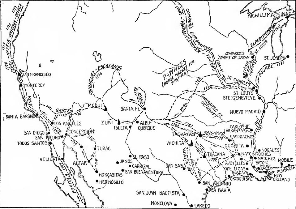 The Spanish Frontier in the Late Eighteenth Century.
[Pg 400] The English danger.—The principal military problems of the new government were to keep the English out and to keep the Indians quiet. Already English traders were entering the tribes west of the Mississippi, ascending the Missouri and the Arkansas, and reaching the borders of Texas overland, or ascending its rivers from the Gulf of Mexico. Trade in Pawnee and Spanish horses extended to the English seaboard colonies, Governor Patrick Henry being among the purchasers of thoroughbred Spanish stock. To keep out the English, defence was concentrated on the Mississippi and efforts made to control the Indian tribes.
[Pg 400] The English threat.—The main military challenges for the new government were to keep the English at bay and to maintain peace with the Native Americans. English traders were already reaching the tribes west of the Mississippi, traveling up the Missouri and the Arkansas Rivers, and making their way into Texas, either overland or by navigating its rivers from the Gulf of Mexico. Trade in Pawnee and Spanish horses was extending all the way to the English colonies on the coast, with Governor Patrick Henry among those buying thoroughbred Spanish stock. To prevent the English from gaining a foothold, defense efforts were focused on the Mississippi River and efforts were made to control the Native American tribes.
Eastern Texas abandoned.—On the other hand, since Louisiana belonged to Spain, the defences of eastern Texas, and the weak missions which they protected, were now withdrawn. At the same time the few settlers, some five hundred in number, who lived on the border, were evicted and taken to San Antonio. But they demurred, sent their Creole leader Gil Ybarbo to Mexico to represent them, and were allowed in 1774 to settle on the Trinity River. Five years later, taking advantage of a flood and Indian raids, and led by Ybarbo, they moved to Nacogdoches (1779), and from there scattered eastward toward their former homes.
Eastern Texas abandoned. — On the other hand, since Louisiana was under Spanish rule, the defenses of eastern Texas and the weak missions they protected were pulled back. At the same time, the few settlers—about five hundred—who lived on the border were forced out and taken to San Antonio. However, they protested and sent their Creole leader, Gil Ybarbo, to Mexico to represent them. In 1774, they were granted permission to settle on the Trinity River. Five years later, taking advantage of a flood and Indian raids, they, led by Ybarbo, moved to Nacogdoches (1779) and from there spread eastward toward their old homes.
The fur trade continued.—Louisiana was Spain's first colony previously occupied by Europeans, and in it many departures were made from her traditional system. As a means of controlling the Indians of Louisiana, Spain utilized the corps of French traders already among the tribes, instead of attempting to use the mission as a means of control, as was being done at the same time in California. A regular system of licensed traders was installed, vagabonds and unlicensed persons were driven from the tribes, presents were annually distributed, and medals of[Pg 401] merit were given to friendly chiefs. St. Louis, the Arkansas post, and Natchitoches became important centers for the fur trade and for distributing presents. To St Louis tribes went to receive presents from the Illinois country, the upper Mississippi, and the upper Missouri. To remove them from English influence, tribes were induced to cross the Mississippi to settle.
The fur trade carried on. Louisiana was Spain's first colony that had been occupied by Europeans, and it saw many changes to its traditional system. To control the Native Americans in Louisiana, Spain made use of the French traders already present among the tribes, rather than relying on missions for control like they were doing in California at the same time. They set up a regular system of licensed traders, drove out vagabonds and unlicensed individuals from the tribes, distributed presents annually, and awarded medals of[Pg 401] merit to friendly chiefs. St. Louis, the Arkansas post, and Natchitoches became key hubs for the fur trade and for distributing gifts. Tribes traveled to St. Louis to receive presents from the Illinois country, the upper Mississippi, and the upper Missouri. To reduce English influence, tribes were encouraged to cross the Mississippi and settle there.
De Mézières.—One of the most difficult problems which confronted Spain was the control of the Red River tribes, which had been friendly to the French but hostile to the Spaniards. It was now necessary to win them over to Spanish allegiance. This was accomplished by Athanase de Mézières, lieutenant-governor at Natchitoches. He installed French traders, drove out vagabonds, expelled English intruders, called in the hostile Red River tribes to make treaties, and himself made a series of notable tours among them. In 1770 he held a great council at the Cadodacho post, where the Cadodacho chief Tin-hi-ou-en was mediator. Two years later he made an expedition through the Asinai, Tonkawa, and Wichita tribes, reaching the upper Brazos River, and going thence to San Antonio. His excellent report first made northern Texas well known to Spanish officials.
De Mézières.—One of the biggest challenges Spain faced was managing the Red River tribes, who had been friendly to the French but were hostile towards the Spaniards. It was crucial to get them to align with Spanish interests. Athanase de Mézières, the lieutenant-governor at Natchitoches, took on this task. He brought in French traders, got rid of troublemakers, expelled English intruders, invited the hostile Red River tribes to negotiate treaties, and personally made several important trips among them. In 1770, he held a significant council at the Cadodacho post, where the Cadodacho chief Tin-hi-ou-en acted as mediator. Two years later, he embarked on an expedition through the Asinai, Tonkawa, and Wichita tribes, reaching the upper Brazos River and then traveling to San Antonio. His detailed report was the first to make northern Texas well-known to Spanish officials.
Croix's plans for a war on the Apaches.—It was in 1776 that the northern provinces of New Spain were put under a comandante general with his capital at Chihuahua. The first comandante, Teodoro de Croix, arrived at the frontier in 177 7. As his first great task he set about checking Indian hostilities, particularly those of the Apaches on the Texas-Coahuila frontier. The essence of his plan was to unite the Red River and the eastern Texas tribes (the Nations of the North) and chasseurs from Louisiana, commanded by Gálvez, with the soldiery of the Interior Provinces, commanded by Croix, in a joint war of extermination against the eastern Apaches.
Croix's plans for a war on the Apaches.—In 1776, the northern provinces of New Spain were placed under a comandante general with its capital in Chihuahua. The first comandante, Teodoro de Croix, arrived at the frontier in 1777. His first major task was to address Indian hostilities, especially those of the Apaches on the Texas-Coahuila border. The core of his plan was to unite the Red River and eastern Texas tribes (the Nations of the North) and chasseurs from Louisiana, led by Gálvez, with the soldiers from the Interior Provinces, commanded by Croix, in a coordinated extermination campaign against the eastern Apaches.
Set aside by the American Revolution.—To consider the matter Croix held a council of war at San Antonio in January, 1778. The arrangement of details with the Indians was left to De Mézières. In 1778 he made a tour of the upper Red River, and in the following year again visited the Texas tribes. Spain soon afterward entered the American war, Gálvez was unable to leave Louisiana, and the conduct of the Apache War was left for the time being to Juan de Ugalde, governor of Coahuila.
Set aside by the American Revolution.—To think through the situation, Croix held a war council in San Antonio in January 1778. De Mézières was responsible for working out the details with the Indians. In 1778, he traveled along the upper Red River, and the next year he visited the Texas tribes again. Soon after, Spain joined the American war, Gálvez couldn't leave Louisiana, and the management of the Apache War was temporarily handed over to Juan de Ugalde, the governor of Coahuila.
[Pg 402] Communication with Santa Fé and the Upper Missouri.—The explorations of De Mézières were soon followed by the opening of routes from Santa Fé to San Antonio, Natchitoches, and St. Louis. In this work the chief pathfinder was Pedro Vial. Just as the American Pike in his southwestern exploration (1807) was preceded by Vial and his associates, so Lewis and Clark, in their ascent of the Missouri River (1804), were anticipated by the agents of Glamorgan's fur trading and exploring company, who operated from St. Louis to the country of the Mandans (1794-1797).
[Pg 402] Communication with Santa Fé and the Upper Missouri.—De Mézières' explorations were quickly followed by the opening of routes connecting Santa Fé to San Antonio, Natchitoches, and St. Louis. The main trailblazer for this endeavor was Pedro Vial. Just as the American Pike was preceded by Vial and his team during his southwestern exploration (1807), Lewis and Clark's journey up the Missouri River (1804) was anticipated by the agents of Glamorgan's fur trading and exploration company, who operated from St. Louis to the Mandan territory (1794-1797).
READINGS
REFORMS OF CHARLES III AND GÁLVEZ
Addison, Joseph, Charles the Third of Spain; Altamira y Crevea, Rafael, Historia de España, IV; Chapman, C.E., The Founding of Spanish California, ch. IV; Danvila y Collado, Manuel, Reinado de Carlos III; Desdevises du Desert, Gaston, L'Espagne de l'Ancien Régime; Ferrer del Rio, Antonio, Historia del Reinado de Carlos III; Hume, M.A.S., Spain: Its Greatness and Decay; Priestley, H.L., José de Gálvez, Visitor-General of New Spain; Rousseau, François, Règne de Charles III d'Espagne, 1750-1788; Scelle, G., La Traite Négrière aux Indes de Castille; Viollet, A., Histoire des Bourbons d'Espagne.
Addison, Joseph, Charles the Third of Spain; Altamira y Crevea, Rafael, Historia de España, IV; Chapman, C.E., The Founding of Spanish California, ch. IV; Danvila y Collado, Manuel, Reinado de Carlos III; Desdevises du Desert, Gaston, L'Espagne de l'Ancien Régime; Ferrer del Rio, Antonio, Historia del Reinado de Carlos III; Hume, M.A.S., Spain: Its Greatness and Decay; Priestley, H.L., José de Gálvez, Visitor-General of New Spain; Rousseau, François, Règne de Charles III d'Espagne, 1750-1788; Scelle, G., La Traite Négrière aux Indes de Castille; Viollet, A., Histoire des Bourbons d'Espagne.
CALIFORNIA
Academy of Pacific Coast History, Publications, I-III; Bancroft, H.H., History of California, I, 110-480; Chapman, C.E., The Founding of Spanish California; Eldredge, Z.S., The Beginnings of San Francisco, I, 31-170; Engelhardt, Fr. Zephyrin, Missions and Missionaries of California, I, 289-385; II, 3-414; Hittell, T.H., History of California, I, 300-429; 441-452; 509-540; Norton, H.K., Story of California, 1-103; Palou, Fr. Francisco, Relación Histórica de la Vida [de] ... Serra; Richman, I.B., California under Spain and Mexico, 32-158.
Academy of Pacific Coast History, Publications, I-III; Bancroft, H.H., History of California, I, 110-480; Chapman, C.E., The Founding of Spanish California; Eldredge, Z.S., The Beginnings of San Francisco, I, 31-170; Engelhardt, Fr. Zephyrin, Missions and Missionaries of California, I, 289-385; II, 3-414; Hittell, T.H., History of California, I, 300-429; 441-452; 509-540; Norton, H.K., Story of California, 1-103; Palou, Fr. Francisco, Relación Histórica de la Vida [de] ... Serra; Richman, I.B., California under Spain and Mexico, 32-158.
LOUISIANA
Bolton, Herbert E., Athanase de Mézières and the Louisiana-Texas Frontier, I, 66-122; Gayarré, C., History of Louisiana, III, 1-617; Hamilton, P.J., The Colonization of the South, 423-445; 447-456; Houck, L., The Spanish Régime in Missouri, I-II; Mason, E.C., "The March of the Spaniards across Illinois," in Magazine of American History, XV. 457-470; Robertson, J.A., Louisiana under the rule of Spain. France, and the United States; Shepherd, W.R., "The Cession of Louisiana to Spain," in The Political Science Quarterly, XIX, 439-458; Teggart, F.J., "Capture of St Joseph, Michigan, by the Spaniards in 1781," in The Missouri Historical Review, V, 214-228; Thwaites, R.G., France in America, 281-295.
Bolton, Herbert E., Athanase de Mézières and the Louisiana-Texas Frontier, I, 66-122; Gayarré, C., History of Louisiana, III, 1-617; Hamilton, P.J., The Colonization of the South, 423-445; 447-456; Houck, L., The Spanish Régime in Missouri, I-II; Mason, E.C., "The March of the Spaniards across Illinois," in Magazine of American History, XV. 457-470; Robertson, J.A., Louisiana under the rule of Spain, France, and the United States; Shepherd, W.R., "The Cession of Louisiana to Spain," in The Political Science Quarterly, XIX, 439-458; Teggart, F.J., "Capture of St Joseph, Michigan, by the Spaniards in 1781," in The Missouri Historical Review, V, 214-228; Thwaites, R.G., France in America, 281-295.
CHAPTER XXII
THE NEW BRITISH POSSESSIONS (1763-1783)
PROVISIONS FOR DEFENCE, GOVERNMENT, AND THE FUR TRADE
Amherst's plan for defence.—While the Spaniards were occupying western Louisiana the British were organizing the country ceded by France and Spain east of the Mississippi, in Canada, and in the West Indies. In 1763 the Secretary of War asked General Amherst, commander-in-chief in America, for a plan of defence of the British possessions. In response he drew up a "Plan of Forts and Garrisons prepared for the security of North America" which reveals England's outlook upon her newly acquired territory. It provided for ten regiments of approximately seven hundred and fifty men each. The stated purposes were: (1) to keep the king's new subjects in Canada and Louisiana "in due subjection," (2) to keep the old provinces "in a state of Constitutional Dependence upon Great Britain," (3) to command the respect of the Indians, (4) to prevent encroachments of the French or Spaniards, (5) and to protect the colonies in case of war. The regiments were to be distributed in posts along the St. Lawrence, about the Great Lakes, in the Illinois country, along the lower Mississippi, and in Nova Scotia, South Carolina, Georgia, and the Floridas.
Amherst's defense plan. — While the Spanish were taking control of western Louisiana, the British were organizing the territories that France and Spain had ceded east of the Mississippi, in Canada, and in the West Indies. In 1763, the Secretary of War asked General Amherst, the commander-in-chief in America, to come up with a defense plan for British possessions. In response, he created a "Plan of Forts and Garrisons prepared for the security of North America," which shows England's perspective on its newly acquired territory. The plan included ten regiments of about seven hundred and fifty men each. The objectives were: (1) to keep the king's new subjects in Canada and Louisiana "in due subjection," (2) to maintain the old provinces "in a state of Constitutional Dependence upon Great Britain," (3) to earn the respect of the Native Americans, (4) to prevent incursions from the French or Spaniards, and (5) to protect the colonies in the event of war. The regiments were to be stationed at posts along the St. Lawrence River, around the Great Lakes, in the Illinois region, along the lower Mississippi, and in Nova Scotia, South Carolina, Georgia, and Florida.
Purposes regarding the West.—Regarding the interior posts the particular aims expressed were to keep open the navigation of the St. Lawrence and the Great Lakes, maintain communication between Canada and the Gulf of Mexico, hold the western tribes in check, and guard against French or Spanish intrusion. A post at St. Augustine was especially desirable as a defence against Spain, and Pensacola and Mobile would command the commerce of the Gulf as well as the tribes of the Alabama Basin. The lower Mississippi posts were essential to control the Chickasaws. A post at Crown Point was not only needed to maintain[Pg 404] a winter highway to Canada, but might also be useful to suppress disaffection in the maritime colonies, "who already begin to entertain some extraordinary Opinions, concerning their Relations to and Dependence upon the Mother Country."
Purposes regarding the West.—For the interior posts, the specific goals were to keep the St. Lawrence and the Great Lakes navigable, maintain communication between Canada and the Gulf of Mexico, keep the western tribes under control, and guard against French or Spanish encroachment. A post in St. Augustine was particularly important as a defense against Spain, while Pensacola and Mobile would oversee the Gulf's commerce as well as the tribes in the Alabama Basin. The lower Mississippi posts were crucial for managing the Chickasaws. A post at Crown Point was not only necessary to maintain a winter route to Canada, but could also help reduce unrest in the coastal colonies, "who already begin to entertain some extraordinary Opinions, concerning their Relations to and Dependence upon the Mother Country."
The Proclamation of 1763.—In October, 1763, the king issued a proclamation creating, within the newly acquired territory, four distinct provinces, Quebec, East Florida, West Florida, and Grenada, and providing a form of government for them. Quebec comprised the Valley of the St. Lawrence from the western end of Anticosti Island to the 45th parallel and Lake Nipissing. Labrador, Anticosti, and the Magdalen Islands were attached to Newfoundland. St. Johns, Cape Breton, and the lesser adjacent islands were attached to Nova Scotia.
The Proclamation of 1763.—In October 1763, the king issued a proclamation establishing four separate provinces in the newly acquired territory: Quebec, East Florida, West Florida, and Grenada, and provided a government structure for them. Quebec included the St. Lawrence Valley from the western end of Anticosti Island to the 45th parallel and Lake Nipissing. Labrador, Anticosti, and the Magdalen Islands were assigned to Newfoundland. St. Johns, Cape Breton, and the smaller nearby islands were designated to Nova Scotia.
East Florida extended to Appalachicola River, and was bounded on the north by St. Mary's River and a line from the head of that stream to the junction of the Chattahoochee and Flint Rivers. The district between St. Mary's and Altamaha Rivers, formerly in dispute between Spain and England, was attached to Georgia. West Florida was the district south of latitude 310 and between the Appalachicola River and the Isle of Orleans. The Island of Grenada, the Grenadines, St. Vincent's, and Tobago were erected into the Government of Grenada.
East Florida stretched to the Appalachicola River and was bordered to the north by the St. Mary's River and a line from the head of that river to where the Chattahoochee and Flint Rivers meet. The area between the St. Mary's and Altamaha Rivers, which was once disputed between Spain and England, became part of Georgia. West Florida was the area south of latitude 31° and between the Appalachicola River and the Isle of Orleans. The islands of Grenada, the Grenadines, St. Vincent, and Tobago were formed into the Government of Grenada.
Crown colonies created.—These new jurisdictions were made crown colonies. For each a governor was to be appointed, with power to call assemblies, "in such Manner and Form as is used and directed in the Colonies and Provinces in America which are under our immediate Government." Until such assemblies should meet, the governors, with their executive councils, were empowered to erect courts, having appeals to the privy council.
Crown colonies created.—These new areas were established as crown colonies. A governor was to be appointed for each, with the authority to call assemblies, "in such Manner and Form as is used and directed in the Colonies and Provinces in America which are under our immediate Government." Until those assemblies convened, the governors, along with their executive councils, had the power to set up courts, with appeals going to the privy council.
The Indian reservation.—For the time being all British possessions on the continent not included in the foregoing jurisdictions, or within the Territory of Hudson Bay, and all lands west or north of the streams flowing into the Atlantic Ocean, were reserved as crown lands for the use of the Indians. No colony might grant lands within this Indian reservation, and settlers were requested to move out. The considerable French settlements in the reserve were ignored.
The Indian reservation.—Currently, all British territories on the continent not included in the previously mentioned jurisdictions, or within the Hudson Bay Territory, along with all lands west or north of the rivers flowing into the Atlantic Ocean, were set aside as crown lands for the use of the Indigenous peoples. No colony could grant lands within this Indian reservation, and settlers were asked to relocate. The significant French settlements in the reserve were overlooked.
Until 1755 the English government had managed its Indian affairs through the different colonies, but the results were far[Pg 405] from satisfactory. In that year the government assumed political control over the Indians, creating a southern and a northern department, and appointing a superintendent for each. In 1761 the purchase of Indian lands was taken out of the hands of the colonies.
Until 1755, the English government managed its relations with Native Americans through the various colonies, but the outcomes were far[Pg 405] from satisfactory. That year, the government took over political control of Native American affairs, establishing a southern and a northern department, and appointing a superintendent for each. In 1761, the responsibility for purchasing Native American lands was removed from the colonies.
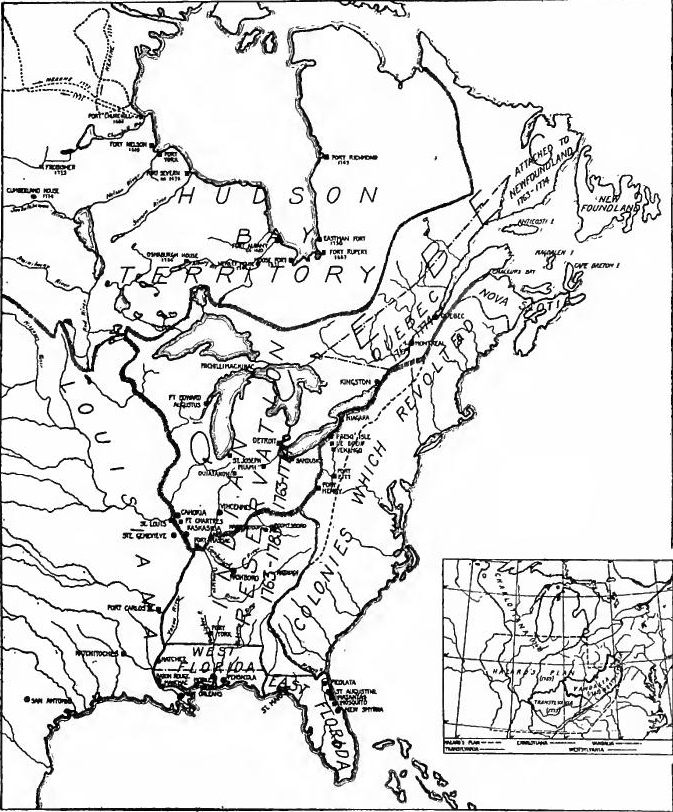 The New British Territories, 1763-1783.
Regulation of Indian trade.—The acquisition of extensive territories in 1763 called for new trade regulations. The proclamation had created an Indian reserve and opened trade to all[Pg 406] duly licensed subjects. In the following year Lord Hillsborough drew up a general plan for the management of Indians and the fur trade. It safeguarded the rights of the Hudson's Bay Company and provided for the continuation of the two superintendents, with three deputies for the northern and two for the southern district. In the North all trade must be conducted at regularly established posts, and in the South at the Indian towns. All traders must be licensed, must trade at schedule prices, and must have no dealings with Indians except at the prescribed places. By 1768 the plan had proved too expensive, and the management of the fur trade was restored to the individual colonies.
Regulation of Indian trade.—The acquisition of large territories in 1763 required new trade regulations. The proclamation had created an Indian reserve and opened trade to all[Pg 406] properly licensed subjects. The following year, Lord Hillsborough developed a general plan for managing relations with Indians and the fur trade. It protected the rights of the Hudson's Bay Company and included the continuation of two superintendents, with three deputies for the northern district and two for the southern. In the North, all trade had to be conducted at established posts, while in the South, it had to occur in Indian towns. All traders were required to be licensed, to trade at set prices, and to engage with Indians only at the designated locations. By 1768, the plan became too costly, and control of the fur trade was returned to the individual colonies.
THE OCCUPATION OF THE FLORIDAS
The West Florida posts.—On August 6, 1763, Colonel Prévost took possession of Pensacola, which became the capital of West Florida. Shortly afterwards Mobile was occupied by Major Robert Farmar. The French troops there withdrew to New Orleans, as did some of the people, but most of the latter remained. Fort Tombecbé, renamed Fort York, was given a garrison of thirty men, for the express purpose of keeping the Choctaws hostile to the Chickasaws, but was abandoned in 1768. The French among the Choctaws moved across the Mississippi into Spanish territory, but continued to trade with the tribe.
The West Florida posts.—On August 6, 1763, Colonel Prévost took control of Pensacola, which then became the capital of West Florida. Soon after, Major Robert Farmar occupied Mobile. The French troops there pulled back to New Orleans, and some residents left as well, but most stayed behind. Fort Tombecbé, renamed Fort York, was assigned a garrison of thirty men specifically to keep the Choctaws hostile towards the Chickasaws, but it was abandoned in 1768. The French among the Choctaws moved across the Mississippi into Spanish territory but continued to trade with the tribe.
The boundary and the river forts.—In 1764 the northern boundary of West Florida was moved north to 32° 28' to take in the Natchez settlements, and to make room for the land speculators who were seeking land grants on the lower Mississippi. A garrison was placed at Natchez (Fort Panmure). In connection with efforts to keep the Mississippi open and to establish navigation through the Iberville River, Fort Bute was bunt near the latter stream in 1766. These Mississippi posts were designed also to prevent French and Spanish smuggling among the Choctaws. But there was English smuggling likewise, and to stop it Spanish posts were later built on the other bank of the river. In 1769 the troops of most of the English posts were withdrawn to St. Augustine, but there was a protest at once. Pensacola drew up a memorial, and immigrants recently arrived at the[Pg 407] Mississippi demanded protection. O'Reilly had just come to New Orleans, and it was feared that he might have designs on West Florida. In 1770, therefore, most of the troops were restored, and a new garrison was established at Manchac.
The boundary and the river forts.—In 1764, the northern boundary of West Florida was moved north to 32° 28' to include the Natchez settlements and to accommodate land speculators looking for land grants along the lower Mississippi. A garrison was set up at Natchez (Fort Panmure). To keep the Mississippi accessible and to establish navigation through the Iberville River, Fort Bute was built near that stream in 1766. These Mississippi posts also aimed to prevent French and Spanish smuggling among the Choctaws. However, there was English smuggling too, and to tackle that, Spanish posts were later constructed on the opposite bank of the river. In 1769, most of the troops from the English posts were moved back to St. Augustine, prompting an immediate protest. Pensacola drafted a memorial, and immigrants who had recently arrived at the[Pg 407] Mississippi demanded protection. O'Reilly had just arrived in New Orleans, raising concerns that he might have intentions regarding West Florida. Thus, in 1770, most of the troops were reinstated, and a new garrison was established at Manchac.
Indian agents and fur magnates.—The possession of West Florida proved an important asset to Great Britain in the control of the southwestern Indians, especially during the Revolution. John Stuart, Superintendent for the Southern Department, made his headquarters at Pensacola, but Mobile was the real center of control for the whole Southwest. Subagents convened at Mobile a great congress of all the tribes and effected an alliance with them, and soon afterward the Indian lands about Mobile were ceded to the English. The military authorities encouraged inter-tribal dissensions, and the Creeks and Choctaws were frequently at war, in which the Chickasaws sometimes joined. According to the general system, the fur trade of the Southwest was opened to all traders having a government license and a proper bond. The fur magnates at Mobile were the house of Swanson and McGillivray, who by 1777 had a branch house at Fort Bute, which conducted trade with the Illinois. At Pensacola Panton, Leslie, and Company, the largest business house, became an important factor in the trade and in the management of the tribes.
Indian agents and fur magnates.—Controlling West Florida was a key advantage for Great Britain in managing the southwestern Indian tribes, especially during the Revolution. John Stuart, the Superintendent for the Southern Department, set up his main office in Pensacola, but Mobile was really the hub of control for the entire Southwest. Subagents gathered a major conference of all the tribes in Mobile and formed an alliance with them, leading to the cession of Indian lands around Mobile to the English shortly afterward. The military authorities stoked conflicts between tribes, with the Creeks and Choctaws often at war, and the Chickasaws sometimes joining in. Under the prevailing system, the fur trade in the Southwest was open to all traders who had a government license and a proper bond. The fur magnates in Mobile included the Swanson and McGillivray firm, which by 1777 had a branch office at Fort Bute that traded with the Illinois. In Pensacola, Panton, Leslie, and Company, the largest business in the area, played a significant role in trade and managing the tribes.
Politics and government.—West Florida was accorded a governor, council, and assembly. Governor George Johnstone arrived at Pensacola in October, 1764, but the first assembly was not elected until 1766. Mobile, Pensacola, and Campbell Town were electoral precincts at first, and after 1778 Natchez and Manchac were represented. The brief political experiences of the province were as interesting as those of the older colonies in early days. The governor and assembly frequently quarreled. In 1772 Governor Chester prorogued that body and for six years got along without it. More harmful than these quarrels were the factional disputes between the civil and military officials.
Politics and government.—West Florida was given a governor, council, and assembly. Governor George Johnstone arrived in Pensacola in October 1764, but the first assembly wasn’t elected until 1766. Mobile, Pensacola, and Campbell Town were the electoral precincts at first, and after 1778, Natchez and Manchac were also represented. The province's short political history was as intriguing as that of the older colonies in their early days. The governor and assembly often clashed. In 1772, Governor Chester suspended the assembly and managed without it for six years. More damaging than these conflicts were the factional disputes between the civilian and military officials.
Development of West Florida.—When England took possession, Pensacola consisted of some forty thatched huts and small barracks, all enclosed within a palisade, but it was rebuilt, and practically dates from British rule. Mobile remained largely French,[Pg 408] and was reduced in size by the emigration to New Orleans. British rule gave impetus to Mobile's commerce, and by 1776 the port was paying £4000 a year to the London custom house alone.
Development of West Florida.—When England took control, Pensacola was made up of about forty thatched huts and small barracks, all surrounded by a palisade, but it was rebuilt and really started from British rule. Mobile mainly remained French,[Pg 408] and its size decreased due to people moving to New Orleans. Under British rule, Mobile's commerce thrived, and by 1776, the port was contributing £4000 a year to the London customs.
Immigration.—Efforts were made also to secure immigrants for West Florida. In 1763 the Board of Trade put an advertisement regarding land grants in the London Gazette, and in 1764 Governor Johnstone issued a circular to attract settlers. In 1765 or 1766 a colony from North Carolina went by sea and settled about Natchez and Baton Rouge. Speculators obtained large grants of land about Natchez as early as 1767, among them being Daniel Clark, later a great figure at New Orleans. Before the Revolution numerous settlers arrived from England, the West Indies, and most of the mainland colonies, including New England. Most of them settled on the Mississippi River between Manchac and Natchez. In 1772 three hundred persons from Virginia and the Carolinas are said to have been established on the lower Mississippi, and three or four hundred families were expected that summer. As a result, the Mississippi posts were repaired and civil government established. In 1775 a considerable immigration from New England was led by General Lyman. About the same time Colonel Putnam led a company from New England to the Yazoo district. In 1777, according to the botanist Bartram, more than half of the population of Mobile were people who had come from the northern colonies and Great Britain.
Immigration.—Efforts were also made to attract immigrants to West Florida. In 1763, the Board of Trade placed an advertisement about land grants in the London Gazette, and in 1764, Governor Johnstone sent out a circular to draw settlers in. In 1765 or 1766, a group from North Carolina traveled by sea and settled around Natchez and Baton Rouge. Speculators secured large land grants around Natchez as early as 1767, including Daniel Clark, who later became a prominent figure in New Orleans. Before the Revolution, many settlers arrived from England, the West Indies, and most of the mainland colonies, including New England. Most of them settled along the Mississippi River between Manchac and Natchez. In 1772, about three hundred people from Virginia and the Carolinas reportedly established themselves on the lower Mississippi, and three to four hundred families were expected that summer. As a result, the Mississippi posts were repaired and a civil government was established. In 1775, a significant immigration wave from New England was led by General Lyman. Around the same time, Colonel Putnam led a group from New England to the Yazoo district. In 1777, according to the botanist Bartram, more than half of Mobile's population were people who had come from the northern colonies and Great Britain.
During the Revolution West Florida was a refuge for Loyalists. In November, 1776, Mathew Phelps led a colony of New Englanders to the lower Mississippi. Highland soldiers defeated in North Carolina that year took refuge in the province. Loyalists from Georgia and South Carolina settled on the Tombigbee River and Mobile Bay, and others from the same colonies settled on the Tensaws Bayou.
During the Revolution, West Florida was a safe haven for Loyalists. In November 1776, Mathew Phelps led a group of New Englanders to the lower Mississippi. Highland soldiers who were defeated in North Carolina that year sought refuge in the province. Loyalists from Georgia and South Carolina settled along the Tombigbee River and Mobile Bay, while others from the same colonies moved to Tensaw Bayou.
East Florida under British rule.—In East Florida, St. Augustine became the capital and the chief military post. St. Marks on the Gulf was occupied for military purposes and the posts of Matanzas, Picolata, and Mosquito were also maintained for a time. The military of both East and West Florida were under the general command at Pensacola. James Grant was made[Pg 409] first governor. In East Florida there was no assembly till 1781. Difficulties between military and civil authorities prevailed as in West Florida.
East Florida under British rule.—In East Florida, St. Augustine became the capital and the main military base. St. Marks on the Gulf was used for military purposes, and the posts at Matanzas, Picolata, and Mosquito were also maintained for a while. The military forces of both East and West Florida were under the overall command at Pensacola. James Grant was appointed[Pg 409] as the first governor. East Florida did not have an assembly until 1781. There were conflicts between military and civil authorities, similar to those in West Florida.
At the time of the British occupation, St. Augustine was a small Spanish town with adobe houses and narrow streets. Under British rule East Florida prospered. Harbors were improved, and highways were constructed, one being built from St. Mary's River to St. Augustine. In 1766 some forty families went from the Bermudas to Mosquito Inlet to engage in ship-building. In the following year Dr. Turnbull brought fifteen hundred indentured colonists from the Mediterranean region and settled them at New Smyrna. In 1776 the indentures were cancelled and the settlers moved to St. Augustine, where their descendants still five. During the Revolution East Florida, like West Florida, became a Mecca for southern Loyalists.
At the time of the British occupation, St. Augustine was a small Spanish town with adobe houses and narrow streets. Under British rule, East Florida thrived. Harbors were upgraded, and roads were built, including one stretching from the St. Mary's River to St. Augustine. In 1766, about forty families moved from the Bermudas to Mosquito Inlet to get into shipbuilding. The following year, Dr. Turnbull brought fifteen hundred indentured colonists from the Mediterranean and settled them in New Smyrna. In 1776, the indentures were canceled, and the settlers relocated to St. Augustine, where their descendants still live. During the Revolution, East Florida, like West Florida, became a refuge for Southern Loyalists.
MILITARY OCCUPATION OF THE ILLINOIS COUNTRY
Plans to occupy the Illinois country.—By the end of 1761 British troops had taken possession of all the lake posts from Niagara to Green Bay, besides Venango, Miamis, and Ouiatanon further south. In July, 1763, orders were sent by the Governor of Louisiana for the evacuation of the Illinois posts, and boats were prepared at Fort Pitt for sending four hundred English troops to relieve the French garrisons. But the conspiracy of Pontiac delayed the complete transfer of this region for nearly three years.
Plans to occupy the Illinois country.—By the end of 1761, British troops had taken control of all the lake posts from Niagara to Green Bay, as well as Venango, Miamis, and Ouiatanon further south. In July 1763, orders were issued by the Governor of Louisiana for the evacuation of the Illinois posts, and boats were prepared at Fort Pitt to send four hundred English troops to replace the French garrisons. However, Pontiac's conspiracy delayed the full transfer of this area for nearly three years.
The conspiracy of Pontiac.—Early in the war the tribes north of the Ohio had ravaged the Virginia and Pennsylvania frontiers, but after 1758 they had been quiet, although they did not like the English. They feared eviction from their lands, English traders had proved arrogant and dishonest, and General Amherst was attempting a policy of economy in presents, in spite of the criticism of the better informed Indian agents. Pontiac, head chief of the Ottawas, organized a general revolt, embracing the Algonquins, some of the tribes of the lower Mississippi, and some of the Iroquois. By a simultaneous assault in May, 1763, all but three northwestern posts—Detroit, Fort Pitt, and Niagara—fell almost without a blow. At Presq'Isle, Le Boeuf, Venango,[Pg 410] Mackinac, Sandusky, St. Josephs, and Ouiatanon, there were massacres, and the garrison fled from Green Bay.
The Pontiac Conspiracy.—Early in the war, the tribes north of the Ohio had devastated the Virginia and Pennsylvania frontiers, but after 1758 they had been quiet, even though they didn’t like the English. They feared losing their land, English traders were arrogant and dishonest, and General Amherst was trying to save money on gifts, despite the criticism from better-informed Indian agents. Pontiac, the chief of the Ottawas, organized a widespread uprising that included the Algonquins, some tribes from the lower Mississippi, and some of the Iroquois. In May 1763, through a coordinated attack, all but three northwestern posts—Detroit, Fort Pitt, and Niagara—were captured almost effortlessly. There were massacres at Presq'Isle, Le Boeuf, Venango,[Pg 410] Mackinac, Sandusky, St. Josephs, and Ouiatanon, and the garrison fled from Green Bay.
Failure of the Loftus expedition.—It being impracticable now to send troops to the Illinois country by way of the Ohio, this was attempted by an expedition up the Mississippi Major Loftus was sent from Mobile with three hundred and fifty men to occupy Fort Massac, Kaskaskia, and Fort Chartres. In February, 1764, he left New Orleans, but when two hundred and forty miles up the river, at Rocher à Davion, he was attacked by Tunica Indians, whereupon he abandoned the expedition and returned to Mobile.
Failure of the Loftus expedition.—Since it was no longer feasible to send troops to the Illinois region via the Ohio River, an attempt was made to send an expedition up the Mississippi River. Major Loftus was dispatched from Mobile with three hundred and fifty men to take control of Fort Massac, Kaskaskia, and Fort Chartres. He left New Orleans in February 1764, but when he was two hundred and forty miles up the river, at Rocher à Davion, he faced an attack from the Tunica Indians, leading him to abandon the expedition and head back to Mobile.
Peace.—While Colonel Bradstreet reoccupied the Lakes, General Gage, Amherst's successor, resorted to conciliation, and a series of peace embassies were sent to the Illinois country from Mobile and from the northern garrisons. The submission of the Ohio tribes, failure of hopes for aid from New Orleans, and news of the transfer of western Louisiana to Spain, led Pontiac to negotiate at Ouiatanon in 1765 with George Croghan. At Detroit Croghan secured peace with all the western tribes. Thomas Stirling then descended the Ohio with a detachment and in October occupied Fort Chartres. "Thus, after nearly three years of fighting and negotiating, British forces were in possession of the last of the French posts in the West."
Peace.—While Colonel Bradstreet returned to the Lakes, General Gage, Amherst's successor, focused on making peace, sending a series of peace missions to the Illinois country from Mobile and the northern garrisons. The surrender of the Ohio tribes, the lack of expected support from New Orleans, and the news that western Louisiana had been handed over to Spain led Pontiac to negotiate at Ouiatanon in 1765 with George Croghan. At Detroit, Croghan established peace with all the western tribes. Thomas Stirling then traveled down the Ohio with a detachment and in October took control of Fort Chartres. "Thus, after nearly three years of fighting and negotiating, British forces were in possession of the last of the French posts in the West."
Establishment of government.—In accordance with the Treaty of Paris a proclamation of General Gage guaranteed the inhabitants the free exercise of the Catholic religion. Settlers were allowed to sell their lands and emigrate, or to become British subjects on taking the oath of allegiance. The inhabitants of Kaskaskia and other places asked and received an extension of the time for decision to March, 1766. Many of them emigrated to St. Louis and Ste. Genevieve, or to New Orleans. The Proclamation of 1763 made no provision for civil government in the Indian reserve, and local administration was left to the military authorities and Indian agents. The French people were dissatisfied, and many misunderstandings arose between them and the English settlers and officers. By 1770 the complaint took the form of a demand for civil government, which was provided in 1774 by the Quebec Act.
Establishment of government.—According to the Treaty of Paris, a proclamation by General Gage ensured that the residents could freely practice the Catholic religion. Settlers were permitted to sell their lands and move away, or they could choose to become British subjects by swearing an oath of allegiance. The residents of Kaskaskia and other areas requested and received an extension to make their decision until March 1766. Many of them moved to St. Louis and Ste. Genevieve, or to New Orleans. The Proclamation of 1763 did not establish any civil government in the Indian reserve, leaving local administration to military authorities and Indian agents. The French population was unhappy, leading to many misunderstandings with the English settlers and officials. By 1770, their discontent turned into a demand for civil government, which was provided in 1774 by the Quebec Act.
LAND SPECULATION AND PLANS FOR WESTERN COLONIES
Western schemes.—Before the French and Indian War grants had been made by the British government of lands beyond the Alleghanies, and settlement on the back lands had been favored as a means of opposing, the French and of extending British trade. During the war the frontiers of settlement were contracted, but, in anticipation of victory, new grants were sought and new schemes proposed. Not only were lands desired, but prominent men proposed new colonial governments west of the mountains. Nearly all of the proposals involved territory in the Ohio Valley. After the Albany Congress of 1754 Franklin urged the formation of two barrier colonies in the West. In 1756 Thomas Pownall, ex-governor of New Jersey, made a similar proposal. About the same time Samuel Hazard of Philadelphia promoted the formation of a Presbyterian colony to embrace most of the Ohio Valley and extending across the Mississippi. In 1757 the Greenbrier Company secured 100,000 acres of land on the western waters.
Western schemes.—Before the French and Indian War, the British government had granted lands beyond the Alleghenies, and settlement in those areas was encouraged as a way to counter the French and expand British trade. During the war, the frontier of settlement shrank, but anticipating victory, new land grants were pursued and fresh plans were proposed. Not only was land sought, but influential individuals also suggested establishing new colonial governments west of the mountains. Almost all the proposals involved territory in the Ohio Valley. After the Albany Congress of 1754, Franklin advocated for the creation of two protective colonies in the West. In 1756, Thomas Pownall, former governor of New Jersey, made a similar suggestion. Around the same time, Samuel Hazard from Philadelphia promoted the idea of a Presbyterian colony that would cover most of the Ohio Valley and extend across the Mississippi. In 1757, the Greenbrier Company obtained 100,000 acres of land along the western waters.
The victory over the French stimulated new speculative and colonizing schemes for the West both in England and America. In June, 1763, the Mississippi Company was formed, composed of prominent Virginians, including Colonel George Washington and Richard Henry Lee. A memorial to the king was drawn asking for 2,500,000 acres on both sides of the lower Ohio, quit rent free for twelve years, and protection by royal forts, on condition of settling two hundred families. Late in 1763 a pamphlet published in Edinborough, Scotland, proposed a colony named Charlotiana, to include the country between the Wabash, Ohio, Mississippi, and the Great Lakes. About the same time Charles Lee proposed a colony on the Illinois and another on the Ohio.
The victory over the French sparked new ideas and plans for colonization in the West both in England and America. In June 1763, the Mississippi Company was established, made up of prominent Virginians, including Colonel George Washington and Richard Henry Lee. A petition to the king was created requesting 2,500,000 acres on both sides of the lower Ohio, free from rent for twelve years, and protection by royal forts, on the condition that two hundred families settle there. Later in 1763, a pamphlet published in Edinburgh, Scotland, suggested a colony called Charlotiana, covering the area between the Wabash, Ohio, Mississippi, and the Great Lakes. Around the same time, Charles Lee proposed a colony in Illinois and another one along the Ohio.
Effect of the Proclamation.—The Proclamation of 1763 closing the Trans-Alleghany country to settlement seems to have checked for a time the schemes for speculation. The Proclamation contained an implied promise that the boundary would be revised, while it was well known that influential politicians in England favored the opening of the West. New schemes for western lands, therefore, were not long suppressed. In 1766 William Franklin, governor of New Jersey, launched a plan for two[Pg 412] colonies, one at Detroit, the other on the lower Ohio. Through the aid of Benjamin Franklin, father of the governor, the Ohio country was favored by the Board of Trade, but in 1768 the plan dropped from sight. Meanwhile many other land companies were formed.
Effect of the Proclamation.—The Proclamation of 1763, which closed the Trans-Alleghany region to settlement, seems to have temporarily halted speculation plans. The Proclamation included an implied promise that the boundary would be reconsidered, and it was well known that influential politicians in England supported the expansion into the West. As a result, new plans for western lands quickly emerged. In 1766, William Franklin, the governor of New Jersey, proposed a plan for two[Pg 412] colonies, one in Detroit and the other along the lower Ohio. With the help of his father, Benjamin Franklin, the Ohio region gained favor with the Board of Trade, but by 1768, the plan faded away. In the meantime, many other land companies were created.
A policy of expansion adopted.—The policy of the ministry regarding the West was vacillating, and more so, no doubt, because of the pressure of conflicting interests. But in 1768 the ministry decided on a definite plan for western settlement, the principle being that expansion should be gradual and under control of imperial agents, who should purchase land from the Indians as needed. Johnson and Stuart, Indian superintendents, had already made tentative arrangements for revising the proclamation line. In 1765 the Six Nations ceded their claims to lands between the Ohio and the Tennessee. Stuart, by a series of treaties, secured a line from the southern boundary of Virginia to the St. Mary's River. Florida, thence along the tidewater line to the Appalachicola River. West of that point the line was not completed, but important cessions were made along the Mobile coast. In 1768 the former lines were ratified, and Stuart, in two treaties with the Cherokees and Creeks (October, November, 1768), secured the extension of the line to the mouth of the Kanawha River on the north and to the Choctaw River on the south. At Fort Stanwix in 1768 the Iroquois ratified essentially their cession of 1765. The lines did not correspond, since the Iroquois cession included Western Tennessee and Kentucky, which were not within the other cessions. Meanwhile the southern line was modified by the treaty of Lochaber by running it west along the southern boundary of Virginia to the Holston River, thence direct to the mouth of the Kanawha. The purpose of the change was to take in the recently formed Watauga settlement.
A policy of expansion was adopted. The ministry's approach to the West was inconsistent, largely due to competing interests. However, in 1768, the ministry settled on a clear plan for western settlement, which emphasized gradual expansion overseen by imperial agents who would purchase land from the Native Americans as necessary. Johnson and Stuart, Indian superintendents, had already made initial arrangements to revise the proclamation line. In 1765, the Six Nations gave up their claims to lands between the Ohio and Tennessee Rivers. Through a series of treaties, Stuart established a line running from the southern boundary of Virginia to the St. Mary's River, then along the tidewater line to the Appalachicola River. West of that point, the line was incomplete, but significant land was ceded along the Mobile coast. In 1768, the previous lines were confirmed, and Stuart, through treaties with the Cherokees and Creeks (in October and November 1768), secured the extension of the line to the mouth of the Kanawha River in the north and to the Choctaw River in the south. At Fort Stanwix in 1768, the Iroquois reaffirmed their cession from 1765. The lines didn't match up, as the Iroquois cession included Western Tennessee and Kentucky, which were not part of the other cessions. Meanwhile, the southern line was adjusted by the treaty of Lochaber, running west along the southern boundary of Virginia to the Holston River, and then directly to the mouth of the Kanawha, aiming to include the newly established Watauga settlement.
Vandalia.—Having extinguished the Indian titles, it was now possible to found a new colony back of Pennsylvania and Virginia, and such a project was put on foot. Samuel Wharton of Philadelphia formed a company for the purpose of purchasing part of the lands. The company included some of the leading men in England and America, among them being Benjamin Franklin and Thomas Walpole. Official aid was enlisted by[Pg 413] including two members of the ministry. In 1769 the purchase was made, and, in spite of Lord Hillsborough's opposition, by 1775 the project of a new and separate province named Vandalia had been approved by king and council. The outbreak of the Revolution set the plan aside. Had it been carried out it would have cut Virginia off from her back lands. The Quebec Act of 1774 operated in the same direction, by attaching the Northwest to Quebec. Virginia therefore resisted. Governor Dunmore opposed the Vandalia colony, made grants of land both within and beyond it, and joined a company which purchased Indian lands north of the Ohio.
Vandalia.—Once the Indian titles were settled, it became possible to establish a new colony behind Pennsylvania and Virginia, and this idea was set in motion. Samuel Wharton from Philadelphia created a company to buy part of the land. The company included some prominent figures from England and America, including Benjamin Franklin and Thomas Walpole. Official support was sought from[Pg 413], including two members of the government. In 1769, the purchase was finalized, and despite Lord Hillsborough's resistance, by 1775, the proposal for a new and separate province called Vandalia was approved by the king and council. However, the start of the Revolution put a stop to the plan. If it had gone ahead, it would have cut Virginia off from its backlands. The Quebec Act of 1774 worked similarly by linking the Northwest to Quebec. Consequently, Virginia pushed back. Governor Dunmore opposed the Vandalia colony, issued land grants both inside and outside it, and joined a company that bought Indian lands north of the Ohio.
TRANS-ALLEGHANY SETTLEMENT
Western settlements before 1763.—But it was the backwoodsmen, and not the corporations, who opened the Trans-Alleghany country. Before the war a few settlements had been made on the western waters, In 1748 Draper's Meadows, on the Greenbrier, in West Virginia, were settled. Between 1750 and 1752 a settlement was made by the Ohio Company at Redstone on the Monongahela. By 1758 several small settlements had been made on the Holston, Watauga, and Cheat Rivers. But during the war these western settlements were abandoned, and the frontier pushed eastward a hundred miles or more.
Western settlements before 1763.—But it was the pioneers, not the companies, who opened up the Trans-Alleghany region. Before the war, there were a few settlements established along the western rivers. In 1748, Draper's Meadows on the Greenbrier in West Virginia was settled. Between 1750 and 1752, the Ohio Company established a settlement at Redstone on the Monongahela River. By 1758, several small settlements had been established along the Holston, Watauga, and Cheat Rivers. However, during the war, these western settlements were abandoned, and the frontier retreated eastward by a hundred miles or more.
The westward movement after the war.—The French and Indian War was scarcely over when the westward movement began again, regardless of proclamations or the deliberations of the Board of Trade. In 1760 Daniel Boone, from the Yadkin in North Carolina, "cilled a bar" on the Watauga River. Between 1761 and 1765 Wallen annually led hunters to the west. In 1765 Croghan surveyed the Ohio River, and the next year James Smith and others explored the Tennessee. In 1767 Finley was in Kentucky, and Stoner, Harrod, and Lindsay were at French Lick (the site of Nashville). In 1767 and 1770 Boone was "prospecting" for Judge Richard Henderson, a land speculator of North Carolina. At the same time Mansker led a party down the Cumberland and on to Natchez. By this time others had wandered far beyond the Mississippi and were causing the Spanish officials anxiety.
The westward movement after the war. — The French and Indian War had just wrapped up when the push to move west started up again, ignoring any proclamations or discussions from the Board of Trade. In 1760, Daniel Boone, from the Yadkin River in North Carolina, "killed a bear" on the Watauga River. Between 1761 and 1765, Wallen led hunters west every year. In 1765, Croghan surveyed the Ohio River, and the following year, James Smith and others explored Tennessee. In 1767, Finley was in Kentucky, while Stoner, Harrod, and Lindsay were at French Lick (the future site of Nashville). In 1767 and 1770, Boone was "scouting" for Judge Richard Henderson, a land speculator from North Carolina. Meanwhile, Mansker led a group down the Cumberland River and on to Natchez. By this time, others had traveled far beyond the Mississippi and were making Spanish officials uneasy.
The hunters, traders, and prospectors were followed by surveyors [Pg 414] and settlers. The chief participants in the movement were from the middle region and the South: Pennsylvania, Maryland, Virginia, and North Carolina. Prominent among the pioneers on the western waters were the Scotch-Irish who had settled the back country of the older colonies and stood waiting at the western passes.
The hunters, traders, and prospectors were followed by surveyors [Pg 414] and settlers. The main people involved in the movement came from the Midwest and the South: Pennsylvania, Maryland, Virginia, and North Carolina. Notable among the pioneers on the western rivers were the Scotch-Irish who had settled the backcountry of the older colonies and were waiting at the western passes.
The Appalachian barrier.—To reach the Mississippi Valley the frontiersman was forced to pass the Appalachian barrier, extending from Maine to Georgia. The easiest pass through it, by way of the Hudson and Mohawk Rivers, was impeded by the Six Nations who stood between the western frontier of settlement and the vacant lands beyond. Farther south the barrier was traversed by a series of interlocking rivers, flowing in opposite directions, whose valleys afforded trails. The Susquehannah led to the Alleghany, the Potomac to the Monongahela, the James and Roanoke to the Great Kanawha, the Great Pedee, the Yadkin, and Catawba to the head waters of the Tennessee. A series of longitudinal valleys on the eastern front of the southern Appalachians gave access from Virginia and North Carolina to the upper Tennessee, from whose valley an easy pass was found to Kentucky by way of Cumberland Gap.
The Appalachian Barrier.—To get to the Mississippi Valley, frontiersmen had to navigate the Appalachian barrier, which stretched from Maine to Georgia. The easiest route through it was via the Hudson and Mohawk Rivers, but this was blocked by the Six Nations, who stood between the western settlement frontier and the open lands beyond. Further south, the barrier was crossed by a network of interlinked rivers flowing in different directions, creating valleys that provided trails. The Susquehanna led to the Allegheny, the Potomac to the Monongahela, and the James and Roanoke to the Great Kanawha, along with the Great Pee Dee, Yadkin, and Catawba leading to the headwaters of the Tennessee. A series of long valleys on the eastern side of the southern Appalachians allowed access from Virginia and North Carolina to the upper Tennessee, from which an easy route to Kentucky was found via Cumberland Gap.
The Indian barrier.—The Iroquois Confederacy, though friendly, was a retarding force to the northern stream of emigration. The Algonquin tribes north of the Ohio had been friendly with the French, and after the French and Indian War they favored the French traders rather than those from the seaboard colonies. At the southern end of the Appalachians westward expansion was retarded by the strong confederacies of the Cherokees, Creeks, Choctaws, and Chickasaws. The region between the Ohio and the Tennessee was the "dark and bloody ground" between the northern and southern tribes, but permanently inhabited by neither. It was this region which was opened to settlement by the Indian cessions between 1768 and 1770. The cessions were followed immediately by a movement of settlers into the area.
The Indian barrier.—The Iroquois Confederacy, while friendly, slowed down the northern flow of migration. The Algonquin tribes north of the Ohio had been allied with the French, and after the French and Indian War, they preferred trading with the French over merchants from the coastal colonies. In the southern part of the Appalachians, westward expansion was hindered by the powerful alliances of the Cherokees, Creeks, Choctaws, and Chickasaws. The area between the Ohio and the Tennessee was known as the "dark and bloody ground" because it was contested by both the northern and southern tribes but was never permanently settled by either. This area was eventually opened up for settlement due to the Indian land cessions between 1768 and 1770. The land cessions quickly led to an influx of settlers moving into the region.
THE SETTLEMENT OF EASTERN TENNESSEE
The North Carolina Regulators.—The movement across the mountains was stimulated by a popular upheaval in the back[Pg 415] country of North Carolina. Shortly before 1740 the Scotch-Irish and German migration reached North Carolina and by 1765 the lands along the headwaters of the Yadkin, Haw, Neuse, Tar, Catawba, and Deep Rivers had been occupied. Many English and Welsh also had settled in the same region. Between the Piedmont and the coastal plain was a sparsely settled country of pine forests. "Cut off ... from the men of the east, the men of the 'back country' felt no more sympathy for the former than they received from them." The coast country controlled the legislature and the courts. The men of the West complained that they were forced to pay excessive taxes, that the sheriffs were dishonest, and fees extortionate. An additional grievance was the scarcity of money. During 1765-1767 the frontiersmen began to organize and from 1767 to 1771 the back country was in a state of rebellion. Lawyers were seized and whipped, and the Hillsboro court was broken up. In 1771 the Regulators were defeated by Governor Tryon's troops in the battle of the Alamance and the rebellion soon subsided. During those troubled years many had sought new homes in the western valleys.
The North Carolina Regulators.—The movement across the mountains was fueled by a popular uprising in the back[Pg 415] country of North Carolina. Shortly before 1740, the Scotch-Irish and German migration reached North Carolina, and by 1765, people had settled along the headwaters of the Yadkin, Haw, Neuse, Tar, Catawba, and Deep Rivers. Many English and Welsh settlers also moved into the same area. Between the Piedmont and the coastal plain was a sparsely populated region of pine forests. "Cut off ... from the people of the east, the people of the 'back country' felt no more sympathy for them than they received in return." The coastal region controlled the legislature and the courts. The western settlers complained about having to pay high taxes, dishonest sheriffs, and outrageous fees. An additional complaint was the lack of money. Between 1765 and 1767, the frontiersmen began to organize, and from 1767 to 1771, the back country was in a state of rebellion. Lawyers were attacked and whipped, and the Hillsboro court was shut down. In 1771, the Regulators were defeated by Governor Tryon's troops in the battle of the Alamance, and the rebellion soon faded. During those turbulent years, many sought new homes in the western valleys.
The Watauga settlement.—Permanent settlement was made in eastern Tennessee in 1769. In that year a band of pioneers moved down the valley from Virginia and settled on the Watauga River, a branch of the Tennessee, thinking that they were still in Virginia. A short time afterward they were joined by settlers from North Carolina, within whose bounds the colony proved to be. Two able leaders soon emerged. James Robertson, a backwoodsman and a "mighty hunter," went to Watauga in 1770 and took thither a colony of sixteen North Carolina families in 1771. A year later arrived John Sevier, a Virginian of Huguenot extraction. Like Robertson, he was an able Indian fighter and a leader of men.
The Watauga settlement.—A permanent settlement was established in eastern Tennessee in 1769. That year, a group of pioneers traveled down the valley from Virginia and settled on the Watauga River, a branch of the Tennessee River, believing they were still in Virginia. Soon after, they were joined by settlers from North Carolina, where the colony was actually located. Two strong leaders quickly emerged. James Robertson, a frontiersman and a "great hunter," arrived in Watauga in 1770 and brought a group of sixteen families from North Carolina in 1771. A year later, John Sevier, a Virginian of Huguenot descent, arrived. Like Robertson, he was a skilled Indian fighter and a natural leader.
The Watauga Association.—Finding themselves outside of Virginia and beyond the reach and protection of the North Carolina administration, the settlers, like the Pilgrim Fathers in a similar situation, reverted to the social compact—familiar to Scotch-Irish Presbyterians and to back-country North Carolinians who had "regulated" horse stealing—and formed a government for themselves. In 1772 a convention of the settlers created[Pg 416] an independent government called the Watauga Association. It had a written constitution, vesting the administration in an executive committee of five, two of whom were Sevier and Robertson. This committee exercised most of the powers of sovereignty, making treaties, administering justice, granting lands, and making war on the Indians. In 1776 the Watauga Association, realizing the need of help, petitioned the Council of North Carolina to extend its government over the new settlements, and in 1777 they were organized as Washington County.
The Watauga Association.—Finding themselves outside of Virginia and beyond the reach and protection of the North Carolina government, the settlers, like the Pilgrim Fathers in a similar situation, turned to the social contract—familiar to Scotch-Irish Presbyterians and to back-country North Carolinians who had dealt with horse stealing—and formed a government for themselves. In 1772, a convention of the settlers established[Pg 416] an independent government called the Watauga Association. It had a written constitution, granting authority to an executive committee of five, two of whom were Sevier and Robertson. This committee held most of the powers of sovereignty, making treaties, administering justice, granting land, and waging war on the Indians. In 1776, the Watauga Association recognized the need for support, so they petitioned the Council of North Carolina to extend its government over the new settlements, and in 1777 they were organized as Washington County.
THE BEGINNINGS OF KENTUCKY
The surveyors and first settlers.—Settlement had also begun in what is now Kentucky. Ahead of the settlers went the prospectors and surveyors, who descended the Ohio and the Kanawha to select and survey lands. In 1770 and 1772 George Washington explored lands in what is now northeastern Kentucky. In 1773 the McAfees led a party of surveyors down the Ohio, crossed Kentucky, and returned over the Cumberland Mountains. In the following year several parties of surveyors and land hunters were sent by Virginia officials to lay out bounty lands for soldiers. Others went without official sanction. One party was led by John Floyd from Fincastle County, Virginia, who descended the Kanawha and Ohio to the Falls, crossed Kentucky, and returned by Cumberland Gap. During his expedition he surveyed lands for George Washington, Patrick Henry, and others. Attempts at settlement had already been made. In 1773 Daniel Boone led a colony from North Carolina toward Kentucky, but was driven back by Indians. The next year Harrod, of Virginia, founded a settlement in Kentucky called Harrodsburg, but it was broken up by Indians, whose hostilities drove out all settlers and land hunters.
The surveyors and first settlers.—Settlement had also started in what is now Kentucky. Ahead of the settlers were the prospectors and surveyors, who traveled down the Ohio and the Kanawha to choose and survey land. In 1770 and 1772, George Washington explored areas in what is now northeastern Kentucky. In 1773, the McAfees led a group of surveyors down the Ohio, crossed through Kentucky, and came back over the Cumberland Mountains. The following year, several groups of surveyors and land seekers were sent by Virginia officials to lay out bounty lands for soldiers. Others went without any official approval. One group was led by John Floyd from Fincastle County, Virginia, who traveled down the Kanawha and Ohio to the Falls, crossed Kentucky, and returned through Cumberland Gap. During his expedition, he surveyed land for George Washington, Patrick Henry, and others. Attempts at settlement had already been made. In 1773, Daniel Boone led a group from North Carolina towards Kentucky, but they were pushed back by Native Americans. The next year, Harrod from Virginia established a settlement in Kentucky called Harrodsburg, but it was destroyed by Native Americans, whose attacks forced all settlers and land seekers to leave.
Indian ravages.—The border war which now occurred was the culmination of a long series of troubles between the frontiersmen of Pennsylvania and Virginia, and the Indians of the Ohio Valley. The Delawares had been pushed over the Pennsylvania Mountains to the Muskingum and Tuscarawas Rivers. Among them settled the Moravian missionaries, who formed them into Christian towns and kept them peaceful when others were hostile.[Pg 417] The Shawanee had been pushed north to the Scioto River, whence they marauded the Virginia border. Behind them were the hostile tribes who had taken part in Pontiacs War. Through 1773 an Indian uprising was threatening, and preparations were made in the westernmost settlements of Virginia. Early in 1774 many settlers fled from the Holston and Clinch Valleys. Minor outrages being committed along the Ohio, alarm, spread, and in April there was a retreat across the Monongahela, which was crossed by more than a thousand refugees in a single day.
Indian ravages.—The border war that occurred was the result of a long history of conflicts between the frontiersmen of Pennsylvania and Virginia and the Native Americans of the Ohio Valley. The Delawares had been driven over the Pennsylvania Mountains to the Muskingum and Tuscarawas Rivers. Among them settled the Moravian missionaries, who established Christian communities and maintained peace while others were hostile.[Pg 417] The Shawanee had been pushed north to the Scioto River, from where they raided the Virginia border. Behind them were the hostile tribes that had participated in Pontiac's War. By 1773, an Indian uprising was looming, leading to preparations in the westernmost settlements of Virginia. Early in 1774, many settlers fled from the Holston and Clinch Valleys. As minor incidents were reported along the Ohio River, fear spread, and in April, over a thousand refugees crossed the Monongahela in a single day.
Lord Dunmore's War.—Governor Dunmore now prepared for war, which, there is some ground for thinking, he helped to bring on as a means of strengthening Virginia's claims to the Northwest. To warn the surveyors and settlers Colonel Preston, lieutenant-sheriff and surveyor of Fincastle County, Virginia, sent Boone and Stoner through Kentucky. They went as far as the Falls of the Ohio, and saved most of the men on the frontier. The governor organized a campaign, himself leading the Virginia regulars down the Ohio, while the frontier levies were led by Colonel Andrew Lewis. They were to meet at the mouth of the Great Kanawha. When Lewis reached that point he was attacked before the arrival of Dunmore by the Indians under Chief Cornstalk, whom he defeated. Thereupon the Indians sued for peace with Dunmore, who had entered their country north of the Ohio. In the following October a treaty was made at Fort Pitt which kept the northern Indians quiet during the first two years of the Revolution and made it possible to settle Kentucky.
Lord Dunmore's War.—Governor Dunmore now prepared for war, which, some believe, he helped instigate as a way to strengthen Virginia's claims to the Northwest. To alert the surveyors and settlers, Colonel Preston, the lieutenant-sheriff and surveyor of Fincastle County, Virginia, sent Boone and Stoner through Kentucky. They traveled as far as the Falls of the Ohio, saving most of the men on the frontier. The governor organized a campaign, personally leading the Virginia regulars down the Ohio, while Colonel Andrew Lewis led the frontier troops. They were to meet at the mouth of the Great Kanawha. When Lewis arrived there, he was attacked by the Indians under Chief Cornstalk before Dunmore's arrival, but he managed to defeat them. After this, the Indians sought peace with Dunmore, who had entered their territory north of the Ohio. In the following October, a treaty was made at Fort Pitt that kept the northern Indians peaceful during the first two years of the Revolution and allowed for the settlement of Kentucky.
Henderson and Transylvania.—Harrodsburg was now refounded by Virginians (1775) who constituted the majority of the settlers. Henderson, the North Carolina land speculator, formed a land company, called the Transylvania Company. To improve his title in 1775 he made a treaty with the Overhill Cherokees paying them £10,000 for their claims to lands along and between the Cumberland and the Kentucky. Boone, with a party of thirty men, was sent ahead to clear a road for Henderson's colony from the Holston River to the Kentucky (1775). It became the famous highway known as the Wilderness Road. Henderson followed with his colony, founded Boonesborough, built a fort, and opened a land office, naming his colony[Pg 418] Transylvania. He attempted to set up in the wilderness a modified proprietary régime. Having established his colony, he called a convention; the delegates made laws which Henderson approved, and a compact was formed between the delegates and proprietors defining the irrespective rights. The proprietors retained control by reserving to themselves the veto power.
Henderson and Transylvania.—Harrodsburg was reestablished by Virginians (1775) who made up the majority of the settlers. Henderson, a land speculator from North Carolina, created a land company called the Transylvania Company. To strengthen his claim in 1775, he struck a deal with the Overhill Cherokees, paying them £10,000 for their rights to lands along and between the Cumberland and Kentucky rivers. Boone, along with thirty men, was sent ahead to clear a route for Henderson's colony from the Holston River to Kentucky (1775). This route became the well-known Wilderness Road. Henderson followed with his colony, established Boonesborough, built a fort, and set up a land office, naming his colony[Pg 418] Transylvania. He aimed to create a modified form of governance in the wilderness. Once his colony was established, he called a convention; the delegates created laws which Henderson approved, and a compact was made between the delegates and proprietors that defined their respective rights. The proprietors maintained control by reserving the veto power for themselves.
Transylvania absorbed by Virginia.—Henderson's procedure was regarded as illegal, and he was denounced by the governors of both Virginia and North Carolina. When the Revolution broke out the proprietors sent a delegate to the Continental Congress and appealed to that body for protection, but, largely through Virginia's influence, the delegation was rejected. The Virginia settlers in Kentucky, led by Harrod, opposed Henderson's claim to lands, appealed to Virginia, and sent George Rogers Clark to the assembly. Virginia asserted sovereignty over Kentucky, and stormy times continued till 1777, when Kentucky with her present boundaries was organized as Kentucky County, Virginia.
Transylvania taken over by Virginia.—Henderson's actions were seen as illegal, and both the governors of Virginia and North Carolina condemned him. When the Revolution started, the landowners sent a representative to the Continental Congress seeking protection, but mainly due to Virginia's influence, the delegation was turned away. The Virginia settlers in Kentucky, led by Harrod, challenged Henderson's claim to the land, appealed to Virginia, and sent George Rogers Clark to the assembly. Virginia claimed control over Kentucky, and contentious times continued until 1777 when Kentucky, with its current boundaries, was established as Kentucky County, Virginia.
THE UPPER OHIO AND MIDDLE TENNESSEE
Westsylvania.—While Henderson was founding Transylvania another region west of the mountains was being settled and was struggling for independent statehood. Emigrants from Pennsylvania, Maryland, Virginia, and other states had crossed the mountains and settled on the tributaries of the upper Ohio in what are now western Pennsylvania, West Virginia, and eastern Ohio. By the middle of 1776 there were said to be 25,000 families on the tributaries of the Ohio above the Scioto River. But the land which they occupied was in dispute between Virginia and Pennsylvania, and the Indiana and Vandalia Companies, and the settlers took up the struggle, quarreling over land titles and jurisdiction. The disorders prevented effective organization against the Indians. Shortly after the Declaration of Independence the settlers memorialized Congress, asking independent statehood as a "sister colony and fourteenth province of the American confederacy," under the name of Westsylvania, whose boundaries they described, but the request was not granted.
Westsylvania.—While Henderson was establishing Transylvania, another area to the west of the mountains was being settled and was fighting for independent statehood. Settlers from Pennsylvania, Maryland, Virginia, and other states had crossed the mountains and settled along the tributaries of the upper Ohio in what are now western Pennsylvania, West Virginia, and eastern Ohio. By mid-1776, there were reportedly 25,000 families living along the Ohio tributaries above the Scioto River. However, the land they occupied was contested between Virginia and Pennsylvania, as well as the Indiana and Vandalia Companies, leading to disputes over land titles and jurisdiction. These conflicts hindered effective organization against the Native Americans. Shortly after the Declaration of Independence, the settlers petitioned Congress, asking for independent statehood as a "sister colony and the fourteenth province of the American confederacy," under the name of Westsylvania, detailing the boundaries they envisioned, but their request was denied.
[Pg 419] The Cumberland settlement.—Robertson was the type of frontiersmen desirous to be ever on the move. In 1779 he prospected at French Lick, returned to Watauga, raised a colony, and in the fall led it forth. The women and children were conducted by Donelson down the Tennessee and up the Cumberland, while Robertson, guided by Mansker, led the men overland. Nashborough, now Nashville, was founded at the Cumberland Bend, and other stations were occupied along the river. In 1780 a convention formed an "Association" much like that of Watauga, but after three years of independence the district became Davidson County, North Carolina.
[Pg 419] The Cumberland settlement.—Robertson embodied the spirit of a frontiersman always eager to explore. In 1779, he explored French Lick, then returned to Watauga to gather a group of settlers, and in the fall, he led them out. Donelson took the women and children down the Tennessee River and up the Cumberland, while Robertson, guided by Mansker, led the men overland. Nashborough, now known as Nashville, was established at the Cumberland Bend, and other settlements were established along the river. In 1780, a convention created an "Association" similar to that of Watauga, but after three years of independence, the area became Davidson County, North Carolina.
THE PROVINCE OF QUEBEC
The French people.—At the time of the conquest the Canadian people numbered about 65,000 living in the St. Lawrence Valley, with several thousand scattered among the western posts. The settlers were in the main a frugal, industrious, unlettered, religious people. They were of two distinct classes, the gentry and the peasant tenants. After the war there was a considerable emigration to France of the official, noble, and commercial classes, leaving chiefly cultivators of the soil and fur traders. By 1775 the population had grown to perhaps 90,000, chiefly through natural increase of the French. By 1784 the population was 113,000.
The French people.—At the time of the conquest, the Canadian population was about 65,000, mostly living in the St. Lawrence Valley, with a few thousand scattered across the western posts. The settlers were primarily a hardworking, practical, uneducated, and religious group. They were divided into two main classes: the gentry and the peasant tenants. After the war, many officials, nobles, and members of the commercial class emigrated back to France, leaving mostly farmers and fur traders behind. By 1775, the population had grown to around 90,000, mainly due to the natural growth of the French community. By 1784, the population reached 113,000.
The British settlers.—The conquest left in the province and attracted to it later a small body of British settlers but by 1775 they did not number more than five or six hundred. Most of them lived in the towns of Quebec and Montreal, and engaged in business, especially in the fur trade, many as agents for English houses, others being independent merchants. When Hillsborough restored seignorial tenure, many of them acquired seigniories, though they continued to live by trade.
The British settlers.—The conquest left a small group of British settlers in the province and attracted more later, but by 1775, there were only about five or six hundred of them. Most lived in the towns of Quebec and Montreal and were involved in business, particularly in the fur trade, with some acting as agents for English companies while others were independent merchants. When Hillsborough reinstated seignorial tenure, many of them acquired seigniories, although they continued to make a living through trade.
Military rule.—British rule in Canada began with the capitulation of Montreal in September, 1760. General Amherst was made governor-general, with lieutenant-governors at Quebec, Montreal, and Three Rivers. From that time to the enforcement of the Proclamation of 1763 Canada was under military rule. But French law and customs were followed in the main, and there was little discontent.
Military rule.—British rule in Canada started with the surrender of Montreal in September 1760. General Amherst was appointed governor-general, with lieutenant-governors in Quebec, Montreal, and Three Rivers. From then until the implementation of the Proclamation of 1763, Canada was under military rule. However, French law and customs were primarily observed, and there was little dissatisfaction.
[Pg 420] Civil government established.—Civil government was established in August, 1764. The governor was assisted by an executive council composed of the lieutenant-governor, chief justice, and eight citizens. The government provided by the Proclamation of 1763 was unsuited to a population almost wholly French, professing the Catholic religion, and living under laws and customs of their own. The Proclamation provided for an assembly, but none was held in Quebec because the French people would not take the test oath, and the British settlers were too few in numbers to warrant an assembly representing them alone. Uncertainty existed regarding tithes and the future status of the Catholic Church. The Proclamation contemplated the establishment of British law, but practice was uncertain. The French inhabitants were not politically ambitious, but the British were aggressive in their demands for an assembly and the uniform establishment of English law.
[Pg 420] Establishment of Civil Government.—Civil government was set up in August 1764. The governor was supported by an executive council made up of the lieutenant-governor, chief justice, and eight citizens. The government outlined in the Proclamation of 1763 was not suitable for a population that was mostly French, practiced the Catholic faith, and followed their own laws and customs. Although the Proclamation allowed for an assembly, none was conducted in Quebec because the French people refused to take the test oath, and the British settlers were too few in number to justify an assembly that represented only them. There was uncertainty about tithes and the future of the Catholic Church. While the Proclamation envisioned the introduction of British law, its implementation was unclear. The French residents were not politically motivated, but the British were eager in their push for an assembly and the consistent application of English law.
The Quebec Act.—Under these circumstances a change of system was deemed necessary. It was provided by the Quebec Act of 1774, the first parliamentary legislation for Canada. The act maintained the privileges of the Catholic clergy, tithes from Catholic subjects being continued. French civil procedure was established, with some exceptions, but English criminal procedure was enforced. Provision was made for an appointive executive council with powers to make ordinances for the province, but no provision was made for a provincial assembly.
The Quebec Act.—Given these circumstances, a change in the system was considered necessary. This was established by the Quebec Act of 1774, which was the first parliamentary legislation for Canada. The act preserved the privileges of the Catholic clergy, allowing tithes from Catholic subjects to continue. French civil procedure was put in place, with some exceptions, but English criminal procedure was applied. An appointive executive council was created with the authority to make ordinances for the province, but there was no provision for a provincial assembly.
Boundaries extended.—The population of the Illinois country was similar to that of Quebec. The French habitants there had been demanding civil government, and it had been complained by the Montreal traders that the prosperity of Canada had been impaired by cutting off the western posts. Therefore the boundaries of Quebec were extended to include the region between the Ohio River and the Upper Mississippi. By the Proclamation of 1763 Labrador east of River St. John's, Anticosti, and the Magdalens, had been attached to Newfoundland. Labrador now began to develop commerce with the interior and the North and with Newfoundland. Opposition to the fishing admirals of Newfoundland caused these three districts to be annexed to Quebec in 1774.
Boundaries extended.—The population of the Illinois area was similar to that of Quebec. The French settlers there had been asking for a civil government, and traders from Montreal complained that the prosperity of Canada had suffered because they cut off the western posts. As a result, the boundaries of Quebec were expanded to include the region between the Ohio River and the Upper Mississippi. By the Proclamation of 1763, Labrador east of the River St. John's, Anticosti, and the Magdalens were added to Newfoundland. Labrador then began to develop trade with the interior, the North, and Newfoundland. Opposition to the fishing admirals of Newfoundland led to these three districts being annexed to Quebec in 1774.
[Pg 421] Not intended as a blow at liberty.—The Quebec Act was regarded in the other colonies as a blow at popular liberties and as an encroachment upon colonies whose chartered boundaries extended into the Northwest. It was in fact an administrative act intended primarily as a means of providing for the interests of the great body of the inhabitants, the French. The attachment of the Ohio country to Quebec, however, checked the natural spread of settlement from the seaboard colonies, and the act, on the other hand, prevented the assimilation of the French people by the English in Canada.
[Pg 421] Not meant as an attack on liberty.—The Quebec Act was seen by the other colonies as an attack on their rights and an infringement on their lands, which were supposed to extend into the Northwest. In reality, it was mainly an administrative move aimed at addressing the needs of the majority of the population, the French. However, the inclusion of the Ohio territory in Quebec restricted the natural expansion of settlement from the coastal colonies, and on the flip side, the act hindered the integration of the French population into English Canada.
The Loyalists in Canada.—During the American Revolution a considerable number of Loyalists crossed into Canada and settled at the border posts. Many others joined the British army against the Americans. At the close of the war some of the border counties of New York were almost depopulated. In 1783 there were in the Montreal district seventeen hundred Loyalists at seventeen posts, not counting enlisted men. Of those who migrated after the revolution the greater number at first settled in Nova Scotia. By the end of 1784 the number there exceeded 28,000 and caused the forming of the new province of New Brunswick. Over three thousand went to Cape Breton Island, and three times that number to the interior of Canada. Thirteen hundred settled at Kingston and formed the nucleus of Upper Canada, which was separated from Lower Canada in 1791. More important than this, the Revolution determined the course of Canadian history. In order not to be absorbed by the United States, Canada was forced into unswerving loyalty to the British Empire.
The Loyalists in Canada.—During the American Revolution, a significant number of Loyalists crossed into Canada and settled at the border posts. Many others joined the British army to fight against the Americans. By the end of the war, some border counties in New York were nearly empty. In 1783, there were about 1,700 Loyalists in the Montreal area across 17 posts, not counting enlisted men. Most of those who moved after the revolution initially settled in Nova Scotia. By late 1784, that number surpassed 28,000, leading to the creation of the new province of New Brunswick. More than 3,000 went to Cape Breton Island, and three times that number headed to the interior of Canada. Thirteen hundred settled in Kingston and formed the foundation of Upper Canada, which was separated from Lower Canada in 1791. More importantly, the Revolution shaped the future of Canadian history. To avoid being absorbed by the United States, Canada had to remain firmly loyal to the British Empire.
THE NORTHERN FUR TRADERS
Supervision of the fur trade.—The fur trade of Quebec under the new régime was supervised according to the principles of the Proclamation of 1763. The most fundamental fact was that the French monopolistic system was discontinued, except at certain "King's posts" in the lower St. Lawrence Valley. The trade was open to any duly licensed subject, superintendents were established at the posts, local courts were erected in the interior, and settlement limited to the immediate neighborhood of the posts in order not to drive away the fur bearing animals.[Pg 422]
Supervision of the fur trade.—The fur trade in Quebec under the new regime was overseen based on the principles of the Proclamation of 1763. The key change was that the French monopolistic system was ended, except at certain "King's posts" in the lower St. Lawrence Valley. The trade was open to any properly licensed individual, superintendents were appointed at the posts, local courts were established in the interior, and settlement was restricted to the immediate area around the posts to avoid driving away the fur-bearing animals.[Pg 422]
The French traders ruined.—The conquest had destroyed the French fur trading organization. Under the mercantile system then in vogue, supplies and markets had now to be sought in England. The French merchants were ruined, and the entire trade of the Great Lake region was thrown into the hands of the British traders. The French coureurs de bois, however, remained in the country, and, in the employ of the British, continued to be the backbone of the fur gathering business in the interior.
The French traders were finished. The conquest had wiped out the French fur trading system. With the mercantilist economy of the time, supplies and markets now had to be found in England. The French merchants were left destitute, and the entire trade of the Great Lakes region fell into the hands of British traders. However, the French coureurs de bois stayed in the country and, working for the British, continued to be the backbone of the fur collection business in the interior.
The rush to the interior.—As early as 1761 British traders of Montreal began to enter the field left vacant by the French. Pontiac's War caused a suspension of their activities, and during it British traders were plundered and murdered. By 1765, however, there was a new rush to the interior, though it was 1771 before they could safely trade in the most remote posts on the Saskatchewan. In the meantime the Indians had learned to take their furs to the posts on Hudson Bay or down the Mississippi.
The rush to the interior.—As early as 1761, British traders from Montreal started moving into the territory left open by the French. Pontiac's War temporarily halted their activities, leading to the plundering and murder of British traders during that time. However, by 1765, there was a renewed rush into the interior, although it wasn't until 1771 that they could trade safely at the furthest posts on the Saskatchewan. Meanwhile, the Indigenous people had started bringing their furs to the trading posts at Hudson Bay or down the Mississippi.
Extent of operations.—The American Revolution destroyed the western fur trade of the seaboard colonies and threw the commerce of the entire Northwest into the hands of the Quebec and Montreal traders. By the close of the war they were conducting operations on both sides of the Great Lakes, in the Illinois country, beyond the upper Mississippi, on the Winnipeg, Saskatchewan, Churchill, and Athabasca Rivers, to the neighborhood of Great Slave Lake. They traded on the Assiniboine, and may have reached the Missouri by that route.
Extent of operations.—The American Revolution wiped out the western fur trade for the coastal colonies and handed control of commerce in the entire Northwest to traders from Quebec and Montreal. By the end of the war, they were operating on both sides of the Great Lakes, in the Illinois region, beyond the upper Mississippi, and along the Winnipeg, Saskatchewan, Churchill, and Athabasca Rivers, up to the area around Great Slave Lake. They traded on the Assiniboine and might have reached the Missouri through that route.
Management of the trade.—During and after the Revolution the value of the furs annually sent from Montreal and Quebec to London was probably $1,000,000. The trade centered mainly in Montreal. In London great mercantile establishments throve by the commerce. At Montreal other great houses were founded. Detroit and Michillimackinac were interior supply posts, where branch houses or lesser merchants conducted business. Wintering partners and clerks went with the fleets of batteaux into the far interior, but most of the common hands or engagés were French and half-breed coureurs de bois, just as in the case of the Spanish fur trade in Louisiana. The entire business was conducted on the credit system.[Pg 423]
Management of the trade.—During and after the Revolution, the annual value of furs sent from Montreal and Quebec to London was probably around $1,000,000. The trade was primarily based in Montreal. In London, large trading companies thrived on this commerce. In Montreal, other significant firms were established. Detroit and Michillimackinac served as internal supply posts, where smaller merchants and branch offices operated. Wintering partners and clerks traveled with the fleets of batteaux into the deeper interior, but most of the laborers or engagés were French and mixed-race coureurs de bois, similar to the situation with the Spanish fur trade in Louisiana. The entire operation relied on a credit system.[Pg 423]
The fur magnates.—Many of the fur magnates were Scotchmen. Among the Montreal merchants of importance in this period were Alexander Henry, Benjamin and Joseph Frobisher, James Finlay, and Peter Pond. Henry was one of the earliest in the West. Finlay is said to have been among the first on the Saskatchewan River. The Frobishers were leading traders on the Saskatchewan and Churchill. Pond was probably the pioneer on the Athabasca, having wintered there in 1778-1789.
The fur tycoons.—Many of the fur tycoons were Scottish. Among the Montreal merchants who played a significant role during this time were Alexander Henry, Benjamin and Joseph Frobisher, James Finlay, and Peter Pond. Henry was one of the first in the West. Finlay is said to have been among the first on the Saskatchewan River. The Frobishers were top traders on the Saskatchewan and Churchill. Pond was likely the first on the Athabasca, having spent the winter there from 1778 to 1789.
The Northwest Company formed.—The free access of all licensed traders to the interior resulted in reckless competition in regions remote from the military posts. Acts of violence were committed and Indians were involved in the contest. Besides the grave disadvantages of competition, there were obvious advantages of combination. In 1779, therefore, nine enterprises were consolidated for one year. The success caused the arrangement to be repeated, and finally in 1783-1784 the Northwest Company was organized and became permanent. This company soon monopolized the larger part of the Montreal trade, and became the great rival of the Hudson's Bay Company.
The Northwest Company was established. The unrestricted entry of all licensed traders into the interior led to fierce competition in areas far from military posts. There were incidents of violence, and Indigenous people were caught up in the conflict. Along with the serious drawbacks of competition, there were clear benefits to collaboration. In 1779, therefore, nine businesses came together for a year. The success of this partnership led to it being repeated, and ultimately in 1783-1784, the Northwest Company was formed and became permanent. This company soon dominated a significant portion of the Montreal trade and became the main competitor of the Hudson's Bay Company.
Advance of Hudson's Bay Company.—After the Peace of Utrecht the Hudson's Bay Company had returned to an era of prosperity. Urged on by French competition, by 1700 expeditions inland had been made by Kelsey (1691) and Sanford, and Henley House had been built a hundred and fifty miles inland from Fort Albany; and by 1720 other minor inland expeditions had been made by Macklish and Stewart, but in the main the Company had held to the shores of the Bay. Instead of sending employees inland, as did the French, reliance was placed on furs brought by the Indians to the posts, all of which were close to the Bay. The monopoly enjoyed was a cause of jealousy among British merchants, and critics arose, notably Arthur Dobbs, who charged that the Company had failed in its obligation to seek the northwest passage and explore the interior. Coerced by criticism, between 1719 and 1737 the Company made some explorations, but little was accomplished.
Advance of Hudson's Bay Company.—After the Peace of Utrecht, the Hudson's Bay Company entered a period of prosperity. Driven by French competition, by 1700, expeditions inland had been made by Kelsey (1691) and Sanford, and Henley House had been built a hundred and fifty miles inland from Fort Albany. By 1720, other minor inland expeditions had been undertaken by Macklish and Stewart, but overall, the Company primarily stayed along the shores of the Bay. Instead of sending employees inland, like the French did, they relied on furs brought by Indigenous people to the posts, all of which were near the Bay. The monopoly they held caused jealousy among British merchants, and critics emerged, particularly Arthur Dobbs, who accused the Company of failing its duty to pursue the northwest passage and explore the interior. Pressured by this criticism, between 1719 and 1737, the Company conducted some explorations, but not much was achieved.
Hearne's explorations.—After 1763 criticism of the Company was reinforced by the rise of the Montreal trade, and new explorations northwestward were undertaken. After two unsuccessful attempts in 1769 and 1770 to reach the Coppermine River[Pg 424] overland, in December, 1770, Samuel Hearne set out from Fort Prince of Wales to seek "a North-West Passage, copper-mines, or any other thing that may be serviceable to the British nation in general, or the Hudson's Bay Company in particular." Going west, then north, on July 18, 1771, Hearne reached the mouth of the Coppermine River near latitude 68°, where he took formal possession of the Arctic Ocean for the Company. Returning by way of Lake Athabasca, which he discovered and crossed, he reached his fort on June 30, 1772.
Hearne's explorations.—After 1763, criticism of the Company grew stronger due to the rise of the Montreal trade, leading to new explorations northwest. After two unsuccessful attempts in 1769 and 1770 to reach the Coppermine River[Pg 424] overland, in December 1770, Samuel Hearne left Fort Prince of Wales to look for "a North-West Passage, copper mines, or anything else that could be useful to the British nation in general, or the Hudson's Bay Company specifically." Heading west and then north, on July 18, 1771, Hearne arrived at the mouth of the Coppermine River near latitude 68°, where he officially claimed the Arctic Ocean for the Company. He returned via Lake Athabasca, which he discovered and crossed, arriving back at his fort on June 30, 1772.
Rival posts in the interior.—Hearne's explorations were indicative of a new policy. Coerced by the aggressive Montreal traders, the Company now pushed into the interior in a struggle for the mastery. Side by side the two, companies placed rival forts on all the important streams from the Hudson Bay to the Rockies and from the Red River of the North to Great Slave Lake.
Rival posts in the interior.—Hearne's explorations showed a new approach. Pressured by the aggressive traders from Montreal, the Company began to venture into the interior in a battle for control. Both companies set up competing forts along all the key rivers from Hudson Bay to the Rockies and from the Red River of the North to Great Slave Lake.
READINGS
Alden, G.H., New Governments west of the Alleghanies before 1780; Alvord, C.W., "Virginia and the West: An Interpretation," in The Mississippi Valley Historical Review, III, 19-38; The Critical Period, 1763-1765; The Mississippi Valley in British Politics; Alvord, C.W., and Carter, C.E., editors, The New Régime, 1765-1767; Bassett, J.S., "The Regulators of North Carolina," in American Hist. Assoc., Annual Report, 1894, pp. 141-212; Bourinot, J.G., Canada under British Rule, 1760-1905 (G.W. Wrong revision), chs. 2-3; Bryce, George, The Remarkable History of the Hudson's Bay Company, chs. 8-13; Carter, C.E., Great Britain and the Illinois Country, 1763-1774; "The Beginnings of British West Florida," in The Mississippi Valley Historical Review, IV, 314-341; Coffin, Victor, The Quebec Act; Hamilton, P.J., Colonial Mobile, chs. 23-31; The Colonisation of the South, chs. 20-21; Henderson, A., "Richard Henderson and the Occupation of Kentucky, 1775," in The Mississippi Valley Historical Review, I, 341-363; Hinsdale, B.A., The Old Northwest, ch. 8; Howard, G.E., Preliminaries of the Revolution, 1763-1775, ch. 13; Roosevelt, Theodore, The Winning of the West, I-II; Siebert, W.H., "The Loyalists in West Florida and the Natchez District," in The Mississippi Vauey Historical Review, II, 465-483; Stevens, W.E., "The Organization of the British Fur Trade, 1760-1800," in The Mississippi Valley Historical Review, III, 172-202; Thwaites, R.G., Daniel Boone; Thwaites, R.G., and Kellogg, L.P., editors, Documentary History of Dunmore's War, 1774, Introduction; Turner, F.J., "Western State-Making in the Revolutionary Era," in American Historical Review, I, 70-87, 251-269; Wallace, S., The United Empire Loyalists; Winsor, Justin, The Westward Movement, 38-100; Wood, W., The Father of British Canada; Davidson, G.C., The North West Company.
Alden, G.H., New Governments West of the Alleghanies Before 1780; Alvord, C.W., "Virginia and the West: An Interpretation," in The Mississippi Valley Historical Review, III, 19-38; The Critical Period, 1763-1765; The Mississippi Valley in British Politics; Alvord, C.W., and Carter, C.E., editors, The New Régime, 1765-1767; Bassett, J.S., "The Regulators of North Carolina," in American Hist. Assoc., Annual Report, 1894, pp. 141-212; Bourinot, J.G., Canada Under British Rule, 1760-1905 (G.W. Wrong revision), chs. 2-3; Bryce, George, The Remarkable History of the Hudson's Bay Company, chs. 8-13; Carter, C.E., Great Britain and the Illinois Country, 1763-1774; "The Beginnings of British West Florida," in The Mississippi Valley Historical Review, IV, 314-341; Coffin, Victor, The Quebec Act; Hamilton, P.J., Colonial Mobile, chs. 23-31; The Colonization of the South, chs. 20-21; Henderson, A., "Richard Henderson and the Occupation of Kentucky, 1775," in The Mississippi Valley Historical Review, I, 341-363; Hinsdale, B.A., The Old Northwest, ch. 8; Howard, G.E., Preliminaries of the Revolution, 1763-1775, ch. 13; Roosevelt, Theodore, The Winning of the West, I-II; Siebert, W.H., "The Loyalists in West Florida and the Natchez District," in The Mississippi Valley Historical Review, II, 465-483; Stevens, W.E., "The Organization of the British Fur Trade, 1760-1800," in The Mississippi Valley Historical Review, III, 172-202; Thwaites, R.G., Daniel Boone; Thwaites, R.G., and Kellogg, L.P., editors, Documentary History of Dunmore's War, 1774, Introduction; Turner, F.J., "Western State-Making in the Revolutionary Era," in American Historical Review, I, 70-87, 251-269; Wallace, S., The United Empire Loyalists; Winsor, Justin, The Westward Movement, 38-100; Wood, W., The Father of British Canada; Davidson, G.C., The North West Company.
THE REVOLT OF THE ENGLISH COLONIES
CHAPTER XXIII
THE CONTROVERSY OF THE ENGLISH COLONIES WITH THE HOME GOVERNMENT (1763-1775)
THE BACKGROUND OF THE CONTEST
Nature of the causes.—While British statesmen were working out a system of government for the newly acquired domains, in the empire forces of disintegration were at work which brought on the American Revolution. The causes of that convulsion cannot be traced to a group of events or laws. Through a long period social, political, and economic forces were at work which gradually brought thirteen of the mainland colonies into open rebellion. Because this opposition is more evident after the French and Indian War, and because the economic is the most obvious phase of the struggle, historians have sometimes concluded that the laws passed by parliament between 1763 and 1776 were the cause of the Revolution. The policy pursued by the British government no doubt hastened it, but alone does not account for it.
Nature of the causes.—While British politicians were developing a government system for the newly acquired territories, forces leading to disintegration were at play that triggered the American Revolution. The causes of this upheaval can't be linked to a single group of events or laws. Over a long period, social, political, and economic forces gradually pushed thirteen of the mainland colonies into outright rebellion. Because this opposition became more apparent after the French and Indian War and because the economic aspect of the struggle is the most noticeable, historians have sometimes concluded that the laws passed by Parliament between 1763 and 1776 caused the Revolution. The policies implemented by the British government likely accelerated it, but they alone do not explain it.
A mixed population.—For more than a century the colonies had been receiving new elements which were producing a society in many respects different from that of England. America had been the recipient of many of the radicals, the down-trodden, and the discontented from the mother country. The acquisition of New Netherlands had brought under British control a considerable number of Dutch, Swedes, and Finns. The Huguenot migration which followed the revocation of the Edict of Nantes had added another element. The German and Scotch-Irish influxes had brought in thousands. Welsh, Scotch, Irish, and Jews were also to be found in the colonies. America, then as now, was a melting pot of the nations.
A mixed population.—For over a century, the colonies had been welcoming new groups that were creating a society quite different from that of England. America had attracted many radicals, the oppressed, and the dissatisfied from the mother country. The acquisition of New Netherlands had brought a significant number of Dutch, Swedes, and Finns under British control. The migration of Huguenots after the revocation of the Edict of Nantes had added another layer. The influx of Germans and Scotch-Irish had brought in thousands more. Welsh, Scottish, Irish, and Jewish communities could also be found in the colonies. America, then as now, was a melting pot of nations.
Lack of American nationality.—Influenced largely by climatic and physiographic conditions, distinct industrial systems[Pg 426] had developed. In the northern colonies the small farm prevailed, in the South the plantation system. The North produced the seamen, fishermen, and merchants, while few of the southerners were seafarers. The frontier with its foreign elements, its scattered settlements, and freedom from restraint had produced a society which differed from the tide-water region. The fur-trader, the cattleman, the lumberman, and the small farmer were distinctly different in speech, dress, habits, and point of view from the Boston merchant, the Philadelphia Quaker, or the Virginia planter. Separatist tendencies were stronger than those of coalescence. A Virginian was a Virginian and not an American. There was little in common between the New Englander and the southern planter, or between the people of the Hudson Valley and the Quakers.
Lack of American nationality.—Influenced mainly by climate and geography, different industrial systems[Pg 426] developed. In the northern colonies, small farms were common, while the South had the plantation system. The North produced sailors, fishermen, and merchants, while few southerners went to sea. The frontier, with its diverse elements, scattered settlements, and freedom from restrictions, created a society that was different from the tidewater region. Fur traders, cattle ranchers, lumberjacks, and small farmers spoke, dressed, and thought differently from the Boston merchant, the Philadelphia Quaker, or the Virginia planter. Separatist tendencies were stronger than those pushing for unity. A Virginian identified as a Virginian, not an American. There was little in common between New Englanders and southern planters, or between the people of the Hudson Valley and the Quakers.
Class distinctions.—In individual colonies society was continually growing in complexity. Though the great mass of the population continued to be rural, town life was becoming an important factor. Members of an aristocracy, of which the governor was usually the central social figure, were inclined to rear their heads above their fellows. The merchants and lawyers, ever increasing in numbers, found themselves outside the social pale of the official aristocracy, a source of silent mortification which was a real force in producing radicals.
Class distinctions.—In each colony, society was becoming more complex. Although most people still lived in rural areas, urban life was becoming a significant part of the picture. The aristocrats, typically centered around the governor, tended to elevate themselves above others. As the number of merchants and lawyers grew, they found themselves excluded from the social circle of the official aristocracy, which caused a quiet frustration and played a major role in the rise of radicals.
Evolution of English society.—English as well as American society had also undergone a rapid evolution. Puritan England had passed away; the Stuarts, the Hanoverians, and foreign conquests had transformed the viewpoint of the Englishman. Little was there in common between John Milton and Horace Walpole, or between a Cromwell and a Newcastle. The sudden greatness that had come through the Seven Years' War well-nigh turned the heads of Englishmen. To acquire wealth, to wield power, and to live gaily seemed to be the ideals of the upper class Englishman of the reign of George III. The colonial who still considered the mother country as the traditional England of Magna Carta, the Puritan Revolution, and the Bill of Rights, had as little understanding of a Townshend as had a Townshend a comprehension of the colonial.
Evolution of English society.—Both English and American society experienced a rapid transformation. Puritan England was gone; the Stuarts, the Hanoverians, and foreign conquests changed the perspective of the English people. There was little in common between John Milton and Horace Walpole, or between Cromwell and Newcastle. The sudden rise to greatness after the Seven Years' War nearly overwhelmed the English. The ideals of the upper-class Englishman during George III's reign seemed to focus on acquiring wealth, exercising power, and living a carefree life. The colonists, who still viewed the mother country as the traditional England of Magna Carta, the Puritan Revolution, and the Bill of Rights, understood Townshend as little as Townshend understood the colonists.
The assemblies control the purse.—The governmental institutions of the colonies had gradually evolved toward a common[Pg 427] type, whose constituent parts were the governor, council, and assembly, the governor and council, except in Connecticut and Rhode Island, representing imperial or proprietary authority, and the assembly the will of the colonial inhabitants. The power of the assemblies to control the purse had been steadily growing, until the colonies considered the principle established both by precedent and by inherent rights guaranteed by the English constitution. By controlling the budgets and the salaries of the governors, the assemblies held the whip hand over the executives.
The assemblies control the money. — The government institutions in the colonies had gradually developed into a common type, consisting of the governor, council, and assembly. The governor and council, except in Connecticut and Rhode Island, represented the imperial or proprietary authority, while the assembly represented the will of the colonial inhabitants. The assemblies' power to control finances had been steadily increasing, leading the colonies to view this principle as established both by precedent and by inherent rights guaranteed by the English constitution. By managing the budgets and the salaries of the governors, the assemblies had the upper hand over the executives.
English and colonial ideas of representation.—The meaning of the term representation differed in England and the colonies. To the Englishman parliament represented the British Empire and legislated for the whole of it, allowing the colonies to handle local matters within their chartered rights. Parliament was regarded as representing the three estates or classes of society, rather than individuals. The idea that every Englishman was represented by a man in whose selection he had had a voice had not become a part of the English political system. Members of parliament were frequently chosen in rotten boroughs. A few thousand men at most chose the entire parliamentary body. The king's ministers, selected from the party which could command a majority in the House of Commons, directed public policy and enforced their will upon a subservient commons. In America the suffrage was usually restricted by a property or church qualification, but every member of an assembly actually represented a colonial community and a known constituency. When the colonial orator declared for no taxation without representation, he was talking in the terms of a system that had grown up in America, but which England did not begin to adopt until the Reform Bill of 1832.
English and colonial ideas of representation.—The meaning of the term representation was different in England and the colonies. To the Englishman, Parliament represented the British Empire and made laws for all of it, allowing the colonies to manage local issues within their granted rights. Parliament was seen as representing the three estates or classes of society, rather than individuals. The notion that every Englishman was represented by someone he had a say in selecting hadn’t become part of the English political framework. Members of Parliament were often chosen from “rotten boroughs.” A few thousand men at most elected the entire parliamentary body. The king's ministers, selected from the party that could secure a majority in the House of Commons, set public policy and imposed their will on a submissive commons. In America, voting rights were usually limited by property or church qualifications, but every member of an assembly genuinely represented a colonial community and a specific constituency. When the colonial speaker argued for no taxation without representation, he was speaking in the context of a system that had developed in America but that England didn’t start to adopt until the Reform Bill of 1832.
The causes of the development of nationalism.—French political philosophers and observant travelers had predicted that the removal of French power from America would cause the colonies to seek independence. Franklin ridiculed the idea, for he believed that colonial jealousies were too strong to allow united action, a view which was also held by Pitt. After the French and Indian War the English government, by enforcing and extending the colonial system, quickened public opinion, overthrew separatist[Pg 428] tendencies, and brought many of the colonists to think and act together in opposition to English policy. When this was attained, a national consciousness had come into existence which gradually developed into open rebellion.
The reasons for the rise of nationalism.—French political thinkers and keen travelers had predicted that once French power was removed from America, the colonies would push for independence. Franklin mocked this idea, believing that the rivalries among the colonies were too strong for them to act together, a sentiment shared by Pitt. After the French and Indian War, the English government, by enforcing and expanding the colonial system, stirred public opinion, reduced separatist[Pg 428] tendencies, and united many colonists in their opposition to English policies. As this unity formed, a sense of national identity emerged, which eventually led to open rebellion.
Illicit traffic during the French and Indian War.—Since the reign of Anne England had not enforced the trade laws strictly. The Molasses Act of 1733 had been practically a dead letter from the date of its passage and the other navigation acts had been frequently violated. Smuggling was winked at by governors and customs officials, who in many cases profited from the traffic. During the French and Indian War the colonies traded extensively with the French West Indies. This was especially galling to England, whose chief weapon against France was control of the seas. Though the colonies in 1756 were forbidden to trade with the French, the colonial skippers evaded the command by shipping goods to the Dutch ports of Curaçoa and St. Eustatius, or to the French West Indies. In 1757 parliament forbade the exportation of food stuffs from the colonies to foreign ports, but the colonials continued to make shipments to the French or Dutch colonies and to bring back cargoes of molasses, sugar, and rum. To stop Dutch trade with the French colonies, Dutch merchant vessels were seized. As the English navy gradually isolated or captured the French West Indies, the colonials found a new method of circumventing the regulations by shipping to Monte Cristi, a Spanish port in Española near the French boundary. A commerce of less importance but of similar nature was also maintained with Florida and Louisiana. In 1760, when the English navy had gained the upper hand, the illicit commerce diminished but did not entirely cease. When Spain entered the war a considerable increase occurred. The naval and military authorities did all in their power to end the traffic with the enemy, for they considered that its continuance meant a prolongation of the war.
Illicit trade during the French and Indian War.—Since Queen Anne's reign, England hasn't strictly enforced trade laws. The Molasses Act of 1733 was mostly ignored after it was passed, and other navigation acts were often violated. Smuggling was overlooked by governors and customs officials, who in many cases benefited from the trade. During the French and Indian War, the colonies traded heavily with the French West Indies, which particularly frustrated England, as their main strategy against France was to control the seas. Although the colonies were banned from trading with the French in 1756, colonial ship captains got around this by shipping goods to Dutch ports in Curaçao and St. Eustatius, or directly to the French West Indies. In 1757, Parliament banned the export of food from the colonies to foreign ports, but colonists continued to send shipments to French or Dutch colonies and brought back molasses, sugar, and rum. To stop Dutch trade with the French colonies, Dutch merchant ships were seized. As the English navy gradually isolated or captured the French West Indies, colonists found a new way to bypass regulations by shipping to Monte Cristi, a Spanish port in Hispaniola near the French border. A less significant but similar trade was also maintained with Florida and Louisiana. In 1760, when the English navy had the advantage, illegal trade decreased but didn't stop completely. When Spain joined the war, there was a noticeable increase in illicit trade. Naval and military authorities did everything they could to end trade with the enemy, believing that its continuation would prolong the war.
Writs of assistance.—To prevent smuggling English officials resorted to the issuance of writs of assistance. These were general search warrants which enabled the holder to search any house, ship, or other property where smuggled goods might be stored. The writs naturally aroused great opposition among the merchants, who claimed that they were illegal. In 1761 when[Pg 429] the Boston customs officers applied for the writs, the merchants objected to them. When the merchants' cause was presented before the Massachusetts Supreme Court, James Otis argued that the writs, being general, were illegal and struck at the liberty of the individual. "No acts of parliament can establish such a writ.... An act against the constitution is void." The courts upheld the legality of the writs but Otis's speech did much to arouse and formulate public opinion.
Writs of assistance.—To stop smuggling, English officials issued writs of assistance. These were general search warrants that allowed the holder to search any house, ship, or other property where smuggled goods might be hidden. Naturally, the writs sparked significant opposition among the merchants, who argued that they were illegal. In 1761, when[Pg 429] the Boston customs officers applied for the writs, the merchants protested against them. When the merchants' case was brought before the Massachusetts Supreme Court, James Otis argued that the writs, being general, were illegal and violated individual liberty. "No acts of parliament can establish such a writ.... An act against the constitution is void." The courts upheld the legality of the writs, but Otis's speech played a major role in shaping and energizing public opinion.
The Parson's Cause.—In Virginia Patrick Henry performed a similar function in formulating public opinion. The speech which made him the leader of the Virginia radicals was delivered in connection with a suit brought by one of the Virginia clergy. Tobacco was the medium of exchange in the Old Dominion and ministers were paid annually 17,000 pounds of tobacco. In 1755 and 1758, the burgesses passed acts which allowed debts to be redeemed at two pence for each pound of tobacco. This worked a hardship upon the ministers, who naturally desired the benefit of the high price of tobacco to compensate them for the hard years when prices were low. The acts were disallowed by the crown in 1759, and the ministers attempted to recover their losses. In a suit brought in 1763 by Reverend James Maury, Patrick Henry appeared for the vestry. Realizing the weakness of his legal position, Henry resolved to carry the jury by an emotional attack upon the king's prerogative. He argued that the act of 1758 was a law of general utility consistent with the original compact between ruler and ruled, upon which government was based, and that the king, by disallowing this salutary act, became a tyrant and forfeited his right to the obedience of his subjects.
The Parson's Cause.—In Virginia, Patrick Henry played a similar role in shaping public opinion. The speech that made him the leader of the Virginia radicals was given during a lawsuit involving one of the Virginia clergy. Tobacco served as the currency in the Old Dominion, and ministers were paid annually with 17,000 pounds of tobacco. In 1755 and 1758, the burgesses passed laws allowing debts to be paid off at two pence for each pound of tobacco. This created difficulties for the ministers, who naturally wanted to benefit from the high price of tobacco to make up for the tough years when prices were low. The crown disallowed the laws in 1759, and the ministers sought to recover their losses. In a lawsuit brought in 1763 by Reverend James Maury, Patrick Henry represented the vestry. Aware of the weakness of his legal position, Henry decided to sway the jury with an emotional argument against the king's authority. He claimed that the act of 1758 was a law beneficial for everyone and aligned with the original agreement between the ruler and the people, on which government was founded, and that by rejecting this helpful law, the king became a tyrant and lost his right to the loyalty of his subjects.
REFORMS OF THE GRENVILLE MINISTRY
Economy and reform.—At the end of the French and Indian War, England was burdened with a staggering debt. To build up the resources of the empire, increase the revenues, and protect the dominions were the objects of the ministers of George III. In this program the colonies were expected to play their part. The Bute Ministry planned to enforce the navigation acts, to tax the colonies directly, and to use the colonial revenue to support an army in America. The powers of the admiralty[Pg 430] courts were immediately enlarged and commanders of war vessels were authorized to act as customs officials. Soon after Grenville came into office (April, 1763), he ordered customs collectors who were lingering in England to proceed at once to their colonial stations and he instructed the governors to enforce the trade laws rigidly.
Economy and reform.—After the French and Indian War, England faced a huge debt. The goal of George III's ministers was to strengthen the empire's resources, boost revenues, and protect their territories. The colonies were expected to contribute to this plan. The Bute Ministry aimed to enforce navigation laws, impose direct taxes on the colonies, and use colonial revenue to support an army in America. The powers of the admiralty[Pg 430] courts were expanded, and commanders of warships were authorized to act as customs agents. Shortly after Grenville took office in April 1763, he ordered customs collectors who had been delayed in England to immediately head to their colonial posts and instructed governors to strictly enforce trade laws.
Trade encouragement during 1764-1765.—To encourage commerce several important provisions were made during 1764 and 1765. To stimulate the fur business the old duties were abolished and an import duty of only one pence a skin and an export duty of seven pence were levied. To stimulate hemp and flax production bounties were paid on those products shipped from the colonies to England. The bounty on indigo was somewhat reduced but was still sufficient to protect the planters. The duties on whale fins were repealed to the great benefit of Massachusetts. The rice business was stimulated by allowing Georgia and the Carolinas to ship without restrictions to the southward.
Trade encouragement during 1764-1765.—To boost commerce, several key measures were introduced during 1764 and 1765. To enhance the fur trade, the old duties were removed, and a low import duty of just one penny per skin and an export duty of seven pence were imposed. To promote hemp and flax production, bounties were offered on these products shipped from the colonies to England. The bounty on indigo was slightly decreased but remained adequate to support the planters. The duties on whale fins were eliminated, greatly benefiting Massachusetts. The rice industry saw growth by allowing Georgia and the Carolinas to ship unrestricted to the south.
The Sugar Act.—Grenville's beneficial measures were more than offset by the Sugar, Colonial Currency, Stamp, and Quartering Acts. The Sugar Act "was a comprehensive measure, whose openly expressed aim was, in the first place to raise a colonial revenue, and in the second to reform the old colonial system both in its administrative and in its economic features." The act confirmed and modified the Molasses Act of 1733. The duty on sugar shipped to the British colonies was raised but that on molasses was lowered. To injure the French island trade, the importation of foreign rum or spirits and commerce with Miquelon and St. Pierre were forbidden. Oriental and French textiles, Portuguese and Spanish wines, and coffee, if brought directly to the British colonies, were taxed heavily, but if shipped from England the duty was low. To protect South Carolina a duty was imposed upon foreign indigo shipped to the colonies. With a few exceptions no drawbacks were henceforth to be allowed, and revenues derived from the Sugar Act were to be paid into the royal exchequer. They were to be kept separate from other moneys and were to be used only for the protection of the British colonies in America.
The Sugar Act.—Grenville's helpful measures were more than canceled out by the Sugar, Colonial Currency, Stamp, and Quartering Acts. The Sugar Act "was a comprehensive measure, whose openly stated purpose was, first, to raise money for the colonies, and second, to reform the old colonial system in both its administrative and economic aspects." The act confirmed and changed the Molasses Act of 1733. The tax on sugar shipped to the British colonies was increased, but the tax on molasses was lowered. To hurt the French island trade, the import of foreign rum or spirits and trade with Miquelon and St. Pierre were banned. Textiles from the East and France, wines from Portugal and Spain, and coffee, when brought directly to the British colonies, were heavily taxed, but if shipped from England, the tax was low. To protect South Carolina, a tax was imposed on foreign indigo shipped to the colonies. With a few exceptions, no refunds would be allowed from then on, and the revenue generated from the Sugar Act was to be paid into the royal treasury. This money was to be kept separate from other funds and used only for the protection of the British colonies in America.
Stringent regulations were provided for the enforcement of [Pg 431] the Sugar Act and other navigation laws. At the option of the informer or prosecutor, penalties for breach of the trade laws might be recovered in any court of record in the district where the offence was committed or in any admiralty court in America. The accused was required to give security for costs if he lost his suit, but if he won his case, he was not entitled to costs if the judge certified that the grounds of action seemed probable. Furthermore in the Molasses Act which was now confirmed, the burden of proof was placed upon the owner or claimant.
Stringent regulations were established to enforce the [Pg 431] Sugar Act and other navigation laws. The informer or prosecutor could choose where to recover penalties for violating trade laws, either in any court of record in the district where the offense occurred or in any admiralty court in America. The accused had to provide security for costs if they lost the case, but if they won, they weren't entitled to costs if the judge believed the basis for the lawsuit seemed likely. Additionally, under the now-confirmed Molasses Act, the burden of proof was placed on the owner or claimant.
Every shipmaster was required to give a bond to land only enumerated goods at European ports north of Cape Finisterre and to possess a certificate from the customs collector at the point of loading. West Indian goods not properly certified were to be treated as foreign goods. Vessels cleared from British ports must contain only goods loaded in Great Britain. This, however, did not apply to salt and Irish linen. Breaches of these regulations subjected the law breaker to severe penalties.
Every ship captain had to provide a guarantee to only unload specified goods at European ports north of Cape Finisterre and to have a certificate from the customs officer at the loading point. West Indian goods that weren’t properly certified would be considered foreign goods. Ships leaving British ports could only carry goods loaded in Great Britain. However, this rule didn’t apply to salt and Irish linen. Violating these regulations would lead to serious penalties.
Regulation of Colonial Currency.—Another important measure was the Colonial Currency Act. Lack of specie had compelled the issuance of colonial paper money, and though Massachusetts had retired such issues in 1749, most of the colonies were still suffering from depreciated and unstable currency. To protect the English merchant, parliament passed the Colonial Currency Act which prevented colonists from paying their debts to the home country in depreciated currency and stopped the issues of unsound money. The act caused a shortage of the medium of exchange at the time that the colonists were deprived of the West Indian commerce which had supplied them with specie to settle balances in London. The act produced embittered feeling which paved the way for greater opposition.
Regulation of Colonial Currency.—Another important measure was the Colonial Currency Act. The shortage of coinage had forced the colonies to issue paper money, and while Massachusetts had ended such payments in 1749, most of the colonies were still grappling with depreciated and unstable currency. To protect English merchants, Parliament passed the Colonial Currency Act, which prevented colonists from paying their debts to the home country using devalued currency and stopped the issuance of unreliable money. This act led to a shortage of currency at a time when the colonists were cut off from West Indian trade, which had previously provided them with coin to settle debts in London. The act created resentment that set the stage for increased opposition.
Colonial protests.—When it became known in the colonies that the Ministry intended to enforce a more rigid policy which included the levying of internal taxes by parliamentary enactment, vigorous protests were made. Memorials, resolutions, and addresses poured in upon the king, lords, commons, and Board of Trade, and numerous pamphlets appeared which presented the economic and constitutional viewpoint of the colonists.
Colonial protests.—When the colonies learned that the Ministry planned to implement a stricter policy that included imposing internal taxes through parliamentary legislation, there were strong protests. Petitions, resolutions, and addresses flooded in to the king, lords, commons, and the Board of Trade, and many pamphlets were published presenting the economic and constitutional perspectives of the colonists.
The Massachusetts protest.—The Boston town meeting urged the assembly to use its influence to protect the rights of the[Pg 432] colonies and in its instructions to the Boston representatives the principles were stated that there should be no taxation without representation and that colonials were entitled to full rights of Englishmen. It was also suggested that other injured colonies should be asked to coöperate in seeking redress. A committee of the assembly presented a memorial drafted by Otis which contained the additional principle that parliament had no right to alter the constitution. The memorial was sent to the Massachusetts agent in England with instructions to urge the repeal of the Sugar Act and to protest against the proposed Stamp Act. A committee of correspondence headed by Otis was authorized to inform the other colonies of the action of Massachusetts and to seek their coöperation. As the action had been taken by the assembly without the consent of the council, the governor was soon petitioned to call the general court. He complied and a petition was drawn which temperately protested.
The Massachusetts protest.—The Boston town meeting urged the assembly to use its influence to protect the rights of the[Pg 432] colonies. In its instructions to the Boston representatives, it was stated that there should be no taxation without representation and that colonists were entitled to the full rights of Englishmen. It was also suggested that other affected colonies should be asked to join in seeking a solution. A committee from the assembly presented a memorial drafted by Otis, which included the additional principle that Parliament had no authority to change the constitution. The memorial was sent to the Massachusetts agent in England with instructions to advocate for the repeal of the Sugar Act and to protest against the proposed Stamp Act. A committee of correspondence led by Otis was authorized to inform the other colonies of Massachusetts' actions and to seek their cooperation. Since the assembly took this action without the council's consent, the governor was soon asked to call the general court. He agreed, and a petition was created that calmly protested.
The Rhode Island protest.—Before the Sugar Act was passed a remonstrance was prepared in Rhode Island, which was to be presented to the Board of Trade if three other colonial agents would coöperate. Committees of correspondence were also formed in various towns. After the passage of the act the committee of correspondence of which Governor Hopkins was a member sent out a circular letter protesting against the Sugar Act and the proposed Stamp Act, In November, 1764, the assembly sent a petition to the king in which the principle was stated that an essential privilege of Englishmen was that they should be governed by laws made by their own consent.
The Rhode Island protest.—Before the Sugar Act was passed, a statement was prepared in Rhode Island to be presented to the Board of Trade if three other colonial representatives would join in. Committees of correspondence were also established in various towns. After the act was passed, the committee of correspondence, which included Governor Hopkins, sent out a circular letter opposing the Sugar Act and the proposed Stamp Act. In November 1764, the assembly sent a petition to the king stating that a fundamental right of Englishmen was to be governed by laws created with their own consent.
Connecticut protest.—In Connecticut Governor Fitch, at the suggestion of the assembly, prepared an address to parliament which protested against the proposed Stamp Act or any other bill for internal taxes. This and the governor's book of Reasons Why the British Colonies in America should not be Charged with Internal Taxes by Authority of Parliament were sent.
Connecticut protest.—In Connecticut, Governor Fitch, at the urging of the assembly, wrote a letter to parliament protesting the proposed Stamp Act and any other bill for internal taxes. This letter and the governor's booklet titled Reasons Why the British Colonies in America should not be Charged with Internal Taxes by Authority of Parliament were sent.
New York protest—In March, 1764, the New York merchants presented to the council a memorial against the renewal of the Molasses Act. In October the assembly appointed a committee of correspondence and sent statements of grievances to the king and the lords, and a petition to the commons. In the petition[Pg 433] the significant statement was made that the loss of colonial rights was likely to shake the power of Great Britain.
New York protest—In March 1764, the merchants of New York submitted a formal request to the council opposing the renewal of the Molasses Act. In October, the assembly set up a committee to communicate and sent complaints to the king and the lords, along with a petition to the commons. In the petition[Pg 433], it was emphasized that losing colonial rights could undermine Great Britain's authority.
Pennsylvania's protest.—The Pennsylvania assembly considered that parliament had no right to tax the colony. Jackson, the colonial agent, was instructed to remonstrate against the proposed Stamp Act and to endeavor to secure the repeal or modification of the Sugar Act. Franklin was sent over to assist Jackson.
Pennsylvania's protest.—The Pennsylvania assembly believed that parliament had no right to tax the colony. Jackson, the colonial agent, was directed to oppose the proposed Stamp Act and try to get the Sugar Act repealed or changed. Franklin was sent over to help Jackson.
Maryland and Virginia.—In Maryland the governor prevented the meeting of the assembly, but the Virginia council and burgesses prepared an address to the king, a memorial to the lords, and a remonstrance to the commons. The Virginians claimed the rights and privileges that their ancestors had had in England and laid down the fundamental principle of no taxation without representation.
Maryland and Virginia.—In Maryland, the governor stopped the assembly from meeting, but the Virginia council and representatives put together a letter to the king, a petition to the lords, and a protest to the commons. The Virginians asserted the rights and privileges that their ancestors had in England and established the key principle of no taxation without representation.
The Carolinas.—North Carolina protested strongly and in South Carolina the assembly appointed a committee which instructed the colonial agent to complain of the laws of trade. The instructions also declared that a Stamp Act would violate the inherent right of every British subject to be taxed only by his own consent or by his representatives. The governor prorogued the assembly before a vote could be taken upon the committee's action, but the instructions, nevertheless, were sent.
The Carolinas.—North Carolina strongly objected, and in South Carolina, the assembly set up a committee that directed the colonial agent to raise concerns about the trade laws. The instructions also stated that a Stamp Act would infringe on the fundamental right of every British subject to be taxed only with their own consent or through their representatives. The governor suspended the assembly before a vote could occur on the committee's actions, but the instructions were still sent.
The Stamp Act.—In spite of colonial protests Grenville pursued his policy, the appeals of the colonies being rejected under the rule that petitions against money bills should not be received, and in March, 1765, parliament passed the Stamp Act. By its provisions stamps were to be placed on commercial and legal documents, pamphlets, newspapers, almanacs, playing cards, and dice. The enforcement of the act was placed under the management of English commissioners who were empowered to appoint persons to attend in every court or public office in the colonies to see that the law was enforced. For infringements of the law there were heavy penalties which might be collected through the admiralty courts if the informer or prosecutor so elected. Certain cases of forging and counterfeiting were punishable by death. The revenue derived from the Stamp Act was to be paid into the exchequer to be used for colonial defence.
The Stamp Act.—Despite colonial protests, Grenville continued with his policy, dismissing the colonies' appeals based on the rule that petitions against money bills wouldn't be accepted. In March 1765, Parliament passed the Stamp Act. According to its provisions, stamps were required on commercial and legal documents, pamphlets, newspapers, almanacs, playing cards, and dice. The enforcement of the act was managed by English commissioners who were authorized to appoint individuals to monitor every court or public office in the colonies to ensure compliance with the law. There were severe penalties for violations, which could be enforced through the admiralty courts if the informer or prosecutor chose to do so. Certain cases of forgery and counterfeiting could result in the death penalty. The revenue generated from the Stamp Act was to be deposited into the exchequer for colonial defense.
[Pg 434] Quartering Act.—The ministry intended to establish an army of 10,000 men in the colonies and the annual Mutiny Act of 1765 authorized the sending of such troops as might be deemed necessary. This was followed by the Quartering Act As "the publick houses and barracks, in his Majesty's dominions in America, may not be sufficient to supply quarters for such forces: and whereas it is expedient and necessary that carriages and other conveniences, upon the march of troops ... should be supplied for that purpose," it was enacted that, if colonial barracks were insufficient, officers and troops were to be quartered in public hostelries. If more room were needed, vacant buildings were to be rented. Troops were to be supplied with fire, candles, vinegar, salt, bedding, cooking utensils, and small quantities of beer, cider, or rum. Persons giving houses for troops and furnishing supplies were to be reimbursed by the province. The colonies were to furnish conveyances at rates fixed by the act, but if the expense exceeded the rate, the province had to make up the deficit.
[Pg 434] Quartering Act.—The government planned to station an army of 10,000 men in the colonies, and the annual Mutiny Act of 1765 allowed for the deployment of troops as needed. This led to the Quartering Act which stated, "public houses and barracks in His Majesty's territories in America may not be enough to provide accommodations for these forces: and it is important and necessary that transportation and other necessities for the movement of troops ... should be provided for that purpose." It was established that if colonial barracks were inadequate, officers and troops would be housed in public inns. If additional space was required, empty buildings would be rented. Troops were to receive fire, candles, vinegar, salt, bedding, cooking tools, and small amounts of beer, cider, or rum. People who provided housing for troops and supplied provisions would be reimbursed by the province. The colonies were required to provide transportation at rates set by the act, but if costs exceeded those rates, the province had to pay the difference.
Colonial opposition.—To the colonies the Stamp Act, the Quartering Act, and the extension of admiralty jurisdiction were unconstitutional. Trials in the admiralty courts had always been looked upon with disfavor, as they violated the right of trial by jury. The new regulation allowing alleged violators of the trade laws to be taken to Halifax for trial was looked upon as a dangerous innovation. The Quartering Act was viewed as a violation of the constitutional principle that troops were not to be quartered upon the people. The provisions of the law were especially aggravating to New York which, because of the strategic position of the colony, would have to bear an undue part in the support and transportation of troops. But the Stamp Act aroused the greatest furor. All of the elements of discontent united against an act which encroached upon the right of the assemblies to control taxation. Indirect taxation was not looked upon as taxation. To the colonial economists the navigation acts were merely trade regulations and the right of parliament to regulate commerce was fully recognized. But a direct tax imposed by parliament to support an obnoxious soldiery set in motion the forces of discontent and produced a unity of opposition which surprised the ministers of George III.
Colonial opposition.—The colonies viewed the Stamp Act, the Quartering Act, and the expansion of admiralty jurisdiction as unconstitutional. Trials in admiralty courts had always been frowned upon because they went against the right to a jury trial. The new rule allowing alleged violators of trade laws to be taken to Halifax for trial was seen as a dangerous change. The Quartering Act was considered a violation of the constitutional principle that troops shouldn't be housed among the people. This law was especially irritating to New York, which, due to its strategic location, would have to shoulder an unfair share of the support and transport of troops. However, the Stamp Act provoked the greatest outrage. All the discontented groups came together against an act that infringed on the assemblies' right to control taxation. Indirect taxation was not considered real taxation. To colonial economists, the navigation acts were just trade regulations, and the right of Parliament to regulate commerce was fully acknowledged. But a direct tax imposed by Parliament to fund an unpopular military sparked widespread discontent and created a unity of opposition that took the ministers of George III by surprise.
[Pg 435] The Virginia Resolutions.—Virginia took the lead in opposition. On May 29, 1765, the burgesses resolved themselves into a committee of the whole to consider the steps necessary to be taken in consequence of the Stamp Act. Patrick Henry, the "rustic and clownish youth of the terrible tongue," introduced a series of resolutions which boldly challenged the British government. The preamble stated that, as the House of Commons had raised the question of how far the general assembly had power to enact laws for laying taxes and imposing duties payable by the people of Virginia, the House of Burgesses, to settle and ascertain the same to all future time, resolved: (1) that the first adventurers and settlers of Virginia brought with them and transmitted to their posterity and to other English subjects who had come to five in the colony all the rights of the people of Great Britain; (2) that these were granted to them by two charters of James I; (3) that taxation of the people by themselves or by their representatives was a distinguishing characteristic of British freedom without which the ancient constitution could not exist; (4) that the people of Virginia had uninterruptedly enjoyed the right of being governed by their own assembly in matters of taxes and internal police, a right which had never been forfeited and had been constantly recognized by the kings and people of Great Britain. (5) Therefore it was resolved that the general assembly had the sole right and power to lay taxes and impositions upon the inhabitants of Virginia, and that every attempt to vest such power in any other person or persons had a tendency to destroy British as well as American freedom; (6) that the inhabitants of Virginia were not bound by any law or ordinance designed to impose any tax upon them other than those imposed by the general assembly; (7) and that any person who maintained that Virginians were bound to obey such laws not imposed by the assembly should be deemed an enemy of the colony.
[Pg 435] The Virginia Resolutions.—Virginia took the lead in the fight against the Stamp Act. On May 29, 1765, the members of the House of Burgesses put themselves into a committee to discuss what actions needed to be taken in response to the Stamp Act. Patrick Henry, described as a "simple and rough-speaking young man," proposed a series of resolutions that boldly confronted the British government. The preamble stated that, since the House of Commons had raised the issue of how much power the general assembly had to create laws regarding taxes and duties that the people of Virginia had to pay, the House of Burgesses, to clarify this for all time to come, resolved: (1) that the first settlers of Virginia brought with them and passed down to their descendants and other English subjects in the colony all the rights of the people of Great Britain; (2) that these rights were granted to them through two charters from James I; (3) that the ability to tax themselves or be taxed by their representatives was a key characteristic of British freedom, essential for the existence of the ancient constitution; (4) that the people of Virginia had continuously enjoyed the right to be governed by their own assembly regarding taxes and local matters, a right that had never been forfeited and had always been recognized by the kings and people of Great Britain; (5) therefore it was resolved that the general assembly had the exclusive right and power to levy taxes and impose duties on the residents of Virginia, and that any effort to give that power to anyone else would undermine both British and American freedom; (6) that the residents of Virginia were not bound by any law or regulation aimed at imposing taxes on them except for those established by the general assembly; (7) and that anyone who claimed that Virginians were obligated to follow such laws not enacted by the assembly should be considered an enemy of the colony.
The resolutions precipitated an acrimonious debate in which the democratic members of the western counties supported Henry against the aristocratic leaders. The committee of the whole appears to have adopted the resolutions, but on the following day the burgesses rejected the preamble and the last two resolutions, the other five being passed by a slender majority.[Pg 436] Henry then left the assembly and the following morning the conservatives expunged from the record the fifth resolution. The manuscript of the entire series, except the third resolution which was omitted by error, was already on its way to the other colonies and was widely published. "Beyond question the Virginia resolves mark an important crisis in the impending revolution."
The resolutions sparked a heated debate where the democratic members from the western counties sided with Henry against the aristocratic leaders. The entire assembly seemed to have accepted the resolutions, but the next day, the representatives rejected the preamble and the last two resolutions, while the other five were passed by a narrow majority.[Pg 436] Henry then left the assembly, and the next morning, the conservatives removed the fifth resolution from the record. The manuscript of the complete series, except for the third resolution which was left out by mistake, was already being sent to the other colonies and was widely published. "Without a doubt, the Virginia resolves represent a significant turning point in the looming revolution."
Resistance and violence.—In June the Massachusetts general court, at the suggestion of Otis, sent a circular letter to the other colonial assemblies asking them to send delegates to meet at New York in the following October to consider the danger from the Stamp Act. Before the delegates met fierce opposition appeared in nearly every colony. Remonstrances came from towns, counties, and assemblies. Newspapers and pamphlets inveighed against the act, and non-importation agreements were made in many localities. Associations called "Sons of Liberty" sprang up. At first they worked secretly, but they soon announced their committees of correspondence which worked to unify the opposition.
Resistance and Violence.—In June, the Massachusetts General Court, prompted by Otis, sent a circular letter to the other colonial assemblies, asking them to send delegates to gather in New York the following October to discuss the threat posed by the Stamp Act. Before the delegates could meet, strong opposition emerged in almost every colony. Protests came from towns, counties, and assemblies. Newspapers and pamphlets criticized the act, and many localities established non-importation agreements. Groups known as the "Sons of Liberty" formed. Initially, they operated in secret, but they soon made their committees of correspondence public to help unify the opposition.
In Boston occurred riots of greater violence than in any other place. On August 14 the stamp distributor's effigy was hung on the "Liberty Tree," and after other demonstrations, that night a mob demolished a building which it was believed the collector was erecting for an office. On August 26 the houses of two of the customs officials were sacked and the house of Chief Justice Hutchinson was pillaged and destroyed. At Newport the stamp distributor and a sympathizer found it necessary to seek safety on a British man-of-war. Scenes of violence occurred in the other colonies and the stamp distributors resigned with more haste than dignity.
In Boston, riots erupted with more violence than anywhere else. On August 14, the effigy of the stamp distributor was hung from the "Liberty Tree," and after more protests, that night a mob tore down a building that was believed to be under construction for the collector's office. On August 26, the homes of two customs officials were ransacked, and Chief Justice Hutchinson's house was looted and destroyed. In Newport, the stamp distributor and a supporter had to seek refuge on a British warship. Violent scenes also broke out in other colonies, and the stamp distributors resigned with more haste than dignity.
REPEAL OF THE STAMP ACT
The Stamp Act Congress.—The Stamp Act Congress met at New York on October 7, 1765. Nine colonies were represented, Virginia, North Carolina, Georgia, and New Hampshire failing to send delegates. Prominent among those in attendance were John Dickinson of Pennsylvania, John Rutledge and Christopher Gadsden of South Carolina, and James Otis of Massachusetts.[Pg 437] On October 19 a declaration of rights and grievances, originally drafted by Dickinson, was adopted. In the declaration the argument was presented that the colonies were entitled to the inherent rights and liberties of native-born Englishmen, one of which was that no taxes were to be imposed upon them except by their own consent or by their representatives. The colonists were not and from their local circumstances could not be represented in the House of Commons, their only representatives being those in the colonies who alone had the constitutional right to impose taxes upon them. All supplies to the crown being free gifts of the people, it was unreasonable and inconsistent with the principles and spirit of the British constitution for the people of Great Britain to grant to the king the property of the colonists. Trial by jury was an inherent right of every British subject in the colonies, but the Stamp Act and other laws, by extending the jurisdiction of the admiralty courts, had a tendency to subvert the rights and liberties of the colonists. The duties imposed by recent acts of parliament would be burdensome and grievous, and from the scarcity of specie the payment of them would be impracticable. The recent restrictions would make it impossible to purchase the manufactures of Great Britain. The right to petition the king or either house of parliament was also asserted. By an address to the king and by applications to both houses of parliament, they endeavored to procure the repeal of the Stamp Act, of clauses in recent acts which increased admiralty jurisdiction, and of recent acts placing restrictions on American commerce.
The Stamp Act Congress met in New York on October 7, 1765. Nine colonies were represented, with Virginia, North Carolina, Georgia, and New Hampshire not sending delegates. Notable attendees included John Dickinson from Pennsylvania, John Rutledge and Christopher Gadsden from South Carolina, and James Otis from Massachusetts.[Pg 437] On October 19, a declaration of rights and grievances, originally written by Dickinson, was adopted. The declaration argued that the colonies were entitled to the same rights and freedoms as native-born Englishmen, one of which was that no taxes could be imposed on them without their own consent or through their representatives. The colonists were not represented in the House of Commons, nor could they be due to their local circumstances; their only representatives were in the colonies, who had the constitutional right to impose taxes on them. All contributions to the crown were viewed as voluntary gifts from the people, making it unreasonable and inconsistent with the principles of the British constitution for the people of Great Britain to grant the king the property of the colonists. Trial by jury was a fundamental right for every British subject in the colonies, but the Stamp Act and other laws, by extending the authority of the admiralty courts, threatened the rights and freedoms of the colonists. The duties imposed by recent acts of parliament would be burdensome and difficult to pay, especially because of the shortage of coins. The new restrictions would make it impossible to buy British goods. They also asserted the right to petition the king or either house of parliament. Through an address to the king and petitions to both houses of parliament, they sought to get the Stamp Act repealed, along with provisions in recent acts that increased admiralty jurisdiction, as well as the recent restrictions on American trade.
Repeal of the Stamp Act.—In July, 1765, Grenville fell from power, but not because of opposition to the Stamp Act. The Marquis of Rockingham, a man of moderate ability, was selected to form the new cabinet. The question of the repeal of the Stamp Act came up in parliament early in 1766. During the debate in the commons on February 13, Franklin, then agent for Pennsylvania and Massachusetts, was questioned regarding the colonial attitude, and he made it clear that the Stamp Act could not be enforced. The American cause was strengthened by the powerful support of Pitt and by the protests of English merchants and manufacturers who were losing trade through colonial boycotts. After a momentous debate, the act was repealed.
Repeal of the Stamp Act.—In July 1765, Grenville lost his position, but not because of opposition to the Stamp Act. The Marquis of Rockingham, a man of average ability, was chosen to form the new cabinet. The issue of repealing the Stamp Act came up in parliament in early 1766. During the debate in the Commons on February 13, Franklin, who was then the representative for Pennsylvania and Massachusetts, was questioned about the colonial perspective, and he made it clear that the Stamp Act couldn't be enforced. The American cause gained momentum thanks to the strong support from Pitt and the protests from English merchants and manufacturers who were losing business due to colonial boycotts. After a significant debate, the act was repealed.
[Pg 438] The Declaratory Act.—Although parliament had given ground it did not surrender, for in the Declaratory Act of March 18, 1766, it asserted its right to tax the colonies. The act declared that the colonies were subordinate unto and dependent upon the crown and parliament, and that the king by and with the consent of parliament had full power and authority to make laws to bind the colonies in all cases. All resolutions, votes, orders, and proceedings in the colonies denying the power and authority of parliament to make laws imposing taxes and regulations were declared null and void.
[Pg 438] The Declaratory Act.—Although Parliament made some concessions, it didn't back down completely. In the Declaratory Act of March 18, 1766, it reaffirmed its right to tax the colonies. The act stated that the colonies were subordinate to and dependent on the crown and Parliament, and that the king, with the approval of Parliament, had the complete power to create laws that applied to the colonies in all matters. Any resolutions, votes, orders, or actions in the colonies that rejected Parliament's authority to impose taxes and regulations were declared invalid.
Other legislation.—The Quartering Act was then renewed, but with certain changes to make it more effective. The imposts on textiles which had previously been collected in America were henceforth to be collected at the point of exportation. The duty on molasses was changed from three pence a gallon on the foreign product to one penny a gallon on all molasses brought to the continental colonies.
Other legislation.—The Quartering Act was then renewed, but with some changes to make it more effective. The taxes on textiles that had previously been collected in America would now be collected at the point of export. The duty on molasses was changed from three pence a gallon on foreign products to one penny a gallon on all molasses brought to the continental colonies.
Colonial rejoicing.—The Declaratory and other acts attracted little attention in America, where there was great rejoicing over the repeal of the Stamp Act. The constitutional principles for which the colonists had contended had in no wise been conceded, but to the colonist his point seemed won. He was soon to be rudely awakened.
Colonial rejoicing.—The Declaratory and other acts didn’t receive much attention in America, where there was widespread celebration over the repeal of the Stamp Act. The constitutional principles that the colonists had fought for were not given up, but to the colonist, it felt like they had won. He was about to be jolted back to reality.
THE TOWNSHEND ACTS
Townshend.—In July, 1766, Rockingham fell from power and the Pitt-Grafton Ministry was formed. Unfortunately for the colonies, Pitt was in ill-health and took little part in shaping policies. The strong man of the cabinet was Charles Townshend. He was fully in sympathy with Grenville's ideas, and was responsible for a new series of irritating acts.
Townshend.—In July 1766, Rockingham lost power and the Pitt-Grafton Ministry was formed. Unfortunately for the colonies, Pitt was not in good health and had little involvement in creating policies. The influential figure in the cabinet was Charles Townshend. He fully supported Grenville's ideas and was responsible for a new set of annoying acts.
Suspension of the New York assembly.—Trouble had arisen in New York over the enforcement of the Quartering Act. In June, 1766, in reply to Governor Moore's request that provision be made for the expected troops, the assembly excused itself from compliance but intimated that about £4000 then in the treasury might be used. Later the assembly passed an act making provision for one year for a thousand men and one company of artillery. When a request was made for full compliance[Pg 439] with the Quartering Act, the assembly refused. On December 19 it was prorogued, and on June 15, 1767, was suspended by act of parliament.
Suspension of the New York assembly.—Issues had come up in New York regarding the enforcement of the Quartering Act. In June 1766, in response to Governor Moore's request for preparations for the incoming troops, the assembly opted not to comply but suggested that around £4000 from the treasury could be used. Later, the assembly passed a law providing for one year of support for a thousand men and one artillery company. When a request was made for complete compliance[Pg 439] with the Quartering Act, the assembly declined. On December 19, it was prorogued, and on June 15, 1767, it was suspended by act of parliament.
Colonial customs commissioners.—Another act provided for a board of commissioners of customs to be established in America. The preamble stated that, as the colonial customs officials had found it inconvenient to apply to the commissioners in England for directions when difficulties arose, and as colonial shippers were greatly delayed in carrying on business, commissioners were to be stationed in America. Five commissioners were appointed with headquarters at Boston.
Colonial customs commissioners.—Another law established a board of customs commissioners to operate in America. The introduction noted that, since colonial customs officials found it inconvenient to ask the commissioners in England for instructions when challenges came up, and since colonial shippers were experiencing significant delays in their business, commissioners would be positioned in America. Five commissioners were appointed to be based in Boston.
Revenue acts.—A new revenue act was passed "for making a more certain and adequate provision for defraying the charge of the administration of justice and the support of civil government, in such provinces where it shall be found necessary, and toward further defraying the expenses of defending, protecting, and securing" the dominions in America. Duties were imposed upon glass, red and white lead, painter's colors, tea, and paper. Drawbacks were allowed on coffee and cocoanuts, but chinaware was no longer subject to drawback. Writs of assistance were declared legal. By another act a drawback for five years was granted on tea reëxported from England to Ireland or the colonies.
Revenue acts.—A new revenue act was passed "to ensure a more reliable and sufficient way to cover the costs of administering justice and supporting civil government in the provinces where it's deemed necessary, and to help cover the expenses of defending, protecting, and securing" the territories in America. Taxes were applied to glass, red and white lead, painter's colors, tea, and paper. Refunds were allowed on coffee and coconuts, but chinaware was no longer eligible for refunds. Writs of assistance were deemed legal. Another act granted a refund for five years on tea re-exported from England to Ireland or the colonies.
Dickinson's "Farmer's Letters."—The Townshend Acts were received with alarm throughout the colonies. "Awed by the suddenness and magnitude of the peril, the colonial leaders acted with circumspection and rare self-control." The most powerful statement of the colonial viewpoint came from John Dickinson whose "Farmer's Letters" were read throughout the colonies, were published in London, translated into French, "and were read by everybody in the two capitals of civilization who read anything more serious than a playbill." Dickinson recognized the vagueness of the constitutional relations of the colonies to the mother country. He urged that a spirit of compromise should prevail and that no abstract theory of sovereignty should be pushed to its logical conclusions. He admitted that parliament possessed legal authority to regulate the trade of the empire, but the recent attempts to raise a revenue he considered a most dangerous innovation. "Great Britain claims and exercises the[Pg 440] right to prohibit manufactures in America. Once admit that she may lay duties upon her exportations to us, for the purpose of levying money on us only, she then will have nothing to do but to lay those duties on the articles which she prohibits us to manufacture, and the tragedy of American liberty is finished."
Dickinson's "Farmer's Letters."—The Townshend Acts sparked alarm across the colonies. "Shocked by the suddenness and scale of the danger, the colonial leaders acted carefully and with remarkable self-discipline." The strongest expression of the colonial perspective came from John Dickinson, whose "Farmer's Letters" were read throughout the colonies, published in London, translated into French, "and were read by everyone in the two centers of civilization who read anything more serious than a playbill." Dickinson acknowledged the ambiguity in the constitutional relationship between the colonies and the mother country. He advocated for a spirit of compromise and warned against pushing any abstract theory of sovereignty to its logical end. He conceded that Parliament had the legal authority to regulate the empire's trade, but viewed the recent attempts to collect revenue as a particularly dangerous innovation. "Great Britain claims and exercises the[Pg 440] right to prohibit manufacturing in America. Once we accept that she can impose duties on her exports to us to raise money from us, she will only need to apply those duties to the items she forbids us to manufacture, and the tragedy of American liberty will be complete."
"I would persuade the people of these Colonies ... to exert themselves in the most firm, but the most peaceable manner, for obtaining relief. If an inveterate resolution is formed to annihilate the liberties of the governed, English history affords examples of resistance by force."
"I would urge the people of these Colonies ... to take action in the most determined yet peaceful way to seek relief. If there is a strong intent to destroy the freedoms of the governed, English history provides examples of resisting through force."
"Let us consider ourselves as ... freemen, ... firmly bound together by the same rights, interests, and dangers ... What have these colonies to ask, while they continue free; Or what have they to dread, but insidious attempts to subvert their freedom?... They form one political body, of which each colony is a member."
"Let's think of ourselves as... free individuals, ... strongly united by our shared rights, interests, and risks ... What do these colonies have to request, as long as they remain free? Or what do they have to fear, except for hidden efforts to undermine their freedom?... They create one political entity, where each colony is a part."
The Massachusetts protest—In Massachusetts the Townshend Acts were received by a public which was already irritated by the untactful course of Governor Bernard. Soon after the repeal of the Stamp Act he had negatived the election of Otis as speaker of the assembly, and when that body retaliated by refusing to reelect certain members of the council, the governor had refused to accept six members elected by the popular party. Difficulties had also arisen when the governor demanded compensation for those who had suffered by the Stamp Act riots and when he demanded compliance with the Quartering Act.
The Massachusetts protest—In Massachusetts, the Townshend Acts were met with a public that was already annoyed by Governor Bernard’s lack of sensitivity. Shortly after the Stamp Act was repealed, he blocked the election of Otis as speaker of the assembly. When the assembly responded by refusing to reelect certain council members, the governor ignored six members who were elected by the popular party. Conflicts also emerged when the governor asked for compensation for those affected by the Stamp Act riots and insisted on compliance with the Quartering Act.
The first protest of Massachusetts against the Townshend Acts was on October 28, 1767, when the Boston town-meeting renewed the non-importation agreement The General Court convened on December 30 and shortly afterward the acts were read in the assembly and referred to a committee for consideration. The committee drafted a letter to the colonial agent which reviewed the arguments against taxation and protested against the Townshend Acts. A petition to the king and letters to members of the ministry were also prepared. A circular letter to the assemblies in the other colonies, drawn by Samuel Adams, was adopted on February 11, 1768.
The first protest in Massachusetts against the Townshend Acts happened on October 28, 1767, when the Boston town meeting renewed the non-importation agreement. The General Court met on December 30, and soon after, the acts were read in the assembly and sent to a committee for review. The committee wrote a letter to the colonial agent that outlined the arguments against taxation and protested the Townshend Acts. They also prepared a petition to the king and letters to members of the ministry. On February 11, 1768, a circular letter to the assemblies in other colonies, written by Samuel Adams, was adopted.
The circular letter stated that it seemed necessary that the[Pg 441] representatives of the several assemblies should act in harmony "upon so delicate a point" as the recent imposition of duties and taxes. The argument regarding taxation without representation was restated, and objection was made to the payment of the salaries of governors and judges by the crown, to the large powers of appointment given to the commissioners of the customs, and to the Quartering Act. Denial was made that independence was in the minds of the Massachusetts representatives and the letter closed with an expression of confidence in the king. Several of the colonies sent sympathetic replies and Virginia issued a circular letter to the other colonies calling upon them to unite with Massachusetts in her petition for redress.
The circular letter stated that it seemed necessary for the[Pg 441] representatives of the various assemblies to work together "on such a sensitive issue" as the recent imposition of duties and taxes. The argument about taxation without representation was reiterated, and there were objections to the crown paying the salaries of governors and judges, the extensive powers given to the customs commissioners, and the Quartering Act. It was denied that the Massachusetts representatives were considering independence, and the letter ended with a show of confidence in the king. Several colonies sent supportive responses, and Virginia issued a circular letter to the other colonies urging them to join Massachusetts in her request for relief.
Hillsborough's reply.—When the Massachusetts protests reached England, they came before a ministry which was prejudiced by letters from royal officials in America. Lord Hillsborough, who had recently been appointed to the newly created position of colonial secretary, laid the Massachusetts protests before the cabinet. On April 21 he sent letters to all the colonial governors, with the exception of Bernard, ordering them to ignore the Massachusetts circular letter. If the assemblies took notice of it, they were to prorogue or dissolve them. Bernard was commanded to require the Massachusetts assembly to rescind its action and to declare its disapprobation of its recent action. The Massachusetts assembly refused and the other assemblies commended its course.
Hillsborough's response.—When the protests from Massachusetts reached England, they came to a government that was influenced by letters from royal officials in America. Lord Hillsborough, who had just been appointed as the new colonial secretary, presented the Massachusetts protests to the cabinet. On April 21, he sent letters to all colonial governors except for Bernard, instructing them to disregard the Massachusetts circular letter. If the assemblies acknowledged it, they were to be prorogued or dissolved. Bernard was ordered to demand that the Massachusetts assembly cancel its actions and publicly disapprove of its recent decisions. The Massachusetts assembly refused, and other assemblies praised its stance.
The customs officials defied.—Acts of violence soon occurred. The warship Romney was anchored in Boston harbor and the captain angered the people by impressing seamen, one of whom was rescued. On the same day the sloop Liberty, owned by John Hancock, arrived with a cargo of Madeira wine. The customs collector was locked up by the crew while the cargo was landed and a false entry made. The Liberty was seized and moored under the guns of the Romney. A riot then occurred; the houses of two of the customs officials were damaged and a boat belonging to the controller was burned. The officials fled to the Romney and later took refuge in Castle William. The Boston town-meeting requested the removal of the war vessel, but the governor refused on the ground that such action would be beyond his jurisdiction. At Newport a revenue cutter was[Pg 442] burned and at Providence a coat of tar and feathers was administered to a customs official.
The customs officials resisted. Soon, acts of violence broke out. The warship Romney was docked in Boston harbor, and the captain angered the locals by forcing seamen into service, one of whom was rescued. On the same day, the sloop Liberty, owned by John Hancock, arrived with a shipment of Madeira wine. The crew locked up the customs collector while unloading the cargo and created a false entry. The Liberty was confiscated and anchored under the guns of the Romney. A riot ensued; the homes of two customs officials were damaged, and a boat belonging to the controller was set on fire. The officials fled to the Romney and later sought refuge in Castle William. The Boston town meeting requested the removal of the warship, but the governor refused, claiming it was outside his authority. In Newport, a revenue cutter was[Pg 442] burned, and in Providence, a customs official was treated to a coat of tar and feathers.
Action of the Boston town-meeting and the Massachusetts convention.—Before the occurrence of these riotous acts, the ministry had determined to send troops to Boston. When this became known, the town-meeting assembled in Faneuil Hall and resolved that the inhabitants defend their rights, and they were called upon to provide themselves with arms. When the governor refused to summon the assembly, the selectmen called a convention of delegates from the Massachusetts towns. Ninety-six towns responded. The governor refused to recognize the convention, but it remained in session for six days and did not adjourn until a statement of grievances had been formulated. On September 28, 1768, the day of adjournment, two regiments arrived at Boston.
Action of the Boston town meeting and the Massachusetts convention.—Before these violent events took place, the government had decided to send troops to Boston. When this news got out, the town meeting gathered at Faneuil Hall and agreed that the people should defend their rights, urging everyone to arm themselves. When the governor refused to call the assembly, the selectmen organized a convention of delegates from the towns of Massachusetts. Ninety-six towns responded. The governor ignored the convention, but it continued for six days and did not adjourn until they had drawn up a statement of grievances. On September 28, 1768, the day the convention adjourned, two regiments arrived in Boston.
Prisoners accused of treason to be tried in England.—The rebellious acts of Massachusetts were condemned by parliament which also advised the enforcement of the statute of Henry VIII which allowed the government to bring to England for trial persons accused of treason committed outside of the kingdom. This aroused a storm of protest. In Virginia the burgesses adopted resolutions which asserted that the right of taxation was vested in the House of Burgesses, that petitioning the sovereign was an undoubted privilege of the colony, and that it was lawful and expedient to procure the concurrence of other colonies "in dutiful addresses, praying the royal interposition in favour of the violated rights of America;" that trials for treason or for any felony or crime committed in the colony should be held in the courts of that colony, and that the sending of suspected persons beyond the sea for trial was derogatory of the right of trial by a jury of the vicinage and deprived the accused of summoning witnesses. The resolutions were sent to the other assemblies. When the governor dissolved the burgesses, the members met in a private house and drew up a non-importation agreement. Other assemblies approved the Virginia resolutions and non-importation agreements were signed throughout the colonies.
Prisoners accused of treason to be tried in England.—Parliament condemned the rebellious acts in Massachusetts and advised enforcing the statute from Henry VIII that allowed the government to bring people accused of treason committed outside the kingdom to England for trial. This sparked intense protests. In Virginia, the burgesses passed resolutions stating that the right to tax belonged to the House of Burgesses, that petitioning the sovereign was an undeniable privilege of the colony, and that it was both lawful and appropriate to seek the agreement of other colonies "in respectful requests, asking the royal intervention in support of the violated rights of America;" that trials for treason or any felony or crime committed in the colony should be held in the colony's courts, and that sending suspected individuals overseas for trial undermined the right to a jury trial from the local area and prevented the accused from summoning witnesses. The resolutions were sent to the other assemblies. When the governor dissolved the burgesses, the members gathered in a private home and created a non-importation agreement. Other assemblies supported the Virginia resolutions, and non-importation agreements were signed throughout the colonies.
Departure of Bernard.—Massachusetts continued to be the center of unrest. The unpopularity of Governor Bernard increased[Pg 443] when it became known that he was collecting evidence against Samuel Adams. The public ire grew more intense when some of the governor's letters to the Ministry were published. The council drew up charges against him and the assembly petitioned for his recall. In July, 1770, he voluntarily departed, leaving Hutchinson in charge.
Departure of Bernard.—Massachusetts remained the center of unrest. The unpopularity of Governor Bernard grew[Pg 443] when people found out he was gathering evidence against Samuel Adams. Public anger intensified when some of the governor's letters to the Ministry were made public. The council filed charges against him, and the assembly asked for his removal. In July 1770, he left on his own, leaving Hutchinson in charge.
The Boston "Massacre."—The troops remained in Boston where they were heartily detested. Difficulties between soldiers and townspeople became more and more frequent and in March, 1770, there was a serious collision. On the fifth a sentinel at the custom house was pelted with snow balls, and when he called for aid the guard came to his assistance. A soldier was knocked down, shots were fired by the guard, and several citizens were killed or wounded. Preston, the commanding officer of the guard, surrendered to the civil authorities, and the privates were placed under arrest. The selectmen demanded the withdrawal of the troops to Castle William and Hutchinson hesitatingly complied. When the soldiers were brought to trial, they were defended by John Adams and Josiah Quincy, who obtained acquittal for all but two who were lightly sentenced.
The Boston "Massacre."—The troops stayed in Boston where they were widely disliked. Tensions between soldiers and locals became increasingly common, and in March 1770, a serious clash occurred. On the fifth, a guard at the custom house was hit with snowballs, and when he called for help, the rest of the guard came to assist him. A soldier was knocked down, the guard fired shots, and several civilians were killed or injured. Preston, the commanding officer of the guard, turned himself in to the local authorities, and the soldiers were arrested. The selectmen demanded that the troops be moved to Castle William, and Hutchinson reluctantly agreed. When the soldiers went to trial, they were defended by John Adams and Josiah Quincy, who secured acquittals for all except two, who received light sentences.
BEGINNING OF ORGANIZED RESISTANCE
Partial repeal of the Townshend Acts.—The Townshend Acts had proved a complete failure. Exports from England to America had dropped from £2,378,000 in 1768 to £1,634,000 in 1769. The customs were yielding little revenue while the colonial military establishment had become extremely expensive. In addition the colonies had been brought close to rebellion. Lord North, who became Prime Minister on January 31, 1770, hoped to end the commotions in America which had been so injurious to English merchants and manufacturers. He accordingly obtained a repeal of the duties on paints, glass, and paper, but at the suggestion of the king, the tea tax was retained in order to maintain the principle that parliament had the right to tax the colonies. The economic result of the repeal was immediately evident, for in 1770 the English exports to America reached nearly two million pounds sterling and during the next year more than doubled.[Pg 444]
Partial repeal of the Townshend Acts.—The Townshend Acts were a total failure. Exports from England to America dropped from £2,378,000 in 1768 to £1,634,000 in 1769. The customs were bringing in little revenue while the colonial military setup had become really expensive. Plus, the colonies were on the verge of rebellion. Lord North, who became Prime Minister on January 31, 1770, wanted to stop the unrest in America that was hurting English merchants and manufacturers. So, he got a repeal of the taxes on paints, glass, and paper, but at the king's suggestion, the tea tax was kept to uphold the idea that parliament had the right to tax the colonies. The economic effects of the repeal were clear right away, as in 1770, English exports to America reached nearly two million pounds sterling and more than doubled the next year.[Pg 444]
Arbitrary attitude of the governors.—The public, however, was kept in a state of agitation by the arbitrary acts of the governors who reflected the royal will. In Georgia the governor vetoed the assembly's choice for speaker, provoking a controversy which ended in the dissolution of the assembly. In South Carolina the governor was in frequent quarrels with the assembly, first over the salaries of the judges, then regarding the veto of an appropriation but, and finally over convening the assembly at Beaufort instead of at Charleston. Virginia was irritated by the royal instructions which forbade the governor to assent to any law which would prohibit or obstruct the importation of slaves. In Maryland the governor by proclamation revived a law regulating fees which had expired by limitation, an action which was looked upon as an assertion of the right to levy taxes.
Arbitrary attitude of the governors.—The public, however, remained stirred up by the reckless actions of the governors who acted on behalf of the king. In Georgia, the governor rejected the assembly’s pick for speaker, leading to a dispute that resulted in the assembly being dissolved. In South Carolina, the governor frequently clashed with the assembly, first over judge salaries, then about the veto of a budget, and finally over moving the assembly's meeting location to Beaufort instead of Charleston. Virginia was annoyed by royal directives that prohibited the governor from approving any law that would ban or hinder the importation of slaves. In Maryland, the governor issued a proclamation that revived a law on fees that had expired, which was seen as an attempt to assert the right to impose taxes.
In Massachusetts the General Court, which was to have met at Boston in January, 1770, was called to meet at Cambridge on March 15. The assembly objected to the change of time and place and demanded a copy of Hutchinson's instructions, but he refused to comply. The assembly would do no business while thus constrained to hold its sessions away from Boston, and declared that the people and their representatives had a right to withstand the abusive exercise of the crown's prerogative. Under protest the assembly finally proceeded to business, but another difficulty immediately arose when the colonial troops were removed from Castle William which was then garrisoned by the regulars. In July, 1771, Hutchinson, who had recently been appointed governor, vetoed a bull which provided for the salaries of the crown officials, an action which called forth a protest from the assembly which held that royal instructions were thus given the force of law. The following year the assembly was informed that henceforth the salaries of the governor and judges would be paid by the crown.
In Massachusetts, the General Court, originally scheduled to meet in Boston in January 1770, was instead called to convene in Cambridge on March 15. The assembly protested the change in time and location and requested a copy of Hutchinson's instructions, but he refused. The assembly decided it wouldn’t conduct any business while forced to hold its meetings outside of Boston and stated that the people and their representatives had the right to resist the misuse of the crown's authority. Reluctantly, the assembly eventually started working, but another issue quickly arose when the colonial troops were pulled from Castle William, which was then occupied by regular soldiers. In July 1771, Hutchinson, who had just been appointed governor, vetoed a bill that allocated salaries for the crown officials, prompting a protest from the assembly, which argued that royal instructions should not carry the weight of law. The following year, the assembly was informed that, from then on, the salaries of the governor and judges would be funded by the crown.
The Gaspee affair.—In Rhode Island an event occurred in 1772 which had far-reaching influence. The numerous inlets and islands of Narragansett Bay made smuggling easy, and revenue vessels, though constantly on the alert, experienced great difficulty in detecting the illicit traders. The revenue boats St. Johns and Liberty were destroyed by men from Newport and the customs officials were annoyed by suits to recover[Pg 445] vessels and cargoes which they had seized; Admiral Montagu accordingly ordered that seized vessels be sent to Boston. To Rhode Islanders Dudington, the commander of the Gaspee, was especially obnoxious. According to Trevelyan, "He stopped and searched vessels without adequate pretext, seized goods illegally, and fired at the market boats as they entered Newport harbour. He treated the farmers on the islands much as the Saracens in the Middle Ages treated the coast population of Italy, cutting down their trees for fuel, and taking their sheep when his crew ran short of meat." The injured parties made their voices heard, and the case was laid before the Admiral, who approved the conduct of his subordinate officer, and announced that, "as sure as any people from Newport attempted to rescue a vessel, he would hang them as pirates." On June 9 the Gaspee ran aground seven miles below Providence and during the night the vessel was boarded, Dudington was wounded, he and his crew were put on shore, and the vessel was burned. The act of violence aroused the British government and orders were sent to the governor of Rhode Island, the admiralty judge at Boston, and the chief justices of Massachusetts, New Jersey, and New York to act as a commission of inquiry. The commission held sessions in January and May, 1773, but failed to obtain any evidence.
The Gaspee affair.—In Rhode Island, something significant happened in 1772 that had a big impact. The many inlets and islands of Narragansett Bay made smuggling easy, and even though revenue vessels were always on alert, they found it very hard to catch the illegal traders. The revenue boats St. Johns and Liberty were destroyed by men from Newport, and the customs officials were frustrated by lawsuits to recover[Pg 445] vessels and cargoes they had seized. Admiral Montagu decided that the seized vessels should be sent to Boston. To the people of Rhode Island, Dudington, the commander of the Gaspee, was particularly hated. According to Trevelyan, "He stopped and searched vessels without proper reason, seized goods illegally, and fired at market boats entering Newport harbor. He treated the farmers on the islands like the Saracens in the Middle Ages treated coastal populations in Italy, cutting down their trees for fuel and taking their sheep when his crew needed meat." Those who were harmed voiced their complaints, and the issue was brought to the Admiral, who backed his subordinate officer and declared that "anyone from Newport who tried to rescue a vessel would be hanged as a pirate." On June 9, the Gaspee ran aground seven miles below Providence, and during the night, the vessel was boarded. Dudington was injured, he and his crew were put ashore, and the vessel was set on fire. This act of violence alarmed the British government, prompting orders to be sent to the governor of Rhode Island, the admiralty judge in Boston, and the chief justices of Massachusetts, New Jersey, and New York to form a commission of inquiry. The commission held sessions in January and May 1773 but was unable to gather any evidence.
Local committees of correspondence.—The arbitrary acts of the crown officials, the extension of the royal prerogative, and the Gaspee affair made possible the organization of the radical elements in the colonies. In Massachusetts opposition centered in Samuel Adams, "the man of the town meeting," who put forth pamphlet after pamphlet which struck at the encroachments upon colonial rights. "While he restated the old argument against the right of parliament to tax, he closely examined the foundations of the claim of the ministers to govern by royal instructions. He had grasped the idea that the king, lords, and commons, as well as the colonies, were subject to the authority and bound by the limitations of constitutional law." In the assembly, in the town meeting, through the press, on the street, among the sailors, fishermen, and ropemakers, he advocated the necessity of union. During the contest over the salaries of the crown officials, Adams seized the opportunity to put his ideas[Pg 446] into tangible form. On November 2, 1772, in the Boston town meeting he moved that a committee of twenty-one be appointed to state the rights of the colonists, particularly of Massachusetts, and to communicate and publish the same to the Massachusetts towns and to the world as the sense of Boston "with the infringements and violations thereof that have been or ... may be, made; also requesting of each town a free communication of their sentiments on this subject." By January, 1773, more than eighty towns in Massachusetts had committees.
Local committees of correspondence.—The unfair actions of crown officials, the expansion of royal powers, and the Gaspee incident led to the formation of radical groups in the colonies. In Massachusetts, opposition was led by Samuel Adams, known as "the man of the town meeting," who produced pamphlet after pamphlet attacking the encroachments on colonial rights. "While he reiterated the old argument against Parliament's right to tax, he thoroughly examined the basis for the ministers' claims to govern through royal instructions. He understood that the king, lords, and commons, just like the colonies, were subject to authority and bound by the limits of constitutional law." In the assembly, town meetings, through the press, on the streets, and among sailors, fishermen, and ropemakers, he championed the need for unity. During the dispute over crown officials' salaries, Adams took the chance to turn his ideas[Pg 446] into action. On November 2, 1772, at the Boston town meeting, he proposed that a committee of twenty-one be formed to outline the rights of the colonists, especially those of Massachusetts, and to communicate and publish this to the towns of Massachusetts and the world, representing the views of Boston "along with the infringements and violations that have occurred or ... may occur; also requesting each town to freely share their thoughts on this matter." By January 1773, over eighty towns in Massachusetts had formed committees.
"The Boston committee of correspondence has been likened to a political party manager. It provided for regular meetings, consulted with similar bodies in the vicinity, stimulated the spread of committees in surrounding towns, kept up a correspondence with them, prepared political matter for the press, circulated it in newspapers and broadsides, matured political measures, created and guided public sentiment—in short, heated the popular temper to the boiling point of revolution and then drew from it the authority to act."
"The Boston committee of correspondence has been compared to a political party manager. It organized regular meetings, coordinated with similar groups nearby, encouraged the formation of committees in surrounding towns, maintained communication with them, prepared political content for the media, distributed it in newspapers and flyers, developed political strategies, shaped and directed public opinion—in essence, it fueled the public's passion to a boiling point of revolution and then derived the authority to take action from that."
Standing committees of correspondence.—Aroused by the Gaspee inquiry, the Virginia burgesses on March 12, 1773, adopted resolutions which provided for a standing committee of correspondence and inquiry whose business was "to obtain the most early and authentic intelligence of all such acts and resolutions of the British Parliament, or proceedings of Administration, as may relate to or affect the British colonies in America, and to keep up and maintain a correspondence and communication with our sister colonies, respecting these important considerations; and the result of such their proceedings, from time to time, to lay before this House." The committee was also instructed to obtain information regarding "the principles and authority on which was constituted a court of inquiry, said to have been lately held in Rhode Island, with powers to transmit persons accused of offences committed in America to places beyond the seas to be tried." The speaker was instructed to transmit to the speakers of the different assemblies of the British colonies on the continent copies of the resolutions, that they might lay them before their assemblies and request them to appoint a person or persons to communicate from time to time with the committee of the burgesses.[Pg 447]
Standing committees of correspondence.—Prompted by the Gaspee investigation, the Virginia burgesses on March 12, 1773, approved resolutions that established a standing committee of correspondence and inquiry. Its role was "to gather the earliest and most reliable information about all acts and resolutions of the British Parliament, or actions of the Administration, that may relate to or impact the British colonies in America, and to maintain communication with our sister colonies on these important matters; and to report the outcomes of their actions to this House from time to time." The committee was also tasked with obtaining details about "the principles and authority under which a court of inquiry, reportedly held recently in Rhode Island, was formed, which had the power to send individuals accused of crimes committed in America to be tried overseas." The speaker was directed to send copies of the resolutions to the speakers of various assemblies of the British colonies on the continent, so they could present them to their assemblies and ask them to appoint one or more people to communicate periodically with the committee of the burgesses.[Pg 447]
The Virginia suggestion was first acted upon by the Rhode Island assembly, which on May 15 informed Virginia of the appointment of a committee of correspondence. Before the close of the month the assemblies of Connecticut, New Hampshire, and Massachusetts had appointed similar committees. The South Carolina assembly acted in July, Georgia in September, Maryland and Delaware in October, and North Carolina in December. The New York assembly appointed its committee on January 20, 1774, and New Jersey on February 8. The Pennsylvania assembly dissolved without taking action.
The Virginia suggestion was first put into action by the Rhode Island assembly, which on May 15 informed Virginia about the appointment of a committee for correspondence. Before the end of the month, the assemblies of Connecticut, New Hampshire, and Massachusetts had set up similar committees. The South Carolina assembly acted in July, Georgia in September, Maryland and Delaware in October, and North Carolina in December. The New York assembly appointed its committee on January 20, 1774, and New Jersey on February 8. The Pennsylvania assembly disbanded without taking any action.
The committees did not prove to be active agents, because (1) "there was little or nothing for them to do;" (2) they "were chosen from members of the assembly, all of whom were desirous of going home when the assembly adjourned"; (3) "the assembly committees were extremely cautious about acting on their own authority." "However, the choice of such committees was not entirely without result. The popular assembly in each colony received preliminary testing. Constitutional questions were raised and discussed, and arguments disseminated.... More important still had been the demonstration that a body could be created which might continue to act in successful opposition to the crown when the royal governors dissolved or prorogued the assemblies."
The committees didn’t end up being very active because (1) "there was little or nothing for them to do;" (2) they "were picked from members of the assembly, all of whom wanted to go home when the assembly adjourned;" (3) "the assembly committees were really careful about taking action on their own." "However, forming these committees wasn’t entirely pointless. The popular assembly in each colony went through some initial testing. Constitutional questions were raised and debated, and arguments spread around.... Even more importantly, it showed that a group could be formed that could keep successfully opposing the crown when the royal governors disbanded or postponed the assemblies."
THE TEA CONTROVERSY
Attempted relief of the East India Company.—During this period George III and his ministers took the fatal step of attempting to force tea upon the colonies. The colonists had refrained from using tea which paid a duty and had supplied themselves with smuggled tea from France, Sweden, and Holland. At this time the East India Company was on the verge of bankruptcy, a condition due in part to the loss of American customers. In the company's warehouses a vast amount of tea had accumulated. As a measure of relief the directors of the company advised the repeal of the tea duty, but "a course which went direct to the point was not of a nature to find favor with George the Third and his Ministers." Instead they allowed the company a drawback of the entire tea duty in England, but the tea was to be subject to the three penny tax payable in the colonies.
Attempted relief of the East India Company.—During this time, George III and his ministers made the disastrous decision to try to impose tea on the colonies. The colonists had stopped using tea that was taxed and had been getting smuggled tea from France, Sweden, and Holland. At this point, the East India Company was nearly bankrupt, partly because they had lost American customers. A huge amount of tea was piling up in the company's warehouses. As a way to help, the directors of the company suggested getting rid of the tea tax, but "a solution that went straight to the issue was not likely to please George the Third and his ministers." Instead, they permitted the company to get back the full tea tax in England, but the tea would still have to pay a three-penny tax in the colonies.
[Pg 448] The tea arrives.—George III was soon to learn that he could not force tea down colonial throats. Late in 1773 several tea-laden ships arrived at American ports. In Charleston the agents of the company resigned, and when the duty was not paid, the collector seized the tea and stored it in a damp cellar. In Philadelphia a public meeting resolved that the duty on tea was illegal and persons who assisted in its being landed were declared public enemies. Under pressure of public opinion the consignees resigned and the captain of the tea vessel wisely decided not to unload his cargo. "When New York learned that the tea-ships allotted to it had been driven by a gale off the coast, men scanned the horizon, like the garrison of Londonderry watching for the English fleet in Lough Foyle, in their fear lest fate should rob them of their opportunity of proving themselves not inferior in mettle to the Bostonians."
[Pg 448] The tea arrives.—George III was about to find out that he couldn't force tea on the colonies. Late in 1773, several ships full of tea arrived at American ports. In Charleston, the company's agents resigned, and when the tax wasn't paid, the collector seized the tea and stored it in a damp basement. In Philadelphia, a public meeting declared that the tea tax was illegal, and anyone who helped unload it was labeled a public enemy. Faced with public pressure, the consignees stepped down, and the captain of the tea ship wisely decided not to unload his cargo. "When New York heard that the tea ships meant for it had been blown off course by a storm, men scanned the horizon like the defenders of Londonderry watching for the English fleet in Lough Foyle, fearing that they might miss their chance to prove themselves just as valiant as the Bostonians."
The Boston Tea Party.—The Massachusetts people had recently been greatly irritated by certain private letters of Hutchinson, Oliver, and Paxton. The letters had been obtained in England by Franklin and had been sent under the seal of secrecy to some of the Massachusetts leaders who, however, published them. Before the excitement subsided three tea-laden vessels arrived at Boston. Hutchinson refused to allow the ships to leave until regularly cleared and this could not be done until the entire cargo had been unloaded. A mass meeting held in the Old South Church resolved that the tea should not be landed, and when the governor ordered the dispersal of the meeting, the bearer of the proclamation met with insult. Neighboring towns agreed to assist Boston, with force if necessary, and a guard watched the vessels to see that none of the tea was landed. On December 17 the cargo would be seized by the collector for non-payment of duty. On the evening of December 16, fifty or sixty men disguised as Indians boarded the tea ships, rifled the chests, and threw the contents into the bay.
The Boston Tea Party.—The people of Massachusetts were really upset by some private letters from Hutchinson, Oliver, and Paxton. Franklin had obtained these letters in England and sent them secretly to some of the Massachusetts leaders, who then published them. Before the situation calmed down, three ships carrying tea arrived in Boston. Hutchinson refused to let the ships leave until they were officially cleared, which couldn’t happen until the entire cargo was unloaded. A large meeting at the Old South Church decided that the tea should not be unloaded, and when the governor ordered the meeting to break up, the messenger faced insults. Nearby towns agreed to support Boston, even with force if necessary, and a guard was set up to ensure that none of the tea was unloaded. On December 17, the cargo would be taken by the collector for not paying duty. On the evening of December 16, about fifty or sixty men dressed as Indians boarded the tea ships, opened the chests, and dumped the contents into the bay.
The course of Massachusetts.—The British government was being sorely tried by Massachusetts. On January 29, 1774, a petition of the general court for the removal of Hutchinson and Oliver came before the Privy Council Committee for Foreign Plantations. The petition was pronounced a seditious document. Franklin was summoned before the committee, was charged with[Pg 449] intercepting letters, and was dismissed from the deputy postmaster-generalship. Soon after the Boston Tea Party, the assembly voted to impeach Justice Oliver for accepting a salary from the crown. In retaliation Hutchinson dissolved the assembly and soon left the colony.
The situation in Massachusetts was putting a lot of pressure on the British government. On January 29, 1774, the general court's petition for the removal of Hutchinson and Oliver was presented to the Privy Council Committee for Foreign Plantations. The petition was labeled a seditious document. Franklin was called before the committee, accused of[Pg 449] intercepting letters, and was removed from his position as deputy postmaster-general. Shortly after the Boston Tea Party, the assembly voted to impeach Justice Oliver for accepting a salary from the crown. In response, Hutchinson dissolved the assembly and soon left the colony.
LORD NORTH'S COERCIVE POLICY
The intolerable acts.—The revolutionary acts which were taking place in America, especially those in Massachusetts, caused deep concern in England. Pitt and Burke favored conciliation as the only means of preserving the empire, but the king insisted upon repression. The ministry speedily adopted a legislative program to punish Massachusetts, and parliament legalized the ministerial policy by passing the so-called intolerable acts.
The Intolerable Acts.—The revolutionary actions occurring in America, particularly in Massachusetts, greatly troubled England. Pitt and Burke supported conciliation as the best way to maintain the empire, but the king pushed for repression. The government quickly implemented a legislative agenda to punish Massachusetts, and Parliament authorized this ministerial strategy by passing what became known as the Intolerable Acts.
Boston Port Act.—The first of these acts closed the port of Boston from June 1, 1774, until such time as "it shall be made to appear to his Majesty, in his privy council, that peace and obedience to the laws shall be so far restored in the said town of Boston, that the trade of Great Britain may safely be carried on there, and his Majesty's customs duly collected." The king was not to open the port until the inhabitants of Boston had given full satisfaction to the East India Company and to the revenue officers and others who had suffered by the recent outbreaks.
Boston Port Act.—The first of these acts shut down the port of Boston from June 1, 1774, until it was proven to his Majesty, in his privy council, that peace and respect for the laws had been restored in the town of Boston to the extent that trade from Great Britain could be conducted safely there, and that his Majesty's customs could be properly collected. The king would not reopen the port until the people of Boston had fully satisfied the East India Company and the revenue officers and others who were affected by the recent disturbances.
Massachusetts Government Act.—By the "regulating act" the people of Massachusetts were deprived of most of their chartered rights. After July 1, 1774, the council was to be appointed by the king instead of by the assembly. The governor was to appoint and remove, without the consent of the council, all judges of the inferior courts, the attorney general, provosts, marshals, and other officers belonging to the council or courts of justice. Sheriffs were also appointed by the governor but could not be removed without the consent of the council. The chief justice and judges of the superior court were to be appointed by the governor, but were to hold their commissions during the king's pleasure, and they could not be removed unless by order of the crown. Grand and petit juries were to be summoned by the sheriffs instead of being chosen in town meetings. Except[Pg 450] for elections, town meetings were to be called only by consent of the governor and discussion was to be limited to subjects stated in the leave. The people were still allowed to elect the assembly.
Massachusetts Government Act.—With the "regulating act," the people of Massachusetts lost most of their charter rights. Starting on July 1, 1774, the council would be appointed by the king instead of being chosen by the assembly. The governor would appoint and remove, without the council's consent, all judges of the lower courts, the attorney general, provosts, marshals, and other officials related to the council or courts. Sheriffs were also appointed by the governor, but could only be removed with the council's approval. The chief justice and judges of the superior court were to be appointed by the governor, but would hold their positions at the king's discretion and could only be removed by a crown order. Grand and petit juries would now be summoned by the sheriffs instead of being selected in town meetings. Except[Pg 450] for elections, town meetings could only be called with the governor's consent, and discussions would be limited to topics specified in the permission. The people were still allowed to elect the assembly.
Administration of Justice Act—The third act provided, "That if any inquisition or indictment shall be found, or if any appeal shall be sued or preferred against any person, for murther, or other capital offence, in the province of the Massachusetts Bay, and it shall appear, by information given upon oath to the governor.., that the fact was committed by the person against whom such inquisition or indictment shall be found, or against whom such appeal shall be sued or preferred..., either in the execution of his duty as a magistrate, for the suppression of riots, or in the support of the laws of revenue, or in acting in his duty as an officer of revenue, or in acting under the direction and order of any magistrate, for the suppression of riots, or for the carrying into effect the laws of revenue, or in aiding and assisting in any of the cases aforesaid; and if it shall also appear, to the satisfaction of the said governor ... that an indifferent trial cannot be had within the said province, in that case, it shall and may be lawful for the governor ... to direct, with the advice and consent of the council, that the inquisition, indictment, or appeal, shall be tried in some other of his Majesty's colonies, or in Great Britain." The act also made it possible to transport witnesses to the scene of the trial.
Administration of Justice Act—The third act stated, "If any inquiry or indictment is found, or if any appeal is made against anyone for murder or another serious crime in the province of the Massachusetts Bay, and it is shown, based on sworn information to the governor, that the act was committed by the person being accused, either while performing their duties as a magistrate to stop riots, enforcing revenue laws, or acting as a revenue officer, or under the direction of any magistrate for the same purposes, and if it is also established to the satisfaction of the governor that a fair trial cannot occur within the province, then the governor may, with the advice and consent of the council, order that the inquiry, indictment, or appeal be tried in another one of His Majesty's colonies or in Great Britain." The act also allowed for witnesses to be transported to the trial location.
Quartering Act, June 2, 1774.—The fourth law was entitled "An act for the better providing suitable quarters for officers and soldiers in his Majesty's service in North America." It provided that, if any officers or soldiers should be without quarters for twenty-four hours after a proper demand had been made, the governor might order that uninhabited houses, outhouses, barns, or other buildings be made fit for quarters. The law was to remain in force until March 24, 1776. Though the act was general in its terms, in reality it was intended "to facilitate the establishment of a temporary military government in Massachusetts." Of ominous import was the appointment of General Gage as governor of Massachusetts.
Quartering Act, June 2, 1774.—The fourth law was called "An act for better providing suitable housing for officers and soldiers in the King's service in North America." It stated that if any officers or soldiers were without housing for twenty-four hours after a proper request was made, the governor could order unoccupied houses, outhouses, barns, or other buildings to be made suitable for living. The law was to stay in effect until March 24, 1776. Although the act was broad in its wording, it was really aimed at "facilitating the establishment of a temporary military government in Massachusetts." The appointment of General Gage as governor of Massachusetts was particularly concerning.
The Quebec Act.—The Quebec Act which extended the province of Quebec to the Ohio River also aroused the anger of[Pg 451] Massachusetts, New York, Connecticut, and Virginia, as it deprived those colonies of large tracts of western lands which they claimed under their ancient charters. It was not intended as a coercive act, but was so considered in the colonies.
The Quebec Act.—The Quebec Act, which expanded the province of Quebec to the Ohio River, also sparked anger from [Pg 451] Massachusetts, New York, Connecticut, and Virginia, as it took away large areas of western land that those colonies claimed based on their old charters. It wasn't meant to be a forceful measure, but the colonies perceived it that way.
THE FIRST CONTINENTAL CONGRESS
Call for a congress.—On May 10 a copy of the Port Act was received in Boston. On the twelfth the committee of correspondence met with eight neighboring committees and recommended non-intercourse with Great Britain. The other colonies were asked to follow the same course. While this was taking place the four additional regiments which Gage had called for began to arrive and on June 1, 1774, the port was blocked by men-of-war. Boston began to receive money and supplies from other towns and colonies, and a new impetus was given to the formation of committees of correspondence. Committees in New York and Philadelphia recommended the appointment of delegates to a general congress. The Virginia burgesses resolved to set aside June 1 as a day of fasting and prayer. The governor dissolved the house, but the burgesses assembled on May 27 at the Raleigh Tavern and adopted a resolution calling for a congress. Copies of the resolution were sent to the other assemblies.
Call for a congress.—On May 10, a copy of the Port Act arrived in Boston. On the twelfth, the committee of correspondence met with eight nearby committees and suggested stopping all trade with Great Britain. The other colonies were asked to do the same. While this was happening, the four additional regiments that Gage had requested began to arrive, and on June 1, 1774, the port was blockaded by warships. Boston started receiving funds and supplies from other towns and colonies, and there was a renewed push to form committees of correspondence. Committees in New York and Philadelphia recommended appointing delegates to a general congress. The Virginia burgesses decided to set aside June 1 as a day of fasting and prayer. The governor dissolved the house, but the burgesses gathered on May 27 at the Raleigh Tavern and adopted a resolution calling for a congress. Copies of the resolution were sent to the other assemblies.
On June 17 the Massachusetts assembly resolved, "That a meeting of committees from several colonies ... is highly expedient and necessary, to consult upon the present state of the colonies, and the miseries to which they are and must be reduced by the operation of certain acts of Parliament respecting America, and to deliberate and determine upon wise and proper measures, to be by them recommended to all the colonies, for the recovery and establishment of their just rights and liberties, civil and religious, and the restoration of union and harmony between Great Britain and the colonies, most ardently desired by all good men: Therefore, resolved, that the Hon. James Bowdoin, Esq., the Hon. Thomas Cushing, Esq., Mr. Samuel Adams and Robert Treat Paine, Esqrs., be appointed a committee ... to meet with such committees or delegates from the other colonies as have been or may be appointed, either by their respective houses of burgesses or representatives, or by convention, or by the committees of correspondence appointed by the respective[Pg 452] houses of assembly, in the city of Philadelphia, or any other place that shall be judged most suitable by the committee, on the 1st day of September next; and that the speaker of the house be directed, in a letter to the speakers of the house of burgesses or representatives in the several colonies, to inform them of the substance of these resolves."
On June 17, the Massachusetts assembly decided, "That a meeting of committees from various colonies ... is extremely important and necessary, to discuss the current situation of the colonies and the hardships they are facing because of certain acts of Parliament concerning America, and to think about and decide on effective and appropriate actions to be recommended to all the colonies for the recovery and establishment of their rightful civil and religious rights and freedoms, and the restoration of unity and harmony between Great Britain and the colonies, which is greatly desired by all good people: Therefore, it is resolved, that the Hon. James Bowdoin, Esq., the Hon. Thomas Cushing, Esq., Mr. Samuel Adams, and Robert Treat Paine, Esqrs., be appointed to a committee ... to meet with such committees or delegates from the other colonies that have been or may be appointed, either by their respective houses of burgesses or representatives, or by convention, or by the committees of correspondence designated by the respective houses of assembly, in the city of Philadelphia, or any other place that the committee thinks is most suitable, on the 1st day of September next; and that the speaker of the house be instructed, in a letter to the speakers of the house of burgesses or representatives in the various colonies, to inform them of the main points of these resolutions."
Meeting of the First Continental Congress.—Every colony but Georgia responded to the call. In September over fifty delegates assembled in Carpenters' Hall at Philadelphia. Among them were John and Samuel Adams of Massachusetts, John Dickinson of Pennsylvania, Richard Henry Lee, Patrick Henry and George Washington of Virginia, Roger Sherman of Connecticut, John Jay of New York, and Edward and John Rutledge of South Carolina. "The congress of 1774 was not thought of by the people as a congress in the modern legislative sense. It was rather a convention of ambassadors of subordinate, but distinct communities which had found it needful to take counsel of one another regarding a crisis in their common relations to the parent state, in order, if possible, to adopt some common plan of action. It was essentially an advisory or consultative body. In another aspect it may be regarded as the completion of the revolutionary party organization of which the basis was laid in the committees of correspondence."
Meeting of the First Continental Congress.—Every colony except Georgia responded to the call. In September, over fifty delegates gathered at Carpenters' Hall in Philadelphia. Among them were John and Samuel Adams from Massachusetts, John Dickinson from Pennsylvania, Richard Henry Lee, Patrick Henry, and George Washington from Virginia, Roger Sherman from Connecticut, John Jay from New York, and Edward and John Rutledge from South Carolina. "The congress of 1774 was not seen by the people as a congress in the modern legislative sense. It was more like a gathering of representatives from different but related communities that felt it was necessary to discuss a crisis in their relationship with the parent state, hoping to agree on a common plan of action. It was basically an advisory or consultative group. Additionally, it may be viewed as the finalization of the revolutionary party organization that began with the committees of correspondence."
The Suffolk Resolves approved.—The delegates were soon divided into well-defined groups; the radicals led by Samuel Adams wanted resistance, the conservatives headed by Joseph Galloway favored compromise. The radicals succeeded in getting Congress to approve the resolves recently drawn up in the Suffolk County convention in Massachusetts. The resolves declared that no obedience to the recent acts of parliament was due from Massachusetts, advised that no money be turned into the treasury by the tax-collectors until the restoration of the constitution, denounced as enemies the king's councillors who had not resigned, and threatened armed resistance. Congress published these resolves with its resolutions commending the course of Boston.
The Suffolk Resolves approved.—The delegates quickly split into clear groups; the radicals, led by Samuel Adams, wanted to resist, while the conservatives, led by Joseph Galloway, preferred compromise. The radicals managed to get Congress to approve the resolves recently created at the Suffolk County convention in Massachusetts. These resolves stated that Massachusetts did not owe obedience to the recent acts of Parliament, suggested that tax collectors should not pay any money into the treasury until the constitution was restored, condemned the king's councillors who had not resigned as enemies, and threatened armed resistance. Congress published these resolves along with its resolutions praising the actions of Boston.
A plan of union.—The conservatives favored a plan of union proposed by Galloway, which provided for a crown appointed president-general and a council of deputies chosen every three[Pg 453] years by the legislatures. The acts of the council were to be subject to parliamentary veto and acts of parliament relating to the colonies might be vetoed by the council. The plan was defeated by a narrow margin.
A plan for unity.—The conservatives supported a plan for unity suggested by Galloway, which called for a president-general appointed by the crown and a council of deputies elected every three[Pg 453] years by the legislatures. The council’s actions would be subject to veto by parliament, and the council could veto parliamentary actions concerning the colonies. The plan was ultimately rejected by a small margin.
The Declaration and Resolves.—On September 7 a committee of two from each colony had been appointed to draw up a statement of the rights of the colonies, instances of their violation, and means of restoring them. Agreement on the committee's report was reached on October 14. The declaration of grievances thus adopted complained that parliament had imposed taxes upon them and under various pretences, but in fact for the purpose of raising revenue, had established a board of commissioners with unconstitutional powers, and had extended the jurisdiction of the admiralty courts, not only for collecting duties, but for trial of causes arising merely within the body of a county. Complaint was also made that judges had been made dependent on the crown for salaries, that standing armies had been kept in times of peace, and that the removal to distant places for trial of prisoners charged with treason and certain other crimes had been legalized. The intolerable acts were described as "impolitic, unjust, and cruel, as well as unconstitutional." Other complaints were the dissolution of assemblies when they attempted to deliberate on grievances, and treating with contempt petitions for redress.
The Declaration and Resolves.—On September 7, a committee made up of two members from each colony was chosen to create a statement outlining the rights of the colonies, examples of how those rights had been violated, and ways to restore them. The committee's report was agreed upon on October 14. The adopted declaration of grievances stated that Parliament had imposed taxes on them under various pretexts, but really to raise revenue. It also established a board of commissioners with unconstitutional powers and expanded the authority of the admiralty courts, not only for collecting duties but also for trying cases that arose within a county. There were complaints that judges were dependent on the crown for their salaries, that standing armies were maintained during peacetime, and that legal provisions were made for trying prisoners charged with treason and certain other crimes in distant locations. The intolerable acts were described as "impolitic, unjust, and cruel, as well as unconstitutional." Additionally, there were grievances regarding the dissolution of assemblies when they tried to discuss complaints and treating petitions for redress with contempt.
Congress accordingly resolved that the inhabitants of the English colonies in North America were "entitled to life, liberty and property: and they had never ceded to any foreign power whatever, a right to dispose of either without their consent;" that they were entitled to the same rights as their ancestors; "that the foundation of English liberty, and of all free government, is a right in the people to participate in their legislative council: and as the English colonies are not represented ... in the British parliament, they are entitled to a free and exclusive power of legislation in their several provincial legislatures, where their right of representation can alone be preserved, in all cases of taxation and internal policy, subject only to the negative of their sovereign." For the mutual interests of both countries they consented to parliamentary regulation of external commerce. The right of trial by their peers of the vicinage, rights confirmed[Pg 454] by royal charters and secured by provincial codes, and the right of assembly and petition were asserted. Keeping of a standing army in time of peace without the consent of the legislature of the colony where the army was kept was declared illegal. The exercise of legislative power by a crown appointed council was declared "unconstitutional, dangerous and destructive to the freedom of American legislation."
Congress resolved that the people living in the English colonies in North America were "entitled to life, liberty, and property: and they had never ceded to any foreign power the right to manage either without their consent;" that they had the same rights as their ancestors; "that the foundation of English liberty, and of all free government, is the right of the people to participate in their legislative council: and since the English colonies are not represented ... in the British parliament, they have the right to a free and exclusive power of legislation in their provincial legislatures, where their right to representation can only be preserved, in all matters of taxation and internal policy, subject only to the veto of their sovereign." For the mutual interests of both countries, they agreed to parliamentary regulation of external commerce. The right to a trial by a jury of their peers, rights guaranteed[Pg 454] by royal charters and protected by provincial laws, along with the right to assemble and petition were asserted. Keeping a standing army during peacetime without the consent of the colony's legislature was declared illegal. The exercise of legislative power by a council appointed by the crown was deemed "unconstitutional, dangerous, and destructive to the freedom of American legislation."
"All and each of which the ... deputies, in behalf of themselves, and their constituents, do claim, demand, and insist on, as their indubitable rights and liberties; which cannot be legally taken from them, altered or abridged by any power whatever, without their own consent, by their representatives in their several provincial legislatures."
"All of which the ... deputies, on behalf of themselves and their constituents, claim, demand, and insist on as their undeniable rights and freedoms; these cannot be legally taken away, changed, or limited by any power, without their own consent through their representatives in their respective provincial legislatures."
The acts passed by parliament since 1763 to which they were opposed were then enumerated. "To these grievous acts and measures, Americans cannot submit, but in hopes their fellow subjects in Great-Britain will, on a region of them, restore us to that state, in which both countries found happiness and prosperity, we have for the present, only resolved to pursue the following peaceable measures: 1. To enter into a non-importation, non-consumption, and non-exportation agreement or association. 2. To prepare an address to the people of Great-Britain, and a memorial to the inhabitants of British America: and 3. To prepare a loyal address to his majesty, agreeable to resolutions already entered into."
The laws passed by parliament since 1763 that they opposed were then listed. "To these burdensome laws and actions, Americans cannot agree, but in hopes that our fellow subjects in Great Britain will, regarding some of them, bring us back to the state where both countries experienced happiness and prosperity, we have currently resolved to pursue the following peaceful measures: 1. To enter into an agreement to stop importing, consuming, and exporting goods. 2. To prepare a message to the people of Great Britain and a memorial to the people of British America; and 3. To prepare a loyal address to His Majesty, in line with resolutions we have already agreed upon."
Non-importation, non-consumption, and non-exportation.—By commercial restrictions the delegates hoped to force the British government to change its policy. On September 22 Congress voted to request colonial merchants and others not to place orders for British goods and to delay or suspend orders already sent until Congress could make known its policy. Five days later it resolved that from December 1 there should be no importation of goods from Great Britain or Ireland, or of British or Irish make, and that such goods be neither used nor purchased. On September 30 it was resolved that exportation to Great Britain. Ireland, and the British West Indies ought to cease after September 10, 1775, unless grievances were redressed, and a committee was appointed to formulate a plan for the enforcement of non-importation, non-consumption, and non-exportation.[Pg 455]
Non-importation, non-consumption, and non-exportation.—Through commercial restrictions, the delegates aimed to pressure the British government into changing its policies. On September 22, Congress voted to ask colonial merchants and others not to place new orders for British goods and to pause or hold off on any existing orders until Congress could reveal its policy. Five days later, it was decided that starting December 1, there would be no importing of goods from Great Britain or Ireland, or made in Britain or Ireland, and that such goods should neither be used nor bought. On September 30, it was resolved that exports to Great Britain, Ireland, and the British West Indies should stop after September 10, 1775, unless the grievances were addressed, and a committee was formed to come up with a plan for enforcing non-importation, non-consumption, and non-exportation.[Pg 455]
The Association.—On October 20 the delegates adopted the "Association" which provided that after December 1 British or Irish goods, East India tea, molasses, syrups, paneles, coffee, and pimento from the British plantations or from Dominica, wines from Madeira or the Western Islands, and foreign indigo should not be imported into British America. It was agreed that slaves should not be imported or purchased after December 1, and slave traders were not to be allowed to rent vessels or purchase goods. Non-exportation was not to be put into force until September 10, 1775, but if redress had not been obtained by that time, American goods would be cut off from Great Britain, Ireland, or the West Indies. Rice, however, might be exported to Europe. Congress agreed to encourage frugality, economy, and industry, to promote agriculture, the arts, and manufactures, especially of wool, and to discourage extravagance and dissipation. Merchants and manufacturers were not to raise prices. A committee in each county, city, and town was to observe the conduct of persons, and if violations of the Association were discovered, the truth was to be published in the newspapers. If any colony did not accede to the Association, intercourse with that colony was to be cut off.
The Association.—On October 20, the delegates approved the "Association," which stated that after December 1, British or Irish goods, East India tea, molasses, syrups, paneles, coffee, and pimento from the British plantations or Dominica, wines from Madeira or the Western Islands, and foreign indigo would not be imported into British America. It was agreed that no slaves should be imported or purchased after December 1, and slave traders would not be allowed to rent vessels or buy goods. The non-exportation would not take effect until September 10, 1775, but if no resolution had been reached by that date, American goods would be cut off from Great Britain, Ireland, or the West Indies. However, rice could still be exported to Europe. Congress decided to promote frugality, thrift, and hard work, to support agriculture, the arts, and manufacturing, particularly of wool, and to discourage lavishness and wastefulness. Merchants and manufacturers were not to increase prices. A committee in each county, city, and town would monitor people's behavior, and if violations of the Association were found, the information would be published in the newspapers. If any colony did not agree to the Association, trade with that colony would be stopped.
Attempts to obtain coöperation of other Colonies.—Congress also made an effort to obtain the cooperation of neighboring colonies by an address to the people of Quebec and by letters to the inhabitants of St. Johns, Nova Scotia, Georgia, and East and West Florida. A memorial to the people of British America, an address to the people of Great Britain, and a petition to the king were also prepared. May 10, 1775, was set as the date for the assembly of another congress, and on October 26 the First Continental Congress dissolved.
Attempts to gain cooperation from other colonies.—Congress also worked to secure support from neighboring colonies through an address to the people of Quebec and letters to the residents of St. Johns, Nova Scotia, Georgia, and East and West Florida. A memorial to the people of British America, an address to the people of Great Britain, and a petition to the king were also created. May 10, 1775, was designated as the date for another congress to meet, and on October 26, the First Continental Congress disbanded.
North's conciliatory resolution.—In January, 1775, parliament began consideration of the petition to the king and other papers relating to America. Chatham moved the withdrawal of the troops from Boston but the motion was defeated. On February 1 he presented a plan of conciliation based upon mutual concessions, but this was also rejected. On February 20 Lord North undertook the unexpected rôle of conciliator by a resolution which was considered in committee of the whole and passed by the commons a week later. The resolution provided "that[Pg 456] when the Governour, Council, and Assembly, or General Court, of any ... colonies in America, shall propose to make provision ... for contributing their proportion to the common defence, (such proportion to be raised under the authority of the General Court, or General Assembly, of such Province or Colony, and disposable by Parliament,) and shall engage to make provision also for the support of the Civil Government, and the Administration of Justice, in such Province or Colony, it will be proper, if such proposal shall be approved by his Majesty and ... Parliament ... to forbear, in respect of such Province or Colony, to levy any Duty, Tax, or Assessment, or to impose any farther Duty, Tax, or Assessment, except only such Duties as it may be expedient to continue to levy or to impose for the regulation of commerce; the nett produce of the Duties last mentioned to be carried to the account of such Province or Colony respectively."
North's conciliatory resolution.—In January 1775, Parliament started discussing the petition to the king and other documents related to America. Chatham suggested withdrawing the troops from Boston, but the motion was turned down. On February 1, he presented a conciliation plan based on mutual concessions, but that was rejected too. On February 20, Lord North unexpectedly took on the role of conciliator with a resolution that was considered in committee and passed by the Commons a week later. The resolution stated "that[Pg 456] when the Governor, Council, and Assembly, or General Court, of any ... colonies in America, propose to make provisions ... for contributing their share to the common defense, (with that share to be raised under the authority of the General Court or General Assembly of that Province or Colony, and managed by Parliament), and commit to providing for the support of Civil Government and the Administration of Justice in that Province or Colony, it will be appropriate, if such a proposal is approved by His Majesty and ... Parliament ... to refrain, with respect to that Province or Colony, from levying any Duty, Tax, or Assessment, or imposing any additional Duty, Tax, or Assessment, except for those Duties that may need to be kept or imposed for regulating commerce; the net revenue from those specified Duties will be credited to the account of that Province or Colony respectively."
The Restraining Act.—The effect of North's resolution was nullified by the Restraining Act, which, in spite of Burke's powerful speech on conciliation, became law on March 13. This act confined the commerce of the New England colonies to Great Britain, Ireland, and the British West Indies, and prohibited the New Englanders from fishing in the northern fisheries, until "the trade and commerce of his Majesty's subjects may be carried on without interruption." In April the act was extended to New Jersey, Pennsylvania, Delaware, Maryland, Virginia, and South Carolina. The British government thus closed the door of conciliation and made the American Revolution inevitable.
The Restraining Act.—The impact of North's resolution was undone by the Restraining Act, which, despite Burke's strong argument for conciliation, was enacted on March 13. This law limited commerce for the New England colonies to Great Britain, Ireland, and the British West Indies, and banned New Englanders from fishing in the northern waters until "the trade and commerce of His Majesty's subjects can be conducted without interruption." In April, the act was expanded to include New Jersey, Pennsylvania, Delaware, Maryland, Virginia, and South Carolina. The British government effectively shut the door on conciliation and made the American Revolution unavoidable.
READINGS
Adams, J., Works, II, 337-517; Adams, S., Writing, II-III; Becker, C.L., Beginnings of the American People, 202-253; Beer, G.L., British Colonial Policy, 1754-1765, 72-315; Bigelow, J., The Life of Benjamin Franklin, II, 7-337; Channing, E., A History of the United States, III, 29-154; Dickinson, J., Writings, in Historical Society of Pennsylvania, Memoirs, XIV, 307-406; Doyle, J.A., "The Quarrel with Great Britain, 1761-1776," in Cambridge Modern History, VII, 148-208; Fisher, S.G., The Struggle for American Independence, I, 1-300; Frothingham, Richard, The Rise of the Republic, 158-455; Henry, W.W., Patrick Henry, I, 24-357; Howard, G.E., Preliminaries of the Revolution; Hutchinson, P.O., The Diary and Letters of his Excellency Thomas Hutchinson, I; Johnson, E.R., History of Domestic and[Pg 457] Foreign Commerce of the United States, I, 84-121; Journals of the Continental Congress, I (Worthington C. Ford, ed.); Lecky, W.E.H., History of England in the Eighteenth Century, III, 290-460; Lincoln, C.H., The Revolutionary Movement in Pennsylvania, 1760-1776; MacDonald, William, Select Charters, 272-396; Trevelyan, G.O., The American Revolution, Part I, 1-253; Tyler, M.C., Literary History of the American Revolution, I; Patrick Henry, 32-134; Van Tyne, C.H., The American Revolution, 3-24; Becker, C.L., The Eve of the Revolution; Eckenrode, H.J., The Revolution in Virginia; Schlesinger, A.M., The Colonial Merchants and the American Revolution, 1763-1776.[Pg 458]
Adams, J., Works, II, 337-517; Adams, S., Writing, II-III; Becker, C.L., Beginnings of the American People, 202-253; Beer, G.L., British Colonial Policy, 1754-1765, 72-315; Bigelow, J., The Life of Benjamin Franklin, II, 7-337; Channing, E., A History of the United States, III, 29-154; Dickinson, J., Writings, in Historical Society of Pennsylvania, Memoirs, XIV, 307-406; Doyle, J.A., "The Quarrel with Great Britain, 1761-1776," in Cambridge Modern History, VII, 148-208; Fisher, S.G., The Struggle for American Independence, I, 1-300; Frothingham, Richard, The Rise of the Republic, 158-455; Henry, W.W., Patrick Henry, I, 24-357; Howard, G.E., Preliminaries of the Revolution; Hutchinson, P.O., The Diary and Letters of his Excellency Thomas Hutchinson, I; Johnson, E.R., History of Domestic and[Pg 457] Foreign Commerce of the United States, I, 84-121; Journals of the Continental Congress, I (Worthington C. Ford, ed.); Lecky, W.E.H., History of England in the Eighteenth Century, III, 290-460; Lincoln, C.H., The Revolutionary Movement in Pennsylvania, 1760-1776; MacDonald, William, Select Charters, 272-396; Trevelyan, G.O., The American Revolution, Part I, 1-253; Tyler, M.C., Literary History of the American Revolution, I; Patrick Henry, 32-134; Van Tyne, C.H., The American Revolution, 3-24; Becker, C.L., The Eve of the Revolution; Eckenrode, H.J., The Revolution in Virginia; Schlesinger, A.M., The Colonial Merchants and the American Revolution, 1763-1776.[Pg 458]
CHAPTER XXIV
FROM LEXINGTON TO INDEPENDENCE (1775-1776)
THE OPENING OF HOSTILITIES
Enforcement of the Association.—The Association adopted by the Continental Congress was approved throughout the colonies. In county and town meetings, in assemblies, provincial congresses, or special conventions, the patriot party expressed its approval. Though the New York assembly refused to sanction the proceedings of Congress, the committee of correspondence and many counties chose inspection committees. In Georgia the patriots had a difficult time, but when the provincial congress assembled at Savannah in March, 1775, forty-five of the deputies ratified the Association and local inspection committees were formed.
Enforcement of the Association.—The Association approved by the Continental Congress was accepted across the colonies. In county and town meetings, assemblies, provincial congresses, or special conventions, the patriot party showed their support. Although the New York assembly wouldn’t approve the actions of Congress, the committee of correspondence and many counties appointed inspection committees. In Georgia, the patriots faced challenges, but when the provincial congress met in Savannah in March 1775, forty-five of the delegates approved the Association and local inspection committees were established.
Military preparations.—Throughout the colonies military preparations were in progress. In October, 1774, Charles Lee wrote from Philadelphia to an English nobleman, "Virginia, Rhode Island and Carolina are forming corps. Massachusetts Bay has long had a sufficient number instructed to become instructive of the rest. Even this Quakering province is following the example." In December the provincial convention of Maryland recommended that all males between the ages of sixteen and fifty should form themselves into military companies. Delaware made provision for the arming and drilling of militia. Connecticut ordered the towns to double their military supplies, and Rhode Islanders seized forty-four cannon from the Newport batteries.
Military preparations.—Across the colonies, military preparations were underway. In October 1774, Charles Lee wrote from Philadelphia to an English nobleman, "Virginia, Rhode Island, and Carolina are forming military groups. Massachusetts Bay has long had enough people trained to teach the others. Even this Quaker province is following suit." In December, the provincial convention of Maryland recommended that all males aged sixteen to fifty should organize themselves into military companies. Delaware arranged for the arming and training of its militia. Connecticut told towns to double their military supplies, and Rhode Islanders took forty-four cannons from the Newport batteries.
Whigs, neutrals, and Tories.—In spite of the military ardor thus displayed, public opinion was by no means a unit. In general the people were divided into three groups, patriots, neutrals, and Loyalists. Among the patriots, or Whigs as they were called, was a small group of ultra-radicals who favored[Pg 459] independence. A great majority of the Whigs stood for strenuous opposition to British policy but not for independence. The neutrals in the main presented three shades of opinion: those with patriot sympathies but who were still wavering, those who were indifferent or were religiously opposed to violence, and those who had Loyalist leanings but had not made a definite decision. The third great group was composed of Loyalists or Tories. These were not all of like mind, one portion being openly in favor of the king but not ready to take up arms, the rest being openly belligerent. As the Revolution progressed shadings within groups gradually disappeared, wavering neutrals linked themselves with patriots or Loyalists, and sections became distinctly Whig or Tory.
Whigs, neutrals, and Tories. — Despite the strong military enthusiasm shown, public opinion was far from unified. Generally, people were split into three groups: patriots, neutrals, and Loyalists. Among the patriots, known as Whigs, there was a small faction of ultra-radicals who pushed for[Pg 459] independence. The majority of Whigs supported strong opposition to British policies but did not advocate for complete independence. The neutrals largely expressed three perspectives: those sympathetic to the patriots but still uncertain, those indifferent or religiously opposed to violence, and those leaning towards Loyalism without making a clear choice. The third main group consisted of Loyalists, or Tories. They were not all in agreement; some openly supported the king yet were not willing to take up arms, while others were openly aggressive. As the Revolution unfolded, distinctions within these groups gradually faded, with uncertain neutrals aligning with either patriots or Loyalists, resulting in sections becoming clearly Whig or Tory.
Even before the adoption of the Association, ill feeling showed itself. As Howard says, "Tarring and featherings was becoming the order of the day.... Loyalists were bitterly stigmatized as Tories and traitors, and the cause of liberty was sullied by acts of intolerance and persecution." Channing says, "The story of tarring and featherings, riotings and burnings becomes monotonous, almost as much so as the reading of the papers that poured forth from counties, towns, conventions, meetings, congresses, and private individuals."
Even before the Association was adopted, there was a lot of negative sentiment. As Howard mentions, "Tarring and featherings were becoming the norm.... Loyalists were harshly labeled as Tories and traitors, and the fight for liberty was tarnished by acts of intolerance and persecution." Channing states, "The tales of tarring and featherings, riots, and burnings become repetitive, almost as much as reading the flood of newspapers that came from counties, towns, conventions, meetings, congresses, and private individuals."
Revolution in Massachusetts.—The people of Massachusetts refused to submit to the Regulating Act. The "mandamus" councillors were threatened with violence and either declined the appointment or resigned, and the courts were unable to sit. On September 1, 1774, Gage sent soldiers to seize some powder stored near Boston and a rumor spread that the war ships had fired on Boston. The militia began to gather from neighboring counties, and Israel Putnam summoned the Connecticut militia to march to the assistance of Boston.
Revolution in Massachusetts.—The people of Massachusetts refused to follow the Regulating Act. The "mandamus" councillors were threatened with violence and either turned down the appointment or resigned, causing the courts to be unable to operate. On September 1, 1774, Gage sent soldiers to seize some gunpowder stored near Boston, and a rumor spread that the warships had fired on Boston. The militia started to gather from surrounding counties, and Israel Putnam called for the Connecticut militia to march to support Boston.
Gage refused to allow the meeting of the assembly called for October 5, but most of the representatives met at Salem where they declared themselves a provincial congress. A few days later the congress moved to Concord and then to Cambridge. It appointed a committee of safety which was empowered to call out the militia, and other committees attended to the collecting of stores and general defence. After the gathering of the second provincial congress on February 1, 1775, the committee of[Pg 460] safety under the leadership of John Hancock and Joseph Warren was authorized to distribute arms.
Gage wouldn't let the assembly meeting scheduled for October 5 happen, but most of the representatives got together in Salem, where they declared themselves a provincial congress. A few days later, the congress moved to Concord and then to Cambridge. They set up a committee of safety that was allowed to call up the militia, while other committees handled collecting supplies and overall defense. After the second provincial congress convened on February 1, 1775, the committee of[Pg 460] safety, led by John Hancock and Joseph Warren, was given the authority to distribute weapons.
Lexington.—On April 18 the watchful patriots discovered that British troops were preparing for an expedition, and William Dawes and Paul Revere were sent to spread the alarm. Soon after dawn of April 19 the British troops approached Lexington where they found sixty or seventy minutemen under arms. When they did not obey the order to lay down their arms and disperse, a shot was fired, followed by a volley which killed eight and wounded ten of the colonials. The regulars went on to Concord where another encounter occurred at the old North Bridge where the British had stationed a guard. After destroying[Pg 461] some stores, the troops started back toward Boston. By this time the militia had gathered, and the incensed farmers and villagers from behind trees, rocks, and fences poured in a deadly fire which did not slacken until the soldiers were relieved at Lexington by troops under Lord Percy. When the march was resumed the battle began again, nor did it cease until the weary soldiers reached Charlestown.
Lexington.—On April 18, the alert patriots noticed that British troops were getting ready for a mission, and William Dawes and Paul Revere were sent to raise the alarm. Shortly after dawn on April 19, the British troops arrived in Lexington, where they found about sixty or seventy minutemen armed and ready. When they refused to follow the order to put down their weapons and disperse, a shot was fired, followed by a volley that killed eight and wounded ten of the colonials. The regulars continued on to Concord, where another clash took place at the old North Bridge where the British had set up a guard. After destroying[Pg 461] some supplies, the troops started their way back to Boston. By then, the militia had assembled, and the angry farmers and villagers emerged from behind trees, rocks, and fences, unleashing a fierce fire that continued until the soldiers were relieved at Lexington by troops led by Lord Percy. When the march resumed, the battle reignited and didn’t stop until the exhausted soldiers reached Charlestown.
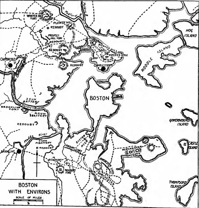 Boston and Surroundings During the Revolution (Based on map in G.O. Trevelyan, The American Revolution, Part I, at end).
Boston besieged.—The news of Lexington started thousands of New England volunteers toward Boston. John Stark led the New Hampshire men; Israel Putnam left his plow in the furrow to lead the Connecticut volunteers; and Nathanael Greene headed the Rhode Islanders. The volunteer forces in a few weeks were reinforced by large bodies of colonial troops. The Massachusetts congress voted to raise thirteen thousand six hundred men, and it called upon the other New England colonies to bring the army up to thirty thousand. The Rhode Island assembly voted to raise fifteen hundred men, and Connecticut six thousand, two-thirds of whom were to be sent to the aid of Boston. Gage, who had been reinforced with troops under Howe, Clinton, and Burgoyne, found his army of six or seven thousand veterans shut up in Boston by an undisciplined and poorly organized force, which, however, outnumbered him three or four to one.
Boston besieged.—The news from Lexington sent thousands of New England volunteers hurrying to Boston. John Stark led the New Hampshire men; Israel Putnam left his plow in the field to lead the Connecticut volunteers; and Nathanael Greene commanded the Rhode Islanders. Within a few weeks, the volunteer forces were bolstered by large groups of colonial troops. The Massachusetts congress voted to raise thirteen thousand six hundred men and asked the other New England colonies to increase the army to thirty thousand. The Rhode Island assembly decided to raise fifteen hundred men, while Connecticut planned to raise six thousand, with two-thirds of them sent to help Boston. Gage, who had received reinforcements with troops under Howe, Clinton, and Burgoyne, found his army of six or seven thousand veterans trapped in Boston by an untrained and poorly organized force that, however, outnumbered him three or four to one.
Bunker Hill.—The city was open to attack from Dorchester Heights and the Charlestown hills. To forestall the British, the colonials decided to occupy Bunker Hill. On the night of June 16 Colonel William Prescott was sent to fortify the position. For reasons which are not entirely clear, he led his men to Breed's Hill where a redoubt was constructed. When dawn disclosed the fortification, the warships and batteries opened fire. Prescott asked for reinforcements and small detachments came to his assistance. A British council of war was called. Clinton suggested the seizure of the causeway on Charlestown neck, a movement which would have cut off the colonial force from the mainland. But Gage and Howe, underestimating the fighting ability of their opponents, foolishly insisted upon a frontal attack. Twice the British were repulsed with staggering losses, but during the third charge the colonials exhausted their ammunition and were forced to retreat, first to Bunker Hill and then[Pg 462] back to their own lines. Though the colonials technically had suffered a defeat, great was the rejoicing over the battle, for colonial troops had proven their prowess against the British regulars and had taken a toll of two for one.
Bunker Hill.—The city was vulnerable to attack from Dorchester Heights and the hills of Charlestown. To prevent the British from advancing, the colonials decided to take control of Bunker Hill. On the night of June 16, Colonel William Prescott was tasked with strengthening the position. For reasons that aren’t completely clear, he led his men to Breed’s Hill, where they built a redoubt. When dawn revealed the fortification, the warships and batteries started firing. Prescott requested reinforcements, and small groups came to help him. A British council of war was convened. Clinton proposed taking the causeway on Charlestown neck, which would have cut off the colonial forces from the mainland. However, Gage and Howe, underestimating their opponents’ fighting capabilities, stubbornly insisted on a direct assault. The British were repelled twice, suffering significant losses, but during the third charge, the colonials ran out of ammunition and had to fall back, first to Bunker Hill and then[Pg 462] to their own lines. Although the colonials technically faced defeat, there was much celebration after the battle, as colonial troops had showcased their abilities against the British regulars, inflicting losses of two-to-one.
Ticonderoga and Crown Point—While the troops were gathering about Boston, it occurred to Benedict Arnold that Ticonderoga would be an easy prize. He submitted his ideas to Warren and the committee of safety, who authorized him to proceed with not over four hundred men to reduce the fort. On the way to Boston Arnold had divulged his thoughts to certain Connecticut friends who immediately organized an expedition with the same object. Ethan Allen and others from the Hampshire grants had also conceived the idea of capturing the fortress and were on the march when joined by Arnold, who had gone forward ahead of his troops. Immediately the question of rank arose and after considerable discussion Allen and Arnold agreed to command jointly for the time being.
Ticonderoga and Crown Point—While the troops were gathering around Boston, Benedict Arnold realized that Ticonderoga would be an easy target. He shared his ideas with Warren and the safety committee, who gave him the go-ahead to proceed with no more than four hundred men to take the fort. On the way to Boston, Arnold had shared his thoughts with some friends from Connecticut, who quickly organized an expedition with the same goal. Ethan Allen and others from the Hampshire grants also had the idea of capturing the fortress and were on their way when they met up with Arnold, who had gone ahead of his troops. Right away, the issue of rank came up, and after some discussion, Allen and Arnold agreed to jointly command for the time being.
On May 10 Ticonderoga surrendered without a struggle and this was followed by an easy conquest of Crown Point and Ft. George. By this time Allen completely ignored his colleague, but the arrival of about a hundred of Arnold's men gave him his opportunity. Having captured a British schooner Arnold decided to make a raid on St. Johns. The town was easily captured and a British sloop fell into the hands of the audacious colonial. The operations supplied the Whig army with much needed artillery and stores, and it opened the way for operations in Canada.
On May 10, Ticonderoga surrendered without a fight, which was quickly followed by an easy takeover of Crown Point and Fort George. By this point, Allen completely disregarded his colleague, but when about a hundred of Arnold's men arrived, he saw his chance. After capturing a British schooner, Arnold planned a raid on St. Johns. The town was quickly taken, and a British sloop was seized by the bold colonial. These actions provided the Whig army with much-needed artillery and supplies, and they paved the way for operations in Canada.
Rebellion in Virginia.—Virginia at the same time was in a state of rebellion. The second revolutionary convention assembled at Richmond in March, 1775, and Patrick Henry boldly sounded the call to arms. The governor, Lord Dunmore, in alarm ordered the removal of the gunpowder from the magazine at Williamsburg and soon several thousand armed men made ready to march on the capital. When some of the leaders hesitated, Henry placed himself at the head of an armed band and marched toward Williamsburg. The governor discreetly agreed to pay for the powder, but two days later (May 6, 1775) issued a proclamation charging the people "not to aid, abet, or give countenance to the said Patrick Henry, or any other persons concerned in such unwarrantable combinations." In May a[Pg 463] legal assembly was called but the members appeared in arms, and an attempted conciliation failed when it became known that a trap was prepared to kill any one who tampered with the magazine. Fearful of the mob, the governor fled to a war vessel.
Rebellion in Virginia.—Virginia was simultaneously in a state of rebellion. The second revolutionary convention met in Richmond in March 1775, and Patrick Henry boldly called for arms. In a panic, Governor Lord Dunmore ordered the removal of gunpowder from the magazine in Williamsburg, and soon thousands of armed men prepared to march on the capital. When some leaders hesitated, Henry took charge of an armed group and marched toward Williamsburg. The governor wisely agreed to pay for the gunpowder, but two days later (May 6, 1775) issued a proclamation urging the people "not to aid, support, or give any assistance to Patrick Henry or anyone else involved in such unjustified actions." In May, a[Pg 463]legal assembly was called, but the members showed up armed, and an attempted compromise failed when it became known that a trap was set to kill anyone who interfered with the magazine. Fearing the mob, the governor escaped to a warship.
The Mecklenburg Resolves.—The news of Lexington aroused every colony. South Carolina immediately raised two regiments. In North Carolina some of the frontiersmen held a meeting at Charlotte, Mecklenburg County, and passed resolutions that crown commissions in the colonies were null and void, and that colonial constitutions were suspended. They also made governmental regulations until Congress could provide laws for them. The original resolutions were destroyed and afterward were reproduced from memory in the form of the so-called "Mecklenburg Declaration of Independence" of May 20. Reliable historians now reject the authenticity of this document, but the original resolves were undoubtedly genuine.
The Mecklenburg Resolves.—The news from Lexington sparked a reaction in every colony. South Carolina quickly formed two regiments. In North Carolina, some frontiersmen gathered in Charlotte, Mecklenburg County, and passed resolutions stating that crown commissions in the colonies were null and void and that colonial constitutions were suspended. They also created governmental regulations until Congress could provide them with laws. The original resolutions were destroyed and later recreated from memory in what became known as the "Mecklenburg Declaration of Independence" on May 20. Reliable historians now dispute the authenticity of this document, but the original resolutions were certainly genuine.
THE SECOND CONTINENTAL CONGRESS
The delegates.—The Second Continental Congress assembled at Philadelphia on May 10, 1775, all but Georgia and Rhode Island being represented. On May 13 Lyman Hall, representing St. John's parish, Georgia, arrived, but not until July 20 was notice received that Georgia had acceded to the Association and appointed delegates. Stephen Hopkins, the first Rhode Island delegate to appear, arrived May 18. Peyton Randolph of Virginia was elected president, but he found it necessary to leave Congress on May 24, and John Hancock was chosen president. Most of the delegates had been in the first Congress; among the new members was Benjamin Franklin, who had recently returned from England; Thomas Jefferson was elected to represent Virginia in the place of Peyton Randolph.
The delegates.—The Second Continental Congress met in Philadelphia on May 10, 1775, with all states represented except Georgia and Rhode Island. On May 13, Lyman Hall arrived from St. John's parish in Georgia, but it wasn't until July 20 that they received word that Georgia had joined the Association and appointed delegates. Stephen Hopkins was the first delegate from Rhode Island, arriving on May 18. Peyton Randolph from Virginia was elected president, but he had to leave Congress on May 24, and John Hancock was then chosen as president. Most delegates had been part of the first Congress; among the new members was Benjamin Franklin, who had just returned from England, and Thomas Jefferson was elected to represent Virginia in place of Peyton Randolph.
Nature of the work of Congress.—The conservative Whigs were still in the majority. They favored another petition to the king, but the state of war was recognized by all and Congress shouldered the responsibility of directing the Revolution as a defensive war. The early activities of Congress were devoted mainly to the raising, organizing, and equipping of the armies,[Pg 464] to building and equipping a fleet, to perfecting the organization of the Revolution, to protecting the frontiers and obtaining alliances with the Indians, to enforcing the Association, to justifying the Revolution and seeking aid outside of the thirteen colonies, and to seeking redress from the British crown.
Nature of the work of Congress.—The conservative Whigs were still in the majority. They supported another petition to the king, but everyone acknowledged the state of war, and Congress took on the responsibility of guiding the Revolution as a defensive conflict. The early actions of Congress focused primarily on raising, organizing, and equipping the armies,[Pg 464] building and outfitting a fleet, refining the organization of the Revolution, protecting the frontiers and securing alliances with the Native Americans, enforcing the Association, justifying the Revolution, seeking support beyond the thirteen colonies, and requesting redress from the British crown.
Military preparations.—Congress worked strenuously to raise troops and to obtain munitions and other stores. Efforts were made to stimulate recruiting, to perfect the organization of the militia, and to hasten the assembling of forces. The manufacture of cannon, guns, and gunpowder was encouraged and attempts were made to increase the supplies of lead, nitre, and salt. Congress recommended to the various assemblies and conventions that they provide sufficient stores of ammunition for their colonies and that they devise means for furnishing with arms such effective men as were too poor to buy them.
Military preparations.—Congress worked hard to raise troops and secure weapons and other supplies. They made efforts to boost recruiting, improve the organization of the militia, and speed up the gathering of forces. The production of cannons, guns, and gunpowder was promoted, and efforts were made to increase supplies of lead, nitre, and salt. Congress advised the various assemblies and conventions to stockpile enough ammunition for their colonies and to find ways to equip capable men who couldn’t afford weapons.
Organization of the army.—The armies already in the field were recognized by Congress. On June 14 a committee was appointed to draft rules for the army and on the following day Washington was appointed to command the continental forces. Arrangements were soon made for the appointment of four major-generals, eight brigadier-generals, and minor officers. The first major-generals were Artemus Ward, Charles Lee, Philip Schuyler, and Israel Putnam, Schuyler being placed in command of the New York department. Rules and regulations for the army were also adopted and provision was made for the establishment of a hospital.
Organization of the army.—The armies already deployed were recognized by Congress. On June 14, a committee was formed to draft rules for the army, and the next day, Washington was appointed to lead the continental forces. Plans were quickly set in motion to appoint four major generals, eight brigadier generals, and other officers. The first major generals were Artemus Ward, Charles Lee, Philip Schuyler, and Israel Putnam, with Schuyler assigned to oversee the New York department. Rules and regulations for the army were also established, and provisions were made for setting up a hospital.
Organization of the navy.—For the protection of the coasts Congress at first depended upon the efforts of individual colonies, recommending that they make provision, by armed vessels or otherwise, for the protection of their harbors and navigation on their coasts. Colonial vessels were utilized to capture British transports, but it soon became evident that a navy under congressional control would be more effective. During October, 1775, Congress decided to fit out four vessels and on November 28 adopted rules for the regulation of the navy. On December 13 provision was made for the building of thirteen war craft and on the twenty-second officers were appointed. Ezek Hopkins was made commander-in-chief of the fleet; the captains were Dudley Saltonstall, Abraham Whipple, Nicholas Biddle, and[Pg 465] John B. Hopkins. Among the first-lieutenants was John Paul Jones.
Organization of the navy.—To protect the coasts, Congress initially relied on individual colonies, urging them to set up armed vessels or other means to safeguard their harbors and coastal navigation. Colonial ships were used to seize British transports, but it quickly became clear that a navy under congressional control would be more effective. In October 1775, Congress decided to outfit four vessels, and on November 28, they adopted rules for regulating the navy. On December 13, they made plans to build thirteen warships, and on the 22nd, officers were appointed. Ezek Hopkins became the commander-in-chief of the fleet, with captains Dudley Saltonstall, Abraham Whipple, Nicholas Biddle, and[Pg 465] John B. Hopkins. One of the first lieutenants was John Paul Jones.
Prizes and privateers.—On November 25 Congress adopted regulations regarding prizes, and advised the legislative bodies to erect admiralty courts or to give to the local courts admiralty jurisdiction. It also provided "That in all cases an appeal shall be allowed to Congress, or such person or persons as they shall appoint for the trials of appeals." In March, 1776, Congress resolved "That the inhabitants of these colonies be permitted to fit out armed vessels to cruize on the enemies of these United Colonies." In April Congress adopted a form of commission and instructions to commanders of privateers, and decided to issue letters of marque and reprisal.
Prizes and privateers.—On November 25, Congress approved regulations regarding prizes and recommended that the legislative bodies set up admiralty courts or grant admiralty jurisdiction to local courts. It also stated, "That in all cases, an appeal shall be allowed to Congress, or to such person or persons as they appoint for the trials of appeals." In March 1776, Congress decided, "That the inhabitants of these colonies be allowed to equip armed vessels to cruise against the enemies of these United Colonies." In April, Congress adopted a format for commissions and instructions for privateer commanders and chose to issue letters of marque and reprisal.
First steps in financing the Revolution.—The financing of the Revolution was one of the most difficult tasks confronting Congress. The first step in raising money was taken on June 3, 1775, when a committee was appointed to borrow £6,000 to purchase gunpowder. A committee was also appointed to bring in an estimate of money necessary to be raised. On June 22 Congress resolved to emit $2,000,000 in bills of credit and pledged the "confederated colonies" for their redemption. Once embarked upon the perilous course of paper finance, issue followed issue in rapid succession. At first the promissory notes passed readily, but they soon began to depreciate and eventually became worthless. Nevertheless they carried the Revolution through its most trying years.
First steps in financing the Revolution.—Financing the Revolution was one of the toughest challenges facing Congress. The initial effort to raise funds began on June 3, 1775, when a committee was created to borrow £6,000 to buy gunpowder. Another committee was also tasked with estimating how much money needed to be raised. On June 22, Congress decided to issue $2,000,000 in bills of credit and committed the "confederated colonies" to guarantee their repayment. Once they took the risky path of using paper currency, more issues followed quickly. Initially, the promissory notes circulated easily, but they soon started to lose value and eventually became worthless. Still, they helped carry the Revolution through its most challenging years.
Establishment of a post office.—The need of "speedy and secure conveyance of intelligence from one end of the Continent to the other" was recognized and a committee was appointed to consider the establishment of posts. On July 26 the post office was established, Benjamin Franklin being elected Postmaster General. He was authorized to establish "a line of posts ... from Falmouth in New England to Savannah in Georgia, with as many cross posts as he shall think fit."
Establishment of a post office.—The necessity for "fast and reliable communication from one end of the continent to the other" was acknowledged, and a committee was formed to look into setting up postal services. On July 26, the post office was launched, with Benjamin Franklin being chosen as Postmaster General. He was given the authority to establish "a network of post routes ... from Falmouth in New England to Savannah in Georgia, along with as many additional routes as he deems appropriate."
An Indian policy adopted.—Control of the Indians was vital for the safety of the frontier. It was felt that if the British ministry should induce the tribes to commit hostile acts, the colonies would be justified in entering into alliances with Indian nations. It was hoped that the Iroquois might be kept neutral.[Pg 466] "Talks" were prepared, goods to be used as presents were purchased, and money was provided. The frontier was laid off into three departments which were placed under commissioners. The Six Nations and tribes to the north of them were in the northern department; tribes between the Iroquois and the Cherokee were in the middle department; and the Cherokee and Indians south of them were in the southern department.
An Indian policy was adopted. Controlling the Native Americans was crucial for the safety of the frontier. It was believed that if the British government encouraged the tribes to act violently, the colonies would be justified in making alliances with Native nations. There was hope that the Iroquois could remain neutral.[Pg 466] "Talks" were organized, gifts were bought, and funds were allocated. The frontier was divided into three departments, each overseen by commissioners. The Six Nations and nearby tribes were part of the northern department; the tribes located between the Iroquois and the Cherokee were in the middle department; and the Cherokee and tribes to the south were in the southern department.
Enforcement of the Association.—Congress continued the policy of trade restriction. On May 17 it resolved that exports to Quebec, Nova Scotia, the Island of St. Johns, Newfoundland, Georgia except St. John's parish, and to East and West Florida, must cease, and that supplies must not be furnished to the British fisheries. After Georgia appointed delegates, the colony was admitted to the Association. On June 2 Congress resolved that no bill of exchange, draught, or order of any British officer should be honored, and that no money, provisions, or other necessaries be furnished the British army or navy.
Enforcement of the Association.—Congress continued the policy of trade restrictions. On May 17, it decided that exports to Quebec, Nova Scotia, Prince Edward Island, Newfoundland, Georgia (except for St. John's parish), and East and West Florida must stop, and that supplies should not be provided to British fisheries. After Georgia appointed delegates, the colony was included in the Association. On June 2, Congress resolved that no bill of exchange, draft, or order from any British officer should be accepted, and that no money, provisions, or other essentials be supplied to the British army or navy.
On June 26 Congress resolved that, as attempts were being made to divide the people of North Carolina and defeat the Association, it was recommended to that colony to associate for the defence of American liberty and to organize the militia, Congress offering to provide pay for a thousand men in the colony. On July 4 a resolution was adopted that the restraining acts were "unconstitutional, oppressive, and cruel," and that commercial opposition should be made to them.
On June 26, Congress decided that since there were efforts to divide the people of North Carolina and undermine the Association, they recommended that the colony unite to defend American liberty and organize the militia, with Congress offering to pay for a thousand men in the colony. On July 4, a resolution was passed stating that the restraining acts were "unconstitutional, oppressive, and cruel," and that there should be commercial resistance against them.
As doubts had arisen with respect to the true spirit and construction of the Association, on August 1 Congress defined it as follows: "Under the prohibition ... to export to, or import from, the Islands of Great Britain and Ireland, this Congress intends to comprise all exportation to, and importation from, the islands of Jersey, Guernsey, Sark, Alderney, and Mann, and every European island and settlement within the British dominions: and that under the denomination of the West Indies, this Congress means to comprehend all the West India islands, British and foreign, to whatever state, power, or prince belonging, or by whomsoever governed, and also the Summer islands, Bahama Islands, Berbicia and Surinam on the Main, and every island and settlement within the latitude of the southern line of Georgia and the Equator."
As doubts had come up about the true purpose and interpretation of the Association, on August 1 Congress defined it as follows: "Under the prohibition ... to export to, or import from, the Islands of Great Britain and Ireland, this Congress intends to include all exports to, and imports from, the islands of Jersey, Guernsey, Sark, Alderney, and Mann, as well as every European island and settlement within the British territories: and that under the term West Indies, this Congress means to include all the West Indian islands, both British and foreign, regardless of which state, power, or prince owns them or oversees them, and also the Summer Islands, Bahama Islands, Berbicia and Surinam on the mainland, along with every island and settlement located between the southern border of Georgia and the Equator."
[Pg 467] The necessity of obtaining supplies forced Congress to make special provisions for the importation of munitions of war. On July 15, 1775, a resolution was adopted that "every vessel importing Gun powder, Salt petre, Sulphur, provided they bring with the sulphur four times as much salt petre, brass field pieces, or good muskets fitted with Bayonets, within nine Months from the date of this resolution, shall be permitted to load and export the produce of these colonies, to the value of such powder and stores aforesd, the non-exportation agreement notwithstanding." On November 2 Congress adopted a resolution to close the ports until March 1, but from time to time special provisions were made for the exportation and importation of goods. The delegates frequently discussed the question of opening the ports, as shown by John Adams's Autobiography which says: "This measure ... labored exceedingly, because it was considered as a bold step to independence. Indeed, I urged it expressly with that view, and as connected with the institution of government in all the States, and a declaration of national independence." On April 6, 1776, the ports were opened to world commerce except trade with Great Britain and her possessions.
[Pg 467] The need for supplies led Congress to make special arrangements for importing weapons. On July 15, 1775, they adopted a resolution stating that "every ship bringing Gunpowder, Saltpeter, or Sulfur, provided they also bring four times as much Saltpeter with the Sulfur, brass field pieces, or quality muskets equipped with Bayonets, within nine months from this resolution's date, will be allowed to load and export the produce of these colonies, up to the equivalent value of the powder and supplies mentioned, despite the non-exportation agreement." On November 2, Congress passed a resolution to close the ports until March 1, but occasionally made special provisions for the import and export of goods. The delegates regularly debated the opening of the ports, as noted in John Adams's Autobiography, which states: "This measure ... faced a lot of challenges because it was viewed as a bold move toward independence. In fact, I pushed for it specifically for that reason, linking it to the establishment of government in all the States, and a declaration of national independence." On April 6, 1776, the ports were opened to global trade except for trade with Great Britain and its territories.
Letter to the people of Canada.—The congressional leaders hoped to strengthen their resistance by obtaining the coöperation of the Canadians. A letter "to the oppressed inhabitants of Canada" was approved on May 29. Congress condoled with them "on the arrival of that day, in the course of which, the sun could not shine on a single freeman in all your extensive dominion.... By the introduction of your present form of government, or rather present form of tyranny, you and your wives and your children are made slaves.... We are informed you have already been called upon to waste your lives in a contest with us. Should you, by complying in this instance, assent to your new establishment [the Quebec Act], and a war break out with France, your wealth and your sons may be sent to perish in expeditions against their islands in the West Indies. We yet entertain hopes of your uniting with us in the defence of our common liberty."
Letter to the people of Canada.—The congressional leaders wanted to strengthen their resistance by gaining the cooperation of Canadians. A letter "to the oppressed inhabitants of Canada" was approved on May 29. Congress expressed sympathy with them "on the arrival of that day, during which, the sun could not shine on a single freeman in all your vast territory... With your current form of government, or rather your current form of tyranny, you and your wives and your children are made slaves... We have been informed you have already been urged to waste your lives in a conflict with us. If you comply in this case and accept your new establishment [the Quebec Act], and a war breaks out with France, your wealth and your sons could be sent to perish in missions against their islands in the West Indies. We still hope you will join us in the defense of our shared liberty."
Attempts to influence public opinion in the British Empire.—Congress hoped by appeals to the inhabitants of the British Isles to arouse public opinion, thereby bringing pressure to bear[Pg 468] upon a Ministry and subservient parliament which had shown themselves to be irresponsible and tyrannous. Addresses to the people of Great Britain and Ireland were accordingly prepared. A letter to the Lord Mayor, aldermen, and liveries of London was drawn up expressing thanks "for the virtuous and unsolicited resentment you have shown to the violated rights of a free people." A letter of friendship was sent to the assembly of Jamaica and a communication regarding commerce was sent to Bermuda.
Attempts to influence public opinion in the British Empire.—Congress hoped to stimulate public opinion in the British Isles by appealing to its inhabitants, aiming to pressure a government and a submissive parliament that had proven to be irresponsible and oppressive. Addresses aimed at the people of Great Britain and Ireland were prepared. A letter was drafted to the Lord Mayor, aldermen, and citizens of London, expressing gratitude "for the honorable and unsolicited anger you have shown towards the violated rights of a free people." A friendly letter was sent to the assembly of Jamaica, along with a message regarding commerce to Bermuda.
Statement to the army.—On July 6 Congress approved a declaration setting forth the causes and necessity of taking up arms, which was to be published by Washington upon his arrival at Boston. The declaration presented the usual arguments regarding constitutional rights and gave an account of the progress of events. That independence was desired was denied in the following words: "We have not raised armies with ambitious designs of separating from Great Britain, and establishing independent states. We fight not for glory or for conquest.... In our own native land, in defence of the freedom that is our birth right,... and for the protection of our property ... we have taken up arms."
Statement to the army.—On July 6, Congress approved a declaration explaining the reasons and necessity for taking up arms, which Washington was to publish upon his arrival in Boston. The declaration presented the usual arguments about constitutional rights and detailed the progress of events. The desire for independence was dismissed with the following words: "We have not raised armies with ambitious goals of breaking away from Great Britain and creating independent states. We are not fighting for glory or conquest.... We are fighting for our homeland, to defend the freedom that is our birthright,... and to protect our property... we have taken up arms."
Petition to the king.—The radicals believed that a war of independence could not be avoided, but the conservatives restrained them, hoping that the force of public opinion, a bold show of resistance, and commercial restrictions would change the ministerial policy. Another direct appeal to the king was decided upon and on May 29 resolutions were adopted, "that with a sincere design of contributing by all the means in our power, not incompatible with just regard for the undoubted rights and true interests of these colonies, to the promotion of this most desirable reconciliation, an humble and dutiful petition be presented to his Majesty." The petition, signed on July 8, was couched in respectful terms as the following quotation shows: "We ... beseech your Majesty, that your royal authority and influence may be graciously interposed to procure us relief from our afflicting fears and jealousies, occasioned by the system before mentioned, and to settle peace through every part of your dominions, with all humility submitting to your Majesty's wise consideration whether it may not be expedient[Pg 469] for facilitating those important purposes, that your Majesty be pleased to direct some mode, by which the united applications of your faithful colonists to the throne, in pursuance of their common councils, may be improved into a happy and permanent reconciliation; and that, in the mean time, measures may be taken for preventing the further destruction of the lives of your Majesty's subjects; and that such statutes as more immediately distress any of your Majesty's colonies may be repealed."
Petition to the king.—The radicals believed that a war for independence was unavoidable, but the conservatives held them back, hoping that public opinion, a strong display of resistance, and trade restrictions would change the government's policy. Another direct appeal to the king was agreed upon, and on May 29, resolutions were passed stating, "that with a sincere intention to contribute by all means available, without compromising the undeniable rights and true interests of these colonies, to promote this much-desired reconciliation, a humble and respectful petition be presented to his Majesty." The petition, signed on July 8, was written in respectful language as shown in the following quote: "We ... earnestly request your Majesty, that your royal authority and influence may be graciously used to help us find relief from our troubling fears and concerns caused by the aforementioned system, and to establish peace throughout all your territories, humbly submitting to your Majesty's wise judgment whether it might be helpful[Pg 469] to facilitate those important goals by directing some means through which the united petitions of your loyal colonists to the throne, following their common decisions, may be turned into a happy and lasting reconciliation; and that, in the meantime, actions may be taken to prevent further loss of life among your Majesty's subjects; and that any laws that particularly distress any of your Majesty's colonies may be repealed."
Reply to Lord North.—As several of the colonies were desirous of knowing the congressional attitude toward Lord North's conciliatory resolution, on July 31 Congress adopted a formal report which closed with the following statement: "When the world reflects how inadequate to justice are these vaunted terms; when it attends to the rapid and bold succession of injuries, which have been aimed at these colonies, when it reviews the pacific and respectful expostulations, which ... were the sole arms we opposed to them; when it observes that our complaints were either not heard at all, or were answered with new and accumulated injury,... when it considers the great armaments with which they have invaded us, and the circumstances of cruelty with which they have commenced and prosecuted hostilities; when these things we say, are laid together and attentively considered, can the world be deceived into an opinion that we are unreasonable, or can it hesitate to believe with us, that nothing but our own exertions may defeat the ministerial sentence of death or abject submission."
Reply to Lord North.—Since many of the colonies wanted to understand Congress's stance on Lord North's conciliatory resolution, on July 31, Congress issued a formal report that concluded with this statement: "When the world reflects on how inadequate these supposed terms are for justice; when it notices the quick and bold series of injuries directed at these colonies; when it reviews the peaceful and respectful protests, which ... were the only weapons we used against them; when it observes that our complaints were either ignored completely or replied to with further and increased harm,... when it considers the large military forces with which they have attacked us, and the cruel ways they've started and continued hostilities; when all these points are brought together and carefully examined, can the world be fooled into thinking that we are unreasonable, or can it doubt that only our own efforts can overcome the ministerial sentence of death or total submission."
Stubborn attitude of the government.—George III and his ministers had gained no wisdom from the rebellious attitude in America. The petition, which had been entrusted to Richard Penn, reached London on August 14, but not until a week later did Lord Dartmouth, the secretary for the colonies, consent to look at a copy of the document and not until September was it presented to the king. On August 23 George III published a proclamation which declared the Americans rebels, and after his examination of the petition, the king saw no reason for revising it. At the next session of parliament acts were passed which prohibited trade with the thirteen colonies, ordered the seizure and confiscation of ships engaged in trade with them,[Pg 470] and permitted British commanders to impress sailors from seized vessels.
Stubborn attitude of the government.—George III and his ministers hadn’t learned anything from the rebellious behavior in America. The petition, which was given to Richard Penn, arrived in London on August 14, but it wasn’t until a week later that Lord Dartmouth, the secretary for the colonies, agreed to look at a copy of the document, and it wasn’t presented to the king until September. On August 23, George III issued a proclamation declaring the Americans as rebels, and after reviewing the petition, the king saw no reason to change his stance. In the next session of parliament, laws were passed that banned trade with the thirteen colonies, ordered the seizure and confiscation of ships trading with them,[Pg 470] and allowed British commanders to force sailors from seized vessels into service.
The German mercenaries.—A reorganization of the cabinet had forced the amiable Dartmouth out of the colonial office, his successor being Lord George Germaine. Lord Rochford was made secretary of state for the southern department, and Lord Suffolk was retained in the northern department to which office fell the business with Germany. The British army was sadly in need of recruits. In Scotland the men of Argyllshire and Inverness-shire readily entered the army for colonial service, but in Ireland and England the people showed little enthusiasm for a war which was intended to subdue their freedom-loving brethren over the seas. To raise the necessary troops the king turned to the continent. An attempt to obtain the use of the Scotch troops which had long been in Dutch service failed and Catherine II refused to furnish Russian infantry, but in Germany British overtures met with better success. The Landgrave of Hesse-Cassel, the Duke of Brunswick, and some other needy princes were willing to sell the services of their subjects for British gold. During the war over thirty thousand mercenaries were hired in Germany for service in America. In the words of Lecky, "The conduct of England in hiring German mercenaries to subdue the essentially English population beyond the Atlantic, made reconciliation hopeless, and the Declaration of Independence inevitable."
The German mercenaries.—A reshuffling of the cabinet had pushed the friendly Dartmouth out of the colonial office, replaced by Lord George Germaine. Lord Rochford became the secretary of state for the southern department, while Lord Suffolk stayed in the northern department, which handled affairs with Germany. The British army was desperately in need of new recruits. In Scotland, the men from Argyllshire and Inverness-shire eagerly joined the army for colonial service, but in Ireland and England, people showed little excitement for a war meant to subdue their freedom-loving brothers across the ocean. To gather the necessary troops, the king looked to the continent. An effort to use the Scottish troops that had been in Dutch service for a long time failed, and Catherine II turned down a request for Russian infantry, but British proposals had better luck in Germany. The Landgrave of Hesse-Cassel, the Duke of Brunswick, and some other cash-strapped princes were willing to sell the services of their subjects for British money. During the war, over thirty thousand mercenaries were hired in Germany for service in America. In the words of Lecky, "The conduct of England in hiring German mercenaries to subdue the essentially English population beyond the Atlantic made reconciliation hopeless and the Declaration of Independence inevitable."
PROGRESS OF THE WAR
Burning of Falmouth.—Events were also taking place in America which were convincing the public that the war for independence must be fought to the bitter end. In October, 1775, four British war vessels sailed into the harbor of Falmouth, now known as Portland, and set fire to the town. Three-fourths of the dwellings were destroyed and a thousand unoffending people were made homeless.
Burning of Falmouth.—Events were also happening in America that made it clear to the public that the war for independence had to be fought to the very end. In October 1775, four British warships entered the harbor of Falmouth, now called Portland, and set the town on fire. Three-quarters of the homes were destroyed, leaving a thousand innocent people homeless.
The Canadian campaign.—The efforts of Congress to enlist the Canadians in the colonial cause did not meet with success and the invasion of Canada was determined upon. Two forces were sent northward. One under Richard Montgomery was to proceed by the Lake Champlain route, seize Montreal, and then[Pg 471] march to Quebec. The other under Benedict Arnold was to go up the Kennebec and down the Chaudière, and join the other force. Montgomery captured Montreal and then made a juncture with Arnold. On December 31 an attack was made on Quebec, but Montgomery was killed, Arnold was wounded, and the forces were repulsed. But in spite of terrible sufferings in his army, Arnold kept Quebec in a state of blockade the rest of the winter.
The Canadian campaign.—Congress's attempts to recruit Canadians for the colonial cause were unsuccessful, leading to a decision to invade Canada. Two forces were sent north. One, led by Richard Montgomery, was to take the Lake Champlain route, capture Montreal, and then[Pg 471] march to Quebec. The other force, commanded by Benedict Arnold, was to travel up the Kennebec River and down the Chaudière to join Montgomery's troops. Montgomery seized Montreal and then joined forces with Arnold. On December 31, they launched an attack on Quebec, but Montgomery was killed, Arnold was injured, and their troops were pushed back. Despite the harsh conditions faced by his army, Arnold maintained a blockade of Quebec for the remainder of the winter.
Siege of Boston.—When Washington arrived at Cambridge, he found a disorganized army which was short of food, ammunition, and uniforms, and without hospital service. Fortunately the British did not take advantage of the situation, and gradually the commander brought order out of chaos. By March, 1776, Washington was prepared to make an offensive move. Taking advantage of the fact that the British had not fortified Dorchester Heights, on the night of March 4 colonial troops seized the position which commanded Boston. On the seventeenth the British army, accompanied by about a thousand Loyalists, sailed for Halifax.
Siege of Boston.—When Washington arrived at Cambridge, he found a disorganized army that was low on food, ammunition, and uniforms, and lacked hospital services. Luckily, the British did not exploit the situation, and gradually the commander restored order. By March 1776, Washington was ready to take action. Taking advantage of the fact that the British hadn't fortified Dorchester Heights, on the night of March 4, colonial troops took control of the position that overlooked Boston. On the seventeenth, the British army, along with about a thousand Loyalists, sailed for Halifax.
Fighting in Virginia and North Carolina.—While Washington was besieging Boston, Lord Dunmore was making reprisals along the Virginia rivers. After the defeat of some of his Loyalist supporters at Great Bridge, the governor caused the burning of Norfolk on January 1, 1776. North Carolina was also torn by civil war. Governor Martin had been driven from the colony, and from the refuge of a war vessel commissioned Donald McDonald to collect an army of Loyalists in the central and western counties. He also appealed to Sir Henry Clinton for aid. With a force of sixteen hundred men McDonald marched toward the coast, but on February 27, 1776, he was met by patriot forces at Moore's Creek and his Loyalist army was practically annihilated. When Clinton's fleet appeared off the coast, ten thousand North Carolina militia were ready to meet him. Clinton lingered for a time off Cape Fear and then sailed to Charleston where he hoped to arouse the Loyalists of the coasts and the German settlers of the interior.
Fighting in Virginia and North Carolina.—While Washington was laying siege to Boston, Lord Dunmore was retaliating along the rivers in Virginia. After some of his Loyalist supporters were defeated at Great Bridge, the governor ordered the burning of Norfolk on January 1, 1776. North Carolina was also torn apart by civil war. Governor Martin had been forced to flee the colony, and from the safety of a warship, he commissioned Donald McDonald to gather an army of Loyalists from the central and western counties. He also reached out to Sir Henry Clinton for assistance. With a force of sixteen hundred men, McDonald marched toward the coast, but on February 27, 1776, he encountered patriot forces at Moore's Creek, and his Loyalist army was nearly wiped out. When Clinton's fleet arrived off the coast, ten thousand militia from North Carolina were ready to confront him. Clinton stayed for a while off Cape Fear and then sailed to Charleston, where he hoped to rally the Loyalists along the coasts and the German settlers in the interior.
Defence of Charleston.—Edward Rutledge with six thousand militia prepared to defend the city. Colonel Moultrie, with his forces back of rude fortifications on Sullivan's Island, made[Pg 472] ready to defend the harbor. On June 28 the fleet attacked. Most of the British shot buried themselves in the palmetto logs and banks of sand from behind which Moultrie's men poured a fire which wrought havoc on the crowded decks. An attempt to make a landing proved a failure and Charleston was saved.
Defence of Charleston.—Edward Rutledge, along with six thousand militia, got ready to protect the city. Colonel Moultrie, with his troops behind makeshift fortifications on Sullivan's Island, prepared to defend the harbor. On June 28, the fleet launched an attack. Most of the British cannonballs got stuck in the palmetto logs and sandy banks, while Moultrie's men fired back, causing chaos on the crowded decks. An attempt to land failed, and Charleston was saved.
THE LOYALISTS
The people not united.—Up to 1774 the majority of Americans were not united in opposition to British policy, but acts of violence and retaliation, the meeting of Congress, and the organization of revolutionary committees, brought about a rapid crystallization of public opinion. Loyalty to Great Britain was the normal state. The Whigs were the nullifiers and eventually the secessionists. That they were able to perfect an organization and carry on a successful rebellion has obscured the fact that they were in reality but an active minority. The masses were indifferent or were loyal supporters of Great Britain. It is impossible to estimate accurately the number of Loyalists; they varied with localities and fluctuated with the fortunes of war. Some historians estimate them as a third of the population, others as one-half.
The people not united.—Up to 1774, most Americans weren’t united in their opposition to British policy. However, acts of violence and retaliation, along with the meeting of Congress and the formation of revolutionary committees, quickly shaped public opinion. Loyalty to Great Britain was the norm. The Whigs were the ones who opposed the British and eventually sided with the secessionists. The fact that they managed to organize and lead a successful rebellion has overshadowed the reality that they were really just an active minority. Most people were either indifferent or were loyal supporters of Great Britain. It's hard to accurately gauge the number of Loyalists; their numbers varied by location and changed with the tides of war. Some historians estimate that they made up a third of the population, while others put the figure at one-half.
The Tory element in the colonies.—The great Loyalist stronghold was New York. There the moderate Tories had controlled the situation for several years. They had favored the assembling of the First Continental Congress, but when that body adopted the Association, they opposed it. After the battle of Lexington the Whigs grew in power and succeeded in setting up a provincial congress. But several counties remained Loyalist, and until the occupation of New York City by British troops a state of civil war existed in the province. After that event the British lines furnished a refuge for Tories from all the colonies.
The Tory presence in the colonies.—New York was the main stronghold for Loyalists. There, moderate Tories had been in control for several years. They had supported the gathering of the First Continental Congress, but when that assembly adopted the Association, they were against it. After the battle of Lexington, the Whigs gained power and managed to establish a provincial congress. However, several counties still remained Loyalist, and a civil war was ongoing in the province until British troops occupied New York City. After that, the British lines provided a safe haven for Tories from all the colonies.
Next to New York Pennsylvania contained the largest Tory element. There the Quakers, the proprietary interests, and a large German population combined to oppose the Whig movement. In New Jersey, Maryland, and Delaware, the Tory element was so numerous that only with the greatest difficulty did the Whigs obtain the support of those colonies for independence. In New England the Loyalists were not powerful. In Massachusetts, New Hampshire, and Rhode Island they formed an[Pg 473] insignificant part of the population, but in the region which afterward became the state of Vermont and in Connecticut they were numerous enough to be a menace.
Next to New York, Pennsylvania had the largest number of Loyalists. There, the Quakers, proprietary interests, and a large German population came together to oppose the Whig movement. In New Jersey, Maryland, and Delaware, the Loyalist presence was so considerable that the Whigs struggled greatly to gain support from those colonies for independence. In New England, the Loyalists were not a strong force. In Massachusetts, New Hampshire, and Rhode Island, they made up a[Pg 473]small part of the population, but in the area that later became Vermont and in Connecticut, they were numerous enough to be a threat.
In the South, Virginia was dominated by the Whigs. The impolitic acts of Lord Dunmore had alienated all but a small element of the population. The Scotch merchants of Norfolk and many planters had supported the governor, but his reprisals on the coast, his proclamation offering freedom to negroes and indented servants who would enlist, and the burning of Norfolk destroyed the Tory power in the province. North Carolina, which had recently been torn by the War of the Regulators was probably about equally divided, and in South Carolina and Georgia the farmers and cattlemen of the interior were usually Loyalists; but the British naval demonstrations and the defeat of Tory bands did much to win converts to the Whig cause in the three southern colonies.
In the South, Virginia was primarily controlled by the Whigs. The unwise actions of Lord Dunmore had pushed away almost everyone except a small part of the population. The Scottish merchants in Norfolk and many planters had backed the governor, but his attacks along the coast, his announcement offering freedom to enslaved people and indentured servants who would join the fight, and the burning of Norfolk wiped out Tory influence in the area. North Carolina, which had recently been shaken by the War of the Regulators, was probably about evenly split, and in South Carolina and Georgia, farmers and cattlemen from the interior were typically Loyalists; however, the British naval show of force and the defeat of Loyalist groups did a lot to sway people to the Whig side in the three southern colonies.
A classification of the Loyalists.—The Loyalists, or Tories as they were called in derision, have been classified by Professor Van Tyne as the office holders whose incomes depended upon the existing régime; those whose friends were among the official class or who depended upon that class for preferment; the majority of the Anglican clergy; the conservative people of all classes, especially the wealthy merchants, the aristocracy of culture, of dignified professions and callings, and of hereditary wealth, and those who held office by virtue of wise selection; the king worshipers, who were moved by theory of government rather than by concrete facts; the legality Tories who believed that parliament had a constitutional right to tax the colonies; the religious Tories whose dictum was fear God and honor the king; and the factional Tories who were influenced by family feuds and political animosities.
A classification of the Loyalists.—The Loyalists, or Tories as they were mockingly called, have been categorized by Professor Van Tyne as the office holders whose incomes relied on the current regime; those whose friends were part of the official class or who depended on that class for advancement; the majority of the Anglican clergy; conservative individuals across all classes, particularly wealthy merchants, the elite of culture, respectable professions and careers, and inherited wealth, as well as those who held office through wise choices; the king worshipers, who were motivated by government theory rather than real-life situations; the legality Tories who believed Parliament had the constitutional right to tax the colonies; the religious Tories whose principle was to fear God and honor the king; and the factional Tories who were swayed by family rivalries and political grudges.
The religious division.—The religious factor was one of the most important causes of division. An Anglican bishopric for the colonies had long been contemplated and the dissenting churches believed that the ministry was about to urge its establishment. In New England where the Congregational church was in the ascendency and in those sections where the Presbyterians and Baptists were powerful, the establishment of an episcopate was especially feared. Already the Anglican church[Pg 474] numbered three hundred parishes in America. Throughout the colonies it was the church of the official class and in the South it was the church of the aristocracy. The southern Episcopalians were divided on the paramount political questions, but in New York the religious and political parties coincided. New York politics for many years had been factional, the De Lanceys who were Episcopalians being leaders in invariable opposition to the Livingstons who were Presbyterians. Both in New York and Connecticut those of the Episcopal faith were almost invariably Loyalists.
The religious division.—The religious factor was one of the most important causes of division. An Anglican bishopric for the colonies had long been considered, and the dissenting churches believed that the ministry was about to push for its establishment. In New England, where the Congregational church was dominant, and in areas where the Presbyterians and Baptists were strong, the establishment of an episcopate was especially feared. Already, the Anglican church[Pg 474] had three hundred parishes in America. Throughout the colonies, it was the church of the official class, and in the South, it was the church of the aristocracy. The southern Episcopalians were divided on the major political issues, but in New York, the religious and political parties aligned. New York politics had been factional for many years, with the De Lanceys, who were Episcopalians, consistently opposing the Livingstons, who were Presbyterians. In both New York and Connecticut, those of the Episcopal faith were almost always Loyalists.
The Tory argument.—The Tories believed in no taxation without representation, but they differed with the Whigs in their interpretation of the word representation. The Tories accepted the English meaning which was based upon the idea that a man enjoyed representation not by the fact that he had voted for a member of parliament but by his belonging to one of the three great estates of the nation, each estate being represented in parliament. They admitted that this was an imperfect type of representation, but it was the ancient constitutional type. They believed that the relationship of the colonies to the mother country should be defined more clearly, but they did not believe that the Whigs had a right to demand a fundamental change in the constitution of the British Empire.
The Tory argument.—The Tories believed in no taxation without representation, but they disagreed with the Whigs on what representation meant. The Tories accepted the English definition, which was based on the idea that a man had representation not just because he voted for a member of parliament, but due to his belonging to one of the three major estates of the nation, each of which was represented in parliament. They acknowledged that this was an imperfect form of representation, but it was the traditional constitutional type. They thought that the relationship between the colonies and the mother country needed to be defined more clearly, but they did not believe that the Whigs had the right to demand a fundamental change in the constitution of the British Empire.
Moses Coit Tyler has pointed out that the other Tory arguments were based upon questions of expediency, (1) Was it expedient to reject the taxing power of parliament? (2) Was separation from the empire expedient? The Whigs argued that parliamentary taxes might become confiscatory. The Tories replied that parliament recognized the principle that all parts of the empire should be taxed equitably and justly, and that a powerful minority, which counted among its members Fox and Burke, were bent upon protecting the colonies. The Tories could see no reason for separation. They pointed out that until the beginning of 1776 the Whigs had consistently disavowed the idea of independence. Why then this sudden change? The Tories believed that concessions were about to be made which would make separation unnecessary and undesirable.
Moses Coit Tyler has pointed out that the other Tory arguments were based on questions of practicality: (1) Was it practical to reject the taxing power of Parliament? (2) Was separation from the empire practical? The Whigs argued that parliamentary taxes could become confiscatory. The Tories countered that Parliament recognized the principle that all parts of the empire should be taxed fairly and justly, and that a strong minority, which included members like Fox and Burke, was committed to protecting the colonies. The Tories saw no reason for separation. They noted that until early 1776, the Whigs had consistently denied the idea of independence. So why this sudden change? The Tories believed that concessions were on the way that would make separation unnecessary and undesirable.
Persecution of the Loyalists.—After Lexington the Loyalists became intolerable to the Whigs. They must show their allegiance[Pg 475] to the patriot cause or suffer the consequences. The favorite method of persecution was tarring and feathering, but riding the Tory on the liberty pole or ducking occurred frequently. Under the direction of the revolutionary committees freedom of speech was suppressed and the liberty of the press was destroyed. Any one who opposed the Association was considered an enemy; he must agree or be persecuted. When the Loyalists attempted to form counter associations, they were met with stern methods of repression. Whig clergymen held conferences in Loyalist communities to try to convert them, and obdurate places were visited by armed bands. When the Tories attempted to arm, their leaders were seized.
Persecution of the Loyalists.—After Lexington, the Loyalists became a major annoyance to the Whigs. They had to show their loyalty to the patriot cause or face the consequences. The common way of persecution was tarring and feathering, but riding the Tory on the liberty pole or ducking also happened frequently. With the revolutionary committees in charge, freedom of speech was stifled, and the freedom of the press was crushed. Anyone who opposed the Association was seen as an enemy; they had to conform or face persecution. When the Loyalists tried to create counter associations, they were met with harsh suppression. Whig clergymen held meetings in Loyalist areas to try to convert them, and stubborn places were targeted by armed groups. When the Tories tried to arm themselves, their leaders were captured.
Congress attempts to control the Loyalists.—The Loyalists were lacking in organization, and when the governors were driven from the colonies, they lost their natural leaders. When calls for aid came from the deposed officials, many Tories formed bands and attempted to coöperate with the British forces. So serious was the situation that Congress, as early as October, 1775, recommended to the revolutionary governments that they arrest every person who might endanger the colonies or "the liberties of America." On December 30 a congressional committee reported that the Tories of Tryon County, New York, had collected arms and munitions, and that several Loyalists had enlisted in British service. Orders were issued to General Schuyler to seize the stores, disarm the Tories, and apprehend their leaders.
Congress attempts to control the Loyalists.—The Loyalists were disorganized, and when the governors were ousted from the colonies, they lost their natural leaders. When requests for help came from the deposed officials, many Tories formed groups and tried to work with the British forces. The situation was so serious that Congress, as early as October 1775, recommended to the revolutionary governments that they arrest anyone who might threaten the colonies or "the liberties of America." On December 30, a congressional committee reported that the Tories of Tryon County, New York, had gathered weapons and munitions, and that several Loyalists had joined the British service. Orders were given to General Schuyler to seize the supplies, disarm the Tories, and apprehend their leaders.
Congress extends the olive branch.—Congress hoped to win over a large part of the Loyalists and on January 2, 1776, it passed a pacific resolution which stated that as certain honest, well-meaning, but uniformed people had been deceived by ministerial agents, it recommended to the various committees and friends of American liberty to treat such persons with kindness and attention, to view their errors as proceeding from want of information, to explain to them the true nature of the controversy, and to try to convince them of the justice of the American cause. The colonial governments were instructed to frustrate the machinations of enemies and restrain wicked practices. It was the opinion of Congress that the more dangerous ones should be placed in custody, and to accomplish this the local[Pg 476] authorities were given the right to call to their aid the continental troops.
Congress extends the olive branch.—Congress aimed to win over many Loyalists, and on January 2, 1776, it passed a peaceful resolution stating that certain honest, well-meaning, but misinformed individuals had been misled by government agents. It recommended that various committees and supporters of American liberty treat these individuals with kindness and attention, view their mistakes as a result of lack of information, explain the true nature of the conflict, and attempt to convince them of the fairness of the American cause. The colonial governments were directed to thwart the schemes of enemies and prevent harmful practices. Congress believed that the more dangerous individuals should be taken into custody, and to achieve this, local[Pg 476] authorities were given the authority to call on the continental troops for assistance.
The Queen's County Tories.—Immediately afterward Congress learned that the Tories of Queen's County, New York, were especially troublesome. Congress accordingly decided that they should be put outside of the protection of the United Colonies, that all trade and intercourse with them should cease, and that none of them should be allowed to travel or reside outside of that county without a certificate from the revolutionary government of New York. Violators of this provision were to be imprisoned for three months and lawyers were forbidden to try causes for them. Troops were sent into the county.
The Queen's County Tories.—Right after that, Congress found out that the Tories in Queen's County, New York, were causing a lot of problems. As a result, Congress decided to remove their protection under the United Colonies, cut off all trade and contact with them, and make sure none of them could travel or live outside that county without a certificate from the revolutionary government of New York. Anyone who broke this rule would be imprisoned for three months, and lawyers were not allowed to represent them. Troops were sent into the county.
Disarming of the Loyalists.—A congressional committee which had under consideration the defence of New York, on March 14 advised the disarming of the Loyalists on Staten Island. Congress immediately ordered that eight thousand men be sent to the defence of New York and recommendation was made to all the colonies to disarm all persons "notoriously disaffected to the cause of America," or who refused to associate to defend, by arms, the United Colonies. The confiscated arms were to be used in arming troops.
Disarming the Loyalists.—A congressional committee reviewing the defense of New York advised on March 14 that the Loyalists on Staten Island should be disarmed. Congress quickly ordered that eight thousand men be sent to support New York's defense and recommended that all the colonies disarm anyone "notoriously disaffected to the cause of America" or who refused to join in defending the United Colonies with arms. The seized weapons were to be used to equip troops.
THE DECLARATION OF INDEPENDENCE
The colonies advised to form temporary governments.—Up to the beginning of 1776 the Whigs disavowed the purpose or desire for independence. But in spite of the view of the conservatives, Congress had been forced to assume the direction of the war and had been called upon to advise several of the colonies regarding the course to be pursued in organizing their governments. In answer to an inquiry from Massachusetts, Congress replied that no obedience was due to the parliamentary act altering the charter, and that the governor and lieutenant-governor were to be considered absent and the offices vacant. As there was no council, the provincial convention was advised to write letters to the inhabitants of the places which were entitled to representation in the assembly, requesting them to choose representatives; and when the assembly was chosen, it was to elect councillors, "which assembly and council should exercise the powers of Government, until a Governor, of his Majesty's[Pg 477] appointment, will consent to govern the colony according to its charter." New Hampshire was advised to call a full and free representation of the people who might establish such a form of temporary government as would "produce the happiness of the people and most effectually secure peace and good order in the province" during the dispute with Great Britain. Similar advice was given to South Carolina and Virginia.
The colonies were advised to set up temporary governments. Up until early 1776, the Whigs denied wanting independence. However, despite the opinions of the conservatives, Congress had to take charge of the war and was asked to guide several colonies on how to organize their governments. In response to a query from Massachusetts, Congress stated that no one needed to comply with the parliamentary act that changed the charter, and that the governor and lieutenant-governor should be considered absent, leaving those positions vacant. Since there was no council, the provincial convention was advised to send letters to the residents of the areas entitled to representation in the assembly, asking them to choose representatives. Once the assembly was elected, it would pick councillors, "which assembly and council should exercise the powers of Government, until a Governor, of his Majesty's[Pg 477] appointment, will consent to govern the colony according to its charter." New Hampshire was encouraged to gather a full and free representation of the people to create a temporary government that would "produce the happiness of the people and most effectively secure peace and good order in the province" during the conflict with Great Britain. Similar recommendations were made for South Carolina and Virginia.
Paine's "Common Sense."—The attitude of the British government, the events on the Canadian frontier and about Boston, and the burning of Falmouth and Norfolk, fanned the flames of rebellion to a white heat. When Tom Paine issued his pamphlet Common Sense, "the first open and unqualified argument in championship of the doctrine of American Independence," he found a receptive audience. The pamphlet held up to scorn the idea of kingship, argued that the security and happiness of the British people were due to their character and not to their constitution, asserted that the British colonial system was based upon English self-interest, and that only injuries and disadvantages would result from continued allegiance to Great Britain. Reconciliation, Paine argued, would result in the ruin of America, because England, ruled by self-interest, would still be the governing power, because any arrangement which might be obtained would be a temporary expedient, and because nothing but independence would keep the peace of the American continent. From every point of view, independence, he declared, was necessary. "The period of debate is closed. Arms, as the last resort, must decide the contest.... By referring the matter from argument to arms, a new era for politics is struck; a new method of thinking hath arisen. All plans, proposals, and so forth, prior to the nineteenth of April ... are like the almanacs of last year." The pamphlet met with immediate success. It was read throughout the colonies and convinced thousands that independence was necessary.
Paine's "Common Sense."—The attitude of the British government, the events on the Canadian frontier and around Boston, and the burning of Falmouth and Norfolk intensified the flames of rebellion. When Tom Paine released his pamphlet Common Sense, "the first open and unqualified argument in support of the idea of American Independence," he found a ready audience. The pamphlet mocked the concept of kingship, argued that the security and happiness of the British people were due to their character and not their constitution, claimed that the British colonial system was based on English self-interest, and that continuing loyalty to Great Britain would only bring injuries and disadvantages. Paine argued that reconciliation would lead to America's ruin, as England, driven by self-interest, would still hold power, and any arrangement reached would merely be a temporary fix; only independence could ensure peace on the American continent. From every perspective, he declared, independence was essential. "The period of debate is over. Arms, as the last resort, must decide the contest.... By shifting the matter from argument to arms, a new era for politics begins; a new way of thinking has emerged. All plans, proposals, and so on, made before the nineteenth of April ... are like last year's almanacs." The pamphlet was an immediate success. It was read throughout the colonies and convinced thousands that independence was vital.
The independence movement in the three southern colonies.—Early in 1776 three southern colonies took definite steps toward independence. In February a small revolutionary group in Savannah instructed delegates to agree to any measure for the general good which might be adopted by Congress. In March South Carolina gave similar instructions, and on April 12 the[Pg 478] provincial congress of North Carolina instructed its delegates to concur with representatives from other colonies in declaring independence. In spite of the action of South Carolina, the colony was probably unconvinced of the necessity of separation from Great Britain until the Charleston hostilities.
The independence movement in the three southern colonies.—Early in 1776, three southern colonies took clear steps toward independence. In February, a small revolutionary group in Savannah directed delegates to support any action for the general good that Congress might adopt. In March, South Carolina gave similar directions, and on April 12, the[Pg 478] provincial congress of North Carolina instructed its delegates to join representatives from other colonies in declaring independence. Despite South Carolina's actions, the colony likely remained unsure about the need to separate from Great Britain until the hostilities in Charleston.
Congress advises the colonies to suppress the authority of Great Britain.—On May 10 Congress recommended to the various assemblies and conventions that where no sufficient government had been established, such governments as would best conduce to the happiness and safety of the people and of America in general should be established. Five days later Congress adopted a preamble to this resolution which contained the significant statement that the exercise of every kind of authority under the British crown should be suppressed and all the powers of government exerted under the authority of the people of the colonies.
Congress advises the colonies to reject the authority of Great Britain. — On May 10, Congress recommended to the different assemblies and conventions that where a proper government had not been established, governments that would best promote the happiness and safety of the people and of America overall should be set up. Five days later, Congress adopted a preamble to this resolution which included the important statement that the exercise of any authority under the British crown should be rejected and all government powers should be exercised under the authority of the people of the colonies.
The German mercenaries.—On May 21 Congress received copies of the treaties which Great Britain had made with the Duke of Brunswick, the Landgrave of Hesse-Cassel, and the Count of Anhalt-Zerbst, by which they agreed to furnish about seventeen thousand troops to be used against the rebellious colonies. These treaties were immediately published and were a potent force in bringing some of the wavering colonies to instruct their delegates for independence.
The German mercenaries.—On May 21, Congress received copies of the treaties that Great Britain had made with the Duke of Brunswick, the Landgrave of Hesse-Cassel, and the Count of Anhalt-Zerbst, which promised to supply around seventeen thousand troops to be used against the rebellious colonies. These treaties were quickly published and played a significant role in convincing some of the uncertain colonies to direct their delegates to pursue independence.
Lee's Resolution.—In Virginia a convention was called to form a new government, and on May 15 the Virginia delegates in Congress were instructed to propose independence. Accordingly on June 7 Richard Henry Lee moved in Congress "That these United Colonies are, and of right ought to be, free and independent States, that they are absolved from all allegiance to the British Crown, and that all political connection between them and the State of Great Britain is, and ought to be, totally dissolved. That it is expedient forthwith to take the most effectual measures for forming foreign alliances. That a plan of confederation be prepared and transmitted to the respective Colonies for their consideration and approbation."
Lee's Resolution.—In Virginia, a convention was called to create a new government, and on May 15, the Virginia delegates in Congress were instructed to propose independence. So, on June 7, Richard Henry Lee put forward a motion in Congress stating, "That these United Colonies are, and should be, free and independent States, that they are released from all loyalty to the British Crown, and that any political connection between them and Great Britain should be completely dissolved. That it is necessary to immediately take the most effective steps to form foreign alliances. That a plan of confederation be prepared and sent to the respective Colonies for their consideration and approval."
The debate on the resolution.—A declaration of independence at that time was opposed by James Wilson, Robert R. Livingston, John Dickinson, Edward Rutledge, and others. They declared that they were friends of the measure but thought that it should[Pg 479] be postponed until the people demanded it. The middle colonies, they thought, "were not yet ripe for bidding adieu to British connection, but ... were fast ripening." They argued that a declaration which was not unanimous would cause foreign powers either to refuse to make alliances with the colonies or to insist upon hard terms. It was believed that a successful termination of the New York campaign would make alliances possible on excellent terms.
The debate on the resolution.—A declaration of independence at that time was opposed by James Wilson, Robert R. Livingston, John Dickinson, Edward Rutledge, and others. They stated that they were supporters of the idea but thought it should[Pg 479] be postponed until the public demanded it. They believed the middle colonies "were not yet ready to say goodbye to British connection, but ... were quickly getting there." They argued that a declaration that wasn't unanimous would either lead foreign powers to refuse alliances with the colonies or force them to impose harsh conditions. It was thought that successfully concluding the New York campaign would make favorable alliances possible.
John Adams, Lee, Wythe, and others argued for an immediate declaration. They saw no reason for waiting for every colony to express itself. They argued that a declaration of independence alone could bring about desired alliances. Without it the colonies would never know whether or not aid could be obtained from France or Spain. It was pointed out that the New York campaign might not be successful and that an alliance ought to be made while affairs bore a hopeful aspect. If an alliance were made at once with France, she might assist in cutting off British supplies and might divert enemy forces by an attack on the British West Indies. It was also pointed out that an immediate alliance would assist the people, who were in need of clothing and money.
John Adams, Lee, Wythe, and others pushed for an immediate declaration. They believed there was no reason to wait for every colony to weigh in. They argued that declaring independence would help secure the alliances they wanted. Without it, the colonies would never know if they could get support from France or Spain. They noted that the New York campaign might not work out and that an alliance should be formed while things still seemed promising. If they partnered with France right away, she could help cut off British supplies and potentially divert enemy forces by attacking the British West Indies. It was also emphasized that an immediate alliance would be beneficial for the people in need of clothes and money.
Committees appointed.—It was decided to get the consent of the colonies before issuing the declaration, but a committee composed of Thomas Jefferson, John Adams, Benjamin Franklin, Roger Sherman, and Robert R. Livingston was appointed to prepare the document. Congress also decided to appoint committees to formulate a plan of confederation and to draft a form of treaties.
Committees appointed.—It was decided to get the approval of the colonies before issuing the declaration, but a committee made up of Thomas Jefferson, John Adams, Benjamin Franklin, Roger Sherman, and Robert R. Livingston was formed to prepare the document. Congress also decided to set up committees to create a plan for confederation and to draft a form of treaties.
New England takes formal action.—The New England colonies had favored independence for some time. They now took formal action. In May Rhode Island instructed its delegates to agree to any acts which would hold the colonies together. In June Massachusetts, Connecticut, and New Hampshire instructed their delegates to support Lee's resolution.
New England takes formal action.—The New England colonies had been in favor of independence for a while. They now took official steps. In May, Rhode Island directed its delegates to agree to any measures that would unite the colonies. In June, Massachusetts, Connecticut, and New Hampshire instructed their delegates to back Lee's resolution.
The independence movement in the middle colonies.—The middle colonies still stood out and Congress made great efforts to induce them to give their support. After a hard struggle with Governor William Franklin, on June 22 the provincial congress of New Jersey authorized its delegates to agree to independence.[Pg 480] Pennsylvania had been held back by the Quakers, Germans, and proprietary interests. When the conservative assembly refused to sanction independence, a vast crowd assembled in Philadelphia and voiced its displeasure. The Loyalists were terrorized and a patriot convention was formed which agreed to favor independence. Delaware formed a new government but failed to instruct its delegates regarding independence. In Maryland the provisional government induced Governor Eden to leave the colony and a special convention called by the council of safety gave the delegates the desired instructions. New York failed to express itself in favor of the great measure.
The independence movement in the middle colonies.—The middle colonies were still distinctive and Congress made significant efforts to encourage them to support independence. After a tough battle with Governor William Franklin, on June 22 the provincial congress of New Jersey authorized its delegates to agree to independence.[Pg 480] Pennsylvania was held back by the Quakers, Germans, and proprietary interests. When the conservative assembly refused to approve independence, a large crowd gathered in Philadelphia to express their frustration. The Loyalists were intimidated, and a patriot convention was formed that agreed to support independence. Delaware created a new government but didn’t direct its delegates on independence. In Maryland, the provisional government convinced Governor Eden to leave the colony, and a special convention called by the council of safety gave the delegates the necessary instructions. New York failed to show its support for the significant measure.
The Declaration of Independence.—On July 1 Lee's motion was debated in Congress, John Adams speaking for an immediate declaration of independence and Dickinson for delay. When the debate closed, nine states voted in the affirmative. Pennsylvania and South Carolina opposed immediate action; the Delaware vote was a tie, and the New York delegates were excused from voting. The final vote was postponed until the next day. The arrival of Rodney of Delaware gave the vote of that state for the Declaration. Dickinson and Morris did not appear and the other delegates from Pennsylvania voted in the affirmative. The South Carolina delegates, influenced by news that a great British fleet was off New York, took matters in their own hands and voted for independence. New York alone stood out.
The Declaration of Independence.—On July 1, Lee's proposal was discussed in Congress, with John Adams advocating for an immediate declaration of independence and Dickinson arguing for a delay. When the debate wrapped up, nine states voted in favor. Pennsylvania and South Carolina opposed taking immediate action; the Delaware vote was a tie, and the New York delegates were excused from voting. The final vote was postponed until the next day. The arrival of Rodney from Delaware swayed that state's vote for the Declaration. Dickinson and Morris were absent, and the other delegates from Pennsylvania voted in favor. The South Carolina delegates, influenced by news of a large British fleet off New York, decided to vote for independence. New York was the only state that remained opposed.
The congressional committee had entrusted the preparation of the Declaration to Thomas Jefferson. After it had undergone the fire of criticism, on the evening of July 4 the document was approved by twelve states. On the following day copies signed by President Hancock and Secretary Thomson were sent to the various assemblies. The other signatures were added later. Although the New York delegates had not voted for the Declaration, on July 9 the New York provincial congress approved it, completing the long chain of states which stretched along the Atlantic seaboard from Nova Scotia to East Florida.
The congressional committee had assigned Thomas Jefferson to prepare the Declaration. After facing intense criticism, the document was approved by twelve states on the evening of July 4. The next day, copies signed by President Hancock and Secretary Thomson were sent to the various assemblies. The other signatures were added later. Although the New York delegates did not vote for the Declaration, on July 9, the New York provincial congress approved it, completing the long chain of states that stretched along the Atlantic coast from Nova Scotia to East Florida.
Contents of the Declaration.—This immortal document begins by setting forth certain "self-evident truths" concerning the rights of mankind and the nature of government. Then follow in nearly thirty paragraphs a list of charges against King George III, and a review of the efforts of the colonies to obtain[Pg 481] redress. The last paragraph declares, in the resounding words of Lee's Resolution, "That these United Colonies are, and of right ought to be Free and Independent States; that they are absolved from all allegiance to the British Crown, and that all political connection between them and the State of Great Britain, is and ought to be totally dissolved." A new nation had been born.
Contents of the Declaration.—This timeless document starts by outlining certain "self-evident truths" about the rights of people and the role of government. It continues with nearly thirty paragraphs listing accusations against King George III and reviewing the colonies' attempts to seek[Pg 481] redress. The final paragraph declares, in the powerful words of Lee's Resolution, "That these United Colonies are, and should rightfully be, Free and Independent States; that they are freed from any loyalty to the British Crown, and that all political ties between them and the State of Great Britain are and should be completely dissolved." A new nation was born.
READINGS
MILITARY EVENTS AND THE CONTINENTAL CONGRESS
Bolton, C.K., The Private Soldier under Washington; Channing, Edward, History of the United States, III, 155-206; Fiske, John, The American Revolution, I, 100-197; Greene, F.V., The Revolutionary War, 1-27; Journals of the Continental Congress (Worthington C. Ford, ed.), II-VI; Lecky, W.E.H., History of England in the Eighteenth Century, III, 461-500; Smith, J.H., Our Struggle for the Fourteenth Colony, I, 107-165; Trevelyan, G.O., The American Revolution, I, 254-390; Van Tyne, C.H., The American Revolution, 24-49; Winsor, Justin, Narrative and Critical History, VI, 1-274; Adams, C.F., Studies Military and Diplomatic, 1775-1865, pp. 1-21.
Bolton, C.K., The Private Soldier under Washington; Channing, Edward, History of the United States, III, 155-206; Fiske, John, The American Revolution, I, 100-197; Greene, F.V., The Revolutionary War, 1-27; Journals of the Continental Congress (Worthington C. Ford, ed.), II-VI; Lecky, W.E.H., History of England in the Eighteenth Century, III, 461-500; Smith, J.H., Our Struggle for the Fourteenth Colony, I, 107-165; Trevelyan, G.O., The American Revolution, I, 254-390; Van Tyne, C.H., The American Revolution, 24-49; Winsor, Justin, Narrative and Critical History, VI, 1-274; Adams, C.F., Studies Military and Diplomatic, 1775-1865, pp. 1-21.
THE LOYALISTS
Flick, A.C., Loyalism in New York (Columbia University, Studies in History, etc., XIV, No. 1.); Tyler, M.C., "The Party of the Loyalists in the American Revolution," in The American Historical Review, I, 24-45; Van Tyne, C.H., The Loyalists in the American Revolution; Wallace, S., The United Empire Loyalists.
Flick, A.C., Loyalism in New York (Columbia University, Studies in History, etc., XIV, No. 1.); Tyler, M.C., "The Party of the Loyalists in the American Revolution," in The American Historical Review, I, 24-45; Van Tyne, C.H., The Loyalists in the American Revolution; Wallace, S., The United Empire Loyalists.
THE DECLARATION OF INDEPENDENCE
Friedenwald, H., The Declaration of Independence; Hazelton, J.H., The Declaration of Independence; Trevelyan, G.O., The American Revolution, II, 133-171; Van Tyne, C.H., The American Revolution, 50-101; Becker, C.L., The Eve of the Revolution, 200-256.[Pg 482]
Friedenwald, H., The Declaration of Independence; Hazelton, J.H., The Declaration of Independence; Trevelyan, G.O., The American Revolution, II, 133-171; Van Tyne, C.H., The American Revolution, 50-101; Becker, C.L., The Eve of the Revolution, 200-256.[Pg 482]
CHAPTER XXV
THE STRUGGLE FOR THE MUDDLE STATES (1776-1777)
THE CONTEST FOR NEW YORK
Preparations to defend New York.—After the evacuation of Boston it was realized that New York would be a probable point of attack and great exertions were made to put it in a state of defence. Washington arrived on April 13, 1776; his troops, delayed by bad roads, came straggling in, and new levies began to arrive, the army being gradually augmented until it numbered about twenty thousand men. But the effective fighting force was several thousand less, for disease was ever present. Furthermore the raw recruits were poorly trained and equipped, and there were not enough artillerymen to man the batteries. The only cavalrymen who appeared were a small force from Connecticut and these, for reasons best known to himself, Washington did not retain in service. The defences were strengthened by works at Paulus Hook on the Jersey shore, and others on Governor's Island and at Red Hook on Long Island. Eleven redoubts were erected on Manhattan Island along the battery and up to a point opposite Hell Gate, and the hamlet of Brooklyn was fortified with seven redoubts. Obstructions were placed in the Hudson and a second line of defence was established at Forts Washington and Lee. Many historians point out that New York should have been abandoned, for Washington's army was too small to cope with the British, the Tories were certain to keep the enemy informed of the movements, the defences were not powerful enough to control the water approaches, and an active enemy could run by the defenses and land troops in the rear of the American army. To make the situation worse, the line of hills on Long Island, known as Brooklyn Heights, commanded New York. To occupy them it was necessary to divide the army, and in case of defeat, the defenders would be separated by a difficult channel from the main army on Manhattan Island.[Pg 483] As Trevelyan observes, Washington "placed, and kept, his troops in a position where they were certain to be defeated, and where, when defeated, they would most probably be surrounded and destroyed."
Preparations to defend New York.—After Boston was evacuated, it became clear that New York would likely be the next target, so great efforts were made to prepare it for defense. Washington arrived on April 13, 1776; his troops, delayed by poor roads, came in slowly, and new recruits started to arrive, gradually increasing the army to about twenty thousand men. However, the actual fighting force was several thousand less due to the constant presence of disease. Moreover, the new recruits were not well-trained or equipped, and there weren’t enough artillerymen to operate the batteries. The only cavalry that showed up was a small group from Connecticut, which Washington chose not to keep for reasons known only to him. The defenses were bolstered with fortifications at Paulus Hook on the Jersey shore, along with others on Governor's Island and at Red Hook on Long Island. Eleven redoubts were built on Manhattan Island along the battery, extending to a point opposite Hell Gate, and the neighborhood of Brooklyn was protected with seven redoubts. Barriers were placed in the Hudson, and a second line of defense was set up at Forts Washington and Lee. Many historians argue that New York should have been abandoned, as Washington's army was too small to face the British, the Loyalists were likely to inform the enemy of their movements, the defenses weren't strong enough to secure the water routes, and an active enemy could bypass the defenses and land troops behind the American army. To complicate matters further, the line of hills on Long Island, known as Brooklyn Heights, overlooked New York. Occupying them would require splitting the army, and in the event of a defeat, the defenders would be cut off by a challenging channel from the main army on Manhattan Island.[Pg 483] As Trevelyan notes, Washington "placed, and kept, his troops in a position where they were certain to be defeated, and where, when defeated, they would most probably be surrounded and destroyed."
The British plan.—The British government hoped to annihilate the armies and cut off New England from the other colonies. By occupying New York and sending converging armies, one from the north, the other up the Hudson, the government believed that it could accomplish its purpose. Large reinforcements were sent to Quebec, and during July and August, 1776, British forces were concentrated on Staten Island and a great fleet assembled. The first forces to arrive at New York were those under General Howe which he brought from Halifax. Large reinforcements under Admiral Lord Howe and forces under Clinton and Cornwallis augmented the army until it numbered about thirty thousand men.
The British plan.—The British government aimed to destroy the armies and separate New England from the other colonies. By taking control of New York and sending two armies—one from the north and the other up the Hudson River—the government believed it could achieve its goal. Significant reinforcements were sent to Quebec, and during July and August 1776, British forces gathered on Staten Island along with a large fleet. The first troops to arrive in New York were those led by General Howe, who brought them from Halifax. Additional reinforcements under Admiral Lord Howe, along with forces led by Clinton and Cornwallis, increased the army's size to around thirty thousand men.
An attempt at conciliation.—Lord Howe hoped that peace could be made, and soon after his arrival, he addressed a letter to "George Washington, Esquire," but the epistle, which failed to recognize the position of the commander-in-chief, was returned. A personal envoy from Lord Howe also met with a rebuff. The British admiral had prepared a circular letter to several of the royal governors setting forth his authority as commissioner and stating the conciliatory terms sanctioned by the cabinet. These contained a mere promise of pardon to those who returned to allegiance and assisted in the restoration of tranquillity. In fact John Adams was marked out for a halter, but this was not divulged. The letters fell into the hands of Congress which ordered that they be published "that the good people of these United States may be informed of what nature are the commissioners, and what the terms, with the expectation of which, the insidious court of Britain has endeavoured to amuse and disarm them...."
An attempt at conciliation.—Lord Howe hoped that peace could be achieved, and shortly after he arrived, he sent a letter to "George Washington, Esquire," but the letter, which didn’t recognize the authority of the commander-in-chief, was returned. A personal messenger from Lord Howe also faced rejection. The British admiral had prepared a circular letter for several of the royal governors outlining his authority as commissioner and stating the conciliatory terms approved by the cabinet. These terms included only a promise of pardon for those who returned to loyalty and helped restore peace. In reality, John Adams was singled out for execution, but this wasn’t made public. The letters were intercepted by Congress, which ordered them to be published "so that the good people of these United States may be informed of the nature of the commissioners, and what the terms are, with the expectation of which, the deceitful court of Britain has attempted to distract and disarm them...."
Battle of Long Island.—General Howe finally decided to attack the American position on Long Island. On the twenty-second and twenty-third of August twenty thousand troops and forty cannon were disembarked at Gravesend Bay, six or seven miles south of Brooklyn, but not until the evening of the twenty-sixth did the British advance. Washington had been misinformed[Pg 484] as to the size of the landing force and had stationed only nine thousand men on Long Island. These were under General Nathanael Greene, but stricken by illness, he was forced to retire from the command on August 23, and Sullivan who succeeded him was superseded by Putnam on the twenty-fifth. Washington spent the twenty-sixth on the island and superintended the disposition of the forces.
Battle of Long Island.—General Howe finally decided to attack the American position on Long Island. On August 22 and 23, twenty thousand troops and forty cannons were unloaded at Gravesend Bay, six or seven miles south of Brooklyn, but the British didn’t advance until the evening of the 26th. Washington had received incorrect information[Pg 484] about the size of the landing force and had only stationed nine thousand men on Long Island. These forces were under General Nathanael Greene, but because he fell ill, he had to step down from command on August 23. Sullivan, who took over for him, was replaced by Putnam on the 25th. Washington spent the 26th on the island overseeing the arrangement of the troops.
The chief line of defence was the densely wooded Brooklyn Heights which were crossed by several roads. One ran up from Gravesend near the coast; four miles to the eastward two wagon roads from Flatbush penetrated the heights; three miles farther east a highway ran from the village of Jamaica. About five thousand men were sent to defend the Gravesend and Flatbush roads but Jamaica Pass was neglected. The British frontal attacks met with stubborn resistance from the forces of Stirling and Sullivan, but their valor was useless for a large British force pushed along the Jamaica road and got in the rear of the American positions. A portion of the army succeeded in getting back to the Brooklyn intrenchments, but Sullivan and Stirling with about eleven hundred men were captured and several hundred were killed.
The main line of defense was the thickly wooded Brooklyn Heights, crossed by several roads. One road went up from Gravesend near the coast; four miles to the east, two wagon roads from Flatbush entered the heights; three miles further east, a highway came from the village of Jamaica. About five thousand men were sent to defend the Gravesend and Flatbush roads, but Jamaica Pass was overlooked. The British frontal assaults faced strong resistance from the forces of Stirling and Sullivan, but their bravery was in vain as a large British force moved along the Jamaica road and got behind the American positions. A portion of the army managed to retreat back to the Brooklyn fortifications, but Sullivan and Stirling, along with about eleven hundred men, were captured, and several hundred were killed.
The withdrawal from Brooklyn.—Howe, who remembered the disastrous frontal attack at Bunker Hill, decided not to attack the Brooklyn defences until supported by the fleet, which was held back by an adverse wind. His caution saved the American army. Washington saw that Brooklyn was untenable and he secretly planned to evacuate it. A brave show of force was made by bringing over three regiments and by keeping up a fusillade while water craft were being collected. Favored by a subsidence of the storm and by a fog, during the night of the twenty-ninth the entire army was successfully withdrawn.
The withdrawal from Brooklyn.—Howe, who remembered the disastrous frontal attack at Bunker Hill, decided not to attack the defenses in Brooklyn until he had the support of the fleet, which was being held back by a strong wind. His caution saved the American army. Washington recognized that Brooklyn was not defensible and secretly planned to evacuate it. A show of strength was made by bringing over three regiments and by maintaining gunfire while boats were being gathered. Favorable weather conditions and a fog allowed the entire army to be successfully withdrawn during the night of the twenty-ninth.
Harlem.—After the battle of Long Island the British commissioners made overtures to Congress and a committee composed of Franklin, Edward Rutledge, and John Adams went to Staten Island for a conference, but it failed completely. There was nothing to do but to fight it out. That Manhattan Island should have been abandoned immediately after the defeat at Brooklyn Heights has been maintained by strategists, but Congress hesitated to evacuate New York City and Washington[Pg 485] does not appear to have insisted upon a withdrawal. As Trevelyan observes, "It is equally difficult to explain satisfactorily why Howe was so long about landing..., and why Washington was so slow in evacuating the city." On September 10 Hancock informed Washington that Congress did not desire to have him hold the city longer than he thought proper. Washington immediately acted. The removal of stores was hastened and most of the troops were withdrawn to Harlem Heights about halfway up the island, but Putnam was left in the city with some infantry and artillery, and five brigades were posted at points along the eastern shore. Not until September 13 did the British begin the movement for the occupation of Manhattan Island. On that day and the next several war vessels moved up into the East River and at eleven o'clock on the morning of the fifteenth British forces landed at Kip's Bay. There the American troops disgraced themselves by slight resistance followed by a confused flight. Howe neglected to follow up his initial success; had he done so he could have cut off the garrison of New York, but his procrastination allowed Putnam's force to rejoin the main army. Not until four in the afternoon did the British commence "a stately progress northward" and not until the next morning did they attack the American position. This time Washington's troops behaved well and the British were checked.
Harlem.—After the Battle of Long Island, the British commissioners reached out to Congress, and a committee made up of Franklin, Edward Rutledge, and John Adams went to Staten Island for a conference, but it was a complete failure. The only option left was to fight it out. Some strategists argue that Manhattan Island should have been abandoned right after the defeat at Brooklyn Heights, but Congress was reluctant to evacuate New York City, and Washington[Pg 485] didn’t seem to push for a withdrawal. As Trevelyan points out, "It is equally difficult to explain satisfactorily why Howe took so long to land..., and why Washington was so slow to evacuate the city." On September 10, Hancock informed Washington that Congress did not want him to hold the city longer than he deemed necessary. Washington took immediate action. The removal of supplies was expedited, and most troops were pulled back to Harlem Heights, which is about halfway up the island. However, Putnam remained in the city with some infantry and artillery while five brigades were stationed at various points along the eastern shore. It wasn't until September 13 that the British began their move to occupy Manhattan Island. On that day and the next, several war vessels entered the East River, and at eleven o'clock on the morning of the fifteenth, British forces landed at Kip's Bay. There, the American troops acted disgracefully, offering little resistance followed by a chaotic retreat. Howe failed to capitalize on his initial success; had he done so, he could have cut off the garrison in New York, but his delay allowed Putnam's forces to rejoin the main army. Not until four in the afternoon did the British begin "a stately progress northward," and it wasn’t until the next morning that they attacked the American position. This time, Washington's troops performed well and managed to hold back the British.
White Plains.—For four weeks the British army remained in front of the American position at Harlem. Howe finally decided upon his plan of campaign; leaving a force to protect New York City, on October 12 he moved his main army to the Westchester Peninsula with the object of getting on the flank and rear of the American army, and cutting off its supplies from the east; war ships were sent up the Hudson to cut off a retreat into New Jersey. After his landing on the peninsula Howe's movements were very slow and it was not until October 25 that he took up a position a few miles south of White Plains, The dilatory movement had given Washington the opportunity of moving his army to the mainland, and when Howe finally arrived near White Plains, he found the American army blocking his advance.
White Plains.—For four weeks, the British army stayed in front of the American position at Harlem. Howe finally decided on his campaign plan; leaving a force to secure New York City, on October 12 he moved his main army to the Westchester Peninsula to get around the side and behind the American army, aiming to cut off its supplies from the east. Warships were sent up the Hudson to prevent a retreat into New Jersey. After landing on the peninsula, Howe’s movements were very slow, and it wasn't until October 25 that he positioned himself a few miles south of White Plains. This delay gave Washington the chance to move his army to the mainland, and when Howe eventually arrived near White Plains, he found the American army blocking his advance.
The British commander had just been heavily reinforced and his overwhelming army should have made short work of Washington's[Pg 486] forces, but again Howe failed to win a decisive victory. On October 28 he ordered a general engagement and the first assault drove in the American outposts. A mile to the west of the main position was Chatterton's Hill which was held by fourteen hundred men. Against this hill Howe sent eight regiments.[Pg 487] Five which advanced for a frontal attack were checked and the defenders only retired when outflanked by the other three. A general engagement did not develop and on October 31 Washington retired to a line of heights somewhat back of his former position.
The British commander had just received significant reinforcements, and his overwhelming army should have easily dealt with Washington's[Pg 486] forces, but Howe once again failed to achieve a decisive victory. On October 28, he ordered a general engagement, and the first assault pushed back the American outposts. A mile to the west of the main position was Chatterton's Hill, which was defended by fourteen hundred men. Howe sent eight regiments against this hill.[Pg 487] Five regiments that advanced for a frontal attack were held back, and the defenders only retreated when they were outflanked by the other three. A general engagement did not take place, and on October 31, Washington withdrew to a line of heights somewhat behind his previous position.
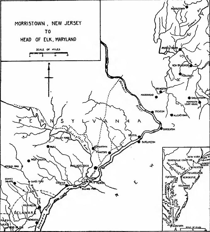 Northern New Jersey, New York, and Its Surroundings during the Revolution (Based on the map in G.O. Trevelyan, The American Revolution, Part II, Vol. I, at the end).
The withdrawal from Quebec.—While Washington's army rested at White Plains, heartening news came from the north; and especially good news it was, for during the summer the reports from the Canadian border had been filled with stories of defeat and distress. Congress had made great efforts to reinforce the army before Quebec, but on May 1 when General Thomas arrived to take command, he had found less than two thousand men assembled and half of them were in the hospitals. Within a week the first British reinforcements arrived and Carleton took the offensive. Thomas was forced to fall back to Sorel and the Americans were driven from their camp near Montreal.
The withdrawal from Quebec.—While Washington's army took a break at White Plains, encouraging news came from the north; and it was especially good news, since throughout the summer, the reports from the Canadian border were filled with tales of defeat and hardship. Congress had worked hard to strengthen the army before Quebec, but on May 1, when General Thomas arrived to take command, he found fewer than two thousand men gathered, and half of them were in the hospitals. Within a week, the first British reinforcements showed up, and Carleton went on the offensive. Thomas had to retreat to Sorel, and the Americans were pushed out of their camp near Montreal.
The army falls back to Crown Point.—On June 5 General John Sullivan arrived at Sorel with three thousand troops. As Thomas had died of the smallpox Sullivan took command. He determined to attack Three Rivers but the surprise failed and his troops were routed. On June 14 an English fleet carrying Carleton's army came up the river. Sullivan immediately broke up his camp and retired to Crown Point, where for the time being he was out of reach of the enemy, for Carleton's vessels were of too deep draft to navigate the Sorel River. But disease proved to be more dangerous than the British, for smallpox and dysentery carried off the men by hundreds.
The army retreats to Crown Point. — On June 5, General John Sullivan arrived at Sorel with three thousand troops. Since Thomas had died of smallpox, Sullivan took command. He planned to attack Three Rivers, but the surprise attack didn't work, and his troops were defeated. On June 14, an English fleet with Carleton's army came up the river. Sullivan quickly disbanded his camp and withdrew to Crown Point, where for the moment he was safe from the enemy, as Carleton's ships were too deep to navigate the Sorel River. However, illness turned out to be more dangerous than the British, as smallpox and dysentery took out hundreds of men.
Ticonderoga becomes the base.—General Philip Schuyler was in command of the northern department with headquarters at Albany and General Horatio Gates was now in charge at Crown Point. In July Gates withdrew most of the depleted force to Ticonderoga. Large numbers of troops were sent north so that by August the garrison numbered thirty-five hundred. Arnold equipped a fleet of small vessels which he hoped would delay if it would not check the British advance.
Ticonderoga becomes the base.—General Philip Schuyler was in charge of the northern department, with headquarters in Albany, while General Horatio Gates was now leading at Crown Point. In July, Gates pulled back most of the weakened troops to Ticonderoga. A large number of soldiers were sent north, so by August, the garrison had grown to three thousand five hundred. Arnold set up a fleet of small boats that he hoped would slow down, if not completely stop, the British advance.
Valcour Island.—During the summer Carleton's shipyard at St. Johns was busy building the fleet which would give him control of Lake Champlain. On October 4 Carleton advanced with an army of twelve thousand men. Arnold started with[Pg 488] his fleet manned by only five hundred men to harass the advance. He ran into the narrow channel between Valcour Island and the western shore and there on October 11 encountered the light advance craft of the British fleet. For five hours he held his own. During the night he withdrew his shattered boats to an island twelve miles to the south where he attempted to repair the damage. On October 13 when the fog lifted, it disclosed the British fleet. Arnold immediately sent off his best vessels and with his crippled ships stayed to fight. One vessel struck its colors but Arnold ran his flag ship and four gondolas into a creek and burned them. He then hastened to Ticonderoga where he displayed tremendous energy in strengthening the fortifications. The spirited fight on the lake, the strength of the American position, and the lateness of the season convinced Carleton that it was useless to continue the operations. On November 3 he evacuated Crown Point and began the withdrawal to Canada. Washington was thus relieved from the danger of an enemy from the north.
Valcour Island.—During the summer, Carleton's shipyard at St. Johns was busy building the fleet that would give him control of Lake Champlain. On October 4, Carleton moved forward with an army of twelve thousand men. Arnold set out with[Pg 488] his fleet, crewed by only five hundred men, to disrupt the advance. He maneuvered into the narrow channel between Valcour Island and the western shore and there, on October 11, faced off against the light ships of the British fleet. For five hours, he held his ground. During the night, he withdrew his damaged boats to an island twelve miles to the south, where he tried to fix the damage. On October 13, when the fog cleared, it revealed the British fleet. Arnold immediately sent off his best ships and stayed to fight with his damaged vessels. One ship lowered its colors, but Arnold ran his flagship and four gondolas into a creek and burned them. He then rushed to Ticonderoga, where he put in a tremendous effort to strengthen the fortifications. The spirited battle on the lake, the strength of the American position, and the lateness of the season convinced Carleton that continuing operations was pointless. On November 3, he evacuated Crown Point and began the withdrawal to Canada. This relieved Washington from the threat of an enemy to the north.
Tactical movements.—Before he was aware of Carleton's withdrawal, Howe had determined to force Washington's army into the open. He sent a force of Hessians to occupy the northern end of Manhattan Island and on November 5 moved his main army to Dobb's Ferry on the Hudson, from which vantage point he could strike at Fort Washington, advance toward Albany, or threaten Philadelphia. Washington's position was endangered and the situation was made doubly precarious by the fact that his army was being depleted by desertions and by the termination of enlistments. To counteract the British movement he sent one corps to Hackensac in New Jersey, and Heath's division was stationed at Peekskill to protect the Hudson. Charles Lee was left at White Plains with about seven thousand men subject to future orders.
Tactical movements.—Before he realized that Carleton had pulled back, Howe had decided to force Washington's army into the open. He deployed a group of Hessians to take control of the northern end of Manhattan Island and on November 5 moved his main army to Dobb's Ferry on the Hudson, from where he could strike at Fort Washington, push toward Albany, or threaten Philadelphia. Washington's position was at risk, and the situation was made even worse by the fact that his army was shrinking due to desertions and the ending of enlistments. To respond to the British move, he sent one unit to Hackensack in New Jersey, and Heath's division was positioned at Peekskill to secure the Hudson. Charles Lee was left at White Plains with about seven thousand men ready for future orders.
Forts Washington and Lee.—The British moved next against Forts Washington and Lee, which, garrisoned by about five thousand men, were under the supervision of General Greene. They ought to have been abandoned, but Washington unfortunately left the decision to his subordinate who believed that they could be held. On November 16 overwhelming forces advanced against Fort Washington which was obliged to surrender. Cornwallis secretly sent six thousand troops across the Hudson and[Pg 489] on November 20 advanced against Fort Lee. He all but surprised it and Greene, with the greatest difficulty, succeeded only in saving the garrison.
Forts Washington and Lee.—The British next targeted Forts Washington and Lee, which had around five thousand soldiers garrisoned and were under General Greene's command. They should have been evacuated, but Washington regrettably let his subordinate make the decision, who thought they could be held. On November 16, overwhelming forces attacked Fort Washington, which had to surrender. Cornwallis secretly moved six thousand troops across the Hudson and[Pg 489] on November 20 advanced against Fort Lee. He nearly caught it by surprise, and Greene only managed to save the garrison with great difficulty.
THE NEW JERSEY CAMPAIGN
Retreat to the Raritan.—The fall of the forts had added greatly to the difficulty of the situation, for Washington's army was in danger of being enveloped. To avert disaster he determined to retreat into New Jersey. He accordingly crossed the Passaic and moved to Newark. The forces under Lee were ordered to join the retreating army, but that vain and conceited officer, who had visions of becoming commander-in-chief as soon as Washington was eliminated, refused to obey orders. On November 28 Washington marched out of Newark and as his rear guard left the town the advanced guard of the British entered it. The American army pushed on to New Brunswick where it found a temporary haven behind the Raritan. On December 1 Cornwallis's troops reached the river, but there he was halted by an order from Howe not to advance until he arrived with reinforcements.
Retreat to the Raritan.—The fall of the forts had made the situation much more difficult, as Washington's army was at risk of being surrounded. To avoid disaster, he decided to retreat into New Jersey. He crossed the Passaic and moved to Newark. The troops under Lee were ordered to join the retreating army, but that arrogant and vain officer, who dreamed of becoming commander-in-chief as soon as Washington was out of the way, refused to follow orders. On November 28, Washington marched out of Newark, and as his rear guard left the town, the British advanced guard entered it. The American army continued on to New Brunswick, where it found temporary shelter behind the Raritan. On December 1, Cornwallis's troops reached the river, but he was stopped by an order from Howe not to move forward until he arrived with reinforcements.
Expedition against Rhode Island.—A week later Howe came up with a single brigade. Instead of concentrating his troops to crush the remnant of Washington's army, the British commander decided to send two divisions to conquer Rhode Island. They easily occupied the island but it was a fruitless venture for "several thousand Royal troops were thenceforward locked up in a sea-girt strip of land no larger than the estate of many an English Lord-Lieutenant."
Expedition against Rhode Island.—A week later, Howe arrived with just one brigade. Rather than gathering his forces to defeat the remnants of Washington's army, the British commander chose to send two divisions to take control of Rhode Island. They easily captured the island, but it turned out to be a pointless endeavor since “several thousand Royal troops were then stuck on a piece of land surrounded by water, no larger than the estate of many an English Lord-Lieutenant.”
Retreat across the Delaware.—Washington's army was constantly reduced by desertion and sickness, and the New Jersey people failed to rally to his assistance. It has been estimated that not a hundred men enlisted during the retreat across the state. The people of New Jersey paid dearly for their indifference, for during the winter they were constantly subjected to indignities from the Hessians who were billeted upon them. Among the atrocious acts was the pillaging of Princeton College. Taking advantage of British inactivity, Washington prepared to retire beyond the Delaware, from New Brunswick having ordered the collection of boats for many miles along the river[Pg 490] front. Covering his retreat with fourteen hundred of his best troops under Stirling, the army and stores were landed on the Pennsylvania shore. When the British troops arrived on the eastern bank, they were forced to halt, for not a boat was available and the short-sighted Howe had failed to provide his army with pontoons.
Retreat across the Delaware.—Washington's army was constantly shrinking due to desertion and illness, and the people of New Jersey didn’t come to his aid. It’s estimated that fewer than a hundred men signed up during the retreat across the state. The people of New Jersey suffered greatly for their indifference, as they faced continuous mistreatment from the Hessians who were stationed there. One of the terrible acts was the looting of Princeton College. Taking advantage of the British's lack of action, Washington planned to withdraw beyond the Delaware, having ordered boats to be collected for miles along the river[Pg 490]front. Covering his retreat with fourteen hundred of his best troops under Stirling, the army and supplies were successfully landed on the Pennsylvania side. When the British troops arrived on the eastern bank, they were forced to stop, as not a single boat was available and the shortsighted Howe had failed to equip his army with pontoons.
To the British commander the campaign was over and he prepared to go into winter quarters, fancying that the rebellion was practically crushed and that the spring campaign would be a mere parade. The Whig use appeared to be lost and gloomy forebodings and grumblings of discontent took the place of declamation and heroics. On December 10 Congress resolved to defend Philadelphia but two days later it adjourned and hied away to Baltimore. Washington's lack of authority had frequently hampered his military operations, but this difficulty was now removed, for before adjournment Congress resolved, that until otherwise ordered, Washington was to have full power to direct operations.
To the British commander, the campaign was over, and he got ready to settle in for the winter, thinking that the rebellion was mostly defeated and that the spring campaign would just be a show. The Whig enthusiasm seemed to be lost, replaced by gloomy worries and grumbling discontent instead of speeches and bravado. On December 10, Congress decided to defend Philadelphia, but two days later, they adjourned and quickly moved to Baltimore. Washington's lack of authority had often hindered his military efforts, but that issue was now resolved, as before adjourning, Congress decided that until further notice, Washington would have full power to direct operations.
Washington's army reinforced.—The dispirited army which crossed the Delaware was soon strongly reinforced. After many days of inaction, General Lee had left his camp at White Plains with the intention, as he grandiloquently put it, of reconquering New Jersey. After the retreat of Carleton, Schuyler had sent seven battalions under Sullivan to assist Washington, but Lee succeeded in getting control of four of them. On December 13 he was captured at a tavern at Baskingridge. As soon as Sullivan heard of it, he started the troops for the Delaware and on the twentieth of December joined Washington. Four other battalions from Schuyler's army arrived shortly afterward and General Mifflin brought in a goodly body of Pennsylvania militia. Before Christmas the army numbered eight thousand.
Washington's army reinforced.—The discouraged army that crossed the Delaware was soon significantly reinforced. After many days without action, General Lee left his camp at White Plains with the grand claim of wanting to reclaim New Jersey. After Carleton's retreat, Schuyler sent seven battalions under Sullivan to support Washington, but Lee managed to take control of four of them. On December 13, he was captured at a tavern in Baskingridge. As soon as Sullivan heard about this, he moved the troops to the Delaware, and on December 20, he joined Washington. Four other battalions from Schuyler's army arrived soon after, and General Mifflin brought in a substantial group of Pennsylvania militia. Before Christmas, the army numbered eight thousand.
Position of the Hessians.—To the east of the Delaware was a Hessian division under Colonel Von Donop, Colonel Rail being stationed at Trenton with three regiments. Rail had taken to measures to strengthen a naturally weak position; highways converged to the north of the village and artillery stationed at the junction could sweep the streets. Scouting parties and spies informed Washington that Rail's troops were scattered through the town and that the place was practically without defences.
Position of the Hessians.—To the east of the Delaware, there was a Hessian division led by Colonel Von Donop, while Colonel Rail was stationed at Trenton with three regiments. Rail had taken steps to strengthen a naturally weak position; highways came together to the north of the village, and artillery positioned at the junction could cover the streets. Scouting parties and spies informed Washington that Rail's troops were spread out across the town and that the area was essentially undefended.
[Pg 491] Trenton.—Washington determined to strike. With the greatest secrecy he perfected his plans. One body of troops under Cadwalader was to attack Von Donop's position at Bordentown and Ewing with a thousand men was to strike at troops stationed on Assumpink Creek, while Washington with Greene and Sullivan in command of twenty-four hundred men and eighteen cannon were to advance against Trenton from the north. During a furious tempest on Christmas night Washington succeeded in crossing the Delaware, but Ewing failed to get over and Cadwalader crossed too late to coöperate. At four in the morning Washington's troops began the weary march toward Trenton. While the valiant army was toiling over the frozen roads, the Hessians were sleeping off the effects of their Christmas wassail. At 8:15 the American forces drove in the Hessian outposts. Aroused from his bed Rail tried to make a stand, but the streets were raked with round shot and the sharpshooters fired relentlessly into the huddled Hessians, several hundred of whom fled across the Assumpink Creek bridge and escaped to Bordentown. Rail tried to rally his men but fell mortally wounded. When Sullivan cut off the retreat to the south and Greene ordered up his reserves, resistance ended. Nine hundred prisoners, a thousand muskets, six field pieces, and a large quantity of stores fell into the hands of the successful commander. But not in terms of men and guns should the battle of Trenton be judged. Its importance lies in the fact that Washington had won a clean cut victory when the Whig cause was tottering and by that victory had raised the drooping spirits of a despairing nation.
[Pg 491] Trenton.—Washington was set to attack. He worked on his plans with great secrecy. One group of troops under Cadwalader was supposed to hit Von Donop's position at Bordentown, while Ewing, with a thousand men, was to target the troops stationed on Assumpink Creek. Washington, along with Greene and Sullivan in command of twenty-four hundred men and eighteen cannons, would advance on Trenton from the north. During a fierce storm on Christmas night, Washington managed to cross the Delaware, but Ewing couldn't make it across, and Cadwalader arrived too late to help. At four in the morning, Washington's troops began their exhausting march toward Trenton. While the brave army struggled over the frozen roads, the Hessians were sleeping off their Christmas festivities. At 8:15, the American forces pushed back the Hessian outposts. Roused from his bed, Rail tried to organize a defense, but the streets were bombarded with cannon fire and sharpshooters fired relentlessly into the clustered Hessians, causing several hundred of them to flee across the Assumpink Creek bridge to Bordentown. Rail attempted to rally his men but was mortally wounded. When Sullivan cut off their escape to the south and Greene sent in reinforcements, resistance came to an end. Nine hundred prisoners, a thousand muskets, six field pieces, and a large amount of supplies fell into the hands of the victorious commander. However, the significance of the Battle of Trenton shouldn't be measured just in numbers. Its importance lies in the fact that Washington secured a decisive victory when the Whig cause was struggling, lifting the spirits of a despairing nation.
Movements of the armies.—When the news of Trenton reached New York, it roused the British from their fancied security. Lord Cornwallis at the head of eight thousand men proceeded by forced marches toward the west. Washington had determined to hold a position east of the Delaware, and on December 30 he again crossed the river and by January 2, 1777, had assembled five thousand men and forty pieces of artillery just below Trenton. As Cornwallis approached the American position, he realized the costliness of a frontal attack, and decided that as soon as his forces assembled he would attempt a flanking movement from Allentown.[Pg 492]
Movements of the armies.—When the news of Trenton reached New York, it shocked the British out of their false sense of security. Lord Cornwallis, leading eight thousand men, moved quickly toward the west. Washington had decided to maintain a position east of the Delaware, and on December 30 he crossed the river again. By January 2, 1777, he had gathered five thousand men and forty pieces of artillery just below Trenton. As Cornwallis got closer to the American position, he recognized that a direct attack would be costly, so he planned to execute a flanking maneuver from Allentown once his forces were assembled.[Pg 492]
Princeton, January 3, 1777.—Washington saw the danger and decided on a daring plan. On the night of January 2 all was activity in the American camp. Sentinels challenged, infantry moved about in the light of the camp fires, and the sound of pick and shovel was plainly audible to the British. But in the darkness to the rear another kind of activity was in progress. Cannon, stores, and baggage were being silently moved to Bordentown and Burlington, and at one in the morning the bulk of the army began a stealthy march which at daybreak brought them out within a mile and a half of Princeton. Three of Cornwallis's regiments had remained there during the night and were now under way. Suddenly the first of these troops under Colonel Mawhood found themselves confronted by the American advance guard. The British charged bravely, scoring an initial success, but Washington's presence in front of his lines steadied the troops and they soon forced a retreat. Sullivan then led the advance against the two remaining regiments, which were driven through and beyond Princeton, leaving three hundred prisoners in Washington's hands. The roar of the guns brought the unwelcome tidings to Cornwallis that the American army had escaped, had cut across his rear, and had defeated three of his crack regiments.
Princeton, January 3, 1777.—Washington recognized the threat and came up with a bold plan. On the night of January 2, there was a flurry of activity in the American camp. Guards were on watch, infantry moved around in the glow of the campfires, and the sounds of digging were clearly audible to the British. However, in the darkness behind them, another kind of movement was taking place. Cannons, supplies, and baggage were being quietly transported to Bordentown and Burlington, and at one in the morning, the majority of the army began a covert march that brought them within a mile and a half of Princeton by dawn. Three of Cornwallis's regiments had stayed there overnight and were now on the move. Suddenly, the first of these troops under Colonel Mawhood encountered the American advance guard. The British charged valiantly, achieving initial success, but Washington's presence at the front steadied the troops, and they soon forced a retreat. Sullivan then led the advance against the two remaining regiments, driving them through and beyond Princeton, capturing three hundred prisoners. The roar of the cannons delivered the unwelcome news to Cornwallis that the American army had escaped, cut across his rear, and defeated three of his elite regiments.
Morristown.—Five miles beyond Princeton Washington turned to the north and soon established his army in a powerful position at Morristown where they remained in security the rest of the winter. Howe made no attempt to dislodge his opponent, but concentrated ten thousand troops in camps at New Brunswick and Perth Amboy. The Jersey people had been cured of their Toryism; supplies poured into the American camp, while the British experienced the greatest difficulty in securing fuel and food, and by March 1 were reduced to a ration of salt provisions and "ammunition bread." When Washington reached Morristown he had about four thousand men and during the winter his army did not increase, but he made the most of the opportunity to drill his men and perfect his organization. Throughout the country men were drilling for the spring campaign, powder mills were being built, and lead mines were being opened. The greatest shortage was in muskets, but fortunately these were obtained from France.[Pg 493]
Morristown.—Five miles past Princeton, Washington turned north and quickly set up his army in a strong position at Morristown, where they stayed secure for the rest of the winter. Howe made no effort to displace him, instead focusing ten thousand troops in camps at New Brunswick and Perth Amboy. The people of Jersey had lost their loyalty to the British; supplies flowed into the American camp while the British struggled to find fuel and food, and by March 1, they were limited to a diet of salt provisions and "ammunition bread." When Washington arrived in Morristown, he had about four thousand men, and though his army didn’t grow during the winter, he took full advantage of the time to train his soldiers and improve his organization. Across the country, men were training for the spring campaign, powder mills were being established, and lead mines were being opened. The biggest shortage was in muskets, but thankfully, these were acquired from France.[Pg 493]
Middlebrook.—In May, 1777, everything was in readiness and Washington led his army to a powerful position at Middlebrook, only a few miles from the British camp at New Brunswick. On June 13 Howe transferred large forces to the southern bank of the Raritan, but he failed to draw Washington from his point of vantage and on the nineteenth he began the withdrawal of his army to Staten Island, having had the satisfaction only of a rear guard action with Stirling's division.
Middlebrook.—In May 1777, everything was set, and Washington led his army to a strong position at Middlebrook, just a few miles from the British camp in New Brunswick. On June 13, Howe moved large troops to the south side of the Raritan River, but he couldn’t lure Washington away from his advantageous position. By the nineteenth, he started pulling his army back to Staten Island, having only managed a rear guard skirmish with Stirling's division.
THE STRUGGLE WITH BURGOYNE
British plans for 1777.—Howe's plan for the campaign of 1777 called for fifteen thousand more troops. With this addition he believed that he could crush Washington and conquer Pennsylvania, New Jersey, and New York. The subjugation of the southern colonies would then be attempted, followed by operations in New England. But Lord Germaine thought otherwise. Ignoring the general in the field, he planned to send a force under St. Leger down the Mohawk Valley, a second army under Burgoyne to penetrate New York by the Lake Champlain route, while Howe was to proceed up the Hudson Valley. The three armies were to meet at Albany. The plan looked good on paper, but it failed to take into account the long distances to be traversed and the difficulties of transportation on the frontier. When Germaine planned the campaign, he should have sent precise orders to Howe, but this he failed to do, and on May 18 he even wrote acquiescing in the proposed expedition against Philadelphia and expressing the hope that the business might be concluded in season so that Howe could coöperate with Burgoyne.
British plans for 1777.—Howe's strategy for the 1777 campaign called for an additional fifteen thousand troops. With this increase, he believed he could defeat Washington and take Pennsylvania, New Jersey, and New York. After that, they would try to take control of the southern colonies, followed by operations in New England. However, Lord Germaine had a different idea. Ignoring the general on the ground, he planned to send a force led by St. Leger down the Mohawk Valley, a second army led by Burgoyne to move into New York via Lake Champlain, while Howe was supposed to advance up the Hudson Valley. The three armies were to converge at Albany. The plan seemed solid on paper, but it didn't consider the long distances involved and the transportation challenges on the frontier. When Germaine devised the campaign, he should have sent clear orders to Howe, but he failed to do so, and on May 18 he even wrote agreeing to the proposed attack on Philadelphia, hoping it could wrap up in time for Howe to support Burgoyne.
Ticonderoga and Ft. Independence.—On June 15, 1777, General Schuyler learned that Burgoyne's army was in motion and that St. Leger was concentrating forces on the upper Mohawk. The American army was in a sorry plight for smallpox and dysentery were still the bane of the northern department. Congress had done much to destroy efficiency by temporarily removing Schuyler. At a time when all should have been working in harmony, Gates was intriguing with members of Congress to overthrow his superior. The advance part of the army was at Ticonderoga. Across the narrow bay Fort Independence had been erected and a bridge connected the fortifications, which were[Pg 494] commanded by General St. Clair who had only twenty-five hundred men to man works which demanded ten thousand defenders.
Ticonderoga and Ft. Independence.—On June 15, 1777, General Schuyler found out that Burgoyne's army was on the move and that St. Leger was gathering forces on the upper Mohawk. The American army was in a tough situation as smallpox and dysentery continued to plague the northern department. Congress had undermined efficiency by temporarily removing Schuyler. At a moment when everyone should have been united, Gates was plotting with members of Congress to unseat his superior. The forward unit of the army was at Ticonderoga. Across the narrow bay, Fort Independence had been built, and a bridge connected the fortifications, which were[Pg 494] led by General St. Clair, who only had twenty-five hundred men to defend positions that needed ten thousand defenders.
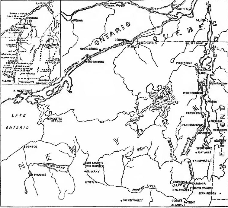 The Area of Burgoyne's Invasion (The large map is based on E.G. Foster's Historical Chart; the inset is from Trevelyan, The American Revolution, Part II, Vol. I).
Burgoyne captures the forts.—Late in June Burgoyne's flotilla carrying about eight thousand soldiers reached Crown Point. His engineers soon discovered the fundamental weaknesses of the American position. Mt. Hope dominated the passage to Lake George and Sugar Hill towered above the forts. On July 2 the former position was occupied by the British and on July 5 St. Clair saw Sugar Hill bristling with cannon. He realized that the forts were untenable and on the night of July 6 he loaded his[Pg 495] stores and light artillery on barges and sent them under convoy to Skenesborough. The main body of troops under St. Clair attempted to reach the same place by a circuitous route which led through Hubbardtown.
Burgoyne captures the forts.—In late June, Burgoyne's fleet, carrying around eight thousand soldiers, arrived at Crown Point. His engineers quickly identified the major weaknesses in the American defenses. Mount Hope overlooked the route to Lake George, and Sugar Hill loomed over the forts. On July 2, the British took control of Mount Hope, and on July 5, St. Clair saw Sugar Hill filled with cannons. He realized that the forts were impossible to defend, so on the night of July 6, he loaded his[Pg 495] supplies and light artillery onto barges and sent them under protection to Skenesborough. The main group of troops led by St. Clair tried to reach the same destination via a longer route through Hubbardtown.
The disastrous retreat.—Burgoyne's vessels broke through the impediments and pursued the American flotilla. They encountered it at anchor in South Bay and short work they made of it. The Americans destroyed the stores and buildings on the shore before they retreated. General Fraser had been sent in pursuit of St. Clair's forces and at Hubbardtown he fell in with the American rear guard and defeated it. St. Clair succeeded in getting his troops to Ft. Edward where he joined Schuyler. Only three thousand men barred the way to Albany.
The disastrous retreat.—Burgoyne's ships managed to break through the obstacles and chased after the American fleet. They found it anchored in South Bay and quickly took care of it. The Americans destroyed the supplies and buildings along the shore before they pulled back. General Fraser was sent to track down St. Clair's forces, and near Hubbardtown, he encountered the American rear guard and defeated them. St. Clair managed to get his troops to Ft. Edward, where he linked up with Schuyler. Only three thousand men stood in the way to Albany.
The withdrawal to Stillwater.—Schuyler sent out calls for help to New England, to New York, and to Washington. While waiting for reinforcements he destroyed the standing crops, drove off the stock, and broke up the roads. Having despoiled the country, he abandoned Fort Edward and withdrew to Stillwater on the west bank of the Hudson. It was not long before reinforcements began pouring in. Although his army was inferior to that of Howe, Washington sent on Morgan's riflemen and he ordered Putnam to send two brigades. General Lincoln was sent to organize the New England militia and Benedict Arnold was called from Connecticut to help Schuyler.
The retreat to Stillwater.—Schuyler called for help from New England, New York, and Washington. While waiting for reinforcements, he destroyed the crops, took the livestock, and damaged the roads. After ravaging the area, he abandoned Fort Edward and moved to Stillwater on the west bank of the Hudson. It wasn't long before reinforcements started arriving. Although his army was smaller than Howe's, Washington sent Morgan's riflemen and ordered Putnam to dispatch two brigades. General Lincoln was sent to organize the New England militia, and Benedict Arnold was called from Connecticut to assist Schuyler.
Bennington.—Burgoyne reached the head of Lake Champlain on July 10, but from that point his progress was exceedingly slow, the twenty miles to Ft. Edwards being traversed in as many days. Schuyler's work of devastation had been complete and the British commissariat suffered accordingly. To replenish his depleted stores, Burgoyne embarked upon a rash enterprise. At Bermington large quantities of stores had been collected and a Tory named Philip Skene suggested that they would be an easy prize. Burgoyne followed Skene's advice and sent Colonel Baum with five or six hundred troops to make the capture. Near Bennington John Stark was in command of two brigades of New England troops and at Manchester were the remnants of regiments which had retreated from Hubbardtown. On August 15 Baum came in touch with Stark's forces, but he hesitated to attack and proceeded to intrench. The New England troops[Pg 496] gradually encircled the position, and when they attacked on the afternooon of the sixteenth, they killed, wounded, or captured nearly the entire force. While the Americans were engaged in plundering the camp, they were suddenly attacked by another force of six hundred under Breymann, sent by Burgoyne at Baum's request. Things were going badly for Stark's men when Seth Warner with forces from Manchester arrived. After a sharp contest Breymann's troops were driven from the field with a loss of a third of the rank and file. The day's fighting had deprived the invaders of a considerable force which they could not afford to lose in the face of an army which was increasing daily.
Bennington.—Burgoyne arrived at the head of Lake Champlain on July 10, but after that, his progress was extremely slow, covering the twenty miles to Ft. Edwards in as many days. Schuyler's destruction had been thorough, and the British supply line suffered as a result. To replenish his dwindling supplies, Burgoyne took a risky gamble. At Bennington, large amounts of supplies had been gathered, and a Loyalist named Philip Skene suggested that they would be an easy target. Burgoyne took Skene's advice and sent Colonel Baum with five or six hundred troops to seize them. Nearby, John Stark was in charge of two brigades of New England troops, and in Manchester were the remnants of regiments that had retreated from Hubbardtown. On August 15, Baum encountered Stark's forces but hesitated to attack and instead began to fortify his position. The New England troops gradually surrounded him, and when they attacked on the afternoon of the 16th, they killed, wounded, or captured almost the entire force. While the Americans were busy looting the camp, they were suddenly charged by another force of six hundred under Breymann, sent by Burgoyne at Baum's request. Things were looking bad for Stark's men when Seth Warner arrived with troops from Manchester. After a fierce fight, Breymann's troops were pushed off the field, losing a third of their ranks. The day's battle had cost the invaders a significant force they could not afford to lose, especially as their enemy was growing stronger each day.
Oriskany.—While Burgoyne was advancing, St. Leger was invading the Mohawk Valley. On August 3 his army of British regulars, Hessians, Canadians, Tories, and Indians invested Ft. Stanwix. Colonel Herkimer gathered the Tryon County militia and went to the relief of the fort, but at Oriskany, which was only six miles from the fort, he was surprised. In the desperate battle the losses were higher in proportion to men engaged than in any other battle of the war. Herkimer was killed and so badly cut up were the militia that the expedition was unable to proceed.
Oriskany.—While Burgoyne was advancing, St. Leger was invading the Mohawk Valley. On August 3, his army of British regulars, Hessians, Canadians, Tories, and Indians surrounded Ft. Stanwix. Colonel Herkimer gathered the Tryon County militia and went to help the fort, but near Oriskany, just six miles away, he was caught off guard. In the fierce battle, the losses were higher in relation to the number of soldiers involved than in any other battle of the war. Herkimer was killed, and the militia suffered such severe casualties that the mission could not continue.
Ft. Stanwix relieved.—Schuyler realized the danger of a flank attack from the Mohawk Valley. St. Leger must be checked. Schuyler called for a volunteer to lead a relief expedition. Arnold offered his services and at the head of eight hundred men advanced up the valley. As he proceeded his force was continually increased by recruits. As he approached Ft. Stanwix, Arnold succeeded in creating the impression that his army was of overwhelming numbers. The Senecas were the first to desert St. Leger and the Tories soon made off to the woods. Abandoned by his allies, St. Leger retreated, leaving behind stores, tents, and artillery. The battle of Bennington and the retirement from the Mohawk Valley sealed the fate of Burgoyne.
Ft. Stanwix relieved.—Schuyler saw the threat of a side attack from the Mohawk Valley. St. Leger needed to be stopped. Schuyler called for a volunteer to lead a relief mission. Arnold offered to help and, leading eight hundred men, moved up the valley. As he went along, his force kept growing with new recruits. Approaching Ft. Stanwix, Arnold managed to give the impression that his army was much larger than it actually was. The Senecas were the first to abandon St. Leger, followed soon by the Tories who fled into the woods. Left without support, St. Leger retreated, leaving behind supplies, tents, and artillery. The battle of Bennington and the withdrawal from the Mohawk Valley sealed Burgoyne's fate.
Gates supersedes Schuyler.—By the middle of August Schuyler had the satisfaction of being in command of a force which outnumbered Burgoyne's army. But on August 19 Horatio Gates arrived at Albany with a commission to take command. Gates was a man of little ability, but of an unscrupulous, intriguing,[Pg 497] and ambitious nature. He had spent many months at the seat of government influencing members of Congress, a task made easy by the fact that the New England delegates disliked Schuyler. With victory already assured, Gates came forward to reap the honors. Burgoyne was in a sorry plight. His line of communication was in danger of being cut and his force had been reduced to about six thousand effectives. In vain he looked for despatches from Howe, but though he had sent ten messengers, an ominous silence was his only answer. Two courses were open to him; an ignominious retreat or an advance that at best was but a forlorn hope. Fortunately for the American cause he chose the latter.
Gates replaces Schuyler.—By mid-August, Schuyler was satisfied to be in charge of a force that outnumbered Burgoyne’s army. However, on August 19, Horatio Gates arrived in Albany with orders to take over. Gates was not particularly skilled but was unscrupulous, scheming, and ambitious. He had spent several months in the capital swaying members of Congress, a task made easier by the New England delegates' dislike for Schuyler. With victory seemingly assured, Gates stepped forward to take the credit. Burgoyne was in a desperate situation. His supply line was at risk of being cut off, and his force had dwindled to about six thousand effective troops. He searched in vain for messages from Howe; despite sending ten messengers, he received only a troubling silence in return. He had two options: a shameful retreat or an advance that was, at best, a hopeless gamble. Luckily for the American cause, he chose the latter.
First battle of Bemis's Heights, September 19.—On September 13 the British army crossed the Hudson on a bridge of boats and encamped at Saratoga. Six miles to the south was a table land called Bemis's Heights which the Americans had fortified. Between the heights and the river stretched a pasture five hundred yards in width. It was a position easily defended provided Gates extended his left wing. This he failed to do and Burgoyne, quick to see the opportunity for a turning movement, disposed his forces in such a manner that while Philips in command of the British left and Burgoyne in the center engaged the American army, General Fraser on the right could encircle the heights. Arnold saw the danger and besought Gates to let him attack the British right. Gates finally consented and Arnold immediately flung his men against Fraser's position. A confused fight occurred in the tangled underbrush, and though Morgan's riflemen got out of hand, the effect of the attack was to stop Fraser's advance. Having been reinforced, Arnold threw his troops against the British center at Freeman's Farm. A very hot engagement ensued and victory would probably have resulted had Gates engaged Philips, but the American commander failed to attack and the British left came to the assistance of the hard-pressed center. At nightfall Arnold fell back a short distance, but he had saved the American army and had inflicted such great injury that Burgoyne was unable to continue the battle the next day.
First battle of Bemis's Heights, September 19.—On September 13, the British army crossed the Hudson on a bridge of boats and set up camp at Saratoga. Six miles to the south was a plateau called Bemis's Heights, which the Americans had fortified. Between the heights and the river was a pasture five hundred yards wide. This was a position that could be easily defended if Gates had extended his left flank. He didn’t, and Burgoyne, quick to recognize the opportunity for a flanking maneuver, arranged his forces so that while Philips commanded the British left and Burgoyne held the center to engage the American army, General Fraser on the right could circle around the heights. Arnold saw the threat and urged Gates to let him attack the British right. Gates eventually agreed, and Arnold immediately launched his troops against Fraser's position. A chaotic fight broke out in the dense underbrush, and although Morgan's riflemen became disorganized, the attack succeeded in halting Fraser's advance. After being reinforced, Arnold directed his troops to strike the British center at Freeman's Farm. A fierce battle followed, and victory was likely if Gates had engaged Philips, but the American commander chose not to attack, allowing the British left to support the struggling center. At nightfall, Arnold pulled back a short distance, but he had saved the American army and dealt such significant damage that Burgoyne was unable to continue the battle the next day.
Clinton fails to coöperate.—The British commander fortified his position and there his army remained inactive for more than[Pg 498] a fortnight. The situation was daily becoming more critical, for Lincoln had succeeded in cutting the line of communication with Canada. A belated despatch had reached Burgoyne informing him of Howe's expedition against Philadelphia. He also received information which led him to believe that Clinton expected to clear the Hudson and come to his relief. Early in October Clinton captured three forts on the lower Hudson, but instead of following up his success, he returned to New York and left the northern army to its fate.
Clinton fails to cooperate.—The British commander strengthened his position, and his army stayed inactive there for more than [Pg 498] two weeks. The situation was getting more urgent every day, as Lincoln had managed to cut off communication with Canada. A late message reached Burgoyne, informing him about Howe's mission against Philadelphia. He also got information that made him think Clinton planned to clear the Hudson and come to help him. In early October, Clinton took three forts on the lower Hudson, but instead of building on that success, he returned to New York and left the northern army to deal with its fate.
Second battle of Bemis's Heights.—The situation in the American camp was far from harmonious. Gates had not mentioned Arnold's division in his official report of the recent battle. This slight was followed by studied insults and cowardly persecution. The protests of the regimental officers caused Arnold to postpone his resignation, but Gates deprived him of his command and elevated Lincoln. On October 7 Burgoyne again prepared to attack the American lines. His initial assault was repulsed and Fraser was mortally wounded. Soon after the fighting began Arnold put himself at the head of his old troops and broke the British center. The British right wing was also forced back, but Gates did nothing to follow up the advantage. Arnold seized the opportunity and assaulted Freeman's Farm. There he was repulsed but he turned his troops against a redoubt on the right and carried it by assault. The redoubtable general, however, was severely wounded, his thigh bone being shattered, but his generalship had won the battle which broke the British army.
Second battle of Bemis's Heights.—The situation in the American camp was anything but peaceful. Gates didn’t mention Arnold's division in his official report about the recent battle. This snub was followed by deliberate insults and cowardly harassment. The regimental officers’ protests made Arnold delay his resignation, but Gates stripped him of his command and promoted Lincoln instead. On October 7, Burgoyne readied another attack on the American lines. His first assault was repelled, and Fraser was mortally wounded. Soon after the fighting started, Arnold took charge of his old troops and broke through the British center. The British right flank was also pushed back, but Gates did nothing to capitalize on the advantage. Arnold seized the moment and attacked Freeman's Farm. There he was pushed back, but he redirected his troops against a redoubt on the right and took it by assault. The courageous general was, however, severely wounded, with his thigh bone shattered, but his leadership had won the battle that broke the British army.
Burgoyne's surrender.—The day after the battle Gates pushed forward his left wing, a movement which threatened to pen Burgoyne between the Hudson and a hostile army. The British commander should have sunk his heavy guns in the river and beaten a hasty retreat, but instead he attempted to save his stores and artillery. He fell back eight miles and took a position on the north bank of Fishkill Creek near Saratoga. Gates threw a force across the Hudson which prevented a crossing, troops were posted on the flank of the British Camp and the main army was drawn up on the south bank of Fishkill Creek. The British were trapped and Burgoyne at last realized that the game was up. On October 13 he called a council of war at which it was[Pg 499] decided to negotiate terms. Gates demanded an unconditional surrender, but Burgoyne refused and the next day Gates, who appears neither to have been able to win a battle or to make the most of a fortunate situation created by the bravery and skill of another, agreed that Burgoyne should surrender with the honors of war and that his army should be given free passage to Great Britain upon the condition that they would not serve in North America during the war. Congress, to its shame, did not carry out the agreement and the troops were kept as prisoners in America.
Burgoyne's surrender.—The day after the battle, Gates advanced his left wing, a move that threatened to trap Burgoyne between the Hudson River and an opposing army. The British commander should have sunk his heavy artillery in the river and retreated quickly, but instead, he tried to protect his supplies and weapons. He fell back eight miles and positioned himself on the north bank of Fishkill Creek near Saratoga. Gates sent a force across the Hudson to block any crossings, stationed troops on the flank of the British camp, and positioned the main army on the south bank of Fishkill Creek. The British were cornered, and Burgoyne finally recognized that it was over. On October 13, he called a council of war where it was[Pg 499] decided to negotiate terms. Gates demanded an unconditional surrender, but Burgoyne refused. The next day, Gates, who seemed unable to win a battle or take full advantage of the situation created by the bravery and skill of others, agreed that Burgoyne should surrender with honors and that his army would be allowed to travel to Great Britain on the condition that they wouldn’t fight in North America for the remainder of the war. Congress, to its shame, did not uphold the agreement, and the troops were held as prisoners in America.
THE CONTEST FOR PHILADELPHIA
Howe moves on Philadelphia.—While the northern army was struggling with Burgoyne, another great contest was taking place in Pennsylvania. Germaine had not given Howe definite orders to coöperate with Burgoyne and, in fact, had approved the proposed expedition against Philadelphia. After the retirement from before Middlebrook, Howe's movements were a mystery to Washington. In July he learned that the British fleet was being prepared for a voyage, but whether the enemy would sail up the Hudson, or strike at Boston, Philadelphia, or Charleston, he could not tell. To forestall an advance northward Washington moved his army toward the New York highlands. On July 31 he heard that the British fleet had appeared in Delaware Bay. Immediately the American army was started for Philadelphia, but before the city was reached the astonishing news came that the fleet had disappeared. Washington immediately went into camp twenty miles north of Philadelphia to await developments. Two weeks later the British fleet sailed into Chesapeake Bay and on August 25 the army, which numbered seventeen thousand, began to disembark at the Head of Elk at the northern end of the bay.
Howe moves on Philadelphia.—While the northern army was dealing with Burgoyne, another significant conflict was happening in Pennsylvania. Germaine hadn’t given Howe clear orders to work with Burgoyne and had actually approved the plan to attack Philadelphia. After withdrawing from Middlebrook, Howe's movements became a mystery to Washington. In July, he learned that the British fleet was getting ready to set sail, but he couldn’t determine if the enemy would head up the Hudson, or target Boston, Philadelphia, or Charleston. To prevent a northern advance, Washington moved his army toward the New York highlands. On July 31, he heard that the British fleet had shown up in Delaware Bay. The American army then headed for Philadelphia, but before they could reach the city, they received the shocking news that the fleet had vanished. Washington quickly set up camp twenty miles north of Philadelphia to wait for updates. Two weeks later, the British fleet entered Chesapeake Bay, and on August 25, the army, consisting of seventeen thousand soldiers, began to disembark at the Head of Elk at the northern end of the bay.
Battle of the Brandywine.—As soon as Washington heard of the British landing, he started his army southward. On August 24 eleven thousand men paraded through the spacious streets of Philadelphia and on September 9 the army was posted on the north bank of the Brandywine. The main road to Philadelphia crossed the stream at Chad's Ford and here Wayne's division was stationed. Below the ford the steep banks were[Pg 500] defended by a small force of militia. Above Wayne were Greene's well-drilled brigades, and the right was held by Sullivan. On September 10 Howe concentrated his army at the Kennet Square meeting house, where he divided it into two columns. At four the next morning Cornwallis in command of one column started for the upper fords of the Brandywine; by making this wide detour it was hoped that he could get in the rear of the American right wing. An hour later General von Knyphausen in command of the other column advanced toward Chad's Ford. He drove a small group of skirmishers across the stream, arranged his army as if for an assault, and opened with his artillery. Washington spent the morning in uncertainty, but at length Sullivan sent word that Cornwallis's troops were getting in his rear. Washington immediately ordered him to throw his entire force across the path of the enemy, but the movement was not carried out with precision and soon the wings of Sullivan's force were routed. Stirling, who held the center, made a gallant defence, but with both flanks exposed, he was forced to retire. When Von Knyphausen heard the firing, he advanced across Chad's Ford, and carried Wayne's intrenchments. Washington had ordered Greene to go to Sullivan's assistance. His men covered four miles in about forty minutes and then came into action against Cornwallis's victorious troops. For an hour the battle raged with great intensity, and as darkness set in, Greene drew off his men. His stubborn fight had saved the army, which was brought together at Chester.
Battle of the Brandywine.—As soon as Washington heard about the British landing, he led his army south. On August 24, eleven thousand troops marched through the broad streets of Philadelphia, and by September 9, the army was stationed on the north bank of the Brandywine. The main road to Philadelphia crossed the river at Chad's Ford, where Wayne's division was positioned. Below the ford, the steep banks were defended by a small group of militia. Above Wayne were Greene's well-trained brigades, and Sullivan held the right flank. On September 10, Howe gathered his army at the Kennet Square meeting house, where he split it into two columns. At four the next morning, Cornwallis, leading one column, set out for the upper fords of the Brandywine; this wide detour aimed to get behind the American right wing. An hour later, General von Knyphausen, in command of the second column, moved towards Chad's Ford. He pushed a small group of skirmishers across the stream, positioned his army as if preparing for an assault, and opened fire with his artillery. Washington spent the morning in uncertainty, but eventually Sullivan reported that Cornwallis's troops were maneuvering behind him. Washington immediately ordered him to deploy his entire force to block the enemy's path, but the execution of this movement was not precise, and soon Sullivan's flanks were routed. Stirling, who held the center, made a brave defense, but with both sides vulnerable, he had to withdraw. When von Knyphausen heard the gunfire, he advanced across Chad's Ford and took Wayne's entrenchments. Washington had instructed Greene to assist Sullivan. His men covered four miles in about forty minutes and quickly engaged Cornwallis's victorious troops. The battle raged for an hour with intense fighting, and as darkness fell, Greene pulled back his men. His determined effort saved the army, which regrouped at Chester.
Paoli.—Washington moved his army thirty-five miles up the Schuylkill and the British encamped south of the river near Valley Forge. To harass the rear of Howe's army Washington sent Wayne's division across the Schuylkill. At 1 A.M. on September 21 this force was surprised near the Paoli Tavern. The British fell upon the American camp with sword and bayonet, and before the grim work was over Wayne had lost more than three hundred men.
Paoli.—Washington moved his army thirty-five miles up the Schuylkill River, and the British set up camp south of the river near Valley Forge. To disrupt the back of Howe's army, Washington sent Wayne's division across the Schuylkill. At 1 A.M. on September 21, this force was caught off guard near the Paoli Tavern. The British attacked the American camp with swords and bayonets, and by the end of the brutal confrontation, Wayne had lost over three hundred men.
The British in Philadelphia.—On September 23 the British army crossed the Schuylkill and began to advance toward Philadelphia. When the news reached the city a Whig exodus began, probably a third of the population taking their departure. Congress removed the prisoners, archives, and most of the stores; upon Washington it conferred dictatorial powers for sixty days in the vicinity, and then adjourned to Lancaster and later to York. On September 25 Howe entered the capital.
The British in Philadelphia.—On September 23, the British army crossed the Schuylkill River and started moving toward Philadelphia. When the news got to the city, a massive departure of Whigs began, with about a third of the population leaving. Congress relocated the prisoners, archives, and most of the supplies; they gave Washington dictatorial powers for sixty days in the area, then adjourned to Lancaster and later to York. On September 25, Howe entered the capital.
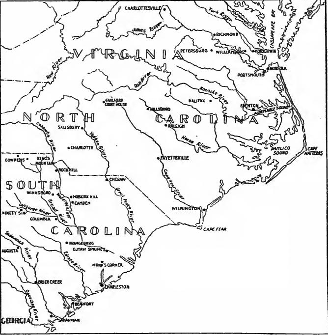 Morristown, New Jersey, to Head of Elk, Maryland (1777)
(Based on map in G.O. Trevelyan, The American Revolution, Part III, op. p. 492).
Morristown, New Jersey, to Head of Elk, Maryland (1777)
(Based on map in G.O. Trevelyan, The American Revolution, Part III, op. p. 492).
[Pg 502] Germantown.—Within a week Washington was ready to try to retake the city. The approach from the northwest lay through Germantown. In the outskirts Howe had stationed a strong force of infantry. Near the center of the village the fine brick mansion of Benjamin Chew, the Chief Justice of Pennsylvania, formed the pivot of the second line of defence which was commanded by Colonel Musgrave. A mile to the rear lay the bulk of the British army. Washington planned to advance in four columns. Armstrong with the Pennsylvania militia on the right was to get in the rear of the British left. Sullivan commanded the next column to the east and was followed by the reserve under Stirling. A third column was commanded by Greene, and the Maryland and New Jersey militia, forming the fourth column, were to strike the British right. Save for a few shots fired by Armstrong's men, the militia failed to get into the fighting.
[Pg 502] Germantown.—Within a week, Washington was ready to attempt to retake the city. The route from the northwest went through Germantown. On the outskirts, Howe had positioned a strong force of infantry. Near the center of the village stood the impressive brick mansion of Benjamin Chew, the Chief Justice of Pennsylvania, which served as the pivot for the second line of defense commanded by Colonel Musgrave. A mile back was the majority of the British army. Washington planned to advance in four columns. Armstrong, with the Pennsylvania militia on the right, was to get behind the British left. Sullivan led the next column to the east, followed by the reserve under Stirling. Greene commanded a third column, and the Maryland and New Jersey militia made up the fourth column, intending to hit the British right. Aside from a few shots fired by Armstrong's men, the militia did not engage in the fighting.
The dawn of October 4 broke in a dense fog, which destroyed the possibility of coöperation and led to much confusion. Sullivan's men arrived first and soon drove the British from their advanced position. Then followed an attack which centered at Chew's house where Musgrave and his men had taken refuge. The sound of the firing attracted some of Greene's men who joined in the attack. The brick walls proved too strong for the American three-pounders, and most of the forces of Sullivan and Greene passed on to attack the next line where five brigades of royal troops were drawn up along a narrow lane. The American units became separated, Greene having advanced a considerable distance ahead of Sullivan's troops. Suddenly Sullivan's force broke and fled in an unaccountable panic. This placed Greene in great jeopardy, for his flank was exposed and British reinforcements were approaching, but he coolly saved his men and guns. So heavy were the British losses that no serious attempt was made to follow the retreating army which was able to get away with all its artillery.
The morning of October 4 began with a thick fog that made cooperation impossible and caused a lot of confusion. Sullivan's troops were the first to arrive and quickly pushed the British out of their forward position. They then launched an attack focused on Chew's house, where Musgrave and his men were hiding. The sound of gunfire drew in some of Greene's soldiers, who joined the assault. The brick walls proved too strong for the American three-pound cannons, and most of Sullivan's and Greene's forces moved on to attack the next line, where five brigades of British troops were stationed along a narrow lane. The American units became disorganized, with Greene advancing significantly ahead of Sullivan’s forces. Suddenly, Sullivan's troops panicked and retreated inexplicably. This put Greene in serious danger, as his flank was exposed and British reinforcements were coming, but he calmly managed to save his men and artillery. The British suffered such heavy losses that they made no serious effort to pursue the retreating army, which managed to escape with all its artillery.
Opening the Delaware.—Philadelphia was firmly held by the British but the Delaware was still closed. At Billingsport[Pg 503] a fort had been built and an obstruction had been thrown across the river. Another obstruction blocked the passage below Mud Island, on which stood Fort Mifflin and opposite on the Jersey shore was Ft. Mercer. A flotilla of small craft patrolled the Delaware. On October 4 part of Lord Howe's fleet anchored in the river and two days later the obstruction at Billingsport was removed. On October 22 Colonel von Donop attempted to capture Ft. Mercer but he met with a bloody repulse. After this defeat the British proceeded with more caution in the reduction of Ft. Mifflin. Shore batteries were constructed which bombarded Mud Island for days. On November 15 two battleships navigated the difficult channel and soon battered the walls of the fort to pieces. At nightfall the garrison abandoned the fortress. Four days later Ft. Mercer was evacuated when an overwhelming force advanced against it, and on November 21 most of the American vessels were set on fire by their crews. Communication with New York was thus opened and Howe prepared to settle down in Philadelphia for the winter.
Opening the Delaware.—Philadelphia was under British control, but the Delaware River was still blocked. At Billingsport[Pg 503], a fort had been constructed and an obstruction had been placed across the river. Another obstruction prevented passage below Mud Island, where Fort Mifflin was located, and directly across on the Jersey shore was Fort Mercer. A fleet of small boats patrolled the Delaware. On October 4, part of Lord Howe's fleet anchored in the river, and two days later, the obstruction at Billingsport was removed. On October 22, Colonel von Donop tried to take Fort Mercer but faced a bloody defeat. After this setback, the British approached the capture of Fort Mifflin with more caution. Shore batteries were built that bombarded Mud Island for days. On November 15, two battleships navigated the tricky channel and soon shattered the fort's walls. By nightfall, the garrison had abandoned the fortress. Four days later, Fort Mercer was evacuated as an overwhelming force advanced, and on November 21, most of the American vessels were set ablaze by their crews. This allowed communication with New York to resume, and Howe prepared to settle in Philadelphia for the winter.
Valley Forge.—In marked contrast to the comfort of the British camp was the condition of the American army. Washington had chosen Valley Forge for his winter quarters and there a fortified camp was constructed and rude cabins erected to house the men. The camp soon became a charnel house, for Congress failed to supply the necessary food and clothing, and sickness inevitably resulted. For days the men were without meat and existed on dough baked in the embers. "Fire-cake" and water became the ration for breakfast, dinner, and supper. Blankets were lacking and the men were soon barefooted and in tatters. On Christmas day the winter broke with great severity and soon the hospitals, which were mere hovels unsupplied with beds, were crowded with the dying.
Valley Forge.—In sharp contrast to the comfort of the British camp was the situation of the American army. Washington chose Valley Forge for their winter quarters, where a fortified camp was built and basic cabins were set up to shelter the men. The camp quickly turned into a place of despair, as Congress failed to provide enough food and clothing, leading to widespread illness. For days, the men went without meat and survived on dough baked in the embers. "Fire-cake" and water became their only meals for breakfast, lunch, and dinner. They lacked blankets, and soon the men were barefoot and wearing tattered clothes. On Christmas Day, the winter hit with great severity, and the hospitals, which were just shabby shacks without beds, became overcrowded with the dying.
The Conway Cabal.—The anguish of Washington was intensified by an intrigue which threatened to deprive him of his command. This centered about Gates and an Irish soldier of fortune named Conway who had been sent over from France by Silas Deane. In November, 1777, Congress had vested the management of military affairs in a Board of War. Gates was made president of the board and Conway was appointed inspector general of the army. They were supported by the New England[Pg 504] delegates in Congress and by those who opposed the Fabian policy of Washington. Fortunately the intrigues of Conway and Gates to displace Washington became known to the public and so great was the popularity of the commander-in-chief that Congress dared not remove him.
The Conway Cabal.—Washington's distress was heightened by a plot that aimed to take his command away from him. This scheme involved Gates and an Irish mercenary named Conway, who was sent from France by Silas Deane. In November 1777, Congress had given control of military affairs to a Board of War. Gates became the president of the board, and Conway was appointed as the inspector general of the army. They had the backing of the New England[Pg 504] delegates in Congress and those who opposed Washington's cautious strategy. Fortunately, the conspiracies of Conway and Gates to oust Washington were revealed to the public, and the widespread popularity of the commander-in-chief made it so that Congress hesitated to remove him.
READINGS
Charming, Edward, History of the United States, III, 210-273; Fisher, S. G., The Struggle for American Independence, I, 490-574, II, 1-174; Fiske, John, The American Revolution, I, 198-344, II, 25-81, 110-115; Greene, F. V., The Revolutionary War, 28-131; Hildreth, Richard, History of the United States of America, III, 140-162, 186-237; Lecky, W.E.H., History of England in the Eighteenth Century, IV, 1-41, 55-98; Smith, J.H., Our Struggle for the Fourteenth Colony, I, 193-606, II; Trevelyan, G.O., The American Revolution, II, 172-349, III, 1-147, IV, 111-319; Van Tyne, C.H., The American Revolution, 102-135, 157-174, 227-247; Winsor, Justin, Narrative and Critical History, VI, 275-447; Adams, C.F., Studies Military and Diplomatic, 1775-1865, pp. 22-173.[Pg 505]
Charming, Edward, History of the United States, III, 210-273; Fisher, S. G., The Struggle for American Independence, I, 490-574, II, 1-174; Fiske, John, The American Revolution, I, 198-344, II, 25-81, 110-115; Greene, F. V., The Revolutionary War, 28-131; Hildreth, Richard, History of the United States of America, III, 140-162, 186-237; Lecky, W.E.H., History of England in the Eighteenth Century, IV, 1-41, 55-98; Smith, J.H., Our Struggle for the Fourteenth Colony, I, 193-606, II; Trevelyan, G.O., The American Revolution, II, 172-349, III, 1-147, IV, 111-319; Van Tyne, C.H., The American Revolution, 102-135, 157-174, 227-247; Winsor, Justin, Narrative and Critical History, VI, 275-447; Adams, C.F., Studies Military and Diplomatic, 1775-1865, pp. 22-173.[Pg 505]
CHAPTER XXVI
THE WAR AS AN INTERNATIONAL CONTEST
THE FRENCH ALLIANCE
The French motives.—On February 6, 1778, France entered into an alliance with the United States. That event changed the war from a struggle between England and her former colonies to an international contest in which Spain and Holland were soon engaged. The motives of France in entering the contest have been variously ascribed to revenge for the loss of her possessions and the desire to regain them, to the intellectual movement in France, to the desire to build up French commerce at the expense of England, and to the fear that Great Britain would adjust the difficulties with the colonies and unite with them in an attack upon the French West Indies. Professor Corwin, who has recently examined the question, concludes that these explanations are not adequate. He contends that the basic principle of French diplomacy was the maintenance of leadership in Europe, and that in return for this commanding position, France was willing to forego the extension of her dominion. In the Seven Years' War French prestige had been destroyed; to rebuild it was the object of her statesmen.
The French motives.—On February 6, 1778, France formed an alliance with the United States. This event transformed the war from a conflict between England and its former colonies into an international struggle involving Spain and the Netherlands soon after. The reasons behind France's involvement have been attributed to a desire for revenge for the loss of its territories, a response to the intellectual movements in France, an aim to boost French trade at Britain's expense, and a concern that Great Britain might resolve its issues with the colonies and join forces with them against the French West Indies. Professor Corwin, who has recently looked into this topic, believes these explanations fall short. He argues that the core principle of French diplomacy was to maintain its leadership in Europe and that France was willing to give up territorial expansion in exchange for this prominent position. French prestige had been diminished during the Seven Years' War; restoring it became a priority for its leaders.
The policy of Vergennes.—In 1774 Louis XVI became king. No better intentioned ruler ever mounted a throne but his weak will and vacillating course led to his undoing. For two years Turgot was the reigning influence at the council board. He installed a system of economy and reform, which, had it been adhered to, would probably have saved France from the throes of her great revolution. Turgot's plans ran counter to the policy of Vergennes, the foreign minister, who desired to see his country take its place in the sun as the dictator of European politics. The attainment of Vergennes's policy was based upon three main ideas: the preservation of peace on the continent by a close alliance with Austria; a renewal of the Family Compact[Pg 506] with Spain; and the humbling of England. The last was to be accomplished by the building up of the French navy, by secretly aiding the colonies, and when the time seemed auspicious, by entering into an alliance with them, an alliance in which Vergennes hoped that Spain would join. To win over the latter power and to overcome the aversion of Louis XVI to aiding rebellious subjects were the immediate problems of Vergennes.
The policy of Vergennes.—In 1774, Louis XVI became king. No ruler ever had better intentions, but his weak will and indecisive actions led to his downfall. For two years, Turgot held the most influence in the council. He introduced a system of economic reform that, if followed, might have saved France from the turmoil of its great revolution. Turgot's plans clashed with the policy of Vergennes, the foreign minister, who wanted France to assert itself as a leader in European politics. Vergennes's policy was based on three main ideas: maintaining peace on the continent through a close alliance with Austria; renewing the Family Compact[Pg 506] with Spain; and diminishing England's power. This last goal was to be achieved by strengthening the French navy, secretly supporting the colonies, and, when the time was right, forming an alliance with them, which Vergennes hoped Spain would join. Winning over Spain and convincing Louis XVI to assist rebellious subjects were Vergennes's immediate challenges.
Vergennes wins over the king.—A secret agent, Bonvouloir, was sent to America to ascertain the condition of the colonies. His first report, which reached Paris in March, 1776, gave a favorable statement of the military situation. Vergennes immediately attempted to convince the king that secret aid should be given the colonies. He argued that the prolongation of the struggle would be advantageous to France and Spain as it would weaken both contestants, and he pointed out that England would probably attack the French West Indies as soon as the present war was over. Aided by Beaumarchais, the author of Le Mariage de Figaro, Vergennes countered the advice of Turgot and won over the king to his plan.
Vergennes wins over the king.—A secret agent, Bonvouloir, was sent to America to figure out the situation in the colonies. His first report, which arrived in Paris in March 1776, gave a positive overview of the military situation. Vergennes immediately tried to persuade the king that secret support should be given to the colonies. He argued that prolonging the conflict would benefit France and Spain, as it would weaken both opponents, and he pointed out that England would likely attack the French West Indies as soon as the current war concluded. With help from Beaumarchais, the author of Le Mariage de Figaro, Vergennes countered Turgot's advice and convinced the king to support his plan.
Deane and Beaumarchais.—The secret committee on foreign correspondence of the Continental Congress in March, 1776, sent Silas Deane to Paris. His presence became known to Lord Stormont, the British ambassador, who demanded his deportation, but France refused and continually aided him in securing supplies. The French government also loaned the colonies a million livres and obtained a similar amount for them from Spain. When news of the Declaration of Independence reached Paris, Vergennes urged that France and Spain enter the war, but Washington's defeats around New York held back both countries. France continued to aid the colonies, the business being transacted by Beaumarchais through the fictitious house of Hortalez et Cie. Beaumarchais also drew heavily upon his private fortune to assist the colonies.
Deane and Beaumarchais.—In March 1776, the secret committee on foreign correspondence of the Continental Congress sent Silas Deane to Paris. His presence caught the attention of Lord Stormont, the British ambassador, who demanded his deportation, but France refused and continuously supported him in obtaining supplies. The French government also loaned the colonies a million livres and arranged for a similar amount from Spain. When news of the Declaration of Independence reached Paris, Vergennes urged France and Spain to join the war, but Washington's losses around New York prevented both countries from acting. France kept supporting the colonies, with Beaumarchais managing the operations through the fake company Hortalez et Cie. Beaumarchais also used a significant part of his own wealth to help the colonies.
Franklin.—The delay of France in making an open alliance caused Congress to appoint a commission composed of Silas Deane, Arthur Lee, and Benjamin Franklin Of all colonials Franklin was the best known in Europe. As a scientist, philosopher, wit, and statesman, his name was familiar to all classes in the French capital. His unpretentious dress, unaffected manners,[Pg 507] and simplicity of life made him seem to Parisians the impersonation of the natural man of Rousseau's philosophy. On the street, at the theater, in the salon, Franklin was the center of interest. Artists made busts of him and jewelers exhibited his countenance on medallions, watches, and snuff-boxes. Franklin soon discovered that he could not hurry matters; he quietly bided his time, never losing an opportunity to win supporters to the American cause. Even the court became enthusiastic, and Marie Antoinette, with little understanding or prophetic vision, applauded the republicans of America.
Franklin.—The delay from France in forming an open alliance led Congress to appoint a commission made up of Silas Deane, Arthur Lee, and Benjamin Franklin. Of all the colonials, Franklin was the most well-known in Europe. As a scientist, philosopher, wit, and statesman, his name was recognized by all social classes in the French capital. His simple dress, relaxed demeanor,[Pg 507] and straightforward lifestyle made him seem to Parisians like the embodiment of Rousseau's concept of the natural man. On the streets, at the theater, in salons, Franklin was the center of attention. Artists created busts of him, and jewelers displayed his image on medallions, watches, and snuff-boxes. Franklin quickly realized he couldn’t rush things; he patiently waited for the right moments, always taking the chance to gain supporters for the American cause. Even the court became excited, and Marie Antoinette, with little understanding or foresight, praised the republicans of America.
The American proposals.—In January, 1777, the commissioners presented their views to Vergennes. They proposed that France and Spain furnish the United States eight ships of the line, twenty or thirty thousand stand of arms, and a large quantity of cannon and ammunition. Congress in return offered the two nations a commercial treaty and a guarantee of their possessions in the West Indies. Vergennes was unable to comply but he advanced two hundred and fifty thousand livres as the first instalment of a secret loan of two millions. In February the commissioners suggested that, if France and Spain became involved in war because of a treaty with the United States, the states would not conclude a separate peace. In March they proposed a triple alliance between France, Spain, and the United States. The bait for Spain was the conquest of Portugal, and the war was to continue until England was expelled from North America and the West Indies.
The American proposals.—In January 1777, the commissioners shared their ideas with Vergennes. They suggested that France and Spain provide the United States with eight warships, twenty to thirty thousand weapons, and a large supply of cannons and ammunition. In return, Congress offered both nations a trade agreement and a guarantee of their territories in the West Indies. Vergennes couldn't fully meet their requests but advanced two hundred and fifty thousand livres as the first part of a secret loan of two million. In February, the commissioners proposed that if France and Spain entered the war due to a treaty with the United States, the states would not make a separate peace. In March, they suggested a three-way alliance between France, Spain, and the United States. The incentive for Spain was the conquest of Portugal, and the war was to continue until England was driven out of North America and the West Indies.
The attitude of Spain.—The American proposals included both France and Spain, and in the latter country the commissioners met with a stumbling block. Spain at first showed a friendly attitude. Through the firm of Josef Gardoqui and Sons supplies were secretly furnished to the United States, but when Arthur Lee attempted to go to Madrid, he was turned back by the Spanish authorities, who preferred to work in secret. In February, 1777, the Count de Florida Blanca became minister of foreign affairs. To Florida Blanca Spain's interests must take precedence over those of France in determining Spanish policy. Difficulties with Portugal had been adjusted, and Florida Blanca could see no advantage in an immediate war with Great Britain. He was willing to keep the contest in America going[Pg 508] until both parties were exhausted. Then Spain and France might enter the war, Spain to get the Floridas and France to obtain Canada. But as to the recognition of American independence, king and minister were unalterably opposed.
The attitude of Spain.—The American proposals included both France and Spain, and in Spain, the commissioners encountered a challenge. Initially, Spain appeared friendly. Through the firm of Josef Gardoqui and Sons, supplies were secretly provided to the United States, but when Arthur Lee tried to go to Madrid, the Spanish authorities turned him back, preferring to operate in secrecy. In February 1777, Count de Florida Blanca became the minister of foreign affairs. For Florida Blanca, Spain's interests had to take priority over those of France in shaping Spanish policy. Issues with Portugal had been resolved, and Florida Blanca saw no benefit in starting an immediate war with Great Britain. He was open to continuing the conflict in America until both sides were worn out. Then, Spain and France could enter the war, with Spain aiming to acquire Florida and France wanting Canada. However, regarding the recognition of American independence, both the king and the minister were firmly opposed.
Lafayette.—Of no little importance in bringing France and the United States together was the coming of the young nobleman Lafayette to America. Fired by the Declaration of Independence, he determined to enlist in the American cause. In April, 1777, Lafayette with the Baron de Kalb and several other officers sailed for America. They reached Philadelphia on July 27 but Congress gave them a chilly reception. Nothing daunted, Lafayette proudly announced that he asked nothing but the opportunity of serving as a volunteer. Congress was deeply impressed by his unselfish attitude and promptly made him a Major-General. Washington received him gladly, took him into his military family and through the long war, with the exception of a period when he was promoting American interests in France, he served as a trusted officer of the commander-in-chief.
Lafayette.—An important factor in bringing France and the United States together was the arrival of the young nobleman Lafayette in America. Inspired by the Declaration of Independence, he decided to join the American cause. In April 1777, Lafayette, along with Baron de Kalb and several other officers, set sail for America. They arrived in Philadelphia on July 27, but Congress greeted them coolly. Undeterred, Lafayette confidently expressed that he wanted nothing more than the chance to serve as a volunteer. Congress was greatly impressed by his selfless attitude and quickly appointed him as a Major-General. Washington welcomed him warmly, included him in his military team, and throughout the lengthy war, apart from a period when he was advocating for American interests in France, he served as a trusted officer to the commander-in-chief.
The French alliance.—During the summer of 1777 the American question was held in abeyance at Paris but Burgoyne's surrender stirred Vergennes to action. He appears to have feared that Great Britain was about to effect a reconciliation with the United States. To prevent it he believed that France must openly espouse the American cause. One more effort was made to draw Spain into the alliance, but the reply proved unfavorable. On January 7, 1778, at a French royal council meeting the final decision was made and on February 6 treaties of commerce and alliance were signed. The latter agreement was described as a defensive alliance to maintain effectually the liberty, sovereignty, and independence of the United States, as well in matters of government as in commerce.
The French alliance.—During the summer of 1777, the situation in America was sidelined in Paris, but Burgoyne's defeat pushed Vergennes to take action. He seemed to worry that Great Britain was about to reconcile with the United States. To stop this, he believed France needed to publicly support the American cause. There was one last attempt to bring Spain into the alliance, but the response was not favorable. On January 7, 1778, during a meeting of the French royal council, a final decision was reached, and on February 6, treaties of commerce and alliance were signed. The latter was described as a defensive alliance aimed at effectively preserving the liberty, sovereignty, and independence of the United States, both in governance and commerce.
Lord North attempts conciliation.—When news of Burgoyne's surrender reached London, hope of subduing the rebellion by force was temporarily abandoned and Lord North was empowered to try his hand at conciliation. On February 17, 1778, the Prime Minister presented his plan to the Commons. He proposed (1) the repeal of the tea duty, (2) the passage of an act removing apprehension regarding parliamentary taxation of the[Pg 509] colonies, (3) opening the port of Boston, (4) restoration of the Massachusetts charter, (5) opening the fisheries, (6) restoration of commerce, and (7) full pardon to those engaged in rebellion. (8) Prisoners charged with treason were not to be brought over the sea for trial, and (9) no bill for changing a colonial constitution was to be introduced in parliament except at the request of the colony involved. (10) Regulation of colonial courts was to follow colonial opinion, and (11) officials were to be elected by popular vote subject, however, to the approval of the king. (12) The royal treasury was to assist in the withdrawal of colonial currency, and (13) a promise was given that the question of colonial representation in parliament would be considered.
Lord North tries to negotiate peace.—When news of Burgoyne's surrender reached London, the hope of defeating the rebellion through force was temporarily abandoned, and Lord North was given the chance to attempt reconciliation. On February 17, 1778, the Prime Minister presented his plan to the House of Commons. He proposed (1) the repeal of the tea tax, (2) passing a law to ease concerns about parliamentary taxation of the[Pg 509] colonies, (3) reopening the port of Boston, (4) restoring the Massachusetts charter, (5) reopening the fisheries, (6) restoring trade, and (7) granting full pardons to those involved in the rebellion. (8) Prisoners charged with treason would not be sent overseas for trial, and (9) no bill to change a colonial constitution would be introduced in parliament without the request of the involved colony. (10) The regulation of colonial courts would follow colonial opinion, and (11) officials would be elected by popular vote, subject to the king's approval. (12) The royal treasury would help withdraw colonial currency, and (13) there was a promise to consider the question of colonial representation in parliament.
The Carlisle Commission.—A royal commission was to visit America to settle points in dispute. Headed by the Earl of Carlisle, the commission proceeded to Philadelphia but it was soon discovered that nothing could be accomplished. General Howe had been recalled and Clinton, who was placed in command, was under orders to evacuate Philadelphia. The alliance with France was already known in America and nothing short of a recognition of independence would satisfy the Whig leaders.
The Carlisle Commission.—A royal commission was set to visit America to resolve disputes. Led by the Earl of Carlisle, the commission went to Philadelphia, but it quickly became clear that nothing could be achieved. General Howe had been recalled, and Clinton, who took over command, was ordered to evacuate Philadelphia. The alliance with France was already known in America, and only a recognition of independence would satisfy the Whig leaders.
Change in British plans.—The French alliance brought about a complete change in British plans. Henceforth garrisons were to be kept in New York, Newport, Canada, and the Floridas, and hostilities on the mainland were to be devoted to the destruction of coastwise trade and coast towns, and to the harassing of the frontiers by Indian raids. Attacks in force were to be made on the French possessions in the West Indies.
Change in British plans.—The French alliance resulted in a total shift in British plans. From now on, garrisons were to be stationed in New York, Newport, Canada, and Florida, and efforts on the mainland would focus on disrupting coastal trade and coastal towns, as well as troubling the frontiers with Indian raids. Major attacks were to be launched against French holdings in the West Indies.
Evacuation of Philadelphia and the battle of Monmouth.—In pursuance of this plan in May, '78, the British prepared to evacuate Philadelphia. General Howe returned to England and Clinton took command. Most of the stores, some of the troops, and about three thousand Loyalists were placed on transports, and the main army on June 18 started on its march across New Jersey. Washington succeeded in getting in touch with the British army ten days later at Monmouth. Clinton's forces were stretched out to such an extent that it was difficult to bring them into action. Washington sent Lee to attack, but after a slight demonstration, the poltroon ordered a retreat. Lee's cowardice gave the British time to form and a bloody battle[Pg 510] followed which ended only with nightfall. In the darkness the British army broke camp and when morning dawned it was beyond the reach of Washington.
Evacuation of Philadelphia and the battle of Monmouth.—In May 1778, the British started to evacuate Philadelphia as part of their plan. General Howe went back to England, and Clinton took over command. Most of the supplies, some troops, and about three thousand Loyalists were put on ships, and the main army began marching across New Jersey on June 18. Washington managed to make contact with the British army ten days later at Monmouth. Clinton's forces were spread so thin that it was hard to get them into action. Washington sent Lee to attack, but after a minor show of force, Lee ordered a retreat. Lee's cowardice gave the British time to regroup, and a bloody battle[Pg 510] ensued, lasting until nightfall. In the darkness, the British army packed up and, by morning, they were out of Washington's reach.
The coming of D'Estaing.—On April 15 Admiral D'Estaing sailed from Toulon in command of twelve ships of the line and five frigates which carried four thousand infantry. The voyage was pursued in a leisurely fashion which gave Lord Howe time to get his transports out of the Delaware and concentrate the fleet at New York. It also made it possible for a reinforcement under Commodore Byron to arrive in American waters. Not until July 8 was D'Estaing's fleet within the Delaware capes. After landing Gérard, the French minister, the admiral proceeded to New York. Though the French fleet was superior to the British, D'Estaing failed to attack.
The Arrival of D'Estaing.—On April 15, Admiral D'Estaing set sail from Toulon commanding twelve battleships and five frigates carrying four thousand troops. The journey was slow-paced, allowing Lord Howe to move his transports out of the Delaware and gather the fleet in New York. It also provided time for a reinforcement led by Commodore Byron to reach American waters. Not until July 8 did D'Estaing's fleet arrive at the Delaware capes. After dropping off Gérard, the French minister, the admiral continued on to New York. Although the French fleet was stronger than the British, D'Estaing chose not to make an attack.
The failure at Newport.—Instead he entered into a plan with Washington to take Newport which was garrisoned by five or six thousand British troops. Sullivan, with about a thousand continental soldiers and several thousand militia, was to coöperate with the French fleet. The opening was auspicious. The war vessels ran by the batteries and anchored in the inner waters. The British commander to prevent capture destroyed several frigates and small craft. On August 9 Sullivan moved nine thousand troops to the island. The same day Howe's fleet appeared at the entrance of Narragansett Bay and D'Estaing, carrying his infantry with him, sailed out to meet the enemy. Before the fleets could engage a terrific storm arose which scattered the vessels. Howe finally regained New York and D'Estaing sailed to Boston for repairs, leaving Sullivan unsupported and in a precarious position. When word came that Clinton was sending large reinforcements, Sullivan abandoned the siege.
The failure at Newport.—Instead, he made a plan with Washington to take Newport, which had about five or six thousand British troops. Sullivan, with around a thousand Continental soldiers and several thousand militia, was supposed to work with the French fleet. The situation looked promising. The warships got past the batteries and anchored in the inner waters. To avoid being captured, the British commander destroyed several frigates and small boats. On August 9, Sullivan moved nine thousand troops to the island. That same day, Howe's fleet appeared at the entrance of Narragansett Bay, and D'Estaing, bringing his infantry with him, sailed out to confront the enemy. Before the fleets could engage, a massive storm hit, scattering the ships. Howe eventually returned to New York, and D'Estaing went to Boston for repairs, leaving Sullivan unsupported and in a tough spot. When word came that Clinton was sending large reinforcements, Sullivan gave up the siege.
D'Estaing in the West Indies.—D'Estaing lingered at Boston ten weeks and then sailed for the West Indies. Before his arrival a French force from Martinique had captured Dominica. The English retaliated by capturing St. Lucia, and when D'Estaing attempted to relieve it, he was replused. On June 18, 1779, the French occupied St. Vincent and on July 2 Grenada. On July 6 Byron attacked the French fleet off Grenada, but D'Estaing had the better of the fighting although he failed to follow up[Pg 511] his victory. After attempting the relief of Savannah, the French commander despatched part of his fleet to the West Indies and then sailed for Europe.
D'Estaing in the West Indies.—D'Estaing stayed in Boston for ten weeks and then set sail for the West Indies. Before he arrived, a French force from Martinique had taken Dominica. The British responded by capturing St. Lucia, and when D'Estaing tried to help, he was pushed back. On June 18, 1779, the French took control of St. Vincent, and on July 2, Grenada. On July 6, Byron attacked the French fleet near Grenada, but D'Estaing performed better in the battle, even though he didn’t capitalize on his victory. After trying to support Savannah, the French commander sent part of his fleet to the West Indies and then headed for Europe.[Pg 511]
Stony Point and the evacuation of Newport.—After the Newport failure Washington drew a cordon about New York and strengthened the line of the Hudson. On May 31, 1779, Clinton seized the fortifications at Stony Point and Verplanck's Point, but on July 16 General Wayne carried the works at Stony Point. Clinton also sent raiding parties to the Chesapeake and along the Connecticut coast, but in October he ordered the evacuation of Newport and concentrated his forces at New York.
Stony Point and the evacuation of Newport.—After the Newport failure, Washington set up a perimeter around New York and reinforced the Hudson River line. On May 31, 1779, Clinton took control of the fortifications at Stony Point and Verplanck's Point, but on July 16, General Wayne captured the works at Stony Point. Clinton also dispatched raiding parties to the Chesapeake and along the Connecticut coast, but in October, he ordered the evacuation of Newport and focused his troops in New York.
The second French expedition.—Washington still hoped for effective help from the French fleet in the West Indies, but his hopes were blasted early in 1780 by the arrival in the islands of British naval reinforcements under Admiral Rodney, who during April and May fought three indecisive actions with the French fleet. Largely through the influence of Lafayette France was induced to send a large force to America in 1780. In July a fleet of seven vessels convoying six thousand men commanded by Rochambeau arrived at Newport. The second division, however, was blockaded at Brest and was unable to sail. Washington's hopes mounted high but they were soon dashed again, for Clinton, who had just returned to New York after the capture of Charleston, was able to send a considerable armament to blockade the French at Newport, and there they remained for months to come.
The second French expedition.—Washington still hoped for effective support from the French fleet in the West Indies, but his hopes were shattered early in 1780 when British naval reinforcements under Admiral Rodney arrived in the islands. During April and May, he fought three inconclusive battles with the French fleet. Thanks in large part to Lafayette's influence, France was persuaded to send a significant force to America in 1780. In July, a fleet of seven ships carrying six thousand troops led by Rochambeau arrived at Newport. However, the second division was stuck in Brest and couldn't set sail. Washington's hopes rose high, but they were quickly crushed again when Clinton, who had just returned to New York after capturing Charleston, was able to dispatch a substantial force to blockade the French at Newport, where they stayed for several more months.
Arnold's treason.—During the long contest Washington had often been disappointed by the incompetence of his subordinates, but Nathanael Greene and Benedict Arnold had seldom been found wanting. The former was soon to win fame as the conqueror of the South; the other chose a path which made his name despised. Arnold had not been justly treated by Congress, although he had the absolute confidence of Washington. Brooding over his wrongs and convinced that the country would welcome the reëstablishment of the king's authority, he determined to play the part of a General Monk. While in command of Philadelphia, he entered into a treasonable correspondence with Clinton. He then asked for the command of the great fortress[Pg 512] at West Point. This was readily given to him and there he perfected his plans to deliver this key position of the Hudson to the British. Clinton sent Major André to communicate with Arnold, but upon his return on September 23, 1780, André was captured and on his person were found papers which disclosed the plot. André was condemned and hung as a spy, but Arnold made good his escape to the British lines.
Arnold's betrayal.—Throughout the long struggle, Washington was often let down by the incompetence of his subordinates, but Nathanael Greene and Benedict Arnold rarely fell short. Greene was about to earn fame as the victor of the South; Arnold, on the other hand, chose a path that would make his name hated. Congress had not treated Arnold fairly, even though Washington had complete trust in him. Resentful of his grievances and convinced that the country would welcome the return of the king's authority, he decided to imitate General Monk. While in charge of Philadelphia, he engaged in treasonous correspondence with Clinton. He then requested command of the important fortress[Pg 512] at West Point. This request was quickly granted, and there he developed his plans to hand over this crucial position on the Hudson to the British. Clinton sent Major André to consult with Arnold, but upon his return on September 23, 1780, André was captured, and papers revealing the plot were found on him. André was tried and executed as a spy, but Arnold managed to escape to the British lines.
THE WAR IN THE WEST
Competition for the support of the Indians.—The westward movement across the mountains was almost simultaneous with the outbreak of the Revolution, and the western settlements were soon drawn into the current. The frontiersmen held back the Indian allies of the British, and by settlement and conquest secured large areas of the back country. At the opening of the war both British and Americans made great efforts to secure the support of the Indians, but in the main the tribes favored the British who did not encroach upon their lands and whose posts on the frontiers were centers for the distribution of presents and for the work of the traders. During the war British agents were kept at work among the tribes, distributing presents and weapons, and often leading the Indian raids.
Competition for the support of the Native Americans.—The westward expansion across the mountains happened almost at the same time as the start of the Revolution, and the western settlements quickly got involved. The frontiersmen pushed back the Indian allies of the British, and through settlement and conquest, claimed large areas of the backcountry. At the beginning of the war, both the British and Americans put in significant effort to gain the support of the Native Americans, but mostly the tribes leaned towards the British, who didn't invade their lands and whose forts on the frontiers served as hubs for distributing gifts and for trade. Throughout the war, British agents continuously worked among the tribes, handing out gifts and weapons, and often leading the Indian attacks.
The Cherokee War.—In the summer of 1776 the Cherokee went on the warpath. From their villages in the southern Alleghanies they were in a position to raid the frontier settlements of Georgia, the Carolinas, Virginia, and Tennessee. The Cherokee towns were in three groups. The upper towns inhabited by the Overhill Cherokee were along the mountain streams that ran into the Tennessee. The lower towns were in the foothills of the back country of Georgia and South Carolina. In the mountainous region between were the middle towns. During June and July Cherokee war parties, at times assisted by Creeks and Tories, fell upon the Georgia and Carolina frontiers and upon the Watauga settlements. The Georgia invaders were met by Colonel Samuel Jack at the head of two hundred rangers who drove them back and destroyed one or two of the lower towns. In North Carolina the Indians came down the Catawba and drove the settlers into the blockhouses. General Griffith Rutherford raised the frontier levies and chased the Indians[Pg 513] back to their villages. In South Carolina the Cherokees from the lower and middle towns, aided by Tories and led by the British agent, Cameron, descended upon the settlements. Colonel Andrew Williamson collected eleven hundred militia, defeated the invaders, and by the middle of August destroyed the lower towns. In July seven hundred Overhill Cherokee raided the Watauga settlements. One party under Chief Dragging Canoe attacked the settlers about Eaton's Station, but the frontiersmen sallied forth and defeated the Indians at Island Flats. For three weeks Fort Watauga was invested by another band, but so stubborn was the defence conducted by Robertson and Sevier that the Indians abandoned the siege. The Carolinians and Virginians determined to carry the war into the enemy's country. In September Rutherford and Williamson completely destroyed the valley towns of the Cherokee; and in October Colonel William Christian led the Virginia troops into the Overhill country, destroyed the principal village, and brought the warriors to terms.
The Cherokee War.—In the summer of 1776, the Cherokee went on the attack. From their villages in the southern Appalachians, they were in a position to raid the frontier settlements of Georgia, the Carolinas, Virginia, and Tennessee. The Cherokee towns were divided into three groups. The upper towns, inhabited by the Overhill Cherokee, were located along the mountain streams that flowed into the Tennessee River. The lower towns were in the foothills of the backcountry of Georgia and South Carolina. Between these areas were the middle towns. During June and July, Cherokee war parties, sometimes joined by Creeks and Loyalists, targeted the frontiers of Georgia and Carolina as well as the Watauga settlements. In Georgia, Colonel Samuel Jack led two hundred rangers to confront the invaders, pushing them back and destroying one or two of the lower towns. In North Carolina, the Indians came down the Catawba River and forced the settlers into blockhouses. General Griffith Rutherford organized the frontier militia and chased the Indians[Pg 513] back to their villages. In South Carolina, Cherokees from the lower and middle towns, supported by Loyalists and led by British agent Cameron, attacked the settlements. Colonel Andrew Williamson gathered eleven hundred militia, defeated the attackers, and by mid-August had destroyed the lower towns. In July, seven hundred Overhill Cherokee raided the Watauga settlements. One group, led by Chief Dragging Canoe, attacked the settlers near Eaton's Station, but the frontiersmen emerged and defeated the Indians at Island Flats. For three weeks, Fort Watauga was besieged by another group, but the stubborn defense led by Robertson and Sevier forced the Indians to abandon the siege. The Carolinians and Virginians decided to take the fight into enemy territory. In September, Rutherford and Williamson completely destroyed the valley towns of the Cherokee, and in October, Colonel William Christian led the Virginia troops into the Overhill region, destroyed the main village, and forced the warriors to surrender.
Indian raids in the Northwest, 1776-1778.—In the Northwest the memory of the Battle of the Kanawha kept the Indians quiet for a time while the diplomats struggled for mastery. Colonel George Morgan was made congressional agent at Fort Pitt, while Hamilton at Detroit was the most active British agent on that frontier. In the fall of 1776 Hamilton sent raiding parties along the border. During 1777 the frontiers of Pennsylvania, Virginia, and Kentucky were kept in a state of terror. Colonel Morgan urged an expedition against Detroit, and when his advice was rejected, he resigned. Governor Patrick Henry sent Virginia militia to relieve Kentucky and Congress sent General Hand to defend the upper Ohio. Hand and his successor, McIntosh, had little success, for the raids continued and by the end of 1778 Kentucky was nearly depopulated.
Indian raids in the Northwest, 1776-1778.—In the Northwest, the memory of the Battle of the Kanawha kept the Native Americans calm for a while while diplomats fought for control. Colonel George Morgan was appointed as a congressional agent at Fort Pitt, while Hamilton in Detroit was the most active British agent on that frontier. In the fall of 1776, Hamilton sent raiding parties along the border. Throughout 1777, the frontiers of Pennsylvania, Virginia, and Kentucky were filled with fear. Colonel Morgan pushed for an expedition against Detroit, and when his advice was turned down, he resigned. Governor Patrick Henry sent Virginia militia to support Kentucky, and Congress sent General Hand to protect the upper Ohio. Hand and his successor, McIntosh, achieved little success, as the raids continued, and by the end of 1778, Kentucky was nearly emptied of its population.
Willing's raids.—In 1777 James Willing, a former resident of Natchez, obtained permission from Congress to make an expedition down the Mississippi to secure the neutrality of the Tories in the Southwest. Descending the Ohio from Pittsburg, his expedition became a raid on the Loyalist plantations along the Mississippi. Far from having the desired effect, the raid drove the inhabitants into active resistance. In May Willing led a second expedition down the Mississippi but he failed to win over[Pg 514] the inhabitants. The Chickasaw and Choctaw went over to the British side. The Southwest had thus definitely taken its stand against the United States.
Willing's raids.—In 1777, James Willing, a former resident of Natchez, got permission from Congress to lead an expedition down the Mississippi to secure the loyalty of the Tories in the Southwest. Traveling down the Ohio from Pittsburgh, his mission turned into a raid on the Loyalist plantations along the Mississippi. Instead of achieving his goal, the raid pushed the locals into active resistance. In May, Willing led a second expedition down the Mississippi, but he was unable to persuade[Pg 514] the locals to join him. The Chickasaw and Choctaw switched sides and sided with the British. The Southwest had now firmly taken its position against the United States.
Clark conquers the Northwest.—To Virginia fell the task of conquering the Northwest. The chief actor in the enterprise was George Rogers Clark, who, though only twenty-six, had already played a prominent part in Kentucky. With one hundred and seventy-five frontiersmen, mainly Virginians, in June, 1778, Clark descended the Ohio to Fort Massac, crossed Illinois, and in July took Kaskaskia, Prairie du Rocher, St. Philippe, and Cahokia, and French sympathizers secured the submission of Vincennes. Hamilton at once organized a force at Detroit to retake the lost posts. In December he occupied Vincennes without difficulty, but was unable to proceed farther. In February, 1779, after a difficult march over flooded prairies, Clark captured Hamilton and his force. In December, 1778 the Virginia legislature erected the territory north of the Ohio into the county of Illinois, John Todd being made civil and Clark military head. Clark planned the capture of Detroit, but was unable to get the necessary aid. Instead, in 1780 he founded Fort Jefferson on the Mississippi near the mouth of the Ohio and it soon became the center of a settled area.
Clark conquers the Northwest. — Virginia was tasked with conquering the Northwest. The main figure in this effort was George Rogers Clark, who, though only twenty-six, had already made a significant impact in Kentucky. In June 1778, Clark led one hundred and seventy-five frontiersmen, mostly Virginians, down the Ohio River to Fort Massac, crossed Illinois, and in July captured Kaskaskia, Prairie du Rocher, St. Philippe, and Cahokia, with French supporters ensuring the surrender of Vincennes. Hamilton quickly organized a force in Detroit to retake the lost posts. In December, he easily occupied Vincennes but couldn't advance further. In February 1779, after a challenging march across flooded prairies, Clark captured Hamilton and his troops. In December 1778, the Virginia legislature established the territory north of the Ohio as the county of Illinois, naming John Todd as its civil leader and Clark as the military head. Clark intended to capture Detroit but couldn't secure the needed support. Instead, in 1780, he established Fort Jefferson on the Mississippi near the mouth of the Ohio, which soon became the hub of a settled area.
Depredations of the Iroquois and Tories.—On the New York frontier Burgoyne's invasion had aroused the Iroquois and even after his defeat the Six Nations, except the Tuscaroras, Oneidas, and part of the Mohawks, adhered to the British. Many Tory refugees settled among the Indians and incited them to go on the warpath. In July, 1778, a force of Tories and Iroquois, mainly Senecas, descended into the Wyoming Valley and laid it waste, killing and capturing many of the inhabitants. Continental troops presently reoccupied the valley and in October the Indian town of Unadilla. The Indians and Tories retaliated by a descent on Cherry Valley. The depredations continued in 1779. Troops sent out from Ft. Stanwix destroyed the Onondaga villages. The Indians then assailed the Schoharie Valley and the western settlements in Ulster County, and spread destruction about Pittsburg.
Depredations of the Iroquois and Tories.—On the New York frontier, Burgoyne's invasion had stirred up the Iroquois, and even after his defeat, the Six Nations, except for the Tuscaroras, Oneidas, and part of the Mohawks, sided with the British. Many Tory refugees moved in with the Indians and encouraged them to take up arms. In July 1778, a group of Tories and Iroquois, mainly Senecas, invaded the Wyoming Valley, destroying it and killing or capturing many residents. Continental troops soon reclaimed the valley, and in October, they took the Indian town of Unadilla. The Indians and Tories retaliated by attacking Cherry Valley. The raids continued into 1779. Troops sent out from Ft. Stanwix destroyed the Onondaga villages. The Indians then attacked the Schoharie Valley and the western settlements in Ulster County, causing destruction around Pittsburg.
Expeditions sent into the Iroquois country.—So extensive were the depredations that Congress decided to send an overwhelming[Pg 515] force into the Iroquois country. Three brigades from Washington's army were assembled at Wyoming under Sullivan. While he was waiting for a New York brigade to join him, Chief Brant and his warriors burned Minisink and ambushed the militia who went in pursuit. Sullivan at the head of five thousand men passed up the Chemung branch of the Susquehanna, defeated a strong force of Indians and Tories on the site of modern Elmira, and then burned eighteen Indian villages and destroyed the crops. Sullivan, however, failed to attack Niagara which was a British stronghold. Another expedition from Pittsburg ascended the Alleghany and destroyed the Indian villages along the river. These operations scattered the Indians and Tories but did not destroy them, and frequent depredations occurred on the New York and Pennsylvania frontiers during the remainder of the war.
Expeditions sent into the Iroquois territory.—The destruction was so widespread that Congress decided to send a massive[Pg 515] force into the Iroquois territory. Three brigades from Washington's army were gathered at Wyoming under Sullivan. While he waited for a New York brigade to join him, Chief Brant and his warriors burned Minisink and ambushed the militia that pursued them. Sullivan, leading five thousand men, moved up the Chemung branch of the Susquehanna, defeated a strong group of Indians and Loyalists at what is now Elmira, then burned eighteen Indian villages and destroyed their crops. However, Sullivan did not attack Niagara, which was a British stronghold. Another expedition from Pittsburgh went up the Allegheny River and destroyed the Indian villages along its banks. These actions scattered the Indians and Loyalists but did not eliminate them, and frequent raids occurred on the New York and Pennsylvania frontiers for the rest of the war.
SPAIN IN THE WAR
Spain enters the war.—When Spain became a factor in the war in 1779, a new element entered the contest in the West. During 1778 Vergennes did not relax his efforts to induce Spain to become a belligerent. But Carlos III and Florida Blanca had no intention of risking a war with Great Britain unless they were well paid for their assistance. Not until they were certain that France would assist in the recovery of Gibraltar and the Floridas did they consent to make war. On another point the king was insistent; he refused to recognize the independence of the United States. The secret convention of Aranjuez between France and Spain was signed on April 12, 1779, and in June Spain definitely entered the war.
Spain enters the war.—When Spain became involved in the war in 1779, it added a new dimension to the conflict in the West. Throughout 1778, Vergennes continued to work hard to persuade Spain to join as a combatant. However, Carlos III and Florida Blanca had no plans to risk a war with Great Britain unless they were well compensated for their support. Only when they were assured that France would help reclaim Gibraltar and the Floridas did they agree to go to war. The king was firm on another issue; he refused to acknowledge the independence of the United States. The secret convention of Aranjuez between France and Spain was signed on April 12, 1779, and in June, Spain officially entered the war.
Gálvez on the lower Mississippi.—Orders were given at once to seize the British posts on the Mississippi. With a hastily built fleet, Bernardo de Gálvez, the Governor of Louisiana, ascended the Mississippi at the head of fifteen hundred men. On September 7 he took Fort Bute at Manchac, and then proceeded to Baton Rouge which he captured, the capitulation including Fort Panmure at Natchez. Meanwhile Grandpré had taken two small British outposts and a fleet had captured eight British vessels on Lake Pontchartrain.
Gálvez on the lower Mississippi.—Orders were immediately issued to take over the British posts on the Mississippi. With a quickly assembled fleet, Bernardo de Gálvez, the Governor of Louisiana, traveled up the Mississippi leading fifteen hundred men. On September 7, he captured Fort Bute at Manchac and then moved on to Baton Rouge, which he also took, including the surrender of Fort Panmure at Natchez. In the meantime, Grandpré had taken two small British outposts, and a fleet had seized eight British vessels on Lake Pontchartrain.
British attack on St. Louis.—As soon as war was declared, the British planned to capture New Orleans. An expedition from the north was to descend the Mississippi, attack St. Louis, reconquer the Illinois country, and meet General Campbell at Natchez with a force from Pensacola. The campaign against St. Louis was directed by Sinclair, commander at Mackinac. Emmanuel Hesse, a trader, was sent to assemble a force of Indians at the Fox-Wisconsin portage. In March, 1780, seven hundred and fifty men left Mackinac and joined Hesse at Prairie du Chien. To coöperate Charles Langlade was sent with Indians via Chicago, while Captain Bird, despatched from Detroit, was to raid Kentucky. None of the plans succeeded. Leyba, the commander at St. Louis, was forewarned and was aided by George Rogers Clark. On May 26 the British attacked St. Louis but were repulsed and forced to withdraw. Bird's expedition also miscarried, and Campbell's movement was frustrated by Gálvez.
British attack on St. Louis. — As soon as war was declared, the British planned to capture New Orleans. An expedition from the north was supposed to travel down the Mississippi, attack St. Louis, reclaim the Illinois region, and join General Campbell at Natchez with a force from Pensacola. The campaign against St. Louis was led by Sinclair, the commander at Mackinac. Emmanuel Hesse, a trader, was sent to gather a force of Indians at the Fox-Wisconsin portage. In March 1780, seven hundred and fifty men left Mackinac and met Hesse at Prairie du Chien. To cooperate, Charles Langlade was sent with Indians via Chicago, while Captain Bird, sent from Detroit, was to raid Kentucky. None of the plans worked out. Leyba, the commander at St. Louis, was forewarned and received help from George Rogers Clark. On May 26, the British attacked St. Louis but were repelled and forced to retreat. Bird's expedition also failed, and Campbell's movement was blocked by Gálvez.
The Spanish expedition against St. Joseph.—Sinclair at once planned a second expedition for the spring of 1781. Learning of the project, Cruzat, the new commander at St. Louis, prepared a counter stroke. He despatched parties up the Mississippi and to Peoria, and sent sixty-five men under Purée to destroy the stores at St. Joseph. On February 12 the post was taken in a surprise attack and the stores destroyed.
The Spanish mission against St. Joseph.—Sinclair quickly organized a second mission for the spring of 1781. When Cruzat, the new leader in St. Louis, found out about the plan, he got ready to strike back. He sent groups up the Mississippi River and to Peoria, and dispatched sixty-five men under Purée to destroy the supplies at St. Joseph. On February 12, they launched a surprise attack and took the post, destroying the supplies.
Capture of Mobile and Pensacola.—Meanwhile more important events had been taking place on the Gulf of Mexico. In February, 1780, Gálvez sailed from New Orleans with two thousand men to capture Fort Charlotte at Mobile, and on March 14 the place capitulated. Going to Cuba for reinforcements, after losing one fleet in a hurricane, in February, 1781, he sailed with fourteen hundred men to attack Pensacola. After a siege of nearly two months, General Campbell with more than eight hundred men surrendered. A simultaneous French and Spanish attack on Jamaica was next planned, and Gálvez sailed for Santo Domingo to command the Spanish forces, but the campaign was made unnecessary by the ending of the war. Spain had played an important part. She had defeated the British attempt to gain control of the Mississippi, had enabled Clark to[Pg 517] maintain his hold on the Northwest, and had recovered Mobile and Pensacola.
Capture of Mobile and Pensacola.—Meanwhile, more significant events were unfolding in the Gulf of Mexico. In February 1780, Gálvez left New Orleans with two thousand men to take Fort Charlotte in Mobile, and on March 14, the fort surrendered. After traveling to Cuba for reinforcements and losing one fleet in a hurricane, he set sail again in February 1781 with fourteen hundred men to assault Pensacola. Following a siege of nearly two months, General Campbell and more than eight hundred men capitulated. A joint French and Spanish attack on Jamaica was then planned, and Gálvez headed to Santo Domingo to lead the Spanish forces, but the campaign became unnecessary when the war concluded. Spain played a crucial role in these events. She thwarted the British's attempt to control the Mississippi, enabled Clark to[Pg 517] maintain his grip on the Northwest, and recaptured Mobile and Pensacola.
THE WAR ON THE SEA AND THE DUTCH ALLIANCE
Washington's fleets.—From the beginning of the war American vessels were an important factor. They captured supply ships and transports, harassed commerce, captured many small war vessels, and protected trading vessels. At the opening of hostilities Washington turned to New England to supply him with vessels, and during the siege of Boston he sent out ten armed craft which made several important captures of arms and supplies. When operations were transferred to New York, he also engaged several vessels which rendered good service.
Washington's fleets.—From the start of the war, American ships were a crucial element. They seized supply ships and transports, disrupted trade, captured many small warships, and protected merchant vessels. When fighting began, Washington looked to New England to provide him with ships, and during the siege of Boston, he dispatched ten armed vessels that made several significant captures of weapons and supplies. When operations moved to New York, he also hired several ships that performed well.
Congress provides a navy.—Largely through the influence of the Rhode Island delegates, Congress was convinced that a navy should be provided, and by January, 1776, ten vessels had been purchased and the building of thirteen others authorized. Before the end of the war over forty vessels were added to the high seas fleet in addition to minor craft on Lake Champlain.
Congress provides a navy.—Thanks in large part to the efforts of the Rhode Island delegates, Congress agreed that a navy should be created, and by January 1776, ten ships had been purchased and the construction of thirteen more was approved. By the end of the war, over forty additional ships were added to the high seas fleet, along with smaller boats on Lake Champlain.
First cruise of the fleet.—In February, 1776, Esek Hopkins, who had been appointed commander-in-chief of the navy, put to sea with a fleet of eight vessels. He cruised to the West Indies, captured New Providence, and sailed away with eighty-eight cannon, fifteen mortars, and a large quantity of stores. The fleet sailed to Long Island and off the eastern end it captured two small vessels, but on April 6 it allowed the Glasgow to escape.
First cruise of the fleet.—In February 1776, Esek Hopkins, who had been appointed the commander-in-chief of the navy, set sail with a fleet of eight ships. He traveled to the West Indies, seized New Providence, and left with eighty-eight cannons, fifteen mortars, and a significant amount of supplies. The fleet then headed to Long Island, where it captured two small vessels, but on April 6, it let the Glasgow escape.
Nature of the operations during 1776-1777.—By the end of 1776 the navy had been increased to twenty-five vessels. During the year it was constantly engaged in commerce destroying, and in capturing transports and small war craft. The operations were confined mainly to American and West Indian waters, although before the end of the year the Reprisal, which carried Franklin to France, had captured several vessels in European waters. During 1777 the congressional vessels, privateers, and state cruisers captured four hundred and sixty-seven vessels, many being taken near the British Isles. The depredations caused great alarm in England and the West Indies; merchants[Pg 518] were often deterred from shipping goods, insurance rates and prices rose, and the demands for escorts became insistent.
Nature of the operations during 1776-1777.—By the end of 1776, the navy had expanded to twenty-five ships. Throughout the year, it was actively involved in destroying enemy commerce and capturing transports and small warships. The operations were mainly focused in American and West Indian waters, though by the end of the year, the Reprisal, which had taken Franklin to France, managed to capture several vessels in European waters. In 1777, congressional vessels, privateers, and state cruisers seized four hundred and sixty-seven ships, many of which were taken near the British Isles. These attacks caused significant concern in England and the West Indies; merchants[Pg 518] were often discouraged from shipping goods, insurance rates and prices increased, and the demand for escorts became urgent.
Privateers.—The swift sailing craft of the Yankee skippers made ideal blockade runners and commerce destroyers, and hundreds of them put to sea. During the war Massachusetts commissioned nine hundred and ninety-eight. While the greater number of these vessels put out from New England, other states gave many commissions, Maryland alone commissioning two hundred and fifty. It is estimated that during the war the privateers captured or destroyed six hundred vessels with cargoes valued at $18,000,000, besides making several important captures of troops and supplies.
Privateers.—The fast sailing ships of the Yankee captains were perfect for running blockades and destroying commerce, and hundreds of them set sail. During the war, Massachusetts commissioned nine hundred and ninety-eight of these ships. While most of them came from New England, other states issued many commissions as well, with Maryland alone commissioning two hundred and fifty. It’s estimated that during the war, privateers captured or destroyed six hundred vessels carrying cargoes worth $18,000,000, in addition to making several significant captures of troops and supplies.
State navies.—With the exception of New Jersey and Delaware, the states had navies, the largest being those of Massachusetts, Connecticut, Pennsylvania, Maryland, Virginia, and South Carolina. At times these operated independently, sometimes in conjunction with privateers, and at other times as adjuncts of the regular navy. They were used chiefly to protect the trade in home waters and for coast defence.
State navies.—Except for New Jersey and Delaware, the states had navies, with the largest belonging to Massachusetts, Connecticut, Pennsylvania, Maryland, Virginia, and South Carolina. Sometimes these operated independently, other times alongside privateers, and at other times as support for the regular navy. They were mainly used to protect trade in local waters and for coastal defense.
The Penobscot expedition.—The most pretentious operation undertaken by a state navy was the attempt to capture Penobscot in 1779. The British had established a naval base near the mouth of the Penobscot River and Massachusetts determined to break it up. Fifteen hundred men were loaded on privateers and transports, and were convoyed by the Warren, the Diligent, and the Providence. The expedition arrived off the Penobscot late in July, but before it could take the fort, a larger British fleet appeared (August 13). The privateers and transports scattered, but the three war vessels were forced to run up the river where their crews destroyed them.
The Penobscot expedition.—The most ambitious operation carried out by a state navy was the attempt to capture Penobscot in 1779. The British had set up a naval base near the mouth of the Penobscot River, and Massachusetts decided to shut it down. Fifteen hundred men were loaded onto privateers and transports, and were escorted by the Warren, the Diligent, and the Providence. The expedition reached Penobscot late in July, but before it could seize the fort, a larger British fleet showed up (August 13). The privateers and transports scattered, but the three warships had to retreat up the river, where their crews destroyed them.
The navy during 1778-1779.—During 1778 the British navy succeeded in greatly decreasing the depredations of American vessels. By the close of the year the national navy was reduced to fourteen. But in 1779 the fleet was somewhat rehabilitated by the securing of several French vessels.
The navy during 1778-1779.—In 1778, the British navy effectively reduced the attacks on American ships. By the end of the year, the national navy had decreased to fourteen. However, in 1779, the fleet was somewhat restored by acquiring several French vessels.
The Bonhomme Richard and the Serapis.—In 1779 the most famous sea-fight of the Revolution occurred. John Paul Jones was given command of an old French East Indiaman which was refitted with forty-two guns and renamed the Bonhomme Richard.[Pg 519] In August the French frigate Alliance and three small vessels accompanied the Bonhomme Richard on a cruise along the west coast of Ireland, northern Scotland, and the eastern coast of England, several prizes being taken. On September 23 off Flamborough Head Jones sighted a large merchant fleet convoyed by the forty-four gun frigate Serapis and the smaller Countess of Scarborough. The Bonhomme Richard engaged the Serapis in one of the most thrilling of naval battles. For three and a half hours the frigates fought at close range, much of the time being lashed together. Although Jones's vessel was in a sinking condition, he refused to surrender. When the English captain had lost more than a third of his crew, he pulled down his flag. The Pallas captured the Countess of Scarborough. Jones placed his crew on board the Serapis, and the squadron soon after arrived at the Dutch port of Texel.
The Bonhomme Richard and the Serapis.—In 1779, the most famous naval battle of the Revolution took place. John Paul Jones was given command of an old French East Indiaman that had been refitted with forty-two guns and renamed the Bonhomme Richard.[Pg 519] In August, the French frigate Alliance and three small vessels joined the Bonhomme Richard on a cruise along the west coast of Ireland, northern Scotland, and the eastern coast of England, capturing several prizes. On September 23, off Flamborough Head, Jones spotted a large merchant fleet protected by the forty-four gun frigate Serapis and the smaller Countess of Scarborough. The Bonhomme Richard engaged the Serapis in one of the most exciting naval battles. For three and a half hours, the frigates fought at close range, often being lashed together. Even though Jones's ship was sinking, he refused to give up. When the British captain lost more than a third of his crew, he lowered his flag. The Pallas captured the Countess of Scarborough. Jones placed his crew on board the Serapis, and the squadron soon arrived at the Dutch port of Texel.
Decline of the navy.—When Charleston surrendered in 1780, four ships fell into British hands and only six vessels were left in the American navy. At the same time parliament voted to increase the naval service. The American coast was closely blockaded, and though cruisers occasionally got through, the navy ceased to be an important factor in the war.
Decline of the navy.—When Charleston surrendered in 1780, four ships were captured by the British and only six vessels remained in the American navy. At the same time, Parliament voted to expand the naval service. The American coast was heavily blockaded, and although some cruisers occasionally got through, the navy stopped being a significant factor in the war.
The league of armed neutrals.—As the war progressed England's exercise of the right of search on the high seas provoked the neutral powers. At that time international law recognized a belligerent's right to seize enemy's goods, but not the vessel in which they were being carried. England acted within the law, but her seizures worked great hardship upon neutrals. Largely through the influence of Frederick the Great, who had not forgiven England for abandoning him in the Seven Years' War, Catherine II of Russia was induced to champion the cause of the neutral states. On February 26, 1780, she addressed a message to the neutral courts which asserted, (1) that neutral vessels should be allowed to navigate freely even upon the coasts of powers at war; (2) that, with the exception of contraband, goods belonging to the subjects of belligerents should be free in neutral ships; (3) that naval stores and provisions of neutrals should not be considered contraband; (4) that a port must be effectively guarded to constitute a blockade; and (5) that the above principles should be considered as rules in determining[Pg 520] the legality of prizes. Denmark and Sweden promptly entered into an agreement with Russia mutually to protect their commerce, by force if necessary, the arrangement being known as the League of Armed Neutrality. The principles proclaimed by the Czarina were approved by France and Spain. The Netherlands joined the league in November, 1780; Prussia came in in May, 1781, and the Empire in October. Even Portugal, the ancient ally of England, and Turkey became parties to the league.
The league of armed neutrals.—As the war continued, England’s enforcement of the right to search ships on the high seas angered the neutral countries. At that time, international law accepted that a country at war could seize the enemy's goods but not the ship carrying them. England was acting within the law, but its seizures caused significant hardship for neutral nations. Much of this was due to the influence of Frederick the Great, who still held a grudge against England for abandoning him during the Seven Years' War. Catherine II of Russia was persuaded to support the neutral countries. On February 26, 1780, she sent a message to the neutral governments declaring that (1) neutral ships should be allowed to sail freely, even along the coasts of warring nations; (2) except for contraband, goods owned by citizens of belligerent nations should be safe on neutral ships; (3) naval supplies and provisions from neutrals should not be seen as contraband; (4) a port must be properly guarded to count as a blockade; and (5) these principles should be used as guidelines to determine[Pg 520] the legality of prize captures. Denmark and Sweden quickly made a pact with Russia to protect their trade, even by force if needed, and this agreement became known as the League of Armed Neutrality. The principles laid out by the Czarina received support from France and Spain. The Netherlands joined the league in November 1780; Prussia joined in May 1781, and the Empire in October. Even Portugal, England's long-standing ally, as well as Turkey, became part of the league.
Attitude of the Netherlands.—At the opening of the American Revolution there were two parties in The Netherlands; the English party headed by the stadtholder, William V, and the Anti-Orange party which had strong French leanings. The strength of the Anti-Orange party lay chiefly in Holland and in the large cities, especially in Amsterdam where the great merchants were powerful. The Dutch people watched the contest between the United States and Great Britain with a filial interest, looking upon it as a counterpart of their own struggle for independence, but policy forced the government to remain neutral.
Attitude of the Netherlands.—At the start of the American Revolution, there were two factions in The Netherlands: the pro-English faction led by the stadtholder, William V, and the Anti-Orange faction, which had strong ties to France. The Anti-Orange faction was particularly strong in Holland and the major cities, especially in Amsterdam, where the wealthy merchants held significant influence. The Dutch people observed the conflict between the United States and Great Britain with a familial interest, seeing it as similar to their own fight for independence, but political pressures required the government to stay neutral.
St Eustatius.—The Dutch merchants saw an opportunity for immense profits in supplying the United States with war materials. The Dutch island of St. Eustatius in the West Indies became the center for a vast trade in contraband goods. The island became a veritable storehouse for the goods of all nations and here the American skippers brought tobacco and indigo, or gave promissory notes or continental currency in exchange for munitions of war. Great Britain complained of the trade and succeeded in getting the States General to prohibit the export of arms and munitions except by special permission from the Dutch admiralty, but nevertheless the traffic went merrily on. When British war vessels began to patrol the waters about the island and search vessels for contraband, it aroused the ire of the Dutch merchants.
St. Eustatius.—The Dutch merchants saw a huge opportunity to make profits by supplying the United States with war materials. The Dutch island of St. Eustatius in the West Indies became the hub for a large trade in illegal goods. The island turned into a real storehouse for products from all nations, where American captains brought tobacco and indigo or exchanged promissory notes or Continental currency for weapons. Great Britain complained about the trade and managed to get the States General to ban the export of arms and munitions unless the Dutch admiralty gave special permission, but the trade continued without interruption. When British warships started patrolling the waters around the island and inspecting ships for contraband, it angered the Dutch merchants.
The Scotch brigade and the Jones incident.—Two incidents added greatly to the ill-feeling which was growing rapidly between the two countries. The British government asked for the loan of the Scotch brigade, a body of troops which had been in Dutch service for many years. The government gave a suave[Pg 521] answer. It was willing to loan the soldiers, but not for service outside of Europe. As George III wanted the troops for American service, the answer was practically a refusal. Another incident which increased the irritation was the sojourn of John Paul Jones at Texel. For over two months he remained on Dutch soil, while the government quibbled over its rights to order his departure.
The Scotch brigade and the Jones incident.—Two events significantly increased the tension that was rapidly building between the two countries. The British government requested to borrow the Scotch brigade, a group of troops that had served in the Dutch army for many years. The government provided a smooth[Pg 521] response. It was willing to lend the soldiers, but not for service outside of Europe. Since George III wanted the troops for use in America, the response was essentially a refusal. Another incident that fueled the frustration was John Paul Jones' stay in Texel. He remained on Dutch territory for over two months while the government stalled over its rights to order him to leave.
British seizures.—During 1778 British seizures of Dutch vessels increased and the demands of the merchants for convoys became more and more insistent. France took advantage of the situation to bring The Netherlands to her side. Special commercial privileges in France had been granted to several of the Dutch cities. France now decided to force the Dutch government to take a more decided stand toward England by cutting off the special privileges to all the Dutch cities except Amsterdam. This led to a demand for an immediate adjustment with France and for convoys to protect Dutch vessels against British seizures. A climax was reached on December 31, 1779, when an encounter occurred between the convoys of a Dutch fleet and British war vessels. The result was soon evident, for The Netherlands began to build a large fleet.
British seizures.—During 1778, British seizures of Dutch ships increased, and merchants' demands for convoys became more urgent. France took advantage of this situation to align itself with The Netherlands. Several Dutch cities were granted special commercial privileges in France. France then decided to pressure the Dutch government to take a firmer stance against England by revoking these privileges for all Dutch cities except Amsterdam. This led to a push for immediate negotiations with France and convoys to protect Dutch ships from British seizures. A climax was reached on December 31, 1779, when a confrontation occurred between the convoys of a Dutch fleet and British warships. The outcome was quickly clear, as The Netherlands began to build a significant fleet.
The secret agreement.—The United States maintained secret agents in The Netherlands throughout the war. For several years they made unsuccessful attempts to obtain a loan, but the authorities of Amsterdam finally communicated to C.W.F. Dumas, the United States representative, that they desired to conclude a treaty provided Congress would not enter into engagements with Great Britain which might prove harmful to Dutch interests. Jean de Neufville, a prominent Amsterdam merchant, at the suggestion of Van Berckel, the pensionary of Amsterdam, visited Aix-la-Chapelle in 1778, where he met William Lee, an American representative to Germany and Austria; together they formulated the draft of a treaty which, however, was not to be considered until after the recognition of American independence by Great Britain. The agreement had no legal force, for Amsterdam could not enter into a treaty without the consent of the other provinces.
The Secret Agreement.—The United States had secret agents in the Netherlands during the entire war. For several years, they tried unsuccessfully to secure a loan, but eventually, the authorities in Amsterdam informed C.W.F. Dumas, the U.S. representative, that they were interested in making a treaty as long as Congress wouldn’t engage in any agreements with Great Britain that could harm Dutch interests. Jean de Neufville, a well-known merchant from Amsterdam, visited Aix-la-Chapelle in 1778 at the suggestion of Van Berckel, the pensionary of Amsterdam. There, he met William Lee, an American representative to Germany and Austria, and together they drafted a treaty. However, it wouldn’t be considered until after Great Britain recognized American independence. The agreement lacked legal authority because Amsterdam couldn’t enter into a treaty without the approval of the other provinces.
The declaration of war.—In 1780 Henry Laurens sailed for The Hague for the purpose of negotiating a loan and making a[Pg 522] treaty with The Netherlands. On September 3 he was captured off Newfoundland. Among his papers was a copy of the secret compact drawn by Neufville and Lee. The British government demanded from the States General a disavowal of the action of Amsterdam and the punishment of Van Berckel. The States General finally disavowed the act but declared its incompetence to punish Van Berckel. On November 20, in the midst of the controversy, the States General decided to join the league of armed neutrals. When this became known at London, the British minister was ordered home, and on December 20 George III issued a manifesto which was a virtual declaration of war.
The declaration of war.—In 1780, Henry Laurens sailed to The Hague to negotiate a loan and establish a[Pg 522] treaty with The Netherlands. On September 3, he was captured off Newfoundland. Among his papers was a copy of the secret agreement drawn up by Neufville and Lee. The British government demanded that the States General disavow Amsterdam's actions and punish Van Berckel. The States General ultimately disavowed the action but stated that it was unable to punish Van Berckel. On November 20, amid the controversy, the States General decided to join the league of armed neutrals. When this became known in London, the British minister was recalled, and on December 20, George III issued a manifesto that was essentially a declaration of war.
READINGS
THE FRENCH AND SPANISH ALLIANCES
Corwin, E.S., French Policy and the American Alliance of 1778, pp. 1-216; Hale, E.E., Franklin in France; Lecky, W.E.H., History of England in the Eighteenth Century, IV, 42-54, 99-129, 166-185; Perkins, J.B., France in the American Revolution; Phillips, P.C., The West in the Diplomacy of the American Revolution; Trescot, W.H., Diplomacy of the American Revolution; Trevelyan, G.O., The American Revolution, Part II, 387-476; Van Tyne, C.H., The American Revolution, 203-226; Wharton, F., The Revolutionary Diplomatic Correspondence of the United States, I.
Corwin, E.S., French Policy and the American Alliance of 1778, pp. 1-216; Hale, E.E., Franklin in France; Lecky, W.E.H., History of England in the Eighteenth Century, IV, 42-54, 99-129, 166-185; Perkins, J.B., France in the American Revolution; Phillips, P.C., The West in the Diplomacy of the American Revolution; Trescot, W.H., Diplomacy of the American Revolution; Trevelyan, G.O., The American Revolution, Part II, 387-476; Van Tyne, C.H., The American Revolution, 203-226; Wharton, F., The Revolutionary Diplomatic Correspondence of the United States, I.
THE WEST IN THE REVOLUTION
Alvord, C.W., "Virginia and the West," in Mississippi Valley Historical Review, III, 19-38; Alvord, C.W., ed., Kaskaskia Records, 1778-1700, Introduction; Gayarré, C, History of Louisiana, the Spanish Domination, ch. 3; Hamilton, P.J., Colonial Mobile, ch. 31; Hamilton, P.J., The Colonization of the South, ch. 23; James, J.A.,.ed., George Rogers Clark Papers, 1771-1781, Introduction; Roosevelt, Theodore, The Winning of the West, I, 272-327, II, 1-213; Teggart, F.J., "The Capture of St. Joseph, Michigan, by the Spaniards in 1781," in Missouri Historical Review, V, 214-228; Thwaites, R.G., and Kellogg, L.P., editors, Frontier Defense on the Upper Ohio, 1778, Introduction and maps; The Revolution on the Upper Ohio, 1775-1777, Introduction and maps; Van Tyne, C.H., The American Revolution, 269-288; Winsor, Justin, The Westward Movement, 101-187; Esarey, L., A History of Indiana, I, 47-91; McElroy, R.M., Kentucky in the Nation's History, 62-113.
Alvord, C.W., "Virginia and the West," in Mississippi Valley Historical Review, III, 19-38; Alvord, C.W., ed., Kaskaskia Records, 1778-1700, Introduction; Gayarré, C, History of Louisiana, the Spanish Domination, ch. 3; Hamilton, P.J., Colonial Mobile, ch. 31; Hamilton, P.J., The Colonization of the South, ch. 23; James, J.A., ed., George Rogers Clark Papers, 1771-1781, Introduction; Roosevelt, Theodore, The Winning of the West, I, 272-327, II, 1-213; Teggart, F.J., "The Capture of St. Joseph, Michigan, by the Spaniards in 1781," in Missouri Historical Review, V, 214-228; Thwaites, R.G., and Kellogg, L.P., editors, Frontier Defense on the Upper Ohio, 1778, Introduction and maps; The Revolution on the Upper Ohio, 1775-1777, Introduction and maps; Van Tyne, C.H., The American Revolution, 269-288; Winsor, Justin, The Westward Movement, 101-187; Esarey, L., A History of Indiana, I, 47-91; McElroy, R.M., Kentucky in the Nation's History, 62-113.
THE NAVY, ARMED NEUTRALITY, AND DUTCH INTERVENTION
Clowes, W.L., The Royal Navy, L.H., 353-538; Edler, F., The Dutch Republic and the American Revolution (Johns Hopkins University, Studies in History and Political Science, XXIX, 187-424); Jameson, J.F., "St. Eustatius[Pg 523] in the American Revolution," in The American Historical Review, VIII, 683-708; Maclay, E.S., A History of American Privateers, 43-222; A History of the United States Navy, I, 34-151; Paullin, C.O., The Navy of the American Revolution; Trevelyan, G.O., George the Third and Charles Fox, II, 36-72; Van Loon, H.W., The Fall of the Dutch Republic, 174-287; Van Tyne, C.H., The American Revolution, 309-319.[Pg 524]
Clowes, W.L., The Royal Navy, L.H., 353-538; Edler, F., The Dutch Republic and the American Revolution (Johns Hopkins University, Studies in History and Political Science, XXIX, 187-424); Jameson, J.F., "St. Eustatius[Pg 523] in the American Revolution," in The American Historical Review, VIII, 683-708; Maclay, E.S., A History of American Privateers, 43-222; A History of the United States Navy, I, 34-151; Paullin, C.O., The Navy of the American Revolution; Trevelyan, G.O., George the Third and Charles Fox, II, 36-72; Van Loon, H.W., The Fall of the Dutch Republic, 174-287; Van Tyne, C.H., The American Revolution, 309-319.[Pg 524]
CHAPTER XXVII
THE CLOSING YEARS OF THE REVOLUTION (1778-1781)
THE WAR IN THE SOUTH
Conquest of Georgia.—When France became the ally of the United States, British statesmen realized that the conquest of New England and the middle states was impossible, but they still hoped to conquer the South. From East Florida the British forces could strike at Georgia, and in November, 1778, the operations began. Thirty-five hundred men were sent south from New York, and General Prévost with two thousand soldiers advanced from Florida. On December 29 British forces captured Savannah and shortly afterward occupied Augusta. Within six weeks Georgia was under British control.
Conquest of Georgia.—When France became an ally of the United States, British leaders understood that taking over New England and the middle states was not feasible, but they still aimed to conquer the South. From East Florida, British forces could launch attacks on Georgia, and in November 1778, the operations started. Three thousand five hundred men were sent south from New York, while General Prévost led two thousand soldiers advancing from Florida. On December 29, British forces captured Savannah and soon after occupied Augusta. Within six weeks, Georgia was under British control.
Reconquest fails.—General Lincoln, who had been placed in command in the South, determined to reconquer Georgia. He sent Ashe with fifteen hundred men to recapture Augusta, but the force was surprised and defeated. When Lincoln moved against Augusta, Prévost advanced against Charleston. The manœuvre succeeded and Lincoln was forced to hasten back to assist in the defence of the city. Prévost, his purpose accomplished, slowly retired to Savannah. Numerous letters were sent to the French admiral asking him to coöperate against the British. In September, 1779, D'Estaing sailed for Savannah; Lincoln advanced to assist him, and the city was besieged. On October 9 an attempt was made to carry the works by assault, but the allies were repulsed with a loss of over eight hundred men. Lincoln wished to continue the siege but D'Estaing refused. Despatching a portion of his fleet to the West Indies, with the rest he sailed for France, and Lincoln withdrew to Charleston.
Reconquest fails.—General Lincoln, who had been put in charge in the South, decided to take back Georgia. He sent Ashe with fifteen hundred men to reclaim Augusta, but the troops were caught off guard and defeated. When Lincoln moved against Augusta, Prévost advanced towards Charleston. The strategy worked, and Lincoln had to rush back to help defend the city. Prévost, having achieved his goal, slowly retreated to Savannah. Numerous letters were sent to the French admiral asking him to team up against the British. In September 1779, D'Estaing set sail for Savannah; Lincoln moved to support him, and the city was besieged. On October 9, there was an attempt to storm the fortifications, but the allies were pushed back with over eight hundred men lost. Lincoln wanted to keep the siege going, but D'Estaing disagreed. After sending part of his fleet to the West Indies, he took the rest back to France, and Lincoln returned to Charleston.
Capture of Charleston.—With Georgia secure, Clinton determined to make another attempt to capture Charleston. He sailed from New York with over eight thousand men, and twelve[Pg 525] hundred were brought from Savannah. On February 11, 1780, the troops from New York were landed thirty miles south of Charleston and they soon advanced to the Ashley River. Lincoln should have abandoned the city but instead he foolishly determined to defend it. Gradually Clinton drew his lines about the city. On April 13 Tarleton defeated the American cavalry which had kept the lines of communication open, and when British reinforcements arrived from New York the investment was completed. Soon the garrison and inhabitants were almost starving. On May 6 Tarleton dispersed the mounted militia at the crossing of the Santee River; on the following day Fort Moultrie surrendered, and the situation became hopeless. On May 12 Lincoln signed articles of capitulation; over five thousand men, nearly four hundred pieces of artillery, and vast quantities of military stores fell into British hands.
Capture of Charleston.—With Georgia secured, Clinton decided to make another attempt to take Charleston. He left New York with over eight thousand troops, and twelve hundred were brought from Savannah. On February 11, 1780, the troops from New York landed thirty miles south of Charleston and quickly moved to the Ashley River. Lincoln should have abandoned the city, but instead, he foolishly chose to defend it. Gradually, Clinton tightened his grip around the city. On April 13, Tarleton defeated the American cavalry that had kept the lines of communication open, and when British reinforcements arrived from New York, the siege was complete. Soon, the garrison and the residents were almost starving. On May 6, Tarleton scattered the mounted militia at the Santee River crossing; the next day, Fort Moultrie surrendered, and the situation became dire. On May 12, Lincoln signed the articles of capitulation; over five thousand men, nearly four hundred pieces of artillery, and vast quantities of military supplies fell into British hands.
Completion of the conquest of South Carolina.—After the fall of Charleston, Clinton sent out three expeditions; one northward under Tarleton against Buford's regiment which was advancing from Virginia, another toward Augusta, and a third toward Camden. Buford started to retreat but Tarleton overtook him at the Waxhaws and almost annihilated his force. The other expeditions met with little resistance and Clinton, believing that the conquest of South Carolina was complete, sailed for New York with a portion of the army, leaving Cornwallis in command of about eight thousand men.
Completion of the conquest of South Carolina.—After Charleston fell, Clinton launched three expeditions: one headed north led by Tarleton against Buford's regiment coming from Virginia, another moving toward Augusta, and a third aimed at Camden. Buford began to retreat, but Tarleton caught up with him at the Waxhaws and nearly wiped out his troops. The other expeditions encountered minimal resistance, and Clinton, thinking the conquest of South Carolina was finished, sailed to New York with part of the army, leaving Cornwallis in command of around eight thousand men.
Gathering of a new army.—Several weeks before the fall of Charleston, Washington had sent DeKalb southward with Maryland and Delaware regiments and these were reinforced by militia as they advanced. South of the Virginia line they passed through a barren country, shortage of supplies and poor roads making their progress very slow. At the Deep River they encamped and there they were joined by Gates who had been appointed by Congress to the command of the southern department. Gates pressed on toward Camden, receiving local reinforcements as he advanced.
Gathering of a new army.—Several weeks before Charleston fell, Washington sent DeKalb south with regiments from Maryland and Delaware, which were bolstered by local militia as they moved forward. South of the Virginia border, they traveled through a desolate area, with a lack of supplies and rough roads slowing their progress significantly. At Deep River, they set up camp and were joined by Gates, who had been appointed by Congress to lead the southern department. Gates continued toward Camden, picking up local reinforcements along the way.
Camden.—A British force had collected at Camden and Cornwallis hastened from Charleston to take command. Gates decided to attempt a surprise attack on the British force at Camden, thirteen miles away. Cornwallis contemplated a similar movement[Pg 526] against Gates and the two armies left their encampments about the same hour on the night of August 15. At daybreak they met, but the militia proved to be no match for the British soldiers and fled almost without firing a shot. The regulars stood firm for a time, but when DeKalb fell mortally wounded and Tarleton's cavalry swept along their flank and rear, the line gave way and the retreat turned into a rout. Gates fled from the field and such was his haste that three days later he was at Hillsborough, nearly two hundred miles away. Shortly afterward Tarleton surprised and dispersed Sumter's band, and resistance seemed completely broken.
Camden.—A British force had gathered at Camden, and Cornwallis rushed from Charleston to take command. Gates decided to make a surprise attack on the British troops at Camden, thirteen miles away. Cornwallis considered a similar move[Pg 526] against Gates, and both armies left their camps around the same time on the night of August 15. At daybreak, they met, but the militia was no match for the British soldiers and retreated almost without firing a shot. The regular troops held their ground for a while, but when DeKalb was mortally wounded and Tarleton's cavalry charged along their flank and rear, they gave way, and the retreat turned into a rout. Gates fled from the battlefield, and in his haste, he reached Hillsborough three days later, nearly two hundred miles away. Soon after, Tarleton surprised and scattered Sumter's band, and resistance appeared completely crushed.
The War in the South (1778-1781) (Based on E.G. Foster, Illustrative Historical Chart).
Partisan warfare.—British arms had defeated the American armies, but the people of South Carolina were not conquered. The merciless raids of Tarleton's cavalry and Ferguson's Loyalists kept the spirit of resistance alive. Marion, Sumter, and Shelby gathered bands of patriots, who from swamp and forest pounced down on isolated detachments, captured the escorts of supply trains, intercepted messengers, and broke up companies of Loyalists. Between July and December, 1780, twenty-seven battles or skirmishes were fought on Carolina soil.
Partisan warfare.—British forces had defeated the American armies, but the people of South Carolina were not defeated. The brutal raids by Tarleton's cavalry and Ferguson's Loyalists kept the spirit of resistance strong. Marion, Sumter, and Shelby assembled groups of patriots who emerged from swamps and forests to ambush isolated units, capture supply train escorts, intercept messengers, and disrupt Loyalist companies. Between July and December 1780, twenty-seven battles or skirmishes took place on Carolina soil.
King's Mountain.—Next to Tarleton, Major Ferguson was probably the most hated and most feared of Cornwallis's officers. His camp at Ninety-Six became a center of Loyalist recruiting, and his band of partisans grew to a thousand strong. They lived on the country, and the property of no man was safe. Ferguson boasted that if the frontiersmen from over the Alleghanies troubled him, he would cross the mountains, lay waste their valleys, and hang their leaders. On September 20, 1780, the borderers under the leadership of Colonel William Campbell, Sevier, and Shelby gathered at Sycamore Shoals on the Watauga River and started across the mountains. Ferguson heard of their coming and decided to teach the frontiersmen a lesson. He pitched his camp on the crest of King's Mountain, a position which would have been impregnable had his opponents been drilled in the tactics of European battlefields. But the Watauga men had been schooled in Indian warfare. Three times they charged up the steep mountain sides. After an hour of hot fighting the resistance began to weaken, and when Ferguson was killed, his troops threw down their arms and asked for quarter. The victory of the mountaineers is justly looked upon as the turning point in the war in the South, for it gave new fife to the waning cause in the Carolinas.
King's Mountain.—After Tarleton, Major Ferguson was probably the most disliked and feared of Cornwallis's officers. His camp at Ninety-Six became a hub for Loyalist recruitment, and his group of partisans grew to a thousand strong. They lived off the land, and no one’s property was safe. Ferguson bragged that if the frontiersmen from over the Alleghanies disturbed him, he would cross the mountains, devastate their valleys, and hang their leaders. On September 20, 1780, the borderers, led by Colonel William Campbell, Sevier, and Shelby, gathered at Sycamore Shoals on the Watauga River and began their trek across the mountains. Ferguson learned of their approach and decided to teach the frontiersmen a lesson. He set up camp on the ridge of King's Mountain, a position that would have been unbeatable if his opponents had been trained in European battle tactics. But the Watauga men were skilled in Indian warfare. They charged up the steep mountainsides three times. After an hour of intense fighting, the resistance started to weaken, and when Ferguson was killed, his troops dropped their weapons and asked for mercy. The victory of the mountaineers is rightly seen as a turning point in the war in the South, as it revitalized the struggling cause in the Carolinas.
Greene in command.—The difficult task of reconquering the South was assigned to General Nathanael Greene. On December 2 he arrived at Charlotte where Gates handed over to him a poorly disciplined and half-starved force of about two thousand men. With this insignificant army and aided by local militia and the partisan bands, Greene was confronted with the task of reconquering a province which was occupied by a skillful general whose veteran army outnumbered him four to one. His plan of campaign was matured with rare judgment. He[Pg 528] proposed to use a mobile force of about two thousand men to keep Cornwallis busy, while Marion and Sumter harassed the enemy, prevented foraging, and broke up convoys.
Greene in command.—The challenging job of regaining control of the South was given to General Nathanael Greene. On December 2, he arrived in Charlotte, where Gates handed over a poorly trained and underfed group of about two thousand men. With this small army, and with help from local militia and partisan groups, Greene faced the challenge of reclaiming a territory occupied by a skilled general whose experienced army outnumbered him four to one. His campaign plan was developed with remarkable insight. He[Pg 528] intended to use a mobile force of about two thousand men to keep Cornwallis occupied while Marion and Sumter disrupted the enemy, hindered foraging, and broke up supply convoys.
The Cowpens.—Early in January, 1781, the main British army was at Winnsborough. Hoping to divide it, Greene sent Morgan with about a thousand men to threaten Augusta and Ninety-Six. The rest of the American army was stationed at Cheraw, sixty miles east of Winnsborough. When Cornwallis heard of Morgan's raid, he sent Tarleton in pursuit with eleven hundred men. Tarleton came in touch with Morgan at The Cowpens. The battle at first was stoutly contested, but Colonel Washington's cavalry turned the scale and Tarleton's force was almost annihilated.
The Cowpens.—In early January 1781, the main British army was located at Winnsborough. Trying to split it up, Greene sent Morgan with around a thousand men to threaten Augusta and Ninety-Six. The remainder of the American army was based in Cheraw, sixty miles east of Winnsborough. When Cornwallis learned about Morgan's raid, he dispatched Tarleton after him with eleven hundred men. Tarleton encountered Morgan at The Cowpens. The battle was fiercely fought at first, but Colonel Washington's cavalry shifted the balance, leading to the near destruction of Tarleton's force.
Greene's retreat.—Morgan had accomplished his purpose and immediately started to rejoin the main army. When Greene heard of the victory, he realized that Cornwallis would retaliate, and a pitched battle with the larger British army meant disaster. Furthermore reinforcements were on their way from Virginia and Maryland. Greene's decision was a vital one. He determined to fall back to make a juncture with Morgan and to draw Cornwallis away from his base into a hostile and difficult country. Turning over the command of the main army to Huger with orders to march northward with all speed, Greene rode nearly a hundred and fifty miles in a pouring rain and joined Morgan in his bivouac on the Catawba. He had judged Cornwallis rightly. The British general divested his army of all unnecessary baggage and pressed forward, but in spite of his efforts, the American army escaped him. From river to river Greene retreated while Huger fell back rapidly, the two lines gradually converging until on February 8 they united at Guilford. From there the retreat was continued across the Dan into Virginia. The Fabian policy had succeeded, for Cornwallis had been drawn over two hundred miles from his base and had gotten in such a position that, even if he won a battle, a victory would be barren.
Greene's retreat.—Morgan had achieved his goal and quickly set out to rejoin the main army. When Greene learned about the victory, he understood that Cornwallis would seek revenge, and a direct battle with the larger British force would lead to disaster. Additionally, reinforcements were on their way from Virginia and Maryland. Greene's choice was crucial. He decided to pull back to connect with Morgan and to draw Cornwallis away from his base into challenging and hostile terrain. Handing over command of the main army to Huger with instructions to march north as quickly as possible, Greene rode nearly one hundred fifty miles in heavy rain and met up with Morgan at his camp on the Catawba. He correctly assessed Cornwallis's intentions. The British general stripped his army of all unnecessary baggage and advanced, but despite his efforts, the American army managed to evade him. Greene retreated from river to river while Huger rapidly fell back, the two lines gradually converging until they united at Guilford on February 8. From there, the retreat continued across the Dan River into Virginia. The Fabian strategy had worked, as Cornwallis had been lured over two hundred miles from his base and found himself in a position where, even if he won a battle, the victory would be meaningless.
Guilford.—Cornwallis was running short of supplies and he could not with safety continue the pursuit. He decided to fall back to Hillsborough. Greene, whose army had been considerably reinforced, decided to follow the retiring British. When Cornwallis learned that the American army was advancing, he[Pg 529] determined to risk a battle. On March 15 the armies met at Guilford. Greene posted his force of about forty-five hundred men in three lines, while the British army was stretched out in one long row without supporting reserves, a disposition made necessary by the fact that it numbered only twenty-two hundred and fifty men. When the British charged, the Carolina militia-men who occupied the front fine gave way and fled from the field. The Virginia militia who held the second line stood their ground more firmly, but when their right flank was enveloped, they too retreated. The hard fighting came when the British met the continental troops of the third line. Twice the British regulars were repulsed, and had Greene followed up the success, he might have won a victory. But he had no intention of risking the destruction of his army. When the British advanced for a final assault, Greene decided to fall back. Covering his retreat with the first Virginia regiment, he retired from the field. He had lost the battle, but the result was as valuable as a victory.
Guilford.—Cornwallis was running low on supplies and couldn't safely continue the chase. He decided to retreat to Hillsborough. Greene, whose army had grown significantly, decided to follow the retreating British. When Cornwallis found out that the American army was advancing, he[Pg 529] decided to risk a battle. On March 15, the armies clashed at Guilford. Greene positioned his force of about four thousand five hundred men in three lines, while the British army was stretched out in a single long line without support, a setup that was necessary because they only had two thousand two hundred fifty men. When the British charged, the Carolina militia in the front line gave way and fled the field. The Virginia militia holding the second line stood their ground better, but when their right flank was surrounded, they retreated as well. The tough fighting occurred when the British faced the continental troops in the third line. The British regulars were pushed back twice, and if Greene had followed up on this success, he might have won a victory. However, he wasn’t willing to risk his army's destruction. When the British launched a final attack, Greene decided to retreat. He covered his withdrawal with the first Virginia regiment and left the field. He lost the battle, but the outcome was as valuable as a victory.
Cornwallis retreats to Wilmington.—Cornwallis had lost nearly thirty per cent, of his fighting force; he was almost without supplies, and his foragers were being picked off by the Carolina guerrillas. His hospital service was deplorable. Leaving seventy of his most sorely wounded men to the tender mercies of General Greene, Cornwallis loaded the rest of his wounded on carts, and started on the long journey to Wilmington, the nearest base of supplies.
Cornwallis retreats to Wilmington.—Cornwallis had lost almost thirty percent of his fighting force; he was nearly out of supplies, and Carolina guerrillas were picking off his foragers. His hospital services were terrible. Leaving seventy of his most seriously injured men to the care of General Greene, Cornwallis loaded the remaining wounded onto carts and began the long journey to Wilmington, the closest supply base.
The reconquest of South Carolina and Georgia.—Greene followed Cornwallis only as far as the Deep River and then turned to reconquer South Carolina. In this work he was ably assisted by Marion, Sumter, Pickens, and Lee, who during April, May, and June captured several of the outlying British posts, the most important being Augusta, which evacuated on June 5. On April 25 Greene encountered Lord Rawdon's force near Camden. The British won the battle, but again they possessed a barren field, for so heavy were their losses that they retreated to Charleston. Greene next invested Ninety-Six. When he heard that Rawdon was marching to its relief, he attempted to carry it by storm. The assault failed and Greene gave up the siege. Lord Rawdon was unable to maintain his army away from his base. He accordingly ordered the evacuation of Ninety-Six[Pg 530] and returned to Charleston. Soon afterward he sailed for England, leaving Stewart in command. The last important engagement occurred on September 8 at Eutaw Springs. The American army was again defeated, but Greene as usual gathered the fruits of victory, for Stewart, who had lost forty per cent of his effectives, moved back to Charleston. In a campaign of eleven months Greene had lost every pitched battle, but the interior of the Carolinas and Georgia had been cleared of the enemy, who retained only Savannah, Charleston, and Wilmington.
The reconquest of South Carolina and Georgia.—Greene followed Cornwallis only as far as the Deep River and then turned to reclaim South Carolina. He was effectively supported by Marion, Sumter, Pickens, and Lee, who during April, May, and June captured several British outposts, the most significant being Augusta, which evacuated on June 5. On April 25, Greene encountered Lord Rawdon's forces near Camden. The British won the battle, but once again they were left with a hollow victory, as their heavy losses forced them to retreat to Charleston. Greene then besieged Ninety-Six. When he learned that Rawdon was marching to its rescue, he attempted a direct assault. The attack failed, and Greene abandoned the siege. Lord Rawdon could not keep his army away from his supply base, so he ordered the evacuation of Ninety-Six[Pg 530] and returned to Charleston. Shortly after, he sailed for England, leaving Stewart in charge. The last major battle took place on September 8 at Eutaw Springs. The American army was defeated again, but Greene, as usual, reaped the benefits of the situation, as Stewart, having lost forty percent of his effective troops, retreated back to Charleston. Over the eleven-month campaign, Greene lost every major battle, but the interior of the Carolinas and Georgia was cleared of the enemy, who only held onto Savannah, Charleston, and Wilmington.
THE YORKTOWN CAMPAIGN
Arnold and Cornwallis in Virginia.—When Benedict Arnold joined the British, he was rewarded with a brigadier-general's commission and sent to Virginia to cut off Greene's retreat if Cornwallis succeeded in driving that astute commander out of the Carolinas. Arnold marched up the James River and burned Richmond, but when the Virginia militia gathered in large numbers, he retreated to Portsmouth, where Lafayette, who had been sent to command in Virginia, held him in check. In the spring of 1781 Cornwallis transferred his forces to Petersburg, and Arnold was sent to Connecticut to conduct a campaign of rapine. Reinforcements were sent from New York and with an army of over seven thousand men Cornwallis began the conquest of Virginia, but he received no Loyalist support and he failed to crush the forces of Lafayette. After several weeks of ineffectual campaigning, he retired to Yorktown where he established himself behind strong fortifications.
Arnold and Cornwallis in Virginia.—When Benedict Arnold joined the British, he was promoted to brigadier general and sent to Virginia to cut off Greene's escape if Cornwallis succeeded in pushing that clever commander out of the Carolinas. Arnold marched up the James River and burned Richmond, but when the Virginia militia gathered in large numbers, he retreated to Portsmouth, where Lafayette, who had been sent to lead in Virginia, kept him in check. In the spring of 1781, Cornwallis moved his forces to Petersburg, and Arnold was sent to Connecticut to carry out a campaign of pillaging. Reinforcements were sent from New York, and with an army of over seven thousand men, Cornwallis began the conquest of Virginia, but he received no Loyalist support and failed to defeat Lafayette’s forces. After several weeks of unproductive campaigning, he withdrew to Yorktown, where he set himself up behind strong fortifications.
Rodney and De Grasse in the West Indies.—The safety of Cornwallis's army depended upon the control of the sea. Since the beginning of the war the British had kept the sea lanes open. Time and again the fleet had enabled them to win victories or to extricate themselves from dangerous positions. Washington realized this and the burden of his letters to Franklin was the necessity of naval superiority. Vergennes made every effort to equip an overwhelming fleet and in March, 1781, a great armament under De Grasse sailed for the West Indies. And none too soon did they arrive, for Rodney was carrying all before him. In January he had been reinforced by eight ships of the line under Hood and on February 3 the British fleet captured St.[Pg 531] Eustatius. This was followed by the seizure of St. Martin and Saba. On April 28 De Grasse arrived at Martinique and on the following day he fought an indecisive action with Hood. An attempt on St. Lucia failed but soon afterward he captured Tobago. He then repaired to Martinique where he received despatches from Washington which determined him to sail for the Chesapeake.
Rodney and De Grasse in the West Indies.—The safety of Cornwallis's army depended on control of the sea. Since the war started, the British had kept the sea routes open. Time after time, the fleet had helped them win battles or get out of dangerous situations. Washington understood this, and the main point of his letters to Franklin was the need for naval superiority. Vergennes worked hard to prepare a powerful fleet, and in March 1781, a large armada under De Grasse set sail for the West Indies. They arrived just in time, as Rodney was having great success. In January, he had been reinforced with eight ships of the line under Hood, and on February 3, the British fleet took St.[Pg 531] Eustatius. This was followed by the capture of St. Martin and Saba. On April 28, De Grasse reached Martinique, and the next day he fought an inconclusive battle with Hood. An attempt on St. Lucia didn't succeed, but soon after, he captured Tobago. He then went back to Martinique, where he received messages from Washington that motivated him to sail for the Chesapeake.
Washington's plans.—When the news reached Washington that De Grasse had left France, he conferred with Rochambeau. Together they drew up a despatch to the French admiral in which they gave him his choice of coöperating with the land forces against New York or of sailing to the Chesapeake. When De Grasse received the despatch, he determined to strike at Cornwallis. On August 14 Washington received his reply and he immediately formulated a masterly plan of action. He decided to move Rochambeau's force and a portion of the continental army to Virginia, leaving General Heath with several New England regiments at West Point. Letters were written with the express intention that they should be intercepted by the British. These and the sudden activity of American engineers in constructing extensive works near Sandy Hook convinced Clinton that he had better sit tight behind his defences.
Washington's plans.—When Washington learned that De Grasse had left France, he met with Rochambeau. Together, they composed a message for the French admiral, giving him the option to either collaborate with the land forces against New York or to sail to the Chesapeake. When De Grasse received the message, he decided to go after Cornwallis. On August 14, Washington got his reply and immediately created a detailed plan of action. He decided to move Rochambeau's troops and part of the Continental Army to Virginia, leaving General Heath with several New England regiments at West Point. Letters were sent with the specific goal of being intercepted by the British. These, along with the sudden activity of American engineers building extensive fortifications near Sandy Hook, convinced Clinton that it was best to stay put behind his defenses.
De Grasse and Graves.—On August 30 De Grasse arrived in the Chesapeake and on September 5 a fleet of nineteen British vessels under Admiral Graves appeared off Cape Henry. The fleets engaged and Graves's fleet was so badly crippled that it was forced to return to New York. Unmolested, a fleet of transports from Rhode Island carrying supplies and siege guns, and convoyed by eight war vessels, sailed into the Chesapeake. At the crucial moment the British had lost control of the seas.
De Grasse and Graves.—On August 30, De Grasse reached the Chesapeake, and on September 5, a fleet of nineteen British ships led by Admiral Graves showed up off Cape Henry. The two fleets clashed, and Graves's fleet was so badly damaged that it had to retreat to New York. Without any interference, a transport fleet from Rhode Island carrying supplies and siege guns, escorted by eight warships, sailed into the Chesapeake. At that critical moment, the British had lost control of the sea.
The assembling of the army.—On August 20 the allied army began the passage of the Hudson, but not until they were near Philadelphia were the officers informed of their destination. At the Head of Elk Washington learned that De Grasse had arrived and that he had brought three thousand French infantry from the West Indies. After the allied army reached Williamsburg, it was reinforced by the troops under Lafayette, by the West Indian contingent, and by thirty-five hundred Virginia militia. With an army of sixteen thousand men and the greatest fleet[Pg 532] that had ever assembled in American waters, Washington was in a position to win an overwhelming victory.
The assembling of the army.—On August 20, the allied army started crossing the Hudson, but they didn’t find out their destination until they were close to Philadelphia. At the Head of Elk, Washington learned that De Grasse had arrived with three thousand French infantry from the West Indies. After the allied army reached Williamsburg, it was joined by the troops under Lafayette, the West Indian contingent, and thirty-five hundred Virginia militia. With an army of sixteen thousand men and the largest fleet[Pg 532] ever gathered in American waters, Washington was poised for a massive victory.
Yorktown.—The siege of Yorktown began on September 28. Earthworks were thrown up within six hundred yards of the British lines and on October 9 a terrific bombardment began. Five days later two outlying works were carried by storm and at short range the allied artillery did fearful execution. On the sixteenth a British counter-attack failed and on the following day an attempt to escape across the river was frustrated. When this failed the British commander knew that his fate was sealed. On October 19 Cornwallis surrendered and seven thousand soldiers became prisoners of war.
Yorktown.—The siege of Yorktown started on September 28. Defensive earthworks were built within six hundred yards of the British lines, and on October 9, a massive bombardment began. Five days later, two outer positions were captured in a fierce assault, and the allied artillery caused devastating damage at close range. On the sixteenth, a British counter-attack failed, and the next day, an attempt to escape across the river was stopped. Once this attempt failed, the British commander realized that his fate was sealed. On October 19, Cornwallis surrendered, and seven thousand soldiers became prisoners of war.
The last struggle in the West Indies.—Yorktown was the last important event on the mainland, but the fighting continued in the West Indies. On January 11, 1782, De Grasse captured St. Christopher and on the twentieth took Nevis. After receiving reinforcements, he planned the conquest of Jamaica, but the arrival of twelve ships from England so strengthened the British fleet that the project was not carried out. On April 12 Rodney defeated De Grasse in a final engagement off Dominica, an event which profoundly influenced the peace negotiations.
The final fight in the West Indies.—Yorktown was the last significant event on the mainland, but the battles continued in the West Indies. On January 11, 1782, De Grasse took St. Christopher and on the twentieth took Nevis. After getting reinforcements, he planned to conquer Jamaica, but the arrival of twelve ships from England greatly bolstered the British fleet, so the plan was abandoned. On April 12, Rodney defeated De Grasse in a final battle off Dominica, an event that had a major impact on the peace talks.
THE TREATY OF PEACE
Western Questions.—The conquests of George Rogers Clark, the entrance of Spain into the war, and the operations of Gálvez turned the attention of congressional leaders to peace terms. Would Spain be willing to grant the United States free navigation of the Mississippi? How much territory in the Southwest would Spain demand? Would France support Spanish pretensions? Such were the questions which disturbed American statesmen. To advance the interests of the United States, on October 4, 1779, Congress appointed John Adams peace commissioner and John Jay representative at Madrid.
Western Questions.—The conquests of George Rogers Clark, Spain's entry into the war, and Gálvez's operations shifted congressional leaders' focus to peace agreements. Would Spain agree to give the United States free navigation of the Mississippi? How much territory in the Southwest would Spain want? Would France back Spain's claims? These were the concerns troubling American leaders. To promote the interests of the United States, on October 4, 1779, Congress appointed John Adams as peace commissioner and John Jay as representative in Madrid.
Adams and Vergennes.—Adams arrived at Paris in February, 1780. He surprised Vergennes by disclosing powers to conclude treaties of peace and commerce with Great Britain. The protests and arguments of the French minister finally convinced Adams that he had better wait until he received new instructions[Pg 533] from Congress, but he offended Vergennes by charging that France was purposely not exerting herself to the utmost. Vergennes distrusted Adams, for he thought that he represented the New England viewpoint which, Vergennes had been led to believe, was friendly to Great Britain. He informed Adams that in the future he would deal with Franklin.
Adams and Vergennes.—Adams arrived in Paris in February 1780. He surprised Vergennes by revealing his authority to negotiate peace and trade treaties with Great Britain. After much debate and protest from the French minister, Adams eventually decided it would be better to wait for new instructions[Pg 533] from Congress, but he upset Vergennes by accusing France of not fully exerting itself. Vergennes was skeptical of Adams because he believed Adams represented the New England perspective, which he had been led to think was sympathetic to Great Britain. He told Adams that moving forward, he would be communicating with Franklin.
Congressional instructions of June 15, 1781.—La Luzerne, the French representative at Philadelphia, made great efforts to have Adams curbed and to prevent a premature negotiation with Great Britain. In this he was assisted by the low state of affairs in the fall and winter of 1780. Congress finally decided to place the negotiations in the hands of a commission composed of Franklin, Jefferson, Jay, Adams, and Henry Laurens. Jefferson did not leave the United States and Laurens, who was captured by the British, did not arrive at Paris in time to take an important part in the negotiations. The instructions of the commissioners gave them considerable liberty of action, but they were to undertake nothing without the knowledge of the French ministers and were ultimately to be governed by their advice and opinion.
Congressional instructions of June 15, 1781.—La Luzerne, the French representative in Philadelphia, worked hard to keep Adams in check and to avoid any early negotiations with Great Britain. He was supported by the poor state of affairs during the fall and winter of 1780. Congress ultimately decided to hand over the negotiations to a commission made up of Franklin, Jefferson, Jay, Adams, and Henry Laurens. Jefferson did not leave the United States, and Laurens, who had been captured by the British, didn’t make it to Paris in time to play a significant role in the negotiations. The instructions given to the commissioners allowed them considerable freedom in their actions, but they were expected to do nothing without informing the French ministers and were to be guided by their advice and opinions.
Jay in Spain.—In the meantime Jay had been having a difficult time in Spain. He was not officially received, and though granted occasional interviews by Florida Blanca, he was unable to make any progress toward the formulation of a treaty. When he was called to Paris in the summer of 1782 to take part in the peace negotiations, he had no illusions concerning the objects of Spain, objects which he seems to have believed were seconded by France.
Jay in Spain.—Meanwhile, Jay was having a tough time in Spain. He wasn’t officially welcomed, and even though he got a few meetings with Florida Blanca, he couldn’t make any headway on forming a treaty. When he was called to Paris in the summer of 1782 to join the peace talks, he had no illusions about Spain's goals, which he seemed to believe were supported by France.
The changed situation in 1782.—The commissioners were in a far stronger position than their instructions of 1781 implied. Yorktown had proved that American independence was assured, and Rodney's recent victory had weakened France at a time when her apparent support of Spain was liable to become troublesome. The situation in England had also changed. Lord North had fallen from power and at the head of the new ministry was Rockingham. Shelburne held the portfolio for the home and colonial departments and Fox was secretary of state for foreign affairs. This ministry held together from March until July, 1782, when Rockingham died. Fox, who had been unable to[Pg 534] agree with Shelburne regarding the handling of American affairs, resigned, and Shelburne became Prime Minister.
The changed situation in 1782.—The commissioners were in a much stronger position than their instructions from 1781 suggested. Yorktown had shown that American independence was guaranteed, and Rodney's recent victory had weakened France at a time when her apparent support of Spain could have become problematic. The situation in England had also shifted. Lord North had lost power, and the new ministry was led by Rockingham. Shelburne was in charge of the home and colonial departments, while Fox served as secretary of state for foreign affairs. This ministry stayed intact from March until July 1782, when Rockingham passed away. Fox, who had been unable to[Pg 534] reach an agreement with Shelburne about American affairs, resigned, and Shelburne became Prime Minister.
Opening of negotiations with Great Britain.—On July 9, when Adams was at The Hague and before Jay had arrived, Franklin opened the negotiation with Oswald, the British agent, by presenting the basis of a treaty by which Great Britain was asked to acknowledge the independence of the United States, to settle boundaries and confine Canada within the bounds which maintained before the passage of the Quebec Act, and to acknowledge the right of Americans to fish on the Newfoundland banks and elsewhere.
Opening of negotiations with Great Britain.—On July 9, while Adams was in The Hague and before Jay had arrived, Franklin started negotiations with Oswald, the British agent, by proposing the terms of a treaty. Great Britain was asked to recognize the independence of the United States, to establish boundaries that would keep Canada within the limits that existed before the Quebec Act, and to acknowledge the right of Americans to fish on the Newfoundland banks and other locations.
Jay's suspicions of Vergennes.—The first hitch in the negotiations occurred when it was found that Oswald was instructed to conclude a peace or truce with the "colonies or plantations." On August 10 Jay and Franklin conferred with Vergennes about Oswald's commission. Jay contended that independence should be acknowledged by Great Britain before a treaty was negotiated, but Vergennes thought that this was of little consequence. When the question of conflicting Spanish and American claims was brought up, Vergennes became reticent, but his principal secretary, Rayneval, said that he thought the United States claimed too much. On September 7 Rayneval presented a memorial which proposed that the lands west of the mountains be divided into three Indian territories; lands north of the Ohio to be under the protection of Great Britain; south of the river the territory to be divided so that Spain would control the southwestern portion and the United States the northeastern part. On September 9 Jay learned that Rayneval had left secretly for England. Jay became thoroughly alarmed, for he believed that if the United States would not yield territory to Spain, Vergennes was ready to force his views by negotiating with England. Whether or not Jay was right in his suspicions has been a much argued question. No matter what the ultimate answer may be, the views of Jay became the determining factor in the course pursued by the American commissioners. Without consulting Franklin, Jay prevailed upon Benjamin Vaughan to visit Shelburne with the object of counteracting Rayneval's supposed mission and to let Shelburne know that the American commissioners were not to be bound by French views. A satisfactory commission[Pg 535] was immediately issued to Oswald and negotiations proceeded with seriousness.
Jay's doubts about Vergennes. — The first problem in the negotiations arose when it became clear that Oswald had been instructed to finalize a peace or truce with the "colonies or plantations." On August 10, Jay and Franklin met with Vergennes to discuss Oswald's role. Jay argued that Britain should recognize independence before any treaty was made, but Vergennes believed this was not significant. When the issue of competing Spanish and American claims was brought up, Vergennes became cautious, but his main secretary, Rayneval, expressed that he thought the United States was claiming too much. On September 7, Rayneval submitted a proposal that suggested dividing the lands west of the mountains into three Indian territories; the lands north of the Ohio would be under British protection, while the south of the river would be divided so that Spain controlled the southwestern area and the U.S. the northeastern part. On September 9, Jay found out that Rayneval had secretly left for England. Jay became very concerned, as he believed that if the U.S. did not concede territory to Spain, Vergennes would seek to impose his views by negotiating with England. Whether Jay was justified in his concerns has been widely debated. Regardless of the final answer, Jay's views became the decisive factor in the actions taken by the American commissioners. Without consulting Franklin, Jay convinced Benjamin Vaughan to visit Shelburne with the aim of countering Rayneval's presumed mission and to inform Shelburne that the American commissioners would not be bound by the French perspective. A satisfactory commission[Pg 535] was promptly issued to Oswald, and negotiations continued earnestly.
Proposal of October 8, 1782.—In October the American commissioners submitted proposals to Oswald. This preliminary draught provided that the independence of the United States be recognized by Great Britain and that the boundaries were to be as follows: "The said States are bounded north by a line drawn from the northwest angle of Nova Scotia, along the highlands which divide those rivers which empty themselves into the river St. Lawrence, from those which fall into the Atlantic Ocean, to the northernmost head of Connecticut River; thence down along the middle of that river to the 45th degree of north latitude, and thence due west in the latitude 45 degrees north from the equator, to the northwesternmost side of the river St. Lawrence...; thence straight to the south end of the Lake Nipissing, and thence straight to the source of the river Mississippi; west by a line to be drawn along the middle of the river Mississippi, from its source to where the said line shall intersect the 31st degree of north latitude; south by a line to be drawn due east from the termination of the line last mentioned, in the latitude of 31 degrees north of the equator, to the middle of the river Apalachicola or Catahouchi; thence along the middle thereof to its junction with the Flint River; thence straight to the head of St. Mary's River; thence down along the middle of St. Mary's River to the Atlantic Ocean, and east by a line to be drawn along the middle of St. John's River from its source to its mouth in the bay of Fundy...." The subjects of Great Britain and the United States were to enjoy the use of the fisheries, common commercial privileges, and the free navigation of the Mississippi. No provision was made for compensation to Loyalists, or for the collection by English merchants of debts in America.
Proposal of October 8, 1782.—In October, the American commissioners presented proposals to Oswald. This initial draft stated that Great Britain should recognize the independence of the United States and that the boundaries would be as follows: "The said States are bounded north by a line drawn from the northwest corner of Nova Scotia, along the highlands that separate the rivers flowing into the St. Lawrence from those flowing into the Atlantic Ocean, to the northernmost head of the Connecticut River; then down along the middle of that river to the 45th degree of north latitude, and then due west at the latitude of 45 degrees north from the equator, to the northwest side of the St. Lawrence River...; then straight to the south end of Lake Nipissing, and then straight to the source of the Mississippi River; west by a line drawn along the middle of the Mississippi River, from its source to where this line intersects the 31st degree of north latitude; south by a line drawn due east from the end of the last-mentioned line, at the latitude of 31 degrees north of the equator, to the middle of the Apalachicola or Catahouchi River; then along the middle of that river to its junction with the Flint River; then straight to the head of the St. Mary's River; then down along the middle of the St. Mary's River to the Atlantic Ocean, and east by a line drawn along the middle of the St. John's River from its source to its mouth in the bay of Fundy...." The citizens of Great Britain and the United States were to have access to the fisheries, shared commercial rights, and free navigation of the Mississippi. No provisions were made for compensation to Loyalists or for English merchants to collect debts in America.
Proposals of November 5.—The preliminary proposal was unsatisfactory to Shelburne. He accordingly sent Henry Strachey, an under official, to assist Oswald in making other arrangements. About this time Adams also arrived from The Hague. The negotiations proceeded without serious complications and in November a second draught was ready. In several important particulars it differed from the previous document. The Maine boundary on the east was to be a line drawn through the middle[Pg 536] of the St. Croix River to its source, and thence directly north to the highlands which divide the rivers of the Atlantic from those which empty into the St. Lawrence; the line was to follow those highlands to the northwesternmost head of the Connecticut River, thence down that river to the forty-fifth parallel, and then straight west until it struck the Mississippi. British creditors were to "meet with no lawful impediment to recovering the full value or sterling amount of such bona fide debts as were contracted before the year 1775," but compensation to Loyalists was studiously omitted. A secret article was added to the effect, that if at the end of the war Great Britain should be, or should be put, in possession of West Florida, the boundary separating that province from the United States should be "a line drawn from the mouth of the river Yazoo,... due east to the river Apalachicola, and thence along the middle of that river to its junction with the Flint River, etc."
Proposals of November 5.—The initial proposal didn't satisfy Shelburne. So, he sent Henry Strachey, a junior official, to help Oswald arrange new plans. Around this time, Adams also arrived from The Hague. The negotiations progressed smoothly, and in November, a second draft was prepared. It differed in several key aspects from the earlier document. The Maine boundary on the east would be a line running through the center of the St. Croix River to its source, and then directly north to the highlands that separate the rivers flowing into the Atlantic from those that flow into the St. Lawrence; the line would follow those highlands to the northwesternmost head of the Connecticut River, then down that river to the forty-fifth parallel, and then straight west until it reached the Mississippi. British creditors were to "encounter no lawful obstacles to recovering the full value or sterling amount of such bona fide debts incurred before the year 1775," but compensation for Loyalists was deliberately excluded. A secret article was added stating that if, at the end of the war, Great Britain gained possession of West Florida, the boundary separating that province from the United States would be "a line drawn from the mouth of the river Yazoo,... due east to the river Apalachicola, and then along the middle of that river to its junction with the Flint River, etc."
British proposal of November 25.—The failure to provide for the Loyalists caused the English government to submit other propositions which differed in two important particulars from the previous proposals. The northern boundary was changed west of the point where the Connecticut River crossed the forty-fifth parallel. From that point it was to follow the present international boundary to the Lake of the Woods, and from the northwestern point of that lake was to run due west to the Mississippi. The southern boundary was to leave the Mississippi at "the northernmost part of the 31st degree of north latitude," then "to be drawn due east ... in the latitude of 31 degrees north of the equator to the middle of the river Apalachicola," and from there it was to follow the line of the proposal of October 8. Articles were also inserted which provided that restitution should be made of all estates, rights, and properties in America which had been confiscated during the war, that no one was to suffer in life or person, or be deprived of property on account of the part which he had taken in the war, that imprisoned Loyalists were to be set at liberty and pending prosecutions dropped. The right of Americans in the use of the fisheries were somewhat abridged.
British proposal of November 25.—The failure to support the Loyalists prompted the English government to present new proposals that had two significant differences from the earlier ones. The northern boundary was modified to the west of where the Connecticut River intersects the forty-fifth parallel. From that point, it was set to follow the current international boundary to the Lake of the Woods, and from the northwestern point of that lake, it would run straight west to the Mississippi. The southern boundary would depart from the Mississippi at "the northernmost part of the 31st degree of north latitude," then "to be drawn due east ... in the latitude of 31 degrees north of the equator to the middle of the river Apalachicola," and from there, it would follow the line proposed on October 8. Additional articles were included to ensure that all estates, rights, and properties in America that had been confiscated during the war would be returned, that no one would suffer harm or be stripped of property because of their involvement in the war, that imprisoned Loyalists would be freed, and ongoing prosecutions would be dismissed. The rights of Americans regarding the use of fisheries were somewhat restricted.
Provisional articles of November 30.—The British proposals were satisfactory to the American commissioners except those[Pg 537] regarding the Loyalists and the fisheries. After considerable discussion an agreement was reached and provisional articles were signed. The people of the United States were given unrestricted fishing privileges "on the Grand Bank and on all the other banks of Newfoundland," in the Gulf of St. Lawrence, and elsewhere, and the right of curing fish along the unsettled bays, harbors, and creeks of Nova Scotia, and on the shores of the Magdalen Islands and Labrador. The idea of indemnity for Loyalists was not incorporated, the articles merely pledging that Congress would make recommendations to the state legislatures that there should be no more confiscations or prosecutions, and that claimants of confiscated lands be allowed to use legal means of recovering them and might go at liberty for one year without personal risk. The articles also provided that the treaty should not be concluded until terms of peace had been agreed upon between France and Great Britain. The action of the American commissioners in arriving at an agreement without consulting the French ministers was not pleasing to Vergennes, but Franklin adroitly pacified him. It is probable that Vergennes did not have a deep feeling of resentment, for he soon obtained a loan of six million livres for the United States.
Provisional articles of November 30.—The British proposals were satisfactory to the American commissioners except for those[Pg 537] concerning the Loyalists and the fisheries. After extensive discussions, an agreement was reached and the provisional articles were signed. The people of the United States were granted unrestricted fishing rights "on the Grand Bank and on all the other banks of Newfoundland," in the Gulf of St. Lawrence, and elsewhere, as well as the right to process fish along the unsettled bays, harbors, and creeks of Nova Scotia, and on the shores of the Magdalen Islands and Labrador. The idea of compensation for Loyalists was not included; the articles simply pledged that Congress would recommend to state legislatures that there should be no more confiscations or prosecutions, and that those claiming confiscated lands could use legal means to recover them and could do so for one year without personal risk. The articles also stated that the treaty wouldn’t be finalized until peace terms had been settled between France and Great Britain. The American commissioners’ decision to reach an agreement without consulting the French ministers did not sit well with Vergennes, but Franklin skillfully smoothed things over. It is likely that Vergennes didn’t feel deep resentment, as he soon secured a loan of six million livres for the United States.
Preliminary agreements between England, France, and Spain.—Preliminary articles between England, France, and Spain were drawn in January, 1783. Spain failed to obtain Gibraltar, but received Minorca and the Floridas. France received no territory on the mainland of North America. French fishermen were granted important rights in the Newfoundland fisheries, and Great Britain gave to France Dunkirk, St. Lucia and Tobago, Senegal, and Gorée, and certain recent conquests, and guarantees of commercial privileges in India. France restored to Great Britain Grenada, the Grenadines, St. Vincent, Dominica, St. Christopher, Nevis, and Montserrat, and territory on the Gambia River.
Preliminary agreements between England, France, and Spain.—Preliminary articles between England, France, and Spain were drawn up in January 1783. Spain didn't get Gibraltar, but received Minorca and the Floridas. France didn't gain any land on the mainland of North America. French fishermen were given important rights in the Newfoundland fisheries, and Great Britain handed over Dunkirk, St. Lucia, Tobago, Senegal, and Gorée to France, along with certain recent conquests and guarantees of commercial privileges in India. France returned Grenada, the Grenadines, St. Vincent, Dominica, St. Christopher, Nevis, and Montserrat, as well as territory on the Gambia River to Great Britain.
Final agreements.—On September 3, 1783, all the definitive treaties were signed, the treaty between the United States and Great Britain being the same as the provisional articles of November 30. In the treaty the boundaries of the United States were apparently defined with exactness, but the statement of the Maine and northwestern boundaries proved to be ambiguous[Pg 538] and became the subject of future disputes with Great Britain; the southern boundary agreement led to future difficulties with Spain, as did the question of the navigation of the Mississippi. The treaty was, however, a great triumph for American diplomacy. The United States had emerged from the contest as an independent power, with a vast domain stretching from the Mississippi to the Atlantic, and from the Great Lakes to the Floridas.
Final agreements.—On September 3, 1783, all the final treaties were signed, with the treaty between the United States and Great Britain being the same as the provisional articles from November 30. In the treaty, the boundaries of the United States were clearly defined, but the descriptions of the Maine and northwestern boundaries turned out to be unclear[Pg 538] and became the source of future disputes with Great Britain; the southern boundary agreement also led to complications with Spain, as did the issue of navigating the Mississippi. However, the treaty was a significant success for American diplomacy. The United States emerged from the conflict as an independent nation, with a vast territory stretching from the Mississippi to the Atlantic, and from the Great Lakes to Florida.
The dispersion of the Loyalists.—During the war many Loyalists had fled to England, to Canada, to the West Indies, or to Florida. A still larger number had taken refuge behind the British lines, or had joined the British Army. After the treaty, as persecutions continued, the British government arranged for the transportation of all who wished to leave the United States, offered them homes in the other British colonies, granted half pay to the officers after their regiments were reduced, and appointed a commission to provide compensation for losses. Many thousands of Loyalists left the country. Of these the more influential went to England. About two hundred families went to the West Indies. The larger number migrated to Canada, where, as "United Empire Loyalists," they laid the foundation of British Canada.
The dispersal of the Loyalists.—During the war, many Loyalists fled to England, Canada, the West Indies, or Florida. An even larger number found refuge behind British lines or joined the British Army. After the treaty, as persecution continued, the British government arranged for transportation for anyone who wanted to leave the United States, offered them homes in other British colonies, provided half pay to officers after their regiments were downsized, and established a commission to provide compensation for losses. Many thousands of Loyalists left the country. Among them, the more influential ones went to England. About two hundred families relocated to the West Indies. The majority migrated to Canada, where, as “United Empire Loyalists,” they laid the foundation for British Canada.
READINGS
THE WAR IN THE SOUTH AND THE YORKTOWN CAMPAIGN
Fisher, S.G., The Struggle for American Independence, II, 228-535; Greene, F.V., The Revolutionary War, 180-281; Lecky, W.E.H., History of England in the Eighteenth Century, IV, 130-165, 199-220; McCrady, Edward, History of South Carolina in the Revolution, 1780-1783; Trevelyan, G.O., George the Third and Charles Fox, II, 94-172.
Fisher, S.G., The Struggle for American Independence, II, 228-535; Greene, F.V., The Revolutionary War, 180-281; Lecky, W.E.H., History of England in the Eighteenth Century, IV, 130-165, 199-220; McCrady, Edward, History of South Carolina in the Revolution, 1780-1783; Trevelyan, G.O., George the Third and Charles Fox, II, 94-172.
THE TREATY OF PEACE
Channing, Edward, History of the United States, LII, 346-373; Corwin, E.S., French Policy and the American Alliance, 217-377; Fiske, John, The Critical Period, 1-49; Lecky, W.E.H., History of England in the Eighteenth Century, IV, 255-322; McLaughlin. A.C., The Confederation and the Constitution, 3-34; Wharton, Francis, The Revolutionary Diplomatic Correspondence of the United States, V-VI; Winsor, Justin, The Westward Movement, 203-224.[Pg 539]
Channing, Edward, History of the United States, LII, 346-373; Corwin, E.S., French Policy and the American Alliance, 217-377; Fiske, John, The Critical Period, 1-49; Lecky, W.E.H., History of England in the Eighteenth Century, IV, 255-322; McLaughlin, A.C., The Confederation and the Constitution, 3-34; Wharton, Francis, The Revolutionary Diplomatic Correspondence of the United States, V-VI; Winsor, Justin, The Westward Movement, 203-224.[Pg 539]
CHAPTER XXVIII
GOVERNMENTAL DEVELOPMENT DURING THE REVOLUTION
The Association a step toward sovereignty.—The First Continental Congress was called to deliberate and determine upon measures to recover rights and liberties of which the colonies had been deprived and to restore harmony with Great Britain. Although the Congress was consultative in nature, it completed the revolutionary organization and made unity of action possible. The adoption of the Association was a fundamental step toward sovereignty. It could only be interpreted to mean that the colonies intended to enforce their will upon the mother country. Furthermore, Congress provided means to enforce the Association within colonies. While the petitions and addresses which were sent forth were couched in respectful terms, the tone of the declaration and resolves was distinctly revolutionary, and when considered in connection with the Association, it becomes evident that the iron hand of a sovereign power was even then visible through the mists of revolution.
The Association: A Step Toward Sovereignty.—The First Continental Congress was called to discuss and decide on actions to reclaim the rights and freedoms that the colonies had lost and to restore peace with Great Britain. Although the Congress was primarily advisory, it finalized the revolutionary organization and made coordinated action feasible. The adoption of the Association marked a crucial step toward sovereignty. It could only be understood as the colonies' intention to impose their will on the mother country. Additionally, Congress created ways to enforce the Association within the colonies. While the petitions and messages sent out were phrased politely, the tone of the declaration and resolutions was clearly revolutionary, and when viewed alongside the Association, it becomes clear that the firm hand of a sovereign power was already apparent amid the chaos of revolution.
THE SECOND CONTINENTAL CONGRESS
Nature of Congress.—The Second Continental Congress which convened at Philadelphia on May 10, 1775, was a purely revolutionary body, a "creature of emergency." In its inception it was in no sense a sovereign body, but was rather a great central committee, representing the revolutionary elements in the various colonies, which assumed the supreme directing power until 1781. The colonies had displayed no regularity in the method of selecting the delegates. The two New Hampshire delegates were chosen by a convention of deputies who had been appointed by various towns. The five delegates of Massachusetts were chosen by the provincial congress. The Rhode Island assembly chose two delegates, and the Connecticut house of representatives five. In New York twelve delegates were selected[Pg 540] by a provincial convention. The five delegates from New Jersey were chosen by the assembly, as were the nine from Pennsylvania and the three from Delaware. In Maryland a meeting of deputies chose seven delegates, three or more of whom might represent the colony. In Virginia a convention of delegates selected seven. In North Carolina a convention chose three delegates who were approved by the assembly, and in South Carolina the assembly appointed five. Georgia at first was represented by a delegate from a single parish.
Nature of Congress.—The Second Continental Congress, which met in Philadelphia on May 10, 1775, was an entirely revolutionary group, a "creature of emergency." At its start, it was not a sovereign body at all, but more like a major central committee representing the revolutionary factions in the different colonies, which took on supreme authority until 1781. The colonies had not followed a consistent method for selecting their delegates. The two delegates from New Hampshire were chosen by a convention of deputies appointed by various towns. The five delegates from Massachusetts were selected by the provincial congress. The Rhode Island assembly appointed two delegates, and the Connecticut house of representatives appointed five. In New York, twelve delegates were chosen[Pg 540] by a provincial convention. The five delegates from New Jersey were chosen by the assembly, just like the nine from Pennsylvania and the three from Delaware. In Maryland, a meeting of deputies selected seven delegates, with at least three needing to represent the colony. In Virginia, a convention of delegates picked seven. In North Carolina, a convention appointed three delegates, who were later approved by the assembly, while in South Carolina, the assembly designated five. Initially, Georgia was represented by a delegate from just one parish.
Original powers of the delegates.—The delegates were not empowered to perform sovereign acts, but were considered as a central revolutionary committee, which was to take such measures as would be best calculated to recover and establish American rights and liberties, restore harmony between Great Britain and her colonies, and advance the best interests of the colonies. As the revolutionary movement spread and acts of violence occurred, necessity forced Congress to perform many acts which were not contemplated in the original instructions of the delegates; but from first to last it was lacking in sovereign powers and was always the creature of the states.
Original powers of the delegates.—The delegates didn’t have the authority to make sovereign decisions; instead, they were viewed as a central revolutionary committee meant to take actions that would best help recover and establish American rights and freedoms, restore peace between Great Britain and its colonies, and promote the best interests of the colonies. As the revolutionary movement grew and violence broke out, the need arose for Congress to carry out many actions that weren't included in the delegates' original instructions; however, from beginning to end, it lacked sovereign authority and was always dependent on the states.
Causes of the weakness of Congress.—The fundamental cause of the weakness of Congress was its lack of legal powers. When executive acts were necessary, the delegates were never certain that their joint action would be upheld by the states. Congress had no power to enforce its will, or to coerce an unruly state. Another source of weakness was the constantly changing personnel of Congress, the numbers varying from twenty-four to a hundred. Many of the strongest members were sent on foreign missions, leaving important work to be done by men who had had little experience in public affairs. Sectional jealousy frequently interfered with concerted action; the small states feared the larger ones; states holding no western lands were suspicious of those with such possessions; and theological differences made it difficult for New Englanders to work with delegates from the middle and southern states. In 1777 when Vermont was asking to be admitted as a state, New England and New York found their interests to be conflicting, as both claimed jurisdiction over the Green Mountain country. Some of the members stooped to petty acts for self-aggrandizement, breeding suspicion in the[Pg 541] minds of many. Congress was housed at Philadelphia in the state house, which was poorly arranged for a body whose business was mainly conducted by committees. Military necessity twice forced Congress to hasten from the city, the first time in December, 1776, when it fled to Baltimore, the second time after the battle of the Brandywine, when it became an exile, first at Lancaster and later at York.
Causes of the Weakness of Congress.—The main reason for Congress's weakness was its lack of legal authority. When executive actions were needed, the delegates often weren't sure if their joint decisions would be supported by the states. Congress didn't have the power to enforce its decisions or to force a rebellious state to comply. Another issue was the constantly changing makeup of Congress, with numbers ranging from twenty-four to a hundred. Many of the strongest members were sent on foreign missions, leaving essential tasks to individuals who had little experience in public affairs. Sectional rivalry often hindered united action; smaller states were wary of larger ones, states without western land were suspicious of those with such territory, and religious differences made it challenging for New England delegates to collaborate with those from the middle and southern states. In 1777, when Vermont sought statehood, New England and New York found their interests conflicting, as both claimed authority over the Green Mountain region. Some members engaged in petty acts for personal gain, creating distrust in the[Pg 541] minds of many. Congress met in Philadelphia at the state house, which was poorly designed for a group that mainly conducted business through committees. Military needs forced Congress to flee the city twice; the first time was in December 1776 when it escaped to Baltimore, and the second time was after the Battle of Brandywine, when it became exiled, first to Lancaster and later to York.
Nature of the business of Congress.—Dr. Albion W. Small has classified the business of Congress under the following heads: (1) To dispose of sundry applications in behalf of individuals; (2) to consider requests for advice and aid to individual colonies; (3) to act as the mouthpiece of the patriotic party; (4) to serve as an organ of communication between the collective colonies and other communities or individuals; (5) to devise peace plans and measures for the general good; (6) to devise offensive and defensive measures to be urged upon the individual colonies; (7) to raise, organize, and regulate a continental army, and assume general direction of military affairs.
Nature of the business of Congress.—Dr. Albion W. Small has categorized the business of Congress in the following ways: (1) To handle various applications on behalf of individuals; (2) to review requests for advice and assistance for individual colonies; (3) to represent the voice of the patriotic party; (4) to act as a channel of communication between the collective colonies and other communities or individuals; (5) to develop peace plans and initiatives for the common good; (6) to create offensive and defensive strategies to be recommended to the individual colonies; (7) to raise, organize, and regulate a continental army and take overall control of military affairs.
Organization of Congress and conduct of business.—When Peyton Randolph found it necessary to leave Congress, the delegates chose John Hancock president and Charles Thomson secretary, the latter serving until 1781. Most of the work was carried on by committees. When a vote was taken in Congress, the members did not cast their ballots as individuals, but each state delegation cast a solid affirmative or negative vote. Usually committees met in the morning from 7 to 10, Congress from 10 A.M. to 4 or 5 P.M., and committees from 6 to 10 P.M. The president's duties were manifold, for in addition to acting as presiding officer, he carried on correspondence with the commander-in-chief, with state governors, and with, local committees.
Organization of Congress and conduct of business.—When Peyton Randolph had to leave Congress, the delegates elected John Hancock as president and Charles Thomson as secretary, the latter serving until 1781. Most of the work was done by committees. When a vote was taken in Congress, members didn't vote individually; instead, each state delegation cast a single yes or no vote. Typically, committees met in the morning from 7 to 10, Congress met from 10 A.M. to 4 or 5 P.M., and committees reconvened from 6 to 10 P.M. The president had many responsibilities, as he not only presided over meetings but also communicated with the commander-in-chief, state governors, and local committees.
Early acts of Congress.—In spite of the conservatives who at first were in the majority and who desired to hold in check the revolutionary forces, circumstances forced Congress to exercise executive authority long before the Declaration of Independence. In June, 1775, Congress ordered the raising and organizing of an army, authorized a loan for the purchase of gunpowder, and issued $2,000,000 in bills of credit. In September provision was made for the fitting out of a navy, and steps were taken to open relations with foreign powers, to supervise the frontiers,[Pg 542] and to establish a post-office. In the chaos which resulted from the overthrow of the chartered governments, several of the state revolutionary bodies appealed to Congress for advice. In answer to the Massachusetts appeal, Congress advised that, as no obedience was due to parliament and as the crown officials were absent, the provincial congress was to summon the representatives to an assembly which was to choose a council, and together the two bodies were to govern until difficulties were adjusted with the crown. Similar advice was given to New Hampshire, South Carolina, and Virginia. The various colonies were also advised to erect prize courts. In March, 1776, it advised the colonies to disarm the Loyalists, and soon afterward authorized the fitting out of privateers and opened the ports to all countries not subject to Great Britain. In May it urged all colonies which had not yet formed state governments to do so and declared that British authority should be suppressed. On July 4, 1776, it adopted the Declaration of Independence.
Early Acts of Congress.—Despite the conservatives who initially held the majority and wanted to keep the revolutionary forces in check, circumstances forced Congress to take on executive authority long before the Declaration of Independence. In June 1775, Congress ordered the creation and organization of an army, approved a loan to buy gunpowder, and issued $2,000,000 in bills of credit. By September, arrangements were made to equip a navy, and steps were taken to establish relations with foreign powers, manage the frontiers,[Pg 542] and set up a post office. Amid the chaos that followed the downfall of chartered governments, several state revolutionary bodies sought Congress for guidance. In response to Massachusetts' request, Congress recommended that, since no obedience was owed to Parliament and the crown officials were absent, the provincial congress should call upon representatives to assemble and choose a council, and together, these two bodies would govern until issues with the crown were resolved. Similar advice was offered to New Hampshire, South Carolina, and Virginia. The various colonies were also urged to establish prize courts. In March 1776, Congress advised the colonies to disarm the Loyalists and shortly after authorized the fitting out of privateers and opened ports to all countries not under British control. In May, it encouraged all colonies that had not yet formed state governments to do so and declared that British authority should be ended. On July 4, 1776, it adopted the Declaration of Independence.
Judicial functions.—With the increase of privateering, prize courts became necessary, and in November, 1775, Congress advised the colonies to erect courts in which cases of capture might be tried by jury and appeals made to Congress. During 1776 the custom was followed of appointing a congressional committee to hear each appeal, but in January, 1777, a standing committee of five was appointed to hear all appeals. The increasing business and the need of legally trained men made it apparent that the committee system could not long handle the prize cases, and in January, 1780, a permanent court of appeals was established, which may be looked upon as a forerunner of the supreme court.
Judicial functions.—As privateering increased, prize courts became essential, and in November 1775, Congress recommended that the colonies set up courts where cases of capture could be tried by a jury, with appeals made to Congress. In 1776, Congress followed the practice of appointing a committee to handle each appeal, but in January 1777, a permanent committee of five was established to manage all appeals. With the growing number of cases and the need for legally trained individuals, it became clear that the committee system couldn't effectively handle the prize cases for much longer. Therefore, in January 1780, a permanent court of appeals was created, which can be seen as a precursor to the Supreme Court.
Military affairs.—When hostilities began, Congress acted on the theory that the colonies were loyal to the king, but were opposing Gage's ministerial army. Events soon forced it to take measures of defence, committees being appointed in May, 1775, to consider how military stores might be procured. On June 15 Washington was chosen commander-in-chief and on the following day a committee was appointed to draw up his commission and instructions. Congress also selected four major-generals, eight brigadier-generals, a quartermaster-general and commissary-general. Later a clothier-general was appointed.[Pg 543]
Military affairs.—When hostilities began, Congress believed that the colonies were loyal to the king but were resisting Gage's ministerial army. Events quickly compelled it to take defensive measures, with committees being established in May 1775 to explore how to procure military supplies. On June 15, Washington was appointed commander-in-chief, and the next day a committee was tasked with drafting his commission and instructions. Congress also appointed four major generals, eight brigadier generals, a quartermaster general, and a commissary general. Later, a clothier general was appointed.[Pg 543]
At first military affairs were handled by congressional committees, but in January, 1776, a committee was appointed to consider the establishment of a war office. Five months later Congress adopted the committee's plan which provided for a Board of War and Ordnance to consist of five members of Congress and a secretary. In 1777 this congressional board was done away with and a new board, consisting of persons who were not members of Congress, was created, Gates being placed at its head. Congress also appointed an inspector-general, Thomas Conway being the first incumbent, being followed by Steuben. The system of supplying the army was found to be deficient and to rectify matters the commissary department was reorganized in 1777 and again in 1778. Congress continued to keep in touch with the army by sending special committees to examine actual conditions.
Initially, military matters were managed by congressional committees, but in January 1776, a committee was formed to look into setting up a war office. Five months later, Congress approved the committee's plan, which established a Board of War and Ordnance made up of five Congress members and a secretary. In 1777, this congressional board was disbanded, and a new board was formed with people who weren't members of Congress, with Gates appointed as its leader. Congress also appointed an inspector-general, with Thomas Conway as the first to hold the position, followed by Steuben. The system for supplying the army turned out to be inadequate, so the commissary department was reorganized in both 1777 and 1778 to improve things. Congress continued to stay connected with the army by sending special committees to assess the actual conditions.
Naval affairs.—To handle maritime affairs a naval committee was appointed whose "active life lasted from October, 1775, until January, 1776, during which time it laid the foundation of the navy." On December 14, 1775, a marine committee, composed of one member from each colony, was chosen to take charge of the building and fitting out of vessels, and this committee soon assumed direction of naval affairs. Agents to superintend the work of construction were employed, and on the recommendation of the committee, Congress appointed prize agents. In November, 1776, a board of three naval experts was created to execute business under the direction of the maritime committee and a similar board was appointed in April, 1777, to handle affairs in New England alone. The marine committee continued until October, 1779. By that time it became evident that a more efficient system was needed and Congress appointed a Board of Admiralty consisting of three commissioners and two members of Congress. The board remained in charge of naval affairs until the governmental reorganization of 1781.
Naval affairs.—To manage maritime matters, a naval committee was formed, which "actively operated from October 1775 until January 1776, during which time it laid the groundwork for the navy." On December 14, 1775, a marine committee, made up of one member from each colony, was selected to oversee the construction and outfitting of ships, and this committee quickly took over naval operations. They hired agents to supervise the building process and, based on the committee's recommendations, Congress appointed prize agents. In November 1776, a board of three naval experts was established to conduct business under the oversight of the marine committee, and a similar board was set up in April 1777 to handle affairs specifically in New England. The marine committee continued its work until October 1779. By then, it was clear that a more effective system was necessary, and Congress appointed a Board of Admiralty made up of three commissioners and two members of Congress. This board managed naval affairs until the government was reorganized in 1781.
Foreign affairs.—To direct diplomacy was one of the difficult functions of a Congress whose members were but little versed in the intricacies of foreign courts. In the fall of 1775 a "secret committee on foreign correspondence" was chosen. In March, 1776, Silas Deane was sent to France, and in September of the same year a commission to handle American interests in[Pg 544] Europe, composed of Franklin, Jefferson, and Deane, was appointed. Jefferson, however, remained in America and Arthur Lee was substituted. To obtain financial aid had been the chief object up to the Declaration of Independence, but after that Congress and its agents directed their energies not only to the securing of funds, but to obtain recognition by France and Spain, and to make military and commercial alliances. In 1777 the secret committee was changed to the "committee on foreign affairs," an organization which conducted the foreign policy up to 1781.
Foreign affairs.—Managing diplomacy was one of the challenging tasks for a Congress whose members had limited experience with the complexities of foreign courts. In the fall of 1775, a "secret committee on foreign correspondence" was formed. In March 1776, Silas Deane was sent to France, and in September of that year, a commission to oversee American interests in[Pg 544] Europe was appointed, consisting of Franklin, Jefferson, and Deane. However, Jefferson stayed in America, and Arthur Lee took his place. Initially, the main goal was to secure financial assistance up until the Declaration of Independence, but afterward, Congress and its representatives focused not only on obtaining funds but also on gaining recognition from France and Spain, as well as establishing military and commercial alliances. In 1777, the secret committee was renamed the "committee on foreign affairs," which managed foreign policy until 1781.
FINANCIAL AFFAIRS
Fiscal machinery.—The most difficult problem which Congress had to solve was the raising of sufficient funds to carry on the Revolution. To handle the public moneys and devise means for raising revenue, fiscal machinery gradually came into existence. In 1775 two treasurers were appointed to receive and disburse public funds. Soon a committee of claims of thirteen members was appointed, and in February, 1776, a standing committee of five known as the Treasury Board, which supervised financial officials and attended to the emission of instruments of credit. This board, under which was an auditor-general at the head of the office of accounts, was the germ of the later treasury. In 1778 the book-keeping system was remodeled and a comptroller, auditor, treasurer, and two chambers of accounts were provided. In 1779 the old treasury board was set aside and in its place a commission of five was appointed, of which three were not congressional delegates.
Fiscal machinery.—The biggest challenge Congress faced was raising enough money to support the Revolution. To manage public funds and find ways to generate revenue, a financial system gradually developed. In 1775, two treasurers were appointed to handle the receipt and disbursement of public funds. Soon after, a committee of claims made up of thirteen members was established, and in February 1776, a standing committee of five, known as the Treasury Board, was created to oversee financial officials and manage the issuance of credit instruments. This board, which included an auditor-general at the helm of the accounts office, laid the groundwork for the later treasury. In 1778, the bookkeeping system was revamped, and a comptroller, auditor, treasurer, and two chambers of accounts were introduced. In 1779, the old treasury board was disbanded, and a commission of five was appointed in its place, three of whom were not congressional delegates.
Bills of credit.—Congress had three principal means of raising money: by issuance of bills of credit, by requisitions upon the states, and by domestic and foreign loans. In addition there was a considerable income from prizes and captures. The need of raising money drove Congress to the doubtful expedient of issuing large quantities of paper money unbacked by bullion or specie but based upon the credit of the states. Between June, 1775, and November, 1779, Congress authorized the issuance of $241,552,780 in denominations varying from one-sixth of a dollar to sixty-five dollars. In addition the states issued over[Pg 545] $200,000,000 in paper money. Such large amounts of unbacked paper could lead to but one result, a steadily increasing depreciation. At first the people took the continental money with little protest, but as issue followed issue in rapid succession, depreciation set in, and by January, 1779, the ratio of currency to specie was eight to one, by June twenty to one, and by the end of that year forty to one. In May, 1781, it ceased to pass as currency. Financiers have found it difficult to estimate the specie value of the various issues, but a careful economist has calculated that it was worth between $37,000,000 and $41,000,000.
Bills of credit.—Congress had three main ways to raise money: by issuing bills of credit, by asking the states for funds, and by taking loans from domestic and foreign sources. Additionally, there was a significant income from prizes and captures. The need for funds pushed Congress to the risky choice of issuing large amounts of paper money that were not backed by gold or silver but rather relied on the states' credit. Between June 1775 and November 1779, Congress authorized the issuance of $241,552,780 in denominations ranging from one-sixth of a dollar to sixty-five dollars. Moreover, the states issued over[Pg 545] $200,000,000 in paper money. Such vast amounts of unbacked paper currency could only lead to one outcome: a gradual and steady decline in value. Initially, people accepted the continental money with little resistance, but as new issues were released quickly, depreciation began. By January 1779, the ratio of currency to gold and silver was eight to one, by June it was twenty to one, and by the end of that year it reached forty to one. By May 1781, it stopped being accepted as currency. Financial experts have had trouble determining the actual value of the various issues, but a careful economist estimated it to be worth between $37,000,000 and $41,000,000.
Requisitions upon the states.—As military demands became more and more insistent, Congress found it necessary to make requisitions upon the states. The demands were met in a niggardly manner; between November, 1777, and February, 1781, the moneys received, figured in specie value, amounted to only $2,737,000. In 1780 Congress was driven to demanding specific supplies, such as corn, meat, and hay.
Requisitions upon the states.—As military demands increased, Congress needed to request resources from the states. The responses were quite minimal; between November 1777 and February 1781, the total funds received, based on their actual value, amounted to just $2,737,000. In 1780, Congress had to demand specific supplies, like corn, meat, and hay.
Domestic loans.—With the exception of a small loan for the purchase of gunpowder, Congress did not authorize a domestic loan until October, 1776, when it voted to borrow $5,000,000 at four per cent, and to establish state loan offices. Subsequent loans were at six per cent. After money from foreign loans began to come in in September, 1777, interest on the domestic debt was paid, enabling Congress to borrow more freely than before. From October, 1776, to September, 1777, only $3,787,000 was obtained from the states, and during the rest of the war $63,289,000 in paper was subscribed.
Domestic loans. — Aside from a small loan for buying gunpowder, Congress didn't approve a domestic loan until October 1776, when it voted to borrow $5,000,000 at four percent and set up state loan offices. Later loans had an interest rate of six percent. Once money from foreign loans started coming in September 1777, interest on the domestic debt was paid, allowing Congress to borrow more easily than before. From October 1776 to September 1777, only $3,787,000 was raised from the states, and throughout the rest of the war, $63,289,000 in paper was subscribed.
Foreign loans.—Most of the foreign financial aid came from France. In the years before France formally recognized the independence of the American states, large sums were loaned to Congress. In May, 1776, Vergennes secured a loan of a million livres from the French treasury and also obtained a small loan from Spain. Through the fictitious company of "Hortalez et Cie" in Paris organized by Beaumarchais, and the Spanish firm of Josef Gardoqui and Sons, large quantities of clothing, military stores, and considerable sums of money were placed at the disposal of the revolutionary agents. During 1777-1780 Congress borrowed from France $1,633,500.[Pg 546]
Foreign loans.—Most of the foreign financial support came from France. In the years before France officially recognized the independence of the American states, significant amounts were loaned to Congress. In May 1776, Vergennes secured a loan of one million livres from the French treasury and also obtained a small loan from Spain. Through the fictitious company "Hortalez et Cie" in Paris, set up by Beaumarchais, and the Spanish firm of Josef Gardoqui and Sons, large quantities of clothing, military supplies, and substantial amounts of money were made available to the revolutionary agents. During 1777-1780, Congress borrowed $1,633,500 from France.[Pg 546]
STATE GOVERNMENTS DURING THE REVOLUTION
Organization of state governments.—As resistance to British authority intensified during 1775, the colonies took steps to organize for resistance. The colonial governors were forced to leave and the committees of safety assumed temporary executive functions. In most of the colonies revolutionary conventions were called which took over the legislative power until it became apparent that the difficulties with Great Britain could not be settled. As it grew more and more evident that the war was to be fought for independence, the conventions took steps to organize state governments. Several of them asked advice concerning such action from the Continental Congress, and that body finally advised all the colonies to proceed on the assumption that they no longer owed allegiance to the crown. The constitutional convention introduced a new principle in the theory of the state. Up to this time governmental authority had rested in England. Henceforth the powers of sovereignty were to emanate from the will of the people, the constitutional convention being the embodiment of the sovereign will.
Organization of state governments.—As resistance to British authority grew stronger in 1775, the colonies began to organize their efforts. Colonial governors were forced to leave, and committees of safety took on temporary executive roles. In most colonies, revolutionary conventions were convened that assumed legislative power until it became clear that the issues with Great Britain couldn't be resolved. As it became more obvious that the war would be fought for independence, these conventions started to set up state governments. Several of them sought advice from the Continental Congress about how to proceed, and that body ultimately recommended that all colonies operate on the assumption that they no longer owed loyalty to the crown. The constitutional convention introduced a new principle in state theory. Until then, governmental authority had been based in England. From this point on, the powers of sovereignty would come from the will of the people, with the constitutional convention representing that sovereign will.
Type of state governments.—In the formation of governments the states were guided by experience in colonial statecraft. The new constitutions disclosed the influence of the struggle with Great Britain, the framers seeking to protect the commonwealths from the possibility of encroachment of the executive at the expense of the legislative departments. The influence of the political philosophy which insisted that the separation of the departments of government was the safeguard of popular rights was also apparent in the new constitutions. Although they displayed a marked divergence on minor points, in general a common type of government prevailed. In most of the states the legislative department was in two parts, a lower and an upper house; the lower, usually elected for a year, represented the people at large, and the upper, serving for longer periods, represented the wealthier classes. In all but one state a property qualification was required for voters and representatives, and in most cases the property qualification was higher for members of the upper chamber. There was no uniformity in designation, the lower chamber being variously called the house of representatives,[Pg 547] house of commons, or assembly; the upper house was usually called the legislative council, but in Virginia it was known as the senate, a designation afterward commonly adopted. The executive was usually weak, being vested either in a governor with limited power or in a small group. So well adapted to the needs of a state were the colonial charters of Connecticut and Rhode Island, that they continued to use their charters as constitutions for many years, merely substituting the authority of the people for that of the king.
Type of state governments.—When creating governments, the states were influenced by their experiences in colonial governance. The new constitutions reflected the impact of the conflict with Great Britain, with the framers aiming to protect the commonwealths from the potential overreach of the executive at the expense of the legislative branches. The political philosophy that emphasized the separation of government powers as a protection of citizens' rights was also evident in the new constitutions. Although there were notable differences on minor issues, a common governmental structure was generally adopted. In most states, the legislative branch was divided into two houses: a lower house and an upper house; the lower house, usually elected for one year, represented the general population, while the upper house, serving longer terms, represented the wealthier classes. In all but one state, voters and representatives were required to meet a property qualification, with the property requirement typically being higher for upper chamber members. There was no consistency in naming, with the lower chamber being referred to variously as the house of representatives,[Pg 547] house of commons, or assembly; the upper house was commonly called the legislative council, but in Virginia, it was referred to as the senate, a name that later became widely used. The executive branch was usually weak, either held by a governor with limited power or a small group. The colonial charters of Connecticut and Rhode Island were so well-suited to the needs of a state that they continued to use their charters as constitutions for many years, simply replacing the authority of the king with that of the people.
Variations from type.—Several of the state constitutions contained unusual features. In Pennsylvania the radical convention in 1776 framed a constitution which provided for a legislature of one chamber and an executive council which could not veto an act of the assembly. Every seven years a council of censors was to be chosen by the voters to see that the constitution had not been violated. By a two-thirds vote the censors could summon a convention to amend the constitution. Georgia also set up a unicameral legislature. The Virginia constitution of 1776 contained a declaration of independence. It also provided that all bills must originate in the lower house and that money bills could not be amended by the senate. A privy council of eight members was chosen by a joint ballot of both houses. This body and the two houses selected the governor. The South Carolina constitution of 1778 provided for the election of the upper house by the people and the governor was deprived of the veto power. By the New York constitution of 1778, the governor was elected by the people, but he had neither appointive nor veto power, those functions being exercised respectively by a council of appointments chosen from the senate by the assembly, and by a council of revision composed of the governor, chancellor, and two or more judges of the supreme court. Objections raised by the council of revision could be defeated by a two-thirds vote of both houses. The first constitution of Massachusetts provided for a legislature of two houses, the upper chamber acting as a multiple executive. In 1780 a new constitution was accepted by the people. This provided that the governor be given military powers and the appointment of judges. He was to be advised by a council of nine elected from the senate by both houses.[Pg 548]
Variations from type.—Several state constitutions had unusual features. In Pennsylvania, the radical convention of 1776 created a constitution that set up a one-chamber legislature and an executive council that couldn't veto assembly actions. Every seven years, voters were to elect a council of censors to ensure the constitution was not violated. With a two-thirds vote, the censors could call for a convention to amend the constitution. Georgia also established a unicameral legislature. The Virginia constitution of 1776 included a declaration of independence. It also required that all bills start in the lower house, and money bills could not be altered by the senate. An eight-member privy council was elected by a joint ballot from both houses. This body and the two houses chose the governor. The South Carolina constitution of 1778 required that the upper house be elected by the people, and the governor lost the veto power. According to the New York constitution of 1778, the governor was elected by the people, but he had no appointive or veto power; those responsibilities were handled by a council of appointments chosen from the senate by the assembly and a council of revision made up of the governor, chancellor, and two or more judges from the supreme court. Objections from the council of revision could be overridden by a two-thirds vote in both houses. Massachusetts's first constitution established a two-house legislature, with the upper chamber functioning as a multiple executive. In 1780, a new constitution was accepted by the people, which granted the governor military powers and the authority to appoint judges, with advice from a council of nine elected from the senate by both houses.[Pg 548]
Selection of the judiciary.—Divergences appeared in the methods of selecting judges. In Connecticut and Rhode Island they were appointed annually by the assemblies. In Georgia the chief justice was appointed by the assembly, but the people elected the county judges annually; in New Jersey, Delaware, and Pennsylvania the assemblies chose the judges for seven years; in Massachusetts, New York, and Maryland the governor and council appointed the judges who held office during good behavior; in other states the legislatures appointed them for varying terms.
Selection of the judiciary.—There were differences in how judges were selected. In Connecticut and Rhode Island, they were appointed every year by the assemblies. In Georgia, the chief justice was appointed by the assembly, but the people elected the county judges each year. In New Jersey, Delaware, and Pennsylvania, the assemblies selected judges for seven-year terms. In Massachusetts, New York, and Maryland, the governor and council appointed judges who served as long as they behaved well. In other states, the legislatures appointed judges for different lengths of time.
The courts.—The states established superior tribunals which were authorized to review and correct decisions of inferior courts. In Georgia the county courts, when presided over by the chief-justice, acted as a final court of appeal. In New Jersey the governor and council constituted the highest appellate tribunal. In Virginia the constitution provided for a court of appeals which passed upon the constitutionality of laws and heard appeals. In Maryland and South Carolina the appellate courts were composed of the presiding officers of the district courts. In the other colonies the supreme court fulfilled the same function. The colonial system of county courts to try the smaller civil cases, and courts of session, composed of justices of the peace, for trial of petty criminal cases were retained.
The courts.—The states set up higher courts that had the power to review and correct decisions made by lower courts. In Georgia, the county courts, when led by the chief justice, served as the final court of appeal. In New Jersey, the governor and council made up the highest appellate court. Virginia's constitution established a court of appeals that evaluated the constitutionality of laws and heard appeals. In Maryland and South Carolina, the appellate courts were made up of the presiding officers of the district courts. In the other colonies, the supreme court served the same purpose. The colonial system kept county courts for smaller civil cases and courts of session, made up of justices of the peace, for minor criminal cases.
English law the basis of American jurisprudence.—The English common-law forms of writs and legal process were continued with all their technicalities, a usage which has been one of the stumbling blocks in the attempts to simplify legal methods in the United States. "Either by the constitutions or by legislative enactments, English common law, and all those English statutes hitherto recognized and acted upon in the colonies respectively, were made the basis of state jurisprudence. The force of law was also continued to all existing colonial statutes until repealed or altered, except in South Carolina, where a particular enumeration and reënactment was made of the colonial statutes intended to be recognized."
English law is the foundation of American law.—The English common-law forms of writs and legal processes were maintained along with all their complexities, which has been a significant obstacle in efforts to simplify legal procedures in the United States. "Either through the constitutions or through legislative acts, English common law, along with all those English statutes that were previously recognized and applied in the colonies, became the foundation of state law. The authority of law was also preserved for all existing colonial statutes until they were repealed or changed, except in South Carolina, where there was a specific listing and re-enactment of the colonial statutes meant to be recognized."
The revolutionary state of Vermont.—In the Green Mountain region a new state was in the making. There New York claimed jurisdiction but her authority had never been established and in April, 1775, the inhabitants of the mountain country held a[Pg 549] convention, eventually drew up a constitution, and asked Congress to recognize Vermont as a state. New York succeeded in defeating the movement in Congress, but the Vermonters, nothing daunted, proceeded to organize their government. The new revolutionary state soon became embroiled in disputes with New Hampshire and Massachusetts. These and the continued opposition of New York caused Congress to delay recognition, and Vermont was not formally admitted to the union until 1791, but to all intents and purposes it was a sovereign state from 1775.
The revolutionary state of Vermont.—In the Green Mountain region, a new state was being created. New York claimed jurisdiction there, but its authority had never been established. In April 1775, the people of the mountain area held a[Pg 549] convention, eventually drafted a constitution, and requested Congress to recognize Vermont as a state. New York successfully blocked the movement in Congress, but the Vermonters, undeterred, went ahead and organized their government. The new revolutionary state soon got caught up in conflicts with New Hampshire and Massachusetts. These issues, along with New York's ongoing opposition, led Congress to postpone recognition, and Vermont wasn't officially admitted to the union until 1791. However, for all practical purposes, it was a sovereign state from 1775.
Attempts at Western State-Making.—In the course of the Revolution, likewise, the settlements beyond the Alleghanies were trying experiments in state-making. The Watauga Association in eastern Tennessee, the Transylvania government in Kentucky, and the Nashborough, Association are all examples. These western communities reverted to the compact theory of government, and their experiences illustrate the democratic tendencies of the frontier. As yet, however, the communities were too weak to succeed in the midst of conflicting elements and each reverted for a time to the subordinate position of a county of the older state.
Attempts at Western State-Making.—During the Revolution, the settlements beyond the Alleghanies were experimenting with state-making. The Watauga Association in eastern Tennessee, the Transylvania government in Kentucky, and the Nashborough Association are all examples. These western communities relied on the idea of government by agreement, and their experiences highlight the democratic tendencies of the frontier. However, these communities were still too weak to thrive amid conflicting interests and, for a time, each returned to the lesser status of a county within the older state.
THE ARTICLES OF CONFEDERATION
The confederation movement.—When danger from without threatened, a union of the colonies as a device of safety had often been suggested, but separatist tendencies had always proved too strong for the federationists. Franklin had been a friend of the idea of union, in 1754 having penned the Albany plan. In July, 1775, when it became apparent that the colonies were facing a great war, he proposed a league of friendship whose affairs should be conducted by a general congress in which each colony should have representation according to its population. Franklin's plan was not adopted, but it focused attention upon the growing need of a confederation. The Continental Congress was a revolutionary body which had no power save the sufferance of states which were themselves revolutionary. Whether or not those states were to retain sovereign powers depended entirely on the outcome of the struggle. To insure a successful issue, it was believed that a more perfect organ than the Continental Congress should be devised to conduct the Revolution.[Pg 550]
The confederation movement.—When external threats loomed, the idea of a union among the colonies for protection was frequently proposed, but the desire for independence always proved too strong for those pushing for federation. Franklin supported the idea of union; in 1754, he wrote the Albany plan. In July 1775, when it became clear that the colonies were heading toward a major conflict, he suggested a league of friendship, managed by a general congress where each colony would have representation based on its population. Although Franklin's plan was not adopted, it highlighted the increasing need for a confederation. The Continental Congress was a revolutionary body with no power other than the approval of states that were also revolutionary. Whether those states would keep their sovereign powers depended entirely on the result of the conflict. To ensure a successful outcome, it was believed that a more effective organization than the Continental Congress needed to be created to lead the Revolution.[Pg 550]
Work of the confederation committee.—When Lee's independence resolution was introduced in the Continental Congress on June 7, 1776, it was accompanied by a motion to appoint a committee to draw up articles of confederation. On June 12 a committee composed of one delegate from each colony was chosen, among the members being John Dickinson, Samuel Adams, Roger Sherman, and Edward Rutledge. On July 12 the committee reported a plan of confederation, drawn mainly by Dickinson, which provided that each state should have a single vote in a central congress, and that an affirmative vote of nine states should be necessary to pass any measure.
Work of the confederation committee.—When Lee's independence resolution was introduced in the Continental Congress on June 7, 1776, there was also a motion to create a committee to draft articles of confederation. On June 12, a committee made up of one delegate from each colony was selected, including members like John Dickinson, Samuel Adams, Roger Sherman, and Edward Rutledge. On July 12, the committee presented a plan for confederation, primarily authored by Dickinson, which stated that each state would have one vote in a central congress and that an affirmative vote from nine states would be required to pass any measure.
Adoption of the articles.—Stress of business, military events which forced the hasty departure of Congress from Philadelphia on several occasions, and divergence of views prevented speedy action. On two ideas only was there agreement. The delegates were convinced that the English imperial system was wrong in its theory of taxation; whatever the form of the central government might be, it must not take from the states the power of taxation. They were also agreed that the executive power of the central government must be weak. The debates turned upon three main questions, taxation, representation, and congressional power to settle boundary disputes. Dickinson's plan proposed that taxation should be apportioned among the states according to population; this aroused the opposition of the Southerners, who objected to the slaves being counted as population. Franklin objected to Dickinson's proposal of one vote per state on the ground that it was an inequitable arrangement. In reply it was argued that the confederation was a league of friendship to be formed for a specific purpose and in consequence each state ought to have equal power. In regard to congressional power to settle boundary disputes, a difference arose between those states which possessed western lands and those which did not. Not until November, 1777, did Congress give the articles a favorable vote and on June 26, 1778, a form of ratification was adopted. Delegates from the New England states, New York, Pennsylvania, Virginia, and South Carolina signed the articles on July 9, North Carolina on July 21, Georgia on July 24, and New Jersey on November 26, 1778; Delaware on May 5, 1779, and Maryland not until March 1, 1781. In consequence[Pg 551] of the tardy action of Maryland, the Continental Congress continued to conduct the war almost to its conclusion.
Adoption of the articles.—The pressure of business, military events that forced Congress to leave Philadelphia quickly on several occasions, and differing opinions delayed action. There was agreement on only two points. The delegates believed that the English imperial system was flawed in its approach to taxation; regardless of the form of the central government, it should not take away the states' power to tax. They also agreed that the executive power of the central government should be limited. The discussions focused on three main issues: taxation, representation, and Congress's authority to resolve boundary disputes. Dickinson's plan suggested that taxation should be divided among the states based on population, which faced opposition from the Southern states, who were against counting slaves as part of the population. Franklin opposed Dickinson's idea of one vote per state, arguing that it was unfair. In response, it was claimed that the confederation was a league of mutual support formed for a specific purpose, and therefore, each state should have equal power. Concerning Congress's authority to resolve boundary disputes, a divide emerged between states with western lands and those without. It wasn't until November 1777 that Congress voted in favor of the articles, and on June 26, 1778, a ratification form was adopted. Delegates from the New England states, New York, Pennsylvania, Virginia, and South Carolina signed the articles on July 9, North Carolina on July 21, Georgia on July 24, and New Jersey on November 26, 1778; Delaware on May 5, 1779, and Maryland not until March 1, 1781. As a result[Pg 551] of Maryland's delays, the Continental Congress continued to lead the war almost to its conclusion.
The more important provisions of the articles.—The preamble stated that the delegates had agreed "to certain articles of Confederation and perpetual union." Article I named the confederacy "The United States of America." Article II said, "Each State retains its sovereignty, freedom and independence, and every power, jurisdiction and right, which is not by this confederation expressly delegated to the United States, in Congress assembled." Article III stated the purpose of the entrance of the states into a league of friendship as follows: "for their common defence, the security of their liberties, and their mutual and general welfare." Article IV declared that the free inhabitants of each state should be "entitled to all privileges and immunities of free citizens in the several States" and provided for the extradition of criminals. It also stated that, "Full faith and credit shall be given in each of these States to the records, acts and judicial proceedings of the courts and magistrates of every other State."
The key provisions of the articles.—The preamble stated that the delegates had agreed "to certain articles of Confederation and perpetual union." Article I referred to the confederacy as "The United States of America." Article II stated, "Each State retains its sovereignty, freedom, and independence, and every power, jurisdiction, and right, that is not expressly delegated to the United States by this confederation in Congress assembled." Article III explained the purpose of the states joining in a league of friendship: "for their common defense, the security of their liberties, and their mutual and general welfare." Article IV declared that the free inhabitants of each state would be "entitled to all privileges and immunities of free citizens in the several States" and included provisions for extraditing criminals. It also stated, "Full faith and credit shall be given in each of these States to the records, acts, and judicial proceedings of the courts and magistrates of every other State."
Article V provided that delegates should "be annually appointed in such manner as the legislature of each State shall direct," and that Congress should convene annually on the first Monday in November. No state was to be represented in Congress by less than two nor more than seven members, and in determining questions, each state should have one vote.
Article V stated that delegates should "be appointed each year in the way the legislature of each state decides," and that Congress would meet every year on the first Monday in November. No state could have fewer than two or more than seven members in Congress, and when it came to voting on issues, each state would have one vote.
Article VI dealt mainly with prohibitions upon the states. Without the consent of Congress, no state was to enter into treaties, confederation, or alliance with foreign courts, nor was any state to lay imposts or duties which might interfere with any stipulations in treaties entered into between the United States and foreign powers. Such naval and military forces were to be maintained by the states in time of peace as Congress might deem necessary, and no state was to engage in war without the consent of Congress unless actually invaded or in danger of Indian attack.
Article VI focused primarily on restrictions placed on the states. No state was allowed to enter into treaties, confederations, or alliances with foreign nations without Congress's approval, nor could any state impose taxes or duties that would conflict with treaties made between the United States and foreign powers. The states were required to maintain naval and military forces during peacetime as deemed necessary by Congress, and no state could go to war without Congress's consent unless it was actually invaded or threatened by an Indian attack.
Article VIII provided that expenses incurred for common defence or for the general welfare, when allowed by Congress, should be defrayed out of a common treasury, to "be supplied by the several states, in proportion to the value of all land[Pg 552] within each state, granted to or surveyed for any person, as such land and the buildings and improvements thereon shall be estimated according to such mode as the United States in Congress assembled, shall from time to time direct and appoint."
Article VIII stated that expenses for common defense or general welfare, when approved by Congress, should be covered by a shared treasury, funded by the individual states based on the value of all land[Pg 552] within each state. This land, along with any buildings and improvements on it, will be assessed using the methods that the United States Congress decides and specifies over time.
Article IX dealt with the congressional powers. Congress was given the exclusive power (1) of determining peace or war except in the cases mentioned in Article VI, (2) of sending and receiving ambassadors, (3) of entering into treaties and alliances, provided such agreements did not interfere with the rights of the states to lay such imposts and duties on foreign goods as they were subjected to by foreigners, or prohibit exportation or importation, (4) of establishing rules for deciding prize cases, (5) of granting letters of marque and reprisal in time of peace, (6) of establishing admiralty courts, and (7) of settling disputes between two or more states, an elaborate procedure in such cases being prescribed.
Article IX addressed the powers of Congress. Congress was granted the exclusive authority (1) to declare peace or war, except in the situations mentioned in Article VI, (2) to send and receive ambassadors, (3) to enter into treaties and alliances, as long as these agreements did not interfere with the rights of the states to impose taxes and duties on foreign goods, or restrict export or import, (4) to set rules for deciding prize cases, (5) to issue letters of marque and reprisal during peacetime, (6) to establish admiralty courts, and (7) to resolve disputes between two or more states, with a detailed procedure laid out for such cases.
Congress was also given the exclusive power (8) of regulating the alloy and value of coin struck by its authority or by that of a state, (9) of fixing the standard of weights and measures, (10) of regulating affairs with Indians not members of states provided state rights were not infringed, (11) of establishing and regulating post offices and postage, (12) of appointing military officers except regimental officers, (13) of appointing naval officers, and (14) of making rules and regulations for the army and navy.
Congress was also given the exclusive power (8) to regulate the type and value of coins produced under its authority or that of a state, (9) to set the standards for weights and measures, (10) to manage relations with Native Americans who aren't part of the states, as long as state rights aren't violated, (11) to establish and oversee post offices and postage, (12) to appoint military officers, except for regimental officers, (13) to appoint naval officers, and (14) to create rules and regulations for the army and navy.
Other powers of Congress were (15) "to appoint a committee, to sit in the recess of Congress, to be denominated 'a Committee of the States,' and to consist of one delegate from each State; and to appoint such other committees and civil officers as may be necessary for managing the general affairs of the United States under direction..., (16) to ascertain the necessary sums of money to be raised for the service of the United States, and to appropriate and apply the same for defraying the public expenses, (17) to borrow money or emit bills on the credit of the United States, (18) to build and equip a navy, and (19) "to agree upon the number of land forces, and to make requisition from each state for its quota, in proportion to the number of white inhabitants in each state." With the exception of a vote upon adjournment, all measures required the assent of nine states. No period of adjournment was to be longer than six months.[Pg 553]
Other powers of Congress were (15) "to set up a committee to operate during Congress's breaks, called 'a Committee of the States,' made up of one delegate from each State; and to establish other committees and civil officers as needed to handle the general affairs of the United States under direction..., (16) to determine how much money needs to be raised for the service of the United States and to allocate and use that money for covering public expenses, (17) to borrow money or issue bills based on the credit of the United States, (18) to build and outfit a navy, and (19) "to agree on the number of land forces and request each state to provide its share, based on the number of white inhabitants in each state." Aside from a vote on adjournment, all decisions required the approval of nine states. No adjournment could last longer than six months.[Pg 553]
Article X provided that the committee of the states should be authorized to execute the delegated powers of Congress during recesses. Article XII stated that bills of credit, loans, and debts should be considered as a charge against the United States and for whose payment the United States and the public faith were pledged. Article XIII provided that every state should abide by the acts of Congress, that the union should be perpetual, and that no alteration should be made in the articles by Congress unless afterwards confirmed by the legislatures of every state.
Article X stated that the committee of the states would be allowed to use the powers given to Congress during its breaks. Article XII explained that bills of credit, loans, and debts would count as a responsibility of the United States, and for which the United States and its public trust were committed to pay. Article XIII stated that every state had to follow Congress's actions, that the union should last forever, and that Congress couldn't change the articles without approval from the legislatures of all states afterward.
Fundamental weaknesses of the articles.—Admirable as this document was in many respects, it contained weaknesses which were certain to make the union temporary rather than perpetual. It failed to give the central government sufficient power. The articles were distinctly the instrument of a confederation of sovereign states, and not the constitution of a federal state. Congress was not given the power to raise money or to regulate commerce. It could not compel the states to pay the national debts, to live up to treaties, or to raise armies. The articles provided for no distinct executive department, but this was remedied in part by congressional acts. With the exception of the fourth, fifth, and seventh provisions of Article IX, judicial matters were left to the states. The required vote of nine state to pass measures necessarily hindered the passage of needed regulations. The requirement that every state legislature must give its consent before an amendment could be passed made it well-nigh impossible to change the instrument.
Fundamental weaknesses of the articles.—As impressive as this document was in many ways, it had flaws that were sure to make the union temporary instead of lasting. It didn't give the central government enough power. The articles were clearly designed for a confederation of independent states, not the constitution of a unified federal state. Congress was not allowed to raise funds or regulate trade. It couldn't force the states to pay their national debts, honor treaties, or raise armies. The articles didn't set up a separate executive branch, but this was partially addressed by actions from Congress. With the exception of the fourth, fifth, and seventh provisions of Article IX, judicial issues were left to the states. The requirement for nine states to agree in order to pass measures made it difficult to implement necessary regulations. Additionally, the need for consent from every state legislature before an amendment could be adopted made it almost impossible to change the document.
GOVERNMENTAL REORGANIZATION
Organization of executive departments.—The failure of the congressional committee system to perform executive functions had grown more apparent as the war progressed, and in the closing days of the Second Continental Congress measures were taken to concentrate the executive departmental work under individual heads. During January and February, 1781, the Continental Congress created four new offices: superintendent of finance, secretary at war, secretary of marine, and secretary of foreign affairs, a foreshadowing of the later cabinet. The policy thus inaugurated was continued under the new Congress which held its first sitting on March 2, 1781.[Pg 554]
Organization of executive departments.—As the war went on, it became increasingly clear that the congressional committee system was unable to handle executive functions effectively. In the final days of the Second Continental Congress, steps were taken to streamline executive departmental tasks under individual leaders. During January and February of 1781, the Continental Congress established four new positions: superintendent of finance, secretary of war, secretary of marine, and secretary of foreign affairs, which hinted at the future cabinet. The policy initiated was continued by the new Congress, which held its first session on March 2, 1781.[Pg 554]
The work of Robert Morris.—The failure of the bills of credit, the insufficiency of state support, and the weakness of foreign credit had made it evident that the financial system must be reorganized; accordingly the treasury commission was abolished and finances were placed in the hands of Robert Morris, a successful merchant of Philadelphia who had rendered valuable assistance as a member of the Pennsylvania assembly and of Congress. Morris realized that retrenchment and economy must be his watchwords. In the words of Dewey, he endeavored "to collect the requisitions from the States, to create a national revenue and impost, and place the revenue on a specie basis...." He also sought to establish foreign credit and to found a United States bank. At every turn he was handicapped by local prejudice, petty bickerings over taxation, and the lack of power of the central government.
The work of Robert Morris.—The failure of the credit bills, the lack of state support, and the weakness of foreign credit made it clear that the financial system needed to be reorganized; so, the treasury commission was abolished and finances were put in the hands of Robert Morris, a successful merchant from Philadelphia who had been a valuable contributor as a member of the Pennsylvania assembly and Congress. Morris knew that cutting costs and being frugal had to be his main focus. As Dewey stated, he worked “to collect the requisitions from the States, create a national revenue and impost, and put the revenue on a specie basis....” He also aimed to establish foreign credit and found a United States bank. However, he faced obstacles from local biases, petty arguments over taxes, and the central government’s lack of power.
Foreign loans and requisitions upon states.—The adoption of the Articles of Confederation immediately strengthened foreign credit, for during 1781-1783 loans of $4,719,000 were obtained from France, $174,017 from Spain, and $1,304,000 from the bankers of Holland. The loans from Spain and Holland, however, probably would not have been obtained had it not been for the entry of those powers into the war. Requisitions upon states during the same period yielded $3,058,000 in specie value, but the proposals of Morris to institute a land tax, poll tax, excise, and tariff came to naught.
Foreign loans and state requisitions.—The adoption of the Articles of Confederation quickly boosted foreign credit. Between 1781 and 1783, loans of $4,719,000 were secured from France, $174,017 from Spain, and $1,304,000 from Dutch bankers. The loans from Spain and Holland likely wouldn't have happened if those nations hadn't entered the war. Requisitions from states during this period brought in $3,058,000 in actual value, but Morris's proposals for a land tax, poll tax, excise tax, and tariff went nowhere.
The Bank of North America.—In 1780 Congress had tried to establish a financial institution called the Bank of Pennsylvania, but it had been of little service. Morris planned a sounder institution to be known as the Bank of North America with a capitalization of not over $10,000,000. Only $70,000 was raised by private subscription and the government set aside $200,000 in specie which had recently arrived from France. From this bank during 1782-1783 the government borrowed on short term loans $1,272,842. As Congress repaid the bank before other creditors, a small working balance was maintained on which the government could draw for immediate needs.
The Bank of North America.—In 1780, Congress attempted to create a financial institution called the Bank of Pennsylvania, but it was not very effective. Morris proposed a more reliable institution called the Bank of North America, with a capitalization of no more than $10,000,000. Only $70,000 was raised through private subscriptions, and the government allocated $200,000 in coins that had recently come from France. From this bank, between 1782 and 1783, the government borrowed $1,272,842 in short-term loans. As Congress repaid the bank before other creditors, a small working balance was kept available for the government to use for immediate needs.
War and navy departments.—Owing to factional quarrels, it was not until January, 1782, that General Benjamin Lincoln was made secretary at war. No one was appointed for the department[Pg 555] of marine, and the work was turned over to the already overburdened superintendent of finance. The office of agent of marine was created, and this Morris held from September, 1781, until November, 1784.
War and Navy Departments.—Due to internal conflicts, General Benjamin Lincoln was only appointed Secretary of War in January 1782. There was no one assigned to the Department of Marine, so the duties were handed over to the already overwhelmed Superintendent of Finance. The position of Agent of Marine was established, and Morris held this role from September 1781 until November 1784.
Department of foreign affairs.—The first secretary of foreign affairs was Robert R. Livingston of New York, a former member of the committee which formulated the Declaration of Independence and famous later as minister to France at the time of the Louisiana purchase. He held office from August, 1781, to June, 1783, being succeeded in 1784 by John Jay. The department as conducted under Livingston consisted of the secretary, two assistant secretaries, and a clerk.
Department of Foreign Affairs.—The first Secretary of Foreign Affairs was Robert R. Livingston from New York, who was a former member of the committee that drafted the Declaration of Independence and later became well-known as the minister to France during the Louisiana Purchase. He served from August 1781 until June 1783, when John Jay took over in 1784. Under Livingston, the department was made up of the secretary, two assistant secretaries, and a clerk.
Conclusion.—Thus during the stress of war national and state governments had come into existence. Necessity had forced the people to act and though the leaders at times groped blindly and took many a false step, the political capacity of the American people had asserted itself and triumphed. They profited by their experiences and showed themselves ready to cast aside useless institutions and try new ones which gave fair promise of success. A government of the people, for the people, and by the people had come into existence which challenged the doctrine that the sovereign ruled by right divine.
Conclusion.—During the challenges of war, national and state governments were formed. The necessity drove the people to take action, and although the leaders sometimes stumbled and made mistakes, the political capabilities of the American people emerged and prevailed. They learned from their experiences and demonstrated a willingness to discard ineffective institutions and adopt new ones that showed potential for success. A government of the people, for the people, and by the people was established, challenging the idea that sovereignty came from divine right.
READINGS
Bolles, A.S., Financial History of the United States, 1774-1780; Bullock, C.J., Finances of the United States from 1775 to 1789; Channing, Edward, History of the United States, III, 431-462; Dewey, D.R., Financial History of the United States, 33-56; Foster, J.W., A Century of American Diplomacy, 1-40; Guggenheim, J.C., "The Development of the Executive Departments, 1775-1789," in J. Franklin Jameson, Essays in the Constitutional History of the United States in the Formative Period, 1775-1789; Hatch, L.C., Administration of the American Revolutionary Army; Hildreth, Richard, The History of the United States of America, III, 374-410; Learned, H.B., The President's Cabinet, 47-63; McLaughlin, A.C., The Confederation and the Constitution, 35-70; Paullin, C.O., The Navy of the American Revolution, 31-251; Small, A.W., "The Beginnings of American Nationality," in Johns Hopkins University, Studies in History and Political Science, 8th Series, Parts I and II; Sumner, W.G., The Financier and Finances of the American Revolution; Van Tyne, C.H., The American Revolution, 175-202; Hunt, G., The Department of State, 1-37.[Pg 557][Pg 556]
Bolles, A.S., Financial History of the United States, 1774-1780; Bullock, C.J., Finances of the United States from 1775 to 1789; Channing, Edward, History of the United States, III, 431-462; Dewey, D.R., Financial History of the United States, 33-56; Foster, J.W., A Century of American Diplomacy, 1-40; Guggenheim, J.C., "The Development of the Executive Departments, 1775-1789," in J. Franklin Jameson, Essays in the Constitutional History of the United States in the Formative Period, 1775-1789; Hatch, L.C., Administration of the American Revolutionary Army; Hildreth, Richard, The History of the United States of America, III, 374-410; Learned, H.B., The President's Cabinet, 47-63; McLaughlin, A.C., The Confederation and the Constitution, 35-70; Paullin, C.O., The Navy of the American Revolution, 31-251; Small, A.W., "The Beginnings of American Nationality," in Johns Hopkins University, Studies in History and Political Science, 8th Series, Parts I and II; Sumner, W.G., The Financier and Finances of the American Revolution; Van Tyne, C.H., The American Revolution, 175-202; Hunt, G., The Department of State, 1-37.[Pg 557][Pg 556]
Abenaki Indians, 257, 266;
war of, 313.
Abercromby, General James, in French and Indian War, 376, 377, 378.
Acadia, colonization, 85-86;
captured by England, restored to France, 86, 87;
during War of Spanish Succession, English expeditions against, 271;
conquest of, 272;
attacked by French during War of Austrian Succession, 364, 365;
French policy in, 366;
during French and Indian War, 374.
Acapulco, Mexico, commercial port, 86.
Acatic, Nueva Galicia, in the Mixton War, 40.
Accau, explorer in Minnesota with Father Hennepin, 100.
Ácoma, New Mexico pueblo, 46, 72, 73.
Adams, John, defence of British soldiers, 443;
in First Continental Congress, 452;
argues for Declaration of Independence, 479;
member of committee for drafting the Declaration, 479;
diplomacy in France and Holland, 532-533;
peace negotiations, 533-538.
Adams, Samuel, circular letter, 440-441;
trouble with Governor Bernard, 443;
the man of the town meeting, 445-446;
in First Continental Congress, 451;
on committee to draft Articles of Confederation, 550.
Adelantados, 54-55.
Administration of Justice Act, 450.
Admiralty, English, 182-183;
courts, 349.
Africa, early ideas concerning, 1-2;
Ptolemy's conception of, 1-2;
trade with desired, 5;
exploration of west coast, 5;
Prester, John, 5;
Sénégal and Gorée captured by English, 380;
Sénégal given to British by Peace of Paris, 382.
African Company, formed to break Dutch monopoly, 196.
Agriculture, in Spanish colonies, 21, 75;
in French Canada, 92, 93;
in French West Indies, 94-95;
in New England, 216-217, 330-331;
in the Middle English colonies, 120, 122, 124, 128, 332;
in the South, 333-335,
in the British West Indies, 339-341;
in Bermudas, 130;
in Dutch colonies, 169, 170, 171, 173.
Aguas Calientes, 58, 59;
mines of, 58.
Aguayo, Marquis of, expedition to Texas, 296-297.
Aguilar, Marcos de, governor in Mexico, 48.
Aijado Indians, 243.
Ailly, Pierre d', author of Imago Mundi, 2, 7.
Aix-la-Chapelle, Peace of, 366.
Alabama Indians, 251, 270.
Alabama River, 62.
Alamance, battle of the, 415.
Alarcón, Hernando de, explores Colorado River, 45.
Alarcón, Martin de, governor of Texas, and of Coahuila, 294-295.
Albany, 332.
Albany Congress, 371, 411.
Albemarle, Duke of. See Monk.
Albermarle district, settlement, 207;
population, 211;
Culpeper rebellion, 211.
Alberoni, 279, 359.
Albórnoz, royal contador of New Spain, 48.
Albuquerque, New Mexico, founding of, 290.
Alburquerque, Portuguese viceroy in India, 24.
Alcalá, University of, 76.
Alcaldes, 14, 34, 55.
Alcaldía Mayor, administrative district, 59.
Aleutian Islands, Russian fur trade, 388.
Alexander, Pillars of, 1.
Alexander VI, Pope, assignation of discoveries between Spain and
Portugal, 11.
Alexander, Sir William, grant on Long Island, 150.
Algonquin Indians, friendly to French, 257;
a barrier to English expansion, 414.
Alibamon, judicial department of Louisiana, 279.
Alleghany Mountains, Spanish explorations in, 1566-1568, 64;
Spanish trade in, 211;
French and English traders cross, 101-102;
English traders cross, 211, 258, 367. 369;
in the French and Indian War, 372-374, 378;
Proclamation of 1763, 404, 411;
settlers cross, 413;
a barrier to settlement, 414;
in the American Revolution, 512.
Allen, Ethan, 462.
Allouez, Jesuit missionary in New France, 96, 97, 101.
Alva, Duke of, 52.
Alvarado, Pedro de, lieutenant of Cortés, 33, 36;
alcalde mayor of City of Mexico, 34;
conquest of Guatemala and San Salvador, 37-38;
claim to Cíbola, 44;
explorations in Peru and the South Sea, 46-47;
governor and captain-general of Guatemala, 49;
death, 47, 49.
Amadas, Philip, takes possession of Roanoke Island, 110.
Amazon Island, Cortés seeks, 37.
Amazons, kingdom of, sought by Raleigh, 110.
Amherst, Jeffrey, English general, 377, 378, 379, 381, 409;
plan of defence of British New World possessions, 403-404;
governor-general of Canada, 419.
Amichel, province of, 26, 37;
map showing, 43.
André, Major John, hanged as a spy, 512.
Andros, Edmund, governor of New York, 197, 262, 263;
governor-general of the Dominion of New England, 194;
overthrow, 194-195.
Anglican Church, in the eighteenth century, 337-338.
Anguilla, Island, government, 206.
Anian, Strait of, 24, 25, 67-68, 72. See the Strait of Anian.
Annapolis Royal, 272.
Anne of Austria, regent of France, 80.
Anne, Queen of England, colonial policy, 350-352.
Anson, Commodore George, attacks Spanish possessions, 363;
admiral in French and Indian War, 377.
Anticosti Island, 82, 420.
Antigua, settled by English, 133, 252;
incorporated with Leeward Islands, 206;
population, 340.
Anza, Juan Bautista, opens route from Arizona to California, 391;
leads colony from Sonora to San Francisco, 391;
governor of New Mexico, explores in Colorado, 292.
Apache Indians, 45:
enslavement of, 23;
hostility, 285;
wars with, 298, 305, 401;
missions for, 299.
Apalachee (Apalachen), Indian settlement, 41, 42, 98;
missions, 247, 253, 254, 270;
revolt of, 270.
Apalachicola Indians, 269.
Appeals, 351-352.
Appointments, 352.
Arabs, theories of concerning geography, 1-2.
Aragon, kingdom of, 13-14.
Argall, Captain Samuel, expedition against French settlements, 86, 136.
Aricara Indians, 283.
Arika Indians, alliance with English, 270.
Arispe, capital of Provincias Internas, 387.
Aristotle, his conception of the world, 1.
Arizona, 72, 236;
Kino's explorations in, 302;
mining excitement at Arizonac, 304;
Keller and Sedelmayr in, 304;
land route to California, 391.
See Pimería Alta, Sonora.
Arkansas region, De Soto and Moscoso in, 42;
Oñate in, 73;
judicial department of Louisiana, 280;
French traders in, 283-286;
English traders in, 102, 400;
Tonty's fort in, 100, 102;
under Spanish rule, 400.
See La Harpe, Du Tisné, Tonty.
Arkansas Post (Fort Carlos III), 398.
Arkansas River (Napestle River), 42, 73, 100, 102, 283-285;
Spanish expeditions to, 291.
Arlington, Earl of, proprietary grant in Virginia, 185;
interest in Hudson's Bay Company, 213.
Armada, "the Invincible," defeat of, 52-53, 105.
Arnold, Benedict, operations at Ticonderoga and Crown Point, 462;
invasion of Canada, 471;
at Valcour Island, 487-488;
in campaign against Burgoyne, 495-499;
treason, 511-512;
in the British army, 530.
Arriola, Andrés de, founds Pensacola, 275.
Arroyo Hondo, boundary between Texas and Louisiana, 300.
Arteaga, expedition up Pacific coast, 395.
Arthur, Gabriel, on Tennessee River, 1673, 211.
Articles of Confederation, confederation movement, 549;
work of the confederation committee, 550;
adoption of the articles, 550-551;
provisions, 551-555;
weaknesses, 553.
Aruba Island, settled by the Dutch, 167.
Asia, classical ideas regarding, 1;
early contact with America, 2;
visits of Polo, 3;
trade route to, 5;
search for northwest passage to, 106, 108, 164, 213;
Portuguese trading settlements in China and Japan, 24;
China a market for Russian trade, 388.
Asiento of 1713, The, 273, 289.
Asinai (Hasinai, Tejas, Texas), Indians, 251.
Assemblies, control of the elections and purse, 352;
increasing power, 357, 426-427.
Association, the, adopted by the First Continental Congress, 455;
enforcement, 458, 466-467;
an act of sovereignty, 539.
Association for the Defense of the Protestant Religion, 189.
Atondo y Antillón, Admiral, attempt to colonize Baja California,
241-242.
Atzcapotzalco, Aztec center, Mexico, 28.
Aubry, in command in Louisiana after cession to Spain, 396-397.
Audiencia, of Santo Domingo, 20;
of the Confines of Panamá and Nicaragua, 50;
of Guatemala, 50;
of Havana, 398;
of Mexico (New Spain),
creation of, 38, 48;
friction with Cortés, 42;
powers, 48;
composition, 48;
replacement of, 49;
Second Audiencia, 49;
of Manila, 68;
of Nueva Galicia (Guadalajara), 55;
expeditions sent out by, 55-56, 387;
of Panamá, 49, 50;
of Nicaragua, 50.
Augusta, Georgia, founded, 316;
fur traders of, 369;
evacuated by British, 529.
Austin, Ann, 189.
Austria, 359-360.
Avalon, 125.
Avalos, lieutenant of Cortés, 36, 37.
Ávila, Alonso de, envoy for Cortés to Audiencia of Santo Domingo,
and to the court of Charles V, 34.
Aviño, mine of, 56.
Axacan (Virginia), 117.
Ayllón, colony in Carolina, 26.
Ays, Florida, settlement at, 64.
Ayscue, Sir George, expedition to West Indies and Virginia, 153.
Azcué, Fernando de, expedition across Rio Grande, 248.
Azilia, project for colonizing Georgia, 315.
Aztecs, arrival in Valley of Mexico, 27-28;
development of power, 28;
discontent of subject peoples, 33;
revolt against, 33;
overthrown by Cortés, 33;
limits of Aztec conquest, 39.
Bacon, Roger, his conception of geography, 2.
Bacon's Rebellion, 185-187.
Baffin, William, discovers Baffin Bay, 213.
Bahama Channel, route of Spanish treasure ships, 62, 64.
Bahama Islands, 10;
enslavement of Indians on, 23;
settlement, 152, 206.
Bahía (Brazil), captured by Dutch West India Company, 252.
Baja California. See California, Lower.
Balboa, Vasco Nuñez de, 28, 29, 42;
discovery of the Pacific, 25;
executed by Pedrarias, 29.
Balearic Isles, 13.
Baltimore, Lord. See Calvert.
Bank, of England, 351;
of North America, 554;
of Pennsylvania, 554.
Baptists, in Rhode Island, 220;
in West New Jersey, 226;
in South Carolina, 231.
Barbados, occupied by the English, 132, 252;
attached to the Windward Islands government, 206;
unrest, 207;
migrations, 207;
furnishes settlers for South Carolina, 208, 210;
trade with South Carolina, 210;
influence upon South Carolina, 230, 231;
social and economic conditions in the eighteenth century, 340.
Barbuda, Island, 206, 252.
Barcelona, 10;
county of, 13.
Barker, English freebooter, 66.
Barlowe, Arthur, expedition of 1585, 110.
Barroto, seeks La Salle's colony, 249.
Barrowists, 135.
Bartram, botanist and traveler, cited, 408.
Bastidas, Spanish explorer, 24.
Baton Rouge, captured by Gálvez, 515.
Bay of the Bidayes (Galveston Bay), visited by La Harpe, 283.
Bay of Chaleurs, 82.
Bay of Espíritu Santo (Matagorda Bay), 249, 297.
Bay of Juan Ponce, 64.
Bay of St. Bernard, 283.
Beaumarchais, Pierre Augustin Caron de, assists United States
during Revolution, 506.
Behaim's globe, 7.
Bellefeuille, explores Tennessee River, 102.
Beltrán, Fray Bernaldino, expedition to New Mexico, 72. See Espejo.
Bemis Heights, first battle of, 497;
second battle of, 498.
Benavides, Fray Alonso de, Franciscan Missionary, 243;
report on New Mexico in 1630, 243.
Benbow, John, English vice-admiral, victories in West Indies, 268.
Bennington, Battle of, 495-496.
Bergen, New Jersey, 198.
Bering, Vitus, 388;
explores American coast, 388.
Berkeley, John, Lord Berkeley, receives West New Jersey, 198;
sells territory to the Quakers, 200;
Carolina proprietor, 208.
Berkeley, Sir William, governor of Virginia, 159;
struggle with the Commonwealth, 160;
begins second administration, 183;
abuses in administration, 184;
Bacon's rebellion, 185-187;
expedition to the West, 211;
Carolina proprietor, 208.
Bermuda Islands, visited by English, 118;
charters of 1612 and 1614, 120;
settlement, 130, 251;
population, 130;
economic importance, 130;
government, 130;
during Puritan Revolution, 152;
Somers Island Company dissolved, 206;
a crown colony, 206;
migration of settlers, 206;
Scotch migration, 324.
Bernard, Francis, Governor of Massachusetts, 440, 441, 442-443.
Béthencourt, de, Norman voyager to the Canaries, 4.
Biencourt, French official in Acadia, 85-86.
Bienville, Governor of Louisiana: first administration, 276;
under the Compagnie d'Occident, 279-280, 284;
royal governor, 280-281.
Bigot, intendant in Canada, 368, 375.
Bill Williams Fork (River in Arizona), Farfán on, 73;
Sedelmayr on, 304.
Bills of credit, 544-545.
Biloxi, Mississippi, founded by French, 267, 276:
settlement moved to Mobile Bay, 276;
judicial department of Louisiana, 279.
Bimini, De León seeks, 40.
Black Code of Louisiana, The, 280, 398.
Blair, William, 229.
Blathwayt, William, secretary of Lords of Trade, 182.
Block, Adrian, Dutch trader, 165.
Blommaert, Samuel, Patroon, 170;
in Sweden, 175.
Board of Admiralty, created, 543.
Board of Trade, 346-347, 348, 354.
Board of War and Ordnance, 543.
Bobadilla, rule in West Indies, 17.
Bodega y Quadra, expeditions up Pacific coast, 395;
discovers Bodega Bay, 395.
Boisbriant, French commander in Illinois, 284.
Bonhomme Richard, sea-fight with the Serapis, 518-519.
Book of the Tartars, 3.
Boone, Daniel, on Watauga River,413;
effort to colonize Kentucky, 416;
opens "Wilderness Road," 417.
Boonesborough, Kentucky, founded, 417.
Boscawen, English admiral, 377, 380.
Bosque, Fernando del, expedition across Rio Grande, 248.
Boston, settled, 142;
population, 331;
resolutions against sending troops, 442;
Massacre, 443;
committee of correspondence, 446;
Tea Party, 447-448;
Port Act, 449;
siege, 461, 471.
Bourgmont, on Missouri and Kansas rivers, 1724, 284.
Boyano, Spanish explorer in North Carolina, 1567, 64.
Braddock, Major General Edward, campaign and defeat, 371-372.
Bradford, New Jersey, 199.
Bradford, Governor William, at Scrooby, 137;
History of Plymouth Plantation, 137;
elected governor of Plymouth, 139.
Bradstreet, English lieutenant-colonel, expedition against Fort
Frontenac, 378.
Brandenburgers, in the West Indies, 253.
Brandywine, Battle of, 499-500.
Brant, Iroquois chief, 515.
Brazil, Portugal's claims to, 11, 24;
French attempts to colonize, 84, 251;
Dutch colonization in, 166;
Brazos River, Texas, Coronado on, 1541, 45;
De Mézières on, 401.
Bréboeuf, French Jesuit, work among the Hurons, 88.
Breed's Hill, 461.
Brewster, William, at Scrooby, 137.
British East India Company, 70.
Brooke, Lord, interest in the Caribbean, 133;
holdings in Connecticut Valley, 149;
obtains lands in New Hampshire, 157.
Brooklyn, captured by the British, 484.
Brownists, 135.
Bruselas (Costa Rica), founding of, 31.
Bucarely, Viceroy of New Spain, 1771-1779;
sends explorers to Northern Pacific, 395.
Buddhist priest, supposed visit to America, 499 A.D., 2.
Buen Aire Island, settled by Dutch, 167.
Buffalo Plains, Spanish expeditions to, 72, 73.
Bunker Hill, Battle of, 461-462.
Burgoyne, General John, at Boston, 441;
New York campaign, 493-499.
Burke, Edmund, on conciliation, 456.
Burlington, New Jersey, body of laws, 201;
description of, 225-226.
Burma, Portuguese in, 24.
Bustamente y Tagle, expedition down Arkansas River against
Comanches, 291.
Bute Ministry, policy of, 429-430.
Button, Sir Thomas, explores Hudson Bay, 213.
Buzzard's Bay, settled by Pilgrims, 139.
Byllynge, Edward, proprietor West Jersey, 201, 202.
Bylot, explores Baffin Bay, 213.
Byng, English admiral, defeats Spanish fleet, 359.
Byron, Commodore John, in American Revolution, 510.
Cabildo, Spanish town council, 20;
membership and functions, 20.
Cabinet, development in the reign of Anne, 350-351;
system, 353.
Cabo del Engaño, discovered by Ulloa, 44.
Cabot, John, explorations of, 26, 105-106.
Cabral, Portuguese explorer, 24.
Cabrillo, Juan Rodríguez, explores Pacific coast, 47.
Cacaxtle Indians, in Texas, expedition against, 248.
Cadereyta, Nuevo León, founded, 247.
Cadillac, Lama the, founder of Detroit and of Louisiana, governor
of Louisiana, 277-278, 282.
Cadodacho Indians, La Harpe visits, 283.
Cahokia, captured by Clark, 514.
Cakchiquels, Indians of Guatemala, conquest of, 38.
Calderón, Bishop of Cuba, visits Florida in 1674, 254.
Cale, province sought by De Soto, 41.
Calender Stone, Aztec, 27.
Calicut, voyage to, 5.
California (Lower and Upper): expedition of Cabrillo and Ferrelo, 47;
on route of Manila trade, 68;
raids of Drake and Cavendish, 70;
new explorations, Cermeño and Vizcaíno, 70-71;
Oñates expedition by land, 73;
insular theory of California geography, 73, 241.
California, Lower: Cortés's colony in, 42;
Ulloa's voyage round the Peninsula, 44;
seventeenth century efforts to occupy, 240-242;
pearl fisheries, 240;
Iturbi's voyage, 240;
later attempts, 240-241;
Kino and Atondo, 242;
Jesuit occupation, 306-308;
Salvatierra and companions, 306;
expulsion of the Jesuits, 307, 386;
Franciscans in, 386;
Gálvez in, 386;
Dominicans in, 391.
California, Upper: threatened by Russia, 388;
derision of Spain to occupy, 388;
the Portolá expedition, 389;
Junípero Serra, 389;
San Diego and Monterey founded, 389;
plans for expansion, 389;
map, 390;
a land route from Arizona, 391;
San Francisco founded, 391;
communication with New Mexico attempted, 391;
explorations of Garcés, Escalante, and Domínguez, 392;
Neve governor, 392;
founding of pueblos San José and Los Angeles, 392;
the halfway post at Yuma and the Yuma massacre, 393-394;
Santa Bárbara and San Buenaventura founded, 394;
northern explorations by sea, 394-395.
Calvert, Cecilius, second Lord Baltimore, 126;
receives proprietary grant of Maryland, 126;
his powers and rights, 127, 128.
Calvert, Charles, proprietor of Maryland, 188-189.
Calvert, George, stockholder in Virginia Company, 125;
early history, 125;
becomes Baron of Baltimore, 125;
application for Virginia grant, 125-126;
death, 126.
Calvert, Leonard, governor of Maryland, 129.
Calvinism, in France, 78;
in New York, 222.
Cambridge Agreement, 142.
Cambridge, settled, 145.
Camden, fighting at, 525-526.
Campbell Colonel William, at King's Mountain, 527.
Canada, search for Northwest passage, Frobisher, Davis, Gilbert,
60, 108-109;
early French voyages, 81-82;
Acadia settled, 85-86;
St. Lawrence Valley exploration, settlements, fur trade,
seigniories, 86-93;
Newfoundland fisheries, 106;
Hudson's Bay Company, 212-214, 423;
struggle for fur country, 257-261;
in Wars of English and Spanish Successions, 262-267, 271-273;
Vérendrye in the West, 287-288;
in War of Austrian Succession, 364-366;
in French and Indian War, 374-383;
under British rule, 403-406, 419-424;
the Montreal traders, 421-424;
during American Revolution, 450, 462, 467, 470;
Loyalists, 421, 472-476; 493, 538.
See Acadia, Colonial administration, English colonies, French
colonies, French and Indian War, fur trade, Hudson's Bay Company,
Jesuits, Loyalists, Montreal, Northwest Company, Quebec, the
intercolonial wars.
Canada Company, 141.
Canadian River, Oñate expedition to, 73.
Canary Islands, discovery of, 3;
other visits to, 4;
acquired by Spain, 8;
factor in trans-Atlantic navigation, 8;
natives of as colonists in Florida and Texas, 255, 298.
Cancer, Fray Luis, expedition to Florida, 61.
Cano, Francisco del, explorer in Coahuila, 59.
Cape Ann, settlement, 140.
Cape Blanco, California, 5, 71.
Cape Bojador, 2.
Cape Breton Island, 273, 365-383;
siege and defence of Louisbourg, 364-365.
Cape Fear, 26.
Cape Fear River, Ayllón at, 41.
Cape Finisterre, battles off, 365.
Cape Gaspé, 82, 87.
Cape of Good Hope, discovery of, 5;
trade route to Far East, 5.
Cape Horn, discovery of, 165.
Cape Mendocino, California on route of Manila galleon, 70.
Cape Nun, early voyages to, 3-4.
Cape St. Vincent, 4.
Cape Verde, reached by Portuguese, 5.
Cape Verde Islands, discovery of, 5.
Capuchins, in Louisiana, 280.
Carabajal, Luis de, governor of Kingdom of New León, 60;
expeditions and colonies, 60-61;
arrest and condemnation, 61.
Caria, Island of, 25.
Caribs, enslaved, 23;
De León's war against, 40.
Cárdenas, discovers Grand Canyon, 45.
Cardona, Thomas, monopoly of pearl fishing, 240.
Caribbean Sea. See West Indies, Lesser Antilles, and
individual islands.
Carleton, General Sir Guy, 487, 488.
Carlisle Commission, 509.
Carlisle, Lord, receives grant in the Caribbean, 132.
Carlos III, attitude toward American Revolution, 515.
Carmelites, in Louisiana, 280.
Carolinas, Gordillo and Quexos in Chicora, 26;
Ayllón's colony of San Miguel in, 40-41;
De Soto in North Carolina Piedmont, 42;
attempt of De Luna and Villafañe at Santa Elena (Port Royal), 61-62;
Ribaut's Huguenot colony at Port Royal, 62, 84;
Spanish post at Santa Elena, 64;
exploration of Pardo and Boyano, 64;
missions at Santa Elena and Orista, 64-65;
Menéndez's expeditions up coast, 65;
traders in, 102;
Carolina traders cross the Alleghanies, 102;
grant to Sir Robert Heath, 207;
settlement of Albemarle district, 207;
charters of 1663 and 1665, 207-208;
the proprietors, 208;
Locke's constitution, 208;
settlements, 208, 254;
effect on Spanish frontier policy, 254;
development of the colony, 210;
unrest at Charleston, 210-211;
the Albemarle region, 211;
Culpeper's rebellion, 211;
under William III, 346;
separation, 313;
Yamassee War, 314;
overthrow of proprietors, 314-315.
See also Albemarle District, North Carolina, South Carolina.
Carpenters' Hall, 452.
Carpini, John de Plano, author of Book of the Tartars, 3.
Carrero, Alonso, explorer in Central America, 32.
Cartagena, despoiled in War of English Succession, 262;
bombarded and besieged in War of Jenkins' Ear, 361, 363.
Carteret, Sir George, grant in the Jerseys, 198;
obtains East New Jersey, 198-199;
Carolina proprietor, 208;
interest in Hudson's Bay Company, 213.
Carteret, Philip, governor of East New Jersey, 198-199.
Cartier, Jacques, in the St. Lawrence, 81-82;
map showing explorations, 83.
Carver, Governor John, goes to Leyden, 137;
removal to Plymouth, 137;
confirmed as governor, 138;
death, 139.
Casa de Contratación, 19;
duties and organization, 19;
subordinate to Council of Indies, 20.
Casas Grandes (Nueva Vizcaya), 56, 242.
Casco Bay settlement, 140;
submits to Massachusetts, 158;
attacks on, 262, 263.
Castañeda, explores coast of Central America, 29.
Castile, kingdom of, 13-14;
ownership of Spanish America, 19.
Castilla del Oro, province of, settlement, organization, and
jurisdiction of, 28-29.
Catalonia, 13.
Catawba Indians, hostile to French of Louisiana, 270, 369.
Catherine de Medici, 78.
Catherine II, of Russia, the League of Armed Neutrals, 519.
Catholic Church, 13-14;
Charles V protector of, 16;
its agencies against the Reformation, 52;
leaders, 78, 79;
in Maryland, 128, 229;
in New York, 223;
in Canada under British rule, 420.
See California, Canada, Louisiana, Florida, New Mexico,
Texas, Missions.
Catholic League, The, 79.
Cattle industry, in Spanish colonies, 19, 21, 58, 75, 240;
in the English colonies, 310, 334.
Cavendish, Thomas, English freebooter, 70;
circumnavigation of the globe, 108.
Cavelier, Abbé Jean, brother of La Salle, urges colonization of
Louisiana, 275.
Cavelier, Robert, sieur de la Salle. See La Salle.
Caymán Islands, granted to Providence Island Company, 133.
Cebú, Philippines, settled by Spaniards, 68.
Cedros (Cerros) Islands, 71, 307.
Celaya, Mexico, founded, 59.
Cempoalla, Cortés at, 33.
Central America, exploration of eastern coasts, 23-26;
Maya and Nahua civilizations, 26-28;
Castilla del Oro, 28-29;
Balboa and Pedrarias, 29;
Panamá founded, 29;
discovery of the Pacific and South Sea exploration, 29-31;
map, 30;
conquest of Costa Rica and Nicaragua, 31;
of Guatemala, San Salvador and Honduras, 31, 37, 38, 39;
of Yucatán, 38;
exploration of the San Juan River, 31-32;
the dukedom of Veragua, 32;
continued struggle, 32.
Cermeño, Sebastián Rodríguez, explores California coast, 71.
Cerro de la Plata, Texas, 248.
Ceuta, Moorish stronghold, 4.
Ceylon, visited by the Polos, 3;
acquired by Portugal, 24.
Ceynos, oidor of New Spain, 49.
Chagres, Central America, captured by England, 361.
Chalchuites, mine of, 56.
Challons, Henry, voyage of 1606, 116.
Champlain, Samuel de, explorations, 85, 87;
associated with Sieur de Monts, 86;
sends expedition in search of Northwest Passage, 88;
last days, 88.
Chamuscado, Francisco Sánchez, expedition to New Mexico, 72.
Chancellor, Richard, expedition to Russia, 106.
Chapuis, Jean, expedition to New Mexico, 286.
Chapultepec, Mexico, 28.
Charcas (San Luis Potosí), Mexico, founded, 59.
Charles I, of England, policy of, 112-114;
the tobacco business, 124-125;
end of personal rule, 152.
Charles II, of England, grant to the Duke of York, 178;
restoration, 179;
general policy, 179;
navigation acts, 180-181;
policy of imperial defense, 181;
fiscal system, 181;
orders return of Governor Berkeley, 187;
attitude toward Massachusetts, 189-190;
grants charters to Connecticut and Rhode Island, 190;
royal commissioners, 190-191;
sends Edward Randolph, 192-193;
annulment of Massachusetts charter, 193;
royal commission to the colonies, 197;
issues charter to Hudson's Bay Company, 213-214.
Charles III, of Spain, reforms of, 384-385.
See Carlos II.
Charles V, emperor, 14, 16;
his inheritance, 16;
elected Holy Roman Emperor, 16;
his European contests, 16;
expansion of New Spain during his reign, 16;
emigration policy, 21;
sale of Spain's claim to the Moluccas, 46;
abdication, 52.
Charleston, South Carolina,
founded, 210, 254;
social conditions, 231;
Spanish expedition against, 270;
commerce, 335;
defense against British, 471;
captured by Clinton, 524-525.
Charlestown, Massachusetts, settled, 142.
Charles Town, South Carolina, 208.
Charlotiana, proposed colony of, 411.
Charlotte Bay, Menéndez at, 64.
Chauvin, French fur trader, associated with de Monts, 85.
Charnisay, struggle with LaTour in Acadia, 86.
Cherokee Indians, unite against France, 270;
French influence, 314;
Cuming's Mission, 315;
attack English during French and Indian War, 369, 378-379;
cede lands, 412, 417;
retard expansion, 414;
war during the Revolution, 512-513.
Cherry Valley, 514.
Chesapeake Bay, Menéndez's plans for, 64;
Jesuit mission at, 65.
Chester, Governor of West Florida, 407.
Chiametla, Mexico, Ibarra at, 56.
Chiaha, Georgia, Boyano at, 64.
Chiapas, Mexico, population in 1574, 75.
Chichén Itza, Maya ruins, 27.
Chickasaw Indians, French alliance with, 276;
French war with, 281;
hostile to English, 403, 407, 414;
on the British side during Revolution, 514.
Chickasaw Trail, 211-212, 369.
Chico, conquistador in Jalisco, 36, 37.
Chicora, region in Carolina, attempt to colonize, 26, 40-41.
Chihuahua, Mexico, 41, 56;
industrial development, 58;
advance of settlement in, 242;
Missions established, 242;
discovery of the mines, 289;
advance down the Conchos Valley, 290;
capital of the Interior Provinces, 387.
Chile, trade with, 66.
China, early contact with America, 2;
travelers' tales of, 3;
Portuguese trading settlements in, 24;
search for northwest passage to, 82, 88, 100;
market for Russian traders, 388.
Chipewyan Indians, trade with Hudson's Bay Company, 214.
Chirinos, veedor of New Spain, 48.
Choctaw Indians, hostile to French, 280, 281;
French smuggling among, 406;
at war with Chickasaws, 407;
retard English expansion, 414;
on the British side during Revolution, 514.
Cholula, Mexico, Cortés at, 33.
Chozas, Father Pedro, Franciscan Missionary in Georgia, 65.
Christian, Col. William, 513.
Christiansen, Dutch navigator, 165.
Church, Benjamin, expedition against Acadia, 271.
Cíbola (New Mexico), search for, 42-46.
Cipango. See Japan.
Claiborne, William, trouble with Maryland, 128.
Clarendon, Earl of (Edward Hyde), Carolina proprietor, 208.
Clark, Daniel, speculator at Natchez, 408.
Clark, George Rogers, conquers Northwest, 514;
assists Spanish commander at St. Louis, 516.
Clamorgan, fur trader at St. Louis, explores Missouri River, 402.
Clifford, English freebooter, 66.
Clinton, Gen. Sir. H., at siege of Boston, 461;
at Charleston, 471;
captures forts on the Hudson, 498;
in command of British forces in America, 509;
evacuation of Philadelphia, 509;
Monmouth, 509-510;
reinforces Newport, 510;
seizes points on the Hudson, 511;
orders raids, 511;
orders evacuation of Newport, 511;
concentration at New York, 511;
blockades Newport, 511;
correspondence with Arnold, 511;
captures Charleston, 524-525.
Coahuila, province of, Vaca crosses, 41;
Tlascaltecan Indians used as colonists in, 60;
founding of, 248;
development, 248-249, 292,387;
map, 250.
Coça, Alabama, Spanish colony at, 61, 62.
See Coosa.
Coddington, William, Rhode Island
magistrate, 148;
governor, 159.
Codrington, English general, attacks Guadeloupe, 1703, 268.
Codrington College, 339.
Coíba, Island of, Balboa granted, 29.
Colbert, controller general of finances of France, 81;
policy with regard to New France, 81, 94.
Coligny, Admiral, Huguenot leader, 52, 78-79.
Colima, founded, 37.
College of New Jersey, 339.
Colleton, James, governor of Carolinas, 211.
Colleton, Sir John, interest in Carolinas, 207-208.
Colonial administration: Spanish, beginnings in the West Indies,
8, 19-23;
establishment of the viceroyalty of New Spain, 47-50;
under Philip II, 52-55;
the merchant fleets, 66;
administrative subdivisions, 75-76;
frontier administration in the 17th century, 234-237;
Jesuit control in Lower California, 306-307;
reorganization of New Spain after 1763;
the reforms of Charles III and Gálvez, 384-388;
in Louisiana, 397-398;
French, Colbert's policy, 81;
in Canada, 85, 87, 90;
reorganization, 91;
Talon, 92;
seignorial grants, 92;
in West Indies, 93-96;
in Louisiana, 276;
the Company of the Indies, 278-280;
the royal governors, 280-281;
English, policy of the Early Stuarts, 113-114;
regulation of tobacco industry, 122-125;
during the Commonwealth and the Protectorate, 153;
under the Later Stuarts, 179-183;
William III's reorganizations, 343-350;
under Anne, 350-352;
under the Whigs, 353-357;
organization of new possessions after French and Indian War,
403-423;
on the Eve of the American Revolution, 425-426;
Dutch, in New Netherlands, 166, 167-168;
patroon system, 169-170;
struggle for popular rights, 172-173.
Colonial Currency Act, 431.
Colorado River, exploration of, 45;
Grand Canyon discovered, 45;
Kino, Keller, Sedelmayr, and Consag at, 302, 304.
Colorado, State; Spanish explorers in, 291-292.
Columbia River, discovered by Heçeta, 395.
Columbus, Bartholomew, in England, 7.
Columbus, Christopher, early life, 7;
sojourn in Spain, 7;
commission, 8;
discovery of America, 8-10;
map showing voyages, 9;
sojourn in West Indies, and return to Europe, 10;
rule in West Indies, 16-19;
second and third voyages, 16-17;
charges against, 17;
fourth voyage, 24;
attempted colony on Veragua coast, 28.
Columbus, Diego, rule and work of in West Indies, 17, 20.
Comanche Indians, barrier to French expansion, 285;
treaty with, 286;
French advance through country of, 286.
Commerce and Trade, with Africa, 5;
with Asia, 5;
Portuguese in the East, 24;
slave trade, 5, 23, 107, 196, 197, 253, 385;
of Spanish Colonies, 8, 16-19, 29, 46, 47, 75, 118, 164, 166,
234, 251-252, 268, 269, 273, 292, 307, 359, 384, 398, 400;
Casa de Contratación, 19-20;
trading voyages, 23-24;
San Juan River route, 31-32;
route of fleets, 62, 64;
Spanish monopoly, 65-66;
freebooters, 62, 66-67, 70;
Puerto Bello, 32, 360, 361;
Vera Cruz port, 66;
the Manila galleon, 66-70, 307;
Acapulco port, 86;
pearl fisheries, 68, 71, 240, 243-244;
the Pichilingues, 240;
reforms of Chas. III, 385;
Louisiana trade, 398;
Spanish horse trade, 400;
French West India Company, 91-92, 94, 96;
Company of St. Christopher, 93, 94;
Company of Hundred Associates, 87, 90;
Company of New France, 91;
Company of Isles of America, 94;
Compagnie du Nord, 273;
Crozat's grant, 276-278;
Compagnie d'Occident, 279-284;
Dutch commercial expansion, 164-166;
in Java, 164;
in Guiana, 166-167, 251-252;
Dutch East India Company, 164-165;
Dutch West India Company, 166, 252;
in New Netherlands, 173-174;
Danes in West Indies, 253;
Russian trade in China, 388;
Early English trade expansion, 105-107;
East India Company, 70, 108, 447;
Muscovy Company, 106;
Eastland Company, 108;
Venetian Company, 107;
Newfoundland fisheries, 106;
Northeast Passage, 106, 108, 164, 213;
Hawkins in Brazil, 107;
Company of Cathay, 109;
Guiana, 130-132;
Canada Company, 141;
Council of Trade, 114, 182;
Committee on Trade and Plantations, 153, 344;
Navigation Acts, 153, 180-181, 348-349, 351, 354-355;
Mercantilist System, 179;
Admiralty Courts, 182-183, 349;
Customs Officials, 183, 439;
Council for Trade and Plantations, 182;
Board of Trade, 346-348, 543;
African Company, 196, 199;
Hudson's Bay Company, 212-214;
Asiento of 1713, 273, 289;
Trade of New England, 217, 331;
Rhode Island, 216;
Massachusetts, 217;
New York, 221-222, 331-332;
Pennsylvania and New Jersey, 225-226;
Delaware, 332-333;
Virginia and Maryland, 188, 228-229, 333-334;
South Carolina, 102, 230-231;
English Florida, 407-408;
Detroit, 422;
of Bermudas, 130;
of Barbados, 210, 340;
of West Indies, 339-341, 356, 398;
St. Eustatius Island, 341, 428;
Leeward Islands, 340;
smuggling, 359-360, 361, 385, 398, 406, 428;
Grenville's policy, 429-437;
Townshend Acts, 438-439;
North's policy, 449-451;
policy of First Continental Congress, 454-455;
Board of Admiralty, 543.
Commission for Foreign Plantations, trouble with Massachusetts,
145-146.
Committees of Correspondence, 436, 445-447.
Committee on Foreign Correspondence, 543.
Committee on Trade and Plantations, 153, 344.
Committee for Foreign Plantations, 153.
Committee of Trade, Plantations, and Foreign Affairs, 153.
Compagnie d'Occident, rule in Louisiana, 278-280;
trade in the trans-Mississippi West, 282.
Compagnie du Nord, competition with Hudson's Bay Company, 273.
Company of Cathay, 109.
Company of Hundred Associates, 87, 90.
Company of the Indies. See Compagnie d'Occident.
Company of Isles of America, organization, 93;
activities and settlements, 94.
Company of New France, surrender of rights, 91.
Company of Royal Adventurers trading to Africa, 196.
Company of St. Christopher, 93, 94.
Compostela, capital of Nueva Galicia, 39, 45, 55.
Conant, Roger, 141.
Conchos Indians, 242.
Conchos River, 72;
Spanish advance down valley of, 290.
Congregational Church, in New England, 220;
in New York, 223;
in East New Jersey, 224;
in South Carolina, 231.
Connecticut, early claimants, 149;
migration of 1635-1636, 149;
Pequot War, 149-150;
"Fundamental Orders," 150;
code of 1650, 155;
member of New England Confederation, 156;
incorporation of new towns, 158;
charter of 1662, 190;
attitude toward royal commissioners, 191;
King Philip's War, 191-192;
Dominion of New England, 194-195;
charter restored, 195;
population, 216;
religion, 220;
education, 220;
restoration of charter, 334;
protest against Grenville's policy, 432;
navy, 518.
Consag, Father Fernando, explores Gulf of California, 304, 307.
Conspiracy of Pontiac, impedes English occupation of Ohio Valley,
409, 417.
Continental Army, 464.
Continental Congress. See First Continental Congress,
Second Continental Congress.
Convention of Aranjuez, 515.
Conway Cabal, 503-504.
Cook, Captain James, voyage to Nootka Sound, 395.
Cooper, Anthony Ashley. Lord Ashley, Carolina proprietor, 207-208;
interest in Hudson's Say Company, 213.
Copala, Mexico, Ibarra seeks, 56.
Coppermine River, discovered by Hearne, 424.
Corazones, Sonora, settlement at, 45.
Córdova, Francisco Hernández de, conquests in Central America,
explores Yucatán, 25, 31, 32.
Cornwallis, Edward, Governor of Acadia, 366.
Cornwallis, Gen. Lord, captures Ft. Lee, 489;
New Jersey campaign, 489-493;
at Brandywine, 500;
in command in South, 525;
Camden, 525-526;
operations in the Carolinas, 527-529;
in Virginia, 530;
Yorktown, 532.
Coronado, Francisco Vásquez, governor of Nueva Galicia, 40;
expedition to Cibola and Quivira (New Mexico and Kansas), 44-46;
conquest of Pueblo Indians, 45.
Corregidores, 14, 49.
Corregimientos, 55, 76.
Cortés, Hernando, 25, 31;
conquests, 32-38;
revolt of and departure from Cuba, 32;
founds Vera Cruz, 33;
at Mexico City, 33;
contest for royal favor, 34;
governor and captain-general, 34;
spread of his conquests, 36-39;
expelled from Vera Cruz, 36;
march to Honduras, 38;
return to Spain, 38;
explorations on South Sea and in California, 42-44, 46;
contest for leadership, 44;
administrator, 47-48;
residencia, 48;
honored in Spain, 49.
Cortés, Martin, second Marquis of the Valley, 53-54.
Cortes, governing bodies in Castile and Aragon, 14.
Costa Rica, conquest of, 31.
Cotton, John, pastor of Boston church, 146;
the Hutchinsonian Controversy, 148.
Council for Foreign Plantations, 181.
Council for New England, 136-137;
grants patent to Plymouth, 319;
land grants, 140;
resigns charter, 146.
Council for Trade and Plantations, 182.
Council of Blood, 52.
Council of the Indies, organization, duties, and authority, 19-20;
promulgates New Laws, 50.
Council of the Inquisition, 14;
expulsion of Jews and Moors, 14.
Council of State, English, 152, 153.
Council of Trade of 1622, 114;
of 1625, 114;
of 1660, 182.
Council of Trent, 52.
Council of Virginia, 113.
Coureurs de bois, 90, 100, 102, 257, 422.
Courten, William, proprietor in Barbados and Carolina, 132, 133.
Court of High Commission, 135.
Couture, Jean, on Tennessee River, 102.
"Cowpens," established on the English frontier.
Cowpens, battle at, 528.
Coxe, Daniel, New Jersey proprietor, 202.
Craven, William, Lord Craven, Carolina proprietor, 208.
Cree Indians, trade of Hudson's Bay Company with, 214.
Creek Indians, Spanish missions among, 255;
French influence, 314;
English diplomacy and trade among, 316, 407, 412;
retard English expansion, 414.
Criminals, 336.
Croghan, surveys in Ohio Valley, 413.
Croix, Teodoro de, first commandant-general of the Interior
Provinces, 387, 304;
plans war on Apaches, 401.
Cromwell, Oliver, heads military party, 152;
member of Committee of Trade, Plantations, and Foreign Affairs, 153;
Lord Protector, 154;
conquers Jamaica, 253.
Crown Colonies, British, established in 1763, 404.
Crown Point, 313, 462, 487.
Crozat, Antoine, trade monopoly in Louisiana, 276-277;
government, 277;
attempts at trade expansion, 278;
surrender of patent, 278.
Crusades, effect on travel and geographical knowledge, 3.
Crúzate, Governor, attempts to reconquer New Mexico, 246.
Cuartelejo, El, Colorado, Urribarri's expedition to, 291;
Villazur's, 296.
Cuauhtemoc, Aztec ruler, executed by Cortés, 33, 38.
Cuba, explored by Columbus and Ocampo, 10, 17, 25;
Cortés in, 32;
decline of, 67;
English attempt to conquer, 363.
Cubero, governor of New Mexico, subdues Pueblos, 247;
founds Albuquerque, 290;
sends expedition to El Cuartelejo, 291.
Cuernavaca, Mexico, estates of Cortés at, 53.
Culiacán, founded, 39;
visited by Vaca, 41; point of departure for Friar Marcos, 44;
for Coronado, 45;
for Ibarra, 56;
population, 58.
Culpeper, Thomas, Lord, proprietary grant in Virginia, 185;
governor of Virginia, 187.
Cumberland settlement, Tennessee, 419.
Cuming, Sir Alexander, mission to the Cherokees, 315.
Curaçao, settled by the Dutch, 167, 252;
trade, 428.
Cusihuiriáchic, Chihuahua, settled, 242.
Customs officials, 183, 439.
Dale, Sir Thomas, deputy-governor of Virginia, 119;
policy, 121.
Danes, in the West Indies, 253.
Daniel, Robert, English colonel, 269.
Davenport, Reverend John, a founder of New Haven, 156.
Davidson County, North Carolina, 419.
Davila, Gil González. See González.
Davis, John, seeks northwest passage, 66, 109.
Dawes, William, 460.
Deane, Silas, mission to France, 506.
De Chastes, in fur trading company, 85.
De Caylus, French admiral, 365.
Declaration of Independence, 476-481.
Declaratory Act, 438.
Deerfield, Massachusetts, massacre at, 271.
Delaware province, economic and social conditions in the eighteenth
century, 332-333;
separation from Pennsylvania, 350.
Delaware Indians, 416.
Delaware, Lord, governor of Virginia, 118-119.
Delaware River, Washington's retreat across, 489-492;
opened by the British, 502.
De León, Alonso, governor of Coahuila, 248;
founds Texas, 249, 251.
De León, Juan Ponce, explores coast, 17, 25, 26;
war against the Caribs, 40;
attempts to colonize Florida, 40.
De León, Luís Ponce, governor in Mexico, holds residencia of
Cortéz, 48.
DeLepe, explorer, 24.
Delgado, Marcos, explores western Florida, 249.
DeLignery, 287, campaign in Wisconsin, 1715, 287.
De Louvigny, victory over Foxes in Wisconsin, 1716, 275, 287.
De Luna, Tristán, expedition to Florida, 61-62.
De Medici, Catherine, 78.
De Medici, Mary, 79, 80.
De Mézières, Athanase, rule in Red River Valley, 398, 401.
Denmark, joins League of Armed Neutrals, 520.
Denonville, Governor, campaign against Iroquois, 258-259.
Department of foreign affairs (United States), 555.
De Soto, Hernando, in Central America, 31;
governor of Florida, 41;
expedition of, 41-42, 44;
death, 42.
D'Estaing, Comte, in command of French fleet, 510;
failure at Newport, 510;
in West Indies, 510-511;
fails to relieve Savannah, 511, 524.
Destruction of the Indies, The, work by Las Casas, 50.
De Tracy, lieutenant-colonel of New France, 94.
Detroit, founding of, 101;
occupied by French, 267, 368;
fur trading post, 422:
during American Revolution, 513, 514.
De Troyes, captures Hudson Bay posts, 261.
Díaz, Bartholomew, explores African coast, 5.
Díaz, Melchior, explores Colorado River, 45.
Dickinson, John, member of the Stamp Act Congress, 436;
author of the Farmer's Letters, 439:
member of First Continental Congress, 452;
attitude toward Declaration of Independence, 478;
on committee to draw up Articles of Confederation, 550.
Dieskau, Baron, 374.
Dinwiddie, lieutenant-governor of Virginia, 369.
Disallowance, 351-352.
Dollard, resistance to Iroquois, 91.
Dolores y Viana, Father, missionary in Texas, 299.
Dominica Island, captured by French, 510;
battle between Rodney and De Grasse, 532.
Dominicans, in New Spain, 61;
field of work, 236.
Domínguez, Father Francisco, explores Utah Basis, 392.
Donelson, pioneer in Kentucky, 419.
Dongan, Thomas, governor of New York, 197-198;
policy toward Indians, 258.
Dorchester, settled, 142.
Dorchester Heights, 471.
Douro River, Portugal, 4, 13.
Dover, New Hampshire, 140;
Puritan settlers, 157;
claimed by Massachusetts, 157.
Drake, Francis, freebooter in West Indies, 66;
raid on Pacific coast, 70;
accompanies Hawkins, 107;
attack on Nombre de Dios, 107;
on Chagres River, 107;
circumnavigates globe, 108;
rescues Roanoke Island colonists, 110.
Drake's Bay, California, 70.
Ducasse, French naval commander, in intercolonial wars, 262, 268, 269.
Duchesneau, intendant of New France, 97;
recalled, 98.
Ducour, French commander, surrenders Louisbourg, 377.
Dudley, Thomas, deputy governor, 142;
governor, 146.
Duke's Laws, 197.
Duluth, fur trader in Minnesota and Wisconsin, 100.
Dunmore, Lord, governor of Virginia, 413;
war with Indians of Ohio Valley, 417;
difficulties in 1775, 462-463.
Duquesne, Marquis, governor-general of Canada, 368;
plans to occupy Ohio country, 368.
Durango, Mexico, founding of, 56;
industrial development, 58;
capital of Nueva Vizcaya, 242.
Durham, Massacre at, 266.
Du Rivage, French explorer on Red River, 1719, 283.
Dutch, destroy English settlement on Schuylkill River, 155;
in American Revolution, 520-522;
revolt of the Netherlands, 52;
Dutch freebooters in the Caribbean, 66;
commercial expansion of the Netherlands, 164;
East Indian trade, 164;
Henry Hudson, 165;
Cape Horn route discovered, 165;
the West India Company, 166;
the Dutch in Brazil, Guiana, and the Antilles, 166, 251-252;
New Netherlands, 167-174;
the government, 167;
Peter Minuit, 167-168;
the patroon system, 169-170;
frontier rivals, 170;
Van Twiller and Kieft, 170-171;
Indian wars, 172;
Stuyvesant, 172;
struggle for popular government, 172-173;
industries, 173-174;
conquest of New Sweden, 175-177;
New Netherlands absorbed by the English, 177-178, 196-197;
Dutch pirates on the Pacific, 240.
Dutch East India Company, 164-165.
Dutch Reformed Church, 223.
Dutch West India Company, 166, 252.
Du Tisné, explores Osage and Arkansas country, 283.
Dyer, Mary, 189.
East India Company, English, formed, 70, 105;
tea concessions, 447.
East Indies, commerce of, 70.
Eastland Company, 106.
East New Jersey, population, 221;
social conditions, 223-224;
religion, 224;
education, 224.
See New Jersey.
Eaton, Theophilus, a founder of New Haven, 150.
Eaton's Station, 513.
Echagaray, ordered to explore Bay of Espíritu Santo, 249.
Ecija, expedition from Florida to Virginia, 1609, 118-119.
Edict of Nantes, 79.
Edisto Island, ravaged by Spaniards, 1686, 255.
Education, in New Spain, 50, 53;
colleges and universities, 76;
in New England, 220-221;
in New York, 222-223;
in East New Jersey, 224;
in Chesapeake Bay region, 229;
in South Carolina, 231;
in English colonies in the eighteenth century, 338-339.
Edwards, Jonathan, 338.
Elcano, completes Magellan's voyage round the world, 25.
Eleutheria Island, settled, 152.
Eliot, John, missionary to Indians, 156.
Elizabethtown, New Jersey, 199.
Elizabeth, Queen of England, policy, 105;
English expansion during reign, 107-111.
El Paso district, beginnings of, 245;
attached to New Mexico, 245.
Emigration. See Immigration and Population.
Encomiendas, origin of, 22;
granting of in conquests, 31, 34, 40, 55;
upheld by Cortés, 47-48; New Laws concerning, 50;
cessation of, in West Indies, 67;
in New Spain, 55, 75.
Endicott, John, founds Salem, 141.
England, the Tudor Period, 104-105;
under the early Stuarts, 112-113;
the Puritan movement, 135-136;
the Restoration, 179;
the mercantilist system, 179;
the Triple Alliance, 359;
in the War of Jenkins's Ear, 361-364;
in the War of the Austrian Succession, 364-366;
in the Seven Years' War, 369-383;
new possessions after 1763, 403-424;
controversy with American colonies, 425-555.
English colonies in North America, general history:
beginning of English expansion, 1485-1603, 104-110;
the Tudor period, 104-105;
commercial expansion, 105-107;
the Cabots, 105;
Newfoundland fisheries, 106;
Muscovy and Levant companies, 106;
Elizabethan sea-dogs, 107-108;
search for a Northwest passage, 108-109;
attempts to colonize Virginia and Guiana, 109-110;
the colonies under the early Stuarts, 112-113;
colonial administration, 113;
the founding of Virginia, 114-125;
the founding of Maryland, 125-129;
the Bermudas, 129;
Guiana, 130;
the Lesser Antilles, 132;
Providence Island Company, 133;
the beginnings of New England, 135-150;
the Puritan movement, 135-136;
Plymouth colony, 136-141;
attempts on New England coast, 141-142;
Massachusetts Bay Colony, 142-146;
Rhode Island and Connecticut, 146-151;
the English colonies during the revolutionary period, 152-163;
the old colonies under the later Stuarts, 179-195;
colonial policy and administration, 179-181;
machinery of government, 181-183;
expansion under the later Stuarts, 196-214;
New York, 196-198;
the Jerseys, 198-202;
Pennsylvania, 202-206;
expansion in the islands, 206-207;
the Carolinas, 207-211;
Western trade and exploration, 211;
Hudson's Bay Company, 212-214;
English Mainland colonies at end of 17th century described—
society, industry, education, religion, population, 216-232;
the struggle with the French for the fur country, 257-261;
the War of the English Succession, 261-267;
the War of the Spanish Succession, 267-273;
the English in the Piedmont, 309-328;
the Westward Movement, 309-311;
defense of the northern frontier, 311-312;
reorganization of the Carolinas, 312-315;
Georgia, the buffer colony, 315-316;
the German and Swiss migration, 316-322;
the Scotch-Irish, 322-326;
significance of settlement of the Piedmont, 326-328;
the English colonies in the middle 18th century, population,
industry, labor systems, society, religion, education, 329-339;
Barbados, Leeward Isles, and Jamaica, 339-341;
the English colonial system, 343-357;
reorganizations by William III, 343-350;
development during the reign of Anne, 350-352;
under the Whigs, 353-357;
a quarter century of conflict with France and Spain, 359-383;
Spain and the powers, 359-361;
War of Jenkins' Ear, 361-364;
War of the Austrian Succession, 364-366;
the conflict in the Ohio Valley, 366-369;
the French and Indian War, 369-382;
the Peace of Paris, 382;
the new British possessions, 1763-1783, 403-424;
general provisions for defense, government, and fur trade, 403-406;
occupation of the Floridas, 406-409;
military occupation of the Illinois country, 409-410;
western land schemes, 411-413;
the westward movement into Tennessee, Kentucky, and the Upper
Ohio country, 413-419;
the province of Quebec, 410-421;
the northern, fur traders, 421-424;
the causes of the American Revolution, 425-456;
the background of the conflict, 425-429;
the policy of the Grenvile Ministry, 429-437;
the repeal of the Stamp Act, 431-432;
the Townshend Acts, 438-443;
organized resistance, 443-447;
the Tea Controversy, 447-449;
Lord North's Coercive Policy, 440-451;
the First Continental Congress, 451-456;
the opening of hostilities, 458-463;
the Second Continental Congress, 463-470;
the Loyalists, 472-476;
the Declaration of Independence, 476-480;
the struggle for the middle states, 482-504;
the war as an international contest, 505-522;
the French Alliance, 505-512;
the war in the West, 512-515;
Spain in the war, 521-522;
the dose of the war, 524-532;
the treaty of peace, 532-538;
governmental development during the Revolution, 539-555.
Episcopal Church, in New England, 220;
in New York, 222;
in Pennsylvania, 226;
in Virginia, 229;
in Maryland, 229;
in South Carolina, 231.
Eric the Red, colonization of Greenland, 2.
Escalante, Father Silvestre de, explores Utah Basin, 392.
Escandón, Colonel José de, colonizes Gulf Coast, 299-300, 385.
Escobar, Cristóbal, Jesuit provincial, urges colonization of Colorado
River, 304, 307.
Española (Haiti), 10;
spread of settlements in, 17;
gold mining, 19;
other industries, 19;
emigration to, encouraged, migration from to mainland forbidden, 21;
decline of, 67.
See also West Indies.
Espejo, Antonio de, expedition to New Mexico, 72.
Espinosa, Gaspar de, explores Central America, 29-30, 42.
Espinosa, Fray Isidro Felix, Franciscan missionary and historian in
Texas, 292, 293.
Espíritu Santo, settlement in Texas, 36;
Bay of, 249, 297.
Esquivel, Juan de, colonizes Jamaica, 17.
Estete, explores Nicaragua, 32.
Estrada, royal treasurer of New Spain, 48;
governor in Mexico, 48.
Eutaw Springs, 530.
Executive departments of United States government, 553, 554-555.
See Second Continental Congress.
Exeter, New Hampshire, settled, 157.
Fabry de la Bruyère, expedition up Canadian River, 286.
Fages, Pedro, expedition against the Yumas, 394.
Falmouth burned, 470.
Far East, travelers in, and books regarding, 3;
change in trade route to, 5.
Farfán, Marcos, explores Arizona, 73.
Farmar, Major Robert, expedition to the Illinois, 406.
Farmer's Letters, 439-440.
Farnese, Elizabeth, 279, 359, 360, 361.
[Pg 573]
Fenwick, John, 201.
Ferdinand and Isabella, 13-14.
See also Isabella, Queen of Spain.
Ferrelo, explores north Pacific coast with Cabrillo, 47.
Feudalism, in Maryland, 125-129.
Finlay, James, Montreal fur magnate, 423.
Finley, explorer in Kentucky, 413.
First Continental Congress, call, 451-452;
meeting, 452;
Suffolk resolves, 452;
plan of union, 452-453;
declaration and resolves, 453-454;
commercial agreements, 454-455;
Association, 455;
attempts to secure cooperation of other colonies, 455;
beginnings of sovereignty, 539.
Fisher, Mary, 189.
Fishing industry of New England, 217, 331.
Fletcher, Colonel Benjamin, governor of New York, 345.
Florida Blanca, Count of, Spanish Minister of Foreign Affairs, 507-508;
policy, 515.
Floyd, John, prospector in Kentucky, 416.
Florida, Indians, 23;
explored, 125, 126;
assigned to Narváez, 37;
Spanish attempts to colonize:
De León, 40;
Ayllón, 40-41;
De Soto, 42;
Fray Luis Cancer, 61;
De Luna, 61-62;
French attempts to colonize, and expulsion of by Spain, 62-63, 83-84, 251;
founding of St. Augustine, 62;
map, 63;
new settlements, 64;
Jesuit missions, 64-65;
Franciscan missions, 65;
Pareja's work on Indian languages, 65, 253;
missions in Apalachee district, 247;
English encroachment, 253-255;
Pensacola founded, 255, 275;
during War of Spanish Succession, 269-271;
siege of St. Augustine, 269-270;
destruction of the Apalachee missions, 269-270;
Spanish expedition against Charleston, 270;
Indian uprising, 270;
the Tuscarora War, 271;
Pensacola captured by French, 295;
ceded to England, 382, 384;
captaincy-general of, 387.
Florida, East, under British rule, 404;
occupation and development, 408-409;
refuge for Loyalists, 409.
Florida, West, joined with Louisiana, 398;
extent under British rule, 404;
possession taken by British, 406;
posts in, 406;
boundary and the river forts, 406-407;
center of control for Indians and for trade of the Southwest, 407;
politics and government, 407;
development under British rule, 407-408;
immigration encouraged, 408;
land speculation, 408;
Loyalist refuge during the Revolution, 408.
Fonseca, Archdeacon, head of Spanish department of Indian affairs,
16, 19, 34;
victory of Cortés over, 34.
Fonseca Bay, discovered, 29.
Font, Father Pedro, Franciscan missionary with Anza, explores in
California, 391.
Forbes, English commander, expedition against Fort Duquesne, 377, 378.
Fort Bute, captured by Gálvez, 515.
Fort Casimir, 177.
Fort Caroline, French fort in Florida, 62, 84.
Fort Christina, 175.
Fort Crêvecœur, Illinois, 98.
Fort Edward, 495.
Fort Elfsborg, 175.
Fort Frederica, 316.
Fort Frontenac, abandoned, 259;
reoccupied, 265.
Fort George, 462.
Fort Good Hope, 170.
Fort Independence, 493-494.
Fort Jefferson, 514.
Fort King George, 315.
Fort Lee, captured by the British, 488-489.
Fort Mercer, 503.
Fort Miami, LaSalle at, 98.
Fort Mifflin, 503.
Fort Orange (Albany), 167.
Fort Panmure, at Natchez, captured by Gálvez, 515.
Fort Rosalie, at Natchez, 278, 280.
Fort St. Louis, built by La Salle in Texas, 99.
Fort Stanwix, 496.
Fort Tombecbé, Alabama, 281, 406.
Fort Toulouse, on Alabama River, fur depot and Jesuit mission, 278.
Fort Washington, captured by British, 488.
Fox, George, visit to New Jersey, 109;
religious views, 202;
visit to America, 203.
Fox Channel, 213.
Fox Indians, wars with, 284, 285, 287;
massacre, 287.
France, during colonial period, 52-53, 78-80, 88, 89, 279, 295,
359, 360, 363, 364, 375;
causes of alliance with the United States, 505;
policy of Vergennes, 505-506;
Deane and Beaumarchais, 506;
Franklin's influence, 506-507;
American proposals, 507;
Lafayette, 508;
the alliance, 508;
operations of D'Estaing, 510-511;
Rochambeau, 511;
alliance of 1779 with Spain, 515;
peace treaty, 532-538;
loans to the United States, 554.
Franche Comté, 52.
Francis I of France, 16.
Franciscans, in New Spain:
in Nueva-Vizcaya, 58;
Monastery at Saltillo, 59;
in Florida, 65;
field of work, 236;
in Chihuahua, 242;
in New Mexico, 243, 245, 246-247, 290;
take over work of the Jesuits in northeastern provinces, 386.
See also Serra, Garcés, Missions.
Franco-Spanish border, 300-301;
Texas-Louisiana boundary, 300;
New Mexico border, 300-301.
Franklin, Benjamin, influence on education, 339;
plan of union, 371;
interest in the West, 412;
agent for Pennsylvania and Massachusetts, 437;
the intercepted letters, 448;
member of Second Continental Congress, 463;
Post Master General, 465;
member of committee for drafting the Declaration of Independence, 479;
diplomacy in France, 506-507;
peace negotiations, 533-538;
views regarding the Articles of Confederation, 550.
Franklin, William, Governor of New Jersey, land scheme, 411;
attempts to defeat Independence, 479.
Frederick the Great and League of Armed Neutrals, 519.
Freebooters in New World, 62, 66, 70.
See Privateers.
Freedom of the press, 356-357.
Freeman's Farm, 497, 498.
French colonies in North America, France during the colonial period, 78-81;
early colonizing efforts, 81-84;
first voyages, 81;
Carriers and Roberval, 81-82;
Ribaut and Laudonnière, 82-84;
Acadia, 85-86;
the fur monopoly, 85;
Port Royal, 85;
Charnisay and LaTour, 86;
the English conquest, 86;
the St. Lawrence Valley, 86-93;
Quebec founded, 86;
Champlain, 87-88;
Company of Hundred Association, 87;
English conquest, 87;
Nicolet, 88;
the Jesuits, 88;
map, 89;
Montreal founded, 90;
the New Company, 90;
Coureurs de bois, 90;
reorganization, 91;
centralist system established, 91;
Laval, 91;
Iroquois War, 91;
the West India Company, 91;
Talon, 92;
Seigneurial grants, 92;
the West Indies, 93-96;
the West India Company, 94;
map, 95;
the Upper Lake region and the Mississippi Valley, 96-102;
two lines of approach, 96;
Upper Lake posts and missions, 96;
Marquette and Joliet, 96-97;
Frontenac, 97;
La Salle's fur trade monopoly, 98;
descends the Mississippi, 98;
his colony in Texas, 98-99;
explores in the Southwest, 100;
Duluth, Le Sueur, and Perrot on the upper Mississippi, 100-101;
the Illinois country, 101;
on the Tennessee, 101-102;
Anglo-French rivalry during Wars of English and Spanish Successions,
214, 257-273;
the founding of Louisiana, 275-278;
Iberville, 275;
Spanish resistance, 275.
Biloxi, 270;
alliances with the tribes, 276;
Bienville, 276;
Crozat, 276;
Natchitoches, Fort Toulouse, and Natchez, 278;
Louisiana under the Company of the Indies, 278-280;
the Mississippi Bubble, 278;
New Orleans founded, 279;
War with Spain, 279;
government, 279;
the Natchez War, 280;
Louisiana under royal governors, 280-286;
Bienville again, 281;
the Chickasaw war, 281;
the Illinois country attached to Louisiana, 281;
the Missouri lead mines, 282;
the French in the trans-Mississippi West, 282-286;
La Harpe, DuTisné, Bourgmont, 283-284;
advance toward New Mexico, 284-286;
the western fur-trade, 284;
Mallet, Fabry, Satren, Chapuis, 286;
the far Northwest, 287-288;
the Fox wars, 281;
new Sioux posts, 287;
Vérendrye and the Post of the Western Sea, 287-288;
Franco-Spanish border conflicts, 289, 291-297, 300-301;
the struggle with England, 359-383:
the War of the Austrian Succession, 364-366;
the conflict on the Upper Ohio, 366-369;
the French and Indian War, 369-383;
the fall of Quebec, 379;
the Peace of Paris, 382;
France expelled from America, 363.
French and Indian War:
approach of, 366-369;
preparations in Acadia, 366;
activities on the Ohio, 366-369;
the Ohio Company, 367;
the French frontier strengthened, 367-368;
French occupation of the upper Ohio, 368-369;
Washington's mission, 369;
the southern frontier, 369;
Virginia prepares, 369-370;
Washington's first campaign, 370;
apathy of colonial legislatures, 370-371;
the Albany convention, 371;
preparations for war, 371;
the council of governors, 371-372;
Braddock's campaign, 372;
harrying of the frontiers, 372-374;
map of the western frontier, 1763, 373;
operations in Acadia, 374;
the Crown Point campaign, 374;
the Niagara campaign, 374-375;
diplomatic revolution, 375;
French preparations, 375;
English preparations, 375-376;
fall of Oswego, 376;
Pitt becomes the moving spirit, 376;
Louisbourg and Ft. William Henry, 376;
English victories in India, 376, 377;
preparations and plans, 1758, 377;
capture of Louisbourg, 377;
Abercromby's defeat, 377-378;
Frontenac and Duquesne, 378;
Kerlérec and the southern Indians, 378;
the Cherokee War, 378-379;
operations in the West Indies, 379;
the campaigns of 1759;
Niagara captured, 379;
the fall of Quebec, 379-380;
important naval operations, 380;
the French fail to recapture Quebec, 381;
capture of Montreal, 381;
George III becomes king, 381;
operations in the West Indies and the Philippines, 382;
the Peace of Paris, 382.
French West India Company, 91-92, 94, 96;
settlements in the West Indies, 252.
Fresnillo, Mexico, mine of, 56.
Frobisher, Benjamin and Joseph, Montreal fur magnates, 423.
Frobisher, Martin, voyages in search of a northwest passage, 66, 108-109.
Frontenac, Count, governor and lieutenant-general of New France,
96, 259, 263;
sends Joliet in search of the Mississippi, 96;
founding of Fort Frontenac, 97;
change in government and resulting friction, 97;
recalled, 98;
reappointed, 259, 263;
conduct of French campaign in War of the English Succession, 263, 264;
his Indian policy, 263;
reopens the fur trade, 265.
Fuenleal, Sebastián Ramirez de, president of Audiencia of New Spain, 49.
Fuerte River Valley, Sinaloa, Jesuit missions in, 239.
Fuller, William, heads rebellion in Maryland, 162.
"Fundamental Orders" of Connecticut, 150.
Fur Trade: early French in Acadia, 85;
of St. Lawrence Valley, 87-90, 213-214;
coureurs de bois, 90;
of Mississippi Valley, 98-102;
rivalry of French and English, 102;
in New England, 155,158, 217;
of the Dutch, 165-166, 167, 171, 173-174;
of Carolinas, 211;
Hudson's Bay Company, 214-215, 260-261;
in New York, 222;
in Pennsylvania, 226;
of South Carolina, 231, 255;
struggle for the northern fur country, 257-261;
French sphere of influence, 257;
English policy, 257-258;
French policy under La Barre and Denonville, 258-259;
temporary French ascendency, 261;
the Alabama border, 270;
in English colonies in the 18th century, 331, 332, 334, 335, 367;
in French Louisiana, 270, 276-278;
in trans-Mississippi West, 284-285, 300, 396;
in the Saskatchewan Valley, 287-288;
Russian, on the Pacific coast, 388;
in Louisiana under Spain, 398, 400-402;
in New British possessions after 1763, regulations, 404-406, 421-422;
in West Florida, 407; in the Ohio Valley, 409;
in Canada, 421-423;
the Northwest Company, 423;
competition with Hudson's Bay Company, 423-424.
Fusang, conjecture concerning location, 2.
Gadsden, Christopher, member of the Stamp Act Congress, 436.
Gage, General Thomas, 410, 459, 461.
Gali, Francisco de, ordered to explore Pacific Coast, 70.
Galissonière, Marquis de la, governor of Canada, 368.
Galloway, Joseph, 452-453.
Galveston Bay, La Harpe at, 283.
Gálvez, Bernardo de, governor of Louisiana, 398,401;
operations on the lower Mississippi, 515;
captures Mobile and Pensacola, 516.
Gálvez, José, visitador general to New Spain, 385;
Minister of the Indies, 387;
reform of the revenue system, 385;
tobacco monopoly, 385;
in Lower California, 386;
organized expedition to Alta California, 386, 387;
pacification of Sonora, 386;
plans for intendant system, 386-387;
creation of new dioceses, 387;
captaincy-general of Havana, 387.
Gama, Vasco da, voyage to Calicut, 5, 24.
Gámara, seeks La Salle's colony, 249.
Garay, governor of Jamaica, explorations, 25-26, 37.
Garcés, Father Francisco, Franciscan missionary, explorations from San
Xavier del Bac, 391;
with Anza, opens land route to California, 391;
seeks route from New Mexico, 391, 393;
founds mission-pueblo at Yuma, 393;
massacred, 393.
Gaspee affair, 444-445.
Gates, General Horatio, at Crown Point, 487;
intrigues with Congress, 493;
in command against Burgoyne, 496-499;
Conway Cabal, 503-504;
in the South, 525;
defeated at Camden, 525-526.
Gates, Sir Thomas, governor of Virginia, 118.
Geography, growth of knowledge, 1-4.
George I, 353;
colonial system under the Whigs, 353-357.
George II, colonial system under the Whigs, 353-357.
George III, becomes king, 381;
policy, 429;
proclamation of rebellion in America, 460-470;
the American Revolution, 425-555.
Georgia, De Soto crosses, 42;
Spanish post in Guale (northern Georgia), 1566, 64;
Boyano explores, 1567, 64;
Jesuit missions in Guale and Orista, 1568, 64-65;
Franciscan missions on coast, 573-597, 65;
destroyed in uprising, 1597, 65;
restored to resist English, 253-254;
Yamassee revolt against Spaniards, 255;
English attack on missions, 255;
English traders among Creeks, 255;
Anglo-Spanish border raids during War of Spanish Succession, Spanish
frontier contracted, 270;
early English movement into, 315;
Azilia, 315;
motives of Oglethorpe, 315;
charter, 315;
government, 316;
early English settlements, 316;
defense, 316;
German migration, to, 321;
Scotch-Irish migration to, 326;
economic conditions, 335;
defense against Spaniards during War of Jenkins' Ear, 361-362, 363-364;
trouble with the governor, 444;
attitude toward the Association 458;
Cherokee War, 512-513;
conquest by British, 534;
reconquered by Greene, 529-530.
Georgian Bay, explored, 87, 88.
Germaine, Lord George, 470, 493.
German mercenaries, 470, 478.
German migration to America, causes, 316-317;
early movement to Pennsylvania, 317-318;
migration to New York, 318-319;
later migration to New York, 318-319;
later migration to Pennsylvania, 319;
to New Jersey, 319;
to Maryland, 319-320;
to Virginia, 320;
to North Carolina, 320;
to South Carolina, 321;
to Georgia, 321;
to New England, 321-322;
to Nova Scotia, 322.
Germantown, battle of, 502.
Germany, 16.
Geronymite friars, in West Indies, 23.
Gibraltar, Anglo-Spanish conflict over, 359, 360.
Gila River, 45;
plans for exploration, 304;
Garcés on, 391;
Yuma mission on, 393.
Gilbert, Sir Humphrey, voyage of, 66;
attempts to found a colony, 109.
Gillam, Zachariah, voyages to Hudson Bay, 213.
Gist, Christopher, explores Ohio Valley, 367.
Glen, governor of South Carolina, 369.
Goa, India, Portuguese in, 24.
Godyn, Samuel, 170.
Golfo Dulce, Cortés visits, 38.
Gómez, Stephen, explores North Atlantic coast, 26.
Gondomar, Spanish ambassador in England, 132.
González, Dávila, Gil, expeditions in Central America, 29-30, 31, 38.
Gordillo, explores Atlantic coast, 26.
Gorges, Lord Edward, land grants, 140, 146.
Gorges, Sir Ferdinando, sends vessels to New England, 136;
land grants, 140, 146, 157;
interest in Canada and Laconia companies, 141;
loss of estates, 157-158.
Gorges, Sir Robert, land grant, 140;
attempted settlement at Weymouth, 140.
Gorges family, opposition to Massachusetts Bay Company, 141.
Gourgues, Dominique de, attacks Spaniards in Florida, 64, 84.
Governor's Island, 171.
Granada, Nicaragua, founding of, 31;
population, 75.
Granada, Spain, conquest of kingdom of, 13.
Gran Quivira (Kansas), expedition of Coronado to, 45;
of Humana, 72-73;
of Oñate, 73;
of Alonso de Vaca, 243.
Grand Canyon of the Colorado, discovered, 45.
Grant, Colonel, expedition against Cherokees, 379.
Grant, James, first English governor of East Florida, 408-409.
Grasse, De, French admiral, in the West Indies, 530-531;
defeats Graves, 531;
defeated by Rodney, 532.
Graves, Admiral, 531.
Graydon, John, English vice-admiral, commander of West Indian fleet,
268.
"Great Awakening," 338.
Great Bridge, 471.
Great Khan, visits of Europeans to court of, 3.
Greene, Nathanael, in command of Rhode Island volunteers, 461;
loses Ft. Washington, 488-489;
at Trenton, 491;
at Brandywine, 500;
at Germantown, 502;
in command in the South, 527;
retreat, 528;
Guilford, 528-529;
reconquest of South Carolina and Georgia, 529-530.
"Green Sea of Darkness," Arabian notion of, 2.
Greenbrier Company, 411.
Greenland, discovery and colonization, 2-3.
Grenada, acquired by England, 404;
occupied by the French, 510;
restored to Great Britain, 537.
Grenville, Sir Richard, freebooter, 60;
expedition to Roanoke Island, 110.
Grenville Ministry, 430-436.
Grijalva, exploring expeditions, 25, 32.
Grimaldi, Spanish minister, 388.
Groseilliers, fur trader in Great Lake region, influence in
establishment of the Hudson's Bay Company, 213.
Guachichile Indians, Coahuila, 59.
Guadalajara, seat of Audiencia, 27, 40, 50, 55, 58, 75, 387;
seat of Province of Santiago de Jalisco, 249.
Guadalajara, New Mexico officer leads pearl hunting expedition in
Texas, 244.
Guadeloupe Island, international contests over, 93, 252, 262, 382.
Guadiana (Durango), diocese of, 242.
Guale (Georgia), Spanish presidio in, 64;
Jesuit mission in, 64-65.
Guanajauto, mines, 58;
founding of City of Santa Fé de, 58.
Guanajá Islands, 25.
Guatemala, Maya civilization, 27;
conquest of, 31, 37-38, 39;
expedition of Niño to, 42;
Audiencia of, 50;
population, 75.
Guerrero (state), Mexico, Zacatilla founded in, 37.
Guiana, 66, 80;
tales about, 110;
English interests in, 130, 132;
early English expeditions to, 132;
Spanish opposition to English settlement, 132;
Dutch colonization, 166-167;
English, Dutch, and French posts, 251-252.
Guilford, Connecticut, 150.
Guilford, New Jersey, 199.
Guilford, battle of, 528-529.
Guillen, Father, Jesuit missionary in California, 307.
Guise, Francis and Henry, 53, 78, 79.
Gutiérrez, Alonso, governor of Veragua, 32.
Guzmán, Nuño de, governor of Victoria Garayana (Pánuco), 37, 48;
president of Audiencia of Mexico, 38, 48;
conquest of Sinaloa (Nueva Galicia), 39, 40;
claim to Cibola, 44;
enmity to Cortés, 48.
Haiti, Columbus's expedition to, 10;
named Española, 10. See Española.
Halifax, Lord, 354, 366.
Halifax, Nova Scotia, founding, 366.
Hamilton, English major-general in War of Austrian Succession, 268.
Hamilton, British commander at Detroit, raids of, 513, 514;
captured, 514.
Hampton Court Conference, 136.
Hancock, John, trouble with customs officials, 441-442;
distributes arms, 460;
president of Second Continental Congress, 463, 541.
Hapsburgs, French hostility to, 80.
Harcourt, Robert, attempts to colonize Guiana, 132.
Harlem, battle of, 485.
Harper's Ferry, founded, 320.
Harrod, pioneer settler in Kentucky, 413, 416.
Harrodsburg, Kentucky, 416, 417.
Hartford, Dutch fort at, 149; founding of the town, 149.
Havana, Cuba, founded, 19;
decline of, 67;
captaincy-general and intendancy of, 387;
Louisiana attached to, 398;
Audiencia of, 398.
Harvard College, 220-221, 339.
Harvey, Sir John, governor of Virginia, 124-125.
Hawkins, John, English freebooter, 66;
slave trade, 107.
Hawkins, William, voyages to Guiana and Brazil, 107.
Hazard, Samuel, plan for western colony, 411.
Hearne, Samuel, explorations, 423-424;
reaches Arctic Ocean and discovers Lake Athabasca, 424.
Heath, Sir Robert, grant in the Carolinas, 207.
Heçeta, Bruno de, expedition up North Pacific coast, 395.
Henderson, Judge Richard, land speculator in Kentucky, 413;
founds Transylvania, 417-418.
Henley House, Hudson's Bay Company post, 423.
Hennepin, Recollet missionary among the Illinois, 97, 101;
in Minnesota, 98;
meets Duluth, 100.
Henry, Alexander, Montreal fur magnate, 423.
Henry, Patrick, buys Spanish horses in the West, 400;
in the Parson's Cause, 429;
Virginia Resolutions, 435-436;
member of First Continental Congress, 452;
heads armed resistance, 462-463;
sends militia to Kentucky, 513.
Henry VII, policy, 104;
Cabot, 105-106.
Henry the Navigator, prince of Portugal, 4-5;
his objects, 5;
explorations, 5;
map showing, 6;
beginning of slave trade, 5.
Henry IV, of France (Henry of Navarre), 53;
Huguenot leader, 78, 79;
reforms of, as king, 79;
assassination, 79.
Henry VII of England, 7.
Herkimer, Colonel Nicholas, 496.
Hermandad, local police, 14;
recognized as state agency by Ferdinand and Isabella, 14.
Hessians, in American Revolution, 489-491.
Heyn, Piet, capture of Bahía, 166;
capture of Vera Cruz fleet, 252.
Hidalgo, Father Francisco, missionary in Texas, 249, 292.
Hill, General Sir John, expedition against Quebec, 272.
Hillsboro, North Carolina, 415.
Hillsborough, Earl of, colonial secretary, 406, 413, 419, 441.
Hispaniola, English corruption of Española, which see.
Hoboken, New Jersey, 198.
Holburne, English vice-admiral in French and Indian War, 376.
Holland. See Netherlands, Dutch.
Honduras, conquest and settlement, 24, 31, 38-39
Hooke, Sir Humphrey, leases in Virginia, 185.
Hopkins, Ezek, 464, 517.
Hopkins, John B., 465.
Horses, Spanish trade in with English colonies, 400.
Hortalez et cie, 506.
Howard of Effingham, Lord, governor of Virginia, 187-188.
Howe, Admiral Lord, attempt at conciliation, 483;
at Philadelphia, 503;
and D'Estaing, 510.
Howe, General Sir William, at Boston, 461;
New York campaign, 483-486, 488-489;
failure to coöperate with Burgoyne, 493;
Philadelphia campaign, 499-503;
recalled, 509.
Huasteca country (Tamaulipas), conquered by Cortés, 37.
Hubbardtown, 495.
Hudson Bay, exploration of, 212-213.
Hudson, Henry, exploration 1609, 165;
discovery of Hudson Bay, 213.
Hudson's Bay Company, established, 213;
trading houses, 214;
methods, 214;
French rivalry, 214, 288;
struggle for fur country, 257-261;
posts, 260-261;
in Wars of English and Spanish Successions, 273;
activity following Peace of Utrecht, 423;
Hearne's explorations, 423-424;
rivalry with Northwest Company, 424.
Huehuetoca, Canal of (Mexico), 53.
Huguenots, in France, 78, 79;
colonizing efforts, 62, 82-83;
in New England, 216;
in South Carolina, 230.
Humana, Gutiérrez de, expedition to New Mexico and Quivira, 72-73.
Hundred Associates. See Company of the Hundred Associates.
Hurdaide, Captain Diego, commander in Sinaloa, 237, 239.
Huron Indians, wars with Iroquois, 258, 259.
Hurtado, Juan P., expedition against Apaches, 290.
Hutchinson, Anne, doctrines, 148;
controversy in Boston congregation, 148;
banishment, 148;
at Portsmouth and Newport, 148.
Hutchinson, Thomas, 443, 444, 448.
Ibarra, Diego de, Conquistador of Zacatecas, 55;
cattle business, 58.
Ibarra, Francisco de, miner at Zacatecas, 55-56;
list of mines opened, 56;
governor of Nueva Vizcaya, 56;
explorations, colonies, mines in northern Mexico, 56, 58;
death, 58.
Iberville, founder of Louisiana, 102, 261, 265, 266, 270, 275, 276.
Iceland, discovery and colonization, 2.
Illinois, La Salle in, 98;
Sulpicians and Jesuits (Cahokia and Kaskaskia), 101;
Tonty's fur trade, 101;
St. Denis' post at Cairo, 102;
Indians of, 258;
a judicial department of Louisiana, 280, 281;
prosperity under Company of the Indies, 281-282;
Fort Chartres, Ste. Genevieve, Vincennes, 281-282;
Missouri lead-mines, 282;
English plans to occupy, 409;
conspiracy of Pontiac, 409-410;
the Loftus expedition, 410;
establishment of English government, 410;
Quebec Act, 411;
character of population, 420;
conquered by G.R. Clark, 514.
Imago Mundi, possible influence on Columbus, 2, 7.
Immigration and population, Spanish colonies, 21, 75;
Sinaloa and Sonora, 240, 305-306;
Chihuahua, 289;
New Mexico, 73, 243, 244, 290;
California, 391-393;
French Canada, 93, 94;
Quebec, 419;
Loyalists in Canada, 421, 538;
French West Indies, 93, 94;
Louisiana, 279, 395-396;
the Illinois country, 281;
Bermudas, 130;
Lesser Antilles, 133, 340, 341;
Barbados, 216, 340, 341;
English mainland colonies, about 1700, 216;
Virginia, 121, 227;
Maryland, 127, 128, 227;
New England. 138, 143, 216, 217:
New Jersey, 200-201, 221;
New York, 221;
Pennsylvania and Delaware, 206, 224;
the Carolinas, 208, 230;
West Florida, 407-408;
Ohio Valley, 413-419;
German and Swiss migration, 316-322;
Scotch, Irish, 322-326;
English colonies in middle 18th century, 329-330;
on the eve of the Revolution, 425-426;
dispersion of the Loyalists, 538;
New Netherlands, 167;
New Sweden, 175.
Indé, Mexico, mines of, 56.
Indented servants, 122, 229, 336, 409.
Independents, 135, 137. See Pilgrims.
India, visited by the Polos, 3;
travelers' tales regarding, 3;
discovery of new route to, 51;
Portuguese empire in, 24;
British administration of, 34;
during the French and Indian War. See French and Indian War;
Events of the War in India.
Indian Ocean, Ptolemy's conception of, 1.
Indiana Company, 418.
Indians, in Spanish colonies, so-named by Columbus, 10;
Spanish policy in West Indies, 22-23;
rebellion in 1495, 22;
slavery 23, 31, 37, 56, 60-61, 72, 75;
Maya and Nahua civilization, 26-28;
native caciques used in conquest, 39;
Mixton War, 40;
Pueblo civilization in New Mexico, 46;
New Laws concerning, 50, 53;
native alcaldes, 55;
Tlascaltecans as colonists, 50-60;
decline in West Indies, 67;
rebellion at Ácoma, 73;
schools for, 76;
missions as frontier defense, 236;
Yaqui wars, 239;
Pueblo revolt in New Mexico, 245;
wars on North Mexican frontier, 245-246, 248;
in Eastern Texas, 251;
Apalachee revolt, 254;
Yamassee revolt, 255;
Moqui and Zuñi resistance, 290;
Navajo, Yuta, and Comanche depredations in New Mexico, 290-291;
captives sold as slaves, 291;
the Jumanos, 243, 244, 285, 291;
destroy Vulazur's parry, 296;
Apache wars in Texas, 298-299;
the Tonkawa missions, 299;
Pima revolt in Arizona, 305;
Yuma massacre, 393-394;
Spanish policy in Louisiana, 400-401;
war on Apaches, 401;
hostilities in New Netherlands, 171-172;
in French colonies;
Huron and Iroquois wars, 88, 91, 258-259, 265;
Anglo-French rivalry for northern tribes, 257-259;
Abenaki wars, 262-265;
Frontenac's policy, 263;
competition for southern Indians, 269, 270, 276;
Natchez war on French, 278, 280;
the Chickasaw War, 281;
French among Western tribes (Asinais, Orcoquisas, Cadodachos,
Bidayes, Touacaras, Wichitas, Osages, Missouris, Pawnees, Otos,
Iowas, Kansas, Mandaos), 282-284;
Winnebagoes,296;
Apache-Comanche barrier to French advance, 285, 286;
Fox Wars, 287;
Sioux posts, 287;
Vérendrye among Manfan Cheyennes, Crows, Little Foxes, Bows, 288;
in English colonies: early attacks in Virginia, 117-119, 122;
relations with Pilgrims, 138-139;
land title theory of Roger Williams, 147;
Wilhams and the Narragansetts, 147;
Pequot War, 159-160;
English missionary work among, 156;
Opechancanough's War, 185;
the Susquehanna War, 185-186;
King Philip's War, 191-192;
Iroquois treaty with Dongan, 198;
Penn's treaty, 205;
war in the Carolinas, 210;
policy of Hudson's Bay Company, 214;
the English among the Creeks, 255;
English war on Apalachees, 270;
Indian slavery in Carolina, 270;
the Tuscarora War, 271, 320;
barriers to Westward Movement, 310-414;
Yamassee War, 314;
Creeks and Cherokees, 314, 316;
alliances on Georgia frontier, 362;
during French and Indian War, 372;
Kerlérec and southern Indians, 378;
Cherokee War, 378;
English policy after 1763, 404-407;
Pontiac's War, 409-410;
land cessions in West, 412;
ravages in Kentucky, 416;
Lord Dunmore's War, 417;
policy of Continental Congress, 465-466;
in American Revolution, 496, 512-515.
See names of individual tribes. Indigo, 535.
Innocent IV, Pope, legate sent to the Great Khan, 3.
Inquisition, The, 52; Council of the, 14.
Intendancies, in New Spain, 387.
Intolerable Acts, 449-451.
Iriarte, seeks La Salle's colony, 249.
Irish, in New England, 216; in New York, 222.
See Scotch-Irish.
Iroquois Indians (Confederation, The Six Nations), 86, 91;
Dongan's treaty with, 198, 257, 258-259, 265, 365, 369;
cession of 1765, 412;
in the Revolution, 514-515.
Isabella of Spain, aids Columbus, 7, 8, 16.
Island Flats, 513.
Italy, 13, 16.
Iturbi, Juan de, pearl hunting voyages, 240;
believes California an island, 240.
Jack, Col. Samuel, 512.
Jackson, William, English privateer, 252.
Jalisco, conquest of, 37, 39.
Jamaica, Island, under Spain, 17, 67;
granted to Providence Island Company, 133;
English conquest, 153, 234, 253;
committee for, 153;
conditions in the eighteenth century, 340-341.
Jamaica Pass, 484.
James I of England, general policy, 112, 113;
treaty with Spain, 114;
the London Company, 123;
non-conformists, 136.
James, Duke of York, proprietor of New York, 178;
Lord High Admiral, 182;
proprietary grant of New Netherlands, 196-197;
attitude toward representative government in New York, 197-198;
interest in Hudson's Bay Company, 213.
See James II.
James II, consolidation of colonies, 194;
"Glorious Revolution," 194-195;
difficulties with Carolina settlers, 210-211.
See James, Duke of York.
Jamestown, founded, 116-117;
Spanish resistance, 118, 251.
Janos, Chihuahua, founded, 242.
Japan, early contact with America, 2;
Polo's knowledge of, 3;
Portuguese trading settlements in, 24.
See Cipango.
Java, visited by the Polos, 3;
Dutch in, 164.
Jay, John, member of First Continental Congress, 452;
in Spain, 533;
peace negotiations, 534-538;
secretary of foreign affairs, 555.
Jefferson, Thomas, member of Second Continental Congress, 463;
writes Declaration of Independence, 479, 480.
Jeffreys, Herbert, acting governor of Virginia, 187.
Jenkins, Thomas, 361.
See also The War of Jenkins' Ear.
Jérez, Mexico, founded, 59.
Jesuits, in Spanish colonies;
general field, 236;
Nueva Vizcaya, 58;
Florida (Georgia, South Carolina, Virginia),64-65;
Sinaloa and Sonora (Fuerte, Mayo, Yaqui, Sonora valleys), 237-240;
map, 238;
Chihuahua, 242;
in Pimería Alta (Arizona), 301-396;
Lower California, 305-307;
expulsion, 1767, 386;
in French colonies: Canada, 87-88, 90, 91;
on the Maine border, 271;
on lakes Michigan and Syperior, 96;
in the Illinois country, 101, 280, 282;
Father Piquet's mission in New York, 368;
Louisiana (Alabama), 278;
in Maryland, 127-128;
expelled, 162.
Jews, in New England, 216;
in New York, 223.
Jiménez, discovers Lower California, 42.
John the Great, ruler of Portugal, 4.
Johnstone, George, governor of West Florida, 407,408.
Joliet, exploration of the Mississippi, 96-97.
Jones, John Paul, appointment, 465;
the Bonhomme Richard and Serapis, 518-519;
at Texel, 520-521.
Jonquiére, Marquis de la, governor-general of Canada, 368.
Johnson, William, Indian agent, 365, 372, 374, 379.
Jordan River, Cape Fear, Ayllón at, 40.
Jumano Indians, Texas, expeditions to, 243, 244, 285.
Kalb, Baron de, 508, 525-526.
Kanawha, battle of the, 513.
Kaskaskia, 410;
captured by Clark, 514.
Kaunitz, Austrian Minister of State, 375.
Keller, Father, Jesuit missionary and explorer in Arizona, 304.
Kelsey, Henry, expedition to Winnipeg, 214.
Kent Island, 128.
Kentucky, beginnings of, 416;
Indian ravages, 416;
Lord Dunmore's war, 417;
Henderson and Transylvania, 417-418;
Virginia's claim of sovereignty over, 418;
organization as Kentucky. County, Virginia, 418;
in the Revolution, 513.
Kentucky County, Virginia, erected, 418.
Kerlérec, Governor of Louisiana, 285, 301, 378.
Kerr, English commodore, in war of the Spanish Succession, 268.
Kidd, Captain, pirate, 350.
Kieft, William, director-general of New Netherlands, 171;
trouble with Indians, 171-172;
the Council of Twelve, 171.
King Philip's War, 191-192.
King William's War. See War of the English Succession.
King's College, 339.
"King's posts," fur trade at, in English colonies, 421.
King's Mountain, battle, 527.
Kingston, Jamaica, founded, 262.
Kino, Father Eusebio, Jesuit missionary and explorer, 301-304;
in Lower California, 241-242;
his map of Pimería Alta, 303;
missions and ranches established in Arizona, 302;
search for land route to California, 302;
his death, 304;
aid given to Lower California, 306.
Kirke, Captain, expedition against French, 87, 141.
Kittery, Maine, claimed by Massachusetts, 157.
Kocherthal, Joshua von, 318.
Knights of Alcántara, 14.
Knights of Calatrava, 14.
Knights of Santiago, 14;
Otomi chief made member of, 39.
Knollys, English freebooter, 66.
Knowles, Admiral Charles, attack on Española, 366.
Kublai Khan, visit of the Polos to, 3.
Labadists, 318.
La Barre, governor of New France, 94, 258, 261.
Labrador, 420.
La Clede, fur trader, founds St. Louis, 396.
Laconia Company, 141.
La Cosa, explorations of, 24.
Lafayette, Marquis de, enlists in the American cause, 508;
influences France to send a second expedition, 511;
in Virginia, 530;
in Yorktown campaign, 531.
La Harpe, Bénard de, French explorer and trader in the West,
283-284, 295.
La Junta missions, Chihuahua, 245, 290.
Lake Athabasca, discovery, 424.
Lake Chápala, Mexico, 36.
Lake Erie, La Salle on, 98.
Lake Michigan, French posts on, 96.
"Lake of New Mexico," Coahuila, 59.
Lake Ontario, discovered, 87.
Lake Superior, trading posts on, 90, 287;
Jesuit missions on, 96.
Lake Tezcuco, Cortés's fleet on, 33.
La Navidad, fort built by Columbus, in Española, 10.
"Land of War," Central America, 39.
Land grants and speculation in the Ohio Valley, 411-413.
Langlade, Charles, French trader leads attack on English, 368.
La Paz, California, attempts to colonize, 42, 71, 240-242, 307.
La Plata River, discovered by Vespuccius, 24.
La Pointe, Jesuit mission on Lake Superior, 96.
Larios, Father Juan, Franciscan missionary, in Coahuila and
Texas, 248.
La Salle, Jean Cavelier, Sieur de, 97, 98;
at Fort Frontenac, 97;
in Illinois, 98;
descends Mississippi, 98;
colony in Texas, 98-99, 249, 283;
assassination, 100.
Las Casas, Father Bartolomé de, 23;
opposition to the encomienda, 23, 50;
conquest of Guatemala, 39.
Las Casas, Francisco de, lieutenant of Cortés in Honduras, 38.
La Tour, Charles de, rule in Acadia, contest with Charnisay, 86.
Laud, William, Archbishop of Canterbury, tyranny, 113;
heads commission to handle dependencies, 114;
struggle with Massachusetts Bay Colony, 142-143, 145-146.
Laudonnière, French colonizer in Florida, 62, 84.
Laurain, French explorer on the Missouri River, 282.
Laurens, Henry, sent to the Netherlands, 521;
his capture, 522.
Laval, Abbé, bishop in Canada, 91.
La Vérendrye, fur trade monopoly, 287;
his "Post of the Western Sea," 287-288.
Law, John, the Mississippi Bubble, 278-279.
Lazarus (Philippine) Islands, 67.
Lea, Captain Charles, attempts to colonize Guiana, 132.
League of Armed Neutrals, 519-520.
League of Hanover, 360-375.
Leake, Captain John, 271.
Lee, Arthur, diplomat, 506;
attempts to get Spanish assistance, 507.
Lee, Charles, 411, 464, 488, 489, 490, 509.
Lee, Richard Henry, member of Western Land Company, 411;
member of the First Continental Congress, 452;
Independence Resolution, 478.
Leeward Islands, made a province, 206;
granted an assembly, 206;
extension of power, 206;
social and economic conditions in the eighteenth century, 340.
Legazpi, Miguel López de, expedition to Philippines, 68;
conquest of islands, 68.
Leisler's Rebellion, 198, 263.
Le Jeune, French Jesuit superior at Quebec, 88.
Le Moyne, Charles, 275;
seignorial grant, 93.
León, Alonso de. See De León.
León (Cerralvo), City of, 60, 61, 247.
León, Nicaragua, founding of, 31.
León, kingdom of in New Spain, 13.
Lesser Antilles, slave hunting in, 23;
English settlements in, 132-133;
Dutch colonization, 167;
subdivisions, 247.
See individual islands.
Le Sueur, fur trader in Minnesota and Wisconsin, 101;
quoted, 97.
Levant Company, 107.
Levasseur, French trader, occupies Tortuga, 94.
Levis, Chevalier de, 375, 381.
Lewis, Colonel Andrew, 417.
Lewis and Clark, exploration of, 402.
Lexington, battle of, 460-461.
Leyva, expedition to New Mexico, 72-73.
Lief, son of Eric, discovery of Vinland, 2.
Linares, Duke of, viceroy of New Spain, 293.
Linares, Diocese of, 387.
Lincoln, General Benjamin, organizes New England militia, 495;
operations in Georgia, 524;
at Charleston, 524-525;
secretary of war, 554.
Lindsay, explorer in Ohio valley, 413.
Line of Demarcation, 11.
Link, Father, Jesuit explorer in Lower California, 307.
Lisbon, Columbus' reception at, 10.
Little Rock, Arkansas, La Harpe visits vicinity, 284.
Littleton, James, Commodore, 269.
Livingston, Robert R., member of committee for drafting the
Declaration of Independence, 479;
secretary of foreign affairs, 555.
Llano River country, Texas, mineral deposits, 298, 299.
"Llanos de Cíbola" (Buffalo Plains), 45.
Lloyd, Thomas, president of the Pennsylvania council, 205.
Loaisa, expedition to Far East, 46.
Locke, John, prepares a constitution for the Carolinas, 208.
London Company, Charter of 1606, 116;
Charter of 1609, 117-118;
Charter of 1612, 120; charter annulled, 123.
London Gazette, 408.
Long Island, early English settlements, 150-151, 222;
granted to Duke of York, 196-197;
battle of, 483-484.
López, Fray Nicolás, Franciscan missionary, 245.
Lords of Trade, 182.
Loreto, California, founded, 306;
capital moved from, 392.
Los Adaes, mission founded, 295;
presidio and capital of Texas, 297, 298.
Los Angeles, California, founding of pueblo of, 392-393.
Loudoun, English commander, 376.
Louis XVI, attitude toward American Revolution, 505-506.
Louisiana, Under France, founding of, 275-278;
Pensacola founded, 275;
Biloxi founded, 276;
Iberville's Indian alliances, 276;
Bienville's first administration, 276;
Crozat's grant, 276-278;
attempts at commercial expansion, 278;
Indian difficulties, 278;
population, 278, 279, 281;
map, 277;
under Company of the Indies, 278-280;
the Mississippi Bubble, 278-279;
New Orleans founded, 279;
war with Spain, 279;
organization of the government, 279-280;
ecclesiastical divisions, 280;
the Natchez War, 280;
under the royal governors, 280-282;
Bienville's second administration, 280-281;
Chickasaw War, 281;
the Illinois district, 251-252;
slavery, 282;
Missouri lead mines, 282;
Under Spain, 1762-1783, 395-402;
ceded to Spain, 382-383, 395;
state of the province, 395-306;
population, 396;
industries, 396;
dissatisfaction with the cession, 306;
expulsion of the Spanish governor, Ulloa, 397;
O'Reilly, administration of, 397-398;
first governors, Unzaga and Gálvez, 398;
encouragement of commerce, 398, 400;
the English danger, 400;
Texas border abandoned, 400;
fur trade continued, 400-401;
De Mézières and the control of the Red River tribes, 401;
plans for war on Apaches, 401;
opening of routes to Santa Fé and the upper Missouri, 402.
Louisiana-Texas boundary question, 300, 301.
Louisbourg, Cape Breton Island, siege and defense of, 364-365.
Lovelace, Francis, governor of New York, 197.
Loyal Company, The, 367.
Loyalists, formation of the group, 459;
accompany the British army to Halifax, 471;
element in the colonies, 472-473;
classification of, 473;
religious aspects, 473-474;
their argument, 474;
persecution of, 474-475;
congressional attitude toward, 475-476;
in the Cherokee War, 512-513;
in the Southwest, 513-514;
in New York, 514-515;
at King's Mountain, 527;
attempts of British to protect, 536, 537;
dispersion, 538;
in Florida, 408, 409;
in Canada, 421.
Lucenilla, attempt to colonize California, 241.
Lumbering in New England, 217, 331;
in North Carolina, 334;
in South Carolina, 335.
Lutherans, 222, 226.
Lybyer, cited on trade routes, 5.
Lyford, John, 140-141.
Lyman, General, colony in West Florida, 408.
Lynn, settled, 142.
Lyttleton, Governor of South Carolina, 378.
McAfees, the, pioneers in Kentucky, 416.
McDonald, Donald, 471.
Machias Bay settlement, 139.
Machin, Robert, English voyager to Madeira, 4.
Machuco, Diego, explores Nicaragua, 32.
Madagascar, French attempt to colonize, 80.
Madeira, visited by Englishmen, 4.
Magdalena Bay, California, 71.
Magellan, Ferdinand, voyage of, map showing, 6;
discovery of Straits, 25;
conflict aroused by his voyage, 46.
Maine, early settlements, 136, 319, 140;
Canada and Laconia companies, 141;
land grants, 157;
settlements claimed by Massachusetts, 157;
northern part granted to the Duke of York, 196-197;
frontier defense, 312-313;
German migration to, 321, 322;
Scotch-Irish migration to, 325.
Malabar, Portuguese at, 24.
Malacca, 24.
Malay Peninsula, 24.
Maldonado, oidor of New Spain, 49.
Mallet brothers, expedition to New Mexico,285-286.
Malocello, discovery of the Canary Islands, 3.
Manchester, founded, 325.
Mandan Indians, Dakota, reached by Spaniards, 402.
Mandeville, French Commander, 278.
Manhattan Island, purchase and settlement, 167.
Manila, Philippines, Audiencia of, established, 68;
captured by British, 382;
restored to Spain, 382.
Manila galleon, 66, 68;
route of, 68, 70, 307.
See also Acapulco.
Manoa, fabulous city of Guiana, 110.
Manors, in Maryland, 128.
Manufactures, in New England, 217-218;
in Pennsylvania, 226;
in the Chesapeake Bay region, 229;
in middle eighteenth century, 330.
Mansker, pioneer in Kentucky, 413, 419.
Maracaibo, plundered by Jackson, 252.
Maracaibo, Gulf of, 23, 24.
Marcos, Friar, discovery of Cíbola, 44.
Margil, Antonia, Franciscan missionary in Texas, 293, 295.
Maria Theresa, 364, 375.
Marine Committee, 543.
Marion, Francis, 527-529.
Maritime science, advance of in 15th century, 4.
Markham, William, deputy-governor of Pennsylvania, 204.
Marquette, Jesuit Missionary, on the Mississippi, 97;
death, 97.
Marqués Cabrera, governor of Florida, sends expedition against
English, 255.
Martha's Vineyard, granted to the Duke of York, 196-197.
Martin and Castillo, pearl hunting expedition in Texas, 243-244.
Martinique Island, 93, 252, 262, 382.
Mary, Queen of Scots, 53.
Maryland, Baltimore's application for a grant in Virginia, 125-126;
founding, 125-129;
charter, 126-127;
first settlers, 127;
trouble with Virginia, 127-128;
early social conditions, 128;
government, 128-129;
under Puritan control, 102;
economic conditions, 188;
Charles Calvert, 188-189;
Notley's administration, 189;
rebellion of 1689, 189;
dispute with Pennsylvania over boundary, 203;
population, 227;
settled area, 227;
plantation system, 228;
commerce, 228;
system of labor, 229;
social conditions, 229;
religion, 229;
education, 229;
German migration to, 319-320;
social and economic conditions in the eighteenth century, 333-334;
under William III, 346;
trouble with the governor, 444;
navy, 518.
Mason and Dixon's line, 203.
Mason, John, land grants, 140, 146, 157;
interest in Canada and Laconia companies, 141;
death, 146.
Massachusetts, charter, 141-142;
Cambridge agreement, 142;
the "Great Migration," 142;
towns settled, 142;
form of government, 143;
the New England towns, 143-145;
representative system introduced, 145;
struggle with Laud, 145-146;
controversy with Roger Williams, 146-147;
controversy with Anne Hutchinson, 148;
Body of Liberties, 154-155;
member of the New England Confederation, 156;
claims New Hampshire and Maine settlements, 157-158;
fur trade, 158;
difficulties with Charles II, 180-190;
reception of royal commissioners, 191;
King Philip's War, 191-192;
complaints against, 192;
trouble with Randolph, 192-193;
annulment of the charter, 193;
temporary government, 193;
acquisition of Mason's rights, 193-194;
Dominion of New England, 194;
administration of Andros, 194;
overthrow of Andros, 194-195;
population, 216;
commerce, 217;
manufactures, 217;
religion, 220;
superstitions, 220;
education, 220;
literature, 221;
treaty with Maine Indians, 271;
German migration to, 322;
Scotch-Irish migration to, 324;
charter of 1691, 344;
protests against Grenville's policy, 431-432;
resists the Stamp Act, 436;
protests against the Townshend Acts, 440-441;
trouble with Governor Bernard, 440-442;
convention, 442;
trouble with Hutchinson, 444;
the tea controversy, 448;
Government Act, 449-450;
resistance to the Regulating Act, 459-460;
fighting around Boston, 460-461;
navy, 518.
Massachusetts Bay Colony. See Massachusetts.
Massanet, Father Damian, Franciscan missionary in Coahuila and Texas,
249, 251.
Massasoit, chief of the Wampanoags, treaty with Plymouth, 138-139.
Matagorda Bay, LaSalle's colony on, 99, 100.
Matehuala, Mexico, founded, 59.
Mauro, Fra, map of the world, 5.
Maximilian I, 16.
May, Cornelius, 165-166.
Maya Indians, 26-27. See Mexico.
Mayflower Compact, 138.
Mayhew, Thomas, missionary to Indians, 156.
Mayo Valley, Sonora, Jesuit missions in, 239.
Mazapil, Mexico, founded, 59.
Mazarin, administration of government of France, 80-81.
Mecklenburg Resolves, 463;
declaration of independence, 463.
Medellin, Mexico, founded, 36.
Medina-Celi, Count of, influence in favor of Columbus, 7.
Medina River, western boundary of Texas, 297.
Mediterranean, trade route to Far East, 5.
Memphis, DeSoto near, 42.
Méndez, Father, Jesuit missionary to Mayos, 239.
Mendoza, Antonio de, viceroy, crushes revolt in Nueva Galicia, 40;
sends expedition to explore Pacific, 46-47;
outfits expedition for Florida, 61;
achievements as administrator, 50;
sent to Peru, 50;
death, 50.
Mendoza, Hurtado de, expedition on west coast, 42.
Mendoza, Juan Domínguez de, expedition to Jumanos in central Texas,
245.
Menéndez de, Áviles, destroys Huguenot settlement, 62;
colonizes Atlantic coast, 64;
explores Alleghanies, 64;
expedition to Chesapeake Bay, 65.
Mennonites, in Pennsylvania, 206.
Mercado, Ginés Vásquez de, search for treasure in Durango, 55.
Mercantilist system, 179-180.
Merry Mount, 139.
Mexico, the Nahuas (Aztecs), 27;
Nahua history, 27;
the Triple Alliance, 28;
Conquest of the Valley of Mexico, 32-35;
Cortés, 32;
the march to Mexico, 33;
loss and recapture of the city, 33;
Cortés's contest with Velásquez, 34;
made governor and captain-general, 34;
the spread of the conquest, 36-40;
factors, 36;
Vera Cruz, Oaxaca, and Tehuantepec, 36;
Olid in Michoacán, 36; Colima and
Jalisco, 37;
Amichel and Pánuco, 37;
Olid, Casas, and Cortés in Honduras, 38;
Yucatán, 38;
Guzmán in Sinaloa, 39;
Querétaro, 39;
the Mirton War, 40;
establishment of the viceroyalty, 47-50;
Cortés as administrator, 47;
his powers curtailed, 48;
first and second audiencias, 48-49;
Cortés made Marquis of the Valley, 49;
Mendoza first viceroy, 49; New Laws, 50;
Mendoza sent to Peru, 50;
Mexico under Philip II, 52;
Luis de Velasco, second viceroy, 53;
Martín Cortés, second Marquis of the Valley, 53;
the adelantados, 54;
audiencia and diocese of Nueva Galicia, 55;
the Zacatecas Mines, 55;
Francisco de Ibarra, 55-58; Nueva
Vizcaya founded, 56-58;
Querétaro, Guanajuato, and Aguas Calientes, 58;
San Luis Potosí and Southern Coahuila, 59;
Tlascaltecan colonies, 59;
Parras, 60;
Nuevo León, 60;
New Spain at end of 16th century, 75;
frontier administration in the 17th century, 234-237;
the governors, 234;
central control, 235;
frontier autonomy, 235;
the missions, 236;
the Jesuits in Sinaloa and Sonora, 237;
Fathers Tápia and Pérez, 237;
Captain Hurdaide, 237;
missions in Fuerte, Mayo, Yaqui and Sonora valleys, 238-239;
Spanish settlements on the Pacific coast, 240;
efforts to occupy Lower California, 240-242;
pearl fishing, 240;
Iturbi's voyages, 240;
later attempts, 240;
the settlement of Chihuahua, 242;
mines of, 289;
the Conchos Valley, 290;
Diocese of Guardiana, 242;
Coahuila occupied, 247-249;
the Nuevo León frontier, 247;
Zavala's rule, 247;
Monclova founded, 248;
the College of the Holy Cross of Querétaro, 248;
Pimería Alta, 301;
Kino, 301-302;
a land route to California, 302;
missions and ranches, 302-303;
the Arizonac Mines, 304;
Keller and Sedelmayr, 304;
the Pima revolt, 305;
the Northwestern frontier in 1763, 305-306;
the Jesuits in Lower California, 306-307;
Salvatierra and his companions, 306;
readjustment following the Seven Years' War, 384-387;
Reforms of Charles III and Gálvez, 384-386;
Rubí's tour, 385;
expulsion of the Jesuits, 386;
the Provincias Internas, 386-387;
new dioceses, 387;
the intendancies, 387.
Mexico City (Tenochtitlán), 27;
Chapultepec, 28;
siege and capture by Cortés, 33;
rebuilt as a Spanish city, 34;
markets established, 47;
seat of audiencia and viceroyalty, 48-49;
canal of Huehuetoca, 53;
population, 75;
seat of archbishopric, 76;
of University, 53, 67.
Mexico, Gulf of, mapping of coast, 25-26, 249, 255, 385.
Michillimackinac, fur trade, 422.
Michoacán, 37;
Guzmán's march through, 39.
Middlebrook, 493.
Middletown, New Jersey, 198.
Miera y Pachecho, Captain Bernardo de, expedition to Utah Basin, 392.
Milan, 53.
Milford, founded, 150.
Milhet, Jean, delegate to France with protest on the Louisiana
cession, 396.
Mines and mining, in northern Mexico, 55-56, 58.
Minisink, burned, 515.
Minho River, 13.
Minuit, Peter, director-general of New Netherlands, 167, 169;
in Sweden, 175.
Missions, part in Spanish colonial expansion, 235-237.
See also Dominicans; Jesuits; Franciscans; California;
Florida; Georgia; New Mexico. In French Colonies, see Canada,
Catholic Church, Jesuits, Illinois, Louisiana.
Mississippi Bubble, 278-279.
Mississippi Company, 411.
Mississippi River (Rio del Espíritu Santo), discovery of, 26, 41, 42;
plans to occupy its mouth, 249.
Mississippi Valley, French approach to, 96, 102;
work of the Jesuits, 96-97, 101;
Joliet and Marquette, 96-97.
La Salle, 98;
Duluth, 100.
Missouri lead mines, 282.
Mixton war, 40.
Mobile, new site for St, Louis, 276;
judicial department of, 279;
during English rule, 403, 407-408;
captured by Gálvez, 516.
Mobile Bay, 42, 249, 255, 276.
Molasses Act, 356.
Moluccas, 42;
Spain claims sold to Portugal, 46.
Monclova, city of, 246, 247. 248, 296, 297.
Monckton, Lieutenant-Colonel, 372, 374.
Mongolia, visit of the Polos to, 3.
Monhegan Island settlement, 140.
Monk, George, Duke of Albermarle, Carolina proprietor, 208;
interest in Hudson's Bay Company, 213.
Monmouth, battle of, 509-510.
Montcalm, Marquis de, in French and Indian War, 375, 376, 377, 380.
Monte Cristi, 428.
Montejo, Francisco de, conqueror of Yucatán, 36, 38.
Montemayor, Luis de, governor of Nuevo León, 61.
Monterey, Mexico, 59;
founding of, 61;
Franciscan monastery at, 61.
Monterey, California, 2;
founding, 389;
made capital 392.
Monterey Bay, California, 47, 71, 305, 380.
Montezuma II, Aztec ruler, 28;
death of, 33.
Montgomery, English colonel, 379.
Montgomery, Richard, 470.
Montgomery, Sir Robert, grant of Azilia to, 315.
Montreal, Canada, 82, 90, 257, 263, 265, 272, 419;
association of Montreal, 90;
captured by the English, 381;
center of fur trade, 422.
Montserrat Island, occupied by English, 133, 252;
in Leeward Isles government, 206;
social conditions, 340;
restored to Great Britain, 537.
Moore, Commodore John, 379.
Moore, Governor of South Carolina, destroys Apalachee missions, 270.
Moore's Creek, 471.
Moors (Mohammedans, Berbers), expulsion from Portugal, 4;
from Spain, 13, 14, 53;
Moqui pueblos, 46, 72;
discovery of, 45;
revolt of the Indians, 45.
Moraga, Lieutenant, founds San José, California, 392.
Moral, Father, Franciscan missionary in Florida, 254.
Moravian missionaries, among Delawares in the West, 416.
Morgan, Gen. Daniel, 495, 528.
Moro Castle, Havana, captured by British, 382.
Morris, Robert, financier of the Revolution, 554.
Morristown, winter quarters of Washington's army, 492.
Morton, Thomas, founds Merry Mount, 139;
driven out, 139;
opposition to Massachusetts Bay Company, 141.
Moscoso, explores Arkansas and Texas, 42, 61.
Moultrie, Colonel Wm., 471, 472.
Moya Contreras, viceroy of Mexico, plans for exploration, 70-71.
Mulattoes and mestizos, in population of the New World, 306.
Munck, Jens, explorations in Hudson Bay, 213.
Muscovy Company, 106.
Mystic, settled, 142.
Nahua civilization, 26-28.
Nanipacna, Alabama, Spanish settlement at, 62.
Nantasket settlement, 140.
Nantes, Edict of, 79.
Nantucket, granted to the Duke of York, 196-197.
Naples, 16, 52, 361.
Narragansett Indians and Roger Williams, 146, 147;
attitude in King Philip's War, 191-192.
Narváez, Pánfilo de, sent to arrest Cortés, 33;
governor of Florida, 37;
attempted conquest of Florida, 41.
Nashborough (Nashville), founded, 419.
Nashborough Association, 549.
Natchez, founded, 278;
a judicial department of Louisiana, 279;
under the English, 406, 407, 408;
captured by Gálvez, 515.
Natchez Indians, 278;
war with French, 280.
Natchitoches, founded by St. Denis, 278;
judicial department of Louisiana, 279;
rule of De Mézières at, 401.
Naval stores, 355-356.
Navidad, port in Mexico, 40, 47, 68.
Navigation acts, of 1650 and 1651, 153;
of 1660, 180;
of 1696, 348-349;
under Anne, 351;
later acts, 354-355.
Navy of the United States, organized, 464;
vessels provided by New England, 517;
congressional provision for, 517;
early operations, 517-518;
state navies, 518;
Penobscot expedition, 518;
operations of John Paul Jones,
518-519, 520-521;
decline of the navy, 519.
Navy Department, of the United States, 554-555.
Needham, James, reaches the upper Tennessee, 1673, 211.
Negro slavery, 23, 56, 273, 276, 279, 282.
Netherlands (Holland), 16;
revolt against Spain, 52;
independent state, 53;
struggle with Spain, 164;
commercial expansion, 164;
search for northeast passage, 164;
trade to Far East, 164-165;
explorations of Henry Hudson, 165;
discovery of Cape Horn, 165;
trade on Hudson River, 165-166;
settlements in Brazil, Guiana, and the Antilles, 166-167;
New Netherlands, 167-174;
struggle with the Swedes on the Delaware, 175, 177;
absorption of New Netherlands by English, 177-178;
alliance with England and France, 359;
treaty of Seville, 360;
attitude toward American Revolution, 520;
St. Eustatius, 520;
the Scotch brigade and the Jones incident, 520-521;
British seizures, 521;
secret agreement of Amsterdam, 521;
declaration of war, 521-522;
loans to the United States, 554.
See New Netherlands.
Neve, Felipe de, governor of California, 392.
Nevis Island, occupied by English, 133, 252;
in Leeward Isles government, 206;
taken by French, 268;
social conditions, 340;
captured by De Grasse, 532;
restored to Great Britain, 537.
Neville, John, English vice-admiral, 262.
Nevome Indians, Sonora, 239.
New Albion, Drake's name for California, 70.
New Amsterdam, 167-169;
surrender to the English, 197.
Newark, New Jersey, 199.
New Brunswick, 421.
New Company, successor to Company of Hundred Associates, 90.
Newcastle, Duke of, 353-354.
New England, supposed visit of North men, 3;
Confederation, 156-157;
settled area in 1700, 216;
population, 216;
agriculture, 216-217;
fur trade, 217;
fishing, 217;
lumbering, 217;
ship-building, 217;
commerce, 217, 331;
manufactures, 217-218;
standard of living, 218;
social standards, 218;
religion, 220;
superstitions, 220;
education, 220-221;
literature, 221;
French and Indian attacks, 271;
population, 329;
settled area about 1750, 329;
farming, 330-331;
lumbering, 331;
ship-building, 331;
fisheries, 331;
ships furnished during the Revolution, 517-518.
See the individual colonies.
Newfoundland fisheries, 106;
English attacks on, in the War of the Spanish Succession, 271,
272, 420.
New Gothenborg, 175.
New Hampshire, early settlements, 140;
land grants in, 157;
attempt of Randolph to take it from Massachusetts, 193;
a royal colony, 194;
population, 216;
Scotch-Irish migration to, 325.
New Jersey, granted to the Duke of York, 197;
granted to Carteret and Berkeley, 197;
government of East New Jersey, 198-199;
difficulties with New England men, 199;
Quakers in West New Jersey, 199, 201;
division of New Jersey, 201;
government of West New Jersey, 201;
trouble with the Duke of York, 201;
Burlington, 202;
proprietors of East New Jersey, 202;
German migration to, 319;
economic and social conditions in the eighteenth century, 332;
under William III, 345;
surrender of proprietary rights, 350;
a royal colony, 350.
See West New Jersey, East New Jersey.
New Haven, founded, 150;
government, 150;
code of 1656, 155;
member of the New England Confederation, 156;
confederation and expansion, 158.
New Laws, for Spanish America, 50, 55.
New Mexico,
Pueblo Indians, 44, 46, 234, 245;
Coronado's expedition, 40, 46;
exploration in later 16th century, 72-73;
colonization, 73-74;
founding of Santa Fé, 73, 243;
isolation, 242;
in the 17th century, 243-247;
missions, 243;
Benavides's report, in 1630, 243;
missionary and trading expeditions, 243-244;
in 1680, 244-245;
beginnings of El Paso, 245;
revolt of Pueblo Indians, 234, 245-247;
La Junta missions, 245, 290;
Mendoza's expedition to Jumanos, 245;
advance of French toward, 285-286, 300-301;
Moqui and Zuñi resistance, 290;
new settlements, 290;
population, 290;
Indian depredations, 290-291;
advance to northeast stimulated by French, 291;
explorers in Colorado, 291-292.
New Netherlands, early settlements, 167;
government, 167;
administration of Peter Minuit, 167, 169;
patroon system, 169-170;
the frontiers strengthened, 170;
administration of Van Twiller, 170-171;
Kieft's administration, 171-172;
Indian war, 172;
administration of Stuyvesant, 172-173;
economic development, 173-174;
conquest of New Sweden, 175, 177;
absorption by England, 177-178, 196-197.
New Netherlands Company, 165-166.
New Orleans, founded, 279, 293;
slavery and agriculture, 279;
population, 279;
judicial department of Louisiana, 279;
under Spanish administration, 398;
emigration to, 408.
Newport, Sir Christopher, voyage to Virginia, 1607, 116-117;
voyage of 1609, 118.
Newport, Rhode Island, founded, 148;
siege of, 510;
evacuated by British, 511;
occupied by Rochambeau, 511.
New Providence Island, occupied by English, 206;
captured by French and Spanish, 268, 269.
New Spain. See Spanish colonies in North America; Mexico.
New Sweden, the New Sweden Company, 175;
founding of Fort Christina, 175;
administration of Governor Printz, 175;
renewed colonization, 175,177;
conquest by the Dutch, 177.
New Sweden Company, 175.
Newtown (Cambridge) settled, 145.
New York, province granted to James, Duke of York, 196-197;
seizure by the English, 197;
administration of Nicolls, 197;
administration of Lovelace, 197;
struggle for representative government, 197-198;
administration of Dongan, 198;
Leisler's rebellion, 198;
attempt to regain control of the Jerseys, 201;
deed to East New Jersey, 202;
dispute with Pennsylvania, 203;
population, 221;
industries, 221-222;
social conditions, 222;
religion, 222-223;
education, 222-223;
large estates, 223;
German migration to, 318-319;
Scotch-Irish migration to, 325;
economic and social conditions in the eighteenth century, 331-332;
a royal colony, 344-345;
protest against Grenville's policy, 432-433;
assembly dissolved, 438-439;
attitude regarding the Association, 458.
See New Netherlands.
New York City, charter granted by Governor Nicolls, 197;
in the eighteenth century, 332;
captured by the British, 482-484.
See New Amsterdam.
Nicaragua, conquest of, 29-30, 31, 32, 42;
audiencia of, 50.
Nicaragua, Lake, 29, 32.
Nicholson, Francis, lieutenant governor of New York, and the Leisler
rebellion, 198;
expedition against Montreal, 272.
Nicolet, Jean, French explorer in Wisconsin, 88.
Nicolls, Richard, governor of New York, 197;
sends colonists to New Jersey, 198.
Nicoya, Gulf of, Central America, 29, 31.
Nicuesa, founder of Nombre de Dios, 28.
Niña, one of Columbus' ships, 8.
Ninety-Six, 527, 529.
Niño, Andrés, expedition of, 29-30, 42.
"Noche Triste," 33, 36.
Nochistlán, Nueva Galicia, 40.
Nombre de Dios (Porto Bello), 24;
colony at, 28; founding of, 29, 56;
port for Spanish merchant fleet, 66;
population, 75.
Nootka Sound, explored, 395.
North, Lord, prime minister, 443;
coercive acts, 449-451;
conciliatory resolution, 455-456;
attempts conciliation, 508-509;
sends Carlisle commission to America, 509.
North, Captain Robert, attempt to colonize Guiana, 132.
North Carolina (for Spanish activities in See Carolinas);
population, 227;
settled area, 227;
economic conditions, 228-229;
religion, 229;
separation from South Carolina, 313-315;
German migration to, 320;
Swiss migration to, 321;
Scotch-Irish migration to, 326;
social and economic conditions in the 18th century, 333-334;
a royal colony, 354;
the Regulators, 414-415;
protest against Grenville's policy, 433;
in the Revolution, 471, 512-513, 528-529.
See Albemarle District, Carolinas.
Northern Mystery, 68.
Northmen, early maritime exploration, 2;
appearance in England, 2;
discovery and colonization of Iceland, and of Greenland, 2-3;
discovery of Vinland, 2-3.
Northwest Company, fur trade of, 423.
Northeast passage, sought by the English, 106, 108, 213;
sought by the Dutch, 164.
Nova Scotia, 3, 26, 272, 421;
English policy of defense, 312-313;
German migration to, 322.
See Acadia.
Nuevo Almadén (Coahuila), 61, 247.
Nueva Andalucía, Central America, 29.
Nueva Andalucía (Sonora), 239.
Nueva Galicia, conquest of, 39;
Mixton War, 40;
audiencia and diocese of, 55, 56;
growth of, 58.
Nueva Vizcaya, founding of, 56, 58;
development, 58;
Franciscans and Jesuits in, 58;
conflicts with Nuevo León, 61;
capital, 242.
Nuevo León, Kingdom of, Tlascaltecan Indians as colonists in, 60;
extent of, 60;
development under Carabajal, 60, 61;
administration of Montemayor, 61;
conflicts with Nueva Vizcaya, 61;
frontier, 247;
Zavala's rule, 247.
Nuevo Santander (Tamaulipus), settlement of by Escandón, 299-300.
Oaxaca, Mexico, 36, 53, 75.
Ocampo, circumnavigates Cuba, 17, 25.
O'Conor, Hugo, comandante inspector in North Mexican provinces, 386.
Oglethorpe, James, motives, 315;
founding of Georgia, 316;
in war of Jenkins' Ear, 361-362, 363-364.
Ohio Company, The, 367.
Ohio River Valley, Spaniards in, 64;
French in, 98, 101, 102, 257, 281-282, 368-369;
English in, 102, 211, 367;
struggle for, 367-378;
development under English rule, 403-419.
Oidores, 48.
Ojeda, explorer, 23, 28.
Ojuelos, Mexico, 59.
Oklahoma, region, early Spanish explorations, 42, 45, 243;
French trade and exploration, 286, 300;
later Spanish activities, 398;
English intruders before Revolution, 401.
Oldham, John, 140-141;
opposition to Massachusetts Bay Company, 141.
Olid, Cristobal de, lieutenant of Cortés, 36;
in Michoacán and Colima, 36-37;
expedition to Honduras, 38.
Olivares, Father Francisco, missionary in Coahuila and Texas, 249,
292, 293.
Oñate, Cristóbal de, a founder of Nueva Galicia, 40, 55.
Oñate, Juan de, colonizer of New Mexico, 73;
explorations of, 74;
displaced by royal governor, 73;
believes California an Island, 240.
Oneida Indians, 265.
Onondaga Indians, 259, 265.
Opechancanough's War in Virginia, 160.
O'Reilly, Alexander, installs Spanish régime in Louisiana, 397-398, 407.
Orinoco River, 171;
Raleigh's exploration of the delta, 110.
Oré, Fray Luis de, Franciscan missionary in Florida, 253.
Oriskany, Battle of, 496.
Orista, South Carolina, Jesuit mission in, 64.
Orleans, Isle of, surrendered to Spain, 383.
Ormuz, capture of, 24.
Orozco, conquistador with Cortés, 38.
Oswego, founded, 313.
Ortega, Francisco de, founds colony at La Paz, 240.
Osage Indians, 283, 284.
Ostend East India Company, 360.
Ostimuri, Sonora district, 305, 306.
Otermin, effort to reconquer New Mexico, 245, 246.
Otis, James, opposition to writs of assistance, 429;
circular letter, 436;
member of the Stamp Act Congress, 436.
Oto Indians, French among, 284.
Ottawa, River explored, 87;
Indians, 258.
Oxenham, English freebooter, 66.
Pacific Ocean, fifth century voyages, 2;
discovery by Portuguese, 24;
by Balboa, 25;
Magellan crosses, 25;
explorations on Central American coast, 29-30;
on Mexican coast, 37, 42-44;
on California coast, 44, 46-47, 70-71, 240-241, 306-307, 389-394;
crossed by Saavedra, 42;
by Villalobos, 47;
Legazpi conquers Philippines, 67-68;
Urdaneta discovers return route, 68;
the Manila galleon, 68;
the Strait of Anian, 70;
raids of Drake and Cavendish, 78;
islands of Rica de Oro and Rica de Plata, 71;
Dutch voyages and raids, 164, 165, 240;
French interest in, 100, 285;
Vérendrye's effort to reach, 287-288;
Anson's raid, 363;
in Seven Years' War, 382;
Russian trade and voyages, 383;
Spanish exploration of the Northern Pacific, Pérez, Heçeta, and
Bodega, 395;
Cook at Nootka Sound, 395.
Padouca Indians, French among, 283.
Paine, Thomas, "Common Sense," 477.
Palenque, Maya center, 27.
Palma, Salvador, Yuma chief, 393.
Palos, Spain, port of sail of Columbus, 5.
Panamá, 24, 25;
founding, 29;
Audiencia of, 49, 50;
population, 75.
Panay, Philippines, 68.
Panton, Leslie, and Company, merchants of Pensacola, 407.
Pánuco, slave-hunting, 23;
district of, separated from Mexico, 33;
headquarters for Carabajal, 66.
Pánuco River, 25, 37.
Paoli, 500.
Paquimé (Casas Grandes), Ibarra at, 56.
Paraguay, 306.
Paramaribo, 23.
Pardo, Juan, explores Alleghanies, 1568, 64.
Pareja, Father, Franciscan missionary and writer in Florida, 253.
Paria, Central America, 29.
Parma, Duchess of, 52.
Parral, Mexico, town, garrison, and mission, 242.
Parras, colony established at, 60;
administered by Urdiñola, 60;
Santa Maria de, Jesuit mission, 60.
Parras, Laguna de, 59.
Parrilla, Diego Ortiz, Colonel, in Texas, 299;
explorations, 385.
Parson's Cause, 429.
Pastorius, Francis Daniel, 318.
Patroon system, 169-170.
Pátzcuaro, Mexico, 36.
Pauw, Michael, 170.
Pawnee Indians, 23, 283;
horse market for Atlantic coast colonies, 400.
Peace of Aix-la-Chapelle, 366.
Peace of Paris, 382-383.
Peace of Ryswick, 266-267.
Peace of Utrecht, 273, 361.
Pearl Coast, The, 24.
Pearl fisheries, 68, 71, 240, 243-244.
Pearls, Isle of, 29.
Pecos River, 45, 46, 72.
Pedrarias de Ávila, governor of Castilla del Oro, 29-31;
expeditions, 29, 31-32;
governor of Nicaragua, 31.
Pemaquid, Maine, 262, 265.
Pembroke and Montgomery, Earl of, receives West Indian grant, 132.
Peñalosa, ex-governor of New Mexico, proposes attack on Spanish
colonies, 249.
Penn, Admiral William, conquers Jamaica, 153, 253.
Penn, William, grant of Pennsylvania, 203;
his powers, 204;
founding of Philadelphia, 204;
frame of government, 204;
first sojourn in America, 204-205;
activities in England, 205;
attempts to relieve friction in Pennsylvania, 205;
restored to his proprietorship, 346;
grants Charter of Privileges, 350;
interest in New Jersey, 199;
settles dispute over lands in West New Jersey, 201;
lands in West New Jersey, 201;
holdings in East New Jersey, 202.
Pennsylvania, the Quaker faith, 202;
coming of the Quakers, 202-203;
Penn's grant, 203;
powers of the proprietor, 204;
founding of Philadelphia, 204;
frame of government, 204;
arrival of Penn and establishment of the government, 204-205;
friction in the colony, 205;
growth, 205;
population, 224;
economic conditions, 226;
religion, 226;
education, 226-227;
German migration to, 317-318, 319;
Swiss migration to, 321;
Scotch-Irish migration to, 325-326;
economic and social condition in the eighteenth century, 332-333;
under William III, 345;
Charter of Privileges, 350;
protest against Grenville's policy, 433;
navy, 518.
Penobscot expedition, 518.
Penobscot River settlements, 139.
Pensacola (bay and settlement), bay discovered by De Soto, 42;
De Luna's expedition to, 61-62;
Ichuse settled, 62;
plans to reoccupy, 255-256;
Pensacola founded, 275;
captured by French, 279-295;
under English rule, 403, 407, 408;
reoccupied by Gálvez, 518.
Pequot War, 149-150.
Pérez, Captain Juan, with Portolá expedition, 389;
voyage up Pacific coast, 395.
Pérez, Fray Juan, influence in favor of Columbus, 7.
Pérez, Martín, Jesuit missionary in Sinaloa, 55, 237, 239.
Pernambuco, captured by Dutch West India Company, 252.
Perrot, Nicholas, posts of, in Wisconsin, 101.
Peru, 29, 46, 49, 50, 66;
viceroyalty of, 75.
Peter the Great, 388.
Petit Guave, West Indies, 262, 268.
Petition of Right, 112.
Pez, Andrés de, explorer of Gulf of Mexico, 249, 255.
Philadelphia, founding, 204;
description of, 226;
in the eighteenth century, 332-353;
First Continental Congress, 452;
Second Continental Congress, 463;
captured by the British, 500-501;
evacuated by the British, 509.
Philip II, of Spain, emigration policy, 21;
inheritance, 52;
agent of the Catholic church in the Counter-Reformation, 52-53;
Spain's weakness under, 53;
decision to colonize Florida, 62;
to establish trade with Philippines, 67;
war with France, 79;
policy toward England, 105.
Philip III, of Spain, policy regarding Virginia, 119.
Philip V, of Spain, 359.
Philippines, Spanish claim to, 46;
expeditions to, 46-47;
occupation of, 54;
conquest of, 67-68;
Legazpi's expedition, 68;
the Manila galleon, 66, 68, 69;
discovery of return route from, 69;
captured by English, 382.
Phips, Sir William, expedition against Port Royal, Acadia, 264;
expedition against Quebec, 264;
orders rebuilding Fort Pemaquid and fort on the Saco, 265.
Pichilingues, pirates in the Gulf of California, 240.
Picólo, Francisco Maria, S.J., in Lower California, 306.
Pickens, General Arthur, 529.
Piedmont, settlement of, 309-329;
significance, 326-328.
Piernas, Pedro, lieutenant-governor at St Louis, 398.
Pilgrims at Scrooby, Gainsborough, and Austerfield, 137;
removal to Leyden, 137;
Use at Leyden, 137;
causes of removal from Holland, 137;
Mayflower Compact, 138.
See Plymouth Colony.
Pillars of Alexander, 1.
Pillars of Hercules, 1.
Pima Revolt, 305.
Pimería Alta (Sonora and Arizona), Jesuits in, 301-306;
exploration and settlement in Arizona, 302;
Kino's map, 303;
decline and revival of the missions, 303-304;
Arizonac mines, 304;
work of Keller and Sedelmayr, 304;
plans to occupy the Gila and Colorado, 304-305;
the Pima revolt, 305;
the northwestern frontier in 1763, 305-306.
Pimienta, captures English settlement, on Providence Island, 252.
Piñadero, attempt to colonize Lower California, 241.
Pineda, explores Gulf of Mexico, 26, 37.
Pinta, one of Columbus's ships, 8.
Pinzón, explores coasts, 24, 25.
Pious Fund of California, 306, 389.
Piquet, French missionary in New York, 368.
Piracy Act, 349-350.
Pirates. See Freebooters.
Pitt, William, 376, 381;
opposition to the Stamp Act, 437.
Pitt-Grafton Ministry, 438.
Pizarro, conqueror of Peru, De Soto with, 41
Placentia Bay, Newfoundland, 271.
Plantation Duties Act of 1673, 181.
Platte River, Humana expedition to, 1594, 73-74;
French traders on, 285-286, 300;
Spanish plans to settle on, 295;
Villazur expedition destroyed, 1720, 296;
horse market for English colonies, 400;
Spanish fur trade on, 402.
Plowden, Sir Edmund, grant on Long Island, 150.
Plymouth Company, charter, 116;
attempts to colonize, 136.
Plymouth Colony, Mayflower Compact, 138;
settlement at Plymouth, 138;
economic development, 138-139;
trouble with western settlers, 139;
expansion, 139;
government, 139-140;
trouble with settlers at Cape Ann, 140-141;
with Morton's settlers, 141;
member of New England Confederation, 156;
the Dominion of New England, 194;
education, 220;
consolidation with Massachusetts, 340.
Pocahontas, 121.
Pocock, English admiral, captures Havana, 382.
Polo, Marco, Matteo, and Nicolo, in the East, 3, 7.
Pond, Peter, fur trader, 423.
Pontchartrain, French Minister of Marine, 275.
Pontgravé, French fur trader, 85, 86.
Pontiac, conspiracy of, 409, 417, 422.
Pope Alexander VI, assignation of discoveries between Spain and
Portugal, 11.
Pope Innocent IV, sends legate to the Great Khan, 3.
Popé, Indian leader of Pueblo revolt, 245-246.
Population. See Immigration and Population.
Port Royal, Acadia, 85, 86.
See also Acadia.
Port Royal, South Carolina, 62, 210.
Port Royal, Jamaica, destroyed, 262.
Port Royal Sound, Huguenot settlement on, 84.
Porter y Casante, attempt to colonize California, 240.
Portezuelos, Mexico, 59.
Porto Bello. See Puerto Bello.
Portolá, expedition to California, 389;
founds San Diego, 389;
Monterey, 389;
discovers San Francisco Bay, 389.
Portoláni, 4.
Porto Rico, Island, 17, 19, 67, 253.
Porto Santo, Island, 7.
Portsmouth, New Hampshire, settled, 140;
Puritan settlers in, 157;
claimed by Massachusetts, 157.
Portsmouth, Rhode Island, founded, 148.
Portugal, rise of, 4-5;
Henry the navigator, 4;
exploration and discoveries, 5-6;
map showing expansion, 6;
reception to Columbus, 10;
line of demarkation, 11;
Magellan, 25, 46;
purchase of Moluccas, 46;
a Spanish province, 53, 68;
spice trade, 67;
incorporated with Spain, 107;
joins League of Armed Neutrals, 520.
Post Office, English colonial, 35;
during the Revolution, 465.
Pownall, Thomas, western land scheme, 411.
Pragmatic Sanction, 360.
Presbyterians, in New Jersey, 202, 226;
in South Carolina, 231.
Prescott, Colonel William, 461.
Prester John, supposed Christian king in interior Africa, 5.
Preston, Colonel, 417.
Prevost, Colonel, 406.
Prevost, General Augustine, 524.
Prideaux, expedition against Niagara, 379.
Princeton, battle of, 492.
Princeton College, pillaged by Hessians, 489.
Printing press, established in Mexico, 50.
Printz, Johan, governor of New Sweden, 175.
Privateers, 465,518.
Privateers, English, French, and Dutch, in Spanish waters, 252, 271;
Spanish retaliation, 252.
Privy council, 113, 114, 343-344, 347-348, 354.
Prize courts, 542.
Prizes, 465.
Proclamation of 1763, creates crown colonies, 404;
discourages expansion, 411;
provisions for government and fur trade, 420, 421.
Protestant Reformation, 16, 52;
in France, 78-79.
Providence Island, occupied by English, 133;
English expelled by Spaniards, 134, 252.
Providence Island Company, 133-134.
Providence Plantation, founding, 147;
government, 143.
See Rhode Island.
Provincias Internas (New Spain), organization of, 386-387.
Ptolemy, his conception of the world, 1, 2.
Puaray, New Mexico, 72.
Puebla, Mexico, population, 75.
Pueblo Indians, of New Mexico, 46;
revolt of, 245-247.
Puerto Bello, 32, 360, 361.
Puritan Revolution, attitude of English colonies, 152.
Purry, Jean, 321.
Putnam, Colonel, plants colony on Mississippi, 408.
Putnam, Israel, 459, 461, 464.
Pym, John, interest in the Caribbean, 133.
Quakers, Massachusetts persecution, 189;
in New Jersey, 198-202, 226;
in Pennsylvania, 202-206, 226;
in Connecticut, 220;
in Rhode Island, 220;
in New York, 223;
in North Carolina, 229;
in South Carolina, 231.
Quartering Acts, 434-436, 438, 450.
Quebec Act of 1774, 413, 450-451.
Quebec, 257, 264, 272;
founding, 86;
occupied by English, 87;
Jesuit schools in, 88;
during intercolonial wars, 257, 264, 272, 379;
British regulation of fur trade, 404-406, 421-424;
province of, under British administration, 419-421;
population in 1763, 419;
first British settlers, 419;
civil government established, 420;
Proclamation of 1763, 420;
Quebec Act, 420, 421;
boundaries extended, 420;
Loyalists in, 421;
fur trade under the British, 421-424;
American expedition against, 487.
See French and Indian War.
Queen Anne's War. See War of the Austrian Succession.
Queres Indians, New Mexico, 246.
Querétaro, a buffer province, conquest of, 39;
natives as agents of subjugation, 39;
battle of, 58;
founding of town, 58;
College of the Holy Cross at, 249.
Quexos, slave hunter and explorer, 26.
Quiché Indians, Guatemala, conquest of, 38.
Quincy, Josiah, defense of British soldiers, 443.
Quiroga, oidor of New Spain, 49; bishop of Michoacán, 49.
Quivira (Kansas), 45, 72, 73, 243.
Radisson, French fur trader, 90, 260;
influence in establishment of Hudson's Bay Company, 213.
Raleigh, Walter, English freebooter and colonizer, 66, 251;
interest in Mediterranean commerce, 107;
charter of 1584, 109;
attempts to colonize Roanoke Island, 110;
expedition to Guiana, 110;
final attempt to colonize Guiana, 132;
death, 132.
Ramón, Domingo, founds colony in Texas, 293, 295, 296.
Randolph, Edward, royal agent, 192;
collector of the customs, 193;
attempt to enforce trade laws, 194;
imprisonment, 194;
surveyor-general of the customs, 344.
Randolph, Peyton, 463.
Rappahannock River, Spanish mission on, 65.
Rawdon, Lord Francis, 529.
Recollet friars, activities in Canada, 87.
Red River, Spanish and French on, 42, 283,284.
Reformation, The. See The Protestant Reformation.
Regidores, members of cabildo, 20;
manner of obtaining office, 20.
Renault, mining on the Missouri, 282.
Requisitions upon states, 545.
Restoration, the, 179.
Restraining Act, 456.
Revere, Paul, 460.
Revillagigedo, viceroy of New Spain, 305.
Revolution in English colonies, background of the contest and nature
of the causes, 423-429;
legislation during the Grenville Ministry, 429-436;
repeal of the Stamp Act, 436-438;
the Townshend Acts, 438-443;
beginning of organized resistance, 443-447;
the tea controversy, 447-449;
North's coercive policy, 449-451;
First Continental Congress, 451-456;
opening of hostilities, 458-463;
Second Continental Congress, 463-470;
progress of the war, 470-472;
Loyalists, 472-476;
Declaration of Independence, 476-481;
contest for New York, 482-489;
New Jersey campaign, 489-493;
struggle with Burgoyne, 493-499;
contest for Philadelphia, 499-504;
the French alliance, 505-512;
the war in the West, 512-515;
Spain in the war, 515-517;
the war on the sea and the Dutch alliance, 517-522;
the war in the South, 524-530;
the Yorktown campaign, 530-538;
the treaty of peace, 532-538;
governmental development during the Revolution, 539-555.
Ribas, Pérez de, missionary and historian in Sinaloa, 239.
Ribaut, Jean, French colonizer;
in Carolina and Florida, 62, 84.
Rica de Oro, Island, 71.
Rica de Plata, Island, 71.
Rice, 231, 313, 334-335, 356.
Richelieu, Cardinal, administration of, government of France, 79-80;
colonial policy, 80.
Rio del Espíritu Santo. See Mississippi River.
Rio Fuerte, Sinaloa, 42, 56.
Rio Grande, 45, 73;
pueblo region of, 46;
population on, in 1680, 244-245;
crossed by expedition from the south, 248.
See New Mexico, Nuevo León, Coahuila, Texas.
Rivas, explorer of Gulf of Mexico, 249.
Rivera y Moneada, with Portolá in California, 389.
Rivera, Juan Maria, explores in Colorado, 291-292.
Rivera, Pedro de, inspects frontier of New Spain, 297, 298,304.
Rhode Island, founding, 147;
confederation, 159;
code, 159;
government, 159;
charter, 190;
attitude toward royal commissioners, 191;
King Philip's War, 191-192;
Dominion of New England, 194-195;
[Pg 597]
charter restored, 195;
population, 216;
commerce, 216;
religion, 220;
education, 220;
restoration of the charter, 344;
protest against Grenville's policy, 432;
opposes the Stamp Act, 436;
British occupation, 489.
See Providence Plantation, Roger Williams; Anne Hutchinson.
Rich, Sir Nathaniel, interest in the Caribbean, 133.
Rich, Robert, Lord Warwick, interest in colonization, 133;
land grants in New England, 140, 149;
assists Reverend John White, 141.
Rising, John, governor of New Sweden, 177.
Roanoke, lost colony of, 110.
Roanoke Island, 66, 251.
Robertson, James, pioneer in Tennessee, 415, 416, 419;
defense of Watauga, 513.
Roberval, French colonizer, 82;
commissioned viceroy and lieutenant-general of Canada, 82.
Robinson, Rev. John, at Scrooby, 137.
Rochambeau, Comte de, 511.
Rockingham Ministry, 437-438.
Rocky Mountains, 282.
Rodney, Admiral, in the West Indies, 382, 511, 530-531;
defeats de Grasse, 532.
Rodrigo del Rio de Losa, expedition to open mines of Nueva Vizcaya,
56;
cattle ranches of, 58.
Rodríguez, Fray Agustín, expedition to New Mexico, 72.
Roe, Sir Thomas, expedition to Guiana, 132.
Rolfe, John, 121.
Rosicrucians, 318.
Roxbury settled, 142.
Royal council, Spanish, 14;
divided into three councils, justice, state, and finance, 14.
Rowley, William, English vice-admiral, 365.
Rubí, Marqués de, inspects outposts of New Spain, 385-386.
Ruí, Captain Francisco, in Missouri.
Rubruquis, William de, sent to court of Great Khan, 3.
Rump Parliament, 152.
Rupert, Prince, interest in Hudson's Bay Company, 213.
Russia, 3, 375, 382, 384;
expansion across Siberia, 388;
expeditions of Bering on Pacific, 388;
fur traders on Aleutian Islands, 388;
rumors of activities of, 394.
Rutherford, Gen. Griffith, 512-513.
Rutledge, Edward, member of the First Continental Congress, 452;
defense of Charleston, 471;
on committee to draw up Articles of Confederation, 550.
Rutledge, John, member of the Stamp Act Congress, 436;
member of the First Continental Congress, 452.
Saavedra, Alvaro de, expedition across the Pacific, 42, 46.
Saavedra, Hernando, in Honduras, 38.
Saba Island, settled by Dutch, 167;
captured by English, 206, 531.
Sable Island, 81, 85.
Saco Bay, settlement, 140.
Sagres, on Cape St. Vincent, 4.
St. Augustine, Florida, founding, 62;
Franciscan monastery at, 65;
siege of, in War of the Spanish Succession, 269-270;
attacks on, in War of Jenkins' Ear, 362, 364;
under English rule, 403, 408, 409.
St. Bartholomew's, massacre of, 79.
St. Christopher Island, settled by French, 93, 94, 252;
by English, 132-133, 252;
in the Leeward Isles government, 206;
in wars, 261, 268;
social conditions, 340;
captured by De Grasse, 532;
restored to Great Britain, 537.
St. Clair, Gen. Arthur, in Burgoyne campaign, 494-495.
St. Croix Island, French settlement of, 85.
St. Denis, Louis Juchereau de, founds Natchitoches, 278;
expeditions to Mexico, 278, 282-283, 293;
imprisonment, 283, 295;
raises French expedition, 297.
St. Eustatius Island, settled by the Dutch, 167, 252;
captured by the English, 206, 262;
trade, 341, 428;
in the Revolution, 520;
captured by the English, 530-531.
St. John, French fur trading post, 86.
St. John's River, 62.
St. Joseph, Michigan, captured by Spaniards, 516.
St. Julien, Peter, South Carolina trader, 369.
St Kitts. See St. Christopher.
St. Lawrence River, exploration of, 81, 82;
French settlement, 86-90.
St. Leger's expedition, 493, 496.
St. Louis, Missouri, La Clede's post at, 396;
emigration to from Illinois, 396;
Spanish régime installed, 397-398;
a center for Indian control and fur trade, 401, 402;
communication with Santa Fé, 402;
British expedition against, 516;
counter expedition to Michigan, 517.
St. Louis of France, sends Rubruquis to Great Khan, 3.
St Louis, Alabama, French settlement, 276; moved to Mobile, 276.
St. Lucia Island, captured by English, 510;
attempted capture by De Grasse, 531;
given to France, 537.
St. Marks Bay, Narváez at, 41.
St. Martin Island, settled by the Dutch, 167;
captured by English, 531.
St. Mary's, Maryland, 127.
St. Thomas Island, Danes on, 253.
St. Vincent Island, occupied by French, 510;
restored to Great Britain, 537.
Salamanca, University of, 76.
Salazar, royal factor of New Spain, 48.
Salem, Massachusetts, founded, 141;
suffering at, 142;
Roger Williams controversy, 146-147;
witchcraft, 220.
Salmerón, oidor of New Spain, 49.
Saltillo, Coahuila, settlement of, 59;
Franciscan monastery at, 59.
Salvatierra, Juan Maria, Jesuit missionary in Lower California, 306.
San Antonio Mission, California, 389.
San Antonio, Florida, presidio of, 64.
San Antonio, Texas, founded, 293-295;
strengthening of, 298.
San Bernabé, Lower California, 307.
San Blas, naval base for California, 389.
San Bruno, Lower California, 242.
San Buenaventura Mission, California, 394.
San Carlos Mission, California, 389.
San Diego, California, founded, 389.
San Diego Bay, California, discovery of, 47;
exploration of, 71.
Sandoval, Gonzalo de, lieutenant of Cortés, 36, 37.
Sandys, Sir Edwin, and Virginia, 120.
San Esteban (Tampico), founding of, 37.
San Felipe, Sinaloa, 58, 59;
development of, 58;
Jesuit school for boys, 237.
San Felipe, South Carolina, 64.
San Fernando, Villa of, Texas, founded, 298.
San Francisco, California, founding of, 391.
San Francisco Bay, California, 47, 71, 389.
San Francisco Xavier, Sonora, 239.
San Gabriel Mission, California, 391.
San Gerónimo, Sonora, founding of, 45;
destruction of, 56;
refounding, 59.
San José, pueblo, California, 392.
San Juan, Sinaloa, mines of, 56;
revolt of Indians at, 58.
San Juan, Sonora, mines, 239.
San Juan, Porto Rico, founded, 17;
captured by English, 66;
decline of, 67;
captured by Dutch West India Company, 252.
San Juan River, Nicaragua, exploration of, 31-32.
San Luis, Nicolás de, Otomi Chief, conquest of Querétaro, 39.
San Luis Obispo Mission, California, 391.
San Luis Potosí, conquest and settlement of, 59;
growth of, 59.
San Mateo, Florida, 64.
San Miguel de Gualdape, South Carolina, settlement of, 41.
San Miguel el Grande (Allende), Mexico, 59.
San Pedro mines, Mexico, 59.
San Sabá, Texas, mines, 248;
mission, 299.
San Salvador, Central America, conquest, 31, 37-38;
population, 75.
San Salvador Island, discovered and named by Columbus, 8, 10.
San Xavier (San Gabriel) River, Texas, mission and presidio on, 299.
Santa Ana, Father, missionary in Texas, 299.
Santa Bárbara mission and presidio, California, 394.
Santa Bárbara, Mexico, mines of, 56;
expedition from, 72.
Santa Catalina Island, California, 71, 255;
mission, 255.
Santa Clara Mission, California, 392.
Santa Cruz de Tlatelalco, Mexico,
College of, founded, 50.
Santa Cruz Island, 252.
Santa Elena (Port Royal) South Carolina, 61-62, 64, 65, 253.
Santa Fé Mission, Florida, 2, 69.
Santa Fé, New Mexico, 73, 243, 246, 290.
Santa Fé de Guanajauto, founding of, 58.
Santa Lucia, Florida, 64.
Santa Maria, one of Columbus' ships, 8;
wreck of, 10.
Santa Maria de Lagos, Mexico, 59.
Santa Maria de Parras, Coahuila, 60.
Santangel, Luis de, influence in favor of Columbus, 7;
loan to the Castilian treasury, 8.
Santa Cruz, Franciscan College of, at Querétaro, 249.
Santiago de Cuba, founded, 17, 18;
decline of, 67;
captured by Jackson, 252;
English attempt to conquer, 363.
Santo Domingo, 17, 67;
establishment of audiencia, 20;
population, 75;
attacks on during King William's War, 262.
Saratoga, campaign, 497, 498.
Sardinia Island, 13, 359.
Satren, Pierre, expedition to New Mexico, 286.
Sault Ste. Marie, 88;
Jesuit mission, 88, 96.
Saunders, English vice-admiral, 379, 380.
Savannah, founding, 316;
attempted relief by D'Estaing, 511;
captured by the British, 524;
failure to recapture, 524.
Saybrook, 149.
Saye and Sele, Lord, interest in the Caribbean, 133;
holdings in the Connecticut Valley, 149;
obtains lands in New Hampshire, 157.
Sayle, Captain William, governor of the Bermuda Islands, leads
colony to Segatoo, 152;
leads settlers to old Charles Town, 208.
Schenectady, New York, 263.
Schouten, William Cornelius, discovers Cape Horn, 165.
Schuyler, Captain John, 264.
Schuyler, Peter, 265.
Schuyler, Gen. Philip, appointment, 464;
in command of the northern department, 487;
defense of northern New York, 493-496;
superseded by Gates, 496.
Schuylkill River, settlement, 155.
Scotch, in New Jersey, 202;
at Port Royal, 210;
in New England, 216;
in New York, 222.
See Scotch-Irish.
Scotch-Irish, causes of migration, 322-323;
seventeenth century migration, 324;
the great migration, 324;
to New England, 324-325;
to New York, 325;
to Pennsylvania, 325-326;
to the Southern Piedmont, 326;
in North Carolina, 415.
Second Continental Congress, delegates, 463;
nature of the work of the congress, 463-464;
military and naval preparations, 464;
prizes and privateers, 465;
finance, 465;
post office established, 465;
Indian policy, 465-466;
enforcement of the Association, 466-467;
letter to the people of Canada, 467;
attempts to influence public opinion in the British Empire, 468;
statement to the army, 468;
petition to the king, 468-469;
reply to Lord North, 469;
abandons Philadelphia and goes to Baltimore, 490;
second abandonment of Philadelphia, 502;
provides a navy, 517;
its nature, 539;
original powers of the delegates, 540;
causes of weakness, 540; business, 541;
organization and conduct of business, 541;
early acts, 541-542;
judicial functions, 542;
military affairs, 542-543;
naval affairs, 543;
foreign affairs, 543-544;
financial affairs, 544-545;
creates executive offices, 553.
Secretaries of State, 347, 351, 353.
Sedelmayr, Father Jacob, Jesuit missionary and explorer in Arizona,
304, 307.
Segatoo (Eleutheria) Island, settled, 152.
Segura, Father, Jesuit, founds missions in Florida, Georgia,
Carolina, and Virginia, 1568-1570, 65.
Seignorial grants in New France, 92, 93.
Seneca Indians, 259;
in St. Leger's army, 496.
Sénégal, Africa, coast of, explored, 5;
retained by British, 1763, 382.
Separatists, 135.
Sena, Junípero, 386;
president of the California missions, 389;
member of Portolá expedition, 389;
goes to Mexico, 389; death, 394.
Seven Years' War, 375, 384.
See French and Indian War.
Sevier, John, Tennessee pioneer, 415, 416;
defense of Watauga, 513;
at King's Mountain, 527.
Seville, 10;
treaty of, 366.
Shaftesbury. See Cooper.
Shawnee Indians, 417.
Sheffield, Lord, land grant to, 140.
Shelby, Isaac, 527.
Shenandoah Valley, settlement, 320.
Sherman, Roger, member of First Continental Congress, 452;
on the committee for drafting Declaration of Independence, 479;
on committee to draw up Articles of Confederation, 550.
Ship-building, 217, 331, 332.
Shirley, governor of Massachusetts, 364. 374, 375-376.
Shrewsbury, New Jersey, 198.
Sicily, 16, 359, 361.
Sieur de Argaud, New World project, 275.
Sieur de Monts, fur trader. 85, 86.
Silao, Mexico, founded, 58.
Silva, Father Juan de, Franciscan missionary in Florida, 65.
Sinaloa, conquest of, 39;
development of, 56, 305-306, 387;
Jesuits in, 237-240;
map of, in seventeenth century, 238.
Sinclair, British commander at Mackinac, expedition against St.
Loins, 516.
Sioux Indians, French among, 287.
Six Nations. See the Iroquois Indians.
Slavery, beginning of the traffic, 5;
slaves in Spain, 13;
enslaving of the Indians, 22, 23, 31, 37, 56, 60-61, 72, 75, 270, 298;
practiced by Mayas and Nahuas, 27;
negro slavery, 23, 56, 273, 276, 279, 281, 282, 361;
in French settlements, 94;
St. Thomas, slave-trading station, 253;
English monopoly of slave-carrying trade, 385;
Dutch slave trade, 196;
English slave trade, 196, 197;
in tobacco colonies, 229;
in South Carolina, 230, 334-335;
in Georgia, 316;
Rhode Island slave trade, 331;
in various colonies, 336;
in the West Indies, 339-341.
Sloughter, Henry, governor of New York, 198, 344-345.
Smith, James, explorer on the Tennessee, 413.
Smith, John, in Virginia, 117;
explorations on the New England coast, 136.
Smuggling, 350-360, 361, 385, 398, 406.
Smythe, Sir Thomas, interest in Mediterranean trade, 107;
in Virginia Company, 120.
Society for Propagating the Gospel, 338.
Solís, Juan de, explorer, 25.
Sombrerete, Mexico, 55, 56.
Somers, Sir George, wrecked on Bermuda Islands, 129;
forms Somers Island Company, 130.
Somers Island Company, 130;
dissolved, 206.
Sonora, Mexico, 41;
Jesuits in, 237, 230-240;
map, 238;
development, 305-306, 387;
Indian disturbances, 1768-1771, 386.
See Pimería Alta.
Sons of Liberty, 436.
Sosa, Castaño de, alcalde-mayor in Nuevo León, 60;
expedition to New Mexico, 72.
Sothell, Seth, 211.
Soton, French trader on the Tennessee, 102.
South America, explorations of Portuguese in, 5;
Columbus' discovery of mainland of, 17;
explorations of coasts of, 23-24, 25;
Spanish conquests, 50.
Southampton, on Long Island, settled, 151.
South Carolina (for early history see Carolinas) in later 17th
century, population, commerce, religion, education, society,
230-231;
separation from North Carolina, 313-315, 354;
Spanish resistance to English advance, 253-256;
Yamassee revolt against Spaniards of Georgia, 255;
English raids on Georgia missions, 255;
South Carolina traders among the Creeks;
Anglo-Spanish border, struggle during War of Spanish Succession, 269-271;
expeditions against Florida, 269-270;
Spanish attack on Charleston, 270.
South Company, 174-175.
South Sea. See Pacific Ocean.
Spain, during the conquest, 13-16;
unification of, 14;
Charles V, 15-16;
under Philip II, 52-53, 67;
decline in the 17th century, 232;
relations to the Powers, 1715-1739, 359-361;
attitude toward American Revolution, 507-508;
in American Revolution, 515-517;
operations on lower Mississippi, 515;
repulse of British at St. Louis, 516;
expedition against St. Joseph, 516;
capture of Mobile and Pensacola, 516-517;
in League of Armed Neutrals, 520;
loans to United States, 554.
Spanish Armada, defeat of, 52-53.
Spanish Colonies in North America, general history, the discovery,
7-11;
the founding of New Spain, 13-50;
occupation of West Indies, 16-19;
beginnings of colonial administration and policy, 19-23;
exploration of mainland coasts and search for strait, 23-26;
Maya and Nahua civilization, 26-28;
conquest of Central America, 28-32;
conquest of Valley of Mexico, 32-36;
spread of conquest in southern Mexico and Central America, 36-40;
exploration of Florida, Cíbola, Quivira, California and Philippines,
40-47;
establishment of viceroyalty of New Spain, 47-50;
expansion in later 16th century, 52-76;
New Spain under Philip II, 52-55;
the mines of northern Mexico, 55-61;
occupation of the Atlantic seaboard (Florida, Georgia, South
Carolina, Virginia), 61-65;
foreign intrusions in the Atlantic, 65-67;
the Philippines and California, 67-71;
New Mexico founded, 72-75;
Spanish achievement in the sixteenth century, 75-76;
expansion in the 17th century, 233-256;
frontier administration, 234-235;
the missions, 235-237;
Jesuits in Sinaloa and Sonora, 237-240;
efforts to occupy Lower California, 240-242;
Chihuahua settled, 242;
New Mexico in the 17th century, lost and regained, 243-247;
Coahuila founded, 247-249;
first attempts in eastern Texas, 249-251;
struggle with rivals in the West Indies, 251-253;
with the English on the Carolina border, 253-256;
New Spain in the Wars of English and Spanish successions, 261-262,
267-271;
French intrusions in Louisiana, Texas, and New Mexico, 275-286;
expansion and frontier conflict during early 18th century, 289-307;
development of Chihuahua and New Mexico frontier, 289-290;
explores in Colorado and Utah Basin, 291-292;
the province of Texas, 292-300;
French intrusion, 295-297; 300-301;
occupation of Pimería Alta, 301-306;
the Jesuits in Lower California, 306-307;
Spanish colonies during intercolonial wars, 359-383;
Florida lost, Louisiana acquired, 382;
readjustments after Seven Years' War, 384-388;
Charles III and José de Gálvez, 384-387;
expulsion of Jesuits, 386;
the Provinciali Internas, 386-387;
new dioceses, 387;
the intendancies, 387;
the Russian menace, 388;
Alta California founded, 380-394;
communication with New Mexico, 391-392;
explorations in Northern Pacific, 394-395;
Louisiana under Spain, 395-402;
ceded, 382, 395;
hostility to transfer, 396;
O'Reilly's coup d'état, 397;
development of the province, 397-402;
Spain in the American Revolution, 515-517;
Gálvez's conquests, 515-516;
English campaign against St. Louis, 516;
Florida restored to Spain, 535-538.
Spice Islands, 24, 46, 68.
Spillberg, Dutch freebooter on the Pacific, 240.
Spotswood, Governor Alexander, expedition to the Blue Ridge
Mountains, 313.
Springfield founded, 149.
Squanto, 138-319.
Stamford founded, 150.
Stamp Act, 433; opposition and resistance
to, 434-436; repealed, 437.
Stamp Act Congress, 436-437.
Standish, Captain Miles, at Leyden, 137;
commanding expedition to Cape Ann, 141.
Staple Act of 1663, 180-181.
Stark, Gen. John, 461, 495-496.
State governments, organization, 546;
types, 546;
variations from type, 547;
selection of judiciary, 548;
courts, 548;
state of Vermont, 548;
western state-making, 549.
Statute of Henry VIII regarding trials for treason, 442.
Stephen, negro, with Vaca, 44.
Stirling, Sir Thomas, 484, 490, 500.
Stone, William, governor of Maryland, 162.
Stoner, pioneer in Kentucky. 413, 417.
Stony Point, captured by Wayne, 511.
Strabo, his conception of the world, 1.
Strait of Anian, 24, 25, 67-68.
Straits of Magellan, 25.
Stuart, John, British Indian superintendent, 407, 412.
Stuyvesant, Peter, director of Curaçao 172;
director-general of New Netherlands, 172;
struggle over representation, 172-173;
conquest of New Sweden, 177;
difficulties with the English, 177-178.
Suaque Indians, Sinaloa, 239.
Suffolk Resolves, 452.
Sugar, 340-341.
Sugar Act, 430-431.
Sullivan, Gen. John, at Long Island. 484;
in Northern New York, 487;
at Trenton, 490, 491;
at Brandywine, 500;
at Germantown, 502;
at Newport, 510;
expedition against the Iroquois, 515.
Sully, French minister, 79.
Sulpicians, in the Illinois country, 91, 101.
Sumter, Thomas, South Carolina leader in the Revolution, 526, 527,
529.
Superstitions in New England, 220.
Surinam, 197.
Swannendael, Dutch settlement, 170.
Swanson and McGillivray, traders in Florida, 407.
Sweden, alliance with France, 80;
expansion movement, 174-175;
settlements on the Delaware, 175;
conquest of New Sweden by Dutch, 175-176.
Swiss migration to South Carolina, 321;
to North Carolina, 321;
to Georgia, 321.
Sylvius, Æneas, General History and Geography, 7.
Tabasco, Mexico, 33.
Tacuba, Mexico, 28.
Tadoussac, fur trading settlement, 85, 87.
Tagus River, 10, 13.
Talon, first intendant of New France, 92;
administrative activities, 92-93, 96.
Tamaulipas, Mexico. See Hausteca, Pánuco, Nuevo Santander.
Tamaral, Father, Jesuit missionary in Lower California, 307.
Tampa Bay, DeSoto at, 41.
Tampico (San Estéban), Mexico, 37.
Tangaxoan, Tarascan chief, 36.
Tano Indians, 246.
Tápia, Cristóbal de, attempt to investigate Cortés, 34.
Tápia, Fernando de, Otomi chief in, conquest of Querétaro, 39.
Tápia, Gonzalo de, Jesuit missionary in Sinaloa, 237.
Tarahumare Indians, 242;
revolt of, 246.
Tarascans, Mexican tribe, 28, 36.
Taraval, Father, Jesuit missionary in Lower California, 307.
Tarleton, Sir Banastre, 525, 526, 528.
Tartary, travelers' report of, 3.
Tea controversy, 447-449.
Tegesta, Florida, 64.
Tehuantepec, Mexico, 36.
Tehueco Indians, Sinaloa, 239.
Tejas (Texas) Indians, 245.
Tennessee, settlement of eastern, 414-416;
stimulated by North Carolina troubles, 414-415;
the Watauga settlement, 415;
the Watauga Association, 415-416;
middle, 418-419;
Cumberland settlement, 419;
Davidson County, North Carolina, 419.
Terán, Domingo de, governor of Texas, 251.
Terreros, Don Pedro de, gift to Apache missions, 299.
Texas, Pineda coasts, 26;
Vaca crosses, 41;
Moscoso in, 41;
Coronado in Panhandle, 45;
Espejo crosses, 72;
Castaño de Sosa crosses, 72;
Oñate crosses Panhandle, 73;
La Salle's colony in, 98-100;
Tonty in, 99;
map, 99;
expeditions from New Mexico to Jumanos, 243-244, 246;
beginnings of El Paso, 245;
the La Junta missions, 245;
Azcué crosses Rio Grande, 248;
Cerro de la Plata, 248;
Bosque-Larios expedition, 248;
the Querétaro friars, 248-249;
search for LaSalle's colony, 249;
eastern Texas occupied (De León and Massanet), 249-251;
and then abandoned, 251;
map, 250;
Hurtado in western Texas, 291;
advance of the Coahuila frontier, 292;
plans to reoccupy Texas, 292;
new French intrusion, 278, 283;
St. Denis in Mexico, 278, 292;
eastern Texas reoccupied (Ramón, Espinosa, Margil), 293;
San Antonio founded (Olivares, Alarcón), 293-295;
map, 294;
French invasion (Blondel), 279, 295;
the Aguayo expedition, 296-297;
Texas won for Spain, 297;
expansion of Texas, 297;
Rivera's inspection, 297;
San Antonio strengthened, 298;
Apache wars, 298;
Tonkawa and Apache missions, 298-299;
the Gulf coast occupied (Nuevo Santander), 299;
western boundary, 300;
the Texas-Louisiana boundary, 300;
the Lower Trinity fortified, 301;
readjustment after 1763, 385;
explorations of Parrilla and Escandón, 385;
Rubí's tour, 385;
eastern outposts abandoned, 385, 400;
Gil Ybarbo, 400;
De Mézières among the northern tribes, 401;
Croix, Ugalde, and the Apache War, 401;
communication with Louisiana and New Mexico (Vial), 402.
Thirty Years' War, 80.
Thomson, Charles, secretary of Second Continental Congress, 541.
Three Rivers, Canada, 257, 419.
Ticonderoga, captured, 462;
an American base, 487;
abandoned, 493-494.
Tidewater, Atlantic, settled in 16th and 17th centuries, 52-231,
passim.
Tierra Firme, Las Casas' Utopian colony in, 23.
Tiguex, 45.
Tlascala, resistance to Cortés, 33.
Tlascaltecan Indians (Tlascalans), 28, 59;
used as colonists, 59-66.
Tobacco industry in English colonies, 121, 122-125, 130, 183-184,
188, 228, 313, 333-334;
Tobago Island, 252;
granted to the Earl of Pembroke and Montgomery, 132;
captured by De Grasse, 531;
given to France, 537.
Tobar, discovers Moqui pueblos, 45.
Tocobago, Florida, 64.
Toledo, victory over English at St. Kitts, 252.
Tololotlán, Rio de, Mexico, 37.
Tolosa, Juan de, founder of Zacatecas, 55.
Toltecs, Nahua tribe, settle in Valley of Mexico, 27.
Toluca, Merico, 53, 75.
Tonkawa, missions in Texas, 209.
Tonty, soldier with La Salle, 8, 9;
fur trader, 265, 275, 276.
Tópia, Mexico, 56.
Tordesulas, Treaty of, 11.
Tories. See Loyalists.
Torres, Admiral Don Rodrigo de, 363.
Tortola Island, captured by the English, 207.
Tortuga Island, occupied by French, 94;
occupied by the English, 133.
Toscanelli, Florentine geographer, influence on Columbus, 7;
map, 7.
Touacara Indians, Oklahoma. 283.
Townshend Acts, 438-443.
Townshend, Charles, policy, 438.
Trans-Alleghany settlement, English, before the French and Indian
War, 413;
Boone, Croghan, Finley, and other pioneers, 413-414;
the Appalachian barrier, 414;
the Indian barrier, 414;
Indian cessions, 414.
Transylvania, Kentucky, 417, 418, 549.
Treasure ships, Spanish, routes of, 62.
Treasury, United States, 465.
Treasury Board, United States, 544.
Treaty of Tordesulas, 11;
of Breda, 86, 197;
of 1604 between England and Spain, 114;
of 1650 between New Netherlands and New England Confederation, 177;
of Pyrenees, 232;
of Ryswick, 266-267;
of Utrecht, 273;
of Aix-la-Chapelle, 366;
of Paris, 1763, 382-383;
of Lochaber, 412;
of alliance with France, 508;
at end of American Revolution, 532-548.
Trent, Council of, 52.
Trenton, battle of, 491.
Treviño, Baltasar, founder of Zacatecas, 55.
Tribunal de la Santa Hermandad, 53.
Trinidad, Guatemala, population, 75.
Trinidad Bay, California, discovery of, 395.
Trinidad Island, West Indies, 262;
granted to the Earl of Pembroke and Montgomery, 132.
Trinity River, Texas, 301, 400.
Trujillo, Honduras, 38, 252.
Tryon, Governor of North Carolina, 415.
Tunica Indians, 410.
Turkish Empire, rise of, supposed effect on trade routes, 5;
opposition of Charles V to westward advance of, 16.
Turk's Island, settled, 152;
attacked, 269.
Turnbull Dr., colonizes East Florida, 309.
Tuscarora War, 271, 320.
Twenty Reasons, by Father Las Casas, 50.
Ugalde, Juan de, campaigns against Apaches, 401.
Ugarte, Juan de, Jesuit missionary and explorer in Lower California,
306.
Ulloa, Antonio de, Spanish governor of Louisiana, 396-397.
Ulloa, Francisco de, explores Pacific coast, 44.
Unalaska, rebellion of natives, 388.
Underwood, Captain John, raids Newfoundland, 271.
United Empire Loyalists, 538.
See Loyalists, Canada.
University of Mexico, 76;
founding of, 53.
See Education in Mexico.
Unzaga y Amezaga, Luis de, Spanish governor of Louisiana, 398.
Urdaneta, Fray Andres de, discovers return route from Philippines, 68.
Uraba, Gulf of, 38.
Urdiñola, Francisco de, settlement of Saltillo, 59;
lieutenant-governor of Nueva Vizcaya, 60;
commission to conquer New Mexico, 60.
Ursulines, The, in New France, 88.
Usselincx, William, in the Dutch West-India Company, 166;
in Sweden, 174-175.
Utah Basin, explorers and traders in, 291-292, 392.
Utatlán, Guatemala, submission to Cortés, 38.
Utrecht, Peace of, 273, 361.
Uxmal, Maya settlement, 27.
Urribarri, Juan de, expedition to El Quartelejo, 291.
Vaca, Alonzo de, expedition to Quivira, 243.
Vaca, Alvar Nuñez Cabeza de, treasurer of colony of Florida, 41;
journey across continent, 41, 42;
application for governorship of Florida, 41.
Valcárcel, Antonio de, alcalde mayor of Coahuila, founds
Monclova, 248.
Valcour Island, battle of, 487-488.
Valley Forge,. 503.
Valverde, governor of New Mexico, expedition across Arkansas River,
295-296.
Vandalia colony, 412-413, 418.
Vane, Governor Harry, in the Hutchinsonian controversy, 148;
member of Committee of Trade, Plantations, and Foreign Affairs, 153.
Van Noort, Oliver, circumnavigation of the globe, 164.
Van Rensselaer, Kiliaen, patroon, 170.
Van Twiller, Wouter, director-general of New Netherlands, 170.
Vargas, Diego de, reconquest of New Mexico, 246-247.
Varkens Kill, settled, 155.
Vaudreuil, governor-general of New France, 375, 381.
Vaughan, Sir William, land grant in Newfoundland, 125.
Velasco, Father, Jesuit missionary, in Sinaloa, writes grammar, 237.
Velasco, López de, author of geographical work on Spanish colonies, 75.
Velasco, Luis de, second viceroy of New Spain, 53;
promotes expansion, 59, 61-62, 67, 71.
Velasquez, Diego, governor of Cuba, 17;
exploring expeditions, 25, 32;
his contest with Cortés, 33, 34.
Venables, conquest of Jamaica, 253.
Venetian Company, 107.
Vera Cruz, founding of, 33, 36, 47;
port of departure for expeditions to Florida, 61, 62;
port for Spanish merchant fleet, 66;
population, 75;
capture of fleet by Heyn, 252.
Vera Paz, Central America, 39.
Veragua, Central America, 28;
dukedom of, 32;
Audiencia of, 49.
Vérendrye. See La Vérendrye.
Vergennes, Comte de, French minister, policy toward the American
Revolution, 505-506, 507;
perfects an alliance, 508;
sends De Grasse to America, 530;
dealings with John Adams, 532-533;
treaty of peace, 534-538.
Vermont, German migration to, 322;
Scotch-Irish migration to, 325;
organization of, 548-549.
Vernon, Admiral Edward, 361, 363.
Verrazano, exploring expedition, 81.
Vespucius, Americus, explorations of, 24.
Vetch, Colonel Samuel, 272.
Vial, Pedro, explorations in Southwest, 402.
Viceroyalties in Spanish America, New Spain and Peru, 75-76.
Victoria Garayana. See Pánuco.
Vila, Captain Vicente, explores Northern Pacific, 389.
Villafañe, attempt to colonize Florida, 61-62.
Villalobos, López de, expedition to Philippines, 47, 67.
Villazur, expedition to Platte River, 1720, 279, 284, 291, 296.
Villiers, lieutenant-governor of Arkansas Post, 398.
Vincennes, founded, 282;
captured by Clark, 514;
reoccupied by British, 514;
retaken, 514.
Vining, E.J., identification of Fusang, 2.
Vinland, discovery of, 2.
Virgin Isles, 341.
Virginia, Jesuit mission in, 1570, 65;
Council of, 113;
settlement of, 115-128;
charter of 1606, 116;
Jamestown founded, 116-117;
John Smith, 117;
charter of 1609, 117-118;
the starving time, 118;
governorship of Gates, 118;
under Lord Delaware, 118-119;
Spanish resistance to, 118-119;
under Sir Thomas Dale, 119-121;
charter of 1612, 120;
first governorship of Berkeley, 160;
Indian War of 1644, 160;
struggle with the Commonwealth, 160;
government under the Commonwealth, 160, 162;
growth, 162;
House of Burgesses, 120,
agricultural development, 120-121;
immigration, 121-122; massacre of 1622, 122;
crown regulation of tobacco industry, 122-123;
a royal colony, 123;
population, 123;
plantations, 123-125;
attitude of Charles I, 124;
under Governor Harvey, 124-125:
royal tobacco monopoly, 125;
trouble with Maryland, 127-128;
economic distress, 183;
population in 1680, 183;
Dutch attacks, 184;
abuses in the second administration of Governor Berkeley, 184;
proprietary grants, 185;
Indian War, 185-186;
Bacon's rebellion, 185-186;
Jeffreys in control, 187;
Culpeper, 187;
Howard, 187-188;
population, 227;
settled areas, 227;
plantation system, 228;
commerce, 228-229;
labor system, 229;
religion, 229;
education, 229;
German migration to, 320;
Scotch-Irish migration to, 326;
social and economic conditions in the eighteenth century, 333-334;
under William III, 345;
protests against Grenville's policy, 433;
resolutions, 435-436;
opposition to Townshend Acts, 442;
trouble with the governor, 444;
rebellion in 1775, 462-463;
struggle with Lord Dunmore, 471;
navy, 518;
Yorktown campaign, 530-532.
Vizigoths, kingdom of, in Spain, overthrown by Mohammedan Berbers, 13.
Vizcaíno, Sebastián, California expeditions, 71.
Wager, Charles, English Commodore, 268.
Walker, Sir Hovenden, expedition against Quebec, 272.
Wall Street, 172.
Wallen, pioneer in Kentucky, 413.
Walpole, Robert, 353, 360.
Walpole, Thomas, interest in Vandalia, 413.
Wampanoags, 138-139.
War department, of United States, organized, 554-555.
War between England and Spain, 1654-1655, 153.
Wars between the English and Dutch, 1652-1654, 153;
1667, 1672-1673, 184.
War of the Palatinate, 261.
War of the Austrian Succession, 364, 366;
French attack on Acadia, 364;
capture of Louisbourg, 364-365;
border warfare, Acadia to New York, 365;
naval activity, and battles off Cape Finisterre, 365-366;
Knowles's attack on the Spaniards in West Indies, 366;
peace of Aix-la-Chapelle, 366.
War of the English Succession (King William's War) in the colonies,
map, 260;
four years of war in the Caribbean Sea, 261-262;
the war on the Canadian frontiers, 262-266;
the Maine frontier, 262;
French attack on New England frontier and the English defense, 263; English expedition
against Montreal, 263-264;
capture of Port Royal, Acadia, 264;
English expedition against Quebec, 264;
Schuyler's expedition, 265;
attacks of Abenakis and of the French, 265;
the New English frontier, 266;
massacre at Durham, 266;
activities on Hudson Bay, 266-267;
operations of Iberville, 266;
peace of Ryswick, 260-267.
War of Jenkins' Ear, 361-364;
in the West Indies, 361, 363;
on the Georgia frontier, 361-263, 363-364;
attack on St. Augustine, 362, 364.
War of the Polish Succession, 360-361.
War of the Spanish Succession, French expansion during the peace of
Ryswick, 267;
the Spanish succession, 267;
Second Treaty of Partition, 267;
English decision for war, 267-268;
war areas (in America), 268;
West Indies, indecisive struggle, 268-269;
on the Florida border, 269-271;
on the Canadian border, 271-272;
in the Hudson Bay country. 273;
Peace of Utrecht, 273.
Ward, Artemus, 464.
Warren, Joseph, distributes arms, 460.
Warwick, Lord. See Rich, Robert.
Warwick, Rhode Island, settled, 159.
Washington, George, bearer of Dinwiddie's message to the French in
Ohio, 369;
organizes plan of defense, 373-374;
member of Western Land Company, 411;
in northeastern Kentucky, 416;
member of the First Continental Congress, 452;
commander of the continental army, 464;
siege of Boston, 471;
New York operations, 482-487, 488-489;
New Jersey campaign, 489-493;
struggle for Philadelphia, 499-502;
Valley Forge, 503;
Conway Cabal, 503-504;
reception of Lafayette, 508;
Monmouth, 509-510;
draws cordon about New York, 511;
equips a fleet, 517;
on control of the sea, 530;
communicates with De Grasse, 531;
plan to trap Cornwallis, 531;
assembly of forces, 531-532;
Yorktown, 532.
Washington County, North Carolina, organized, 1416.
Watauga settlement, 412;
Association, 415-416;
attacked by Cherokees, 512, 513;
attempt at statehood, 549.
Watertown, settled, 142.
Watling's Island, 10.
Waxhaws, 525.
Wayne, Gen. Anthony, 500, 511.
Webb, Colonel Daniel, 376.
Weiser, Conrad, interpreter to Indians, 365.
Welles, Maine, claimed by Massachusetts, 157.
Welsh, settlers in North Carolina, 415.
Wessagusset, 140.
West, Joseph, governor of the Carolinas, 208;
trouble with Yeamans, 210;
political difficulties, 210.
West Indies, discovery of, 9-10;
Spanish colonies founded, 16-19;
rule of Columbus in, 16-17;
gold discovered, 17;
Santo Domingo founded, 17;
spread of Spanish settlement, 17-19, 251;
map, 18;
Spanish administration, 19-23;
the towns, 20;
immigration, 21;
agriculture, 21;
Indian policy, 22;
depopulation, 19, 22, 67;
French, Dutch, and English intrusions, 65-66, 80;
Spanish decline, 67;
French colonies, 93-96;
Company of St. Christopher's, 93;
French West India Company, 94;
Elizabethan Sea-dogs in, 107-108;
English colonies in the Lesser Antilles, 132-133;
Providence Island Company, 133;
English expansion in, 152;
Jamaica conquered by England, 153, 253;
Dutch settlements in, 166-167;
Dutch West Indian Company, 166;
English expansion and reorganization, 206-207;
unrest in Barbados, 207;
Spanish conflict with rivals in 17th century, 251-253;
privateers, 252;
Spanish retaliation, 252;
Danes and Brandenburgers, 253;
during War of English Succession, 261-263;
during War of Spanish Succession, 268-269;
society in English colonies in the 18th century, 339-341;
the planters, 339;
Barbados and Leeward Islands, 340;
Jamaica, 340-341;
emigration from, 341;
smuggling, 341;
piracy, 349-350;
the Molasses Act, 356;
the West Indies during the War of Jenkins' Ear, 361-363, 365;
during War of Austrian Succession, 366;
during French and Indian War, 379, 382;
Spanish reorganization, 387-388;
trade with Louisiana, 398;
English province of Grenada organized, 404;
relation of trade to American Revolution, 430-431, 454;
war activities during American Revolution, 510-516, 517-520, 530, 532;
in the Treaty of 1783, 537.
Western Sea, efforts to find route to, 287-288.
Western (Lazarus) Islands, 67.
West New Jersey, population, 224;
settled area, 224-225;
social conditions, 224-225;
religion, 226;
education, 226-227.
See New Jersey.
Westsylvania, 418.
Weston, Thomas, gives financial aid to the Pilgrims, 317;
his settlement at Wessagusset, 139;
aid from Plymouth, 139.
West Point, 511-512.
Westward movement, English, characteristics, 309-312;
into the Piedmont, frontier defense, 312-313;
reorganization of the Carolinas, 313-315;
founding of Georgia, 315-316;
German and Swiss migration, 316-322;
Scotch-Irish migration, 322-326;
significance of the settlement of the Piedmont, 326-328;
into the Trans-Alleghany West, 403-419.
Wethersfield founded, 149.
Weymouth, George, voyage to New-England, 116.
Weymouth settlement, 140.
Whigs, 458, 459, 463. See Revolution.
White, Governor John, of Roanoke, 110.
White, Reverend John, forms association, 141.
Whitefield, George, 338.
White Plains, 485, 487.
Wichita, Kansas, Oñate at, 73.
Wichita Indians, 45. See Quivira.
Wiehawken, New Jersey, 198.
Wilderness Road, opened by Boone, 417.
William and Mary College, 229, 338-339.
Williams, Roger, at Boston, 146;
at Salem, 146;
at Plymouth, 146;
preaching at Salem, 146-147;
his trial, 147;
founding of Providence, 147;
separation of church and state, 147;
government, 147;
keeps Narragansetts out of Pequot War, 150;
obtains revocation of Coddington patent, 159.
William III, first reorganization of the colonial system, 343-346;
second reorganization, 346-350.
See War of the English Succession.
William of Orange (the Silent), 52.
Windward Islands, 252.
Williamson, Col. Andrew, 513.
Williamsburg, made capital of Virginia, 345.
Willing, James, raids in the Southwest during the Revolution, 513-514.
Willoughby, Sir Hugh, expedition to Russia, 106.
Wilmington, made base by Cornwallis, 529.
Wilson, James, attitude toward Declaration of Independence, 478.
Windsor, founded, 149.
Windward Islands, organized into a province, 206.
Winslow, John, 375.
Winter, English freebooter, 66.
Winthrop, Fitz-John, 263.
Winthrop, John, governor of Massachusetts Bay Colony, 142;
arrives at Salem, 142;
moves to Charlestown, 142;
religious controversies, 147-148.
Winthrop, John Jr., erects Fort Saybrook, 149.
Witchcraft in New England, 220.
Wolfe, Major-General, capture of Quebec, 379-380.
Woolen Act of 1698, 349.
Wrenn, Ralph, English commodore, 262.
Wright, Commodore, English commander in the Caribbean Sea, 262.
Writs of assistance, 428-429.
Wyoming Valley massacre, 514.
Yale College, 339.
Yamassee Indians, revolt against Spaniards, 255;
War in South Carolina, 314.
Yaqui Indians, missions among, 239.
Yaqui River Valley, Sonora, 45, 56;
Jesuit missions in, 239.
Yazoo, judicial department of Louisiana, 279;
immigration to, 408.
Ybarbo, Antonio Gil, leader in eastern Texas, 400.
Yeamans, Sir John, expeditions to Carolina, 208;
claims the governorship, 210;
governor, 210.
Yeardley, Sir George, governor of Virginia, 120.
York (Maine), claimed by Massachusetts, 157.
Yorktown campaign, 530-532.
Yucatán, exploration of, 25;
inhabitants of, 27;
conquest of, 38-39.
Yuma, mission pueblos at, 393;
massacre of Spaniards at, 393-394;
punishment for, 394.
Zacatecas, mines of, 55, 56;
development of, 59;
population, 75.
Zacatula, Mexico, ship-building port, 37, 42.
Zaguaripa, Mexico, Ibarra at, 56.
Zaldívar, Vincente, pioneer in New Mexico, 73.
Zárate Salmerón, Gerónimo de, Franciscan missionary in New Mexico, 243.
Zavala, Martin de, conquistador of Nuevo León, 247.
Zenger case, 356-357.
Zultepec, Mexico, 75.
Zumárraga, Bishop of Mexico, 48.
Zuñi, New Mexico, pueblos, 44, 45, 46. 72.
Zuñiga, Governor of Florida, 269.
Zuñiga, Spanish ambassador to England, 118-119.
Abenaki Indians, 257, 266;
war of __A_TAG_PLACEHOLDER_0__.
Abercromby, General James, in French and Indian War, 376, 377, 378.
Acadia, colonization, 85-86;
captured by England, returned to France, __A_TAG_PLACEHOLDER_0__, __A_TAG_PLACEHOLDER_1__;
During the War of the Spanish Succession, English expeditions were launched against __A_TAG_PLACEHOLDER_0__;
conquest of __A_TAG_PLACEHOLDER_0__;
attacked by the French during the War of the Austrian Succession, __A_TAG_PLACEHOLDER_0__, __A_TAG_PLACEHOLDER_1__;
French policy in, __A_TAG_PLACEHOLDER_0__;
during the French and Indian War, __A_TAG_PLACEHOLDER_0__.
Acapulco, Mexico, commercial port, 86.
Acatic, Nueva Galicia, in the Mixton War, 40.
Accau, explorer in Minnesota with Father Hennepin, 100.
Ácoma, New Mexico pueblo, 46, 72, 73.
Adams, John, defence of British soldiers, 443;
in First Continental Congress, __A_TAG_PLACEHOLDER_0__;
supports Declaration of Independence, __A_TAG_PLACEHOLDER_0__;
member of the committee that drafted the Declaration, __A_TAG_PLACEHOLDER_0__;
diplomacy in France and Holland, __A_TAG_PLACEHOLDER_0__-__A_TAG_PLACEHOLDER_1__;
peace talks, __A_TAG_PLACEHOLDER_0__-__A_TAG_PLACEHOLDER_1__.
Adams, Samuel, circular letter, 440-441;
trouble with Governor Bernard, __A_TAG_PLACEHOLDER_0__;
the man at the town meeting, __A_TAG_PLACEHOLDER_0__-__A_TAG_PLACEHOLDER_1__;
in First Continental Congress, __A_TAG_PLACEHOLDER_0__;
on the committee to draft the Articles of Confederation, __A_TAG_PLACEHOLDER_0__.
Adelantados, 54-55.
Administration of Justice Act, 450.
Admiralty, English, 182-183;
courts, __A_TAG_PLACEHOLDER_0__.
Africa, early ideas concerning, 1-2;
Ptolemy's view of, __A_TAG_PLACEHOLDER_0__-__A_TAG_PLACEHOLDER_1__;
trade with desired, __A_TAG_PLACEHOLDER_0__;
exploration of the West Coast, __A_TAG_PLACEHOLDER_0__;
Prester John, __A_TAG_PLACEHOLDER_0__;
Senegal and Gorée taken by the English, __A_TAG_PLACEHOLDER_0__;
Senegal was given to the British by the Peace of Paris, __A_TAG_PLACEHOLDER_0__.
African Company, formed to break Dutch monopoly, 196.
Agriculture, in Spanish colonies, 21, 75;
in French Canada, __A_TAG_PLACEHOLDER_0__, __A_TAG_PLACEHOLDER_1__;
in the French West Indies, __A_TAG_PLACEHOLDER_0__-__A_TAG_PLACEHOLDER_1__;
in New England, __A_TAG_PLACEHOLDER_0__-__A_TAG_PLACEHOLDER_1__, __A_TAG_PLACEHOLDER_2__-__A_TAG_PLACEHOLDER_3__;
in the early English colonies, __A_TAG_PLACEHOLDER_0__, __A_TAG_PLACEHOLDER_1__, __A_TAG_PLACEHOLDER_2__, __A_TAG_PLACEHOLDER_3__, __A_TAG_PLACEHOLDER_4__;
in the South, __A_TAG_PLACEHOLDER_0__-__A_TAG_PLACEHOLDER_1__,
in the Caribbean, __A_TAG_PLACEHOLDER_0__-__A_TAG_PLACEHOLDER_1__;
in Bermuda, __A_TAG_PLACEHOLDER_0__;
in Dutch colonies, __A_TAG_PLACEHOLDER_0__, __A_TAG_PLACEHOLDER_1__, __A_TAG_PLACEHOLDER_2__, __A_TAG_PLACEHOLDER_3__.
Aguas Calientes, 58, 59;
mines of, __A_TAG_PLACEHOLDER_0__.
Aguayo, Marquis of, expedition to Texas, 296-297.
Aguilar, Marcos de, governor in Mexico, 48.
Aijado Indians, 243.
Ailly, Pierre d', author of Imago Mundi, 2, 7.
Aix-la-Chapelle, Peace of, 366.
Alabama Indians, 251, 270.
Alabama River, 62.
Alamance, battle of the, 415.
Alarcón, Hernando de, explores Colorado River, 45.
Alarcón, Martin de, governor of Texas, and of Coahuila, 294-295.
Albany, 332.
Albany Congress, 371, 411.
Albemarle, Duke of. See Monk.
Albermarle district, settlement, 207;
population, __A_TAG_PLACEHOLDER_0__;
Culpeper rebellion, __A_TAG_PLACEHOLDER_0__.
Alberoni, 279, 359.
Albórnoz, royal contador of New Spain, 48.
Albuquerque, New Mexico, founding of, 290.
Alburquerque, Portuguese viceroy in India, 24.
Alcalá, University of, 76.
Alcaldes, 14, 34, 55.
Alcaldía Mayor, administrative district, 59.
Aleutian Islands, Russian fur trade, 388.
Alexander, Pillars of, 1.
Alexander VI, Pope, assignation of discoveries between Spain and
Portugal, __A_TAG_PLACEHOLDER_0__.
Alexander, Sir William, grant on Long Island, 150.
Algonquin Indians, friendly to French, 257;
a hurdle to English expansion, __A_TAG_PLACEHOLDER_0__.
Alibamon, judicial department of Louisiana, 279.
Alleghany Mountains, Spanish explorations in, 1566-1568, 64;
Spanish trade in, __A_TAG_PLACEHOLDER_0__;
French and English traders meet, __A_TAG_PLACEHOLDER_0__-__A_TAG_PLACEHOLDER_1__;
English traders cross, __A_TAG_PLACEHOLDER_0__, __A_TAG_PLACEHOLDER_1__, __A_TAG_PLACEHOLDER_2__. __A_TAG_PLACEHOLDER_3__;
During the French and Indian War, __A_TAG_PLACEHOLDER_0__-__A_TAG_PLACEHOLDER_1__, __A_TAG_PLACEHOLDER_2__;
Proclamation of 1763, __A_TAG_PLACEHOLDER_0__, __A_TAG_PLACEHOLDER_1__;
settlers move across, __A_TAG_PLACEHOLDER_0__;
a settlement barrier, __A_TAG_PLACEHOLDER_0__;
in the American Revolution, __A_TAG_PLACEHOLDER_0__.
Allen, Ethan, 462.
Allouez, Jesuit missionary in New France, 96, 97, 101.
Alva, Duke of, 52.
Alvarado, Pedro de, lieutenant of Cortés, 33, 36;
mayor of Mexico City, __A_TAG_PLACEHOLDER_0__;
conquest of Guatemala and San Salvador, __A_TAG_PLACEHOLDER_0__-__A_TAG_PLACEHOLDER_1__;
claim to Cíbola, __A_TAG_PLACEHOLDER_0__;
explorations in Peru and the South Sea, __A_TAG_PLACEHOLDER_0__-__A_TAG_PLACEHOLDER_1__;
governor and captain-general of Guatemala, __A_TAG_PLACEHOLDER_0__;
death, __A_TAG_PLACEHOLDER_0__, __A_TAG_PLACEHOLDER_1__.
Amadas, Philip, takes possession of Roanoke Island, 110.
Amazon Island, Cortés seeks, 37.
Amazons, kingdom of, sought by Raleigh, 110.
Amherst, Jeffrey, English general, 377, 378, 379, 381, 409;
defense plan for British territories in the New World, __A_TAG_PLACEHOLDER_0__-__A_TAG_PLACEHOLDER_1__;
Governor General of Canada, __A_TAG_PLACEHOLDER_0__.
Amichel, province of, 26, 37;
map showing, __A_TAG_PLACEHOLDER_0__.
André, Major John, hanged as a spy, 512.
Andros, Edmund, governor of New York, 197, 262, 263;
governor-general of the Dominion of New England, __A_TAG_PLACEHOLDER_0__;
overthrow, __A_TAG_PLACEHOLDER_0__-__A_TAG_PLACEHOLDER_1__.
Anglican Church, in the eighteenth century, 337-338.
Anguilla, Island, government, 206.
Anian, Strait of, 24, 25, 67-68, 72. See the Strait of Anian.
Annapolis Royal, 272.
Anne of Austria, regent of France, 80.
Anne, Queen of England, colonial policy, 350-352.
Anson, Commodore George, attacks Spanish possessions, 363;
Admiral in the French and Indian War, __A_TAG_PLACEHOLDER_0__.
Anticosti Island, 82, 420.
Antigua, settled by English, 133, 252;
incorporated with Leeward Islands, __A_TAG_PLACEHOLDER_0__;
population, __A_TAG_PLACEHOLDER_0__.
Anza, Juan Bautista, opens route from Arizona to California, 391;
leads the colony from Sonora to San Francisco, __A_TAG_PLACEHOLDER_0__;
The governor of New Mexico is exploring in Colorado, __A_TAG_PLACEHOLDER_0__.
Apache Indians, 45:
enslavement of __A_TAG_PLACEHOLDER_0__;
hostility, __A_TAG_PLACEHOLDER_0__;
wars with, __A_TAG_PLACEHOLDER_0__, __A_TAG_PLACEHOLDER_1__, __A_TAG_PLACEHOLDER_2__;
missions for, __A_TAG_PLACEHOLDER_0__.
Apalachee (Apalachen), Indian settlement, 41, 42, 98;
missions, __A_TAG_PLACEHOLDER_0__, __A_TAG_PLACEHOLDER_1__, __A_TAG_PLACEHOLDER_2__, __A_TAG_PLACEHOLDER_3__;
revolt of, __A_TAG_PLACEHOLDER_0__.
Apalachicola Indians, 269.
Appeals, 351-352.
Appointments, 352.
Arabs, theories of concerning geography, 1-2.
Aragon, kingdom of, 13-14.
Argall, Captain Samuel, expedition against French settlements, 86, 136.
Aricara Indians, 283.
Arika Indians, alliance with English, 270.
Arispe, capital of Provincias Internas, 387.
Aristotle, his conception of the world, 1.
Arizona, 72, 236;
Kino's explorations in, __A_TAG_PLACEHOLDER_0__;
mining excitement at Arizona, __A_TAG_PLACEHOLDER_0__;
Keller and Sedelmayr in, __A_TAG_PLACEHOLDER_0__;
route to California, __A_TAG_PLACEHOLDER_0__.
Check out Pimería Alta, Sonora.
Arkansas region, De Soto and Moscoso in, 42;
Oñate's in, __A_TAG_PLACEHOLDER_0__;
Louisiana judicial department, __A_TAG_PLACEHOLDER_0__;
French traders in, __A_TAG_PLACEHOLDER_0__-__A_TAG_PLACEHOLDER_1__;
English traders in, __A_TAG_PLACEHOLDER_0__, __A_TAG_PLACEHOLDER_1__;
Tonty's fort in, __A_TAG_PLACEHOLDER_0__, __A_TAG_PLACEHOLDER_1__;
under Spanish rule, __A_TAG_PLACEHOLDER_0__.
See La Harpe, Du Tisné, Tonty.
Arkansas Post (Fort Carlos III), 398.
Arkansas River (Napestle River), 42, 73, 100, 102, 283-285;
Spanish expeditions to, __A_TAG_PLACEHOLDER_0__.
Arlington, Earl of, proprietary grant in Virginia, 185;
interest in Hudson's Bay Company, __A_TAG_PLACEHOLDER_0__.
Armada, "the Invincible," defeat of, 52-53, 105.
Arnold, Benedict, operations at Ticonderoga and Crown Point, 462;
invasion of Canada, __A_TAG_PLACEHOLDER_0__;
at Valcour Island, __A_TAG_PLACEHOLDER_0__-__A_TAG_PLACEHOLDER_1__;
in campaign against Burgoyne, __A_TAG_PLACEHOLDER_0__-__A_TAG_PLACEHOLDER_1__;
treason, __A_TAG_PLACEHOLDER_0__-__A_TAG_PLACEHOLDER_1__;
in the British Army, __A_TAG_PLACEHOLDER_0__.
Arriola, Andrés de, founds Pensacola, 275.
Arroyo Hondo, boundary between Texas and Louisiana, 300.
Arteaga, expedition up Pacific coast, 395.
Arthur, Gabriel, on Tennessee River, 1673, 211.
Articles of Confederation, confederation movement, 549;
work of the confederation committee, __A_TAG_PLACEHOLDER_0__;
adoption of the articles, __A_TAG_PLACEHOLDER_0__-__A_TAG_PLACEHOLDER_1__;
provisions, __A_TAG_PLACEHOLDER_0__-__A_TAG_PLACEHOLDER_1__;
weaknesses, __A_TAG_PLACEHOLDER_0__.
Aruba Island, settled by the Dutch, 167.
Asia, classical ideas regarding, 1;
early contact with America, __A_TAG_PLACEHOLDER_0__;
Polo's visits, __A_TAG_PLACEHOLDER_0__;
trade route to __A_TAG_PLACEHOLDER_0__;
search for Northwest Passage to, __A_TAG_PLACEHOLDER_0__, __A_TAG_PLACEHOLDER_1__, __A_TAG_PLACEHOLDER_2__, __A_TAG_PLACEHOLDER_3__;
Portuguese trading posts in China and Japan, __A_TAG_PLACEHOLDER_0__;
China is a market for Russian trade, __A_TAG_PLACEHOLDER_0__.
Asiento of 1713, The, 273, 289.
Asinai (Hasinai, Tejas, Texas), Indians, 251.
Assemblies, control of the elections and purse, 352;
increasing power, __A_TAG_PLACEHOLDER_0__, __A_TAG_PLACEHOLDER_1__-__A_TAG_PLACEHOLDER_2__.
Association, the, adopted by the First Continental Congress, 455;
enforcement, __A_TAG_PLACEHOLDER_0__, __A_TAG_PLACEHOLDER_1__-__A_TAG_PLACEHOLDER_2__;
a sovereign act, __A_TAG_PLACEHOLDER_0__.
Association for the Defense of the Protestant Religion, 189.
Atondo y Antillón, Admiral, attempt to colonize Baja California,
241-__A_TAG_PLACEHOLDER_0__.
Atzcapotzalco, Aztec center, Mexico, 28.
Aubry, in command in Louisiana after cession to Spain, 396-397.
Audiencia, of Santo Domingo, 20;
of the borders of Panamá and Nicaragua, __A_TAG_PLACEHOLDER_0__;
of Guatemala, __A_TAG_PLACEHOLDER_0__;
of Havana, __A_TAG_PLACEHOLDER_0__;
of Mexico (New Spain),
creation of, __A_TAG_PLACEHOLDER_0__, __A_TAG_PLACEHOLDER_1__;
friction with Cortés, __A_TAG_PLACEHOLDER_0__;
powers, __A_TAG_PLACEHOLDER_0__;
composition, __A_TAG_PLACEHOLDER_0__;
replacement of, __A_TAG_PLACEHOLDER_0__;
Second Audiencia, __A_TAG_PLACEHOLDER_0__;
of Manila, __A_TAG_PLACEHOLDER_0__;
of Nueva Galicia (Guadalajara), __A_TAG_PLACEHOLDER_0__;
expeditions sent out by, __A_TAG_PLACEHOLDER_0__-__A_TAG_PLACEHOLDER_1__, __A_TAG_PLACEHOLDER_2__;
of Panama, __A_TAG_PLACEHOLDER_0__, __A_TAG_PLACEHOLDER_1__;
of Nicaragua, __A_TAG_PLACEHOLDER_0__.
Augusta, Georgia, founded, 316;
fur traders of __A_TAG_PLACEHOLDER_0__;
evacuated by Brits, __A_TAG_PLACEHOLDER_0__.
Austin, Ann, 189.
Austria, 359-360.
Avalon, 125.
Avalos, lieutenant of Cortés, 36, 37.
Ávila, Alonso de, envoy for Cortés to Audiencia of Santo Domingo,
and to the court of Charles V, __A_TAG_PLACEHOLDER_0__.
Aviño, mine of, 56.
Axacan (Virginia), 117.
Ayllón, colony in Carolina, 26.
Ays, Florida, settlement at, 64.
Ayscue, Sir George, expedition to West Indies and Virginia, 153.
Azcué, Fernando de, expedition across Rio Grande, 248.
Azilia, project for colonizing Georgia, 315.
Aztecs, arrival in Valley of Mexico, 27-28;
power development, __A_TAG_PLACEHOLDER_0__;
discontent of subject peoples, __A_TAG_PLACEHOLDER_0__;
uprising against, __A_TAG_PLACEHOLDER_0__;
overthrown by Cortés, __A_TAG_PLACEHOLDER_0__;
limits of Aztec conquest, __A_TAG_PLACEHOLDER_0__.
Bacon, Roger, his conception of geography, 2.
Bacon's Rebellion, 185-187.
Baffin, William, discovers Baffin Bay, 213.
Bahama Channel, route of Spanish treasure ships, 62, 64.
Bahama Islands, 10;
enslavement of Indians on, __A_TAG_PLACEHOLDER_0__;
settlement, __A_TAG_PLACEHOLDER_0__, __A_TAG_PLACEHOLDER_1__.
Bahía (Brazil), captured by Dutch West India Company, 252.
Baja California. See California, Lower.
Balboa, Vasco Nuñez de, 28, 29, 42;
discovery of the Pacific, __A_TAG_PLACEHOLDER_0__;
executed by Pedrarias, __A_TAG_PLACEHOLDER_0__.
Balearic Isles, 13.
Baltimore, Lord. See Calvert.
Bank, of England, 351;
of North America, __A_TAG_PLACEHOLDER_0__;
of Pennsylvania, __A_TAG_PLACEHOLDER_0__.
Baptists, in Rhode Island, 220;
in West New Jersey, __A_TAG_PLACEHOLDER_0__;
in South Carolina, __A_TAG_PLACEHOLDER_0__.
Barbados, occupied by the English, 132, 252;
attached to the Windward Islands government, __A_TAG_PLACEHOLDER_0__;
unrest, __A_TAG_PLACEHOLDER_0__;
migrations, __A_TAG_PLACEHOLDER_0__;
sends settlers to South Carolina, __A_TAG_PLACEHOLDER_0__, __A_TAG_PLACEHOLDER_1__;
trade with South Carolina, __A_TAG_PLACEHOLDER_0__;
influence on South Carolina, __A_TAG_PLACEHOLDER_0__, __A_TAG_PLACEHOLDER_1__;
social and economic conditions in the 18th century, __A_TAG_PLACEHOLDER_0__.
Barbuda, Island, 206, 252.
Barcelona, 10;
county of, __A_TAG_PLACEHOLDER_0__.
Barker, English freebooter, 66.
Barlowe, Arthur, expedition of 1585, 110.
Barroto, seeks La Salle's colony, 249.
Barrowists, 135.
Bartram, botanist and traveler, cited, 408.
Bastidas, Spanish explorer, 24.
Baton Rouge, captured by Gálvez, 515.
Bay of the Bidayes (Galveston Bay), visited by La Harpe, 283.
Bay of Chaleurs, 82.
Bay of Espíritu Santo (Matagorda Bay), 249, 297.
Bay of Juan Ponce, 64.
Bay of St. Bernard, 283.
Beaumarchais, Pierre Augustin Caron de, assists United States
during Revolution, __A_TAG_PLACEHOLDER_0__.
Behaim's globe, 7.
Bellefeuille, explores Tennessee River, 102.
Beltrán, Fray Bernaldino, expedition to New Mexico, 72. See Espejo.
Bemis Heights, first battle of, 497;
second battle of __A_TAG_PLACEHOLDER_0__.
Benavides, Fray Alonso de, Franciscan Missionary, 243;
Report on New Mexico in 1630, __A_TAG_PLACEHOLDER_0__.
Benbow, John, English vice-admiral, victories in West Indies, 268.
Bennington, Battle of, 495-496.
Bergen, New Jersey, 198.
Bering, Vitus, 388;
explores the U.S. coast, __A_TAG_PLACEHOLDER_0__.
Berkeley, John, Lord Berkeley, receives West New Jersey, 198;
sells land to the Quakers, __A_TAG_PLACEHOLDER_0__;
Carolina owner, __A_TAG_PLACEHOLDER_0__.
Berkeley, Sir William, governor of Virginia, 159;
struggling with the Commonwealth, __A_TAG_PLACEHOLDER_0__;
starts second term, __A_TAG_PLACEHOLDER_0__;
administrative abuses, __A_TAG_PLACEHOLDER_0__;
Bacon's Rebellion, __A_TAG_PLACEHOLDER_0__-__A_TAG_PLACEHOLDER_1__;
trip to the West, __A_TAG_PLACEHOLDER_0__;
Carolina owner, __A_TAG_PLACEHOLDER_0__.
Bermuda Islands, visited by English, 118;
charters of 1612 and 1614, __A_TAG_PLACEHOLDER_0__;
settlement, __A_TAG_PLACEHOLDER_0__, __A_TAG_PLACEHOLDER_1__;
population, __A_TAG_PLACEHOLDER_0__;
economic significance, __A_TAG_PLACEHOLDER_0__;
government, __A_TAG_PLACEHOLDER_0__;
during the Puritan Revolution, __A_TAG_PLACEHOLDER_0__;
Somers Island Company shut down, __A_TAG_PLACEHOLDER_0__;
a crown colony, __A_TAG_PLACEHOLDER_0__;
settler migration, __A_TAG_PLACEHOLDER_0__;
Scotch migration, __A_TAG_PLACEHOLDER_0__.
Bernard, Francis, Governor of Massachusetts, 440, 441, 442-443.
Béthencourt, de, Norman voyager to the Canaries, 4.
Biencourt, French official in Acadia, 85-86.
Bienville, Governor of Louisiana: first administration, 276;
under the West Company, __A_TAG_PLACEHOLDER_0__-__A_TAG_PLACEHOLDER_1__, __A_TAG_PLACEHOLDER_2__;
royal governor, __A_TAG_PLACEHOLDER_0__-__A_TAG_PLACEHOLDER_1__.
Bigot, intendant in Canada, 368, 375.
Bill Williams Fork (River in Arizona), Farfán on, 73;
Sedelmayr on, __A_TAG_PLACEHOLDER_0__.
Bills of credit, 544-545.
Biloxi, Mississippi, founded by French, 267, 276:
settlement relocated to Mobile Bay, __A_TAG_PLACEHOLDER_0__;
Louisiana judicial department, __A_TAG_PLACEHOLDER_0__.
Bimini, De León seeks, 40.
Black Code of Louisiana, The, 280, 398.
Blair, William, 229.
Blathwayt, William, secretary of Lords of Trade, 182.
Block, Adrian, Dutch trader, 165.
Blommaert, Samuel, Patroon, 170;
in Sweden, __A_TAG_PLACEHOLDER_0__.
Board of Admiralty, created, 543.
Board of Trade, 346-347, 348, 354.
Board of War and Ordnance, 543.
Bobadilla, rule in West Indies, 17.
Bodega y Quadra, expeditions up Pacific coast, 395;
discovers Bodega Bay, __A_TAG_PLACEHOLDER_0__.
Boisbriant, French commander in Illinois, 284.
Bonhomme Richard, sea-fight with the Serapis, 518-519.
Book of the Tartars, 3.
Boone, Daniel, on Watauga River,413;
effort to colonize Kentucky, __A_TAG_PLACEHOLDER_0__;
opens "Wilderness Road," __A_TAG_PLACEHOLDER_0__.
Boonesborough, Kentucky, founded, 417.
Boscawen, English admiral, 377, 380.
Bosque, Fernando del, expedition across Rio Grande, 248.
Boston, settled, 142;
population, __A_TAG_PLACEHOLDER_0__;
rescinding troop deployment, __A_TAG_PLACEHOLDER_0__;
Mass shooting, __A_TAG_PLACEHOLDER_0__;
correspondence committee, __A_TAG_PLACEHOLDER_0__;
Tea Party, __A_TAG_PLACEHOLDER_0__-__A_TAG_PLACEHOLDER_1__;
Port Act, __A_TAG_PLACEHOLDER_0__;
siege, __A_TAG_PLACEHOLDER_0__, __A_TAG_PLACEHOLDER_1__.
Bourgmont, on Missouri and Kansas rivers, 1724, 284.
Boyano, Spanish explorer in North Carolina, 1567, 64.
Braddock, Major General Edward, campaign and defeat, 371-372.
Bradford, New Jersey, 199.
Bradford, Governor William, at Scrooby, 137;
History of Plymouth Plantation, __A_TAG_PLACEHOLDER_0__;
elected governor of Plymouth, __A_TAG_PLACEHOLDER_0__.
Bradstreet, English lieutenant-colonel, expedition against Fort
Frontenac, __A_TAG_PLACEHOLDER_0__.
Brandenburgers, in the West Indies, 253.
Brandywine, Battle of, 499-500.
Brant, Iroquois chief, 515.
Brazil, Portugal's claims to, 11, 24;
French colonization attempts, __A_TAG_PLACEHOLDER_0__, __A_TAG_PLACEHOLDER_1__;
Dutch colonization in, __A_TAG_PLACEHOLDER_0__;
Brazos River, Texas, Coronado visited in 1541, __A_TAG_PLACEHOLDER_0__;
De Mézières onward, __A_TAG_PLACEHOLDER_0__.
Bréboeuf, French Jesuit, work among the Hurons, 88.
Breed's Hill, 461.
Brewster, William, at Scrooby, 137.
British East India Company, 70.
Brooke, Lord, interest in the Caribbean, 133;
holdings in Connecticut Valley, __A_TAG_PLACEHOLDER_0__;
acquires land in New Hampshire, __A_TAG_PLACEHOLDER_0__.
Brooklyn, captured by the British, 484.
Brownists, 135.
Bruselas (Costa Rica), founding of, 31.
Bucarely, Viceroy of New Spain, 1771-1779;
sends explorers to the Northern Pacific, __A_TAG_PLACEHOLDER_0__.
Buddhist priest, supposed visit to America, 499 A.D., 2.
Buen Aire Island, settled by Dutch, 167.
Buffalo Plains, Spanish expeditions to, 72, 73.
Bunker Hill, Battle of, 461-462.
Burgoyne, General John, at Boston, 441;
New York campaign, __A_TAG_PLACEHOLDER_0__-__A_TAG_PLACEHOLDER_1__.
Burke, Edmund, on conciliation, 456.
Burlington, New Jersey, body of laws, 201;
description of, __A_TAG_PLACEHOLDER_0__-__A_TAG_PLACEHOLDER_1__.
Burma, Portuguese in, 24.
Bustamente y Tagle, expedition down Arkansas River against
Comanches, __A_TAG_PLACEHOLDER_0__.
Bute Ministry, policy of, 429-430.
Button, Sir Thomas, explores Hudson Bay, 213.
Buzzard's Bay, settled by Pilgrims, 139.
Byllynge, Edward, proprietor West Jersey, 201, 202.
Bylot, explores Baffin Bay, 213.
Byng, English admiral, defeats Spanish fleet, 359.
Byron, Commodore John, in American Revolution, 510.
Cabildo, Spanish town council, 20;
membership and functions, __A_TAG_PLACEHOLDER_0__.
Cabinet, development in the reign of Anne, 350-351;
system, __A_TAG_PLACEHOLDER_0__.
Cabo del Engaño, discovered by Ulloa, 44.
Cabot, John, explorations of, 26, 105-106.
Cabral, Portuguese explorer, 24.
Cabrillo, Juan Rodríguez, explores Pacific coast, 47.
Cacaxtle Indians, in Texas, expedition against, 248.
Cadereyta, Nuevo León, founded, 247.
Cadillac, Lama the, founder of Detroit and of Louisiana, governor
of Louisiana, __A_TAG_PLACEHOLDER_0__-__A_TAG_PLACEHOLDER_1__, __A_TAG_PLACEHOLDER_2__.
Cadodacho Indians, La Harpe visits, 283.
Cahokia, captured by Clark, 514.
Cakchiquels, Indians of Guatemala, conquest of, 38.
Calderón, Bishop of Cuba, visits Florida in 1674, 254.
Cale, province sought by De Soto, 41.
Calender Stone, Aztec, 27.
Calicut, voyage to, 5.
California (Lower and Upper): expedition of Cabrillo and Ferrelo, 47;
on the Manila trade route, __A_TAG_PLACEHOLDER_0__;
raids of Drake and Cavendish, __A_TAG_PLACEHOLDER_0__;
new explorations, Cermeño and Vizcaíno, __A_TAG_PLACEHOLDER_0__-__A_TAG_PLACEHOLDER_1__;
Oñate's land expedition, __A_TAG_PLACEHOLDER_0__;
insular theory of California geography, __A_TAG_PLACEHOLDER_0__, __A_TAG_PLACEHOLDER_1__.
California, Lower: Cortés's colony in, 42;
Ulloa's journey around the Peninsula, __A_TAG_PLACEHOLDER_0__;
17th-century efforts to occupy, __A_TAG_PLACEHOLDER_0__-__A_TAG_PLACEHOLDER_1__;
pearl farming, __A_TAG_PLACEHOLDER_0__;
Iturbi's journey, __A_TAG_PLACEHOLDER_0__;
later attempts, __A_TAG_PLACEHOLDER_0__-__A_TAG_PLACEHOLDER_1__;
Kino and Atondo, __A_TAG_PLACEHOLDER_0__;
Jesuit presence, __A_TAG_PLACEHOLDER_0__-__A_TAG_PLACEHOLDER_1__;
Salvatierra and friends, __A_TAG_PLACEHOLDER_0__;
expulsion of the Jesuits, __A_TAG_PLACEHOLDER_0__, __A_TAG_PLACEHOLDER_1__;
Franciscans in, __A_TAG_PLACEHOLDER_0__;
Gálvez in, __A_TAG_PLACEHOLDER_0__;
Dominicans are in, __A_TAG_PLACEHOLDER_0__.
California, Upper: threatened by Russia, 388;
mocking Spain to occupy, __A_TAG_PLACEHOLDER_0__;
the Portolá expedition, __A_TAG_PLACEHOLDER_0__;
Junípero Serra, __A_TAG_PLACEHOLDER_0__;
San Diego and Monterey established, __A_TAG_PLACEHOLDER_0__;
expansion plans, __A_TAG_PLACEHOLDER_0__;
map, __A_TAG_PLACEHOLDER_0__;
a route through Arizona, __A_TAG_PLACEHOLDER_0__;
San Francisco established, __A_TAG_PLACEHOLDER_0__;
communication with New Mexico tried, __A_TAG_PLACEHOLDER_0__;
explorations by Garcés, Escalante, and Domínguez, __A_TAG_PLACEHOLDER_0__;
Neve governor, __A_TAG_PLACEHOLDER_0__;
the establishment of San José and Los Angeles, __A_TAG_PLACEHOLDER_0__;
the halfway point at Yuma and the Yuma massacre, __A_TAG_PLACEHOLDER_0__-__A_TAG_PLACEHOLDER_1__;
Santa Bárbara and San Buenaventura were founded, __A_TAG_PLACEHOLDER_0__;
northern sea explorations, __A_TAG_PLACEHOLDER_0__-__A_TAG_PLACEHOLDER_1__.
Calvert, Cecilius, second Lord Baltimore, 126;
receives exclusive grant from Maryland, __A_TAG_PLACEHOLDER_0__;
his powers and rights, __A_TAG_PLACEHOLDER_0__, __A_TAG_PLACEHOLDER_1__.
Calvert, Charles, proprietor of Maryland, 188-189.
Calvert, George, stockholder in Virginia Company, 125;
early history, __A_TAG_PLACEHOLDER_0__;
becomes Baron of Baltimore, __A_TAG_PLACEHOLDER_0__;
application for Virginia grant, __A_TAG_PLACEHOLDER_0__-__A_TAG_PLACEHOLDER_1__;
death, __A_TAG_PLACEHOLDER_0__.
Calvert, Leonard, governor of Maryland, 129.
Calvinism, in France, 78;
in NYC, __A_TAG_PLACEHOLDER_0__.
Cambridge Agreement, 142.
Cambridge, settled, 145.
Camden, fighting at, 525-526.
Campbell Colonel William, at King's Mountain, 527.
Canada, search for Northwest passage, Frobisher, Davis, Gilbert,
60, __A_TAG_PLACEHOLDER_0__-__A_TAG_PLACEHOLDER_1__;
early French voyages, __A_TAG_PLACEHOLDER_0__-__A_TAG_PLACEHOLDER_1__;
Acadia established, __A_TAG_PLACEHOLDER_0__-__A_TAG_PLACEHOLDER_1__;
Exploration of the St. Lawrence Valley, settlements, fur trade,
seigniories, __A_TAG_PLACEHOLDER_0__-__A_TAG_PLACEHOLDER_1__;
Newfoundland fishing industry, __A_TAG_PLACEHOLDER_0__;
Hudson's Bay Company, __A_TAG_PLACEHOLDER_0__-__A_TAG_PLACEHOLDER_1__, __A_TAG_PLACEHOLDER_2__;
struggle for fur territory, __A_TAG_PLACEHOLDER_0__-__A_TAG_PLACEHOLDER_1__;
In the English and Spanish Succession Wars, __A_TAG_PLACEHOLDER_0__-__A_TAG_PLACEHOLDER_1__, __A_TAG_PLACEHOLDER_2__-__A_TAG_PLACEHOLDER_3__;
Vérendrye in the West, __A_TAG_PLACEHOLDER_0__-__A_TAG_PLACEHOLDER_1__;
in War of Austrian Succession, __A_TAG_PLACEHOLDER_0__-__A_TAG_PLACEHOLDER_1__;
in the French and Indian War, __A_TAG_PLACEHOLDER_0__-__A_TAG_PLACEHOLDER_1__;
under British rule, __A_TAG_PLACEHOLDER_0__-__A_TAG_PLACEHOLDER_1__, __A_TAG_PLACEHOLDER_2__-__A_TAG_PLACEHOLDER_3__;
the Montreal traders, __A_TAG_PLACEHOLDER_0__-__A_TAG_PLACEHOLDER_1__;
during the American Revolution, __A_TAG_PLACEHOLDER_0__, __A_TAG_PLACEHOLDER_1__, __A_TAG_PLACEHOLDER_2__, __A_TAG_PLACEHOLDER_3__;
Loyalists, __A_TAG_PLACEHOLDER_0__, __A_TAG_PLACEHOLDER_1__-__A_TAG_PLACEHOLDER_2__; __A_TAG_PLACEHOLDER_3__, __A_TAG_PLACEHOLDER_4__.
Check out Acadia, colonial administration, English colonies, French.
colonies, French and Indian War, fur trade, Hudson's Bay Company,
Jesuits, Loyalists, Montreal, Northwest Company, Quebec, the
intercolonial wars.
Canada Company, 141.
Canadian River, Oñate expedition to, 73.
Canary Islands, discovery of, 3;
other visits to, __A_TAG_PLACEHOLDER_0__;
acquired by Spain, __A_TAG_PLACEHOLDER_0__;
consider trans-Atlantic navigation, __A_TAG_PLACEHOLDER_0__;
natives as colonists in Florida and Texas, __A_TAG_PLACEHOLDER_0__, __A_TAG_PLACEHOLDER_1__.
Cancer, Fray Luis, expedition to Florida, 61.
Cano, Francisco del, explorer in Coahuila, 59.
Cape Ann, settlement, 140.
Cape Blanco, California, 5, 71.
Cape Bojador, 2.
Cape Breton Island, 273, 365-383;
siege and defense of Louisbourg, __A_TAG_PLACEHOLDER_0__-__A_TAG_PLACEHOLDER_1__.
Cape Fear, 26.
Cape Fear River, Ayllón at, 41.
Cape Finisterre, battles off, 365.
Cape Gaspé, 82, 87.
Cape of Good Hope, discovery of, 5;
trade route to the East, __A_TAG_PLACEHOLDER_0__.
Cape Horn, discovery of, 165.
Cape Mendocino, California on route of Manila galleon, 70.
Cape Nun, early voyages to, 3-4.
Cape St. Vincent, 4.
Cape Verde, reached by Portuguese, 5.
Cape Verde Islands, discovery of, 5.
Capuchins, in Louisiana, 280.
Carabajal, Luis de, governor of Kingdom of New León, 60;
expeditions and colonies, __A_TAG_PLACEHOLDER_0__-__A_TAG_PLACEHOLDER_1__;
arrest and condemnation, __A_TAG_PLACEHOLDER_0__.
Caria, Island of, 25.
Caribs, enslaved, 23;
De León's war against __A_TAG_PLACEHOLDER_0__.
Cárdenas, discovers Grand Canyon, 45.
Cardona, Thomas, monopoly of pearl fishing, 240.
Caribbean Sea. See West Indies, Lesser Antilles, and
islands.
Carleton, General Sir Guy, 487, 488.
Carlisle Commission, 509.
Carlisle, Lord, receives grant in the Caribbean, 132.
Carlos III, attitude toward American Revolution, 515.
Carmelites, in Louisiana, 280.
Carolinas, Gordillo and Quexos in Chicora, 26;
Ayllón's colony of San Miguel in __A_TAG_PLACEHOLDER_0__-__A_TAG_PLACEHOLDER_1__;
De Soto in the Piedmont of North Carolina, __A_TAG_PLACEHOLDER_0__;
the attempt by De Luna and Villafañe at Santa Elena (Port Royal), __A_TAG_PLACEHOLDER_0__-__A_TAG_PLACEHOLDER_1__;
Ribaut's Huguenot colony at Port Royal, __A_TAG_PLACEHOLDER_0__, __A_TAG_PLACEHOLDER_1__;
Spanish post at Santa Elena, __A_TAG_PLACEHOLDER_0__;
exploring Pardo and Boyano, __A_TAG_PLACEHOLDER_0__;
missions at Santa Elena and Orista, __A_TAG_PLACEHOLDER_0__-__A_TAG_PLACEHOLDER_1__;
Menéndez's coastal expeditions, __A_TAG_PLACEHOLDER_0__;
traders in, __A_TAG_PLACEHOLDER_0__;
Carolina traders cross the Appalachians, __A_TAG_PLACEHOLDER_0__;
grant to Sir Robert Heath, __A_TAG_PLACEHOLDER_0__;
Albemarle district settlement, __A_TAG_PLACEHOLDER_0__;
charters of 1663 and 1665, __A_TAG_PLACEHOLDER_0__-__A_TAG_PLACEHOLDER_1__;
the owners, __A_TAG_PLACEHOLDER_0__;
Locke's constitution, __A_TAG_PLACEHOLDER_0__;
settlements, __A_TAG_PLACEHOLDER_0__, __A_TAG_PLACEHOLDER_1__;
impact on Spanish border policy, __A_TAG_PLACEHOLDER_0__;
colony development, __A_TAG_PLACEHOLDER_0__;
unrest in Charleston, __A_TAG_PLACEHOLDER_0__-__A_TAG_PLACEHOLDER_1__;
the Albemarle area, __A_TAG_PLACEHOLDER_0__;
Culpeper's rebellion, __A_TAG_PLACEHOLDER_0__;
under William III, __A_TAG_PLACEHOLDER_0__;
separation, __A_TAG_PLACEHOLDER_0__;
Yamassee War, __A_TAG_PLACEHOLDER_0__;
overthrow of owners, __A_TAG_PLACEHOLDER_0__-__A_TAG_PLACEHOLDER_1__.
See also Albemarle District, North Carolina, South Carolina.
Carpenters' Hall, 452.
Carpini, John de Plano, author of Book of the Tartars, 3.
Carrero, Alonso, explorer in Central America, 32.
Cartagena, despoiled in War of English Succession, 262;
attacked and surrounded during the War of Jenkins' Ear, __A_TAG_PLACEHOLDER_0__, __A_TAG_PLACEHOLDER_1__.
Carteret, Sir George, grant in the Jerseys, 198;
gets East New Jersey, __A_TAG_PLACEHOLDER_0__-__A_TAG_PLACEHOLDER_1__;
Carolina owner, __A_TAG_PLACEHOLDER_0__;
interest in Hudson's Bay Company, __A_TAG_PLACEHOLDER_0__.
Carteret, Philip, governor of East New Jersey, 198-199.
Cartier, Jacques, in the St. Lawrence, 81-82;
map showing explorations, __A_TAG_PLACEHOLDER_0__.
Carver, Governor John, goes to Leyden, 137;
moving to Plymouth, __A_TAG_PLACEHOLDER_0__;
confirmed as governor, __A_TAG_PLACEHOLDER_0__;
death, __A_TAG_PLACEHOLDER_0__.
Casa de Contratación, 19;
tasks and structure, __A_TAG_PLACEHOLDER_0__;
subordinate to the Council of Indies, __A_TAG_PLACEHOLDER_0__.
Casas Grandes (Nueva Vizcaya), 56, 242.
Casco Bay settlement, 140;
submits to Massachusetts, __A_TAG_PLACEHOLDER_0__;
attacks on, __A_TAG_PLACEHOLDER_0__, __A_TAG_PLACEHOLDER_1__.
Castañeda, explores coast of Central America, 29.
Castile, kingdom of, 13-14;
ownership of Spanish America, __A_TAG_PLACEHOLDER_0__.
Castilla del Oro, province of, settlement, organization, and
jurisdiction of, __A_TAG_PLACEHOLDER_0__-__A_TAG_PLACEHOLDER_1__.
Catalonia, 13.
Catawba Indians, hostile to French of Louisiana, 270, 369.
Catherine de Medici, 78.
Catherine II, of Russia, the League of Armed Neutrals, 519.
Catholic Church, 13-14;
Charles V protector of __A_TAG_PLACEHOLDER_0__;
its agencies against the Reformation, __A_TAG_PLACEHOLDER_0__;
leaders, __A_TAG_PLACEHOLDER_0__, __A_TAG_PLACEHOLDER_1__;
in Maryland, __A_TAG_PLACEHOLDER_0__, __A_TAG_PLACEHOLDER_1__;
in New York, __A_TAG_PLACEHOLDER_0__;
in Canada under British rule, __A_TAG_PLACEHOLDER_0__.
Check out California, Canada, Louisiana, Florida, New Mexico,
Texas Missions.
Catholic League, The, 79.
Cattle industry, in Spanish colonies, 19, 21, 58, 75, 240;
in the English colonies, __A_TAG_PLACEHOLDER_0__, __A_TAG_PLACEHOLDER_1__.
Cavendish, Thomas, English freebooter, 70;
circumnavigation of the globe, __A_TAG_PLACEHOLDER_0__.
Cavelier, Abbé Jean, brother of La Salle, urges colonization of
Louisiana, __A_TAG_PLACEHOLDER_0__.
Cavelier, Robert, sieur de la Salle. See La Salle.
Caymán Islands, granted to Providence Island Company, 133.
Cebú, Philippines, settled by Spaniards, 68.
Cedros (Cerros) Islands, 71, 307.
Celaya, Mexico, founded, 59.
Cempoalla, Cortés at, 33.
Central America, exploration of eastern coasts, 23-26;
Maya and Nahua cultures, __A_TAG_PLACEHOLDER_0__-__A_TAG_PLACEHOLDER_1__;
Castilla del Oro, __A_TAG_PLACEHOLDER_0__-__A_TAG_PLACEHOLDER_1__;
Balboa and Pedrarias, __A_TAG_PLACEHOLDER_0__;
Panama established, __A_TAG_PLACEHOLDER_0__;
discovery of the Pacific and exploration of the South Sea, __A_TAG_PLACEHOLDER_0__-__A_TAG_PLACEHOLDER_1__;
map, __A_TAG_PLACEHOLDER_0__;
conquest of Costa Rica and Nicaragua, __A_TAG_PLACEHOLDER_0__;
of Guatemala, San Salvador, and Honduras, __A_TAG_PLACEHOLDER_0__, __A_TAG_PLACEHOLDER_1__, __A_TAG_PLACEHOLDER_2__, __A_TAG_PLACEHOLDER_3__;
of Yucatán, __A_TAG_PLACEHOLDER_0__;
exploration of the San Juan River, __A_TAG_PLACEHOLDER_0__-__A_TAG_PLACEHOLDER_1__;
the Veragua duchy, __A_TAG_PLACEHOLDER_0__;
ongoing struggle, __A_TAG_PLACEHOLDER_0__.
Cermeño, Sebastián Rodríguez, explores California coast, 71.
Cerro de la Plata, Texas, 248.
Ceuta, Moorish stronghold, 4.
Ceylon, visited by the Polos, 3;
acquired by Portugal, __A_TAG_PLACEHOLDER_0__.
Ceynos, oidor of New Spain, 49.
Chagres, Central America, captured by England, 361.
Chalchuites, mine of, 56.
Challons, Henry, voyage of 1606, 116.
Champlain, Samuel de, explorations, 85, 87;
associated with Sieur de Monts, __A_TAG_PLACEHOLDER_0__;
sends an expedition to search for the Northwest Passage, __A_TAG_PLACEHOLDER_0__;
last days, __A_TAG_PLACEHOLDER_0__.
Chamuscado, Francisco Sánchez, expedition to New Mexico, 72.
Chancellor, Richard, expedition to Russia, 106.
Chapuis, Jean, expedition to New Mexico, 286.
Chapultepec, Mexico, 28.
Charcas (San Luis Potosí), Mexico, founded, 59.
Charles I, of England, policy of, 112-114;
the tobacco industry, __A_TAG_PLACEHOLDER_0__-__A_TAG_PLACEHOLDER_1__;
end of personal rule, __A_TAG_PLACEHOLDER_0__.
Charles II, of England, grant to the Duke of York, 178;
restoration, __A_TAG_PLACEHOLDER_0__;
general policy, __A_TAG_PLACEHOLDER_0__;
navigation laws, __A_TAG_PLACEHOLDER_0__-__A_TAG_PLACEHOLDER_1__;
imperial defense policy, __A_TAG_PLACEHOLDER_0__;
financial system, __A_TAG_PLACEHOLDER_0__;
orders return of Governor Berkeley, __A_TAG_PLACEHOLDER_0__;
attitude toward Massachusetts, __A_TAG_PLACEHOLDER_0__-__A_TAG_PLACEHOLDER_1__;
grants charters to Connecticut and Rhode Island, __A_TAG_PLACEHOLDER_0__;
royal commissioners, __A_TAG_PLACEHOLDER_0__-__A_TAG_PLACEHOLDER_1__;
sends Edward Randolph, __A_TAG_PLACEHOLDER_0__-__A_TAG_PLACEHOLDER_1__;
Massachusetts charter annulment, __A_TAG_PLACEHOLDER_0__;
royal commission to the colonies, __A_TAG_PLACEHOLDER_0__;
issues charter to Hudson's Bay Company, __A_TAG_PLACEHOLDER_0__-__A_TAG_PLACEHOLDER_1__.
Charles III, of Spain, reforms of, 384-385.
Check out Carlos II.
Charles V, emperor, 14, 16;
his inheritance, __A_TAG_PLACEHOLDER_0__;
elected Holy Roman Emperor, __A_TAG_PLACEHOLDER_0__;
his European competitions, __A_TAG_PLACEHOLDER_0__;
the growth of New Spain during his reign, __A_TAG_PLACEHOLDER_0__;
migration policy, __A_TAG_PLACEHOLDER_0__;
sale of Spain's claim to the Moluccas, __A_TAG_PLACEHOLDER_0__;
abdication, __A_TAG_PLACEHOLDER_0__.
Charleston, South Carolina,
founded, __A_TAG_PLACEHOLDER_0__, __A_TAG_PLACEHOLDER_1__;
social conditions, __A_TAG_PLACEHOLDER_0__;
Spanish expedition against, __A_TAG_PLACEHOLDER_0__;
business, __A_TAG_PLACEHOLDER_0__;
defense against the British, __A_TAG_PLACEHOLDER_0__;
captured by Clinton, __A_TAG_PLACEHOLDER_0__-__A_TAG_PLACEHOLDER_1__.
Charlestown, Massachusetts, settled, 142.
Charles Town, South Carolina, 208.
Charlotiana, proposed colony of, 411.
Charlotte Bay, Menéndez at, 64.
Chauvin, French fur trader, associated with de Monts, 85.
Charnisay, struggle with LaTour in Acadia, 86.
Cherokee Indians, unite against France, 270;
French impact, __A_TAG_PLACEHOLDER_0__;
Cuming's Mission, __A_TAG_PLACEHOLDER_0__;
attack on English during the French and Indian War, __A_TAG_PLACEHOLDER_0__, __A_TAG_PLACEHOLDER_1__-__A_TAG_PLACEHOLDER_2__;
cede lands, __A_TAG_PLACEHOLDER_0__, __A_TAG_PLACEHOLDER_1__;
slow down expansion, __A_TAG_PLACEHOLDER_0__;
war during the Revolution, __A_TAG_PLACEHOLDER_0__-__A_TAG_PLACEHOLDER_1__.
Cherry Valley, 514.
Chesapeake Bay, Menéndez's plans for, 64;
Jesuit mission at __A_TAG_PLACEHOLDER_0__.
Chester, Governor of West Florida, 407.
Chiametla, Mexico, Ibarra at, 56.
Chiaha, Georgia, Boyano at, 64.
Chiapas, Mexico, population in 1574, 75.
Chichén Itza, Maya ruins, 27.
Chickasaw Indians, French alliance with, 276;
French war with, __A_TAG_PLACEHOLDER_0__;
hostile to English, __A_TAG_PLACEHOLDER_0__, __A_TAG_PLACEHOLDER_1__, __A_TAG_PLACEHOLDER_2__;
On the British side during the Revolution, __A_TAG_PLACEHOLDER_0__.
Chickasaw Trail, 211-212, 369.
Chico, conquistador in Jalisco, 36, 37.
Chicora, region in Carolina, attempt to colonize, 26, 40-41.
Chihuahua, Mexico, 41, 56;
industrial growth, __A_TAG_PLACEHOLDER_0__;
settlement progress in, __A_TAG_PLACEHOLDER_0__;
Missions set up, __A_TAG_PLACEHOLDER_0__;
discovery of the mines, __A_TAG_PLACEHOLDER_0__;
advance through the Conchos Valley, __A_TAG_PLACEHOLDER_0__;
capital of the Interior Provinces, __A_TAG_PLACEHOLDER_0__.
Chile, trade with, 66.
China, early contact with America, 2;
travelers' stories of __A_TAG_PLACEHOLDER_0__;
Portuguese trading posts in __A_TAG_PLACEHOLDER_0__;
search for northwest passage to, __A_TAG_PLACEHOLDER_0__, __A_TAG_PLACEHOLDER_1__, __A_TAG_PLACEHOLDER_2__;
market for Russian traders, __A_TAG_PLACEHOLDER_0__.
Chipewyan Indians, trade with Hudson's Bay Company, 214.
Chirinos, veedor of New Spain, 48.
Choctaw Indians, hostile to French, 280, 281;
French smuggling among, __A_TAG_PLACEHOLDER_0__;
at war with Chickasaws, __A_TAG_PLACEHOLDER_0__;
slow down English expansion, __A_TAG_PLACEHOLDER_0__;
on the British side during the Revolution, __A_TAG_PLACEHOLDER_0__.
Cholula, Mexico, Cortés at, 33.
Chozas, Father Pedro, Franciscan Missionary in Georgia, 65.
Christian, Col. William, 513.
Christiansen, Dutch navigator, 165.
Church, Benjamin, expedition against Acadia, 271.
Cíbola (New Mexico), search for, 42-46.
Cipango. See Japan.
Claiborne, William, trouble with Maryland, 128.
Clarendon, Earl of (Edward Hyde), Carolina proprietor, 208.
Clark, Daniel, speculator at Natchez, 408.
Clark, George Rogers, conquers Northwest, 514;
aids the Spanish commander in St. Louis, __A_TAG_PLACEHOLDER_0__.
Clamorgan, fur trader at St. Louis, explores Missouri River, 402.
Clifford, English freebooter, 66.
Clinton, Gen. Sir. H., at siege of Boston, 461;
at Charleston, __A_TAG_PLACEHOLDER_0__;
captures forts on the Hudson, __A_TAG_PLACEHOLDER_0__;
in charge of British troops in America, __A_TAG_PLACEHOLDER_0__;
evacuation of Philadelphia, __A_TAG_PLACEHOLDER_0__;
Monmouth, __A_TAG_PLACEHOLDER_0__-__A_TAG_PLACEHOLDER_1__;
strengthens Newport, __A_TAG_PLACEHOLDER_0__;
seizes points on the Hudson, __A_TAG_PLACEHOLDER_0__;
orders raids, __A_TAG_PLACEHOLDER_0__;
orders evacuation of Newport, __A_TAG_PLACEHOLDER_0__;
concentration in New York, __A_TAG_PLACEHOLDER_0__;
blockades Newport, __A_TAG_PLACEHOLDER_0__;
communication with Arnold, __A_TAG_PLACEHOLDER_0__;
captures Charleston, __A_TAG_PLACEHOLDER_0__-__A_TAG_PLACEHOLDER_1__.
Coahuila, province of, Vaca crosses, 41;
Tlascaltecan Indians were used as colonists in __A_TAG_PLACEHOLDER_0__;
founding of __A_TAG_PLACEHOLDER_0__;
development, __A_TAG_PLACEHOLDER_0__-__A_TAG_PLACEHOLDER_1__, __A_TAG_PLACEHOLDER_2__,387;
map, __A_TAG_PLACEHOLDER_0__.
Coça, Alabama, Spanish colony at, 61, 62.
Check out Coosa.
Coddington, William, Rhode Island
judge, __A_TAG_PLACEHOLDER_0__;
governor, __A_TAG_PLACEHOLDER_0__.
Codrington, English general, attacks Guadeloupe, 1703, 268.
Codrington College, 339.
Coíba, Island of, Balboa granted, 29.
Colbert, controller general of finances of France, 81;
policy regarding New France, __A_TAG_PLACEHOLDER_0__, __A_TAG_PLACEHOLDER_1__.
Coligny, Admiral, Huguenot leader, 52, 78-79.
Colima, founded, 37.
College of New Jersey, 339.
Colleton, James, governor of Carolinas, 211.
Colleton, Sir John, interest in Carolinas, 207-208.
Colonial administration: Spanish, beginnings in the West Indies,
8, __A_TAG_PLACEHOLDER_0__-__A_TAG_PLACEHOLDER_1__;
the creation of the viceroyalty of New Spain, __A_TAG_PLACEHOLDER_0__-__A_TAG_PLACEHOLDER_1__;
under Philip II, __A_TAG_PLACEHOLDER_0__-__A_TAG_PLACEHOLDER_1__;
the shipping fleets, __A_TAG_PLACEHOLDER_0__;
administrative divisions, __A_TAG_PLACEHOLDER_0__-__A_TAG_PLACEHOLDER_1__;
frontier management in the __A_TAG_PLACEHOLDER_0__th century, __A_TAG_PLACEHOLDER_1__-__A_TAG_PLACEHOLDER_2__;
Jesuit oversight in Baja California, __A_TAG_PLACEHOLDER_0__-__A_TAG_PLACEHOLDER_1__;
reorganization of New Spain after 1763;
the reforms by Charles III and Gálvez, __A_TAG_PLACEHOLDER_0__-__A_TAG_PLACEHOLDER_1__;
in Louisiana, __A_TAG_PLACEHOLDER_0__-__A_TAG_PLACEHOLDER_1__;
French, Colbert's strategy, __A_TAG_PLACEHOLDER_0__;
in Canada, __A_TAG_PLACEHOLDER_0__, __A_TAG_PLACEHOLDER_1__, __A_TAG_PLACEHOLDER_2__;
restructuring, __A_TAG_PLACEHOLDER_0__;
Talon, __A_TAG_PLACEHOLDER_0__;
land grants, __A_TAG_PLACEHOLDER_0__;
in the Caribbean, __A_TAG_PLACEHOLDER_0__-__A_TAG_PLACEHOLDER_1__;
in Louisiana, __A_TAG_PLACEHOLDER_0__;
the Company of the Indies, __A_TAG_PLACEHOLDER_0__-__A_TAG_PLACEHOLDER_1__;
the royal governors, __A_TAG_PLACEHOLDER_0__-__A_TAG_PLACEHOLDER_1__;
English, policy of the Early Stuarts, __A_TAG_PLACEHOLDER_0__-__A_TAG_PLACEHOLDER_1__;
tobacco industry regulation, __A_TAG_PLACEHOLDER_0__-__A_TAG_PLACEHOLDER_1__;
during the Commonwealth and the Protectorate, __A_TAG_PLACEHOLDER_0__;
under the Later Stuarts, __A_TAG_PLACEHOLDER_0__-__A_TAG_PLACEHOLDER_1__;
William III's reforms, __A_TAG_PLACEHOLDER_0__-__A_TAG_PLACEHOLDER_1__;
under Anne, __A_TAG_PLACEHOLDER_0__-__A_TAG_PLACEHOLDER_1__;
under the Whigs, __A_TAG_PLACEHOLDER_0__-__A_TAG_PLACEHOLDER_1__;
organization of new territories after the French and Indian War,
403-__A_TAG_PLACEHOLDER_0__;
On the brink of the American Revolution, __A_TAG_PLACEHOLDER_0__-__A_TAG_PLACEHOLDER_1__;
Dutch, in New Netherlands, __A_TAG_PLACEHOLDER_0__, __A_TAG_PLACEHOLDER_1__-__A_TAG_PLACEHOLDER_2__;
patron system, __A_TAG_PLACEHOLDER_0__-__A_TAG_PLACEHOLDER_1__;
fight for civil rights, __A_TAG_PLACEHOLDER_0__-__A_TAG_PLACEHOLDER_1__.
Colonial Currency Act, 431.
Colorado River, exploration of, 45;
Grand Canyon found, __A_TAG_PLACEHOLDER_0__;
Kino, Keller, Sedelmayr, and Consag at __A_TAG_PLACEHOLDER_0__, __A_TAG_PLACEHOLDER_1__.
Colorado, State; Spanish explorers in, 291-292.
Columbia River, discovered by Heçeta, 395.
Columbus, Bartholomew, in England, 7.
Columbus, Christopher, early life, 7;
stay in Spain, __A_TAG_PLACEHOLDER_0__;
commission, __A_TAG_PLACEHOLDER_0__;
discovery of America, __A_TAG_PLACEHOLDER_0__-__A_TAG_PLACEHOLDER_1__;
map showing trips, __A_TAG_PLACEHOLDER_0__;
stay in the West Indies and return to Europe, __A_TAG_PLACEHOLDER_0__;
rule in the Caribbean, __A_TAG_PLACEHOLDER_0__-__A_TAG_PLACEHOLDER_1__;
second and third trips, __A_TAG_PLACEHOLDER_0__-__A_TAG_PLACEHOLDER_1__;
charges against, __A_TAG_PLACEHOLDER_0__;
fourth trip, __A_TAG_PLACEHOLDER_0__;
attempted colony on Veragua coast, __A_TAG_PLACEHOLDER_0__.
Columbus, Diego, rule and work of in West Indies, 17, 20.
Comanche Indians, barrier to French expansion, 285;
treaty with, __A_TAG_PLACEHOLDER_0__;
French advance through __A_TAG_PLACEHOLDER_0__.
Commerce and Trade, with Africa, 5;
with Asia, __A_TAG_PLACEHOLDER_0__;
Portuguese in the East, __A_TAG_PLACEHOLDER_0__;
slave trade, __A_TAG_PLACEHOLDER_0__, __A_TAG_PLACEHOLDER_1__, __A_TAG_PLACEHOLDER_2__, __A_TAG_PLACEHOLDER_3__, __A_TAG_PLACEHOLDER_4__, __A_TAG_PLACEHOLDER_5__, __A_TAG_PLACEHOLDER_6__;
of Spanish Colonies, __A_TAG_PLACEHOLDER_0__, __A_TAG_PLACEHOLDER_1__-__A_TAG_PLACEHOLDER_2__, __A_TAG_PLACEHOLDER_3__, __A_TAG_PLACEHOLDER_4__, __A_TAG_PLACEHOLDER_5__, __A_TAG_PLACEHOLDER_6__, __A_TAG_PLACEHOLDER_7__, __A_TAG_PLACEHOLDER_8__, __A_TAG_PLACEHOLDER_9__,
234, __A_TAG_PLACEHOLDER_0__-__A_TAG_PLACEHOLDER_1__, __A_TAG_PLACEHOLDER_2__, __A_TAG_PLACEHOLDER_3__, __A_TAG_PLACEHOLDER_4__, __A_TAG_PLACEHOLDER_5__, __A_TAG_PLACEHOLDER_6__, __A_TAG_PLACEHOLDER_7__, __A_TAG_PLACEHOLDER_8__, __A_TAG_PLACEHOLDER_9__, __A_TAG_PLACEHOLDER_10__;
Casa de Contratación, __A_TAG_PLACEHOLDER_0__-__A_TAG_PLACEHOLDER_1__;
trading voyages, __A_TAG_PLACEHOLDER_0__-__A_TAG_PLACEHOLDER_1__;
San Juan River route, __A_TAG_PLACEHOLDER_0__-__A_TAG_PLACEHOLDER_1__;
fleet routes, __A_TAG_PLACEHOLDER_0__, __A_TAG_PLACEHOLDER_1__;
Spanish monopoly, __A_TAG_PLACEHOLDER_0__-__A_TAG_PLACEHOLDER_1__;
free agents, __A_TAG_PLACEHOLDER_0__, __A_TAG_PLACEHOLDER_1__-__A_TAG_PLACEHOLDER_2__, __A_TAG_PLACEHOLDER_3__;
Puerto Bello, __A_TAG_PLACEHOLDER_0__, __A_TAG_PLACEHOLDER_1__, __A_TAG_PLACEHOLDER_2__;
Vera Cruz port, __A_TAG_PLACEHOLDER_0__;
the Manila galleon, __A_TAG_PLACEHOLDER_0__-__A_TAG_PLACEHOLDER_1__, __A_TAG_PLACEHOLDER_2__;
Acapulco port, __A_TAG_PLACEHOLDER_0__;
pearl farming, __A_TAG_PLACEHOLDER_0__, __A_TAG_PLACEHOLDER_1__, __A_TAG_PLACEHOLDER_2__, __A_TAG_PLACEHOLDER_3__-__A_TAG_PLACEHOLDER_4__;
the Pichilingues, __A_TAG_PLACEHOLDER_0__;
reforms of Charles III, __A_TAG_PLACEHOLDER_0__;
Louisiana trade, __A_TAG_PLACEHOLDER_0__;
Spanish horse trade, __A_TAG_PLACEHOLDER_0__;
French West India Company, __A_TAG_PLACEHOLDER_0__-__A_TAG_PLACEHOLDER_1__, __A_TAG_PLACEHOLDER_2__, __A_TAG_PLACEHOLDER_3__;
Company of St. Christopher, __A_TAG_PLACEHOLDER_0__, __A_TAG_PLACEHOLDER_1__;
Company of Hundred Associates, __A_TAG_PLACEHOLDER_0__, __A_TAG_PLACEHOLDER_1__;
Company of New France, __A_TAG_PLACEHOLDER_0__;
Company of Isles of America, __A_TAG_PLACEHOLDER_0__;
Compagnie du Nord, __A_TAG_PLACEHOLDER_0__;
Crozat's grant, __A_TAG_PLACEHOLDER_0__-__A_TAG_PLACEHOLDER_1__;
Compagnie d'Occident, __A_TAG_PLACEHOLDER_0__-__A_TAG_PLACEHOLDER_1__;
Dutch commercial growth, __A_TAG_PLACEHOLDER_0__-__A_TAG_PLACEHOLDER_1__;
in Java, __A_TAG_PLACEHOLDER_0__;
in Guyana, __A_TAG_PLACEHOLDER_0__-__A_TAG_PLACEHOLDER_1__, __A_TAG_PLACEHOLDER_2__-__A_TAG_PLACEHOLDER_3__;
Dutch East India Company, __A_TAG_PLACEHOLDER_0__-__A_TAG_PLACEHOLDER_1__;
Dutch West India Company, __A_TAG_PLACEHOLDER_0__, __A_TAG_PLACEHOLDER_1__;
in New Netherlands, __A_TAG_PLACEHOLDER_0__-__A_TAG_PLACEHOLDER_1__;
Danes in the Caribbean, __A_TAG_PLACEHOLDER_0__;
Russian trade with China, __A_TAG_PLACEHOLDER_0__;
Early English trade growth, __A_TAG_PLACEHOLDER_0__-__A_TAG_PLACEHOLDER_1__;
East India Company, __A_TAG_PLACEHOLDER_0__, __A_TAG_PLACEHOLDER_1__, __A_TAG_PLACEHOLDER_2__;
Muscovy Company, __A_TAG_PLACEHOLDER_0__;
Eastland Company, __A_TAG_PLACEHOLDER_0__;
Venetian Company, __A_TAG_PLACEHOLDER_0__;
Newfoundland fishing, __A_TAG_PLACEHOLDER_0__;
Northeast Passage, __A_TAG_PLACEHOLDER_0__, __A_TAG_PLACEHOLDER_1__, __A_TAG_PLACEHOLDER_2__, __A_TAG_PLACEHOLDER_3__;
Hawkins in Brazil, __A_TAG_PLACEHOLDER_0__;
Company of Cathay, __A_TAG_PLACEHOLDER_0__;
Guiana, __A_TAG_PLACEHOLDER_0__-__A_TAG_PLACEHOLDER_1__;
Canada Company, __A_TAG_PLACEHOLDER_0__;
Council of Trade, __A_TAG_PLACEHOLDER_0__, __A_TAG_PLACEHOLDER_1__;
Committee on Trade and Agriculture, __A_TAG_PLACEHOLDER_0__, __A_TAG_PLACEHOLDER_1__;
Navigation Acts, __A_TAG_PLACEHOLDER_0__, __A_TAG_PLACEHOLDER_1__-__A_TAG_PLACEHOLDER_2__, __A_TAG_PLACEHOLDER_3__-__A_TAG_PLACEHOLDER_4__, __A_TAG_PLACEHOLDER_5__, __A_TAG_PLACEHOLDER_6__-__A_TAG_PLACEHOLDER_7__;
Mercantilist System, __A_TAG_PLACEHOLDER_0__;
Admiralty Courts, __A_TAG_PLACEHOLDER_0__-__A_TAG_PLACEHOLDER_1__, __A_TAG_PLACEHOLDER_2__;
Customs Officials, __A_TAG_PLACEHOLDER_0__, __A_TAG_PLACEHOLDER_1__;
Council for Trade and Plantations, __A_TAG_PLACEHOLDER_0__;
Board of Trade, __A_TAG_PLACEHOLDER_0__-__A_TAG_PLACEHOLDER_1__, __A_TAG_PLACEHOLDER_2__;
African Company, __A_TAG_PLACEHOLDER_0__, __A_TAG_PLACEHOLDER_1__;
Hudson's Bay Company, __A_TAG_PLACEHOLDER_0__-__A_TAG_PLACEHOLDER_1__;
Asiento of 1713, __A_TAG_PLACEHOLDER_0__, __A_TAG_PLACEHOLDER_1__;
New England Trade, __A_TAG_PLACEHOLDER_0__, __A_TAG_PLACEHOLDER_1__;
Rhode Island, __A_TAG_PLACEHOLDER_0__;
Massachusetts, __A_TAG_PLACEHOLDER_0__;
New York, __A_TAG_PLACEHOLDER_0__-__A_TAG_PLACEHOLDER_1__, __A_TAG_PLACEHOLDER_2__-__A_TAG_PLACEHOLDER_3__;
Pennsylvania and New Jersey, __A_TAG_PLACEHOLDER_0__-__A_TAG_PLACEHOLDER_1__;
Delaware, __A_TAG_PLACEHOLDER_0__-__A_TAG_PLACEHOLDER_1__;
Virginia and Maryland, __A_TAG_PLACEHOLDER_0__, __A_TAG_PLACEHOLDER_1__-__A_TAG_PLACEHOLDER_2__, __A_TAG_PLACEHOLDER_3__-__A_TAG_PLACEHOLDER_4__;
South Carolina, __A_TAG_PLACEHOLDER_0__, __A_TAG_PLACEHOLDER_1__-__A_TAG_PLACEHOLDER_2__;
English, Florida, __A_TAG_PLACEHOLDER_0__-__A_TAG_PLACEHOLDER_1__;
Detroit, __A_TAG_PLACEHOLDER_0__;
of Bermuda, __A_TAG_PLACEHOLDER_0__;
of Barbados, __A_TAG_PLACEHOLDER_0__, __A_TAG_PLACEHOLDER_1__;
of the Caribbean, __A_TAG_PLACEHOLDER_0__-__A_TAG_PLACEHOLDER_1__, __A_TAG_PLACEHOLDER_2__, __A_TAG_PLACEHOLDER_3__;
St. Eustatius Island, __A_TAG_PLACEHOLDER_0__, __A_TAG_PLACEHOLDER_1__;
Leeward Islands, __A_TAG_PLACEHOLDER_0__;
smuggling, __A_TAG_PLACEHOLDER_0__-__A_TAG_PLACEHOLDER_1__, __A_TAG_PLACEHOLDER_2__, __A_TAG_PLACEHOLDER_3__, __A_TAG_PLACEHOLDER_4__, __A_TAG_PLACEHOLDER_5__, __A_TAG_PLACEHOLDER_6__;
Grenville's policy, __A_TAG_PLACEHOLDER_0__-__A_TAG_PLACEHOLDER_1__;
Townshend Acts, __A_TAG_PLACEHOLDER_0__-__A_TAG_PLACEHOLDER_1__;
North's policy, __A_TAG_PLACEHOLDER_0__-__A_TAG_PLACEHOLDER_1__;
First Continental Congress policy, __A_TAG_PLACEHOLDER_0__-__A_TAG_PLACEHOLDER_1__;
Board of Admiralty, __A_TAG_PLACEHOLDER_0__.
Commission for Foreign Plantations, trouble with Massachusetts,
__A_TAG_PLACEHOLDER_0__-__A_TAG_PLACEHOLDER_1__.
Committees of Correspondence, 436, 445-447.
Committee on Foreign Correspondence, 543.
Committee on Trade and Plantations, 153, 344.
Committee for Foreign Plantations, 153.
Committee of Trade, Plantations, and Foreign Affairs, 153.
Compagnie d'Occident, rule in Louisiana, 278-280;
trade in the trans-Mississippi West, __A_TAG_PLACEHOLDER_0__.
Compagnie du Nord, competition with Hudson's Bay Company, 273.
Company of Cathay, 109.
Company of Hundred Associates, 87, 90.
Company of the Indies. See Compagnie d'Occident.
Company of Isles of America, organization, 93;
activities and settlements, __A_TAG_PLACEHOLDER_0__.
Company of New France, surrender of rights, 91.
Company of Royal Adventurers trading to Africa, 196.
Company of St. Christopher, 93, 94.
Compostela, capital of Nueva Galicia, 39, 45, 55.
Conant, Roger, 141.
Conchos Indians, 242.
Conchos River, 72;
Spanish advance down the valley of __A_TAG_PLACEHOLDER_0__.
Congregational Church, in New England, 220;
in New York, __A_TAG_PLACEHOLDER_0__;
in East New Jersey, __A_TAG_PLACEHOLDER_0__;
in South Carolina, __A_TAG_PLACEHOLDER_0__.
Connecticut, early claimants, 149;
migration of 1635-1636, __A_TAG_PLACEHOLDER_0__;
Pequot War, __A_TAG_PLACEHOLDER_0__-__A_TAG_PLACEHOLDER_1__;
"Fundamental Orders," __A_TAG_PLACEHOLDER_0__;
code of 1650, __A_TAG_PLACEHOLDER_0__;
member of New England Confederation, __A_TAG_PLACEHOLDER_0__;
incorporation of new towns, __A_TAG_PLACEHOLDER_0__;
charter of 1662, __A_TAG_PLACEHOLDER_0__;
attitude toward royal commissioners, __A_TAG_PLACEHOLDER_0__;
King Philip's War, __A_TAG_PLACEHOLDER_0__-__A_TAG_PLACEHOLDER_1__;
Dominion of New England, __A_TAG_PLACEHOLDER_0__-__A_TAG_PLACEHOLDER_1__;
charter renewed, __A_TAG_PLACEHOLDER_0__;
population, __A_TAG_PLACEHOLDER_0__;
religion, __A_TAG_PLACEHOLDER_0__;
learning, __A_TAG_PLACEHOLDER_0__;
charter restoration, __A_TAG_PLACEHOLDER_0__;
protest against Grenville's policy, __A_TAG_PLACEHOLDER_0__;
navy, __A_TAG_PLACEHOLDER_0__.
Consag, Father Fernando, explores Gulf of California, 304, 307.
Conspiracy of Pontiac, impedes English occupation of Ohio Valley,
__A_TAG_PLACEHOLDER_0__, __A_TAG_PLACEHOLDER_1__.
Continental Army, 464.
Continental Congress. See First Continental Congress,
Second Continental Congress.
Convention of Aranjuez, 515.
Conway Cabal, 503-504.
Cook, Captain James, voyage to Nootka Sound, 395.
Cooper, Anthony Ashley. Lord Ashley, Carolina proprietor, 207-208;
interest in Hudson's Say Company, __A_TAG_PLACEHOLDER_0__.
Copala, Mexico, Ibarra seeks, 56.
Coppermine River, discovered by Hearne, 424.
Corazones, Sonora, settlement at, 45.
Córdova, Francisco Hernández de, conquests in Central America,
explores Yucatán, __A_TAG_PLACEHOLDER_0__, __A_TAG_PLACEHOLDER_1__, __A_TAG_PLACEHOLDER_2__.
Cornwallis, Edward, Governor of Acadia, 366.
Cornwallis, Gen. Lord, captures Ft. Lee, 489;
New Jersey campaign, __A_TAG_PLACEHOLDER_0__-__A_TAG_PLACEHOLDER_1__;
at Brandywine, __A_TAG_PLACEHOLDER_0__;
in charge in South, __A_TAG_PLACEHOLDER_0__;
Camden, __A_TAG_PLACEHOLDER_0__-__A_TAG_PLACEHOLDER_1__;
operations in the Carolinas, __A_TAG_PLACEHOLDER_0__-__A_TAG_PLACEHOLDER_1__;
in Virginia, __A_TAG_PLACEHOLDER_0__;
Yorktown, __A_TAG_PLACEHOLDER_0__.
Coronado, Francisco Vásquez, governor of Nueva Galicia, 40;
expedition to Cibola and Quivira (New Mexico and Kansas), __A_TAG_PLACEHOLDER_0__-__A_TAG_PLACEHOLDER_1__;
conquest of Pueblo Indians, __A_TAG_PLACEHOLDER_0__.
Corregidores, 14, 49.
Corregimientos, 55, 76.
Cortés, Hernando, 25, 31;
conquests, __A_TAG_PLACEHOLDER_0__-__A_TAG_PLACEHOLDER_1__;
revolt against and exit from Cuba, __A_TAG_PLACEHOLDER_0__;
founds Veracruz, __A_TAG_PLACEHOLDER_0__;
in Mexico City, __A_TAG_PLACEHOLDER_0__;
contest for royal favor, __A_TAG_PLACEHOLDER_0__;
governor and captain-general, __A_TAG_PLACEHOLDER_0__;
spread of his conquests, __A_TAG_PLACEHOLDER_0__-__A_TAG_PLACEHOLDER_1__;
expelled from Veracruz, __A_TAG_PLACEHOLDER_0__;
march to Honduras, __A_TAG_PLACEHOLDER_0__;
return to Spain, __A_TAG_PLACEHOLDER_0__;
explorations in the South Sea and in California, __A_TAG_PLACEHOLDER_0__-__A_TAG_PLACEHOLDER_1__, __A_TAG_PLACEHOLDER_2__;
leadership contest, __A_TAG_PLACEHOLDER_0__;
administrator, __A_TAG_PLACEHOLDER_0__-__A_TAG_PLACEHOLDER_1__;
residence, __A_TAG_PLACEHOLDER_0__;
honored in Spain, __A_TAG_PLACEHOLDER_0__.
Cortés, Martin, second Marquis of the Valley, 53-54.
Cortes, governing bodies in Castile and Aragon, 14.
Costa Rica, conquest of, 31.
Cotton, John, pastor of Boston church, 146;
the Hutchinsonian Controversy, __A_TAG_PLACEHOLDER_0__.
Council for Foreign Plantations, 181.
Council for New England, 136-137;
grants patent to Plymouth, __A_TAG_PLACEHOLDER_0__;
land grants, __A_TAG_PLACEHOLDER_0__;
resigns charter, __A_TAG_PLACEHOLDER_0__.
Council for Trade and Plantations, 182.
Council of Blood, 52.
Council of the Indies, organization, duties, and authority, 19-20;
promulgates New Laws, __A_TAG_PLACEHOLDER_0__.
Council of the Inquisition, 14;
expulsion of Jews and Moors, __A_TAG_PLACEHOLDER_0__.
Council of State, English, 152, 153.
Council of Trade of 1622, 114;
of 1625, __A_TAG_PLACEHOLDER_0__;
of 1660, __A_TAG_PLACEHOLDER_0__.
Council of Trent, 52.
Council of Virginia, 113.
Coureurs de bois, 90, 100, 102, 257, 422.
Courten, William, proprietor in Barbados and Carolina, 132, 133.
Court of High Commission, 135.
Couture, Jean, on Tennessee River, 102.
"Cowpens," established on the English frontier.
Cowpens, battle at, 528.
Coxe, Daniel, New Jersey proprietor, 202.
Craven, William, Lord Craven, Carolina proprietor, 208.
Cree Indians, trade of Hudson's Bay Company with, 214.
Creek Indians, Spanish missions among, 255;
French influence, __A_TAG_PLACEHOLDER_0__;
English diplomacy and trade among, __A_TAG_PLACEHOLDER_0__, __A_TAG_PLACEHOLDER_1__, __A_TAG_PLACEHOLDER_2__;
halt English expansion, __A_TAG_PLACEHOLDER_0__.
Criminals, 336.
Croghan, surveys in Ohio Valley, 413.
Croix, Teodoro de, first commandant-general of the Interior
Provinces, __A_TAG_PLACEHOLDER_0__, __A_TAG_PLACEHOLDER_1__;
plans war against Apaches, __A_TAG_PLACEHOLDER_0__.
Cromwell, Oliver, heads military party, 152;
member of the Committee on Trade, Plantations, and Foreign Affairs, __A_TAG_PLACEHOLDER_0__;
Lord Protector, __A_TAG_PLACEHOLDER_0__;
conquers Jamaica, __A_TAG_PLACEHOLDER_0__.
Crown Colonies, British, established in 1763, 404.
Crown Point, 313, 462, 487.
Crozat, Antoine, trade monopoly in Louisiana, 276-277;
government, __A_TAG_PLACEHOLDER_0__;
trade expansion efforts, __A_TAG_PLACEHOLDER_0__;
patent surrender, __A_TAG_PLACEHOLDER_0__.
Crusades, effect on travel and geographical knowledge, 3.
Crúzate, Governor, attempts to reconquer New Mexico, 246.
Cuartelejo, El, Colorado, Urribarri's expedition to, 291;
Villazur's, __A_TAG_PLACEHOLDER_0__.
Cuauhtemoc, Aztec ruler, executed by Cortés, 33, 38.
Cuba, explored by Columbus and Ocampo, 10, 17, 25;
Cortés in, __A_TAG_PLACEHOLDER_0__;
decline of, __A_TAG_PLACEHOLDER_0__;
English attempt to conquer, __A_TAG_PLACEHOLDER_0__.
Cubero, governor of New Mexico, subdues Pueblos, 247;
founds Albuquerque, __A_TAG_PLACEHOLDER_0__;
sends mission to El Cuartelejo, __A_TAG_PLACEHOLDER_0__.
Cuernavaca, Mexico, estates of Cortés at, 53.
Culiacán, founded, 39;
visited by Vaca, __A_TAG_PLACEHOLDER_0__; starting point for Friar Marcos, __A_TAG_PLACEHOLDER_1__;
for Coronado, __A_TAG_PLACEHOLDER_0__;
for Ibarra, __A_TAG_PLACEHOLDER_0__;
population, __A_TAG_PLACEHOLDER_0__.
Culpeper, Thomas, Lord, proprietary grant in Virginia, 185;
governor of Virginia, __A_TAG_PLACEHOLDER_0__.
Cumberland settlement, Tennessee, 419.
Cuming, Sir Alexander, mission to the Cherokees, 315.
Curaçao, settled by the Dutch, 167, 252;
trade, __A_TAG_PLACEHOLDER_0__.
Cusihuiriáchic, Chihuahua, settled, 242.
Customs officials, 183, 439.
Dale, Sir Thomas, deputy-governor of Virginia, 119;
policy, __A_TAG_PLACEHOLDER_0__.
Danes, in the West Indies, 253.
Daniel, Robert, English colonel, 269.
Davenport, Reverend John, a founder of New Haven, 156.
Davidson County, North Carolina, 419.
Davila, Gil González. See González.
Davis, John, seeks northwest passage, 66, 109.
Dawes, William, 460.
Deane, Silas, mission to France, 506.
De Chastes, in fur trading company, 85.
De Caylus, French admiral, 365.
Declaration of Independence, 476-481.
Declaratory Act, 438.
Deerfield, Massachusetts, massacre at, 271.
Delaware province, economic and social conditions in the eighteenth
century, __A_TAG_PLACEHOLDER_0__-__A_TAG_PLACEHOLDER_1__;
separation from Pennsylvania, __A_TAG_PLACEHOLDER_0__.
Delaware Indians, 416.
Delaware, Lord, governor of Virginia, 118-119.
Delaware River, Washington's retreat across, 489-492;
opened by the Brits, __A_TAG_PLACEHOLDER_0__.
De León, Alonso, governor of Coahuila, 248;
founds Texas, __A_TAG_PLACEHOLDER_0__, __A_TAG_PLACEHOLDER_1__.
De León, Juan Ponce, explores coast, 17, 25, 26;
war with the Caribs, __A_TAG_PLACEHOLDER_0__;
attempts to settle Florida, __A_TAG_PLACEHOLDER_0__.
De León, Luís Ponce, governor in Mexico, holds residencia of
Cortéz, __A_TAG_PLACEHOLDER_0__.
DeLepe, explorer, 24.
Delgado, Marcos, explores western Florida, 249.
DeLignery, 287, campaign in Wisconsin, 1715, 287.
De Louvigny, victory over Foxes in Wisconsin, 1716, 275, 287.
De Luna, Tristán, expedition to Florida, 61-62.
De Medici, Catherine, 78.
De Medici, Mary, 79, 80.
De Mézières, Athanase, rule in Red River Valley, 398, 401.
Denmark, joins League of Armed Neutrals, 520.
Denonville, Governor, campaign against Iroquois, 258-259.
Department of foreign affairs (United States), 555.
De Soto, Hernando, in Central America, 31;
Florida governor, __A_TAG_PLACEHOLDER_0__;
expedition of, __A_TAG_PLACEHOLDER_0__-__A_TAG_PLACEHOLDER_1__, __A_TAG_PLACEHOLDER_2__;
death, __A_TAG_PLACEHOLDER_0__.
D'Estaing, Comte, in command of French fleet, 510;
failure at Newport, __A_TAG_PLACEHOLDER_0__;
in the Caribbean, __A_TAG_PLACEHOLDER_0__-__A_TAG_PLACEHOLDER_1__;
fails to relieve Savannah, __A_TAG_PLACEHOLDER_0__, __A_TAG_PLACEHOLDER_1__.
Destruction of the Indies, The, work by Las Casas, 50.
De Tracy, lieutenant-colonel of New France, 94.
Detroit, founding of, 101;
occupied by French, __A_TAG_PLACEHOLDER_0__, __A_TAG_PLACEHOLDER_1__;
fur trading post, __A_TAG_PLACEHOLDER_0__:
during the American Revolution, __A_TAG_PLACEHOLDER_0__, __A_TAG_PLACEHOLDER_1__.
De Troyes, captures Hudson Bay posts, 261.
Díaz, Bartholomew, explores African coast, 5.
Díaz, Melchior, explores Colorado River, 45.
Dickinson, John, member of the Stamp Act Congress, 436;
author of the Farmer's Letters, __A_TAG_PLACEHOLDER_0__:
member of the First Continental Congress, __A_TAG_PLACEHOLDER_0__;
attitude towards the Declaration of Independence, __A_TAG_PLACEHOLDER_0__;
on the committee to draft the Articles of Confederation, __A_TAG_PLACEHOLDER_0__.
Dieskau, Baron, 374.
Dinwiddie, lieutenant-governor of Virginia, 369.
Disallowance, 351-352.
Dollard, resistance to Iroquois, 91.
Dolores y Viana, Father, missionary in Texas, 299.
Dominica Island, captured by French, 510;
the battle between Rodney and De Grasse, __A_TAG_PLACEHOLDER_0__.
Dominicans, in New Spain, 61;
work field, __A_TAG_PLACEHOLDER_0__.
Domínguez, Father Francisco, explores Utah Basis, 392.
Donelson, pioneer in Kentucky, 419.
Dongan, Thomas, governor of New York, 197-198;
policy toward Indigenous peoples, __A_TAG_PLACEHOLDER_0__.
Dorchester, settled, 142.
Dorchester Heights, 471.
Douro River, Portugal, 4, 13.
Dover, New Hampshire, 140;
Puritan settlers, __A_TAG_PLACEHOLDER_0__;
claimed by Massachusetts, __A_TAG_PLACEHOLDER_0__.
Drake, Francis, freebooter in West Indies, 66;
raid on Pacific coast, __A_TAG_PLACEHOLDER_0__;
accompanies Hawkins, __A_TAG_PLACEHOLDER_0__;
attack on Nombre de Dios, __A_TAG_PLACEHOLDER_0__;
on Chagres River, __A_TAG_PLACEHOLDER_0__;
circumnavigates the globe, __A_TAG_PLACEHOLDER_0__;
rescues Roanoke Island settlers, __A_TAG_PLACEHOLDER_0__.
Drake's Bay, California, 70.
Ducasse, French naval commander, in intercolonial wars, 262, 268, 269.
Duchesneau, intendant of New France, 97;
recalled, __A_TAG_PLACEHOLDER_0__.
Ducour, French commander, surrenders Louisbourg, 377.
Dudley, Thomas, deputy governor, 142;
governor, __A_TAG_PLACEHOLDER_0__.
Duke's Laws, 197.
Duluth, fur trader in Minnesota and Wisconsin, 100.
Dunmore, Lord, governor of Virginia, 413;
war with the Indians of the Ohio Valley, __A_TAG_PLACEHOLDER_0__;
difficulties in 1775, __A_TAG_PLACEHOLDER_0__-__A_TAG_PLACEHOLDER_1__.
Duquesne, Marquis, governor-general of Canada, 368;
plans to take over Ohio, __A_TAG_PLACEHOLDER_0__.
Durango, Mexico, founding of, 56;
industrial growth, __A_TAG_PLACEHOLDER_0__;
capital of Nueva Vizcaya, __A_TAG_PLACEHOLDER_0__.
Durham, Massacre at, 266.
Du Rivage, French explorer on Red River, 1719, 283.
Dutch, destroy English settlement on Schuylkill River, 155;
in the American Revolution, __A_TAG_PLACEHOLDER_0__-__A_TAG_PLACEHOLDER_1__;
Dutch Revolt, __A_TAG_PLACEHOLDER_0__;
Dutch pirates in the Caribbean, __A_TAG_PLACEHOLDER_0__;
Netherlands' commercial growth, __A_TAG_PLACEHOLDER_0__;
Indian trade, __A_TAG_PLACEHOLDER_0__;
Henry Hudson, __A_TAG_PLACEHOLDER_0__;
Cape Horn route found, __A_TAG_PLACEHOLDER_0__;
the West India Company, __A_TAG_PLACEHOLDER_0__;
the Dutch in Brazil, Guiana, and the Antilles, __A_TAG_PLACEHOLDER_0__, __A_TAG_PLACEHOLDER_1__-__A_TAG_PLACEHOLDER_2__;
New Netherlands, __A_TAG_PLACEHOLDER_0__-__A_TAG_PLACEHOLDER_1__;
the government, __A_TAG_PLACEHOLDER_0__;
Peter Minuit, __A_TAG_PLACEHOLDER_0__-__A_TAG_PLACEHOLDER_1__;
the patroon system, __A_TAG_PLACEHOLDER_0__-__A_TAG_PLACEHOLDER_1__;
frontier competitors, __A_TAG_PLACEHOLDER_0__;
Van Twiller and Kieft, __A_TAG_PLACEHOLDER_0__-__A_TAG_PLACEHOLDER_1__;
Indian Wars, __A_TAG_PLACEHOLDER_0__;
Stuyvesant, __A_TAG_PLACEHOLDER_0__;
struggle for democracy, __A_TAG_PLACEHOLDER_0__-__A_TAG_PLACEHOLDER_1__;
industries, __A_TAG_PLACEHOLDER_0__-__A_TAG_PLACEHOLDER_1__;
conquest of New Sweden, __A_TAG_PLACEHOLDER_0__-__A_TAG_PLACEHOLDER_1__;
New Netherlands taken over by the English, __A_TAG_PLACEHOLDER_0__-__A_TAG_PLACEHOLDER_1__, __A_TAG_PLACEHOLDER_2__-__A_TAG_PLACEHOLDER_3__;
Dutch pirates in the Pacific, __A_TAG_PLACEHOLDER_0__.
Dutch East India Company, 164-165.
Dutch Reformed Church, 223.
Dutch West India Company, 166, 252.
Du Tisné, explores Osage and Arkansas country, 283.
Dyer, Mary, 189.
East India Company, English, formed, 70, 105;
tea deals, __A_TAG_PLACEHOLDER_0__.
East Indies, commerce of, 70.
Eastland Company, 106.
East New Jersey, population, 221;
social conditions, __A_TAG_PLACEHOLDER_0__-__A_TAG_PLACEHOLDER_1__;
religion, __A_TAG_PLACEHOLDER_0__;
education, __A_TAG_PLACEHOLDER_0__.
Check out New Jersey.
Eaton, Theophilus, a founder of New Haven, 150.
Eaton's Station, 513.
Echagaray, ordered to explore Bay of Espíritu Santo, 249.
Ecija, expedition from Florida to Virginia, 1609, 118-119.
Edict of Nantes, 79.
Edisto Island, ravaged by Spaniards, 1686, 255.
Education, in New Spain, 50, 53;
colleges and universities, __A_TAG_PLACEHOLDER_0__;
in New England, __A_TAG_PLACEHOLDER_0__-__A_TAG_PLACEHOLDER_1__;
in New York, __A_TAG_PLACEHOLDER_0__-__A_TAG_PLACEHOLDER_1__;
in East New Jersey, __A_TAG_PLACEHOLDER_0__;
in the Chesapeake Bay area, __A_TAG_PLACEHOLDER_0__;
in South Carolina, __A_TAG_PLACEHOLDER_0__;
In the English colonies during the eighteenth century, __A_TAG_PLACEHOLDER_0__-__A_TAG_PLACEHOLDER_1__.
Edwards, Jonathan, 338.
Elcano, completes Magellan's voyage round the world, 25.
Eleutheria Island, settled, 152.
Eliot, John, missionary to Indians, 156.
Elizabethtown, New Jersey, 199.
Elizabeth, Queen of England, policy, 105;
English expansion during reign, 107-111.
El Paso district, beginnings of, 245;
attached to New Mexico, __A_TAG_PLACEHOLDER_0__.
Emigration. See Immigration and Population.
Encomiendas, origin of, 22;
granting of in conquests, __A_TAG_PLACEHOLDER_0__, __A_TAG_PLACEHOLDER_1__, __A_TAG_PLACEHOLDER_2__, __A_TAG_PLACEHOLDER_3__;
upheld by Cortés, __A_TAG_PLACEHOLDER_0__-__A_TAG_PLACEHOLDER_1__; New Laws regarding, __A_TAG_PLACEHOLDER_2__;
cessation of, in the Caribbean, __A_TAG_PLACEHOLDER_0__;
in New Spain, __A_TAG_PLACEHOLDER_0__, __A_TAG_PLACEHOLDER_1__.
Endicott, John, founds Salem, 141.
England, the Tudor Period, 104-105;
under the early Stuarts, __A_TAG_PLACEHOLDER_0__-__A_TAG_PLACEHOLDER_1__;
the Puritan movement, __A_TAG_PLACEHOLDER_0__-__A_TAG_PLACEHOLDER_1__;
the Restoration, __A_TAG_PLACEHOLDER_0__;
the mercantilist system, __A_TAG_PLACEHOLDER_0__;
the Triple Alliance, __A_TAG_PLACEHOLDER_0__;
During the War of Jenkins's Ear, __A_TAG_PLACEHOLDER_0__-__A_TAG_PLACEHOLDER_1__;
during the War of the Austrian Succession, __A_TAG_PLACEHOLDER_0__-__A_TAG_PLACEHOLDER_1__;
in the Seven Years' War, __A_TAG_PLACEHOLDER_0__-__A_TAG_PLACEHOLDER_1__;
new possessions after 1763, __A_TAG_PLACEHOLDER_0__-__A_TAG_PLACEHOLDER_1__;
controversy with American colonies, __A_TAG_PLACEHOLDER_0__-__A_TAG_PLACEHOLDER_1__.
English colonies in North America, general history:
beginning of English expansion, 1485-1603, __A_TAG_PLACEHOLDER_0__-__A_TAG_PLACEHOLDER_1__;
the Tudor era, __A_TAG_PLACEHOLDER_0__-__A_TAG_PLACEHOLDER_1__;
business growth, __A_TAG_PLACEHOLDER_0__-__A_TAG_PLACEHOLDER_1__;
the Cabots, __A_TAG_PLACEHOLDER_0__;
Newfoundland fishing industry, __A_TAG_PLACEHOLDER_0__;
Muscovy and Levant companies, __A_TAG_PLACEHOLDER_0__;
Elizabethan sea-dogs, __A_TAG_PLACEHOLDER_0__-__A_TAG_PLACEHOLDER_1__;
search for a Northwest Passage, __A_TAG_PLACEHOLDER_0__-__A_TAG_PLACEHOLDER_1__;
efforts to colonize Virginia and Guiana, __A_TAG_PLACEHOLDER_0__-__A_TAG_PLACEHOLDER_1__;
the colonies during the early Stuart period, __A_TAG_PLACEHOLDER_0__-__A_TAG_PLACEHOLDER_1__;
colonial governance, __A_TAG_PLACEHOLDER_0__;
the founding of Virginia, __A_TAG_PLACEHOLDER_0__-__A_TAG_PLACEHOLDER_1__;
the founding of Maryland, __A_TAG_PLACEHOLDER_0__-__A_TAG_PLACEHOLDER_1__;
the Bermudas, __A_TAG_PLACEHOLDER_0__;
Guiana, __A_TAG_PLACEHOLDER_0__;
the Lesser Antilles, __A_TAG_PLACEHOLDER_0__;
Providence Island Co., __A_TAG_PLACEHOLDER_0__;
the origins of New England, __A_TAG_PLACEHOLDER_0__-__A_TAG_PLACEHOLDER_1__;
the Puritan movement, __A_TAG_PLACEHOLDER_0__-__A_TAG_PLACEHOLDER_1__;
Plymouth Colony, __A_TAG_PLACEHOLDER_0__-__A_TAG_PLACEHOLDER_1__;
attempts on New England coast, __A_TAG_PLACEHOLDER_0__-__A_TAG_PLACEHOLDER_1__;
Massachusetts Bay Colony, __A_TAG_PLACEHOLDER_0__-__A_TAG_PLACEHOLDER_1__;
Rhode Island and Connecticut, __A_TAG_PLACEHOLDER_0__-__A_TAG_PLACEHOLDER_1__;
the English colonies during the revolutionary period, __A_TAG_PLACEHOLDER_0__-__A_TAG_PLACEHOLDER_1__;
the former colonies during the later Stuart era, __A_TAG_PLACEHOLDER_0__-__A_TAG_PLACEHOLDER_1__;
colonial policy and admin, __A_TAG_PLACEHOLDER_0__-__A_TAG_PLACEHOLDER_1__;
government machinery, __A_TAG_PLACEHOLDER_0__-__A_TAG_PLACEHOLDER_1__;
expansion during the later Stuarts, __A_TAG_PLACEHOLDER_0__-__A_TAG_PLACEHOLDER_1__;
New York, __A_TAG_PLACEHOLDER_0__-__A_TAG_PLACEHOLDER_1__;
the Jerseys, __A_TAG_PLACEHOLDER_0__-__A_TAG_PLACEHOLDER_1__;
Pennsylvania, __A_TAG_PLACEHOLDER_0__-__A_TAG_PLACEHOLDER_1__;
island expansion, __A_TAG_PLACEHOLDER_0__-__A_TAG_PLACEHOLDER_1__;
the Carolinas, __A_TAG_PLACEHOLDER_0__-__A_TAG_PLACEHOLDER_1__;
Western trade and exploration, __A_TAG_PLACEHOLDER_0__;
Hudson's Bay Company, __A_TAG_PLACEHOLDER_0__-__A_TAG_PLACEHOLDER_1__;
English mainland colonies at the end of the __A_TAG_PLACEHOLDER_0__th century described—
society, industry, education, religion, population, __A_TAG_PLACEHOLDER_0__-__A_TAG_PLACEHOLDER_1__;
the fight with the French for the fur territory, __A_TAG_PLACEHOLDER_0__-__A_TAG_PLACEHOLDER_1__;
the War of the English Succession, __A_TAG_PLACEHOLDER_0__-__A_TAG_PLACEHOLDER_1__;
the War of the Spanish Succession, __A_TAG_PLACEHOLDER_0__-__A_TAG_PLACEHOLDER_1__;
the English in the Piedmont, __A_TAG_PLACEHOLDER_0__-__A_TAG_PLACEHOLDER_1__;
the Westward Expansion, __A_TAG_PLACEHOLDER_0__-__A_TAG_PLACEHOLDER_1__;
defense of the northern border, __A_TAG_PLACEHOLDER_0__-__A_TAG_PLACEHOLDER_1__;
reorg of the Carolinas, __A_TAG_PLACEHOLDER_0__-__A_TAG_PLACEHOLDER_1__;
Georgia, the buffer colony, __A_TAG_PLACEHOLDER_0__-__A_TAG_PLACEHOLDER_1__;
the German and Swiss migration, __A_TAG_PLACEHOLDER_0__-__A_TAG_PLACEHOLDER_1__;
the Scots-Irish, __A_TAG_PLACEHOLDER_0__-__A_TAG_PLACEHOLDER_1__;
importance of the settlement of the Piedmont, __A_TAG_PLACEHOLDER_0__-__A_TAG_PLACEHOLDER_1__;
the English colonies in the middle __A_TAG_PLACEHOLDER_0__th century, population,
industry, labor systems, society, religion, education, __A_TAG_PLACEHOLDER_0__-__A_TAG_PLACEHOLDER_1__;
Barbados, Leeward Islands, and Jamaica, __A_TAG_PLACEHOLDER_0__-__A_TAG_PLACEHOLDER_1__;
the English colonial system, __A_TAG_PLACEHOLDER_0__-__A_TAG_PLACEHOLDER_1__;
reorganizations by William III, __A_TAG_PLACEHOLDER_0__-__A_TAG_PLACEHOLDER_1__;
development during Anne's reign, __A_TAG_PLACEHOLDER_0__-__A_TAG_PLACEHOLDER_1__;
under the Whigs, __A_TAG_PLACEHOLDER_0__-__A_TAG_PLACEHOLDER_1__;
a 25-year conflict with France and Spain, __A_TAG_PLACEHOLDER_0__-__A_TAG_PLACEHOLDER_1__;
Spain and the powers, __A_TAG_PLACEHOLDER_0__-__A_TAG_PLACEHOLDER_1__;
War of Jenkins' Ear, __A_TAG_PLACEHOLDER_0__-__A_TAG_PLACEHOLDER_1__;
War of the Austrian Succession, __A_TAG_PLACEHOLDER_0__-__A_TAG_PLACEHOLDER_1__;
the conflict in the Ohio Valley, __A_TAG_PLACEHOLDER_0__-__A_TAG_PLACEHOLDER_1__;
the French and Indian War, __A_TAG_PLACEHOLDER_0__-__A_TAG_PLACEHOLDER_1__;
the Paris Peace Treaty, __A_TAG_PLACEHOLDER_0__;
the new British territories, 1763-1783, __A_TAG_PLACEHOLDER_0__-__A_TAG_PLACEHOLDER_1__;
general rules for defense, governance, and the fur trade, __A_TAG_PLACEHOLDER_0__-__A_TAG_PLACEHOLDER_1__;
occupation of Florida, __A_TAG_PLACEHOLDER_0__-__A_TAG_PLACEHOLDER_1__;
military occupation of the Illinois area, __A_TAG_PLACEHOLDER_0__-__A_TAG_PLACEHOLDER_1__;
western land plans, __A_TAG_PLACEHOLDER_0__-__A_TAG_PLACEHOLDER_1__;
the westward migration into Tennessee, Kentucky, and the Upper
Ohio countryside, __A_TAG_PLACEHOLDER_0__-__A_TAG_PLACEHOLDER_1__;
the province of Quebec, __A_TAG_PLACEHOLDER_0__-__A_TAG_PLACEHOLDER_1__;
the northern fur traders, __A_TAG_PLACEHOLDER_0__-__A_TAG_PLACEHOLDER_1__;
the reasons for the American Revolution, __A_TAG_PLACEHOLDER_0__-__A_TAG_PLACEHOLDER_1__;
the context of the conflict, __A_TAG_PLACEHOLDER_0__-__A_TAG_PLACEHOLDER_1__;
the policy of the Grenville Ministry, __A_TAG_PLACEHOLDER_0__-__A_TAG_PLACEHOLDER_1__;
the repeal of the Stamp Act, __A_TAG_PLACEHOLDER_0__-__A_TAG_PLACEHOLDER_1__;
the Townshend Acts, __A_TAG_PLACEHOLDER_0__-__A_TAG_PLACEHOLDER_1__;
organized protest, __A_TAG_PLACEHOLDER_0__-__A_TAG_PLACEHOLDER_1__;
the Tea Debate, __A_TAG_PLACEHOLDER_0__-__A_TAG_PLACEHOLDER_1__;
Lord North's Coercive Policy, __A_TAG_PLACEHOLDER_0__-__A_TAG_PLACEHOLDER_1__;
the First Continental Congress, __A_TAG_PLACEHOLDER_0__-__A_TAG_PLACEHOLDER_1__;
the start of conflict, __A_TAG_PLACEHOLDER_0__-__A_TAG_PLACEHOLDER_1__;
the Second Continental Congress, __A_TAG_PLACEHOLDER_0__-__A_TAG_PLACEHOLDER_1__;
the Loyalists, __A_TAG_PLACEHOLDER_0__-__A_TAG_PLACEHOLDER_1__;
the Declaration of Independence, __A_TAG_PLACEHOLDER_0__-__A_TAG_PLACEHOLDER_1__;
the fight for the central states, __A_TAG_PLACEHOLDER_0__-__A_TAG_PLACEHOLDER_1__;
the war as a global competition, __A_TAG_PLACEHOLDER_0__-__A_TAG_PLACEHOLDER_1__;
the French Alliance, __A_TAG_PLACEHOLDER_0__-__A_TAG_PLACEHOLDER_1__;
the war in the West, __A_TAG_PLACEHOLDER_0__-__A_TAG_PLACEHOLDER_1__;
Spain in the war, __A_TAG_PLACEHOLDER_0__-__A_TAG_PLACEHOLDER_1__;
the dose of the war, __A_TAG_PLACEHOLDER_0__-__A_TAG_PLACEHOLDER_1__;
the peace treaty, __A_TAG_PLACEHOLDER_0__-__A_TAG_PLACEHOLDER_1__;
government development during the Revolution, __A_TAG_PLACEHOLDER_0__-__A_TAG_PLACEHOLDER_1__.
Episcopal Church, in New England, 220;
in New York, __A_TAG_PLACEHOLDER_0__;
in Pennsylvania, __A_TAG_PLACEHOLDER_0__;
in Virginia, __A_TAG_PLACEHOLDER_0__;
in Maryland, __A_TAG_PLACEHOLDER_0__;
in South Carolina, __A_TAG_PLACEHOLDER_0__.
Eric the Red, colonization of Greenland, 2.
Escalante, Father Silvestre de, explores Utah Basin, 392.
Escandón, Colonel José de, colonizes Gulf Coast, 299-300, 385.
Escobar, Cristóbal, Jesuit provincial, urges colonization of Colorado
River, __A_TAG_PLACEHOLDER_0__, __A_TAG_PLACEHOLDER_1__.
Española (Haiti), 10;
spread of settlements in, __A_TAG_PLACEHOLDER_0__;
gold mining, __A_TAG_PLACEHOLDER_0__;
other industries, __A_TAG_PLACEHOLDER_0__;
Emigration to the mainland is encouraged, but migration from it is forbidden, __A_TAG_PLACEHOLDER_0__;
decline of, __A_TAG_PLACEHOLDER_0__.
See also Caribbean.
Espejo, Antonio de, expedition to New Mexico, 72.
Espinosa, Gaspar de, explores Central America, 29-30, 42.
Espinosa, Fray Isidro Felix, Franciscan missionary and historian in
Texas, __A_TAG_PLACEHOLDER_0__, __A_TAG_PLACEHOLDER_1__.
Espíritu Santo, settlement in Texas, 36;
Bay of, __A_TAG_PLACEHOLDER_0__, __A_TAG_PLACEHOLDER_1__.
Esquivel, Juan de, colonizes Jamaica, 17.
Estete, explores Nicaragua, 32.
Estrada, royal treasurer of New Spain, 48;
governor in Mexico, __A_TAG_PLACEHOLDER_0__.
Eutaw Springs, 530.
Executive departments of United States government, 553, 554-555.
See Second Continental Congress.
Exeter, New Hampshire, settled, 157.
Fabry de la Bruyère, expedition up Canadian River, 286.
Fages, Pedro, expedition against the Yumas, 394.
Falmouth burned, 470.
Far East, travelers in, and books regarding, 3;
change in trade route to, __A_TAG_PLACEHOLDER_0__.
Farfán, Marcos, explores Arizona, 73.
Farmar, Major Robert, expedition to the Illinois, 406.
Farmer's Letters, 439-440.
Farnese, Elizabeth, 279, 359, 360, 361.
[Pg 573]
Fenwick, John, 201.
Ferdinand and Isabella, 13-14.
See also Isabella, Spain's Queen.
Ferrelo, explores north Pacific coast with Cabrillo, 47.
Feudalism, in Maryland, 125-129.
Finlay, James, Montreal fur magnate, 423.
Finley, explorer in Kentucky, 413.
First Continental Congress, call, 451-452;
meeting, __A_TAG_PLACEHOLDER_0__;
Suffolk decides, __A_TAG_PLACEHOLDER_0__;
union plan, __A_TAG_PLACEHOLDER_0__-__A_TAG_PLACEHOLDER_1__;
declaration and resolutions, __A_TAG_PLACEHOLDER_0__-__A_TAG_PLACEHOLDER_1__;
business contracts, __A_TAG_PLACEHOLDER_0__-__A_TAG_PLACEHOLDER_1__;
Association, __A_TAG_PLACEHOLDER_0__;
efforts to gain the cooperation of other colonies, __A_TAG_PLACEHOLDER_0__;
beginnings of sovereignty, __A_TAG_PLACEHOLDER_0__.
Fisher, Mary, 189.
Fishing industry of New England, 217, 331.
Fletcher, Colonel Benjamin, governor of New York, 345.
Florida Blanca, Count of, Spanish Minister of Foreign Affairs, 507-508;
policy, __A_TAG_PLACEHOLDER_0__.
Floyd, John, prospector in Kentucky, 416.
Florida, Indians, 23;
explored, __A_TAG_PLACEHOLDER_0__, __A_TAG_PLACEHOLDER_1__;
assigned to Narváez, __A_TAG_PLACEHOLDER_0__;
Spanish colonization attempts:
De León, __A_TAG_PLACEHOLDER_0__;
Ayllón, __A_TAG_PLACEHOLDER_0__-__A_TAG_PLACEHOLDER_1__;
De Soto, __A_TAG_PLACEHOLDER_0__;
Fray Luis Cancer, __A_TAG_PLACEHOLDER_0__;
De Luna, __A_TAG_PLACEHOLDER_0__-__A_TAG_PLACEHOLDER_1__;
French efforts to colonize and their expulsion by Spain, __A_TAG_PLACEHOLDER_0__-__A_TAG_PLACEHOLDER_1__, __A_TAG_PLACEHOLDER_2__-__A_TAG_PLACEHOLDER_3__, __A_TAG_PLACEHOLDER_4__;
founding of St. Augustine, __A_TAG_PLACEHOLDER_0__;
map, __A_TAG_PLACEHOLDER_0__;
new developments, __A_TAG_PLACEHOLDER_0__;
Jesuit missions, __A_TAG_PLACEHOLDER_0__-__A_TAG_PLACEHOLDER_1__;
Franciscan missions, __A_TAG_PLACEHOLDER_0__;
Pareja's work on Indian languages, __A_TAG_PLACEHOLDER_0__, __A_TAG_PLACEHOLDER_1__;
missions in Apalachee district, __A_TAG_PLACEHOLDER_0__;
English encroachment, __A_TAG_PLACEHOLDER_0__-__A_TAG_PLACEHOLDER_1__;
Pensacola established, __A_TAG_PLACEHOLDER_0__, __A_TAG_PLACEHOLDER_1__;
during the War of Spanish Succession, __A_TAG_PLACEHOLDER_0__-__A_TAG_PLACEHOLDER_1__;
siege of St. Augustine, __A_TAG_PLACEHOLDER_0__-__A_TAG_PLACEHOLDER_1__;
destruction of the Apalachee missions, __A_TAG_PLACEHOLDER_0__-__A_TAG_PLACEHOLDER_1__;
Spanish expedition against Charleston, __A_TAG_PLACEHOLDER_0__;
Indian revolt, __A_TAG_PLACEHOLDER_0__;
the Tuscarora War, __A_TAG_PLACEHOLDER_0__;
Pensacola taken by the French, __A_TAG_PLACEHOLDER_0__;
ceded to England, __A_TAG_PLACEHOLDER_0__, __A_TAG_PLACEHOLDER_1__;
captain-general of __A_TAG_PLACEHOLDER_0__.
Florida, East, under British rule, 404;
occupation and development, __A_TAG_PLACEHOLDER_0__-__A_TAG_PLACEHOLDER_1__;
refuge for Loyalists, __A_TAG_PLACEHOLDER_0__.
Florida, West, joined with Louisiana, 398;
extent under British rule, __A_TAG_PLACEHOLDER_0__;
British possession taken, __A_TAG_PLACEHOLDER_0__;
posts in, __A_TAG_PLACEHOLDER_0__;
boundary and the river forts, __A_TAG_PLACEHOLDER_0__-__A_TAG_PLACEHOLDER_1__;
center of control for Native Americans and for trade in the Southwest, __A_TAG_PLACEHOLDER_0__;
politics and government, __A_TAG_PLACEHOLDER_0__;
development under British rule, __A_TAG_PLACEHOLDER_0__-__A_TAG_PLACEHOLDER_1__;
immigration welcome, __A_TAG_PLACEHOLDER_0__;
land speculation, __A_TAG_PLACEHOLDER_0__;
Loyalist safe haven during the Revolution, __A_TAG_PLACEHOLDER_0__.
Fonseca, Archdeacon, head of Spanish department of Indian affairs,
16, __A_TAG_PLACEHOLDER_0__, __A_TAG_PLACEHOLDER_1__;
Cortés's victory over __A_TAG_PLACEHOLDER_0__.
Fonseca Bay, discovered, 29.
Font, Father Pedro, Franciscan missionary with Anza, explores in
California, __A_TAG_PLACEHOLDER_0__.
Forbes, English commander, expedition against Fort Duquesne, 377, 378.
Fort Bute, captured by Gálvez, 515.
Fort Casimir, 177.
Fort Caroline, French fort in Florida, 62, 84.
Fort Christina, 175.
Fort Crêvecœur, Illinois, 98.
Fort Edward, 495.
Fort Elfsborg, 175.
Fort Frederica, 316.
Fort Frontenac, abandoned, 259;
reoccupied, __A_TAG_PLACEHOLDER_0__.
Fort George, 462.
Fort Good Hope, 170.
Fort Independence, 493-494.
Fort Jefferson, 514.
Fort King George, 315.
Fort Lee, captured by the British, 488-489.
Fort Mercer, 503.
Fort Miami, LaSalle at, 98.
Fort Mifflin, 503.
Fort Orange (Albany), 167.
Fort Panmure, at Natchez, captured by Gálvez, 515.
Fort Rosalie, at Natchez, 278, 280.
Fort St. Louis, built by La Salle in Texas, 99.
Fort Stanwix, 496.
Fort Tombecbé, Alabama, 281, 406.
Fort Toulouse, on Alabama River, fur depot and Jesuit mission, 278.
Fort Washington, captured by British, 488.
Fox, George, visit to New Jersey, 109;
beliefs, __A_TAG_PLACEHOLDER_0__;
trip to America, __A_TAG_PLACEHOLDER_0__.
Fox Channel, 213.
Fox Indians, wars with, 284, 285, 287;
mass shooting, __A_TAG_PLACEHOLDER_0__.
France, during colonial period, 52-53, 78-80, 88, 89, 279, 295,
359, __A_TAG_PLACEHOLDER_0__, __A_TAG_PLACEHOLDER_1__, __A_TAG_PLACEHOLDER_2__, __A_TAG_PLACEHOLDER_3__;
reasons for the alliance with the United States, __A_TAG_PLACEHOLDER_0__;
Vergennes' policy, __A_TAG_PLACEHOLDER_0__-__A_TAG_PLACEHOLDER_1__;
Deane and Beaumarchais, __A_TAG_PLACEHOLDER_0__;
Franklin's impact, __A_TAG_PLACEHOLDER_0__-__A_TAG_PLACEHOLDER_1__;
American proposals, __A_TAG_PLACEHOLDER_0__;
Lafayette, __A_TAG_PLACEHOLDER_0__;
the alliance, __A_TAG_PLACEHOLDER_0__;
operations of D'Estaing, __A_TAG_PLACEHOLDER_0__-__A_TAG_PLACEHOLDER_1__;
Rochambeau, __A_TAG_PLACEHOLDER_0__;
alliance with Spain in 1779, __A_TAG_PLACEHOLDER_0__;
peace treaty, __A_TAG_PLACEHOLDER_0__-__A_TAG_PLACEHOLDER_1__;
loans to the U.S., __A_TAG_PLACEHOLDER_0__.
Franche Comté, 52.
Francis I of France, 16.
Franciscans, in New Spain:
in Nueva Vizcaya, __A_TAG_PLACEHOLDER_0__;
Monastery in Saltillo, __A_TAG_PLACEHOLDER_0__;
in Florida, __A_TAG_PLACEHOLDER_0__;
work field, __A_TAG_PLACEHOLDER_0__;
in Chihuahua, __A_TAG_PLACEHOLDER_0__;
in New Mexico, __A_TAG_PLACEHOLDER_0__, __A_TAG_PLACEHOLDER_1__, __A_TAG_PLACEHOLDER_2__-__A_TAG_PLACEHOLDER_3__, __A_TAG_PLACEHOLDER_4__;
take over the work of the Jesuits in the northeastern provinces, __A_TAG_PLACEHOLDER_0__.
See also Serra, Garcés, Missions.
Franco-Spanish border, 300-301;
Texas-Louisiana border, __A_TAG_PLACEHOLDER_0__;
New Mexico border, __A_TAG_PLACEHOLDER_0__-__A_TAG_PLACEHOLDER_1__.
Franklin, Benjamin, influence on education, 339;
plan of union, __A_TAG_PLACEHOLDER_0__;
interest in the West, __A_TAG_PLACEHOLDER_0__;
agent for PA and MA, __A_TAG_PLACEHOLDER_0__;
the intercepted letters, __A_TAG_PLACEHOLDER_0__;
member of the Second Continental Congress, __A_TAG_PLACEHOLDER_0__;
Postmaster General, __A_TAG_PLACEHOLDER_0__;
member of the committee that drafted the Declaration of Independence, __A_TAG_PLACEHOLDER_0__;
diplomacy in France, __A_TAG_PLACEHOLDER_0__-__A_TAG_PLACEHOLDER_1__;
peace talks, __A_TAG_PLACEHOLDER_0__-__A_TAG_PLACEHOLDER_1__;
Opinions about the Articles of Confederation, __A_TAG_PLACEHOLDER_0__.
Franklin, William, Governor of New Jersey, land scheme, 411;
attempts to undermine Independence, __A_TAG_PLACEHOLDER_0__.
Frederick the Great and League of Armed Neutrals, 519.
Freebooters in New World, 62, 66, 70.
Check out Privateers.
Freedom of the press, 356-357.
Freeman's Farm, 497, 498.
French colonies in North America, France during the colonial period, 78-81;
early colonization attempts, __A_TAG_PLACEHOLDER_0__-__A_TAG_PLACEHOLDER_1__;
first journeys, __A_TAG_PLACEHOLDER_0__;
Carriers and Roberval, __A_TAG_PLACEHOLDER_0__-__A_TAG_PLACEHOLDER_1__;
Ribaut and Laudonnière, __A_TAG_PLACEHOLDER_0__-__A_TAG_PLACEHOLDER_1__;
Acadia, __A_TAG_PLACEHOLDER_0__-__A_TAG_PLACEHOLDER_1__;
the fur monopoly, __A_TAG_PLACEHOLDER_0__;
Port Royal, __A_TAG_PLACEHOLDER_0__;
Charnisay and LaTour, __A_TAG_PLACEHOLDER_0__;
the English takeover, __A_TAG_PLACEHOLDER_0__;
the St. Lawrence Valley, __A_TAG_PLACEHOLDER_0__-__A_TAG_PLACEHOLDER_1__;
Quebec established, __A_TAG_PLACEHOLDER_0__;
Champlain, __A_TAG_PLACEHOLDER_0__-__A_TAG_PLACEHOLDER_1__;
Company of 100 Association, __A_TAG_PLACEHOLDER_0__;
English conquest, __A_TAG_PLACEHOLDER_0__;
Nicolet, __A_TAG_PLACEHOLDER_0__;
the Jesuits, __A_TAG_PLACEHOLDER_0__;
map, __A_TAG_PLACEHOLDER_0__;
Montreal established, __A_TAG_PLACEHOLDER_0__;
the New Company, __A_TAG_PLACEHOLDER_0__;
Woodland runners, __A_TAG_PLACEHOLDER_0__;
restructuring, __A_TAG_PLACEHOLDER_0__;
centralized system established, __A_TAG_PLACEHOLDER_0__;
Laval, __A_TAG_PLACEHOLDER_0__;
Iroquois War, __A_TAG_PLACEHOLDER_0__;
the West India Company, __A_TAG_PLACEHOLDER_0__;
Talon, __A_TAG_PLACEHOLDER_0__;
Seigneurial grants, __A_TAG_PLACEHOLDER_0__;
the Caribbean, __A_TAG_PLACEHOLDER_0__-__A_TAG_PLACEHOLDER_1__;
the West India Company, __A_TAG_PLACEHOLDER_0__;
map, __A_TAG_PLACEHOLDER_0__;
the Upper Lake area and the Mississippi Valley, __A_TAG_PLACEHOLDER_0__-__A_TAG_PLACEHOLDER_1__;
two methods of approach, __A_TAG_PLACEHOLDER_0__;
Upper Lake updates and tasks, __A_TAG_PLACEHOLDER_0__;
Marquette and Joliet, __A_TAG_PLACEHOLDER_0__-__A_TAG_PLACEHOLDER_1__;
Frontenac, __A_TAG_PLACEHOLDER_0__;
La Salle's fur trade monopoly, __A_TAG_PLACEHOLDER_0__;
descends the Mississippi, __A_TAG_PLACEHOLDER_0__;
his colony in Texas, __A_TAG_PLACEHOLDER_0__-__A_TAG_PLACEHOLDER_1__;
explores the Southwest, __A_TAG_PLACEHOLDER_0__;
Duluth, Le Sueur, and Perrot on the upper Mississippi, __A_TAG_PLACEHOLDER_0__-__A_TAG_PLACEHOLDER_1__;
the Illinois area, __A_TAG_PLACEHOLDER_0__;
on the Tennessee, __A_TAG_PLACEHOLDER_0__-__A_TAG_PLACEHOLDER_1__;
The Anglo-French rivalry during the Wars of the English and Spanish Successions,
__A_TAG_PLACEHOLDER_0__, __A_TAG_PLACEHOLDER_1__-__A_TAG_PLACEHOLDER_2__;
the founding of Louisiana, __A_TAG_PLACEHOLDER_0__-__A_TAG_PLACEHOLDER_1__;
Iberville, __A_TAG_PLACEHOLDER_0__;
Spanish resistance, __A_TAG_PLACEHOLDER_0__.
Biloxi, __A_TAG_PLACEHOLDER_0__;
alliances with the tribes, __A_TAG_PLACEHOLDER_0__;
Bienville, __A_TAG_PLACEHOLDER_0__;
Crozat, __A_TAG_PLACEHOLDER_0__;
Natchitoches, Fort Toulouse, and Natchez, __A_TAG_PLACEHOLDER_0__;
Louisiana under the Company of the Indies, __A_TAG_PLACEHOLDER_0__-__A_TAG_PLACEHOLDER_1__;
the Mississippi Bubble, __A_TAG_PLACEHOLDER_0__;
New Orleans established, __A_TAG_PLACEHOLDER_0__;
War with Spain, __A_TAG_PLACEHOLDER_0__;
government, __A_TAG_PLACEHOLDER_0__;
the Natchez War, __A_TAG_PLACEHOLDER_0__;
Louisiana under royal governors, __A_TAG_PLACEHOLDER_0__-__A_TAG_PLACEHOLDER_1__;
Bienville again, __A_TAG_PLACEHOLDER_0__;
the Chickasaw War, __A_TAG_PLACEHOLDER_0__;
the Illinois region connected to Louisiana, __A_TAG_PLACEHOLDER_0__;
the Missouri lead mines, __A_TAG_PLACEHOLDER_0__;
the French in the trans-Mississippi West, __A_TAG_PLACEHOLDER_0__-__A_TAG_PLACEHOLDER_1__;
La Harpe, DuTisné, Bourgmont, __A_TAG_PLACEHOLDER_0__-__A_TAG_PLACEHOLDER_1__;
head to New Mexico, __A_TAG_PLACEHOLDER_0__-__A_TAG_PLACEHOLDER_1__;
the Western fur trade, __A_TAG_PLACEHOLDER_0__;
Mallet, Fabry, Satren, Chapuis, __A_TAG_PLACEHOLDER_0__;
the far Northwest, __A_TAG_PLACEHOLDER_0__-__A_TAG_PLACEHOLDER_1__;
the Fox Wars, __A_TAG_PLACEHOLDER_0__;
new Sioux posts, __A_TAG_PLACEHOLDER_0__;
Vérendrye and the Post of the Western Sea, __A_TAG_PLACEHOLDER_0__-__A_TAG_PLACEHOLDER_1__;
Franco-Spanish border conflicts, __A_TAG_PLACEHOLDER_0__, __A_TAG_PLACEHOLDER_1__-__A_TAG_PLACEHOLDER_2__, __A_TAG_PLACEHOLDER_3__-__A_TAG_PLACEHOLDER_4__;
the fight with England, __A_TAG_PLACEHOLDER_0__-__A_TAG_PLACEHOLDER_1__:
the War of the Austrian Succession, __A_TAG_PLACEHOLDER_0__-__A_TAG_PLACEHOLDER_1__;
the conflict in the Upper Ohio, __A_TAG_PLACEHOLDER_0__-__A_TAG_PLACEHOLDER_1__;
the French and Indian War, __A_TAG_PLACEHOLDER_0__-__A_TAG_PLACEHOLDER_1__;
the fall of Quebec, __A_TAG_PLACEHOLDER_0__;
the Paris Peace Treaty, __A_TAG_PLACEHOLDER_0__;
France expelled from America, __A_TAG_PLACEHOLDER_0__.
French and Indian War:
approach of, __A_TAG_PLACEHOLDER_0__-__A_TAG_PLACEHOLDER_1__;
preparations in Acadia, __A_TAG_PLACEHOLDER_0__;
activities on the Ohio, __A_TAG_PLACEHOLDER_0__-__A_TAG_PLACEHOLDER_1__;
the Ohio Company, __A_TAG_PLACEHOLDER_0__;
the French border reinforced, __A_TAG_PLACEHOLDER_0__-__A_TAG_PLACEHOLDER_1__;
French control of the upper Ohio, __A_TAG_PLACEHOLDER_0__-__A_TAG_PLACEHOLDER_1__;
Washington's mission, __A_TAG_PLACEHOLDER_0__;
the southern border, __A_TAG_PLACEHOLDER_0__;
Virginia gets ready, __A_TAG_PLACEHOLDER_0__-__A_TAG_PLACEHOLDER_1__;
Washington's first campaign, __A_TAG_PLACEHOLDER_0__;
apathy of colonial legislatures, __A_TAG_PLACEHOLDER_0__-__A_TAG_PLACEHOLDER_1__;
the Albany Convention, __A_TAG_PLACEHOLDER_0__;
war preparations, __A_TAG_PLACEHOLDER_0__;
the governors' council, __A_TAG_PLACEHOLDER_0__-__A_TAG_PLACEHOLDER_1__;
Braddock's campaign, __A_TAG_PLACEHOLDER_0__;
harassment of the borders, __A_TAG_PLACEHOLDER_0__-__A_TAG_PLACEHOLDER_1__;
map of the western frontier, 1763, __A_TAG_PLACEHOLDER_0__;
operations in Acadia, __A_TAG_PLACEHOLDER_0__;
the Crown Point campaign, __A_TAG_PLACEHOLDER_0__;
the Niagara campaign, __A_TAG_PLACEHOLDER_0__-__A_TAG_PLACEHOLDER_1__;
diplomatic revolution, __A_TAG_PLACEHOLDER_0__;
French preparations, __A_TAG_PLACEHOLDER_0__;
English preparations, __A_TAG_PLACEHOLDER_0__-__A_TAG_PLACEHOLDER_1__;
fall of Oswego, __A_TAG_PLACEHOLDER_0__;
Pitt becomes the driving force, __A_TAG_PLACEHOLDER_0__;
Louisbourg and Fort William Henry, __A_TAG_PLACEHOLDER_0__;
English wins in India, __A_TAG_PLACEHOLDER_0__, __A_TAG_PLACEHOLDER_1__;
preparations and plans, 1758, __A_TAG_PLACEHOLDER_0__;
capture of Louisbourg, __A_TAG_PLACEHOLDER_0__;
Abercromby's defeat, __A_TAG_PLACEHOLDER_0__-__A_TAG_PLACEHOLDER_1__;
Frontenac and Duquesne, __A_TAG_PLACEHOLDER_0__;
Kerlérec and the southern tribes, __A_TAG_PLACEHOLDER_0__;
the Cherokee War, __A_TAG_PLACEHOLDER_0__-__A_TAG_PLACEHOLDER_1__;
operations in the Caribbean, __A_TAG_PLACEHOLDER_0__;
the campaigns of 1759;
Niagara's captured, __A_TAG_PLACEHOLDER_0__;
the fall of Quebec, __A_TAG_PLACEHOLDER_0__-__A_TAG_PLACEHOLDER_1__;
important naval operations, __A_TAG_PLACEHOLDER_0__;
the French are unable to recapture Quebec, __A_TAG_PLACEHOLDER_0__;
capture of Montreal, __A_TAG_PLACEHOLDER_0__;
George III becomes king, __A_TAG_PLACEHOLDER_0__;
operations in the Caribbean and the Philippines, __A_TAG_PLACEHOLDER_0__;
the Paris Peace Treaty, __A_TAG_PLACEHOLDER_0__.
French West India Company, 91-92, 94, 96;
settlements in the Caribbean, __A_TAG_PLACEHOLDER_0__.
Fresnillo, Mexico, mine of, 56.
Frobisher, Benjamin and Joseph, Montreal fur magnates, 423.
Frobisher, Martin, voyages in search of a northwest passage, 66, 108-109.
Frontenac, Count, governor and lieutenant-general of New France,
__A_TAG_PLACEHOLDER_0__, __A_TAG_PLACEHOLDER_1__, __A_TAG_PLACEHOLDER_2__;
sends Joliet to find the Mississippi, __A_TAG_PLACEHOLDER_0__;
founding of Fort Frontenac, __A_TAG_PLACEHOLDER_0__;
change in government and the resulting tension, __A_TAG_PLACEHOLDER_0__;
recalled, __A_TAG_PLACEHOLDER_0__;
reappointed, __A_TAG_PLACEHOLDER_0__, __A_TAG_PLACEHOLDER_1__;
conduct of the French campaign in the War of the English Succession, __A_TAG_PLACEHOLDER_0__, __A_TAG_PLACEHOLDER_1__;
his Indian policy, __A_TAG_PLACEHOLDER_0__;
reopens the fur trade, __A_TAG_PLACEHOLDER_0__.
Fuenleal, Sebastián Ramirez de, president of Audiencia of New Spain, 49.
Fuerte River Valley, Sinaloa, Jesuit missions in, 239.
Fuller, William, heads rebellion in Maryland, 162.
"Fundamental Orders" of Connecticut, 150.
Fur Trade: early French in Acadia, 85;
of St. Lawrence Valley, __A_TAG_PLACEHOLDER_0__-__A_TAG_PLACEHOLDER_1__, __A_TAG_PLACEHOLDER_2__-__A_TAG_PLACEHOLDER_3__;
wood runners, __A_TAG_PLACEHOLDER_0__;
of Mississippi Valley, __A_TAG_PLACEHOLDER_0__-__A_TAG_PLACEHOLDER_1__;
French-English rivalry, __A_TAG_PLACEHOLDER_0__;
in New England, __A_TAG_PLACEHOLDER_0__,158, __A_TAG_PLACEHOLDER_1__;
of the Dutch, __A_TAG_PLACEHOLDER_0__-__A_TAG_PLACEHOLDER_1__, __A_TAG_PLACEHOLDER_2__, __A_TAG_PLACEHOLDER_3__, __A_TAG_PLACEHOLDER_4__-__A_TAG_PLACEHOLDER_5__;
of the Carolinas, __A_TAG_PLACEHOLDER_0__;
Hudson's Bay Company, __A_TAG_PLACEHOLDER_0__-__A_TAG_PLACEHOLDER_1__, __A_TAG_PLACEHOLDER_2__-__A_TAG_PLACEHOLDER_3__;
in New York, __A_TAG_PLACEHOLDER_0__;
in Pennsylvania, __A_TAG_PLACEHOLDER_0__;
of South Carolina, __A_TAG_PLACEHOLDER_0__, __A_TAG_PLACEHOLDER_1__;
struggle for the northern fur country, __A_TAG_PLACEHOLDER_0__-__A_TAG_PLACEHOLDER_1__;
French influence zone, __A_TAG_PLACEHOLDER_0__;
English policy, __A_TAG_PLACEHOLDER_0__-__A_TAG_PLACEHOLDER_1__;
French policy during the time of La Barre and Denonville, __A_TAG_PLACEHOLDER_0__-__A_TAG_PLACEHOLDER_1__;
temporary French dominance, __A_TAG_PLACEHOLDER_0__;
the Alabama border, __A_TAG_PLACEHOLDER_0__;
In the English colonies during the __A_TAG_PLACEHOLDER_0__th century, __A_TAG_PLACEHOLDER_1__, __A_TAG_PLACEHOLDER_2__, __A_TAG_PLACEHOLDER_3__, __A_TAG_PLACEHOLDER_4__, __A_TAG_PLACEHOLDER_5__;
in French Louisiana, __A_TAG_PLACEHOLDER_0__, __A_TAG_PLACEHOLDER_1__-__A_TAG_PLACEHOLDER_2__;
in the trans-Mississippi West, __A_TAG_PLACEHOLDER_0__-__A_TAG_PLACEHOLDER_1__, __A_TAG_PLACEHOLDER_2__, __A_TAG_PLACEHOLDER_3__;
in the Saskatchewan Valley, __A_TAG_PLACEHOLDER_0__-__A_TAG_PLACEHOLDER_1__;
Russian, on the Pacific coast, __A_TAG_PLACEHOLDER_0__;
in Louisiana under Spain, __A_TAG_PLACEHOLDER_0__, __A_TAG_PLACEHOLDER_1__-__A_TAG_PLACEHOLDER_2__;
In the new British territories after 1763, regulations, __A_TAG_PLACEHOLDER_0__-__A_TAG_PLACEHOLDER_1__, __A_TAG_PLACEHOLDER_2__-__A_TAG_PLACEHOLDER_3__;
in West Florida, __A_TAG_PLACEHOLDER_0__; in the Ohio Valley, __A_TAG_PLACEHOLDER_1__;
in Canada, __A_TAG_PLACEHOLDER_0__-__A_TAG_PLACEHOLDER_1__;
the Northwest Company, __A_TAG_PLACEHOLDER_0__;
competition with Hudson's Bay, __A_TAG_PLACEHOLDER_0__-__A_TAG_PLACEHOLDER_1__.
Fusang, conjecture concerning location, 2.
Gadsden, Christopher, member of the Stamp Act Congress, 436.
Gage, General Thomas, 410, 459, 461.
Gali, Francisco de, ordered to explore Pacific Coast, 70.
Galissonière, Marquis de la, governor of Canada, 368.
Galloway, Joseph, 452-453.
Galveston Bay, La Harpe at, 283.
Gálvez, Bernardo de, governor of Louisiana, 398,401;
operations on the lower Mississippi, __A_TAG_PLACEHOLDER_0__;
captures Mobile and Pensacola, __A_TAG_PLACEHOLDER_0__.
Gálvez, José, visitador general to New Spain, 385;
Minister of the Indies, __A_TAG_PLACEHOLDER_0__;
reform of the revenue system; __A_TAG_PLACEHOLDER_0__
tobacco monopoly, __A_TAG_PLACEHOLDER_0__;
in Baja California, __A_TAG_PLACEHOLDER_0__;
organized trip to California, __A_TAG_PLACEHOLDER_0__, __A_TAG_PLACEHOLDER_1__;
pacifying Sonora, __A_TAG_PLACEHOLDER_0__;
plans for management system, __A_TAG_PLACEHOLDER_0__-__A_TAG_PLACEHOLDER_1__;
creation of new dioceses, __A_TAG_PLACEHOLDER_0__;
captaincy-general of Havana, __A_TAG_PLACEHOLDER_0__.
Gama, Vasco da, voyage to Calicut, 5, 24.
Gámara, seeks La Salle's colony, 249.
Garay, governor of Jamaica, explorations, 25-26, 37.
Garcés, Father Francisco, Franciscan missionary, explorations from San
Xavier del Bac, __A_TAG_PLACEHOLDER_0__;
with Anza, opens a land route to California, __A_TAG_PLACEHOLDER_0__;
seeks route from New Mexico, __A_TAG_PLACEHOLDER_0__, __A_TAG_PLACEHOLDER_1__;
founds mission village at Yuma, __A_TAG_PLACEHOLDER_0__;
massacred, __A_TAG_PLACEHOLDER_0__.
Gaspee affair, 444-445.
Gates, General Horatio, at Crown Point, 487;
intrigues with Congress, __A_TAG_PLACEHOLDER_0__;
in charge against Burgoyne, __A_TAG_PLACEHOLDER_0__-__A_TAG_PLACEHOLDER_1__;
Conway Cabal, __A_TAG_PLACEHOLDER_0__-__A_TAG_PLACEHOLDER_1__;
in the South, __A_TAG_PLACEHOLDER_0__;
defeated at Camden, __A_TAG_PLACEHOLDER_0__-__A_TAG_PLACEHOLDER_1__.
Gates, Sir Thomas, governor of Virginia, 118.
Geography, growth of knowledge, 1-4.
George I, 353;
colonial system under the Whigs, __A_TAG_PLACEHOLDER_0__-__A_TAG_PLACEHOLDER_1__.
George II, colonial system under the Whigs, 353-357.
George III, becomes king, 381;
policy, __A_TAG_PLACEHOLDER_0__;
proclamation of rebellion in America, __A_TAG_PLACEHOLDER_0__-__A_TAG_PLACEHOLDER_1__;
the American Revolution, __A_TAG_PLACEHOLDER_0__-__A_TAG_PLACEHOLDER_1__.
Georgia, De Soto crosses, __A_TAG_PLACEHOLDER_0__;
Spanish post in Guale (northern Georgia), 1566, __A_TAG_PLACEHOLDER_0__;
Boyano explores, 1567, __A_TAG_PLACEHOLDER_0__;
Jesuit missions in Guale and Orista, 1568, __A_TAG_PLACEHOLDER_0__-__A_TAG_PLACEHOLDER_1__;
Franciscan missions on the coast, __A_TAG_PLACEHOLDER_0__-__A_TAG_PLACEHOLDER_1__, __A_TAG_PLACEHOLDER_2__;
destroyed in uprising, 1597, __A_TAG_PLACEHOLDER_0__;
restored to resist English, __A_TAG_PLACEHOLDER_0__-__A_TAG_PLACEHOLDER_1__;
Yamassee uprising against Spaniards, __A_TAG_PLACEHOLDER_0__;
English attack on missions, __A_TAG_PLACEHOLDER_0__;
English traders with Creeks, __A_TAG_PLACEHOLDER_0__;
Anglo-Spanish border raids during the War of the Spanish Succession, Spanish
frontier contracted, __A_TAG_PLACEHOLDER_0__;
early English movement into, __A_TAG_PLACEHOLDER_0__;
Azilia, __A_TAG_PLACEHOLDER_0__;
Oglethorpe's motives, __A_TAG_PLACEHOLDER_0__;
charter, __A_TAG_PLACEHOLDER_0__;
government, __A_TAG_PLACEHOLDER_0__;
early English colonies, __A_TAG_PLACEHOLDER_0__;
defense, __A_TAG_PLACEHOLDER_0__;
German migration to __A_TAG_PLACEHOLDER_0__;
Scotch-Irish migration to __A_TAG_PLACEHOLDER_0__;
economic conditions, __A_TAG_PLACEHOLDER_0__;
defense against the Spaniards during the War of Jenkins' Ear, __A_TAG_PLACEHOLDER_0__-__A_TAG_PLACEHOLDER_1__, __A_TAG_PLACEHOLDER_2__-__A_TAG_PLACEHOLDER_3__;
issues with the governor, __A_TAG_PLACEHOLDER_0__;
attitude toward the Association __A_TAG_PLACEHOLDER_0__;
Cherokee War, __A_TAG_PLACEHOLDER_0__-__A_TAG_PLACEHOLDER_1__;
British conquest, __A_TAG_PLACEHOLDER_0__;
reclaimed by Greene, __A_TAG_PLACEHOLDER_0__-__A_TAG_PLACEHOLDER_1__.
Georgian Bay, explored, 87, 88.
Germaine, Lord George, 470, 493.
German mercenaries, 470, 478.
German migration to America, causes, 316-317;
early move to Pennsylvania, __A_TAG_PLACEHOLDER_0__-__A_TAG_PLACEHOLDER_1__;
moving to New York, __A_TAG_PLACEHOLDER_0__-__A_TAG_PLACEHOLDER_1__;
later move to New York, __A_TAG_PLACEHOLDER_0__-__A_TAG_PLACEHOLDER_1__;
later move to Pennsylvania, __A_TAG_PLACEHOLDER_0__;
to New Jersey, __A_TAG_PLACEHOLDER_0__;
to Maryland, __A_TAG_PLACEHOLDER_0__-__A_TAG_PLACEHOLDER_1__;
to Virginia, __A_TAG_PLACEHOLDER_0__;
to North Carolina, __A_TAG_PLACEHOLDER_0__;
to South Carolina, __A_TAG_PLACEHOLDER_0__;
to Georgia, __A_TAG_PLACEHOLDER_0__;
to New England, __A_TAG_PLACEHOLDER_0__-__A_TAG_PLACEHOLDER_1__;
to Nova Scotia, __A_TAG_PLACEHOLDER_0__.
Germantown, battle of, 502.
Germany, 16.
Geronymite friars, in West Indies, 23.
Gibraltar, Anglo-Spanish conflict over, 359, 360.
Gila River, 45;
exploration plans, __A_TAG_PLACEHOLDER_0__;
Garcés on, __A_TAG_PLACEHOLDER_0__;
Yuma mission ongoing, __A_TAG_PLACEHOLDER_0__.
Gilbert, Sir Humphrey, voyage of, 66;
attempts to establish a colony, __A_TAG_PLACEHOLDER_0__.
Gillam, Zachariah, voyages to Hudson Bay, 213.
Gist, Christopher, explores Ohio Valley, 367.
Glen, governor of South Carolina, 369.
Goa, India, Portuguese in, 24.
Godyn, Samuel, 170.
Golfo Dulce, Cortés visits, 38.
Gómez, Stephen, explores North Atlantic coast, 26.
Gondomar, Spanish ambassador in England, 132.
González, Dávila, Gil, expeditions in Central America, 29-30, 31, 38.
Gordillo, explores Atlantic coast, 26.
Gorges, Lord Edward, land grants, 140, 146.
Gorges, Sir Ferdinando, sends vessels to New England, 136;
land grants, __A_TAG_PLACEHOLDER_0__, __A_TAG_PLACEHOLDER_1__, __A_TAG_PLACEHOLDER_2__;
interest in Canadian and Laconian companies, __A_TAG_PLACEHOLDER_0__;
loss of properties, __A_TAG_PLACEHOLDER_0__-__A_TAG_PLACEHOLDER_1__.
Gorges, Sir Robert, land grant, 140;
attempted settlement in Weymouth, __A_TAG_PLACEHOLDER_0__.
Gorges family, opposition to Massachusetts Bay Company, 141.
Gourgues, Dominique de, attacks Spaniards in Florida, 64, 84.
Governor's Island, 171.
Granada, Nicaragua, founding of, 31;
population, __A_TAG_PLACEHOLDER_0__.
Granada, Spain, conquest of kingdom of, 13.
Gran Quivira (Kansas), expedition of Coronado to, 45;
of Humana, __A_TAG_PLACEHOLDER_0__-__A_TAG_PLACEHOLDER_1__;
of Oñate, __A_TAG_PLACEHOLDER_0__;
of Alonso de Vaca, __A_TAG_PLACEHOLDER_0__.
Grand Canyon of the Colorado, discovered, 45.
Grant, Colonel, expedition against Cherokees, 379.
Grant, James, first English governor of East Florida, 408-409.
Grasse, De, French admiral, in the West Indies, 530-531;
defeats Graves, __A_TAG_PLACEHOLDER_0__;
defeated by Rodney, __A_TAG_PLACEHOLDER_0__.
Graves, Admiral, 531.
Graydon, John, English vice-admiral, commander of West Indian fleet,
268.
"Great Awakening," 338.
Great Bridge, 471.
Great Khan, visits of Europeans to court of, 3.
Greene, Nathanael, in command of Rhode Island volunteers, 461;
loses Fort Washington, __A_TAG_PLACEHOLDER_0__-__A_TAG_PLACEHOLDER_1__;
at Trenton, __A_TAG_PLACEHOLDER_0__;
at Brandywine, __A_TAG_PLACEHOLDER_0__;
at Germantown, __A_TAG_PLACEHOLDER_0__;
in charge in the South, __A_TAG_PLACEHOLDER_0__;
retreat, __A_TAG_PLACEHOLDER_0__;
Guilford, __A_TAG_PLACEHOLDER_0__-__A_TAG_PLACEHOLDER_1__;
Reconquest of South Carolina and Georgia, __A_TAG_PLACEHOLDER_0__-__A_TAG_PLACEHOLDER_1__.
"Green Sea of Darkness," Arabian notion of, 2.
Greenbrier Company, 411.
Greenland, discovery and colonization, 2-3.
Grenada, acquired by England, 404;
occupied by the French, __A_TAG_PLACEHOLDER_0__;
restored to the UK, __A_TAG_PLACEHOLDER_0__.
Grenville, Sir Richard, freebooter, 60;
trip to Roanoke Island, __A_TAG_PLACEHOLDER_0__.
Grenville Ministry, 430-436.
Grijalva, exploring expeditions, 25, 32.
Grimaldi, Spanish minister, 388.
Groseilliers, fur trader in Great Lake region, influence in
the founding of the Hudson's Bay Company, __A_TAG_PLACEHOLDER_0__.
Guachichile Indians, Coahuila, 59.
Guadalajara, seat of Audiencia, 27, 40, 50, 55, 58, 75, 387;
seat of the Province of Santiago de Jalisco, __A_TAG_PLACEHOLDER_0__.
Guadalajara, New Mexico officer leads pearl hunting expedition in
Texas, __A_TAG_PLACEHOLDER_0__.
Guadeloupe Island, international contests over, 93, 252, 262, 382.
Guadiana (Durango), diocese of, 242.
Guale (Georgia), Spanish presidio in, 64;
Jesuit mission in, __A_TAG_PLACEHOLDER_0__-__A_TAG_PLACEHOLDER_1__.
Guanajauto, mines, 58;
founding of the City of Santa Fé de, __A_TAG_PLACEHOLDER_0__.
Guanajá Islands, 25.
Guatemala, Maya civilization, 27;
conquest of, __A_TAG_PLACEHOLDER_0__, __A_TAG_PLACEHOLDER_1__-__A_TAG_PLACEHOLDER_2__, __A_TAG_PLACEHOLDER_3__;
Niño's expedition to __A_TAG_PLACEHOLDER_0__;
Audiencia of, __A_TAG_PLACEHOLDER_0__;
population, __A_TAG_PLACEHOLDER_0__.
Guerrero (state), Mexico, Zacatilla founded in, 37.
Guiana, 66, 80;
stories about, __A_TAG_PLACEHOLDER_0__;
English interests in, __A_TAG_PLACEHOLDER_0__, __A_TAG_PLACEHOLDER_1__;
early English expeditions to, __A_TAG_PLACEHOLDER_0__;
Spanish resistance to English settlement, __A_TAG_PLACEHOLDER_0__;
Dutch colonization, __A_TAG_PLACEHOLDER_0__-__A_TAG_PLACEHOLDER_1__;
English, Dutch, and French posts, __A_TAG_PLACEHOLDER_0__-__A_TAG_PLACEHOLDER_1__.
Guilford, Connecticut, 150.
Guilford, New Jersey, 199.
Guilford, battle of, 528-529.
Guillen, Father, Jesuit missionary in California, 307.
Guise, Francis and Henry, 53, 78, 79.
Gutiérrez, Alonso, governor of Veragua, 32.
Guzmán, Nuño de, governor of Victoria Garayana (Pánuco), 37, 48;
president of the Audiencia of Mexico, __A_TAG_PLACEHOLDER_0__, __A_TAG_PLACEHOLDER_1__;
conquest of Sinaloa, __A_TAG_PLACEHOLDER_0__, __A_TAG_PLACEHOLDER_1__;
claim to Cibola, __A_TAG_PLACEHOLDER_0__;
hostility towards Cortés, __A_TAG_PLACEHOLDER_0__.
Haiti, Columbus's expedition to, 10;
named Española, __A_TAG_PLACEHOLDER_0__. See Española.
Halifax, Lord, 354, 366.
Halifax, Nova Scotia, founding, 366.
Hamilton, English major-general in War of Austrian Succession, 268.
Hamilton, British commander at Detroit, raids of, 513, 514;
captured, __A_TAG_PLACEHOLDER_0__.
Hampton Court Conference, 136.
Hancock, John, trouble with customs officials, 441-442;
arms distribution, __A_TAG_PLACEHOLDER_0__;
president of the Second Continental Congress, __A_TAG_PLACEHOLDER_0__, __A_TAG_PLACEHOLDER_1__.
Hapsburgs, French hostility to, 80.
Harcourt, Robert, attempts to colonize Guiana, 132.
Harlem, battle of, 485.
Harper's Ferry, founded, 320.
Harrod, pioneer settler in Kentucky, 413, 416.
Harrodsburg, Kentucky, 416, 417.
Hartford, Dutch fort at, 149; founding of the town, 149.
Havana, Cuba, founded, 19;
decline of, __A_TAG_PLACEHOLDER_0__;
captaincy-general and intendancy of, __A_TAG_PLACEHOLDER_0__;
Louisiana connected to, __A_TAG_PLACEHOLDER_0__;
Audience of, __A_TAG_PLACEHOLDER_0__.
Harvard College, 220-221, 339.
Harvey, Sir John, governor of Virginia, 124-125.
Hawkins, John, English freebooter, 66;
human trafficking, __A_TAG_PLACEHOLDER_0__.
Hawkins, William, voyages to Guiana and Brazil, 107.
Hazard, Samuel, plan for western colony, 411.
Hearne, Samuel, explorations, 423-424;
reaches the Arctic Ocean and finds Lake Athabasca, __A_TAG_PLACEHOLDER_0__.
Heath, Sir Robert, grant in the Carolinas, 207.
Heçeta, Bruno de, expedition up North Pacific coast, 395.
Henderson, Judge Richard, land speculator in Kentucky, 413;
founds Transylvania, __A_TAG_PLACEHOLDER_0__-__A_TAG_PLACEHOLDER_1__.
Henley House, Hudson's Bay Company post, 423.
Hennepin, Recollet missionary among the Illinois, 97, 101;
in Minnesota, __A_TAG_PLACEHOLDER_0__;
meets Duluth, __A_TAG_PLACEHOLDER_0__.
Henry, Alexander, Montreal fur magnate, 423.
Henry, Patrick, buys Spanish horses in the West, 400;
in the Parson's Cause, __A_TAG_PLACEHOLDER_0__;
Virginia Resolutions, __A_TAG_PLACEHOLDER_0__-__A_TAG_PLACEHOLDER_1__;
member of the First Continental Congress, __A_TAG_PLACEHOLDER_0__;
heads armed resistance, __A_TAG_PLACEHOLDER_0__-__A_TAG_PLACEHOLDER_1__;
sends troops to Kentucky, __A_TAG_PLACEHOLDER_0__.
Henry VII, policy, 104;
Cabot, __A_TAG_PLACEHOLDER_0__-__A_TAG_PLACEHOLDER_1__.
Henry the Navigator, prince of Portugal, 4-5;
his items, __A_TAG_PLACEHOLDER_0__;
explorations, __A_TAG_PLACEHOLDER_0__;
map showing, __A_TAG_PLACEHOLDER_0__;
start of slave trade, __A_TAG_PLACEHOLDER_0__.
Henry IV, of France (Henry of Navarre), 53;
Huguenot leader, __A_TAG_PLACEHOLDER_0__, __A_TAG_PLACEHOLDER_1__;
king’s reforms, __A_TAG_PLACEHOLDER_0__;
assassination, __A_TAG_PLACEHOLDER_0__.
Henry VII of England, 7.
Herkimer, Colonel Nicholas, 496.
Hermandad, local police, 14;
recognized as a state agency by Ferdinand and Isabella, __A_TAG_PLACEHOLDER_0__.
Hessians, in American Revolution, 489-491.
Heyn, Piet, capture of Bahía, 166;
capture of Veracruz fleet, __A_TAG_PLACEHOLDER_0__.
Hidalgo, Father Francisco, missionary in Texas, 249, 292.
Hill, General Sir John, expedition against Quebec, 272.
Hillsboro, North Carolina, 415.
Hillsborough, Earl of, colonial secretary, 406, 413, 419, 441.
Hispaniola, English corruption of Española, which see.
Hoboken, New Jersey, 198.
Holburne, English vice-admiral in French and Indian War, 376.
Holland. See Netherlands, Dutch.
Honduras, conquest and settlement, 24, 31, 38-39
Hooke, Sir Humphrey, leases in Virginia, 185.
Hopkins, Ezek, 464, 517.
Hopkins, John B., 465.
Horses, Spanish trade in with English colonies, 400.
Hortalez et cie, 506.
Howard of Effingham, Lord, governor of Virginia, 187-188.
Howe, Admiral Lord, attempt at conciliation, 483;
at Philly, __A_TAG_PLACEHOLDER_0__;
and D'Estaing, __A_TAG_PLACEHOLDER_0__.
Howe, General Sir William, at Boston, 461;
New York campaign, __A_TAG_PLACEHOLDER_0__-__A_TAG_PLACEHOLDER_1__, __A_TAG_PLACEHOLDER_2__-__A_TAG_PLACEHOLDER_3__;
failure to cooperate with Burgoyne, __A_TAG_PLACEHOLDER_0__;
Philadelphia campaign, __A_TAG_PLACEHOLDER_0__-__A_TAG_PLACEHOLDER_1__;
recalled, __A_TAG_PLACEHOLDER_0__.
Huasteca country (Tamaulipas), conquered by Cortés, 37.
Hubbardtown, 495.
Hudson Bay, exploration of, 212-213.
Hudson, Henry, exploration 1609, 165;
discovery of Hudson Bay, __A_TAG_PLACEHOLDER_0__.
Hudson's Bay Company, established, 213;
trading firms, __A_TAG_PLACEHOLDER_0__;
methods, __A_TAG_PLACEHOLDER_0__;
French rivalry, __A_TAG_PLACEHOLDER_0__, __A_TAG_PLACEHOLDER_1__;
struggle for fur trade, __A_TAG_PLACEHOLDER_0__-__A_TAG_PLACEHOLDER_1__;
posts, __A_TAG_PLACEHOLDER_0__-__A_TAG_PLACEHOLDER_1__;
in the Wars of English and Spanish Successions, __A_TAG_PLACEHOLDER_0__;
activity after Peace of Utrecht, __A_TAG_PLACEHOLDER_0__;
Hearne's explorations, __A_TAG_PLACEHOLDER_0__-__A_TAG_PLACEHOLDER_1__;
rivalry with Northwest Company, __A_TAG_PLACEHOLDER_0__.
Huehuetoca, Canal of (Mexico), 53.
Huguenots, in France, 78, 79;
colonization efforts, __A_TAG_PLACEHOLDER_0__, __A_TAG_PLACEHOLDER_1__-__A_TAG_PLACEHOLDER_2__;
in New England, __A_TAG_PLACEHOLDER_0__;
in South Carolina, __A_TAG_PLACEHOLDER_0__.
Humana, Gutiérrez de, expedition to New Mexico and Quivira, 72-73.
Hundred Associates. See Company of the Hundred Associates.
Hurdaide, Captain Diego, commander in Sinaloa, 237, 239.
Huron Indians, wars with Iroquois, 258, 259.
Hurtado, Juan P., expedition against Apaches, 290.
Hutchinson, Anne, doctrines, 148;
Boston congregation controversy, __A_TAG_PLACEHOLDER_0__;
exile, __A_TAG_PLACEHOLDER_0__;
at Portsmouth and Newport, __A_TAG_PLACEHOLDER_0__.
Hutchinson, Thomas, 443, 444, 448.
Ibarra, Diego de, Conquistador of Zacatecas, 55;
cattle industry, __A_TAG_PLACEHOLDER_0__.
Ibarra, Francisco de, miner at Zacatecas, 55-56;
mines opened list, __A_TAG_PLACEHOLDER_0__;
governor of Nueva Vizcaya, __A_TAG_PLACEHOLDER_0__;
explorations, colonies, and mines in northern Mexico, __A_TAG_PLACEHOLDER_0__, __A_TAG_PLACEHOLDER_1__;
death, __A_TAG_PLACEHOLDER_0__.
Iberville, founder of Louisiana, 102, 261, 265, 266, 270, 275, 276.
Iceland, discovery and colonization, 2.
Illinois, La Salle in, 98;
Sulpicians and Jesuits (Cahokia and Kaskaskia), __A_TAG_PLACEHOLDER_0__;
Tonty's fur trade, __A_TAG_PLACEHOLDER_0__;
St. Denis' post in Cairo, __A_TAG_PLACEHOLDER_0__;
Indians of __A_TAG_PLACEHOLDER_0__;
a judicial branch of Louisiana, __A_TAG_PLACEHOLDER_0__, __A_TAG_PLACEHOLDER_1__;
prosperity during the Company of the Indies, __A_TAG_PLACEHOLDER_0__-__A_TAG_PLACEHOLDER_1__;
Fort Chartres, Ste. Genevieve, Vincennes, __A_TAG_PLACEHOLDER_0__-__A_TAG_PLACEHOLDER_1__;
Missouri lead mines, __A_TAG_PLACEHOLDER_0__;
English plans to take over, __A_TAG_PLACEHOLDER_0__;
Pontiac's Conspiracy, __A_TAG_PLACEHOLDER_0__-__A_TAG_PLACEHOLDER_1__;
the Loftus expedition, __A_TAG_PLACEHOLDER_0__;
establishment of English government, __A_TAG_PLACEHOLDER_0__;
Quebec Act, __A_TAG_PLACEHOLDER_0__;
character of population, __A_TAG_PLACEHOLDER_0__;
conquered by G.R. Clark, __A_TAG_PLACEHOLDER_0__.
Imago Mundi, possible influence on Columbus, 2, 7.
Immigration and population, Spanish colonies, 21, 75;
Sinaloa and Sonora, __A_TAG_PLACEHOLDER_0__, __A_TAG_PLACEHOLDER_1__-__A_TAG_PLACEHOLDER_2__;
Chihuahua, __A_TAG_PLACEHOLDER_0__;
New Mexico, __A_TAG_PLACEHOLDER_0__, __A_TAG_PLACEHOLDER_1__, __A_TAG_PLACEHOLDER_2__, __A_TAG_PLACEHOLDER_3__;
California, __A_TAG_PLACEHOLDER_0__-__A_TAG_PLACEHOLDER_1__;
French Canada, __A_TAG_PLACEHOLDER_0__, __A_TAG_PLACEHOLDER_1__;
Quebec, __A_TAG_PLACEHOLDER_0__;
Loyalists in Canada, __A_TAG_PLACEHOLDER_0__, __A_TAG_PLACEHOLDER_1__;
French Caribbean, __A_TAG_PLACEHOLDER_0__, __A_TAG_PLACEHOLDER_1__;
Louisiana, __A_TAG_PLACEHOLDER_0__, __A_TAG_PLACEHOLDER_1__-__A_TAG_PLACEHOLDER_2__;
the Illinois area, __A_TAG_PLACEHOLDER_0__;
Bermuda shorts, __A_TAG_PLACEHOLDER_0__;
Lesser Antilles, __A_TAG_PLACEHOLDER_0__, __A_TAG_PLACEHOLDER_1__, __A_TAG_PLACEHOLDER_2__;
Barbados, __A_TAG_PLACEHOLDER_0__, __A_TAG_PLACEHOLDER_1__, __A_TAG_PLACEHOLDER_2__;
English mainland colonies, around 1700, __A_TAG_PLACEHOLDER_0__;
Virginia, __A_TAG_PLACEHOLDER_0__, __A_TAG_PLACEHOLDER_1__;
Maryland, __A_TAG_PLACEHOLDER_0__, __A_TAG_PLACEHOLDER_1__, __A_TAG_PLACEHOLDER_2__;
New England. __A_TAG_PLACEHOLDER_0__, __A_TAG_PLACEHOLDER_1__, __A_TAG_PLACEHOLDER_2__, __A_TAG_PLACEHOLDER_3__:
New Jersey, __A_TAG_PLACEHOLDER_0__-__A_TAG_PLACEHOLDER_1__, __A_TAG_PLACEHOLDER_2__;
New York, __A_TAG_PLACEHOLDER_0__;
Pennsylvania and Delaware, __A_TAG_PLACEHOLDER_0__, __A_TAG_PLACEHOLDER_1__;
the Carolinas, __A_TAG_PLACEHOLDER_0__, __A_TAG_PLACEHOLDER_1__;
West Florida, __A_TAG_PLACEHOLDER_0__-__A_TAG_PLACEHOLDER_1__;
Ohio Valley, __A_TAG_PLACEHOLDER_0__-__A_TAG_PLACEHOLDER_1__;
German and Swiss migration, __A_TAG_PLACEHOLDER_0__-__A_TAG_PLACEHOLDER_1__;
Scotch, Irish, __A_TAG_PLACEHOLDER_0__-__A_TAG_PLACEHOLDER_1__;
English colonies in mid __A_TAG_PLACEHOLDER_0__th century, __A_TAG_PLACEHOLDER_1__-__A_TAG_PLACEHOLDER_2__;
on the night before the Revolution, __A_TAG_PLACEHOLDER_0__-__A_TAG_PLACEHOLDER_1__;
dispersion of the Loyalists, __A_TAG_PLACEHOLDER_0__;
New Netherlands, __A_TAG_PLACEHOLDER_0__;
New Sweden, __A_TAG_PLACEHOLDER_0__.
Indé, Mexico, mines of, 56.
Indented servants, 122, 229, 336, 409.
Independents, 135, 137. See Pilgrims.
India, visited by the Polos, 3;
travelers' stories about, __A_TAG_PLACEHOLDER_0__;
discovery of new route to __A_TAG_PLACEHOLDER_0__;
Portuguese empire in, __A_TAG_PLACEHOLDER_0__;
British governance of, __A_TAG_PLACEHOLDER_0__;
during the French and Indian War. See French and Indian War;
Events of the War in India.
Indian Ocean, Ptolemy's conception of, 1.
Indiana Company, 418.
Indians, in Spanish colonies, so-named by Columbus, 10;
Spanish policy in the Caribbean, __A_TAG_PLACEHOLDER_0__-__A_TAG_PLACEHOLDER_1__;
rebellion in 1495, __A_TAG_PLACEHOLDER_0__;
slavery __A_TAG_PLACEHOLDER_0__, __A_TAG_PLACEHOLDER_1__, __A_TAG_PLACEHOLDER_2__, __A_TAG_PLACEHOLDER_3__, __A_TAG_PLACEHOLDER_4__-__A_TAG_PLACEHOLDER_5__, __A_TAG_PLACEHOLDER_6__, __A_TAG_PLACEHOLDER_7__;
Maya and Nahua civilization, __A_TAG_PLACEHOLDER_0__-__A_TAG_PLACEHOLDER_1__;
native leaders used in conquest, __A_TAG_PLACEHOLDER_0__;
Mixton War, __A_TAG_PLACEHOLDER_0__;
Pueblo culture in New Mexico, __A_TAG_PLACEHOLDER_0__;
New Laws regarding, __A_TAG_PLACEHOLDER_0__, __A_TAG_PLACEHOLDER_1__;
native mayors, __A_TAG_PLACEHOLDER_0__;
Tlascaltecans as settlers, __A_TAG_PLACEHOLDER_0__-__A_TAG_PLACEHOLDER_1__;
decline in the Caribbean, __A_TAG_PLACEHOLDER_0__;
rebellion at Acoma, __A_TAG_PLACEHOLDER_0__;
schools for, __A_TAG_PLACEHOLDER_0__;
missions as border security, __A_TAG_PLACEHOLDER_0__;
Yaqui wars, __A_TAG_PLACEHOLDER_0__;
Pueblo uprising in New Mexico, __A_TAG_PLACEHOLDER_0__;
wars on North Mexican border, __A_TAG_PLACEHOLDER_0__-__A_TAG_PLACEHOLDER_1__, __A_TAG_PLACEHOLDER_2__;
in East Texas, __A_TAG_PLACEHOLDER_0__;
Apalachee uprising, __A_TAG_PLACEHOLDER_0__;
Yamassee uprising, __A_TAG_PLACEHOLDER_0__;
Moqui and Zuñi resistance, __A_TAG_PLACEHOLDER_0__;
Navajo, Yuta, and Comanche raids in New Mexico, __A_TAG_PLACEHOLDER_0__-__A_TAG_PLACEHOLDER_1__;
captives sold as slaves, __A_TAG_PLACEHOLDER_0__;
the Jumanos, __A_TAG_PLACEHOLDER_0__, __A_TAG_PLACEHOLDER_1__, __A_TAG_PLACEHOLDER_2__, __A_TAG_PLACEHOLDER_3__;
break Vulazur's parry, __A_TAG_PLACEHOLDER_0__;
Apache Wars in Texas, __A_TAG_PLACEHOLDER_0__-__A_TAG_PLACEHOLDER_1__;
the Tonkawa missions, __A_TAG_PLACEHOLDER_0__;
Pima uprising in Arizona, __A_TAG_PLACEHOLDER_0__;
Yuma massacre, __A_TAG_PLACEHOLDER_0__-__A_TAG_PLACEHOLDER_1__;
Spanish policy in Louisiana, __A_TAG_PLACEHOLDER_0__-__A_TAG_PLACEHOLDER_1__;
war on Apaches, __A_TAG_PLACEHOLDER_0__;
hostilities in New Netherlands, __A_TAG_PLACEHOLDER_0__-__A_TAG_PLACEHOLDER_1__;
in French territories;
Huron and Iroquois wars, __A_TAG_PLACEHOLDER_0__, __A_TAG_PLACEHOLDER_1__, __A_TAG_PLACEHOLDER_2__-__A_TAG_PLACEHOLDER_3__, __A_TAG_PLACEHOLDER_4__;
Anglo-French competition for northern tribes, __A_TAG_PLACEHOLDER_0__-__A_TAG_PLACEHOLDER_1__;
Abenaki wars, __A_TAG_PLACEHOLDER_0__-__A_TAG_PLACEHOLDER_1__;
Frontenac's policy, __A_TAG_PLACEHOLDER_0__;
competition for southern Indians, __A_TAG_PLACEHOLDER_0__, __A_TAG_PLACEHOLDER_1__, __A_TAG_PLACEHOLDER_2__;
Natchez war against the French, __A_TAG_PLACEHOLDER_0__, __A_TAG_PLACEHOLDER_1__;
the Chickasaw War, __A_TAG_PLACEHOLDER_0__;
French among Western tribes (Asinais, Orcoquisas, Cadodachos,
Bidayes, Touacaras, Wichitas, Osages, Missouris, Pawnees, Otos,
Iowa, Kansas, Mandao), __A_TAG_PLACEHOLDER_0__-__A_TAG_PLACEHOLDER_1__;
Winnebagos, 296;
Apache-Comanche obstacle to French advance, __A_TAG_PLACEHOLDER_0__, __A_TAG_PLACEHOLDER_1__;
Fox Wars, __A_TAG_PLACEHOLDER_0__;
Sioux posts, __A_TAG_PLACEHOLDER_0__;
Vérendrye with the Manfan Cheyennes, Crows, Little Foxes, Bows, __A_TAG_PLACEHOLDER_0__;
in English colonies: initial assaults in Virginia, __A_TAG_PLACEHOLDER_0__-__A_TAG_PLACEHOLDER_1__, __A_TAG_PLACEHOLDER_2__;
relations with Pilgrims, __A_TAG_PLACEHOLDER_0__-__A_TAG_PLACEHOLDER_1__;
land title theory of Roger Williams, __A_TAG_PLACEHOLDER_0__;
Wilhams and the Narragansetts, __A_TAG_PLACEHOLDER_0__;
Pequot War, __A_TAG_PLACEHOLDER_0__-__A_TAG_PLACEHOLDER_1__;
English missionary work among __A_TAG_PLACEHOLDER_0__;
Opechancanough's War, __A_TAG_PLACEHOLDER_0__;
the Susquehanna War, __A_TAG_PLACEHOLDER_0__-__A_TAG_PLACEHOLDER_1__;
King Philip's War, __A_TAG_PLACEHOLDER_0__-__A_TAG_PLACEHOLDER_1__;
Iroquois treaty with Dongan, __A_TAG_PLACEHOLDER_0__;
Penn's treaty, __A_TAG_PLACEHOLDER_0__;
Carolina Wars, __A_TAG_PLACEHOLDER_0__;
Hudson's Bay Company policy, __A_TAG_PLACEHOLDER_0__;
the English among the Creeks, __A_TAG_PLACEHOLDER_0__;
English war against Apalachees, __A_TAG_PLACEHOLDER_0__;
Indian slavery in Carolina, __A_TAG_PLACEHOLDER_0__;
the Tuscarora War, __A_TAG_PLACEHOLDER_0__, __A_TAG_PLACEHOLDER_1__;
barriers to westward expansion, __A_TAG_PLACEHOLDER_0__-__A_TAG_PLACEHOLDER_1__;
Yamassee War, __A_TAG_PLACEHOLDER_0__;
Creeks and Cherokees, __A_TAG_PLACEHOLDER_0__, __A_TAG_PLACEHOLDER_1__;
alliances on Georgia border, __A_TAG_PLACEHOLDER_0__;
during the French and Indian War, __A_TAG_PLACEHOLDER_0__;
Kerlérec and southern tribes, __A_TAG_PLACEHOLDER_0__;
Cherokee War, __A_TAG_PLACEHOLDER_0__;
English policy post-1763, __A_TAG_PLACEHOLDER_0__-__A_TAG_PLACEHOLDER_1__;
Pontiac's War, __A_TAG_PLACEHOLDER_0__-__A_TAG_PLACEHOLDER_1__;
land cessions in the West, __A_TAG_PLACEHOLDER_0__;
ravages in Kentucky, __A_TAG_PLACEHOLDER_0__;
Lord Dunmore's War, __A_TAG_PLACEHOLDER_0__;
policy of Continental Congress, __A_TAG_PLACEHOLDER_0__-__A_TAG_PLACEHOLDER_1__;
in American Revolution, __A_TAG_PLACEHOLDER_0__, __A_TAG_PLACEHOLDER_1__-__A_TAG_PLACEHOLDER_2__.
See names of individual tribes. Indigo, __A_TAG_PLACEHOLDER_0__.
Innocent IV, Pope, legate sent to the Great Khan, 3.
Inquisition, The, 52; Council of the, 14.
Intendancies, in New Spain, 387.
Intolerable Acts, 449-451.
Iriarte, seeks La Salle's colony, 249.
Irish, in New England, 216; in New York, 222.
See Scotch-Irish.
Iroquois Indians (Confederation, The Six Nations), 86, 91;
Dongan's treaty with, __A_TAG_PLACEHOLDER_0__, __A_TAG_PLACEHOLDER_1__, __A_TAG_PLACEHOLDER_2__-__A_TAG_PLACEHOLDER_3__, __A_TAG_PLACEHOLDER_4__, __A_TAG_PLACEHOLDER_5__, __A_TAG_PLACEHOLDER_6__;
cession of 1765, __A_TAG_PLACEHOLDER_0__;
in the Revolution, __A_TAG_PLACEHOLDER_0__-__A_TAG_PLACEHOLDER_1__.
Isabella of Spain, aids Columbus, 7, 8, 16.
Island Flats, 513.
Italy, 13, 16.
Iturbi, Juan de, pearl hunting voyages, 240;
believes California is an island, __A_TAG_PLACEHOLDER_0__.
Jack, Col. Samuel, 512.
Jackson, William, English privateer, 252.
Jalisco, conquest of, 37, 39.
Jamaica, Island, under Spain, 17, 67;
granted to Providence Island Company, __A_TAG_PLACEHOLDER_0__;
English conquest, __A_TAG_PLACEHOLDER_0__, __A_TAG_PLACEHOLDER_1__, __A_TAG_PLACEHOLDER_2__;
committee for __A_TAG_PLACEHOLDER_0__;
conditions in the 18th century, __A_TAG_PLACEHOLDER_0__-__A_TAG_PLACEHOLDER_1__.
Jamaica Pass, 484.
James I of England, general policy, 112, 113;
treaty with Spain, __A_TAG_PLACEHOLDER_0__;
the London Company, __A_TAG_PLACEHOLDER_0__;
non-conformists, __A_TAG_PLACEHOLDER_0__.
James, Duke of York, proprietor of New York, 178;
Lord High Admiral, __A_TAG_PLACEHOLDER_0__;
proprietary grant of New Netherlands, __A_TAG_PLACEHOLDER_0__-__A_TAG_PLACEHOLDER_1__;
attitude toward representative government in New York, __A_TAG_PLACEHOLDER_0__-__A_TAG_PLACEHOLDER_1__;
interest in Hudson's Bay Co., __A_TAG_PLACEHOLDER_0__.
See King James II.
James II, consolidation of colonies, 194;
"Glorious Revolution," __A_TAG_PLACEHOLDER_0__-__A_TAG_PLACEHOLDER_1__;
issues with Carolina settlers, __A_TAG_PLACEHOLDER_0__-__A_TAG_PLACEHOLDER_1__.
Check out James, Duke of York.
Jamestown, founded, 116-117;
Spanish resistance, __A_TAG_PLACEHOLDER_0__, __A_TAG_PLACEHOLDER_1__.
Janos, Chihuahua, founded, 242.
Japan, early contact with America, 2;
Polo's knowledge of, __A_TAG_PLACEHOLDER_0__;
Portuguese trade posts in __A_TAG_PLACEHOLDER_0__.
Check out Cipango.
Java, visited by the Polos, 3;
Dutch in, __A_TAG_PLACEHOLDER_0__.
Jay, John, member of First Continental Congress, 452;
in Spain, __A_TAG_PLACEHOLDER_0__;
peace talks, __A_TAG_PLACEHOLDER_0__-__A_TAG_PLACEHOLDER_1__;
foreign affairs secretary, __A_TAG_PLACEHOLDER_0__.
Jefferson, Thomas, member of Second Continental Congress, 463;
writes Declaration of Independence, __A_TAG_PLACEHOLDER_0__, __A_TAG_PLACEHOLDER_1__.
Jeffreys, Herbert, acting governor of Virginia, 187.
Jenkins, Thomas, 361.
Also see The War of Jenkins' Ear.
Jérez, Mexico, founded, 59.
Jesuits, in Spanish colonies;
general field, __A_TAG_PLACEHOLDER_0__;
Nueva Vizcaya, __A_TAG_PLACEHOLDER_0__;
Florida (Georgia, South Carolina, Virginia), 64-__A_TAG_PLACEHOLDER_0__;
Sinaloa and Sonora (Fuerte, Mayo, Yaqui, Sonora valleys), __A_TAG_PLACEHOLDER_0__-__A_TAG_PLACEHOLDER_1__;
map, __A_TAG_PLACEHOLDER_0__;
Chihuahua, __A_TAG_PLACEHOLDER_0__;
in Pimería Alta (Arizona), __A_TAG_PLACEHOLDER_0__-__A_TAG_PLACEHOLDER_1__;
Lower California, __A_TAG_PLACEHOLDER_0__-__A_TAG_PLACEHOLDER_1__;
expulsion, 1767, __A_TAG_PLACEHOLDER_0__;
in French colonies: Canada, __A_TAG_PLACEHOLDER_0__-__A_TAG_PLACEHOLDER_1__, __A_TAG_PLACEHOLDER_2__, __A_TAG_PLACEHOLDER_3__;
on the Maine border, __A_TAG_PLACEHOLDER_0__;
on Lakes Michigan and Superior, __A_TAG_PLACEHOLDER_0__;
in Illinois, __A_TAG_PLACEHOLDER_0__, __A_TAG_PLACEHOLDER_1__, __A_TAG_PLACEHOLDER_2__;
Father Piquet's mission in New York, __A_TAG_PLACEHOLDER_0__;
Louisiana (Alabama), __A_TAG_PLACEHOLDER_0__;
in Maryland, __A_TAG_PLACEHOLDER_0__-__A_TAG_PLACEHOLDER_1__;
expelled, __A_TAG_PLACEHOLDER_0__.
Jews, in New England, 216;
in NYC, __A_TAG_PLACEHOLDER_0__.
Jiménez, discovers Lower California, 42.
John the Great, ruler of Portugal, 4.
Johnstone, George, governor of West Florida, 407,408.
Joliet, exploration of the Mississippi, 96-97.
Jones, John Paul, appointment, 465;
the Bonhomme Richard and Serapis, __A_TAG_PLACEHOLDER_0__-__A_TAG_PLACEHOLDER_1__;
at Texel, __A_TAG_PLACEHOLDER_0__-__A_TAG_PLACEHOLDER_1__.
Jonquiére, Marquis de la, governor-general of Canada, 368.
Johnson, William, Indian agent, 365, 372, 374, 379.
Jordan River, Cape Fear, Ayllón at, 40.
Jumano Indians, Texas, expeditions to, 243, 244, 285.
Kalb, Baron de, 508, 525-526.
Kanawha, battle of the, 513.
Kaskaskia, 410;
captured by Clark, __A_TAG_PLACEHOLDER_0__.
Kaunitz, Austrian Minister of State, 375.
Keller, Father, Jesuit missionary and explorer in Arizona, 304.
Kelsey, Henry, expedition to Winnipeg, 214.
Kent Island, 128.
Kentucky, beginnings of, 416;
Indian ravages, __A_TAG_PLACEHOLDER_0__;
Lord Dunmore's War, __A_TAG_PLACEHOLDER_0__;
Henderson and Transylvania, __A_TAG_PLACEHOLDER_0__-__A_TAG_PLACEHOLDER_1__;
Virginia's claim of sovereignty over __A_TAG_PLACEHOLDER_0__;
organization as Kentucky. County, Virginia, __A_TAG_PLACEHOLDER_0__;
in the Revolution, __A_TAG_PLACEHOLDER_0__.
Kentucky County, Virginia, erected, 418.
Kerlérec, Governor of Louisiana, 285, 301, 378.
Kerr, English commodore, in war of the Spanish Succession, 268.
Kidd, Captain, pirate, 350.
Kieft, William, director-general of New Netherlands, 171;
trouble with Indians, __A_TAG_PLACEHOLDER_0__-__A_TAG_PLACEHOLDER_1__;
the Council of Twelve, __A_TAG_PLACEHOLDER_0__.
King Philip's War, 191-192.
King William's War. See War of the English Succession.
King's College, 339.
"King's posts," fur trade at, in English colonies, 421.
King's Mountain, battle, 527.
Kingston, Jamaica, founded, 262.
Kino, Father Eusebio, Jesuit missionary and explorer, 301-304;
in Baja California, __A_TAG_PLACEHOLDER_0__-__A_TAG_PLACEHOLDER_1__;
his map of Pimería Alta, __A_TAG_PLACEHOLDER_0__;
missions and ranches set up in Arizona, __A_TAG_PLACEHOLDER_0__;
search for a land route to California, __A_TAG_PLACEHOLDER_0__;
his death, __A_TAG_PLACEHOLDER_0__;
aid to Lower California, __A_TAG_PLACEHOLDER_0__.
Kirke, Captain, expedition against French, 87, 141.
Kittery, Maine, claimed by Massachusetts, 157.
Kocherthal, Joshua von, 318.
Knights of Alcántara, 14.
Knights of Calatrava, 14.
Knights of Santiago, 14;
Otomi chief became member of, __A_TAG_PLACEHOLDER_0__.
Knollys, English freebooter, 66.
Knowles, Admiral Charles, attack on Española, 366.
Kublai Khan, visit of the Polos to, 3.
Labadists, 318.
La Barre, governor of New France, 94, 258, 261.
Labrador, 420.
La Clede, fur trader, founds St. Louis, 396.
Laconia Company, 141.
La Cosa, explorations of, 24.
Lafayette, Marquis de, enlists in the American cause, 508;
influences France to send a second expedition, __A_TAG_PLACEHOLDER_0__;
in Virginia, __A_TAG_PLACEHOLDER_0__;
in Yorktown campaign, __A_TAG_PLACEHOLDER_0__.
La Harpe, Bénard de, French explorer and trader in the West,
283-__A_TAG_PLACEHOLDER_0__, __A_TAG_PLACEHOLDER_1__.
La Junta missions, Chihuahua, 245, 290.
Lake Athabasca, discovery, 424.
Lake Chápala, Mexico, 36.
Lake Erie, La Salle on, 98.
Lake Michigan, French posts on, 96.
"Lake of New Mexico," Coahuila, 59.
Lake Ontario, discovered, 87.
Lake Superior, trading posts on, 90, 287;
Jesuit missions ongoing, __A_TAG_PLACEHOLDER_0__.
Lake Tezcuco, Cortés's fleet on, 33.
La Navidad, fort built by Columbus, in Española, 10.
"Land of War," Central America, 39.
Land grants and speculation in the Ohio Valley, 411-413.
Langlade, Charles, French trader leads attack on English, 368.
La Paz, California, attempts to colonize, 42, 71, 240-242, 307.
La Plata River, discovered by Vespuccius, 24.
La Pointe, Jesuit mission on Lake Superior, 96.
Larios, Father Juan, Franciscan missionary, in Coahuila and
Texas, __A_TAG_PLACEHOLDER_0__.
La Salle, Jean Cavelier, Sieur de, 97, 98;
at Fort Frontenac, __A_TAG_PLACEHOLDER_0__;
in Illinois, __A_TAG_PLACEHOLDER_0__;
descends the Mississippi, __A_TAG_PLACEHOLDER_0__;
colony in Texas, __A_TAG_PLACEHOLDER_0__-__A_TAG_PLACEHOLDER_1__, __A_TAG_PLACEHOLDER_2__, __A_TAG_PLACEHOLDER_3__;
assassination, __A_TAG_PLACEHOLDER_0__.
Las Casas, Father Bartolomé de, 23;
opposition to the encomienda, __A_TAG_PLACEHOLDER_0__, __A_TAG_PLACEHOLDER_1__;
conquest of Guatemala, __A_TAG_PLACEHOLDER_0__.
Las Casas, Francisco de, lieutenant of Cortés in Honduras, 38.
La Tour, Charles de, rule in Acadia, contest with Charnisay, 86.
Laud, William, Archbishop of Canterbury, tyranny, 113;
heads committee to manage dependencies, __A_TAG_PLACEHOLDER_0__;
struggle with Massachusetts Bay Colony, __A_TAG_PLACEHOLDER_0__-__A_TAG_PLACEHOLDER_1__, __A_TAG_PLACEHOLDER_2__-__A_TAG_PLACEHOLDER_3__.
Laudonnière, French colonizer in Florida, 62, 84.
Laurain, French explorer on the Missouri River, 282.
Laurens, Henry, sent to the Netherlands, 521;
his capture, __A_TAG_PLACEHOLDER_0__.
Laval, Abbé, bishop in Canada, 91.
La Vérendrye, fur trade monopoly, 287;
his "Post of the Western Sea," __A_TAG_PLACEHOLDER_0__-__A_TAG_PLACEHOLDER_1__.
Law, John, the Mississippi Bubble, 278-279.
Lazarus (Philippine) Islands, 67.
Lea, Captain Charles, attempts to colonize Guiana, 132.
League of Armed Neutrals, 519-520.
League of Hanover, 360-375.
Leake, Captain John, 271.
Lee, Arthur, diplomat, 506;
tries to get Spanish help, __A_TAG_PLACEHOLDER_0__.
Lee, Charles, 411, 464, 488, 489, 490, 509.
Lee, Richard Henry, member of Western Land Company, 411;
member of the First Continental Congress, __A_TAG_PLACEHOLDER_0__;
Independence Resolution, __A_TAG_PLACEHOLDER_0__.
Leeward Islands, made a province, 206;
granted a meeting, __A_TAG_PLACEHOLDER_0__;
power extension, __A_TAG_PLACEHOLDER_0__;
social and economic conditions in the 18th century, __A_TAG_PLACEHOLDER_0__.
Legazpi, Miguel López de, expedition to Philippines, 68;
island conquest, __A_TAG_PLACEHOLDER_0__.
Leisler's Rebellion, 198, 263.
Le Jeune, French Jesuit superior at Quebec, 88.
Le Moyne, Charles, 275;
seignorial grant, __A_TAG_PLACEHOLDER_0__.
León, Alonso de. See De León.
León (Cerralvo), City of, 60, 61, 247.
León, Nicaragua, founding of, 31.
León, kingdom of in New Spain, 13.
Lesser Antilles, slave hunting in, 23;
English settlements in, __A_TAG_PLACEHOLDER_0__-__A_TAG_PLACEHOLDER_1__;
Dutch colonization, __A_TAG_PLACEHOLDER_0__;
subdivisions, __A_TAG_PLACEHOLDER_0__.
View individual islands.
Le Sueur, fur trader in Minnesota and Wisconsin, 101;
quoted, __A_TAG_PLACEHOLDER_0__.
Levant Company, 107.
Levasseur, French trader, occupies Tortuga, 94.
Levis, Chevalier de, 375, 381.
Lewis, Colonel Andrew, 417.
Lewis and Clark, exploration of, 402.
Lexington, battle of, 460-461.
Leyva, expedition to New Mexico, 72-73.
Lief, son of Eric, discovery of Vinland, 2.
Linares, Duke of, viceroy of New Spain, 293.
Linares, Diocese of, 387.
Lincoln, General Benjamin, organizes New England militia, 495;
operations in Georgia, __A_TAG_PLACEHOLDER_0__;
at Charleston, __A_TAG_PLACEHOLDER_0__-__A_TAG_PLACEHOLDER_1__;
secretary of defense, __A_TAG_PLACEHOLDER_0__.
Lindsay, explorer in Ohio valley, 413.
Line of Demarcation, 11.
Link, Father, Jesuit explorer in Lower California, 307.
Lisbon, Columbus' reception at, 10.
Little Rock, Arkansas, La Harpe visits vicinity, 284.
Littleton, James, Commodore, 269.
Livingston, Robert R., member of committee for drafting the
Declaration of Independence, __A_TAG_PLACEHOLDER_0__;
foreign affairs secretary, __A_TAG_PLACEHOLDER_0__.
Llano River country, Texas, mineral deposits, 298, 299.
"Llanos de Cíbola" (Buffalo Plains), 45.
Lloyd, Thomas, president of the Pennsylvania council, 205.
Loaisa, expedition to Far East, 46.
Locke, John, prepares a constitution for the Carolinas, 208.
London Company, Charter of 1606, 116;
Charter of 1609, 117-118;
Charter of 1612, 120; charter annulled, 123.
London Gazette, 408.
Long Island, early English settlements, 150-151, 222;
granted to Duke of York, __A_TAG_PLACEHOLDER_0__-__A_TAG_PLACEHOLDER_1__;
battle of, __A_TAG_PLACEHOLDER_0__-__A_TAG_PLACEHOLDER_1__.
López, Fray Nicolás, Franciscan missionary, 245.
Lords of Trade, 182.
Loreto, California, founded, 306;
capital moved from, __A_TAG_PLACEHOLDER_0__.
Los Adaes, mission founded, 295;
capital of Texas, __A_TAG_PLACEHOLDER_0__, __A_TAG_PLACEHOLDER_1__.
Los Angeles, California, founding of pueblo of, 392-393.
Loudoun, English commander, 376.
Louis XVI, attitude toward American Revolution, 505-506.
Louisiana, Under France, founding of, 275-278;
Pensacola established, __A_TAG_PLACEHOLDER_0__;
Biloxi established, __A_TAG_PLACEHOLDER_0__;
Iberville's Native American alliances, __A_TAG_PLACEHOLDER_0__;
Bienville's first term, __A_TAG_PLACEHOLDER_0__;
Crozat's grant, __A_TAG_PLACEHOLDER_0__-__A_TAG_PLACEHOLDER_1__;
efforts for business growth, __A_TAG_PLACEHOLDER_0__;
Indian challenges, __A_TAG_PLACEHOLDER_0__;
population, __A_TAG_PLACEHOLDER_0__, __A_TAG_PLACEHOLDER_1__, __A_TAG_PLACEHOLDER_2__;
map, __A_TAG_PLACEHOLDER_0__;
under Company of the Indies, __A_TAG_PLACEHOLDER_0__-__A_TAG_PLACEHOLDER_1__;
the Mississippi Bubble, __A_TAG_PLACEHOLDER_0__-__A_TAG_PLACEHOLDER_1__;
New Orleans established, __A_TAG_PLACEHOLDER_0__;
war with Spain, __A_TAG_PLACEHOLDER_0__;
government organization, __A_TAG_PLACEHOLDER_0__-__A_TAG_PLACEHOLDER_1__;
church divisions, __A_TAG_PLACEHOLDER_0__;
the Natchez War, __A_TAG_PLACEHOLDER_0__;
under the royal governors, __A_TAG_PLACEHOLDER_0__-__A_TAG_PLACEHOLDER_1__;
Bienville's second term, __A_TAG_PLACEHOLDER_0__-__A_TAG_PLACEHOLDER_1__;
Chickasaw War, __A_TAG_PLACEHOLDER_0__;
the Illinois district, __A_TAG_PLACEHOLDER_0__-__A_TAG_PLACEHOLDER_1__;
slavery, __A_TAG_PLACEHOLDER_0__;
Missouri lead mines, __A_TAG_PLACEHOLDER_0__;
Under Spain, 1762-1783, __A_TAG_PLACEHOLDER_0__-__A_TAG_PLACEHOLDER_1__;
ceded to Spain, __A_TAG_PLACEHOLDER_0__-__A_TAG_PLACEHOLDER_1__, __A_TAG_PLACEHOLDER_2__;
province status, __A_TAG_PLACEHOLDER_0__-__A_TAG_PLACEHOLDER_1__;
population, __A_TAG_PLACEHOLDER_0__;
industries, __A_TAG_PLACEHOLDER_0__;
dissatisfaction with the transfer, __A_TAG_PLACEHOLDER_0__;
the removal of the Spanish governor, Ulloa, __A_TAG_PLACEHOLDER_0__;
O'Reilly, management of, __A_TAG_PLACEHOLDER_0__-__A_TAG_PLACEHOLDER_1__;
first governors, Unzaga and Gálvez, __A_TAG_PLACEHOLDER_0__;
support of business, __A_TAG_PLACEHOLDER_0__, __A_TAG_PLACEHOLDER_1__;
the English threat, __A_TAG_PLACEHOLDER_0__;
Texas border deserted, __A_TAG_PLACEHOLDER_0__;
fur trade continued, __A_TAG_PLACEHOLDER_0__-__A_TAG_PLACEHOLDER_1__;
De Mézières and the management of the Red River tribes, __A_TAG_PLACEHOLDER_0__;
plans for war on Apaches, __A_TAG_PLACEHOLDER_0__;
opening of routes to Santa Fe and the upper Missouri, __A_TAG_PLACEHOLDER_0__.
Louisiana-Texas boundary question, 300, 301.
Louisbourg, Cape Breton Island, siege and defense of, 364-365.
Lovelace, Francis, governor of New York, 197.
Loyal Company, The, 367.
Loyalists, formation of the group, 459;
join the British army in Halifax, __A_TAG_PLACEHOLDER_0__;
element in the colonies, __A_TAG_PLACEHOLDER_0__-__A_TAG_PLACEHOLDER_1__;
classification of, __A_TAG_PLACEHOLDER_0__;
religious elements, __A_TAG_PLACEHOLDER_0__-__A_TAG_PLACEHOLDER_1__;
their debate, __A_TAG_PLACEHOLDER_0__;
persecution of, __A_TAG_PLACEHOLDER_0__-__A_TAG_PLACEHOLDER_1__;
congressional attitude toward, __A_TAG_PLACEHOLDER_0__-__A_TAG_PLACEHOLDER_1__;
in the Cherokee War, __A_TAG_PLACEHOLDER_0__-__A_TAG_PLACEHOLDER_1__;
in the Southwest, __A_TAG_PLACEHOLDER_0__-__A_TAG_PLACEHOLDER_1__;
in New York, __A_TAG_PLACEHOLDER_0__-__A_TAG_PLACEHOLDER_1__;
at King's Mountain, __A_TAG_PLACEHOLDER_0__;
attempts by the British to protect, __A_TAG_PLACEHOLDER_0__, __A_TAG_PLACEHOLDER_1__;
dispersion, __A_TAG_PLACEHOLDER_0__;
in Florida, __A_TAG_PLACEHOLDER_0__, __A_TAG_PLACEHOLDER_1__;
in Canada, __A_TAG_PLACEHOLDER_0__.
Lucenilla, attempt to colonize California, 241.
Lumbering in New England, 217, 331;
in North Carolina, __A_TAG_PLACEHOLDER_0__;
in South Carolina, __A_TAG_PLACEHOLDER_0__.
Lutherans, 222, 226.
Lybyer, cited on trade routes, 5.
Lyford, John, 140-141.
Lyman, General, colony in West Florida, 408.
Lynn, settled, 142.
Lyttleton, Governor of South Carolina, 378.
McAfees, the, pioneers in Kentucky, 416.
McDonald, Donald, 471.
Machias Bay settlement, 139.
Machin, Robert, English voyager to Madeira, 4.
Machuco, Diego, explores Nicaragua, 32.
Madagascar, French attempt to colonize, 80.
Madeira, visited by Englishmen, 4.
Magdalena Bay, California, 71.
Magellan, Ferdinand, voyage of, map showing, 6;
discovery of the Straits, __A_TAG_PLACEHOLDER_0__;
conflict sparked by his voyage, __A_TAG_PLACEHOLDER_0__.
Maine, early settlements, 136, 319, 140;
Canada and Laconia companies, __A_TAG_PLACEHOLDER_0__;
land grants, __A_TAG_PLACEHOLDER_0__;
settlements claimed by Massachusetts, __A_TAG_PLACEHOLDER_0__;
northern part given to the Duke of York, __A_TAG_PLACEHOLDER_0__-__A_TAG_PLACEHOLDER_1__;
frontier defense, __A_TAG_PLACEHOLDER_0__-__A_TAG_PLACEHOLDER_1__;
German migration to, __A_TAG_PLACEHOLDER_0__, __A_TAG_PLACEHOLDER_1__;
Scotch-Irish migration to __A_TAG_PLACEHOLDER_0__.
Malabar, Portuguese at, 24.
Malacca, 24.
Malay Peninsula, 24.
Maldonado, oidor of New Spain, 49.
Mallet brothers, expedition to New Mexico,285-286.
Malocello, discovery of the Canary Islands, 3.
Manchester, founded, 325.
Mandan Indians, Dakota, reached by Spaniards, 402.
Mandeville, French Commander, 278.
Manhattan Island, purchase and settlement, 167.
Manila, Philippines, Audiencia of, established, 68;
captured by the British, __A_TAG_PLACEHOLDER_0__;
returned to Spain, __A_TAG_PLACEHOLDER_0__.
Manila galleon, 66, 68;
route of, __A_TAG_PLACEHOLDER_0__, __A_TAG_PLACEHOLDER_1__, __A_TAG_PLACEHOLDER_2__.
See also Acapulco.
Manoa, fabulous city of Guiana, 110.
Manors, in Maryland, 128.
Manufactures, in New England, 217-218;
in Pennsylvania, __A_TAG_PLACEHOLDER_0__;
in the Chesapeake Bay area, __A_TAG_PLACEHOLDER_0__;
in the mid-eighteenth century, __A_TAG_PLACEHOLDER_0__.
Mansker, pioneer in Kentucky, 413, 419.
Maracaibo, plundered by Jackson, 252.
Maracaibo, Gulf of, 23, 24.
Marcos, Friar, discovery of Cíbola, 44.
Margil, Antonia, Franciscan missionary in Texas, 293, 295.
Maria Theresa, 364, 375.
Marine Committee, 543.
Marion, Francis, 527-529.
Maritime science, advance of in 15th century, 4.
Markham, William, deputy-governor of Pennsylvania, 204.
Marquette, Jesuit Missionary, on the Mississippi, 97;
death, __A_TAG_PLACEHOLDER_0__.
Marqués Cabrera, governor of Florida, sends expedition against
English, __A_TAG_PLACEHOLDER_0__.
Martha's Vineyard, granted to the Duke of York, 196-197.
Martin and Castillo, pearl hunting expedition in Texas, 243-244.
Martinique Island, 93, 252, 262, 382.
Mary, Queen of Scots, 53.
Maryland, Baltimore's application for a grant in Virginia, 125-126;
founding, __A_TAG_PLACEHOLDER_0__-__A_TAG_PLACEHOLDER_1__;
charter, __A_TAG_PLACEHOLDER_0__-__A_TAG_PLACEHOLDER_1__;
first settlers, __A_TAG_PLACEHOLDER_0__;
troubles with Virginia, __A_TAG_PLACEHOLDER_0__-__A_TAG_PLACEHOLDER_1__;
early social conditions, __A_TAG_PLACEHOLDER_0__;
government, __A_TAG_PLACEHOLDER_0__-__A_TAG_PLACEHOLDER_1__;
under Puritan rule, __A_TAG_PLACEHOLDER_0__;
economic conditions, __A_TAG_PLACEHOLDER_0__;
Charles Calvert, __A_TAG_PLACEHOLDER_0__-__A_TAG_PLACEHOLDER_1__;
Notley's government, __A_TAG_PLACEHOLDER_0__;
1689 rebellion, __A_TAG_PLACEHOLDER_0__;
dispute with Pennsylvania over boundary, __A_TAG_PLACEHOLDER_0__;
population, __A_TAG_PLACEHOLDER_0__;
settled area, __A_TAG_PLACEHOLDER_0__;
plantation system, __A_TAG_PLACEHOLDER_0__;
commerce, __A_TAG_PLACEHOLDER_0__;
labor system, __A_TAG_PLACEHOLDER_0__;
social conditions, __A_TAG_PLACEHOLDER_0__;
religion, __A_TAG_PLACEHOLDER_0__;
learning, __A_TAG_PLACEHOLDER_0__;
German migration to, __A_TAG_PLACEHOLDER_0__-__A_TAG_PLACEHOLDER_1__;
social and economic conditions in the eighteenth century, __A_TAG_PLACEHOLDER_0__-__A_TAG_PLACEHOLDER_1__;
under William III, __A_TAG_PLACEHOLDER_0__;
trouble with the governor, __A_TAG_PLACEHOLDER_0__;
navy, __A_TAG_PLACEHOLDER_0__.
Mason and Dixon's line, 203.
Mason, John, land grants, 140, 146, 157;
interest in Canada and Laconia companies, __A_TAG_PLACEHOLDER_0__;
death, __A_TAG_PLACEHOLDER_0__.
Massachusetts, charter, 141-142;
Cambridge agreement, __A_TAG_PLACEHOLDER_0__;
the "Great Migration," __A_TAG_PLACEHOLDER_0__;
towns established, __A_TAG_PLACEHOLDER_0__;
type of government, __A_TAG_PLACEHOLDER_0__;
the New England towns, __A_TAG_PLACEHOLDER_0__-__A_TAG_PLACEHOLDER_1__;
representative system launched, __A_TAG_PLACEHOLDER_0__;
struggle with praise, __A_TAG_PLACEHOLDER_0__-__A_TAG_PLACEHOLDER_1__;
controversy with Roger Williams, __A_TAG_PLACEHOLDER_0__-__A_TAG_PLACEHOLDER_1__;
controversy with Anne Hutchinson, __A_TAG_PLACEHOLDER_0__;
Body of Liberties, __A_TAG_PLACEHOLDER_0__-__A_TAG_PLACEHOLDER_1__;
member of the New England Confederation, __A_TAG_PLACEHOLDER_0__;
claims the New Hampshire and Maine settlements, __A_TAG_PLACEHOLDER_0__-__A_TAG_PLACEHOLDER_1__;
fur trade, __A_TAG_PLACEHOLDER_0__;
difficulties with Charles II, __A_TAG_PLACEHOLDER_0__-__A_TAG_PLACEHOLDER_1__;
reception of royal commissioners, __A_TAG_PLACEHOLDER_0__;
King Philip's War, __A_TAG_PLACEHOLDER_0__-__A_TAG_PLACEHOLDER_1__;
complaints about, __A_TAG_PLACEHOLDER_0__;
trouble with Randolph, __A_TAG_PLACEHOLDER_0__-__A_TAG_PLACEHOLDER_1__;
charter annulment, __A_TAG_PLACEHOLDER_0__;
temporary government, __A_TAG_PLACEHOLDER_0__;
Mason's rights acquisition, __A_TAG_PLACEHOLDER_0__-__A_TAG_PLACEHOLDER_1__;
Dominion of New England, __A_TAG_PLACEHOLDER_0__;
Andros administration, __A_TAG_PLACEHOLDER_0__;
overthrow of Andros, __A_TAG_PLACEHOLDER_0__-__A_TAG_PLACEHOLDER_1__;
population, __A_TAG_PLACEHOLDER_0__;
business, __A_TAG_PLACEHOLDER_0__;
manufactures, __A_TAG_PLACEHOLDER_0__;
religion, __A_TAG_PLACEHOLDER_0__;
superstitions, __A_TAG_PLACEHOLDER_0__;
education, __A_TAG_PLACEHOLDER_0__;
literature, __A_TAG_PLACEHOLDER_0__;
treaty with Maine tribes, __A_TAG_PLACEHOLDER_0__;
German migration to, __A_TAG_PLACEHOLDER_0__;
Scotch-Irish migration to __A_TAG_PLACEHOLDER_0__;
charter of 1691, __A_TAG_PLACEHOLDER_0__;
protests against Grenville's policy, __A_TAG_PLACEHOLDER_0__-__A_TAG_PLACEHOLDER_1__;
opposes the Stamp Act, __A_TAG_PLACEHOLDER_0__;
protests against the Townshend Acts, __A_TAG_PLACEHOLDER_0__-__A_TAG_PLACEHOLDER_1__;
trouble with Governor Bernard, __A_TAG_PLACEHOLDER_0__-__A_TAG_PLACEHOLDER_1__;
convention, __A_TAG_PLACEHOLDER_0__;
trouble with Hutchinson, __A_TAG_PLACEHOLDER_0__;
the tea controversy, __A_TAG_PLACEHOLDER_0__;
Government Act, __A_TAG_PLACEHOLDER_0__-__A_TAG_PLACEHOLDER_1__;
resistance to the Regulating Act, __A_TAG_PLACEHOLDER_0__-__A_TAG_PLACEHOLDER_1__;
fighting near Boston, __A_TAG_PLACEHOLDER_0__-__A_TAG_PLACEHOLDER_1__;
navy, __A_TAG_PLACEHOLDER_0__.
Massachusetts Bay Colony. See Massachusetts.
Massanet, Father Damian, Franciscan missionary in Coahuila and Texas,
__A_TAG_PLACEHOLDER_0__, __A_TAG_PLACEHOLDER_1__.
Massasoit, chief of the Wampanoags, treaty with Plymouth, 138-139.
Matagorda Bay, LaSalle's colony on, 99, 100.
Matehuala, Mexico, founded, 59.
Mauro, Fra, map of the world, 5.
Maximilian I, 16.
May, Cornelius, 165-166.
Maya Indians, 26-27. See Mexico.
Mayflower Compact, 138.
Mayhew, Thomas, missionary to Indians, 156.
Mayo Valley, Sonora, Jesuit missions in, 239.
Mazapil, Mexico, founded, 59.
Mazarin, administration of government of France, 80-81.
Mecklenburg Resolves, 463;
declaration of independence, __A_TAG_PLACEHOLDER_0__.
Medellin, Mexico, founded, 36.
Medina-Celi, Count of, influence in favor of Columbus, 7.
Medina River, western boundary of Texas, 297.
Mediterranean, trade route to Far East, 5.
Memphis, DeSoto near, 42.
Méndez, Father, Jesuit missionary to Mayos, 239.
Mendoza, Antonio de, viceroy, crushes revolt in Nueva Galicia, 40;
sends team to explore Pacific, __A_TAG_PLACEHOLDER_0__-__A_TAG_PLACEHOLDER_1__;
Florida trip outfits, __A_TAG_PLACEHOLDER_0__;
achievements as admin, __A_TAG_PLACEHOLDER_0__;
sent to Peru, __A_TAG_PLACEHOLDER_0__;
death, __A_TAG_PLACEHOLDER_0__.
Mendoza, Hurtado de, expedition on west coast, 42.
Mendoza, Juan Domínguez de, expedition to Jumanos in central Texas,
__A_TAG_PLACEHOLDER_0__.
Menéndez de, Áviles, destroys Huguenot settlement, 62;
colonizes the Atlantic coast, __A_TAG_PLACEHOLDER_0__;
explores the Alleghenies, __A_TAG_PLACEHOLDER_0__;
trip to Chesapeake Bay, __A_TAG_PLACEHOLDER_0__.
Mennonites, in Pennsylvania, 206.
Mercado, Ginés Vásquez de, search for treasure in Durango, 55.
Mercantilist system, 179-180.
Merry Mount, 139.
Mexico, the Nahuas (Aztecs), 27;
Nahua history, __A_TAG_PLACEHOLDER_0__;
the Triple Alliance, __A_TAG_PLACEHOLDER_0__;
Conquest of the Valley of Mexico, __A_TAG_PLACEHOLDER_0__-__A_TAG_PLACEHOLDER_1__;
Cortés, __A_TAG_PLACEHOLDER_0__;
the march to Mexico, __A_TAG_PLACEHOLDER_0__;
loss and recapture of the city, __A_TAG_PLACEHOLDER_0__;
Cortés's rivalry with Velásquez, __A_TAG_PLACEHOLDER_0__;
appointed governor and captain-general, __A_TAG_PLACEHOLDER_0__;
the spread of the conquest, __A_TAG_PLACEHOLDER_0__-__A_TAG_PLACEHOLDER_1__;
factors, __A_TAG_PLACEHOLDER_0__;
Vera Cruz, Oaxaca, and Tehuantepec, __A_TAG_PLACEHOLDER_0__;
Olid in Michoacán, __A_TAG_PLACEHOLDER_0__; Colima and
Jalisco, __A_TAG_PLACEHOLDER_0__;
Amichel and Pánuco, __A_TAG_PLACEHOLDER_0__;
Olid, Casas, and Cortés in Honduras, __A_TAG_PLACEHOLDER_0__;
Yucatán, __A_TAG_PLACEHOLDER_0__;
Guzmán in Sinaloa, __A_TAG_PLACEHOLDER_0__;
Querétaro, __A_TAG_PLACEHOLDER_0__;
the Mirton War, __A_TAG_PLACEHOLDER_0__;
establishment of the viceroyalty, __A_TAG_PLACEHOLDER_0__-__A_TAG_PLACEHOLDER_1__;
Cortés as admin, __A_TAG_PLACEHOLDER_0__;
his powers limited, __A_TAG_PLACEHOLDER_0__;
first and second audiences, __A_TAG_PLACEHOLDER_0__-__A_TAG_PLACEHOLDER_1__;
Cortés was made Marquis of the Valley, __A_TAG_PLACEHOLDER_0__;
Mendoza's first viceroy, __A_TAG_PLACEHOLDER_0__; New Laws, __A_TAG_PLACEHOLDER_1__;
Mendoza went to Peru, __A_TAG_PLACEHOLDER_0__;
Mexico under Philip II, __A_TAG_PLACEHOLDER_0__;
Luis de Velasco, second viceroy, __A_TAG_PLACEHOLDER_0__;
Martín Cortés, the second Marquis of the Valley, __A_TAG_PLACEHOLDER_0__;
the adelantados, __A_TAG_PLACEHOLDER_0__;
audience and diocese of Nueva Galicia, __A_TAG_PLACEHOLDER_0__;
the Zacatecas Mines, __A_TAG_PLACEHOLDER_0__;
Francisco de Ibarra, __A_TAG_PLACEHOLDER_0__-__A_TAG_PLACEHOLDER_1__; New
Vizcaya established, __A_TAG_PLACEHOLDER_0__-__A_TAG_PLACEHOLDER_1__;
Querétaro, Guanajuato, and Aguascalientes, __A_TAG_PLACEHOLDER_0__;
San Luis Potosí and Southern Coahuila, __A_TAG_PLACEHOLDER_0__;
Tlascaltecan colonies, __A_TAG_PLACEHOLDER_0__;
Parras, __A_TAG_PLACEHOLDER_0__;
Nuevo León, __A_TAG_PLACEHOLDER_0__;
New Spain at the end of __A_TAG_PLACEHOLDER_0__th century, __A_TAG_PLACEHOLDER_1__;
frontier management in the __A_TAG_PLACEHOLDER_0__th century, __A_TAG_PLACEHOLDER_1__-__A_TAG_PLACEHOLDER_2__;
the governors, __A_TAG_PLACEHOLDER_0__;
central control, __A_TAG_PLACEHOLDER_0__;
frontier independence, __A_TAG_PLACEHOLDER_0__;
the missions, __A_TAG_PLACEHOLDER_0__;
the Jesuits in Sinaloa and Sonora, __A_TAG_PLACEHOLDER_0__;
Fathers Tápia and Pérez, __A_TAG_PLACEHOLDER_0__;
Captain Hurdaide, __A_TAG_PLACEHOLDER_0__;
missions in the Fuerte, Mayo, Yaqui, and Sonora valleys, __A_TAG_PLACEHOLDER_0__-__A_TAG_PLACEHOLDER_1__;
Spanish settlements along the Pacific coast, __A_TAG_PLACEHOLDER_0__;
efforts to take over Lower California, __A_TAG_PLACEHOLDER_0__-__A_TAG_PLACEHOLDER_1__;
pearl diving, __A_TAG_PLACEHOLDER_0__;
Iturbi's journeys, __A_TAG_PLACEHOLDER_0__;
subsequent attempts, __A_TAG_PLACEHOLDER_0__;
the city of Chihuahua, __A_TAG_PLACEHOLDER_0__;
mines of, __A_TAG_PLACEHOLDER_0__;
the Conchos Valley, __A_TAG_PLACEHOLDER_0__;
Diocese of Guardiana, __A_TAG_PLACEHOLDER_0__;
Coahuila occupied, __A_TAG_PLACEHOLDER_0__-__A_TAG_PLACEHOLDER_1__;
the Nuevo León border, __A_TAG_PLACEHOLDER_0__;
Zavala's leadership, __A_TAG_PLACEHOLDER_0__;
Monclova established, __A_TAG_PLACEHOLDER_0__;
the College of the Holy Cross of Querétaro, __A_TAG_PLACEHOLDER_0__;
Pimería Alta, __A_TAG_PLACEHOLDER_0__;
Kino, __A_TAG_PLACEHOLDER_0__-__A_TAG_PLACEHOLDER_1__;
a highway to California, __A_TAG_PLACEHOLDER_0__;
missions and ranches, __A_TAG_PLACEHOLDER_0__-__A_TAG_PLACEHOLDER_1__;
the Arizona Mines, __A_TAG_PLACEHOLDER_0__;
Keller and Sedelmayr, __A_TAG_PLACEHOLDER_0__;
the Pima uprising, __A_TAG_PLACEHOLDER_0__;
the Northwestern frontier in 1763, __A_TAG_PLACEHOLDER_0__-__A_TAG_PLACEHOLDER_1__;
the Jesuits in Baja California, __A_TAG_PLACEHOLDER_0__-__A_TAG_PLACEHOLDER_1__;
Salvatierra and his crew, __A_TAG_PLACEHOLDER_0__;
readjustment after the Seven Years' War, __A_TAG_PLACEHOLDER_0__-__A_TAG_PLACEHOLDER_1__;
Reforms by Charles III and Gálvez, __A_TAG_PLACEHOLDER_0__-__A_TAG_PLACEHOLDER_1__;
Rubí's tour, __A_TAG_PLACEHOLDER_0__;
expulsion of the Jesuits, __A_TAG_PLACEHOLDER_0__;
the Internal Provinces, __A_TAG_PLACEHOLDER_0__-__A_TAG_PLACEHOLDER_1__;
new dioceses, __A_TAG_PLACEHOLDER_0__;
the agencies, __A_TAG_PLACEHOLDER_0__.
Mexico City (Tenochtitlán), 27;
Chapultepec, __A_TAG_PLACEHOLDER_0__;
Cortés' siege and capture, __A_TAG_PLACEHOLDER_0__;
rebuilt as a Spanish city, __A_TAG_PLACEHOLDER_0__;
markets set up, __A_TAG_PLACEHOLDER_0__;
audience and viceroyalty seat, __A_TAG_PLACEHOLDER_0__-__A_TAG_PLACEHOLDER_1__;
canal of Huehuetoca, __A_TAG_PLACEHOLDER_0__;
population, __A_TAG_PLACEHOLDER_0__;
archbishop's seat, __A_TAG_PLACEHOLDER_0__;
of University, __A_TAG_PLACEHOLDER_0__, __A_TAG_PLACEHOLDER_1__.
Mexico, Gulf of, mapping of coast, 25-26, 249, 255, 385.
Michillimackinac, fur trade, 422.
Michoacán, 37;
Guzmán's march through, __A_TAG_PLACEHOLDER_0__.
Middlebrook, 493.
Middletown, New Jersey, 198.
Miera y Pachecho, Captain Bernardo de, expedition to Utah Basin, 392.
Milan, 53.
Milford, founded, 150.
Milhet, Jean, delegate to France with protest on the Louisiana
cession, __A_TAG_PLACEHOLDER_0__.
Mines and mining, in northern Mexico, 55-56, 58.
Minisink, burned, 515.
Minho River, 13.
Minuit, Peter, director-general of New Netherlands, 167, 169;
in Sweden, __A_TAG_PLACEHOLDER_0__.
Missions, part in Spanish colonial expansion, 235-237.
See also Dominicans; Jesuits; Franciscans; California;
Florida; Georgia; New Mexico. In French Colonies, see Canada,
Catholic Church, Jesuits, Illinois, Louisiana.
Mississippi Bubble, 278-279.
Mississippi Company, 411.
Mississippi River (Rio del Espíritu Santo), discovery of, 26, 41, 42;
plans to take over its mouth, __A_TAG_PLACEHOLDER_0__.
Mississippi Valley, French approach to, 96, 102;
work of the Jesuits, __A_TAG_PLACEHOLDER_0__-__A_TAG_PLACEHOLDER_1__, __A_TAG_PLACEHOLDER_2__;
Joliet and Marquette, __A_TAG_PLACEHOLDER_0__-__A_TAG_PLACEHOLDER_1__.
La Salle, __A_TAG_PLACEHOLDER_0__;
Duluth, __A_TAG_PLACEHOLDER_0__.
Missouri lead mines, 282.
Mixton war, 40.
Mobile, new site for St, Louis, 276;
judicial branch of __A_TAG_PLACEHOLDER_0__;
during British rule, __A_TAG_PLACEHOLDER_0__, __A_TAG_PLACEHOLDER_1__-__A_TAG_PLACEHOLDER_2__;
captured by Gálvez, __A_TAG_PLACEHOLDER_0__.
Mobile Bay, 42, 249, 255, 276.
Molasses Act, 356.
Moluccas, 42;
Spain sells to Portugal, __A_TAG_PLACEHOLDER_0__.
Monclova, city of, 246, 247. 248, 296, 297.
Monckton, Lieutenant-Colonel, 372, 374.
Mongolia, visit of the Polos to, 3.
Monhegan Island settlement, 140.
Monk, George, Duke of Albermarle, Carolina proprietor, 208;
interest in Hudson's Bay Co., __A_TAG_PLACEHOLDER_0__.
Monmouth, battle of, 509-510.
Montcalm, Marquis de, in French and Indian War, 375, 376, 377, 380.
Monte Cristi, 428.
Montejo, Francisco de, conqueror of Yucatán, 36, 38.
Montemayor, Luis de, governor of Nuevo León, 61.
Monterey, Mexico, 59;
founding of __A_TAG_PLACEHOLDER_0__;
Franciscan monastery at __A_TAG_PLACEHOLDER_0__.
Monterey, California, 2;
founding, __A_TAG_PLACEHOLDER_0__;
raised capital __A_TAG_PLACEHOLDER_0__.
Monterey Bay, California, 47, 71, 305, 380.
Montezuma II, Aztec ruler, 28;
death of, __A_TAG_PLACEHOLDER_0__.
Montgomery, English colonel, 379.
Montgomery, Richard, 470.
Montgomery, Sir Robert, grant of Azilia to, 315.
Montreal, Canada, 82, 90, 257, 263, 265, 272, 419;
Montreal association, __A_TAG_PLACEHOLDER_0__;
captured by the English, __A_TAG_PLACEHOLDER_0__;
hub of the fur trade, __A_TAG_PLACEHOLDER_0__.
Montserrat Island, occupied by English, 133, 252;
in Leeward Islands government, __A_TAG_PLACEHOLDER_0__;
social conditions, __A_TAG_PLACEHOLDER_0__;
restored to Britain, __A_TAG_PLACEHOLDER_0__.
Moore, Commodore John, 379.
Moore, Governor of South Carolina, destroys Apalachee missions, 270.
Moore's Creek, 471.
Moors (Mohammedans, Berbers), expulsion from Portugal, 4;
from Spain, __A_TAG_PLACEHOLDER_0__, __A_TAG_PLACEHOLDER_1__, __A_TAG_PLACEHOLDER_2__;
Moqui villages, __A_TAG_PLACEHOLDER_0__, __A_TAG_PLACEHOLDER_1__;
discovery of, __A_TAG_PLACEHOLDER_0__;
Indian revolt, __A_TAG_PLACEHOLDER_0__.
Moraga, Lieutenant, founds San José, California, 392.
Moral, Father, Franciscan missionary in Florida, 254.
Moravian missionaries, among Delawares in the West, 416.
Morgan, Gen. Daniel, 495, 528.
Moro Castle, Havana, captured by British, 382.
Morris, Robert, financier of the Revolution, 554.
Morristown, winter quarters of Washington's army, 492.
Morton, Thomas, founds Merry Mount, 139;
driven out, __A_TAG_PLACEHOLDER_0__;
opposition to the Massachusetts Bay Company, __A_TAG_PLACEHOLDER_0__.
Moscoso, explores Arkansas and Texas, 42, 61.
Moultrie, Colonel Wm., 471, 472.
Moya Contreras, viceroy of Mexico, plans for exploration, 70-71.
Mulattoes and mestizos, in population of the New World, 306.
Munck, Jens, explorations in Hudson Bay, 213.
Muscovy Company, 106.
Mystic, settled, 142.
Nahua civilization, 26-28.
Nanipacna, Alabama, Spanish settlement at, 62.
Nantasket settlement, 140.
Nantes, Edict of, 79.
Nantucket, granted to the Duke of York, 196-197.
Naples, 16, 52, 361.
Narragansett Indians and Roger Williams, 146, 147;
attitude during King Philip's War, __A_TAG_PLACEHOLDER_0__-__A_TAG_PLACEHOLDER_1__.
Narváez, Pánfilo de, sent to arrest Cortés, 33;
governor of Florida, __A_TAG_PLACEHOLDER_0__;
attempted takeover of Florida, __A_TAG_PLACEHOLDER_0__.
Nashborough (Nashville), founded, 419.
Nashborough Association, 549.
Natchez, founded, 278;
a court of Louisiana, __A_TAG_PLACEHOLDER_0__;
under the English, __A_TAG_PLACEHOLDER_0__, __A_TAG_PLACEHOLDER_1__, __A_TAG_PLACEHOLDER_2__;
captured by Gálvez, __A_TAG_PLACEHOLDER_0__.
Natchez Indians, 278;
war with the French, __A_TAG_PLACEHOLDER_0__.
Natchitoches, founded by St. Denis, 278;
Louisiana judicial department, __A_TAG_PLACEHOLDER_0__;
rule of De Mézières at, __A_TAG_PLACEHOLDER_0__.
Naval stores, 355-356.
Navidad, port in Mexico, 40, 47, 68.
Navigation acts, of 1650 and 1651, 153;
of 1660, __A_TAG_PLACEHOLDER_0__;
of 1696, __A_TAG_PLACEHOLDER_0__-__A_TAG_PLACEHOLDER_1__;
under Anne, __A_TAG_PLACEHOLDER_0__;
later actions, __A_TAG_PLACEHOLDER_0__-__A_TAG_PLACEHOLDER_1__.
Navy of the United States, organized, 464;
vessels supplied by New England, __A_TAG_PLACEHOLDER_0__;
congressional provision for __A_TAG_PLACEHOLDER_0__;
early ops, __A_TAG_PLACEHOLDER_0__-__A_TAG_PLACEHOLDER_1__;
state navies, __A_TAG_PLACEHOLDER_0__;
Penobscot expedition, __A_TAG_PLACEHOLDER_0__;
John Paul Jones' operations,
__A_TAG_PLACEHOLDER_0__-__A_TAG_PLACEHOLDER_1__, __A_TAG_PLACEHOLDER_2__-__A_TAG_PLACEHOLDER_3__;
navy decline, __A_TAG_PLACEHOLDER_0__.
Navy Department, of the United States, 554-555.
Needham, James, reaches the upper Tennessee, 1673, 211.
Negro slavery, 23, 56, 273, 276, 279, 282.
Netherlands (Holland), 16;
revolt against Spain, __A_TAG_PLACEHOLDER_0__;
independent state, __A_TAG_PLACEHOLDER_0__;
struggle with Spain, __A_TAG_PLACEHOLDER_0__;
business growth, __A_TAG_PLACEHOLDER_0__;
search for Northeast Passage, __A_TAG_PLACEHOLDER_0__;
trade to the Far East, __A_TAG_PLACEHOLDER_0__-__A_TAG_PLACEHOLDER_1__;
Henry Hudson's explorations, __A_TAG_PLACEHOLDER_0__;
discovery of Cape Horn, __A_TAG_PLACEHOLDER_0__;
trade on Hudson River, __A_TAG_PLACEHOLDER_0__-__A_TAG_PLACEHOLDER_1__;
settlements in Brazil, Guiana, and the Antilles, __A_TAG_PLACEHOLDER_0__-__A_TAG_PLACEHOLDER_1__;
New Netherlands, __A_TAG_PLACEHOLDER_0__-__A_TAG_PLACEHOLDER_1__;
struggle with the Swedes on the Delaware, __A_TAG_PLACEHOLDER_0__, __A_TAG_PLACEHOLDER_1__;
absorption of New Netherlands by the English, __A_TAG_PLACEHOLDER_0__-__A_TAG_PLACEHOLDER_1__;
alliance with England and France, __A_TAG_PLACEHOLDER_0__;
Treaty of Seville, __A_TAG_PLACEHOLDER_0__;
attitude toward the American Revolution, __A_TAG_PLACEHOLDER_0__;
St. Eustatius, __A_TAG_PLACEHOLDER_0__;
the Scotch brigade and the Jones incident, __A_TAG_PLACEHOLDER_0__-__A_TAG_PLACEHOLDER_1__;
British seizures, __A_TAG_PLACEHOLDER_0__;
Amsterdam secret deal, __A_TAG_PLACEHOLDER_0__;
declaration of war, __A_TAG_PLACEHOLDER_0__-__A_TAG_PLACEHOLDER_1__;
loans to the U.S., __A_TAG_PLACEHOLDER_0__.
Check out New Netherlands.
Neve, Felipe de, governor of California, 392.
Nevis Island, occupied by English, 133, 252;
in Leeward Islands government, __A_TAG_PLACEHOLDER_0__;
taken by French, __A_TAG_PLACEHOLDER_0__;
social conditions, __A_TAG_PLACEHOLDER_0__;
captured by De Grasse, __A_TAG_PLACEHOLDER_0__;
restored to the UK, __A_TAG_PLACEHOLDER_0__.
Neville, John, English vice-admiral, 262.
Nevome Indians, Sonora, 239.
New Albion, Drake's name for California, 70.
New Amsterdam, 167-169;
surrender to the English, __A_TAG_PLACEHOLDER_0__.
Newark, New Jersey, 199.
New Brunswick, 421.
New Company, successor to Company of Hundred Associates, 90.
Newcastle, Duke of, 353-354.
New England, supposed visit of North men, 3;
Confederation, __A_TAG_PLACEHOLDER_0__-__A_TAG_PLACEHOLDER_1__;
settled area in 1700, __A_TAG_PLACEHOLDER_0__;
population, __A_TAG_PLACEHOLDER_0__;
farming, __A_TAG_PLACEHOLDER_0__-__A_TAG_PLACEHOLDER_1__;
fur trade, __A_TAG_PLACEHOLDER_0__;
fishing, __A_TAG_PLACEHOLDER_0__;
slow-moving, __A_TAG_PLACEHOLDER_0__;
shipbuilding, __A_TAG_PLACEHOLDER_0__;
commerce, __A_TAG_PLACEHOLDER_0__, __A_TAG_PLACEHOLDER_1__;
manufactures, __A_TAG_PLACEHOLDER_0__-__A_TAG_PLACEHOLDER_1__;
standard of living, __A_TAG_PLACEHOLDER_0__;
social norms, __A_TAG_PLACEHOLDER_0__;
faith, __A_TAG_PLACEHOLDER_0__;
superstitions, __A_TAG_PLACEHOLDER_0__;
education, __A_TAG_PLACEHOLDER_0__-__A_TAG_PLACEHOLDER_1__;
literature, __A_TAG_PLACEHOLDER_0__;
French and Indian Wars, __A_TAG_PLACEHOLDER_0__;
population, __A_TAG_PLACEHOLDER_0__;
settled area around 1750, __A_TAG_PLACEHOLDER_0__;
farming, __A_TAG_PLACEHOLDER_0__-__A_TAG_PLACEHOLDER_1__;
lumbering, __A_TAG_PLACEHOLDER_0__;
shipbuilding, __A_TAG_PLACEHOLDER_0__;
fishing industry, __A_TAG_PLACEHOLDER_0__;
ships supplied during the Revolution, __A_TAG_PLACEHOLDER_0__-__A_TAG_PLACEHOLDER_1__.
Check out the individual colonies.
Newfoundland fisheries, 106;
English attacks during the War of the Spanish Succession, __A_TAG_PLACEHOLDER_0__,
__A_TAG_PLACEHOLDER_0__, __A_TAG_PLACEHOLDER_1__.
New Gothenborg, 175.
New Hampshire, early settlements, 140;
land grants in, __A_TAG_PLACEHOLDER_0__;
Randolph's attempt to take it from Massachusetts, __A_TAG_PLACEHOLDER_0__;
a royal colony, __A_TAG_PLACEHOLDER_0__;
population, __A_TAG_PLACEHOLDER_0__;
Scotch-Irish migration to __A_TAG_PLACEHOLDER_0__.
New Jersey, granted to the Duke of York, 197;
granted to Carteret and Berkeley, __A_TAG_PLACEHOLDER_0__;
government of East New Jersey, __A_TAG_PLACEHOLDER_0__-__A_TAG_PLACEHOLDER_1__;
troubles with New England guys, __A_TAG_PLACEHOLDER_0__;
Quakers in West New Jersey, __A_TAG_PLACEHOLDER_0__, __A_TAG_PLACEHOLDER_1__;
division of New Jersey, __A_TAG_PLACEHOLDER_0__;
government of West New Jersey, __A_TAG_PLACEHOLDER_0__;
issues with the Duke of York, __A_TAG_PLACEHOLDER_0__;
Burlington, __A_TAG_PLACEHOLDER_0__;
owners of East New Jersey, __A_TAG_PLACEHOLDER_0__;
German immigration to, __A_TAG_PLACEHOLDER_0__;
economic and social conditions in the 18th century, __A_TAG_PLACEHOLDER_0__;
under William III, __A_TAG_PLACEHOLDER_0__;
surrender of ownership rights, __A_TAG_PLACEHOLDER_0__;
a royal colony, __A_TAG_PLACEHOLDER_0__.
See West New Jersey, East New Jersey.
New Haven, founded, 150;
government, __A_TAG_PLACEHOLDER_0__;
code of 1656, __A_TAG_PLACEHOLDER_0__;
member of the New England Confederation, __A_TAG_PLACEHOLDER_0__;
confederation and expansion, __A_TAG_PLACEHOLDER_0__.
New Laws, for Spanish America, 50, 55.
New Mexico,
Pueblo people, __A_TAG_PLACEHOLDER_0__, __A_TAG_PLACEHOLDER_1__, __A_TAG_PLACEHOLDER_2__, __A_TAG_PLACEHOLDER_3__;
Coronado's expedition, __A_TAG_PLACEHOLDER_0__, __A_TAG_PLACEHOLDER_1__;
exploration in the late __A_TAG_PLACEHOLDER_0__th century, __A_TAG_PLACEHOLDER_1__-__A_TAG_PLACEHOLDER_2__;
colonization, __A_TAG_PLACEHOLDER_0__-__A_TAG_PLACEHOLDER_1__;
founding of Santa Fe, __A_TAG_PLACEHOLDER_0__, __A_TAG_PLACEHOLDER_1__;
isolation, __A_TAG_PLACEHOLDER_0__;
in the __A_TAG_PLACEHOLDER_0__th century, __A_TAG_PLACEHOLDER_1__-__A_TAG_PLACEHOLDER_2__;
missions, __A_TAG_PLACEHOLDER_0__;
Benavides's report, in 1630, __A_TAG_PLACEHOLDER_0__;
missionary and trading trips, __A_TAG_PLACEHOLDER_0__-__A_TAG_PLACEHOLDER_1__;
in 1680, __A_TAG_PLACEHOLDER_0__-__A_TAG_PLACEHOLDER_1__;
El Paso's beginnings, __A_TAG_PLACEHOLDER_0__;
Pueblo Indian revolt, __A_TAG_PLACEHOLDER_0__, __A_TAG_PLACEHOLDER_1__-__A_TAG_PLACEHOLDER_2__;
La Junta missions, __A_TAG_PLACEHOLDER_0__, __A_TAG_PLACEHOLDER_1__;
Mendoza's trip to Jumanos, __A_TAG_PLACEHOLDER_0__;
advance of French toward, __A_TAG_PLACEHOLDER_0__-__A_TAG_PLACEHOLDER_1__, __A_TAG_PLACEHOLDER_2__-__A_TAG_PLACEHOLDER_3__;
Moqui and Zuñi resistance, __A_TAG_PLACEHOLDER_0__;
new developments, __A_TAG_PLACEHOLDER_0__;
population, __A_TAG_PLACEHOLDER_0__;
Indian raids, __A_TAG_PLACEHOLDER_0__-__A_TAG_PLACEHOLDER_1__;
move northeast influenced by the French, __A_TAG_PLACEHOLDER_0__;
explorers in Colorado, __A_TAG_PLACEHOLDER_0__-__A_TAG_PLACEHOLDER_1__.
New Netherlands, early settlements, 167;
government, __A_TAG_PLACEHOLDER_0__;
administration of Peter Minuit, __A_TAG_PLACEHOLDER_0__, __A_TAG_PLACEHOLDER_1__;
patroon system, __A_TAG_PLACEHOLDER_0__-__A_TAG_PLACEHOLDER_1__;
the frontiers strengthened, __A_TAG_PLACEHOLDER_0__;
administration of Van Twiller, __A_TAG_PLACEHOLDER_0__-__A_TAG_PLACEHOLDER_1__;
Kieft's administration, __A_TAG_PLACEHOLDER_0__-__A_TAG_PLACEHOLDER_1__;
Indian war, __A_TAG_PLACEHOLDER_0__;
administration of Stuyvesant, __A_TAG_PLACEHOLDER_0__-__A_TAG_PLACEHOLDER_1__;
economic growth, __A_TAG_PLACEHOLDER_0__-__A_TAG_PLACEHOLDER_1__;
conquest of New Sweden, __A_TAG_PLACEHOLDER_0__, __A_TAG_PLACEHOLDER_1__;
absorption by England, __A_TAG_PLACEHOLDER_0__-__A_TAG_PLACEHOLDER_1__, __A_TAG_PLACEHOLDER_2__-__A_TAG_PLACEHOLDER_3__.
New Netherlands Company, 165-166.
New Orleans, founded, 279, 293;
slavery and farming, __A_TAG_PLACEHOLDER_0__;
population, __A_TAG_PLACEHOLDER_0__;
judicial branch of Louisiana, __A_TAG_PLACEHOLDER_0__;
under Spanish control, __A_TAG_PLACEHOLDER_0__;
emigration to __A_TAG_PLACEHOLDER_0__.
Newport, Sir Christopher, voyage to Virginia, 1607, 116-117;
voyage of 1609, __A_TAG_PLACEHOLDER_0__.
Newport, Rhode Island, founded, 148;
siege of __A_TAG_PLACEHOLDER_0__;
evacuated by the British, __A_TAG_PLACEHOLDER_0__;
occupied by Rochambeau, __A_TAG_PLACEHOLDER_0__.
New Providence Island, occupied by English, 206;
captured by French and Spanish, __A_TAG_PLACEHOLDER_0__, __A_TAG_PLACEHOLDER_1__.
New Spain. See Spanish colonies in North America; Mexico.
New Sweden, the New Sweden Company, 175;
founding of Fort Christina, __A_TAG_PLACEHOLDER_0__;
Governor Printz's administration, __A_TAG_PLACEHOLDER_0__;
renewed colonization, __A_TAG_PLACEHOLDER_0__, 177;
Dutch conquest, __A_TAG_PLACEHOLDER_0__.
New Sweden Company, 175.
Newtown (Cambridge) settled, 145.
New York, province granted to James, Duke of York, 196-197;
seizure by the English, __A_TAG_PLACEHOLDER_0__;
administration of Nicolls, __A_TAG_PLACEHOLDER_0__;
administration of Lovelace, __A_TAG_PLACEHOLDER_0__;
fight for representative government, __A_TAG_PLACEHOLDER_0__-__A_TAG_PLACEHOLDER_1__;
administration of Dongan, __A_TAG_PLACEHOLDER_0__;
Leisler's rebellion, __A_TAG_PLACEHOLDER_0__;
try to take back control of the Jerseys, __A_TAG_PLACEHOLDER_0__;
deed to East New Jersey, __A_TAG_PLACEHOLDER_0__;
dispute with Pennsylvania, __A_TAG_PLACEHOLDER_0__;
population, __A_TAG_PLACEHOLDER_0__;
industries, __A_TAG_PLACEHOLDER_0__-__A_TAG_PLACEHOLDER_1__;
social conditions, __A_TAG_PLACEHOLDER_0__;
religion, __A_TAG_PLACEHOLDER_0__-__A_TAG_PLACEHOLDER_1__;
education, __A_TAG_PLACEHOLDER_0__-__A_TAG_PLACEHOLDER_1__;
big properties, __A_TAG_PLACEHOLDER_0__;
German migration to, __A_TAG_PLACEHOLDER_0__-__A_TAG_PLACEHOLDER_1__;
Scotch-Irish migration to __A_TAG_PLACEHOLDER_0__;
economic and social conditions in the eighteenth century, __A_TAG_PLACEHOLDER_0__-__A_TAG_PLACEHOLDER_1__;
a royal colony, __A_TAG_PLACEHOLDER_0__-__A_TAG_PLACEHOLDER_1__;
protest against Grenville's policy, __A_TAG_PLACEHOLDER_0__-__A_TAG_PLACEHOLDER_1__;
assembly disbanded, __A_TAG_PLACEHOLDER_0__-__A_TAG_PLACEHOLDER_1__;
attitude towards the Association, __A_TAG_PLACEHOLDER_0__.
Check out New Netherlands.
New York City, charter granted by Governor Nicolls, 197;
in the 1700s, __A_TAG_PLACEHOLDER_0__;
captured by the British, __A_TAG_PLACEHOLDER_0__-__A_TAG_PLACEHOLDER_1__.
Watch New Amsterdam.
Nicaragua, conquest of, 29-30, 31, 32, 42;
audience of, __A_TAG_PLACEHOLDER_0__.
Nicaragua, Lake, 29, 32.
Nicholson, Francis, lieutenant governor of New York, and the Leisler
rebellion, __A_TAG_PLACEHOLDER_0__;
expedition against Montreal, __A_TAG_PLACEHOLDER_0__.
Nicolet, Jean, French explorer in Wisconsin, 88.
Nicolls, Richard, governor of New York, 197;
sends settlers to New Jersey, __A_TAG_PLACEHOLDER_0__.
Nicoya, Gulf of, Central America, 29, 31.
Nicuesa, founder of Nombre de Dios, 28.
Niña, one of Columbus' ships, 8.
Ninety-Six, 527, 529.
Niño, Andrés, expedition of, 29-30, 42.
"Noche Triste," 33, 36.
Nochistlán, Nueva Galicia, 40.
Nombre de Dios (Porto Bello), 24;
colony at __A_TAG_PLACEHOLDER_0__; founded __A_TAG_PLACEHOLDER_1__, __A_TAG_PLACEHOLDER_2__;
port for Spanish merchant fleet, __A_TAG_PLACEHOLDER_0__;
population, __A_TAG_PLACEHOLDER_0__.
Nootka Sound, explored, 395.
North, Lord, prime minister, 443;
coercive acts, __A_TAG_PLACEHOLDER_0__-__A_TAG_PLACEHOLDER_1__;
peaceful solution, __A_TAG_PLACEHOLDER_0__-__A_TAG_PLACEHOLDER_1__;
attempts to reconcile, __A_TAG_PLACEHOLDER_0__-__A_TAG_PLACEHOLDER_1__;
sends Carlisle commission to the U.S., __A_TAG_PLACEHOLDER_0__.
North, Captain Robert, attempt to colonize Guiana, 132.
North Carolina (for Spanish activities in See Carolinas);
population, __A_TAG_PLACEHOLDER_0__;
settled neighborhood, __A_TAG_PLACEHOLDER_0__;
economic conditions, __A_TAG_PLACEHOLDER_0__-__A_TAG_PLACEHOLDER_1__;
faith, __A_TAG_PLACEHOLDER_0__;
separation from South Carolina, __A_TAG_PLACEHOLDER_0__-__A_TAG_PLACEHOLDER_1__;
German migration to, __A_TAG_PLACEHOLDER_0__;
Swiss migration to, __A_TAG_PLACEHOLDER_0__;
Scotch-Irish migration to __A_TAG_PLACEHOLDER_0__;
social and economic conditions in the __A_TAG_PLACEHOLDER_0__th century, __A_TAG_PLACEHOLDER_1__-__A_TAG_PLACEHOLDER_2__;
a royal colony, __A_TAG_PLACEHOLDER_0__;
the Regulators, __A_TAG_PLACEHOLDER_0__-__A_TAG_PLACEHOLDER_1__;
protest against Grenville's policy, __A_TAG_PLACEHOLDER_0__;
in the Revolution, __A_TAG_PLACEHOLDER_0__, __A_TAG_PLACEHOLDER_1__-__A_TAG_PLACEHOLDER_2__, __A_TAG_PLACEHOLDER_3__-__A_TAG_PLACEHOLDER_4__.
See Albemarle District, NC.
Northern Mystery, 68.
Northmen, early maritime exploration, 2;
appearance in England, __A_TAG_PLACEHOLDER_0__;
the discovery and colonization of Iceland and Greenland, __A_TAG_PLACEHOLDER_0__-__A_TAG_PLACEHOLDER_1__;
Vinland discovery, __A_TAG_PLACEHOLDER_0__-__A_TAG_PLACEHOLDER_1__.
Northwest Company, fur trade of, 423.
Northeast passage, sought by the English, 106, 108, 213;
sought by the Dutch, __A_TAG_PLACEHOLDER_0__.
Nova Scotia, 3, 26, 272, 421;
English defense policy, __A_TAG_PLACEHOLDER_0__-__A_TAG_PLACEHOLDER_1__;
German migration to, __A_TAG_PLACEHOLDER_0__.
Check out Acadia.
Nuevo Almadén (Coahuila), 61, 247.
Nueva Andalucía, Central America, 29.
Nueva Andalucía (Sonora), 239.
Nueva Galicia, conquest of, 39;
Mixton War, __A_TAG_PLACEHOLDER_0__;
audience and diocese of, __A_TAG_PLACEHOLDER_0__, __A_TAG_PLACEHOLDER_1__;
growth of __A_TAG_PLACEHOLDER_0__.
Nueva Vizcaya, founding of, 56, 58;
development, __A_TAG_PLACEHOLDER_0__;
Franciscans and Jesuits in, __A_TAG_PLACEHOLDER_0__;
conflicts with Nuevo León, __A_TAG_PLACEHOLDER_0__;
capital, __A_TAG_PLACEHOLDER_0__.
Nuevo León, Kingdom of, Tlascaltecan Indians as colonists in, 60;
extent of, __A_TAG_PLACEHOLDER_0__;
development under Carabajal, __A_TAG_PLACEHOLDER_0__, __A_TAG_PLACEHOLDER_1__;
administration of Montemayor, __A_TAG_PLACEHOLDER_0__;
conflicts with Nueva Vizcaya, __A_TAG_PLACEHOLDER_0__;
frontier, __A_TAG_PLACEHOLDER_0__;
Zavala's rule, __A_TAG_PLACEHOLDER_0__.
Nuevo Santander (Tamaulipus), settlement of by Escandón, 299-300.
Oaxaca, Mexico, 36, 53, 75.
Ocampo, circumnavigates Cuba, 17, 25.
O'Conor, Hugo, comandante inspector in North Mexican provinces, 386.
Oglethorpe, James, motives, 315;
founding of Georgia, __A_TAG_PLACEHOLDER_0__;
in the War of Jenkins' Ear, __A_TAG_PLACEHOLDER_0__-__A_TAG_PLACEHOLDER_1__, __A_TAG_PLACEHOLDER_2__-__A_TAG_PLACEHOLDER_3__.
Ohio Company, The, 367.
Ohio River Valley, Spaniards in, 64;
French in, __A_TAG_PLACEHOLDER_0__, __A_TAG_PLACEHOLDER_1__, __A_TAG_PLACEHOLDER_2__, __A_TAG_PLACEHOLDER_3__, __A_TAG_PLACEHOLDER_4__-__A_TAG_PLACEHOLDER_5__, __A_TAG_PLACEHOLDER_6__-__A_TAG_PLACEHOLDER_7__;
English in, __A_TAG_PLACEHOLDER_0__, __A_TAG_PLACEHOLDER_1__, __A_TAG_PLACEHOLDER_2__;
struggle for, __A_TAG_PLACEHOLDER_0__-__A_TAG_PLACEHOLDER_1__;
development under English rule, __A_TAG_PLACEHOLDER_0__-__A_TAG_PLACEHOLDER_1__.
Oidores, 48.
Ojeda, explorer, 23, 28.
Ojuelos, Mexico, 59.
Oklahoma, region, early Spanish explorations, 42, 45, 243;
French trade and exploration, __A_TAG_PLACEHOLDER_0__, __A_TAG_PLACEHOLDER_1__;
later Spanish activities, __A_TAG_PLACEHOLDER_0__;
English intruders before the Revolution, __A_TAG_PLACEHOLDER_0__.
Oldham, John, 140-141;
opposition to the Massachusetts Bay Company, __A_TAG_PLACEHOLDER_0__.
Olid, Cristobal de, lieutenant of Cortés, 36;
in Michoacán and Colima, __A_TAG_PLACEHOLDER_0__-__A_TAG_PLACEHOLDER_1__;
trip to Honduras, __A_TAG_PLACEHOLDER_0__.
Olivares, Father Francisco, missionary in Coahuila and Texas, 249,
__A_TAG_PLACEHOLDER_0__, __A_TAG_PLACEHOLDER_1__.
Oñate, Cristóbal de, a founder of Nueva Galicia, 40, 55.
Oñate, Juan de, colonizer of New Mexico, 73;
explorations of __A_TAG_PLACEHOLDER_0__;
displaced by the governor, __A_TAG_PLACEHOLDER_0__;
believes California is an island, __A_TAG_PLACEHOLDER_0__.
Oneida Indians, 265.
Onondaga Indians, 259, 265.
Opechancanough's War in Virginia, 160.
O'Reilly, Alexander, installs Spanish régime in Louisiana, 397-398, 407.
Orinoco River, 171;
Raleigh's exploration of the delta, __A_TAG_PLACEHOLDER_0__.
Oré, Fray Luis de, Franciscan missionary in Florida, 253.
Oriskany, Battle of, 496.
Orista, South Carolina, Jesuit mission in, 64.
Orleans, Isle of, surrendered to Spain, 383.
Ormuz, capture of, 24.
Orozco, conquistador with Cortés, 38.
Oswego, founded, 313.
Ortega, Francisco de, founds colony at La Paz, 240.
Osage Indians, 283, 284.
Ostend East India Company, 360.
Ostimuri, Sonora district, 305, 306.
Otermin, effort to reconquer New Mexico, 245, 246.
Otis, James, opposition to writs of assistance, 429;
circular letter, __A_TAG_PLACEHOLDER_0__;
member of the Stamp Act Congress, __A_TAG_PLACEHOLDER_0__.
Oto Indians, French among, 284.
Ottawa, River explored, 87;
Indians, __A_TAG_PLACEHOLDER_0__.
Oxenham, English freebooter, 66.
Pacific Ocean, fifth century voyages, 2;
discovery by the Portuguese, __A_TAG_PLACEHOLDER_0__;
by Balboa, __A_TAG_PLACEHOLDER_0__;
Magellan crosses, __A_TAG_PLACEHOLDER_0__;
explorations on Central American coast, __A_TAG_PLACEHOLDER_0__-__A_TAG_PLACEHOLDER_1__;
on the Mexican coast, __A_TAG_PLACEHOLDER_0__, __A_TAG_PLACEHOLDER_1__-__A_TAG_PLACEHOLDER_2__;
on California coast, __A_TAG_PLACEHOLDER_0__, __A_TAG_PLACEHOLDER_1__-__A_TAG_PLACEHOLDER_2__, __A_TAG_PLACEHOLDER_3__-__A_TAG_PLACEHOLDER_4__, __A_TAG_PLACEHOLDER_5__-__A_TAG_PLACEHOLDER_6__, __A_TAG_PLACEHOLDER_7__-__A_TAG_PLACEHOLDER_8__, __A_TAG_PLACEHOLDER_9__-__A_TAG_PLACEHOLDER_10__;
crossed by Saavedra, __A_TAG_PLACEHOLDER_0__;
by Villalobos, __A_TAG_PLACEHOLDER_0__;
Legazpi conquers Philippines, __A_TAG_PLACEHOLDER_0__-__A_TAG_PLACEHOLDER_1__;
Urdaneta finds the return route, __A_TAG_PLACEHOLDER_0__;
the Manila galleon, __A_TAG_PLACEHOLDER_0__;
the Strait of Anian, __A_TAG_PLACEHOLDER_0__;
raids of Drake and Cavendish, __A_TAG_PLACEHOLDER_0__;
islands of Rica de Oro and Rica de Plata, __A_TAG_PLACEHOLDER_0__;
Dutch voyages and raids, __A_TAG_PLACEHOLDER_0__, __A_TAG_PLACEHOLDER_1__, __A_TAG_PLACEHOLDER_2__;
French interest in, __A_TAG_PLACEHOLDER_0__, __A_TAG_PLACEHOLDER_1__;
Vérendrye's effort to reach, __A_TAG_PLACEHOLDER_0__-__A_TAG_PLACEHOLDER_1__;
Anson's raid, __A_TAG_PLACEHOLDER_0__;
in the Seven Years' War, __A_TAG_PLACEHOLDER_0__;
Russian trade and voyages, __A_TAG_PLACEHOLDER_0__;
The Spanish exploration of the Northern Pacific, Pérez, Heçeta, and __A_TAG_PLACEHOLDER_0__
Corner store, __A_TAG_PLACEHOLDER_0__;
Cook at Nootka Sound, __A_TAG_PLACEHOLDER_0__.
Padouca Indians, French among, 283.
Paine, Thomas, "Common Sense," 477.
Palenque, Maya center, 27.
Palma, Salvador, Yuma chief, 393.
Palos, Spain, port of sail of Columbus, 5.
Panamá, 24, 25;
founding, __A_TAG_PLACEHOLDER_0__;
Audiencia of, __A_TAG_PLACEHOLDER_0__, __A_TAG_PLACEHOLDER_1__;
population, __A_TAG_PLACEHOLDER_0__.
Panay, Philippines, 68.
Panton, Leslie, and Company, merchants of Pensacola, 407.
Pánuco, slave-hunting, 23;
district of, separated from Mexico, __A_TAG_PLACEHOLDER_0__;
Carabajal headquarters, __A_TAG_PLACEHOLDER_0__.
Pánuco River, 25, 37.
Paoli, 500.
Paquimé (Casas Grandes), Ibarra at, 56.
Paraguay, 306.
Paramaribo, 23.
Pardo, Juan, explores Alleghanies, 1568, 64.
Pareja, Father, Franciscan missionary and writer in Florida, 253.
Paria, Central America, 29.
Parma, Duchess of, 52.
Parral, Mexico, town, garrison, and mission, 242.
Parras, colony established at, 60;
administered by Urdiñola, __A_TAG_PLACEHOLDER_0__;
Santa Maria de, Jesuit mission, __A_TAG_PLACEHOLDER_0__.
Parras, Laguna de, 59.
Parrilla, Diego Ortiz, Colonel, in Texas, 299;
explorations, __A_TAG_PLACEHOLDER_0__.
Parson's Cause, 429.
Pastorius, Francis Daniel, 318.
Patroon system, 169-170.
Pátzcuaro, Mexico, 36.
Pauw, Michael, 170.
Pawnee Indians, 23, 283;
horse market for Atlantic coast colonies, __A_TAG_PLACEHOLDER_0__.
Peace of Aix-la-Chapelle, 366.
Peace of Paris, 382-383.
Peace of Ryswick, 266-267.
Peace of Utrecht, 273, 361.
Pearl Coast, The, 24.
Pearl fisheries, 68, 71, 240, 243-244.
Pearls, Isle of, 29.
Pecos River, 45, 46, 72.
Pedrarias de Ávila, governor of Castilla del Oro, 29-31;
expeditions, __A_TAG_PLACEHOLDER_0__, __A_TAG_PLACEHOLDER_1__-__A_TAG_PLACEHOLDER_2__;
governor of Nicaragua, __A_TAG_PLACEHOLDER_0__.
Pemaquid, Maine, 262, 265.
Pembroke and Montgomery, Earl of, receives West Indian grant, 132.
Peñalosa, ex-governor of New Mexico, proposes attack on Spanish
colonies, __A_TAG_PLACEHOLDER_0__.
Penn, Admiral William, conquers Jamaica, 153, 253.
Penn, William, grant of Pennsylvania, 203;
his powers, __A_TAG_PLACEHOLDER_0__;
founding of Philadelphia, __A_TAG_PLACEHOLDER_0__;
government framework, __A_TAG_PLACEHOLDER_0__;
first trip to America, __A_TAG_PLACEHOLDER_0__-__A_TAG_PLACEHOLDER_1__;
activities in England, __A_TAG_PLACEHOLDER_0__;
efforts to ease tension in Pennsylvania, __A_TAG_PLACEHOLDER_0__;
returned to his ownership, __A_TAG_PLACEHOLDER_0__;
grants Charter of Privileges, __A_TAG_PLACEHOLDER_0__;
interest in New Jersey, __A_TAG_PLACEHOLDER_0__;
resolves the conflict over lands in West New Jersey, __A_TAG_PLACEHOLDER_0__;
lands in West New Jersey, __A_TAG_PLACEHOLDER_0__;
holdings in East New Jersey, __A_TAG_PLACEHOLDER_0__.
Pennsylvania, the Quaker faith, 202;
coming of the Quakers, __A_TAG_PLACEHOLDER_0__-__A_TAG_PLACEHOLDER_1__;
Penn's grant, __A_TAG_PLACEHOLDER_0__;
owner's powers, __A_TAG_PLACEHOLDER_0__;
founding of Philadelphia, __A_TAG_PLACEHOLDER_0__;
government framework, __A_TAG_PLACEHOLDER_0__;
the arrival of Penn and the creation of the government, __A_TAG_PLACEHOLDER_0__-__A_TAG_PLACEHOLDER_1__;
friction in the colony, __A_TAG_PLACEHOLDER_0__;
growth, __A_TAG_PLACEHOLDER_0__;
population, __A_TAG_PLACEHOLDER_0__;
economic conditions, __A_TAG_PLACEHOLDER_0__;
religion, __A_TAG_PLACEHOLDER_0__;
education, __A_TAG_PLACEHOLDER_0__-__A_TAG_PLACEHOLDER_1__;
German migration to, __A_TAG_PLACEHOLDER_0__-__A_TAG_PLACEHOLDER_1__, __A_TAG_PLACEHOLDER_2__;
Swiss migration to, 321;
Scotch-Irish migration to __A_TAG_PLACEHOLDER_0__-__A_TAG_PLACEHOLDER_1__;
economic and social conditions in the eighteenth century, __A_TAG_PLACEHOLDER_0__-__A_TAG_PLACEHOLDER_1__;
under William III, __A_TAG_PLACEHOLDER_0__;
Charter of Privileges, __A_TAG_PLACEHOLDER_0__;
protest against Grenville's policy, __A_TAG_PLACEHOLDER_0__;
navy, __A_TAG_PLACEHOLDER_0__.
Penobscot expedition, 518.
Penobscot River settlements, 139.
Pensacola (bay and settlement), bay discovered by De Soto, 42;
De Luna's expedition to __A_TAG_PLACEHOLDER_0__-__A_TAG_PLACEHOLDER_1__;
Ichuse settled, __A_TAG_PLACEHOLDER_0__;
plans to reoccupy, __A_TAG_PLACEHOLDER_0__-__A_TAG_PLACEHOLDER_1__;
Pensacola established, __A_TAG_PLACEHOLDER_0__;
captured by the French, __A_TAG_PLACEHOLDER_0__-__A_TAG_PLACEHOLDER_1__;
under English rule, __A_TAG_PLACEHOLDER_0__, __A_TAG_PLACEHOLDER_1__, __A_TAG_PLACEHOLDER_2__;
reoccupied by Gálvez, __A_TAG_PLACEHOLDER_0__.
Pequot War, 149-150.
Pérez, Captain Juan, with Portolá expedition, 389;
trip up Pacific coast, __A_TAG_PLACEHOLDER_0__.
Pérez, Fray Juan, influence in favor of Columbus, 7.
Pérez, Martín, Jesuit missionary in Sinaloa, 55, 237, 239.
Pernambuco, captured by Dutch West India Company, 252.
Perrot, Nicholas, posts of, in Wisconsin, 101.
Peru, 29, 46, 49, 50, 66;
viceroyalty of __A_TAG_PLACEHOLDER_0__.
Peter the Great, 388.
Petit Guave, West Indies, 262, 268.
Petition of Right, 112.
Pez, Andrés de, explorer of Gulf of Mexico, 249, 255.
Philadelphia, founding, 204;
description of, __A_TAG_PLACEHOLDER_0__;
in the 18th century, __A_TAG_PLACEHOLDER_0__-__A_TAG_PLACEHOLDER_1__;
First Continental Congress, __A_TAG_PLACEHOLDER_0__;
Second Continental Congress, __A_TAG_PLACEHOLDER_0__;
captured by the British, __A_TAG_PLACEHOLDER_0__-__A_TAG_PLACEHOLDER_1__;
evacuated by the British, __A_TAG_PLACEHOLDER_0__.
Philip II, of Spain, emigration policy, 21;
inheritance, __A_TAG_PLACEHOLDER_0__;
agent of the Catholic Church during the Counter-Reformation, __A_TAG_PLACEHOLDER_0__-__A_TAG_PLACEHOLDER_1__;
Spain's weakness under, __A_TAG_PLACEHOLDER_0__;
decision to colonize Florida, __A_TAG_PLACEHOLDER_0__;
to establish trade with the Philippines, __A_TAG_PLACEHOLDER_0__;
war with France, __A_TAG_PLACEHOLDER_0__;
policy towards England, __A_TAG_PLACEHOLDER_0__.
Philip III, of Spain, policy regarding Virginia, 119.
Philip V, of Spain, 359.
Philippines, Spanish claim to, 46;
expeditions to, __A_TAG_PLACEHOLDER_0__-__A_TAG_PLACEHOLDER_1__;
occupation of, __A_TAG_PLACEHOLDER_0__;
conquest of, __A_TAG_PLACEHOLDER_0__-__A_TAG_PLACEHOLDER_1__;
Legazpi's expedition, __A_TAG_PLACEHOLDER_0__;
the Manila galleon, __A_TAG_PLACEHOLDER_0__, __A_TAG_PLACEHOLDER_1__, __A_TAG_PLACEHOLDER_2__;
discovery of return route from __A_TAG_PLACEHOLDER_0__;
captured by English, __A_TAG_PLACEHOLDER_0__.
Phips, Sir William, expedition against Port Royal, Acadia, 264;
expedition against Quebec, __A_TAG_PLACEHOLDER_0__;
Orders to rebuild Fort Pemaquid and the fort on the Saco, __A_TAG_PLACEHOLDER_0__.
Pichilingues, pirates in the Gulf of California, 240.
Picólo, Francisco Maria, S.J., in Lower California, 306.
Pickens, General Arthur, 529.
Piedmont, settlement of, 309-329;
significance, __A_TAG_PLACEHOLDER_0__-__A_TAG_PLACEHOLDER_1__.
Piernas, Pedro, lieutenant-governor at St Louis, 398.
Pilgrims at Scrooby, Gainsborough, and Austerfield, 137;
move to Leiden, __A_TAG_PLACEHOLDER_0__;
Use at Leyden, __A_TAG_PLACEHOLDER_0__;
causes of removal from Holland, __A_TAG_PLACEHOLDER_0__;
Mayflower Compact, __A_TAG_PLACEHOLDER_0__.
See Plymouth Colony.
Pillars of Alexander, 1.
Pillars of Hercules, 1.
Pima Revolt, 305.
Pimería Alta (Sonora and Arizona), Jesuits in, 301-306;
exploration and settlement in Arizona, __A_TAG_PLACEHOLDER_0__;
Kino’s map, __A_TAG_PLACEHOLDER_0__;
decline and revival of the missions, __A_TAG_PLACEHOLDER_0__-__A_TAG_PLACEHOLDER_1__;
Arizona mines, __A_TAG_PLACEHOLDER_0__;
work of Keller and Sedelmayr, __A_TAG_PLACEHOLDER_0__;
plans to settle the Gila and Colorado, __A_TAG_PLACEHOLDER_0__-__A_TAG_PLACEHOLDER_1__;
the Pima uprising, __A_TAG_PLACEHOLDER_0__;
the northwestern frontier in 1763, __A_TAG_PLACEHOLDER_0__-__A_TAG_PLACEHOLDER_1__.
Pimienta, captures English settlement, on Providence Island, 252.
Piñadero, attempt to colonize Lower California, 241.
Pineda, explores Gulf of Mexico, 26, 37.
Pinta, one of Columbus's ships, 8.
Pinzón, explores coasts, 24, 25.
Pious Fund of California, 306, 389.
Piquet, French missionary in New York, 368.
Piracy Act, 349-350.
Pirates. See Freebooters.
Pitt, William, 376, 381;
opposition to the Stamp Act, __A_TAG_PLACEHOLDER_0__.
Pitt-Grafton Ministry, 438.
Pizarro, conqueror of Peru, De Soto with, 41
Placentia Bay, Newfoundland, 271.
Plantation Duties Act of 1673, 181.
Platte River, Humana expedition to, 1594, 73-74;
French traders on, __A_TAG_PLACEHOLDER_0__-__A_TAG_PLACEHOLDER_1__, __A_TAG_PLACEHOLDER_2__;
Spanish plans to settle on, __A_TAG_PLACEHOLDER_0__;
Villazur mission failed, 1720, __A_TAG_PLACEHOLDER_0__;
horse market for UK colonies, __A_TAG_PLACEHOLDER_0__;
Spanish fur trade on, __A_TAG_PLACEHOLDER_0__.
Plowden, Sir Edmund, grant on Long Island, 150.
Plymouth Company, charter, 116;
efforts to colonize, __A_TAG_PLACEHOLDER_0__.
Plymouth Colony, Mayflower Compact, 138;
Plymouth settlement, __A_TAG_PLACEHOLDER_0__;
economic growth, __A_TAG_PLACEHOLDER_0__-__A_TAG_PLACEHOLDER_1__;
trouble with Western settlers, __A_TAG_PLACEHOLDER_0__;
growth, __A_TAG_PLACEHOLDER_0__;
government, __A_TAG_PLACEHOLDER_0__-__A_TAG_PLACEHOLDER_1__;
issues with settlers at Cape Ann, __A_TAG_PLACEHOLDER_0__-__A_TAG_PLACEHOLDER_1__;
with Morton's settlers, __A_TAG_PLACEHOLDER_0__;
member of New England Confederation, __A_TAG_PLACEHOLDER_0__;
the New England Dominion, __A_TAG_PLACEHOLDER_0__;
education, __A_TAG_PLACEHOLDER_0__;
merger with Massachusetts, __A_TAG_PLACEHOLDER_0__.
Pocahontas, 121.
Pocock, English admiral, captures Havana, 382.
Polo, Marco, Matteo, and Nicolo, in the East, 3, 7.
Pond, Peter, fur trader, 423.
Pontchartrain, French Minister of Marine, 275.
Pontgravé, French fur trader, 85, 86.
Pontiac, conspiracy of, 409, 417, 422.
Pope Alexander VI, assignation of discoveries between Spain and
Portugal, __A_TAG_PLACEHOLDER_0__.
Pope Innocent IV, sends legate to the Great Khan, 3.
Popé, Indian leader of Pueblo revolt, 245-246.
Population. See Immigration and Population.
Port Royal, Acadia, 85, 86.
See Acadia.
Port Royal, South Carolina, 62, 210.
Port Royal, Jamaica, destroyed, 262.
Port Royal Sound, Huguenot settlement on, 84.
Porter y Casante, attempt to colonize California, 240.
Portezuelos, Mexico, 59.
Porto Bello. See Puerto Bello.
Portolá, expedition to California, 389;
founds San Diego, __A_TAG_PLACEHOLDER_0__;
Monterey, __A_TAG_PLACEHOLDER_0__;
discovers San Francisco Bay, __A_TAG_PLACEHOLDER_0__.
Portoláni, 4.
Porto Rico, Island, 17, 19, 67, 253.
Porto Santo, Island, 7.
Portsmouth, New Hampshire, settled, 140;
Puritan settlers in, __A_TAG_PLACEHOLDER_0__;
claimed by Massachusetts, __A_TAG_PLACEHOLDER_0__.
Portsmouth, Rhode Island, founded, 148.
Portugal, rise of, 4-5;
Henry the Navigator, __A_TAG_PLACEHOLDER_0__;
exploration and discoveries, __A_TAG_PLACEHOLDER_0__-__A_TAG_PLACEHOLDER_1__;
expansion map, __A_TAG_PLACEHOLDER_0__;
reception for Columbus, __A_TAG_PLACEHOLDER_0__;
boundary line, __A_TAG_PLACEHOLDER_0__;
Magellan, __A_TAG_PLACEHOLDER_0__, __A_TAG_PLACEHOLDER_1__;
purchase of Moluccas, __A_TAG_PLACEHOLDER_0__;
a Spanish province, __A_TAG_PLACEHOLDER_0__, __A_TAG_PLACEHOLDER_1__;
spice trade, __A_TAG_PLACEHOLDER_0__;
incorporated with Spain, __A_TAG_PLACEHOLDER_0__;
joins League of Armed Neutrals, __A_TAG_PLACEHOLDER_0__.
Post Office, English colonial, 35;
during the Revolution, __A_TAG_PLACEHOLDER_0__.
Pownall, Thomas, western land scheme, 411.
Pragmatic Sanction, 360.
Presbyterians, in New Jersey, 202, 226;
in South Carolina, __A_TAG_PLACEHOLDER_0__.
Prescott, Colonel William, 461.
Prester John, supposed Christian king in interior Africa, 5.
Preston, Colonel, 417.
Prevost, Colonel, 406.
Prevost, General Augustine, 524.
Prideaux, expedition against Niagara, 379.
Princeton, battle of, 492.
Princeton College, pillaged by Hessians, 489.
Printing press, established in Mexico, 50.
Printz, Johan, governor of New Sweden, 175.
Privateers, 465,518.
Privateers, English, French, and Dutch, in Spanish waters, 252, 271;
Spanish revenge, __A_TAG_PLACEHOLDER_0__.
Privy council, 113, 114, 343-344, 347-348, 354.
Prize courts, 542.
Prizes, 465.
Proclamation of 1763, creates crown colonies, 404;
discourages growth, __A_TAG_PLACEHOLDER_0__;
provisions for government and fur trade, __A_TAG_PLACEHOLDER_0__, __A_TAG_PLACEHOLDER_1__.
Protestant Reformation, 16, 52;
in France, __A_TAG_PLACEHOLDER_0__-__A_TAG_PLACEHOLDER_1__.
Providence Island, occupied by English, 133;
English expelled by Spaniards, __A_TAG_PLACEHOLDER_0__, __A_TAG_PLACEHOLDER_1__.
Providence Island Company, 133-134.
Providence Plantation, founding, 147;
government, __A_TAG_PLACEHOLDER_0__.
Check out Rhode Island.
Provincias Internas (New Spain), organization of, 386-387.
Ptolemy, his conception of the world, 1, 2.
Puaray, New Mexico, 72.
Puebla, Mexico, population, 75.
Pueblo Indians, of New Mexico, 46;
revolt of, __A_TAG_PLACEHOLDER_0__-__A_TAG_PLACEHOLDER_1__.
Puerto Bello, 32, 360, 361.
Puritan Revolution, attitude of English colonies, 152.
Purry, Jean, 321.
Putnam, Colonel, plants colony on Mississippi, 408.
Putnam, Israel, 459, 461, 464.
Pym, John, interest in the Caribbean, 133.
Quakers, Massachusetts persecution, 189;
in New Jersey, __A_TAG_PLACEHOLDER_0__-__A_TAG_PLACEHOLDER_1__, __A_TAG_PLACEHOLDER_2__;
in Pennsylvania, __A_TAG_PLACEHOLDER_0__-__A_TAG_PLACEHOLDER_1__, __A_TAG_PLACEHOLDER_2__;
in Connecticut, __A_TAG_PLACEHOLDER_0__;
in Rhode Island, __A_TAG_PLACEHOLDER_0__;
in NYC, __A_TAG_PLACEHOLDER_0__;
in North Carolina, __A_TAG_PLACEHOLDER_0__;
in South Carolina, __A_TAG_PLACEHOLDER_0__.
Quartering Acts, 434-436, 438, 450.
Quebec Act of 1774, 413, 450-451.
Quebec, 257, 264, 272;
founding, __A_TAG_PLACEHOLDER_0__;
occupied by English, __A_TAG_PLACEHOLDER_0__;
Jesuit schools in, __A_TAG_PLACEHOLDER_0__;
during colonial wars, __A_TAG_PLACEHOLDER_0__, __A_TAG_PLACEHOLDER_1__, __A_TAG_PLACEHOLDER_2__, __A_TAG_PLACEHOLDER_3__;
British fur trade regulation, __A_TAG_PLACEHOLDER_0__-__A_TAG_PLACEHOLDER_1__, __A_TAG_PLACEHOLDER_2__-__A_TAG_PLACEHOLDER_3__;
province of, under British rule, __A_TAG_PLACEHOLDER_0__-__A_TAG_PLACEHOLDER_1__;
population in 1763, __A_TAG_PLACEHOLDER_0__;
first British settlers, __A_TAG_PLACEHOLDER_0__;
civil government established, __A_TAG_PLACEHOLDER_0__;
Proclamation of 1763, __A_TAG_PLACEHOLDER_0__;
Quebec Act, __A_TAG_PLACEHOLDER_0__, __A_TAG_PLACEHOLDER_1__;
boundaries expanded, __A_TAG_PLACEHOLDER_0__;
Loyalists in, __A_TAG_PLACEHOLDER_0__;
fur trade under the British, __A_TAG_PLACEHOLDER_0__-__A_TAG_PLACEHOLDER_1__;
American expedition against __A_TAG_PLACEHOLDER_0__.
See French and Indian War.
Queen Anne's War. See War of the Austrian Succession.
Queres Indians, New Mexico, 246.
Querétaro, a buffer province, conquest of, 39;
natives as agents of oppression, __A_TAG_PLACEHOLDER_0__;
battle of, __A_TAG_PLACEHOLDER_0__;
founding of town, __A_TAG_PLACEHOLDER_0__;
College of the Holy Cross at __A_TAG_PLACEHOLDER_0__.
Quexos, slave hunter and explorer, 26.
Quiché Indians, Guatemala, conquest of, 38.
Quincy, Josiah, defense of British soldiers, 443.
Quiroga, oidor of New Spain, 49; bishop of Michoacán, 49.
Quivira (Kansas), 45, 72, 73, 243.
Radisson, French fur trader, 90, 260;
influence in the founding of Hudson's Bay Company, __A_TAG_PLACEHOLDER_0__.
Raleigh, Walter, English freebooter and colonizer, 66, 251;
interest in Mediterranean trade, __A_TAG_PLACEHOLDER_0__;
charter of 1584, __A_TAG_PLACEHOLDER_0__;
attempts to colonize Roanoke Island, __A_TAG_PLACEHOLDER_0__;
expedition to Guiana, __A_TAG_PLACEHOLDER_0__;
final attempt to colonize Guiana, __A_TAG_PLACEHOLDER_0__;
death, __A_TAG_PLACEHOLDER_0__.
Ramón, Domingo, founds colony in Texas, 293, 295, 296.
Randolph, Edward, royal agent, 192;
customs collector, __A_TAG_PLACEHOLDER_0__;
enforce trade laws, __A_TAG_PLACEHOLDER_0__;
imprisonment, __A_TAG_PLACEHOLDER_0__;
customs surveyor-general, __A_TAG_PLACEHOLDER_0__.
Randolph, Peyton, 463.
Rappahannock River, Spanish mission on, 65.
Rawdon, Lord Francis, 529.
Recollet friars, activities in Canada, 87.
Red River, Spanish and French on, 42, 283,284.
Reformation, The. See The Protestant Reformation.
Regidores, members of cabildo, 20;
way of getting office, __A_TAG_PLACEHOLDER_0__.
Renault, mining on the Missouri, 282.
Requisitions upon states, 545.
Restoration, the, 179.
Restraining Act, 456.
Revere, Paul, 460.
Revillagigedo, viceroy of New Spain, 305.
Revolution in English colonies, background of the contest and nature
of the causes, __A_TAG_PLACEHOLDER_0__-__A_TAG_PLACEHOLDER_1__;
legislation in the Grenville Ministry, __A_TAG_PLACEHOLDER_0__-__A_TAG_PLACEHOLDER_1__;
repeal of the Stamp Act, __A_TAG_PLACEHOLDER_0__-__A_TAG_PLACEHOLDER_1__;
the Townshend Acts, __A_TAG_PLACEHOLDER_0__-__A_TAG_PLACEHOLDER_1__;
start of organized resistance, __A_TAG_PLACEHOLDER_0__-__A_TAG_PLACEHOLDER_1__;
the tea debate, __A_TAG_PLACEHOLDER_0__-__A_TAG_PLACEHOLDER_1__;
North's forceful policy, __A_TAG_PLACEHOLDER_0__-__A_TAG_PLACEHOLDER_1__;
First Continental Congress, __A_TAG_PLACEHOLDER_0__-__A_TAG_PLACEHOLDER_1__;
start of hostilities, __A_TAG_PLACEHOLDER_0__-__A_TAG_PLACEHOLDER_1__;
Second Continental Congress, __A_TAG_PLACEHOLDER_0__-__A_TAG_PLACEHOLDER_1__;
progress of the war, __A_TAG_PLACEHOLDER_0__-__A_TAG_PLACEHOLDER_1__;
Loyalists, __A_TAG_PLACEHOLDER_0__-__A_TAG_PLACEHOLDER_1__;
Declaration of Independence, __A_TAG_PLACEHOLDER_0__-__A_TAG_PLACEHOLDER_1__;
contest for New York, __A_TAG_PLACEHOLDER_0__-__A_TAG_PLACEHOLDER_1__;
New Jersey campaign, __A_TAG_PLACEHOLDER_0__-__A_TAG_PLACEHOLDER_1__;
struggle with Burgoyne, __A_TAG_PLACEHOLDER_0__-__A_TAG_PLACEHOLDER_1__;
contest for Philadelphia, __A_TAG_PLACEHOLDER_0__-__A_TAG_PLACEHOLDER_1__;
the French alliance, __A_TAG_PLACEHOLDER_0__-__A_TAG_PLACEHOLDER_1__;
the war in the West, __A_TAG_PLACEHOLDER_0__-__A_TAG_PLACEHOLDER_1__;
Spain in the war, __A_TAG_PLACEHOLDER_0__-__A_TAG_PLACEHOLDER_1__;
the naval war and the Dutch alliance, __A_TAG_PLACEHOLDER_0__-__A_TAG_PLACEHOLDER_1__;
the war in the South, __A_TAG_PLACEHOLDER_0__-__A_TAG_PLACEHOLDER_1__;
the Yorktown campaign, __A_TAG_PLACEHOLDER_0__-__A_TAG_PLACEHOLDER_1__;
the peace treaty, __A_TAG_PLACEHOLDER_0__-__A_TAG_PLACEHOLDER_1__;
government development during the Revolution, __A_TAG_PLACEHOLDER_0__-__A_TAG_PLACEHOLDER_1__.
Ribas, Pérez de, missionary and historian in Sinaloa, 239.
Ribaut, Jean, French colonizer;
in Carolina and Florida, __A_TAG_PLACEHOLDER_0__, __A_TAG_PLACEHOLDER_1__.
Rica de Oro, Island, 71.
Rica de Plata, Island, 71.
Rice, 231, 313, 334-335, 356.
Richelieu, Cardinal, administration of, government of France, 79-80;
colonial policy, __A_TAG_PLACEHOLDER_0__.
Rio del Espíritu Santo. See Mississippi River.
Rio Fuerte, Sinaloa, 42, 56.
Rio Grande, 45, 73;
pueblo region of __A_TAG_PLACEHOLDER_0__;
population in 1680, __A_TAG_PLACEHOLDER_0__-__A_TAG_PLACEHOLDER_1__;
crossed by an expedition from the south, __A_TAG_PLACEHOLDER_0__.
Check out New Mexico, Nuevo León, Coahuila, Texas.
Rivas, explorer of Gulf of Mexico, 249.
Rivera y Moneada, with Portolá in California, 389.
Rivera, Juan Maria, explores in Colorado, 291-292.
Rivera, Pedro de, inspects frontier of New Spain, 297, 298,304.
Rhode Island, founding, 147;
confederation, __A_TAG_PLACEHOLDER_0__;
code, __A_TAG_PLACEHOLDER_0__;
government, __A_TAG_PLACEHOLDER_0__;
charter, __A_TAG_PLACEHOLDER_0__;
attitude toward royal commissioners, __A_TAG_PLACEHOLDER_0__;
King Philip's War, __A_TAG_PLACEHOLDER_0__-__A_TAG_PLACEHOLDER_1__;
Dominion of New England, __A_TAG_PLACEHOLDER_0__-__A_TAG_PLACEHOLDER_1__;
[Pg 597]
charter reinstated, __A_TAG_PLACEHOLDER_0__;
population, __A_TAG_PLACEHOLDER_0__;
business, __A_TAG_PLACEHOLDER_0__;
religion, __A_TAG_PLACEHOLDER_0__;
education, __A_TAG_PLACEHOLDER_0__;
restoring the charter, __A_TAG_PLACEHOLDER_0__;
protest against Grenville's policy, __A_TAG_PLACEHOLDER_0__;
opposes the Stamp Act, __A_TAG_PLACEHOLDER_0__;
British control, __A_TAG_PLACEHOLDER_0__.
See Providence Plantation, Roger Williams; Anne Hutchinson.
Rich, Sir Nathaniel, interest in the Caribbean, 133.
Rich, Robert, Lord Warwick, interest in colonization, 133;
land grants in New England, __A_TAG_PLACEHOLDER_0__, __A_TAG_PLACEHOLDER_1__;
assists Rev. John White, __A_TAG_PLACEHOLDER_0__.
Rising, John, governor of New Sweden, 177.
Roanoke, lost colony of, 110.
Roanoke Island, 66, 251.
Robertson, James, pioneer in Tennessee, 415, 416, 419;
defense of Watauga, __A_TAG_PLACEHOLDER_0__.
Roberval, French colonizer, 82;
appointed viceroy and lieutenant-general of Canada, __A_TAG_PLACEHOLDER_0__.
Robinson, Rev. John, at Scrooby, 137.
Rochambeau, Comte de, 511.
Rockingham Ministry, 437-438.
Rocky Mountains, 282.
Rodney, Admiral, in the West Indies, 382, 511, 530-531;
defeats de Grasse, __A_TAG_PLACEHOLDER_0__.
Rodrigo del Rio de Losa, expedition to open mines of Nueva Vizcaya,
56;
cattle ranches in __A_TAG_PLACEHOLDER_0__.
Rodríguez, Fray Agustín, expedition to New Mexico, 72.
Roe, Sir Thomas, expedition to Guiana, 132.
Rolfe, John, 121.
Rosicrucians, 318.
Roxbury settled, 142.
Royal council, Spanish, 14;
divided into three councils: justice, state, and finance, __A_TAG_PLACEHOLDER_0__.
Rowley, William, English vice-admiral, 365.
Rubí, Marqués de, inspects outposts of New Spain, 385-386.
Ruí, Captain Francisco, in Missouri.
Rubruquis, William de, sent to court of Great Khan, 3.
Rump Parliament, 152.
Rupert, Prince, interest in Hudson's Bay Company, 213.
Russia, 3, 375, 382, 384;
expansion throughout Siberia, __A_TAG_PLACEHOLDER_0__;
Bering's Pacific expeditions, __A_TAG_PLACEHOLDER_0__;
fur traders in the Aleutians, __A_TAG_PLACEHOLDER_0__;
rumors of, __A_TAG_PLACEHOLDER_0__.
Rutherford, Gen. Griffith, 512-513.
Rutledge, Edward, member of the First Continental Congress, 452;
defense of Charleston, __A_TAG_PLACEHOLDER_0__;
on the committee to create the Articles of Confederation, __A_TAG_PLACEHOLDER_0__.
Rutledge, John, member of the Stamp Act Congress, 436;
member of the First Continental Congress, __A_TAG_PLACEHOLDER_0__.
Saavedra, Alvaro de, expedition across the Pacific, 42, 46.
Saavedra, Hernando, in Honduras, 38.
Saba Island, settled by Dutch, 167;
captured by English, __A_TAG_PLACEHOLDER_0__, __A_TAG_PLACEHOLDER_1__.
Sable Island, 81, 85.
Saco Bay, settlement, 140.
Sagres, on Cape St. Vincent, 4.
St. Augustine, Florida, founding, 62;
Franciscan monastery at __A_TAG_PLACEHOLDER_0__;
siege of, during the War of the Spanish Succession, __A_TAG_PLACEHOLDER_0__-__A_TAG_PLACEHOLDER_1__;
attacks during the War of Jenkins' Ear, __A_TAG_PLACEHOLDER_0__, __A_TAG_PLACEHOLDER_1__;
under English rule, __A_TAG_PLACEHOLDER_0__, __A_TAG_PLACEHOLDER_1__, __A_TAG_PLACEHOLDER_2__.
St. Bartholomew's, massacre of, 79.
St. Christopher Island, settled by French, 93, 94, 252;
by English, __A_TAG_PLACEHOLDER_0__-__A_TAG_PLACEHOLDER_1__, __A_TAG_PLACEHOLDER_2__;
in the Leeward Islands government, __A_TAG_PLACEHOLDER_0__;
in wars, __A_TAG_PLACEHOLDER_0__, __A_TAG_PLACEHOLDER_1__;
social conditions, __A_TAG_PLACEHOLDER_0__;
captured by De Grasse, __A_TAG_PLACEHOLDER_0__;
restored to the UK, __A_TAG_PLACEHOLDER_0__.
St. Clair, Gen. Arthur, in Burgoyne campaign, 494-495.
St. Croix Island, French settlement of, 85.
St. Denis, Louis Juchereau de, founds Natchitoches, 278;
expeditions to Mexico, __A_TAG_PLACEHOLDER_0__, __A_TAG_PLACEHOLDER_1__-__A_TAG_PLACEHOLDER_2__, __A_TAG_PLACEHOLDER_3__;
imprisonment, __A_TAG_PLACEHOLDER_0__, __A_TAG_PLACEHOLDER_1__;
raises French expedition, __A_TAG_PLACEHOLDER_0__.
St. Eustatius Island, settled by the Dutch, 167, 252;
captured by the English, __A_TAG_PLACEHOLDER_0__, __A_TAG_PLACEHOLDER_1__;
trade, __A_TAG_PLACEHOLDER_0__, __A_TAG_PLACEHOLDER_1__;
in the Revolution, __A_TAG_PLACEHOLDER_0__;
captured by the English, __A_TAG_PLACEHOLDER_0__-__A_TAG_PLACEHOLDER_1__.
St. John, French fur trading post, 86.
St. John's River, 62.
St. Joseph, Michigan, captured by Spaniards, 516.
St. Julien, Peter, South Carolina trader, 369.
St Kitts. See St. Christopher.
St. Lawrence River, exploration of, 81, 82;
French settlement, __A_TAG_PLACEHOLDER_0__-__A_TAG_PLACEHOLDER_1__.
St. Leger's expedition, 493, 496.
St. Louis, Missouri, La Clede's post at, 396;
emigration from Illinois, __A_TAG_PLACEHOLDER_0__;
Spanish regime installed, __A_TAG_PLACEHOLDER_0__-__A_TAG_PLACEHOLDER_1__;
a hub for Indian governance and fur commerce, __A_TAG_PLACEHOLDER_0__, __A_TAG_PLACEHOLDER_1__;
communication with Santa Fe, __A_TAG_PLACEHOLDER_0__;
British expedition against, __A_TAG_PLACEHOLDER_0__;
counter expedition to Michigan, __A_TAG_PLACEHOLDER_0__.
St. Louis of France, sends Rubruquis to Great Khan, 3.
St Louis, Alabama, French settlement, 276; moved to Mobile, 276.
St. Lucia Island, captured by English, 510;
attempted capture by De Grasse, __A_TAG_PLACEHOLDER_0__;
given to France, __A_TAG_PLACEHOLDER_0__.
St. Marks Bay, Narváez at, 41.
St. Martin Island, settled by the Dutch, 167;
captured by English, __A_TAG_PLACEHOLDER_0__.
St. Mary's, Maryland, 127.
St. Thomas Island, Danes on, 253.
St. Vincent Island, occupied by French, 510;
restored to the UK, __A_TAG_PLACEHOLDER_0__.
Salamanca, University of, 76.
Salazar, royal factor of New Spain, 48.
Salem, Massachusetts, founded, 141;
suffering at, __A_TAG_PLACEHOLDER_0__;
Roger Williams controversy, __A_TAG_PLACEHOLDER_0__-__A_TAG_PLACEHOLDER_1__;
witchcraft, __A_TAG_PLACEHOLDER_0__.
Salmerón, oidor of New Spain, 49.
Saltillo, Coahuila, settlement of, 59;
Franciscan monastery at __A_TAG_PLACEHOLDER_0__.
Salvatierra, Juan Maria, Jesuit missionary in Lower California, 306.
San Antonio Mission, California, 389.
San Antonio, Florida, presidio of, 64.
San Antonio, Texas, founded, 293-295;
strengthening of, __A_TAG_PLACEHOLDER_0__.
San Bernabé, Lower California, 307.
San Blas, naval base for California, 389.
San Bruno, Lower California, 242.
San Buenaventura Mission, California, 394.
San Carlos Mission, California, 389.
San Diego, California, founded, 389.
San Diego Bay, California, discovery of, 47;
exploring __A_TAG_PLACEHOLDER_0__.
Sandoval, Gonzalo de, lieutenant of Cortés, 36, 37.
Sandys, Sir Edwin, and Virginia, 120.
San Esteban (Tampico), founding of, 37.
San Felipe, Sinaloa, 58, 59;
development of, __A_TAG_PLACEHOLDER_0__;
Jesuit school for boys, __A_TAG_PLACEHOLDER_0__.
San Felipe, South Carolina, 64.
San Fernando, Villa of, Texas, founded, 298.
San Francisco, California, founding of, 391.
San Francisco Bay, California, 47, 71, 389.
San Francisco Xavier, Sonora, 239.
San Gabriel Mission, California, 391.
San Gerónimo, Sonora, founding of, 45;
destruction of, __A_TAG_PLACEHOLDER_0__;
refounding, __A_TAG_PLACEHOLDER_0__.
San José, pueblo, California, 392.
San Juan, Sinaloa, mines of, 56;
revolt of Indians at __A_TAG_PLACEHOLDER_0__.
San Juan, Sonora, mines, 239.
San Juan, Porto Rico, founded, 17;
captured by English, __A_TAG_PLACEHOLDER_0__;
decline of __A_TAG_PLACEHOLDER_0__;
captured by the Dutch West India Company, __A_TAG_PLACEHOLDER_0__.
San Juan River, Nicaragua, exploration of, 31-32.
San Luis, Nicolás de, Otomi Chief, conquest of Querétaro, 39.
San Luis Obispo Mission, California, 391.
San Luis Potosí, conquest and settlement of, 59;
growth of, __A_TAG_PLACEHOLDER_0__.
San Mateo, Florida, 64.
San Miguel de Gualdape, South Carolina, settlement of, 41.
San Miguel el Grande (Allende), Mexico, 59.
San Pedro mines, Mexico, 59.
San Sabá, Texas, mines, 248;
mission, __A_TAG_PLACEHOLDER_0__.
San Salvador, Central America, conquest, 31, 37-38;
population, __A_TAG_PLACEHOLDER_0__.
San Salvador Island, discovered and named by Columbus, 8, 10.
San Xavier (San Gabriel) River, Texas, mission and presidio on, 299.
Santa Ana, Father, missionary in Texas, 299.
Santa Bárbara mission and presidio, California, 394.
Santa Bárbara, Mexico, mines of, 56;
expedition from __A_TAG_PLACEHOLDER_0__.
Santa Catalina Island, California, 71, 255;
mission, __A_TAG_PLACEHOLDER_0__.
Santa Clara Mission, California, 392.
Santa Cruz de Tlatelalco, Mexico,
College of, established, __A_TAG_PLACEHOLDER_0__.
Santa Cruz Island, 252.
Santa Elena (Port Royal) South Carolina, 61-62, 64, 65, 253.
Santa Fé Mission, Florida, 2, 69.
Santa Fé, New Mexico, 73, 243, 246, 290.
Santa Fé de Guanajauto, founding of, 58.
Santa Lucia, Florida, 64.
Santa Maria, one of Columbus' ships, 8;
wreck of, __A_TAG_PLACEHOLDER_0__.
Santa Maria de Lagos, Mexico, 59.
Santa Maria de Parras, Coahuila, 60.
Santangel, Luis de, influence in favor of Columbus, 7;
loan to the Castilian treasury, __A_TAG_PLACEHOLDER_0__.
Santa Cruz, Franciscan College of, at Querétaro, 249.
Santiago de Cuba, founded, 17, 18;
decline of __A_TAG_PLACEHOLDER_0__;
captured by Jackson, __A_TAG_PLACEHOLDER_0__;
English attempt to conquer, __A_TAG_PLACEHOLDER_0__.
Santo Domingo, 17, 67;
establishment of court, __A_TAG_PLACEHOLDER_0__;
population, __A_TAG_PLACEHOLDER_0__;
attacks during King William's War, __A_TAG_PLACEHOLDER_0__.
Saratoga, campaign, 497, 498.
Sardinia Island, 13, 359.
Satren, Pierre, expedition to New Mexico, 286.
Sault Ste. Marie, 88;
Jesuit mission, __A_TAG_PLACEHOLDER_0__, __A_TAG_PLACEHOLDER_1__.
Saunders, English vice-admiral, 379, 380.
Savannah, founding, 316;
attempted relief by D'Estaing, __A_TAG_PLACEHOLDER_0__;
captured by the Brits, __A_TAG_PLACEHOLDER_0__;
failure to recapture, __A_TAG_PLACEHOLDER_0__.
Saybrook, 149.
Saye and Sele, Lord, interest in the Caribbean, 133;
holdings in the Connecticut Valley, __A_TAG_PLACEHOLDER_0__;
acquires land in New Hampshire, __A_TAG_PLACEHOLDER_0__.
Sayle, Captain William, governor of the Bermuda Islands, leads
colony to Segatoo, __A_TAG_PLACEHOLDER_0__;
guides settlers to the historic Charles Town, __A_TAG_PLACEHOLDER_0__.
Schenectady, New York, 263.
Schouten, William Cornelius, discovers Cape Horn, 165.
Schuyler, Captain John, 264.
Schuyler, Peter, 265.
Schuyler, Gen. Philip, appointment, 464;
in charge of the northern department, __A_TAG_PLACEHOLDER_0__;
defense of northern New York, __A_TAG_PLACEHOLDER_0__-__A_TAG_PLACEHOLDER_1__;
replaced by Gates, __A_TAG_PLACEHOLDER_0__.
Schuylkill River, settlement, 155.
Scotch, in New Jersey, 202;
at Port Royal, __A_TAG_PLACEHOLDER_0__;
in New England, __A_TAG_PLACEHOLDER_0__;
in NYC, __A_TAG_PLACEHOLDER_0__.
See Scots-Irish.
Scotch-Irish, causes of migration, 322-323;
17th-century migration, __A_TAG_PLACEHOLDER_0__;
the Great Migration, __A_TAG_PLACEHOLDER_0__;
to New England, __A_TAG_PLACEHOLDER_0__-__A_TAG_PLACEHOLDER_1__;
to New York, __A_TAG_PLACEHOLDER_0__;
to Pennsylvania, __A_TAG_PLACEHOLDER_0__-__A_TAG_PLACEHOLDER_1__;
to the Southern Piedmont, __A_TAG_PLACEHOLDER_0__;
in North Carolina, __A_TAG_PLACEHOLDER_0__.
Second Continental Congress, delegates, 463;
the nature of the work of Congress, __A_TAG_PLACEHOLDER_0__-__A_TAG_PLACEHOLDER_1__;
military and naval readiness, __A_TAG_PLACEHOLDER_0__;
prizes and privateers, __A_TAG_PLACEHOLDER_0__;
finance, __A_TAG_PLACEHOLDER_0__;
post office set up, __A_TAG_PLACEHOLDER_0__;
Indian policy, __A_TAG_PLACEHOLDER_0__-__A_TAG_PLACEHOLDER_1__;
enforcement of the Association, __A_TAG_PLACEHOLDER_0__-__A_TAG_PLACEHOLDER_1__;
letter to the people of Canada, __A_TAG_PLACEHOLDER_0__;
efforts to sway public opinion in the British Empire, __A_TAG_PLACEHOLDER_0__;
statement to the army, __A_TAG_PLACEHOLDER_0__;
petition to the king, __A_TAG_PLACEHOLDER_0__-__A_TAG_PLACEHOLDER_1__;
reply to Lord North, __A_TAG_PLACEHOLDER_0__;
leaves Philadelphia and heads to Baltimore, __A_TAG_PLACEHOLDER_0__;
second abandonment of Philadelphia, __A_TAG_PLACEHOLDER_0__;
provides a navy, __A_TAG_PLACEHOLDER_0__;
its nature, __A_TAG_PLACEHOLDER_0__;
original powers of the delegates, __A_TAG_PLACEHOLDER_0__;
causes of weakness, __A_TAG_PLACEHOLDER_0__; business, __A_TAG_PLACEHOLDER_1__;
organization and management of business, __A_TAG_PLACEHOLDER_0__;
early acts, __A_TAG_PLACEHOLDER_0__-__A_TAG_PLACEHOLDER_1__;
judicial roles, __A_TAG_PLACEHOLDER_0__;
military matters, __A_TAG_PLACEHOLDER_0__-__A_TAG_PLACEHOLDER_1__;
naval matters, __A_TAG_PLACEHOLDER_0__;
international relations, __A_TAG_PLACEHOLDER_0__-__A_TAG_PLACEHOLDER_1__;
financial matters, __A_TAG_PLACEHOLDER_0__-__A_TAG_PLACEHOLDER_1__;
creates executive offices, __A_TAG_PLACEHOLDER_0__.
Secretaries of State, 347, 351, 353.
Sedelmayr, Father Jacob, Jesuit missionary and explorer in Arizona,
304, __A_TAG_PLACEHOLDER_0__.
Segatoo (Eleutheria) Island, settled, 152.
Segura, Father, Jesuit, founds missions in Florida, Georgia,
Carolina and Virginia, 1568-1570, __A_TAG_PLACEHOLDER_0__.
Seignorial grants in New France, 92, 93.
Seneca Indians, 259;
in St. Leger's army, __A_TAG_PLACEHOLDER_0__.
Sénégal, Africa, coast of, explored, 5;
retained by British, 1763, __A_TAG_PLACEHOLDER_0__.
Separatists, 135.
Sena, Junípero, 386;
president of the California missions, __A_TAG_PLACEHOLDER_0__;
member of Portolá expedition, __A_TAG_PLACEHOLDER_0__;
goes to Mexico, __A_TAG_PLACEHOLDER_0__; death, __A_TAG_PLACEHOLDER_1__.
Seven Years' War, 375, 384.
See French and Indian War.
Sevier, John, Tennessee pioneer, 415, 416;
defending Watauga, __A_TAG_PLACEHOLDER_0__;
at King's Mountain, __A_TAG_PLACEHOLDER_0__.
Seville, 10;
treaty of, __A_TAG_PLACEHOLDER_0__.
Shaftesbury. See Cooper.
Shawnee Indians, 417.
Sheffield, Lord, land grant to, 140.
Shelby, Isaac, 527.
Shenandoah Valley, settlement, 320.
Sherman, Roger, member of First Continental Congress, 452;
on the committee for drafting the Declaration of Independence, __A_TAG_PLACEHOLDER_0__;
on the committee to draft the Articles of Confederation, __A_TAG_PLACEHOLDER_0__.
Ship-building, 217, 331, 332.
Shirley, governor of Massachusetts, 364. 374, 375-376.
Shrewsbury, New Jersey, 198.
Sicily, 16, 359, 361.
Sieur de Argaud, New World project, 275.
Sieur de Monts, fur trader. 85, 86.
Silao, Mexico, founded, 58.
Silva, Father Juan de, Franciscan missionary in Florida, 65.
Sinaloa, conquest of, 39;
development of, __A_TAG_PLACEHOLDER_0__, __A_TAG_PLACEHOLDER_1__-__A_TAG_PLACEHOLDER_2__, __A_TAG_PLACEHOLDER_3__;
Jesuits here, __A_TAG_PLACEHOLDER_0__-__A_TAG_PLACEHOLDER_1__;
map of, in 1600s, __A_TAG_PLACEHOLDER_0__.
Sinclair, British commander at Mackinac, expedition against St.
Loins, __A_TAG_PLACEHOLDER_0__.
Sioux Indians, French among, 287.
Six Nations. See the Iroquois Indians.
Slavery, beginning of the traffic, 5;
slaves in Spain, __A_TAG_PLACEHOLDER_0__;
enslavement of the Indians, __A_TAG_PLACEHOLDER_0__, __A_TAG_PLACEHOLDER_1__, __A_TAG_PLACEHOLDER_2__, __A_TAG_PLACEHOLDER_3__, __A_TAG_PLACEHOLDER_4__, __A_TAG_PLACEHOLDER_5__-__A_TAG_PLACEHOLDER_6__, __A_TAG_PLACEHOLDER_7__, __A_TAG_PLACEHOLDER_8__, __A_TAG_PLACEHOLDER_9__, __A_TAG_PLACEHOLDER_10__;
practiced by Mayans and Nahuas, __A_TAG_PLACEHOLDER_0__;
Black slavery, __A_TAG_PLACEHOLDER_0__, __A_TAG_PLACEHOLDER_1__, __A_TAG_PLACEHOLDER_2__, __A_TAG_PLACEHOLDER_3__, __A_TAG_PLACEHOLDER_4__, __A_TAG_PLACEHOLDER_5__, __A_TAG_PLACEHOLDER_6__, __A_TAG_PLACEHOLDER_7__;
in French territories, __A_TAG_PLACEHOLDER_0__;
St. Thomas, slave trading post, __A_TAG_PLACEHOLDER_0__;
English monopoly on slave trade, __A_TAG_PLACEHOLDER_0__;
Dutch slave trade, __A_TAG_PLACEHOLDER_0__;
English slave trade, __A_TAG_PLACEHOLDER_0__, __A_TAG_PLACEHOLDER_1__;
in tobacco colonies, __A_TAG_PLACEHOLDER_0__;
in South Carolina, __A_TAG_PLACEHOLDER_0__, __A_TAG_PLACEHOLDER_1__-__A_TAG_PLACEHOLDER_2__;
in Georgia, __A_TAG_PLACEHOLDER_0__;
Rhode Island human trafficking, __A_TAG_PLACEHOLDER_0__;
in different colonies, __A_TAG_PLACEHOLDER_0__;
in the Caribbean, __A_TAG_PLACEHOLDER_0__-__A_TAG_PLACEHOLDER_1__.
Sloughter, Henry, governor of New York, 198, 344-345.
Smith, James, explorer on the Tennessee, 413.
Smith, John, in Virginia, 117;
explorations along the New England coast, __A_TAG_PLACEHOLDER_0__.
Smuggling, 350-360, 361, 385, 398, 406.
Smythe, Sir Thomas, interest in Mediterranean trade, 107;
in Virginia Company, __A_TAG_PLACEHOLDER_0__.
Society for Propagating the Gospel, 338.
Solís, Juan de, explorer, 25.
Sombrerete, Mexico, 55, 56.
Somers, Sir George, wrecked on Bermuda Islands, 129;
forms Somers Island Company, __A_TAG_PLACEHOLDER_0__.
Somers Island Company, 130;
dissolved, __A_TAG_PLACEHOLDER_0__.
Sonora, Mexico, 41;
Jesuits in, __A_TAG_PLACEHOLDER_0__, __A_TAG_PLACEHOLDER_1__-__A_TAG_PLACEHOLDER_2__;
map, __A_TAG_PLACEHOLDER_0__;
development, __A_TAG_PLACEHOLDER_0__-__A_TAG_PLACEHOLDER_1__, __A_TAG_PLACEHOLDER_2__;
Indian unrest, 1768-1771, __A_TAG_PLACEHOLDER_0__.
Check out Pimería Alta.
Sons of Liberty, 436.
Sosa, Castaño de, alcalde-mayor in Nuevo León, 60;
trip to New Mexico, __A_TAG_PLACEHOLDER_0__.
Sothell, Seth, 211.
Soton, French trader on the Tennessee, 102.
South America, explorations of Portuguese in, 5;
Columbus' discovery of the mainland, __A_TAG_PLACEHOLDER_0__;
coastal explorations of __A_TAG_PLACEHOLDER_0__-__A_TAG_PLACEHOLDER_1__, __A_TAG_PLACEHOLDER_2__;
Spanish conquests, __A_TAG_PLACEHOLDER_0__.
Southampton, on Long Island, settled, 151.
South Carolina (for early history see Carolinas) in later 17th
century, population, business, faith, schooling, community,
__A_TAG_PLACEHOLDER_0__-__A_TAG_PLACEHOLDER_1__;
separation from North Carolina, __A_TAG_PLACEHOLDER_0__-__A_TAG_PLACEHOLDER_1__, __A_TAG_PLACEHOLDER_2__;
Spanish resistance to English advance, __A_TAG_PLACEHOLDER_0__-__A_TAG_PLACEHOLDER_1__;
Yamassee uprising against the Spaniards in Georgia, __A_TAG_PLACEHOLDER_0__;
English raids on Georgia missions, __A_TAG_PLACEHOLDER_0__;
Traders from South Carolina among the Creeks;
Anglo-Spanish border, conflict during the War of the Spanish Succession, __A_TAG_PLACEHOLDER_0__-__A_TAG_PLACEHOLDER_1__;
expeditions to Florida, __A_TAG_PLACEHOLDER_0__-__A_TAG_PLACEHOLDER_1__;
Spanish attack on Charleston, __A_TAG_PLACEHOLDER_0__.
South Company, 174-175.
South Sea. See Pacific Ocean.
Spain, during the conquest, 13-16;
unification of __A_TAG_PLACEHOLDER_0__;
Charles V, __A_TAG_PLACEHOLDER_0__-__A_TAG_PLACEHOLDER_1__;
under Philip II, __A_TAG_PLACEHOLDER_0__-__A_TAG_PLACEHOLDER_1__, __A_TAG_PLACEHOLDER_2__;
decline in the __A_TAG_PLACEHOLDER_0__th century, __A_TAG_PLACEHOLDER_1__;
relations to the Powers, 1715-1739, __A_TAG_PLACEHOLDER_0__-__A_TAG_PLACEHOLDER_1__;
attitude toward the American Revolution, __A_TAG_PLACEHOLDER_0__-__A_TAG_PLACEHOLDER_1__;
in American Revolution, __A_TAG_PLACEHOLDER_0__-__A_TAG_PLACEHOLDER_1__;
operations on lower Mississippi, __A_TAG_PLACEHOLDER_0__;
repulsion of the British at St. Louis, __A_TAG_PLACEHOLDER_0__;
expedition against St. Joseph, __A_TAG_PLACEHOLDER_0__;
capture of Mobile and Pensacola, __A_TAG_PLACEHOLDER_0__-__A_TAG_PLACEHOLDER_1__;
in League of Armed Neutrals, __A_TAG_PLACEHOLDER_0__;
loans to the U.S., __A_TAG_PLACEHOLDER_0__.
Spanish Armada, defeat of, 52-53.
Spanish Colonies in North America, general history, the discovery,
__A_TAG_PLACEHOLDER_0__-__A_TAG_PLACEHOLDER_1__;
the establishment of New Spain, __A_TAG_PLACEHOLDER_0__-__A_TAG_PLACEHOLDER_1__;
occupation of the West Indies, __A_TAG_PLACEHOLDER_0__-__A_TAG_PLACEHOLDER_1__;
the start of colonial administration and policy, __A_TAG_PLACEHOLDER_0__-__A_TAG_PLACEHOLDER_1__;
exploring the mainland coasts and searching for a strait, __A_TAG_PLACEHOLDER_0__-__A_TAG_PLACEHOLDER_1__;
Maya and Nahua civilization, __A_TAG_PLACEHOLDER_0__-__A_TAG_PLACEHOLDER_1__;
conquest of Central America, __A_TAG_PLACEHOLDER_0__-__A_TAG_PLACEHOLDER_1__;
conquest of Mexico City, __A_TAG_PLACEHOLDER_0__-__A_TAG_PLACEHOLDER_1__;
the expansion of conquest in southern Mexico and Central America, __A_TAG_PLACEHOLDER_0__-__A_TAG_PLACEHOLDER_1__;
exploration of Florida, Cíbola, Quivira, California, and the Philippines,
__A_TAG_PLACEHOLDER_0__-__A_TAG_PLACEHOLDER_1__;
establishment of the viceroyalty of New Spain, __A_TAG_PLACEHOLDER_0__-__A_TAG_PLACEHOLDER_1__;
expansion in later __A_TAG_PLACEHOLDER_0__th century, __A_TAG_PLACEHOLDER_1__-__A_TAG_PLACEHOLDER_2__;
New Spain during Philip II, __A_TAG_PLACEHOLDER_0__-__A_TAG_PLACEHOLDER_1__;
the mines in northern Mexico, __A_TAG_PLACEHOLDER_0__-__A_TAG_PLACEHOLDER_1__;
occupation of the Atlantic coast (Florida, Georgia, South
Carolina, Virginia), __A_TAG_PLACEHOLDER_0__-__A_TAG_PLACEHOLDER_1__;
foreign intrusions in the Atlantic, __A_TAG_PLACEHOLDER_0__-__A_TAG_PLACEHOLDER_1__;
the Philippines and California, __A_TAG_PLACEHOLDER_0__-__A_TAG_PLACEHOLDER_1__;
New Mexico established, __A_TAG_PLACEHOLDER_0__-__A_TAG_PLACEHOLDER_1__;
Spanish accomplishments in the sixteenth century, __A_TAG_PLACEHOLDER_0__-__A_TAG_PLACEHOLDER_1__;
expansion in the __A_TAG_PLACEHOLDER_0__th century, __A_TAG_PLACEHOLDER_1__-__A_TAG_PLACEHOLDER_2__;
frontier management, __A_TAG_PLACEHOLDER_0__-__A_TAG_PLACEHOLDER_1__;
the missions, __A_TAG_PLACEHOLDER_0__-__A_TAG_PLACEHOLDER_1__;
Jesuits in Sinaloa and Sonora, __A_TAG_PLACEHOLDER_0__-__A_TAG_PLACEHOLDER_1__;
efforts to take over Lower California, __A_TAG_PLACEHOLDER_0__-__A_TAG_PLACEHOLDER_1__;
Chihuahua settled, __A_TAG_PLACEHOLDER_0__;
New Mexico in the __A_TAG_PLACEHOLDER_0__th century, went through periods of loss and recovery, __A_TAG_PLACEHOLDER_1__-__A_TAG_PLACEHOLDER_2__;
Coahuila established, __A_TAG_PLACEHOLDER_0__-__A_TAG_PLACEHOLDER_1__;
first attempts in East Texas, __A_TAG_PLACEHOLDER_0__-__A_TAG_PLACEHOLDER_1__;
struggle with opponents in the West Indies, __A_TAG_PLACEHOLDER_0__-__A_TAG_PLACEHOLDER_1__;
with the English on the Carolina border, __A_TAG_PLACEHOLDER_0__-__A_TAG_PLACEHOLDER_1__;
New Spain during the Wars of English and Spanish successions, __A_TAG_PLACEHOLDER_0__-__A_TAG_PLACEHOLDER_1__,
__A_TAG_PLACEHOLDER_0__-__A_TAG_PLACEHOLDER_1__;
French incursions in Louisiana, Texas, and New Mexico, __A_TAG_PLACEHOLDER_0__-__A_TAG_PLACEHOLDER_1__;
expansion and frontier conflict during the early __A_TAG_PLACEHOLDER_0__th century, __A_TAG_PLACEHOLDER_1__-__A_TAG_PLACEHOLDER_2__;
development of the Chihuahua and New Mexico frontier, __A_TAG_PLACEHOLDER_0__-__A_TAG_PLACEHOLDER_1__;
explores in the Colorado and Utah Basin, __A_TAG_PLACEHOLDER_0__-__A_TAG_PLACEHOLDER_1__;
the state of Texas, __A_TAG_PLACEHOLDER_0__-__A_TAG_PLACEHOLDER_1__;
French intrusion, __A_TAG_PLACEHOLDER_0__-__A_TAG_PLACEHOLDER_1__; __A_TAG_PLACEHOLDER_2__-__A_TAG_PLACEHOLDER_3__;
occupation of Pimería Alta, __A_TAG_PLACEHOLDER_0__-__A_TAG_PLACEHOLDER_1__;
the Jesuits in Lower California, __A_TAG_PLACEHOLDER_0__-__A_TAG_PLACEHOLDER_1__;
Spanish colonies in intercolonial wars, __A_TAG_PLACEHOLDER_0__-__A_TAG_PLACEHOLDER_1__;
Florida lost, Louisiana gained, __A_TAG_PLACEHOLDER_0__;
readjustments after the Seven Years' War, __A_TAG_PLACEHOLDER_0__-__A_TAG_PLACEHOLDER_1__;
Charles III and José de Gálvez, __A_TAG_PLACEHOLDER_0__-__A_TAG_PLACEHOLDER_1__;
expulsion of Jesuits, __A_TAG_PLACEHOLDER_0__;
the Intern Regionals, __A_TAG_PLACEHOLDER_0__-__A_TAG_PLACEHOLDER_1__;
new dioceses, __A_TAG_PLACEHOLDER_0__;
the intendancies, __A_TAG_PLACEHOLDER_0__;
the Russian threat, __A_TAG_PLACEHOLDER_0__;
Alta California established, __A_TAG_PLACEHOLDER_0__-__A_TAG_PLACEHOLDER_1__;
communication with New Mexico, __A_TAG_PLACEHOLDER_0__-__A_TAG_PLACEHOLDER_1__;
explorations in the North Pacific, __A_TAG_PLACEHOLDER_0__-__A_TAG_PLACEHOLDER_1__;
Louisiana under Spain, __A_TAG_PLACEHOLDER_0__-__A_TAG_PLACEHOLDER_1__;
ceded, __A_TAG_PLACEHOLDER_0__, __A_TAG_PLACEHOLDER_1__;
opposition to transfer, __A_TAG_PLACEHOLDER_0__;
O'Reilly's takeover, __A_TAG_PLACEHOLDER_0__;
development of the province, __A_TAG_PLACEHOLDER_0__-__A_TAG_PLACEHOLDER_1__;
Spain in the American Revolution, __A_TAG_PLACEHOLDER_0__-__A_TAG_PLACEHOLDER_1__;
Gálvez's victories, __A_TAG_PLACEHOLDER_0__-__A_TAG_PLACEHOLDER_1__;
English campaign against St. Louis, __A_TAG_PLACEHOLDER_0__;
Florida returned to Spain, __A_TAG_PLACEHOLDER_0__-__A_TAG_PLACEHOLDER_1__.
Spice Islands, 24, 46, 68.
Spillberg, Dutch freebooter on the Pacific, 240.
Spotswood, Governor Alexander, expedition to the Blue Ridge
Mountains, __A_TAG_PLACEHOLDER_0__.
Springfield founded, 149.
Squanto, 138-319.
Stamford founded, 150.
Stamp Act, 433; opposition and resistance
to, 434-436; repealed, 437.
Stamp Act Congress, 436-437.
Standish, Captain Miles, at Leyden, 137;
commanding trip to Cape Ann, __A_TAG_PLACEHOLDER_0__.
Staple Act of 1663, 180-181.
Stark, Gen. John, 461, 495-496.
State governments, organization, 546;
types, __A_TAG_PLACEHOLDER_0__;
variations from type, __A_TAG_PLACEHOLDER_0__;
judicial selection, __A_TAG_PLACEHOLDER_0__;
courts, __A_TAG_PLACEHOLDER_0__;
state of Vermont, __A_TAG_PLACEHOLDER_0__;
state-building, __A_TAG_PLACEHOLDER_0__.
Statute of Henry VIII regarding trials for treason, 442.
Stephen, negro, with Vaca, 44.
Stirling, Sir Thomas, 484, 490, 500.
Stone, William, governor of Maryland, 162.
Stoner, pioneer in Kentucky. 413, 417.
Stony Point, captured by Wayne, 511.
Strabo, his conception of the world, 1.
Strait of Anian, 24, 25, 67-68.
Straits of Magellan, 25.
Stuart, John, British Indian superintendent, 407, 412.
Stuyvesant, Peter, director of Curaçao 172;
director-general of New Netherlands, __A_TAG_PLACEHOLDER_0__;
struggle for representation, __A_TAG_PLACEHOLDER_0__-__A_TAG_PLACEHOLDER_1__;
conquest of New Sweden, __A_TAG_PLACEHOLDER_0__;
problems with English, __A_TAG_PLACEHOLDER_0__-__A_TAG_PLACEHOLDER_1__.
Suaque Indians, Sinaloa, 239.
Suffolk Resolves, 452.
Sugar, 340-341.
Sugar Act, 430-431.
Sullivan, Gen. John, at Long Island. 484;
in upstate New York, __A_TAG_PLACEHOLDER_0__;
at Trenton, __A_TAG_PLACEHOLDER_0__, __A_TAG_PLACEHOLDER_1__;
at Brandywine, __A_TAG_PLACEHOLDER_0__;
at Germantown, __A_TAG_PLACEHOLDER_0__;
at Newport, __A_TAG_PLACEHOLDER_0__;
expedition against the Iroquois, __A_TAG_PLACEHOLDER_0__.
Sully, French minister, 79.
Sulpicians, in the Illinois country, 91, 101.
Sumter, Thomas, South Carolina leader in the Revolution, 526, 527,
529.
Superstitions in New England, 220.
Surinam, 197.
Swannendael, Dutch settlement, 170.
Swanson and McGillivray, traders in Florida, 407.
Sweden, alliance with France, 80;
expansion movement, __A_TAG_PLACEHOLDER_0__-__A_TAG_PLACEHOLDER_1__;
settlements on the Delaware, __A_TAG_PLACEHOLDER_0__;
the Dutch conquest of New Sweden, __A_TAG_PLACEHOLDER_0__-__A_TAG_PLACEHOLDER_1__.
Swiss migration to South Carolina, 321;
to North Carolina, __A_TAG_PLACEHOLDER_0__;
to Georgia, __A_TAG_PLACEHOLDER_0__.
Sylvius, Æneas, General History and Geography, 7.
Tabasco, Mexico, 33.
Tacuba, Mexico, 28.
Tadoussac, fur trading settlement, 85, 87.
Tagus River, 10, 13.
Talon, first intendant of New France, 92;
administrative tasks, __A_TAG_PLACEHOLDER_0__-__A_TAG_PLACEHOLDER_1__, __A_TAG_PLACEHOLDER_2__.
Tamaulipas, Mexico. See Hausteca, Pánuco, Nuevo Santander.
Tamaral, Father, Jesuit missionary in Lower California, 307.
Tampa Bay, DeSoto at, 41.
Tampico (San Estéban), Mexico, 37.
Tangaxoan, Tarascan chief, 36.
Tano Indians, 246.
Tápia, Cristóbal de, attempt to investigate Cortés, 34.
Tápia, Fernando de, Otomi chief in, conquest of Querétaro, 39.
Tápia, Gonzalo de, Jesuit missionary in Sinaloa, 237.
Tarahumare Indians, 242;
revolt of, __A_TAG_PLACEHOLDER_0__.
Tarascans, Mexican tribe, 28, 36.
Taraval, Father, Jesuit missionary in Lower California, 307.
Tarleton, Sir Banastre, 525, 526, 528.
Tartary, travelers' report of, 3.
Tea controversy, 447-449.
Tegesta, Florida, 64.
Tehuantepec, Mexico, 36.
Tehueco Indians, Sinaloa, 239.
Tejas (Texas) Indians, 245.
Tennessee, settlement of eastern, 414-416;
stimulated by North Carolina issues, __A_TAG_PLACEHOLDER_0__-__A_TAG_PLACEHOLDER_1__;
the Watauga settlement, __A_TAG_PLACEHOLDER_0__;
the Watauga Association, __A_TAG_PLACEHOLDER_0__-__A_TAG_PLACEHOLDER_1__;
middle, __A_TAG_PLACEHOLDER_0__-__A_TAG_PLACEHOLDER_1__;
Cumberland settlement, __A_TAG_PLACEHOLDER_0__;
Davidson County, NC, __A_TAG_PLACEHOLDER_0__.
Terán, Domingo de, governor of Texas, 251.
Terreros, Don Pedro de, gift to Apache missions, 299.
Texas, Pineda coasts, 26;
Vaca crossings, __A_TAG_PLACEHOLDER_0__;
Moscoso in, __A_TAG_PLACEHOLDER_0__;
Coronado in the Panhandle, __A_TAG_PLACEHOLDER_0__;
Espejo crosses, __A_TAG_PLACEHOLDER_0__;
Castaño de Sosa crosses, __A_TAG_PLACEHOLDER_0__;
Oñate crosses the Panhandle, __A_TAG_PLACEHOLDER_0__;
La Salle's colony in, __A_TAG_PLACEHOLDER_0__-__A_TAG_PLACEHOLDER_1__;
Tonty here, __A_TAG_PLACEHOLDER_0__;
map, __A_TAG_PLACEHOLDER_0__;
Expeditions from New Mexico to Jumanos, __A_TAG_PLACEHOLDER_0__-__A_TAG_PLACEHOLDER_1__, __A_TAG_PLACEHOLDER_2__;
beginnings of El Paso, __A_TAG_PLACEHOLDER_0__;
the La Junta missions, __A_TAG_PLACEHOLDER_0__;
Azcué crosses the Rio Grande, __A_TAG_PLACEHOLDER_0__;
Cerro de la Plata, __A_TAG_PLACEHOLDER_0__;
Bosque-Larios expedition, __A_TAG_PLACEHOLDER_0__;
the Querétaro friars, __A_TAG_PLACEHOLDER_0__-__A_TAG_PLACEHOLDER_1__;
search for LaSalle's colony, __A_TAG_PLACEHOLDER_0__;
eastern Texas was occupied (De León and Massanet), __A_TAG_PLACEHOLDER_0__-__A_TAG_PLACEHOLDER_1__;
and then left behind, __A_TAG_PLACEHOLDER_0__;
map, __A_TAG_PLACEHOLDER_0__;
Hurtado in West Texas, __A_TAG_PLACEHOLDER_0__;
advance of the Coahuila border, __A_TAG_PLACEHOLDER_0__;
plans to retake Texas, __A_TAG_PLACEHOLDER_0__;
new French invasion, __A_TAG_PLACEHOLDER_0__, __A_TAG_PLACEHOLDER_1__;
St. Denis in Mexico, __A_TAG_PLACEHOLDER_0__, __A_TAG_PLACEHOLDER_1__;
eastern Texas was reoccupied (Ramón, Espinosa, Margil), __A_TAG_PLACEHOLDER_0__;
San Antonio established (Olivares, Alarcón), __A_TAG_PLACEHOLDER_0__-__A_TAG_PLACEHOLDER_1__;
map, __A_TAG_PLACEHOLDER_0__;
French invasion (Blondel), __A_TAG_PLACEHOLDER_0__, __A_TAG_PLACEHOLDER_1__;
the Aguayo expedition, __A_TAG_PLACEHOLDER_0__-__A_TAG_PLACEHOLDER_1__;
Texas won for Spain, __A_TAG_PLACEHOLDER_0__;
Texas expansion, __A_TAG_PLACEHOLDER_0__;
Rivera's inspection, __A_TAG_PLACEHOLDER_0__;
San Antonio is stronger, __A_TAG_PLACEHOLDER_0__;
Apache Wars, __A_TAG_PLACEHOLDER_0__;
Tonkawa and Apache missions, __A_TAG_PLACEHOLDER_0__-__A_TAG_PLACEHOLDER_1__;
the Gulf Coast occupied (Nuevo Santander), __A_TAG_PLACEHOLDER_0__;
western boundary, __A_TAG_PLACEHOLDER_0__;
the Texas-Louisiana border, __A_TAG_PLACEHOLDER_0__;
the Lower Trinity fortified, __A_TAG_PLACEHOLDER_0__;
readjustment after 1763, __A_TAG_PLACEHOLDER_0__;
explorations of Parrilla and Escandón, __A_TAG_PLACEHOLDER_0__;
Rubí's tour, __A_TAG_PLACEHOLDER_0__;
eastern outposts left behind, __A_TAG_PLACEHOLDER_0__, __A_TAG_PLACEHOLDER_1__;
Gil Ybarbo, __A_TAG_PLACEHOLDER_0__;
De Mézières among the northern tribes, __A_TAG_PLACEHOLDER_0__;
Croix, Ugalde, and the Apache War, __A_TAG_PLACEHOLDER_0__;
Communication with Louisiana and New Mexico (Vial), __A_TAG_PLACEHOLDER_0__.
Thirty Years' War, 80.
Thomson, Charles, secretary of Second Continental Congress, 541.
Three Rivers, Canada, 257, 419.
Ticonderoga, captured, 462;
an American base, __A_TAG_PLACEHOLDER_0__;
abandoned, __A_TAG_PLACEHOLDER_0__-__A_TAG_PLACEHOLDER_1__.
Tidewater, Atlantic, settled in 16th and 17th centuries, 52-231,
throughout.
Tierra Firme, Las Casas' Utopian colony in, 23.
Tiguex, 45.
Tlascala, resistance to Cortés, 33.
Tlascaltecan Indians (Tlascalans), 28, 59;
used as settlers, __A_TAG_PLACEHOLDER_0__-__A_TAG_PLACEHOLDER_1__.
Tobacco industry in English colonies, 121, 122-125, 130, 183-184,
188, __A_TAG_PLACEHOLDER_0__, __A_TAG_PLACEHOLDER_1__, __A_TAG_PLACEHOLDER_2__-__A_TAG_PLACEHOLDER_3__;
Tobago Island, __A_TAG_PLACEHOLDER_0__;
granted to the Earl of Pembroke and Montgomery, __A_TAG_PLACEHOLDER_0__;
captured by De Grasse, __A_TAG_PLACEHOLDER_0__;
given to France, __A_TAG_PLACEHOLDER_0__.
Tobar, discovers Moqui pueblos, 45.
Tocobago, Florida, 64.
Toledo, victory over English at St. Kitts, 252.
Tololotlán, Rio de, Mexico, 37.
Tolosa, Juan de, founder of Zacatecas, 55.
Toltecs, Nahua tribe, settle in Valley of Mexico, 27.
Toluca, Merico, 53, 75.
Tonkawa, missions in Texas, 209.
Tonty, soldier with La Salle, 8, 9;
fur trader, __A_TAG_PLACEHOLDER_0__, __A_TAG_PLACEHOLDER_1__, __A_TAG_PLACEHOLDER_2__.
Tópia, Mexico, 56.
Tordesulas, Treaty of, 11.
Tories. See Loyalists.
Torres, Admiral Don Rodrigo de, 363.
Tortola Island, captured by the English, 207.
Tortuga Island, occupied by French, 94;
taken over by the English, __A_TAG_PLACEHOLDER_0__.
Toscanelli, Florentine geographer, influence on Columbus, 7;
map, __A_TAG_PLACEHOLDER_0__.
Touacara Indians, Oklahoma. 283.
Townshend Acts, 438-443.
Townshend, Charles, policy, 438.
Trans-Alleghany settlement, English, before the French and Indian
War, __A_TAG_PLACEHOLDER_0__;
Boone, Croghan, Finley, and other pioneers, __A_TAG_PLACEHOLDER_0__-__A_TAG_PLACEHOLDER_1__;
the Appalachian barrier, __A_TAG_PLACEHOLDER_0__;
the Indian barrier, __A_TAG_PLACEHOLDER_0__;
Indian land transfers, __A_TAG_PLACEHOLDER_0__.
Transylvania, Kentucky, 417, 418, 549.
Treasure ships, Spanish, routes of, 62.
Treasury, United States, 465.
Treasury Board, United States, 544.
Treaty of Tordesulas, 11;
of Breda, __A_TAG_PLACEHOLDER_0__, __A_TAG_PLACEHOLDER_1__;
of 1604 between England and Spain, __A_TAG_PLACEHOLDER_0__;
of 1650 between New Netherland and the New England Confederation, __A_TAG_PLACEHOLDER_0__;
of the Pyrenees, __A_TAG_PLACEHOLDER_0__;
of Ryswick, __A_TAG_PLACEHOLDER_0__-__A_TAG_PLACEHOLDER_1__;
of Utrecht, __A_TAG_PLACEHOLDER_0__;
of Aachen, __A_TAG_PLACEHOLDER_0__;
of Paris, 1763, __A_TAG_PLACEHOLDER_0__-__A_TAG_PLACEHOLDER_1__;
of Lochaber, __A_TAG_PLACEHOLDER_0__;
of alliance with France, __A_TAG_PLACEHOLDER_0__;
at the end of American Revolution, __A_TAG_PLACEHOLDER_0__-__A_TAG_PLACEHOLDER_1__.
Trent, Council of, 52.
Trenton, battle of, 491.
Treviño, Baltasar, founder of Zacatecas, 55.
Tribunal de la Santa Hermandad, 53.
Trinidad, Guatemala, population, 75.
Trinidad Bay, California, discovery of, 395.
Trinidad Island, West Indies, 262;
granted to the Earl of Pembroke and Montgomery, __A_TAG_PLACEHOLDER_0__.
Trinity River, Texas, 301, 400.
Trujillo, Honduras, 38, 252.
Tryon, Governor of North Carolina, 415.
Tunica Indians, 410.
Turkish Empire, rise of, supposed effect on trade routes, 5;
Charles V's opposition to the westward expansion of __A_TAG_PLACEHOLDER_0__.
Turk's Island, settled, 152;
attacked, __A_TAG_PLACEHOLDER_0__.
Turnbull Dr., colonizes East Florida, 309.
Tuscarora War, 271, 320.
Twenty Reasons, by Father Las Casas, 50.
Ugalde, Juan de, campaigns against Apaches, 401.
Ugarte, Juan de, Jesuit missionary and explorer in Lower California,
306.
Ulloa, Antonio de, Spanish governor of Louisiana, 396-397.
Ulloa, Francisco de, explores Pacific coast, 44.
Unalaska, rebellion of natives, 388.
Underwood, Captain John, raids Newfoundland, 271.
United Empire Loyalists, 538.
Check out Loyalists, Canada.
University of Mexico, 76;
founding of __A_TAG_PLACEHOLDER_0__.
Check out Education in Mexico.
Unzaga y Amezaga, Luis de, Spanish governor of Louisiana, 398.
Urdaneta, Fray Andres de, discovers return route from Philippines, 68.
Uraba, Gulf of, 38.
Urdiñola, Francisco de, settlement of Saltillo, 59;
lieutenant governor of Nueva Vizcaya, __A_TAG_PLACEHOLDER_0__;
commission to conquer New Mexico, __A_TAG_PLACEHOLDER_0__.
Ursulines, The, in New France, 88.
Usselincx, William, in the Dutch West-India Company, 166;
in Sweden, __A_TAG_PLACEHOLDER_0__-__A_TAG_PLACEHOLDER_1__.
Utah Basin, explorers and traders in, 291-292, 392.
Utatlán, Guatemala, submission to Cortés, 38.
Utrecht, Peace of, 273, 361.
Uxmal, Maya settlement, 27.
Urribarri, Juan de, expedition to El Quartelejo, 291.
Vaca, Alonzo de, expedition to Quivira, 243.
Vaca, Alvar Nuñez Cabeza de, treasurer of colony of Florida, 41;
trip across the continent, __A_TAG_PLACEHOLDER_0__, __A_TAG_PLACEHOLDER_1__;
application for Florida governor, __A_TAG_PLACEHOLDER_0__.
Valcárcel, Antonio de, alcalde mayor of Coahuila, founds
Monclova, __A_TAG_PLACEHOLDER_0__.
Valcour Island, battle of, 487-488.
Valley Forge,. 503.
Valverde, governor of New Mexico, expedition across Arkansas River,
__A_TAG_PLACEHOLDER_0__-__A_TAG_PLACEHOLDER_1__.
Vandalia colony, 412-413, 418.
Vane, Governor Harry, in the Hutchinsonian controversy, 148;
member of the Committee on Trade, Plantations, and Foreign Affairs, __A_TAG_PLACEHOLDER_0__.
Van Noort, Oliver, circumnavigation of the globe, 164.
Van Rensselaer, Kiliaen, patroon, 170.
Van Twiller, Wouter, director-general of New Netherlands, 170.
Vargas, Diego de, reconquest of New Mexico, 246-247.
Varkens Kill, settled, 155.
Vaudreuil, governor-general of New France, 375, 381.
Vaughan, Sir William, land grant in Newfoundland, 125.
Velasco, Father, Jesuit missionary, in Sinaloa, writes grammar, 237.
Velasco, López de, author of geographical work on Spanish colonies, 75.
Velasco, Luis de, second viceroy of New Spain, 53;
promotes growth, __A_TAG_PLACEHOLDER_0__, __A_TAG_PLACEHOLDER_1__-__A_TAG_PLACEHOLDER_2__, __A_TAG_PLACEHOLDER_3__, __A_TAG_PLACEHOLDER_4__.
Velasquez, Diego, governor of Cuba, 17;
exploring trips, __A_TAG_PLACEHOLDER_0__, __A_TAG_PLACEHOLDER_1__;
his contest with Cortés, __A_TAG_PLACEHOLDER_0__, __A_TAG_PLACEHOLDER_1__.
Venables, conquest of Jamaica, 253.
Venetian Company, 107.
Vera Cruz, founding of, 33, 36, 47;
departure point for trips to Florida, __A_TAG_PLACEHOLDER_0__, __A_TAG_PLACEHOLDER_1__;
port for Spanish merchant fleet, __A_TAG_PLACEHOLDER_0__;
population, __A_TAG_PLACEHOLDER_0__;
capture of fleet by Heyn, __A_TAG_PLACEHOLDER_0__.
Vera Paz, Central America, 39.
Veragua, Central America, 28;
dukedom of __A_TAG_PLACEHOLDER_0__;
Audiencia of __A_TAG_PLACEHOLDER_0__.
Vérendrye. See La Vérendrye.
Vergennes, Comte de, French minister, policy toward the American
Revolution, __A_TAG_PLACEHOLDER_0__-__A_TAG_PLACEHOLDER_1__, __A_TAG_PLACEHOLDER_2__;
forms an alliance, __A_TAG_PLACEHOLDER_0__;
sends De Grasse to the U.S., __A_TAG_PLACEHOLDER_0__;
dealings with John Adams, __A_TAG_PLACEHOLDER_0__-__A_TAG_PLACEHOLDER_1__;
peace treaty, __A_TAG_PLACEHOLDER_0__-__A_TAG_PLACEHOLDER_1__.
Vermont, German migration to, 322;
Scotch-Irish migration to __A_TAG_PLACEHOLDER_0__;
organization of, __A_TAG_PLACEHOLDER_0__-__A_TAG_PLACEHOLDER_1__.
Vernon, Admiral Edward, 361, 363.
Verrazano, exploring expedition, 81.
Vespucius, Americus, explorations of, 24.
Vetch, Colonel Samuel, 272.
Vial, Pedro, explorations in Southwest, 402.
Viceroyalties in Spanish America, New Spain and Peru, 75-76.
Victoria Garayana. See Pánuco.
Vila, Captain Vicente, explores Northern Pacific, 389.
Villafañe, attempt to colonize Florida, 61-62.
Villalobos, López de, expedition to Philippines, 47, 67.
Villazur, expedition to Platte River, 1720, 279, 284, 291, 296.
Villiers, lieutenant-governor of Arkansas Post, 398.
Vincennes, founded, 282;
captured by Clark, __A_TAG_PLACEHOLDER_0__;
reoccupied by the British, __A_TAG_PLACEHOLDER_0__;
retaken, __A_TAG_PLACEHOLDER_0__.
Vining, E.J., identifying Fusang, __A_TAG_PLACEHOLDER_0__.
Vinland, discovery of, __A_TAG_PLACEHOLDER_0__.
Virgin Islands, __A_TAG_PLACEHOLDER_0__.
Virginia, Jesuit mission in, 1570, 65;
Council of, __A_TAG_PLACEHOLDER_0__;
settlement of, __A_TAG_PLACEHOLDER_0__-__A_TAG_PLACEHOLDER_1__;
charter from 1606, __A_TAG_PLACEHOLDER_0__;
Jamestown established, __A_TAG_PLACEHOLDER_0__-__A_TAG_PLACEHOLDER_1__;
John Smith, __A_TAG_PLACEHOLDER_0__;
charter of 1609, __A_TAG_PLACEHOLDER_0__-__A_TAG_PLACEHOLDER_1__;
the starving period, __A_TAG_PLACEHOLDER_0__;
governorship of Gates, __A_TAG_PLACEHOLDER_0__;
under Lord Delaware, __A_TAG_PLACEHOLDER_0__-__A_TAG_PLACEHOLDER_1__;
Spanish resistance to, __A_TAG_PLACEHOLDER_0__-__A_TAG_PLACEHOLDER_1__;
under Sir Thomas Dale, __A_TAG_PLACEHOLDER_0__-__A_TAG_PLACEHOLDER_1__;
charter from 1612, __A_TAG_PLACEHOLDER_0__;
first governorship of Berkeley, __A_TAG_PLACEHOLDER_0__;
Indian War of 1644, __A_TAG_PLACEHOLDER_0__;
struggle with the Commonwealth, __A_TAG_PLACEHOLDER_0__;
government under the Commonwealth, __A_TAG_PLACEHOLDER_0__, __A_TAG_PLACEHOLDER_1__;
growth, __A_TAG_PLACEHOLDER_0__;
House of Burgesses, __A_TAG_PLACEHOLDER_0__,
agriculture development, __A_TAG_PLACEHOLDER_0__-__A_TAG_PLACEHOLDER_1__;
immigration, __A_TAG_PLACEHOLDER_0__-__A_TAG_PLACEHOLDER_1__; 1622 massacre, __A_TAG_PLACEHOLDER_2__;
crown regulation of tobacco industry, __A_TAG_PLACEHOLDER_0__-__A_TAG_PLACEHOLDER_1__;
a royal colony, __A_TAG_PLACEHOLDER_0__;
population, __A_TAG_PLACEHOLDER_0__;
plantations, __A_TAG_PLACEHOLDER_0__-__A_TAG_PLACEHOLDER_1__;
attitude of Charles I, __A_TAG_PLACEHOLDER_0__;
under Governor Harvey, __A_TAG_PLACEHOLDER_0__-__A_TAG_PLACEHOLDER_1__:
royal tobacco monopoly, __A_TAG_PLACEHOLDER_0__;
trouble with Maryland, __A_TAG_PLACEHOLDER_0__-__A_TAG_PLACEHOLDER_1__;
economic hardship, __A_TAG_PLACEHOLDER_0__;
population in 1680, __A_TAG_PLACEHOLDER_0__;
Dutch assaults, __A_TAG_PLACEHOLDER_0__;
abuses during Governor Berkeley's second term, __A_TAG_PLACEHOLDER_0__;
proprietary grants, __A_TAG_PLACEHOLDER_0__;
Indian War, __A_TAG_PLACEHOLDER_0__-__A_TAG_PLACEHOLDER_1__;
Bacon's Rebellion, __A_TAG_PLACEHOLDER_0__-__A_TAG_PLACEHOLDER_1__;
Jeffreys in charge, __A_TAG_PLACEHOLDER_0__;
Culpeper, __A_TAG_PLACEHOLDER_0__;
Howard, __A_TAG_PLACEHOLDER_0__-__A_TAG_PLACEHOLDER_1__;
population, __A_TAG_PLACEHOLDER_0__;
developed areas, __A_TAG_PLACEHOLDER_0__;
plantation system, __A_TAG_PLACEHOLDER_0__;
commerce, __A_TAG_PLACEHOLDER_0__-__A_TAG_PLACEHOLDER_1__;
work system, __A_TAG_PLACEHOLDER_0__;
religion, __A_TAG_PLACEHOLDER_0__;
education, __A_TAG_PLACEHOLDER_0__;
German migration to, __A_TAG_PLACEHOLDER_0__;
Scotch-Irish migration to __A_TAG_PLACEHOLDER_0__;
social and economic conditions in the 18th century, __A_TAG_PLACEHOLDER_0__-__A_TAG_PLACEHOLDER_1__;
under William III, __A_TAG_PLACEHOLDER_0__;
protests against Grenville's policy, __A_TAG_PLACEHOLDER_0__;
resolutions, __A_TAG_PLACEHOLDER_0__-__A_TAG_PLACEHOLDER_1__;
opposition to the Townshend Acts, __A_TAG_PLACEHOLDER_0__;
trouble with the governor, __A_TAG_PLACEHOLDER_0__;
rebellion in 1775, __A_TAG_PLACEHOLDER_0__-__A_TAG_PLACEHOLDER_1__;
struggle with Lord Dunmore, __A_TAG_PLACEHOLDER_0__;
navy, __A_TAG_PLACEHOLDER_0__;
Yorktown campaign, __A_TAG_PLACEHOLDER_0__-__A_TAG_PLACEHOLDER_1__.
Vizigoths, kingdom of, in Spain, overthrown by Mohammedan Berbers, 13.
Vizcaíno, Sebastián, California expeditions, 71.
Wager, Charles, English Commodore, 268.
Walker, Sir Hovenden, expedition against Quebec, 272.
Wall Street, 172.
Wallen, pioneer in Kentucky, 413.
Walpole, Robert, 353, 360.
Walpole, Thomas, interest in Vandalia, 413.
Wampanoags, 138-139.
War department, of United States, organized, 554-555.
War between England and Spain, 1654-1655, 153.
Wars between the English and Dutch, 1652-1654, 153;
1667, 1672-1673, __A_TAG_PLACEHOLDER_0__.
War of the Palatinate, 261.
War of the Austrian Succession, 364, 366;
French attack on Acadia, __A_TAG_PLACEHOLDER_0__;
capture of Louisbourg, __A_TAG_PLACEHOLDER_0__-__A_TAG_PLACEHOLDER_1__;
border conflict, Acadia to New York, __A_TAG_PLACEHOLDER_0__;
naval activity and battles off Cape Finisterre, __A_TAG_PLACEHOLDER_0__-__A_TAG_PLACEHOLDER_1__;
Knowles's attack on the Spaniards in the West Indies, __A_TAG_PLACEHOLDER_0__;
peace of Aix-la-Chapelle, __A_TAG_PLACEHOLDER_0__.
War of the English Succession (King William's War) in the colonies,
map, __A_TAG_PLACEHOLDER_0__;
four years of war in the Caribbean Sea, __A_TAG_PLACEHOLDER_0__-__A_TAG_PLACEHOLDER_1__;
the war on the Canadian front, __A_TAG_PLACEHOLDER_0__-__A_TAG_PLACEHOLDER_1__;
the Maine frontier, __A_TAG_PLACEHOLDER_0__;
French attack on the New England frontier and the English defense, __A_TAG_PLACEHOLDER_0__; English expedition
against Montreal, __A_TAG_PLACEHOLDER_0__-__A_TAG_PLACEHOLDER_1__;
capture of Port Royal, Acadia, __A_TAG_PLACEHOLDER_0__;
English expedition against Quebec, __A_TAG_PLACEHOLDER_0__;
Schuyler's expedition, __A_TAG_PLACEHOLDER_0__;
attacks by the Abenakis and the French, __A_TAG_PLACEHOLDER_0__;
the New English frontier, __A_TAG_PLACEHOLDER_0__;
mass shooting in Durham, __A_TAG_PLACEHOLDER_0__;
activities on Hudson Bay, __A_TAG_PLACEHOLDER_0__-__A_TAG_PLACEHOLDER_1__;
operations of Iberville, __A_TAG_PLACEHOLDER_0__;
peace of Ryswick, __A_TAG_PLACEHOLDER_0__-__A_TAG_PLACEHOLDER_1__.
War of Jenkins' Ear, 361-364;
in the Caribbean, __A_TAG_PLACEHOLDER_0__, __A_TAG_PLACEHOLDER_1__;
on the Georgia frontier, __A_TAG_PLACEHOLDER_0__-__A_TAG_PLACEHOLDER_1__, __A_TAG_PLACEHOLDER_2__-__A_TAG_PLACEHOLDER_3__;
attack on St. Augustine, __A_TAG_PLACEHOLDER_0__, __A_TAG_PLACEHOLDER_1__.
War of the Polish Succession, 360-361.
War of the Spanish Succession, French expansion during the peace of
Ryswick, __A_TAG_PLACEHOLDER_0__;
the Spanish Succession, __A_TAG_PLACEHOLDER_0__;
Second Partition Treaty, __A_TAG_PLACEHOLDER_0__;
English war decision, __A_TAG_PLACEHOLDER_0__-__A_TAG_PLACEHOLDER_1__;
war zones (in America), __A_TAG_PLACEHOLDER_0__;
West Indies, indecisive struggle, 268-269;
on the Florida border, __A_TAG_PLACEHOLDER_0__-__A_TAG_PLACEHOLDER_1__;
on the Canadian border, __A_TAG_PLACEHOLDER_0__-__A_TAG_PLACEHOLDER_1__;
in the Hudson Bay area. __A_TAG_PLACEHOLDER_0__;
Peace of Utrecht, __A_TAG_PLACEHOLDER_0__.
Ward, Artemus, 464.
Warren, Joseph, distributes arms, 460.
Warwick, Lord. See Rich, Robert.
Warwick, Rhode Island, settled, 159.
Washington, George, bearer of Dinwiddie's message to the French in
Ohio, __A_TAG_PLACEHOLDER_0__;
organizes defense strategy, __A_TAG_PLACEHOLDER_0__-__A_TAG_PLACEHOLDER_1__;
member of Western Land Co., __A_TAG_PLACEHOLDER_0__;
in northeastern Kentucky, __A_TAG_PLACEHOLDER_0__;
member of the First Continental Congress, __A_TAG_PLACEHOLDER_0__;
commander of the Continental Army, __A_TAG_PLACEHOLDER_0__;
siege of Boston, __A_TAG_PLACEHOLDER_0__;
New York operations, __A_TAG_PLACEHOLDER_0__-__A_TAG_PLACEHOLDER_1__, __A_TAG_PLACEHOLDER_2__-__A_TAG_PLACEHOLDER_3__;
New Jersey campaign, __A_TAG_PLACEHOLDER_0__-__A_TAG_PLACEHOLDER_1__;
struggle for Philly, __A_TAG_PLACEHOLDER_0__-__A_TAG_PLACEHOLDER_1__;
Valley Forge, __A_TAG_PLACEHOLDER_0__;
Conway Cabal, __A_TAG_PLACEHOLDER_0__-__A_TAG_PLACEHOLDER_1__;
Lafayette reception, __A_TAG_PLACEHOLDER_0__;
Monmouth, __A_TAG_PLACEHOLDER_0__-__A_TAG_PLACEHOLDER_1__;
sets up cordon around New York, __A_TAG_PLACEHOLDER_0__;
equips a fleet, __A_TAG_PLACEHOLDER_0__;
on sea control, __A_TAG_PLACEHOLDER_0__;
communicates with De Grasse, __A_TAG_PLACEHOLDER_0__;
plan to trap Cornwallis, __A_TAG_PLACEHOLDER_0__;
force gathering, __A_TAG_PLACEHOLDER_0__-__A_TAG_PLACEHOLDER_1__;
Yorktown, __A_TAG_PLACEHOLDER_0__.
Washington County, North Carolina, organized, 1416.
Watauga settlement, 412;
Association, __A_TAG_PLACEHOLDER_0__-__A_TAG_PLACEHOLDER_1__;
attacked by Cherokees, __A_TAG_PLACEHOLDER_0__, __A_TAG_PLACEHOLDER_1__;
attempt at statehood, __A_TAG_PLACEHOLDER_0__.
Watertown, settled, 142.
Watling's Island, 10.
Waxhaws, 525.
Wayne, Gen. Anthony, 500, 511.
Webb, Colonel Daniel, 376.
Weiser, Conrad, interpreter to Indians, 365.
Welles, Maine, claimed by Massachusetts, 157.
Welsh, settlers in North Carolina, 415.
Wessagusset, 140.
West, Joseph, governor of the Carolinas, 208;
trouble with Yeamans, __A_TAG_PLACEHOLDER_0__;
political challenges, __A_TAG_PLACEHOLDER_0__.
West Indies, discovery of, 9-10;
Spanish colonies established, __A_TAG_PLACEHOLDER_0__-__A_TAG_PLACEHOLDER_1__;
Columbus's rule in, __A_TAG_PLACEHOLDER_0__-__A_TAG_PLACEHOLDER_1__;
gold found, __A_TAG_PLACEHOLDER_0__;
Santo Domingo established, __A_TAG_PLACEHOLDER_0__;
spread of Spanish settlement, __A_TAG_PLACEHOLDER_0__-__A_TAG_PLACEHOLDER_1__, __A_TAG_PLACEHOLDER_2__;
map, __A_TAG_PLACEHOLDER_0__;
Spanish government, __A_TAG_PLACEHOLDER_0__-__A_TAG_PLACEHOLDER_1__;
the towns, __A_TAG_PLACEHOLDER_0__;
immigration, __A_TAG_PLACEHOLDER_0__;
farming, __A_TAG_PLACEHOLDER_0__;
Indian policy, __A_TAG_PLACEHOLDER_0__;
depopulation, __A_TAG_PLACEHOLDER_0__, __A_TAG_PLACEHOLDER_1__, __A_TAG_PLACEHOLDER_2__;
French, Dutch, and English influences, __A_TAG_PLACEHOLDER_0__-__A_TAG_PLACEHOLDER_1__, __A_TAG_PLACEHOLDER_2__;
Spanish decline, __A_TAG_PLACEHOLDER_0__;
French territories, __A_TAG_PLACEHOLDER_0__-__A_TAG_PLACEHOLDER_1__;
Company of St. Christopher's, __A_TAG_PLACEHOLDER_0__;
French West Indies Company, __A_TAG_PLACEHOLDER_0__;
Elizabethan Sea Dogs in, __A_TAG_PLACEHOLDER_0__-__A_TAG_PLACEHOLDER_1__;
English colonies in the Lesser Antilles, __A_TAG_PLACEHOLDER_0__-__A_TAG_PLACEHOLDER_1__;
Providence Island Co., __A_TAG_PLACEHOLDER_0__;
English expansion in, __A_TAG_PLACEHOLDER_0__;
Jamaica taken by England, __A_TAG_PLACEHOLDER_0__, __A_TAG_PLACEHOLDER_1__;
Dutch settlements in, __A_TAG_PLACEHOLDER_0__-__A_TAG_PLACEHOLDER_1__;
Dutch West India Company, __A_TAG_PLACEHOLDER_0__;
English expansion and reorganization, __A_TAG_PLACEHOLDER_0__-__A_TAG_PLACEHOLDER_1__;
unrest in Barbados, __A_TAG_PLACEHOLDER_0__;
Spanish conflict with adversaries in the __A_TAG_PLACEHOLDER_0__th century, __A_TAG_PLACEHOLDER_1__-__A_TAG_PLACEHOLDER_2__;
privateers, __A_TAG_PLACEHOLDER_0__;
Spanish retaliation, __A_TAG_PLACEHOLDER_0__;
Danes and Brandenburgers, __A_TAG_PLACEHOLDER_0__;
during English Civil War, __A_TAG_PLACEHOLDER_0__-__A_TAG_PLACEHOLDER_1__;
during the War of Spanish Succession, __A_TAG_PLACEHOLDER_0__-__A_TAG_PLACEHOLDER_1__;
society in English colonies in the __A_TAG_PLACEHOLDER_0__th century, __A_TAG_PLACEHOLDER_1__-__A_TAG_PLACEHOLDER_2__;
the planters, __A_TAG_PLACEHOLDER_0__;
Barbados and Leeward Islands, __A_TAG_PLACEHOLDER_0__;
Jamaica, __A_TAG_PLACEHOLDER_0__-__A_TAG_PLACEHOLDER_1__;
emigration from __A_TAG_PLACEHOLDER_0__;
smuggling, __A_TAG_PLACEHOLDER_0__;
piracy, __A_TAG_PLACEHOLDER_0__-__A_TAG_PLACEHOLDER_1__;
the Molasses Act, __A_TAG_PLACEHOLDER_0__;
the West Indies during the War of Jenkins' Ear, __A_TAG_PLACEHOLDER_0__-__A_TAG_PLACEHOLDER_1__, __A_TAG_PLACEHOLDER_2__;
during the War of Austrian Succession, __A_TAG_PLACEHOLDER_0__;
during the French and Indian War, __A_TAG_PLACEHOLDER_0__, __A_TAG_PLACEHOLDER_1__;
Spanish reorganization, __A_TAG_PLACEHOLDER_0__-__A_TAG_PLACEHOLDER_1__;
trade with Louisiana, __A_TAG_PLACEHOLDER_0__;
English province of Grenada organized, __A_TAG_PLACEHOLDER_0__;
the connection between trade and the American Revolution, __A_TAG_PLACEHOLDER_0__-__A_TAG_PLACEHOLDER_1__, __A_TAG_PLACEHOLDER_2__;
war activities during the American Revolution, __A_TAG_PLACEHOLDER_0__-__A_TAG_PLACEHOLDER_1__, __A_TAG_PLACEHOLDER_2__-__A_TAG_PLACEHOLDER_3__, __A_TAG_PLACEHOLDER_4__, __A_TAG_PLACEHOLDER_5__;
in the 1783 Treaty, __A_TAG_PLACEHOLDER_0__.
Western Sea, efforts to find route to, 287-288.
Western (Lazarus) Islands, 67.
West New Jersey, population, 224;
settled neighborhood, __A_TAG_PLACEHOLDER_0__-__A_TAG_PLACEHOLDER_1__;
social conditions, __A_TAG_PLACEHOLDER_0__-__A_TAG_PLACEHOLDER_1__;
faith, __A_TAG_PLACEHOLDER_0__;
education, __A_TAG_PLACEHOLDER_0__-__A_TAG_PLACEHOLDER_1__.
Check out New Jersey.
Westsylvania, 418.
Weston, Thomas, gives financial aid to the Pilgrims, 317;
his settlement at Wessagusset, __A_TAG_PLACEHOLDER_0__;
assistance from Plymouth, __A_TAG_PLACEHOLDER_0__.
West Point, 511-512.
Westward movement, English, characteristics, 309-312;
into the Piedmont, border defense, __A_TAG_PLACEHOLDER_0__-__A_TAG_PLACEHOLDER_1__;
restructuring of the Carolinas, __A_TAG_PLACEHOLDER_0__-__A_TAG_PLACEHOLDER_1__;
founding of Georgia, __A_TAG_PLACEHOLDER_0__-__A_TAG_PLACEHOLDER_1__;
German and Swiss migration, __A_TAG_PLACEHOLDER_0__-__A_TAG_PLACEHOLDER_1__;
Scotch-Irish migration, __A_TAG_PLACEHOLDER_0__-__A_TAG_PLACEHOLDER_1__;
importance of the settlement of the Piedmont, __A_TAG_PLACEHOLDER_0__-__A_TAG_PLACEHOLDER_1__;
into the Trans-Allegheny West, __A_TAG_PLACEHOLDER_0__-__A_TAG_PLACEHOLDER_1__.
Wethersfield founded, 149.
Weymouth, George, voyage to New-England, 116.
Weymouth settlement, 140.
Whigs, 458, 459, 463. See Revolution.
White, Governor John, of Roanoke, 110.
White, Reverend John, forms association, 141.
Whitefield, George, 338.
White Plains, 485, 487.
Wichita, Kansas, Oñate at, 73.
Wichita Indians, 45. See Quivira.
Wiehawken, New Jersey, 198.
Wilderness Road, opened by Boone, 417.
William and Mary College, 229, 338-339.
Williams, Roger, at Boston, 146;
at Salem, __A_TAG_PLACEHOLDER_0__;
at Plymouth, __A_TAG_PLACEHOLDER_0__;
preaching in Salem, __A_TAG_PLACEHOLDER_0__-__A_TAG_PLACEHOLDER_1__;
his trial, __A_TAG_PLACEHOLDER_0__;
founding of Providence, __A_TAG_PLACEHOLDER_0__;
separation of church and state, __A_TAG_PLACEHOLDER_0__;
government, __A_TAG_PLACEHOLDER_0__;
keeps the Narragansetts out of the Pequot War, __A_TAG_PLACEHOLDER_0__;
cancels Coddington patent, __A_TAG_PLACEHOLDER_0__.
William III, first reorganization of the colonial system, 343-346;
second reorg, __A_TAG_PLACEHOLDER_0__-__A_TAG_PLACEHOLDER_1__.
See English Civil War.
William of Orange (the Silent), 52.
Windward Islands, 252.
Williamson, Col. Andrew, 513.
Williamsburg, made capital of Virginia, 345.
Willing, James, raids in the Southwest during the Revolution, 513-514.
Willoughby, Sir Hugh, expedition to Russia, 106.
Wilmington, made base by Cornwallis, 529.
Wilson, James, attitude toward Declaration of Independence, 478.
Windsor, founded, 149.
Windward Islands, organized into a province, 206.
Winslow, John, 375.
Winter, English freebooter, 66.
Winthrop, Fitz-John, 263.
Winthrop, John, governor of Massachusetts Bay Colony, 142;
arrives in Salem, __A_TAG_PLACEHOLDER_0__;
moves to Charlestown, __A_TAG_PLACEHOLDER_0__;
religious debates, __A_TAG_PLACEHOLDER_0__-__A_TAG_PLACEHOLDER_1__.
Winthrop, John Jr., erects Fort Saybrook, 149.
Witchcraft in New England, 220.
Wolfe, Major-General, capture of Quebec, 379-380.
Woolen Act of 1698, 349.
Wrenn, Ralph, English commodore, 262.
Wright, Commodore, English commander in the Caribbean Sea, 262.
Writs of assistance, 428-429.
Wyoming Valley massacre, 514.
Yale College, 339.
Yamassee Indians, revolt against Spaniards, 255;
War in South Carolina, __A_TAG_PLACEHOLDER_0__.
Yaqui Indians, missions among, 239.
Yaqui River Valley, Sonora, 45, 56;
Jesuit missions in, __A_TAG_PLACEHOLDER_0__.
Yazoo, judicial department of Louisiana, 279;
immigration to __A_TAG_PLACEHOLDER_0__.
Ybarbo, Antonio Gil, leader in eastern Texas, 400.
Yeamans, Sir John, expeditions to Carolina, 208;
claims the governorship, __A_TAG_PLACEHOLDER_0__;
governor, __A_TAG_PLACEHOLDER_0__.
Yeardley, Sir George, governor of Virginia, 120.
York (Maine), claimed by Massachusetts, 157.
Yorktown campaign, 530-532.
Yucatán, exploration of, 25;
inhabitants of __A_TAG_PLACEHOLDER_0__;
conquest of, __A_TAG_PLACEHOLDER_0__-__A_TAG_PLACEHOLDER_1__.
Yuma, mission pueblos at, 393;
massacre of Spaniards at __A_TAG_PLACEHOLDER_0__-__A_TAG_PLACEHOLDER_1__;
punishment for __A_TAG_PLACEHOLDER_0__.
Zacatecas, mines of, 55, 56;
development of, __A_TAG_PLACEHOLDER_0__;
population, __A_TAG_PLACEHOLDER_0__.
Zacatula, Mexico, ship-building port, 37, 42.
Zaguaripa, Mexico, Ibarra at, 56.
Zaldívar, Vincente, pioneer in New Mexico, 73.
Zárate Salmerón, Gerónimo de, Franciscan missionary in New Mexico, 243.
Zavala, Martin de, conquistador of Nuevo León, 247.
Zenger case, 356-357.
Zultepec, Mexico, 75.
Zumárraga, Bishop of Mexico, 48.
Zuñi, New Mexico, pueblos, 44, 45, 46. 72.
Zuñiga, Governor of Florida, 269.
Zuñiga, Spanish ambassador to England, 118-119.
Download ePUB
If you like this ebook, consider a donation!