This is a modern-English version of The Archaeology of the Yakima Valley, originally written by Smith, Harlan Ingersoll.
It has been thoroughly updated, including changes to sentence structure, words, spelling,
and grammar—to ensure clarity for contemporary readers, while preserving the original spirit and nuance. If
you click on a paragraph, you will see the original text that we modified, and you can toggle between the two versions.
Scroll to the bottom of this page and you will find a free ePUB download link for this book.
ANTHROPOLOGICAL PAPERS
OF THE
American Museum of Natural
History.
Vol. VI, Part I.
THE ARCHAEOLOGY OF THE YAKIMA VALLEY.
BY
HARLAN I. SMITH.
NEW YORK:
Published by Order of the Trustees.
June, 1910.
NEW YORK:
Published by Order of the Trustees.
June, 1910.
[Pg 1]
[Pg 1]
Contents.
ILLUSTRATIONS.
Plates.
Dishes.
| I. | Chipped Points. Fig. 1 (Museum No. 202-8333), length 21 cm.; Fig. 2 (202-8338); Fig. 3 (202-8334). |
| II. | Chipped Points. Fig. 1 (Museum No. 202-8115), length 3.8 cm.; Fig. 2 (202-8169 A); |
| Fig. 3 (202-8196 A); Fig. 4 (202-8196 B); Fig. 5 (202-8142); Fig. 6 (202-8397); Fig. 7 (202-8366); | |
| Fig. 8 (202-8363); Fig. 9 (202-8368); Fig. 10 (202-8361); Fig. 11 (202-8359); Fig. 12 (202-8222); | |
| Fig. 13 (202-8203): Fig. 14 (202-8360). | |
| III. | Quarry near Naches River. |
| House Site near Naches River. | |
| IV. | House Sites near Naches River. |
| V. | Camp Sites near Sentinal Bluffs. |
| VI. | Fort near Rock Creek. |
| Rock-Slide Grave on Yakima Ridge. | |
| VII. | Terraced Rock-Slide on Yakima Ridge. |
| VIII. | Rock-Slide Graves on Yakima Ridge. |
| IX. | Cremation Circle near Mouth of Naches River. |
| Grave in Dome of Volcanic Ash near Tampico. | |
| X. | Opened Grave in Dome of Volcanic Ash near Tampico. |
| XI. | Petroglyphs near Sentinal Bluffs. |
| XII. | Petroglyphs in Selah Canon. |
| XIII. | Petroglyph in Selah Canon. |
| Petroglyph near Wallula Junction. | |
| XIV. | Pictographs at Mouth of Cowiche Creek. |
| XV. | Pictographs at Mouth of Cowiche Creek. |
| XVI. | Pictographs at Mouth of Cowiche Creek. |
Text Figures.
Text Graphics.
Introduction.
The following pages contain the results of archaeological investigations carried on by the writer for the American Museum of Natural History from May to August, 1903,[1] in the Yakima Valley between Clealum of the forested eastern slope of the Cascade Mountains and Kennewick, between the mouths of the Yakima and Snake Rivers in the treeless arid region, and in the Columbia Valley in the vicinity of Priest Rapids. My preliminary notes on the archaeology of this region were published in Science.[2] Definite age cannot be assigned to the archaeological finds, since here, as to the north, the remains are found at no great depth or in soil the surface of which is frequently shifted. Some of the graves are known to be of modern Indians, but many of them antedate the advent of the white race in this region or at least contain no objects of European manufacture, such as glass beads or iron knives. On the other hand, there was found no positive evidence of the great antiquity of any of the skeletons, artifacts or structures found in the area. The greater part of the area was formerly inhabited by Sahaptian speaking people, including the Yakima, Atanum, Topinish, Chamnapum, and Wanapum, while the northern part of it was occupied by the Piskwans or Winatshmpui of the Salish linguistic stock.[3]
The following pages include the results of archaeological investigations conducted by the author for the American Museum of Natural History from May to August 1903,[1] in the Yakima Valley, located between Clealum on the forested eastern slope of the Cascade Mountains and Kennewick, between the mouths of the Yakima and Snake Rivers in the treeless, arid region, as well as in the Columbia Valley near Priest Rapids. My preliminary notes on the archaeology of this area were published in Science.[2] We cannot assign a specific age to the archaeological finds, as, like to the north, the remains are found at shallow depths or in soil that is frequently disturbed. Some graves are known to belong to modern Indigenous peoples, but many predate the arrival of white settlers in this region or at least contain no objects made in Europe, such as glass beads or iron knives. However, no definitive evidence was found to suggest that any of the skeletons, artifacts, or structures in the area are of great antiquity. Most of the area was once inhabited by Sahaptian-speaking peoples, including the Yakima, Atanum, Topinish, Chamnapum, and Wanapum, while the northern part was occupied by the Piskwans or Winatshmpui of the Salish language family.[3]
Near North Yakima we examined graves in the rock-slides along the Yakima and Naches Rivers; a site, where material, possibly boulders, suitable for chipped implements had been dug and broken with pebble hammers, on the north side of the Naches about one mile above its mouth; pictographs on the basaltic columns on the south side of the Naches River to the west of the mouth of Cowiche Creek; petroglyphs pecked into basaltic columns in Selah Canon; ancient house sites on the north side of the Naches River near its mouth, and on the north side of the Yakima River below the mouth of the Naches; remains of human cremations, each surrounded by a circle of rocks on the point to the northwest of the junction of the Naches [Pg 8]and Yakima Rivers; recent rock-slide graves on the eastern side of the Yakima River above Union Gap below Old Yakima (Old Town); the surface along the eastern side of the Yakima River, as far as the vicinity of Sunnyside; graves in the domes of volcanic ash in the Ahtanum Valley near Tampico; and rock-slide graves in the Cowiche Valley.
Near North Yakima, we looked at graves in the rock slides along the Yakima and Naches Rivers; a site where material, possibly boulders, suitable for making chipped tools had been dug and broken with pebble hammers, located on the north side of the Naches about a mile above its mouth; pictographs on the basalt columns on the south side of the Naches River west of the mouth of Cowiche Creek; petroglyphs carved into basalt columns in Selah Canyon; ancient house sites on the north side of the Naches River near its mouth, and on the north side of the Yakima River below the mouth of the Naches; remains of human cremations, each surrounded by a circle of rocks on the point northwest of where the Naches and Yakima Rivers meet; recent rock slide graves on the eastern side of the Yakima River above Union Gap, below Old Yakima (Old Town); the surface along the eastern side of the Yakima River, extending as far as the area near Sunnyside; graves in the volcanic ash domes in the Ahtanum Valley near Tampico; and rock slide graves in the Cowiche Valley.
We then moved our base about thirty miles up the Yakima River to Ellensburg, Mr. Albert A. Argyle examining the surface along the western side, en route. From Ellensburg, rock-slide graves and human remains, surrounded by circles of rocks, as well as a village site upon the lowland, were examined near the mouth of Cherry Creek. A day spent at Clealum failed to develop anything of archaeological interest in that vicinity, except that a human skeleton had been removed in the sinking of a shaft for a coal mine.
We then relocated our base about thirty miles up the Yakima River to Ellensburg, with Mr. Albert A. Argyle checking out the surface along the western side on the way. From Ellensburg, we examined rock-slide graves and human remains, surrounded by circles of rocks, as well as a village site on the lowland near the mouth of Cherry Creek. A day spent at Clealum didn’t yield anything of archaeological interest in that area, except that a human skeleton had been uncovered during the sinking of a shaft for a coal mine.
From Ellensburg we went to Fort Simcoe by way of North Yakima and near the Indian Agency observed circles of rocks, like those around the cremated human remains near North Yakima, and a circular hole surrounded by a ridge, the remains of an underground house. Crossing the divide from Ellensburg and going down to Priest Rapids in the Columbia Valley, no archaeological remains were observed except chips of stone suitable for chipped implements which were found on the eastern slope of the divide near the top and apparently marked the place where material for such implements, probably float quartz, had been quarried. On the western side of the Columbia, on the flat between Sentinal Bluffs and the river at the head of Priest Rapids, considerable material was found. This was on the surface of the beach opposite the bluffs and on a village site near the head of Priest Rapids. Graves in the rock-slides, back from the river about opposite this site, were also examined. Some modern graves were noticed in a low ridge near the river, a short distance above the village site. Crossing the Columbia, some material was found on the surface of the beach and further up, petroglyphs pecked in the basaltic rocks at the base of Sentinal Bluffs were photographed.
From Ellensburg, we traveled to Fort Simcoe via North Yakima and, near the Indian Agency, noticed circles of rocks similar to those around the cremated human remains near North Yakima, along with a circular hole surrounded by a ridge, which was the remnant of an underground house. After crossing the divide from Ellensburg down to Priest Rapids in the Columbia Valley, we didn't see any archaeological remains except for chips of stone suitable for making tools, which we found on the eastern slope of the divide near the top. This area likely marked where material for such tools, probably quartz, had been sourced. On the western side of the Columbia, in the flat area between Sentinel Bluffs and the river at the head of Priest Rapids, we found a significant amount of material. This was located on the surface of the beach across from the bluffs and near a village site at the head of Priest Rapids. We also examined graves in the rockslides, situated a bit back from the river, opposite this site. Additionally, some modern graves were seen on a low ridge near the river, a short distance above the village site. After crossing the Columbia, we found more material on the beach surface and further up, we photographed petroglyphs etched into the basalt rocks at the base of Sentinel Bluffs.
The writer wishes to acknowledge his indebtedness to Mr. D. W. Owen of Kennewick for information, for permission to examine his collection, to make notes and sketches of specimens in it, and for presenting certain specimens;[4] to Mr. Frank N. McCandless of Tacoma for permission to study and photograph the specimens[5] in his collection containing part of the York collection in the Ferry Museum, City Hall, Tacoma; to Mr. Louis O. Janeck of 415 North 2nd. St., North Yakima for information and for per[Pg 9]mission to study and photograph the specimens[6] in his collection as well as for supplementary information since received from him; to Hon. Austin Mires of Ellensburg for information and permission to study and photograph specimens[7] in his collection; to Mrs. O. Hinman of Ellensburg for permission to photograph specimens[8] in her collection; to Mrs. J. B. Davidson of Ellensburg for information and permission to study her collection and to make drawings of specimens[9] in it, and for the pipe shown in Fig. 106; to Mr. W. H. Spalding of Ellensburg for permission to photograph specimens[10] in his collection; to Mrs. Jay Lynch of Fort Simcoe, for information and permission to photograph specimens[11] in her collection; to Mr. W. Z. York of Old Yakima for permission to sketch and study specimens[12] in his collection, and to others credited specifically in the following pages. The accompanying drawings are by Mr. R. Weber and the photographs are by the author, unless otherwise credited.
The writer would like to thank Mr. D. W. Owen of Kennewick for information, for allowing him to check out his collection, to take notes and sketches of the specimens, and for donating certain specimens;[4] to Mr. Frank N. McCandless of Tacoma for letting him study and photograph the specimens[5] in his collection, which includes part of the York collection at the Ferry Museum, City Hall, Tacoma; to Mr. Louis O. Janeck of 415 North 2nd St., North Yakima for information and for allowing him to study and photograph the specimens[6] in his collection as well as for additional information he provided later; to Hon. Austin Mires of Ellensburg for information and permission to study and photograph specimens[7] in his collection; to Mrs. O. Hinman of Ellensburg for letting him photograph specimens[8] in her collection; to Mrs. J. B. Davidson of Ellensburg for information and permission to study her collection and make drawings of specimens[9] in it, and for the pipe shown in Fig. 106; to Mr. W. H. Spalding of Ellensburg for allowing him to photograph specimens[10] in his collection; to Mrs. Jay Lynch of Fort Simcoe for information and permission to photograph specimens[11] in her collection; to Mr. W. Z. York of Old Yakima for allowing him to sketch and study specimens[12] in his collection, and to others acknowledged specifically in the following pages. The drawings are by Mr. R. Weber, and the photographs are by the author, unless credited otherwise.
FOOTNOTES:
FOOTNOTES:
[1] A brief report of the operations of this expedition appeared in the American Museum Journal, Vol. IV, No. 1, pp. 12-14, January, 1904. It was slightly revised and appeared in Science N. S. Vol. XIX, No. 484, pp. 579-580, April 8, 1904, and Records of the Past, Vol. IV, Part 4, pp. 119-127, April 1905.
[1] A short report on the activities of this expedition was published in the American Museum Journal, Vol. IV, No. 1, pp. 12-14, January 1904. It was slightly updated and published in Science N. S. Vol. XIX, No. 484, pp. 579-580, April 8, 1904, and in Records of the Past, Vol. IV, Part 4, pp. 119-127, April 1905.
[2] N. S. Vol. XXIII, No. 588, p. 551-555, April 6, 1906. Reprinted in the Seattle Post Intelligencer for March, 1906, the Scientific American Supplement, Vol. LXII, No. 1602, September 15, 1906, and in the Washington Magazine, Vol. I, No. 4, June 1906. Abstracted in the Bulletin of the American Geographical Society, May, 1906.
[2] N. S. Vol. XXIII, No. 588, p. 551-555, April 6, 1906. Reprinted in the Seattle Post-Intelligencer for March, 1906, the Scientific American Supplement, Vol. LXII, No. 1602, September 15, 1906, and in the Washington Magazine, Vol. I, No. 4, June 1906. Abstracted in the Bulletin of the American Geographical Society, May, 1906.
[3] Mooney, Plate LXXXVIII
[6] See Figs. 19, 20, 27, 28, 31, 33, 34, 46, 58, 60, 61, 63, 64, 65, 66, 67, 69, 81, 108, 109, 120 and 125.
__A_TAG_PLACEHOLDER_0__ See Figs. __A_TAG_PLACEHOLDER_1__, __A_TAG_PLACEHOLDER_2__, __A_TAG_PLACEHOLDER_3__, __A_TAG_PLACEHOLDER_4__, __A_TAG_PLACEHOLDER_5__, __A_TAG_PLACEHOLDER_6__, __A_TAG_PLACEHOLDER_7__, __A_TAG_PLACEHOLDER_8__, __A_TAG_PLACEHOLDER_9__, __A_TAG_PLACEHOLDER_10__, __A_TAG_PLACEHOLDER_11__, __A_TAG_PLACEHOLDER_12__, __A_TAG_PLACEHOLDER_13__, __A_TAG_PLACEHOLDER_14__, __A_TAG_PLACEHOLDER_15__, __A_TAG_PLACEHOLDER_16__, __A_TAG_PLACEHOLDER_17__, __A_TAG_PLACEHOLDER_18__, __A_TAG_PLACEHOLDER_19__, __A_TAG_PLACEHOLDER_20__, __A_TAG_PLACEHOLDER_21__ and __A_TAG_PLACEHOLDER_22__.
Location Overview.
Clealum is situated on the Yakima River, at a point on the Northern Pacific Railway, 122 miles east of the humid, heavily forested coast at Puget Sound. Although situated not over 154 miles from Copalis, on the ocean at the western edge or furthest limit of the temperate humid coast country, the summers are hot and dry and the winters severe. It is 1909 feet above the sea level and far enough towards the summit of the Cascade Mountains, that marks the line between the humid coast and the arid almost treeless interior, to find considerable moisture and many trees.
Clealum is located on the Yakima River, right on the Northern Pacific Railway, 122 miles east of the humid, heavily wooded coast at Puget Sound. Even though it's only about 154 miles from Copalis, on the ocean at the western edge of the temperate humid coastal region, the summers are hot and dry while the winters are harsh. It sits at 1,909 feet above sea level and is close enough to the top of the Cascade Mountains, which separates the humid coast from the dry, almost treeless interior, to have a good amount of moisture and many trees.
Ellensburg is situated near the eastern side of the Yakima River, 25 miles below Clealum, at an altitude of 1512 feet above the sea level and in the wide somewhat flat Kittitas Valley which was, in former geologic times, a lake bottom. The river flows rapidly and its low banks at places are high enough to form gravel bluffs. The surrounding country is arid and there is no natural forest growth.
Ellensburg is located on the eastern side of the Yakima River, 25 miles downstream from Clealum, at an elevation of 1,512 feet above sea level in the broad, relatively flat Kittitas Valley, which used to be a lake bottom in ancient geological times. The river flows quickly, and its low banks are, in some areas, high enough to create gravel bluffs. The surrounding area is dry, with no natural forest growth.
Cherry Creek, one of a number of small streams on this side of the river, flows through the eastern part of this valley, and empties into the Yakima [Pg 10]River about one mile below Thrall on Section 31, Town 17, North of Range 19 East. Here, the river enters Yakima Canon which cuts through Umptanum Ridge and the western foothills of Saddle Mountains. There are some pines in this canon.
Cherry Creek, one of several small streams on this side of the river, runs through the eastern part of the valley and pours into the Yakima [Pg 10] River about a mile downstream from Thrall at Section 31, Town 17, North of Range 19 East. This is where the river enters Yakima Canyon, which carves through Umptanum Ridge and the western foothills of the Saddle Mountains. There are some pine trees in this canyon.
Selah Creek flows through Selah Canon from the east and empties into the Yakima, about one mile above Selah at the northwest corner of Section 16, Town 14, north of Range 19 East. This is in a broad valley below Yakima Canon. At the time of our visit, however, the lower portion of this creek was dry. Wenas Creek empties into the Yakima from the west, nearly opposite Selah.
Selah Creek runs through Selah Canyon from the east and flows into the Yakima, about a mile upstream from Selah at the northwest corner of Section 16, Town 14, north of Range 19 East. This is located in a wide valley below Yakima Canyon. However, during our visit, the lower part of this creek was dry. Wenas Creek flows into the Yakima from the west, almost directly across from Selah.
North Yakima is on the western side of the Yakima River, about two miles below the mouth of the Naches, which empties into the Yakima from the west, immediately below where the latter breaks through Yakima Ridge. This break is called the Gap or the Upper Gap. North Yakima is at an altitude of 1067 feet above the sea level. The soil of the valley is made up of a rich volcanic ash and the region is arid and practically treeless except on the banks of the rivers and creeks or where irrigation has been successfully practised. The climate in most respects resembles that of the southern interior of British Columbia, lying to the north, but in general, there is less vegetation except on irrigated land.
North Yakima is located on the west side of the Yakima River, about two miles downstream from where the Naches River flows into the Yakima from the west, right below where the Yakima River cuts through Yakima Ridge. This opening is referred to as the Gap or the Upper Gap. North Yakima sits at an elevation of 1,067 feet above sea level. The valley's soil consists of rich volcanic ash, and the area is dry and almost treeless except along the riverbanks and creeks, or where irrigation has been implemented successfully. The climate mostly resembles that of southern interior British Columbia to the north, but in general, there is less vegetation except on irrigated land.
Cowiche Creek flows from the southwest and empties into the south side of the Naches, at a point about three miles above its mouth.
Cowiche Creek runs in from the southwest and flows into the south side of the Naches, about three miles upstream from where it empties.
Tampico is situated on Section 17, Town 12, north of Range 16 East, on the north side of Ahtanum Creek, which flows nearly east along the base of the north side of Rattlesnake Range and empties into the Yakima at Union Gap or Lower Gap, below Old Yakima.
Tampico is located on Section 17, Town 12, north of Range 16 East, on the north side of Ahtanum Creek, which flows almost east along the base of the north side of Rattlesnake Range and empties into the Yakima at Union Gap or Lower Gap, just below Old Yakima.
Fort Simcoe is located in a cluster of live oak trees, on one of the branches of Simcoe Creek, which flows in an easterly direction and empties into the Toppenish River, a western feeder of the Yakima. This place is at an altitude of 937 feet above the sea level and is surrounded by 'scab' land. Going west from Fort Simcoe, up the slopes of the Cascade Mountains, a mile or so, one notices timber in the valleys, and as one proceeds still further up the mountains, the timber becomes thicker and of greater size. This is the beginning of the forest, which at the west side of the Cascades becomes so remarkably dense. To the east of Fort Simcoe, however, no trees are seen, except in the bottoms along the streams, while on the lower reaches of the Yakima and on the banks of the Columbia, east of here, there are absolutely no trees.
Fort Simcoe is situated among a cluster of live oak trees, on one of the branches of Simcoe Creek, which flows eastward and empties into the Toppenish River, a western tributary of the Yakima. This location sits at an elevation of 937 feet above sea level and is surrounded by barren land. Heading west from Fort Simcoe, up the slopes of the Cascade Mountains, after about a mile, you’ll notice trees in the valleys, and as you go further up the mountains, the tree cover becomes denser and larger. This marks the beginning of the forest, which on the west side of the Cascades becomes incredibly thick. To the east of Fort Simcoe, however, there are no trees in sight, except in the low areas along the streams, while on the lower stretches of the Yakima and along the banks of the Columbia, east of here, there are virtually no trees at all.
Kennewick is located on the western side of the Columbia River about six miles below the mouth of the Yakima. It is opposite Pasco, which is about three miles above the mouth of Snake River. The place is only 366[Pg 11] feet above the sea level and except where irrigation has been practised, there are no trees in sight, the vegetation being that typical of the desert among which are sagebrush, grease-wood and cactus. Lewis and Clark, when here on their way to the Pacific Coast, October 17, 1805,[13] saw the Indians drying salmon on scaffolds for food and fuel. Captain Clark said, "I do not think [it] at all improbable that those people make use of Dried fish as fuel. The number of dead Salmon on the Shores & floating in the river is incrediable to say ... how far they have to raft their timber they make their scaffolds of I could not learn; but there is no timber of any sort except Small willow bushes in sight in any direction."
Kennewick is on the west side of the Columbia River, about six miles downstream from where the Yakima River meets it. It’s across from Pasco, which is about three miles upstream from the Snake River. The area is only 366[Pg 11] feet above sea level, and aside from places where irrigation has been used, there are no trees visible; the vegetation is typical of a desert, featuring sagebrush, greasewood, and cactus. When Lewis and Clark passed through on their journey to the Pacific Coast on October 17, 1805,[13] they saw the local tribes drying salmon on scaffolds for their food and fuel. Captain Clark remarked, "I do not think [it] at all improbable that those people use dried fish as fuel. The number of dead salmon on the shores and floating in the river is incredible... how far they have to raft their timber to make their scaffolds, I could not learn; but there is no timber of any sort except small willow bushes in sight in any direction."
Sentinal Bluffs is the name given to both sides of the gap where the Columbia River breaks through Saddle Mountains. It is a short distance above the head of Priest Rapids. Crab Creek empties into the Columbia from the east on the north side of these mountains. On the western side of the river, between the Bluffs and the head of Priest Rapids, there is a flat place of considerable area, portions of which the Columbia floods during the winter. Going northwest from here to Ellensburg, the trail leads up a small valley in which are several springs surrounded by some small trees. One ascends about 2000 feet to the top of the divide and then descends perhaps 1000 feet into the Kittitas Valley.
Sentinel Bluffs is the name given to both sides of the gap where the Columbia River flows through the Saddle Mountains. It's located just above the head of Priest Rapids. Crab Creek flows into the Columbia from the east on the north side of these mountains. On the west side of the river, between the Bluffs and the head of Priest Rapids, there's a sizable flat area, parts of which the Columbia floods during the winter. Heading northwest from here to Ellensburg, the trail goes up a small valley with several springs surrounded by a few small trees. You climb about 2,000 feet to the top of the divide and then drop down about 1,000 feet into the Kittitas Valley.
Archaeological Locations.
At Clealum, we found no archaeological remains, except a single human skeleton unearthed in the sinking of a shaft for a coal mine. Here, however, our examination of the vicinity was limited to one day, and it is possible that a more thorough search might bring to light archaeological sites. Specimens from the vicinity of Clealum are unknown to the writer, although there are a number of collections from the vicinity of Ellensburg, Priest Rapids, Kennewick and other places lower down. The abundance of specimens on the surface near Priest Rapids and Kennewick in proportion to those found near North Yakima and Ellensburg, suggests that the high parts of the valley were less densely inhabited and that the mountains were perhaps only occasionally visited. It would seem possible that the prehistoric people of the Yakima Valley had their permanent homes on the Columbia, and possibly in the lower parts of the Yakima region. This is indicated by the remains of underground houses, some of which are as far up as Ellensburg. These remains are similar to those found in the Thompson River region, where such [Pg 12]houses were inhabited in the winter. The people of the Yakima area probably seldom went up to the higher valleys and the mountains, except on hunting expeditions or to gather berries, roots and wood for their scaffolds, canoes and other manufactures. If this be correct, it would account for the scarcity of specimens upon the surface along the higher streams, since all the hunting parties, berry, root and wood-gathering expeditions were not likely to leave behind them so much material as would be lost or discarded in the vicinity of the permanent villages. Spinden states[14] that in the Nez Perce region to the east of the Yakima country, permanent villages were not built in the uplands, although in a few places where camas and kouse were abundant, temporary summer camps were constructed.
At Clealum, we didn't find any archaeological remains, except for a single human skeleton uncovered during the sinking of a coal mine shaft. However, our examination of the area was limited to just one day, and it's possible that a more thorough search could reveal archaeological sites. The writer is not aware of any specimens from the Clealum area, although there are several collections from nearby Ellensburg, Priest Rapids, Kennewick, and other places downstream. The abundance of specimens found on the surface near Priest Rapids and Kennewick compared to those near North Yakima and Ellensburg suggests that the higher parts of the valley were less densely populated and that the mountains were likely only visited occasionally. It seems possible that the prehistoric people of the Yakima Valley had their permanent homes along the Columbia River and possibly in the lower parts of the Yakima region. This is supported by the remains of underground houses, some as far up as Ellensburg. These remains are similar to those found in the Thompson River region, where such houses were occupied in the winter. The people of the Yakima area likely didn't frequently venture into the higher valleys and mountains except for hunting trips or to gather berries, roots, and wood for their scaffolds, canoes, and other crafts. If this is accurate, it would explain the lack of specimens on the surface along the higher streams, as all the hunting parties and gathering expeditions probably didn't leave behind as much material as would accumulate in the vicinity of permanent villages. Spinden states that in the Nez Perce region to the east of Yakima, permanent villages were not established in the uplands, although temporary summer camps were set up in a few places where camas and kouse were abundant.
In the vicinity of Ellensburg, we found no archaeological specimens except the chipped point mentioned on page 163, but this may be due in part to the modern cultivation of the soil and to the fact that the irrigated crops, such as are grown here, hide so much of the surface of the ground. A search along portions of the level country west of the town and even in such places as those where the river cuts the bank, failed to reveal signs of house or village sites. In Ellensburg, I saw a summer lodge, made up of a conical framework of poles covered with cloth and inhabited by an old blind Indian and his wife. East of the city, near the little stream below the City Reservoir was another summer lodge made similarly, but among the covering cloths was some matting of native manufacture. The remains of an underground house, possibly 30 feet in diameter were seen to the east of the Northern Pacific Railway, between Ellensburg and Thrall.
In the area around Ellensburg, we didn’t find any archaeological artifacts except the chipped point mentioned on page 163. This might be partly because of modern farming practices and the fact that irrigated crops, like those grown here, cover much of the ground. A search through the flat land west of the town and even in spots where the river cuts into the bank didn’t show any signs of house or village sites. In Ellensburg, I saw a summer lodge made of a conical framework of poles covered with fabric, which was home to an old blind Native American and his wife. East of the city, near the small stream below the City Reservoir, there was another similarly constructed summer lodge, but this one had some locally-made matting among the covering fabrics. To the east of the Northern Pacific Railway, between Ellensburg and Thrall, we saw the remains of an underground house, possibly about 30 feet in diameter.
On the little bottom land along the western side of Cherry Creek, near its mouth, at the upper end of Yakima Canon, we found objects which show that the place had been a camping ground. This is immediately south of where an east and west road crosses the creek on the farm of Mr. Bull. On this village site were found the specimens catalogued under numbers 202-8213 to 8222, of which two are shown in Plate II, Fig. 12, and Fig. 52. The opposite side of this stream strikes one of the foothills of the uplands, the western extension of Saddle Mountains. On the top of this foothill, which overlooks the above mentioned village site, were a number of burials marked by circles of rocks.[15] In the rock-slide on the side of this hill, between these circles and the village site below, were a number of graves which are described in detail under numbers 99-4326-4332 and 202-8223-8258 on pages 164 to 166. Some of the objects found, many of which are recent and show contact with the white race, are shown in Figs. 71a, 72, 74, 78, 80, 82-86, 90, 92, 95, and 96.
On the small flat land along the west side of Cherry Creek, near its mouth, at the upper end of Yakima Canyon, we found items indicating that the area had served as a campsite. This location is just south of where an east-west road crosses the creek on Mr. Bull's farm. On this village site, we found the items cataloged under numbers 202-8213 to 8222, two of which are shown in Plate II, Fig. 12, and Fig. 52. The opposite side of this creek meets one of the foothills leading up to the uplands, which are the western extension of Saddle Mountains. At the top of this foothill, overlooking the previously mentioned village site, there were several burials marked by circles of rocks.[15] In the rock-slide on the side of this hill, between these circles and the village site below, there were several graves described in detail under numbers 99-4326-4332 and 202-8223-8258 on pages 164 to 166. Some of the items found, many of which are more recent and indicate contact with European settlers, are shown in Figs. 71a, 72, 74, 78, 80, 82-86, 90, 92, 95, and 96.
On the western side of the Yakima, about opposite the above mentioned village site, a rock-slide appears at the head of Yakima Canon. In it are a number of rock-slide graves marked by sticks.
On the west side of the Yakima, directly across from the previously mentioned village site, there's a rockslide at the top of Yakima Canyon. It contains several grave sites marked by sticks.
In Selah Canon, on the north side of Selah Creek, about a mile and a half above where it empties into the Yakima are three groups of petroglyphs pecked into the vertical surface of the low basaltic cliffs of the canon wall. Two of these groups (Plate XII) are upon eastern faces of the rock, while the one shown in Fig. 1, Plate XIII, is upon a southern exposure. In the rock-slide on the south side of Selah Canon, about three quarters of a mile above the Yakima or about half way between these petroglyphs and the Yakima, were found a number of graves, one of them marked by a much weathered twig. These were the only archaeological remains seen by us in Selah Canon, although we examined it for at least two miles from its mouth.
In Selah Canyon, on the north side of Selah Creek, about a mile and a half upstream from where it flows into the Yakima, there are three groups of petroglyphs carved into the vertical surface of the low basalt cliffs of the canyon wall. Two of these groups (Plate XII) are located on the eastern faces of the rock, while the one shown in Fig. 1, Plate XIII is on a southern exposure. In the rockslide on the south side of Selah Canyon, about three-quarters of a mile above the Yakima or halfway between these petroglyphs and the Yakima, several graves were discovered, one of which was marked by a very weathered twig. These were the only archaeological remains we found in Selah Canyon, even though we explored at least two miles from its mouth.
On the north slope of Yakima Ridge, near its base, at a point where the Moxee Canal and the river road turn and run west along the base of the ridge or about southeast of the largest ranch there, possibly two miles northeasterly from the Gap, were a number of scattered graves covered with rock-slide material. About one quarter of a mile west from here, a little west of south of the ranch, was a large rock-slide, covering a short northerly spur of the ridge. This is shown from the southwest in Plate VII. It is about three quarters of a mile northeast from where the Yakima River, after flowing through bottom lands, strikes the base of the Yakima Ridge. In this slide were a large number of shallow parallel nearly horizontal ditches below each of which is a low ridge or terrace of the angular slide-rock. Among these terraces, as shown in Fig. 2 of the plate, were a few pits surrounded by a low ridge, made up of jagged slide-rock, apparently from out of the pits. It was naturally larger at the side of the pit towards the bottom of the slide. In none of these did we find human remains or specimens. Some of them are larger than similar pits that we found to be rock-slide graves. Their close resemblance to graves found to have been disturbed, part of their remains being scattered near by and to other graves, as they appeared after our excavations, suggests that these pits are the remains of such rock-slide graves from which the bodies have been removed by the Indians possibly since the land became the property of the United States Government. On the other hand, these pits remind us of rifle pits, though it does not seem probable that they would be built in such a place for that purpose and there is no local account of the site having been used for such pits. This rock-slide is particularly interesting because of the terraces into which most of its surface had been formed. The character of the rock-slide material is such that one may walk over these for some little time without noticing them, but once having been noticed, they always force themselves upon the attention. Standing near the top[Pg 14] of the slide, they remind one of rows of seats in a theatre. Each terrace begins at the edge of the slide and runs horizontally out around its convex surface to the opposite side. Some of them are wider than others. They resemble the more or less horizontal and parallel terraces formed by horses and cattle while feeding on steep slopes. The Yakima Ridge has been so terraced by stock in many places and over large areas. However, there is no vegetation on the rock-slide to entice stock and the difficulty of walking over the cruelly sharp rocks as well as the presence of rattlesnakes would seem sufficient to cause both cattle and horses to pass either below or above it. The outer edge of each terrace is probably little lower than the inner edge, but viewed from the slope it seems so, and this suggests that these terraces may have been entrenchments, though it would seem that they would be useless for such a purpose since one can easily reach the land above from either side. Moreover, it would not seem necessary to make parallel entrenchments down the entire slope. That they were made to facilitate the carrying of the dead to the rock-slide graves is possible but not probable. It seems unlikely that they could have been made for the seating of spectators to overlook games or ceremonies; for the sharpness of the rocks would make them very uncomfortable.
On the north slope of Yakima Ridge, near the base, where the Moxee Canal and the river road curve and go west along the ridge, about two miles northeast of the Gap and southeast of the largest ranch there, were several scattered graves covered with rock debris. About a quarter of a mile west from this spot, just west-southwest of the ranch, was a large rockslide covering a short northern spur of the ridge. This is shown from the southwest in Plate VII. It is about three-quarters of a mile northeast from where the Yakima River, after flowing through the bottom lands, hits the base of Yakima Ridge. In this slide were a significant number of shallow, parallel, nearly horizontal ditches, each with a low ridge or terrace of angular slide-rock beneath them. Among these terraces, as shown in Fig. 2 of the plate, were a few pits surrounded by a low ridge made up of jagged slide-rock, seemingly originating from the pits. The ridge was naturally larger on the side of the pit toward the bottom of the slide. We found no human remains or specimens in any of these. Some of these pits are larger than similar ones we've identified as rockslide graves. Their close resemblance to disturbed graves, where some remains were scattered nearby, and to other graves as they appeared after our excavations, suggests that these pits might be remnants of such rockslide graves from which bodies were removed by the Indigenous people, possibly after the land became U.S. Government property. Conversely, these pits are reminiscent of rifle pits, though it's unlikely they would be constructed here for that purpose, and there are no local accounts of the site being used for such pits. This rockslide is notably interesting due to the terraces that make up most of its surface. The nature of the rockslide material allows one to walk over these terraces for quite some time without noticing them, but once they’re observed, they demand attention. Standing near the top of the slide, they remind one of rows of seats in a theater. Each terrace starts at the edge of the slide and runs horizontally around its convex surface to the opposite side. Some are wider than others, resembling the horizontal and parallel terraces formed by horses and cattle while grazing on steep slopes. Yakima Ridge has been terraced by livestock in many areas. However, there is no vegetation on the rockslide to attract livestock, and the harshness of the sharp rocks, along with the presence of rattlesnakes, would likely cause both cattle and horses to navigate either above or below it. The outer edge of each terrace is probably only slightly lower than the inner edge, but from the slope, it appears so, suggesting that these terraces might have been fortifications. However, they would seem useless for such a purpose since it’s easy to reach the land above from either side, and there would be no need for parallel entrenchments along the entire slope. They could have been made to assist in carrying the dead to the rockslide graves, but this is possible yet not likely. It seems improbable that they were made for seating spectators to watch games or ceremonies, as the sharpness of the rocks would make it very uncomfortable.
There is a much higher rock-slide on the east side of a small steep ravine near where the Yakima River flows close to the base of the ridge, about a mile northeast of the Naches River or Upper Gap. Near the top of this slide, possibly three hundred feet above the river, were similar pits larger than those just described. Two or three of these were bounded along the edge towards the top of the slide by an unusually wide terrace. Near the bottom of this slide were graves[16] (Nos. 1 and 2) which are described in detail on page 153. Grave No. 1 was in the base of the rock-slide as shown in the figure and was indicated by a cedar stick projecting from a slight depression in the top of the heap of rock-slide material covering it. It was on a slight terrace about eighty feet above the river, and commanded a view over the valley of the Yakima to the north. The presence of the brass tube shown in Fig. 75 suggests that this grave is not of great antiquity. Grave No. 2 was in the same rock-slide about fifty feet down the ravine or to the north, and about forty feet above the Moxee flume. It was indicated by a hole in a pile of rock, like an old well. It was found to contain nothing, the remains having been removed. On the south side of the Yakima Ridge, near the bridge over the Yakima, at the Upper Gap, rock-slide graves are said to have been disturbed during the construction of the flume which carries the waters of the Moxee ditch around the western end of the Yakima Ridge, and [Pg 15]during the gathering of stone on this point for commercial purposes. Some of these graves are said to have been above the flume.
There's a much larger rock-slide on the east side of a steep ravine near where the Yakima River runs close to the base of the ridge, about a mile northeast of the Naches River or Upper Gap. Near the top of this slide, possibly three hundred feet above the river, there were larger pits similar to those previously mentioned. Two or three of these were bordered along the edge towards the top of the slide by an unusually wide terrace. Near the bottom of this slide were graves[16] (Nos. 1 and 2) which are described in detail on page 153. Grave No. 1 was at the base of the rock-slide, as shown in the figure, marked by a cedar stick sticking out from a slight depression at the top of the pile of rock-slide material covering it. It was on a small terrace about eighty feet above the river and overlooked the Yakima valley to the north. The presence of the brass tube shown in Fig. 75 suggests that this grave isn't very old. Grave No. 2 was in the same rock-slide, about fifty feet further down the ravine or to the north, and about forty feet above the Moxee flume. It was marked by a hole in a pile of rocks, similar to an old well. It was found empty, as the remains had been removed. On the south side of the Yakima Ridge, near the bridge over the Yakima at the Upper Gap, people say that rock-slide graves were disturbed during the construction of the flume that carries the water from the Moxee ditch around the western end of the Yakima Ridge, and [Pg 15]during the collection of stones at this point for commercial purposes. Some of these graves are reported to have been situated above the flume.
Here and there, near the base of the ridge from this point easterly for about a mile, were found small pits, such as one shown in Fig. 1, Plate VIII. Apparently, these were rock-slide graves from which the human remains had been removed, either by the Indians in early times or more recently by visitors from the neighboring town of North Yakima. Possibly some of them are old cache holes. One of these graves near the top of a small rock-slide above the flume contained a human skeleton and is shown in Fig. 2, Plate VIII. Below these graves, on the narrow flat between the base of the ridge and the Yakima River at a point about three quarters of a mile below the Upper Gap at the mouth of the Naches River, were discovered a number of small pits each surrounded by a low ridge of earth which were probably the remains of cache holes made by the Indians during the last twenty years. On this flat, close to the river were two pits surrounded by a circular ridge which indicated ancient semi-subterranean house sites, further described on page 51.
Here and there, near the base of the ridge extending eastward for about a mile, small pits were found, like the one shown in Fig. 1, Plate VIII. These seem to be rock-slide graves from which the human remains had been removed, either by the Indigenous people in the past or more recently by visitors from the nearby town of North Yakima. Some of them may be old cache holes. One grave near the top of a small rock slide above the flume contained a human skeleton, as shown in Fig. 2, Plate VIII. Below these graves, on the narrow flat between the base of the ridge and the Yakima River, about three-quarters of a mile below the Upper Gap at the mouth of the Naches River, several small pits were discovered, each surrounded by a low ridge of earth, likely the remains of cache holes made by the Indigenous people within the last twenty years. On this flat, near the river, were two pits surrounded by a circular ridge, indicating ancient semi-subterranean house sites, further described on page 51.
It is said, that above the flume at a point about a mile and a half below the Upper Gap, rock-slide graves, some of which were marked by pieces of canoes were excavated by school boys. The writer was also informed by small boys that near the top of the ridge immediately above here, they frequently found chipped points for arrows but on examination discovered only chips of stone suitable for such points, the boys either having mistaken the chips for points or having collected so many of the points that they were scarce.
It’s said that just above the flume, about a mile and a half downstream from the Upper Gap, some schoolboys dug up rock-slide graves, some of which had pieces of canoes as markers. Younger boys also told the writer that near the top of the ridge right above here, they often found chipped arrowheads, but on closer inspection, they discovered only stone chips good for making points. It seems the boys either confused the chips for actual arrowheads or had collected so many that the real ones were hard to find.
On the west side of the Yakima, at the Upper Gap, there is a raised flat top or terrace that overlooks the mouth of the Naches River to the southeast. Here were a number of circles made up of angular rocks. Within each we found the remains of human cremations. Unburned fragments of the bones of several individuals with shell ornaments were often present in a single circle.[17]
On the west side of the Yakima, at the Upper Gap, there's a flat-topped terrace that looks over the mouth of the Naches River to the southeast. Several circles made up of angular rocks were found here. Inside each circle, we discovered the remains of human cremations. Often, there were unburned fragments of bones from several individuals along with shell ornaments found in a single circle.[17]
Continuing westward, along the slope of the ridge, cut along its southern base by the Naches River, at a point about one and a quarter miles west of the mouth of the river, a small ravine cuts down from the top of the ridge. This has formed a little flat through the middle of which it has again cut down towards the river. East of this ravine on the flat is a circle of angular rocks such as are found scattered over the ridge. This circle no doubt marks a house site, the interior having been cleared of stone and the circle of rocks probably having been used to hold down the lodge covering.[18] To [Pg 16]the west of the ravine, where the flat is somewhat higher than to the east, there are the remains of two semi-subterranean houses. Each of these is represented by a pit surrounded by a ridge of earth, and on the top, are large angular rocks.[19] At a point where the ridge meets this flat, close to the western side of the ravine was a slight depression in a small rock-slide which marked what seemed to be a grave, but which, on excavation, revealed nothing. Still further westward at a point probably two miles above the mouth of the Naches River and overlooking the stream at an altitude of perhaps 250 feet, we found scattered over the ground along the eastern summit of a deep ravine, the first one west of the house sites above mentioned, numerous small chips of material suitable for chipped implements. These became more numerous as we proceeded northward up the eastern side of the ravine for a distance of about a quarter of a mile. Here we came upon the small quarry in the volcanic soil, shown in Fig. 1, Plate III. Immediately to the west of the pit was a pile of earth, apparently excavated from it.
Heading west along the slope of the ridge, which is cut by the Naches River at its southern base, about one and a quarter miles west of the river's mouth, a small ravine descends from the top of the ridge. This has created a little flat where it has once again eroded down toward the river. To the east of this ravine, on the flat, there's a circle of angular rocks typically found scattered across the ridge. This circle likely marks a house site, with the interior cleared of stones and the circle of rocks probably used to hold down the covering of a lodge.[18] To [Pg 16] the west of the ravine, where the flat is a bit higher than to the east, there are the remnants of two semi-subterranean houses. Each consists of a pit surrounded by an earthen ridge, with large angular rocks on top.[19] At a spot where the ridge meets this flat, near the western side of the ravine, there was a slight depression in a small rockslide that seemed to indicate a grave, but upon digging, it revealed nothing. Continuing further west, about two miles upstream from the mouth of the Naches River and overlooking the stream at an altitude of around 250 feet, we found numerous small chips of material suitable for making chipped tools scattered across the ground along the eastern edge of a deep ravine, the first one west of the previously mentioned house sites. These chips became more plentiful as we moved northward up the eastern side of the ravine for about a quarter of a mile. Here, we discovered a small quarry in the volcanic soil, shown in Fig. 1, Plate III. Just to the west of the pit was a pile of earth that seemed to have been excavated from it.
On the top of this heap of soil and among the broken rock to the south and east of it, were found several water-worn pebbles, used as hammers in breaking up the rock, as indicated by the battered condition of their ends (p. 58). We saw no other water-worn pebbles on the surface of the ridge, but they were numerous in the gravel of the bottom-lands subject to the overflow of the rivers. It would seem that these pebbles were brought up from the river below for use as hammers. Scattered to the south of the pit were found large fragments of float quartz material containing small pieces of stone suitable for chipped implements but made up mainly of stone which was badly disintegrated. Lying on the slope of the ravine were many small fragments of this same stone which were clear of flaws.
On top of this pile of soil and among the broken rocks to the south and east, we found several water-worn pebbles that were used as hammers for breaking up the rock, evident from the battered ends (p. 58). We didn’t see any other water-worn pebbles on the surface of the ridge, but they were plentiful in the gravel of the floodplains that were affected by river overflows. It seems that these pebbles were brought up from the river below to be used as hammers. Scattered to the south of the pit were large pieces of float quartz containing small pieces of stone suitable for making chipped tools, but mostly made up of badly disintegrated stone. On the slope of the ravine were many small pieces of this same stone that were free of flaws.
It would seem that a mass of float quartz much of which was suitable for chipped implements had been found here. It had been excavated, leaving the pile of earth and then broken up with the river pebbles which were left behind with the waste. Probably there were fairly large pieces of the material, suitable for chipped implements; that were carried away while small pieces were left lying about a pile of unsuitable material. In other words, it would seem that these specimens mark a place for the roughing out of material for chipped implements.[20] On the same side of the river, on the side of a rather low ridge or table-land overlooking it, at a point about twelve miles above its mouth, are some rock-slides. Here it is said that graves have been found. They were probably typical rock-slide graves. On a point of land perhaps fifty feet above these and a few hundred feet to [Pg 17]the north, Master James McWhirter pointed out a grave on his farm. It was then surrounded by a ring made up of water-worn pebbles, apparently brought up from the river. He stated that an attempt had been made to excavate it which possibly accounts for the pebbles being in a circle rather than a heap over the grave. This grave was found to contain a slab of wood, shell ornaments, probably modern, and an adult skeleton, No. 12 (7), 99-4320, p. 156.
It appears that a large amount of float quartz, most of which was suitable for making chipped tools, was discovered here. It was dug up, leaving a pile of earth, and then mixed with the river pebbles that were discarded. Likely, there were quite a few larger pieces of material suitable for chipped tools that were taken away while smaller pieces were left scattered among a pile of unusable material. In other words, these finds seem to indicate a location where material was roughly shaped for chipped implements.[20] On the same side of the river, on a relatively low ridge or plateau overlooking it, about twelve miles upstream from its mouth, there are some rockslides. It is said that graves have been found here, likely typical of rockslide graves. On a piece of land roughly fifty feet above these and a few hundred feet to the north, Master James McWhirter pointed out a grave on his property. It was surrounded by a circle of water-worn pebbles, presumably brought up from the river. He mentioned that there had been an attempt to excavate it, which might explain why the pebbles formed a circle rather than being piled over the grave. This grave was found to contain a wooden slab, shell ornaments, likely modern, and an adult skeleton, No. 12 (7), 99-4320, p. 156.
There are a number of painted pictographs on the vertical faces of the basaltic columns, facing north on the south side of the Naches River, immediately to the west of the mouth of Cowiche Creek. These are below the flume and may be reached from the top of the talus slope which has been added to by the blasting away of the rock above, during the construction of the flume. In fact, debris from this blasting has covered part of the pictographs. Some of the pictures are in red, others in white and there are combinations of the two colors.[21] Local merchants have defaced these pictographs with advertisements.
There are several painted pictographs on the vertical faces of the basalt columns, facing north on the south side of the Naches River, just west of the entrance to Cowiche Creek. These are located below the flume and can be accessed from the top of the talus slope, which has been increased by blasting away the rock above during the construction of the flume. In fact, debris from this blasting has covered some of the pictographs. Some of the images are in red, others in white, and there are combinations of both colors.[21] Local businesses have covered these pictographs with advertisements.
In the Cowiche Valley, there are several rock-slide graves, but these seem to have been rifled. Northeast of the fair grounds at North Yakima, the remains of an underground house are said to exist. A short distance east of Tampico, about 18 miles above the mouth of the Ahtanum, on the north side of the river and east of the road from the north where it meets the river road and immediately across it from the house of Mr. Sherman Eglin, was a grave located in a volcanic dome left by the wind, which Mr. Eglin pointed out to us. The site is about 600 feet north of the north branch of the Ahtanum and about fifteen feet above the level of the river. A pile of rocks about eight feet in diameter covered this grave, No. 25, p. 160. On the land of Mr. A. D. Eglin, between the above-mentioned grave and Tampico on the north side of the road were seen the signs of two graves, destroyed by plowing. Near here, an oblong mound six or eight inches high and ten feet wide by eight feet long, supposedly covering a grave, marked by a stone on the level at each side and each end, 12 and 16 feet apart respectively was reported by Mr. Eglin's son. A little distance further north and up the slope of the land, were a number of volcanic ash heaps left by the wind. The surrounding land is what is locally known as "scab land." In some of these knolls, graves have been found and one which has been explored is shown in Fig. 2, Plate IX. It is located near the pasture gate, and was marked by a circle of stones as shown in the figure. On excavating, nothing was found. It is possible that the remains were entirely disintegrated. Graves in rock-slides on hill sides, and a village site near this place were [Pg 18]reported by Mr. Eglin's son. Along the north side of Ahtanum Creek between Ahtanum and Tampico, below the rim rock of the uplands parallel to the creek are a number of rock-slide graves.
In Cowiche Valley, there are several rock-slide graves, but they seem to have been disturbed. Northeast of the fairgrounds in North Yakima, it's said that there are remains of an underground house. A short distance east of Tampico, about 18 miles upstream from the mouth of the Ahtanum, on the north side of the river and east of the road that connects with the river road, right across from Mr. Sherman Eglin's house, there was a grave located in a volcanic dome shaped by the wind, which Mr. Eglin showed us. The site is about 600 feet north of the north branch of the Ahtanum and around fifteen feet above river level. A pile of rocks about eight feet in diameter covered this grave, No. 25, p. 160. On Mr. A. D. Eglin's property, between this grave and Tampico on the north side of the road, we noticed signs of two graves that had been destroyed by plowing. Nearby, there was an oblong mound six to eight inches high and ten feet wide by eight feet long, which is thought to cover a grave, marked by a stone at each side and end, spaced 12 and 16 feet apart respectively, as reported by Mr. Eglin's son. A little further north and up the slope, we found several heaps of volcanic ash left by the wind. The surrounding land is locally referred to as "scab land." In some of these knolls, graves have been discovered, and one that has been excavated is shown in Fig. 2, Plate IX. It's located near the pasture gate and was marked by a circle of stones, as depicted in the figure. Upon excavation, nothing was found. It's possible that the remains have completely disintegrated. Mr. Eglin's son reported graves in rock-slides on hillsides and a village site near this area. Along the north side of Ahtanum Creek, between Ahtanum and Tampico, below the rim rock of the uplands that run parallel to the creek, there are several rock-slide graves.
On the western side of Union Gap, through which the Yakima River flows, below the mouth of Ahtanum Creek, a short distance below Old Yakima, on a little flat or terrace projecting from the south side of Rattle Snake Range is a modern Indian cemetery surrounded by a fence. To the east of Union Gap, on the northwestern slope of Rattle Snake Range, we examined some rock-slide graves which had been made since the advent of objects of white manufacture. A mile or so south of Union Gap not far from the uplands to the east of the river was a ridge of earth extending north and south nearly parallel with the river road. This, however, I believe may be the remains of some early irrigation project. On the west side of the Yakima River about two miles south of Union Gap was seen a summer lodge made by covering a conical framework with mats.
On the western side of Union Gap, where the Yakima River flows, just below the mouth of Ahtanum Creek and a short distance from Old Yakima, there's a modern Indian cemetery surrounded by a fence on a small flat or terrace that juts out from the south side of Rattle Snake Range. To the east of Union Gap, on the northwestern slope of Rattle Snake Range, we looked at some rock-slide graves that were created after the arrival of white-made items. About a mile or so south of Union Gap, not far from the elevated land east of the river, there's a ridge of earth running north and south, nearly parallel to the river road. However, I think this might be the remnants of an early irrigation project. On the west side of the Yakima River, about two miles south of Union Gap, we saw a summer lodge constructed by covering a conical framework with mats.
At Fort Simcoe, immediately south of the Indian agency, on the north edge of the "scab land," overlooking a small ravine, is a large pit surrounded by an embankment of earth, the remains of a semi-subterranean house. Perhaps an eighth of a mile south of this, on higher "scab land" was a rather low long mound upon which were several piles of stone that probably marked graves. This mound was lower and more oblong than the usual dome in which such graves were made. Mrs. Lynch, who pointed these out has excavated similar piles at this place and found them to mark graves. We were informed that chipped implements were frequently found along the Yakima River at a point near Prosser. Above Kennewick, while digging a flume, a number of graves were discovered, from which Mr. Sonderman made his collection. Some of these graves contained modern material (p. 111).
At Fort Simcoe, just south of the Indian agency, on the north edge of the "scab land," overlooking a small ravine, there's a large pit surrounded by an earth embankment, the leftover structure of a semi-subterranean house. About an eighth of a mile south of this, on higher "scab land," there’s a long, low mound with several piles of stones that likely mark graves. This mound is lower and more elongated than the typical dome used for such graves. Mrs. Lynch, who pointed these out, has dug up similar piles at this site and confirmed they mark graves. We were told that chipped tools are often found along the Yakima River near Prosser. Above Kennewick, while digging a flume, a number of graves were uncovered, from which Mr. Sonderman collected some items. Some of these graves had modern materials. (p. 111)
On the surface of the western beach of the Columbia at Kennewick and on the flat land back of it we found chips of material suitable for making chipped implements, and a large pebble, probably a net sinker.[22] These, together with the fact that Mr. D. W. Owen has also frequently found specimens here, suggest that this place was an ancient camping ground. That Lewis and Clark saw Indians here and in the vicinity, as well as that the Indians still camp here on the beach of the river, sheltered from the wind by the bank and depending upon the river driftwood for their fuel, strengthens this suggestion. Specimens have been found on the large island in the Columbia at the mouth of the Yakima. (See p. 64.) At a point four miles below Kennewick or perhaps a mile below a point opposite the mouth [Pg 19]of the Snake, a grave which contained material of white manufacture is said to have been discovered by a man while hauling water up the bank of the Columbia.
On the western beach of the Columbia at Kennewick and on the flat land behind it, we found pieces of material suitable for making chipped tools, along with a large pebble, likely used as a net sinker.[22] These findings, along with the fact that Mr. D. W. Owen has frequently discovered specimens in this area, suggest that this site was an ancient campsite. The reports that Lewis and Clark encountered Indigenous people here and nearby, along with the fact that the Indigenous people still camp on the beach of the river, sheltered from the wind by the bank and relying on driftwood from the river for fuel, reinforce this notion. Specimens have also been found on the large island in the Columbia at the mouth of the Yakima. (See p. 64.) About four miles downstream from Kennewick or possibly a mile downriver from the mouth of the Snake, a grave containing items of white manufacture was reportedly discovered by a man while hauling water up the bank of the Columbia.
Schoolcraft states[23] that there was an earthwork on the left bank of the Lower Yakima on the edge of a terrace about fifteen feet high a short distance from the water. This terrace was banked on either side by a gully. This consisted of two concentric circles of earth about eighty yards in diameter by three feet high, with a ditch between. Within were about twenty "cellars", situated without apparent design, except economy of room. They were some thirty feet across, and three feet deep. A guide stated that it was unique and made very long ago by an unknown people. Outside, but near by, were other "cellars" in no way differing from the remains of villages of the region. What may be an earthwork near by is described by Schoolcraft[24] as follows: "The Indians also pointed out, near by, a low hill or spur, which in form might be supposed to resemble an inverted canoe, and which he had said was a ship." Schoolcraft suggests a possible relation of this to the mounds of the Sacramento Valley and continues:—
Schoolcraft mentions[23] that there was an earthwork on the left bank of the Lower Yakima, on the edge of a terrace about fifteen feet high, not far from the water. This terrace was bordered on either side by a gully. It consisted of two concentric circles of earth, around eighty yards in diameter and three feet high, with a ditch in between. Inside were about twenty "cellars," placed without any clear pattern, except for space efficiency. They measured around thirty feet across and were three feet deep. A guide stated that it was unique and created a long time ago by an unknown group. Nearby were additional "cellars" that were identical to the remains of other villages in the area. Schoolcraft[24] describes what could be another earthwork close by: "The Indians also pointed out, nearby, a low hill or spur, which in shape could be thought of as an upside-down canoe, and which he had referred to as a ship." Schoolcraft proposes a possible connection between this and the mounds of the Sacramento Valley and continues:—
"In this connection may also be mentioned a couple of modern fortifications, erected by the Yakamas upon the Sunkive fork. They are situated between two small branches, upon the summits of a narrow ridge some two hundred yards long, and thirty feet in height, and are about twenty-five yards apart. The first is a square with rounded corners, formed by an earthen embankment capped with stones; the interstices between which served for loop-holes, and without any ditch. It is about thirty feet on the sides, and the wall three feet high. The other is built of adobes, in the form of a rectangle, twenty by thirty-four feet, the walls three feet high, and twelve to eighteen inches thick, with loop-holes six feet apart. Both are commanded within rifle-shot by neighboring hills. They were erected in 1847 by Skloo, as a defence against the Cayuse. We did not hear whether they were successfully maintained, accounts varying greatly in this respect. In the same neighborhood Captain M'Clellan's party noticed small piles of stones raised by the Indians on the edges of the basaltic walls which enclose these valleys, but were informed that they had no purpose; they were put up through idleness. Similar piles are, however, sometimes erected to mark the fork of a trail. At points on these walls there were also many graves, generally made in regular form, covered with loose stones to protect them from the cayotes, and marked by poles decorated with tin cups, powder-horns, and articles of dress. During the summer the Indians for the most part live in the small valleys lying well into the foot of the mountains. These are, however, uninhabitable during the winter, and they move further down, or to more sheltered situations. The mission which, in summer, is maintained in the A-tá-nam valley, is transferred into that of the main river."[25]
"In this context, it's important to mention a couple of modern forts built by the Yakamas at the Sunkive fork. They are situated between two small branches on top of a narrow ridge that’s about two hundred yards long and thirty feet high, and they are approximately twenty-five yards apart. The first fortification is a square with rounded corners, made from an earthen embankment topped with stones; the gaps in the stones served as loopholes, and there's no ditch. It's roughly thirty feet on each side, with walls that are three feet high. The second fortification is rectangular and made of adobe, measuring twenty by thirty-four feet, with walls three feet high and twelve to eighteen inches thick, featuring loopholes six feet apart. Both are within rifle range of nearby hills. They were constructed in 1847 by Skloo to defend against the Cayuse. We couldn't determine if they were successfully maintained, as accounts vary widely on this. In the same area, Captain M'Clellan's team observed small piles of stones arranged by the Indians along the edges of the basalt walls surrounding these valleys, but were told these served no specific purpose; they were simply placed there out of boredom. Similar piles are sometimes created to mark trail forks. At certain points along these walls, there were also many graves, generally arranged neatly, covered with loose stones to protect them from coyotes, and marked with poles adorned with tin cups, powder horns, and pieces of clothing. During the summer, the Indians primarily live in the small valleys nestled in the foothills of the mountains. However, these areas are uninhabitable in the winter, so they move to lower ground or more sheltered locations. The mission that operates in the A-tá-nam valley during the summer relocates to the main river in the winter." __A_TAG_PLACEHOLDER_0__
[Pg 20]After passing the top of the divide, to the left of the trail from Ellensburg to Priest Rapids, chips and fragments of variegated float quartz suitable for chipped implements were found. This apparently marked a place where a fragment of float rock had been broken up, but fine fragments were hardly numerous enough to indicate that the place had been a shop site, or at least a large one. The quantity of material broken up, judging from the amount of refuse, was small. On the western side of the Columbia, at the base of the basaltic rocks where they meet the bottom-land, perhaps a mile from the river were rock-slide graves in the talus slope. At the head of Priest Rapids, the river turns towards the west and then southward, flowing close to the southern end of this escarpment. On the flat, at the very head of Priest Rapids, the river, during high water had washed out the remains of a village or camp site, where pestles and animal bones were numerous. A short distance above this, in a low ridge near the river were some modern graves some of which were marked with sticks at the head and foot. The bodies, judging from the mounds of earth, were laid full length and many, if not all of them, judging from the size of the head and foot sticks, were placed with the feet towards the east. Perhaps a mile above here near the home of Mr. Britain Everette Craig, several large and deep pits, the sites of ancient semi-subterranean houses were seen. Above and near his house, the river had washed out what was apparently a village site, and perhaps a few graves. Here was found the small fresh water shell heap, shown in Fig. 1, Plate V, and the pile of flat oval pebbles which probably marked a cooking place, shown in Fig. 2. On the west beach of the Columbia at Sentinal Bluffs perhaps another mile further up the river, notched sinkers and other indications of a camp or fishing ground were found.
[Pg 20]After reaching the summit, to the left of the trail from Ellensburg to Priest Rapids, we discovered chips and fragments of colorful float quartz that could be used for making tools. This seemed to indicate a spot where a piece of float rock had been broken apart, but the small size of the fragments didn’t really suggest it had been a significant workshop. The amount of material that had been chipped off, based on the debris, was minimal. On the western side of the Columbia, at the base of the volcanic rocks where they meet the flat land, about a mile from the river, there were rock-slide graves in the debris slope. At the head of Priest Rapids, the river turns west and then southward, flowing close to the southern edge of this escarpment. On the flat area right at the start of Priest Rapids, during high water, the river had eroded the remains of a village or campsite, where pestles and animal bones were quite common. A little further up, on a low ridge near the river, there were some modern graves, some marked with sticks at the head and foot. The bodies, based on the earth mounds, were laid out full length, and many of them, if not all, judging by the size of the head and foot sticks, were positioned with their feet facing east. About a mile further up, near Mr. Britain Everette Craig's home, several large and deep pits, remnants of ancient semi-subterranean houses, were found. Above and near his house, the river had eroded what appeared to be a village site and possibly a few graves. Here we located the small freshwater shell heap, shown in Fig. 1, Plate V, and a pile of flat oval pebbles that likely marked a cooking area, shown in Fig. 2. On the west beach of the Columbia at Sentinel Bluffs, maybe another mile up the river, notched sinkers and other signs of a camp or fishing site were discovered.
On the eastern side of the river near the head of Priest Rapids some material was found on the surface of the beach where the floods of the river had uncovered it. A mile or more above here, pecked on the basaltic columns of Sentinal Bluffs, which may be seen in both figures of Plate V were a number of petroglyphs, shown in Plate XI and described on page 121. Those shown in Fig. 1, photographed from the west, are on the columns to the east of the road, blasted through the rocks at this point, and perhaps fifteen feet from the river. Those in Fig. 2, photographed from the north, are to the west of the road on the columns which rise abruptly from the river. Some specimens and indications of habitation were found scattered between this point and the mouth of Crab Creek, the bed of which was dry in most places when we visited it.
On the eastern side of the river near the head of Priest Rapids, some material was uncovered on the beach where the river floods had exposed it. A mile or so upstream, there were several petroglyphs carved into the basalt columns of Sentinel Bluffs, which can be seen in both figures of Plate V and are shown in Plate XI and described in page 121. The petroglyphs in Fig. 1, photographed from the west, are located on the columns east of the road, which was blasted through the rocks at this spot, and are about fifteen feet from the river. The ones in Fig. 2, photographed from the north, are on the columns to the west of the road that rise steeply from the river. Some artifacts and signs of habitation were found scattered between this point and the mouth of Crab Creek, which was mostly dry when we visited.
FOOTNOTES:
FOOTNOTES:
[14] Spinden, p. 178.
__A_TAG_PLACEHOLDER_0__ Spinden, p. 178.
[15] See 99-4325, page 163.
[16] See Fig. 3, Plate VI from the north of west.
[17] See p. 142 and Fig. 1, Plate IX.
[18] See p. 15 and Fig. 1, Plate IV.
[19] See p. 52 and Fig. 2, Plate IV.
[23] Schoolcraft, VI. p. 612.
[24] Schoolcraft, VI. p. 613.
Resources.
The resources of the prehistoric people of the Yakima Valley, as indicated by the specimens found in the graves and about the village sites, were chiefly of stone, copper, shell, bone, antler, horn, feathers, skin, tule stalks, birch bark and wood. They employed extensively various kinds of stone for making a variety of objects. Obsidian,[26] glassy basalt or trap, petrified wood, agate, chalcedonic quartz with opaline intrusions, chert and jasper were used for chipping into various kinds of points, such as those used for arrows, spears, knives, drills and scrapers. According to Spinden,[27] obsidian was used in the Nez Perce region to the east where it was obtained from the John Day River and in the mountains to the east, possibly in the vicinity of the Yellowstone National Park. The people of the Yakima Valley may have secured it from the Nez Perce. As on the coast, objects made of glassy basalt were rare here, although it will be remembered that they were the most common among chipped objects in the Thompson River region.[28] Mr. James Teit believes that glassy basalt is scarce in the Yakima region and that this is the reason why the prehistoric people there did not use it extensively. Some agate, chalcedony and similar materials were used in the Thompson River region, but while there is a great quantity of the raw material of these substances there, the Indians say that the black basalt was easier to work and quite as effective when finished. Several small quarries of float quartz had been excavated and broken up to be flaked at adjacent work shops, p. 16. River pebbles were made into net sinkers, pestles, mortars, hammerstones, scrapers, clubs, slave killers, sculptures, and similar objects, and were also used for covering some of the graves in the knolls. Serpentine was used for celts and clubs; lava for sculptures. Slate was used for ornamental or ceremonial tablets steatite for ornaments and pipes, though rarely for pestles and other objects; and impure limestone for pipes. Fragments of basaltic rock were used for covering graves in the rock-slides and in some of the knolls. Places on the basaltic columns and cliffs served as backgrounds upon which pictures were made, some being pecked,[29] others painted.[30] No objects made of mica or nephrite were found. Siliceous sandstone was made into pestles, pipes and smoothers for arrow-shafts, but the last were rare. Copper clay, white earth and red ochre were not found, but red and white [Pg 22]paint were seen on the basaltic cliffs and Mrs. Lynch reports blue paint from a grave near Fort Simcoe (p. 117).
The resources of the prehistoric people of the Yakima Valley, based on the artifacts discovered in graves and around village sites, were primarily stone, copper, shell, bone, antler, horn, feathers, skin, tule stalks, birch bark, and wood. They extensively used different types of stone to create a variety of objects. Obsidian,[26] glassy basalt or trap rock, petrified wood, agate, chalcedony with opaline intrusions, chert, and jasper were crafted into various points for arrows, spears, knives, drills, and scrapers. According to Spinden,[27] obsidian was sourced from the Nez Perce area to the east, where it was obtained from the John Day River and the surrounding mountains, possibly near Yellowstone National Park. The people of the Yakima Valley might have obtained it from the Nez Perce. Similar to the coast, objects made of glassy basalt were rare here, although they were the most common chipped objects in the Thompson River region.[28] Mr. James Teit believes that glassy basalt is scarce in the Yakima region, which is why the prehistoric people there didn’t use it much. Some agate, chalcedony, and similar materials were found in the Thompson River area, but even though there was a large quantity of the raw materials, the Native Americans claimed that the black basalt was easier to work with and just as effective when finished. Several small quarries of float quartz were mined and broken down for flaking at nearby workshops, p. 16. River pebbles were formed into net sinkers, pestles, mortars, hammerstones, scrapers, clubs, and sculptures, and were also used to cover some graves in the knolls. Serpentine was used for celts and clubs; lava for sculptures. Slate was fashioned into ornamental or ceremonial tablets, steatite for ornaments and pipes, although it was rarely used for pestles and other objects, and impure limestone for pipes. Fragments of basaltic rock were used to cover graves in rockslides and in some of the knolls. Areas on the basaltic columns and cliffs served as canvases for art, with some drawings pecked,[29] and others painted.[30] No artifacts made of mica or nephrite were discovered. Siliceous sandstone was shaped into pestles, pipes, and smoothers for arrow shafts, though the latter were rare. Copper clay, white earth, and red ochre were absent, but red and white [Pg 22]paint were observed on the basaltic cliffs, and Mrs. Lynch reported blue paint from a grave near Fort Simcoe (p. 117).
Copper was used for beads, pendants and bracelets. While all of this copper may have been obtained by barter from the whites, yet some of it may have been native. Copper, according to Spinden, was probably not known to the Nez Perce before the articles of civilization had reached that region, but he states that large quantities of copper have been taken from graves and that the edges of some of the specimens are uneven, such as would be more likely to result from beating out a nugget than from working a piece of cut sheet copper.[31] The glass beads, iron bracelets,[32] and bangles,[33] the brass rolled beads,[34] brass pendant[35] and the white metal inlay,[36] which we found, all came from trade with the white race during recent times and do not belong to the old culture.
Copper was used for making beads, pendants, and bracelets. While it's possible that all of this copper was obtained through trade with white settlers, some of it may have been sourced locally. According to Spinden, the Nez Perce probably didn't know about copper until after contact with civilized goods, but he mentions that large amounts of copper have been found in graves, and some of the pieces have uneven edges, which suggests they were likely made by hammering a nugget rather than from working a flat piece of cut copper.[31] The glass beads, iron bracelets,[32] and bangles,[33] the brass rolled beads,[34] brass pendant[35] and the white metal inlay,[36] that we found all came from trading with white settlers in recent times and are not part of the old culture.
Shells of the fresh water unio, in a bed five or six feet in diameter and two or three inches thick, at the Priest Rapids village site and described on p. 34 indicate that this animal had been used for food. Shells of the little salt water clam (Pectunculus 202-8388, Fig. 88), haliotis (202-8234b, 8252, 8255, 8386, Figs. 89-92), dentalium (202-8178, 8156, 8163, 8173, 8177-9, 8184, 8186-89, 8192-3, 8233, 8241, 8253, 8389, Figs. 74, 117, and 118) olivella (202-8393, Fig. 87), and oyster (202-8170, Fig. 94) which were made into various ornaments must have been obtained from the coast. No shells of Pecten caurinus were found.
Shells of the freshwater mussel, in a bed about five or six feet wide and two or three inches thick, at the Priest Rapids village site, and described on p. 34 indicate that this animal was used for food. Shells of the small saltwater clam (Pectunculus 202-8388, Fig. 88), haliotis (202-8234b, 8252, 8255, 8386, Figs. 89-92), dentalium (202-8178, 8156, 8163, 8173, 8177-9, 8184, 8186-89, 8192-3, 8233, 8241, 8253, 8389, Figs. 74, 117, and 118) olivella (202-8393, Fig. 87), and oyster (202-8170, Fig. 94), which were made into various ornaments, must have been collected from the coast. No shells of Pecten caurinus were found.
Deer bones were seen in great numbers in the earth of a village site at the head of Priest Rapids where they probably are the remains of cooking. Animal bones were made into points for arrows or harpoon barbs, awls and tubes that were probably used in gambling. Fish bones (202-8387) found in the village sites suggest that fish were used for food. No bones of the whale were found.
Deer bones were plentiful in the soil of a village site at the head of Priest Rapids, likely the leftovers from cooking. Animal bones were crafted into points for arrows or harpoon barbs, awls, and tubes that were probably used for gambling. Fish bones (202-8387) discovered at the village sites indicate that fish were part of the diet. No whale bones were found.
Antler was used for wedges, combs and as material upon which to carve. Horns of the Rocky Mountain sheep were used for digging-stick handles. Mountain sheep horns were secured by the Nez Perce who lived to the east of the Yakima region, and were traded with Indians westward as far as the Lower Columbia.[37] No objects made of teeth were found although a piece of a beaver tooth (202-8189) was seen in grave No. 21, and Mrs. Lynch reports elk teeth from a grave near Fort Simcoe (p. 119). Pieces of [Pg 23]thong, skin, fur, and feathers of the woodpecker, all of which were probably used as articles of wearing apparel, were found in the graves preserved by the action of copper salts or the dryness of the climate.
Antler was used for making wedges, combs, and for carving. Horns from Rocky Mountain sheep were used for digging-stick handles. The Nez Perce, who lived east of the Yakima region, secured mountain sheep horns, which were traded with tribes to the west as far as the Lower Columbia.[37] No objects made from teeth were found, although a piece of a beaver tooth (202-8189) was seen in grave No. 21, and Mrs. Lynch reports elk teeth from a grave near Fort Simcoe (p. 119). Pieces of [Pg 23]thong, skin, fur, and feathers from the woodpecker, likely used as clothing, were found in the graves, preserved by copper salts or the dry climate.
Wood was used as the hearth of a fire drill[38] and for a bow, a fragment of which is shown in Fig. 114. Sticks which had not decayed in this dry climate, marked some of the graves in the rock-slides (p. 140). Charcoal was also found in the graves and village sites. A fragment of birch bark, tightly rolled (202-8392) was found in a grave; roots were woven into baskets;[39] rushes were stitched and woven into mats.[40]
Wood was used as the base for a fire drill[38] and for a bow, a piece of which is shown in Fig. 114. Sticks that hadn't decayed in this dry climate marked some of the graves in the rock-slides (p. 140). Charcoal was also found in the graves and village sites. A tightly rolled fragment of birch bark (202-8392) was discovered in a grave; roots were woven into baskets;[39] rushes were stitched and woven into mats.[40]
FOOTNOTES:
FOOTNOTES:
[27] Spinden, p. 184.
__A_TAG_PLACEHOLDER_0__ Spinden, p. 184.
[31] Spinden, p. 190.
__A_TAG_PLACEHOLDER_0__ Spinden, p. 190.
[37] Spinden, p. 223.
__A_TAG_PLACEHOLDER_0__ Spinden, p. 223.
Food Security.
") Fig. 1 (202-8369). Chipped Point made of Chalcedony. Retrieved from the surface near the head of Priest Rapids. ½ natural size.
Fig. 1 (202-8369). Chipped Point made of Chalcedony. Retrieved from the surface near the head of Priest Rapids. ½ natural size.
Points Chipped out of Stone. Many implements used in procuring food were found. In general, they are similar in character to those found in the Thompson River Region.[41] The most numerous perhaps, were points of various sizes and shapes, made by chipping and flaking, for arrows, knives and spears. Many of these are small and finely wrought and most of them are of bright colored agates, chalcedonies and similar stones. As before mentioned, several small quarries of such material with adjacent workshops were found. A very few specimens were made of glassy basalt, and it will be remembered (p. 21) that this was the prevailing material for chipped implements in the Thompson River region to the north, where there was perhaps not such a great variety of material used.[42] In the Nez Perce region to the east, according to Spinden, a great variety of forms of arrow points chipped from stone of many kinds is found,[43] and the extreme minuteness of some of them is noteworthy. The war spear sometimes had a point of stone, usually lance-shaped, but sometimes barbed.[44] He further states that iron supplanted flint and obsidian at an early date, for the manufacture of arrow-heads.[45]
Points Chipped out of Stone. Many tools used for gathering food have been discovered. Overall, they are similar to those found in the Thompson River Region.[41] The most common were probably points of different sizes and shapes, created by chipping and flaking, intended for arrows, knives, and spears. Many of these are small and intricately made, and most of them are crafted from brightly colored agates, chalcedonies, and similar stones. As previously mentioned, several small quarries of this material with nearby workshops were identified. Only a few specimens were made from shiny basalt, and it should be noted (p. 21) that this was the main material for chipped tools in the Thompson River region to the north, where there was likely not as much variety in materials used.[42] In the Nez Perce region to the east, according to Spinden, a wide range of forms of arrow points, made from various stones, is found,[43] and the extreme smallness of some of them is remarkable. The war spear sometimes featured a stone point, usually lance-shaped, but occasionally barbed.[44] He further notes that iron replaced flint and obsidian early on for making arrowheads.[45]
No caches of chipped implements were found in the Yakima region. Judging from the collections which I have seen, I am under the impression that chipped points are not nearly so numerous in this region as they are near The Dalles and in the Columbia Valley immediately south of this area, [Pg 24]and perhaps not even as numerous as in the Thompson River country to the north. We found no fantastic forms such as were rather common in the Thompson River country.[46] It will be remembered[47] that the art of chipping stone was not extensively practised on the coast of British Columbia or Washington, no specimens having been found in that area north of Vancouver Island except at Bella Coola, where only two were discovered. They were frequent at Saanich and in the Fraser Delta and became still more common as one approached the mouth of the Columbia on the west coast of Washington where, on the whole, they seem to resemble, especially in the general character of the material, the chipped points of the Columbia River Valley in the general region from Portland to The Dalles.
No caches of chipped tools were found in the Yakima area. From the collections I've seen, it seems that chipped points are not nearly as common here as they are near The Dalles and in the Columbia Valley just south of this region, [Pg 24] and maybe not even as numerous as in the Thompson River area to the north. We didn't find any unusual shapes that were fairly common in the Thompson River region.[46] It's worth noting[47] that the technique of chipping stone wasn't widely practiced on the coasts of British Columbia or Washington, with no artifacts found in that area north of Vancouver Island, except at Bella Coola, where only two were discovered. They were common at Saanich and in the Fraser Delta, and they became even more frequent as one got closer to the mouth of the Columbia on the west coast of Washington. Overall, they seem to resemble, particularly in the general character of the material, the chipped points found in the Columbia River Valley from Portland to The Dalles.
 Fig. 2 (202-8364). Chipped Point made of Chalcedony. Found on the surface, near the head of Priest Rapids. ½ natural size.
Fig. 3 (202-8336). Chipped Point made of White Chalcedony. Found on the surface, near the head of Priest Rapids. ½ natural size.
Fig. 4. Serrated Chipped Point made of Petrified Wood. From Priest Rapids. ½ natural size. (Drawn from a sketch. Original in Mr. Mires' collection.)
The range of forms and sizes is well shown in Figs. 1 to 6 and in Plates I and II.[48] The specimen shown in Fig. 1 is very small, apparently made from a thin flake of chalcedony that has not been much chipped. Its edges are slightly serrated and it was found on the surface near the head of Priest Rapids. Deeply serrated points are found in the Nez Perce region to the east, but they are unusual.[49] The one shown in Fig. 2 is also made of chalcedony and is from the same place. It is larger and the barbs are not so deep. The specimen shown in Fig. 3, chipped from white chalcedony was found at the same place and may be considered as a knife point rather than as an arrow point. The one shown in Fig. 4 is made of petrified wood and has serrated edges. It was found at Priest Rapids and is in the collection of Mr. Mires. Fig. 5 illustrates a point with a straight base chipped from obsidian, one of the few made of this material that have been found in the whole region. This is also from Priest Rapids in the collection of Mr. Mires. The straight based arrow-head is very common in the Nez Perce region.[50] The specimen shown in Fig. 6 is leaf shaped, the base being broken off. It is made of chert, was collected at Wallula near the Columbia River in Oregon by Judge James Kennedy in 1882 and is in the James Terry collection of this Museum. Plate I shows a rather large and crudely chipped point made of basalt, from the surface near the head of Priest Rapids on the bank of the Columbia River. The second is made of red jasper and the third of white chert. They were found near the head of Priest Rapids, the latter also on [Pg 25] the bank of the river. These three specimens may be considered as finished or unfinished spear or knife points. The specimens shown in Plate II are more nearly of the average size. The first is made of buff jasper and was found on the surface at Kennewick. It is slightly serrated. The second is made of brownish fissile jasper and was found in grave No. 10 (5) in a rock-slide near the mouth of the Naches River. The third, chipped from mottled quartz was found in grave No. 28 (21) near the skull in a rock-slide about three miles west of the mouth of Cowiche Creek. The fourth of white quartzite is also from grave No. 28 (21) near the skull. The breadth of the base of these last two specimens and the notches would facilitate their being fastened very securely in an arrow-shaft, while the basal points would probably project far enough beyond the shaft to make serviceable barbs. The fifth specimen, chipped from brown chert was found among the refuse of a fire in grave No. 1, in a rock-slide of the Yakima Ridge. The sixth is made of glassy basalt and is remarkable for having two sets of notches. It is rather large, which suggests that it may have served as a knife point. It is from the head of Priest Rapids and was collected and presented by Mrs. J. B. Davidson. Double notched arrow points are found in the Nez Perce region.[51] The seventh is chipped from pale fulvous chalcedony and is from the surface at the same place. The eighth is chipped from similar material and was found near by. The ninth is made of opaline whitish chalcedony and is from the same place. The tenth is chipped from yellow agate, and somewhat resembles a drill, while the eleventh is of brown horn stone, both of them being from the surface near the head of Priest Rapids.
The variety of shapes and sizes is clearly displayed in Figs. 1 to 6 and in Plates I and II.[48] The specimen shown in Fig. 1 is very small, seemingly made from a thin flake of chalcedony that hasn’t been significantly chipped. Its edges are slightly serrated, and it was found on the surface near the head of Priest Rapids. Deeply serrated points are located in the Nez Perce area to the east, but they are rare.[49] The one shown in Fig. 2 is also made of chalcedony and comes from the same location. It is larger, and the barbs are not as deep. The specimen shown in Fig. 3, which is chipped from white chalcedony, was also found at the same site and is better classified as a knife point than an arrow point. The one shown in Fig. 4 is made of petrified wood and has serrated edges. It was found at Priest Rapids and is part of Mr. Mires' collection. Fig. 5 illustrates a point with a straight base chipped from obsidian, one of the few that have been found in the entire region. This specimen is also from Priest Rapids and belongs to Mr. Mires. The straight-based arrowhead is quite common in the Nez Perce region.[50] The specimen shown in Fig. 6 is leaf-shaped, with the base being broken off. It is made of chert and was collected at Wallula near the Columbia River in Oregon by Judge James Kennedy in 1882; it is part of the James Terry collection at this Museum. Plate I shows a rather large and crudely chipped point made of basalt, found on the surface near the head of Priest Rapids on the bank of the Columbia River. The second is made of red jasper, and the third is made of white chert. They were discovered near the head of Priest Rapids, with the latter found on the bank of the river. These three specimens can be considered finished or unfinished spear or knife points. The specimens shown in Plate II are closer to average size. The first is made of buff jasper and was found on the surface at Kennewick. It is slightly serrated. The second, made of brownish fissile jasper, was found in grave No. 10 (5) in a rock-slide near the mouth of the Naches River. The third, chipped from mottled quartz, was found in grave No. 28 (21) near the skull in a rock-slide about three miles west of the mouth of Cowiche Creek. The fourth, made of white quartzite, also comes from grave No. 28 (21) near the skull. The width of the base of these last two specimens and their notches would make it easy to secure them firmly in an arrow-shaft, while the basal points would likely extend far enough beyond the shaft to function as barbs. The fifth specimen, made from brown chert, was discovered among the refuse of a fire in grave No. 1, in a rock-slide of Yakima Ridge. The sixth is made of glassy basalt and is notable for having two sets of notches. It is quite large, suggesting it may have been used as a knife point. It is from the head of Priest Rapids and was collected and donated by Mrs. J. B. Davidson. Double-notched arrow points are found in the Nez Perce region.[51] The seventh is made from pale fulvous chalcedony and comes from the surface at the same location. The eighth is made from similar material and was found nearby. The ninth is made of opaline whitish chalcedony and is from the same area. The tenth is chipped from yellow agate and somewhat resembles a drill, while the eleventh is made of brown horn stone; both were found on the surface near the head of Priest Rapids.
The twelfth which is chipped from clove brown jasper was found on the surface of the Cherry Creek camp site near Ellensburg. The thirteenth is made of reddish white chert and was found on the surface near the mouth of Wenas Creek. The fourteenth is of pale yellow chalcedony and comes from the surface near the head of Priest Rapids. Most of these specimens seem to be suitable for arrow points, although some of them probably served for use as knives.
The twelfth, which is chipped from clove brown jasper, was found on the surface of the Cherry Creek campsite near Ellensburg. The thirteenth is made of reddish-white chert and was found on the surface near the mouth of Wenas Creek. The fourteenth is pale yellow chalcedony and comes from the surface near the head of Priest Rapids. Most of these specimens appear to be suitable for arrow points, although some probably served as knives.
 Fig. 5. Chipped Point made of Obsidian. From Priest Rapids. ½ natural size. (Drawn from a sketch. Original in Mr. Mires' collection.)
Fig. 6. (T-21184, II-180.) Fragment of a leaf-shaped Point made of Chert. From Wallula near the Columbia River, Oregon. Collected by Judge James Kennedy in 1882. ½ natural size.
Points Rubbed out of Stone. No points rubbed out of stone have been found in this region, although it will be remembered that two such points were found in the Thompson River region[52] and were thought to represent an intrusion from the coast where they were common as in the Fraser Delta[53] at both Port Hammond and Eburne where they are more than one half as numerous as the chipped points, and at Comox[54] where at least seven of this [Pg 27]type to three chipped from stone were found. They were also found at Saanich,[55] where they were in proportion of nineteen to twenty-four, near Victoria[56] and on the San Juan Islands.[57]
Points Rubbed out of Stone. No points rubbed out of stone have been found in this area, although it should be noted that two such points were discovered in the Thompson River region[52] and were believed to have originated from the coast, where they are common, especially in the Fraser Delta[53] at both Port Hammond and Eburne, where they are more than half as numerous as chipped points, and at Comox[54], where at least seven of this type were found compared to three chipped from stone. They were also discovered at Saanich,[55] where the ratio was nineteen to twenty-four, near Victoria[56] and on the San Juan Islands.[57]
Points Rubbed out of Bone. Points rubbed out of bone which were so common on the coast everywhere, but rare in the Thompson River country are still more scarce here. Only ten specimens from the whole region can be identified as clearly intended for the points or barbs of arrows, harpoon heads or spears. The types are shown in Figs. 7 to 12. The first was found in the west, northwest part of grave No. 10 (5) in a rock-slide about a half mile above the mouth of the Naches River. It is nearly circular in cross section, 31 mm. long with a point only 6 mm. in length and was apparently intended for a salmon harpoon head, similar to those used in the Thompson River region[58] both in ancient and modern times but which are much more common on the coast. The specimen shown in Fig. 8 is circular in cross section and was seen in the collection of Mrs. Davidson. It is from Kennewick and is of the shape of one of the most frequent types of bone points found in the Fraser Delta.[59] The specimen shown in Fig. 9 was found with three others in grave No. 1 in a rock-slide of the Yakima Ridge. This and two of the others were scorched. They are circular in cross section and sharp at both ends but the upper end is much the more slender. The point shown in Fig. 10 somewhat resembles these, but it is slightly larger and tends to be rectangular in cross section except at the base. It was found with a similar specimen in a grave on the Snake River, five miles above its mouth, and was collected and presented by Mr. Owen who still has the other specimen. Diagonal striations may still be seen on its much weathered brown surface. These were probably caused by rubbing it on a stone in its manufacture. A slightly different type of bone point is shown in Figs. 11 and 12. These seem to be barbs for fish spears such as were found in the Thompson River region,[60] among both ancient and modern specimens. The one shown in Fig. 11 has traces of the marrow canal on the reverse. It was found in the Yakima Valley below Prosser and is in the collection of Mr. Spalding. While the specimen shown in Fig. 12 is from the surface near the head of Priest Rapids.
Points Rubbed out of Bone. Bone points that were common along the coast but rare in the Thompson River area are even scarcer here. Only ten specimens from the entire region can be identified as clearly meant for arrow points, harpoon heads, or spear tips. The types are shown in Figs. 7 to 12. The first was found in the northwest section of grave No. 10 (5) in a rock-slide about half a mile above the Naches River mouth. It is nearly circular in cross-section, measuring 31 mm long with a point only 6 mm in length and was likely intended for a salmon harpoon head, similar to those used in the Thompson River area[58] in both ancient and modern times, but these are much more common on the coast. The specimen shown in Fig. 8 is circular in cross-section and was seen in Mrs. Davidson's collection. It is from Kennewick and resembles one of the most common types of bone points found in the Fraser Delta.[59] The specimen shown in Fig. 9 was found with three others in grave No. 1 in a rock-slide on Yakima Ridge. This one and two of the others were scorched. They are circular in cross-section and sharp at both ends, but the upper end is considerably more slender. The point shown in Fig. 10 somewhat resembles these, but it is slightly larger and tends to be rectangular in cross-section except at the base. It was found alongside a similar specimen in a grave on the Snake River, five miles above its mouth, which was collected and donated by Mr. Owen, who still has the other specimen. Diagonal striations can still be seen on its weathered brown surface. These likely resulted from rubbing it against a stone during its creation. A slightly different type of bone point is shown in Figs. 11 and 12. These appear to be barbs for fish spears, similar to those found in the Thompson River area,[60] among both ancient and modern specimens. The one shown in Fig. 11 has traces of the marrow canal on the back. It was found in the Yakima Valley below Prosser and is part of Mr. Spalding's collection. Meanwhile, the specimen shown in Fig. 12 was found on the surface near the head of Priest Rapids.
 Fig. 7 (202-8165). Bone Point. From the northwest part of grave No. 10 (5) in a rock-slide about half a mile above the mouth of the Naches River. ½ natural size.
Fig. 8. Bone Point. From Kennewick. ½ natural size. (Drawn from a sketch. Original in the collection of Mrs. Davidson.)
Fig. 9 (202-8143). Scorched Bone Point. From grave No. 1 in a rock-slide on Yakima Ridge. ½ natural size.
Fig. 10 (20.0-1468). Bone Point. Found in a grave on an island in the Snake River, five miles above its mouth, ½ natural size. (Collected and presented by Mr. Owen.)
Fig. 11. Bone Point or Barb. From the Yakima Valley below Prosser. ½ natural size. (Drawn from a sketch. Original in the collection of Mr. Spalding.)
Fig. 12 (202-8381). Bone Point or Barb. From the surface, near the head of Priest Rapids. ½ natural size.
Bone points and barbs were used in the Nez Perce region to the east, where three types of spears with bone points were known, two of them at least being similar to those found in the Thompson River region to the[Pg 29] north.[61] The war spears sometimes had a point of bone, usually lance-shaped, but sometimes barbed.[62]
Bone points and barbs were used in the Nez Perce area to the east, where three types of spears with bone points were known. At least two of them were similar to those found in the Thompson River area to the[Pg 29]north.[61] The war spears sometimes had a bone point, usually lance-shaped, but sometimes barbed.[62]
Bows. The only information which we have regarding bows is from the specimen shown in Fig. 114. The object seems to be a fragment of a bow which was lenticular in cross section although rather flat. It is slightly bent and the concave side bears transverse incisions. (p. 125.) The specimen was found in grave No. 10 (5) in a rock-slide about one hundred and fifty feet up the slope on the north side of the Naches River, about half a mile above its mouth. The presence of several perishable objects in the grave suggest it to be modern, but no objects of white manufacture were found. This is the only object indicating the sort of bow used in this region and with the exception of the chipped points previously described, some of which were undoubtedly for arrows, is the only archaeological object tending to prove the use of the bow. It will be remembered[63] that fragments of a bow of lenticular cross section ornamented with parallel irregularly arranged cuneiform incisions, were found in a grave near Nicola Lake in the Thompson River region and that pieces of wood, some of which may have been part of a bow, were found in a grave at the mouth of Nicola Lake; also that pieces of wood found at Kamloops resemble a bow of the type shown in Fig. 220 of Mr. Teit's paper on the present Thompson Indians.[64]
Bows. The only information we have about bows comes from the specimen shown in Fig. 114. This object appears to be a piece of a bow that has a lenticular cross section but is fairly flat. It's slightly bent, and the concave side has transverse cuts. (p. 125.) The specimen was discovered in grave No. 10 (5) in a rockslide about one hundred and fifty feet up the slope on the north side of the Naches River, roughly half a mile above its mouth. The presence of several perishable items in the grave suggests it's modern, yet no items made of white materials were found. This is the only item indicating the type of bow used in this area and, aside from the chipped points mentioned earlier, some of which were definitely for arrows, it’s the only archaeological evidence supporting the use of the bow. It should be noted[63] that fragments of a bow with a lenticular cross section, decorated with parallel, irregularly arranged cuneiform cuts, were found in a grave near Nicola Lake in the Thompson River region. Also, pieces of wood that may have been part of a bow were discovered in a grave at the mouth of Nicola Lake; additionally, pieces of wood found at Kamloops resemble a bow of the type depicted in Fig. 220 of Mr. Teit's paper on the current Thompson Indians.[64]
In the Nez Perce region to the east, war clubs with heads made of unworked river boulders, according to Spinden,[65] were sometimes used in killing game and such may have been the case in this region.
In the Nez Perce area to the east, war clubs with heads made from raw river boulders, as noted by Spinden,[65] were occasionally used for hunting game, and that might have been true in this region as well.
Snares. Fragments of thongs, skin, fur and woodpecker feathers merely suggest methods of hunting or trapping which are not proven by any of our finds. It is barely possible although not probable that the bone tubes considered to have been used in gambling and illustrated in Figs. 97 and 98 and also the perforated cylinder of serpentine shown in Fig. 99 may be portions of snares. Traps and snares of various kinds were common among the Indians of the larger plateau area of which this is a part.[66]
Snares. Bits of thongs, skin, fur, and woodpecker feathers only hint at hunting or trapping techniques that haven't been confirmed by any of our discoveries. It's barely possible, though not likely, that the bone tubes thought to be used for gambling, shown in Figs. 97 and 98, and the perforated cylinder made of serpentine displayed in Fig. 99, could be parts of snares. Different types of traps and snares were common among the Indigenous people of the larger plateau region of which this area is a part.[66]
Mr. J. S. Cotton informs me that in the vicinity of Mr. Turner's home, Section 6, Town north 18, Range 40 east, on Rock Creek, about six miles below Rock Lake, and in the vicinity of the graves described on p. 140 and the so-called fort mentioned on p. 82, there is a long line of stones running from Rock Creek in a southeasterly direction across the coule to a small draw on the other side. This chain of rocks is about five miles long. The stones [Pg 30]have evidently sunk into the ground and show signs of having been there a long time. They have been in the same condition since about 1874 when first seen by the whites, even the oldest Indians claiming to know nothing about them. According to Lewis, game was surrounded and driven in by a large number of hunters or was run down by horses, in the great area of which this is part.[67] It seems altogether probable that a line of stone heaps may have been made to serve either as a line of scarecrows, possibly to support flags or similar objects, which would have the effect of a fence to direct the flight of the game or as a guide to enable the hunters to drive the game towards a precipice where it would be killed, or a corral where it would be impounded.
Mr. J. S. Cotton tells me that near Mr. Turner's home, Section 6, Town north 18, Range 40 east, on Rock Creek, about six miles downstream from Rock Lake, and close to the graves mentioned on p. 140 and the fort referenced on p. 82, there’s a long line of stones extending from Rock Creek in a southeasterly direction across the coulee to a small draw on the opposite side. This chain of rocks is about five miles long. The stones [Pg 30]have clearly sunk into the ground and show signs of having been there for a long time. They have remained in the same condition since around 1874, when they were first seen by white settlers, and even the oldest Native Americans claim to know nothing about them. According to Lewis, game was either surrounded and driven in by a large group of hunters or chased down by horses in the vast area of which this is a part.[67] It seems quite likely that a line of stone heaps might have been created to function as a kind of scarecrow line, possibly to hold flags or similar objects, which would act as a fence to guide the movement of the game, or as a marker to help hunters drive the game toward a cliff where it could be killed, or a corral where it could be contained.
Notched Sinkers. Sinkers for fish nets or lines were made of disk-shaped river pebbles. A pebble and the different types of sinkers are shown in Fig. 13. These were numerous on the surface of the beach of the Columbia River near the head of Priest Rapids. They have two or four notches chipped from each side in the edges. When there are two, the notches are usually at each end; when there are four, they are at the end and side edges. Sometimes, the notches are so crudely made that the edge of the pebble is simply roughened so that a string tied about it at this place would hold. One of these sinkers from Priest Rapids was seen in Mr. Mires' collection.
Notched Sinkers. Sinkers for fishing nets or lines were made from flat, disk-shaped river pebbles. A pebble and the different types of sinkers are shown in Fig. 13. These were common on the beach by the Columbia River near the head of Priest Rapids. They typically have two or four notches chipped out of the edges on each side. When there are two notches, they are usually at each end; when there are four, they are located at the ends and side edges. Sometimes, the notches are so roughly made that the edge of the pebble is just roughened enough so that a string tied around it in that spot would hold. One of these sinkers from Priest Rapids was found in Mr. Mires' collection.
Grooved Sinkers. Some large thick pebbles have grooves pecked around
their shortest circumference. They may have been used as canoe smashers
or anchors, but seem more likely to be net sinkers. Two of these are shown
in Figs. 14 and 15. They are from Priest Rapids and are in the collection
of Mr. Mires. Both are battered along the lower edge, from the groove on
the left to within a very short distance of it on the right and over a considerable
portion of the edge of the top. In the second specimen, this battering
forms a considerable groove on the lower edge, but a groove only the size of
those shown in the illustration on the upper edge. This battering suggests
that they may have been used as hammers, but the battered ends of hammers
are not often grooved. There are certain grooves pecked on one side of each
which seem to be of a decorative or ceremonial significance and are consequently
discussed on p. 132 under the section devoted to art. The first
specimen is made of granite or yellow quartzite with mica, the second is of
granite or yellowish gray quartz with augite and feldspar. One specimen
similar to these two, but without any decoration or grooving (202-8116) was
found by us on the beach at Kennewick as was also a large pebble grooved
nearly around the shortest circumference (202-8332) at Priest Rapids.
One object of this type made of a boulder but grooved around the longest
[Pg 31]
[Pg 32]
circumference was seen in Mr. Owen's collection. It was found on the bank
of the Columbia River two miles below Pasco. The specimen described on
p. 60 which has a notch pecked in each side edge and is battered slightly
on one end may have been used as a net sinker, although it has been considered
a hammer. This specimen (202-8214) in a way resembles the small
flat notched sinkers except that the notch is pecked instead of chipped and
that it is larger and thicker in proportion. Other specimens which are
considered as net sinkers, anchors or "canoe smashers" instead of being
grooved, are perforated by a hole which tapers from each side and has
apparently been made by pecking. Sometimes this hole is in the center,
while in other cases it passes through one end. Fig. 16 illustrates such a
specimen. It was found at Priest Rapids and is in the collection of Mr.
Mires. It is made from a river pebble of yellowish-gray volcanic rock.
The perforation is in the broadest end. A similar specimen perforated near
one end and one pierced near the middle were seen in Mr. Owen's collection.
He believes that these were used for killing fish, an Indian having told him
that such stones were thrown at the fish and retrieved with a cord which was
tied through the hole. Probably all of these were sinkers for nets or at least
anchors for the ends of nets, set lines or for small boats.
Grooved Sinkers. Some large, thick pebbles have grooves carved around their shortest circumference. They might have been used as canoe wreckers or anchors, but they’re more likely net sinkers. Two of these are shown in Figs. 14 and 15. They come from Priest Rapids and are part of Mr. Mires' collection. Both are worn along the lower edge, from the groove on the left to a short distance from it on the right, and across a significant portion of the top edge. In the second specimen, this wear creates a noticeable groove on the lower edge, but only a groove the size of those in the illustration on the upper edge. The wear suggests that they might have been used as hammers, but the worn ends of hammers are rarely grooved. There are some grooves carved on one side of each that appear to have decorative or ceremonial significance, and are therefore discussed on p. 132 in the section about art. The first specimen is made of granite or yellow quartzite with mica, while the second is granite or yellowish-gray quartz with augite and feldspar. One specimen, similar to these two but without any decoration or grooves (202-8116), was found by us on the beach at Kennewick, along with a large pebble grooved almost all the way around its shortest circumference (202-8332) at Priest Rapids. An object of this type, made from a boulder but grooved around the longest circumference, was seen in Mr. Owen's collection. It was found on the bank of the Columbia River, two miles below Pasco. The specimen described on p. 60, which has a notch carved in each side edge and is slightly battered on one end, may have been used as a net sinker, although it has also been considered a hammer. This specimen (202-8214) somewhat resembles the small flat notched sinkers, except that the notch is carved instead of chipped, and it is larger and thicker in proportion. Other specimens believed to be net sinkers, anchors, or "canoe wreckers," instead of being grooved, have a hole that tapers from each side and seems to have been made by pecking. Sometimes this hole is in the center, while in other cases it goes through one end. Fig. 16 illustrates such a specimen. It was found at Priest Rapids and is in Mr. Mires' collection. It’s made from a river pebble of yellowish-gray volcanic rock. The hole is on the broadest end. A similar specimen with a hole near one end and another pierced near the middle were seen in Mr. Owen's collection. He thinks these were used for killing fish, as an Indian told him that such stones were thrown at fish and retrieved with a cord tied through the hole. Likely, all of these were sinkers for nets or at least anchors for the ends of nets, set lines, or for small boats.
 Fig. 13 a (202-8296), b (202-8318), c (202-8313), d (202-8330). Pebble and Net Sinkers made from Pebbles. Collected from the bank of the Columbia River, near the head of Priest Rapids. ½ natural size.
Fig. 14. Sinker, a Grooved Boulder featuring a Design in Intaglio. Found at Priest Rapids, ½ natural size. (Drawn from photograph 44536, 9-2. Original in Mr. Mires' collection.)
Sinkers were not seen by us among archaeological finds in the Thompson
River region but Mr. James Teit has informed the writer of their use there
on both nets and lines, particularly on the former. Nets, excepting the bag
net, were very little used in the Kamloops-Lytton region along the Thompson
River and that may account for a scarcity of sinkers among archaeological
finds. Nets were more extensively used on the Fraser River, but were very
much used near large lakes and consequently one would expect to find sinkers
in the vicinity of such places as Kamloops, Shushwap, Anderson, Seaton,
Lillooet, Nicola, Kootenay and Arrow Lakes. Now, as the Shushwap generally
made little bags of netting in which they put their sinkers to attach
them to nets, this would greatly militate against the finding of grooved,
notched or perforated sinkers in the Shushwap part of this region. They
probably thought this method was more effective or took up less time than
notching, grooving or perforating stones, and attaching lines to them. It is
unknown which of these methods is the most primitive. Unworked pebbles,
chosen for their special adaptation in shape, and others grooved or perforated
were used in some parts of the interior of British Columbia for sinkers
which were not enclosed in netting. Unworked pebbles attached to
lines have been seen in use among the Thompson River Indians by Mr.
Teit who sent a specimen of one to the Museum.[68] These were of various
[Pg 33]
[Pg 34]
shapes, some of them being egg-shaped. A deeply notched oval pebble
was found on the site of an old semi-subterranean winter house on the west
side of Fraser River at the month of Churn Creek in the country of the
Fraser River division of the Shushwap. The Thompson Indians said it
had been intended for a war ax and accordingly one of them mounted it in a
handle. It is now cat. No. 16-9073 in this Museum. Mr. Teit believes the
stone to be too heavy for a war club of any kind and that possibly it may
originally have been a sinker, although it is chipped more than necessary
for the latter. In 1908, he saw a perforated sinker found near the outlet of
Kootenay Lake, on the borders of the Lake division of the Colville tribe and
the Flat-bow or Kootenay Lake branch of the Kootenay tribe. It was
made of a smooth flat water-worn beach pebble 132 mm. long by 75 mm. wide
and 25 mm. thick. The perforation was drilled from both sides near the
slightly narrower end and a groove extended from it over the nearest end
where it formed a notch somewhat deeper than the groove. Mr. Teit heard
that several such sinkers had been picked up around Kootenay Lake and
also along the Arrow Lakes of the Columbia River on the borders of the
Shushwap and Lake divisions of the Colville tribe.
We didn’t find sinkers among the archaeological discoveries in the Thompson River region, but Mr. James Teit informed me that they were used there on both nets and lines, especially on the nets. Besides the bag net, nets were rarely used in the Kamloops-Lytton area along the Thompson River, which might explain the lack of sinkers found in archaeological digs. Nets were used more frequently on the Fraser River, and they were heavily utilized near large lakes, so it makes sense to expect to find sinkers around places like Kamloops, Shushwap, Anderson, Seaton, Lillooet, Nicola, Kootenay, and Arrow Lakes. The Shushwap typically made small bags out of netting where they stored their sinkers to attach them to nets, which likely reduced the chances of finding grooved, notched, or perforated sinkers in the Shushwap area. They probably thought this method was more efficient or took less time than notching, grooving, or perforating stones and attaching lines to them. It’s unclear which of these methods is more primitive. Unworked pebbles, selected for their specific shapes, along with others that were grooved or perforated, were used in some regions of interior British Columbia as sinkers not enclosed in netting. Mr. Teit observed unworked pebbles attached to lines in use among the Thompson River Indians and sent a specimen to the Museum.[68] These varied in shape, with some being egg-shaped. A deeply notched oval pebble was discovered at the site of an old semi-subterranean winter house on the west side of the Fraser River at the mouth of Churn Creek, in the Fraser River division of the Shushwap. The Thompson Indians claimed it was meant to be a war ax, and one of them mounted it on a handle. It is now cataloged as No. 16-9073 in this Museum. Mr. Teit thinks the stone is too heavy for any kind of war club and it might have originally served as a sinker, although it's chipped more than necessary for that purpose. In 1908, he saw a perforated sinker found near the outlet of Kootenay Lake, on the borders of the Lake division of the Colville tribe and the Flat-bow or Kootenay Lake branch of the Kootenay tribe. It was made of a smooth, flat, water-worn beach pebble measuring 132 mm long by 75 mm wide and 25 mm thick. The perforation was drilled from both sides near the slightly narrower end, and a groove extended from it to the nearest end, where it formed a notch that was somewhat deeper than the groove. Mr. Teit heard that several of these sinkers had been collected around Kootenay Lake and along the Arrow Lakes of the Columbia River on the borders of the Shushwap and Lake divisions of the Colville tribe.
 Fig. 15. Sinker, a Grooved Boulder with an Intaglio Design. From Priest Rapids. ½ natural size. (Drawn from photograph 44536, 9-2. Original in Mr. Mires's collection.)
Fig. 16. Sinker, a Perforated Boulder. From Priest Rapids. ½ natural size. (Drawn from photograph 44535, 9-1. Original in Mr. Mires's collection.)
In the Nez Perce region[69] to the east, no sinkers were used with fish lines, but roughly grooved river boulders were employed as net sinkers.[70] A grooved sinker has been found at Comox, grooved stones which may have been used as sinkers occur at Saanich, on the west coast of Washington and the lower Columbia. On the coast of Washington some of them have a second groove at right angles to the first which in some cases extends only half way around; that is, from the first groove over one end to meet the groove on the opposite side. One of the specimens found at Saanich was of this general type. Perforated specimens have been found in the Fraser Delta,[71] at Comox,[72] at Saanich,[72] Point Gray,[72] Marietta,[72] at Gray's Harbor and in the Lower Columbia Valley. On the whole, however, sinkers are much more numerous in the Yakima region than on the Coast. The fish bones which were found, as mentioned under resources, tend to corroborate the theory that the notched, grooved and perforated pebbles were net sinkers and that the bone barbs were for harpoons used in fishing.
In the Nez Perce region[69] to the east, fish lines didn't use sinkers; instead, they used roughly grooved river boulders as net sinkers.[70] A grooved sinker has been discovered at Comox, and grooved stones that might have served as sinkers are found at Saanich, on the west coast of Washington, and the lower Columbia. On the Washington coast, some of these stones have a second groove at a right angle to the first, which in some cases only wraps halfway around; that is, from the first groove over one end to meet the groove on the opposite side. One of the examples found at Saanich was of this type. Perforated examples have been uncovered in the Fraser Delta,[71] at Comox,[72] at Saanich,[72] Point Gray,[72] Marietta,[72] at Gray's Harbor, and in the Lower Columbia Valley. Overall, however, sinkers are much more common in the Yakima region than on the Coast. The fish bones that were found, as noted under resources, support the idea that the notched, grooved, and perforated pebbles were net sinkers and that the bone barbs were meant for harpoons used in fishing.
Shell Heaps. Small heaps of fresh water clam shells, as before mentioned among the resources of the region on p. 22, were seen; but these being only about five feet in diameter and two or three inches thick are hardly comparable to the immense shell heaps of the coast. These fresh water [Pg 35]shells were probably secured from the river near by, where such mollusks now live. Shell fish probably formed only a small part of the diet of the people although dried sea clams may have been secured from the coast by bartering. The objects made of sea shell mentioned among the resources of this region as probably secured from the coast through channels of trade, suggest that the same method was employed for obtaining certain food products from a distance. In fact, Lewis and Clark inform us that the tribes of this general region carried on considerable trade with those of the lower Columbia. Shell heaps of this character, however, are found in the Nez Perce region. Spinden[73] states that no shell heaps except of very small size are found, but occasionally those of a cubic foot or more in size are seen in the loamy banks of the rivers, noting a few near the junction of the South and Middle forks of Clearwater River, and also near the confluence of the North fork with the Clearwater. These seem to be the remains of single meals that had been buried or cast into holes.
Shell Heaps. Small piles of freshwater clam shells, as previously mentioned among the resources of the region on p. 22, were observed; however, these measured only about five feet in diameter and two or three inches thick, making them insignificant compared to the vast shell heaps found along the coast. These freshwater shells were likely gathered from the nearby river, where these mollusks currently thrive. Shellfish probably made up only a small portion of the diet of the people, even though dried sea clams may have been acquired from the coast through trade. The items made from seashells, mentioned as resources from this area and likely obtained from the coast via trade routes, indicate that this approach was also used to acquire certain food products from afar. In fact, Lewis and Clark report that the tribes in this region engaged in significant trade with those along the lower Columbia. However, shell heaps of this type are seen in the Nez Perce region. Spinden[73] notes that only very small shell heaps are found, although occasionally those measuring a cubic foot or more appear in the loamy riverbanks, with some noted near the junction of the South and Middle forks of Clearwater River, and also close to where the North fork meets the Clearwater. These seem to be the remnants of single meals that had been buried or tossed into pits.
Digging Sticks. The gathering of roots is suggested by the presence of digging stick handles. One of these (Fig. 126) is made of the horn of a rocky mountain sheep and was secured from an Indian woman living near Union Gap below Old Yakima. The perforation, near the middle of one side for the reception of the end of the digging stick, is nearly square but has bulging sides and rounded corners. The smaller end of the object is carved, apparently to represent the head of an animal. Similar handles, some of them of wood, others of antler and with perforations of the same shape, were seen in Mr. Janeck's collection. It will be remembered that such digging stick handles made of antler were found in the Thompson River region among both archaeological finds and living natives,[74] the archaeological specimens being of antler, the modern handles of wood or horn.
Digging Sticks. The gathering of roots is indicated by the presence of digging stick handles. One of these (Fig. 126) is made from the horn of a Rocky Mountain sheep and was obtained from an Indian woman living near Union Gap below Old Yakima. The hole, located near the middle of one side for the end of the digging stick, is nearly square but has bulging sides and rounded corners. The smaller end of the object is carved, apparently to resemble the head of an animal. Similar handles, some made of wood and others made of antler with the same shaped holes, were seen in Mr. Janeck's collection. It should be noted that such digging stick handles made of antler were discovered in the Thompson River region among both archaeological finds and living natives,[74] with the archaeological specimens made of antler and the modern handles made of wood or horn.
 Fig. 17 (202-8161). Fragment of Coiled Basket with Splint Foundation and Bifurcated Stitch. Found in grave No. 10 (5) in a rock slide about half a mile above the mouth of the Naches River. ½ natural size.
The digging stick was one of the most necessary and characteristic implements of the Nez Perce region to the east, the handle consisting of a piece of bone or horn perforated in the middle for the reception of the end of the digging stick, or, according to Spinden, an oblong stone with a transverse groove in the middle lashed at right angles to the stick.[75] No archaeological specimens which are certainly digging stick handles were found on the coast.
The digging stick was one of the most essential and distinctive tools in the Nez Perce area to the east, featuring a handle made from a piece of bone or horn with a hole in the middle to hold the end of the digging stick, or, as Spinden noted, a flat stone with a cross groove in the center attached perpendicularly to the stick.[75] No archaeological examples known to be digging stick handles were discovered on the coast.
[Pg 36]No sap scrapers such as were collected in the Thompson River region[76] were identified and they have not been recognized among specimens from the coast.
[Pg 36]No sap scrapers like those found in the Thompson River area[76] were identified, and they haven't been recognized in specimens from the coast.
Basketry. The gathering of berries as well as of roots is suggested by fragments of baskets which have been found. One of these is shown in Fig. 17. It was found in grave No. 10 (5) in a rock-slide about a half mile above the mouth of the Naches River. It is coiled with splint foundation and bifurcated stitch. Judging from other baskets of the same kind, it was probably once imbricated. This type of basketry is widely distributed towards the north and with grass foundation is even found in Siberia.[77] Commonly the coiled basketry in the Nez Perce region to the east was made with bifurcated stitch,[78] by means of a sharpened awl which was the only instrument used in weaving it. Some were imbricated, although this style has not been made for many years, and only a few of the older natives remember women who could make them.[79] Some similar basketry of a finer technique was found with this fragment.
Basketry. The collection of berries and roots is indicated by fragments of baskets that have been discovered. One of these is shown in Fig. 17. It was found in grave No. 10 (5) in a rock slide about half a mile above the mouth of the Naches River. It has a coiled splint foundation and a bifurcated stitch. Based on similar baskets, it likely used to have an imbricated design. This type of basketry is commonly found further north and, with a grass foundation, can even be seen in Siberia.[77] Typically, the coiled basketry in the Nez Perce region to the east was made with a bifurcated stitch,[78] using a sharpened awl, which was the only tool used for weaving. Some baskets were imbricated, although this style hasn’t been made in many years, and only a few older locals remember women who could create them.[79] Some similar basketry with a finer technique was found along with this fragment.
FOOTNOTES:
FOOTNOTES:
[42] Ibid.
[43] Cf. Spinden, Figs. 10-22, Plate VII.
[44] Spinden, p. 227.
[45] Spinden, p. 190.
[49] Cf. Spinden, Fig. 16, Plate VII.
[50] Cf. Spinden, Fig. 14, Plate VII.
[51] Cf. Spinden, Fig. 15, Plate VII.
[52] Smith, (c), p. 409.
[54] Smith, (b), p. 308.
__A_TAG_PLACEHOLDER_0__ Smith, (b), p. 308.
[55] Smith, (b), p. 332.
[56] P. 357 and 358, ibid.
__A_TAG_PLACEHOLDER_0__ pp. 357-358, ibid.
[57] P. 380, ibid.
__A_TAG_PLACEHOLDER_0__ P. 380, ibid.
[59] Cf. Smith, (a), Fig. 13h.
[62] Spinden, p. 227.
[63] Smith, (c), p. 411.
__A_TAG_PLACEHOLDER_0__ Smith, (c), p. 411.
[64] Teit, (a), Fig. 216.
__A_TAG_PLACEHOLDER_0__ Teit, (a), Fig. 216.
[66] Lewis, p. 182.
[68] Teit, (a), Fig. 234.
[69] Spinden, p. 210.
__A_TAG_PLACEHOLDER_0__ Spinden, p. 210.
[70] Spinden, pp. 188 and 211.
[71] Smith, (a), Fig. 22.
[73] Spinden, p. 177.
__A_TAG_PLACEHOLDER_0__ Spinden, p. 177.
[76] Smith, (c), p. 411.
__A_TAG_PLACEHOLDER_0__ Smith, (c), p. 411.
[77] Jochelson, p. 632.
[79] Spinden, p. 193.
__A_TAG_PLACEHOLDER_0__ Spinden, p. 193.
Food Preparation.
 Fig. 18 (202-8394). Fragment of a Stone Mortar. Found among covering boulders of grave No. 42 (4) of an adult in sand at the western edge of the Columbia River, about twelve miles upstream from Priest Rapids. ¼ natural size.
Mortars. Mortars made of stone for crushing food, such as dried salmon, other meat and berries, were not uncommon in this region and pestles of the same material were numerous. Flat oval pebbles were found scattered on [Pg 37]the surface of a village site on the west bank of the Columbia at the head of Priest Rapids, and were probably used as lap stones or as objects upon which to crush food. A somewhat circular one (202-8295) about 230 mm. in diameter has a notch, formed by chipping from one side, opposite one naturally water-worn, which suggests that it may have been used as a sinker; but it seems more likely that it was simply an anvil or lap stone. Similar pebbles were used in the Thompson River region,[80] some of them having indications of pecking or a slight pecked depression in the middle of one or both sides. In the Nez Perce region to the east, basketry funnels were used in connection with flat stones for mortars. These funnels were of rather crude coil technique.[81] Another specimen (202-8292b) found at the same place is merely a water-worn boulder somewhat thinner at one end than at the other, the surface of which apparently has been rubbed from use as a mortar or milling stone. A few large chips have been broken from the thinner edge. Still another specimen (202-8294) from here is a fragment of a pebble only 120 mm. in diameter with a saucer-shaped depression about 10 mm. deep, in the top.
Mortars. Stone mortars used for crushing food, like dried salmon, other meats, and berries, were common in this area, and there were plenty of pestles made from the same material. Flat oval pebbles were found scattered on the surface of a village site on the west bank of the Columbia at the head of Priest Rapids and were likely used as lap stones or surfaces for crushing food. One somewhat circular pebble (202-8295), about 230 mm in diameter, has a notch that looks like it was chipped from one side and a naturally worn side opposite it, which suggests it might have been used as a sinker; however, it seems more likely that it was just an anvil or lap stone. Similar pebbles were found in the Thompson River region,[80] some having marks from pecking or slight pecked depressions on one or both sides. In the Nez Perce region to the east, basketry funnels were used along with flat stones for mortars. These funnels were made using a pretty basic coiling technique.[81] Another specimen (202-8292b) found at the same site is just a water-worn boulder that is thinner at one end than the other, and its surface seems to have been rubbed from use as a mortar or milling stone. A few large chips have broken off from the thinner edge. Yet another specimen (202-8294) from this location is a fragment of a pebble only 120 mm in diameter with a saucer-shaped depression about 10 mm deep on top.
 Fig. 19. Stone Mortar. From the Yakima Reservation near Union Gap. ½ natural size. (Illustrated from photograph 44455, 2-4. Original in Mr. Janeck's collection.)
A somewhat disk-shaped pebble of gray lava 295 mm. in diameter with a saucer-shaped depression in the top and a large pecked pit in the bottom (20.0-3344) was collected at Fort Simcoe by Dr. H. J. Spinden. A fragment of a mortar about 190 mm. in diameter with a nearly flat or slightly convex base and a depression 50 mm. deep in the top (202-8293) was found on the surface near the head of Priest Rapids and another fragment nearly twice as large, the base of which is concave over most of its surface and shows marks of pecking, apparently the result of an attempt to make it either quite flat or concave like many other mortars that have a concavity in each side, is shown in Fig. 18. It was found among the covering boulders of the grave [Pg 38]of an adult, No. 42(4), in the sand at the western edge of the Columbia River about twelve miles above the head of Priest Rapids. The mortar shown in Fig. 19, is hollowed in the top of a symmetrical, nearly circular pebble and has a convex base. It was found on the Yakima Reservation near Union Gap and is in the collection of Mr. Janeck.[82] This reminds us of a similar mortar found in the Thompson River region,[83] but such simple mortars made from pebbles are rarely found in the Nez Perce region to the east.[84] The mortar shown in Fig. 20 also from the same place and in the same collection has a nearly flat base and three encircling grooves.[85] These grooves find their counterpart in four encircling incisions on the little mortar found in the Thompson River region.[86]
A somewhat disk-shaped pebble made of gray lava, 295 mm in diameter, has a saucer-shaped depression on the top and a large pecked pit on the bottom (20.0-3344). It was collected at Fort Simcoe by Dr. H. J. Spinden. A fragment of a mortar about 190 mm in diameter, featuring a nearly flat or slightly convex base and a 50 mm deep depression on the top (202-8293), was discovered on the surface near the head of Priest Rapids. Another fragment, nearly twice as large, has a concave base for most of its surface and shows pecking marks, likely from attempts to make it either quite flat or concave, similar to many other mortars that have a concavity on each side. This fragment is illustrated in Fig. 18. It was found among the covering boulders of the grave [Pg 38] of an adult, No. 42(4), in the sand at the western edge of the Columbia River, about twelve miles above the head of Priest Rapids. The mortar shown in Fig. 19 features a hollowed top on a symmetrical, nearly circular pebble with a convex base. It was found on the Yakima Reservation near Union Gap and is part of Mr. Janeck's collection.[82] This reminds us of a similar mortar found in the Thompson River region,[83] but simple mortars made from pebbles are rarely seen in the Nez Perce region to the east.[84] The mortar shown in Fig. 20, also from the same area and in the same collection, has a nearly flat base and three encircling grooves.[85] These grooves are paralleled by four encircling incisions on the smaller mortar found in the Thompson River region.[86]
 Fig. 20. Stone Mortar. From the Yakima Reservation near Union Gap. ½ natural size. (Based on photograph 44455, 2-4. Original in the collection of Mr. Janeck.)
The specimen shown in Fig. 116, which may be considered as a dish rather than a mortar, was seen in the collection of Mrs. Hinman who obtained it from Priest Rapids. It is apparently of sandstone, 150 mm. in diameter, 50 mm. high, the upper part being 38 mm. high and of disk shape with slightly bulging sides which are decorated with incised lines,[87] the lower part being also roughly disk shaped 64 mm. by 76 mm. in diameter by about 12 mm. high with slightly convex bottom and edges curved out to the base of the upper part. There is a disk shaped dish in the top 100 mm. in diameter by 12 mm. in depth.[88]
The item displayed in Fig. 116, which is more like a dish than a mortar, was part of Mrs. Hinman's collection, obtained from Priest Rapids. It’s made of sandstone, measuring 150 mm in diameter and 50 mm in height. The upper section is 38 mm tall, with a disk shape and slightly bulging sides decorated with incised lines, [87] while the lower part is roughly disk-shaped, measuring 64 mm by 76 mm in diameter and about 12 mm tall, with a slightly curved bottom and edges that flare out to the base of the upper section. On top, there’s a dish that is 100 mm in diameter and 12 mm deep. [88]
The animal form shown in Fig. 125 bears a mortar or dish in its back. The object is 203 mm. in length, 88 mm. high and 113 mm. wide. The length of the bowl is 88 mm., the width 70 mm., and the depth 38 mm. The object is made of porous lava and was secured from an Indian who claimed to have found it in a grave near Fort Simcoe on the Yakima Reservation two miles below Union Gap which is immediately below Old Yakima.[89]
The animal figure shown in Fig. 125 has a mortar or bowl on its back. The piece measures 203 mm in length, 88 mm in height, and 113 mm in width. The bowl itself is 88 mm long, 70 mm wide, and 38 mm deep. This object is made of porous lava and was obtained from an Indian who claimed to have discovered it in a grave near Fort Simcoe on the Yakima Reservation, just two miles below Union Gap, which is right below Old Yakima.[89]
It seems strange that so many of the mortars are broken since they would [Pg 39]be hard to break. It will be remembered that one of the broken mortars came from a grave and it may be that the others were on or in graves but had been removed in some way. My general impression is that mortars are much more numerous among archaeological finds both in this region and in the interior of British Columbia than on the coast.
It seems odd that so many of the mortars are broken since they would be tough to break. It's worth noting that one of the broken mortars came from a grave, and it's possible that the others were on or in graves but had been moved somehow. My overall impression is that mortars are much more common in archaeological finds both in this area and in the interior of British Columbia than on the coast.
Pestles. In addition to the probable use of pestles with flat stones or mortars with basket funnels, some of them, especially where nearly flat or concave on the striking head as in the Thompson River region to the north and on the coast may also have been used as hammers for driving wedges, splitting wood and like industries, if indeed they were not made solely for the latter uses. Some of the pestles differ from those found either to the north or on the coast, many of them being much longer, although Mr. James Teit informs me that very long pestles are occasionally found in the Thompson River region. He has seen four, and heard of one or two more. One two feet long was found in the Nicola Valley about 1905. One of the pestles of the Yakima Valley has a top in the form of an animal hoof, as is shown in Fig. 124. Others like animal heads are shown in Figs. 31, 33-35. The range of forms of pestles is shown in Figs. 21 to 35. The specimens shown in Figs. 22 to 28 inclusive are apparently all of the shorter type, while those shown in the remaining figures are variations of the longer type. By far the greater number of pestles, about forty, are of the type shown in Fig. 21, and of these two thirds come from the vicinity of Priest Rapids. They are merely natural pebbles, all more or less of suitable size, shape and material, which have been used as pestles until one end has become flattened. Some of them are also flattened on the top, the battered ends often giving the only indication that they were used. Such as were not of exactly the right form for grasping have had their excrescences or the more projecting surfaces removed by pecking. A few of these objects seem to have been made from small basaltic columns, the corners of which have been pecked into a more suitable shape. Some of them have been pecked so that they taper gradually from the small upper end to the base. The specimen considered as a "slave-killer" and shown in Fig. 69, may have been used as a pestle. Simple short cylindrical or conoid pebbles, only slightly changed from their natural form, are used for pestles in the Nez Perce region to the east.[90]
Pestles. Besides likely using pestles with flat stones or mortars with basket funnels, some of them—especially those that are nearly flat or have a concave striking head, like in the Thompson River region to the north and along the coast—might also have been used as hammers for driving wedges, splitting wood, and similar tasks, unless they were specifically made for those purposes. Some pestles differ from those found either to the north or on the coast, with many being much longer, though Mr. James Teit mentions that very long pestles are occasionally found in the Thompson River area. He has seen four and heard of one or two more. One pestle, two feet long, was found in the Nicola Valley around 1905. One of the pestles from the Yakima Valley features a top resembling an animal hoof, as shown in Fig. 124. Others, shaped like animal heads, are depicted in Figs. 31, 33-35. The variety of pestle shapes is illustrated in Figs. 21 to 35. The specimens shown in Figs. 22 to 28 are all shorter types, while the others in the remaining figures represent variations of the longer type. The majority of pestles, around forty, belong to the type shown in Fig. 21, with two-thirds of those coming from the Priest Rapids area. They are simply natural pebbles, all roughly appropriate in size, shape, and material, having been used as pestles until one end became flattened. Some of them are also flattened on the top, with the battered ends often being the only signs of their use. Those that weren’t perfectly shaped for gripping had their protruding parts or uneven surfaces smoothed out by pecking. A few of these objects seem to have been made from small basalt columns, with the corners pecked into a more suitable shape. Some taper gradually from the small upper end to the base. The specimen referred to as a "slave-killer," shown in Fig. 69, might have been used as a pestle. Simple short cylindrical or conoid pebbles, only slightly modified from their natural form, are used as pestles in the Nez Perce region to the east.[90]
 Fig. 21 (202-8281). Stone pestle. Found on the surface, near the head of Priest Rapids. ½ natural size.
Fig. 22 (202-8263). Stone pestle, pecked. Likely unfinished. Found on the surface, near the head of Priest Rapids. ¼ natural size.
Fig. 23 (202-8399). Stone pestle, pecked. Likely unfinished. Found on the surface, eight miles above the head of Priest Rapids. ½ natural size.
A pebble 559 mm. long by 152 mm. wide and 114 mm. thick, with rounded corners and ends, found by Mr. John Lacy near the Yakima River in North Yakima, has longitudinal grooves pecked in three sides to where they begin to round over to form the end, and a similar groove, except that [Pg 41] it is only about 101 mm. long, in the middle of the fourth side.[91] These grooves were probably made as part of a process of grooving and battering down the intervening ridges in order to bring the specimen into a desired form. Similarly grooved pebbles found on the northern part of Vancouver Island were explained to Professor Franz Boas as having been implements in such process of manufacture. So far as I am aware, Prof. Boas' announcement of this at a meeting of the American Association for the Advancement of Science was the first explanation of the sort of grooving or fluting of specimens found in northwestern America. One similar large specimen (20.0-3343) found at Lewiston, Idaho, in the Nez Perce region by Dr. H. J. Spinden, bears two longitudinally pecked grooves in addition to pecking on much of its surface. A yellowish gray boulder about 349 mm. long, nearly circular in sections and with rounded ends, from Priest Rapids, bears a pecked groove 82 mm. long by 31 mm. wide and 6 mm. deep across the middle of one side. This may have been made to cut it into the length desired for a pestle.[92] This specimen is much too large to be considered as the handle of a digging stick, similar to the object from the Nez Perce region considered as such by Spinden.[93]
A pebble measuring 559 mm long, 152 mm wide, and 114 mm thick, with rounded corners and ends, was discovered by Mr. John Lacy near the Yakima River in North Yakima. It has longitudinal grooves pecked into three sides that lead to rounded ends, and there’s a similar groove, though only about 101 mm long, in the middle of the fourth side. [Pg 41] These grooves were likely created as part of a process to smooth down the ridges and shape the stone into a specific form. Similarly grooved pebbles found in the northern part of Vancouver Island were explained to Professor Franz Boas as tools used in such manufacturing processes. As far as I know, Prof. Boas first presented this explanation at a meeting of the American Association for the Advancement of Science, offering insights into the grooving or fluting of stones found in northwestern America. One large specimen (20.0-3343) found in the Nez Perce region at Lewiston, Idaho, by Dr. H. J. Spinden, has two longitudinal grooves pecked into it, in addition to markings on much of its surface. A yellowish-gray boulder about 349 mm long, nearly circular in cross-section and with rounded ends, from Priest Rapids, has a pecked groove that is 82 mm long, 31 mm wide, and 6 mm deep across the middle of one side. This groove might have been created to trim it to the desired length for a pestle. [92] This stone is far too large to be considered the handle of a digging stick, unlike the object from the Nez Perce area that Spinden identified as such. [93]
The object shown in Fig. 22, one of those from the surface near the head of Priest Rapids, judging from the battered end, has apparently been used as a pestle, yet it is still apparently in process of manufacture into a form somewhat like that shown in Fig. 27. The pecking at the top is possibly the result of an attempt to remove that portion of the rock, while the transversely pecked surface seems to be a beginning towards the formation of the shaft of the pestle, whereas the longitudinal groove between these two surfaces was necessary to reduce an excrescence on the rim of what was apparently intended to be the knob at the top of the pestle. If this supposition be true, when finished, this object would have a large striking head resembling more in shape and size those of the pestles of the region near The Dalles than any yet found in this region. The specimen shown in Fig. 23 is much more clearly an unfinished pestle. The ends are pecked flat and the entire middle section has been pecked, apparently to reduce it to the desired size of the shaft. It seems that the striking head of this specimen, when finished, would be rather short. It was found on the surface eight miles above the head of Priest Rapids.
The object shown in Fig. 22, found on the surface near the head of Priest Rapids, looks worn at one end and seems to have been used as a pestle. However, it’s still in the process of being shaped into something more like what is shown in Fig. 27. The pecking at the top likely results from an attempt to remove that part of the rock, while the cross-hatched surface appears to be the start of forming the pestle’s shaft. The long groove between these two surfaces was likely necessary to smooth out a bump on the rim of what was meant to be the knob at the top of the pestle. If this is correct, once finished, this object would have a large striking head that resembles more in shape and size those of the pestles found near The Dalles rather than any found in this area so far. The specimen in Fig. 23 is definitely an unfinished pestle. Both ends are flattened from pecking, and the entire middle section has been pecked down, likely to reach the desired size for the shaft. It seems that the striking head of this specimen, when completed, would be relatively short. It was discovered on the surface eight miles above the head of Priest Rapids.
The pestle shown in Fig. 24 has a conoid body with no striking head and in this respect resembles the pestles of the Thompson River country;[94] but [Pg 42]the top is roughly disk-shaped, being neither hat-shaped nor in the form of an animal head, as are most pestles of the Thompson region nor is it exactly of the shape of the typical pestles of northern and western Vancouver Island.[95] The material is a soft gray stone which shows the marks of the pecking by means of which it was shaped.
The pestle shown in Fig. 24 has a conical body without a pronounced head, similar to the pestles from the Thompson River area;[94] but [Pg 42]the top is roughly disk-shaped, not resembling the hat shape or the animal head design common in most pestles from the Thompson region, nor is it exactly like the typical pestles found on northern and western Vancouver Island.[95] The material is a soft gray stone that shows the marks from the pecking used to shape it.
 Fig. 24. Stone pestle from Priest Rapids. ½ natural size. (Illustrated from photograph 44535, 9-1. Original belongs to Mr. Mires.)
Fig. 25. Stone pestle from Priest Rapids. ½ natural size. (Illustrated from photograph 44535, 9-1. Original belongs to Mr. Mires.)
Fig. 25 illustrates a pestle, the top of which is broken off. There are two grooves encircling the somewhat cylindrical striking head. The material is a light blue hard porphoritic rock. These two specimens are from Priest Rapids.[96] The pestle shown in Fig. 26 is from the Yakima River, five miles below Old Yakima. It has a hat-shaped top and a cylindrical striking head a little larger at the top than at the bottom, is somewhat like the typical pestles of the Thompson River region,[97] and is in the collection of Mr. York. Another has a slightly wider brim to the hat-shaped top, a body concave in outline and the striking head is larger at the top than at the bottom, while a [Pg 43]third has a medium sized brim, a body bulging in the middle and a long cylindrical striking head. The last two specimens are in the collection of Mr. Janeck, and are from the Yakima Valley within eight miles of North Yakima.[98]
Fig. 25 shows a pestle with the top broken off. There are two grooves around the somewhat cylindrical striking head. The material is a light blue hard porphyritic rock. These two specimens are from Priest Rapids.[96] The pestle shown in Fig. 26 is from the Yakima River, five miles below Old Yakima. It has a hat-shaped top and a cylindrical striking head that is slightly larger at the top than at the bottom, resembling the typical pestles of the Thompson River region,[97] and belongs to Mr. York's collection. Another pestle features a slightly wider brim on the hat-shaped top, a body that is concave in shape, and a striking head that is larger at the top than at the bottom. A third pestle has a medium-sized brim, a body that bulges in the middle, and a long cylindrical striking head. The last two specimens are from the Yakima Valley, within eight miles of North Yakima, and are part of Mr. Janeck's collection.[98]
The specimen shown in Fig. 27 was found in a grave with beads and resembles the typical pestles of Lytton except that it has no nipple on the top, which is of the shape of the tops of the typical pestles of northern and western Vancouver Island. Another of nearly the same shape but less regular was found on the surface of the Yakima Valley within eight miles of North Yakima. A third specimen 234 mm. long, also found within the above mentioned limits, is made of a concavely flaring pebble. A groove is pecked part way around near the top as if to carve the knob and begin the reduction of the top of the shaft. There is also a pecked surface on one side near the base, apparently the beginning of an attempt to form a striking head by first removing irregularities. The one shown in Fig. 28 was found within eight miles of North Yakima and is of rather unusual shape, having a short striking head of the shape of the typical pestles of northern and western Vancouver Island. The slightly bulging body and exceedingly small, nearly flat knob at the top are entirely different from those of the pestles usually found in any of this area, or the country adjacent to it on the north and west. These four specimens are in the collection of Mr. Janeck.[99]
The item shown in Fig. 27 was discovered in a grave with beads and looks like the typical pestles from Lytton, except it doesn't have a bulb on top, resembling the tops of the usual pestles from northern and western Vancouver Island. Another piece, almost the same shape but less uniform, was found on the surface of Yakima Valley, about eight miles from North Yakima. A third specimen, 234 mm long, also found within the previously mentioned area, is made from a flaring pebble. There's a groove carved partway around near the top, as if to shape the knob and start reducing the top of the shaft. There's also a pecked area on one side near the base, seemingly the beginning of an effort to create a striking head by first smoothing out any irregularities. The one shown in Fig. 28 was found within eight miles of North Yakima and has a rather unique shape, featuring a short striking head like the typical pestles from northern and western Vancouver Island. The slightly rounded body and very small, almost flat knob at the top are completely different from those of the pestles usually found in this region or the nearby areas to the north and west. These four specimens are part of Mr. Janeck's collection.[99]
There are found in the Nez Perce region[100] short pestles with dome-shaped tops, cylindrical bodies and rather long striking heads of the form of triangular or quadrangular prisms with rounded corners slightly larger at the top than at the bottom[101] and such pestles with hat-shaped tops, although one has a flat top, slightly expanding shafts and long striking heads, larger at the top than at the bottom.
In the Nez Perce area[100], there are short pestles with dome-shaped tops, cylindrical bodies, and fairly long striking heads shaped like triangular or quadrangular prisms with rounded corners that are slightly wider at the top than at the bottom[101]. There are also pestles with hat-shaped tops, one of which has a flat top, slightly widening shafts, and long striking heads that are larger at the top than at the bottom.
 Fig. 26. Stone pestle. Found in the Yakima River, five miles below Old Yakima. ½ natural size. (Drawn from a sketch. Original is part of Mr. York's collection.)
Fig. 27. Stone pestle. Discovered in a grave in the Yakima Valley. Approximately ½ natural size. (Drawn from photograph 44454, 2-3. Original is part of Mr. Janeck's collection.)
Fig. 28. Stone pestle. Found on the surface in the Yakima Valley, within eight miles of North Yakima. Approximately ½ natural size. (Drawn from photograph 44454, 2-3. Original is part of Mr. Janeck's collection.)
Fig. 29 is the first of those showing the longer type of pestle from the Yakima region. This specimen was found at Satus on the Yakima Reservation near Old Yakima and is in the collection of Mr. York. The top is somewhat spherical and the body elongated. Its conoid shape may class it with the one shown in Fig. 24. It somewhat reminds us of the pestles of the Santa Catalina Islands of California, but until we have a more definite knowledge of the forms in the vast intervening area, this resemblance must be considered as merely a coincidence, especially since long simple conoid pestles are found in the Nez Perce region to the east.[102] A somewhat similar [Pg 45] pestle in Mr. York's collection is 408 mm. long, and has a tapering body, circular in sections, a knob at the top about the size of the base and a convex striking face. It was found at Fort Simcoe.
Fig. 29 is the first of those showing the longer type of pestle from the Yakima region. This specimen was found at Satus on the Yakima Reservation near Old Yakima and is in Mr. York's collection. The top is somewhat round, and the body is elongated. Its conical shape might categorize it along with the one shown in Fig. 24. It somewhat resembles the pestles from the Santa Catalina Islands of California, but until we have clearer information about the forms in the large area in between, this similarity should be seen as just a coincidence, especially since long, simple conical pestles can be found in the Nez Perce region to the east.[102] A somewhat similar [Pg 45] pestle in Mr. York's collection measures 408 mm long, has a tapering body that is circular in cross-section, a knob at the top that is about the same size as the base, and a convex striking face. It was found at Fort Simcoe.
The pestle shown in Fig. 30 is made of sandstone, was found at Priest Rapids and is in the collection of Mrs. Hinman. The shaft is a long cylinder, expanding somewhat towards the base which is only slightly convex. Like the preceding, it has no striking head. It has a hemispherical top, is unusually large and is decorated with an encircling line of circles and dots. There is also a circle and dot in the top. This decoration is again mentioned in the consideration of art on p. 130.[103]
The pestle shown in Fig. 30 is made of sandstone, was found at Priest Rapids, and is part of Mrs. Hinman's collection. The shaft is a long cylinder that widens slightly towards the base, which is only a bit curved. Like the previous one, it doesn't have a striking head. It features a hemispherical top, is unusually large, and is adorned with a line of circles and dots around it. There is also a circle and dot on the top. This decoration is mentioned again in the discussion of art on p. 130.[103]
The pestle shown in Fig. 31 is 355 mm. long. It has a conoid body perhaps more pronounced than the one shown in Fig. 29 but much less typical than the one shown in Fig. 24. The top is apparently intended to represent an animal head. It is made of very hard breccia and well polished. At each side of the lower part of the body is a design made by four parallel zigzag grooves, further discussed on p. 132. It was found in the Yakima Valley, and is in the collection of Mr. Janeck.[104] A pestle figured by Spinden, as from the Nez Perce Indians,[105] is somewhat similar to this in that it has a knob protruding slightly to one side, but there is a notch or groove made longitudinally in the top of this knob.
The pestle shown in Fig. 31 is 355 mm long. It has a conoid shape that seems more pronounced than the one in Fig. 29, but it's much less typical than the one in Fig. 24. The top appears to represent an animal's head. It's made from very hard breccia and is well polished. On each side of the lower part of the body, there’s a design featuring four parallel zigzag grooves, which are discussed further in p. 132. It was discovered in the Yakima Valley and is part of Mr. Janeck's collection.[104] A pestle illustrated by Spinden, identified as coming from the Nez Perce Indians,[105] is somewhat similar in that it has a knob that slightly protrudes to one side, but there’s a notch or groove running lengthwise on the top of this knob.
The pestle shown in Fig. 32 might perhaps be considered as a war club. It was found at Priest Rapids and is in the collection of Mr. Mires. The top is somewhat flat and smoothed. There is a groove around the specimen near this end. From here it constricts gradually to the lower end which is broken off. It was made from a triangular piece of gray basalt, probably a column, the natural angles and parts of the faces of which have been reduced by pecking.[106]
The pestle shown in Fig. 32 could be seen as a war club. It was discovered at Priest Rapids and is part of Mr. Mires' collection. The top is somewhat flat and smoothed out. There's a groove around the piece near this end. From there, it tapers gradually to the lower end, which is broken off. It was made from a triangular piece of gray basalt, likely a column, with the natural angles and surface areas reduced through pecking.[106]
The specimen shown in Fig. 33 from the Yakima Valley, is in the collection of Mr. Janeck and is 630 mm. long. The top apparently represents an animal head indicated by three nipples the larger of which is interpreted as representing the nose, the others as indicating the ears. The body is of circular cross section and expands evenly to a cylindrical striking head 70 mm. in diameter by 76 mm. long.[107]
The specimen displayed in Fig. 33 from the Yakima Valley is part of Mr. Janeck's collection and measures 630 mm in length. The top seems to represent an animal's head, marked by three nipples, the largest being seen as the nose and the others as the ears. The body has a circular cross-section and evenly expands into a cylindrical striking head that is 70 mm in diameter and 76 mm long.[107]
 Fig. 29. Stone Pestle. From Satus on the Yakima Reservation near Old Yakima. ½ natural size. (Drawn from a sketch. Original in Mr. York's collection.)
Fig. 30. Sandstone Pestle. From Priest Rapids. ½ natural size. (Drawn from photograph 44537, 9-3. Original in Mrs. Hinman's collection.)
Fig. 31. Stone Pestle. From the Yakima Valley. ¼ natural size. (Drawn from photograph 44502, 6-3. Original in Mr. Janeck's collection.)
A long pestle with a knob at the top which is divided into four pyramidal or dome-shaped nipples was found at Five Mile Rapids on Snake River and was seen in Mr. Owen's collection. The next figure represents a stone pestle [Pg 47] of somewhat similar shape but more specialized. It was found in the Yakima Valley and is in the collection of Mr. Janeck. It is 590 mm. long. The top is roughly the form of the fustrum of a cone, being circular in cross section and gradually expanding downward, but it is somewhat celt-shaped, the sides for some distance being ground off nearly flat. They approach each other more closely towards the front than they do towards the back. In each of these surfaces there is an incision which represents one side of an animal's mouth and a pecked dot indicating an eye. The tip of the nose is broken off. Across the curved part behind the flat surfaces or on the back of this animal head are four incisions. Below this portion the object is circular in section until near its middle, or 178 mm. from the top, where there is a band roughly sub-pentagonal in section with rounded corners 88 mm. long. Following this band it is nearly cylindrical, being 57 mm. in diameter for 178 mm. until it expands suddenly into the striking head which is unusually bulging, 108 mm. long by 64 mm. in diameter.[108]
A long pestle with a knob on top, divided into four pyramidal or dome-shaped tips, was found at Five Mile Rapids on the Snake River and is part of Mr. Owen's collection. The next item shows a stone pestle of a similar shape but more specialized. It was discovered in the Yakima Valley and belongs to Mr. Janeck's collection. It measures 590 mm in length. The top is roughly in the shape of a frustum of a cone, circular in cross-section and gradually widening downwards, but it has a somewhat celt-like shape, with the sides ground nearly flat for part of the length. The sides come closer together towards the front than the back. Each of these surfaces has an incision that represents one side of an animal's mouth and a pecked dot indicating an eye. The tip of the nose is missing. Across the curved area behind the flat surfaces or on the back of this animal head are four incisions. Below this section, the object is circular in cross-section until about its middle, 178 mm from the top, where there is a band that is roughly sub-pentagonal in shape with rounded corners, measuring 88 mm long. After this band, it is nearly cylindrical, measuring 57 mm in diameter for 178 mm until it suddenly expands into the striking head, which is unusually bulbous, measuring 108 mm long and 64 mm in diameter.[108]
The object 498 mm. long shown in Fig. 35 is made of steatite, material seemingly unsuited by its softness for a pestle, and may possibly be a war club. Mr. McCandless, in whose collection it is, calls the material a soft sandstone which he says is found at the head of the Wenatchie River. He says the specimen is from Lake Chelan and that he obtained it from a man above Wenatchie on the Columbia River. This man told him that he secured it from Chief Moses' tribe on Lake Chelan, and that the Indians there call it a war club and a family heirloom. The upper end is of the form of a truncated pyramid with two flat sides, two bulging edge's and rounded corners. It shows peck marks and is engraved as described under art, on p. 124, and is said by the Indians to represent the head of a snake. The shaft is circular in cross section and gradually enlarges towards the base where it suddenly constricts. The specimen has been polished by the natural sand blast.[109]
The object, 498 mm long, shown in Fig. 35, is made of steatite, a material that seems too soft for a pestle and might actually be a war club. Mr. McCandless, who has it in his collection, describes the material as a soft sandstone that he says is found at the head of the Wenatchie River. He states that the specimen is from Lake Chelan and that he got it from a man upstream of Wenatchie on the Columbia River. This man told him he received it from Chief Moses' tribe at Lake Chelan, and the locals refer to it as a war club and a family treasure. The upper end has the shape of a truncated pyramid with two flat sides, two rounded edges, and rounded corners. It has peck marks and is engraved as described under art, on p. 124, and the locals say it represents the head of a snake. The shaft is circular in cross-section and gradually widens towards the base, where it suddenly narrows. The specimen has been polished by natural sand blasting.[109]
The noise of the women at one of the Nez Perce villages, pounding roots, reminded Lewis of a nail factory.[110] Beyond the Nez Perce country which bounds this area on the east, according to Spinden,[111] the use of stone pestles disappears until the region of the Great Lakes is reached, but I have seen pestles in collections in Wyoming which are said to have been found in that state.
The sound of the women at one of the Nez Perce villages, pounding roots, reminded Lewis of a nail factory.[110] Beyond the Nez Perce territory that borders this area on the east, according to Spinden,[111] the use of stone pestles disappears until you reach the Great Lakes region, but I have seen pestles in collections in Wyoming that are claimed to have been found in that state.
 Fig. 32. Stone pestle. From Priest Rapids. ¼ natural size. (Based on photograph 44534, 8-12. Original in Mr. Mires' collection.)
Fig. 33. Stone pestle. From the Yakima Valley. ¼ natural size. (Based on photograph 41502, 6-3. Original in Mr. Janeck's collection.)
Fig. 34. Stone pestle. From the Yakima Valley. ¼ natural size. (Based on photograph 44502, 6-3. Original in Mr. Janeck's collection.)
 Fig. 35. Pestle made of Steatite. From Lake Chelan. ¼ natural size. (Drawn from photograph 44507, 6-8. Original in Mr. McCandless's collection.)
Fig. 36. Pestle or Roller made of Stone. From Priest Rapids. ¼ natural size. (Drawn from photograph 44537, 9-3. Original in Mrs. Hinman's collection.)
Fig. 37 (202-8197). Pestle or Roller made of Stone. Found on the surface, about one mile east of Fort Simcoe. ¼ natural size.
The one shown in Fig. 36 from Priest Rapids is in the collection of Mrs. Hinman. The convex ends of this cylindrical form present the natural surface of a pebble and they are not battered. The material is a yellowish quartzite or closely allied rock. It is 457 mm. long, 75 mm. in diameter and the entire cylindrical surface has been pecked apparently to bring it to[Pg 50] form. If it had been used as a pestle the ends would show the signs of battering or grinding. The cylindrical surface does not seem to show any signs of its having been used as a roller or grinder. It may possibly be a pestle in process of manufacture although it seems very strange that so much work should have been expended on the cylindrical surface in a region where natural pebbles very nearly of this shape were common.[112] The specimen shown in Fig. 37 is apparently made of basalt and was found on the surface about a mile east of Fort Simcoe. The ends are considerably chipped and one of them has apparently been somewhat battered since. If the object were used as a pestle the chipping of the ends is unusually great. The cylindrical surface has been formed by pecking except in one place where the natural surface shows. This bit of natural surface is such that it suggests the specimen to have been made of a prismatic basaltic column. While these two specimens may have been intended for pestles, it seems possible that they were made for rollers. Several such objects made of stone were seen in Mr. Owen's collection. He says that they were used like rolling pins for crushing camas and kouse roots in making bread. Both of these roots were extensively used in the Nez Perce region to the east.[113]
The one shown in Fig. 36 from Priest Rapids is part of Mrs. Hinman's collection. The rounded ends of this cylindrical shape have a natural pebble surface and are not damaged. The material is a yellowish quartzite or a similar rock. It measures 457 mm long and 75 mm in diameter, and the entire cylindrical surface appears to have been pecked to shape it.[Pg 50] If it was used as a pestle, the ends would show signs of wear from pounding or grinding. The cylindrical surface doesn't seem to show any indication of having been used as a roller or grinder. It might be a pestle that's still being made, though it seems odd that so much effort would go into shaping this surface in an area where natural pebbles of a similar shape were common. [112] The specimen in Fig. 37 appears to be made of basalt and was discovered on the surface about a mile east of Fort Simcoe. The ends are quite chipped, and one has clearly been somewhat battered since. If the object was used as a pestle, the chipping at the ends is unusually extensive. The cylindrical surface has been shaped by pecking, except in one area where the natural surface is visible. This piece of natural surface suggests that the specimen was made from a prismatic basaltic column. While these two objects may have been intended as pestles, it's also possible they were made for rolling. Several similar stone objects were noted in Mr. Owen's collection. He mentioned that they were used like rolling pins to crush camas and kouse roots when making bread. Both of these roots were widely used in the Nez Perce region to the east. [113]
 Fig. 38 (202-8157). Fragment of Hearth of Fire Drill. From Grave No. 10 (5) located in a rock slide approximately half a mile above the mouth of the Naches River. ½ natural size.
Fire Making. The method of making fire formerly employed in this region is suggested by a fragment of the hearth of a fire drill found in grave No. 10 (5) in a rock-slide about one half a mile above the mouth of the Naches River and is shown in Fig. 38. It is made of porous wood, of light cellular structure, possibly cottonwood. This is similar to the fire drill hearths of the Thompson River region,[119] where I have seen the Thompson River Indians make fire with the palm drill, using cottonwood root for the hearth. In the Nez Perce region to the east, also, fire was made with the palm drill, the hearth stick being of the root of the light leaved willow or the stem of "smoke wood." It was of the shape of the hearth here described. The twirling stick was made of the dead tips of red fir.[120]
Fire Making. The way of making fire that was used in this area is indicated by a piece of the hearth from a fire drill discovered in grave No. 10 (5) in a rockslide about half a mile above the mouth of the Naches River, shown in Fig. 38. It’s made of porous wood with a light cellular structure, likely cottonwood. This resembles the fire drill hearths found in the Thompson River region,[119] where I’ve observed the Thompson River Indians create fire using a palm drill, utilizing cottonwood root for the hearth. Similarly, in the Nez Perce region to the east, fire was made with a palm drill as well, with the hearth stick being made from the root of light-leaved willow or the stem of "smoke wood." It had a shape like the hearth described here. The twirling stick was crafted from the dead tips of red fir.[120]
[Pg 51]Caches. A number of small circular holes about four feet in diameter, encircled by a slight ridge, as mentioned on p. 15, were seen which are possibly the remains of ancient food caches. The Nez Perce Indians in the region to the east referred to a field at Kamiah, near the mouth of Lawyer's Creek which has the appearance of being "hilled" like an old hop field, as being the site of winter cache pits.[121]
[Pg 51]Caches. A number of small circular holes about four feet in diameter, surrounded by a slight ridge, as noted on p. 15, were observed, which are likely the remnants of ancient food caches. The Nez Perce Indians in the area to the east referred to a field at Kamiah, near the mouth of Lawyer's Creek, which looks "hilled" like an old hop field, as the site of winter cache pits.[121]
Boiling. Natural pebbles were plentiful in the river bottoms near the village sites. Such were no doubt used in boiling food in baskets or boxes, as fragments of burned and cracked pebbles were also found while pottery was entirely absent. These facts suggest that it was the custom to boil the food in baskets or even in boxes as on the coast to the west. This idea is strengthened by the fact that in the Nez Perce region to the east, watertight coiled baskets were regularly used in cooking.[122] We may naturally suppose that roasting before open fires was also customary in this region. No fireplaces such as were probably used in this area and are found in the Nez Perce region,[123] were recognized by us, although beds of clam shells previously mentioned, may indicate the sites of ancient hearths.
Boiling. Natural pebbles were abundant in the riverbeds near the village sites. These were likely used to boil food in baskets or boxes, as pieces of burned and cracked pebbles were found, while pottery was completely missing. These facts imply that it was common practice to boil food in baskets or even boxes, similar to the method used on the coast to the west. This idea is further supported by the fact that in the Nez Perce region to the east, watertight coiled baskets were often used for cooking.[122] We can reasonably assume that roasting over open fires was also common in this area. No fireplaces, which were probably used here and can be found in the Nez Perce region,[123] were identified by us, although the mentioned beds of clam shells may indicate the locations of ancient hearths.
FOOTNOTES:
FOOTNOTES:
[80] Smith, (d), p. 139.
[81] Cf. Spinden, p. 194.
[82] Museum negative no. 44455. 2-4.
__A_TAG_PLACEHOLDER_0__ Museum negative #44455. 2-4.
[83] Smith, (c) Fig. 342.
[85] Museum negative no. 44455. 4-2.
[86] Smith, (c), Fig. 343.
__A_TAG_PLACEHOLDER_0__ Smith, (c), Fig. 343.
[88] Museum negative no. 44537. 9-3.
[89] Here reproduced from photographs 44452, 2-1, 44455, 2-4, and 44503, 6-4 and the original which is catalogue no. 36 in the collection of Mr. Janeck.
[89] Here reproduced from photographs 44452, 2-1, 44455, 2-4, and 44503, 6-4, along with the original, which is catalog number 36 in Mr. Janeck's collection.
[93] Cf. Spinden, Plate VII, Fig. 33.
[94] Smith, (c), Fig. 341.
__A_TAG_PLACEHOLDER_0__ Smith, (c), Fig. 341.
[95] Smith, (b), Fig. 126a.
[97] Smith, (d), p. 138.
__A_TAG_PLACEHOLDER_0__ Smith, (d), p. 138.
[98] Museum negative no. 44454, 2-3.
[99] Museum negative no. 44454, 2-3.
[103] Museum negative no. 44537, 9-3.
[104] Museum negative no. 44502, 6-3.
[105] Spinden, Fig. 7, Plate VIII.
[106] Museum negative no. 44534, 8-12.
__A_TAG_PLACEHOLDER_0__ Museum negative #44534, 8-12.
[107] Museum negative no. 44502, 6-3.
[108] Museum negative no. 44502, 6-3.
__A_TAG_PLACEHOLDER_0__ Museum negative #44502, 6-3.
[109] Museum negative no. 44507, 6-8.
__A_TAG_PLACEHOLDER_0__ Museum negative #44507, 6-8.
[111] Spinden, p. 187.
[112] Museum negative no. 44537, 9-3.
[113] Spinden, pp. 201-203.
__A_TAG_PLACEHOLDER_0__ Spinden, pp. 201-203.
[114] Smith, (d), p. 140.
__A_TAG_PLACEHOLDER_0__ Smith, (d), p. 140.
[115] Smith, (c) p. 414.
__A_TAG_PLACEHOLDER_0__ Smith, (c) p. 414.
[116] Smith, (a), p. 159.
[117] Smith, (b), p. 315.
[118] P. 345, ibid.
__A_TAG_PLACEHOLDER_0__ p. 345, ibid.
[119] Teit, (a), p. 203.
__A_TAG_PLACEHOLDER_0__ Teit, (a), p. 203.
[120] Spinden, p. 200.
[121] Spinden, p. 181.
__A_TAG_PLACEHOLDER_0__ Spinden, p. 181.
[122] Spinden, pp. 190 and 194.
[123] Spinden, p. 178.
__A_TAG_PLACEHOLDER_0__ Spinden, p. 178.
Homes.
Semi-subterranean House Sites. Sites of ancient semi-subterranean winter houses, modern lodges and what may possibly have been a shell heap were seen and photographed by us in this region. Two of the examples of the remains of semi-subterranean house sites found here, as shown in Fig. 2, Plate IV, had stones on top of the surrounding embankments. Although on the top of the embankments of the remains of similar underground winter houses in the Thompson River region,[124] we saw no stones other than those of the soil. I am informed by Mr. James Teit that such are occasionally to be found there also, but that these stones are generally found only in those places where boulders were removed during the excavation for the houses. He was told that it was the custom to place these boulders around the base of the house. Two semi-subterranean winter house sites, as mentioned on pp. 7 and 15, may be seen on the flat along the north side of the Yakima River about a mile below the mouth of the Naches. One of these may be seen in Fig. 2, Plate III.[125] There are water-worn boulders in and on the [Pg 52]embankments surrounding them. These boulders were probably uncovered during the excavation for the house. The holes are situated within twenty-five feet of the river and between it and the Yakima Ridge which rises by perpendicular cliffs, almost immediately behind these winter house sites. In fact, the photograph reproduced in the figure was taken from the hill side north of the pit and just up stream from the cliffs. They are on a little terrace about three feet high which gives them the appearance of having been connected by a ridge. The hole shown in the figure measured from the top of the ridge was nine feet deep. The top of the bank measured at points on the flat between it and the river, up stream from it, and between it and the hill, was four feet, two feet, and two feet, four inches, respectively. Averaging these measurements, the height of the embankment above the level is thirty-three and one third inches. The hole was so near the level of the river, and was so deep that when we visited it on June 18, 1903, which was during high water, the waters of the Yakima had soaked through the terrace and were about two feet deep in the bottom of the hole where it was about eight feet in diameter, measuring north and south. Measuring in the same direction the diameter of the top of the hole from points inside of the surrounding ridge was twenty-two feet, from points on top thirty-three feet, from points outside forty-seven feet, and from points outside of the wash from the ridge fifty-one feet. These measurements give us twelve and a half feet as an approximate width of the ridge or fourteen and a half feet if we measure from the bottom of the wash. The two sites mentioned on pp. 7 and 16 were also examined and photographed by us. One is plainly shown from the north of west in Fig. 2, Plate IV. They are located on a high terrace on the north side of the Naches River about one and a half miles above its mouth. There are angular rocks on each encircling ridge. Some of the large angular rocks found on the embankment of this ridge, may also have been dug out during the excavation for the house if such rocks are found under the surface of the soil in this terrace. Similar rocks are scattered about on the surface so thickly that it must have been necessary to remove a number of them from the site where the house was to stand and possibly others that were scattered about may have been put up around the base of the house in order to clear the immediate vicinity especially since many of them are disagreeably sharp angular fragments.[126]
Semi-subterranean House Sites. We spotted and photographed ancient semi-subterranean winter house sites, modern lodges, and what might have been a shell heap in this area. Two of the semi-subterranean house sites we found here, as shown in Fig. 2, Plate IV, had stones on top of the surrounding embankments. However, we didn't see any stones other than the soil at the top of the embankments of similar underground winter houses in the Thompson River region,[124]. Mr. James Teit informed me that such stones can occasionally be found there too, but they’re generally located only where boulders were removed during house excavation. He mentioned that it was customary to place these boulders around the base of the house. Two semi-subterranean winter house sites, noted on pp. 7 and 15, can be seen on the flat along the north side of the Yakima River about a mile below the mouth of the Naches. One of them is visible in Fig. 2, Plate III.[125]. There are water-worn boulders in and on the [Pg 52]embankments surrounding them. These boulders were likely uncovered during the house excavation. The holes are located within twenty-five feet of the river and between it and the Yakima Ridge, which rises sharply right behind these winter house sites. In fact, the photograph shown in the figure was taken from the hillside north of the pit and upstream from the cliffs. They sit on a small terrace about three feet high, making it appear they were once connected by a ridge. The hole pictured in the figure was nine feet deep when measured from the top of the ridge. The top of the bank measured four feet, two feet, and two feet four inches at various points on the flat between it and the river, upstream from it, and between it and the hill, respectively. Averaging these measurements, the height of the embankment above the level is thirty-three and one third inches. The hole was so close to the river level and so deep that when we visited it on June 18, 1903, during high water, the waters of the Yakima had soaked through the terrace and were about two feet deep at the bottom of the hole, which measured about eight feet in diameter from north to south. In that same direction, the diameter of the top of the hole measured twenty-two feet from points inside the surrounding ridge, thirty-three feet from points on top, forty-seven feet from points outside, and fifty-one feet from points beyond the wash from the ridge. These measurements indicate an approximate width of the ridge of twelve and a half feet or fourteen and a half feet if we measure from the bottom of the wash. The two sites mentioned on pp. 7 and 16 were also examined and photographed by us. One is clearly visible from the north of west in Fig. 2, Plate IV. They are situated on a high terrace on the north side of the Naches River about one and a half miles above its mouth. There are angular rocks on each surrounding ridge. Some of the large angular rocks found on the embankment of this ridge may have also been dug out during the house excavation if similar rocks are located beneath the soil in this terrace. Similar rocks are so densely scattered on the surface that it likely required removing several of them from the site where the house was to be built. Others that were scattered nearby might have been placed around the base of the house to clear the area, especially since many of them are sharply angular fragments that can be quite unpleasant to deal with.[126]
Measuring the site best shown in the figure, east and west, the level floor inside the extreme wash from the ridge is nine feet in diameter, the rocks fallen from the ridge thirteen feet, the inner edge of the ridge 20 feet, the [Pg 53]points on the top of the embankment, twenty-five and a half feet; the outside of the rocks, thirty feet; the extremes of the embankment thirty-five feet. These measurements north and south are respectively, nine feet, thirteen and a half feet, sixteen and a half feet, twenty-one feet, twenty-five and a half feet and thirty-three feet. Judging from these measurements, the original dimensions were probably thirty feet by twenty-five and a half feet over all, twenty-five and a half feet by twenty-one feet for the top of the embankment, twenty by sixteen and a half feet for the inside of the embankment and sixteen and a half feet by fifteen feet for the bottom of the floor. These measurements are also east and west and north and south respectively. The present depth of the hole below the top of the rocks is twenty-nine inches and from the top of the earth embankment is twenty-six and twenty-one inches. The measurements were taken east and west and north and south respectively. The slope of the hill from north to south and its attendant wash, of course, affect the north and south measurements, while the east and west measurements are probably near the original dimensions. Contiguous to this hole on the south, or in the sage brush to the right in the figure, is the other site. It is on the slope of the hill and not so clearly shown in the Plate. This hole measures ten and a half feet by eleven feet across the level floor inside; thirteen by fourteen feet inside of the rocks; nineteen by eighteen feet at the top of the embankment twenty-three by twenty-three feet outside of the rocks; and twenty-seven by twenty-six feet outside of the embankment; fourteen and eighteen inches in depth from the top of the rocks and ten and twelve inches from the top of the earth, the measurements being taken east and west and north and south respectively.
Measuring the site shown in the figure, going east and west, the flat area inside the outer wash from the ridge is nine feet in diameter, the rocks that fell from the ridge are thirteen feet, the inner edge of the ridge is 20 feet, the points on top of the embankment are twenty-five and a half feet; the outer side of the rocks measures thirty feet; and the ends of the embankment are thirty-five feet. The measurements going north and south are nine feet, thirteen and a half feet, sixteen and a half feet, twenty-one feet, twenty-five and a half feet, and thirty-three feet. Based on these measurements, the original dimensions were likely thirty feet by twenty-five and a half feet overall, twenty-five and a half feet by twenty-one feet for the top of the embankment, twenty feet by sixteen and a half feet for the inside of the embankment, and sixteen and a half feet by fifteen feet for the bottom of the floor. These measurements are also given in the east-west and north-south orientations. The current depth of the hole below the top of the rocks is twenty-nine inches, and from the top of the earth embankment, it is twenty-six and twenty-one inches. The measurements were taken in both east-west and north-south directions. The slope of the hill from north to south and its related wash naturally affect the north-south measurements, while the east-west measurements are likely close to the original dimensions. Adjacent to this hole on the south, or in the sagebrush to the right in the figure, is the other site. It's on the slope of the hill and not as clearly shown in the Plate. This hole measures ten and a half feet by eleven feet across the flat area inside; thirteen by fourteen feet inside the rocks; nineteen by eighteen feet at the top of the embankment; twenty-three by twenty-three feet outside the rocks; and twenty-seven by twenty-six feet outside the embankment; with depths of fourteen and eighteen inches from the top of the rocks and ten and twelve inches from the top of the earth, with measurements taken east and west and north and south respectively.
Mr. G. R. Shafer informed me that there were holes, the remains of old houses on the flat in the Naches Valley, twelve miles above the Nelson Bridge which crosses the river a short distance above the mouth of Cowiche Creek. At Fort Simcoe, immediately south of the Indian agency, on the north edge of "scab land" overlooking a small ravine as mentioned on p. 8, is a large pit surrounded by an embankment of earth, the remains of a winter house site. This hole is so deep and the embankment is so high that both Mrs. Lynch and the Indians call it a fort. About fifteen miles above Kennewick on the eastern side of the Columbia River, according to Mr. D. W. Owen, there were the remains of hundreds of semi-underground winter houses and we saw several large and deep sites immediately below Mr. Craig's house above Priest Rapids as mentioned on page 20.
Mr. G. R. Shafer told me that there were holes, the remnants of old houses, on the flat in the Naches Valley, twelve miles upstream from the Nelson Bridge, which crosses the river a short distance above the mouth of Cowiche Creek. At Fort Simcoe, just south of the Indian agency, on the north edge of "scab land" overlooking a small ravine as mentioned on p. 8, is a large pit surrounded by an earthen embankment, the remains of a winter house site. This hole is so deep and the embankment is so tall that both Mrs. Lynch and the Indigenous people refer to it as a fort. About fifteen miles upstream from Kennewick on the eastern side of the Columbia River, according to Mr. D. W. Owen, there were remnants of hundreds of semi-underground winter houses and we saw several large and deep sites just below Mr. Craig's house above Priest Rapids as mentioned on page 20.
A semi-subterranean winter house, with an entrance through the roof, seen by Lewis and Clark[127] on the north side of the Columbia near the mouth [Pg 54]of White Salmon River, was uninhabited at that time (1805). As described, it does not differ from the winter house of the Thompson Indians. The Chinook, so far as we know, never erected such houses. The pit of an underground house, according to Clark[128] was found among the Nez Perce. Gibbs[129] mentions what were probably similar pits on the Lower Yakima. Kane[130] describes a somewhat similar house used by the Walla Walla but much ruder. Such houses were used by the Klamath.[131]
A semi-subterranean winter house, with an entrance through the roof, seen by Lewis and Clark[127] on the north side of the Columbia near the mouth [Pg 54]of the White Salmon River, was uninhabited at that time (1805). As described, it doesn’t differ from the winter house of the Thompson Indians. The Chinook, as far as we know, never built such houses. The pit of an underground house, according to Clark[128], was found among the Nez Perce. Gibbs[129] mentions what were probably similar pits on the Lower Yakima. Kane[130] describes a somewhat similar house used by the Walla Walla but much more primitive. Such houses were also used by the Klamath.[131]
Not far from the ranch of Mr. Frank Turner on Rock Creek about six miles below Rock Lake on Section 6, Town 18 north, Range 40 east in the country locally known as "The Rocks," there are two pits that are supposed to be the remains of houses which with other remains (pp. 29, 82, 140) have been in their present condition since about 1874 when they were first seen by the whites. Both the pioneers and the old Indians are said to know nothing about them. Mr. Turner's place is best reached from Sprague on the Northern Pacific Railroad, although his Post Office is Winona. My information regarding these two pits is from Mr. J. S. Cotton, then in charge of cooperative range work in Washington.
Not far from Mr. Frank Turner's ranch on Rock Creek, about six miles downstream from Rock Lake in Section 6, Town 18 North, Range 40 East, in an area commonly known as "The Rocks," there are two pits believed to be the remnants of houses that, along with other remains (pp. 29, 82, 140), have been in their current state since around 1874 when they were first discovered by white settlers. Both pioneers and the local Native Americans are said to be unaware of their origins. The best way to reach Mr. Turner's place is from Sprague on the Northern Pacific Railroad, although his Post Office is located in Winona. My information about these two pits comes from Mr. J. S. Cotton, who was then overseeing cooperative range work in Washington.
It is quite possible as pointed out by Lewis[132] that the introduction of the buffalo skin covered lodge which probably came after the advent of the horse into this region, had something to do with the apparent scarcity of the semi-subterranean winter house in the Yakima region in historic times, the buffalo skin lodge possibly having taken the place of the earth-covered dwellings.
It’s very likely, as Lewis[132], mentioned that the introduction of the buffalo skin-covered lodge, which probably appeared after horses came into this area, had something to do with the noticeable decline of the semi-subterranean winter house in the Yakima region during historic times. The buffalo skin lodge might have replaced the earth-covered homes.
The so-called cremation circles near Cherry Creek and near the mouth of the Naches which were mentioned on pp. 12 and 15 and described on pp. 163 and 157, may be the remains of small houses of the type of semi-subterranean winter house sites that were made especially as grave houses. As before mentioned, this type of semi-subterranean circular lodge is found as far north as the Thompson River country, and I have seen one site on the prairie near Rochester, Thurston Co., probably of this type. In the Nez Perce region to the east, remains that appear like those of semi-subterranean houses consisting of ridges of earth about a foot above the general level of the ground, surrounding a circular pit, from three to five feet deep, measuring from the top of the ridge; and about seventy feet in diameter, are found near the mouth of Tammany Creek on the east bank of Snake River, a few miles above Lewiston. The site may be identified with Hasutin.[133] The place [Pg 55]is known to have been used as a camp until about 1878, especially during the season of lamprey eel fishing. These house rings are in several groups. A little charcoal, some unio shell, flint chips, a digging stick with a bone handle, glass beads and other objects are reported to have been found in them. Somewhat similar house rings about twenty-five feet in diameter were found on the south bank of the Middle fork of Clearwater River, near the town of Kooskia. Spinden[134] refers to Lewis and Clark[135] for evidence of considerable antiquity for the circular house rings in this Nez Perce region. They mention one as being about thirty feet in diameter with a rim over three feet high and the floor sunken four feet below the surface of the ground or seven feet below the top of the rim. The Mountain Snakes, according to Ross[136] never used underground houses.
The cremation circles near Cherry Creek and at the mouth of the Naches, mentioned on pp. 12 and 15 and described on pp. 163 and 157, may be remnants of small semi-subterranean winter house sites made specifically as grave houses. As previously noted, this type of semi-subterranean circular lodge can be found as far north as the Thompson River area, and I've seen one site on the prairie near Rochester, Thurston Co., likely of this type. In the Nez Perce area to the east, there are remains that look like semi-subterranean houses, consisting of ridges of earth about a foot above the general ground level, surrounding a circular pit that's three to five feet deep, measured from the top of the ridge and approximately seventy feet in diameter, located near the mouth of Tammany Creek on the east bank of the Snake River, a few miles above Lewiston. This site may be identified with Hasutin.[133] The site is known to have been used as a camp until around 1878, especially during lamprey eel fishing season. These house rings are found in several groups. Some charcoal, unio shell, flint chips, a digging stick with a bone handle, glass beads, and other artifacts have been reported to be found in them. Similar house rings about twenty-five feet in diameter have been found on the south bank of the Middle Fork of Clearwater River, near Kooskia. Spinden[134] refers to Lewis and Clark[135] for evidence that these circular house rings in the Nez Perce region are quite ancient. They mention one that is about thirty feet in diameter with a rim over three feet high and the floor sunken four feet below ground level or seven feet below the top of the rim. According to Ross[136], the Mountain Snakes never used underground houses.
At the site near Kooskia there is another type of house site such as I have not seen in the Yakima, Thompson or Coast regions. Spinden describes them as long and narrow, about sixty to eighty-five feet long by eighteen feet wide. The interior is sunken from one to three feet and surrounded by well marked elevated rims. As a rule, these pits are not so deep or clearly marked as those of the circular type. The axis of the house is parallel with the river. He states that these house sites have not been used for a long time and that trees, some of which are eighteen inches in diameter grow directly out of them. Excavation revealed a number of fireplaces about twelve feet apart along the axis of these houses suggesting that they were communal lodges.[137] We discovered no indications of communal dwellings in the Yakima region.
At the site near Kooskia, there's a type of house site I've never seen in the Yakima, Thompson, or Coast regions. Spinden describes them as long and narrow, measuring about sixty to eighty-five feet long by eighteen feet wide. The interior is sunken one to three feet and has well-defined elevated edges. Typically, these pits aren't as deep or as clearly defined as those of the circular type. The house's axis runs parallel to the river. He notes that these house sites haven't been used in a long time, with trees—some as thick as eighteen inches—growing directly out of them. Excavation uncovered several fireplaces about twelve feet apart along the axis of these houses, indicating that they were communal lodges.[137] We found no signs of communal dwellings in the Yakima region.
Circles of Stones (Summer House Sites). A circle of stones which marked a small lodge site was examined and photographed. The stones were no doubt cleared from the interior and all or part of these possibly with others, were no doubt used to hold down the lodge covers. Although I saw no such circle of stones in the Thompson River region I am informed by Mr. Teit that they are occasionally to be seen there and that they represent old lodge sites. The circle of stones above-mentioned as described on p. 15 was found on a terrace somewhat lower than the one on which were situated the remains of the two semi-subterranean houses described on p. 52 This terrace is a few yards down stream from the one on which they stand, and is separated from it by a small ravine. The site is a little further down the stream and towards the southeast. It is shown in Fig. 1, Plate IV,[138] from [Pg 56]the point on the hillside a few feet above it to the north, shown on the lower end of the slope in Fig. 2, Plate IV and in negative nos. 44491, 5-4, and 44492, 5-5. This circle of stones on the level ground was made up of angular rocks such as are scattered on the immediate surface. It measures ten by eleven feet in diameter inside; fifteen by seventeen feet from the top of the circle; and twenty-two by twenty-three feet over all. The top of the highest stones was from fourteen to twelve inches above the middle of the space enclosed which as before stated, seemed to be on a level with the outside, all measuring being east to west and north to south respectively. Among the rocks was found a chipped piece of jasper or brown chalcedony.
Circles of Stones (Summer House Sites). A circle of stones that marked a small lodge site was examined and photographed. The stones were likely cleared from the interior and all or part of these, possibly with others, were probably used to secure the lodge covers. Although I didn’t see any such circle of stones in the Thompson River area, I learned from Mr. Teit that they can occasionally be found there and that they indicate old lodge sites. The previously mentioned circle of stones, described on p. 15, was located on a terrace that is somewhat lower than the one with the remains of the two semi-subterranean houses described on p. 52. This terrace is a few yards downstream from the one where they are situated and is separated from it by a small ravine. The site is a little further downstream towards the southeast. It is illustrated in Fig. 1, Plate IV,[138] from [Pg 56]the point on the hillside a few feet above it to the north, shown at the lower end of the slope in Fig. 2, Plate IV and in negative nos. 44491, 5-4, and 44492, 5-5. This circle of stones on the flat ground was made up of angular rocks that are scattered on the immediate surface. It measures ten by eleven feet in diameter inside; fifteen by seventeen feet from the top of the circle; and twenty-two by twenty-three feet overall. The top of the highest stones was from fourteen to twelve inches above the middle of the enclosed space, which, as noted, seemed to be level with the outside, with all measurements taken from east to west and north to south, respectively. Among the rocks, a chipped piece of jasper or brown chalcedony was found.
No saucer-shaped depressions were seen in the Yakima region, although it is quite probable that they formerly existed and have been obliterated by weathering. It will be remembered that such saucer-shaped depressions are often made by sweeping out the summer lodges in the Thompson River region[139] and that they marked the sites of such houses.
No saucer-shaped depressions were found in the Yakima region, although it’s quite likely that they used to exist and have been worn away by the weather. It’s worth noting that these saucer-shaped depressions are often created when summer lodges in the Thompson River area are cleaned out[139] and that they marked the locations of those houses.
Two summer lodges photographed[140] by us near Ellensburg which were mentioned on page 12 and the one seen below Union Gap down stream from Old Yakima, resemble those of the Thompson River region to the north. It will be remembered that mat covered tipis are found in the Nez Perce region to the east.[141] Lewis and Clark[142] mention but one buffalo skin lodge among the Nez Perce in 1806 and that was apparently reserved for special occasions, but a few years later this type of lodge had practically supplanted the mat lodge among that tribe and was in common use among all the interior Salish and Sahaptin tribes. The mat houses of the Yakima are mentioned by Gibbs in the Pacific Railroad Reports.[143]
Two summer lodges we photographed[140] near Ellensburg, mentioned on page 12, and the one seen below Union Gap downstream from Old Yakima, are similar to those in the Thompson River area to the north. It should be noted that mat-covered tipis are found in the Nez Perce region to the east.[141] Lewis and Clark[142] referenced just one buffalo skin lodge among the Nez Perce in 1806, which was reserved for special occasions. However, a few years later, this type of lodge had almost completely replaced the mat lodge among that tribe and was commonly used by all the interior Salish and Sahaptin tribes. Gibbs mentions the mat houses of the Yakima in the Pacific Railroad Reports.[143]
A pile of stones shown in Fig. 2, Plate V[144] and mentioned on p. 20 as uncovered by the wash of the flood waters of the Columbia, was seen on the bottom-lands on the western side of the Columbia, south of Sentinal Bluffs and within a hundred feet north of the house of Mr. Britain Everette Craig. It is possible that this may have been a house hearth or ancient cooking place, although the presence of human bones among these stones, suggests that it was a grave covered with flat oval river pebbles. Near by, uncovered by the same wash, was a small patch of fresh water unio shells shown from the west [Pg 57]of south in Fig. 1, Plate V.[145] This was probably kitchen refuse. The little pits, each encircled with a slight embankment made up of the soil thrown out in making it, p. 15, are probably the remains of food caches near the houses.
A pile of stones shown in Fig. 2, Plate V[144] and mentioned on p. 20 as uncovered by the floodwaters of the Columbia was found on the bottomlands on the western side of the river, south of Sentinal Bluffs and within a hundred feet north of Mr. Britain Everette Craig's house. This could have been a house hearth or an ancient cooking site, but the presence of human bones among the stones suggests it was a grave covered with flat oval river pebbles. Nearby, also uncovered by the same flooding, was a small patch of freshwater unio shells coming from the west[Pg 57]of south in Fig. 1, Plate V.[145] This was likely kitchen waste. The little pits, each surrounded by a slight embankment made from the soil dug out to create them, p. 15, are probably remnants of food storage near the houses.
FOOTNOTES:
FOOTNOTES:
[126] These two sites are represented by Museum negatives nos. 44181, 4-6 reproduced in the figure; 44491, from the west; and 44492, 5-5 nearer from the west.
[126] These two locations are shown in Museum negatives no. 44181, 4-6 in the figure; 44491, from the west; and 44492, 5-5 closer from the west.
[129] Gibbs, (a), p. 409.
__A_TAG_PLACEHOLDER_0__ Gibbs, (a), p. 409.
[130] Kane, p. 272.
__A_TAG_PLACEHOLDER_0__ Kane, p. 272.
[132] Lewis, p. 186.
[133] Spinden p. 179.
[134] Spinden, p. 197.
__A_TAG_PLACEHOLDER_0__ Spinden, p. 197.
[136] Ross, (b), II, p. 117.
[137] Spinden, p. 197.
__A_TAG_PLACEHOLDER_0__ Spinden, p. 197.
[139] Smith, (c), p. 405.
[140] Summer lodge, covered with cloth, Japanese matting and Indian matting July, 1903; East of Ellensburg. Museum negatives no. 44523, 8-1 from the southeast; no. 44524, 8-2, from the west; and no. 44525, 8-3 a nearer view; and summer lodge covered with cloth, July 1903, in the northern part of Ellensburg, Museum negative no. 44526, 8-4 from the east.
[140] Summer lodge, draped in fabric, Japanese matting, and Indian matting July, 1903; East of Ellensburg. Museum negatives no. 44523, 8-1 from the southeast; no. 44524, 8-2, from the west; and no. 44525, 8-3 a closer view; and summer lodge draped in fabric, July 1903, in the northern part of Ellensburg, Museum negative no. 44526, 8-4 from the east.
[141] Spinden, Fig. 6, Plate X.
[143] Gibbs, (a), I, p. 407.
Tools Used by Guys.
A number of objects which seem to be tools intended to be used by men are found in this region. Among these may be mentioned a wedge, hammerstones, a celt, a hand-adze, drills, scrapers, and an arrow-shaft smoother.
A variety of objects that appear to be tools meant for use by people have been discovered in this area. These include a wedge, hammerstones, a celt, a hand-adze, drills, scrapers, and an arrow-shaft smoother.
Wedges. Wedges made of antler were not frequently found by us as in the Thompson River region,[146] although according to Lewis, elk horn wedges or chisels were used for splitting wood in the general plateau region of which this is a part.[147] One specimen, however (202-8378b), was found on the surface near the head of Priest Rapids, which is apparently a longitudinal fragment of a wedge broken off at the top and cut by longitudinal grooving along one edge, the other edge being a portion of the surface of the wedge formed by cutting convexly across the antler. The specimen is bleached from exposure on the surface. Another wedge, shown in Fig. 39, was found on the surface near the Columbia River below the mouth of the Snake. It is made of antler which has since been bleached from exposure on the surface of the ground.
Wedges. We didn't often find antler wedges like those in the Thompson River area,[146] though Lewis noted that elk horn wedges or chisels were used for splitting wood in this general plateau region.[147] However, one wedge (202-8378b) was found on the surface near the head of Priest Rapids. It appears to be a longitudinal fragment of a wedge that broke at the top and has longitudinal grooves cut along one edge, with the other edge being a section of the wedge's surface shaped by a convex cut across the antler. The specimen has been bleached from being exposed on the surface. Another wedge, shown in Fig. 39, was found on the surface near the Columbia River, just below the mouth of the Snake. It's made from antler that has also bleached due to exposure on the ground.
 Fig. 39 (20.0-1464).
Wedge made from antler. Found near the surface close to the Columbia River below the mouth of the Snake River. Half natural size. (Collected and presented by Mr. Owen.)
Fig. 39 (20.0-1464).
Wedge made from antler. Found near the surface close to the Columbia River below the mouth of the Snake River. Half natural size. (Collected and presented by Mr. Owen.)
The top was partly cut off and then broken across, while one side edge shows where the antler was grooved lengthwise for over half its length, from the inner surface and then broken out. This shows that the process of cutting up pieces of antler in this region was similar to that employed in cutting both antler and nephrite, in the Thompson River region and on the coast of British Columbia and Washington. It has since been battered. One side shows the nearly flat outer surface of part of the antler, the other has been cut off to form the wedge, which is constricted towards the point so that it assumes a somewhat spatulate form. This specimen is twisted, until the [Pg 58]point is in a plane about 45° from the poll. It was collected by Mr. Owen who believes it to have been used as a spatula for grinding paint upon the surface of a rock. Wedges made of elk antler are common in the Nez Perce region where they are said to have almost completely supplanted celts.[148]
The top was partially cut off and then broken, while one side edge shows where the antler was grooved lengthwise for over half its length, starting from the inner surface and then broken out. This indicates that the method of cutting pieces of antler in this area was similar to the techniques used for both antler and nephrite in the Thompson River area and on the coast of British Columbia and Washington. It has been damaged since. One side displays the nearly flat outer surface of part of the antler, while the other has been cut to form a wedge that narrows towards the point, giving it a somewhat spatula-like shape. This specimen is twisted so that the point is at an angle of about 45° from the top. It was collected by Mr. Owen, who thinks it was used as a spatula for grinding paint on the surface of a rock. Wedges made from elk antler are common in the Nez Perce area, where they are said to have largely replaced celts.[Pg 58]
Although no wedges were found by us in the Yakima Valley proper, and we can mention only these two specimens in the whole Yakima region yet it seems probable that they were here used and for the same purposes as in the Thompson River region to the north, the Nez Perce area to the east and on the coast to the west for splitting timber, for cutting firewood and for general carpenter work. Perhaps their relative scarcity here, as compared with the Thompson and the Nez Perce country, may be explained by supposing that wooden wedges, such as are more common than antler wedges on the coast, and which may have decayed were here used more than those made of antler.
Although we didn’t find any wedges in the Yakima Valley itself, and we can only mention these two examples throughout the entire Yakima region, it seems likely that they were used here for similar purposes as in the Thompson River area to the north, the Nez Perce region to the east, and along the coast to the west—for splitting timber, cutting firewood, and general carpentry work. Perhaps their relative scarcity here, compared to the Thompson and Nez Perce areas, can be explained by the idea that wooden wedges, which are more common than antler wedges along the coast and may have decayed, were used here more frequently than those made of antler.
While the stone hammers or pestles with convex bases, which are described on p. 39 et seq. were probably largely used for crushing food and other material; yet some of them and those with concave bases, were undoubtedly sometimes used as hammers for driving wedges, setting stakes, pinning out skins and for similar purposes.
While the stone hammers or pestles with rounded bases, which are described on p. 39 et seq., were probably mostly used for crushing food and other materials, some of them, as well as those with hollow bases, were definitely sometimes used as hammers for driving wedges, setting stakes, pinning out skins, and for similar purposes.
 Fig. 40 (202-8128). Hammerstone. From a quarry on the north side of the Naches River, about two miles upstream from its mouth. ½ natural size.
Hammerstones. The deeply pitted hammer, such as is found in the Mississippi Valley, was not seen here, and it will be remembered[149] that they were not found in the Thompson River region. Tough pebbles, however, were used for pounding. At the quarry shop mentioned on p. 16, we found a number of pebbles that were evidently used in breaking up the material out of which to make chipped implements. One of these (202-8129) is merely a water-worn pebble, 73 mm. long, an edge of which has been broken off, and a sharp corner shows signs of its having been used as a hammer, as it has been battered and shows where one large chip has come off. It will be remembered that in the vicinity of the shop where the specimen was found, pebbles were rarely if ever seen, although the surface of the ground was covered with weathered fragments of volcanic rock. Another specimen (202-8127) found at the same place, shown southeast of the quarry pit, in Fig. 1, Plate III, is 155 mm. long and of a rather irregular cross section. The ends are battered and fractured from use. Apparently it may have been held between the two hands and used in breaking off large pieces of material. A longer hammer pebble, bearing the same catalogue number, and found at the same place, shows on the top of the quarry dump to the left centre in Fig. 1, Plate III. It is about 270 mm. long. In cross section it tends to be [Pg 59]triangular with rounded corners. The ends are battered and long slivers have been broken off. The specimen shown in Fig. 40 is from the same place, shorter, but similar in that the section is sub-triangular and that each end is both battered and slivered. Other battered pebbles and fragments slivered from them were found at the same place. The hammerstone shown in Fig. 41 was found on the surface near the head of Priest Rapids. It is an oval pebble, nearly twice as wide as it is thick, of yellowish brown color, which has been used for a hammer, as is indicated by the battered and chipped condition of its ends.
Hammerstones. The deeply pitted hammer, commonly found in the Mississippi Valley, wasn't present here, and it's worth noting[149] that they weren't found in the Thompson River region. Tough pebbles were, however, used for pounding. In the quarry shop mentioned on p. 16, we discovered several pebbles that were clearly used to break apart the material needed to create chipped tools. One of these (202-8129) is simply a water-worn pebble, 73 mm long, with an edge that has broken off, and a sharp corner shows signs of being used as a hammer, as it has been battered and has a large chip missing. It's important to note that in the area around the shop where we found the specimen, pebbles were rarely seen, if ever, although the ground was covered with weathered pieces of volcanic rock. Another specimen (202-8127) found at the same location, shown southeast of the quarry pit, in Fig. 1, Plate III, measures 155 mm long and has a rather irregular cross-section. The ends are battered and fractured from use. It seems it may have been held with both hands to break off large pieces of material. A longer hammer pebble, with the same catalog number, was also found at the same site, located at the top of the quarry dump to the left center in Fig. 1, Plate III. It is about 270 mm long. Its cross-section is roughly triangular with rounded corners. The ends are battered, and long slivers have broken off. The specimen shown in Fig. 40 is shorter but similar, with a sub-triangular section and battered and slivered ends. Other battered pebbles and fragments slivered from them were found at the same site. The hammerstone shown in Fig. 41 was found on the surface near the head of Priest Rapids. It’s an oval pebble, nearly twice as wide as it is thick, and has a yellowish-brown color. It has been used as a hammer, as indicated by the battered and chipped condition of its ends.
Another specimen, shown in Fig. 42, is made of a hard, dark green or bluish, water-worn pebble. It was found in the Snake River Valley, twenty miles above the mouth of the river, and is in the collection of Mr. Owen. Both ends are battered and the margins of the battered surfaces are chipped. Mr. Owen says such objects were used in pecking pestles, mortars, and similar implements into shape. Fig. 43 illustrates one of these hammerstones, found on the surface at Kennewick. It is a part of a pebble of tough dark blue material, apparently glassy basalt. One side edge and one end have been chipped and show large scars on each side of the side edge and several on one side of the top. Near the middle of one side, and opposite it on the other side edge, there are signs of pecking which suggest an attempt at grooving. The lower corner of the pebble shows signs of having been used as a hammer for pecking. A small spatulate pebble slightly curved (202-8215), found at the same place, is battered entirely around the edge of its larger end and in one place on the side of the narrow end. The battering has given it a smooth surface in places which suggests that it was used for pecking, rather than chipping. A large, rather flat, oval pebble (202-8213) from the same place has large chips off from both sides of its edge in three places, three fourths of its edge being so chipped. This seems more likely to be a hammerstone used for chipping.
Another item, shown in Fig. 42, is made from a hard, dark green or bluish, water-worn pebble. It was found in the Snake River Valley, twenty miles upstream from the river's mouth, and is part of Mr. Owen's collection. Both ends are damaged, and the edges of the worn surfaces are chipped. Mr. Owen states that such items were used to shape pestles, mortars, and similar tools. Fig. 43 illustrates one of these hammerstones, discovered on the surface at Kennewick. It is a piece of a tough dark blue material, likely glassy basalt. One side edge and one end have been chipped and display large scars on each side of the edge and several on one side of the top. Near the middle of one side, and directly opposite on the other side edge, there are signs of pecking that suggest an attempt at grooving. The lower corner of the pebble shows signs of having been used as a hammer for pecking. A small spatulate pebble slightly curved (202-8215), found at the same site, has battering all around the edge of its larger end and at one spot on the side of the narrower end. The battering has created a smooth surface in places, indicating it was likely used for pecking instead of chipping. A large, rather flat oval pebble (202-8213) from the same location has significant chips taken from both sides of its edge in three spots, with three-quarters of its edge being chipped like this. This appears to be more of a hammerstone used for chipping.
 Fig. 41 (202-8292a). Hammerstone. Collected from the surface near the head of Priest Rapids, ½ natural size.
Fig. 42. Hammerstone made from a hard, water-worn pebble. Collected from Snake River Valley, twenty miles above its mouth. ½ natural size. (Drawn from a sketch. Original in Mr. Owen's collection.)
Fig. 43 (202-8119). Hammerstone. Collected from the surface in Kennewick. ½ natural size.
[Pg 61]The long, narrow, oval pebble, shown in Fig. 44, is about 140 mm. long, of a yellow, volcanic, coarse-grained rock, and is in the collection of Mr. Austin Mires of Ellensburg. This was found at Priest Rapids. The top is battered and slightly chipped, the other end has been battered to a rather flat edge, and this battered surface extends one half way up one side of the specimen and two thirds of the way up the other.[150] A large flat oval pebble (202-8214), found on the Cherry Creek camp site, has a notch pecked in each side edge and is battered slightly on one end. It may have been notched for hafting as a hammer, or for use as a net sinker, but the battered end suggests the former use. These pebbles which have been used as hammerstones, remind us of the unbattered pebbles found with pieces of glassy basalt in certain caches near Kamloops.[151] Pebbles used as hammerstones are also found in the Nez Perce region to the east[152] and according to Lewis stone hammers were used for splitting wood in the general plateau region of which this is a part.[153]
[Pg 61]The long, narrow, oval pebble, shown in Fig. 44, is about 140 mm long, made of a yellow, volcanic, coarse-grained rock, and is part of Mr. Austin Mires' collection from Ellensburg. It was found at Priest Rapids. The top is worn and slightly chipped, while the other end is battered down to a rather flat edge, and this worn surface extends halfway up one side and two-thirds of the way up the other.[150] A large flat oval pebble (202-8214), discovered at the Cherry Creek campsite, has a notch on each side edge and is slightly battered on one end. It may have been notched for use as a hammer or as a net sinker, but the battered end suggests it was likely used as a hammer. These pebbles, which served as hammerstones, remind us of the unbattered pebbles found alongside pieces of glassy basalt in certain caches near Kamloops.[151] Pebbles used as hammerstones are also located in the Nez Perce area to the east[152] and according to Lewis, stone hammers were used for splitting wood in the general plateau region of which this is a part.[153]
A pebble, oval in outline and in cross section (202-8303), found on the surface of the bank of the Columbia River, near the head of Priest Rapids, is battered on one side edge near the middle in a way that suggests that the place was for the reception of the end of a handle. The lower edge is battered and the top has a large chip off of each side. It was probably used as a hammerstone. Another flat oval pebble of lava (202-8305) found at the same place, is chipped on both sides of the entire edge; but the edge is not sharp, apparently having been dulled by scraping, the natural sand blast or weathering. A disk or sub-oblong-shaped pebble (202-8304) also found at the same place is chipped from one side only across the entire edge at a slight bevel so that it has a nearly flat edge. The high places of the edge are smoothed as if from its use in pecking, yet it does not seem to have been much used for such a purpose or to need to have been chipped into disk form for that use.
A pebble, oval in shape and cross-section (202-8303), found on the surface of the bank of the Columbia River near the head of Priest Rapids, is worn on one side edge near the middle in a way that suggests it was meant to hold the end of a handle. The lower edge is battered and there’s a large chip on each side of the top. It was likely used as a hammerstone. Another flat oval pebble made of lava (202-8305), found at the same location, is chipped along the entire edge on both sides; however, the edge isn’t sharp, likely having been dulled by scraping, natural sandblasting, or weathering. A disk or oval-shaped pebble (202-8304), also found in the same area, is chipped only from one side across the entire edge with a slight bevel, giving it a nearly flat edge. The elevated parts of the edge are smooth as if used for pecking, yet it doesn’t appear to have been heavily used for that purpose or needed to be shaped into a disk for such use.
None of the pebbles which were notched and supposed to be net sinkers, as mentioned on p. 30 and that were found in this region, show battered ends or appear as if they had been used as hammers. On the other hand, some of the grooved pebbles described as net sinkers are battered, p. 30. It will be remembered[154] that no notched hammers or those grooved entirely around, like those found here, were found in the Thompson River region, although a pebble which had been notched or grooved on two edges was [Pg 62]found and figured as a hammer.[155] Nor was the grooved stone maul used by the Nez Perce to the east according to Spinden[156] although many specimens are found on the Umatilla in northern Oregon to the south.[157]
None of the pebbles that were notched and thought to be net sinkers, as mentioned on p. 30 and found in this area, show any worn ends or look like they were used as hammers. In contrast, some of the grooved pebbles identified as net sinkers are indeed battered, p. 30. It's worth noting[154] that no notched hammers or those fully grooved, like the ones found here, were discovered in the Thompson River area, although a pebble notched or grooved on two edges was [Pg 62]found and identified as a hammer.[155] Similarly, the grooved stone maul used by the Nez Perce to the east was not reported by Spinden[156], even though many examples exist on the Umatilla in northern Oregon to the south.[157]
 Fig. 44. Hammerstone made from a close-grained yellow volcanic pebble. From Priest Rapids. ½ natural size. (Drawn from photograph 44534, 8-2. Original in Mr. Mires' collection.)
Fig. 45. Celt made of serpentine. From an Indian at Ellensburg. ½ natural size. (Drawn from photograph 44507, 6-8. Original in Mr. McCandless' collection.)
Celts. Celts made of stone such as were common in the Thompson River region[158] were not found by us in the Yakima region; but one typical specimen which apparently resembles the celts found on Puget Sound, more than it does those found in the Thompson River region is shown in Fig. 45. It may be seen in the collection of Mr. McCandless who secured it from an Indian [Pg 63]at Ellensburg. This celt is made of serpentine and is 190 mm. long.[159] A similar specimen, in the same collection, resembles this one but shows grooves along the side edges by means of which it was cut out. There is a celt made of green serpentine, only about 3 mm. thick in the collection of Mr. Owen, but it was found at Umatilla, Oregon.
Celts. We didn’t find stone celts, common in the Thompson River area[158], in the Yakima region; however, there is one typical specimen that looks more like the celts from Puget Sound than those from the Thompson River region, shown in Fig. 45. You can see it in Mr. McCandless's collection, who got it from an Indian [Pg 63] in Ellensburg. This celt is made of serpentine and measures 190 mm long.[159] A similar item in the same collection resembles this one but has grooves along the side edges where it was carved out. There is a celt made of green serpentine, only about 3 mm thick, in Mr. Owen's collection, but it was found in Umatilla, Oregon.
Celts of jadeite (?) narrow and oblong were found on Snake River above Lewiston in the Nez Perce region to the east.[160] Spinden states that these were evidently acquired by trade from natives of the northwest coast and that they have been cut by grooving and breaking. Also, that this method and material was not employed by the Nez Perce who considered the objects to have been used as wedges. I am inclined to believe, therefore, that these more nearly resemble the celts of the Thompson River country[161] than they do those of the coast. At least one celt of this general style has been found near Lake Chelan lying between the Thompson River region and both the Yakima and Nez Perce regions. It is a long stone celt and was found in an ancient grave on the bank of the Chelan River near the house of Hon. Amos Edmunds, of Chelan, Washington. In the graves of this group, according to Mr. C. G. Ridout, who cooperated with Mr. Edmunds in excavating at this place, and from whom all of our information on this specimen was obtained, stone knives and skinning and scraping tools were found. This celt is of a mottled green "marble resembling onyx" (probably serpentine or nephrite) 400 mm. long, 47 mm. wide and 15 mm. thick. It is slightly concave on the two sides, while one side edge is flat and the other is concavely bevelled. The poll is of the natural unworked stone and judging from the drawing furnished by Mr. Ridout, was broken off. It is raggedly diagonal. The cutting edge is sharpened by long convexly ground surfaces of nearly equal size and curve. The bevel of the side edge suggests that the material for the celt was cut out by grooving and breaking as was the case in the Thompson River region, where the celts showed similar traces of grooving.[162] It is true that similar grooving may be seen on celts from the Coast, but in that region the celts are short, while in the Thompson River area they are long like this one and the material is more often of the mottled green color than on the coast. The specimen is owned by Mr. Edmunds and is in the collection of Mr. Ridout.
Celts made of jadeite (?) that are narrow and oblong were discovered in the Snake River above Lewiston, in the Nez Perce area to the east.[160] Spinden mentions that these were likely obtained through trade with natives from the northwest coast and that they were shaped by grooving and breaking. He also notes that the Nez Perce didn't use this method or material and believed the items were used as wedges. Therefore, I tend to think that these are more similar to the celts from the Thompson River area[161] than to those from the coast. At least one celt of this type has been found near Lake Chelan, located between the Thompson River area and both the Yakima and Nez Perce regions. It is a long stone celt that was discovered in an ancient grave on the bank of the Chelan River, close to the home of Hon. Amos Edmunds in Chelan, Washington. According to Mr. C. G. Ridout, who worked with Mr. Edmunds on the excavations and from whom we got all our information about this specimen, stone knives and tools for skinning and scraping were found in the graves of this group. This celt is made of a mottled green "marble that resembles onyx" (likely serpentine or nephrite), measuring 400 mm long, 47 mm wide, and 15 mm thick. It has a slight concave shape on both sides, with one edge being flat and the other bevelled concavely. The poll is made of unworked natural stone and, judging by the drawing provided by Mr. Ridout, appears to have been broken off. It has a ragged diagonal edge. The cutting edge is sharpened by long convex surfaces that are nearly equal in size and curve. The bevel on the side edge suggests that the material for the celt was shaped by grooving and breaking, as seen in the Thompson River area, where celts exhibit similar grooving marks.[162] While it's true that similar grooving can be found on celts from the coast, those in that region are shorter, whereas celts from the Thompson River area are long like this one and the material is more often a mottled green than what is typically found on the coast. The specimen belongs to Mr. Edmunds and is part of Mr. Ridout's collection.
No pieces of antler or other material which may possibly have served as celt hafts were found in this region, although it will be remembered that one specimen, thought possibly to have been such, was found at Kamloops in the [Pg 64]Thompson River[163] region, another in the Lillooet Valley[164] and that celt hafts made of antler were common on the coast at Port Hammond,[165] Comox,[166] Saanich,[167] and Utsalady.[168] A piece of antler (202-8378a), found on the surface near the head of Priest Rapids, is much bleached and shows signs of having been daubed with red paint. It consists of a piece which has been cut around below a fork with some sharp instrument and then broken off. The prongs seem to be simply broken off.
No pieces of antler or any other material that might have been used as celt hafts were found in this area, although it's worth noting that one specimen, believed to have served this purpose, was discovered at Kamloops in the [Pg 64]Thompson River[163] region. Another was found in the Lillooet Valley[164], and celt hafts made from antler were common on the coast at Port Hammond,[165] Comox,[166] Saanich,[167] and Utsalady.[168] A piece of antler (202-8378a), found on the surface near the head of Priest Rapids, is very bleached and shows signs of having been coated with red paint. It appears to have been shaped with a sharp tool around the bottom of a fork and then broken off, while the prongs seem to have just broken off.
 Fig. 46. Stone Hand-Adze. Found on the surface of an old burial ground of the Indigenous people near the mouth of the Yakima River on McNeals Island. ½ natural size. (Based on photographs 44503, 6-4, 44452, 2-1. Original catalogue No. 25 in Mr. Janeck's collection.)
Hand-Adze. Only one hand-adze has been found in this area, so far as I am aware. It is catalogue No. 25 in the collection of Mr. Janeck, made of stone and found near the surface of an old burial ground of the Indians near the mouth of the Yakima River on what is known as McNeals Island. This specimen is shown in Fig. 46, and is 165 mm. long, 228 mm. in greatest circumference which is around the part corresponding to the edge of the striking head of a pestle, 37 mm. in diameter at the top and 37 mm. along the edge of the blade. It is made of rock resembling diorite or diabase. The natural surface of the pebble from which it was made shows on the ridge of the striking head of the pestle-like part. The convex side of the celt-like part of the object is very smooth. This is apparently partly due to the fact that it presents the smooth natural surface of the pebble from which the object was made, and also to more or less friction which must have been received here when in use. It probably served as an adze. This specimen is perhaps the most ideal form of this type that I have seen, the upper end comparing closely to a pestle, with a slight indication of a knob at the top, a flaring body, and a short striking head, the sides of which extend as a ridge nearly if not entirely around the specimen. The celt-like part is to one side of the axis, so that one side expands to meet the ridge above [Pg 65]mentioned, forming a concavity; the other contracts to meet it forming a convex sweep from the cutting edge to the beginning of the body of the pestle-like part.[169] Such hand-adzes have been found at Portland, Columbia Slough about ten miles below Portland,[2] and Mr. E. D. Zimmerman of Philadelphia has informed me that there are five or six specimens of this type in his collection but the discovery of this specimen at McNeals Island marks the most eastern occurrence of this type, so far as I know at present.[170]
Hand-Adze. So far, only one hand-adze has been found in this area, to my knowledge. It's catalog number 25 in Mr. Janeck's collection, made of stone and discovered near the surface of an old Indian burial ground close to the mouth of the Yakima River on what’s known as McNeals Island. This specimen is displayed in Fig. 46, measuring 165 mm long and 228 mm at its widest circumference, which is around the part that corresponds to the edge of the striking head of a pestle. It has a diameter of 37 mm at the top and 37 mm along the edge of the blade. It's made from a rock that looks like diorite or diabase. The natural surface of the pebble used to make it is visible on the ridge of the pestle-like striking head. The convex side of the celt-like part is very smooth, likely due to the natural smooth surface of the pebble and the friction it encountered while in use. It probably functioned as an adze. This specimen may be the best example of this type I’ve encountered, with the upper end closely resembling a pestle, a slight knob at the top, a flaring body, and a short striking head, the sides of which create a ridge almost completely encircling the specimen. The celt-like part is located off-center, allowing one side to expand to meet the ridge above, creating a concavity, while the other side contracts to meet it, forming a convex sweep from the cutting edge to the beginning of the pestle-like body.[169] Similar hand-adzes have been found at Portland, Columbia Slough, about ten miles downstream from Portland,[2] and Mr. E. D. Zimmerman from Philadelphia has told me he has five or six specimens of this type in his collection, but the discovery of this specimen at McNeals Island represents the farthest east occurrence of this type that I am aware of at this time.[170]
Whetstones. Whetstones, recognized as such, are rare in the Yakima region but a fragment (202-8217) of a sandstone pebble, which is apparently rubbed on the irregular sides was found on the surface of the little camp site, west of Cherry Creek, near Ellensburg. It probably served as a rough whetstone or for grinding implements into shape.
Whetstones. Whetstones, as they are known, are uncommon in the Yakima area, but a piece (202-8217) of a sandstone pebble, which seems to have been worn down on its uneven edges, was discovered on the surface of a small campsite west of Cherry Creek, near Ellensburg. It likely functioned as a basic whetstone or was used for shaping tools.
The cigar-shaped object made of friable stone, shown in Fig. 69, and considered on p. 81 as a war implement or "slave-killer," is suitable for use as a whetstone and may have been such. The object thought to be a whetstone shown in Fig. 120, is in the collection of Mr. Janeck, and is said to be from the Yakima Valley. It is made of friable slate; the top is broken off. It is 142 mm. long, 18 mm. wide and 6 mm. thick with rounded edges. The circle and dot design incised on the specimen is described on p. 131. It would seem that use as a whetstone would destroy the design.[171] From the whole region, I have seen only these three specimens that can be considered as whetstones. This scarcity seems somewhat remarkable when we consider their abundance in the Thompson River region,[172] and also on the coast at Port Hammond and Eburne in the Fraser Delta,[173] Comox,[174] North Saanich[175] Victoria,[176] New Dungeness,[177] and Port Williams.[178]
The cigar-shaped object made of fragile stone, shown in Fig. 69, and considered in p. 81 as a weapon or "slave-killer," is suitable for use as a whetstone and may have served that purpose. The object thought to be a whetstone, shown in Fig. 120, is in Mr. Janeck's collection and is said to be from the Yakima Valley. It is made of soft slate; the top is broken off. It measures 142 mm long, 18 mm wide, and 6 mm thick with rounded edges. The circle and dot design engraved on the piece is described in p. 131. It seems that using it as a whetstone would damage the design.[171] From the entire region, I have seen only these three pieces that can be classified as whetstones. This scarcity is quite surprising considering their abundance in the Thompson River region,[172] and also on the coast at Port Hammond and Eburne in the Fraser Delta,[173] Comox,[174] North Saanich[175] Victoria,[176] New Dungeness,[177] and Port Williams.[178]
Beaver teeth sharpened for use as knives, such as were found in the Thompson River region,[179] were not found by us in this whole area any more than in the Fraser Delta,[180] although they were present at Comox,[181] and though not certainly identified at both Saanich[182] and Burton.[183] However, [Pg 66]a beaver tooth was found (202-8189) in cremation rectangle No. 21 (16) on the flat overlooking the mouth of the Naches River. Objects that are considered as knife handles, such as were found at Lytton,[184] though not certainly at Kamloops[185] were absent here as in the Fraser Delta.[186] Objects made of bone or antler and thought to have been used for flaking stone implements were also absent.
Beaver teeth sharpened to be used as knives, like those found in the Thompson River area,[179] were not discovered by us in this entire region any more than in the Fraser Delta,[180] although they did exist at Comox,[181] and were possibly identified at both Saanich[182] and Burton.[183] However, [Pg 66]a beaver tooth was found (202-8189) in cremation rectangle No. 21 (16) on the flat overlooking the mouth of the Naches River. Items considered to be knife handles, like those found at Lytton,[184] although not definitely at Kamloops[185] were also missing here, just like in the Fraser Delta.[186] Items made from bone or antler that were thought to have been used for flaking stone tools were similarly absent.
 Fig. 47 (202-8398). Drill point, made from chalcedony. Collected from the head of Priest Rapids. ½ natural size. (Collected by Mrs. J. B. Davidson.)
Fig. 48 (202-8370). Drill point, made from chert. Found on the surface, near the head of Priest Rapids. ½ natural size.
Drills. Drill points chipped from stone are perhaps less abundant in the Yakima country than in the Thompson River region[187] to the north. They are found of various shapes in the Nez Perce region[188] to the east but it will be remembered that they were not certainly identified among finds from the coast.[189] The specimen shown in Fig. 47, was collected at the head of Priest Rapids, and presented by Mrs. J. B. Davidson of Ellensburg. It is chipped from a grayish chalcedony. The shaft is rather blunt at the end, possibly having been broken off, and is somewhat lozenge-shaped in cross section although one side has a less pronounced ridge than the other which causes the section to tend towards the sub-triangular. The base expands sidewise and is somewhat thinner at the end than at the shaft although it is thicker than the point. A point somewhat similar in shape, but 57 mm. long, chipped from white chalcedony, and found at Priest Rapids, was seen in the [Pg 67]collection of Mr. Austin Mires. Another drill point chipped from black trap, 48 mm. long, and also found at Priest Rapids, was seen in the same collection. The shaft expands sidewise into a base of the form of a truncated triangle which is rather thin. Fig. 48 shows a drill point chipped from reddish brown chert that was found on the surface near the head of Priest Rapids. The upper portion resembles the first-mentioned specimen and the lower part is somewhat similar to it but more lenticular in cross section. In other words, the implement is either double-pointed or it was intended to chip away the lower part. The lower point is so well chipped to form that it seems more likely to be a double-pointed drill.
Drills. Drill points made from stone are probably less common in the Yakima area than in the Thompson River region[187] to the north. They come in various shapes in the Nez Perce area[188] to the east, but it's important to note that they weren't definitely identified among finds from the coast.[189] The item shown in Fig. 47 was collected at the head of Priest Rapids and given by Mrs. J. B. Davidson of Ellensburg. It's made from a grayish chalcedony. The shaft is somewhat blunt at the end, possibly because it was broken off, and has a lozenge shape in cross-section, although one side has a less prominent ridge than the other, making it lean towards a sub-triangular shape. The base widens sideways and is thinner at the end compared to the shaft, although it’s thicker than the point. A similarly shaped point, measuring 57 mm long, made from white chalcedony and found at Priest Rapids, was seen in the [Pg 67]collection of Mr. Austin Mires. Another drill point made from black trap, 48 mm long, was also found at Priest Rapids and was seen in the same collection. The shaft widens laterally into a base shaped like a truncated triangle that is quite thin. Fig. 48 shows a drill point made from reddish-brown chert that was found on the surface near the head of Priest Rapids. The upper part resembles the first specimen mentioned, while the lower part is similar but has a more lenticular cross-section. This means the tool could either be double-pointed or it was intended to chip away the lower part. The lower point is so well shaped that it seems more likely to be a double-pointed drill.
Holes which have been drilled and apparently with such drills as these are seen in the stone objects shown in Figs. 34, 77, 81, 99, 105, 119. The shell object shown in Fig. 88 probably was broken; but in Figs. 76, 79, 90, 91, 93 and 94, the shell seems drilled and in Fig. 73 the antler is drilled.
Holes that have been drilled, likely with drills like these, can be seen in the stone objects displayed in Figs. 34, 77, 81, 99, 105, 119. The shell object shown in Fig. 88 is probably broken; however, in Figs. 76, 79, 90, 91, 93, and 94, the shell appears to be drilled, and in Fig. 73, the antler is drilled.
Scrapers. For scraping and shaving, the objects shown in Figs. 49-52 would have been useful. One side of these consists of a large facet, as in the case of Fig. 50, or is but slightly chipped. This surface on the first two specimens shows the bulb of percussion, while on the fourth all signs of the bulb have apparently been obliterated by secondary chipping along a longitudinal third, probably done to flatten the side, although as this scraper was made from a fragment of a flake rather than from the whole flake it is possible that the bulb was not on this piece. In the third specimen the bulb does not show as the object was not made from a flake but from a thin piece of chalcedony which shows striations upon both surfaces suggesting that it may have been the filling or cast of a seam from which it has separated. The upper ends of the first two specimens are somewhat convex on this surface probably because of the bulb of percussion. The lower or wider ends, which are chipped to a scraping edge from the opposite side on all the specimens are somewhat concave or at least flat as in the third specimen. The other two are not so regular in outline, but are also chipped like a scraper at the broad end and the side edges. The specimen shown in Fig. 52 was found on the surface of the little camp site on Cherry Creek, near Ellensburg, and is of a waxy, yellowish brown chalcedony. It is shaped something like a gun flint.
Scrapers. For scraping and shaving, the items shown in Figs. 49-52 would have been helpful. One side of these has a large flat area, like in Fig. 50, or is only slightly chipped. The surface on the first two specimens shows the bulb of percussion, while on the fourth, all signs of the bulb have probably been worn away by secondary chipping along a longitudinal third, likely done to flatten the side. However, since this scraper was made from a fragment of a flake instead of the whole flake, it’s possible that the bulb wasn’t on this piece. In the third specimen, the bulb doesn’t appear because the object wasn’t made from a flake but from a thin piece of chalcedony, which has striations on both surfaces, suggesting it might be the filling or cast from a seam it separated from. The upper ends of the first two specimens are somewhat rounded on this surface, likely due to the bulb of percussion. The lower or wider ends, which are chipped to create a scraping edge from the opposite side on all specimens, are somewhat concave or at least flat, as seen in the third specimen. The other two are not as regular in shape but are also chipped like a scraper at the broad end and the side edges. The specimen shown in Fig. 52 was found on the surface of a small campsite on Cherry Creek, near Ellensburg, and is made of a waxy, yellowish-brown chalcedony. It is shaped somewhat like a gun flint.
There is a scraper 66 mm. long made of a greenish slate in the collection of Mrs. Davidson to whom it was presented by Mr. Owen. It is somewhat tongue-shaped and slightly concave-convex. The base is broken while the curved edge is slightly chipped on the convex side to form an edge. The point is rather thin and has been somewhat rubbed. Red paint has been daubed on the specimen which suggests that it may have been found in a grave. It will be remembered that scrapers were found, although not so[Pg 68] frequently, in the Thompson River region[190] to the north and that in the Nez Perce region to the east,[191] they are usually irregular in form, flat on one side and convex on the other. While their chief use may have been for skin scraping, they are found by experiment to be excellent implements for planing wood, and may well have served for the scraping down of arrow-shafts, spear-shafts, and for similar work.
There is a scraper that is 66 mm long, made of a greenish slate, in Mrs. Davidson's collection; it was given to her by Mr. Owen. It's somewhat tongue-shaped and slightly concave on both sides. The base is broken, and the curved edge is slightly chipped on the convex side to form a cutting edge. The point is quite thin and has been somewhat worn down. Red paint has been applied to the specimen, suggesting it might have been found in a grave. It's worth noting that scrapers have been found, although not as often, in the Thompson River region to the north, and in the Nez Perce region to the east, they are usually irregular in shape, flat on one side and convex on the other. While their main purpose may have been for scraping skins, experiments show they are excellent tools for planing wood and likely also served for smoothing arrow shafts, spear shafts, and similar tasks.
 Fig. 49 (202-8371). Scraper made from Petrified Wood. Collected from the surface near the head of Priest Rapids. ½ natural size.
Fig. 50 (202-8372). Scraper made from Agate. Collected from the surface near the head of Priest Rapids. ½ natural size.
Fig. 51 (202-8373). Scraper made from Chalcedony. Collected from the surface near the head of Priest Rapids. ½ natural size.
Fig. 52 (202-8221). Scraper made from Chalcedony. Collected from the surface of the Cherry Creek Camp Site near Ellensburg. ½ natural size.
Some of the chipped points described on p. 23 may have been used for knife points. Among these there are a number of specimens which were particularly suited for this use. The specimen shown in Fig. 6 may have served as a knife, possibly one used for ceremonial purposes although it may have been used as a spear point. These knives, being somewhat symmetrical differ from the one found at Kamloops[192] in the Thompson River region which was similar in shape to the knives used until recently by the Thompson River Indians.[193] These knives from the Thompson River region are chipped much more from one side than from the other and have curved points. The specimen shown in Fig. 3 (202-8336) has an absolutely flat base which is apparently an unworked portion of the block from which the object was [Pg 69]chipped. It is possibly an unfinished arrow point, but its outline suggests that it is a knife point. The specimen shown in Fig. 2 is chipped from waxy red chalcedony. It has a straight end and one edge of the point is slightly more curved than the other, which together with the fact that one side is nearly flat suggests that it may have been one of those points which are considered to have been used for knives rather than for arrow or spear points. The specimen (202-8369) shown in Fig. 1 may have served either as the tip for an arrow or as a knife point, and it may be compared with the much more deeply serrated points found in the Thompson River region.[194]
Some of the chipped points mentioned in p. 23 might have been used as knife points. Among these, there are several specimens that were particularly suitable for this purpose. The specimen shown in Fig. 6 might have been used as a knife, possibly for ceremonial purposes, although it may have also served as a spear point. These knives, being somewhat symmetrical, differ from the one found at Kamloops[192] in the Thompson River region, which had a shape similar to the knives used until recently by the Thompson River Indians.[193] The knives from the Thompson River region are chipped much more on one side than on the other and have curved tips. The specimen shown in Fig. 3 (202-8336) has an absolutely flat base, which appears to be an unworked part of the block from which the object was[Pg 69] chipped. It may be an unfinished arrow point, but its shape suggests it is a knife point. The specimen shown in Fig. 2 is chipped from waxy red chalcedony. It has a straight end, and one edge of the point is slightly more curved than the other, along with the fact that one side is nearly flat, suggesting that it might have been one of those points considered to be used for knives rather than arrows or spear points. The specimen (202-8369) shown in Fig. 1 may have served either as the tip for an arrow or as a knife point, and it can be compared to the much more deeply serrated points found in the Thompson River region.[194]
Arrow-shaft Smoothers. Arrow-shaft smoothers, made of coarse sandstone like those from the Thompson River region,[195] were not found by us in this area nor on the coast;[196] but one of these grooved stones was seen in the collection of Mr. E. R. McDonald at Ellensburg. It was collected by Mr. Dick Williams, of the same place, who found it on the west bank of the Columbia River, twenty miles north of Priest Rapids, Kittitas County. It is made of a salmon-colored gritstone, and is of the usual type, semi-cylindrical with a longitudinal groove on the flat side, in this case a very small groove such as might occur if it had not been much used. In the Nez Perce region to the east,[197] according to Spinden, there have been found an arrow-shaft smoother made up of two somewhat rectangular blocks of light tufa, each with a semi-cylindrical groove in one side and a soapstone object which he considers to be an arrow-shaft polisher, but I have considered this as a mat presser.
Arrow-shaft Smoothers. Arrow-shaft smoothers, made from coarse sandstone like those from the Thompson River region,[195] were not found by us in this area or along the coast;[196] but one of these grooved stones was seen in Mr. E. R. McDonald's collection in Ellensburg. It was collected by Mr. Dick Williams from the same area, who found it on the west bank of the Columbia River, twenty miles north of Priest Rapids, Kittitas County. It is made from a salmon-colored gritstone and is of the usual type, semi-cylindrical with a longitudinal groove on the flat side, in this case a very small groove as if it hadn’t been used much. In the Nez Perce region to the east,[197] according to Spinden, there have been found an arrow-shaft smoother made from two somewhat rectangular blocks of light tufa, each with a semi-cylindrical groove on one side, and a soapstone object that he considers to be an arrow-shaft polisher, but I think of it as a mat presser.
FOOTNOTES:
FOOTNOTES:
[147] Lewis, p. 186.
[150] Museum negative, no. 44534, 8-2.
[152] Spinden, p. 188.
[154] Smith, (c), p. 415.
[155] Ibid., Fig. 347.
[156] Spinden, p. 188.
__A_TAG_PLACEHOLDER_0__ Spinden, p. 188.
[159] Museum negative no. 44507, 6-8.
[161] Smith, (c), Fig. 349.
[162] Cf. Smith, (c), Fig. 349.
[164] Teit, (b), Fig. 66.
__A_TAG_PLACEHOLDER_0__ Teit, (b), Fig. 66.
[166] Smith, (b), Fig. 107.
__A_TAG_PLACEHOLDER_0__ Smith, (b), Fig. 107.
[167] Ibid., Figs. 129-130.
[168] Ibid., Fig. 157.
__A_TAG_PLACEHOLDER_0__ Ibid., Fig. 157.
[170] First mentioned on pp. 303-304, Noteworthy Archaeological Specimens from Lower Columbia Valley, by Harlan I. Smith, American Anthropologist, (N. S.) Vol. VIII, No. 2, April-June, 1906.
[170] First mentioned on pp. 303-304, Noteworthy Archaeological Specimens from Lower Columbia Valley, by Harlan I. Smith, American Anthropologist, (N. S.) Vol. VIII, No. 2, April-June, 1906.
[171] Museum negative no. 44503, 6-4.
[173] Smith (a), p. 167.
[174] Smith (b), p. 312
__A_TAG_PLACEHOLDER_0__ Smith (b), p. 312
[175] Ibid., p. 339.
[176] Ibid., p. 360.
__A_TAG_PLACEHOLDER_0__ Ibid., p. 360.
[177] Ibid., p. 389.
[178] Ibid., p. 392.
[180] Smith (a), p. 168.
__A_TAG_PLACEHOLDER_0__ Smith (a), p. 168.
[181] Smith (b), p. 318.
__A_TAG_PLACEHOLDER_0__ Smith (b), p. 318.
[182] Ibid., p. 346.
[183] Ibid., p. 398.
[184] Smith (d), Fig. 50.
__A_TAG_PLACEHOLDER_0__ Smith (d), Fig. 50.
[185] Smith (c), p. 418.
[186] Smith (a), p. 168.
__A_TAG_PLACEHOLDER_0__ Smith (a), p. 168.
[190] Smith (c), p. 418.
[193] Teit, (a), Figs. 125-126.
Tools Women Use.
A number of implements were found which may have served for the preparation of skins and for sewing. Among these may be mentioned skin scrapers, awls, a needle, and a mat presser.
A number of tools were found that likely were used for preparing skins and sewing. These include skin scrapers, awls, a needle, and a mat presser.
 Fig. 53 (202-8302). Scraper made from a flat circular pebble. Found on the surface of the Columbia River bank near the head of Priest Rapids. ½ natural size.
Fig. 54 (202-8307). Scraper or knife made from a pebble. Found on the surface of the Columbia River bank, near the head of Priest Rapids. ½ natural size.
Scrapers Chipped from Stone. The scrapers chipped from stone, shown in Figs. 49 to 52, and considered among tools used by men on pp. 67-68, may possibly have been used on skins although they seem rather small for such a purpose. The specimen shown in Fig. 53, made from a flat circular pebble was found on the surface of the bank of the Columbia River, near the head of Priest Rapids. The edges are chipped in such a way that it has been brought somewhat to the form of a square. This object would serve [Pg 70] well as a skin scraper if hafted in the split end of a stick and used like similar implements seen in use by us among the natives of the Thompson River region.[198] It resembles archaeological specimens from the same area.[199] In the Nez Perce region to the east[200] a disk-shaped spall struck from a boulder was used for skin scraping. Another form, shown in Fig. 54, is chipped from a pebble, probably a flat circular one. Along one side, the surface of the pebble shows, but on the other it has been completely chipped away. In outline, the object is elliptical, but has a slight tendency to be pointed at each end. It is lenticular in section, with the edges jaggedly sharp. This reminds us of certain specimens found at Columbus and The Dalles, which have the same general shape, but are ground and polished, so that no signs of chipping remain on some of them. It seems probable that this specimen is a roughed-out form of the same kind, which may have been used in its present condition, or was intended to be finished by grinding and polishing. It seems quite likely that this implement may have been hafted in the end of a split stick and used as a skin scraper, similar to those previously mentioned. On the other hand, it may have been held in the hand and used in scraping skins or perhaps as a knife. It was found with another on the surface of the bank of the Columbia River, near the head of Priest Rapids. Another of these (202-8117) was found on the surface at Kennewick. The specimen shown in Fig. 55 is simply an oval water-worn pebble with one edge chipped on both sides. It is 115 mm. long by 16 mm. thick, may be an unfinished [Pg 71]object, if not a scraper or knife, and was found on the surface of the bank of the Columbia River near the head of Priest Rapids.
Scrapers Chipped from Stone. The scrapers made from stone, shown in Figs. 49 to 52, and thought to be tools used by people on pp. 67-68, may have been used on animal skins, although they seem a bit small for that purpose. The specimen shown in Fig. 53, made from a flat circular pebble, was found on the surface of the Columbia River bank, near the head of Priest Rapids. The edges are chipped in a way that makes it somewhat square. This object would work well as a skin scraper if attached to the split end of a stick and used like similar tools we see with the natives of the Thompson River region.[198] It looks like archaeological specimens from the same area.[199] In the Nez Perce region to the east[200], a disk-shaped piece struck from a boulder was used for skin scraping. Another form, shown in Fig. 54, is chipped from a pebble, likely a flat circular one. One side shows the original surface of the pebble, while the other side has been completely chipped away. The object has an elliptical shape but is slightly pointed at each end. It is lenticular in shape, with jagged sharp edges. This reminds us of certain specimens found at Columbus and The Dalles, which have a similar general shape but are ground and polished, leaving no signs of chipping on some of them. It seems likely that this specimen is a rough version of that kind, which may have been used as it is or intended to be finished by grinding and polishing. It’s quite possible that this tool was attached to the end of a split stick and used as a skin scraper, like the ones mentioned earlier. Alternatively, it might have been held in the hand and used for scraping skins or possibly as a knife. It was found alongside another on the surface of the Columbia River bank, near the head of Priest Rapids. Another one of these (202-8117) was found on the surface at Kennewick. The specimen shown in Fig. 55 is just an oval water-worn pebble with one edge chipped on both sides. It measures 115 mm long by 16 mm thick, and it may be an unfinished object, possibly a scraper or knife, and was found on the surface of the Columbia River bank near the head of Priest Rapids.
Scrapers Rubbed from Bone. Scrapers made of bone, similar to those found by us in the Thompson River region and in the vicinity of Puget Sound[201] were not seen in the Yakima region.
Scrapers Made from Bone. Scrapers made from bone, similar to those we discovered in the Thompson River area and around Puget Sound[201] were not observed in the Yakima region.
 Fig. 55 (202-8297). Scraper or knife made from a pebble. Collected from the surface of the bank of the Columbia River, near the head of Priest Rapids. ½ natural size.
Awls Rubbed from Bone. Awls made of bone have been found in this area. The specimens made of stone, mentioned on p. 25 among chipped points, and on p. 66 among drills may have been used by women for the same purposes. The specimen shown in Fig. 56, was found on the surface of an island in the Columbia River near the mouth of the Snake, and it is bleached from exposure. It was collected and presented by Mr. D. W. Owen. The specimen shown in Fig. 57, was found on an island in the Columbia River, forty miles above the mouth of the Snake, and it is bleached from exposure on the surface. The shaft is nearly circular in cross section and tapers to a point for one half its length. The base ends in a flat elbow piece. The outline of the end of this projection is rounded. The specimen was collected and presented by Mr. D. W. Owen.
Bone Awls. Awls made from bone have been discovered in this area. The stone specimens mentioned on p. 25 among the chipped points, and on p. 66 among the drills, may have been used by women for similar purposes. The specimen shown in Fig. 56 was found on the surface of an island in the Columbia River near the mouth of the Snake and has become bleached due to exposure. It was collected and presented by Mr. D. W. Owen. The specimen shown in Fig. 57 was found on an island in the Columbia River, about forty miles upstream from the mouth of the Snake, and is also bleached from surface exposure. The shaft is nearly circular in cross-section and tapers to a point for about half its length. The base ends with a flat elbow piece, and the outline of the end of this projection is rounded. This specimen was also collected and presented by Mr. D. W. Owen.
No awls made from the proximal part of the ulna of the deer were seen by us in this area, although it will be remembered they were found in the Thompson River region[202] and are reported from the Nez Perce region to the east by Spinden who says that they were used in braiding rope.[203] We found them on the coast of British Columbia and Washington.[204] The same remarks are true of awls made of the distal end of the metapodial of the deer.[205]
No awls made from the upper part of the deer’s ulna were found in this area, although it's worth noting that they were discovered in the Thompson River region[202] and are also reported from the Nez Perce region to the east, as mentioned by Spinden, who states that they were used for braiding rope.[203] We found them on the coast of British Columbia and Washington.[204] The same applies to awls made from the lower end of the deer’s metapodial.[205]
 Fig. 56 (20.0-1466). Bone awl. Found on an island in the Columbia River near the mouth of the Snake River. ½ natural size. (Collected and presented by Mr. Owen.)
Fig. 57 (20.0-1465). Bone awl. Found on an island in the Columbia River, forty miles upstream from the mouth of the Snake River. ½ natural size. (Collected and presented by Mr. Owen.)
 Fig. 58. Spatula-like Object made of Bone.
From the Yakima Valley. ½ natural size.
(Drawn from photograph 44503, 6-4. Original catalogue No. 13 in the collection of Mr. Janeck.)
Fig. 58. Spatula-like Object made of Bone.
From the Yakima Valley. ½ natural size.
(Drawn from photograph 44503, 6-4. Original catalogue No. 13 in the collection of Mr. Janeck.)
This seems rather interesting since these two kinds of awls, each made of a special bone are so commonly found and so widely distributed in America that it seems hardly possible that they may not yet be found in this region. Simple sharpened bone implements which are said to have been used as awls are found in the Nez Perce region[206] where according to Spinden, a small awl was used in making basketry but we saw none in the Yakima region not considered to be points for arrows or spears.
This is quite interesting since these two types of awls, each made from a specific type of bone, are so commonly found and widely distributed in America that it seems unlikely they haven't been discovered in this area yet. Simple sharpened bone tools, thought to have been used as awls, are found in the Nez Perce region[206] where, according to Spinden, a small awl was used for basket weaving, but we didn't find any in the Yakima region, which are not considered to be points for arrows or spears.
Needles. Only one object which may be considered as a needle was seen by us in the Yakima region, and it will be remembered that they are rare on the coast of British Columbia and Washington, except in the Lower [Pg 73]Fraser[207] country, although they were common in the Thompson River region.[208] This specimen shown in Fig. 58 is a long needle-like object, No. 13, in the collection of Mr. Janeck. The object is warped or bent like the needles used in the Puget Sound country to string cat-tail stalks together in order to make mats. This specimen is 291 mm. long. The point is sharpened and although the side edges are flat, it somewhat resembles a paper knife. At a point nearly one third of its length from the base, it is perforated through the middle by gouging from each side. The base is notched, in such a way that the object is bilaterally symmetrical as shown in the illustration. It may possibly but not probably have served as a sap scraper.[209]
Needles. We observed only one object that could be classified as a needle in the Yakima region, and it’s worth noting that they are uncommon along the coast of British Columbia and Washington, except in the Lower [Pg 73]Fraser[207] country, even though they were plentiful in the Thompson River area.[208] This specimen displayed in Fig. 58 is a long, needle-like item, No. 13, from Mr. Janeck's collection. The object is warped or bent like the needles used in the Puget Sound region for stitching together cat-tail stalks to create mats. This specimen measures 291 mm long. The point is sharpened and while the sides are flat, it bears some resemblance to a paper knife. About one third of the way up from the base, it is gouged through the middle from both sides. The base is notched, making the object bilaterally symmetrical as illustrated. It might have possibly served as a sap scraper, though that is unlikely.[209]
 Fig. 59 a. Object made of steatite, likely a mat presser. From Prosser. ½ natural size. (Drawn from photograph 44504, 6-5. Original in Mr. Spalding's collection). b, Part of incised pictograph on the object shown in a.
Mat Pressers. Mat pressers, or objects that are considered to be such, made of stone are commonly found in the area immediately to the south. No objects recognized as such were found by us in the Thompson River region, and from the coast of British Columbia and Washington there is only one. It is made of stone[210] and was found at Cadboro Bay near Victoria. Specimens made of wood are very common among the present natives of the same coast. A ground soapstone object from the Nez Perce region is considered by Spinden an arrow-shaft polisher,[211] but seems to me more likely to be a mat presser of the type found in the region immediately south of the Yakima area.
Mat Pressers. Mat pressers, or objects considered to be such, made of stone are commonly found in the area just to the south. We didn't find any objects recognized as such in the Thompson River region, and from the coasts of British Columbia and Washington, there's only one. It's made of stone[210] and was discovered at Cadboro Bay near Victoria. Wooden specimens are quite common among the present-day natives of the same coast. A ground soapstone object from the Nez Perce region is thought by Spinden to be an arrow-shaft polisher,[211] but it seems to me more likely to be a mat presser of the type found in the area immediately south of the Yakima region.
The object shown in Fig. 59 which may be an unfinished pipe, is of the [Pg 74]form of a flattened cylinder, made of steatite and was found at Prosser in the southern part of the area here considered. The surface is marked with incised figures, part of which are illustrated in Fig. 59b and described on p. 124. The groove on one side suggests that it may have been used as a mat presser such as are used to string cat-tails and tule stalks. The cylindrical bore in the top is 25 mm. deep by 10 mm. in diameter and its top is funnel-shaped. The original is in the collection of Mr. Spalding.[212]
The object shown in Fig. 59, possibly an unfinished pipe, is a flattened cylinder made of steatite and was found at Prosser in the southern part of the area discussed here. The surface has incised figures, some of which are illustrated in Fig. 59b and described on p. 124. The groove on one side suggests it might have been used as a mat presser, similar to those used for stringing cat-tails and tule stalks. The cylindrical opening on top is 25 mm deep and 10 mm in diameter, and its top is funnel-shaped. The original piece is part of Mr. Spalding's collection.[212]
FOOTNOTES:
FOOTNOTES:
[200] Spinden, p. 215.
__A_TAG_PLACEHOLDER_0__ Spinden, p. 215.
[202] Smith (c), Fig. 357.
[207] Smith, (a), Fig. 36.
[209] Museum negative no. 44503 (6-4).
__A_TAG_PLACEHOLDER_0__ Museum negative #44503 (6-4).
[210] Smith (b), Fig. 146.
[211] Spinden, Plate VII, Fig. 34.
[212] Museum negative no. 44504, 6-5.
Manufacturing Processes.
The processes of manufacture employed in this area as indicated by the archaeological objects found include fracturing by chipping and flaking, pecking or bruising, grinding, polishing, cutting by grooving and breaking, incising, whittling and gouging, and drilling. The materials worked by each of these processes may be seen among the specimens here figured and described. Spinden states[213] that in the Nez Perce area chipped implements were made by the men and that the pecked artifacts were made by the women.
The manufacturing techniques used in this region, as shown by the archaeological findings, include chipping and flaking, pecking or bruising, grinding, polishing, cutting through grooving and breaking, incising, whittling, gouging, and drilling. The materials processed through each of these techniques can be seen in the specimens presented and described here. Spinden states[213] that in the Nez Perce area, men created chipped tools while women made the pecked artifacts.
FOOTNOTES:
FOOTNOTES:
[213] Spinden, p. 185.
Life Stories of Manufactured Items.
The story of the manufacture of the objects found from the securing of the raw material to their finished and to their worn out and broken condition is not shown completely in the case of more than one class of objects, viz., chipped implements, but in a number of cases the signs of manufacture have not been entirely obliterated and some specimens are figured and described which are undoubtedly in process of manufacture. Plate III, Fig. 1 shows a quarry from which material for the manufacture of chipped implements was obtained. A description of this has been given on p. 16. Here could be seen the hammers, one of which is illustrated in Fig. 40, that were used in breaking up the raw material, and the material in various stages of chipping and flaking together with the waste products. In Plates I and II may be seen the more or less completed chipped implements. If points of antler were used as flakers, they were either not found or recognized by us. According to Mr. Cotton, there are numerous chips within the "fort" mentioned on p. 82. One other example of a series illustrating the life history of an object may be mentioned, namely, that of the pestles. Many oblong peb[Pg 75]bles suitable for pestles without being changed from their natural form were seen in both the Yakima and the Columbia Valleys. Other pebbles required but slight shaping to bring them to the required form. Fig. 22 illustrates such a pebble which is in process of shaping by pecking or bruising and Fig. 43 shows a suitable tool for executing the work. After being fully shaped by this process such pestles were polished but the materials used for this purpose, whether sandstones and similar abrasives, the horse tail rush or the bare hand, are not known.
The process of making the objects, from gathering the raw materials to their finished and worn-out versions, isn't fully depicted for several types of items, like chipped tools. However, in many cases, the signs of production haven't completely disappeared, and some examples are shown and described that are clearly in the manufacturing stage. Plate III, Fig. 1 shows a quarry where raw material for making chipped tools was sourced. A description of this is provided in p. 16. Here, you can see the hammers, one of which is illustrated in Fig. 40, used to break up the raw material, along with the material at various stages of chipping and flaking, as well as the waste products. In Plates I and II, you can see the nearly finished chipped tools. If antler points were used as flakers, they either weren't found or recognized by us. According to Mr. Cotton, there are many chips within the "fort" mentioned in p. 82. Another example of a series that illustrates the life cycle of an object is the pestles. Many oblong pebbles that could be used as pestles without being altered from their natural shape were seen in both the Yakima and Columbia Valleys. Other pebbles only needed slight modification to achieve the desired shape. Fig. 22 shows such a pebble being shaped by pecking or bruising, while Fig. 43 presents a suitable tool for the task. After being fully shaped, these pestles were polished, but the materials used for this process—whether sandstones and similar abrasives, horse tail rush, or just hands—are not known.
War.
Implements used in Warfare. The objects considered under hunting on p. 23 et seq., such as chipped points for spears, arrows and knives may have served in warfare; so also may bows, mentioned on p. 29. Others that were considered as tools, on p. 57 et seq., such as the celt and hand-adze, may have been used as weapons in war times; but there are some objects that were probably useful only in warfare. Prominent among these are the club-heads and clubs, made of stone, shown in Figs. 60-68. No clubs made of copper, antler or whale's bone have been seen by us that are certainly from this region although it will be remembered[214] that such were found in the Thompson River region, lying to the north, that the latter are common on the coast of British Columbia and Washington[215] to the west of this area and that one of whale's bone labeled from the upper Columbia River has been figured in my report on the archaeology of Puget Sound.[216]
Implements Used in Warfare. The tools discussed under hunting on p. 23 et seq., like chipped points for spears, arrows, and knives, might have been used in warfare; bows, noted on p. 29, could have also served this purpose. Additionally, some items that were seen as tools, on p. 57 et seq., such as the celt and hand-adze, might have been employed as weapons during wartime; however, there are certain items that were likely only useful for warfare. Notably, the club-heads and stone clubs displayed in Figs. 60-68 stand out. We haven't encountered any clubs made from copper, antler, or whale's bone that can be definitely traced back to this region, although it should be noted[214] that such items were found in the Thompson River area to the north, that they are commonly found along the coast of British Columbia and Washington[215] west of this region, and that one whale's bone club from the upper Columbia River has been illustrated in my report on the archaeology of Puget Sound.[216]
 Fig. 60. Grooved Pebble. From the Yakima Reservation near the Gap. ½ natural size.
(Drawn from photograph 44455, 2-4. Original in Mr. Janeck's collection.)
Fig. 60. Grooved Pebble. From the Yakima Reservation near the Gap. ½ natural size.
(Drawn from photograph 44455, 2-4. Original in Mr. Janeck's collection.)Fig. 61. Club-head or Sinker made of Lava. From the Yakima Reservation near the Gap. ½ natural size. (Drawn from photograph 44503, 6-4. Original in Mr. Janeck's collection.)
Grooved Pebbles, Club-heads, or Sinkers. The grooved spheroid pebble, shown in Fig. 60, was found on the Yakima Reservation near Union Gap and is in the collection of Mr. Janeck. There are two encircling grooves which cross each other at nearly right angles. These have been made by pecking. At one intersection of the grooves, the object shows signs of battering such as may have resulted from pounding with it, or such as may have been made to form a pit for the reception of a handle end. It is probably a club-head, net sinker or gaming stone[217] similar to those used in the Thompson River region.[218] In the Nez Perce region[219] to the east unworked river boulders sewed in skin, were used for the heads of war clubs which were sometimes also used in killing game. This kind of club is the same [Pg 76] used by the eastern Indians, according to Lewis[220] and was probably introduced. The spheroid specimen made of hard lava, possibly trap, shown in Fig. 61, was found on the Yakima Reservation near Union Gap, and is also in the collection of Mr. Janeck. There are three grooves, marking great circles at right angles to each other. These have been made by pecking. At each pole or the intersection of two of these grooves, at the top and bottom in the illustration, and in each area marked out by the grooves is a pit making a total of ten. In the equatorial grooves are the remains of two parallel strings, each twisted to the right or contra-screw-wise, made up of two strings twisted to the left and remains of a fabric of loose mesh overlying the strings. It measures 70 mm. by 63 mm. by 57 mm.[221] A club-head made of stone with a handle covered with rawhide and horsehair, was seen by us in the collection of Mr. Janeck. The head is grooved, circular in cross section, and has conoid ends. It consequently resembles the stone clubs of the eastern Plains. The objects shown in Figs. 14-16 and considered as sinkers, may have been fastened to handles and used as heads for war clubs or as 'canoe smashers' in warfare.
Grooved Pebbles, Club-heads, or Sinkers. The grooved spherical pebble, shown in Fig. 60, was discovered on the Yakima Reservation near Union Gap and is part of Mr. Janeck's collection. There are two grooves that intersect at nearly right angles, created by pecking. At one intersection, the object shows signs of wear that might have come from being pounded or could have been made to create a pit for a handle. It’s likely a club-head, net sinker, or gaming stone[217] similar to those used in the Thompson River area.[218] In the Nez Perce region[219], unworked river boulders wrapped in skin were used as war club heads, which were sometimes also employed in hunting. This type of club is the same [Pg 76] used by the eastern Indians, as noted by Lewis[220], and was likely introduced from there. The spherical specimen made of hard lava, possibly trap rock, shown in Fig. 61, was also found on the Yakima Reservation near Union Gap and is included in Mr. Janeck's collection. It features three grooves that create great circles at right angles to each other, made by pecking. At each pole, where two grooves intersect, at the top and bottom of the illustration, and in each area defined by the grooves, there is a pit, totaling ten pits. In the equatorial grooves, there are remains of two parallel strings, each twisted to the right or counter-screw-wise, made from two strings twisted to the left, along with pieces of a loose mesh fabric overlaying the strings. Its dimensions are 70 mm by 63 mm by 57 mm.[221] We saw a stone club-head with a handle covered in rawhide and horsehair in Mr. Janeck's collection. The head is grooved, circular in cross-section, and has conoid ends. It therefore resembles the stone clubs used on the eastern Plains. The items shown in Figs. 14-16, considered as sinkers, may have been attached to handles for use as war club heads or as 'canoe smashers' in battle.
Stone Clubs. The club[222] shown in Fig. 62, is made of serpentine. The handle is oval but approaches a lenticular form in cross section. There are eighteen notches across one edge of the knob and eight on the other. The blade is of the characteristic form with lenticular cross section but thicker than the thin type of stone clubs of this form such as are found near the [Pg 77]coast.[223] The tip is rather blunt. The reverse is the same as the obverse. It is from Methow River, Okanogan County and here illustrated from a sketch by Mr. Charles C. Willoughby of the original in the Peabody Museum, Harvard University.
Stone Clubs. The club[222] shown in Fig. 62 is made of serpentine. The handle is oval but nearly lenticular in shape when viewed in cross section. There are eighteen notches on one side of the knob and eight on the other. The blade has the typical shape with a lenticular cross section but is thicker than the thinner types of stone clubs of this shape found near the [Pg 77]coast.[223] The tip is quite blunt. The reverse side is the same as the front. It comes from the Methow River in Okanogan County and is illustrated here from a sketch by Mr. Charles C. Willoughby of the original in the Peabody Museum, Harvard University.
 Fig. 62. Serpentine club. Collected from Methow River, Okanogan County. ¼ natural size. (Illustrated from sketches by Mr. Charles C. Willoughby. Original catalog No. 64795 in the Peabody Museum, Cambridge, Mass.)
Fig. 63. Serpentine club. From the Yakima Valley, between Wenas Station and the Gap above North Yakima. ¼ natural size. (Illustrated from photographs 44453, 2-2, and 44500, 6-1. Original catalog No. 44 in the collection of Mr. Janeck.)
The club shown in Fig. 63 was found in the Yakima Valley on the west side of the river between Wenas Station and Upper Gap above North Yakima. It is made of serpentine of a mottled yellow, brown and green color. It is 26 mm. long, and of the form of a rather thick, elongated apple [Pg 78]seed, with the upper and lower ends cut off. The top is of the form of a symmetrical celt with a dull edge and is bevelled about equally from each side. The handle, which is 22 mm. thick, is the thickest part of the object, rather oval in section and merges into the blade, which is paddle-shaped, lenticular in cross section and terminates in a celt-like end which is dull and bevelled about equally from each side.[224] It is catalogue No. 44 in the collection of Mr. Janeck.[225] A club of this general type has been found as far east as Sand Point, Idaho, the most eastern occurrence, as was mentioned on p. 413 of my "Archaeology of the Gulf of Georgia and Puget Sound," where all the clubs of this type from Northwestern America are discussed. On the west, they seem to range from the Klamath Valley to the head of Puget Sound.
The club shown in Fig. 63 was discovered in the Yakima Valley on the west side of the river between Wenas Station and Upper Gap, above North Yakima. It is made of serpentine in a mottled yellow, brown, and green color. It measures 26 mm long and has the shape of a fairly thick, elongated apple seed, with the upper and lower ends cut off. The top resembles a symmetrical celt with a dull edge and is beveled evenly from both sides. The handle, which is 22 mm thick, is the thickest part of the object, somewhat oval in shape, and blends into the blade, which is paddle-shaped, lenticular in cross-section, and ends in a celt-like tip that is dull and beveled evenly from both sides.[224] It is catalog No. 44 in Mr. Janeck's collection.[225] A club of this general type has been found as far east as Sand Point, Idaho, the most eastern occurrence, as mentioned on p. 413 of my "Archaeology of the Gulf of Georgia and Puget Sound," where all the clubs of this type from Northwestern America are discussed. To the west, they seem to extend from the Klamath Valley to the head of Puget Sound.
The club, shown in Fig. 64[226] is made of stone and has a blade rather lenticular in cross section, but bulging somewhat so that it reminds us of the clubs of the lozenge-shaped cross section.[227] It is 265 mm. long, by 25 mm. thick. The handle is somewhat lenticular, but tends to be hexagonal in section, with rounded corners and meets the blade abruptly. There is a saddle-shaped knob at the top with an incised geometric design in the hollow. The upper part of the right edge of this knob is flat with two incisions across it, while the lower part is rounded. A stone club with similar handle is known from Puget Sound.[228] The specimen is catalogue No. 40 in the collection of Mr. Janeck, and was secured by him from the York collection. It was originally collected from an Indian woman on the Yakima Reservation.[229]
The club, shown in Fig. 64[226], is made of stone and has a blade that is somewhat lens-shaped in cross-section, but bulges a bit, reminding us of clubs with a diamond-shaped cross-section.[227] It measures 265 mm long and 25 mm thick. The handle is somewhat lens-shaped but tends to be hexagonal in cross-section, with rounded corners, and it connects to the blade abruptly. There's a saddle-shaped knob at the top with an incised geometric design in the hollow. The upper part of the right edge of this knob is flat with two cuts across it, while the lower part is rounded. A stone club with a similar handle is known from Puget Sound.[228] This specimen is catalog No. 40 in Mr. Janeck's collection and was obtained by him from the York collection. It was originally collected from an Indigenous woman on the Yakima Reservation.[229]
The club shown in Fig. 65 is made of diabase or allied material and is 338 mm. in length. It is bilaterally symmetrical and the reverse and obverse are alike. The handle is oval in cross section and terminates in a knob from which it is separated by a slight groove. In the top of the knob is a depression as if there had been a hole pecked through the form, tapering from each side, as in the clubs or slave-killers having lozenge-shaped cross section from the coast there[230] the top broken off and the broken edges rounded, as in the club with lozenge-shaped cross section from Copalis on the coast of Washington.[231] But such is not the case; the notch resembles that of the club shown in Fig. 64, slightly the one shown in Fig. 62, both from this [Pg 79]region, and one from Burton on Puget Sound.[232] The blade is paddle-shaped like the large end of an apple seed, lenticular in cross section, with a mid-rib on each side which runs out about 10 mm. from the end of the club.[233] It was found on the surface at Union Gap, below Old Yakima, and is in the collection of Mr. Janeck.[234]
The club shown in Fig. 65 is made of diabase or a similar material and is 338 mm long. It has a bilateral symmetrical shape, with the front and back being identical. The handle is oval in cross-section and ends in a knob, which is separated from the handle by a slight groove. There is a depression at the top of the knob, as if a hole was pecked through it, tapering from both sides, similar to the clubs or slave-killers that have a lozenge-shaped cross-section from the coast there[230], with the top broken off and the edges rounded, like the club with a lozenge-shaped cross-section from Copalis on the coast of Washington.[231] But that isn’t the case; the notch resembles that of the club shown in Fig. 64, and slightly the one shown in Fig. 62, both from this [Pg 79]region, and one from Burton on Puget Sound.[232] The blade is paddle-shaped, resembling the large end of an apple seed, lenticular in cross-section, with a mid-rib on each side extending about 10 mm from the end of the club.[233] It was found on the surface at Union Gap, below Old Yakima, and is part of Mr. Janeck's collection.[234]
 Fig. 64. Stone Club. From Yakima Reservation. ¼ natural size. (Illustrated from photographs 44500, 6-1, and 44453, 2-2. Original in Mr. Janeck's collection.)
Fig. 65. Stone Club. From the surface at Union Gap below Old Yakima. ¼ natural size. (Illustrated from photographs 44453, 2-2, and 44501, 6-2. Original in Mr. Janeck's collection.)
Fig. 66. Stone Club. From the surface at Union Gap below Old Yakima. ¼ natural size. (Illustrated from photographs 44453, 2-2, and 44501, 6-2. Original in Mr. Janeck's collection.)
The stone club, shown in Fig. 66, was found on the surface at Union Gap, below Old Yakima. It is of a purplish gray lava-like material. The handle is oval in cross section with a knob at the end which is somewhat flattened on each side and slopes towards the rounded top like a blunt [Pg 80]symmetrical celt. The blade has convex side edges which are nearly flat and about 18 mm. wide. It is thicker in the middle than at the edges and bears a mid-rib of the shape of a railroad embankment with rounded angles, from the handle to the end. On each side of this mid-rib, the surface is nearly flat. The end of the blade is nearly flat. The specimen is in the collection of Mr. Janeck.[235]
The stone club, shown in Fig. 66, was found at Union Gap, below Old Yakima. It’s made of a purplish-gray, lava-like material. The handle is oval-shaped in cross-section and features a knob at the end that is somewhat flattened on both sides and slopes toward the rounded top, resembling a blunt symmetrical celt. The blade has convex edges that are nearly flat and about 18 mm wide. It’s thicker in the middle than at the edges and has a mid-rib that looks like a railroad embankment with rounded angles, extending from the handle to the tip. On either side of this mid-rib, the surface is nearly flat. The end of the blade is almost flat. The specimen is part of Mr. Janeck's collection.[235]
It will be noted that the thin stone clubs found here have no mid-rib. Clubs made of stone, whale's bone or wood with such mid-ribs are unknown from the coast but are found with median decoration in place of a mid-rib,[236] those of whale's bone being common and a thin club made of copper with a median decoration was found at Spuzzum in the interior of Southern British Columbia.[237]
It should be noted that the thin stone clubs found here don't have a mid-rib. Clubs made of stone, whale bone, or wood that include mid-ribs are unknown from the coast, but those with median decoration instead of a mid-rib,[236] are common, particularly whale bone clubs. A thin club made of copper with a median decoration was found at Spuzzum in the interior of Southern British Columbia.[237]
'Slave-killers.' A 'slave-killer' or club, made of friable stone shown in Fig. 67, was found on the surface of Union Gap, below Old Yakima. It is in the collection of Mr. Janeck. The object has a blade which sets out from the handle and resembles in shape the typical 'slave-killer' in that it is lozenge-shaped in cross section with bulging sides and rounded angles. The handle is oval or nearly circular in cross section, and slightly larger at the top where there is no knob or perforation as in the typical club of this type.[238] The object is 377 mm. long, 63 mm. wide, and 41 mm. thick.[239] The club or 'slave-killer' made of stone, shown in Fig. 68, was found at Lake Chelan, and is 280 mm. long. It is owned by Mr. C. G. Ridout of Chelan, Chelan County. The handle terminates in a knob, which resembles the form of an animal head. This knob is somewhat heart-shaped, the two lobes possibly representing ears, and the lower tip projects beyond the handle of the object. One side, the larger surface, stands at about 45 degrees to the axis of the club and is bisected by a deep incision, on each side of which are two circles, which probably represent eyes. On either edge of this knob are thirteen incisions. The handle which is nearly circular in cross section, bears four vertical rows of horizontally arranged incisions and expands suddenly edgewise to form the blade which, however, on its upper and lower surfaces is practically continuous with the handle. The blade is nearly circular in cross section and tapers gradually to a rather blunt point. The object is probably a ceremonial implement.
'Slave-killers.' A 'slave-killer' or club, made of crumbly stone shown in Fig. 67, was found on the surface of Union Gap, below Old Yakima. It is part of Mr. Janeck's collection. The object has a blade that extends from the handle and resembles the typical 'slave-killer' with its lozenge-shaped cross-section, bulging sides, and rounded angles. The handle is oval or nearly circular in cross-section and slightly larger at the top where there is neither a knob nor a hole, unlike the typical club of this type.[238] The object measures 377 mm long, 63 mm wide, and 41 mm thick.[239] The club or 'slave-killer' made of stone, shown in Fig. 68, was found at Lake Chelan and is 280 mm long. It belongs to Mr. C. G. Ridout of Chelan, Chelan County. The handle ends in a knob that looks like an animal's head. This knob has a somewhat heart-shaped form, with the two lobes likely representing ears, and the lower tip extends beyond the handle. One side, the larger surface, is angled at about 45 degrees to the club’s axis and has a deep incision that divides it, with two circles on each side that probably represent eyes. On either edge of this knob are thirteen incisions. The handle, which is nearly circular in cross-section, features four vertical rows of horizontally arranged incisions and widens sharply at the sides to form the blade, which is almost continuous with the handle on its upper and lower surfaces. The blade is nearly circular in cross-section and gradually tapers to a blunt point. The object is likely a ceremonial tool.
 Fig. 67. Stone club. Found at Union Gap below Old Yakima. ¼ natural size. (Drawn from photographs 44453, 2-2, and 44500, 6-1. Original in Mr. Janeck's collection.)
Fig. 68. Stone club. Found at Lake Chelan. ¼ natural size. (Drawn from a sketch provided by Mr. C. G. Ridout. Original in his collection.)
Fig. 69. War tool or Slave Killer, made of brittle stone. Found in the Yakima Valley. ¼ natural size. (Drawn from photograph 44503, 6-4. Original in Mr. Janeck's collection.)
The stone objects considered as pestles and shown in Figs. 32 and 35 may have been used as war clubs. The object made of friable stone, [Pg 81] shown in Fig. 69 was mentioned on p. 39 us possibly having been used as a pestle and again on p. 65 as being suitable for use as a whetstone. It seems most likely, however, that it served as an implement of war or as a 'slave-killer.' It is roughly of the shape of a cigar. The upper end is nearly flat and circular. From here the object gradually expands for about half its length and then contracts to a point, being nearly circular in cross section throughout. It is 208 mm. long, 38 mm. in maximum diameter, and 19 mm. in diameter at the top. It was found in the Yakima Valley and is in the collection of Mr. Janeck.[240] The object considered as a hand-adze and shown in Fig. 46, may have been used as a 'slave-killer.'
The stone items identified as pestles and displayed in Figs. 32 and 35 might have actually been used as war clubs. The item made from soft stone, [Pg 81] shown in Fig. 69, was noted on p. 39 as possibly being used as a pestle and again on p. 65 as suitable for use as a whetstone. However, it seems most likely that it was used as a weapon or as a 'slave-killer.' It is roughly shaped like a cigar. The upper end is almost flat and circular. From there, the object gradually widens for about half its length and then tapers to a point, remaining nearly circular in cross section throughout. It measures 208 mm long, 38 mm at its widest point, and 19 mm in diameter at the top. It was found in the Yakima Valley and is part of Mr. Janeck's collection.[240] The item identified as a hand-adze and shown in Fig. 46 may also have been used as a 'slave-killer.'
No objects considered as daggers or knives and made of antler were found by us in this region. Although it will be remembered[241] that several, over 200 mm. in length, were found in the Thompson River region.
No objects identified as daggers or knives made of antler were found by us in this area. However, it should be noted[241] that several measuring over 200 mm in length were discovered in the Thompson River region.
War Costume. The costume indicated on the figure carved in antler, described under the section of dress and adornment, p. 100, referred to in the discussion of art on p. 127, and shown in Fig. 121, may be that of a warrior as is suggested by the similarity of the headdress to the war-bonnet of the tribes of the Plains. That the war-bonnet was used in this region is strongly suggested not only by this headdress but also by those represented in the pictographs and petroglyphs as well as by the wearing of it by the modern Indians of this area. This idea is further strengthened by the fact that the war-bonnet is worn in the Nez Perce region to the east,[242] where it has no doubt been used for a long time, although it may originally have been derived from the Plains. The Nez Perce sometimes wore streamers with these war-bonnets. Spinden states that the early Nez Perce war-bonnets differed from the type used by them to-day, and that exact information about them is difficult to obtain.
War Costume. The costume shown in the figure carved from antler, described in the section on dress and adornment, p. 100, discussed in the art section on p. 127, and illustrated in Fig. 121, may belong to a warrior, as suggested by the resemblance of the headdress to the war-bonnet worn by Plains tribes. The use of the war-bonnet in this area is strongly indicated not only by this headdress but also by its depiction in pictographs and petroglyphs, as well as its current use by modern Native Americans in the region. This concept is further supported by the fact that the war-bonnet is worn in the Nez Perce area to the east,[242] where it has likely been in use for a long time, although it may have originally come from the Plains. The Nez Perce sometimes wore streamers with these war-bonnets. Spinden notes that early Nez Perce war-bonnets were different from the type they use today, and finding accurate information about them is challenging.
Fortifications. A so-called "Indian fort" is situated near Rock Creek about six miles below Rock Lake. It is about a mile south of the ranch of Mr. Frank Turner (p. 54), and shown in the photographs reproduced in Figs. 1[243] and 2[244], Plate VI. These were taken and presented by Mr. J. S. Cotton, then in charge of the cooperative range work at the Washington State Experiment Station at Pullman, who furnished from his notebook all our data on this subject. The "fort" is built on a flat knoll of about fifteen feet in height and with precipitous sides. It is in the form of a circle, being enclosed about four fifths of the way around. The wall is built of flat rocks which are tilted in such a manner that they will glance all projectiles into the air. There were numerous arrow chip pings within the "fort." There are many Indian graves supposed to be very old, two pits believed to mark building sites, and a long line of stones in the vicinity (pp. 140, 54, 29).
Fortifications. A so-called "Indian fort" is located near Rock Creek about six miles downstream from Rock Lake. It is about a mile south of Mr. Frank Turner's ranch (p. 54), as shown in the photographs in Figs. 1[243] and 2[244], Plate VI. These were taken and provided by Mr. J. S. Cotton, who was in charge of the cooperative range work at the Washington State Experiment Station in Pullman, and he shared all the data from his notebook on this subject. The "fort" is constructed on a flat knoll about fifteen feet high with steep sides. It has a circular shape, being enclosed about four-fifths of the way around. The wall is made of flat rocks arranged to deflect all projectiles upward. There were many arrow chips found within the "fort." Additionally, there are several Indian graves thought to be very old, two pits believed to indicate building sites, and a long line of stones nearby (pp. 140, 54, 29).
Wounds. The skull of skeleton No. 99-4318, found in rock-slide grave No. 10 (5) on the north side of the Naches River half a mile above its mouth, showed where the right side of the orbit had been pierced in such a way that the malar bone was partly severed and repair had taken place, leaving a large anterior lateral projection on the malar bone. One rib had two articular surfaces at the anterior end.
Injuries. The skull of skeleton No. 99-4318, discovered in rock-slide grave No. 10 (5) on the north side of the Naches River, half a mile upstream from its mouth, revealed that the right side of the eye socket had been punctured, causing partial damage to the cheekbone, which had healed, resulting in a large anterior lateral projection on the cheekbone. One rib had two joint surfaces at the front end.
FOOTNOTES:
FOOTNOTES:
[215] Smith, (b), Figs. 165-171.
[216] Smith (b), Fig. 166d.
[218] Museum negative no. 44455, 2-4.
__A_TAG_PLACEHOLDER_0__ Museum negative #44455, 2-4.
[220] Lewis, p. 189.
[221] Museum negative no. 44455, 2-4.
[223] Smith (b), Fig. 172a, b.
[224] Smith (b), p. 417.
[227] Smith (b), p. 415.
__A_TAG_PLACEHOLDER_0__ Smith (b), p. 415.
[228] Smith (b), Fig. 177b.
[231] Ibid., Fig. 175e.
[232] Ibid., Fig. 177b.
__A_TAG_PLACEHOLDER_0__ Same source., Fig. 177b.
[237] Ibid., Fig. 172d.
[240] Museum negative no. 44503, 6-4.
[242] Spinden, p. 228.
__A_TAG_PLACEHOLDER_0__ Spinden, p. 228.
[243] From the interior.
From inside.
[244] From the exterior.
__A_TAG_PLACEHOLDER_0__ From the outside.
[Pg 83]
[Pg 83]
Fashion and Accessories.
Skins. Tanned skin and skin bearing hair of animals, including the deer, and feathers of the woodpecker have been found in the graves and were evidently portions of garments or of pouches; but graves containing these materials are apparently more modern than some of the others. No skins of birds were found by us in this whole region. The scrapers mentioned on page 69 and the hammers as well possibly as the grooved stones mentioned on pages 30 and 75 may have contributed to the making of clothing: the former for scraping skins, the latter for beating and softening them.
Skins. Tanned hides and animal fur, including that of deer, along with woodpecker feathers, have been discovered in graves and were clearly parts of clothing or pouches; however, the graves with these items appear to be more recent than some of the others. We didn't find any bird skins in this entire area. The scrapers mentioned on page 69, along with the hammers and possibly the grooved stones referenced on pages 30 and 75, may have been used in making clothing: the scrapers for scraping hides and the stones for beating and softening them.
Skin (202-8223), resembling buckskin or leather in its decomposed condition, was found in grave No. 31 (2) (99-4326), in the rock-slide near the mouth of Cherry Creek, immediately below Ellensburg. That this grave may not be as ancient as some of the artifacts here described is suggested by the fact that a small piece of a wooden post, not completely decayed, was found projecting from the rock-slide above the grave, and by the presence of four more posts, one at each corner of the grave, extending down from the level of the rock-slide, the upper parts apparently being entirely decomposed. The remains of matting which had been wrapped around the body, glass beads (202-8225) and three bracelets made of iron (202-8226), one of which is shown in Fig. 96, also suggest that this grave was modern, although it must be remembered that in this dry climate, wooden posts, matting and iron resist decomposition for a long time. The form of the garment or other object made up of this skin has not been identified, but pieces of the skin are joined in some places by over-casting with skin thread; in others, with a double skin thong and still in others with some sort of vegetable fibre. A piece of deer skin (202-8230) with the hair on was found in grave No. 37 (4) (99-4328), in the same rock-slide. Here again, the presence of sticks about three feet long, decayed at the tops and arranged in three rows of matting made of reeds (202-8229 and 202-8230, Figs. 71-72), and of beads apparently made of factory-rolled copper, suggest that the entire contents of this grave are modern.
Skin (202-8223), similar to buckskin or leather in its decomposed state, was discovered in grave No. 31 (2) (99-4326), located in the rock-slide near the mouth of Cherry Creek, just below Ellensburg. The idea that this grave might not be as old as some of the artifacts described here is indicated by the discovery of a small piece of a wooden post, which is not completely decayed, sticking out from the rock-slide above the grave, and by the presence of four additional posts, one at each corner of the grave, extending down from the level of the rock-slide, with the upper parts seemingly completely decomposed. The remains of matting wrapped around the body, along with glass beads (202-8225) and three iron bracelets (202-8226), one of which is shown in Fig. 96, also imply that this grave is modern. However, it’s important to remember that in this dry climate, wooden posts, matting, and iron can resist decomposition for a long time. The shape of the garment or object made from this skin has not been identified, but pieces of the skin are attached in some areas by over-casting with skin thread; in others, with a double skin thong, and in still others with some type of vegetable fiber. A piece of deer skin (202-8230) with the hair intact was found in grave No. 37 (4) (99-4328), in the same rock-slide. Again, the presence of sticks about three feet long, decayed at the tops and arranged in three rows of matting made from reeds (202-8229 and 202-8230, Figs. 71-72), as well as beads apparently made from factory-rolled copper, suggest that the entire contents of this grave are modern.
Fragments of skin of a small mammal, with the hair on, which had been stitched along one edge with what appears to be twisted vegetable fibre made into a cord of two strings (202-8231), was found in grave No. 34 (5) (99-4329) in the same rock-slide. Here again were found evidences suggesting the grave to be modern. These consisted of decayed posts cut off at the surface of the slide. Among the other objects in the grave were matting (202-8232), beads (202-8233, Fig. 74), made of what is apparently[Pg 84] factory-rolled copper, coarse string and thong, some of which is wound at the ends and pieces of coarse twisted plant fibre upon which some of the beads were strung, two ornaments (202-8234, Fig. 91) made of haliotis shell, two pendants made of what appears to be factory-rolled copper (202-8235), four bracelets apparently made of similar copper (202-8236, Fig. 95), a square pendant (202-8238, Fig. 78), a disk (202-8239, Fig. 83), both of which seem to be made of factory-rolled copper and a piece of iron (202-8242). Among the rocks above the grave were found a copper ornament (202-8244), a brass pendant (202-8245, Fig. 84), with thong and copper bead, and a copper pendant (202-8246, Fig. 82).
Fragments of the skin of a small mammal, still covered with fur, were found stitched along one edge with what looks like twisted plant fiber made into a two-string cord (202-8231) in grave No. 34 (5) (99-4329) within the same rock-slide. Again, there were signs indicating that the grave is modern. These included decayed posts cut off at the surface of the slide. Among the other items in the grave were matting (202-8232), beads (202-8233, Fig. 74) made from what seems to be factory-rolled copper, rough string and thong, some of which is wrapped at the ends, and pieces of coarse twisted plant fiber that some of the beads were strung on, two ornaments (202-8234, Fig. 91) made from haliotis shell, two pendants made from what appears to be factory-rolled copper (202-8235), four bracelets that also seem to be made of similar copper (202-8236, Fig. 95), a square pendant (202-8238, Fig. 78), a disk (202-8239, Fig. 83), both likely made of factory-rolled copper, and a piece of iron (202-8242). Among the rocks above the grave were found a copper ornament (202-8244), a brass pendant (202-8245, Fig. 84) with thong and copper bead, and a copper pendant (202-8246, Fig. 82).
 Fig. 70 (202-8391). Diagram of Stitch of Fragment of Rush Matting. From near the skin on the skeleton in grave No. 38 (1) of an adult found in a rock-slide on the east side of the escarpment near the head of Priest Rapids. ½ actual size.
Matting. Fragments of matting of vegetable fibre sewed or twined with cords made of plant material were found; but only in recent graves. Such graves contained objects introduced into the region since the advent of the whites. These fabrics were probably modern but were in no way affected by the coming of the white man or the materials secured from him, being simply found in these modern graves associated with artifacts made from material secured from the white man. In the old graves they have probably long since decayed. Spindle-whorls were not found. Fig. 70 illustrates the stitch of a piece of matting (202-8391) of a well known type consisting of a single strand warp of rushes pierced at intervals by the weft which is a two-strand string. It is similar to that commonly found in the Thompson River region.[245] This specimen was found in grave No. 38 (1) (99-4333) in a rock-slide on the west side of the Columbia River, near the head of Priest Rapids. The grave was probably modern as is suggested by stakes nearly six feet long which projected about three feet above the surface of the rock-slide and a roll of birch bark[246] (202-8392). The vegetable fibre used in sewing these stalks was probably the same as that used by the present Indians as was [Pg 85] thought to be the case in the Thompson River region.[247] Spinden does not mention this simple type of sewed mat as found in the Nez Perce area.[248] Fig. 71 shows a piece of matting (202-8229) of a new type consisting of two strands of what seem to be small stalks of tule, twisted loosely and pierced at each half turn by a cord. The cord is a two-strand string, the vegetable fibre of the individual strands not seeming to be twisted. The interstices are wide. It was found under the pelvis of a skeleton of a youth (99-4228) in a recent grave, No. 33 (4), in a rock-slide near the mouth of Cherry Creek, below Ellensburg. This piece of matting, so far as I am aware, is the first specimen of a new type collected and figured. It was first brought to the attention of students in 1906 through correspondence when Professor Otis T. Mason stated that he had never seen an example, a picture or a description of just that technique. It was shown at the annual exhibition of the New York Academy of Sciences, in December of the same year, but reference to the type was first published in November 1908 by Spinden.[249] In the Thompson River region this type has not been found. Mr. James Teit informs me that he asked all the old Thompson Indian women of the vicinity of Spences Bridge about this type of matting, [Pg 86]submitting a model of it to them which I sent him. They all stated that they never saw that particular type made in the Thompson River region and if ever made there it must have been before the memory of those now living. The only pierced matting made there as far as they have ever known is the tule tent mat,[250] but the strands of this were not twisted, being like those shown in Fig. 70. They had a weave similar to this and the same in general effect in the common mat used for beds and on which to sit, known as the floor mat, but the strands were woven and not stitched.[251] Certain rush bags of the Quinault and the Makah resemble this type of matting but the rushes are not pierced.
Matting. Fragments of matting made from plant fibers sewn or twisted with cords made from plant material were discovered, but only in recent graves. These graves contained objects that were brought to the area after the arrival of white settlers. These fabrics were likely modern but were not influenced by the presence of white people or the materials obtained from them, as they were simply found in these recent graves alongside artifacts made from materials acquired from white settlers. In older graves, they have likely decayed long ago. Spindle-whorls were not found. Fig. 70 illustrates the stitch of a piece of matting (202-8391) of a well-known type consisting of a single strand warp of rushes pierced at intervals by a weft which is a two-strand string. It resembles those commonly found in the Thompson River area. [245] This specimen was found in grave No. 38 (1) (99-4333) in a rock slide on the west side of the Columbia River, near the head of Priest Rapids. The grave was likely modern, as indicated by stakes nearly six feet long projecting about three feet above the surface of the rock slide and a roll of birch bark [246] (202-8392). The plant fiber used to sew these stalks was probably the same type currently used by the local Indigenous people, as believed in the Thompson River area.[Pg 85] [247] Spinden does not mention this simple type of sewn matting found in the Nez Perce area. [248] Fig. 71 shows a piece of matting (202-8229) of a new type consisting of two strands of what appear to be small stalks of tule, twisted loosely and pierced at each half turn with a cord. The cord is a two-strand string, and the plant fibers of the individual strands don't seem to be twisted. The gaps are wide. It was found under the pelvis of a youth's skeleton (99-4228) in a recent grave, No. 33 (4), in a rock slide near the mouth of Cherry Creek, below Ellensburg. As far as I know, this piece of matting is the first specimen of this new type to be collected and illustrated. It was first brought to the attention of scholars in 1906 through correspondence when Professor Otis T. Mason mentioned that he had never seen an example, picture, or description of that specific technique. It was displayed at the annual exhibition of the New York Academy of Sciences in December of the same year, but the type was first formally published by Spinden in November 1908. [249] This type has not been found in the Thompson River region. Mr. James Teit informed me that he asked all the elderly Thompson Indian women living near Spences Bridge about this type of matting, submitting a model of it that I provided him. They all said they had never seen that particular type made in the Thompson River region and, if it was ever made there, it must have been long before the memory of those currently living. The only pierced matting made there, as far as they knew, is the tule tent mat, [250] but the strands of this were not twisted, resembling those shown in Fig. 70. They had a weaving pattern similar to this and the same general appearance as the common mat used for beds and seating, known as the floor mat, but the strands were woven, not stitched. [251] Certain rush bags from the Quinault and the Makah resemble this type of matting, but the rushes are not pierced.
 Fig. 71 a (202-8229). Piece of matting made from twined rush, sewn together with twisted cord. Found beneath the pelvis of a skeleton in grave No. 33 (4) in a rock-slide, near the entrance of Cherry Creek, below Ellensburg. b Diagram of the stitch for a. ½ natural size.
Matting (202-8162) made of tule stalks stitched together with cords twisted to the right, but made of large stalks was found in a recent grave, No. 10 (5) in the rock-slide on the north side of the Naches River, half a mile above its mouth. Part of this was of a similar type and stitched with similar cords and part was of the more common form of sewed matting such as is shown in Fig. 70. This grave had been rifled, and the presence of bark, a portion of a fire drill (202-8157), part of a wooden bow (202-8159), two pieces of a finely woven basket (202-8160) and copper tubes apparently of rolled copper, suggest that it was modern.
Matting (202-8162) made from tule stalks sewn together with cords twisted to the right, but made of large stalks, was discovered in a recent grave, No. 10 (5), in the rockslide on the north side of the Naches River, half a mile upstream from its mouth. Some of this matting was similar in type and stitched with similar cords, while other parts were of the more common type of sewn matting, as shown in Fig. 70. This grave had been disturbed, and the presence of bark, a piece of a fire drill (202-8157), part of a wooden bow (202-8159), two pieces of a finely woven basket (202-8160), and copper tubes that seem to be rolled copper suggest that it is modern.
 Fig. 72 (202-8230). Piece of Open-Twine Matting made of Rush. Found under the pelvis of a skeleton in grave No. 33 (4) of a young person in a rock-slide near the mouth of Cherry Creek, below Ellensburg. ½ natural size.
Fig. 72 illustrates the technique of a piece of matting of open twine weaving made of rush which was found under the pelvis of the skeleton in grave No. 33 (4) of a youth in a rock-slide near the mouth of Cherry Creek, below Ellensburg. Spinden states that mats were made in the Nez Perce area, of cat-tail stalks held together by two twined cords and that mats were used for house and floor coverings and as sheets upon which to dry berries.[252]
Fig. 72 shows the method used to create a mat made from open twine weaving with rushes, which was discovered beneath the pelvis of a skeleton in grave No. 33 (4) of a young person found in a rock-slide near the mouth of Cherry Creek, below Ellensburg. Spinden mentions that mats were crafted in the Nez Perce region using cat-tail stalks held together by two twisted cords, and that these mats were utilized for covering houses and floors, as well as for laying out berries to dry.[252]
The string of all these fragments of matting was too much decayed or fragmentary for determination. It will be remembered that both sewed and woven matting were found in the graves of the Thompson River region,[253] as well as among the living Indians. It seems probable that these mats were made and used one above the other like great shingles for covering the summer house, for beds and for wrapping the dead, while the thinner pieces may have served for garments. Food was probably spread on them to dry and they no doubt served many other purposes. The art of weaving was practised to a considerable extent in the Nez Perce region to the east, although it had very slight development in the Plains area, still further east.[254]
The collection of all these bits of matting was too decayed or incomplete to identify. It’s important to note that both sewn and woven matting were found in the graves of the Thompson River area,[253] as well as among the living Native Americans. It seems likely that these mats were layered like large shingles to cover summer homes, to use as bedding, and to wrap the deceased, while the thinner pieces might have been used for clothing. Food was probably laid out on them to dry, and they likely had many other uses. Weaving was practiced extensively in the Nez Perce region to the east, although it was not very developed in the Plains area, even further east.[254]
Cord made of vegetable fibre (202-8233) found in grave No. 34 (5) [Pg 87](99-4329) in a rock-slide near the mouth of Cherry Creek, below Ellensburg, upon which copper and shell beads were strung was made of two strands, some twisted to the right, others, to the left and in some cases a single cord was used for stringing the beads, while in other cases three cords were used.
Cord made from plant fiber (202-8233) discovered in grave No. 34 (5) [Pg 87](99-4329) in a rockslide near the entrance of Cherry Creek, below Ellensburg, which held copper and shell beads, was made of two strands, with some twisted to the right and others to the left. In some instances, a single cord was used for stringing the beads, while in other instances, three cords were utilized.
A roll of birch bark (202-8392) was found in grave No. 38 (1) (99-4333) in a rock-slide, on the west side of the Columbia River near the head of Priest Rapids. It is the only specimen of this kind that was found by us in the whole area although it will be remembered[255] that such rolls of birch bark were frequently found in graves of the Thompson River region. As stated on p. 84, we considered this grave to be modern.
A roll of birch bark (202-8392) was found in grave No. 38 (1) (99-4333) in a rockslide on the west side of the Columbia River, near the head of Priest Rapids. It's the only specimen of this kind that we found in the entire area, although it's worth noting[255] that such rolls of birch bark were often found in graves in the Thompson River region. As mentioned in p. 84, we determined that this grave is modern.
Ornaments. A great variety of ornaments was found, but most of these were in graves considered to be modern. Among the finds which appear to be old, none of them having been found in graves considered to be modern, none of them appearing to be made of commercial material and all of which seem to be of native technique are perforated disks of stone (202-8152), and bone, (202-8227), a perforated and engraved sea shell (202-8388), and haliotis shell from the Pacific Ocean (202-8393), both plain and polished dentalium shells, pendants made of what is apparently haliotis shell, a nose ornament also apparently made of haliotis shell (202-8252), and beads made of shell.
Ornaments. A wide range of ornaments was discovered, but most of these were from graves deemed modern. Among the items that seem to be older, all of which were found in graves classified as ancient, none appear to be made from commercial materials, and they all seem to reflect local craftsmanship. These include perforated stone disks (202-8152) and bone pieces (202-8227), a perforated and engraved seashell (202-8388), haliotis shell from the Pacific Ocean (202-8393), both plain and polished dentalium shells, pendants made from what seems to be haliotis shell, a nose ornament that also appears to be made of haliotis shell (202-8252), and beads crafted from shell.
Red and yellow ochre, blue copper clay, and white earth, which may have been used for paint such as was found in the Thompson River region[256] were not seen by us in this area. Although charcoal, which may have been mixed with grease and used for paint, was frequently found there was no evidence of such use.
Red and yellow ochre, blue copper clay, and white earth, which might have been used for paint like what was found in the Thompson River region[256] were not observed in this area. While charcoal, which could have been mixed with grease and used for paint, was often found, there was no proof of such usage.
 Fig. 73. Antler Comb. From a grave at Fort Simcoe. ½ natural size. (Drawn from photograph 44510, 6-12. Original in Mrs. Lynch's collection.)
Combs. Only one comb was seen and nowhere throughout the area were found any objects known to have been used as head scratchers such as were not uncommon in the Thompson River region.[257] The comb (Fig. 73) is made of antler and was found where a creek had washed it out of an old grave at Fort Simcoe. The teeth are convex in outline, the back is nearly straight but not quite parallel with the line of the teeth and the [Pg 88] ends convex, the rear end being shorter than the other. The nineteen teeth (one perhaps being rather wide to be considered) are set out from each other by grooves on each side of the comb. This edge of the object is somewhat sharpened making the lower end of each tooth resemble the shape of a celt or wedge. Near the back of the comb are three perforations, one in the middle and one at each end, the latter being about equi-distant from both the back and the end of the comb. The hole near the short end of the comb was drilled tapering from the reverse, while the two other holes were drilled tapering part way through from each side, but slightly farther from the reverse than the obverse. The specimen is in the collection of Mrs. Jay Lynch at Fort Simcoe.[258] A comb made of antler was found by us at Lytton[259] but none were seen among archaeological finds from the other parts of the Thompson River region,[260] although wooden combs are found among the Indians there, as in the Nez Perce region where modern combs were made of narrow strips of wood lashed together.[261] A comb of antler was found by us in the main shell heap at Eburne in the Fraser Delta.[262]
Combs. Only one comb was found, and there were no other items known to be used as head scratchers, which were quite common in the Thompson River region.[257] The comb (Fig. 73) is made from antler and was discovered where a creek had washed it out of an old grave at Fort Simcoe. The teeth are curved in shape, the back is nearly straight but not quite parallel to the line of the teeth, and the ends are rounded, with the rear end being shorter than the front. The nineteen teeth (one may be too wide to count) are spaced apart by grooves on either side of the comb. This edge of the object is slightly sharp, making the lower end of each tooth look like a celt or wedge. Near the back of the comb are three holes: one in the middle and one at each end, all being about equal distance from both the back and the end of the comb. The hole near the short end was drilled from the back and tapers inward, while the other two holes were drilled halfway from both sides, but slightly further from the back than the front. The specimen is in the collection of Mrs. Jay Lynch at Fort Simcoe.[258] We found a comb made of antler at Lytton[259], but none were found among the archaeological discoveries from other parts of the Thompson River region,[260] although wooden combs can be found among the Indigenous peoples there, similar to the Nez Perce region, where modern combs were made of narrow strips of wood tied together.[261] We also found an antler comb in the main shell heap at Eburne in the Fraser Delta.[262]
Beads. Among beads, some made of glass are certainly modern. Judging from these glass beads, others found associated with them or with things of white manufacture in the same grave are also modern; while some seem to be old and from sites believed to be ancient. Besides objects truly of the shape of beads, there are others, as for instance the tubes of copper such as are shown in Figs. 74 and 78, some of which were found strung with simple bead forms. Otherwise, they might possibly not have been considered as beads. Fig. 121 suggests how such tubular beads of copper may have been worn on armlets and headdresses. In Fig. 74 are illustrated two fragmentary strings of several types of beads from a number which were found on the neck, arms and legs of a skeleton in grave number 34 (5) in a rock-slide near the mouth of Cherry Creek below Ellensburg. The short cylinders are sections of dentalium shells, longer sections appearing occa[Pg 89]sionally. The longest cylinders are sheet copper rolled into cylindrical form. The lapping edge, in most of the beads illustrated is irregular and varies in thickness, which suggests that they were beaten out of native copper rather than cut out of factory-rolled copper. Of course this appearance might be given to the latter by beating it. Such rolled beads made of copper are found in the Nez Perce region to the east[263] and in the Thompson River area to the north.[264] These shell and copper beads consequently might be considered ancient from their individual appearance, but on the shorter string are some more or less spherical beads made of glass which of course shows that all these beads were used in comparatively recent times. The beads on the longer string are strung upon coarse plant fiber twisted into a two strand string while the shorter string is upon a much smaller fiber also of two strands which are twisted. Some of the other beads in this lot were strung upon thongs.
Beads. Among beads, some made of glass are definitely modern. Based on these glass beads, others found with them or with items of white manufacture in the same grave are also modern; while some seem old and are from sites believed to be ancient. Besides objects that truly resemble beads, there are others, like the copper tubes shown in Figs. 74 and 78, some of which were found strung with simple bead forms. Otherwise, they might not have been recognized as beads. Fig. 121 suggests how these copper tubular beads may have been worn on armlets and headdresses. In Fig. 74 are illustrated two fragmentary strings of various types of beads from a collection found on the neck, arms, and legs of a skeleton in grave number 34 (5) in a rock-slide near the mouth of Cherry Creek below Ellensburg. The short cylinders are sections of dentalium shells, with longer sections appearing occasionally. The longest cylinders are sheets of copper rolled into cylindrical shapes. The overlapping edges of most of the illustrated beads are irregular and vary in thickness, suggesting that they were shaped from native copper rather than cut from factory-rolled copper. Of course, this appearance could also be achieved with beating. These rolled copper beads are found in the Nez Perce area to the east[263] and in the Thompson River region to the north.[264] Therefore, these shell and copper beads might seem ancient based on their individual appearance, but on the shorter string, there are some more or less spherical beads made of glass, indicating that all these beads were used in relatively recent times. The beads on the longer string are strung on coarse plant fibers twisted into a two-strand string, while the shorter string is made of much smaller fibers that are also twisted into two strands. Some of the other beads in this collection were strung on thongs.
 Fig. 74 (202-8233). Beads made from copper, glass, and pieces of dentalium shells. From the neck, arms, and legs of the skeleton in grave No. 34 (5) found in a rockslide near the mouth of Cherry Creek, below Ellensburg. ½ natural size.
The tubular bead shown in Fig. 75 is made of brass, proving conclusively that it is recent. It was found in grave No. 1 of the Yakima ridge, which contained a number of other objects that might characterize the grave as ancient were it not for the presence of brass beads. A smaller but slightly shorter brass bead was found with this. It contained a piece of stick, but this may be merely the remains of a rootlet many of which had penetrated into the grave. The edges of the outer fold as well as the ends of the bead are irregular and thinned out similar to the corresponding parts of the copper beads shown in Fig. 74. This suggests that the brass may have been [Pg 90]pounded into sheets by the natives or at least that factory-rolled brass was pounded by them in manufacturing the bead. It also shows that this characteristic of the edges of copper objects, while it may suggest that they were beaten out of native copper and are consequently ancient, does not prove it. Tubular copper beads with short sections of dentalium shell were found mixed all the way from the top to the bottom of grave number 10 (5) in a rock-slide on the north side of the Naches River about half a mile above its mouth. Some of these were slightly larger than those shown in Fig. 74.
The tubular bead shown in Fig. 75 is made of brass, clearly proving that it's recent. It was discovered in grave No. 1 of the Yakima ridge, which contained several other objects that could make the grave seem ancient if not for the presence of brass beads. A smaller but slightly shorter brass bead was found with it. This had a piece of stick in it, but that might just be the remains of a rootlet that had penetrated into the grave. The edges of the outer fold and the ends of the bead are irregular and thinned out, similar to the corresponding parts of the copper beads shown in Fig. 74. This suggests that the brass might have been pounded into sheets by the natives or at least that they pounded factory-rolled brass to make the bead. It also indicates that this characteristic of the edges of copper objects, while it might suggest they were made from native copper and therefore ancient, doesn't actually prove it. Tubular copper beads with short sections of dentalium shell were found mixed all the way from the top to the bottom of grave number 10 (5) in a rock slide on the north side of the Naches River about half a mile above its mouth. Some of these were slightly larger than those shown in Fig. 74.

The bone tubes shown in Figs. 97 and 98 and those described on p. 105 under games, may possibly have been intended for beads or ornaments. Beads were made of bones of birds in the Nez Perce region to the east.[265] The perforated cylinder made of serpentine or steatite shown in Fig. 99 may also have been used as a bead or ornament instead of for gambling. Shell beads of disk shape such as are shown in Fig. 76 were found in three places. Those figured were among the refuse of a grave in a rock-slide near the head of Priest Rapids. Two were found in grave No. 7 (4) in a rock-slide on the northern side of the Yakima Ridge. A brass button and three glass beads were found with them. Twenty-eight of them were found in the grave of a child in a rock-slide on the west side of the Columbia River near the head of Priest Rapids. All these beads seem to be drilled from both sides or at least each end of the bore is slightly larger than the middle. Somewhat similar disk-shaped beads, apparently made of shell are found in the Nez Perce region to the east,[266] the Thompson area to the north[267] and in the Fraser Delta[268] of the coast country to the west.
The bone tubes shown in Figs. 97 and 98 and those mentioned on p. 105 under games might have been made for beads or ornaments. Beads were crafted from bird bones in the Nez Perce region to the east.[265] The perforated cylinder made of serpentine or steatite shown in Fig. 99 could also have been used as a bead or ornament rather than for gambling. Shell beads shaped like disks, as shown in Fig. 76, were discovered in three locations. The ones depicted were found among the debris of a grave in a rockslide near Priest Rapids. Two were discovered in grave No. 7 (4) in a rockslide on the north side of the Yakima Ridge. A brass button and three glass beads were found with them. Twenty-eight of these beads were located in a child’s grave in a rockslide on the west side of the Columbia River near Priest Rapids. All these beads appear to be drilled from both sides, or at least, each end of the hole is slightly larger than the middle. Similar disk-shaped beads, apparently made from shell, can be found in the Nez Perce region to the east,[266] the Thompson area to the north[267] and in the Fraser Delta[268] of the coastal region to the west.
 Fig. 76 (202-8384). Shell beads. Collected from debris of a grave in a rockslide near the head of Priest Rapids. Actual size.
Dentalium Shells. Dentalium shells, some broken or cut into short sections, were found in twelve of the graves of this region. Two of these [Pg 91]graves were in domes of volcanic ash and probably old; five of them were cremation circles, also ancient, while five were rock-slide graves of which three were surely modern, and two probably so. It will be seen that the dentalia beads are found in about equal proportions in old and recent graves, there being seven examples of the former and five of the latter. One lot of dentalia found in a cremation circle was charred. None of the dentalia found in the rock-slide graves were incised while in one of the graves in a dome of volcanic ash incised dentalia were found together with the sculptured human form in antler shown in Fig. 121 on which are represented what appear to be dentalium shells forming parts of ear or hair pendants. Incised dentalia were also found in two of the five cremation circles containing dentalium shells. Some of the incised designs on dentalium shells are shown in Figs. 117 and 118. An idea of how the dentalium shells may have been used as ornaments on arm bands and headdresses may be had by reference to Fig. 121 and p. 101. Somewhat similarly incised dentalium shells were found at the large burial place at Kamloops in the southern interior of British Columbia to the north,[269] and in the Nez Perce region to the east bits of engraved dentalium shells are found in the graves of children.[270] Strings of them were hung from the ears or fastened to the braids of hair and dentalia were attached to the dresses of the women.[271] Among antiquities they are found as far east as central Wyoming. There are some dentalium shells decorated with windings along lines somewhat similar in the collections from the Hupa of California. Dentalium shells used as nose ornaments, ear pendants or parts of ornaments and as beads were also found in the Thompson region.[272] A few were found on the coast in the Fraser Delta,[273] but while they are to be seen in collections from living Indians and recent graves they were not found among antiquities elsewhere on the coast of British Columbia and Washington.[274] It seems noteworthy that while the shells are plentiful on the coast where they are used by the modern people they could only have been obtained in the Thompson River region and the Yakima Valley by barter. In the north, they were imported until recently through the Chilcotin country from the region north of Vancouver Island.[275] In the Yakima Valley, however, they were probably brought in by a more southern route and from places further south on the coast. My impression is that the Fraser Valley was not used as a route for the importation.
Dentalium Shells. Dentalium shells, some broken or cut into shorter pieces, were discovered in twelve of the graves in this area. Two of these [Pg 91]graves were covered with domes of volcanic ash and are likely ancient; five of them were cremation circles, also old, while five were rock-slide graves, of which three were definitely modern and two were probably so. It can be noted that dentalia beads were found in nearly equal amounts in old and recent graves, with seven examples from the former and five from the latter. One group of dentalia found in a cremation circle was burned. None of the dentalia from the rock-slide graves had incised designs, while in one of the graves under a volcanic ash dome, incised dentalia were discovered alongside a carved human figure in antler illustrated in Fig. 121 that shows what seem to be dentalium shells as parts of ear or hair ornaments. Incised dentalia were also discovered in two of the five cremation circles containing dentalium shells. Some of the incised patterns on the dentalium shells are displayed in Figs. 117 and 118. An idea of how the dentalium shells might have been used as decorations on arm bands and headdresses can be seen in Fig. 121 and p. 101. Similarly, incised dentalium shells were found at the large burial site in Kamloops in the southern interior of British Columbia to the north,[269] and in the Nez Perce area to the east, where pieces of engraved dentalium shells are found in children's graves.[270] Strings of these shells were worn as earrings or fastened in braids of hair, and dentalia were attached to women's dresses.[271] Among ancient items, they can be found as far east as central Wyoming. There are some dentalium shells decorated with swirling lines similar to those in collections from the Hupa of California. Dentalium shells used as nose ornaments, ear pendants, or parts of decorations and as beads were also found in the Thompson area.[272] A few were discovered on the coast in the Fraser Delta,[273] but while they appear in collections from living Indigenous people and recent graves, they were not found among ancient items in other parts of the coast of British Columbia and Washington.[274] It is interesting to note that while the shells are abundant on the coast, where they are used by modern people, they could only have been acquired in the Thompson River area and the Yakima Valley through trade. In the north, they were imported until recently through the Chilcotin area from regions north of Vancouver Island.[275] In the Yakima Valley, however, they were probably brought in by a more southern route from places further south along the coast. I believe that the Fraser Valley was not used as a route for their importation.
 Fig. 77 (202-8152). Drilled and Perforated Disk made of Slate. From grave No. 1 in a rock-slide of Yakima Ridge. Actual size.
Pendants. Somewhat circular objects which might possibly be considered as beads are shown in Figs. 77 to 80 and are considered as pendants perforated near the centre. The first is a slightly asymmetrical disk, made of slate, which was found in grave No. 1 in a rock-slide of the Yakima Ridge. It is perforated at the centre with a large hole and at each end with a small hole. These perforations taper from each end and were apparently drilled. On each side there are four conoid pits about equi-distant from each other and the end holes arranged to form an oval about parallel with the edge of the object. On the reverse, there are only two of these pits, one on each side. The disk is 3 mm. thick.
Pendants. Somewhat circular objects that could be seen as beads are shown in Figs. 77 to 80 and are identified as pendants with a hole near the center. The first is a slightly asymmetrical disk made of slate, which was found in grave No. 1 in a rockslide on Yakima Ridge. It has a large hole in the center and a small hole at each end. These holes taper from each end and were likely drilled. On each side, there are four conoid pits spaced evenly from each other, and the end holes are arranged to form an oval, roughly parallel to the edge of the object. On the back, there are only two of these pits, one on each side. The disk is 3 mm thick.
Fig. 78 illustrates a thin square of copper with rounded corners, a thong of skin and a copper bead, found in grave No. 34 (5) of an infant in a rock-slide near the mouth of Cherry Creek below Ellensburg. The hole in the centre of this little pendant has been punched. The presence of glass beads and iron in the same grave suggests that possibly this copper pendant was made of factory-rolled metal.
Fig. 78 shows a thin square of copper with rounded corners, a leather thong, and a copper bead, found in grave No. 34 (5) of an infant in a rock-slide near the mouth of Cherry Creek below Ellensburg. There’s a hole punched in the center of this small pendant. The presence of glass beads and iron in the same grave suggests that this copper pendant might have been made from factory-rolled metal.
 Fig. 78 (202-8238). Pendant made of copper, thong, and copper bead. Found in grave No. 34 (5) of an infant in a rock-slide near the mouth of Cherry Creek, below Ellensburg. Natural size.
Fig. 79. Button made of shell with an attached metal bead. From an Indian at Ellensburg. Natural size. (Drawn from photograph 44506, 6-7. Original __A_TAG_PLACEHOLDER_0__ the collection of Mr. McCandless.)
Fig. 80 (202-8227). Perforated disk made of bone. Found in grave No. 31 (2) of a child in a rock-slide near the mouth of Cherry Creek, below Ellensburg. Natural size.
The object shown in Fig. 79 is a sort of button made of shell attached to which is a metal bead. It was secured from an Indian at Ellensburg and is in the collection of Mr. McCandless.[276] The edge of the shell disk is [Pg 93]rounded. There are two perforations through the disk, one a short distance from the centre. The other is in the centre, into which the metal bead is welded. The hole in the bead is parallel to the surface of the shell disk but does not go through the bead.
The object shown in Fig. 79 is a type of button made from shell, with a metal bead attached. It was obtained from an Indian in Ellensburg and is part of Mr. McCandless's collection.[276] The edge of the shell disk is [Pg 93]rounded. There are two holes in the disk; one is a short distance from the center, and the other is at the center, where the metal bead is welded. The hole in the bead is aligned with the surface of the shell disk but does not go all the way through the bead.
Fig. 80 illustrates a disk of bone about 1 mm. thick found in grave No. 31 (2) of a child in a rock-slide near the mouth of Cherry Creek below Ellensburg. The edge is rounded, the perforation has straight sides and is slightly worn at the ends. This, together with certain faint parallel grooves running diagonally across the grain of the bone suggests that the object may be a portion of a factory-made button.
Fig. 80 shows a bone disc about 1 mm thick found in grave No. 31 (2) of a child in a rockslide near the mouth of Cherry Creek below Ellensburg. The edges are rounded, the hole has straight sides, and it's slightly worn at the ends. This, along with some faint parallel grooves running diagonally across the grain of the bone, suggests that the object might be a piece of a factory-made button.
 Fig. 81. Slate Pendants. From McNeals Island near the mouth of the Yakima River. ½ natural size. (Based on photograph 44503, 6-4. Original catalog No. 45 in Mr. Janeck's collection.)
Pendants perforated at the end or edge are shown in Figs. 81 to 94, arranged according to material, as stone, copper, brass, iron and shell. Fig. 81a illustrates a pendant made of slate which was found with five others in a grave on McNeals Island near the mouth of the Yakima River by Mr. Janeck. It is 52 mm. long, 3 mm. thick by 24 mm. wide. The upper end is narrower than the lower and perforated closer to the end of the object than to the side edges. The perforation tapers from each side and shows striations caused by drilling. The lower end of the pendant is somewhat thicker than the upper end.[277] The pendant shown next in the figure bears the same catalogue number in Mr. Janeck's collection and was one of the same lot of six specimens. It is 70 mm. long by 19 mm. wide and 3 mm. thick, is made of slate and similar to the other five specimens except that it bears six notches spaced about equi-distant from each other on one edge, and that the perforation is irregular, apparently having been broken through rather than drilled. The edges of this pendant are rather flat and the lower end is bevelled off somewhat from each side like a celt. This pendant may have been made to represent the tooth of an animal.[278]
Pendants with holes at the end or edge are shown in Figs. 81 to 94, organized by material, including stone, copper, brass, iron, and shell. Fig. 81a depicts a pendant made of slate that was discovered alongside five others in a grave on McNeals Island near the Yakima River by Mr. Janeck. It measures 52 mm long, 3 mm thick, and 24 mm wide. The upper end is narrower than the lower end and has a hole that is closer to the end of the item than to the side edges. The hole tapers from both sides and shows striations from drilling. The lower end of the pendant is somewhat thicker than the upper end. [277] The next pendant shown in the figure has the same catalogue number in Mr. Janeck's collection and is part of the same group of six specimens. It is 70 mm long, 19 mm wide, and 3 mm thick, made of slate, and similar to the other five specimens except it features six notches spaced evenly on one edge, and the hole appears irregular, seemingly having been broken through rather than drilled. The edges of this pendant are rather flat, and the lower end is slightly beveled on each side like a celt. This pendant may have been designed to resemble an animal's tooth. [278]
A pendant made of steatite and bearing an incised design in which part of the lines and holes are colored with red paint (mercury) is shown in Fig. 119. This was found on the manubrium of an adult skeleton supposed to be that of a man, in a grave covered with rocks on a low ridge about two and a half miles south of Fort Simcoe. The object is not necessarily recent because the coloring matter being mineral may have lasted a long time. In outline, it is of the form of a tall truncated pyramid. It is only about 6 mm. thick and its edges are rounded or somewhat sharp. Across the base of the side shown in Fig. 119a extends a ridge which on the opposite side of the specimen is raised for only a short distance on the left. The Agency physician is of the opinion that the grave was very old and that steatite does not occur near by but that the material must have been brought from Puget Sound. As the character of the art more closely resembles that of the Thompson River region where steatite is frequently found, at least in the form of artifacts, it would seem that the material more likely came from there, if indeed it was not from a nearer source, perhaps in this very valley. The specimen is in the collection of Mrs. Lynch.
A pendant made of steatite with an etched design, part of which is colored with red paint (mercury), is shown in Fig. 119. This was found on the manubrium of an adult skeleton believed to be a man's, in a grave covered with rocks on a low ridge about two and a half miles south of Fort Simcoe. The object isn't necessarily recent because the mineral-based color could have lasted a long time. In shape, it resembles a tall truncated pyramid. It's only about 6 mm thick, and its edges are rounded or slightly sharp. A ridge extends across the base of the side shown in Fig. 119a, which on the opposite side of the specimen is raised only a short distance on the left. The Agency physician thinks the grave is very old and that steatite doesn't occur nearby, suggesting the material had to be brought from Puget Sound. Since the style of the art more closely resembles that of the Thompson River region, where steatite is often found, at least in the form of artifacts, it's likely the material came from there, unless it originated from a closer source, perhaps right here in this valley. The specimen belongs to Mrs. Lynch's collection.
Fig. 82 illustrates a long pendant made of copper found about one foot deep among the rocks over grave 34 (5) of an infant in a rock-slide near the mouth of Cherry Creek below Ellensburg. The perforation at the top is punched, which together with the fact that glass beads and a piece of iron were also found in this grave, suggests that the copper is factory-rolled. The edges are rounded and thinned, possibly by disintegration, to almost a cutting edge. The thong by which it was suspended is of skin and attached by being passed through the perforation and looped through a slit in the tip of the thong. Two somewhat similar pendants, (202-8235a, b) made of copper, were found near the legs in this same grave. The first is narrow at the top which is slightly concave in outline, and the perforation is punched. The sides are nearly straight. The lower end is about three times as wide as the top and is deeply concave in the middle and convex in outline from this concavity to the side edges. In each of the concavities is a notch. These suggest that they are worn out perforations from which other pendants may have been suspended. The second pendant is of almost the same size and shape as that shown in Fig. 82. It has a somewhat fluted lower end but this characteristic may be partly the result of worn and decomposed perforations or merely of decomposition. The perforation at the top was punched and still retains a fragment of a leather thong. A small triangular pendant only 18 mm. in length, made of copper, (202-8251) was found inside the skull of a child in grave No. 37 (8) in a rock-slide near the mouth of Cherry Creek. It is perforated near the most acute angle and also through the base. The perforations seem to have been punched and the corners have been[Pg 95] rounded, possibly by decomposition. Fig. 83 shows a thin disk-shaped pendant made of copper from the same grave as the one shown in Fig. 82. The perforation near the upper edge is also punched. A fragment of copper (202-8185) was found in the northwestern part of cremation circle No. 17 (12) on the terrace northwest of the mouth of the Naches River. This may be a fragment of a copper ornament. It, and the specimen found in circle No. 15 constitute the only finds of copper which were made in cremation circles. In its decomposed state it does not look like factory-rolled copper and may be native. The other fragment (202-8181) found in cremation circle No. 15 (10) at the same place may be factory-rolled copper. In the Nez Perce area to the east, small pieces of copper were attached to the dresses of women.[279]
Fig. 82 shows a long copper pendant found about a foot deep among the rocks above the grave of an infant in a rock slide near the mouth of Cherry Creek, below Ellensburg. The hole at the top is punched, which, along with the discovery of glass beads and a piece of iron in the same grave, indicates that the copper was factory-made. The edges are rounded and thin, possibly due to wear, almost forming a cutting edge. The thong used to suspend it is made of skin and was attached by passing it through the hole and looping it through a slit at the tip of the thong. Two similar copper pendants (202-8235a, b) were also discovered near the legs in this grave. The first one is narrow at the top, which is slightly concave, with a punched hole. The sides are nearly straight. The lower end is about three times wider than the top and is deeply concave in the middle, curving outward from this dip to the side edges. Each concave area includes a notch, suggesting they are worn-out holes that may have held other pendants. The second pendant is nearly identical in size and shape to the one shown in Fig. 82. It has a somewhat fluted lower end, though this could be due to wear and decomposition of the perforations. The hole at the top is punched and still has a piece of leather thong attached. A small triangular copper pendant, only 18 mm in length (202-8251), was found inside a child's skull in grave No. 37 (8) in a rock slide near Cherry Creek. It's perforated near the most pointed angle and also at the base. The holes appear to have been punched, and the corners are rounded, possibly from decomposition. Fig. 83 displays a thin, disk-shaped copper pendant from the same grave as the one shown in Fig. 82. The hole near the upper edge is also punched. A piece of copper (202-8185) was found in the northwestern part of cremation circle No. 17 (12) on the terrace northwest of the Naches River mouth. This may be a fragment of a copper ornament. It and the specimen from circle No. 15 are the only copper finds in cremation circles. In its decomposed state, it doesn't appear to be factory-rolled copper and could be native. The other fragment (202-8181) found in cremation circle No. 15 (10) at the same location may be factory-rolled copper. In the Nez Perce area to the east, small pieces of copper were attached to women's dresses.[279]
 Fig. 82 (202-8246). Copper pendant. Found about one foot deep among the rocks above grave No. 34 (5) of an infant in a rock-slide near the mouth of Cherry Creek, below Ellensburg. ½ natural size.
Fig. 83 (202-8239). Copper pendant. From grave No. 34 (5) of an infant in a rock-slide near the mouth of Cherry Creek, below Ellensburg. Natural size.
Fig. 84 (202-8245). Brass pendant and copper bead. Found about one foot deep among the rocks above grave No. 34 (5) of an infant in a rock-slide near the mouth of Cherry Creek, below Ellensburg. ½ natural size.
The pendant shown in Fig. 84, also found near the one shown in Fig. 82 was made of brass. There are two perforations near the upper edge, the larger one of which is not circular, and a perforation tapering more from the [Pg 96]concave side than from the other as well as a notch at the lower edge. The peculiarities of these perforations suggest that they were gouged out. The object is slightly concavo-convex. A skin thong is attached to the larger perforation at the upper edge by looping as in the case of the pendant shown in Fig. 82. On this is strung a cylindrical copper bead.
The pendant shown in Fig. 84, which was also found near the one shown in Fig. 82, is made of brass. There are two holes near the upper edge; the larger one isn't circular, and there's another hole that tapers more from the concave side than from the other side, along with a notch at the lower edge. The unique shape of these holes suggests they were carved out. The object is slightly curved on both sides. A skin thong is attached to the larger hole at the top by looping it, similar to the pendant shown in Fig. 82. A cylindrical copper bead is threaded on this thong.
Fig. 85 illustrates a pendant made of iron found in grave No. 35 (6) of a youth in a rock-slide near the mouth of Cherry Creek, below Ellensburg. The next figure represents one of thirteen cone-shaped bangles or pendants also made of iron, found in the same grave. These were made by bending a thin sheet of the metal into the conical form.
Fig. 85 shows a pendant made of iron that was discovered in grave No. 35 (6) of a young person in a rock-slide near the mouth of Cherry Creek, just below Ellensburg. The next figure depicts one of thirteen cone-shaped bangles or pendants, also crafted from iron, found in the same grave. These were created by bending a thin sheet of metal into a cone shape.
 Fig. 85 (202-8249a). Iron pendant. Found in grave No. 35 (6) of a youth in a rock-slide near the mouth of Cherry Creek, below Ellensburg. ½ natural size.
Fig. 86 (202-8248a). Iron pendant. Found in grave No. 35 (6) of a youth in a rock-slide near the mouth of Cherry Creek, below Ellensburg. ½ natural size.
Fig. 87 (202-8393). Pendant or bead made from an Olivella shell. Found in grave No. 39 (1) of a child in a rock-slide near the head of Priest Rapids. Natural size.
Fig. 88 (202-8388). Pendant made from (Pectunculus) shell. Found in the grave of a child in a rock-slide west of the Columbia River, near the head of Priest Rapids. Natural size.
The remaining pendants are all made of shell. The one shown in Fig. 87 is a natural olivella shell with the top of the cone missing and found in grave No. 39 (1) of a child in a rock-slide near the head of Priest Rapids. A shell somewhat similar to this made into a bead was found in the Nez Perce region.[280] The pendant shown in Fig. 88 was found in the grave of a child in a rock-slide west of the Columbia River near the head of Priest Rapids. It is made of a small marine clam shell (Pectunculus), probably a young Pectunculus gigantea. The perforation passes through the apex and has apparently been gouged from the outside. The ribs on the convex surface of the shell have been nearly effaced by grinding or polishing and the hinge also seems to have been smoothed so that only slight scars mark the depths of the teeth. This shell certainly came from the Pacific Coast either in its natural condition or after having been made into this form. It [Pg 97]is the only object made of this kind of shell which I have seen in the whole northwest. The pendant shown in Fig. 89 is made of iridescent shell possibly unio but probably haliotis. If the latter, it must have come from the Pacific Coast. It was found in the same grave. This grave contained no objects of white man's manufacture or anything suggesting that it was modern. A list of its contents will be found on p. 169. This pendant is of the form of an isosceles triangle. It is perforated through the more acute angle by a small hole which tapers as if drilled from each side of the object. The edges of the pendant are rather sharp in places and the lower one is concave in outline. This object may be compared with the pendant made of bone, found at Lytton,[281] which was considered to be a sap scraper.[282]
The remaining pendants are all made from shell. The one shown in Fig. 87 is a natural olivella shell with the tip of the cone missing, and it was found in grave No. 39 (1) of a child in a rock slide near the head of Priest Rapids. A similar shell that was made into a bead was discovered in the Nez Perce region.[280] The pendant shown in Fig. 88 was found in the grave of a child in a rock slide west of the Columbia River near the head of Priest Rapids. It is made from a small marine clam shell (Pectunculus), likely a young Pectunculus gigantea. The hole goes through the tip and seems to have been gouged from the outside. The ribs on the round side of the shell have almost been worn down by grinding or polishing, and the hinge also appears to have been smoothed, leaving only faint marks where the teeth were. This shell definitely came from the Pacific Coast, either in its natural state or after being shaped into this form. It is the only object made from this type of shell that I have seen in the entire northwest. The pendant shown in Fig. 89 is made from iridescent shell, possibly unio but probably haliotis. If it's the latter, it must have come from the Pacific Coast. It was found in the same grave. This grave did not contain any objects made by white men or anything indicating it was modern. A list of its contents will be found on p. 169. This pendant is shaped like an isosceles triangle. It has a small hole drilled through the more pointed angle, tapering as if drilled from both sides. The edges of the pendant are quite sharp in some areas, and the bottom edge is concave. This object can be compared to the pendant made from bone, found at Lytton,[281] which was thought to be a sap scraper.[282]
The pendant shown in Fig. 90, from grave No. 37 (8) of a child in a rock-slide near the mouth of Cherry Creek below Ellensburg, is made of haliotis shell which must have come from the coast and is rectangular in outline with slightly worn or rounded corners. The perforation at the top is larger at each end, while the one in the side is much larger on the convex side and only slightly larger on the concave side than in the middle. This perforation has been broken out. A somewhat similar pendant but smaller and with only an end perforation (202-8256) was found together with the shell pendant described on p. 98 near the lower jaw in the same grave. A larger pendant of this general rectangular form, with worn or rounded corners, perforated near the middle of one end, and with a second perforation lower down (202-8254) was found with this. One perforation is larger at one side of the object, the other at the other side. Three somewhat similar pendants or fragments of such pendants, one with the perforation broken out, another with a single perforation and still another with a double perforation like the one just described (202-8183) except two dentalium shells were the only shell ornaments found in cremation circle No. 17 (12) on the flat northwest of the mouth of the Naches River. These were in the northeastern part of the circle. In the northern and northwestern parts of cremation circle No. 15 (10) on this same flat were found a number of such pendants and fragments of pendants which have only one perforation so far as can be identified.
The pendant shown in Fig. 90, from grave No. 37 (8) of a child in a rock-slide near the mouth of Cherry Creek below Ellensburg, is made of haliotis shell, likely sourced from the coast. It's rectangular with slightly worn or rounded corners. The hole at the top is larger at both ends, while the one on the side is much larger on the convex side and just slightly larger on the concave side than in the middle. This side perforation has been broken. A similar but smaller pendant with only an end perforation (202-8256) was found alongside the shell pendant mentioned on p. 98 near the lower jaw in the same grave. A larger pendant of this general rectangular shape, also with worn or rounded corners, has a perforation near the middle of one end and another lower down (202-8254) was found with it. One hole is larger on one side of the object, and the other is larger on the opposite side. Three similar pendants or fragments, one with a broken perforation, another with a single perforation, and a third with a double perforation like the previously described one (202-8183), were found in cremation circle No. 17 (12) on the flat northwest of the mouth of the Naches River. These were located in the northeastern part of the circle. In the northern and northwestern areas of cremation circle No. 15 (10) on the same flat, several such pendants and fragments were found, all identified as having only one perforation.
A much decomposed and fragmentary piece of shell, apparently of claw shape with a perforation at the base, several other pieces of similar shape and two triangular pieces of shell (202-8180-82) all of which were apparently burned, were found in cremation circle No. 14 (9) at the same place. A fragment of a shell ornament (202-8189) was also found in cremation circle No. 21 (16) at this place.
A highly decayed and broken piece of shell, likely in the shape of a claw with a hole at the base, along with several other similar-shaped pieces and two triangular shell pieces (202-8180-82), all of which seem to have been burned, were discovered in cremation circle No. 14 (9) at the same location. A fragment of a shell ornament (202-8189) was also found in cremation circle No. 21 (16) at this site.
The pendant shown in Fig. 91 is nearly of disk form and made of haliotis shell. It is perforated at the more convex edge and was found with one very much like it in grave No. 34 (5) of an infant in a rock-slide near the mouth of Cherry Creek. One was near the head and the other near the pelvis. Another specimen and a fragment of still another (202-8257a, b) and several other small fragments of decomposed shell (202-8258) were found near the lower jaw in grave No. 37 (8) in a rock-slide near the mouth of Cherry Creek.
The pendant shown in Fig. 91 is almost disk-shaped and made of haliotis shell. It has a hole at the more rounded edge and was found alongside another very similar one in grave No. 34 (5) of an infant in a rock-slide near the mouth of Cherry Creek. One was located near the head and the other near the pelvis. Another piece and a fragment of a third one (202-8257a, b) along with several other small pieces of decomposed shell (202-8258) were found near the lower jaw in grave No. 37 (8) in a rock-slide close to the mouth of Cherry Creek.
 Fig. 89 (202-8386). Pendant made of iridescent shell. Found in the grave of a child in a rock-slide west of the Columbia River near the head of Priest Rapids. Natural size.
Fig. 90 (202-8255). Pendant made of (Haliotis) shell. Found in grave No. 37 (8) of a child in a rock-slide near the mouth of Cherry Creek, below Ellensburg. Natural size.
Fig. 91 (202-8234b). Pendant made of (Haliotis) shell. Found in grave No. 34 (5) of an infant in a rock-slide near the mouth of Cherry Creek, below Ellensburg. Natural size.
Fig. 92 (202-8252). Pendant or nose ornament made of (Haliotis) shell. Found in grave No. 37 (8) of a child in a rock-slide near the mouth of Cherry Creek, below Ellensburg. ½ natural size.
The pendant or nose ornament shown in Fig. 92 is made of shell which in its much decomposed condition appears to be haliotis. This object was found on the lower jaw of a very much decomposed skeleton of a child in the same grave. The fact that a piece of copper, apparently factory-rolled, (202 8251) was found inside the broken skull suggests that this grave was modern. The object is nearly circular in outline, although slightly wider than high. The sides have disintegrated or were rounded off, to a rather sharp edge. There were apparently three perforations near the upper edge of the object, and it is broken so that it is impossible to see whether they were perforations for suspension or were made merely as a means of[Pg 99] cutting out a portion of the shell in such a way that it could be clasped on to the septum of the nose. Portions of this specimen and several other shell objects, found in the same grave were of a peculiar pink color.
The pendant or nose ornament shown in Fig. 92 is made of shell, which appears to be haliotis in its highly decomposed state. This object was discovered on the lower jaw of a severely decomposed child's skeleton in the same grave. The presence of what seems to be a factory-rolled piece of copper (202 8251) found inside the broken skull suggests that this grave is from a more recent time. The object is nearly circular in shape, although it is slightly wider than it is tall. The sides have either disintegrated or were rounded off to a fairly sharp edge. There appear to be three holes near the upper edge of the object, and it's broken, making it impossible to determine whether these holes were for suspension or were simply cut to create an item that could be attached to the septum of the nose. Parts of this specimen and several other shell objects found in the same grave had a distinctive pink color.[Pg 99]
 Fig. 93 (202-8171). Pendant made of shell. Found near the neck on the south side of an adult skeleton in grave No. 12 (7), which was covered with pebbles on the bluff on the north side of the Naches River, about twelve miles upstream from its mouth. Actual size.
Fig. 94 (202-8170). Pendant made of oyster shell. Found near the neck on the south side of an adult skeleton in grave No. 12 (7), which was covered with pebbles on the bluff on the north side of the Naches River, about twelve miles upstream from its mouth. Actual size.
The shell shown in Fig. 93 was found near the neck at the south side of an adult skeleton in grave No. 12 (7) covered with pebbles in the bluff on the north side of the Naches River about 12 miles above its mouth. It has two perforations and what appears to have been a third perforation now broken out. A somewhat similar circular shell pendant which appears to have been made from the shell of the oyster was found with this and is shown in Fig. 94. One of these pendants was at the south shoulder, the other at the south side of the skull. A piece of wood in this grave suggests that it may not be an old one and that these disks may have been obtained from traders. The grave was apparently unique. The lower part of the inner decoration on each side of the face shown in Fig. 121 probably represents a shell pendant for the ear or hair. Disks of haliotis shells were used as ear pendants in the Nez Perce region to the east.[283]
The shell shown in Fig. 93 was found near the neck on the south side of an adult skeleton in grave No. 12 (7), which was covered with pebbles on the bluff north of the Naches River, about 12 miles upstream from its mouth. It has two holes and what looks like a third hole that is now broken out. A similar circular shell pendant, likely made from an oyster shell, was found with this and is shown in Fig. 94. One of these pendants was located at the south shoulder, while the other was on the south side of the skull. A piece of wood found in this grave suggests that it may not be very old and that these disks might have been acquired from traders. The grave seems to be quite unique. The lower part of the inner decoration on each side of the face shown in Fig. 121 probably represents a shell pendant for the ear or hair. Disks made from haliotis shells were used as ear pendants in the Nez Perce region to the east.[283]
Bracelets. Bracelets are shown in Figs. 95 and 96. The one shown in Fig. 95 represents four of about the same size, all made of copper and from the arm of the skeleton found in grave No. 34 (5) of an infant in a rock-slide near the mouth of Cherry Creek. The presence of glass beads in this grave suggests that the bracelets may be of drawn copper. They are not made of wire but seem to be rolled out of rather thick sheet copper. The edges of [Pg 100]the fold are somewhat irregular but I do not consider that this proves the material to be native copper. The bracelet shown in Fig. 96 is one of three made of iron found in grave No. 31 (2) of a child in a rock-slide near the mouth of Cherry Creek. The use of armlets of skin decorated with shells or quills is suggested by the incisions on the arms of the costumed human figure made of antler shown in Fig. 121. In the Nez Perce region to the east arm and leg bands were worn[284] while in the Thompson area dentalium shells were sometimes fastened parallel to each other on arm bands.
Bracelets. Bracelets are shown in Figs. 95 and 96. The one shown in Fig. 95 features four that are roughly the same size, all made of copper and taken from the arm of the skeleton found in grave No. 34 (5) of an infant in a rock-slide near Cherry Creek's mouth. The presence of glass beads in this grave suggests that the bracelets might be made of drawn copper. They’re not made from wire but seem to have been rolled out of fairly thick sheets of copper. The edges of [Pg 100] the fold are a bit uneven, but I don’t think that proves the material is native copper. The bracelet shown in Fig. 96 is one of three made of iron found in grave No. 31 (2) of a child in a rock-slide near Cherry Creek. The use of armlets made from skin, decorated with shells or quills, is indicated by the incisions on the arms of the costumed human figure made of antler shown in Fig. 121. In the Nez Perce region to the east, arm and leg bands were worn[284], while in the Thompson area, dentalium shells were sometimes attached parallel to each other on arm bands.
 Fig. 95 (202-8236b). Copper Bracelet. Found on the arm of skeleton No. 34 (5) of an infant in a rock-slide near the mouth of Cherry Creek, below Ellensburg. ½ natural size.
Fig. 96 (202-8226). Iron Bracelet. Found in grave No. 31 (2) of a child in a rock-slide near the mouth of Cherry Creek, below Ellensburg. ½ natural size.
A Costumed Human Figure. A costumed human figure made of antler[285] is shown in Fig. 121. It was found in grave No. 25[286] in a dome of volcanic ash near Tampico. There was nothing to indicate that the grave was recent and so this gives an idea of the costume, but possibly merely of ceremonial costume as formerly worn in this region. It apparently shows a feather headdress like that of the present Indians of the region and as far east as the Dakotas; the hair dressed and ornamented with dentalium shells, the arms, body, legs and feet apparently bare and ornamented with ceremonial paintings and about the waist a fringed apron. The general style of the costume indicated is unlike that of the northwest coast but resembles that of the plateaus to the south and the Plains to the east. Above the face is a zigzag line which may represent tattooing, painting or a head-ring. Spinden says that tattooing was not practised in the Nez Perce region to the east[287] but Teit reports it as practised in the Thompson River region[288] where [Pg 101]he supposed that when applied to the wrists the custom was derived from the coast tribes.[289] Head-rings among the Thompson River Indians were decorated with dentalium shells.[290] In the Nez Perce region[291] the face and body were painted, red and yellow being much used for this purpose. In the Thompson River area[292] the face and body were painted with several shades of red, head-bands being painted across the brows.
A Costumed Human Figure. A costumed human figure made of antler[285] is shown in Fig. 121. It was found in grave No. 25[286] in a dome of volcanic ash near Tampico. There was nothing to suggest that the grave was recent, which gives us an idea of the costume, likely a ceremonial outfit traditionally worn in this region. It appears to feature a feather headdress similar to those worn by the current Indigenous people of the area and as far east as the Dakotas; the hair is styled and decorated with dentalium shells, while the arms, body, legs, and feet are presumably bare and adorned with ceremonial paint. Around the waist, there is a fringed apron. The overall style of the costume indicated here is different from that of the northwest coast but resembles those found in the plateaus to the south and the Plains to the east. Above the face is a zigzag line that could represent tattooing, painting, or a head-ring. Spinden mentions that tattooing was not practiced in the Nez Perce region to the east[287], but Teit reports that it was practiced in the Thompson River region[288], where he speculated that when applied to the wrists, the custom may have originated from the coastal tribes.[289] Head-rings among the Thompson River Indians were decorated with dentalium shells.[290] In the Nez Perce region[291], the face and body were painted, with red and yellow being commonly used colors. In the Thompson River area[292], the face and body were painted in various shades of red, and headbands were painted across the foreheads.
The zigzag is a common form of decoration of the head-bands among the Sioux. Above the zigzag arranged in a semi-circular row, are certain oblong forms which indicate feathers. The middle form, however, is marked with a circle. Both above and below this row are three incised lines forming an ark. Based on the outer one of these incisions are isosceles triangles slightly in relief. If these triangles represent the feathers of the headdress, they are certainly in the correct position. Between them are incised arks forming hachure parallel to the arks previously mentioned. Two of these extend above the tips of the triangles. Beyond this, much of the object is missing, but to the right may be seen a surface similar to the areas interpreted later on as hair ornaments. Further evidence of the use of such a headdress is offered by the red and white pictographs and by the petroglyphs of this region, samples of which are shown in Plates XI, XIV-XVI.
The zigzag is a common decorative style on the headbands among the Sioux. Above the zigzag, arranged in a semi-circular row, are some oblong shapes that represent feathers. The middle shape is marked with a circle. Both above and below this row, there are three incised lines forming an arc. From the outer incision, there are isosceles triangles that are slightly raised. If these triangles symbolize the feathers of the headdress, they are definitely in the right position. Between them, there are incised arcs that create hachures parallel to the previously mentioned arcs. Two of these go above the tips of the triangles. Beyond this, much of the object is missing, but to the right, there’s a surface similar to the areas that are interpreted later as hair ornaments. Further evidence of this type of headdress is provided by the red and white pictographs and the petroglyphs from this area, some of which are shown in Plates XI, XIV-XVI.
On each side of the face is what is apparently a hair ornament, perhaps made of buckskin, which was attached to the rolled up braids or curls of the front hair on each side of the head and hung down as in this representation. The three horizontal bands of vertical lines apparently represent dentalium shells although they may be intended for tubular copper or bone beads, while the oval figure at the bottom of each of these flaps probably represents a pendant of haliotis shell. Shell ornaments in the Thompson River region were sometimes of similar proportions and shape. Such hair ornaments were used until recently in the Thompson River region to the north where they were of different types and differed in the richness and style of their ornamentation. One of the common styles was to cover the flap of buckskin thickly with rows of the largest dentalia placed vertically side by side. Mr. James Teit informs me that the outer portion of the figure, bearing five bands of vertical lines, evidently represents part of the headdress and the buckskin flaps such as were worn in the Thompson River region attached to the sides of the head-bands. These were ornamented generally with dentalia among the women and more commonly with designs embroidered with quills or made with paint among the men. In the Nez [Pg 102]Perce region[293] ear pendants in the form of disks were made from haliotis shells and strings of dentalia were hung from the ears or fastened to the braids of hair and dentalia and small pieces of copper were attached to the dresses of women. These vertical bands, however, may represent the lines of attachment of additional hair by means of glue covered with lime in which manner the hair is dressed by some Plains tribes. Below the nose are faint suggestions of an ornament possibly similar to the shell pendant shown in Fig. 92.
On each side of the face is what looks like a hair accessory, possibly made of buckskin, which was attached to the rolled-up braids or curls of hair on each side of the head and dangled down as shown here. The three horizontal bands of vertical lines likely represent dentalium shells, though they might also be meant to symbolize tubular copper or bone beads. The oval shape at the bottom of each flap probably depicts a pendant made from haliotis shell. Shell ornaments in the Thompson River area were sometimes similar in size and shape. Such hair accessories were used until recently in the Thompson River area to the north, where they varied in type and in the richness and style of their decoration. One common style was to cover the buckskin flap heavily with rows of the largest dentalia positioned vertically side by side. Mr. James Teit informs me that the outer part of the figure, which has five bands of vertical lines, clearly represents part of the headdress and the buckskin flaps that were worn on the sides of the headbands in the Thompson River area. These were usually adorned with dentalia among women and more often featured designs embroidered with quills or painted among men. In the Nez Perce region, ear pendants shaped like disks were made from haliotis shells, and strings of dentalia were hung from the ears or attached to hair braids, while dentalia and small bits of copper were fastened to women’s dresses. However, these vertical bands might represent the lines of attachment for additional hair using glue covered with lime, which is how some Plains tribes style hair. Below the nose are faint hints of an ornament that could be similar to the shell pendant shown in Fig. 92.
The two ridges, extending from near the chin to the shoulders, seem to indicate collar bones. The body is thin and narrows downward. Paint or tattooing, representing the ribs, or the ribs themselves, are indicated by ridges. There are horizontal hachure on the body above the waist. The arms are separated from the body by incisions made from both the front and the back, and the outer edges of the object, being rounded off, are like portions of a carving. A bracelet, band, or figure painted or tattooed, on the apparently bare arm is indicated in the middle of each by vertical hachure connecting pairs of parallel lines. The vertical arrangement of lines of the horizontal band suggests that these were arm bands, bearing vertically arranged copper or shell beads, if not dentalium shells similar to those which are supposed to be represented by the bands of vertical lines on the headdress on each side of the face. Mr. Teit considers the bands around the elbows as representing armlets of skin embroidered with dentalia or quills like those formerly used in the Thompson River region, although the Indians there were in the habit of painting their bodies in imitation of clothing. Head-bands were painted across the brows, fringed kilts or aprons around the middle and upper part of the legs and fringed short leggings along the lower part of the legs. The fringes were represented as long. Imitations of wristlets, armlets and anklets were also painted on the body. As before mentioned, arm and leg bands were worn by the Nez Perce Indians[294] and as indicated by the previously described specimens, bracelets were worn in the Yakima area. At the wrist is a slight horizontal incision, where the hand expands somewhat sidewise. The fingers and thumb are separated by four vertical incisions. Below these and extending across the body are four horizontal lines, the space between the two in the middle being slightly wider than the other two spaces. These lines seem to indicate the upper edge of an apron which is covered by vertical hachure.
The two ridges, extending from near the chin to the shoulders, seem to indicate collarbones. The body is slim and tapers downward. Paint or tattoos, representing the ribs, or the ribs themselves, are shown by ridges. There are horizontal lines on the body above the waist. The arms are separated from the body by cuts made from both the front and back, and the outer edges of the object are rounded, resembling parts of a carving. A bracelet, band, or figure painted or tattooed on the seemingly bare arm is indicated in the middle of each by vertical lines connecting pairs of parallel lines. The vertical arrangement of lines on the horizontal band suggests that these were armbands, possibly adorned with vertically arranged copper or shell beads, if not dentalium shells similar to those represented by the vertical lines on the headdress on each side of the face. Mr. Teit thinks the bands around the elbows represent armlets of skin embroidered with dentalia or quills like those used in the Thompson River region, even though the Indians there were known to paint their bodies to mimic clothing. Headbands were painted across the brows, fringed skirts or aprons around the middle and upper legs, and fringed short leggings along the lower legs. The fringes were depicted as long. Imitations of wristbands, armlets, and anklets were also painted on the body. As mentioned before, arm and leg bands were worn by the Nez Perce Indians[294] and, as indicated by the previously described examples, bracelets were worn in the Yakima area. At the wrist is a slight horizontal cut, where the hand expands a bit sideways. The fingers and thumb are separated by four vertical cuts. Below these, and extending across the body, are four horizontal lines, with the space between the two in the middle being slightly wider than the other two spaces. These lines seem to indicate the upper edge of an apron, which is covered by vertical lines.
The legs begin at the bottom of the apron from which they are set off by [Pg 103]two horizontal incisions. The apron at the outline of the object projects slightly beyond them. On each leg are five incised isosceles triangles,—three at the top and two at the bottom, with their long points extending towards the knees. At each side of the lower triangles is one line which seems to represent a continuation of the designs around the legs. On each triangle are horizontal hachure. On both knees are faint traces of two concentric incisions, forming figures with rounded corners and bulging sides. Between these are radiating hachure. Close inside is a concentric incised line and there may be seen two parallel lines, nearly horizontal, above the right knee and one below it, and one above the left knee. The triangles may be considered as pointing from these concentric designs rather than towards them, and in that case the lines, suggesting the continuation of the design around the leg, appear at the top instead of the bottom. It does not seem probable that these triangles represent part of a circular design radiating from the knees, the sides of which are folded around the legs, but rather that the two series of triangles extend horizontally. The incisions on the legs probably represent painting or tattooing, since the designs seem to be horizontal and to extend all around the legs, while on leggings the patterns are usually vertical and on a flap at the outer side of the leg, the knee being disregarded. Catlin[295] figures paintings on the arms and legs of the Mandan similar to the patterns on this carving. The custom is not rare, especially in connection with elaborate ceremonial costumes such as are no doubt represented by this figure. The vertical incisions on the feet probably represent the toes, or designs painted or tattooed on the feet. These lines argue against any idea that the feet are encased in moccasins, unless bead or quill work on, or improbable wrinkles in, the moccasins are indicated by them. Porcupine quills, embroidery, beadwork and painting on moccasins were used in the general plateau region of which this is a part.[296]
The legs start at the bottom of the apron, marked by two horizontal cuts. The apron slightly extends beyond the outline of the object. Each leg features five carved isosceles triangles—three on top and two on the bottom—pointing towards the knees. Next to the lower triangles, there’s a line that appears to continue the design around the legs. Each triangle has horizontal shading. On both knees, there are faint signs of two concentric cuts, creating shapes with rounded corners and bulging sides. Between these are radiating lines. Inside, there's a circular carved line, and you can see two nearly horizontal parallel lines above the right knee, one below it, and one above the left knee. The triangles could be seen as pointing away from these concentric designs rather than towards them, which would place the continuation lines at the top instead of the bottom. It seems unlikely that these triangles represent part of a circular design radiating from the knees, with the sides wrapped around the legs; instead, both series of triangles likely extend horizontally. The cuts on the legs likely symbolize painting or tattooing, as the designs appear horizontal and wrap around the legs, while legging patterns are typically vertical and situated on a flap at the outer side of the leg, ignoring the knee. Catlin[295] depicts paintings on the arms and legs of the Mandan that resemble the patterns on this carving. This custom isn’t uncommon, especially in relation to elaborate ceremonial outfits like the one this figure probably represents. The vertical cuts on the feet likely indicate the toes or designs painted or tattooed on the feet. These lines suggest the feet aren’t covered by moccasins unless they're indicating beaded or quilled embellishments, or unlikely wrinkles in the moccasins. Porcupine quills, embroidery, beadwork, and painting on moccasins were typical in this plateau region.[296]
Lewis suggests[297] that the tribes depending largely on the hunt, would be better supplied with skins for clothing than those subsisting generally on fish, and that in most of the plateau region, the scanty vegetation makes clothing from plant materials difficult, if not practically out of the question. In this connection, it will be remembered that this carving of antler which gives us our general archaeological information regarding ancient costume, comes from the higher or hunting region of the valley. It will also be remembered that sage brush and other plant materials were used for clothing in the Thompson River region to the north, where the vegetation is nearly as scanty as in the Yakima Valley.
Lewis suggests[297] that tribes relying heavily on hunting would have a better supply of animal skins for clothing compared to those mainly living off fish. In most of the plateau areas, the sparse vegetation makes it hard, if not impossible, to create clothing from plant materials. It's important to note that the antler carving, which provides our main archaeological information about ancient clothing, comes from the higher, hunting region of the valley. Additionally, it's worth remembering that sagebrush and other plant materials were used for clothing in the Thompson River region to the north, where the vegetation is almost as limited as in the Yakima Valley.
[Pg 104]Perhaps some suggestion as to the sex of the individual which this figure was intended to represent may be gleaned from the fact that in the Nez Perce region the costume of the men differed greatly from that of the women. The former wore moccasins, leggings, breech clout, shirt, blanket, and also the war-bonnet, while the latter wore moccasins, a long loose gown and a fez-shaped cap made of basketry, also occasionally leggings and less decoration on their costume than on that of the men. The ornamentation consisted of fringes, bead and quill work, shells, elk teeth, beads, and copper.[298] The men's clothing was decorated with fringes, and some with beads, porcupine quills and paint. Considering this figure from these facts it would seem that it was clearly intended to represent a man.
[Pg 104]We can perhaps get a clue about the gender of the individual this figure represents by noting that in the Nez Perce region, men's and women's clothing was quite different. Men typically wore moccasins, leggings, a breechcloth, a shirt, a blanket, and a war bonnet, while women wore moccasins, a long loose gown, and a fez-shaped cap made from woven materials, occasionally with leggings and less decoration than the men. Their adornments included fringes, bead and quill work, shells, elk teeth, beads, and copper.[298] Men's clothing featured fringes, and some had beads, porcupine quills, and paint. Given these details, it seems clear that this figure was intended to represent a man.
Some feathers of the flicker (202-8243) were found in grave No. 34 (3) in a rock-slide near the mouth of Cherry Creek. One of them had bound to its tip a little piece of fabric, another a bit of fur. These may have been part of a costume or ceremonial paraphernalia.
Some feathers from the flicker (202-8243) were discovered in grave No. 34 (3) in a rock-slide near the entrance of Cherry Creek. One feather had a small piece of fabric tied to its tip, while another had a bit of fur. These could have been part of a costume or ceremonial items.
Of the different articles of clothing worn by the Nez Perce, Lewis says,[299] "These are formed of various skins and are in all respects like those particularly described of the Shoshones." Along the Columbia, the similarity was not so complete,[300] but as far down as the Upper Chinook many articles described as similar to those of the Shoshone were found.[301] All these, however, they declared were, obtained by trade from other tribes and from those who sometimes visit the Missouri.[302] According to Lewis,[303] the clothing and equipment of the Shoshone living on Lemhi and Salmon Rivers in Idaho were much the same as the Plains type, and it is quite probable that they had formerly lived farther east. There are two certain indications that this extensive introduction of eastern clothing took place about the time of Lewis and Clark's visit. When they went down the Columbia in 1805, they found the women wore quite a different dress, consisting merely of a breech clout of buckskin with occasionally the addition of a small robe of skin.[304] This is exactly the same dress as was worn by the Chinook women above the mouth of the Willamette.[305] When these explorers returned up the Columbia the following year they found the Indians particularly the women, much better dressed, and in the eastern or Shoshone style.[306] A few years [Pg 105]later, Cox[307] mentioned the older type of dress as found only among a few miserable tribes along the Columbia, above the mouth of the Yakima.[308]
Of the various clothing items worn by the Nez Perce, Lewis says,[299] "These are made from different animal skins and are in every way like those specifically described among the Shoshones." Along the Columbia, the resemblance wasn’t as strong,[300] but as far down as the Upper Chinook, many items similar to those of the Shoshone were found.[301] However, they stated that all these goods were obtained through trade with other tribes and those who occasionally travel from Missouri.[302] According to Lewis,[303] the clothing and gear of the Shoshone living on the Lemhi and Salmon Rivers in Idaho were very similar to the Plains style, and it’s likely they had previously lived further east. There are two clear signs that this wide introduction of eastern clothing happened around the time of Lewis and Clark's visit. When they traveled down the Columbia in 1805, they observed that the women wore a quite different outfit, consisting only of a buckskin breechcloth, sometimes with the addition of a small skin robe.[304] This is exactly the same outfit worn by the Chinook women above the mouth of the Willamette.[305] When these explorers returned up the Columbia the next year, they found the Native Americans, especially the women, much better dressed, and in the eastern or Shoshone style.[306] A few years later, Cox[307] noted that the older style of dress was found only among a few impoverished tribes along the Columbia, above the mouth of the Yakima.[308]
Deformation. All of the skulls secured in this area by our party showed antero-posterior deformation, although not so extreme as is found in the Lower Columbia region. Accompanying this in many cases was a concave depression in the anterior parietal region. The flattening of the head was practised to a limited extent by tribes living along the Columbia River above the Chinook, but limited, according to Lewis, almost entirely to the women, and gradually died out towards the east.[309]
Deformation. All the skulls collected in this area by our team showed front-to-back deformation, although not as extreme as what's seen in the Lower Columbia region. In many cases, there was also a concave dip in the front part of the parietal region. The flattening of the head was practiced to a limited extent by tribes living along the Columbia River above the Chinook, but, according to Lewis, it was mainly confined to women and gradually faded out as you moved east.[309]
FOOTNOTES:
FOOTNOTES:
[245] Teit (a), Fig. 131c.
[246] Cf. Smith (d), Fig. 117.
[248] Spinden, p. 195.
[249] Spinden, p. 195.
[250] Teit (a), Fig. 131c.
[251] Teit (a), Fig. 131d.
[252] Spinden, p. 195.
[253] Smith (c), p. 423.
[254] Spinden, p. 190.
__A_TAG_PLACEHOLDER_0__ Spinden, p. 190.
[255] Smith, (d), Fig. 117.
[258] Museum negative no. 44510, 6-12.
[259] Smith, (d), Fig. 83.
[260] Smith, (c), p. 424.
[261] Spinden, p. 221.
__A_TAG_PLACEHOLDER_0__ Spinden, p. 221.
[262] Smith, (a), Fig. 12.
[263] Spinden, Plate IX, Figs. 16-18.
[264] Smith, (c), Fig. 371.
[265] Spinden, p. 189.
[268] Smith, (a), p. 179.
__A_TAG_PLACEHOLDER_0__ Smith, (a), p. 179.
[269] Smith, (c), Fig. 379.
__A_TAG_PLACEHOLDER_0__ Smith, (c), Fig. 379.
[271] Ibid., p. 220.
__A_TAG_PLACEHOLDER_0__ Ibid., p. 220.
[273] Smith, (a), p. 180.
[275] Smith, (c), p. 408.
[276] Museum negative no. 44506, 6-7.
__A_TAG_PLACEHOLDER_0__ Museum negative #44506, 6-7.
[278] Museum negative no. 44503, 6-4.
[279] Spinden, p. 220.
[280] Spinden, Plate IX, Fig. 14.
[281] Smith, (d), Fig. 95.
[283] Spinden, p. 220.
__A_TAG_PLACEHOLDER_0__ Spinden, p. 220.
[284] Spinden, p. 219.
__A_TAG_PLACEHOLDER_0__ Spinden, p. 219.
[285] Cf. p. 127.
__A_TAG_PLACEHOLDER_0__ See p. 127.
[287] Spinden, p. 222.
__A_TAG_PLACEHOLDER_0__ Spinden, p. 222.
[290] Teit, (a), 351.
__A_TAG_PLACEHOLDER_0__ Teit, (a), 351.
[291] Spinden, p. 222.
__A_TAG_PLACEHOLDER_0__ Spinden, p. 222.
[292] Ibid., pp. 228 and 268.
[293] Spinden, p. 220.
[294] Spinden, p. 219.
__A_TAG_PLACEHOLDER_0__ Spinden, p. 219.
[295] Catlin, Plates V and VI.
[296] Lewis, p. 190.
[297] Lewis, p. 189.
[298] Spinden, p. 216.
__A_TAG_PLACEHOLDER_0__ Spinden, p. 216.
[302] Ibid., IV, 303.
__A_TAG_PLACEHOLDER_0__ Same source., IV, 303.
[303] Lewis, p. 188.
[305] Lewis, p. 189.
__A_TAG_PLACEHOLDER_0__ Lewis, p. 189.
[307] Cox, p. 229.
[308] Lewis, pp. 188-189.
Games, Entertainment, and Drugs.
Games. Dice made of beaver teeth or woodchuck teeth, such as were found in the Thompson River region,[310] but which were not found in the shell heaps of the Lower Fraser, or in fact, in any of those of the coast of Washington or British Columbia, were absent among our finds in this region although a beaver tooth was seen in the cremation rectangle No. 21 (16) near the mouth of the Naches River.
Games. Dice made from beaver teeth or woodchuck teeth, like those discovered in the Thompson River area,[310] but which weren't found in the shell mounds of the Lower Fraser or anywhere along the coast of Washington or British Columbia, were missing from our discoveries in this region, although a beaver tooth was spotted in cremation rectangle No. 21 (16) near the mouth of the Naches River.
A number of small tubes, made of bone which may have been used in gambling, were found here. Four of them, about 42 mm. long and 9 mm. in diameter, with the ends ground squarely across, but with the edges somewhat rounded possibly by wear, were found in the east northeastern part of the bottom of grave No. 10 (5) in a rock-slide on the north side of the Naches River about half a mile above its mouth. Fig. 97 shows one of two other bone tubes of similar size and shape, the ends ground somewhat more perfectly flat, which were found in grave No. 1, in the rock-slide on the north side of the Yakima Ridge to the southeast of the Yakima River. Another bone tube from this same grave (Fig. 98) is 43 mm. long and 12 mm. in diameter, and the ends are ground off flat. This bears nine about equi-distant incised lines, which run around it in such a way that the lower end of each line is on the opposite side of the bone from its upper end. It is charred. Such bone tubes were found at Lytton,[311] in pouches in the graves, in other parts of the Thompson River region[312] to the north and in the shell [Pg 106]heaps of the Lower Fraser River[313] to the west. In the Nez Perce region dice and gaming pieces were commonly made of bone.[314] Cylindrical sections of the long bone of the deer were used in gambling,[315] and whistles were made of the long bones of the sand hill crane.[316]
A number of small tubes made of bone that may have been used for gambling were found here. Four of them, about 42 mm long and 9 mm in diameter, have ends that are cut squarely across, though the edges are slightly rounded, probably due to wear. These were discovered in the eastern northeastern section of the bottom of grave No. 10 (5) in a rock slide on the north side of the Naches River, about half a mile above its mouth. Fig. 97 shows one of two other bone tubes of similar size and shape, with ends that are cut more evenly flat, which were found in grave No. 1 in the rock slide on the north side of Yakima Ridge southeast of the Yakima River. Another bone tube from the same grave (Fig. 98) measures 43 mm long and 12 mm in diameter, with flat-cut ends. It has nine evenly spaced incised lines that run around it, with the lower end of each line opposite the upper end on the opposite side of the bone. It is charred. Similar bone tubes were found at Lytton,[311] in pouches in the graves, in other areas of the Thompson River region[312] to the north, and in the shell heaps of the Lower Fraser River[313] to the west. In the Nez Perce region, dice and gaming pieces were commonly made from bone.[314] Cylindrical sections of deer long bones were used for gambling,[315] and whistles were made from the long bones of the sandhill crane.[316]
 Fig. 97 (202-8150). Bone Tube. From grave No. 1, in a rockslide on Yakima Ridge. ½ natural size.
Fig. 98 (202-8151). Bone Tube, with Incised Lines, Charred. From grave No. 1 in a rockslide on Yakima Ridge. ½ natural size.
Fig. 99 (202-8166). Perforated Cylinder made of Steatite. From near the center of grave No. 10 (5) in a rockslide near the mouth of the Naches River. ½ natural size.
Fig. 100. Tubular Pipe made of Steatite. From Yakima Indians. ½ natural size. (Drawn from photograph 44506, 6-7. Original Catalogue No. 215 in the collection of Mr. McCandless.)
The perforated cylinder shown in Fig. 99, made of serpentine is 44 mm. long and 8 mm. in diameter, rounded at the edges and was found in about the centre of grave No. 10 (5). There are five small pits about equi-distant from each other around this cylinder near the top, and four near the bottom. There are two transverse incised lines just below the five pits, and there is an incision about 12 mm. above the bottom of the specimen, below which the diameter is perhaps half a mm. greater than at the top. Near the middle of the object it is pierced by a hole which tapers from each end. While this object also may have been used in gambling, it seems possible that it may be an amulet.
The perforated cylinder shown in Fig. 99, made of serpentine, is 44 mm long and 8 mm in diameter, rounded at the edges, and was found near the center of grave No. 10 (5). There are five small pits spaced evenly around the top of this cylinder, and four near the bottom. Two horizontal incised lines are just below the five pits, and there is an incision about 12 mm above the bottom of the specimen, below which the diameter is possibly half a mm greater than at the top. Near the middle of the object, it has a hole that tapers from both ends. While this object may have been used in gambling, it also seems likely that it could be an amulet.
Narcotics. Pipes of seven distinct types were found in this region; a tube, a simple bowl, a disk with both bowl and stem made in the periphery, an elbow form, a modern inlaid pipe similar to the typical form of the catlinite pipe of the Plains, a tomahawk-pipe in stone, and a pipe carved in the art of the North Pacific coast.
Narcotics. Seven different types of pipes were discovered in this area: a tube, a basic bowl, a disk with a bowl and stem on the edge, an elbow-shaped pipe, a contemporary inlaid pipe resembling the usual catlinite pipes from the Plains, a stone tomahawk-pipe, and a pipe carved in the style of the North Pacific coast.
 Fig. 101. Tubular pipe made of green stone with a stem. From the Lemhi River, Idaho. (Reproduced from p. 342, Vol. II, Lewis and Clark. Bowl is approximately 2.5 inches long.)
A tubular pipe made of steatite is shown in Fig. 100. It was collected by Mr. Frank N. McCandless from the Yakima Indians. Mr. McCandless [Pg 107] says the stone differs from that found at the head of Wenatchee Lake, which is sometimes used for pipes in this region. This pipe is No. 215 in his collection deposited in the Ferry Museum in the City Hall at Tacoma. It is 51 mm. long and the bowl has been broken off irregularly, about half of it apparently having been broken away. The bowl flares rather more abruptly than is the case in the pipes usually found either in this region or that of the Thompson River. In this respect it resembles the tubular pipes made of steatite, found on the coast of British Columbia.[317] In outline, it is nearly straight, while most pipes of this type have bowls convexly curved in a form characteristic of the type found in the interior of British Columbia and of Washington. The bowl has been gouged out. There is a ridge or ring around the pipe where the bowl meets the stem. Oblique incisions slanting downward from left to right, at an angle of about 45°, mark this ridge, making it suggest a twisted cord. The end of the stem is similarly marked. These lines are again mentioned under art on p. 125. The stem expands from the ridge to the end. The outline of the stem is rather straight or slightly concave, while most pipes of this type have more slender or nearly cylindrical stems. The interior of the stem was apparently formed by whittling. The pipe is stained by tobacco which suggests that while it may be old, it has nevertheless been recently smoked.[318] In the Nez Perce region to the east the earliest form of pipe, according to Spinden, was doubtless the straight tubular type.[319] One of the pipes figured by him has a flange for a mouthpiece similar to those found in the Thompson River region, and this flange is perforated near one end. This particular type of pipe is also found in Oregon.[320] A pipe of this type, but which much more nearly resembles the typical form of tubular pipe of this region, especially the shorter specimens, is reproduced in Fig. 101 from Lewis and Clark.[321] This specimen which is made of green stone and has a stem, was seen among the Shoshone Indians at the headwaters of the Lemhi River, Idaho, by Lewis, August thirteenth, [Pg 108]1805. It marks the eastern limits of the occurrence of this type of pipe, so far as I am aware at present, the short forms having been found at Fulford Harbor, North Saanich, Sidney[322] and Port Hammond,[323] on the southern coast of British Columbia, Damon[324] on the coast of Washington, Lytton[325] in the interior of British Columbia, Umatilla[326] and Blalock Island,[327] near Umatilla, both in the interior of Washington. In the Journal for Tuesday, August 13, 1805, Lewis refers to this pipe, as follows:—"the chief then lit his pipe at the fire kindled in this little magic circle ... pointed the stem to the four cardinal points of the heavens first beginning at the East and ending with the North. He now presented the pipe to me, as if desirous that I should smoke, but when I reached my hand to receive it, he drew it back and repeated the same c[e]remony three times, after which he pointed the stem first to the heavens then to the center of the magic circle smoked himself with three whifs and held the pipe until I took as many as I thought proper; he then held it to each of the white persons and then gave it to be consumed by his warriors. This pipe was made of a dense semi-transparent green stone very highly polished about 2-½ inches long and of an oval figure, the bowl being in the same direction with the stem. A small piece of birned clay is placed in the bottom of the bowl to seperate the tobacco from the end of the stem and is of an irregularly rounded figure not fitting the tube perfectly close in order that the smoke may pass. This is the form of the pipe. Their tobacco is of the same kind of that used by the Minnetares Mandans and Ricares of the Missouri. The Shoshonees do not cultivate this plant, but obtain it from the Rocky mountain Indians and some of the bands of their own nation who live further south."[328]
A tubular pipe made of steatite is shown in Fig. 100. It was collected by Mr. Frank N. McCandless from the Yakima Indians. Mr. McCandless [Pg 107] says the stone is different from what is found at the head of Wenatchee Lake, which is sometimes used for pipes in this area. This pipe is No. 215 in his collection displayed in the Ferry Museum at Tacoma City Hall. It measures 51 mm in length, and the bowl has been broken off irregularly, with about half of it appearing to be damaged. The bowl flares more sharply than those typically found in this region or the Thompson River area. In this way, it resembles the tubular pipes made of steatite found on the coast of British Columbia.[317] The outline is nearly straight, while most pipes of this type have bowls that are curved in a manner characteristic of those found in the interior of British Columbia and Washington. The bowl has been hollowed out. There is a ridge or ring around the pipe where the bowl meets the stem. Oblique lines slanting downward from left to right at about a 45° angle mark this ridge, making it look like a twisted cord. The end of the stem has similar markings. These lines are mentioned again under art on p. 125. The stem widens from the ridge to the end. Its outline is fairly straight or slightly concave, while most pipes of this type have slimmer or nearly cylindrical stems. The inside of the stem was likely shaped by whittling. The pipe is stained with tobacco, suggesting that while it may be old, it has been recently smoked.[318] In the Nez Perce region to the east, the earliest type of pipe, according to Spinden, was likely the straight tubular type.[319] One of the pipes he illustrated has a mouthpiece flange similar to those found in the Thompson River area, and this flange is perforated near one end. This type of pipe is also found in Oregon.[320] A pipe of this type, which closely resembles the typical tubular pipe from this region, especially the shorter versions, is shown in Fig. 101 from Lewis and Clark.[321] This specimen, made of green stone and featuring a stem, was seen among the Shoshone Indians at the headwaters of the Lemhi River in Idaho by Lewis on August 13, [Pg 108]1805. It marks the eastern limit of this type of pipe, as far as I am currently aware. The shorter forms have been found at Fulford Harbor, North Saanich, Sidney[322] and Port Hammond,[323] on the southern coast of British Columbia, Damon[324] on the coast of Washington, Lytton[325] in the interior of British Columbia, as well as Umatilla[326] and Blalock Island,[327] near Umatilla, both in the interior of Washington. In the Journal for Tuesday, August 13, 1805, Lewis describes this pipe as follows:—"the chief then lit his pipe at the fire kindled in this little magic circle ... pointed the stem to the four cardinal points of the heavens first beginning at the East and ending with the North. He now presented the pipe to me, as if he wanted me to smoke, but when I reached my hand to take it, he pulled it back and repeated the same ceremony three times, after which he pointed the stem first to the heavens then to the center of the magic circle, smoked himself with three puffs, and held the pipe until I took as many puffs as I thought appropriate; he then held it to each of the white people and finally gave it to be used by his warriors. This pipe was made of a dense, semi-transparent green stone, very highly polished, about 2-½ inches long and of an oval shape, with the bowl aligned with the stem. A small piece of burned clay is placed at the bottom of the bowl to separate the tobacco from the end of the stem and is irregularly rounded, not fitting the tube closely so that the smoke can pass. This is the form of the pipe. Their tobacco is the same type used by the Minnetares, Mandans, and Ricares of the Missouri. The Shoshone do not cultivate this plant, but obtain it from the Rocky Mountain Indians and some groups of their own people who live further south."[328]
Mr. James Teit informs me that a flange like the end of a spool at the mouth of the stem of a tubular pipe, makes it of a type which seems to him peculiarly characteristic of the Thompson River region. In some cases this peculiarity is carried over into the stems of pipes of the modern or elbow type, which have wooden stems, as is shown in Fig. 102. Mr. Teit has never seen or heard of tubular pipes from the Thompson River region with holes through the flanges. It seems possible that the hole in such specimens as one from Umatilla, Oregon,[329] may have been made for the attachment of ornaments or symbolic material such as feathers or for a cleaner. Ornaments were sometimes attached to pipes of the elbow type in the Thompson River [Pg 109]region. This was done by tying in a hole bored through the hatchet-shaped piece underneath the shank close to the elbow. Pipes of the simple bowl type often had an extension at the foot of the bowl, sometimes perforated, to which ornaments could be attached. On the other hand, the hole may have been to facilitate attaching the pipe to its wooden stem. The pipes that have been perforated through the flange,[330] however, seem to have too small a bore for a wooden stem; yet, a pipe of this type with a wooden stem has been shown in Fig. 101. One reason given Mr. Teit by the Indians for the making of the flange or other thickening at the mouth of the pipe stem was to prevent the string used in attaching the pipe to the wooden stem slipping off. According to all of them, wooden stems were always used with tubular pipes as with elbow and simple bowl pipes; for a person cannot smoke any kind of stone pipe more than a few draws before it becomes too hot for the lips. To Mr. Teit's mind, no matter how small the bore of the pipe, a regular stem must have been used for smoking.
Mr. James Teit tells me that a flange similar to the end of a spool at the opening of a tubular pipe seems to be a distinctive feature of the Thompson River region. In some cases, this characteristic extends into the stems of modern or elbow-type pipes that have wooden stems, as shown in Fig. 102. Mr. Teit has never seen or heard of tubular pipes from the Thompson River region with holes through the flanges. It’s possible that the hole in specimens like one from Umatilla, Oregon,[329] might have been made for attaching ornaments or symbolic items like feathers or for a cleaner. Ornaments were sometimes attached to elbow-type pipes in the Thompson River [Pg 109]region. This was done by tying them in through a hole bored in the hatchet-shaped piece under the shank near the elbow. Simple bowl-type pipes often featured an extension at the foot of the bowl, sometimes perforated, for attaching ornaments. On the other hand, the hole might have been for attaching the pipe to its wooden stem. However, the pipes that have been perforated through the flange,[330] seem to have a bore that’s too small for a wooden stem; still, a pipe of this type with a wooden stem has been shown in Fig. 101. One reason the Indians gave Mr. Teit for having a flange or other thickening at the end of the pipe stem was to prevent the string used to attach the pipe to the wooden stem from slipping off. According to them, wooden stems were always used with tubular pipes, just as with elbow and simple bowl pipes; you can't smoke any kind of stone pipe more than a few puffs before it gets too hot for your lips. To Mr. Teit, no matter how small the bore of the pipe, a regular stem must have been used for smoking.
 Fig. 102. Pipe made of steatite used by the Thompson River Indians at Spences Bridge in 1895. About ½ natural size. (Based on a sketch by Mr. James Teit.)
Fig. 103. Shape of the flange-shaped mouth of the bowl of some Thompson River Indian pipes. About ½ natural size. (Based on a sketch by Mr. James Teit.)
Some tubular pipes are said to have had a flange around the mouth of the bowl, similar to that on elbow pipes as in Fig. 103; but this flange meets the body of the bowl with an even curve. Mr. Teit does not distinctly remember having seen such flanged tubular pipe bowls among the Thompson River Indians who gave him this information, but he saw one specimen at least, of the elbow type with flanged bowl. He further states that to his knowledge there is only one part of the country where the semi-transparent green steatite is obtained; that is, on the west side of the Fraser River, [Pg 110]over twenty miles north of Lytton, which as is well known is at the mouth of the Thompson River. This stone, when polished and used, takes on a much darker hue than its original color. The fire may be seen through the stone of the pipes when smoked in the dark. The bluish gray steatite is the most commonly employed and it turns black when polished and used. The Thompson River Indians can usually tell from what part of the country the stone comes of which any particular pipe is made.
Some tubular pipes are said to have a flange around the mouth of the bowl, similar to what's found on elbow pipes as in Fig. 103; however, this flange connects to the bowl's body with a smooth curve. Mr. Teit doesn't clearly remember seeing such flanged tubular pipe bowls among the Thompson River Indians who shared this information, but he did see at least one specimen of the elbow type with a flanged bowl. He also mentions that, to his knowledge, there's only one area where the semi-transparent green steatite is found; that's on the west side of the Fraser River, over twenty miles north of Lytton, which, as everyone knows, is located at the mouth of the Thompson River. This stone, when polished and used, becomes a much darker shade than its original color. You can see the fire through the stone of the pipes when smoked in the dark. The bluish-gray steatite is the most commonly used, and it turns black when polished and used. The Thompson River Indians can usually identify where the stone used for any particular pipe comes from.
The tubular form of pipe is remembered by the old Indians to have been in use in the Thompson River region, although not so common as the simple pipe bowls and elbow pipes, and one was seen in use in eastern Washington as late as 1896.[331] On the other hand, no simple pipe bowls known to be such, or elbow pipes have been seen among archaeological finds. The bowl and elbow pipes are affiliated with forms found farther east. This fact suggests that the tubular pipe was supplanted recently by bowl and elbow forms brought in from the southeast, or at least from the east. The westward movement of tribes due to the encroachment of our settlements may have brought them, or some of them, and they may be patterned after pipes seen in the hands of fur traders and their Indian employees. The tubular pipe made of steatite, shown in Fig. 104, was purchased from Mr. W. Z. York of Old Yakima (Old Town), who secured it from Shaw-wa-way, an Indian known as "Young Chief Aleck," who lives on a ranch three miles south of Old Yakima. This Indian is known to have frequently visited the Okanogon region and it is possible that he secured the pipe, decorated as it is, or got the idea for this particular sort of decoration from that region. This is suggested by the fact that this particular kind of decoration is common, especially on more recent ornaments, in the Thompson River region, the people of which in turn frequently visited the Okanogon country. The bowl of the pipe is cut squarely across at the end where the outer edge has been rounded. It is of the typical shape of this form of pipes, and has been hollowed out by gouging contra-screw-wise. It meets the stem abruptly and the latter is slightly larger than the base of the bowl, so that it seems to be separated from it. The stem is very short and cylindrical and the end is cut squarely off; but it is bevelled on each side so that about one third of the end is left and the bevelled surfaces extend over half the length of the stem. This beveling may have been to form the mouthpiece; but it seems more likely that the pipe had a long stem similar to those found in the Thompson River region.[332] This seems to have been broken off obliquely near the bowl, then cut squarely across, and the other side bevelled to give bilateral symmetry because one of these bevelled surfaces appears as if it had been [Pg 111]broken and then only slightly smoothed; both of these surfaces and the square end of the stem seem to have been more recently cut than the rest of the pipe. These three surfaces seem less polished and as if they were made with a steel knife. The bore of the stem measures 5 mm. in diameter. A portion of the bowl is decorated by incised lines into which red paint has been daubed, suggesting that it was recently applied; while the design itself, which is further described on p. 131 under the section of art, is of figures which suggest that it was made lately. Possibly the pipe is old, but was recently broken and decorated with the incised design and paint.
The old Indians remember that tubular pipes were used in the Thompson River area, although they weren't as common as simple pipe bowls and elbow pipes. In fact, one was seen in use in eastern Washington as recently as 1896.[331] However, no simple pipe bowls or elbow pipes have been found in archaeological discoveries. The bowl and elbow pipes relate to forms found further east. This indicates that tubular pipes were recently replaced by bowl and elbow types brought in from the southeast, or at least from the east. The westward movement of tribes caused by the expansion of our settlements may have introduced some of them, possibly influenced by pipes seen with fur traders and their Indigenous employees. The tubular pipe made of steatite, shown in Fig. 104, was bought from Mr. W. Z. York of Old Yakima (Old Town), who acquired it from Shaw-wa-way, an Indian known as "Young Chief Aleck," living on a ranch three miles south of Old Yakima. This Indian often visited the Okanogon region, making it possible that he got the pipe, with its unique decoration, or the idea for this type of decoration from that area. This is supported by the fact that this specific decoration is common, especially on more recent ornaments, in the Thompson River area, whose people frequently traveled to the Okanogon country. The bowl of the pipe is cut square at the end, rounded at the outer edge, and follows the typical shape of such pipes, hollowed out by going against the grain. It meets the stem abruptly, which is slightly larger than the base of the bowl, making it appear separate from it. The stem is short and cylindrical, with a square end that’s beveled on each side, leaving about a third of the end intact while the beveled surfaces extend over half the stem's length. This beveling might have been for forming the mouthpiece, but it seems more likely the pipe originally had a longer stem like those found in the Thompson River area.[332] It looks like the stem was broken off at an angle near the bowl, then cut straight across, with the other side beveled for symmetry because one beveled surface appears to have been broken and only slightly smoothed; both surfaces and the square end of the stem seem to have been cut more recently than the rest of the pipe. These three surfaces seem less polished and look like they were made with a steel knife. The bore of the stem measures 5 mm in diameter. Part of the bowl is decorated with incised lines filled with red paint, suggesting it was recently done; while the design itself, detailed further on p. 131 under the art section, features figures suggesting it was created recently. The pipe could be old but was likely recently broken and decorated with the incised design and paint.
The fragment of a sculptured tubular pipe made of steatite shown in Fig. 105 is apparently about half of the original object. It was found in an Indian grave about a quarter of a mile from the bank of the Yakima River at a point about nine miles above its mouth, in August 1902, by Mr. W. F. Sonderman of Kennewick. Mr. Sonderman's collection from the immediate vicinity contained glass beads, a metallic handle and buttons, as well as chipped points. As the contents of the three graves from which he obtained this collection, during the construction of an irrigation canal were mixed, it seems that this pipe may belong to the same period as that of the glass beads and other objects of European manufacture and consequently may be modern, although it may be an old specimen, deposited in a modern grave. The general form of the pipe was thought to be that of a cone. The portion towards the front of the carving, however, is somewhat longer than that towards the rear, and the back is nearly flat, although this may be caused simply by the carving. The bore is somewhat smaller at the mouth of the bowl than lower down. It was apparently gouged out. Some traces of dirt, perhaps the remains of the material smoked in the pipe may be seen towards its larger opening. The carving, which represents a human form, is further described under the section of art on p. 135. As the tubular form of pipe seems to be common to this region, as well as to the Thompson River region, further north, it would seem that this specimen may be a variation from the type or merely one of these pipes made by an artist. It may be that such sculptured forms of this type of pipe may not be found in the Thompson River region, and that the carving of tubular pipes in this way may be characteristic of the Yakima region, although the style of art suggests that found in the Thompson River region and more especially in the Lillooet Valley.
The piece of sculpted tubular pipe made from steatite shown in Fig. 105 is likely about half of the original item. It was discovered in an Indian grave roughly a quarter of a mile from the Yakima River bank, about nine miles upstream from its mouth, in August 1902, by Mr. W. F. Sonderman of Kennewick. Mr. Sonderman's collection from the nearby area included glass beads, a metal handle, buttons, and chipped points. Since the items from the three graves he excavated during the construction of an irrigation canal were mixed together, it suggests that this pipe may date back to the same time as the glass beads and other European-made items, and thus could be modern, or it could be an ancient piece placed in a modern grave. The overall shape of the pipe was believed to be conical. However, the front portion of the carving is slightly longer than the back, which is almost flat, possibly due to the carving process. The bore is smaller at the mouth of the bowl compared to lower down and appears to have been gouged out. Some remnants of dirt, likely the remnants of the material smoked in the pipe, can be seen near its larger opening. The carving, which depicts a human figure, is detailed further in the art section under p. 135. Since the tubular form of the pipe is common in this area and the nearby Thompson River region to the north, it seems this specimen might be a variation of the type or just one of these pipes crafted by an artist. It's possible that such sculpted forms of this type of pipe are not found in the Thompson River region, and that the carving of tubular pipes in this manner might be specific to the Yakima area, even though the art style resembles that found in the Thompson River region, particularly in the Lillooet Valley.
 Fig. 104 (202-8122). Tubular pipe made of steatite. From an Indian living three miles south of Old Yakima. ½ natural size. (Collected by Mr. York.)
Fig. 105 (202-8120). Fragment of a sculpted tubular pipe made of steatite. From near Kennewick. ½ natural size. (Collected by Mr. W. F. Sonderman.)
Fig. 106 (202-8396). Pipe made of limestone. From near the head of Priest Rapids. ½ natural size. (Collected and presented by Mrs. J. B. Davidson.)
Fig. 107 (20.0 1470). Pipe made of sandstone. From the Snake River Indians. ½ natural size. (Collected and presented by Mr. Owen.)
Fig. 108. Pipe made of blue stone. From the Yakima Valley, ½ natural size. (Drawn from photograph 41503, 6-4. Original in the collection of Mr. Janeck.)
Fig. 109. Pipe made of stone. From the Yakima Valley. ½ natural size. (Drawn from photograph 44503, 6-4. Original catalogue No. 155 in the collection of Mr. Janeck.)
Only one specimen of the second or simple bowl type was seen by us in the whole region. It is shown in Fig. 106, and was found near the head of Priest Rapids by a boy from whom Mrs. J. B. Davidson obtained it for her collection. She afterwards presented it to our expedition. It is made of schistose rock, apparently limestone, of gray color with lighter veins. The[Pg 112] object is oval in section, slightly longer than it is wide, and a little wider than it is thick being 32 mm. long, 29 mm. wide, and 15 mm. thick. If slightly flatter, this pipe would resemble in shape the third type. The inside of the bowl which was apparently gouged out, is 13 mm. in diameter; while the opening for the stem seems to have been drilled. This opening is 7 mm. in diameter. The rim of the bowl is flattened, and this flat surface resembles that of the part of a hammerstone used for pecking. This style of pipe somewhat resembles some of the pipes used by the Thompson River Indians of the present day and together with elbow pipes, supplemented the tubular pipe in that region. This suggests them to be more modern than the tubular pipes in this region where also they are not as numerous. The type is not found among the archaeological remains in the Thompson region,[Pg 113] but Mr. Teit sent one simple bowl pipe to the Museum from a very old grave at Spuzzum besides two from the Thompson Indians.[333] The absence of this form of pipe among archaeological specimens from the areas to the north and west suggests that the culture of this region is somewhat more closely related to that further east than are the cultures of the areas further north and west. The pipe is ornamented with a circle and dot design again mentioned under the section of art on p. 131.[334]
Only one example of the second or simple bowl type was observed by us in the entire region. It is shown in Fig. 106, and was found near the head of Priest Rapids by a boy, from whom Mrs. J. B. Davidson acquired it for her collection. She later donated it to our expedition. It is made of schistose rock, likely limestone, and is gray with lighter veins. The[Pg 112] object is oval in shape, slightly longer than it is wide and a bit wider than it is thick, measuring 32 mm long, 29 mm wide, and 15 mm thick. If it were slightly flatter, this pipe would resemble the third type. The inside of the bowl, which was seemingly carved out, is 13 mm in diameter, while the opening for the stem appears to have been drilled, measuring 7 mm in diameter. The rim of the bowl is flat, and this flat surface resembles the part of a hammerstone used for pecking. This style of pipe somewhat resembles some of the pipes still used by the Thompson River Indians today and, along with elbow pipes, complemented the tubular pipes in that region. This indicates that they might be more modern than the tubular pipes in this area, where they are also less common. This type is not found among the archaeological remains in the Thompson region,[Pg 113] but Mr. Teit sent one simple bowl pipe to the Museum from a very old grave at Spuzzum, along with two from the Thompson Indians.[333] The absence of this form of pipe among archaeological specimens from the northern and western areas suggests that the culture of this region is somewhat more closely related to that further east than the cultures found further north and west. The pipe is decorated with a circle and dot design also mentioned in the section on art in p. 131.[334]
Specimens of the third or disk-shaped type are shown in Figs. 107, 108 and 109. The first, made of sandstone, is from the Snake River Indians, was a part of Mr. D. W. Owen's collection, and was presented by him to our expedition. It is nearly of the form of a disk but has slightly bulging sides, 52 mm. long, 49 mm. wide, and 19 mm. thick. The mouth of the bowl is 13 mm. in diameter; while the opening for the stem, at right angles to it, is 9 mm. in diameter. The convex appearance of the sides or ends of the disk is due to the beveling of these surfaces near their edges. On each of these sides is an incised design. These are again mentioned under the section of art on p. 125. The second specimen, shown in Fig. 108, is oval in outline with slightly convex sides. The object is made of blue stone and was found in the Yakima Valley. It is about 52 mm. long, 41 mm. wide, and 19 mm. thick. Parallel scratches on the surface suggest that it was brought into shape by grinding with a piece of sandstone, although these marks may be interpreted as those made with a file. The opening in the bowl tapers evenly towards its base, from one of the longer edges of the discoid; while the somewhat longer drilling for the stem from one of the shorter edges of the disk, at right angles to the bore of the bowl, is of nearly the same diameter throughout. The specimen is in the collection of Mr. Louis O. Janeck of North Yakima.[335] The third specimen of this type which is shown in Fig. 109 is No. 155 in the collection of Mr. Janeck, and was also found in the Yakima Valley. It is made of stone resembling quartzite in appearance and is of a waxy, yellowish brown color. It is nearly circular in outline, almost flat on the rim, and the sides are somewhat convex. It is 45 mm. long by 40 mm. wide and 19 mm. thick. The bore of the bowl is 16 mm. in diameter at the mouth, and is somewhat larger than that of the stem, which is 10 mm. in diameter at its end, and at right angles to the bowl. Each bore tapers from its outer opening to the point of juncture. In the Nez Perce region to the east near Asotin city, this disk-shaped type of pipe is found.[336] Mr. Fay Cooper Cole of the Field Museum of Natural History [Pg 114]believes the Tlingit have a variation of this type of pipe and that it is also found in California. Its occurrence in Oregon is mentioned by Moorehead.[337]
Specimens of the third or disk-shaped type are shown in Figs. 107, 108 and 109. The first, made of sandstone, is from the Snake River Indians, was part of Mr. D. W. Owen's collection, and he donated it to our expedition. It has a disk-like shape but with slightly bulging sides, measuring 52 mm long, 49 mm wide, and 19 mm thick. The bowl's opening is 13 mm in diameter, while the hole for the stem, perpendicular to it, is 9 mm in diameter. The rounded look of the sides or ends of the disk comes from beveling near the edges. Each of these sides features an incised design. These are mentioned again in the art section on p. 125. The second specimen, shown in Fig. 108, is oval with slightly convex sides. It’s made of blue stone and was found in the Yakima Valley. It measures about 52 mm long, 41 mm wide, and 19 mm thick. Parallel scratches on the surface indicate it was shaped by grinding with a piece of sandstone, although these marks could also have been made with a file. The bowl's opening tapers evenly toward its base, starting from one of the longer edges of the disk; meanwhile, the longer hole for the stem from one of the shorter edges of the disk, perpendicular to the bowl's opening, remains nearly the same diameter throughout. This specimen is in Mr. Louis O. Janeck's collection from North Yakima.[335] The third specimen of this type, shown in Fig. 109, is No. 155 in Mr. Janeck's collection and was also discovered in the Yakima Valley. It's made of a stone that looks like quartzite, with a waxy, yellowish-brown color. Almost circular in shape, it is nearly flat on the rim, and its sides are somewhat curved. The measurements are 45 mm long, 40 mm wide, and 19 mm thick. The bowl opening is 16 mm in diameter at the mouth, which is larger than the stem opening, measuring 10 mm in diameter at its end and perpendicular to the bowl. Each opening narrows from its outer edge to where they join. This disk-shaped type of pipe can be found in the Nez Perce region to the east, near Asotin city.[336] Mr. Fay Cooper Cole from the Field Museum of Natural History [Pg 114] believes the Tlingit have a variation of this type of pipe, which is also present in California. Moorehead mentions its occurrence in Oregon.[337]
The fourth or rectangular bowl type is shown in Figs. 110, 111 and 112. The first shows the axis of the bowl and that of the stein, at nearly, if not exactly, a right angle. The specimen is in the collection of Mr. York, and is made of soft grit or sandstone. The outer opening of the bowl is somewhat larger than that of the stem. There was a band around the bowl, made up of a single thickness of thread which is not shown in the figure.
The fourth type, which is the rectangular bowl, is depicted in Figs. 110, 111 and 112. The first figure illustrates the axis of the bowl and the axis of the stein at nearly, if not exactly, a right angle. This piece is part of Mr. York's collection and is crafted from soft grit or sandstone. The opening of the bowl is slightly larger than the opening of the stem. There's a band around the bowl made from a single layer of thread that isn't shown in the figure.
 Fig. 110. Pipe made of soft sandstone. Location unknown. ½ natural size. (Drawn from a sketch. Original in Mr. York's collection.)
Fig. 111. Pipe made of steatite. Location unknown. ½ natural size. (Drawn from a sketch. Original in Mr. York's collection.)
Fig. 112. Pipe made of soft sandstone. Location unknown. ½ natural size. (Drawn from a sketch. Original in Mr. York's collection.)
The second of these specimens, shown in Fig. 111, is a simple elbow pipe with the angle between the axis of the bowl and the stem, slightly greater than 90 degrees. It is also in the collection of Mr. York and is made of steatite, which he calls Wenatchee pipe stone. The outer opening of the bowl is slightly larger than that of the stem. The third specimen, shown in Fig. 112, is also of the simple elbow type and the axis of the bowl is nearly at right angles to that of the stem. It is in the collection of Mr. York, and is made of soft grit or sandstone of a yellowish gray color. In the Thompson River region to the north, according to Mr. Teit, there seems to be little doubt but that the tubular pipe has been supplanted by the simple bowl and elbow types.[338] This change may have been brought about by the copying of the early trader's pipes but Mr. Teit believes it more likely to have come from influence from the southeast, passed from tribe to tribe about the same time as the advent of the horse or a little later. The Thompson River Indians tell him that the tubular pipe continued to be the one in common use as long as native tobacco only was used, but after the introduction of manufactured tobacco the elbow type came to be exclusively used because very [Pg 115]much better adapted for holding the latter kind of tobacco. In the Nez Perce region to the east, pipes with rectangular bowls were found.[339] One of these bowls has an incised design representing a tomahawk, which with the character of other incisions on it suggest that it is modern. Only two finds of elbow pipes have been reported on the coast. These,[340] which were of fragments, were said by Mr. Edmond Croft to have been found by him in a shell heap near Markham on Grey's Harbor, Washington. They are made of fine-grained sandstone of a gray color. Both were apparently intended to be used with a wooden stem and one of them has a ventral mid-rib from the mouth of the stem nearly to the base of the bowl which reminds one somewhat of a similar appendage on the pipe from the Yakima Valley shown in Fig. 113 and one from the Thompson Indians.[341] My supposition has been that they reached the coast recently from this general region possibly by way of the Columbia or were taken there by employees of the fur companies in early historic times.
The second of these examples, shown in Fig. 111, is a simple elbow pipe with an angle between the bowl and the stem that is slightly more than 90 degrees. It belongs to Mr. York’s collection and is made from steatite, which he refers to as Wenatchee pipe stone. The opening of the bowl is a bit larger than that of the stem. The third example, shown in Fig. 112, is also a simple elbow type, and the bowl's axis is nearly at right angles to the stem's. It is part of Mr. York's collection and is made of soft grit or yellowish-gray sandstone. In the Thompson River area to the north, Mr. Teit notes that the tubular pipe seems to have been replaced by the simple bowl and elbow types.[338] This change may have occurred due to imitation of the early trader's pipes, but Mr. Teit suggests it’s more likely influenced by tribes from the southeast, around the same time as the arrival of horses or shortly after. The Thompson River Indians inform him that the tubular pipe was commonly used as long as only native tobacco was smoked, but once manufactured tobacco was introduced, the elbow type became the exclusive choice because it was much more suited for holding that type of tobacco. In the Nez Perce area to the east, pipes with rectangular bowls have been discovered.[339] One of these bowls features an incised design resembling a tomahawk, and the style of other incisions suggests it's a modern piece. Only two instances of elbow pipes have been reported along the coast. These,[340] consisting of fragments, were said to have been found by Mr. Edmond Croft in a shell heap near Markham on Grey's Harbor, Washington. They are made from fine-grained gray sandstone. Both were seemingly intended for use with a wooden stem, and one has a ventral mid-rib extending from the mouth of the stem to nearly the base of the bowl, resembling a similar feature on the pipe from Yakima Valley shown in Fig. 113 and another from the Thompson Indians.[341] I suspect they reached the coast recently from that general area, possibly via the Columbia River, or were brought there by employees of fur companies in early historic times.
The fifth type is illustrated by the specimen shown in Fig. 128. It is the only specimen of this type which I have seen from the region. It is now in the collection of Mrs. Jay Lynch at Fort Simcoe who obtained it from Chief Moses. It is made of black steatite which Mrs. Lynch calls Wenatchee pipe stone, inlaid with white metal and has a wooden stem. It is comparatively modern as is shown by the presence of inlaid white metal. The mouth of the bowl is 18 mm. in diameter, but tapers suddenly, the rest of the bowl cavity being nearly cylindrical. The opening for the wooden stem is 11 mm. in diameter, and also tapers suddenly to a nearly even bore. It is of the same form as many of the pipes made of red pipe stone (catlinite). This form of pipe is found throughout the Minnesota-Dakota region. This specimen, however, bears four carvings, which together with the inlaid white metal design are further mentioned under the section of art on pp. 118 and 135. It would seem that this type of pipe belongs to the region further east, and as no ancient pipe of this form has been found in this whole region, as well as from the fact that this specimen marks the most westerly occurrence of this form, so far as we know, we may conclude that it was introduced from the east in comparatively modern times. The type of carving, however, may be of more local origin. The bringing together of several animal forms may be associated with the idea of the totem poles found to the west; but no more so than the wooden pipe stems of the Plains which the general character of the carving more closely resembles.[342] In this connection, it may [Pg 116]be well to remember that in the Nez Perce region, catlinite for pipes seems to have been acquired from the Plains tribes.[343] A pipe made from stone found in the Cascade Mountains of Washington, is in the collection of Mr. C. G. Ridout, of Chelan, Washington, who states that it has a representation of a bear and a man on the shaft back of the bowl.
The fifth type is shown in Fig. 128. It's the only example of this type that I've seen from the area. It's now in Mrs. Jay Lynch's collection at Fort Simcoe, who got it from Chief Moses. The pipe is made of black steatite, which Mrs. Lynch refers to as Wenatchee pipe stone, and it's inlaid with white metal with a wooden stem. It’s relatively modern because of the inlaid white metal. The mouth of the bowl measures 18 mm in diameter but narrows quickly, while the rest of the bowl cavity is nearly cylindrical. The opening for the wooden stem is 11 mm in diameter and also narrows suddenly to a nearly uniform bore. This design is similar to many pipes made of red pipe stone (catlinite). Pipes of this form are found throughout the Minnesota-Dakota region. However, this specimen features four carvings, which, along with the inlaid white metal design, are discussed further in the art section on pp. 118 and 135. It seems this type of pipe originates from further east, and since no ancient pipes of this design have been found in this entire region, and given that this specimen represents the most westerly find of this form so far, we can conclude that it was introduced from the east in relatively modern times. The carving style might, however, have more local roots. The combination of various animal forms might relate to the totem poles found to the west; but it resembles more closely the wooden pipe stems of the Plains, reflecting the general character of the carvings.[342] It’s important to note that in the Nez Perce region, catlinite for pipes appears to have been sourced from the Plains tribes.[343] There is a pipe made from stone found in the Cascade Mountains of Washington, which is part of Mr. C. G. Ridout's collection in Chelan, Washington. He mentions that it has a depiction of a bear and a man on the shaft behind the bowl.
 Fig. 113. Pipe made of steatite. From a Yakima Indian. ½ natural size. (Drawn from photograph 44506, 6-7. Original in the collection of Mr. McCandless.)
A specimen of the sixth type is shown in Fig. 113. It is the only one of this style which I have seen in the whole region, and was obtained from a Yakima Indian. It is in the collection of Mr. McCandless. It is made of steatite, which Mr. McCandless calls "sandstone from the northern part of Wenatchee Lake." The form of the pipe seems to be a conventionalized tomahawk pipe. The bowl is circular in section and somewhat urn-shaped and rests upon the part that is drilled for the stem and which is rather square in cross section with slightly convex sides. Projecting from the lower part of this is the form which represents the tomahawk blade. It is wider at its convex edges than where it joins the base of the stem part. Its three edges are flat, and it is of about equal thickness throughout. The pipe is somewhat stained by tobacco. It seems likely that this was modelled after the metal hatchet, tomahawk or tomahawk pipe, introduced by the traders,[344] being a rather modern pipe, since such objects do not seem to have been used in early times in the great plateau region according to Lewis.[345]
A specimen of the sixth type is shown in Fig. 113. It’s the only one of this style I’ve seen in the entire region and was obtained from a Yakima Indian. It’s part of Mr. McCandless's collection. It's made of steatite, which Mr. McCandless refers to as "sandstone from the northern part of Wenatchee Lake." The shape of the pipe resembles a stylized tomahawk pipe. The bowl is circular and somewhat urn-shaped, sitting on the part that's drilled for the stem, which is rather square in cross-section with slightly curved sides. Extending from the lower part is the form that represents the tomahawk blade. It’s wider at the rounded edges than where it connects to the base of the stem. Its three edges are flat, and it maintains a consistent thickness. The pipe is somewhat stained by tobacco. It seems likely that this was modeled after the metal hatchet, tomahawk, or tomahawk pipe introduced by traders,[344] being a rather modern pipe, since such objects don’t appear to have been used in early times in the great plateau region according to Lewis.[345]
The seventh type is illustrated in Fig. 127. The specimen is the only one of the style which I have seen from this whole region and so closely resembles in its carving the work of the Kwakiutl, Haida and Tsimshian Indians of the coast to the northwest, that I am inclined to believe it was brought in as a gift or by trade. The material is apparently soft slate, but is rather light in color, possibly having been burned. Its appearance suggests that it is the same as that used by the Haida Indians on the Queen Charlotte Islands, for the carving of such things as dishes, miniature totem poles, and pipes. The pipe is made up of carvings representing among other things a bird, a human form and a human face, which are more fully described under the section of art on p. 136. This specimen was found two feet deep in earth at one side of a grave in a little hillside on Toppenish Creek, four miles southeast of Fort Simcoe. Above the earth were rocks, and the grave was marked by a circle of stones. [Pg 117]In the grave were found elk teeth, and a sea shell, filled with a blue powder, evidently paint, and covered with what appears to be gut or a bladder-like skin. What is described as a silver coin, afterwards lost, was found with this pipe. It is possible that it may have been a silver disk or medal. The bowl of the pipe, which was gouged out, is in the middle of the carving, and the tube for the reception of the stem projects from the end under the human form. The upper part of the human figure is broken off. A hole was drilled in the opposite end of the pipe through the lower part of the bird form, but if it had any connection with the bowl, this is not now discernible.[346] The specimen shown in Fig. 59 and considered as a mat presser reminds one of an unfinished pipe.
The seventh type is illustrated in Fig. 127. This specimen is the only one of its kind that I have seen from this entire region and resembles the carvings done by the Kwakiutl, Haida, and Tsimshian Indians from the northwest coast so closely that I suspect it was brought here as a gift or through trade. The material appears to be soft slate, but it’s quite light in color, possibly due to burning. Its look suggests that it’s the same as that used by the Haida Indians on the Queen Charlotte Islands for carving items like dishes, miniature totem poles, and pipes. The pipe features carvings that include a bird, a human form, and a human face, which are described in more detail in the art section under p. 136. This specimen was discovered two feet below the surface beside a grave on a small hill at Toppenish Creek, four miles southeast of Fort Simcoe. Above the earth, there were rocks, and the grave was marked by a circle of stones. [Pg 117] Inside the grave were elk teeth and a seashell filled with a blue powder, likely paint, covered with what looks like gut or a bladder-like skin. A silver coin, which was later lost, was found alongside this pipe. It might have been a silver disk or medal. The bowl of the pipe, which was carved out, is in the center of the carving, and the tube for the stem extends from the end beneath the human figure. The upper part of the human figure is broken off. A hole was drilled at the opposite end of the pipe through the lower part of the bird figure, but if it had any connection to the bowl, that is not clear now. [346] The specimen shown in Fig. 59 and identified as a mat presser looks like an unfinished pipe.
FOOTNOTES:
FOOTNOTES:
[311] Smith, (d), p. 154.
[312] Teit, (a), p. 275.
[313] Smith, (a), p. 180.
[314] Spinden, p. 189.
__A_TAG_PLACEHOLDER_0__ Spinden, p. 189.
[315] Spinden, p. 254.
[316] Spinden, p. 189.
[318] Museum negative no. 44506, 6-7.
__A_TAG_PLACEHOLDER_0__ Museum negative #44506, 6-7.
[322] Smith, (b), Fig. 139.
[323] Smith, (a), Fig. 48.
[324] Smith, (b), Fig. 139.
[325] Smith, (h), p. 34.
[326] Ibid., Fig. 7.
[327] Ibid., p. 36.
__A_TAG_PLACEHOLDER_0__ Same source., p. 36.
[329] Smith, (h), Fig. 7a.
[330] Smith, (h), Fig. 4.
[331] Teit, (a), p. 300.
[334] Museum negative no. 44505, 6-6.
__A_TAG_PLACEHOLDER_0__ Museum negative #44505, 6-6.
[335] Museum negative no. 41503, 6-4.
[337] Moorehead, Fig. 27, p. 316.
__A_TAG_PLACEHOLDER_0__ Moorehead, Fig. 27, p. 316.
[340] Smith, (b). Fig. 140.
[341] Teit. (a), Fig. 306.
[343] Spinden, p. 188.
__A_TAG_PLACEHOLDER_0__ Spinden, p. 188.
[344] Museum negative no. 44506, 6-7.
[345] Lewis, p. 190.
Artwork.
The graphic and plastic art of the early people of this region is illustrated by pictographic line paintings in red and white on the basaltic columns of the cliffs;[347] petroglyphs of the same general style pecked into similar cliffs; incised designs on stone, bone, antler and dentalium shells, and carvings both incised and pecked in stone. Some of the objects found are colored by red ochre or have it rubbed into the lines of their incised designs. Examples of graphic art seem to be more common than those of plastic art.
The graphic and plastic art of the early people in this area is shown through pictographic line paintings in red and white on the basalt columns of the cliffs;[347] petroglyphs in a similar style carved into the same cliffs; incised designs on stone, bone, antler, and dentalium shells; and carvings both incised and pecked into stone. Some of the items found are colored with red ochre or have it rubbed into the lines of their incised designs. Examples of graphic art appear to be more common than those of plastic art.
The paintings and pecked designs on cliffs are more or less geometric although pictographic in character. The incised designs are still more geometric and include the circle and dot commonly found in the Thompson River region.[348] This design is also common on modern objects from the coast of British Columbia and Washington, but was not there present among archaeological finds. Lewis[349] states that according to the early writers, in the general area of which this is a part, porcupine quills were much used for decorating articles of clothing and that later, beads were used for this purpose. The modern designs are largely floral. Among the Nez Perce, floral and plant designs in beadwork are particularly common although some geometric designs occur, as on belts, the decoration of which is largely geometric, as squares, triangles and similar figures.[350] Lewis[351] believes that [Pg 118]the designs of the general region were originally geometric and that some of the modern geometric designs are survivals, while others suggest eastern influence. He further states that floral designs are found among the Salish tribes but to a much less extent. We found no floral designs among the archaeological specimens in the Yakima area. Some of the incised work, on certain of the carvings is of good technique, and artistic execution. This is noticeable in the object made of antler, carved on one surface to represent a human figure in costume, shown in Fig. 121 and on the dish shown in Fig. 116. Inlaying with white metal was practised in comparatively modern times. Animal heads are represented by the specialization of knobs on pestles, an animal form by a mortar and human forms by some of the pictographs, and petroglyphs, the incised antler figure and several of the pipes.
The paintings and scratched designs on cliffs are mostly geometric, even though they are pictographic. The carved designs are even more geometric and feature the circles and dots commonly seen in the Thompson River area.[348] This design is also prevalent on modern items from the coast of British Columbia and Washington, but it wasn't found among archaeological discoveries. Lewis[349] mentions that early writers noted that in this region, porcupine quills were frequently used to decorate clothing, and later, beads replaced them for this purpose. Today's designs are mostly floral. Among the Nez Perce, floral and plant patterns in beadwork are especially common, although some geometric designs exist, particularly on belts, which are mainly decorated with geometric shapes like squares and triangles.[350] Lewis[351] believes that the designs in this region were initially geometric and that some of the modern geometric designs are remnants, while others indicate eastern influence. He adds that floral designs appear among the Salish tribes but to a much lesser degree. We didn’t find any floral designs among the archaeological samples in the Yakima area. Some of the carved work on certain pieces exhibits high skill and artistic quality. This is particularly noticeable in the antler object, which is carved on one side to depict a human figure in traditional dress, shown in Fig. 121 and on the dish depicted in Fig. 116. Inlaying with white metal was practiced in relatively modern times. Animal heads are represented by specialized knobs on pestles, animal shapes by mortars, and human forms by some of the pictographs and petroglyphs, the carved antler figure, and several of the pipes.
Many of the representations are realistic, others are highly conventional. Some conventional representations are explained by similar figures. For instance, the radiating lines of the pictographs shown in Plate XVI are probably explained satisfactorily by similar figures in Plate XI, Fig. 2, such radiations on the costumed figure in antler shown in Fig. 121 or by the feather headdresses worn by the present natives. Spinden states that in the Nez Perce region, realistic figures are probably of recent origin.[352] One of the carvings is clearly of the art of the northwest coast, from which the object or the artist who executed it must have come. Some of the pictographic-geometric and conventional figures probably represent guardian spirits and illustrate dreams done in symbols. A few art forms are evenly spaced on objects but only a few are distorted to fit the shape of the field. Pictographic symbols and conventional figures may be placed in groups to form designs as in the arrangement of the circles and dots on the pipe shown in Fig. 106.
Many of the representations are realistic, while others are very conventional. Some conventional representations can be understood by looking at similar figures. For example, the radiating lines of the pictographs shown in Plate XVI can probably be explained by similar figures in Plate XI, Fig. 2, such as the radiations on the costumed figure with antlers shown in Fig. 121 or by the feather headdresses worn by the current natives. Spinden notes that in the Nez Perce area, realistic figures are likely of recent origin.[352] One of the carvings clearly displays the style of the northwest coast, indicating that the object or the artist who created it must have originated from there. Some of the pictographic-geometric and conventional figures probably represent guardian spirits and depict dreams using symbols. A few art forms are evenly spaced on objects, but only a few are distorted to fit the shape of the field. Pictographic symbols and conventional figures can be grouped together to create designs, as seen in the arrangement of the circles and dots on the pipe shown in Fig. 106.
In general, the art of the region tends toward line work of geometric and a slightly pictographic nature. It shows little resemblance to that of the coast, but a strong relationship to that of the Plains. The decorative art of the Nez Perce region includes motives from the Plains and also from the Pacific Coast.[353] Some of their designs partake strongly of motives from the Plains, while here in the Yakima Valley there are perhaps more examples of coast art and still much influence from the Plains. Spinden says that in early times the Nez Perce were very poor in decorative ideas and that the richness and variety found in their modern art may be ascribed to the absorbing of ideas from other cultures. This is perhaps equally true of the Yakima region where the influence of coast art in proportion to that from the Plains is perhaps greater than in the Nez Perce region.
In general, the art from the region tends to focus on geometric line work and somewhat pictographic designs. It doesn't look much like the art from the coast but shares a strong connection with the Plains art. The decorative art of the Nez Perce area incorporates elements from both the Plains and the Pacific Coast.[353] Some of their designs are heavily influenced by Plains motifs, while in the Yakima Valley, there are possibly more examples of coastal art alongside a significant influence from the Plains. Spinden mentions that in earlier times, the Nez Perce had limited decorative ideas, and the richness and variety seen in their modern art can be attributed to the incorporation of ideas from other cultures. This is likely also true for the Yakima region, where the impact of coastal art compared to that from the Plains might be even more pronounced than in the Nez Perce area.
Paintings. Pictographic line paintings somewhat geometric in character, made on the basaltic columns on the west of the mouth of Cowiche Creek, on the south side of the Naches River, about four miles northwest from North Yakima, are shown in Plates XIV-XVI. These pictures, some in red, and some in white, were probably painted with mineral matter mixed with grease. Their antiquity is unknown. In the Nez Perce region to the east,[354] pictographs in red, yellow and black occur, while in the Thompson River area[355] and in the Lillooet Valley,[356] pictographs in red are found. Some of the Yakima pictographs have been destroyed during the construction of the irrigation flume which runs along the top of this cliff. Others are partly covered by the talus slope. All those remaining, are here represented by those reproduced in the plates. They extend from the top of the talus slope upward a distance of perhaps five feet. Many of them are indistinct, and appear more easily seen, if they are not actually clearer, in the photographs here reproduced than in the originals. Many of the paintings represent human heads and headdresses and one of them the whole figure with such a headdress. These headdresses may be compared to similar designs in the petroglyphs (Plate XI) at Sentinal Bluffs, thirty-three miles to the northeast (Fig. 2, Plate XII and Fig. 1, Plate XIII) at Selah Canon, eight miles to the northeast and the headdress pecked on the grooved net sinker shown in Fig. 14. Also, taken together with the pictographs representing the full figure with similar headdress shown in Fig. 1, Plate XIV, may be compared to the petroglyphs of men each with a headdress among those at Sentinal Bluffs, the human figure with a headdress carved in antler found near Tampico, only fourteen miles to the southwest and shown in Fig. 121, petroglyphs which apparently represent human forms somewhat similar to this, on Buffalo Rock, in the Nez Perce region to the east[357] and the quill flattener carved to represent a human form with headdress or hair from the Dakota shown in Fig. 122.
Paintings. Pictographic line paintings that are somewhat geometric in style are found on the basalt columns on the west side of Cowiche Creek, south of the Naches River, about four miles northwest of North Yakima, as shown in Plates XIV-XVI. These images, some in red and some in white, were likely created using mineral materials mixed with grease. The age of these paintings is unknown. In the Nez Perce area to the east,[354] there are pictographs in red, yellow, and black, while in the Thompson River area[355] and in the Lillooet Valley,[356] red pictographs are present. Some of the Yakima pictographs were damaged during the construction of the irrigation flume that runs along the top of the cliff. Others are partially obscured by the talus slope. All remaining images are represented here as shown in the plates. They stretch from the top of the talus slope upward about five feet. Many of the images are faint and appear easier to see, if not clearer, in the photographs reproduced than in the originals. Numerous paintings depict human heads and headdresses, with one showing a full figure with such a headdress. These headdresses can be compared to similar designs found in the petroglyphs (Plate XI) at Sentinel Bluffs, thirty-three miles to the northeast (Fig. 2, Plate XII and Fig. 1, Plate XIII) at Selah Canyon, eight miles to the northeast, as well as the headdress pecked onto the grooved net sinker shown in Fig. 14. When combined with the pictographs of the full figure with a similar headdress shown in Fig. 1, Plate XIV, they can be compared to the petroglyphs of men, each wearing a headdress, found at Sentinel Bluffs, the human figure with a headdress carved from antler discovered near Tampico, only fourteen miles to the southwest and depicted in Fig. 121, and petroglyphs representing human forms somewhat similar to these on Buffalo Rock in the Nez Perce region to the east[357] along with the quill flattener carved to represent a human form with a headdress or hair from the Dakota shown in Fig. 122.
The human figure with feather headdress indicated by ten lines shown in Fig. 1, Plate XIV is all in red. It is the next to the westernmost pictograph at this site. It is 457 mm. high, the ends of the legs are 279 mm. apart, the tip of the arms 254 mm., the width of the headdress 229 mm. and the height of the middle feather 101 mm. There are four horizontal red lines on the overhanging column above the figure.[358] Fig. 2, Plate XIV shows [Pg 120]human heads with feather headdresses in white.[359] Fig. 1, Plate XV shows similar human heads with feather headdresses also in white.[360] Fig. 2, Plate XV shows human heads with feather headdresses in white and a double star figure in white and red.[361] Plate XVI[362] shows human heads with feather headdresses in white and red. In addition, Fig. 2 shows the advertisement of a modern business man over the pictographs. Some of the pictographs at the same place have every alternate radiating line in red, while others are in white.
The human figure with a feather headdress shown by ten lines in Fig. 1, Plate XIV is entirely red. It is located next to the westernmost pictograph at this site. It stands 457 mm tall, with the ends of the legs 279 mm apart, the tips of the arms at 254 mm, the width of the headdress at 229 mm, and the height of the middle feather at 101 mm. There are four horizontal red lines on the overhanging column above the figure.[358] Fig. 2, Plate XIV shows [Pg 120]human heads with feather headdresses in white.[359] Fig. 1, Plate XV displays similar human heads with feather headdresses also in white.[360] Fig. 2, Plate XV exhibits human heads with feather headdresses in white and a double star figure in white and red.[361] Plate XVI[362] shows human heads with feather headdresses in white and red. Additionally, Fig. 2 displays the advertisement of a modern businessman over the pictographs. Some of the pictographs in the same area have alternating radiating lines in red, while others are in white.
Mr. G. R. Shafer informed me that he knows of painted rocks in the Teton River Valley, 20 miles above the Nelson Bridge, which crosses the Naches a short distance above the mouth of Cowiche Creek. Mr. W. H. Wilcox of North Yakima stated to me that there are pictures on rocks on the west side of the Columbia River ten miles south of Wenatchee. Bancroft[363] refers to painted and "carved" pictures on the perpendicular rocks between Yakima and Pisquouse. According to Mallery, "Capt. Charles Bendire, U. S. Army, states in a letter that Col. Henry C. Merriam, U. S. Army, discovered pictographs on a perpendicular cliff of granite at the lower end of Lake Chelan, lat. 48° N., near old Fort O'Kinakane, on the upper Columbia River. The etchings appear to have been made at widely different periods, and are evidently quite old. Those which appeared the earliest were from twenty-five to thirty feet above the present water level. Those appearing more recent are about ten feet above water level. The figures are in black and red colors, representing Indians with bows and arrows, elk, deer, bear, beaver, and fish. There are four or five rows of these figures, and quite a number in each row. The present native inhabitants know nothing whatever regarding the history of these paintings."[364] Apparently only paintings are meant.
Mr. G. R. Shafer told me that he knows about painted rocks in the Teton River Valley, 20 miles above the Nelson Bridge, which crosses the Naches a short distance above where Cowiche Creek meets it. Mr. W. H. Wilcox from North Yakima mentioned that there are rock paintings on the west side of the Columbia River, ten miles south of Wenatchee. Bancroft[363] refers to painted and "carved" images on the steep rocks between Yakima and Pisquouse. According to Mallery, "Capt. Charles Bendire, U.S. Army, states in a letter that Col. Henry C. Merriam, U.S. Army, discovered pictographs on a vertical granite cliff at the lower end of Lake Chelan, latitude 48° N., near old Fort O'Kinakane, on the upper Columbia River. The engravings seem to have been made at very different times and are clearly quite old. The earliest ones are located about twenty-five to thirty feet above the current water level, while the more recent ones are around ten feet above the water level. The figures are in black and red colors, depicting Indians with bows and arrows, elk, deer, bears, beavers, and fish. There are four or five rows of these figures, with several in each row. The current native inhabitants know nothing at all about the history of these paintings."[364] It seems that only paintings are being referenced.
Red ochre is rubbed in the circle and dot designs and the grain of the stone of the pestle shown in Fig. 30 and also in the incised lines on the pipe shown in Fig. 104. Red paint (mercury) partly fills some of the holes and lines on the pendant made of steatite shown in Fig. 119. Because of the mineral nature of this paint, it may have remained a long time and its presence does not necessarily prove that the supposedly old grave in which the object was found is recent. Red paint also fills the circles and dots in the slate object shown in Fig. 120 while vermilion paint is found in the grooves [Pg 121]of the animal form shown in Fig. 125 and as this is probably a mineral which would be rather enduring, it does not indicate that the painting was recently done.
Red ochre is applied to the circle and dot designs, as well as the texture of the stone pestle shown in Fig. 30, and also in the carved lines on the pipe illustrated in Fig. 104. Red paint (mercury) partially fills some of the holes and lines on the steatite pendant displayed in Fig. 119. Due to the mineral nature of this paint, it might have lasted a long time, and its presence doesn’t necessarily mean that the supposedly old grave where the object was found is recent. Red paint also fills the circles and dots on the slate object shown in Fig. 120, while vermilion paint is found in the grooves of the animal form displayed in Fig. 125. Since this is likely a mineral that would be quite durable, it doesn’t suggest that the painting was done recently. [Pg 121]
Painting was done on moccasins in the general plateau area of which this is a part.[365] Spinden states that in the Nez Perce region the natives depended upon minerals for dyes, except in the cases of a wood, which produced a brown dye, and rock slime which produced green[366] and that white, red, blue and yellow earth paints were obtained by them further east from the vicinity of the Grande Ronde Valley;[367] also, that rock surfaces were painted over with brown as a field upon which to peck petroglyphs.[368] In the same region moreover, white clay[369] was used for cleaning clothing.
Painting was done on moccasins in the general plateau area of which this is a part.[365] Spinden states that in the Nez Perce region, the locals relied on minerals for dyes, except for a type of wood that produced a brown dye and rock slime that produced green[366]. They also sourced white, red, blue, and yellow earth paints further east from the Grande Ronde Valley;[367] additionally, rock surfaces were painted brown to create a background for petroglyphs.[368] In the same region, white clay[369] was used for cleaning clothes.
Petroglyphs. The petroglyphs pecked into the weathered surface of the basaltic columns found in this region, are similar in style to the paintings, being largely line designs of geometric or conventional representation together with a few realistic figures. The pictures are formed by pecking away the weathered surface and exposing the lighter color of the basalt below. Some of them may be very old, but the bruised surfaces making up the lines are not weathered very much in comparison with the surrounding rock surface and yet there is no history of their manufacture. In the Nez Perce region[370] such pecked pictographs are also found, some of them being upon fields painted brown.
Petroglyphs. The petroglyphs carved into the worn surface of the basalt columns in this area are similar in style to the paintings, mainly featuring line designs of geometric or conventional shapes alongside a few realistic figures. The images are created by chipping away the weathered surface to reveal the lighter color of the basalt underneath. Some of these may be very old, but the chipped areas forming the lines aren't as weathered compared to the surrounding rock surface, and there are no records of how they were made. In the Nez Perce region[370] such carved pictographs can also be found, some located on fields painted brown.
In Plate XI are shown petroglyphs on the vertical basaltic columns on the eastern side of the Columbia River at Sentinal Bluffs, immediately above Priest Rapids. They are at the base of the cliffs shown in Plate V. Those shown in Fig. 1 are to the east of the road which runs along a notch blasted in the top of the columns that rise from the river at this point, while those shown in Fig. 2 are about fifteen feet to the southwest on the columns that rise shear from the river.
In Plate XI, there are petroglyphs on the vertical basalt columns on the eastern side of the Columbia River at Sentinel Bluffs, right above Priest Rapids. They are located at the base of the cliffs shown in Plate V. The ones shown in Fig. 1 are east of the road that runs along a cutout at the top of the columns rising from the river at this spot, while those shown in Fig. 2 are about fifteen feet to the southwest on the columns that rise straight up from the river.
Some of those shown in Fig. 1[371] represent human figures each with a feather headdress which may be compared with that of the antler figure found at Tampico (Fig. 121) and the pictographs of Cowiche Creek. This place is only about 47 miles northeast from Tampico, and 33 miles in the same direction from the mouth of Cowiche Creek. One of these is shown in Fig. 2.[372] The long form in the centre has a headdress which taken with [Pg 122]its shape reminds us especially of the human form in antler from Tampico. The general shape of the body and the row of dots on each side edge suggest a resemblance to the quill flattener made of antler from the Dakota shown in Fig. 122. On each side are human heads, each with a similar feather headdress that might be interpreted as rising suns with eyes and mouths. On the left are some similar figures without eyes and mouths. Below, is a horizontal figure resembling five links of a chain. There is also a goat which resembles the two pecked in a granite boulder near Buffalo Rock in the Nez Perce area, eighteen miles above Lewiston on the east bank of the Snake River.[373] The star at the bottom, the rays of which end in dots, a small oval with radiating lines at the left, and two connected ovals with radiating lines at the top, remind us of the stars at Selah Canon, shown in Fig. 1, Plate XII, the petroglyphs near Wallula Junction, shown in Fig. 2, Plate XIII, somewhat similar figures on the large petroglyph at Nanaimo[374] and perhaps even more than of the Nanaimo figures, those in the petroglyphs beyond Nanaimo at Yellow Island, near Comox.[375] However, the two connected ovals with the radiating lines may represent hands of a human figure with a headdress having radiating feathers. All of these headdresses remind us of the others at this place shown in Fig. 1, the rising suns at Selah Canon next described, the pictographs at the mouth of Cowiche Creek, and the incised human form in antler.
Some of the figures depicted in Fig. 1[371] show human forms wearing feather headdresses, which can be compared to the antler figure found at Tampico (Fig. 121) and the pictographs at Cowiche Creek. This location is roughly 47 miles northeast of Tampico and 33 miles in the same direction from the mouth of Cowiche Creek. One example is illustrated in Fig. 2.[372] The long figure in the center has a headdress that, along with its shape, particularly resembles the antler human form from Tampico. The overall shape of the body and the row of dots on each side give it a similarity to the quill flattener made of antler from Dakota, shown in Fig. 122. On either side are human heads, each with a matching feather headdress that could be seen as rising suns with eyes and mouths. To the left are some similar figures that lack eyes and mouths. Below is a horizontal figure that looks like five interconnected links of a chain. There is also a goat that resembles the two pecked into a granite boulder near Buffalo Rock in the Nez Perce area, eighteen miles upriver from Lewiston on the east bank of the Snake River.[373] The star at the bottom, with rays ending in dots, a small oval with radiating lines on the left, and two connected ovals with radiating lines at the top, bring to mind the stars at Selah Canon, shown in Fig. 1, Plate XII, the petroglyphs near Wallula Junction, shown in Fig. 2, Plate XIII, somewhat similar figures on the large petroglyph at Nanaimo[374] and perhaps even more than the Nanaimo figures, those in the petroglyphs beyond Nanaimo at Yellow Island, near Comox.[375] However, the two connected ovals with radiating lines might represent the hands of a human figure wearing a headdress adorned with radiating feathers. All of these headdresses remind us of the others at this site shown in Fig. 1, the rising suns at Selah Canon described next, the pictographs at the mouth of Cowiche Creek, and the incised human form in antler.
In Plate XII and Fig. 1, Plate XIII are shown petroglyphs which appear fresher and whiter or yellower than the naturally weathered reddish basaltic columns into which they are pecked. They are on the north side of Selah Canon about one and a half miles from the Yakima River at a point about a mile north of Selah station or one half a mile south of the intake of the Moxee Canal. It is about twenty-five miles west southwest of Sentinal Bluffs, eight northeast from the mouth of Cowiche Creek and twenty-two miles northeast from Tampico. They are more easily made out from a distance than close by.
In Plate XII and Fig. 1, Plate XIII, there are petroglyphs that look fresher and either whiter or yellower than the naturally weathered reddish basalt columns they’re carved into. They’re located on the north side of Selah Canon, about one and a half miles from the Yakima River, roughly a mile north of Selah station, or half a mile south of the Moxee Canal intake. It’s about twenty-five miles west-southwest of Sentinel Bluffs, eight miles northeast from the mouth of Cowiche Creek, and twenty-two miles northeast from Tampico. They’re easier to see from a distance than up close.
The petroglyph shown in Fig. 1, Plate XII, is the most northeasterly of the group. This seems to be made up of circles with a dot in the middle and radiating lines, some of which end in dots. They remind us of some of the same series of figures as the oval with radiating lines at Priest Rapids.[376]
The petroglyph shown in Fig. 1, Plate XII is the farthest northeast in the group. It consists of circles with a dot in the center and lines radiating out, some of which end in dots. They remind us of similar figures, like the oval with radiating lines found at Priest Rapids.[376]
The one shown in Fig. 2, is about eight feet to the southwest and a little lower down. The upper part of the left figure and the two main parts on [Pg 123]the right, each consisting of a curve with short radiating lines like a representation of the rising sun, may be compared with the top of the petroglyph on the rocks a few feet to the southwest shown in Fig. 1, Plate XIII, next described, and with some of those at Sentinal Bluffs, shown in Plate XI; also, with the pictographs at the mouth of Cowiche Creek.[377]
The one shown in Fig. 2 is about eight feet to the southwest and slightly lower down. The upper part of the left figure and the two main parts on the right, each made up of a curve with short radiating lines similar to a drawing of the rising sun, can be compared with the top of the petroglyph on the rocks a few feet to the southwest shown in Fig. 1, Plate XIII, which will be described next, and with some of those at Sentinal Bluffs, shown in Plate XI; as well as with the pictographs at the mouth of Cowiche Creek.[377]
The petroglyph shown in Fig. 1, Plate XIII, is a few feet southwest of those shown in Plate XII, taken from the south. The segment with radiating lines like the rising sun at the top reminds us of similar figures among the other petroglyphs here just described, those at Sentinal Bluffs and pictographs at the mouth of Cowiche Creek, but the other lines are not interpreted and are not suggestive to us of other figures in the neighborhood. A small figure, similar in that it consists of two nearly vertical lines crossing each other and topped by a curved line, shows very faintly above, a little to the right.[378] A design similar to the part of some of these pictures interpreted as representing a headdress was also found pecked in the surface of the grooved net sinker shown in Fig. 14.
The petroglyph shown in Fig. 1, Plate XIII is located a few feet southwest of the ones depicted in Plate XII, as seen from the south. The part with radiating lines resembling the rising sun at the top reminds us of similar figures among the other petroglyphs we just mentioned, like those at Sentinal Bluffs and the pictographs at the mouth of Cowiche Creek. However, the other lines aren’t understood and don’t suggest any other figures in the area. A small figure, which is similar in that it consists of two nearly vertical lines crossing each other and topped by a curved line, is faintly visible above, slightly to the right.[378] A design similar to the part of some of these images interpreted as representing a headdress was also found carved on the surface of the grooved net sinker shown in Fig. 14.
The petroglyph shown in Fig. 2, Plate XIII, is pecked on the top of a rock which projects about three feet from the surface of the ground near mile post 209 between it and 210 above the Spokane branch of the O. R. & N. on the south side of the Columbia River about four miles west of Wallula Junction and is here illustrated as one twentieth of the natural size, from a tracing made by Mr. J. P. Newell, of Portland, assistant chief engineer on that road. We are indebted to Mr. W. E. Elliott of New York City, formerly engineer with Mr. Newell for permission to copy this tracing.[379] The top of the rock forms an east and west ridge. The pecked grooves are all of about equal depth and there are no other petroglyphs on the rock. The large figure at the left reminds us of the dog-like figures with "spines" in the petroglyphs at Nanaimo,[380] on Vancouver Island, especially as it has waved parallel lines, a fin or "spine" and two concentric curves at the top similar in shape to the lines indicating the back of the head and the mouth of the Nanaimo figure. This is less suggestive of certain harpoon points that are incised apparently to represent fish found in the main shell heap in the Fraser Delta at Eburne[381] although Eburne is nearer than Nanaimo and en route, and although these harpoon points have parallel lines, a fin-like projection and two lines representative of the back of the head or cheek and [Pg 124]the mouth. The small circles some with lines radiating from them, remind us of similar marks on the same large petroglyph at Nanaimo and even more so of the petroglyphs beyond Nanaimo at Yellow Island near Comox.[382] The large figure on the right reminds us of the human form of the petroglyph at Nanaimo.[383]
The petroglyph shown in Fig. 2, Plate XIII is carved on the top of a rock that sticks out about three feet from the ground, located near milepost 209 between 209 and 210, above the Spokane branch of the O. R. & N. on the south side of the Columbia River, about four miles west of Wallula Junction. It is illustrated here at one-twentieth of its natural size, based on a tracing made by Mr. J. P. Newell from Portland, who was the assistant chief engineer on that road. We are grateful to Mr. W. E. Elliott of New York City, who previously worked with Mr. Newell, for allowing us to copy this tracing.[379] The top of the rock creates an east-west ridge. The pecked grooves are all roughly the same depth, and there are no other petroglyphs on this rock. The large figure on the left is reminiscent of dog-like figures with "spines" found in the petroglyphs at Nanaimo,[380] on Vancouver Island, especially since it features wavy parallel lines, a fin or "spine," and two concentric curves at the top that resemble the lines showing the back of the head and mouth of the Nanaimo figure. This is less similar to certain harpoon points that are engraved to represent fish found in the main shell heap in the Fraser Delta at Eburne[381] even though Eburne is closer than Nanaimo and on the way. These harpoon points also have parallel lines, a fin-like projection, and two lines representing the back of the head or cheek and the mouth. The small circles, some with lines radiating from them, remind us of similar markings on the large petroglyph at Nanaimo, and even more so of the petroglyphs beyond Nanaimo at Yellow Island near Comox.[382] The large figure on the right brings to mind the human form of the petroglyph at Nanaimo.[383]
I am informed by Mr. Owen that there is a petroglyph on the north side of the Columbia River below Kennewick and that it has been destroyed by recent railroad construction; by Mr. W. H. Willcox of North Yakima that there are petroglyphs or pictographs on the rocks ten miles south of Wenatchee on the western side of the Columbia River; and by Prof. Mark Harrington that it is said that there are "engravings" on the cliffs overhanging Lake Chelan. Mallery[384] refers to etchings at the lower end of Lake Chelan but his information seems to refer to painted figures only (See p. 120). The late Prof. Israel C. Russell informed me that there are etchings close to the river on both sides in the Snake Canon at Buffalo Rock in the extreme southeast corner of the state of Washington.[385]
I was told by Mr. Owen that there’s a petroglyph on the north side of the Columbia River below Kennewick which has been destroyed by recent railroad construction; by Mr. W. H. Willcox from North Yakima that there are petroglyphs or pictographs on the rocks ten miles south of Wenatchee on the western side of the Columbia River; and by Prof. Mark Harrington that it is said there are "engravings" on the cliffs overlooking Lake Chelan. Mallery[384] refers to etchings at the lower end of Lake Chelan, but his information seems to pertain only to painted figures (See p. 120). The late Prof. Israel C. Russell informed me that there are etchings near the river on both sides in the Snake Canyon at Buffalo Rock in the far southeast corner of Washington state.[385]
 Fig. 114 a (202-8159). Incised design on a fragment of a wooden bow. From grave No. 10 (5) in a rockslide near the mouth of the Naches River. ½ natural size. b Section of the fragment of the bow shown in a.
Incised Designs. Among the designs incised on stone, attention may be called to the top of the pestle made of steatite shown in Fig. 35, which bears two parallel longitudinal incisions and notches, ten on the left and eleven on the right of each side edge of the obverse. There are fifteen fine incisions running obliquely down from the notches on the left to the first longitudinal incision. They begin at the eighth notch from the bottom and extend to the lower notch. On the reverse are three longitudinal incisions apparently more recently made, and eleven notches on each side edge. This incised knob is said by the Indians to represent the head of a snake. On the reverse of the steatite object, possibly a mat-presser, shown in Fig. 59a, is an incised pictographic sketch which unfortunately, with the exception of the nine short lines above, was re-scratched by its owner. It is reproduced in Fig. 59b. The first figure beginning at the left possibly represents a tree. The middle figure has not been identified but it is clear that the one on the right represents a human being. On the left of the groove in the object are incised two hands pointing towards the left. These also were re-cut and are not reproduced in Fig. 59. The incision in the edge of the top of the club shown in Fig. 62 and the incisions at right angles to this were probably intended for decorative purposes. There is an incised design on the rounded surface of the saddle-shaped hollow of the club shown in Fig. 64. This design is made of transverse notches above and a zigzag line below. [Pg 125]The upper part of the right edge of this knob is flat with two incisions across it. Incised lines arranged parallel to each other in rows may be seen on the handle and knob of the club shown in Fig. 68. There are thirteen of these lines on either edge of the knob. The other incisions are arranged in four vertical rows on the handle. The lines on the top of the shell pendant shown in Fig. 88 may be merely the depths of the teeth rather than incisions artificially made, but in this case they may have been considered as decorative and the shell may even have been chosen because of these lines. There are nine incised lines on the bone tube shown in Fig. 98. These run around it in a spiral direction in such a way that the lower end of each line is on the opposite side from the upper end.
Engraved Designs. Among the designs engraved on stone, we should highlight the top of the pestle made of steatite displayed in Fig. 35, which has two parallel long grooves and notches, ten on the left and eleven on the right side at the edge of the front. There are fifteen fine lines running diagonally down from the notches on the left to the first long groove. They start at the eighth notch from the bottom and go down to the lower notch. On the back, there are three long grooves that seem to have been made more recently, and eleven notches on each edge. This engraved knob is said by the Indians to represent a snake's head. On the back of the steatite object, possibly a mat presser, shown in Fig. 59a, there’s an engraved pictographic sketch which, unfortunately—except for the nine short lines above—was re-scratched by its owner. It is shown in Fig. 59b. The first figure starting from the left may represent a tree. The middle figure is unidentifiable, but it's clear that the one on the right represents a human figure. To the left of the groove on the object, there are two engraved hands pointing to the left. These were also re-cut and are not shown in Fig. 59. The groove on the edge of the top of the club shown in Fig. 62 and the engravings at right angles to it were likely meant for decoration. There’s an engraved design on the rounded surface of the saddle-shaped hollow of the club shown in Fig. 64. This design features transverse notches on top and a zigzag line below. [Pg 125]The upper part of the right edge of this knob is flat with two grooves across it. Parallel incised lines arranged in rows can be seen on the handle and knob of the club shown in Fig. 68. There are thirteen lines on either edge of the knob. The other engravings are set in four vertical rows on the handle. The lines on the top of the shell pendant shown in Fig. 88 may just be the depths of the teeth and not artificially made engravings, but in that case, they might have been seen as decorative, and the shell may have even been chosen because of these lines. There are nine engraved lines on the bone tube shown in Fig. 98. These wrap around it in a spiral pattern so that the lower end of each line is on the opposite side from the upper end.
The three transverse incisions on the top of the steatite specimen shown in Fig. 99 may be for decorative purposes or merely as tallies as also the five small drilled pits arranged about equi-distant from each other around the top and the four similarly arranged near the bottom.
The three cuts across the top of the steatite specimen shown in Fig. 99 may be for decoration or just for counting, like the five small drilled holes that are evenly spaced around the top and the four that are similarly arranged near the bottom.

The oblique incised lines on the edge of the mouthpiece and on the ridge about the middle of the pipe shown in Fig. 100, which slant outward from left to right at an angle of about 45° and make the ridge at least suggest a twisted cord, were no doubt made for decorative purposes. Pictographic scratches may be seen on the disk-shaped stone pipe, shown in Fig. 107. Those on the reverse are shown in Fig. 115. A simple geometric incised line decoration on wood may be seen on a fragment of a bow shown in Fig. 111. It will be remembered that parallel irregularly arranged cuneiform incisions decorated a fragment of a bow found in the Thompson River region.[386] The incised design on the stone dish previously mentioned on p. 38 and shown in Fig. 116 consists of two horizontal incisions running around the upper part of the dish a little below its middle and a zigzag line made up of twenty-five V-shaped marks which fills the space between the flat rim of this dish and the upper horizontal line.
The angled incised lines on the edge of the mouthpiece and along the ridge about the middle of the pipe shown in Fig. 100 slant outward from left to right at about a 45° angle and give the ridge the appearance of a twisted cord, and were likely created for decorative reasons. Pictographic scratches can be seen on the disk-shaped stone pipe, shown in Fig. 107. Those on the back are displayed in Fig. 115. A simple geometric line design incised on wood can be found on a fragment of a bow shown in Fig. 111. It's worth noting that parallel, unevenly arranged cuneiform incisions decorated another fragment of a bow discovered in the Thompson River region.[386] The incised pattern on the stone dish mentioned earlier in p. 38 and shown in Fig. 116 features two horizontal incisions running around the upper part of the dish just below its center, along with a zigzag line made up of twenty-five V-shaped marks that fills the space between the flat rim of the dish and the upper horizontal line.
 Fig. 116. Engraved Design on Stone Dish. From Priest Rapids. ½ natural size. (Created from photograph 44537, 9-3. Original in Mrs. Hinman's collection.)
 Fig. 117 (202-8193). Incised Designs on Dentalium Shells. Found beneath the skeleton in grave No. 25 of a child in a stone cyst within a dome of volcanic ash near Tampico. Actual size.
Fig. 118 (202-8178). Incised Designs on Dentalium Shells. Discovered among broken and burnt human bones of about twelve individuals in cremation circle No. 15 (10) on the terrace northwest of the junction of the Naches and Yakima Rivers.
Incised designs on dentalium shells are shown in Figs. 117 and 118. The first four were found under the skeleton in grave No. 25. This skeleton was of a child and was surrounded by a stone cyst buried in a dome of volcanic ash near Tampico, as shown in Plate X. This lot contained two shells ornamented with designs of the type shown in a, but in the one not figured the diamond points met and formed a checker pattern. There were four of the type shown in b, one of the type shown in c, and two like the type shown in d. The specimens shown in Fig. 118 were found among broken and charred human bones of about twelve individuals in cremation circle No. 15 (10) on the terrace northwest of the mouth of the Naches River. While there was only one specimen of the type shown in a, there were two of the type shown in b, and one like the four represented by Fig. 117b. Another cremation circle containing incised dentalium shells is known as No. 18 (13) and was located on the same terrace. The specimens are mere fragments, one of[Pg 127] them, from the tip of the shell, bears a design similar to that shown in Fig. 117b, the other bears a simple incised spiral, the space between one incision and another being about equal to the width of the incision itself. The character of both the technique and the motive of these designs resembles that of those found on similar shells at Kamloops in the Thompson River region[387] and in the Nez Perce area to the east.[388] The design shown in Fig. 117a at least reminds us of paintings on the parfleches found among the modern Sahaptin and Plains tribes.
Incised designs on dentalium shells are shown in Figs. 117 and 118. The first four were discovered beneath the skeleton in grave No. 25. This skeleton belonged to a child and was surrounded by a stone cyst buried in a dome of volcanic ash near Tampico, as shown in Plate X. This lot contained two shells decorated with designs like those shown in a, but in the unfigured one, the diamond points came together to form a checker pattern. There were four of the type shown in b, one of the type shown in c, and two similar to the type shown in d. The specimens displayed in Fig. 118 were found among broken and charred human bones of about twelve individuals in cremation circle No. 15 (10) on the terrace northwest of the mouth of the Naches River. While there was only one specimen of the type shown in a, there were two of the type shown in b, and one like the four represented by Fig. 117b. Another cremation circle containing incised dentalium shells is known as No. 18 (13) and was located on the same terrace. The specimens are just fragments, one of them, from the tip of the shell, features a design similar to that shown in Fig. 117b, while the other displays a simple incised spiral, with the space between each incision being roughly equal to the width of the incision itself. The nature of both the technique and the motifs of these designs is similar to those found on comparable shells at Kamloops in the Thompson River region[387] and in the Nez Perce area to the east.[388] The design shown in Fig. 117a at least reminds us of paintings on the parfleches found among the modern Sahaptin and Plains tribes.
 Fig. 119. Incised pendant made of steatite with red paint (mercury) in some of the holes and lines. Found in the manubrium of an adult male skeleton in a grave covered with rocks on a low ridge about two and a half miles south of Fort Simcoe. Actual size. (Original in Mrs. Lynch's collection.)
The incised design on the pendant made of steatite (p. 94, Fig. 119) does not seem to differ greatly in technique or motive from other incised designs found in this area and in the Thompson River region to the north. While most of the lines and pits can be considered as forming symmetrical or geometric designs, the central figure on the side shown in Fig. 119b may be interpreted as a conventional representation of a life form, namely, a fish. Red paint is rubbed into some of the lines and pits.
The carved design on the steatite pendant (p. 94, Fig. 119) doesn't appear to differ much in technique or style from other carved designs found in this area and in the Thompson River region to the north. While most of the lines and pits create symmetrical or geometric patterns, the central figure shown in Fig. 119b can be seen as a traditional representation of a life form, specifically a fish. Red paint has been rubbed into some of the lines and pits.
The human figure described under costume (p. 100, Fig. 121) is a somewhat conventionalized realistic form indicated by incisions on one surface of a piece of antler 2 to 5 mm. thick.[389] It was found in the grave of an infant under the vertebrae, No. 25 in a dome of volcanic ash. It is of good technique and artistic execution. The eyes are of the shape of a par[Pg 128]allelogram with rounded corners. These, with similarly shaped figures on the headdress or inner hair-rolls, and on the hands, knees, and insteps, slightly resemble a motive common in the art of the coast to the northwest. The crescent-shaped mouth and thick lips are indicated by incised lines, while the cheeks are full, and the entire head is somewhat set out in relief from the rest of the object. The radiating figures above the head do not represent feathers in a realistic way, but closely resemble the conventional paintings made by the Dakota on buffalo robes. These paintings have been called sun symbols, but are interpreted by the Dakota as the feathers of a war-bonnet or other headdress. The fingers and thumb are set off from the palm by two lines, which, with the mark at the wrist, make a figure resembling the eye-form so common in Northwest coast art. The concentric design on the knees is probably related to the wheel, sun, or spider-web pattern common as a symbol on the shirts, blankets, and tents of some Plains tribes. The feet jutting out at the sides are slightly wider than the legs. The inside of the foot is straight with the inside of the leg, while the outer part is curved. The two, taken together with the lower portion of the legs, resemble a divided hoof. The divided hoof is a common design among Plains tribes.
The human figure shown in the costume (p. 100, Fig. 121) is a somewhat stylized realistic form represented by incisions on one side of a piece of antler that is 2 to 5 mm thick.[389] It was discovered in an infant's grave beneath the vertebrae, No. 25, in a dome of volcanic ash. It demonstrates good craftsmanship and artistic skill. The eyes are shaped like a parallelogram with rounded corners. These, along with similarly shaped figures on the headdress or the inner hair rolls, and on the hands, knees, and insteps, slightly resemble a motif common in the art of the northwest coast. The crescent-shaped mouth and thick lips are shown with incised lines, while the cheeks are plump, and the entire head is slightly raised in relief from the rest of the piece. The radiating figures above the head do not realistically depict feathers, but closely resemble the traditional paintings made by the Dakota on buffalo robes. These paintings have been referred to as sun symbols but are understood by the Dakota as representing the feathers of a war-bonnet or another type of headdress. The fingers and thumb are separated from the palm by two lines, which, along with the mark at the wrist, create a shape similar to the eye form often seen in Northwest coast art. The concentric pattern on the knees likely relates to the wheel, sun, or spider-web designs commonly used as symbols on the shirts, blankets, and tents of some Plains tribes. The feet protrude at the sides and are slightly wider than the legs. The inner edges of the feet align straight with the inner edges of the legs, while the outer edges are curved. Together with the lower parts of the legs, they resemble a split hoof. The divided hoof is a prevalent design among Plains tribes.
There are only two specimens, of which I am aware, that resemble this. One (T-22107, 177 II) consists of seven fragments of a thin piece of antler found by Mrs. James Terry at Umatilla, Oregon, only about 83 miles in a southerly direction from Tampico. The back of this specimen is largely disintegrated, except on the two dog heads, and these being only about 5 mm. thick suggest that the whole figure was thin. The carving (Fig. 123) is in much greater relief than in the specimen from Tampico, although some of the lines are merely incisions. The tongue projects between, but not beyond, the lips. The cheeks are raised and there is considerable character to the face. The nose is aquiline and narrow, but the alæ are indicated. The orbits are sunken and horizontal oblong pits evidently indicate the eyes. The eyebrows are raised. Two horizontal incisions extend across the brow. Below the chin, at the left, are four incisions in a raised piece. This seems to represent a hand held with the fingers to the neck. A similar hand was probably at the right. A foot, with four toes in relief projecting above the brow as high as do the eyebrows, rests immediately above the upper horizontal incision and apparently indicates that some animal, possibly a bird, stood upon the human head. The fragment, however, is not sufficiently large to settle these points. Two of the other fragments are apparently intended to represent the heads of dogs. The eyes are indicated by the common circle and dot design; while the nostrils in one are represented by drilled dots. The shape of the heads is brought out by the carving of the[Pg 129] edge of the object. The fragments are broken off at the neck, and the lower side of each shows the finished surface of the back of the object. The remaining fragments show little or nothing. The animal heads and the feet and hands suggest the possibility that in some cases animal forms were combined in such figures, as on the Northwest Coast, although the general style of art of the object is like neither Haida nor Kwakiutl work, but more like the carvings of Puget Sound and the lower Columbia River. The fact that the carving of this face is more in relief helps to explain the intent of the author of the Tampico specimen.
There are only two examples I know of that look like this one. One (T-22107, 177 II) consists of seven pieces of a thin antler that Mrs. James Terry found at Umatilla, Oregon, which is about 83 miles south of Tampico. The back of this piece is mostly broken down, except for the two dog heads, and since they are only about 5 mm thick, it suggests that the whole figure was thin. The carving (Fig. 123) is much more prominent than the specimen from Tampico, although some lines are just shallow cuts. The tongue sticks out between, but not beyond, the lips. The cheeks are raised, giving the face a lot of character. The nose is long and narrow, with the nostrils indicated. The eye sockets are deep and have horizontal oblong shapes that represent the eyes. The eyebrows are raised, and two cuts go across the forehead. Below the chin, on the left side, there are four cuts in a raised area that seem to show a hand resting with fingers on the neck. There was likely a similar hand on the right. A foot with four toes protruding above the brow as high as the eyebrows is located just above the upper horizontal cut, seemingly indicating that some animal, possibly a bird, was standing on the human head. However, the fragment isn't large enough to clarify these details. Two of the other pieces seem to depict dog heads. The eyes are indicated by the standard circle and dot design, while one nostril is shown using drilled dots. The shape of the heads is defined by the carving along the edge of the [Pg 129] object. The fragments break off at the neck, and the underside of each shows the finished back surface of the object. The remaining pieces reveal little or nothing. The animal heads and the hands and feet suggest that, in some cases, animal forms were merged into these figures, similar to styles seen on the Northwest Coast, although the overall artistic style doesn't resemble either Haida or Kwakiutl work but is more similar to carvings from Puget Sound and the lower Columbia River. The fact that this face has a more pronounced carving helps explain the intentions of the creator of the Tampico piece.
The other specimen (50-3110 a, b, c) is a quill-flattener, made of antler (Fig. 122). It was obtained by Dr. Clark Wissler from the Dakota at Pine Ridge, South Dakota, who also made reference to other objects of the same sort among the tribe. Porcupine quills were flattened on it with the thumb nail until after it had been broken, when the lower or pointed end had been used as a brush in applying color to form designs on various articles made of buckskin. This end is stained a deep red and the point is much worn. The object, in general, resembles in shape and size the specimen from Tampico. Its sides are somewhat thinner and sharper. The slight indications of hair or headdress, the deeply cut eyes and mouth in the concave side, the holes or ears at the sides of the head, and the method of indicating the arms by slits, setting them off, from the body, are all details which emphasize this general resemblance. The technical work is about as good as that of the Tampico specimen, but the art work is inferior. One edge of the convex or outer surface of the bone has twenty-five notches, and in each tooth left between them, as well as above the top one, is a small drilled dot. Some of the notches on the other side are broken away with the arm, which is missing. On the same surface are twenty-six horizontal incisions, which were interpreted as year counts. The general shape of the body and the rows of dots are similar to those of the figure pecked on the cliff at Sentinal Bluffs (Plate XI, Fig. 2).
The other specimen (50-3110 a, b, c) is a quill-flattener made of antler (Fig. 122). Dr. Clark Wissler obtained it from the Dakota at Pine Ridge, South Dakota, who also mentioned other similar items within the tribe. Porcupine quills were flattened on it using a thumb until it broke, after which the lower or pointed end was used as a brush to apply color for designs on various buckskin items. This end is stained a deep red and the point is quite worn. Overall, the object resembles the specimen from Tampico in shape and size. Its sides are slightly thinner and sharper. The faint signs of hair or headdress, the deeply carved eyes and mouth on the concave side, the holes or ears on the sides of the head, and the way of indicates the arms using slits that separate them from the body all highlight this general resemblance. The craftsmanship is about as good as that of the Tampico specimen, but the artistic quality is lower. One edge of the outer surface of the bone has twenty-five notches, and a small drilled dot is present in each gap between them, as well as above the top one. Some notches on the other side are broken along with the missing arm. On the same surface, there are twenty-six horizontal cuts, which were thought to represent year counts. The overall shape of the body and the rows of dots resemble those of the figure carved on the cliff at Sentinel Bluffs (Plate XI, Fig. 2).
The Tampico specimen may have developed from a quill-flattener, which implement was probably of common and characteristic use among Indian mothers, not only of the Plains but also as far west as Tampico. If the result of such a development, it had probably lost its domestic use and become entirely symbolic.
The Tampico specimen might have evolved from a quill-flattener, an item likely used regularly by Indigenous mothers not just on the Plains but all the way to Tampico. If this was the case, it probably lost its practical purpose and became purely symbolic.
Mr. Teit has heard the Thompson Indians speak of figures carved by some men in their spare time, and valued highly as curiosities and works of art. They had no practical value, and were generally used as ornaments inside the house. They were in wood, bark, stone and antler, more generally in the last three, and usually represented the human figure. Although the Indians aver that they were sometimes very elaborately and truthfully carved,[Pg 130] it is impossible to say, in the absence of a good specimen from the Thompson Indians whether there was any resemblance in style to that of this figure. The Thompson sometimes, placed such figures on the tops of houses, but the great majority were shown inside the houses. The Indian who made the one illustrated[390] told Mr. Teit that he had seen some of larger size which had taken a carver's spare time for many months.
Mr. Teit has heard the Thompson Indians talk about figures carved by some men in their free time, and these are highly valued as curiosities and works of art. They had no practical use and were usually just decorative pieces inside the house. They were made from wood, bark, stone, and antler, primarily the last three, and typically represented human figures. Although the Indians claim that they were sometimes very intricately and accurately carved,[Pg 130] it’s impossible to determine, without a good specimen from the Thompson Indians, whether there was any similarity in style to this figure. The Thompson sometimes placed these figures on the roofs of houses, but most of them were displayed inside. The Indian who made the illustrated one[390] told Mr. Teit that he had seen some larger ones that took a carver months of spare time to complete.
The headdress seems to be a so-called war-bonnet, and would indicate that the figure was that of an important personage; perhaps a suggestion of what had been hoped for the child's position in the tribe or after death. The arms, body, legs, and feet are apparently bare and ornamented with ceremonial paintings, while about the waist is an apron. The whole object seems of a rather high order of art to be a mere child's doll, and it would seem more plausible to consider it as an emblematical figure. The general style of art and costume indicated show little or no resemblance to those of the Northwest Coast, but a strong relationship to those of the Plains.
The headdress appears to be a type of war-bonnet, suggesting that the figure represents an important person; it might reflect what was hoped for the child's status in the tribe or after death. The arms, body, legs, and feet seem to be bare and decorated with ceremonial paintings, and there’s an apron around the waist. The entire piece seems too artistically significant to be just a child's doll, making it more believable to see it as an emblematic figure. The overall style and costume show little to no resemblance to those from the Northwest Coast, but there's a strong connection to those from the Plains.
There are some incised lines on the pipe shown in Fig. 127. Those on the pipe shown in Fig. 104 are described on p. 131. In the Nez Perce region, according to Spinden, incised designs, some of them of a pictographic character and probably modern are found on pipes, and designs of ladder shape are found on a flat plummet-shaped bone object.[391]
There are some carved lines on the pipe shown in Fig. 127. Those on the pipe displayed in Fig. 104 are outlined in p. 131. In the Nez Perce area, according to Spinden, carved designs, some of which are pictographic in nature and likely modern, can be found on pipes, and ladder-shaped designs appear on a flat, plummet-shaped bone object.[391]
Notches. The notch in the base of the spatulate object made of bone shown in Fig. 58 and the two notches in each side of the base may be for practical purposes but were probably intended to be artistic, while the six notches in the edge of the pendant made of slate shown in Fig. 81 probably also have been intended for decoration or even to make the object represent something although possibly the representation may be rather conventional.
Notches. The notch in the base of the spatula-shaped bone object shown in Fig. 58 and the two notches on each side of the base may serve practical purposes but were likely designed to be decorative. Similarly, the six notches along the edge of the slate pendant shown in Fig. 81 were probably meant for decoration or to symbolize something, although the representation might be quite conventional.
In the Nez Perce region to the east,[392] a notched stone has been found near Asotin and notches occur as decorations on objects found in the Thompson River region to the north, but, of this type, they are rare if not absent among archaeological finds on the coast to the west from Fort Rupert on northern Vancouver Island to Tacoma.
In the Nez Perce area to the east,[392] a notched stone was found near Asotin, and notches appear as decorations on items discovered in the Thompson River area to the north. However, this type of decoration is rare, if not completely missing, in archaeological finds along the coast to the west, from Fort Rupert on northern Vancouver Island to Tacoma.
Circle and Dot Designs. The circle and dot design is commonly found in this region. It may be seen on the top of the pestle shown in Fig. 30. There is one of these designs in the tip and eleven about equi-distant in a row around the edge of the knob. In the Nez Perce region to the east[393] the design is found on bone gambling pieces. Further east, this design is also found. This motive may be seen around the top of the bowl on a pipe [Pg 131](50-4867a, b) from the Gros Ventre Indians of Montana collected by Dr. Clark Wissler, which, however, is considered to be recent. To the west, it is not found among ancient things on the coast but among recent objects it may be seen on certain bone gambling cylinders and on beaver teeth used for dice. The design is common in the Thompson River region[394] and the Lillooet Valley between there and the coast.[395] It is perhaps even more frequently seen on the modern things among the Thompson River Indians[396] who often visit the Okanogan country.
Circle and Dot Designs. The circle and dot design is commonly found in this area. You can see it on the top of the pestle shown in Fig. 30. There's one of these designs at the tip and eleven spaced evenly in a row around the edge of the knob. In the Nez Perce area to the east[393], the design appears on bone gambling pieces. Further east, this design is also present. You can find this motif around the top of the bowl on a pipe [Pg 131](50-4867a, b) from the Gros Ventre Indians of Montana, collected by Dr. Clark Wissler, which is considered to be more recent. To the west, it doesn’t appear among ancient items on the coast, but you can see it on certain bone gambling cylinders and on beaver teeth used as dice among newer objects. The design is common in the Thompson River region[394] and in the Lillooet Valley between there and the coast.[395] It is possibly even more frequently seen on modern items among the Thompson River Indians[396] who often visit the Okanogan country.
The pipe shown in Fig. 104 was secured from an Indian who is known to have frequently visited the Okanogan area so that if he did not bring the pipe from there, he may at least have gotten the idea for this style of decoration there. This suggests an explanation for the occurrence of the circle and dot design on what are apparently older specimens from the Yakima country. On the lower end of this specimen is a design made up of a zigzag line based upon an incision running around where the stem meets the bowl. The five triangles thus formed are nearly equilateral and there is a circle and dot design in each. Other circles and dots are arranged in seven equi-distant longitudinal pairs about the middle of the bowl. In addition, parallel to these, and between two of the pairs, there is a double-headed figure each end of which resembles the form of a crude fleur-de-lis. All of the incisions on this pipe are colored with red paint. The circle and dot design may be seen on the limestone pipe shown in Fig. 106. There is one circle and dot on the tip of the base, encircling this is a row of eight of them and outside of this still another circle of nine. Around the opening for the stem is a circle made up of eight, around the mouth of the bowl are ten and between the circle around the bowl and the one around the stem are three of the circles and dots. A typical circle and dot decoration is shown in Fig. 120 of what, as stated on p. 65, may possibly have been used as a whetstone. The object is made of slate and the top is broken off. It is 142 mm. long, 18 mm. wide and 6 mm. thick. The lower end and side edges are rounded. On the reverse, the design is similar except that it is continued upward by three circles and dots arranged in the same order as the uppermost three on the obverse and that there are several slightly incised marks on it, one of which, of X form, makes a tangent and a cord with the next to the lower circle and dot. All the circles and dots are filled with red paint. There are twelve incisions, possibly tally marks, on one side edge near the point. The original is in the collection of Mr. Janeck.[397]
The pipe shown in Fig. 104 was obtained from an Indian who often visited the Okanogan area. Even if he didn't bring the pipe from there, he at least might have drawn inspiration for this style of decoration from that region. This could explain why the circle and dot design appears on what seem to be older pieces from the Yakima area. The lower end of this specimen has a design featuring a zigzag line following where the stem connects with the bowl. The five triangles formed are almost equilateral, and each contains a circle and dot design. Additionally, there are seven evenly spaced pairs of circles and dots around the center of the bowl. Furthermore, parallel to these, between two of the pairs, is a double-headed figure with ends shaped like a crude fleur-de-lis. All the incisions on this pipe are colored red. The circle and dot design can also be seen on the limestone pipe displayed in Fig. 106. There is one circle and dot at the tip of the base, surrounded by a row of eight, and outside of that is another circle with nine. Around the opening for the stem is a circle made up of eight, around the mouth of the bowl there are ten, and between the circle around the bowl and the one around the stem are three circles and dots. A typical circle and dot decoration is shown in Fig. 120, which, as noted on p. 65, may have possibly been used as a whetstone. The object is made of slate and has a broken top. It measures 142 mm long, 18 mm wide, and 6 mm thick. The lower end and side edges are rounded. On the back, the design is similar, except it continues upward with three circles and dots arranged like the uppermost three on the front, plus there are several lightly incised marks, including one X-shaped mark that makes a tangent and cord with the next lower circle and dot. All the circles and dots are filled with red paint. There are twelve incisions, possibly tally marks, on one side near the point. The original is in the collection of Mr. Janeck.[397]
The symmetrical arrangement of the perforations and the pits on both sides of the object shown in Fig. 77 was no doubt due to artistic motives.
The balanced layout of the holes and the indentations on both sides of the object shown in Fig. 77 was clearly for artistic reasons.
Pecked Grooves. Some designs were made by pecking grooves in stone. Part of these, those forming petroglyphs, have been mentioned on p. 121 and are shown in Plates XI-XIII. The upper portion of the marking on the grooved stone shown in Fig. 14 is made in this way. It may represent a feather headdress, such as is mentioned on p. 119 and such as is so common in the pictographs as well as in the petroglyphs. The design on the lower part of the same object was formed in the same way and on the obverse of the net sinker shown in Fig. 15 are pecked grooves forming three concentric semi-circles on each side of the groove and nearly parallel with the edges of the object. Taken together, they give the suggestion of a spiral. There are three pecked grooves encircling the stone mortar shown in Fig. 20 and two around the head of the pestle shown in Fig. 25. On each side of the lower part of the pestle shown in Fig. 31 is a longitudinal design made up of four parallel zigzag pecked grooves. The two pecked grooves at right angles to each other on the specimen shown in Fig. 60 while they are probably made for use may have been interpreted as decorative or artistic. This may also be said of the three pecked grooves at right angles to each other on the club-head shown in Fig. 61, and it seems likely that the eight pecked pits made in the middle of the spaces between these grooves and possibly even the two pits at either pole of the object were intended to embellish it. Pecking was also the process employed in forming the sculpture shown in Fig. 125. The four pyramidal or dome-shaped nipples on the top of the knob of a pestle found at Five Mile Rapids mentioned on p. 45 were probably made by pecking, followed by polishing and they may have served a ceremonial as well as a decorative purpose.
Pecked Grooves. Some designs were created by pecking grooves into stone. Some of these, which form petroglyphs, have been discussed on p. 121 and are displayed in Plates XI-XIII. The upper part of the marking on the grooved stone shown in Fig. 14 is made this way. It might represent a feather headdress, similar to what is referenced on p. 119 and is commonly seen in pictographs as well as petroglyphs. The design on the lower part of the same object was created in the same way, and on the other side of the net sinker shown in Fig. 15 are pecked grooves forming three concentric semi-circles on each side of the groove, almost parallel to the edges of the object. Together, they suggest a spiral shape. There are three pecked grooves circling the stone mortar shown in Fig. 20 and two around the head of the pestle shown in Fig. 25. On each side of the lower part of the pestle shown in Fig. 31, there is a longitudinal design made up of four parallel zigzag pecked grooves. The two pecked grooves at right angles to each other on the specimen shown in Fig. 60, while likely functional, may have also been seen as decorative or artistic. This could also apply to the three pecked grooves at right angles to each other on the club head shown in Fig. 61, and it seems probable that the eight pecked pits created in the spaces between these grooves and possibly even the two pits at either end of the object were intended for decoration. Pecking was also the technique used in forming the sculpture shown in Fig. 125. The four pyramidal or dome-shaped nipples on the top of the knob of a pestle found at Five Mile Rapids mentioned on p. 45 were likely made by pecking, then polished, and they may have served both ceremonial and decorative purposes.
 Fig. 120. Circle and Dot Design on Whetstone made of Slate. From the Yakima Valley. ½ natural size. (Drawn from photograph 44503, 6-4. Original in Mr. Janeck's collection.)
Fig. 121 (202-8191). Human Figure in Costume made of Antler. From grave No. 25 of a child in a dome of volcanic ash near Tampico. ½ natural size.
Fig. 122 (50-3110a, b, c). Quill-flattener made of Antler. From the Dakota at Pine Ridge, South Dakota. ¼ natural size. (Collected by Dr. Clark Wissler.)
Fig. 123 (T-22107, 11-177). Fragments of a Figure made of Antler. From Umatilla, Oregon. ½ natural size. (Collected by Mrs. James Terry.)
Animal and Human Forms. There are a number of sculptures that apparently were intended to represent heads of animals, whole animals and human forms. The top of the pestle shown in Fig. 31 is sculptured to represent what is apparently an animal head. The top of the one shown in Fig. 33 has three nipples one of which is longer than the others. This sculpture also seems to represent an animal head, the ears being indicated by the short nipples and the nose by the long one. The top of the pestle shown in Fig. 34 apparently represents an animal head, the mouth being indicated by the groove, each eye by a pit and there are four incisions across the top or back of the head. A sculptured animal head, with wide open mouth, pits for eyes, and projections for ears on what may be a pestle top, has been found in the Nez Perce region to the east[398] and pestles with heads [Pg 134] are found in the Thompson River area to the north.[399] The knob shown in Fig. 35 (p. 47) is interpreted as representing a snake's head. The heart-shaped knob on the top of the club shown in Fig. 68 resembles the form of an animal head and stands at an angle of about 45° to the axis of the club. Two of the incised circles probably represent the eyes. The top of the handle of a digging stick made of horn of the Rocky Mountain sheep, shown in Fig. 126 is sculptured to represent an animal head. It was obtained from an Indian woman living near Union Gap below Old Yakima.
Animal and Human Forms. There are several sculptures that seem to depict animal heads, entire animals, and human figures. The top of the pestle displayed in Fig. 31 is carved to look like an animal head. The top of the one shown in Fig. 33 features three nipples, one of which is longer than the others. This sculpture also seems to represent an animal head, with the short nipples indicating the ears and the long one representing the nose. The top of the pestle seen in Fig. 34 appears to depict an animal head, with the mouth shown by a groove, each eye represented by a pit, and four cuts across the top or back of the head. A carved animal head, with an open mouth, pits for eyes, and projections for ears, possibly from a pestle top, has been found in the Nez Perce area to the east[398], and pestles with heads [Pg 134] are located in the Thompson River area to the north.[399] The knob shown in Fig. 35 (p. 47) is thought to represent a snake's head. The heart-shaped knob on the top of the club displayed in Fig. 68 resembles an animal head and is angled about 45° from the axis of the club. Two of the etched circles likely represent the eyes. The top of the handle of a digging stick made from the horn of the Rocky Mountain sheep, shown in Fig. 126, is sculpted to resemble an animal head. It was acquired from an Indian woman living near Union Gap below Old Yakima.
 Fig. 124. Fragment of a Sculpture with hoof-like part. From Pasco. ½ natural size. (Drawn from a sketch. Original in the collection of Mr. Owen.)
Fig. 124 illustrates a fragment of sculpture from Pasco. It is hoof-shaped and is here reproduced from a sketch of the original in the collection of Mr. Owen. The sculptured animal form made of lava shown in Fig. 125 which was mentioned on p. 38, bears a mortar or dish in its back. It is a good example of an art form which has been specialized so that it may be used or at least so that the useful part is less prominent than the animal figure. It has been sculptured by pecking. The raised eyes are almond-shaped rather than elliptical, and the ears are indicated by raised places on the transverse ridge at the top of the head. The mid-rib or dewlap under the chin is about 6 mm. wide and of the [Pg 135]three transverse grooves in this, only the upper one is deep. The tail is slightly under cut. The grooves are all more or less colored with vermilion, apparently a mineral paint and consequently sufficiently lasting so that we need not consider even the painting as necessarily modern. The general form and especially the four elephantine legs remind us of a somewhat similar animal form with a dish in its back found in a shell heap in the delta of the Fraser River[400] and the animal form with the dish in its back resembles slightly carvings found in the Lillooet Valley[401] and the Thompson River region.
Fig. 124 shows a piece of sculpture from Pasco. It's shaped like a hoof and is reproduced here from a sketch of the original that belongs to Mr. Owen. The sculpted animal made of lava, shown in Fig. 125 mentioned in p. 38, has a mortar or dish on its back. This is a good example of an art form that's been specialized so that the useful part is less noticeable than the animal figure. It has been crafted by pecking. The raised eyes are almond-shaped rather than oval, and the ears are represented by raised areas on the transverse ridge at the top of the head. The mid-rib or dewlap under the chin is about 6 mm wide, and of the three transverse grooves in this area, only the top one is deep. The tail is slightly undercut. The grooves are all colored with vermilion, which appears to be a mineral paint and is likely durable enough that we shouldn't assume even the painting is necessarily modern. The overall form, especially the four elephant-like legs, reminds us of a somewhat similar animal form with a dish on its back found in a shell heap in the Fraser River delta[400], and the animal form with the dish on its back bears slight resemblance to carvings found in the Lillooet Valley[401] and the Thompson River area.
 Fig. 125. Carved Animal Shape made of Lava. From an individual who said they discovered it in a grave on the Yakima Reservation, two miles south of Union Gap below Old Yakima. ½ natural size. (Based on photographs 44452, 2-1, 44455, 2-4, and 44503, 6-4. Original catalogue No. 36 in Mr. Janeck's collection.)
The pipe made of steatite shown in Fig. 128[402] illustrates the modern type of carving in soft, easily cut stone, as well as the style of white metal inlaying employed here during recent years. In this case, the inlaying is nearly bilaterally symmetrical as may be seen by comparing Fig. 128a with the outlines in c and d. The carving is not symmetrical, the human form holding a fish-like form appearing on one side only, while the rear figure evidently represents a turtle which animal is found in the valley. The other two figures are not easily identified but the forward one perhaps represents a dog, the white metal inlay on it possibly representing a harness, but as likely was merely for decoration. The figure on the base of the pipe might represent a lizard or any quadruped with a long tail. This form and the way it is represented as clinging to the cylindrical part of the pipe at least remind us of similar forms seen on totem poles in the region from Puget Sound to Victoria.[403] The technique is rather crude and the style of art does not closely resemble that of the coast, but reminds us of certain sculptures found on pipes and on the carved wooden stems of pipes in the Plains where this particular shape of pipe is much more common than here.
The pipe made of steatite shown in Fig. 128[402] illustrates the modern type of carving in soft, easily cut stone, as well as the style of white metal inlay used here in recent years. In this case, the inlaying is almost bilaterally symmetrical, which can be seen by comparing Fig. 128a with the outlines in c and d. The carving itself is not symmetrical; the human figure holding a fish-like shape appears on only one side, while the back figure clearly represents a turtle, which is found in the valley. The other two figures are not easily identified, but the front one might depict a dog, with the white metal inlay possibly representing a harness or just serving as decoration. The figure on the base of the pipe might represent a lizard or any quadruped with a long tail. This shape and the way it clings to the cylindrical part of the pipe remind us of similar forms seen on totem poles from Puget Sound to Victoria.[403] The technique is fairly rough, and the art style does not closely resemble that of the coast but echoes certain sculptures found on pipes and on the carved wooden stems of pipes in the Plains, where this specific shape of pipe is much more common than here.
 Fig. 126 (202-8121). Handle of a Digging Stick made from the horn of a Rocky Mountain Sheep. Collected from an Indigenous woman living near Union Gap, below Old Yakima. ¼ natural size.
In Fig. 105 is illustrated a fragment of a sculptured tubular pipe made from steatite by cutting or scratching and drilling the soft material rather than by pecking. It was apparently intended to represent an anthropoid form. The mouth is indicated by an incision, the other features of the head [Pg 136]are more difficult to determine, but both the arm and the leg stand out in high relief. As previously suggested on p. 111, this style of art slightly resembles that found in the region from the Lillooet Valley to the Lower Willamette and as far east at least as The Dalles.[404] It is possible that some of the sculptures found in the Thompson River region[405] adjoining the Lillooet Valley on the east and the Yakima region on the north, may be somewhat related to the style of art of this fragmentary pipe. The human form shown in Fig. 121 has been discussed on p. 127 as it is incised rather than carved in the round. Clark mentions a "malet of stone curiously carved,"[406] which he says was used by the Indians near the mouth of the Snake River and Eells[407] mentions two stone carvings from the general area of which this is a part which he describes as horses' heads. If this interpretation be correct, the carvings are evidently modern. The fish form shown in Fig. 119 has been mentioned on p. 127.
In Fig. 105 is shown a piece of a sculpted tubular pipe made from steatite, created by cutting, scratching, and drilling the soft material instead of pecking. It seems to represent a human-like figure. The mouth is marked by an incision, while the other features of the head[Pg 136] are harder to identify, but both the arm and leg are clearly defined in high relief. As previously indicated on p. 111, this art style is somewhat similar to that found in the area from the Lillooet Valley to the Lower Willamette and at least as far east as The Dalles.[404] It's possible that some of the sculptures from the Thompson River area[405] bordering the Lillooet Valley to the east and the Yakima region to the north may be somewhat connected to the art style of this fragmentary pipe. The human figure depicted in Fig. 121 has been discussed on p. 127 since it is incised rather than fully carved. Clark mentions a "malet of stone curiously carved,"[406] which he claims was used by the Indians near the mouth of the Snake River, and Eells[407] references two stone carvings from the surrounding area, describing them as horses' heads. If this interpretation is accurate, the carvings are clearly modern. The fish form shown in Fig. 119 has been noted on p. 127.
 Fig. 127. Stone Pipe. From a hillside grave on Toppenish Creek near Fort Simcoe. Collected by Mrs. Lynch. ½ natural size. (Currently in the collection of Mr. George G. Heye, New York.)
The very form of the pestle shown in Fig. 34 and the symmetrical outline of the club shown in Fig. 62 are in themselves somewhat artistic, while the fact that the pipe shown in Fig. 113 somewhat represents a tomahawk or hatchet suggests that it may have been sculptured as representative art. It seems likely that it was modelled after the metal tomahawk pipe introduced by the traders which of course would indicate that it was recently made.
The shape of the pestle in Fig. 34 and the even outline of the club in Fig. 62 are both somewhat artistic. Additionally, the pipe in Fig. 113 resembles a tomahawk or hatchet, suggesting it could have been crafted as representative art. It’s likely that it was modeled after the metal tomahawk pipe introduced by traders, which clearly indicates that it was made recently.
Coast Art. The pipe shown in Fig. 127 which was mentioned on p. 116 is clearly of the art of the northwest coast. It must have been brought to this region from as far at least, as the Kwakiutl and Haida region, and may be the work of an artist from that part of the coast, on Vancouver Island, north of Comox. Although in a fragmentary condition, this sculpture exhibits an excellent technique of its style of art. Astride of the stem is a [Pg 138] human figure with the left hand to the chest, and the right one resting on the right knee. The head is missing, the chest muscular. The other end of the pipe apparently represents the thunder bird. The head and most of the figure are bilaterally symmetrical. The beak is cut off in such a manner as to form a flat surface at the tip. The feathers of the rear portion of the left wing extend in a different direction from those on the tip, while those of the right wing are parallel with those on the rear part of the left wing. The lower side or tail of this bird figure is broken off, but it probably extended to the broken place shown at the neck of the human face on the base of the pipe. In it, may be seen a groove, the half of a longitudinal perforation which does not connect with the pipe bowl. The carving on the right side of the pipe bowl, the top of which is broken away, is practically the same as that on the left, while the base is carved to represent a human head.
Coast Art. The pipe shown in Fig. 127 mentioned on p. 116 is clearly part of the art from the northwest coast. It likely came from at least as far as the Kwakiutl and Haida region and may be the work of an artist from that area of the coast on Vancouver Island, north of Comox. Even though it's in fragments, this sculpture shows excellent technique characteristic of its style. On the stem sits a human figure with its left hand on its chest and its right hand resting on its right knee. The head is missing, but the chest is muscular. The other end of the pipe seems to depict a thunderbird. The head and most of the figure are symmetrical. The beak is cut to create a flat surface at the tip. The feathers on the back of the left wing angle differently than those at the tip, while the feathers on the right wing run parallel to the back feathers of the left wing. The underside or tail of this bird figure is broken off, but it probably extended to where the neck of the human face is on the base of the pipe. You can see a groove, which is half of a longitudinal hole that doesn’t connect with the pipe bowl. The carving on the right side of the pipe bowl, which is mostly broken away, is almost identical to that on the left, while the base is carved to show a human head.
 Fig. 128. Carved and Inlaid Pipe made of Steatite with Wooden Stem. From Chief Moses of the Yakima Region. ½ natural size. (Illustrated from photograph 44508, 6-9, 6-10, 6-11. Original in Mrs. Lynch's collection.)
FOOTNOTES:
FOOTNOTES:
[347] A few of which were figured and described in Smith, (g), pp. 195-203, and abstracted in The Scientific American Supplement, pp. 23876-8, Vol. LVIII, No. 1490, July 23, 1904, and in Records of the Past, pp. 119-127, Vol. IV, Part IV, April, 1905.
[347] Some of these were illustrated and outlined in Smith, (g), pp. 195-203, and summarized in The Scientific American Supplement, pp. 23876-8, Vol. LVIII, No. 1490, July 23, 1904, and in Records of the Past, pp. 119-127, Vol. IV, Part IV, April, 1905.
[349] Lewis, p. 191.
[350] Spinden, p. 236.
[351] Lewis, p. 191.
[352] Spinden, p. 236.
[353] Spinden, p. 233.
__A_TAG_PLACEHOLDER_0__ Spinden, p. 233.
[354] Spinden, p. 232.
__A_TAG_PLACEHOLDER_0__ Spinden, p. 232.
[356] Teit, (b), Pl. IX.
[357] Spinden, Plate X, Fig. 5.
[364] Mallery, p. 26.
__A_TAG_PLACEHOLDER_0__ Mallery, p. 26.
[365] Lewis, p. 190.
[366] Spinden, p. 191.
[367] Ibid., p. 222.
[368] Ibid., p. 231.
[369] Ibid., p. 216.
__A_TAG_PLACEHOLDER_0__ Same source., p. 216.
[370] Spinden, p. 232.
[373] Spinden, Fig. 4, Plate X.
[374] Smith, (b), Plate XI.
[375] Ibid., Fig. 115.
[376] Museum negative no. 44463, 2-12 from the east and from a greater distance, showing its relation to the next in negative catalogue no. 44162, 2-11.
[376] Museum negative no. 44463, 2-12 from the east and from a greater distance, showing its relation to the next in negative catalog no. 44162, 2-11.
[377] Represented in Museum, with the one shown in Fig. 1, by negative no. 44462, 2-11 and from a nearer point as shown in this figure in negative no. 44476, 4-1.
[377] Shown in the Museum, with the one depicted in Fig. 1, by negative no. 44462, 2-11, and from a closer angle as shown in this figure in negative no. 44476, 4-1.
[379] Museum negative no. 45696.
__A_TAG_PLACEHOLDER_0__ Museum negative #45696.
[381] Smith, (a), Fig. 52.
[382] Smith, (b), Fig. 115.
[383] Ibid., Fig. 117a.
__A_TAG_PLACEHOLDER_0__ Ibid., Fig. 117a.
[384] Mallery, p. 26.
[386] Smith, (c), p. 411.
[387] Smith, (c), Fig. 369.
[389] First described and figured, Smith, (g). See also abstract in Scientific American Supplement pp. 23876-8, Vol. LVIII, No. 1490, July 23, 1904 and in Records of the Past, l. c.; The Saturday Evening Post, Sept. 10, 1904 and the Washington Magazine.
[389] First described and illustrated, Smith, (g). See also the summary in Scientific American Supplement pp. 23876-8, Vol. LVIII, No. 1490, July 23, 1904 and in Records of the Past, l. c.; The Saturday Evening Post, Sept. 10, 1904, and the Washington Magazine.
[395] Teit, (b), Fig. 92.
__A_TAG_PLACEHOLDER_0__ Teit, (b), Fig. 92.
[397] Museum negative no. 44503, 6-4.
__A_TAG_PLACEHOLDER_0__ Museum photo no. 44503, 6-4.
[398] Spinden, Plate IX, Fig. 19.
[400] Smith, (a), Fig. 56.
[401] Teit, (b), Fig. 97.
[407] Eells, p. 293.
__A_TAG_PLACEHOLDER_0__ Eells, p. 293.
Burial Method.
In ancient times, there were three principal methods of disposing of the dead: in graves in domes of volcanic ash, in rock-slide graves, and in cremation circles. In all of these they were covered with stones.[408] Detailed descriptions of the graves explored by us, are given in the appendix. There are also burials covered with pebbles, some of which may be old; and recent graves (p. 20), where the bodies were apparently buried at length with the feet to the east, and both head and foot marked by a stake, the one at the head being the larger. Simple graves in the level ground known to be old were not found. Gibbs saw bodies wrapped in blankets and tied upright to tree trunks at some distance above the ground near the mouth of the Okanogan River.[409]
In ancient times, there were three main ways to handle the dead: by burying them in graves made of volcanic ash, in rock-slide graves, or by using cremation circles. In all these cases, the bodies were covered with stones.[408] Detailed descriptions of the graves we explored are provided in the appendix. There were also burials covered with pebbles, some of which might be ancient; and recent graves (p. 20), where the bodies were laid out with their feet facing east, marked by stakes at both the head and the feet, with the head stake being larger. We didn't find simple graves in the flat ground that we knew to be old. Gibbs observed bodies wrapped in blankets and tied upright to tree trunks at a height above the ground near the mouth of the Okanogan River.[409]
Burials in Domes of Volcanic Ash. In this arid region are stretches of country locally known as 'scab land,' on which are occasionally groups of low dome-shaped knolls from about fifty to one hundred feet in diameter, by three to six feet in height.[410] These knolls consist of fine volcanic ash, and apparently have been left by the wind because held in place by roots of sage brush and other vegetation. This ashy material has been swept from the intervening surface leaving the 'scab land' paved with fragments of basalt imbedded in a hard soil. The prehistoric Indians of this region, have used many of these knolls, each as a site for a single grave [Pg 139](Fig. 2, Plate IX).[411] These graves, which are located in the tops of the knolls, are usually marked by large river pebbles, or, in some cases, by fragments of basalt that appear as a circular pavement projecting slightly above the surface of the soil. None of them are known to be recent. On the other hand, there is no positive evidence of their great antiquity. In these we sometimes find a box or cyst. This box (Plate X) was formed of thin slabs of basaltic rock some placed on edge and large flat slabs covering the cyst so formed. Above this, as was usually the case, above the skeletons in this kind of grave, the space was filled with irregular rocks or pebbles. The rocks and cyst were entirely different from those of the cairns of the coast of Washington and British Columbia.[412] The skeletons were found flexed, on the side. In the graves, artifacts such as dentalium shells were deposited at the time of burial.
Burials in Domes of Volcanic Ash. In this dry area, there are patches of land called 'scab land,' where you can sometimes find groups of low dome-shaped hills about fifty to one hundred feet wide and three to six feet high.[410] These hills are made of fine volcanic ash, and it seems the wind left them behind, held in place by the roots of sagebrush and other plants. The ashy material has been blown away from the surrounding area, leaving the 'scab land' covered with fragments of basalt set in hard soil. The prehistoric Native Americans in this area used many of these hills as sites for single graves [Pg 139](Fig. 2, Plate IX).[411] These graves, found at the tops of the hills, are typically marked by large river pebbles or in some cases, by pieces of basalt arranged as a circular surface slightly raised above the soil. None of these graves are known to be recent, but there's no solid proof of how ancient they are either. Inside these graves, we sometimes find a box or cyst. This box (Plate X) is made of thin slabs of basaltic rock, some set on their edges and large flat slabs covering the cyst. On top of this, as is typically the case, the space above the skeletons in this type of grave was filled with irregular rocks or pebbles. The rocks and cyst were completely different from those found in the cairns along the coast of Washington and British Columbia.[412] The skeletons were found flexed on their sides. Artifacts like dentalium shells were placed in the graves at the time of burial.
The Kalapuya of the Willamette Valley to the southwest, buried their dead in the earth. One writer described the process as follows:—"When the grave was dug they placed slabs on the bottom and sides, and when they had lowered the wrapped body down, placed another over, resting on the side ones, and filled in the earth."[413] The account does not seem to indicate whether these slabs were of wood or stone, but in either case there is a certain similarity to the graves with the stone cyst found near Tampico.
The Kalapuya people in the Willamette Valley to the southwest buried their dead in the ground. One writer described the process like this: "After digging the grave, they placed slabs on the bottom and sides, and when they lowered the wrapped body in, they placed another slab on top, resting on the sides, and filled in the earth."[413] The account doesn't clarify whether these slabs were made of wood or stone, but either way, there is a certain similarity to the graves with the stone cyst found near Tampico.
A grave which may be of this type, found about two and one half miles south of Fort Simcoe was reported to me by Mrs. Lynch who furnished the following information about it. It was on a low ridge with the usual cairn of rocks about three feet high covering it. This cairn was made up of two distinct layers of rocks, both lying above the contents of the grave which included the skeleton of an adult man estimated to be at least six feet tall and that of a child about six to eight years of age, according to identifications made by the physician of the United States Indian service stationed at Fort Simcoe. The man's skull which was well preserved though brittle, was found four feet below the ground or approximately seven feet below the top of the cairn and on the eastern side of the grave. The pelvis of the child was completely decayed, and few of the bones were intact except the maxilla which was found in the western part of the grave between the patellæ of the man. Near them were found four "links" [beads] of a copper necklace. The maxilla was deeply copper-stained. The steatite ornament shown in Fig. 119 was found on the man's manubrium.
A grave of this type, located about two and a half miles south of Fort Simcoe, was reported to me by Mrs. Lynch, who provided the following details. It was on a low ridge with the typical cairn of rocks about three feet high covering it. This cairn consisted of two distinct layers of rocks, both placed over the contents of the grave, which included the skeleton of an adult man estimated to be at least six feet tall and that of a child around six to eight years old, based on identifications made by the physician of the United States Indian service stationed at Fort Simcoe. The man's skull, which was well-preserved though brittle, was found four feet beneath the ground, or approximately seven feet below the top of the cairn and on the eastern side of the grave. The child's pelvis had completely decayed, and very few bones were intact except the maxilla, which was found in the western part of the grave between the man's patellae. Close to them were four "links" [beads] of a copper necklace. The maxilla was deeply stained with copper. The steatite ornament shown in Fig. 119 was found on the man's manubrium.
Rock-slide Graves. The rock-slides on the hill and canon sides as in the [Pg 140]region to the north had frequently been used as burial places. The graves are found from top to bottom. Some of them seem very old. Others were proven to be recent by the character of the objects found in them. The skeletons were in or on the ground and the rocks of the slide had been piled or caused to slide over them (Fig. 1, Plate VIII).[414] The skeleton was buried from one to five, six or even ten feet deep. In some cases, the rocks seemed to have sunk as the body decayed, in others they formed a pile as if placed there to mark the grave. Some graves were marked with sticks (Fig. 3, Plate VI). In others, probably always the older graves, sticks were not seen having doubtless decayed. One of the graves found rifled 75 feet above the little flat at the edge of the north side of the Naches River about a mile and a half above its mouth, seemed to lie walled up with rocks like a well and slabs of a broken canoe, part of which had been thrown out surrounded a few of the disturbed bones. The skeletons were always in a flexed position (Fig. 2, Plate VIII) and objects were found to have been placed in some of these graves.
Rock-slide Graves. The rockslides on the hills and canyon sides, like those in the [Pg 140]region to the north, were often used as burial sites. The graves can be found from top to bottom. Some of them look very old, while others are recent based on the types of items discovered with them. The skeletons were either in or on the ground, and the rocks from the slide had been piled or shifted over them (Fig. 1, Plate VIII).[414] The depth of the skeletons varied from one to five, six, or even ten feet down. In some instances, the rocks appeared to have settled as the body decomposed; in others, they formed a heap as if intentionally placed to mark the grave. Some graves were marked with sticks (Fig. 3, Plate VI). In other cases, likely the older graves, there were no sticks visible, likely due to decay. One grave discovered about 75 feet above the small flat at the north side of the Naches River, roughly a mile and a half above its mouth, seemed to be enclosed by rocks like a well, and pieces of a broken canoe that had been tossed out surrounded some disturbed bones. The skeletons were consistently found in a flexed position (Fig. 2, Plate VIII) and items were often placed in some of these graves.
Spinden states that cemeteries are readily located by the heaps of "river-worn or rock-slide boulders" piled over the graves in the Nez Perce country.[415] They are usually on the first bench above the river bottom and are found near the traditional village sites, from which they can be seen. The more common method of disposing of the dead there, was by burial in the ground, especially on stony hillsides, and covering the graves with stones to keep off the wild animals. This seems to have been the prevailing method throughout the whole Columbia region of which this is a part.[416] Rock-slide graves were sometimes made in basaltic cliffs in the Nez Perce region. One of these is known to have been used in recent times from the presence of a Lewis and Clark medal,[417] and graves marked by pieces of upright cedar and covered by large piles of stone are reported by Spinden on the east bank of the Snake River, beside the mouth of the Grande Ronde.[418]
Spinden notes that cemeteries are easily found by the piles of "river-worn or rock-slide boulders" that cover the graves in Nez Perce country.[415] They are typically located on the first level above the river bottom and can be seen near the traditional village sites. The more common way to handle the dead there was by burying them in the ground, especially on rocky hillsides, and covering the graves with stones to protect against wild animals. This approach seems to have been standard throughout the entire Columbia region of which this is a part.[416] Rock-slide graves were occasionally created in basalt cliffs in the Nez Perce area. One of these is known to have been used recently because of a Lewis and Clark medal found there,[417] and Spinden reports graves marked by upright cedar pieces and covered with large rock piles on the east bank of the Snake River, near the mouth of the Grande Ronde.[418]
Indian graves filled up with stones are numerous in the vicinity of the several remains (pp. 29, 54 and 82) near Mr. Turner's home, according to Mr. J. S. Cotton. Mr. Turner told him that all the graves that had been excavated contained bones in a greatly decayed condition, which suggested to him that they were very old. These graves, like the other remains of the vicinity previously mentioned, have been in the same condition since about 1874.
Indian graves piled high with stones are common around the remains (pp. 29, 54 and 82) near Mr. Turner's house, according to Mr. J. S. Cotton. Mr. Turner mentioned that all the excavated graves contained bones in a highly decayed state, indicating to him that they were quite old. These graves, similar to the other nearby remains previously noted, have been in this condition since around 1874.
The terraces mentioned on p. 13 (Fig. 1, Plate Vii)[419] may have been made to facilitate reaching rock-slide graves in the same slide; while the pits which were found in the slides (Fig. 2, Plate VII)[420] walled up on the outer sides like balconies, with the rocks that apparently came both from the pits and the disturbed slide above them, have been considered as rifled graves or graves from which the burials had been removed (p. 13).
The terraces mentioned on p. 13 (Fig. 1, Plate Vii)[419] might have been created to make it easier to access rock-slide graves in the same area; meanwhile, the pits found in the slides (Fig. 2, Plate VII)[420] were enclosed on the outside like balconies, with rocks that likely came from both the pits and the disturbed slide above them, and have been thought of as looted graves or graves from which the bodies had been taken out (p. 13).
The following quotation may refer to rock-slide pits:[421] "In the eastern part of Marion County, Oregon, there stands an isolated and most strikingly regular and beautiful butte some three hundred feet in height and covering nearly a section of land. It was fringed about its base, at the time of which I write, with fir groves, but its sides and well rounded and spacious top were devoid of timber, except a few old and spreading oaks, and perhaps a half dozen gigantic firs, whose weighty limbs were drooping with age. A meridian section line passes over the middle of this butte, and four sections corner near its top. While running this line and establishing these corners in 1851, I observed many semi-circular walls of stone, each enclosing space enough for a comfortable seat, and as high as one's shoulders when in a sitting posture, upon cross-sticks as high as the knee ... the older white residents said the Indians made them, but for what purpose they could not say. I became a witness to the use, and was particularly impressed with the fitness for what I saw. Indians from the North and South traveling that way generally camped upon the banks of the Abiqua Creek, a rapid stream of pure, cold water, just issued from the mountains upon the plain. The butte was near, and this they ascended and, taking seats within the stone sanctuaries, communed in silence with the Great Spirit. Bowing the head upon the hands and resting them upon the knees for a few moments, then sitting erect and gazing to the west over the enchanting valley interspersed with meadow, grove and stream." The author states that the place is now called Mount Angel, is surmounted by a Roman Catholic cathedral and that the Indians called this butte Tap-a-lam-a-ho, signifying Mount of Communion; and the plain to the west Chek-ta, meaning beautiful or enchanting.
The following quotation may refer to rock-slide pits:[421] "In the eastern part of Marion County, Oregon, there is a strikingly regular and beautiful butte that stands about three hundred feet tall and covers nearly a section of land. At the time I wrote this, it was surrounded by fir groves at its base, but its sides and spacious rounded top were mostly bare, except for a few old, sprawling oaks and a handful of giant firs with heavy branches drooping due to age. A meridian section line runs over the middle of this butte, with four sections marked near its top. While surveying this line and marking these corners in 1851, I noticed many semi-circular stone walls, each providing enough space for a comfortable seat, rising to shoulder height when sitting on cross-sticks about knee-high... The older white residents claimed the Indians built them, but they couldn't explain their purpose. I witnessed their use and was struck by how fitting they were for the activities I observed. Indigenous people from the North and South who traveled that way usually camped along the banks of Abiqua Creek, a fast-moving stream of pure, cold water that had just emerged from the mountains onto the plain. The butte was nearby, and they would climb it, taking their seats in the stone sanctuaries, where they quietly connected with the Great Spirit. They would bow their heads upon their hands resting on their knees for a moment before sitting upright and gazing west over the enchanting valley filled with meadows, groves, and streams." The author mentions that this place is now called Mount Angel, topped by a Roman Catholic cathedral, and that the Indians referred to this butte as Tap-a-lam-a-ho, meaning Mount of Communion; and the plain to the west as Chek-ta, meaning beautiful or enchanting.
Possibly the burials in the domes of volcanic ash and those in the rock-slides are practically the results of a common motive by the same people in the same time and the differences may be due simply to the difference in the character of the near by topography and the relative convenience of securing [Pg 142]the material to cover the graves. This idea is strengthened by information given me by Mr. W. H. Hindshaw who stated that from sixteen to thirty miles above the mouth of the Snake River where it cuts through canons there are rock burial heaps immediately above flood level and burials in the flood sand below, both of which he found to contain human bones and implements. He also stated that graves are found on the bluff overlooking the river. One was curbed with the remains of a cedar canoe. The grave had a bottom of plank and a cover over the body—that of a small child—which was wrapped in a fur, apparently a beaver skin. There were a number of beads and brass buttons and a large fragment of the shell of the Schizothoerus nuttallii which must have come from the coast.
Possibly, the burials in the domes of volcanic ash and those in the rockslides are basically the results of a shared motivation by the same people at the same time, with the differences likely stemming from the nearby topography and how easy it was to find the materials to cover the graves. This idea is supported by information I received from Mr. W. H. Hindshaw, who mentioned that from sixteen to thirty miles upstream of the Snake River, where it cuts through canyons, there are rock burial mounds just above flood level and burials in the flood sand below, both of which contained human bones and tools. He also noted that graves can be found on the bluff overlooking the river. One grave was marked with the remains of a cedar canoe. The grave had a wooden base and a cover over the body of a small child, which was wrapped in a fur, likely a beaver skin. There were several beads, brass buttons, and a large piece of the shell of the Schizothoerus nuttallii, which must have come from the coast.
Cremation Circles. Rings of stones (Fig. 1, Plate IX)[422] were also seen and on excavation within them cremated human remains were found usually several in each circle. In some cases the ring was irregular and in others assumed the form of a rectangle. None of them are known to be recent. In such places, dentalium shells, flat shell beads, and shell ornaments were usually seen. Mr. Teit says that rings of stones were also put on top of graves in the Thompson River region. Along the Columbia, below the mouth of the Snake River, vaults or burial houses like those found among the Upper Chinook were used.[423] A somewhat similar method was observed even among the Nez Perce.[424] This suggests that the cremation circles here described, may be the caved-in remains of earth-covered burial lodges built somewhat on the plan of the semi-subterranean winter houses.
Cremation Circles. Rings of stones (Fig. 1, Plate IX)[422] were also found, and when excavated, cremated human remains were typically discovered, often several in each circle. In some instances, the ring was uneven, while in others, it took on a rectangular shape. None of them are considered recent. In these locations, dentalium shells, flat shell beads, and shell ornaments were often present. Mr. Teit mentions that stone rings were also placed on top of graves in the Thompson River area. Along the Columbia, downstream from the mouth of the Snake River, vaults or burial houses similar to those seen among the Upper Chinook were utilized.[423] A somewhat similar practice was noted even among the Nez Perce.[424] This implies that the cremation circles described here may be the collapsed remains of earth-covered burial lodges built in a manner resembling the semi-subterranean winter homes.
Position of the Body. In all the old graves the skeletons were flexed and usually on the side (Plate VIII, Fig. 2).[425] The graves where the body was buried at length with the feet to the east were doubtless recent and probably placed that way due to the teachings of Christians. In the Nez Perce region to the east, the body was placed in a variety of positions, either flexed or at length[426] and sometimes upon the side. Considering the difference between the costume and objects used by the men and those by the women, in the Nez Perce region to the east,[427] it would seem that the contents of the graves in this near by region may be used to check the determination of the sex of the skeletons.
Position of the Body. In all the old graves, the skeletons were curled up and usually positioned on their sides (Plate VIII, Fig. 2).[425] The graves where the body was laid out straight with the feet toward the east were likely more recent and probably arranged that way because of Christian beliefs. In the Nez Perce region to the east, the body was placed in various positions, either curled up or straight[426] and sometimes on the side. Considering the differences in clothing and objects used by men and women in the Nez Perce region to the east,[427] it seems the contents of the graves in this nearby region could help determine the sex of the skeletons.
Property with the Dead. Objects are usually found with the remains of [Pg 143]the dead in all classes of old burials but some of the graves contained nothing; others very little. There was apparently no radical difference in the character of the material in the graves in volcanic domes and those in the rock-slides; but the more modern rock-slide graves seemed, on the whole, to contain a greater number of objects than the older graves or the graves in domes. On the coast, objects are found with recent burials, but rarely in ancient graves. The cremation circles often contained dentalium shells and bits of shell objects but little else. In the Nez Perce region to the east a considerable amount of property, ornaments and utensils is found buried with the dead.[428]
Property with the Dead. Objects are often found with the remains of the deceased in all types of ancient burials, but some graves had nothing at all; others had very few items. There didn't seem to be a significant difference in the types of materials found in graves located in volcanic domes compared to those in rockslides; however, the more recent rockslide graves generally contained a greater number of objects than the older graves or those in domes. Along the coast, items are discovered with recent burials, but rarely in ancient graves. The cremation circles frequently contained dentalium shells and pieces of shell artifacts, but not much else. In the Nez Perce region to the east, a notable amount of property, decorative items, and tools has been found buried with the dead.[428]
Horse Sacrifices. We discovered no graves containing horse bones or over which a skeleton of a horse was found, although it will be remembered that such were found in the Nez Perce region east of here.[429] There, the killing of horses over the graves of their owners became the usual practice when horses were plentiful. Sometimes a horse was buried over the body.[430] In this region, however, we found no evidences of the horse in connection with the graves other than the presence of an old Spanish bit in one of the more recent burials.
Horse Sacrifices. We didn’t find any graves with horse bones or where a horse skeleton was discovered, although it’s worth noting that such findings were made in the Nez Perce area east of here.[429] In that region, it became common practice to kill horses over the graves of their owners when horses were abundant. Sometimes a horse was buried atop the body.[430] However, in this area, we found no signs of horses related to the graves, except for an old Spanish bit in one of the more recent burials.
Diseases. Out of about seventeen complete skeletons and six skulls secured in this region by our party those of two children (99-4323, 99-4326) and two adults, one of which was apparently a female (99-4336), exhibited anchylosis of some of the vertebrae. The left ankle bones of the other skeleton (99-4327) showed anchylosis with the tibia and one of the ribs was abnormal. The skeleton of a young child (99-4329) with persistent frontal suture, an example of retarded development was also found.[431]
Diseases. Out of about seventeen complete skeletons and six skulls collected in this area by our team, two belonged to children (99-4323, 99-4326) and two to adults, one of which appeared to be female (99-4336). These exhibited fusion in some of the vertebrae. The left ankle bones of the other skeleton (99-4327) showed fusion with the tibia, and one of the ribs was abnormal. We also found the skeleton of a young child (99-4329) with a persistent frontal suture, indicating delayed development.[431]
FOOTNOTES:
FOOTNOTES:
[409] Gibbs, (a), p. 413.
__A_TAG_PLACEHOLDER_0__ Gibbs, (a), p. 413.
[412] See Smith and Fowke.
See Smith and Fowke.
[414] See Museum negative no. 44513, 7-3, from the south in base of rock-slide on the north side of the Yakima River about a mile below the mouth of the Naches River, see p. 15.
[414] See Museum negative no. 44513, 7-3, from the south at the base of the rock slide on the north side of the Yakima River, about a mile downstream from the Naches River, see p. 15.
[415] Spinden, p. 181.
[417] Spinden, p. 181.
__A_TAG_PLACEHOLDER_0__ Spinden, p. 181.
[418] Spinden, pp. 181 and 252.
[421] Pp. 35 and 36 of an article entitled "Extract from T. W. Davenport's, Recollections of an Indian agent (not yet published)." The Quarterly of the Oregon Historical Society, March, 1904, Vol. V, No. 1.
[421] Pages 35 and 36 of an article titled "Extract from T. W. Davenport's Recollections of an Indian Agent (not yet published)." The Quarterly of the Oregon Historical Society, March 1904, Vol. V, No. 1.
[422] Museum negative no. 44493, 5-6 of circle no. 14 from the east on the terrace northwest of the junction of the Yakima and the Naches Rivers (p. 15 and 157). Cf. also Museum negative no. 44522, 7-2.
[422] Museum negative no. 44493, 5-6 of circle no. 14 from the east on the terrace northwest of where the Yakima and Naches Rivers meet (p. 15 and 157). See also Museum negative no. 44522, 7-2.
[426] Spinden, pp. 182 and 252.
__A_TAG_PLACEHOLDER_0__ Spinden, pp. 182 and 252.
[427] Cf. Spinden, p. 216.
[428] Spinden, pp. 182 and 252.
__A_TAG_PLACEHOLDER_0__ Spinden, pp. 182 and 252.
[429] Spinden, p. 182.
__A_TAG_PLACEHOLDER_0__ Spinden, p. 182.
[430] Spinden, p. 252.
[431] Cf. Wounds, p. 82.
Conclusion.
The connection, nay partial identity, of this culture with that of the Thompson River region in the southern interior of British Columbia is supported by considerable evidence. Small heaps of fresh-water clam shells are found in both regions. The preponderance of chipped points over those ground out of stone, bone and antler; the presence of digging stick handles; pestles with flaring bodies and no striking heads, others with tops in the form of animal heads; celts; the sites of cache pits, of circular summer lodges marked by rings of stones; and of semi-subterranean houses with stones on the encircling ridge; pairs of arrow-shaft smoothers, and bone tubes, were [Pg 144]all found to be common to both regions. The simple pipe bowl found here, although with one exception not found among archaeological objects in the Thompson area is commonly used by the present Indians there. Tubular pipes, modern copper tubes or beads, incised designs consisting of a circle with a dot in it and engraved dentalium shells, each of a particular kind, besides pictographs in red, rock-slide sepulchres, modern graves walled up with parts of canoes, the marking of recent graves with sticks, and the custom of burying artifacts with the dead were also found to be common to both areas. Perforated slate tablets of gorget-form are unknown in both regions. Circles of stones which mark places where cremated human remains were found in this region sometimes indicate graves in the Thompson River region.
The connection, even a partial identity, of this culture with that of the Thompson River area in southern British Columbia is backed by considerable evidence. Small piles of fresh-water clam shells are found in both places. There are more chipped points than those made from stone, bone, and antler; the presence of digging stick handles; pestles with flaring bodies and no striking heads, some shaped like animal heads; celts; the locations of cache pits, circular summer lodges indicated by stone rings; and semi-subterranean houses with stones on the surrounding ridge; pairs of arrow-shaft smoothers, and bone tubes were all found to be common to both areas. The simple pipe bowl found here, although there's one exception not found among archaeological objects in the Thompson area, is commonly used by the present-day Indigenous people there. Tubular pipes, modern copper tubes or beads, incised designs consisting of a circle with a dot in it, and engraved dentalium shells of a particular type, along with pictographs in red, rock-slide burial sites, modern graves walled with parts of canoes, the marking of recent graves with sticks, and the practice of burying artifacts with the dead were also found to be common to both areas. Perforated slate tablets in gorget form are unknown in both regions. Stone circles marking places where cremated human remains were discovered here sometimes indicate graves in the Thompson River region.
Frazer[432] mentions meeting Yakima Indians in the Lillooet Valley which shows that they travelled even beyond the Thompson River country and readily accounts for the dissemination of cultural elements.
Frazer[432] mentions encountering Yakima Indians in the Lillooet Valley, which indicates that they traveled even past the Thompson River area and easily explains how cultural elements spread.
On the other hand, many differences in culture are observable. Thus objects made of nephrite and mica which occur, the former being common in the Thompson River valley, were not found in the Yakima area. Quarries and terraced rock-slides such as were seen here are not known to us in the Thompson River region. The bone of the whale occasionally found in the Thompson River country is lacking in Yakima collections. That glassy basalt was not the chief material for chipped implements, as it was in the Thompson River region, is probably due to the scarcity of this material and its use is perhaps as rare in the Yakima valley as on the coast. Chipped implements were made of a greater variety of stone than in the interior of British Columbia, and a greater proportion were of the more beautifully colored materials. No harpoon points made of a unio (?) shell, such as the object found in the Thompson River region or other objects made of such a shell, were seen. Notched sinkers and large grooved sinkers were more commonly found than in the Thompson Valley, while sap scrapers which were common there, were not found in the Yakima district. A great number of pestles made from short cylindrical pebbles, forming a type rather rare in the Thompson River region; many long pestles, of which only four or five have been found in interior British Columbia; and one with a zigzag design not represented among the finds from that region, were found in the Yakima area. Saucer-shaped depressions marking summer lodge sites were not noted by the writer. Clubs made of stone were more numerous and all are of a different type. Clubs or other objects made of the bone of the whale or drilled pendants either circular or [Pg 145]elongated were not found. Petroglyphs, pictographs in white, and representations of feather headdresses were not found among the archaeological objects in the Thompson region. Graves in knolls, some with a cyst made of thin slabs of stones constitute another distinct trait of the Yakima area.
On the other hand, many cultural differences are noticeable. For instance, nephrite and mica, the former being common in the Thompson River valley, were not found in the Yakima area. Quarries and terraced rock slides seen here are not known in the Thompson River region. Whale bone, which is occasionally found in the Thompson River area, is absent from Yakima collections. The fact that glassy basalt wasn't the main material for chipped tools, as it was in the Thompson River region, is likely due to its scarcity; its use in the Yakima valley is probably as rare as it is on the coast. Chipped tools were made from a wider variety of stone than in interior British Columbia, and a larger proportion came from more beautifully colored materials. Harpoon points made from unio (?) shell, like the ones found in the Thompson River region, were not seen, nor were other objects made from such shells. Notched sinkers and large grooved sinkers were found more commonly than in the Thompson Valley, whereas sap scrapers, which were common there, were absent in the Yakima district. A significant number of pestles made from short cylindrical pebbles, which are quite rare in the Thompson River region; many long pestles, of which only four or five have been found in interior British Columbia; and one with a zigzag design, not represented among finds from that region, were found in the Yakima area. Saucer-shaped depressions marking summer lodge sites were not reported by the writer. Stone clubs were more numerous, and all are of different types. Clubs or other objects made from whale bone or drilled pendants, either circular or elongated, were not found. Petroglyphs, white pictographs, and representations of feather headdresses were absent among the archaeological objects in the Thompson region. Graves in knolls, some with a cyst made of thin stone slabs, represent another distinct characteristic of the Yakima area.
There is relatively less evidence of contact with the prehistoric people of Puget Sound and the Pacific coast of Washington, and of southern British Columbia. Several kinds of sea shells, including dentalium, haliotis and pectunculus, which must have come from the coast, were found in the Yakima Valley. Small points chipped from beautiful material found in this region were occasionally seen on the coast, more particularly south of Puget Sound. Glassy basalt was used here perhaps about as much as on the coast. Net sinkers are also about as common here as on the coast from Gray's Harbor southward. The pestles found in the vicinity of Vancouver Island are similar to some of the short pestles found in the Yakima region. Short tubular pipes are found on the coast in the vicinity of the Saanich Peninsula and the Lower Frazer. The pipe previously described as clearly representative of the art of the Northwest coast must have been brought from there or made by a coast artist, not by one merely familiar with the art of the coast. A portion of the material indicative of coast culture that was found in the Yakima Valley may have come up the Cowlitz and down the Toppenish River.
There is relatively less evidence of contact with the prehistoric people of Puget Sound and the Pacific coast of Washington, as well as southern British Columbia. Several types of seashells, including dentalium, haliotis, and pectunculus, which must have come from the coast, were found in the Yakima Valley. Small points chipped from beautiful materials found in this region were occasionally seen on the coast, especially south of Puget Sound. Glassy basalt was used here about as much as on the coast. Net sinkers are also as common here as they are on the coast from Gray's Harbor southward. The pestles found near Vancouver Island are similar to some of the short pestles discovered in the Yakima region. Short tubular pipes are found along the coast near the Saanich Peninsula and the Lower Fraser. The pipe previously described as clearly representing the art of the Northwest coast must have been brought from there or made by a coastal artist, not by someone merely familiar with the art of the coast. Some of the materials indicative of coastal culture that were found in the Yakima Valley may have come up the Cowlitz River and down the Toppenish River.
The similarities mentioned are, however, outweighed by marked differences. Large shell heaps—the chief feature of Coastal archaeology—have not been found in the Yakima area, while quarries are unknown to us on the coast. Objects made of nephrite and whale's bone are lacking in the Yakima Valley. A very great number of points rubbed out of slate and bone are found on the coast, but none rubbed out of slate and only a few rubbed out of bone have been found on Yakima sites. Net sinkers are much more common than on the coast, where they are plentiful only from Gray's Harbor southward and in the Lower Columbia Valley. Long pestles with the tops carved to represent animal heads are distinctive of the Yakima area, while cylindrical pebbles used as pestles but slightly changed from the natural form, which are quite common in the Yakima Valley, are rarely found in the Coast country. One style of club made of stone commonly found in this vicinity has not been seen anywhere on the coast, although some clubs made of stone are like specimens from that region. Perforated slate tablets like Coastal gorgets are unknown to us from the Yakima area. Cairns common on the coast are not found in the Yakima country, while the reverse holds true of rock-slide burials. Graves in knolls are unknown on the Pacific, and artifacts are often found in the Yakima graves but they seldom, if ever, occur with ancient burials on the coast.[Pg 146]
The similarities mentioned are, however, outweighed by significant differences. Large shell heaps—the main feature of Coastal archaeology—haven't been found in the Yakima area, while quarries are unknown to us along the coast. Items made of nephrite and whale bone are absent in the Yakima Valley. A large number of points made from slate and bone are found on the coast, but none made from slate and only a few made from bone have been found at Yakima sites. Net sinkers are much more common than on the coast, where they are plentiful only from Gray's Harbor southward and in the Lower Columbia Valley. Long pestles with carved tops that represent animal heads are distinctive to the Yakima area, while cylindrical pebbles used as pestles but slightly altered from their natural form, which are quite common in the Yakima Valley, are rarely found in the coastal region. One style of stone club commonly found in this area hasn't been seen anywhere on the coast, though some stone clubs resemble specimens from that region. Perforated slate tablets like Coastal gorgets are unknown to us from the Yakima area. Cairns that are common on the coast aren't found in the Yakima country, while the opposite is true for rock-slide burials. Graves in knolls are absent on the Pacific, and artifacts are often found in the Yakima graves, but they seldom, if ever, appear with ancient burials on the coast.[Pg 146]
Much of the material from the Yakima region resembles that which I have seen from the general area including the Columbia Valley between Umatilla and The Dalles, and possibly extending further down the valley. There seems to be a greater similarity of the art products of the Yakima to those of the Thompson River region than to those of the Columbia Valley below the mouth of the Snake, so far as we understand the latter region at this time, and this according to Lewis[433] is certainly not contrary to the belief in an earlier occupancy of this region by the Salish. The culture here resembles that of the Nez Perce region to the east in that a considerable variety of material was used for chipped implements.[434]
Much of the material from the Yakima area is similar to what I've seen in the surrounding region, including the Columbia Valley between Umatilla and The Dalles, and possibly even further down the valley. The art products from Yakima seem to resemble more closely those from the Thompson River region than those from the Columbia Valley below the mouth of the Snake, based on what we currently understand about that area. According to Lewis[433], this actually supports the belief that the Salish occupied this region earlier. The culture here is similar to that of the Nez Perce region to the east, as both used a significant variety of materials for making chipped tools.[434]
Inter-tribal trade may have been a factor in the production of some observed similarities. It was seen that pipes of three types, one of which is found as far east as the Dakota, another as far north as the Thompson River country, and a third as far west as the Queen Charlotte Islands are all found in this region. It is clear that the ancient people from the Yakima region had extensive communications not only with the region southward as far as The Dalles, but also northward, as far as the more distant Thompson River tribes. If the products of the sea found in this region came up the Columbia, as may be inferred from Lewis,[435] it is a good illustration of how trade as a rule, follows the line of least physical resistance; although the migrations of the tribes do not always follow such lines because the lines of trade as a rule are thickly populated by people who resist the migration of their neighbors. Lewis[436] states that from the coast inward there was only one trade route of importance in the Washington-Oregon-Idaho region and this led up the Columbia River to The Dalles where was found the greatest trade center in the whole region and whither the tribes were wont to come from the north and south as well as from the east.[437] Klamath,[438] Cayuse, Nez Perce, Walla Walla and other Sahaptin and probably Salish tribes were all in the habit of going there to traffic. He also states that further east, the Sahaptin in their turn, traded with the Shoshone from whom they obtained buffalo robes and meat. The center for this trade at least in later times was the Grande Ronde in eastern Oregon;[439] but this later center probably came into being after the advent of the horse. The Okanogan are known to have crossed the mountains to Puget Sound to trade wild hemp for sea shells especially dentalia as well as for other small objects.[440] The Yakima also in later times crossed the moun[Pg 147]tains and traded with Puget Sound tribes according to Gibbs,[441] but if this trade were carried on in earlier times its effect in the Yakima Valley seems to have been slight as indicated by the few dentalium shells, the shell pendants shown in Figs. 87-94 and the pipe of coast art, shown in Fig. 127. It is possible that this trade with the coast became customary only after the horse was introduced. There was a considerable amount of trade between the Yakima and the Thompson River and other tribes of British Columbia which was carried on chiefly through the Okanogan.[442] Lewis[443] states that the Walla Walla who lived to the south of the Yakima at least in later times visited as far north as the Thompson River region, and that certain Sahaptin tribes seem to have moved northward and westward and forced back the Salish tribes which at the time of Lewis and Clark's visit were on the north bank of the Columbia and on its tributaries.[444] These tribes were particularly the Klickitat and the Yakima, an assumption which Lewis states is supported by the definite assertions of the natives themselves. A number of old men positively assured Dr. Suckley that they had pushed their way into the country formerly occupied by the Salish.[445] The Klickitat, although living in a well wooded region on the southern slopes of Mt. Adams and Mt. St. Helens are thought to have been driven by the Cayuse from their earlier home which was further east and south. Later, they went further west into the Cowlitz Valley.[446] This may account for the circular pit surrounded by an embankment which I saw near Rochester in Thurston County and interpreted as the remains of a semi-subterranean winter house site. Lewis also states that the Yakima probably lived on the Columbia near the mouth of the river which now bears their name, and are in fact so located by Cox who places them on the north and east side of the Columbia. The pressure of neighboring tribes caused by the coming of the white race no doubt facilitated the adoption of new cultural details.
Inter-tribal trade might have played a role in creating some of the similarities we see. Pipes of three types have been discovered in this area: one type has been found as far east as the Dakota, another as far north as the Thompson River region, and a third as far west as the Queen Charlotte Islands. It's clear that the ancient people from the Yakima region had extensive communication not only southward to The Dalles but also northward to the more distant Thompson River tribes. If products from the sea reached this region via the Columbia, as suggested by Lewis,[435] this illustrates how trade typically follows the easiest paths, although tribal migrations don’t always follow these paths since heavily populated trade lines often resist the movement of neighboring groups. Lewis[436] mentions that there was only one significant trade route going inland from the coast in the Washington-Oregon-Idaho region, which led up the Columbia River to The Dalles, the biggest trade center in the whole area. Tribes traveled there from the north, south, and east.[437] Klamath,[438] Cayuse, Nez Perce, Walla Walla, and other Sahaptin and probably Salish tribes frequently visited for trade. He also states that farther east, the Sahaptin traded with the Shoshone, from whom they got buffalo robes and meat. Later on, the Grande Ronde in eastern Oregon became the center for this trade;[439] however, this center likely developed after horses were introduced. The Okanogan are known to have crossed the mountains to Puget Sound to trade wild hemp for sea shells, especially dentalia, as well as other small items.[440] The Yakima also, in later times, crossed the mountains and traded with tribes from Puget Sound according to Gibbs,[441] but if this trade occurred earlier, its impact in the Yakima Valley seems minimal, as shown by the few dentalium shells, the shell pendants illustrated in Figs. 87-94 and the coastal art pipe displayed in Fig. 127. It’s possible that this coastal trade became common only after horses were introduced. There was a significant amount of trade between the Yakima and the Thompson River and other tribes from British Columbia, mostly through the Okanogan.[442] Lewis[443] notes that the Walla Walla, who lived to the south of the Yakima, later traveled as far north as the Thompson River area, and certain Sahaptin tribes seem to have moved north and west, pushing back the Salish tribes that, during Lewis and Clark's visit, were located on the north bank of the Columbia and its tributaries.[444] The tribes primarily involved were the Klickitat and the Yakima, a perception that Lewis suggests is backed by the clear statements from the natives themselves. Several elderly individuals confidently informed Dr. Suckley that they had moved into territories previously occupied by the Salish.[445] The Klickitat, despite living in a densely forested region on the southern slopes of Mt. Adams and Mt. St. Helens, are thought to have been pushed west by the Cayuse from their earlier home located further east and south. Later, they migrated further west into the Cowlitz Valley.[446] This could explain the circular pit surrounded by an embankment that I observed near Rochester in Thurston County, which I interpreted as the remains of a semi-subterranean winter house site. Lewis also suggests that the Yakima likely lived on the Columbia near the mouth of the river now named after them, and they are indeed positioned there by Cox, who identifies them on the north and east sides of the Columbia. The pressure from neighboring tribes due to the arrival of white settlers surely sped up the adoption of new cultural practices.
As late as 1854, the Palus, a tribe living further east on the Paloose River regarded themselves as a portion of the Yakima and the head chief of the Yakima as their chief.[447] The general similarity of the Walla Walla language to that of the Klickitat and Yakima rather than to that of the Nez Perce is mentioned by Lewis.
As late as 1854, the Palus, a tribe living further east on the Palouse River, considered themselves part of the Yakima tribe and viewed the head chief of the Yakima as their chief.[447] Lewis notes that the Walla Walla language is more similar to that of the Klickitat and Yakima than to the Nez Perce.
Cultural elements, especially those associated with the horse and with the new mode of life which it made possible, probably came from the region [Pg 148]to the southeast, and show a great similarity to the Plains type of culture. How much the Plains culture had influenced the Plateau type before the introduction of the horse, is a question.[448] On the Columbia River, near the mouth of the Yakima, were numerous Indians who were visited by Clark in 1805, but he says that while he saw a few horses, the Indians appeared to make but little use of them. If these were the Yakima Indians there must have been quite a change in their manner of living in the next few years.[449] This agrees very well with the time of the introduction of the horse among the Lower Thompson Indians towards the close of the eighteenth century, according to Teit.[450] All this would tend to show that the horse, while common in the Yakima country, about that time, had not yet affected the earlier customs of the natives.
Cultural elements, especially those related to horses and the new lifestyle they enabled, likely originated from the region to the southeast and show a strong similarity to Plains culture. It's uncertain how much the Plains culture influenced the Plateau culture before horses were introduced. Near the mouth of the Yakima River on the Columbia, there were many Indians visited by Clark in 1805, but he noted that while he saw a few horses, the Indians seemed to use them very little. If these were the Yakima Indians, there must have been a significant change in their lifestyle in the following years. This aligns well with the time horses were introduced among the Lower Thompson Indians toward the end of the eighteenth century, as noted by Teit. All this suggests that while horses were becoming common in the Yakima area around that time, they hadn't yet impacted the traditional customs of the natives.
The early culture throughout the great area of which this is a part, according to Lewis, was of a very simple and undeveloped character, which probably accounts for the rapidity with which eastern types were assimilated when once introduced.[451]
The early culture in this extensive region, as noted by Lewis, was quite simple and underdeveloped, which likely explains how quickly eastern influences were embraced once they arrived.[451]
Summing up: the prehistoric culture of the Yakima area resembled that of its recent inhabitants, as it will be remembered was the case in the Thompson River region, the Lower Fraser Valley and the Puget Sound country including the coast from Comox on Vancouver Island to Olympia. As a typical plateau culture, being affiliated with the neighboring cultures to the north, east and south, it presented a sharp contrast to both the present and past cultures of the coast to the west. Compared with other branches of the Plateau culture area it must be considered inferior in complexity to its northern neighbor of the southern interior of British Columbia and also to the adjacent branch near The Dalles to the south. While each of these divisions has been influenced by the others more especially in the past, differentiations due to environment or specific historical conditions lead to local variations without obscuring an essential unity of cultural traits.
Summing up: the prehistoric culture of the Yakima area was similar to that of its more recent inhabitants, just like in the Thompson River region, the Lower Fraser Valley, and the Puget Sound area, which includes the coast from Comox on Vancouver Island to Olympia. As a typical plateau culture, connected to the neighboring cultures to the north, east, and south, it stood in stark contrast to both the current and past cultures of the coast to the west. Compared to other branches of the Plateau culture area, it should be seen as less complex than its northern counterpart in the southern interior of British Columbia and also the nearby branch near The Dalles to the south. While each of these divisions has influenced one another, especially in the past, differences caused by the environment or specific historical events lead to local variations without hiding a fundamental unity of cultural traits.
[Pg 149]
[Pg 149]
FOOTNOTES:
FOOTNOTES:
[432] Fraser, p. 175.
[433] Lewis, p. 196.
__A_TAG_PLACEHOLDER_0__ Lewis, p. 196.
[434] Spinden, p. 181.
__A_TAG_PLACEHOLDER_0__ Spinden, p. 181.
[435] Lewis, p. 193.
[436] Lewis, p. 193.
[438] Gatschet, p. 93.
__A_TAG_PLACEHOLDER_0__ Gatschet, p. 93.
[439] Wilkes, IV, p. 394.
[441] Gibbs, (a), p. 408.
[442] Cf. Teit, (a), p. 258.
[443] Lewis, pp. 194-5.
[445] Gibbs, (b), p. 224.
__A_TAG_PLACEHOLDER_0__ Gibbs, (b), p. 224.
[446] Swan, p. 323.
__A_TAG_PLACEHOLDER_0__ Swan, p. 323.
[448] Lewis, p. 179.
[450] Teit, (a), p. 257.
[451] Lewis, p. 180.
__A_TAG_PLACEHOLDER_0__ Lewis, p. 180.
__A_TAG_PLACEHOLDER_0__.
Bancroft, H. H. The Native Races of the Pacific States of North America. 5 volumes. 1874-1882.
Bancroft, H. H. The Native Races of the Pacific States of North America. 5 volumes. 1874-1882.
Catlin, George. O-Kee-Pa. A religious Ceremony and other Customs of the Mandans. Philadelphia, 1867.
Catlin, George. O-Kee-Pa. A religious ceremony and other customs of the Mandans. Philadelphia, 1867.
Cox, Ross. Adventures on the Columbia River, etc. New York, 1832.
Cox, Ross. Adventures on the Columbia River, etc. New York, 1832.
De Smet, Father. Life, Letters and Travels of Father Pierre-Jean De Smet, S.J., 1801-1873. Edited by Chittenden and Richardson. 4 volumes. New York, 1905.
De Smet, Father. Life, Letters and Travels of Father Pierre-Jean De Smet, S.J., 1801-1873. Edited by Chittenden and Richardson. 4 volumes. New York, 1905.
Douglas. D. Sketch of a Journey to the Northwestern part of the Continent of North America during the years 1824-27. (Oregon Historical Society Quarterly, 5-6, 1904-05.)
Douglas, D. Summary of a Trip to Northwestern North America from 1824 to 1827. (Oregon Historical Society Quarterly, 5-6, 1904-05.)
Eells, Myron. The Stone Age in Oregon. (Smithsonian Report, for 1886, Washington, 1889, pp. 283-295.)
Eells, Myron. The Stone Age in Oregon. (Smithsonian Report, for 1886, Washington, 1889, pp. 283-295.)
Fraser, Simon. Journal of a Voyage from the Rocky Mountains to the Pacific Coast in 1802.
Fraser, Simon. Journal of a Voyage from the Rocky Mountains to the Pacific Coast in 1802.
Gatschet, Albert S. The Klamath Indians of Southwestern Oregon. (Contributions to North American Ethnology, II, parts I-II, Washington, 1890.)
Gatschet, Albert S. The Klamath Indians of Southwestern Oregon. (Contributions to North American Ethnology, II, parts I-II, Washington, 1890.)
Gibbs, George. (a) Report on the Indian Tribes of the Territory of Washington. (Pacific Railroad Report, 1, pp. 402-436, Washington, 1855.)
Gibbs, George. (a) Report on the Indian Tribes of Washington Territory. (Pacific Railroad Report, 1, pp. 402-436, Washington, 1855.)
(b) Tribes of Western Washington and Northwestern Oregon. (Contributions to North American Ethnology, I, pp. 157-241, Washington, 1877.)
(b) Tribes of Western Washington and Northwestern Oregon. (Contributions to North American Ethnology, I, pp. 157-241, Washington, 1877.)
Hale, Horatio. United States Exploring Expedition during the years 1838-1842. Under the command of Charles Wilkes. Vol. VI. Ethnology and Philology. Philadelphia, 1846.
Hale, Horatio. United States Exploring Expedition from 1838 to 1842. Led by Charles Wilkes. Vol. VI. Ethnology and Philology. Philadelphia, 1846.
Jochelson, Waldemar. Material Culture and Social Organization of the Koryak. (Memoir, American Museum of Natural History, 1908, Vol. X, Part 2, pp. 283-842.)
Jochelson, Waldemar. Material Culture and Social Organization of the Koryak. (Memoir, American Museum of Natural History, 1908, Vol. X, Part 2, pp. 283-842.)
Kane, Paul. Wanderings of an Artist among the Indians of North America. London, 1859.
Kane, Paul. Wanderings of an Artist Among the Indians of North America. London, 1859.
Lewis, Albert Buell. Tribes of the Columbia Valley and the Coast of Washington and Oregon. (Memoirs of the American Anthropological Association, Vol. 1, Part 2, 1906.)
Lewis, Albert Buell. Tribes of the Columbia Valley and the Coast of Washington and Oregon. (Memoirs of the American Anthropological Association, Vol. 1, Part 2, 1906.)
Lewis and Clark. Original Journals of the Lewis and Clark Expedition. (Thwaites Edition.) New York, 1904.
Lewis and Clark. Original Journals of the Lewis and Clark Expedition. (Thwaites Edition.) New York, 1904.
Lord, John Keast. The Naturalist in Vancouver's Island and British Columbia. 2 vols. London, 1866.
Lord, John Keast. The Naturalist in Vancouver's Island and British Columbia. 2 vols. London, 1866.
Mallery, Garrick. Pictographs of the North American Indians. (Fourth Annual Report, Bureau of American Ethnology, Washington, 1886, pp. 3-256.)
Mallery, Garrick. Pictographs of the North American Indians. (Fourth Annual Report, Bureau of American Ethnology, Washington, 1886, pp. 3-256.)
[Pg 150]
[Pg 150]
Mooney, James. The Ghost-dance Religion and the Sioux Outbreak of 1890. (Fourteenth Annual Report, Bureau of American Ethnology, Pt. 2, Washington, 1896.)
Mooney, James. The Ghost Dance Religion and the Sioux Uprising of 1890. (Fourteenth Annual Report, Bureau of American Ethnology, Pt. 2, Washington, 1896.)
Moorehead, Warren K. Prehistoric Implements. A description of the Ornaments, Utensils and Implements of Pre-Columbian Man in America. New York. 1900.
Moorehead, Warren K. Prehistoric Tools. A description of the ornaments, utensils, and tools used by pre-Columbian people in America. New York, 1900.
Ross, Alexander. (a) Adventures of the First Settlers on the Oregon or Columbia River. London, 1849.
Ross, Alexander. (a) Adventures of the First Settlers on the Oregon or Columbia River. London, 1849.
(b) The Fur Hunters of the Far West. 2 vols. London, 1855.
(b) The Fur Hunters of the Far West. 2 vols. London, 1855.
Schoolcraft, Henry R. Historical and Statistical Information respecting the History, Condition and Prospects of the Indian Tribes of the United States. Philadelphia, 1851-1857.
Schoolcraft, Henry R. Historical and Statistical Information about the History, Condition, and Future of the Indian Tribes of the United States. Philadelphia, 1851-1857.
Smith, Harlan I. and Fowke, Gerard. Cairns of British Columbia and Washington. (Memoir, American Museum of Natural History, 1901, Vol. 4, Part 2, pp. 55-75.)
Smith, Harlan I. and Fowke, Gerard. Cairns of British Columbia and Washington. (Memoir, American Museum of Natural History, 1901, Vol. 4, Part 2, pp. 55-75.)
Smith, Harlan I. (a) Shell-Heaps of the Lower Fraser River, British Columbia. (Memoir, American Museum of Natural History, 1903, Vol. 4, Part 4, pp. 133-191.)
Smith, Harlan I. (a) Shell Mounds of the Lower Fraser River, British Columbia. (Memoir, American Museum of Natural History, 1903, Vol. 4, Part 4, pp. 133-191.)
(b) Archaeology of the Gulf of Georgia and Puget Sound. (Memoir, American Museum of Natural History, 1907, Vol. 4, Part 6, pp. 301-441.)
(b) Archaeology of the Gulf of Georgia and Puget Sound. (Memoir, American Museum of Natural History, 1907, Vol. 4, Part 6, pp. 301-441.)
(c) Archaeology of the Thompson River Region. (Memoir, American Museum of Natural History, 1900, Vol. 2, Part 6, pp. 401-442.)
(c) Archaeology of the Thompson River Region. (Memoir, American Museum of Natural History, 1900, Vol. 2, Part 6, pp. 401-442.)
(d) The Archaeology of Lytton, British Columbia. (Memoir, American Museum of Natural History, 1899, Vol. 2, Part 3, pp. 129-161.)
(d) The Archaeology of Lytton, British Columbia. (Memoir, American Museum of Natural History, 1899, Vol. 2, Part 3, pp. 129-161.)
(e) Archaeological Investigations on the North Pacific Coast in 1899. (American Anthropologist, N. S., Vol. 2, No. 3, July-September, 1900.)
(e) Archaeological Investigations on the North Pacific Coast in 1899. (American Anthropologist, N. S., Vol. 2, No. 3, July-September, 1900.)
(f) New Evidence of the Distribution of Chipped Artifacts and Interior Culture in British Columbia. (American Anthropologist, N. S., Vol. 11, No. 3, July-September, 1909).
(f) New Evidence of the Distribution of Chipped Artifacts and Interior Culture in British Columbia. (American Anthropologist, N. S., Vol. 11, No. 3, July-September, 1909).
(g) A Costumed Human Figure from Tampico, Washington. (Bulletin, American Museum of Natural History, 1904, Vol. 20, Article 16, pp. 195-203.)
(g) A Costumed Human Figure from Tampico, Washington. (Bulletin, American Museum of Natural History, 1904, Vol. 20, Article 16, pp. 195-203.)
(h) A Remarkable Pipe from Northwestern America. (American Anthropologist, N. S., Vol. 8, No. 1, January-March, 1906, pp. 33-38.)
(h) An Incredible Pipe from Northwestern America. (American Anthropologist, N. S., Vol. 8, No. 1, January-March, 1906, pp. 33-38.)
Spinden, Herbert Joseph. The Nez Perce Indians. (Memoirs of the American Anthropological Association, Vol. 2, Part 3, 1908, pp. 171-274.)
Spinden, Herbert Joseph. The Nez Perce Indians. (Memoirs of the American Anthropological Association, Vol. 2, Part 3, 1908, pp. 171-274.)
Stevens, Isaac I. Report of the Commissioner of Indian Affairs for 1854, pp. 181-254.
Stevens, Isaac I. Report of the Commissioner of Indian Affairs for 1854, pp. 181-254.
Swan, James G. The Northwest Coast; or Three Years' Residence in Washington Territory, New York, 1857.
Swan, James G. The Northwest Coast; or Three Years in Washington Territory, New York, 1857.
[Pg 151]
[Pg 151]
Teit, James. (a) The Thompson Indians of British Columbia. (Memoir, American Museum of Natural History, 1900, Vol. 2, Part 4, pp. 163-392.)
Teit, James. (a) The Thompson Indians of British Columbia. (Memoir, American Museum of Natural History, 1900, Vol. 2, Part 4, pp. 163-392.)
(b) The Lillooet Indians. (Memoir, American Museum of Natural History, 1906, Vol. 4, Part 5, pp. 193-300.)
(b) The Lillooet Indians. (Memoir, American Museum of Natural History, 1906, Vol. 4, Part 5, pp. 193-300.)
Whitman. Mrs. Marcus. Letters written by Mrs. Whitman from Oregon to her relations in New York. (Transactions of the Oregon Pioneer Association for 1891, pp. 79-179, and 1893, pp. 53-219.)
Whitman, Mrs. Marcus. Letters from Mrs. Whitman in Oregon to her family in New York. (Transactions of the Oregon Pioneer Association for 1891, pp. 79-179, and 1893, pp. 53-219.)
Wilkes, C. Narrative of the United States Exploring Expedition during the years 1838-1842. 5 vols. Philadelphia, 1845.
Wilkes, C. Narrative of the United States Exploring Expedition from 1838 to 1842. 5 vols. Philadelphia, 1845.
Yarrow, H. C. A Further Contribution to the Study of the Mortuary Customs of the North American Indians. (First Annual Report, Bureau of American Ethnology, Washington, 1881, pp. 91-203.)
Yarrow, H. C. An Additional Contribution to the Study of Mortuary Customs of North American Indians. (First Annual Report, Bureau of American Ethnology, Washington, 1881, pp. 91-203.)
[Pg 152]
[Pg 152]
Appendix.
The following appendix contains a detailed account of graves with catalogue numbers of their contents and other finds, upon which the preceding descriptions are based.
The following appendix includes a detailed list of graves along with the catalogue numbers of their contents and other discoveries, which the previous descriptions are based on.
Kennewick.
Kennewick.
202-8114. Flint chip from the surface. No chips of this quality were found in the Thompson River region.
202-8114. Flint chip found on the surface. No chips of this quality were discovered in the Thompson River area.
202-8115. Chipped point made of buff jasper from the surface (Plate II, Fig. 1).
202-8115. Chipped point made of buff jasper from the surface (__A_TAG_PLACEHOLDER_0__).
202-8116. Large grooved pebble from the beach of the Columbia River.
202-8116. Large grooved pebble from the Columbia River beach.
202-8117. Chipped pebble from the surface.
202-8117. Chipped pebble found on the surface.
202-8118. Broken pestle from the surface.
202-8118. Broken pestle found on the surface.
202-8119. Chipped and battered hammerstone from the surface. (Fig. 43).
202-8119. A worn and damaged hammerstone found on the surface. (__A_TAG_PLACEHOLDER_1__).
202-8120. One half of a sculptured tubular steatite pipe, purchased from Mr. W. F. Sonderman who dug it up while building a flume near Kennewick (Fig. 105).
202-8120. One half of a carved tubular steatite pipe, purchased from Mr. W. F. Sonderman, who discovered it while building a flume near Kennewick (__A_TAG_PLACEHOLDER_2__).
North Yakima.
North Yakima.
202-8121. Sculptured handle of a digging stick made of the horn of a Rocky Mountain sheep purchased of Mr. W. Z. York, at Old Yakima, who bought it from an Indian woman living near Union Gap below Old Yakima. She, however, may have brought it from some other locality. (Fig. 126).
202-8121. Sculpted handle of a digging stick made from the horn of a Rocky Mountain sheep bought from Mr. W. Z. York in Old Yakima, who got it from an Indigenous woman living near Union Gap below Old Yakima. She might have brought it from another location. (__A_TAG_PLACEHOLDER_0__).
202-8122. Tubular steatite pipe (Fig. 104).
202-8122. Tubular steatite pipe (__A_TAG_PLACEHOLDER_1__).
202-8123. Pestle made of stone. Presented by Mr. W. M. Gray of North Yakima. Found where the Moxie Ditch enters the flume, about 3 miles northeast of the mouth of the Naches River and southeast of the Yakima River.
202-8123. Stone pestle. Donated by Mr. W. M. Gray of North Yakima. Found where the Moxie Ditch meets the flume, about 3 miles northeast of the mouth of the Naches River and southeast of the Yakima River.
202-8124. Fragment of rock painted red. Part of a pictograph showing a human figure with feather headdress (Plate XIV, Fig. 1), taken from the basaltic cliffs southeast of the Naches River above the mouth of Cowiche Creek, about four miles northwest of North Yakima. Several other pictographs were photographed here from the north: Plate XV, Fig. 2 (44480, 4-5), white human heads with feather headdresses and white and red double star figure; Plate XIV, Fig. 2 (44483, 4-8), white human heads with feather headdresses, also (44484, 4-9), Plate XV, Fig. 1 (44485, 4-10); Plate XVI, Fig. 1 (44486, 4-11), and Plate XVI, Fig. 2 (44487, 4-12), white and red human heads with feather headdresses.
202-8124. A fragment of rock painted red. It's part of a pictograph showing a human figure with a feather headdress (__A_TAG_PLACEHOLDER_2__), taken from the basalt cliffs southeast of the Naches River above the mouth of Cowiche Creek, about four miles northwest of North Yakima. Several other pictographs were photographed here from the north: __A_TAG_PLACEHOLDER_3__ (44480, 4-5), white human heads wearing feather headdresses and a white and red double star figure; __A_TAG_PLACEHOLDER_4__ (44483, 4-8), white human heads with feather headdresses; also (44484, 4-9), __A_TAG_PLACEHOLDER_5__ (44485, 4-10); __A_TAG_PLACEHOLDER_6__ (44486, 4-11), and __A_TAG_PLACEHOLDER_7__ (44487, 4-12), white and red human heads with feather headdresses.
202-8125. Six parts of pebbles, from the surface of the flat on the east side of the Yakima River at "The Upper Gap" near the northern end of North Yakima, as samples of what could have been used as material for arrow points.
202-8125. Six pieces of pebbles, collected from the surface on the east side of the Yakima River at "The Upper Gap" near the northern end of North Yakima, as samples of what might have been used to make arrow points.

Numbers 202-8126 to 202-8136 are from the quarry shown in Plate III, Fig. 1 (44488, 5-1 from the south, 44489, 5-2, and 44490, 5-3). This quarry is on the ridge top north of the Naches River, about two miles above its mouth (p. 16).
Numbers 202-8126 to 202-8136 come from the quarry indicated in __A_TAG_PLACEHOLDER_0__ (44488, 5-1 from the south, 44489, 5-2, and 44490, 5-3). This quarry is located on the ridge top north of the Naches River, about two miles upstream from its mouth (__A_TAG_PLACEHOLDER_1__).
202-8126. Stone, possibly a hammer.
202-8126. Stone, possibly a hammer.
202-8127. Two river pebbles used as stone hammers.
202-8127. Two river pebbles used as hammers.
202-8128. Hammerstone (Fig. 40).
202-8128. Hammerstone (__A_TAG_PLACEHOLDER_2__).
202-8129. Pebble used as a hammer.
202-8129. Pebble used as a hammer.
202-8130. Fragment of a hammerstone, edge smooth.
202-8130. Fragment of a hammerstone, with a polished edge.
202-8131. Two fragments of hammerstones.
202-8131. Two pieces of hammerstones.
202-8132. Four pieces of raw material for chipped implements.
202-8132. Four pieces of raw material for chipped tools.
202-8133. Seven pieces of raw material for chipped implements possibly waste from pieces blocked out to be transported or possibly too small or of too poor a quality to be transported.
202-8133. Seven pieces of raw material for chipped tools, possibly waste from parts cut out for transport or maybe too small or of poor quality for transport.
202-8134. Two pieces of raw material, perhaps chipped.
202-8134. Two pieces of raw material, possibly chipped.
202-8135. Two pieces of raw material, perhaps too poor to be transported.
202-8135. Two pieces of raw material, likely too low-quality for transport.
202-8136. Thirty pieces of raw material, some very good, some very poor, all apparently waste of pieces blocked out to be transported. No finished or broken implements were found here.
202-8136. Thirty pieces of raw material, some very good, some very poor, all appearing to be waste pieces set aside for transport. No finished or broken tools were found here.
Grave No. 1. Plate VI, Fig. 3 (1910) from north of west of the grave before it was disturbed (p. 14). This grave was about 50 feet up the gully from No. 2, and was excavated by us May 18. It was marked by a stick which was very dry but not yet fully decayed. It was located in the rock-slide on the east slope of the gully, a steep ravine going down from the south to a little flat southeast of the Yakima River. This ravine is on the north side of the hill on the east of the Yakima River at the mouth of the Naches River. The grave was about a mile northeast of the mouth of the Naches River, and about 80 feet above the Yakima. From the spot one can see out over the valley of the Yakima. The grave was on a slight, bench, terrace, or place that could be so interpreted. There were large pits and terraces in the slide above this grave, like those shown in Plate VII. Indications of very old charred cedar strips were found across the grave. Charcoal was found among the rocks, and the grave was bounded by a sort of circular balcony of rocks of the rock-slide and had a slight flat or depression in the center. On top, the stones were large, averaging the size of a man's head, some 30 pounds, some 100 pounds, some the size of a man's fist. Below, covering the body, the rocks were small and many were fine, being chipped small from the same rock by fire. All except this burned rock were the common irregular angular rock-slide material. In the bottom of the grave were found adult human bones, partly charred black, the parts not so charred were yellow. Numbers 202-8137 to 202-8152 were found in this grave.
Grave No. 1. __A_TAG_PLACEHOLDER_3__ (1910) to the north and west of the grave before it was disturbed (__A_TAG_PLACEHOLDER_4__). This grave was located about 50 feet up the gully from No. 2 and was excavated by us on May 18. It was marked by a stick that was fairly dry but not entirely decayed. It was positioned in the rock slide on the east slope of the gully, a steep ravine that slopes down from the south to a small flat area southeast of the Yakima River. This ravine is on the north side of the hill east of the Yakima River near the mouth of the Naches River. The grave was about a mile northeast of the mouth of the Naches River and roughly 80 feet above the Yakima River. From this point, you can see across the Yakima Valley. The grave was on a slight bench, terrace, or area that could be interpreted as such. There were large pits and terraces in the slide above this grave, similar to those shown in __A_TAG_PLACEHOLDER_5__. Signs of very old charred cedar strips were found across the grave. Charcoal was uncovered among the rocks, and the grave was surrounded by a sort of circular arrangement of rocks from the rock slide, with a slight flat or depression in the center. On top, the stones were large, averaging the size of a man's head, some weighing about 30 pounds, some 100 pounds, and others the size of a man's fist. Below, covering the body, the rocks were smaller, many finely chipped from the same rock by fire. All stones except for the burned ones were standard irregular angular rock-slide material. At the bottom of the grave, we found adult human bones, partially charred black, with the less charred parts looking yellow. Numbers 202-8137 to 202-8152 were found in this grave.
202-8137. Left half of a charred human jaw, parts are ivory black and parts yellowish gray.
202-8137. Left half of a burned human jaw, with some areas blackened and others a yellowish-gray.
202-8138. Part of a human vertebra.
202-8138. A part of a human vertebra.
202-8139. Some charred and calcined bones of a dog with the joint end of the tibia showing the articulation pulled off as in youth. Ashes and black fine masses resembling pulverized charcoal were found in the bottom of the grave. The human bones found with these were probably of two skeletons, but all were much broken and charred. Some yellow brown mass, composed of rootlets, maggot sacks, etc., was found at the sides of the grave.
202-8139. Some burnt and charred dog bones were found, with the end of the tibia showing where it had pulled apart as it did in youth. Ashes and fine black particles resembling crushed charcoal were discovered at the bottom of the grave. The human bones found with them likely belonged to two skeletons, but all were severely fractured and burned. A yellow-brown mass made of rootlets, maggot sacs, and other materials was found along the sides of the grave.
202-8140. At the east side of the grave, a large piece of partly charred cedar about 8 inches wide by 2 inches thick was found.
202-8140. On the east side of the grave, a large piece of partially burned cedar about 8 inches wide and 2 inches thick was found.
202-8141. Chipped point of obsidian with base broken off, showing that at least some of the contents of the grave were of prehistoric culture.
202-8141. A chipped piece of obsidian with the base broken off, suggesting that at least some of the items in the grave were from prehistoric culture.
202-8142. Finely chipped point made of brown chert found in fire refuse of this grave (Plate II, Fig. 5).
202-8142. A finely chipped point made of brown chert was found in the fire debris of this grave (__A_TAG_PLACEHOLDER_0__).
202-8143. Scorched point made of bone (Fig. 9).
202-8143. A scorched point made of bone (__A_TAG_PLACEHOLDER_1__).
202-8144. Part of a point similar to 202-8143 and found with it.
202-8144. This point is related to 202-8143 and was found alongside it.
202-8145. Part of a point similar to 202-8143 and found with it.
202-8145. This point is similar to 202-8143 and was found alongside it.
202-8146. Part of a point similar to 202-8143 and found with it.
202-8146. This is a point similar to 202-8143 and was found alongside it.
202-8147. Tube of rolled brass having the diameter of a lead pencil. Proving this grave to have been made since the prehistoric people were able to reach the whites in trade.
202-8147. A tube made of rolled brass with the diameter of a pencil. This indicates that this grave was created after prehistoric people began trading with Europeans.
202-8148. Tube similar to 202-8147 (Fig. 75).
202-8148. A tube similar to 202-8147 (__A_TAG_PLACEHOLDER_2__).
202-8149. Charred tube made of bone about 1-¼ inches long.
202-8149. A burned bone tube approximately 1.25 inches long.
202-8150. Tube similar to 202-8149 (Fig. 97).
202-8150. A tube similar to 202-8149 (__A_TAG_PLACEHOLDER_3__).
202-8151. Scorched tube made of bone and ornamented by incisions running from one end to the other in a spiral course. The tube is charred and about 1-¼ inches long (Fig. 98).
202-8151. A burned tube made of bone, decorated with spiral incisions running from one end to the other. The tube is charred and measures about 1-¼ inches long (__A_TAG_PLACEHOLDER_4__).
202-8152. Slate disk perforated in the center and at each side. The object is about 1 inch in diameter and 1/8 inch thick (Fig. 77).
202-8152. A slate disk with holes in the center and on each side. The object is about 1 inch in diameter and 1/8 inch thick (__A_TAG_PLACEHOLDER_5__).
Grave No. 2. Rock-slide grave, about 50 feet down the ravine from grave No. 1 and about 40 feet above the flume. It had grass growing in the center. The grave seemed caved in and as if thoroughly walled like a well. It contained nothing, apparently having been rifled. Before excavation this seemed to be more like a grave than No. 1. (See photograph taken from the southwest.)
Grave No. 2. Rock-slide grave, located about 50 feet down the ravine from grave No. 1 and about 40 feet above the flume. Grass was growing in the center. The grave looked caved in and seemed to be completely walled like a well. It appeared empty, suggesting it had been looted. Before excavation, this grave seemed more substantial than No. 1. (See photograph taken from the southwest.)
Grave No. 3. Rock-slide grave.
Grave No. 3. Rock-slide grave.
99-4314. Bleached skull and jaw of an adult purchased of a boy who said it was from a rock-slide grave on the north side of the Yakima Ridge lying east of the Yakima River above the Upper Gap.
99-4314. A bleached skull and jaw of an adult purchased from a boy who claimed it came from a rock-slide grave on the north side of Yakima Ridge, located east of the Yakima River above the Upper Gap.
Grave No. 4. Rock-slide grave about 6 feet southeast of grave No. 5 at Selah Canon. As this grave had been opened and the skeleton had been disturbed, no accurate description as to its position can be given. Some of the rock-slide material was quite large, weighing from 200 to 300 lbs; depth, 4 feet; diameter, 3 feet. Decayed wood was found in the grave and long poles on the side of the grave. The grave was probably not very old.
Grave No. 4. This rock-slide grave is located about 6 feet southeast of grave No. 5 at Selah Canyon. Since this grave had been opened and the skeleton disturbed, a precise description of its position cannot be provided. Some of the rock-slide material was fairly large, weighing between 200 and 300 lbs; depth, 4 feet; diameter, 3 feet. Decayed wood was found in the grave along with long poles on the side. The grave was likely not very old.
99-4315. Part of skull and skeleton of a youth which was partly bleached. Found in Grave No. 4.
99-4315. A portion of the skull and skeleton of a young person that had been partially bleached. Discovered in Grave No. 4.
[Pg 155]
[Pg 155]
Grave No. 5. Rock-slide grave in Selah Canon and about 6 feet northwest of grave No. 4. Apparently this grave had been rifled. The adult skull lay to the west and was broken. The skeleton was flexed, the feet were toward the east and the knees south of the vertebrae, that is, the skeleton was on the right side. The grave which was about 75 feet up the hillside, and 1-½ miles east of the Yakima River on the south side of Selah Canon, was about 3-½ feet deep by 3-½ feet in diameter. Long poles lay on the side of the grave while decayed wood, leather thongs and dried flesh yet adhering to some of the bones, in this kind of a grave even in such a dry region as this, especially the last two, suggest the grave to be recent.
Grave No. 5: This is a rock-slide grave located in Selah Canyon, about 6 feet northwest of grave No. 4. It looks like this grave had been disturbed. The adult skull was found to the west and was broken. The skeleton was flexed, lying on its right side, with the feet facing east and the knees positioned south of the vertebrae. The grave, about 75 feet up the hillside and 1.5 miles east of the Yakima River on the south side of Selah Canyon, measured approximately 3.5 feet deep and 3.5 feet in diameter. Long poles were found beside the grave, and decayed wood, leather thongs, and dried flesh still attached to some bones suggest that this grave is fairly recent, even in such a dry area, especially considering the last two items.
99-4316. Jaw and skeleton of an adult. Found in grave No. 5.
99-4316. Jaw and skeleton of an adult. Found in grave No. 5.
Grave No. 6. Rock-slide grave about 100 feet up the hillside at the top of a rock-slide on a point south of the Yakima River about 2 miles northeast and above the mouth of the Naches River. The bones were found in excavating an adjacent barren grave, 5 feet to the northeast and had probably been thrown out of this one on top of it. Pieces of cedar were scattered around the grave, which had been rifled. Its depth was 5 feet, diameter 5 feet.
Grave No. 6. Rock-slide grave located about 100 feet up the hillside at the top of a rock-slide on a point south of the Yakima River, roughly 2 miles northeast and above the mouth of the Naches River. The bones were discovered while excavating a nearby empty grave, 5 feet to the northeast, and likely got displaced from this grave, ending up on top of it. Fragments of cedar were scattered around the disturbed grave, which was 5 feet deep and also 5 feet in diameter.
99-4317. Skull and one hip bone of an adult. Probably from grave No. 6.
99-4317. Skull and one hip bone from an adult. Probably from grave No. 6.
Grave No. 7. Rock-slide grave situated northeast of North Yakima and about half a mile northeast of grave No. 6. There is a road near the edge of the grave. The grave had been rifled and pieces of wood were found lying near it; the bones were scattered around and broken. None of them were in anatomical order. Numbers 202-8153 to 202-8156 were found in this grave.
Grave No. 7. Rock-slide grave located northeast of North Yakima, about half a mile northeast of grave No. 6. There's a road near the edge of the grave. It had been disturbed, and pieces of wood were found nearby; the bones were scattered and broken, with none of them in anatomical order. Items numbered 202-8153 to 202-8156 were found in this grave.
202-8153. One brass bell.
202-8153. One brass bell.
202-8154. Three glass beads.
202-8154. Three glass beads.
202-8155. Two shell beads.
202-8155. Two shell beads.
202-8156. Three dentalium shells.
202-8156. Three dentalium shells.
Grave No. 8. Rifled rock-slide grave. The skeleton which had been wrapped in cedar bark had been taken away. Nothing besides the cedar bark was found. The grave was found near No. 7 and about a half mile northeast of No. 6. Wood was lying near by. There was a road near the edge of the grave which had been rifled.
Grave No. 8. Dug-up rock-slide grave. The skeleton that was wrapped in cedar bark was removed. No other items were found except for the cedar bark. The grave was located near No. 7 and about half a mile northeast of No. 6. Wood was lying nearby, and there was a road close to the edge of the disturbed grave.
Grave No. 9. Rock-slide grave found near No. 7 which was situated about half a mile northeast of No. 6. The grave contained nothing but charcoal. There was wood lying near by. There was a road near the edge of the grave which had been rifled.
Grave No. 9. A rock-slide grave found near No. 7, located about half a mile northeast of No. 6. This grave contained only charcoal. Wood was nearby, and a road was close to the edge of the disturbed grave.
Grave No. 10. Rock-slide grave excavated June 2, 1903. This grave was 150 feet up the hill from the Naches River, half a mile above its mouth and on the north side. It was 5 feet long by 6 feet wide and 4 feet deep and had been disturbed and many of the bones thrown out. Dry poles and cedar boards lay around the top. Numbers 99-4318, 202-8157 to 202-8169 were found in this grave.
Grave No. 10. Rock-slide grave excavated on June 2, 1903. This grave was 150 feet up the hill from the Naches River, half a mile upstream from its confluence with the river, on the north side. It measured 5 feet long, 6 feet wide, and 4 feet deep, and it had been disturbed, with many bones scattered outside. Dry poles and cedar boards were found around the top. Items numbered 99-4318, 202-8157 to 202-8169 were found in this grave.
99-4318. An adult skull and skeleton with abnormality on right malor and with one rib expanded, part of a young adult skeleton and part of a child's skeleton were found. Some of the bones were bleached. The adult and the child were on the bottom. These two bodies had been wrapped in bark and placed in a hole one foot deep in the ground below the slide. The adult's head was to the west southwest. On top and to the east northeast was the young adult. Human hair was also found in grave No. 10.
99-4318. An adult skull and skeleton were found with an abnormality on the right cheekbone and one large rib, alongside part of a young adult skeleton and part of a child's skeleton. Some bones were bleached. The adult and child were at the bottom of the grave. These two bodies had been wrapped in bark and placed in a hole one foot deep in the ground beneath the slide. The adult's head was facing west-southwest, and the young adult's remains were located above and to the east-northeast. Human hair was also discovered in grave No. 10.
202-8157. Four parts of the hearth of a fire drill, similar to that used in the Thompson River region. See Teit, (a) p. 203, for descriptions of fire drills (See also Fig. 38.)
202-8157. Four parts of a fire drill's hearth, similar to those used in the Thompson River area. For details about fire drills, see Teit, (a) p. 203. (See also __A_TAG_PLACEHOLDER_0__.)
202-8158. Wolf or dog bones, some of them bleached.
202-8158. Bones from wolves or dogs, some of which were whitened.
202-8159. Part of a decorated wooden bow (Fig. 114).
202-8159. A piece of a finely made wooden bow (__A_TAG_PLACEHOLDER_1__).
202-8160a, b. Two pieces of a basket. Doubtless of a finer stitch than those from the Thompson River Indians. See Teit, (a), Fig. 131a and Figs. 143 to 146.
202-8160a, b. Two parts of a basket, likely made with a finer stitch than those from the Thompson River Indians. Refer to Teit, (a), Fig. 131a and Figs. 143 to 146.
202-8161. Piece of coarse coil basket with splint foundation and bifurcated stitch (Fig. 17).
202-8161. A piece of a rough coil basket with a split base and a divided stitch (__A_TAG_PLACEHOLDER_2__).
202-8162. Piece of a stitched rush mat (p. 86).
202-8162. A piece of a stitched rush mat (__A_TAG_PLACEHOLDER_3__).
The bill of a saw-bill duck was found but not preserved.
Part of a saw-bill duck's bill was found but not retained.
202-8163. Copper tubes with six beads, short sections of dentalium shells, which were found from the top to the bottom of the grave. These beads were strung.
202-8163. Copper tubes with six beads, short pieces of dentalium shells, were found from the top to the bottom of the grave. These beads were strung together.
202-8164. Four bone tubes found near the bottom and mostly to the east northeast of the grave.
202-8164. Four bone tubes were located near the bottom, mostly towards the east-northeast of the grave.
202-8165. Point made of bone found to the west northwest in grave (Fig. 7).
202-8165. A bone point was found to the west-northwest in grave (__A_TAG_PLACEHOLDER_4__).
202-8166. A perforated cylinder made of steatite found at about the center of the grave (Fig. 99).
202-8166. A perforated cylinder made of steatite was located near the center of the grave (__A_TAG_PLACEHOLDER_5__).
202-8167. Fishbone.
202-8167. A fishbone.
202-8168. Three pieces of yellow jasper (raw material).
202-8168. Three pieces of yellow jasper (raw material).
202-8169a, b, c. Three small arrow points, one found on center, one in east northeast part and one in south of grave. a is of brownish fissile jasper (Plate II. Fig. 2).
202-8169a, b, c. Three small arrow points: one found in the center, one in the east-northeast section, and one south of the grave. a is made of brownish fissile jasper (__A_TAG_PLACEHOLDER_6__).
Grave No. 11. Rock-slide grave located on the north side of the Naches River, a little over half a mile above its mouth. The place is about 600 feet west southwest of grave No. 10 and 150 feet above the river. It was 6 feet by 4 feet in diameter and 4 feet deep. Apparently it had been rifled as nothing was found in it except a skull and a few bones.
Grave No. 11. A rock-slide grave located on the north side of the Naches River, just over half a mile upstream from its confluence with the river. The site is about 600 feet west-southwest of grave No. 10 and 150 feet above the river. It measured 6 feet by 4 feet in diameter and was 4 feet deep. It appears to have been disturbed since only a skull and a few bones were found inside.
99-4319. Skull, a lower jaw, and a few broken bones which were scattered among the rocks. The skull was found in the west southwest part of the grave with the face down. The lower jaw was found in the southern part of the grave about 1 foot higher up in the rocks.
99-4319. A skull, a lower jaw, and some broken bones were scattered among the rocks. The skull was located in the west-southwest part of the grave, face down. The lower jaw was found in the southern part of the grave, about one foot higher in the rocks.
Grave No. 12. Bluff pebble grave. We examined a ring of river boulders on the twenty-acre farm of Mr. James McWhirter, a boy about fifteen years old, twelve miles up the Naches River on the crest of the foothill terrace north of the road, and overlooking the bottom along the north side of the Naches River. This grave was about 150 feet high above the river by about half a mile from it. At first it looked like a [Pg 157]little underground house site or a shallow cache pit. (Museum negative, no. 44441, 1-2 for general locality.) James, who called our attention to the pile of boulders, said that some one threw off part in an abandoned attempt to dig the grave. We thought the grave practically undisturbed and it proved to have been the least disturbed of any we had found up to this point. The outside of the ring was 10 feet east and west by 5 feet north and south. The inside of the ring or the space surrounded was 6 feet east and west by 4 feet north and south. Probably this grave was a boulder heap, the aspect of a ring being given by the removal of the stones, i.e., this central space may be where stones were thrown off. River boulders were found from top to bottom. The boulders varied in weight from about 7 to 30 pounds. Most of them were disk-shaped but some were oval. Numbers 99-4320 and 202-8170, 1 were found in this grave.
Grave No. 12. Bluff pebble grave. We examined a ring of river boulders on the twenty-acre farm of Mr. James McWhirter, a boy around fifteen years old, located twelve miles up the Naches River on the crest of the foothill terrace north of the road, overlooking the bottom along the north side of the Naches River. This grave was about 150 feet above the river and roughly half a mile from it. At first glance, it resembled a small underground house site or a shallow storage pit. (Museum negative, no. 44441, 1-2 for general locality.) James, who pointed out the boulder pile, mentioned that someone had partially dug into the grave in a failed attempt to access it. We believed the grave was mostly undisturbed, and it turned out to be the least disturbed one we discovered to that point. The outer ring measured 10 feet east and west by 5 feet north and south. The enclosed area measured 6 feet east and west by 4 feet north and south. This grave was likely a pile of boulders, with the circular shape created by the removal of stones, suggesting that this central space may have been where the stones were cleared away. River boulders were found throughout, weighing between about 7 to 30 pounds. Most were disk-shaped, but some were oval. Numbers 99-4320 and 202-8170, 1 were found in this grave.
99-4320. An adult skeleton was found 4 feet deep with the head towards the west, resting on its occiput. The skull which was broken, faced south by east, with the mouth open. The knees were north; the body was on its left side and flexed. Over the north side of the knees was an elliptically-shaped piece of cedar burned on the upper side. It was about 2 feet wide by 4 feet long. A few fragments of the skeleton of a child were found in the grave. All the bones in the grave were very soft and as the ends were broken off we discarded all but the skull and a few of the bones of the child. Two shell disks (202-8170,1) were found about 6 inches apart near the neck, one at the south shoulder, and one at the south side of the skull of the adult.
99-4320. An adult skeleton was discovered 4 feet down, with the head facing west, lying on its back. The skull, which was broken, was oriented south by east, with the mouth open. The knees pointed north; the body was lying on its left side and bent. Above the north side of the knees was an elliptical piece of cedar, burned on the top side, measuring about 2 feet wide by 4 feet long. A few fragments of a child's skeleton were also found in the grave. All bones found there were quite fragile, and since most ends were broken off, we only kept the skull and a few bones from the child. Two shell disks (202-8170,1) were found about 6 inches apart near the neck, one at the south shoulder and one at the south side of the adult's skull.
202-8170. Pendant of disk shape made of oyster shell with one perforation near the edge (Fig. 94).
202-8170. A disk-shaped pendant made of oyster shell with one hole near the edge (__A_TAG_PLACEHOLDER_7__).
202-8171 Pendant of disk shape made of shell with two perforations near one edge (Fig. 93).
202-8171. A disk-shaped pendant made of shell with two holes near one edge (__A_TAG_PLACEHOLDER_8__).
Grave No. 13. Cremation circle, similar to several of the others on the terrace northwest of the mouth of the Naches River. This consisted of a ring of angular rocks among which were no river pebbles, resembling a small underground house site, 8 feet in diameter outside, 6 feet in diameter at the top of the rocks, 4-½ feet in diameter inside, both east-west and north-south. It is widest and built of largest stones on the side towards the lower part of the terrace, suggesting that the ring had slid down but the nearly level terrace would argue against this idea. This grave was like a rock-slide grave, filled with soil, but on a gently sloping terrace instead of a steep slide. Photograph no. 44495, 5-8, from the south shows a telegraph pole to left and a flume across the Yakima River to the right. See also graves No. 14 and 15. Child bones, found two feet deep in volcanic ash, were decayed and discarded. The tibiae were about 2-½ inches long.
Grave No. 13. Cremation circle, similar to several others on the terrace northwest of the mouth of the Naches River. This consisted of a ring of angular rocks without any river pebbles, resembling a small underground house site, measuring 8 feet in diameter on the outside, 6 feet in diameter at the top of the rocks, and 4.5 feet in diameter inside, both east-west and north-south. It was widest and made of the largest stones on the side facing the lower part of the terrace, suggesting that the ring may have slid down, but the nearly level terrace contradicts this idea. This grave was similar to a rock-slide grave, filled with soil, but situated on a gently sloping terrace instead of a steep slide. Photograph no. 44495, 5-8, taken from the south, shows a telegraph pole to the left and a flume across the Yakima River to the right. See also graves No. 14 and 15. Child bones found two feet deep in volcanic ash were decayed and discarded. The tibiae measured about 2.5 inches long.
Grave No. 14. This cremation circle was situated on the terrace about 100 feet above the Naches River and about 250 yards north of the two bridges near its mouth. Plate IX, Fig. 1 (photograph no. 44493, 5-6) shows this from the east with telegraph poles beyond. The stone circle[Pg 158] measured 6 feet north and south inside (16 outside) by 7 feet east and west inside (14 outside). Our excavation here was 6 by 5 by 4 feet deep. Fragments of charred human bones, and some that seemed not to be charred, of six or seven individuals were found from about 1 foot deep down to 4 feet deep. Most of these were pieces of skulls, but pieces of many other bones were found. The bones which were most burned, were those found nearest the surface. Much charcoal was seen. A layer of ashes about 6 inches in thickness was found in the center. In the northwest part of the hole a skeleton was found lying on the left side flexed, the face east, and the head north. This may have been buried after the others. The bones were very much decomposed and the skull was broken into small pieces. Numbers 202-8172 to 202-8174 were found in this grave.
Grave No. 14. This cremation circle was located on the terrace about 100 feet above the Naches River and about 250 yards north of the two bridges near its mouth. __A_TAG_PLACEHOLDER_9__ (photograph no. 44493, 5-6) shows this from the east with telegraph poles beyond. The stone circle measured 6 feet north and south inside (16 outside) by 7 feet east and west inside (14 outside). Our excavation here was 6 by 5 by 4 feet deep. Fragments of charred human bones, as well as some that didn’t appear charred, from six or seven individuals were found from about 1 foot deep down to 4 feet deep. Most of these were pieces of skulls, along with many other bone fragments discovered. The most burned bones were found closer to the surface. A lot of charcoal was observed. A layer of ashes about 6 inches thick was found in the center. In the northwest part of the hole, a skeleton was discovered lying on its left side, flexed, facing east, with the head to the north. This individual may have been buried after the others. The bones were significantly decomposed, and the skull was broken into small pieces. Numbers 202-8172 to 202-8174 were found in this grave.
202-8172. A shell ornament found on the east side of the skull.
202-8172. A shell ornament found on the right side of the skull.
202-8173. Two dentalium shells found on the west side of the skull. Dentalium shells were found in all parts of the excavation but were most numerous in the northeastern parts.
202-8173. Two dentalium shells found on the west side of the skull. Dentalium shells were common throughout the excavation, but were most plentiful in the northeastern areas.
202-8174. A shell ornament.
202-8174. A shell ornament.
Grave No. 15. Cremation circle excavated on June 10, 11 and 12. Shown from the east in photograph No. 44494, 5-7. It is 56 feet west of grave No. 14 and further up the terrace. The outside circle of stones measured 15 feet north and south by 15 feet east and west. The next circle of stones measured 9 feet north and south by 9 feet east and west. The space inside the stone circle measured 7 feet north and south by 7 feet east and west. The depth varied from 2 feet 6 inches in the east and south parts to 4 feet in the north and west parts below all of which was a pitching layer of basaltic rocks. The three rings of stones surrounded a hollow. The inner row was about 12 inches lower than the outer ring. Several boulders were found in the grave. Ashes and lava composed the grave soil. The whole cremation circle seemed to have been the burned remains of a communal or family depository for the dead, probably a hut like an underground winter house walled around the edge of the roof with stones. Two skeletons were found on the bottom, apparently not burned, but much decayed. They were discarded. Numbers 202-8175 to 202-8182 were found in this grave.
Grave No. 15. The cremation circle was excavated on June 10, 11, and 12. It is shown from the east in photograph No. 44494, 5-7. The site is located 56 feet west of grave No. 14 and further up the terrace. The outer circle of stones measured 15 feet north and south by 15 feet east and west. The next circle of stones measured 9 feet north and south by 9 feet east and west. The inner space measured 7 feet north and south by 7 feet east and west. The depth varied from 2 feet 6 inches in the east and south areas to 4 feet in the north and west areas, all beneath a layer of basaltic rocks. The three rings of stones surrounded a hollow area. The inner row was about 12 inches lower than the outer ring. Several boulders were found in the grave. The soil consisted of ashes and lava. The entire cremation circle appeared to be the burned remains of a communal or family burial site, likely resembling an underground winter house with stone walls around the roof’s edge. Two skeletons were found at the bottom, seemingly intact but severely decomposed. They were removed. Numbers 202-8175 to 202-8182 were found in this grave.
202-8175. Charcoal was abundant but most of it was found about 14 inches deep.
202-8175. Charcoal was plentiful, mostly found about 14 inches down.
202-8176. Broken and charred human bones of about twelve individuals were found throughout the grave in a space about 8 by 5 feet beginning at the east inner ring of stones and extending beyond the second circle on the west. They were found from 8 inches deep to parts of the bottom.
202-8176. Broken and burned human bones from around twelve individuals were scattered throughout the grave in an area roughly 8 by 5 feet, starting at the east inner ring of stones and extending past the second circle to the west. They were found at depths ranging from 8 inches to various parts of the bottom.
202-8177. Dentalium shells were very abundant.
202-8177. Dentalium shells were very common.
202-8178. Engraved dentalium shells (Fig. 118).
202-8178. Engraved dentalium shells (__A_TAG_PLACEHOLDER_10__).
202-8179. Several kinds of shell ornaments were found in the northern and northwestern parts of the grave.
202-8179. Various types of shell decorations were found in the northern and northwestern areas of the grave.
202-8180. Several burned pieces of shell.
202-8180. A few charred pieces of shell.
202-8181. One piece of metal, probably copper.
202-8181. One piece of metal, likely copper.
202-8182. Several pieces of shell of different kinds.
202-8182. Several pieces of shells of various types.
[Pg 159]
[Pg 159]
Grave No. 16. Shallow cremation circle, 13 feet north and south by 14 east and west (outside); 5 feet north and south by 7 feet east and west (inside). Charred human bones of a child about 10 years old were found.
Grave No. 16. A shallow cremation circle measuring 13 feet north to south and 14 feet east to west (outside); 5 feet north to south by 7 feet east to west (inside). Charred human bones of a child around 10 years old were found.
Grave No. 17. Cremation circle situated 58 feet west from grave No. 15 and 46 feet west from grave No. 16. Its diameter was 13 feet east and west by 14 feet north and south outside of all stones. The diameter was 5 feet east and west by 6 feet north and south inside. At the middle of the stone ring the diameter was 9 feet. The middle of the excavation was 3 feet deep in volcanic ash. No evidence of burning was found among the bones except the presence of charcoal at a depth of four feet. Parts of at least four skeletons, one adult, and children were found, all much broken and separated. The bones were mostly in the southwestern end of the excavation. No skull bones were found except a lower jaw, while in grave No. 13 most of the pieces found were of skulls. Numbers 202-8183 to 202-8185 were found here.
Grave No. 17. The cremation circle is located 58 feet west of grave No. 15 and 46 feet west of grave No. 16. Its outside diameter is 13 feet from east to west and 14 feet from north to south. Inside, it measures 5 feet across from east to west and 6 feet from north to south. The center of the stone ring has a diameter of 9 feet. The excavation is 3 feet deep in volcanic ash. No signs of burning were found among the bones, except for charcoal located at a depth of four feet. Parts of at least four skeletons were uncovered, including one adult and several children, all significantly fragmented. The bones were primarily found in the southwestern area of the excavation. No skull bones were found, apart from a lower jaw, whereas in grave No. 13, most fragments were from skulls. Numbers 202-8183 to 202-8185 were found here.
202-8183. Three shell ornaments found in the northeastern part of the grave.
202-8183. Three shell ornaments were found in the northeastern section of the grave.
202-8184. Two dentalium shells found in the western part of the excavation. These were the only two found in the whole grave.
202-8184. Two dentalium shells were found in the western part of the excavation. These were the only two in the entire grave.
202-8185. Piece of copper found in the northwestern part of the grave.
202-8185. A piece of copper was discovered in the northwestern part of the grave.
Grave No. 18. Cremation circle situated 84 feet south of grave No. 14. This grave had possibly been rifled. The stone circle was 15 feet in diameter outside and 9 feet in diameter inside. The excavation was 2 feet, 6 inches to 3 feet 6 inches deep. Excavation 7 feet by 6 feet. Some fragments of human bones were found on the surface. There were more stones mixed in the earth than in the graves previously excavated here; viz: Nos. 13 to 17. Ashes were abundant especially at the bottom. Many pieces of much broken human bones were found but not as many as were seen in grave No. 15 and they were less burned than in that grave. Numbers 202-8186 to 202-8187 were found in this grave.
Grave No. 18. The cremation circle is located 84 feet south of grave No. 14. This grave may have been disturbed. The stone circle measures 15 feet in diameter on the outside and 9 feet in diameter on the inside. The excavation depth ranged from 2 feet, 6 inches to 3 feet, 6 inches. The dimensions of the excavation area were 7 feet by 6 feet. Some human bone fragments were found on the surface. More stones mixed in the soil were present compared to previously excavated graves, specifically numbers 13 to 17. Ashes were abundant, particularly at the bottom. Many broken human bone fragments were found, but they were fewer than in grave No. 15, and less charred. Numbers 202-8186 to 202-8187 were found in this grave.
202-8186. Two engraved dentalium shells.
202-8186. Two engraved dentalium shells.
202-8187. Two dentalium shells of which one was crushed and discarded. A broken flat shell ornament which we also discarded, was found here.
202-8187. Two dentalium shells, one of which was crushed and discarded. A broken flat shell ornament that was also discarded was found here.
Graves Nos. 19-20. These cremation circles were of the usual construction, showed nothing new and contained no specimens.
Graves Nos. 19-20. These cremation circles were built in the usual manner, revealed nothing new, and contained no items.
Grave No. 21. Cremation rectangle last explored on the terrace near the mouth of the Naches River and situated 300 feet northwest from the two bridges. The rectangular enclosure was bounded by a single row of stones, but on the south several rows were placed outside to conform with the slope of the hill covering a semi-circular area, while on the west was a second row of marking stones. It was 12 feet long north and south by 8 feet wide east and west and 3 feet, 6 inches deep. Part of a child's skull, two scapulae, two tibiae, and a piece of a femur of another child; bones of a young adult; a small piece of skull and[Pg 160] part of a femur of an adult were found. All the bones were in a poor state of preservation. Numbers 202-8188 to 202-8189 were found in this grave.
Grave No. 21. This cremation site was last examined on a terrace near the Naches River and is located 300 feet northwest of the two bridges. The rectangular area was bordered by a single row of stones, but on the southern side, several rows were arranged outside to align with the slope of the hill, creating a semi-circular space, while to the west, there was a second row of marking stones. It measured 12 feet long from north to south, 8 feet wide from east to west, and 3 feet 6 inches deep. Remains included part of a child's skull, two shoulder blades, two shin bones, and a fragment of a thigh bone from another child; bones of a young adult; a small skull fragment; and part of a thigh bone from an adult were also discovered. All the bones were in poor condition. Numbers 202-8188 to 202-8189 were found in this grave.
202-8188. Dentalium shells.
202-8188. Dentalium shells.
202-8189. A shell ornament was found in this excavation. A piece of beaver tooth and several pieces of decayed cedar were also found and discarded.
202-8189. A shell ornament was found in this excavation. A piece of beaver tooth and several pieces of decayed cedar were also found and discarded.
99-4321. See grave No. 25.
99-4321. See grave __A_TAG_PLACEHOLDER_0__.
Grave No. 22. Rock-slide grave located near the top of the slide and above the flume on the southern side of the Yakima Ridge on the northern side of the Yakima River about a mile eastward from the mouth of the Naches River. Traces of wrappings of stitched rush matting were seen in the grave.
Grave No. 22. This grave, affected by a rock slide, is located near the top of the slide and above the flume on the southern side of Yakima Ridge, north of the Yakima River, about a mile east of where the Naches River meets the Yakima River. Remnants of stitched rush matting wrappings were noted in the grave.
99-4322. Adult skeleton, partly bleached, flexed on back, head north as shown in situ after removing covering rocks in photograph (no. 44516, 7-6 from the south by west), Plate VIII, Fig. 2 (pp. 15 and 142).
99-4322. Adult skeleton, partially bleached, lying on its back, with the head facing north as shown in the photograph (no. 44516, 7-6 from the south by west), __A_TAG_PLACEHOLDER_1__ (pp. __A_TAG_PLACEHOLDER_2__ and __A_TAG_PLACEHOLDER_3__).
Grave No. 23. A grave 600 feet up on the plateau south of Oak Spring Canon, in a dome-shaped mound of volcanic ash left by the wind. It was not like a rock-slide grave. Somewhat angular stones unlike rock-slide material among which were no pebbles, formed a rectangular pile, 15 feet long by 12 feet wide. The grave contained many stones, several modern beads, evidently part of a rosary, two dentalium shells and a human lower jaw, but all were discarded.
Grave No. 23. A grave situated 600 feet up on the plateau south of Oak Spring Canyon, in a dome-shaped mound of volcanic ash left by the wind. It didn't resemble a rock slide grave. There were somewhat angular stones that were different from rock slide material, and there were no pebbles, forming a rectangular pile, 15 feet long by 12 feet wide. The grave contained many stones, several modern beads, clearly part of a rosary, two dentalium shells, and a human lower jaw, but everything was discarded.
Grave No. 24. This grave was located in a dome of volcanic ash on the hill or plateau north of the Ahtanum River and northwest of Mr. A. D. Eglin's house near Tampico. It was marked by a rectangular group of rough and wind smoothed rocks (not rock-slide or river pebble) which extended down as in the crude cairns, 6 feet northeast and southwest by 4 feet wide northwest and southeast, the vault being 5 feet by 3 feet. Numbers 99-4323 and 202-8190 were found in this grave.
Grave No. 24. This grave was located in a dome of volcanic ash on the hill or plateau north of the Ahtanum River and northwest of Mr. A. D. Eglin's house near Tampico. It was marked by a rectangular arrangement of rough, wind-smoothed rocks (not from rock slides or river pebbles) that extended down like crude cairns, measuring 6 feet northeast to southwest and 4 feet wide northwest to southeast, with the vault measuring 5 feet by 3 feet. Numbers 99-4323 and 202-8190 were found in this grave.
99-4323. A skeleton of a child found in a very much decomposed condition. Some of the bones showed anchylosis. The skull was found in the southwest of the grave with part of the pelvis, two humerii and a scapula. The rest of the skeleton was scattered, the lower jaw being in the northwest corner of the grave with the femora, tibiae and fibulae. The skull faced northeast and rested on the occiput.
99-4323. A child's skeleton was found in a state of significant decomposition. Some bones displayed anchylosis. The skull was located in the southwest area of the grave along with part of the pelvis, two humeri, and a scapula. The rest of the skeleton was scattered, with the lower jaw positioned in the northwest corner of the grave alongside the femora, __A_TAG_PLACEHOLDER_4__. The skull was oriented northeast and lay on the back of the head.
202-8190. Bone point found at the side of the skull.
202-8190. A bone point discovered at the side of the skull.
99-4324. See grave No. 27.
99-4324. See grave __A_TAG_PLACEHOLDER_5__.
Grave No. 25. Eglin stone grave located in a volcanic ash knoll left behind by wind and surrounded by 'scab land' on the bottom land about 18 miles up and west of North Yakima or nearly to Tampico, Yakima County, and on the north side of the river road, but east of the north and south branch road which is east of Mr. Sherman Eglin's place; about 600 feet north of the north branch of the Ahtanum river and about 15 feet above the water level. Over the grave was a stone heap of[Pg 161] angular basalt about 8 feet in diameter. At a depth of 3 feet, after finding stones all the way down, was a cyst (Negative, nos. 44498, 5-11 and 44499, 5-12, reproduced in Plate X, from the same station looking east), made up of slabs averaging 2 inches in maximum thickness with thin sharp edges about 2 feet by 18 inches and smaller. There were two such cover stones, some at the sides and ends. Sometimes two or three such slabs were found parallel or overlapping. There were no slabs or floor below the skeleton. This grave resembled very much the stone graves of Ohio and Kentucky except that the slabs were not of limestone and there was a pile of rocks over the stone cyst. Numbers 99-4321, and 202-8191 to 202-8195 were found in this grave.
Grave No. 25. Eglin stone grave located in a volcanic ash hill left by the wind, surrounded by 'scab land' on the low ground about 18 miles northwest of North Yakima, nearly reaching Tampico, Yakima County, and on the north side of the river road, east of the north-south branch road, which is east of Mr. Sherman Eglin's property; about 600 feet north of the north branch of the Ahtanum River and about 15 feet above the water level. Above the grave was a pile of angular basalt stones about 8 feet in diameter. At a depth of 3 feet, after reaching stones all the way down, there was a cyst (Negative, nos. 44498, 5-11 and 44499, 5-12, reproduced in __A_TAG_PLACEHOLDER_6__, from the same location looking east), made up of slabs averaging 2 inches thick, with thin sharp edges measuring about 2 feet by 18 inches and smaller. Two such cover stones were present, with some positioned at the sides and ends. Occasionally, two or three of these slabs were found either parallel or overlapping. There were no slabs or floors below the skeleton. This grave closely resembled the stone graves found in Ohio and Kentucky, except that the slabs were not made of limestone, and a pile of rocks sat atop the stone cyst. Numbers 99-4321 and 202-8191 to 202-8195 were discovered in this grave.
99-4321. In the cyst about on a level with the lower edges of the enclosing slabs was the skeleton of a child about six years old with head west, face north, and the knees flexed on the left side. The skull was slightly deformed by occipital pressure (Plate X).
99-4321. In the cyst at the level of the lower edges of the enclosing slabs, the skeleton of a child around six years old was found, with the head facing west, the face to the north, and the knees bent to the left side. The skull showed slight deformation from pressure at the back (__A_TAG_PLACEHOLDER_7__).
202-8191. Horizontally under the vertebrae was found an engraved slab of antler in the form of a costumed human figure with the engraved surface up (Fig. 121).
202-8191. Horizontally beneath the vertebrae was an engraved slab of antler shaped like a dressed human figure, with the engraved surface facing upward (__A_TAG_PLACEHOLDER_8__).
202-8192. Dentalium shells were found under the body, from the neck to the pelvis.
202-8192. Dentalium shells were found beneath the body, from the neck to the pelvis.
202-8193. Ten engraved dentalium shells (Fig. 117).
202-8193. Ten carved dentalium shells (__A_TAG_PLACEHOLDER_9__).
202-8194. A bit of bone.
202-8194. A piece of bone.
202-8195. Charcoal found in this grave.
202-8195. Charcoal discovered in this grave.
The grave (No. 25) and its contents seem to antedate the advent of the white race in this region or at least show no European influence.
This grave (No. 25) and its contents seem to date back before white settlers arrived in this area or, at the very least, show no European influence.
99-4322 to 99-4323. See graves nos. 22 to 24.
99-4322 to 99-4323. See graves nos. __A_TAG_PLACEHOLDER_10__.
Grave No. 26. Rock-marked grave in a dome left by the wind near the pasture gate on Mr. A. D. Eglin's place and about half a mile north of his house near Tampico. A heap of somewhat angular wind abraded rock some being smooth, (none being river pebbles or rock-slide material) marked the grave and extended below the surface about two feet. Then about 1 foot of earth intervened between them and thin rocks found around the bones of a very young child. The skull was in the northwest end of the grave and was disarticulated. The depth was 4 feet, the length of the excavation 4 feet, and the width 3 feet. The skeleton was found with the head northwest and the pelvis southeast. A grave with outward appearance resembling this except that it had river pebbles among the stones of the pile is shown in Fig. 2, Plate IX, (Negative no. 44497, 5-10 taken from the north of east).
Grave No. 26. A rock-marked grave in a dome formed by the wind near the pasture gate on Mr. A. D. Eglin's property, about half a mile north of his house near Tampico. A pile of somewhat angular wind-eroded rocks, some smooth (none being river pebbles or material from a rockslide), marked the grave and extended about two feet below the surface. There was then about a foot of earth between them and the thin rocks found around the bones of a very young child. The skull was located at the northwest end of the grave and was disarticulated. The depth was 4 feet, the length of the excavation was 4 feet, and the width was 3 feet. The skeleton was found with the head facing northwest and the pelvis facing southeast. A grave that looks similar to this, except it had river pebbles among the stones in the pile, is shown in __A_TAG_PLACEHOLDER_11__, (Negative no. 44497, 5-10 taken from the north of east).
Grave No. 27. Rock-marked grave in a dome of volcanic ash left by the wind located about half a mile north of Mr. A. D. Eglin's house near Tampico. This grave was like a rude cairn being rudely walled and found filled with earth and stones as well as covered by rocks of which eight or nine weighing about 15 or 20 pounds, showed above the surface of the ground. Its depth was 4 feet, length 5 feet, and its[Pg 162] width, 3 feet 6 inches, extending west southwest and east northeast. A little charcoal was found in this grave also.
Grave No. 27. Rock-marked grave in a dome of volcanic ash left by the wind, located about half a mile north of Mr. A. D. Eglin's house near Tampico. This grave resembled a rough cairn, poorly walled and filled with earth and stones, covered by rocks, with eight or nine weighing about 15 to 20 pounds visible above the ground. Its depth was 4 feet, length 5 feet, and width 3 feet 6 inches, extending from west-southwest to east-northeast. A small amount of charcoal was found in this grave as well.
99-4324. Adult skeleton found flexed on left side, facing northeast.
99-4324. Adult skeleton found curled up on its left side, facing northeast.
Grave No. 28. Rock-slide grave located in a small irregular rock-slide on the north side of Cowiche Creek about 3 miles west of its mouth and about 40 feet above the road. The rocks were piled up in a crescent-shaped ridge on the lower side of the grave. Four sticks about four feet long were found planted upright among the stones. The grave extended east and west. Parts of a human skeleton were found. It was in a flexed position, head west, skull and the bones of the upper part of the body broken and decomposed. The bones of the lower part of the body were well preserved. The skeleton had been wrapped in matting or bark, several pieces of matting being found in the grave as well as parts of a basket. Numbers 202-8196a and 202-8196b were found in this grave.
Grave No. 28. This grave is located in a small, irregular rock slide on the north side of Cowiche Creek, about 3 miles west of where it meets the river and around 40 feet above the road. The rocks are stacked in a crescent shape on the lower side of the grave. Four sticks, each around four feet long, were found standing upright among the stones. The grave extends east to west. Human skeletal remains were discovered. It was in a flexed position, with the head pointing west, and the skull and upper body bones were broken and decomposed. However, the lower body bones were well preserved. The skeleton had been wrapped in matting or bark, and several pieces of matting, along with parts of a basket, were found in the grave. Numbers 202-8196a and 202-8196b were also found in this grave.
202-8196a. Chipped point of mottled quartz found near the skull (Plate II, Fig. 3).
202-8196a. A chipped point made of mottled quartz was found near the skull (__A_TAG_PLACEHOLDER_12__).
202-8196b. Chipped point of white quartz found near the skull (Plate II, Fig. 4).
202-8196b. A chipped piece of white quartz was found close to the skull (__A_TAG_PLACEHOLDER_13__).
202-8197. Pestle or roller made of stone from the surface about a mile east of Fort Simcoe. This is of cylindrical shape tapering to both ends but to one more than to the other. Both ends are fractured (Fig. 37).
202-8197. A stone pestle or roller from the area about a mile east of Fort Simcoe. It's cylindrical, tapering at both ends, but one end tapers more than the other. Both ends are broken (__A_TAG_PLACEHOLDER_14__).
Grave No. 29. Rock-marked grave located on a plateau above Wenas Creek near its mouth and about seven miles north of North Yakima. The rocks marking the grave covered a space 6 feet by 4 feet and extended down to the skeleton which was very much broken but not decomposed. No objects other than some charcoal were found in this grave.
Grave No. 29. A rock-marked grave located on a plateau above Wenas Creek near its mouth and about seven miles north of North Yakima. The rocks marking the grave covered an area of 6 feet by 4 feet and extended down to a skeleton that was severely broken but not decomposed. No items other than some charcoal were found in this grave.
All the other graves in the vicinity of the mouth of Wenas Creek seem to have been rifled.
All the other graves near the mouth of Wenas Creek appear to have been disturbed.
202-8198. Broken ulna of a deer found at the mouth of Wenas Creek about 7 miles north of North Yakima.
202-8198. A broken ulna of a deer found at the mouth of Wenas Creek, about 7 miles north of North Yakima.
Numbers 202-8199 to 202-8204 were found on the surface at the mouth of Wenas Creek.
Numbers 202-8199 to 202-8204 were discovered on the surface at the entrance of Wenas Creek.
202-8199. Small chipped point made of red jasper.
202-8199. A small chipped point made of red jasper.
202-8200a-c. Three chipped points made of white chert.
202-8200a-c. Three chipped points made of white chert.
202-8201. Broken and burned chipped point made of white chert.
202-8201. A broken and burned chipped point made of white chert.
202-8202. Broken triangular chipped point made of white chert.
202-8202. A broken triangular chipped point made of white chert.
202-8203. Chipped point made of reddish white chert (Plate II. Fig. 13).
202-8203. A chipped point made of reddish-white chert (__A_TAG_PLACEHOLDER_15__).
202-8204 a, b. Two chipped pieces of white chalcedony.
202-8204 a, b. Two broken pieces of white chalcedony.
Numbers 202-8205a-e to 202-8206f were found in the valley of Wenas Creek, on the surface near where the trail from North Yakima to Ellensburg crosses the creek, about 7 miles north of North Yakima.
Numbers 202-8205a-e to 202-8206f were found in the Wenas Creek valley, on the surface close to where the path from North Yakima to Ellensburg crosses the creek, roughly 7 miles north of North Yakima.
202-8205a-e. Five pieces of agate of reddish or amber color.
202-8205a-e. Five pieces of reddish or amber agate.
202-8205f. Agate of whitish color
202-8205f. Agate of whitish color.
202-8206a. A chip of stone.
202-8206a. A chip of stone.
202-8206b-e. Four pieces of stone.
202-8206b-e. Four pieces of stone.
202-8206f. Chip of stone.
202-8206f. Chip of stone.
Numbers 202-8207 to 202-8209 were found on the surface at the mouth of Wenas Creek.
Numbers 202-8207 to 202-8209 were found on the surface at the entrance of Wenas Creek.
202-8207. Pestle made of stone.
202-8207. Stone pestle.
202-8208. Pestle made of stone.
202-8208. Stone pestle.
202-8209. Broken pebble, battered on the side.
202-8209. Cracked pebble with a dent on the side.
202-8210. Fragment of a pestle made of stone of nearly square cross section. Found on the surface three miles north of Clemen's ranch, on Wenas Creek where the trail from North Yakima to Ellensburg crosses.
202-8210. Fragment of a stone pestle with a nearly square cross section. Found on the surface three miles north of Clemen's Ranch, by Wenas Creek where the trail from North Yakima to Ellensburg crosses.
202-8211. Pestle found about 28 miles north of North Yakima, on the trail to Ellensburg. It was in a dry creek in "Kittitass" Canon. This canon is probably the Manastash not the "Kittitass," as we were told.
202-8211. Pestle located about 28 miles north of North Yakima, along the route to Ellensburg. It was found in a dry creek in "Kittitass" Canyon. This canyon is likely the Manastash, not the "Kittitass," as we were informed.
Ellensburg.
Ellensburg.
202-8212. Base of a triangular chipped point made of jasper found on the surface near the town reservoir on the ridge east of Ellensburg.
202-8212. Base of a triangular chipped point made of jasper found on the surface near the town reservoir on the ridge east of Ellensburg.
Numbers 202-8213 to 202-8222 were found on the surface of the bottom land west of Cherry Creek, near Ellensburg. The place was a village site and is on the farm of Mr. Bull near where an east and west road crosses the creek, and opposite where the creek touches on the east, the west base of the upland. At this point the creek comes up to the upland from the lowland to the north (p. 12).
Numbers 202-8213 to 202-8222 were discovered on the surface of the lowland west of Cherry Creek, near Ellensburg. This site was a village location and is on Mr. Bull’s farm, where an east-west road crosses the creek, directly across from the point where the creek reaches the eastern side, at the western base of the upland. Here, the creek comes from the lowlands to the north (__A_TAG_PLACEHOLDER_0__).
202-8213. Chipped boulder.
202-8213. Chipped boulder.
202-8214. Notched boulder, or net sinker.
202-8214. Notched boulder, or net sinker.
202-8215. Battered pebble.
202-8215. Battered pebble.
202-8216. Four burned stones.
202-8216. Four burned stones.
202-8217. Gritstone, probably a whetstone.
202-8217. Gritstone, likely a whetstone.
202-8218. Pebble.
202-8218. Pebble.
202-8219. Unio shells.
202-8219. Unio shells.
202-8220. Six chips.
202-8220. Six chips.
202-8221. Scraper chipped from chalcedony (Fig. 52).
202-8221. Scraper made from chalcedony (__A_TAG_PLACEHOLDER_1__).
202-8222. Chipped point of heart shape made of clove brown jasper. (Plate II, Fig. 12).
202-8222. Chipped heart-shaped point made of clove-brown jasper. (__A_TAG_PLACEHOLDER_2__).
Grave No. 30. Stone circle located on the crest of a western extension of the Saddle Mountains on Mr. Bull's farm, east of Cherry Creek and about seven miles south of Ellensburg. The place is east of the village site above-mentioned which is on the bottom land along the west side of the creek at this point. A circular ring of stones, 10 feet in diameter marked the grave. Smaller stones and earth in the middle extended 3 feet 6 inches down to the skeleton. No objects were found except a plentiful supply of charcoal.
Grave No. 30. A stone circle located on the western extension of the Saddle Mountains on Mr. Bull's farm, east of Cherry Creek and about seven miles south of Ellensburg. This location is east of the previously mentioned village site, situated on the flat land along the west side of the creek at this point. A circular ring of stones, 10 feet in diameter, marked the grave. Smaller stones and dirt in the center went down 3 feet 6 inches to the skeleton. No items were found other than a large amount of charcoal.
99-4325. The bones of an adult human skeleton which appeared as if it had been flexed were found very much out of anatomical order. It lay northeast and southwest in the southeast part of the grave. There was a large hole in the right frontal of the skull which lay facing the northwest. The lower jaw was found on top of the skull with its angle east. Fragments of the tibiae were blackened by fire.
99-4325. The bones of an adult human skeleton appeared to be flexed and were found in disarray. It was positioned northeast to southwest in the southeast area of the grave. There was a large hole in the right side of the skull, facing northwest. The lower jaw rested on top of the skull, angled eastward. Fragments of the tibiae were charred by fire.
Grave No. 31. Rock-slide grave located in the rock-slide on the west side of the bluff, a western extension of the Saddle Mountains, east of Cherry Creek[Pg 164] and about half a mile southwest of Mr. Bull's house. One small piece of decayed wood was found projecting above the rock-slide, and it was the only indication of the grave, there being no cavity over it. Among the rocks, four more posts were found, one at each corner of the grave. These had evidently rotted off even with the surface, having formerly, no doubt, extended above it. The depth of the grave was from 2 to 3 feet, according to the slope of the hill. Numbers 99-4326 and 202-8223 to 202-8228 were found in this grave.
Grave No. 31. This grave is located in a rock slide on the west side of the bluff, an extension of the Saddle Mountains, east of Cherry Creek[Pg 164] and about half a mile southwest of Mr. Bull's house. A small piece of decayed wood was found protruding from the rock slide, serving as the only indication of the grave since there was no visible cavity above it. Among the rocks, four more posts were found, one at each corner of the grave. These had clearly rotted down to the surface, likely having extended above it at one time. The grave's depth ranged from 2 to 3 feet, depending on the slope of the hill. Numbers 99-4326 and 202-8223 to 202-8228 were found in this grave.
99-4326. Skeleton of a child with anchylosed neck vertebrae. Some of the bones were bleached. The bones were very much displaced, the skull being found in the middle of the grave and some of the vertebrae being found near the surface, but most of the bones were around the skull. The body dressed and wrapped in matting had been placed between four large boulders.
99-4326. Skeleton of a child with fused neck vertebrae. Some bones were bleached. The bones were significantly displaced, with the skull found in the middle of the grave and some vertebrae near the surface, while most bones were around the skull. The body, dressed and wrapped in matting, was placed between four large boulders.
202-8223. Fragments of leather or skin clothing.
202-8223. Pieces of leather or skin clothing.
202-8224. Dentalium shells.
202-8224. Dentalium shells.
202-8225. Glass beads.
202-8225. Glass beads.
202-8226. Three bracelets made of iron (Fig. 96).
202-8226. Three iron bracelets (__A_TAG_PLACEHOLDER_3__).
202-8227. A bone disk with central perforation (Fig. 80).
202-8227. A bone disk with a hole in the center (__A_TAG_PLACEHOLDER_4__).
202-8228. A bit of a fresh water shell.
202-8228. A small freshwater shell.
Grave No. 32. Rock-slide grave located about 30 feet south southwest of grave No. 31 and in the same rock-slide. It had the same characteristics but had evidently been disturbed, the skull being missing. No artifacts were found in the grave.
Grave No. 32. Rock-slide grave located about 30 feet south-southwest of grave No. 31 and within the same rock-slide. It shared similar characteristics but appeared to have been disturbed, with the skull missing. No artifacts were found in the grave.
99-4327. Adult skeleton without skull and some bones of a little child. The bones of an adult were found in a heap except the vertebrae which lay extended full length; cervical vertebrae to the north. The bones of one ankle, a tibia, and fibula were diseased. The cervical vertebrae are anchylosed; and one of the ribs is abnormal. The bones of the knees are partly bleached. The bones of the child being found between the ribs and the pelvis suggest that it was foetal.
99-4327. Adult skeleton without a skull and some bones of a small child. The adult bones were found piled, except for the vertebrae, which were laid out in full length; the cervical vertebrae pointed north. One ankle's bones, along with a tibia and fibula, showed signs of disease. The cervical vertebrae are fused, and one of the ribs is unusual. The knee bones are partially bleached. The child's bones, found between the ribs and pelvis, indicate that it was fetal.
Grave No. 33. Rock-slide grave located 40 feet south southwest from grave No. 31 in the same rock-slide with it. There was nothing on the surface to indicate this grave, but below the surface of the slide on the upper side of the grave, were three rows of sticks, about 3 feet long, standing vertically and close to each other. These seemed to be so placed that they would prevent the slide from further movement towards the grave. The grave cavity was 5 feet south southeast by 4 feet east northeast and 4 feet deep on one side, 3 feet on the other, or averaging about 3-½ feet deep, and extending into the soil below the slide. Numbers 99-4328 and 202-8229 to 202-8230 were found in this grave.
Grave No. 33. This grave is located 40 feet south-southwest of Grave No. 31, within the same rock-slide. There were no visible signs on the surface to indicate this grave, but beneath the surface of the slide on the upper side of the grave, there were three rows of sticks, about 3 feet long, standing vertically and close together. These seemed to be placed to prevent further movement of the slide towards the grave. The grave cavity measured 5 feet south-southeast by 4 feet east-northeast and had a depth of 4 feet on one side and 3 feet on the other, averaging about 3.5 feet deep, extending into the soil below the slide. Numbers 99-4328 and 202-8229 to 202-8230 were found in this grave.
99-4328. In the bottom of the grave the skeleton of a youth was found. It was in good condition, lying on its back, facing west, but having rolled westward. The legs were flexed so that the femora lay at right angles or to the southeast of the pelvis, and the tibiae and fibulae lay parallel to them. The arms lay extended at the sides of the body with the hands on the pelvis. Three of the arm bones and one[Pg 165] pelvis bone are stained by copper. The tibia of a child was found with these.
99-4328. At the bottom of the grave, the skeleton of a young person was discovered. It was in good condition, lying on its back and facing west, but had shifted westward. The legs were bent, so the femurs were at right angles, pointing southeast from the pelvis, while the tibias and fibulas were parallel to them. The arms extended alongside the body, with the hands resting on the pelvis. Three arm bones and one pelvis bone had copper stains. A child's tibia was found alongside these.
202-8229. Mat of twined rushes found under the pelvis. The rushes were stitched together in pairs with cord and each pair was twisted once between each stitch (Fig. 71).
202-8229. A mat made of woven rushes was found under the pelvis. The rushes were tied together in pairs with cord, and each pair was twisted once between each stitch (__A_TAG_PLACEHOLDER_5__).
202-8230. Open twine matting of rushes held together with cords woven around them, skin with hair on it, and in this were copper beads strung with beads made of dentalium shells on a leather thong (Fig. 72).
202-8230. Open twine matting made from rushes held together with cords woven around them, covered with fur, containing copper beads strung with beads made from dentalium shells on a leather thong (__A_TAG_PLACEHOLDER_6__).
Grave No. 34. Rock-slide grave found 5 feet south southwest of grave No. 32. There were no surface indications of the grave. Posts of decayed wood were found extending from the surface down to about 6 inches from the bottom. The tops appeared to have been cut off and probably never extended above the surface. Numbers 99-4329 and 202-8231 to 202-8246 were found in this grave.
Grave No. 34. Rock-slide grave discovered 5 feet south-southwest of grave No. 32. There were no visible signs of this grave. Decaying wooden posts were found sticking out from the surface down to about 6 inches from the bottom. The tops appeared to have been cut off and probably never extended above the surface. Numbers 99-4329 and 202-8231 to 202-8246 were found in this grave.
99-4329. The skeleton of a young child with a persistent frontal suture was found at a depth of from 3 to 4 feet with the head east, trunk on back, femora at right angles to tibiae, and fibulae parallel to them, flexed to left or south.
99-4329. The skeleton of a young child with a continuous frontal suture was found at a depth of 3 to 4 feet, with the head facing east, the trunk on its back, the femurs at right angles to the tibias, and the fibulas parallel, bent to the left or south.
202-8231. Skin with the hair on found on body.
202-8231. Skin with hair found on the body.
202-8232. Matting.
202-8232. Matting.
202-8233. Several rows of beads, some of copper, others of glass and still others of sections of dentalium shells were found at the neck, arms and legs. These are strung on pieces of thong, some of which are wound at the ends. Some of them are on coarse twisted, and others on fine twisted plant fibre (Fig. 74).
202-8233. Several rows of beads, some made of copper, others of glass, and some from sections of dentalium shells, were found at the neck, arms, and legs. They are threaded onto pieces of thong, some of which are wrapped at the ends, some on coarse twisted plant fiber, and others on fine twisted plant fiber (__A_TAG_PLACEHOLDER_7__).
202-8234a, b. Two pendants made of haliotis shell were found, one near the head and one at the pelvis (Fig. 91).
202-8234a, b. Two pendants made from abalone shell were found, one near the head and one at the pelvis (__A_TAG_PLACEHOLDER_8__).
202-8235a, b. Two copper pendants were found at the legs, b has a thong in the perforation.
202-8235a, b. Two copper pendants were found at the legs, b has a cord in the hole.
202-8236a-d. Four bracelets made of copper found on the arms (Fig. 95).
202-8236a-d. Four copper bracelets discovered on the arms (__A_TAG_PLACEHOLDER_9__).
202-8237. Teeth of a rodent found in the grave.
202-8237. Rodent teeth discovered in the grave.
202-8238. A square pendant made of copper with a thong and bead made of copper (Fig. 78).
202-8238. A square copper pendant with a cord and a bead made of copper (__A_TAG_PLACEHOLDER_10__).
202-8239. A pendant made of copper (Fig. 83).
202-8239. A copper pendant (__A_TAG_PLACEHOLDER_11__).
202-8240. A bit of wood bounding a knot hole.
202-8240. A piece of wood surrounding a knot hole.
202-8241. Two dentalium shells.
202-8241. Two dentalium shells.
202-8242. A piece of iron.
202-8242. A piece of iron.
202-8243. Woodpecker feathers, some bound at the tips with fabric, one with feather, and fur or moss.
202-8243. Woodpecker feathers, some tied at the ends with fabric, one featuring feather, and fur or moss.
202-8244. A copper ornament found among the rocks over this grave about 1 foot deep.
202-8244. A copper ornament found among the rocks over this grave, about 1 foot deep.
202-8245. A pendant made of brass with thong and bead made of copper found among the rocks over this grave about 1 foot deep (Fig. 84).
202-8245. A brass pendant with a thong and a bead made of copper found among the rocks over this grave, located about 1 foot deep (__A_TAG_PLACEHOLDER_12__).
202-8246. A pendant made of copper with thong found about 1 foot deep among the rocks over this grave (Fig. 82).
202-8246. A copper pendant on a thong found about 1 foot deep among the rocks over this grave (__A_TAG_PLACEHOLDER_13__).
Grave No. 35. Rock-slide grave located in the same slide with Nos. 31, 32, 33 and 34, 8 feet to the south southwest of No. 34. The grave was 3 feet in diameter by 4 feet deep. Four posts of poplar were found at the[Pg 166] corners of this grave but these did not show above the surface being decayed down to within 6 or 8 inches of the ground under the rock-slide. Sticks had also been used to mark this grave on the surface. Numbers 99-4330 and 202-8247 to 202-8249 were found in this grave.
Grave No. 35. This rock-slide grave is in the same area as graves 31, 32, 33, and 34, located 8 feet to the south-southwest of No. 34. The grave measures 3 feet in diameter and is 4 feet deep. Four poplar posts were found at the corners of this grave, but they had decayed and did not extend above the surface, with only about 6 to 8 inches remaining above the ground beneath the rock-slide. Sticks were also used to mark this grave at the surface. Numbers 99-4330 and 202-8247 to 202-8249 were found in this grave.
99-4330. The skeleton of a youth was found resting on its back with the head to the east, arms at the sides, legs flexed at right angles, i.e., to the north. Two buttons, one of bone and one of pearl, or shell, and a bridle bit were found in the grave, but were discarded.
99-4330. The skeleton of a young person was discovered lying on their back with the head facing east, arms by the sides, and legs bent at right angles, facing north. Two buttons, one made of bone and the other of pearl or shell, along with a bridle bit, were found in the grave but were discarded.
202-8247. A bit of shell.
202-8247. A piece of shell.
202-8248. Thirteen cones made of iron (Fig. 86).
202-8248. Thirteen iron cones (__A_TAG_PLACEHOLDER_14__).
202-8249. Two pendants made of iron (Fig. 85).
202-8249. Two iron pendants (__A_TAG_PLACEHOLDER_15__).
Grave No. 36. A rock-enclosure burial located on the hill south of Mr. Bull's house near the gap south of Ellensburg and about 300 feet north of grave No. 30. This burial was the southwestern of a group of eight, all very close together and of which the southern circular enclosure of five had been rifled although the three oblong enclosures were intact. There were traces of human bones in all of the eight enclosures. The enclosure to the north contained a skeleton that had been burned. No. 36 differed from No. 30 in that the stones did not extend below the surface.
Grave No. 36. A stone burial site located on the hill south of Mr. Bull's house, near the gap south of Ellensburg and about 300 feet north of grave No. 30. This burial was the southwestern one in a group of eight, all very close together, and the southern circular enclosure of five had been disturbed, while the three oblong enclosures remained intact. There were signs of human bones in all eight enclosures. The enclosure to the north contained skeletons that had been burned. No. 36 was different from No. 30 in that the stones did not extend below the surface.
99-4331. At a depth of 3 feet, in the grave pit 5 feet by 3 feet was the skeleton of an adult lying with the head north, face east, on the left side, arms extended to pelvis, legs flexed to left, i.e., to east. No specimens were found in this enclosure.
99-4331. At a depth of 3 feet, in the grave pit measuring 5 feet by 3 feet, was the skeleton of an adult lying with the head facing north, the face turned east, on the left side, arms extended to the pelvis, and legs bent to the left, meaning to the east. No artifacts were found in this area.
Grave No. 37. A rock-slide grave was located about 10 feet west of grave No. 35 and was similar to it in general character. Numbers 99-4332 and 202-8250 to 202-8258 were found in this grave.
Grave No. 37. A rock-slide grave found about 10 feet west of grave No. 35, resembling it in general characteristics. Numbers 99-4332 and 202-8250 to 202-8258 were found in this grave.
99-4332. The very much decomposed skeleton of a child was found here. The broken skull was preserved.
99-4332. The highly decomposed skeleton of a child was found here. The fractured skull was preserved.
202-8250a, b. Two fragments of antler, perhaps part of an implement found about 1 inch above the pelvis.
202-8250a, b. Two pieces of antler, possibly part of a tool, found about 1 inch above the pelvis.
202-8251. A triangular copper object with two perforations found inside the skull.
202-8251. A triangular copper piece with two holes found within the skull.
202-8252. A pendant or nose ornament made of haliotis shell and stained pink in places found on the lower jaw (Fig. 92).
202-8252. A pendant or nose ring made from haliotis shell with pink stains found on the lower jaw (__A_TAG_PLACEHOLDER_16__).
202-8253. Dentalium shells.
202-8253. Dentalium shells.
202-8254. A long shell pendant with two perforations.
202-8254. A long shell pendant with two holes.
202-8255. A pendant made of haliotis shell bearing a pink stain with a perforation and part of a second perforation (Fig. 90).
202-8255. A pendant made of abalone shell with a pink stain that has a hole and part of a second hole (__A_TAG_PLACEHOLDER_17__).
202-8256. A long shell pendant with one perforation.
202-8256. A long shell pendant with one hole.
202-8257a, b. Two triangular objects made of shell.
202-8257a, b. Two triangular objects made of shell.
202-8258. Pieces of shell found near the lower jaw.
202-8258. Fragments of shell found near the lower jaw.
Priest Rapids.
Priest Rapids.
202-8259. One pebble showing use at the end as a pestle. Found on the surface of the divide 25 miles east of Ellensburg, and about 15 miles west of Mr. Craig's house near the head of Priest Rapids.
202-8259. One pebble that has wear on one end, indicating it was used as a pestle. It was found on the surface of the divide, 25 miles east of Ellensburg and about 15 miles west of Mr. Craig's house near the head of Priest Rapids.
[Pg 167]
[Pg 167]
202-8260a, b. Pieces of a pestle made of part of a column of basalt, with the corners rounded by pecking. Found on the surface at the head of Priest Rapids on the west side of the river.
202-8260a, b. Fragments of a pestle made from a section of basalt column, with the edges smoothed by pecking. Found on the surface at the head of Priest Rapids on the west bank of the river.
202-8261. A pestle made by rounding the edges of a piece of a basaltic column. Found on the surface of the west bank of the Columbia River 8 miles above Mr. Craig's house, which is at the head of Priest Rapids.
202-8261. A pestle formed by smoothing the edges of a basalt column. Discovered on the surface of the west bank of the Columbia River, 8 miles upstream from Mr. Craig's house, located at the head of Priest Rapids.
Numbers 202-8262 to 202-8266 were found on the surface near the head of Priest Rapids.
Numbers 202-8262 to 202-8266 were found on the surface near the head of Priest Rapids.
202-8262. A pestle or part of a pestle.
202-8262. A pestle or part of a pestle.
202-8263. A river pebble partly pecked into the form of a pestle (Fig. 22).
202-8263. A river pebble that has been somewhat shaped into a pestle (__A_TAG_PLACEHOLDER_0__).
202-8264. The end of a pestle having a large striking head.
202-8264. The end of a pestle featuring a large, heavy striking head.
202-8265. Part of a stone pestle.
202-8265. A piece of a stone pestle.
202-8266. Pestle formed by rounding the corners of a small basaltic column.
202-8266. A pestle shaped by rounding the edges of a small basalt column.
202-8267. to 202-8290. Numbers 202-8267 to 202-8290 are pestles made of stone found on the surface near the head of Priest Rapids (Fig. 21, 202-8281).
202-8267 to 202-8290. Numbers 202-8267 to 202-8290 are stone pestles found on the surface near the head of Priest Rapids (__A_TAG_PLACEHOLDER_1__, 202-8281).
Numbers 202-8291 to 202-8295 were found on the surface near the head of Priest Rapids.
Numbers 202-8291 to 202-8295 were found on the surface near the head of Priest Rapids.
202-8291. Part of a pestle made of stone.
202-8291. A piece of a stone pestle.
202-8292a. A pebble battered on each end (Fig. 41).
202-8292a. A pebble worn down at both ends (__A_TAG_PLACEHOLDER_2__).
202-8292b. Pebble, one side of which has been used as a mortar.
202-8292b. Pebble, with one side used as a mortar.
202-8293. Part of a mortar made of stone.
202-8293. A piece of a mortar made from stone.
202-8294. Part of a mortar.
202-8294. Part of a mortar.
202-8295. Disk-shaped boulder, one side of which is notched opposite a natural notch. Possibly this has been a net sinker similar to the following.
202-8295. A disk-shaped boulder with one side notched, opposite a natural notch. This could have been used as a net sinker, similar to the next item.
Numbers 202-8296 to 202-8334 were found on the surface of the bank of the Columbia River near the head of Priest Rapids.
Numbers 202-8296 to 202-8334 were found on the surface of the bank of the Columbia River near the head of Priest Rapids.
202-8296. River pebble. Such pebbles were made into sinkers for fish nets. See 202-8310 and adjacent catalogue numbers (Fig. 13a).
202-8296. River pebble. These pebbles were used as sinkers for fishing nets. See 202-8310 and nearby catalog numbers (__A_TAG_PLACEHOLDER_3__).
202-8297. Scraper or knife made of a river pebble one side of which is chipped (Fig. 55).
202-8297. A scraper or knife made from a river pebble, with one side chipped (__A_TAG_PLACEHOLDER_4__).
202-8298. River pebble of disk shape, partly chipped.
202-8298. Round river pebble, partially chipped.
202-8299. River pebble of disk shape, partly chipped on two edges.
202-8299. Disk-shaped river pebble, with chips on two edges.
202-8300. River pebble of disk shape, partly chipped on one edge.
202-8300. Flat river pebble, somewhat chipped on one edge.
202-8301. River pebble of disk shape, partly chipped on two edges.
202-8301. River pebble shaped like a disk, with some chips on two edges.
202-8302. River pebble of disk shape, partly chipped on four edges (Fig. 53).
202-8302. A disk-shaped river pebble, partially chipped on four edges (__A_TAG_PLACEHOLDER_5__).
202-8303. River pebble, partly chipped.
202-8303. River pebble, partly chipped.
202-8304. River pebble of disk shape, chipped around the edge from one side only.
202-8304. River pebble with a flat shape, chipped around the edge on one side only.
202-8305. Disk-shaped river pebble, chipped around the edge from both sides.
202-8305. Round river pebble, with chips around the edge on both sides.
202-8306. Disk-shaped river pebble, chipped in two places, opposite each other from both sides, and at a place equi-distant from these two from only one side.
202-8306. Disk-shaped river pebble, chipped in two spots directly opposite each other on both sides, and at a point equidistant from these two on just one side.
202-8307. Scraper or knife chipped from a pebble (Fig. 54).
202-8307. Scraper or knife made from a pebble (__A_TAG_PLACEHOLDER_6__).
202-8308. Chipped pebble.
202-8308. Chipped pebble.
202-8309 to 202-8322. Numbers 202-8309 to 202-8322 are oblong flat river pebbles with a notch chipped in the edge at each end from both sides. They are probably sinkers for fish nets. (202-8313, see Fig. 13c; 202-8318, see Fig. 13b).
Numbers 202-8309 to 202-8322 are flat, oval river pebbles with a notch chipped into each edge from both sides. They were likely used as sinkers for fishing nets. (202-8313, see __A_TAG_PLACEHOLDER_7__; 202-8318, see __A_TAG_PLACEHOLDER_8__).
[Pg 168]
[Pg 168]
202-8323 to 202-8325. Numbers 202-8323 to 202-8325 are oval flat river pebbles with pieces chipped from the edges in several places.
202-8323 to 202-8325. Numbers 202-8323 to 202-8325 are flat oval river stones with some edges chipped in several places.
202-8326. Flat oval river pebble with pieces chipped from both sides of the edge at five places, probably a sinker for a fish net.
202-8326. Flat oval river pebble with chips on both sides of the edge at five spots, likely a weight for a fishing net.
202-8327. Flat disk-shaped pebble with four notches about equi-distant around the edge, and chipped from each side, probably a sinker for a fish net.
202-8327. Flat, disk-shaped pebble with four evenly spaced notches around the edge, chipped on each side, likely used as a sinker for a fishing net.
202-8328. Oval river pebble with four notches chipped in the edge nearly equi-distant from each other, probably a sinker for a fish net.
202-8328. Oval river pebble with four evenly spaced notches chipped into the edge, likely a sinker for a fish net.
202-8329. Oval flat river pebble with four notches chipped in the edge from both sides, and about equi-distant from each other, probably a sinker for a fish net.
202-8329. Oval flat river pebble with four notches chipped in the edge from both sides, about equally spaced from each other, probably a sinker for a fish net.
202-8330. Oval flat river pebble with four notches chipped in the edge from both sides, and about equi-distant from each other, probably a sinker for a fish net (Fig. 13d).
202-8330. Oval flat river pebble with four notches chipped into the edge from both sides, evenly spaced, likely a sinker for a fishing net (__A_TAG_PLACEHOLDER_0__).
202-8331. Half of a stone ring, probably a sinker for a fish net.
202-8331. Half of a stone ring, probably a weight for a fishing net.
202-8332. Boulder in which groove is partly pecked, probably a net sinker or anchor.
202-8332. Boulder with a partially pecked groove, likely a net sinker or anchor.
202-8333. Large chipped implement made of basalt (Plate I, Fig. 1).
202-8333. Large chipped tool made of basalt (__A_TAG_PLACEHOLDER_1__).
202-8334. Large chipped form made of white chert (Plate I, Fig. 3).
202-8334. Large, chipped piece made of white chert (__A_TAG_PLACEHOLDER_2__).
Numbers 202-8335 to 202-8383 were found on the surface near the head of Priest Rapids.
Numbers 202-8335 to 202-8383 were found on the surface near the head of Priest Rapids.
202-8335. Chipped form.
202-8335. Chipped form.
202-8336. Chipped form of white chalcedony (Fig. 3).
202-8336. Chipped form of white chalcedony (__A_TAG_PLACEHOLDER_3__).
202-8337. Chipped form.
202-8337. Chipped form.
202-8338. Chipped form made of red jasper (Plate I, Fig. 2).
202-8338. Chipped piece made of red jasper (__A_TAG_PLACEHOLDER_4__).
202-8339 to 202-8344. Numbers 202-8339 to 202-8344 are chipped forms.
202-8339 to 202-8344. Numbers 202-8339 to 202-8344 are chipped forms.
202-8345. Basal half of a chipped point.
202-8345. Bottom half of a broken point.
202-8346. Half of a chipped form.
202-8346. Half of a chipped piece.
202-8347. Point of a chipped form.
202-8347. Point of a chipped form.
202-8348. Part of a chipped form.
202-8348. Part of a damaged form.
202-8349 to 202-8354. Numbers 202-8349 to 202-8354 are points of chipped forms.
202-8349 to 202-8354. Numbers 202-8349 to 202-8354 are points of chipped forms.
202-8355. Triangular chipped point.
202-8355. Triangular chipped point.
202-8356. Triangular chipped point.
202-8356. Triangular chipped point.
202-8357. Chipped form.
202-8357. Chipped form.
202-8358. Chipped point.
202-8358. Chipped point.
202-8359. Chipped point made of brown horn stone (Plate II, Fig. 11).
202-8359. Chipped point made of brown horn stone (__A_TAG_PLACEHOLDER_5__).
202-8360. Triangular chipped point made of pale yellow chalcedony. The chalcedony is flint-like in texture (Plate II, Fig. 14).
202-8360. Triangular chipped point made of light yellow chalcedony. The chalcedony has a flint-like texture (__A_TAG_PLACEHOLDER_6__).
202-8361. Chipped point made of yellow agate (Plate II, Fig. 10).
202-8361. Chipped point made of yellow agate (__A_TAG_PLACEHOLDER_7__).
202-8362. Chipped point.
202-8362. Chipped point.
202-8363. Chipped point made of pale fulvous chalcedony (Plate II, Fig. 8).
202-8363. Chipped point made of light tan chalcedony (__A_TAG_PLACEHOLDER_8__).
202-8364. Chipped arrow, knife or spear point made of chalcedony (Fig. 2).
202-8364. Chipped arrow, knife, or spear point made of chalcedony (__A_TAG_PLACEHOLDER_9__).
202-8365. Chipped arrow, spear or knife point.
202-8365. Chipped arrow, spear, or knife tip.
202-8366. Chipped arrow point made of pale fulvous chalcedony (Plate II, Fig. 7).
202-8366. A chipped arrow point made of light brown chalcedony (__A_TAG_PLACEHOLDER_10__).
202-8367. Chipped arrow point.
202-8367. Chipped arrow point.
202-8368. Chipped arrow point made of opaline whitish chalcedony (Plate II, Fig. 9).
202-8368. Chipped arrow point made of whitish opaline chalcedony (__A_TAG_PLACEHOLDER_0__).
202-8369. Chipped arrow point made of chalcedony (Fig. 1).
202-8369. Chipped arrow point made of chalcedony (__A_TAG_PLACEHOLDER_1__).
202-8370. Point for a drill chipped from chert (Fig. 48).
202-8370. Drill point made from chert (__A_TAG_PLACEHOLDER_2__).
202-8371. Scraper chipped from petrified wood (Fig. 49).
202-8371. Scraper made from fossilized wood (__A_TAG_PLACEHOLDER_3__).
202-8372. Scraper chipped from agate (Fig. 50).
202-8372. Scraper made from agate (__A_TAG_PLACEHOLDER_4__).
202-8373. Scraper chipped from chalcedony (Fig. 51).
202-8373. Scraper made from chalcedony (__A_TAG_PLACEHOLDER_5__).
202-8374. Chipped piece of chalcedony.
202-8374. Chipped piece of chalcedony.
202-8375. Chipped piece of petrified wood.
202-8375. Chipped piece of fossilized wood.
202-8376. Flake of stone.
202-8376. Stone flake.
202-8377. Flake of stone.
202-8377. Stone flake.
202-8378a. Piece of antler showing knife marks.
202-8378a. Piece of antler with knife marks.
202-8378b. Part of a wedge made of antler.
202-8378b. Wedge made from antler.
202-8379. A piece of antler that has been whittled.
202-8379. Carved piece of antler.
202-8380a, b, c. Three pieces of antler.
202-8380a, b, c. Three pieces of antler.
202-8381. Bleached barb for a fish spear made of bone (Fig. 12).
202-8381. Bone fish spear with a bleached barb (__A_TAG_PLACEHOLDER_6__).
202-8382. Six clam shells from the Columbia River.
202-8382. Six clam shells from the Columbia River.
202-8383. Seventeen clam shells from the old shell bed shown in Plate V, Fig. 1.
202-8383. Seventeen clam shells from the old shell bed shown in __A_TAG_PLACEHOLDER_7__.
202-8384. Four shell disks found among the refuse of a rock-slide grave near the head of Priest Rapids (Fig. 76).
202-8384. Four shell disks found among debris of a rock-slide grave near the head of Priest Rapids (__A_TAG_PLACEHOLDER_8__).
202-8385. One dentalium shell found among the refuse of a rock-slide grave near the head of Priest Rapids.
202-8385. One dentalium shell found among the debris of a rock-slide burial site near the top of Priest Rapids.
202-8386. Pendant made of haliotis shell, triangular in form, perforated at the most acute corner. This shell came from the Pacific Coast. Found in the grave of a child in a rock-slide near the head of Priest Rapids west of the Columbia River near the home of Mr. Craig (Fig. 89). Numbers 202-8387 to 202-8390 were also found here.
202-8386. Triangular pendant made from haliotis shell, with a hole at the pointed corner. This shell is from the Pacific Coast and was found in a child's grave in a rockslide near the head of Priest Rapids, west of the Columbia River, close to Mr. Craig's home (__A_TAG_PLACEHOLDER_9__). Numbers 202-8387 to 202-8390 were also discovered here.
202-8387a, b, c, d. Vertebrae of a fish.
202-8387a, b, c, d. Fish vertebrae.
202-8388. Pendant made of a shell probably a young Pectunculus gigantea. The hinge side has been smoothed off (Fig. 88).
202-8388. Pendant made from a shell, likely a young Pectunculus gigantea. The hinge side has been smoothed down (__A_TAG_PLACEHOLDER_10__).
202-8389. Three dentalium shells.
202-8389. Three dentalium shells.
202-8390. Twenty-eight shell disks or beads.
202-8390. Twenty-eight shell disks or beads.
Grave No. 38. A rock-slide grave located on the east side of the escarpment that runs south to the Columbia River about two miles southwest of Mr. Craig's house near the head of Priest Rapids. Stones were heaped up over this grave and sticks about 6 feet long were standing up and extended from the earth above the skeleton to 3 feet above the surface. Numbers 99-4333 and 202-8391 to 202-8392 were found in the grave.
Grave No. 38. A rock-slide grave on the east side of the cliff extending south to the Columbia River, about two miles southwest of Mr. Craig's house, near the head of Priest Rapids. Stones were piled over this grave, and sticks about 6 feet long stood upright, extending from the ground above the skeleton to 3 feet above the surface. Numbers 99-4333 and 202-8391 to 202-8392 were found in the grave.
99-4333. An adult skeleton was found at a depth of 3 feet from the top of the rock heap. The head was east. The skeleton was flexed and it was lying on the left side.
99-4333. An adult skeleton was found at a depth of 3 feet from the top of the rock pile. The head faced east. The skeleton was curled up and lying on its left side.
202-8391. Stitched rush matting, probably recent, found in contact with the skin on this skeleton (Fig. 70). Part was of the stitch shown in Fig. 71.
202-8391. Stitched rush matting, likely recent, found in contact with the skin of this skeleton (__A_TAG_PLACEHOLDER_11__). Part was of the stitch shown in __A_TAG_PLACEHOLDER_12__.
202-8392. A roll of birch bark.
202-8392. A roll of birch bark.
Grave No. 39. Grave of a child near grave No. 38. This child's grave was of the same kind as grave No. 38.
Grave No. 39. Child's grave near grave No. 38. This child's grave was similar to grave No. 38.
202-8393. Pendant or bead made of sea shell (Fig. 87).
202-8393. Pendant or bead made from seashell (__A_TAG_PLACEHOLDER_13__).
[Pg 170]
[Pg 170]
Grave No. 40. A rock-slide grave found 8 miles above Mr. Craig's house in a small slide at the foot of the bluff. Upright cedar slabs about 8 feet long were found along about 6 feet of the lower part of the grave. The skeleton of an adult lay flexed along the slabs with the head to the north.
Grave No. 40: A rock-slide grave was found 8 miles above Mr. Craig's house in a small slide at the bottom of the bluff. Upright cedar slabs about 8 feet long covered roughly 6 feet of the lower part of the grave. The skeleton of an adult was positioned flexed along the slabs, with the head pointing north.
99-4334. The skull.
99-4334: The skull.
Several similar graves, most of which have been rifled, were seen at this place.
Several similar graves, most of which have been disturbed, were noticed at this site.
Grave No. 41. Grave found about 5 miles south of Mr. Craig's house on the western bank of the Columbia. It was in the sand, covered with flat river boulders. No artifacts were found in the grave.
Grave No. 41: This grave was found about 5 miles south of Mr. Craig's house on the western bank of the Columbia. It was in the sand and covered with flat river boulders. No artifacts were discovered in the grave.
99-4335. Adult skeleton, bleached. Much of the skeleton was found exposed and parts were missing. The head was north.
99-4335: Adult skeleton, bleached. Much of the skeleton was found exposed, and some parts were missing. The head was facing north.
Grave No. 42. Boulder-covered grave in sand was located at the edge of the river 12 miles up the Columbia from Mr. Craig's house. Numbers 99-4336 and 202-8394 to 202-8395 were found in this grave.
Grave No. 42: The boulder-covered grave in the sand was found at the riverbank, 12 miles up the Columbia from Mr. Craig's house. Numbers 99-4336 and 202-8394 to 202-8395 were found in this grave.
99-4336. An adult skeleton was found in this grave with the head north, face down, and flexed.
99-4336: An adult skeleton was located in this grave, with the head pointing north, face down, and flexed.
202-8394. Fragment of a large mortar made of stone (Fig. 18).
202-8394: A piece of a large stone mortar (__A_TAG_PLACEHOLDER_0__).
202-8395a, b, c. Three pestles found among the covering boulders of this grave.
202-8395a, b, c: Three pestles found among the boulders surrounding this grave.
Numbers 202-8396 to 202-8398 were presented by Mrs. J. B. Davidson of Ellensburg. The specimens were collected at the head of Priest Rapids.
Numbers 202-8396 to 202-8398 were provided by Mrs. J. B. Davidson from Ellensburg. The samples were collected at the head of Priest Rapids.
202-8396. Pipe made of limestone decorated with the circle and dot design similar to that used in the Thompson River region (Fig. 106 also negative 44505, 6-6).
202-8396: A limestone pipe featuring a circle and dot design similar to the one found in the Thompson River area (__A_TAG_PLACEHOLDER_1__ also negative 44505, 6-6).
202-8397. Double notched point chipped from black glassy basalt or trap (Plate II, Fig. 6).
202-8397: A double notched point made from shiny black basalt or trap (__A_TAG_PLACEHOLDER_2__).
202-8398. Point for a drill or perforator chipped from chalcedony (Fig. 47).
202-8398: A point for a drill or perforator made from chalcedony (__A_TAG_PLACEHOLDER_3__).
202-8399. River pebble partly pecked into the form of a pestle. Found on the surface 8 miles above the head of Priest Rapids (Fig. 23).
202-8399: A river pebble that has been partially shaped like a pestle. Discovered on the surface 8 miles upstream from the head of Priest Rapids (__A_TAG_PLACEHOLDER_4__).
Various Localities.
Different Areas.
Numbers 20.0-1463 to 20.0-1471 were collected and presented by Mr. D. W. Owen of Kennewick.
Numbers 20.0-1463 to 20.0-1471 were gathered and shared by Mr. D. W. Owen of Kennewick.
20.0-1463. Bone object broken and partly missing from Blalock Island fifteen miles below Umatilla in the Columbia River.
20.0-1463. A broken bone object that is partially missing, discovered on Blalock Island, fifteen miles downstream from Umatilla in the Columbia River.
20.0-1464. Wedge made of antler from the surface near the Columbia River near the mouth of the Snake River (Fig. 39).
20.0-1464. An antler wedge found on the surface near the Columbia River at the mouth of the Snake River (__A_TAG_PLACEHOLDER_0__).
20.0-1465. Bleached awl made of bone from an island in the Columbia River, forty miles above the mouth of the Snake River (Fig. 57).
20.0-1465. A bleached bone awl from an island in the Columbia River, located forty miles upstream from the mouth of the Snake River (__A_TAG_PLACEHOLDER_1__).
20.0-1466. Bleached awl made of bone from the surface of an island in the Columbia River near the mouth of the Snake River (Fig. 56).
20.0-1466. A bleached bone awl found on the surface of an island in the Columbia River near the mouth of the Snake River (__A_TAG_PLACEHOLDER_2__).
20.0-1467. Awl made of brownish bone nearly circular in section with five incised lines on two sides, four on one, and none on the other which is plain[Pg 171] because worn smooth probably by age or use. From a grave on Blalock Island, a long island in the Columbia River fifteen miles below Umatilla.
20.0-1467. An awl made from brownish bone, nearly circular in shape, with five incised lines on two sides—four on one side and none on the other, which is plain due to wear, likely from age or use. It was discovered in a grave on Blalock Island, a long island in the Columbia River, fifteen miles downstream from Umatilla.
20.0-1468. Awl made of brownish bone. The shaft has nearly parallel sides and rounded corners but the base is nearly circular in section. Striations such as are made by a gritstone show on the surface. Found with another in a grave on an island in the Snake River five miles above its mouth (Fig. 10).
20.0-1468. An awl made from brownish bone. The shaft has nearly parallel sides and rounded corners, while the base is almost circular. Striations resembling those made by gritstone are visible on the surface. It was found along with another item in a grave on an island in the Snake River, five miles upstream from its mouth (__A_TAG_PLACEHOLDER_3__).
20.0-1469. Sculptured arm with hand made of black slate having four nearly parallel sides and rounded corners. From Umatilla, Oregon.
20.0-1469. Sculpted arm with a hand made of black slate, featuring four nearly parallel sides and rounded corners. From Umatilla, Oregon.
20.0-1470. A pipe made from sandstone with a design. From the Snake River Indians (Figs. __A_TAG_PLACEHOLDER_4__ and __A_TAG_PLACEHOLDER_5__).
20.0-1471. Sculptured handle broken from a club made of serpentine. The broken surface is smooth. There are notches ¼ inch long on the edge. From Blalock Island opposite Umatilla in the Columbia Valley (Fig. 167h, Smith, (b).).
20.0-1471. A carved handle broken off from a serpentine club. The broken surface is smooth, with notches ¼ inch long on the edge. Found on Blalock Island across from Umatilla in the Columbia Valley (Fig. 167h, Smith, (b).).
20.0-3343. Fluted stone, possibly an unfinished pestle. From near Lewiston, Idaho. Presented by Mr. Henry Fair, Spokane, Idaho.
20.0-3343. A fluted stone, likely an unfinished pestle. From near Lewiston, Idaho. Presented by Mr. Henry Fair, Spokane, Idaho.
Numbers 20.0-3344 to 20.0-3346 are from an old village site near Fort Simcoe. Collected by Dr. H. J. Spinden.
Numbers 20.0-3344 to 20.0-3346 come from an old village site near Fort Simcoe. Collected by Dr. H. J. Spinden.
20.0-3344. Mortar.
20.0-3344. Mortar.
20.0-3345. Pestle.
20.0-3345. Pestle.
20.0-3346. Pestle.
20.0-3346. Pestle.
T-21184 (H-180). Fragment of a leaf-shaped point made of chert. From Wallula near the Columbia River, Oregon. Collected by Judge James Kennedy in 1882 (Fig. 6).
T-21184 (H-180). Fragment of a leaf-shaped point made of chert. From Wallula near the Columbia River, Oregon. Collected by Judge James Kennedy in 1882 (__A_TAG_PLACEHOLDER_6__).
T-22107 (H-177). Fragments of a figure made of antler. From Umatilla, Oregon. Collected by Mrs. James Terry (Fig. 123).
T-22107 (H-177). Pieces of a figure made from antler. From Umatilla, Oregon. Collected by Mrs. James Terry (__A_TAG_PLACEHOLDER_7__).
[Pg 172]
[Pg 173]
[Pg 172]
[Pg 173]
[Pg 174]
[Pg 175]
[Pg 174]
[Pg 175]
 Chipped Points.
(Page 24)
 Chipped Points.
(Page 25)
[Pg 176]
[Pg 177]
[Pg 176]
[Pg 177]
 Fig. 1: Quarry by the Naches River.
(Page 16)
 House site by Naches River.
(__A_TAG_PLACEHOLDER_0__)
[Pg 178]
[Pg 179]
[Pg 178]
[Pg 179]

 Homes near Naches River.
(__A_TAG_PLACEHOLDER_0__)
[Pg 180]
[Pg 181]
[Pg 180]
[Pg 181]

 Campsites near Sentinel Bluffs.
(__A_TAG_PLACEHOLDER_0__)
[Pg 182]
[Pg 183]
[Pg 182]
[Pg 183]

 Fort by Rock Creek.
 Rock-Slide Grave on Yakima Ridge.
(__A_TAG_PLACEHOLDER_0__)
[Pg 184]
[Pg 185]
[Pg 184]
[Pg 185]

 Terraced Rockslide on Yakima Ridge.
(__A_TAG_PLACEHOLDER_0__)
Terraced Rockslide on Yakima Ridge.
(__A_TAG_PLACEHOLDER_0__)
[Pg 186]
[Pg 187]
[Pg 186]
[Pg 187]

 Rock-Slide Graves on Yakima Ridge.
(__A_TAG_PLACEHOLDER_0__)
[Pg 188]
[Pg 189]
[Pg 188]
[Pg 189]
 Cremation Circle by the Mouth of the Naches River.
(__A_TAG_PLACEHOLDER_0__)
 Grave in a Dome of Volcanic Ash near Tampico.
(__A_TAG_PLACEHOLDER_0__)
[Pg 190]
[Pg 191]
[Pg 190]
[Pg 191]

 Opened Grave in a Dome of Volcanic Ash near Tampico
(__A_TAG_PLACEHOLDER_0__)
[Pg 192]
[Pg 193]
[Pg 192]
[Pg 193]

 Petroglyphs Near Sentinel Bluffs.
(__A_TAG_PLACEHOLDER_0__)
[Pg 194]
[Pg 195]
[Pg 194]
[Pg 195]

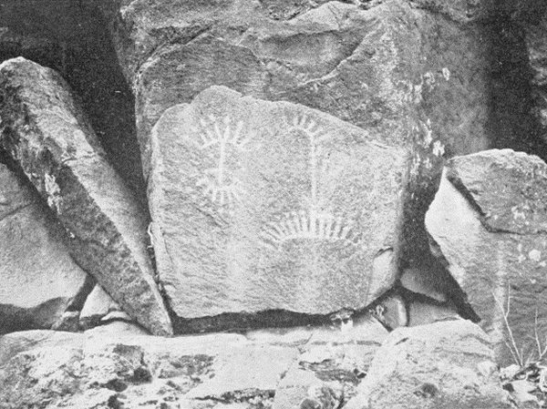 Rock carvings in Selah Canyon.
(__A_TAG_PLACEHOLDER_0__)
[Pg 196]
[Pg 197]
[Pg 196]
[Pg 197]
 Petroglyph in Selah Canyon.
(__A_TAG_PLACEHOLDER_0__)
 Petroglyph at Wallula Junction.
(__A_TAG_PLACEHOLDER_0__)
[Pg 198]
[Pg 199]
[Pg 198]
[Pg 199]
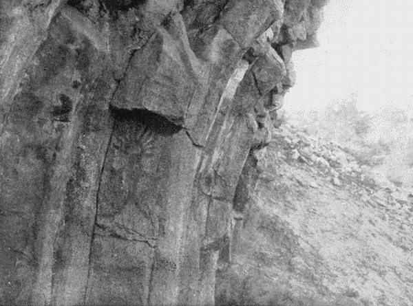
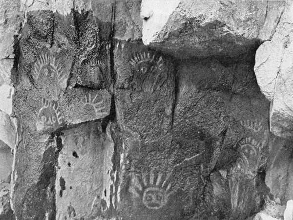 Pictographs at the Mouth of Cowiche Creek.
(__A_TAG_PLACEHOLDER_0__)
[Pg 200]
[Pg 201]
[Pg 200]
[Pg 201]
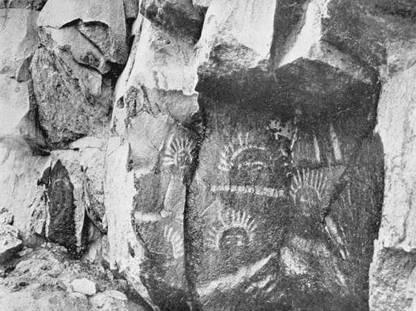
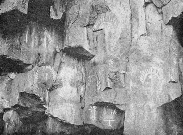 Pictographs at the Mouth of Cowiche Creek.
(__A_TAG_PLACEHOLDER_0__)
[Pg 202]
[Pg 203]
[Pg 202]
[Pg 203]

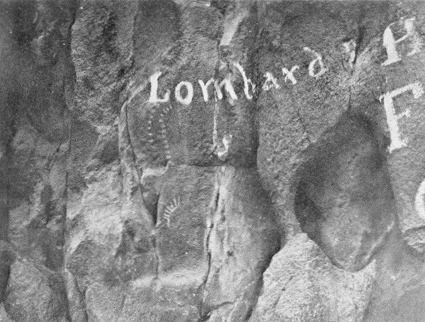 Pictographs at the Mouth of Cowiche Creek.
(__A_TAG_PLACEHOLDER_0__)
[Pg 204]
[Pg 204]
Archaic, alternate and misspellings of words have been retained to match the original work with the exception of those listed below.
Archaic, alternate, and misspelled words have been kept to match the original work, except for those listed below.
Missing punctuation has been added and obvious punctuation errors have been corrected.
Missing punctuation has been added, and obvious punctuation mistakes have been fixed.
Some page numbers have been removed to maintain text consistency.
Some page numbers have been removed to keep the text consistent.
Any reference to size, i.e. ½ nat. size, in the illustrations has not been retained.
Any reference to size, i.e. ½ nat. size, in the illustrations has not been kept.
Page 19: "gulley" changed to "gully" (on either side by a gully).
Page 19: "gully" changed to "gully" (on either side by a gully).
Page 51: footnote 78, added "p." (Spinden, p. 194.)
Page 51: footnote 78, added "p." (Spinden, p. 194.)
Page 82: "anterio" changed to "anterior" (leaving a large anterior lateral projection).
Page 82: "anterio" changed to "anterior" (leaving a large anterior lateral projection).
Page 92: "assymetrical" changed to "asymmetrical" (a slightly asymmetrical disk).
Page 92: "asymmetrical" changed to "asymmetrical" (a slightly asymmetrical disk).
Page 93: illustration caption: "n" changed to "in" (in the collection of).
Page 93: illustration caption: "in" changed to "in" (in the collection of).
Page 97: "he" changed to "be" (contents will be found).
Page 97: "be" changed to "be" (contents will be found).
Page 108: "begining" changed to "beginning" (first beginning at the East).
Page 108: "begining" changed to "beginning" (first beginning at the East).
Page 108: "untill" changed to "until" (held the pipe until I took).
Page 108: "until" changed to "until" (held the pipe until I took).
Page 109: "simitransparent" changed to "semi-transparent" (where the semi-transparent green steatite).
Page 109: "semi-transparent" changed to "semi-transparent" (where the semi-transparent green steatite).
Page 113: "p. 13" changed to "p. 131" (under the section of art on p. 131.)
Page 113: "p. 13" changed to "p. 131" (under the section of art on p. 131.)
Page 129: "fo" changed to "of" (and the method of indicating).
Page 129: "of" changed to "of" (and the method of indicating).
Page 145: "familar" changed to "familiar" (not be one merely familiar with).
Page 145: "familiar" changed to "familiar" (not be one merely familiar with).
Page 149: "Bibiography" changed to "Bibliography."
Page 149: "Bibliography" changed to "Bibliography."
Page 160: "tibiæ" changed to "tibiae" and "fibulæ" changed to "fibulae" for consistency.
Page 160: "tibiæ" changed to "tibiae" and "fibulæ" changed to "fibulae" for consistency.
Download ePUB
If you like this ebook, consider a donation!