This is a modern-English version of Historic Jamaica, originally written by Cundall, Frank.
It has been thoroughly updated, including changes to sentence structure, words, spelling,
and grammar—to ensure clarity for contemporary readers, while preserving the original spirit and nuance. If
you click on a paragraph, you will see the original text that we modified, and you can toggle between the two versions.
Scroll to the bottom of this page and you will find a free ePUB download link for this book.
Transcriber’s Note:
Transcriber's Note:
The cover image was created by the transcriber and is placed in the public domain.
The cover image was made by the transcriber and is in the public domain.
Is it nature or by the error of fantasie that the seeing of places we know to have been frequented or inhabited by men whose memory is esteemed or mentioned in Stories, doth in some sort move and stirre us up as much or more than the hearing of their noble deeds or reading of their compositions?
Is it nature or just our imagination that seeing places we know were visited or lived in by people whose memories are valued or mentioned in stories makes us feel just as much, if not more, than hearing about their remarkable deeds or reading their works?
The care which a nation devotes to the preservation of the monuments of its past may serve as a true measure of the degree of civilization to which it has attained.
The attention a nation gives to preserving the monuments of its past can be a real indicator of how civilized it has become.

UP-PARK CAMP IN 1840
From a coloured lithograph by Joseph B. Kidd
UP-PARK CAMP IN 1840
From a colored lithograph by Joseph B. Kidd
HISTORIC JAMAICA
PREFACE
In the year 1900 the present writer published a small volume entitled “Studies in Jamaica History,” giving the records of certain historic sites in the colony.
In 1900, the author published a small book called “Studies in Jamaica History,” detailing the records of specific historic sites in the colony.
In its issue of October 27, 1908, the Editor of the “West India Committee Circular,” commenting on the appointment of a Royal Commission to enumerate and report upon the historical monuments in England, drew attention to the need for the preservation of historic sites and buildings in the West Indies, and stated that a letter on the subject had been addressed by the West India Committee to the Colonial Office. On November 24 he was able to state that the Secretary of State for the Colonies (the Earl of Crewe) sympathised with the object of the West India Committee and had forwarded their representations to the governors of the various West Indian colonies, recommending them to their consideration.
In its issue from October 27, 1908, the Editor of the “West India Committee Circular,” commenting on the appointment of a Royal Commission to catalog and report on the historical monuments in England, highlighted the need to preserve historic sites and buildings in the West Indies. He mentioned that a letter on the subject had been sent by the West India Committee to the Colonial Office. On November 24, he reported that the Secretary of State for the Colonies (the Earl of Crewe) supported the West India Committee's goals and had forwarded their suggestions to the governors of the various West Indian colonies for their consideration.
In Jamaica the present writer, at the request of the Governor (Sir Sydney Olivier) and with the consent of the Board of Governors of the Institute of Jamaica, undertook to prepare a list, parish by parish, of historic sites, buildings and monuments, stating in each case the nature of its interest and the name of its owner. This list was published as a special supplement to the “Jamaica Gazette” on December 23, 1909; and in November 1912 it was reprinted as part of a report relating to the preservation of historic visites and ancient monuments and buildings in the West Indian colonies presented to Parliament.
In Jamaica, the author, at the request of the Governor (Sir Sydney Olivier) and with the approval of the Board of Governors of the Institute of Jamaica, took on the task of creating a list of historic sites, buildings, and monuments for each parish, detailing their significance and the name of their owners. This list was published as a special supplement to the “Jamaica Gazette” on December 23, 1909, and in November 1912, it was republished as part of a report about the preservation of historic visites and ancient monuments and buildings in the West Indian colonies presented to Parliament.
In the meantime the present writer had commenced a series of articles in the “West India Committee Circular” dealing with historic sites and monuments in Jamaica, which appeared from October 1909 till October 1914.
In the meantime, the author had started a series of articles in the “West India Committee Circular” covering historic sites and monuments in Jamaica, which were published from October 1909 to October 1914.
At the suggestion of various persons interested in the subject it was decided to reprint these articles. In doing this it has been thought well to arrange them parish by parish and to add a few words of general history, taken in part from the writer’s contributions to the “Handbook of Jamaica,” and of descriptions of sites and monuments which have not been treated of individually.
At the suggestion of various people interested in the topic, it was decided to reprint these articles. In doing so, we thought it would be a good idea to organize them by parish and to include a few words of general history, partly drawn from the writer’s contributions to the “Handbook of Jamaica,” as well as descriptions of sites and monuments that haven’t been covered individually.
It is hoped that the following notes may not only serve the double purpose of evoking interest in the history of the colony in the minds of its inhabitants and proving a source of information to visitors, but may be the means of steps being taken to preserve old buildings and other monuments alike from decay and the hand of man.
It is hoped that the following notes will serve the dual purpose of sparking interest in the colony's history among its residents and providing information to visitors, as well as encouraging efforts to preserve old buildings and other monuments from deterioration and neglect.
A list of works consulted in the compilation of the notes embodied in this volume would comprise almost all the books in the Jamaica section of the West India Library of the Institute of Jamaica, some 1400 in number.
A list of works referenced in the creation of the notes included in this volume would consist of nearly all the books in the Jamaica section of the West India Library at the Institute of Jamaica, about 1400 in total.
My thanks are due to Mrs. Lionel Lee for making the illustrations and to Mr. Algernon E. Aspinall for kind assistance in seeing the work through the press.
My thanks go to Mrs. Lionel Lee for creating the illustrations and to Mr. Algernon E. Aspinall for his helpful support in getting the work published.
CONTENTS
| PAGE | ||
|---|---|---|
| LISTS OF OFFICIALS | ||
| Governors, Presidents of the Council, Speakers of the Assembly, Chief Justices, Attorney-Generals, Naval Commanders-in-chief at Jamaica, Agents for Jamaica in Great Britain | xiii | |
| INTRODUCTION | ||
| Aboriginal inhabitants, Arawâks: physical features, language, beliefs, habitations, implements, name of Jamaica, other Arawâk names: Spanish occupation, hatos, towns, buildings, names: English possession, ancient monuments, buildings, slavery, politics, forts, religion, agriculture, education, printing, maps, parishes, counties, place-names, Jamaica overseas | 1 | |
| I. | PORT ROYAL | |
| The Point: Shirley: Jackson: Forts: Residence of the Governor: Church: Buccaneers: Myngs: Morgan: Earthquake of 1692: Spanish bell: Fire of 1703–4: Hurricane of 1722: Attempt on Cartagena, Ogle, Smollett: Rodney: Water-supply: Rodney’s Look-out: Fort Charles: Nelson’s Quarter-deck: Rodney’s victory over De Grasse: the Convoy: Prince William Henry: Lady Nugent: Gosse: Hill: Urgent | 45 | |
| II. | ST. CATHERINE | |
| Passage Fort: Jackson: Penn and Venables: Spanish-Town: Raymond and Tyson: Cathedral, monuments, plate, rectors, Earl of Effingham, Countess of Elgin: House of Assembly: Eagle House: Sir Hans Sloane’s House: King’s House: Rodney Memorial: St. John’s, Guanaboa Vale: Church of St. Dorothy: Colebeck Castle: Galdy’s Tomb: Ferry Inn: Fort Augusta: Rodney’s Look-out: Port Henderson | 81 | |
| III. | KINGSTON | |
| viii | Earthquake, site: Lilly, plan: Fire, 1780: Corporation: Fires, 1843, 1862, 1882: Earthquake, 1907: Names of streets: Parish church, Knight, Lewis, Hakewill, plate, rectors, records, Benbow, monuments: Scotch Church: Headquarters House: Thomas Hibbert: General officers: Old Mico: Blundell Hall: Institute of Jamaica: Arawâk pottery: Chancellor’s purse: maces: Monuments, Sir Charles Metcalfe, Queen Victoria, Edward Jordan, Dr. Bowerbank, Father Dupont, Rev. John Radcliffe, Rev. W. J. Gardner: Wharves | 147 |
| IV. | ST. ANDREW | |
| Liguanea: Halfway-Tree: Old Burial-Ground: Church of St. Andrew, records, monuments, rectors: Lundie’s pen: King’s House: Admiral’s Pen: Rock Fort: Fort Nugent: Constant Spring: Raymond Hall: Up-Park Camp: Berthaville: Mico College: Stony Hill Barracks: Garden House: Hope: Jamaica College: Lumb drinking-trough: Newcastle: Jewish Burial-Ground: Hunt’s Bay: Kitchen-middens: Norbrook: Hope: Long Mountain: Caves: Dallas Castle: Bloxburgh: Silver Hill: Cane River Falls: Hagley Gap: Catherine’s Peak: Gordon Town: Dallas Castle: Manning’s Hill: Salt Hill: Morce’s Gap: Hardwar Gap: Scarlett | 197 | |
| V. | ST. THOMAS | |
| Name: Yallahs, church, plate: Luke Stokes: Stokes Hall: Stokesfield, Estate accounts: Morant Bay: Rebellion: Eyre, Gordon: Church, Bath, Spring, Court House: Botanical Gardens: Dr. Dancer: Belvedere: Lyssons, Sir John Taylor, Simon Taylor: Hordley, Monk Lewis: Albion: Arawâk remains at Cambridge Hill and Botany Bay: Cow Bay and Bull Bay | 236 | |
| VI. | PORTLAND | |
| Name: Titchfield: Early settlement: School: St. George: Olivier Park: Carder Park: Moore Town: Muirton: Darlingford: Low Layton: Spring Garden: Modyford’s Gully: Balcarres Hill: Seaman’s Valley | 254 | |
| VII. | ST. MARY | |
| Name: Gray’s Inn, Spanish remains: Decoy, Tomb of Sir Charles Price, Gardens: Sir Charles Price’s rat: Agualta Vale: Dryland: Fort Haldane: Prospect: Heywood Hall | 259 | |
| VIII. | ST. ANN | |
| ix | Historic interest: Liberty Hill: Arawâk remains: Dry Harbour: Landing of Columbus, 1494: Don Christopher’s Cove: Residence of Columbus, 1503–4: Mendes, rebellion of Porras, appeal to Hispaniola, bravery of Bartolommeo Columbus: Sevilla Nueva, Sloane’s account, Peter Martyr, Ocho Rios, Chireras: Doyley’s defeat of Sasi: Rio Nuevo in St. Mary, Final defeat of Sasi: Runaway Bay: Sevilla Nueva: Cardiff Hall: Edinburgh Castle, Hutchinson: Moneague Tavern: Forts, Mammee Bay, St. Ann’s Bay, Windsor Fort: Priory: Dixon Pen: Geddes: York Castle: Dry Harbour Caves: Walton, Jamaica Free School | 267 |
| IX. | TRELAWNY | |
| Falmouth: Martha Brae: Bryan Castle, Bryan Edwards and his writings: Fort Dundas: Hyde Hall: Kitchen-middens | 306 | |
| X. | ST. JAMES | |
| Montego Bay: Close Harbour: Church, rectors: Mrs. Rosa Palmer: Maroons, Block House, Maroon Town, Accompong, War, Walpole, Treaty, Balcarres, Gillespie, Maroons in Nova Scotia: Duckett’s Spring, the Scarletts: Rose Hall: Arawâk Middens and Caves | 319 | |
| XI. | HANOVER | |
| Lucea, church: Rusea: Shettlewood | 343 | |
| XII. | WESTMORELAND | |
| Savanna-la-Mar, church: Bluefields and Gosse: Cornwall and Monk Lewis: Roaring River, Fort William and Williamsfield and Beckford | 346 | |
| XIII. | ST. ELIZABETH | |
| Black River: Munro and Dickenson: Lacovia: Catadupa | 369 | |
| XIV. | MANCHESTER | |
| Mandeville: Sir William Scarlett: Bridges | 372 | |
| XV. | CLARENDON | |
| Carlisle Bay: Vere Church, rectors, monuments: Church of the White Cross: Morgan’s Valley: Chapelton Church: Halse Hall: Longville: Kellets | 373 | |
| INDEX | 398 | |
LIST OF ILLUSTRATIONS
| PAGE | |
|---|---|
| Arawâk Bowl | 1 |
| Mealing-stone | 2 |
| Arawâk Pestle | 3 |
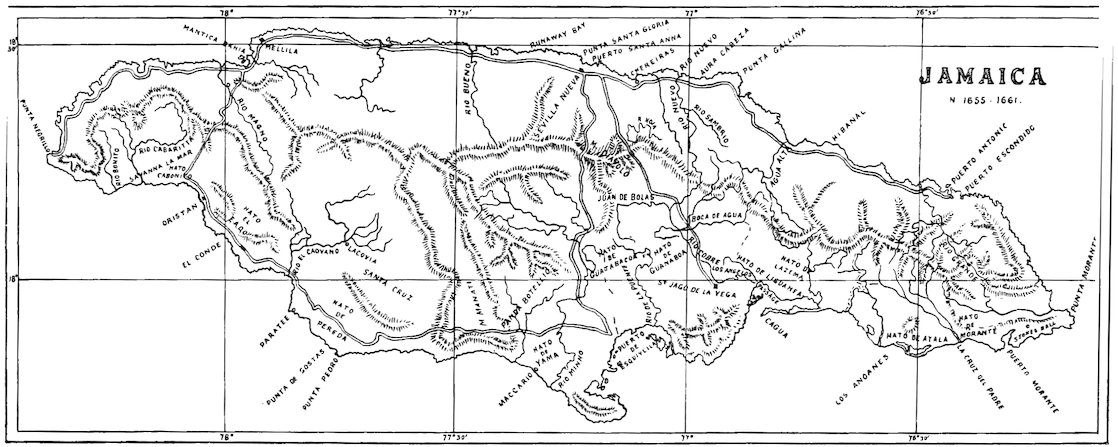
| Sketch Map of Jamaica, circa 1661 | 7 |
| Branding-iron | 15 |
| Sketch Map of Jamaica, circa 1866 | 41 |
| PORT ROYAL | |
| Nelson’s Quarter-deck | 68 |
| Kingston Harbour in 1774. From an engraving in Long's "History of Jamaica" | facing 70 |
| Figure-head of the Aboukir | 71 |
| ST. CATHERINE | |
| Passage Fort | 83 |
| Cathedral, Spanish Town | 90 |
| King’s House, Spanish Town | 104 |
| Court House, Spanish Town | 104 |
| Rodney’s Statue, Spanish Town | 105 |
| House of Assembly, Spanish Town | 105 |
| The Lady Juliana in tow of the Pallas in 1782. From an aquatint by Robert Dodd | facing 122 |
| Colebeck Castle | 134 |
| The Ferry Inn | 139 |
| KINGSTON | |
| Kingston, Harbour Street in 1820. From a coloured engraving in Hakewill’s “Picturesque Tour of Jamaica” | facing 150 |
| The Parish Church | 157 |
| Date-Tree Hall in 1906 | 180 |
| Statue of Sir Charles Metcalfe | 187 |
| Statue of Queen Victoria | 194 |
| xii | |
| ST. ANDREW | |
| Halfway-Tree Church in 1906 | 200 |
| King Edward’s Clock Tower, Halfway-Tree | 208 |
| Admiral’s Pen | 211 |
| Rock Fort | 212 |
| Fort Nugent | 215 |
| Raymond Hall | 219 |
| Up-Park Camp in 1840. From a coloured lithograph by Joseph B. Kidd (Frontispiece) | |
| ST. THOMAS | |
| Stokes Hall | 241 |
| Albion Estate | 252 |
| PORTLAND | |
| Port Antonio in 1770. From an engraving | facing 256 |
| ST. MARY | |
| Tomb of Sir Charles Price | 261 |
| ST. ANN | |
| Dry Harbour | 268 |
| Don Christopher’s Cove | 273 |
| Rio Novo | 285 |
| Cardiff Hall | 294 |
| Moneague Tavern in 1844. From a daguerreotype by Adolphe Duperly | facing 302 |
| Slave Punishment Cell at Geddes | 303 |
| TRELAWNY | |
| Bryan Castle | 307 |
| ST. JAMES | |
| Block-house, Maroon Town | 324 |
| Rose Hall | 341 |
| WESTMORELAND | |
| Fort William, Aqueduct | 360 |
| Fort William Estate, from the site of old Great House | 361 |
| Roaring River Estate in 1774. From an engraving by Thomas Vivares after a painting by George Robertson | facing 364 |
| Savanna-la-Mar in 1840. From a coloured lithograph by Joseph B. Kidd facing | 366 |
| CLARENDON | |
| Carlisle Bay | 375 |
| Vere Parish Church, at the Alley | 382 |
| Morgan’s Valley | 394 |
| Halse Hall Great House | 396 |
LIST OF OFFICIALS
The following tables are inserted for reference. The list of Governors is complete. The others are as complete as it has hitherto been found possible to make them. There are portraits in Jamaica History Gallery in the Institute of Jamaica of those to whom an * is suffixed.
The following tables are included for reference. The list of Governors is complete. The others are as complete as it has been possible to make them so far. There are portraits in the Jamaica History Gallery at the Institute of Jamaica of those marked with an *.
GOVERNORS OF JAMAICA[1]
| 1661–62. | General Edward Doyley. | Governor. |
| 1662. | Thomas, Lord Windsor.* | „ |
| 1662–64. | Sir Charles Lyttelton.* | Dep.-Governor |
| 1664. | Colonel Edward Morgan. | „ |
| 1664. | Colonel Thomas Lynch. | President. |
| 1664–71. | Sir Thomas Modyford, Bt. | Governor. |
| 1671–74. | Sir Thomas Lynch. | Lieut.-Gov. |
| 1674. | Sir Henry Morgan.* | „ „ |
| 1675–78. | John, Lord Vaughan.* | Governor. |
| 1678. | Sir Henry Morgan. | Lieut.-Gov. |
| 1678–80. | Charles, Earl of Carlisle.* | Governor. |
| 1680–82. | Sir Henry Morgan. | Lieut.-Gov. |
| 1682–84. | Sir Thomas Lynch. | Governor. |
| 1684–87. | Colonel Hender Molesworth. | Lieut.-Gov. |
| 1687–88. | Christopher, Duke of Albemarle.* | Governor. |
| 1688–90. | Sir Francis Watson. | President. |
| 1690–92. | William, Earl of Inchiquin.* | Governor. |
| 1691–92. | John White. | President. |
| 1692–93. | John Bourden. | „ |
| 1693–1700. | Sir William Beeston. | Lieut.-Gov. |
| 1700–02. | „ „ „ | Governor. |
| 1702. | Maj.-Gen. William Selwyn. | „ |
| 1702. | Peter Beckford.* | Lieut.-Gov. |
| 1702–04. | Colonel Thomas Handasyd. | Lieut.-Gov. |
| 1704–11. | Sir Thomas Handasyd. | Governor. |
| 1711–16. | Lord Archibald Hamilton. | „ |
| 1716–18. | Peter Heywood. | „ |
| 1718–22. | Sir Nicholas Lawes. | „ |
| xiv1722–26. | Henry, Duke of Portland. | Governor. |
| 1726–28. | John Ayscough. | President. |
| 1728–34. | Maj.-Gen. Robert Hunter. | Governor. |
| 1734–35. | John Ayscough. | President. |
| 1735. | John Gregory. | „ |
| 1735–36. | Henry Cunningham. | Governor. |
| 1736–38. | John Gregory. | President. |
| 1738–52. | Edward Trelawny. | Governor. |
| 1752–56. | Admiral Charles Knowles.* | Governor. |
| 1756–59. | Henry Moore. | Lieut.-Gov. |
| 1759. | General George Haldane. | Governor. |
| 1760–62. | Henry Moore. | Lieut.-Gov. |
| 1762–66. | William Henry Lyttelton. | Governor. |
| 1766–67. | Roger Hope Elletson. | Lieut.-Gov. |
| 1767–72. | Sir William Trelawny. | Governor. |
| 1772–74. | Lieut.-Col. John Dalling. | Lieut.-Gov. |
| 1774–77. | Sir Basil Keith. | Governor. |
| 1777–81. | Colonel John Dalling. | Lieut.-Gov. |
| 1781–83. | Maj.-Gen. Archibald Campbell.* | „ „ |
| 1783–84. | „ „ „ | Governor. |
| 1784–90. | Brig.-Gen. Alured Clarke.* | Lieut.-Gov. |
| 1790–91. | Thomas, Earl of Effingham.* | Governor. |
| 1791–95. | Maj.-Gen. Adam Williamson. | Lieut.-Gov. |
| 1795–01. | Alexander, Earl of Balcarres.* | „ „ |
| 1801–06. | Lieut.-Gen. George Nugent.* | „ „ |
| 1806–08. | Sir Eyre Coote.* | „ „ |
| 1808–11. | William, Duke of Manchester.* | Governor. |
| 1811–13. | Lieut.-Gen. Edward Morrison. | Lieut.-Gov. |
| 1813–21. | William, Duke of Manchester. | Governor. |
| 1821–22. | Maj.-Gen. Henry Conran.* | Lieut.-Gov. |
| 1822–27. | William, Duke of Manchester. | Governor. |
| 1827–29. | Maj.-Gen. Sir John Keane.* | Lieut.-Gov. |
| 1829–32. | Somerset, Earl of Belmore.* | Governor. |
| 1832. | George Cuthbert. | President. |
| 1832–34. | Constantine, Earl of Mulgrave.* | Governor. |
| 1834. | George Cuthbert. | President. |
| 1834. | Maj.-Gen. Sir Amos Norcot. | Lieut.-Gov. |
| 1834–36. | Peter, Marquis of Sligo.* | Governor. |
| 1836–39. | Sir Lionel Smith. | „ |
| 1839–42. | Sir Charles Metcalfe.* | „ |
| 1842–46. | James, Earl of Elgin.* | „ |
| 1846–47. | Maj.-Gen. Sackville Berkeley. | Lieut.-Gov. |
| 1847–53. | Sir Charles Edward Grey. | Governor. |
| 1853–56. | Sir Henry Barkly.* | „ |
| 1856–57. | Maj.-Gen. E. Wells Bell. | Lieut.-Gov. |
| 1857–62. | Captain Charles Darling.* | Governor. |
| 1862–64. | Edward John Eyre.* | Lieut.-Gov. |
| 1864–66. | „ „ „ | Governor. |
| xv1866. | Sir Henry Storks.* | Governor. |
| 1866–74. | Sir John Peter Grant.* | „ |
| 1874. | W. A. Young. | Administ. |
| 1874–77. | Sir William Grey.* | Governor. |
| 1877. | Edward Rushworth. | Lieut.-Gov. |
| 1877. | Maj.-Gen. Mann. | Administ. |
| 1877–80. | Sir Anthony Musgrave.* | Governor. |
| 1879–80. | Edward Newton. | Lieut.-Gov. |
| 1880–83. | Sir Anthony Musgrave. | Governor. |
| 1883. | Col. Somerset M. Wiseman Clarke. | Administ. |
| 1883. | Maj.-Gen. Gamble. | „ |
| 1883–89. | Sir Henry Norman.* | Governor. |
| 1889. | Col. William Clive Justice. | Administ. |
| 1889–98. | Sir Henry Arthur Blake. | Governor. |
| 1898. | Maj.-Gen. Hallowes. | Administ. |
| 1898–04. | Sir Augustus W. L. Hemming.* | Governor. |
| 1904. | Sydney Olivier. | Administ. |
| 1904. | Hugh Clarence Bourne. | „ |
| 1904–07. | Sir James Alexander Swettenham. | Governor. |
| 1907. | Hugh Clarence Bourne. | Administ. |
| 1907–13. | Sir Sydney Olivier. | Governor. |
| 1913. | Philip Clarke Cork. | Administ. |
| 1913– | Sir William Henry Manning. | Governor. |
PRESIDENTS OF THE COUNCIL OF JAMAICA
| 1661. | General Edward Doyley, Governor and President |
| 1664. | Colonel Thomas Lynch |
| 1671. | Major-General James Bannister |
| 1674. | Colonel Hender Molesworth (afterwards Baronet). |
| 1688. | Sir Francis Watson |
| 1691. | John White |
| 1692. | John Bourden |
| 1702. | Peter Beckford |
| Francis Rose | |
| 1722. | John Ayscough |
| 1735–51. | John Gregory |
| 1774. | Archibald Sinclair |
| 1775–96. | Thomas Iredell |
| 1797. | John Palmer |
| 1798. | Thomas Wallen |
| 1805. | John Scott |
| 1806. | Nathaniel Beckford |
| 1811. | John Lewis |
| 1821. | George Pinnock |
| 1825. | George Cuthbert |
| xvi1838. | William Rowe |
| 1840. | James Gayleard |
| 1856. | John Salmon |
LEGISLATIVE COUNCIL
| 1866–91. | The governor for the time being |
| 1892. | Dr. J. C. Phillippo |
| 1893 et seq. | The governor for the time being |
PRIVY COUNCIL
| 1866 et seq. | The governor for the time being |
SPEAKERS OF THE HOUSE OF ASSEMBLY OF JAMAICA
| 1664. | Robert Freeman |
| 1664. | Sir Thomas Whetstone |
| 1671. | Samuel Long |
| 1672–73. | Major John Colebeck (pro tem.) |
| 1673. | Samuel Long |
| 1677. | Lieut.-Col. William Beeston |
| 1679–88. | Samuel Bernard |
| 1688. | George Nedham (pro tem.) |
| 1688. | Roger Hope Elletson |
| „ | Thomas Rives |
| „ | John Peeke |
| 1691–92. | Thomas Sutton |
| 1693. | Andrew Langley |
| 1694. | James Bradshaw |
| 1698. | Thomas Sutton |
| 1701. | Andrew Langley |
| 1702. | Francis Rose |
| 1702–03. | Andrew Langley |
| 1704. | Edward Stanton |
| 1705. | Matthew Gregory |
| 1706. | Hugh Totterdale |
| „ | John Peeke |
| „ | Matthew Gregory |
| 1707–11. | Peter Beckford, jun. |
| xvii1711. | William Brodrick |
| „ | Samuel Vassall (pro tem.) |
| 1711–13. | Peter Beckford, jun. |
| 1714. | Hugh Totterdale |
| 1715. | John Blair |
| 1716. | Peter Beckford |
| 1718. | William Nedham |
| 1719. | Edmund Kelly |
| 1721–22. | George Modd |
| 1722. | William Nedham |
| 1724. | John Manley (pro tem.) |
| 1725. | Francis Melling |
| 1727–28. | Thomas Beckford |
| 1731. | John Stewart |
| 1733. | William Nedham |
| 1745. | Charles Price [afterwards Sir Charles, Bt.] (pro tem.) |
| 1747. | Richard Beckford (pro tem.) |
| 1751. | „ „ |
| 1755. | Edward Manning |
| 1756. | Thomas Hibbert |
| 1756. | Charles Price |
| 1763. | Charles Price, jun. [afterwards 2nd Baronet] |
| 1764. | Thomas Fearon (pro tem.) |
| 1765. | Charles Price, jun. |
| 1766. | William Nedham |
| 1768. | Edward Long |
| „ | Phillip Pinnock* |
| 1770. | Nicholas Bourke |
| „ | Charles Price, jun. |
| 1775. | Phillip Pinnock |
| 1776. | Sir Charles Price (2nd Baronet) |
| 1778. | Jasper Hall* |
| 1778–93. | Samuel Williams Haughton |
| 1781. | Thomas French (pro tem.) |
| 1782. | William Pusey (pro tem.) |
| 1787. | William Blake (pro tem.) |
| 1793. | William Blake |
| 1797. | Donald Campbell |
| 1798. | Keane Osborn |
| 1802. | Philip Redwood |
| 1809. | James Lewis |
| 1821. | David Finlayson |
| 1830. | Richard Barrett |
| 1832. | Robert Allwood |
| 1838. | Richard Barrett |
| 1839. | Edward Panton |
| 1842. | Samuel Jackson Dallas* |
| xviii1849. | Charles McLarty Morales* |
| 1861. | Edward Jordon (pro tem.)* |
| 1864. | Charles Hamilton Jackson* |
CHIEF JUSTICES OF JAMAICA
| 1661. | Philip Ward |
| „ | Samuel Barry |
| 1663. | William Mitchell |
| 1664–65. | Lynch |
| 1671. | John White |
| 1675. | Sir Thomas Modyford |
| 1676–79. | Samuel Long |
| 1681. | Robert Byndloss |
| 1685. | Samuel Bernard |
| 1688. | Robert Noell |
| 1689. | Roger Elletson |
| „ | Richard Lloyd |
| 1695–98. | Richard Lloyd |
| 1698. | Nicholas Lawes |
| 1703. | Peter Beckford |
| „ | Peter Heywood |
| 1706. | John Walters |
| 1714–15. | Peter Heywood |
| 1716. | Peter Bernard |
| 1724. | John Ayscough |
| (d. 173 | 6) Edward Pennant |
| 1733. | Richard Mill |
| 1733–35. | John Gregory |
| 1735. | James Hay |
| 1736–39. | George Ellis |
| 1739. | John Gregory |
| 1742. | Dennis Kelly |
| 1746. | William Nedham |
| 1749. | John Hudson Guy |
| 1751–56. | John Palmer |
| 1756–64. | Thomas Fearon |
| 1765. | George Ellis |
| 1766. | Thomas Beach |
| 1770. | Peter Haywood |
| 1776. | Edward Webley |
| 1779. | Richard Welch |
| 1780–83. | Thomas French |
| 1784–91. | John Grant |
| 1790. | Thomas Harrison (pro tem.) |
| xix1792. | William Jackson |
| 1801. | John Henckell |
| 1802. | John Kirby |
| 1808. | John Lewis |
| „ | Philip Redwood |
| 1818. | Thomas Witter Jackson |
| 1821. | Sir William Anglin Scarlett* |
| 1832. | Sir Joshua Rowe* |
| 1855. | Sir Bryan Edwards* |
| 1869. | Sir John Lucie-Smith |
| 1884. | Sir Adam Gibb Ellis* |
| 1895. | Sir Henry James Burford-Hancock |
| 1896. | Sir Fielding Clarke |
| 1910. | Sir Anthony Coll |
ATTORNEY-GENERALS OF JAMAICA
| 1671. | Edmund Ducke |
| 1688. | Sir Richard Dereham |
| 1686–91. | Simon Musgrave |
| 1693. | William Brodrick |
| 1698. | Thomas Barrow |
| 1698. | Charles Brodrick |
| 1703. | Edward Haskins |
| „ | Robert Hotchkyn |
| 1711–15. | William Brodrick |
| 1719. | Edmund Kelly |
| 1724. | William Monk |
| 1732. | Alexander Henderson |
| 1732. | Thomas Howe |
| 1732–44. | Matthew Concanen |
| 1744. | Thomas Hill |
| 1744–49. | Robert Penny |
| 1754. | Henry Morgan Byndloss |
| 1755. | Richard Beckford |
| 1760. | Gilbert Ford |
| 1760. | Edward Penny |
| 1766. | Thomas Gordon |
| 1766. | Thomas Beach |
| 1769. | Thomas Harrison |
| 1784. | Robert Sewell |
| 1796. | George Crawford Ricketts |
| 1802. | William Ross |
| 1806. | Thomas Witter Jackson |
| 1807. | William Ross |
| xx1810. | Thomas Witter Jackson |
| 1818. | William Burge |
| 1829. | Hugo James |
| 1832. | Fitz Herbert Batty |
| 1833. | Dowell O’Reilly |
| 1857. | Alexander Heslop* |
| 1872. | E. A. C. Schalch |
| 1876. | G. H. Barne |
| 1877. | E. L. O’Mally |
| 1881. | Sir Henry Hicks Hocking |
| 1896. | (Sir) Henry Rawlins Pipon Schooles |
| 1906. | Thomas Bancroft Oughton |
| 1910. | Ernest St. John Branch |
NAVAL COMMANDERS-IN-CHIEF AT JAMAICA
| 1655. | Sir William Penn, Admiral and General-at-sea* |
| 1655–57. | Vice-Admiral William Goodsonn |
| 1656–57. | Vice-Admiral Christopher Myngs* |
| 1662. | Col. Mitchell, chief over the sea-officers |
| 1662–64. | Vice-Admiral Christopher Myngs |
| 1663. | Sir Thomas Whetstone, commanded a fleet at Jamaica |
| 1669. | Henry Morgan, “Commander-in Chief of all the ships of war” of Jamaica (commission from Governor) |
| 1676. | The Duke of York was Admiral of Jamaica and all other his Majesty’s Plantations and Dominions |
| [1692. | Commodore Wrenn, commanded in the West Indies |
| 1692. | Rear-Admiral Sir Francis Wheler, commanded in the West Indies] |
| 1702. | Vice-Admiral Benbow* |
| [1703. | Vice-Admiral John Graydon, commanded a fleet in the West Indies] |
| 1703–05. | Sir William Whetstone, Commander-in-Chief in the West Indies |
| [1706. | Commodore William Kerr, commanded a fleet in the West Indies |
| 1706. | Sir John Jennings, commanded a fleet in the West Indies] |
| 1707–09. | Rear-Admiral Charles Wager* |
| 1710–12. | Commodore James Littleton |
| 1712. | Rear-Admiral Sir Hovenden Walker |
| 1720. | Commodore Vernon, Commander-in-Chief of all his Majesty’s ships in the West Indies* |
| xxi[1726–27. | Vice-Admiral Francis Hosier, commanded a squadron in the West Indies] |
| 1727. | Commodore Edward St. Lo, in command of West India Station |
| 1728. | Vice-Admiral Edward Hopson, in command of West India Station |
| 1728–29. | Rear-Admiral Edward St. Lo, in command of West India Station |
| 1729. | Commodore William Smith |
| 1730–33. | Rear-Admiral the Hon. Charles Stuart, in command of West India Station |
| 1732. | Commodore Richard Lestock |
| 1732–39. | Commodore Sir Chaloner Ogle* |
| 1736–37. | Captain Digby Dent |
| [1739–42. | Admiral Edward Vernon, commanded in the West Indies]* |
| 1742–44. | Rear-Admiral Sir Chaloner Ogle. |
| [1744. | Vice-Admiral Thomas Davers, died at Jamaica] |
| 1746. | Captain Cornelius Mitchell |
| 1747. | Captain Digby Dent |
| 1747–49. | Rear-Admiral Charles Knowles |
| 1749–52. | Commodore the Hon. George Townshend |
| 1755–57. | Rear-Admiral the Hon. George Townshend |
| 1757. | Rear-Admiral Thomas Cotes |
| 1760–61. | Rear-Admiral Charles Holmes |
| 1762. | Commodore Sir James Douglas |
| [1762. | Admiral Sir George Pocock, Commander-in-Chief of expedition against Havana] |
| 1762–64. | Rear-Admiral Viscount Keppel |
| 1764–66. | Rear-Admiral Sir William Burnaby |
| 1766–69. | Rear-Admiral W. Parry |
| 1769–70. | Commodore Arthur Forrest* |
| 1771–74. | Rear-Admiral Sir George Rodney* |
| 1774–78. | Vice-Admiral Clarke Gayton |
| 1778–82. | Vice-Admiral Sir Peter Parker* |
| [1779. | Captain Horatio Nelson, commanded in Fort Charles, Port Royal]* |
| 1782–83. | Rear-Admiral Joshua Rowley |
| 1783–84. | Vice-Admiral James Gambier |
| 1785. | Commodore John Pakenham |
| 1785. | Captain Alan Gardner* |
| 1786. | Rear-Admiral Alexander Innes |
| 1786–89. | Commodore Alan (afterwards Lord) Gardner |
| 1790–93. | Rear-Admiral Philip Affleck |
| 1793–95. | Rear-Admiral John Ford |
| 1796. | Rear-Admiral William Parker |
| 1796. | Commodore Richard Rodney Bligh* |
| xxii1796–1800. | Vice-Admiral Sir Hyde Parker* |
| 1800–01. | Vice-Admiral Lord Hugh Seymour* |
| 1802. | Rear-Admiral Robert Montague |
| 1803–04. | Vice-Admiral Sir John Thomas Duckworth* |
| 1804–08. | Vice-Admiral James Richard Dacres* |
| 1809–11. | Vice-Admiral Bartholomew Samuel Rowley* |
| 1811–13. | Vice-Admiral Sir Charles Stirling, Bart. |
| 1812. | Vice-Admiral James Vashon |
| 1813–14. | Rear-Admiral William Brown* |
| 1814–16. | Vice-Admiral the Hon. Sir Alexander Forrester Inglis Cochrane, K.B., Commander-in-Chief on the Jamaica Station, Windward and Leeward Islands, and Coast of North America |
| 1816–17. | Rear-Admiral John Erskine Douglas |
| 1817–20. | Rear-Admiral Sir Home Riggs Popham, K.C.B.* |
| 1820–23. | Rear-Admiral Sir Charles Rowley, K.C.B. |
| 1823. | Commodore E. W. C. R. Owen |
| 1824–27. | Vice-Admiral Sir Lawrence William Halstead, K.C.B. |
| 1828–29. | Vice-Admiral the Hon. Charles Elphinstone Fleeming |
| 1829–32. | Vice-Admiral Sir Edward Griffith Colpoys, K.C.B. |
| 1833. | Commodore Sir Arthur Farquhar, C.B., K.C.H. K.S. |
| 1833–36. | Vice-Admiral Sir George Cockburn |
COMMODORES ON JAMAICA DIVISION OF NORTH AMERICAN AND WEST INDIAN STATION
| 1838. | Sir John Strutt Peyton, K.C.H. |
| 1839–41. | Peter John Douglas |
| 1843. | Hon. Henry Dilkes Byng |
| 1844–45. | Alexander R. Sharpe, C.B. |
| 1846. | Daniel Pring |
| 1849–51. | Thomas Bennet |
| 1855. | Thomas Henderson |
| 1860. | Henry Kellet, C.B. |
| 1861. | Hugh Dunlop |
| 1864–65. | Peter Cracroft, C.B. |
| 1865. | A. M. De Horsey (acting) |
| 1865–68. | Sir Francis Leopold M’Clintock* |
| 1869–70. | Augustus Phillimore |
| 1871–72. | Richard W. Courtenay |
| 1873–75. | Algernon F. R. De Horsey |
| 1875–78. | Algernon McLennan Lyons |
| 1878–80. | William John Ward |
| 1880–82. | William S. Brown |
| 1882. | Edward White |
| xxiii1883–86. | F. M. Prattent |
| 1886–89. | Henry Hand |
| 1889–92. | Rodney M. Lloyd |
| 1892–95. | T. S. Jackson |
| 1895–98. | H. W. Dowding |
| 1898–99. | William H. Henderson |
| 1900–01. | Edward H. M. Davis, C.M.G. |
| 1901–03. | D. Mc. N. Riddel |
| 1903–05. | (Sir) F. W. Fisher |
| Dockyard close, March 1905 |
AGENTS FOR JAMAICA IN GREAT BRITAIN
| 1664–66. | Sir James Modyford |
| 1682. | { Sir Charles Lyttelton |
| { William Beeston | |
| 1688. | Ralph Knight |
| 1698–1713. | { Sir Gilbert Heathcote |
| { Sir Bartholomew Gracedieu | |
| 1714. | F. Marsh |
| 1725. | Alexander Stephenson |
| 1725–6. | Edward Charlton |
| 1728–1733. | Charles de la Foy |
| 1733. | John Gregory |
| 1733–1757. | John Sharpe |
| 1757–1762. | Lovel Stanhope |
| 1764–1795. | Stephen Fuller |
| 1795–1803. | Robert Sewell |
| 1803–1812. | Edmund Pusey Lyon |
| 1812–1831. | George Hibbert |
| 1831–1845. | William Burge |
| 1845, Dec 8. | Office abolished |
INTRODUCTION
Studies in Jamaica archæology and history naturally fall into three main groups: Aboriginal, Spanish and English.
Studies in Jamaican archaeology and history naturally fall into three main groups: Indigenous, Spanish, and English.
Though, owing to the high form of civilization there attained, research has in Egypt revealed very full information concerning the condition of life in the Nile valley thousands of years before the Christian era, it has hitherto told us very little about the aborigines who inhabited Jamaica a little more than 400 years ago. How long they had been here when Columbus discovered the island no one can say for certain, though the thickness and extent of their middens, some thirty of which have been opened from time to time, offer evidence of value.
Though, due to the advanced civilization that developed there, research in Egypt has provided detailed information about life in the Nile valley thousands of years before the Christian era, it has so far revealed very little about the indigenous people who lived in Jamaica just over 400 years ago. No one can say for sure how long they had been there when Columbus discovered the island, although the size and number of their midden sites, about thirty of which have been excavated over time, provide valuable evidence.

ARAWÂK BOWL
Arawak Bowl
As in Hispaniola, the natives of Jamaica were ruled over by caciques or chieftains. The estimates of historians of the number of inhabitants in the West Indian islands differ widely. Las Casas says that the islands abounded with inhabitants as an ant-hill with ants, and puts them down at 6,000,000. But Peter Martyr gives but 1,200,000 to Hispaniola and, taking this as a guide, there would probably have been about 600,000 in Jamaica—or, roughly speaking, three-quarters of its present population. Not many were left when the English took the island in 1655.
As in Hispaniola, the native people of Jamaica were governed by caciques or chieftains. Historians' estimates of the number of inhabitants in the West Indian islands vary significantly. Las Casas claims that the islands were as full of people as an ant hill is full of ants, estimating the population at 6,000,000. However, Peter Martyr estimates Hispaniola's population at only 1,200,000, which suggests there might have been around 600,000 in Jamaica—roughly three-quarters of its current population. By the time the English arrived and took control of the island in 1655, not many people were left.
Judged by the English standard, Indians are short in stature. The Arawâks of Guiana to-day are described as being of a red cinnamon in colour. The hair on the scalp is thick, long, very straight and very black. The features of the face are strikingly like those familiarly known as Chinese (Mongolian), and the expression is decidedly gentle. Physically they are weak, and life hardly ever exceeds fifty years. The natives of Jamaica—as a few skulls found from time to time testify—possessed, in common with other West Indian tribes, the peculiarity of tying boards on to the foreheads 2of their children in such a way that the skulls assumed and permanently retained an extraordinarily flat shape.
According to English standards, Indians are shorter in height. The Arawâks of Guiana today are described as having a reddish-cinnamon skin tone. Their hair is thick, long, very straight, and jet black. Their facial features strikingly resemble those commonly associated with Chinese (Mongolian) people, and their expressions are notably gentle. Physically, they are fragile, and their lifespan rarely goes beyond fifty years. The natives of Jamaica— as evidenced by a few skulls found occasionally—shared with other West Indian tribes the unusual practice of binding boards to their children's foreheads, which caused their skulls to take on and permanently keep an extraordinarily flat shape.
Peter Martyr, who heard it spoken, said that the language in the Greater Antilles was “soft and not less liquid than the Latin,” and “rich in vowels and pleasant to the ear.” Of words of West Indian origin, those most frequently in use in the English language are avocado (aguacate) pear, barbecue, buccaneer, canoe, Carib and its derivative cannibal, guava, hammock, hurricane, iguana, maize, manatee, pirogue, potato and tobacco.
Peter Martyr, who heard it spoken, said that the language in the Greater Antilles was “soft and just as fluid as Latin,” and “rich in vowels and pleasing to the ear.” Of words with West Indian origins, the ones most commonly used in English are avocado (aguacate) pear, barbecue, buccaneer, canoe, Carib and its derivative cannibal, guava, hammock, hurricane, iguana, maize, manatee, pirogue, potato, and tobacco.
Columbus has told us of a cacique of Cuba who believed in a future state dependent on one’s actions in this world, but Sir Everard im Thurn found nothing of the kind amongst the Indians of Guiana, and it is probable that Columbus’s guide from Guanahani (Watling Island) only partially understood the cacique, or that Columbus only partially understood his guide. Their houses were primitive alike in shape and construction. In Jamaica, they were probably circular, and were provided with walls of wattle work plastered with mud, and with a high-pitched roof of palm leaves; they probably had no windows. The Indians slept in hammocks. The weapons of the Arawâks of Jamaica and the other large islands consisted of darts and war clubs; but they apparently did not possess bows and arrows, which were the form of weapons preferred by the Caribs, and the use of which gave them a great advantage over their more peaceful foes.
Columbus mentioned a chief in Cuba who believed in an afterlife based on one's actions in this world, but Sir Everard im Thurn found no such beliefs among the Indians of Guiana. It's likely that Columbus’s guide from Guanahani (Watling Island) only partly understood the chief, or that Columbus only partially understood his guide. Their homes were simple in both shape and building style. In Jamaica, they were probably round, made of woven materials covered with mud, and had steep roofs made of palm leaves; they likely had no windows. The Indians slept in hammocks. The weapons of the Arawâks in Jamaica and other large islands included darts and war clubs, but they apparently did not have bows and arrows, which were the favored weapons of the Caribs and gave them a significant edge over their more peaceful rivals.

MEALING-STONE
Grinding stone
Ornaments were more worn by the men than the women. Painting was the simplest form of ornamentation; the colours used being blue, black, carmine, white and yellow, derived from plants and earths. They wore necklets of hogs’ teeth and stone beads, crowns of feathers in their heads, aprons of palm-leaves or woven cotton, and bands round their arms and legs. Their chief occupations and means of living were hunting and fishing and agricultural pursuits with, in some cases, a certain amount of trading. As they required nothing more than canoes for travelling on the water, simple houses to live in, baskets for domestic purposes, hammocks for rest, rude weapons of the chase, and implements such as hatchets and chisels, earthen vessels, and a few ornaments and articles of dress, these, with a few crude rock-carvings, formed the sum total of their arts and manufactures.
Men wore more ornaments than women. Painting was the simplest form of decoration, using colors like blue, black, red, white, and yellow, which came from plants and minerals. They adorned themselves with necklaces made of pig teeth and stone beads, wore feather crowns, had aprons made of palm leaves or woven cotton, and sported bands around their arms and legs. Their main activities for making a living included hunting, fishing, and farming, with some trading as well. They needed only canoes for travel on water, simple homes to live in, baskets for daily use, hammocks for resting, basic weapons for hunting, and tools such as axes and chisels, along with clay pots and a few decorations and clothing items. Together with some primitive rock carvings, these represented the totality of their arts and crafts.
In common with the other aborigines of the West Indies generally 3and with the natives of New Zealand and with all the nomad tribes of the new world from Patagonia to the Arctic circle, the Arawâks of Jamaica were, when discovered, without any knowledge of the metals as such. From their kitchen middens we know that they were great fish eaters.
Like other indigenous people of the West Indies, as well as the natives of New Zealand and all the nomadic tribes across the New World from Patagonia to the Arctic Circle, the Arawâks of Jamaica had no knowledge of metals when they were discovered. From their kitchen middens, we know that they were heavy fish eaters. 3

ARAWÂK PESTLE
ARAWÂK MORTAR AND PESTLE
Until 1895, but few remains had been discovered to testify to the existence of a tribe which not so very long ago lived by gathering the fruits of the land and sea of Jamaica. During that and the following years several collections of Indian remains were found.[2] They are scattered fairly throughout the island, except curiously enough, the eastern end, and are thickly grouped in St. Andrew and Vere, in St. Ann, and in the west end of Westmoreland. They all supply objects similar in character and giving evidence of no very high advance in civilization or the arts; being considerably below those of Mexico and Peru. The objects consist for the most part of petaloid or almond-shaped polished celts of metamorphic or igneous rocks, found somewhat abundantly all over the island; circular or oval, shallow, unglazed bowls of baked pottery, with but crude ornamentation, used in the preparation of food, and some as mortuary vessels for the heads of their chiefs—found here and there in the caves and on the sites of dwellings; calcedony beads, hitherto found, curiously enough, only in Vere; stone and wooden images and rock-carvings and the rock-pictures; and a few shell and flint implements and mealing-stones rarely found.
Until 1895, only a few remains had been discovered that confirmed the existence of a tribe that recently lived by gathering fruits from the land and sea of Jamaica. During that year and the years that followed, several collections of Indian remains were found.[2] These remains are spread fairly throughout the island, although, interestingly, not in the eastern end, and are densely grouped in St. Andrew and Vere, in St. Ann, and in the western part of Westmoreland. They all provide objects that are similar in nature and show evidence of a relatively low level of advancement in civilization or the arts, significantly behind those of Mexico and Peru. The objects mainly include petaloid or almond-shaped polished stone tools made from metamorphic or igneous rocks, which can be found somewhat abundantly all over the island; circular or oval, shallow, unglazed bowls made of baked pottery, featuring only simple decoration, used for food preparation and some as burial vessels for their chiefs—discovered here and there in caves and dwelling sites; chalcedony beads, which have only been found in Vere; stone and wooden figures, rock carvings, and rock paintings; and a few shell and flint tools and grinding stones, which are rarely found.
It is to be regretted that many of the objects shown at an exhibition of native remains held at the Institute of Jamaica in 1895, following on the discovery of the Halberstadt cave, as well as others discovered later, should have been allowed to leave the island. Such things once lost can rarely be regained.
It’s unfortunate that many of the items displayed at the exhibition of indigenous artifacts held at the Institute of Jamaica in 1895, after the discovery of the Halberstadt cave and others found later, were allowed to leave the island. Once such things are lost, they are rarely recovered.
Some of the early Spanish historians—putting as they frequently did X for J—wrote the name of the island Xaymaca, but it appears in its present form as early as 1511 in Peter Martyr’s “Decades.” He called it Jamaica and Jamica. The island is unnamed in Juan de la Cosa’s map of 1500.
Some of the early Spanish historians—often substituting X for J—wrote the name of the island Xaymaca, but it shows up in its current form as early as 1511 in Peter Martyr’s “Decades.” He referred to it as Jamaica and Jamica. The island is not named in Juan de la Cosa’s map from 1500.
Its first appearance in cartography is on the map made by Bartolommeo Colombo, Columbus’s younger brother, to illustrate the admiral’s fourth voyage, where it is spelled Jamaicha. In 4Cantino’s map (1502–04) it appears as Jamaiqua: in Caneiro as Jamaiqua and in Waldseemüller’s map of 1507 as Jamaiana. In the so-called Admiral’s map of 1507 it appears as Jamaqua: the name does not appear in Ruysch’s map of 1508, but in the Ptolemaeus edition, Strasburg 1513, it is given as Jamaiqua, and in the Waldseemüller map of 1516 it is also Jamaiqua.
Its first appearance in maps is on the map created by Bartolommeo Colombo, Columbus’s younger brother, to show the admiral’s fourth voyage, where it is spelled Jamaicha. In Cantino’s map (1502–04), it appears as Jamaiqua; in Caneiro as Jamaiqua and in Waldseemüller’s 1507 map as Jamaiana. In the so-called Admiral’s map from 1507, it appears as Jamaqua; the name doesn’t show up in Ruysch’s map from 1508, but in the Ptolemaeus edition, Strasburg 1513, it is given as Jamaiqua, and in the Waldseemüller map of 1516, it is also Jamaiqua.
In the Maggiolo map of 1519 it is Jamaica, but in the Maggiolo map of 1527 it is Jamaicha: in Ribero’s “Antilles” of 1529 and in Mercator’s map of 1541 it is Jamaica: but in Herrera’s map of 1601, it goes back to the old form Xamaica, and as late as 1734 in Charlevoix’s “L’isle Espagnole,” it appears as Xamayca. Amongst Englishmen who wrote of it from personal knowledge immediately after the British occupation, Commissioner Butler (1655) wrote it Gemecoe and Gemegoe. Daniell (1655) calls it Jamico, Gwakin (1657) wrote it Jammaca, and General Fleetwood (1658) wrote it Jamecah.
In the Maggiolo map of 1519, it’s Jamaica, but on the Maggiolo map of 1527, it’s Jamaicha: in Ribero’s “Antilles” of 1529 and in Mercator’s map of 1541, it’s Jamaica: however, in Herrera’s map of 1601, it returns to the old form Xamaica, and as late as 1734 in Charlevoix’s “L’isle Espagnole,” it appears as Xamayca. Among Englishmen who wrote about it from personal experience right after the British occupation, Commissioner Butler (1655) referred to it as Gemecoe and Gemegoe. Daniell (1655) called it Jamico, Gwakin (1657) wrote it as Jammaca, and General Fleetwood (1658) wrote it as Jamecah.
Columbus on his return from his first journey was told by the natives when off Tortuga, that if he sailed in a certain direction two days he would arrive at Babeque, where he would find gold. Columbus mentions Babeque many times in his journals, but he never found it, at least under that name. The “Historie,” of 1571, identifies it with Hispaniola but this is doubted. Las Casas thought that it might refer to Jamaica.
Columbus, during his return from his first journey, was informed by the natives near Tortuga that if he sailed in a specific direction for two days, he would reach Babeque, where he would discover gold. Columbus frequently mentions Babeque in his journals, but he never found it, at least not under that name. The "Historie," published in 1571, links it to Hispaniola, but this connection is disputed. Las Casas believed it might refer to Jamaica.
In common with most other West Indian native names Jamaica has come to us through a Spanish source; and the native pronunciation was possibly something like Hâmîca. Several derivations have been given of the meaning of the word. The most extraordinary is that which seeks to connect it with James II. On Moll’s map of the island, published early in the eighteenth century, it is stated that it was first called St. Jago by Columbus, who discovered it, but that the name was afterwards changed to Jamaica, after James, Duke of York. In this connection it is somewhat sad to note that not one of the Greater Antilles retained the name given to it by Columbus. Española, Santiago and Juana, went back to their native Hayti, Jamaica and Cuba; and St. Juan Bautista became Porto Rico, but Hispaniola still survives to some extent and is the most convenient name for the island which contains two republics. Of the smaller islands, the names of Trinidad, Antigua, Dominica, Montserrat and Guadeloupe still remind us of their great discoverer.
Like most other native names from the West Indies, Jamaica comes from a Spanish origin, and the native pronunciation might have been something like Hâmîca. There are several theories about what the word means. One of the most unusual links it to James II. On Moll’s map of the island, published in the early eighteenth century, it says that Columbus, who discovered it, originally named it St. Jago, but later the name was changed to Jamaica after James, Duke of York. In this context, it’s a bit sad to realize that none of the Greater Antilles kept the name Columbus gave them. Española, Santiago, and Juana went back to their native Hayti, and Jamaica and Cuba became their current names, while St. Juan Bautista was renamed Porto Rico. However, Hispaniola still lives on to some extent and is the most convenient name for the island that holds two republics. As for the smaller islands, the names Trinidad, Antigua, Dominica, Montserrat, and Guadeloupe still serve as a reminder of their great discoverer.
James Knight, in the rough draft of his history of Jamaica (1742) in the British Museum, gives the following derivation of the word Jamaica: “In the original it was Jamajaco. Jamo in the Indian language is a country, and Jaco is water.”
James Knight, in the rough draft of his history of Jamaica (1742) in the British Museum, gives the following derivation of the word Jamaica: “Originally, it was Jamajaco. Jamo in the Indian language means country, and Jaco means water.”
John Atkins, in his “Voyage to the Guinea, Brazil, and the West Indies” (1737), says that “Jamaica was altered by King James, it being a compound of his name and ‘ca’ an island.” He was possibly not far wrong in regard to the “island.” The West 5Indian word for an island, cai (or the Biscayan word cay) is supposed to appear in Lucayos (Bahamas), “Men of the Island”; in the Caicos islands, and also in various cays or keys in the West Indies; albeit modern etymology makes cay or key the same word as the Welsh cae.
John Atkins, in his “Voyage to the Guinea, Brazil, and the West Indies” (1737), says that “Jamaica was changed by King James, combining his name with ‘ca’ which means island.” He might not have been too far off about the “island.” The West Indian term for an island, cai (or the Biscayan word cay), is thought to appear in Lucayos (Bahamas), which means “Men of the Island”; in the Caicos islands, and also in various cays or keys in the West Indies; although modern etymology links cay or key to the Welsh word cae.
Long wrote in 1774 that “it is not improbable that Jamaica is a name of Indian extraction, perhaps derived from Jamacaru, the Brazilian name of the prickly pear, which overspreads the maritime parts of the south side, where the aboriginal Indian discoverers of this island might have first landed,” but this derivation has found no supporters among later writers.
Long wrote in 1774 that “it’s not unlikely that Jamaica comes from an Indian origin, possibly derived from Jamacaru, the Brazilian name for the prickly pear, which covers the coastal areas on the south side, where the native Indian discoverers of this island might have first landed,” but this origin has not been supported by later writers.
Bryan Edwards, writing in 1793, says: “The early Spanish historians wrote the word Xaymaca. It is said to have signified in the language of the natives, a country abounding in springs.”
Bryan Edwards, writing in 1793, says: “The early Spanish historians wrote the word Xaymaca. It is said to have meant in the native language, a country full of springs.”
Bridges, who as a rule displays a more fertile imagination than Long without half his trustworthiness as a historian, says, writing in 1828: “In the speech of Florida, Chaübaan signified water and makia wood (Lescarbot, I.6, c.6). The compound sound would approach to Chab-makia; and, harmonized to the Spanish ear, would be Chamakia, or some such indistinct union of these two significant expressions, denoting a land covered with wood, and therefore watered by shaded rivulets, or, in other words, fertile.” This suggested origin has been usually adopted by later writers. Why Bridges sought in Florida the meaning of words of Jamaica, he does not explain. Carib and Arawâk are probably the only two languages which Columbus heard spoken in the Greater Antilles. Wood, in Arawâk, is ada; woods are in Arawâk konoko and in Carib eotch; and water is in Arawâk winiab (Hillhouse) or comiaboo (im Thurn), and in Carib tona.
Bridges, who generally shows a more creative imagination than Long but lacks half his reliability as a historian, wrote in 1828: “In the language of Florida, Chaübaan meant water and makia meant wood (Lescarbot, I.6, c.6). The combined sound would be similar to Chab-makia; when adapted for Spanish speakers, it would be Chamakia, or some other vague mix of these two meaningful words, referring to a land covered with trees, and therefore watered by shaded streams, in other words, fertile.” This suggested origin has often been accepted by later writers. Bridges does not explain why he looked to Florida for the meaning of words from Jamaica. Carib and Arawâk are probably the only two languages Columbus heard spoken in the Greater Antilles. Wood in Arawâk is ada; woods are konoko in Arawâk and eotch in Carib; and water is winiab (Hillhouse) or comiaboo (im Thurn) in Arawâk, and tona in Carib.
Bryan Edwards points out that Fernando Columbus’s “Historie” states that the Indian name of Antigua was Jamaica, and he adds: “It is a singular circumstance that this word which in the language of the larger islands signified a country abounding in springs, should in the dialect of the Charaibs have been applied to an island that has not a single spring or rivulet of fresh water in it.” Until further research proves the contrary Jamaica must remain, what it truly is, the land of woods and streams.
Bryan Edwards notes that Fernando Columbus’s “Historie” mentions that the Indian name for Antigua was Jamaica. He adds, “It’s a unique situation that this word, which in the language of the larger islands meant a land full of springs, was used in the dialect of the Caribs to refer to an island that has not a single spring or stream of fresh water.” Until further research proves otherwise, Jamaica must remain what it truly is: the land of woods and streams.
Apart from the name of the island itself, there are few names of native origin left. These will be referred to in the body of the work as they occur.
Besides the name of the island, there are hardly any names of native origin left. These will be mentioned in the main text as they come up.
There is some difficulty in discriminating between the native Indian and Spanish origin of West Indian names: and too great a faith in the laws of philology are apt to lead one astray. Placenames are not infrequently rather evolved in accordance with the rule of phonetics.
There is some difficulty in distinguishing between the native Indian and Spanish origins of West Indian names, and placing too much trust in the rules of philology can easily mislead someone. Place names often develop according to phonetic rules.
On this subject Long wrote: “From the resemblance which the language of these islanders bears in some respects to the Spanish, I am apt to suspect that many of their words have been altered 6by the Spanish mode of pronunciation, and the difficulty which the discoverers found in articulating and accenting them without some intermixture of their own patronymic. In some this is exceedingly obvious, where the letter b is used indiscriminately for v, agreeably to their idiom. This perversion may easily lead us to ascribe a Spanish or Moorish origin to the names of places, such as rivers, mountains, headlands, &c., which in fact are of Indian derivation. Thus the article gua, so commonly met with both in these islands and on the Southern continent, was often prefixed or appended to the Indian names of places and things; and even of their provincial caciques. Of the latter were Gua-rionexius, Gua-canarillus, Gua-naboa, and others. Of the former a vast multitude occurs, as Gua-nama, Xa-gua, Gua-há-gua, Camayá-gua, Aicayazá-gua, Má-gua, Nicará-gua, Verá-gua, Xará-guo, Gua-ríco, Ni-gua (Chigger), etc., which may seem to confound them with derivatives from the Spanish or Moorish word agua (water). So the terminations, ao, ana, coa, and boa or voa, as Manabax-ao, Cib-ao, Gu-ana, Magu-ana, Yagu-ana, Ligu-ana, Zav-ana (Savannah), Furac-ana (Hurricane), Caym-ana, Guaiac-ana (Guiacum), Haba-coa, Cuana-boa, and so forth. The names therefore occurring in our island of Liguana, Cagua, Tilboa, Guanaboa, Guadibocoa, and others of similar finals are with more propriety to be traced from the Indian than the Spanish dialect.”
On this topic, Long wrote: “Because the language of these islanders has some similarities to Spanish, I suspect that many of their words have been changed by the way Spanish is pronounced, and that the discoverers struggled to articulate and emphasize them without mixing in their own names. In some cases, this is very clear, especially where the letter b is used interchangeably with v, according to their language rules. This alteration might lead us to mistakenly attribute a Spanish or Moorish origin to place names like rivers, mountains, and headlands, which are actually of Indian origin. For instance, the article gua, frequently found both in these islands and on the Southern continent, was often added to the Indian names of places and things, including their local caciques. Some of the latter include Gua-rionexius, Gua-canarillus, Gua-naboa, and others. A vast number of names can be found, such as Gua-nama, Xa-gua, Gua-há-gua, Camayá-gua, Aicayazá-gua, Má-gua, Nicará-gua, Verá-gua, Xará-guo, Gua-ríco, Ni-gua (Chigger), etc., which may seem to confuse them with derivatives of the Spanish or Moorish word agua (water). The endings ao, ana, coa, and boa or voa, as in Manabax-ao, Cib-ao, Gu-ana, Magu-ana, Yagu-ana, Ligu-ana, Zav-ana (Savannah), Furac-ana (Hurricane), Caym-ana, Guaiac-ana (Guiacum), Haba-coa, Cuana-boa, and so on. Therefore, names found in our island like Liguana, Cagua, Tilboa, Guanaboa, Guadibocoa, and other similar endings are more accurately traced back to Indian than Spanish dialects.”
With regard to the Spanish occupation of the island both history and archæology are almost as scantily supplied as in the case of the Arawâks.
With respect to the Spanish occupation of the island, both history and archaeology are almost as limited as they are for the Arawâks.
It is estimated that when Jamaica fell into the hands of the English the population of the capital was half Spanish and Portuguese or their descendants and half slaves; but it is a curious fact that a negro is mentioned as holding the position of priest of the Roman Catholic church.
It is estimated that when Jamaica was taken over by the English, the capital's population was split equally between Spanish and Portuguese people or their descendants and enslaved individuals; however, it is interesting to note that a Black person is mentioned as serving as a priest in the Roman Catholic Church.
The more important islands of Cuba and Hispaniola, to say nothing of the rich mines of South America, offered greater attractions to the Spaniards than did Jamaica, where—then, as now—the field had to be ploughed before the harvest could be reaped. They utilized for their hatos, or pastures, the low-lying lands on the sea-coast, which had formerly been used by the native Arawâks for the cultivation of Indian corn and cassava.
The more significant islands of Cuba and Hispaniola, not to mention the rich mines of South America, attracted the Spaniards more than Jamaica, where—just like today—the land had to be prepared before the crops could be harvested. They used the low-lying coastal areas, which had previously been farmed by the native Arawâks for growing corn and cassava, for their hatos, or pastures.
Of these hatos the principal were, going from east to west, Morante (the name of which still lives in Morant Bay), Ayala (Yallahs), Lezama (where Mona now is), Liguanea (Lower St. Andrew), Guanaboa (the name of which still exists), Guatabaco (about Old Harbour), Yama (in Vere), Pereda (Pedro Plains), El Eado (behind Bluefields) and Cabonico (near Savanna-la-Mar).
Of these hatos, the main ones from east to west were Morante (which still exists in Morant Bay), Ayala (Yallahs), Lezama (where Mona is now), Liguanea (Lower St. Andrew), Guanaboa (the name still exists), Guatabaco (near Old Harbour), Yama (in Vere), Pereda (Pedro Plains), El Eado (behind Bluefields), and Cabonico (near Savanna-la-Mar).
8They had settlements at St. Jago de la Vega (the present Spanish town, established in 1520), Puerto de Esquivella (Old Harbour, named after the first governor about 1501), Parattee (still bearing the same name), Oristan (Bluefield, named after a town in Sardinia then subject to the crown of Spain), Savanna-la-Mar, Melilla (in the north-west corner of St. James, named after a town on the coast of Barbary, then in the possession of Spain), Sevilla Nueva (St. Ann’s Bay), Chireras (Ocho Rios), Rio Nuevo and Hibanal (somewhere near Buff Bay).
8They had settlements at St. Jago de la Vega (the current Spanish town, founded in 1520), Puerto de Esquivella (Old Harbour, named after the first governor around 1501), Parattee (still goes by the same name), Oristan (Bluefield, named after a town in Sardinia that was then under Spanish rule), Savanna-la-Mar, Melilla (in the northwest corner of St. James, named after a town on the Barbary Coast, which was then owned by Spain), Sevilla Nueva (St. Ann’s Bay), Chireras (Ocho Rios), Rio Nuevo, and Hibanal (somewhere near Buff Bay).
Roads ran from Puerto Antonio westerly along the coast to Punta Negrilla, connecting their townships of Santa Anna, Melilla and Manteca. From Manteca a road ran southerly to where Savanna-la-Mar now is, and thence easterly to Old Harbour, and thence northerly to Santa Anna.
Roads stretched from Puerto Antonio westward along the coast to Punta Negrilla, linking the towns of Santa Anna, Melilla, and Manteca. From Manteca, a road headed south to what is now Savanna-la-Mar, then east to Old Harbour, and north back to Santa Anna.
There are but scanty remains of Spanish masonry in the island; none of great importance. The “Columbian Magazine” in 1796 recorded that an old Spanish tavern, with laths of bamboo, was taken down to make way for Rodney’s statue, and the adjacent buildings, but there is, of course, no certain proof that this was Spanish work. The only known relic of Spanish Jamaica is the church bell from Port Royal now in the Institute of Jamaica.
There are only a few remnants of Spanish masonry on the island; none of significant importance. The “Columbian Magazine” in 1796 noted that an old Spanish tavern, built with bamboo laths, was torn down to make room for Rodney’s statue and the nearby buildings, but there's no definitive proof that this was Spanish construction. The only known relic from Spanish Jamaica is the church bell from Port Royal, which is now in the Institute of Jamaica.
Of their buildings in general, Sir Hans Sloane, who was here in 1687–88, only thirty-three years after the conquest, says that they were “usually one storey high, having a porch, parlour, and at each end a room, with small ones behind. They built with posts put deep in the ground; on the sides their houses were plastered up with clay or reeds, or made of the split trunks of cabbage trees nailed close to one another and covered with tiles or palmetto thatch. The lowness, as well as fixing the posts deep in the earth, was for fear their houses should be ruined by earthquakes, as well as for coolness.” It seems strange, according to modern ideas, to build a house one storey only for coolness; although one might do so for fear of earthquakes.
Of their buildings in general, Sir Hans Sloane, who was here in 1687–88, only thirty-three years after the conquest, says that they were “usually one story high, with a porch, a living room, and a room at each end, with smaller rooms at the back. They built with posts set deep in the ground; the sides of their houses were plastered with clay or reeds, or made from split trunks of cabbage trees nailed closely together and covered with tiles or palmetto thatch. The low height, along with setting the posts deep in the ground, was to prevent their houses from being damaged by earthquakes, as well as to stay cool.” It seems strange, by modern standards, to build a house just one story high for coolness, although doing so for earthquake safety makes sense.
Long tells us that “a certain number of posts of the hardest timber, generally lignum vitæ, brazilletto, or fustick, of about 18 feet in length and 6 to 8 inches in diameter, being first well-seasoned and hardened in smoke, were fixed at proper distances to the depth of 2 or 3 feet in the ground; then a wall of brick, enclosing these posts, was carried up with very strong mortar to the plate, which was pinned with wooden spikes to the tops of the posts. The main rafters were small, but being of the like hard wood, and perfectly well-seasoned, were sufficiently strong; these were likewise pinned upon each other, and at their angle of intersection at top formed a crutch to receive the ridge pole. The smaller rafters were of the lesser ebony trees, stripped of their bark, hardened in smoke, notched at bottom, and being placed at the distance of about 18 inches from each other, were pinned to the plate. Athwart these on all rafters a stratum of the wild cane (Arundo Indica, bamboo species), previously smoked, was tied on by way of wattling with straps made of the bark of mahoe or 9mangrove trees. Upon these wattles some mortar was laid, to the thickness of about 4 inches; and the whole covered with large pantiles, well bedded in. The thickness of these roofs, from the outward shell or tile-covering to the ceiling within, was about 8 or 10 inches. A canopy of so solid a texture was certainly well contrived to shelter the inhabitants from the disagreeable effects of a vertical sun,” and accordingly it is found by experience that these old Spanish houses are much cooler than our modern ones covered with shingles. After regretting the failure to establish a manufacture of tiles, and the importation of North American shingles, Long goes on to say: “The chief error the Spaniards committed in their buildings was the placing their ground floors too low; these were nearly on a level with the surface of the earth out of doors, or at most raised only a few inches higher.” In his time there were, he tells us, upwards of fifty Spanish houses remaining in Spanish Town “very little the worse for time or weather.”
Long tells us that “a certain number of posts made from the hardest timber, usually lignum vitæ, brazilletto, or fustick, about 18 feet long and 6 to 8 inches in diameter, were first well-seasoned and smoked, then secured in the ground at proper distances to a depth of 2 or 3 feet. Next, a brick wall was built around these posts using very strong mortar, reaching up to the plate, which was fastened to the tops of the posts with wooden spikes. The main rafters, although small, were made from the same hard wood, perfectly seasoned, and strong enough; these were also pinned together, and at their intersection at the top, they formed a support to hold the ridge pole. The smaller rafters were made from smaller ebony trees, stripped of bark, smoked to harden, notched at the bottom, and placed about 18 inches apart, pinned to the plate. Across all rafters, a layer of wild cane (Arundo Indica, bamboo species), previously smoked, was woven in using straps made from the bark of mahoe or mangrove trees. On top of this weaving, a layer of mortar about 4 inches thick was laid, and the whole thing was covered with large pantiles, well secured. The total thickness of these roofs, from the outer shell or tile covering to the inner ceiling, was about 8 or 10 inches. Such a solid canopy was well-designed to protect the inhabitants from the harsh effects of a direct sun” and as a result, it has been found that these old Spanish houses are much cooler than our modern ones with shingles. After lamenting the lack of a tile-making industry and the reliance on imported North American shingles, Long notes: “The main mistake the Spaniards made in their buildings was placing their ground floors too low; these were nearly at ground level outside, or at most just a few inches higher.” In his time, he mentions there were over fifty Spanish houses still standing in Spanish Town “very little worse for wear from time or weather.”
Of Spanish names given to towns and villages, St. Jago de la Vega (St. James of the plain) still survives in custom, although supplanted officially by Spanish Town. So also do Ocho Rios, Savanna-la-Mar (the plain by the sea) and Oracabessa; Esquivel became Old Harbour soon after the British occupation.
Of the Spanish names for towns and villages, St. Jago de la Vega (St. James of the plain) still remains in common use, even though it has been officially replaced by Spanish Town. The same goes for Ocho Rios, Savanna-la-Mar (the plain by the sea), and Oracabessa; Esquivel was renamed Old Harbour shortly after the British took control.
Of the Spanish names of rivers, many survive; the principal being Rio Alto (deep river), Rio Cobre (copper river), Rio Grande, Rio Minho, Rio Bueno (the good river), Rio Magno (the great river), Rio Novo (new river), Rio d’oro (golden river), Rio Pedro (Peter’s river). It is thought that Rio Pedro may be a corruption of Rio Piedra (stony river). The Rio Minho is said to have been named after a river in Portugal or, as Long says in another place, after some mine in the neighbourhood. It is thought by some that it should be Rio Mina, (the river by the mine). Others are named after rivers in Spain.
Of the Spanish names for rivers, many still exist, with the main ones being Rio Alto (deep river), Rio Cobre (copper river), Rio Grande, Rio Minho, Rio Bueno (the good river), Rio Magno (the great river), Rio Novo (new river), Rio d’oro (golden river), and Rio Pedro (Peter’s river). It’s believed that Rio Pedro may be a mistaken version of Rio Piedra (stony river). The Rio Minho is thought to have been named after a river in Portugal or, as Long mentions elsewhere, after a nearby mine. Some believe it should actually be Rio Mina (the river by the mine). Others are named after rivers in Spain.
Amongst districts we have Santa Cruz (Holy Cross); as well as Pedro both in St. Ann and in St. Elizabeth. The former is said to have been named after Pedro Esquivel, the Spanish governor.
Among the districts, we have Santa Cruz (Holy Cross) and Pedro, both in St. Ann and St. Elizabeth. The former is said to have been named after Pedro Esquivel, the Spanish governor.
The following derivations of Spanish names in Jamaica are given by Long. Notes by the present writer are added between square brackets:
The following explanations of Spanish names in Jamaica are provided by Long. Comments by the current writer are added in square brackets:
Auracabeza. Aura, air or breeze; Cabeza, head or high land. [This is now Ora Cabessa in St. Mary. Others derive it from Oro Cabeza, the golden head.]
Auracabeza. Aura, air, or breeze; Cabeza, head or high land. [This is now Ora Cabessa in St. Mary. Others say it comes from Oro Cabeza, the golden head.]
Alta Mela. Deep Gap. (Alta Mela, Savannah, St. James.)
Alta Mela. Deep Gap. (Alta Mela, Savannah, St. James.)
Agua Alta Bahia. Deep water Bay, corruptly Wag-Water. [Still known as Wag Water.]
Agua Alta Bahia. Deep Water Bay, commonly referred to as Wag-Water. [Still known as Wag Water.]
Los Angelos. The Angels. [Angels in St. Catherine was the first terminus of the railway.]
Los Angeles. The Angels. [Angels in St. Catherine was the first stop of the railway.]
Rio Bonito. The Pretty River.
Rio Bonito. The Beautiful River.
10Cabo Bonito. The Pretty Cape. [In St. Catherine.]
10Cabo Bonito. The Beautiful Cape. [In St. Catherine.]
Cabarita Punta. Kid or Goat Point. [In Westmoreland, where there is a river of the same name; there is another Cabaritta Point in Old Harbour Bay, and a Cabaritta Island in Port Maria Harbour.]
Cabarita Punta. Kid or Goat Point. [In Westmoreland, where there is a river with the same name; there is another Cabaritta Point in Old Harbour Bay, and a Cabaritta Island in Port Maria Harbour.]
Rio de Camarones. Perhaps from Gambaro, a crab, from the abundance of black crabs hereabouts.
Rio de Camarones. Possibly named after Gambaro, a type of crab, due to the large number of black crabs found in this area.
Cobre Rio. Copper River, or Cobra Port, Snake River. [Still known as Rio Cobre.]
Cobre Rio. Copper River, or Cobra Port, Snake River. [Still known as Rio Cobre.]
Caborido. Quasi Caba Arido, the dry or withered cape (part of Healthshire highlands.)
Caborido. Quasi Caba Arido, the dry or withered cape (part of the Healthshire highlands.)
Carvil or Caravel Bahia. Caravela signifies a light round kind of a ship formerly used by the Spaniards.
Carvil or Caravel Bahia. Caravela means a small, round type of ship that was used by the Spaniards in the past.
Diablo Monte. Devil’s Mount. [Now called Mount Diavolo.]
Diablo Monte. Devil’s Mount. [Now called Mount Diavolo.]
Escondido Puerto. The hidden harbour. [In Portland; now called Turtle Crawle Harbour.]
Escondido Puerto. The hidden harbor. [In Portland; now called Turtle Crawle Harbor.]
Flora Ria. Flower River.
Flora Ria. Flower River.
Fortaleza Punta. Fort Point. [On Blome’s map there are two in St. Ann.]
Fortaleza Punta. Fort Point. [On Blome’s map, there are two in St. Ann.]
Gallina Punta. Hen Point. [Galina Point is in St. Mary.]
Gallina Punta. Hen Point. [Galina Point is in St. Mary.]
Guada Bocca. Guada, brook of water; boca, mouth.
Guada Bocca. Guada, stream of water; boca, mouth.
Hoja Rio. River of leaves, now corruptly Riho Hoa. [Now called Rio Hoe.]
Hoja Rio. River of leaves, now twisted to Riho Hoa. [Now called Rio Hoe.]
Jarisse Punta. Cross-bow or arrow, probably refers to some action with the Indians.
Jarisse Punta. Crossbow or arrow, likely refers to some interaction with the Native Americans.
Javareen. Rustic expression, signifying a wild boar.
Javareen. A country term that means a wild boar.
Lacovia. Quasi Lago-via, or the way by the lake. [A village in St. Elizabeth. Elsewhere Long suggests it may be a corruption of La agua via, the watery way. It was once in the possession of the Gladstone family.]
Lacovia. Quasi Lago-via, or the way by the lake. [A village in St. Elizabeth. Elsewhere Long suggests it might be a corruption of La agua via, the watery way. It was once owned by the Gladstone family.]
Liguanea. Lia-withe-guana, the name of an animal, probably one frequent in that part of the island. [That part of Lower St. Andrew, bordered by the Long Mountain, the St. Andrew Mountains and the Red Hills.]
Liguanea. Lia-withe-guana, the name of an animal, likely one that is common in that area of the island. [That part of Lower St. Andrew, surrounded by the Long Mountain, the St. Andrew Mountains, and the Red Hills.]
Moneque or Monesca Savannah. Savannah of monkeys. [Now confined to the village of Moneague.]
Moneque or Monesca Savannah. Savannah of monkeys. [Now limited to the village of Moneague.]
Mari bona. Maria-buena, Mary the Good. [Maria Buena Bay is in Trelawny.]
Mari bona. Mary the Good. [Maria Buena Bay is in Trelawny.]
Multi-bezon Rio. Multi, many; buzon, conduit.
Multi-bezon Rio. Multi, many; buzon, channel.
Macari Bahia. Macari, a tile, such as is made for floors, which
the Spaniards universally used here and probably manufactured
them near this bay, the soil being proper for that purpose.
[Long adds as a footnote to Macari: “Or perhaps it may derive
more properly from the Indian word Macarij (which signifies
bitter), and allude to the tree commonly called the Majoe,
or Macary-bitter which grows in great abundance along this
part of the coast, and with whose leaves, bark and root, which
are all of them extremely bitter, some very notable cures in
11cases of inveterate ulcers, the yaws, and venereal distempers,
were some years ago performed by an old negress named
Majoe, in commemoration of whom it took its name.” Macary
Bay is in Vere. Majoe Bitter, or Macary Bitter (Picramnia
Antidesnia Sus.) is a shrub about 8 feet high, with small
whitish green flowers, and berries first scarlet, then black.]
Macari Bahia. Macari is a type of tile, like those made for floors, which the Spaniards commonly used here and likely manufactured near this bay since the soil was suitable for that.
[Long adds in a footnote to Macari: “Or perhaps it might more accurately come from the Indian word Macarij (which means bitter) and refer to the tree known as the Majoe, or Macary-bitter, which grows in large numbers along this part of the coast. The leaves, bark, and root of this tree are all extremely bitter and were used for some significant cures for stubborn ulcers, yaws, and venereal diseases a few years ago by an old woman named Majoe, after whom it was named.” Macary Bay is located in Vere. Majoe Bitter, or Macary Bitter (Picramnia Antidesnia Sus.), is a shrub about 8 feet tall, featuring small whitish-green flowers and berries that are initially scarlet and later turn black.]
Mantica Bahia. Butter (now Montego Bay). This part abounding formerly with wild hogs, the Spaniards probably made here what they called hog’s butter (lard) for exportation. [In a very old deed of conveyance of land in St. James a road is marked as leading to Lard Bay.]
Mantica Bahia. Butter (now Montego Bay). This area, once full of wild hogs, was likely where the Spaniards produced what they referred to as hog’s butter (lard) for export. [In a very old land deed in St. James, a road is indicated as leading to Lard Bay.]
Ocho Rios said to mean eight rivers. [In St. Ann. It was more commonly called Chareiras in Long’s time; and indeed as late as 1841, William Rob wrote “Ocho Rios, called to this day by the old inhabitants ‘Cheireras,’ its early and appropriate name ‘the Bay of the Water-Falls,’ but has now gone back to Ocho Rios.” It is not unlikely that the present form Ocho Rios and the derivation from eight rivers is wrong, and that the real name is Chorréra, a spout. There is a Chorréra River in Cuba, near Havannah.]
Ocho Rios is said to mean eight rivers. [In St. Ann. It was more commonly known as Chareiras in Long’s time; and even as late as 1841, William Rob wrote, “Ocho Rios, still called by the old residents ‘Cheireras,’ its original and fitting name ‘the Bay of the Water-Falls,’ but has now reverted to Ocho Rios.” It’s quite possible that the current name Ocho Rios and the interpretation as eight rivers is incorrect, and that the actual name is Chorréra, which means a spout. There is a Chorréra River in Cuba, near Havana.]
Perexil Insula. Samphire Island.
Perexil Insula. Samphire Island.
Sombrio Rio. Shady river. [Now called the Sambre.]
Sombrio Rio. Shady river. [Now called the Sambre.]
Yalos. Frosts (whence, perhaps corruptly, Yallahs), the high white cliffs having the appearance of a frosty covering. [Now called Yallahs. Long was probably wrong in connecting Yallahs with Yalos. The Hatô de Ayala extended from Bull Bay nearly to Morant Bay, and the name is probably a personal one. Pedro Lopez de Ayala was a celebrated poet and politician in the fourteenth century; Pedro de Ayala was Spanish envoy to the Court of St. James in 1498; and, curiously, a recent Spanish representative at Havana bore the name de Ayala. There was a Captain Yhallahs, a privateer who flourished in Jamaica in and about 1671, and the locality may have been named after him.]
Yalos. Frosts (which may have been corrupted to Yallahs), the tall white cliffs look like they’re covered in frost. [Now called Yallahs. Long was likely mistaken in linking Yallahs with Yalos. The Hatô de Ayala stretched from Bull Bay almost to Morant Bay, and the name is probably a personal one. Pedro Lopez de Ayala was a famous poet and politician in the fourteenth century; Pedro de Ayala was the Spanish envoy to the Court of St. James in 1498; and, interestingly, a recent Spanish representative in Havana had the name de Ayala. There was a Captain Yhallahs, a privateer who operated in Jamaica around 1671, and the area may have been named after him.]
Luidas. Perhaps from Luzida; gay, fine. [Lluidas Vale is in St. Catherine.]
Luidas. Possibly from Luzida; cheerful, elegant. [Lluidas Vale is in St. Catherine.]
Martha Brea. Martha, a woman’s name; Brea, tar; perhaps a nickname of some Spanish sailor’s Dulcinea like the English vulgar appellation Jack Tar. [Martha Brea village and river are in Trelawny. The name is a corruption of Rio Matibereon.]
Martha Brea. Martha is a woman's name; Brea means tar; it might be a nickname from some Spanish sailor's Dulcinea, similar to the English slang term Jack Tar. [Martha Brea village and river are in Trelawny. The name is a variation of Rio Matibereon.]
No traces are to be found to-day of the following: Alta Mela, Rio de Camarones, Caborida, Carvil Bahia, Guada Bocca, Jarisse Punta, Javareen, Multi Bezon Rio, Perexil Insula.
No traces can be found today of the following: Alta Mela, Rio de Camarones, Caborida, Carvil Bahia, Guada Bocca, Jarisse Punta, Javareen, Multi Bezon Rio, Perexil Insula.
Of corruptions of Spanish names the best known are: Agualta (Agua Alta, the deep river); Bog Walk (Boca d’Agua, water’s mouth); and Mount Diablo. Cagua became with the English Caguay, then Cagway when it was renamed Port Royal.
Of the corrupted Spanish names, the most well-known are: Agualta (Agua Alta, the deep river); Bog Walk (Boca d’Agua, water’s mouth); and Mount Diablo. Cagua became Caguay with the English, then Cagway when it was renamed Port Royal.
12Those who see in Porus a survival of the name of Columbus’s companion, Porras, are probably drawing on a fertile imagination. Columbus and his companions saw little of the interior of the island. It is more probably called after some well sunk there, or from the porous nature of the soil, “pitted with holes.” In the English edition of Ferdinand Columbus’s “Historie,” we read that the Morant Cays were called by Columbus Los Poros because “not finding water in them they dug pits in the sand”; but in the Italian edition (Venice, 1571) they are called “le pozzi” (the pits), and in the Spanish edition of 1749 they are called “Las Poças” (the pits). It is possible that in the case of Porus, as in that of the Morant Cays, there has been a confusion between Poros and Pocas; and that the town in Manchester should be called Poças. The Spaniards called the Black River, el Caovana (the Mahogany River).
12Those who see a connection between Porus and Columbus’s companion, Porras, are likely just using their imagination. Columbus and his crew didn't explore much of the island’s interior. It’s more likely named after a well dug there, or because of the porous nature of the soil, which is “pitted with holes.” In the English version of Ferdinand Columbus’s “Historie,” it states that Columbus called the Morant Cays Los Poros because “not finding water in them they dug pits in the sand”; but in the Italian version (Venice, 1571), they are referred to as “le pozzi” (the pits), and in the Spanish edition from 1749, they are called “Las Poças” (the pits). It’s possible that, like the Morant Cays, there has been some confusion between Poros and Pocas; and that the town in Manchester should actually be called Poças. The Spaniards referred to the Black River as el Caovana (the Mahogany River).
In the English section of Jamaica history for the two centuries from 1655 to 1855, there is a wide field of exploration.
In the English part of Jamaica's history from 1655 to 1855, there's a lot to explore.
What with earthquakes, hurricanes and floods, the march of time, and rebuilding, the typical old-time planter’s houses are getting scarcer. Then, again, there are the monuments and gravestones which contribute to our knowledge of Jamaica genealogy and history. Captain Lawrence-Archer, in the middle of the last century, did much in his “Monumental Inscriptions of the British West Indies,” to put this information in a handy form, but his work, which is often inaccurate, by no means covers the whole field. Something of late years has been done in that direction by Mr. Oliver in “Caribbeana.”
With earthquakes, hurricanes, and floods, along with the passage of time and rebuilding, the classic old planter’s houses are becoming rarer. On the other hand, there are the monuments and gravestones that help us understand Jamaica's genealogy and history. Captain Lawrence-Archer, in the mid-19th century, contributed significantly to this knowledge with his “Monumental Inscriptions of the British West Indies,” providing the information in a useful format, but his work, which is often inaccurate, doesn’t cover everything. Recently, Mr. Oliver has also made contributions in this area with “Caribbeana.”
Although Jamaica is probably no worse than other countries in its disregard for ancient monuments, that there is need for improvement cannot be denied by those who have looked into the matter. The Spanish invaders burned the Arawâk huts; the old-time English planters despoiled Spanish buildings to find material for their sugar works; and in our own day a ruined seventeenth-century building which withstood the recent earthquake was later pulled down by peasants for the sake of its stones. When Lawrence-Archer wrote less than fifty years ago, he recorded a statue by Bacon to Richard Batty in the cathedral. Only a fragment of it remains to-day. The author of his epitaph little thought that the literal truth of part of it would be so early established when he wrote in 1796:
Although Jamaica might not be any worse than other countries in its neglect of ancient monuments, it's clear to anyone who's looked into it that improvements are needed. The Spanish invaders burned down the Arawâk huts; the old English planters took apart Spanish buildings to use their materials for sugar production; and even in our time, a ruined seventeenth-century building that survived the recent earthquake was later demolished by locals just for its stones. When Lawrence-Archer wrote less than fifty years ago, he noted a statue by Bacon of Richard Batty in the cathedral. Today, only a fragment of it remains. The writer of his epitaph probably never imagined that the literal truth of part of it would be so quickly proven when he wrote in 1796:
The most strongly constructed building will wear out with time and, in the tropics especially, vegetation is apt to interfere with monuments and gravestones; but a little care without much expense should be all that is needed to render unnecessary an 13expensive restoration, which many individuals and bodies find themselves unprepared to meet and which, after all, can never take the place of preservation.
The sturdiest building will deteriorate over time, and especially in tropical areas, plants can damage monuments and gravestones. However, with some care and minimal cost, we can avoid the need for an expensive restoration that many people and organizations aren't ready to handle, which, in the end, can never replace proper preservation. 13
In 1672 Port Royal contained 800 well-built houses, “as dear rented,” Blome tells us, “as if they stood in well-traded streets in London.” Twenty years later, when it was at its zenith, the number was 2000, “the greatest number of which were of brick, several storeys in height.” In 1692, as is well known, a large part of the town perished by an earthquake, and from that event Kingston dates its origin, Port Royal being partially destroyed again, by fire, in 1703 and by hurricane in 1722.
In 1672, Port Royal had 800 well-built houses, “rented for prices as high,” Blome tells us, “as if they were in busy streets in London.” Twenty years later, at its peak, the number rose to 2000, “most of which were made of brick and several stories tall.” In 1692, as is widely known, a large part of the town was destroyed by an earthquake, and from that event, Kingston traces its origins, with Port Royal being partially destroyed again by fire in 1703 and by a hurricane in 1722.
Charles Leslie, writing in 1739, says of Jamaica: “One is not to look for the beauties of architecture here; the public buildings are neat but not fine. The churches in the town are generally in form of a cross, with a small cupola a-top, built high in the walls, paved within, and adorned with no manner of finery.” The churches, he says, except those at Spanish Town and Halfway-Tree, are “decent small houses, scarce to be known for such,” and he adds, “the clergy trouble them little, and their doors are seldom open,” in marked contrast to the present state of affairs. “The gentlemen’s houses,” he says, “are generally built low, of one storey, consisting of five or six handsome apartments, beautifully lined and floored with mahogany.... In the towns there are several houses which are two storeys, but that way of building is disapproved of because they seldom are known to stand the shock of an earthquake or the fury of a storm.”
Charles Leslie, writing in 1739, says of Jamaica: “You shouldn't expect to find great architectural beauty here; the public buildings are tidy but not impressive. The churches in the town are usually shaped like a cross, topped with a small dome, built high in the walls, with tiled floors inside, and decorated without any embellishments.” The churches, he notes, except for those in Spanish Town and Halfway-Tree, are “modest small buildings, hardly recognizable as such,” and he adds, “the clergy hardly bother them, and their doors are rarely open,” which is a stark difference from today. “The gentlemen’s houses,” he says, “are typically low, one-story buildings, with five or six nice rooms, beautifully lined and floored with mahogany.... In the towns, there are several two-story houses, but that style of building is frowned upon because they usually don't survive an earthquake or a storm.”
On Craskell and Simpson’s large map of Surrey, of the year 1763, is shown a view of a presumably typical Jamaica house, two storeys high, with an open veranda in front only. It is evident from what Long says that, at all events for the first century of the island’s occupation by the British, not much attention was paid to domestic architecture by the planters of the island. “It is,” he says, “but of late that the planters have paid much attention to elegance in their habitations; their general rule was to build what they called a makeshift; so that it was not unusual to see a plantation adorned with a very expensive set of works, of brick or stone, well executed, and the owner residing in a miserable thatched hovel, hastily put together with wattles and plaster, damp, unwholesome, and infested with every species of vermin. But the houses in general, as well in the country parts as in the towns, have been greatly improved within these last twenty years.”
On Craskell and Simpson’s large map of Surrey from 1763, there's a depiction of what appears to be a typical Jamaican house, two stories tall, with only an open veranda in front. It's clear from what Long mentions that, at least during the first century of British occupation on the island, the planters didn’t focus much on domestic architecture. “Only recently,” he states, “have the planters begun to think about elegance in their homes; their usual practice was to build what they called a makeshift. So it wasn't uncommon to find a plantation featuring a very costly set of structures, made of brick or stone and well built, while the owner lived in a shabby thatched hut, poorly assembled with sticks and plaster, damp, unhealthy, and overrun with all kinds of pests. However, the quality of houses, both in the countryside and in the towns, has significantly improved over the last twenty years.”
In this connection mention may be made of the aqueducts on some of the sugar estates, which are amongst the best pieces of architectural work in the island. They and some of the old stone bridges compare more than favourably with the modern bridges, many of which—excellent monuments of engineering skill as they 14may be—their best friends would never venture to call works of art. Moreover the stone bridges will probably be standing when the iron ones have perished by decay.
In this regard, we can talk about the aqueducts on some of the sugar estates, which are some of the best architectural works on the island. They, along with the old stone bridges, stand up well against modern bridges. Many of those modern bridges, though impressive feats of engineering, would struggle to earn the title of "works of art" even from their biggest supporters. Furthermore, the stone bridges are likely to still be standing long after the iron ones have crumbled away.
Peter Marsden, writing a little later (1788), says: “Except a few excellent houses which have lately been built of brick and two or three of stone, after the English fashion, by rich merchants, the houses are in general of wood, very often mahogany, which is plentiful in this island. They consist but of a room or two below stairs, with piazzas all round and a storey above.” Stewart, whose account of the island was published in 1808, gives much the same account of the domestic houses, but goes on to say: “As for bridges and other public structures of the kind, in this part of the world there are few that deserve mention, except a neat cast-iron bridge imported from Great Britain and some years ago thrown across the Rio Cobra. There is, indeed, often a marked deficiency here of public spirit in undertakings of this sort.”
Peter Marsden, writing a bit later (1788), says: “Aside from a few nice houses that have recently been built of brick and a couple of stone ones, in the English style, by wealthy merchants, most houses are generally made of wood, often mahogany, which is abundant on this island. They usually consist of one or two rooms downstairs, with porches all around and an upper floor.” Stewart, whose account of the island was published in 1808, offers a similar description of the residential houses but adds: “As for bridges and other public structures, there are few in this part of the world worth mentioning, except for a neat cast-iron bridge imported from Great Britain that was completed a few years ago across the Rio Cobra. In fact, there is often a noticeable lack of public spirit regarding such projects here.”
Many of the houses on the sea-coast were, in the eighteenth century, made defensible with loopholes and fortified by guns, so as to guard against the attacks in war time of the enemy’s privateers. In other cases a like precaution was taken against the risings of slaves; houses in some instances being supplied with towers at the corners, each of which commanded two sides of the building.
Many of the houses on the coast in the eighteenth century were built defensively with loopholes and reinforced with cannons to protect against attacks from enemy privateers during wartime. Similarly, some houses were designed to guard against slave uprisings, featuring towers at the corners that overlooked two sides of the building.
Of direct records of slavery days there are not many prominent relics.
Of direct records from the days of slavery, there aren't many notable remnants.
Here and there a punishment cell is found, with indications of the fixing of shackles; but of stocks and such-like implements no traces remain. A few examples of branding-irons exist. In this connection it may be of interest to quote Bryan Edwards’s account of the method adopted in branding slaves:
Here and there, a punishment cell is found, showing signs of shackles being fixed; however, there are no traces of stocks or similar devices. A few examples of branding irons still exist. In this context, it might be interesting to quote Bryan Edwards's account of the method used for branding slaves:
“A gentleman of my acquaintance, who had purchased at the same time ten Koromantyn boys and the like number of Eboes (the eldest of the whole apparently not more than thirteen years of age) caused them all to be collected and brought before him in my presence, to be marked on the breast. This operation is performed by heating a small silver brand composed of one or two letters, in the flame of spirits of wine, and applying it to the skin, which is previously anointed with sweet oil. The application is instantaneous and the pain momentary. Nevertheless, it may be easily supposed that the apparatus must have a frightful appearance to a child. Accordingly when the first boy, who happened to be one of the Eboes, and the stoutest of the whole, was led forward to receive the mark, he screamed dreadfully, while his companions of the same nation manifested strong emotions of sympathetic terror. The gentleman stopt his hand, but the Koromantyn boys, laughing aloud, and, immediately coming forward of their own accord, offered their bosoms undauntedly 15to the brand, and receiving its impression without flinching in the least, snapt their fingers in exultation over the poor Eboes.”
A gentleman I know, who had bought ten Koromantyn boys and the same number of Eboes (the oldest of them was probably no more than thirteen), had them all gathered and brought before him while I was present, to be marked on the chest. This procedure is done by heating a small silver brand made of one or two letters in the flame of alcohol, and applying it to the skin, which is first rubbed with sweet oil. The application is quick, and the pain is brief. However, it’s easy to imagine how terrifying the equipment must look to a child. So when the first boy, who was one of the Eboes and the strongest of the bunch, was brought forward to receive the mark, he screamed loudly, and his fellow Eboes showed strong signs of fear. The gentleman paused his actions, but the Koromantyn boys, laughing loudly, stepped forward on their own and offered their chests bravely to the brand, taking the mark without flinching, and snapped their fingers in celebration over the frightened Eboes.
A branding-iron such as that mentioned above, in the Institute of Jamaica, is shown in the accompanying illustration. It is 6⅞ inches in length.
A branding iron like the one mentioned earlier, found in the Institute of Jamaica, is shown in the illustration below. It measures 6⅞ inches in length.

BRANDING-IRON
BRANDING IRON
Doyley’s Council had been elected by the people, and so, in a sense, was a forerunner of the Assembly. But the first regular Assembly was summoned by Lyttelton and met at Spanish Town on January 20, 1664, and from that day until the Assembly of the time resigned its powers to the Crown on December 21, 1865, the political destiny of the colony is to be read in the pages of its Journal and its Votes.
Doyley’s Council was elected by the people and, in a way, was a precursor to the Assembly. However, the first official Assembly was called by Lyttelton and convened in Spanish Town on January 20, 1664. From that day until the Assembly gave up its powers to the Crown on December 21, 1865, the political fate of the colony can be found in the pages of its Journal and its Votes.
The first Assembly chose as its speaker Robert Freeman, who represented Morant, one of the then twelve districts that returned members.
The first Assembly chose Robert Freeman, who represented Morant, as its speaker. Morant was one of the twelve districts that sent members at the time.
The troubles which Doyley, the first governor, had had in inducing adventure-loving soldiers to become planters had given place to a more settled state of affairs, and when the House rose on February 12, 1664, it “parted with all kindness and feastings, having passed as good a body of laws as could be expected from such young statesmen.” But this peaceful condition was not destined to last. Familiarity with legislative functions bred contempt for the opinions of others, and unreasonable demands on the part of these young statesmen were met by high-handed actions on the part of the Crown.
The challenges that Doyley, the first governor, faced in persuading adventure-seeking soldiers to become farmers had led to a more stable situation. When the House adjourned on February 12, 1664, it “parted with all kindness and celebrations, having passed a set of laws as good as could be expected from such inexperienced politicians.” However, this peaceful period wasn't meant to last. As they became more comfortable with their legislative roles, they started to disregard others’ opinions, and their unreasonable demands were met with forceful responses from the Crown.
In his opening speech to the Assembly Carlisle said that the King looked on Jamaica as “his darling plantation, and has taken more pains to make this island happy than any other of his colonies.” These kind words were, however, nullified by the fact that the new governor had brought with him forty acts which Charles had had drawn up (and to which he had affixed the great seal of England) in lieu of the acts which the Assembly had passed under Vaughan, and that he was instructed to get the House to pass them. This 16plan had been suggested in a letter written in England by a Mr. Nevil (who was evidently acquainted with Jamaica) to Carlisle just before he started to take up his appointment, and had been adopted because—to quote the words of the Lords of Trade and Plantations to the King in Council—“of the irregular, violent and unwarrantable proceedings of the Assembly.”
In his opening speech to the Assembly, Carlisle said that the King viewed Jamaica as “his cherished plantation and has done more to make this island happy than any of his other colonies.” However, these kind words were undermined by the fact that the new governor had brought with him forty acts that Charles had drafted (and to which he had affixed the great seal of England) instead of the acts that the Assembly had passed under Vaughan, and he was instructed to get the House to approve them. This plan had been suggested in a letter written in England by a Mr. Nevil (who clearly knew about Jamaica) to Carlisle just before he started his appointment, and it had been adopted because—according to the Lords of Trade and Plantations' words to the King in Council—“of the irregular, violent, and unwarrantable proceedings of the Assembly.”
The virtual point of difference was this, that under the original constitution the island (through the Governor, Council and Assembly) made its own laws in accordance with what it conceived to be its needs and sent them home for approval, they remaining in force for two years till the royal pleasure was known, while under the new arrangement (based on Poynings’s Law, or the Statutes of Drogheda, in use in Ireland), the laws were to be made in England (on the advice of the Governor and Council), and remitted for the approval of the Assembly. The style of enactment was altered from the “Governor, Council and Assembly, etc.” to the “King, by and with the advice, etc. of the Assembly.”
The key difference was this: under the original constitution, the island (through the Governor, Council, and Assembly) created its own laws based on its perceived needs and sent them back for approval, with those laws remaining in effect for two years until the royal decision was known. In contrast, under the new arrangement (influenced by Poynings’s Law, or the Statutes of Drogheda, which were in use in Ireland), laws were to be made in England (with input from the Governor and Council), and then sent for the Assembly's approval. The wording of the enactment changed from “Governor, Council and Assembly, etc.” to “King, by and with the advice, etc. of the Assembly.”
This proposed change, which had been decided on by the Lords of Trade and Plantations, in opposition to the advice of Lynch, who knew Jamaica well—the Assembly resisted with might and main, but though they were in a very great measure successful, it was not until 1728 that the complete legislative power for which Jamaica contended was granted.
This proposed change, decided by the Lords of Trade and Plantations, went against the advice of Lynch, who knew Jamaica well. The Assembly fought back fiercely, and while they were largely successful, it wasn't until 1728 that the full legislative power Jamaica was fighting for was granted.
Lynch, when he returned as governor, was able to tell the people of Jamaica, “His Majesty, upon the Assembly’s humble address, was pleased to restore us to our beloved form of making laws, wherein we enjoy beyond dispute all the deliberative powers in our Assembly that the House of Commons enjoy in their House.”
Lynch, when he returned as governor, was able to tell the people of Jamaica, “His Majesty, in response to the Assembly’s humble request, was pleased to restore us to our cherished way of making laws, where we have all the deliberative powers in our Assembly that the House of Commons has in their House.”
In return for the constitution now conceded the Assembly pledged itself to grant to the King a fixed revenue, which if not perpetual should at least last for seven years. The quarrel, however, with regard to the revenue bills lasted up till 1728; the Crown desiring a perpetual revenue, the Assembly persistently declining to do more than grant bills for a few years’ duration. The Crown on the other hand declined to approve many of their laws. In 1728 the Assembly gave way and settled a permanent revenue in return for the royal confirmation of various acts of importance to the island and a concession as to their past laws which they regarded as “the grand charter of their liberties.”
In exchange for the constitution that was granted, the Assembly agreed to provide the King with a fixed revenue that, while not permanent, would last for at least seven years. However, the dispute over the revenue bills continued until 1728; the Crown wanted a permanent revenue, while the Assembly consistently refused to approve bills for longer than a few years. On the other hand, the Crown rejected many of the Assembly's laws. Finally, in 1728, the Assembly conceded and established a permanent revenue in exchange for the royal endorsement of several important acts for the island and a concession regarding their past laws, which they viewed as "the grand charter of their liberties."
To return for a moment to the early struggles, we find that under the Duke of Albemarle, a very unwise governor, matters were far from satisfactory. He dissolved the House suddenly because one of the members, John Towers, in a debate repeated the old adage salus populi suprema lex, in protesting against the Speaker’s refusal to grant him permission to attend a race meeting. Albemarle had the offender taken in custody and fined £600. In his dispatch on the subject he wrote: “The Assembly have done very little, the major part having made it their business to wrangle and oppose 17all things that are for the King’s service and the good of the country.” The freedom of election was grossly violated by the duke, who admitted hosts of servants and discharged seamen to the poll at the election, and actually imprisoned many legal voters of wealth and consideration. He imposed fines on the latter to a large amount, and threatened to whip two gentlemen for requesting a habeas corpus for their friends. In spite of this he had the effrontery to write home to the Board of Trade and Plantations: “While the elections were going forward there were unwarrantable oppositions made in most parishes as well as malicious practices to prevent fair election!”
To go back for a moment to the early struggles, we see that under the Duke of Albemarle, a very foolish governor, things were far from good. He abruptly disbanded the House because one of the members, John Towers, during a debate repeated the old saying the welfare of the people is the highest law while protesting against the Speaker’s refusal to let him attend a race meeting. Albemarle had Towers arrested and fined £600. In his correspondence about the situation, he wrote: “The Assembly has done very little, with most members making it their job to argue and oppose 17 everything that benefits the King’s interests and the good of the country.” The duke severely violated the freedom of elections by allowing many servants and discharged sailors to vote while actually imprisoning many wealthy and respected voters. He imposed hefty fines on these voters and threatened to whip two gentlemen for asking for a habeas corpus for their friends. Despite all this, he had the nerve to write back to the Board of Trade and Plantations: “While the elections were happening, there were unjust oppositions in most parishes and malicious actions to prevent a fair election!”
His successor, Inchiquin, met with considerable opposition from a section of the Assembly whose temper had been ruffled by Albemarle’s arbitrary government, and whom he treated in a somewhat tactless manner. That they would not do what he wanted he considered “an indignity and affront to himself and the board.” He finally rejected their address of congratulation, and “then it was thrown to them with some contempt.”
His successor, Inchiquin, faced significant pushback from part of the Assembly, which was annoyed by Albemarle’s heavy-handed rule and whom he dealt with in a rather clumsy way. He saw their refusal to comply with his requests as “an insult and offense to himself and the board.” Ultimately, he dismissed their congratulatory message, and “then it was tossed back to them with a bit of disdain.”
The franchise established by the law of 1681 for appointing the members of the Assembly was still in force in 1812: “Freeholders in the same parish where the election is to be made.” At a by-election in 1804, in St. Andrew, seventy-nine freeholders voted, forty-six for the successful candidate.
The franchise set up by the law of 1681 for appointing members of the Assembly was still active in 1812: “Freeholders in the same parish where the election is taking place.” During a by-election in 1804 in St. Andrew, seventy-nine freeholders voted, with forty-six supporting the winning candidate.
The House met usually from October to Christmas, the time of the year when the planters could be absent from their estates with least inconvenience.
The House usually met from October to Christmas, the time of year when the planters could be away from their estates with the least hassle.
The closing scene in the life of the Assembly was acted on December 21, 1865, around amendments to the “Act to alter and amend the Political Constitution of the Island,” and especially to that to the second clause, which ran:
The final scene in the life of the Assembly took place on December 21, 1865, regarding amendments to the "Act to alter and amend the Political Constitution of the Island," particularly the second clause, which stated:
“It shall be lawful for Her Majesty’s Imperial Government to assume the entire management and control of the affairs of this island, and by orders in Council or otherwise, as Her Majesty may be advised, to conduct the affairs of this island as Her Majesty may think fit: and such orders shall have the effect and force of law.”
“It is lawful for Her Majesty's Imperial Government to take full control and management of the affairs of this island, and through orders in Council or other means, as advised to Her Majesty, to handle the island's matters as she sees fit: and such orders shall carry the weight and authority of law.”
The Council’s amendment was as follows:
The Council’s amendment was as follows:
“It shall be lawful for Her Majesty the Queen to create and constitute a Government in this island, in such form and with such power as to Her Majesty shall seem fit, and from time to time to alter and amend such Government.”
“It shall be legal for Her Majesty the Queen to establish a Government on this island in whatever form and with whatever powers She deems appropriate, and to change or update that Government as needed.”
The Legislative Council had adjourned while their amendments to the Constitution Bill were being discussed by the Assembly, and some of them were in the House during the discussion. So soon as they saw that the amendments had passed, they retired and formed a board, which passed the bill in almost ten minutes after it left the Assembly.
The Legislative Council had paused while the Assembly was discussing their changes to the Constitution Bill, and some members were present in the House during the discussion. As soon as they realized that the amendments had been approved, they stepped out and formed a board, which passed the bill in almost ten minutes after it left the Assembly.
18In proroguing the assembly on the following day Governor Eyre said:
18When he dissolved the assembly the next day, Governor Eyre said:
“In releasing you from further attendance upon your legislative duties, I cannot lose sight of the probability that you may never be called upon to exercise these duties again, under the existing form of constitution, and that this general sacrifice has been consummated by yourselves from an earnest and sincere desire, regardless of all personal considerations, to benefit the colony.
“In freeing you from further attendance at your legislative duties, I can’t ignore the chance that you might never be asked to perform these duties again, under the current constitution. This decision has been made by all of you out of a genuine and sincere desire, regardless of any personal factors, to benefit the colony.”
“On behalf of the colony and of the many interests associated with it, I return you the thanks which are so justly your due. History will record the heroic act, and I trust that history will show from the ameliorated state of the country, and a renewed prosperity, that your noble self devotion has not been in vain.”
“On behalf of the colony and everyone connected to it, I want to sincerely thank you for what you’ve done. History will remember your heroic act, and I hope it will reflect the improved condition of the country and our renewed prosperity, showing that your selfless commitment has not been wasted.”
In concluding, he said, with reference to the Morant Bay outbreak:
In conclusion, he said, referring to the Morant Bay uprising:
“The session which is now about to terminate has been the most important that has ever taken place since Jamaica became a dependency of the British Crown.
“The session that is about to end has been the most significant that has ever occurred since Jamaica became a dependency of the British Crown.
“It is impossible to help regretting the necessity which has enforced the abandonment of institutions so deservedly dear to every British heart, and which, even in this colony, have remained unchanged for a period of 200 years; but it is wiser and better, circumstanced as we are, to give up institutions which are valued rather for the associations which are connected with them, than for any advantages which have resulted to the colony from their existence in Jamaica, and to substitute in their place a perhaps less showy and less time-honoured form of Government, but which is certainly more practicable and better suited to the altered circumstances of our position.
“It’s hard not to regret the need to let go of institutions that hold such deep meaning for every British person, and which, even in this colony, have remained unchanged for 200 years. However, given our situation, it makes more sense to abandon institutions that are cherished more for their historical associations than for any actual benefits they’ve brought to the colony in Jamaica. Instead, we should replace them with a perhaps less impressive and less traditional form of government that is definitely more practical and better suited to the new circumstances we find ourselves in.”
“Well, I think, it is that we have taken warning by the terrible circumstances which have forced upon us the conviction that a Government, to be effective, in times of difficulty and danger, must be a strong and united one; and well will it be if by a voluntary reconstruction, the community may receive some compensation in future good government, for the dreadful calamity with which it has just been afflicted.”
"Well, I think we’ve learned from the terrible situation that has made us realize that for a government to be effective during tough times and danger, it needs to be strong and unified. It would be great if, through a voluntary rebuild, the community could get some compensation in terms of better governance for the awful disaster it just experienced."
The House took a deep interest from time to time in the barracks for which they voted funds. In 1702 orders were received from home to build barracks to receive 3000 men. Handasyd, the Lieutenant-governor, said that it would cost more than £40,000 “where such buildings are unreasonably dear” to build such as were built in Ireland, but that suitable barracks could be built of wood for £3000.
The House occasionally showed interest in the barracks for which they allocated funding. In 1702, they received orders from back home to construct barracks to accommodate 3,000 troops. Handasyd, the Lieutenant-governor, stated that it would cost over £40,000 to build buildings like those in Ireland, which were excessively expensive, but that suitable barracks could be built with wood for £3,000.
The following account of the state of the forts and barracks in the island in May 1745, taken from the “Journals of the House of Assembly,” may be fittingly quoted here.
The following account of the condition of the forts and barracks on the island in May 1745, taken from the “Journals of the House of Assembly,” may be appropriately quoted here.
19“Then the House resolved itself into a Committee of the whole House, upon the report made on Friday last, of the number and condition of the barracks already built, and of such others as were necessary to be provided; and the plans laid before the House, and the said report, being read, is in the words following:
19“Then the House turned into a Committee of the Whole to discuss the report made last Friday about the number and condition of the barracks that had already been built, as well as the additional ones that needed to be constructed. The plans presented to the House and the report were read, and the content is as follows:
Mr. Speaker,—Your Committee, appointed to make enquiry into the number and condition of the barracks already built, and what more shall be necessary to be provided, have accordingly done the same; and, by the best information they have been able to get, find to be as follows:
Speaker,—Your Committee, tasked with investigating the number and condition of the barracks that have already been constructed, as well as what additional facilities will be needed, has completed its work. Based on the best information they were able to gather, their findings are as follows:
Port-Morant. A complete barrack, newly built by the Parish of St.-Thomas-in-the-East, framed, boarded, and shingled, in good order, which will contain about sixty men.
Port-Morant. A fully constructed barrack, recently built by the Parish of St. Thomas-in-the-East, properly framed, boarded, and shingled, in good condition, which will accommodate about sixty men.
Manchioneal. A barrack, formerly built by the said parish of St.-Thomas-in-the-East, which will contain thirty men; the body built with stone, a framed roof, wants new shingling, and already ordered to be forthwith done, and to be put in good repair.
Manchioneal. A barracks, previously constructed by the parish of St.-Thomas-in-the-East, that will house thirty men; the structure is made of stone, with a framed roof, needing new shingles, which have already been ordered to be done soon, and it will be put into good repair.
Morant-Bay. A new barrack now building at the expense of the aforesaid parish of St.-Thomas-in-the-East for twenty-five men.
Morant-Bay. A new barrack is being built at the expense of the aforementioned parish of St. Thomas-in-the-East for twenty-five men.
Yallahs Bay. A large house with proper conveniencies belonging to Mr. Donaldson, already hired for a barrack, to receive twenty-five men.
Yallahs Bay. A big house with all the necessary amenities owned by Mr. Donaldson, already rented out as a barrack to accommodate twenty-five men.
Cow-Bay. A barrack for twenty men going to be built, by Mr. Vallete, in the room of the former barrack destroyed by the hurricane.
Cow-Bay. A barrack for twenty men is going to be built by Mr. Vallete, replacing the former barrack that was destroyed by the hurricane.
Westmoreland. A barrack already built, capable of receiving a whole company, situate at Savanna-la-Mar, as informed by Mr. Hall.
Westmoreland. A barrack has already been built, capable of housing an entire company, located in Savanna-la-Mar, as reported by Mr. Hall.
St. Ann’s. A barrack now building at St. Ann’s Bay, and is calculated to be a crutched house, wattled and plastered, and capable to receive fifty men, as informed by Mr. Whitehorne.
St. Ann’s. A barrack is currently under construction at St. Ann’s Bay. It is designed to be a sturdy building made of wattle and plaster, and can accommodate fifty men, as reported by Mr. Whitehorne.
Moneague. A barrack which now lodges twenty men, and capable of holding thirty; is at present water-tight, but will soon want new shingling, as informed by lieutenant Troah.
Moneague. A barrack that currently houses twenty men and can hold thirty is now waterproof, but will soon need new shingles, as reported by Lieutenant Troah.
Vere. The barrack was blown down in the late hurricane but the parish has agreed with Mr. Pusey for his storehouse in Carlisle Bay, which is boarded, shingled and in good order and capable to receive one hundred men.
Vere. The barrack was destroyed in the recent hurricane, but the parish has made an agreement with Mr. Pusey for his storehouse in Carlisle Bay, which is boarded, shingled, and in good condition, able to accommodate one hundred men.
St. Elizabeth. A barrack situate at Black-River; it being a crutched house, wattled and plastered, injured by the storm, but is now ordered by the parish to be repaired.
St. Elizabeth. A barrack located at Black River; it is a crutched house, made of wattle and plaster, damaged by the storm, but the parish has now authorized repairs.
St. James. A barrack at St. James, of a hundred feet long and twenty feet wide, with a stone wall, a framed roof, well shingled, in good order, which will completely contain fifty men as informed by Mr. Hall.
St. James. A barrack at St. James, measuring a hundred feet long and twenty feet wide, with a stone wall, a framed roof, well-shingled, in good condition, which can comfortably accommodate fifty men, according to Mr. Hall.
Hanover. A barrack situate at Lusea-Fort, which will be capable of receiving fifty men; a crutched house, wattled, plastered and thatched, in good order; and a convenient house for the reception of four officers, well shingled and floored.
Hanover. A barrack located at Lusea-Fort that can accommodate fifty men; a crutched house made of wattle, plastered, and thatched, in good condition; and a suitable house for hosting four officers, nicely shingled and floored.
20Port Antonio. A barrack in good order, which now lodges one company, and will soon be in a condition to receive another, by the information of lieutenant Bailey.
20Port Antonio. A barrack in good shape, currently housing one company, and will soon be ready to accommodate another, according to Lieutenant Bailey's report.
St. Mary’s. No barrack built in said parish, but as the Committee are informed his excellency intends to send some soldiers for their protection, a barrack is necessary to be forthwith built.
St. Mary’s. There isn’t a barrack in this parish, but the Committee has learned that the governor plans to send some soldiers for their protection, so a barrack needs to be built immediately.
Old Harbour. No barrack built, but the parish of St. Dorothy have hired a house for a detachment of thirty soldiers, as informed by Mr. Edmund Pusey.
Old Harbour. No barrack has been built, but the parish of St. Dorothy has rented a house for a group of thirty soldiers, as reported by Mr. Edmund Pusey.
Spanish Town. The barrack-house is in good order, the officers’ cook-room wants repairing, the cook-room for the private men is entirely down, and the palisado enclosure, on the back part of the out-houses, carried away by the late storm; said barrack contains sixty men.
Spanish Town. The barrack house is in good shape, the officers’ kitchen needs fixing, the kitchen for the enlisted men is completely gone, and the fenced area at the back of the outbuildings was taken out by the recent storm; the barrack holds sixty men.
The Committee are informed that his excellency intends four companies of soldiers to be in this town, if proper lodgements were provided for them; and, as the barrack contains so few, it will be necessary either to enlarge the present barrack or to buy such house or houses as may be convenient and sufficient to lodge the aforesaid four companies, as are intended for this town; but as we are informed that the house belonging to the estate of the late Colonel Heywood is as proper and convenient for the purpose aforesaid as any building in this town, and to be sold, we think proper to lay before the house a plan relating thereto, as also a plan of a barrack to be built adjoining to the present barrack, or such other place as shall be judged most convenient; all which is submitted to the consideration of the house.
The Committee has been informed that his excellency plans to station four companies of soldiers in this town if adequate accommodations are made for them. Since the current barrack has very few spaces, it will be necessary either to expand the existing barrack or to purchase suitable houses to accommodate the mentioned four companies. We've learned that the property belonging to the estate of the late Colonel Heywood is as appropriate and convenient for this purpose as any building in town and is up for sale. Therefore, we think it is appropriate to present a plan regarding this matter to the house, as well as a proposal for a barrack to be constructed next to the existing barrack or at another location deemed most suitable; all of this is submitted for the house's consideration.
Kingston. No barracks built, and his excellency is willing to let this town have one or more companies of His Majesty’s troops was there proper lodgement to receive them.
Kingston. No barracks have been built, and His Excellency is willing to allow this town to host one or more companies of His Majesty’s troops if there are suitable accommodations to receive them.
Port Royal. The barracks in that town being too small for receiving the number of men intended to be quartered there, your Committee are informed that said barracks are to be enlarged for that purpose.
Port Royal. The barracks in that town are too small to accommodate the number of men planned to be stationed there, so your Committee has been informed that these barracks will be expanded for that purpose.
And, after some time spent in the Committee, Mr. Speaker resumed the chair, and Mr. Chief Justice, from a Committee, reported that they had gone through the matter to them referred, and come to several resolutions, which he read in his place, and afterwards delivered them in at the table; where they being again read were agreed unto by the House, and are as follows:
And, after some time in the Committee, Mr. Speaker took back the chair, and Mr. Chief Justice, from a Committee, reported that they had gone through the issue they were assigned and reached several resolutions, which he read aloud, and then submitted them at the table; after being read again, they were approved by the House, and are as follows:
1. Resolved. It is the opinion of this Committee, that it be recommended to the House, to appoint a Committee to bring in a bill for obliging the several parishes to repair and keep up the respective barracks already built.
1. Resolved. This Committee believes that it should be recommended to the House to appoint a Committee to introduce a bill requiring the various parishes to maintain and repair the barracks that have already been constructed.
Ordered. That Mr. Fuller, Mr. Fearon and Mr. March be a committee for that purpose.
Ordered. That Mr. Fuller, Mr. Fearon, and Mr. March form a committee for that purpose.
2. Resolved. It is the opinion of this Committee, that it be 21recommended to the House, to appoint a committee to treat with the attornies of Abraham Elton and Mary Heywood for the purchase of a house and footland, late of James Heywood, deceased, for a barrack for the service of the public.
2. Resolved. This Committee believes that the House should appoint a committee to negotiate with the attorneys of Abraham Elton and Mary Heywood for the purchase of a house and land, formerly owned by James Heywood, deceased, to use as a barrack for public service.
Ordered. That Mr. Arcedeckne, Mr. R. Beckford and Mr. Fuller be a committee for that purpose.
Ordered. That Mr. Arcedeckne, Mr. R. Beckford, and Mr. Fuller form a committee for that purpose.
3. Resolved. It is the opinion of this Committee that a barrack be built at Kingston, at the expense of the parish of Kingston.
3. Resolved. This Committee believes that a barrack should be built in Kingston, funded by the parish of Kingston.
4. Resolved. It is the opinion of this Committee that the barrack at Port-Royal be enlarged.
4. Resolved. The Committee believes that the barracks at Port-Royal should be expanded.
Ordered. That it be an instruction to the committee appointed to bring in the bill for obliging the several parishes to repair and keep up the respective barracks already built, to insert a clause therein to oblige the parish of Kingston to build a barrack at the expense of the parish.”
Ordered. That it be an instruction to the committee assigned to introduce the bill requiring the various parishes to repair and maintain the existing barracks, to include a clause mandating the parish of Kingston to construct a barrack at the parish's expense.
We learn from Foster’s “Alumini Oxonienses” that William Dennys, of New College, a chaplain who took his B.A. degree in 1652, obtained leave of absence from the parliamentary visitors, for special service at sea in 1654, and died at Jamaica in 1655. He probably came out with Penn and Venables, and predeceased Thomas Gage who was chaplain to the expedition.
We learn from Foster’s “Alumini Oxonienses” that William Dennys, from New College, was a chaplain who earned his B.A. in 1652. He was granted leave of absence by the parliamentary visitors for special service at sea in 1654 and died in Jamaica in 1655. He likely joined Penn and Venables and died before Thomas Gage, who was the chaplain for the expedition.
In 1655, the very year in which the English took the island, Admiral William Goodson, one of the Commissioners charged with the conduct of Penn and Venables’s expedition, requested that “some godly ministers with monies for their maintenance” should be sent out. Two years later the want of ministers in Jamaica was referred by the Council of State to the Committee for America for suggestions. It was one of the instructions to Doyley, when he was made governor in 1661, that he should give the best encouragement to ministers “that Christianity and the Protestant religion, according to the profession of the Church of England, may have due reverence amongst them”; and later in the year it was resolved that the Archbishop of Canterbury and the Bishop of London should choose five able ministers to be maintained in Jamaica at the King’s expense for one year, the governor to provide for their maintenance afterwards.
In 1655, the same year the English took the island, Admiral William Goodson, one of the Commissioners assigned to oversee Penn and Venables’s expedition, asked for “some devout ministers with funds for their support” to be sent out. Two years later, the lack of ministers in Jamaica was brought up by the Council of State to the Committee for America for recommendations. One of the instructions given to Doyley when he became governor in 1661 was to encourage ministers so that “Christianity and the Protestant religion, according to the beliefs of the Church of England, may be properly respected among them.” Later that year, it was decided that the Archbishop of Canterbury and the Bishop of London would select five capable ministers to be supported in Jamaica at the King’s expense for one year, after which the governor would be responsible for their upkeep.
In 1664 Sir Thomas Modyford, the governor, stated that there was “but one church (in the whole island) at St. Katherine’s [at Spanish Town], being a fair Spanish Church ruined by the old soldiers, but lately in some measure repaired by Sir Charles Lyttelton; but they are now levying contributions to raise churches in some of the richest parishes.” There were then five ministers in the island, Henry Howser (a Switzer) being at St. Catherine’s.
In 1664, Governor Sir Thomas Modyford said that there was “only one church (on the whole island) at St. Katherine’s [in Spanish Town], which was a nice Spanish Church damaged by the old soldiers, but recently partially repaired by Sir Charles Lyttelton; however, they are now collecting donations to build churches in some of the wealthiest parishes.” At that time, there were five ministers on the island, with Henry Howser (a Swiss) serving at St. Catherine’s.
In 1671 Sir Thomas Modyford replied to enquiries of His Majesty’s Commissioners that: “Their Lordships will find among the statutes with these presented a law for the maintenance of the ministry; until this His Majesty was piously pleased to pay five ministers 22£100 each, but since they were left upon the charity of the inhabitants, he has encouraged them to enlarge their payments at St. Katherine’s, where he lives, from £50 to £140, and at Port Royal £200. At St. Katherine’s, Mr. Howser, a Switzer, officiates; at Port Royal, Mr. Maxwell, a Scotchman; at St. John’s, Mr. Lemmings, an Englishman, lately sent by my Lord of London; and in St. Andrew’s, Mr. Zellers, another Switzer; all these are orthodox men, of good life and conversation, live comfortably on their means, and preach every Sunday. Mr. Pickering, of St. Thomas and St. David’s, at Port Morant and Yallows, is lately dead, and they have none to supply his place. But, alas, these five do not preach to one-third of the island, and the plantations are at such distance that it is impossible to make up congregations; but they meet at each others’ houses, as the primitive Christians did, and there pray, read a chapter, sing a psalm, and home again; so that did not the accessors to this island come so well instructed in the article of faith, it might well be feared the Christian religion would be quite forgot. I have, my Lords, and shall use all the persuasive means I can to advance this people’s knowledge of the true God, as also of all Christian and moral virtues.”
In 1671, Sir Thomas Modyford responded to inquiries from His Majesty’s Commissioners, saying: “Their Lordships will find among the statutes presented a law for supporting the ministry; until now, His Majesty graciously paid five ministers £100 each, but since then they have relied on the generosity of the local residents. He has encouraged them to increase their payments at St. Katherine’s, where he resides, from £50 to £140, and at Port Royal, to £200. At St. Katherine’s, Mr. Howser, a Swiss, officiates; at Port Royal, Mr. Maxwell, a Scot; at St. John’s, Mr. Lemmings, an Englishman recently sent by my Lord of London; and at St. Andrew’s, Mr. Zellers, another Swiss; all these men are of sound doctrine, lead good lives, manage comfortably on their means, and preach every Sunday. Mr. Pickering, who served St. Thomas and St. David’s at Port Morant and Yallows, has recently passed away, and there is no one to take his place. Unfortunately, these five ministers do not preach to even one-third of the island, and the plantations are so far apart that it’s impossible to gather congregations. They meet at each other’s homes, like the early Christians, where they pray, read a chapter, sing a psalm, and then go home. If newcomers to this island weren’t already well-versed in the principles of faith, we might worry that the Christian religion could be forgotten. I have, my Lords, and will continue to use every persuasive means I can to promote this people’s understanding of the true God, as well as all Christian and moral virtues.”
In 1675 a Mr. Crandfield reported that there were six churches and four ministers, and two years later there were but three clergy in the island. In a MS., once in the House of Assembly Library, entitled “The State of the Church in His Majesty’s Island of Jamaica,” dated May 1675 (which was allowed to perish after Richard Hill quoted from it in 1864), it was stated, after enumerating the then stipended ministers of religion: “All the other parishes on the northside, and St. Elizabeth’s on the south, are great and ill-settled, without churches, they being almost planted in Sir Thomas Lynch’s time, who ordered Glebe lands to be reserved in two or three places in every parish, that in time may prove convenient.”
In 1675, Mr. Crandfield reported that there were six churches and four ministers, but two years later, there were only three clergy on the island. In a manuscript that was once in the House of Assembly Library, titled “The State of the Church in His Majesty’s Island of Jamaica,” dated May 1675 (which was allowed to be lost after Richard Hill quoted from it in 1864), it was stated, after listing the ministers of religion at that time: “All the other parishes on the north side, and St. Elizabeth’s on the south, are large and poorly settled, without churches, as they were almost established during Sir Thomas Lynch’s time, who ordered Glebe lands to be set aside in two or three places in every parish, which may become useful in the future.”
In 1677 Howser and Zellers, “His Majesty’s chaplains in Jamaica,” petitioned that they might receive the pay promised to them, and declared that “the island, in regard of its great poverty, is not able to allow maintenance for four chaplains resident there.” In the same year the Bishop of London represented the ill-usage of ministers in the Plantations, and their too great subjection to the vestrymen, especially in Jamaica; and the Lords of Trade and Plantations resolved that the clergy should, in future, “make a part of the vestry in the regulation of all matters, except in the settlement of their maintenance.”
In 1677, Howser and Zellers, “His Majesty’s chaplains in Jamaica,” requested the pay that had been promised to them and stated that “the island, due to its extreme poverty, cannot support four chaplains living there.” That same year, the Bishop of London highlighted the mistreatment of ministers in the colonies and their excessive subservience to the vestrymen, particularly in Jamaica. The Lords of Trade and Plantations decided that, in the future, clergy should be included in the vestry for all issues, except for determining their pay.
In 1681 an Act was passed for the maintenance of ministers and the poor, and erecting and repairing churches. Ten vestrymen and two churchwardens were yearly elected by the freeholders of each parish. The law provided for the keeping of a register of births, christenings, marriages and burials. Port Royal was to pay £250 to its minister, St. Catherine £120, St. Thomas, St. Andrew 23and St. John £100, and other parishes £80. These stipends were apparently not sufficient inducement, for in 1706 an Act was passed “for the encouragement of good and able ministers to come to this island.” The salary of St. Catherine was fixed at £150 (or £250 if the vestry wished); for St. Thomas-in-the-Vale, St. Dorothy, Kingston, Vere, and Clarendon, it was £150 (or £200), and for the other parishes (including Port Royal, by reason of its recent disasters) £100 (or £150 if the vestry wished). This system of payment of the rectors by the parishes was continued till late in the eighteenth century, when they were placed on the Island Establishment.
In 1681, a law was passed to support ministers and the poor, as well as to build and repair churches. Each year, ten vestrymen and two churchwardens were elected by the freeholders of each parish. The law required a register to be kept for births, christenings, marriages, and burials. Port Royal was to pay £250 to its minister, St. Catherine £120, St. Thomas, St. Andrew, and St. John £100, while other parishes were to pay £80. These salaries were evidently not enough incentive, so in 1706, another law was passed “to encourage good and capable ministers to come to this island.” The salary for St. Catherine was set at £150 (or £250 if the vestry wanted); for St. Thomas-in-the-Vale, St. Dorothy, Kingston, Vere, and Clarendon, it was £150 (or £200); and for the other parishes (including Port Royal, due to its recent disasters) £100 (or £150 if the vestry wanted). This system of paying the rectors through the parishes continued until the late eighteenth century, when they were placed on the Island Establishment.
In 1682 Sir Thomas Lynch sent home to the Bishop of London a detailed report of the state of the Church in Jamaica. He says: “At St. Jaga de la Vega the minister is also a Swiss, Mr. Howsyer; he has £140 a year by law, and, since I came, £150. He is a reasonable preacher, a good liver, well esteemed, and very rich. The church is a Spanish church, and the parsonage good. The parish is called St. Catherine’s.”
In 1682, Sir Thomas Lynch sent a detailed report to the Bishop of London about the state of the Church in Jamaica. He states: “At St. Jaga de la Vega, the minister is a Swiss named Mr. Howsyer; he has a legal salary of £140 a year, and since I arrived, it’s £150. He’s a decent preacher, lives well, is well-respected, and quite wealthy. The church is a Spanish church, and the rectory is nice. The parish is called St. Catherine’s.”
When, by an Act passed in 1789, burying in churches was prohibited, on penalty of £500 imposed on any rector who permitted it, the rectors received compensation in lieu of fees, the largest amount falling to the rector of Kingston, who received £100 per annum, St. Catherine being next with £70.
When an Act was passed in 1789 that made it illegal to bury people in churches, with a fine of £500 for any rector who allowed it, the rectors were compensated instead of receiving fees. The biggest payout went to the rector of Kingston, who got £100 a year, followed by St. Catherine with £70.
As evidence of the relative value of the livings in the island at the time it is interesting to quote from the “Jamaica Magazine” that in November 1814, “The Reverend Alexander Campbell has been translated from the living of Kingston to that of St. Andrew’s, vacant by the death of his father, the reverend John Campbell; the Reverend Isaac Mann to that of Kingston; the Reverend William Vaughan Hamilton from St. Elizabeth’s to St. Catherine’s; and the Reverend William Peat from St. Dorothy’s to St. Elizabeth’s.”
As evidence of the relative value of the positions on the island at the time, it's interesting to quote from the “Jamaica Magazine” that in November 1814, “The Reverend Alexander Campbell has been moved from the position in Kingston to that in St. Andrew’s, which became available after the death of his father, the Reverend John Campbell; the Reverend Isaac Mann to the position in Kingston; the Reverend William Vaughan Hamilton from St. Elizabeth’s to St. Catherine’s; and the Reverend William Peat from St. Dorothy’s to St. Elizabeth’s.”
In 1800 Ecclesiastical Commissioners were appointed. But it is evident that they had not been able to effect much by April 1802, when Lady Nugent wrote: “I will conclude my tour through the island with a few remarks. In this country it appears as if everything were bought and sold. Clergymen make no secret of making a traffic of their livings; but General N—— has set his face against such proceedings, and has refused many applications for the purpose. He is determined to do all he can towards the reformation of the Church, and thus rendering it respectable. It is indeed melancholy to see the general disregard of both religion and morality throughout the whole island.”
In 1800, Ecclesiastical Commissioners were appointed. However, it’s clear they hadn’t made much progress by April 1802, when Lady Nugent wrote: “I will finish my tour of the island with a few comments. In this country, it seems like everything is for sale. Clergymen are open about trading their positions; however, General N—— has strongly opposed such actions and has turned down many requests aimed at that. He is committed to doing everything he can to reform the Church and make it respectable. It’s really disheartening to see the widespread neglect of both religion and morality across the entire island.”
Matters were much improved when the see of Jamaica, which then included the Bahamas and British Honduras, was formed in 1824; and in 1870, when Disestablishment threw the Church almost entirely on to voluntary resources, it gave to it a new vitality.
Things got a lot better when the see of Jamaica, which then included the Bahamas and British Honduras, was established in 1824; and in 1870, when Disestablishment nearly forced the Church to rely entirely on voluntary resources, it gave the Church a fresh energy.
Many of the old Baptismal, Marriage and Burial registers are deposited for safe keeping in the Record Office at Spanish Town, 24where all the old church registers should be, as they would there have a chance of longer life than when exposed to the vicissitudes of local vestries, and would, moreover, be more readily available for research than when scattered throughout the island.
Many of the old Baptism, Marriage, and Burial records are stored for safekeeping in the Record Office in Spanish Town, 24 where all the old church registers should be, as they would have a better chance of lasting longer there than if they were subjected to the ups and downs of local vestries. They would also be more accessible for research than when spread out across the island.
It may be convenient to give here a list of the earliest date of the Baptismal, Marriage and Burial registers for the island, taken from “Sketch Pedigrees of some of the early Settlers in Jamaica. By Noel B. Livingston, Kingston 1909.”
It might be helpful to provide a list of the earliest dates for the Baptism, Marriage, and Burial records for the island, sourced from “Sketch Pedigrees of some of the early Settlers in Jamaica. By Noel B. Livingston, Kingston 1909.”
| Earliest Date of Church Records | |||
|---|---|---|---|
| Parish | Baptisms | Marriages | Burials |
| Kingston | 1722 | 1721 | 1722 |
| Port Royal | 1728 | 1727 | 1725 |
| St. Andrew | 1664 | 1668 | 1666 |
| St. Thomas ye East | 1709 | 1721 | 1708 |
| St. David | 1794 | 1794 | 1794 |
| Portland | 1804 | 1804 | 1808 |
| St. George | 1806 | 1807 | 1811 |
| St. Mary | 1752 | 1755 | 1767 |
| Clarendon | 1690 | 1695 | 1769 |
| St. Ann | 1768 | 1768 | 1768 |
| Manchester | 1816 | 1827 | 1817 |
| St. Catherine | 1668 | 1668 | 1671 |
| St. John | 1751 | 1751 | 1751 |
| St. Dorothy | 1693 | 1725 | 1706 |
| St. Thomas ye Vale | 1816 | 1816 | 1816 |
| Metcalfe | 1843 | 1843 | 1843 |
| Westmoreland | 1740 | 1740 | 1741 |
| St. Elizabeth | 1708 | 1719 | 1720 |
| Trelawny | 1771 | 1771 | 1771 |
| St. James | 1770 | 1772 | 1774 |
| Vere | 1696 | 1743 | 1733 |
| Hanover | 1725 | 1754 | 1727 |
John Roby, Jamaica’s most celebrated antiquary, published (from notes made in 1824) in 1831, at Montego Bay, where he was then collector of customs, “Monuments of the Cathedral Church and Parish of St. Catherine.” The information therein given was included and supplemented by Lawrence-Archer in his “Monumental Inscriptions of the British West Indies,” published in 1875: and annotations to Lawrence-Archer’s account, by the present writer and Mr. N. B. Livingston, were published in “Caribbeana” for January and April 1910. A full account of the history of the Church of England in Jamaica may be gathered from the work of the Rev. J. B. Ellis, published in 1913, “The Diocese of Jamaica.”
John Roby, Jamaica’s most celebrated antiquarian, published (from notes he took in 1824) in 1831, in Montego Bay, where he was the customs collector, “Monuments of the Cathedral Church and Parish of St. Catherine.” The information in this work was included and expanded upon by Lawrence-Archer in his “Monumental Inscriptions of the British West Indies,” published in 1875; annotations to Lawrence-Archer’s account by the current writer and Mr. N. B. Livingston were published in “Caribbeana” for January and April 1910. A comprehensive history of the Church of England in Jamaica can be found in the work of Rev. J. B. Ellis, published in 1913, titled “The Diocese of Jamaica.”
The history of the Department of Public Gardens and Plantations, now known as the Agricultural Department, is intimately connected 25with the various vicissitudes through which the island has passed. The following particulars have been taken in great measure from the account in the “Handbook of Jamaica for 1900.”
The history of the Department of Public Gardens and Plantations, now called the Agricultural Department, is closely tied to the different challenges the island has faced. The following details are largely based on the account in the “Handbook of Jamaica for 1900.” 25
Directly and indirectly during the last hundred years and more the Department has been the means of introducing and propagating some of the most valuable plants, now the sources of the staple products of the island.
Directly and indirectly over the past hundred years and more, the Department has played a key role in introducing and spreading some of the most valuable plants, which are now the main sources of the island’s staple products.
It is a striking fact that with the exception of pimento and a few others of comparatively little value, most of the staple products of the island are derived from exotics or plants introduced from other parts of the globe, either by accident or by direct intention.
It’s notable that, aside from pimento and a few other plants of minimal value, most of the main products of the island come from exotic species or plants that have been brought in from other parts of the world, whether accidentally or intentionally.
The sugar-cane, though here in the time of the Spaniards, was first cultivated by the English, by Sir Thomas Modyford, in 1660; but its most valuable varieties, the Otaheite and Bourbon canes, were introduced in His Majesty’s ships by Captain Bligh as late as 1796. Coffee was introduced by Governor Sir Nicholas Lawes in 1718. The mango, brought by Captain Marshall of Rodney’s squadron in 1782, was first planted in Hinton East’s botanic garden, in Liguanea, and is now one of the commonest trees in the island. The plentiful and free-growing logwood was introduced from Honduras by Dr. Barham, the author of “Hortus Americanus,” in 1715. The beautiful akee was obtained by Dr. Thomas Clarke, first Island Botanist, from a West African slave ship in 1778. The cinnamon came with the mango in Captain Marshall’s ship in 1782, and was distributed from the Bath Garden by Dr. Dancer. The ubiquitous but graceful bamboo is also an exotic and owes its introduction to M. Wallen, who brought it from Hispaniola and first planted it in the parish of St. Thomas-in-the-East. To Wallen, formerly owner of Cold Spring and Wallenford, the friend of Swartz and a successful botanist, we are no doubt indebted for the first plants of the watercress, chickweed, wild pansy, groundsel, dead nettles, dandelion, common honeysuckle, black-berried elder, evening primrose, nasturtium, common myrtle, the English oak, white clover, and the sweet violet, now common on the Port Royal and Blue Mountains, being possibly escapes from his garden at Cold Spring, which even in 1793 was well stocked with choice selections of introduced flowers and European trees and shrubs. For the cherimoyer we are indebted to Hinton East, who introduced if from South America in 1786; to East and his magnificent garden we also owe the jasmines and many species of lilies, many convolvuli, the oleander, the horse-radish tree, numerous roses, the trumpet-flower, monkey-bread, the camellia, Calla æthiopica, the weeping willow, the mulberry tree, the Arbor vitæ, and the sweet-scented mimosa. Dr. Clarke, on his arrival as Island Botanist in 1777, brought with him the jujube tree, and the litchi, the purple dracæna, the sago palm, and the valuable camphor tree; at the same time there came the now common “almond tree,” the tea tree, and the “sunn” hemp plant. The wanglo, or zezegary, 26was sent by Sir Simon Haughton Clarke in 1801. The nutmeg tree, first brought by Rodney in 1782, was reintroduced by Dr. Marter in 1788, together with the clove and black pepper, for which he received the thanks of the House of Assembly and an honorarium of £1000. The seeds of the valuable and now indispensable Guineagrass were accidentally introduced from the West Coast of Africa as bird food in 1745. Scotch grass received its name from having been first brought from Scotland to Barbados.
The sugar cane, which was present here during the Spanish period, was first cultivated by the English, specifically Sir Thomas Modyford, in 1660. However, its most valuable varieties, the Otaheite and Bourbon canes, were brought over by Captain Bligh in His Majesty’s ships as late as 1796. Coffee was introduced by Governor Sir Nicholas Lawes in 1718. The mango, which Captain Marshall of Rodney’s squadron brought in 1782, was first planted in Hinton East’s botanic garden in Liguanea and has now become one of the most common trees on the island. The abundant and fast-growing logwood was introduced from Honduras by Dr. Barham, the author of “Hortus Americanus,” in 1715. The beautiful akee was obtained by Dr. Thomas Clarke, the first Island Botanist, from a West African slave ship in 1778. The cinnamon came along with the mango in Captain Marshall’s ship in 1782 and was distributed from the Bath Garden by Dr. Dancer. The ever-present yet elegant bamboo is also exotic and was introduced by M. Wallen, who brought it from Hispaniola and planted it first in the parish of St. Thomas-in-the-East. To Wallen, who was previously the owner of Cold Spring and Wallenford and a friend of Swartz, we likely owe the introduction of the first plants of watercress, chickweed, wild pansy, groundsel, dead nettles, dandelion, common honeysuckle, black-berried elder, evening primrose, nasturtium, common myrtle, the English oak, white clover, and sweet violet, which are now common in the Port Royal and Blue Mountains, probably escaping from his garden at Cold Spring, which was already well-stocked with select introduced flowers and European trees and shrubs as of 1793. For the cherimoyer, we are grateful to Hinton East, who brought it from South America in 1786; his magnificent garden also gave us jasmines, many species of lilies, several convolvuli, oleander, horse-radish tree, numerous roses, trumpet-flower, monkey-bread, camellia, Calla æthiopica, weeping willow, mulberry tree, Arbor vitæ, and sweet-scented mimosa. Dr. Clarke, upon his arrival as Island Botanist in 1777, brought with him the jujube tree, litchi, purple dracæna, sago palm, and valuable camphor tree; at the same time, he introduced the now-common almond tree, tea tree, and sunn hemp plant. The wanglo, or zezegary, was sent by Sir Simon Haughton Clarke in 1801. The nutmeg tree, initially brought by Rodney in 1782, was reintroduced by Dr. Marter in 1788, along with clove and black pepper, for which he received thanks from the House of Assembly and an honorarium of £1000. The seeds of the valuable and now essential Guineagrass were accidentally introduced from the West Coast of Africa as bird food in 1745. Scotch grass got its name because it was first brought from Scotland to Barbados.
Pindars were brought to Hinton East from South America; the afou, the acorn and Guinea yam, and indeed all but one of the cultivated yams, are from the coast of Africa or East Indies. The seeds of the guango were brought over from the mainland by Spanish cattle. Cacao is indigenous to Central America. The shaddock was brought to the West Indies from China by Captain Shaddock, hence its name. The genip was brought to Jamaica from Surinam by one Guaf, a Jew. The ginger is a native of the East Indies, introduced to Jamaica by a Spaniard, Francisco de Mendiza. The locust tree and blimbling were brought to Jamaica from the South Seas in H.M.S. Providence in the year 1793. The orange, both sweet and Seville, the lime, the lemon and citron, were brought hither by the Spaniards. The Jerusalem thorn is from the Spanish main. The prickly pear is a Mexican plant.
Pindars were brought to Hinton East from South America; the afou, the acorn, and Guinea yam, along with all but one of the cultivated yams, come from the coast of Africa or the East Indies. The guango seeds were brought over from the mainland by Spanish cattle. Cacao is native to Central America. The shaddock was introduced to the West Indies from China by Captain Shaddock, which is how it got its name. The genip was brought to Jamaica from Surinam by a Jew named Guaf. Ginger is indigenous to the East Indies and was introduced to Jamaica by a Spaniard, Francisco de Mendiza. The locust tree and blimbling were brought to Jamaica from the South Seas on H.M.S. Providence in 1793. The sweet orange, Seville orange, lime, lemon, and citron were all brought here by the Spaniards. The Jerusalem thorn is from the Spanish main. The prickly pear is a plant from Mexico.
It appears that the first public garden established in the island was the old Botanic Garden at Bath; and in the Journals of the House of Assembly mention is made of Dr. Thomas Clarke, “Practitioner in Physic and Surgery,” who came to the island in 1777, at the particular instance and request of Sir Basil Keith, to superintend two botanic gardens, then intended to be established in the island. One was to be a European Garden, which however was not established till long after, at Cinchona, and the other was the Tropical Garden at Bath.
It looks like the first public garden set up on the island was the old Botanic Garden at Bath. The Journals of the House of Assembly mention Dr. Thomas Clarke, "Practitioner in Medicine and Surgery," who arrived on the island in 1777 at the specific request of Sir Basil Keith to oversee two botanical gardens that were planned for the island. One was meant to be a European Garden, which, however, didn't get established until much later at Cinchona, while the other was the Tropical Garden at Bath.
A private garden possessing many rare and valuable plants had already been formed by Hinton East in Liguanea (Gordon Town), which, on the death of the founder, became the property of his nephew, E. H. East, “who with great generosity offered it to the Assembly of Jamaica for the use of the public at their own price.”
A private garden filled with many rare and valuable plants had already been created by Hinton East in Liguanea (Gordon Town), which, upon the founder's death, became the property of his nephew, E. H. East, “who generously offered it to the Assembly of Jamaica for public use at their own price.”
Bryan Edwards remarks that “the Assembly of Jamaica, cooperating with the benevolent intentions of His Majesty (to introduce valuable exotics and productions of the most distant regions to the West Indies) purchased in 1792–93 the magnificent Botanical Garden of Mr. East and placed it on the public establishment, under the care of skilful gardeners, one of whom, Mr. James Wiles, had circumnavigated the globe with Captain Bligh.”
Bryan Edwards notes that “the Assembly of Jamaica, working together with the good intentions of His Majesty (to bring valuable exotic plants and products from faraway places to the West Indies), bought the impressive Botanical Garden from Mr. East in 1792–93 and made it a public establishment, overseen by skilled gardeners, one of whom, Mr. James Wiles, had traveled around the world with Captain Bligh.”
An interesting catalogue of the plants in this garden, at the time of East’s decease, was prepared by Dr. A. Broughton, and forms an appendix under the title of “Hortus Eastensis” to Bryan Edwards’s “History of the British West Indies.”
An interesting catalog of the plants in this garden, at the time of East's death, was prepared by Dr. A. Broughton, and it serves as an appendix titled “Hortus Eastensis” to Bryan Edwards’s “History of the British West Indies.”
27From a letter addressed to Sir Joseph Banks by the Botanic Gardener, Jamaica, 1793, we gather that the bread-fruit trees “were upwards of 11 feet high, with leaves 36 inches long, and the success in cultivating them has exceeded the most sanguine expectations; the cinnamon tree is become very common, and mangoes are in such plenty as to be planted in the negro grounds. There are, also, several bearing trees of the jack or bastard bread-fruit ... and we have one nutmeg plant.” For his services in introducing the bread-fruit tree, 1000 guineas were granted in 1793 to Captain Bligh and 500 guineas to Lieutenant Portlock.
27In a letter to Sir Joseph Banks from the Botanic Gardener in Jamaica, 1793, we learn that the breadfruit trees “were over 11 feet tall, with leaves 36 inches long, and the success in growing them has surpassed the most optimistic expectations; the cinnamon tree has become quite common, and mangoes are so abundant that they are being planted in the slaves' fields. There are also several mature trees of the jack or bastard breadfruit ... and we have one nutmeg plant.” For his efforts in introducing the breadfruit tree, Captain Bligh was awarded 1000 guineas in 1793 and Lieutenant Portlock received 500 guineas.
The Botanic Garden at Liguanea continued to be under Wiles’s care (superintended by a Committee of the House of Assembly) for many years, while that at Bath was entrusted to Dr. Dancer as Island Botanist. The allowance for the two gardens was fixed at £800. The duties of the Island Botanist were defined as follows: “To collect, class and describe the native plants of the island; to use his endeavours to find out their medicinal virtues; to discover if they possess any qualities useful to the arts, and annually to furnish the House with a correct list of such plants as are in the Botanic Gardens, together with such information as he may have acquired relative to their uses and virtues.”
The Botanic Garden at Liguanea remained under Wiles’s management (supervised by a Committee of the House of Assembly) for many years, while the one at Bath was handed over to Dr. Dancer as the Island Botanist. The budget for the two gardens was set at £800. The responsibilities of the Island Botanist were outlined as follows: “To collect, classify, and describe the native plants of the island; to make efforts to identify their medicinal properties; to investigate if they have any qualities useful for the arts; and to provide the House with an accurate list of the plants in the Botanic Gardens each year, along with any information he may have gathered about their uses and benefits.”
For the purpose of distributing the bread-fruit and other valuable plants from the Botanic Garden the Committee of the House “appointed several Committees for each county, to receive and distribute the allotments destined for them,” and, according as sufficient numbers were prepared for propagation, the Chairmen of the County Committees were apprised and their respective proportions delivered and distributed, “by which means,” it is quaintly remarked, “the public has derived all the advantages to be expected from these establishments.”
To distribute the breadfruit and other valuable plants from the Botanic Garden, the House Committee “appointed several committees for each county to receive and distribute the allotments assigned to them.” As soon as enough plants were ready for propagation, the chairs of the County Committees were notified, and their respective shares were delivered and distributed, “which allowed,” it is humorously noted, “the public to gain all the benefits that could be expected from these initiatives.”
During the years 1791–1807 the Committee in charge of the Botanic Gardens, with Shirley as Chairman, greatly developed and improved them. Enquiries were made everywhere for new products; thanks and gratuities were voted for the introduction of valuable plants, and these were cultivated and distributed with great assiduity and care. In order to make the islands less dependent on America for supplies every encouragement was given to the cultivation of yams, cocoas, maize, plantain, and such products as the bread-fruit, zezegary or wanglo, nutmeg, clove, cinnamon, pindars and coffee, it being believed that the “cultivation of these valuable exotics will without doubt in a course of years lessen the dependence of the Sugar Islands on North America for food and necessaries; and not only supply subsistence for future generations, but probably furnish fresh incitements to industry, new improvements in the arts, and new subjects of commerce.”
During the years 1791–1807, the Committee overseeing the Botanic Gardens, led by Shirley as Chairman, significantly developed and enhanced them. Research was conducted everywhere for new products; thanks and rewards were granted for the introduction of valuable plants, which were cultivated and distributed with great diligence and care. To reduce the islands' reliance on America for supplies, every effort was made to encourage the growth of yams, cocoa, maize, plantains, and other products like breadfruit, zezegary or wanglo, nutmeg, clove, cinnamon, peanuts, and coffee. It was believed that “cultivating these valuable exotics will undoubtedly, over time, reduce the Sugar Islands’ dependence on North America for food and necessities; and not only provide sustenance for future generations but also likely inspire new industries, advancements in the arts, and new areas of commerce.”
These beneficial efforts, long and successfully maintained, were however greatly relaxed after the year 1807, and under the influence of domestic troubles, want of due appreciation of the value and 28nature of botanic gardens, or the need of strict economy, a bill was introduced into the House of Assembly in 1810 “for vesting the Botanic Garden in Liguanea in the Commissioners of the Board of Works, to be sold and the money to be brought to the credit of the public.” This bill was finally passed December 1810, and, the garden passing to private hands, many of the valuable plants contained in it, and collected with so much care and industry, were entirely lost.
These helpful efforts, which had been effectively maintained for a long time, were significantly relaxed after 1807. Due to domestic issues, a lack of understanding of the value and purpose of botanic gardens, and the need for strict budgeting, a bill was introduced in the House of Assembly in 1810 “to transfer the Botanic Garden in Liguanea to the Commissioners of the Board of Works, to be sold and the funds credited to the public.” This bill was finally passed in December 1810, and with the garden going into private ownership, many of the valuable plants that had been collected with great care and effort were completely lost.
The garden at Bath was however maintained, though in a very reduced state. Dr. Stewart West acted for some time as Island Botanist, and was engaged in collecting the plants that had been lost from the gardens, for the purpose of propagating and distributing them.
The garden at Bath was still kept up, although in a much smaller scale. Dr. Stewart West served for a while as the Island Botanist and was busy collecting the plants that had disappeared from the gardens, aiming to propagate and distribute them.
The first record to be found of any agricultural society in Jamaica occurs in 1807. The society, which had evidently been in existence for some little time, belonged to Cornwall. As it was called the Agricultural Society it was presumably the only one of its kind in existence. In 1825 a Jamaica Horticultural Society was formed at Kingston, which two years later became the Jamaica Society for the Cultivation of Agriculture and other Arts and Sciences, which did good work till it ceased to exist in 1850.
The first known record of an agricultural society in Jamaica dates back to 1807. This society, which had clearly been around for a while, was based in Cornwall. Since it was called the Agricultural Society, it was likely the only one of its kind at the time. In 1825, a Jamaica Horticultural Society was established in Kingston, which two years later became the Jamaica Society for the Cultivation of Agriculture and Other Arts and Sciences. This society did valuable work until it disbanded in 1850.
In the year 1824 an effort was made to restore the value and usefulness of the botanic gardens, and Sir M. B. Clare, from the Committee appointed to enquire into the state of the Botanic Garden, reported: “That the Botanic Garden in St.-Thomas-in-the-East, established more than fifty years ago, has during that period received and transmitted for propagation throughout the island many valuable plants. That the royal munificence of his late Majesty promoted the object of this institution by vessels of war employed to collect plants in the settlements of the east and south seas, some of which are now naturalized in this island, and more might be added, greatly to the advantage of its inhabitants. Your Committee therefore recommend that proper care may be taken to preserve the valuable plants which the Garden now contains. That in addition to the above considerations, Your Committee are of opinion that one object of this institution of chief importance has never been properly attended to, namely, the investigation of the many unknown native plants of this island, which, from the properties of those already known, it is reasonable to infer would prove highly beneficial in augmenting our internal resources, by supplying various articles either for food, for medicine, or for manufactures, to be cultivated, prepared and exported as staple commodities, by which great commercial advantages might be obtained; among others the various vegetable dyes claim particular attention as promising a fruitful field for discovery. That it appears to your Committee that the person fit for undertaking such enquiries ought to be a well-educated and scientific man, combining with his botanical knowledge sufficient information in experimental chemistry 29to enable him to discover the useful qualities of such indigenous plants, and improve the productions of those already known; but at the same time your Committee strongly recommend that such person should not be a medical man, as his whole time and attention ought to be applied to promote the above objects. Your Committee recommends to the House to instruct the Commissioners of Correspondence to direct the Agent to apply for such a person to the President of the Linnean Society in London.” As a result of this proposal James Macfadyen was selected and approved of as a botanist, and arrived in the island in 1825.
In 1824, an effort was made to restore the value and usefulness of the botanic gardens. Sir M. B. Clare, from the Committee appointed to look into the state of the Botanic Garden, reported: “The Botanic Garden in St. Thomas-in-the-East, established over fifty years ago, has during that time received and shared many valuable plants for propagation throughout the island. The generosity of his late Majesty supported this institution through warships sent to collect plants from the east and south seas, some of which are now established on this island, with even more that could be added for the benefit of its residents. Your Committee therefore recommends that proper care is taken to preserve the valuable plants currently in the Garden. In addition to the above considerations, Your Committee believes that one of the most important goals of this institution has not been adequately addressed: the investigation of the many unknown native plants of this island, which, based on the properties of those already recognized, it is reasonable to assume could be very beneficial in enhancing our internal resources by providing various items for food, medicine, or manufacturing, to be cultivated, prepared, and exported as staple commodities, which could lead to significant commercial advantages; among these, various vegetable dyes deserve special attention as offering a promising area for discovery. Your Committee believes that the person suitable for undertaking such inquiries should be a well-educated and scientific individual, combining botanical knowledge with sufficient background in experimental chemistry to discover the useful qualities of indigenous plants and improve the known productions; however, your Committee strongly recommends that this individual should not be a medical professional, as their full focus should be on promoting the above objectives. Your Committee suggests that the House instruct the Commissioners of Correspondence to direct the Agent to request such a person from the President of the Linnean Society in London.” As a result of this proposal, James Macfadyen was selected and approved as a botanist, arriving on the island in 1825.
At the same time it was felt that the botanic garden at Bath was too distant from Kingston and the seat of government to answer the intention proposed, and it was recommended that a bill be brought in for purchasing a proper place for such a garden in the vicinity of Kingston and Spanish Town.
At the same time, it was believed that the botanical garden in Bath was too far from Kingston and the government center to achieve its intended purpose, and it was suggested that a bill be introduced to buy a suitable location for such a garden near Kingston and Spanish Town.
This proposal was, however, never carried into execution, and the garden at Bath on the removal and death of Macfadyen, “fast falling to decay,” was placed in charge of Thomas Higson; and his petitions addressed to the House of Assembly during 1830–32 show that the allowances made were not sufficient for the maintenance of the garden even in its reduced state, and that no remuneration had been made to him for its superintendence.
This proposal was never put into action, and after Macfadyen's removal and death, the garden in Bath, "quickly falling into disrepair," was assigned to Thomas Higson. His petitions to the House of Assembly between 1830 and 1832 demonstrate that the funds provided were not enough to maintain the garden, even in its diminished condition, and that he had not received any payment for overseeing it.
In 1833, in another fit of economy, owing to domestic troubles and the need for retrenchment, a Committee was appointed to “report on the best means of diminishing the contingencies and expenditure of the island and to consider whether the Botanic Gardens at Bath could be sold for the benefit of the public.” The report was made at the close of the year and ordered to lie on the table. Nothing further, however, appears to have been done for the garden till 1840, when the sum of £300 was “voted for the improvement of the Garden at Bath and for the services of a Botanist.” This sum, afterwards reduced to £200, was placed in the hands of the members of St. Thomas-in-the-East, Portland and St. David, by whom it appears to have been administered down to the year 1852, when the garden was transferred to the Board of Directors of the Bath of St. Thomas the Apostle. Nathaniel Wilson was appointed Curator of the Garden in 1847, and devoted many years, often labouring under great discouragements, in maintaining and improving the garden and introducing new plants. His yearly reports contain sufficient evidence of the value of the garden, small as it was, to an island entirely dependent for its prosperity on its agricultural interest; and, assisted and encouraged by the Rev. Thomas Wharton, Wilson laboured most successfully in the propagation and distribution of valuable plants, and especially in developing the “fibre” resources of the colony.
In 1833, due to domestic issues and the need to cut costs, a committee was formed to "report on the best ways to reduce the island's expenses and to consider whether the Botanic Gardens at Bath could be sold for the public good." The report was submitted at the end of the year and was put on hold. However, no further action appears to have been taken for the garden until 1840, when £300 was allocated for "improvements to the Garden at Bath and for the services of a Botanist." This amount was later reduced to £200 and was managed by members of St. Thomas-in-the-East, Portland, and St. David until 1852, when the garden was handed over to the Board of Directors of the Bath of St. Thomas the Apostle. Nathaniel Wilson was appointed as the Curator of the Garden in 1847 and dedicated many years, often facing significant challenges, to maintaining and improving the garden and introducing new plants. His annual reports provide clear evidence of the garden's value, however small, to an island that relied entirely on its agricultural interests for prosperity. With the support and encouragement of Rev. Thomas Wharton, Wilson successfully worked on propagating and distributing valuable plants, particularly focusing on developing the colony's "fibre" resources.
In 1842 we find there were local agricultural societies in St. Dorothy, St. John, St. Thomas-in-the-Vale, St. Thomas-in-the-East, St. Catherine, St. Andrew, St. James and Trelawny. In 30the following year a general Agricultural Society was established, with the governor as patron, with eighteen vice-patrons, and local committees in each of the parishes. In 1845 this society became the Royal Agricultural Society of Jamaica. In 1854 a Jamaica Society of Arts was established, which two years later became the Royal Society of Arts of Jamaica. This in 1864 was amalgamated with the Royal Agricultural Society—the two becoming the Royal Society of Arts and Agriculture, but it ceased after about 1873: the present Jamaica Agricultural Society being established in 1895.
In 1842, there were local agricultural societies in St. Dorothy, St. John, St. Thomas-in-the-Vale, St. Thomas-in-the-East, St. Catherine, St. Andrew, St. James, and Trelawny. In 30the following year, a general Agricultural Society was formed, with the governor as its patron, eighteen vice-patrons, and local committees in each parish. In 1845, this society became the Royal Agricultural Society of Jamaica. In 1854, a Jamaica Society of Arts was established, which two years later became the Royal Society of Arts of Jamaica. In 1864, this merged with the Royal Agricultural Society, creating the Royal Society of Arts and Agriculture, but it stopped operating around 1873. The current Jamaica Agricultural Society was established in 1895.
In 1857 a grant was passed by the Legislature for purchasing land and for a botanic garden at Castleton, in the parish of St. Mary, nineteen miles from Kingston, and steps were at once taken to establish the garden and remove such plants as could be spared from Bath.
In 1857, the Legislature approved a grant to buy land and set up a botanic garden at Castleton, in the parish of St. Mary, nineteen miles from Kingston. They immediately started working on establishing the garden and relocating plants that could be spared from Bath.
Writing in 1861 Wilson referred to the successful introduction of seeds of the valuable cinchona tree to Jamaica, through the liberality of the British Government and recommendation of Sir W. J. Hooker of Kew. By the month of October 1861 Wilson reported that he had over four hundred healthy plants quite ready for planting out. As the climate of Bath was unsuitable for the successful growth of cinchona, by the kindness of Dr. Hamilton, they were tried at Cold Spring coffee plantation in St. Andrew, at an elevation of 4000 feet. Here Wilson found “the climate and soil to be all he could desire,” and as it afforded every facility for carrying out so valuable an experiment he at once availed himself of it, and planted out in the coffee fields, November 1861, several plants of each species.
In 1861, Wilson talked about the successful introduction of seeds from the valuable cinchona tree to Jamaica, thanks to the generosity of the British Government and the recommendation of Sir W. J. Hooker from Kew. By October 1861, Wilson reported having over four hundred healthy plants ready for planting. Since the climate in Bath wasn't suitable for the successful growth of cinchona, with Dr. Hamilton’s help, they were tested at the Cold Spring coffee plantation in St. Andrew, which is at an elevation of 4,000 feet. There, Wilson found “the climate and soil to be all he could desire,” and since it offered everything needed for such a valuable experiment, he quickly took advantage of it and planted several plants of each species in the coffee fields in November 1861.
The garden at Castleton was then finally established, and ultimately the government Cinchona plantations were opened in 1868, and placed under the management of Robert Thompson, who on Wilson’s retirement had been appointed superintendent of the Botanic Gardens. The cinchona trees flourished, but the industry was killed by the cheaper production of bark from India.
The garden at Castleton was finally set up, and the government Cinchona plantations officially opened in 1868, with Robert Thompson put in charge after Wilson retired as superintendent of the Botanic Gardens. The cinchona trees thrived, but the industry was undermined by the cheaper production of bark coming from India.
Thompson retired in 1878, and was succeeded by Mr. (now Sir) Daniel Morris till 1886, then Mr. William Fawcett till 1908, when the Department was changed into an agricultural Department, with Mr. H. H. Cousins as Director and a Farm School and Stock Farm were added to the Hope establishment. At the same time the Government Laboratory, originated in 1870 as a separate department, and in 1901 brought into direct connexion with agricultural work, was amalgamated with it.
Thompson retired in 1878 and was succeeded by Mr. (now Sir) Daniel Morris until 1886, then Mr. William Fawcett until 1908, when the Department became an agricultural Department, with Mr. H. H. Cousins as Director. A Farm School and Stock Farm were added to the Hope establishment. At the same time, the Government Laboratory, which started in 1870 as a separate department and was connected with agricultural work in 1901, was merged with it.
The Palisadoes plantation of coco-nuts, which in 1884 had some 23,000 palms in bearing, was while in the care of lessee later attacked by disease.
The Palisadoes plantation of coconuts, which in 1884 had around 23,000 productive palms, was later affected by disease while under the management of the lessee.
Mining operations have been carried on with more or less success in Jamaica from time to time. In 1857 there were four mining companies operating: the Clarendon Consolidated Copper Mining 31Company in Clarendon, where mining has recently been reintroduced; the Wheal-Jamaica, with a capital of £100,000; the Ellerslie and Bardowie Copper Mines (capital £50,000) in St. Andrew; and the Rio Grande Copper Mine (capital £60,000) in Portland.
Mining operations have been conducted with varying degrees of success in Jamaica over the years. In 1857, there were four mining companies in operation: the Clarendon Consolidated Copper Mining Company in Clarendon, where mining has recently been restarted; the Wheal-Jamaica, which had a capital of £100,000; the Ellerslie and Bardowie Copper Mines (capital £50,000) in St. Andrew; and the Rio Grande Copper Mine (capital £60,000) in Portland.
The earliest reference to Education in the history of Jamaica occurs under date February 23, 1663, when a warrant was issued to prepare a bill for the king’s signature authorizing the treasurer of the exchequer to pay the sum of £500 yearly to Thomas Povey to be by him transmitted and equally distributed to five ministers serving in Jamaica or to four ministers and a schoolmaster as shall seem fit to the governor.
The first mention of Education in Jamaica's history dates back to February 23, 1663, when a warrant was issued to prepare a bill for the king’s signature. This bill authorized the treasurer of the exchequer to pay £500 each year to Thomas Povey, who was to send this money and distribute it equally among five ministers serving in Jamaica, or to four ministers and a schoolmaster, depending on what the governor deemed appropriate.
Jamaica then apparently preferred preaching to teaching—there being at the time obviously few children of a teachable age—for there is no further reference to the schoolmaster.
Jamaica seemed to favor preaching over teaching—likely because there were obviously few children old enough to be taught at the time—since there’s no more mention of the schoolmaster.
In 1671 the last of twenty-four enquiries sent to the governor, Sir Thomas Modyford, was “what provision for instructing the people in the Christian religion and for paying the ministry?”; but there was no mention made of secular education.
In 1671, the final of twenty-four inquiries sent to the governor, Sir Thomas Modyford, was “what arrangements are in place for teaching the people about the Christian religion and supporting the ministry?”; however, there was no mention of secular education.
In 1675 Sir Thomas Lynch reported that “Mr. Lemon, a sobergoing man and a very good preacher, is minister of Guinaboa, St. John’s parish; he has £100 per annum from the parish, and about as much from Colonel Coape for keeping a free school he has erected.” To John Coape, who was a member of the first Council, Custos of Precinct VII (consisting of the parishes of St. John, St. Ann, St. George and St. Mary) and a Quaker, is due the honour of having spent the first money recorded in the cause of education in Jamaica.
In 1675, Sir Thomas Lynch reported that “Mr. Lemon, a respectable man and a very good preacher, is the minister of Guinaboa, St. John’s parish; he earns £100 a year from the parish, and about the same amount from Colonel Coape for running a free school he has set up.” John Coape, who was a member of the first Council, Custos of Precinct VII (which includes the parishes of St. John, St. Ann, St. George, and St. Mary), and a Quaker, deserves recognition for being the first to spend money on education in Jamaica.
The art of self-defence was not neglected. Sara Lyssons, of St. Thomas, employed John Lookmore, “a master of the noble science of defence,” to teach her sons, in 1678.
The art of self-defense was not ignored. Sara Lyssons, from St. Thomas, hired John Lookmore, “a master of the noble science of defense,” to teach her sons in 1678.
Till the end of the seventeenth century the safety of trade and commerce, the means of defence against Spanish or French invasion, the encouragement of immigration, government, and legislation, formed the subjects of discussion with the home government, and the comparatively newly formed colony was too unsettled to think of imparting knowledge to the rising generation.
Until the end of the seventeenth century, the safety of trade and commerce, the methods of defense against Spanish or French invasion, the promotion of immigration, government, and legislation were the main topics of discussion with the home government. The relatively new colony was too unstable to focus on educating the next generation.
The only reference to education found in the legislation of the century is in an “Act for Confirmation of Pious, Charitable and Public Gifts and Grants,” to “erecting or maintaining of Churches, Chappels, Schools, Universities, Colledges, or other places for education of Youth or maintenance of men of Learning, or any Alms-houses or Hospitals, or any other uses whatsoever, heretofore made, and hereafter to be made within the time aforesaid.” But it was long ere “Colledges” came into being, and the Universities are as yet in the future.
The only mention of education in the laws of the century is in an “Act for Confirmation of Pious, Charitable and Public Gifts and Grants,” which talks about “building or maintaining Churches, Chapels, Schools, Universities, Colleges, or other places for educating youth or supporting scholars, or any Almshouses or Hospitals, or any other uses made in the past or to be made in the future.” But it took a long time for “Colleges” to actually be established, and Universities are still a thing of the future.
In the year 1688, Sir Henry Morgan, of buccaneering fame, gave £100 to aid the bequest of £100 sterling by Joachim Hane to found 32a school in St. Mary, but nothing was rendered available to the establishment of such a school.
In 1688, Sir Henry Morgan, known for his piracy, donated £100 to support a £100 sterling gift from Joachim Hane to establish a school in St. Mary, but nothing was made available for the creation of that school.
Bridges tells us that “in the year 1695 Sir Nicolas Lawes bequeathed his estate, in default of heirs, to found a free school for the benefit of the parishes of Kingston and St. Andrew. A school was consequently incorporated, with a seal, bearing the founder’s arms, but it failed for want of sufficient means, and the land was attached to the rectory. Twelve years afterwards Zacariah Gaulton left £80 per annum to pay a master and £500 to build a schoolhouse, and in 1721 Benjamin Cotman bequeathed his estate for the same purpose.” As a matter of fact Sir Nicholas Lawes’s will is dated August 21, 1730, and the bequest was not to establish a school, but “unto the Governors of the Free School of St. Andrews in the Island of Jamaica for the time being, and in case there be no Governors at that time as the Law directs then to such Governors as the Chancellor or Commander-in-Chief of the said Island shall direct and appoint Governors of the said Free School then I say I give to such Governors of the said Free School and their successors for ever the estate and premisses aforesaid for and towards the maintenance of the Masters Teachers and other Officers of the said Free School the repairing and making new Buildings more fitt and comodious large house or houses on the land at Halfway Tree which I formerly gave for that use finishing and furnishing the same and for and towards the maintenance support education and learning of so many Scholars (native youths of Jamaica) as the said Governors of the said School or the major part of them shall from time to time think fitt to admit to that benefit and the said bequest can support and maintain.”
Bridges tells us that “in 1695, Sir Nicolas Lawes left his estate, in the absence of heirs, to establish a free school for the benefit of the parishes of Kingston and St. Andrew. As a result, a school was incorporated, with a seal bearing the founder’s arms, but it failed due to lack of funds, and the land was attached to the rectory. Twelve years later, Zacariah Gaulton left £80 a year to pay a master and £500 to build a schoolhouse, and in 1721, Benjamin Cotman bequeathed his estate for the same purpose.” In fact, Sir Nicholas Lawes’s will is dated August 21, 1730, and the bequest was not to establish a school but “to the Governors of the Free School of St. Andrews in the Island of Jamaica for the time being, and in case there are no Governors at that time as the Law directs, then to such Governors as the Chancellor or Commander-in-Chief of the said Island shall direct and appoint Governors of the said Free School. I give to such Governors of the said Free School and their successors forever the estate and premises mentioned above for the maintenance of the Masters, Teachers, and other Officers of the said Free School; for repairing and constructing more suitable and spacious buildings on the land at Halfway Tree, which I previously gave for that use; finishing and furnishing the same; and for the maintenance, support, education, and learning of as many Scholars (native youths of Jamaica) as the said Governors of the said School or the majority of them shall think fit to admit to that benefit and as the said bequest can sustain.”
But this bequest never took effect, for all his children who were living when he made his will—his sons James and Temple and his daughter Judith Maria—survived him.
But this bequest never went into effect because all his children who were alive when he made his will—his sons James and Temple and his daughter Judith Maria—outlived him.
Roger Elletson, Speaker of the House of Assembly, and Chief Justice, in the year 1690 gave £20 towards the foundation of a school in St. Andrew. Edward Harrison, in 1695, and Charles Delacree, in the succeeding year, each bequeathed £10 per annum for the same purpose. The bequests, however, were allowed to lie dormant until the year 1789, when the principal and interest were estimated at £14,710, no part of which was, however, recovered.
Roger Elletson, Speaker of the House of Assembly and Chief Justice, donated £20 in 1690 to help establish a school in St. Andrew. Edward Harrison contributed £10 annually in 1695, and Charles Delacree did the same the following year for the same cause. However, these donations went unused until 1789, when the total value, principal plus interest, was estimated at £14,710, but none of it was recovered.
John Mills, in 1711, after several entails, left money to establish a free school in St. Elizabeth, but no such institution ever existed.
John Mills, in 1711, after several legal stipulations, left money to set up a free school in St. Elizabeth, but no such institution ever came to be.
In the year 1736, Edward Pennant left £200 for a school and books, in Clarendon; and a school was founded in Old Woman’s Savannah, aided by subscriptions to the amount of £2000. It flourished about the year 1758, when, by some ill-management, it failed; the premises were vested in trustees for sale, and the institution vanished.
In 1736, Edward Pennant donated £200 for a school and books in Clarendon. A school was established in Old Woman’s Savannah, supported by donations totaling £2000. It thrived around 1758, but due to poor management, it eventually failed. The property was put into the hands of trustees for sale, and the school disappeared.
By the end of the seventeenth century the need of education for the sons and daughters of the colonists must have become pressing. 33The plan usually adopted by those who could afford it was to send their children (often the illegitimate as well as the legitimate) home; and so it continued in the main till the end of the following century, and indeed far into the nineteenth. Many a son of Jamaica acquired a good education in England, and not a few graduated at the universities. A manuscript “Catalogue of Men born in the Island of Jamaica who matriculated at Oxford 1689–1885 extracted from Alumni Oxonienses. (To which I have added a few stray names of men connected with the island.) By William Cowper, M.A.,” in the Library of the Institute of Jamaica, contains 268 names of men known to have matriculated at Oxford. Peter Beckford, who matriculated in 1688, and afterwards became lieutenant-governor of Jamaica, is the first on the list which includes other well-known names, such as Garbrand, Dawkins, Nedham, Ellis, Price, Gale, Gregory, Haughton, Morant, Barham, Lawrence, Lewis, Clarke, Barrett, East, Dallas, Dwarris and Scarlett.
By the end of the seventeenth century, the demand for education among the children of colonists had become urgent. 33 The common approach for those who could afford it was to send their kids (both legitimate and illegitimate) back to England for schooling; this practice continued largely until the end of the following century and even well into the nineteenth. Many sons from Jamaica received a quality education in England, and quite a few graduated from universities. A manuscript titled “Catalogue of Men born in the Island of Jamaica who matriculated at Oxford 1689–1885 extracted from Alumni Oxonienses. (To which I have added a few stray names of men connected with the island.) By William Cowper, M.A.,” housed in the Library of the Institute of Jamaica, lists 268 individuals known to have registered at Oxford. Peter Beckford, who registered in 1688 and later became the lieutenant-governor of Jamaica, is the first name on the list, which includes other notable figures such as Garbrand, Dawkins, Nedham, Ellis, Price, Gale, Gregory, Haughton, Morant, Barham, Lawrence, Lewis, Clarke, Barrett, East, Dallas, Dwarris, and Scarlett.
A review of the state of education in the middle of the eighteenth century is given by Leslie in his “New History of Jamaica” (1740). He says:
A review of the state of education in the middle of the eighteenth century is given by Leslie in his “New History of Jamaica” (1740). He says:
“Learning is here at the lowest Ebb; there is no publick School in the whole Island, neither do they seem fond of the thing; several large Donations have been made for such Uses, but have never taken Effect. The Office of a Teacher is looked upon as contemptible and no Gentleman keeps Company with one of that Character; to read, write and cast Accounts, is all the Education they desire, and even these are but scurvily taught. A Man of any Parts or Learning, that would employ himself in that Business, would be despised and starve. The Gentlemen whose Fortunes can allow it, send their Children to Great Britain, where they have the Advantage of a polite generous Education; but others are spoil’d, and make such an inconsiderable Figure ever after, that they are the common Butt in every Conversation. Mr. Beckford[3] has lately bequeathed £2000 sterling, for a Free-School: It is doubtful whether this Gentleman’s Intentions will be answered by the Managers; for by their way of proceeding there is small Appearance they design to encourage Men of Merit to take upon them such an Office. Several have lately offered themselves who were every way qualified for the Undertaking; and some promised themselves Success, from the good Disposition they perceived in many to encourage their Design; but after a Trial were of Necessity obliged to quit it. ’Tis Pity, in a Place like this, where the Means could be so easily afforded, something of a publick Nature should not be done for the Advantage of Posterity; but when such a Spirit will appear, is hard to determine. There are indeed several 34Gentlemen who are well acquainted with Learning, in some of its most valuable Branches: but these are few; and the Generality seem to have a greater Affection for the moodish Vice of Gaming than the Belles Lettres, and love a Pack of Cards better than the Bible. To talk of a Homer, or a Virgil, of a Tully, or a Demosthenes, is quite unpolite; and it cannot be otherwise; for a Boy, till the Age of Seven or Eight, diverts himself with the Negroes, acquires their broken way of talking, their Manners of Behaviour, and all the Vices which these unthinking Creatures can teach: Then perhaps he goes to School; but young Master must not be corrected; if he learns, ’tis well; if not, it can’t be helped. After a little Knowledge of reading, he goes to the Dancing-school, and commences Beau, learns the common Topicks of Discourse, and visits and rakes with his Equals. This is their Method; and how can it be supposed one of such a Turn can entertain any generous Notions, distinguish the Beauties of Virtue, act for the Good of his Country, or appear in any Station of Life, so as to deserve Applause? Some of the Ladies read, they all dance a great deal, coquet much, dress for Admirers; and at last, for the most part, run away with the most insignificant of their humble Servants. Their Education consists intirely in acquiring these little Arts. ’Tis a thousand Pities they do not improve their Minds, as well as their Bodies; they would then be charming Creatures indeed.”
“Learning is at its lowest point here; there are no public schools on the entire island, and people don't seem to care much about it. Several large donations have been made for educational purposes, but they have never taken effect. Being a teacher is seen as a lowly position, and no gentleman associates with someone of that status; they only want to read, write, and do basic math, and even those subjects are taught poorly. A person of any talent or education who would consider a teaching job would be looked down upon and would likely starve. Gentlemen who can afford it send their children to Great Britain, where they can receive a refined, generous education; others, however, are poorly educated and end up looking insignificant, becoming the subject of every conversation. Mr. Beckford[3] has recently donated £2000 sterling for a free school: it’s doubtful whether this gentleman’s intentions will actually be fulfilled by the managers; given their approach, it seems unlikely they plan to encourage qualified individuals to take on such a role. Several qualified individuals have recently put themselves forward for the task, and some had hoped for success due to the encouraging attitude from many towards their plans; but after trying, they were forced to give up. It’s a shame that in a place like this, where the means could be easily provided, nothing public is done for the benefit of future generations; but when a spirit to change this will emerge is hard to say. There are indeed a few gentlemen well-versed in some valuable fields of learning: but they are few; the majority seem to prefer the petty vice of gambling over the Beautiful Writing, enjoying a deck of cards more than the Bible. Discussing a Homer, or a Virgil, or a Tully, or a Demosthenes, is considered rude; and it makes sense; because a boy, until the age of seven or eight, entertains himself with the local kids, adopts their broken way of speaking, their behaviors, and all the vices that these careless kids can teach. Then he might go to school; but young master must not be corrected; if he learns, that's good; if not, oh well. After a little bit of reading, he moves on to dancing classes, becomes a dandy, learns the usual topics of conversation, and socializes and parties with his peers. This is their method; how can anyone with such upbringing be expected to have any noble ideas, understand the beauty of virtue, act for the good of their country, or hold any position in life that warrants praise? Some of the ladies read, they all dance a lot, flirt extensively, dress for attention; and in the end, most of them elope with the most insignificant of their humble admirers. Their education is entirely focused on mastering these superficial skills. It's a thousand pities they don't develop their minds as well as their bodies; then they would truly be charming individuals.”
That the object of those few who, amongst a community indifferent to such matters, wished to benefit education in Jamaica, had been in the main disregarded during the eighteenth century, is evident from a report of a Committee of the Assembly presented in November 1791 by Bryan Edwards, the historian. The Committee had been appointed to “enquire into and prepare an account of the several charities and donations that have been made and devised from time to time, by well disposed persons for the establishment of free-schools in the different parts of this Island, and which have not been carried into effect agreeably to the intention of the donors; and further to report a state of the landed and other real property, funds, and securities for money, which, in the judgment of the Committee, are at this time subject and liable to such donations; and their opinion what steps are proper to be taken for the recovery and establishment thereof for the purposes intended.”
That the few people in a community indifferent to education issues in Jamaica, who wanted to improve education, had largely been overlooked during the eighteenth century is clear from a report by a Committee of the Assembly presented in November 1791 by Bryan Edwards, the historian. The Committee was tasked with “looking into and preparing a report on the various charities and donations made over time by well-intentioned individuals for the establishment of free schools throughout the Island, which have not been implemented according to the donors' wishes; and additionally to report on the state of the land and other real property, funds, and securities currently eligible for such donations, and to provide their opinion on what actions should be taken to recover and establish these for the intended purposes.”
They reported “that the committee, limiting their enquiries to such charities or donations only, in the recovery whereof there appears at this time any visible property to which resort can be had, confine themselves to the several Parishes of St. Ann, St. Andrew, Vere, and Westmoreland: In each of these parishes donations have been made for the purpose in the resolution of the House mentioned; some of which donations have not been carried into full effect, and others have remained wholly unapplied and 35unaccounted for by the several devisees, executors, purchasers, or possessors, under the original granters or donors of such estates or properties as were specially charged with such donations.”
They reported “that the committee, focusing their inquiries solely on those charities or donations where there currently seems to be any visible property available, are restricting themselves to the Parishes of St. Ann, St. Andrew, Vere, and Westmoreland: In each of these parishes donations have been made for the purposes mentioned in the resolution of the House; some of these donations have not been fully implemented, and others have remained completely unused and unaccounted for by the various beneficiaries, executors, buyers, or owners under the original grantors or donors of such estates or properties that were specifically designated for these donations.”
That matters had not much improved by the beginning of the nineteenth century is evident from “An Account of Jamaica and its Inhabitants,” published in 1808. “Literature,” the author says, “is little cultivated in Jamaica, nor is reading a very favorite amusement. There is a circulating Library in Kingston, and, in one or two other places a paltry attempt at such a thing, these collections of books not being of that choice and miscellaneous nature which they ought to be, but usually composed of a few good novels mixed with a much larger proportion of these ephemeral ones which are daily springing up, and which are a disgrace to literature, and an insult to common sense.”
That things hadn’t improved much by the start of the nineteenth century is evident from “An Account of Jamaica and its Inhabitants,” published in 1808. The author states, “Literature isn’t well-liked in Jamaica, nor is reading a popular pastime. There’s a circulating library in Kingston, and in one or two other places a poor attempt at such a thing; these collections of books are not the diverse and quality ones they should be, but are usually made up of a few good novels mixed with a much larger number of those trivial ones that keep appearing, which are a disgrace to literature and an insult to common sense.”
John Rippingham, the author of “Jamaica considered in its Present State, Political, Financial, and Philosophical” (1817), presented a memorial to the Assembly, setting forth that “there is no establishment provided by this Island for the education of sons of gentlemen, that he had had considerable experience in the higher departments of education, and had published several works upon intellectual improvement, and that he offered his abilities, acquirements, and assiduity to supply the deficiency and craved the aid of the house.” The matter was referred to a Committee and the House agreed, on their report, that they did not consider it expedient to adopt any measure on the subject. Whether the House thought higher education was not necessary or doubted Rippingham’s ability to give it, is not stated.
John Rippingham, the author of “Jamaica Considered in Its Present State, Political, Financial, and Philosophical” (1817), presented a petition to the Assembly, stating that “there is no establishment in this Island for the education of gentlemen's sons, that he had significant experience in higher education, and had published several works on intellectual development, and that he offered his skills, knowledge, and commitment to address this gap and requested the support of the assembly.” The issue was referred to a Committee, and the House agreed, based on their report, that they did not think it wise to take any action on the matter. It is unclear whether the House believed higher education was unnecessary or questioned Rippingham’s capability to provide it.
Bridges, writing in his “Annals,” gives some account of the educational efforts of the past. He reports “no endowments of any kind” in the parishes of Trelawny, Manchester, St. Dorothy (now part of St. Catherine), St. Thomas-in-the-Vale, and St. Thomas-in-the-East or in St. James, although the Legislature had early in the eighteenth century appropriated £1400 per annum for the purpose.
Bridges, in his “Annals,” provides some insight into past educational efforts. He states that there were “no endowments of any kind” in the parishes of Trelawny, Manchester, St. Dorothy (now part of St. Catherine), St. Thomas-in-the-Vale, St. Thomas-in-the-East, or St. James, even though the Legislature had allocated £1400 per year for this purpose early in the eighteenth century.
In 1843 the Charity Commissioners of England reported on the schools of Jamaica:
In 1843, the Charity Commissioners of England issued a report on the schools in Jamaica:
“With this view, then, we may be permitted to observe that almost all the schools in question have been greatly modified by, and that many owe their very existence, or their increased income to, acts of the Legislature. The original bequest to the Jamaica Free School would probably have been lost to that institution, but for the interference of the Legislature, and a great part of its present funds was derived from a grant of the Crown. So at Vere, the Act 2 Geo. 4, c. 19, recites that the school was failing for want of scholars, and its original constitution was accordingly varied, by throwing it open for the reception of children from the adjoining 36and other parishes. Grants have, from time to time, been made to each of these schools for temporary purposes, e.g. repairs, etc., and a permanent rate of interest amounting to no less than 8 per cent. is paid by the Receiver General to both. It is not, therefore, we think, too much to say that the Legislature has thus acquired (even if it did not necessarily possess it) a right to deal with the funds of these institutions, in such manner as it may deem expedient. Least of all can this be denied where the object is not to divert them from, but to apply them more usefully to the great purpose of education, for which they were originally intended. More especially does this remark apply to the Jamaica Free School, which appears by the Act 18, Geo. 3, c. 25, s. 5, to have been expressly intended to fulfil this end, and was even permitted to incorporate with its own funds those of any other charitable institution, which were either unappropriated, or which parties were willing to transfer to it, with a view to carry out this very object.”
With this perspective in mind, we can note that almost all the schools mentioned have been significantly changed by, and many owe their very existence or increased funding to, actions taken by the Legislature. The original donation to the Jamaica Free School would likely have been lost to that institution without the intervention of the Legislature, and a substantial portion of its current funds comes from a grant from the Crown. Similarly, at Vere, the Act 2 Geo. 4, c. 19, states that the school was struggling due to a lack of students, leading to changes in its original structure, allowing it to accept children from nearby parishes and others. From time to time, grants have been made to these schools for temporary needs, such as repairs, and a steady interest rate of at least 8 percent is paid by the Receiver General to both institutions. Therefore, we believe it is not unreasonable to say that the Legislature has gained (even if it didn't inherently possess it) the right to manage the funds of these institutions in whatever way it sees fit. This assertion is especially valid when the intent is not to divert these funds but to use them more effectively for the primary purpose of education, for which they were initially allocated. This observation is particularly relevant to the Jamaica Free School, which, according to the Act 18, Geo. 3, c. 25, s. 5, was specifically established to achieve this goal and was even allowed to combine its funds with those from any other charitable institution that were either unassigned or that individuals were willing to transfer, all to fulfill this specific objective.
Of the condition of education in the middle of the nineteenth century, Gardner, in his “History” (1873), states:
Of the state of education in the mid-nineteenth century, Gardner, in his “History” (1873), states:
“Another Commission, first appointed in 1843, was also discharging the duty of enquiring into the extent and management of the different charities of the island, and quietly preparing the way for some wholesome reforms. Many painful facts were brought to light relative to the culpable alienation of benevolent bequests from their intended purpose; and other facts equally discreditable, in reference to the mode in which existing charities were managed.”
“Another Commission, initially appointed in 1843, was also tasked with investigating the scope and management of the various charities on the island, quietly paving the way for some much-needed reforms. Many troubling facts emerged about the irresponsible diversion of charitable donations from their intended purposes, along with other equally shameful issues regarding how the existing charities were managed.”
Robson, in “The Story of our Jamaica Mission” (1894), says:
Robson, in “The Story of our Jamaica Mission” (1894), says:
“In 1855 the Governor, Sir Henry Barkly, in a despatch to the Colonial Secretary, said: ‘By far the most creditable institution in the island is the Presbyterian Academy, principally intended for training young men of the ministry or the scholastic profession. It still held a foremost place and was accomplishing excellent work; there were twenty-four missionary students and fifty-six public scholars in attendance. But the expense to the Home Church, amounting to nearly £500 a year, appeared to call for some more economical scheme.’”
“In 1855, the Governor, Sir Henry Barkly, wrote to the Colonial Secretary, saying: ‘The most impressive institution on the island is the Presbyterian Academy, mainly aimed at training young men for the ministry or teaching profession. It still has a top position and is doing excellent work; there are twenty-four missionary students and fifty-six public scholars enrolled. However, the cost to the Home Church, which comes to nearly £500 a year, seems to require a more economical plan.’”
In a chapter in his “History” devoted to “Religion, Education, and Social Progress, from 1839 to 1865,” Gardner makes no reference to Secondary Education, unless the foundation of Calabar College in 1843 for the training of a native Baptist Ministry can be so considered.
In a chapter of his “History” titled “Religion, Education, and Social Progress, from 1839 to 1865,” Gardner doesn’t mention Secondary Education, unless the establishment of Calabar College in 1843 for training a native Baptist Ministry can be viewed that way.
In 1865 an Act (28 Vic., c. 23) was passed by which the Government appropriated the sums of money deposited from time to time in the Public Treasury by various charities and institutions at varying rates of interest, and became responsible for the payment 37of perpetual annuities in lieu thereof, thereby preventing for the future so far as those funds were concerned any of that misapplication alluded to in the reports of the Committee of 1791.
In 1865, an Act (28 Vic., c. 23) was passed that allowed the Government to take control of the funds deposited in the Public Treasury by different charities and institutions at different interest rates. The Government became responsible for paying perpetual annuities instead, which helped avoid any mismanagement of those funds that had been mentioned in the reports from the Committee of 1791. 37
Under that able organizer, Sir John Peter Grant (1866–1874), elementary education was put on a sound basis of encouragement and support; by him was also founded the too ambitious and short-lived College at Spanish Town which aimed at providing a university education for a community that was not yet ready for it.
Under the capable leadership of Sir John Peter Grant (1866–1874), elementary education was established on a solid foundation of support and encouragement. He also established the overly ambitious and short-lived College at Spanish Town, which aimed to provide a university education to a community that wasn't quite ready for it.
During the governorship of Sir Anthony Musgrave the needs of Secondary Education—which was defined as being the encouragement of education of a higher grade “among those classes of the community who would value it, if placed within their reach, but whose means do not enable them to send their children to Europe for the purpose of obtaining it”—received full consideration.
During Sir Anthony Musgrave's time as governor, the needs of Secondary Education—which was understood as promoting higher education “among those groups in the community who would appreciate it if it were accessible, but who can't afford to send their kids to Europe for that purpose”—were given serious attention.
By the creation in 1879 of the Jamaica Schools Commission, which exercises over endowed schools in Jamaica the same sort of supervision formerly exercised by the Charity Commissioners in England over English schools, means were afforded for placing the old endowed schools of the island under suitable management. The Jamaica High School was established, the Jamaica Scholarship was started, and the Cambridge Local Examinations were held for the first time in 1882; and later in 1891 the University of London was induced to hold its examinations in the colony.
By establishing the Jamaica Schools Commission in 1879, which oversees endowed schools in Jamaica much like the Charity Commissioners did in England, it became possible to put the island's old endowed schools under better management. The Jamaica High School was founded, the Jamaica Scholarship was introduced, and the Cambridge Local Examinations took place for the first time in 1882. Later, in 1891, the University of London was persuaded to conduct its exams in the colony.
The Wesleyan Church started their High School at York Castle, in St. Ann, in 1876; and the Institute of Jamaica for the encouragement of Literature, Science and Art was founded by the Government in 1879.
The Wesleyan Church established their High School at York Castle, in St. Ann, in 1876; and the Institute of Jamaica, aimed at promoting Literature, Science, and Art, was created by the Government in 1879.
In 1892 a Secondary Education Law (32 of 1892) was passed, empowering the Governor in Privy Council on the recommendation of the Board of Education—a Board formed with the main object of advising on elementary education—to declare any important centre of population to be without adequate provision for secondary education and to establish a school there, to be managed by a local committee of management under the supervision of the Board. A subsequent act of the Legislature transferred the duty of supervision of all such schools from the Board of Education to the Jamaica Schools Commission. In 1911 the secondary schools of the island were first inspected and reported on by an English school inspector.
In 1892, a Secondary Education Law (32 of 1892) was passed, giving the Governor in Privy Council, based on the recommendation of the Board of Education—a Board created mainly to advise on elementary education—the authority to declare any significant population center as lacking sufficient secondary education and to set up a school there. This school would be managed by a local committee under the oversight of the Board. Later, a new law shifted the responsibility for overseeing all these schools from the Board of Education to the Jamaica Schools Commission. In 1911, an English school inspector conducted the first inspections and reports on the secondary schools across the island.
Taverns must have existed in Jamaica from early times. They are mentioned in the Deficiency law, by which one white hired or indentured servant had to be kept for every tavern or retail shop; and White’s Tavern in Kingston is referred to in the Journals of the Assembly in 1730. That there was a tavern at Dry Harbour in 1769 is evident from a rare view published in that year entitled “Dry Harbour in the Parish of St. Ann’s, Jamaica, taken from the West end of the Tavern, with the Fort and Barracks, now in Ruins.”
Taverns must have been around in Jamaica for a long time. They’re mentioned in the Deficiency law, which stated that one white hired or indentured servant had to be kept for every tavern or retail shop. White’s Tavern in Kingston is mentioned in the Journals of the Assembly from 1730. It's clear that there was a tavern at Dry Harbour in 1769, as shown in a rare view published that year titled “Dry Harbour in the Parish of St. Ann’s, Jamaica, taken from the West end of the Tavern, with the Fort and Barracks, now in Ruins.”
But when one considers the large amount of travelling by road 38that was done in Jamaica in the past, there were, comparatively speaking, few taverns or posting houses, the truth being that planters and even strangers relied in the main on the proverbial hospitality of the inhabitants. Of “the Permanent natives, or Creole men,” Long tells us in his history (written in 1774), “their hospitality is unlimited; they having lodging and entertainment always at the service of transient strangers and travellers; and receive in the most friendly manner those, with whose character and circumstances they are often utterly unacquainted.” And he adds as a footnote: “One obvious proof of this is, that there is scarcely one tolerable inn throughout the whole Island, except at a great distance from any settlement.” He refers to Knockpatrick, now in Manchester, and “two good taverns” at Lacovia in St. Elizabeth. He says: “The Tavern at Knockpatrick (belonging also to Mr. W—stn—y), the next settlement we come to, stands very commodiously, and enjoys a most excellent climate. The English beans, pease, and other culinary vegetables of Europe grow here in most seasons of the year, to the utmost perfection. A gentleman who supped here could not help remarking, that the victuals were literally brought smoaking-hot to table, a phenomenon seldom observed in the low lands, where the air is so much more rarefied.” Elsewhere he states that “Mr. W—stn—y” is said to be a natural son of the late “Duke of L—ds.”
But when you think about the extensive road travel that used to happen in Jamaica, there were, relatively speaking, very few taverns or inns. The truth is that planters and even visitors largely depended on the famous hospitality of the locals. Of “the Permanent natives, or Creole men,” Long mentions in his history (written in 1774), “their hospitality is unlimited; they always have lodging and food available for transient strangers and travelers, welcoming those they often know nothing about in the most friendly way.” He adds in a footnote: “One clear indication of this is that there is hardly a decent inn anywhere on the entire island, except far away from any settlement.” He points out Knockpatrick, now in Manchester, and “two good taverns” at Lacovia in St. Elizabeth. He writes: “The Tavern at Knockpatrick (also owned by Mr. W—stn—y), the next settlement we come to, is very conveniently located and benefits from an excellent climate. English beans, peas, and other vegetables from Europe grow here throughout most of the year to perfection. A gentleman who had dinner here couldn’t help but notice that the food was literally served steaming hot, a rarity in the lowlands where the air is much thinner.” Elsewhere, he mentions that “Mr. W—stn—y” is said to be a natural son of the late “Duke of L—ds.”
Bryan Edwards in 1806 says: “As Mr. Long has remarked, there is not one tolerable inn throughout all the West Indies.” He then goes on to contrast the general plenty and magnificence of the Jamaica planter’s table and the meanness of their houses and apartments: “it being no uncommon thing to find, at the country habitations of the planters, a splendid sideboard loaded with plate and the choicest wines, a table covered with the finest damask, and a dinner of perhaps sixteen or twenty covers; and all this in a hovel not superior to an English barn.”
Bryan Edwards in 1806 says: “As Mr. Long pointed out, there isn’t a single decent inn throughout the entire West Indies.” He then compares the abundance and grandeur of the Jamaica planter's dining table to the simplicity of their homes and living spaces: “It’s not uncommon to see, at the countryside homes of the planters, an impressive sideboard loaded with silverware and the finest wines, a table covered with exquisite damask, and a dinner set for maybe sixteen or twenty guests; and all of this in a shack no better than an English barn.”
Monk Lewis, writing on his visits to the Island in 1816 and 1818, in his “Journal of a West India Proprietor,” alluded to a “solitary tavern called Blackheath” near Claremont, and to a lodging-house in St. Ann’s Bay where he found “an excellent breakfast at an inn quite in the English fashion;” to the “Wellington Hotel” at Rio Bueno in Trelawny; to “Judy James’s” in Montego Bay, in St. James; to “Miss Hetley’s” inn at Yallahs in St.-Thomas-in-the-East; to a “solitary tavern” at Bluefields in Westmoreland, where he met “the handsomest creole that I have ever seen,” Antonietta by name, of Spanish-African parentage; and to “West Tavern,” which must have been somewhere near Ewarton, as it was nineteen miles from Spanish Town on the north road. He also alludes to “The Gutturs” in St. Elizabeth, where they found “everything that travellers could wish.”
Monk Lewis, writing about his visits to the Island in 1816 and 1818 in his “Journal of a West India Proprietor,” mentioned a “solitary tavern called Blackheath” near Claremont, and a lodging house in St. Ann’s Bay where he enjoyed “an excellent breakfast at an inn quite in the English style;” he referred to the “Wellington Hotel” at Rio Bueno in Trelawny; “Judy James’s” in Montego Bay, in St. James; “Miss Hetley’s” inn at Yallahs in St. Thomas-in-the-East; a “solitary tavern” at Bluefields in Westmoreland, where he met “the most beautiful creole I have ever seen,” named Antonietta, of Spanish-African descent; and “West Tavern,” which was likely near Ewarton, as it was nineteen miles from Spanish Town on the north road. He also mentioned “The Gutturs” in St. Elizabeth, where they found “everything that travelers could wish.”
Lewis says: “All the inns upon this road [the western half of the north side] are excellent, with the solitary exception of the 39Blackheath Tavern, which I stopped at by mistake instead of that at Montague [an obvious misprint for Moneague].” While elsewhere he says: “Inns would be bowers of Paradise if they were all rented by mulatto ladies like Judy James.”
Lewis says: “All the inns along this road [the western half of the north side] are great, with the only exception being the 39Blackheath Tavern, where I mistakenly stopped instead of the one at Montague [clearly a typo for Moneague].” Meanwhile, he also mentions: “Inns would be like paradise if they were all run by mixed-race ladies like Judy James.”
A strangely long time was allowed to elapse after the settling of the various islands in the West Indies before printing presses were established. Perhaps some of the governors thought like Berkeley of Virginia, who, in his report to the Lords of Trade in 1671, wrote: “But I thank God, there are no free schools, nor printing, and I hope we shall not have, these hundred years; for learning has brought disobedience, and heresy and sects into the world, and printing has divulged them, and libels against the best of government. God keep us from both.”
A surprisingly long time passed after the settlement of the various islands in the West Indies before printing presses were set up. Perhaps some of the governors felt like Berkeley of Virginia, who, in his report to the Lords of Trade in 1671, wrote: “But I thank God, there are no free schools, nor printing, and I hope we shall not have these for a hundred years; for learning has brought disobedience, heresy, and sects into the world, and printing has spread them, along with libels against the best of governments. God keep us from both.”
The earliest printing press in America was set up in Mexico before the middle of the sixteenth century.
The first printing press in America was established in Mexico before the middle of the 1500s.
The first printing press in English Colonies was set up in Massachusetts in 1638. In Jamaica it was established in 1721, sixty-six years after the acquisition of the colony by the British. The first almanac printed in the colonies was produced at Cambridge in 1639. Unfortunately no copy is known to exist: the earliest existing being one issued at Cambridge in 1646 in private possession. Printing was practised at Havanna, in Cuba, as early as 1729, and in Martinique as early as 1727; a Royal printing house was established in St. Domingo in 1750. The “Barbados Gazette,” published weekly, has been called the earliest British West Indian newspaper. Its first issue appeared on May 18, 1731, but Isaiah Thomas, in his “History of Printing,” says that the “Weekly Jamaica Courant” was published at Kingston as early as 1722.
The first printing press in the English Colonies was set up in Massachusetts in 1638. In Jamaica, it was established in 1721, sixty-six years after the British acquired the colony. The first almanac printed in the colonies was produced in Cambridge in 1639. Unfortunately, no copy is known to exist; the earliest existing one is from Cambridge in 1646 and is in private possession. Printing was practiced in Havana, Cuba, as early as 1729, and in Martinique as early as 1727; a Royal printing house was established in Santo Domingo in 1750. The “Barbados Gazette,” published weekly, has been called the earliest British West Indian newspaper. Its first issue came out on May 18, 1731, but Isaiah Thomas, in his “History of Printing,” states that the “Weekly Jamaica Courant” was published in Kingston as early as 1722.
The first Jamaica wall almanac and the earliest piece of Jamaica printing known to be extant dates from 1734, a copy of which is in the Library of the Institute of Jamaica. The earliest Jamaica-printed book known is the “Merchant’s Pocket Companion,” printed in Kingston—be it observed, not in Spanish Town, the then capital of the island—in 1751. The next oldest Jamaica-printed book known is a volume of Love Elegies by Peter Pindar of the year 1773. A copy of each is in the Institute Library. The best known of the early Jamaica newspapers was the “St. Jago de la Vega Gazette.” There may be early volumes of the “St. Jago de la Vega Gazette” (founded in 1756) in existence, but the earliest in the Institute Library bears date 1791, and the earliest of the “Royal Gazette” (founded in 1779) there bears date 1780. The earliest example of a Jamaica newspaper in the Library is an issue of “The St. Jago Intelligencer” of Kingston of the year 1757, possibly the earliest copy of a Jamaica newspaper extant.
The first Jamaica wall almanac and the earliest known piece of printing from Jamaica dates back to 1734, and a copy can be found in the Library of the Institute of Jamaica. The earliest printed book from Jamaica is the “Merchant’s Pocket Companion,” printed in Kingston—not in Spanish Town, which was the island's capital at the time—in 1751. The next oldest book is a volume of Love Elegies by Peter Pindar from 1773. A copy of each is available in the Institute Library. The most recognized early newspaper in Jamaica was the “St. Jago de la Vega Gazette.” While there may be earlier volumes of the “St. Jago de la Vega Gazette” (founded in 1756), the earliest available in the Institute Library is from 1791, and the earliest of the “Royal Gazette” (founded in 1779) there is dated 1780. The oldest example of a Jamaica newspaper in the Library is an issue of “The St. Jago Intelligencer” from Kingston dating back to 1757, possibly the earliest surviving copy of any Jamaica newspaper.
In Hickeringill’s “Jamaica View’d,” published in the year 1661, appears what is probably the oldest English map of the island. With the exception of Guanaboa, The Seven Plantations, The 40Angels, and St. Jago de la Vega, only towns on the sea-board are mentioned in it, and there is no attempt to divide the island into parishes.
In Hickeringill’s “Jamaica View’d,” published in 1661, is what is likely the oldest English map of the island. Besides Guanaboa, The Seven Plantations, The 40Angels, and St. Jago de la Vega, only coastal towns are listed, and there's no effort to divide the island into parishes.
In a census taken in 1662 the Island was divided into ten districts, as follows: the Precincts of Port Moranto; Morant; Yealoth; and Legene; the town of Saint Angelo Delvega [St. Jago de la Vega]; Between Black River, Bower Savanna and thereabouts; In the Angles Quarter; In the Seven Plantations, Macaria, Quathebeca; In the Quarters Quanaboa and Quardelena; and Point Caugway.
In a census conducted in 1662, the Island was divided into ten districts, as follows: the Precincts of Port Moranto; Morant; Yealoth; and Legene; the town of Saint Angelo Delvega [St. Jago de la Vega]; Between Black River, Bower Savanna and surrounding areas; In the Angles Quarter; In the Seven Plantations, Macaria, Quathebeca; In the Quarters Quanaboa and Quardelena; and Point Caugway.
Sir Thomas Modyford, in his “View of the Condition of Jamaica, the 1st of October, 1664,” reprinted in the appendix to the first volume of the “Journals of the House of Assembly” ([Spanish Town] 1811), says “there is in the said island but seven established parishes: videlicet, the town and parish of St. Katherine’s, St. John’s, the town and parish of Port Royal, Clarendon, St. David’s, St. Andrew’s, and St. Thomas, which are very large, and in them all but one church, that at St. Katherine’s.”
Sir Thomas Modyford, in his “View of the Condition of Jamaica, the 1st of October, 1664,” reprinted in the appendix to the first volume of the “Journals of the House of Assembly” ([Spanish Town] 1811), says “there are only seven established parishes on the island: namely, the town and parish of St. Katherine’s, St. John’s, the town and parish of Port Royal, Clarendon, St. David’s, St. Andrew’s, and St. Thomas, which are all quite large, and in all of them there is only one church, which is at St. Katherine’s.”
The parish of St. David was part of the precinct of St. Thomas-in-the-East, and St. George was part of the precinct of St. Mary.
The parish of St. David was part of the area of St. Thomas-in-the-East, and St. George was part of the area of St. Mary.
As a result of the survey ordered by Sir Thomas Modyford, and made by “Serjeant-Major John Man, Surveyor-General for His Majesty,” who calculated that the island comprised seven millions of acres, a map was prepared by Man and copied by “Mr. Innians, the surveyor,” and published in Blome’s “Description of the Island of Jamaica” in 1671. There are included on this map, in addition to two unnamed precincts occupying approximately the positions of the present Hanover and Manchester, the precincts of St. Catherine, St. Andrew, Port Royal, St. David, St. Thomas, St. George, St. Mary, St. John, St. Ann, St. James, St. Elizabeth and Clarendon.
As a result of the survey ordered by Sir Thomas Modyford and conducted by “Serjeant-Major John Man, Surveyor-General for His Majesty,” who estimated that the island covered seven million acres, a map was created by Man and duplicated by “Mr. Innians, the surveyor,” and published in Blome’s “Description of the Island of Jamaica” in 1671. This map includes, in addition to two unnamed areas representing roughly the locations of present-day Hanover and Manchester, the areas of St. Catherine, St. Andrew, Port Royal, St. David, St. Thomas, St. George, St. Mary, St. John, St. Ann, St. James, St. Elizabeth, and Clarendon.
In the year 1673, Vere was formed by cutting off a portion of Clarendon, but it still remained part of the precinct of Clarendon; and in 1675 when an Act was passed for dividing His Majesty’s Island of Jamaica into several parishes and precincts, St. Thomas-in-the-Vale was taken from St. Catherine; and Clarendon lost another piece out of which was formed St. Dorothy, which parish became part of the precinct of St. Catherine.
In 1673, Vere was created by splitting off a part of Clarendon, but it still stayed part of the Clarendon area. Then in 1675, when a law was enacted to divide His Majesty's Island of Jamaica into different parishes and areas, St. Thomas-in-the-Vale was separated from St. Catherine, and Clarendon lost another section that became St. Dorothy, which joined the St. Catherine area.
In “The State of Jamaica under Sir Thomas Lynch, His Majesty’s present Captain-General and Chief Governour, September 20th, 1683,” prefixed to the “Laws of Jamaica” (London 1684), it states “since that time (1661) it has been divided into Fifteen Parishes and they into eight Provinces or Precincts.”
In “The State of Jamaica under Sir Thomas Lynch, His Majesty’s present Captain-General and Chief Governor, September 20th, 1683,” which is included in the “Laws of Jamaica” (London 1684), it states, “since that time (1661) it has been divided into fifteen parishes and those into eight provinces or precincts.”

JAMAICA
Jamaica
42The first act on record having reference to the parishes of the island was read on the 11th of May, 1675, by the Council, and sent to the Assembly with this amendment, that the Magotty be annexed to the sixteen-mile-walk, but continue still to pay all parochial duties to St. John’s except to the repairing of the highways, until a church be built and a parish settled in the parish of St. Thomas-in-the-Vale. A law was passed in 1677. The law itself had not been preserved, but it is recited in a law passed in 1681 (33 Car. 2), “An Act for the maintenance of Ministers and the Poor, and erecting and Repairing of churches.” (“The Laws of Jamaica,” London 1684): “and whereas this Island, in the twenty-ninth year of His Majesty’s reign, by an Act of this Country, was divided into fifteen parishes, which were called, distinguished and known, by the several names hereafter mentioned, that is to say, St. Thomas, St. Davids, Port Royal, St. Andrews, St. Katherines, St. Dorothys, St. Thomas in the Valley, Clarendon, Vere, St. Johns, St. Georges, St. Maries, St. Anns, St. James, and St. Elizabeths; Be it therefore enacted and ordained by the Authority aforesaid, That all and every of the said Parishes, rest, remain, and for ever hereafter be distinguished and known by the aforesaid respective Names, and by no other whatsoever, anything in this or any other Law to the contrary notwithstanding.”
42The first recorded act concerning the parishes of the island was read on May 11, 1675, by the Council and sent to the Assembly with the amendment that the Magotty be added to the sixteen-mile-walk, but still continue to pay all parochial duties to St. John’s except for the maintenance of the highways, until a church is built and a parish is established in St. Thomas-in-the-Vale. A law was passed in 1677. The law itself has not been preserved, but it is mentioned in a law passed in 1681 (33 Car. 2), “An Act for the maintenance of Ministers and the Poor, and erecting and Repairing of churches.” (“The Laws of Jamaica,” London 1684): “and whereas this Island, in the twenty-ninth year of His Majesty’s reign, by an Act of this Country, was divided into fifteen parishes, which were called, distinguished and known, by the several names listed below, namely, St. Thomas, St. Davids, Port Royal, St. Andrews, St. Katherines, St. Dorothys, St. Thomas in the Valley, Clarendon, Vere, St. Johns, St. Georges, St. Maries, St. Anns, St. James, and St. Elizabeths; Therefore, it is enacted and ordained by the aforementioned Authority, that all and each of the said Parishes shall remain and forever be recognized by their respective Names, and by no other name whatsoever, anything in this or any other Law to the contrary notwithstanding.”
In 1692, on the destruction of the greater part of Port Royal by earthquake, most of the inhabitants that survived settled in hastily erected buildings in St. Andrew, on the harbour, and in the following year the parish of Kingston was formed.
In 1692, after most of Port Royal was destroyed by an earthquake, many of the surviving residents quickly moved into makeshift buildings in St. Andrew, by the harbor, and the following year, the parish of Kingston was established.
In 1703 Westmoreland was formed out of a portion of St. Elizabeth. In 1723 Portland was formed, the land being taken partly from St. Thomas-in-the-East, and partly from St. George (by 10 Geo. 1); and Hanover was formed out of part of Westmoreland. In 1739 (12 Geo. 2, ch. 6) parts of the Carpenters Mountains, heretofore esteemed part of St. Elizabeth and Clarendon, were transferred to Vere.
In 1703, Westmoreland was created from a section of St. Elizabeth. In 1723, Portland was established, with the land taken partly from St. Thomas-in-the-East and partly from St. George (by 10 Geo. 1); Hanover was formed from part of Westmoreland. In 1739 (12 Geo. 2, ch. 6), parts of the Carpenters Mountains, which were previously considered part of St. Elizabeth and Clarendon, were moved to Vere.
In 1758 the three counties of Surrey, Middlesex and Cornwall were created (by 31 Geo. 2, ch. 15) with a view to the more convenient holding of courts of justice. The middle county was appropriately called Middlesex; the westernmost was named after the most western county in England, Cornwall; and the eastern division was called Surrey, probably because, like Surrey in England, its principal town was Kingston.
In 1758, the three counties of Surrey, Middlesex, and Cornwall were established (by 31 Geo. 2, ch. 15) to make it easier to hold courts of justice. The middle county was fittingly named Middlesex; the westernmost was named after Cornwall, the most western county in England; and the eastern division was called Surrey, likely because, similar to Surrey in England, its main town was Kingston.
Kingston was declared the county town of Surrey; St. Jago de la Vega, that of Middlesex; and Savanna-la-Mar, that of Cornwall. In the first-named were the seven parishes of Port Royal, Kingston, St. Andrew, St. David, Portland, St. George and St. Thomas-in-the-East; Middlesex comprised St. Catherine, St. John, St. Thomas-in-the-Vale, St. Dorothy, Clarendon, Vere, St. Ann, and St. Mary; while Cornwall had but four parishes, St. Elizabeth, Westmoreland, Hanover and St. James. The next change was in 1770, when Trelawny was formed out of a portion of St. James. In 1814 Manchester was created by taking parts from Clarendon, Vere and St. Elizabeth, thus transferring a portion of Cornwall to Middlesex.
Kingston was named the county town of Surrey; St. Jago de la Vega was the county town of Middlesex; and Savanna-la-Mar was the county town of Cornwall. The first-named included the seven parishes of Port Royal, Kingston, St. Andrew, St. David, Portland, St. George, and St. Thomas-in-the-East; Middlesex included St. Catherine, St. John, St. Thomas-in-the-Vale, St. Dorothy, Clarendon, Vere, St. Ann, and St. Mary; while Cornwall had only four parishes: St. Elizabeth, Westmoreland, Hanover, and St. James. The next change occurred in 1770 when Trelawny was created from a part of St. James. In 1814, Manchester was established by taking sections from Clarendon, Vere, and St. Elizabeth, thus moving a part of Cornwall to Middlesex.
In many old maps of the island, notably James Robertson’s (published in 1804) the names of the owners are given rather than the names of properties, and in many instances these proper names 43exist to this day; and to-day the negro peasantry are often able to tell one the name of the owner when they are ignorant of the name of the estate or house.
In many old maps of the island, especially James Robertson’s (published in 1804), the names of the owners are listed instead of the property names, and in many cases, these names still exist today; even now, the Black farmers are often able to tell you the owner's name when they don't know the name of the estate or house. 43
In 1809 a law was passed (50 Geo. 3) for fixing the boundaries of the several counties and parishes of this island, by which the extent and boundaries of the counties and parishes as laid down and delineated in the three maps of the counties and the general map of the island, made and published by Robertson, were taken as the bounds of the counties and parishes, and printed copies of the maps were recognized as evidence in all courts of justice in the island.
In 1809, a law was enacted (50 Geo. 3) to establish the boundaries of the various counties and parishes of this island. This law determined that the extent and borders of the counties and parishes, as outlined in the three maps of the counties and the general map of the island created and published by Robertson, would serve as the official boundaries. Printed copies of these maps were accepted as valid evidence in all courts of law on the island.
In 1831 McGeachy and Smith, surveyors, proposed to publish by subscription maps of the three counties at £20 apiece. They received the names of eighty-six subscribers, but the maps were never published, as we learn by “St. Jago de la Vega Gazette” for February 12, 1831.
In 1831, surveyors McGeachy and Smith planned to publish maps of the three counties by subscription for £20 each. They collected the names of eighty-six subscribers, but the maps were never published, as reported by the “St. Jago de la Vega Gazette” on February 12, 1831.
In 1841 the last parish to be created in the history of Jamaica, Metcalfe, was formed out of the parishes of St. Mary and St. George, whereby Middlesex again gained land, this time at the expense of Surrey. The parishes then numbered twenty-two. In 1844 an Act (8 Vic. c. 39) was passed defining the boundaries of Kingston Harbour.
In 1841, the last parish ever established in Jamaica, Metcalfe, was created from parts of the parishes of St. Mary and St. George, which meant Middlesex acquired land again, this time taking it from Surrey. At that point, there were twenty-two parishes. In 1844, an Act (8 Vic. c. 39) was passed to define the boundaries of Kingston Harbour.
In 1867, as part of the reformation scheme of Sir John Peter Grant, was passed the law for the reduction of the number of parishes. In Surrey, Kingston, was increased by taking part of St. Andrew, a part of the parish and the whole town of Port Royal. St. Andrew took the remaining part of Port Royal parish; and St. David was merged into St. Thomas-in-the-East, and St. George into Portland, which also took the Manchioneal district of St. Thomas-in-the-East.
In 1867, as part of Sir John Peter Grant's reform plan, a law was passed to reduce the number of parishes. In Surrey, Kingston was expanded by incorporating part of St. Andrew, which included a section of the parish and the entire town of Port Royal. St. Andrew took the rest of the Port Royal parish, while St. David was combined with St. Thomas-in-the-East, and St. George was merged into Portland, which also absorbed the Manchioneal district of St. Thomas-in-the-East.
In Middlesex the recently created parish of Metcalfe was merged into the parish of St. Mary. St. Thomas-in-the-Vale, St. John, and St. Dorothy were all merged into St. Catherine, and Vere again became part of Clarendon; St. Ann and Manchester remaining as they were. In Cornwall there was no alteration, the five parishes remaining as they were.
In Middlesex, the newly formed parish of Metcalfe was combined with the parish of St. Mary. St. Thomas-in-the-Vale, St. John, and St. Dorothy were all merged into St. Catherine, and Vere once again became part of Clarendon; St. Ann and Manchester stayed the same. In Cornwall, there were no changes, with the five parishes remaining intact.
In 1900 Port Royal was made a separate parish for municipal purposes, remaining still part of the electoral district of Kingston.
In 1900, Port Royal became a separate parish for local government purposes, while still being part of the Kingston electoral district.
Of names given owing to natural features, there are numbers in Jamaica—the Blue Mountains; the Red Hills; the Great, White, Swift, Dry, and Milk Rivers; Green Island; Dry Harbour; Dry Mountains; the Round Hill (in Vere), and so on.
Of names given because of natural features, there are many in Jamaica—the Blue Mountains; the Red Hills; the Great, White, Swift, Dry, and Milk Rivers; Green Island; Dry Harbour; Dry Mountains; the Round Hill (in Vere), and so on.
The Y. S. River (pronounced Wyers) is, Long tells us, so called from the Gallic word Y. S., which signifies crooked or winding. Another authority says the name of the property was Wyess, and its commercial mark for shipping purposes was Y. S.
The Y. S. River (pronounced Wyers) is, according to Long, named after the Gallic word Y. S., which means crooked or winding. Another expert claims the property was called Wyess, and its shipping trademark was Y. S.
Labour-in-vain Savannah in St. Elizabeth is a name perfectly descriptive of its nature. So, too, is Burnt Savannah.
Labour-in-vain Savannah in St. Elizabeth accurately reflects its nature. The same goes for Burnt Savannah.
44The struggle for and the success of emancipation have left their names on many a free negro settlement; some of which, it is to be feared, have not realized their early promise: Clarkson Ville, Sturge Town, Wilberforce, Buxton, Liberty Hill and others.
44The fight for emancipation and its achievements have given names to many free Black communities; however, it’s unfortunate that some of these places, like Clarkson Ville, Sturge Town, Wilberforce, Buxton, Liberty Hill, and others, have not lived up to their initial potential.
Some names are typical of the simple faith and language of the negro, such as Wait-a-bit and Come-see. Me-no-sen-you-no-come, in Trelawny, must have been named by folk of recluse habits. Others are not euphonious—Fat Hog Quarter, Running Gut (which Lawrence Archer, in his “Monumental Inscriptions of the British West Indies,” thinks may probably be a corruption by some seafaring man of Harangutta, a branch of the Ganges), Starve Gut Bay; and one rather wonders whether they are not vulgar corruptions of different designations. We find, however, similar names in the other islands: Dos d’Ane in Dominica, and Mal d’Estomac in Trinidad. On the other hand Kick-em-Jenny, the rock between St. Vincent and Grenada, is said to have been originally called Cay qu’on gêne—the islet that bothers one, from the roughness of the neighbouring sea.
Some names reflect the straightforward faith and language of the people, like Wait-a-bit and Come-see. Me-no-sen-you-no-come, in Trelawny, likely originated from people who preferred solitude. Others aren't exactly pleasant to say—like Fat Hog Quarter and Running Gut (which Lawrence Archer mentions in his “Monumental Inscriptions of the British West Indies,” suggesting it might be a mispronunciation by some sailor of Harangutta, a branch of the Ganges), and Starve Gut Bay; it makes one wonder if these are crude twists on other names. However, we see similar names in other islands, such as Dos d’Ane in Dominica and Mal d’Estomac in Trinidad. On the flip side, Kick-em-Jenny, the rock between St. Vincent and Grenada, is said to have originally been called Cay qu’on gêne—the islet that bothers one, reflecting the harshness of the surrounding sea.
Many names of townships and properties have been translated from the old country—Oxford, Ipswich, Cambridge, Newmarket and the like—and the number of Bellevues, Belvideres, Contents, speak little for the inventive faculties of those who named them.
Many names of townships and properties have been translated from the old country—Oxford, Ipswich, Cambridge, Newmarket, and so on—and the many Bellevues, Belvideres, and Contents don’t really show much creativity from those who named them.
Of its trade with the outside world Jamaica has evidences in Jamaica Bay, in Acklin’s Island, Bahamas; in Jamaica (as old at least as 1699), Long Island; in Jamaica Plain near Boston; in Jamaica Street in Glasgow; in Jamaica Street in Greenock; and formerly in the Jamaica coffee house in London.
Of its trade with the outside world, Jamaica has proof in Jamaica Bay, Acklin’s Island in the Bahamas; in Jamaica (dating back at least to 1699), Long Island; in Jamaica Plain near Boston; in Jamaica Street in Glasgow; in Jamaica Street in Greenock; and formerly in the Jamaica coffee house in London.
The Jamaica coffee house was in St. Michael’s Alley, Cornhill, which runs out of Cornhill to the west of St. Michael’s church. This alley is famous as having contained the first coffee house established in London. The Jamaica coffee house is kept in memory there by the Jamaica wine house which adjoins the office of a wine merchant (E. J. Rose & Co.) and by Jamaica buildings. Like all city alleys, the place has been entirely rebuilt.
The Jamaica coffee house was located in St. Michael’s Alley, Cornhill, which extends from Cornhill to the west of St. Michael’s church. This alley is known for being the site of the first coffee house established in London. The Jamaica coffee house is remembered there by the Jamaica wine house, which is next to the office of a wine merchant (E. J. Rose & Co.), and by Jamaica buildings. Like all city alleys, the area has been completely rebuilt.
Jamaica Street, one of the busiest streets in Glasgow, leading to Jamaica Bridge over the Clyde, was named in 1763, and its name was doubtless suggested by the business connexion. There are other evidences in Glasgow of West Indian trade in St. Vincent Street, Tobago Street, and the “Havannah” (Street); but the name of Kingston Dock has no connection with Kingston, Jamaica.
Jamaica Street, one of the busiest streets in Glasgow that leads to Jamaica Bridge over the Clyde, was named in 1763, likely because of its ties to business. There are other signs of West Indian trade in Glasgow with St. Vincent Street, Tobago Street, and "Havannah" (Street); however, the name Kingston Dock is not related to Kingston, Jamaica.
There is a Jamaica Road in Bermondsey and a Jamaica Street in Shadwell.
There is a Jamaica Road in Bermondsey and a Jamaica Street in Shadwell.
I
Port Royale
The chief interest of Port Royal lies rather in the silent witness which through two and a half centuries she has borne to the naval activities of the island of Jamaica, and in a measure to those of the British fleets which have from time to time visited these waters, than in any part which she has played in the internal domestic development of the colony, although she has now and again sent to the Assembly such notable members as William Beeston, Samuel Long, Marmaduke Freeman, Peter Beckford, Matthew Concanen, Roger Hope Elletson and Samuel Jackson Dallas. The three last, however, were connected, not with “the Point,” but with that portion of the old parish of Port Royal which now forms part of St. Andrew and is known to-day as the Port Royal Mountains.
The main focus of Port Royal is more about the silent testimony it has provided over two and a half centuries to the naval activities of Jamaica, and to some extent the British fleets that have occasionally visited these waters, rather than any role it has played in the colony's internal development. Nevertheless, it has occasionally sent notable members to the Assembly, including William Beeston, Samuel Long, Marmaduke Freeman, Peter Beckford, Matthew Concanen, Roger Hope Elletson, and Samuel Jackson Dallas. However, the last three were not connected with “the Point,” but with the part of the old parish of Port Royal that is now part of St. Andrew and is known today as the Port Royal Mountains.
In these days of pageants, Port Royal would fittingly make either background or proscenium to many a stirring episode illustrative of the island’s history.
In this era of pageants, Port Royal would perfectly serve as either a backdrop or a stage for many dramatic episodes that showcase the island’s history.
Though Jamaica since its occupation by the English has escaped the capture and recapture which was the fate of many of the smaller West Indian islands which are now British, and its forts have never had to face besieging ships, the vessels sent out from its harbour from that date till the early years of the last century played no insignificant part in the sum total of Britannia’s naval history; and Port Royal was a toll-gate on Britain’s path of Admiralty at which many heavy tolls were paid.
Although Jamaica, since the English took control, hasn't gone through the capture and recapture that many of the smaller British West Indian islands experienced, and its forts have never faced besieging ships, the vessels that left its harbor from that time until the early years of the last century were significant in Britain's naval history. Port Royal served as a toll gate on Britain's maritime path, where many substantial tolls were collected.
From the Swiftsure, Admiral Penn’s flagship in the expedition which gained the island for England, to the Suffolk and Sydney, many of the finest ships in the British Navy 46have sailed or steamed past Port Royal’s shores; and the flags of not a few of England’s most celebrated seamen have waved near its walls—Myngs, Morgan (who was buried there), Nevell, Benbow (who died there), Vernon, Hosier, Ogle, Keppel, Rodney, Peter Parker, Nelson, Joshua Rowley, McClintock, and lastly Admiral Lloyd.
From the Swiftsure, Admiral Penn’s flagship in the expedition that secured the island for England, to the Suffolk and Sydney, many of the best ships in the British Navy 46have sailed or steamed by Port Royal’s shores; and the flags of several of England’s most famous seamen have flown near its walls—Myngs, Morgan (who was buried there), Nevell, Benbow (who died there), Vernon, Hosier, Ogle, Keppel, Rodney, Peter Parker, Nelson, Joshua Rowley, McClintock, and finally Admiral Lloyd.
Columbus, who was intimately acquainted with the north side of Jamaica, probably only saw Port Royal from the Niña’s deck as he, after discovering the island on his second voyage, in 1494, beat slowly homeward along the south side, after having exchanged courtesies with the caciques in Old Harbour bay, putting in here and there for shelter from the contrary wind.
Columbus, who was familiar with the north side of Jamaica, likely only viewed Port Royal from the Niña’s deck as he made his way home along the south side after discovering the island on his second trip in 1494. He had exchanged pleasantries with the local leaders in Old Harbour bay and stopped occasionally for shelter from the unfavorable wind.
During the Spanish occupation the Point remained unoccupied and the harbour of Kingston was disregarded till 1520, when the Spaniards removed their northside capital to St. Jago de la Vega.
During the Spanish occupation, the Point stayed unoccupied, and the harbour of Kingston was ignored until 1520, when the Spaniards moved their northside capital to St. Jago de la Vega.
In January 1596–97, the inhabitants of Port Royal, had there been any, would have seen that adventurous soldier of fortune, Sir Anthony Shirley, sail up the harbour, whence he plundered the island and burnt St. Jago; in March 1643, the buccaneering hero Captain William Jackson, with his marauding company of three ships sent out from England by the Earl of Warwick, recruited at Barbados and St. Kitts, again insulted the powerless or supine Spaniards, passing Port Royal, which was then an island; and in May 1655, the inhabitants fell an easy prey to a ragamuffin army of 8000 troops contained in thirty-eight ships under Penn and Venables, who tried to atone thereby for their ineffectual attempt on Hispaniola. This was probably the largest fleet which up to that moment had entered Kingston harbour.
In January 1596–97, the people of Port Royal, if there had been any, would have seen the adventurous soldier of fortune, Sir Anthony Shirley, sail into the harbor, where he plundered the island and burned St. Jago. In March 1643, the buccaneer Captain William Jackson, with his marauding group of three ships sent from England by the Earl of Warwick and reinforced at Barbados and St. Kitts, once again insulted the helpless Spaniards, passing Port Royal, which was then an island. In May 1655, the residents easily fell victim to a ragtag army of 8,000 troops in thirty-eight ships led by Penn and Venables, who were trying to make up for their unsuccessful attempt on Hispaniola. This was likely the largest fleet that had entered Kingston harbor up to that point.
The English conquerors soon saw the strategic advantage of Cagua (which they corrupted into Cagway), or the Point, as they called it, as a protection to the harbour and the capital at St. Jago de la Vega.
The English conquerors quickly recognized the strategic benefit of Cagua (which they changed to Cagway), or the Point, as they referred to it, to protect the harbor and the capital at St. Jago de la Vega.
The earliest act of this motley crew, when they tired of killing the cattle which the Spaniards had been at great pains to breed on the sea-washed savannahs on the south 47side, was to erect a fort at Cagway under Sedgwick in March 1656. At the Restoration it not unnaturally received the name of Fort Charles, and the collection of houses that grew up around it was called Port Royal, at the dictates of loyalty or sycophancy, according to the political creed of the members of the new colony. But the governor and council had often great difficulty in persuading the Assembly to vote the funds necessary for its upkeep and improvement. A writer during Sir Charles Lyttelton’s governorship, 1662–1664, says it was called Port Royal from the excellency of the harbour; but it was apparently not till February 1674 that that became its official name, when the Assembly voted “Point Conway (an obvious misprint for Cagway) to be called Port Royal.” In addition to Fort Charles there were three other principal forts called James, Carlisle and Rupert.
The first move of this diverse group, when they grew tired of slaughtering the cattle that the Spaniards had painstakingly raised on the sea-swept lowlands to the south, was to build a fort at Cagway under Sedgwick in March 1656. When the monarchy was restored, it understandably got the name Fort Charles, and the collection of houses that developed around it was named Port Royal, reflecting either loyalty or flattery based on the political beliefs of the new colony's members. However, the governor and council often faced significant challenges in convincing the Assembly to allocate the funds needed for its maintenance and development. A writer during Sir Charles Lyttelton’s time as governor from 1662 to 1664 noted that it was named Port Royal for the excellence of the harbor; but it wasn’t until February 1674 that it officially became known by that name, when the Assembly voted “Point Conway (an obvious misprint for Cagway) to be called Port Royal.” Besides Fort Charles, there were three other main forts named James, Carlisle, and Rupert.
For a time Port Royal was the residence of the Lieutenant-Governor, while the Governor’s official residence was at Spanish Town. In November 1661, it was ordered “that no person remain on Point Cagua without giving security to a Justice of the Peace not to be chargeable to the inhabitants for more than one month. Any waterman bringing a person likely to be chargeable to pay a piece of eight and carry him back again.” In 1664 the Assembly desired and advised the Council that the Court of Common Pleas should be held constantly “in St. Jago de la Vego and no more at Port Royal,” and the Council agreed. In March 1674–5 Peter Beckford wrote home:
For a while, Port Royal was home to the Lieutenant-Governor, while the Governor lived officially in Spanish Town. In November 1661, it was mandated that “no one should stay on Point Cagua without providing security to a Justice of the Peace to ensure they wouldn’t be a financial burden to the residents for more than a month. Any waterman bringing someone who might become a financial burden must take them back after one month.” In 1664, the Assembly requested and advised the Council that the Court of Common Pleas should be held continuously “in St. Jago de la Vego and no longer at Port Royal,” and the Council agreed. In March 1674–5, Peter Beckford wrote home:
Lord Vaughan arrived on the 13th inst. at night and landed at Port Royal; next day his commission was read, and he was entertained as well as the island could afford; 15th, he remained on Port Royal, viewing the fortifications; came next day to St. Jago, being received at the seaside [at Passage Fort, probably] by 150 horse and a company of foot, besides the gentlemen of the country and seven coaches, all which attended him to the town, where he was received with two companies of foot, and dined with Sir Thos. Modyford.
Lord Vaughan arrived at night on the 13th and landed at Port Royal. The next day, his commission was read, and he was welcomed as well as the island could manage. On the 15th, he stayed in Port Royal, checking out the fortifications. The following day, he came to St. Jago, where he was greeted by 150 horsemen and a company of foot, along with local gentlemen and seven coaches, all of which accompanied him to the town. There, he was received by two companies of foot and had dinner with Sir Thomas Modyford.
By 1675, residence by the Governor at Port Royal had gone out of favour. In that year was passed a resolution 48to the effect that—the “Captain-General’s salary to be £2000 per annum, residing usually at St. Jago, his residence at Port Royal to be omitted.”
By 1675, the Governor's residence at Port Royal was no longer popular. That year, a resolution was passed stating that the “Captain-General’s salary would be £2000 per year, typically residing at St. Jago, with his residence at Port Royal being discontinued.” 48
In 1680, the custos of Port Royal was Sir Henry Morgan, J.P. The judges of court of common pleas were William Beeston, Reginald Wilson and Anthony Swimmer. The justices of the peace were, besides the judges, John White, Theodore Cary, Prichard Herne and Harbottle Wingfield.
In 1680, the custos of Port Royal was Sir Henry Morgan, J.P. The judges of the court of common pleas were William Beeston, Reginald Wilson, and Anthony Swimmer. The justices of the peace, in addition to the judges, included John White, Theodore Cary, Prichard Herne, and Harbottle Wingfield.
Sir Thomas Lynch wrote, in 1682, to the Bishop of London, of Beeston: “You may be disposed to credit him as Dr. Beeston’s brother, and a very ingenious man, to whose skill and zeal we owe the building of our church at Port Royal, the handsomest in America....” This church, called Christchurch, perished in the earthquake. The present building, erected in 1725–26, contains monuments to many of those who succumbed to yellow fever. Its most notable monument is that to Lieutenant Stapleton (d. 1754) by Roubiliac. Of the rest the most interesting is that to Captain de Crespigny (d. 1825), who had served under St. Vincent, Nelson and Collingwood, and during his career saved no less than sixteen lives. The carved organ loft was erected in 1743.
Sir Thomas Lynch wrote in 1682 to the Bishop of London about Beeston: “You might be inclined to believe he is Dr. Beeston’s brother and a very clever man, to whose skill and dedication we owe the construction of our church at Port Royal, the most beautiful in America....” This church, named Christchurch, was destroyed in the earthquake. The current building, built in 1725–26, features monuments to many of those who died from yellow fever. Its most notable monument is to Lieutenant Stapleton (d. 1754) by Roubiliac. Among the others, the most interesting is to Captain de Crespigny (d. 1825), who served under St. Vincent, Nelson, and Collingwood, and during his career saved at least sixteen lives. The carved organ loft was installed in 1743.
In the Council minutes for June 1685, occurs the valuation of two parcels of land taken for the public use. One “contiguous to the breast work” (probably identical with the “Redoute” in Lilly’s plan) was valued at £125.
In the Council minutes from June 1685, there’s a valuation of two plots of land taken for public use. One, "next to the breastwork" (likely the same as the "Redoute" in Lilly’s plan), was valued at £125.
As early as 1661 there were in Fort Charles “some as good cannon planted as the Tower of London would afford,” but it was not ever thus. The fort was “not shook down, but much shattered” by the earthquake of 1692. Seven or eight years later it was reconstructed by Colonel Christian Lilly, an engineer officer of considerable ability, who had laid out the town of Kingston in 1694, and who, in 1734, was captain of the fort. He was probably the author of “An Account of Commodore Wilmot’s Expedition to Hispaniola” of the year 1696, in which occurs a very caustic description of the “small fort” at Port Royal, which he regarded as
As early as 1661, Fort Charles had “some really good cannons that could rival those at the Tower of London,” but that wasn’t always the case. The fort wasn’t completely destroyed, but it was severely damaged by the earthquake of 1692. Seven or eight years later, it was rebuilt by Colonel Christian Lilly, a skilled engineer who had planned out the town of Kingston in 1694 and was the captain of the fort in 1734. He likely wrote “An Account of Commodore Wilmot’s Expedition to Hispaniola” in 1696, where he gave a very critical description of the “small fort” at Port Royal, which he viewed as
49Of little significance in case of an attack. It is something like a square redoubt of forty or fifty paces to a side with two small bastions towards the town, but nothing towards the sea but a small semi-circular advance in the middle of that side, capable of containing three or four pieces of cannon. The walls are built after the ancient way of fortifications and are not cannon-proof. The embrasures are arched over, and so large as to be more like gates for the enemy to enter at than port-holes. There is not so much as a trench or palisade round it, and I believe not six pieces of cannon that can bear at one time upon a ship when opposite to it. Outside this fort, when I was there, there was a long line of cannon; but so extremely exposed to the enemy’s fire that it would be hard matter for any one to use them in case of an attack, and they are of no use at all in case an enemy gets into the harbour, for they can then be taken in reverse. This is the chief artificial fortification of Port Royal, and the natural fortification is not much except that it is now an island, for the town is all open to the harbour and partly to the sea. In my opinion, therefore, there would be no difficulty for a small fleet to master it, and less risk than in encountering two stout men-of-war, were it not for our own ships in the harbour, as I can explain if required. This place, being the bulwark and gate to the conquest of the island, should be better secured. The side of the fort towards the sea, already falling down, should be rebuilt in some figure better suited for its defence, and the whole should be surrounded by a good deep ditch and a row or two of strong palisades. The embrasures should be lessened to two feet at most to protect the gunners at their guns. The battery on the east side should be made defencible and cannon-proof. The plot of land to north-west of the fort should be taken into a horn-work and fitted for several guns, to defend it against attack in reverse. To eastward of the town a work should be thrown up to cover it against the isthmus, and to guard against surprise by boats on that side. These fortifications could also be built of earth and wood; which would save much expense and would suffice if they lasted to the end of the war.
49Not very important in case of an attack. It’s basically a square fort about forty or fifty paces on each side, with two small bastions facing the town but nothing towards the sea except a small semi-circular extension in the middle of that side, which can hold three or four cannons. The walls are built in the old-fashioned way and aren’t proof against cannon fire. The embrasures are arched over and are so large they seem more like gates for the enemy to enter through than openings for gunfire. There aren’t even any trenches or palisades around it, and I doubt there are even six cannons that can effectively target a ship when it’s directly opposite. Outside this fort, when I was there, there was a long line of cannons; however, they were so exposed to enemy fire that it would be nearly impossible for anyone to use them if an attack happened, and they wouldn't be useful at all if an enemy got into the harbor since they could then be targeted from the rear. This is the main artificial fortification of Port Royal, and the natural defenses aren't much better; it’s now an island, but the town is completely open to the harbor and partially to the sea. In my view, a small fleet could easily take it, with less risk than facing two strong warships, except for our own ships in the harbor, which I can explain if needed. This location, being the stronghold and gateway to conquering the island, needs better fortification. The side of the fort facing the sea, which is already crumbling, should be rebuilt in a way that’s better for defense, and the entire area should be surrounded by a deep ditch and one or two rows of strong palisades. The embrasures should be reduced to a maximum of two feet to protect the gunners. The battery on the east side should be made defensible and cannon-proof. The plot of land to the northwest of the fort should be incorporated into a hornwork for several guns to defend against attacks from the rear. East of the town, a fortification should be built to protect it from the isthmus and guard against surprise attacks by boats from that side. These fortifications could also be made from earth and wood, which would save a lot of money and would be sufficient if they lasted until the end of the war.
This account tallies with a description of Port Royal, dated October 25, 1699, signed by Lilly himself.
This account matches a description of Port Royal, dated October 25, 1699, signed by Lilly himself.
Sir William Beeston, writing to the Council of Trade and Plantations in February 1700, said—with all the self-sufficiency of one in authority:
Sir William Beeston, writing to the Council of Trade and Plantations in February 1700, said—with all the confidence of someone in power:
The storehouses are finished and of great use, and so is Fort Charles with all the advantage the ground will afford. Captain Lilly would have had it built in another figure, but that was more to show his desire it might be done by his directions than of any 50use, for, as he proposed, there would have been much less room, and the spurs were not capacious enough to contain any guns. I had the approbation of all people in the figure I proposed, and it’s not only very useful but very beautiful also. The next public work we go about is to lay a line of thirty or forty guns in good stone work to the eastward of Fort Charles, which guns will be right up the channel where all ships come in, and make the place not easy to be attempted by sea.
The storehouses are completed and very useful, as is Fort Charles, which takes full advantage of the terrain. Captain Lilly wanted it built in a different design, but that was more to show his preference for having it constructed according to his plans than for any practical benefit. As he suggested, there would have been much less space, and the spurs weren't large enough to hold any cannons. I received support from everyone for the design I proposed, which is not only very functional but also quite attractive. Our next public project is to set up a line of thirty or forty cannons in solid stonework to the east of Fort Charles. These cannons will be positioned directly up the channel where all ships enter, making the area difficult to assault by sea.
From the earliest times the members of the House of Assembly, ever ready to insist on their rights, were admitted to view the forts and fortifications, and a joint committee of the Assembly and Council used to report annually on Fort Charles. After pointing out various defects for thirty or forty years, the committee in 1736 got angry, and complained “that the present state and condition of the fortifications in Port Royal, which is very defenceless, require the immediate consideration of the Legislature, as they are the strength and security of the island,” and that “little or no notice had been taken to remedy the grievances complained of.”
From the earliest times, the members of the House of Assembly, always ready to stand up for their rights, were allowed to inspect the forts and fortifications. A joint committee of the Assembly and Council used to report annually on Fort Charles. After noting various issues for thirty or forty years, the committee got frustrated in 1736 and complained “that the current state and condition of the fortifications in Port Royal, which is very defenseless, require the immediate attention of the Legislature, as they are the strength and security of the island,” and that “little or no action had been taken to fix the problems that had been raised.”
Towards the close of the eighteenth century there were thirty forts and batteries in the island. At present there are but three worthy of the name—Fort Nugent at Harbour Head, Fort Clarence, opposite Port Royal, and Rocky Point, on the Palisadoes.
Towards the end of the eighteenth century, there were thirty forts and batteries on the island. Now, there are only three that truly deserve the name—Fort Nugent at Harbour Head, Fort Clarence across from Port Royal, and Rocky Point on the Palisadoes.
As the island became more settled under the British colonists, vessels which had at first been equipped for home defence began to assume the position of private men-of-war, or privateers, and to bring into Port Royal, sometimes with the warrant of the governor, sometimes without, spoils from the Spaniards. When it suited the home programme the local Governor was praised for zeal in Imperial service. When the complaints of the Spanish court became too insistent, he was made a scapegoat and recalled. But the habit of plundering the hated Spaniard had got into the blood of men who were ill-fitted to lead a sedentary life, and the steps from authorized privateersmen, first to unauthorized buccaneer, and then to pirate and murderer, were easy. And no close scrutiny was placed upon the origin of the wealth poured into Port 51Royal, which its owners squandered in drinking and gaming as quickly as they had gained it. Port Royal was then the centre of much debauchery.
As the island became more established under British settlers, ships that were initially outfitted for home defense began to take on the role of private men-of-war or privateers, bringing back spoils from the Spaniards to Port Royal, sometimes with the governor's approval and sometimes without. When it aligned with the home agenda, the local governor was commended for his commitment to imperial service. However, when complaints from the Spanish court grew too frequent, he became a scapegoat and was removed from his position. Yet, the practice of plundering the despised Spaniards had seeped into the culture of men ill-suited for a quiet life, making the transition from licensed privateers to rogue buccaneers, and eventually to pirates and murderers, a smooth one. Moreover, there was little scrutiny concerning the source of the wealth flooding into Port Royal, which its owners squandered on drinking and gambling just as quickly as they acquired it. At that time, Port Royal was the epicenter of debauchery.
Modyford, the governor, wrote home, “The Spaniards wondered much at the sickness of our people, until they knew of the strength of their drinks, but then they wondered more that they were not all dead.” The buccaneers, another writer tells us, “have been known to spend 2000 or 3000 pieces of eight in one night.”
Modyford, the governor, wrote home, “The Spaniards were really shocked by the illness of our people until they learned about the strength of their drinks, but then they were even more surprised that not everyone was dead.” Another writer tells us that the buccaneers “have been known to spend 2000 or 3000 pieces of eight in a single night.”
The memory of the wild deeds done by those who put off from Port Royal’s shore is kept alive in the name of Gallows Point, where many notorious pirates were, when condemned, hung up, and where the last of those executions, of which one is graphically described by Michael Scott in “Tom Cringle’s Log,” took place in 1831. Rackham, another pirate, was executed on the cay which still bears his name.
The memory of the wild acts performed by those who set sail from Port Royal is kept alive in the name of Gallows Point, where many notorious pirates were hung after being condemned, and where the last of those executions, vividly described by Michael Scott in “Tom Cringle’s Log,” occurred in 1831. Rackham, another pirate, was executed on the cay that still carries his name.
The following interesting account of Port Royal is given, in Francis Hanson’s account of Jamaica, written in 1682, appended to the first printed edition of the “Laws of Jamaica”:
The following interesting account of Port Royal is given, in Francis Hanson’s account of Jamaica, written in 1682, appended to the first printed edition of the “Laws of Jamaica”:
The Town of Port Royal, being as it were the Store House or Treasury of the West Indies, is always like a continual Mart or Fair, where all sorts of choice Merchandizes are daily imported, not only to furnish the Island, but vast quantities are thence again transported to supply the Spaniards, Indians, and other Nations, who in exchange return us bars and cakes of Gold, wedges and pigs of Silver, Pistoles, Pieces of Eight and several other Coyns of both Mettles, with store of wrought Plate, Jewels, rich Pearl Necklaces, and of Pearl unsorted or undrill’d several Bushels; besides which, we are furnished with the purest and most fine sorts of Dust Gold from Guiney, by the Negroe Ships, who first come to Jamaica to deliver their Blacks, and there usually refit and stay to reload three or four Months; in which time (though the Companies Gold may be partly sent home) yet the Merchants, Masters of Ships, and almost every Mariner (having private Cargoes) take occasion to sell or exchange great quantities; some of which our Goldsmiths there work up, who being yet but few grow very wealthy, for almost every House hath a rich Cupboard of Plate, which they carelessly expose, scarce shutting their doors in the night, being in no apprehension of Thieves for want of receivers as aforesaid. And whereas most other Plantations ever did and now do keep their accounts in Sugar, or the proper Commodities 52of the place, for want of Money, it is otherwise in Jamaica, for in Port-Royal there is more plenty of running Cash (proportionably to the number of its inhabitants) than is in London....
The Town of Port Royal, serving as the main storehouse or treasury of the West Indies, is always bustling like a constant marketplace or fair, where all kinds of fine goods are imported daily, not only to supply the island but also in large quantities that are shipped out to supply the Spaniards, Indians, and other nations. In return, we receive bars and coins of gold, wedges and ingots of silver, pistoles, pieces of eight, and various other coins made from both metals, along with plenty of silverware, jewels, expensive pearl necklaces, and several bushels of unsorted or undrilled pearls. Additionally, we get the purest and finest gold dust from Guinea, brought by the African ships, which first stop in Jamaica to deliver their cargo of enslaved people and typically stay for three to four months to reload. During this time, even if some of the cargo's gold is sent home, the merchants, ship captains, and nearly every sailor (having private cargoes) seize the opportunity to sell or trade large amounts. Some of this gold is worked into items by the goldsmiths there, who, although few in number, become quite wealthy, as almost every home has a beautiful display of silverware that they leave out carelessly, rarely locking their doors at night because they feel no fear of thieves, lacking any buyers for stolen goods as mentioned earlier. While most other plantations have always kept their accounts in sugar or the specific commodities of the region due to a lack of cash, it’s different in Jamaica, as Port Royal has more cash on hand (relative to its population) than is found in London....
One of the earliest to bring lustre to the crown of Port Royal was Admiral Myngs, by his capture in 1662 of St. Jago de Cuba, and other naval exploits.
One of the first to add prestige to the crown of Port Royal was Admiral Myngs, thanks to his capture of St. Jago de Cuba in 1662 and other naval achievements.
Then came Sir Henry Morgan, the conqueror of Panama, whose deeds of undoubted valour were smirched by cowardly conduct towards priests and defenceless women. In later life he turned respectable, even to the extent of persecuting his former comrades, when he acted as lieutenant-governor. But the old spirit died hard, and we are not surprised when we read that the governor, Lord Vaughan, complained that Morgan made himself “so cheap at the port drinking and gaming at the taverns” that he intended to remove thither himself, from Spanish Town, for the credit of the island. In justice to Morgan’s memory it may be said that some historians hold that Oexmelin’s account of the buccaneers is a libel on Morgan, and that he was not nearly so black as he has been painted: and when we find his methods of warfare, and worse, adopted by a nation that has hitherto claimed to be in the forefront of civilization we are tempted to forgive Morgan much. As admiral of the Jamaica fleet, Morgan at the time commanded twenty-eight English-built ships and eight taken from the French—thirty-six in all, with a tonnage of 1585, the size of a small passenger steamer of to-day.
Then came Sir Henry Morgan, the conqueror of Panama, whose undeniably brave actions were tainted by cowardly behavior towards priests and defenseless women. Later in life, he became respectable, even going so far as to persecute his former comrades when he served as lieutenant-governor. However, the old spirit was hard to shake off, and it’s not surprising to read that the governor, Lord Vaughan, complained that Morgan made himself “so cheap at the port drinking and gambling at the taverns” that he planned to move there himself, from Spanish Town, for the sake of the island's reputation. To be fair to Morgan's legacy, some historians argue that Oexmelin’s account of the buccaneers is unfairly harsh towards Morgan, claiming he wasn’t nearly as bad as he's often portrayed. And when we see his methods of warfare, and worse, being adopted by a nation that has prided itself on being at the forefront of civilization, we are inclined to overlook much of what Morgan did. As admiral of the Jamaica fleet, Morgan commanded twenty-eight English-built ships and eight captured from the French—thirty-six in total, with a tonnage of 1,585, about the size of a small passenger steamer today.
The Council was sitting at Port Royal on June 7, 1692, when by the ever memorable earthquake of that day many important colonists lost their lives. Houses, said to have been as good as many in the city of London, were destroyed; and the part of the town bordering on the sea entirely disappeared, owing to insecure foundations. A century later remains of these houses were still visible. Lewis Galdy, a French immigrant, was swallowed and cast up again, and lived many years. He will be referred to in the chapter on St. Catherine. The mace brought out by Lord Windsor in 1662 (erroneously supposed to have been the bauble which Cromwell ordered out of the House of 53Commons), was damaged at the time of the earthquake, and repaired after it; but it has since disappeared. The two maces in the Institute of Jamaica are of later date.
The Council was meeting at Port Royal on June 7, 1692, when the unforgettable earthquake of that day took the lives of many prominent colonists. Houses, believed to be as good as many in the city of London, were destroyed, and the part of the town near the sea completely vanished due to unstable foundations. A century later, remnants of these houses were still visible. Lewis Galdy, a French immigrant, was swallowed by the earth and then thrown up again; he lived for many more years. He will be mentioned in the chapter on St. Catherine. The mace brought out by Lord Windsor in 1662 (mistakenly thought to be the item that Cromwell had removed from the House of Commons) was damaged during the earthquake and repaired afterward, but it has since gone missing. The two maces in the Institute of Jamaica are from a later time.
The principal authorities usually quoted on the earthquake of 1692 are Sir Hans Sloane’s account in the “Philosophical Transactions”; the description given by Long, in his History of Jamaica; and a letter by the rector of the parish which appeared in the “Gentleman’s Magazine” for 1750, and was reprinted by Bridges—all of which information was epitomized by Gardner in his history.
The main sources typically referenced regarding the earthquake of 1692 are Sir Hans Sloane’s report in the “Philosophical Transactions”; the account by Long in his History of Jamaica; and a letter from the parish rector published in the “Gentleman’s Magazine” in 1750, which was reprinted by Bridges—all of which was summarized by Gardner in his history.
In addition to these is available a broadside in the British Museum, a copy of which is in the Institute of Jamaica. The key and letter which form part of the broadside appeared in the “Journal of the Institute of Jamaica,” in 1892.
In addition to this, there is a broadside at the British Museum, and a copy of it is at the Institute of Jamaica. The key and letter that are part of the broadside were published in the "Journal of the Institute of Jamaica" in 1892.
The following accounts of the earthquake have also been printed in the “Journal of the Institute of Jamaica”:
The following accounts of the earthquake have also been published in the “Journal of the Institute of Jamaica”:
(1) Sir Hans Sloane’s account consisting of (a) “An account ... which I wrote myself being present in it.” (b) “Extract from a letter from one in Jamaica who was in the terrible earthquake.” (c) “Extract of a letter ... giving an account of the sickness that followed the earthquake.” (d) “Part of a letter ... giving a further account from another hand.” (e) “Part of another from the same hand.” (f) “Part of a letter from a gentleman in Jamaica ... not being present in the earthquake ... very curious.” (2) Notes by Mr. Maxwell Hall on an article by Colonel A. B. Ellis in “Popular Science Monthly” for 1892. (3) “A full account of the late dreadful earthquake at Port Royal in Jamaica written in two letters from the minister of the place [Dr. Heath],” which is copied incompletely and incorrectly by Bridges. (4) An account by Mrs. Akers of Nevis, printed in a “Natural History of Nevis ... by the Rev. Mr. Smith ... 1745.” (5) “The Truest and Largest account of the earthquake in Jamaica ... written by a Reverend Divine there to his friend in London ... 1693,” a copy of which is in the West India Library in the Institute. The letter is dated “Withy Wood in the parish of Vere,” and it is possible that the “Reverend Divine” was Thomas Hardwicke, who was appointed Rector of Vere by the Earl of Carlisle. (6) “A letter to a friend from Jamaica, Spanish Town, the 29th of June, 1692,” by John Pike, printed in a pamphlet, a copy of which is in the British Museum.
(1) Sir Hans Sloane’s account includes (a) “An account... which I wrote myself while present.” (b) “Excerpt from a letter from someone in Jamaica who experienced the terrible earthquake.” (c) “Excerpt of a letter... describing the sickness that followed the earthquake.” (d) “Part of a letter... providing a further account from another source.” (e) “Part of another letter from the same source.” (f) “Part of a letter from a gentleman in Jamaica... who wasn’t present during the earthquake... very interesting.” (2) Notes by Mr. Maxwell Hall on an article by Colonel A. B. Ellis in “Popular Science Monthly” for 1892. (3) “A complete account of the recent dreadful earthquake at Port Royal in Jamaica written in two letters from the local minister [Dr. Heath],” which is copied incompletely and incorrectly by Bridges. (4) An account by Mrs. Akers of Nevis, published in a “Natural History of Nevis... by the Rev. Mr. Smith... 1745.” (5) “The most accurate and extensive account of the earthquake in Jamaica... written by a Reverend there to his friend in London... 1693,” a copy of which is in the West India Library at the Institute. The letter is dated “Withy Wood in the parish of Vere,” and it’s likely that the “Reverend” was Thomas Hardwicke, who was appointed Rector of Vere by the Earl of Carlisle. (6) “A letter to a friend from Jamaica, Spanish Town, the 29th of June, 1692,” by John Pike, printed in a pamphlet, a copy of which is in the British Museum.
There were also two letters dated from Port Royal on June 20 and June 28, 1692, given in “Earthquakes 54explained and Practically Improved ... by Thomas Doolittle, M.A., Jamaica’s Miseries show London Mercies ... London, 1693.”
There were also two letters dated from Port Royal on June 20 and June 28, 1692, included in “Earthquakes 54 explained and Practically Improved ... by Thomas Doolittle, M.A., Jamaica’s Miseries show London Mercies ... London, 1693.”
In addition to all these there is a letter sent home by the Council to the Lords of Plantations, which is given in an abbreviated form in the “Calendar of State Papers (Colonial Series)—America and West Indies—1689–1692.” The following is copied in extenso from the manuscript Council minutes in the Colonial Secretary’s office, Jamaica, a manuscript copy of which is in the Library of the Institute:
In addition to all this, there’s a letter sent home by the Council to the Lords of Plantations, which is summarized in the “Calendar of State Papers (Colonial Series)—America and West Indies—1689–1692.” The following is copied in full from the manuscript Council minutes in the Colonial Secretary’s office, Jamaica, a manuscript copy of which is in the Library of the Institute:
A letter from the President and Council of Jamaica to Lords of Trade and Plantations of the date June 20 from on board the Richard and Sarah, Jamaica. May it please Your Lordships on the seventh instant it pleased God to afflict this whole island with an earthquake, the dreadfullness whereof will sensibly enough appear in acquainting Your Lordships that in the space of two minutes [the “Calendar of State Papers” has ten] all the churches, the dwelling houses and sugar works of the whole island were thrown down: two-thirds of Port Royal swallowed up by sea, all its forts and fortifications demolished and a great part of its inhabitants miserably either knockt o’th head or drowned. As we are become by this an instance of God Almighty’s severe judgment, so we hope we shall be of Your Lordships compassion. We have in the midst of this confusion applied ourselves with all vigour to the restoring of things. We have taken into Their Majesties’ service the Richard and Sarah, a merchantship, where though to a great loss in the neglect of our own private affairs, we sit de die in diem in Council; protecting the merchants in their fishing on the ruins of their own houses; preventing robbery and stealing amongst the ruins; deciding controversies and punishing quarrels too frequently arising from the uncertain right of things. In sinking floating carcasses, taking care of the sick and wounded; lastly, in feeding and sustaining the necessitous which must now be done out of the Country stock, all kinde of stores being lost in the ruin of Port Royall. We have sett the masters of ships to the sounding a channell leading further up into this harbour, where we are like to have a scituation equal to Port Royall in everything and exceeding it in its being capable of relieving the country or being on any invasion relieved by it. This may it please Your Lordships we doe in all humble confidence hoping Your Lordships will consider us as we are all open and exposed to the attempts of enemyes by sea as well as by land. At land at this instant we are contending against a party of French who have been for some time ravageing the north side of the island, and though we have sent a proportionable force against them 55both by sea and land, yet by reason of the violent rains and earthquakes at land and blowing weather at sea it has not pleased God as yet to make us able to give much account of them as we still hope to doe. Among other accidents of the earthquake, their Majesties ship the Swan, which was lying at the wharves for careening, was suckt among the houses of Port Royall, has lost her guns, rigging, cables, and anchors, and her keel damaged, and is on survey cast, and we must inform Your Lordships that could repeated persuasions or even threats have prevailed on Captain Nevill to any degree of diligence, the Swan had either been out of harbour or rid out of danger. Many of the guns of the fortifications are two fathoms under water, and are in danger of being lost. The small arms of the country are generally broke by the fall of the houses, which gives us apprehensions from the slaves. This being the true state of our condition we must humbly beseech Your Lordships effectually to intercede with their most gracious Majesties that we may have a proportionable reliefe in time, and in all humility we think till we shall be able to fortify it cannot be less than three fifth Rates with one or two good fourth Rates for a battery, together with four or five hundred land soldiers and all sorts of arms and ammunition (great shot excepted), and that Your Lordships would procure us such a Governor whose generous care and charity may be equall to the needs of this distressed place, and we humbly take leave to inform Your Lordships that a tollerable choice may be made from amongst ourselves till, by the blessing of God and the just and equal administration of the Government, it may again grow to be fitt reward for greater persons. We humbly beg that this advice sloop may be speedily returned and the master and men protected. All which is humbly submitted. We are, may it please your honours, Your Lordships most humble servants, John White, P.C., John Bourden, Peter Heywood, Samuell Bernard, John Towers, Nicholas Laws, Francis Blackmore, Charles Knight, Thomas Sutton.
A letter from the President and Council of Jamaica to the Lords of Trade and Plantations, dated June 20, from on board the Richard and Sarah, Jamaica. Dear Lords, On the seventh of this month, our entire island was struck by a devastating earthquake. In just two minutes, as documented in the “Calendar of State Papers,” all the churches, homes, and sugar works across the island were destroyed. Two-thirds of Port Royal was submerged by the sea, all its forts and defenses were demolished, and many inhabitants were tragically injured or drowned. This disaster has shown us to be under God Almighty’s severe judgment, and we hope for your compassion in our plight. Amid this chaos, we have worked tirelessly to restore order. We have taken into Their Majesties’ service the Richard and Sarah, a merchant ship. Although this has led to a significant loss of our own private affairs, we continue to sit live in the moment in Council, protecting merchants as they fish on the ruins of their homes, preventing theft among the wreckage, and resolving disputes that frequently arise due to unclear rights to possessions. We are dealing with floating bodies, caring for the sick and wounded, and providing for those in need, since we must now rely on the country’s stock as all kinds of supplies were lost in the destruction of Port Royal. We have engaged shipmasters to explore a channel leading further up into the harbor, which could provide us with a location that rivals Port Royal in capability while being more suitable for supporting the country or defending against invasions. We respectfully ask Your Lordships to consider our vulnerable position, exposed to attacks from enemies by both sea and land. Currently, we are fighting against a group of French forces that have been ravaging the northern part of the island. Although we have dispatched a suitable force to confront them by both sea and land, the harsh rain, earthquakes on land, and poor weather at sea have made it difficult to report much progress, although we remain hopeful. Additionally, among the earthquake's many consequences, Their Majesties' ship, the Swan, which was docked for maintenance, was pulled into the ruins of Port Royal. It has lost its guns, rigging, cables, and anchors, and its keel is damaged. A survey has been conducted, and we must inform Your Lordships that if Captain Nevill had been more diligent, the Swan could have either left the harbor or avoided danger. Many of the fortification’s guns are now two fathoms underwater, risking permanent loss. The small arms in the country have mostly been destroyed by the falling buildings, raising concerns regarding potential uprisings by slaves. Given this dire situation, we respectfully request Your Lordships to urgently advocate with Their Most Gracious Majesties for timely and proportional relief. We believe that until we can adequately fortify our defenses, we will need no less than three fifth Rates and possibly one or two solid fourth Rates for a battery, as well as four or five hundred land soldiers and all types of arms and ammunition (except heavy artillery). Furthermore, we request that Your Lordships help us find a Governor who possesses the generosity and compassion needed for this troubled region. We believe a fair selection can be made from among ourselves until, through God's blessing and just governance, we can restore the area to a state worthy of greater leaders. We earnestly beg for a speedy return of this advice sloop and for the protection of its captain and crew. All of this is respectfully submitted. We are, with all respect, Your Lordships’ most humble servants, John White, P.C. John Bourden Peter Heywood Samuell Bernard John Towers Nicholas Laws Francis Blackmore Charles Knight Thomas Sutton
Postscript—Since the foregoing their Majesties’ ship Guernsey with the sloop which we sent out against the French that had landed on the north side of this island are come into port and have had good success, having burnt the enemy’s ship and taken and destroyed all the men both by land and sea, except eighteen which escaped in a sloop.
Postscript—Since the previous note, their Majesties’ ship Guernsey and the sloop we sent out against the French who landed on the north side of this island have returned to port with good results. They burned the enemy’s ship and captured and eliminated all the men both on land and at sea, except for eighteen who escaped in a sloop.
In all humility we are your Lordships most humble and obedient servants.
In all humility, we are your Lordships' most humble and obedient servants.
Jamaica. From on board the Richard and Sarah, June the 20th, 1692.
Jamaica. From on board the Richard and Sarah, June 20, 1692.
The old bell in the Institute of Jamaica, is said to have been sunk originally by the great earthquake, and to have been recovered during some dredging operations off Port 56Royal. Tradition said that it was given to the old Spanish church at Port Royal, by a convent in Spain, but this is obviously incorrect as the Spaniards had no church, or in fact, any building at the Point. It is, of course, possible that the early English settlers took it from the ruins of some Spanish Town church, for use in the church they built at the Point, or it may have been taken to Port Royal at a later date. In any case it is curious that the only Spanish bell known in Jamaica should have been discovered at Port Royal and not at Spanish Town or at St. Ann’s Bay, where the first Spanish settlement stood.
The old bell in the Institute of Jamaica is said to have originally sunk during the great earthquake and was recovered during some dredging near Port 56 Royal. According to tradition, it was given to the old Spanish church at Port Royal by a convent in Spain, but this is obviously wrong since the Spaniards had no church or any building at the Point. It's possible that the early English settlers took it from the ruins of some Spanish Town church to use in the church they built at the Point, or it might have been brought to Port Royal later on. In any case, it's interesting that the only Spanish bell known in Jamaica was found at Port Royal and not at Spanish Town or St. Ann’s Bay, where the first Spanish settlement was located.

SPANISH CHURCH BELL
Spanish Church Bell
Either in the ordinary course of events by the continual beating of the clapper, or through a flaw in the metal, or through its fall at the time of the earthquake or at some other time, the bell was cracked; but after its recovery the crack was stayed by a drill hole, and the bell is said to have been hung in the new church which had been built at Port Royal in 1725.
Either in the usual course of events due to the constant clanging of the clapper, or because of a defect in the metal, or from its fall during the earthquake or at some other time, the bell got cracked; but after it was repaired, the crack was stopped with a drill hole, and the bell is said to have been hung in the new church that was built in Port Royal in 1725.
In 1855, as the crack had extended in two directions and rendered the bell useless, the “whitewash and plaster” churchwardens of the day sold it for old metal. During the administration of Sir John Peter Grant it was pointed out to the Government that it was lying in an old curiosity shop in Kingston, in imminent danger of being melted down; and it was purchased by the Government and deposited at the Ordnance Wharf, whence it found its way to the Institute of Jamaica. It is 2 feet 1¾ inch in height 57and 6 feet 7 inches in circumference at the base. Round the edge runs the following inscription:
In 1855, when the crack had spread in two directions and made the bell unusable, the “whitewash and plaster” churchwardens of the time sold it for scrap metal. During Sir John Peter Grant's administration, someone alerted the Government that it was sitting in an old curiosity shop in Kingston, in serious danger of being melted down. The Government bought it and moved it to the Ordnance Wharf, from where it was taken to the Institute of Jamaica. It stands 2 feet 1¾ inches tall and has a circumference of 6 feet 7 inches at the base. Around the edge is the following inscription:
Ihesv Maria et Verbum Caro Factum Est et Abita.
Ihesv Maria and the Word became flesh and dwelt among us..
In the Vulgate, the 14th verse of the 1st chapter of St. John’s Epistle commences thus: “Et Verbum caro factum est, et habitavit in nobis.”
In the Vulgate, the 14th verse of the 1st chapter of St. John's Epistle starts like this: “And the Word became flesh and dwelled among us..”
The bell also bears a cross made of a series of stars, and two small designs in relief placed in duplicate on opposite sides, representing the one the Virgin and Child, and the other, a saint, probably St. George or St. Michael.
The bell also features a cross made up of several stars, along with two small raised designs mirrored on opposite sides, depicting one of the Virgin and Child and the other of a saint, likely St. George or St. Michael.
The bell, in the opinion of an expert to whom a photograph was sent, is certainly Spanish; the cross and letter are from fifteenth-century moulds, but the small designs are later, probably sixteenth century. In casting, old moulds were frequently used. The cross is decidedly Spanish.
The bell, according to an expert who received a photograph, is definitely Spanish; the cross and letter are made from molds from the fifteenth century, but the smaller designs are later, probably from the sixteenth century. When casting, old molds were often reused. The cross is clearly Spanish.
In September 1692, the Council wrote home, “Port Royal which was our chief stay and where we could muster two thousand effective men is, since the earthquake, reduced to about two hundred men.”
In September 1692, the Council wrote home, “Port Royal, which was our main support and where we could gather two thousand capable men, has now been reduced to about two hundred men since the earthquake.”
The old plan of Port Royal which was reproduced on page 442 of the “West India Committee Circular” of September 23, 1913, was formerly in the Dockyard there, having been presented to that office by Commodore the Hon. W. J. Ward, in August 1880. It was handed over to the Institute of Jamaica by the last commodore after the dockyard was given up. It is obviously a copy of an older plan in the Colonial Secretary’s office. In mistake it is stated on it that the original plan was surveyed in June 1857. It should have been 1827.
The old map of Port Royal that appeared on page 442 of the “West India Committee Circular” dated September 23, 1913, used to be in the Dockyard there. It was given to that office by Commodore the Hon. W. J. Ward in August 1880. After the dockyard was closed, the last commodore passed it on to the Institute of Jamaica. Clearly, it’s a copy of an earlier map in the Colonial Secretary’s office. There’s a mistake on it claiming the original map was surveyed in June 1857, but it should have been 1827.
The wording on the original plan is as follows: “A general plan of the town, forts and fortifications, etc., of Port Royal, performed by an order from His Grace William, Duke of Manchester, Captain-General and Governor-in-Chief of His Majesty’s Island of Jamaica and the territories thereon depending in America, Chancellor and Vice-Admiral of the same. Surveyed in June 1827 by Philip A. Morris, Crown Surveyor.”
The wording on the original plan is as follows: “A general plan of the town, forts and fortifications, etc., of Port Royal, done by order from His Grace William, Duke of Manchester, Captain-General and Governor-in-Chief of His Majesty’s Island of Jamaica and the territories dependent on it in America, Chancellor and Vice-Admiral of the same. Surveyed in June 1827 by Philip A. Morris, Crown Surveyor.”
On the original plan are the following notes: “All 58within the yellow lines is Crown property.” “The blue lines represent the town of Port Royal before the great earthquake of 1692.” “The red line is what remained of the town after the earthquake.” “The ochre colouring represents the town as it now stands.” “True copy from Morris, original Survey. The blue, red and yellow lines added by me.” (Signed) Thos. Harrison, Govt. Surveyor, 20th September, 1870; (Signed) J. R. Mann, D. of Rds. and Surveyor-General, 24th October, 1870.
On the original plan are the following notes: “Everything within the yellow lines is Crown property.” “The blue lines show the town of Port Royal before the massive earthquake of 1692.” “The red line indicates what was left of the town after the earthquake.” “The ochre coloring represents the town as it is now.” “True copy from Morris, original Survey. The blue, red, and yellow lines were added by me.” (Signed) Thos. Harrison, Govt. Surveyor, 20th September, 1870; (Signed) J. R. Mann, D. of Rds. and Surveyor-General, 24th October, 1870.
The following interesting experience of a diver during his visit to submerged Port Royal, appeared in the “Falmouth Post,” of October 7, 1859.
The following fascinating account of a diver during his visit to the sunken city of Port Royal appeared in the “Falmouth Post,” on October 7, 1859.
Sir,—Being aware that many erroneous statements regarding my explorations of old Port Royal have been circulated, I beg to offer the public, through the medium of your valuable journal, the following statement, should you deem it worthy a place in your columns.
Mr.,—Knowing that many incorrect claims about my explorations of old Port Royal have been spread, I ask you to publish the following statement in your esteemed journal, if you consider it worthy of your pages.
I first went down on the remains of the old Port Royal on the 29th August, and found that what I had heard with regard to some of the buildings being seen when the water was clear was correct. I landed among the remains of ten or more houses, the walls of which were from 3 to 10 feet above the sand. The day was rather cloudy and I could only get a view of a small portion at a time.
I first went down to the remains of the old Port Royal on August 29th and found that what I had heard about some of the buildings being visible when the water was clear was true. I landed among the remains of ten or more houses, with the walls standing 3 to 10 feet above the sand. The day was pretty cloudy, so I could only see a small portion at a time.
After repairing H.M. Ship Valorous, I went down again on the 9th instant, at what is called at Port Royal, “The Church Buoy,” but which ought to be called the “Fort Buoy,” it being placed on the remains of old Fort James; but the day was unfavourable, the water being muddy—so that I could not see much; and being impressed with the idea that it must have been the remains of the church on which I was, my explorations that day were not satisfactory. About 12 o’clock (being then down four hours) the water cleared a little, and getting a better view I concluded that the ruins which I was on must have been those of a fort. But soon after I found a large granite stone somewhat the shape and size of a tombstone, which was covered with a coral formation, so that I could not tell whether it had an inscription or not. Fancying this stone to have been a tombstone, thereby indicating the vicinity of a churchyard, I was not satisfied what the character of the building could have been. I came to the surface about 1 o’clock determined to wait a more favourable day. In the meantime Mr. de Pass was so good as to obtain for me, from the collection of Henry Hutchings, Esq., a map of the old town as it stood before the earthquake, by which I learnt that the ruins, of the nature of which I had all along my doubts, were in fact the 59ruins of old Fort James, and that the Church stood about the east end of the present dockyard.
After fixing H.M. Ship Valorous, I went down again on the 9th at what is known at Port Royal as “The Church Buoy,” but it should really be called the “Fort Buoy,” since it’s located on the remains of old Fort James. Unfortunately, the day wasn’t great, with muddy water making it hard to see much. I had the impression that I was exploring the remains of a church, which made my discoveries that day feel unsatisfactory. Around noon, after being underwater for four hours, the water cleared up a bit, and with a better view, I realized the ruins I was on were likely those of a fort. Shortly after, I found a large granite stone that looked somewhat like a tombstone, covered in coral, so I couldn’t tell if it had any inscription. I imagined this stone might be a tombstone, suggesting there was a churchyard nearby, which left me unsure about the true nature of the building. I came back up around 1 o’clock, resolved to wait for a better day. In the meantime, Mr. de Pass kindly got me a map of the old town, as it was before the earthquake, from Henry Hutchings, Esq. This map clarified my doubts about the nature of the ruins I had been exploring; they were indeed the remains of old Fort James, and the Church was located near the east end of the current dockyard.
Monday, the 19th instant, being a very clear day, I went down about 2 o’clock, and had a very good view of the Fort. At times I could see objects 100 feet each away from me. The Fort forms an obtuse angle to the west, on a line with the north end of the hospital—the wall of the angle runs in a N.E. direction, the other in a S.S.E. The walls are built of brick, and are as solid as so much rock. I have traced and examined several of the embrasures and have no doubt but that the guns in them are covered with coral; that known as “brain stone,” being large and numerous on the fort. After being down about two hours, I found an iron gun in one of the embrasures almost covered in the ruins, with a heavy copper chain to the breech. After sending up the gun next day, I found the end of another chain not far from where the gun lay. On heaving it out of the sand and mud, I found it was attached to a granite stone similar to the one I had seen before. I have no doubt these stones were part of the embrasures and that the copper chains were used for slinging the guns. The gun which I found had no trunnions to it, and therefore could not have been used on a carriage.
On Monday, the 19th, it was a really clear day, so I went down around 2 o’clock and got a great view of the Fort. I could see objects 100 feet away from me at times. The Fort forms an obtuse angle to the west, aligning with the north end of the hospital—the wall of the angle runs northeast, while the other runs southeast. The walls are made of brick and are as solid as rock. I’ve checked out several of the embrasures and I’m sure the guns in them are covered in coral; the stuff known as “brain stone” is large and plentiful on the fort. After being down there for about two hours, I found an iron gun in one of the embrasures, almost buried in the ruins, with a heavy copper chain attached to the breech. The next day, after sending the gun up, I found the end of another chain not far from where the gun was. When I pulled it out of the sand and mud, I saw it was connected to a granite stone similar to the one I had seen before. I’m convinced these stones were part of the embrasures and that the copper chains were used to secure the guns. The gun I found didn’t have any trunnions, so it couldn’t have been used on a carriage.
I am of opinion, from what I have seen of old Port Royal, that many of the houses remained perfect after the earthquake, though sunk in the water, and that the sand has been thrown up, and the mud settled around and in them from time to time, until all the largest buildings are covered over, so that the remains of the houses which I have seen may have been the top part of the highest buildings; which is apparently the case from the irregularity of the heights.
I believe, based on what I've seen of old Port Royal, that many of the houses remained intact after the earthquake, even though they are submerged. Over time, sand has been pushed up, and mud has settled around and inside them until all the largest buildings are buried, so the remains I've observed might be just the tops of the tallest structures; this seems true given the uneven heights.
I intend paying another visit to the ill-fated town, in a week or two; and I will take the first opportunity of informing you, and through you the public, of anything new that may come to my notice.
I plan to visit the unfortunate town again in a week or two, and I will let you know, and through you the public, about any new information I might discover.
It would be interesting to know what became of the gun referred to.
It would be interesting to know what happened to the gun mentioned.
Port Royal as a town, never recovered from the effects of the earthquake of June 17, 1692.
Port Royal as a town never bounced back from the impact of the earthquake on June 17, 1692.
Shortly after, the town of Kingston rose on the mainland across the harbour, and thither much of the wealth of Port Royal went, and the principal commercial and shipping street was not unnaturally called Port Royal Street.
Shortly after, the town of Kingston emerged on the mainland across the harbor, and much of Port Royal's wealth moved there, with the main commercial and shipping street naturally named Port Royal Street.
In August 1702, brave old Benbow sailed into Port Royal 60after his fight with Du Casse off Santa Marta, extending over five days (a fight which, thanks to his cowardly captains, was one of the darkest blots on Britannia’s shield) only to die here of his wounds two months later.... He was buried in Kingston parish church.
In August 1702, brave old Benbow sailed into Port Royal 60 after his five-day battle with Du Casse off Santa Marta (a battle that, due to his cowardly captains, became one of the darkest stains on Britannia’s reputation), only to die from his wounds here two months later.... He was buried in Kingston parish church.
In 1703 arrived from Massachusetts one good foot company of volunteers, “the first men in armes that ever went out of this Province, or from the Shoar of America”: they were intended for a further expedition.
In 1703, a solid group of volunteer soldiers arrived from Massachusetts, “the first men in arms that ever left this Province, or the shores of America”: they were meant for a further expedition.
In January 1703–04, a fire destroyed that part of Port Royal which the earthquake had spared. The occurrence is thus described by Christian Lilly: “Between 11 and 12 of the clock in the morning a fire hapn’d thro carelessness to break out in a warehouse at Port Royall which before night consumed all ye Town, and left not one house of it standing, by which meanes a great many people, especially merchants are ruin’d. For this Town being scituated upon a small Cay, now, of about Thirty Acres of Land surrounded with the sea, and the whole place taken up with houses and the streets and lanes extreamly narrow, the poor people had not that conveniency of saving their goods as might have been expected in a place where they might have been more at large.”
In January 1703–04, a fire destroyed the part of Port Royal that the earthquake had spared. Christian Lilly described the event like this: “Between 11 and 12 in the morning, a fire broke out in a warehouse at Port Royal due to carelessness, and by nightfall, it had consumed the entire town, leaving not a single house standing. As a result, many people, especially merchants, were ruined. This town, located on a small cay of about thirty acres surrounded by the sea, was completely filled with houses, and the streets and alleys were extremely narrow. The unfortunate people didn’t have the option to save their belongings as one might expect in a place with more space.”
In 1708, Admiral Sir Charles Wager, commander-in-chief of Jamaica, met and conquered a Spanish treasure ship, and though, owing to the cowardice of two of his captains, much of the treasure (said to have been worth from four to ten millions) was lost, Wager became a wealthy man. During his command (1707–9), a greater number of prizes were taken than at any former period of like duration.
In 1708, Admiral Sir Charles Wager, the commander-in-chief of Jamaica, encountered and defeated a Spanish treasure ship. Although due to the cowardice of two of his captains, a lot of the treasure (estimated to be worth between four and ten million) was lost, Wager ended up becoming rich. During his command (1707–9), more prizes were captured than at any other comparable period.
On March 23, 1692–93, Beeston, in writing home, had said: “But there is little of Port Royal left, being now a perfect island of about twenty-five acres and too small to hold the trade and people.” After the fire a bill was passed in the Assembly to prevent the re-settling of the town, but this was warmly opposed and in October 1703 another bill was passed entitled “an Act for making the Key, whereon Fort Charles and Fort William are erected, a port of entry”; and in a letter written from Jamaica in 1712, 61Port Royal is referred to as a “small island about fourteen miles from Spanish Town”: In 1716, William Wood, in his preface to “The Laws of Jamaica” says, “The Town of Port Royal, formerly much larger and very populous, is built on a key, which before the great earthquake, joyned to an Isthmus of Land that divides the sea and the Harbour of Kingston,” and there is additional evidence that, at various stages in the history of the Palisadoes, channels were formed by the sea across what is, after all, nothing but a string of islands more or less closely connected by drifted sand and stone. And an engraving, in Long’s History, as late as 1774, shows it as an island.
On March 23, 1692–93, Beeston wrote home, saying: “But there’s little of Port Royal left, now just a perfect island of about twenty-five acres and too small to support the trade and population.” After the fire, the Assembly passed a bill to stop the town from being re-settled, but this was strongly opposed. In October 1703, another bill was passed titled “An Act for making the Key, whereon Fort Charles and Fort William are erected, a port of entry.” In a letter from Jamaica in 1712, 61 Port Royal is described as a “small island about fourteen miles from Spanish Town.” In 1716, William Wood, in his preface to “The Laws of Jamaica,” stated, “The Town of Port Royal, which used to be much larger and very populated, is built on a key that, before the great earthquake, was connected to an isthmus of land dividing the sea and the Harbour of Kingston,” and there is more evidence that, throughout the history of the Palisadoes, channels were created by the sea across what is basically just a chain of islands linked by sand and stone. An engraving in Long’s History, as recently as 1774, shows it as an island.
A manuscript chart, in the Institute of Jamaica, entitled “A plan of the Harbour of Port Royal in Jamaica, survey’d in the year 1724, and carefully examin’d in the year 1728, by Capt. John Gascoigne,” tells of the severe shocks which the town and harbour have received within historic times. As we see by the map, the hurricane of 1722 once more cut it off from the isthmus to which it is now connected, if, indeed, the passage existing ten years before had silted up.
A manuscript chart at the Institute of Jamaica, titled “A plan of the Harbour of Port Royal in Jamaica, surveyed in 1724 and carefully examined in 1728 by Capt. John Gascoigne,” describes the significant shocks the town and harbor have experienced throughout history. From the map, we can see that the hurricane of 1722 once again isolated it from the isthmus it's currently linked to, unless the passage that existed ten years earlier had already filled in with silt.
Professor Robert T. Hill, in “The Geology and Physical Geography of Jamaica,” writes:
Professor Robert T. Hill, in “The Geology and Physical Geography of Jamaica,” writes:
The Kingston formation is the oldest of the formations of old gravel and other alluvium occurring upon the plains of the Liguanea type. This is the formation upon which the city of Kingston and suburbs are built, including the strip of land known as the Palisades, and the plain extending back of Kingston to the foot of the mountains. The material consists of boulders, gravel, and pebble of varying sizes, usually very angular, and representing every known material of the Blue Mountain series. These are embedded in a matrix of dull red arenaceous clay, producing a chocolate soil and derived from the Minho beds so completely exposed in situ in the mountains north of Kingston.
The Kingston formation is the oldest of the old gravel and other alluvial deposits found on the Liguanea plains. This is the foundation on which the city of Kingston and its suburbs are built, including the area known as the Palisades, and the flat land extending behind Kingston up to the foot of the mountains. The material includes boulders, gravel, and pebbles of various sizes, usually very angular, representing all known materials from the Blue Mountain series. These are set in a matrix of dull red sandy clay, creating a chocolate-colored soil that comes from the Minho beds that are fully exposed in situ in the mountains north of Kingston.
With reference to the chart, Mr. Charlton Thompson, R.N., the harbour master, wrote in 1907 as follows:
With reference to the chart, Mr. Charlton Thompson, R.N., the harbor master, wrote in 1907 as follows:
“I have always been of opinion that the Palisadoes were originally coral cays joined gradually by sand-spits. To my knowledge of Port Royal Point (thirty-one years), I am sure it had grown out about 50 feet during that time, which portion sank during the last earthquake; and the depressions or subsidences which took 62place then were all made-up land. There were also subsidences in the Palisadoes.”
“I've always believed that the Palisadoes were originally coral islands that slowly connected through sandspits. In my thirty-one years of experience with Port Royal Point, I'm certain it extended about 50 feet during that time, which later sank during the last earthquake; and the sinkholes that occurred then were all man-made land. There were also sinkholes in the Palisadoes.”
The following account of the hurricane of 1722 above referred to is from “A Voyage to Guinea, Brasil, and the West Indies; in His Majesty’s ships the Swallow and Weymouth” by John Atkins, a naval surgeon (2nd edition, London, 1737).
The following account of the hurricane of 1722 mentioned above is from “A Voyage to Guinea, Brasil, and the West Indies; in His Majesty’s ships the Swallow and Weymouth” by John Atkins, a naval surgeon (2nd edition, London, 1737).
The present hurricane was a week after our arrival; began at eight in the morning, two days before the change of the moon, gave at least forty-eight hours notice, by a noisy breaking of the waves upon the kays, very disproportioned to the breeze, a continued swell, without reflux of the water; and the two nights preceding, prodigious lightnings and thunder; which all the old experienced men foretold would be a hurricane; or that one already had happened at no great distance. I was ashore at Port Royal and found all the pilots returned from the windward part of the island, (where they customarily attend the coming down of ships,) and observing upon the unusual intumescence of the water, so great the day before, and beat so high, that our boats could not possibly put on shore at Gun Kay to take the men off that were set there, to the number of twenty, for trimming up our cask; themselves making signals not to attempt it. Betimes next morning, the wind began in flurrys at N.E. and flew quickly round to S.E. and S.S.E. where it continued the stress of the storm, bringing such quantities of water, that our little island was overflowed 4 foot at least; so that what with the fierce driving of shingles (wooden staves used instead of tiling upon their houses) about our ears, and the water floating their boats, empty hogheads, and lumber about the streets, those without doors were every moment in danger of being knocked on the head, or carried away by the stream. Within it was worse, for the waters sapping the foundations, gave continual and just apprehensions of the houses falling, as in effect half of them did, and buried their inhabitants! Nor indeed after the storm had began, was it safe to open a door, especially such as faced the wind, lest it should carry the roofs off; and escaping thence, there was no place of retreat, we remaining in a very melancholly scituation, both from wind and water. The perils of false brethren was nothing to it. It may be worth notice, what became of the purser in this common danger; I was regardless at first, as suspecting more of timidity in the people, till finding myself left alone proprietor of a shaking old house, the streets full of water and drift, with shingles flying about like arrows; I began to meditate a little more seriously upon my safety, and would have compounded all my credit in the victualling, my hoops, and bags, for one acre (as Gonzalo says in the Tempest) of barren ground, long heath, or brown furze, to have trod dry upon. Our neighbours 63had retreated towards the church, as the strongest building, and highest ground, which I was luckily too late to recover; but endeavouring to stem upwards for a safer station, was taken into a house in the lower street, with an old woman wading in the same manner from her ruined habitation. We were no sooner in, but new fears of this also falling, thrust us into the yard (the water then at eleven o’clock, breast high) where we helped one another upon a low brick-built outhouse, that being more out of the wind, and surrounded with others, kept the water still. The unhappiness of those who suffered in stronger, was their facing the wind, which brought the sea upon them with violence. A platform of one and twenty guns and mortars were drove some of them to the market-place; the two lines of houses next the sea, with the church, was undermined and levelled with the torrent, and in their ruin was our safety; for altho’ we had a greater depth, they were by such a bank made motionless. The whole rise of the water was computed at 16 or 18 foot, very admirable at a place where it is not ordinarily observed to flow above one or two. At 5 in the evening the waters abated, and with so quick a retreat as to leave the streets dry before 6; when every one was congratulating his own safety in condolancies upon the loss of their friends. Of 50 sail in this harbour, only four men-of-war and 2 merchant ships rid it out, but with all their masts and booms blown away. All the men we left at Gun Kay were washed off and perished, except one Indian that drove into harbour upon a broken gallows that had been there erected. Wrecks and drowned men were everywhere seen along shore; general complaints of loss at land (least at St. Jago) which made it a melancholy scene, and to finish the misfortune, the slackness of the sea-breezes, calms, and lightning, stagnating waters, broods of insects thence, and a shock or two of earthquake that succeeded to the hurricane, combined to spread a baneful influence, and brought on a contagious distemper, fatal for some months through the island. There being no volcanos, the earthquakes felt here are always after great rains, on a parched earth that admits their penetration; and possibly nigher the coast, as at Port Royal, may be from the sea in a long process of time undermining in some manner a loose earth, or finding in its deep recesses new caverns; or subterranean heats working towards them, the dreadful contest shocks.
The current hurricane hit a week after we got here; it started at eight in the morning, two days before the moon changed, and gave us at least forty-eight hours of warning with the loud crashing of waves against the keys, which was completely out of proportion to the light breeze, along with a constant swell of water that didn’t recede. The two nights before, there were massive lightning and thunder, which all the old-timers predicted would lead to a hurricane, or that one had already occurred not far off. I was ashore at Port Royal and saw that all the pilots had returned from the windward side of the island (where they usually go to guide ships coming in) because of the unusual rise in the water—so high the day before that our boats couldn’t possibly land at Gun Kay to pick up the twenty men there who were prepping our barrels; those men were signaling us not to attempt it. Early the next morning, the wind picked up in gusts from the N.E. and quickly shifted to S.E. and S.S.E., where it sustained the storm, bringing so much water that our small island was flooded at least four feet. Between the fierce flying shingles (wooden staves used as roofing) whipping around us and the water carrying their boats, empty barrels, and debris through the streets, those caught outside were in constant danger of being knocked over or swept away by the current. Inside was even worse, as the water eroding the foundations created ongoing fears that the houses might collapse—half of them actually did, burying their inhabitants! After the storm began, it wasn’t safe to open any doors, especially those facing the wind, for fear they would blow the roofs off; and escaping from there, there was nowhere to find shelter. We were left in a very miserable situation, caught between wind and water. The dangers of false friends were nothing compared to this. It’s worth noting what happened to the purser during this collective crisis; at first, I wasn’t worried, thinking it was just the people’s timidity, until I found myself alone in a shaky old house, with the streets flooded and debris flying around like arrows. I started to think more seriously about my safety and would have traded all my credit in supplies, hoops, and bags for just one acre (as Gonzalo says in the Tempest) of barren land, long heather, or brown gorse, just to be able to stand dry on solid ground. Our neighbors had retreated toward the church, which was the strongest building and highest ground, but I was fortunate to have been too late to join them; trying to head uphill to find a safer spot, I ducked into a house down the street with an old woman also wading in from her destroyed home. As soon as we got inside, new fears of this place collapsing forced us into the yard (the water was up to our chests by eleven o'clock), where we helped each other climb onto a low brick outhouse, which was more protected from the wind and surrounded by other structures, keeping the water calmer. Those who had suffered in stronger buildings faced the wind and got hit by the waves with a vengeance. A platform with twenty-one guns and mortars was swept into the marketplace; the two lines of houses closest to the sea and the church were undermined and flattened by the flood, and in their devastation lay our safety; for even though the water was deeper where we were, they were immobilized by the banks formed by the wreckage. The overall rise of the water was estimated at 16 to 18 feet, which was incredible for a place where it usually doesn’t rise above one or two. By 5 in the evening, the waters started to recede quickly, leaving the streets dry by 6, when everyone began congratulating themselves on their survival while mourning the loss of their friends. Of the 50 ships in the harbor, only four warships and two merchant ships survived, but they lost all their masts and booms. All the men we left at Gun Kay were washed away and perished, except for one Indian who drifted into the harbor on a broken gallows that had been set up there. Wrecks and drowned men were seen everywhere along the shore; there were general complaints of loss on land (except at St. Jago), which created a sorrowful scene, and to cap off the misfortune, the stillness of the sea breezes, calm waters, lightning, stagnant water, swarms of insects, and a couple of earthquakes that followed the hurricane contributed to a harmful atmosphere, causing a contagious sickness that lasted for several months across the island. Since there are no volcanoes here, the earthquakes usually happen after heavy rains on a dry ground that allows for their penetration; and perhaps closer to the coast, as at Port Royal, the sea may gradually undermine the loose earth in some way or find new caverns in its depths, where heat from underground is working toward them, causing those dreadful shock waves.
The hurricane occurred on the tenth anniversary of one that visited Jamaica on August 28, 1712. In it about four hundred persons perished, and August 28 was appointed by the House of Assembly as a “perpetual anniversary fast.”
The hurricane happened on the tenth anniversary of another one that hit Jamaica on August 28, 1712. Around four hundred people died, and the House of Assembly designated August 28 as a “perpetual anniversary fast.”
At this time it was “ordered that all masters of sloops and vessels employed as sugar-drogers in and about this 64island, shall before they are permitted to pass His Majesty’s fort at Port Royal, be obliged to bring one load of stones each, in order to repair the damages done to the fortifications by the late hurricane.” The Marquis Duquesne got into trouble with the assembly owing to the manner in which he enforced the order, and generally in his duties as captain of the fort, and had to vindicate his position, in “The Marquis Duquesne vindicated in a letter to a noble lord,” published in 1728.
At this time, it was “ordered that all masters of sloops and vessels used as sugar-drogers around this 64island must bring one load of stones each before they are allowed to pass His Majesty’s fort at Port Royal, in order to repair the damage caused to the fortifications by the recent hurricane.” The Marquis Duquesne ran into trouble with the assembly because of how he enforced the order and generally in his duties as captain of the fort, and he had to defend his position in “The Marquis Duquesne vindicated in a letter to a noble lord,” published in 1728.
In a petition presented by the garrison of Fort Charles to a committee of the Assembly that was inspecting the fort in September 1725, the following representations occur:
In a petition submitted by the garrison of Fort Charles to a committee of the Assembly that was inspecting the fort in September 1725, the following points are made:
That abundance of us from time to time have been swept away into our graves; besides several of us, by reson of divers sorts of lingering distempers, are rendered incapable of doing further service:
That many of us have been carried away to our graves from time to time; besides, several of us, due to various lingering illnesses, are unable to serve any longer:
“... You are sensible, sirs, our beds are the hard stones, our covering nothing but the expanded canopy of the heavens! This certainly is very grievous, especially when we see the company at Spanish-Town lie in beds, and having barracks fit for men of their function. Are they more loyal subjects, or more dutiful soldiers, than we are? Be it far from us to reflect on them or their happiness! but with sorrow and regret we behold our own misfortunes.
“... You’re reasonable, gentlemen, our beds are made of hard stones, and our only covering is the vast sky above! This is truly unfortunate, especially when we see people in Spanish-Town sleeping in beds and having accommodations suitable for their roles. Are they more loyal subjects or more dedicated soldiers than we are? It’s not our place to judge them or their happiness! Yet, we can’t help but feel sorrow and regret for our own misfortunes.”
In 1733 Fort Charles was considered not sufficient protection to Kingston Harbour and a fort at Mosquito Point was suggested; this was the origin of Fort Augusta.
In 1733, Fort Charles was seen as inadequate for protecting Kingston Harbour, and a fort at Mosquito Point was proposed; this led to the creation of Fort Augusta.
In 1734 was passed an act to vest Lands in Port Royal in His Majesty, His Heirs and Successors for the use of His ships of war. The property consisted of “Lands, tenements, hereditaments or shoal water.” The act, in the edition of 1738, is accompanied by a plan of land proposed to be acquired to the north-east of Port Royal. From this it appears that there was at the time a town wall on the sea front.
In 1734, an act was passed to transfer ownership of lands in Port Royal to His Majesty, His heirs, and successors for the use of His war ships. The property included "lands, buildings, inheritance, or shallow water." The 1738 edition of the act comes with a map of the land proposed for acquisition to the northeast of Port Royal. It shows that there was a town wall along the seaside at that time.
In the first half of the eighteenth century smuggling was prevalent in the British colonies, and subject to violent repression on the part of Spain. The well-known case in 1731 of Robert Jenkins, master of the brig Rebecca, who lost his ear on his way from Jamaica to London was not unique. Rear-Admiral Stewart, who then commanded on the 65Jamaica station, saw that the fault lay largely with the Jamaica merchants, but the English merchants made their wrongs felt in the House of Parliament, and Vernon was amongst their warmest supporters. He pleaded for the destruction of Porto Bello (where the Spanish guardacostas fitted out), and offered to effect it with six ships; which he did to his own renown and the gratification of the English nation in general and the Jamaica merchants in particular. While in command on the Jamaica station, Vernon issued an order, which was quickly adopted by the Admiralty, and made marked improvement in the discipline and efficiency of the British navy, and enriched the English language with the word grog. The order was to the effect that the sailors should qualify their rum with water—a quart of water to half a pint of rum. The sailors did not like their “grog,” as they nicknamed the new drink, adopting the nickname of Vernon, derived, it is said, from his using a grogram boat cloak.
In the first half of the eighteenth century, smuggling was common in the British colonies and faced harsh crackdowns from Spain. The famous case in 1731 of Robert Jenkins, captain of the brig Rebecca, who lost his ear while traveling from Jamaica to London, was not an isolated incident. Rear-Admiral Stewart, who was in charge at the Jamaica station, recognized that the issues mostly stemmed from the Jamaican merchants, but the English merchants made their grievances known in the House of Parliament, and Vernon was one of their strongest supporters. He advocated for the destruction of Porto Bello (where the Spanish guardacostas were based) and offered to carry it out with six ships; he did so, gaining fame for himself and pleasing the English public, particularly the Jamaican merchants. While in command at the Jamaica station, Vernon issued an order that was quickly adopted by the Admiralty, which significantly improved the discipline and efficiency of the British navy and introduced the term grog into the English language. The order stated that sailors should dilute their rum with water—one quart of water for half a pint of rum. The sailors didn’t like their new beverage, which they nicknamed "grog," a name derived from Vernon’s use of a grogram boat cloak.
Writing about 1740, Leslie, in his “New and Exact Account of Jamaica,” says:—“Port Royal was once the fairest seaport in America, it flowed in Riches and Trade, now it is only a small place, but yet it consists of three handsome streets, several cross lanes and a fine Church. They have a Hospital for sick or disabled Sailors, and there is lately built a Yard for the King’s Naval Stores and conveniency of Workmen employed about His Majesty’s Ships of War.”
Writing about 1740, Leslie, in his “New and Exact Account of Jamaica,” says:—“Port Royal was once the most beautiful seaport in America, overflowing with wealth and trade; now it’s just a small place, but it still has three nice streets, several cross streets, and a beautiful church. They have a hospital for sick or disabled sailors, and a yard has recently been built for the King’s naval supplies and the convenience of the workers involved with His Majesty’s warships.”
Although doubt had been expressed as to the wisdom of appointing Port Royal as a rendezvous, “for fear of the soldiers staying too long there, and getting sickness, by drinking too much rum, as has usually been the case,” on January 17, 1740–41, by far the largest force that ever assembled in Jamaica waters was gathered together. On that day twenty-four ships of the line under Sir Chaloner Ogle, with nine thousand soldiers under Brigadier Wentworth, reached Port Royal as a reinforcement for Vernon’s fleet. The attempt on Cartagena was a miserable failure, owing to divided command, lack of ability on Wentworth’s part, disease caused by the rainy season, and general mismanagement, 66which was exposed by Smollett, the novelist, who was surgeon’s mate on one of Ogle’s vessels. He married a Jamaica lady (the original of Narcissa in “Roderick Random”) and lived for a time in Jamaica.
Despite concerns about whether it was wise to use Port Royal as a meeting point—"fearing the soldiers would stay too long and get sick from drinking too much rum, as often happens"—on January 17, 1740–41, the largest force ever assembled in Jamaican waters came together. That day, twenty-four ships of the line led by Sir Chaloner Ogle, along with nine thousand soldiers commanded by Brigadier Wentworth, arrived at Port Royal to support Vernon's fleet. The attempt to capture Cartagena ended in failure because of split leadership, Wentworth's incompetence, disease from the rainy season, and overall mismanagement. This was highlighted by Smollett, the novelist, who served as the surgeon's mate on one of Ogle's ships. He married a Jamaican woman (the inspiration for Narcissa in “Roderick Random”) and lived in Jamaica for a time. 66
Ill-feeling also between Vernon and Wentworth was responsible for the lack of success which attended the attack on St. Jago de Cuba.
Ill will between Vernon and Wentworth was also responsible for the failure of the attack on St. Jago de Cuba.
During a storm in 1744 the larger part of the fleet was luckily at sea under Sir Chaloner Ogle, but there were in the harbour nine men-of-war and ninety-six merchant-ships. One hundred and four were stranded, wrecked or foundered, so that only the Rippon rode it out with the loss of her masts. A great number of marines perished.
During a storm in 1744, most of the fleet was fortunately at sea under Sir Chaloner Ogle, but there were nine warships and ninety-six merchant ships in the harbor. One hundred and four were stranded, wrecked, or sunk, leaving only the Rippon to survive, losing her masts in the process. A significant number of marines lost their lives.
We learn from a petition from the inhabitants of Port Royal to the Assembly, in October 1751, that during the hurricane of that year, the sea “by forcing up the sand to a level with the wall, has rendered it quite unserviceable, as it gained, by that means, a free and easy passage into the town, and filled the greatest part of it with such a quantity of water, that many of the inhabitants, in the extremity of the weather, were obliged to abandon their houses, and fly for shelter to places of greater safety.” It then appeared that the law of 1717 arranging for the repairing of the wall had been a dead letter since 1737.
We learn from a petition from the residents of Port Royal to the Assembly in October 1751 that during the hurricane that year, the sea “forced up the sand to the level of the wall, making it completely unusable, as it created a free and easy passage into the town, flooding most of it with so much water that many residents, facing the harsh weather, had to leave their homes and seek shelter in safer places.” It then became clear that the law from 1717 regarding the repair of the wall had been ignored since 1737.
When Rodney assumed command in 1771, he found that apartments only were provided for the admiral at Port Royal, and it was doubtless due to his action that “Admiral’s Pen” near Kingston (the present poor-house), was purchased just before he left in 1774. One of the chief objects to which he devoted his attention while on this station was the watering of the fleet—the water having hitherto been purchased by the naval authorities; and he, after investigation at Kingston and the Rio Cobre, decided on Rock Fort, Vernon’s old spot, at Harbour Head as a source of supply. The sailors, when they found themselves spared the task of rolling heavy water casks long distances in the hot sun, said “God bless the Admiral,” but when they realized that improved methods of watering 67meant shorter leave on shore, they changed their tune and said, “The devil take the Admiral.”
When Rodney took command in 1771, he discovered that accommodations were only provided for the admiral at Port Royal. His efforts led to the purchase of “Admiral’s Pen” near Kingston (the current poor-house) just before he left in 1774. One of the main issues he focused on during his time there was supplying water for the fleet, as the naval authorities had been buying it up until then. After looking into options at Kingston and the Rio Cobre, he chose Rock Fort, Vernon’s old site, at Harbour Head as the water source. The sailors, relieved to not have to roll heavy water casks long distances under the scorching sun, exclaimed, “God bless the Admiral.” But when they realized that better watering methods meant less time on shore, their sentiment shifted to, “The devil take the Admiral.”
Till about the year 1902, when pipes were laid along the Palisadoes to Port Royal, that town had its water conveyed to it, from Rodney’s source at Rock Fort, in a sailing ship fitted for the purpose.
Till about 1902, when pipes were installed along the Palisadoes to Port Royal, that town received its water from Rodney’s source at Rock Fort, using a sailing ship designed for the task.
Rodney, in order to get timely notice of the approach of foreign ships, had a look-out erected on the top of the Healthshire Hills on the opposite side of the harbour from Port Royal; and on the site of Rodney’s Look-out there is still a mark for navigation.
Rodney set up a watchtower on top of the Healthshire Hills, across the harbor from Port Royal, so he could get early warnings about approaching foreign ships. Today, there’s still a navigation marker at the location of Rodney’s Look-out.
It is quite likely that during the voyage which Nelson made to the West Indies in 1771–72 in a merchant ship he visited Jamaica, as the ship belonged to a Jamaica firm; but no such visit has been recorded.
It’s very likely that during the voyage Nelson took to the West Indies in 1771-72 on a merchant ship, he visited Jamaica, since the ship was owned by a Jamaican firm; however, there’s no record of such a visit.
On September 19, 1771, Rodney wrote from Port Royal:
On September 19, 1771, Rodney wrote from Port Royal:
Since my letter to their Lordships [of the Admiralty] of the 4th instant, giving their Lordships an account of the violent earthquake which happened the day before, which has been attended with frequent shocks till within these few days and, in the opinion of the inhabitants, done more damage than any since the great one in 1692, particularly in the towns of Port Royal and Kingston, in the former of which there is not a single house that has not been damaged, I find His Majesty’s dockyard has suffered considerably. The pitch-house is split up the middle of the arch, the chimney thrown down, the coppers and chimney where the people cook while at the wharf are rendered useless; the smith’s shop split in several places, and so shaken as to be quite unserviceable. The foundations of the capstern and mast-houses have likewise received much damage.
Since my letter to their Lordships [of the Admiralty] on the 4th of this month, updating them about the severe earthquake that occurred the day before, which has been followed by frequent tremors until just a few days ago, and, according to the locals, has caused more destruction than any since the major one in 1692, especially in the towns of Port Royal and Kingston, where not a single house in the former has escaped damage, I have found that His Majesty’s dockyard has also been significantly affected. The pitch-house is split down the middle of the arch, the chimney is collapsed, and the cooking area at the wharf is now unusable; the smith’s shop has multiple splits and is so shaken that it is completely out of service. The foundations of both the capstern and mast-houses have also suffered extensive damage.
His Majesty’s hospital at Port Royal seems to have suffered more than any other building, the chimneys shaken down, the walls shattered; the partition walls and gable end of the northern wing, and a southern wall next the dispensary greatly damaged.
His Majesty’s hospital at Port Royal appears to have been damaged more than any other building, with the chimneys knocked down and the walls shattered; the partition walls and gable end of the northern wing, as well as a southern wall next to the dispensary, are badly damaged.
As the sick men were very much alarmed, and really in danger, I found it necessary to order the surgeon and agent to repair it with all possible despatch. There have been nine shocks since the first, but as each has appeared weaker, I hope we shall experience no more of them.
As the sick men were quite worried and genuinely in danger, I felt it essential to tell the surgeon and agent to fix it as quickly as possible. There have been nine shocks since the first, but since each has seemed weaker, I hope we won’t have any more.
The most brilliant period of Port Royal’s glory was perhaps the command of Sir Peter Parker, from 1778–1782.
The peak of Port Royal’s greatness was likely during the leadership of Sir Peter Parker, from 1778 to 1782.
68Of all the forts which have been erected from time to time round the coast of Jamaica for its protection the oldest, and most important from an historic standpoint, is undoubtedly Fort Charles at Port Royal. It was not the first fort built at The Point, for Sedgwick writing home in November 1655, to the Commissioners of the Admiralty, said, “Are building a fort at the harbour’s mouth, and 9 or 10 guns are mounted.”
68Of all the forts that have been built over time along the coast of Jamaica for its protection, the oldest and most significant from a historical perspective is definitely Fort Charles at Port Royal. It wasn’t the first fort constructed at The Point; Sedgwick wrote home in November 1655 to the Commissioners of the Admiralty, saying, “A fort is being built at the harbor’s mouth, and 9 or 10 guns are mounted.”

Nelson’s Quarter-deck
Nelson's Quarterdeck
The construction of Fort Charles, named after Charles II, was commenced in the reign of that monarch. When originally built it was washed by the sea on two sides. In course of time Chocalatta Hole became silted up, and is now the parade-ground. It is thus referred to in a “Journal Kept by Colonel William Beeston from his first coming to Jamaica,” in connection with a fear that the Spaniards, enraged by the loss of St. Jago de Cuba, might meditate revenge, and make some attempt on the island:
The construction of Fort Charles, named after Charles II, started during his reign. When it was first built, it was surrounded by the sea on two sides. Over time, Chocalatta Hole became filled with sand, and it is now the parade ground. This is mentioned in a “Journal Kept by Colonel William Beeston from his first coming to Jamaica,” where he expressed concern that the Spaniards, angered by the loss of St. Jago de Cuba, might seek revenge and try to attack the island.
“Therefore what money was due to the King was called in, and in November [1662] about forty men hired to work on the fort, which is now called Fort Charles, with intent to finish it, which hitherto lay open, with only a round tour of stone and banks of board and sand towards the sea....”
“Therefore, the money owed to the King was collected, and in November [1662], about forty workers were hired to complete the fort, which is now known as Fort Charles, as it had previously been left unfinished, with only a circular wall of stone and mounds of wood and sand facing the sea....”
69And on May 29, 1678, he writes: “Being the King’s birthday, and all the flags abroad upon all the forts, the great flag of Fort Charles blew down, which we doubted was ominous, being so noted a day and on the most noted Fort....”
69And on May 29, 1678, he writes: “Since it’s the King’s birthday and all the flags were up on all the forts, the big flag at Fort Charles came down, which we thought was a bad sign, especially on such an important day and at such a prominent fort....”
The fort was “not shook down, but much shattered” by the earthquake of 1692. It was subsequently reconstructed in 1699 by Colonel Christian Lilley, who had laid out the city of Kingston four years earlier, and who in 1734 was captain of the fort.
The fort was “not knocked down, but heavily damaged” by the earthquake in 1692. It was rebuilt in 1699 by Colonel Christian Lilley, who had designed the city of Kingston four years earlier, and who was captain of the fort in 1734.
From the earliest times the members of the House of Assembly were admitted to view the forts and fortifications, and a joint committee of the Assembly and Council used to report annually on Fort Charles.
From the earliest times, the members of the House of Assembly were allowed to view the forts and fortifications, and a joint committee of the Assembly and Council would report annually on Fort Charles.
Long, writing in 1774, says: “The Captain of the fort [Fort Charles] has of late years been appointed by the Governor’s warrant, upon the nomination of his Ministry. His salary is only £109 10s. per annum, but the profits of this post make it far more considerable.”
Long, writing in 1774, says: “The Captain of the fort [Fort Charles] has recently been appointed by the Governor’s warrant, based on his Ministry's nomination. His salary is only £109 10s. a year, but the earnings from this position make it much more significant.”
In June 1779, war was declared with Spain, and on the 11th of that month Nelson was promoted to the command of the Hinchinbrook, thus becoming a post-captain while yet four months under twenty-one years of age. The ship was then at sea, and had not returned by July 28, when Nelson wrote from Port Royal to his friend Captain Locker, and she apparently did not return till September 1. During this period Nelson was in command of the batteries at Port Charles, as he twice mentions in his published correspondence—once when writing under date August 12, 1779, to Locker, and once in the “Sketch of My Life,” written twenty years later. At this time Jamaica was, to use Nelson’s own words, “turned upside down” by fear of capture of a French fleet. In his own letter to Locker he says, speaking of the measures of defence taken:
In June 1779, war was declared with Spain, and on the 11th of that month, Nelson was promoted to captain of the Hinchinbrook, making him a post-captain while still four months shy of turning twenty-one. The ship was out at sea and hadn’t returned by July 28, when Nelson wrote from Port Royal to his friend Captain Locker; it seemed she didn't come back until September 1. During this time, Nelson commanded the batteries at Port Charles, as he mentions twice in his published letters—once in a letter dated August 12, 1779, to Locker, and again in the “Sketch of My Life,” written twenty years later. At that moment, Jamaica was, in Nelson’s own words, “turned upside down” with fear of a French fleet capturing them. In his letter to Locker, he discusses the defense strategies that were put in place:
Five thousand men were encamped between the Ferry and Kingston, 1000 at Fort Augusta, 300 at the Apostles’ Battery, and we expect to have 500 in Fort Charles, where I am to command. Lion, Salisbury, Charon, and Janus in a line from the Point to the outer shoal; Ruby and Bristol in the narrows going to Kingston, 70to rake any ships that may attack Fort Augusta; Pomona and Speke Indiaman above Rock Fort, and Lowestoffe at the end of the dock wall.... I have fairly stated our situation, and I leave you in England to judge what stand we shall make; I think you must not be surprised to hear of my learning to speak French.
Five thousand men were camped between the Ferry and Kingston, with 1,000 at Fort Augusta, 300 at the Apostles’ Battery, and we expect to have 500 in Fort Charles, where I will be in charge. Lion, Salisbury, Charon, and Janus are lined up from the Point to the outer shoal; Ruby and Bristol are in the narrow passage leading to Kingston, ready to take on any ships that might attack Fort Augusta; Pomona and Speke Indiaman are positioned above Rock Fort, and Lowestoffe is at the end of the dock wall.... I have clearly outlined our situation, and I leave it to you in England to decide what approach we should take; I think you shouldn’t be surprised to hear that I've started learning French.
In his sketch of his life, Nelson tells us:
In his life story, Nelson shares with us:
In this critical state [i.e. fear of invasion] I was by both Admiral and General entrusted with the command of the Batteries at Port Royal, and I need not say, as the defence of this place was the key to the port of the whole naval force, the town of Kingston, and Spanish Town, it was the most important place in the whole island.
In this critical situation [i.e. fear of invasion], both the Admiral and General trusted me with command of the Batteries at Port Royal. I shouldn’t have to say that defending this location was crucial for the entire naval force, including the towns of Kingston and Spanish Town; it was the most important site on the whole island.
The admiral was Sir Peter Parker, Nelson’s lifelong friend and patron; the general was the Governor, Dalling.
The admiral was Sir Peter Parker, Nelson's lifelong friend and supporter; the general was the Governor, Dalling.
This was Nelson’s first actual command after he was posted, though it lasted probably but three or four weeks, and gave him no opportunity of showing what he could do in that capacity.
This was Nelson's first real command after he was assigned, but it only lasted about three or four weeks and didn’t give him a chance to demonstrate what he could do in that role.
Nelson’s reputation still survives in Port Charles itself, and there still exists his wooden “quarter-deck” from which he could, while pacing up and down, command a view to windward.
Nelson’s reputation still lives on in Port Charles, and his wooden “quarter-deck” remains, where he could, while walking back and forth, have a clear view to the windward side.
There is also an inscription to his memory in gilt letters on a white marble tablet fixed into the brickwork of the west wall of Port Charles. In size the tablet is 2½ feet by 1½ feet, and the following is a copy of the inscription:
There is also a memorial inscription in gold letters on a white marble plaque embedded in the brickwork of the west wall of Port Charles. The plaque measures 2½ feet by 1½ feet, and here’s a copy of the inscription:
Nelson’s memory was kept green in Jamaica for many years. Monk Lewis saw, at Black River, at New Year, 1816, a “Nelson’s Car” with “Trafalgar” written on it, which formed part of the procession of Blue Girls in the John Canoe festivities. But there is no monument to the great hero in Jamaica as there is at Barbados; and yet the larger island owes just as much to Nelson as does the smaller.
Nelson's memory was cherished in Jamaica for many years. Monk Lewis spotted, at Black River, during New Year, 1816, a “Nelson’s Car” with “Trafalgar” written on it, which was part of the procession of Blue Girls in the John Canoe festivities. However, there is no monument to the great hero in Jamaica like there is in Barbados; still, the larger island owes just as much to Nelson as the smaller one does.

KINGSTON HARBOUR IN 1774
From an engraving in Long’s “History of Jamaica”
KINGSTON HARBOUR IN 1774
From an engraving in Long’s “History of Jamaica”

Figure-head of the Aboukir
Figurehead of the Aboukir
The following, amongst others, commanded at Fort Charles: Major Man (1661–64), Major Byndloss (1664–65), Sir James Modyford (1667), Col. Theodore Cary (1675), Col. Charles Morgan (1682), Col. Molesworth (1683), Col. James O’Brien (1691–92), Peter Beckford (1692), Col. Knight (1703), Major Howard (1713), Col. Joseph Delawnay (1715), Gabriel, Marquis Duquesne (1723–25), Captain Dalrymple (1730–33), Col. Christian Lilly (1733–35), Captain Charles Knowles (1734), Col. Philips (1737), Captain Newton (1742), Captain Hamilton (1743), Lieut.-Col. Spragge (1753), Captain Trower (1762), Exelbee Lawford (1776), John Dalling (1776–77), Horatio Nelson (1777), Edward FitzGerald (1777–79), Montgomery Mathan (1779–80), Hans Carsden (1780).
The following, among others, commanded at Fort Charles: Major Man (1661–64), Major Byndloss (1664–65), Sir James Modyford (1667), Col. Theodore Cary (1675), Col. Charles Morgan (1682), Col. Molesworth (1683), Col. James O’Brien (1691–92), Peter Beckford (1692), Col. Knight (1703), Major Howard (1713), Col. Joseph Delawnay (1715), Gabriel, Marquis Duquesne (1723–25), Captain Dalrymple (1730–33), Col. Christian Lilly (1733–35), Captain Charles Knowles (1734), Col. Philips (1737), Captain Newton (1742), Captain Hamilton (1743), Lieut.-Col. Spragge (1753), Captain Trower (1762), Exelbee Lawford (1776), John Dalling (1776–77), Horatio Nelson (1777), Edward FitzGerald (1777–79), Montgomery Mathan (1779–80), Hans Carsden (1780).
A portrait bust in wood, which formed the figurehead of the Aboukir, port guardship from 1862 to 1877, and now rests in the dockyard (alongside the figureheads of the Imaum, the port guardship from 1856 to 1862; the Argent, the port guardship from 1877 to 1903, and the Megaera, wrecked on Bare Bush Cay in 1843), was until quite lately thought to represent Nelson; but recent investigation has tended to prove that it is a portrait of the celebrated general Sir Ralph Abercromby, who received his death wound in the hour of victory at the battle of Alexandria, on August 1, 721801 (when he was conveyed to Nelson’s old flagship, the Foudroyant): the blind eye of the soi-disant Nelson has been removed, and the figure painted to represent Abercromby. If this be the true version, one rather wonders what wag had the audacity to transform it into a Nelson.
A wooden bust that was the figurehead of the Aboukir, the port guardship from 1862 to 1877, now sits in the dockyard alongside the figureheads of the Imaum, the port guardship from 1856 to 1862; the Argent, the port guardship from 1877 to 1903; and the Megaera, which sank at Bare Bush Cay in 1843. Until recently, this bust was thought to depict Nelson, but recent investigations suggest it actually portrays the famous general Sir Ralph Abercromby, who was mortally wounded during the victorious battle of Alexandria on August 1, 721801 (when he was brought to Nelson’s old flagship, the Foudroyant). The blind eye that once belonged to the so-called Nelson has been removed, and the figure has been painted to represent Abercromby. If this is indeed the case, one has to wonder who had the nerve to change it into a Nelson.
After a cruise of a few months in his ship, the Hinchinbrook, Nelson wrote to Locker from Port Royal on January 23, 1780, “Our mess is broken up. Captain Cornwallis and myself live together.... I have been twice given over since you left this country with that cursed disorder, the gout.” Early in 1780, Nelson went on that ill-fated expedition to Nicaragua, originated by Dalling, the governor, in which Dr. Dancer, the island botanist, and the unfortunate Colonel Despard took part.
After a few months at sea on his ship, the Hinchinbrook, Nelson wrote to Locker from Port Royal on January 23, 1780, “Our group is broken up. Captain Cornwallis and I are living together.... I’ve almost died twice since you left this country because of that annoying illness, the gout.” Early in 1780, Nelson went on that disastrous expedition to Nicaragua, started by Dalling, the governor, where Dr. Dancer, the island botanist, and the unfortunate Colonel Despard were involved.
This expedition, while it laid the foundation of his subsequent fame, nearly cost Nelson his life. On his return to Port Royal he was suffering so much from fever and dysentery that he had to be carried ashore in his cot to the lodging-house of his former black nurse, Couba Cornwallis, a favourite nurse with naval officers. From Couba’s hands Nelson passed under the care of Sir Peter and Lady Parker, who first nursed him at Admiral’s Pen, and afterwards sent him to Admiral’s Mountain[4] (as the Admiral’s hill residence was named) to recuperate; but there he missed their kind attention, and wished himself back with Couba. While at Jamaica Nelson made many friends—in addition to his naval companions, Parker, Prince William, Locker and Collingwood—such as Simon Taylor, a wealthy sugar planter and Hercules Ross, the Navy agent, to whose son Horatio, afterwards a celebrated sportsman, Nelson stood godfather. A portrait of Charles II (said to have been painted in 1679 and to have been in the possession of Bishop Falconer), presented by Hercules Ross, for many years hung in the Royal Artillery and Royal Engineers’ mess at Fort Charles, and now adorns the former residence of the commodores, now used as the mess room.
This expedition, which set the stage for his future fame, nearly cost Nelson his life. Upon returning to Port Royal, he was suffering so badly from fever and dysentery that he had to be carried ashore in his cot to the home of his former nurse, Couba Cornwallis, who was well-liked among naval officers. From Couba’s care, Nelson was taken over by Sir Peter and Lady Parker, who first treated him at Admiral’s Pen and later sent him to Admiral’s Mountain[4] (the name of the Admiral’s hill residence) to recover; but there he missed their attentive care and wished he could return to Couba. During his time in Jamaica, Nelson made many friends—besides his naval companions Parker, Prince William, Locker, and Collingwood—like Simon Taylor, a wealthy sugar planter, and Hercules Ross, the Navy agent, whose son Horatio, who later became a famous sportsman, Nelson became godfather to. A portrait of Charles II (reported to have been painted in 1679 and previously owned by Bishop Falconer), gifted by Hercules Ross, hung for many years in the Royal Artillery and Royal Engineers’ mess at Fort Charles, and now decorates the former residence of the commodores, which is now used as the mess room.
Towards the close of Parker’s service at Jamaica, Rodney 73gained his celebrated victory over the brave De Grasse off Dominica, on April 12, 1782. De Grasse after fighting hard all day till only himself and two men remained unwounded, at the setting of the sun and the arrival of the Barfleur fresh to the fray, lowered with his own hands his flag on his ship the Ville de Paris, the gay Lutetia’s present to Louis XV, and thus completed the British victory which had commenced the moment that Rodney’s flagship the Formidable had broken the French line.
Towards the end of Parker’s time in Jamaica, Rodney 73 achieved his famous victory over the brave De Grasse off Dominica on April 12, 1782. De Grasse fought fiercely all day until he was left with only himself and two unwounded men. As the sun set and the Barfleur joined the battle, he lowered his flag on his ship the Ville de Paris, the elegant gift from Lutetia to Louis XV, thus sealing the British victory that had started the moment Rodney’s flagship, the Formidable, broke through the French lines.
On April 24, news reached Jamaica from St. Lucia, that both French and English fleets had sailed. The worst was feared, and the suspense was intense; but on the morrow arrived the joyful news from Rodney that Jamaica was saved from invasion.
On April 24, word came to Jamaica from St. Lucia that both the French and English fleets had set sail. The worst was feared, and the tension was palpable; but the next day, joyful news arrived from Rodney that Jamaica was saved from invasion.
On the morning of Monday, April 29, Rodney’s fleet with nine prizes was seen approaching, and though it was evident that it would be near sunset before the ships could be moored we can imagine that that would not have restrained many from starting off from Kingston to Port Royal to witness the triumphal entry.
On the morning of Monday, April 29, Rodney’s fleet with nine ships was spotted coming in, and even though it was clear that it would be close to sunset before the ships could be docked, we can assume that many couldn’t resist setting off from Kingston to Port Royal to see the triumphant arrival.
Those, however, who remained behind and lined every vantage spot of view and every housetop, witnessed a goodly sight, for a long line of tall ships, on the tallest of which flew the lilies of France with the Red Cross of St. George of England surmounting it, followed by ship after ship each bearing similar signs of subjugation, and attended by a brave show of their captors, swept in slow but stately array past the Palisadoes with the last of the sea breeze, and rounding the point brought up in good order, their enormous wooden anchor stocks causing such a splash as they fell from their bows as to be visible by help of a good glass from Kingston Church tower.
Those who stayed behind and filled every viewpoint and rooftop had a great view, as a long line of tall ships appeared, with the tallest displaying the lilies of France along with the Red Cross of St. George of England on top. Following that were many ships, each showing similar signs of surrender and accompanied by a brave display of their captors. They moved slowly but majestically past the Palisadoes with the last of the sea breeze, and as they rounded the point, they assembled in good order. Their massive wooden anchors caused such a splash when they dropped from the bows that they were visible through a good telescope from the Kingston Church tower.
The Ville de Paris, was, it is said, the first first-rate man-of-war ever taken and carried into port by any commander of any nation. A painting by Pine, of Rodney in action aboard the Formidable, attended by his principal officers, is, with a volume of charts taken from De Grasse’s cabin, and a series of prints illustrating the engagement, in the Institute of Jamaica. The prizes were sent home under convoy, which was of course a special one. In those days the planters, merchants and others interested 74were wont to meet and settle the rates of freight to be paid by the fleet of merchantmen which went home four times a year, under the convoy of a man-of-war. In war time the rates were nearly three times as high as in peace. The merchantmen were then wont to assemble at Bluefields in order to await their convoy for England.
The Ville de Paris was supposedly the first top-tier warship ever captured and brought into port by any commander from any nation. A painting by Pine, depicting Rodney in action aboard the Formidable with his main officers, along with a collection of charts taken from De Grasse’s cabin and a series of prints showing the battle, is housed in the Institute of Jamaica. The prizes were sent home with a special convoy. Back then, planters, merchants, and others involved would meet to decide on the freight rates for the fleet of merchant ships that traveled back home four times a year under the protection of a warship. During wartime, the rates were nearly three times higher than in peacetime. The merchantmen would gather at Bluefields to wait for their convoy to England.
The Ville de Paris and the other prizes encountered a hurricane on their way to England on September 16; and being hove to on the wrong tack, and perhaps overladen with the captured battering train and other stores, besides being weakened by the heavy fire to which they had been exposed, they with the exception of the Ardent foundered with 1200 men; several ships of the convoy also sank.
The Ville de Paris and the other ships faced a hurricane on their way to England on September 16. They were stuck on the wrong course, possibly overloaded with the captured artillery and other supplies, and had been weakened by the heavy fire they endured. Except for the Ardent, they sank with 1,200 men on board, and several ships in the convoy also went down.
A series of four aquatints by Robert Dodd, published in 1783, illustrates the fate of this convoy with special reference to the Lady Juliana.
A set of four aquatints by Robert Dodd, released in 1783, shows the fate of this convoy, particularly focusing on the Lady Juliana.
It is worthy of record that two sons of Flora Macdonald went down in the late flagship of the Comte De Grasse.
It’s worth noting that two sons of Flora Macdonald went down with the last flagship of the Comte De Grasse.
In this connection the following extract from the Minutes of a Meeting of the West India Merchants—now the West India Committee—held on January 29, 1782, Mr. Long presiding, may be of interest:
In this regard, the following excerpt from the Minutes of a Meeting of the West India Merchants—now the West India Committee—held on January 29, 1782, with Mr. Long presiding, may be of interest:
The following letter from the Chairman, and Deputy Chairman, to Mr. Stephens, was read.
The following letter from the Chairman and Deputy Chairman to Mr. Stephens was read.
Sir,—We take the Liberty of desiring you to submit to the Lords of the Admiralty, to recommend to their Commander in Chief, the request we made at the Board some time ago, of having early and frequent Convoys home, both from Jamaica and the Leeward Islands, instead of the Ships being sent home in such large and delayed Fleets, which in the present Situation of Affairs, is found to be attended with great Inconveniences, and very severe losses, besides, a greater Object of Attention to the Enemy.—Early Convoys are particularly desirable, from the Produce being extremely wanted, on account of its scarcity, and coming home in a favourable season for safe Passages, the Strength of the Convoys may be regulated by the number of the Trade in each.
Dude,—We would like to ask you to bring to the attention of the Lords of the Admiralty to recommend to their Commander in Chief our earlier request made at the Board some time ago, for having early and frequent Convoys returning home from Jamaica and the Leeward Islands, rather than sending ships home in such large and delayed fleets. In the current situation, this approach has led to significant inconveniences and considerable losses, as well as drawing more attention from the enemy. Early Convoys are especially important since the produce is in high demand due to its scarcity, and returning during a favorable season ensures safer passages. The strength of the Convoys can be adjusted based on the volume of trade in each area.
We decline naming the Times of the Appointment of the Convoys (as has been usually done) in order to prevent their expected arrival in Europe being known to our Enemies.
We choose not to disclose the schedule for the Convoy Appointments (as is typically done) to keep our enemies from finding out when they can expect to arrive in Europe.
75From 1796 to 1800, Sir Hyde Parker was commander-in-chief of Jamaica, and the cruising ships as stationed by him were exceptionally fortunate, and brought into Port Royal a great many prizes, merchantmen, privateers and ships of war, “by which both himself and his country were materially benefited.”
75From 1796 to 1800, Sir Hyde Parker was the commander-in-chief of Jamaica, and the ships he assigned for cruising had incredible luck, bringing many prizes, merchant ships, privateers, and warships into Port Royal, “which greatly benefited both him and his country.”
From October 1782 to July 1783, Nelson was cruising under Hood in West Indian waters, and more than once put into Port Royal.
From October 1782 to July 1783, Nelson was sailing under Hood in the West Indies, and he visited Port Royal more than once.
In 1783, William IV, as a midshipman on the celebrated Barfleur, came into Port Royal, the first prince of the blood royal of England to put foot on Jamaica’s shore. He then made the acquaintance of Couba Cornwallis, the chère amie of the admiral of that name and the kindly nurse of Nelson, who lived till 1848.
In 1783, William IV, serving as a midshipman on the famous Barfleur, arrived at Port Royal, becoming the first royal prince of England to set foot in Jamaica. He then met Couba Cornwallis, the chère amie of the admiral of the same name and the caring nurse of Nelson, who lived until 1848.
Lady Nugent in her voluminous Journal, does not make much reference to Port Royal. On their arrival in July 1801, she records:
Lady Nugent in her extensive Journal doesn't mention Port Royal very often. When they arrived in July 1801, she notes:
It is now seven o’clock in the evening and we have only just anchored in Port Royal Harbour. An express is just sent off to the Governor at Spanish Town. Colonel Ramsay of the Artillery, and Captain Coates of the 69th Regiment, with a Navy officer from Lord Hugh Seymour, came on board immediately. I am disappointed. I hoped to have landed instantly, but there is so much etiquette about it, that it is settled we are not to stir till to-morrow morning.
It’s now seven o’clock in the evening, and we’ve only just anchored in Port Royal Harbour. An express message has just been sent off to the Governor in Spanish Town. Colonel Ramsay from the Artillery and Captain Coates from the 69th Regiment, along with a Navy officer from Lord Hugh Seymour, came on board right away. I’m disappointed. I wanted to land immediately, but there are so many formalities that it’s been decided we can’t move until tomorrow morning.
29th [July]. General N. landed at six o’clock under salutes from the forts and all the ships of war in the harbour. The Ambuscade fired on his leaving the deck, and I lay down to my cot, with a pillow over my ears, the noise was so stunning.
29th [July]. General N. arrived at six o’clock to salutes from the forts and all the warships in the harbor. The Ambuscade fired as he left the deck, and I lay down on my cot, with a pillow over my ears, the noise was so overwhelming.
All this is in marked contrast to the simpler landing of a governor in these days—even on his first arrival.
All of this stands in sharp contrast to the simpler arrival of a governor these days—even during his first visit.
In March 1804, Lady Nugent records:
In March 1804, Lady Nugent notes:
Dress by candle-light, and our whole party proceeded to Port Royal where the Admiral gave us a grand breakfast on board the Hercules.... The lion for the morning for the gentlemen was a large cannon, taken from the French, but I own it did not interest me much.
Dress by candlelight, and our whole group headed to Port Royal where the Admiral treated us to a lavish breakfast on board the Hercules.... The main attraction for the gentlemen in the morning was a large cannon taken from the French, but I must admit it didn't interest me very much.
This was probably one of those cannons which were removed to the present King’s House on the shutting up of the dockyard.
This was probably one of those cannons that were moved to the current King’s House when the dockyard closed.
76In 1806, Port Royal saw the victorious Duckworth bring in three French ships taken off Santo Domingo after what was called, before the days of Togo, “one of the completest victories on record.”
76In 1806, Port Royal witnessed the triumphant Duckworth arrive with three French ships captured near Santo Domingo after what was referred to, before the era of Togo, as “one of the most complete victories ever recorded.”
In the memorable year 1805, Dacres was commander-in-chief of Jamaica, and he detained at Port Royal for the protection of the island four of the six ships (of Cochrane’s squadron), which had come out in chase of Missiessy, and Nelson had hoped would reach him at Barbados, when he sailed in pursuit of the French fleet under Villeneuve, immediately before Trafalgar.
In the significant year 1805, Dacres was the commander-in-chief of Jamaica, and he kept four out of the six ships from Cochrane’s squadron at Port Royal to protect the island. These ships had come out to chase Missiessy, and Nelson had hoped they would make it to him in Barbados when he set out after the French fleet under Villeneuve, just before Trafalgar.
With Trafalgar, Port Royal’s chief importance as a naval station may be said to have ended. Nothing of great moment, except the almost complete destruction of the town by fire in 1815, occurred afterwards, although Jamaica remained as a separate station for some twenty years more.
With Trafalgar, Port Royal’s main significance as a naval station can be said to have come to an end. Nothing particularly important happened afterward, except for the near-total destruction of the town by fire in 1815, though Jamaica continued to operate as a separate station for about twenty more years.
Monk Lewis writes in February 1816:
Monk Lewis writes in February 1816:
The Jamaica canoes are hollowed cotton-trees. We embarked in one of them at six in the morning, and visited the ruins of Port Royal, which, last year, was destroyed by fire: some of the houses were rebuilding; but it was a melancholy sight, not only from the look of the half-burnt buildings, but the dejected countenances of the ruined inhabitants.
The Jamaica canoes are made from hollowed-out cotton trees. We got into one of them at six in the morning and visited the ruins of Port Royal, which was destroyed by fire last year. Some of the houses were being rebuilt, but it was a sad sight, not just because of the half-burned buildings, but also because of the downcast faces of the displaced residents.
Bleby records in his “Scenes in the Caribbean Sea” (1854) having seen as he entered the harbour in 1831, several slavers captured by British cruisers and sent in here to be condemned and broken up.
Bleby notes in his “Scenes in the Caribbean Sea” (1854) that when he arrived at the harbor in 1831, he saw several slave ships captured by British cruisers and brought here to be condemned and dismantled.
In “The Wanderings of a Marine,” a series of letters to a friend comprising descriptive sketches at sea and on shore, at home and abroad, written in 1831—a manuscript volume in the West India Library of the Institute of Jamaica, we read:
In “The Wanderings of a Marine,” a collection of letters to a friend that includes descriptive sketches at sea and on land, at home and overseas, written in 1831—a manuscript volume in the West India Library of the Institute of Jamaica, we read:
As we approached Port Royal Bay a novel and pleasing sight was again displayed to our view. The hills now gradually gave place to gentle slopes and green knolls till towards the entrance the land became perfectly level. Still advancing, we found ourselves in a narrow channel between the projecting headlands beautifully ornamented with cocoanut trees and separated from each other by a very small distance, scarcely sufficient to permit 77two large vessels to pass. At the extremity of these headlands, where the bay begins to sweep, there are placed two very strong forts, and there is a third at the opposite side so that no enemy can force an entrance if a good outlook is kept. The water in this channel is remarkably clear, and exhibits with great distinctness the tops and chimneys of houses at the bottom. It is now many years since a dreadful earthquake destroyed great part of the town of Port Royal and covered it with the sea, by which means the site of the harbour was completely changed, and what was formerly dry land, on which stood the town, became part of the entrance of the bay.
As we got close to Port Royal Bay, a new and pleasing sight appeared before us. The hills gradually gave way to gentle slopes and green knolls until the land became completely flat near the entrance. As we moved forward, we found ourselves in a narrow channel flanked by projecting headlands beautifully adorned with coconut trees, separated by only a short distance—barely enough for two large vessels to pass each other. At the end of these headlands, where the bay begins to curve, there are two very strong forts, and a third on the opposite side, ensuring that no enemy can break through as long as there’s a good lookout. The water in this channel is incredibly clear, clearly showing the tops and chimneys of houses at the bottom. It’s been many years since a terrible earthquake destroyed much of the town of Port Royal and submerged it underwater, completely changing the layout of the harbor and turning what was once dry land, where the town stood, into part of the bay's entrance.
In the “Statistical Report of the Sickness, Mortality, and Invaliding Among the Troops in the West Indies,” published as a Parliamentary paper in 1838, the following is the account given of Port Royal:
In the “Statistical Report of the Sickness, Mortality, and Invaliding Among the Troops in the West Indies,” published as a Parliamentary paper in 1838, the following is the account given of Port Royal:
... The barracks stand at the very extremity of the peninsula on which the town is built, only three feet above the level of the sea, and frequently at high water a great portion of the parade-ground is inundated by the tide. The hospital is in a narrow street leading from the town to the barracks, and consists of a ground floor and upper storey, divided into six wards, with balconies in front and rear....
... The barracks are located at the far end of the peninsula where the town is built, just three feet above sea level, and often during high tide, a significant part of the parade ground gets flooded. The hospital is on a narrow street that connects the town to the barracks, and it has a ground floor and an upper floor, divided into six wards, with balconies at the front and back....
... During the above period [1817–1836] the average mortality has been about 113 per thousand of the strength annually, but it exhibits remarkable variations at different periods. Last year it was less than 1 per cent., while in 1825 about a third part of the force was cut off; thus demonstrating how difficult it is to form any fair estimate of the influence of these climates, except on the average of a long series of years. This station suffered very severely from the epidemic fevers which raged throughout the island in 1819, 1822, and 1825. A large proportion of the force also was cut off in 1821, when most of the other stations were comparatively healthy....
... During the time period of 1817–1836, the average death rate was about 113 per thousand people each year, but it showed significant variations at different times. Last year, it was below 1 percent, while in 1825, about a third of the troops were lost. This highlights how challenging it is to get a reliable understanding of the impact of these climates, except when looking at the average over many years. This station was hit hard by epidemic fevers that swept across the island in 1819, 1822, and 1825. A significant number of the troops were also lost in 1821, while most other stations were relatively healthy....
On comparing the ratio of deaths by each of the above classes of diseases with that which has prevailed generally throughout the island, there appears little difference in any except fevers, which have been rather under the average, particularly since 1830; and so irregular has been their operation that, though in 1819 and 1825, they cut off a third part of the force; in 1831 not a death took place from them.
When comparing the death rates from each of the disease categories mentioned above with the overall rates across the island, there’s not much difference, except for fevers, which have been somewhat below average, especially since 1830. Their impact has been so inconsistent that while they wiped out a third of the population in 1819 and 1825, there were no deaths from fevers in 1831.
On visiting Jamaica in 1844, while the captain and the other passengers of the ship, which was bound for Savanna-la-Mar, went up the harbour, to see Kingston, Gosse spent his time in examining the fauna and flora of the Palisadoes.
On his visit to Jamaica in 1844, while the captain and the other passengers of the ship heading for Savanna-la-Mar went up the harbor to see Kingston, Gosse used his time to explore the plants and animals of the Palisadoes.
78It is true there was little of the luxuriance or beauty that we associate with tropical scenery here. It is a low land of sand nearly nine miles in length; but scarcely anywhere more than a few hundred yards in breadth, forming a natural breakwater that separates the broad lake-like harbour of Kingston from the Caribbean Sea. I found it barren enough; but it was all strange, and to feet which for nearly two months had not felt the firm earth, even a run along the beach was exhilarating. The graceful cocoanut palm sprang up in groups from the water’s edge, waving its feathery fronds over the rippling waters that dashed about its fibrous foot. Great bushes of prickly-pear and other Cacti were growing on the low summit of the bank, covering large spaces of ground, with their impenetrable masses, presenting a formidable array of spines: as did also a species of Acacia that grew in thickets and single trees. All along the line of high water lay heaps of seaweeds drying in the sun, among which was particularly abundant a species of Padina, closely resembling the pretty “Peacock’s tail” of our own shores, though less regularly beautiful. Sponges of various forms, and large Fan-corals with the gelatinous flesh dried on the horny skeleton, were also thrown up on the higher beach; and I found in some abundance, a Coralline, of a soft consistence, and of a bright grass green hue, each branch of which was terminated by a radiating tuft of slender filaments.
78It’s true that there wasn’t much of the lushness or beauty we usually think of with tropical scenery here. It’s a low stretch of sandy land nearly nine miles long; but hardly anywhere was it more than a few hundred yards wide, acting as a natural barrier that separates the wide, lake-like harbor of Kingston from the Caribbean Sea. I found it quite barren; but it was all new to me, and after nearly two months of not feeling solid ground beneath my feet, even a jog along the beach was refreshing. The graceful coconut palm stood in clusters at the water’s edge, its feathery fronds swaying over the rippling waters that splashed around its fibrous base. Large clumps of prickly pear and other Cacti grew on the low hilltop, covering large areas with their dense mass of spines, just like a type of Acacia that grew in both thickets and as solitary trees. All along the high water line lay piles of seaweed drying in the sun, with a particularly abundant type of Padina, which closely resembled the pretty “Peacock’s tail” from our own shores, although it was less consistently beautiful. Various sponges, along with large Fan-corals with their gelatinous flesh dried on the hard skeleton, were also washed up on the higher part of the beach; and I found a good amount of a Coralline, which was soft and a bright grass green color, with each branch ending in a radiating tuft of slender filaments.
Shells were very scarce on the sea beach; but on the harbour side many species were found in the crevices and pools of the low rocks, and just within the margin of the water. All were small, and few presented any facts worthy of being noticed: they were chiefly of the genera Turbo, Phasianella, Planaxis, Buccinum, Vermetus, and Fusus; the bivalves Ostrea, Anomia, Spondylus, Avicula, Arca, Cardium, Venus, and Pholas. Several specimens of a brilliant little Choetodon were swimming and darting about the narrow, but deep pools; they were not more than an inch in length, marked with alternate bands of black and golden yellow. In the vertical position in which they swim, with the eye of the observer looking down upon them, they appear to bear the slender proportions of ordinary fishes; and it is only by accident as in turning, or on capturing one, that we detect the peculiar form, high and vertically flattened, of this curious genus.
Shells were really rare on the beach, but on the harbor side, many types were found in the gaps and pools of the low rocks, just by the water's edge. All of them were small, and few had anything noteworthy: they were mainly from the genera Turbo, Phasianella, Planaxis, Buccinum, Vermetus, and Fusus; and the bivalves Ostrea, Anomia, Spondylus, Avicula, Arca, Cardium, Venus, and Pholas. Several specimens of a bright little Choetodon were swimming and darting around the narrow but deep pools; they were no more than an inch long, with alternating bands of black and golden yellow. When they swim in a vertical position, with an observer looking down at them, they seem to have the slender shape of regular fish; it’s only by chance, like when turning them or catching one, that we notice their unique shape, which is high and vertically flattened, typical of this interesting genus.
For the naturalist there is a work of lasting interest in the form of a small rare volume published in 1855, by Richard Hill, the friend and collaborator of Gosse, entitled “A Week at Port Royal.” Even in his day it was “a place for the memory.”
For the naturalist, there is a work of lasting interest in the form of a small rare volume published in 1855 by Richard Hill, a friend and collaborator of Gosse, titled “A Week at Port Royal.” Even in his time, it was “a place for the memory.”
One passage records that:
One section notes that:
Admiral Sir Charles Hamilton related that in 1780 the submerged houses were plainly discernible between the town as it now 79stands and the usual anchorage of vessels of war. Bryan Edwards says, in 1793, the ruins were visible in clear weather from the boats which sailed over them; and Lieutenant B. Jeffrey, of the Royal Navy, states that when engaged in the surveys made between the years 1824 and 1835, he repeatedly traced sites of buildings where the depth of the water is from four to six fathoms. When there was little wind, he perceived traces of houses, especially distinct when he used the instrument called “the diver’s eye” let down below the ripple of the wave.
Admiral Sir Charles Hamilton reported that in 1780, the submerged houses were clearly visible between the town as it is today and the usual anchorage for warships. Bryan Edwards noted in 1793 that the ruins could be seen in clear weather from the boats that passed over them. Lieutenant B. Jeffrey of the Royal Navy mentioned that while conducting surveys between 1824 and 1835, he often identified building sites where the water depth ranged from four to six fathoms. On calm days, he noticed the outlines of houses, especially clear when he used an instrument known as “the diver’s eye” lowered beneath the surface of the water.
A later work, published in 1893 by Major M. M[artin] and others, entitled “Port Royal and its Harbour,” is of more general interest.
A later work, published in 1893 by Major M. M[artin] and others, called “Port Royal and its Harbour,” is of more general interest.
In 1891, at the time of the exhibition, Jamaica was visited by the present King and his elder brother, and Port Royal was not overlooked; nor was it when Prince Albert visited Jamaica in the spring of 1913.
In 1891, during the exhibition, Jamaica was visited by the current King and his older brother, and Port Royal didn’t go unnoticed; it also received attention when Prince Albert came to Jamaica in the spring of 1913.
In 1894, experimental borings were made by the military authorities with a view to obtaining a supply of fresh water, but these were abandoned when a depth of 270 feet had been reached.
In 1894, the military authorities conducted test drillings to find a source of fresh water, but they stopped when they reached a depth of 270 feet.
By the irony of fate, the impetus given a few years since to British naval development was destined to result not in the increase in importance, but in the withdrawal of the remnants of the faded glory, of a fort which was formerly one of the principal advance guards of Britannia’s realm.
By an ironic twist of fate, the push for British naval development a few years ago was meant to boost its significance, but instead led to the decline of the remnants of a once-glorious fort that used to be one of the main frontlines defending Britain’s territory.
A shadow of coming events was cast in 1903 by the sale of the old depot ship, the Urgent, which for many years, after serving as a troop ship, had swung to the tide at the entrance to the harbour, which before the days of monster vessels boasted that it could hold the navies of the world. By a special order in council the commodore then flew for a short time his broad pennant in the dockyard instead of in the Urgent, which was destined to spend her last days in the inglorious capacity of a coal hulk in Boston harbour. Then the edict went forth that the office of commodore, which in 1838 replaced that of admiral, when Jamaica ceased to be an independent command, was to be abolished, and on March 31, 1905, Commodore Fisher struck his flag.
A hint of future events was evident in 1903 with the sale of the old depot ship, the Urgent, which for many years, after serving as a troop ship, had floated with the tide at the entrance to the harbor, which, before the era of massive vessels, claimed it could accommodate the navies of the world. By a special order from the council, the commodore briefly flew his broad pennant in the dockyard instead of on the Urgent, which was set to spend her final days in the unglamorous role of a coal hulk in Boston harbor. Then the announcement came that the position of commodore, which replaced that of admiral in 1838 when Jamaica stopped being an independent command, was to be eliminated, and on March 31, 1905, Commodore Fisher lowered his flag.
Of later years Port Royal has become most important as a military fort; if that glory were taken from it, it would 80sink almost into the insignificance of its neighbour Port Henderson, across the harbour’s mouth—where the old Aboukir, rebuilt, does duty as a storehouse, and where memory still lingers of the days when it formed a seaside resort for the gay folk of St. Jago de la Vega—and it would be without Port Henderson’s importance as a banana port.
In recent years, Port Royal has become really significant as a military fort; if that status were taken away, it would pretty much fade into obscurity like its neighbor Port Henderson, across the harbor entrance—where the old Aboukir, now rebuilt, serves as a storage facility, and where people still remember the times when it was a seaside getaway for the lively crowd from St. Jago de la Vega—and it wouldn’t have Port Henderson’s importance as a banana port.
Its ancient glory was recalled on September 10, 1914, when a large crowd assembled to see H.M.S. Essex bring in as prize the Hamburg-Amerika line steamer Bethania with five hundred naval reservists on board.
Its ancient glory was remembered on September 10, 1914, when a large crowd gathered to watch H.M.S. Essex bring in as a prize the Hamburg-Amerika line steamer Bethania with five hundred naval reservists on board.
It is to be hoped that the completion of the Panama Canal may give to Port Royal a new era of commercial prosperity, unaccompanied by the drawbacks which attended its acquisition of wealth in the seventeenth century.
It is hoped that the completion of the Panama Canal will bring Port Royal a new era of commercial prosperity, without the downsides that came with its wealth in the seventeenth century.
II
St. Catherine
The parish of St. Catherine derived its name from the queen of Charles II., who was king of England when the parish was formed. In the first act in which it is mentioned it is correctly spelled Katharine. It consists of what before the passing of law 20 of 1867 constituted the parishes of St. Catherine, St. Dorothy, St. John and St. Thomas-in-the-Vale. St. Thomas-in-the-Vale was probably named after Sir Thomas Lynch. St. Dorothy, Roby, in his “Memorials of the Cathedral Church and Parish of St. Catherine” (1831), conjectures, received its name in compliment to Dorthy Wale, who had probably a large estate there.
The parish of St. Catherine got its name from the queen of Charles II, who was the king of England when the parish was established. In the first mention of it, it is spelled Katharine. It includes what used to be the parishes of St. Catherine, St. Dorothy, St. John, and St. Thomas-in-the-Vale before the passing of Law 20 of 1867. St. Thomas-in-the-Vale was likely named after Sir Thomas Lynch. St. Dorothy, as Roby suggests in his “Memorials of the Cathedral Church and Parish of St. Catherine” (1831), may have been named in honor of Dorothy Wale, who probably had a large estate there.
Passage Fort, at first known as The Passage, probably so called by the Spaniards as being their place of embarkation from St. Jago de la Vega (Spanish Town), situated at the west end of Kingston harbour, first appears in the annals of Jamaica as the landing-place of a predatory expedition fitted out chiefly in Barbados and St. Kitts in 1642 by a certain Captain William Jackson, of whom little is known but of whose expedition a graphic account is given in a manuscript in the Sloane MSS. in the British Museum entitled: “CXVIII—Mercurius Americanus—A Briefe Journall, or a succinct and true relation of the most Remarkable Passages observed in the Voyage undertaken by Captain William Jackson to the West Indies or Continent of America. Anno Domini, 1642, September 27,” reprinted in “The West India Committee Circular,” May 9, 1911—January 16, 1912. The date, September 27, 1642, it may be mentioned, is the date of sailing, not of the writing of the account.
Passage Fort, originally called The Passage, likely got its name from the Spaniards as their embarkation point from St. Jago de la Vega (Spanish Town), located at the west end of Kingston harbor. It first shows up in Jamaica's history as the landing site for a raiding expedition mainly organized in Barbados and St. Kitts in 1642 by a certain Captain William Jackson, about whom little is known. However, a vivid description of his expedition is detailed in a manuscript in the Sloane MSS. at the British Museum titled: “CXVIII—Mercurius Americanus—A Brief Journal, or a succinct and true relation of the most Remarkable Passages observed in the Voyage undertaken by Captain William Jackson to the West Indies or Continent of America. Anno Domini, 1642, September 27,” reprinted in “The West India Committee Circular,” May 9, 1911—January 16, 1912. It's worth noting that the date, September 27, 1642, refers to the date of sailing, not when the account was written.
82Richard Norwood, who was a minister of religion and a school teacher, writing under date May 14, 1645, from Somers Islands, now known as Bermuda, to the Governor and Company of Adventurers to the Somers Islands, alluded to the time when of late the valiant and victorious General Capt. Jackson arrived after his voyage through the West Indies, and added “it was doubtful how things would go.”
82Richard Norwood, a minister and school teacher, wrote on May 14, 1645, from Somers Islands, now known as Bermuda, to the Governor and Company of Adventurers to the Somers Islands. He mentioned the recent arrival of the brave and successful General Capt. Jackson after his journey through the West Indies and added, “it was uncertain how things would turn out.”
After attempts more or less successful on various islands and the Spanish main, Jackson, in the Charles, accompanied by the Dolphin and the Valentine, put into Port Royal harbour on March 25, 1643. After trying the west coast of the harbour, where they perceived “noe passage,” they interrogated some prisoners and were led to Passage Fort “at a place where we found an Old Trench and a storehouse of Timber, lately sett by but not fully finished,” where, after a skirmish with both horse and foot of the enemy, they took the fort and marched past “divers workes,” one of which they dismantled, into Spanish Town. Jackson’s men were so pleased that they wished “to sett by their stacon here”; but the general, bent on robbing the Spaniards, had no taste for bucolic simplicity and gave up the town for “200 Beaves and 10,000 weight of cassavi bread for ye victualling of our ships, besides 20 Beaves every day for ye general expense till our departure and 7,000 pieces of Eight.” After spending sixteen days in “salting up our Beaves” Jackson and his men sailed away, but a few days later took a Spanish frigate “in an Harbour next to that where wee had formerly ridd at ankor,” probably Old Harbour.
After several attempts, some more successful than others, on different islands and the Spanish mainland, Jackson, on the Charles, along with the Dolphin and the Valentine, entered Port Royal harbor on March 25, 1643. After exploring the west coast of the harbor, where they found “no passage,” they interrogated some prisoners who directed them to Passage Fort “at a place where we found an Old Trench and a storehouse of Timber, recently set up but not fully finished,” where, after a skirmish with both cavalry and infantry of the enemy, they captured the fort and moved past “divers workes,” one of which they dismantled, into Spanish Town. Jackson’s men were so pleased that they wanted “to settle by their station here”; but the general, focused on plundering the Spaniards, had no interest in rural simplicity and gave up the town for “200 Beaves and 10,000 weight of cassavi bread for the victualing of our ships, besides 20 Beaves every day for the general expense until our departure and 7,000 pieces of Eight.” After spending sixteen days “salting up our Beaves,” Jackson and his men sailed away, but a few days later captured a Spanish frigate “in a Harbour next to that where we had formerly ridden at anchor,” probably Old Harbour.
The most important event, however, in the history of Passage Fort is the taking of Jamaica by the English in 1655. After an inexcusable failure on Hispaniola (or, to give it its original name, Haiti), due in some measure to silly jealousy between the naval and military authorities, when, to use Venables’s own words, passion usurped the seat of reason, and also to want of care—one might almost say of honesty—on the part of those responsible for the organization of the expedition, Penn and Venables, joint 83commanders of an expedition intended “to assault the Spaniard in the West Indies,” entered what we now call Kingston harbour on May 10, 1655, and anchored at about 11 A.M. On nearing the island it had been proclaimed to the whole army, as a result of the cowardice displayed in the attack on Hispaniola, that whoever should be found to turn his back on the enemy and run away, the next officer (that brought up the rear of that division) should immediately run him through, on penalty of death if he failed to do it.
The most important event in the history of Passage Fort is when the English took Jamaica in 1655. After a major failure in Hispaniola (or, as it was originally called, Haiti), which was partly caused by petty jealousy between the naval and military leaders — when, in Venables's own words, passion took over reason — and also due to negligence — one might even say dishonesty — by those in charge of organizing the expedition, Penn and Venables, the joint commanders of an effort intended “to attack the Spaniards in the West Indies,” entered what we now call Kingston harbor on May 10, 1655, and anchored around 11 A.M. When approaching the island, it had been declared to the entire army, due to the cowardice shown during the attack on Hispaniola, that anyone who turned their back on the enemy and fled would be immediately killed by the next officer in line (that brought up the rear of that division), under threat of death if they failed to do so.

PASSAGE FORT
PASSAGE FORT
There were thirty-eight ships in the three squadrons, and about seven thousand troops, without counting the sea regiment, who numbered nearly one thousand more.
There were thirty-eight ships in the three squadrons and around seven thousand troops, not including the sea regiment, which had nearly one thousand more.
A few shots fired into the fort from the Martin (one of the smallest of the fleet, carrying but twelve guns and sixty men), which was run ashore as near the fort as possible, and the landing of the troops, seemed to have sufficed to disperse the Spaniards, whose best soldier, a major, had been disabled by a shot. They left three guns mounted in the fort.
A few shots fired into the fort from the Martin (one of the smallest ships in the fleet, with only twelve guns and sixty men), which was beached as close to the fort as possible, along with the troops landing, appeared to be enough to scatter the Spaniards. Their top soldier, a major, had been injured by a shot. They left three guns still mounted in the fort.
Thus Jamaica was captured by a wretched army without the loss of a man. Colonel Clarke, who had died at sea on the 9th from wounds received at Hispaniola, was buried at Passage Fort on May 11.
Thus Jamaica was captured by a miserable army without losing a single man. Colonel Clarke, who had died at sea on the 9th from wounds he received in Hispaniola, was buried at Passage Fort on May 11.
84The following account, signed W.B., and written probably by William Burrows, who was Sir William Penn’s chief clerk in the Navy Office after the Restoration, is taken from the journal of the Swiftsure:
84The following account, signed W.B., and likely written by William Burrows, who served as Sir William Penn’s chief clerk in the Navy Office after the Restoration, is taken from the journal of the Swiftsure:
The landing-places are two, and are only banks supported with stakes, a matter of twenty yards long towards the water; all the rest being trees and bushes, among which can be no good going ashore. At the more eastward, where we landed, we saw the ordnance the Spaniards left; the army having landed at the other, within that to the westward. A pretty parcel of ground is cleared within the landing-places. About a furlong and a half thence, the way leads into the wood, which continues till within a quarter of a mile of the town; all the way being even, without hills, and a fair path for eight to march abreast. At the issuing out of the wood begins the Savanna, which stretches about, and is very fair and plain to the westward of the town; so that I deemed there might be room enough for 50,000 men to draw up in battalia.
The landing spots are two, just banks supported with stakes, about twenty yards long toward the water; all the rest is trees and bushes, making it hard to go ashore. At the eastern landing point, where we got off, we saw the cannons the Spaniards left behind; the army had landed at the other spot, further west. There's a nice cleared area near the landing spots. About a furlong and a half from there, the path leads into the woods, which go on until about a quarter of a mile from the town; the ground is flat, without hills, and a good path for eight people to walk side by side. As you exit the woods, the Savanna begins, which stretches out and is quite nice and flat to the west of the town; I figured there’d be enough room for 50,000 men to line up in formation.
The Rio Cobre has, since the conquest of the island, brought down so much sand and deposited it at its mouth that the site of Passage Fort is now some four or five hundred yards off the sea. In dry weather, it now meanders through a new course which it cut for itself in 1838, across the beach to the harbour, giving no idea of the power which it acquires in the rainy season. Here, as of old, is there “no good going ashore,” the slope of the beach being very gradual.
The Rio Cobre has, since the island was conquered, carried down so much sand and piled it up at its mouth that the location of Passage Fort is now about four or five hundred yards from the sea. During dry weather, it now flows through a new path it created for itself in 1838, across the beach to the harbor, giving no indication of the strength it gains during the rainy season. Here, like before, there is “no good going ashore,” as the slope of the beach is very gradual.
In “The Present State of Jamaica” (1683) we read: “Going from Port Royal to St. Jago de la Vega, people land at Passage, where a fort was in Col. Doyly’s time, and there is about thirty houses that are storehouses, alehouses, and horse keepers, and hackney coaches; this being the greatest passage in the island, it is two leagues from Port Royal by sea, and six miles from St. Jago by land.”
In “The Present State of Jamaica” (1683) we read: “Traveling from Port Royal to St. Jago de la Vega, people stop at Passage, where there used to be a fort during Col. Doyly’s time. There are about thirty buildings that serve as warehouses, pubs, and stables, and there are also hired carriages. This is the busiest passage on the island; it’s two leagues from Port Royal by sea and six miles from St. Jago by land.”
Totally destroyed by the earthquake of 1692, the village was but partially rebuilt, and was, when Long wrote his history (1774), of small importance, consisting of about fifteen houses, chiefly inhabited by wharfingers, warehouse keepers and the masters of wherries and hackney chaises, which plied with passengers to and from Port Royal and Spanish Town. Large ships could not lie alongside as 85there was not sufficient depth of water; and for this reason it was in a measure superseded by Port Henderson, where the depth of water is greater; but, with the abandonment of Spanish Town as the seat of government, both villages gradually diminished, and Passage Fort is to-day a mere fishing hamlet.
Totally destroyed by the earthquake of 1692, the village was only partially rebuilt and, when Long wrote his history (1774), was of little importance, consisting of about fifteen houses, mainly occupied by wharfingers, warehouse keepers, and the operators of boats and hackney carriages that transported passengers to and from Port Royal and Spanish Town. Large ships couldn’t dock there due to insufficient water depth; for this reason, it was somewhat replaced by Port Henderson, where the water is deeper. However, with the decline of Spanish Town as the seat of government, both villages gradually shrank, and Passage Fort is now just a small fishing community.
Richard Hill, in his “A Week at Port Royal” (1855), says:
Richard Hill, in his “A Week at Port Royal” (1855), says:
The early maps of Saint Catherine’s show that there have occurred deviations in the course of the Rio Cobre, that are not easily to be reconciled by abundant rains. Antecedent to the discovery of the West Indies, the embouchure of the river was perceptively in the ponds, shut in by the narrow belt of land on which Fort Augusta stands, the river having been at that time more of a surface stream, and striking to the sea due south; the outlet curving northward, and embaying Passage Fort. At the time of the conquest of the island by the English the river flowed in an opposite direction due north, coursing the foot of the Caymanas Mountains, and making the present lagoons in the upper part of that plain its channel, seeking the sea southward, through what is now an independent stream, called the Ferry River (Fresh River). In 1722, in the midst of an extraordinary rain-storm, this channel was suddenly quitted, and a straight line made eastward. The settling waters, as they reached the Harbour of Kingston, impeded by the easterly winds, regurgitated through the lakelet into which they gathered themselves, and digging out the soil at the foot of the mountains, made the present lagoons, increasing the sea-board lands of Hunt’s Bay 3000 feet (three thousand).
The early maps of Saint Catherine show that there have been changes in the course of the Rio Cobre that can't easily be explained by heavy rains. Before the discovery of the West Indies, the river's mouth was clearly located in the ponds, surrounded by the narrow strip of land where Fort Augusta stands. At that time, the river flowed more like a surface stream, heading directly south to the sea; the outlet curved northward, creating an embayment at Passage Fort. When the English conquered the island, the river flowed in the opposite direction, due north, running at the base of the Caymanas Mountains and turning the present lagoons in that area into its channel, aiming for the sea to the south through what is now known as the independent stream, the Ferry River (Fresh River). In 1722, during an intense rainstorm, this channel was abruptly abandoned, and a new path was formed eastward. The settling waters, as they reached the Harbour of Kingston, were blocked by easterly winds, flowing back through the small lake where they gathered, eroding the soil at the foot of the mountains and creating the current lagoons, expanding the coastal lands of Hunt’s Bay by 3000 feet.
In Spanish Town, the ancient capital, although there is nothing to speak to us of the native Arawâk, we can perhaps, better than anywhere else in the island, picture to ourselves the deeds of the Spaniards in the fifteenth and early sixteenth century; and especially the long struggles between the people’s or rather planters’ representatives and the government in the House of Assembly for a century and a half; together with the political and social entertainments at King’s House, as narrated for one short period in the graphic pages of Lady Nugent’s Journal, until, with the removal of the government to Kingston by Sir John Peter Grant, Spanish Town was shorn of its grandeur, to be only revived at rare intervals by such episodes as the consecration of the Bishop of Antigua in 1911.
In Spanish Town, the old capital, even though there's nothing that connects us to the native Arawâk, we can perhaps better than anywhere else on the island envision the actions of the Spaniards during the fifteenth and early sixteenth century; especially the long conflicts between the people's, or rather planters', representatives and the government in the House of Assembly for a century and a half; along with the political and social events at King’s House, as briefly told in Lady Nugent’s Journal, until, with the government moving to Kingston under Sir John Peter Grant, Spanish Town lost its glory, only to be occasionally revived by events like the consecration of the Bishop of Antigua in 1911.
86Jackson gives the following account of the town in 1643.
86Jackson shares this description of the town from 1643.
The fame of our proceedings in other places had arrived here eight days before us, so that they had time enough to convey all their best household stuff away, leaving nothing behinde them of any value, but onely ye possession of empty houses, with some few chaires, bedsteads, jarres of Mountego, and ye like poore materialls. However, we feasted ourselves this night with Hoggs, Henns, and other good provisions, which wee found in and about ye Towne. This place is called by ye inhabitants Sant Jago de la Vega, being a faire Town, consisting of four or five hundred houses, built for ye most part with canes, overcast with morter and lime, and covered with Tyle. It is beautiful with five or six stately churches and chapples, and one Monastery of Franciscan Fryers, and situated upon descent of a delectable and spacious plaine, on ye North West whereof runneth a pleasant River, whose streame doth empty itself into ye Harbour, distant from hence about four miles Eastward, where our Fleet lay at ankor.
The news of our actions in other places had reached here eight days before we did, so they had enough time to take all their best belongings away, leaving behind only empty houses with a few chairs, beds, jars of Mountego, and similar meager items. However, we treated ourselves that night with pigs, hens, and other good food that we found in and around the town. This place is called by the locals Sant Jago de la Vega, a nice town with about four or five hundred houses, mostly made of canes, covered with mortar and lime, and topped with tiles. It boasts five or six impressive churches and chapels, along with one monastery of Franciscan friars, and is situated on a delightful and spacious plain. To the northwest runs a pleasant river that flows into the harbor, located about four miles east from here, where our fleet was anchored.
The houses, unlesse it bee in ye Markitt Place, stand somewhat separated one from another, by which means it taketh up farr more roome than thrice ye number of our comparted building in Europe.
The houses, unless they're in the Market Place, are spaced out from each other, which means they take up a lot more space than three times the number of our compact buildings in Europe.
The churches and houses of the Spaniards were for the most part destroyed by the Venables’s soldiery in sheer wantonness. But when they began to settle the island, they repaired those which were worth repairing. It is doubtful, however, if much Spanish work exists to-day.
The churches and homes of the Spaniards were mostly destroyed by Venables's soldiers out of sheer destructiveness. However, when they started to settle on the island, they fixed up the ones that were worth it. It's uncertain, though, if much Spanish work still exists today.
The foundations of St. Jago de la Vega were probably laid by the then viceroy, Diego Columbus, about the year 1523. His son Lewis, created Duke of Veragua, had for a second title Marquis de la Vega, after this town. Hickeringill (writing in 1661) tells us that when the English took the island it contained 2000 houses, sixteen churches and chapels and one abbey, and that of these the English soldiery left but two churches and 500 houses undemolished, but it is thought by Long that this was an exaggeration.
The foundations of St. Jago de la Vega were likely laid by the then viceroy, Diego Columbus, around the year 1523. His son Lewis, who was made Duke of Veragua, also held the title Marquis de la Vega, named after this town. Hickeringill (writing in 1661) tells us that when the English took the island, it had 2,000 houses, sixteen churches and chapels, and one abbey. Of these, the English soldiers left only two churches and 500 houses standing, although Long believes this might have been an exaggeration.
In April 1755 when the penkeepers of St. Catherine, St. John, St. Dorothy and St. Thomas-in-the-Vale petitioned the Assembly against the proposed removal of the courts of justice and public offices to Kingston (the assembly itself being then sitting there) they stated that St. Jago de la Vega then consisted of 499 houses, of a rental value of nearly £20,000, and 866 settled white inhabitants exclusive 87of visitors, and 405 mulattoes and negroes: that there were 472 pens and provision plantations in the neighbourhood, and there were 24,000 inhabitants in the parishes named.
In April 1755, when the penkeepers of St. Catherine, St. John, St. Dorothy, and St. Thomas-in-the-Vale made a formal request to the Assembly against moving the courts of justice and public offices to Kingston (the Assembly was meeting there at the time), they pointed out that St. Jago de la Vega had 499 houses with a rental value of nearly £20,000, along with 866 settled white residents, not including visitors, and 405 mulattoes and black individuals. They also noted that there were 472 pens and provision plantations nearby, and a total of 24,000 residents in the mentioned parishes.
When Doyley, on the death of Brayne in September 1657, found himself in supreme command in the newly acquired island of Jamaica, he set himself resolutely to work to establish the colony on a firm basis. After having successfully repelled three attempts made by Sasi, the last Spanish governor, to retake the island from Hispaniola, he, in August 1660, was met by internal rebellion, got up by Colonel Raymond, who persuaded Colonel Tyson, the gallant commander of the English troops in the last defeat of Sasi a few months earlier, to participate in it.
When Doyley took over in September 1657 after Brayne's death, he found himself in charge of the newly acquired island of Jamaica and immediately began working to establish a solid foundation for the colony. After successfully fending off three attempts by Sasi, the last Spanish governor, to reclaim the island from Hispaniola, he faced internal rebellion in August 1660. This rebellion was led by Colonel Raymond, who convinced Colonel Tyson, the brave commander of the English troops who defeated Sasi a few months before, to join in.
Of Raymond little is known beyond that Beeston calls him “a discontented reformed officer,” and Long “a factious officer.” Tyson, we know, was not one of those who came out with Venables, but arrived a year later. Leslie tells us that they were “two gentlemen who adhered to the Protector and had a mighty influence on the soldiers.”
Of Raymond, not much is known except that Beeston refers to him as “a discontented reformed officer,” and Long labels him “a factious officer.” We know that Tyson was not one of those who joined Venables initially, but arrived a year later. Leslie mentions that they were “two gentlemen who supported the Protector and had a significant influence on the soldiers.”
In the face of contradictory evidence it is a little difficult to discover the real origin of the outbreak. An interesting contemporary account of it is given by Colonel (afterwards Sir) William Beeston, in a journal kept by him “from his first coming to Jamaica,” and printed from the MSS. now in the British Museum, in “Interesting Tracts relating to the Island of Jamaica ... St. Jago de la Vega, 1800.” He says:
In light of conflicting evidence, it's a bit challenging to determine the true origin of the outbreak. Colonel (later Sir) William Beeston provides an intriguing contemporary account in a journal he kept “from his first arrival in Jamaica,” which was published from the manuscripts now housed in the British Museum, in “Interesting Tracts relating to the Island of Jamaica ... St. Jago de la Vega, 1800.” He states:
April 27, 1660. At my arrival the people were still as an Army, but without pay, commanded by General Doyley, under whom, as chief ministers, were Major Fairfax and Captain Burroughs; the government was only by a court-martial held once a month at St. Jago, and what disputes General Doyley [gap in the print here] self, who lived very near and private, did not by any means love planting, but hindered those that were willing to plant, by telling them they would be all called off. The people were now healthful, and provisions began to be plenty, and trade to increase; the privateering was carried on, and good prizes often brought in by them....
April 27, 1660. When I arrived, the people were as quiet as an army, but they weren’t getting paid. They were led by General Doyley, with Major Fairfax and Captain Burroughs as his main officers. The government operated through a court-martial that met once a month in St. Jago, and in any disputes, General Doyley himself, who lived nearby and kept to himself, definitely didn’t support planting. He discouraged those who wanted to grow crops by telling them they would all be called away. The people were now healthy, food was becoming abundant, and trade was picking up; privateering continued, and they frequently brought in good prizes...
About this time the rump parliament being again up in England no recruits came for the Army, and they had no pay which made the soldiers deem themselves neglected, and a general expectation 88there was that all would be called off, and the island deserted, there being no news of His Majesty’s happy restoration; this gave occasion to one of the Regiments at Guanaboe, and formerly commanded by Colonel Barrington, but now by Lieutenant-Colonel Tyson, who being set on by a discontented reformed officer called Lieutenant-Colonel Raymond, who lived near him, began to mutiny and set up for themselves, saying, they would live no more as an Army. And accordingly, August 2, they declared they would have the Island settled in Colonies, and make constables and civil officers. These, General Doyley not being able to appease with words, drew some forces to St. Jago to appease them, but was cautious, not being certain but that those he brought if it came to the push, would fail him, and be of the mind of the others; and, therefore, he ordered a ship of Southampton, called the Mary, Captain Richard Tylar, Commander, to lay ready without the fort that if he saw things grow desperate he might embark and leave them; but by sending several messengers to them, and at length Major Richard Hope, of the Liguanea Regiment, he so prevailed with them, telling them the danger if they persisted, and, on the contrary, that if they delivered up the two Lieutenant-Colonels they should all be pardoned, that they promised the next morning to deliver up their officers. Accordingly, in the morning, the soldiers brought down the two Lieutenant-Colonels, and delivered them up; on whom there presently sat a Court-Martial who adjudged them worthy of death, and accordingly, in a very short time, in sight of both parties, they were shot to death. Then the soldiers were all ordered to their several quarters, but were grown so insolent, that the General was forced to give them leave to plunder the houses of Tyson and Raymond in St. Jago, which flushed them to plunder more, even any that they could pretend had any correspondence with those men; and yet after all this, and all the fair words that were given them, it was as much as the General and their Officers could do to keep them from mutinying and to get them to return to their precincts.
Around this time, the Rump Parliament was active again in England, and no new recruits were joining the Army. They weren't getting paid, which made the soldiers feel neglected, and there was a general expectation that everyone would be sent home and the island would be abandoned since there was no news about the King’s happy return. This situation led to a mutiny in one of the regiments at Guanaboe, formerly commanded by Colonel Barrington and now by Lieutenant-Colonel Tyson. They were influenced by a disgruntled former officer named Lieutenant-Colonel Raymond, who lived nearby. The soldiers began to mutiny, declaring they would no longer live as an Army. On August 2, they announced their intention to establish Colonies on the island and create constables and civil officers. General Doyley, unable to calm them with words, gathered some forces to St. Jago for this purpose but was careful, uncertain if the troops he brought would side with him or join the mutineers. Therefore, he ordered a ship from Southampton, called the Mary, commanded by Captain Richard Tylar, to stay ready outside the fort, so he could leave if things escalated. By sending several messengers and eventually Major Richard Hope of the Liguanea Regiment, he managed to convince the soldiers about the dangers of their actions. He also assured them that if they surrendered the two Lieutenant-Colonels, they would all be pardoned, which led them to promise to hand over their officers the next morning. Accordingly, the soldiers brought down the two Lieutenant-Colonels and surrendered them. A Court-Martial was quickly formed, which found them guilty and sentenced them to death, executing them shortly after in view of both sides. Following this, the soldiers were sent back to their quarters, but they had become so unruly that the General had to permit them to loot the homes of Tyson and Raymond in St. Jago, emboldening them to pillage anyone they assumed had links to those men. Despite all this and the reassurances they received, it remained a struggle for the General and their Officers to prevent further mutinies and to encourage them to return to their assigned posts.
Tyson and Raymond were shot on August 3, 1660, tradition says, under the large tamarind tree which still stands in Spanish Town, in Mulberry Garden, now used as a poor-house. August 2 is the date usually given, but Beeston’s account makes it clear that they were shot on “the next morning,” i.e. the 3rd.
Tyson and Raymond were shot on August 3, 1660, tradition says, under the large tamarind tree that still stands in Spanish Town, in Mulberry Garden, now used as a poorhouse. August 2 is the date usually mentioned, but Beeston’s account clarifies that they were shot on “the next morning,” i.e. the 3rd.
Leslie, without giving the source of his information, adds, “Raymond expressed no concern, but died with a haughty kind of Resolution. Tyson behaved in a manner more becoming, and seemed penitent for the part he had acted.” We learn from the “Calendar of State Papers,” that in 89May 1660 an Order in Council was made “To permit Mary Tyson to repair to her husband, Lieut.-Col. Edward Tyson, in Jamaica, in the ship Bear, now bound thither, with accommodation for two maid-servants and one manservant.” Her arrival must have been a sad one. She found her gallant but misguided husband laid in a rebel’s grave.
Leslie, without revealing his source, says, “Raymond showed no concern and died with a proud kind of determination. Tyson acted in a more fitting manner and seemed regretful for the role he played.” From the “Calendar of State Papers,” we learn that in 89May 1660, an Order in Council was issued “To allow Mary Tyson to join her husband, Lieut.-Col. Edward Tyson, in Jamaica, on the ship Bear, which is currently headed there, with space for two maid-servants and one manservant.” Her arrival must have been a sorrowful one. She discovered her brave but misguided husband resting in a rebel’s grave.
Long says that Raymond was probably encouraged in his attempt by the knowledge that Doyley was not armed with any express commission or power to punish such offence capitally; and Gardner, thus fortified, says that Doyley’s action was illegal. But Beeston tells us that “the government was only by court-martial,” and this surely implied the right to shoot a rebel. The news of the Restoration reached Jamaica twelve days after the affair, but Doyley did not receive his commission to act as a constitutional governor until February 8, 1661.
Long suggests that Raymond was likely motivated in his attempt by the understanding that Doyley didn't have any official authority or power to impose a capital punishment for such an offense; and Gardner, feeling secure in this knowledge, claims that Doyley’s actions were illegal. However, Beeston informs us that “the government was only by court-martial,” which surely implied the authority to execute a rebel. The news of the Restoration arrived in Jamaica twelve days after the incident, but Doyley didn’t receive his commission to act as a constitutional governor until February 8, 1661.
Leslie makes the outbreak a Cavalier and Roundhead affair, and Bridges and Hill concur in that view. Gardner, following Beeston, thinks it was mainly due to a desire for a simple civil life. Long says, “Raymond’s object, it has been supposed, was to seize the Government himself; but the real design is not certainly known.” In contradistinction to Beeston, Long tells us that Doyley was “a steady advocate for pursuing the cultivation of the island, to which most of the private men were disinclined.”
Leslie frames the outbreak as a conflict between Cavaliers and Roundheads, and both Bridges and Hill agree with this perspective. Gardner, aligning with Beeston, believes it primarily stemmed from a desire for a simple, civil life. Long states, “It’s been thought that Raymond aimed to take control of the government himself; however, the true intention is not definitely known.” In contrast to Beeston, Long informs us that Doyley was “a strong supporter of focusing on developing the island, which most of the private individuals were not keen on.”
The outbreak was probably just as much due to a desire for a more civil form of government than that favoured by Doyley as to any feeling of loyalty to the Stuarts; and the fact that Doyley felt compelled to take precautions for his personal safety in case of defeat may have been dictated as much by fear of the soldiers’ dislike for him as a martinet, as of the antipathy of the Roundhead portion of them to him as a cavalier.
The outbreak likely stemmed as much from a desire for a more civilized government than what Doyley preferred as from any loyalty to the Stuarts. The fact that Doyley felt he needed to take precautions for his personal safety in case of defeat might have been driven just as much by his fear of the soldiers not liking him as a strict enforcer as by the Roundhead factions' dislike of him for being a cavalier.
Of the ecclesiastical buildings at St. Jago de la Vega trustworthy records exist only of an abbey, and a chapel of the red cross and a chapel of the white cross. The present Cathedral, the oldest cathedral in the British colonies, stands on the site of the red cross chapel. The 90bases of two piers (Long calls them columns) 8 feet square, part of the entrance to the abbey (which stood to the south of the present parade), were, in Long’s time, standing near the south end of the public offices. They were of brickwork, strongly cemented. He says: “I have seen in this town a great many large stone mouldings for the bases and other parts of columns, which, as well as the sculptures dug out of the ruins of Sevilla Nueva, in St. Ann’s, appeared to have been executed by no mean artist. The Spanish ecclesiastics ... must be allowed some merit in having cultivated the elegances of architecture in these remote parts of the world. Some of their public structures at St. Domingo, the Havannah, La Vera Cruz, Carthagena, Panama, &c., would make a noble figure even in European cities.” Unfortunately it would seem that, judging from his comments on buildings still standing, art criticism was not one of Long’s strong points.
Of the religious buildings at St. Jago de la Vega, there are reliable records only of an abbey, a chapel of the red cross, and a chapel of the white cross. The current Cathedral, the oldest cathedral in the British colonies, is located on the site of the red cross chapel. The 90bases of two piers (which Long refers to as columns) measuring 8 feet square, formed part of the entrance to the abbey (which was to the south of the current parade). In Long’s time, they were still standing near the southern end of the public offices. They were made of brickwork, strongly cemented. He noted, “I have seen many large stone moldings for the bases and other parts of columns in this town, which, along with the sculptures excavated from the ruins of Sevilla Nueva in St. Ann’s, seemed to have been made by no ordinary artist. The Spanish clergy... should be credited with some merit for promoting architectural elegance in these remote areas of the world. Some of their public buildings in St. Domingo, Havana, Vera Cruz, Cartagena, Panama, etc., would look impressive even in European cities.” Sadly, it seems that, based on his remarks about the buildings still standing, art criticism was not one of Long’s strengths.

SPANISH-TOWN CATHEDRAL
Spanish Town Cathedral
The original church, erected by the English, probably on the foundations and of the materials of the Spanish 91building, as the parish church of St. Catherine, was thrown down by the hurricane of 1712, and was rebuilt of red brick in 1714, as is stated on a tablet over the entrance door in the tower at the west end:
The original church, built by the English, likely using the foundations and materials of the Spanish 91 building, was dedicated as the parish church of St. Catherine. It was destroyed by the hurricane of 1712 and rebuilt with red brick in 1714, as noted on a plaque above the entrance door in the tower at the west end:
D. O. M.
D.O.M.
This Church Dedicated to ye Service of Almighty God was thrown downe by ye dreadfull Hurricane of August ye 28th Anno Domini MDCCXII., and was by ye Divine Assistance, through ye Piety and at ye expence of ye Parishioners, more beautifully and substantially rebuilt upon its old foundation in ye thirteenth year of ye Reigne of our most gracious Sovereigne Queen Ann and in ye Government of his Excellency the Lord Archibald Hamilton, in the year of our Lord MDCCXIV.
This church dedicated to the service of Almighty God was destroyed by the terrible hurricane on August 28, 1712, and was rebuilt more beautifully and sturdily on its original foundation, thanks to divine assistance, the generosity, and the expense of the parishioners, in the thirteenth year of our most gracious Sovereign Queen Anne's reign and under the governance of his Excellency Lord Archibald Hamilton, in the year of our Lord 1714.
Below this on another marble slab is the following inscription:
Below this on another marble slab is the following inscription:
When Long published his History in 1774, the church being without a tower, the congregation was “summoned by a small bell hung in a wooden frame erected in the churchyard.”
When Long published his History in 1774, since the church didn't have a tower, the congregation was “summoned by a small bell hung in a wooden frame set up in the churchyard.”
Hakewill (1821), one of the few artists who have ever seen the cathedral, calls it “an ancient brick structure of no exterior beauty.” In Roby’s time (1831) the walls were wainscoted, and the roof was coved and ornamented with circles, ovals, and lozenges. In 1843 the letters patent creating Aubrey George Spencer second bishop of Jamaica, created the parish church of St. Catherine the cathedral of the diocese. The chancel was restored and extended in 1853. A chapter was formed in 1899.
Hakewill (1821), one of the few artists who actually saw the cathedral, describes it as “an old brick building with no exterior beauty.” In Roby’s time (1831), the walls were paneled, and the roof had a curved design decorated with circles, ovals, and diamond shapes. In 1843, the patent letters that established Aubrey George Spencer as the second bishop of Jamaica designated the parish church of St. Catherine as the cathedral for the diocese. The chancel was restored and expanded in 1853. A chapter was established in 1899.
The church, which had fallen into disrepair, was restored in 1901, as is duly recorded on the tower, “in commemoration of the glorious reign of her most gracious Majesty Queen Victoria, 1837–1901.” Considerable damage was 92wrought by the earthquake of 1907, and a further restoration was completed during the year 1908.
The church, which had fallen into disrepair, was restored in 1901, as noted on the tower, “in commemoration of the glorious reign of her most gracious Majesty Queen Victoria, 1837–1901.” Significant damage was caused by the earthquake of 1907, and another restoration was finished in 1908.
On state occasions, such as the burial of the governor, the House of Assembly was wont to attend in a body; and the church was, from the taking of the island till the removal of the capital to Kingston in 1866, intimately associated with all the important events in the island’s history, being near both to the House of Assembly and the governor’s residence. Nearly all its celebrated personages were at some time or another within its walls, and many of them are buried within its precincts.
On state occasions, like the governor’s funeral, the House of Assembly would attend as a group; and the church was, from the time the island was taken until the capital moved to Kingston in 1866, closely linked to all the significant events in the island's history, being located near both the House of Assembly and the governor's residence. Almost all of its notable figures spent time within its walls, and many of them are buried on its grounds.
Of its monuments the most important are those to the Earl and Countess of Effingham (d. 1791); the wife of Sir Adam Williamson (d. 1794); and Dr. Brodbelt (d. 1795), all by Bacon; Sir Basil Keith (d. 1777), by J. Wilton, R.A.; the Countess of Elgin (d. 1842), by Sir John Steell; Colonel John Colbeck (d. 1682), who came out with Penn and Venables; William Nedham (d. 1746), four times elected speaker of the Assembly; William Selwyn (d. 1702), governor; Henry Cunningham (d. 1735–6), governor; Sir Thomas Modyford (d. 1679), governor; Elizabeth Modyford (d. 1694), wife successively of Samuel Barry and Sir Nicholas Lawes; Sir Thomas Lynch (d. 1684), governor; Samuel Long (d. 1683), the patriot who, with William Beeston, succeeded in maintaining the privileges of the island as against the restrictions attempted to be imposed by the Earl of Carlisle, acting on instructions from home; Peter Beckford (d. 1710), lieutenant-governor; Major-General James Bannister (d. 1674), at one time governor of Surinam.
Of its monuments, the most significant are those dedicated to the Earl and Countess of Effingham (d. 1791); the wife of Sir Adam Williamson (d. 1794); and Dr. Brodbelt (d. 1795), all created by Bacon; Sir Basil Keith (d. 1777), by J. Wilton, R.A.; the Countess of Elgin (d. 1842), by Sir John Steell; Colonel John Colbeck (d. 1682), who arrived with Penn and Venables; William Nedham (d. 1746), who was elected speaker of the Assembly four times; William Selwyn (d. 1702), governor; Henry Cunningham (d. 1735–6), governor; Sir Thomas Modyford (d. 1679), governor; Elizabeth Modyford (d. 1694), who was married successively to Samuel Barry and Sir Nicholas Lawes; Sir Thomas Lynch (d. 1684), governor; Samuel Long (d. 1683), the patriot who, along with William Beeston, fought to keep the island's privileges against the restrictions that the Earl of Carlisle tried to impose, acting on orders from home; Peter Beckford (d. 1710), lieutenant-governor; Major-General James Bannister (d. 1674), who was once the governor of Surinam.
When Sir William Trelawny died, the Assembly expended 1000 guineas on his funeral, but no monument or slab marks his last resting-place. Other governors who have died in the island and are without a monument are, the Duke of Albemarle, the Duke of Portland, Sir Nicholas Lawes, General Hunter and General Haldane; the bodies of the two first-named (as was that of Sir Basil Keith) were sent across the Atlantic for interment; but portions of Albemarle’s body were buried under the altar. Inchiquin 93was buried in the church, but there was no memorial of him until the present Lord Inchiquin erected a brass tablet in 1912.
When Sir William Trelawny passed away, the Assembly spent 1000 guineas on his funeral, but there’s no monument or marker where he was laid to rest. Other governors who died on the island without a monument include the Duke of Albemarle, the Duke of Portland, Sir Nicholas Lawes, General Hunter, and General Haldane. The bodies of the first two (as well as that of Sir Basil Keith) were sent across the Atlantic for burial, but parts of Albemarle’s body were buried under the altar. Inchiquin was buried in the church, but it wasn’t until 1912 that the current Lord Inchiquin put up a brass plaque in his honor.
The earliest monument is that to Catherine, wife of Sir Charles Lyttelton (January 1662).
The earliest monument is to Catherine, the wife of Sir Charles Lyttelton (January 1662).
The following plate is in the Cathedral:
The following plate is in the Cathedral:
Flagon: The Rev. John Lindsay, D.D., Rector; Samuel Howell, James Trowers, Esq., Churchwardens. From the old plate of St. Catherine, Jamaica, 1685. Refashioned 1777. Maker’s name S. W., like that of the maker of a pair of Candlesticks of the year 1759 in Trinity College, Oxford (recorded by Cripps).
Jug: Rev. John Lindsay, D.D., Rector; Samuel Howell, James Trowers, Esq., Churchwardens. From the old plate of St. Catherine, Jamaica, 1685. Refashioned in 1777. Maker’s name S. W., similar to the maker of a pair of candlesticks from 1759 at Trinity College, Oxford (noted by Cripps).
2 Patens: On each—The Gift of Susannah Butler, widow, of St. Catherine, Jamaica, 1702. Refashioned 1777. Maker’s name S. W.
2 Patens: On each—The Gift of Susannah Butler, widow, of St. Catherine, Jamaica, 1702. Refashioned 1777. Maker’s name S. W.
2 Patens (Small), with foot. The gift of Mrs. Jane Spencer to the Altar of St. Catherine, Jamaica. Refashioned 1777. Maker’s name S. W.
2 Patterns (Small), with foot. The gift of Mrs. Jane Spencer to the Altar of St. Catherine, Jamaica. Refashioned 1777. Maker’s name S. W.
2 Chalices: On each—The gift of Mrs. Jane Spencer to the Altar of St. Catherine, Jamaica. Refashioned 1777.
2 Cups: On each—The gift of Mrs. Jane Spencer to the altar of St. Catherine, Jamaica. Refashioned 1777.
Flagon and 2 Cups and 2 Patens: With the year mark 1789. Maker’s name, W. P.
Flagon, 2 cups, and 2 patens: From the year 1789. Maker's name, W. P.
1 Flagon, 2 Chalices and 2 Patens: On each—Presented by Sarah Cole to Trinity Chapel, St. Catherine’s, Jamaica. Christmas, A.D. 1851.
1 Flagon, 2 Chalices, and 2 Patens: On each—Presented by Sarah Cole to Trinity Chapel, St. Catherine’s, Jamaica. Christmas, CE 1851.
Paten (Small): The gift of Wm. G. Macfarlane, in memory of his sister, Elizabeth E. Jackson, born October 8th, 1819, died Dec. 5th, 1854.
Paten (Small): A gift from Wm. G. Macfarlane, in memory of his sister, Elizabeth E. Jackson, born October 8, 1819, died December 5, 1854.
Strainer Spoon: Year mark 1855. Maker’s name G. A.
Straining Spoon: Year marked 1855. Made by G. A.
It is to be regretted that the old plate of 1685 was refashioned in 1777.
It's unfortunate that the original plate from 1685 was redone in 1777.
The church at Spanish Town is the oldest foundation in the colony, dating from the year of the British occupation, 1655; the next oldest being St. Andrew (Halfway-Tree), dating from 1666, the Alley, 1671, and St. John’s Guanaboa Vale, which dates from 1699.
The church in Spanish Town is the oldest structure in the colony, built in the year the British took over, 1655. The next oldest is St. Andrew (Halfway-Tree), which was established in 1666, followed by the Alley in 1671, and St. John’s Guanaboa Vale, which dates back to 1699.
The Baptismal and Marriage registers date from 1668: the Burial from 1671.
The baptism and marriage records start from 1668; the burial records begin from 1671.
It is interesting to note that one of the earliest bequests recorded in the island was that of Edward Morgan of July 14, 1674, of “his house for a parsonage house” in St. Jago de la Vega.
It’s interesting to mention that one of the earliest donations noted on the island was by Edward Morgan on July 14, 1674, of “his house for a parsonage house” in St. Jago de la Vega.
94In April 1677, the Assembly gave “Thanks to Mr. Howser for his sermon; to be desired to say prayers in the House every morning between six and seven o’clock, who answered that he would give his attendance at that time. Every member not attending prayers to be fined 15d.”
94In April 1677, the Assembly thanked Mr. Howser for his sermon and asked him to lead prayers in the House every morning between six and seven o’clock. He agreed to do so. Any member who didn’t attend prayers would be fined 15d.
In the following year the Assembly requested Mr. Howser “to say prayers every morning between 6 and 7 o’clock.”
In the following year, the Assembly asked Mr. Howser "to say prayers every morning between 6 and 7 o'clock."
The following is a list of the rectors. Since 1899 they have been ex officio senior canons of the cathedral.
The following is a list of the rectors. Since 1899, they have been ex officio senior canons of the cathedral.
Tabor is referred to in “The Groans of Jamaica.”
Tabor is mentioned in “The Groans of Jamaica.”
Of the Rev. John Venn, Bryan Edwards wrote an epitaph beginning:
Of the Rev. John Venn, Bryan Edwards wrote an epitaph beginning:
and ending:
and wrap-up:
95Lindsay was ordained in December 1753 in Conduit Street Chapel, Hanover Square, London; he was presented to the rectory of St. Thomas-ye-Vale, Jamaica, in 1768, and was made rector of St. Catherine in 1773; and he was made D.D. by the University of Edinburgh in the same year. He officiated at Spanish Town till his death in 1788. The sermon which he preached at the funeral of Sir Basil Keith, the governor, in 1777, was published. In 1770 he petitioned the House of Assembly to assist him in publishing his collection of “drawings of the most curious and beautiful plants, trees, fruits, birds, insects, fishes,” but received but cold comfort—the House resolving that the drawings “will merit the attention of the curious in natural history.” In 1781 and 1783 he published in “The Gentleman’s Magazine,” “An Examination of the Hypothetical Doctrine of Waterspouts, in Opposition to the Ingenious Speculations of Dr. B. Franklin, of Philadelphia, F.R.S.,” which was reprinted in “The Journal of the Institute of Jamaica,” for December 1897. It is curious that one of his illustrations represents the church of St. Catherine with a tower and spire, for it had not even a tower in 1781. In the Bristol Museum are four volumes of coloured drawings of Jamaica plants and animals made by Lindsay from 1758 to 1771, many of them accompanied by descriptive matter.
95Lindsay was ordained in December 1753 at Conduit Street Chapel, Hanover Square, London. He was appointed to the rectory of St. Thomas-ye-Vale, Jamaica, in 1768 and became rector of St. Catherine in 1773. He received an honorary Doctor of Divinity from the University of Edinburgh the same year. He served in Spanish Town until his death in 1788. The sermon he preached at the funeral of Sir Basil Keith, the governor, in 1777 was published. In 1770, he asked the House of Assembly for help in publishing his collection of “drawings of the most curious and beautiful plants, trees, fruits, birds, insects, fishes,” but received only a lukewarm response—the House declared that the drawings “will merit the attention of the curious in natural history.” In 1781 and 1783, he published in “The Gentleman’s Magazine,” “An Examination of the Hypothetical Doctrine of Waterspouts, in Opposition to the Ingenious Speculations of Dr. B. Franklin, of Philadelphia, F.R.S.,” which was reprinted in “The Journal of the Institute of Jamaica,” for December 1897. Interestingly, one of his illustrations shows the church of St. Catherine with a tower and spire, even though it didn’t have a tower in 1781. The Bristol Museum holds four volumes of colored drawings of Jamaican plants and animals made by Lindsay from 1758 to 1771, many of which are accompanied by descriptive notes.
The Rev. Robert Stanton Woodham was rector in Nugent’s time, and is frequently mentioned in Lady Nugent’s Journal. She appears to have formed no very high opinion of the clergy of the island.
The Rev. Robert Stanton Woodham was the rector during Nugent’s time and is often mentioned in Lady Nugent’s Journal. She doesn't seem to have held the island's clergy in very high regard.
Dr. Musson, who died in 1857, is the only rector whose resting-place is recorded in the church.
Dr. Musson, who passed away in 1857, is the only rector whose burial site is noted in the church.
Dr. C. F. Douet was for many years assistant bishop of the diocese—1888–1904. He died in England in 1905. The stained glass window was erected to his memory in 1914, at the same time as the Children’s window over the north door.
Dr. C. F. Douet served as the assistant bishop of the diocese for many years—1888–1904. He passed away in England in 1905. The stained glass window was put up in his memory in 1914, alongside the Children’s window above the north door.
After the Rodney memorial, the monument in the cathedral, Spanish Town, erected to the memory of the Earl of Effingham, governor of Jamaica, and his countess, is the most important and the most beautiful 96work by Bacon in Jamaica. It is of marble, and bears the legend “J. Bacon, sculptor, London, 1796.”
After the Rodney memorial, the monument in the cathedral in Spanish Town, dedicated to the memory of the Earl of Effingham, governor of Jamaica, and his countess, is the most significant and the most stunning piece by Bacon in Jamaica. It is made of marble and has the inscription “J. Bacon, sculptor, London, 1796.” 96
On a base stands an urn, decorated with festoons of flowers, and bearing, under an earl’s coronet, the arms of Effingham: Quarterly, 1st gules on a bend between six cross crosslets fitchée argent, an escutcheon or, bearing a demi-lion rampant pierced through the mouth with an arrow within a double tressure flory counterflory of the first. 2nd gules three lions passant guardant in pale or (England) with a label of three points. 3rd checky, or and azure. 4th gules a lion rampant argent. In fess point of the shield a mullet for difference. Supporters two lions rampant. Motto, Virtus mille scuta. Above the urn, hanging on an obelisk which rises from the base of the monument, are represented the Chancellor’s seal, the mace and sword in saltire, and the usual emblematic scales.
On a pedestal stands an urn, adorned with garlands of flowers, and featuring, under an earl’s coronet, the coat of arms of Effingham: Quarterly, 1st red on a diagonal stripe between six small crosses in silver, a gold shield with a half lion standing tall pierced through the mouth with an arrow within a double floral border of the first. 2nd red three lions walking and looking forward in a vertical line in gold (England) with a label of three points. 3rd checkered, gold and blue. 4th red a lion standing tall in silver. At the center of the shield, a star for distinction. Supporters are two lions standing tall. Motto, Virtue is a thousand shields. Above the urn, hanging on an obelisk that rises from the base of the monument, are depicted the Chancellor’s seal, the mace and sword crossed, and the usual symbolic scales.
On one side of the monument, clasping the urn, is an elegant female figure personifying Jamaica, bearing the crest of the colony, an alligator passant proper, on her zone. On the other side is a lovely boy, his left hand holding an olive branch, resting on a cornucopia full of tropical fruits, and his right hand upon a shield bearing the arms of Jamaica as granted by Charles II, viz,: Argent on a cross gules five pineapples proper. Dexter supporter an Indian female, in her exterior hand a basket of fruit. Sinister, an Indian warrior, in his exterior hand a bow, both plumed, all proper. Crest, an alligator. Motto, Indus uterque serviet uni. The epitaph, written by Bryan Edwards, the historian of the West Indies, and then member of Assembly for Trelawny, is as follows:
On one side of the monument, holding the urn, is a graceful female figure representing Jamaica, adorned with the colony's crest, which features a proper alligator. On the other side is a charming boy, with his left hand holding an olive branch, resting on a cornucopia overflowing with tropical fruits, and his right hand on a shield displaying the arms of Jamaica as granted by Charles II, which shows: Argent on a cross gules five proper pineapples. The right supporter is an Indian woman, holding a basket of fruit in her outer hand. The left supporter is an Indian warrior, holding a bow in his outer hand, both featuring proper plumage. The crest is an alligator. The motto is Both will serve one.. The epitaph, written by Bryan Edwards, the historian of the West Indies, who was also a member of the Assembly for Trelawny, is as follows:
To the Memory of
In Memory of
Thomas Earl of Effingham Baron Howard, Captain General and Chief Governor of this Island in the Years 1790 and 1791, and of Catherine his wife. The latter departed this life on the Thirteenth day of October, 1791, in a voyage undertaken for the benefit of her health, in His Majesty’s ship Diana: the former on the 19th of the following month, the third week after the melancholy return of the Diana with the remains of his beloved consort, whom he seemed unwilling to survive, and with whom he was deposited in 97the same grave, thus, united in their lives by the most tender and exalted ties,
Thomas, Earl of Effingham, Baron Howard, Captain General and Chief Governor of this Island in 1790 and 1791, and his wife Catherine. She died on October 13, 1791, while on a voyage intended to improve her health, aboard His Majesty’s ship Diana. Thomas passed away on the 19th of the following month, just three weeks after the sorrowful return of the Diana with the remains of his beloved wife, whom he seemed unwilling to outlive, and he was buried in the same grave with her, thus united in life by the most tender and elevated bonds.
To perpetuate the remembrance of so illustrious a pattern of conjugal affection, to manifest the public sense of the many public and private virtues of their respected Governor, and to record for the benefit of posterity the Clearness of that sagacity, the extent of that knowledge, and the purity and firmness of that integrity, which rendered his administration the boast and security of a grateful people; the Assembly of Jamaica, having caused the remains of this noble and lamented pair to be interr’d with funeral honours at the public expense, the whole House attending each procession as mourners, as a further testimony of merited esteem, inscribe this monument.
To honor the memory of such a remarkable example of marital love, to express public appreciation for the many virtues—both in public service and private life—of their respected Governor, and to record for future generations the clarity of his wisdom, the depth of his knowledge, and the purity and strength of his integrity that made his leadership a source of pride and safety for a thankful community; the Assembly of Jamaica, having arranged for the remains of this noble and dearly missed couple to be buried with honors at public expense, with the entire House attending each procession as mourners as a further demonstration of their earned respect, dedicates this monument.
By an Act passed in 1789, burying in churches had been recently prohibited, and a penalty of £500 imposed on any rector permitting such burial; but two bills, dispensing with that Act and indemnifying the Rev. Robert Stanton Woodham, the then lately appointed rector of St. Catherine, from its penalties in the special cases of the Earl and Countess were introduced in the Assembly by Bryan Edwards and passed unanimously.
By a law passed in 1789, burying in churches had recently been banned, and a fine of £500 was imposed on any rector who allowed such burials; however, two bills were introduced in the Assembly by Bryan Edwards that would override that law and protect the Rev. Robert Stanton Woodham, the newly appointed rector of St. Catherine, from its penalties in the specific cases of the Earl and Countess. These bills passed unanimously.
On November 19 the House “resolved, nem. con., in order to testify the grateful respect which this House entertain of his late Excellency’s merit and virtues, his firm and independent conduct, and the sense they have of the great and universal satisfaction which his mild and equitable administration, in every department, gave to all ranks of people, and the regret which they feel at his loss, that the funeral of the late Earl of Effingham be conducted at the public expense”; and on December 7, 1791, the Assembly voted £500 sterling toward this monument. The monument, together with the two funerals, which were attended by the members of the Assembly, cost the island £8700.
On November 19, the House “resolved, nem. con., to express their appreciation for the contributions and virtues of his late Excellency, his strong and independent leadership, and the recognition of the widespread satisfaction his fair and just administration brought to all members of society, along with the sadness they feel at his passing. Therefore, the funeral of the late Earl of Effingham will be funded by the public.” On December 7, 1791, the Assembly allocated £500 sterling towards this monument. The total cost for the monument and the two funerals, which were attended by the Assembly members, amounted to £8700.
The Rev. Thomas Warren, rector of St. Elizabeth, and domestic chaplain to the governor—the same Thomas Warren who ten years later disgusted Lady Nugent by his toadyism while conducting the service at Black River-preached 98the funeral sermons, which are given in the “Columbian Magazine or Monthly Miscellany” published in Kingston in June 1797.
The Rev. Thomas Warren, the rector of St. Elizabeth and the governor's chaplain—the same Thomas Warren who ten years later annoyed Lady Nugent with his sycophancy while leading the service at Black River—delivered the funeral sermons, which are published in the “Columbian Magazine or Monthly Miscellany” out of Kingston in June 1797.
The Earl and Countess of Effingham arrived at Port Royal on March 17, 1790, in the ship Catherine Countess of Effingham. During his short period of governorship the condition of Jamaica was the cause of some anxiety owing to the nearness of the republican movement in San Domingo; so much so, that during the Christmas holidays of 1791 two ships of war patrolled round the island. The National Assembly of France passed a decree of thanks to the King of Great Britain, to the English nation, and to Lord Effingham, governor of Jamaica, for his generous conduct in relieving the planters of St. Domingo from the horrors of famine, and in furnishing them with arms and military stores against the rebel negroes. It was during Effingham’s governorship that the bread-fruit and other trees were imported from the south seas, and a collection of Jamaica plants was sent home to Kew Gardens.
The Earl and Countess of Effingham arrived at Port Royal on March 17, 1790, on the ship Catherine Countess of Effingham. During his brief time as governor, the situation in Jamaica raised some concerns due to the proximity of the republican movement in San Domingo; so much so that during the Christmas holidays of 1791, two warships patrolled around the island. The National Assembly of France issued a decree thanking the King of Great Britain, the English people, and Lord Effingham, the governor of Jamaica, for his generous efforts in helping the planters of St. Domingo escape the horrors of famine and for providing them with arms and military supplies against the rebel slaves. It was during Effingham’s governorship that breadfruit and other trees were imported from the South Seas, and a collection of Jamaican plants was sent back to Kew Gardens.
The House of Assembly addressed the governor on the subject of proposed additional duties by England on sugar and rum, but to their representations the governor made a diplomatic reply.
The House of Assembly talked to the governor about the proposed extra duties from England on sugar and rum, but the governor responded with a diplomatic answer.
The Earl’s mother was daughter of Peter Beckford, speaker of the Assembly, and sister to the celebrated lord mayor of London. His wife, whom he married in 1765, was the daughter of Metcalfe Proctor, of Thorpe, near Leeds. They had no children.
The Earl's mother was the daughter of Peter Beckford, the speaker of the Assembly, and sister to the famous lord mayor of London. He married his wife in 1765, and she was the daughter of Metcalfe Proctor from Thorpe, near Leeds. They had no children.
Next to the Effingham monument that to the Countess of Elgin is the most interesting from an art point of view.
Next to the Effingham monument, the one dedicated to the Countess of Elgin is the most interesting from an artistic perspective.
In April 1841, Elizabeth Mary, the twenty-year-old daughter of Charles Lennox Cumming Bruce, was married to Lord Bruce, the son of the earl of “Elgin Marbles” fame. He had the year before become heir to the earldom through the death of his elder half-brother; and in the July following he was elected member of Parliament for Southampton, and succeeded to the title in the November of the same year (1841), becoming a peer of Scotland without a seat in the House of Lords. In the April of the following 99year he was made governor of Jamaica at the early age of thirty-one years, and there served his apprenticeship to his greater work as governor-general of Canada and viceroy of India. He experienced a period of depression, owing to the effects of emancipation, and of storms and floods; but in spite of difficulties he endeavoured, not without success, to improve the social conditions and develop the industrial resources of the island. The Royal Agricultural Society of Jamaica (later merged into the Royal Society of Arts and Agriculture of Jamaica) and several parochial agricultural associations were established by him; the first batch of coolies arrived from India in 1845, and the railway was opened for traffic in the same year.
In April 1841, Elizabeth Mary, the twenty-year-old daughter of Charles Lennox Cumming Bruce, married Lord Bruce, the son of the earl famous for the "Elgin Marbles." The previous year, he had become the heir to the earldom after his older half-brother passed away. In July of that same year, he was elected as a member of Parliament for Southampton and inherited the title in November 1841, becoming a peer of Scotland without a seat in the House of Lords. In April of the following year, he was appointed governor of Jamaica at just thirty-one years old, where he began his apprenticeship for bigger roles as governor-general of Canada and viceroy of India. He went through a tough time due to the impacts of emancipation, storms, and floods; however, despite these challenges, he worked hard— with some success— to improve social conditions and develop the island's industrial resources. He established the Royal Agricultural Society of Jamaica (which later merged into the Royal Society of Arts and Agriculture of Jamaica) and several local agricultural associations; the first group of coolies arrived from India in 1845, and the railway opened for traffic in the same year.
On the death of the countess within less than a twelvemonth of her landing, and after a little more than two years of married life, the House of Assembly voted three hundred guineas for a monument to be erected in the cathedral at Spanish Town. It was carved by Sir John Steell, and is inscribed on the back “Jn. Steell, Sculptor, Edinr., 1849.” He is best known for his statues in Edinburgh of Sir Walter Scott and the Prince Consort, and for his colossal statue of Burns in New York. The first-named is said to have been the first marble statue commissioned in Scotland from a native artist; the second secured him his knighthood. Steell in early life patriotically declined Chantrey’s flattering offer to remove from Edinburgh to London, in order that he might devote himself to the improvement of the art of his native country.
After the countess died less than a year after arriving and a little over two years of marriage, the House of Assembly approved three hundred guineas for a monument to be built in the cathedral at Spanish Town. It was carved by Sir John Steell, and the back is inscribed “Jn. Steell, Sculptor, Edinr., 1849.” He is best known for his statues in Edinburgh of Sir Walter Scott and the Prince Consort, as well as for his large statue of Burns in New York. The first statue is said to be the first marble statue commissioned in Scotland from a local artist; the second earned him his knighthood. In his early life, Steell patriotically turned down Chantrey’s flattering offer to move from Edinburgh to London so that he could focus on improving the art in his home country.
His busts are said to be distinguished by great dignity and refinement. These characteristics are evident in his posthumous portrait of Lady Elgin.
His busts are known for their great dignity and refinement. These traits are clear in his posthumous portrait of Lady Elgin.
The following is the inscription on the monument:
The following is the inscription on the monument:
In memory of
In remembrance of
Elizabeth Mary, Countess of Elgin and Kincardine, only child of Charles Lennox Cumming Bruce, Esqr., of Roseisle and Kinnaird in Scotland, Member of Parliament for the Counties of Elgin and Nairn, and of Mary Elizabeth Bruce. granddaughter and representative of the distinguished 100Traveller in Abyssinia. Born on the 13th April, 1821, she was married on the 22nd April, 1841, and having accompanied her Husband, His Excellency James Earl of Elgin and Kincardine, to Jamaica, in April, 1842, she died at Craigton, in the Parish of St. Andrew’s, on the 7th June, 1843: Resting with assured faith on the love of her Redeemer, amidst the unspeakable sorrow of her relatives and friends, and the deep lament of the community that had witnessed the rich promise of her early virtues. This monument was erected by the Legislature of the Colony not as a cold tribute of respect due to exalted rank, but to mark the public regret, for distinguished worth and talent, so early lost to her country and her family.
Elizabeth Mary, Countess of Elgin and Kincardine, was the only daughter of Charles Lennox Cumming Bruce, Esqr., from Roseisle and Kinnaird in Scotland, who was a Member of Parliament for the Counties of Elgin and Nairn, and of Mary Elizabeth Bruce, granddaughter and representative of the famous 100 Traveler in Abyssinia. Born on April 13, 1821, she married on April 22, 1841. After joining her husband, His Excellency James Earl of Elgin and Kincardine, in Jamaica in April 1842, she passed away at Craigton, in the Parish of St. Andrew’s, on June 7, 1843. With unwavering faith in the love of her Redeemer, she left behind immense sorrow among her family and friends, and profound mourning in the community that recognized her early promise. This monument was erected by the Legislature of the Colony not as a mere formal tribute to her high status, but to convey the public's deep regret for the exceptional worth and talent lost to her country and family far too soon.
“Blessed are the pure in heart for they shall see God.”
Blessed are those with pure hearts, because they will see God.
Craigton, used as a mountain residence by the Earl of Elgin, is in the Blue Mountains, by the fourteenth milestone on the driving road to Newcastle.
Craigton, a mountain home for the Earl of Elgin, is located in the Blue Mountains, right by the fourteenth milestone on the road to Newcastle.
The following passage from Professor Wrong’s “Earl of Elgin” tells in a few words the sad cause of Lady Elgin’s death:
The following passage from Professor Wrong’s “Earl of Elgin” briefly explains the tragic reason behind Lady Elgin’s death:
In April 1842 Lord Elgin left England for Jamaica. On the way he experienced the dramatic and, for him, tragic consequences of shipwreck; the steamer struck on the coral reefs surrounding Turk’s Island, one of the Bahamas, and became a total wreck. No lives were lost, but Lady Elgin received a shock from which she never recovered. When, in the following summer, she died in Jamaica, Lord Elgin was so prostrated by grief that his recovery seemed doubtful. He was left with one infant daughter. From utter loneliness the society of his own kindred saved him; with him were his sister Charlotte, afterwards Lady Charlotte Locker, and his brother Robert, the latter as his Secretary. Though living chiefly at the country house, Craighton (sic), in the Blue Mountains, he did not neglect holding at Spanish Town, then the capital of Jamaica, the receptions and entertainments which must be a heavy burden upon the time and patience of those in high official position. The life was sufficiently monotonous, and after three years he longed for more active employment.
In April 1842, Lord Elgin left England for Jamaica. On the way, he faced the dramatic and, for him, tragic consequences of a shipwreck; the steamer hit the coral reefs around Turk’s Island in the Bahamas and was completely destroyed. No one lost their life, but Lady Elgin suffered a shock from which she never fully recovered. When she died in Jamaica the following summer, Lord Elgin was so overcome with grief that it seemed doubtful he would recover. He was left with one infant daughter. In his deep loneliness, the company of his relatives helped him; his sister Charlotte, later known as Lady Charlotte Locker, and his brother Robert, who served as his Secretary, were with him. Although they primarily lived at their country house, Craighton, in the Blue Mountains, he still held receptions and social events in Spanish Town, which was then the capital of Jamaica, a responsibility that weighed heavily on those in high official positions. Life became quite monotonous, and after three years, he yearned for a more active role.
The immediate cause of Lady Elgin’s death was the birth of an infant daughter, who only lived a few hours. Her only surviving child, Elma, married Baron Thurlow.
The direct cause of Lady Elgin’s death was the birth of her baby girl, who only lived for a few hours. Her only surviving child, Elma, got married to Baron Thurlow.
With regard to the actual spot where the body is interred, we read in the “Morning Journal” of June 1843:
With respect to the exact location where the body is buried, we see in the “Morning Journal” from June 1843:
101His Honour, the Chief Justice, the Custos, and several other officials, then proceeded to the selection of a proper place for the sepulture of her Ladyship. The spot they selected was immediately below the Communion Table, in the Cathedral, and in which the remains of the Earl and Countess of Effingham were interred in 1791. The excavation took place under the superintendence of His Honor the Custos, assisted by Mr. Churchwarden M’Anuff; and about five o’clock on Thursday morning the vaulting and arches were complete.
101 The Chief Justice, the Custos, and several other officials then set out to find a suitable place for her Ladyship's burial. They chose a spot directly beneath the Communion Table in the Cathedral, where the Earl and Countess of Effingham had been laid to rest in 1791. The digging was overseen by His Honor the Custos, with assistance from Mr. Churchwarden M’Anuff; by around five o’clock on Thursday morning, the vault and arches were finished.
The funeral was attended by all the high officials, civil, naval and military, and by the members of the House of Assembly.
The funeral was attended by all the top officials, including civil, naval, and military leaders, as well as the members of the House of Assembly.
Though the present House of Assembly probably only dates from about the same period as King’s House (1762) or a little later, the Assembly always met (with a slight diversion, in favour of Kingston, under Admiral Knowles in 1755) in Spanish Town, and the old capital was thus associated with the story of the long series of struggles which took place between the people’s representatives and the Crown.
Though the current House of Assembly likely originated around the same time as King’s House (1762) or a bit later, the Assembly consistently convened (with a brief shift to Kingston under Admiral Knowles in 1755) in Spanish Town. This old capital became tied to the narrative of the ongoing battles between the representatives of the people and the Crown.
In 1702 the Assembly met at the Queen’s House and at the Court House. In his speech to the Assembly on September 5, 1706, Handasyd said, “That the public building, I mean the Assembly House, being ready to fall, I don’t doubt but you will give orders for the rebuilding of the same.”
In 1702, the Assembly met at the Queen’s House and the Court House. In his speech to the Assembly on September 5, 1706, Handasyd said, “The public building, meaning the Assembly House, is about to fall down, and I’m sure you will order it to be rebuilt.”
In 1728 the Duchess of Portland, widow of the late Governor, gave a portrait of George I to the Assembly. It was hung over the speaker’s chair. One wonders where it now is.
In 1728, the Duchess of Portland, widow of the former Governor, donated a portrait of George I to the Assembly. It was placed above the speaker’s chair. One wonders where it is now.
One of the most dramatic incidents which ever happened during a session of the Assembly is that which caused the death of Peter Beckford, a former lieutenant-governor of the colony, the president of the Council, and the first custos of Kingston.
One of the most dramatic incidents that ever occurred during a session of the Assembly is the one that led to the death of Peter Beckford, a former lieutenant-governor of the colony, the president of the Council, and the first custos of Kingston.
The incident is thus described by Bridges:
The incident is described like this by Bridges:
During a warm debate in the Assembly on June 8, 1711, on the right of adjournment for a longer period than de die in diem, Peter Beckford, the Speaker (son of the President), repeatedly called to order; and was at length compelled to enforce it by 102adjournment. But irritation had gone so far that, when he rose to quit the chair, the Members drew their swords and held him there, while the obnoxious questions in debate were put and carried. The doors were barred; the uproar was alarming; and the Speaker’s father heard the disturbance in the Council Chamber. He recognised the voice of his son crying aloud for help, and rushed into the Governor’s apartment. Sir Thomas Handasyde seized his sword, ordered the sentinels to follow him, forced the door of the Court House, and dissolved the Assembly in the Queen’s name. But the fray was fatal to the elder Beckford; in his agitation his foot slipped, and he was precipitated down the staircase, and the effects of terror were deadly to his aged frame.
During a heated debate in the Assembly on June 8, 1711, regarding the right to adjourn for a longer time than day by day, Peter Beckford, the Speaker (and son of the President), repeatedly called the assembly to order; ultimately, he had to enforce it by adjourning. However, tensions had risen so high that when he stood up to leave the chair, the Members drew their swords and held him there while the contentious questions were debated and passed. The doors were locked; the chaos was alarming; and the Speaker’s father could hear the commotion from the Council Chamber. He recognized his son’s voice calling for help and rushed into the Governor’s room. Sir Thomas Handasyde grabbed his sword, ordered the sentinels to follow him, broke down the door of the Court House, and dissolved the Assembly in the Queen’s name. Unfortunately, the struggle proved fatal for the elder Beckford; in his distress, he lost his footing and fell down the staircase, and the shock was too much for his frail body.
From this account we incidentally learn that the Assembly then had no House of its own and met in the court house, which probably stood where the present court house stands, at the south side of the square; the House of Assembly being on the east side, the King’s House on the west, and Rodney’s memorial on the north. In 1679 the church was first used as a House of Assembly, and was so used occasionally, as well as the court house, till its destruction by hurricane in 1712.
From this account, we learn that the Assembly then didn’t have its own building and met in the courthouse, which likely stood where the current courthouse is, on the south side of the square; the House of Assembly was on the east side, the King’s House on the west, and Rodney’s memorial on the north. In 1679, the church was first used as a House of Assembly and was used occasionally, along with the courthouse, until it was destroyed by a hurricane in 1712.
In “A View of the Proceedings of the Assemblies of Jamaica for some years past,” published in London in 1716, occurs a letter dated from Kingston, December 4, 1715, which begins, “The Grand Court is Sitting, as also the Assembly (who as former Assemblies have done in Court time) Sit in the Great Church [at Spanish Town]....”
In “A View of the Proceedings of the Assemblies of Jamaica for some years past,” published in London in 1716, there is a letter dated from Kingston, December 4, 1715, which starts, “The Grand Court is in session, and the Assembly (just like previous Assemblies have done during court time) sits in the Great Church [at Spanish Town]....”
The speaker alluded to above, Peter Beckford, held that office no less than four times. He will ever be remembered, in Spanish Town at all events, as the founder of Beckford and Smith’s School.
The speaker mentioned above, Peter Beckford, held that position no less than four times. He will always be remembered, at least in Spanish Town, as the founder of Beckford and Smith’s School.
Space will not permit of any detailed reference to the continual struggles which took place between the Assembly and the Governor in Council, or the Assembly and the Crown, for in some cases the Assembly found governors who from the larger knowledge gained by local experience were in sympathy with many of their claims for equitable treatment. But we may perhaps for a moment try to picture to ourselves the scene at the opening of an assembly a hundred years ago. There were then forty-three members representing twenty constituencies or parishes. Of these 103all but a few came from outside Spanish Town, and had perforce to find temporary homes for themselves, their servants, and their horses: and the old capital must have offered a gay appearance. If the member for noble St. James did not drive his own horses it must have cost him some £8 to £10 to post.
Space won't allow for a detailed discussion about the ongoing conflicts between the Assembly and the Governor in Council, or between the Assembly and the Crown. In some cases, the Assembly encountered governors who, because of their broader understanding gained from local experience, were sympathetic to many of their requests for fair treatment. But let's take a moment to imagine what it was like at the opening of an assembly a hundred years ago. There were forty-three members representing twenty constituencies or parishes. Most of them came from outside Spanish Town and had to find temporary accommodations for themselves, their servants, and their horses. The old capital must have looked quite lively. If the member from noble St. James didn’t drive his own horses, it likely cost him around £8 to £10 for travel.
It is true that Feurtado mentions ten lodging-houses and six hotels or taverns as existing at the time of the removal of the Government from Spanish Town to Kingston in 1870; but it is somewhat curious that, though travellers and historians have recorded the names of some ten or twelve taverns throughout the colony in the eighteenth century, no mention is made of any such institution of importance in the old capital.
It’s true that Feurtado lists ten lodging houses and six hotels or taverns that were around when the Government moved from Spanish Town to Kingston in 1870. However, it’s interesting that, although travelers and historians have noted about ten or twelve taverns in the colony during the eighteenth century, there’s no mention of any significant ones in the old capital.
In 1812 the lieutenant-governor was Lieutenant-General Edward Morrison. His secretary was William Bullock, who later, under the Duke of Manchester, became a great pluralist and wielded much power. The speaker of the Assembly was James Lewis, who represented St. Catherine. John Jacques, the mayor, was one of Kingston’s three representatives. St. Andrew sent as one member a James Stewart, Trelawny sent another James Stewart, and Westmoreland a third—which suggests numerous pitfalls for the unwary student of genealogy—while a fourth Stewart, John by name, sat for St. Ann. John Shand, the custos of St. Catherine, represented St. John. One of Vere’s members was J. P. Edwards, while Robert Allwood came up from St. Elizabeth. Hanover was represented by a Scarlett. Portland sent two Minots. The wealthy and powerful Simon Taylor represented St. Thomas-in-the-East, where most of his property lay.
In 1812, the lieutenant-governor was Lieutenant-General Edward Morrison. His secretary was William Bullock, who later became a significant pluralist and held considerable power under the Duke of Manchester. The speaker of the Assembly was James Lewis, who represented St. Catherine. John Jacques, the mayor, was one of Kingston’s three representatives. St. Andrew sent a James Stewart as one member, Trelawny sent another James Stewart, and Westmoreland sent a third—which indicates many challenges for anyone studying genealogy—while a fourth Stewart, named John, sat for St. Ann. John Shand, the custos of St. Catherine, represented St. John. One of Vere’s members was J. P. Edwards, while Robert Allwood came from St. Elizabeth. Hanover was represented by a Scarlett. Portland sent two Minots. The wealthy and influential Simon Taylor represented St. Thomas-in-the-East, where most of his property was located.
The officers of the Assembly were: Clerk, F. Smith; Serjeant-at-arms and Librarian, John Clement; Chaplain, Isaac Mann (rector of St. Catherine); Printer, A. Aikman; and Doorkeeper, J. Wintle.
The officers of the Assembly were: Clerk, F. Smith; Sergeant-at-arms and Librarian, John Clement; Chaplain, Isaac Mann (rector of St. Catherine); Printer, A. Aikman; and Doorkeeper, J. Wintle.

KING’S HOUSE
KING'S HOUSE

COURT HOUSE
Court House

RODNEY MEMORIAL
RODNEY MEMORIAL

HOUSE OF ASSEMBLY
LEGISLATIVE ASSEMBLY
106The president of the Council, which was not infrequently recruited from the Assembly, was John Lewis, the chief justice, a relative of the well-known “Monk” Lewis; and other members (twelve in all) bore the well-known Jamaica names of Broadbelt, Ross, Pinnock, Cuthbert, Scarlett, Nembhardt and Jackson. Its chaplain was the Rev. John Campbell (rector of St. Andrew). Its librarian was Alexander Dallas, a relation of the author of the “History of the Maroons.” The Assembly opened daily with prayer.
106The president of the Council, which often included members from the Assembly, was John Lewis, the chief justice, who was related to the famous “Monk” Lewis. Other members (twelve in total) had well-known Jamaican names like Broadbelt, Ross, Pinnock, Cuthbert, Scarlett, Nembhardt, and Jackson. The chaplain was the Rev. John Campbell (rector of St. Andrew), and the librarian was Alexander Dallas, a relative of the author of the “History of the Maroons.” The Assembly started each day with a prayer.
Until 1842, when a new judicature law, which transferred to a vice-chancellor the authority of chancellor, came into force, the governor for the time being was ex-officio chancellor of the island, and sat in a Chancellor’s Court which was held in the Egyptian hall of Ring’s House.
Until 1842, when a new judiciary law took effect that gave the vice-chancellor the powers of the chancellor, the current governor served as the ex-officio chancellor of the island and presided over a Chancellor’s Court held in the Egyptian hall of Ring’s House.
At its first session the House was wont to go over “in grand procession”—the speaker preceded by the macebearer with the mace—to King’s House at 4 P.M. to hear the governor read his speech. They then returned and deliberated on the speech, to which they sent a reply. They formally elected a speaker. He was wont to plead his unworthiness but allowed himself to be over-persuaded, and the governor gave his approval. After the passing of many compliments the pendulum not infrequently swung round to the point of contention and bickering, but many of the Assembly honestly did their best in legislating for the well-being of the colony. To do honour to Sir Henry Barkly the Assembly turned their hall into a ballroom, each member subscribing £10 toward the cost of the entertainment.
At its first session, the House would usually proceed “in grand procession” — with the speaker followed by the macebearer carrying the mace — to the King’s House at 4 PM to listen to the governor read his speech. They would then return and discuss the speech, to which they sent a response. They formally elected a speaker. He would often argue that he wasn’t worthy but eventually got convinced to accept, and the governor gave his approval. After exchanging many compliments, discussions often shifted to disagreements and arguments, but many members of the Assembly genuinely tried to legislate for the colony's well-being. To honor Sir Henry Barkly, the Assembly transformed their hall into a ballroom, with each member contributing £10 toward the costs of the event.
In 1853 the House committed to jail, where he was kept for upwards of twenty-four hours, one of the judges of the supreme court, William Stevenson (afterwards governor of Mauritius), for an alleged breach of privilege in writing a letter to the public press, in which he accused them of violating public faith and confiscating the property of public men.
In 1853, the House sent one of the judges of the supreme court, William Stevenson (who later became the governor of Mauritius), to jail, where he was held for over twenty-four hours. This was for an alleged breach of privilege for writing a letter to the public press in which he claimed they were violating public trust and seizing the property of public officials.
An English merchant describing Jamaica in 1726 says, “Nor is the keeping of a coach and six any more credit than keeping a horse in England, it is so common in the lowlands where the roads will admit”; and, even within the memory of those living, members of the Council and Assembly were 107wont to drive into Spanish Town in style. The late Mr. Judah, in “Old St. Jago” (1894), says:
An English merchant describing Jamaica in 1726 says, “Driving a coach and six isn't any more impressive than owning a horse in England; it's so common in the lowlands where the roads allow it.” Even in the lifetime of those living, Council and Assembly members used to drive into Spanish Town in style. The late Mr. Judah, in “Old St. Jago” (1894), says:
We come to so late as 1848–49 when Sir Charles Grey was Governor. He rode in a State Coach drawn by four horses, and had outriders as part of his equipage. Besides coachman and groom he had two footmen behind his coach holding, in their dignity, their straps in holders; all in splendid livery. When the Honourable James Gayleard was President of the Council, he rode too in State Coach and pair, with coachman and groom on the box and a footman behind standing with strap and holder, all too in livery. Sir Joshua Rowe, Chief Justice, in his stately barouche with liveried servants. The Honourable William Church Macdougall driving in uniform with high-booted postilion. The Honourable Alexandre Bravo, always arriving in town on the first day of the meeting of the Council, of which he was a member, with four in hand, his wife and then young family inside, himself on the driving box with his son Alexandre, afterwards Major and Acting Governor in one of Her Majesty’s Colonies in Africa, seated beside him; while Mr. Moses Bravo followed with his wife, driving a gay and attractive tandem. “Old Saint Jago” has its traditions, and is full of memories of the old past and the greater days of Jamaica. A hundred of these memories as it were pass before my eyes, and I feel a real pleasure in recalling some of them, associated as they are with the days of my boyhood and my early manhood. I well remember the first day of the inauguration of a new Governor, attended at old King’s House by all the heads of departments and highest officials of the colony. The Lieutenant-Governor, who was always then the Major-General commanding the Forces in this island, and his brilliant staff, the Admiral with his staff, the Commodore on the station—the whole in full dress uniform. The Bishop with his mitre on, and his black silk gown with ample lawn sleeves. The three Archdeacons in their full college dress and honours. The Chief Justice and Puisne Judges in their purple robes. The Registrar in Chancery and Clerk of Patents, gowned in black silk and bearing on a scarlet velvet cushion the insignia in gold of Equity and of his office. The Clerk of the Crown and Supreme Court with parchment scroll surmounted by the British Crown in gold. The Military and Navy in full dress uniform. The foreign Consuls also in uniform—those of Spain, France, Austria, and the Mosquito territory being most conspicuous for their splendour. The three members of “the mixed Commission” (for the adjudication of cases arising out of the slave trade treaties) in their peculiar dress of white kerseymeres trimmed in silver, and their silver-sheathed swords suspended in fine silver chains. The military band of music arriving from the barracks, at the head of the regiment, with standards flying and taking up their position in the present garden on the left hand opposite to the 108front of the King’s House. During the administration of the usual oaths to the new Governor the playing of the National Anthem, and this followed by a salvo of fourteen guns from two field pieces positioned in front of Rodney’s statue, then on its original site, under the dome of the colonnade, at the north side of the public square.
We arrive at the years 1848-49 when Sir Charles Grey was the Governor. He traveled in a State Coach pulled by four horses, complete with outriders as part of his entourage. Alongside the coachman and groom, he had two footmen at the back holding their straps with dignity; all dressed in lavish uniforms. When the Honourable James Gayleard was President of the Council, he also rode in a State Coach, with a pair of horses, and had a coachman and groom on the box, and a footman standing at the back holding a strap and holder, all in their formal attire. Sir Joshua Rowe, the Chief Justice, was in his grand barouche with liveried servants. The Honourable William Church Macdougall drove in uniform with a high-booted postilion. The Honourable Alexandre Bravo always arrived in town on the first day of the Council meeting, of which he was a member, with four horses in front, his wife and young family inside, himself on the driving box with his son Alexandre, who later became a Major and Acting Governor in one of Her Majesty’s Colonies in Africa, seated beside him; while Mr. Moses Bravo followed with his wife, driving a lively and attractive tandem. “Old Saint Jago” has its traditions and is filled with memories of the past and the glory days of Jamaica. A hundred of these memories seem to flash before my eyes, and I take genuine pleasure in recalling some of them, as they are tied to my boyhood and early manhood. I vividly remember the first day of a new Governor’s inauguration, attended at old King’s House by all the heads of departments and top officials of the colony. The Lieutenant-Governor, who was then always the Major-General commanding the Forces in this island, and his distinguished staff, the Admiral with his staff, the Commodore stationed here—all in full dress uniform. The Bishop wore his mitre and black silk gown with large lace sleeves. The three Archdeacons were in their full college dress and honors. The Chief Justice and Puisne Judges donned their purple robes. The Registrar in Chancery and the Clerk of Patents wore black silk gowns, carrying on a scarlet velvet cushion the gold insignia of Equity and his office. The Clerk of the Crown and Supreme Court carried a parchment scroll topped with the British Crown in gold. The military and navy personnel were all in full dress uniform. The foreign Consuls, particularly those from Spain, France, Austria, and the Mosquito territory stood out in their impressive uniforms. The three members of “the mixed Commission” (for adjudicating cases related to the slave trade treaties) were dressed in unique white kerseymeres trimmed in silver, their silver-sheathed swords hanging from fine silver chains. The military band arrived from the barracks at the head of the regiment, with banners waving, taking their place in the current garden on the left side in front of King’s House. During the administration of the usual oaths to the new Governor, the National Anthem was played, followed by a salute of fourteen guns fired from two field pieces located in front of Rodney’s statue, then still at its original site, under the dome of the colonnade on the north side of the public square.
Then there was the opening day of the annual meeting of the Legislature, with almost the like pageantry and with the members of the Privy Council in Windsor uniform, and the members of the Legislative Council, attended by “Black Rod” in full Court dress with his chapeau bras. The entrance of the Governor into the Egyptian Hall of King’s House, in full military dress as Captain-General and Commander-in-Chief, attended by his Secretary in Windsor uniform, and his aide-de-camp in full military dress. The despatch of “Black Rod” by the Governor, summoning the Assembly to attend him in the Council Chamber. The arrival of “Black Rod” at the bar of the Assembly Hall, delivering the message, and his retiring backways, making his obeisance three times to the Chair while retiring. The attendance of the Speaker and the whole House, headed by the Serjeant-at-Arms carrying, with head covered by his chapeau bras, the large gilt mace of the House, and with his ivory-hilted sword at side, while the band plays the grand and stately “God Save the Queen.” These pageantries followed by a grand dinner at King’s House to the Lieutenant-Governor and staff, Admiral and staff, Chief Justice, Bishop, and the high officials of the day.
Then it was the opening day of the annual legislative meeting, featuring almost the same pageantry, with the members of the Privy Council dressed in Windsor uniforms and the members of the Legislative Council, accompanied by “Black Rod” in full court attire with his chapeau bras. The Governor entered the Egyptian Hall of King’s House in full military dress as Captain-General and Commander-in-Chief, accompanied by his Secretary in Windsor uniform and his aide-de-camp in full military attire. The Governor sent “Black Rod” to summon the Assembly to join him in the Council Chamber. “Black Rod” arrived at the bar of the Assembly Hall to deliver the message, then stepped back while bowing three times to the Chair. The Speaker and the entire House attended, led by the Serjeant-at-Arms, who, with his head covered by his chapeau bras, carried the large gilt mace of the House and had his ivory-hilted sword at his side, while the band played the grand and stately “God Save the Queen.” This ceremony was followed by a lavish dinner at King’s House for the Lieutenant-Governor and his staff, the Admiral and his staff, the Chief Justice, the Bishop, and other high-ranking officials of the day.
The mace mentioned above is now in the history gallery in the Institute of Jamaica.
The mace mentioned earlier is now in the history gallery at the Institute of Jamaica.
Tradition has it that the old house known as Eagle House, behind the Public Hospital in King street, Spanish Town, was the residence of William O’Brien, second earl of Inchiquin, who was governor of Jamaica in 1690–91–2. Its local name, from the remaining eagle that surmounts one of the gate-posts, is John Crow House; John Crow being the popular designation of the vulture of Jamaica (Cathartes aura).
Tradition says that the old house called Eagle House, located behind the Public Hospital on King Street in Spanish Town, was home to William O’Brien, the second earl of Inchiquin, who served as the governor of Jamaica from 1690 to 1692. Its local name, derived from the eagle that still sits atop one of the gate posts, is John Crow House; John Crow being the common name for the vulture found in Jamaica (Cathartes aura).
A discussion on the subject of this house took place in the “Gleaner” newspaper during August and September 1911, with the result that, though some light was thrown on the subject, nothing was settled for certain. Mr. G. F. Judah, whose antiquarian knowledge of Jamaica was unequalled, informed us that his father told him that when he first visited the house as a boy in 1808–9 both eagles were in situ; 109but that when he went to reside in Spanish Town in 1830–31 only one remained; and further that tradition said that it had once been the residence of Sir James de Castillo, the agent of the Assiento Company.
A discussion about this house took place in the “Gleaner” newspaper during August and September 1911. While some information came to light, nothing was conclusively decided. Mr. G. F. Judah, who had unparalleled knowledge of Jamaica’s history, told us that his father mentioned that when he first visited the house as a boy in 1808–9, both eagles were in situ; 109 but when he moved to Spanish Town in 1830–31, only one remained. Additionally, tradition holds that it was once the home of Sir James de Castillo, the agent of the Assiento Company.
Mr. Judah seemed to think that “Eagle House” is identical with the “Fort House,” which he told us was granted first in 1662 to Sir Charles Lyttelton, deputy governor to Lord Windsor, being the first of the records of Patents in the island, and dating only seven years after the British occupation. Lyttelton sold it to Charles Brayne, who sold it to Sir Thomas Modyford. Modyford’s nephew succeeded to the baronetcy and his executors sold the “Fort House” in 1715 to John Stewart, president of the Council, who had the title to the house confirmed by a special act of the Legislature in 1733. From an act which was passed in 1736 it appears that the Fort House bounded north-east on a street between a storehouse belonging to John Stewart, Esquire, and the dwelling-house formerly belonging to Arnold Brown, Esquire, deceased, to the Parade; south-east on land belong to William Careless, Esquire, deceased; south-west on the town Savanna; and north-west on the land lately belonging to Ursula Hunt, widow, deceased, by indenture.
Mr. Judah seemed to believe that “Eagle House” is the same as the “Fort House,” which he told us was first granted in 1662 to Sir Charles Lyttelton, the deputy governor to Lord Windsor. This was the first record of Patents on the island, dating just seven years after the British occupation. Lyttelton sold it to Charles Brayne, who then sold it to Sir Thomas Modyford. Modyford’s nephew inherited the baronetcy, and his executors sold the “Fort House” in 1715 to John Stewart, president of the Council, who had the title to the house confirmed by a special act of the Legislature in 1733. From an act passed in 1736, it seems that the Fort House was bordered on the north-east by a street between a storehouse owned by John Stewart, Esquire, and the house that used to belong to Arnold Brown, Esquire, who had passed away, leading to the Parade; on the south-east by land owned by William Careless, Esquire, who was also deceased; on the south-west by the town Savanna; and on the north-west by the land that recently belonged to Ursula Hunt, widow, who had passed away, by indenture.
It was conveyed to Thomas Brayne, descended to his daughter, Mary Elizabeth, wife of Alexander Henderson. They conveyed it to Walter Thomas, and he and his wife conveyed it to John Stewart. Stewart sold it to Robert Delap (nephew of Francis Delap, provost marshal), and the place subsequently fell into the hands of Bogle & Co., of which firm Michael Scott, the well-known author of “Tom Cringle’s Log,” was a member. It then passed successively into the possession of Alexander Young, William Taylor and Robert Nichol. Mr. Oscar Plummer, quoting from manuscripts in his possession, of which however he gave no details, said that various personages—Robert Russell, Andrew Gregory Johnson, and Richard Hill—in the earlier part of the nineteenth century, gave credence to the legend that Eagle House was the residence of the Earl of Inchiquin, and that some of them alluded 110to Eagle House as the Moat House. In this case, although there is no proof, it is quite likely that the legend that Inchiquin inhabited it is true; but it is not likely that much of the old fabric remains, though the present house is of considerable antiquity. There is nothing in all this to aid in the identification of Eagle House with the residence of Lord Inchiquin; but as the rent for the house he occupied was paid to Samuel Bernard, the chief justice, it was probably not identical with Fort House, which, as we have seen, belonged to the Modyfords.
It was passed down to Thomas Brayne, who then handed it down to his daughter, Mary Elizabeth, married to Alexander Henderson. They transferred it to Walter Thomas, who and his wife passed it on to John Stewart. Stewart sold it to Robert Delap (nephew of Francis Delap, the provost marshal), and the property eventually came into the possession of Bogle & Co., which included Michael Scott, the renowned author of “Tom Cringle’s Log.” It then successively changed hands to Alexander Young, William Taylor, and Robert Nichol. Mr. Oscar Plummer, referencing manuscripts he possessed, although he gave no specifics, mentioned that several individuals—Robert Russell, Andrew Gregory Johnson, and Richard Hill—once believed the legend that Eagle House was the home of the Earl of Inchiquin, with some referring to it as the Moat House. While there’s no evidence to confirm this, it’s quite possible that the legend about Inchiquin living there holds some truth; however, it’s unlikely that much of the original structure remains, although the current house is quite old. None of this helps identify Eagle House with the residence of Lord Inchiquin; however, since the rent for the house he occupied was paid to Samuel Bernard, the chief justice, it likely wasn’t the same as Fort House, which, as we've noted, belonged to the Modyfords.
The early life of the Earl of Inchiquin was spent with his father in foreign military service, during which he lost an eye and suffered imprisonment in Algiers. In 1764 he was appointed captain-general of the King’s forces in Africa, and governor and vice-admiral of the royal citadel of Tangier, ceded by the Portuguese to Britain as part of the marriage portion of Catherine of Braganza. He held the post for six years.
The early life of the Earl of Inchiquin was spent with his father in foreign military service, where he lost an eye and was imprisoned in Algiers. In 1764, he was appointed captain-general of the King’s forces in Africa, and also served as governor and vice-admiral of the royal citadel of Tangier, which the Portuguese had ceded to Britain as part of the marriage agreement of Catherine of Braganza. He held this position for six years.
Inchiquin welcomed the Prince of Orange in 1688, and in the following year he and his son were attainted by the Irish Parliament of James II, and their estates were sequestrated. He appealed to arms, but was defeated and fled to England.
Inchiquin welcomed the Prince of Orange in 1688, and in the following year he and his son were declared outlaws by the Irish Parliament of James II, and their estates were confiscated. He took up arms in response, but was defeated and fled to England.
After the Revolution he was appointed governor of Jamaica. On going to take up office he was allowed £500 in lieu of fifty tons of baggage, and also passage and victuals for seventy-five menial servants. It is interesting to note that on his journey he drew half-pay salary (i.e. at the rate of £1000 a year).
After the Revolution, he was appointed governor of Jamaica. When he went to take up the position, he was granted £500 instead of fifty tons of baggage, as well as travel and food for seventy-five servants. It's interesting to note that during his trip, he received half-pay salary (i.e. at the rate of £1000 a year).
He, after escaping great dangers by sea and a malignant fever brought on board by the soldiers embarked at Plymouth, arrived at Jamaica, accompanied by Lady Inchiquin, on May 31, 1690, in H.M.S. Swan, “so bad a sailor that she is little better than nothing”—the same ship that was “forced over the tops of many houses” in the earthquake of two years later. Inchiquin was sworn in as governor on the same day.
He, after surviving serious dangers at sea and a nasty fever brought on board by the soldiers who had departed from Plymouth, arrived at Jamaica, along with Lady Inchiquin, on May 31, 1690, in H.M.S. Swan, “such a poor sailor that she is hardly any good”—the same ship that was “carried over the tops of many houses” in the earthquake two years later. Inchiquin was sworn in as governor on that same day.
He met with considerable opposition from a portion of the Assembly, whose temper had been ruffled by Albemarle’s 111arbitrary government, and whom he treated in a somewhat tactless manner. That, added to troubles arising from incursions by French cruisers on the seaside plantations—the result of the war—plunderings by the runaway slaves, the original maroons, and an outbreak of slaves in Clarendon, undermined his constitution. Nineteen months of worry were terminated by his death, on Saturday, January 16, 1691–2, “after long indisposition through fever and plague which ended in a flux”; he was buried that night in the parish church at St. Jago de la Vega. Until recently no monument marked the spot. A memorial brass has now, however, been erected in the cathedral by Lord Inchiquin with the following inscription:
He faced significant opposition from part of the Assembly, whose tempers had been upset by Albemarle's arbitrary rule, and he dealt with them in a somewhat insensitive way. This, combined with issues from French cruisers attacking the coastal plantations due to the war, raids by runaway slaves, the original maroons, and a slave uprising in Clarendon, weakened his health. Nineteen months of stress ended with his death on Saturday, January 16, 1691–2, "after a prolonged illness from fever and plague that led to diarrhea"; he was buried that night in the parish church at St. Jago de la Vega. Until recently, there was no monument marking the spot. However, a memorial brass has now been placed in the cathedral by Lord Inchiquin with the following inscription:
In connection with his governorship of Tangier, Inchiquin has been described as “a well-meaning impulsive man, devoid of discretion,” and this description seems equally applicable to his Jamaica career.
In relation to his time as governor of Tangier, Inchiquin has been described as “a well-meaning impulsive man, lacking judgment,” and this description appears to fit his time in Jamaica just as well.
By his first wife, Lady Margaret Boyle, daughter of the first Earl of Orrery, he had three sons, of whom the third, James, was a member of the Council of Jamaica, Captain of Fort Charles, and chief of an expedition that destroyed French settlements in Hispaniola.
By his first wife, Lady Margaret Boyle, daughter of the first Earl of Orrery, he had three sons, the third of whom, James, served on the Council of Jamaica, was the Captain of Fort Charles, and led a mission that took out French settlements in Hispaniola.
James O’Brien returned to England at his father’s death.
James O’Brien came back to England after his father passed away.
For the first thirty-four years of British occupation, the governors of Jamaica lived partly at Spanish Town and partly at Port Royal. In 1675 the Assembly voted £500 to be employed in buying the house Lord Vaughan lived in at Spanish Town “for the Governor’s use for ever.”
For the first thirty-four years of British rule, the governors of Jamaica lived partly in Spanish Town and partly in Port Royal. In 1675, the Assembly voted to spend £500 to buy the house that Lord Vaughan lived in at Spanish Town “for the Governor’s use forever.”
On January 13, 1690, however, the President and Council passed an “Order for hiring a house in Port Royal and for provision for the reception of Lord Inchiquin.”
On January 13, 1690, the President and Council approved an “Order to rent a house in Port Royal and to make arrangements for the reception of Lord Inchiquin.”
112On March 27, 1690, they passed an “Order for King’s House to be made ready for Lord Inchiquin,” but the Order does not state whether Port Royal or St. Jago de la Vega was meant, probably the latter.
112On March 27, 1690, they issued an “Order for the King’s House to be prepared for Lord Inchiquin,” but the Order doesn’t specify whether it was referring to Port Royal or St. Jago de la Vega, probably the latter.
On June 18 it was resolved that “Their Majesties’ house at St. Jago de la Vega being extremely out of repair and almost ruinous so it is in no manner fit for the reception of His Excellency, it was decided by the Board if His Excellency would be pleased to let it be ordered, and it is hereby ordered that the rent of the house where His Excellency now lives be paid out of their Majesties’ revenue for the island till the other be so repaired or built, that it may be fit for his reception.”
On June 18, it was decided that “Their Majesties' house at St. Jago de la Vega is in terrible condition and nearly falling apart, making it completely unsuitable for His Excellency's arrival. The Board determined that if His Excellency agrees, it is hereby ordered that the rent for the house where His Excellency currently resides will be paid from Their Majesties' revenue for the island until the other house is repaired or rebuilt to be suitable for his reception.”
On December 18, 1690, it was “ordered that £600 be allowed for building an addition to the King’s House on Port Royal to be paid out of their Majesties’ revenue for this island.”
On December 18, 1690, it was “ordered that £600 be allocated for building an addition to the King’s House in Port Royal to be paid from their Majesties' revenue for this island.”
On January 28, 1691–2, just after the death of Lord Inchiquin, the Council wrote home to the Lords of Trade and Plantations: “We beg that the Governor’s residence may be fixed at St. Jago de la Vega, which is the most convenient place.”
On January 28, 1691–2, shortly after Lord Inchiquin passed away, the Council wrote to the Lords of Trade and Plantations: “We request that the Governor’s residence be established at St. Jago de la Vega, as it is the most convenient location.”
At a Council meeting on March 15, 1691–2, it was ordered that £250 be paid to Samuel Bernard for “rent of the house the Earl of Inchiquin, late Governor, lived in at the Towne of St. Jago de la Vega.”
At a Council meeting on March 15, 1691-2, it was decided that £250 be paid to Samuel Bernard for "rent of the house the Earl of Inchiquin, former Governor, stayed in at the Town of St. Jago de la Vega."
On May 9, 1692, just after the earthquake, the Council made an “Order for agreement as to the goods belonging to the late Governor at King’s House, for the accommodation of the next Governor,” and on June 24, they passed an “Order for material for rebuilding King’s House.” This presumably refers to St. Jago de la Vega.
On May 9, 1692, right after the earthquake, the Council issued an “Order for agreement regarding the belongings of the late Governor at King’s House, for the accommodation of the next Governor,” and on June 24, they passed an “Order for materials to rebuild King’s House.” This likely refers to St. Jago de la Vega.
On July 8 of that year the Lords of Trade and Plantations at a meeting at which Beeston, who was then agent for Jamaica in England, and was soon to be appointed lieutenant-governor, was in attendance, resolved that the “King’s House at St. Jago de la Vega should be sold, and the proceeds devoted to the purchase of another house”—at the very time that it was probably being rebuilt.
On July 8 of that year, the Lords of Trade and Plantations met, with Beeston, who was the agent for Jamaica in England and was about to be appointed lieutenant-governor, present. They decided that the "King's House at St. Jago de la Vega should be sold, and the money from the sale should be used to buy another house"—right when it was likely being rebuilt.
113On the Earl of Inchiquin’s death, the Government bought of Lady Inchiquin for the use of the Government, goods to the value of £90. These included the “King and Queen’s picture” valued at £20. Where is that picture now?
113When the Earl of Inchiquin passed away, the Government purchased items worth £90 from Lady Inchiquin for official use. This included the "King and Queen's picture," which was valued at £20. Where is that picture now?
It is interesting to note that in the contemporary manuscript Council Minutes the name Inchiquin is always spelt phonetically Insiquin.
It’s interesting to see that in the current manuscript Council Minutes, the name Inchiquin is always spelled phonetically as Insiquin.
Sir Hans Sloane studied botany, materia medica, and pharmacy, in England and France. It is said that, before consenting to accompany Albemarle, the newly appointed governor, to Jamaica in 1687, he consulted Sydenham on the subject, and that the father of English medicine told him that he had better drown himself in Rosamond’s Pond, a sheet of water in St. James’s Park, which was then a fashionable resort for intending suicides. He, however, decided to come. While in Jamaica he attended, in addition to the duke’s “numerous family,” many people professionally, including the whilom buccaneering governor, Morgan; making in his reports very frank references to their mode of life.
Sir Hans Sloane studied botany, medicine, and pharmacy in England and France. It's said that before agreeing to go to Jamaica with Albemarle, the newly appointed governor, in 1687, he consulted Sydenham about it, and the father of English medicine suggested he would be better off drowning himself in Rosamond’s Pond, a popular spot in St. James’s Park known for people contemplating suicide. Nonetheless, he chose to go. While in Jamaica, he not only looked after the duke’s “numerous family” but also treated many others professionally, including the former buccaneer governor, Morgan, making very candid remarks about their lifestyle in his reports.
In fifteen months he collected 800 plants, most of which were new specimens; of these he published, in 1696, his “Catalogus Plantarum.” On April 16, 1691, Evelyn writes: “I went to see Dr. Sloane’s curiosities, being a universal collection of the natural productions of Jamaica, consisting of plants, fruits, corals, minerals, stones, earth, shells, animals and insects, collected with great judgement; several folios of dried plants, and one which had about eighty several sorts of ferns and another of grasses; the Jamaica pepper in branch, leaves, flower, fruit, &c. This collection, with his Journal, and other philosophical and natural discourses and observations, indeed very copious and extraordinary, sufficient to furnish a history of that island, to which I encouraged him.” In 1707 and 1725 Sloane issued two large volumes entitled, “A Voyage to the Islands Madera, Barbados, Nieves, St. Christopher and Jamaica, with the Natural History ... of the last of those Islands,” with many engravings from 114crayon drawings. The work was parodied by the clever but drunken Dr. William King, under the title “The Present State of Physic in the Island of Cajami.”
In fifteen months, he collected 800 plants, most of which were new specimens. He published his “Catalogus Plantarum” in 1696. On April 16, 1691, Evelyn wrote: “I went to see Dr. Sloane’s curiosities, which were a comprehensive collection of the natural products of Jamaica, including plants, fruits, corals, minerals, stones, earth, shells, animals, and insects, all gathered with great skill; several folios of dried plants, one with about eighty different types of ferns and another of grasses; the Jamaica pepper in branch, leaves, flower, fruit, etc. This collection, along with his Journal and other philosophical and natural discussions and observations, was indeed very extensive and remarkable, enough to provide a history of that island, which I encouraged him to pursue.” In 1707 and 1725, Sloane published two large volumes titled “A Voyage to the Islands Madera, Barbados, Nieves, St. Christopher, and Jamaica, with the Natural History... of the last of those Islands,” complete with many engravings from crayon drawings. The work was humorously parodied by the witty but drunken Dr. William King, under the title “The Present State of Physic in the Island of Cajami.”
Sloane’s wife, whom he married in 1695 and who died in 1724, was Elizabeth, daughter of Alderman Langley and widow of Ffulk Rose, of St. Catherine, who from 1675 to 1693 represented first St. Thomas-in-the-Vale, and afterwards St. John, in the House of Assembly.
Sloane’s wife, whom he married in 1695 and who passed away in 1724, was Elizabeth, the daughter of Alderman Langley and the widow of Ffulk Rose from St. Catherine. He represented St. Thomas-in-the-Vale from 1675 to 1693 and then St. John in the House of Assembly.
Soon after the death of his patron, the Duke of Albemarle, Sloane returned to England. In 1693 he was secretary to the Royal Society, of which he edited the transactions for twenty years, contributing twenty-two papers. Of these one was an account of the earthquake of 1692 which destroyed Port Royal, already alluded to. Meantime he practised with great success as a physician. In 1716 he was created a baronet, being the first physician so honoured, and made physician-general to the army; from 1719 to 1735 he was president of the College of Physicians; and in 1727 president of the Royal Society. He bequeathed his books, manuscripts, prints and curiosities (including his Jamaica collections) to the nation, on condition that £20,000 (or less than half of what they had cost him) was paid to his executors. The collection formed the basis of the British Museum. He gave to the Apothecaries Company the freehold of the physic garden at Chelsea, and he assisted to start the Foundling Hospital.
Soon after the death of his patron, the Duke of Albemarle, Sloane returned to England. In 1693, he became the secretary of the Royal Society, where he edited the transactions for twenty years and contributed twenty-two papers. One of these was a report on the 1692 earthquake that destroyed Port Royal, which has already been mentioned. In the meantime, he successfully practiced medicine. In 1716, he was made a baronet, becoming the first physician to receive this honor, and he was appointed physician-general to the army. From 1719 to 1735, he served as the president of the College of Physicians, and in 1727, he became the president of the Royal Society. He left his books, manuscripts, prints, and curiosities (including his Jamaica collections) to the nation, on the condition that £20,000 (which was less than half of what they had cost him) was paid to his executors. This collection became the foundation of the British Museum. He also donated the freehold of the physic garden at Chelsea to the Apothecaries Company and helped start the Foundling Hospital.
Tradition points to a house (now No. 14), in what has been known as Nugent Street, Spanish Town, for upwards of a century, as the residence of Sloane.
Tradition says that a house (now No. 14) on what has been called Nugent Street in Spanish Town for over a century was the home of Sloane.
In a MS. scrap book called “The Omnibus, or Jamaica Scrap Book,” in the West India Library of the Institute of Jamaica, dating from about 1840, there is an account of Sir Hans Sloane, wherein it states: “This celebrated naturalist during his stay in Jamaica resided in the old Spanish fronted building which was till about the year 1828 to be discerned in the lane at the back of the King’s House in Spanish Town, and which about that period came by purchase into the hands of a tradesman, who, without any respect to its former possessor, razed it to the ground 115and erected upon the site a blacksmith’s shop and other tradesmen’s offices, at which period some of his etchings, were discovered in a ruined outhouse.” The present building is of a type that has existed in the colony “from time.”
In a manuscript scrapbook called “The Omnibus, or Jamaica Scrap Book,” in the West India Library of the Institute of Jamaica, dated around 1840, there’s a record of Sir Hans Sloane that says: “This renowned naturalist lived in Jamaica in an old Spanish-style building that was still visible until about 1828, located in the lane behind the King’s House in Spanish Town. Around that time, it was purchased by a tradesman who, without regard for its former owner, demolished it and built a blacksmith’s shop and other tradesman’s offices in its place. It was during this period that some of his etchings were found in a dilapidated outbuilding.” The current structure is a type that has existed in the colony “since time immemorial.” 115
Previous to the building of a King’s House, the governors of Jamaica apparently lived in whatever house they chose. From the following entry in the Council Minutes of June 16, 1684, it would appear that there were in 1683 two King’s Houses, one at Port Royal and one at Spanish Town: “Ordered that His Excellency’s order shall be sufficient warrant for issuing money for the fortifications, repair of the King’s Houses, &c., according to the Act of this country”; and this is confirmed by the accounts of the Receiver-General for 1684–85, which contains references to the “King’s House at Town” [Spanish Town] and the King’s House at Port Royal. In July 1689 it was reported that in the Duke of Albemarle’s time (December 1687 to October 1688) the King’s House at Port Royal had been appointed for a Popish priest, Thomas Churchill, to say Mass in.
Before the construction of a King’s House, the governors of Jamaica apparently lived in whichever house they preferred. The following entry from the Council Minutes of June 16, 1684, suggests that there were two King’s Houses in 1683, one in Port Royal and one in Spanish Town: “Ordered that His Excellency’s order shall be sufficient warrant for issuing money for the fortifications, repair of the King’s Houses, &c., according to the Act of this country”; and this is confirmed by the accounts of the Receiver-General for 1684–85, which mention the “King’s House at Town” [Spanish Town] and the King’s House in Port Royal. In July 1689, it was reported that during the Duke of Albemarle’s time (from December 1687 to October 1688), the King’s House in Port Royal was designated for a Popish priest, Thomas Churchill, to say Mass in.
In June 1689 Colonel Hender Molesworth, who did not live to take up his position as governor for a second term of office, suggested, in his proposals as to the government of Jamaica, that “it would be well to sell the old King’s House [presumably at Port Royal], and build a new one at Spanish Town”; but in January 1690 it was ordered, as we have seen, that a house should be built in Port Royal, and provision made for the reception of Lord Inchiquin. There was, however, a King’s House at Spanish Town in Beeston’s time. On July 8, 1692, it was decided by the Lords of Trade and Plantations that “the King’s House at St. Jago de la Vega should be sold, and the proceeds devoted to the purchase of another house”; but on July 27, 1693, Beeston wrote home: “I hope also to get them to raise money to put King’s House at St. Jago (where I live) in order, for at present it only protects me from the sun and rain, having no convenience for horses or servants, nor room for but few in a family, and being as common as the highway. 116Nevertheless, my cost of living, for the honour of the Government, is more than double what I am allowed, nor is there money nor like to be yet awhile, to pay me what I am allowed by their Majesty’s.”
In June 1689, Colonel Hender Molesworth, who didn’t live to start his second term as governor, suggested in his proposals for the government of Jamaica that “it would be a good idea to sell the old King’s House [probably at Port Royal] and build a new one in Spanish Town.” However, in January 1690, it was decided, as we’ve seen, that a house should be built in Port Royal to accommodate Lord Inchiquin. Still, there was a King’s House in Spanish Town during Beeston’s time. On July 8, 1692, the Lords of Trade and Plantations decided that “the King’s House at St. Jago de la Vega should be sold, and the proceeds used to buy another house.” But on July 27, 1693, Beeston wrote back: “I also hope to get them to raise money to fix the King’s House at St. Jago (where I live), because right now it only shields me from the sun and rain, with no facilities for horses or servants, and only enough space for a few family members, making it as ordinary as the highway. 116 Still, my living expenses, for the sake of the Government’s honor, are more than double what I’m allowed, and there’s no money now or likely to be soon to pay me what their Majesties have allotted.”
In October 1700 he wrote home: “I am also enlarging to more than double the King’s House, which was too little for any indifferent family, and have taken in all the land belonging to it with a bricke wall, and have made aditions of out houses for the reception of servants and for offices, all which will bee finished in a short time, and will be very comodious and useful, tho’ not so beautyfull, being built not one entire fabricke, but by peices.”
In October 1700, he wrote home: “I’m also expanding the King’s House to more than double its size, as it was too small for even a decent family. I’ve enclosed all the land with a brick wall and added outbuildings for housing servants and offices. All of this will be completed soon and will be very convenient and useful, though not particularly beautiful, as it is built in pieces rather than as one complete structure.”
There was a Queen’s House when Lord Archibald Hamilton arrived in 1711, but it was in a “ruinous condition” and “could not be made tenable under £2000,” which was voted. The Duke of Portland (1724–6) expended £1544 0s. 1¾d. over the £4000 voted on the then King’s House, but this sum was not refunded to his widow although a committee of the Assembly recommended it.
There was a Queen’s House when Lord Archibald Hamilton arrived in 1711, but it was in a "ruinous condition" and "could not be made livable for under £2000," which was agreed upon. The Duke of Portland (1724–6) spent £1544 0s. 1¾d. on top of the £4000 allocated for the then King’s House, but this amount was never reimbursed to his widow, even though a committee of the Assembly suggested it.
The original residence of the governors consisted partly of the old Spanish edifice and partly of irregular additions made from time to time by Sir William Beeston and other governors. The Spanish hall of audience was demolished in 1761 to make way for the present building. Of it Long says:
The original home of the governors was made up of part of the old Spanish building and some irregular additions added over time by Sir William Beeston and other governors. The Spanish hall of audience was torn down in 1761 to make room for the current building. Long comments on it:
Nothing of art or elegance graced the inside of this hall: it was lined throughout with boards, or rather planks, unequally hewn with an adze, none of them appearing to have undergone the embellishment of the plane; these were rudely nailed to upright posts, which supported the roof. The posts were for the most part crooked, not even squared, and many of them had some remnant of their bark, but they retained for the most part their primitive solidity. The whole of the woodwork, indeed, seemed to have passed through no other hands than those of a clumsy ship-carpenter.
Nothing about the art or elegance decorated the inside of this hall: it was completely lined with boards, or rather planks, that were unevenly cut with an adze, none of them seeming to have been smoothed out. These were roughly nailed to upright posts that held up the roof. Most of the posts were crooked, not even squared off, and many still had some of their bark, but they mostly kept their original sturdiness. Overall, the woodwork looked like it had only been worked on by a clumsy ship carpenter.
This description might almost apply to the dwellings of the native Arawâks.
This description could almost fit the homes of the native Arawâks.
The former official residence of the governors of Jamaica, or King’s House, as it is called, stands on the west side of the square. The plan was designed by Craskell, the engineer of the island, and approved during the administration 117of Lieutenant-Governor Henry Moore in 1759–62; but the building was not completed until the arrival of Governor William Henry Lyttelton in 1762.
The former official residence of the governors of Jamaica, known as King’s House, is located on the west side of the square. The design was created by Craskell, the island's engineer, and it was approved during the leadership of Lieutenant-Governor Henry Moore from 1759 to 1762; however, the building wasn't finished until Governor William Henry Lyttelton arrived in 1762.
The expense of building and furnishing amounted to nearly £30,000 currency (or £21,428 sterling), and in Long’s time (circa 1774) it was “thought to be the noblest and best edifice of the kind, either in North America or any of the British colonies in the West Indies.” The façade is about 200 feet long; the freestone used in the construction came from the Hope river course in St. Andrew. The columns supporting the portico are of Portland stone, the pavement of white marble, of which much came out, as ballast, from time to time in the old sugar ships, and is still seen in many a great house and town dwelling. The following is taken from Long’s description of the interior:
The cost of building and furnishing was nearly £30,000 (or £21,428 in sterling), and during Long's time (around 1774), it was considered "the finest and best building of its kind, either in North America or any of the British colonies in the West Indies." The façade is about 200 feet long; the freestone used in the construction came from the Hope River in St. Andrew. The columns supporting the portico are made of Portland stone, and the pavement is white marble, much of which was used as ballast in the old sugar ships and can still be found in many large houses and townhomes. The following is taken from Long's description of the interior:
Two principal entrances lead through it into the body of the house; the one opens into a lobby, or ante-chamber; the other into the great saloon, or hall of audience, which is well proportioned, the dimensions being about 73 by 30 feet, and the height about 32; from the ceiling, which is coved, hang two brass gilt lustres. A screen of seven large Doric pillars divides the saloon from an upper and lower gallery of communication, which range the whole length on the West side; and the upper one is secured with an elegant entrelas of figured iron work. The East or opposite side of the saloon is finished with Doric pilasters, upon each of which are brass girandoles double-gilt; and between each pilaster, under the windows of the Attic story, are placed, on gilt brackets, the busts of several ancient and modern philosophers and poets, large as life; which being in bronze, the darkness of their complexion naturally suggests the idea of so many Negro Caboceros, exalted to this honourable distinction for some peculiar services rendered to the country. At the North end, over a door which opens into the lobby, is a small moveable orchestra, made to hold a band of music on festive occasions. The furniture below consists of a great number of mahogany chairs and settees, sufficient to accommodate a large company, the room being chiefly used for public audiences, entertainments, balls, and the hearings of chancery and ordinary. At the South end are three folding doors opening into a spacious apartment, in which, by the Governor’s permission, the Council usually meet; whence it has received the name of the Council Chamber....
Two main entrances lead into the main part of the house; one opens into a lobby, or foyer, and the other leads into the grand hall, which is well-sized, measuring about 73 by 30 feet with a height of about 32 feet. From the coved ceiling hang two brass gilt chandeliers. A screen of seven large Doric pillars separates the hall from upper and lower galleries that run the entire length on the west side; the upper gallery is secured with elegant ironwork. The east side of the hall is finished with Doric pilasters, each adorned with double-gilt brass wall sconces; between each pilaster, under the attic windows, are busts of several ancient and modern philosophers and poets on gilt brackets, all life-sized; being made of bronze, their dark complexion naturally suggests a resemblance to distinguished figures of African descent, honored for their exceptional contributions to the country. At the north end, over a door leading into the lobby, is a small movable orchestra set up for music during celebrations. The furniture below includes many mahogany chairs and settees, enough to accommodate a large crowd, as this room is primarily used for public meetings, events, balls, and court hearings. At the south end are three folding doors that open into a spacious room where the Council typically meets with the Governor's permission; hence, it is called the Council Chamber....
Monk Lewis, writing in 1834, says: “The Government House is a large clumsy-looking brick building with a 118portico, the stucco of which has suffered by the weather, and it can advance no pretensions to architectural beauty.” And with this criticism one must fain agree.
Monk Lewis, writing in 1834, says: “The Government House is a large, awkward-looking brick building with a 118portico, the stucco of which has been damaged by the weather, and it can’t claim any architectural beauty.” And with this criticism, one has to agree.
In Long’s time a new governor was usually feasted for three successive days in Spanish Town; after which he was wont to make a kind of public entry into Kingston, where more festivities were got up in his honour—the two towns vying the one with the other; and Lady Nugent, in her Journal, makes many references to gay doings in King’s House, Spanish Town.
In Long’s time, a new governor was typically celebrated with three days of feasting in Spanish Town. After that, he would make a public entrance into Kingston, where even more festivities were organized in his honor—the two towns competing with each other. Lady Nugent, in her Journal, frequently mentions the lively events at King’s House in Spanish Town.
During the reign of Queen Victoria, King’s House—in common with its younger rival in the plain of Liguanea—remained King’s House, and did not permanently change its name to Queen’s House, as did the official residences of other British colonies, although in 1840 the House of Assembly alluded to the Queen’s House.
During Queen Victoria's reign, King's House—like its younger counterpart in the plain of Liguanea—remained King's House and didn’t permanently change its name to Queen’s House, unlike the official residences of other British colonies. However, in 1840, the House of Assembly referred to it as the Queen’s House.
With the removal of the seat of Government the remaining glory departed from Spanish Town. With the exception of the year 1873, when it was utilised for a little more than twelve months by Queen’s College, of which Grant Allen was one of the staff, and the occupation by a temporary tenant of recent years, King’s House has been practically empty.
With the government moving out, Spanish Town lost its last bit of prestige. Except for 1873, when it was used for just over a year by Queen’s College, where Grant Allen was on the staff, and a recent temporary tenant, King’s House has mostly been empty.
Jamaica’s former capital is like one of her bridges, which now and again, through the change of a rivercourse, is left to span a dry passage.
Jamaica’s former capital is like one of her bridges, which every now and then, due to the shifting of a river, is left to cross a dry path.
In the palmy days of old the lot of a governor and his wife could not have been altogether a happy one. Lady Nugent writes, under date August 3, 1801, soon after their arrival in the island:
In the good old days, being a governor and his wife wasn't always a happy situation. Lady Nugent notes on August 3, 1801, shortly after they arrived on the island:
Up at six. A grand breakfast at eight and a council at ten. Lord B[alcarres] set off immediately for his country-house, called The Penn. A salute was fired, and all due honours paid to him, as he drove off. General Nugent then walked in procession to the House of Assembly, and was sworn in as Lieutenant-Governor and Commander-in-Chief. Then another salute was fired, and he came back and held a levee. I remained above stairs until four o’clock, seeing all the proceedings from my windows, or the gallery round the Egyptian Hall. I then went to the drawing-room, and received all the ladies of Spanish Town, &c., the principal officers of the Navy and Army, the members of Council, and a number of the 119gentlemen of the House of Assembly, who had come to compliment the new Governor and his Lady; bowing, curtseying, and making speeches, till six o’clock. The ladies then dined with me in the Ball-room, and the gentlemen with General N. in the Egyptian Hall. My guests were forty in number, with ten gentlemen to carve for us. General N. had three or four times that number with him; but we should not call them our guests, as these dinners were given to us by the public. I must remark the loads of turtle, turkies, hams, and whole kids, that crowded my table, and increased the heat of the climate. The room, too, was filled with black servants; and all the population, I believe, both white and black, were admitted to walk round the table, and stare at me after dinner. They did General N. the same favour, being, I suppose, very curious to see what sort of looking people we were; but their curiosity added most exceedingly to the heat, and, indeed, I never felt anything like it in all my life. At two o’clock all the ladies took their leave, and some of the gentlemen; but General N. left those that remained to enjoy their bottle, and he and I retired to our own apartment, but not to rest, for the garrison gave us a grand serenade, and the house was a scene of dancing, singing, and merriment almost the whole night.
Up at six. A big breakfast at eight and a meeting at ten. Lord B[alcarres] left right away for his country house, called The Penn. A salute was fired, and he received all due honors as he drove off. General Nugent then walked in procession to the House of Assembly and was sworn in as Lieutenant-Governor and Commander-in-Chief. Another salute was fired, and he returned to hold a levee. I stayed upstairs until four o’clock, watching all the proceedings from my windows or the gallery around the Egyptian Hall. I then went to the drawing-room to welcome all the ladies of Spanish Town, the top officers of the Navy and Army, the Council members, and several gentlemen from the House of Assembly who came to congratulate the new Governor and his Lady; bowing, curtseying, and making speeches until six o’clock. The ladies then had dinner with me in the Ball-room, while the gentlemen dined with General N. in the Egyptian Hall. I had forty guests, with ten gentlemen to carve for us. General N. had three or four times that number with him; but we wouldn’t call them our guests, as these dinners were hosted for us by the public. I have to mention the loads of turtle, turkeys, hams, and whole kids that filled my table, adding to the heat of the climate. The room was also packed with black servants, and I believe everyone, both white and black, was allowed to walk around the table and stare at me after dinner. They did the same for General N., probably very curious to see what we looked like; but their curiosity made the heat even more unbearable, and honestly, I’ve never felt anything like it in my life. At two o’clock, all the ladies took their leave, along with some gentlemen; but General N. left those who stayed to enjoy their drinks, and he and I went to our room, but not to rest, since the garrison gave us a grand serenade, and the house was lively with dancing, singing, and merriment almost all night.
No wonder she writes on the following day “This day we have kept to ourselves.”
No surprise she writes the next day, “We kept to ourselves today.”
Rodney, who was for three and a half years commander-in-chief on the Jamaica station, crowned that service by his ever-memorable victory over De Grasse on April 12, 1782. The early days of that April had been dark indeed for Jamaica. The militia had been called up for the defence of the capital, extra taxation had been imposed to meet the cost of defensive preparations, and the roads had been rendered impassable by the placing of large trees across them. After weeks of doubt and fear, Rodney’s letter, written on the 14th, “between Guadaloupe and Montserrat,” announcing his victory, was received on the 25th, and fear was replaced by rejoicing, which received additional impetus when four days later Rodney himself appeared with his fleet, accompanied by nine prizes, including the famous Ville de Paris.
Rodney, who served as commander-in-chief on the Jamaica station for three and a half years, capped his service with his unforgettable victory over De Grasse on April 12, 1782. The early days of that April were extremely bleak for Jamaica. The militia had been called up to defend the capital, additional taxes were imposed to cover the costs of defensive preparations, and the roads were made impassable by large trees being placed across them. After weeks of uncertainty and fear, Rodney’s letter, written on the 14th, “between Guadaloupe and Montserrat,” announcing his victory, was received on the 25th, turning fear into celebration, which grew even more when, four days later, Rodney himself arrived with his fleet, accompanied by nine captured ships, including the famous Ville de Paris.
On February 20, 1783, the House of Assembly resolved to write to the agent of the colony in England, Stephen Fuller, desiring him “to apply to the most eminent artist in England, to prepare an elegant marble statue of Lord 120Rodney, with a handsome pedestal of the same, to be erected in Spanish Town in commemoration of the glorious victory obtained by that gallant commander and the brave officers and seamen serving under him, over the French fleet on April 12, 1782.”
On February 20, 1783, the House of Assembly decided to contact the colony's agent in England, Stephen Fuller, asking him "to reach out to the top artist in England to create a beautiful marble statue of Lord Rodney, along with a matching pedestal, to be set up in Spanish Town in honor of the glorious victory achieved by that brave commander and the courageous officers and sailors under his command against the French fleet on April 12, 1782."
Premiums for designs to be approved by the Royal Academy were to be offered, and the most eminent statuary employed to carry them out.
Premiums for designs to be approved by the Royal Academy were to be provided, and the most renowned sculptors hired to execute them.
Instead of an anonymous competition for premiums open to all English sculptors, which would have included the young Flaxman, who had already shown signs of genius, the Council of the Academy directed Bacon, Carlini, Nollekens, Tyler and Wilton to prepare designs. Only Bacon and Tyler sent models, and the work was entrusted to Bacon, who was “at the extraordinary trouble of making two trips to Italy for the purpose of procuring a block of marble large enough for the design.”
Instead of a nameless competition for prizes available to all English sculptors, which would have involved the young Flaxman, who had already displayed signs of talent, the Academy Council instructed Bacon, Carlini, Nollekens, Tyler, and Wilton to create designs. Only Bacon and Tyler submitted models, and the project was given to Bacon, who went to the extraordinary effort of making two trips to Italy to get a block of marble big enough for the design.
We read in Leslie and Taylor’s “Life of Sir Joshua Reynolds,” that the President, “according to Barry (letter to the Dilettanti Society, 1798), was much disappointed at the poor result, complaining that it in some measure defeated the object of those who intrusted the commission to the Academy.” But inasmuch as Bacon was recognised as the best sculptor of the time, it is a little difficult to understand what Sir Joshua expected.
We read in Leslie and Taylor’s “Life of Sir Joshua Reynolds” that the President, “according to Barry (letter to the Dilettanti Society, 1798), was quite disappointed with the poor outcome, stating that it somewhat undermined the purpose of those who gave the commission to the Academy.” However, since Bacon was recognized as the best sculptor of the time, it’s somewhat hard to understand what Sir Joshua was expecting.
The House of Assembly voted £1000 sterling for the object, but, as is usually the case in such matters, the monument cost them considerably more before it was completed—£5200 in fact; of which £500 was for freight and erection.
The House of Assembly approved £1000 sterling for the project, but, as often happens in such cases, the monument ended up costing them significantly more by the time it was finished—£5200 in total; with £500 going towards shipping and installation.
The statue did not arrive until 1790; and in that year the inhabitants of Kingston and Port Royal, having heard with concern a report that it was to be erected in Spanish Town, petitioned the House that it might be placed in the Parade in Kingston. The petition says:
The statue didn't arrive until 1790; and that year, the people of Kingston and Port Royal, worried about a report that it was going to be put up in Spanish Town, asked the House to have it placed in the Parade in Kingston. The petition states:
Conscious that such an ornament can only be adapted to decorate a place equally conspicuous in point of situation, and convenient with respect to proximity to those harbours which his victory graced, they have anticipated the public approbation of seeing his 121statue erected in the centre of the first commercial town in the West Indies, and, solicitous to improve every advantage of position as well as to add every possible embellishment to this testimony of public gratitude, they, some time ago, subscribed a large sum of money for the purpose of conveying water from the Hope River to the Parade of Kingston, by means of which they propose to form a spacious basin to surround the statue, and have lately subscribed a further considerable sum to assist in erecting it, but are penetrated with the greatest concern, to find a report prevails of its being intended to be placed in Spanish Town.
Aware that such an ornament is only suitable for a prominent location and close to the harbors that benefited from his victory, they have looked forward to the public approval of seeing his 121statue set up in the heart of the first commercial town in the West Indies. Eager to take advantage of its location and enhance this symbol of public gratitude, they previously contributed a large sum of money to bring water from the Hope River to the Parade of Kingston. With this, they plan to create a spacious basin around the statue, and they have recently committed an additional significant sum to help with its construction. However, they are deeply concerned to hear that there are rumors about it being placed in Spanish Town.
The petition was rejected by the vote only of the speaker pro tem. (William Blake), the House dividing equally; and a further sum of £3000 was voted for a “proper building” to contain it, in Spanish Town, making an expenditure of £8200. The total cost of Jamaica’s tribute to the great hero (including the public offices which form wings to the colonnade, and £3650 for the purchase of the necessary land) was £30,918 (currency).
The petition was rejected by a vote from just the temporary speaker (William Blake), with the House splitting evenly on the decision. An additional £3000 was allocated for a “proper building” to house it in Spanish Town, bringing the total expenditure to £8200. Jamaica’s total tribute to the great hero (including the public offices that make up the wings of the colonnade and £3650 for purchasing the necessary land) amounted to £30,918 (currency).
This grant for a “proper building” was ill-spent. Memorial statues should be erected “plain for all folk to see.” It is difficult to get a good view of Rodney, placed as he is beneath a low-roofed temple which, fitting as it might be for a statue of Jupiter or Venus, ill accords with the breezy life of a sailor; and if the good people of Kingston had been supported by the Assembly, Rodney’s statue would certainly have looked better in the centre of the Parade. When it was in Kingston temporarily from 1872 to 1889 it was on that barest of bare pedestals at the bottom of King street (to which Lord Metcalfe has once more been relegated) and lacked subsidiary adornment altogether.
This funding for a “proper building” was wasted. Memorial statues should be put up “clearly for everyone to see.” It’s hard to get a good view of Rodney, as he’s located under a low-roofed structure that, while suitable for a statue of Jupiter or Venus, doesn’t fit the lively spirit of a sailor. If the good people of Kingston had received backing from the Assembly, Rodney’s statue would definitely have looked better in the center of the Parade. When it was in Kingston from 1872 to 1889, it stood on the simplest of pedestals at the bottom of King Street (where Lord Metcalfe has once again been placed) and had no additional decorations at all.
Although West, in 1771, broke through tradition in painting in the matter of classic costume, and dared, to the great advantage of Art, to represent Wolfe and his soldiers in their own dress; and Pine painted Rodney himself and his officers as they appeared on board the Formidable in the dress they wore, in sculpture the result was slower, and Rodney was clothed by Bacon in the dress of a Roman, as a matter of course; the fondness on the part of sculptors for classic costume dying hard. Gibson, 122it is said, refused in the middle of the nineteenth century to execute his statue of Sir Robert Peel unless he was allowed to clothe him in a toga. In general treatment Rodney’s statue is not unlike the Augustus Cæsar of the Capitol. He is clad in a short-sleeved tunic (of which the part that should cover the body is by artistic licence omitted), and wears his paludamentum (or cloak) over his right arm, He has no greaves, but wears sandals on his feet. From a torques, or necklace (usually worn by Oriental barbarians) is suspended a Medusa’s head. His left hand, holding a sword-hilt, rests on the ordinary oblong shield of the Romans. His right arm is outstretched, and in his hand is a baton.
Although West, in 1771, broke with tradition in painting regarding classic costumes and boldly depicted Wolfe and his soldiers in their actual attire, Pine portrayed Rodney and his officers as they appeared on board the Formidable in the clothes they wore. In sculpture, however, the changes came more slowly, and Bacon dressed Rodney in a Roman outfit as a matter of course, as sculptors had a lasting preference for classic costumes. It’s said that Gibson, in the mid-nineteenth century, refused to create his statue of Sir Robert Peel unless he could dress him in a toga. Generally, Rodney’s statue resembles the Augustus Caesar in the Capitol. He is wearing a short-sleeved tunic (with the part that should cover the body omitted for artistic reasons) and has his paludamentum (or cloak) draped over his right arm. He has no greaves but wears sandals on his feet. From a torques, or necklace (typically worn by Oriental barbarians), dangles a Medusa's head. His left hand, gripping a sword-hilt, rests on a standard rectangular Roman shield. His right arm is extended, and in his hand, he holds a baton.
On the front panel of the pedestal is the following inscription:
On the front panel of the pedestal is this inscription:
Which may be rendered:
Which can be shown:
On the other three panels are bas-reliefs. On the one side is a representation of Britannia protecting Jamaica, who has a shield bearing the arms of the colony and her foot on a crocodile. The French flag appears to the right. On the other side is a representation of Britannia sitting in her chariot, with her foot on the French flag, in the grasp of a seaman. On her shield is the head of George III. On the back panel is a well-executed bas-relief of the chief feature in the great battle, showing the sterns of the Ville de Paris and the Barfleur.
On the other three panels are bas-reliefs. On one side is a depiction of Britannia protecting Jamaica, who has a shield showing the arms of the colony and her foot on a crocodile. The French flag appears to the right. On the other side is a depiction of Britannia sitting in her chariot, with her foot on the French flag, held by a seaman. On her shield is the head of George III. On the back panel is a well-executed bas-relief of the main feature in the great battle, showing the sterns of the Ville de Paris and the Barfleur.

THE “LADY JULIANA” IN TOW OF THE “PALLAS” IN 1782
From an aquatint by Robert Dodd
THE “LADY JULIANA” TOWING THE “PALLAS” IN 1782
From an aquatint by Robert Dodd
123In front of the monument, typifying the spoils of war, are two handsome brass cannons, Le Modeste and Le Précipice, founded at Douay in 1748, by Jean Maritz, and bearing the proud legend “Nec pluribus impar”—the motto of Louis XIV.
123In front of the monument, representing the spoils of war, are two beautiful brass cannons, Le Modeste and Le Précipice, made in Douay in 1748 by Jean Maritz, and featuring the proud inscription “Nec pluribus impar”—the motto of Louis XIV.
The initials P. R. and B. E. refer to Philip Redwood (member of the Assembly for St. Catherine, later speaker, and afterwards chief justice), and Bryan Edwards, the historian, who selected the passages from Horace, cut in each side of the pedestal.
The initials P. R. and B. E. stand for Philip Redwood (a member of the Assembly for St. Catherine, who later became the speaker and then the chief justice) and Bryan Edwards, the historian who chose the excerpts from Horace that are inscribed on each side of the pedestal.
Over the front arch of the superstructure is the Rodney coat-of-arms carved in bold relief.
Over the front arch of the superstructure is the Rodney coat of arms carved in bold relief.
Rodney’s statue is mentioned in Cecil’s “Life of Bacon” as one of his principal works; and it was doubtless through the commission for this work that Bacon gained the orders for the other monuments by him erected in Jamaica—to the Countess of Effingham, Rosa Palmer, Lady Williamson, John Wolmer and others.
Rodney’s statue is mentioned in Cecil’s “Life of Bacon” as one of his main works; and it was likely through the commission for this work that Bacon secured the commissions for the other monuments he erected in Jamaica—to the Countess of Effingham, Rosa Palmer, Lady Williamson, John Wolmer, and others.
In Spanish Town, streets named after governors, are Beckford street, Nugent street, Manchester street, and Conran lane (after General Conran, 1813); the origin of Adelaide street (after the Queen of that name), William street (after the Prince who was later King), Brunswick street (after the Duke of Brunswick), and Nelson lane and Wellington street, are obvious.
In Spanish Town, the streets named after governors include Beckford Street, Nugent Street, Manchester Street, and Conran Lane (after General Conran, 1813). The origins of Adelaide Street (after the Queen with that name), William Street (after the Prince who later became King), Brunswick Street (after the Duke of Brunswick), as well as Nelson Lane and Wellington Street, are clear.
Canning lane and Melbourne lane tell of two English prime ministers. In Cochrane lane we have probably a reminiscence of Sir Alexander Cochrane, who was admiral on the Jamaica station in 1814–15. Ellis street tells of the family of Lord Seaford who had properties in the island: the first Lord Seaford having been born in Spanish Town.
Canning Lane and Melbourne Lane are named after two English prime ministers. Cochrane Lane likely brings to mind Sir Alexander Cochrane, who was the admiral in charge on the Jamaica station in 1814–15. Ellis Street is named for the family of Lord Seaford, who owned properties on the island, with the first Lord Seaford having been born in Spanish Town.
Barrett street recalls a family long resident in the island on the North-side.
Barrett Street brings to mind a family that has lived on the island in the North Side for a long time.
The parish of St. John, merged in St. Catherine since 1867, dates from the first partition of the island under Modyford in 1664. The old name of Guanaboa is either Arawâk or Spanish, possibly, as Long suggests, a mixture of both, but the prefix gua is suggestive of an aboriginal 124origin. It may perhaps be formed from the Cuban Indian word meaning any kind of palm, or the native Indian word for sour-sop, guabana. Guanaboa occurs as the name of a district in Hayti. The earliest reference to the district in English days is under date July 15, 1661, when the justices of peace of Guanaboa were ordered by the Governor and Council “to nominate a person to sell drink at Cowhides,” and in the map in Hickeringill’s “Jamaica View’d,” published in that year, Guanaboa is one of the four inland names given. In the earlier edition of Slaney’s map of Jamaica of 1678, published by William Berry, there is a church marked at Guanaha, north-west of Spanish-Town, but in the later edition, published by Morden, Guanaha has been erased from the plate. Cowhides is marked on the map which accompanies the “Laws of Jamaica,” of 1684, as a pen for cattle; it probably indicated the place where the skins of the wild cattle were disposed of and possibly survives to-day in Cowpen estate; albeit a spot near Aylmers is still called Cowhide. On August 1 of the same year permission was given to Captain Anthony Collier and Lieutenant Edward Morris “to pen their own with other wild horses for one month, with the assistance of the officers of Guanaboa, to whom half the wild horses are to be delivered.” In 1663–64 to the first Assembly Guanaboa returned two members. One was William Clee, of whom even the erudite Roby has nothing to record. He was not a landowner in 1670. The other was Thomas Freeman, who was later member for St. Thomas-in-the-East, a brother-in-law of Colonel Cope (a member of the Council and colonel of one of the seven regiments, and possibly a kinsman of Colonel Doyley) who lived at Cope Place hard by.
The parish of St. John, merged with St. Catherine since 1867, dates back to the first division of the island under Modyford in 1664. The old name of Guanaboa is either Arawâk or Spanish, possibly a mix of both, as Long suggests, but the prefix gua hints at an indigenous origin. It might come from the Cuban Indian word for any kind of palm, or the native Indian term for sour-sop, guabana. Guanaboa also appears as the name of a district in Haiti. The earliest mention of the district in English records is dated July 15, 1661, when the justices of peace of Guanaboa were instructed by the Governor and Council “to nominate a person to sell drink at Cowhides.” In the map from Hickeringill’s “Jamaica View’d,” published that year, Guanaboa is listed as one of the four inland names. In the earlier version of Slaney’s map of Jamaica from 1678, published by William Berry, a church is noted at Guanaha, northwest of Spanish Town, but in the later version published by Morden, Guanaha has been removed from the plate. Cowhides is marked on the map that accompanies the “Laws of Jamaica” from 1684 as a pen for cattle; it likely indicated the spot where the skins of wild cattle were processed, possibly surviving today in Cowpen estate, although a place near Aylmers is still called Cowhide. On August 1 of the same year, permission was granted to Captain Anthony Collier and Lieutenant Edward Morris “to pen their own with other wild horses for one month, with the help of the officers of Guanaboa, to whom half the wild horses are to be given.” In 1663–64, Guanaboa sent two members to the first Assembly. One was William Clee, about whom even the knowledgeable Roby has nothing to record. He was not a landowner in 1670. The other was Thomas Freeman, who later represented St. Thomas-in-the-East and was a brother-in-law of Colonel Cope (a member of the Council and colonel of one of the seven regiments, possibly related to Colonel Doyley) who lived at Cope Place nearby.
Amongst the representatives whom St. John sent to the Assembly were members of the most noted families in Jamaica history—Aylmer, Beckford, Price, Ayscough, Rose, Brodrick, Kelly, Modd, Fuller, Beach and Shand.
Among the representatives that St. John sent to the Assembly were members of some of the most notable families in Jamaican history—Aylmer, Beckford, Price, Ayscough, Rose, Brodrick, Kelly, Modd, Fuller, Beach, and Shand.
In 1664 when Sir Thomas Modyford wrote home, St. John was one of the seven established parishes. By the survey of the island in 1670, it was shown to have eightythree 125families, and an estimated total population of 996; and a rate of one penny per acre then produced £200 in the parish. The largest landowner was John Styles with 3200 acres. Styles, in a letter to the principal Secretary of State in that year, states that Jamaica “would maintain more people than the whole of England.”
In 1664, when Sir Thomas Modyford wrote home, St. John was one of the seven established parishes. A survey of the island in 1670 revealed it had eighty-three 125 families and an estimated total population of 996. A rate of one penny per acre then generated £200 in the parish. The largest landowner was John Styles, who had 3,200 acres. In a letter to the principal Secretary of State that year, Styles stated that Jamaica “would support more people than all of England combined.”
In May 1675 a petition was presented by him “that his land be made a distinct parish under the name of Styles Langley, he having left it by will to Christ Church College, Oxford, from whence he expects it will be supplied with preachers,” and offering to build a church. The petition was refused on the ground that the land, which was at Magatee, was not sufficiently extensive. It was later taken from St. John and made part of St. Thomas-in-the-Vale. Research at Christ Church, Oxford, has failed to reveal any trace of Styles’s bequest.
In May 1675, he submitted a petition requesting that his land be designated as a separate parish called Styles Langley, since he had willed it to Christ Church College, Oxford, from which he hoped to receive preachers, and he offered to build a church. The petition was denied because the land at Magatee was not large enough. Later, it was taken from St. John and added to St. Thomas-in-the-Vale. Research at Christ Church, Oxford, has not uncovered any evidence of Styles’s bequest.
In 1671 of the four clergymen ministering in Jamaica, at St. John’s was “Mr. Lemmings, an Englishman, lately sent by my Lord of London.” In 1675 “Mr. Lemon” (evidently the same man), “a sober young man and very good preacher,” was minister at Guanaboa. “He has £100 per annum for the parish, and about as much from Colonel Coape for keeping a free school he has erected.”
In 1671, there were four clergymen serving in Jamaica. At St. John’s was “Mr. Lemmings, an Englishman, recently sent by my Lord of London.” In 1675, “Mr. Lemon” (clearly the same person), “a serious young man and a very good preacher,” was the minister at Guanaboa. “He receives £100 a year for the parish, and about the same amount from Colonel Coape for running a free school he has set up.”
In 1682 we learn from a very interesting account of the state of the Church in Jamaica, sent to the Bishop of London by Sir Thomas Lynch, who took a keen interest in the cause of religion, that “St. John’s parish or Guanaboa is supplied by Mr. Lemon, who has £100 a year by law. He had some advantages by a school built by Colonel Cope, but on the failure of that and on his marriage to a poor gentleman’s widow he has been a little uneasy. However, since I came he has sold some land I gave him for £500, so that he is in a reasonably good condition. For all I have heard he is a very honest, sober, fair-conditioned man, and esteemed the best preacher in the island. I think he has a parsonage, but the church is decayed, and he preaches in the schoolhouse.” This reference to the decayed condition of the church is, curiously enough, the earliest direct evidence of the existence of a church at Guanaboa, though it was 126probably one of the six churches existing in 1675. It was presumably at all events existing when Richard Guy was buried in 1681, the earliest dated tombstone in the church; but it is curious that there is no mark for a church at Guanaboa in the map of 1684 above referred to. The existing register of baptisms, marriages and burials only goes back as far as 1751. Part of the original fabric probably exists in the present building, which only dates from about 1845, the older church having been burnt down shortly before then.
In 1682, we learn from an interesting report about the state of the Church in Jamaica, sent to the Bishop of London by Sir Thomas Lynch, who was very invested in religion, that “St. John’s parish, or Guanaboa, is served by Mr. Lemon, who earns £100 a year according to law. He had some advantages from a school built by Colonel Cope, but after that failed and he married a poor gentleman’s widow, he became a bit uneasy. However, since I arrived, he sold some land I gave him for £500, so he is doing reasonably well now. From what I’ve heard, he is a very honest, sober, well-mannered man and is regarded as the best preacher on the island. I believe he has a parsonage, but the church is in bad shape, and he preaches in the schoolhouse.” This mention of the church's poor condition is, interestingly, the earliest direct evidence of a church at Guanaboa, although it was likely one of the six churches that existed in 1675. It presumably existed when Richard Guy was buried in 1681, marking the earliest dated tombstone in the church; however, it’s strange that there’s no indication of a church at Guanaboa on the map from 1684 previously mentioned. The existing record of baptisms, marriages, and burials only goes back to 1751. Part of the original structure probably remains in the current building, which dates from around 1845, as the older church had been burned down shortly before then.
Roby, in his “History of the Parish of St. James” (1849), says, “In a wood near Aylmer’s in St. John’s, is a monument inscribed, under arms (the colours added) sable, a chevron erminois, between three spear-heads argent, embrued at the points, proper. Crest, a dragon’s head vert, erased gules, holding in its mouth a sinister hand, erect, couped, dropping blood from the wrist, all proper.”
Roby, in his “History of the Parish of St. James” (1849), says, “In a woods near Aylmer’s in St. John’s, there’s a monument inscribed, under arms (the colors added) black, a yellow chevron between three silver spearheads, stained at the tips, all proper. Crest, a green dragon’s head, cut off, holding in its mouth a left hand, upright, severed, dripping blood from the wrist, all proper.”
Roby gives the inscription with, marvellous to relate, one or two mistakes, e.g. He for Who in the fourth line; High for Hon. in the tenth; and he corrects the Mason’s Pallidæ into Pallida. It runs as follows:
Roby shares the inscription that, surprisingly, contains a couple of errors, like changing Who to He in the fourth line; Hon. to High in the tenth; and he corrects the Mason’s Pallidæ to Pallida. It reads as follows:
Near to this Mournfull Marble lies Interr’d the Body of the Hon. Coll. Charles Price who was divested of the Robe of Mortality on the 23d day of May, 1730, Aged 52 years.
Near this mournful marble lies buried the body of the Hon. Col. Charles Price, who passed away on May 23, 1730, at the age of 52.
Who was a Loving Husband, an Indulgent Parent, a peaceable Neighbour, and a faithful Friend; Just, Charitable, Courteous, Affable to his Inferiors, patient of Injuries and Slow to wrath.
Who was a loving husband, a caring parent, a friendly neighbor, and a loyal friend; fair, generous, polite, kind to his subordinates, patient with injuries, and slow to anger.
A Man of Integrity, and so firm to his word, that he inviolably preserv’d the same even to the strictest Nicety of Honour; meek he was but truly Brave, and every way fited for his Hon. station, and for a Loyalist was second to none.
A man of integrity, so steadfast in his promises that he upheld them with the utmost respect for honor; he was humble yet truly brave, suited in every way for his honorable position, and as a loyalist, he was unmatched.
He was possessed of such a singular ingaging temper and sincerity of mind, which render’d him a very desirable Companion to all, but more especialy to those who had the happyness of being intimately acquainted with him for he knew no guile neither was deceit found in his heart. If he had any Enemies, they must have been the Sons of Envy, and became such not thro’ any real cause by him given, but from some invidious and Malignant seeds planted and foster’d in their own turbulent and uneasie breasts.
He had such a unique, engaging personality and genuine sincerity that made him a very desirable companion for everyone, especially for those lucky enough to know him well. He knew no deceit, and there was no dishonesty in his heart. If he had any enemies, they must have been those driven by envy, who became so not because of anything he had done, but because of some bitter and malicious feelings nurtured in their own troubled hearts.
To say more of him would be but still to say too little, only that he is now gone to that place which alone knows how to reward those vertues, of which he was here the happy possessor.
To say more about him would just be saying too little, except to say that he has now gone to that place that alone knows how to reward the virtues he happily possessed while he was here.
Pallidæ [sic] mors æquo pulsat Pede pauperum Tabernas Regumque Turres.
Pallid death strikes equally at the huts of the poor and the towers of kings.
Lawrence-Archer, in his “Monumental Inscriptions of the British West Indies” (1875), gives the same information as Roby. Nothing is now known of such a tomb near Aylmers, and the tombstone in memory of Price, as quoted by Roby, is now on the floor of the church near the north door; but the tinctures on the arms are quite gone. There is no record of the removal from wood to church. It was evidently subsequent to 1849, but the reference in Lawrence-Archer is no certain proof that it was still in the wood in 1875.
Lawrence-Archer, in his "Monumental Inscriptions of the British West Indies" (1875), shares the same information as Roby. There's currently no knowledge of a tomb near Aylmers, and the gravestone honoring Price, quoted by Roby, is now on the floor of the church near the north door; however, the colors on the coat of arms have completely faded. There's no record of its transfer from wood to the church. This must have happened after 1849, but the reference in Lawrence-Archer doesn't definitively prove that it was still in the wood in 1875.
Charles Price was the third son of Francis Price, who came to Jamaica as a captain under Venables. His eldest son, Charles, who achieved much fame in Jamaica and was made a baronet in 1768, and lies buried at Decoy, his estate in St. Mary, will be dealt with under that parish. Charles Price was member for St. John in 1713 and St. James in 1725, but was expelled for non-attendance in the same year. He was custos of St. Catherine. His two sons and six daughters, who all died between 1716 and 1727, lie buried in the church. He left three surviving sons.
Charles Price was the third son of Francis Price, who arrived in Jamaica as a captain under Venables. His eldest son, also named Charles, became quite famous in Jamaica and was made a baronet in 1768; he is buried at Decoy, his estate in St. Mary, which will be discussed under that parish. Charles Price served as a member for St. John in 1713 and for St. James in 1725, but he was expelled that same year for not showing up. He was the custos of St. Catherine. His two sons and six daughters, who all passed away between 1716 and 1727, are buried in the church. He left behind three surviving sons.
Amongst other monuments in the church are those to the following: Richard Guy, who represented in the Assembly “the North-side” (1671–2), St. Ann and St. James in 1673–74, and St. James from 1675 to 1679. In 1676 he patented 1000 acres of which Latium (not Latimer as Lawrence-Archer and Feurtado—after him—have it) in St. John, formed part: George Modd, who represented St. John in the Assembly in 1718, 1719, and 1722, and St. Catherine in 1721, in which year he was speaker; and Colonel Whitgift Aylmer. The arms on his monument are: a cross between four Cornish choughs close; the crest, a Cornish chough rising out of a ducal coronet. From the title “Honourable” it is possible, Roby points out, that he was custos of the precinct of St. Catherine (which comprehended the parish 128of St. John with St. Dorothy and St. Thomas-in-the-Vale), as he does not appear to have been a member of the Council; and although from the arms on his monument it may be inferred that he was of the now noble family of Aylmers, of Balrath, Co. Meath, yet that family was not ennobled until 1718, seventeen years after his decease, when Matthew (second son of Sir Christopher Aylmer, who was created a baronet of Ireland in 1682), rear-admiral of the red, was created Baron Aylmer of Balrath.
Among the other monuments in the church are those dedicated to: Richard Guy, who represented “the North-side” in the Assembly from 1671 to 1672, St. Ann and St. James in 1673–74, and St. James from 1675 to 1679. In 1676, he patented 1,000 acres, which included Latium (not Latimer as Lawrence-Archer and Feurtado later claimed) in St. John. George Modd represented St. John in the Assembly in 1718, 1719, and 1722, and St. Catherine in 1721, when he served as speaker; and Colonel Whitgift Aylmer. The arms on his monument feature a cross surrounded by four Cornish choughs; the crest shows a Cornish chough rising out of a ducal coronet. The title “Honourable” suggests, as Roby notes, that he might have been the custos of the precinct of St. Catherine (which included the parish of St. John with St. Dorothy and St. Thomas-in-the-Vale), since he does not seem to have been a member of the Council. Although the arms on his monument imply that he belonged to the now noble family of Aylmers from Balrath, Co. Meath, that family was not ennobled until 1718, seventeen years after his death, when Matthew, the second son of Sir Christopher Aylmer (who was created a baronet of Ireland in 1682), was made Baron Aylmer of Balrath.
The family, which had been long settled in Ireland, is said to have been descended from Aylmer, a Saxon duke of Cornwall, and Sir Gerald Alymer, who, 25 Hen. VIII (1533), was a Baron of the Exchequer in Ireland, was great-great-grandfather to Sir Christopher, the first baronet before mentioned.
The family, which had been living in Ireland for a long time, is said to be descended from Aylmer, a Saxon duke of Cornwall, and Sir Gerald Alymer, who, in 1533 during the reign of Henry VIII, was a Baron of the Exchequer in Ireland. He was the great-great-grandfather of Sir Christopher, the first baronet mentioned earlier.
The family gave an archbishop to Canterbury, and Whitgift Aylmer is supposed to have descended from Whitgift, archbishop of Canterbury. He was member of Assembly for St. John’s 1673–74, 1677, 1677 again; St. Ann’s 1680–81 and 1687–88; and for St. John’s 1701. The Christian name of his wife was Joyce, as appears from the register of St. Catherine’s, in which parish two of their children were baptized—Mary, June 11, 1669, and John, September 5, 1687. His son was also a member of the Assembly.
The family produced an archbishop for Canterbury, and Whitgift Aylmer is believed to be a descendant of Whitgift, the archbishop of Canterbury. He served as a member of the Assembly for St. John’s in 1673–74, 1677, and again in 1677; for St. Ann’s in 1680–81 and 1687–88; and for St. John’s in 1701. His wife's first name was Joyce, as noted in the register of St. Catherine’s, where two of their children were baptized—Mary on June 11, 1669, and John on September 5, 1687. His son was also a member of the Assembly.
The following notice of his election for this parish appears under the date of June 26, 1701.
The following notice of his election for this parish is dated June 26, 1701.
It appearing by the return of the writs, that Lieutenant-Colonel Whitgift Aylmer was elected for the parish of St. John, and Whitgift Aylmer for the parish of St. James, and it being doubted whether the said Whitgift Aylmer, elected for the parish of St. James, was Colonel Whitgift Aylmer the father or Whitgift Aylmer the son, and a debate thereon, it was put to the vote whether the House understood by the said returns, that Lieutenant-Colonel Whitgift Aylmer or Whitgift Aylmer his son were elected for the parish of St. James.
It appeared from the return of the writs that Lieutenant-Colonel Whitgift Aylmer was elected for the parish of St. John, and Whitgift Aylmer was elected for the parish of St. James. There was some doubt about whether the Whitgift Aylmer elected for the parish of St. James was Colonel Whitgift Aylmer, the father, or Whitgift Aylmer, the son. After some discussion, it was put to a vote to determine whether the House understood from the returns that Lieutenant-Colonel Whitgift Aylmer or his son, Whitgift Aylmer, was elected for the parish of St. James.
Resolved, that it was understood by the return to be Whitgift Aylmer the son.
Resolved, that it was understood by the return to be Whitgift Aylmer the son.
The memory of the family still lives in Aylmers estate hard by.
The memory of the family still exists in Aylmer's estate nearby.
The parish of St. Dorothy, which was formed out of part 129of Clarendon and part of St. Catherine in 1675, was, on the general reduction of the number of parishes in 1867, merged into St. Catherine.
The parish of St. Dorothy, created from part of Clarendon and part of St. Catherine in 1675, was combined with St. Catherine during the overall reduction of parishes in 1867.
Old Harbour bay was called by Columbus Puerto de las Vacas, probably because he saw a number of manatees there when he visited it on his homeward way after he had discovered Jamaica.
Old Harbour bay was named by Columbus Puerto de las Vacas, likely because he spotted several manatees there during his trip back home after discovering Jamaica.
Bernaldez tells us that:
Bernaldez says that:
Thus sailing in a southerly direction they anchored one evening in a bay in a territory where there were many large villages; and the cacique of a very large village which was above the ships came and brought them a quantity of fresh provisions and the admiral gave some of the things which he had on board to him and his followers, and they were much pleased; and the cacique asked whence they came and what the admiral’s name was, and the admiral answered that he was a vassal of the mighty and illustrious sovereigns the king and queen of Castile, his masters, who had sent him to these parts to learn and discover those lands and to do much honour to good men but to destroy the bad. Now he spoke to them by means of his Indian interpreter and the said cacique was much pleased, and he asked the interpreter at great length about things in Spain, and he told him at great length at which the cacique and the other Indians were much astonished and pleased and they stayed there until night, and then took leave of the admiral. Next day the admiral departed, and as he was sailing with a light wind, the cacique came with three canoes and overtook the admiral coming in an orderly and stately manner; one of the canoes was as large as a sea-going ship and was painted all over: the cacique came and his wife and two daughters and two young lads, his sons and five brothers and others who were followers; one of the daughters was 18 years old, and very beautiful; she was quite naked according to the custom of those parts, the other was younger.
Sailing south, they anchored one evening in a bay in a region with many large villages. The chief of a large village located above the ships came and brought them a lot of fresh food. The admiral gave him and his followers some items from the ship, which made them very happy. The chief asked where they came from and what the admiral's name was. The admiral replied that he was a subject of the mighty and esteemed king and queen of Castile, his rulers, who had sent him to this area to explore the lands and honor good people while dealing with the bad. He communicated through his Indian interpreter, and the chief was very pleased. He asked the interpreter many questions about life in Spain, and the interpreter shared extensive information, which amazed and delighted the chief and the other Indians. They spent the night there and then said goodbye to the admiral. The next day, the admiral set sail, and while he was moving with a light wind, the chief arrived with three canoes, approaching the admiral in a formal and dignified manner. One of the canoes was as big as a sea-going ship and was fully painted. The chief, along with his wife, two daughters, two young sons, five brothers, and other followers, came aboard; one daughter was 18 years old and very beautiful, wearing nothing as was customary in that region, while the other was younger.
In the prow of the canoe stood the standard-bearer of the cacique clad in a mantle of variegated feathers, with a tuft of gay plumes on his head, and bearing in his hand a fluttering white banner. Two Indians with caps or helmets of feathers of uniform shape and colour and their faces painted in a similar manner, beat upon tabors; two others, with hats curiously wrought of green feathers, held trumpets of a fine black wood, ingeniously carved; there were six others, in large hats of white feathers, who appeared to be guards to the cacique.
In the front of the canoe stood the standard-bearer of the chief, dressed in a colorful feather cloak, with a bunch of bright plumes on his head, holding a waving white banner in his hand. Two Indians with matching feather caps and painted faces played on small drums; two others, wearing intricately crafted green feather hats, held beautifully carved black wooden trumpets; and six more, in oversized white feather hats, seemed to be the chief's guards.
Having arrived alongside of the admiral’s ship, the cacique entered on board with all his train. He appeared in full regalia. Around his head was a band of small stones of various colours, but principally green, symmetrically arranged, with large white stones 130at intervals, and connected in front by a large jewel of gold. Two plates of gold were suspended to his ears by rings of very small green stones. To a necklace of white beads, of a kind deemed precious by them, was suspended a large plate, in the form of a fleur-de-lys, of guanin, an inferior species of gold; and a girdle of variegated stones, similar to those around his head, completed his regal decorations. His wife was adorned in a similar manner, having also a very small apron of cotton, and bands of the same round her arms and legs. The daughters were without ornaments, excepting the eldest and handsomest, who had a girdle of small stones, from which was suspended a tablet, the size of an ivyleaf, composed of various coloured stones embroidered on network of cotton.
Having arrived next to the admiral’s ship, the cacique boarded with all his entourage. He was dressed in full regalia. Around his head was a band of small stones in various colors, mainly green, arranged symmetrically, with large white stones at intervals, and connected in front by a large gold jewel. Two gold plates were hanging from his ears by rings made of very small green stones. Attached to a necklace of white beads, which they valued as precious, was a large plate shaped like a fleur-de-lys, made of guanin, a lesser type of gold; and a belt made of assorted stones, similar to those on his head, completed his royal attire. His wife was similarly adorned, with a very small cotton apron and bands of the same material around her arms and legs. The daughters wore no ornaments, except for the eldest and most beautiful, who had a belt made of small stones, from which hung a tablet the size of an ivy leaf, made of various colored stones stitched onto a cotton mesh.
When the cacique entered on board the ship he distributed presents of the productions of his island among the officers and men.
When the chief came on board the ship, he handed out gifts of the products from his island to the officers and crew.
Columbus tells us that Old Harbour was inhabited by the most intelligent and most civilized of all the aborigines that he had met in the Antilles. Later it was called Esquivel, after the Spanish governor who established it as a port for ship-building.
Columbus tells us that Old Harbour was home to the smartest and most civilized of all the native people he had encountered in the Antilles. Later, it was named Esquivel, after the Spanish governor who set it up as a port for shipbuilding.
The land on which the Church of St. Dorothy, commonly called Tamarind-tree church, at Old Harbour, was built, was given as a free gift by Colonel Fuller and his wife Catherine Fuller, and also the land and glebe consisting of about 30 acres of land on which the rectory house was built. Colonel Fuller was among the foremost of the Parliamentary officers who came here with Penn and Venables, and received large grants of land, comprising Fuller’s Pen and Thetford in St. Dorothy, and Fuller’s Pen in St. John’s. At a Council meeting held at St. Jago de la Vega, May 9, 1692,
The land where the Church of St. Dorothy, also known as Tamarind-tree church, in Old Harbour, was built, was generously donated by Colonel Fuller and his wife, Catherine Fuller. This included approximately 30 acres of land for the rectory house. Colonel Fuller was one of the leading Parliamentary officers who came here with Penn and Venables and received significant land grants, including Fuller’s Pen and Thetford in St. Dorothy, as well as Fuller’s Pen in St. John’s. During a Council meeting at St. Jago de la Vega on May 9, 1692,
Thomas Scambler Clerke, Minister and Rector of the Parish of St. Dorothy, being at the Board tendered the oaths appointed by Act of Parliament to be taken instead of the oaths of Supremacy and Allegiance, and also to repeat and subscribe the Declaration as by the said Act is Required Peremtarily refuse to take the same ordered that he be from henceforth ipso facto deprived of his said benefice as by the said Act is Directed, and that notice thereof be given to the Churchwardens of the said parish.
Thomas Scambler Clerke, Minister and Rector of the Parish of St. Dorothy, was at the Board and was asked to take the oaths required by Act of Parliament instead of the oaths of Supremacy and Allegiance. He was also required to repeat and sign the Declaration as mandated by the Act. He firmly refused to take these oaths and was ordered to be from that point on ipso facto deprived of his position as directed by the Act, and that notice of this be given to the Churchwardens of the parish.
On May 19, at a meeting of the council, it was
On May 19, at a council meeting, it was
ordered that the Provost Marshall forthwith take into custody the body of Thomas Scambler Clerke, late Minister and Rector of the 131Parish of St. Dorothy for refusing to take the oaths ... and that the Attorney-General prosecute him thereupon.
ordered that the Provost Marshall immediately take into custody the body of Thomas Scambler Clerke, former Minister and Rector of the 131Parish of St. Dorothy for refusing to take the oaths ... and that the Attorney-General prosecute him accordingly.
Amongst the rectors was the Rev. William Leacock, who was of the Leacock family in Barbados. He gave up the living in 1836–37 and went to America and was the leading divine of the Episcopal church in New Orleans. He was succeeded by the Rev. Charles Hall, the Rev. McAlves, and the Rev. George Wilkinson Rowe, brother of Sir Joshua Rowe, the chief justice of Jamaica, who held the rectory for upwards of 30 years, and the Rev. W. C. McCalla, who commenced the building of the chancel and organ chamber about 1890.
Among the rectors was Rev. William Leacock, who was part of the Leacock family from Barbados. He left his position in 1836-37 and moved to America, becoming the leading priest of the Episcopal church in New Orleans. He was followed by Rev. Charles Hall, Rev. McAlves, and Rev. George Wilkinson Rowe, brother of Sir Joshua Rowe, the chief justice of Jamaica, who held the rectory for over 30 years, and Rev. W. C. McCalla, who started building the chancel and organ chamber around 1890.
Up to the year 1845–46 the old church was usually called the Old Harbour “barn,” with red brick walls and wooden window shutters. The church was renovated and restored and a belfry was put on the roof by the late Alexander Bravo in the time of the Rev. George W. Rowe.
Up until 1845-46, the old church was commonly referred to as the Old Harbour “barn,” featuring red brick walls and wooden window shutters. It was renovated and restored, and a belfry was added to the roof by the late Alexander Bravo during the time of Rev. George W. Rowe.
In the church are monuments to Colonel Thomas Fuller (d. 1690) and John Pusey (d. 1767).
In the church are memorials to Colonel Thomas Fuller (d. 1690) and John Pusey (d. 1767).
Colebeck Castle, which stands on a ridge of land on the west bank of the Colebeck gully, about a mile and a half to the north-west of Old Harbour town, overlooking the bay, probably dates from the end of the seventeenth century. It must have been the most imposing building of the kind erected in Jamaica. It was evidently at one time partially destroyed by fire. It is rectangular in plan, about 114 feet wide and 90 feet deep, consisting of four three-storied, square, tower-like buildings at each corner, rising to a height of about 40 feet, connected by two-storied arched arcades, consisting on two sides of three arches, on the other sides of five arches. The windows on the ground floor are circular. The walls are formed of stone, filled in between with rubble, with brick quoins and window facings, and are about 2 feet 6 inches thick; at every fourth or fifth course is a course of larger sized bricks. The inside walls have been coated with plaster work. Some of the lintels of doors and windows still remain, and are of bully-wood, as good as when they were first put up. A concrete terrace ran around the castle, with steps at front and back.
Colebeck Castle is located on a ridge on the west bank of the Colebeck gully, about a mile and a half northwest of Old Harbour town, overlooking the bay. It likely dates back to the late seventeenth century and was probably the most impressive building of its kind in Jamaica. At one point, it was partially damaged by fire. The castle has a rectangular shape, measuring about 114 feet wide and 90 feet deep, featuring four three-story tower-like structures at each corner, rising to around 40 feet. These towers are connected by two-story arched arcades, which have three arches on two sides and five arches on the other sides. The ground floor windows are circular. The walls are made of stone filled with rubble, with brick corners and window frames, and are approximately 2 feet 6 inches thick. There is a layer of larger bricks every fourth or fifth course. The interior walls are coated with plaster. Some of the wooden lintels above the doors and windows still remain and are made from bully-wood, in as good condition as when they were first installed. A concrete terrace surrounds the castle, with steps at both the front and back.
132Parts of a projecting wall—at a distance of about 114 feet from the castle on each side, enclosing a square of about 300 feet—about 12 inches thick, still remain, and show crudely-formed loopholes for firing. In some places there is a drop of from 12 to 20 feet on the outside. At each corner of the outer wall was a substantial building some 60 feet square, and underneath three of them were vaulted dungeons. Two dungeons are no higher than 6 feet, 8 feet wide, and 24 feet long, with only one very small aperture low down at one end. The dungeon at another corner measures 60 feet by 20 feet, and is reached by a flight of twenty steps.
132Parts of a projecting wall—about 114 feet away from the castle on each side, forming a square of roughly 300 feet—still stand at around 12 inches thick, featuring crudely-shaped loopholes for firing. In some areas, there is a drop of 12 to 20 feet on the outside. Each corner of the outer wall had a substantial building measuring about 60 feet square, and below three of them were vaulted dungeons. Two dungeons are no taller than 6 feet, 8 feet wide, and 24 feet long, with just a small opening low down at one end. The dungeon at another corner measures 60 feet by 20 feet and is accessed by a flight of twenty steps.
To-day the castle is surrounded by bush, and is the abode of bats and owls. On the surrounding property sugar has given place to tobacco.
Today, the castle is surrounded by brush and is home to bats and owls. On the land around it, sugar has been replaced by tobacco.
From his black marble gravestone on the floor of the south transept in the cathedral, we learn that “Collnel John Colbeck of Colbeck in St. Dorothyes was born ye 30th of May, 1630, and came with ye army that conquered this island ye 10th day of May, 1655, where haveing discharged several honble. offices both civill and military with great applause he departed this life ye 22d day of February 1682.”
From his black marble gravestone on the floor of the south transept in the cathedral, we learn that “Colonel John Colbeck of Colbeck in St. Dorothea was born on May 30, 1630, and came with the army that conquered this island on May 10, 1655, where he held several honorable positions, both civil and military, with great praise. He passed away on February 22, 1682.”
He was returned member for Old Harbour in the first Assembly of Jamaica, which met on January 20, 1663–64. In 1664, as Sedgwick had prophesied in a letter to Thurloe, the Maroons proved a thorn in the side of the English settlers. Though the main body under Juan de Bolas had surrendered after the defeat of the Spaniards by Doyley, other parties remained in inaccessible retreats, and, augmented by runaway slaves, gave great trouble by intermittent descents on the planters in the interior. Foremost amongst these were the Vermaholis negroes. After the death, in action, of Juan de Bolas, who on surrendering had been made a colonel of the Black regiment, Captain Colebeck, in March 1664, was employed to endeavour to quell them. “He went,” Long tells us, “by sea to the north side, and having gained some advantages over them, he returned, with one who pretended to treat for the rest. This embassy, however, was only calculated to amuse the 133whites, and gain some respite; for they no sooner found themselves in a proper condition, and the white inhabitants lulled into security, than they began to renew hostilities.”
He was elected as the representative for Old Harbour in the first Assembly of Jamaica, which convened on January 20, 1663–64. In 1664, as Sedgwick had predicted in a letter to Thurloe, the Maroons became a major problem for the English settlers. Although the main group led by Juan de Bolas had surrendered after Doyley defeated the Spaniards, other factions still hid in hard-to-reach places and, joined by runaway slaves, created significant issues with sporadic raids on the plantations in the interior. Among the most prominent of these groups were the Vermaholis negroes. After Juan de Bolas died in battle, who had been made a colonel of the Black regiment upon his surrender, Captain Colebeck was tasked in March 1664 to try to subdue them. “He went,” Long tells us, “by sea to the north side, and after gaining some victories over them, he returned with one who claimed to negotiate for the rest. However, this mission was merely meant to distract the whites and buy some time, because as soon as they felt secure, they resumed hostilities.”
In the survey of Jamaica sent home by Modyford in 1670, under St. Katherine’s parish we read: “John Colebeck (812 acres); Capt. Colebeck and inhabitants (1340 acres).”
In the survey of Jamaica sent home by Modyford in 1670, under St. Katherine’s parish we read: “John Colebeck (812 acres); Capt. Colebeck and residents (1340 acres).”
In the third Assembly, which met on February 1, 1671–72, Colebeck’s name appears among the representatives of St. Catherine as “Major John Colebeck for Bowers,” Bowers being the district in which Colebeck Castle stands. On February 14 following “the Gentlemen of the Assembly in a body came to the Council and informed the Governor [Sir Thomas Lynch, Lieutenant-Governor] of the sickness of their Speaker, Captain Samuel Long, who recommended unto them Major John Colebeck, with whom they went back to their House and immediately returned their thanks to the Governor for his proposing so fit and able a person to be their Speaker.”
In the third Assembly, which convened on February 1, 1671–72, Colebeck’s name shows up among the representatives of St. Catherine as “Major John Colebeck for Bowers,” with Bowers being the area where Colebeck Castle is located. On February 14, the members of the Assembly collectively approached the Council and informed the Governor [Sir Thomas Lynch, Lieutenant-Governor] about the illness of their Speaker, Captain Samuel Long, who had recommended Major John Colebeck to them. They went back to their House and immediately thanked the Governor for suggesting such a suitable and capable person to be their Speaker.
Colebeck remained speaker of the Assembly until Samuel Long was re-elected in May 1673; but on Long’s election to the Council, Colebeck was passed over for the speakership, and Beeston was elected.
Colebeck stayed the speaker of the Assembly until Samuel Long was re-elected in May 1673; however, when Long was elected to the Council, Colebeck was overlooked for the speakership, and Beeston was chosen instead.
In the fourth Assembly, May 10, 1673, Colebeck was again returned under the general head of St. Catherine as chosen specially for Bowers. In the next Assembly, which met on February 13, 1673–74, his name appears as one of the three representatives for St. Catherine generally, the return omitting the former distinctions of one member for St. Jago, another for Sixteen Mile Walk, and a third for Bowers. In the sixth Assembly, April 26, 1675, he was elected for the newly formed parish of St. Dorothy, and continued until his death to represent that parish in every successive assembly, viz. on April 9, 1677, when he had been promoted to the rank of lieutenant-colonel; on September 6, 1677; September 2, 1678; August 19, 1679, when he had attained his colonelcy; and finally on March 19, 1680–81.
In the fourth Assembly, on May 10, 1673, Colebeck was once again returned under the general category of St. Catherine, specifically chosen for Bowers. In the next Assembly, which met on February 13, 1673–74, his name appeared as one of the three representatives for St. Catherine overall, with the distinction of a member for St. Jago, another for Sixteen Mile Walk, and a third for Bowers omitted. In the sixth Assembly, on April 26, 1675, he was elected for the newly established parish of St. Dorothy, and continued to represent that parish in every subsequent assembly, including on April 9, 1677, when he was promoted to the rank of lieutenant-colonel; on September 6, 1677; September 2, 1678; August 19, 1679, when he achieved his colonelcy; and finally on March 19, 1680–81.
In a “Brief Account of the Government of Jamaica,” drawn up in 1680, his name appears fourth on the list of 134justices of the peace for Precinct IV (St. Catherine’s, St. Thomas-in-the-Vale, and St. Dorothy’s), coming after those of Byndloss, Ballard and Long.
In a “Brief Account of the Government of Jamaica,” created in 1680, his name is listed fourth among the justices of the peace for Precinct IV (St. Catherine’s, St. Thomas-in-the-Vale, and St. Dorothy’s), coming after Byndloss, Ballard, and Long.
In 1679 he was one of a committee of fourteen of the Council and Assembly for the Defence of Jamaica, who signed specific recommendations to the governor for strengthening the breastwork, arming the new works, and providing four fire-ships.
In 1679, he was part of a committee of fourteen from the Council and Assembly for the Defense of Jamaica, who signed specific recommendations to the governor for reinforcing the breastwork, arming the new defenses, and providing four fire ships.

COLEBECK CASTLE
COLEBECK CASTLE
On February 17, 1682, the Lords of Trade and Plantations agreed to recommend, and the King approved, Colonel John Colebeck to be of the Council of Jamaica, in the room of Colonel Whitfield deceased, but he had died before the decision reached Jamaica. His will, dated February 20, was proved on March 15, 1682–83. He does not seem to have had relations for whom he cared, for he named none. He left all his estate, real and personal, to his executors, Hender Molesworth and Samuel Bernard (to each of whom he gave £40), to hold for payment of his just debts and legacies. He bequeathed money to purchase a ring to each of Sir Thomas Lynch, Robert Byndloss and Sir Henry Morgan. He left £20 to Henry Howser, the rector of St. Catherine, to preach his funeral sermon. He left £10 each to Dr. Ross 135and Edmund Duck, the Attorney-General, and £300 to Mrs. Ann Ash; and to every one of “ye Gentlemen of Councill each a ring of 30/- price. To ye church of St. Dorothy’s ye charge of glassing all ye windows and putting in iron barrs.”
On February 17, 1682, the Lords of Trade and Plantations agreed to recommend, and the King approved, Colonel John Colebeck to join the Council of Jamaica, replacing the late Colonel Whitfield. However, he had already passed away before this decision was communicated to Jamaica. His will, dated February 20, was probated on March 15, 1682-83. He doesn’t seem to have had any close relatives, as he did not name anyone. He left all his assets, both real and personal, to his executors, Hender Molesworth and Samuel Bernard (to whom he bequeathed £40 each), to cover his debts and legacies. He allocated money for a ring for each of Sir Thomas Lynch, Robert Byndloss, and Sir Henry Morgan. He left £20 to Henry Howser, the rector of St. Catherine, for his funeral sermon. He also gifted £10 each to Dr. Ross and Edmund Duck, the Attorney-General, and £300 to Mrs. Ann Ash; and to each of the “Gentlemen of Council” a ring worth 30 shillings. Additionally, he instructed that money be allocated to the church of St. Dorothy’s for the cost of glazing all the windows and installing iron bars.
After his death, the name of Colebeck does not appear in Jamaica history. As his arms are not given on his tombstone, there is nothing to show whether he came of the Bedfordshire or the Lincolnshire branch of the family; but there is a tradition in the Colbeck family that a member of the Lincolnshire branch at Louth was transported to the West Indies for cutting down an elm tree; that he acquired a fortune, and that his estate went into Chancery.
After he died, the name Colebeck doesn't show up in Jamaica's history. Since his coat of arms isn’t listed on his tombstone, there’s no indication if he was from the Bedfordshire or Lincolnshire side of the family. However, there's a family tradition that says a member of the Lincolnshire branch from Louth was sent to the West Indies for chopping down an elm tree; he made a fortune, and then his estate ended up in Chancery.
The principal reminiscence of the great earthquake of 1692 which overthrew Port Royal is the Tomb of Lewis Galdy, which is on the opposite side of Kingston harbour, at Green Bay, where at one time many naval officers were interred. On a brick tomb rests a white marble slab with Galdy’s crest and arms. The arms are a cock, two mullets in chief and a crescent in base. The crest, on an esquire’s helmet, is a plume, and the motto “Dieu sur tout.” The following is the inscription:
The main reminder of the great earthquake of 1692 that destroyed Port Royal is the Tomb of Lewis Galdy, located across Kingston harbor at Green Bay, where many naval officers were once buried. A white marble slab rests on a brick tomb, showcasing Galdy’s crest and arms. The arms feature a rooster, two stars at the top, and a crescent at the bottom. The crest, sitting on a knight’s helmet, includes a plume, with the motto “Dieu sur tout.” Here’s the inscription:
Here Lyes the Body of Lewis Galdy, Esq., who departed this life at Port Royal the 22nd December 1739. Aged 80. He was Born at Montpelier in France, but left that Country for his Religion and came to settle in this Island, where he was swallowed up in the Great Earthquake in the year 1692 and by the Providence of God was by another Shock thrown into the Sea, and miraculously saved by swimming until a boat took him up: He lived many years after in great Reputation, Beloved by all who knew him and much lamented at his death.
Here lies the body of Lewis Galdy, Esq., who passed away at Port Royal on December 22, 1739, at the age of 80. He was born in Montpelier, France, but left his home country due to his faith and settled on this island. He was engulfed by the Great Earthquake in 1692, and by the grace of God, another shock threw him into the sea, where he miraculously survived by swimming until a boat rescued him. He lived many years afterward with a great reputation, cherished by all who knew him, and was deeply mourned at his death.
Lawrence-Archer, in recording this inscription, adds: “Mr. Galdy probably exaggerated the circumstances of his escape, especially as there was no one left to contradict his statement.” There must have been at the time of his death many persons living who could have borne witness to Galdy’s escape. Galdy probably did not write his own epitaph. Moreover, if Lawrence-Archer had experienced an earthquake himself he would not have been so ready to scoff; and the following contemporary accounts all tend to prove 136the truth of the monumental inscription. In the earthquake of 1907 there were many escapes almost as miraculous as Galdy’s.
Lawrence-Archer, while documenting this inscription, adds: “Mr. Galdy likely exaggerated the details of his escape, especially since there was no one around to dispute his claim.” At the time of his death, there must have been many people who could have confirmed Galdy’s escape. It’s likely that Galdy didn't write his own epitaph. Plus, if Lawrence-Archer had experienced an earthquake himself, he wouldn't have been so quick to mock; and the following contemporary accounts all suggest that the monumental inscription is true. During the earthquake of 1907, there were many escapes that were almost as miraculous as Galdy’s.
In “The Truest and Largest Account of the Earthquake in Jamaica, June the 7th, 1692, Written by a Reverend Divine there to his friend in London” (London, 1693) it is stated:
In “The Truest and Largest Account of the Earthquake in Jamaica, June 7th, 1692, Written by a Reverend Divine there to his friend in London” (London, 1693) it is stated:
You would admire at the Goodness of God in the Preservation of the residue; some were very miraculously delivered from death, swallowed down into the Bowels of the Earth alive and spewed up again, and saved by the violent Eruption of Water through those Gaps; some (as they say themselves, if they were alive at that time to know what was done to them) were swallowed up in one place, and by the rushing of Waters to and fro by reason of the agitation of the Earth at that time, were cast up again by another Chasm at places far distant.
You would be amazed by God's goodness in saving the remnants; some were miraculously saved from death, pulled into the depths of the Earth alive and then spit back out, rescued by the forceful eruption of water through those gaps. Some (as they would say themselves, if they had been alive then to know what happened to them) were taken in one spot and, due to the swirling waters caused by the Earth's upheaval at that time, were thrown up again through another opening far away.
This account is corroborated by the contemporary account given by Captain Crocket, writing from Port Royal on June 30, 1692. He says:
This account is backed up by the contemporary account given by Captain Crocket, writing from Port Royal on June 30, 1692. He says:
Several People were Swallow’d up of the Earth, when the Sea breaking in before the Earth could Close, were washed up again and Miraculously saved from Perishings; Others the Earth received up to their Necks, and then Closed upon them and squeez’d them to Death; with their Heads above ground, many of which the Dogs Eat; Multitudes of People Floating up and down, having no Burial.
Several people were swallowed up by the earth when the ocean surged in before it could close, and they were washed up again and miraculously saved from dying; others were trapped by the earth up to their necks, then it closed over them and squeezed them to death; with their heads above ground, many of whom the dogs ate; countless people were floating around, having no burial.
Also in “A full Account of the Late Dreadful Earthquake at Port Royal in Jamaica, Written in two Letters from the Minister of that Place” (London, 1692), we read:
Also in “A full Account of the Late Dreadful Earthquake at Port Royal in Jamaica, Written in two Letters from the Minister of that Place” (London, 1692), we read:
But no place suffered like Port Royal; where whole Streets were swallowed up by the opening Earth, and the Houses and Inhabitants went down together, some of them were driven up again by the Sea, which arose in those breaches and wonderfully escaped; some were swallowed up to the Neck, and then the Earth shut upon them, and squeezed them to death; and in that manner several are left buried with their Heads above ground, and some Heads the Dogs have eaten, others are covered with Dust and Earth by the people which yet remain in the Place to avoid the stench.
But no place suffered like Port Royal, where entire streets were consumed by the earth opening up, and the buildings and people went down together. Some were pushed back up by the sea that surged into those gaps and managed to escape; some were buried up to their necks, and then the earth closed over them and squeezed them to death. In that way, several people were left buried with their heads above ground, and some heads were eaten by dogs, while others are covered with dust and dirt by the people who still remain in the area to avoid the smell.
Also in a letter, dated Jamaica, September 20, 1692, quoted by Sir Hans Sloane:
Also in a letter, dated Jamaica, September 20, 1692, quoted by Sir Hans Sloane:
137The Earth when it opened up and swallowed up people, they rose in other streets, some in the middle of the Harbour, and yet saved; though at the same time I believe there was lost about 2000 Whites and Blacks.
137When the Earth opened up and swallowed people, they appeared in other streets, some in the middle of the harbor, and yet survived; however, I believe around 2000 Whites and Blacks were lost in the process.
Elsewhere in the same letter it says:
Elsewhere in the same letter it says:
She [the anonymous writer’s wife] told me when she felt the House shake, she run out, and called all within to do the same: She was no sooner out but the Sand lifted up; and her Negro Woman grasping about her, they both dropped into the Earth together; and at the same Instant the Water coming in rowled them over and over, till at length they catched hold of a beam, where they hung, till a Boat came from a Spanish Vessel and took them up.
She [the anonymous writer’s wife] told me that when she felt the house shake, she ran outside and called for everyone to do the same. As soon as she got out, the sand rose up, and her Black woman grabbed onto her, causing both of them to fall into the ground together. At the same moment, the water rolled in, tumbling them over and over until they managed to grab onto a beam, where they hung on until a boat from a Spanish vessel came and rescued them.
And again, in a letter of July 3, 1693, “Some were swallowed quite down, and cast up again by great Quantities of Water; others went down and were never more seen. These were the smallest openings: Others that were more large swallowed up great Houses, and out of some gapings would issue great Rivers of Water, spouted up a great height into the Air, which seemed to threaten a Deluge to that part of Port-Royal.”
And again, in a letter from July 3, 1693, “Some were completely swallowed up and later brought back up by huge amounts of water; others went down and were never seen again. These were the smaller openings: Others that were larger swallowed up entire houses, and from some of these gaps, great rivers of water would shoot up high into the air, which seemed to threaten a flood in that part of Port-Royal.”
But the most detailed account of all is given in “A Natural History of Nevis and the rest of the English Leeward Charibee Islands in America. With many other Observations on Nature and Art. In Eleven Letters from the Rev. Mr. Smith, sometime Rector of St. John’s, at Nevis, and now Rector of St. Mary’s in Bedford; to the Rev. Mr. Mason, B.D., Woodwardian Professor, and Fellow of Trinity College, in Cambridge, 1745.”
But the most detailed account of all is found in “A Natural History of Nevis and the rest of the English Leeward Charibee Islands in America. With many other Observations on Nature and Art. In Eleven Letters from the Rev. Mr. Smith, former Rector of St. John's, at Nevis, and now Rector of St. Mary’s in Bedford; to the Rev. Mr. Mason, B.D., Woodwardian Professor, and Fellow of Trinity College, in Cambridge, 1745.”
One Mrs. Akers of Nevis was a native of Port Royal in Jamaica, and lived there in the year of our Lord 1692, when the great earthquake made such a dismal havoc and destruction, as will hardly ever be forgotten by the inhabitants of that Island. She told me, ‘That the earth opened wide, swallowed her with many others, and then immediately closed up again’; she said she was in a state of insensibility during her short stay there. It could not exceed the tenth part of a minute before it opened once more to vomit some of them up again. I asked her what might be her thoughts of the matter just the moment before the Earth swallowed her down; and she answered, that imagining herself upon the brink of a boundless Eternity, she put up a short ejaculation to Almighty 138God, begging him to pardon her Sins, and to receive her Soul. The Hiatus she fell into was all Water, so that being very wet she received no other harm, excepting in one of her Cheeks, which grated a little against something that did but just draw blood. This water Hiatus closed again the next moment, catching hold of some people by a Leg, of others by the middle of the Body, and of others some by the Arm &c., detaining them in dismal torture, but immovably fixed in the ground, till they, with almost the whole Town besides, sunk under Water; which happen’d within three minutes after she had got safe on board a Ship then riding at anchor in the Harbour.
Mrs. Akers from Nevis was originally from Port Royal in Jamaica and lived there in 1692 when the great earthquake caused such devastation that it will likely never be forgotten by the island's residents. She described how the ground opened wide, swallowed her and many others, and then closed up again. She mentioned being unconscious during the brief time she was trapped there. It couldn't have been more than a few seconds before the earth opened again to release some of them. When I asked her what she thought right before the earth swallowed her, she said that, fearing she was on the edge of endless eternity, she sent a quick prayer to Almighty God, asking Him to forgive her sins and accept her soul. The chasm she fell into was filled with water, so she was very wet but suffered no serious injuries except for a slight graze on one cheek that drew a bit of blood. This watery gap closed again almost immediately, grabbing hold of some people by the leg, others by the waist, and some by the arm, holding them in terrible agony and leaving them stuck in the ground until they, along with nearly the entire town, sank underwater. This all happened within three minutes after she had safely boarded a ship anchored in the harbor.
Galdy was an affluent merchant of Port Royal, churchwarden from 1726, and member of Assembly for St. Mary, 1707; for Port Royal, 1708–09; for St. George, 1711; for Port Royal again, 1716; and for St. Anne, 1718. He enriched himself by the slave trade, as factor for the Assiento.
Galdy was a wealthy merchant from Port Royal, churchwarden starting in 1726, and a member of the Assembly for St. Mary in 1707; for Port Royal from 1708 to 1709; for St. George in 1711; for Port Royal again in 1716; and for St. Anne in 1718. He made his fortune through the slave trade, serving as a factor for the Assiento.
Until about the middle of the last century various inns and posting-houses, or taverns, as they were generally called, were kept in Jamaica. Some were rendered unnecessary by the advent of the railway, and some were superseded owing to the more rapid travelling rendered possible by better roads.
Until about the middle of the last century, various inns and taverns, often referred to as posting houses, operated in Jamaica. Some became unnecessary with the arrival of the railway, while others were replaced due to the faster travel made possible by improved roads.
Of these the Ferry Inn, formerly the halfway house between Kingston and Spanish Town, has survived hurricane and earthquake, only to live on its departed glory, and no longer as a tavern.
Of these, the Ferry Inn, which was once the halfway stop between Kingston and Spanish Town, has weathered hurricanes and earthquakes, yet continues to exist in its former glory, no longer functioning as a tavern.
In 1677 “An Act for the Ferry between St. Catherines and St. Andrews” was passed, of which the preamble runs:
In 1677, "An Act for the Ferry between St. Catherines and St. Andrews" was enacted, and the preamble states:
Whereas William Parker, of the parish of St. Andrews, Esquire, hath at his particular Charge found out and made a very convenient Way between the Salt and Fresh River in the Parish of St. Andrews and St. Catherines, which will be of great use and advantage to the whole Island, in causing a more near and easie Correspondence with the several Precincts and whereas the said William Parker hath likewise set up and erected a Ferry for the better Accommodation of the said Passage, and whereas the same cannot be maintained without great and constant charges....
Whereas William Parker, from the parish of St. Andrews, Esquire, has at his own expense created a very convenient route between the salt and fresh river in the parish of St. Andrews and St. Catherines, which will greatly benefit the entire island by facilitating closer and easier connections with the various areas, and whereas the said William Parker has also established a ferry to improve the convenience of this passage, and whereas this service cannot be maintained without significant and ongoing expenses....
In return for the right to demand Toll over the Ferry, Parker was bound to “compleat the said Way and Passage within twelve months from and after the making of this 139Act, and that in all places it be not less than eight foot broad.”
In exchange for the right to collect tolls on the ferry, Parker was required to "complete the mentioned road and pathway within twelve months of the enactment of this 139Act, and that in all locations it be no less than eight feet wide."
This was one of a batch of laws that was not assented to by the King, and included in the laws passed under the Great Seal of England in 1678, and brought out by Carlisle for the Assembly’s acceptance which was refused. It was repeated in an Act of 1683. An Act of 1699, confirmed in 1703, directed the building of a bridge, and the 1683 Act does not appear in subsequent editions of the laws. The Ferry river—once known as the Lagoon river from its source to the Ferry and thence to its junction with the Salt river as the Fresh river—rises at Governor’s Spring in Ellis’s Caymanas and runs into the Salt river; the united stream then runs into the old course of the Rio Cobre just before it enters Hunt’s Bay in Kingston harbour.
This was part of a set of laws that the King did not approve, included in the laws passed under the Great Seal of England in 1678, and presented by Carlisle for the Assembly's approval, which was denied. It was repeated in an Act of 1683. An Act of 1699, confirmed in 1703, mandated the construction of a bridge, and the 1683 Act is not seen in later editions of the laws. The Ferry river—previously called the Lagoon river from its source to the Ferry and then to where it meets the Salt river as the Fresh river—starts at Governor’s Spring in Ellis’s Caymanas and flows into the Salt river; the combined stream then follows the old path of the Rio Cobre just before it reaches Hunt’s Bay in Kingston harbour.

THE FERRY INN
The Ferry Inn
By the Act of 1677, “William Parker, his Heirs and Assigns” were “Impowered and Authorized, for the space and term of fourteen years from the making thereof, to ask, demand, sue for, recover, and receive as a Duty and Toll for the Transporting of any Person over the said Ferry, Seven pence half peny; for every Horse and Man, fifteen pence; for every grown Beast that hath no Rider, seven Pence half peny; for every Sheep, Calf, or Hog, sixpence; 140and that the said William Parker, his Heirs and Assigns, may and shall erect a Tavern or Victualling-house near the said Ferry, and shall not be compelled to renew or pay any License Money for the same.”
By the Act of 1677, “William Parker, his Heirs and Assigns” were “empowered and authorized, for a period of fourteen years from the date of this act, to ask, demand, sue for, recover, and receive as a fee for transporting any person across the ferry, seven and a half pence; for every horse and rider, fifteen pence; for every animal without a rider, seven and a half pence; for every sheep, calf, or hog, six pence; 140 and that William Parker, his Heirs and Assigns, may and shall build a tavern or food establishment near the ferry and shall not be required to renew or pay any licensing fees for it.”
Lady Nugent, in her Journal, mentions visits to the Ferry Inn on three occasions, all in 1803; on February 10, when the Governor’s party breakfasted there prior to the review of the St. Andrew’s militia by General Nugent; on May 27, when “most of our family dined at the Ferry House, on the Kingston Road, and our dinner party was very small”; and lastly, on June 13, when she writes: “13th—Sent carriages, soon after 5, into Spanish Town, for the Murphy family, who slept there. Soon after breakfast, General N. set off with Mr. M. in the curricle, to visit the estates between this and Kingston called the Camoens [Caymanas]. After second breakfast Mrs. and the Misses Murphy with me in the sociable. The rest of the party in kittareens, phaetons, and on horseback, all proceded to the Ferry Inn to meet the Admiral and a large party at dinner. We had sent on to order the dinner, a few days before, and all that Jamaica produces was ready to be served up. The poor Admiral however, was so overcome with fatigue and the heat of the day, that he was quite ill, and obliged to leave the table. In consequence we all separated early. Mr. and Mrs. M. went with the Admiral, and are to be his guests till Wednesday. I took my seat in the curricle with General N., and all our young people went in the sociable; and really if it had not been for Sir J. T. Duckworth’s illness it would have been a merry party. As it was I was much entertained; for the Inn is situated on the road between Kingston and Spanish Town, and it was very diverting to see the odd figures and extraordinary equipages constantly passing—kittareens, sulkies, mules, and donkies. Then a host of gentlemen, who were taking their sangaree in the Piazza; and their vulgar buckism amused me very much. Some of them got half tipsy; and then began petitioning me for my interest with his Honour—to redress the grievance of one, to give a place to another, and so forth; in short it was a picture of Hogarth....”
Lady Nugent, in her Journal, mentions visits to the Ferry Inn on three occasions, all in 1803; on February 10, when the Governor’s party had breakfast there before the review of the St. Andrew’s militia by General Nugent; on May 27, when “most of our family dined at the Ferry House, on the Kingston Road, and our dinner party was very small”; and lastly, on June 13, when she writes: “13th—Sent carriages, soon after 5, into Spanish Town, for the Murphy family, who slept there. Soon after breakfast, General N. set off with Mr. M. in the curricle, to visit the estates between this and Kingston called the Camoens [Caymanas]. After second breakfast, Mrs. and the Misses Murphy joined me in the sociable. The rest of the party in kittareens, phaetons, and on horseback all proceeded to the Ferry Inn to meet the Admiral and a large party for dinner. We had sent ahead to order the dinner a few days before, and everything that Jamaica produces was ready to be served. Unfortunately, the poor Admiral was so exhausted by the heat of the day that he felt ill and had to leave the table. As a result, we all separated early. Mr. and Mrs. M. went with the Admiral and would be his guests until Wednesday. I took my seat in the curricle with General N., and all our young people went in the sociable; and honestly, if it hadn’t been for Sir J. T. Duckworth’s illness, it would have been a cheerful gathering. As it was, I was quite entertained; for the Inn is located on the road between Kingston and Spanish Town, and it was very amusing to see the peculiar characters and unusual carriages constantly passing—kittareens, sulkies, mules, and donkeys. There were also a bunch of gentlemen, enjoying their sangaree in the Piazza; and their crude behavior really amused me. Some of them got a bit tipsy and then started asking me for favors with his Honour—to address one person's complaint, to give another a position, and so on; in short, it was a scene right out of a Hogarth painting....”
141To-day one can drive by the road and meet perhaps only a few drays, laden with wood or guinea-grass for Kingston, or, it may be, bananas or other agricultural produce. Of the “host of gentlemen” one sees nothing. The Ferry was in the early nineteenth century one of the places where tolls were charged. In the “Royal Gazette” for November 17, 1827, the Lease of the Ferry Toll was advertised for tender.
141Nowadays, you can drive along the road and maybe come across just a few wagons loaded with wood or guinea-grass headed for Kingston, or perhaps bananas or other farm products. There’s no sign of the “host of gentlemen” anymore. Back in the early nineteenth century, the Ferry was one of the places where tolls were collected. In the “Royal Gazette” for November 17, 1827, the Lease of the Ferry Toll was advertised for bids.
The records of the House of Assembly contain many references to the grants made in aid of roads, their management and the like. It may be interesting to take the history of the Spanish Town road, which until the advent of the railway was the principal, as typical of the rest.
The records of the House of Assembly include numerous references to the grants provided for road construction, their management, and similar matters. It might be worth examining the history of the Spanish Town road, which was the main route before the arrival of the railway, as a case study for the others.
“An Act for the Highways,” passed in 1681 (the third Act passed by the legislature of the colony) provides “That the Highways be sixty foot wide in standing Wood, forty foot where the Wood is only on one side, and twenty-four foot in open ground.”
“An Act for the Highways,” passed in 1681 (the third Act passed by the legislature of the colony) states “That the Highways be sixty feet wide in areas with standing trees, forty feet where trees are only on one side, and twenty-four feet in open ground.”
The early “Act for the Highways” is alluded to in a slightly later Act (passed before 1695): “For making and Clearing a Publick Road from St. Mary’s and St. George’s into the Parish of St. Andrew’s.”
The early “Act for the Highways” is mentioned in a slightly later Act (passed before 1695): “For making and Clearing a Public Road from St. Mary’s and St. George’s into the Parish of St. Andrew’s.”
In 1698 Parker was brought before the House for collecting toll at the Ferry although the law had expired. A Committee to whom the matter was referred, reported that they had
In 1698, Parker was brought before the House for collecting tolls at the Ferry even though the law had expired. A Committee that was assigned the matter reported that they had
examined the business referred to them by the House, concerning the Ferry between St. Catherine’s and St. Andrews and upon perusal of the Patent granted anno 1682, the whole Committee came to this resolution, viz. That the patent was void and the law expired:
examined the business referred to them by the House regarding the Ferry between St. Catherine’s and St. Andrews, and after reviewing the Patent granted in 1682, the entire Committee reached this conclusion: that the patent was invalid and the law had expired.
Whereupon the said letters patent and the law being read in the house, it was put to the vote, whether the House would concur to the report of the committee of grievances;
Whereupon the mentioned patent letters and the law were read in the house, it was put to a vote whether the House would agree to the committee on grievances' report;
Carried in the affirmative.
Approved.
Michael Holdsworth and John Moone, esquires, ordered to wait on the Governor and acquaint him of the resolution of the House about the ferry, who returning, reported the delivery of the message, and that the Governor said that he hoped the house would take care to make a law that the benefit of the ferry should go to the two parishes, but that he thought it reasonable that the parish of St. 142Andrew shall have somewhat the more of the benefit, in regard that the road on the other side the ferry is to be maintained by them, which will be chargeable.
Michael Holdsworth and John Moone, esquires, were asked to meet with the Governor and inform him about the House's decision regarding the ferry. After their return, they reported that they delivered the message, and the Governor expressed his hope that the House would create a law ensuring that the benefits of the ferry would be shared between the two parishes. However, he believed it was fair for the parish of St. 142Andrew to receive a bit more of the benefits since they would be responsible for maintaining the road on the other side of the ferry, which would incur costs.
Whereupon Michael Holdsworth, Usher Tyrrell, John Walters, John Dove, Emanuel Moreton, William Hall, Jervis Sleigh, and John James, esquires, were appointed a committee to bring in a bill for that purpose.
Whereupon Michael Holdsworth, Usher Tyrrell, John Walters, John Dove, Emanuel Moreton, William Hall, Jervis Sleigh, and John James, esquires, were appointed a committee to draft a bill for that purpose.
And in the following year an Act was passed “to oblige the parishes of St. Catherine and St. Andrew to build a bridge over the Rio Cobre.” The bridge was to be at least twelve foot wide.
And in the following year, a law was passed “to require the parishes of St. Catherine and St. Andrew to build a bridge over the Rio Cobre.” The bridge was to be at least twelve feet wide.
In October 1723 a Committee of the Assembly, appointed to consider the most effectual means for repairing the public roads, reported:
In October 1723, a committee from the Assembly, tasked with finding the best ways to repair the public roads, reported:
1. That although the road leading from Spanish-Town to the Parish of St. Andrew were repaired according to the Act of this island directing the repairing the public roads, yet it would be of no effect, unless the Rio Cobre were first cleared.
1. Even if the road from Spanish Town to the Parish of St. Andrew was repaired as required by the law governing public road repairs on this island, it wouldn't make a difference unless the Rio Cobre was cleared first.
To which the House agreed....
The House agreed to that....
And a committee was appointed to bring in a bill for repairing the road leading from St. Jago de la Vega to the town of Kingston. The committee was, five days later, ordered to insert a clause for cutting a new channel for the Rio Cobre.
And a committee was set up to propose a bill for fixing the road from St. Jago de la Vega to the town of Kingston. Five days later, the committee was instructed to add a clause to create a new channel for the Rio Cobre.
By 1745 the road was known as the Ferry Road, and in that year a Committee of the Assembly was appointed to enquire into matters respecting it.
By 1745, the road was called the Ferry Road, and that year a Committee of the Assembly was set up to look into issues related to it.
In 1748 the Assembly again considered the state of the Ferry Road, and passed “An Act to empower Commissioners to keep the Ferry, and erect a toll-gate or turnpike, between St. Catherine’s and St. Andrew’s, to commence at the expiration of an Act entitled An Act for empowering William Peete, Esquire to keep the Ferry, and erect a toll-gate or turnpike between St. Catherine’s and St. Andrew’s, and taking up runaway negroes.”
In 1748, the Assembly looked at the condition of the Ferry Road again and approved “An Act to allow Commissioners to maintain the Ferry and set up a toll gate or turnpike between St. Catherine’s and St. Andrew’s, which would start after the end of an Act titled An Act for allowing William Peete, Esquire to maintain the Ferry and set up a toll gate or turnpike between St. Catherine’s and St. Andrew’s, and to capture runaway slaves.”
In 1758 an Act was passed for “Vesting in Trustees a toll to keep the ferry, and erect a toll-gate or turnpike between St. Catherine’s and St. Andrew’s ...” and a similar Act was passed in 1761.
In 1758, a law was passed to “vest in trustees a toll to operate the ferry and set up a tollgate or turnpike between St. Catherine’s and St. Andrew’s...” and a similar law was passed in 1761.
143In 1777 a Committee reported:
In 1777, a committee reported:
4. On consideration of the motion for £4000 to be applied towards carrying on the road from the church in Spanish Town to the church in Kingston, it appears to your Committee, from accounts solemnly attested and rendered in, and also from vouchers produced, that the sum of £2000 granted last session of Assembly, for carrying on the new road from the town of St. Jago de la Vega to the Ferry, in the parish of St. Catherine, and of £2000 for carrying on the new road from the Ferry, in the parish of St. Andrew, to the Town of Kingston, have been all expended on the said roads; your Committee were therefore of opinion, the sum of £4000 now applied for, should be granted: Your Committee have come to two resolutions respecting this road:
4. After reviewing the request for £4000 to continue the road from the church in Spanish Town to the church in Kingston, your Committee finds that, based on formally verified accounts and provided receipts, the £2000 allocated last session of Assembly for the new road from St. Jago de la Vega to the Ferry in St. Catherine and the £2000 for the road from the Ferry in St. Andrew to Kingston have both been fully spent on those projects. Therefore, your Committee believes the requested £4000 should be approved. Your Committee has made two resolutions regarding this road:
1st. Resolved: It is the opinion of this Committee that the road between Spanish Town and Kingston is laid out on too large a scale; that therefore, it ought to be contracted that thirty feet in the centre well paved and gravelled (except in the Salina which ought to be paved forty feet) would answer every purpose to the public, and save a considerable expense.
1st. Resolved: This Committee believes that the road between Spanish Town and Kingston is unnecessarily wide; therefore, it should be narrowed to thirty feet in the center, well-paved and gravelled (except in the Salina, which should be paved to forty feet), as this would serve the public well and save a significant amount of money.
2nd. Resolved: It is the opinion of this Committee that the salaries allowed to the Superintendent, and his assistants, amounting to about £900 per annum, are too large; and that, in future, they ought to be reduced.
2nd. Resolved: The Committee believes that the salaries given to the Superintendent and his assistants, totaling about £900 a year, are excessive; and that, moving forward, they should be lowered.
In 1778 an Act was passed “for explaining and amending the several Highway Laws now in force, and rendering the said Laws more effectual.” It was repealed and expired by 1792.
In 1778, a law was passed “to clarify and improve the various Highway Laws currently in effect, making those laws more effective.” It was repealed and became void by 1792.
In 1799 an Act “for continuing the Act commonly called the Highways Act for a certain time longer,” was passed, but expired in 1812.
In 1799, an Act “for continuing the Act commonly called the Highways Act for a certain time longer” was passed, but it expired in 1812.
In 1801 a Highway law was passed, but was repealed in 1805.
In 1801, a highway law was enacted, but it was repealed in 1805.
In 1802 a law was passed “for rendering more effectual the several laws relating to the public road from the church in the town of Saint Jago de la Vega to the church in Kingston,” and “the Trustees of the Ferry Road” were thereby appointed.
In 1802, a law was passed “to make more effective the various laws regarding the public road from the church in the town of Saint Jago de la Vega to the church in Kingston,” and “the Trustees of the Ferry Road” were appointed as a result.
In 1815 an Act was passed giving “fuller powers to the Trustees of the Ferry Road,” as it was found that “the present state of the Ferry Road requires that their powers shall be extended, and that prompt and efficacious means should be used to repair and keep the same in good order especially by causing it to be frequently examined.”
In 1815, an Act was passed that gave “greater authority to the Trustees of the Ferry Road,” as it was determined that “the current condition of the Ferry Road necessitates that their authority be expanded, and that quick and effective measures should be taken to repair and maintain it in good condition, particularly by having it examined regularly.”
144The oldest tablet in the Church of St. Thomas-in-the-Vale at Linstead is that of one Elizabeth Burton, who died in 1742. At the time of the threatened invasion by the French in 1805 the Records of the island were removed to this church, and were protected by a militia guard. The said church was blown down by a hurricane in March 1822, and was shortly afterwards rebuilt. A tower was added to the church in 1830.
144The oldest tablet in the Church of St. Thomas-in-the-Vale at Linstead belongs to a woman named Elizabeth Burton, who died in 1742. During the threat of a French invasion in 1805, the island's Records were moved to this church and were safeguarded by a militia guard. The church was destroyed by a hurricane in March 1822 and was rebuilt shortly after. A tower was added to the church in 1830.
The church was destroyed by earthquake on January 14, 1907, and was rebuilt of reinforced concrete with eternit roofing at a total cost of £950 and was consecrated in 1911.
The church was destroyed by an earthquake on January 14, 1907, and was rebuilt with reinforced concrete and eternit roofing at a total cost of £950. It was consecrated in 1911.
Although the parish of St. Thomas-in-the-Vale dates from 1675, when the author of “The Present State of Jamaica” (published in 1683) wrote his work, its church was not one of the seven churches in the island; the nearest church then being St. John’s, Guanaboa Vale, which had been in existence since 1669. The earliest rector recorded was the Rev. Thomas Garbrand, appointed in 1705. In “The Early English Colonies” (1908), by Mr. Sadler Phillips, is given “A List of the Parishes, Churches and Ministers in Jamaica, April 18th, 1715,” in which is included “St. Thomas-in-the-Vale, a church blown down, Mr. Reinolds.” The Rev. James Reynolds had come out in 1709, sent by the Bishop of London, who since 1702 had had ecclesiastical jurisdiction over Jamaica. In 1798 the rector was the Rev. William Williamson. In 1820 and for some years after the rector was the Rev. William Buston.
Although the parish of St. Thomas-in-the-Vale dates back to 1675, when the author of “The Present State of Jamaica” (published in 1683) wrote his work, its church was not one of the seven churches on the island; the closest church at the time was St. John’s in Guanaboa Vale, which had been established since 1669. The earliest recorded rector was the Rev. Thomas Garbrand, appointed in 1705. In “The Early English Colonies” (1908), by Mr. Sadler Phillips, there is “A List of the Parishes, Churches and Ministers in Jamaica, April 18th, 1715,” which includes “St. Thomas-in-the-Vale, a church blown down, Mr. Reinolds.” The Rev. James Reynolds arrived in 1709, sent by the Bishop of London, who had held ecclesiastical jurisdiction over Jamaica since 1702. In 1798, the rector was the Rev. William Williamson. In 1820 and for several years afterward, the rector was the Rev. William Buston.
Williamsfield, in St. Thomas-in-the-Vale, on the road between St. Mary and Spanish Town, was first settled by Needham, a large proprietor, but was soon purchased by one Harvey from Barbados, who in turn sold it to Daniel Lascelles, brother to the first Baron Harewood. It remained in the Lascelles’ hands for many years. In 1743, Henry Lascelles went to London from Barbados, and being a wealthy man purchased the Harewood estate, carried on business in London as West India merchants with George Maxwell. His son Edwin was created Baron Harewood in 1790.
Williamsfield, in St. Thomas-in-the-Vale, on the road between St. Mary and Spanish Town, was initially settled by Needham, a large landowner, but was soon bought by a man named Harvey from Barbados, who then sold it to Daniel Lascelles, brother of the first Baron Harewood. It stayed in the Lascelles family for many years. In 1743, Henry Lascelles traveled to London from Barbados, and being wealthy, he bought the Harewood estate and conducted business in London as West India merchants alongside George Maxwell. His son Edwin was made Baron Harewood in 1790.
145At a Council meeting held on July 11, 1692, at St. Jago de la Vega (the first held there after the earthquake) it was “ordered that the Councill meet on Wednesday next at Musqueto Point to view and consider of a place in order to the Building a fortification for to secure the Channell.”
145 At a Council meeting on July 11, 1692, at St. Jago de la Vega (the first meeting there after the earthquake), it was “decided that the Council would meet next Wednesday at Musqueto Point to look into and discuss a location for building a fortification to secure the Channel.”
And on August 8 it was “ordered that a fortification be made at Mosquito Point, of the ground &c. fitt to erect the same and that Charles Bouchier, Esq. goe and veiw the same and draw out Plott thereof and the same Returne to this Board.” This was the origin of Fort Augusta.
And on August 8, it was “decided that a fortification be built at Mosquito Point, on the appropriate land, and that Charles Bouchier, Esq. go and inspect the site, create a plan for it, and then bring it back to this Board.” This was the origin of Fort Augusta.
Long gives the following account of the fort in his time. He makes a strong attack on the policy of fortifying a place which he designates a “still unfinished battery stuck into a quagmire at the entrance of Kingston Harbour,” and says that the immense charges incurred on its behalf had by 1757 helped to cripple the island financially. He says:
Long provides the following description of the fort during his time. He strongly criticizes the strategy of building up a location that he refers to as a “still unfinished battery stuck in a swamp at the entrance of Kingston Harbour,” and he states that the enormous costs associated with it had, by 1757, severely weakened the island's finances. He states:
This fort mounts eighty-six large guns, kept in excellent order. It contains a large magazine, a house for the commandant, barracks to contain three hundred soldiers, with all convenient offices, and casemates. It was projected to mount one hundred and sixteen guns; but it is not yet compleated. The walls and bastions are built upon piles of the palmeto or thatch-pole tree, which is endued with the property of lasting in water without being liable to erosion by the worm. These were driven down through the loose land, until they reached a firm bed. If the same precaution had been used in constructing the houses of Port Royal, it is probable that the greater part of the town would have survived the earthquake. This fort contains an hospital, besides habitations for the officers, and is looked upon to be an healthy garrison. The neck of sand which joins it to the main is not above fifty or sixty feet wide in most places, and so low, that an enemy could not carry on approaches, on account of the water rising near the surface; and it is flanked by a lagoon, or inlet of water from the harbour, of some extent; for these reasons, and because the ships, in passing up the channel towards Kingston, must come within point-blank shot of a whole line of guns, a governor of this island pronounced it impregnable both by land and sea.
This fort has eighty-six large guns, all in excellent condition. It has a large magazine, a commandant's house, barracks for three hundred soldiers, along with all necessary offices and casemates. It was intended to have one hundred and sixteen guns, but it's not fully completed yet. The walls and bastions are built on piles made from palmetto or thatch-pole trees, which naturally resist decay in water and aren't affected by worms. These piles were driven down through the loose soil until they reached solid ground. If the same method had been used to build the houses in Port Royal, most of the town would likely have survived the earthquake. This fort also has a hospital, living quarters for the officers, and is considered a healthy military post. The narrow neck of sand connecting it to the mainland is no more than fifty or sixty feet wide in most places, and it's so low that an enemy couldn't approach because of the water close to the surface. It's also bordered by a lagoon, or water inlet from the harbor, which is sizable. For these reasons, and since ships passing through the channel toward Kingston come within direct firing range of a full line of guns, a governor of this island declared it impregnable by both land and sea.
During a storm in 1744 a new fort begun at Mosquito Point was entirely destroyed.
During a storm in 1744, a new fort that was being built at Mosquito Point was completely destroyed.
The present fort was erected on Mosquito Point in Kingston Harbour in 1753. On September 13, 1782, the magazine, with three hundred barrels of powder, blew up. 146Amongst the military tombs is that to Major John Sankey Darley, 2nd W.I.R., who was killed in a mutiny of the West India Regiment there in May 1808. Recruits of the 2nd West India Regiment, Chamba and Koromantyn negroes, mutinied on parade, aided by some of the older men. The Lieutenant and Adjutant Ellis was killed on the spot, and Darley died of the wounds he received. The general officer commanding, Carmichael, got into conflict with the House of Assembly by directing his officers not to answer any questions that that body might put to them with reference to the occurrence. Darley was brother to Alderman Darley of Dublin, of Orange notoriety. Carmichael died in 1813 while governor of British Guiana.
The current fort was built at Mosquito Point in Kingston Harbour in 1753. On September 13, 1782, the magazine, containing three hundred barrels of gunpowder, exploded. 146Among the military graves is the one for Major John Sankey Darley, 2nd W.I.R., who was killed during a mutiny of the West India Regiment there in May 1808. Recruits from the 2nd West India Regiment, consisting of Chamba and Koromantyn individuals, mutinied during parade, supported by some of the older soldiers. Lieutenant and Adjutant Ellis was killed immediately, and Darley succumbed to his injuries. The commanding general officer, Carmichael, clashed with the House of Assembly by instructing his officers not to respond to any questions from that body regarding the incident. Darley was the brother of Alderman Darley of Dublin, known for his Orange affiliations. Carmichael passed away in 1813 while serving as governor of British Guiana.
Rodney’s Look-out on the Heathshire Hills was shaken down by the earthquake of 1907. It was erected by Rodney while he was admiral on the Jamaica station, (1771–74), for the purpose of keeping a look-out to windward. Port Henderson hard by, is named after a former owner, John Henderson, colonel of militia, who was presented at Court in February 1784. He died at his estate in Scotland in 1811. It was founded in opposition to Passage Fort, as it afforded better accommodation for ships.
Rodney’s Look-out on the Heathshire Hills was knocked down by the earthquake of 1907. Rodney built it while he was admiral on the Jamaica station, (1771–74), to keep an eye on things to windward. Port Henderson nearby is named after a former owner, John Henderson, a militia colonel who was presented at Court in February 1784. He passed away at his estate in Scotland in 1811. It was established in opposition to Passage Fort, as it provided better accommodation for ships.
Towards the close of the nineteenth century it was the site of a temporary laboratory of marine zoology for students of the Johns Hopkins University.
Towards the end of the nineteenth century, it served as a temporary marine zoology lab for students at Johns Hopkins University.
Lawrencefield is said to have been the residence of Sir Henry Morgan, governor of Jamaica (1673–82). St. Jago Farm is said to be the site of the residence of Sasi, the last of the Spanish Governors. Government Pen was the residence of former governors, and is frequently mentioned in Lady Nugent’s “Journal.” At Caymanas is an Arawâk kitchen-midden·, at Mountain River, St. John’s, some Arawâk rock-carvings, and at Goat Island (in Old Harbour Bay) is a cave with Arawâk remains. At Point Hill are some old barracks which are now used as a police station.
Lawrencefield is said to have been the home of Sir Henry Morgan, governor of Jamaica (1673–82). St. Jago Farm is believed to be the location of the residence of Sasi, the last of the Spanish Governors. Government Pen was the home of previous governors and is often mentioned in Lady Nugent’s “Journal.” At Caymanas, there’s an Arawâk kitchen-midden; at Mountain River, St. John’s, there are some Arawâk rock carvings; and at Goat Island (in Old Harbour Bay), there’s a cave with Arawâk remains. At Point Hill, there are some old barracks that are now used as a police station.
Keith Hall is probably named after Sir Basil Keath, governor in 1774–77, and Sligoville after Peter, Marquis of Sligo, governor in 1834–36.
Keith Hall is likely named after Sir Basil Keath, who was governor from 1774 to 1777, and Sligoville is named after Peter, Marquis of Sligo, who served as governor from 1834 to 1836.
III
KINGSTON
That there was a collection of houses on or near the spot where Kingston now stands, some years before its formation into a town and parish, is evident, but it is also evident that Gardner’s application of the name to “the little village of Kingston” in 1673 is based on imagination. In the map of Jamaica in “The English Pilot” of 1689 in the inset of “the draft of the Harbor of Port Royal” is marked Liganea, with seven small houses and one larger one where Kingston now is, and one larger one half-way to The Rock.
There was a cluster of houses on or near the site where Kingston now stands, some years before it became a town and parish. This is clear, but it’s also clear that Gardner’s use of the name for “the little village of Kingston” in 1673 was based on imagination. In the map of Jamaica in “The English Pilot” from 1689, in the inset of “the draft of the Harbor of Port Royal,” Liganea is marked, featuring seven small houses and one larger one where Kingston is today, along with another larger one halfway to The Rock.
In the “Present State of Jamaica,” published in 1683, occurs the following description of the village:—“At Liguania, the inside of the harbour, opposite to Port Royal, about two leagues, is several houses, some of them very handsome, and well built, which place in time is like to become a pretty town.”
In the “Present State of Jamaica,” published in 1683, occurs the following description of the village:—“At Liguania, the inside of the harbour, opposite to Port Royal, about two leagues, are several houses, some of them very nice and well built, which place is likely to become a lovely town over time.”
On the map which accompanies the “State of Jamaica under Sir Thomas Lynch” (included in the “Laws of Jamaica,” published in London in 1684) the place where Kingston now stands is marked “Beeston.” The original owner of the land was Colonel Samuel Barry, who patented it in 1664 and later sold it to (Sir) William Beeston, who, coming to Jamaica in 1660, represented Port Royal in the first House of Assembly, and was lieutenant-governor of the island from 1693 to 1700, and Governor till 1702: but there is on the map a mark for a “towne” on the harbour to the west, between “Beeston” and Hunt’s Bay, where Greenwich now is.
On the map that comes with the “State of Jamaica under Sir Thomas Lynch” (included in the “Laws of Jamaica,” published in London in 1684), the spot where Kingston is now labeled “Beeston.” The original owner of the land was Colonel Samuel Barry, who got a patent for it in 1664 and later sold it to (Sir) William Beeston. Beeston arrived in Jamaica in 1660, represented Port Royal in the first House of Assembly, and served as lieutenant-governor of the island from 1693 to 1700, and then as Governor until 1702. However, the map also shows a mark for a “town” on the harbor to the west, between “Beeston” and Hunt’s Bay, where Greenwich is now located.
The site of Kingston was not the first chosen by the English for the commercial capital of the island. Port 148Royal, as we have seen, flourished as such until 1692, in which year occurred the great earthquake which destroyed that place and caused the death of 3000 of its inhabitants. That dealt it a fearful blow.
The location of Kingston wasn't the first one picked by the English as the commercial capital of the island. Port 148 Royal, as we’ve seen, thrived in that role until 1692, when a massive earthquake struck, destroying the area and killing 3,000 of its residents. That was a devastating blow.
On June 24, 1692, a little more than a fortnight after the earthquake which destroyed Port Royal, the Council ordered a “survey of 200 acres of Colonel Beeston’s land in St. Andrews where the Council have resolved to build a new town,” and four days later the Council ordered that £1000 should be paid to Beeston, who was at the moment in England, for the 200 acres: but this was apparently ultra vires on the Council’s part, as they had no power to originate money votes. The first traceable reference to the place by name occurs in the Council minutes of July 21, 1692, when regulations for building “the new town of Kingston in St. Andrews” were drawn up, and it was resolved that every purchaser should within three years build a house worth £50 on forfeiture of that sum. Such forfeiture, it was later decided, should go towards founding a hospital.
On June 24, 1692, a little more than two weeks after the earthquake that destroyed Port Royal, the Council ordered a survey of 200 acres of Colonel Beeston’s land in St. Andrews, where they decided to build a new town. Four days later, the Council instructed that £1000 be paid to Beeston, who was currently in England, for the 200 acres. However, this apparently exceeded the Council’s authority, as they didn’t have the power to initiate money votes. The first recorded mention of the place by name occurs in the Council minutes of July 21, 1692, when regulations for building "the new town of Kingston in St. Andrews" were established. It was decided that every buyer should construct a house worth £50 within three years, or forfeit that amount. Later, it was determined that such forfeitures would go toward funding a hospital.
The following occurs in the Council minutes for August 9, 1692:
The following is recorded in the Council minutes for August 9, 1692:
Ordered that no freeholder of Port Royall have laid out for him above one lott by the sea side.
Ordered that no property owner in Port Royall be given more than one lot by the seaside.
Ordered that none of the Inhabitants of Port Royall have laid out for him above one lott.
Ordered that none of the residents of Port Royal have claimed more than one lot for him.
Ordered that all the freeholders of Port Royall have laid out for them in the said Towne the same quantity they had on Port Royall provided it Exceed not three lotts.
Ordered that all the property owners of Port Royal have designated for them in the town the same amount they had in Port Royal, provided it does not exceed three lots.
Ordered that all the freeholders that had land bounding upon the North sea side on Port Royall be Preferred to the sea side land and that their lotts be first cast.
Ordered that all the landowners with property along the North Sea by Port Royall be given priority for the seaside land and that their lots be drawn first.
Ordered that all the lotts for the Towne of Kingston be cast on once and that if Claimers doe not appear for all the said land that then blankes be cast to Collll Peter Beckford and Collll Nicholas Laws or be disposed of by them to the next Pretenders.
Ordered that all the lots for the Town of Kingston be drawn at once and that if claimants do not show up for all the said land, then blanks will be given to Colonel Peter Beckford and Colonel Nicholas Laws or be handed over by them to the next interested parties.
Ordered that for every lott of land there be reserved to their Majties Tenn Shillings a year as an anuall Quitt Rent.
Ordered that for every lot of land, there be reserved to their Majesties ten shillings a year as an annual quit rent.
Ordered that the chiefe Justice be desired to order the Drawing of Conveyances for the severall parcells of land laid out in the said Towne.
Ordered that the Chief Justice be asked to arrange for the drafting of documents for the various parcels of land outlined in the said Town.
Ordered that the forfeiture of fifty pounds for not building a house 149upon the Premises of the Value of fifty Pounds within the time appointed by this Board shall be applied to the building of an Hospital in the said Towne.
Ordered that the forfeiture of fifty pounds for not constructing a house 149on the premises valued at fifty pounds within the timeframe set by this Board shall be used for the construction of a hospital in the said town.
Ordered that the Councill meet at the house of Mr. Ann. Lowder in the Towne of Kingston on Tuesday next to Receive the claims of the freeholders and Inhabitants of Pot Royall & all others that are Desireous to Erect and build in the said Towne & that notice be given thereof accordingly.
Ordered that the Council meet at the home of Mr. Ann Lowder in the Town of Kingston next Tuesday to hear the claims of the freeholders and residents of Pot Royall and anyone else who wants to develop and build in the town, and that notice be given accordingly.
After the Calamity of the Earthquake we had appointed a place for ye building of a Towne wch we then thought by its Scituation would have been equall if not Exceeding Port Royall where we had ordered all ships and vessells arriveing here to unlade and also ordered the severall offices to settle there for Enterey of the same—
After the disaster of the earthquake, we designated a location for building a town which we believed, because of its location, would be equal to or even better than Port Royal. We instructed all ships and vessels arriving here to unload there, and we also directed various offices to establish their operations for entry there.
But may it pleas yr Lordships Since to or no small greif we are made sensible of the unhealthyness of the place. By the great Mortality that there happened & finding a Greater difficulty then we Expected in fortifying the harbour Have been forst to order the withdrawing of those offices to the Remains of Port Royall where there is firme Rock enough left for fortifying that neither the Earthquake nor the sea hath distroyed or made Unhabitable.
But may it please your Lordships, it has caused us no small grief to realize how unhealthy the place is. Due to the significant mortality that occurred there and encountering greater difficulties than we expected in fortifying the harbor, we have been forced to order the relocation of those offices to the remains of Port Royal, where there is enough solid rock left for fortification that neither the earthquake nor the sea has destroyed or made uninhabitable.
On August 16 the Council itself met at Kingston. Orders were given for the erection of a market to be held daily, Edward Yeamans to be clerk. Thomas Clarke was provisionally appointed naval officer and collector of customs, and Deodatus Stanley was appointed bellman of Kingston. Kingston was not represented in Sir William Beeston’s first Assembly, which met in 1693; of his second, which met in the following year, the names of the members are not recorded; so it is impossible to give the names of those who probably represented the new town for the first time. But in Beeston’s third Assembly, which met on March 5, 1694–5, Kingston was represented by Josiah Hethcott, James Bradshaw and Samuel Foxley. Of these Bradshaw was a relative (probably son) of the regicide of that name. According to a document in Fulham Palace, recently quoted by Mr. N. Darnell Davis in “Notes and Queries,” “in 1723–4 Bradshaw, the son of President Bradshaw, came frequently to Liguania and received the sacrament there.”
On August 16, the Council met at Kingston. They ordered the establishment of a market to be held daily, with Edward Yeamans as the clerk. Thomas Clarke was temporarily appointed as the naval officer and collector of customs, and Deodatus Stanley was named the bellman of Kingston. Kingston was not represented in Sir William Beeston’s first Assembly, which convened in 1693; the names of the members of his second Assembly, held the following year, are not recorded, making it impossible to identify those who likely represented the new town for the first time. However, in Beeston’s third Assembly, which took place on March 5, 1694–5, Kingston was represented by Josiah Hethcott, James Bradshaw, and Samuel Foxley. Of these, Bradshaw was related (probably a son) to the regicide of the same name. According to a document from Fulham Palace, recently referenced by Mr. N. Darnell Davis in “Notes and Queries,” “in 1723–4, Bradshaw, the son of President Bradshaw, visited Liguania frequently and received the sacrament there.”
A letter, dated Port Royal, July 3, 1693, quoted by Sir Hans Sloane in his account of the great earthquake already 150alluded to, contains the following information about Kingston:
A letter, dated Port Royal, July 3, 1693, quoted by Sir Hans Sloane in his account of the great earthquake already 150 referenced, contains the following information about Kingston:
Others went to the place called Kingston (or by others Killcown) where from the first clearing of the Ground, and from bad Accommodations, then Hutts built with Boughs, and not sufficient to keep out Rain, which in great and an unusual manner followed the Earthquake, lying wet, and wanting Medicines, and all Conveniences, etc., they died miserably in heaps. Indeed there was a general sickness (supposed to proceed from the hurtful Vapours belch’d from the many openings of the Earth) all over the Island so general that few escaped being sick; and ’tis thought it swept away in all Parts of the Island 3000 Souls; the greatest part from Kingston only, yet an unhealthy Place.
Others went to a place called Kingston (or Killcown, as some refer to it), where, from the initial clearing of the land, the conditions were poor. They had huts built from branches that weren’t strong enough to keep out the rain, which fell heavily and unusually after the earthquake. They lay in wet conditions, lacking medicine and basic necessities, and many died in large numbers. In fact, there was a widespread illness (thought to be caused by harmful vapors released from the many openings in the earth) across the entire island, so widespread that few escaped becoming sick. It’s believed that it took the lives of around 3,000 people across the island, the majority from Kingston alone, which was already an unhealthy place.
Many people remained at Port Royal, but most of the survivors removed to the lower part of Liguanea. The Council paid Beeston on June 28, £1000. A plan for the town was drawn up by Colonel Christian Lilly, “Her Majesty’s engineer-general,” under the direction of the Government.
Many people stayed at Port Royal, but most of the survivors moved to the lower part of Liguanea. The Council paid Beeston £1000 on June 28. A plan for the town was created by Colonel Christian Lilly, "Her Majesty’s engineer-general," under the guidance of the Government.
In his plan Lilly adopted the chessboard fashion of all Spanish cities in the New World—a plan which is at least as old as the Romans. If one omits the lanes, the plan of Kingston as laid down by Lilly in the seventeenth century is precisely the same as that of the recently unearthed Roman city of Calleva (Silchester) of thirteen centuries earlier, with its insulæ, prototypes of the American blocks. Kingston consisted then of a parallelogram one mile in length from north to south, and half a mile in breadth, regularly traversed by streets and lanes, alternately crossing each other at right angles. When Long wrote it contained “sixteen hundred and fifty-five houses, besides negro houses and warehouses; so that the whole number of its buildings, including every sort, may be computed at between two and three thousand, and thirty-five spacious streets and sixteen lanes.” At present there are in Kingston 171 streets and sixty-nine lanes and about 9000 houses.
In his plan, Lilly adopted the grid layout seen in all Spanish cities in the New World—a pattern that dates back at least to the Romans. If you ignore the smaller streets, Lilly's layout for Kingston in the seventeenth century is exactly like that of the recently discovered Roman city of Calleva (Silchester) from thirteen centuries earlier, with its insulæ, which served as models for American city blocks. Kingston then was a rectangular shape one mile long from north to south and half a mile wide, regularly crossed by streets and lanes, which intersected each other at right angles. When Long wrote about it, Kingston had “sixteen hundred and fifty-five houses, in addition to houses for enslaved people and warehouses; so the total number of buildings, including all types, could be estimated at between two and three thousand, along with thirty-five wide streets and sixteen lanes.” Currently, Kingston has 171 streets and sixty-nine lanes, with about 9,000 houses.

HARBOUR STREET, KINGSTON, IN 1820
From a coloured engraving in Hakewill’s “Picturesque Tour of Jamaica”
HARBOUR STREET, KINGSTON, IN 1820
From a colored engraving in Hakewill’s “Picturesque Tour of Jamaica”
151Unfortunately Lilly when he planned Kingston, when land was cheap, omitted to leave room for lines of trees down each principal street. Had this been done, shade would have been afforded to drivers and pedestrians alike, and a picturesque feature would have been assured for the town. Moreover, the chessboard plan of laying out a town, naturally from its regularity dear to the heart of an engineer, is fatal in the interests of picturesqueness, however suitable it may be for progression.
151Unfortunately, Lilly, when he designed Kingston during the time when land was inexpensive, didn't leave space for rows of trees along each main street. If he had, shade would have been provided for both drivers and pedestrians, and it would have added a beautiful element to the town. Furthermore, the grid layout for a town, while appealing for its regularity to an engineer, is detrimental to its charm, no matter how practical it may be for development.
There was not at first much progress in its settlement, the recollection of the former wealth and greatness of Port Royal giving the colonists a continued preference for that place; but the fire of 1703 completely destroyed the favourite town, and the disheartened inhabitants went in large numbers to Kingston, which the Assembly caused to be divided into lots and given to those who had lost their houses. A law was also passed directing the slave-owners in the parish of St. Andrew to send one out of every twenty of their slaves to build temporary huts for the refugees, and, as an encouragement for the early settlement of the new town, every house built within the year (1703) was exempted from taxes for seven years. Soon after this another law was passed declaring Kingston to be “the chief seat of trade and head port of entry” of the island.
At first, there wasn’t much progress in settling the area, as the colonists continued to prefer the memory of Port Royal’s former wealth and greatness. However, the fire in 1703 completely destroyed the beloved town, and many disheartened residents moved to Kingston. The Assembly split Kingston into lots and gave them to those who had lost their homes. A law was also enacted requiring slave owners in St. Andrew to send one out of every twenty of their slaves to build temporary shelters for the refugees. To encourage the early settlement of the new town, any house built that year (1703) was exempt from taxes for seven years. Shortly after this, another law was passed declaring Kingston to be “the chief seat of trade and head port of entry” of the island.
From this time the prosperity of the town was assured, and in the year 1713 it was declared by law that the place should “for ever be taken and esteemed as an entire and distinct parish, with all the powers of any other parish,” and, further, that it should “have the right of sending three representatives to the Assembly.”
From this point on, the town's prosperity was guaranteed, and in 1713, it was officially declared that the area would "always be recognized and regarded as a complete and separate parish, with all the powers of any other parish," and that it would "have the right to send three representatives to the Assembly."
So rapidly had the town grown that in 1716 it was thus described by a historian of the time:
So quickly had the town expanded that in 1716 it was described this way by a historian of the time:
Within the harbour and about six miles from the town of Port Royal lies the town of Kingston, first laid out and partially settled after the great earthquake.... It is now become greatly increased in houses, stores, wharves and other conveniences for trade and business, so that it is by much the largest town in the island; and if the island shall increase in people and new settlements (the consequences of trade and riches) it is likely to be much the fairest town in all the Indies for ’tis most commodiously laid out, happily and beautifully situated, has many spacious houses in it, and more are daily building, is the residence of the greatest merchants and traders, and has resorting to it most of the ships or vessels that come to the island, and in it is managed the greatest part of the trade of Jamaica.
Within the harbor and about six miles from the town of Port Royal lies the town of Kingston, which was first developed and partially settled after the great earthquake. It has now significantly expanded with more houses, stores, wharves, and other conveniences for trade and business, making it by far the largest town on the island. If the island continues to grow in population and new settlements due to trade and wealth, it is likely to become the most attractive town in all the Indies. Kingston is conveniently laid out, beautifully located, features many spacious houses with more being built every day, serves as the home for the top merchants and traders, and attracts most of the ships that come to the island, managing a significant portion of Jamaica's trade.
152In 1721 an Act was passed empowering the inhabitants to erect a court house and exchange; and for nearly half a century the town continued to grow in size and opulence, and so important had it become in 1755 that the attempt was then made to constitute it the seat of government. The Governor (Admiral Knowles) twice proposed and the Assembly twice rejected a bill for that purpose; but at length the Assembly gave way and a law was passed giving effect to the arrangement. Soon after the public archives were removed to Kingston and the superior courts were established there. But the change was unpopular throughout the island, and numerous petitions against it were sent to the King. On October 3, 1758 (after Knowles had left), the disallowance of the law was proclaimed and the records were returned to Spanish Town, escorted by “a considerable body of military.”
152In 1721, a law was passed allowing the residents to build a courthouse and a marketplace; for almost fifty years, the town kept growing in size and wealth. By 1755, it had become so significant that there was an attempt to make it the capital. Governor Admiral Knowles proposed this twice, but the Assembly rejected the bill both times. Eventually, the Assembly relented, and a law was enacted to make it happen. Shortly after, the public records were moved to Kingston, and higher courts were established there. However, this change was unpopular across the island, leading to many petitions against it being sent to the King. On October 3, 1758 (after Knowles had left), the cancellation of the law was announced, and the records were sent back to Spanish Town, accompanied by “a significant military presence.”
In 1780, and again in 1782, the town was severely stricken by a fire. In the former year the large and closely built portion of the town lying between King and Orange streets was burnt down, the destruction of property being estimated at £30,000. But the town soon recovered from the effects of the conflagrations, and prospered to such an extent that in 1802 it was granted a corporation under the style of “The Mayor, Aldermen and Common Council of the City and Parish of Kingston.” The Court of Common Council was given a seal and empowered to make and ordain bylaws, ordinances and regulations for the good order of the city, not repugnant to prerogative or to the laws of the island. The following is a description of the city seal: On the obverse the island arms, crest, supporters and mottoes. Legend, Sigi Commune Civit: Kingston in Jamaica. Reverse, Britannia, in the dress of Minerva, holding a trident in one hand, and in the other a mirror, reflecting the rays of the benign influence of Heaven on the produce of the island; behind her the British Lion, supporting her shield, a conch shell at her feet, and at a distance a ship under sail. Legend, Hos fovet, hos curat, servatque, Britannia Mater.
In 1780 and again in 1782, the town was hit hard by a fire. In the first instance, the large, densely built area between King and Orange streets was destroyed, with property damage estimated at £30,000. However, the town quickly bounced back from these disasters and thrived to the point that in 1802, it was granted a corporation with the name “The Mayor, Aldermen and Common Council of the City and Parish of Kingston.” The Court of Common Council received a seal and was authorized to create and enforce bylaws, ordinances, and regulations for the city's good order, as long as they didn't conflict with the prerogative or the laws of the island. Here’s a description of the city seal: On the front side, it features the island's arms, crest, supporters, and mottoes. The inscription reads, Sigi Commune Civit: Kingston in Jamaica. On the back, there's Britannia, dressed like Minerva, holding a trident in one hand and a mirror in the other, reflecting the benevolent light from Heaven on the island’s produce; behind her is the British Lion, supporting her shield, with a conch shell at her feet and a ship sailing in the distance. The inscription reads, Here lies the one who fosters, cares for, and protects, Mother Britain..
153In 1843 another great fire devastated a large portion of the city. It began shortly before 10 A.M. on August 26, in a foundry situated at the east end of Harbour street and extended diagonally across the city until it reached the old Roman Catholic chapel at the corner of Duke street. Many of the best dwellings and much valuable property were consumed, and a large number of persons were left in utter destitution. The sum of £10,149 was distributed among the sufferers, of which £5000 was voted by the House of Assembly. At this period a great deal of the foreign trade of Kingston had disappeared in consequence of the establishing of direct steam communication between the European and Spanish-American states; still Kingston continued an important centre of commerce.
153 In 1843, another massive fire destroyed a large part of the city. It started just before 10 A.M. on August 26, in a foundry located at the east end of Harbour Street and spread diagonally across the city until it reached the old Roman Catholic chapel at the corner of Duke Street. Many of the finest homes and a lot of valuable property were lost, leaving many people in complete poverty. A total of £10,149 was given to the victims, with £5,000 allocated by the House of Assembly. During this time, much of Kingston's foreign trade had vanished due to the establishment of direct steam communication between European and Spanish-American countries; nevertheless, Kingston remained an important hub of commerce.
In March 1862, another great fire occurred by which the commercial division of the city was devastated. Nineteen of the principal stores in Harbour and Port Royal streets, three wharves, and the extensive and well-built three-storied house in which the Commercial Hotel was kept, were burnt down at a loss of £30,000. The value of the merchandise, furniture, &c., destroyed was estimated at £60,830, making a total of £90,830. Of this £9400 was covered by insurances, leaving £81,530 as the total loss to the owners of the premises and stock.
In March 1862, another major fire broke out, devastating the commercial area of the city. Nineteen of the main stores on Harbour and Port Royal streets, three wharves, and the large, well-constructed three-story building that housed the Commercial Hotel were destroyed, resulting in a loss of £30,000. The value of the merchandise, furniture, etc., that was lost was estimated at £60,830, totaling £90,830. Out of this, £9,400 was covered by insurance, leaving £81,530 as the total loss for the owners of the properties and inventory.
Three years afterwards representative government was abandoned in Jamaica, and Kingston ceased to be a corporate city. All the powers and immunities of the common council were transferred to a nominated municipal board created by Law 8 of 1866, the privilege of making ordinances for the regulation of the city being transferred to the Governor in Privy Council. Since 1885 its affairs have been administered by a mayor and city council, elected every three years, similar to the parochial boards of the other parishes.
Three years later, representative government was discontinued in Jamaica, and Kingston stopped being a corporate city. All the powers and rights of the common council were handed over to a nominated municipal board established by Law 8 of 1866, with the authority to create ordinances for city regulation shifted to the Governor in Privy Council. Since 1885, its affairs have been managed by a mayor and city council, elected every three years, similar to the local boards in the other parishes.
For many years it had become evident that the convenience of the Government and of the general public would be best served by a transfer of the seat of government 154from Spanish Town, and in 1872 Sir John Grant, with the approval of the Secretary of State for the Colonies, gave effect to the change.
For many years, it was clear that moving the seat of government from Spanish Town would be more convenient for the government and the general public. In 1872, Sir John Grant, with the approval of the Secretary of State for the Colonies, made the change happen. 154
A calamitous fire occurred in Kingston on December 11, 1882, by which a large section of the business portion of the city was destroyed. The total number of houses entirely destroyed was five hundred and seventy-seven, whilst twelve were partially destroyed. These places were inhabited by about six thousand persons. The total loss of house property was estimated at between £150,000 and £220,000.
A disastrous fire took place in Kingston on December 11, 1882, destroying a significant part of the city's business area. A total of five hundred seventy-seven houses were completely destroyed, while twelve were partially damaged. Around six thousand people lived in these homes. The total damage to property was estimated to be between £150,000 and £220,000.
On January 14, 1907, the city suffered great damage from the disastrous earthquake of that date and from fire. Much the same area as that devastated by fire in 1882 was destroyed in the fire of 1907, in addition to the havoc caused by the earthquake. The loss of life was variously estimated as between 1000 and 1500. The value of property destroyed amounted to between £1,000,000 and £1,500,000. A Mansion House fund for the relief of the sufferers amounted to £55,395, and a free Imperial grant was made by Parliament of £150,000 and a loan of £800,000 was authorised. The relief funds were distributed by a Relief Committee, afterwards the Assistance Committee, constituted by the Assistance Committee Law 20 of 1907. After considerable delay and much negotiations, and on the failure of an appeal in a test case to the Judicial Committee of the Privy Council, the insurance companies agreed to pay the claims to the extent of 85 per cent. on the face values of the policies, and the money was distributed in 1909.
On January 14, 1907, the city experienced severe damage from the devastating earthquake that day and from subsequent fires. The same area that was destroyed by fire in 1882 was again ravaged by the fire of 1907, along with the destruction caused by the earthquake. The estimated loss of life ranged between 1,000 and 1,500. The value of the property that was destroyed was between £1,000,000 and £1,500,000. A Mansion House fund to aid the victims totaled £55,395, and Parliament provided a free Imperial grant of £150,000 along with an authorized loan of £800,000. The relief funds were distributed by a Relief Committee, later known as the Assistance Committee, established under the Assistance Committee Law 20 of 1907. After significant delays and extensive negotiations, and following an unsuccessful appeal in a test case to the Judicial Committee of the Privy Council, the insurance companies agreed to pay out claims at 85 percent of the policies' face values, and the funds were distributed in 1909.
The Imperial Loan was administered by a Loan Board created by law. Up to March 31, 1914, loans had been made to the value of £326,000.
The Imperial Loan was managed by a Loan Board established by law. As of March 31, 1914, loans totaling £326,000 had been issued.
A fair number of the streets of Kingston have personal names. Those named after Governors: Beeston street, (Sir William Beeston, 1692–1701); Beckford street (Sir Peter Beckford, 1702); Heywood street (Peter Heywood, 1716–17); Laws (sic) street (Sir Nicholas Lawes, 1718–22); Elletson road (Roger Hope Elletson, 1766–67); 155Nugent lane (General Nugent, 1801–6); Manchester square (Duke of Manchester, 1808–27); Elgin street and Lord Elgin street (Earl of Elgin, 1842–16); Darling street (Captain Charles Darling, 1857–62); Musgrave avenue (Sir Anthony Musgrave, 1878–83); Norman road, Norman crescent and Norman range (Sir Henry Norman, 1883–89); and Blake road (Sir Henry Blake, 1889–98).
Many of the streets in Kingston have personal names. Those named after Governors include: Beeston Street (Sir William Beeston, 1692–1701); Beckford Street (Sir Peter Beckford, 1702); Heywood Street (Peter Heywood, 1716–17); Laws (sic) Street (Sir Nicholas Lawes, 1718–22); Elletson Road (Roger Hope Elletson, 1766–67); Nugent Lane (General Nugent, 1801–6); Manchester Square (Duke of Manchester, 1808–27); Elgin Street and Lord Elgin Street (Earl of Elgin, 1842–16); Darling Street (Captain Charles Darling, 1857–62); Musgrave Avenue (Sir Anthony Musgrave, 1878–83); Norman Road, Norman Crescent, and Norman Range (Sir Henry Norman, 1883–89); and Blake Road (Sir Henry Blake, 1889–98).
There was a Thomas Allman, clerk to the Agent Victuallers at Jamaica, who was wanted for forgery and embezzling £1283 in 1743: but Allman Town, which came into existence soon after Emancipation, was, so Mr. G. F. Judah stated, named after George Allman, who was either an officer in the army or the son of one.
There was a Thomas Allman, a clerk for the Agent Victuallers in Jamaica, who was wanted for forgery and stealing £1283 in 1743. However, Allman Town, which was established shortly after Emancipation, was named after George Allman, who was either an army officer or his son.
Barry street reminds us of Colonel Samuel Barry, who was one of the first Council named in 1661, and owned the land on which Kingston was built. The land called Colonel Barry’s Hog Crawle was sold to Beeston, who had it laid out in lots for the building of Kingston. Byndloss lane bears the name of a family which in the seventeenth and early eighteenth centuries supplied seven members to the Assembly—the earliest being Colonel Robert Byndloss, member for Cagua in 1663. Barnes gully recalls Joseph Barnes, mayor, custos and representative in the Assembly of Kingston, who died in 1829. Bowrey road reminds us of a recent island chemist, from whose property the road was formed. Hibbert street also recalls a family closely connected with Jamaica in the eighteenth and nineteenth centuries, one member of which built Headquarters House, formerly known as Hibbert house. Marescaux road, north of Kingston, reminds us of the late manager of the Colonial Bank. Orange and Hanover streets refer to reigning houses of England.
Barry Street is named after Colonel Samuel Barry, one of the first Council members appointed in 1661, who owned the land where Kingston was established. The area known as Colonel Barry's Hog Crawle was sold to Beeston, who subdivided it into lots for the development of Kingston. Byndloss Lane honors a family that, in the seventeenth and early eighteenth centuries, provided seven members to the Assembly, the earliest being Colonel Robert Byndloss, who represented Cagua in 1663. Barnes Gully is named after Joseph Barnes, who served as mayor, custos, and representative in the Assembly of Kingston, and passed away in 1829. Bowrey Road is a nod to a recent chemist on the island, from whose property the road was created. Hibbert Street also pays tribute to a family with strong ties to Jamaica in the eighteenth and nineteenth centuries, one member of which constructed Headquarters House, previously known as Hibbert House. Marescaux Road, located north of Kingston, is in memory of the late manager of the Colonial Bank. Orange and Hanover Streets reference the reigning houses of England.
It is probable that Pechon street was named after Major John Bonnet Pechon, who was assistant engineer on the military staff in 1809, and later island engineer. He died in 1815. Princess street is a corruption of Prince’s street, as it was called in Beeston’s time. It is called Rue du Prince on a French translation of Lilly’s map. 156Sutton street was probably named after Colonel Thomas Sutton, who was speaker of the Assembly at the time of the earthquake of 1692. Temple lane in Kingston, as well as Temple Hall in St. Andrew, was named after Susanna Temple, the fourth wife of Sir Nicholas Lawes, sister of “la belle Temple” of de Grammont, the wife of Sir Charles Lyttelton. Whence Tower street obtained its name is not known. The following has been suggested as the origin. In the very early days of Kingston the town had a rector but no church. The rector lived in Tower street. It is thought that the rector’s house may have been used as a church and had a tower and bell.
It’s likely that Pechon Street was named after Major John Bonnet Pechon, who was an assistant engineer on the military staff in 1809 and later served as the island engineer. He passed away in 1815. Princess Street is a variation of Prince’s Street, which it was called during Beeston’s time. On a French version of Lilly’s map, it is referred to as Rue du Prince. Sutton Street was probably named after Colonel Thomas Sutton, who was the speaker of the Assembly during the earthquake of 1692. Temple Lane in Kingston, along with Temple Hall in St. Andrew, was named after Susanna Temple, the fourth wife of Sir Nicholas Lawes, and sister of “la belle Temple” of de Grammont, who was married to Sir Charles Lyttelton. The origin of Tower Street's name is unclear. One suggestion is that in the early days of Kingston, the town had a rector but no church. The rector lived on Tower Street, and it’s believed that his house might have been used as a church and had a tower and bell.
Wildman street is named after James Wildman, a member of the Council in 1786, and later fellow member of Parliament for Hindon with Monk Lewis, another Jamaica proprietor.
Wildman Street is named after James Wildman, a Council member in 1786, who later served as a fellow Member of Parliament for Hindon alongside Monk Lewis, another landowner from Jamaica.
Though they omitted for two centuries to dedicate their parish church to a patron saint, the people of Kingston named five of their lanes after the Apostles.
Though they took two centuries to dedicate their parish church to a patron saint, the people of Kingston named five of their streets after the Apostles.
Dr. Samuel Knight, who practised medicine in the island “magna cum laude” for thirty-four years, represented Kingston in the Assembly in 1698 and 1701; he lies buried in the church.
Dr. Samuel Knight, who practiced medicine on the island with high honors for thirty-four years, represented Kingston in the Assembly in 1698 and 1701; he is buried in the church.
In 1694, when an Act was passed for raising money “to solicit in England the affairs of this Their Majesties’ island,” the parish of St. Andrew was taxed to the extent of £52 17s. 5d., St. Katherine £56 16s. 3d., and others in less amounts; Kingston only being called upon to contribute £19 5s.: but soon after, on another tax being raised, Kingston was regarded as being on a par with Port Royal and St. Jago de la Vega.
In 1694, when a law was passed to raise money “to address the issues of this Their Majesties’ island in England,” the parish of St. Andrew was taxed £52 17s. 5d., St. Katherine £56 16s. 3d., and others lesser amounts; Kingston was only asked to contribute £19 5s.: but soon after, with another tax imposed, Kingston was seen as being on the same level as Port Royal and St. Jago de la Vega.
It is interesting to note that in 1699 a law was passed uniting the precincts of St. Andrew and Kingston for the purpose of keeping their courts and sessions. This law was repealed in 1704, by which time the new town had become more prosperous.
It’s interesting to point out that in 1699, a law was enacted to merge the areas of St. Andrew and Kingston for the purpose of maintaining their courts and sessions. This law was overturned in 1704, by which time the new town had become more successful.
The church has always been known as Kingston Parish Church, and there is no record of its ever having been dedicated to any saint until, at the time of the recent 157consecration of the new building (in 1911), it was decided to dedicate it to St. Thomas.
The church has always been called Kingston Parish Church, and there’s no record of it ever being dedicated to any saint until the recent 157 consecration of the new building in 1911, when it was decided to dedicate it to St. Thomas.

PARISH CHURCH, KINGSTON
Kingston Parish Church
The first traceable documentary reference to the church occurs under date October 1701, when the land was sold to the churchwardens. In March 1702–3 it is recorded in the “Votes” in the house of Assembly, that the commissioners appointed to receive claims and make distributions of the lands, under the Act of that year, “to invest Her Majesty in land in Kingston, for the reception of the sufferers by the late dreadful fire at Port Royal, declaring Kingston to be the chief seat of trade and head port of entry, and fortifying West Chester,” gave notice that they would sit in the church at Kingston. But the Act was disallowed in the following year; and West Chester, wherever it may have been (probably the western part of the town), was never fortified. It is interesting to note that the only serious rival to Kingston in its claim to be made the chief seat of trade was Old Harbour. The use of the parish church for civic purposes was by no means unusual in those days in England: for instance, from 1576 (the date of the town receiving a charter) till 1794 the paroise 158(or priest’s chamber) over the porch of the parish church of Hythe was used as a town hall.
The first documented mention of the church dates back to October 1701 when the land was sold to the churchwardens. In March 1702–3, it’s noted in the "Votes" in the House of Assembly that the commissioners assigned to handle claims and distribute the lands under that year's Act “to invest Her Majesty in land in Kingston, for the reception of the victims of the recent devastating fire at Port Royal, declaring Kingston to be the main trading hub and primary port of entry, and strengthening West Chester,” announced they would meet in the church at Kingston. However, the Act was rejected the following year, and West Chester, wherever it might have been (likely the western part of the town), was never fortified. It’s interesting to point out that the only real competitor to Kingston in its bid for the primary trading center was Old Harbour. In those days in England, it was not unusual for parish churches to be used for civic purposes: for example, from 1576 (the year the town received its charter) until 1794, the parish (or priest’s chamber) above the porch of the parish church of Hythe served as a town hall.
There were probably in Jamaica nine churches of older foundation than Kingston—those at Spanish Town, Port Royal, Halfway-Tree, St. John’s (in Guanaboa Vale), Port Morant, Yallahs, The Alley, Old Harbour and one other. Kingston, till an earlier year can be assigned, must rest content with 1699, the date of its oldest tomb—that to William Hall, a merchant of Kingston and member of Assembly for St. Andrew from 1694 to 1699 (one of the Halls of Lincolnshire)—although it was possibly erected in or about 1695. On the other hand, if the church was standing in 1701, it is odd that it is not mentioned in the deed conveying the land given by Sir William and Lady Beeston to the churchwardens.
There were probably nine churches in Jamaica that were older than Kingston—those in Spanish Town, Port Royal, Halfway Tree, St. John’s (in Guanaboa Vale), Port Morant, Yallahs, The Alley, Old Harbour, and one other. Kingston, until we can pinpoint an earlier year, must settle for 1699, the date of its oldest tomb—William Hall, a merchant from Kingston and a member of the Assembly for St. Andrew from 1694 to 1699 (one of the Halls from Lincolnshire)—although it may have actually been erected around 1695. On the other hand, if the church was still standing in 1701, it's strange that it’s not mentioned in the deed transferring the land donated by Sir William and Lady Beeston to the churchwardens.
The following is a copy of the register:
The following is a copy of the register:
| Lib. 33. Fol. 85. | Beeston, Sir William et Ux. |
| Dated 13th October, 1701. | to |
| Enrolled October 28th, 1701. | The Churchwardens of |
| Kingston | |
| Josiah Heathcote and | |
| Peter Caillard. |
All these two lotts or parcells of land with the appurtenance thereunto belonging being part and parcell of the said five hundred and thirty acres of land situate and lying and being in the said Towne of Kingston both the said lots containing one hundred foot to the High Street westward one hundred and fifty foot northward to the Parade one hundred foot East to Temple Lane and one hundred and fifty foot South to the land of the said Sir William Beeston.
All these two lots or parcels of land, along with the belongings associated with them, are part of the mentioned five hundred thirty acres of land located in the Town of Kingston. Both lots have dimensions of one hundred feet along the High Street to the west, one hundred fifty feet to the north towards the Parade, one hundred feet east to Temple Lane, and one hundred fifty feet south to the land owned by Sir William Beeston.
It is probable that a temporary building was at first erected, and was served by the rectors of Halfway Tree and Port Royal pending the appointment of a rector; and that the permanent structure of the church was only commenced after the land had been given by Beeston.
It is likely that a temporary building was initially constructed and managed by the rectors of Halfway Tree and Port Royal while they waited for a rector to be appointed; and that construction on the permanent church structure only began after Beeston donated the land.
In 1703 a sermon was “preached at King’s Town in Jamaica upon June 7, being the Anniversary Fast for that Dreadful Earthquake which happened there in the year 1692, by William Corbin.” This was “printed and sold by William Bradford at the Bible in New York, 1703.”
In 1703, a sermon was “preached at King’s Town in Jamaica on June 7, which was the Anniversary Fast for that terrible earthquake that occurred there in 1692, by William Corbin.” This was “printed and sold by William Bradford at the Bible in New York, 1703.”
159James Knight, whose manuscript history of Jamaica (dating from 1746) is in the British Museum, thus describes the Kingston of his day, which he represented in the Assembly from 1722 to 1735, with intervals:
159James Knight, whose manuscript history of Jamaica (from 1746) is in the British Museum, describes Kingston in his time, where he served in the Assembly from 1722 to 1735, with breaks:
“The plan of the town is three-fourths of a mile in length, N. and S., and half a mile in breadth, E. and W. Streets are Broad and are Regularly laid out with a Parade in the centre. The South part is built from one end to the other as high as the Parade and many buildings are scattered in the North part so that there are now 1200 Houses and Storehouses, most of which are handsome Buildings, two stories high besides garrets. They are covered with shingles, sashed and glazed with Piazzas before every house so that a man may walk from one end to the other without going in the sun but in crossing streets. The church, which is a handsome building in form of a cross, is 120 feet in length and stands in the S.E. part of the Parade, the pulpit, pews and wainscote about 8 feet in height are all neatly made with cedar, and it has a very good organ in it. There is also in the town a Quakers’ Meeting House and a Jews’ Synagogue, no other place of Public Worship, though there are grounds to believe some Roman Catholics or disguised Papists and Priests privately assemble and meet together. There is also a very good Town Hall about 80 feet in length and 30 in breadth on the South side and fronting of King Street, with a Piazza round which is made use of as an exchange.... Kingston being the most popular parish in the island, and a great number of strangers resorting to it yearly, the Benefice is estimated at six hundred pounds per annum currency.”
The town is three-quarters of a mile long, north and south, and half a mile wide, east and west. The streets are wide and regularly laid out, with a parade in the center. The southern part is fully built up to the height of the parade, while many buildings are scattered in the northern part, resulting in a total of 1,200 houses and stores, most of which are attractive two-story buildings with attics. They have shingle roofs and are fitted with windows, each house featuring a piazza so that a person can walk from one end to the other without being in the sun, except when crossing streets. The church, which is a beautiful cross-shaped building, is 120 feet long and is located in the southeast part of the parade. The pulpit, pews, and wainscot are about 8 feet high and all made of cedar, and it has a very nice organ. The town also includes a Quaker meeting house and a Jewish synagogue, with no other public places of worship, although there are reasons to believe that some Roman Catholics or disguised Catholics and priests meet privately. Additionally, there is a well-constructed town hall that measures about 80 feet in length and 30 feet in width on the south side, facing King Street, with a piazza that serves as an exchange. Kingston is the most popular parish on the island, and a large number of visitors come to it each year, so the benefice is estimated to be worth six hundred pounds a year in currency.
The anonymous author of an undated work, published in London in 1740, entitled “The importance of Jamaica to Great Britain, considered.... In a Letter to a Gentleman,” thus refers to the church:
The anonymous author of an undated work, published in London in 1740, titled “The Importance of Jamaica to Great Britain, Considered.... In a Letter to a Gentleman,” makes the following reference to the church:
There is a handsome neat church, which consists of four Isles; the Pulpit-Cloth is red Velvet, with Gold Fringes; the Seats large, uniform and airy; has a good Organ; but the Church has no steeple, there is no Bell hung up in it, but ’tis supplied by a small one set up on a Frame not far from it; a large one lies in readiness to be set up when they think proper, or have a Conveniency to hold it. The Churchyard is wall’d in, which has several Tombs in it; in the Church under the Altar, lies the brave Admiral Bembow (sic); and in another burying-place is a Tomb, which bears the Arms and Name of one of the noble Family of the Talbots.
There’s a handsome, tidy church with four aisles. The pulpit cloth is made of red velvet with gold fringes, and the seats are spacious, uniform, and well-ventilated. It has a nice organ, but the church doesn’t have a steeple, and there’s no bell installed inside. Instead, there’s a small bell set up on a frame nearby. A larger bell is ready to be installed when they decide the time is right or have a suitable place for it. The churchyard is walled in and features several tombs. Inside the church, under the altar, lies the brave Admiral Bembow (sic), and in another burial ground, there’s a tomb that displays the arms and name of a member of the noble Talbot family.
From this it appears that the tower had probably been erected between 1740 and 1774, for Long, whose history 160was published in 1774—easily pleased in matters architectural—calls it “a large elegant building, of four aisles, which has a fine organ, a tower and spire, with a large clock. The tower is well-constructed, and a very great ornament to the town.” “The Rector’s stipend,” he adds, “as fixed by Law, is only £250; but the surplice-fees are so large, that his income is supposed at least to be £1000 per annum, Jamaica currency (£715 stirling).” His “four aisles” is a very free use of the term. The church was in his time an aisleless, cruciform building, but Greek rather than Latin in shape, a not uncommon custom in Jamaica in early days.
From this, it seems that the tower was likely built between 1740 and 1774, since Long, whose history 160 was published in 1774—who was easily impressed by architectural things—describes it as “a large, elegant building with four aisles, a fine organ, a tower and spire, and a large clock. The tower is well-built and a significant decoration for the town.” He also notes, “The Rector’s salary, as set by law, is only £250; however, the surplice fees are so high that his total income is estimated to be at least £1000 per year, in Jamaican currency (£715 sterling).” His reference to “four aisles” is a very loose interpretation of the term. At that time, the church was an aisleless, cruciform structure, but it had a Greek rather than Latin shape, which was a common practice in early Jamaica.
In 1808 the mayor and commonalty of Kingston petitioned the House of Assembly, inter alia, that “the resort of persons to the parish church of the parish of Kingston for public worship hath of late years so much increased that the said church cannot with convenience accommodate them.”
In 1808, the mayor and commonalty of Kingston asked the House of Assembly, inter alia, that “the number of people coming to the parish church of Kingston for public worship has increased so much in recent years that the church can no longer accommodate them comfortably.”
In the “Jamaica Magazine” for 1813 we read: “An ordinance was passed in Common Council of Kingston, the same day (15th) for punishing all persons conducting themselves in a manner offensive to public decorum in the church. It enacts a punishment on all white and free persons of £100 fine or three months imprisonment for such an offence, and on slaves thirty-nine stripes or three months imprisonment.”
In the “Jamaica Magazine” from 1813, it states: “An ordinance was passed in the Common Council of Kingston on the same day (15th) to punish anyone acting in a way that is offensive to public decorum in the church. It sets a penalty of a £100 fine or three months in prison for all white and free individuals for such an offense, and for slaves, thirty-nine stripes or three months in prison.”
“Monk Lewis,” who saw it in 1816, says:
“Monk Lewis,” who saw it in 1816, says:
The church is a large one, but it is going to be still further extended, the negroes in Kingston and neighbourhood being (as the Rector assured me) so anxious to obtain religious instruction, that on Sundays not only the church but the churchyard is so completely thronged with them, as to make it difficult to traverse the crowd; and those who are fortunate enough to obtain seats for the morning service, through fear of being excluded from the evening, never stir out of the church the whole day. They also flock to be baptised in great numbers, and many have lately come to be married; and their burials and christenings are performed with great pomp and solemnity.
The church is quite large, but plans are in place for further expansion, as the Black community in Kingston and the surrounding area is, as the Rector told me, very eager for religious instruction. On Sundays, not only is the church packed, but the churchyard is also so crowded that it's hard to move through it. Those who manage to get seats for the morning service, fearing they might miss out on the evening service, stay in the church all day. They also come in large numbers to get baptized, and many have recently come to be married; their funerals and christenings are conducted with great ceremony and seriousness.
James Hakewill, the architect, who was here in 1820, in his “Picturesque Tour,” calls the church truly “a plain, 161convenient structure, but without any pretensions to architectural beauty.”
James Hakewill, the architect, who was here in 1820, in his “Picturesque Tour,” describes the church as a truly “plain, convenient structure, but without any pretensions to architectural beauty.”
The Rev. R. Bickell, who had been naval chaplain at Port Royal and for some time curate of Kingston, wrote in his “West Indies as they are,” in 1825:
The Rev. R. Bickell, who had served as a naval chaplain at Port Royal and later as a curate in Kingston, wrote in his “West Indies as they are,” in 1825:
In the city and parish of Kingston, there is but one church, which will hold nearly a thousand people; it is thronged every Sunday morning, principally by free people of colour, and free blacks. Indeed, had there been two or three churches more built in this populous city, six or seven years ago, and zealous clergymen appointed to them, I feel confident in saying, they would, ere now, have been equally thronged; but, though there are eight or ten thousand slaves in the place, and a greater number of free people, with several thousand white inhabitants, an island curate has never been appointed there, and consequently a chapel of ease has never been built: on this account, seeing so good an opening, the Dissenters have been very active, and have four or five places of worship, three of them built within the last three years; the Scotch, and other Presbyterians, have a very large kirk (built principally with Episcopalians’ money) which is not half filled; but the Wesleyans have two large chapels, capable of containing more than two thousand persons, and which are well attended (even filled I have been told) morning and evening, chiefly by negroes and people of colour. The Baptists have also a large and handsome chapel well attended by Blacks and Browns, besides a smaller one occasionally opened. There is also a Catholic chapel for the French and other foreigners.
In the city and parish of Kingston, there’s only one church that can hold nearly a thousand people. It's crowded every Sunday morning, mainly by free people of color and free Blacks. In fact, if two or three more churches had been built in this busy city six or seven years ago, along with dedicated clergy, I'm sure they would have been just as crowded by now. But even though there are eight or ten thousand slaves in the area, along with a larger population of free people and several thousand white residents, an island curate has never been assigned there, which is why a chapel of ease has never been established. Because of this, seeing such a great opportunity, the Dissenters have been very proactive and have set up four or five places of worship, three of which were built in the last three years. The Scottish and other Presbyterians have a large kirk (mainly funded by Episcopalian money) that is only half full, while the Wesleyans have two large chapels that can accommodate over two thousand people, which are well attended (I've heard they are often full) during both morning and evening services, primarily by Black individuals and people of color. The Baptists also have a large, attractive chapel that receives a good turnout from Blacks and Browns, in addition to a smaller one that is occasionally opened. There’s also a Catholic chapel for the French and other foreigners.
In the “Estimate of Contingencies for the City and Parish of Kingston for the year 1830” occur the following entries:
In the “Estimate of Contingencies for the City and Parish of Kingston for the year 1830” there are the following entries:
| Church | £ | s. | d. |
|---|---|---|---|
| Rector’s compensation money, 110l.; house-rent, 200l.; burying, 50l. | 360 | 0 | 0 |
| Clerk’s salary, 70l.; taking care of plate, 15l.; palls, 10l. | 95 | 0 | 0 |
| Sexton’s salary, 70l.; digging graves, 25l.; ringing the bell, 25l. | 120 | 0 | 0 |
| Keeper of the town clock salary, 40l.; repairs to organ, 120l. | 160 | 0 | 0 |
| Sundry repairs and alterations for the present year | 200 | 0 | 0 |
| Organist’s salary, 130l.; beadle’s salary, 84l.; lighting up the church, 132l. | 346 | 0 | 0 |
| Amount required for the Chapel of Ease | 300 | 0 | 0 |
| £1581 | 0 | 0 |
162This of course does not include the stipends of rector and curate, which were paid by the Government.
162 This does not include the salaries of the rector and curate, which were covered by the Government.
N. B. Dennys, who was here in 1861, writing in “An Account of the Cruise of the St. George” (1862), miscalls the church St. Andrews and describes it as a “small building, whose only point of interest seemed to be its extreme old age.”
N. B. Dennys, who was here in 1861, writing in “An Account of the Cruise of the St. George” (1862), mistakenly refers to the church as St. Andrews and describes it as a “small building, whose only point of interest seemed to be its extreme old age.”
Of the fabric of the church wrecked by the earthquake of 1907 nothing much need be said. It was a simple brick structure with concrete pillars and round-headed arches and window openings. Cruciform in shape, in accordance with English custom it was oriented with its altar at the east end. The pulpit and reading-desk originally stood, as was the case at Halfway Tree, Port Royal and Montego Bay, at the transept, almost in the centre of the building.
Of the church's structure damaged by the earthquake of 1907, not much needs to be mentioned. It was a simple brick building with concrete pillars, rounded arches, and window openings. Shaped like a cross, following English traditions, it was oriented with its altar at the east end. The pulpit and reading desk were originally located, like in Halfway Tree, Port Royal, and Montego Bay, at the transept, almost in the center of the building.
The present building was erected from a design by Mr. B. A. Raves at a cost of £6000, in reinforced concrete on the old foundations, and as nearly as possible similar in design, with the omission of the tower. The window openings differ from those of the old building; two of them being decidedly original in design. The new building was consecrated on January 17, 1911, by the Archbishop of the West Indies, assisted by the Bishops of St. Albans, North Carolina, Honduras and Antigua, the Coadjutor Bishop of Jamaica, and the Assistant Bishop of Toronto.
The current building was constructed based on a design by Mr. B. A. Raves at a cost of £6000, using reinforced concrete on the old foundations, and aiming to replicate the original design as closely as possible, with the exception of the tower. The window openings are different from those of the old building; two of them have a distinctly original design. The new building was consecrated on January 17, 1911, by the Archbishop of the West Indies, along with the Bishops of St. Albans, North Carolina, Honduras, and Antigua, the Coadjutor Bishop of Jamaica, and the Assistant Bishop of Toronto.
About the beginning of the nineteenth century, as “Monk Lewis” mentions, the church was extended in length and the renaissance baldachin, which was not replaced after the recent rebuilding, an unusual addition to an Anglican church, was, it is said, added by the then rector, the Rev. Isaac Mann. Some thought they saw in the floral device immediately beneath the crown over the centre of the baldachin, the monogram W.M., which they took to stand for William and Mary, but there are no grounds for the supposition, and the structure was probably of later date.
Around the start of the nineteenth century, as “Monk Lewis” noted, the church was elongated, and the renaissance baldachin, which wasn’t removed during the recent renovation—an unusual feature for an Anglican church—was reportedly added by the then rector, Rev. Isaac Mann. Some believed that the floral design directly below the crown at the center of the baldachin displayed the monogram W.M., which they assumed stood for William and Mary, but there’s no evidence to support that claim, and the structure was likely from a later period.
In Duperly’s view taken in about 1844 the old sash 163windows appear; and the old curved lead gargoyles, most of which were removed later, are very evident.
In Duperly's perspective from around 1844, the old sash 163windows are visible, and the old curved lead gargoyles, most of which were taken down later, stand out clearly.
In 1883–85, during the incumbency of Archdeacon Downer, who held the living for thirty-five years and took part in the recent consecration service, the church, which in 1873 consisted of nave and transepts without side aisles, was considerably enlarged by G. Messiter, by the addition of two side aisles on each side, giving extra accommodation for 500 persons, making the building available for 1300 in all.
In 1883–85, under Archdeacon Downer, who served for thirty-five years and participated in the recent consecration service, the church, which in 1873 had just a nave and transepts without side aisles, was significantly expanded by G. Messiter. Two side aisles were added on each side, providing extra seating for 500 people, bringing the total capacity to 1300.
The aisles nearest the nave extended the full length of the fabric, while the exterior ones only ran east of the transepts. This, added to their apsidal form, gave, and gives, the church the appearance of a miniature cathedral in plan. Pieces of the original outside walls could, till the recent reconstruction, be seen in situ in corners of the transept. The original windows were removed to the new outer walls and the mural monuments were taken down and replaced on the new walls, a process which had to be repeated in 1910. When some of the old walls were pulled down many massive beams of timber were found embedded in the masonry, placed in several directions. Some of them were ten or fifteen feet long, many inches in diameter and of bully-wood in perfectly sound condition. Some, including Messiter the architect, thought that these were put in to strengthen the walls in case of a repetition of the Port Royal earthquake of a few years before: and they certainly suggest the method of construction adopted by the Spaniards for that purpose and described in Long’s history. At the same time, when the foundation of the east wall was underpinned, a large vault under the altar was opened; and in it was found a coffin—covered with the remains of velvet and gilt ornaments, apparently of a most expensive character—thought to have been Admiral Benbow’s.
The aisles closest to the nave stretched the entire length of the structure, while the outer ones only extended east of the transepts. This, along with their rounded shape, gives the church the look of a small cathedral in its layout. Pieces of the original outer walls could, until the recent reconstruction, be seen in situ in the corners of the transept. The original windows were relocated to the new outer walls, and the mural monuments were taken down and put back on the new walls, a process that had to be done again in 1910. When some of the old walls were torn down, many large wooden beams were discovered embedded in the masonry, arranged in various directions. Some of them were ten to fifteen feet long, many inches in diameter, and made of high-quality wood, still in perfect condition. Some, including the architect Messiter, believed these were added to reinforce the walls in case of another Port Royal earthquake like the one that happened a few years earlier; they certainly resemble the construction methods used by the Spaniards for that purpose, as described in Long's history. At the same time, when the foundation of the east wall was supported, a large vault under the altar was uncovered, and inside, there was a coffin—covered with remnants of velvet and gold ornaments, apparently very luxurious—believed to belong to Admiral Benbow.
The oldest dated Communion plate is of the year 1707. Two patens were the gift of Mrs. Ann Plowman; and two other pieces, a chalice and flagon, were given by Mr. Elias Nezerau in that year. Mrs. Elizabeth Sillers gave in 1721 164a flagon identical with that given by Mr. Nezerau fourteen years earlier. Both flagons bear the maker’s mark.
The oldest dated Communion plate is from the year 1707. Two patens were a gift from Mrs. Ann Plowman, and two other items, a chalice and a flagon, were given by Mr. Elias Nezerau that same year. Mrs. Elizabeth Sillers donated a flagon in 1721 that is identical to the one given by Mr. Nezerau fourteen years earlier. Both flagons have the maker’s mark. 164
The clock dates from 1801, the organ from 1878, the lectern from 1886, the bell from 1890, the pulpit (of white stone, with marble columns) from 1891, when it was erected in memory of a former rector, Archdeacon Campbell, his brother Dr. Charles Campbell, and the doctor’s partner, Dr. Bowerbank.
The clock is from 1801, the organ from 1878, the lectern from 1886, the bell from 1890, and the pulpit (made of white stone with marble columns) from 1891, when it was built in memory of a former rector, Archdeacon Campbell, his brother Dr. Charles Campbell, and the doctor’s partner, Dr. Bowerbank.
The rose window in the north transept, representing the Good Samaritan, with medallions of St. John, St. Peter, St. Stephen, St. Andrew as deacon, and St. Stephen as martyr, was put up in 1888 to the memory of the Hon. H. F. Colthirst, a churchwarden, and his children. The corresponding window, of 1887, in the south transept, representing, in the centre, the Angel at the Sepulchre, surrounded by cherubs, is a memorial to Mr. C. A. Robinson and children. These two windows gave a good illustration of the manner in which concrete, even before the earthquake of 1907, was made to do duty for stone in Jamaica. Portions of the glass from these windows have, in the recent reconstruction, been scattered throughout various window openings. The window at the east end of the north aisle, heraldic and geometric in character, was erected to the Hon. Dr. Hamilton, District Grand Master of the Freemasons in Jamaica. The east window was erected in 1914 in memory of Archdeacon Downer.
The rose window in the north transept, depicting the Good Samaritan, along with medallions of St. John, St. Peter, St. Stephen as a deacon, and St. Stephen as a martyr, was installed in 1888 in memory of the Hon. H. F. Colthirst, a churchwarden, and his children. The matching window from 1887 in the south transept features the Angel at the Sepulchre in the center, surrounded by cherubs, and serves as a memorial to Mr. C. A. Robinson and his children. These two windows effectively demonstrate how concrete was used as a substitute for stone in Jamaica, even before the earthquake of 1907. Some of the glass from these windows has been redistributed throughout various window openings during the recent reconstruction. The window at the east end of the north aisle, which has a heraldic and geometric design, was dedicated to the Hon. Dr. Hamilton, District Grand Master of the Freemasons in Jamaica. The east window was dedicated in 1914 in memory of Archdeacon Downer.
The vestry was built in 1895, and in that year the old brick wall which formerly surrounded the churchyard was replaced by the present railing. The City Council contributed £50 towards the cost of the bell on the condition that it should be rung at nine o’clock every evening—a reminiscence of the English curfew which is still continued.
The vestry was built in 1895, and that year the old brick wall that used to surround the churchyard was replaced by the current railing. The City Council contributed £50 towards the cost of the bell on the condition that it would be rung at nine o’clock every evening—a nod to the English curfew that still continues.
Beside the west door were hung the old colours of the 2nd Battalion of the West India Regiment, returned to the rebuilt garrison chapel at Up-Park Camp in 1912, and on either side are monumental brasses—one (1896) to the memory of officers and men of the 1st Battalion W.I.R. who fell in West Africa in various expeditions, and 165another (1898) to officers who died of fever on the West Coast of Africa and in this island; and there are marble tablets to the officers of the 1st and 3rd W.I.R. who died here and elsewhere in the West Indies of yellow fever in 1853.
By the west door hung the old colors of the 2nd Battalion of the West India Regiment, which were returned to the rebuilt garrison chapel at Up-Park Camp in 1912. On either side, there are memorial brasses—one (1896) honoring the officers and men of the 1st Battalion W.I.R. who fell in various expeditions in West Africa, and 165 another (1898) for officers who died of fever on the West Coast of Africa and in this island. Additionally, there are marble tablets dedicated to the officers of the 1st and 3rd W.I.R. who died here and elsewhere in the West Indies from yellow fever in 1853.
The following is as perfect a list of the rectors of the parish as it has been found possible to compile:
The following is the most complete list of the parish rectors that has been put together:
| 1701–(?) 1714. | Rev. William Collins. |
| 1715————— | Rev. — Skipp. |
| 1722–1754. | Rev. William May, M.A. |
| 1729————— | Rev. Charles Lambe, D.D. |
| 1754–1765. | Rev. Robert Atkins. |
| 1766–1768. | Rev. John Pool. |
| 1768–1776. | Rev. Thomas Coxeter. |
| 1776–1784. | Rev. William Morgan, D.D. |
| 1784–1805. | Rev. Thomas Rees. |
| 1805–1813. | Rev. Alexander Campbell, M.A. |
| 1813–1828. | Rev. Isaac Mann, M.A. |
| 1829–1847. | Ven. Archdeacon Edward Pope, D.D. |
| 1848–1860. | Ven. Archdeacon Thomas Stewart, D.D. |
| 1861–1872. | Ven. Archdeacon Duncan Houston Campbell, M.A. |
| 1873–1908. | Ven. Archdeacon George William Downer. |
| 1908.————— | Rev. R. J. Ripley. |
It is difficult to understand how Lambe came to be rector during May’s tenure of office. It may have been an acting appointment during the incumbent’s illness. The authority for including Lambe in the list of rectors is the following entry in Foster’s “Alumni Oxonienses”:
It’s hard to figure out how Lambe became rector while May was in office. It might have been a temporary appointment during the current rector’s illness. The source for adding Lambe to the list of rectors is the following entry in Foster’s “Alumni Oxonienses”:
Lambe, Charles. S. John [Dean of Ely]. Ch. Ch. Matric. 1697, aged 18 [or 13]; B.A. 1701, M.A. from King’s Coll., Cambridge, 1709. D.D. Lambeth, 1722.... Chaplain to the Duke of Portland when Governor of Jamaica, Rector of Kingston, Jamaica, 1729.
Lambe, Charles. S. John [Dean of Ely]. Ch. Ch. Matric. 1697, aged 18 [or 13]; B.A. 1701, M.A. from King’s Coll., Cambridge, 1709. D.D. Lambeth, 1722.... Chaplain to the Duke of Portland when he was Governor of Jamaica, Rector of Kingston, Jamaica, 1729.
The records of the parish church of Kingston extant unfortunately only go as far back as the year 1722, the date of the first “Christening” recorded. The marriages at that time were by licence, or Bannis tribus vicibus promulgatis. By recent legislation one calling of the banns is sufficient. It is curious to note the large number of widows amongst the brides and of mariners amongst the bridegrooms. One of the best kept registers is that of 166baptisms, commenced in 1785 by the Rev. Thomas Rees. The first entry is:
The records of the parish church of Kingston currently available only go back to 1722, which is the date of the first recorded "Christening." Marriages at that time were conducted by license, or Banishments published three times. According to recent laws, just one announcement of the banns is enough. It’s interesting to see the high number of widows among the brides and seamen among the grooms. One of the best-maintained registers is for baptisms, which started in 1785 by Rev. Thomas Rees. The first entry is:
Joseph Fennell Brookbank, the son of Mary Fennell, a free mulatto woman, by George Brookbank, was born April 12, 1779, Bapt. Jany. 1, 1785.
Joseph Fennell Brookbank, the son of Mary Fennell, a free mixed-race woman, and George Brookbank, was born on April 12, 1779, and baptized on January 1, 1785.
The next entry, more Jamaicense, records the baptism of “Jamima Beaumont, the daughter of Mary Fennell, by James Beaumont.” Two out of the first seven entries in this register are of children of married women, which unfortunately would not be, according to the Registrar-General’s returns, a bad record even for to-day. On Christmas Day, 1786, the rector baptized twelve of his own slaves en bloc.
The next entry, more Jamaicense, notes the baptism of “Jamima Beaumont, the daughter of Mary Fennell, by James Beaumont.” Two out of the first seven entries in this register are for children of married women, which unfortunately wouldn’t be considered a bad record even today, according to the Registrar-General’s returns. On Christmas Day, 1786, the rector baptized twelve of his own slaves en bloc.
Those who were baptized are described as black, or negro; mulatto; sambo; quadroon; mestee, or mustee; brown; of colour; Indian (these were probably from the Mosquito Coast); and slave, or property of; and free. The old African names of Quashie, Quasheba and the like were replaced by ordinary Christian names, with a partiality for Biblical ones, with here and there a classic designation. The names on one page, taken at random, of the register for 1797 are: John, Sarah, Richard, Lucretia, Susanna, Margaret, Hannah, Jeremiah, James, William, Edward, Cilly (sic), Juno, Mary, Eleanor, Joseph. These, in the main, simple names are preferable to the Thomasina, Justina, Rosina, and so on, affected to-day.
Those who were baptized are described as black or negro, mulatto, sambo, quadroon, mestee or mustee, brown, colored, Indian (likely from the Mosquito Coast), and either enslaved or property, and free. The old African names like Quashie and Quasheba were replaced with common Christian names, often drawn from the Bible, with some classic names thrown in. A random selection of names from the 1797 register includes: John, Sarah, Richard, Lucretia, Susanna, Margaret, Hannah, Jeremiah, James, William, Edward, Cilly (sic), Juno, Mary, Eleanor, and Joseph. These mostly simple names are preferred over the more elaborate ones like Thomasina, Justina, Rosina, and so on that are popular today.
In 1745 Cornelius Lilly, “of the parish of Kingston, mariner,” was married to Jane Macky of the same parish. One wonders whether he was a relation of Colonel Christian Lilly who had laid out the town. The first burial recorded is under date March 27, 1741, “Ralph Greathead, belonging to the Sheldon, Capt. Read, Command.” The ship Sheldon possibly belonged to the owner of Sheldon, a property in the Blue Mountains. The baptism in 1797 of “Dorothy Morgan Mahony, a negro woman slave of Thomas Mahony, aged forty years,” recalls Dolly Mahony’s Gap in the St. Andrew Mountains.
In 1745, Cornelius Lilly, a mariner from Kingston, married Jane Macky, who was also from Kingston. One wonders if he was related to Colonel Christian Lilly, who had established the town. The first recorded burial is dated March 27, 1741, for "Ralph Greathead, belonging to the Sheldon, Capt. Read, Command." The ship Sheldon might have belonged to the owner of Sheldon, a property in the Blue Mountains. The baptism in 1797 of "Dorothy Morgan Mahony, a black woman enslaved by Thomas Mahony, aged forty years," brings to mind Dolly Mahony’s Gap in the St. Andrew Mountains.
The following particulars of the baptisms solemnised in the parish church in the year 1828 may be of interest:
The following details of the baptisms held at the parish church in 1828 may be of interest:
| 167 | ||
| White | 10 | |
| Coloured | 164 | |
| Black | 54 | |
| No memo made of colour | 53 | |
| 281 | ||
| Slaves—Coloured | 40 | |
| Black | 276 | |
| 316 | ||
| 597 | ||
From its position of principal church in the chief town of the island, Kingston parish church is frequently chosen for the holding of state and other important services rather than the cathedral of Spanish Town, which now finds itself left by the stream of time in a civic backwater.
From its status as the main church in the island's largest town, Kingston parish church is often selected for state functions and other significant services, instead of the cathedral in Spanish Town, which has now been left behind in a civic backwater by the passage of time.
With the exception of the cathedral at Spanish Town more celebrated personages have been buried within the walls of Kingston parish church than in those of any other church in the island.
Aside from the cathedral in Spanish Town, more well-known figures have been buried within the walls of Kingston parish church than in any other church on the island.
Of the memorials, the most interesting is the tomb of Benbow, of dark blue slate, in the chancel, the inscription on which is curiously inaccurate. He was not, we learn in his life in the “Dictionary of National Biography,” an admiral of the white, but vice-admiral of the blue. He was not fifty-one years old at his death, but forty-nine; and the arms carved on it are not his. The arms are: Palewise, two bent bows between two sheaves of arrows; the crest, on an esquire’s helmet, a harpy. The following is the inscription:
Of the memorials, the most interesting one is the tomb of Benbow, made of dark blue slate, located in the chancel. The inscription on it is oddly inaccurate. According to his biography in the “Dictionary of National Biography,” he was not an admiral of the white, but a vice-admiral of the blue. He wasn’t fifty-one years old when he died, but forty-nine; and the arms carved on it don’t belong to him. The arms are: vertically, two bent bows between two bundles of arrows; the crest, on an esquire’s helmet, features a harpy. The inscription reads:
Here Lyeth Interred the Body of John Benbow Esq: Admiral of the White: a true Pattern of English Courage who Lost his life In Defence of his Queene & Country, November ye 4th 1702 In the 52nd year of his age by a wound In his Legg, Receeiu’d In an Engagement with Monsr. du Casse, Being Much Lamented.
Here lies the body of John Benbow Esq: Admiral of the White; a true example of English courage who lost his life in defense of his Queen and country on November 4th, 1702, at the age of 52 due to a wound in his leg received in a battle with Monsr. du Casse, greatly mourned.
Of the monuments, there are only four of artistic merit—three by John Bacon, all similar in style, figures carved in high relief against a pyramidal background of marble; and one without the sculptor’s name, in the north wall of the inner north transept, to Edward Maiming. It consists of a bust in mezzo-relievo. If executed shortly 168after Manning’s death in 1756, it is too early for a work by Bacon. It is a good example of English sculpture of that time, and it is possibly by Roubiliac, by whom there is a monument of the year 1754 to Lieutenant Stapleton in Port Royal church, or more probably by John Cheere (brother of Sir Henry Cheere, Roubiliac’s instructor for some time), by whom there is a monument of the year 1733 to the Hon. James Lawes (eldest son of Sir Nicholas Lawes) in Halfway-Tree church. Cheere’s work resembles more closely the Manning bust than does that of the more florid Roubiliac. As was the case with Bacon, one commission for Jamaica sometimes led to others. The arms on the Manning monument are wrongly blazoned in Lawrence-Archer’s “Monumental Inscriptions of the British Indies.” They are: Gules, a cross fleurie [not moline] or between four [not three] trefoils slipped or.
Of the monuments, there are only four that are artistically significant—three by John Bacon, all similar in style, featuring figures carved in high relief against a pyramidal marble background; and one without the sculptor's name, located on the north wall of the inner north transept, dedicated to Edward Manning. It consists of a bust in mezzo-relievo. If it was created shortly after Manning's death in 1756, it’s too early to be a work by Bacon. It is a good example of English sculpture from that time, and it might be by Roubiliac, who created a monument in 1754 for Lieutenant Stapleton in Port Royal church, or more likely by John Cheere (brother of Sir Henry Cheere, who was Roubiliac’s instructor for a while), who created a monument in 1733 for the Hon. James Lawes (the eldest son of Sir Nicholas Lawes) in Halfway-Tree church. Cheere’s work is more similar to the Manning bust than the more ornate style of Roubiliac. As with Bacon, one commission for Jamaica often led to others. The arms on the Manning monument are incorrectly described in Lawrence-Archer’s “Monumental Inscriptions of the British Indies.” They should be: Gules, a cross fleurie [not moline] or between four [not three] trefoils slipped or.
Of the monuments by Bacon, that to Malcolm Laing and his wife (1794) represents a female figure seated, emblematic of grief; the phœnix, of which Bacon was fond, is introduced in the background.
Of the monuments by Bacon, the one for Malcolm Laing and his wife (1794) features a seated female figure, symbolizing grief; the phoenix, which Bacon was fond of, is shown in the background.
The monument to Dr. Fortunatus Dwarris, member of the House of Assembly for St. George (which is now merged in Portland), and his stepdaughter (1792), represents a recumbent female figure resting on an urn, gazing at an angel conducting the soul of the departed upwards. In it the poetry on the urn descriptive of the scene represented is hardly equal to Bacon’s art:
The monument to Dr. Fortunatus Dwarris, a member of the House of Assembly for St. George (now part of Portland), and his stepdaughter (1792), features a reclining female figure on an urn, looking up at an angel guiding the soul of the departed into the heavens. The poetry on the urn describing the scene doesn't quite match the quality of Bacon’s craftsmanship:
Sir Fortunatus William Lilley Dwarris (d. 1860), the lawyer and antiquary, eldest son of William Dwarris, of Warwick, England, and Golden Grove, Jamaica, of which he was a native, was a member of the same family.
Sir Fortunatus William Lilley Dwarris (d. 1860), the lawyer and historian, was the eldest son of William Dwarris from Warwick, England, and Golden Grove, Jamaica, where he was originally from. He belonged to the same family.
The monument to John Wolmer (1789) is on the west wall of the outer north aisle. Of the three monuments by Bacon this is the best. Erected just sixty years after 169Wolmer’s death, it represents a seated figure of Liberality, carved in high relief, holding a medallion, on which the crest of the school, the sun of Learning breaking through a cloud of Ignorance, is represented. On the supporting brackets are scholastic emblems—a quill pen, a book, parchment, scientific instruments and the like.
The monument to John Wolmer (1789) is located on the west wall of the outer north aisle. Out of the three monuments created by Bacon, this one is the best. Erected just sixty years after Wolmer's death, it features a seated figure of Liberality, carved in high relief, holding a medallion that shows the school's crest, with the sun of Learning breaking through a cloud of Ignorance. The supporting brackets display academic symbols—a quill pen, a book, parchment, scientific instruments, and more.
Besides the three monuments in this church already mentioned, there is another monument to Mary, daughter of Dawkins Carr (who died in 1798). It is in the usual pyramidal form, and represents a classic urn on a pedestal. It is signed “J. Bacon, sct., London, 1799,” and must have been one of the last works sent out of his studio in his lifetime, for he died in that year.
Besides the three monuments in this church already mentioned, there is another monument to Mary, daughter of Dawkins Carr (who died in 1798). It is in the usual pyramidal shape and features a classic urn on a pedestal. It is signed “J. Bacon, sct., London, 1799,” and must have been one of the last works sent out of his studio during his lifetime, as he died that year.
Some monuments make one wish that the admirers of the worthies represented had followed the Erewhonian plan of paying the sculptor on condition that he did not make the statue, letting into the pavement a small inscription where it would have stood, as was the case in that delectable country. The tribute of respect would have been paid to the deceased, and the rest of the public would have suffered no inconvenience.
Some monuments make you wish that the fans of the notable people featured had followed the Erewhonian approach of paying the sculptor only if he didn’t create the statue, putting a small inscription in the pavement where it would have been, just like they did in that delightful place. This way, respect would have been shown to the deceased, and the rest of the public wouldn’t have experienced any hassle.
Other tombs of interest in the church are those to Smart Pennant (wife of the rector, William May), who “was kill’d in ye 23rd year of her age by ye fall of an house in ye great storm, August ye 28th, A.D. 1722” (when her husband’s leg was also broken; he was commissary to the Bishop of London); to Susanna, wife of Colonel William Gordon (d. 1731), of the family which gave its name to Gordon Town; to Captain Charles Brown (d. 1747), who is evidently the Commodore Brown who was described in a pamphlet published in 1740 as living in Kingston, “and entertain’d the gentlemen and Ladies about Ligunea once a fortnight with an Assembly”; to Captain Samuel Phillips (died in 1757, aged 54), who, as the inscription tells us, “Commanded the Alexander, Private Ship of War, out of Bristoll, and Cut His Majesties Ship Solebay out of St. Martin’s Road the 10th of April, 1746, for which he had the honour to kis His Majesties hand and Received a Gold Medal and Chain. Alexander 140 Men and Solebay 220 170men”; to John Jaques (d. 1815), first mayor of Kingston; to Hon. George Kinghorne (1823), custos of Kingston; to Hon. Joseph Barnes (d. 1829), mayor and custos of Kingston, whose memory lives in Barnes Gully; to Virginia Fairfax, wife of Peter Alexander Espeut, and daughter of Colonel Robert Munroe Harrison, consul-general of the United States of America for Jamaica; to Lieut.-Colonel Sir Alexander Leith, Bt.; to William James Stevenson, receiver-general; to Ebenezer Reid (d. 1843), headmaster of Wolmer’s school for twenty-eight years (the monument was erected by his pupils); to William Augustus Hunt (d. 1852), another headmaster of Wolmer’s school, a member of the family of Barbadian Hunts of which Leigh Hunt was one; to Bartholomew Owen Williams (d. 1830), founder of the Sussex Lodge of Freemasons; to Colonel Hill (d. 1819), who took part in the engagements of Vimiera and Vittoria; and to Dr. Edward Nathaniel Bancroft (d. 1842), deputy inspector-general of Army Hospitals.
Other notable tombs in the church include those of Smart Pennant (wife of the rector, William May), who “was killed in her 23rd year by the fall of a house during the great storm on August 28, A.D. 1722” (when her husband also broke his leg; he was the commissary to the Bishop of London); Susanna, wife of Colonel William Gordon (d. 1731), from the family that gave its name to Gordon Town; Captain Charles Brown (d. 1747), who is apparently the Commodore Brown mentioned in a pamphlet published in 1740 as living in Kingston, “and entertained the gentlemen and ladies around Ligunea once every two weeks with an assembly”; Captain Samuel Phillips (died in 1757, aged 54), who, as the inscription states, “Commanded the Alexander, a Private Ship of War, out of Bristol, and cut His Majesty's Ship Solebay out of St. Martin’s Road on April 10, 1746, for which he had the honor to kiss His Majesty’s hand and received a Gold Medal and Chain. Alexander had 140 men and Solebay had 220 men”; John Jaques (d. 1815), the first mayor of Kingston; Hon. George Kinghorne (1823), custos of Kingston; Hon. Joseph Barnes (d. 1829), mayor and custos of Kingston, whose memory lives on in Barnes Gully; Virginia Fairfax, wife of Peter Alexander Espeut, and daughter of Colonel Robert Munroe Harrison, consul-general of the United States of America for Jamaica; Lieutenant Colonel Sir Alexander Leith, Bt.; William James Stevenson, receiver-general; Ebenezer Reid (d. 1843), headmaster of Wolmer’s school for twenty-eight years (the monument was erected by his students); William Augustus Hunt (d. 1852), another headmaster of Wolmer’s school, a member of the Barbadian Hunts family, which included Leigh Hunt; Bartholomew Owen Williams (d. 1830), founder of the Sussex Lodge of Freemasons; Colonel Hill (d. 1819), who participated in the battles of Vimiera and Vittoria; and Dr. Edward Nathaniel Bancroft (d. 1842), deputy inspector-general of Army Hospitals.
Of tombs of special biographical interest are those of Benbow, Rowley and Brown, sailors; May, Mann and Humberstone, clergymen; Campbell, an author; Higson, a botanist; Wolmer, a philanthropist; and Manning, Lawrence, Mitchell and Jordan, politicians.
Of particular biographical interest are the tombs of Benbow, Rowley, and Brown, sailors; May, Mann, and Humberstone, clergymen; Campbell, an author; Higson, a botanist; Wolmer, a philanthropist; and Manning, Lawrence, Mitchell, and Jordan, politicians.
At the principal entrance to the north transept was a large dark blue slate slab, foot-worn, but without an inscription.
At the main entrance to the north transept was a large, dark blue slate slab, worn down by many feet, but with no inscription.
“The story is,” says Lawrence-Archer, “that it is turned on its face, to conceal the epitaph of an early Rector of the parish, who was hanged for coining counterfeit doubloons in the vestry. It is said he was discovered in consequence of having issued one from his mint before it was quite cold. The story is most improbable.” In 1885 the slab was raised and turned, when it was found to be to the memory of James Ramadge, a merchant of Kingston, who died in 1755, aged thirty-three years. Why it had ever been placed face downwards is not known. But that there is some reason for the legend is proved by a reference to the “St. Jago de la Vega Gazette” for December 19, 1801, where we read:
“The story goes,” says Lawrence-Archer, “that it was turned upside down to hide the epitaph of an early Rector of the parish, who was hanged for making counterfeit doubloons in the vestry. It's said he was caught because he issued one from his mint before it had fully cooled. The story seems highly unlikely.” In 1885, the slab was lifted and turned over, revealing it was dedicated to the memory of James Ramadge, a merchant from Kingston, who died in 1755 at the age of thirty-three. The reason it was ever placed face down is unclear. However, there is some truth to the legend, as shown by a mention in the “St. Jago de la Vega Gazette” dated December 19, 1801, where we read:
171A number of counterfeit Doubloons and Eight-Dollar pieces are now in circulation. The inscription on the face is Carol’s 3d., date 1761. The face does not by any means resemble any effigy given of him or any coins issued by Spanish Government during his reign. It is a perfect copy of the head of Ferdinand the 6th, which appears on the doubloons issued by him ten years before the accession of Charles the 3rd to the throne. The pieces now in circulation are said to have been coined by a Reverend Mr. Smith, who suffered for the crime many years ago on the Kingston Parade.
171A number of fake Doubloons and Eight-Dollar coins are currently in circulation. The inscription on the front reads Carol’s 3d., dated 1761. The front doesn’t resemble any image of him or any coins issued by the Spanish Government during his reign. It’s an exact copy of the head of Ferdinand the 6th, which appears on the doubloons he issued ten years before Charles the 3rd took the throne. The coins now in circulation are said to have been minted by a Reverend Mr. Smith, who was punished for the crime many years ago on the Kingston Parade.
Can this have been the Hadden Smith who was curate of Kingston parish church in 1766?
Can this have been the Hadden Smith who was the curate of Kingston parish church in 1766?
The death of Peter Wagstaffe (who died in 1759) was curiously enough recorded on two tombstones, both lying in the north aisle.
The death of Peter Wagstaffe (who died in 1759) was oddly recorded on two tombstones, both located in the north aisle.
In the churchyard are three interesting tombstones, those of Janet Scott, sister to Michael Scott (the author of the well-known “Tom Cringle’s Log”), who was two years her brother’s senior, and evidently came out with him and his bride in 1818, when he returned from Glasgow to Jamaica; to Robert Bogle, his brother-in-law, of the firm of Bogle, Harris & Co., of Glasgow; and to Robert Hamilton, who was planting attorney to Sir Edward Hyde East, the owner of Maryland, on which stands Raymond Hall, where “Tom Cringle’s Log” was written. Hamilton was a friend of Scott’s, and was portrayed as Aaron Bang in the Log. The Scotts and the Bogles were evidently old friends. A “Jennet Scott, the daughter of Robert Bogle and Margaret his wife,” was baptized on April 5, 1793. She was probably a sister of the Robert Bogle who was Scott’s brother-in-law. The following are the inscriptions on the three tombs:
In the churchyard, there are three noteworthy tombstones: those of Janet Scott, sister of Michael Scott (the author of the well-known “Tom Cringle’s Log”), who was two years older than her brother. She clearly traveled with him and his wife back in 1818 when he returned from Glasgow to Jamaica; to Robert Bogle, his brother-in-law from the firm of Bogle, Harris & Co. in Glasgow; and to Robert Hamilton, who was the planting attorney for Sir Edward Hyde East, the owner of Maryland, where Raymond Hall stands— the place where “Tom Cringle’s Log” was written. Hamilton was a friend of Scott’s and was depicted as Aaron Bang in the Log. The Scotts and the Bogles were apparently longtime friends. A “Jennet Scott, the daughter of Robert Bogle and Margaret his wife,” was baptized on April 5, 1793. She was likely a sister of the Robert Bogle who was Scott’s brother-in-law. The following are the inscriptions on the three tombs:
Here lies Interr’d the remains of Mr. Robert Bogle, third son of Robert Bogle, Esqr., Merchant, Glasgow, formerly of this city Merchant who departed this life on 21st December 1819 aged 18 years.
Here lie the remains of Mr. Robert Bogle, the third son of Robert Bogle, Esq., Merchant, Glasgow, who was previously a merchant in this city. He passed away on December 21, 1819, at the age of 18.
Miss Janet Scott, fourth Daughter of Allan Scott, Esq., of Glasgow, departed this life on the 4th January 1819 aged 32 years.
Miss Janet Scott, the fourth daughter of Allan Scott, Esq., of Glasgow, passed away on January 4, 1819, at the age of 32.
In memory of Robert Hamilton, Esq., of the Parish of St. Andrews, who departed this life on the 30th day of October 1826, aged 68 years. His unbounded Hospitality and goodness of heart endeared him to all who knew him and his worth and amiable qualities will 172long live in the remembrance of his Family who pay this last tribute due to the Memory of a revered Father.
In memory of Robert Hamilton, Esq., of the Parish of St. Andrews, who passed away on October 30, 1826, at the age of 68. His open hospitality and kind heart made him beloved by everyone who knew him, and his value and friendly qualities will 172live on in the memories of his family, who offer this final tribute to a respected father.
The Hamilton tomb is close to the south door. The Scott and Bogle tombs are side by side further south.
The Hamilton tomb is near the south door. The Scott and Bogle tombs are right next to each other further south.
It is possible that the name of Murray Crymble, who was receiver-general in the middle of the eighteenth century, may have suggested to Scott the somewhat curious name of the hero of his novel. Crymble patented land in Grand Cayman in 1741.
It’s possible that the name of Murray Crymble, who was receiver-general in the middle of the eighteenth century, may have inspired Scott to choose the rather unusual name for the hero of his novel. Crymble patented land in Grand Cayman in 1741.
Copies of the inscriptions on all the tombs both in church and churchyard up to the year 1875 will be found in Lawrence-Archer’s “Monumental Inscriptions of the British West Indies” (London, 1875); but many of the tombs mentioned by him as being in the churchyard were, at the enlargement of the church in 1883–85, placed on the floor of the side aisles. During the recent reconstruction of the church, many changes have taken place in the monuments and tombstones.
Copies of the inscriptions on all the tombs both in the church and the churchyard up to the year 1875 can be found in Lawrence-Archer’s “Monumental Inscriptions of the British West Indies” (London, 1875); however, many of the tombs he noted as being in the churchyard were moved to the floor of the side aisles during the church's expansion in 1883–85. During the recent reconstruction of the church, many changes have occurred in the monuments and tombstones.
The following brief biographical notes on some of the principal persons buried in the church and churchyard may have some interest:
The following short biographical notes about some of the main people buried in the church and churchyard might be of interest:
William Hall, youngest son of Edmund Hall, of Greatford Hall, Lincolnshire, was born in Lincolnshire in 1656, and was for a time British Consul at Bilbao. In 1687 he accompanied the Duke of Albemarle, as his secretary, when he came out as Governor to Jamaica. In the following year he married Elizabeth, daughter of William Wyatt. He was member of the Assembly for St. Andrew from 1695 till his death, which took place in 1699.
William Hall, the youngest son of Edmund Hall from Greatford Hall, Lincolnshire, was born in Lincolnshire in 1656 and served for a time as the British Consul in Bilbao. In 1687, he went with the Duke of Albemarle as his secretary when the Duke became Governor of Jamaica. The following year, he married Elizabeth, the daughter of William Wyatt. He was a member of the Assembly for St. Andrew from 1695 until his death in 1699.
Vice-Admiral John Benbow, the son of a tanner, was born at Shrewsbury in 1653. In 1678 he entered the navy, and served in the Mediterranean, where he did good service against the Algerine corsairs. In 1686 he appears to have owned a ship in the Levant trade. In 1689 he re-entered the navy, and became master attendant at Chatham Dockyard and at Deptford. In 1690–92 he acted as Master of the Fleet; he was present at the engagements of Beachy Head, Barfleur and La Hogue. In 1693–94 he commanded a flotilla of bomb vessels against the French; and, though only a captain, received the pay of rear-admiral, which rank he acquired in 1695; and in 1697 he became Commander-in-Chief of the King’s ships in the West Indies, with especial orders to hunt down the pirates. The help which he rendered to the Scotch colony in Darien was not acceptable to 173the English government. In 1700 he returned to England, but in the following year he was back in the West Indies, and in 1702 he was stationed at Jamaica. From August 19 to the 24th of that year took place his engagement off Santa Martha with Du Casse, chef d’éscadre in the French navy, and a former governor of San Domingo, which has been called “the most disgraceful event in our naval records.” Owing to the cowardice displayed by some of his captains, Benbow had to abandon pursuit. He court-martialled his captains, of whom two were shot, one cashiered and two suspended. Benbow died of his wounds at Port Royal on November 4, 1702.
Vice Admiral John Benbow, the son of a tanner, was born in Shrewsbury in 1653. In 1678, he joined the navy and served in the Mediterranean, where he performed well against the Algerine corsairs. In 1686, he seems to have owned a ship involved in the Levant trade. He re-entered the navy in 1689 and became the master attendant at Chatham Dockyard and Deptford. From 1690 to 1692, he served as Master of the Fleet and participated in the battles of Beachy Head, Barfleur, and La Hogue. In 1693-94, he commanded a flotilla of bomb vessels against the French. Although he held the rank of captain, he received the pay of a rear-admiral, a rank he officially gained in 1695. In 1697, he became Commander-in-Chief of the King’s ships in the West Indies, with specific orders to hunt down pirates. The assistance he provided to the Scottish colony in Darien was not welcomed by the English government. In 1700, he returned to England, but the following year he was back in the West Indies, and in 1702, he was stationed in Jamaica. From August 19 to 24 of that year, he engaged in a confrontation off Santa Martha with Du Casse, head of cadre of the French navy and a former governor of San Domingo, an event that has been labeled “the most disgraceful incident in our naval history.” Due to the cowardice demonstrated by some of his captains, Benbow had to call off the chase. He court-martialed his captains, resulting in two being shot, one cashiered, and two suspended. Benbow died from his wounds in Port Royal on November 4, 1702.
John Wolmer, was a goldsmith, to whose benefaction the town of Kingston has for nearly two centuries been indebted for the excellent school bearing his name. Of his life little is known. On July 11, 1705, he married at Halfway Tree Mary Elizabeth Lumbard. From the name of one of the executors of his will (Samuel Kemer Main), as well as from his own, it is possible that he was of German or Swiss extraction. By his will, dated May 21, 1729, he devised, after some small legacies mentioned therein, the rest and residue of his estate for the foundation of a Free School in the parish in which he should happen to die. This amounted to about £2360. He died on June 29, 1729, at Kingston, where he had resided for upwards of twenty years. In 1820 Wolmer’s Pen, adjoining Camp, was purchased by the authorities in order to secure a better water-supply for Camp. Although a bill was brought into the House of Assembly to give effect to the will in June 1731, and the matter was again revived in 1734, it was not till 1736, and then after many amendments and conferences between the Assembly and the Council, that a law was passed and the Trust put upon a firm basis. The marble to his memory in the church was erected “as a monument of public gratitude,” sixty years after his death.
John Wolmer was a goldsmith whose generosity has benefited the town of Kingston for nearly two centuries through the excellent school that bears his name. Little is known about his life. On July 11, 1705, he married Mary Elizabeth Lumbard at Halfway Tree. From the name of one of the executors of his will (Samuel Kemer Main), as well as his own, it’s possible that he was of German or Swiss descent. In his will, dated May 21, 1729, he allocated the rest of his estate, after some small legacies, to establish a Free School in the parish where he would die. This amounted to about £2360. He passed away on June 29, 1729, in Kingston, where he had lived for over twenty years. In 1820, Wolmer’s Pen, next to Camp, was purchased by the authorities to secure a better water supply for Camp. Although a bill was introduced in the House of Assembly to honor his will in June 1731, and the issue was brought up again in 1734, it wasn’t until 1736—after many amendments and discussions between the Assembly and the Council—that a law was enacted and the Trust was established on a solid foundation. A marble memorial in the church was erected “as a monument of public gratitude,” sixty years after his death.
Hon. Edward Pratter, who died in 1735, aged 52, was member of the Assembly for Hanover in 1723–24 (he and John Morant being the first members for that parish) and for Kingston in 1726–27, 1731, and 1732–33. He was receiver-general, and also agent in Jamaica for the South Sea Company. Kingston Gardens, in Kingston, was formerly known as Pratter Pond.
Hon. Edward Pratter, who passed away in 1735 at the age of 52, was a member of the Assembly for Hanover in 1723-24 (he and John Morant being the first representatives for that parish) and for Kingston in 1726-27, 1731, and 1732-33. He served as the receiver-general and was also the agent in Jamaica for the South Sea Company. Kingston Gardens, located in Kingston, was previously called Pratter Pond.
Rev. William May, born at Ash, in Kent, in 1695, was educated at St. John’s College, Cambridge, was commissary of Jamaica, and for thirty-two years rector of Kingston. He died in January 1753–54. His first wife was Smart Mary, daughter of Edward Pennant, of Clarendon, widow of Thomas Peters, member for Clarendon; his second wife was Bathusa, daughter of Florentius Vassall, of St. Elizabeth. His only surviving son, Rose Herring May, was a member of the Council and custos of Clarendon and Vere.
Rev. William May, born in Ash, Kent, in 1695, was educated at St. John’s College, Cambridge. He served as the commissary of Jamaica and was the rector of Kingston for thirty-two years. He passed away in January 1753–54. His first wife was Mary Smart, the daughter of Edward Pennant from Clarendon, and she was the widow of Thomas Peters, a member for Clarendon. His second wife was Bathusa, the daughter of Florentius Vassall from St. Elizabeth. His only surviving son, Rose Herring May, was a member of the Council and custodian of Clarendon and Vere.
Edward Manning, who died in 1756, aged 46, was a member of the 174House of Assembly for Kingston in 1744, 1745–46, 1749 and 1752; and for Portland in 1754–55, in which year he was chosen speaker. He and his partner, James Ord (who also represented Kingston in the Assembly), were considered the principal merchants of the island in their day. In 1756 Manning was made a member of the Council. He was also custos of Kingston. His wife was Elizabeth, the only sister of Henry Moore, lieutenant-governor of Jamaica from 1756 to 1762, when he was created a baronet; he became governor of New York in 1765. Moore’s wife, Catherine Long (sister of the historian), gave her name to Catherine’s Peak, the highest point in St. Andrew, as she was the first lady to ascend it in 1760. Manning’s marriage with Elizabeth Moore was, after the taking of evidence, dissolved in 1739 by an Act of the legislature of the island, the co-respondent being Ballard Beckford (a member of the House of Assembly and a relation of the famous author of “Vathek”). This was the only Divorce Act ever passed in Jamaica, the Assembly being told they were not to pursue the same course again. The inscription on Manning’s monument is given below, as only an abbreviation is given by Lawrence-Archer:
Edward Manning, who passed away in 1756 at the age of 46, served as a member of the 174House of Assembly for Kingston in 1744, 1745–46, 1749, and 1752; and for Portland in 1754–55, the year he was appointed speaker. He and his partner, James Ord (who also represented Kingston in the Assembly), were considered the leading merchants of the island in their time. In 1756, Manning was appointed as a member of the Council. He was also the custos of Kingston. His wife was Elizabeth, the only sister of Henry Moore, who was the lieutenant-governor of Jamaica from 1756 to 1762, when he was made a baronet; he became the governor of New York in 1765. Moore’s wife, Catherine Long (sister of the historian), is honored with the name of Catherine’s Peak, the highest point in St. Andrew, as she was the first lady to reach it in 1760. Manning’s marriage to Elizabeth Moore was dissolved in 1739 by an Act of the island's legislature after evidence was presented, with Ballard Beckford (a member of the House of Assembly and a relative of the well-known author of “Vathek”) as the co-respondent. This was the only Divorce Act ever passed in Jamaica, and the Assembly was instructed not to pursue the same path again. The inscription on Manning’s monument is noted below, as only a summary is provided by Lawrence-Archer:
A true patriot to his country, in Private life he was remarkable for Filial Duty Steady Friendship and kind Benevolence to the Distressed which with his affable Disposition gained him the
A true patriot to his country, in private life he was known for his strong sense of family duty, steady friendships, and kindness to those in need, which, along with his friendly personality, earned him the
Colonel James Lawrence, the third son of John Lawrence and Susanna Petgrave, belonged to a family which was amongst the earliest and most extensive landed proprietors in the parish of St. James. In 1739 they owned four out of eight sugar estates in the parish. It is said, possibly without reason, that they were descended from Henry Lawrence, President of Cromwell’s Council, to whose son Milton addressed the sonnet, “Lawrence, of virtuous father virtuous son.” John Lawrence emigrated to Barbados, coming on to Jamaica about 1675. James Lawrence was his grandson. In 1736 he commanded, as captain, a party raised in St. James and St. Ann to suppress rebellious negroes; the House of Assembly voting to “each white shot, twenty shillings; each black shot, ten shillings; and each baggage-negro, five shillings,” as a further encouragement to the party. He subsequently became colonel of the St. James regiment. 175He represented the parish of St. James in the three Assemblies which were held in Kingston (the only Assemblies ever convened in that town), which met on October 21, 1754, on January 20 and on April 8, 1755, when he supported the governor, Admiral Charles Knowles, in his scheme for the transference of the legislature, courts and public offices from Spanish Town to Kingston. Party feeling ran high. Many of the Spanish Town party rendered the formation of a quorum difficult by withdrawing themselves from meetings—the two Prices, Roger Hope Elletson, William Nedham, Thomas Beach and others, and refused to obey the summons of the Speaker for their attendance. For this seventeen members were expelled the House, but all but two were re-elected by their constituencies. The House sat usually in the court house, but once it met at Wolmer’s school house and at Hibbert house (the present Headquarters house, where the legislative council now sits), and sometimes at Dr. Clarke’s house. In 1755 Lawrence was made custos rotulorum of the parish of St. James, and in that year he erected the square in Montego Bay, which he called Charles Square, in honour of his friend and patron, the governor. His wife, Mary, was daughter of Colonel Richard James, of Hanover, who was the first child born of English parents in Jamaica. Lawrence died at Kingston in 1756, aged forty-six. Lawrence-Archer’s statement to the effect that “he was buried there 16th June” is made in error to appear as though it was part of the inscription.
Colonel James Lawrence, the third son of John Lawrence and Susanna Petgrave, came from a family that was among the earliest and largest landowners in the parish of St. James. In 1739, they owned four out of eight sugar estates in the parish. It's said, perhaps without reason, that they descended from Henry Lawrence, President of Cromwell’s Council, to whom Milton addressed the sonnet, “Lawrence, of virtuous father virtuous son.” John Lawrence moved to Barbados before coming to Jamaica around 1675. James Lawrence was his grandson. In 1736, he led a group formed in St. James and St. Ann to put down rebellious enslaved people; the House of Assembly voted to pay “each white shot, twenty shillings; each black shot, ten shillings; and each baggage-negro, five shillings” as an additional incentive for the group. He later became colonel of the St. James regiment. 175 He represented the parish of St. James in the three Assemblies held in Kingston (the only Assemblies ever held in that town), which convened on October 21, 1754, January 20, and April 8, 1755, when he backed Governor Admiral Charles Knowles in his plan to move the legislature, courts, and public offices from Spanish Town to Kingston. Political tensions were high. Many from the Spanish Town faction made it difficult to form a quorum by withdrawing from meetings— including the two Prices, Roger Hope Elletson, William Nedham, Thomas Beach, and others— and they refused to respond to the Speaker's summons for attendance. As a result, seventeen members were expelled from the House, but all but two were re-elected by their constituents. The House typically met in the courthouse but once gathered at Wolmer’s schoolhouse and Hibbert house (now the Headquarters house, where the legislative council currently meets), and sometimes at Dr. Clarke’s house. In 1755, Lawrence was appointed custos rotulorum of the parish of St. James, and that year he built a square in Montego Bay, which he named Charles Square in honor of his friend and patron, the governor. His wife, Mary, was the daughter of Colonel Richard James of Hanover, who was the first child born to English parents in Jamaica. Lawrence passed away in Kingston in 1756 at the age of forty-six. Lawrence-Archer’s claim that “he was buried there 16th June” is mistakenly presented as part of the inscription.
Archibald Campbell, who died at Kingston on December 16, 1780, in the fifty-fourth year of his age, was the son of a divine of Edinburgh of the same name. A classical scholar, he all his lifetime dabbled in books; but he became purser of a man-of-war and led a wandering and unsettled life. In 1745 William Falconer (author of the “Shipwreck”), who was serving on the same ship, became his servant. About 1760, on a long voyage, Campbell read the “Rambler,” and soon afterwards at Pensacola wrote “Lexiphanes” and the “Sale of Authors.” The former, a dialogue in imitation of Lucian, was published in order to cast ridicule on Dr. Johnson’s style. Issued anonymously in 1767, it was attributed by Sir John Hawkins to Dr. Kenrick. It is not known when or why Campbell came to Jamaica.
Archibald Campbell, who passed away in Kingston on December 16, 1780, at the age of fifty-four, was the son of a clergyman from Edinburgh with the same name. A classical scholar, he spent his life immersed in books; however, he took on the role of purser on a warship and led a restless, itinerant life. In 1745, William Falconer (the author of “Shipwreck”), who was serving on the same ship, became his servant. Around 1760, during a long voyage, Campbell read the “Rambler” and shortly afterward wrote “Lexiphanes” and “The Sale of Authors” in Pensacola. The former, a dialogue mimicking Lucian, was published to mock Dr. Johnson’s style. Released anonymously in 1767, it was attributed by Sir John Hawkins to Dr. Kenrick. It remains unclear when or why Campbell arrived in Jamaica.
Richard Cargill, colonel of the St. Thomas Regiment of Foot Militia, and member for that parish of the House of Assembly, died in 1781, aged thirty-seven years. The first reference to the Cargill family in Jamaica is to “one Cargill,” who is believed to have slain in a duel Thomas, son of Colonel Peter Beckford, in 1731.
Richard Cargill, colonel of the St. Thomas Regiment of Foot Militia and representative for that parish in the House of Assembly, died in 1781 at the age of thirty-seven. The earliest mention of the Cargill family in Jamaica refers to “one Cargill,” who is thought to have killed Thomas, the son of Colonel Peter Beckford, in a duel in 1731.
Thomas Higson, a merchant of Kingston, who was born in 1773, succeeded Macfadyen as island botanist and curator of the Gardens at Bath in 1828, which post he held till 1832. He presented to the garden a collection of living plants collected 176by himself in South America. He died in Kingston in 1836, in the sixty-fourth year of his age.
Thomas Higson, a merchant from Kingston, born in 1773, took over from Macfadyen as the island botanist and curator of the Gardens at Bath in 1828, a position he held until 1832. He donated a collection of living plants he collected himself in South America to the garden. He passed away in Kingston in 1836 at the age of sixty-four.
Vice-Admiral Bartholomew Samuel Rowley was the second son of Vice-Admiral Sir Joshua Rowley. He was commander-in-chief at Jamaica from 1809 till 1811, when he died on October 7, aged forty-seven years. He was buried in the churchyard. A monument to him is over the west door.
Vice Admiral Bartholomew Samuel Rowley was the second son of Vice-Admiral Sir Joshua Rowley. He served as commander-in-chief in Jamaica from 1809 until 1811, when he passed away on October 7, at the age of forty-seven. He was laid to rest in the churchyard. A monument honoring him is located above the west door.
Rear-Admiral William Brown was a member of an old Leicestershire family. He was made a lieutenant in the Navy in 1788, a commander in 1792, and was raised to post rank in the next year. In 1794 he served in the Channel under Lord Howe. In 1805 he took part in the engagement off Cape Finisterre. He missed being present at Trafalgar by going home to give evidence at Calder’s court-martial. He was afterwards commissioner of the dockyards at Malta and at Sheerness. He attained flag rank in 1812. He was commander-in-chief at Jamaica in 1813–14. He died on September 20 in the latter year, after an illness of five days. He is buried in the churchyard.
Rear Admiral William Brown came from an old family in Leicestershire. He became a lieutenant in the Navy in 1788, a commander in 1792, and was promoted to post rank the following year. In 1794, he served in the Channel under Lord Howe. In 1805, he participated in the battle off Cape Finisterre. He narrowly missed attending the Battle of Trafalgar because he had to return home to testify at Calder’s court-martial. Later, he was in charge of the dockyards in Malta and Sheerness. He achieved flag rank in 1812 and served as commander-in-chief in Jamaica from 1813 to 1814. He passed away on September 20 of that year, after being ill for five days. He is buried in the churchyard.
Rev. Francis Humberstone was born at Ampthill, Bedfordshire, in 1791, and was trained at Newport-Pagnell college. He came to Jamaica in 1818 as curate of the parish of Kingston, and was appointed chaplain to the Corporation of that town in the following year, at a salary of £420 per annum, and chaplain to the 61st Regiment. He died on August 9 in the same year after only nine months’ residence in the island, in which time he made a reputation as a very fervent and fearless preacher; preaching especially on behalf of the slaves. The tablet to his memory was erected by the Corporation, which also paid £210 to his widow.
Rev. Francis Humberstone was born in Ampthill, Bedfordshire, in 1791, and studied at Newport-Pagnell college. He arrived in Jamaica in 1818 as a curate for the parish of Kingston, and the following year, he was appointed chaplain to the Corporation of that town with a salary of £420 per year, as well as chaplain to the 61st Regiment. He passed away on August 9 in the same year after just nine months on the island, during which he established a reputation as a passionate and fearless preacher, particularly advocating for the slaves. A memorial tablet was erected by the Corporation in his honor, which also provided £210 to his widow.
Rev. Isaac Mann, M.A., was rector of Kingston from 1813 to 1828. He was chaplain of the Provincial Grand Lodge, and Past Master of the Sussex Lodge, No. 8, in Kingston. He died in 1828, aged fifty-one. A monument was erected to his memory in the churchyard by the Brethren of these Lodges.
Rev. Isaac Mann, M.A., was the rector of Kingston from 1813 to 1828. He served as the chaplain of the Provincial Grand Lodge and was a Past Master of the Sussex Lodge, No. 8, in Kingston. He passed away in 1828 at the age of fifty-one. A monument was built in his honor in the churchyard by the members of these Lodges.
Dr. Edward Nathaniel Bancroft was born in London in 1772. He graduated bachelor of medicine at Cambridge in 1794, and was in the following year appointed physician to the Forces. In 1804 he took his degree as M.D., and commenced to practise in London. He became a Fellow of the Royal College of Physicians. In 1811 he gave up practice in London and resumed his duties as physician of the Forces, and came to Jamaica, where he resided till his death in Kingston in 1842, when he held the post of deputy inspector-general of Army hospitals. The mural tablet was erected to his memory “by the Physicians and Surgeons of Jamaica.” One of his earliest writings was due to conflict with his brother army medical officers—“Exposure of misrepresentations by Dr. McGrigor and Dr. Jackson to the Commissioners of Military Enquiry” (1808); but he is best 177remembered by his “Essay on the Disease called Yellow Fever, with observations concerning Febrile Contagion, Typhus Fever, Dysentery, and the Plague, partly delivered as the Gulstonian Lectures before the College of Physicians in the years 1806 and 1807” (1811 and 1817). In 1839 he published in Jamaica “A Letter to the Hon. Hector Mitchell on the proposed erection of a new Lunatic Asylum,” and in the following year he issued another “representing the total unfitness of the present Asylum for Lunatics, and the urgent necessity for building a new Lunatic Asylum in a proper situation.”
Dr. Edward N. Bancroft was born in London in 1772. He graduated with a bachelor's degree in medicine from Cambridge in 1794 and was appointed physician to the Forces the following year. In 1804, he received his M.D. degree and started practicing in London. He became a Fellow of the Royal College of Physicians. In 1811, he stopped practicing in London and returned to his role as physician of the Forces, moving to Jamaica, where he lived until his death in Kingston in 1842. At that time, he held the position of deputy inspector-general of Army hospitals. A mural tablet was put up in his memory “by the Physicians and Surgeons of Jamaica.” One of his earliest writings arose from conflicts with his fellow army medical officers—“Exposure of misrepresentations by Dr. McGrigor and Dr. Jackson to the Commissioners of Military Enquiry” (1808); however, he is best known for his “Essay on the Disease called Yellow Fever, with observations concerning Febrile Contagion, Typhus Fever, Dysentery, and the Plague, partly delivered as the Gulstonian Lectures before the College of Physicians in the years 1806 and 1807” (1811 and 1817). In 1839, he published in Jamaica “A Letter to the Hon. Hector Mitchell on the proposed erection of a new Lunatic Asylum,” and the following year, he issued another letter “representing the total unfitness of the present Asylum for Lunatics, and the urgent necessity for building a new Lunatic Asylum in a proper situation.”
Hector Mitchell was elected mayor of Kingston in 1833 and held the office till he died, aged eighty-four years, in 1853 at Kingston. His body lay in state in the old court house, and his funeral was attended by most of the prominent men of Jamaica. He was also custos of Kingston. His portrait—a lithograph by A. Maurin, from a daguerreotype by A. Duperly, printed for distribution when he addressed the electors of Kingston in 1848—is in the Jamaica History Gallery in the Institute.
Hector Mitchell was elected as the mayor of Kingston in 1833 and held the position until he passed away at the age of eighty-four in 1853 in Kingston. His body was displayed in the old courthouse, and his funeral was attended by many of the leading figures in Jamaica. He also served as the custos of Kingston. His portrait—a lithograph by A. Maurin, based on a daguerreotype by A. Duperly, printed for distribution during his address to the electors of Kingston in 1848—is housed in the Jamaica History Gallery at the Institute.
Edward Jordan, C.B., was born in 1800. He devoted himself to journalism in early life, and for many years was connected with the “Watchman” and the “Morning Journal.” While representing Kingston in the House of Assembly he was in 1854 called to the Council, and on that occasion received a testimonial from the inhabitants of the island; but he resigned his seat to seek reelection in the Assembly at the time of the introduction of the new constitution. He was elected, and was furthermore made a member of the Governor’s Executive Committee, which carried with it the leadership of the Assembly. He also acted as Speaker. He represented Kingston till the abolition of the House in 1866. He was appointed custos of Kingston by Sir Charles Grey, and held the post till 1866. Governor Eyre appointed him receiver-general, but he did not hold the post for long; and he was appointed Governor’s Secretary, with which was amalgamated on the death of the Hon. W. G. Stewart the Island Secretaryship. He died in 1869 at his residence, Good Air, in St. Andrew. On the Parade stands a monument of him erected by public subscription. There is also a tablet to his memory in Halfway Tree church. His portrait, an oil painting from life, is in the Jamaica History Gallery in the Institute.
Edward Jordan, C.B., was born in 1800. He dedicated his early life to journalism and was connected with the “Watchman” and the “Morning Journal” for many years. While representing Kingston in the House of Assembly, he was called to the Council in 1854, receiving a testimonial from the island's residents on that occasion. However, he resigned his seat to run for reelection in the Assembly at the time the new constitution was introduced. He was elected and also became a member of the Governor’s Executive Committee, which included the leadership of the Assembly. He also served as Speaker. He represented Kingston until the House was abolished in 1866. Sir Charles Grey appointed him custos of Kingston, a position he held until 1866. Governor Eyre appointed him receiver-general, but he didn’t stay in that role for long; he was appointed Governor’s Secretary, which was combined with the Island Secretaryship after the death of the Hon. W. G. Stewart. He died in 1869 at his home, Good Air, in St. Andrew. There is a monument to him on the Parade, erected by public subscription. Additionally, there is a tablet in his memory at Halfway Tree church. His portrait, an oil painting of him, is in the Jamaica History Gallery at the Institute.
As in Lawrence-Archer many of the coats-of-arms are blazoned wrongly and a few omitted, and as many of the arms on the slabs on the floor of the church were in danger of being completely, as some of them were then partly, effaced, it was thought desirable, some years before the earthquake of 1907, to describe all the armorial bearings 178in the church; and this was duly done in the “Jamaica Churchman” in 1902, and the descriptions were reprinted in the “West India Committee Circular” for March 26, 1912.
As in Lawrence-Archer, many of the coats of arms were described incorrectly, and a few were left out. Additionally, many of the arms on the slabs on the church floor were at risk of being completely erased, as some of them already were partially. Therefore, some years before the earthquake of 1907, it was deemed necessary to document all the coats of arms in the church. This was done in the “Jamaica Churchman” in 1902, and the descriptions were later reprinted in the “West India Committee Circular” on March 26, 1912. 178
The floor of a church, where they are subjected to the tread of many feet, is not a good position in which to place monuments with a view to their preservation; but it is to be deplored that some other method of rendering the seats stable was not adopted by the architect in charge during the alterations of 1883–85 than fastening them to the pavement by iron clamps, many of which have actually been driven through armorial designs—that of Benbow not excepted.
The floor of a church, where it gets a lot of foot traffic, isn't a great place to put monuments if you want to keep them safe. It’s unfortunate that the architect in charge of the renovations from 1883–85 didn't choose a better way to secure the seats than by attaching them to the pavement with iron clamps, many of which have actually gone through the heraldic designs, including that of Benbow.
It has recently been well said that “the village church is the village Westminster Abbey, in which every object commemorating our ancestors ought to be sacred, small as well as great.” This applies with the greater force to the principal church in the chief town of an ancient colony. But, on the other hand, it must be admitted that even the ancient stall-plates of the Knights of the Order of the Garter in St. George’s, Windsor, have not altogether escaped damage at the “restorer’s” hands.
It has recently been well said that “the village church is the village Westminster Abbey, where every object honoring our ancestors should be respected, no matter how small or large.” This is even more true for the main church in the main town of an old colony. However, it must also be acknowledged that even the ancient stall plates of the Knights of the Order of the Garter in St. George’s, Windsor, have not completely avoided damage at the hands of the “restorer.”
Amongst the coats-of-arms alluded to above occur the following examples of allusive devices—the canting heraldry of England, the armes parlantes of France—the asses of Askew, the bent bows of Benbow, the fern of Ferneley, the hinds of Hinde, and the vessel (both cup and ship) of Vassall; whilst amongst the mottoes we have the “Sanguis et vulnera” of Skinner. It may be of interest to note that the only arms in the church represented with supporters are those of Crawford.
Among the coats of arms mentioned earlier, there are examples of allusive devices—the punning heraldry of England and the talking weapons of France—the donkeys of Askew, the bent bows of Benbow, the fern of Ferneley, the hinds of Hinde, and the vessel (both cup and ship) of Vassall; while among the mottos, we find the “Sanguis et vulnera” of Skinner. It's interesting to note that the only arms in the church displayed with supporters are those of Crawford.
Rubbings of the most interesting of the armorial bearings were made, for preservation in the Library of the Institute of Jamaica, by the Rev. W. B. Atherton, B.A.
Rubbings of the most interesting coat of arms were made for preservation in the Library of the Institute of Jamaica by Rev. W. B. Atherton, B.A.
Hakewill, writing in 1821, said, “The handsomest building in Kingston is the Scotch Church in Duke street, which was erected about the year 1814 by a public subscription from a plan of Mr. James Delaney.” This church 179was destroyed by the earthquake of 1907 and subsequently rebuilt on the old foundations.
Hakewill, writing in 1821, stated, “The most beautiful building in Kingston is the Scotch Church on Duke Street, which was built around 1814 through public donations based on a design by Mr. James Delaney.” This church 179was destroyed by the earthquake in 1907 and was later rebuilt on the original foundations.
With the destruction of “Jasper Hall” in the earthquake of 1907, Headquarters House, as it is still called, in Duke street, became possessor of the undisputed title of the finest old house in Kingston. Its history is of interest.
With the destruction of “Jasper Hall” in the earthquake of 1907, Headquarters House, as it is still called, on Duke Street, became the clear owner of the title of the best old house in Kingston. Its history is fascinating.
The story goes that in the latter half of the eighteenth century four Kingston merchants with great wealth and equally great ambition as to appearance—Jasper Hall, Thomas Hibbert, John Bull and another, made a heavy bet amongst themselves as to who should build the most magnificent dwelling. This resulted in Jasper Hall, till recently standing in High Holborn street; Headquarters House; Bull House, in North street; and the house to the north of the old “Mico” in Hanover street, once called “Harmony Hall.” The name of the winner of the bet is not recorded. It should have been Jasper Hall.
The story goes that in the late eighteenth century, four wealthy Kingston merchants—Jasper Hall, Thomas Hibbert, John Bull, and another—made a sizable bet among themselves on who could build the most impressive house. This led to the construction of Jasper Hall, which recently stood on High Holborn Street; Headquarters House; Bull House on North Street; and the house north of the old “Mico” on Hanover Street, once called “Harmony Hall.” The name of the bet's winner isn’t documented, but it should have been Jasper Hall.
Jasper Hall, who was receiver-general and speaker of the house of Assembly, died in 1778. As mentioned above, he was in 1774 one of the commissioners for purchasing a pen for an official residence for the admiral on the station. His house, which he named “Constantine House,” bore the date “June 1, 1756”; and not many years ago possessed what was probably the best collection of paintings, engravings and books ever got together by a private individual in Jamaica. Unfortunately at the sale many bibliographical treasures were allowed to leave the colony.
Jasper Hall, who served as the receiver-general and speaker of the House of Assembly, passed away in 1778. As mentioned earlier, he was one of the commissioners in 1774 for purchasing a pen for the admiral's official residence on the station. His home, which he called "Constantine House," was dated "June 1, 1756"; and not long ago, it had what was likely the best collection of paintings, engravings, and books ever assembled by a private person in Jamaica. Sadly, during the sale, many valuable bibliographical items were allowed to leave the colony.
Thomas Hibbert, who arrived in Jamaica in 1734, soon became one of the principal and most opulent merchants in Jamaica. He was member of Assembly for St. George and for Portland, and speaker of the Assembly in 1756. He died in 1780, and was buried at “Agualta Vale” pen in St. Mary. His house was long known as Hibbert’s House.
Thomas Hibbert, who came to Jamaica in 1734, quickly became one of the leading and wealthiest merchants in the area. He served as a member of the Assembly for St. George and Portland, and was the speaker of the Assembly in 1756. He passed away in 1780 and was buried at “Agualta Vale” pen in St. Mary. His house was known for a long time as Hibbert’s House.
In November 1755, when the Assembly was sitting in Kingston, it on the 12th adjourned “to the dwelling house of Thomas Hibbert, Esquire, a member of this House, 180where he and Colonel Lawrence, another member of this House, are indisposed, there to proceed to business,” and the House met there for several days. In December 1814 it was purchased by the War Office of the widow of Dr. Solomon Deleon, of Kingston, and was thenceforward known as General’s House or Headquarters House. Although the governor of the colony has ever held the rank of captain-general of the forces, there has always been a general officer in actual command of the troops; and in former days, and as late as 1895, such general held, ex officio, a commission as lieutenant-governor of the colony, and succeeded to the control of affairs when occasion arose. The house still retains the name of Headquarters House, though it has been the colonial secretary’s office since the government was removed from Spanish Town to Kingston. It was purchased by the Government in 1872 for £5000. It also contains the chamber in which the legislative council sits. The “Hibbert Trust” was founded by a member of this family.
In November 1755, while the Assembly was meeting in Kingston, it adjourned on the 12th to the home of Thomas Hibbert, Esquire, a member of this House, 180because he and Colonel Lawrence, another member, were unwell. The House continued to meet there for several days. In December 1814, the War Office bought the property from the widow of Dr. Solomon Deleon, of Kingston, and it became known as General’s House or Headquarters House. Although the governor of the colony has always held the rank of captain-general of the forces, there has consistently been a general officer in charge of the troops; in earlier times, up until 1895, that general also held an ex officio commission as the lieutenant-governor of the colony and took over the management of affairs when necessary. The house is still called Headquarters House, even though it has served as the colonial secretary’s office since the government moved from Spanish Town to Kingston. It was purchased by the Government in 1872 for £5000. It also includes the chamber where the legislative council meets. The “Hibbert Trust” was established by a member of this family.

DATE TREE HALL IN 1906
Date Tree Hall, 1906
John Bull was the owner of Sheldon coffee estate 181in the Blue mountains. The name of the builder of the house to the north of the Mico has not been recorded.
John Bull owned the Sheldon coffee estate 181in the Blue Mountains. The name of the builder of the house to the north of the Mico hasn't been documented.
Amongst those, many of them lieutenant-governors, who were general officers commanding the forces in Jamaica while the headquarters of the army were in Duke street, Kingston, were Archibald Campbell (1782–84), who controlled military affairs at a troublous time for Jamaica, and by sending troops to act as marines materially assisted Rodney in his victory over de Grasse; Sir Alured Clarke (1785–90), during whose tenure of office there was a succession of severe storms during one of which the barracks at Up-Park Camp were blown down; Sir Adam Williamson (1790–95), who was in 1795 governor-general of that part of St. Domingo which was under the control of Great Britain; the Earl of Balcarres (1796–1801), who is chiefly remembered in connection with the Maroon war; Sir George Nugent (1801–05), whose doings have been fully chronicled by his wife in her Journal; Sir Eyre Coote (1806–09), who had served with distinction under Cornwallis in America, under Grey in the Leeward Islands, and in Egypt; Hugh Carmichael (1809), who had declined to let the House of Assembly interfere with a purely military matter—the mutiny at Port Augusta alluded to in the chapter on St. Catherine—eventually, but by the King’s command, had to appear before that body, which grudgingly accepted the explanation offered; Edward Morrison (1811–14); Francis Fuller (1814–17); Henry Conran (1817–23); Sir John Keane (1823–30), who had served under Wellington in the Peninsula, and while in Jamaica took part in the attack on New Orleans, and later served with distinction in India; Sir Willoughby Cotton (1831–37), who in Bermuda had had Havelock as his aide-de-camp, and in Jamaica suppressed the rebellion in St. James; Sir William Maynard Gomm (1839–42), at one time governor and commander-in-chief of the Windward and Leeward Islands; Sackville Hamilton Berkeley; Samuel Lambert; Thomas Bunbury; Sir Richard Doherty; Edward Wells Bell; Pringle Taylor; Charles Ashmore; and lastly Luke Smythe O’Connor all of whose regimental commissions were in the 1st West 182India Regiment, and who was in command of the troops during the Morant Bay rebellion of 1865.
Among those were many lieutenant-governors, who were general officers in charge of the forces in Jamaica while the army's headquarters were on Duke Street, Kingston. Archibald Campbell (1782–84) managed military affairs during a turbulent time for Jamaica, and by sending troops to act as marines, he played a significant role in helping Rodney achieve victory over de Grasse. Sir Alured Clarke (1785–90) served during a series of severe storms, one of which destroyed the barracks at Up-Park Camp. Sir Adam Williamson (1790–95) was the governor-general of the area of St. Domingo that was under British control in 1795. The Earl of Balcarres (1796–1801) is mostly remembered for his involvement in the Maroon War. Sir George Nugent (1801–05) had his actions documented in detail by his wife in her Journal. Sir Eyre Coote (1806–09) had distinguished service under Cornwallis in America, under Grey in the Leeward Islands, and in Egypt. Hugh Carmichael (1809) refused to let the House of Assembly interfere in a strictly military issue—the mutiny at Port Augusta mentioned in the chapter on St. Catherine—but eventually had to appear before that body by the King’s command, which reluctantly accepted his explanation. Edward Morrison (1811–14), Francis Fuller (1814–17), Henry Conran (1817–23), Sir John Keane (1823–30), who served under Wellington in the Peninsula and participated in the attack on New Orleans while in Jamaica, later distinguished himself in India. Sir Willoughby Cotton (1831–37) had Havelock as his aide-de-camp in Bermuda and suppressed the rebellion in St. James while in Jamaica. Sir William Maynard Gomm (1839–42) was at one time governor and commander-in-chief of the Windward and Leeward Islands. Sackville Hamilton Berkeley, Samuel Lambert, Thomas Bunbury, Sir Richard Doherty, Edward Wells Bell, Pringle Taylor, Charles Ashmore, and finally Luke Smythe O’Connor, all held regimental commissions in the 1st West India Regiment and were in command of the troops during the Morant Bay Rebellion of 1865.
The old Mico Institution in Hanover street—now used as a technical school, and for a few years after the earthquake of 1907 used as the supreme court of the colony—was the original home of the Mico College, which is now removed to St. Andrew.
The old Mico Institution on Hanover Street—now serving as a technical school, and for a few years after the 1907 earthquake, as the supreme court of the colony—was originally the home of Mico College, which has now moved to St. Andrew.
With their destruction by the earthquake in 1907 Kingston lost two important old-time houses in Blundell Hall and Date Tree Hall, at the lower end of East street. Both had been in former days boarding-houses. Latterly the former had served as the home of a part of the Post Office, the latter as that of the Institute of Jamaica, founded in 1879. Blundell Hall was for some years under the proprietorship of Mary Seacole, a native of Jamaica, well known in connection with her kindness to the sick and wounded of the British soldiers in the Crimea, where she filled the position of sutler, having failed to obtain that of nurse. Sir William Russell wrote a preface to her “Adventures,” published in 1857. Seacole Cottage in Duke street was named after her.
With their destruction by the earthquake in 1907, Kingston lost two important historic houses: Blundell Hall and Date Tree Hall, located at the lower end of East Street. Both had previously been boarding houses. More recently, the former housed part of the Post Office, while the latter served as the home of the Institute of Jamaica, which was founded in 1879. Blundell Hall was owned for several years by Mary Seacole, a native of Jamaica known for her kindness to sick and wounded British soldiers during the Crimea, where she worked as a sutler after being unable to secure a position as a nurse. Sir William Russell wrote a preface for her “Adventures,” published in 1857. Seacole Cottage on Duke Street was named in her honor.
The reconstructed Institute of Jamaica possesses several objects of considerable historic interest. Besides the Arawâk pottery and implements and the slave branding-iron alluded to in the Introduction, there is a cage in which criminals were hung to die of starvation, as late as the early days of the nineteenth century. There is also the Chancellor’s purse for holding the official seal of the colony, recalling the days when the governor sat as chancellor, which lasted up to the passing of the judicature law of 1879.
The rebuilt Institute of Jamaica has a number of items that are historically significant. In addition to the Arawâk pottery and tools, and the slave branding iron mentioned in the Introduction, there's a cage where criminals were left to starve to death, as recently as the early 1800s. There's also the Chancellor’s purse used to hold the colony's official seal, reminding us of the time when the governor served as chancellor, a position that continued until the judicature law was passed in 1879.
The following—taken from “The State of Jamaica under Sir Thomas Lynch, 1683,” printed in “The Laws of Jamaica” (London, 1684)—is the earliest reference to the Seal of the Island:
The following—taken from “The State of Jamaica under Sir Thomas Lynch, 1683,” printed in “The Laws of Jamaica” (London, 1684)—is the earliest reference to the Seal of the Island:
The King has been pleased to honour this Island with a large guilt Mace, as a signal Mark of his Favour, and to make the Government appear more great and formal: It’s carried before the Governour and Chancellour on Solemn Occasions.
The King has graciously bestowed upon this Island a large gilded Mace as a sign of his Favor, aiming to enhance the dignity and formality of the Government. It is carried in front of the Governor and Chancellor on special occasions.
The King has likewise honoured this Island with Arms, and with 183a publick Broad Seal; and on one side of it his Majesty is seated on his Throne, with two Indians on their knees, presenting him Fruits, and two Cherubins aloft, supporting a Canopy; underneath his Feet, this Motto:
The King has also honored this Island with a coat of arms and a public seal; on one side of it, His Majesty is seated on his throne, with two Indians on their knees presenting him fruits, and two cherubs above supporting a canopy; beneath his feet, this motto:
The Inscription about it is, Carolus Secundus Dei gratia, &c. Dominus Jamaicæ; On the other side is an Escutcheon, bearing a Cross charged with five Pines; two Indians for the Supporters and for the Crest an Alligator. The Inscription in the Orle, Inclosing all, is
The inscription reads, Charles II, by the grace of God, etc., Lord of Jamaica; On the other side is a shield featuring a cross with five pine trees; two Indians as supporters and an Alligator as the crest. The inscription around the edge, enclosing everything, is
The Motto underneath the Escutcheon is,
The motto under the coat of arms is,
All this, as I have heard, was designed by the present Lord Archbishop of Canterbury, in the year 1661, and the Seal then delivered to Sir Charles Littleton, that came hither Chancellour, for the Chancellours always keep it, and with it Seal all Publick Grants, Commissions, Patents &c.
All of this, as I’ve heard, was arranged by the current Lord Archbishop of Canterbury in 1661, and the Seal was then given to Sir Charles Littleton, who came here as Chancellor, since the Chancellors always hold it and use it to seal all public grants, commissions, patents, etc.
The King by a Clause in the Commission for the Government, appoints the Governour to be Chancellour, as judging it fittest to entrust him with the Equity, who is to see the Laws executed, and not thinking it for the good of his Subjects to have many great Officers in a young Colony; and that if the Seal were in private hands it would be erected into an Office: Now its worth little or nothing. For the Chancellour has no Fee, only for granting Land and that amounts to very little now....
The King, through a provision in the Commission for the Government, appoints the Governor as Chancellor, believing it best to give him authority over Equity since he is responsible for enforcing the laws. He does not consider it beneficial for his subjects to have several high-ranking officials in a young colony, and he thinks that if the Seal were in private hands, it would become a formal position, which is currently of little value. The Chancellor does not receive a salary, except for land grants, which are not worth much these days.
There is no mention of a purse, but one was probably sent out with the Seal and Counter-Seal.
There’s no mention of a purse, but one was probably sent out with the Seal and Counter-Seal.
Lawrence-Archer—misled by Bridges, who, ignoring the “present,” simply says, “This seal was designed by the Archbishop of Canterbury”—says, “At that time (1662) the Metropolitan See was filled by William Juxon.” It is true that Lord Windsor came to Jamaica while Juxon was archbishop of Canterbury (1660 to 1663), but Sancroft occupied the see in 1683, when the sentence quoted from the Records of the house of Assembly was written.
Lawrence-Archer, misled by Bridges, who ignores the "present" and simply states, "This seal was designed by the Archbishop of Canterbury," says, "At that time (1662), the Metropolitan See was held by William Juxon." It's true that Lord Windsor arrived in Jamaica while Juxon was the Archbishop of Canterbury (from 1660 to 1663), but Sancroft held the see in 1683, when the quote from the Records of the House of Assembly was written.
184The only Jamaica chancellor’s purse that is known to exist to-day is that which is now in the history gallery of the Institute, whither it was transferred from the supreme court office some years ago.
184The only Jamaica chancellor's purse that is known to exist today is the one currently displayed in the history gallery of the Institute, where it was moved from the Supreme Court office a few years ago.
No mention of the purse has hitherto been found in any of the histories: it is not even mentioned by Lady Nugent, who makes frequent references to her husband, Sir George Nugent, sitting as chancellor. Bryan Edwards says, “The Governor or Commander-in-chief is chancellor of his office, and presides solely in that high department, which is administered with great form and solemnity.”
No mention of the purse has been found in any of the histories so far: it’s not even mentioned by Lady Nugent, who often talks about her husband, Sir George Nugent, sitting as chancellor. Bryan Edwards states, “The Governor or Commander-in-chief is chancellor of his office and presides solely over that high department, which is run with great formality and seriousness.”
It would seem evident that a new purse was not supplied each year. In fact there is no evidence that any later purse than this dating from the time of George III has ever been in use in the colony.
It seems clear that a new purse wasn’t provided each year. In fact, there’s no proof that any purse made after this one from the time of George III has ever been used in the colony.
In form and character and size it is just like the purses used in England. Like them, it measures 1 ft. 6 in. by 1 ft. 4 in., and is made of red velvet. The arms of Jamaica (with the cross gules, be it observed) are in the centre, and are surmounted by the arms of England at the time of George III. At the base are two cornucopias, and on each side is a decorative border of roses and other flowers. It is embroidered with gold and silver thread and coloured silk, ornamented with beads. It has suffered by wear and neglect.
In terms of shape, style, and size, it’s just like the purses used in England. Like them, it measures 1 ft. 6 in. by 1 ft. 4 in. and is made of red velvet. The arms of Jamaica (note the red cross) are in the center, topped by the arms of England from the time of George III. At the bottom, there are two cornucopias, and on each side, there's a decorative border of roses and other flowers. It's embroidered with gold and silver thread and colored silk, adorned with beads. It has been worn and neglected.
The mace was evidently the property of the governor, and was probably used when the council met.
The mace clearly belonged to the governor and was likely used during council meetings.
The council is known to have sat on the fatal June 7, 1692; and in the Journals of the house of Assembly is this entry:
The council is known to have met on the fatal June 7, 1692; and in the Journals of the House of Assembly is this entry:
June 7, 1692.—This day happened the great earthquake which destroyed Port Royal, and did great injury throughout the island: The Council had previously met in that town, and it is probable were sitting when it commenced, as no adjournment is entered that day in the Journal.
June 7, 1692.—On this day, the massive earthquake struck that destroyed Port Royal and caused significant damage across the island. The Council had gathered in that town beforehand, and it's likely they were in session when it began, as there is no record of an adjournment in the Journal that day.
This is not correct, as the president was with the rector.
This isn't right, since the president was with the rector.
The next record we find of a mace is on December 1, 1763, when the house of Assembly resolved: “That the Receiver-General do send to his correspondent in England, 185to purchase a silver mace gilt, of the same size, for the use of the Speaker of the House, as that used by the Speaker of the House of Commons; and that this or any future Assembly will make the same good.”
The next record we have of a mace is from December 1, 1763, when the House of Assembly decided: “That the Receiver-General send to his contact in England, 185to buy a gilded silver mace, the same size, for the Speaker of the House, as that used by the Speaker of the House of Commons; and that this or any future Assembly will honor this request.”
The older of the two maces at present in the Institute was possibly imported as the result of this resolution. It is silver-gilt, measures 5 ft. 6 in. high and weighs 297 oz. 5 dwt., and is thus both higher and heavier than the mace of the House of Commons. It is surmounted by a royal crown, on the base of which are the British coat-of-arms as used from 1714 to 1801, and the letters G. R. (Georgius Rex). Round the head, in panels divided by caryatides, are the emblems of England and Scotland, Ireland and France, and the arms of Jamaica. It bears the London hall marks and date letter of the year 1753, and the initials M. F. of the maker, Mordecai Fox of London.
The older of the two maces currently at the Institute was likely brought in as a result of this resolution. It is silver-gilt, stands 5 ft. 6 in. tall, and weighs 297 oz. 5 dwt., making it both taller and heavier than the mace of the House of Commons. It has a royal crown on top, with the British coat-of-arms used from 1714 to 1801 on the base, along with the letters G. R. (Georgius Rex). Around the head, in panels separated by caryatides, are the emblems of England, Scotland, Ireland, France, and the arms of Jamaica. It has the London hallmarks and the date letter for 1753, along with the initials M. F. of the maker, Mordecai Fox of London.
The other mace evidently came as the result of the resolution of the Assembly of December 22, 1786: “That the Receiver-General do immediately remit to the agent the sum of £300 to be by him laid out in the purchase of robes for the Speaker, and a mace.” Four years later they voted £200 for a coach to be obtained from England. The mace is similar in appearance, but of a little later date, measures also 5 ft. 6 in. high, and is also surmounted by a royal crown on the base of which is the same form of the British coat-of-arms; and round the head are the same emblems of England and Scotland, France and Ireland, and the arms of Jamaica. It bears the London hall marks and date letter of the year 1787, and the initials H. G. of the maker, Henry Green of London, whose initials are on a piece bearing the mark of the same year in the hall of the Clothworkers Company, London, and who also made the Grenada mace, which dates from 1781, and which is almost as massive as the Jamaica mace of 1753. The Barbados mace, which dates from 1812, is 4 ft. 4 in. high. The head of the Jamaica 1787 mace has at some time been bent by a blow, and should stand up in the same manner as that of the older one. This is not to be wondered at when we 186read of the stormy meetings held in the last century by the house of assembly.
The other mace clearly resulted from the Assembly's decision on December 22, 1786: “That the Receiver-General should immediately send £300 to the agent to purchase robes for the Speaker and a mace.” Four years later, they allocated £200 for a coach to be imported from England. The mace looks similar but is made a bit later, measures 5 ft. 6 in. tall, and is topped with a royal crown, with the same British coat-of-arms at the base. Around the head are the same symbols for England, Scotland, France, Ireland, and the arms of Jamaica. It has the London hallmarks and the date letter for 1787, along with the initials H. G. of the maker, Henry Green from London, whose initials appear on a piece from the same year in the hall of the Clothworkers Company, London, and who also made the Grenada mace dating from 1781, which is nearly as heavy as the Jamaica mace from 1753. The Barbados mace, which dates from 1812, stands at 4 ft. 4 in. tall. The head of the Jamaica 1787 mace has been bent at some point by a blow and should stand upright like the older mace. This is not surprising considering the turbulent meetings held last century by the house of assembly.
These two maces were used, the one at the meetings of the house of Assembly, the other at those of the legislative council. One or other of them was used at the meetings of the privy council until some time in Sir John Peter Grant’s administration, when its use was discontinued. They were both deposited in the Institute of Jamaica in 1879, and were shown at the exhibition in 1891.
These two maces were used, one during the meetings of the House of Assembly and the other at the legislative council meetings. One of them was also used at the meetings of the privy council until sometime during Sir John Peter Grant’s administration, when its use was stopped. They were both placed in the Institute of Jamaica in 1879 and were displayed at the exhibition in 1891.
Of the public monuments in Kingston the principal is the Statue of Sir Charles Metcalfe.
Of the public monuments in Kingston, the main one is the Statue of Sir Charles Metcalfe.
High on a list of those governors who have left their mark on Jamaica history stands the name of Metcalfe, the only governor to whom the colony has erected a statue. Without seeking it, Metcalfe gained everywhere where his work lay such popular esteem as finds expression in statues and addresses, while he received the sincere regard of those with whom he came in close contact. Coming in September, 1839, when relations between the planters and the British government on the one hand and the emancipated slaves on the other had become very strained over questions arising out of the recent abolition of slavery, he, by the same tactful manner which he had employed in India with marked success, did much to reconcile the differences; and when he left Jamaica three years later it was amidst the genuine regret of all classes of the community.
High on the list of governors who made a significant impact on Jamaican history is Metcalfe, the only governor for whom a statue has been erected in the colony. Without seeking recognition, Metcalfe earned widespread respect for his work, which is reflected in statues and public speeches, and he received heartfelt appreciation from those he interacted with closely. He arrived in September 1839, during a time when tensions between the planters and the British government on one side and the freed slaves on the other were very high due to issues stemming from the recent abolition of slavery. Using the same diplomatic skills he successfully applied in India, he helped ease the tensions. When he left Jamaica three years later, it was with genuine regret from all segments of the community.
Charles Theophilus Metcalfe, the son of a major in the Bengal army, who later became a director of the East India company, was born at Calcutta in 1785. He was one of a family of six; the boys all had, in addition to another, the name Theophilus, the girls Theophila. After spending five years at Eton, where he did much “sapping,” he, to his own regret at having to leave, entered the East India service at the early age of fifteen. By the time he was nineteen he was earning £1000 a year; and after working in several important branches of the service as special commissioner, and as president at Delhi, and at Hyderabad, where he incurred the displeasure of the governor-general by his fearless methods of pressing 187reforms, he became in 1827 a member of the supreme council, on which he sat for nearly seven years. In 1832 he succeeded his brother in the baronetcy which had been bestowed upon his father, and in 1836 he received the Grand Cross of the Bath in reward for his distinguished services. In 1835–36 he held provisionally the post of governor-general of India, at which he had confidently aimed from almost the commencement of his career, and he only lost the actual position, to which he was nominated by the court of directors, because the ministry did not consider it advisable to appoint one so experienced as Metcalfe in Indian affairs to that high office, which they wished to bestow on their own nominee.
Charles Theophilus Metcalfe, the son of a major in the Bengal army who later became a director of the East India Company, was born in Calcutta in 1785. He was one of six siblings; the boys all had the name Theophilus and the girls Theophila. After spending five years at Eton, where he did a lot of “sapping,” he regrettably left school to join the East India service at the young age of fifteen. By the time he was nineteen, he was earning £1000 a year. After working in several key areas of the service as a special commissioner and as president in Delhi and Hyderabad, where he fell out of favor with the governor-general due to his fearless approach to reforms, he became a member of the supreme council in 1827, serving for nearly seven years. In 1832, he inherited the baronetcy from his brother, which had been awarded to their father. In 1836, he received the Grand Cross of the Bath as a reward for his distinguished service. During 1835–36, he temporarily held the position of governor-general of India, a role he had aimed for almost from the start of his career. He lost the official appointment—one he had been nominated for by the court of directors—because the ministry felt it wasn’t wise to appoint someone as experienced as Metcalfe in Indian affairs to that high office, which they preferred to give to their own nominee.

STATUE OF SIR CHARLES METCALFE
STATUE OF SIR CHARLES METCALFE
Always a Liberal in politics and wide in his sympathies, he during his tenure of office gave offence to the directors of the company by his action in removing the restrictions on the liberty of the press, and this led ultimately to his resignation from the company’s service.
Always a liberal in politics and broad in his sympathies, he offended the company's directors during his time in office by lifting the restrictions on press freedom, which ultimately led to his resignation from the company.
After a period of rest in England from official labours, he was in 1839 made governor of Jamaica, two former governors of which colony—Sir Alured Clarke and Sir George Nugent—he had incidentally met in India. He was made a privy councillor “as a mark of consideration for his past services and a tribute to the importance of the office he was about to assume.”
After a break in England from official duties, he was appointed governor of Jamaica in 1839. He had coincidentally met two previous governors of the colony—Sir Alured Clarke and Sir George Nugent—while in India. He was also made a privy councillor “as a mark of consideration for his past services and a tribute to the importance of the office he was about to assume.”
The sending of an East Indian official as governor to the West Indies was then an unusual occurrence, but the undoubted success achieved by Metcalfe led to greater 188frequency in the custom. Somewhat tired of administrative work, a lover of a quiet life and with some parliamentary ambition, he only accepted the office because he knew that the affairs of the colony were in disorder, and he looked upon it as a duty to his country to be at the call of the Colonial Office.
The appointment of an East Indian official as governor to the West Indies was pretty uncommon back then, but Metcalfe's clear success made it happen more often. Feeling a bit worn out from administrative tasks and wanting a quieter life, along with some political ambitions, he only took the position because he recognized that the colony was in chaos, and he saw it as his duty to his country to respond to the needs of the Colonial Office.
The few years that had elapsed since Emancipation had not proved sufficient in Jamaica to efface differences of opinion and produce harmony where conflicting interests were rife. The apprenticeship system had broken down the year before, and total abolition had come into effect. Trouble had arisen between the Assembly and the Home Government. The Assembly considered the passing of the West India Prisons bill an aggression on their rights, and declined to perform any legislative functions not absolutely necessary, until those rights were restored. The British Government retorted by threatening to suspend the constitution of Jamaica, and a measure was ultimately passed which increased the powers possessed by the governor. Metcalfe was selected as a possibly popular governor to tide over a critical period of great anxiety.
The few years since Emancipation hadn’t been enough in Jamaica to eliminate differences in opinion and create harmony amidst conflicting interests. The apprenticeship system had fallen apart the year before, leading to full abolition. Tensions arose between the Assembly and the Home Government. The Assembly viewed the passing of the West India Prisons bill as an infringement on their rights and refused to carry out any legislative functions not absolutely necessary until those rights were restored. The British Government responded by threatening to suspend Jamaica's constitution, and eventually a law was passed that gave the governor more authority. Metcalfe was chosen as a potentially popular governor to navigate a critical period of significant anxiety.
On his arrival he saw that the existence of the stipendiary magistrates, which body had been formed with a view to counteracting the alleged lack of justice on the part of the local magistracy composed chiefly of the planters and their attorneys, was a means of keeping alive the ill-will between the planters and the emancipated slaves and their well-wishers; and he therefore decided to let the scheme gradually die out, by abstaining from filling up vacancies as they arose.
Upon his arrival, he noticed that the existence of the paid magistrates, which had been established to address the supposed lack of justice from the local magistrates mainly made up of planters and their lawyers, was actually a way to keep the resentment between the planters and the freed slaves and their supporters alive. He decided to gradually let the scheme fade away by not filling vacancies as they came up.
In his work of conciliation Metcalfe did not hesitate to controvert the opinions of the Secretary of State for the Colonies, and to point out to him the error of his views in certain cases.
In his effort to bring about agreement, Metcalfe didn't hesitate to challenge the opinions of the Secretary of State for the Colonies, pointing out the mistakes in his views in certain situations.
He achieved the at that time difficult task of gaining the esteem alike of the white and the black population, and he did much to remove the mutual mistrust existing between them. The only sect in sympathy with whom he found it difficult to work was the Baptist community, 189who wished him to be hostile to the planters and were displeased by his absolute impartiality.
He accomplished the challenging task of earning the respect of both the white and black communities, and he played a significant role in bridging the gap of mutual distrust between them. The only group he struggled to connect with was the Baptist community, 189 who wanted him to take a stance against the planters and were unhappy with his complete fairness.
In November 1841 he considered that the purpose of his visit had been achieved, and he resigned his office. By his honesty of purpose and the conciliatory nature of his methods of work he had endeared himself to almost all.
In November 1841, he felt that his visit had fulfilled its purpose, so he stepped down from his position. His sincerity and the friendly approach he took in his work had made him well-liked by almost everyone.
As his mission had been one of smoothing over difficulties arising from a recent legal and social upheaval, it obviously was not a time for great administrative changes; but while he was in Jamaica the judicial system and the criminal code were amended, the military cantonment at Newcastle was established, and the salary of the governor was put on a more satisfactory and permanent basis.
As his mission was to ease the challenges from a recent legal and social upheaval, it clearly wasn't the right moment for major administrative changes; however, while he was in Jamaica, the judicial system and the criminal code were revised, the military base at Newcastle was set up, and the governor's salary was placed on a more satisfactory and stable footing.
Metcalfe had his portrait painted twice in Jamaica—once by a Danish artist, a full-size, half-length, which he sent home to his aunt, Mrs. Manson: the other, a full-length, by another artist, “was intended for the town hall of our principal city Kingston.” Where is that portrait now? There is a portrait of him, by a very mediocre painter, in the court house at Old Harbour, and a full-length standing painting, dated 1846, and signed by A. Bradish, in the Town Hall at Falmouth. The portrait of him by F. R. Say in the Oriental Club, a copy of the engraving after which by F. E. Lewis is in the Jamaica history gallery in the Institute, was painted between his return to England from Jamaica and his going to Canada. Another portrait in the same gallery is a mezzotint engraving by William Warner of Philadelphia, after a painting by A. Bradish, executed in 1844, representing him half-length seated. This print, published at Montreal, was dedicated to Sir Robert Peel. It shows the left side of the face, the right having by that time been disfigured by the sad malady which caused his death.
Metcalfe had his portrait painted twice in Jamaica—once by a Danish artist, a full-size, half-length piece that he sent home to his aunt, Mrs. Manson. The other was a full-length painting by a different artist, meant for the town hall of our main city, Kingston. Where is that portrait now? There is a portrait of him by a rather mediocre painter in the courthouse at Old Harbour, and a full-length standing painting, dated 1846 and signed by A. Bradish, in the Town Hall at Falmouth. A portrait of him by F. R. Say is in the Oriental Club; a copy of the engraving by F. E. Lewis is in the Jamaica history gallery at the Institute. This was painted between his return to England from Jamaica and his trip to Canada. Another portrait in the same gallery is a mezzotint engraving by William Warner from Philadelphia, after a painting by A. Bradish from 1844, showing him half-length seated. This print, published in Montreal, was dedicated to Sir Robert Peel. It depicts the left side of his face, while the right had already been disfigured by the unfortunate illness that led to his death.
Metcalfe on leaving Jamaica received addresses.
Metcalfe received farewell addresses upon leaving Jamaica.
“On May 21, 1842,” says Sir John William Kaye, in his life of Metcalfe, “Sir Charles Metcalfe once again embarked for England. The scene will never be forgotten by those who witnessed it. From even the most distant places crowds of people of all classes had come to see for 190the last time, and to say God-speed to, the Governor whose public and private virtues they so loved and revered. The old island militiamen, who had not been called out for years, volunteered to form his escort. The ‘coloured population knelt to bless him.’ Many present on that occasion, at once so gratifying and so painful to the departing statesman, felt that they had lost a friend who could never be replaced. All classes of society and all sects of Christians sorrowed for his departure; and the Jews set an example of Christian love by praying for him in their synagogues.
“On May 21, 1842,” says Sir John William Kaye in his biography of Metcalfe, “Sir Charles Metcalfe once again set out for England. The scene will always be remembered by those who witnessed it. People from even the most distant places gathered to see him one last time and to wish him well, the Governor whose public and private virtues they cherished and respected. The old island militiamen, who hadn’t been called up in years, volunteered to form his escort. The ‘colored population knelt to bless him.’ Many present at that moment, both satisfying and painful for the departing statesman, felt they had lost a friend who could never be replaced. Everyone from all walks of life and all Christian denominations mourned his departure, and the Jews displayed a remarkable example of Christian love by praying for him in their synagogues.”
“He went—but the statue voted by the Island, and erected in the public square of Spanish Town, is not a more enduring record of his residence in Jamaica than the monument which he has made for himself in the hearts of a grateful people.”
“He left—but the statue voted for by the Island, and set up in the public square of Spanish Town, is not a more lasting reminder of his time in Jamaica than the legacy he’s created in the hearts of a thankful people.”
In 1843–45 he was governor-general of Canada, a post of extreme difficulty at that time, and held by him with considerable tact and firmness while he himself was practically dying. He displayed much patience under the greatest provocation. He had there the support of that empire-builder Wakefield, who said of him that God had made him greater than the Colonial Office. In 1845 he was created Baron Metcalfe. In the securing of this honour the valuable services which he rendered in connection with Jamaica played an important part. In fact it may fairly be said that had the Whigs and not the Tories been in power when he left that island the peerage would have been conferred on him then. He never took his seat in the House of Lords, and the title died with him the following year, the baronetcy going to his younger brother. During the latter part of his life he had borne great suffering with heroic patience.
In 1843–45, he served as governor-general of Canada, a role that was extremely challenging at the time, and he managed it with considerable skill and resolve while he was essentially dying. He showed a lot of patience despite facing significant provocation. He had the backing of the empire-builder Wakefield, who remarked that God had made him greater than the Colonial Office. In 1845, he was made Baron Metcalfe. His significant contributions related to Jamaica played a key role in earning this honor. In fact, it can be said that if the Whigs had been in power instead of the Tories when he left that island, he would have received the peerage then. He never took his seat in the House of Lords, and the title expired with him the following year, with the baronetcy passing to his younger brother. In the later years of his life, he endured great suffering with remarkable patience.
He was short in stature and somewhat homely in appearance; but he had an intelligent countenance and an habitually sweet smile. He was of a most lovable disposition. Though intensely hospitable he really disliked society and preferred the companionship of a few friends, but he lived continually in harness either social or official. He was 191at all times of his life a poor horseman; he had tried in vain to learn in India, and travelling in the hilly parts of Jamaica must have been a painful task for him. He writes: “I have got some steady horses and ponies which suit me pretty well. Any but steady ones would soon tumble me over a precipice.”
He was short and a bit unattractive, but he had a smart look and a friendly smile that he always wore. His personality was very lovable. Although he was very welcoming, he actually didn't enjoy socializing much and preferred the company of just a few friends. However, he was always engaged in some kind of social or official duty. Throughout his life, he was a poor rider; he had tried to learn in India, and traveling in the hilly areas of Jamaica must have been really difficult for him. He wrote: “I have some calm horses and ponies that work well for me. Any horses that weren't calm would quickly send me tumbling over a cliff.”
Of his country residence, Highgate, to which he retreated from Spanish Town whenever the calls of office permitted, he wrote, “If climate were everything I should prefer living on this spot to any other that I know in the world.”
Of his country home, Highgate, where he escaped from Spanish Town whenever his work allowed, he wrote, “If the climate were everything, I would choose to live in this place over any other I know in the world.”
Liberal and generous by disposition, he yet succeeded in saving from his official salaries and the interest of his investments a sufficient fortune to have maintained with credit the peerage which had been bestowed upon him.
Liberal and generous by nature, he still managed to save enough from his official salaries and the interest from his investments to maintain the peerage that had been granted to him with respect.
On his quitting Jamaica the Assembly voted £3000 for the statue, which for many years looked down King street, Kingston, to which spot it had been removed from Spanish Town, where it was originally erected on the site of the present court house, opposite Rodney’s statue. It was originally intended to have a temple and colonnade like Rodney’s, but the funds did not prove sufficient and the scheme was abandoned. In 1898 the statue was removed to make way for a statue of Queen Victoria, when it was placed at the foot of King street, on the pedestal which had for some years supported Bacon’s statue of Rodney during its temporary absence from Spanish Town.
When he left Jamaica, the Assembly voted £3000 for the statue, which for many years overlooked King Street in Kingston. It was moved there from Spanish Town, where it was originally erected on the site of the current courthouse, across from Rodney’s statue. It was initially meant to have a temple and colonnade like Rodney’s, but there wasn't enough funding, so the plan was scrapped. In 1898, the statue was taken down to make space for a statue of Queen Victoria, and it was placed at the bottom of King Street on the pedestal that had temporarily supported Rodney's statue during its absence from Spanish Town.
Metcalfe’s statue has proved more enduring than the parish which, formed from parts of St. George and St. Mary and named after him in 1841, was merged into St. Mary in 1867 by Grant’s reduction of the parishes from twenty-two to fourteen. The statue is by Edward Hodges Baily, R.A., a pupil of Flaxman, and a sculptor of high aims and pure ideals, by whom there is also a bust of Metcalfe in the Metcalfe Hall, Calcutta.
Metcalfe’s statue has lasted longer than the parish that was created from parts of St. George and St. Mary, named after him in 1841, which was combined into St. Mary in 1867 when Grant reduced the number of parishes from twenty-two to fourteen. The statue was created by Edward Hodges Baily, R.A., a student of Flaxman and a sculptor with lofty goals and clear ideals, who also made a bust of Metcalfe that’s located in Metcalfe Hall, Calcutta.
He is represented bare-headed, and wearing the insignia of the Bath. The statue on its double pedestal stands too high to be well seen. On the front of the original pedestal is the following inscription, now almost illegible 192from the ground, partly because of its great height and partly because the painting has worn off the letters:
He is depicted without a hat and wearing the insignia of the Bath. The statue is on a double pedestal that is too high to see clearly. On the front of the original pedestal is an inscription that is now almost unreadable from the ground, partly due to its height and partly because the paint has faded from the letters: 192
On the west face are the arms of Jamaica (on which the cross is tricked or instead of gules, and the crest is placed on an esquire’s helmet); on the east those of Metcalfe. On the back is an emblematic design with figures of Justice and Mercy on either side of an altar on which rests an anchor.
On the west side are the arms of Jamaica (where the cross is decorated or instead of gules, and the crest is positioned on an esquire’s helmet); on the east are those of Metcalfe. On the back is a symbolic design featuring figures of Justice and Mercy on either side of an altar that holds an anchor.
On the lower pedestal, erected originally to receive Rodney’s statue, is placed an earthenware tablet (similar to those erected by the Royal Society of Arts in London) which was put up by the Institute of Jamaica in 1892 to record the fact that:
On the lower pedestal, originally built to hold Rodney’s statue, there’s an earthenware tablet (similar to those put up by the Royal Society of Arts in London) that was put up by the Institute of Jamaica in 1892 to note that:
The great weight of this lower pedestal enabled the statue to stand the earthquake of 1907 unmoved; while every other statue in Kingston was either thrown down or slued round on its base.
The heavy lower pedestal allowed the statue to withstand the earthquake of 1907 without budging, while every other statue in Kingston was either toppled or twisted around on its base.
“Selections from the Papers of Lord Metcalfe” contain papers from Jamaica, dealing with such divers subjects as the Conditions of the Island; the Social Condition of the People; the Labour Question; the Stipendiary 193Magistrate; the Governor’s Salary; Reforms of the Judicial System; Advantages of Conciliation; Prison Discipline; the Health of the Troops, and Answers to Addresses from the parishes of St. Catherine, St. Ann and St. Thomas; the Missionary Presbytery and the St. George’s Agricultural Society. The “Addresses” themselves, to the number of thirty-nine from all sections of the community, were published in Jamaica in 1842.
“Selections from the Papers of Lord Metcalfe” include documents from Jamaica, covering a variety of topics such as the Condition of the Island; the Social Situation of the People; the Labour Issue; the Stipendiary 193Magistrate; the Governor’s Salary; Reforms in the Judicial System; Benefits of Conciliation; Prison Discipline; the Health of the Troops, and Responses to Addresses from the parishes of St. Catherine, St. Ann, and St. Thomas; the Missionary Presbytery, and the St. George’s Agricultural Society. The “Addresses” themselves, totaling thirty-nine from all parts of the community, were published in Jamaica in 1842.
From this volume we learn that the first proposal to erect a statue to Metcalfe in St. Jago de la Vega was made and adopted at a meeting of the inhabitants of St. Catherine held on March 17, 1842, and this was supported by meetings held in many of the parishes. There was, however, a counter proposal to have a statue in Kingston. St. Jago de la Vega won then, but time has brought revenge to Kingston. In 1847 £200 was paid by the Assembly for a temple for the statue of Metcalfe, and they voted “£1500 for its removal and erection” in front of the Assembly Room and Library.
From this volume, we learn that the first proposal to put up a statue of Metcalfe in St. Jago de la Vega was suggested and approved at a meeting of the residents of St. Catherine on March 17, 1842, and this was backed by gatherings in several other parishes. However, there was a competing proposal to place a statue in Kingston. St. Jago de la Vega won at that time, but eventually, Kingston got its revenge. In 1847, the Assembly paid £200 for a site for Metcalfe's statue, and they voted £1500 for its removal and installation in front of the Assembly Room and Library.
When Colonel Christian Lilly laid out the town of Kingston in 1692, he left in the centre a plaza or square after the Spanish method of colonial town-planning. In the eighteenth century barracks were erected to the north-west corner of this square, and the space to the south was for many years utilised as a parade-ground, as shown in Adolphe Duperly’s view in his “Daguerian Excursions in Jamaica,” published about 1844. Later on the barracks were abandoned by the troops, and they are now utilised for police-court purposes. The ornamental gardens were laid out in 1870 in the centre of the old military parade, whence they became known as the Parade Gardens; a wide space being left as roadway to the south.
When Colonel Christian Lilly designed the town of Kingston in 1692, he included a plaza or square in the center, following the Spanish method of colonial town planning. In the 18th century, barracks were built at the northwest corner of this square, and the area to the south was used for many years as a parade ground, as depicted in Adolphe Duperly’s view in his “Daguerian Excursions in Jamaica,” published around 1844. Eventually, the troops abandoned the barracks, and they are now used for police court purposes. Ornamental gardens were created in 1870 in the middle of the former military parade, which is why they became known as the Parade Gardens, leaving a wide space for a roadway to the south.
At the instance of a Committee appointed to report on the most suitable way to celebrate the Queen’s Diamond Jubilee, £800 was voted by the Legislature in March 1897 for a Statue to Queen Victoria in addition to £700 for local rejoicings.
At the request of a Committee assigned to suggest the best way to celebrate the Queen’s Diamond Jubilee, £800 was approved by the Legislature in March 1897 for a Statue to Queen Victoria, along with £700 for local celebrations.
It was originally intended to place the statue at the front of the block of buildings which was in contemplation; but, 194as retrenchment then interfered with the project, the statue was erected at the top of King’s street, on the base erected for the statue of Lord Metcalfe when it was removed from Spanish Town. Owing to its small size it is to be regretted that the statue was not placed somewhere indoors, or at all events not on so high a pedestal.
It was meant to put the statue at the front of the block of buildings that were being planned; however, since budget cuts affected the project, the statue was put up at the top of King’s Street, on the base made for the statue of Lord Metcalfe when it was taken down from Spanish Town. Because of its small size, it’s unfortunate that the statue wasn't placed indoors, or at least not on such a high pedestal.

QUEEN VICTORIA’S STATUE
QUEEN VICTORIA STATUE
It is a replica of a statue erected in the hall of the Colonial Office at Singapore in connection with the Jubilee of 1887, by E. Edward Geflowski, who exhibited at the Royal Academy from 1867 to 1872.
It is a replica of a statue set up in the hall of the Colonial Office in Singapore for the Jubilee of 1887, created by E. Edward Geflowski, who showcased his work at the Royal Academy from 1867 to 1872.
The statue cost in all about £800. A plaster cast that was used for the unveiling, in connection with the Jubilee rejoicings, is now at King’s House, Spanish Town. Another copy is in the Imperial Institute, London.
The statue cost around £800 in total. A plaster cast that was used for the unveiling during the Jubilee celebrations is now at King’s House, Spanish Town. Another copy is in the Imperial Institute, London.
In February of 1914 the Victoria League of Jamaica asked the Mayor and Council of Kingston to consider the desirability of re-naming the Parade Gardens the Victoria Park, and suggested that, if they approved, occasion should be taken of the presence of Her Highness Princess Marie Louise of Schleswig-Holstein, the granddaughter of Queen Victoria, on February 4, to ask her Highness to perform the ceremony, as it was felt that it would be well if the memory of Queen Victoria should be perpetuated in the centre of the principal town of the Colony, the more especially as it was in close proximity to the statue of her late Majesty. The Mayor and Council fell in with the suggestion, the consent of the Governor was obtained, and Her Highness the Princess renamed the 195Gardens on February 4. Although the Gardens have been fittingly named after Queen Victoria, dear to the hearts of all Jamaicans, it is to be hoped the surrounding buildings will still retain the name of Parade, and thus help to recall the days when the central part was made gay by many a military uniform.
In February 1914, the Victoria League of Jamaica asked the Mayor and Council of Kingston to consider renaming Parade Gardens to Victoria Park. They suggested that if the council agreed, they could take advantage of the visit from Her Highness Princess Marie Louise of Schleswig-Holstein, Queen Victoria's granddaughter, on February 4, to have her perform the ceremony. It was believed that memorializing Queen Victoria in the center of the principal town of the Colony would be fitting, especially since it was close to the statue of her late Majesty. The Mayor and Council agreed with the suggestion, the Governor's approval was secured, and on February 4, Her Highness the Princess officially renamed the Gardens. While the Gardens are now appropriately named after Queen Victoria, beloved by all Jamaicans, it is hoped that the surrounding buildings will still keep the name Parade, helping to remember the days when the area was vibrant with military uniforms.
On the eastern side of the Gardens stands a full-length statue by R. G. Miller, R.A., of Edward Jordan, C.B., “who through a long series of years and in times of danger, fearlessly stood forward as the champion of Emancipation and for the removal of civil disabilities,” erected by public subscription. The statue of another distinguished Jamaican, Dr. Lewis Quier Bowerbank, was erected in the year 1881, on the northern side, by his numerous friends and admirers; but a third statue, that of Father Dupont, a Roman Catholic priest who for many years laboured among the poor of the city, erected at the north-east corner, was destroyed by the earthquake of 1907.
On the eastern side of the Gardens stands a full-length statue by R. G. Miller, R.A., of Edward Jordan, C.B., “who over many years and in times of danger, bravely stepped up as the advocate for Emancipation and the removal of civil disabilities,” funded by public donations. The statue of another notable Jamaican, Dr. Lewis Quier Bowerbank, was put up in 1881 on the northern side by his many friends and admirers; however, a third statue, that of Father Dupont, a Roman Catholic priest who dedicated many years to helping the poor of the city, was destroyed in the earthquake of 1907 at the north-east corner.
Other monuments of interest in Kingston are a bust portrait of the Rev. John Radcliffe (preacher and poet), in the Scotch church, by Sir Thomas Brock, R.A., erected by public subscription in 1896, which, though buried under the ruins of the porch, escaped serious injury in the earthquake of 1907, and a memorial tablet to the Rev. William James Gardner (Congregational minister and historian) in the Congregational church, North street, erected after his death, which occurred in 1874.
Other notable monuments in Kingston include a bust of the Rev. John Radcliffe (preacher and poet) located in the Scotch church, created by Sir Thomas Brock, R.A., and funded by public donations in 1896. This bust, although buried under the porch ruins, survived the earthquake of 1907 with minimal damage. Additionally, there is a memorial plaque for the Rev. William James Gardner (Congregational minister and historian) in the Congregational church on North Street, which was installed after he passed away in 1874.
Amongst disused burial-grounds are the Stranger’s Burial-Ground (earliest tomb is dated 1753) and the Spring Path Burial-Ground, both by the Railway Station (earliest tomb is dated 1794); the Baptist Ground, in the Windward Road (earliest tomb dated 1801); the Wesleyan Methodist Cemetery at the corner of Windward Road and Elletson Road (earliest tomb dated 1791); the Jewish Cemetery in Elletson Road (the earliest tomb dated 1797); the Jewish Cemeteries at the south-east and south-west corners of Church and North streets (in the former the earliest tomb dated 1719), all contain monuments of historic interest.
Among the unused burial grounds are the Stranger’s Burial Ground (the earliest tomb is from 1753) and the Spring Path Burial Ground, both near the Railway Station (the earliest tomb is from 1794); the Baptist Ground on Windward Road (the earliest tomb is from 1801); the Wesleyan Methodist Cemetery at the corner of Windward Road and Elletson Road (the earliest tomb is from 1791); the Jewish Cemetery on Elletson Road (the earliest tomb is from 1797); and the Jewish Cemeteries at the southeast and southwest corners of Church and North streets (the former has the earliest tomb from 1719). All of these sites contain monuments of historical significance.
In view of recent interest evinced in the question of 196wharf accommodation it may be well to republish a “List and Situation of the Public Wharves in Kingston, running East and West,” which appeared in the “Columbian Magazine” (Kingston) in 1800—one hundred and fifteen years ago.
In light of recent interest in the issue of wharf space, it might be helpful to republish a “List and Location of the Public Wharves in Kingston, running East and West,” which was featured in the “Columbian Magazine” (Kingston) in 1800—one hundred and fifteen years ago.
I. Welsh & Son’s: bottom of John’s Lane.
I. Welsh & Son's: at the end of John's Lane.
I. Harriot’s: between John’s Lane and Duke Street.
I. Harriot’s: between John’s Lane and Duke Street.
G. Douglas & Co., and I. Sewell’s: bottom of Duke Street.
G. Douglas & Co. and I. Sewell's: at the bottom of Duke Street.
John Davidson’s: between Duke Street and Mark Lane.
John Davidson’s: between Duke Street and Mark Lane.
Donaldson & Heron, and M’Bean & Bagnold’s: bottom of Mark Lane.
Donaldson & Heron, and M’Bean & Bagnold’s: bottom of Mark Lane.
Jaques, Laing, & Ewing’s: between Mark Lane and Church Street.
Jaques, Laing, & Ewing’s: between Mark Lane and Church Street.
Duncomb & Pownal, and Bogle & Cathcart’s: bottom of Church Street.
Duncomb & Pownal, and Bogle & Cathcart’s: bottom of Church Street.
Thomas Hyne’s: between Church Street and Temple Lane.
Thomas Hyne’s: between Church Street and Temple Lane.
Kinkhead & Sproull; and Hardy, Pennock & Brittan’s: bottom of Temple Lane.
Kinkhead & Sproull; and Hardy, Pennock & Brittan’s: bottom of Temple Lane.
John West & Co.’s: between Temple Lane and King Street.
John West & Co.: between Temple Lane and King Street.
Willis & Waterhouse; and Bogle, Jopp & Co.’s: bottom of King Street.
Willis & Waterhouse; and Bogle, Jopp & Co.: at the end of King Street.
Joseph Teasdale; and I. Robertson & Co.’s: bottom of Peter’s Lane.
Joseph Teasdale; and I. Robertson & Co.’s: bottom of Peter’s Lane.
Burnett, Stirling & Co.; and W. Cleland’s: bottom of Orange Street.
Burnett, Stirling & Co.; and W. Cleland's: at the end of Orange Street.
Cowgill & Co.’s; between Orange Street and Luke Lane.
Cowgill & Co.; located between Orange Street and Luke Lane.
Henry West & Co.; and Donaldson, Forbes, Grant & Stewart’s: bottom of Luke Lane.
Henry West & Co.; and Donaldson, Forbes, Grant & Stewart’s: bottom of Luke Lane.
Dick, McCall & Co.’s: between Luke Lane and Princess Street.
Dick, McCall & Co.: between Luke Lane and Princess Street.
Shaw, Holy & Co.; and Lindo & Brothers’: bottom of Princess Street.
Shaw, Holy & Co.; and Lindo & Brothers’: bottom of Princess Street.
Ordnance; and R. Sutherland & Co.’s: bottom of Matthew’s Lane.
Ordnance; and R. Sutherland & Co.’s: bottom of Matthew’s Lane.
W. B. Bryan & Co.; and Fairclough & Barnes’s: bottom of West Street.
W. B. Bryan & Co.; and Fairclough & Barnes: at the end of West Street.
Dick, McCall & Co.’s Lumber Wharf: next on the Westward; and further on.
Dick, McCall & Co.'s Lumber Wharf: next on the Westward; and further on.
Liddle & Rennie’s.
Liddle & Rennie's.
IV
ST. ANDREW
The parish of St. Andrew was originally called Liguanea, and the name still lingers round the plain. It now consists of what before the passing of law 20 of 1867 comprised the parish of Port Royal and the parish of St. Andrew, less the parts known as Smith’s Village, Hannah’s Town, Fletcher’s Town, and the town of Port Royal. There are no towns in St. Andrew; the principal villages being Halfway Tree, Gordon Town and Stony Hill.
The parish of St. Andrew was originally named Liguanea, and that name still hangs around the area. It now includes what used to be the parish of Port Royal and part of St. Andrew, excluding the areas known as Smith’s Village, Hannah’s Town, Fletcher’s Town, and the town of Port Royal. There are no towns in St. Andrew; the main villages are Halfway Tree, Gordon Town, and Stony Hill.
The earliest known reference to Halfway Tree on record occurs in the minutes of the Council of January 4, 1696, when “the Governor acquainted the Board that he had been informed that Mr. Redman Maccragh, Mr. Henry Archbold, and others had assembled together att halfeway tree in the parish of St. Andrews and had obleiged severall of His Majesty’s subjects passing that way to drink a health to the late K. James, which was lookt upon by the Board to be a great misdemeanour,” and it was ordered that all persons concerned should appear before the Board the next Council day; but this apparently they discreetly abstained from doing.
The earliest known reference to Halfway Tree on record happens in the minutes of the Council from January 4, 1696, when “the Governor informed the Board that he had learned that Mr. Redman Maccragh, Mr. Henry Archbold, and others had gathered at Halfway Tree in the parish of St. Andrews and had forced several of His Majesty’s subjects passing by to toast to the late King James, which the Board considered a serious offense,” and it was ordered that all involved should appear before the Board on the next Council day; however, it seems they wisely chose not to do so.
It derives its name from a cotton tree dating from the conquest, which existed as late as 1866. Richard Hill, in an article which was published posthumously in the “Victoria Quarterly” in 1890, said:
It gets its name from a cotton tree that dates back to the conquest, which was still around as late as 1866. Richard Hill, in an article published posthumously in the “Victoria Quarterly” in 1890, said:
“I visited Halfway Tree on Sunday the 25th November, 1866. When I first saw the cotton tree at the junction of the four roads through the plain of Liguanea from which Halfway Tree receives its name, it had nearly lived out its time. It is of that lofty straight-stemmed variety of Eriondendron which originally growing among some 198clustering trees had overtopped them and had spread its horizontal arms out above them at about some fifty or sixty feet in elevation from the root. Four or five of these arms yet remained with a few scattering stems on which a few straggling leaves vegetated. An age of surface rains rushing to the sea three miles away had removed all the soluble earth from the platform roots, so that they made arched resting places, where the marketers coming from the mountains would rest themselves in groups for they had reached the Halfway Tree.... At the time of the conquest of the island 200 years ago, the Halfway Tree was one of those tall and solitary cotton trees of the Liguanea Plain.”
“I visited Halfway Tree on Sunday, November 25, 1866. When I first saw the cotton tree at the crossroads through the Liguanea plain, which is how Halfway Tree got its name, it was nearly at the end of its life. It’s that tall, straight-stemmed type of Eriondendron that originally grew among some clustering trees, but it had outgrown them and spread its wide branches about fifty or sixty feet above the ground. Four or five of these branches still remained, along with a few scattered stems that had a handful of straggling leaves. Years of rain washing down to the sea three miles away had washed away all the fertile soil from the roots, creating arched resting spots where vendors coming from the mountains would gather to take a break after reaching Halfway Tree. Two hundred years ago, during the conquest of the island, the Halfway Tree was one of those tall, solitary cotton trees of the Liguanea Plain.”
It is to be regretted that no illustration exists of this interesting tree, which has perished since Hill wrote. It stood near the present church, where the original road (now known as the old Pound Road) going from Passage Fort, the landing-place from Port Royal, direct towards the mountains, was cut by the road that went from Spanish Town to the plain of St. Andrew.
It’s unfortunate that there’s no image of this fascinating tree, which has died since Hill wrote about it. It was located near the current church, where the original road (now called the old Pound Road) from Passage Fort, the landing point from Port Royal, went straight towards the mountains, crossing the road from Spanish Town to the plain of St. Andrew.
Long the historian says: “The village of Halfway Tree is situated ... at the intersection of the three roads which lead to Spanish Town, St. Mary, and St. George,” and this probably is the origin of the name.
Long the historian says: “The village of Halfway Tree is located ... at the intersection of the three roads that lead to Spanish Town, St. Mary, and St. George,” and this is likely where the name comes from.
The ascription of the name to the half-way position for the troops between Greenwich on the Harbour and Stony Hill is evidently wrong, as the troops were not placed at Stony Hill till 1799.
The assignment of the name to the midway point for the troops between Greenwich on the Harbour and Stony Hill is clearly incorrect, as the troops were not stationed at Stony Hill until 1799.
The Old Burial-Ground, Halfway Tree, is the name usually given to the disused graveyard on the road between King’s House and the Constant Spring road, where the Waterloo road crosses it on its way to the foot of the hills. Standing on land falling away towards Sandy Gully, it is said to be the site of the first church erected by the English in St. Andrew, one of the seven parishes into which the island was originally divided by Sir Thomas Modyford in 1664; but there are now no evidences of the foundations to be seen.
The Old Burial-Ground, Halfway Tree is the name commonly used for the abandoned graveyard located on the road between King's House and Constant Spring road, where Waterloo road intersects on its way down to the hills. Set on land that slopes down towards Sandy Gully, it's believed to be the location of the first church built by the English in St. Andrew, one of the seven parishes originally established on the island by Sir Thomas Modyford in 1664; however, there are no visible signs of the foundations left today.
In 1682 Sir Thomas Lynch sent home to the Bishop of London a detailed account of “this infant church” in Jamaica. Of Halfway Tree he wrote: “On the north side of Port Royal harbour lies St. Andrews, where Mr. Cellier, a Swiss, is minister. It is the pleasantest part of the 199Island, with an ordinary church and a pretty parsonage house. The minister has £100 a year, he is an honest man and well beloved. Colonel Beeston can tell you about him.”
In 1682, Sir Thomas Lynch sent a detailed report to the Bishop of London about "this young church" in Jamaica. He described Halfway Tree: "On the north side of Port Royal harbor lies St. Andrews, where Mr. Cellier, a Swiss, is the minister. It's the nicest part of the 199Island, with a regular church and a lovely parsonage. The minister earns £100 a year; he's an honest guy and well-liked. Colonel Beeston can tell you more about him."
The second church was erected near where the present fabric stands; the foundation stone being laid on January 12, 1686, according to the following extract from the early vestry minutes:—“1686, January 12, Prayers at the old church and a sermon from Gen. ch. 28, v. 16, 17. The first brick of the new church laid by the Rev. Mr. Zeller, the second by Col. Sam. Barry.” The building of this church had evidently been contemplated for some time, a previous entry, under date July 28, 1684, reading “Agree about building the new intended Church.” James Zellers, a Swiss by birth, came out to Jamaica in 1664 and was at once appointed to St. Andrew, which parish he served for thirty-six years. Colonel Barry, who owned Cavaliers, was one of the largest landowners in the parish. The second church was destroyed by the earthquake of 1692. In “The Truest and Largest Account of the Late Earthquake in Jamaica ... written by a Reverend Divine there ... London, 1693,” it is thus referred to: “From thence it is but a short way to Ligania, the first and principal place for Planting, (whereunto my own parish is immediately the next) which for the most part imitating, if not Exceeding the stateliness of Port Royal, is now, together with its fine New Built and not yet finished Church, buried in the same Ruines with the Houses.” This old ground was used for interment long after the present church was built; in fact, as late as 1862.
The second church was built near where the current building stands, with the foundation stone laid on January 12, 1686, as noted in the early vestry minutes: “1686, January 12, Prayers at the old church and a sermon from Gen. ch. 28, v. 16, 17. The first brick of the new church was laid by Rev. Mr. Zeller, and the second by Col. Sam. Barry.” The construction of this church had clearly been planned for some time, as a previous entry from July 28, 1684, states, “Agree about building the new intended Church.” James Zellers, originally from Switzerland, arrived in Jamaica in 1664 and was immediately assigned to St. Andrew, where he served for thirty-six years. Colonel Barry, who owned Cavaliers, was one of the biggest landowners in the parish. The second church was destroyed in the earthquake of 1692. In “The Truest and Largest Account of the Late Earthquake in Jamaica ... written by a Reverend Divine there ... London, 1693,” it mentions: “From thence it is but a short way to Ligania, the first and principal place for Planting, (where my own parish is immediately next) which mostly imitating, if not exceeding the stateliness of Port Royal, is now, along with its fine newly built and not yet finished Church, buried in the same ruins with the houses.” This old ground was used for burials long after the current church was erected; in fact, as recently as 1862.
The registers of the church of St. Andrew at Halfway Tree, dating back to 1666, are the oldest in the island. They contain many records of interest. Unfortunately, the entries for the early years are only a transcript of about the middle of the eighteenth century, the same handwriting extending to the year 1741. The first entry of baptism extant is that of Grace, daughter of Edward Onion, under date June 10, 1666. The earliest marriage is that of John Wilson and Anne Zeale on June 7, 1666; and the first death Arabella Joanes, on July 4, 1666.
The records from the church of St. Andrew at Halfway Tree, which go back to 1666, are the oldest on the island. They include many interesting entries. Unfortunately, the records from the early years are just a copy that starts around the middle of the eighteenth century, with the same handwriting continuing until 1741. The earliest baptism recorded is for Grace, daughter of Edward Onion, on June 10, 1666. The first marriage noted is between John Wilson and Anne Zeale on June 7, 1666; and the first death recorded is that of Arabella Joanes on July 4, 1666.
Amongst those who lie in the old burial-ground are 200George Bennett, of Dorsetshire family, “who came here a soldier under General Venables”; Henry Dakins, who died in 1683; Major Samuel Guy, who died in 1736; and “Edward, the soven (sic) of William and Anne Beeston, who dyed this 5th day of August, 1678, being above the age of ... months,” and “Henry the sonne of William and Anne Beeston who dyed the first day of May, 1677, being about the age of 14 months.”
Among those buried in the old graveyard are 200George Bennett, from a family in Dorsetshire, "who came here as a soldier under General Venables"; Henry Dakins, who passed away in 1683; Major Samuel Guy, who died in 1736; and "Edward, the son of William and Anne Beeston, who died on the 5th day of August, 1678, at over the age of ... months," and "Henry, the son of William and Anne Beeston, who died on the first day of May, 1677, at about the age of 14 months."

HALFWAY-TREE CHURCH IN 1906
Halfway Tree Church in 1906
Sir William Beeston was governor of Jamaica from 1693 to 1701. His daughter Jane married firstly Sir Thomas Modyford, the fifth and last baronet, and secondly, Charles Long, of Longville, son of Samuel Long who came out with Penn and Venables as secretary to Cromwell’s Commission, and rose to fame. With his friend Beeston, Samuel Long was sent home a prisoner by the Earl of Carlisle, but they successfully vindicated the privileges of Jamaica. Edward Long, the historian of Jamaica, was grandson of Charles and Jane Long.
Sir William Beeston was the governor of Jamaica from 1693 to 1701. His daughter Jane first married Sir Thomas Modyford, the fifth and last baronet, and then married Charles Long of Longville, the son of Samuel Long, who came with Penn and Venables as the secretary to Cromwell’s Commission and became well-known. Along with his friend Beeston, Samuel Long was returned home as a prisoner by the Earl of Carlisle, but they successfully defended Jamaica's rights. Edward Long, the historian of Jamaica, was the grandson of Charles and Jane Long.
201The wall of the churchyard no doubt dates from early in the eighteenth century, as appears by a further extract from the vestry minutes, under date “1706, February”: “Ordered that both these churchyards [the new and the old] be walled in.”
201The wall of the churchyard was probably built in the early eighteenth century, based on another extract from the vestry minutes dated "February 1706": "It was decided that both of these churchyards [the new and the old] should be enclosed with a wall."
The vestry minutes are copied from a reference in the “Morning Journal” of June 18, 1858, contributed by Mr. Livingston.
The vestry minutes are taken from a mention in the "Morning Journal" dated June 18, 1858, contributed by Mr. Livingston.
The Parish Church of St. Andrew, commonly known as Halfway Tree church, is, after the cathedral at Spanish Town, the most interesting, from an historic point of view, of all the churches in the colony.
The Parish Church of St. Andrew, usually called Halfway Tree church, is, after the cathedral in Spanish Town, the most historically interesting church in the colony.
The vestry lost no time in rebuilding after the earthquake had destroyed the first church, for we learn from the vestry minutes, under date July 5, 1692; “Ordered that a new church be forthwith built on the church land at Halfway Tree of the figure of the late new church, and a house for the Minister 50 feet front from out to out, 16 feet wide from in to in, 9 feet high a brick and half thick.”
The vestry quickly got to work on rebuilding after the earthquake had destroyed the first church. According to the vestry minutes from July 5, 1692, it was “Ordered that a new church be built immediately on the church land at Halfway Tree, similar in design to the previous church, along with a house for the Minister measuring 50 feet wide from outside to outside, 16 feet wide from inside to inside, and 9 feet high, made of brick and a half thick.”
The building was apparently so far completed as to receive monuments on its walls by the following March, for that is the date of the one which records the death of Frances, wife of Sir Nicholas Lawes, a successful planter, and a wise and beneficent governor in times of great misfortune. Lawes himself was buried in the church of the parish, the interests of which he did much to further, but his tomb is not now to be found. His name still lives in Laws street, Kingston.
The building was clearly far enough along that it could have monuments placed on its walls by the following March, as that’s when the one commemorating the death of Frances, the wife of Sir Nicholas Lawes, was created. He was a successful planter and a wise and generous governor during tough times. Lawes himself was buried in the parish church, where he contributed significantly to the community, but his tomb is no longer visible. His name still endures in Laws Street, Kingston.
The following further extracts from the vestry minutes are interesting: “1697, order for building a Vestry room and hanging the Bell”; “1699, April 29, Bargain about a Steeple”; “... December 22, Order for pewing the Church.”
The following additional extracts from the vestry minutes are interesting: “1697, order for building a Vestry room and hanging the Bell”; “1699, April 29, Agreement about a Steeple”; “... December 22, Order for putting in pews in the Church.”
The church was finally completed in 1700. In 1701 Sir William Beeston and his wife gave, as we have seen, a site in Kingston for the erection of a church in that town, and in the year following, namely, on January 13, 1702, the Vestry of St. Andrew ordered “That the benches belonging 202to the church be given to Kingston for the use of their church.” On October 25, 1703, it was ordered “that the tyles be taken off the roof of the church, and that it be covered with shingles instead thereof”; and in 1705 that the ceiling, &c., be plaistered. Richard Hill is probably in error in saying that “the then existing church shattered and blown down in the hurricane of 1712 and 1722 was succeeded by the present edifice,” but one’s later day experience of hurricane and earthquake have shown that these and the work of “restorers” make sad havoc of the historic evidence offered by monumental inscriptions. In 1685 it was decided to order a communion service from England, but the oldest chalice and flagon in the church bear the date 1700, and the mark, B.O., of John Boddington (who made a communion flagon which is at North Cerney in Gloucestershire).
The church was finally finished in 1700. In 1701, Sir William Beeston and his wife donated, as we have seen, a site in Kingston for building a church in that town. The following year, on January 13, 1702, the Vestry of St. Andrew ordered, “That the benches belonging to the church be given to Kingston for the use of their church.” On October 25, 1703, it was decided, “that the tiles be removed from the roof of the church, and that it be covered with shingles instead”; and in 1705, that the ceiling, etc., be plastered. Richard Hill might be mistaken in saying that “the then existing church shattered and blown down in the hurricane of 1712 and 1722 was succeeded by the present building,” but later experiences with hurricanes and earthquakes have shown that these, along with the work of “restorers,” can greatly disrupt the historic evidence provided by monumental inscriptions. In 1685, it was decided to order a communion service from England, but the oldest chalice and flagon in the church are dated 1700 and bear the mark, B.O., of John Boddington (who made a communion flagon that’s at North Cerney in Gloucestershire).
On June 9, 1741, the churchwardens were ordered to send to Great Britain for a “Pulpit Cloth with Cushions and other necessary ornaments for the Pulpit, Reading Desk, and Communion Table, of crimson, with a plain gold fringe, and six dozen hassocks.” The edifice was somewhat damaged in the hurricane of October 20, 1744; and on November 3 following the churchwardens were ordered to agree with workmen to put the church immediately in repair and secure the windows with substantial shutters on the outside. In 1760 orders were given for the importation of an organ, and on July 1, 1762, Messrs. Freeman and Dixper were employed to take down the old organ and to put up and tune the new one for £80.
On June 9, 1741, the churchwardens were instructed to send to Great Britain for a “Pulpit Cloth with Cushions and other necessary decorations for the Pulpit, Reading Desk, and Communion Table, in crimson with a simple gold fringe, and six dozen hassocks.” The building suffered some damage during the hurricane on October 20, 1744; and on November 3, the churchwardens were directed to hire workers to quickly repair the church and install strong shutters on the outside of the windows. In 1760, orders were placed for the importation of an organ, and on July 1, 1762, Messrs. Freeman and Dixper were contracted to remove the old organ and to install and tune the new one for £80.
For many years the church remained, as it was built, a plain unattractive structure, by men who had the fear of earthquake and hurricane before them. In 1879–80 extensive restorations were carried out; the Campbell memorial chancel was added, extensions were made to the north and south ends of the transept, and at the west end so as to connect nave and tower, and the ceiling was removed.
For many years, the church stayed as it was built, a simple and unattractive building, created by people who feared earthquakes and hurricanes. In 1879–80, major renovations were done; the Campbell memorial chancel was added, extensions were made to the north and south ends of the transept, and at the west end to connect the nave and tower, and the ceiling was taken out.
In 1904, in order to provide extra accommodation, a south chancel aisle, designed with deep-mullioned, unglazed 203window-openings, so as to exclude sunlight and yet admit fresh air, was added in memory of the late rector, the Rev. H. H. Isaacs. And in 1909 extensive repairs, involving the pulling down of the shattered tower, the space occupied by which was thrown into the nave, were rendered necessary by the earthquake of 1907.
In 1904, to provide additional space, a south chancel aisle was added in memory of the late rector, Rev. H. H. Isaacs. It was designed with deep-mullioned, unglazed window openings to block out sunlight while allowing fresh air in. Then, in 1909, extensive repairs were needed due to the 1907 earthquake, which included tearing down the damaged tower and converting that area into the nave.
The first rector, James Zellers, was appointed to St. Andrew on June 9, 1664, and since that date the parish has been served by but sixteen rectors, giving an average of upwards of fifteen years for each incumbent—not a bad record for a “pestilential climate,” as that of Jamaica was formerly called.
The first rector, James Zellers, was appointed to St. Andrew on June 9, 1664, and since then, the parish has had only sixteen rectors, averaging over fifteen years for each one—not a bad record for what was once referred to as a "pestilential climate" like Jamaica.
In this connection it is of interest to note that a recent member of the congregation worshipped in the church for upwards of seventy years, for a large part of which time he was verger. Stephen Dale, who was born in the parish of Manchester in or about 1806, came to St. Andrew as a slave on Cassia Park, a property near the church, when a young man, and lived in Halfway Tree till his death. Though pensioned as verger in 1896, he still, to the advanced age of 106, in 1912, played his part in collecting the offertory at the Sunday services, and performed other duties in connection with the church. He remembered that he was thirty-two years of age at the time of Emancipation.
In this regard, it's noteworthy that a recent member of the congregation worshipped in the church for over seventy years, and for a significant part of that time, he served as the verger. Stephen Dale, who was born in the parish of Manchester around 1806, came to St. Andrew as a slave on Cassia Park, a property near the church, when he was a young man, and he lived in Halfway Tree until his death. Although he was pensioned as verger in 1896, he continued, even at the impressive age of 106 in 1912, to help collect the offertory during Sunday services and carried out other duties related to the church. He recalled being thirty-two years old at the time of Emancipation.
Of the monuments by far the most interesting from an art point of view is that formerly on the south wall of the chancel, now on the north wall of the nave, to James Lawes. One of the best pieces of iconic sculpture in the island, it is by John Cheere (miscalled Sheere by Lawrence-Archer), the brother of Sir Henry Cheere (b. 1703, d. 1781), at first a pupil of Sheemakers, and afterwards employer and instructor of Roubiliac.
Of all the monuments, the most interesting from an artistic perspective is the one that used to be on the south wall of the chancel but is now on the north wall of the nave, dedicated to James Lawes. It’s one of the best examples of iconic sculpture on the island, created by John Cheere (incorrectly called Sheere by Lawrence-Archer), who was the brother of Sir Henry Cheere (b. 1703, d. 1781). John was initially a student of Sheemakers and later became both an employer and mentor to Roubiliac.
Sir Henry Cheere was the chief of the statuaries of his time, working in marble, bronze, and lead to meet the demand for garden decoration. He executed numerous monuments for Westminster Abbey. In 1760 he was chosen by the County of Middlesex to present a congratulatory address to the King on his accession. Knighted 204on that occasion, he was created a baronet six years later. In 1755 he drew up the first proposals for the formation of the Royal Academy. All we are told of John Cheere is that he was “also a statuary and probably a partner in his brother’s works.”
Sir Henry Cheere was the leading sculptor of his time, creating works in marble, bronze, and lead to fulfill the demand for garden decor. He made several monuments for Westminster Abbey. In 1760, he was selected by the County of Middlesex to deliver a congratulatory message to the King upon his accession. Knighted on that occasion, he was made a baronet six years later. In 1755, he proposed the establishment of the Royal Academy. All we know about John Cheere is that he was “also a sculptor and likely a partner in his brother’s works.”
Of James Lawes almost all there is to tell is stated in Latin on his handsome monument. He was baptized in 1697, married in 1720, and was member of the house of Assembly for St. Andrew in 1721, and for Vere in 1722. He was called up to the council in 1725. He died in 1733. He had a dormant commission, but never acted as governor. His widow re-married, in 1742, William Home, eighth Earl of Home, governor of Gibraltar. His epitaph, translated, runs as follows:
Of James Lawes, almost everything worth noting is inscribed in Latin on his beautiful monument. He was baptized in 1697, married in 1720, and served as a member of the assembly for St. Andrew in 1721 and for Vere in 1722. He was appointed to the council in 1725. He passed away in 1733. He held a dormant commission but never served as governor. His widow remarried in 1742 to William Home, the eighth Earl of Home, who was the governor of Gibraltar. His epitaph, translated, reads as follows:
In this neighbourhood lie the remains of the Hon. James Lawes: he was the first-born son of Sir Nicholas Lawes, the Governor of this island, by his wife Susanna Temple: he married Elizabeth, the only daughter and heiress of William Gibbon, Esquire: then in early manhood, when barely thirty-six years of age, he obtained almost the highest position of distinction amongst his countrymen, being appointed Lieutenant-Governor by royal warrant; but before he entered on his duties, in the prime of life—alas!—he died on the 29th day of December, A.D. 1733.
In this neighborhood are the remains of the Hon. James Lawes: he was the firstborn son of Sir Nicholas Lawes, the Governor of this island, and his wife Susanna Temple: he married Elizabeth, the only daughter and heiress of William Gibbon, Esquire: then in early adulthood, at just thirty-six years old, he achieved one of the highest positions of honor among his peers, being appointed Lieutenant-Governor by royal warrant; but before he could start his duties, in the prime of his life—sadly!—he died on December 29, A.D. 1733.
In him we lose an upright and honoured citizen, a faithful and industrious friend, a most affectionate husband, a man who was just and kind to all, and distinguished by the lustre of genuine religion. His wife who survived him had this tomb erected to perpetuate the memory of a beloved husband.
In him, we lose an honest and respected citizen, a loyal and hardworking friend, a deeply loving husband, a man who was fair and kind to everyone, and known for the genuine brightness of his faith. His wife, who outlived him, had this tomb built to keep the memory of her beloved husband alive.
His arms are painted on the monument: “Or, on a chief azure, three estoiles of eight points or. On an escutcheon of pretence, or, a lion rampant sable debruised of a bend gules charged with three escallops, or.”
His arms are depicted on the monument: “Or, on a chief blue, three eight-pointed stars gold. On a shield of pretence, gold, a black rampant lion covered by a red diagonal stripe charged with three scallops, gold.”
He was probably born at Temple Hall, where his father, governor of the colony from 1718 till 1722, introduced towards the close of his life, in 1728, the coffee plant into the island. His mother was a daughter of Thomas Temple, of Francton, Warwickshire, and Temple Hall, in St. Andrew, sister of “La Belle Temple,” of de Grammont (wife of Sir Charles Lyttelton, governor of Jamaica), and widow of Samuel Bernard, speaker of the Assembly. She was 205the fourth of Sir Nicholas Lawes’s five wives, all widows when he married them.
He was probably born at Temple Hall, where his father, governor of the colony from 1718 to 1722, introduced the coffee plant to the island towards the end of his life in 1728. His mother was a daughter of Thomas Temple from Francton, Warwickshire, and Temple Hall in St. Andrew, sister of “La Belle Temple,” who was married to Sir Charles Lyttelton, the governor of Jamaica, and widow of Samuel Bernard, the speaker of the Assembly. She was the fourth of Sir Nicholas Lawes’s five wives, all of whom were widows when he married them. 205
Other interesting monuments in the church are those to Zachary Bayly, uncle and patron of Bryan Edwards, the historian, who wrote his flowery epitaph typical of the time; to Admiral Davers, who was one of the principal actors in the quarrel between Sir Chaloner Ogle and the governor, Trelawny, an echo of the jealousy of Wentworth and Vernon, which was a factor in their deplorable failure at Cartagena; and to General Villettes (by Sir Richard Westmacott), commander of the forces and lieutenant-governor, to whom there is a mural tablet in Westminster Abbey; and in the churchyard is the monument of Christopher Lipscomb, first bishop of Jamaica.
Other interesting monuments in the church include those for Zachary Bayly, the uncle and supporter of Bryan Edwards, the historian, who wrote a flowery epitaph typical of the era; for Admiral Davers, one of the key figures in the conflict between Sir Chaloner Ogle and Governor Trelawny, reflecting the rivalry between Wentworth and Vernon that contributed to their unfortunate failure at Cartagena; and for General Villettes (by Sir Richard Westmacott), the commander of the forces and lieutenant-governor, who has a mural tablet in Westminster Abbey. In the churchyard, there is also a monument for Christopher Lipscomb, the first bishop of Jamaica.
The earliest dated tomb is that to Edward Harrison, of the year 1695. The latest monuments of importance erected in the church are those in memory of Sir James Fergusson, who was killed in Kingston by the earthquake of 1907, and lies buried in the churchyard; and a brass tablet to the memory of Sir Anthony Musgrave, a former governor.
The earliest dated tomb belongs to Edward Harrison, from the year 1695. The most recent significant monuments in the church are those honoring Sir James Fergusson, who died in Kingston during the 1907 earthquake and is buried in the churchyard; and a brass plaque commemorating Sir Anthony Musgrave, a former governor.
The number of naval men buried here is somewhat remarkable for an inland church: Admiral Davers (d. 1746), Dr. Charles Mackglashan, R.N. (d. 1834), Commodores Pring (d. 1846), Peter McQuhae (d. 1853) and Cracroft (d. 1865), Admiral Holmes (d. 1761), Captains Renton (d. 1747–8), Shortland (d. 1827) and Morrish (d. 1861).
The number of naval personnel buried here is quite notable for an inland church: Admiral Davers (d. 1746), Dr. Charles Mackglashan, R.N. (d. 1834), Commodores Pring (d. 1846), Peter McQuhae (d. 1853), and Cracroft (d. 1865), Admiral Holmes (d. 1761), and Captains Renton (d. 1747–8), Shortland (d. 1827), and Morrish (d. 1861).
Amongst military men are General William Anne Villettes (d. 1808), Lieut.-Col. Augustus Frederick Ellis (d. 1841), Lieut.-Col. Charles Markham (d. 1842), and Major-General Lambert (d. 1848).
Among military personnel are General William Anne Villettes (d. 1808), Lieut.-Col. Augustus Frederick Ellis (d. 1841), Lieut.-Col. Charles Markham (d. 1842), and Major-General Lambert (d. 1848).
The old chandelier, at the west end, dating from the year 1706, the gift of Nicholas Lawes, is a good example of English brass work of that period. The copy of the royal arms, also at the west end, dates from the time of Queen Anne, as the initials A. R. testify. The tattered flags of the 3rd West India Regiment told of a time when there were more battalions than there are now. Laid up on the disbandment of the regiment in 1870, they were on July 31, 2061912, removed from the church to the recently erected garrison chapel at Up-Park Camp.
The old chandelier at the west end, which dates back to 1706 and was given by Nicholas Lawes, is a great example of English brass work from that time. The replica of the royal arms, also at the west end, dates back to the era of Queen Anne, as the initials A. R. indicate. The faded flags of the 3rd West India Regiment remind us of a time when there were more battalions than there are today. After the regiment was disbanded in 1870, the flags were moved from the church to the new garrison chapel at Up-Park Camp on July 31, 1912.
The registers contain many records of interest. In the early years occur the well-known names of Brayne, Beeston, Barry, Elletson and Lawes.
The registers hold many noteworthy records. In the early years, you can find the famous names of Brayne, Beeston, Barry, Elletson, and Lawes.
Between 1671 and 1691 Colonel Samuel Barry had four children baptized; Colonel William Beeston, five; and Roger Elletson (who married Anne Hope on May 6, 1680), six.
Between 1671 and 1691, Colonel Samuel Barry had four children baptized; Colonel William Beeston had five; and Roger Elletson (who married Anne Hope on May 6, 1680) had six.
The Robert Beckford who, on June 6, 1688, married Anne Prenyard, must have been a member of the well-known family, possibly a brother of Colonel Peter Beckford, the president of the council.
The Robert Beckford who married Anne Prenyard on June 6, 1688, must have been part of the prominent family, likely a brother of Colonel Peter Beckford, the president of the council.
Amongst the baptisms are recorded those of Robert Charles Dallas, the author of “The History of the Maroons,” on Christmas day, 1756; of William, son of Lieut.-Col. John Dalling, afterwards governor of the island, in 1771; and of Marie Antoinette, daughter of Maria Despouches and Sir Hyde Parker, vice-admiral of the red, in 1797.
Among the baptisms recorded are those of Robert Charles Dallas, the author of “The History of the Maroons,” on Christmas Day, 1756; William, son of Lieutenant Colonel John Dalling, who later became the governor of the island, in 1771; and Marie Antoinette, daughter of Maria Despouches and Sir Hyde Parker, Vice Admiral of the Red, in 1797.
Slaves were often baptized en bloc. In 1780 four negroes “the property of the Dutchess of Chandos” were baptized on February 8. On May 5, 1790, five slaves, the property of Simon Taylor, the wealthiest man of his time, were baptized; and on September 9, 1803, eighteen slaves on Mona estate; and on July 15, 1815, twenty-nine male adults, twenty-seven female adults, eight male and nine female children slaves were baptized on Fair Hill plantation.
Slaves were often baptized all at once. In 1780, four enslaved individuals “owned by the Duchess of Chandos” were baptized on February 8. On May 5, 1790, five slaves who belonged to Simon Taylor, the richest man of his time, were baptized; and on September 9, 1803, eighteen slaves on the Mona estate were baptized; and on July 15, 1815, twenty-nine adult men, twenty-seven adult women, eight young boys, and nine young girls who were enslaved were baptized on the Fair Hill plantation.
The good people of Kingston not infrequently came to St. Andrew to be married, e.g., on September 12, 1792, Robert Hibbert, Esq., Jun., of the parish of Kingston, married Elizabeth Jane Nembhard, of the same parish. Another interesting marriage that took place in St. Andrew was that of Philip Livingston of Kingston, merchant (the eldest son of Philip Livingston, one of the signers of the Declaration of Independence of the United States in 1776), to Sarah Johnson, of the parish of St. Andrew, on June 29, 1768. Apparently, also, sometimes burial services were conducted in St. Andrew prior to entombment elsewhere. 207Under date November 5, 1702, is recorded the death of “Admiral John Bembo,” whose tombstone is in Kingston parish church. He had died at Port Royal on November 4. There is an old tradition that Benbow was buried at Greenwich, then a naval station on the harbour to the west of Kingston. This would be compatible with the entry in the Halfway Tree register, as Greenwich was and is in the parish of St. Andrew; but James Knight, who was member for Kingston in 1722 and following years, says, in a manuscript history of Jamaica in the British Museum, “He was buried the day following [his death] in the church at Kingston, greatly lamented by all ranks of people.” It is strange, therefore, that his burial should be recorded in the register of St. Andrew. It may be that when two rectors took part in the burial service each recorded it.
The good people of Kingston often came to St. Andrew to get married. For example, on September 12, 1792, Robert Hibbert, Esq., Jr., from the parish of Kingston, married Elizabeth Jane Nembhard, from the same parish. Another notable marriage that occurred in St. Andrew was between Philip Livingston, a merchant from Kingston (the eldest son of Philip Livingston, one of the signers of the Declaration of Independence in 1776), and Sarah Johnson, from the parish of St. Andrew, on June 29, 1768. It seems that sometimes burial services were also held in St. Andrew before the remains were laid to rest elsewhere. On November 5, 1702, there is a record of the death of “Admiral John Bembo,” whose tombstone is in the Kingston parish church. He passed away at Port Royal on November 4. There's an old tradition that Benbow was buried at Greenwich, which was a naval station on the harbor west of Kingston. This aligns with the entry in the Halfway Tree register, as Greenwich is in the parish of St. Andrew. However, James Knight, who was a member for Kingston in 1722 and the following years, states in a manuscript history of Jamaica at the British Museum, “He was buried the day after [his death] in the church at Kingston, greatly mourned by people of all ranks.” It’s strange, then, that his burial is recorded in the St. Andrew register. It’s possible that when two rectors participated in the burial service, each recorded it. 207
Amongst other interesting items in the burials we read: “1772, Nov. 6, Mrs. Clies, mother-in-law to Sir George Bridges Rodney, Bart.” She was the mother of Rodney’s second wife, Henrietta. Her husband was John Clies, of Lisbon.
Among other interesting things found in the burials, we read: “1772, Nov. 6, Mrs. Clies, mother-in-law to Sir George Bridges Rodney, Bart.” She was the mother of Rodney’s second wife, Henrietta. Her husband was John Clies, from Lisbon.
The following is a complete list of the rectors of the parish:
The following is a full list of the parish rectors:
| July | 1664 | to 25th May | 1700 | Rev. James Zellers |
| 1700 | to 5th July | 1710 | Rev. John Moodie | |
| 1710 | to 22nd Oct. | 1714 | Rev. George Wright | |
| 1714 | to 25th March | 1738 | Rev. John Carey | |
| 1738 | to 26th April | 1747 | Rev. Alexander Inglis | |
| 1747 | to 25th Oct. | 1760 | Rev. George Eccles | |
| 1760 | to 13th April | 1768 | Rev. Gideon Castelfranc | |
| 1768 | to | 1782 | Rev. John Pool, LL.B. | |
| 1782 | to May | 1813 | Rev. John Campbell | |
| 1813 | to 8th Dec. | 1858 | Rev. Alexander Campbell, M.A. | |
| 1858 | to | 1860 | Ven. Archdeacon Richard Panton, D.D. | |
| January | 1861 | to | 1870 | Rev. William Mayhew, M.A. |
| October | 1870 | to August | 1872 | Rev. George Taylor Braine, B.A. |
| August | 1872 | to Oct. | 1878 | Ven. Archdeacon Duncan Houston Campbell, M.A. |
| 208March | 1879 | to 22nd Sept. | 1900 | Rev. Hubert Headland Isaacs M.A. |
| January | 1901 | Rev. Edward Jocelyn Wortley |

KING EDWARD’S CLOCK TOWER
King Edward's Clock Tower
Amongst interesting houses are Lundie’s Pen, Halfway Tree, a typical eighteenth-century Jamaica house, but altered after the earthquake of 1907—it bears date September 3, 1767. King’s House, which was formerly the residence of the Bishop of Jamaica, was purchased for £5000 as an official residence of the governor, on the removal of the seat of government to Kingston in 1872. 209A dining-hall and ballroom were added later. It was wrecked by the earthquake of 1907, and was rebuilt in 1909 from designs by Sir Charles Nicholson. In it are two full-length portraits by Sir Joshua Reynolds of George III and Queen Charlotte, copies of the portraits which were painted in 1779 and for which Reynolds received £420. Reynolds made it a condition of his acceptance of the presidentship of the Royal Academy that he should be allowed to paint portraits of the king and queen. The portraits were presented to the Royal Academy by the king. Thirteen pairs of copies were painted. Copies are in the possession of the Earl of Malmesbury at Heron Court; at the Viceregal Lodge, Dublin; at Hatfield House; at Cobham Hall; at Knole; the Senior United Service Club, London; and the Cutlers’ Company; and the pair mentioned above at Jamaica. The king is seated in his robes, with the sceptre in his right hand; in the background are a canopy and the aisles of Westminster Abbey. The queen is seated on a throne, with a sceptre on a cushion in front. She is clad in a gold-embroidered dress, with lace sleeves, and ermine train and robe.
Among the interesting houses is Lundie’s Pen, Halfway Tree, a typical 18th-century Jamaican house, but modified after the earthquake of 1907—it’s dated September 3, 1767. King’s House, which was once the residence of the Bishop of Jamaica, was bought for £5000 to serve as the official residence of the governor when the seat of government moved to Kingston in 1872. 209A dining hall and ballroom were added later. It was destroyed by the earthquake of 1907 and rebuilt in 1909 based on designs by Sir Charles Nicholson. Inside, there are two full-length portraits by Sir Joshua Reynolds of George III and Queen Charlotte, copies of the portraits painted in 1779 for which Reynolds was paid £420. Reynolds made it a condition of his acceptance of the presidency of the Royal Academy that he be allowed to paint portraits of the king and queen. The portraits were presented to the Royal Academy by the king. Thirteen pairs of copies were made. Copies are held by the Earl of Malmesbury at Heron Court; at the Viceregal Lodge, Dublin; at Hatfield House; at Cobham Hall; at Knole; by the Senior United Service Club, London; and by the Cutlers’ Company; and the pair mentioned above is located in Jamaica. The king is seated in his robes, holding the sceptre in his right hand; in the background are a canopy and the aisles of Westminster Abbey. The queen is seated on a throne, with a sceptre on a cushion in front of her. She’s dressed in a gold-embroidered gown, with lace sleeves and an ermine train and robe.
At Halfway is King Edward’s Clock Tower, erected as a memorial by public subscription in 1913.
At Halfway is King Edward’s Clock Tower, built as a memorial through public donations in 1913.
The Stony Hill Barracks (dating from 1799) are now used as an Industrial School. In 1844 they were unoccupied, and the Assembly suggested that they should form a lodging for the convicts which, it was proposed, should tunnel Stony Hill. Amongst the tombs is one to the memory of an officer of the York Chasseurs who fell in a duel in 1818.
The Stony Hill Barracks (built in 1799) are now an Industrial School. In 1844, they were vacant, and the Assembly recommended that they be turned into housing for convicts, who were supposed to dig a tunnel at Stony Hill. Among the graves, there is one dedicated to an officer of the York Chasseurs who died in a duel in 1818.
During the latter years of the eighteenth century the Jamaica naval station was one of very great importance to the British Empire. The North American (with which it was later united) was then considered a fine station for making prize-money, but the West Indies was, to use Nelson’s own words, “the station for honour.” Earlier in the century, however, riches had been added to honour for those who held command at Jamaica.
During the final years of the eighteenth century, the Jamaica naval station was extremely important to the British Empire. The North American station (which was later combined with it) was viewed as a great place to make prize money, but the West Indies was, in Nelson’s words, “the station for honour.” Earlier in the century, though, wealth had been added to honour for those in command at Jamaica.
In addition to the naval station at Port Royal (where 210the commodore on the station till recently resided at Admiralty house), there were for many years to the west of Kingston a dockyard at Greenwich (with a depot for military stores, and a hospital, as well as a cemetery attached) which was the point of embarkation for the naval authorities; and a pen residence for the commander-in-chief near Kingston, known as Admiral’s Pen. At times the admiral on the station had a house in the hills, and there was at one period a naval convalescent hospital (now called The Cottage) in the St. Andrew mountains.
In addition to the naval station at Port Royal (where the commodore on the station recently lived at Admiralty House), there was for many years to the west of Kingston a dockyard at Greenwich (with a military supplies depot, a hospital, and a cemetery attached) which served as the embarkation point for the naval authorities; and a residence for the commander-in-chief near Kingston, known as Admiral’s Pen. Occasionally, the admiral on the station had a house in the hills, and at one time, there was a naval convalescent hospital (now called The Cottage) in the St. Andrew mountains.
The earliest record of a suggestion for a permanent residence for the admiral on the station is to be found in the will of Zachary Bayly (the uncle of Bryan Edwards the historian) who offered Greenwich Park, situated between Admiral’s Pen and Greenwich, near Kingston, to the government “for the use and residence of a Governor, or of the Commander-in-chief for the time being, of His Majesty’s ships of war employed or kept upon this station,” at a reduction of £1000 sterling on a just valuation. This offer, which Bryan Edwards, as executor, made to the House of Assembly in 1770, was not accepted.
The earliest record of a proposal for a permanent home for the admiral on the station is found in the will of Zachary Bayly (the uncle of the historian Bryan Edwards), who offered Greenwich Park, located between Admiral’s Pen and Greenwich, near Kingston, to the government “for the use and residence of a Governor, or of the Commander-in-chief for the time being, of His Majesty’s ships of war employed or kept upon this station,” at a £1,000 sterling discount based on a fair valuation. This offer, which Bryan Edwards made as executor to the House of Assembly in 1770, was not accepted.
But in 1773 the House resolved “that a sum not exceeding £2500 (currency) be laid out in purchasing the house and pen in the parish of St. Andrew, where Sir William Burnaby, Admiral Keppel, and Admiral Parry formerly lived, to be annexed to the Government for the use of the Commander-in-Chief of his Majesty’s ships of war on this station.”
But in 1773, the House decided “that an amount not exceeding £2500 (currency) be spent on purchasing the house and pen in the parish of St. Andrew, where Sir William Burnaby, Admiral Keppel, and Admiral Parry previously lived, to be attached to the Government for the use of the Commander-in-Chief of His Majesty’s ships of war on this station.”
Admiral’s Pen was bought on January 13, 1774, by Jasper Hall, et al., commissioners for purchasing a pen for the admiral on the station, from John Dalling, et ux., for the sum of £2500 (currency). This was Lieut.-Colonel Dalling, who was then lieutenant-governor. Its purchase was no doubt due to Rodney, who was then the admiral on the station. As he left, however, in that year, Gayton, commodore at Jamaica in 1776–78, was probably the first admiral to inhabit it as an official residence. Gayton was followed by, amongst others, Sir Peter Parker, Joshua Rowley, Gardner, Affleck, Sir Hyde Parker, Lord Hugh 211Seymour, Sir J. T. Duckworth, Dacres, Cochrane, Douglas and Popham. In November 1829 Admiral Fleeming reported that Admiral’s Pen was “ruinous and uninhabitable.”
Admiral’s Pen was purchased on January 13, 1774, by Jasper Hall, et al., commissioners tasked with buying a residence for the admiral stationed there, from John Dalling, et ux., for £2500. This was Lieutenant Colonel Dalling, who was then serving as lieutenant governor. Its acquisition was likely influenced by Rodney, who was the admiral stationed there at the time. However, since he left that year, Gayton, who was commodore in Jamaica from 1776 to 1780, was probably the first admiral to officially live there. Gayton was succeeded by several others, including Sir Peter Parker, Joshua Rowley, Gardner, Affleck, Sir Hyde Parker, Lord Hugh Seymour, Sir J. T. Duckworth, Dacres, Cochrane, Douglas, and Popham. In November 1829, Admiral Fleeming reported that Admiral’s Pen was “ruinous and uninhabitable.”

ADMIRAL’S PEN
Admiral's Pen
On May 20, 1863, Thomas Cushnie, for the Executive Committee of the Government, bought it for £600 (sterling). It is now used as a Union Poorhouse for Kingston and St. Andrew. Its whitewashed walls and stones along the drive recall the coastguard stations of England, and keep alive the memory of its connection with the navy of Great Britain at a period of some of its brightest achievements.
On May 20, 1863, Thomas Cushnie, representing the Executive Committee of the Government, purchased it for £600 (sterling). It is currently used as a Union Poorhouse for Kingston and St. Andrew. Its whitewashed walls and stones along the driveway remind us of the coastguard stations in England and keep the memory of its ties to the British Navy during one of its most successful periods alive.
To Admiral’s Pen in 1780 Nelson was brought, after a short sojourn at Port Royal, on his return from the San Juan expedition, and, weak from fever and dysentery, was tenderly nursed by Lady Parker and her housekeeper, Mrs. Yates, while even the admiral himself took his turn in sitting up with the patient. We are told that Nelson’s aversion from taking medicine was so great that they had to send it to him by the hand of the admiral’s youngest daughter. On June 11 Nelson went up to the admiral’s hill residence, or “Admiral’s Mountain,” as he calls it in a letter to his friend Hercules Ross.
To Admiral’s Pen in 1780, Nelson was brought after a brief stay at Port Royal, returning from the San Juan expedition. Weak from fever and dysentery, he was cared for by Lady Parker and her housekeeper, Mrs. Yates, while even the admiral himself took turns sitting with the patient. It's said that Nelson’s dislike for taking medicine was so strong that they had to send it to him via the admiral’s youngest daughter. On June 11, Nelson went up to the admiral’s hill residence, or “Admiral’s Mountain,” as he referred to it in a letter to his friend Hercules Ross.
Lady Nugent, in her “Journal of a Voyage to and Residence in the Island of Jamaica,” refers to the Admiral’s 212Pen more than once. On September 13, 1804, when Sir John Thomas Duckworth was admiral, she writes:
Lady Nugent, in her “Journal of a Voyage to and Residence in the Island of Jamaica,” mentions the Admiral’s 212Pen several times. On September 13, 1804, during Sir John Thomas Duckworth's time as admiral, she writes:
Breakfast at 8, as usual. Have at 11 a second breakfast of fruit, wine, cake, etc., and at 12 all set off for the Admiral’s Penn; Lady M[argaret Cameron, wife of the Governor of the Bahamas], her young people, and myself, in the sociable, with our two black postillions in scarlet liveries, but with black ancles peeping out of their particulars, and altogether rather a novel sort of appearance, to Europeans just arrived. General N. and Mr. Cameron in the curricle. Aides-de-camp, servants, etc., in kittareens, and on horseback; and all arrived in grand procession at the Admiral’s at about 3. Refreshments were ready, and then we all creolized till 5 o’clock. A large party, of the Navy chiefly, at dinner. Cards; and to bed soon after ten.
Breakfast at 8, as usual. At 11, we had a second breakfast of fruit, wine, cake, and more, and at 12 we all set off for the Admiral’s Penn; Lady M[argaret Cameron, the Governor of the Bahamas' wife], her young ones, and I rode in the carriage with our two black drivers in red uniforms, though their black ankles were showing, giving a rather unusual appearance to the Europeans who had just arrived. General N. and Mr. Cameron were in the curricle. Aides-de-camp, servants, and others were in kittareens or on horseback, and we all arrived in a grand procession at the Admiral’s around 3. Refreshments were ready, and we spent time socializing until 5 o’clock. There was a large party for dinner, mostly from the Navy. We played cards and went to bed shortly after 10.
The banquets and other ceremonies that have taken place within the walls of Admiral’s Pen must have been excelled in splendour only by those of King’s House, Spanish Town, in its palmiest days.
The banquets and other ceremonies that have happened within the walls of Admiral’s Pen must have only been surpassed in grandeur by those at King’s House, Spanish Town, in its prime.

ROCK FORT
ROCK FORT
“Long before Kingston had been settled as a town,” says the late Mr. G. F. Judah in his “Rock Fort, Fort Castile, Fort Nugent” (Kingston, 1906), “Rock Fort, with its surroundings then lying in both the old parishes of Port Royal and St. Andrew, had acquired a name and reputation of its own.”
“Long before Kingston was established as a town,” says the late Mr. G. F. Judah in his “Rock Fort, Fort Castile, Fort Nugent” (Kingston, 1906), “Rock Fort, along with its surroundings which were then part of the old parishes of Port Royal and St. Andrew, had gained its own name and reputation.”
213Though not one of the earliest spots to be defended in Jamaica under British rule, Rock Fort, at Harbour Head (not to be confounded with Rocky Fort on the Palisadoes), which commands the approach to Kingston from the east, or windward as it was commonly called in the days of sailing-ships, came into importance before the close of the seventeenth century. It was first fortified as a protection against the threatened French invasion from San Domingo, under Du Casse in 1694; and enlarged and strengthened from time to time. It was manned in 1865, when it was feared that the rising in St. Thomas would spread to Kingston. Near Rock Fort is the site of a Naval Watering Place, established by Admiral Vernon in 1739–42, where Rodney later added a conduit, still to be seen, for the conveyance of fresh water from the spring to the shore. Sir James Castile, a native of Barcelona but a naturalised Englishman, who had come to Jamaica as agent for the Assiento Company of Spain, which had the exclusive right to import slaves and other objects from Africa to the Spanish West Indies, and to which was joined the Royal African Company of England, received his letters of naturalisation in March, 1684–85; and in the July following he acquired land in Port Royal, where he established offices for his company, which he could not have done had he been an alien. In 1690 he purchased 300 acres of land in the old parish of Port Royal (now St. Andrew), near Harbour Head, and in the following year he acquired one hundred more in St. Andrew near by. In September 1693 letters patent were issued by the governor, Sir William Beeston, authorising Castile “to enclose his dwelling house at Three Rivers in the Parish of St. Andrews, with imbattled walls for the security and defence of his said house and plantation and negroes and the parts adjacent, against their Majesty’s Enemys”; and thus arose Fort Castile, about a mile and a quarter beyond Rock Fort. In the June following, under fear of French invasion, with the defences of Port Royal ruined by the recent earthquake, Colonel Lawes “drew lines and secured a narrow pass to the eastward of Kingston,” and this 214became Rock Port, and Du Casse was led to make his attack to the west of St. Jago de la Vega at Carlisle Bay. Sir James assisted not only at Rock Fort, but also at his own dwelling; “having garrisoned and provided his house, which was well walled and guarded for a defence, they built a regular fort on the parade.”
213Although not one of the first locations to be defended in Jamaica under British rule, Rock Fort at Harbour Head (not to be confused with Rocky Fort on the Palisadoes), which overlooks the approach to Kingston from the east, or windward as it was often called back in the days of sailing ships, became significant before the end of the seventeenth century. It was first fortified to protect against a possible French invasion from San Domingo under Du Casse in 1694, and it was expanded and reinforced from time to time. It was manned in 1865 when there were fears that the uprising in St. Thomas would spread to Kingston. Close to Rock Fort is the site of a Naval Watering Place, established by Admiral Vernon in 1739–42, where Rodney later built a conduit, still visible today, to carry fresh water from the spring to the shore. Sir James Castile, a native of Barcelona who had become a naturalized Englishman, came to Jamaica as an agent for the Assiento Company of Spain, which had the exclusive right to import slaves and other goods from Africa to the Spanish West Indies, and which was connected with the Royal African Company of England. He received his letters of naturalization in March 1684–85; and in the following July, he bought land in Port Royal, where he set up offices for his company—something he couldn't have done if he were an alien. In 1690, he purchased 300 acres of land in the old parish of Port Royal (now St. Andrew), near Harbour Head, and the following year, he acquired another one hundred acres in nearby St. Andrew. In September 1693, letters patent were issued by the governor, Sir William Beeston, allowing Castile “to enclose his dwelling house at Three Rivers in the Parish of St. Andrews, with battlemented walls for the security and defense of his house, plantation, and enslaved individuals, as well as the surrounding areas against their Majesty’s enemies”; and this led to the creation of Fort Castile, about a mile and a quarter beyond Rock Fort. The following June, fearing a French invasion and with the defenses of Port Royal damaged by a recent earthquake, Colonel Lawes “drew lines and secured a narrow pass to the east of Kingston,” which became Rock Port, and Du Casse was driven to launch his attack to the west of St. Jago de la Vega at Carlisle Bay. Sir James contributed not only at Rock Fort but also at his own residence; “having fortified and equipped his house, which was well walled and guarded for defense, they built a proper fort on the parade.”
In 1702 Castile petitioned the House of Assembly in respect to the great charge he had been put to in building Fort Castile, and the House voted him £500 in compensation. He died in 1709, and in 1711 his widow petitioned for consideration in view of the fact that for five years the fort was occupied by her Majesty’s forces, “during which time it ran greatly to ruin.”
In 1702, Castile asked the House of Assembly for help regarding the significant expenses he incurred while building Fort Castile, and the House granted him £500 in compensation. He passed away in 1709, and in 1711, his widow requested consideration because, for five years, the fort was occupied by Her Majesty’s forces, “during which time it deteriorated significantly.”
From that time nothing is recorded of Rock Fort till 1753, when £300 was voted for its defence (£7000 being voted for Mosquito Point, afterwards called Fort Augusta); and thence onwards it is frequently reported on by the various committees appointed from time to time to report to the Assembly on the state of the fortifications and barracks of the island; and in 1755 £5000 was voted to be expended on Rock Fort. The following account of it is given by Long:
From that time, nothing was recorded about Rock Fort until 1753, when £300 was allocated for its defense (£7000 was allocated for Mosquito Point, later known as Fort Augusta); from then on, it was frequently reported on by various committees appointed from time to time to update the Assembly on the condition of the fortifications and barracks on the island. In 1755, £5000 was approved to be spent on Rock Fort. Long provides the following account of it:

FORT NUGENT IN 1908
Fort Nugent in 1908
It consists of two bastions, mounting twenty-one guns (twenty-four pounders), and furnished with a small powder-magazine, and other habiliments of war necessary for its defence. Upon the face of the hill is a little battery of six guns, with traversed lines that lead up to it. Outside the walls is a wet ditch, sunk lower than the surface of the water in the harbour; so that it may be occasionally filled. The fort is provided also with a drawbridge towards the Eastern road; casemates for lodging the men; and a house for the officers. It is too small to admit a garrison of more than seventy men: nevertheless, governor Kn[o]l[e]s was so confident of its strength, that he maintained that it was capable of standing a siege against ten thousand. It defends the access towards the town from the Eastward, and would undoubtedly prove a great security against an attack from that quarter; for the only way leading to it is narrow, and confined a considerable length in a straight direction, exposed to the whole fire of the fort, without a possibility of annoying it: nor could trenches be formed, to carry on a regular approach, as the road is all the way a shallow sand close by the water’s edge. A guard of soldiers is always kept here; but the fort is said to be very unhealthy to the men and their officers. The cause of this has by some been imputed to their drinking from a brackish stream which runs near it. Others ascribe it to the extreme heat reverberated down upon them from the hill, which rises like a wall above the fort. And some have thought it proceeded from a lagoon, which lies near the mouth of Mammee River, about three miles to the Eastward. To corroborate the latter opinion, is alleged the instance, mentioned by Lind, of Whydaw-castle, on the coast of Africa; which has been rendered more unhealthy than the Negroe-town in its neighbourhood by a flight of circumstance unattended to at first. It is built on a small spot of ground, which the sea breezes cannot reach without passing over a little, inconsiderable brook of water, which produces some aquatic plants always covered with a putrid slime. It is certain, from constant experience, that places adjacent to a foul shore, or stagnant waters, near the coast in the West Indies, are invariably unhealthful. But, whatever be the cause, it deserves a minute enquiry of gentlemen of the faculty, in order to its discovery; to the end that, if it arises from some local evil, that cannot be remedied, the men might be lodged at night in convenient huts, erected for them upon the hill-side; by which means all of them, except those on immediate duty in the fort, might enjoy a purer air, especially in those hours when a depraved air is found to be most pernicious; for this is a post of so much importance to the Town, that the men stationed here ought neither to be disheartened by apprehensions, nor disabled by sickness, from doing their regular duty. The assembly having lately granted 1500l. for erecting barracks at this fort to contain two hundred men; if the situation be properly attended to, the result will shew, whether the unhealthiness 216of the garrison has been owing to a pestilent quality in the air, or some other cause.
It has two bastions with twenty-one cannons (twenty-four pounders), and it’s equipped with a small powder magazine and other military gear needed for its defense. On the hill, there’s a small battery with six cannons, connected by traversed lines. Outside the walls, there’s a wet ditch, lower than the water level in the harbor, so it can be occasionally filled. The fort also has a drawbridge leading to the Eastern road, barracks for the soldiers, and housing for the officers. It’s too small to support a garrison of more than seventy men; however, Governor Knoles was so confident in its strength that he claimed it could withstand a siege from ten thousand attackers. It protects the approach to the town from the East and would definitely provide significant security against an attack from that direction, as the only route to it is narrow and confined, remaining in a straight line for a considerable distance, fully exposed to the fort’s fire and unable to threaten it. Trenches couldn’t be dug to create a proper siege approach since the road is always shallow sand right along the water’s edge. A guard of soldiers is always stationed here, but the fort is said to be very unhealthy for both the men and their officers. Some believe this unhealthiness is due to their drinking from a brackish stream nearby, while others attribute it to the extreme heat reflected down from the hill that looms above the fort. Some suspect it’s caused by a lagoon near the mouth of Mammee River, about three miles to the East. To support this last theory, there's an example noted by Lind regarding Whydaw Castle in Africa, which has become more unhealthy than the nearby Negro town due to a seemingly minor circumstance that was overlooked at first. It’s built on a small piece of land where sea breezes can’t reach without crossing a small, insignificant stream that produces aquatic plants always covered in putrid slime. Experience has shown that areas next to contaminated shores or stagnant water along the Caribbean coast are always unhealthy. Regardless of the cause, this situation merits close examination by medical experts to identify it; if it’s due to some local issue that can’t be fixed, the soldiers should have temporary huts built for them on the hillside so that, except for those on immediate duty in the fort, they can breathe cleaner air, especially during the times when unhealthy air is most harmful. This is such an important post for the town that the soldiers stationed here should not be discouraged by fear or weakened by illness from performing their duties. The assembly recently allocated £1,500 to build barracks at this fort for two hundred men; if the situation is managed properly, the outcome will reveal whether the garrison's unhealthiness is due to bad air quality or another cause.
It is interesting to read Long’s reference to the lagoon, having in view the unpleasant experiences which Kingston has had in recent years from the smell of the Yallahs ponds from time to time, notably in 1906.
It’s interesting to see Long’s mention of the lagoon, especially considering the unpleasant experiences Kingston has faced in recent years with the smell from the Yallahs ponds occasionally, particularly in 1906.
In 1805 fear of French invasion was very real in Jamaica, martial law was proclaimed, and in December (before the news of Trafalgar reached the island) a law was passed for purchasing Castile Fort and certain lands (118 acres) surrounding it, for completing the works of that Fort, and for putting the same on the Island establishment under the name of Fort Nugent, in honour of Lieutenant-General George Nugent, then lieutenant-governor. The martello tower hard by must have been built about the same time. In 1865, owing to fear of a descent on Kingston by the rioters of Morant Bay, the fort was manned by volunteers.
In 1805, there was a genuine fear of a French invasion in Jamaica. Martial law was declared, and in December (before the news of Trafalgar reached the island), a law was passed to purchase Castile Fort and 118 acres of land around it. This was to complete the work on the fort and officially place it on the island's registry under the name Fort Nugent, in honor of Lieutenant-General George Nugent, who was the lieutenant-governor at the time. The nearby martello tower was likely built around the same time. In 1865, due to concerns about a potential attack on Kingston by the rioters from Morant Bay, the fort was staffed by volunteers.
The view of the old guns lying about in picturesque confusion, shown in the sketch (on the previous page) copied from a photograph taken in 1908, no longer exists, as the fort has since been reconstructed.
The sight of the old guns scattered around in a charming mess, shown in the sketch (on the previous page) taken from a photograph from 1908, is gone now, as the fort has since been rebuilt.
When the lands on the plain of Liguanea were divided amongst themselves by Cromwell’s army of occupation, that part on which the Constant Spring estate stands fell to the lot of Lieutenant-Colonel Henry Archbould, a member of the first Council nominated in 1661. He married in 1668 (he was her third husband and she was his second wife) the mother of Sir Nicholas Lawes (afterwards governor of the colony), but died in the following year, she surviving him twenty years. His son, Colonel Henry Archbould, who had sat for St. George from 1680 to 1688, was elected member of the Assembly for St. Andrew in 1701–2. His wife, Joanna Wilhelmina, was sister to the wife and cousin of Sir Henry Morgan (buccaneer and governor of Jamaica) and sister to the wife of Colonel Robert Byndlos, chief justice. She obtained a patent of naturalisation in August 1685. The second Colonel Archbould died in 1709, and was buried in Halfway-Tree 217church. The first Colonel Archbould’s second son, Major William Archbould, was member for St. Andrew in 1688. James Archbould, the son of his second wife, was member for St. Andrew in 1702–4, but sat for St. David in 1713.
When Cromwell's occupying army divided the lands on the plain of Liguanea, the area where the Constant Spring estate is located went to Lieutenant-Colonel Henry Archbould, who was part of the first Council appointed in 1661. He married in 1668 (he was her third husband, and she was his second wife) the mother of Sir Nicholas Lawes (who later became governor of the colony), but he died the following year, leaving her to live for another twenty years. His son, Colonel Henry Archbould, represented St. George from 1680 to 1688 and was elected to the Assembly for St. Andrew in 1701–2. His wife, Joanna Wilhelmina, was the sister of Sir Henry Morgan's wife and cousin (the buccaneer and governor of Jamaica) and the sister of Colonel Robert Byndlos's wife, the chief justice. She was granted a naturalization patent in August 1685. The second Colonel Archbould passed away in 1709 and was buried in Halfway-Tree 217church. The first Colonel Archbould’s second son, Major William Archbould, was a representative for St. Andrew in 1688. James Archbould, the son of his second wife, was a representative for St. Andrew from 1702–4 but served for St. David in 1713.
In 1759 a private Act was passed (we read in Feurtado’s “Official and other Personages of Jamaica,” 1896) for the sale of certain lands in Liguanea belonging to Henry Archbould, late of the said parish, deceased, for payment of £8000 with interest, devised by the will of the said Henry Archbould, to his daughter, Sarah Elizabeth Archbould, and for other purposes.
In 1759, a private Act was enacted (as noted in Feurtado’s “Official and other Personages of Jamaica,” 1896) for the sale of specific lands in Liguanea that belonged to Henry Archbould, who had passed away in that parish. This was for the payment of £8000 plus interest, as stated in the will of Henry Archbould for his daughter, Sarah Elizabeth Archbould, along with other purposes.
In 1765 Constant Spring estate with some mountain land adjoining, called Snow Hill, was (the writer was informed by Mr. G. F. Judah) sold by Henry Archbould to Daniel Moore, who had in the previous year provisionally leased the property. Daniel Moore, member of the Assembly for St. Andrew from 1768 to 1781, who had done a thriving trade in prizes and prize money in those privateering days, and was latterly joined in business by Jasper Farmer, died in 1783–4, and his properties formed part of his residuary estate. After his death there was a suit in Chancery, “Maitland vs. Moore et al,” and in 1785 Constant Spring and Snow Hill, with its slaves and other effects, were sold under a decree of the Court at Riley’s tavern in Kingston for £33,000 current money of the Island. It became afterwards the property of George Cuthbert (who administered the government of Jamaica in 1832), who mortgaged it for £77,000 to Alexandre Lindo, a retired merchant; the latter sold the mortgage debt in 1810 to his son, Abraham Alexandre Lindo, the proprietor of Kingston Pen.
In 1765, the Constant Spring estate, along with some mountain land nearby called Snow Hill, was sold by Henry Archbould to Daniel Moore, as Mr. G. F. Judah informed the writer. Daniel Moore, who was a member of the Assembly for St. Andrew from 1768 to 1781, had made a profitable business in prizes and prize money during the privateering days. Later, he partnered with Jasper Farmer in business. Daniel Moore passed away in 1783–84, and his properties became part of his remaining estate. After his death, there was a court case in Chancery, “Maitland vs. Moore et al,” and in 1785, Constant Spring and Snow Hill, along with its enslaved people and other assets, were sold under a court order at Riley's tavern in Kingston for £33,000 in current island currency. This estate eventually became the property of George Cuthbert, who governed Jamaica in 1832. He mortgaged it for £77,000 to Alexandre Lindo, a retired merchant. In 1810, Alexandre sold the mortgage debt to his son, Abraham Alexandre Lindo, who was the owner of Kingston Pen.
It was during the ownership of Daniel Moore in 1770 that an Act was passed empowering him to bring, by means of a tunnel through the mountain range and an aqueduct, the water of the Wag Water (the Agua Alta of the Spaniards) to his estate, which means now serve in part to supply the town of Kingston with water. It was entitled “An Act to enable Daniel Moore, Esquire, to take up a sufficient 218quantity of water for turning mills for grinding sugar-canes, out of or from Agua Alta River, commonly called Wag Water River, in the parish of St. Andrew; and to convey the same to his works on the plantation in the said parish, called Constant Spring.”
It was during Daniel Moore's ownership in 1770 that a law was passed allowing him to create a tunnel through the mountain range and build an aqueduct to bring water from the Wag Water (known as Agua Alta by the Spaniards) to his estate, which now partially supplies water to the town of Kingston. The law was titled “An Act to enable Daniel Moore, Esquire, to take up a sufficient 218 quantity of water for turning mills for grinding sugar-canes, out of or from Agua Alta River, commonly called Wag Water River, in the parish of St. Andrew; and to convey the same to his works on the plantation in the said parish, called Constant Spring.”
In 1898 the original brick-lined tunnel, which is about half a mile in extent, was straightened in parts, and converted into a concrete pipe of six feet diameter. The proposal to supply Kingston with water from the Wag Water was first made, it is interesting to note, as early as 1798.
In 1898, the original brick-lined tunnel, which is about half a mile long, was straightened in some areas and changed into a six-foot-diameter concrete pipe. It's interesting to note that the idea to provide Kingston with water from the Wag Water was first suggested all the way back in 1798.
In 1811 there were on the estate 401 slaves and 22 head of stock.
In 1811, there were 401 slaves and 22 livestock on the estate.
As the result of legal proceedings of a protracted character the estate about 1832 became the property of Mrs. Jasper Farmer Cargill (née Jane Marston), when there were 312 slaves and 31 head of stock; the only estate in the lowland district of St. Andrew with more slaves being Hope.
As a result of lengthy legal proceedings, the estate became the property of Mrs. Jasper Farmer Cargill (née Jane Marston) around 1832, when there were 312 slaves and 31 heads of livestock; it was the only estate in the lowland district of St. Andrew with more slaves than Hope.
It later passed into the hands of Chrystie and Porteous, merchants of Kingston, the memory of this ownership still living in the title Porteous’s Pen, applied to a lower and now distinct part of the property. In the ‘seventies it was owned by a Captain Carson, a son of a member of the above-named firm.
It later came under the ownership of Chrystie and Porteous, merchants from Kingston, and the memory of this ownership lives on in the name Porteous’s Pen, which refers to a lower and now separate part of the property. In the 1870s, it was owned by Captain Carson, a son of a member of the aforementioned firm.
In the year 1888 the American Hotels company was formed in Jamaica, principally with Jamaica capital, and properties were acquired and two or three hotels were started, Constant Spring amongst the number. When the Jamaica Exhibition of 1891 was in preparation, the Government, thinking there was not enough hotel accommodation, passed the Hotels Companies law, and the directors of the Constant Spring hotel, as it was not paying as well as was anticipated, mortgaged it to the Government, to whom they subsequently handed it over. Golf links and tennis courts now usurp the place of cane-fields. The hotel since that date afforded a pleasant temporary home for numberless visitors to the island.
In 1888, the American Hotels company was established in Jamaica, mainly with local capital. They acquired properties and started a few hotels, including Constant Spring. When preparations for the Jamaica Exhibition of 1891 were underway, the Government believed there wasn't enough hotel accommodation and enacted the Hotels Companies law. The directors of the Constant Spring hotel, which wasn’t performing as well as expected, mortgaged it to the Government, to whom they later transferred ownership. Now, golf courses and tennis courts have replaced the sugar cane fields. Since then, the hotel has provided a pleasant temporary home for countless visitors to the island.
At the commencement of the nineteenth century Constant 219Spring estate was the place selected for his experiments in the improvement of the manufacture of sugar and rum by Dr. Bryan Higgins (miscalled “Wiggins” in Gardner’s “History of Jamaica”), the celebrated physician and chemist, who came to Jamaica in 1797 at the instance of the West India Committee (as related in the issue of the “Circular” for November 6, 1906).
At the start of the nineteenth century, Constant 219Spring estate was chosen for his experiments on improving the production of sugar and rum by Dr. Bryan Higgins (mistakenly referred to as “Wiggins” in Gardner’s “History of Jamaica”), the renowned physician and chemist, who arrived in Jamaica in 1797 at the request of the West India Committee (as mentioned in the “Circular” issue from November 6, 1906).
On March 4, 1801, the House of Assembly resolved, “That a Committee be appointed to visit Constant Spring estate in Liguanea, on Monday, the 9th instant, to inspect what improvements Dr. Higgins has effected there in the manufacture of sugar and rum, and to report their opinion thereon to the House.”
On March 4, 1801, the House of Assembly decided, "That a Committee be formed to visit Constant Spring estate in Liguanea on Monday, the 9th of this month, to check out the improvements Dr. Higgins has made in the production of sugar and rum, and to report their findings to the House."

RAYMOND HALL
RAYMOND HALL
On the 13th of that month the Committee made a lengthy report, in which it stated that:
On the 13th of that month, the Committee delivered a detailed report, in which it stated that:
“As Doctor Higgins has exemplified practically what theoretically he has detailed in print, the Committee deem it unnecessary to lay before the House in their report a more particular account of what they have seen and so satisfactorily approve.
“As Doctor Higgins has practically demonstrated what he has detailed theoretically in print, the Committee feels it is unnecessary to provide a more specific account of what they have observed in their report to the House and thus satisfactorily approve.”
“That the Committee lament that they have to state to the House that the infirm state of Doctor Higgins’s health obliges him to return to England this year; his assiduous and indefatigable exertions, both of body and 220mind, in the public service ever since his arrival, of which every gentleman with whom he has by turns resided is a witness, have been too much for his weak frame and advanced years, and render the change of climate necessary.”
“The Committee regrets to inform the House that Doctor Higgins's poor health requires him to return to England this year. His dedicated and tireless efforts, both physically and mentally, in public service since he arrived, witnessed by every gentleman he has lived with, have taken a toll on his frail body and age, making a change of climate essential.”
“The observations and Advices for the Improvement of Muscavado Sugar and Rum by Bryan Higgins, M.D.,” was published in the “Columbian Magazine” in Kingston in 1798.
“The observations and Advices for the Improvement of Muscavado Sugar and Rum by Bryan Higgins, M.D.,” was published in the “Columbian Magazine” in Kingston in 1798.
Constant Spring forms part of the scene of a tale by Captain Brooke-Knight, entitled “The Captain’s Story, or Adventures in Jamaica Thirty Years Ago,” which appeared in the “Leisure Hour,” illustrated by (Sir) John Gilbert, in 1859–60, and was afterwards published in book form with the same illustrations about 1880, under the title “The Captain’s Story, or Jamaica Sixty Years Since.” At the time of the story (1832) Constant Spring, which is in it called “Running Water,” was, as is mentioned above, the property of Mrs. Cargill; and Judge Jasper Farmer Cargill figures in the work as Mr. Jasper. The author, Captain Brooke-Knight, who appears as Lieutenant Brook, married Miss Marston.
Constant Spring is part of a story by Captain Brooke-Knight called “The Captain’s Story, or Adventures in Jamaica Thirty Years Ago,” which was published in the “Leisure Hour,” illustrated by (Sir) John Gilbert, in 1859–60, and later released in book form with the same illustrations around 1880, under the title “The Captain’s Story, or Jamaica Sixty Years Since.” During the time the story is set (1832), Constant Spring, referred to in the story as “Running Water,” was owned by Mrs. Cargill; Judge Jasper Farmer Cargill appears in the book as Mr. Jasper. The author, Captain Brooke-Knight, who is depicted as Lieutenant Brook, married Miss Marston.
The original Constant Spring works stood to the east of the new main road to Stony Hill, about seven miles from Kingston, just below the aqueduct. They were later removed to the other side of the road lower down the hill, near the end of the car line, where they still stand in ruins; and traces of the stone guttering connecting the old works with the new may still be seen on the east side of the main road. The late Dr. Cargill stated (in an article on “The Captain’s Story” which appeared in the “Journal of the Institute of Jamaica” in 1896) that the great house stood a little below the aqueduct. Mr. Soutar, however, says that the house at Spring Garden was the original great house. The remains of a substantial though short flight of stone steps (marking, Mr. Soutar says, the old still-house) exist to-day just above the reservoirs, commanding one of the finest views to be obtained on the higher slopes of the plain of Liguanea. These old aqueducts, which enhance the beauty of many a Jamaica landscape, besides telling 221of the day when sugar was king, afford the best examples of architecture to be found in the island.
The original Constant Spring works were located to the east of the new main road to Stony Hill, about seven miles from Kingston, just below the aqueduct. They were later moved to the other side of the road further down the hill, near the end of the car line, where they still stand in ruins; you can still see traces of the stone guttering that connected the old works with the new on the east side of the main road. The late Dr. Cargill mentioned in an article on “The Captain’s Story,” published in the “Journal of the Institute of Jamaica” in 1896, that the great house was situated a little below the aqueduct. However, Mr. Soutar claims that the house at Spring Garden was the original great house. Remains of a substantial but short flight of stone steps, which Mr. Soutar says mark the old still-house, still exist today just above the reservoirs, offering one of the best views on the higher slopes of the plain of Liguanea. These old aqueducts, which enhance the beauty of many Jamaican landscapes and tell of the days when sugar was king, provide some of the finest examples of architecture in the island.
It was at Constant Spring hotel in 1894 that “Alice Spinner” wrote a “Study in Colour,” one of the best pictures of negro character sketched by an English pen; and the hotel figures in the story as Summerlands Hotel, where “no ill-cooked stew or muddy coffee could rob the glorious mountains of their jewelled peak.”
It was at Constant Spring hotel in 1894 that “Alice Spinner” wrote a “Study in Colour,” one of the best depictions of Black character drawn by an English writer; and the hotel appears in the story as Summerlands Hotel, where “no badly cooked stew or muddy coffee could take away from the glorious mountains and their jeweled peak.”
Olivier Road, near Constant Spring, helps to record the fact that Sir Sydney Olivier, when colonial secretary, lived near by. It is the only publicly-given name after a colonial secretary.
Olivier Road, close to Constant Spring, serves as a reminder that Sir Sydney Olivier, while he was colonial secretary, lived nearby. It is the only street name publicly given in honor of a colonial secretary.
Although of late, writers, misled by Anthony Trollope’s doubting reference to the story, and by a misreading of Froude’s words, have attempted to prove that “Tom Cringle’s Log,” a work which brought literary fame to Michael Scott at a bound, was probably written in Glasgow in the intervals of business, and although it is possible he may have rewritten in that city the chapters to suit the pages of “Blackwood,” there seems very good evidence still obtainable that the original studies of Jamaica life and character, which have delighted three or four generations of readers, were actually written in Jamaica.
Recently, some writers, influenced by Anthony Trollope's skeptical mention of the story and by a misunderstanding of Froude's remarks, have tried to argue that “Tom Cringle’s Log,” a work that instantly made Michael Scott famous, was likely written in Glasgow during his downtime. While it’s possible that he revised some chapters there to fit the style of “Blackwood,” there is still strong evidence available that the original observations of Jamaican life and character, which have pleased three or four generations of readers, were actually written in Jamaica.
Michael Scott, who was born at Cowlairs, on the outskirts of Glasgow, on October 30, 1789, was the son of Allan Scott, a Glasgow merchant and owner of a small estate at Cowlairs. After being educated at the high school and the university of Glasgow, he came in 1806 to Jamaica to manage several estates. Four years later he entered in Kingston a business the nature of which compelled him to travel frequently both by sea and road. He visited the neighbouring islands, especially Cuba and the Spanish Main, and the experiences of tropical scenery and nautical life thus gained formed the basis of his “Log.” In 1817 he returned to Scotland, and in the following year he married Margaret, daughter of Robert Bogle, of Gilmore Hill, a merchant in Glasgow. He returned to Jamaica immediately afterwards, but left the island finally in 1822, and, settling in Glasgow, became a partner in his father-in-law’s firm, Bogle, Harris and Co., of Glasgow, and Bogle, 222Douglas and Co., of Maracaybo. He died in Glasgow on November 7, 1835. It was in 1829, we learn from Mowbray Morris’s introduction to the edition of 1895, that the “Log” began to make its appearance in “Blackwood’s Magazine” as a disconnected series of sketches, published intermittently as the author supplied them, or as the editor found it convenient to print them. Blackwood, while keenly alive to their value, was urgent, we are told, with the author to give these sketches some connecting link, which, without binding him to the strict rules of narrative composition, would add a strain of personal and continuous interest to the movement of the story. The young midshipman accordingly began to cut a more conspicuous figure; and in July 1832 the title of “Tom Cringle’s Log” was prefixed to what is now the eighth but was then called the eleventh chapter. Henceforward the “Log” proceeded regularly each month, with but one intermission, to its conclusion in August 1833; and in that year it appeared in volume form in Philadelphia, in what was probably an unauthorised edition. Mowbray Morris gives 1834 as the year of its first appearance as a book; the “Dictionary of National Biography” says 1836; Allibone gives 1833. Both the “Log” and its successor, “The Cruise of the Midge,” were highly praised at the time, and Coleridge, in his “Table Talk,” called them “most excellent.” Scott so successfully concealed his identity that he was dead before his authorship of “Tom Cringle” was known. It was attributed to Captain Chamier, to Captain Marryat, and to Professor Wilson, to whom it was ascribed in a German edition published at Brunswick in 1839. From internal evidence it is clear that the events in this story synchronise, if they are not identical, with Scott’s own travels.
Michael Scott was born in Cowlairs, on the outskirts of Glasgow, on October 30, 1789. He was the son of Allan Scott, a Glasgow merchant and owner of a small estate at Cowlairs. After getting an education at the high school and the university of Glasgow, he moved to Jamaica in 1806 to manage several estates. Four years later, he started a business in Kingston that required him to travel frequently, both by sea and by land. He visited nearby islands, especially Cuba and the Spanish Main, and the experiences of tropical scenery and life at sea formed the basis of his “Log.” In 1817, he returned to Scotland, and the following year he married Margaret, the daughter of Robert Bogle from Gilmore Hill, a merchant in Glasgow. He went back to Jamaica right after, but left the island for good in 1822. He settled in Glasgow and became a partner in his father-in-law’s firm, Bogle, Harris and Co. in Glasgow, and Bogle, 222 Douglas and Co. in Maracaybo. He died in Glasgow on November 7, 1835. In 1829, as mentioned in Mowbray Morris’s introduction to the 1895 edition, the “Log” started appearing in “Blackwood’s Magazine” as a series of unrelated sketches, published at intervals as the author provided them or as the editor found it convenient. Blackwood recognized their value and urged the author to create some kind of connecting link that, without requiring strict narrative structure, would add a personal and continuous interest to the story. As a result, the young midshipman began to play a more prominent role, and in July 1832, the title “Tom Cringle’s Log” was added to what is now the eighth chapter but was then called the eleventh. From then on, the “Log” published regularly each month, with only one break, until its conclusion in August 1833. That year it was released in volume form in Philadelphia, probably in an unauthorized edition. Mowbray Morris states that 1834 is the year it first appeared as a book; the “Dictionary of National Biography” says 1836; and Allibone cites 1833. Both the “Log” and its sequel, “The Cruise of the Midge,” received high praise at the time, with Coleridge referring to them as “most excellent” in his “Table Talk.” Scott managed to keep his identity hidden so well that he passed away before it was known he wrote “Tom Cringle.” The work was attributed to Captain Chamier, Captain Marryat, and Professor Wilson, the latter of whom was credited in a German edition published in Brunswick in 1839. Internal evidence shows that the events in this story align closely, if not identically, with Scott’s own travels.
Anthony Trollope, who visited Jamaica in 1859, tells us, in his “West Indies and the Spanish Main,” that “Nothing can be grander, either in colour or grouping, than the ravines of the Blue Mountain ranges of hills. Perhaps the finest view in the island is from Raymond Lodge [sic], a house high up among the mountains, in which, so local rumour 223says, ‘Tom Cringle’s Log’ was written.” Trollope misrepresented the case and misled later writers when he used the expression “so local rumour says,” for he heard the story from the then owner of Raymond Hall, Captain Hinton East, as Captain East’s daughter, the late Mrs. Marescaux, one of the two ladies whom Trollope mentions as accompanying him on his ride to Newcastle, well remembered, and told the present writer.
Anthony Trollope, who visited Jamaica in 1859, tells us in his “West Indies and the Spanish Main,” that “Nothing can be grander, either in color or grouping, than the ravines of the Blue Mountain ranges of hills. Perhaps the finest view in the island is from Raymond Lodge [sic], a house high up among the mountains, where, according to local rumor, ‘Tom Cringle’s Log’ was written.” Trollope misrepresented the situation and misled later writers when he used the phrase “according to local rumor,” because he heard the story from the then owner of Raymond Hall, Captain Hinton East. His daughter, the late Mrs. Marescaux, one of the two ladies that Trollope mentions as riding with him to Newcastle, remembered this well and shared it with me.
Mowbray Morris says that “the tradition seems to have died away before Froude’s visit,” but the reason why the historian did not mention it is probably because he never heard it. Raymond Hall is the great house on Maryland coffee estate. Situated in the Blue Mountains at an altitude of about 3000 feet, some eleven miles from Kingston, it has been in the possession of the East family for upwards of 200 years. When Scott was here it was in the possession of Sir Edward Hyde East. In the returns of properties given in the “Jamaica Almanac” for 1840, Maryland is recorded as being 1265 acres in extent. In 1845 it had increased to 1700.
Mowbray Morris says that “the tradition seems to have faded away before Froude’s visit,” but the reason the historian didn’t mention it is probably because he never heard it. Raymond Hall is the impressive house on the Maryland coffee estate. Located in the Blue Mountains at an altitude of about 3000 feet, roughly eleven miles from Kingston, it has been owned by the East family for over 200 years. When Scott was here, it was owned by Sir Edward Hyde East. According to the property returns listed in the “Jamaica Almanac” for 1840, Maryland is noted as being 1265 acres in size. By 1845, it had grown to 1700 acres.
Mr. Hamilton, the original Aaron Bang in the “Log,” was, at the time when Michael Scott was in Jamaica, planting-attorney to Sir Edward Hyde East for Maryland; he resided at times at Kingston, at Raymond Hall, and in St. Thomas-in-the-Vale. At all three places his friend Scott was wont to stay with him. Hamilton was known among his friends as (Aaron) Bang from his fondness for practising with firearms, and until the hurricane of 1886 there stood in front of Raymond Hall a cabbage palm, the stem of which was riddled with shot, it is said, from Hamilton’s gun. Under this tree Scott wrote his studies of Jamaica life and scenery. So Captain East, who came out in 1836, only fourteen years after Scott had left, was informed.
Mr. Hamilton, the original Aaron Bang in the “Log,” was, during the time Michael Scott was in Jamaica, the planting attorney for Sir Edward Hyde East in Maryland. He spent time in Kingston, at Raymond Hall, and in St. Thomas-in-the-Vale. At all these places, his friend Scott often stayed with him. Hamilton was known among his friends as (Aaron) Bang because of his love for practicing with firearms, and until the hurricane of 1886, there was a cabbage palm in front of Raymond Hall, whose trunk was said to be shot up by Hamilton’s gun. Under this tree, Scott wrote about Jamaican life and scenery. So Captain East, who arrived in 1836, only fourteen years after Scott had left, was informed.
An orange tree under which Scott, as he relates in his “Log,” made love to his cousin Maria, stood till quite recently at the back of the house. Mrs. Marescaux remembered the old estate carpenter, Stackpole by name, who was wont to show where Scott wrote, and where 224Hamilton fired at the cabbage palm from an old sofa which the writer saw resting in the same corner at Raymond Hall. The house was much shaken by the earthquake of 1907.
An orange tree, where Scott, as he shares in his "Log," had a romantic encounter with his cousin Maria, stood at the back of the house until just recently. Mrs. Marescaux recalled the old estate carpenter, Stackpole, who would point out where Scott wrote and where Hamilton shot at the cabbage palm from an old sofa that the writer remembered seeing in the same spot at Raymond Hall. The house was heavily damaged by the earthquake of 1907.
The following is Scott’s description of the house and its view:
The following is Scott’s description of the house and its view:
“The beautiful cottage where we were sojourning was situated about 3000 feet above the level of the sea, and half-way up the great prong of the Blue Mountains, known by the name of the Liguanea range, which rises behind and overhangs the city of Kingston.... Immediately under foot rose several lower ranges of mountains—those nearest us, covered with laurel-looking coffee-bushes, interspersed with negro villages hanging among the fruit trees like clusters of birds’ nests on the hill-side, with a bright green patch of plantain suckers here and there, and a white-painted overseer’s house peeping from out the wood, and herds of cattle in the guinea-grass pieces. Beyond these stretched out the lovely plain of Liguanea covered with luxuriant cane-pieces, and groups of negro houses, and guinea-grass pastures of even a deeper green than that of the canes; and smaller towns of sugar works rose every here and there, with their threads of white smoke floating up into the clear sky, while, as the plain receded the cultivation disappeared, and it gradually became sterile, hot and sandy, until the Long Mountain hove its back like a whale from out the sealike level of the plain; while to the right of it appeared the city of Kingston, like a model, with its parade, or place d’armes, in the centre, from which its long lines of hot, sandy streets stretched out at right angles, with the military post of Up-Park Camp, situated about a mile and a half to the northward and eastward of the town. Through a tolerably good glass the church spire looked like a needle, the trees about the houses like bushes, the tall cocoanut trees like harebells; a slow crawling black speck here and there denoted a carriage moving along, while waggons with their teams of eighteen and twenty oxen looked like so many centipedes. At the camp, the two regiments drawn out on parade, with two nine-pounders on each flank, and their attendant gunners, looked like a red sparkling line, with two black spots at each end, surrounded by small black dots.”
The beautiful cottage where we were staying was located about 3000 feet above sea level, halfway up the great prong of the Blue Mountains, called the Liguanea range, which rises behind and overlooks the city of Kingston. Immediately below us were several lower mountain ranges—those closest to us covered with coffee bushes that looked like laurels, mixed with Black villages nestled among the fruit trees like clusters of birds' nests on the hillside, with bright green patches of plantain suckers here and there, and a white-painted overseer's house peeking out from the woods, along with herds of cattle grazing in the guinea-grass fields. Beyond these lay the beautiful Liguanea plain, filled with lush sugar cane fields, groups of Black houses, and guinea-grass pastures even greener than the canes; smaller sugar works towns popped up now and then, with wisps of white smoke rising into the clear sky. As the plain receded, the farmland gradually faded away into a hot, sandy wasteland until the Long Mountain rose up from the flat expanse like a whale surfacing. To its right, the city of Kingston appeared like a model, with its parade, or place d’armes, in the center, from which long stretches of hot, sandy streets branched out at right angles, and the military post of Up-Park Camp located about a mile and a half to the north and east of town. Through a fairly good telescope, the church spire looked like a needle, the trees around the houses like bushes, and the tall coconut trees like harebells; a slow-moving black dot here and there indicated a carriage in motion, while wagons pulled by teams of eighteen and twenty oxen resembled centipedes. At the camp, the two regiments lined up for parade, with two nine-pounders on each side, and their accompanying gunners looked like a red sparkling line, with two black spots at either end, surrounded by small black dots.
Michael Scott is now chiefly remembered in connection with a cotton tree at Camp by the barracks, and one on the Spanish Town road, half-way from Kingston.
Michael Scott is mostly remembered for a cotton tree at Camp by the barracks, and another one on the Spanish Town road, halfway from Kingston.
The following is the passage from “Tom Cringle’s Log” which has made the cotton tree at Up-Park Camp famous:
The following is the passage from “Tom Cringle’s Log” which has made the cotton tree at Up-Park Camp famous:
“I had occasion at this time to visit Up-Park Camp, a military 225post about a mile and a half from Kingston, where two regiments of infantry and a detachment of artillery were stationed.
“I had the opportunity during this time to visit Up-Park Camp, a military post located about a mile and a half from Kingston, where two infantry regiments and a group of artillery were stationed.”
“In the forenoon I walked out in company with an officer, a relation of my own, whom I had gone to visit; enjoying the fresh sea-breeze that whistled past us in half a gale of wind, although the sun was vertical, and shining into the bottom of a pint-pot, as the sailors have it.
“In the morning, I went out with an officer, a relative of mine, whom I had gone to see; enjoying the fresh sea breeze that whistled past us in a strong wind, even though the sun was directly overhead, shining into the bottom of a pint pot, as the sailors say.”
“The barracks were built on what appeared to me a very dry situation (although I have since heard it alleged that there was a swamp to windward of it, over which the sea-breeze blew, but this I did not see), considerably elevated above the hot, sandy plain on which Kingston stands, and sloping gently towards the sea. They were splendid, large, airy, two-storey buildings, well raised off the ground on brick pillars, so that there was a perfectly free ventilation of air between the surface of the earth and the floor of the first storey, as well as through the whole of the upper rooms....
“The barracks were built in what seemed to me a very dry area (though I've since heard that there was a swamp nearby, over which the sea breeze blew, but I didn’t see this), significantly elevated above the hot, sandy plain where Kingston is located, and sloping gently toward the sea. They were impressive, spacious, airy two-story buildings, raised well off the ground on brick pillars, allowing for perfect air circulation between the ground and the floor of the first story, as well as throughout all the upper rooms....”
“This superb establishment stood in an extensive lawn, not surpassed in beauty by any nobleman’s park that I had ever seen. It was immediately after the rains when I visited it; the grass was luxuriant and newly cut, and the trees, which grew in detached clumps, were most magnificent. We clambered up into one of them, a large umbrageous wild cotton tree, which cast a shadow on the ground—the sun being, as already mentioned, right overhead—of thirty paces in diameter; but still it was but a dwarfish plant of its kind, for I have measured others whose gigantic shadows, at the same hour, were upwards of one hundred and fifty feet in diameter, and their trunks, one in particular that overhangs the Spanish Town Road, twenty feet through of solid timber; that is not including the enormous spurs that shoot out like buttresses, and end in strong twisted roots that strike deep into the earth and form stays, as it were, to the tree in all directions.
“This amazing place was set in a large lawn, more beautiful than any nobleman’s park I had ever seen. I visited right after the rain; the grass was lush and freshly cut, and the trees, which grew in separate clusters, were truly stunning. We climbed up into one of them, a large shady wild cotton tree, which cast a shadow on the ground—the sun being, as mentioned earlier, directly overhead—thirty paces wide; but still, it was a small example of its species, as I have measured others whose massive shadows, at the same hour, were over one hundred and fifty feet wide, and their trunks, one in particular that hangs over the Spanish Town Road, twenty feet across of solid timber; this doesn’t even include the huge spurs that shoot out like buttresses and end in strong twisted roots that dig deep into the earth, providing support for the tree in all directions.
Our object, however—publish it not in Askalon—was not so much to admire the charms of Nature as to enjoy the luxury of a real Havannah cigar in solitary comfort; and a glorious perch we had selected. The shade was grateful beyond measure. The fresh breeze was rushing, almost roaring, through the leaves and groaning branches, and everything around was green, and fragrant, and cool, and delicious—by comparison, that is, for the thermometer would, I daresay, have still vouched for eighty degrees. The branches overhead were alive with a variety of beautiful lizards and birds of the gayest plumage; amongst others, a score of small chattering green paroquets were hopping close to us, and playing at bo-peep from the lower surfaces of the leaves of the wild pine (a sort of Brobdignag parasite that grows like the mistletoe in the clefts of the large trees), to which they clung, as green and shining as the leaves themselves, and ever and anon popping their little heads over to peer at us; while the red-breasted woodpecker kept drumming on every hollow part of the bark for all the world like 226old Kelson, the carpenter of the Torch, tapping along the top-sides for the dry rot. All around us the men were lounging about in the shade and sprawling on the grass in their foraging caps and light jackets, with an officer here and there lying reading, or sauntering. about, bearding Phœbus himself, to watch for a shot at a swallow as it skimmed past; while goats and horses, sheep and cattle were browsing the fresh grass, or sheltering themselves from the heat beneath the trees....
Our goal, however—let's not share this in Askalon—was not just to appreciate the beauty of nature but to savor the luxury of a genuine Havannah cigar in peaceful solitude; and we had picked a fantastic spot. The shade felt incredibly refreshing. A fresh breeze was rushing, almost howling, through the leaves and creaking branches, and everything around was green, fragrant, cool, and delightful—relatively, that is, since the thermometer would probably still have shown eighty degrees. The branches overhead were teeming with a variety of gorgeous lizards and brightly colored birds; among them, a bunch of small chattering green parrots were hopping nearby, playing peek-a-boo from the underside of the leaves of the wild pine (a kind of giant parasite that grows like mistletoe in the nooks of large trees), clinging to it, as green and shiny as the leaves themselves, and every now and then popping their little heads up to glance at us; while the red-breasted woodpecker kept drumming on every hollow section of the bark like old Kelson, the carpenter of the Torch, tapping along the top sides for dry rot. All around us, men were lounging in the shade and sprawled out on the grass in their forage caps and light jackets, with an officer here and there reading or strolling about, challenging the sun itself, waiting for a chance to shoot at a swallow as it zipped by; while goats and horses, sheep and cattle were nibbling the fresh grass or seeking refuge from the heat under the trees....
“At length the forenoon wore away, and the bugles sounded for dinner, when we adjourned to the mess-room.”
“At last, the morning passed by, and the bugles sounded for lunch, so we headed to the mess hall.”
Up-Park Pen, on which Up-Park Camp now stands, was conveyed to King by the trustees of Sir Alexander Grant in 1784. In 1793 the Assembly deducted lodging allowance previously made to the army because of the new barracks at Up-Park. In 1819 the Assembly in response to a request for a water-supply resolved that it “does not feel justified in making an extraordinary grant for the troops at Up-Park, a post entirely under the control of the British Government.” In the following year Wolmer’s Pen adjoining was purchased by the Treasury as it had a well. In that year the officer commanding asked for six mules to carry water; but the House was obdurate, “the barracks at Up-Park not being under the control of the House.” For a similar reason Up-Park was not included in the official list of “Forts, Fortifications and Public Buildings” for many years. The history of the West India regiment, closely associated with Up-Park Camp, is extremely interesting. It dates back to the American War of Independence when a British expedition from New York captured the State of Georgia. As a result, black and white loyalists flocked to the British camp where they were formed into corps of which the South Carolina was one. This regiment took an active part in the war, and in 1780 was converted into a cavalry regiment which at the close of the war was stationed in Jamaica under the command of Lord Charles Montagu.
Up-Park Pen, where Up-Park Camp is now located, was transferred to King by the trustees of Sir Alexander Grant in 1784. In 1793, the Assembly cut the lodging allowance previously provided to the army due to the new barracks at Up-Park. In 1819, in response to a request for a water supply, the Assembly decided that it “does not feel justified in granting extra funds for the troops at Up-Park, a post entirely under the control of the British Government.” The following year, the Treasury bought the adjacent Wolmer’s Pen because it had a well. In that same year, the commanding officer requested six mules to carry water, but the House remained firm, stating “the barracks at Up-Park not being under the control of the House.” For a similar reason, Up-Park was not included in the official list of “Forts, Fortifications and Public Buildings” for many years. The history of the West India Regiment, which is closely linked to Up-Park Camp, is very interesting. It dates back to the American War of Independence when a British expedition from New York captured the State of Georgia. As a result, both black and white loyalists flocked to the British camp, where they were organized into corps, one of which was South Carolina. This regiment played an active role in the war and in 1780 was converted into a cavalry regiment that, at the end of the war, was stationed in Jamaica under the command of Lord Charles Montagu.
The regiment at this period consisted of both black and white soldiers, and on the general disbandment of provincial corps in 1783, the white members were compensated with grants of land, and the black formed into a foot regiment 227in combination with black mechanics, under the name of the “Black Carolina Corps.” War broke out with France in 1793 and at that time various black corps were formed in the West Indies, all of which took an active part in the fierce fighting that took place during the succeeding years in those islands. With one of these corps, the Royal Rangers, the South Carolina Regiment was amalgamated in 1795 under the title of “Whyte’s Regiment of Foot.” In the West Indies, however, these regiments were called the West India Regiments, “Whyte’s Regiment of Foot” receiving the title of “The First West India Regiment.”
The regiment at this time included both black and white soldiers, and when the provincial corps were disbanded in 1783, the white soldiers were given land grants as compensation, while the black soldiers were organized into a foot regiment along with black mechanics, called the “Black Carolina Corps.” When war broke out with France in 1793, several black corps were established in the West Indies, all of which played a significant role in the intense fighting that followed in those islands. In 1795, the South Carolina Regiment combined with one of these corps, the Royal Rangers, and was renamed “Whyte’s Regiment of Foot.” However, in the West Indies, these regiments were referred to as the West India Regiments, with “Whyte’s Regiment of Foot” becoming known as “The First West India Regiment.”
This regiment, which is now the only British black regiment surviving, has a magnificent record. It took part in the Ashantee wars of 1864 and 1873–74 and was especially complimented by Sir Garnet Wolseley on its behaviour; and in all punitive and other expeditions associated with African colonisation, its members have maintained its reputation for soldierly qualities of the highest order. It is interesting to note that in 1815 the regiment was strengthened by the Bourbon regiment of French emigrés which had been disbanded at the outbreak of the French Revolution. The present Zouave uniform of the corps was adopted in 1858 at the suggestion of Queen Victoria.
This regiment, now the only surviving British black regiment, has an impressive history. It participated in the Ashantee wars of 1864 and 1873–74 and received special praise from Sir Garnet Wolseley for its conduct; in all punitive and other missions linked to African colonization, its members have upheld a reputation for outstanding soldierly qualities. It's interesting to note that in 1815, the regiment was reinforced by the Bourbon regiment of French émigrés, which had been disbanded when the French Revolution began. The current Zouave uniform for the corps was adopted in 1858 at Queen Victoria's suggestion.
The first reference to a West India regiment in the Jamaica Almanacs is in 1802, when the second is recorded, and so continues to 1809; then till 1813 the fifth is recorded: in that and the following years the second and seventh were also at Up-Park. Then the second occurs down to 1842, being accompanied by the third in 1841 and 1842. A new chapel erected to replace the one destroyed by the earthquake was consecrated in May 1912, and in 1915 four windows were put in to replace those (lost with the old chapel) which had been erected to the memory of officers and men of the 2nd W.I.R. who fell in the Ashantee war of 1873–74.
The first mention of a West India regiment in the Jamaica Almanacs is in 1802, when the second one is noted, and this continues until 1809; then up to 1813, the fifth is recorded: in that year and the following years, the second and seventh were also at Up-Park. The second continues to appear until 1842, being accompanied by the third in 1841 and 1842. A new chapel constructed to replace the one destroyed by the earthquake was consecrated in May 1912, and in 1915, four windows were installed to replace those (lost with the old chapel) that had been put up in memory of the officers and men of the 2nd W.I.R. who died in the Ashantee war of 1873–74.
Plum-Tree Tavern, which stands on the junction road between Kingston and Annotto Bay, and seven miles 228distant from the former, is of interest as having been the scene of one of the last duels fought in Jamaica.
Plum-Tree Tavern, located at the crossroads between Kingston and Annotto Bay, and seven miles away from Kingston, is notable for having been the site of one of the last duels fought in Jamaica.
The late Dr. Cargill, in his article entitled “A few Words about ‘The Captain’s Story’” in “The Journal of the Institute of Jamaica” for July 1896, says: “A very amusing duel (almost the last fought in Jamaica) took place near ‘Running Water’ [Constant Spring Estate], and was omitted from the ‘Captain’s Story’ by request of the parties concerned. As they are all dead and gone there is no reason why it should not now be related. My uncle, Dr. John Marston and a Captain Peel, R.N., went to a party and were requested to sing. Captain Peel sang first, and then Dr. Marston was asked to sing the same song that Captain Peel sang, but got more applause. Peel conceived himself insulted and called out Marston. They fought at ‘Plum Tree.’ I have the pistols, Wagdon and Barton’s hair-triggers. They fired and missed, but Marston’s shot hit a tree and glanced off on to the forehead of a Mr. Berry (a book-keeper) who had hidden in the bush to see the fight. Dr. Marston had to leave the battlefield to attend to Berry, who was supposed to be killed. In the meantime ‘Mrs. Jasper’ (my mother) heard of the duel and came down to Plum Tree and prevented further hostility. Mr. Berry only died a few years ago. He had the mark of Dr. Marston’s bullet in the space between the eyes. I have often seen the wound, which had broken the outer table of the bone there.”
The late Dr. Cargill, in his article titled “A few Words about ‘The Captain’s Story’” in “The Journal of the Institute of Jamaica” for July 1896, writes: “A very amusing duel (almost the last one fought in Jamaica) took place near ‘Running Water’ [Constant Spring Estate], and it was left out of the ‘Captain’s Story’ at the request of the parties involved. Since they are all long gone, there’s no reason why it shouldn’t be shared now. My uncle, Dr. John Marston, and Captain Peel, R.N., went to a party and were asked to sing. Captain Peel sang first, and then Dr. Marston was asked to sing the same song, but received more applause. Peel felt insulted and challenged Marston. They fought at ‘Plum Tree.’ I have the pistols, Wagdon and Barton’s hair-triggers. They fired and missed, but Marston’s shot hit a tree and ricocheted onto the forehead of a Mr. Berry (a bookkeeper) who had hidden in the bushes to watch the fight. Dr. Marston had to leave the battlefield to attend to Berry, who was thought to be killed. Meanwhile, ‘Mrs. Jasper’ (my mother) heard about the duel and came down to Plum Tree to prevent any further fighting. Mr. Berry only passed away a few years ago. He had a scar from Dr. Marston’s bullet between his eyes. I have often seen the wound, which had broken the outer layer of bone there.”
Unfortunately old Plum-Tree Tavern was wrecked by the hurricane of 1903, and little more than the lower walls now remain to bear witness to old-time life in Jamaica.
Unfortunately, the old Plum-Tree Tavern was destroyed by the hurricane of 1903, and now only the lower walls are left to remind us of the past life in Jamaica.
A fort on Bridge Pen (formerly Berthaville) and, at the foot of the Long Mountain, now a ruin, was probably erected as a protection against rebellious slaves marching on Kingston.
A fort on Bridge Pen (formerly Berthaville) at the base of Long Mountain, now a ruin, was likely built to protect against rebellious slaves marching toward Kingston.
At Garden House, Gordon Town, Hinton East (receiver-general of the Island, 1779) gathered together a collection of rare and valuable plants which were purchased by the Government in 1792–3, as is mentioned in the Introduction. The house of Hope Tavern was 229destroyed by the earthquake of 1907; the foundations still stand above the Hope river just beyond Papine on the way towards Gordon Town. In the old days it was the place where travellers to the Port Royal Mountains and the Blue Mountains exchanged buggies for saddles. Cherry Garden was once the residence of George William Gordon, who will be found mentioned elsewhere.
At Garden House, Gordon Town, Hinton East (receiver-general of the Island, 1779) gathered a collection of rare and valuable plants that the Government purchased in 1792–3, as mentioned in the Introduction. The house of Hope Tavern was 229destroyed by the earthquake of 1907; the foundations still stand above the Hope River just beyond Papine on the way to Gordon Town. In the past, it was where travelers to the Port Royal Mountains and the Blue Mountains swapped buggies for saddles. Cherry Garden was once the home of George William Gordon, who is mentioned elsewhere.
The estate at Hope, now a botanical garden, formerly belonged to the Duke of Buckingham. In “Notes in Defence of the Colonies,” by a West Indian, 1826, we read:
The estate at Hope, now a botanical garden, used to belong to the Duke of Buckingham. In “Notes in Defence of the Colonies,” by a West Indian, 1826, we read:
A decrease is not from premature mortality arising from slavery, for slaves live to great ages in Jamaica: eighty and one hundred years old are as common on estates as in any country of the same latitude, or more so; and I saw a few years ago a negro from the Hope Estate in St. Andrew’s, belonging to the Marquis of Buckingham, one hundred and forty-five years old. He had walked seven miles that morning, and his faculties were perfect, except his sight. Admiral Douglas had a painting taken of him, by Field[8] of the Royal Academy, who was out here, which I saw.
A decline in population isn't due to early deaths from slavery, because slaves in Jamaica live to be quite old: reaching eighty or even a hundred years is quite common on plantations, often more so than in other countries at the same latitude. A few years ago, I saw a man from the Hope Estate in St. Andrew’s, owned by the Marquis of Buckingham, who was one hundred and forty-five years old. He had walked seven miles that morning and was in perfect health, aside from his eyesight. Admiral Douglas had a portrait made of him by Field[8] of the Royal Academy, who was visiting at the time, and I got a chance to see it.
8. There was never a member of the Royal Academy of this name. The painter referred to was probably R. Field of Halifax, Nova Scotia, who exhibited a portrait in 1810.
8. There was never a member of the Royal Academy by that name. The painter in question was likely R. Field from Halifax, Nova Scotia, who showcased a portrait in 1810.
The Jamaica College at Hope, which was established under law 34 of 1879 as the Jamaica High School, became the inheritor of the Walton foundation in St. Ann of the year 1802, which may therefore be taken as the date of its foundation. A college, called University College, was opened in connection with the school in 1890, but by law 26 of 1902 the college and school were amalgamated. During its existence thirty students passed through the college, and four students took the London B.A. degree, and one the M.A., without leaving the island. Amongst its alumni are several well-known teachers now working in Jamaica.
The Jamaica College at Hope, which was founded under law 34 of 1879 as the Jamaica High School, became the successor to the Walton foundation in St. Ann from the year 1802, which can thus be considered its founding date. A college, called University College, was opened in connection with the school in 1890, but according to law 26 of 1902, the college and school were merged. Over its history, thirty students attended the college, with four earning the London B.A. degree and one the M.A., all without leaving the island. Among its graduates are several well-known teachers currently working in Jamaica.
At Matilda Corner, near Hope, is a Drinking Trough, erected in 1914 by his widow to the memory of Sir Charles Frederick Lumb, puisne judge of the colony from 1892 to 1909, showed a keen interest in the welfare of animals.
At Matilda Corner, near Hope, there’s a drinking trough, built in 1914 by his widow in memory of Sir Charles Frederick Lumb, who served as a judge in the colony from 1892 to 1909 and had a strong interest in the well-being of animals.
The Mico College was erected in 1896 on land in St. Andrew to the north of the racecourse. This building was wrecked by the earthquake, rebuilt in 1909, and again 230destroyed by fire in 1910: it was rebuilt as it now stands in 1911. The origin of the charity is of some historic interest.
The Mico College was built in 1896 on land in St. Andrew, north of the racecourse. This building was destroyed by an earthquake, rebuilt in 1909, and then again 230burned down in 1910: it was rebuilt to its current form in 1911. The history of the charity is somewhat interesting.
Jane Robinson, widow of Sir Samuel Mico, an alderman of the city of London, of the family of Micault of the Isle de France, amongst numerous other bequests in her will, dated July 1, 1670, made the following:
Jane Robinson, the widow of Sir Samuel Mico, an alderman of the city of London from the Micault family of the Isle de France, included several bequests in her will dated July 1, 1670, one of which was as follows:
“And whereas I haveing a great kindness for Samuel Mico, my deere husbande kinsman son of John Mico of Croscombe in the county of Somersett and well knoweing that my deere husband with myself had thought of marrying him to one of my neeces and when and as sune as he shall marrey such nece of mine viz: one of the daughters of my brother-in-law Andrew Barker or my brother William Robinson aforemencioned then and not before or otherwise, I give and bequeath to him two thousand pounds lawful money of England, and on the forementioned condition I give and bequeath to him a farm called the Littell Parke which I bought or purchashed in the names of my brother Andrew Barker and my brother William Robinson of the Right Honourable the Marquis of Worcester in the manner (sic) of Crookham scituate lyeing and being in the severall parishes of Chatcham in the countey of Barke and Kingscleare in the countey of Southampton now in the tenor or occupation of Thomas Browne and when the aforesaid Samuel Mico shall have given a full discharge according to law when he comes to one and twenty years of age to the executors of my deere husband for his estate in thare hands then I give him one thousand pounds of lawful money of England and if hee doe not to thare satisfaction I then give it to redeeme poor slaves in what manner my Executors shall think most convenient and I give to Samuel Mico aforesaid my deere husband’s picter set with diamonds and I give him my crimson damaske bedd with all that belongs to that sute and my great Lucking Glace and my marbell tabell when he comes to the age of one and twenty yeares he dying before that age I give them to my two Executors.
“And since I have a great fondness for Samuel Mico, my dear husband’s cousin and son of John Mico from Croscombe in Somerset, and knowing that my late husband and I had considered marrying him to one of my nieces—specifically one of the daughters of my brother-in-law Andrew Barker or my brother William Robinson—then, once he marries one of those nieces, I give and bequeath him two thousand pounds in lawful money of England. Under that condition, I also bequeath him a farm called the Little Park, which I purchased in the name of my brother Andrew Barker and my brother William Robinson from the Right Honourable the Marquis of Worcester, located in the parishes of Chatham in Berkshire and Kingsclere in Southampton, currently occupied by Thomas Browne. When Samuel Mico turns twenty-one and has provided a full discharge according to the law to my husband’s executors for the estate in their hands, I will also give him one thousand pounds in lawful money of England. If he does not meet their satisfaction, I will instead give those funds to redeem poor slaves in whatever manner my Executors find most appropriate. Additionally, I give Samuel Mico my late husband’s portrait set with diamonds, my crimson damask bed along with all its furnishings, my large looking glass, and my marble table. If he passes away before turning twenty-one, I will bequeath these items to my two Executors.”
“But if the above Samuel Mico do not marry one of my neces aforesaid my will is if he be a civel man and doe marrey into a good family and has a porchone with her answereable to his estate and has a sonne that lives to the age of a man I then give him the Littell Parke in the manner of Crookham in the parish Chactham in the County of Barkes and Kingscleare in the county of Southampton. But if he have no sonne I give it to his brother Richard Mico sonne if hee have any if he have no sonne then to my two executors I give it.”
“But if the above-mentioned Samuel Mico doesn’t marry one of my stated heirs, my wish is that if he is a decent man and marries into a good family, and has a fortune that matches his status, and has a son who reaches adulthood, then I give him the Little Park in the manner of Crookham in the parish of Chatham in the County of Berkshire and Kingsclere in the county of Southampton. But if he has no son, I give it to his brother Richard Mico, if he has one; if he has no son, then I give it to my two executors.”
After further bequests she turns to her nephew.
After additional gifts, she looks to her nephew.
“And furthermore I doe hereby declare that whereas I gave 231Samuel Mico aforesaid two thousand pounds when he had married one of my neeces he not performing it I give one of the saide thousand pounds to redeem poore slaves which I would have put out as my Executors thinke the best for a yeerely revenue to redeem some yeerely, and if the aforesaide Samuel Mico marry one of my neeces I then give him my best Pearl Necklace and all my plate that I doe not give away by this my will.”
“And I also declare that I gave Samuel Mico two thousand pounds when he married one of my nieces. Since he didn’t fulfill that obligation, I will give one of those thousand pounds to redeem poor slaves, which I want to distribute as my Executors see fit for a yearly income to redeem some each year. If Samuel Mico marries one of my nieces, I will then give him my best pearl necklace and all my silverware that I don’t assign to others in this will.”
Samuel Mico was by the terms of his aunt’s will given the option of marrying any one of the six nieces of Lady Mico-Jane, Mary and Elizabeth Robinson, and Jane, Mary and Elizabeth Barker; the Jane in each case being apparently the most desirable bride from a monetary point of view as being god-daughter of his rich aunt: and of these Jane Barker was the favourite, unless Lady Mico in her bequest took into account the respective wealth of the two families, for there is evidence in Lady Mico’s will that Jane Barker’s father was not opulent. Apparently not one of the six pleased him; nor could he be induced to change his mind by the promise of his aunt’s best pearl necklace and the unbequeathed portion of her plate. Thus the £1000 went to the redemption of “poore slaves,” i.e. Christians held in captivity by the Moors of Algiers, in aid of whose release benevolent persons were at that time wont to make bequests.
Samuel Mico, according to his aunt’s will, was given the choice to marry any one of Lady Mico's six nieces: Jane, Mary, and Elizabeth Robinson, and Jane, Mary, and Elizabeth Barker. The Jane in each case seemed to be the most attractive option financially since she was the goddaughter of his wealthy aunt. Of these, Jane Barker was the top pick, unless Lady Mico considered the financial status of the two families, as there’s evidence in her will indicating that Jane Barker’s father wasn’t rich. Clearly, none of the six appealed to him, and he couldn't be persuaded to change his mind even with the offer of his aunt’s best pearl necklace and the unallocated part of her silverware. As a result, the £1000 went to the rescue of “poor slaves,” i.e. Christians held captive by the Moors of Algiers, which was a common cause for benevolent bequests at that time.
In the seventeenth century pirates, mostly from Algiers, swarmed along the coasts of the Mediterranean sea, and numberless captives were taken as slaves and detained as such in Algiers and Barbary.
In the seventeenth century, pirates, mainly from Algiers, flooded the coasts of the Mediterranean Sea, and countless captives were taken as slaves and held as such in Algiers and Barbary.
During the latter part of the eighteenth and the earlier part of the nineteenth century both France and England had done much to put a stop to piracy in the Mediterranean, and when in 1816 Algiers was taken by Pellew and the slaves, some three thousand in number, mostly Spanish and Italian, were liberated, there no longer existed an outlet for the special benevolence on their behalf of Lady Mico and other philanthropists.
During the late eighteenth and early nineteenth centuries, both France and England worked hard to end piracy in the Mediterranean. When Algiers was captured by Pellew in 1816, around three thousand slaves, mostly Spanish and Italian, were freed. At that point, there was no longer a need for the special efforts of Lady Mico and other philanthropists on their behalf.
In the year 1827 the Court of Chancery referred the matter of the Mico bequest for the redemption of poor slaves to Lord Henley, Master in Chancery, to devise a 232scheme for the application of the money according to the will of the foundress; and if the Master should find that the same could not be executed according to her will, then “as near its intent as possible,” regard being had to existing circumstances.
In 1827, the Court of Chancery asked Lord Henley, Master in Chancery, to come up with a plan for using the Mico bequest to help poor slaves according to the founder's wishes. If the Master discovered that it couldn't be carried out exactly as intended, then he should do it "as close to its intent as possible," taking into account the current situation. 232
In the meantime Lady Mico’s £1000 had increased—partly by the re-investment of the unused income, partly by the realisation of a material profit on an investment in London property—to upwards of £120,000, giving a yearly income of £3625, and nobody knew what to do with it; but a matter very “near its intent” was already before the public.
In the meantime, Lady Mico’s £1000 had grown—partly due to reinvesting the unused income, and partly because of a substantial profit from an investment in London property—into over £120,000, generating an annual income of £3625, and no one knew what to do with it; however, a matter closely related to its purpose was already in the public eye.
While the name of William Wilberforce in England will ever be honoured as the prime mover in the abolition of the curse of the Slave Trade, the completion of his life’s work by the abolition of slavery in the British colonies proved too heavy for his age-enfeebled shoulders. This great undertaking he consigned in 1821 to the care of an earnest colleague, Thomas Fowell Buxton; and it was under this younger champion’s leadership of the forces of Emancipation and through his indefatigable efforts that the inevitable day was hastened, when, in Jamaica, the flag of Great Britain floated—as in every portion of the far-extended British dominions—over none but freemen.
While the name William Wilberforce in England will always be honored as the key figure in the fight against the Slave Trade, the task of finishing his life’s work by abolishing slavery in the British colonies was too much for his aging body. He handed this important mission over in 1821 to a dedicated colleague, Thomas Fowell Buxton; and it was under this younger leader’s guidance and relentless efforts that the day was brought closer when, in Jamaica, the flag of Great Britain flew—just like in every part of the vast British Empire—over nothing but free people.
The Emancipation Act came into force on August 1, 1834, and on July 29 of the following year the Master of the Rolls made an order confirming the scheme prepared by Buxton and Stephen Lushington, by which the Lady Mico Charity was founded, for giving Christian education to the coloured population of the British colonies. It was eminently fitting that to Buxton and Lushington, with others of kindred spirit, should be trusted the administration of the fund to confer the blessings of education upon the freed people of the British West Indies.
The Emancipation Act took effect on August 1, 1834, and on July 29 of the following year, the Master of the Rolls issued an order approving the plan created by Buxton and Stephen Lushington, which established the Lady Mico Charity to provide Christian education to the colored population of the British colonies. It was entirely appropriate that Buxton, Lushington, and others with a similar vision were entrusted with managing the fund to bring the benefits of education to the freed people of the British West Indies.
The institution in Jamaica, where the trustees have finally concentrated their efforts, was at first locally looked after by a board of visitors. This in 1882 was replaced by a board of directors. Each year some twenty-four students leave its walls to take up the work of education.
The institution in Jamaica, where the trustees have finally focused their efforts, was initially managed locally by a board of visitors. This was replaced in 1882 by a board of directors. Each year, around twenty-four students graduate from there to pursue careers in education.
233The burial-grounds of interest are the Newcastle Burial Ground, containing military monuments, inter alia a monument to officers and men of the 36th Regiment who died there and at Stony Hill of yellow fever in 1856; and the rare instance of musical notation on a tomb. The oldest tomb is dated 1844. The Jewish Burial-Ground at Hunt’s Bay, the wall of which was destroyed by the earthquake of 1907, has its oldest tomb 1678; at the Up-Park Camp new burial-ground the oldest tomb is dated 1836; and at the disused graveyard the oldest one is dated 1819, a year during which yellow fever proved very fatal to the troops. The principal monument in May Pen Cemetery, the general burial-ground for Kingston, is the simple obelisk erected in 1909 to the Unknown Dead who perished in Kingston in the earthquake of January 14, 1907.
233The burial sites of interest include the Newcastle Burial Ground, which features military memorials, including one dedicated to the officers and soldiers of the 36th Regiment who died there and at Stony Hill from yellow fever in 1856; and a rare example of musical notation on a tombstone. The oldest tomb dates back to 1844. The Jewish Burial-Ground at Hunt’s Bay, whose wall was destroyed by the earthquake in 1907, has its oldest tomb dating to 1678; at the new burial ground at Up-Park Camp, the oldest tomb is from 1836; and in the abandoned graveyard, the oldest one is from 1819, a year when yellow fever was particularly deadly for the troops. The main monument in May Pen Cemetery, the general burial ground for Kingston, is a simple obelisk erected in 1909 to honor the Unknown Dead who lost their lives in Kingston during the earthquake on January 14, 1907.
The Kitchen-middens worthy of note are Norbrook, near Constant Spring; Belle Vue, in the Red Hills; Hope, near the old tavern; and Long Mountain (on the top and on northern slope): Dallas Castle Cave and Bloxburgh Cave have Arawâk remains. The latter was discovered in 1895, and gave an impetus to archæological research.
The notable kitchen middens are Norbrook, near Constant Spring; Belle Vue, in the Red Hills; Hope, near the old tavern; and Long Mountain (at the top and on the northern slope): Dallas Castle Cave and Bloxburgh Cave contain Arawâk remains. The latter was discovered in 1895 and spurred archaeological research.
Silver Hill, near Newcastle, contains the Jamaica Spa, a mineral spring of great value; it was once in great request, but is now not used. The Cane River Falls are famed for their beauty. They were the haunt of “Three-fingered Jack,” who was captured in 1781, and later formed the hero of a transpontine melodrama; various editions of the play having been issued.
Silver Hill, near Newcastle, is home to the Jamaica Spa, a valuable mineral spring; it used to be very popular, but now it's not in use. The Cane River Falls are well-known for their beauty. They were the hideout of “Three-fingered Jack,” who was captured in 1781 and later became the star of a melodrama; several versions of the play have been released.
Hagley Gap is named after Hagley in Worcestershire, the home of William Henry Lyttelton, governor in 1762–66. It is interesting to note that Mr. Jekyll in his “Jamaican Song and Story” informs us that he was told locally that it was so called because it was “a hugly place”!
Hagley Gap is named after Hagley in Worcestershire, the home of William Henry Lyttelton, who was governor from 1762 to 1766. Interestingly, Mr. Jekyll in his “Jamaican Song and Story” tells us that he heard locally that it was named that way because it was “a ugly place”!
Catherine’s Peak (often miscalled St. Catherine’s Peak), near Newcastle, was named after Catherine Long (sister of the historian, and wife of Henry Moore, lieutenant-governor) who in 1760 was the first lady to ascend that peak.
Catherine’s Peak (often mistakenly called St. Catherine’s Peak), near Newcastle, was named after Catherine Long (sister of the historian and wife of Henry Moore, the lieutenant-governor) who, in 1760, was the first woman to reach that peak.
Gordon Town was formerly the property of a family 234of that name; but was not, as some suppose, connected with George William Gordon, of Morant Bay fame.
Gordon Town used to belong to a family with that name; however, it is not, as some think, related to George William Gordon, known for his role in Morant Bay.
Dallas Castle (which still survives as a district in St. Andrew) was owned by a scion of the family of Dallas, in the state of Alabama, whose descendants played their part in Jamaica history.
Dallas Castle (which still exists as a neighborhood in St. Andrew) was owned by a member of the Dallas family from Alabama, whose descendants were involved in Jamaica's history.
Manning’s Hill in St. Andrew Hills, and Salt Hill, Morce’s Gap, and Hardwar Gap (usually miscalled Hardware Gap), in the Blue Mountains, recall the names of former owners. Edward Manning, a wealthy merchant, who represented Kingston in the Assembly for many years. John Morce was at one time sergeant-at-arms of the Assembly and also deputy postmaster. John Hardwar was auditor-general in 1782.
Manning’s Hill in St. Andrew Hills, and Salt Hill, Morce’s Gap, and Hardwar Gap (often incorrectly called Hardware Gap) in the Blue Mountains, remember the names of past owners. Edward Manning was a wealthy merchant who represented Kingston in the Assembly for many years. John Morce served as sergeant-at-arms of the Assembly and also worked as the deputy postmaster. John Hardwar held the title of auditor-general in 1782.
The Scarletts were amongst the earliest settlers in Jamaica. On April 24, 1673–74, Colonel Samuel Barry and Captain George Nedham took to the Council from the Assembly, with four other bills, a bill for compensating the loss of “Mr. Nicholas Scarlett, received by the pursuit of the rebellious negroes at Legonea.” This was read three times and sent to the Assembly with these amendments: “In the sixth line after ‘be it enacted by the Governor and Council’ add ‘and the representatives of the Commons of this Island now assembled and by the authority thereof, that the said Nicholas,’ &c....” On May 17 it passed the House. A similar bill was No. 14 on the list of forty bills brought out by the Earl of Carlisle. It was voted “not to pass” on October 11, 1678, the Committee’s reasons against it being: “Because Mr. Scarlett hath been in England since, and when the former Act was first made it was intended to continue only during the residence here, and, that if notwithstanding any further consideration ought to be had it were better that the entire sum were given, rather than to enlarge anything upon the revenue.” What relation Nicholas Scarlett was to Francis Scarlett is not evident. He is not mentioned in the latter’s will.
The Scarletts were among the first settlers in Jamaica. On April 24, 1673–74, Colonel Samuel Barry and Captain George Nedham brought several bills to the Council from the Assembly, including a bill to compensate for the loss incurred by “Mr. Nicholas Scarlett, due to the attack by rebellious enslaved people at Legonea.” This bill was read three times and sent to the Assembly with the following amendments: “In the sixth line after ‘be it enacted by the Governor and Council’ add ‘and the representatives of the Commons of this Island currently assembled and by the authority thereof, that the said Nicholas,’ &c....” On May 17, it passed the House. A similar bill was No. 14 on the list of forty bills presented by the Earl of Carlisle. It was voted “not to pass” on October 11, 1678, with the Committee’s reasons being: “Because Mr. Scarlett has been in England since, and when the previous Act was first made, it was intended to remain valid only during his residency here, and that if further consideration is necessary, it would be better to provide the entire sum rather than expand anything from the revenue.” It is unclear what relation Nicholas Scarlett had to Francis Scarlett, as he is not mentioned in the latter’s will.
Captain Francis Scarlett, the son of Benjamin Scarlett, of Eastbourne in Sussex, came out with Penn and Venables, 235but as his name is not mentioned in the “perfect list of all the forces under the command of His Excellency General Venables, taken at muster, March 21, 1654,” he presumably must then have held rank below that of captain. He patented lands on the Wag Water in the 28th year of Charles II, and bought neighbouring land in the vicinity of the present Temple Hall Estate. In the “Survey of the Island of Jamaica” sent home by Modyford in 1670 he is put down as owning 1000 acres in St. Andrew, in which parish there were then 194 families, and people, “by estimation” 1552. Only five men—Archbould, Hope, Howell, Parker (his neighbour), and Tothill were larger landowners in the parish than Scarlett at that time. He was recorded as Captain Francis Scarlett, member of the Assembly for St. Andrew in 1680–81; his co-member was Colonel Samuel Barry. He returned to England, and died unmarried in Eastbourne. He left his estate to his nephew William Scarlett, of the Middle Temple. A William Scarlett, of Port Royal, merchant, named as one of the Commissioners to take the evidence of certain witnesses in the Chancery suit of Elizabeth Smart versus John Parnaby in 1685, may be identical with him. It is interesting to note that one of his executors to whom he left legacies was Sir Bartholomew Gracedieu of London, Agent for Jamaica in England.
Captain Francis Scarlett, the son of Benjamin Scarlett from Eastbourne in Sussex, came out with Penn and Venables, 235 but since his name isn’t listed in the “complete roster of all the forces under the command of His Excellency General Venables, taken at muster on March 21, 1654,” he likely held a rank below captain. He patented land on the Wag Water in the 28th year of Charles II and purchased nearby land close to what is now the Temple Hall Estate. In the “Survey of the Island of Jamaica” sent back by Modyford in 1670, he is recorded as owning 1000 acres in St. Andrew, a parish that then had 194 families and an estimated population of 1552. Only five men—Archbould, Hope, Howell, Parker (his neighbor), and Tothill—were larger landowners in the parish than Scarlett at that time. He was noted as Captain Francis Scarlett, a member of the Assembly for St. Andrew in 1680–81, alongside Colonel Samuel Barry. He returned to England and died unmarried in Eastbourne. He left his estate to his nephew William Scarlett, of the Middle Temple. A William Scarlett from Port Royal, a merchant named as one of the Commissioners to gather evidence from certain witnesses in the Chancery suit of Elizabeth Smart versus John Parnaby in 1685, may be the same person. It’s worth noting that one of the executors to whom he bequeathed legacies was Sir Bartholomew Gracedieu of London, the Agent for Jamaica in England.
The first William Scarlett was succeeded by his only son William. This William (the second) was married in 1705 in the parish church of St. Andrew to Judith, daughter and co-heiress of Gideon Lecount of St. Jago de la Vega. She must have been very young, for she was not of age three years later. He and his wife sold the Wag Water estate, some of it to Sir Nicholas Lawes, the rest to James Herbert of St. Andrew, planter, and from that time onwards the fortunes of the Scarletts were connected with the western parishes of the Island.
The first William Scarlett was succeeded by his only son, William. This William (the second) married Judith, the daughter and co-heiress of Gideon Lecount of St. Jago de la Vega, in 1705 at the parish church of St. Andrew. She must have been very young, as she wasn't of age three years later. He and his wife sold the Wag Water estate, part of it to Sir Nicholas Lawes and the rest to James Herbert of St. Andrew, a planter. From that point on, the Scarletts' fortunes were tied to the western parishes of the Island.
V
St. Thomas
The parish of St. Thomas (or as it was formerly called St. Thomas-in-the-East to distinguish it from St. Thomas-in-the-Vale), which now embraces the former parish of St. David, is one of the oldest parishes in the island. Roby points out that, although St. Thomas was so called before the arrival of Sir Thomas Modyford, Doyley’s immediate successor in the Government was Thomas Hickman, Lord Windsor, after whom it may have been called. But many of the parishes in the sister colonies were named after saints, and we need probably seek no further than the desire to establish church districts in the newly acquired lands for the origin of the names of several of Jamaica’s parishes. It was settled by the Spaniards and was thus described by General Venables, of the army of occupation, in 1655: “Morante is a large and beautiful hato, being four leagues in length, consisting of many small savannahs, and has wild cattle and hogs in very great plenty, and ends at the mine, which is at the cape or point of Morante itself, by which towards the north is the port of Antonio.”
The parish of St. Thomas (formerly known as St. Thomas-in-the-East to distinguish it from St. Thomas-in-the-Vale), which now includes the former parish of St. David, is one of the oldest parishes on the island. Roby notes that, even though St. Thomas was named before Sir Thomas Modyford's arrival, Doyley’s direct successor in government was Thomas Hickman, Lord Windsor, after whom it may have been named. Many parishes in the nearby colonies were named after saints, and the names of several of Jamaica’s parishes likely came from the intention to establish church districts in the newly acquired lands. It was settled by the Spaniards and was described by General Venables of the occupying army in 1655 as follows: “Morante is a large and beautiful hato, being four leagues in length, consisting of many small savannahs, and has wild cattle and hogs in very great plenty, and ends at the mine, which is at the cape or point of Morante itself, by which towards the north is the port of Antonio.”
There was a settlement at Yallahs (called Yealoth), when Sir Thomas Modyford surveyed the island in 1663. In 1661 Sir Charles Lyttelton recorded that “the regiment of Port Morant, Morant and Yallahs, commanded by Colonel Lynch, is the richest settlement.”
There was a settlement at Yallahs (called Yealoth) when Sir Thomas Modyford surveyed the island in 1663. In 1661, Sir Charles Lyttelton noted that “the regiment of Port Morant, Morant and Yallahs, commanded by Colonel Lynch, is the richest settlement.”
In 1671 Sir Thomas Modyford wrote home, in answer to questions as to church matters, that “Mr. Pickering of St. Thomas and St. Davids at Port Morant and Yallahs, is lately dead and they have none to supply his place.” 237There is no reference to a church, but rather a suggestion that there was none; “but they meet at each others houses as the primitive Christians do.”
In 1671, Sir Thomas Modyford wrote back in response to questions about church matters, saying, “Mr. Pickering of St. Thomas and St. Davids at Port Morant and Yallahs has recently passed away, and they don’t have anyone to take his place.” 237 There’s no mention of a church, which implies there isn’t one; “but they gather at each other’s houses like the early Christians did.”
There is, however, a church shown at Yallahs in “A new and exact map of Jamaica ... dedicated to Sir Thomas Lynch” in “The Laws of Jamaica” of 1684. Therefore the date of the foundation of Yallahs Church was between 1671 and 1684.
There is, however, a church indicated at Yallahs in “A new and exact map of Jamaica ... dedicated to Sir Thomas Lynch” in “The Laws of Jamaica” from 1684. Therefore, the date of the founding of Yallahs Church was between 1671 and 1684.
The chalice and patten belonging to this church are amongst the oldest in the island. They are at present deposited in the offices of the Church of England in Jamaica in Kingston. The chalice, 6 inches high, is inscribed:
The chalice and patten that belong to this church are some of the oldest on the island. They are currently kept in the offices of the Church of England in Jamaica, located in Kingston. The chalice, which is 6 inches tall, is inscribed:
The patten, 9¼ inches in diameter, is inscribed:
The pattern, 9¼ inches in diameter, is engraved:
After Cromwell had acquired Jamaica through the blundering of Penn and Venables at Hispaniola, he set about finding colonists for his new plantation, and conceived the idea of inducing settlers in the Leeward Islands to go thither. Amongst those who acted in the matter was old Luke Stokes, governor of Nevis.
After Cromwell got Jamaica due to the mistakes made by Penn and Venables in Hispaniola, he started looking for colonists for his new plantation and came up with the idea of encouraging settlers from the Leeward Islands to move there. One of the people involved in this was old Luke Stokes, the governor of Nevis.
On March 12, 1655–6, he wrote from Nevis to Sedgwick in Jamaica:
On March 12, 1655–6, he wrote from Nevis to Sedgwick in Jamaica:
Sir, his highnes undeserved and unexpected favours he hath bin pleased to throw some of them uppon my self wherein hee hath in some particulars declared his highnes designe concerning Jamaica and made mee an instrument to declaire it to the people of this colloni; so likewise I have declaired it to my adjacent nighbours, and caused his proclamations to bee published; and I find in this island the greatest part of the inhabitants, with their wives, children and servants, are willing and ready to accept his highnes termes, laid downe in his highnes proclamation.
Sir, his highness's undeserved and unexpected favors have been showered upon me, in which he has shared some of his plans regarding Jamaica and made me a means to communicate this to the people of this colony; likewise, I have informed my neighboring communities and ensured his proclamations have been published. I find that the majority of the inhabitants of this island, along with their wives, children, and servants, are eager and ready to accept his highness's terms outlined in his proclamation.
238There is onely wanting transportation for them and theires. What provission his highnes intends to make when his fleete comes (which wee are informed wee may daily expect) I know not; but in case there bee not, if by you and the others, that are intrusted in those great affaires of his highness, to send them shipping for theire transportation, and such provissions as they intend to carry with them may effect it, the which I leave to your grave considerations.
238We just need transportation for them and theirs. I don’t know what plans his highness has for when his fleet arrives (which we’ve been told we can expect any day now); however, if there aren’t any, it would be wise for you and the others involved in his highness's important matters to arrange shipping for their transportation and the supplies they plan to take with them. I leave this to your careful consideration.
Sir, the number of men in a moneth’s time, which is of this place, may arrise neere to one thousand, besides women children and slaves. Sir, other islands are forward, if they may but have a convenient transport, and some man impowered to treat with the governours about them, concerninge some small debts, or other small engagements, which paradventure may bee some cause of stoppidge to them therein, which to further his highnes designe may be composed with his power.
Sir, the number of men in this area may reach close to one thousand in a month, not counting women, children, and slaves. Other islands are eager to engage, but they need proper transportation and someone authorized to negotiate with the governors about some minor debts or other small obligations that might be holding them back. This could potentially be resolved with his authority to help advance his highness's objectives.
Sir, bee pleased to give mee leave, to publish to yourself, I am in my hart his highnes faithful servant, yours and all his. Sir, I pray God direct you in all your highnes designes and bee your wisdome and directions, and all God’s people in theire lawfull imployes. Sir
Sir, please grant me permission to express to you that I am, in my heart, your highness's faithful servant, as well as yours and all of his. Sir, I pray that God guides you in all your highness's endeavors and grants you wisdom and direction, along with all of God's people in their lawful duties. Sir
Sedgwick probably only received this letter a few weeks before his death, which occurred on May 24, 1656.
Sedgwick probably received this letter only a few weeks before he passed away on May 24, 1656.
Vice-Admiral Goodson wrote home to the Admiralty Commissioners from on board the Torrington at Jamaica on June 24:
Vice-Admiral Goodson wrote to the Admiralty Commissioners from aboard the Torrington in Jamaica on June 24:
Upon notice given from Governor Stokes of himself and the people of Nevis their intention to transplant themselves hither, dispatched three ships for their transport, and 4th June a vessel arrived from the Governor with three gentlemen to treat with us concerning shipping and to view the country. Afterwards fitted out a small vessel to carry back our resolutions of sending ships for about 1000 people besides women, children and servants.
Upon receiving word from Governor Stokes about him and the people of Nevis planning to move here, I sent out three ships for their transport. On June 4th, a ship arrived from the Governor with three gentlemen to discuss shipping and explore the area. Later, I arranged for a small vessel to carry back our decision to send ships for about 1000 people, along with women, children, and servants.
On September 23 he wrote that he had been informed by Wm. Simons, master of the Peter of Bristol, which had put in at Barbados, that:
On September 23, he wrote that he had been told by Wm. Simons, captain of the Peter from Bristol, which had docked in Barbados, that:
Three ships had sometime since arrived at Nevis, that the Governor there had not only used all means possible to induce the people of Nevis to transplant themselves to [Jamaica] but had gone to St Christopher’s to draw what people he can from thence.
Three ships had recently arrived at Nevis, and the Governor there had not only tried every possible way to encourage the people of Nevis to move to [Jamaica] but had also gone to St. Christopher’s to recruit anyone he could from there.
239Stokes, with his 1600 settlers, arrived in Jamaica during the administration of Goodsonn and Doyley, and just about the same time as the arrival of Brayne on December 14 with his 1000 troops. The site selected for Stokes was in the Spanish Hato de Morante, near Port Morant, whither some of the soldiers had already been sent with the object of colonization; and doubtless he set to work to establish his settlement with all the ardour that he had displayed in getting his followers together; but the sad fate of his venture is recorded by Long, the historian. Brayne had petitioned the Protector that he might be recalled at the end of one year’s service. Long tells us that:
239 Stokes, along with his 1600 settlers, arrived in Jamaica during the leadership of Goodsonn and Doyley, around the same time that Brayne brought his 1000 troops on December 14. Stokes chose a location in the Spanish Hato de Morante, near Port Morant, where some soldiers had already been sent to start a settlement. It's clear he got to work establishing his colony with the same enthusiasm he had shown in gathering his followers. However, the unfortunate outcome of his efforts is documented by Long, the historian. Brayne had requested the Protector to be relieved of his duties after one year of service. Long informs us that:
Several disheartening circumstances occurred besides what have already been noticed, and contributed to make him disgusted with the command. He had conceived great hopes from the industry of the Nevis planters settled at Morante; and imagined, that the example of their success would not only prove an incentive to the drones of the army, but induce many persons to remove from the other islands and dissipate their ill-grounded fears. But, about the latter end of February, Governor Stokes and his wife died, leaving three sons, the eldest of whom was not more than fifteen years old. The Governor was advanced in age when he left Nevis; and had been at so much expense in the removal, that his fortune was greatly impaired by it. In his last moments he earnestly recommended his family to Brayne and the Protector, who afterwards bestowed a commission in the army on his eldest son. Either this gentleman, or one of his brothers, formed a very good plantation, which still continues with their descendants. Near two-thirds of these unfortunate planters at Morante were buried before the month of March; the rest were reduced to a sickly condition and the danger of starving, for want of strength either to gather in their crops of provisions already come to maturity, or to plant anew.
Several discouraging events took place in addition to what has already been mentioned, leading him to feel frustrated with the command. He had high hopes for the hardworking planters from Nevis who settled at Morante and believed that their success would encourage the slackers in the army and motivate many people to leave the other islands, easing their unfounded fears. However, toward the end of February, Governor Stokes and his wife passed away, leaving behind three sons, the oldest of whom was only fifteen. The Governor was older when he left Nevis, and he spent so much on the move that his fortune suffered greatly. In his final moments, he earnestly entrusted his family to Brayne and the Protector, who later granted a commission in the army to his eldest son. Either this son or one of his brothers established a very good plantation, which continues to thrive with their descendants. By early March, nearly two-thirds of those unfortunate planters at Morante had died; the rest were left in poor health and at risk of starvation, lacking the strength to harvest their mature crops or replant.
But a little further on Long tells us that “in the meantime the remnant of the settlers at Morante, having recovered their healths, and got in their harvest, were exempted from the calamities which oppressed the other inhabitants, and proceeded in their labours with great ardour and success.” And still further on he says that “In 1671 notwithstanding the mortality which had swept off many of the first planters, there were upwards of sixty settlements in this neighbourhood; many of which formed 240a line along the coast Eastward from the harbour, where are only two or three at present.”
But a little further on, Long tells us that “in the meantime, the remaining settlers at Morante, after regaining their health and harvesting their crops, were free from the hardships that troubled the other residents, and they worked with great enthusiasm and success.” And even further, he mentions that “In 1671, despite the loss of many of the original planters, there were over sixty settlements in this area; many of which lined the coast eastward from the harbor, where now there are only two or three.”
In Modyford’s “Survey of the Island of Jamaica” sent home on September 23, 1670, we find recorded:
In Modyford’s “Survey of the Island of Jamaica” sent home on September 23, 1670, we find recorded:
| St. Thomas Parish | John Stokes | 25 acres. |
| St. David’s Parish | Jacob Stokes | 640 acres. |
| Jacob Stokes and Smith | 1 acre. |
Of Luke Stokes research has failed to reveal any particulars, either as to place of origin, family or personal accomplishments. He would seem to have been a simple-minded man, who did his best for his country.
Of Luke Stokes, research has not uncovered any details about his background, family, or personal achievements. He appears to have been a straightforward man who did his best for his country.
One wonders what relation, if any, he was to Admiral John Stokes, “Commander-in-Chief of the English Forces upon the coast of Africa,” against whose actions the States-General of Holland, on behalf of the Dutch West India Company, protested in 1663. This was apparently the same Admiral Stokes who commanded the Marmaduke which brought Modyford from Barbados to Jamaica in 1664.
One wonders what connection, if any, he had to Admiral John Stokes, "Commander-in-Chief of the English Forces on the coast of Africa," whose actions the States-General of Holland protested against in 1663 on behalf of the Dutch West India Company. This was apparently the same Admiral Stokes who commanded the Marmaduke that brought Modyford from Barbados to Jamaica in 1664.
Jacob Stokes, who was member for St. David in 1672, and his namesake who sat for St. Thomas in 1721, were apparently the only members of the family to sit in the House of Assembly, although their name appears in the Island records till the beginning of the nineteenth century.
Jacob Stokes, who represented St. David in 1672, and his namesake who represented St. Thomas in 1721, were apparently the only family members to serve in the House of Assembly, although their name shows up in the Island records until the start of the nineteenth century.
In November 1732 a petition, dated April of that year, by one John Evans, overseer of Dousabel plantation, complained to the Assembly that he had been opprobriously used by Colonel Jacob Stoakes and his son Jacob Stoakes, with several of their negroes, in passing through said Colonel Stoakes his plantation to the seaside or barquadier in which complaint it appears that Evans applied in vain to the custos, the chief justice, the magistrates of the parish, and the attorney general, being sent from one to the other—for a warrant for Colonel Stoakes’ arrest. It was resolved that the report do lie on the table.
In November 1732, a petition from April of that year, submitted by John Evans, overseer of Dousabel plantation, complained to the Assembly that he had been treated badly by Colonel Jacob Stoakes and his son, Jacob Stoakes, along with several of their enslaved people, while passing through Colonel Stoakes’ plantation to get to the seaside or barquadier. In this complaint, it seems that Evans tried in vain to get help from the custos, the chief justice, the parish magistrates, and the attorney general, being passed from one to another for a warrant for Colonel Stoakes’ arrest. It was decided that the report would be kept on the table.
Stokes Hall and Stokesfield are now all that remain to testify to gallant old Luke Stokes’s attempt to assist the struggling colony of Jamaica.
Stokes Hall and Stokesfield are all that's left to witness gallant old Luke Stokes’s effort to help the struggling colony of Jamaica.

STOKES HALL
STOKES HALL
Stokes Hall is possibly the oldest house in good preservation in the island. It was probably built soon after it was found that Stokesfield was unhealthy by reason of the swamps near Port Morant. It is a very substantially built building. It apparently consisted at first of a single-storey building measuring 48 ft. 6 ins. by 30 ft., with four two-storied towers at the corners each measuring 13 ft. by 19 ft., the towers overlapping the main building by the width of the doorway. The walls are of solid stone work 2 ft. 6 ins. thick. The lower storeys of the towers are 13 ft. high and the upper about 15 ft. Both towers and main building are loopholed, each tower having eight loopholes, two at each corner. The building stands at an altitude of about 290 feet, on a range of hills between Plantain Garden valley and the sea, and commands a fine view of Holland bay about five miles away. The upper storey of the main building and the front and back verandahs are evidently additions of a later date.
Stokes Hall is likely the oldest well-preserved house on the island. It was probably built shortly after it was discovered that Stokesfield was unhealthy due to the swamps near Port Morant. It is a very solidly constructed building. Initially, it seems to have been a single-story structure measuring 48 ft. 6 ins. by 30 ft., with four two-story towers at each corner, each measuring 13 ft. by 19 ft., with the towers overlapping the main building by the width of the doorway. The walls are made of solid stonework that is 2 ft. 6 ins. thick. The lower stories of the towers are 13 ft. high, while the upper ones are about 15 ft. Both the towers and the main building are loopholed, with each tower featuring eight loopholes, two at each corner. The building sits at an elevation of about 290 feet on a range of hills between Plantain Garden Valley and the sea, offering a great view of Holland Bay about five miles away. The upper story of the main building and the front and back verandas are clearly later additions.
Though not of course the selfsame house that sheltered poor Luke Stokes, it carries us back to the days when dwellers far from the capital of St. Jago de la Vega had to depend in great measure on their own resources for protection from the incursions of foreign foes, bloodthirsty pirates or rebellious slaves.
Though it’s not exactly the same house that sheltered poor Luke Stokes, it takes us back to a time when people living far from the capital of St. Jago de la Vega had to rely largely on their own resources for protection against foreign enemies, ruthless pirates, or rebellious slaves.
242Stokesfield, which was possibly the earliest home of Luke Stokes, stand at an elevation of about 300 ft., about three miles to the north of Port Morant harbour, of which it commands a fine view. Much damaged by the hurricane of 1903 and again by the earthquake of 1907, it was originally a substantially built loopholed two-storey building, but inferior in solidity to Stokes Hall. It has evidently been altered from time to time; in the early part of the nineteenth century, and again in the seventies, when the present owner took possession. The building was in the shape of a cross, the transept made by two porches 18 ft. square, the main body measuring 74 ft. by 46 ft. with five bedrooms upstairs, to which access was gained by a winding stair. On the front wall has been placed a tablet with the inscription “T. S. H., 1775,” it is supposed for Thomas Stokes Harris (said to have been the grandson of Colonel Stokes), whose grave is still to be seen on the estate. Till some years ago an English weeping willow planted by it was still alive. Thomas Stokes Harris is recorded as one of the magistrates of St.-Thomas-in-the-East and St. David in the “Jamaica Almanac” for 1776: but as he continues as Thomas S. Harris till 1791, he must have been of a later generation than the man who died in 1775. From 1782 to 1805 a Thomas Harris was coroner and clerk of the peace and vestry for the parish. The latter Thomas Stokes Harris’s will dated 1790 was proved in 1792.
242 Stokesfield, which may have been the first home of Luke Stokes, sits at about 300 ft. above sea level, roughly three miles north of Port Morant harbor, offering a great view of the area. It suffered significant damage from the hurricane in 1903 and again from the earthquake in 1907. Originally, it was a sturdy two-story building with loopholes, though not as strong as Stokes Hall. It has clearly undergone several changes over the years; in the early nineteenth century and later in the 1870s when the current owner took over. The building is shaped like a cross, with two porches that are 18 ft. square forming the transept, and the main section measuring 74 ft. by 46 ft., which includes five bedrooms upstairs accessed by a winding staircase. A tablet on the front wall bears the inscription “T. S. H., 1775,” believed to be for Thomas Stokes Harris (thought to be the grandson of Colonel Stokes), whose grave is still on the estate. Until a few years ago, an English weeping willow planted nearby was still alive. Thomas Stokes Harris is listed as one of the magistrates of St.-Thomas-in-the-East and St. David in the “Jamaica Almanac” for 1776; however, since he is referred to as Thomas S. Harris until 1791, he must have been from a later generation than the man who died in 1775. From 1782 to 1805, a Thomas Harris served as coroner and clerk of the peace and vestry for the parish. The will of the latter Thomas Stokes Harris, dated 1790, was proven in 1792.
In the “In-giving” for 1810, and for another thirty years or more, in the “Jamaica Almanac,” Stoakes Hall was owned by the trustees of Alexander Donaldson. In 1810, it had 263 slaves and 169 head of stock. Stoakesfield was then owned by Peter Wallace, and had sixty-four slaves and seven head of stock, but the latter is absent from later in-givings.
In the "In-giving" for 1810, and for another thirty years or more, in the "Jamaica Almanac," Stoakes Hall was owned by the trustees of Alexander Donaldson. In 1810, it had 263 slaves and 169 livestock. Stoakesfield was then owned by Peter Wallace and had sixty-four slaves and seven livestock, but the latter is missing from later in-givings.
In 1746 Jacob Stoakes and Mary his wife mortgaged Stoakes Hall to Daniel McQueen to secure £3209 (currency). It was described as containing 1057 acres part of 1330 acres patented by Charles Whitefield. Jacob Stoakes died in 1749. McQueen took possession after Stoakes’s death 243and continued in possession till July 8, 1758, when he died; and his executors continued to run the estate until Ann Stoakes, the only surviving child, who in 1760 had married Richard Cargill of St. Thomas, took proceedings in Chancery which resulted in their favour and also showing a balance in their favour of £639 18s. 4d. which was directed to be paid them by the executors of McQueen, who were also ordered to reconvey Stoakes Hall to Richard Cargill and Ann his wife free from the mortgage.
In 1746, Jacob Stoakes and his wife Mary mortgaged Stoakes Hall to Daniel McQueen for £3209. It was noted that the property included 1057 acres out of a total of 1330 acres patented by Charles Whitefield. Jacob Stoakes passed away in 1749. McQueen took control of the property after Stoakes's death and maintained possession until July 8, 1758, when he died. His executors managed the estate until Ann Stoakes, the only surviving child, who had married Richard Cargill of St. Thomas in 1760, initiated legal proceedings in Chancery. The court ruled in their favor, determining a balance of £639 18s. 4d. that was to be paid to them by McQueen's executors, who were also instructed to return Stoakes Hall to Richard Cargill and his wife Ann, free of the mortgage.
The following items of account taken from the old Chancery records may prove of interest.
The following account items from the old Chancery records might be of interest.
| Stoakes Hall accounts. | ||||
|---|---|---|---|---|
| £ | s. | d. | ||
| Profit shown in a/c for year | 1749 | 312 | 1 | 8 |
| „ „ „ „ „ „ | 1750 | 45 | 14 | 6½ |
| „ „ „ „ „ „ | 1751 | 543 | 0 | 8 |
| „ „ „ „ „ „ | 1752 | 34 | 3 | 8 |
| „ „ „ „ „ „ | 1753 | 1441 | 11 | 8½ |
| „ „ „ „ „ „ | 1755 | 786 | 4 | 0 |
| „ „ „ „ „ „ | 1756 | 1317 | 0 | 2¼ |
| „ „ „ „ „ „ | 1757 | 897 | 5 | 9¼ |
| Certain items from account. | ||||
|---|---|---|---|---|
| 1752 | ||||
| Nov. 24th. | To paid Ann Downes for 2 qrs. Board of Mrs. Mary Stoakes D of Captain Stoakes decd | £15. | ||
| 1753 | ||||
| May 7th. | To cash paid the soldiers at Rock Fort for taking up Robt Can a white servt belongs to this estate | 6s. | 3d. | |
| Oct. 11th. | Box knives and forks sent p for the use of the overseer of this plantation | 3s. | 9d. | |
| A/CS re Stoakes Hall Plantation along with the estate of the late Daniel McQueen | ||||
| (Extracts.) | ||||
| 1748 | ||||
| Sept. 13th. | To Sundrys sent for the Funeral of Jacob Stoakes viz. | |||
| From Robt Wilson one compleat set of coffin Furniture and one thousand of brass nails | £5 | 10 | 0 | |
| 244 | From Eliz. Able 12 pr. white gloves 37s. 6d., 2 pr. black Shammy do. 37s. 6d.—15s., 2 crape hat bands 12s. 6d.—25s., 2 oz. mace 7s. 6d., 2 doz. cloves 5s. | 4 | 10 | 0 |
| 10 Black silk scarves 27s. 6d. £13 15s., 8 Black hat bands 12s. 6d. ea. £5, a box &c. to pack them in 2s. 6d. | 18 | 17 | 6 | |
| £28 | 17 | 6 | ||
| Sept. 30th. | To sundries sent to Mrs. Stoakes viz. | |||
| 2 pr. white and black callicoe £4 15s., 1 pr. silk shoes 10s. | 5 | 5 | 0 | |
| A black Fan 5s., 2 skains black silk 1s. 3d. 3 yds. narrow ribband 1s. 10½d. | 8 | 1½ | ||
| 1 pr. Buckles 2s. 6d., 1 pr. Buttons 1s. 3d., 2 laces 1s. 3d.—2s. 6d. | 6 | 3 | ||
| 4 yds. Broad Ribband for Knotts 1s. 3d. per yard | 5 | 0 | ||
| 1 pr. woven blk. callimanco shoes 12s. 6d., 2 prs. girls blk. leather shoes 11s. 3d. | 1 | 3 | 9 | |
| Paid to Mingo for grass for the horses | 3 | 9 | ||
| Nov. 7th. | To cash paid Parson Bonnervalle for his attendance at Mr. Stoakes’s Funeral. | 4 | 15 | 0 |
| 1749 | ||||
| May 29th. | Taxes for 1748. | 15 | 10 | 7½ |
Morant Bay, the chief town and shipping port, is noted as being the principal scene of the disturbances of 1865. Nearly all the public buildings were then burnt down. No disturbance in the West Indies since the days of Emancipation has caused half so much excitement or given rise to half so much acrimonious correspondence, publication and litigation as that which occurred in Jamaica in 1865, and is usually known as the “Morant Bay Rebellion.” Apart from the official inquiry, which is of course judicial in tone, the publications range over the whole subject of negrophobia or negrophilia—of abuse of Governor Eyre and of his defence.
Morant Bay, the main town and shipping port, is recognized as the primary location of the disturbances in 1865. Almost all the public buildings were destroyed at that time. No unrest in the West Indies since Emancipation has generated as much excitement or led to as much heated correspondence, publications, and legal disputes as what happened in Jamaica in 1865, commonly referred to as the “Morant Bay Rebellion.” Besides the official inquiry, which has a judicial tone, the publications cover the entire topic of feelings towards Black individuals—criticisms of Governor Eyre and his defense.
In 1862 Edward John Eyre was appointed acting governor of Jamaica, and when in 1864 he became full governor, the post was no bed of roses. The island was not prosperous, the American war had raised the price of American breadstuffs, and the governor was at variance with the House of Assembly, in which the negro population was 245then represented. Agitation ended in riot at Morant Bay on October 11, 1865. Undoubtedly the riot, or rebellion, was a very serious one in its actual results, and still more in its possible consequences, and but for its prompt and energetic repression it might have spread into a general negro insurrection in an island where the negroes outnumbered the whites by at least fifty to one. Martial law was proclaimed on October 13 throughout the county of Surrey, except Kingston, and tranquillity was restored. Then followed courts-martial and punishments; and George William Gordon, a ringleader, was taken from Kingston, where martial law did not exist, to Morant Bay, where it did, tried by an ill-constituted court-martial, and executed in haste and on evidence wholly insufficient.
In 1862, Edward John Eyre was appointed acting governor of Jamaica, and when he became the full governor in 1864, the job was anything but easy. The island was struggling economically, the American Civil War had driven up the prices of American food supplies, and the governor was at odds with the House of Assembly, which included representatives from the black population. Agitation led to a riot in Morant Bay on October 11, 1865. The riot, or rebellion, was very serious in its immediate impact and even more so in its potential fallout. If it hadn’t been quickly and forcefully suppressed, it could have escalated into a widespread black uprising in an island where the black population outnumbered whites by at least fifty to one. Martial law was declared on October 13 across the county of Surrey, except for Kingston, and order was restored. This was followed by courts-martial and punishments; George William Gordon, one of the leaders, was taken from Kingston, where martial law was not in effect, to Morant Bay, where it was, tried by a poorly organized court-martial, and executed quickly on completely inadequate evidence.
On the day of the outbreak at Morant Bay, October 11, 1865, twenty-two civilians, including the custos (the chief magistrate), and volunteers were killed and thirty-four wounded; under martial law 439 were put to death (354 by sentence of courts-martial—the rest shot by soldiers, sailors or maroons who were employed by the Government). In addition there were 147 put to death after martial law ceased. One thousand “houses,” some of them very flimsy in character, were destroyed.
On the day of the outbreak at Morant Bay, October 11, 1865, twenty-two civilians, including the custos (the chief magistrate), and volunteers were killed, and thirty-four were injured; under martial law, 439 people were executed (354 by court-martial sentences—the rest shot by soldiers, sailors, or maroons employed by the Government). Additionally, 147 were executed after martial law ended. One thousand "houses," some of them quite flimsy, were destroyed.
These Jamaica disturbances engaged public attention in England for nearly three years, and caused an excitement quite unprecedented. The Parliamentary papers relating to the case are voluminous, consisting as they do of eight separate publications and covering in the aggregate no less than 2336 pages. The first series of papers begins with the celebrated letter of Dr. Underhill to Mr. Cardwell, drawing attention to the state of affairs in Jamaica, and the subsequent despatches have reference to it or the question which it raised.
These disturbances in Jamaica captured public attention in England for almost three years and created an unprecedented level of excitement. The Parliamentary documents related to the case are extensive, totaling eight separate publications and amounting to no less than 2,336 pages. The first set of papers starts with the famous letter from Dr. Underhill to Mr. Cardwell, highlighting the situation in Jamaica, and the subsequent dispatches relate to it or the issues it raised.
The Commissioners appointed to enquire into the origin, nature, and circumstances of the disturbances and the means adopted for their suppression, and the conduct of those concerned in the disturbances and suppression, after taking a large amount of evidence reported that the disturbances had their immediate origin in a planned 246resistance to lawful authority, which resistance was caused in manifold ways—by a desire to obtain land free of rent, a lack of confidence on the part of the labouring class in the tribunals before which most of their disputes were adjudicated, and in some cases hostility towards political and personal opponents, and a desire to attain their ends by the death or expulsion of the white inhabitants of the island. They further reported that, though the original design was confined to a small portion of St.-Thomas-in-the-East, the disorder rapidly spread over an extensive tract of country, and that praise was due to Eyre for his skill, promptitude and vigour, which in a great degree caused its speedy termination. The military and naval operations appeared to them prompt and judicious, but they thought that martial law was continued longer than necessary and that the punishments inflicted were excessive.
The Commissioners assigned to investigate the origin, nature, and circumstances of the disturbances, as well as the methods used to suppress them and the actions of those involved, reviewed a significant amount of evidence. They reported that the disturbances were primarily driven by a deliberate resistance to lawful authority, which stemmed from various factors: the desire to acquire land without paying rent, a lack of trust among the laboring class in the courts handling their disputes, some hostility towards political and personal rivals, and a wish to achieve their goals through the death or expulsion of the island's white residents. They also noted that, while the initial plan was limited to a small area of St. Thomas-in-the-East, the disorder quickly spread across a large region. They praised Eyre for his skill, promptness, and decisiveness, which significantly contributed to its swift resolution. The military and naval actions appeared to them to be prompt and well-considered, but they believed that martial law was enforced longer than necessary and that the punishments handed out were too harsh.
The reply of the Secretary of State to Sir Henry Storks stated that Her Majesty’s Government generally concurred in the conclusions arrived at by the commission. So far as Eyre was concerned, it gave him full credit for his promptness in quelling the outbreak, but held him responsible for the continuance of excessive severity, and for the method of Gordon’s trial and execution. Eyre was recalled and was most bitterly attacked by a large section of the English people headed by John Stuart Mill, and defended by another led by Carlyle, whose original draft manuscript defence of Eyre is in the West India library of the Institute of Jamaica. Eyre successfully underwent more than one legal prosecution. He retired on a pension into private life, and never sought, even in the face of the greatest hostility, to justify his actions to the world. He died at Tavistock on November 30, 1901, aged eighty-six. “He did many good and brave things, and atoned for the one error of his life by a silence so dignified and so prolonged.”
The Secretary of State's response to Sir Henry Storks indicated that Her Majesty’s Government generally agreed with the conclusions reached by the commission. Regarding Eyre, it acknowledged his quick action in handling the outbreak but held him accountable for the ongoing excessive harshness and for the way Gordon was tried and executed. Eyre was recalled and faced severe criticism from a significant part of the English public, led by John Stuart Mill, while he was defended by another group led by Carlyle, whose original draft manuscript defending Eyre is kept in the West India library of the Institute of Jamaica. Eyre successfully faced more than one legal prosecution. He eventually retired on a pension and lived a private life, never attempting to justify his actions to the world, even amid intense opposition. He passed away in Tavistock on November 30, 1901, at the age of eighty-six. “He did many good and brave things, and atoned for the one mistake of his life with a silence that was both dignified and enduring.”
Behind the court house is Mount Bay Fort, dating from the seventeenth century.
Behind the courthouse is Mount Bay Fort, which dates back to the seventeenth century.
The present church of Morant Bay was built in 1881, 247on the site of the church destroyed by the cyclone of August 19, 1880, and the church so destroyed was built to take the place of the old church near the almshouse, which is now in ruins. There are tombs in the ruined church to Jane Ellis (d. 1763); Marmaduke Freeman (d. 1709); and to Mary, wife of Sir Henry Lyttelton, governor (d. 1808).
The current church of Morant Bay was built in 1881, 247on the site of the church that was destroyed by the cyclone on August 19, 1880. The church that was destroyed was built to replace the old church near the almshouse, which is now in ruins. There are tombs in the ruined church for Jane Ellis (d. 1763); Marmaduke Freeman (d. 1709); and Mary, wife of Sir Henry Lyttelton, governor (d. 1808).
The village of Bath contains a thermal spring of great value. An historical account of the Bath was contributed by Dr. G. J. Neish to the “Journal of the Institute of Jamaica” in 1895, and from it much of the following account is taken.
The village of Bath has a highly valued thermal spring. Dr. G. J. Neish contributed a historical account of Bath to the “Journal of the Institute of Jamaica” in 1895, and much of the following information is based on that account.
Tradition says that a runaway slave hiding in the gorge came upon a spring in which he bathed. Finding the temperature greatly to his liking, he returned constantly to the pool, and after the lapse of some days was astonished and delighted at the evidence of healing in a long-standing ulcer on one of his legs. With his ulcer healed he braved the wrath of his master to communicate the discovery of the pool. Colonel Stanton, the owner of the land, sold his right in the spring “to the public in the year 1699 for a valuable consideration.”
Tradition says that a runaway slave hiding in the gorge found a spring where he bathed. He really liked the temperature, so he kept coming back to the pool. After a few days, he was amazed and thrilled to see that a long-standing ulcer on one of his legs had healed. With his ulcer gone, he faced his master’s anger to share the discovery of the pool. Colonel Stanton, who owned the land, sold his rights to the spring “to the public in the year 1699 for a valuable consideration.”
By the law passed in 1699 the land was vested in “The Directors of the Bath of St. Thomas the Apostle.” They consisted of the governor (Sir William Beeston), the chief justice (Nicholas Lawes), Peter Beckford, and Peter Heywood, and seven other members of the privy council, and five justices of the peace of St. Thomas and St. David. They were a body corporate and had power to erect a market, and to grant licences and to sell and retail strong liquors.
By the law passed in 1699, the land was assigned to “The Directors of the Bath of St. Thomas the Apostle.” They included the governor (Sir William Beeston), the chief justice (Nicholas Lawes), Peter Beckford, and Peter Heywood, along with seven other members of the privy council and five justices of the peace of St. Thomas and St. David. They were a corporate body with the authority to set up a market, issue licenses, and sell and retail alcoholic beverages.
In 1731 an Act was passed for rendering the Bath more serviceable. From the preamble it appears that there were no house or proper conveniences for the accommodation of sick persons. £500 was voted for a house. The leases of lands were cancelled, but land was to be granted to soldiers and others who would settle, and who would be exempt from taxes for seven years.
In 1731, a law was enacted to make Bath more useful. The preamble indicates that there were no homes or proper facilities for the care of sick individuals. £500 was allocated for a house. The leases on lands were terminated, but land was to be given to soldiers and others who would settle there, and they would be tax-exempt for seven years.
A road was made, buildings were erected, and the public began to make use of the bath. Shortly afterwards lots 248were laid out and assigned, a town sprang up. Slaves were purchased to look after the roads and the vegetable gardens which had been planted for provisioning the hospital, which was built on the town square. The foundation was in more modern days utilized for supporting the present court house, and the old baths are still to be seen on the ground floor. The bath house at the spring was first built on the brink of the river, opposite the point of issue of the water which was conducted across the stream by a wooden gutter.
A road was built, buildings were constructed, and the public started using the bath. Soon after, lots were laid out and assigned, and a town emerged. Slaves were bought to maintain the roads and the vegetable gardens that were planted to supply the hospital, which was built in the town square. The foundation was later used to support the current courthouse, and the old baths can still be seen on the ground floor. The bathhouse by the spring was originally built on the edge of the river, across from where the water was released, which was directed across the stream through a wooden gutter.
Changes in the river bank afterwards made it possible to build the house on the same side as the hot spring and so near that the water retained its heat. The baths grew fashionable and the town of Bath rapidly became a society resort. People of wealth built houses and brought their amusements with them. Gaiety prevailed and music, dancing and card-playing were indulged in; but fashionables wearied, quarrelled and sought for pastures new. In 1774, Long complained of the desertion of Bath; the decline went steadily on, and it never regained its popularity.
Changes in the riverbank later allowed for the construction of the house on the same side as the hot spring, so close that the water kept its warmth. The baths became trendy, and the town of Bath quickly transformed into a social hotspot. Wealthy people built houses and brought their entertainment with them. Joyfulness filled the air, with music, dancing, and card games being enjoyed; however, the fashionable crowd grew tired, argued, and looked for new experiences. In 1774, Long expressed dissatisfaction about Bath's decline in popularity; the downturn continued steadily, and it never regained its former status.
There is a stone table affixed to the portico of the court house, bearing this inscription:
There’s a stone table attached to the porch of the courthouse, with this inscription:
This public building was erected under the inspection of the Hon. Charles Price, Peter Valette and William Forbes, Esqrs., appointed commissioners for carrying on the same, the foundation of which was begun on the 10th day of March, 1747.
This public building was built under the supervision of Hon. Charles Price, Peter Valette, and William Forbes, Esqs., who were appointed as commissioners for the project. The foundation was laid on March 10, 1747.
This tablet originally belonged to the old bath house and was many years ago picked out of the river bed, and after lying in a yard in the town for some time was rescued by the authorities and placed on the front of the court house.
This tablet used to be part of the old bathhouse and was taken from the riverbed many years ago. After sitting in a yard in town for a while, it was rescued by the authorities and put on the front of the courthouse.
After 1789, the old Botanic Garden in Bath was placed under the corporation. Dr. Thomas Dancer, best known as the author of “The Medical Assistant or Jamaica Practice of Physic” (1801), and as chief of the hospital staff on the expedition to San Juan de Nicaragua from Jamaica in 1779, when Nelson nearly lost his life from 249malarial fever, was for many years from 1781 to 1792 physician to the bath, and Island botanist from 1797. While acting in the former capacity, he brought out in 1784 “A Short Dissertation on the Jamaica Bath Waters, to which is prefixed an introduction concerning mineral waters in general....”
After 1789, the old Botanic Garden in Bath was placed under the local government. Dr. Thomas Dancer, who is mainly known for writing “The Medical Assistant or Jamaica Practice of Physic” (1801), and for being the head of the hospital staff during the expedition to San Juan de Nicaragua from Jamaica in 1779, when Nelson almost died from malarial fever, served as the physician to the bath from 1781 to 1792, and was the island's botanist starting in 1797. While working as the physician, he published in 1784 “A Short Dissertation on the Jamaica Bath Waters, to which is prefixed an introduction concerning mineral waters in general....”
Of the rainfall he says, “above forty perpendicular inches have fallen in about the space of six or eight hours, which is nearly double the quantity that on a medium, falls in Great Britain through a whole year.” The work also contained a list of the rarer plants cultivated in the garden, of which he published a full list in 1792. Some of the plants he owed to the interest of Sir Joseph Banks, with whom he corresponded.
Of the rainfall, he mentions, “more than forty inches of rain have fallen in about six or eight hours, which is almost double the amount that typically falls in Great Britain over an entire year.” The work also included a list of the rarer plants grown in the garden, which he published in full in 1792. Some of the plants were thanks to the interest of Sir Joseph Banks, with whom he kept in touch.
Near the Johnson River to the west of Morant Bay is Belvedere estate, 2200 acres in extent, the original home of Colonel Thomas Freeman, the first speaker of the House of Assembly.
Near the Johnson River to the west of Morant Bay is Belvedere estate, covering 2200 acres, the original home of Colonel Thomas Freeman, the first speaker of the House of Assembly.
There are remains of a fine aqueduct, a water-wheel, still used for pumping water, parts of very extensive works, and higher up the hill the great house and the overseer’s house. Now, bananas and coco-nuts usurp the place of cane. Not far from the great house, in a logwood plantation, is a tomb on the front of which is a massive slate slab with the following inscription:
There are remains of a beautiful aqueduct, a waterwheel still in use for pumping water, parts of very large structures, and higher up the hill are the main house and the overseer's house. Now, bananas and coconuts have taken the place of sugar cane. Not far from the main house, in a logwood plantation, there's a tomb with a huge slate slab at the front that has the following inscription:
Here lyeth Anne Freeman who was Wife to ye Hon. / Colonel Thomas Freeman of Bellvedere Daughter to Richard Bellthrapp Esq. & Grandaughter to St. John Colt / Shee left five sonns and one daughter (viz) Thomas, / John, Charles, Richard and Howard, And Anne two sisters /in the island Hester married to ye Hon. Colonell John Cope / and Margaret unmaried. Shee departed this life August ye 3rd 1681 Ætatis Suao 30.
Here lies Anne Freeman, who was the wife of the Hon. Colonel Thomas Freeman of Bellvedere. She was the daughter of Richard Bellthrapp, Esq., and the granddaughter of St. John Colt. She left behind five sons and one daughter: Thomas, John, Charles, Richard, and Howard, along with her sister Anne. In the island, Hester was married to the Hon. Colonel John Cope, and Margaret remained unmarried. She passed away on August 3rd, 1681, at the age of 30.
The slab was thrown down by the earthquake of 1907, and on October 4, 1911, the writer saw in the vault two skulls and the bones appertaining.
The slab was thrown down by the earthquake of 1907, and on October 4, 1911, the writer saw two skulls and the related bones in the vault.
The tomb of George Cuthbert (who governed Jamaica 250as senior member of the Council in 1832 and 1834); which is said to have been here, is not now to be found.
The tomb of George Cuthbert (who served as the senior member of the Council in Jamaica in 1832 and 1834); which is said to have been here, cannot be found now.
Dr. William Lloyd, in his “Letters from the West Indies,” wrote in 1837 of Belvedere as follows:
Dr. William Lloyd, in his “Letters from the West Indies,” wrote in 1837 about Belvedere as follows:
Belvidere is a noble estate: the great house has a balcony thirty yards long, fronting the sea; it may be one mile from the shore; the cane grounds descend thereto skirted by cocoanut palms; neighbouring and distant hills form an imposing background and complete the panoramic spectacle. The sick house is a clean, commodious, handsome building, and the children and others confined under a prevalent epidemic, measles, well attended to: the negroes’ cottages were like so many harbors in bowers of ever-greens; and close at hand the inmates had built a chapel at their own expense, spacious enough for hundreds; neither mahogany, glass nor doors, formed part of the structure; but there was a pulpit, and one substantial adornment, simplicity, around and throughout; service was performed in it every sabbath. An intelligent negro acted as our Cicerone through the village, conducting us into his dwelling, where he waited on us with due politeness, in handing water; from the evident air of comfort around, I was certain that “Aristus would not be so amiable, were it not for his Aspasia; nor Aspasia so much esteemed were it not for her Aristus”; yet distress sits over those unaspiring seats. Count F——, the proprietor, a French nobleman, resides in France, and he is not at present liberally disposed. The provision grounds are in the mountains, and the watchmen being removed, cattle and thieves destroy the fruits of their exertions; so that instead of having provisions to sell, they suffer scarcity themselves, only being allowed one pound of salt fish per week; in crop time they are defrauded and overworked, and these teasing impositions, which are beneath a proprietor’s dignity, destroy their peace.
Belvidere is an elegant estate: the main house has a balcony that's thirty yards long, overlooking the sea; it's about a mile from the shore. The cane fields slope down to it, lined with coconut palms; neighboring and distant hills create an impressive backdrop and complete the stunning view. The sick house is a clean, spacious, and attractive building, and the children and others affected by the ongoing measles epidemic are well cared for. The cottages for the workers resemble little havens amid greenery; nearby, the residents built a chapel at their own expense, large enough to accommodate hundreds. The structure doesn't include mahogany, glass, or doors; however, there is a pulpit and a single significant decoration: simplicity, present inside and out; services are held there every Sunday. An educated Black man served as our guide through the village, welcoming us into his home, where he politely offered us water. From the cozy atmosphere, I knew that "Aristus wouldn’t be so charming if it weren’t for his Aspasia; nor would Aspasia be so revered if it weren’t for her Aristus"; yet, there's a sense of hardship hanging over those humble homes. Count F——, the owner, is a French nobleman who lives in France and isn’t currently generous. The farmland is in the mountains, and with the watchmen gone, thieves and cattle ruin their hard work; as a result, instead of having food to sell, they face shortages themselves, only allowed one pound of salt fish per week. During harvest time, they are cheated and overworked, and these frustrating burdens, which are beneath a landowner’s dignity, rob them of their peace.
On Lyssons estate, named after Nicholas Lycence, member for St. Thomas in 1671–72, by the works, are the remains of an old windmill with the date 1764.
On Lyssons estate, named after Nicholas Lycence, who served as the member for St. Thomas in 1671–72, there are remnants of an old windmill dating back to 1764.
Here is the tomb to Sir John Taylor, Bt., and Simon Taylor, to the north of the main road running through the property. It is in good condition. The latter held many important posts and was a very wealthy planter, leaving behind him, it is said, the largest fortune ever accumulated by a West Indian. Both Sir John and his brother Simon were originally buried at Vale Royal, in St. Andrew; but on the sale of that property their bodies were removed to Lyssons.
Here is the tomb of Sir John Taylor, Bt., and Simon Taylor, located north of the main road that runs through the property. It’s in good shape. Simon held many important positions and was a very wealthy plantation owner, reportedly leaving behind the largest fortune ever amassed by someone from the West Indies. Both Sir John and his brother Simon were originally buried at Vale Royal in St. Andrew, but after that property was sold, their remains were moved to Lyssons.
251The following are the inscriptions:
The following are the inscriptions:
[On the South side]
[On the south side]
Here lie the Remains of—Sir John Taylor, of Lissons, Baronet,—Amiable in His Manners, Steady in His Attachments—& Exemplary in the Practice of the Social & Domestic Duties.—He died—during a visit to His Estates in this Island,—May 6th, 1786,—Aged 41.
Here rest the remains of Sir John Taylor, of Lissons, Baronet. He was kind in his demeanor, loyal in his commitments, and a model of social and family responsibility. He passed away during a visit to his estates on this island, May 6th, 1786, at the age of 41.
[On the North side]
[On the North side]
Here lie the Remains of—the Honourable Simon Taylor,—A Loyal Subject, A firm Friend, & an Honest man.—Who, after an active life,—During which he faithfully & ably filled the highest Offices—of Civil & Military Duty in this Island,—Died April 14th, 1813,—aged 73.
Here lie the remains of the Honorable Simon Taylor—a loyal subject, a good friend, and an honest man. After an active life, during which he faithfully and effectively held the highest civil and military roles on this island, he died on April 14th, 1813, at the age of 73.
[On the East side]
On the East side
To the Memory of—A beloved & Honoured—Father and Uncle.
To the Memory of—A beloved & Honored—Father and Uncle.
This Monument was erected—By Sir Simon Richard Brissett Taylor,—Baronet,—1814.
This monument was put up by Sir Simon Richard Brissett Taylor, Baronet, 1814.
[On the West side]
[On the west side]
Arms, Two escutcheons.
Arms, Two shields.
1. Argent, a saltire sable, between two human hearts, in pale gules, & 2 cinquefoils in fesse, vert. Baronet’s badge in the fesse point. Crest, Out of a ducal coronet, a cubit arm holding a cross crosslet.
1. Silver, with a black diagonal cross, between two red human hearts, & 2 green five-petaled flowers in a horizontal line. Baronet's badge at the center. Crest, From a duke's crown, an arm holding a cross with four arms.
2. The same arms with supporters—Two leopards chained & collared. Motto, “In hoc signo Vinces.”
2. The same arms with supporters—Two leopards chained and collared. Motto, “In this sign, you shall conquer.”
All that is left of Hordley are the remains of the works and overseer’s house. Of the great house, two miles away at an elevation of 700 feet, there is now nothing left.
All that’s left of Hordley are the ruins of the factory and the overseer's house. The grand house, two miles away at an elevation of 700 feet, has completely vanished.
While on his second visit to Jamaica, in 1818, Monk Lewis paid a flying visit to this estate.
While on his second trip to Jamaica in 1818, Monk Lewis made a quick visit to this estate.
Here (he said) I expected to find a perfect paradise, and I found a perfect hell. Report had assured me that Hordley was the best managed estate in the island; and, as far as the soil was concerned, report appeared to have said true: but my trustee had also assured me that my negroes were the most contented and best-disposed, and here there was a lamentable incorrectness in the account. I found them in a perfect uproar; complaints of all kinds stunned me from all quarters: all the blacks accused all the whites, and all the whites accused all the blacks; and, as far as I could make out, both parties were extremely in the right.
Here (he said) I expected to find a perfect paradise, but instead, I discovered a perfect hell. Reports told me that Hordley was the best-managed estate on the island; and when it came to the soil, those reports seemed accurate. However, my trustee also assured me that my Black workers were the most content and well-disposed, and here was a sadly inaccurate portrayal. I found them in complete chaos; complaints of all kinds flooded in from every direction: all the Black workers blamed all the white workers, and all the white workers blamed all the Black workers. From what I could gather, both sides had a valid point.
In the week at his disposal he was not able to effect much remedy. He found his “trustee” not cruel, but 252merely indolent as to the fate of the negroes; but he dismissed one of the book-keepers and the “chief black governor.” He gave the negroes new holdings, additional allowances of salt fish and presents of money, &c., and “left them in as good humour, apparently, as I found them in bad.”
In the week he had available, he couldn't make much progress. He discovered that his “trustee” wasn't mean, just lazy regarding the well-being of the Black workers. However, he did fire one of the bookkeepers and the “chief Black governor.” He provided the workers with new land, extra allowances of salt fish, and cash gifts, and “left them in as good spirits, apparently, as I found them in bad.”

ALBION ESTATE
ALBION ESTATE
Albion estate, on the right bank of the Yallahs just before it joins the sea, is the estate whence the white Albion sugar well known in England takes its name. The old works and the coolie hospital, erected in the middle of the nineteenth century, and the old-time book-keeper’s house still exist; but the great house is now in ruins.
Albion estate, on the right bank of the Yallahs just before it meets the sea, is where the famous white Albion sugar recognized in England gets its name. The old factory and the worker hospital, built in the mid-nineteenth century, along with the old bookkeeper’s house, are still standing; however, the main house is now in ruins.
Dr. William Lloyd, in “Letters from the West Indies,” above quoted, gives the following account of Golden Grove:
Dr. William Lloyd, in “Letters from the West Indies,” above quoted, gives the following account of Golden Grove:
The “great house” is at a little distance on rising ground, commanding a coup d’œil of the whole plain; hundreds and thousands of acres of canes may be seen at one glance. A school house has been erected near, and a pleasing young man sent out by the Church Missionary Society has charge of it. We were pleased with the good order of the children; many were absent; at present the measles prevail, which may be one cause. During the day we visited a very celebrated estate, Golden Grove; attorney, Thomas McCornock, Esq., custos of the parish, answering to our Lord 253Lieutenant. The extent of this estate is two thousand acres; apprentices five hundred; and it exports near six hundred hogheads of sugar: “communibus annis.” All the arrangements, buildings, machinery, et cet, are of a very superior description. A very neat chapel with a tower and clock close to the principal dwelling, was built by the tradesmen of the estate during the slave regime; and such was the interest evinced by the slaves for religion, that they subscribed twenty pounds to buy a communion service cup; it has been appropriately engraved; much might be said on this occurrence.
The "great house" is located a short distance away on rising ground, offering a view of the entire plain; you can see hundreds and thousands of acres of sugarcane in one glance. A schoolhouse has been built nearby, and a kind young man from the Church Missionary Society is in charge of it. We were impressed by the good behavior of the children; many were absent due to the ongoing measles outbreak, which could be one reason. During the day, we visited a well-known estate, Golden Grove; the attorney, Thomas McCornock, Esq., is the parish custodian, acting on behalf of our Lord Lieutenant. This estate spans two thousand acres and has five hundred apprentices, exporting nearly six hundred hogsheads of sugar every year. All the arrangements, buildings, machinery, etc., are of very high quality. A neat chapel with a tower and clock, built by the estate's craftsmen during the slave era, stands close to the main house. The slaves showed such a strong interest in religion that they contributed twenty pounds to purchase a communion service cup, which has been appropriately engraved; there’s a lot to say about this event.
The plate mentioned is now preserved in the offices of the Church of England in Jamaica in Kingston. The chalice, eight inches high, is inscribed round the foot, “Purchased for Golden Grove Chapel by the slaves of the estate, 1830.”
The plate mentioned is now kept in the offices of the Church of England in Jamaica, in Kingston. The chalice, which is eight inches tall, has the inscription around the base: “Purchased for Golden Grove Chapel by the slaves of the estate, 1830.”
At Cambridge Hill and at Botany Bay are caves in which Arawâk remains have been found.
At Cambridge Hill and at Botany Bay, there are caves where Arawâk remains have been discovered.
Cow Bay and Bull Bay recall the old days of the “cow killers” or buccaneers; cow being by them applied to all kinds of horned cattle.
Cow Bay and Bull Bay bring to mind the days of the "cow killers" or pirates; "cow" in their terminology referred to all types of horned cattle.
VI
PORTLAND
The parish of Portland was named after the Duke of Portland, who was Governor of the colony at the date of its formation. It includes the old parish of St. George and part of St. Thomas, from which it was originally taken in 1723. St. George derived its name from the patron saint of England. Roby thinks that the name might have received additional appropriateness from the fact that George was the Christian name of the Duke of Albemarle, Sir Thomas Modyford’s relative and patron; as also of Colonel Nedham, his son-in-law.
The parish of Portland was named after the Duke of Portland, who was the Governor of the colony when it was established. It includes the old parish of St. George and part of St. Thomas, from which it was originally separated in 1723. St. George got its name from the patron saint of England. Roby believes that the name may have been even more fitting because George was the first name of the Duke of Albemarle, who was a relative and supporter of Sir Thomas Modyford, as well as Colonel Nedham, his son-in-law.
Port Antonio, which was then established, has two of the finest and securest harbours in the island. It is divided into Upper and Lower Titchfield, named after the property of the Duke of Portland. Upper Titchfield stands on a peninsula and contains Fort George, the old military barracks.
Port Antonio, which was established at that time, has two of the best and safest harbors on the island. It is divided into Upper and Lower Titchfield, named after the estate of the Duke of Portland. Upper Titchfield is located on a peninsula and houses Fort George, the old military barracks.
In the year 1721, when strenuous efforts were made to induce immigrants from the British Isles to settle in the north-eastern part of the island, the Governor was empowered to make grants in the king’s name:
In 1721, when strong efforts were made to encourage immigrants from the British Isles to move to the northeastern part of the island, the Governor was given the authority to make grants in the king’s name:
To every white person, being a protestant, thirty acres; to every white person in the family, thirty acres; to every free mulatto Indian or Negro, twenty acres; to every slave bought, five acres; with a proviso that no person not having fifteen white persons in the family should have above 400 acres in the whole. On the condition that the grantees should settle and plant the land, or some part thereof, within six months from the date of the patent, and should not alienate the land for seven years from 255that date. Special facilities were given to intending settlers: the lands were exonerated from all arrears of quit rent and all grants made without fee of office, and the settlers freed from all taxes (general or parochial) (except quit rents) for seven years.
To every white person who is Protestant, thirty acres; to every white person in the family, thirty acres; to every free mixed-race person or Black person, twenty acres; to every slave purchased, five acres; with the condition that anyone without fifteen white people in their family can't own more than 400 acres total. The grantees must settle and cultivate the land, or part of it, within six months from the date of the patent, and cannot sell the land for seven years from that date. Special support was provided for prospective settlers: the lands were exempt from all back rent and all grants made without a fee, and settlers were free from all taxes (both general and local) except for rent for seven years.
In 1723 the receiver-general was authorised to raise a sum of £1500, to be applied: £1000 in purchasing lands, &c., provided by Act 9 Geo. 1, c. 8, and to provide each newcomer (man or woman) that should come over and settle within twelve months with two barrels of beef and one barrel of flour to be delivered at Port Antonio free of all charges as a means of support until the lands allotted to them should be planted with proper provisions, and until the same were grown up and become fit for use—and also to provide proper necessaries and conveniences for the newcomers travelling to the land where they were to settle.
In 1723, the receiver-general was allowed to raise £1500 to be used as follows: £1000 to purchase land as specified in Act 9 Geo. 1, c. 8, and to provide each newcomer (man or woman) who arrived and settled within twelve months with two barrels of beef and one barrel of flour, which would be delivered at Port Antonio without any charges. This was meant to support them until the lands assigned to them were planted with suitable crops and until those crops were fully grown and ready for use. Additionally, it was to cover proper necessities and conveniences for the newcomers traveling to their designated land.
To encourage new settlers and on account of the distance from the supreme court (then held in Spanish Town), persons settling were freed from all suits, actions and arrests, and public taxes, for three years.
To attract new settlers and because of the distance from the supreme court (which was then in Spanish Town), people settling there were exempt from all lawsuits, actions, arrests, and public taxes for three years.
All these Acts and the facilities and encouragements apparently proved ineffectual to settle the parish, and in 1725 an Act was passed and the privileges of the previous Acts extended to all inhabitants of the island as well as newcomers.
All these laws and the support provided obviously failed to establish the parish, so in 1725, a new law was passed that extended the benefits of the previous laws to all residents of the island as well as newcomers.
In 1730, the Crown having purchased the remainder of Lynch’s Island, the twenty acres originally allotted for a town and fortifications were vested in the Crown as they were found necessary for building wharves and stores and for careening men-of-war.
In 1730, the Crown bought the rest of Lynch’s Island, and the twenty acres originally set aside for a town and fortifications were transferred to the Crown because they were needed for building wharves and stores and for repairing warships.
In 1733 an Act was passed for cutting a road from the breastwork, building a defensible house, and prohibiting the sale of rum in Titchfield. Breastwork (about one and a half miles from Port Antonio) is still a local name on the Golden Vale road.
In 1733, a law was enacted to construct a road from the breastwork, build a defensible house, and ban the sale of rum in Titchfield. Breastwork (about one and a half miles from Port Antonio) is still a local name on the Golden Vale road.
In 1743 settlers in Portland were granted the same privileges as persons settling at Manchioneal and Norman’s Valley in St. Thomas-in-the-East, by Act 9 Geo. 2, 256that is; their passages were paid and that of their slaves not exceeding twenty, and the receiver-general was to subsist them and their slaves for twelve months on the following scale: each white person, four barrels of beef and 400 lb. of biscuit or bread; each slave a barrel of herrings and 400 lb. of biscuit or bread—the number of slaves not exceeding twenty. Every settler was entitled to a grant of land: for himself, thirty acres; for his wife, fifty acres; for each child, twenty acres; for every other white, fifteen acres; for each slave, ten acres; not to exceed in the whole 300 acres. He was exempted from taxes for five years, but had to commence settlement within three months from the date of his patent.
In 1743, settlers in Portland were given the same rights as those settling in Manchioneal and Norman’s Valley in St. Thomas-in-the-East, according to Act 9 Geo. 2, 256which meant their travel costs were covered along with those of up to twenty slaves. The receiver-general was responsible for providing support to them and their slaves for a year based on the following provisions: each white person received four barrels of beef and 400 pounds of biscuits or bread; each slave received a barrel of herring and 400 pounds of biscuits or bread, with a maximum of twenty slaves. Every settler was eligible for a land grant: thirty acres for themselves, fifty acres for their wife, twenty acres for each child, fifteen acres for every other white individual, and ten acres for each slave, with a total limit of 300 acres. They were exempt from taxes for five years but had to start settling within three months from the date of their patent.
This Act was limited in its duration, and subsequently expired.
This Act had a set duration and eventually ended.
Long tells us that under the inducements of the laws passed between 1736 and 1752, in sixteen years, one hundred and eight families and fifteen artificers were introduced into Portland and elsewhere at an expense of £17,898, but that many of them failed for lack of capital.
Long informs us that due to the laws enacted between 1736 and 1752, over a span of sixteen years, one hundred and eight families and fifteen craftsmen were brought into Portland and other areas at a cost of £17,898, but many of them struggled due to insufficient capital.
In 1780 all the restrictions, conditions, penalties and forfeitures imposed on settlers by the several Acts from 1721 to 1776 having failed of their end, these Acts were repealed, and lands were to be held free from such restrictions, &c., and thereafter grants were to be made free therefrom—with a proviso excepting persons who had within four years before evaded the condition of their grants.
In 1780, all the restrictions, conditions, penalties, and forfeitures placed on settlers by various Acts from 1721 to 1776 were deemed ineffective, so these Acts were repealed. Lands would be held free from those restrictions, and from then on, grants would be made without those limitations—except for those who had evaded the conditions of their grants within the four years prior.
From this date legislation with a view to settle the parish appears to have been discontinued, as no more Acts with that object are to be found in the statute book.
From this date, it seems that legislation aimed at settling the parish has been discontinued, as no further Acts with that purpose are found in the statute book.
In 1722 it was enacted that fifty acres at a certain place named Pattison’s Point and thirty acres on Ruther’s or Lynch’s Island should be allotted for a town, and that two hundred and fifty acres adjoining should be a common belonging to the said town or towns.
In 1722, it was decided that fifty acres at a location called Pattison’s Point and thirty acres on Ruther’s or Lynch’s Island would be set aside for a town, and that two hundred and fifty acres nearby would be designated as common land belonging to that town or those towns.

PORT ANTONIO IN 1770
From an engraving
PORT ANTONIO IN 1770
From an engraving
257By an Act of 1725 (an explanatory Act for the further encouraging the settling the parish of Portland) it was enacted that for enlarging the said town of Titchfield which had sprung up, fifty more acres should be added to the town and one hundred acres should be added to the common. By 1785 it appeared that divers people unlawfully encroached on the common of 350 acres, and the land had become of little or no use or profit to the town and the benefit was in danger of being entirely lost to them. Certain trustees were appointed by act 26 Geo. 3, c. 7 (an Act for vesting the common lands of the town of Titchfield in the parish of Portland, in trustees, for the purpose of raising a fund for erecting and maintaining a free school in the said town; and for other purposes therein mentioned), for the direction and management of a free school to be erected in or near the town of Titchfield, to be maintained and endowed from the proceeds of the 350 acres of common land. The object of the trust was to provide instruction for youths, without charge to their parents, in reading, writing, arithmetic, Latin, Greek, mathematics, &c., and the masters were to be of the Church of England. The school was open to children of the island generally, but those of the inhabitants of the town of Titchfield were to have the preference.
257In 1725, a law was passed to further encourage the settlement of the parish of Portland, which stated that to expand the town of Titchfield, an additional fifty acres should be added to the town and one hundred acres to the common land. By 1785, it was evident that several people had illegally encroached on the common area of 350 acres, rendering the land nearly useless and putting the community's benefits at risk. Certain trustees were appointed by Act 26 Geo. 3, c. 7 (an Act to transfer the common lands of Titchfield to trustees in the parish of Portland, to raise funds for establishing and maintaining a free school in the town, among other purposes), to oversee the direction and management of a free school to be set up in or near Titchfield, funded by the proceeds from the 350 acres of common land. The goal of the trust was to provide free education for young people, covering subjects like reading, writing, arithmetic, Latin, Greek, mathematics, etc., with masters being from the Church of England. The school was open to all children on the island, but preference was given to those from Titchfield.
The school was in active operation from its foundation to the year 1855, when it appears to have been closed in consequence of a report made on its “state and condition” by Henry Laidlaw, stipendiary magistrate, in pursuance of a commission entrusted to him by the Governor, and because of the trust having been thrown into Chancery by reason of having incurred debts amounting to nearly £300, for which judgment was obtained against the trustees in the Grand Court of October 1852, in the case of “Anderson Charles vs. the Trustees of the Titchfield Free School Trust.”
The school was active from its founding until 1855, when it seems to have closed due to a report on its “state and condition” by Henry Laidlaw, a stipendiary magistrate, following a commission given to him by the Governor. It closed because the trust was taken to Chancery after accumulating debts of nearly £300, for which a judgment was issued against the trustees in the Grand Court of October 1852, in the case of “Anderson Charles vs. the Trustees of the Titchfield Free School Trust.”
From the revelations laid bare in Laidlaw’s report, and from the tenor of a resolution passed at a meeting of the trustees held on January 3, 1853, it may be gathered that the trust at this time was in a very bad state.
From the insights revealed in Laidlaw’s report and from the tone of a resolution passed at a trustees' meeting on January 3, 1853, it can be understood that the trust was in a really poor condition at that time.
In 1883 a scheme was drawn up by the Jamaica Schools Commission, by which the management of the trust was vested in the Schools Commission and a board of local managers appointed by the Governor on the recommendation of the Schools Commission, and in 1903 the Titchfield 258lands were vested in trustees appointed by the Governor.
In 1883, the Jamaica Schools Commission created a plan where the Schools Commission managed the trust, and a board of local managers was appointed by the Governor based on the Commission's recommendations. By 1903, the Titchfield 258 lands were assigned to trustees appointed by the Governor.
Olivier Park in Port Antonio was named after Sir Sydney Olivier, when he was Colonial Secretary; Carder Park after a benefactor to the town.
Olivier Park in Port Antonio was named after Sir Sydney Olivier, who served as Colonial Secretary; Carder Park is named after a town benefactor.
The fruit trade, which was opened up in Portland in the year 1868, has made Port Antonio a town of considerable importance.
The fruit trade, which started in Portland in 1868, has made Port Antonio a town of significant importance.
The Maroon settlement, called Moore Town, named after Henry Moore, Governor in 1760–62, is nine miles from Port Antonio on the banks of the Rio Grande.
The Maroon settlement, called Moore Town, named after Henry Moore, who was Governor from 1760 to 1762, is located nine miles from Port Antonio along the banks of the Rio Grande.
There are at Low Layton, 150 feet above sea level, the remains of an extinct volcano.
There are at Low Layton, 150 feet above sea level, the remains of an extinct volcano.
Manchioneal was the scene of some of the exploits of “Tom Cringle,” recorded in his Log; and the great house on Muirton is said to be the one to which he was taken on his arrival from Cuba with yellow fever.
Manchioneal was the setting for some of the adventures of “Tom Cringle,” mentioned in his Log; and the big house on Muirton is said to be the one he was taken to when he arrived from Cuba with yellow fever.
Darlingford, an extensive coco-nut plantation belonging to the heirs of Sir Charles Darling, a former Governor of Jamaica, stands around the village of Manchioneal.
Darlingford, a large coconut plantation owned by the heirs of Sir Charles Darling, a former Governor of Jamaica, is situated near the village of Manchioneal.
At Spring Garden is a ruined fort, said to have been erected against the buccaneers. Sir Thomas Modyford, Governor from 1664 to 1670, is probably commemorated in Modyford’s Gully at Dry River in St. George. Balcarres Hill is perhaps named after Alexander, Earl of Balcarres, Governor in 1795–1801, but Crawford Town was so called before the Earl of Balcarres came to the Island. Seaman’s Valley is said to have derived its name from the destruction of a party of seamen by the Maroons.
At Spring Garden, there’s a ruined fort that was supposedly built to defend against the pirates. Sir Thomas Modyford, who was Governor from 1664 to 1670, is likely honored in Modyford’s Gully at Dry River in St. George. Balcarres Hill may be named after Alexander, Earl of Balcarres, who served as Governor from 1795 to 1801, but Crawford Town was named long before the Earl arrived on the Island. Seaman’s Valley is believed to have gotten its name from an incident where a group of seamen was killed by the Maroons.
In 1842 the portion of the original parish of St. George to the west of the little Spanish River, together with part of the eastern portion of St. Mary, was taken to constitute the separate parish of Metcalfe. On the reduction of the number of parishes in 1867 this parish of Metcalfe fell to St. Mary, and the parish of St. George as reduced in 1842 fell to Portland.
In 1842, the part of the original St. George parish west of the small Spanish River, along with a section of the eastern part of St. Mary, was made into the separate parish of Metcalfe. When the number of parishes was reduced in 1867, the parish of Metcalfe merged back into St. Mary, while the parish of St. George, as it was modified in 1842, became part of Portland.
VII
ST. MARY
The parish of St. Mary was probably so called from the port, Puerto Santa Maria, thus named by the Spaniards, now known as Port Maria: but Roby points out that Modyford’s daughter’s name was Mary, and it was immediately next to the parish of St. George, the name of her husband being, as we have seen, George Nedham. It includes the former parish of Metcalfe, as well as a part of the old parish of St. George.
The parish of St. Mary was likely named after the port, Puerto Santa Maria, a name given by the Spaniards, now known as Port Maria. However, Roby notes that Modyford's daughter's name was Mary, and it was located right next to the parish of St. George, whose name belonged to her husband, George Nedham. It includes the former parish of Metcalfe, along with part of the old parish of St. George.
At Gray’s Inn, near Annotto Bay, are to be found remains of an old Spanish house, one of the few left in the island. The Maroon Town of Scott’s Hall is situated behind Castleton Gardens on the Junction road, from Kingston to Annotto Bay.
At Gray’s Inn, near Annotto Bay, there are remains of an old Spanish house, one of the few left on the island. The Maroon Town of Scott’s Hall is located behind Castleton Gardens on the Junction road, which connects Kingston to Annotto Bay.
The account of the defeat of Sasi by Doyley at Rio Nuevo, now on Spring Valley, will best be told in the account of St. Ann amongst Doyley’s other operations.
The story of how Doyley defeated Sasi at Rio Nuevo, now Spring Valley, will be best explained in the account of St. Ann along with Doyley’s other operations.
At Decoy on the borders of St. Catherine is the tomb of Sir Charles Price, Bart., called the Patriot, for many years speaker of the Assembly. The property has now been divided up. The tomb is illustrated in Hakewill’s “Picturesque Tour of Jamaica.”
At Decoy on the outskirts of St. Catherine is the tomb of Sir Charles Price, Bart., known as the Patriot, who served as the speaker of the Assembly for many years. The property has since been subdivided. The tomb is featured in Hakewill’s “Picturesque Tour of Jamaica.”
The following is a copy of the lengthy inscriptions. The Latin inscription is on the top, the English round the sides.
The following is a copy of the long inscriptions. The Latin inscription is at the top, and the English is around the sides.
This truly great man was born on the 20th August 1708. Having finished his Classical Education in some of the best private schools in England, his academical at Trinity Colledge in the University of Oxford and taken the tour of Europe he returned to this his Native Country in the month of January 1730.
This truly great man was born on August 20, 1708. After completing his classical education at some of the best private schools in England, attending Trinity College at the University of Oxford, and traveling around Europe, he returned to his home country in January 1730.
On the 13th March 1732 he was elected a Member of the Honourable House of Assembly, of which on the 18th March 1745 he was chosen Speaker.
On March 13, 1732, he was elected as a Member of the Honourable House of Assembly, and on March 18, 1745, he was chosen as Speaker.
On the 3rd of August 1748 the House came to the following Resolution:
On August 3, 1748, the House made the following decision:
Resolved Nemine Contradicente: That Charles Price Esq. have the thanks of this House for his candid and impartial behaviour in the Service of this Country as Speaker of the Assembly, and that as a farther acknowledgement of his said Service:
Resolved Nemine Contradicente: That Charles Price Esq. receives the gratitude of this House for his honest and fair conduct in serving this Country as Speaker of the Assembly, and that as a further acknowledgment of his service:
Ordered:—That the Receiver-General do purchase a peice of Plate for the said Speaker of the value of Two hundred Pistoles to be made in such Form and Shape as the said Speaker shall direct.
Ordered:—That the Receiver-General purchase a piece of plate for the Speaker worth two hundred pistoles, to be made in whatever form and design the Speaker specifies.
December 19th 1760 the House came to another Resolution:
December 19th, 1760, the House reached another resolution:
Resolved Nemine Contradicente: That Charles Price, Esqr. Speaker of the Assembly hath supported that High Office with great Dignity, Impartiality, and Integrity, and that the thanks of the House be, and they are hereby given to the said Charles Price, Esqr. for his faithful discharge of the High Office of Speaker, and as a further Testimony of the Sense this House entertains of his 261Conduct in that Office that a peice of Plate of the value of Two Hundred Pounds sterling be presented to him.
Resolved Without Disagreement: That Charles Price, Esq., Speaker of the Assembly, has held that important position with great dignity, impartiality, and integrity, and that the thanks of the House are hereby given to Charles Price, Esq. for his faithful service as Speaker. Furthermore, as a further recognition of how this House views his conduct in that role, a piece of silverware valued at two hundred pounds sterling will be presented to him.
Ordered:—That Robert Graham Esq. the Receiver-General, or the Receiver-General for the time being do pay to the order of Charles Price Esq. the sum of two hundred pounds sterling to be laid out in the purchase of a Peice of Plate and that this or any future Assembly will make the same good to him.
Ordered:—That Robert Graham Esq., the current Receiver-General, pay Charles Price Esq. the sum of two hundred pounds sterling to be used for purchasing a piece of silverware, and that this or any future Assembly will ensure he is compensated for it.

TOMB OF SIR CHARLES PRICE
GRAVE OF SIR CHARLES PRICE
On the 11th day of October 1763 his seat was vacated at his own request, and the House came to the following Resolution:
On October 11, 1763, he left his seat by his own request, and the House passed the following Resolution:
Resolved Nemine Contradicente: That the Thanks of this House be given to the Honourable Charles Price Esqr. for his steady, faithful, and impartial Discharge of the high and important Office of Speaker of the Assembly for a long series of years, throughout the whole course of which he distinguished himself in the most conspicuous manner, and approved himself a dutiful and loyal subject to His Majesty and a true lover of this Country by supporting on every Occasion the Honour and Dignity of the Crown and the Rights and Privileges of the People, and as a farther testimony of the high sense and approbation this House entertains of his conduct in that Office and Services to the Public that he be presented with a Peice of Plate of the value of five hundred Pounds sterling.
Resolved, unanimously: That this House expresses its gratitude to the Honourable Charles Price Esqr. for his steady, faithful, and impartial service as Speaker of the Assembly for many years. Throughout his tenure, he stood out in a remarkable way and proved himself to be a dutiful and loyal subject to His Majesty and a true supporter of this Country by always defending the Honor and Dignity of the Crown as well as the Rights and Privileges of the People. As a further demonstration of the high regard and approval this House holds for his conduct in that Office and his public service, he should be presented with a piece of silver valued at five hundred pounds sterling.
Ordered:—That Malcolm Lang Esqr. Receiver-General or the 262Receiver-General for the time being do pay to the Order of the Honourable Charles Price Esqr. the sum of Five Hundred Pounds sterling to be laid out in the Purchase of a Peice of Plate, and this or any future Assembly will make the same good to him.
Ordered:—That Malcolm Lang Esq., Receiver-General, or the current Receiver-General, shall pay to the Order of the Honorable Charles Price Esq. the amount of Five Hundred Pounds sterling to be used for purchasing a piece of silverware, and this or any future Assembly will ensure that he receives this amount.
Ordered:—That Mr. Speaker do transmit to the Honourable Charles Price Esqr. a copy of the foregoing Resolution and Order, in a Letter of thanks agreeable to the above Resolution, and expressing likewise their Concern for the great loss the Country hath sustained by his Resignation occasioned by his ill state of Health.
Ordered:—That Mr. Speaker send a copy of the above Resolution and Order to the Honorable Charles Price Esq. in a letter of thanks, in accordance with the above Resolution, and also express their concern for the significant loss the country has experienced due to his resignation resulting from his poor health.
In the year 1768 as an additional Testimony of the Approbation of his Conduct and in Reward of his great Merit, His Majesty King George the Third in a manner, the most distinguishly honourable, it being unsolicited, was most graciously pleased to create him a Baronet of the Kingdom of Great Britain, an Honor, which though he did not live many years to enjoy, he might justly be said to enjoy with honor.
In 1768, as further recognition of his good conduct and in reward for his significant contributions, His Majesty King George III graciously appointed him a Baronet of the Kingdom of Great Britain in a distinctly honorable way, without it being requested. Although he didn't live many years to enjoy this honor, he could rightly be said to have enjoyed it with distinction.
In the offices also of Judge of the Supreme Court of Judicature, Custos Rotulorum of the Parish and Precinct of St. Catherine, and Major-General of all the Horse and Foot Militia in the Island, he eminently distinguished himself in the service of his Country.
In the offices of the Judge of the Supreme Court of Judicature, Custos Rotulorum of the Parish and Precinct of St. Catherine, and Major-General of all the Horse and Foot Militia on the Island, he stood out in his service to the country.
“His Life was gentle, and the Elements so mixed in him, that Nature might stand up and say to all the world This was a Man.”
“His life was kind, and the elements blended in him so well that Nature could rise up and declare to the whole world, ‘This was a man.’”
In the “Columbian Magazine,” Kingston, 1796, occurs a poem on “The Decoy”:
In the “Columbian Magazine,” Kingston, 1796, there's a poem titled “The Decoy”:
Dedicated to Sir Charles Price, Baronet, by his Son, the Hon. Charles Price Esq. Speaker of the Honourable House of Assembly of Jamaica.
Dedicated to Sir Charles Price, Baronet, by his son, the Hon. Charles Price Esq., Speaker of the Honourable House of Assembly of Jamaica.
9. This delightful spot, to which art and nature seemed to have conspired, in imparting the brightest touches of beauty and sublimity to the surrounding scenery, is situate in the higher part of the St. Mary’s Mountains, and at present in possession of Henry Archbould, Esq. It was denominated the “Decoy,” from the various attractions it possessed, and the interest it maintained in the breast of its numerous visitors. The garden is represented as the burial-place of that respectable but unfortunate family the Prices.
9. This charming place, where art and nature seemed to work together to add the most beautiful and sublime touches to the surrounding landscape, is located in the upper part of the St. Mary’s Mountains, currently owned by Henry Archbould, Esq. It was called the “Decoy” because of the various attractions it offered and the interest it sparked in its many visitors. The garden is said to be the burial site of the respected but unfortunate Price family.
10. From its elevated situation, the island of Cuba is said to be distinctly seen in a clear day; a prospect, however, commanded by many other mountainous settlements on that side of the Island.
10. From its high location, Cuba can supposedly be seen clearly on a clear day; a view, however, that is overshadowed by many other mountainous areas on that side of the island.
In the same magazine appears a poem by Sir Charles Price entitled “Resignation.” One of the twelve verses may suffice:
In the same magazine, there's a poem by Sir Charles Price called “Resignation.” One of the twelve verses might be enough:
Long says of St. Mary: “The weather in this parish is extremely wet during great parts of the year, and so cold, that few if any of the houses are unfurnished with a chimney.” In writing of the Decoy he says:
Long says of St. Mary: “The weather in this parish is very rainy for most of the year, and it's so cold that hardly any of the houses are without a chimney.” In writing of the Decoy he says:
One of the greatest curiosities in this parish is the Decoy, the seat of Sir Charles Price, Bart. It is situated on part of the range of mountains which border on St.-Thomas-in-the-Vale. The house 264is of wood, but well finished, and has in front a very fine piece of water, which in winter is commonly stocked with wild-duck and teal. Behind it is a very elegant garden disposed in walks, which are shaded with the cocoanut, cabbage and sand-box trees. The flower and kitchen garden are filled with the most beautiful and useful variety which Europe, or this climate produce. It is decorated, besides, with some pretty buildings; of which the principal is an octagonal saloon, richly ornamented on the inside with lustres, and mirrors empanneled. At the termination of another walk is a grand triumphal arch, from which the prospect extends over the fine cultivated vale of Bagnals quite to the North-side sea. Clumps of graceful cabbage-trees are dispersed in different parts, to enliven the scene, and thousands of plantane and other fruit-trees occupy a vast tract, that environs this agreeable retreat, not many years ago a gloomy wilderness.
One of the most fascinating sights in this parish is the Decoy, the home of Sir Charles Price, Bart. It sits on part of the mountain range that borders St.-Thomas-in-the-Vale. The house is wooden but nicely finished, and in front, there’s a beautiful piece of water, often filled with wild ducks and teal in winter. Behind it is a lovely garden with paths shaded by coconut, cabbage, and sandbox trees. The flower and vegetable gardens showcase a stunning range of plants from Europe and the local climate. It also features some charming buildings, the main one being an octagonal salon, elegantly decorated inside with chandeliers and mirrored panels. At the end of another path stands a grand triumphal arch, offering a view over the beautifully cultivated Bagnals valley all the way to the north side sea. Groups of graceful cabbage trees are scattered throughout to brighten the scene, and thousands of plantain and other fruit trees cover a large area surrounding this pleasant retreat, which was just a dark wilderness not long ago.
He further tells us that Price constantly resided on this property, and in truly Jamaica old-time fashion kept open house: “Few gentlemen of rank, whether of the army or navy, on service here, quitted the island without having passed some of their time at the Decoy.”
He also mentions that Price always lived on this property and, in true old Jamaican style, kept his doors open to guests: “Few gentlemen of rank, whether from the army or navy, on duty here, left the island without spending some time at the Decoy.”
Sir Charles Price, the first baronet, was a grandson of Francis Price, a captain in the army of Venables at the capture of the island, who married the widow of Lieutenant-Colonel Rose, also one of the army. His son, Colonel Charles Price, who died in 1730 and lies buried, as we have seen, in the church of St. John, Guanaboa Vale, was the father of the first baronet. Sir Charles Price was a native of Jamaica, and “endued with uncommon natural talents, which were improved by education, and polished by travel in the early part of his life”: these abilities and his personal wealth gained for him considerable influence in the island. He was member of the Assembly for St. Thomas-in-the-Vale 1732, for St. Catherine in 1752–66, and St. Mary 1756–61, and again for St. Catherine in 1766, was speaker in 1746, and from 1756 to 1763.
Sir Charles Price, the first baronet, was the grandson of Francis Price, who was a captain in Venables' army during the capture of the island. He married the widow of Lieutenant-Colonel Rose, also part of the army. His son, Colonel Charles Price, passed away in 1730 and is buried in the church of St. John in Guanaboa Vale. He was the father of the first baronet. Sir Charles Price was born in Jamaica and was “blessed with exceptional natural talents, which were refined through education and enhanced by travel in his early years.” These skills and his personal wealth earned him significant influence on the island. He served as a member of the Assembly for St. Thomas-in-the-Vale in 1732, for St. Catherine from 1752 to 1766, and for St. Mary from 1756 to 1761, and then again for St. Catherine in 1766. He was the speaker in 1746 and from 1756 to 1763.
He was created a baronet, of Rose Hall, Jamaica, in 1768.
He was made a baronet of Rose Hall, Jamaica, in 1768.
His son, Sir Charles Price, the second baronet, was member of the Assembly for St. Catherine in 1768, for St. Thomas-in-the-Vale in 1779 and 1787. He was speaker in 1763 (when he succeeded his father in that office), 1765, and 1770. In October 1775 he was expelled the house at 265his own request, and left for England, intending never to return.
His son, Sir Charles Price, the second baronet, was a member of the Assembly for St. Catherine in 1768 and for St. Thomas-in-the-Vale in 1779 and 1787. He served as speaker in 1763 (when he took over the position from his father), 1765, and 1770. In October 1775, he asked to be expelled from the house and left for England, planning never to come back.
In 1786 as he was in financial difficulties the House advanced £5000 on mortgage of the Decoy, but in the following year a new Assembly voted this transaction “unconstitutional and of dangerous example.” He died in 1788 in Spanish Town without issue, and the title became extinct.
In 1786, while facing financial problems, the House loaned £5000 on the mortgage of the Decoy. However, the next year, a new Assembly declared this deal “unconstitutional and a dangerous precedent.” He passed away in 1788 in Spanish Town without any heirs, and the title ended.
Sir Charles Price’s name was for many years associated with a particular species of rat—the largest in the island—known as the “cane-piece rat,” or the “Charles Price rat” on the assumption that it was introduced into Jamaica by him; but Richard Hill, who investigated the matter for Gosse, and obtained the family tradition on the subject from George Price, of Worthy Park, a great-grandson of Sir Charles Price, came to the conclusion that the animal, which Price introduced from South America and in the eyes of the negroes had strong rat characteristics, was no rat. Several were set loose at the Decoy, and at Worthy Park, but they did not survive. They may possibly have been a species of opossum, one example of which recently came to Jamaica in a ship from Costa Rica. To show what a curse rats were to the sugar planters, Beckford records that 39,000 were caught in five or six months on one estate.
Sir Charles Price’s name was long linked to a specific type of rat—the largest on the island—referred to as the “cane-piece rat” or the “Charles Price rat,” based on the belief that he brought it to Jamaica. However, Richard Hill, who looked into the issue for Gosse and learned the family story from George Price of Worthy Park, a great-grandson of Sir Charles Price, concluded that the creature, which Price allegedly brought from South America and was considered by the locals to have strong rat traits, was not a rat at all. Several were released at the Decoy and at Worthy Park, but they did not survive. They might have been a type of opossum, as one was recently brought to Jamaica on a ship from Costa Rica. To illustrate how much of a problem rats were for sugar planters, Beckford noted that 39,000 were caught on one estate within five or six months.
At Agualta Vale is the tomb of Thomas Hibbert (d. 1780), who came to Jamaica in 1734.
At Agualta Vale is the tomb of Thomas Hibbert (d. 1780), who arrived in Jamaica in 1734.
The following is the inscription:
The following is the inscription:
In a vault near this place lie deposited by his own direction the remains of—Thomas Hibbert, Esq.,—late a Merchant in the Town of Kingston—and proprietor of this and two adjoining Estates. He was the eldest son of Robert and Mary Hibbert, of Manchester, in the county of Lancaster, in the Kingdom of Great Britain—from whence he first arrived in this Island in 1734—and after residing in it, with little interruption, almost forty-six years—Died unmarried at this Estate, on the 20th of May, 1780—in the 71st year of his age....
In a vault near this location, the remains of Thomas Hibbert, Esq., are laid to rest by his own wishes. He was a merchant in the town of Kingston and the owner of this estate and two neighboring ones. He was the eldest son of Robert and Mary Hibbert from Manchester in Lancashire, Great Britain, where he first arrived on this island in 1734. After living here, with few interruptions, for almost forty-six years, he died unmarried at this estate on May 20, 1780, at the age of 71.
As we have seen, he built Headquarters House, Kingston. He purchased Agualta Vale, containing about 3000 acres, 266from the heir of one Bendish about the year 1760. The sugar estate was settled in 1771.
As we have seen, he built Headquarters House in Kingston. He bought Agualta Vale, which is about 3000 acres, 266 from the heir of one Bendish around 1760. The sugar estate was established in 1771.
Fort George, near Annotto Bay, is now all that remains of the lands of the Ellis family, which once owned numerous properties in the island—Shettlewood Montpelier in St. James, Ellis Caymanas and Crawle Pen in St. Catherine and Nutfield, Newry, Greencastle and Fort George in St. Mary.
Fort George, near Annotto Bay, is now all that’s left of the Ellis family's lands, which once included several properties on the island—Shettlewood Montpelier in St. James, Ellis Caymanas and Crawle Pen in St. Catherine, and Nutfield, Newry, Greencastle, and Fort George in St. Mary.
The statement often made that John Ellis, the first settler, was an officer in Venables’ army is not borne out by the list of those officers. He is recorded as a captain in 1685. He and his descendants sat in many Assemblies, and intermarried with the Nedhams, Beckfords, and Longs. Charles Rose Ellis was created Baron Seaford in 1826, and his son became Baron Howard de Walden in right of his mother.
The claim that John Ellis, the first settler, was an officer in Venables’ army isn’t supported by the list of officers. He is noted as a captain in 1685. He and his descendants participated in many Assemblies and intermarried with the Nedhams, Beckfords, and Longs. Charles Rose Ellis was made Baron Seaford in 1826, and his son became Baron Howard de Walden through his mother.
George Ellis, the poet, and John Ellis, the naturalist and Agent in England for Dominica, were also members of this family, who have, from time to time, done much for cattle breeding in Jamaica, having been pioneers in importing valuable breeds from Cuba, India, Portugal, and Italy. To George Ellis, chief justice in 1736–39, Jamaica owes the introduction of guinea grass—the seed having been brought from Guinea as food for cage-birds.
George Ellis, the poet, and John Ellis, the naturalist and representative in England for Dominica, were also part of this family. They have significantly contributed to cattle breeding in Jamaica by being pioneers in importing valuable breeds from Cuba, India, Portugal, and Italy. Jamaica owes the introduction of guinea grass to George Ellis, who served as chief justice from 1736 to 1739; the seed was brought from Guinea as food for cage birds.
At Fort George indigo was cultivated in the early days.
At Fort George, they grew indigo in the early days.
At Dryland, near Woodside, is an example of Arawâk rock-carving (illustrated in the “Journal of the Institute of Jamaica,” vol. ii, No. 4). Fort Haldane, situated on a cliff above the coast on Gray’s Charity, a mile west of Port Maria, is named after General George Haldane, Governor in 1759. Prospect, near White River, is an old loopholed house, a good example of Jamaica architecture; and Heywood Hall was the scene of a fight between Koromantyn slaves and the white inhabitants of St. Mary, who defeated them, in 1760.
At Dryland, close to Woodside, there's an example of Arawâk rock carvings (shown in the “Journal of the Institute of Jamaica,” vol. ii, No. 4). Fort Haldane, located on a cliff overlooking the coast at Gray’s Charity, a mile west of Port Maria, is named after General George Haldane, who was Governor in 1759. Prospect, near White River, is an old house with loopholes, representing a good example of Jamaican architecture; and Heywood Hall was the site of a battle between Koromantyn slaves and the white residents of St. Mary, who defeated them in 1760.
As early as Slaney’s map of 1678 there was a Christopher’s Cove in St. Mary in addition to Don Christopher’s Cove in St. Ann.
As early as Slaney’s map of 1678, there was a Christopher’s Cove in St. Mary, in addition to Don Christopher’s Cove in St. Ann.
VIII
St. Ann
The parish of St. Ann is rich in associations with the aboriginal inhabitants, the Spaniards, and with the early history of the British occupation of the colony. It was in St. Ann that Columbus discovered Jamaica; it was in St. Ann that he spent a twelvemonth while waiting for help from Hispaniola; it was in St. Ann, at Ocho Rios, that two engagements of note with the Spaniards were fought; it was from St. Ann that the last remnants of the Spaniards left the island, while the last battle of importance was fought at Rio Nuevo in St. Mary, but a few miles across the border.
The parish of St. Ann has deep connections to the native people, the Spaniards, and the early history of British rule in the colony. It was in St. Ann that Columbus discovered Jamaica; it was in St. Ann that he spent a year waiting for assistance from Hispaniola; it was in St. Ann, at Ocho Rios, that two significant battles against the Spaniards were fought; it was from St. Ann that the last remnants of the Spaniards left the island, while the final major battle took place at Rio Nuevo in St. Mary, just a few miles away.
A kitchen midden of peculiar interest was opened up in 1912, situated at the top of the hill, some 980 feet high, on which stands the great house of Liberty Hall, commanding a view from Seville, the old Spanish settlement, on the west, to Port Maria on the east, and overlooking the little creek to the east of St. Ann’s Bay, known as Don Christopher’s Cove, where Columbus spent twelve weary months, from June 1503 to June 1504. The thick foliage must in those days, however, have precluded any more than mere peeps at that sea over which the dreaded Caribs might at any moment arrive.
A fascinating kitchen midden was discovered in 1912, located at the top of a hill about 980 feet high, where the impressive house of Liberty Hall stands. It offers a view stretching from Seville, the old Spanish settlement, to the west, all the way to Port Maria in the east, while also overlooking the small creek to the east of St. Ann’s Bay, known as Don Christopher’s Cove. This is the spot where Columbus spent twelve exhausting months, from June 1503 to June 1504. Back then, the dense foliage likely prevented anything more than glimpses of the sea beyond, where the feared Caribs could arrive at any moment.
It is highly probable that the Liberty Hill Arawâks supplied Columbus and his companions with food while he lived on board ship in the creek some three miles distant, into which the Spanish Lookout river runs, through land which afterwards became Drax Hall property and whence Beckford of “Vathek” fame later obtained much of the wealth he spent lavishly at his Gothic residence in Somerset. 268It is possible that some of the pottery recently dug up by the turn of the fork may have been used to cook this food, and it is conceivable that some of the vessels may have been handled by the great discoverer himself.
It’s very likely that the Liberty Hill Arawâks provided Columbus and his crew with food while he stayed on his ship in the creek about three miles away, where the Spanish Lookout River flows through land that later became Drax Hall property, from which Beckford, known for “Vathek,” later acquired much of the wealth he spent extravagantly at his Gothic home in Somerset. 268 Some of the pottery recently found by the fork might have been used to cook this food, and it’s possible that some of the vessels were handled by the great explorer himself.
The area of the midden or shell-mound is, roughly speaking, about half of an acre, consisting of the brow of the hill on which the great house stands. The richest collection of remains was found just outside the garden gate on the carriage drive, where a few days before some pieces had been unearthed in the preliminary work of grading the drive to facilitate the turning of motor cars—a strange link between the old world and the new. Investigation in the banana walk at the back of the house, and in the garden on the one side and the pastures on the other, yielded proof that the midden extended all round the brow of the hill, as was the usual custom.
The area of the midden or shell-mound is roughly half an acre, located on the hill where the great house stands. The richest collection of remains was found just outside the garden gate on the driveway, where a few days earlier some pieces had been uncovered during the initial work of leveling the drive to make it easier for cars to turn—an odd connection between the old and new worlds. Investigations in the banana walk behind the house, as well as in the garden on one side and the pastures on the other, confirmed that the midden extended all around the top of the hill, which was the usual practice.

Dry Harbour
Dry Harbor
The remains resemble in the main the usual results of search in such middens—as described in Dr. Duerden’s “Aboriginal Indian Remains of Jamaica” published by the Institute of Jamaica in 1897, and in Mr. T. De Booy’s more recent pamphlet, “Certain Kitchen-Middens in Jamaica” (1913)—land and marine shells, some pierced for the purpose of carrying them, fish bones, coney bones, broken 269pottery, broken stone implements, flint flakes and chalcedony, from which their beads and other ornaments were made. The Jamaica arawâk pottery, Professor Mason tells us, lies between the Porto Rican and that of Florida to Carolina. The pieces unearthed at Liberty Hill afford good examples of its decoration, in the handles especially. One is distinctly fashioned like a parrot’s head. The borders show the usual indentations made, before the pottery was baked, by cross-hatching and otherwise. But one has a curious serrated edge not hitherto found in Jamaica. Examples of this collection are in the museum of the Institute of Jamaica.
The remains mainly resemble the typical findings from such middens—as detailed in Dr. Duerden’s “Aboriginal Indian Remains of Jamaica,” published by the Institute of Jamaica in 1897, and in Mr. T. De Booy’s more recent pamphlet, “Certain Kitchen-Middens in Jamaica” (1913)—including land and marine shells, some with holes for carrying, fish bones, coney bones, broken pottery, broken stone tools, flint flakes, and chalcedony, which were used to make beads and other ornaments. According to Professor Mason, the Jamaica arawâk pottery falls between the styles of Puerto Rico and Florida to Carolina. The pieces uncovered at Liberty Hill provide good examples of its decoration, especially in the handles. One handle is clearly shaped like a parrot’s head. The edges typically show the usual indentations made before the pottery was baked, using cross-hatching and other techniques. However, one piece features a unique serrated edge not previously found in Jamaica. Examples from this collection are in the museum of the Institute of Jamaica.
Although from the nature of things only fragments of pottery were obtained, it is not difficult, in the light of previous experience, to reconstruct the bowls of which they formed part. Dr. Duerden mentions as the greatest size hitherto found, a circular basin with a diameter of about eighteen inches. That must have been approximated by one found at Liberty Hill. The bowls vary in thickness from three-sixteenths of an inch to half an inch, but pieces of flat cooking slabs were found as thick as one inch. The pottery on the whole seems better baked than that usually found.
Even though only fragments of pottery were recovered, it's fairly easy, based on previous experience, to piece together what the bowls looked like. Dr. Duerden notes that the largest one found so far is a circular basin with a diameter of about eighteen inches. This size is similar to one discovered at Liberty Hill. The bowls range in thickness from three-sixteenths of an inch to half an inch, but some flat cooking slabs were found as thick as one inch. Overall, the pottery appears to be better fired than what is typically found.
Additional interest attaches to the Liberty Hill mound from the fact that clay from which some of this pottery was made is to be found at Lime Hall hard by, where there was in recent times a pottery in operation, and also from the fact that in the St. Ann’s Great River, which runs bordering the property to the east, are to be found stones from which aboriginal hatchets were made, and alongside a supply of sandstone which the Arawâks conceivably used for the shaping and polishing of their implements. A slab of stone was found on the midden itself, suggesting that perhaps Liberty Hill may have been the site of a factory of both earthenware bowls and stone hatchets. But it would seem that its greatest interest lies in its possible close association, during a twelvemonth, with the life of the great Columbus.
Additional interest surrounds the Liberty Hill mound because clay used to make some of this pottery is found at Lime Hall nearby, where a pottery was recently in operation. There's also the fact that in the St. Ann’s Great River, which runs along the eastern border of the property, are stones that were used to make native hatchets, alongside a supply of sandstone that the Arawâks likely used to shape and polish their tools. A stone slab was discovered on the midden itself, suggesting that Liberty Hill may have been the site of a factory for both earthenware bowls and stone hatchets. However, its most significant interest seems to lie in its potential close association with the life of the great Columbus during a year.
Other kitchen middens have been discovered at 270Moneague, on the hotel grounds; at Friendship, near by; at Belle Vue, on the banks of the White River; at Retreat, at Orange Valley; and at Cranbrook. Further investigations would doubtless reveal others.
Other kitchen middens have been found at 270Moneague, on the hotel grounds; at Friendship, nearby; at Belle Vue, along the banks of the White River; at Retreat, at Orange Valley; and at Cranbrook. More investigations would surely uncover more.
There are Arawâk rock-carvings in a cave at Coventry.
There are Arawâk rock carvings in a cave in Coventry.
On September 12, 1492, Columbus, after encountering oppositions and difficulties which would have deterred all but very resolute men, was the first European to set foot in the New World—landing on that day at Guanahani (Watling Island) in the Bahamas. The important discovery of Cuba and Hispaniola was made on his homeward voyage.
On September 12, 1492, Columbus, despite facing challenges and obstacles that would have stopped most people, became the first European to step foot in the New World—landing that day at Guanahani (Watling Island) in the Bahamas. He made the significant discoveries of Cuba and Hispaniola on his journey back home.
On May 4, 1494, while on his second voyage of discovery, he was the first European to land in Jamaica, running his lateen-rigged caravel, the Niña, and her two consorts into Dry Harbour Bay on the north side of the island.
On May 4, 1494, during his second voyage of discovery, he became the first European to land in Jamaica, bringing his lateen-rigged caravel, the Niña, and her two counterparts into Dry Harbour Bay on the north side of the island.
On April 24 he had left his new-founded city of Isabella in Hispaniola, and started on a further voyage of discovery. He sailed westward along the north coast of Hispaniola, and, leaving the point we now call Cape St. Nicholas, stood across to Cuba, and anchored in a harbour (Guantanamo), to which he gave the name of Puerto Grande. Leaving on May 1, he coasted along the southern shores, admiring the beauty of the landscape, noting the rivers, and receiving visits from numerous Indians in their canoes, with whom he exchanged beads and hawks’ bells for cassava bread, fish and fresh water. But soon, on the advice of his Guanahani guide (whom he had taken to Spain on returning from his first voyage) he stood due south in order to visit a large island of which the natives spoke. As he neared the island a number of carved and painted canoes, one nearly ninety feet in length, crowded with Indians, came out to meet him a league’s length from the shore. After giving them presents, Columbus sailed on and dropped anchor in a place which he named Santa Gloria, on account of its extreme beauty. Passing the night there he sailed westward to find a closed port in which he might careen and caulk up his vessels. About four leagues further on he found a very singular port, to use the words of Bernaldez, or, as Fernando Colombo describes it, resembling a horseshoe 271in shape, which he named Puerto Bueno. Here two canoes full of Indians met him, but after six or seven of the natives had been wounded by bolts from the Spaniards’ crossbows they retreated.
On April 24, he left his newly founded city of Isabella in Hispaniola and set out on another voyage of discovery. He sailed west along the northern coast of Hispaniola and, after passing what we now call Cape St. Nicholas, crossed over to Cuba, anchoring in a harbor (Guantanamo) that he named Puerto Grande. After leaving on May 1, he followed the southern coasts, appreciating the beauty of the landscape, noting the rivers, and receiving visits from many Indigenous people in their canoes, with whom he traded beads and hawks’ bells for cassava bread, fish, and fresh water. But soon, following the advice of his Guanahani guide (whom he had taken to Spain after his first voyage), he headed due south to visit a large island the natives talked about. As he approached the island, several carved and painted canoes, one nearly ninety feet long, filled with Indigenous people, came out to meet him about a league from the shore. After giving them gifts, Columbus continued and anchored in a spot he named Santa Gloria because of its stunning beauty. Spending the night there, he sailed west to find a sheltered port where he could careen and repair his ships. About four leagues further on, he discovered a unique port, to quote Bernaldez, or as Fernando Colombo described it, resembling the shape of a horseshoe, which he named Puerto Bueno. Here, two canoes full of Indigenous people greeted him, but after six or seven of the natives were injured by bolts from the Spaniards’ crossbows, they retreated.
On anchoring Columbus saw “so many Indians that the earth was covered with them,” all painted, chiefly in black, wearing nothing but plumes on their heads and aprons of leaves round their waists. Wishing to assert his authority and instil a fear for the arms of Castile into the hearts of the natives, Columbus, as the caravels could not reach the shore owing to the shallowness of the water, sent three boatloads of men, who, aided by the pioneer of those hounds which afterwards did fearful execution amongst the poor Indians, drove them off so that there was not a man or woman left in the neighbourhood. On the following day six Indians came as ambassadors from the caciques or chiefs, begging Columbus not to go away; and later on the caciques themselves and many followers came and brought provisions, which probably consisted of cassava, arrowroot, guavas, naseberries, cocoa-plums and star-apples. During the time they were there the Spaniards had everything in abundance, and the Indians were very pleased with the objects (hawks’ bells, beads and the like) which the admiral gave them. When the vessels had been repaired and the crews were rested, Columbus left Puerto Bueno after a three days’ stay, and skirted the northern shore, being visited from each village by canoes full of Indians, who exchanged native products for hawks’ bells and beads, till he came to Point Negril, which he named “Cabo del Buen Tiempo.”
When Columbus anchored, he saw “so many Indians that the earth was covered with them,” all painted, mostly in black, wearing nothing but feathers on their heads and leaf aprons around their waists. Wanting to assert his authority and instill fear of Castile’s power in the hearts of the natives, Columbus, since the caravels couldn’t reach the shore due to shallow water, sent three boatloads of men. With the help of the first hounds, which later caused significant harm to the poor Indians, they drove them away, leaving no man or woman in the area. The next day, six Indians came as ambassadors from the chiefs, asking Columbus not to leave; later, the chiefs themselves and many followers arrived with provisions, probably including cassava, arrowroot, guavas, naseberries, cocoa-plums, and star-apples. While they were there, the Spaniards had everything they needed, and the Indians were very happy with the items (hawks’ bells, beads, and the like) that the admiral gave them. Once the ships were repaired and the crews rested, Columbus left Puerto Bueno after a three-day stay and traveled along the northern shore, being visited at each village by canoes filled with Indians who traded local goods for hawks’ bells and beads, until he reached Point Negril, which he named “Cabo del Buen Tiempo.”
Owing partly to contrary winds and partly to the impression that there was “no gold in it, or any other metal, although the island was otherwise a paradise and worth more than gold,” Columbus now left Jamaica and returned to Cuba.
Due to a combination of unfavorable winds and the belief that there was “no gold in it, or any other metal, even though the island was otherwise a paradise and worth more than gold,” Columbus left Jamaica and went back to Cuba.
The historians of Jamaica and the West Indies generally have thrown but little light on the subject of the Jamaica landing. For a time the honour was about equally divided between St. Ann’s Bay and Port Maria. So far, however, as the somewhat scanty information warrants one in 272coming to a conclusion, it may be assumed that Columbus’s Santa Gloria was probably St. Ann’s Bay and that his Puerto Bueno was what is now known as Dry Harbour, for it is said that he called the first port he touched at Santa Gloria; that he stayed at Santa Gloria in 1504; that Sevilla arose near Santa Gloria, and Sevilla, we are told, was near St. Ann’s Bay. The horseshoe shape of Puerto Bueno, as well as other evidence, points to Dry Harbour as the place of Columbus’s first landing in Jamaica. It may be mentioned that the identification of Puerto Bueno with Dry Harbour was dealt with by the present writer at greater length than is possible here in “The Story of the Life of Columbus and the Discovery of Jamaica” (Kingston, 1894). There was a Fort Columbus at Dry Harbour in and about 1783.
The historians of Jamaica and the West Indies have generally not shed much light on the topic of the Jamaica landing. For a while, the honor was roughly split between St. Ann’s Bay and Port Maria. However, based on the somewhat limited information available, it can be assumed that Columbus’s Santa Gloria was likely St. Ann’s Bay and that his Puerto Bueno corresponds to what we now call Dry Harbour. It’s said that he referred to the first port he landed at as Santa Gloria, that he stayed at Santa Gloria in 1504, and that Sevilla developed near Santa Gloria, which is believed to be close to St. Ann’s Bay. The horseshoe shape of Puerto Bueno, along with other evidence, suggests that Dry Harbour was where Columbus first landed in Jamaica. It’s worth noting that the connection between Puerto Bueno and Dry Harbour was discussed in more detail by the current writer in “The Story of the Life of Columbus and the Discovery of Jamaica” (Kingston, 1894). There was a Fort Columbus at Dry Harbour around 1783.
It is not here necessary to follow Columbus in his further voyaging—through “The Queen’s Garden,” as he named the islands off the southern coast of Cuba, back to Jamaica, where on the south side he had, as we have seen in the account of St. Catherine, an interview at Old Harbour with an important cacique, thence to Isabella, on the north coast of Hispaniola, and so home. But Dry Harbour was once again visited by the admiral on his fourth and last voyage.
It is not necessary to follow Columbus in his further travels—through “The Queen’s Garden,” as he called the islands off the southern coast of Cuba, back to Jamaica, where on the south side he had, as we saw in the account of St. Catherine, a meeting at Old Harbour with an important chief, then to Isabella, on the north coast of Hispaniola, and finally home. However, Dry Harbour was once again visited by the admiral on his fourth and last voyage.
On his way back from the continent of America, which he saw for the last time on May 1, 1503, while making for Hispaniola for succour, as his two worm-eaten caravels the Capitana and the Santiago de Palos were in no fit state to cross the Atlantic, after passing the Cayman Islands, which he named Las Tortugas, and encountering a storm at the west end of Cuba, he ran for Jamaica and reached Dry Harbour on June 23, 1503; when, finding no water there, he went on to Puerto Santa Gloria (St. Ann’s Bay) and ran his caravels on the beach in a cove, possibly in that which is still called Don Christopher’s Cove. Why another cove in St. Mary received the same name is not evident.
On his way back from America, which he saw for the last time on May 1, 1503, while heading to Hispaniola for help, his two worn-out caravels, the Capitana and the Santiago de Palos, were not seaworthy enough to cross the Atlantic. After passing the Cayman Islands, which he named Las Tortugas, and facing a storm at the western end of Cuba, he made for Jamaica and arrived at Dry Harbour on June 23, 1503. When he found no water there, he continued to Puerto Santa Gloria (St. Ann’s Bay) and brought his caravels onto the beach in a cove, possibly what is still called Don Christopher’s Cove. It's unclear why another cove in St. Mary has the same name.
Being unable to keep the ships afloat any longer he stranded them as best he could, one near the other, and propped them up on both sides so that they could not move.
Being unable to keep the ships afloat any longer, he stranded them as best he could, one close to the other, and propped them up on both sides so that they couldn't move.
273The lower parts soon filled when pumping ceased, and cabins had to be built on deck thatched with straw to supplement the accommodation now only found in the cabins under the poops and forecastles. There, in the words of Mendez, they were “not without considerable danger from the natives, who were not yet subdued, and who might easily set fire to our habitation in the night, in spite of the greatest watchfulness.”
273The lower areas quickly filled up once the pumping stopped, so cabins had to be built on deck with straw roofs to add to the limited accommodation that was only available in the cabins under the poop deck and forecastle. There, in Mendez's words, they faced “significant danger from the natives, who were not yet subdued and could easily set fire to our shelter at night, despite our best efforts to keep watch.”

Don Christopher’s Cove
Don Christopher's Cove
The natives, however, soon showed that they were inclined to be friendly, and Columbus endeavoured to see that nothing was done to abuse their confidence. They brought in provisions such as cassava, fish and birds, which they willingly exchanged for cheap ornaments; and we are told that Columbus’s youthful son, Fernando, took great interest in these barterings, which were organised on a large scale by Diego Mendez, who had ever been a good and faithful follower of the admiral.
The locals quickly demonstrated their friendliness, and Columbus made an effort to ensure that nothing happened to betray their trust. They brought in food like cassava, fish, and birds, which they eagerly traded for inexpensive trinkets. It’s said that Columbus’s young son, Fernando, was very interested in these exchanges, which were organized on a large scale by Diego Mendez, a loyal and devoted supporter of the admiral.
The following is Mendez’s account[11] of what he did:
The following is Mendez’s account[11] of what he did:
It was there that I gave out the last ration of biscuit and wine; I then took a sword in my hand, three men only accompanying me, and advanced into the island; for no one else dared go to seek food for the Admiral and those who were with him. It pleased God that I found some people who were very gentle and did us no harm, but received us cheerfully, and gave us food with hearty goodwill. I then made a stipulation with the Indians, who lived in a village called Aguacadiba, and with their cacique, that they should make cassava bread, and that they should hunt and fish to supply the Admiral every day with a sufficient quantity of provisions, which they were to bring to the ships, where I promised there should be a person ready to pay them in blue beads, combs and knives, hawks’-bells and fish hooks, and other such articles which we had with us for that purpose. With this understanding, I dispatched one of the Spaniards, whom I brought with me, to the Admiral, in order that he might send a person to pay for the provisions, 274and secure their being sent. From thence I went to another village, at three leagues distance from the former, and made a similar agreement with the natives and their cacique, and dispatched another Spaniard to the Admiral, begging him to send another person with a similar object to this village. After this I went further on, and came to a great cacique named Huareo, living in a place which is now called Melilla, thirteen leagues from where the ships lay. I was very well received by him; he gave me plenty to eat, and ordered all his subjects to bring together in the course of three days a great quantity of provisions, which they did, and laid them before him, whereupon I paid him for them to his full satisfaction. I stipulated with him that they should furnish a constant supply, and engaged that there should be a person appointed to pay them. Having made this arrangement, I sent the other Spaniard to the Admiral with the provisions they had given me, and then begged the cacique to allow me two Indians to go with me to the extremity of the island, one to carry the hammock in which I slept, and the other carrying the food.
It was there that I handed out the last rations of biscuits and wine; I then picked up a sword and, with only three men accompanying me, I went into the island because no one else dared to search for food for the Admiral and those with him. Thankfully, I encountered some people who were very kind and harmed us not; instead, they welcomed us warmly and provided us with food willingly. I then made an agreement with the locals, who lived in a village called Aguacadiba, and their chief, that they would make cassava bread and hunt and fish to supply the Admiral daily with enough provisions, which they would bring to the ships. I promised there would be someone there to pay them in blue beads, combs, knives, hawks’-bells, fish hooks, and other goods we had for this purpose. With this arrangement in place, I sent one of the Spaniards I brought along to the Admiral to ask him to send someone to pay for the provisions, 274 and ensure they were sent. From there, I went to another village three leagues away and made a similar agreement with the locals and their chief. I sent another Spaniard to the Admiral, asking him to send another person for the same purpose to this village. After that, I continued further and reached a powerful chief named Huareo, who lived in a place now called Melilla, thirteen leagues from where the ships were anchored. He received me very well; he offered me plenty of food and instructed his people to gather a large amount of provisions over the next three days, which they did and displayed before him. I paid him fully for the provisions. I arranged for them to provide a steady supply and committed to having someone assigned to make payments. After securing this deal, I sent the other Spaniard back to the Admiral with the provisions they had given me, and then I asked the chief if I could take two locals with me to the far end of the island—one to carry the hammock I slept in and the other to carry the food.
In this manner I journeyed eastward to the end of the island, and came to a cacique who was named Ameyro, with whom I entered into close friendship. I gave him my name and took his, which amongst these people is regarded as a pledge of brotherly attachment. I bought of him a very good canoe, and gave him in exchange an excellent brass helmet that I carried in a bag, a frock, and one of the two shirts that I had with me; I then put out to sea in this canoe, in search of the place that I had left, the cacique having given me six Indians to assist in guiding the canoe. When I reached the spot to which I had dispatched the provisions, I found there the Spaniards whom the Admiral had sent, and I loaded them with the victuals that I had brought with me, and went myself to the Admiral who gave me a very cordial reception. He was not satisfied with seeing and embracing me, but asked me respecting everything that had occurred in the voyage, and offered up thanks to God for having delivered me in safety from so barbarous a people. The men rejoiced greatly at my arrival, for there was not a loaf left in the ships when I returned to them with the means of allaying their hunger; this and every day after that, the Indians came to the ships loaded with provisions from the places where I had made the agreements; so that there was enough for the two hundred and thirty people who were with the Admiral.
I traveled eastward to the end of the island and met a chief named Ameyro, with whom I formed a close friendship. I shared my name with him, and in return, I took his name, which is a sign of brotherly bond among these people. I bought a really good canoe from him and exchanged it for a great brass helmet I had in a bag, a frock, and one of the two shirts I brought with me. Then, I set out to sea in this canoe looking for the place I had left, and the chief gave me six Indians to help navigate the canoe. When I arrived at the spot where I had sent the provisions, I found the Spaniards the Admiral had sent, and I loaded them up with the food I had brought. I then went to see the Admiral, who welcomed me warmly. He was excited to see me and wanted to hear everything about my journey, thanking God for bringing me back safely from such a savage people. The men were overjoyed at my return, as there hadn’t been a single loaf left on the ships when I arrived with food to satisfy their hunger. From that day on, the Indians came to the ships loaded with supplies from the agreements I had made, so there was plenty for the two hundred and thirty people with the Admiral.
11. Mendez wrote in 1536.
__A_TAG_PLACEHOLDER_0__. Mendez wrote in 1536.
In spite of Mendez’s efforts, it was evident to Columbus that the present state of affairs was highly unsatisfactory. Neither of the caravels could be made fit for sea, and it became necessary to seek aid from Hispaniola. After a conversation with the admiral, and when no response had been made to an appeal for volunteers for such a risky 275journey, which appeal Columbus had made publicly at Mendez’s suggestion, Mendez offered to go, saying:
In spite of Mendez’s efforts, it was clear to Columbus that the current situation was really disappointing. Neither of the caravels could be made seaworthy, and it became essential to get help from Hispaniola. After talking with the admiral, and when there was no reaction to a call for volunteers for such a dangerous journey—which Columbus had announced publicly at Mendez’s suggestion—Mendez offered to go, saying:
“I have but one life, and I am willing to sacrifice it in the service of your lordship, and for the welfare of all those who are here with us; for I trust in God, that in consideration of the motive which actuates me, he will give me deliverance, as he has done on many other occasions.”
“I have only one life, and I am ready to sacrifice it in the service of your lordship and for the well-being of everyone here with us; for I trust in God that, considering the reason that drives me, He will grant me deliverance, just as He has done many times before.”
It was decided that he should be accompanied by Bartolomé Fiesco, in a second canoe, who was to return and announce Mendez’s safe arrival in Hispaniola, while the latter was to go on to Spain and let the sovereigns know of the results of the voyage, and for that purpose Columbus entrusted Mendez with a long letter descriptive of the voyage.
It was decided that Bartolomé Fiesco would accompany him in a second canoe. Fiesco would return to announce Mendez’s safe arrival in Hispaniola, while Mendez would continue on to Spain to inform the sovereigns about the outcome of the voyage. To facilitate this, Columbus entrusted Mendez with a detailed letter describing the journey.
In the meantime hope of assistance deferred, their crowded quarters on shipboard, and want of occupation and exercise began to have their effects upon the health and spirits of the little settlement at Santa Gloria. Discontent led to open rebellion. The brothers Porras (Francisco the captain of the Santiago, and Diego the accountant) led the revolt, followed by Juan Sanchez, the pilot Ledesma, Barba the gunner, and some fifty others, who were moved to rebellion by Porras’s false representations. On January 2, 1504, when Columbus was confined in bed by gout, Francisco de Porras burst into his small cabin and accused the admiral of having no intention of returning to Spain. Remonstrances were useless, and, to quote the “Historie”:
In the meantime, the hope for help was pushed aside, their cramped living conditions on the ship, combined with a lack of activities and exercise, started to take a toll on the health and morale of the small community at Santa Gloria. Discontent led to outright rebellion. The Porras brothers (Francisco, the captain of the Santiago, and Diego, the accountant) led the uprising, joined by Juan Sanchez, the pilot Ledesma, Barba the gunner, and around fifty others, who were driven to revolt by Porras’s misleading claims. On January 2, 1504, while Columbus was bedridden with gout, Francisco de Porras burst into his small cabin and accused the admiral of having no intention of going back to Spain. Any protests were futile, and, to quote the “Historie”:
“Porras replied, that it was not now time to talk, and that the Admiral must either embark immediately or stay there by himself; and turning his back upon the Admiral he called out in a loud voice, ‘I am bound for Spain with those that are willing to follow me.’ On this all his followers who were present shouted out, ‘We will go with you! we will go with you!’ and running about in great confusion crying, ‘Let them die! let them die! For Spain! for Spain!’ while others called on the captain for his orders, they took possession of the poop, forecastle, and round tops.
“Porras responded that it wasn’t the right time to talk and that the Admiral needed to either leave right away or stay there alone. Turning his back on the Admiral, he shouted, ‘I’m heading for Spain with anyone who wants to come with me.’ Hearing this, all his followers present yelled, ‘We’ll go with you! We’ll go with you!’ They ran around in chaos, shouting, ‘Let them die! Let them die! For Spain! For Spain!’ Meanwhile, others were calling on the captain for his orders as they took over the poop, forecastle, and crow’s nests.”
276“Though the Admiral was then so lame of the gout that he could not stand, he yet endeavoured to rise and come out upon deck on hearing this uproar; but two or three worthy persons, his attendants, laid hold upon him and forcibly laid him again in bed, that the mutineers might not murder him; they then ran to his brother, who was going out courageously with a half-pike, and wresting it from his hands, they forced him into the cabin beside the admiral, desiring Captain Porras to go where he liked, and not commit a crime for which they might all suffer; that he might be satisfied in meeting no opposition to his going away, but if he killed the Admiral he must lay his account with being severely punished for what could not possibly be of the least benefit to his views.”
276“Even though the Admiral was so crippled by gout that he couldn’t stand, he still tried to get up and go on deck when he heard the commotion; but two or three loyal attendants grabbed him and forced him back into bed to keep the mutineers from killing him. They then ran to his brother, who was bravely heading out with a spear, and wrestled it from his hands, pushing him into the cabin with the Admiral. They urged Captain Porras to go wherever he wanted but not to commit an act that could endanger them all; they wanted him to understand that there would be no resistance to his leaving, but if he harmed the Admiral, he would face severe consequences for something that would gain him nothing.”
The rebels seized some stores and ten canoes which Columbus had purchased at Maima, a native village near where the caravels were grounded, and which perhaps stood by Mammee Bay, and made several futile attempts to follow Mendez to Hispaniola; proving themselves such wretches, it is said, as to force into the sea when the waves ran high, in order to lighten the canoes, those poor Indians whom they had taken with them to navigate their canoes.
The rebels took over some shops and ten canoes that Columbus had bought at Maima, a native village close to where the caravels were stuck, which might have been by Mammee Bay. They made several unsuccessful attempts to follow Mendez to Hispaniola, showing themselves to be such terrible people that they reportedly forced the poor Indians they had brought along to navigate the canoes into the sea when the waves got high, just to lighten the load.
Foiled by their own cowardice and want of enterprise from leaving Jamaica, they ran riot throughout the island, ill-treating the natives, and thereby upsetting the reputation for kindness and fair dealing which the admiral had carefully been building up. The result was that the natives, not able to distinguish between the followers of Columbus and his renegades, began to change their regard for their visitors; the consistent and steady labour necessary for the due supply of food also was unusual and proved irksome to them, and the Spanish trinkets with their loss of novelty lost much of their value in their eyes. Supplies therefore were not now forthcoming, and Columbus found himself and his companions, many of whom were with him owing rather to sickness than to loyalty, in danger of starvation. Once again his resourceful nature stood him in good stead, and he made use of an approaching eclipse 277to bring them to reason in the manner related by Mendez.
Hampered by their own fear and lack of initiative to leave Jamaica, they ran wild across the island, mistreating the locals and ruining the reputation for kindness and fairness that the admiral had been working hard to establish. As a result, the locals, unable to tell the difference between Columbus's followers and his renegades, began to change how they felt about their visitors. The consistent and steady effort needed to supply food became unusual and burdensome for them, and the Spanish trinkets, which had lost their novelty, lost much of their appeal. Consequently, supplies were no longer available, and Columbus found himself and his companions—many of whom were with him out of illness rather than loyalty—facing the threat of starvation. Once again, his resourceful nature proved useful, and he took advantage of an upcoming eclipse 277 to bring them to reason in the way Mendez describes.
But Columbus’s troubles were by no means over. In March, just as discontent amongst his followers was again becoming formidable, a caravel hove in sight, and all hearts were raised in thanksgiving in anticipation of being removed from their disagreeable position. Bitter must have been the disappointment when, the ship anchoring outside the bay, a boat put off, and Escobar, the messenger sent by Ovanda, handed a letter to Columbus, with a present of a bottle of wine and a piece of bacon; and it was found that the letter contained merely condolences for their sufferings, and regret that no vessels could be spared for the purpose of bringing them from Jamaica. It was a sorry jest on Ovanda’s part, and there seems reason for believing that Escobar had been sent rather in the hope of finding that the admiral was dead, than to render succour. Still Columbus’s dignity and courage did not desert him. He sent an answer asking for assistance, consoling himself with the reflection that Mendez was safe, and that sooner or later succour would come: and Escobar left that same night.
But Columbus's troubles were far from over. In March, just when dissatisfaction among his followers was becoming intense again, a caravel appeared on the horizon, and everyone felt a surge of gratitude at the thought of finally being rescued from their miserable situation. What a bitter disappointment it must have been when, after the ship anchored outside the bay, a boat rowed over, and Escobar, the messenger sent by Ovanda, handed Columbus a letter along with a gift of a bottle of wine and a piece of bacon. The letter contained only condolences for their hardships and expressed regret that no ships were available to bring them from Jamaica. It was a cruel joke on Ovanda's part, and it seems likely that Escobar was sent more in the hope of discovering that the admiral was dead than to offer any real help. Still, Columbus maintained his dignity and courage. He sent a reply asking for assistance, comforting himself with the thought that Mendez was safe and that sooner or later help would arrive: Escobar left that same night.
At this time Columbus endeavoured to pacify the rebel party by sending to tell them of the arrival of Escobar, giving them a piece of the bacon as token; and he offered, if they returned to obedience, to give them a free pardon and a passage to Spain. Porras persuaded his followers to decline this offer and to demand permission to reside where they liked in the island and a promise of half the room on ship board and half the stores when help should arrive. On being told that these demands would not be complied with, they said they would take them by force.
At this time, Columbus tried to calm the rebel group by sending word about Escobar's arrival, giving them a piece of bacon as a gesture. He offered that if they returned to obedience, he would grant them a full pardon and passage to Spain. Porras convinced his followers to reject this offer and instead demand the right to live wherever they wanted on the island, along with a promise of half the space on the ship and half the supplies when help arrived. When they were informed that these demands wouldn't be met, they declared they would take them by force.
Hearing that Porras and his mutineers were marching in open rebellion upon Maima, Columbus entrusted to the adelantado the task of pacifying them or defying them. Bartolomé gathered together what men he could, about fifty in all, and, after overtures had been rejected by Porras, who calculated on his superior numbers to gain him an easy victory, prepared to receive attack on May 19. 278Porras and six others made a dead set at the adelantado, for they thought if they could kill him, the rest would be easy. But the bold Bartolomé was not dismayed. His first three blows disposed of the powerful Sanchez the pilot, Barba the gunner, and Ledesma, who, however, recovered from his wounds in spite of the fact that he fell into a ravine and was not discovered till the next day. Then he received on his shield a fierce blow from Francisco de Porras, who, his sword sticking in the shield, was overpowered and bound. His followers fled, and the formidable revolt was quelled by the courage and strength of one man. The adelantado lost but one soldier. This miniature battle had been witnessed by the natives drawn up in battle array, and after the fight was over they marvelled to find that the strangers from the skies were but mortal like themselves. Columbus, with his usual clemency, granted the pardon asked for by the rebels, and even spared the lives of the two Porrases, whom he, however, kept in custody.
Hearing that Porras and his rebels were marching in open rebellion toward Maima, Columbus assigned the adelantado the task of either pacifying them or standing up to them. Bartolomé gathered about fifty men and, after Porras rejected overtures, believing his superior numbers would ensure an easy victory, he prepared to face an attack on May 19. 278 Porras and six others launched a direct attack on the adelantado, thinking that if they could kill him, the rest would be easy to defeat. But the brave Bartolomé was not shaken. His first three strikes took down the powerful Sanchez the pilot, Barba the gunner, and Ledesma, who, despite being injured, managed to survive even after falling into a ravine and not being found until the next day. Then he took a fierce blow from Francisco de Porras, who got his sword stuck in Bartolomé's shield and was quickly overpowered and captured. His followers fled, and the formidable revolt was put down by the courage and strength of just one man. The adelantado lost only one soldier. This small battle was watched by the natives, who were lined up for battle, and afterwards they were amazed to realize that the strangers from the skies were just as mortal as they were. Columbus, staying true to his usual compassion, granted the pardon requested by the rebels and even spared the lives of the two Porrases, although he kept them in custody.
At last, about the end of June, the long looked for help arrived in the shape of two caravels, one sent by Mendez under the command of Diego Salcedo, and a second sent as an ostensible aid to Columbus by Ovando, who, now that he found that the admiral could get assistance without him, thought it well to take part in the relief.
At last, by the end of June, the long-awaited help arrived in the form of two caravels—one sent by Mendez, commanded by Diego Salcedo, and a second sent to supposedly support Columbus by Ovando, who, seeing that the admiral could get assistance without his involvement, decided it was a good idea to join in the relief effort.
On June 28, 1504, after a sojourn of twelve months and four days in the island, Columbus and his followers, accompanied by Salcedo, left Jamaica, which could have had but unhappy memories for the great mariner.
On June 28, 1504, after spending twelve months and four days on the island, Columbus and his crew, along with Salcedo, left Jamaica, which likely held only painful memories for the great explorer.
Four years later the town of Sevilla Nueva, later known as Sevilla d’Oro, was founded under the authority of the admiral’s son and successor Diego, near the spot occupied by the wrecked caravels.
Four years later, the town of Sevilla Nueva, which later became known as Sevilla d’Oro, was established under the leadership of the admiral’s son and successor Diego, close to the site where the wrecked caravels were located.
Sloane on his expedition to the north side visited Sevilla Nueva. He says:
Sloane, on his journey to the northern side, visited Sevilla Nueva. He says:
I observed the ruins of the town called Sevilla, among which a church built by Peter Martyr of Angleria, of a sort of freestone (to be had near this city) and bricks. A pavement was found two miles from this church; the city was so large it had a fortified 279castle, the walls of pebbles and bricks, four feet thick; it was and is a good port.... This town is now Captain Hemmings’ plantation. The church was not finished; it was thirty paces broad and thirty paces long. There were two rows of pillars within; over the place where the altar was to be were some carvings under the ends of the arches. It was built out of a sort of stone between freestone and marble, taken out of a quarry about a mile up in the hills; the houses and foundations stand for several miles along. The ground towards the country is rising. Captain Hemmings told me he sometimes found pavements under his canes, three feet covered with earth, and several times wells, and sometimes burialstones finely cut. There are the beginnings of a great house called a monastery, but I suppose the house was designed for the Governor. There were two coats-of-arms not set up—a ducal one, and that of a count, I suppose belonging to Columbus’s family, the proprietors of the island. There had been raised a tower, part brick and part hewn stones, as also several battlements on it, and other lower buildings not finished. At the church lie several arched stones to complete it, which had never been put up, but lay among the canes. The rows of pillars within were for the most part plain. In the time of the Spaniards it was thought the Europeans had been cut off by the Indians, and so the church left unfinished. When the English took the island the ruins of this city were so overgrown with wood that they were all turned black; nay, I saw a mammee, or bastard mammee tree grow within the walls of the tower, so high that it must have been a very large gun could kill a bird on the top of it, and most part of the timber fell’d off this place, when it was planted, was sixty foot or more long. A great many wells are on this ground.... The west gate of the church was a very fine work, and stands very entire; it was seven feet wide, and as high before the arch began. Over the door in the middle was our Saviour’s head with a crown of thorns between two angels; on the right side a small round figure of some saint with a knife struck into his head; on the left a Virgin Mary or Madonna, her arm tied in three places, Spanish fashion. Over the gate, under a coat of arms, this inscription:—Petrus Martir ab Angleria Italvs Civis Mediolanen. Prothon. Apos. hvivs Insulæ Abbas Senatus Indici Consiliarivs Ligneam privs Ædem hanc bis Igne consvmptam Latericio et Quadrato Lapide primus a Fundamentis Extruxit.
I saw the ruins of a town called Sevilla, which included a church built by Peter Martyr of Angleria, made from a type of freestone (available near this city) and bricks. A pavement was discovered two miles from this church; the city was so large it had a fortified 279castle with walls made of pebbles and bricks, four feet thick; it was and still is a good port... This town is now Captain Hemmings’ plantation. The church was unfinished; it measured thirty paces wide and thirty paces long. Inside, there were two rows of pillars; above where the altar was supposed to be, there were some carvings beneath the ends of the arches. It was constructed using a type of stone that was between freestone and marble, taken from a quarry about a mile up in the hills; the houses and foundations stretched for several miles. The land towards the countryside rises. Captain Hemmings told me he sometimes found pavements under his sugarcane, three feet deep in dirt, and several times discovered wells and occasionally burial stones that were finely carved. There are the beginnings of a large house referred to as a monastery, but I think it was intended for the Governor. There were two coats of arms that had not been erected—a ducal one and that of a count, which I assume belonged to Columbus’s family, the owners of the island. A tower had been built, partly from brick and partly from hewn stone, as well as several battlements on it, along with other unfinished lower buildings. At the church, several arched stones were lying around to complete it, which had never been installed and were among the sugarcane. The rows of pillars inside were mostly plain. During the Spanish era, it was believed that the Europeans had been cut off by the Indians, leaving the church unfinished. When the English took the island, the ruins of this city were so overgrown with trees that they all turned black; in fact, I saw a mammee, or bastard mammee tree growing inside the tower walls, so high that it would take a very large gun to kill a bird on top of it, and much of the timber cleared from this site when it was planted was sixty feet or more long. There are many wells located on this land... The west gate of the church was a beautiful piece of work and is still very intact; it was seven feet wide and just as high before the arch began. Above the door in the center was our Saviour’s head with a crown of thorns between two angels; on the right side, there was a small round figure of a saint with a knife stabbed into his head; on the left was the Virgin Mary or Madonna, with her arm tied in three places, Spanish style. Above the gate, under a coat of arms, was this inscription:—Petrus Martir ab Angleria, an Italian citizen of Milan, Prothonotary Apostolic, and the abbot of this island, was a councilor of the Senate. He was the first to build this structure from the ground up using brick and stone, after the original wooden church had been burned twice.
This Long thus translates:—
This long translates to:—
Peter Martir, of Anghiera, an Italian citizen of Milan, chief missionary and abbot of this island, member of the Council of the Indies, first raised from its foundation, with brick and square stone, this edifice, which formerly was built of wood, and twice destroyed by fire.
Peter Martir of Anghiera, an Italian from Milan, chief missionary and abbot of this island, a member of the Council of the Indies, first constructed this building from its foundation using brick and square stone. It was originally built of wood and has been destroyed by fire twice.
280This Peter Martyr must not be confounded with his namesake, Pietro Martire Vermigli (1500–62), of Florence, who at Cranmer’s instance went to England, and for six years occupied a professor’s chair of theology at Oxford. Our Peter Martyr was Pietro Martire of Anghiera (1455–1526), a native of Arona in Italy, apostolic protonotary, and a member of the Council of the Indies to Charles V. and first abbot of Jamaica. He was a prototype of the absentee proprietor; he never set foot in the island. He is best known by his work entitled “De Orbe Novo,” commonly called “The Decades.” The “some saint with a knife struck into his head,” mentioned by Sloane, was the Dominican saint of the thirteenth century, well known to students of mediæval Christian art, especially by reason of Titian’s world-famous painting of his martyrdom, and the saint after whom the two sixteenth-century Peter Martyrs were named.
280This Peter Martyr should not be confused with his namesake, Pietro Martire Vermigli (1500–62), from Florence, who, at Cranmer’s suggestion, moved to England and spent six years as a theology professor at Oxford. Our Peter Martyr was Pietro Martire of Anghiera (1455–1526), originally from Arona in Italy, an apostolic protonotary, and a member of the Council of the Indies under Charles V., as well as the first abbot of Jamaica. He was the prototype of an absentee owner; he never actually visited the island. He is best known for his work titled “De Orbe Novo,” commonly referred to as “The Decades.” The “some saint with a knife struck into his head,” mentioned by Sloane, refers to the Dominican saint from the thirteenth century, well-known among students of medieval Christian art, particularly due to Titian’s famous painting of his martyrdom, and the saint after whom the two sixteenth-century Peter Martyrs were named.
At the time that Long wrote (1774), nearly a century later than Sloane, several fragments of carved work in stone “that would be thought no mean ornaments in an European church” were still to be seen there, and the ruins of two edifices, one said to have been a castle and the other probably the collegiate church, were still remaining, separated by about half a mile. The walls were compacted with a very hard cement, and were several feet in thickness. But he mentions that these walls were being every day diminished for the sake of the materials, which were used in repairing the buildings on the estate, so much so that the remains of the castle were then below the surface of the earth. In 1764 he tells us there were dug up two pilasters of about seven feet in length, “of no particular order, but somewhat resembling the Ionic,” on which were “some carvings in alto-relievo.” Four or five coarse images were likewise found, one of which resembled a sphinx, another an alligator, and the rest creatures of the mason’s fancy. Long says that the Spaniards abandoned Sevilla Nueva because the south side ports were more convenient for the galleons and other vessels passing between St. Domingo and Cartagena.
At the time Long wrote (1774), nearly a century after Sloane, several fragments of carved stone work “that would be considered fine ornaments in a European church” could still be seen there, along with the ruins of two buildings, one thought to have been a castle and the other likely the collegiate church, which were about half a mile apart. The walls were built with a very hard cement and were several feet thick. However, he notes that these walls were being gradually reduced for their materials, which were used to repair the buildings on the estate, to the point that the remains of the castle were now below ground level. In 1764, he mentions that two pilasters about seven feet long were dug up, “of no specific style, but somewhat resembling the Ionic,” which had “some carvings in alto-relievo.” Four or five rough images were also found, one resembling a sphinx, another an alligator, and the rest were creatures from the mason’s imagination. Long states that the Spaniards left Sevilla Nueva because the south side ports were more convenient for the galleons and other ships traveling between St. Domingo and Cartagena.
281The usual derivation of the name of Ocho Rios, one of the most beautiful spots in the beautiful parish of St. Ann, as meaning eight rivers, is probably wrong. The word is most likely a corruption of chorréra, a spout, having reference to the waterfall near by. In Long’s time it was called Chareiras, and as late as 1841 William Rob wrote: “Ocho Rios called to this day by the old inhabitants ‘Cheireras,’ its early and appropriate name, ‘the bay of waterfalls.’” It is interesting to note that there is a Chorréra River in Cuba, near Havannah.
281The common explanation for the name Ocho Rios, one of the most stunning places in the beautiful parish of St. Ann, meaning eight rivers, is probably incorrect. The term is more likely a distortion of chorréra, which means a spout, referring to the nearby waterfall. During Long’s time, it was called Chareiras, and as recently as 1841, William Rob wrote: “Ocho Rios, still known by the local people as ‘Cheireras,’ its early and fitting name, means ‘the bay of waterfalls.’” It's also worth noting that there is a Chorréra River in Cuba, near Havana.
In 1657 a letter from Bayona, the governor of Cuba, to a certain Spanish serjeant-major in Jamaica, making arrangements for an attack on Jamaica to be aided by the whilom Spanish slaves in the island, was intercepted. Immediate steps were taken by the resourceful Doyley; and Arnoldo Sasi, the Spanish governor, who having yielded up Jamaica to Penn and Venables had re-landed on the north side from Cuba, was signally defeated by Doyley in person at Ocho Rios, whither he had sailed round from Passage Fort.
In 1657, a letter from Bayona, the governor of Cuba, to a Spanish sergeant major in Jamaica was intercepted. The letter discussed plans for an attack on Jamaica with the help of former Spanish slaves living on the island. Quick action was taken by the resourceful Doyley; and Arnoldo Sasi, the Spanish governor who had previously surrendered Jamaica to Penn and Venables, had returned to the north side from Cuba. He was decisively defeated by Doyley in person at Ocho Rios, after sailing around from Passage Fort.
The following is the account which Doyley himself gave to Cromwell in “A Narrative of the Great Success God hath been pleased to give his Highness Forces in Jamaica, against the King of Spain’s Forces. Published by His Highness Special Command. London, 1658.”
The following is the account that Doyley himself provided to Cromwell in “A Narrative of the Great Success God has been pleased to give his Highness Forces in Jamaica, against the King of Spain’s Forces. Published by His Highness Special Command. London, 1658.”
Since my last to Your Honour, the First of October last, I have had intelligence, that the Galleons with Plate, I then mentioned to be at Carthagena bound for Spain, were cast away by a Hirecane; and an evident token thereof, the Burmudans, our Informants, being in a small Shallop, brought in hither about Twenty thousand pieces of Eight, which they had taken in the Rack. And according to my former to the Committee for Jamaica, having by a Prisoner notice, that about Five hundred of the Enemy were landed here, and that the Governour Don Christopher Arnaldo Sasser [sic] was fortifying himself at St. Anne about Thirty-five miles from us, I was resolved to give him time to fortifie so much, that he might think himself secure enough to stand us (that we might not perpetually be put to the toyl of hunting them in the Woods), and yet so that he might not be able to give us any strong resistance: which accordingly being done, I sent a Party of Stout, Well and Willing men, under 282the command of Major Richard Steevens to whom about Sixty of our Officers joyned, Volunteers, exceedingly desirous of action (after so long a cessation) who advanced to the place, very strongly situated on a Rock; as soon as the Enemies Centinels discovered them, they threw down their Arms, gave the Allarm to the Governour, who with the rest fled to the Woods, leaving behinde them all their Arms and Ammunition; so, finding the vanity of following them in the Woods and Mountains, we left them.
Since my last letter to Your Honor on October 1st, I learned that the galleons carrying treasure, which I mentioned previously were at Carthagena headed for Spain, were wrecked by a hurricane. A clear sign of this is that the Bermudians, our informants, brought in about twenty thousand pieces of eight that they salvaged. Additionally, based on my earlier communication to the Committee for Jamaica, I received word from a prisoner that around five hundred enemy troops had landed here, and that Governor Don Christopher Arnaldo Sasser was fortifying himself at St. Anne, about thirty-five miles away. I decided to give him time to fortify himself enough so that he would feel secure enough to stand against us (so we wouldn’t have to constantly hunt them down in the woods), while ensuring he wouldn’t be able to put up a strong resistance. Once that was accomplished, I sent a group of strong, willing men under the command of Major Richard Steevens, to which about sixty of our officers joined as volunteers eager for action (after such a long pause). They advanced to a well-fortified position on a rock; as soon as the enemy sentinels spotted them, they dropped their weapons, alerted the governor, who then fled into the woods with the others, leaving behind all their arms and ammunition. Realizing the futility of pursuing them into the woods and mountains, we decided to leave them be.
Before our Party came in, our Ships brought in a Portugal, running into Cuba, who examined, told me that there were Five hundred landed about the middle of July, that they had marched up the Countrey, and finding the scarcity of provisions (contrary to what was told them) were almost starved, had endeavoured to mutiny; and that about Three hundred of them were by the Spanish Commanders returned to a place called the Chareras, in the North, over against Cuba, where they first landed, where was their Magazine and Provisions, and more men and Provisions dayly expected, where likewise they were fortified and received their relief, which he had twice carried them.
Before our Party arrived, our ships brought in a Portugal ship that had come from Cuba. The crew reported to me that about five hundred people landed around mid-July. They marched inland and, discovering a shortage of food (contrary to what they had been told), were nearly starving and tried to mutiny. About three hundred of them were sent back by the Spanish commanders to a place called the Chareras in the north, across from Cuba, where they first landed. That location had their supplies and food, and more men and provisions were expected daily. They were also fortified there and received help, which the person I spoke to had delivered twice.
Upon this intelligence, I met the Party coming home, and dismissing about a hundred to their plantations (which wanted them) I shipped the rest under the same command, on board the Indian, and went myself with them for the better carrying on and expediting the business.
Upon receiving this information, I encountered the Party on their way home, and after sending about a hundred of them back to their plantations (where they were needed), I organized the rest under the same command onto the Indian, and went with them to better facilitate and expedite the task.
The 24 of October we set sail from Cagway Point, and the thirty stood over against the place. Early in the morning we spied a Sail from Cuba running into the place we were bound for, who had come with relief, but told them he could not unlade himself because he saw Ships at Sea. Our Party landed Six miles below the place intended, there being no place nearer, and marcht on; who ere they had marched Two miles, were saluted with a round Volley out of a wood, at which ours, prepared for before by their Orders, never made stand, but fired in boldly at the Ambuscade, in which the Enemy had Four wounded, we One; the Captain with the rest made hast to their Fort, and ours so fast after them, that onely the Captain and Four of the forty could get in.
On October 24th, we set sail from Cagway Point, and on the 30th, we approached our destination. Early in the morning, we spotted a ship from Cuba heading into the area we were going to. It had come to provide supplies, but it couldn’t unload because it saw ships at sea. Our group landed six miles away from our intended spot since there wasn't anything closer, and we started marching. After marching two miles, we were greeted with a volley of shots from the woods. However, our team, prepared as per orders, didn’t hesitate and fired back at the ambush, wounding four of the enemy while we sustained one injury. The captain and the others hurried to their fort, and we followed so closely that only the captain and four of the forty managed to get inside.
Our Party found them very well prepared with Matches lighted in the Stockadoes (for that is the manner of their fortification, with great Trees and Flankers) ours leaving a Third for a reserve, without any gradual approaches, presently ran up to their Work, and with their Musquets possest as much advantage, as the Enemy (the Work being not at all Lined) between whom for the Space of near Three quarters of an hour was a stiff dispute, till some of ours with the help of Hatchets (which they were ordered to carry) made a Breach and entred; as soon as the Enemy saw that, they betook themselves to run over the Rocks, leaping into the Sea, and shifting for themselves (though the Officers endeavoured to rally them) yet made not such hast, but that they left One hundred and twenty, 283or thereabouts dead on the place, and many wounded, amongst whom were most of the Officers; the Mastre del Campe Don Francis De Prencia, by means of a Prisoner of ours, whom he kept by him, got quarter, and some others whom we found in the Rocks whom (though we had received barbarous usage from them) we could not kill in cold blood.
Our party found them well-prepared with lit matches in the stockades (that’s how they fortify, using large trees and flankers). Leaving a third of our forces in reserve, we rushed up to their position without making gradual approaches. With our muskets, we had just as much advantage as the enemy (the fortifications being completely unlined). For nearly three-quarters of an hour, we engaged in a fierce dispute until some of our men, using hatchets as ordered, created a breach and entered. As soon as the enemy saw this, they scrambled over the rocks, leaping into the sea to escape, despite the officers’ efforts to rally them. However, they didn’t move quickly enough, leaving about one hundred and twenty dead behind, along with many wounded, including most of the officers. The Master of the Camp, Don Francis De Prencia, secured quarter through one of our prisoners, whom he kept with him, and some others we found in the rocks. Despite the brutal treatment we had received from them, we couldn’t kill them in cold blood.
We took here Thirty-three barrels of Powder, with Match and Bullet proportionable, and good Store of Bread and Salt, and likewise their Musters, their Commissaries book; which Powder, and what we took before from the Governour, within less than Two Barrels did ballance the Commissaries Accompt, so that they were wholly deprived of that. And that which did more indear our Success; we had onely Four men killed, and about Ten wounded, some whereof I have sent home, and humbly and earnestly desire they may be provided for.
We took thirty-three barrels of gunpowder, along with matches, bullets, plenty of bread and salt, and also their muster and commissary's book. The gunpowder we took from the governor and what we collected before amounted to less than two barrels, which cleared the commissary’s account, leaving them completely without any. What made our success even more worthwhile is that we only had four men killed and around ten wounded, some of whom I’ve sent home, and I sincerely request that they be taken care of.
After I had refresht the men, I put them aboard again, and with small Parties in several little Boats, Scoured all the Coast, and left them that fled neither Boats nor time to get away; since which time some are come in to us almost starved. The Negroes formerly their Slaves, using them roughly, and denying them Provisions, so that I saw a Letter from Don Francis de Liva, the Deputy-Governor, to one of his former Slaves, wofully bemoaning the condition of his Majesties Infantry, and giving him the title of Worship at every word; to such a necessity are they reduced, and we have not been idle to pursue them in all quarters, though we now lie still for want of Shooes, if there should any more of the Enemy come, which we have reason to expect; for that I find by Letters, that the Governour of Cuba Don Peter de Bayona being an old Souldier in Italy, doth not onely heartilie solicite it, but makes a great benefit by it, having received money from the Vice Roy, for the payment of Three Moneths to the Souldiers, according to their Kings express command, whereof they never received any; and since that, hath received Twenty thousand pieces of Eight from the Vice Roy for levying more men. I shall not fail in my endeavours to prepare for their coming, and doubt not, but that the King of Spains lessening his Garrisons, may in time produce good effect to our Nation.
After I had refreshed the men, I put them back on board, and with small groups in several boats, we scoured the entire coast, making sure those who tried to flee had neither boats nor time to escape. Since then, some of them have come to us almost starving. The former slaves treated them harshly and denied them food. I saw a letter from Don Francis de Liva, the Deputy-Governor, to one of his former slaves, lamenting the state of His Majesty's Infantry and calling him "Your Worship" at every turn; they've been brought to such a desperate situation. We have not been idle in pursuing them, though we are currently on hold due to a lack of shoes. If any more of the enemy show up, we have reason to expect it. I found out through letters that the Governor of Cuba, Don Peter de Bayona, an old soldier from Italy, is not only actively soliciting reinforcements but is also profiting from it. He has received money from the Vice Roy for three months' pay for the soldiers, as directed by the King, which they have never actually received. Additionally, he has received twenty thousand pieces of Eight from the Vice Roy for recruiting more men. I will continue to prepare for their arrival and believe that the King of Spain reducing his garrisons could eventually benefit our nation.
I have sent the Mastre del Campe, the Colours, some Paper and Letters; he is the onely man hereabouts, and hath chiefly advised in this relief, and therefore I hope shall not be released till we are better settled. I had almost forgot to acquaint your Honour that the enemy at their first coming, sent a Lieutenant and two more, to scatter Papers amongst our Souldiers signifying that who would come to them, should have fair quarter and transport; who being met withall by some of our Hunters, were all kil’d, and so that hopefull design of theirs had no effect: And that the Governour of Porto Rico, having set One hundred men to demand some English, living in new Turtola, a Coloney of the Dutch, being refused to have them 284delivered up, was in his return cast away by the Hericane, one onely Mulatto escaped. The King of Spains Affairs do very much fail in these parts, and his Trade is almost brought to nothing, by the many private Men of War of English and French and ours are still abroad to annoy them.
I have sent the Mastre del Campe, the Colors, some paper, and letters; he is the only guy around here and has mainly advised on this relief effort, so I hope he won’t be released until we are better established. I almost forgot to let you know that when the enemy first arrived, they sent a lieutenant and two others to spread papers among our soldiers, saying that anyone who came over to them would have fair treatment and transport; however, when our hunters confronted them, they were all killed, so that promising plan of theirs came to nothing. Also, the governor of Porto Rico sent a hundred men to demand some English people living in new Turtola, a Dutch colony, and when they were refused, he was caught in a hurricane on his way back, with only one Mulatto escaping. The Spanish King’s affairs are really struggling in these parts, and his trade is almost non-existent due to the many private warships from the English and French, and ours are still out there to harass them.
All I have more is, onely to intreat your Honour, and all our Friends with us, to magnifie the goodness of God, who hath given yett by his glimmering, some hopes, that he altogether hath not forgotten us, but doth, and will at length continue to own his Servants, who trust in him, and to subscribe myself,
All I have left is to ask your Honour and all our friends with us to celebrate the goodness of God, who has given us some hope amidst the darkness, showing that He has not completely forgotten us. He does and will, in the end, continue to support His servants who trust in Him, and I remain,
In spite of the fact that Doyley felt aggrieved at having been twice superseded by Cromwell in military command (by Sedgwick and by Brayne, both avowed followers of Cromwell) and at not being appointed actual governor, and showed his resentment by asking to be allowed to return home, he loyally did his best for the infant colony which fate had more than once entrusted to his care; and it was owing to the wise and prompt methods he pursued that the last serious attempt made by the Spaniards to retake Jamaica was frustrated.
Despite feeling wronged for being passed over twice by Cromwell for military command (first by Sedgwick and then by Brayne, both known supporters of Cromwell) and not being appointed as the actual governor, Doyley expressed his frustration by requesting to return home. Nevertheless, he dedicated himself to the fledgling colony that fate had entrusted to him more than once. Thanks to his wise and timely actions, the last serious attempt by the Spaniards to reclaim Jamaica was successfully thwarted.
In the May of 1658, Spanish reinforcements of troops from Spain, consisting of thirty small companies making in all about one thousand men, landed at the mouth of the Rio Novo in St. Mary, where they erected a fort of some strength on a rocky eminence near the sea and not far from the west bank of the river.
In May 1658, Spanish reinforcements from Spain, made up of thirty small companies totaling around one thousand soldiers, arrived at the mouth of the Rio Novo in St. Mary. They built a fairly strong fort on a rocky hill close to the sea and not far from the west bank of the river.
The account of the occurrence given by Long, which is relied on by later historians, is taken from the letter which Doyley sent home; and it is better, therefore, to give the description in Doyley’s own words, which, though not printed in the “Calendar of State Papers,” are given by Thurloe:
The story of the event provided by Long, which later historians depend on, comes from the letter that Doyley sent back home. Therefore, it makes more sense to present the description in Doyley’s own words, which, although not included in the “Calendar of State Papers,” are found in Thurloe:

RIO NOVO
RIO NOVO
The 8th of May last the Spaniards made good my intelligence to your honour, by landing thirty captaines, thirty alferes, and thirty companyes of foote, at a place called Rio Nova, in the north of this island, who were there about 12 days, before they were discovered; at which tyme our ships playing up and downe, saw three sayle of Spanish in that bay, and made an attempt to have boarded them; but being becalmed could not effect it. That night the Spaniards stole away, and a ship came out to acquaint me therewith. I immediately called a counsell of warr, as the affair did importune; and we debated, whether it were most advantageous to assault them presently, or let them partake of the distemper and want of the country; and when sickness had weakened them, to attempt them then, though much might have beene and was urged, how invaders were to be used with delayes, &c., the exceeding desire of the officers and soldiers to be doing with them, cut of all debates, and termed a sudden resolution to fall on them, before they were fortified; so I comanded out 750 officers and souldiers; and on the 11th of June last, wee set sayle from this harbour towards them, and on the 22d in the morning wee attempted the landing on a bay, which was defended by 2 companies and 2 captains within half shott of their cannon playing from their fort. Our forelorne went on with such gallantry, and kept into the water with so much chearfullness, that perswaded the enemy they would not be denyed entrance, and so they ranne, leaving one of their captaines and about 23 slaine; the other were took wounded, who dyed since. Then we made all the hast, and in a hour landed our men, their cannon playing all the while with little successe. That day we spent in playing upon their fort from our ships, though the place being of so vast an height, they could bear to doe them little harme. The next day understanding their numbers to be more than ours, we were at a stand how to attempt them, having fortified themselves and having 6 pieces of ordnance, and a river to passe, the depth whereof we knew not. Wherefore after our ladders were made, and other things fitted as well as we could, in the evening I sent a drummer, partly to discover the depth of the river he was to passe, with this summons:
On May 8th, the Spaniards confirmed my information to you by landing thirty captains, thirty ensigns, and thirty companies of foot at a place called Rio Nova, in the north of this island. They were there for about 12 days before we discovered them. During that time, our ships were moving around and spotted three Spanish vessels in the bay. We tried to board them, but we were becalmed and couldn't succeed. That night, the Spaniards slipped away, and a ship came to inform me. I quickly called a war council, as the situation was urgent. We debated whether it would be better to attack them immediately or let them suffer from the diseases and shortages of the area, and then strike when they were weakened. Although many argued that invaders should be delayed, the strong desire of the officers and soldiers to engage them led to a quick decision to attack before they could fortify themselves. I ordered out 750 officers and soldiers, and on June 11th, we set sail from the harbor towards them. On the morning of the 22nd, we attempted to land in a bay that was defended by two companies and two captains, just within range of their cannon from their fort. Our vanguard approached with such bravery and determination that the enemy believed we would not be denied entry, leading them to flee, leaving one of their captains and about 23 slain behind; the others were captured, some of whom later died from their wounds. We hurried our men ashore, landing them within an hour, while their cannon fired with little success. That day, we spent time bombarding their fort from our ships, although the height of the place meant we could do little damage. The next day, realizing their numbers were greater than ours, we hesitated on how to approach, especially since they had fortified themselves and six pieces of artillery, as well as a river to cross, the depth of which we did not know. Therefore, after making our ladders and preparing as best we could, in the evening, I sent a drummer, partly to gauge the depth of the river he needed to cross, with this summons:
286Sir, being here with the forces of the mighty prince, the protector of England and the dominions thereunto belonging, I doe, in his name and for his use, require and summon you to deliver up the fort of Rio Novo, with the ordnance and amunition therein; assuring you honourable termes and transport to your country; which, if you shall refuse, I shall be acquitted of the bloud shall be shed. I expect the returne of my drummer in an hower, and am,
286Sir, being here with the forces of the powerful prince, the protector of England and its territories, I, in his name and for his benefit, demand and summon you to surrender the fort of Rio Novo, along with the artillery and ammunition inside; assuring you of honorable terms and safe passage to your country. If you refuse, I will not be held responsible for any blood that may be shed. I expect my drummer to return within an hour, and I am,
Who was very civilly treated; the generall gave him twenty-five pieces of eight, and sent me a jarr of sweate meates, and this answere:
Who was treated very courteously; the general gave him twenty-five pieces of eight and sent me a jar of sweat meats, along with this response:
Lord generall don Christopher Arnoldo & Sasi, Governor for his majestie the king of Spayne, my lord of the island of Jamaica, answering to your letter, wherein you require me to deliver the fort of Rio nova, and what else is therein, I say, that his majestie, whom God preserve, hath appointed me for governor of this island, being his owne property, and hath remitted me unto it a regiment of Spanish infantry, and twenty foote companies to defend it. The forts and castles of his majestie are not yielded with so much facility hitherto. I have received noe batteries, nor have you made any advance. I want noe powder, ball, provisions, nor gallant men, that know how to dye before they be overcome. God keepe your honour many years in those commands that you desire.
Lord General Don Christopher Arnoldo & Sasi, Governor for His Majesty the King of Spain, my lord of the island of Jamaica, in response to your letter asking me to hand over the fort of Rio Nova and everything else mentioned, I want to emphasize that His Majesty, whom God protect, has appointed me as the governor of this island, which is his own property. He has assigned me a regiment of Spanish infantry and twenty foot companies to defend it. The forts and castles of His Majesty have not been surrendered so easily so far. I have not received any bombardment, nor have you made any progress. I lack no powder, ball, provisions, or brave men who know how to die before being defeated. May God keep your honor in command for many years to come.
Wee made noe more demurrs, but resolved to march the morrow morning: soe I ordered two of our vessels to set sayle leeward, to perswade them. We intended to stand on that side of them; the other ships to warpe as neere as they could, and play in them, while wee fell on the other side. Wee marcht as so’on as it was light, haveing two arches to goe being through a wood on the back side of them. About a quarter of a mile from their fort wee mett a party on a worke on a high hill, prepared to obstruct our goeing over the river, who onely gave us a fruitless volley, rann to their fort, and told them all the world was comeing. Wee clymed that hill with much adoe, refreshed our weariness and advanced. When wee came in sight of their fort, we found, to our exceeding joy, that the work on that side was not finished to that height, as that to the leeward. Wee ordered our business with our forlorne ladders and handgranades, and without any further dispute received their shott, and rann up to their flankers, which in a quarter of an hower wee gained. Many of them made shift to runn out of the works, and ours 287followed their chase about three or four miles, doeing execution. The seamen likewise seeing of them runn along the rocks, came out with their boats, and killed many of them.
We didn’t hesitate anymore and decided to march the next morning. So I ordered two of our ships to sail downwind to persuade them. We planned to approach from that side, while the other ships moved as close as they could and fired at them, while we attacked from the other side. We marched as soon as it was light, having to go through a wood behind them. About a quarter of a mile from their fort, we encountered a group working on a high hill, ready to block our crossing of the river. They only managed to give us a useless volley before they ran back to their fort and warned everyone that we were coming. We climbed that hill with a lot of effort, regrouped to shake off our fatigue, and moved forward. When we saw their fort, we were thrilled to find that the work on that side wasn’t finished to the same height as it was downwind. We prepared our equipment with our ladders and hand grenades, and without any further argument, we took their shots and rushed up to their flanks, which we captured in about a quarter of an hour. Many of them managed to escape from the fortifications, and our guys chased them for about three or four miles, doing some damage. The sailors, seeing them running along the rocks, also came out with their boats and took out many of them.
In this fort, wee took about ten double barrels of powder, shott great store, six peices of ordnance, great store of provisions, wyne, brandy, salt, oyle, and other provisions for eight months, as they termed it. There was slayne about three hundred persons, diverse captaines, two priests, and their serjeant-major, about one hundred taken, and six captaines, which we have sent home; the king of Spayn’s standard and ten collours. The rest, especially the strangers, that are in the woods, must of necessity perish. Though this mercy was very great, yet our joy had some abatement, by the losse of capt. Wiseman, capt. Meers, capt. lieutenant Walker, capt. lieutenant Robinson, and ensign Ferror, men for their gallantry rather to be admired than comended, about some twenty-three private souldiers killed, and thirty-fower wounded, whereof some are since dead; some other of our officers slightly wounded with stones. Thus hath the Lord made knowne his salvation. His righteousness hath He openly shewed in the sight of the heathen. I have sent this short narration, because it comes by colonell Barry, who was an eye witness, and principal actor herein, and rest
In this fort, we took about ten double barrels of gunpowder, a lot of shot, six pieces of artillery, plenty of supplies, wine, brandy, salt, oil, and other provisions for eight months, as they put it. About three hundred people were killed, including several captains, two priests, and their sergeant-major; around one hundred were captured, along with six captains, whom we sent home; the king of Spain’s flag and ten colors. The rest, especially the foreigners hiding in the woods, are likely to perish. Even though this was a great victory, our joy was somewhat dampened by the loss of Capt. Wiseman, Capt. Meers, 1st Lt. Walker, 1st Lt. Robinson, and Ensign Ferror, men who were more to be admired than praised for their bravery, with about twenty-three private soldiers killed and thirty-four wounded, some of whom have since died; a few of our other officers were slightly injured by stones. Thus, the Lord has made His salvation known. His righteousness has been openly displayed before the heathen. I am sending this brief account because it comes from Colonel Barry, who was an eyewitness and a key player in this event, and rest.
To the Colonel Barry, the first name mentioned in the list of Doyley’s first Council elected in 1661, reference has been made in the chapter dealing with Kingston.
To Colonel Barry, the first name mentioned in the list of Doyley's first Council elected in 1661, reference has been made in the chapter dealing with Kingston.
In this action we can imagine that the soldiers played their part. William Burough, the steward-general, wrote home on July 15, 1659: “The ships in his Highness’s service here are the Marston Moor, Grantham, Cagway, Blackmore, Hector, Pearl and Dolphin, with upwards of 650 men all in good health. Three were slain in their late expedition to Rio Novo. Their stay aboard was near six weeks, the soldiers about 700, who made a great hole in the stores.”
In this event, we can picture the soldiers doing their part. William Burough, the steward-general, wrote home on July 15, 1659: “The ships in his Highness’s service here are the Marston Moor, Grantham, Cagway, Blackmore, Hector, Pearl, and Dolphin, with over 650 men all in good health. Three were killed in their recent expedition to Rio Novo. They stayed on board for nearly six weeks, with about 700 soldiers, who significantly depleted the supplies.”
On the 16th he wrote:
On the 16th, he wrote:
This comes by the Martin to communicate our good news which he desires may be kept from the press well knowing the Commander-in-Chief sends a fuller account. Several letters of private persons here have been inserted in the weekly prints “which is judged to be popularity and a matter of great offence here.” Has seen a great deal of bloody work in his time both by land and sea, but never saw any action carried on with so much cheerfulness as this was, the 288Commander-in-Chief, Colonel D’Oyley, telling the soldiers that a great deal of England’s glory lay at stake, and therefore hoped they would consider it and carry themselves accordingly, going himself from party to party, and following the rear of the forlorn in a very signal habit. His gallant behaviour was answered both by officers and soldiers with a silent cheerful obedience, and through God’s gracious goodness there was found such a joint unanimous willingness to the work that the truth is it was of God and it hath exceedingly endeared us one to another since we came here.
This comes via the Martin to share our good news, which he wishes to keep out of the press, knowing that the Commander-in-Chief will provide a more detailed account. Several letters from private individuals here have been featured in the weekly publications, “which is considered to be popular and very offensive here.” He has witnessed a lot of bloody conflict in his time, both on land and at sea, but has never seen any action carried out with such cheerfulness as this was. The 288Commander-in-Chief, Colonel D’Oyley, informed the soldiers that much of England’s glory was at stake and hoped they would take that into account and behave accordingly, moving from group to group and trailing behind in a very notable manner. His brave conduct was met with silent, cheerful obedience from both officers and soldiers, and through God’s gracious kindness, there was such a collective willingness to the task that it truly felt like it was ordained by God and has greatly strengthened our bond with one another since we arrived here.
Doyley evidently had difficulty in beating round Port Morant, for he mentions incidentally (on another occasion) that the Nevis settlers there quartered 400 men for a week en route.
Doyley obviously struggled to navigate around Port Morant, as he casually notes (on another occasion) that the Nevis settlers stationed 400 men there for a week en route.
Among those who took part in the expedition was Captain Sibada, who had joined Penn’s fleet from Antigua, and acted as pilot of the flagship.
Among those who participated in the expedition was Captain Sibada, who had joined Penn’s fleet from Antigua and served as the pilot of the flagship.
The army evidently had to do its work on short commons. Burough wrote home in November: “Stores almost spent, occasioned by entertainment of soldiers on board the fleets in two expeditions, one to Rio Nuevo with 700 men, equal to the number of the fleet for six weeks, and 300 men in the late expedition to find out the Spanish fleet, ten weeks. If they had not pinched the army the fleet and garrison on the island must have been starved.”
The army clearly had to manage with limited supplies. Burough wrote home in November: “Supplies are nearly gone, due to feeding soldiers on board the fleets during two missions, one to Rio Nuevo with 700 men, which matched the fleet’s size for six weeks, and 300 men in the recent mission to locate the Spanish fleet, which lasted ten weeks. If they hadn’t restricted the army, the fleet and the garrison on the island would have run out of food.”
Hickeringill tells us that Doyley at Rio Novo made amends for the loss of British honour at Hispaniola:
Hickeringill tells us that Doyley at Rio Novo made up for the loss of British honor at Hispaniola:
to whom our Nation in some measures stands indebted for the Reprizal of the Honour at Rio Novo which was so shamefully Lost under the Debauch’d conduct of General Venables in Hispaniola: the Spaniards till then having so mean and despicable Thoughts of English Courage, that upon the Onset at Rio Novo they upbraided our Men with the opprobrious mention of Sancto Domingo, till the repeated Assay of their Valour, disicplin’d them into better manners.
to whom our Nation is somewhat indebted for the retrieval of honor at Rio Novo, which was so disgracefully lost due to the corrupt actions of General Venables in Hispaniola: the Spaniards had such low and contemptible views of English bravery that, at the onset at Rio Novo, they mocked our men with the shameful mention of Santo Domingo, until the repeated demonstrations of their courage taught them to behave better.
For though the number of the Spanish Forces at Rio Novo doubled the English (being sent from Cuba to reinforce and settle the Island) and those strongly Entrenched, yet such was the enraged earnestness of the Soldiery to redeem their wounded Honours, that (regardless of all odds and disadvantages) they storm’d them in their Trenches with a resolution as undaunted as the success was prosperous. Hereby not only retrieving the Prestine Fame of their Country-men; but also hitherto frustrating all hopes in the Spaniards of further Attempts to regain the Island.
Although the Spanish forces at Rio Novo were twice the size of the English troops (who were dispatched from Cuba to reinforce and secure the island) and well-entrenched, the fierce determination of the soldiers to restore their wounded honor led them to attack the Spanish in their trenches. They charged boldly despite being outnumbered and in a tough situation, and their resolve resulted in a successful outcome. This not only restored the former glory of their countrymen but also dashed any hopes the Spaniards had of trying to retake the island.
289Sir Hans Sloane, in his account of his visit to the north side of Jamaica in 1688, says: “I went from St. Anns towards St. Georges, where I crossed the river called Rio Nuevo. I saw the old Spanish Fortifications, whither the Spaniards retreated and kept themselves till they were carried to Cuba, where they, for the most part, settled about a place called St. Jago. Colonel Ballard, who was present at the taking of the Island, assured me that the Spaniards (who inhabited the Island to the number of Five thousand, with as many Blacks) retired to the North-side, where Seven hundred fortified themselves very well, but were beat in their Forts by so many English. The Governour was an old decrepid Man, who was brought to them in an Hamaca, his name was Don Juan Ramires de Arellano Cavalero del Habito de S. Jago. They held it out in this North-side for some time.”
289Sir Hans Sloane, in his account of his visit to the north side of Jamaica in 1688, says: “I traveled from St. Anns toward St. Georges, where I crossed the river called Rio Nuevo. I saw the old Spanish fortifications, where the Spaniards retreated and held out until they were taken to Cuba, where most of them settled in a place called St. Jago. Colonel Ballard, who was there when the Island was captured, told me that the Spaniards (who lived on the Island with about five thousand others, including many Blacks) retreated to the north side, where seven hundred fortified themselves well, but were defeated in their forts by so many English. The governor was an old, feeble man who was brought to them in a Hamaca, named Don Juan Ramires de Arellano Cavalero del Habito de S. Jago. They held out on this north side for some time.”
In the beginning of the year 1660, Long tells us, Doyley was informed by the friendly negroes that his old opponent Sasi, unwilling to resign his pretensions to the government so long as he could maintain the least party or show of authority, was lying perdu on the north side of the island. Doyley ordered out a detachment under the command of Lieutenant-Colonel Tyson, consisting of eighty officers and soldiers, and twenty-one of the revolted Spanish blacks; which, after a tedious march across the mountains, found Sasi in a swampy place, now part of Shaw Park, with one hundred and thirty-three men. Sasi himself was then old and infirm, but his second in command was an experienced soldier, who had served in Spain and had engaged in this new service in consideration of double pay, and a promise of succeeding to the chief command after the governor’s death.
At the beginning of 1660, Long tells us that Doyley was informed by the friendly Black locals that his old rival Sasi, unwilling to give up his claim to power as long as he could maintain even a small faction or show of authority, was hiding out on the north side of the island. Doyley ordered a detachment led by Lieutenant-Colonel Tyson, which included eighty officers and soldiers, along with twenty-one of the defected Spanish Blacks; after a long march across the mountains, they found Sasi in a swampy area that is now part of Shaw Park, with one hundred and thirty-three men. Sasi himself was old and frail, but his second-in-command was a seasoned soldier who had fought in Spain and had joined this new effort for double pay and a promise of taking over the leadership after the governor's death.
The English advanced upon them with intrepidity, and at the first onset the Spanish lieutenant-general received a lance-wound, of which he died in two hours. On the loss of this able leader, upon whom all their hopes had been fixed, the whole of the little army was panic-stricken. Sasi was one of the first to retreat, and “ran so nimbly as to save himself from being taken.” Several, however, 290were made prisoners, and about fifty officers and soldiers slain on the part of the Spaniards, without any loss to the victorious side. The negroes were extremely active and dexterous in catching the fugitives. Long goes on to say:
The English charged at them fearlessly, and during the first attack, the Spanish lieutenant-general was wounded by a lance, dying within two hours. Following the loss of this capable leader, on whom all their hopes relied, the entire small army was thrown into panic. Sasi was one of the first to flee, running so swiftly that he avoided capture. However, several others were taken prisoner, and around fifty officers and soldiers were killed among the Spaniards, with no losses on the part of the victorious English. The Black soldiers were incredibly quick and skilled at capturing the fleeing troops. Long goes on to say:
The unfortunate old Governor, being now reduced to the last extremity, and studious only for the preservation of life, sent commissioners to treat on his behalf; and was permitted to retire to Cuba.
The unfortunate old Governor, now at his wits' end and only focused on staying alive, sent commissioners to negotiate for him and was allowed to retreat to Cuba.
After this exploit the English proceeded to Chereiras Bay, where a vessel lay at anchor, which the Spaniards had formerly taken and employed to bring them monthly supplies of provision from Cuba, such as cassada-bread, sweet-meats, chocolate and other conveniences. The better to secure her from being surprised they kept several scouts at some distance from the shore, to reconnoitre the country, and give the alarm upon the approach of any enemy. Colonel Tyson had intelligence of this caution; and disposing his men on different ambuscades, found means to secure all the scouts one after another; after which he concerted his measures so well as to make himself master of the vessel, on board of which he found twenty officers and soldiers, who were all taken prisoners.
After this venture, the English moved on to Chereiras Bay, where a ship was anchored that the Spaniards had previously captured and used to bring them monthly supplies from Cuba, including cassava bread, sweets, chocolate, and other essentials. To better protect the ship from being ambushed, they kept several scouts at a distance from the shore to survey the area and sound the alarm if any enemies approached. Colonel Tyson learned about this precaution; and by positioning his men in different ambush spots, he managed to capture all the scouts one by one. After that, he strategically planned his moves to take control of the ship, where he found twenty officers and soldiers, who were all taken prisoner.
The few remaining Spaniards who had eluded the search of the English forces, embraced the first convenient opportunity of making their escape from the Island, leaving about thirty of their negro slaves behind, who secreted themselves in the mountains and afterwards entered into alliance with other unsubdued banditti.
The last few Spaniards who had avoided the English forces took the first chance they got to escape from the Island, leaving behind around thirty of their Black slaves, who hid in the mountains and later allied with other unsubmitted bandits.
It is to be regretted that Tyson, who acquitted himself so nobly on this occasion, shortly afterwards gave occasion to Doyley to have him shot, as has been described in the chapter dealing with St. Catherine.
It’s unfortunate that Tyson, who performed so admirably on this occasion, soon afterwards provided Doyley the opportunity to have him killed, as described in the chapter about St. Catherine.
In his account Bridges says that “The British troops pursued him [Sasi] to a little bay about eight miles to the westward of the ruins of Seville; thence he escaped in a Canoe and ended his days in the bosom of peace and Christianity, by retiring to a monastery in Spain.” The spot from whence he embarked still retains the name of Runaway Bay.
In his account, Bridges states that “The British troops chased him [Sasi] to a small bay about eight miles west of the ruins of Seville; from there, he escaped in a canoe and spent his final days in peace and Christianity, by retreating to a monastery in Spain.” The location where he set off still goes by the name of Runaway Bay.
In Modyford’s “View” of 1664 there is no reference to St. Ann. It first appears in the same governor’s “Survey” of 1670; the other new parishes being St. George, St. Mary, St. Elizabeth and St. James.
In Modyford’s “View” of 1664, there’s no mention of St. Ann. It first shows up in the same governor’s “Survey” of 1670, along with the other new parishes: St. George, St. Mary, St. Elizabeth, and St. James.
The parish is said to have been named after Anne Hyde, 291wife of James Duke of York. If Roby is right in this, the correct spelling of the name of the parish would be St. Anne, as indeed Long and others spell it.
The parish is said to have been named after Anne Hyde, 291wife of James Duke of York. If Roby is correct about this, the proper spelling of the parish's name would be St. Anne, as Long and others actually spell it.
Not more than a mile to the west of St. Ann’s Bay is the site of the first capital of the island, Sevilla Nueva, or “Sevilla d’Oro,” as it was afterwards called. This town was founded by Juan d’Esquivel, the first Spanish governor of Jamaica, he having been commissioned and sent over by Diego Columbus (Christopher’s son), the hereditary viceroy of the New World, to establish a colony there. Esquivel arrived in Jamaica in November 1509, accompanied by a number of the viceroy’s friends. “Bringing with them the refinements of taste and the means of displaying it, they assisted in the foundation of Sevilla Nueva, whose fame long attested its superiority over every other town which has since been built here.” The town contained many buildings worthy of note, amongst which were a monastery, a cathedral, a theatre and many palaces. Sevilla did not long, however, continue the capital, having been abandoned for St. Jago de la Vega. The reason for the change is not quite agreed upon; some say that it was owing to the Spanish inhabitants of Sevilla having in their wars with the natives been suddenly and entirely cut off, and others assigned the desertion to “a visitation of innumerable ants” that destroyed all the provision grounds of the people and compelled them to find a home elsewhere. Bridges, however, attributes the abandonment to the depredations of the French filibusters, and states that “the northern coast of Jamaica afforded frequent spoils to this bold band of corsairs.”
Not more than a mile west of St. Ann’s Bay is the site of the first capital of the island, Sevilla Nueva, or “Sevilla d’Oro,” as it later became known. This town was founded by Juan d’Esquivel, the first Spanish governor of Jamaica, who was sent over by Diego Columbus (Christopher’s son), the hereditary viceroy of the New World, to establish a colony there. Esquivel arrived in Jamaica in November 1509, along with several of the viceroy’s friends. “Bringing the refinements of taste and the means to showcase it, they helped establish Sevilla Nueva, whose reputation long confirmed its superiority over every other town built here since.” The town featured many notable buildings, including a monastery, a cathedral, a theater, and several palaces. Sevilla, however, did not remain the capital for long, as it was abandoned for St. Jago de la Vega. The reasons for the change are debated; some say it was due to the Spanish inhabitants of Sevilla being suddenly and completely cut off during their conflicts with the natives, while others attribute the move to “a swarm of countless ants” that destroyed all the people’s food supplies and forced them to relocate. Bridges, however, links the abandonment to the attacks by French pirates and states that “the northern coast of Jamaica often provided spoils for this daring group of corsairs.”
No property in Jamaica has perhaps been handed down in the same family for so many years as Cardiff Hall. The first Blagrove to settle in Jamaica was a regicide. Land in St. Ann was early taken up—about 1665; and before the middle of the eighteenth century Cardiff Hall was a place of note. The earliest patent of land to a Blagrove of which a record has been discovered is to John Blagrove of 700 acres in St. James in 1689. On Orange Valley, near to Cardiff Hall, in the possession of the 292same owner, are the remains of a so-called Spanish residence; and, going further back, on “big pasture” is a series of Arawâk kitchen-middens of the usual type, from which a small modelled human head of greater naturalistic treatment than is usually met with was excavated in April 1914. Other middens are near this series, indicating a thick population in aboriginal times. It is conceivable that the residents were amongst the first to welcome Columbus on his landing at Dry Harbour, a few miles off. The present building of Cardiff Hall, which possesses more architectural features than most houses in the colony, of which the fine old mahogany staircase is not the least noticeable, probably dates from the middle of the eighteenth century. It displays details of a Renaissance character, such as a line of columns in the entrance hall, a three-light window in what was evidently the drawing room upstairs, and an ornamentation over the doorways dating from about the closing years of the century. The hospital and other buildings are also of a character superior to those usually met with. The first named has Corinthian pilasters of considerable beauty. Guns, too, that formerly protected the property from buccaneers, are still in situ. In front of the house is a vaulted chamber, half dug out of the rock, which is said to have been designed as a place of refuge in case of hurricane. It measures some 7 feet by 20 feet, and is 10 feet high, with walls some 2 feet thick. The house attracted the attention of Hakewill, who included it in his “Picturesque Tour” (1825), the drawings of which were made in 1820–1.
No property in Jamaica has probably been passed down in the same family for as long as Cardiff Hall. The first Blagrove to settle in Jamaica was a regicide. Land in St. Ann was taken up early—around 1665; and by the mid-eighteenth century, Cardiff Hall was well-known. The earliest land patent found for a Blagrove is for John Blagrove, who received 700 acres in St. James in 1689. Near Cardiff Hall, on Orange Valley, the same owner has the remains of a so-called Spanish residence; further back, on "big pasture," there are a series of Arawâk kitchen-middens, typical of the area, from which a small, more naturalistic model of a human head was excavated in April 1914. Other middens are nearby, suggesting a dense population in ancient times. It's possible that the residents were among the first to greet Columbus when he landed at Dry Harbour, just a few miles away. The current building of Cardiff Hall, which has more architectural features than most houses in the colony, including a striking old mahogany staircase, likely dates back to the mid-eighteenth century. It shows Renaissance details, like a line of columns in the entrance hall, a three-light window in what was clearly the drawing room upstairs, and ornamentation above the doorways from the late part of the century. The hospital and other buildings also have a quality superior to what is commonly found. The hospital features beautifully proportioned Corinthian pilasters. Cannons that once defended the property from pirates are still in situ. In front of the house is a vaulted chamber, partly dug out of the rock, said to have been designed as a refuge in case of a hurricane. It measures about 7 feet by 20 feet, and is 10 feet high, with walls around 2 feet thick. The house caught the eye of Hakewill, who included it in his “Picturesque Tour” (1825), with drawings made in 1820–21.
John Blagrove, who was proprietor shortly before Hakewill visited the island, was born at Cardiff Hall, but was sent, like the majority of planters’ sons in those days, at an early age to England. He received his education at Eton, and afterwards passed a considerable time in travelling. On his return to Jamaica he occasionally took an active part in the discussions which occurred in the House of Assembly, to which he was returned by his native parish, St. Ann, in 1787. The only member of the family to sit in the Assembly before him was his father, Thomas 293Blagrove, who had represented Hanover in 1755. He (Thomas Blagrove) died in that year, when only 21 years of age, leaving a widow and one son. He was buried at Maggotty.
John Blagrove, who owned the property just before Hakewill visited the island, was born at Cardiff Hall but, like most planter's sons at that time, was sent to England at a young age. He was educated at Eton and then spent a significant amount of time traveling. Upon returning to Jamaica, he sometimes actively participated in the discussions in the House of Assembly, where he was elected by his home parish, St. Ann, in 1787. The only family member to serve in the Assembly before him was his father, Thomas Blagrove, who represented Hanover in 1755. Thomas Blagrove passed away that year at just 21 years old, leaving behind a widow and one son. He was buried in Maggotty.
During the Maroon war John Blagrove was most actively engaged, and shared in its privations and dangers. He, Hakewill tells us, bestowed the greatest attention to improvement of the breed of cattle on his several pens. He imported into the island some of the best-bred horses England ever produced, and his liberality and public spirit were rewarded by the high price which his stock, particularly his horses, always commanded. He was a successful competitor on many occasions for the cup given at the races held in the parish of St. Ann; in fact, his horses for the most part beat the whole field. The Blagrove stables were successful in other races as well. On the flat land by Runaway Bay the memory of the old private racecourses on which the horses were trained is still preserved in the names of three pastures. In Palache’s “Jamaica Stud Book” John Blagrove is recorded as having imported for racing purposes Lurcher, a bay colt, bred in 1789, and Buzzard, imported in 1809. For many years previous to his decease John Blagrove was resident in England. He died at Great Abshot, near Titchfield, in Hampshire, in 1824.
During the Maroon War, John Blagrove was highly active and faced its hardships and dangers. He, according to Hakewill, focused heavily on improving the breed of cattle on his various farms. He brought some of the best-bred horses from England to the island, and his generosity and civic-mindedness were reflected in the high prices his stock, especially his horses, consistently fetched. He frequently competed successfully for the cup at races held in the parish of St. Ann; in fact, his horses often outperformed the entire field. The Blagrove stables also had success in other races. In the flatlands by Runaway Bay, the memory of the old private racecourses where the horses were trained is still remembered in the names of three pastures. In Palache’s “Jamaica Stud Book,” John Blagrove is noted to have imported for racing Lurcher, a bay colt bred in 1789, and Buzzard, imported in 1809. For many years before his death, John Blagrove lived in England. He passed away at Great Abshot, near Titchfield, in Hampshire, in 1824.
At this period, when the whole system of colonial slavery was being severely criticized, Blagrove was always considered by his slaves as a most kind and humane master. His will states:
At this time, when the entire system of colonial slavery was facing harsh criticism, Blagrove was seen by his slaves as a very kind and humane master. His will states:
And, lastly, to my loving people, denominated and recognized by Law as, and being in fact my slaves in Jamaica, but more estimated and considered by me and my family as tenants for life attached to the soil, I bequeath a dollar for every man, woman and child, as a small token of my regard for their faithful and affectionate service and willing labours to myself and family, being reciprocally bound in one general tie of master and servant in the prosperity of the land, from which we draw our mutual comforts and subsistence in our several relations (a tie and interest not practised on by the hired labourer of the day in the United Kingdom), the contrary of which doctrine is held only by the visionists of the puritanical order against the common feeling of mankind.
And finally, to my beloved people, legally recognized as my slaves in Jamaica, but whom I and my family see more as lifelong tenants tied to the land, I leave a dollar for every man, woman, and child as a small gesture of my appreciation for their loyal and loving service and their hard work for me and my family. We are all connected by a shared bond of master and servant in the prosperity of the land that provides us with our common comforts and livelihood, unlike the hired laborers in the United Kingdom today. The opposite view is held only by the extreme puritans who go against the common sentiments of humanity.
Henry John Blagrove sat for St. Ann for a short time 294in the middle of the nineteenth century. In the library of the Institute of Jamaica, which inherited the library of the House of Assembly, is a series of twenty-five bound volumes of the “St. Jago de la Vega Gazette,” ranging from 1791 to 1840, “presented to the Library of the Hon. House of Assembly of Jamaica by Henry John Blagrove, Esq. Representative in Assembly for the Parish of St. Ann. 1851.” He soon afterwards left the colony, never to return.
Henry John Blagrove served as the representative for St. Ann for a brief period in the mid-nineteenth century. In the library of the Institute of Jamaica, which took over the library of the House of Assembly, there is a collection of twenty-five bound volumes of the “St. Jago de la Vega Gazette,” covering the years 1791 to 1840, “presented to the Library of the Hon. House of Assembly of Jamaica by Henry John Blagrove, Esq. Representative in Assembly for the Parish of St. Ann. 1851.” He soon left the colony and never came back.

CARDIFF HALL
CARDIFF HALL
The view by Hakewill is “taken from the great interior road, and represents, seen through the pimento grove, the south or entrance front of the house. On the right is the barbecue or plaister floor, on which the pimento is spread out to dry. The excellence of the house, the delightful variety of the grounds and the contiguity of the sea, render Cardiff Hall one of the most desirable residences in the island of Jamaica.”
The view by Hakewill is “taken from the main interior road and shows, seen through the pimento grove, the southern or entrance front of the house. On the right is the barbecue or plaster floor, where the pimento is spread out to dry. The quality of the house, the lovely variety of the grounds, and the proximity to the sea make Cardiff Hall one of the most sought-after residences on the island of Jamaica.”
A sketch of a photograph taken recently from the same point of view is shown on this page.
A sketch of a photograph taken recently from the same viewpoint is shown on this page.
Near the house is a private burial-ground with five tombs. Three are unnamed; of the other two one is inscribed as follows:
Near the house is a private cemetery with five graves. Three of them are unmarked; one of the other two has the following inscription:
Here lyeth the body of Thomas Williams, Esqr., who departed this life the 7th of June, 1746, aged 66 years.
Here lies the body of Thomas Williams, Esq., who passed away on June 7, 1746, at the age of 66.
Here lyeth the body of Mary Williams, who departed this life on April 14, 1753, aged....
Here lies the body of Mary Williams, who passed away on April 14, 1753, at the age of....
The arms are those of the Williams of Herringstone, county Dorset. Argent a greyhound courant in fess between three Cornish choughs proper, a border engrailed 295gules charged with crosses pattée or and bezants alternately. Crest, a man’s arm couped at the elbow, habited sable charged with a cross pattée or the hand proper holding an oak branch vert, fructified gold. Neither the motto, Nil Solidum, nor the tinctures are given. The second tomb is inscribed:
The coat of arms belongs to the Williams family of Herringstone, Dorset. It features a silver background with a running greyhound in the center between three black choughs, and a red border with gold crosses and coins alternating. The crest shows a man’s arm cut off at the elbow, dressed in black and holding a gold oak branch. The family motto, *Nil Solidum*, and the color details are not provided. The second tomb reads:
In the memory of Peter Blagrove, Esq., son of John Blagrove, Esquire, and Ann, his wife. Born at Cardiff Hall in this parish, 21st May, 1789, and died there 10th August, 1812.
In memory of Peter Blagrove, Esq., son of John Blagrove, Esquire, and Ann, his wife. Born at Cardiff Hall in this parish on May 21, 1789, and died there on August 10, 1812.
The wife’s name was Shakespeare.
The wife's name was Shakespeare.
The following account of this Peter Blagrove is taken from the “Jamaica Magazine” for 1812.
The following account of Peter Blagrove is taken from the “Jamaica Magazine” for 1812.
At Orange-Valley Pen, in St. Arm’s, on the 9th inst., aged 24 years, Peter Blagrove, Esq., third son of John Blagrove, of Cardiff Hall. In spite of the best medical skill and experience, he fell on the eighth day a victim to one of those insidious fevers so fatal to many young men from Europe. Detained with an elder brother in France, which he visited after the peace of 1802, for the purpose of gaining a knowledge of mankind, he endured, for seven years, an exile from his family and friends—which as it was inflicted on himself, and his unoffending countrymen, during a profound peace, will continue to stamp with infamy the despot and government that sanctioned it as long as the laws of nature and nations shall be understood. Impelled by his attachment to liberty and his country, he adopted the disguise of one of the meanest of the French peasants to effect his escape; and with a perseverance the most extraordinary, he encountered scenes and hardships to which his earlier years were not accustomed. Unappalled by the danger of the attempt such were the vigour of his mind and his resources, amidst the hazard of hourly detection, that for many months he eluded the vigilance of the most active police, employed by any barbarian; and, having traversed the greater parts of France, Switzerland and Germany he reached Trieste in safety, and soon after repaired to his native country.
At Orange-Valley Pen, in St. Arm's, on the 9th, Peter Blagrove, Esq., aged 24 and the third son of John Blagrove of Cardiff Hall, passed away. Despite the best medical care and expertise, he succumbed on the eighth day to one of those sneaky fevers that are particularly deadly for many young men from Europe. He had been stuck in France with his older brother after the peace of 1802, hoping to learn about people. For seven years, he faced exile from his family and friends, a hardship that was forced upon him and countless innocent countrymen during a time of peace. This injustice will continue to bring shame on the despot and government responsible as long as the laws of nature and nations are recognized. Driven by his love for freedom and his country, he disguised himself as one of the lowest French peasants to escape. With remarkable determination, he faced challenges and difficulties that he had never encountered before. Undeterred by the risks of his escape, his strong will and cleverness helped him evade the keen eyes of the harshest police for many months. After traveling through most of France, Switzerland, and Germany, he finally reached Trieste safely and soon returned to his homeland.
Amongst evil-doers mentioned in Jamaica history, Lewis Hutchinson of Edinburgh Castle holds a high place. Some of the accounts of him are based on that given by Bridges in his “Annals of Jamaica”; others, more fantastical, on the imagination of their writers. But the following account taken down in 1897 by Miss A. E. Cork, from her great-aunt Miss Potenger, kindly contributed 296by the late Miss Robinson, of Trafalgar, St. Ann, is based on better tradition, and is more likely to be correct. Miss Cork is great-great-granddaughter of Dr. Hutton, mentioned in the narrative.
Among the wrongdoers noted in Jamaican history, Lewis Hutchinson of Edinburgh Castle is quite prominent. Some of the stories about him are drawn from Bridges' “Annals of Jamaica”; others are more imaginative, depending on the writers. However, the following account, recorded in 1897 by Miss A. E. Cork from her great-aunt Miss Potenger and generously shared by the late Miss Robinson from Trafalgar, St. Ann, is rooted in better tradition and is likely more accurate. Miss Cork is the great-great-granddaughter of Dr. Hutton mentioned in the narrative.
“About the year 1768 there lived at Edinburgh Castle, in the Pedro district of St. Ann, Jamaica, a desperado called Lewis Hutchinson. He owned the property on which he lived, and was said to have been a man of some education, but he was the terror of the neighbourhood, and it was not infrequent for a white man to disappear mysteriously, and it would then be said that Hutchinson had made away with him by shooting him as he passed the ‘Castle,’ which was furnished with loopholes and overlooked the road. But these stories were hard to verify, and such was the unsettled and lawless state of the Island in those days that people preferred to leave Hutchinson alone, rather than attempt to have him arrested.
“About the year 1768, there lived in Edinburgh Castle, in the Pedro district of St. Ann, Jamaica, a notorious figure named Lewis Hutchinson. He owned the land he lived on and was said to have had some education, but he was the nightmare of the neighborhood. It wasn’t uncommon for a white man to mysteriously disappear, leading people to say that Hutchinson had killed him while he was passing the ‘Castle,’ which was equipped with loopholes and overlooked the road. However, these stories were hard to confirm, and given the chaotic and lawless state of the island at that time, people preferred to leave Hutchinson alone rather than try to have him arrested."
“A few miles from Edinburgh Castle was Hutton Bonvil, or Bonneville Pen, as it is now called, which, with Lebanon Pen, adjoining, belonged to Dr. Jonathan Hutton, an Englishman. Dr. Hutton was a retired naval doctor, and also owned property in Lincolnshire, his native county. He spent his time between England and Jamaica, sometimes remaining in the latter place a year or two at a time.
“A few miles from Edinburgh Castle was Hutton Bonvil, or Bonneville Pen, as it’s now called, which, along with Lebanon Pen next to it, belonged to Dr. Jonathan Hutton, an Englishman. Dr. Hutton was a retired naval doctor and also owned property in Lincolnshire, his home county. He divided his time between England and Jamaica, sometimes staying in Jamaica for a year or two at a time.
“During one of these visits he got into a dispute with the redoubtable Hutchinson about a boundary-line between their properties, Hutchinson claiming some portion of land which Dr. Hutton asserted was his own. This caused great bitterness of feeling on Hutchinson’s part towards Dr. Hutton; and one evening as the doctor, who was colonel of militia for the parish of St. Ann, was riding home from muster at Moneague with his black servant man following on foot, carrying his sabre and other accoutrements, Hutchinson overtook the man and took away the sabre from him, saying, ‘You can give my compliments to Dr. Hutton and tell him I have got his sabre.’ Dr. Hutton appeared to have taken no notice of this. Some months later Dr. Hutton made arrangements to go to England. His wife and one of his children—a little girl 297of about eight years of age—were in Jamaica with him, and Mrs. Hutton went to the adjoining parish of Clarendon on a visit, intending to meet her husband in Kingston, and return with him to England. The little girl, Mary Hutton, was left with her father at Bonneville; and Dr. Hutton set out one morning on horseback on his journey to Kingston, little Mary being carried by one of his servants in attendance before him on horseback.
During one of his visits, he got into a disagreement with the formidable Hutchinson about the boundary line between their properties, with Hutchinson claiming some land that Dr. Hutton insisted was his. This caused a lot of resentment on Hutchinson’s part towards Dr. Hutton. One evening, as Dr. Hutton, the militia colonel for the parish of St. Ann, was riding home from muster at Moneague with his black servant following him on foot, carrying his sabre and other gear, Hutchinson caught up with the servant and took the sabre from him, saying, “You can give my regards to Dr. Hutton and let him know I have his sabre.” Dr. Hutton seemed to ignore this. A few months later, Dr. Hutton planned a trip to England. His wife and one of his children—a little girl of about eight—were in Jamaica with him. Mrs. Hutton went to the neighboring parish of Clarendon for a visit, planning to meet her husband in Kingston and return to England with him. Little Mary Hutton stayed with her father at Bonneville while Dr. Hutton set out one morning on horseback toward Kingston, with little Mary being carried by one of his servants on horseback in front of him.
“Dr. Hutton intended to pursue the route now usually taken from Pedro through Moneague and St. Thomas-ye-Vale to Spanish Town, and on to Kingston; with this exception that the public road from Pedro to Moneague in those days lay across the hill from Grier Park, where they were met by Hutchinson and a following of his slaves. He rode up to Dr. Hutton, who was unarmed, and attacked him fiercely, the weapon he used being Dr. Hutton’s own sabre which he had stolen. He struck the doctor such a severe blow on the head with this sabre that the latter fell senseless from his horse. Hutchinson made off with his servants, and Dr. Hutton’s terrified servants carried him back to Bonneville, where he stayed for a few days until he partially recovered, when, without venturing to travel by the same road he had at first intended to take, his servants took him across the hills to join his wife in Clarendon and they and their little girl went on to Kingston together. Dr. Hutton laid information there about Hutchinson; but as he was unable through the cruel blow he had received to remain in the Island to prosecute the matter, no steps appeared to have been taken. Dr. Hutton proceeded to England still suffering much from the wound in his head, and when he got there had to undergo the operation of trepanning, and wore a silver plate in his head until the day of his death. Dr. Hutton remained in England for about a year or more, and on his return to Jamaica tried to get Hutchinson arrested; but such was the terror he inspired, that the doctor found it hard to get anyone to take the warrant. At last a white soldier named Callender agreed to go, and with some others proceeded to Edinburgh Castle. As soon as Hutchinson found what 298was their errand, he fired at Callender and shot him dead on the spot. The others fled, and Hutchinson was again left unmolested for a short while. But this crime committed before white witnesses could never be passed over, and a strong body was sent to arrest him for the murder of Callender. He was overpowered and taken to Spanish Town jail. The castle was searched and forty-three watches were said to have been found there, besides quantities of clothing and many other articles, showing that Hutchinson had committed most, if not all, of the murders with which he was popularly credited. His unfortunate slaves, to whom, as may be supposed, he had been friendly, came now gladly and told all that they knew about his proceedings, and showed what he used to do with the bodies of his victims, which had hitherto been a puzzle.
Dr. Hutton planned to take the usual route from Pedro through Moneague and St. Thomas-ye-Vale to Spanish Town, and then on to Kingston; however, during that time, the public road from Pedro to Moneague went over the hill from Grier Park, where Hutchinson and a group of his slaves confronted them. Hutchinson rode up to Dr. Hutton, who was unarmed, and attacked him fiercely using Dr. Hutton's own sabre that he had stolen. He struck the doctor a heavy blow to the head with the sabre, causing Dr. Hutton to fall senseless from his horse. Hutchinson escaped with his servants, and Dr. Hutton's frightened servants took him back to Bonneville, where he stayed for a few days until he partially recovered. Without risking the same route he originally intended to take, his servants guided him across the hills to join his wife in Clarendon, and they all continued on to Kingston together. Dr. Hutton reported Hutchinson there, but since he was unable to remain on the island due to the severe injury he sustained, no further action seemed to have occurred. Dr. Hutton traveled to England while still suffering greatly from his head wound, and once there, he underwent trepanation, wearing a silver plate in his skull until his death. He spent about a year in England, and upon returning to Jamaica, he attempted to have Hutchinson arrested; however, he inspired such fear that the doctor struggled to find anyone willing to execute the warrant. Eventually, a white soldier named Callender agreed to go with a few others to Edinburgh Castle. As soon as Hutchinson realized their purpose, he shot Callender dead on the spot. The others fled, leaving Hutchinson unbothered briefly. However, this crime, witnessed by white people, couldn't be overlooked, and a strong force was sent to arrest him for Callender's murder. He was overpowered and taken to Spanish Town jail. The castle was searched, and forty-three watches were reportedly found there, along with various clothing and other items, suggesting that Hutchinson had committed most, if not all, of the murders he was accused of. His unfortunate slaves, who had previously been loyal to him, now eagerly came forward to share what they knew about his actions and revealed what he used to do with the bodies of his victims, which had previously been a mystery.
“Not far from Edinburgh Castle House, in a small wood, was a sink-hole with a large mouth and supposed to be bottomless. To this sink-hole the bodies of Hutchinson’s victims were carried by the slaves on a plank in the dead of night, and one edge being placed at the edge of the hole, the other was raised and the body shot down never to be seen again by human eyes. Many of his victims were persons against whom he had no grudge, and murder was evidently a mania with the wretched man. Edinburgh Castle overlooked the road, and it was Hutchinson’s playful little practice to stand at one of the loopholes and fire at any solitary white traveller who might be passing. As he was a dead shot they never lived to tell the tale. His negroes would then bring the body to the house, where after being rifled of whatever valuables might be on it, it was kept until night and then disposed of in the manner already stated. It was said by these slaves that once a young man—a stranger to his reputation—being ill in the road, called up and asked for hospitality, which was at once accorded to him; Hutchinson showing him every kindness and administering remedies kept him for some time until the young man was able to proceed on his journey. Hutchinson then took his station at his loophole, and as 299the young man turned into the road, shot him dead and disposed of his body as usual. Many such tales were related by the slaves, but a coloured person’s evidence was not admitted in those days; and so Hutchinson was tried, convicted and hanged for the murder of Callender only.
Not far from Edinburgh Castle House, there was a sinkhole in a small woods, which had a large opening and was believed to be bottomless. At this sinkhole, Hutchinson’s victims were secretly carried by his slaves on a plank in the dead of night. One edge of the plank was placed at the edge of the hole, and the other was lifted, sending the body down to never be seen again. Many of his victims were people he had no personal grudge against, and murder seemed to be an obsession for the miserable man. Edinburgh Castle overlooked the road, and Hutchinson had a disturbing habit of standing at one of the loopholes, shooting at any lone white traveler who happened to pass by. As he was an expert marksman, none of them survived to tell the tale. His slaves would then bring the body to the house, where they would take any valuables and keep it until night, after which it would be disposed of in the same way. It was said by these slaves that once, a young man—unaware of Hutchinson’s reputation—fell ill on the road and asked for help, which was immediately given; Hutchinson treated him kindly and provided remedies until the young man was well enough to continue his journey. Hutchinson then took his position at the loophole, and as the young man turned onto the road, he shot him dead and disposed of the body as usual. Many stories like this were told by the slaves, but back then, a Black person's testimony wasn’t accepted in court; so Hutchinson was tried, convicted, and hanged only for the murder of Callender.
“This story of Hutchinson and his crimes and connections has been variously told. In Mr. Bridges’ ‘Annals of Jamaica,’ another version will be found. This was owing to Mr. Bridges having sent for an old Bonneville slave and obtaining from him the story as it was current among slaves. But as I have told it, I think it is fairly correct, allowing for the lapse of years. The little Mary Hutton—who was an eye-witness of Hutchinson’s attack on her father, married in England, and was Mrs. Potenger—lived afterwards at Bonneville for many years. One of her daughters was my grandmother, and from my late great-aunt, Miss Elizabeth Potenger, another of her daughters, I have often heard the story related to her by her mother.
“This story of Hutchinson and his crimes and connections has been told in different ways. You can find another version in Mr. Bridges’ ‘Annals of Jamaica.’ This is because Mr. Bridges sought out an old Bonneville slave and got the story as it was known among the slaves. However, I believe my telling of it is fairly accurate, considering the passage of time. The little Mary Hutton—who witnessed Hutchinson’s attack on her father, married in England, and became Mrs. Potenger—lived at Bonneville for many years afterwards. One of her daughters was my grandmother, and from my late great-aunt, Miss Elizabeth Potenger, another of her daughters, I have often heard the story recounted as it was told to her by her mother."
George Wilson Bridges was rector of St. Ann from 1823 till 1837, when, on losing four daughters by a boating accident in St. Ann’s Bay, he left Jamaica never to return. In his story he appears to have confused Callender with Dr. Hutton, and makes him manager of a neighbouring property. The statement in the account given above, that Hutchinson was “overpowered and taken to Spanish Town jail” is incorrect. Hutchinson, when he saw that the authorities were determined to arrest him, escaped south to Old Harbour and put out to sea in an open boat, where he was captured by one of Rodney’s officers, acting under his directions. He was hanged in Spanish Town on March 16, 1773.
George Wilson Bridges was the rector of St. Ann from 1823 to 1837, when he left Jamaica for good after losing four daughters in a boating accident in St. Ann’s Bay. In his account, he seems to have mixed up Callender with Dr. Hutton, making him the manager of a nearby property. The claim in the previous account that Hutchinson was “overpowered and taken to Spanish Town jail” is incorrect. When Hutchinson realized the authorities were set on arresting him, he fled south to Old Harbour and set out to sea in an open boat, where he was captured by one of Rodney’s officers, following his orders. He was hanged in Spanish Town on March 16, 1773.
Bridges states that Hutchinson left a hundred pounds to erect a monument to his memory, and that he (Bridges) saw the following autograph writing:
Bridges says that Hutchinson left a hundred pounds to build a monument in his memory, and he (Bridges) saw the following handwritten note:
300Lewis Hutchinson—hanged in Spanish Town, Jamaica, on the sixteenth morning of March, in the year of his Lord one thousand seven hundred and seventy-three.—Aged forty years.
300Lewis Hutchinson—executed in Spanish Town, Jamaica, on the morning of March sixteenth, in the year of our Lord 1773.—Age forty years.
Of his life little is known. In the St. Ann Vestry Records (February 5, 1768) his name appears on the jury list for the parish. In 1771 he was called upon to supply slave labour for mending the road passing Edinburgh Castle to Pedro River. In 1773 the “Estate of Lewis Hutchinson” was returned at twenty-four slaves and ninety-three head of stock; but it does not appear whether he had heirs or whether it went to the Government.
Of his life, not much is known. In the St. Ann Vestry Records (February 5, 1768), his name is listed on the jury list for the parish. In 1771, he was asked to provide slave labor for repairing the road from Edinburgh Castle to Pedro River. In 1773, the “Estate of Lewis Hutchinson” was reported to have twenty-four slaves and ninety-three livestock; however, it’s unclear if he had any heirs or if it went to the Government.
On December 2, 1773, the House of Assembly resolved: “That the thanks of the House be given to Sir George Brydges Rodney, baronet, rear-admiral of Great Britain, vice-admiral of the red, and commander-in-chief of His Majesty’s squadron on this station, for the essential service rendered to this Island by his ready and effectual assistance of the civil power, at the instance of his Majesty’s Attorney-General, in apprehending Lewis Hutchinson, since executed for murder, and that Mr. Speaker do transmit the same to the Admiral, in the most acceptable manner.”
On December 2, 1773, the House of Assembly decided: “That the House expresses gratitude to Sir George Brydges Rodney, baronet, rear-admiral of Great Britain, vice-admiral of the red, and commander-in-chief of His Majesty’s squadron in this area, for the essential service provided to this Island through his prompt and effective support of the civil authorities, at the request of His Majesty’s Attorney-General, in capturing Lewis Hutchinson, who has since been executed for murder, and that Mr. Speaker should convey this message to the Admiral in the most appropriate way.”
And it was further resolved: “That as a testimony of the approbation of the House, respecting the behaviour of Mr. George Turnbull (an officer in his Majesty’s Navy, employed by the Admiral to take and secure the said Lewis Hutchinson), and of the spirit and address with which he executed that charge, the Receiver-General to pay to the said Mr. George Turnbull, or his order, the sum of £50 sterling, to be laid out in the purchase of a gold-hilted sword; and this or any future assembly will make the same good; and that the admiral be desired to signify, to the proper department of state, the sense the House entertains of Mr. Turnbull’s merit on that occasion.” An account—basing his undoing on a quarrel with a neighbour named Callender over a jackass—is given in the “Columbian Magazine” for June 1797, published in Kingston.
And it was also decided: “As a sign of the House's approval regarding the conduct of Mr. George Turnbull (an officer in His Majesty’s Navy, tasked by the Admiral to capture and secure Lewis Hutchinson), and the skill and quick thinking with which he carried out that duty, the Receiver-General is to pay Mr. George Turnbull, or his designated representative, the amount of £50 sterling, to be used for purchasing a gold-hilted sword; and this or any future assembly will ensure that amount is honored; and that the admiral be asked to inform the appropriate government office of the House's recognition of Mr. Turnbull’s merit in this matter.” An account—attributing his downfall to a dispute with a neighbor named Callender over a donkey—is detailed in the “Columbian Magazine” for June 1797, published in Kingston.
The ruins of Edinburgh Castle still stand on a rising 301piece of ground near the main road, which it commands, running from St. Ann’s Bay to the south side of the island. It was a small two-storeyed rectangular building with two loopholed towers, circular in plan, at diagonally opposite corners. A doorway was at one side of the front angle, and another at the side to the east near the front tower. There are evidences of there having been a fireplace on each story of the front tower, and of a series of spiral steps in the back tower. The adjacent ruins to the west are said to mark the site of the slave quarters.
The ruins of Edinburgh Castle still stand on an elevated piece of land near the main road, which it overlooks, running from St. Ann’s Bay to the south side of the island. It was a small two-story rectangular building with two loopholed towers, circular in shape, at opposite corners. There was a doorway on one side of the front angle, and another on the east side near the front tower. Evidence suggests there was a fireplace on each story of the front tower, as well as a series of spiral stairs in the back tower. The nearby ruins to the west are believed to mark the site of the slave quarters.
Mr. R. F. Perkins, who went down the sink-hole some years ago, wrote as follows:
Mr. R. F. Perkins, who fell down the sinkhole a few years ago, wrote the following:
“Sir Henry Blake with two or three others, I among the number, went down it. It is 265 feet deep from its edge to the point where a stone dropped down would first strike, and it slopes down for another ten feet or so, where it stops. The ground around the top of the hole slopes rapidly down to its edge, and the bottom is wider than the top; the sides of the hole are of nearly vertical rock.
“Sir Henry Blake, along with a couple of others, myself included, went down into it. It is 265 feet deep from the rim to the spot where a stone dropped would first hit, and it slopes down for another ten feet or so before leveling out. The ground around the top of the hole slopes steeply down to the edge, and the bottom is wider than the top; the sides of the hole are nearly vertical rock."
“All this refers to the hole known as ‘Hutchinson’s Hole,’ which local tradition connects with the murderer. Hundreds of people have visited the place and rolled down stones, so it is possible that any remains might well have been covered. We did not find a vestige of anything connected with the atrocities. From more recent investigations I believe that ‘Hutchinson’s Hole’ is not the hole at all. It is about a quarter of a mile away from the castle, to the south; and there is another far less formidable one quite close, that, I should not be surprised to find, has some hidden entrance from the castle.”
“All this refers to the spot known as ‘Hutchinson’s Hole,’ which local legends link to the murderer. Hundreds of people have visited this site and rolled down stones, so it’s likely that any remains could have been buried. We didn’t find any trace of anything related to the crimes. From more recent investigations, I believe that ‘Hutchinson’s Hole’ isn’t the right location at all. It’s about a quarter of a mile away from the castle, to the south, and there’s another, much less imposing hole nearby that I wouldn’t be surprised to find has a hidden entrance from the castle.”
Sir Henry Blake wrote as follows:
Sir Henry Blake wrote as follows:
I had, of course, heard the accounts of the various murders committed by the notorious Hutchinson, and I determined to ascertain the depth and details of the cave, which is in limestone formation, and to see if any remains of bones, arms, &c., could be found.... On July 22, 1895, I was lowered to the bottom and examined the cave, or “Swallow Hole,” carefully. The opening at the surface was 15 feet by 8 feet. The cave was, in shape, somewhat like a champagne bottle, 270 feet deep, and 70 feet by 50 feet at the bottom, which was formed by a level mass of stones of all sizes. There were no 302bones to be seen; but remembering the time that has elapsed since the notorious Hutchinson held the country in terror, bones, if any, may well have been covered to a considerable depth by the stones flung down by curious visitors, and the stones and rubbish from the adjacent fields flung into the pit by the inhabitants.
I had, of course, heard the stories about the various murders committed by the infamous Hutchinson, and I decided to find out the depth and details of the cave, which is made of limestone, and see if any remains of bones, limbs, etc., could be discovered.... On July 22, 1895, I was lowered to the bottom and carefully examined the cave, or "Swallow Hole." The opening at the surface was 15 feet by 8 feet. The cave was somewhat shaped like a champagne bottle, 270 feet deep, and 70 feet by 50 feet at the bottom, which was formed by a flat layer of stones of all sizes. There were no bones visible; but considering the time that has passed since the infamous Hutchinson terrorized the area, any bones may have been buried deep beneath the stones thrown in by curious visitors and the stones and debris from the nearby fields tossed into the pit by the locals.
The old tavern at Moneague, which was represented by Duperly in 1844, has been succeeded by the Moneague hotel. A reference to the early taverns of Jamaica will be found in the Introduction.
The old tavern at Moneague, which Duperly depicted in 1844, has been replaced by the Moneague hotel. You can find information about the early taverns of Jamaica in the Introduction.
As we have seen in the Introduction, in the eighteenth century there were many forts around the coast of Jamaica, as protection against privateers. St. Ann had her fair share of such forts, of which remains still exist. There was one at Mammee Bay, two miles east of St. Ann’s Bay, where the St. Ann volunteers repelled an attack by pirates in 1795; another between Roaring River bridge and Ocho Rios, close to the main road, dating from the eighteenth century; two at St. Ann’s Bay—one, erected in 1777, now used as a slaughter-house; Windsor Fort, erected in 1803; and Dry Harbour, existing in 1777. In 1737 an Act was passed to enable the inhabitants of the parish of St. Ann to build a barrack at or near the head of the Rio Bueno, which divides the parish of St. Ann from the parish of St. James. Other places of historic interest in the parish are: Priory, nine miles west of St. Ann’s Bay, where are the ruins of an old church, the oldest tomb being dated 1750; best known during the incumbency of Bridges the historian, who resided at one time at Tydenham, which was purchased by the vestry as a rectory in 1817. At Dixon Pen, in the Pedro district, there are remains of a very old building said to have been the residence of a Spanish governor of the island. At Green Park, near Claremont, is said to be the house mentioned in Scott’s “Cruise of the Midge.”
As we saw in the Introduction, in the eighteenth century there were many forts along the coast of Jamaica to protect against privateers. St. Ann had its share of these forts, some of which still exist. There was one at Mammee Bay, two miles east of St. Ann’s Bay, where the St. Ann volunteers defended against a pirate attack in 1795; another between Roaring River bridge and Ocho Rios, close to the main road, dating back to the eighteenth century; two at St. Ann’s Bay—one, built in 1777, is now used as a slaughterhouse; Windsor Fort, built in 1803; and Dry Harbour, which existed in 1777. In 1737, an Act was passed allowing the residents of the parish of St. Ann to build a barrack at or near the head of the Rio Bueno, which separates the parish of St. Ann from St. James. Other historic sites in the parish include: Priory, nine miles west of St. Ann’s Bay, where the ruins of an old church can be found, the oldest tomb dating back to 1750; it was best known during the time of Bridges the historian, who once lived at Tydenham, which was bought by the vestry as a rectory in 1817. At Dixon Pen, in the Pedro district, there are remains of a very old building said to have been the home of a Spanish governor of the island. Near Green Park, close to Claremont, is believed to be the house mentioned in Scott’s “Cruise of the Midge.”
At Geddes, about five miles from Claremont, there is a curious slave punishment cell, with holes in one wall, through which it is possible the hands of the prisoner were fastened.
At Geddes, about five miles from Claremont, there is an unusual punishment cell for slaves, with holes in one wall where the prisoner's hands might have been secured.

MONEAGUE TAVERN IN 1844
From a daguerreotype by Adolphe Duperley
MONEAGUE TAVERN IN 1844
From a daguerreotype by Adolphe Duperley
303At Rio Hoe, properly Rio Hoja, two miles south-east from Moneague, was the last settlement of the Spaniards prior to their departure from the Island. At York Castle, in the Pedro district, was held from 1576 to 1900 the Wesleyan High School for boys, which during that period contributed eight of the Jamaica scholars. The Dry Harbour Caves, on Hopewell and Cardiff Hall, are about a mile and a half from the village of Dry Harbour. They inspired a poem entitled, “The Grotto of Melancholy,” in “A Short Journey in the West Indies,” published in 1790. Moseley Hall Cave, on Guy’s Hill, on the border of St. Mary and St. Ann, has fine stalactites, which were much visited in former times. Llandovery Falls are natural waterfalls on the Llandovery; a view of them is reproduced on one issue of the Jamaica penny postage stamps.
303At Rio Hoe, officially Rio Hoja, located two miles southeast of Moneague, was the last settlement of the Spaniards before they left the Island. At York Castle, in the Pedro district, the Wesleyan High School for boys operated from 1576 to 1900, during which time it produced eight of the Jamaica scholars. The Dry Harbour Caves, found on Hopewell and Cardiff Hall, are about a mile and a half from the village of Dry Harbour. These caves inspired a poem called “The Grotto of Melancholy” in “A Short Journey in the West Indies,” published in 1790. The Moseley Hall Cave, located on Guy’s Hill at the border of St. Mary and St. Ann, features beautiful stalactites that were popular among visitors in the past. The Llandovery Falls are natural waterfalls on the Llandovery River; a view of them is featured on one version of the Jamaica penny postage stamps.

PUNISHMENT CELL, GEDDES
Solitary confinement, Geddes
Metcalfe Ville is named after Sir Charles Metcalfe, mention of whom has been made in the chapter on Kingston.
Metcalfe Ville is named after Sir Charles Metcalfe, who was mentioned in the chapter on Kingston.
Walton, near Moneague—where a lake appears at intervals after very heavy rains, is the site of an old military barracks, also the original site of the Jamaica High School, now the Jamaica College at Hope, in St. Andrew. Here also is a lake which appears at intervals after very heavy rains.
Walton, near Moneague—where a lake shows up occasionally after heavy rains, is the location of an old military barracks, and was also the original site of the Jamaica High School, now Jamaica College at Hope, in St. Andrew. There's also a lake that appears at times following very heavy rains.
Charles Drax, by will dated 1721, directed
Charles Drax, in a will dated 1721, instructed
that a charity school should be established in the said parish of St. Ann for maintaining and educating eight poor boys and four poor girls belonging to the said parish as well as for other charitable purposes: And, as an endowment to the said charity, the testator 304made subject and liable all that his estate in the said parish of St. Ann, called Shelton; and if that estate be found insufficient, his will was, that all his, the testator’s, other estates should be made liable for the deficiency.
that a charity school should be set up in the parish of St. Ann to support and educate eight poor boys and four poor girls from the parish, along with other charitable purposes: And, as an endowment for this charity, the testator 304made all of his estate in the parish of St. Ann, known as Shelton, subject to this obligation; and if that estate is found to be insufficient, his will stated that all his other estates should cover the shortfall.
It appears from the report that William Beckford, the well-known author of “Vathek,” had obtained possession of Drax Hall, the principal property, in a manner “that excited the indignation of every honest man who became acquainted with the transaction.”
It seems from the report that William Beckford, the famous author of “Vathek,” had acquired Drax Hall, the main property, in a way “that stirred the anger of every decent person who learned about the deal.”
Protracted legal proceedings resulted in Beckford having to disgorge £5200. A free school, commenced by the vestry of St. Ann in the old court house in that parish in 1795, was in 1802 by an Act of the legislature (43 George 3, c. 32) endowed with the sum obtained from the Drax bequest and called Drax’s Free School; and trustees, consisting of the president of the Council, the speaker of the Assembly, and representatives of St. Ann, were appointed. In 1806 the trustees of this school purchased Walton, the buildings on which had originally been erected as barracks. In 1807 they expressed their willingness to surrender their charge for the public good, and new trustees (embodying many of the old members) were appointed (by 48 George 3, c. 25), and the name of the school was changed to the Jamaica Free School. At its formation the school was thrown open to the island, ten nominations to the school being reserved for the parish of St. Ann in view of the bequest, and thirteen being for the other parishes on the nomination of the Governor, this privilege being transferred by Sir John Peter Grant in later days to the custodes of the thirteen parishes; and on the school being removed and merged into the Jamaica High School, which was opened in the newly constructed buildings at Hope in 1885, after a short sojourn in Barbican great house hard by, the same course was followed, the thirteen open scholarships being awarded by the Jamaica Schools Commission, as the trustees and board of management of the College.
Prolonged legal battles led to Beckford having to repay £5,200. A free school, started by the vestry of St. Ann in the old courthouse of that parish in 1795, was endowed in 1802 by an Act of the legislature (43 George 3, c. 32) with money from the Drax bequest and named Drax’s Free School. Trustees, including the president of the Council, the speaker of the Assembly, and representatives of St. Ann, were appointed. In 1806, these trustees bought Walton, where the buildings were originally built as barracks. In 1807, they expressed their willingness to hand over their responsibilities for the benefit of the public, and new trustees (many of whom were previous members) were appointed (by 48 George 3, c. 25), changing the school's name to Jamaica Free School. When it was established, the school was open to the island, with ten nominations reserved for the parish of St. Ann due to the bequest, and thirteen for other parishes nominated by the Governor, a privilege later transferred by Sir John Peter Grant to the custodians of the thirteen parishes. When the school was relocated and merged into the Jamaica High School, which opened in newly constructed buildings at Hope in 1885, after a brief stay at Barbican great house nearby, the same process was followed, with the thirteen open scholarships awarded by the Jamaica Schools Commission, serving as the trustees and board of management of the college.
The old Jamaica Free School, like other schools in the 305island at that period, was somewhat overweighted by trustees, consisting as they did of the Governor, the president and members of the Council, the speaker and members of the Assembly, the chief justice, the Attorney-general and others. In the case of the Jamaica Free School their duties were not onerous. The law enforced their meeting only “once in every year, during the annual session of the Legislature of this Island, in the town of Saint Jago de la Vega, for the purpose of examining into the state of the said free-school, &c.”
The old Jamaica Free School, like other schools on the island at that time, had a lot of trustees. This group included the Governor, the president and members of the Council, the speaker and members of the Assembly, the chief justice, the Attorney General, and others. For the Jamaica Free School, their responsibilities weren't too demanding. The law required them to meet just "once a year, during the annual session of the Legislature of this Island, in the town of Saint Jago de la Vega, to check on the condition of the said free school, etc."
When Bridges wrote his Annals, he said of it:
When Bridges wrote his Annals, he referred to it as:
The total income of the establishment is now about £1700 per annum, which educates, maintains and clothes ten boys, nominated by the parish, and six named by the Governor. In the session of 1825, a grant of £1500 displayed the liberal desire of the public to extend the means of instruction, and dissemination of Christianity, by the addition of a chapel to the establishment. The master’s salary is £300; and he is allowed to appoint an under-master with £150 per annum. Under the management of the late master, the establishment rose to be the first in the Island; public examinations took place twice a year; and besides the objects of the foundation, thirty-one boys were educated there at £70 per annum each. The present master is permitted to hold the curacy of the parish; but the chapel being thirty miles distant, he is under an engagement to the Trustees, not to quit the school, but to pay half the salary of his cure to an officiating curate.
The total income of the establishment is now around £1700 per year, which covers the education, maintenance, and clothing for ten boys chosen by the parish and six selected by the Governor. In 1825, a grant of £1500 showed the public's generous desire to enhance educational opportunities and promote Christianity by adding a chapel to the establishment. The master's salary is £300, and he can appoint an under-master with a salary of £150 per year. Under the previous master's management, the establishment became the leading one on the Island, with public examinations happening twice a year. In addition to the primary objectives, thirty-one boys were educated there at a cost of £70 per year each. The current master is allowed to hold the curacy of the parish; however, since the chapel is thirty miles away, he has an arrangement with the Trustees that he cannot leave the school and must pay half of his curate’s salary to an officiating curate.
It is a curious record, that the estate of Drax Hall still remains charged with the sum of £500, payable to the same fund, whenever the old Spanish Abbey at Seville d’Oro shall be rebuilt.
It’s an interesting fact that the estate of Drax Hall is still responsible for the amount of £500, which is due to the same fund whenever the old Spanish Abbey at Seville d’Oro is rebuilt.
In the Wesleyan church, Brown’s Town, are two recently erected memorials to the Rev. W.C. Murray, D.D. (d. 1909), for fifty-one years a minister, and for eighteen years Governor of York Castle, which school, while it existed, did much for secondary education in Jamaica—in the church a mural tablet, in the churchyard an obelisk of granite.
In the Wesleyan church in Brown's Town, there are two recently built memorials for Rev. W.C. Murray, D.D. (d. 1909), who served as a minister for fifty-one years and was the Governor of York Castle for eighteen years. This school, while it was open, contributed significantly to secondary education in Jamaica. In the church, there’s a mural tablet, and in the churchyard, there’s a granite obelisk.
IX
TRELAWNY
The parish of Trelawny derives its name from Sir William Trelawny, the Governor, who died in Jamaica in 1772. It was taken out of part of St. James in 1770.
The parish of Trelawny gets its name from Sir William Trelawny, the Governor, who passed away in Jamaica in 1772. It was created from a portion of St. James in 1770.
Falmouth was a town of considerable importance, and is more regularly laid out than any other town in the island, except Kingston. The court house, a building erected in the days of Jamaica’s extravagance, is lofty and spacious and affords accommodation for nearly all the parochial officers. It contains full-length portraits of General Sir John Keane, lieutenant-governor from 1827 to 1829, and of Sir Charles Theophilus Metcalfe, Governor in 1839–42, the former being a replica of the portrait by Sir Martin Archer Shee in the possession of the family. The Parish Church contains monuments to John Hodges, who died in 1787, and James Blake (d. 1753), and to James Stewart (b. 1762, d. 1828), custos of Trelawny, and member of the Assembly for the parish from 1794 to 1822, and from 1826 till his death. The spacious Baptist chapel was erected under the auspices of William Knibb.
Falmouth was a town of significant importance, and is more neatly organized than any other town on the island, except Kingston. The courthouse, a building from Jamaica’s extravagant days, is tall and roomy, accommodating almost all the local officials. It features full-length portraits of General Sir John Keane, who served as lieutenant-governor from 1827 to 1829, and Sir Charles Theophilus Metcalfe, Governor from 1839 to 1842; the former is a replica of the portrait by Sir Martin Archer Shee that belongs to the family. The Parish Church has monuments to John Hodges, who passed away in 1787, and James Blake (d. 1753), as well as to James Stewart (b. 1762, d. 1828), custos of Trelawny, and member of the Assembly for the parish from 1794 to 1822, and from 1826 until his death. The large Baptist chapel was built with the support of William Knibb.
Martha Brae, one and a half miles inland from Falmouth, is supposed by some to have been the site of the old Spanish settlement of Melilla (which, however, was probably in St. James), which was abandoned soon after its establishment owing to the depredations of the French filibusters. “The secret gold mine” of the Spaniards is said to be in the neighbourhood of Martha Brae. The origin of the name has puzzled antiquaries, but Mr. G. F. Judah a few years ago discovered it in Rio Matibereon recorded in a patent of the year 1674. In the 307map in “The Laws of Jamaica” of 1683 the Para Mater Tiberen Rio is marked where the Martha Brae now flows.
Martha Brae, one and a half miles inland from Falmouth, is thought by some to have been the location of the old Spanish settlement of Melilla (which was likely in St. James), abandoned shortly after it was established due to attacks by French filibusters. The so-called “secret gold mine” of the Spaniards is believed to be near Martha Brae. The origin of the name has puzzled historians, but Mr. G. F. Judah discovered it a few years ago in the Rio Matibereon noted in a patent from 1674. In the 307map in “The Laws of Jamaica” from 1683, the Para Mater Tiberen Rio is marked where the Martha Brae now flows.
Bryan Castle, where Bryan Edwards’s “History of the British West Indies” was written, was, together with the neighbouring estate of Brampton (now called Brampton Bryan), acquired by him from Zachary Bayly in or before 1792. It is within three miles of the port of Rio Bueno. It afterwards became by purchase the property of Alexander Donaldson, whose estate went into bankruptcy, and is now in the possession of the heirs of Mr. A. W. Gordon. A view of the great house is given in James Hakewill’s “Picturesque Tour of the Island of Jamaica” (London, 1825), the most artistic work ever published on the island. In 1825 the property contained 1402 acres of land, 300 of which were in sugar-canes, 600 in pasture and pimento, and the remainder was occupied by negroes and their provision grounds. The crops had then averaged during the previous twelve years 300 hogsheads of sugar, with the usual proportion of rum, and, in good seasons, 300 bags of pimento. There were employed 165 estate negroes, with the addition of extra labour.
Bryan Castle, where Bryan Edwards’s “History of the British West Indies” was written, was, along with the nearby estate of Brampton (now called Brampton Bryan), acquired by him from Zachary Bayly in or before 1792. It is located within three miles of the port of Rio Bueno. It later became the property of Alexander Donaldson through purchase, but his estate went bankrupt, and it is now owned by the heirs of Mr. A. W. Gordon. A view of the great house is featured in James Hakewill’s “Picturesque Tour of the Island of Jamaica” (London, 1825), which is the most artistic work ever published about the island. In 1825, the property included 1,402 acres of land, with 300 acres planted with sugar cane, 600 acres used for pasture and pimento, and the rest occupied by enslaved people and their provision grounds. The crops had averaged 300 hogsheads of sugar over the previous twelve years, along with the usual amount of rum, and in good seasons, 300 bags of pimento. There were 165 enslaved people working on the estate, plus additional labor.

BRYAN CASTLE
BRYAN CASTLE
The great house is a typical Jamaica house of the period, solidly built, but without any pretensions to architectural beauty, and surrounded on all four sides by the usual verandah. When Hakewill wrote, Edwards’s books and furniture were still preserved in his study upstairs, 308where he compiled his history. His writing-table is now all that remains. From the only window of the room that was his study an extensive view is obtained across the Bryan Castle works and cane-fields in the foreground, and more cane-fields and woodlands in the distance, to the open sea in the neighbourhood of Falmouth.
The great house is a typical Jamaican house from that time, built solidly but lacking any flashy architectural beauty, and surrounded on all four sides by the usual verandah. When Hakewill wrote, Edwards's books and furniture were still stored in his study upstairs, 308 where he put together his history. Now, all that remains is his writing table. From the only window of the room that served as his study, you can get a wide view across the Bryan Castle works and cane fields in the foreground, and more cane fields and woodlands in the distance, all the way to the open sea near Falmouth.
Bryan Edwards, the son of a gentleman of Westbury in Wiltshire, who tried not very successfully to add to his patrimony by dealing in corn and malt, was born at Westbury in 1743. On his father’s death in 1756, his widowed mother, who had great difficulty in maintaining her six children, was taken under the protection of the elder of her two brothers, Zachary Bayly, a liberal-minded man of considerable wealth, custos of St. Mary and St. George, and a member of the Council, who had come to Jamaica from Westbury. After acquiring some education and a love of letters at two schools in Bristol, and after spending a few months with his younger uncle, Nathaniel Bayly, with whom he disagreed, young Bryan was in 1759 sent out to his uncle, Zachary Bayly. The epitaph on the monument of the uncle in Halfway-Tree church is from the pen of the nephew. In Jamaica Edwards resided under the care of his “great and good uncle,” continuing his studies under the Rev. Isaac Teale, who was specially engaged by his uncle for this purpose—the T—— of Edwards’s “Poems.” They evidently lived on one of Zachary Bayly’s properties in St. Mary, on the banks of the Agua Alta (Wag Water); and the chief outcome of the instruction seems to have been a love for literature, and a propensity for writing poetry. In his “Elegy on the Death of a Friend” Edwards says:
Bryan Edwards, the son of a gentleman from Westbury in Wiltshire, who unsuccessfully tried to increase his wealth by trading in corn and malt, was born in Westbury in 1743. After his father's death in 1756, his widowed mother, who struggled to support her six children, was taken in by her older brother, Zachary Bayly, a broad-minded and wealthy man, custos of St. Mary and St. George, and a Council member who had moved to Jamaica from Westbury. After receiving some education and developing a love for literature at two schools in Bristol, and spending a few months with his younger uncle, Nathaniel Bayly, with whom he had differences, young Bryan was sent to live with his uncle, Zachary Bayly, in 1759. The epitaph on Zachary Bayly's monument in Halfway-Tree church was written by Bryan. In Jamaica, Bryan lived under the care of his "great and good uncle," continuing his studies with Rev. Isaac Teale, who was specially hired by his uncle for this purpose—the T—— of Edwards’s “Poems.” They likely resided on one of Zachary Bayly’s properties in St. Mary, by the banks of the Agua Alta (Wag Water); and the main outcome of this education appears to have been a love for literature and a talent for writing poetry. In his “Elegy on the Death of a Friend,” Edwards expresses:
Teale, who died in 1794, was at his own request buried on its banks.
Teale, who passed away in 1794, was laid to rest by his own request on its banks.
309In 1769, Edwards was left heir in tail male to his uncle’s properties, and four years later he acquired by bequest the great possessions of Benjamin Hume, of Jamaica, a friend of his uncle’s, and became a merchant. Hume, it may be mentioned, had been removed from the post of receiver-general on its being proved that he had embezzled upwards of £20,000 of public money. In 1765 Edwards had been elected a member of the House of Assembly for the parish of St. George, now merged in Portland. In February 1770 he resigned his seat on the plea that his ill-health necessitated a change of climate, but he apparently did not leave the island, and in December 1771 he was again elected for St. George, but in 1772 he was called up to a seat in the Council. As a member of the Assembly he attacked the restrictions placed by the British Government on trade between Jamaica and the United States.
309In 1769, Edwards inherited his uncle's estate and four years later received a large bequest from Benjamin Hume, a friend of his uncle's, which allowed him to become a merchant. It's worth noting that Hume had been removed from his position as receiver-general after it was discovered that he had embezzled over £20,000 of public funds. In 1765, Edwards had been elected to the House of Assembly for the parish of St. George, which is now part of Portland. In February 1770, he resigned from his seat, claiming his health required a change of climate, but he apparently didn't leave the island. In December 1771, he was re-elected for St. George, and in 1772, he was appointed to a seat in the Council. As a member of the Assembly, he criticized the British Government's restrictions on trade between Jamaica and the United States.
In 1782 he returned to England, where he tried, without success, to enter Parliament as member for Chichester against the Duke of Richmond’s nominee, losing by eight votes only. In 1787 he came out again to Jamaica, and in the Assembly which first met in the October of that year he sat as member for Trelawny. In 1788 he received in his place the unanimous thanks of the House for his reports on the slave trade.
In 1782, he went back to England, where he unsuccessfully tried to become a Parliament member for Chichester, competing against the Duke of Richmond's candidate and losing by just eight votes. In 1787, he returned to Jamaica, and in the Assembly that first met in October of that year, he served as the member for Trelawny. In 1788, he received unanimous thanks from the House for his reports on the slave trade.
Soon after the revolt of the negroes in 1791 he paid a short visit to San Domingo, in the welfare of which island he took a deep interest, endeavouring to obtain for it a loan from Jamaica. This was recommended by a Committee of the Assembly; but the matter met with public opposition, and the loan did not pass the House. In a long letter from his pen which appeared in the “Royal Gazette,” April 21, 1792, he says:
Soon after the rebellion of the enslaved people in 1791, he took a brief trip to San Domingo, where he was deeply concerned about the island's well-being and tried to secure a loan for it from Jamaica. This was suggested by a Committee of the Assembly, but the proposal faced public backlash, and the loan didn’t get approved by the House. In a lengthy letter he wrote that was published in the “Royal Gazette” on April 21, 1792, he states:
For myself, I propose shortly to quit the island, and probably shall never return to it; but my wishes for its happiness, freedom and prosperity shall never be suppressed, so long as I have life and recollection. I have exerted myself in its service for the last five years with unabating zeal and perseverance, and, I hope, on some occasions, with success.
For my part, I plan to leave the island soon and likely won't come back; however, I will always wish for its happiness, freedom, and prosperity for as long as I live and remember. I've worked hard for its benefit over the past five years with constant dedication and determination, and I hope I've been successful at times.
310In 1793 his seat in the Assembly was declared vacant, he having gone to England the previous year.
310In 1793, his position in the Assembly was declared vacant because he had gone to England the year before.
While in the Assembly he was often called upon to assist in drawing up addresses and reports, and he now and then acted as chairman of committees.
While in the Assembly, he was frequently asked to help draft addresses and reports, and he occasionally served as the chair of committees.
In England he settled permanently at Southampton as a West Indian merchant and banker. After contesting Southampton in vain in 1794, he was in 1796 elected M.P. for Grampound. He supported the slave trade with certain restrictions, and was admitted by Wilberforce to be a powerful opponent to abolition. He was, however, not unmindful of the great hardships done in Africa, and he had stated in Jamaica “that if all the nations of Europe would concur in a determination to relinquish the slave trade altogether, it ought to be relinquished.”
In England, he permanently settled in Southampton as a West Indian merchant and banker. After unsuccessfully contesting Southampton in 1794, he was elected M.P. for Grampound in 1796. He supported the slave trade with some restrictions and was acknowledged by Wilberforce as a strong opponent of abolition. However, he was also aware of the significant hardships faced in Africa, and he had stated in Jamaica, “that if all the nations of Europe agreed to a decision to completely end the slave trade, it should be ended.”
In 1797 he succeeded Sir Joseph Banks as secretary of the Association for promoting the discovery of the interior parts of Africa, and he edited some of Mungo Park’s contributions to its Proceedings. He died at his residence in the Polygon at Southampton, in July 1800. He was buried in the catacombs of the church, but there is no recording tablet. His wife, whom he married in 1774, was Martha, daughter of Thomas Phipps, of Westbury. His vast wealth was inherited by his only surviving son, Zachary Hume Edwards, who was not of age when his father died; but he died on board the Montague packet on his passage from Jamaica to England in 1812. An elder son had died at Winchester College in his seventeenth year, in 1794, of a “nervous malignant fever.”
In 1797, he took over from Sir Joseph Banks as the secretary of the Association for Promoting the Discovery of the Interior Parts of Africa, and he edited some of Mungo Park’s contributions to its Proceedings. He passed away at his home in the Polygon at Southampton in July 1800. He was buried in the catacombs of the church, but there is no memorial tablet. His wife, whom he married in 1774, was Martha, the daughter of Thomas Phipps of Westbury. His considerable wealth was inherited by his only surviving son, Zachary Hume Edwards, who was underage when his father died; however, he perished on board the Montague packet while traveling from Jamaica to England in 1812. An older son had died at Winchester College in his seventeenth year in 1794 from a “nervous malignant fever.”
Bryan Edwards’s elder brother, Nathaniel Bayly Edwards, died in 1771, aged 19, and lies buried at Halfway Tree; his younger brother, Zachary Bayly Edwards, of Dove Hall, Jamaica, was member of the Assembly for St. Andrew in 1785–90. He married Catherine, daughter of Rowland Otto-Baijer, of Antigua and Ffarleigh Castle, Somerset, England. Their son was Sir Bryan Edwards, chief justice of Jamaica from 1855 to 1869, and their daughter Eliza married her cousin Samuel Otto-Baijer, a member of the Council of Antigua. A genealogical table of the Edwards 311family will be found in Mr. Oliver’s “History of the Island of Antigua.” What relation to the historian the Bryan Edwards, special stipendiary magistrate for the parish of Westmoreland, who died in 1835, aged 29, was, it is difficult to say. He could not have been a son of his brother Nathaniel Bayly Edwards (who died at Cheltenham in September 1800). He may have been a son of his cousin William mentioned below. We know that the historian was one of a family of six, and that he had two brothers; whether the remaining two were brothers or sisters is not recorded; but it would seem from his will that he left but one brother, who only survived him two months.
Bryan Edwards's older brother, Nathaniel Bayly Edwards, died in 1771 at the age of 19 and is buried at Halfway Tree. His younger brother, Zachary Bayly Edwards, from Dove Hall, Jamaica, served as a member of the Assembly for St. Andrew from 1785 to 1790. He married Catherine, the daughter of Rowland Otto-Baijer, who was from Antigua and Ffarleigh Castle, Somerset, England. Their son was Sir Bryan Edwards, who was the chief justice of Jamaica from 1855 to 1869, and their daughter Eliza married her cousin Samuel Otto-Baijer, a member of the Council of Antigua. A genealogical table of the Edwards family can be found in Mr. Oliver's “History of the Island of Antigua.” It’s hard to determine the relationship of Bryan Edwards, a special stipendiary magistrate for the parish of Westmoreland, who died in 1835 at 29; he likely wasn't a son of his brother Nathaniel Bayly Edwards (who died in Cheltenham in September 1800). He might have been a son of his cousin William mentioned below. We know that the historian came from a family of six and had two brothers; it’s unclear whether the other two siblings were brothers or sisters, but his will suggests he left behind only one brother, who survived him by just two months.
That Bryan Edwards was, to some extent at all events, a patron of the arts, is evident from the following extract from the second codicil to his will:
That Bryan Edwards was, in some way at least, a supporter of the arts is clear from the following extract from the second codicil to his will:
I give and devise to my wife, Martha Edwards ... the full length portrait of herself, drawn by Pine,[12] now in my drawing-room in London, if she thinks proper to accept it. I give and devise to my brother the portraits of my mother and brother, Nathaniel McHume; and my own portrait now in London and any six other pictures in my collection which he may make choice of.
I leave my wife, Martha Edwards, the full-length portrait of herself, created by Pine,[12] currently hanging in my drawing room in London, if she wants to accept it. I also bequeath to my brother the portraits of our mother and my brother, Nathaniel McHume; along with my own portrait now in London and any six other pictures from my collection that he chooses.
One wonders whether the fact that Edwards had employed Pine to paint his wife’s portrait had any influence in the purchase by the people of Kingston of that artist’s celebrated portrait of Rodney on board the Formidable.
One wonders if the fact that Edwards hired Pine to paint his wife’s portrait had any impact on the people of Kingston buying that artist’s famous portrait of Rodney on board the Formidable.
In an obituary notice of him, a writer in the “Gentleman’s Magazine” said: “He exercised his literary talents in a memorable way in Jamaica; for, by the strokes of his pen, he drove Peter Pindar from the Island, and the bitter satirist never dared to attack his character while he remained in this country.”
In an obituary about him, a writer in the “Gentleman’s Magazine” stated: “He showcased his literary talents in a remarkable way in Jamaica; with his pen, he drove Peter Pindar from the Island, and the harsh satirist never dared to criticize his character while he was in this country.”
The first time Wolcot left Jamaica it was in order to take Holy Orders, so that he might be presented to a living in Jamaica by his kinsman the governor, Sir William Trelawny; the second time he left—never to return—it was to accompany Lady Trelawny, his patron’s widow, 312to whom he was deeply attached. Moreover, Edwards never in his writings, at all events, gave evidence of satire equal to Wolcot’s; and the latter, one would think, was too pachydermatous to be driven anywhere by anybody against his will.
The first time Wolcot left Jamaica, it was to take Holy Orders so he could be given a position in Jamaica by his relative, the governor, Sir William Trelawny. The second time he left—never to come back—it was to accompany Lady Trelawny, the widow of his patron, to whom he was very attached. Moreover, Edwards never showed in his writings any satire that matched Wolcot’s; it seemed that Wolcot was too thick-skinned to be pushed anywhere by anyone against his will. 312
Four later members of the Edwards family have also been famous. Sir Bryan Edwards, chief justice of Jamaica, died in December 1876. Dr. William Frédéric Edwards, who was born in Jamaica in 1776, was the son of a rich English planter—William Edwards by name (a cousin of Bryan)—who afterwards settled at Bruges, where the younger William was educated. In early life he became a Frenchman, and won for himself much fame as a physiologist, dying at Versailles in 1842. William’s younger brother, Henri Milne Edwards (born at Bruges in 1800 and died in 1885), the zoologist, and Henri’s son, Alphonse Milne Edwards (born in Paris in 1835 and died in 1900), successively held the post of professor of zoology at the Jardin des Plantes, Paris.
Four later members of the Edwards family have also gained fame. Sir Bryan Edwards, the chief justice of Jamaica, passed away in December 1876. Dr. William Frédéric Edwards, born in Jamaica in 1776, was the son of a wealthy English planter named William Edwards (a cousin of Bryan) who later settled in Bruges, where young William received his education. In his early years, he became a French citizen and earned significant recognition as a physiologist, dying in Versailles in 1842. William's younger brother, Henri Milne Edwards (born in Bruges in 1800 and died in 1885), was a zoologist, and Henri's son, Alphonse Milne Edwards (born in Paris in 1835 and died in 1900), held the position of professor of zoology at the Jardin des Plantes in Paris.
In 1793 Bryan Edwards published in London, in two quarto volumes, “The History, Civil and Commercial, of the British Colonies in the West Indies,” with plates and maps, which has remained the standard work on its subject—the history of the British West Indies till the close of the last century—till to-day. A third volume was added in 1801.
In 1793, Bryan Edwards published in London, in two quarto volumes, “The History, Civil and Commercial, of the British Colonies in the West Indies,” complete with illustrations and maps. This work has been the definitive resource on the history of the British West Indies up until the end of the last century and continues to be relevant today. A third volume was added in 1801.
He evidently took much pains to collect all the trustworthy information available, especially about current affairs. But he wrote more as a politician than as an historian, and the chief value of the work lies in the large amount of light it throws on the condition of affairs in the West Indies at his time. The arrangement, it must be admitted, leaves a good deal to be desired; and it partakes rather of a collection of essays and articles than of a connected history, and is sadly in need of editing; but the nature of the subject makes it difficult to treat it as a whole while at the same time going into details. Edwards himself only visited San Domingo, and the information about the British islands other than Jamaica is scanty. 313For instance, Barbados is dismissed in thirty-five pages.
He clearly put in a lot of effort to gather all the reliable information available, especially about current events. However, he wrote more like a politician than a historian, and the main value of the work lies in the significant insight it provides into the situation in the West Indies during his time. The organization, it must be said, leaves much to be desired; it feels more like a collection of essays and articles than a cohesive history and is in desperate need of editing. However, the nature of the topic makes it challenging to address it as a whole while also delving into details. Edwards himself only visited San Domingo, and the information about the British islands besides Jamaica is limited. 313For example, Barbados is summarized in thirty-five pages.
The fifth edition was published in London in 1819, many years after the author’s death. It contains (as did the third and fourth editions) a “prefatory advertisement” by his friend and collaborator, Sir William Young, Governor of Tobago, and a brief “sketch of the life of the author, written by himself a short time before his death.” It also contains descriptions of colonies ceded after Edwards’s death, a “History of the Abolition of the Slave Trade,” and later particulars of the West Indies generally, which would have been more useful had they been put in their several places in the work, instead of at the end.
The fifth edition was published in London in 1819, long after the author had passed away. It includes (just like the third and fourth editions) a “prefatory advertisement” by his friend and collaborator, Sir William Young, Governor of Tobago, along with a brief “sketch of the life of the author, written by himself shortly before he died.” It also features descriptions of colonies that were ceded after Edwards’s death, a “History of the Abolition of the Slave Trade,” and additional details about the West Indies overall, which would have been more helpful if they had been placed in their respective sections of the work instead of at the end.
The following is a list of Bryan Edwards’s publications:
The following is a list of Bryan Edwards's publications:
1. (a) The History, Civil and Commercial, of the British Colonies in the West Indies. In two volumes. By Bryan Edwards, Esq., of the Island of Jamaica. London, 1793. 4to. [With plates and preface to 2nd edition added afterwards.]
1. (a) The History, Civil and Commercial, of the British Colonies in the West Indies. In two volumes. By Bryan Edwards, Esq., of the Island of Jamaica. London, 1793. 4to. [With illustrations and a preface to the 2nd edition added later.]
(b) The History, Civil and Commercial, of the British Colonies in the West Indies. In two volumes. By Bryan Edwards, Esq., of the Island of Jamaica. Dublin, 1793. 8vo.
(b) The History, Civil and Commercial, of the British Colonies in the West Indies. In two volumes. By Bryan Edwards, Esq., of the Island of Jamaica. Dublin, 1793. 8vo.
(c) The History, Civil and Commercial, of the British Colonies in the West Indies. In two volumes. By Bryan Edwards, Esq., of the Island of Jamaica, F.R.S., S.A., and Member of the American Philosophical Society at Philadelphia. The second edition, illustrated with maps. London, 1794. 4to.
(c) The History, Civil and Commercial, of the British Colonies in the West Indies. In two volumes. By Bryan Edwards, Esq., from the Island of Jamaica, F.R.S., S.A., and Member of the American Philosophical Society in Philadelphia. The second edition, illustrated with maps. London, 1794. 4to.
(d) List of Maps and Plates for the History, Civil and Commercial, of the British Colonies in the West Indies. In two volumes. By Bryan Edwards, Esq., of the Island of Jamaica, F.R.S., S.A., and Member of the American Philosophical Society of Philadelphia. London, 1794. 4to. [Issued in order that owners of the 1st edition might add to their copies the map and plates included in the 2nd edition.]
(d) List of Maps and Plates for the History, Civil and Commercial, of the British Colonies in the West Indies. In two volumes. By Bryan Edwards, Esq., of the Island of Jamaica, F.R.S., S.A., and Member of the American Philosophical Society of Philadelphia. London, 1794. 4to. [Issued so that owners of the 1st edition could add the map and plates that are in the 2nd edition.]
(e) An Abridgment of Mr. Edwards’ Civil and Commercial History of the British West Indies. In two volumes. London, 1794. 8vo.
(e) A Summary of Mr. Edwards’ Civil and Commercial History of the British West Indies. In two volumes. London, 1794. 8vo.
(f) Beschreibung der Brittischen Kolonien in Westindien. [Translated from the English of Bryan Edwards by Matthias Christian Sprengel in “Auswahl der basten ausländischen geographischen und statistischen Nachrichten zur Aufklärung der Volker und Länderkunde.” Halle, 1794–1800. 8vo.]
(f) Description of the British Colonies in the West Indies. [Translated from the English of Bryan Edwards by Matthias Christian Sprengel in “Selection of the Best Foreign Geographic and Statistical News for the Enlightenment of Peoples and Geography.” Halle, 1794–1800. 8vo.]
(g) The History, Civil and Commercial, of the British Colonies in the West Indies: To which is added a Survey of the French 314Colony in the Island of St. Domingo. Abridged from the History written by Bryan Edwards, Esq. Illustrated with a map. London, 1798. Small 4to.
(g) The History, Civil and Commercial, of the British Colonies in the West Indies: Also included is an overview of the French Colony on the Island of St. Domingo. Condensed from the history written by Bryan Edwards, Esq. Illustrated with a map. London, 1798. Small 4to.
(h) The History, Civil and Commercial, of the British Colonies in the West Indies. To which is added an Historical Survey of the French Colony in the Island of St. Domingo. Abridged from the History written by Bryan Edwards, Esq. Illustrated with a map. London, 1799. Small 4to.
(h) The History, Civil and Commercial, of the British Colonies in the West Indies. To which is added an Historical Survey of the French Colony in the Island of St. Domingo. Abridged from the History written by Bryan Edwards, Esq. Illustrated with a map. London, 1799. Small 4to.
(i) The History, Civil and Commercial, of the British Colonies in the West Indies. Vol. 3. Edited by Sir William Young. [Issued to be added to the two volumes of the 1st edition of 1793.] London, 1801. 4to.
(i) The History, Civil and Commercial, of the British Colonies in the West Indies. Vol. 3. Edited by Sir William Young. [Issued to be added to the two volumes of the 1st edition of 1793.] London, 1801. 4to.
(j) The History, Civil and Commercial, of the British Colonies in the West Indies. By Bryan Edwards, Esq., F.R.S., S.A. In three volumes. Third edition, with considerable additions. Illustrated with Plates. London, 1901. [With “Prefatory Advertisement,” by Sir William Young, Bart.; a brief “Sketch of the Life of the Author, written by himself a short time before his death”; and “A Tour through the several Islands of Barbadoes, St. Vincent, Antigua, Tobago, and Grenada, in the years 1791 and 1792.” By Sir William Young, Bart., M.P., F.R.S., &c.] 8vo.
(j) The History, Civil and Commercial, of the British Colonies in the West Indies. By Bryan Edwards, Esq., F.R.S., S.A. In three volumes. Third edition, with extensive additions. Illustrated with Plates. London, 1901. [With “Prefatory Advertisement,” by Sir William Young, Bart.; a brief “Sketch of the Life of the Author, written by himself shortly before his death”; and “A Tour through the several Islands of Barbados, St. Vincent, Antigua, Tobago, and Grenada, in the years 1791 and 1792.” By Sir William Young, Bart., M.P., F.R.S., &c.] 8vo.
(k) The History, Civil and Commercial, of the British Colonies in the West Indies. By Bryan Edwards, Esq., F.R.S., S.A. Fourth edition, with considerable additions. Illustrated with Plates. In three Volumes. London, 1807. [With “Prefatory Advertisement” by Sir William Young, Bart., and a brief “Sketch of the Life of the Author, written by himself a short time before his death.”] 8vo.
(k) The History, Civil and Commercial, of the British Colonies in the West Indies. By Bryan Edwards, Esq., F.R.S., S.A. Fourth edition, with significant additions. Illustrated with Plates. In three Volumes. London, 1807. [Including “Prefatory Advertisement” by Sir William Young, Bart., and a brief “Sketch of the Life of the Author, written by himself shortly before his death.”] 8vo.
(l) The History, Civil and Commercial, of the British in the West Indies. By Bryan Edwards, Esq., F.R.S., S.A. Illustrated by an Atlas and embellished with a portrait of the Author. To which is added a general description of the Bahama Islands by Daniel M’Kinnen, Esq. In four Volumes. Philadelphia, 1805–6. 8vo.
(l) The History, Civil and Commercial, of the British in the West Indies. By Bryan Edwards, Esq., F.R.S., S.A. Illustrated with an Atlas and featuring a portrait of the Author. Also includes a general description of the Bahama Islands by Daniel M’Kinnen, Esq. In four volumes. Philadelphia, 1805–6. 8vo.
(m) Another edition. 4 Vols. Baltimore, 1810.
(m) Another edition. 4 vols. Baltimore, 1810.
(n) Another edition. 4 Vols, and Atlas. Philadelphia, 1810.
(n) Another edition. 4 volumes, and atlas. Philadelphia, 1810.
(o) The History, Civil and Commercial, of the British West Indies. By Bryan Edwards, Esq., F.R.S., S.A. With a continuation to the present time. Fifth edition, with Maps and Plates. In five Volumes. London, 1819. Five Volumes of Text, 8vo, and one Volume of Plates, 4to. The title-page of the plate is as follows: “History of the British West Indies. By Bryan Edwards, Esq., F.R.S., S.A. With a continuation to the present time. Illustrated by Maps and Plates. In four Volumes. London. Printed for the Proprietors, 1818.”
(o) The History, Civil and Commercial, of the British West Indies. By Bryan Edwards, Esq., F.R.S., S.A. With an update to the current time. Fifth edition, with Maps and Plates. In five volumes. London, 1819. Five volumes of text, 8vo, and one volume of plates, 4to. The title page of the plate reads: “History of the British West Indies. By Bryan Edwards, Esq., F.R.S., S.A. With an update to the current time. Illustrated with Maps and Plates. In four volumes. London. Printed for the Proprietors, 1818.”
(p) Burgerlyke en Handelkundige Geschiedenis van de Englische Volkplantingen in de West-Indiën. Door Bryan Edwards, Schildkn. Uit het Engelsch. Haarlem, 1794–99. 6 Vols. 8vo.
(p) Burgerlyke en Handelkundige Geschiedenis van de Englische Volkplantingen in de West-Indiën. Door Bryan Edwards, Schildkn. Uit het Engelsch. Haarlem, 1794–99. 6 Vols. 8vo.
(q) Extracto do livro quinto da Historia Civil e Commercial das 315colonias occidentales Inglezias, por Bryan Edwards. [Translated by José Mariano la Conceicao Velloso in “O. Fazendeiro do Brazil.”] Lisbon, 1798. 8vo.
(q) Excerpt from the fifth book of the Civil and Commercial History of the English West Indies, by Bryan Edwards. [Translated by José Mariano la Conceicao Velloso in “O. Fazendeiro do Brazil.”] Lisbon, 1798. 8vo.
(r) Histoire civile et commerciale des Colonies Anglaises dans les Indies occidentales: depuis leur découverte par Christophe Colomb jusqu’a nos jours; suivie d’un Tableau historique et politique de l’ile de Saint-Domingue avant et depuis la revolution française; traduit de l’anglais de Bryan Edouard (sic), par le traducteur des Voyages d’Arthur Young en France et en Italie. Orné d’une belle carte. Paris, An. IX. [1801.] 8vo.
(r) A Civil and Commercial History of the English Colonies in the West Indies: from their discovery by Christopher Columbus to the present day; followed by a Historical and Political Overview of the Island of Saint-Domingue before and after the French Revolution; translated from the English of Bryan Edouard (sic), by the translator of Arthur Young's Travels in France and Italy. Illustrated with an attractive map. Paris, Year IX. [1801.] 8vo.
2. (a) An Historical Survey of the French Colony in the Island of St. Domingo: Comprehending a short account of its ancient government, political state, population, productions, and exports; A Narrative of the calamities which have desolated the country ever since the year 1789, with some Reflections on their causes and probable consequences; and a detail of the military transactions of the British Army in that Island to the end of 1794. By Bryan Edwards, Esq., M.P., F.R.S., &c., Author of the History of the British Colonies in the West Indies. London, 1797. 4to.
2. (a) A Historical Overview of the French Colony on the Island of St. Domingo: Including a brief account of its early government, political situation, population, products, and exports; A Narrative of the disasters that have struck the country since 1789, along with some thoughts on their causes and likely outcomes; and a detailed account of the military actions of the British Army on that Island up until the end of 1794. By Bryan Edwards, Esq., M.P., F.R.S., etc., Author of the History of the British Colonies in the West Indies. London, 1797. 4to.
(b) An Historical Survey of the Island of Saint Domingo, together with an Account of the Maroon Negroes in the Island of Jamaica, and a History of the War in the West Indies in 1793 and 1794. By Bryan Edwards, Esq., Also a Tour through the several Islands of Barbadoes, St. Vincent, Antigua, Tobago, and Grenada in the years 1791 and 1792 by Sir William Young, Bart. Illustrated with Copper Plates. London, 1801. 4to. [Issued also as 1i. of this list. Each sheet is marked Vol. iii.]
(b) An Historical Survey of the Island of Saint Domingo, along with an Account of the Maroon Negroes in Jamaica, and a History of the War in the West Indies in 1793 and 1794. By Bryan Edwards, Esq. Also includes a Tour through several Islands such as Barbadoes, St. Vincent, Antigua, Tobago, and Grenada in the years 1791 and 1792 by Sir William Young, Bart. Illustrated with Copper Plates. London, 1801. 4to. [Issued also as 1i. of this list. Each sheet is marked Vol. iii.]
(c) Geschichte des Revolutionskriegs in Sanct Domingo; von Bryan Edwards, Esq. Aus dem Englischen. [On title page of Vol. 2: Nebst einem schreiben: über Europens Interesse in Beziehung auf die Wohlfahrt der Colonien in Amerika, von Herrn Malouet, und einer Rede des Admiral Villaret Joyeuse.] Leipzig, 1798. 2 Vols., with map. 8vo.
(c) History of the Revolutionary War in Santo Domingo; by Bryan Edwards, Esq. Translated from English. [On the title page of Vol. 2: Including a letter about Europe’s interest in the well-being of the American colonies, by Mr. Malouet, and a speech by Admiral Villaret Joyeuse.] Leipzig, 1798. 2 Vols., with map. 8vo.
(d) Geschiedkundige Beschouwing van St. Domingo, door Bryan Edwards. Uit het Engelsch. Haarlem, 1802. 8vo.
(d) Historical Overview of St. Domingo, by Bryan Edwards. Translated from English. Haarlem, 1802. 8vo.
(e) Histoire de l’île Saint-Domingue; extraite de l’Histoire civile et commerciale des Antilles, de M. Bryan Edwards, et continuée jusqu’aux derniers événemens. Contenant de nombreux détails sur ce qui s’est passé dans cette importante colonie pendant la Révolution. Traduite de l’Anglais par J. B. J. Breton, auteur du Voyage dans la Belgique. Orné d’une carte de Saint Domingue. Paris, An. XI., 1802. 12mo.
(e) History of the island of Saint-Domingue; taken from the Civil and Commercial History of the Antilles by Mr. Bryan Edwards and updated with the latest events. It includes many details about what occurred in this significant colony during the Revolution. Translated from English by J. B. J. Breton, author of Journey Through Belgium. Illustrated with a map of Saint-Domingue. Paris, Year XI, 1802. 12mo.
(f) Storia dell’ Isola di S. Domingo ricavata dalla Storia civile e del commercio delle Antille. Del. Sig. Bryan Edwards, e continuata sino agli ultimi avvenimenti, che minutamente rappresentano quanto ê succeduto in quella importante Colonia pendente la rivoluzione. Tradotta dall’ Inglese da J. B. Breton, autore del Viaggia nel Belgio, e trasportata dal francese in 316italiano da Giammichele Briolo. Torino. Anno XI., 1803. 12mo.
(f) History of the Island of S. Domingo, adapted from the Civil History and Commerce of the Antilles by Mr. Bryan Edwards, and updated with recent events detailing what occurred in that important colony during the revolution. Translated from English by J. B. Breton, the author of Travel in Belgium, and translated from French into Italian by Giammichele Briolo. Turin. Year XI., 1803. 12mo.
(g) The History of the Island of St. Domingo. Abridged from the History of Bryan Edwards, Esq., and continued to the present time. Illustrated with a Map. Edinburgh, 1802. 6mo.
(g) The History of the Island of St. Domingo. Shortened from the History of Bryan Edwards, Esq., and updated to the present day. Illustrated with a Map. Edinburgh, 1802. 6mo.
3. (a) Proceedings of the Honourable House of Assembly relative to the Maroons; including the Correspondence between the Right Honourable Earl Balcarres and the Honourable Major-General Walpole, during the Maroon Rebellion, with the report of the Joint Special Secret Committee, to whom those papers were referred. St. Jago de la Vega, 1796. 4to.
3. (a) Proceedings of the Honorable House of Assembly regarding the Maroons; including the correspondence between the Right Honorable Earl Balcarres and the Honorable Major-General Walpole during the Maroon Rebellion, along with the report from the Joint Special Secret Committee that reviewed those documents. St. Jago de la Vega, 1796. 4to.
(b) The Proceedings of the Governor and Assembly of Jamaica, in regard to the Maroon Negroes: Published by order of the Assembly. To which is prefixed an Introductory Account, containing observations on the disposition, character, manners, and habits of life, of the Maroons, and a Detail of the origin, progress and termination of the late war between those people and the white inhabitants. London, 1796. 8vo.
(b) The Proceedings of the Governor and Assembly of Jamaica, regarding the Maroon people: Published by order of the Assembly. This includes an Introductory Account with insights on the attitudes, character, customs, and lifestyle of the Maroons, along with a detailed account of the origin, development, and conclusion of the recent war between them and the white settlers. London, 1796. 8vo.
4. (a) Thoughts on the late Proceedings of Government respecting the Trade of the West India Islands with the United States of North America. By Brian [sic] Edwards, Esq. ... London, 1784. Small 4to.
4. (a) Thoughts on the recent actions of the government regarding the trade of the West India Islands with the United States of North America. By Brian [sic] Edwards, Esq. ... London, 1784. Small 4to.
(b) Thoughts on the late Proceedings of Government respecting the Trade of the West India Islands with the United States of North America. The Second Edition, corrected and enlarged. To which is now first added a Postscript addressed to the Right Honourable Lord Sheffield. By Bryan Edwards, Esq. London, 1784. Small 4to.
(b) Thoughts on the recent actions of the government regarding the trade between the West India Islands and the United States of North America. The Second Edition, revised and expanded. Now including a Postscript directed to the Right Honourable Lord Sheffield. By Bryan Edwards, Esq. London, 1784. Small 4to.
5. (a) A Speech delivered at a Free Conference between the Honourable the Council and Assembly of Jamaica, held the 19th November, 1789, on the subject of Mr. Wilberforce’s propositions in the House of Commons concerning the Slave Trade. By Bryan Edwards, Esq., Member of the Assembly of the said Island. Kingston, Jamaica, 1789. Small 4to.
5. (a) A speech given at an open conference between the Honorable Council and Assembly of Jamaica, held on November 19, 1789, regarding Mr. Wilberforce’s proposals in the House of Commons about the Slave Trade. By Bryan Edwards, Esq., a member of the Assembly of the same island. Kingston, Jamaica, 1789. Small 4to.
(b) A Speech ... on the Subject of Mr. Wilberforce’s propositions in the House of Commons concerning the Slave Trade. London, 1790. 8vo.
(b) A Speech ... on the Subject of Mr. Wilberforce’s propositions in the House of Commons about the Slave Trade. London, 1790. 8vo.
6. A Vindication of the Conduct and Proceedings of the English Government towards the Spanish Nation in M.D.C.L.V., in reply to the Misrepresentations of some late Historians. Also some account of the State of Jamaica, its inhabitants and productions, on its surrender. By Bryan Edwards, Esquire. In “An Abridgement of the Laws of Jamaica.... St. Jago de la Vega, Jamaica, 1793.” 4to.
6. A Defense of the Actions and Decisions of the English Government towards the Spanish Nation in 1655, in response to the Misinterpretations by some recent Historians. Also, a brief overview of Jamaica, its people, and its resources at the time of its surrender. By Bryan Edwards, Esquire. In “An Abridgment of the Laws of Jamaica.... St. Jago de la Vega, Jamaica, 1793.” 4to.
7. Poems written chiefly in the West Indies. Kingston, Jamaica, 1793. Small 4to.
7. Poems mainly written in the West Indies. Kingston, Jamaica, 1793. Small 4to.
[Contains a translation of the Second Epode of Horace, by his brother Nathaniel Bayly Edwards.]
[Contains a translation of the Second Epode of Horace, by his brother Nathaniel Bayly Edwards.]
3178. Abstract of Mr. Park’s Account of his Travels and Discoveries, abridged, from his own minutes. By B. Edwards, Esq. In “Proceedings of the Association for promoting the discovery of the interior parts of Africa.” Vol. 2, 1798. 4to.
3178. Summary of Mr. Park’s Account of his Travels and Discoveries, condensed from his own notes. By B. Edwards, Esq. In “Proceedings of the Association for Promoting the Discovery of the Interior Parts of Africa.” Vol. 2, 1798. 4to.
9. Travels in the interior districts of Africa; performed under the direction and patronage of the African Association in the years 1795, 1796, 1797, with an appendix containing geographical illustrations of Africa by Major Rennell. Edited by Bryan Edwardes. London, 1799. 4to.
9. Travels in the inland regions of Africa; carried out under the guidance and support of the African Association in the years 1795, 1796, 1797, with an appendix featuring geographical illustrations of Africa by Major Rennell. Edited by Bryan Edwardes. London, 1799. 4to.
His writings evoked the following publications:
His writings led to the following publications:
10. A letter to Bryan Edwards, Esq., containing Observations on some passages of his History of the West Indies. By William Preston, M.R.I.A. London, 1795.
10. A letter to Bryan Edwards, Esq., containing Observations on some passages of his History of the West Indies. By William Preston, M.R.I.A. London, 1795.
11. Lettre à M. Bryan Edwards, membre du parlement d’Angleterre et de la Société Royale de Londres, colon propriétaire à la Jamaïque, en réfutation de son ouvrage, intitulé Vues Historiques sur la Colonie Française de Saint-Domingue, etc., etc., publié en Mars dernier, Par M. le Colonel Venault de Charmilly, chevalier de l’ordre royal et militaire de St. Louis, colon propriétaire à St. Domingue, ancien membre de l’Assemblé générale de cette colonie: chargé par les Ministres de sa Majesté Britannique, et par les Habitans de la Grande-Anse de régler, accepter et signer la capitulation pour la reddition de la partie Française de Saint-Domingue avec M. le lieutenant-general Adam Williamson, lieutenant-gouverneur de la Jamaïque, etc., etc. Londres, juillet, 1797. Small folio.
11. Letter to Mr. Bryan Edwards, Member of Parliament in England and of the Royal Society of London, plantation owner in Jamaica, refuting his work titled Historical Views on the French Colony of Saint-Domingue, etc., etc., published last March, by Colonel Venault de Charmilly, knight of the royal and military order of St. Louis, plantation owner in St. Domingue, former member of the General Assembly of that colony: appointed by the Ministers of Her Majesty the British, and by the inhabitants of Grande-Anse to negotiate, accept, and sign the capitulation for the surrender of the French part of Saint-Domingue with Lieutenant-General Adam Williamson, Lieutenant Governor of Jamaica, etc., etc. London, July, 1797. Small folio.
(b) Answer, by way of letter to Bryan Edwards, Esq., M.P., F.R.S., Planter of Jamaica, etc., containing a Refutation of his Historical Survey of the French Colony of St. Domingo, etc. By Colonel Venault de Charmilly.... London, 1797. Small folio.
(b) Letter response to Bryan Edwards, Esq., M.P., F.R.S., Plantations of Jamaica, etc., including a rebuttal to his Historical Survey of the French Colony of St. Domingo, etc. By Colonel Venault de Charmilly.... London, 1797. Small folio.
12. An Address to Brian [sic] Edwards, Esq.; containing remarks on his Pamphlet entitled “Thoughts on the late Proceedings of Government respecting the Trade of the West India Islands with the United States of America.” Also Observations on some parts of a pamphlet, lately published by the West India Planters and Merchants, entitled “Considerations on the present State of the Intercourse between His Majesty’s Sugar Colonies and the Dominions of the United States of America.” By John Stevenson. London, 1784. Small 4to.
12. An Address to Brian [sic] Edwards, Esq.; including comments on his pamphlet titled “Thoughts on the Recent Actions of the Government Regarding the West India Islands' Trade with the United States of America.” Also Observations on parts of a pamphlet recently published by the West India Planters and Merchants, called “Considerations on the Current State of the Trade between His Majesty’s Sugar Colonies and the United States of America.” By John Stevenson. London, 1784. Small 4to.
In a copy of No. 12 from the library of Lord Sheffield is a note on the title page in Sheffield’s handwriting:
In a copy of No. 12 from Lord Sheffield's library, there's a note on the title page in Sheffield’s handwriting:
Is this the John Stevenson who is included in the list of persons restored to grace and pardon within the State of New York by an Act of that State passed 12th May, 1784?
Is this the John Stevenson who is on the list of people restored to grace and pardon in the State of New York by an Act of that State passed on May 12, 1784?
At Rio Bueno is Fort Dundas, dated 1778 and taken 318over as an Island fort in 1800. At Mayfield are the tombs of John Spence (d. 1785) and Anne Blake, the wife of John Hodges (d. 1787); at Roslyn Castle tombs of Minto and Virgo; at Golden Grove that of Rebecca, wife of Colonel Thomas Reid (d. 1747); at Orange Valley tombs of Mrs. Ann Jarrett (d. 1769) and of William Rhodes James (d. 1795); at Weston Favell, the tomb of Thomas Harding (d. 1766). In the old slave village on Hyde Hall Estate is the rare example of a monument erected to a slave, rare at least in Jamaica, though not so rare in the smaller islands. It is inscribed:—
At Rio Bueno is Fort Dundas, built in 1778 and turned into an island fort in 1800. At Mayfield are the graves of John Spence (d. 1785) and Anne Blake, the wife of John Hodges (d. 1787); at Roslyn Castle are the graves of Minto and Virgo; at Golden Grove is the grave of Rebecca, wife of Colonel Thomas Reid (d. 1747); at Orange Valley are the graves of Mrs. Ann Jarrett (d. 1769) and William Rhodes James (d. 1795); at Weston Favell, the grave of Thomas Harding (d. 1766). In the old slave village on Hyde Hall Estate is a rare example of a monument built for a slave, rare at least in Jamaica, although not so uncommon in the smaller islands. It is inscribed:—
Tradition has it that Eve was the woman in charge of the children of the slaves who went out to work during the day, and that she met her death by being drowned in a pond on Hyde Hall.
Tradition says that Eve was the woman responsible for the children of the slaves who went out to work during the day, and that she died by drowning in a pond at Hyde Hall.
Arawâk kitchen middens are to be found at Stewart Castle, the locality being known as Indian Town to this day, and at Wales; while at Pantrepant are Arawâk rock-carvings. Kettering was named about 1840 by the well-known Baptist missionary William Knibb after his birthplace in Northamptonshire.
Arawâk kitchen middens can be found at Stewart Castle, a place still known today as Indian Town, and at Wales; meanwhile, Arawâk rock carvings are located at Pantrepant. Kettering was named around 1840 by the famous Baptist missionary William Knibb after his hometown in Northamptonshire.
John Kenyon, the poet and philanthropist (1784–1856), was born in Trelawny, where his father owned extensive sugar plantations. His mother was a daughter of John Simpson of Bounty Hall in the same parish. Both died while he was a boy at Fort Bristol School, Bristol. He it was who first introduced Browning to Elizabeth Barrett, a distant relative and soi-disant cousin.
John Kenyon, the poet and philanthropist (1784–1856), was born in Trelawny, where his father owned large sugar plantations. His mother was a daughter of John Simpson of Bounty Hall in the same parish. Both passed away when he was a child at Fort Bristol School in Bristol. He was the one who first introduced Browning to Elizabeth Barrett, a distant relative and self-proclaimed cousin.
To Kenyon Browning dedicated his “Dramatic Romances and Lyrics”; and Mrs. Browning dedicated to him “Aurora Leigh.”
To Kenyon Browning, he dedicated his “Dramatic Romances and Lyrics”; and Mrs. Browning dedicated to him “Aurora Leigh.”
X
St. James
The parish of St. James, which was one of the second batch of parishes formed in Jamaica (the others in the batch being St. George, St. Mary, St. Ann and St. Elizabeth), was so named by Sir Thomas Modyford in 1664–65, probably after James, Duke of York; and he may at the same time have intended, as Roby suggests, to perpetuate the memory of his brother, Sir James Modyford. The parish of Hanover was made out of parts of Westmoreland and St. James in 1725–26, and Trelawny was made out of parts of St. Ann and St. James in 1770. In this parish is the site (probably at Spanish Quarters) of the first town built by the Spaniards in the island, Melilla; and from this parish, from Cabo del Buen Tempo, sailed with Columbus the first Jamaican who ever went to Europe—probably the first willing emigrant from the New World to the Old. The origin of the name of the chief town, Montego Bay, has been variously ascribed, firstly to the bay in Portugal into which the Mondego river falls; secondly to Francisco de Montego (or Montijo), who assisted Grijalva in his discoveries in New Spain; and thirdly, with the greatest probability, by Long to manteca, the Spanish word for butter. He adds, “This part abounding formerly with wild hogs, the Spaniards probably made here what they called hog’s butter (lard) for exportation.”
The parish of St. James, which was among the second group of parishes established in Jamaica (the others being St. George, St. Mary, St. Ann, and St. Elizabeth), was named by Sir Thomas Modyford in 1664–65, likely after James, Duke of York. He might have also intended, as Roby suggests, to honor his brother, Sir James Modyford. The parish of Hanover was created from areas of Westmoreland and St. James in 1725–26, and Trelawny was formed from parts of St. Ann and St. James in 1770. Within this parish is the site (probably at Spanish Quarters) of the first town built by the Spaniards on the island, Melilla. From this parish, at Cabo del Buen Tempo, Columbus departed with the first Jamaican who ever traveled to Europe—likely the first willing emigrant from the New World to the Old. The origin of the name of the main town, Montego Bay, has been attributed variously: first, to the bay in Portugal where the Mondego River flows; second, to Francisco de Montego (or Montijo), who helped Grijalva in his discoveries in New Spain; and third, most likely, as Long suggests, to manteca, the Spanish word for butter. He adds, “This area, which used to be full of wild hogs, probably led the Spaniards to produce what they called hog’s butter (lard) for export.”
At the time of the formation of St. James’ parish (1665) the “north side” was represented in the Assembly by Abraham Rutter and Samuel Jenks. In 1673, jointly with St. Ann, St. James returned a member, Captain Richard Guy. In that year, when there were in the twelve 320inhabited parishes of Jamaica 17,268 persons, the parish of St. James had only 146, of whom 22 were negroes. In 1675 St. James returned two members on its own account, Richard Guy and Samuel Jenks.
At the time St. James’ parish was formed (1665), the “north side” had Abraham Rutter and Samuel Jenks representing it in the Assembly. In 1673, along with St. Ann, St. James sent Captain Richard Guy as a member. That year, with a total population of 17,268 in the twelve inhabited parishes of Jamaica, St. James had only 146 residents, including 22 who were black. In 1675, St. James sent two members on its own, Richard Guy and Samuel Jenks.
Four years later, when the Assembly decided that £1300 should be raised for the fortifications of the island, St. James was asked to contribute £5 only. In 1711–12 the parishes of St. James and St. George were exempt from taxation, “they having no towns, few inhabitants and little commerce.” In 1724 the first Road Act for the parish was passed, the road going from The Cave in Westmoreland to the west end of St. James; and a court of quarter sessions was established four years later.
Four years later, when the Assembly decided that £1300 should be raised for the island's fortifications, St. James was asked to contribute just £5. In 1711–12, the parishes of St. James and St. George were exempt from taxes, “since they had no towns, few residents, and little commerce.” In 1724, the first Road Act for the parish was passed, establishing a road from The Cave in Westmoreland to the west end of St. James; a court of quarter sessions was set up four years later.
At Montego Bay was printed the third known book printed in Jamaica—an almanack for the year 1776. St. James remained a poor parish till about the middle of the eighteenth century, but by 1782 Montego Bay was called “next to Kingstown the most flourishing town in the island.”
At Montego Bay was printed the third known book printed in Jamaica—an almanac for the year 1776. St. James stayed a struggling parish until around the middle of the eighteenth century, but by 1782, Montego Bay was referred to as “next to Kingstown the most prosperous town on the island.”
In 1733 a bill was passed “for appointing a proper plan for building a church.” This church was probably built, but all traces of it are now lost. In 1738 barracks were built, and were supplied by the churchwardens with a pack of hounds, to be used in defence and offence against revolted slaves. In that year Montego Bay was made a free port. In March 1738–39 articles of pacification were signed at Trelawny Town by Cudjoe, the Maroon chief.
In 1733, a bill was passed to create a suitable plan for building a church. This church was likely constructed, but now all evidence of it has disappeared. In 1738, barracks were built, and the churchwardens provided a pack of hounds for use in defense and offense against runaway slaves. That same year, Montego Bay became a free port. In March 1738–39, peace agreements were signed at Trelawny Town by Cudjoe, the Maroon chief.
In 1795 the Legislature passed an Act incorporating a company to be formed by subscription under the title of “The President, Directors and Company of the Close Harbour of Montego Bay,” with power to raise £10,000 capital, and to make a harbour at “Meagre Bay, being a part of Montego Bay,” for the protection of shipping and to create rules and regulations for its management; which company, said to have been the first formed in the West Indies for the execution of any public undertaking, existed for about half a century, and for a time paid dividends.
In 1795, the Legislature passed a law that allowed for the formation of a company by subscription called “The President, Directors and Company of the Close Harbour of Montego Bay.” This company had the authority to raise £10,000 in capital and to create a harbor at “Meagre Bay, a part of Montego Bay,” to protect shipping and establish rules and regulations for its management. This company, believed to be the first established in the West Indies for any public project, lasted for about fifty years and, at one point, provided dividends.
321In January 1800 (to quote from the “Columbian Magazine,” Kingston, 1800):
321In January 1800 (to quote from the “Columbian Magazine,” Kingston, 1800):
one of those dreadful swells of the sea from the N.W. did much damage, although the misfortune has been greatly decreased, by the extent of the Moles erected, yet it has been very considerable.
One of those terrible waves from the northwest caused a lot of damage, although the disaster has been significantly reduced by the size of the moles constructed, it has still been quite substantial.
Of the two channels through the reef, which were intended to be filled up by the Moles, the largest only is made, and the other is hardly, as yet, commenced. Vessels lying immediately behind the Mole, and not near to the Southern channel, which is still open, lie secure and easy; but the vessels moored near the South channel into which an immense sea poured, and the small craft near the shore, round which the waves coming in at the South channel washed, were, and still are in the greatest danger.
Of the two channels through the reef that were supposed to be filled in by the Moles, only the largest one has been completed, and the other has barely even begun. Ships anchored just behind the Mole and away from the Southern channel, which is still open, are safe and stable; however, the ships moored near the South channel, where a massive sea came crashing in, and the smaller boats close to the shore, which were battered by the waves from the South channel, were and still are in serious danger.
There were twenty-four vessels of all sizes in the Close Harbour; of these the ship Clyde, belonging to Kingston, which was anchored near the Southern channel, is totally lost; but a brig still nearer, fortunately escaped the first day, and has since been able to shift to a safer birth (sic). Five small vessels from the great action of the swell near the shore, or from bad tackling are also lost.
There were twenty-four boats of all sizes in the Close Harbour; among them, the ship Clyde, owned by Kingston, which was anchored near the Southern channel, has completely sunk; however, a brig that was even closer managed to escape on the first day and has since been able to move to a safer spot (sic). Five small boats have also been lost due to the strong waves near the shore or from bad equipment.
In the Outer Harbour were two vessels, one a Spanish schooner, prise to the Experiment lugger, is lost; and the other, an American brig, after losing an anchor, and driving some hundred yards, has got into a situation where the undertow gives her a more easy birth.
In the Outer Harbour, there were two boats: one was a Spanish schooner, captured by the Experiment lugger, which is now lost; and the other was an American brig that, after losing an anchor and drifting a couple hundred yards, found itself in a spot where the undertow made it more stable.
It is certainly a distressing consideration to the community that after the expense of upwards of 16,000l. in building the Moles, so much damage has happened to the shipping, within them, and this danger cannot be completely guarded against, so as to protect the whole of the harbour, until the Southern Mole is finished, or nearly joins to the shore; but there is this consideration, that a great number of valuable lives were saved, not a seaman having lost his life, and upwards of 250 negroes being safely landed on Tuesday evening, from the Thomas Guineaman.
It’s definitely concerning for the community that after spending over £16,000 to build the Moles, so much damage has occurred to the shipping within them. This danger can't be completely avoided to protect the entire harbor until the Southern Mole is finished or nearly reaches the shore. However, it’s worth noting that many valuable lives were saved—no sailors lost their lives, and more than 250 Africans were safely brought ashore on Tuesday evening from the Thomas Guineaman.
Reference to the Close Harbour ceases in the Jamaica almanacks after 1848.
Reference to the Close Harbour stops appearing in the Jamaica almanacs after 1848.
In 1798 two thirds of the town of Montego Bay was destroyed by fire, the loss being estimated at £500,000. And in 1831–32 the parish was the scene of one of the worst outbreaks of slaves recorded in the island’s history. On one night sixteen incendiary fires took place, and many lives were lost in quelling the outbreak. Martial law was declared, and the commander of the forces, Sir Willoughby Cotton, took the field in person.
In 1798, two-thirds of the town of Montego Bay was destroyed by fire, with damages estimated at £500,000. Then in 1831–32, the parish experienced one of the worst slave uprisings in the island's history. On one night, sixteen fires were deliberately set, and many lives were lost in attempting to control the rebellion. Martial law was declared, and the commander of the forces, Sir Willoughby Cotton, personally took charge.
The foundation stone of the present parish Church 322of St. James, was laid on May 6, 1775, and the building was opened for public worship in 1782. It is Georgian in character, and typical of many churches erected in the West Indies by those who, probably doing the best they could with the money and knowledge at their disposal, considered that a building was rendered ecclesiastical by putting rounded heads to ordinary domestic windows, and did not hesitate to combine the Classic and Gothic styles. In this case, however, the building, which is one of the best of its kind, is helped by a tower, its most pleasing feature. Hakewill called it the handsomest church in the island. The church is dedicated to St. James the Great, the patron saint of Spain, whose name was given to the Spanish capital of the island. The parochial seal, or seal of the churchwardens, in establishment days, is—Argent, a palmer’s staff erect; from its rest, dependent by a leathern thong, a gourd bottle, all proper. On a bordure gules, five pineapples of the second. The circumscription is “Sigill Aedilium Sancti Jacobi in Jamaica.”
The foundation stone of the current parish Church 322 of St. James was laid on May 6, 1775, and the building opened for public worship in 1782. It has a Georgian style and is typical of many churches built in the West Indies by those who, likely doing their best with the resources and knowledge they had, believed that a building became church-like by adding rounded tops to regular domestic windows, and they weren’t afraid to mix Classic and Gothic styles. In this case, though, the building, which is one of the best of its kind, is complemented by a tower, its most attractive feature. Hakewill referred to it as the most beautiful church on the island. The church is dedicated to St. James the Great, the patron saint of Spain, whose name was given to the Spanish capital of the island. The parochial seal, or seal of the churchwardens, from establishment days, is—Argent, a palmer’s staff upright; from its rest, hanging by a leather thong, a gourd bottle, all proper. On a red border, five pineapples of the second. The inscription reads “Sigill Aedilium Sancti Jacobi in Jamaica.”
The earliest baptism recorded in the existing register of St. James is dated January 1, 1771; the earliest marriage, May 5, 1774, and the earliest burial July 6, 1774.
The earliest baptism recorded in the current register of St. James is dated January 1, 1771; the earliest marriage is May 5, 1774, and the earliest burial is July 6, 1774.
The rectors have been, so far as they can be traced:
The rectors have been, as far as they can be traced:
| 1771–74. | Rev. Joseph Stoney. |
| 1774–87. | Rev. J. Grignon. |
| 1787–95. | Rev. Francis Dauney. |
| 1795–1805. | Rev. Francis Rickard. |
| 1805–13. | Rev. David Duff. |
| 1814–27. | Rev. Henry Jenkins. |
| 1827–47. | Rev. John M’Intyre, M.A. |
| 1847–62. | Archdeacon Thomas Price Williams, D.D. |
| 1862–81. | Rev. David R. Morris. |
| 1881–85. | Rev. W. H. Williamson. |
| 1885–87. | Rev. George Whyte. |
| 1887–97. | Rev. F. H. Sharpe. |
| 1897–1904. | Rev. J. W. Austin. |
| 1905. | Rev. J. Messiah, B.A. |
323Of the monuments in the church, the best is that of Mrs. Rosa Palmer, by John Bacon, R.A., of the year 1794. It is, after the Rodney and Effingham monuments at Spanish Town, the best work by Bacon in Jamaica. She to whose memory it was erected, the wife of John Palmer, custos of the parish, died in 1790, aged 72 years. This monument has been for years connected with the legend of Rose Hall, about ten miles to the east of Montego Bay. Into this legend, of cruelty to slaves and murder of her several husbands by a certain Mrs. Palmer, it is not necessary to enter. Controversies have raged having for their object the identity of the figure on the monument; some maintaining that it was the good, others the bad Mrs. Palmer. As a matter of fact it represents neither, but is merely an emblematic figure, such as Bacon was very fond of putting into his memorials, and in all probability the head on the vase represents the features of Rosa Palmer. Mr. Joseph Shore, in his work “In Old St. James” in 1911, solved the mystery. The good Mrs. Palmer was Rosa Kelly, daughter of the Reverend John Kelly of St. Elizabeth, who married John Palmer as her fourth husband, and was his faithful wife for twenty-three years; her other husbands being Henry Fanning of St. Catherine, George Ash of St. James, and the Honourable Norwood Witter of Westmoreland. The wicked Mrs. Palmer was Annie Mary Paterson, who married in St. James in 1820 John Rose Palmer, grand-nephew and successor at Rose Hall and Palmyra of John Palmer. She ended her ill-spent days in 1833.
323Among the monuments in the church, the standout is that of Mrs. Rosa Palmer, created by John Bacon, R.A., in 1794. After the Rodney and Effingham monuments in Spanish Town, it’s the best work by Bacon in Jamaica. The monument honors the memory of John Palmer's wife, the custos of the parish, who passed away in 1790 at the age of 72. For years, this monument has been linked to the legend of Rose Hall, located about ten miles east of Montego Bay. This legend involves cruelty towards slaves and the murder of several husbands by a certain Mrs. Palmer, which doesn’t need further elaboration here. Debates have arisen over the identity of the figure on the monument; some claim it represents the good Mrs. Palmer, while others argue it depicts the bad one. In reality, it represents neither but is simply an emblematic figure, which Bacon often included in his memorials, and it’s likely that the head on the vase portrays the likeness of Rosa Palmer. Mr. Joseph Shore, in his 1911 work “In Old St. James,” revealed the truth. The good Mrs. Palmer was Rosa Kelly, the daughter of Reverend John Kelly from St. Elizabeth, who married John Palmer as her fourth husband and remained his devoted wife for twenty-three years; her previous husbands included Henry Fanning of St. Catherine, George Ash of St. James, and the Honorable Norwood Witter of Westmoreland. The wicked Mrs. Palmer was Annie Mary Paterson, who married John Rose Palmer in St. James in 1820, the grand-nephew and successor of John Palmer at Rose Hall and Palmyra. She spent her final years poorly and died in 1833.
Other good monuments in the church are to Dr. George Macfarquhar, also by Bacon (1791), to Dr. William Fowle, an early work of Sir Richard Westmacott (1796), and to Mrs. Sarah Newton Kerr, by Henry Westmacott (1814). The works by John Bacon the younger are hardly worthy of mention.
Other notable memorials in the church include the one for Dr. George Macfarquhar, also by Bacon (1791), the one for Dr. William Fowle, an early piece by Sir Richard Westmacott (1796), and the one for Mrs. Sarah Newton Kerr, created by Henry Westmacott (1814). The works by John Bacon the younger are hardly worth mentioning.
In 1911 a handsome three-light window by Jones and Willis was erected at the east end of the church. The centre light represents the Crucifixion, the side-lights the Resurrection and the Ascension. One of the side-lights 324was presented by Mr. W. F. Lawrence, whose family owned Fairfield and other estates on the north side for many years.
In 1911, a beautiful three-light window created by Jones and Willis was installed at the east end of the church. The center light depicts the Crucifixion, while the side lights represent the Resurrection and the Ascension. One of the side lights 324was donated by Mr. W. F. Lawrence, whose family had owned Fairfield and other estates on the north side for many years.
Space will not permit of more than a brief résumé of the history of a people in Jamaica around whom much romance has sprang up. This romance is, however, apt to be a little modified by a closer acquaintance, for the modern representatives show little of that physical enterprise and endurance for which their ancestors were famous.
Space won't allow for more than a brief résumé of the history of a people in Jamaica that has inspired a lot of romance. However, this romance often changes with a closer look, as the modern descendants display little of the physical adventure and resilience that their ancestors were known for.

BLOCK HOUSE, MAROON TOWN
Block House, Maroon Town
The term Maroon—said to be a corruption of the Spanish Cimarron, wild, untamed, and applied to those negroes, originally fugitive slaves, who lived and still live in the mountains and forests of Guiana and the West Indies—first occurs in the English language in 1628, in “Sir Francis Drake Revived”: “The Symerons (a blacke people, which about eightie yeeres past, fled from the Spaniards their Masters).” So, too, in 1655, when Penn and Venables arrived, the negroes left their masters and betook themselves to the mountainous parts of the island, with a natural 325desire to escape from serving alien owners; and when the Spaniards vacated the island, assumed to themselves, as they had every right to do, not the rôle of rebels, but of a people resisting to the utmost of their power the invasion of the island by the English. And thenceforward, their forces swelled from time to time by runaway slaves of the newcomers, they were for many a long year a source of anxiety to the planters living in their neighbourhood, and, indeed, to the colony in general. It may be mentioned that Bridges, in his History, gives a different origin to the Maroons, but he quotes no authority in support of either of the following statements, and the first is certainly untrue. He says:
The term Maroon—believed to come from the Spanish Cimarron, which means wild or untamed, and referred to those Black people, initially runaway slaves, who lived and still live in the mountains and forests of Guiana and the West Indies—first appeared in English in 1628, in “Sir Francis Drake Revived”: “The Symerons (a black people, who about eighty years ago, fled from the Spaniards their masters).” Similarly, in 1655, when Penn and Venables arrived, the Black people left their masters and fled to the mountainous parts of the island, motivated by a natural desire to escape from serving foreign owners; and when the Spaniards left the island, they rightfully took on not the role of rebels, but of a people fighting as hard as they could against the invasion of the island by the English. From that point on, their numbers grew over the years with runaway slaves from the newcomers, and they became a continued source of worry for the planters living nearby, and indeed, for the colony as a whole. It’s worth noting that Bridges, in his History, offers a different origin for the Maroons, but he provides no evidence to support either of the following claims, and the first is certainly incorrect. He states:
It has been supposed that the present race of Maroons derive their origin from the Spanish slaves who remained in the fastnesses of the island after its conquest; but these were all disposed of and accounted for to a man in less than eight years after that event. The Maroons of Jamaica owe their peculiarity of feature to the mixture of the Malay caste, which they derived from the crews of a Madagascar slave-ship wrecked upon these shores.
It’s believed that today’s Maroons come from the Spanish slaves who stayed in the remote areas of the island after it was conquered; however, all of them were accounted for within eight years of that event. The Maroons of Jamaica have their unique features because of the mix with the Malay group, which they got from the crew of a slave ship from Madagascar that wrecked on these shores.
That the Maroons of Jamaica were a real menace in the early days is evident from the fact that General Robert Sedgwick, in writing home to Thurloe, more than once referred to them with apprehension.
That the Maroons of Jamaica were a real threat in the early days is clear from the fact that General Robert Sedgwick, in his letters to Thurloe, mentioned them with concern more than once.
The name of their first chief known to history still lives in Juan de Bolas, in the St. John district of St. Catherine, round which hill the Maroons were scattered in Doyley’s time; but de Bolas in time surrendered to the English, and was made colonel of the black regiment, and trouble ceased for the moment. The next Maroon chief of whom we read is Cudjoe. In 1690 there was an insurrection, in the parish of Clarendon, of negro slaves who found a secure retreat in the interior of the country, contenting themselves for a time with predatory excursions against neighbouring estates. When later an armed force was sent against them, they elected as their chief Cudjoe, who appointed his brothers, Accompong, whose name still lives in Accompong in St. Elizabeth (Akjampong was the name of an Ashantee chief who figured in the Ashantee 326War of 1872) and Johnny, as leaders under him, the greater part of his men being Coromantees. He was, in about 1730, joined by a party of Cottawood negroes from St. George (now merged in Portland), and later by a party from St. Elizabeth. From the similarity of their mode of life, Cudjoe and his followers about this time became known as Maroons, the same as the original Spanish runaway slaves. Up to this time forty-four Acts of the Assembly, Long tells us, had been passed, and £240,000 expended for the suppression of the Maroons. On the commencement of hostilities against them, their mere wish for plunder became a desire for revenge. In 1733 the Government resolved to establish advanced posts to hold the Maroons in check, one at Cave Valley being intended to guard Cudjoe. These posts were garrisoned by independent companies, confidential negroes (termed black shot), mulattoes, and some two hundred Indians specially imported from the Mosquito Coast, who, fighting the Maroons with their own weapons, destroyed their provision grounds. Dogs, provided by the churchwardens of the parishes, were also used for defence and for tracking purposes. Realising that his quarters were accessible to the rangers, Cudjoe removed into Trelawny, on the north-west side of the Cockpits. Finding them difficult to subdue, and fearful of the risk of defeat of an organised attack on them, the Governor, Edward Trelawny, was persuaded—at a time when, though he was ignorant of it, the Maroons were prepared to surrender—to offer terms of peace to the Maroons, the offer being made through Colonel Guthrie, of the militia, and Captain Sadler, of the regulars, who had been placed in command of the troops it had originally been intended to send against them. Dr. Russell was selected as delegate to represent the English. In order to placate Cudjoe he exchanged hats with him. Later, Colonel Guthrie came forward, and under Cudjoe’s tree in Guthrie’s defile were concluded “Articles of Pacification with the Maroons of Trelawny Town, March 1, 1738,” by which the Maroons received full pardon, with privilege to possess for ever 1500 acres between Trelawny 327Town, which was then so called after the Governor, Edward Trelawny, and the Cockpits, with right to hunt; the Maroons on their side undertaking to take part in any action of the Government against rebels, and to hand over runaway slaves to their masters. A similar treaty was made with Quao and the Windward Maroons in July 1739, and the five Maroon settlements of Jamaica were established—Trelawny Town, Accompong, Scott’s Hall, Charles Town and Moore Town, the last three being in the eastern part of the island. Later, some of the land was alienated from Trelawny Town, and 1000 acres were attached to Accompong. It was really this treaty, which kept the bodies of Maroons as a distinct tribe in the strongest parts of the country, instead of encouraging their being merged in the general negro population, that was the cause of all the subsequent trouble.
The name of their first chief known to history still exists in Juan de Bolas, in the St. John district of St. Catherine, around which hill the Maroons were scattered during Doyley’s time; but de Bolas eventually surrendered to the English and became a colonel of the black regiment, and for a while, peace was maintained. The next Maroon chief we hear about is Cudjoe. In 1690, there was an uprising in Clarendon parish, where enslaved people found a secure refuge in the interior, temporarily contenting themselves with raids on nearby estates. Later, when an armed force was sent against them, they chose Cudjoe as their chief, who appointed his brothers, Accompong, whose name still exists in Accompong in St. Elizabeth (Akjampong was the name of an Ashantee chief notable in the Ashantee 326 War of 1872), and Johnny, as leaders under him, most of his men being Coromantees. Around 1730, he was joined by a group of Cottawood people from St. George (now part of Portland) and later by a group from St. Elizabeth. Due to the similarities in their lifestyle, Cudjoe and his followers became known as Maroons, just like the original Spanish runaway slaves. By this point, Long tells us, forty-four Acts of the Assembly had been passed, and £240,000 had been spent to suppress the Maroons. As hostilities began against them, their initial desire for plunder turned into a desire for revenge. In 1733, the Government decided to set up outposts to keep the Maroons in check, including one at Cave Valley meant to guard Cudjoe. These posts were manned by independent companies, trusted Black soldiers (called black shot), mulattoes, and about two hundred Indians specially brought in from the Mosquito Coast, who fought the Maroons with their own tactics and destroyed their supplies. Dogs provided by the churchwardens of the parishes were also used for defense and tracking. Realizing that his position was vulnerable to the rangers, Cudjoe moved to Trelawny, on the northwest side of the Cockpits. Finding them difficult to defeat, and worried about the risk of losing an organized attack, the Governor, Edward Trelawny, was convinced—at a time when, unbeknownst to him, the Maroons were ready to surrender—to offer peace terms to the Maroons. The offer was made through Colonel Guthrie of the militia and Captain Sadler of the regulars, who were in command of the troops originally intended to be sent against them. Dr. Russell was chosen to represent the English. To appease Cudjoe, he exchanged hats with him. Later, Colonel Guthrie came forward, and under Cudjoe’s tree in Guthrie’s defile, "Articles of Pacification with the Maroons of Trelawny Town, March 1, 1738," were agreed upon, granting the Maroons full pardon and the right to hold 1500 acres between Trelawny 327Town, named after Governor Edward Trelawny, and the Cockpits, with hunting rights; in return, the Maroons committed to participate in any government actions against rebels and to return runaway slaves to their masters. A similar treaty was established with Quao and the Windward Maroons in July 1739, resulting in the formation of five Maroon settlements in Jamaica—Trelawny Town, Accompong, Scott’s Hall, Charles Town, and Moore Town, with the last three located in the eastern part of the island. Later, some land was taken from Trelawny Town, and 1000 acres were added to Accompong. It was this treaty that kept the Maroons as a distinct group in the strongest parts of the country, rather than merging them with the broader enslaved population, leading to all the subsequent troubles.
We next in the history of the Maroons come to the rebellion in 1795, by the Trelawny Town Maroons—sometimes spoken of as the Maroon War—when James Montague was their leading chief. Their neighbours at Accompong sided with the Government.
We next in the history of the Maroons come to the rebellion in 1795, by the Trelawny Town Maroons—sometimes referred to as the Maroon War—when James Montague was their main chief. Their neighbors at Accompong supported the Government.
The immediate cause of (or rather excuse for) the rebellion was the flogging at the workhouse at Montego Bay by a runaway negro (whom the Maroons themselves had captured) of two Maroons who had been convicted of stealing pigs. Previous to this the Maroons had become discontented through the removal of their superintendent, which removal they themselves had helped to bring about, and disapproval of his successor; and they also desired new land in place of that allotted to them, which they said was both worn out and insufficient. But Balcarres, the Governor, always held that the origin of the war lay “in French principles and the unjustifiable mode of warfare adopted in these islands by the ruling power in France.”
The immediate reason for the rebellion (or, rather, the excuse) was the flogging at the workhouse in Montego Bay by a runaway enslaved person (whom the Maroons themselves had captured) of two Maroons who had been convicted of stealing pigs. Before this, the Maroons had become frustrated due to the removal of their superintendent, a change they had helped bring about, and their dissatisfaction with his successor; they also wanted new land instead of what was given to them, claiming it was both depleted and inadequate. However, Governor Balcarres always believed that the root of the conflict was “in French principles and the unjustifiable way of warfare practiced in these islands by the ruling power in France.”
At the first outbreak the whole island was put under martial law, and the Governor himself, a veteran of the American war, went to the seat of war and took command—his headquarters being first at Vaughan’s Field and later at Montego Bay and Castle Wemyss—only leaving the 328scene of operations to meet the Assembly from time to time in Spanish Town. Of a nature prone to show his military prowess, and moved by fear of the influence of the rebellion taking place in Haiti hard by, and the presence of a number of questionable immigrants in Jamaica from that island, as well as by his prejudice against the imperium in imperio which the Maroons possessed under the treaty of 1738, he gave the rebels, the Maroons of Trelawny Town (1660 in number all told) only four days in which to surrender. Thirty-eight did so; but on August 12 hostilities commenced by a detachment of dragoons falling into an ambuscade, five officers and thirty men being killed. It is said by some that the Maroons chose their time for rising when they did, as they knew that with the departure of the July fleet but few troops would be left in the island; and it was only by the prompt action on the part of the Governor in stopping the Halifax packet for three weeks and in detaining a convoy of troops on its way from England to St. Domingo (where it was sadly needed), which had actually sailed from Port Royal, that forces were available to meet the rebels. These forces numbered some four hundred men of the 13th, 14th, 17th, and 18th Light Dragoons, the 83rd Foot, and the recently raised 130th Foot. A tiresome campaign then followed, in which twenty actions were fought, the seat of the struggle being the wild Cockpit country. By another ambuscade Colonel Fitch and two other officers lost their lives.
At the first outbreak, the entire island was placed under martial law, and the Governor, a veteran of the American war, went to the frontlines to take command—initially setting up his headquarters at Vaughan’s Field and later at Montego Bay and Castle Wemyss—only leaving the 328battlefield occasionally to meet with the Assembly in Spanish Town. Driven by a desire to display his military strength and motivated by concerns about the rebellion occurring in nearby Haiti, as well as the presence of questionable immigrants from that island, and his bias against the imperium in imperio that the Maroons had under the treaty of 1738, he gave the rebels, the Maroons of Trelawny Town (totaling 1,660), just four days to surrender. Thirty-eight chose to surrender; however, on August 12, fighting began when a group of dragoons fell into an ambush, resulting in the deaths of five officers and thirty men. Some say the Maroons timed their uprising deliberately, knowing that few troops would be left on the island after the July fleet's departure; it was only through the Governor's quick decision to hold back the Halifax packet for three weeks and to delay a troop convoy from England destined for St. Domingo (where it was desperately needed) that forces became available to confront the rebels. These forces included about four hundred men from the 13th, 14th, 17th, and 18th Light Dragoons, the 83rd Foot, and the recently raised 130th Foot. A long and exhausting campaign followed, featuring twenty battles, with the main conflict occurring in the rugged Cockpit Country. In another ambush, Colonel Fitch and two other officers lost their lives.
At the time of the meeting of the Assembly in September the rebellion was not so near quelled as the Governor had hoped.
At the time of the Assembly meeting in September, the rebellion wasn't as close to being put down as the Governor had hoped.
Lieutenant-Colonel Walpole, of the 13th Light Dragoons, who on the death of Colonel Fitch had succeeded to the command of the forces, and was made a major-general by Balcarres and given very full powers, altered the whole plan of campaign, teaching the troopers of the 17th Light Dragoons, who had had experience in colonial warfare with Tarleton in America, to fight on foot and to work in twos, so that each could hold the arms of the other while 329climbing had to be done—and by fighting the Maroons in their own way paved the way for their surrender. But the difficulty of the operation may be judged by the fact that Walpole, after months of experience, wrote to Balcarres that there was “little chance of any but a Maroon discovering a Maroon.”
Lieutenant-Colonel Walpole of the 13th Light Dragoons, who took command of the forces after Colonel Fitch's death and was promoted to major-general by Balcarres with extensive authority, completely changed the campaign plan. He trained the troopers of the 17th Light Dragoons, who had combat experience with Tarleton in America, to fight on foot and work in pairs. This way, they could support each other while climbing—and by engaging the Maroons in their own style, he set the stage for their surrender. However, the challenge of the operation is clear from Walpole's statement to Balcarres after months of experience, noting that there was "little chance of any but a Maroon discovering a Maroon."
When “cultivation was suspended, the courts at law had long been shut up, and the Island seemed more like a garrison under the power of the martial law than a country of agriculture and commerce,” one hundred bloodhounds and forty chasseurs were imported from Cuba to aid in tracking the Maroons. The news of the arrival (on December 14) of the hounds had such an effect that without seeing them the Maroons sued for peace a week or so later, only stipulating that they should not be executed or transported. The treaty was ratified on December 28, but they were only given till January 1 to come in and deliver up the runaways. In the end they were transported on the grounds that they had not surrendered by the date named (the last did not come in until March 21) and that they had not surrendered up the runaway slaves that had joined them; and Walpole, considering that the Governor and House of Assembly had broken faith with the Maroons, whom he had promised should not be expatriated, refused a sword of honour offered him by that body and resigned his commission in the army, which, however, he had contemplated selling before the trouble with Balcarres began. That being so, it is odd to read in the “Account of Expenses incurred in the late Martial Law” “Present of swords to Lord Balcarres and General Walpole, £1950.” The regard one feels for Walpole’s indignation at what he terms “this guilt and infamy,” and his skill in quelling the rebellion, is marred when one learns that he Wrote to Balcarres on December 24, 1795: “Two Maroons (Smith and Dunbar) have come in from Johnstone’s party, to beg the King’s mercy, and the whole are to be here on Saturday, to construct their huts within our posts. I have allotted them a spot between Cudjoe Town and the Old Town; there they are to remain 330until the Legislature shall dispose of them. If I might give you an opinion, it should be that they should be settled near Spanish Town, or some other of the large towns in the lowlands; the access to spirits will soon decrease their numbers, and destroy that hardy constitution which is nourished by a healthy mountainous situation.” It is evident that his indignation was aroused by the false position in which he had been placed, and not by any humanitarian feeling towards the Maroons. It is also evident that Balcarres was satisfied in his own conscience that his action was right.
When “farming was halted, the courts had been closed for a long time, and the Island felt more like a military base under martial law than a place of agriculture and trade,” one hundred bloodhounds and forty hunters were brought in from Cuba to help track down the Maroons. The news about the arrival (on December 14) of the dogs had such an impact that without even seeing them, the Maroons asked for peace a week later, only insisting that they shouldn’t be executed or sent away. The treaty was confirmed on December 28, but they were only given until January 1 to come forward and hand over the runaways. In the end, they were sent away because they hadn’t surrendered by the deadline (the last one showed up on March 21) and because they hadn’t turned in the runaway slaves who had joined them; Walpole, believing that the Governor and House of Assembly had broken their promise to the Maroons, whom he had assured wouldn’t be exiled, declined a sword of honor offered to him by that body and resigned his army commission, which he had actually considered selling before the conflict with Balcarres began. Given that, it's strange to read in the “Account of Expenses incurred in the late Martial Law” “Present of swords to Lord Balcarres and General Walpole, £1950.” The respect one feels for Walpole’s anger at what he calls “this guilt and infamy,” and his ability to suppress the rebellion, is diminished when one learns that he wrote to Balcarres on December 24, 1795: “Two Maroons (Smith and Dunbar) have come in from Johnstone’s group, to seek the King’s mercy, and the rest will be here on Saturday, to build their huts within our posts. I’ve set aside a spot between Cudjoe Town and the Old Town; they will stay there until the Legislature decides their fate. If I could give you an opinion, I’d say they should be settled near Spanish Town, or another big town in the lowlands; the access to alcohol will quickly reduce their numbers and harm that strong constitution which thrives in a healthy mountainous environment.” It’s clear that his anger was stirred by the uncomfortable position he found himself in, rather than any humanitarian concern for the Maroons. It’s also clear that Balcarres felt justified in his actions.
Parkinson was one of the last to surrender, about three months after the date fixed. He and Palmer, who had both surrendered on August 11, 1795, had been sent to the Maroons to try and persuade them to come in. Instead, they had rejoined their companies. That General Walpole had a high opinion of them as leaders is evident. He says in a letter to Lord Balcarres, “If Palmer or Parkinson should refuse the terms, which I think they will, you will never conquer them.”
Parkinson was one of the last to give up, about three months after the set date. He and Palmer, who both surrendered on August 11, 1795, were sent to the Maroons to try to persuade them to join them. Instead, they rejoined their companies. It's clear that General Walpole thought highly of them as leaders. He states in a letter to Lord Balcarres, “If Palmer or Parkinson refuse the terms, which I believe they will, you will never conquer them.”
In addition to the regular foot soldiers and militia employed, the 13th, 14th, 17th, 18th and 20th Light Dragoons and the York Hussars, as we have seen, took part in the struggle, and Horse-guards in St. James’s probably owes its name to their having been quartered there. Of the Dragoons, the 20th (or Jamaica) were raised in the West Indies. On the whole about 1520 chosen European troops, aided by twice that number of colonial militia, were opposed to less than three hundred undisciplined Maroons, who were, however, physically brave men, and fighting under conditions very favourable to themselves and most unfavourable to their adversaries. They had a system of horn-signals so perfect that there was a distinct call by which every individual man could be hailed. The cost of the war was about £350,000 sterling. In addition £49,400 was voted to defray the expatriation expenses.
Along with the regular soldiers and militia, the 13th, 14th, 17th, 18th, and 20th Light Dragoons and the York Hussars, as mentioned, participated in the conflict, and Horse-guards in St. James’s likely got its name from their being stationed there. Among the Dragoons, the 20th (or Jamaica) was formed in the West Indies. In total, about 1,520 selected European troops, supported by twice that number of colonial militia, faced off against fewer than three hundred undisciplined Maroons. However, the Maroons were physically courageous and fought under conditions that were very advantageous to them and quite challenging for their opponents. They had a highly effective system of horn-signals, allowing each individual man to be called by a specific sound. The cost of the war amounted to around £350,000 sterling. Additionally, £49,400 was allocated to cover the costs of expatriation.
Under date December 22, 1795, General Walpole wrote to Lord Balcarres as follows:
Under date December 22, 1795, General Walpole wrote to Lord Balcarres as follows:
331I have the honour to enclose to your Lordship the proposals of the Maroons to which I have acceded.
331I am pleased to enclose the proposals from the Maroons that I have agreed to.
The whole detachment behaved to their credit. I must not omit to mention to your Lordship, that to the impression made in the action by the undaunted bravery of the 17th Dragoons who were more particularly engaged on the 15th, we owe the submission of the rebels: The Maroons speak of them with astonishment. Mr. Werge was particularly signalized with the advance guard; and the sergeant-major of that regiment is strongly recommended, for his spirit and activity, by the commanding officer Mr. Edwards, who is every way deserving your Lordship’s good opinion.
The entire unit acted commendably. I must mention to your Lordship that the brave actions of the 17th Dragoons, who were especially involved in the battle on the 15th, led to the rebels' surrender: The Maroons speak of them with great respect. Mr. Werge was notably recognized for his role with the advance guard; and the sergeant-major of that regiment comes highly recommended for his energy and dedication by the commanding officer, Mr. Edwards, who truly deserves your Lordship’s high regard.
On February 11, 1796, General Walpole wrote to Lord Balcarres as follows:—
On February 11, 1796, General Walpole wrote to Lord Balcarres as follows:—
... I am preparing to move the 13th Dragoons through the cockpits, from One-Eye.
... I am getting ready to move the 13th Dragoons through the cockpits, from One-Eye.
On February 20 Lord Balcarres wrote to General Walpole:
On February 20, Lord Balcarres wrote to General Walpole:
... I think it will take a considerable force to guard the Maroon prisoners. The 17th Light Dragoons and the 62nd Regiment may occupy Montego-Bay, Falmouth and St. Ann’s.
... I think it will take a significant force to guard the Maroon prisoners. The 17th Light Dragoons and the 62nd Regiment can occupy Montego Bay, Falmouth, and St. Ann’s.
The 17th are to hold themselves in readiness to embark for St. Domingo, when they send shipping to receive them; of which no requisition is as yet made.
The 17th should be prepared to leave for St. Domingo when they send ships to take them; no request has been made yet.
I should be glad to know your wish as to the quartering of the 13th Light Dragoons on their arrival.
I would be happy to hear your preference regarding the placement of the 13th Light Dragoons when they arrive.
The 14th regiment of Light Dragoons are not to remain in this country if quiet is restored. If, however, the banditti of runaway slaves have gone down to Old Woman Savanna, they must occupy posts in that neighbourhood; the country that lies behind it I believe never was explored.
The 14th regiment of Light Dragoons won’t stay in this country if things calm down. However, if the runaway slave bandits have headed down to Old Woman Savanna, they need to take positions in that area; I believe the land behind it has never been explored.
The “XX (or Jamaica) Regiment of Light Dragoons” was formed in 1792 and is last mentioned in the year 1802, when it was transferred to the English establishment.
The “XX (or Jamaica) Regiment of Light Dragoons” was established in 1792 and is last referenced in 1802, when it was moved to the English establishment.
Major-Gen. Robert R. Gillespie, who was one of the first lieutenants appointed when the regiment was raised in 1792, entered the army in 1783. When in the following year the French planters in San Domingo applied to Jamaica for aid, he volunteered for service with the infantry, 332and in the campaign there distinguished himself for bravery, returning home at the fall of Port-au-Prince. On being appointed in 1795 major of brigade to General Wilford, he accompanied him to San Domingo, and soon afterwards, though small in stature, killed six men single handed. Returning to Jamaica, he assumed command of the regiment, and in 1799 was recommended by the lieutenant-governor and House of Assembly for the rank of lieutenant-colonel and was so gazetted. He was offered by Lord Hugh Seymour the military command at Curaçoa; but Lord Balcarres said he could not spare him. At the Peace of Amiens in 1802, when the 20th Light Dragoons were transferred to the English establishment, Gillespie returned home in command, and the House of Assembly, glad to be rid of the regiment, voted one hundred pounds for a sword of honour for him. He subsequently had a brilliant career in the East, and in 1812 he received the thanks of the commander-in-chief in India, Sir George Nugent, for services in connection with the Palimbang expedition.
Major General Robert R. Gillespie, one of the first lieutenants appointed when the regiment was formed in 1792, started his army career in 1783. The following year, when the French planters in San Domingo requested help from Jamaica, he volunteered for infantry service, and during the campaign, he distinguished himself for his bravery, returning home after the fall of Port-au-Prince. In 1795, he became a major of brigade under General Wilford and joined him in San Domingo, where, despite his small size, he single-handedly killed six men. After returning to Jamaica, he took command of the regiment, and in 1799, was recommended by the lieutenant-governor and House of Assembly for the rank of lieutenant colonel, which he was then appointed to. Lord Hugh Seymour offered him the military command in Curaçoa; however, Lord Balcarres said he couldn't be spared. At the Peace of Amiens in 1802, when the 20th Light Dragoons were incorporated into the English military, Gillespie returned home in command, and the House of Assembly, pleased to be rid of the regiment, awarded him one hundred pounds for a sword of honor. He went on to have a brilliant career in the East, and in 1812, he received thanks from the commander-in-chief in India, Sir George Nugent, for his contributions to the Palimbang expedition.
With regard to the unfairness to them in expatriating them, it is only just to those who did it to add that those few Maroons to whom was offered liberty to stay in Jamaica elected to go with the rest, on the grounds that “they feared they could never live in security and quiet with the free people of colour and negroes in this island.” Balcarres was severely attacked in England for the use he made of the dogs from Cuba; but he, it would seem, fully justified his action in that matter.
Regarding the unfairness of expatriating them, it's only fair to note that the few Maroons who were offered the chance to stay in Jamaica chose to leave with the others, believing that “they were afraid they could never live securely and peacefully with the free people of color and Black people on this island.” Balcarres faced significant criticism in England for his use of the dogs from Cuba; however, it seems he felt completely justified in his actions.
On June 6, 1796, the Maroons left Port Royal in three ships with the 96th Regiment as guard, and under convoy of H.M.S. Africa. The arrival of the exiles in Halifax is thus described in “Maroons of Jamaica and Nova Scotia, by J. C. Hamilton, LL.B.” in “Proceedings of the Canadian Institute, April 1890”: “Four years after this (i.e. in 1796) three ships entered the harbour of Halifax, laden with the most extraordinary cargoes that ever entered that port. Prince Edward, Duke of Kent, then in command at Halifax, boarded the Dover, was met by Colonel 333W. D. Quarrell, commissary-general of Jamaica, with whom Mr. Alexander Ouchterlony was associated, and a detachment of the 96th Regiment drawn up on board to receive him. Black men of good proportions, with many women and children, all in neat uniform attire, were mustered in lines. Other transports, the Mary and Anne, were, his Highness was informed, about to follow, and the main cargo was six hundred Maroons exiled from Jamaica, with soldiers to guard them and meet any attacks from French vessels on the voyage.
On June 6, 1796, the Maroons left Port Royal on three ships, escorted by the 96th Regiment and under the protection of H.M.S. Africa. The arrival of the exiles in Halifax is described in “Maroons of Jamaica and Nova Scotia, by J. C. Hamilton, LL.B.” in “Proceedings of the Canadian Institute, April 1890”: “Four years later (in 1796), three ships entered the harbor of Halifax, carrying the most remarkable cargoes that ever came into that port. Prince Edward, Duke of Kent, who was in charge at Halifax, boarded the Dover, where he was greeted by Colonel W. D. Quarrell, the commissary-general of Jamaica, along with Mr. Alexander Ouchterlony, and a detachment of the 96th Regiment assembled on board to welcome him. Well-built Black men, along with many women and children, all dressed in tidy uniforms, were lined up. His Highness was informed that other transports, the Mary and Anne, were on their way, and the main cargo consisted of six hundred Maroons who had been exiled from Jamaica, accompanied by soldiers to protect them and address any threats from French vessels during the voyage.
“The Prince was struck with the fine appearance of the black men, but the citizens had heard of how Jamaica had been harried by its black banditti, and were unwilling at first to have them added to their population.”
“The Prince was impressed by the striking appearance of the Black men, but the citizens had heard about how Jamaica had been troubled by its Black bandits, and were initially hesitant to welcome them into their community.”
They worked at the fortifications that were being erected to meet the threatened attack of the French fleet under Richery; and Maroon Hill, near Halifax, still bears their name. But the settlement of the Maroons in Nova Scotia was ill-conceived and ill-controlled, and they, being themselves unwilling to work, and both Jamaica and Nova Scotia unwilling to keep them in idleness, followed in 1800 those “loyal negroes” of the United States who had migrated first to Canada and then to Sierra Leone. In the transport Asia 550 of them reached Sierra Leone, where, as no particular place could be secured for their location, efforts to obtain an island having failed, they were allotted a place in Granville Town, under a superintendent, Lieutenant Odburn. The “Settlers’ Rising” was in progress when they arrived, and they assisted in quelling it.
They worked on the fortifications being built to prepare for the expected attack from the French fleet led by Richery, and Maroon Hill, near Halifax, still carries their name. However, the settlement of the Maroons in Nova Scotia was poorly planned and poorly managed; they were reluctant to work, and since both Jamaica and Nova Scotia didn’t want to support their idleness, they followed in 1800 the example of those "loyal negroes" from the United States who first moved to Canada and then to Sierra Leone. On the transport Asia, 550 of them arrived in Sierra Leone, where, since no specific location could be secured for them and efforts to obtain an island had failed, they were assigned to Granville Town, supervised by Lieutenant Odburn. The "Settlers’ Rising" was unfolding when they got there, and they helped to suppress it.
Soon after the Trelawny Town Maroons were transported from Jamaica, barracks were erected on the site of their old town, and regiments of British troops were maintained there until the middle of the nineteenth century, when they were withdrawn at the time of the Crimean war. Trelawny Town was for a time the headquarters of the troops stationed in the county of Cornwall, but it later was superseded by Falmouth. The barracks at Trelawny Town have fallen into ruins, but the evidence of the 334residents in the neighbourhood of a number of white soldiers in the past exists in some of the peasantry there to-day.
Soon after the Trelawny Town Maroons were relocated from Jamaica, barracks were built on the site of their old town, and British troops were stationed there until the middle of the nineteenth century when they were withdrawn during the Crimean War. Trelawny Town was the headquarters for the troops in Cornwall for a while, but it was later replaced by Falmouth. The barracks in Trelawny Town have fallen into disrepair, but there is still evidence from some of the local people today of a number of white soldiers who lived there in the past.
In 1839 Maroon Town was made the site of a sanatorium for European troops, and huts were erected there for the purpose, and the 68th Regiment was stationed there.
In 1839, Maroon Town was chosen as the location for a sanatorium for European troops, and huts were built for this purpose. The 68th Regiment was stationed there.
On a visit made to the Cockpit country in 1905 by the present writer and a friend, on entering the neighbourhood of Trelawny Town, or Maroon Town as it is now called, we came across the remains of a block-house which had loopholed chambers at three corners and evidently had had an upper storey, now disappeared, for dwelling purposes. Being now in the heart of the Cockpit country we could study its formation in detail. At one time it gave the impression of a number of stunted cones rising from a plain; at another the feeling was one of a number of basins like the Devil’s Punch-bowls of England; at all times, except where there was a clearing for corn, bananas or bread-kind, it appeared thickly wooded—mahogany, cedar, mahoe, Santa Maria, and broadleaf being prominent; and mosquito wood and red shingle wood, and other lesser known woods, being pointed out by our guide. As the bridle path now runs at some distance from the rocks, which here and there crop out of the overhanging foliage and assume the form of solid masonry, tending to deceive one into thinking that one is in front of the ruin of some fort, it cannot be by it that the troops travelled when the Maroons hurled stones on them from above. As one rides along these defiles the mournful note of the solitaire, suggests the nervousness which might have fallen on the soldiers marching through a thickly wooded, rocky, unknown country, every crag of which might conceal a foe, to whose foot such mountain paths were familiar. At Maroon Town itself we found a clearing on which cattle were grazing, and a police station (just abandoned) built on the site of the officers’ quarters of half a century ago. Near by was the well which supplied the settlement with water, and a barracks, some 130 ft. long by 30 ft. broad, 335which had once possessed an upper storey of wood, little now remaining of the stoutly built lower walls of limestone quarried in the neighbourhood. There also were the powder-house and the cells, the hospital and the kitchens and the mess-house, which, placed on an immense rock open to the sea breeze from the east, commanded a view over Trelawny to the sea by Falmouth miles away. It was once a substantial building of three storeys, the solid steps leading up to the second floor being still usable. Opposite the mess-house rise two large conical hills calling to mind the twin Pitons of St. Lucia—the one called Gun Hill (because a gun had been placed in position there, possibly the howitzer with which Walpole did great execution), the other Garrison Hill. Then we saw the tank some thirty feet long, fed by a clear stream in which the soldiers were wont to bathe; then, saddest of all, a few tombs—one recalling the death in 1840 of a coloured sergeant of the 68th (or Durham) Regiment, another to the wife of a quartermaster of the 38th Regiment who died in 1846, and a third to the paymaster of the 101st Regiment who died in 1810; while a nameless tomb, the oldest inhabitant told us, belonged to a Colonel Skeate, who, being ill when his regiment left, was buried by the incoming regiment. The wood behind the police station was, we were told, almost impassable. For miles the thick woods lie untrodden by man, except when a few Maroons or other negroes go hunting the wild hogs which abound, or “fowling,” i.e. shooting pigeons.
During a visit to the Cockpit Country in 1905 with a friend, we entered the area around Trelawny Town, now known as Maroon Town, and stumbled upon the remnants of a blockhouse that had slits for shooting at three corners and clearly had an upper floor for living, which has since disappeared. Now deep in the Cockpit Country, we could closely examine its structure. At one point, it seemed like a collection of short cones rising from a flat area; at another, it resembled several basins similar to England's Devil’s Punch-bowls. Except for the areas cleared for corn, bananas, or other crops, it always looked densely forested—with mahogany, cedar, mahoe, Santa Maria, and broadleaf trees being prominent, while our guide pointed out mosquito wood, red shingle wood, and other lesser-known varieties. As the bridle path now runs somewhat away from the rocks that occasionally emerge from the dense foliage, resembling solid masonry and misleading one into thinking they were facing the ruins of a fort, it’s unlikely that the troops traveled this way when the Maroons threw stones down at them. Riding through these narrow paths, the sorrowful call of the solitaire evokes the anxiety that might have gripped the soldiers marching through this unfamiliar, densely wooded, rocky area, where every crag could hide an enemy well-versed in navigating such mountain trails. At Maroon Town itself, we found an open area where cattle grazed and a police station (which had just been abandoned) built on the site of the officers’ quarters from fifty years ago. Nearby was the well that provided water for the settlement and a barracks, around 130 feet long and 30 feet wide, which once had a wooden upper floor, though little now remains of the strongly built lower limestone walls quarried locally. There were also the powder house, cells, hospital, kitchens, and mess hall situated on a large rock open to the sea breeze coming from the east, offering a view over Trelawny to the sea near Falmouth miles away. It was once a solid three-story building, with the sturdy steps leading up to the second floor still usable. Opposite the mess hall were two large conical hills reminiscent of the twin Pitons of St. Lucia—one called Gun Hill (because a gun was placed there, possibly the howitzer that did significant damage), and the other Garrison Hill. Next, we saw the tank that was about thirty feet long, fed by a clear stream where soldiers used to bathe. Then, the saddest sight of all was a few tombs—one marking the death in 1840 of a colored sergeant from the 68th (or Durham) Regiment, another for the wife of a quartermaster from the 38th Regiment who died in 1846, and a third for the paymaster of the 101st Regiment who died in 1810. A nameless tomb, as told by the oldest resident, belonged to Colonel Skeate, who, being ill when his regiment departed, was buried by the incoming regiment. The woods behind the police station were said to be nearly impassable. For miles, the dense forests remain untouched by humans, except when a few Maroons or other locals go hunting for the abundant wild hogs or “fowling,” meaning shooting pigeons.
After leaving Maroon Town we visited the chief settlement of the Maroons in the west end of the island, Accompong, and experienced rough travelling. In places there was nothing but the bare limestone rock for yards, without a scrap of earth. Nothing but a pony bred in the district could have negotiated it successfully. But once on the main path riding was easy. One was struck by the amount of cultivation on either hand; here and there a patch of bananas, here and there yams, and so on. On reaching the town of Accompong we saw a number of houses scattered about and a small church nearing completion. Across 336a “pit” stood the “Colonel’s” house on the opposite side. There was a schoolhouse, presided over by a teacher trained in the elementary school at Retirement hard by; but the Maroons apparently did not set much store by education, and only about a fourth of their children attended school.
After leaving Maroon Town, we visited the main settlement of the Maroons in the west end of the island, Accompong, and had a tough journey. In some areas, there was nothing but bare limestone rock for yards, with no soil at all. Only a pony raised in the area could have handled it well. But once we got on the main path, riding became easy. We noticed a lot of farming on both sides; there were patches of bananas and yams here and there. When we arrived in Accompong, we saw several houses scattered around and a small church that was almost finished. Across a “pit” stood the “Colonel’s” house on the other side. There was a schoolhouse run by a teacher who had been trained in the local elementary school at Retirement nearby; however, the Maroons didn’t seem to value education much, as only about a quarter of their children went to school.
The “Colonel’s” brother told us he knew more of their old language (Coromantyn) than any one else, but all we could get out of them was pig = bracho, bull = aboukani, cow = aboukress. From a philological point of view one views them with suspicion, although the late Major J. W. Powell, of the Bureau of Ethnology of the United States, assured the writer that when he visited these Maroons a year or two ago, he had discovered them talking their native language. Bryan Edwards tells us that in his day their language was “a barbarous dissonance of the African dialects with a mixture of Spanish and broken English.”
The "Colonel's" brother claimed he knew more of their old language (Coromantyn) than anyone else, but all we could learn from them was that pig = bracho, bull = aboukani, cow = aboukress. From a linguistic standpoint, one views them with skepticism, although the late Major J. W. Powell from the Bureau of Ethnology in the United States told the writer that when he visited these Maroons a year or two ago, he found them speaking their native language. Bryan Edwards mentioned that in his time, their language sounded like "a harsh mix of African dialects with some Spanish and broken English."
To the ordinary observer there is little or nothing to differentiate the Maroons from the ordinary “bush-negroes,” although they seem to possess more than an ordinary share of suspiciousness—a suspiciousness which was engendered by the treatment which their brothers of Trelawny Town received from Balcarres, and has been kept alive at odd times by subsequent actions. This curious group of people numbering about 800 dwelt, each family in its own house, in the centre of their 1200 acres, which they hold in common.
To the average observer, there’s not much to set the Maroons apart from the typical “bush-negroes,” even though they seem to have an above-average level of suspiciousness—suspiciousness that originated from the way Balcarres treated their fellow members in Trelawny Town, and this wariness has been periodically reinforced by later actions. This unique group of about 800 people lived, with each family in its own home, at the center of the 1200 acres they hold collectively.
The following technical description of the Cockpit country, wherein Maroon Town and Accompong are situated, is taken from Mr. F. C. Nicholas’s paper on the subject in the “Journal of the Institute of Jamaica,” 1897.
The following technical description of the Cockpit Country, where Maroon Town and Accompong are located, is taken from Mr. F. C. Nicholas’s paper on the subject in the “Journal of the Institute of Jamaica,” 1897.
A marked feature of the geology of the West Indies is found in the extensive deposits of massive white limestone common to all this part of the world. This formation, though hard and compact, disintegrates freely; tall cliffs and broken rocks are honeycombed with openings and pit-marks, presenting a rough jagged surface, which is sometimes almost impassable.
A noticeable aspect of the geology of the West Indies is the large deposits of solid white limestone that are typical in this region. This type of rock, while hard and dense, breaks down easily; tall cliffs and fragmented rocks are filled with gaps and pockmarks, creating a rough, jagged surface that can often be nearly impossible to navigate.
The Cockpit country where this formation is typical is situated in the west central part of Jamaica, and comprises an area some ten 337by fifteen miles in extent, and for the greater part one vast labyrinth of glades among rough cliffs, with here and there patches of smoother ground, and at other places, coming one after the other, a general collection of impassable sink-holes, called cockpits.
The Cockpit Country, where this formation is common, is located in the west-central part of Jamaica and covers an area of about ten by fifteen miles. For the most part, it's a huge maze of clearings among rugged cliffs, with some areas of smoother ground, and in other places, a series of impassable sinkholes, known as cockpits, appear one after another.
The impression one gets in first visiting this region is that it is of little interest; just a path between a few not very high cliffs. There is such a sameness about it all that one is constantly expecting the next turn to lead out into the open country, or to a cultivated estate. After a few hours’ hard scrambling one realises that here in truth there is a wilderness of rocks.
The first impression you get when you visit this area is that it’s not very interesting; just a path between some not very tall cliffs. Everything looks so similar that you keep expecting the next bend to take you out into open fields or to a cultivated estate. After a few hours of tough climbing, you realize that this is really a wilderness of rocks.
A large part of the Cockpit country has never been explored, nor is it probable that it ever will be, because the land is useless. One can cross the district from north to south, and east to west, and go all round it; sufficient to show that there is nothing to compensate for the effort, and that one part is quite similar to all the others. The elevations averaged from 1400 ft. to 1500 ft. In the glades I noted aneroid readings as low as 800 ft.; while on some of the ridges which cross this district N.E. and S.W., bending at times N. and S., I took readings as high as 2300 ft. These are the extremes, the average variation is about 200 ft.; but these elevations are abrupt and almost precipitous over nearly all the region.
A large part of the Cockpit Country has never been explored, and it’s unlikely that it ever will be because the land is pretty much useless. You can travel through the area from north to south and east to west, going all around it, which shows there’s nothing worth the effort, and every part is pretty much the same as the others. The elevations range from 1,400 ft. to 1,500 ft. In the clearings, I noted aneroid readings as low as 800 ft., while on some of the ridges that cross this district northeast and southwest, bending sometimes north and south, I recorded readings as high as 2,300 ft. These are the extremes; the average variation is about 200 ft., but these elevations are steep and almost cliff-like over nearly all the region.
In 1898 there arose, owing to a not unfrequent source, disputes about land, some slight trouble amongst the Maroons of Charles Town, which was, however, effectually suppressed by the prompt action of the general commanding the forces. It, however, gave to the late Phil Robinson, who was in the island at the time, an opportunity to write an article for the “Contemporary Review,” entitled “A Dress Rehearsal of Rebellion among the Maroons at Annotto Bay, Jamaica.”
In 1898, there were some disputes over land, along with minor issues among the Maroons of Charles Town. However, these were quickly dealt with by the swift actions of the general in charge of the forces. This situation provided Phil Robinson, who was on the island at the time, the chance to write an article for the “Contemporary Review” titled “A Dress Rehearsal of Rebellion among the Maroons at Annotto Bay, Jamaica.”
In 1796 “The Proceedings of the Honourable House of Assembly relative to the Maroons; including the correspondence between the Right Honourable Earl Balcarres and the Honourable Major-General Walpole, during the Maroon rebellion; with the report of the Joint Special Secret Committee, to whom those papers were referred,” edited by Bryan Edwards, was published at St. Jago de la Vega; while in the same year was published in London “The Proceedings of the Governor and Assembly of Jamaica, in regard to the Maroon negroes: published by order of the Assembly. To which is prefixed an introductory account, containing observations on the disposition, 338character, manners, and habits of life, of the Maroons, and a detail of the origin, progress and termination of the late war between those people and the white inhabitants.” This was published in great measure as an answer to the attack made by Fox in the House of Commons on the action of the Assembly of Jamaica with regard to the Maroons. The same “Account of the Maroon Negroes in the Island of Jamaica” was included in Bryan Edwards’ “Historical Survey of the Island of St. Domingo,” published in 1801.
In 1796, “The Proceedings of the Honourable House of Assembly regarding the Maroons, including the correspondence between the Right Honourable Earl Balcarres and the Honourable Major-General Walpole during the Maroon rebellion, along with the report of the Joint Special Secret Committee to whom those papers were referred,” edited by Bryan Edwards, was published in St. Jago de la Vega. In the same year, “The Proceedings of the Governor and Assembly of Jamaica concerning the Maroon negroes, published by order of the Assembly, featuring an introductory account that contains observations on the disposition, 338 character, manners, and habits of life of the Maroons, as well as a detailed account of the origin, progress, and conclusion of the recent conflict between these people and the white inhabitants” was published in London. This was largely a response to Fox's criticism in the House of Commons regarding the Assembly of Jamaica's actions toward the Maroons. The same “Account of the Maroon Negroes in the Island of Jamaica” was later included in Bryan Edwards’ “Historical Survey of the Island of St. Domingo,” published in 1801.
In the “Lives of the Lindsays,” published in 1858, is an account of “The Rise, Progress and Termination of the Maroon War.” Accounts of the Maroons will also be found in the histories of Long (to whom Edwards owns his indebtedness) and Bridges. The story of the Maroon War, from a military point of view, is told in the 7th chapter of the “History of the 17th Lancers,” by the Honourable J. W. Fortescue, and in a briefer form in the same writer’s “History of the British Army.” “The Maroon,” the work of the well-known novelist, Captain Mayne Reid (first published in 1862), described a sugar estate named “Welcome Hall” near Montego Bay, and a neighbouring pen, and the scene is laid entirely in St. James and Trelawny. The time is shortly anterior to the passing of the Emancipation Act in 1833, and the story, which incidentally imparts much information about local natural history and social life at the time, is, as might be expected from its author, full of exciting adventures.
In the “Lives of the Lindsays,” published in 1858, there's an account of “The Rise, Progress and Termination of the Maroon War.” You can also find stories about the Maroons in the histories by Long (to whom Edwards is indebted) and Bridges. The military perspective of the Maroon War is detailed in the 7th chapter of the “History of the 17th Lancers,” by the Honourable J. W. Fortescue, and more briefly in the same author’s “History of the British Army.” “The Maroon,” a work by the well-known novelist Captain Mayne Reid (first published in 1862), describes a sugar estate called “Welcome Hall” near Montego Bay, along with a nearby pen, with the setting mainly in St. James and Trelawny. The story takes place just before the Emancipation Act was passed in 1833 and provides a lot of insight into local natural history and social life at the time, filled with thrilling adventures, as you would expect from its author.
In 1898 Lady Blake contributed an article on “The Maroons of Jamaica” to the “North American Review.”
In 1898, Lady Blake wrote an article called “The Maroons of Jamaica” for the “North American Review.”
The published accounts of the Maroon War are all more or less of a partisan spirit. Bryan Edwards holds a brief for the planters, Dallas for the Maroons, the writer of the “Lives of the Lindsays” for Balcarres, and even Mr. Fortescue shows a slight partiality for Walpole.
The published accounts of the Maroon War are all pretty biased. Bryan Edwards supports the planters, Dallas backs the Maroons, the author of “Lives of the Lindsays” is in favor of Balcarres, and even Mr. Fortescue seems a bit partial to Walpole.
An account of the cantonment of Maroon Town in 1848 is given in “Memorials of Captain Hedley Vicars, 97th Regiment,” 1881.
An account of the Maroon Town camp in 1848 is provided in “Memorials of Captain Hedley Vicars, 97th Regiment,” 1881.
A brief account of the Maroons in Sierra Leone is given 339in “The Rise of British West Africa,” by Claude George (1904).
A short overview of the Maroons in Sierra Leone is provided 339in “The Rise of British West Africa,” by Claude George (1904).
The wife of William Scarlett (the second), who has been alluded to in the chapter dealing with St. Andrew, had the Lecount estate in the parish of St. John, which she parted with to Francis Morgan, mariner, her brother-in-law, he being the husband of her sister Elizabeth. This William (the second) had a son William, baptized in St. Andrew’s parish church on January 17, 1711, but he is the only child so recorded. His (William the second) second son, James Scarlett, had estates in St. James, which by his will, proved in 1777, he left amongst his eleven children, and this James’s second son was the Robert Scarlett of Duckett’s Spring, alluded to above.
The wife of William Scarlett (the second), mentioned in the chapter about St. Andrew, owned the Lecount estate in the parish of St. John. She sold it to her brother-in-law, Francis Morgan, a mariner, who is married to her sister Elizabeth. This William (the second) had a son named William, who was baptized in St. Andrew’s parish church on January 17, 1711, and he is the only recorded child. His (William the second's) second son, James Scarlett, owned estates in St. James, which he left to his eleven children by his will, proved in 1777. James’s second son is the Robert Scarlett of Duckett’s Spring, mentioned above.
Robert Scarlett was born in 1737, probably in St. James. He died in 1798, and was buried in Montego Bay on March 18. He owned Duckett’s Spring, Success estate and Forest pen in St. James. Scarlett’s Hall (not far from Rose Hall and Palmyra) was a property of the family.
Robert Scarlett was born in 1737, likely in St. James. He died in 1798 and was buried in Montego Bay on March 18. He owned Duckett’s Spring, Success estate, and Forest pen in St. James. Scarlett’s Hall (not far from Rose Hall and Palmyra) was a family property.
Elizabeth Anglin, daughter of Philip Anglin, of Paradise estate, was born on June 25, 1747, and married firstly one John Wright, a planter, who was killed in her presence by revolted slaves in 1763 or 1764, in the month of March, on the estate of a Mr. Griswold. In 1765 she married Robert Scarlett, of Duckett’s Spring, and had by him thirteen children, but only four sons and three daughters survived their father, the four sons being Philip Anglin Scarlett, custos and member of Assembly for Hanover from 1816 till his death in 1823; James Scarlett, “Silver-tongued Scarlett,” afterwards Lord Chief Baron of the Exchequer and first Lord Abinger; Robert Scarlett, M.D. of Edinburgh 1795, member of the Assembly for St. James in 1803–07, and later of the Council; and Sir William Anglin Scarlett. Elizabeth Anglin died in 1828 at Montego Bay, and was buried there on August 28.
Elizabeth Anglin, daughter of Philip Anglin of Paradise estate, was born on June 25, 1747. She first married John Wright, a planter, who was killed in front of her by enslaved people in March 1763 or 1764 on Mr. Griswold’s estate. In 1765, she married Robert Scarlett of Duckett’s Spring, and they had thirteen children, but only four sons and three daughters survived their father. The four sons were Philip Anglin Scarlett, who served as custos and was a member of the Assembly for Hanover from 1816 until his death in 1823; James Scarlett, known as “Silver-tongued Scarlett,” who later became Lord Chief Baron of the Exchequer and first Lord Abinger; Robert Scarlett, an M.D. from Edinburgh (1795), who was a member of the Assembly for St. James from 1803 to 1807, and later served on the Council; and Sir William Anglin Scarlett. Elizabeth Anglin passed away in 1828 in Montego Bay and was buried there on August 28.
Mary, daughter of John Lawrence, and wife of Philip Anglin, of Paradise estate, was the mother of the above 340mentioned Elizabeth. She was born in 1713 and died in 1797.
Mary, daughter of John Lawrence and wife of Philip Anglin from Paradise estate, was the mother of the previously mentioned Elizabeth. She was born in 1713 and passed away in 1797.
Philip Anglin Scarlett, member of the Assembly for Hanover, was the eldest son of Robert Scarlett, of Duckett’s Spring, and the owner of Cambridge estate, where the railway now runs on the way to Montego Bay, and near the road to Duckett’s.
Philip Anglin Scarlett, a member of the Assembly for Hanover, was the eldest son of Robert Scarlett from Duckett’s Spring and owned the Cambridge estate, where the railway now runs on the way to Montego Bay, close to the road to Duckett’s.
William Anglin Scarlett was born on June 24, 1777. He died at Grove pen in Manchester on October 9, 1831, and lies buried at Mandeville. The following is the inscription on his tombstone: “Here rest the mortal remains of the Honourable Sir William Scarlett, Knight, ten years Chief Justice of Jamaica. He died October 9, 1831, aged 54. ‘The memory of the just is blessed.’” He married in July 1809 Mary, daughter of Joseph Williams, of Luana estate in the parish of St. Elizabeth; in that year he was member of the Assembly for St. James. He became chief justice of Jamaica in 1821. He was knighted in 1829. His widow survived him for one year, dying at Worthing in Sussex, England, in 1832. In 1823 he presided over the trial of Augustus Hardin Beaumont, the proprietor of a somewhat scandalous paper called “The Trifler,” first published in that year, for a libel on the Governor, the Duke of Manchester. The trial was the first to take place in the new court house, Kingston, which, wrecked by the earthquake of 1907, was only pulled down recently. The trial lasted for fourteen hours, finishing at 12.30 A.M., and ended in a verdict of “Not Guilty.” On leaving the court house the chief justice and attorney-general (Burge) were hissed and pelted with stones.
William Anglin Scarlett was born on June 24, 1777. He died at Grove pen in Manchester on October 9, 1831, and is buried in Mandeville. The inscription on his tombstone reads: “Here rest the mortal remains of the Honourable Sir William Scarlett, Knight, ten years Chief Justice of Jamaica. He died October 9, 1831, aged 54. ‘The memory of the just is blessed.’” He married Mary, the daughter of Joseph Williams from Luana estate in the parish of St. Elizabeth, in July 1809; that same year, he was a member of the Assembly for St. James. He became Chief Justice of Jamaica in 1821 and was knighted in 1829. His widow lived for one year after him, passing away in Worthing in Sussex, England, in 1832. In 1823, he presided over the trial of Augustus Hardin Beaumont, the owner of a somewhat scandalous newspaper called “The Trifler,” which was first published that year, for libel against the Governor, the Duke of Manchester. This trial was the first to take place in the new courthouse in Kingston, which was destroyed by the earthquake of 1907 and only recently demolished. The trial lasted fourteen hours, finishing at 12:30 A.M., and ended with a verdict of “Not Guilty.” As the Chief Justice and the Attorney General (Burge) left the courthouse, they were booed and pelted with stones.
In the rebellion of 1831 the great house and works on both Cambridge and Duckett’s Spring were destroyed. On the former were 196 slaves, on the latter 221. At the time of Emancipation nine Scarletts owned properties in Hanover, Trelawny, St. James, St. Ann, St. Thomas-in-the-Vale and Kingston, with an aggregate of 327 slaves.
In the rebellion of 1831, the large house and facilities at both Cambridge and Duckett’s Spring were destroyed. There were 196 slaves at Cambridge and 221 at Duckett’s Spring. At the time of Emancipation, nine Scarletts owned properties in Hanover, Trelawny, St. James, St. Ann, St. Thomas-in-the-Vale, and Kingston, with a total of 327 slaves.
At Cambridge is still to be seen a family burial vault. At Duckett’s are the remains of the works and the great house. The latter was a square building of stone, with 341two loopholed circular towers at diagonally opposite corners. A similar arrangement is observable at The Cottage, on Cow Park, hard by in Westmoreland.
At Cambridge, you can still see a family burial vault. At Duckett’s are the remains of the estate and the grand house. The house was a square stone building with two circular towers that had loopholes at opposite corners. A similar setup can be found at The Cottage, on Cow Park, nearby in Westmoreland.
In the history gallery of the Institute of Jamaica are photographic reproductions of paintings of five members and connections of the Scarlett family: Robert Scarlett of Duckett’s Spring, and Elizabeth Anglin his wife; Mary Anglin, mother of Elizabeth Anglin, and Philip Anglin Scarlett, the eldest son of Robert; and his fourth son, Sir William Anglin Scarlett, chief justice of Jamaica. The slave boy who holds the game bag in the portrait of Robert Scarlett was called Oliver, and was entailed very strictly on his master’s death.
In the history gallery of the Institute of Jamaica, there are photographic reproductions of paintings of five members and associates of the Scarlett family: Robert Scarlett of Duckett’s Spring and his wife, Elizabeth Anglin; Mary Anglin, who was Elizabeth Anglin's mother; and Philip Anglin Scarlett, the eldest son of Robert; along with his fourth son, Sir William Anglin Scarlett, the chief justice of Jamaica. The slave boy holding the game bag in the portrait of Robert Scarlett was named Oliver, and he was strictly tied to his master's estate upon his death.

ROSE HALL
Rose Hall
Grove Hill house is mentioned in “Tom Cringle’s Log.” Rose Hall, about 10 miles from Montego Bay, is one of the finest examples of Jamaica architecture of the old time. It was erected in 1760 at a cost of £30,000 by George Ash, the second husband of Rose Kelly (b. 1724). Her fourth husband was the Hon. John Palmer. It is said to have been the scene of a tragedy in the eighteenth century, when the owner, Annie Mary Paterson, wife of John Rose Palmer, grand-nephew of the Hon. John Palmer, was murdered by her slaves; but the occurrence more probably took place at Palmyra hard by. In 1831 the great house at Rose Hall was unoccupied and one wing had been removed, while a gable end is all that remains 342of the other. Adelphi (formerly called Stretch and Set) is said to have been the first spot on the north side at which religious instruction was given to the slaves. At Running Gut estate are monuments of the Lawrence family, e.g. Benjamin Lawrence (d. 1776). The Lawrences for many years owned property from Little River to Montego Bay. The last portion was sold in 1910. Spring Mount estate has monuments of the Heath family, and Catherine Hall estate has tombs of Stone, Barnett, Ross, and others. Cinnamon Hill is interesting as being the home of the Barretts and the Moultons, from whom descended the poetess wife of the poet Robert Browning. Carlton formerly belonged to an old Scottish family, the Gordons of Earlston, well known by readers of Crockett’s books, and part of the property is still called Earlston. At California and Williamsfield are Arawâk kitchen middens; at Tryall an Arawâk kitchen midden and cave, indicating the existence at one time of an important Indian settlement; and at Kempshot, the site of the observatory of the government meteorologist, there is an Arawâk rock-carving. Brandon Hill has a curious cave; this was the town house of the Hon. John Palmer, of Rose Hall. There is another cave at Seven Rivers, near Cambridge, with stalactites. Miranda Hill has Spanish remains. Seaford Town, in St. James, is named after Lord Seaford, who there established a settlement of German immigrants from Hanover. Some account of his family is given in the chapter on St. Mary.
Grove Hill house is mentioned in “Tom Cringle’s Log.” Rose Hall, about 10 miles from Montego Bay, is one of the best examples of historic Jamaican architecture. It was built in 1760 at a cost of £30,000 by George Ash, the second husband of Rose Kelly (b. 1724). Her fourth husband was the Hon. John Palmer. It's said to have been the site of a tragedy in the eighteenth century when the owner, Annie Mary Paterson, wife of John Rose Palmer, grand-nephew of the Hon. John Palmer, was murdered by her slaves; however, it’s more likely that this incident actually happened at nearby Palmyra. In 1831, the great house at Rose Hall was empty, one wing had been taken down, and only a gable end remained from the other. Adelphi (previously called Stretch and Set) is believed to be the first place on the north side where slaves were given religious instruction. At Running Gut estate are monuments for the Lawrence family, such as Benjamin Lawrence (d. 1776). The Lawrences owned property from Little River to Montego Bay for many years. The last section was sold in 1910. Spring Mount estate has monuments for the Heath family, and Catherine Hall estate has tombs belonging to Stone, Barnett, Ross, and others. Cinnamon Hill is notable as the home of the Barretts and the Moultons, from whom the poetess wife of poet Robert Browning is descended. Carlton used to belong to an old Scottish family, the Gordons of Earlston, who are well-known to readers of Crockett’s books, and part of the property is still called Earlston. At California and Williamsfield are Arawâk kitchen middens; at Tryall there is an Arawâk kitchen midden and cave, indicating that a significant Indian settlement once existed there; and at Kempshot, the site of the observatory of the government meteorologist, there is an Arawâk rock carving. Brandon Hill has an interesting cave; this was the town house of the Hon. John Palmer of Rose Hall. There is another cave at Seven Rivers, near Cambridge, with stalactites. Miranda Hill has remnants from the Spanish era. Seaford Town, in St. James, is named after Lord Seaford, who established a settlement of German immigrants from Hanover there. Some details about his family are included in the chapter on St. Mary.
XI
HANOVER
Kingston and Port Royal excepted, Hanover is the smallest parish in area in the island. When it was formed the Assembly wished to call it St. Sophia in honour of the mother of George I, but in this it was overridden by the Council, and the name was chosen with reference to the reigning family in England. In the “Jamaica Almanac” for 1751 it is called, German fashion, Hannover.
Kingston and Port Royal aside, Hanover is the smallest parish in terms of area on the island. When it was established, the Assembly wanted to name it St. Sophia in honor of George I's mother, but this was overruled by the Council, and the name was chosen in reference to the ruling family in England. In the "Jamaica Almanac" for 1751, it is referred to as Hannover, following the German naming convention.
In the Church of Lucea is a monument to Sir Simon Clarke, 7th baronet (d. 1777) by Flaxman. The inscription runs: “In this church is deposited the mortal part of Sir Simon Clarke, Bart., who was born in this island A.D. 1727, and died on the 2nd of November, 1777, having that day completed his 50th year.” His father, the sixth baronet, represented St. John in the Assembly in 1731, and St. Mary in 1732 and 1736, and was called to the Council in 1739. Sir Simon, the seventh baronet, represented Hanover in the Assembly in 1760 and 1772. By his wife, Anne Haughton, eldest daughter and co-heir of Philip Haughton, he left two sons, Philip Haughton and Simon Haughton. Sir Simon Peter, the fifth baronet, was an officer in the royal navy in 1730, but was transported for highway robbery to Jamaica, where his uncle held the office of patent clerk of the Crown.
In the Church of Lucea, there's a monument to Sir Simon Clarke, 7th baronet (d. 1777) by Flaxman. The inscription says: “In this church is laid to rest the mortal remains of Sir Simon Clarke, Bart., who was born on this island CE 1727, and passed away on November 2nd, 1777, having just completed his 50th year.” His father, the sixth baronet, represented St. John in the Assembly in 1731, and St. Mary in 1732 and 1736, and was called to the Council in 1739. Sir Simon, the seventh baronet, represented Hanover in the Assembly in 1760 and 1772. With his wife, Anne Haughton, the eldest daughter and co-heir of Philip Haughton, he had two sons, Philip Haughton and Simon Haughton. Sir Simon Peter, the fifth baronet, was an officer in the royal navy in 1730, but was exiled for highway robbery to Jamaica, where his uncle was the patent clerk of the Crown.
Martin Rusea, a French refugee, in grateful recollection of the hospitality manifested towards him on his arrival and settlement in the colony, left by his will, dated July 23, 1764, all his real and personal estate, which afterwards realised £4500 currency (£2700 sterling), for the establishment of a free school in the parish of Hanover.
Martin Rusea, a French refugee, in thankful memory of the kindness shown to him upon his arrival and settling in the colony, left by his will, dated July 23, 1764, all his real and personal estate, which later amounted to £4500 currency (£2700 sterling), for the establishment of a free school in the parish of Hanover.
344The devise was disputed, but in 1777 an Act was passed (18 Geo. 3, chap. 18) settling the trust and establishing an undenominational school, which has been maintained since in Lucea. It is at present situated in the old barracks, and is known as Rusea’s School.
344The plan was contested, but in 1777, a law was enacted (18 Geo. 3, chap. 18) that resolved the trust and created a non-denominational school, which has continued to operate in Lucea ever since. It is currently located in the old barracks and is called Rusea’s School.
Trinity Chapel, Green Island, has the tomb of Hugh Munro (d. 1829); at Orange Bay estate is the tomb of Colonel James Campbell (d. 1744) and others of the family, including one to John Campbell, custos of the parish (d. 1808, aged 76) “erected by his dutiful and affectionate nephew, John Blagrove, Esq.,” the John Blagrove, alluded to in the account of Cardiff Hall, in St. Ann, to whom Campbell owned his indebtedness for much financial assistance in his will, and to whom he left his estates under certain conditions. He manumitted certain of his mulatto slaves and left them money to purchase negroes to assist them in carrying on their business. In a codicil he states:
Trinity Chapel, Green Island, has the tomb of Hugh Munro (d. 1829); at Orange Bay estate is the tomb of Colonel James Campbell (d. 1744) and other family members, including one for John Campbell, custos of the parish (d. 1808, aged 76) “erected by his dutiful and affectionate nephew, John Blagrove, Esq.,” the John Blagrove mentioned in the account of Cardiff Hall in St. Ann, to whom Campbell expressed his gratitude for significant financial support in his will, and to whom he left his estates under certain conditions. He freed some of his mulatto slaves and provided them with money to purchase enslaved individuals to help them with their business. In a codicil, he states:
It is my will and desire also that the place of my interment should be about 20 feet in direct line from the front Bow windows of the Hospital [for the completion of which he made provision] and that a sun-dial be erected over my grave. The Sun Dial 18 inches in diameter to be supported by both hands upon the head of a Leaden figure of a Negro man with a bandage about his waist Kneeling upon the right knee, placed upon a platform laid with Bristol Flags, six feet square and 18 inches higher than the ground round about, so that it requires three steps of Bristol Flags six inches high and 18 inches wide to get up to the platform, and this will effectually prevent the Cattle and Horses while pasturing from rubbing against it, and putting it out of plumb.
I want to be buried about 20 feet directly in front of the hospital’s bow windows [which I helped fund], and I’d like a sun-dial to be placed over my grave. The sun-dial should be 18 inches in diameter and held up by both hands of a lead statue of a Black man, who is kneeling on his right knee with a bandage around his waist. This statue should sit on a platform made of Bristol Flags, measuring six feet square and elevated 18 inches above the surrounding ground. To reach the platform, there should be three steps made of Bristol Flags, each six inches high and 18 inches wide. This design will effectively keep cattle and horses from rubbing against it while grazing, ensuring it stays upright.
At Haughton Court Mountain is the tomb of Christopher Crooks (d. 1762). The tomb of John Pearce is on the parochial road between Hopewell and Welcome; he was murdered by the slaves of the adjoining estate on December 30, 1831. Salt Spring estate burial-ground has a monument to John Campbell (d. 1782); Haughton Court burial-ground has tombs of Colonel Richard Haughton (d. 1740), Jonathan Haughton (d. 1767), and others of the family who came to Jamaica from Barbados; Fat Hog Quarter Estate burial-ground has tombs of Philip Haughton (d. 1765) and others of the family; and at 345Point Estate burial-ground are tombs of David Dehaney (d. 1701) and others of the family. Haughton Hall, Rhodes Hill, New-found River and Kew are all places with Arawâk kitchen-middens. At The Bluff, Round Hill, is a stone to James Reid (d. 1772). Cousin’s Cove is interesting as being the property which caused Mrs. Flora Annie Steel, its present owner, to visit Jamaica in 1914 on account of a lawsuit connected with it.
At Haughton Court Mountain is the grave of Christopher Crooks (d. 1762). The grave of John Pearce is on the local road between Hopewell and Welcome; he was killed by the slaves from the nearby estate on December 30, 1831. The Salt Spring estate burial ground features a monument to John Campbell (d. 1782); the Haughton Court burial ground contains the graves of Colonel Richard Haughton (d. 1740), Jonathan Haughton (d. 1767), and other family members who came to Jamaica from Barbados. The Fat Hog Quarter Estate burial ground has the tombs of Philip Haughton (d. 1765) and other family members; and at the Point Estate burial ground are the graves of David Dehaney (d. 1701) and other family members. Haughton Hall, Rhodes Hill, New-found River, and Kew are all sites with Arawâk kitchen middens. At The Bluff, Round Hill, there is a stone dedicated to James Reid (d. 1772). Cousin’s Cove is notable for being the property that prompted Mrs. Flora Annie Steel, its current owner, to visit Jamaica in 1914 due to a lawsuit connected to it.
Shettlewood, originally belonging to an owner of that name, was for many years, with Montpellier, the property of the Ellis family. In the closing years of the nineteenth century extensive tobacco-growing experiments were carried out, but were ultimately abandoned. Both pens of recent years have had many head of imported Indian cattle placed on them.
Shettlewood, originally owned by someone with that name, was for many years, along with Montpellier, the property of the Ellis family. In the late nineteenth century, large-scale tobacco-growing experiments were conducted but were eventually given up. In recent years, both properties have had many imported Indian cattle placed on them.
XII
WESTMORELAND
Westmoreland, which became a parish in 1703, was probably so called because it is the westernmost parish in the colony.
Westmoreland, which became a parish in 1703, was likely named because it is the westernmost parish in the colony.
The chief town was formerly called Queen’s Town (now Cross Path) and contained a church and many inhabitants, but in 1730 Savanna-la-Mar (“the plain by the sea”) rose into fame.
The main town used to be called Queen’s Town (now Cross Path) and had a church and many residents, but in 1730, Savanna-la-Mar (“the plain by the sea”) gained prominence.
Its sad fate in the hurricane of 1744 can never be remembered without horror. “The sea bursting its ancient limits overwhelmed that unhappy town and swept it to instant destruction, leaving not a vestige of man, beast, or habitation behind. So sudden and comprehensive was the stroke,” says Bryan Edwards, “that I think the catastrophe of Savanna-la-Mar was even more terrible, in many respects, than that of Port Royal.”
Its tragic fate in the hurricane of 1744 can never be recalled without horror. “The sea breaking through its ancient boundaries overwhelmed that unfortunate town and swept it to immediate destruction, leaving no trace of man, beast, or home behind. So sudden and complete was the blow,” says Bryan Edwards, “that I believe the disaster of Savanna-la-Mar was in many ways even more dreadful than that of Port Royal.”
The “Spanish road from Bluefields Bay to Martha Brae, by the head of the Great River,” as Long wrote, is said to be still in existence.
The "Spanish road from Bluefields Bay to Martha Brae, by the head of the Great River," as Long wrote, is said to still exist.
The old parish Church of Savanna-la-Mar was pulled down in 1904 in order that a new and more suitable building be erected in its place. The old building took the place of what must have been the first parish church erected there late in the seventeenth century or early in the eighteenth century.
The old parish Church of Savanna-la-Mar was demolished in 1904 so that a new, more suitable building could be constructed in its place. The old building replaced what was likely the first parish church built there in the late seventeenth century or early eighteenth century.
The church stood somewhere along the sea beach. It was destroyed in the storm on October 3, 1780. For some years services were held in a temporary building, and in 1797 the foundation-stone of the second church was laid, but it would seem that it was really intended to be a 347temporary structure. It was opened for divine service in 1799, so considering that it was a wooden building it had done good service. While excavating, the old foundation-stone was discovered, and in it was inlaid a brass plate in a fine state of preservation, bearing the following inscription:
The church was located somewhere along the beach. It was destroyed in the storm on October 3, 1780. For several years, services took place in a temporary building, and in 1797, the foundation stone for the second church was laid, although it seems that it was really meant to be a 347temporary structure. It was opened for worship in 1799, and considering it was a wooden building, it served well. While digging, the old foundation stone was found, and in it was a brass plate in excellent condition, with the following inscription:
Which may be thus translated:
Which can be translated like this:
Thanks be to God, the Hon. George Murray, Esquire, Custos, in the presence of many distinguished parishioners, laid the foundation-stone of this Church of the Parish of Westmoreland, in Jamaica, on the fourth day of June, on the hallowed birthday and in the thirty-seventh year of the reign of George III, and (in the year) of man’s salvation, 1797. Thomas Stewart, Rector. Hugh Fraser, Architect. To the glory of God.
Thanks be to God, the Hon. George Murray, Esquire, Custodian, in front of many respected members of the parish, laid the foundation stone of this Church of the Parish of Westmoreland, in Jamaica, on June 4th, on the sacred birthday and in the thirty-seventh year of King George III's reign, in the year of our Lord, 1797. Thomas Stewart, Rector. Hugh Fraser, Architect. To the glory of God.
The accompanying list copied from an old bible once in the possession of a former beadle, W. Robertson, gives the following rectors:
The attached list taken from an old Bible that used to belong to a former beadle, W. Robertson, includes the following rectors:
| Rev. John Dickson | From 1739 | Died July 23, 1747 |
| Rev. John Pool | From 1747 | Died Dec. 1766 |
| Rev. Thomas Pollen | From 1767 | Died 1768 |
| 348Rev. William Bartholomew, A.M. | From July 1768 | Died Sept. 15, 1780 |
| Rev. Hanford | Left Dec. 1793 | |
| Rev. Thomas Stewart | From Dec. 17, 1793 | To Sept. 15, 1815 |
| Rev. Edmund Pope, LL.D. | From Sept. 15, 1815 | To July 9, 1820 |
| Rev. James Dawn, A.M. | From July 16, 1820 | Died Jan. 25, 1822 |
| Rev. W. W. Baynes | Left Jan. 25, 1823 | |
| Rev. John McIntyre | Left Dec. 1, 1827 | |
| Rev. Thos. Stewart, D.D. | Left Dec. 6, 1847 | |
| Rev. Wm. Mayhew, M.A. | Left Nov. 13, 1860 | |
| Rev. Daniel Fidler, B.D. | Died Apr. 11, 1863 | |
| Rev. Josias Cork | Left Sept. 21, 1870 | |
| Rev. Henry Clarke } | To Oct. 1872 | |
| Rev. Edward Clarke } | ||
| Rev. Henry Clarke | Till April 1894 | |
| Archdeacon Henderson | ||
| Davis, F.K.C. | Died Jan. 1915 |
The new building is a stone structure with a clerestory of wood. It is in length 105 ft. 3 in.; width 56 ft., with an apse 13 ft. 6 in. by 23 ft. It is dedicated to St. George. The foundation-stone was laid on St. George’s Day, 1903, and the building was consecrated St. George’s Day, 1904.
The new building is made of stone, featuring a wooden clerestory. It measures 105 feet 3 inches in length and 56 feet in width, with an apse that's 13 feet 6 inches by 23 feet. It's dedicated to St. George. The foundation stone was laid on St. George's Day in 1903, and the building was consecrated on St. George's Day in 1904.
Where Bluefields now stands once stood probably the township of Oristan, one of the three principal early “cities” formed by the Spaniards in Jamaica, named after a town in Sardinia when that island was under the crown of Spain. Except for Sevilla (St. Ann’s Bay), Bluefields was the only town mentioned in the description of Jamaica supplied by Gage to Cromwell. It was connected by road with Mellila (near Montego Bay) on the north, and with Esquivel (Old Harbour) to the east. It had been deserted by the founders as a place of settlement prior to 1655, although it was adopted as a temporary place of residence by a number of Spaniards in 1657, before they were finally driven off the island. Of it Blome writes in his “Description of the Island of Jamaica, with other Isles and Territories in America” (1672):—
Where Bluefields now exists, there likely used to be the township of Oristan, one of the three main early “cities” established by the Spaniards in Jamaica, named after a town in Sardinia when that island was under Spanish rule. Besides Sevilla (St. Ann’s Bay), Bluefields was the only town mentioned in the description of Jamaica that Gage provided to Cromwell. It was connected by road to Mellila (near Montego Bay) to the north and to Esquivel (Old Harbour) to the east. The founders had abandoned it as a settlement before 1655, although it was used as a temporary residence by several Spaniards in 1657, just before they were ultimately driven off the island. Blome writes about it in his “Description of the Island of Jamaica, with other Isles and Territories in America” (1672):—
“Orista reguards the South-Sea, in which are many Rocks, and amongst their Banks, some Isles, as Servavilla, Quitosvena and 349Serrana, where Augustin Pedro Serrano lost his Vessel, and saved onely himself, and here in a solitary and lone Condition passed away 3 Yeares; at the end of which time he had the company of a Marriner for 4 Years more, that was likewise there Ship-wrackt, and also alone saved himself.”
“Orista looks out at the South-Sea, which has many Rocks, and among its Banks, there are some Isles, like Servavilla, Quitosvena, and 349Serrana, where Augustin Pedro Serrano lost his Vessel and only managed to save himself. He spent 3 years in a solitary and lonely condition, and at the end of that time, he had the company of a Marriner for 4 Years more, who was also there Ship-wracked, and similarly saved himself alone.”
The Serrano above mentioned was a Spanish hidalgo, a passenger in one of the plate fleets during the reign of Charles V, whose ship was wrecked on the island. When, after his sojourn there, he reached Spain, Serrano was sent into Germany to tell his experiences to the Emperor, who gave him an order on the mines of Peru for four thousand eight hundred ducats, but he died on his way to Panama.
The Serrano mentioned earlier was a Spanish nobleman who was a passenger on one of the treasure fleets during Charles V's reign. His ship was wrecked on an island. After he spent some time there, he made it back to Spain, where he was sent to Germany to share his experiences with the Emperor. The Emperor granted him an order for the mines of Peru worth four thousand eight hundred ducats, but he died on his way to Panama.
Ruins of Oristan existed when Leslie wrote in 1739. In the Assembly convened in October 1664, Bluefields was represented by James Perkman and Christopher Pinder; but at the next election (January, 1671–72) the district was called St. Elizabeth.
Ruins of Oristan were present when Leslie wrote in 1739. In the Assembly held in October 1664, Bluefields was represented by James Perkman and Christopher Pinder; however, at the next election (January 1671–72), the district was renamed St. Elizabeth.
Whether Bluefields owes its name, as does its namesake Blewfields in Nicaragua, to the use made of it by Bleevelt, the buccaneer, is merely conjecture. In the map accompanying Blome’s “Description of Jamaica” it is called Blew Fields.
Whether Bluefields got its name, like its namesake Blewfields in Nicaragua, from the usage by Bleevelt, the pirate, is just speculation. In the map that comes with Blome’s “Description of Jamaica,” it is referred to as Blew Fields.
In later days Bluefields has been chiefly noted as the temporary home of the celebrated naturalist Philip Henry Gosse, well known as the inventor of the marine aquarium, whose writings have done much to bring the charms of Jamaica to the notice of students of natural history. While on the one hand he was, as Huxley called him, an “honest hodman of science,” on the other the unacademic freshness of his early habit of mind, which met with the hearty approval of Darwin and Owen, remained through life, and gave, as his son points out in his Life, its pleasant tincture to all his subsequent works; and this is especially noticeable in his “Naturalist’s Sojourn,” “one of the most valuable and best written of his books.” He was not a true biologist; his real work in life was the practical study of animal forms in detail, and his chief attempts at theorising, “Life” and “Omphalos,” were failures. 350In these days of nature study it may be interesting to quote the following passage from the preface to the “Naturalist’s Sojourn,” written more than half a century ago:
In later years, Bluefields has primarily been recognized as the temporary home of the famous naturalist Philip Henry Gosse, who is well-known for inventing the marine aquarium and whose writings have greatly contributed to highlighting the wonders of Jamaica for students of natural history. While he was, as Huxley referred to him, an "honest hodman of science," the unacademic freshness of his early mindset, which earned the enthusiastic approval of Darwin and Owen, remained with him throughout his life. His son notes in his Life that this quality gave a delightful touch to all his later works, particularly in his book "Naturalist’s Sojourn," which is regarded as one of his most valuable and well-written pieces. He wasn't a true biologist; his real contribution was the detailed practical study of animal forms, and his main attempts at theorizing, "Life" and "Omphalos," were not successful. 350In today's era of nature study, it might be interesting to quote the following passage from the preface of the "Naturalist’s Sojourn," written more than fifty years ago:
That alone is worthy to be called Natural History, which investigates and records the condition of living things, of things in a state of nature; if animals, of living animals:—which tells of their “sayings and doings,” their varied notes and utterances, songs and cries; their actions, in ease and under the pressure of circumstances; their affections and passions towards their young, towards each other, towards other animals, towards man; their various arts and devices to protect their progeny, to procure food, to escape from their enemies, to defend themselves from attacks; their ingenious resources for concealment; their stratagems to overcome their victims; their modes of bringing forth, of feeding and of training their offspring; the relations of their structure to their wants and habits; the countries in which they dwell; their connexion with the inanimate world around them, mountain or plain, forest or field, barren heath or bushy dell, open savannah or wild hidden glen, river, lake or sea:—this would be indeed zoology, i.e. the science of living creatures.
What can truly be called Natural History is the study and documentation of living things in their natural state; when it comes to animals, it focuses on living animals:—it describes their “words and actions,” their different sounds and expressions, songs and calls; their behaviors, both in comfort and under stress; their feelings and emotions towards their young, each other, other animals, and humans; their various strategies and methods to protect their offspring, to find food, to evade predators, and to defend against threats; their clever ways of hiding; their tactics to capture their prey; their approaches to giving birth, feeding, and raising their young; the relationship between their structure and their needs and behaviors; the environments they inhabit; their connection with the surrounding non-living world, whether it’s mountains or plains, forests or fields, barren heaths or overgrown valleys, open savannahs or secluded glens, rivers, lakes, or seas:—this would truly be zoology, i.e. the science of living creatures.
Dr. Duerdon, in his article on Gosse, which appeared in the “Journal of the Institute of Jamaica” in 1899, says:
Dr. Duerdon, in his article on Gosse, which appeared in the “Journal of the Institute of Jamaica” in 1899, says:
There is no writer who has thrown such a charm around the natural history of Jamaica, or who has contributed in the same degree to make known the various representatives of its topical fauna, as Philip Henry Gosse. Probably no other country possesses such a strictly accurate and entertaining account of the nature and activities of its leading animals, such as they were fifty years ago, as is found in the pages of “A Naturalist’s Sojourn in Jamaica.” With its minute and attractively written observations and descriptions of almost everything which could appeal to the eye of a naturalist, Gosse has accomplished for Jamaica what Gilbert White, in his letters of last century, performed for Selborne.
No other writer has captivated readers quite like Philip Henry Gosse when it comes to the natural history of Jamaica, or contributed as much to showcasing its unique wildlife. There's probably no other place that has such an accurate and entertaining account of its major animals, as they were fifty years ago, as you'll find in “A Naturalist’s Sojourn in Jamaica.” With detailed and engaging observations and descriptions of nearly everything that could catch a naturalist's eye, Gosse achieved for Jamaica what Gilbert White accomplished in his letters for Selborne last century.
Born in 1810, Gosse was from 1827 to 1835 in an office in Newfoundland; from 1835 to 1838 in Canada. In 1836 he wrote his “Entomology of Newfoundland” (which still remains unpublished); after a sojourn in Canada and Alabama he returned to England in 1839 and sold the MS. of his “Canadian Naturalist,” which had been written on his homeward voyage. He published his “Introduction of Zoology” in 1843. In 1844 he 351started for Jamaica, where he remained for eighteen months at Bluefields as the paying guest of a Moravian minister and his wife, and collected and sent home specimens of many rare animals. In 1847 he published his “Birds of Jamaica,” and in 1849 a folio volume of plates in illustration. In 1851 he produced his “Naturalist’s Sojourn in Jamaica,” in which he was much assisted by Richard Hill, one of Jamaica’s most talented sons. Several other works followed and added to his reputation. In 1856 he was elected a Fellow of the Royal Society, to the Transactions of which he contributed numerous papers. He died in 1888, after many years of seclusion, at St. Mary’s Church, Devonshire. Gosse’s main purpose in visiting Jamaica was the collection, for dealers at home, of the animals and plants, particularly in such popular groups as insects, birds, shells and orchids. That he was an eminently successful collector in every department may be gathered from the number of objects which he gives in the “Sojourn,” namely: “Mammalia, 41 specimens; Birds, 1510; Reptiles, 102; Fishes, 94; Nests and Eggs, 34; Shells (marine), 1276; (terrestrial and fluviatile), about 1850; Crustacea, 100; Insects (including Arachnida and Myriapoda), about 7800; Echinodermata, 57; Zoophytes, &c., 42; Sponges, 550; Dried plants, about 5000; Living plants (Orchideæ), about 800; Bulbs and Suckers, 932; Cacti, 32; Ferns, 222; other Living Plants and Young Trees, &c., 117; large Capsules and Seed-vessels, 383; Seeds of Flowering Plants, 170 packets; Palm seeds, 14 boxes; Gums, 24 specimens; Woods, 50 blocks.”
Born in 1810, Gosse worked in an office in Newfoundland from 1827 to 1835, and then in Canada from 1835 to 1838. In 1836, he wrote his “Entomology of Newfoundland” (which still remains unpublished); after spending time in Canada and Alabama, he returned to England in 1839 and sold the manuscript of his “Canadian Naturalist,” which he had written during his journey home. He published his “Introduction of Zoology” in 1843. In 1844, he set off for Jamaica, where he stayed for eighteen months at Bluefields as a paying guest of a Moravian minister and his wife, collecting and sending home specimens of many rare animals. In 1847, he published his “Birds of Jamaica,” followed by a folio volume of plates in 1849 to illustrate it. In 1851, he produced his “Naturalist’s Sojourn in Jamaica,” with significant help from Richard Hill, one of Jamaica’s most talented natives. Several other works followed, boosting his reputation. In 1856, he was elected a Fellow of the Royal Society, to which he contributed numerous papers in the Transactions. He died in 1888, after many years of solitude, at St. Mary’s Church, Devonshire. Gosse’s main goal in visiting Jamaica was to collect animals and plants for dealers back home, particularly in popular categories like insects, birds, shells, and orchids. His success as a collector in every category is evident from the number of specimens he listed in the “Sojourn”: “Mammalia, 41 specimens; Birds, 1510; Reptiles, 102; Fishes, 94; Nests and Eggs, 34; Shells (marine), 1276; (terrestrial and aquatic), about 1850; Crustacea, 100; Insects (including Arachnida and Myriapoda), about 7800; Echinodermata, 57; Zoophytes, etc., 42; Sponges, 550; Dried plants, about 5000; Living plants (Orchideæ), about 800; Bulbs and Suckers, 932; Cacti, 32; Ferns, 222; other Living Plants and Young Trees, etc., 117; large Capsules and Seed-vessels, 383; Seeds of Flowering Plants, 170 packets; Palm seeds, 14 boxes; Gums, 24 specimens; Woods, 50 blocks.”
The Bluefields of to-day differs but little from its condition of fifty years ago. The actual property to which the name is applied was in Gosse’s time in a very advanced ruinate condition, having been thrown up as an estate years before. When he was there the prospect of planters was by no means bright. “In 1844,” he says, “the beautiful sugar estates throughout the Island were half desolate, and the planters had either ceased to reside in their mansions or had pitifully retrenched their expenses.”
The Bluefields today is not very different from how it was fifty years ago. The actual property that the name refers to was in a pretty run-down state during Gosse’s time, having been abandoned as an estate years earlier. When he was there, the outlook for planters was far from encouraging. “In 1844,” he mentions, “the beautiful sugar estates across the Island were half-deserted, and the planters had either stopped living in their mansions or had sadly cut back on their expenses.”
352A tinted lithograph of Bluefields House and its immediate surroundings forms the frontispiece to the “Naturalist’s Sojourn”; but various alterations have been effected in the house since the drawing was made, and the internal re-arrangements have been so numerous that the actual room used by Gosse—a naturalist’s workroom—cannot now be identified. A view of Bluefields, entitled “The Torch was lying in Bluefields Bay,” also forms the frontispiece to one of the many editions of “Tom Cringle’s Log,” i.e. the third volume of “Blackwood’s Standard Novels,” published in 1842. Gosse gave a copy of this work to his young son on his request for information regarding the West Indies. Bluefields River—the “romantic little stream,” as he fondly terms it—still glides and tumbles down to the sea, its waters as pure and fresh as ever and as well stocked with mullet, crayfish, and crabs as when the naturalist wandered along its banks, turned aside its stones or searched its crevices for specimens, or bathed in its enticing pools. The Bluefields hills behind stretch upwards, their sides as thickly wooded as when Gosse first gazed upon them from Bluefields Bay, or, as he himself says of the Peak, “in the rude luxurious wildness that it bore in the days when the glories of those Hesperides first broke upon the astonished eyes of Europeans.”
352A color lithograph of Bluefields House and its nearby surroundings serves as the frontispiece for the “Naturalist’s Sojourn”; however, various changes have been made to the house since the drawing was created, and the internal re-arrangements have been so extensive that the specific room used by Gosse—a naturalist's workroom—can no longer be identified. A view of Bluefields, titled “The Torch was lying in Bluefields Bay,” is also the frontispiece for one of the many editions of “Tom Cringle’s Log,” i.e. the third volume of “Blackwood’s Standard Novels,” published in 1842. Gosse gave a copy of this book to his young son upon his request for information about the West Indies. Bluefields River—the “romantic little stream,” as he affectionately calls it—still flows and tumbles down to the sea, its waters just as pure and fresh as ever and still abundant with mullet, crayfish, and crabs, just as they were when the naturalist explored its banks, turned over its stones, searched its crevices for specimens, or bathed in its inviting pools. The Bluefields hills behind rise upwards, their slopes as densely forested as when Gosse first saw them from Bluefields Bay, or, as he describes the Peak, “in the rough luxurious wildness that it had in the days when the glories of those Hesperides first dazzled the astonished eyes of Europeans.”
In August 1694 Sir William Beeston sent home to the Duke of Shrewsbury “A Brief Account of what passed in Jamaica during the preparations and duration of the French attacks on it in 1694.” In it, while telling of the French predatory attacks along the coast before the final landing at Carlisle Bay, he says: “On the Thursday after their arrival at Cow Bay, the wind blew hard and the Admiral’s ship and another were blown off shore to Blackfield Bay at the west end of the Island, where they landed sixty men. Major Andress, who had been left there with a few men, engaged them and there was a small encounter in which we had one man killed and two wounded, and they lost some; but the Admiral firing a gun to recall them they hurried on board, leaving their food and captured cattle behind them, and sailed away.”
In August 1694, Sir William Beeston wrote to the Duke of Shrewsbury with “A Brief Account of what happened in Jamaica during the preparations and the French attacks in 1694.” In it, while describing the French raids along the coast before they finally landed at Carlisle Bay, he mentions: “On the Thursday after their arrival at Cow Bay, the wind picked up and the Admiral’s ship along with another was blown off shore to Blackfield Bay at the west end of the Island, where they landed sixty men. Major Andress, who had been left there with a few men, engaged them, resulting in a small skirmish where we had one man killed and two wounded, and they lost some as well; but the Admiral fired a gun to call them back, so they hurried on board, leaving their food and captured cattle behind, and sailed away.”
353Although the word is Bluckfield or Blackfield in the original manuscript (it is printed Blackfield in the “Calendar of State Papers”) there is no doubt that Bluefields is referred to. The Major Andress is evidently identical with Lieutenant-Colonel Barnard Andreiss, who was custos and member of the Assembly for St. Elizabeth, and died at Lacovia in 1710.
353Although the name is Bluckfield or Blackfield in the original manuscript (it is printed Blackfield in the “Calendar of State Papers”), it's clear that Bluefields is being referenced. Major Andress is clearly the same person as Lieutenant-Colonel Barnard Andreiss, who was the custos and a member of the Assembly for St. Elizabeth, and he passed away in Lacovia in 1710.
Matthew Gregory Lewis—usually known from the title of his most famous work as Monk Lewis—though he only spent a few months in Jamaica, did much for the welfare of the negro population, both by precept and example. On both sides his ancestors had interests in the island. His uncle Robert Sewell died Attorney-General of Jamaica. Another relative and namesake, the Hon. John Lewis, was Chief Justice. The husband of one of his father’s sisters, a Mr. Blake, was a West Indian planter, and his maternal grandmother lies buried in Spanish Town cathedral, while the mausoleum which he mentions as being at Cornwall points to a resident proprietorship. Another aunt, it may be mentioned, was married to the ill-fated General Whitelocke, who, after commanding with distinction in 1793–94 the expedition sent by General Williamson from Jamaica to St. Domingo, and elsewhere, was cashiered in 1808 for cowardice in the Buenos Ayres expedition of the previous year.
Matthew Gregory Lewis—commonly referred to by the title of his most famous work as Monk Lewis—though he only spent a few months in Jamaica, did a lot for the well-being of the Black population, both through his words and actions. His ancestors had ties to the island on both sides of his family. His uncle Robert Sewell died as the Attorney-General of Jamaica. Another relative with the same name, the Hon. John Lewis, served as Chief Justice. The husband of one of his father’s sisters, Mr. Blake, was a West Indian planter, and his maternal grandmother is buried in Spanish Town cathedral, while the mausoleum he mentions at Cornwall indicates a resident ownership. Additionally, it’s worth mentioning that another aunt was married to the unfortunate General Whitelocke, who, after leading the expedition sent by General Williamson from Jamaica to St. Domingo and other places with distinction in 1793–94, was dismissed in 1808 for cowardice during the Buenos Ayres expedition the year before.
Lewis was born in London in 1775. His father was the deputy secretary at war, and his mother the youngest daughter of Sir Thomas Sewell, the Master of the Rolls. Much of his life and his inner thoughts may be gathered from “The Life and Correspondence of M. G. Lewis,” published anonymously—by Mrs. Margaret Baron-Wilson—in 1839, based in great measure on the letters which he constantly wrote to a mother whom he adored.
Lewis was born in London in 1775. His father was the deputy secretary at war, and his mother was the youngest daughter of Sir Thomas Sewell, the Master of the Rolls. A lot of what we know about his life and his thoughts can be found in “The Life and Correspondence of M. G. Lewis,” published anonymously—by Mrs. Margaret Baron-Wilson—in 1839, largely based on the letters he frequently wrote to a mother he deeply loved.
A more precocious child than he was it would be almost impossible to conceive; but at the same time, though least like her in outward appearance of all her four children, he inherited much of the temperament of his mother, a timid and sensitive woman, whose constant companion he was in early life.
A more advanced child than he was would be almost impossible to imagine; but at the same time, although he was the least like her in appearance of all her four children, he inherited much of his mother’s temperament, a timid and sensitive woman, who was his constant companion in early life.
354Young Lewis’s histrionic talents were early developed, and at Westminster he took part in the school plays. Intended by his parents for a diplomatic career, he afterwards went to Oxford, spending his vacations on the continent in the study of modern languages.
354Young Lewis’s acting skills were developed at an early age, and he participated in school plays at Westminster. His parents had planned for him to have a diplomatic career, but he later went to Oxford, spending his vacations in Europe studying modern languages.
When he was nineteen, his father’s influence procured him an attachéship to the British Embassy at the Hague. He stayed but a few months in the Dutch capital, but in that time, in the short space of ten weeks, he wrote a work by the publication of which in 1795 he at once sprang into fame—“Ambrosio, or The Monk.”
When he was nineteen, his father's influence got him a position as an attaché at the British Embassy in The Hague. He only spent a few months in the Dutch capital, but during that time, in just ten weeks, he wrote a work that made him famous when it was published in 1795—“Ambrosio, or The Monk.”
The discrepancy to be noticed between the character of Lewis as a man and the opinions expressed in the book are most curious. Mrs. Baron-Wilson, evidently a close friend, says of him: “There is nothing else in English literature so wild, so extravagant, so utterly at variance with all the ordinary and received rules of art and of criticism (not to mention the recognised codes of morals), as the chief writings of ‘Monk’ Lewis. Yet we may tax the whole circle of our biographical literature to show us a man whose personal character and conduct—from his earliest youth to the close of his worldly career—were more strictly and emphatically those which we are accustomed to look for from a plain, right-thinking, commonsense view of human affairs.” Before he had passed his majority by many months, Lewis was elected Member of Parliament for Hindon in Wiltshire, in which borough he succeeded William Beckford, of Fonthill Abbey, another Jamaica proprietor. But his parliamentary career was singularly prosaic; he never addressed the House. Henceforth he devoted himself to literature. From his facile pen flowed contributions to every branch, from vers de société to funeral odes—novels, dramas, lyric poems, Scotch ballads, nautical songs, imitations of classic writers, translations and adaptations from the German, Italian, Spanish and Danish.
The difference between Lewis as a person and the views shared in the book is quite interesting. Mrs. Baron-Wilson, clearly a close friend, says about him: “Nothing in English literature is as wild, extravagant, or completely at odds with all the usual rules of art and criticism (not to mention the accepted moral standards) as the main works of ‘Monk’ Lewis. Yet we can search through all our biographical literature and find no one whose personal character and behavior—from his early youth to the end of his life—are more in line with what we typically expect from a straightforward, sensible perspective on human affairs.” Before he turned 21, Lewis was elected Member of Parliament for Hindon in Wiltshire, taking over from William Beckford of Fonthill Abbey, another owner of Jamaican plantations. However, his time in parliament was quite uneventful; he never spoke in the House. From then on, he focused on writing. He produced works across all genres, from social verses to funeral odes—novels, plays, lyric poems, Scottish ballads, sea shanties, imitations of classic authors, and translations and adaptations from German, Italian, Spanish, and Danish.
As a reviver of old ballads he paved the way for Hogg and for Scott, the latter of whom collaborated with him in his “Tales of Terror” and “Tales of Wonder,” which however were never popular.
As a reviver of old ballads, he paved the way for Hogg and Scott, the latter of whom worked with him on his “Tales of Terror” and “Tales of Wonder,” which, however, never gained popularity.
355The acquisition of wealth and the inheritance of his father’s West Indian estates enabled him to enter on a larger sphere of philanthropic work than he had hitherto been able to undertake. His action in this respect was not a momentary impulse, but a practical outcome of firm conviction, and he took steps to ensure that its effects should endure after his death. His object was the amelioration of the condition of the slaves on his Jamaica properties.
355The wealth he gained and the inheritance of his father's West Indian estates allowed him to engage in a broader range of philanthropic work than he had been able to before. His decision was not a sudden urge but a result of strong belief, and he took measures to make sure its impact would last beyond his lifetime. His goal was to improve the living conditions of the slaves on his properties in Jamaica.
He arrived at Black River on New Year’s Day, 1816, where he found “John Canoe” and all the rest of negro Christmastide festivities in full swing. In his first letter home to his mother he told her he was keeping a regular journal, and this was afterwards published posthumously in 1834, under the title of “The Journal of a West Indian Proprietor, kept during a residence in the Island of Jamaica,” which Coleridge in his “Table-Talk” denotes “delightful. It is almost the only unaffected book of travels I have read of late years. You have the man himself. It is by far his best work, and will live to be popular.” A new edition appeared in 1861 under the title of “Journal of a Residence among the Negroes in the West Indies.”
He arrived at Black River on New Year’s Day, 1816, where he found “John Canoe” and all the other Christmas festivities for black people in full swing. In his first letter home to his mother, he told her he was keeping a regular journal, which was later published posthumously in 1834, titled “The Journal of a West Indian Proprietor, kept during a residence in the Island of Jamaica.” Coleridge referred to it in his “Table-Talk” as “delightful. It is almost the only unaffected book of travels I have read of late years. You have the man himself. It is by far his best work, and will live to be popular.” A new edition was released in 1861 under the title “Journal of a Residence among the Negroes in the West Indies.”
Lewis spent four months in Jamaica, and so much of his time did he give to the amelioration of the condition of his slaves on his estate of Cornwall, within a few miles of Savanna-la-Mar, that he left the island without having visited Hordley, an estate in the Plantain Garden River division of St. Thomas-in-the-East, in which estate he had a share. On Cornwall there were 307 slaves and 287 head of stock, and on Hordley 283 slaves and 130 stock. His friend Lord Holland, it may be mentioned, then owned Friendship and Greenwich, neighbouring estates in Westmoreland.
Lewis spent four months in Jamaica, dedicating so much of his time to improving the conditions of his slaves on his estate, Cornwall, just a few miles from Savanna-la-Mar, that he left the island without having visited Hordley, an estate in the Plantain Garden River area of St. Thomas-in-the-East, where he had a share. Cornwall had 307 slaves and 287 livestock, while Hordley had 283 slaves and 130 livestock. His friend Lord Holland, it’s worth noting, owned the neighboring estates Friendship and Greenwich in Westmoreland at that time.
Lewis’s principal acts were the abolition of the lash, the acceptance of negro evidence at enquiries into offences, &c., and an endeavour to supplement manual labour by mechanical implements and improved stock. He built better hospitals for the sick, granted extra holidays to his negroes, and generally did his best to spoil them—not 356without success, for he writes: “The negroes certainly are perverse beings. They had been praying for a sight of their master year after year; they were in raptures at my arrival; I have suffered no one to be punished, and shown them every possible indulgence during my residence amongst them, and one and all they declare themselves perfectly happy and well treated. Yet previous to my arrival they made thirty-three hogsheads a week; in a fortnight after my landing their product dwindled to twenty-three; during this last week they have managed to make but thirteen.”
Lewis’s main actions were getting rid of corporal punishment, allowing Black people to give testimony in investigations into crimes, and trying to enhance manual labor with machines and better livestock. He built better hospitals for the sick, gave his workers extra holidays, and generally tried to pamper them—not 356without success, as he writes: “The Black people are definitely stubborn. They had been praying to see their master year after year; they were thrilled by my arrival; I haven’t allowed anyone to be punished and have shown them every possible kindness during my time with them, and they all say they are perfectly happy and well treated. Yet before I arrived, they produced thirty-three hogsheads a week; two weeks after I landed, their output dropped to twenty-three; in the past week, they’ve only managed to produce thirteen.”
It is curious to read of the author of “The Monk,” a little lion in London society, throwing himself heart and soul into the most minute questions of domestic economy and policy at Cornwall, and adjusting differences between Cubina and Phyllis.
It’s interesting to read about the author of “The Monk,” a little lion in London society, fully engaging in the tiniest issues of home economics and local governance in Cornwall, and working out differences between Cubina and Phyllis.
He drew up rules for the better security of justice for his slaves after he had left, and by his kindness he so won their hearts that when he threatened to leave them, they professed to be filled with despair.
He established rules for better protecting the rights of his slaves after he was gone, and through his kindness, he won their loyalty so much that when he hinted at leaving, they claimed to be deeply distressed.
So strongly was he impressed with the evil arising from absent landlordism that in a codicil to his will he made it a condition of inheritance that the owner, whoever he or she might be, of his estates should pass three clear calendar months in Jamaica every third year.
He was so deeply struck by the harm caused by absentee landownership that in a codicil to his will, he made it a requirement for inheritance that the owner, whoever they may be, of his properties must spend a full three months in Jamaica every three years.
He made enemies for himself amongst the local magistrates, by taking upon himself the part of intercessor with their masters for slaves on neighbouring properties.
He made enemies among the local magistrates by acting as a go-between with their bosses for slaves on nearby properties.
He made one more visit to Jamaica. In October 1817 accompanied by Tita, an Italian valet, he set out for Jamaica in the same ship and with the same captain as in 1815. He reached Black River in February 1818, and this time he visited Hordley, but, as we have seen in the account of St. Thomas, had hardly sufficient time to effect such drastic changes as he had done at Cornwall.
He made one more trip to Jamaica. In October 1817, accompanied by Tita, an Italian valet, he set off for Jamaica on the same ship and with the same captain as in 1815. He arrived at Black River in February 1818, and this time he visited Hordley, but, as we saw in the account of St. Thomas, he barely had enough time to make the same significant changes he had made at Cornwall.
On his way he stopped at Kingston, where he saw performed at the theatre his own tragedy “Adelgitha,” whom the author meant only to be killed in the last act, but whom the actors murdered in all five.
On his way, he stopped in Kingston, where he saw his own tragedy “Adelgitha” performed at the theater. The author intended for the character to be killed only in the last act, but the actors had her murdered in all five acts.
357On May 4, 1818, he left Black River for England, and ten days later he was committed to a watery grave, having succumbed to yellow fever, which had broken out on board the Sir Godfrey Webster. He died in the arms of the faithful Tita who was afterwards present at Byron’s death.
357On May 4, 1818, he departed from Black River for England, and ten days later, he was lost to the sea, having succumbed to yellow fever, which had spread on board the Sir Godfrey Webster. He died in the arms of the loyal Tita, who was later present at Byron’s death.
The following is Lewis’s description of Cornwall great house as it then was:
The following is Lewis’s description of Cornwall's great house as it was at that time:
The houses here are generally built and arranged to one and the same model. My own is of wood, partly raised upon pillars; it consists of a single floor: a long gallery, called a piazza, terminated at each end by a square room, runs the whole length of the house. On each side of the piazza is a range of bedrooms, and the porticoes of the two fronts form two more rooms, with balustrades, and flights of steps descending to the lawn. The whole house is virandoed with shifting Venetian blinds to admit air; except that one of the end rooms has sash-windows on account of the rains, which, when they arrive, are so heavy, and shift with the wind so suddenly from the one side to the other, that all the blinds are obliged to be kept closed; consequently the whole house is in total darkness during their continuance, except the single sash-windowed room. There is nothing underneath except a few store-rooms and a kind of waiting-hall; but none of the domestic negroes sleep in the house, all going home at night to their respective cottages and families.
The houses here are mostly built and arranged in the same style. Mine is wooden, raised on pillars; it has a single floor. A long gallery, called a piazza, runs the entire length of the house, ending in a square room at each end. On both sides of the piazza, there’s a row of bedrooms, and the porticoes at the two fronts create two more rooms with railings and staircases that lead down to the lawn. The whole house is fitted with adjustable Venetian blinds for ventilation; however, one of the end rooms has sash windows because the rains, when they come, are so heavy and shift so quickly with the wind that all the blinds have to stay closed. As a result, the entire house is totally dark during those times, except for the room with the sash windows. There’s nothing underneath except a few storage rooms and a kind of waiting area; none of the domestic workers sleep in the house, as they all return to their cottages and families at night.
Cornwall House itself stands on a dead flat, and the works are built in its immediate neighbourhood, for the convenience of their being the more under the agent’s personal inspection (a point of material consequence with them all, but more particularly for the hospital). This dead flat is only ornamented with a few scattered bread-fruit and cotton trees, a grove of mangoes, and the branch of a small river, which turns the mill. Several of these buildings are ugly enough; but the shops of the cooper, carpenter and blacksmith, some of the trees in their vicinity, and the negro huts, embowered in shrubberies and groves of oranges, plantains, cocoas and pepper-trees, would be reckoned picturesque in the most ornamented grounds. A large spreading tamarind fronts me at this moment and overshadows the stables, which are formed of open wickerwork; and an orange tree, loaded with fruit, grows against the window at which I am writing.
Cornwall House itself is located on flat land, and the buildings are constructed nearby for the convenience of being closely monitored by the agent (which is very important to everyone, but especially for the hospital). This flat area is only decorated with a few scattered breadfruit and cotton trees, a grove of mango trees, and the branch of a small river that powers the mill. Some of these buildings are rather unattractive; however, the shops of the cooper, carpenter, and blacksmith, a few nearby trees, and the small huts of the locals, surrounded by shrubs and groves of oranges, plantains, coconuts, and pepper trees, could be considered charming even in the most decorated landscapes. A large, sprawling tamarind tree is shading the stables in front of me at this moment, which are made of open wickerwork, and an orange tree, heavy with fruit, is growing next to the window where I’m writing.
On three sides of the landscape the prospect is bounded by lofty, purple mountains; and the variety of occupations going on all around me, and at the same time, give an inconceivable air of life and animation to the whole scene, especially as all those occupations look clean—even those which in England look dirty. All the 358tradespeople are dressed in jackets and trousers, either white or of red and sky-blue stripe. One band of negroes are carrying the ripe canes on their heads to the mill; another set are conveying away the “trash,” after the juice has been extracted; flocks of turkeys are sheltering from the heat under the trees; the river is filled with ducks and geese; the coopers and carpenters are employed about the puncheons; carts drawn some by six, others by eight, oxen, are bringing loads of Indian corn from the fields; the black children are employed in gathering it into the granary, and in quarrelling with pigs as black as themselves, who are equally busy in stealing the corn whenever the children are looking another way: in short, a plantation possesses all the movement and interest of a farm, without its dung and its stench and its dirty accompaniments.
On three sides of the landscape, tall purple mountains frame the view, and the variety of activities happening all around creates an incredible sense of life and energy in the scene, especially since everything looks clean—even the things that appear dirty in England. All the tradespeople are wearing jackets and pants, either white or striped with red and blue. One group of workers is carrying ripe sugarcane on their heads to the mill, while another group is hauling away the leftover materials after the juice has been extracted. Flocks of turkeys are taking shade from the heat under the trees, the river is filled with ducks and geese, and coopers and carpenters are busy working on the barrels. Carts, some pulled by six and others by eight oxen, are bringing loads of corn from the fields. The black children are busy gathering it into the granary and arguing with pigs as dark as they are, which are just as intent on stealing the corn whenever the children look away. In short, a plantation has all the activity and excitement of a farm, but without the manure, the bad smells, and the other dirty aspects.
The following inscriptions occur at Cornwall:
The following inscriptions can be found in Cornwall:
For Beckford Town, now little more than a name, the land was given by Richard Beckford, one of the family of that name, which numbered in it some of Jamaica’s most wealthy planters.
For Beckford Town, now just a name, the land was given by Richard Beckford, a member of that family, which included some of Jamaica’s wealthiest planters.
359Under date January 5, 1660–61, Pepys wrote: “The great Tom Fuller come to me to desire a kindness for a friend of his who hath a mind to go to Jamaica with these two ships that are going, which I promised to do.” The friend, Peter Beckford, quitted England in search of adventures, and settled in Jamaica, where he rose to considerable wealth as a planter. He did not, as Bridges suggests, fly from Cromwell’s tyranny, for the Restoration had taken place before he left England. In 1663 the name of Beckford appears amongst the planters of St.-Thomas-in-the-Vale. Colonel Peter Beckford, a son of the immigrant, was elected member of the Assembly under Lord Carlisle, who must have been—if we are to believe Nichols in his “Herald and Genealogist” and Burke in his “History of the Commoners”—a man of somewhat humble estate in spite of his high ancestry, for they tell us that Sir Thomas Beckford, sheriff of London, and Colonel Peter Beckford, governor of Jamaica, were brothers—both sons of a tailor of Maidenhead. Lord Braybrooke, in his notes to Pepy’s Diary, says that Sir Thomas and Colonel Peter were uncle and nephew, the former being a son of the tailor. Colonel Beckford was elected member for St. Catherine in the Assembly which met on April 26, 1675. He afterwards served in several Assemblies for the parishes of St. James, Clarendon and St. Dorothy. He was then called to the Council and became its president. On the death of the Governor, Major-General Selwyn, on April 5, 1702, when the Legislature was sitting, Colonel Beckford, who had a dormant commission of old date, caused himself to be proclaimed lieutenant-governor. In his speech to the Assembly he said, “I have gone through most of the offices of this Island, though with no great applause, yet without complaint.” The manner of his death has been already narrated in the account of St. Catherine. His personal wealth, which was said to have amounted to £478,000, and his real estate to as much more, gained for him great influence with the planters. This wealth was inherited by his son Peter, the speaker of the Assembly above mentioned. His second son, 360Thomas, married “en secondes noces” Mary Ballard (apparently a cousin) and had three sons; the eldest, Ballard Beckford, who married a daughter of John Clark, Governor of New York, was expelled from the House “during the continuance of this Assembly” in 1739, for adultery with the wife of another member, Manning, the member for Kingston. At his death his estate was in debt, and an Act was passed to enable certain properties to be sold. The second, Thomas, married a daughter of Robert Byndloss, the brother-in-law of Sir Henry Morgan, of buccaneering fame, and their daughter and sole heiress married firstly John Palmer, and secondly Edward Long, the historian. Thomas Beckford himself, who sat in the Assembly for St. Catherine, and was elected speaker in 1727 and 1728, died in 1731, “slain, it is believed, in an encounter with one Cargill,” probably Captain Richard Cargill, member for Vere.
359On January 5, 1660–61, Pepys wrote: “The great Tom Fuller came to me to ask a favor for a friend of his who wants to go to Jamaica on these two ships that are departing, which I agreed to help with.” The friend, Peter Beckford, left England in search of adventures and settled in Jamaica, where he became quite wealthy as a planter. He didn’t, as Bridges suggests, flee from Cromwell’s tyranny, since the Restoration had already occurred by the time he left England. In 1663, Beckford's name appears among the planters in St. Thomas-in-the-Vale. Colonel Peter Beckford, the son of the immigrant, was elected to the Assembly under Lord Carlisle, who, according to Nichols in his “Herald and Genealogist” and Burke in his “History of the Commoners,” was of relatively modest means despite his noble lineage, since they state that Sir Thomas Beckford, sheriff of London, and Colonel Peter Beckford, governor of Jamaica, were brothers—both sons of a tailor from Maidenhead. Lord Braybrooke, in his notes on Pepys's Diary, mentions that Sir Thomas and Colonel Peter were uncle and nephew, the former being the son of the tailor. Colonel Beckford was elected to represent St. Catherine in the Assembly that convened on April 26, 1675. He later served in several Assemblies for the parishes of St. James, Clarendon, and St. Dorothy. He was then appointed to the Council and became its president. Upon the death of the Governor, Major-General Selwyn, on April 5, 1702, while the Legislature was in session, Colonel Beckford, who had an old dormant commission, declared himself lieutenant-governor. In his speech to the Assembly, he stated, “I have held most of the offices of this Island, though without great acclaim, yet without complaint.” The details of his death have already been covered in the account of St. Catherine. His personal wealth, said to be £478,000, along with his substantial real estate, gave him significant influence with the planters. This wealth was inherited by his son Peter, who was the speaker of the Assembly mentioned earlier. His second son, 360Thomas, married “in a second marriage” Mary Ballard (who appears to be a cousin) and had three sons; the eldest, Ballard Beckford, married a daughter of John Clark, Governor of New York, but was expelled from the House “during this Assembly” in 1739 for committing adultery with the wife of another member, Manning, the representative for Kingston. Upon his death, his estate was in debt, leading to an Act being passed to facilitate the sale of certain properties. The second son, Thomas, married a daughter of Robert Byndloss, who was the brother-in-law of the famous buccaneer Sir Henry Morgan, and their daughter and only heiress first married John Palmer and later Edward Long, the historian. Thomas Beckford himself served in the Assembly for St. Catherine, and was elected speaker in 1727 and 1728, and died in 1731, “believed to have been killed in a confrontation with one Cargill,” likely Captain Richard Cargill, who was the member for Vere.

FORT WILLIAM—AQUEDUCT
FORT WILLIAM - AQUEDUCT
Peter Beckford, the speaker, married Bathshua, daughter and co-heiress of Colonel Julines Herring, of Jamaica. He was elected member of Assembly for Port Royal in 1704, and in the next Assembly of 1705 was chosen for three parishes, St. James, Westmoreland and St. Elizabeth, but elected to sit for the last named. He continued to serve as a member in every Assembly of the island until his death—in the early part of the time generally for St. 361Elizabeth, in the later for St. Catherine. As member for the former parish he was five times chosen speaker—in 1707, 1708–9, 1711, 1713, 1716. At this time he applied to be deputy secretary of the island, under a deputation from William Congreve, but the Governor (Lord Archibald Hamilton) refused to accept him on the ground that he was “the chief actor in all the unhappy differences in the country.” He was comptroller of her Majesty’s customs. He died in 1735, aged 61. From the votes of the Assembly we learn that he bequeathed the sum of £1000 to the poor of the parish of St. Catherine. This sum was used in the formation of a school: it is now merged with the Smith bequest in the Beckford and Smith School at Spanish Town. In the “Gentleman’s Magazine” for December 1735 he is said to have left nearly £300,000. Besides mortgages and similar investments, he had no less than twenty-four plantations and twelve hundred slaves of his own in the island.
Peter Beckford, the speaker, married Bathshua, the daughter and co-heiress of Colonel Julines Herring from Jamaica. He was elected as a member of the Assembly for Port Royal in 1704, and in the next Assembly in 1705, he was chosen to represent three parishes: St. James, Westmoreland, and St. Elizabeth, but he opted to sit for St. Elizabeth. He continued to serve as a member in every Assembly of the island until his death—initially representing St. Elizabeth and later St. Catherine. As a member for St. Elizabeth, he was elected speaker five times—in 1707, 1708–1709, 1711, 1713, and 1716. During this time, he applied to become the deputy secretary of the island under a deputation from William Congreve, but the Governor (Lord Archibald Hamilton) refused to accept him, claiming he was “the chief actor in all the unhappy differences in the country.” He also served as the comptroller of Her Majesty’s customs. He died in 1735 at the age of 61. From the votes of the Assembly, we learn that he left £1,000 to the poor of St. Catherine parish. This amount was used to establish a school, which is now combined with the Smith bequest in the Beckford and Smith School in Spanish Town. According to the “Gentleman’s Magazine” for December 1735, he was reported to have left nearly £300,000. In addition to mortgages and similar investments, he owned no less than twenty-four plantations and twelve hundred slaves on the island.

PORT WILLIAM ESTATE
PORT WILLIAM ESTATE
He had thirteen children. The eldest, Peter, was member of the Assembly for Westmoreland in 1728, while his father was sitting for St. Catherine, and his uncle for Port Royal. He died unmarried in 1737, aged 31. On his death his fortune went to his brother William, afterwards Lord Mayor of London, whose son was the celebrated William Beckford, of “Vathek” and Fonthill fame.
He had thirteen kids. The oldest, Peter, was a member of the Assembly for Westmoreland in 1728, while his father represented St. Catherine, and his uncle represented Port Royal. He died single in 1737 at the age of 31. After he died, his fortune passed to his brother William, who later became Lord Mayor of London, and his son was the famous William Beckford, known for “Vathek” and Fonthill.
362A younger brother of the Lord Mayor, Richard Beckford, who was M.P. for Bristol, had a natural son, William Beckford, who visited his father’s Jamaica estates. His mother was Elizabeth Hay. He married his cousin, Charlotte Hay, daughter of Thomas Hay, formerly Island Secretary of Jamaica; and he impaled with his father’s arms those of the Hays—on a field argent, three escutcheons gules: but in preference to the bend sinister, the usual mark of illegitimacy, he added the less-known badge, the fimbria or border. Richard Beckford by his will trusted to the justice of his brother Julines to convey—to trustees in trust for his reputed son William—Roaring River and such other estates in Jamaica as had come into Julines’ possession by virtue of an agreement between them, and accordingly he bequeathed these properties to his reputed son William, who, on his coming of age, executed a deed in 1765, which was registered at Spanish Town in 1766, a deed to bar the entail in favour of another, who, however, subsequently re-conveyed it to him. He is therein described as “of Balls, in the County of Hartford (sic), Esq.” In a later deed, recorded in 1773, he is described as late of Balls, but now of Summerley (sic) Hall.
362 A younger brother of the Lord Mayor, Richard Beckford, who served as M.P. for Bristol, had an illegitimate son named William Beckford, who visited his father's estates in Jamaica. His mother was Elizabeth Hay. He married his cousin, Charlotte Hay, the daughter of Thomas Hay, who was formerly the Island Secretary of Jamaica; he combined his family's coat of arms with those of the Hays—on a silver background, three red escutcheons: but instead of the usual diagonal stripe representing illegitimacy, he added the lesser-known border decoration. Richard Beckford, in his will, relied on the fairness of his brother Julines to transfer— to trustees for the benefit of his son William—Roaring River and other estates in Jamaica that had come into Julines’ possession through an agreement between them, and accordingly, he left these properties to his son William, who, when he turned 21, signed a deed in 1765, which was registered in Spanish Town in 1766, to eliminate the entail for another, who later transferred it back to him. He is referred to as “of Balls, in the County of Hartford (sic), Esq.” In a subsequent deed recorded in 1773, he is described as formerly of Balls, but now of Summerley (sic) Hall.
One of his earliest works was “Remarks on the Situation of Negroes in Jamaica,” 1788; and he published in 1794 a “History of France from the most early records to the death of Louis XVI,” the early part of which is by Beckford, and the more modern by an anonymous Englishman who had been some time resident in Paris. But the work by which he is best known is “A Descriptive Account of the Island of Jamaica; with remarks upon the cultivation of the Sugar-cane, throughout the different seasons of the year, and chiefly considered in a picturesque point of view; also observations and reflections upon what would probably be the consequences of an abolition of the slave-trade and of the emancipation of the Slaves,” published in two volumes in London in 1790. The title fully describes the contents. It is a work of no considerable merit, and displaying none of the genius which might have been expected of a near relative of the author of 363“Vathek.” From the dedication we learn that the author enjoyed the friendship of the Duke of Dorset, to whom it is addressed, and from the preface that the work was written in the Fleet prison—a strange residence for one who would claim kinship with the owner of Fonthill. His position was, he says, the consequence of “imprudences which I might have prevented, and of misfortunes which I could not foresee”—a subject which is constantly referred to throughout the book. Besides suffering from the great hurricane of 1780, he was evidently deceived by some friend for whom he had become security.
One of his earliest works was “Remarks on the Situation of Negroes in Jamaica,” 1788; and he published in 1794 a “History of France from the earliest records to the death of Louis XVI,” the early part of which is by Beckford, and the more modern part by an anonymous Englishman who had lived in Paris for some time. However, the work he is most known for is “A Descriptive Account of the Island of Jamaica; with remarks on the cultivation of the Sugar-cane throughout the different seasons of the year, considered mainly from a picturesque viewpoint; also observations and reflections on what would likely be the consequences of abolishing the slave trade and freeing the slaves,” published in two volumes in London in 1790. The title clearly outlines the contents. It's a work of little significance, lacking the genius that one might expect from a close relative of the author of 363 “Vathek.” From the dedication, we learn that the author had the friendship of the Duke of Dorset, to whom it is addressed, and from the preface, we find out that the work was written in Fleet prison—a peculiar place for someone who would claim kinship with the owner of Fonthill. He states that his situation was the result of “imprudences that I might have avoided, and misfortunes I couldn’t predict”—a theme that is frequently mentioned throughout the book. Besides suffering from the devastating hurricane of 1780, he was also clearly betrayed by a friend for whom he had become security.
He intended to illustrate his work with engravings from “some particular views of the island that were taken on the spot” by George Robertson, but pecuniary reasons obliged him to desist. He devotes several pages to the praises of this artist’s work, comparing him—with an enthusiasm which does more credit to his kindness of heart than to his faculties as an art critic—to Claude Lorrain, Gaspard Poussin and Salvator Rosa, and he concludes: “It is a pity that more of his drawings are not engraved; of the numerous and interesting views he took in Jamaica, only six have met the public eye, although there are many that richly deserve to be removed from dust and oblivion. The names of Robertson and Earlom, to the same plate, could not fail to render them immortal.”
He wanted to enhance his work with engravings from “some specific views of the island taken on-site” by George Robertson, but financial reasons forced him to stop. He spends several pages praising this artist's work, comparing him—with an enthusiasm that reflects his kindness more than his skills as an art critic—to Claude Lorrain, Gaspard Poussin, and Salvator Rosa. He concludes: “It’s unfortunate that more of his drawings aren’t engraved; of the many fascinating views he captured in Jamaica, only six have been seen by the public, even though there are many that truly deserve to be brought out of dust and forgottenness. The names of Robertson and Earlom on the same plate would surely make them timeless.”
In 1778 John Boydell published a series of six engravings from paintings by George Robertson, by Thomas Vivares, James Mason and David Lerpiniere. They are all dedicated to William Beckford, Esq. They represent: (1) Part of the Rio Cobre, near Spanish Town; (ii) Roaring River Estate; (iii) Fort William Estate, with part of Roaring River belonging to William Beckford, Esq., near Savanna-la-Mar; (iv) Bridge crossing Cabarita River; (v) The Spring Head of Roaring River on the Estate of William Beckford, Esq.; (vi) The Bridge crossing the Rio Cobre, near Spanish Town.
In 1778, John Boydell released a series of six engravings based on paintings by George Robertson, Thomas Vivares, James Mason, and David Lerpiniere. All of them are dedicated to William Beckford, Esq. They depict: (1) Part of the Rio Cobre, close to Spanish Town; (ii) Roaring River Estate; (iii) Fort William Estate, including part of Roaring River owned by William Beckford, Esq., near Savanna-la-Mar; (iv) The bridge over Cabarita River; (v) The springhead of Roaring River on the estate of William Beckford, Esq.; (vi) The bridge crossing the Rio Cobre, near Spanish Town.
Two of the original paintings are in the possession of Mrs. C. E. de Mercado, of Kingston.
Two of the original paintings are owned by Mrs. C. E. de Mercado from Kingston.
As, with the exception of Hakewill and John Bartholomew 364Kidd, R.S.A., George Robertson is the only artist of any importance who has devoted his pencil to portraying the beauties of Jamaica, a few notes about him may prove of interest. The facts recorded about him by Redgrave are somewhat scanty. Born in London, he was the son of a wine merchant, and was brought up to that business. He studied in Shipley’s school, and in 1761 he gained a Society of Arts premium for his drawings of horses. This brought him to the notice of William Beckford, with whom he travelled in Italy, and studied, chiefly at Rome, during several years. He returned to London about 1770, and although Beckford tried to push his fortunes for him, he was not very successful, and he was induced to accompany his patron to Jamaica. He painted views in the island, and, returning to England, exhibited pictures of Jamaica scenes, twenty-six in all, with the Incorporated Society of Artists (of which body he was for some time vice-president) from 1775 to 1778. Most of them appeared as “A View in Jamaica.” The names given are Roaring River, Fort William and Williamsfield. These views were admired, and when engraved created some interest; but he received no better encouragement than before, and he had to have recourse to teaching and making drawings for the dealers, to support his wife and children, till a bequest from an uncle happily relieved him from anxiety. Never of robust health, a fall from a horse increased his infirmity. He died in 1788, before he reached his fortieth year. He occasionally painted subject pieces, aiming at the “grand style,” and his “St. Martin dividing his cloak” is in Vintners’ Hall, London. But his principal talents lay in the direction of landscape. “His compositions,” Redgrave says, “were too scenic, his trees, though spirited, were fanciful and exuberant in their forms, yet his works are by no means without merit.”
Aside from Hakewill and John Bartholomew Kidd, R.S.A., George Robertson is the only significant artist who has used his skills to capture the beauty of Jamaica. A few details about him may be interesting. The information recorded by Redgrave about him is somewhat limited. Born in London to a wine merchant, he was expected to follow in the family business. He studied at Shipley’s school and in 1761 won a Society of Arts award for his horse drawings. This brought him to the attention of William Beckford, with whom he traveled to Italy and studied mainly in Rome for several years. He returned to London around 1770, and although Beckford tried to help him succeed, he wasn't very successful and ended up going to Jamaica with his patron. He painted scenes of the island and, upon returning to England, exhibited a total of twenty-six paintings of Jamaican landscapes with the Incorporated Society of Artists (of which he served as vice-president for a time) from 1775 to 1778. Most of these were titled “A View in Jamaica.” The locations mentioned include Roaring River, Fort William, and Williamsfield. These paintings were well received, and when they were engraved, they generated some interest; however, he still didn’t get much support, and he had to resort to teaching and creating drawings for art dealers to provide for his wife and children until a bequest from an uncle relieved his financial worries. He was never in robust health, and a fall from a horse worsened his condition. He died in 1788, before turning forty. Occasionally, he painted subject pieces aiming for a “grand style,” and his painting “St. Martin dividing his cloak” is displayed in Vintners’ Hall, London. However, his main strength was in landscape painting. Redgrave notes, “His compositions were too scenic, his trees, although lively, were imaginative and extravagant in their shapes, yet his works are by no means without merit.”

ROARING RIVER ESTATE IN 1774
From an engraving by Thomas Vivares after a painting by George Robertson
ROARING RIVER ESTATE IN 1774
From an engraving by Thomas Vivares after a painting by George Robertson
365William Beckford also employed in Jamaica the talents of Philip Wickstead, a portrait painter, a pupil of Zoffany, and distinguished by his small whole-length portraits, whose acquaintance he had made in Rome in 1773. He accompanied his patron to Jamaica, and practised his art for a considerable time in the island. He speculated as a planter, but was unsuccessful. Losses led to drink, and his life was thereby shortened. He died before 1790. Beckford said of him, his “powers of painting were considerably weakened by his natural indolence, and more than all, by a wonderful eccentricity of character. His colouring was almost equal to that of any artist of his time, and the freedom and execution of his pencil were particularly apparent in his representation of negroes of every character, expression and age.” Unfortunately many of Wickstead’s drawings perished in the hurricane of 1780.
365William Beckford also brought to Jamaica the skills of Philip Wickstead, a portrait painter who studied under Zoffany and was known for his small full-length portraits. Beckford met him in Rome in 1773. Wickstead accompanied his patron to Jamaica and practiced his art there for quite a while. He tried his hand at planting but wasn’t successful. His losses drove him to drink, which ultimately shortened his life. He passed away before 1790. Beckford remarked that Wickstead’s “painting abilities were significantly diminished by his natural laziness, and more than anything by a remarkable eccentricity in his character. His coloring was almost on par with that of any artist of his time, and the freedom and skill of his brush were especially noticeable in his depictions of people of African descent of all types, expressions, and ages.” Unfortunately, many of Wickstead’s drawings were lost in the hurricane of 1780.
In biographical dictionaries William Beckford is styled an historian, and, as we have seen, he wrote part of a History of France, but in his work on Jamaica he was content to reprint his historical facts from the “Jamaica Almanack” of the day, and apparently he did not know the year of the discovery of the island by Columbus, for he twice gives a wrong date, and his date for the Port Royal earthquake is also wrong. Much may be excused, however, in an historian who wrote in the Fleet prison.
In biographical dictionaries, William Beckford is referred to as a historian. As we’ve seen, he wrote part of a History of France, but in his work on Jamaica, he simply reprinted historical facts from the “Jamaica Almanack” of the time. It seems he wasn't aware of the year Columbus discovered the island, as he mentions the wrong date twice, and his date for the Port Royal earthquake is incorrect as well. Still, we can forgive a historian who wrote while in the Fleet prison.
One trait he had in common with his kinsman and namesake—a true love of nature and the picturesque. But his description of the natural beauties of the island is couched in the somewhat high-flown style of the eighteenth century.
One trait he shared with his relative and namesake was a genuine love for nature and beautiful scenery. However, his description of the island's natural beauty is written in the somewhat grandiose style of the eighteenth century.
The following is part of his description of the great hurricane which destroyed Savanna-la-Mar in 1780:
The following is part of his description of the great hurricane that devastated Savanna-la-Mar in 1780:
At Savanna-la-Mar, there was not even a vestige of a town (the parts only of two or three houses having in partial ruin remained, as if to indicate the situation and extent of the calamity); the very materials of which it had been composed had been carried away by the resistless fury of the waves, which finally completed what the wind began. A very great proportion of the poor inhabitants were crushed to death or drowned; and in one house alone, it was computed that forty, out of one and forty souls, unhappily and prematurely perished. The sea drove with progressive violence for more than a mile into the country; and carried terror, as it left destruction, wherever it passed. Two large ships and a schooner were at anchor in the bay, but were driven a considerable distance from the shore, and totally wrecked among the mango-trees upon land.
At Savanna-la-Mar, there was barely any sign of a town left (only parts of two or three houses remained in partial ruin, as if to show the scale of the disaster); the very materials that made up the town had been washed away by the unstoppable force of the waves, which finally finished what the wind had started. A significant number of the residents were crushed to death or drowned; in one house alone, it was estimated that forty out of a total of forty-one people tragically lost their lives. The sea pushed inland with increasing force for more than a mile, bringing fear and destruction wherever it went. Two large ships and a schooner were anchored in the bay, but they were pushed a considerable distance from the shore and completely wrecked among the mango trees on land.
366He concludes his description thus:
He wraps up his description like this:
“Having resided for some time in that delightful country, from which the most celebrated painters of landscape have made their principal studies; and having always travelled with those who loved, or were professors of the Art; and having accompanied the latter in all their walks, and followed their imitations upon the easel, it is not unnatural to suppose that I should catch, as it were by reflection, a small portion of their curiosity, and endeavour to follow, at a distance, those rays which have warmed, although they have not been able to illuminate. As one, therefore, who has observed Nature with more enthusiasm than taste, I must decide in favour of the rich and magnificent scenery of the West Indies, in preference to any rural appearances I have observed in other countries; and I should dwell with more pertinacity upon this opinion, were they, by contrast, more observed and better known.”
“After spending some time in that beautiful country, which has been the main inspiration for many famous landscape painters, and having always traveled with those who appreciated or taught the Art, and having joined them on their walks, while trying to replicate their work on the easel, it’s not surprising that I would pick up, almost by reflection, a small part of their curiosity and attempt to follow, from a distance, those rays of inspiration that have warmed me, even if they haven't fully illuminated my path. So, as someone who has observed Nature with more enthusiasm than skill, I must say that I prefer the rich and stunning scenery of the West Indies over any rural landscapes I’ve seen in other countries. I would strongly stick to this opinion if those other landscapes were more remarked upon and well-known by contrast.”
William Beckford was born in Jamaica in 1744.
William Beckford was born in Jamaica in 1744.
In 1767 or 1768 he went abroad with “two others”
(William Fullerton and Glover) under the travelling preceptorship
of Patrick Brydone, traveller and author, and
made a somewhat extensive tour. Fullerton, after a
most successful career in India, became known, from his
conduct of the first commissionership of the government
of Trinidad, as “the persecutor of Picton.” Beckford
spent nearly thirteen years (between 1773 and 1788) in
Jamaica, on his estates, Fort William and Roaring River,
near Savanna-la-Mar, now the property of Miss G. C. Hay.
Of the works at Roaring River almost all that remain are
two stones, one of which bears the date 1737 and the other
the Beckford crest, a heron’s head with a fish in its beak,
with the date 1778. On page 392 of his work he says,
“When I left Jamaica in the year 1777.” This is an
evident misprint for 1788 or 1789. He also owned Williamsfield,
and is said to have owned the following properties,
also in Westmoreland: The Crawl, Hertford Pen, Hatfield
Pen and Smithfield Wharf. During all these years he
apparently never visited the north side of the island. He
is mentioned in the Jamaica Almanacs from 1782 to 1788
(after which date his name disappears) as a magistrate for
Westmoreland. Much as he admired its scenery, the
island of Jamaica evidently had for him unpleasant memories.
He alludes to it as “that spot upon which it was
my unhappy fortune for so many years of my life to reside.”
The only records of his sojourn in Jamaica are Beckford
street at Savanna-la-Mar, and Beckford Lodge, a small
holding near that town, and the mark R
WB which is still
used for the rum exported from Roaring River. On his
return voyage to England he passed the Cayman Islands,
landing at Grand Cayman. In 1788 he published his
“Remarks on the Situation of Negroes in Jamaica.” He
retired to his estate at Somerly in Suffolk, which he had
evidently owned as early as 1773. He then spent, as we
have seen, some time, about 1790–91, in the Fleet prison.
In 1767 or 1768, he traveled abroad with "two others" (William Fullerton and Glover) under the guidance of Patrick Brydone, a traveler and author, and took a fairly extensive trip. Fullerton, after enjoying a successful career in India, became known for his role as the first commissioner of the government of Trinidad, earning the nickname "the persecutor of Picton." Beckford spent almost thirteen years (from 1773 to 1788) in Jamaica, on his estates, Fort William and Roaring River, near Savanna-la-Mar, which is now owned by Miss G. C. Hay. Almost all that remains of the works at Roaring River are two stones—one with the date 1737 and the other displaying the Beckford crest, a heron's head holding a fish, with the date 1778. On page 392 of his work, he states, "When I left Jamaica in the year 1777." This is clearly a typo for 1788 or 1789. He also owned Williamsfield, and it's said he had the following properties in Westmoreland: The Crawl, Hertford Pen, Hatfield Pen, and Smithfield Wharf. Throughout these years, he apparently never visited the north side of the island. His name appears in the Jamaica Almanacs from 1782 to 1788 (after which it disappears) as a magistrate for Westmoreland. Despite his admiration for its scenery, Jamaica seemed to carry unpleasant memories for him. He referred to it as “that spot upon which it was my unhappy fortune for so many years of my life to reside.” The only remnants of his time in Jamaica are Beckford Street at Savanna-la-Mar, Beckford Lodge, a small holding near that town, and the mark R
WB, still used for the rum exported from Roaring River. On his return voyage to England, he passed the Cayman Islands, landing at Grand Cayman. In 1788, he published "Remarks on the Situation of Negroes in Jamaica." He retired to his estate at Somerly in Suffolk, which he had evidently owned since at least 1773. As noted, he then spent some time around 1790–91 in the Fleet prison.

SAVANNA-LA-MAR IN 1840
Savanna-La-Mar in 1840
367He died on February 4, 1799, of an apoplectic fit at the Earl of Effingham’s in Wimpole street, London. His pecuniary losses had probably led him to sell his property in Suffolk, for he is described as “late of Somerly Hall.” The Earl of Effingham mentioned is Richard the fourth earl, nephew to Thomas second earl, who had married a sister of Lord Mayor Beckford in 1744, and brother to the third earl, who died while Governor of Jamaica. Beckford evidently selected his friends from those accomplished in literature and the arts. In his writings he refers to Sir William Hamilton, who was a friend of the author of “Vathek,” to Brydone, to “my friend Parsons,” the musician, to Charles Burney, nephew of Dr. Burney and Robertson and Wickstead the artists; and Dr. Burney has told us that he was the friend of Sir Joshua Reynolds and Sir Joseph Banks.
367He passed away on February 4, 1799, from a stroke at the Earl of Effingham’s on Wimpole Street, London. His financial losses likely pushed him to sell his property in Suffolk, as he is noted as “formerly of Somerly Hall.” The Earl of Effingham mentioned here is Richard, the fourth earl, who was the nephew of Thomas, the second earl, who married a sister of Lord Mayor Beckford in 1744, and brother to the third earl, who died while serving as Governor of Jamaica. Beckford clearly chose his friends from those skilled in literature and the arts. In his writings, he names Sir William Hamilton, who was a friend of the author of “Vathek,” Brydone, “my friend Parsons,” the musician, Charles Burney, nephew of Dr. Burney, and the artists Robertson and Wickstead; and Dr. Burney has told us that he was friends with Sir Joshua Reynolds and Sir Joseph Banks.
Negril Harbour is sometimes called Bloody Bay, said to be due to the killing of whales there in former times. In it is a tomb of George Murray (d. 1804), custos, who laid the foundation-stone of the church in 1797. At Cross Path is the tomb of Colonel John Guthrie (d. 1739), custos of the parish and colonel of the militia, who reduced the rebel negroes who had for many years harassed the island; at Dryworks there is the tomb of Colonel William Williams (d. 1723), custos of the parish, who had rendered valuable services during the hurricane of 1772, and William Lewis (d. 1774), grandfather of Matthew Gregory Lewis; 368On the roadside near Kew Park is a soldier’s tomb with the following inscription:
Negril Harbour is sometimes known as Bloody Bay, which is thought to come from the killing of whales there in the past. It holds the tomb of George Murray (d. 1804), custos, who laid the foundation stone of the church in 1797. At Cross Path is the tomb of Colonel John Guthrie (d. 1739), custos of the parish and colonel of the militia, who dealt with the rebel slaves who had troubled the island for many years; at Dryworks, there’s the tomb of Colonel William Williams (d. 1723), custos of the parish, who provided valuable assistance during the hurricane of 1772, and William Lewis (d. 1774), grandfather of Matthew Gregory Lewis; 368 On the roadside near Kew Park is a soldier’s tomb with the following inscription:
In the rear of this stone lie the remains of Obediah Chambers, late a private of the Light Infantry Company W.I.R. which, on the 5th of January 1830 fell into an ambush of rebellious slaves, near this spot, by whom the deceased was cruelly butchered.
In the back of this stone lie the remains of Obediah Chambers, formerly a private in the Light Infantry Company W.I.R., who, on January 5, 1830, fell into an ambush of rebellious slaves near this spot, where he was brutally killed.
A brave man, & valorous in course of life here, who died a Soldier & an honest man.
A brave man, and courageous in his life, who died a soldier and an honest man.
This stone is erected by the Officers & N.C. Officers of the 6th Battn. Coy.
This stone is put up by the Officers and Non-Commissioned Officers of the 6th Battn. Company.
At Harmony Hall is the tomb of John Lewis (d. 1820), chief justice and custos of the parish, and also of Mary Lewis (d. 1813). At Three-Mile River Estate is a mausoleum with a large marble slab “to the memory of James Graham, late of this island” (d. 1795), erected by his friend John Wedderburn. Drummond and Indian Head both have caves with Arawâk remains.
At Harmony Hall is the tomb of John Lewis (d. 1820), chief justice and custos of the parish, and also of Mary Lewis (d. 1813). At Three-Mile River Estate, there’s a mausoleum with a large marble slab “in memory of James Graham, late of this island” (d. 1795), put up by his friend John Wedderburn. Drummond and Indian Head both have caves containing Arawâk remains.
XIII
ST. ELIZABETH
The parish of St. Elizabeth was probably named in honour of Elizabeth, Lady Modyford, the daughter of William Palmer, whose tombstone is in the cathedral. It is one of the largest parishes and one of the most important. In the parish church at Black River are memorial tablets recalling to the memory of the living the many good qualities of the departed St. Elizabeth gentry. The handsomest are those on either side of the chancel to the memory of Caleb Dickenson and Robert Hugh Munro, founders of the Munro and Dickenson’s trust, which to-day maintains two of the principal schools in the island. The Maroon township called Accompong on the northern boundary of the parish has been referred to in the account of the neighbouring parish of St. James.
The parish of St. Elizabeth was likely named in honor of Elizabeth, Lady Modyford, the daughter of William Palmer, whose tombstone is in the cathedral. It is one of the largest and most important parishes. In the parish church at Black River, there are memorial tablets that remind the living of the many good qualities of the deceased St. Elizabeth gentry. The most beautiful are those on either side of the chancel in memory of Caleb Dickenson and Robert Hugh Munro, founders of the Munro and Dickenson’s trust, which today supports two of the main schools on the island. The Maroon township known as Accompong, located on the northern boundary of the parish, has been mentioned in the account of the nearby parish of St. James.
Robert Hugh Munro, of the parish of St. Elizabeth, by his will dated January 21, 1797, and a codicil of May 23, 1797, bequeathed the residue of his real and personal estate in certain contingencies in trust to his nephew, Caleb Dickenson, and the churchwardens of the parish of St. Elizabeth, and their successors, to lay out the same in the endowment of a school to be erected and maintained in the said parish, for the education of as many poor children of the parish as the funds might be sufficient to provide for and maintain, and, if necessary, to apply to the Legislature for an act for the regulation of the charity and to carry out his intentions. For years after the death of Dickenson, who had bequeathed them fully to carry out his uncle’s intentions, the funds of the Charity were applied to anything but their proper purpose, and at length in 3701825 an Act of the Legislature was passed for regulating the charity, which recited the history of the trust up to that date, and propounded a scheme which had been agreed upon for the management of the trust; but this commendable scheme appears never to have been carried out, and it was not until 1855 that the Act 18 Victoria, chap. 53, was passed with the object of rescuing the remains of the charity.
Robert Hugh Munro, from the parish of St. Elizabeth, by his will dated January 21, 1797, and a codicil from May 23, 1797, left the remainder of his real and personal estate under certain conditions in trust to his nephew, Caleb Dickenson, and the churchwardens of the parish of St. Elizabeth, along with their successors. They were tasked with using these assets to establish and support a school in the parish, aimed at educating as many poor children as the funds could sustain. Additionally, if needed, they were to petition the Legislature for a law to regulate the charity and fulfill his wishes. For years after Dickenson's death, who had fully entrusted them to carry out his uncle's plans, the charity’s funds were used for purposes unrelated to their intended goal. Finally, in 1825, the Legislature passed an Act to regulate the charity, which outlined the history of the trust up to that point and proposed a management scheme that had been agreed upon. However, this well-intentioned plan never seemed to be implemented, and it wasn’t until 1855 that the Act 18 Victoria, chap. 53, was enacted to try to restore the remnants of the charity.
In 1856 a Free School for boys was opened near Black River, and early in 1857 the premises at Potsdam, in the Santa Cruz Mountains, were purchased and the school was removed thither. The Trust maintains two schools situated in the Santa Cruz Mountains—that for boys still at Potsdam; that for girls formerly at Mount Zion, now at Hampton.
In 1856, a Free School for boys was opened near Black River, and early in 1857, the property in Potsdam, located in the Santa Cruz Mountains, was purchased and the school was moved there. The Trust operates two schools in the Santa Cruz Mountains—one for boys still at Potsdam and one for girls, which was formerly at Mount Zion but is now at Hampton.
At Lacovia, on the main road from Santa Cruz to Black River, precisely at its junction with the road from Lacovia to Balaclava, there are two tombs, side by side; the space between being only six feet. One, built of large squares of stones or rock commonly used for building purposes, is in the last stages of decay and ruin, and without any slab or inscription. The other is a high brick tomb, with a massive white marble slab on which is the following inscription:
At Lacovia, on the main road from Santa Cruz to Black River, right at the point where the road from Lacovia meets the one to Balaclava, there are two tombs next to each other, just six feet apart. One is made of large stone blocks often used for construction and is in the final stages of decay, with no slab or inscription. The other is a tall brick tomb topped with a heavy white marble slab that has the following inscription:
The Arms are: Quarterly argent and gules, in the second and third quarters a frette or: over all, on a bend sable, three fleurs-de-lis of the first. The Crest an esquire’s helmet.
The Arms are: Split into four sections, silver and red, in the second and third sections a gold mesh design: across it all, on a black diagonal stripe, three gold fleurs-de-lis. The Crest is a knight's helmet.
This monument is not mentioned in Lawrence-Archer’s “Monumental Inscriptions of the British West Indies.” The quartering of the shield is very much worn owing to the exposed position of the tomb.
This monument isn't listed in Lawrence-Archer's "Monumental Inscriptions of the British West Indies." The sections of the shield are quite worn down due to the tomb's exposed location.
Tradition says that at a tavern which formerly stood hard by, a friendly party was interrupted by angry words 371which led to a duel, in which both combatants fell, and that they were buried side by side.
Tradition holds that at a tavern that used to be nearby, a friendly gathering was disrupted by angry words 371 that led to a duel, in which both fighters fell, and they were buried side by side.
At Lacovia estate is the tomb of Barnard Andreiss (d. 1710), custos of the parish; Dickenson’s Run has Jewish tombs with inscriptions in Hebrew and Portuguese. At Pedro is a cave with Arawâk remains, and also at Hounslow. Hampstead great house is said to have been the summer residence of former Jamaica governors.
At Lacovia estate is the tomb of Barnard Andreiss (d. 1710), the parish custodian; Dickenson’s Run has Jewish graves with inscriptions in Hebrew and Portuguese. At Pedro, there's a cave with Arawâk remains, and the same goes for Hounslow. The Hampstead great house is said to have once been the summer residence of former governors of Jamaica.
Some one with classic taste named Catadupa, a word originally applied to the cataracts of the Nile, and once used both in French and English for a waterfall.
Someone with classic taste named Catadupa, a term originally used for the waterfalls of the Nile, and previously used in both French and English to refer to a waterfall.
Long, after ridiculing the tale copied by many writers that the rain-drops which fall at Magotty turn into maggots, goes on to suggest the derivation of “maga (an enchantress) and oteo (watching on a high place); alluding probably to the pinnacle of Monte Diablo, over which the thunder clouds so frequently break, as together with its horrid aspect to make it seem a proper residence for a witch, under patronage of the devil, to whom the mountain was dedicated.”
After mocking the story that many writers share—that the raindrops that fall at Magotty turn into maggots—he goes on to suggest the origin of “maga (a witch) and oteo (watching from a high place); probably referring to the peak of Monte Diablo, where the thunder clouds often gather, which, along with its frightening appearance, makes it seem like an appropriate home for a witch, under the protection of the devil, to whom the mountain was dedicated.”
Surinam Quarters, in St. Elizabeth, were settled in 1675 by planters from Surinam, when that colony was exchanged with the Dutch for New York.
Surinam Quarters, in St. Elizabeth, were established in 1675 by planters from Surinam when that colony was traded to the Dutch in exchange for New York.
Culloden and Auchindown, in St. Elizabeth, date from the time of the arrival of the ill-fated Darien refugees.
Culloden and Auchindown, in St. Elizabeth, are from the period when the unfortunate Darien refugees arrived.
XIV
MANCHESTER
Manchester was separated from the adjoining parishes of St. Elizabeth, Clarendon and Vere in 1814, and was named after the Duke of Manchester, who was Governor of the island at the time; while the chief town, Mandeville, was named after his eldest son.
Manchester was cut off from the nearby parishes of St. Elizabeth, Clarendon, and Vere in 1814, and was named after the Duke of Manchester, who was the Governor of the island at that time; the main town, Mandeville, was named after his eldest son.
The parish is more noted for its agricultural than historic associations. Mandeville is much frequented by visitors from the United States and Canada and Great Britain. The court-house is said to have cost upwards of £20,000. In the churchyard is the tombstone of Sir William Scarlett, chief justice of the island from 1821 to 1832, who is referred to in the account of St. James.
The parish is better known for its farming than its history. Mandeville attracts many visitors from the United States, Canada, and Great Britain. The courthouse is said to have cost over £20,000. In the churchyard is the tombstone of Sir William Scarlett, who was the chief justice of the island from 1821 to 1832 and is mentioned in the account of St. James.
Bridges, the historian, was the rector from 1817 to 1823. In that period he baptized 9547 slaves, and married 2187. In 1823 he published his “Voice from Jamaica,” written in defence of slave-owners, for which the Assembly two years later voted him £700. He valued his living at £1118 per annum. The Rev. Samuel Stewart, writing in 1840, says: “Four large schoolhouses have been erected, one-half of the expense paid by the Bishop, the other moiety by the Vestry.”
Bridges, the historian, was the rector from 1817 to 1823. During that time, he baptized 9,547 slaves and married 2,187 couples. In 1823, he published his “Voice from Jamaica,” which defended slave-owners, and two years later, the Assembly awarded him £700 for it. He estimated the value of his living at £1,118 per year. The Rev. Samuel Stewart, writing in 1840, states: “Four large schoolhouses have been built, with half the cost covered by the Bishop and the other half by the Vestry.”
XV
CLARENDON
The parish of Clarendon was named in honour of the celebrated Lord Chancellor. The parish of Vere, now merged in it, was named after Vere, daughter of Sir Edward Herbert, Attorney-General to Charles I, and first wife of Sir Thomas Lynch, who, with her two sons, died on her passage from England to this island in 1683.
The parish of Clarendon was named after the famous Lord Chancellor. The parish of Vere, which has now merged into it, was named after Vere, the daughter of Sir Edward Herbert, who was the Attorney-General for Charles I, and the first wife of Sir Thomas Lynch. She, along with her two sons, died while traveling from England to this island in 1683.
Carlisle Bay, the scene of the principal military engagement with a foreign foe which has taken place in Jamaica during the British occupation, is on the south-west coast of the old parish of Vere.
Carlisle Bay, the site of the main military conflict with a foreign enemy that occurred in Jamaica during British rule, is located on the southwest coast of the former parish of Vere.
Much of the following account is taken from “A Narrative of the Descent on Jamaica by the French,” by Sir William Beeston, in the MSS. department of the British Museum. It is printed in “Interesting Tracts relating to the Island of Jamaica,” published at St. Jago de la Vega in 1800. A letter from the Council in England in answer to Beeston’s narrative is also in the British Museum, and a contemporary account of the occurrence sworn to at Bermuda on October 2, 1694, by Benjamin Thornton, master of the sloop Content, is in the Record Office at Bermuda. Beeston came to the island in 1660, was employed in various public capacities, and was lieutenant-governor from 1690 to 1700, and thenceforward Governor till 1702; he is chiefly famous for the defence, which he made, together with Colonel Long, against the attempt by Lord Carlisle to assimilate the government of Jamaica to that of Ireland.
Much of the following account is taken from “A Narrative of the Descent on Jamaica by the French,” by Sir William Beeston, in the MSS. department of the British Museum. It is printed in “Interesting Tracts relating to the Island of Jamaica,” published in St. Jago de la Vega in 1800. A letter from the Council in England in response to Beeston’s narrative is also in the British Museum, and a contemporary account of the event sworn to in Bermuda on October 2, 1694, by Benjamin Thornton, captain of the sloop Content, is in the Record Office in Bermuda. Beeston arrived on the island in 1660, was involved in various public roles, and served as lieutenant-governor from 1690 to 1700, and then as Governor until 1702; he is mainly known for the defense he led, alongside Colonel Long, against Lord Carlisle’s attempt to align Jamaica’s government with that of Ireland.
374For some time prior to the engagement at Carlisle Bay the owners of the plantations on the sea coast of Jamaica had been much distressed by descents by French privateers (aided in some cases by disaffected persons from the island itself who threw in their lot with them) from San Domingo and the Leeward Islands, who plundered and murdered as occasion offered.
374For a while before the battle at Carlisle Bay, the plantation owners along the coast of Jamaica had been quite troubled by attacks from French privateers, who were sometimes supported by discontented locals from the island. These attackers came from San Domingo and the Leeward Islands, pillaging and killing whenever they had the chance.
Captain Du Casse—the Governor of San Domingo, perhaps best known in England as the opponent to Benbow in the engagement which ended in the latter’s death—being informed by two renegade Irishmen that the “island was easily taken; the fortifications at Port Royal were out of order and few men there, so that two hundred men would take that place, and two hundred more would march in any part of the country the people were so thin and so little used to arms,” and, being reinforced by three men-of-war from France, decided to make a descent on the island. In the meantime a Captain Elliott, of Jamaica, who had been taken prisoner into Petit Goave, on the west coast of San Domingo, by French privateers, and was probably the Captain Stephen Elliott who brought to England the news of the great earthquake at Port Royal in 1692, managed to escape to Jamaica in a small canoe, and give timely warning on May 31, 1694, that Du Casse himself, with twenty sail and 3000 men, was coming to take the island. For this he was subsequently rewarded by William III with a gold chain and medal of £100 value and £500 in money.
Captain Du Casse—the Governor of San Domingo, perhaps best known in England as the rival of Benbow in the battle that resulted in Benbow's death—was informed by two renegade Irishmen that the “island was easy to conquer; the fortifications at Port Royal were in disrepair and had few defenders, so that two hundred men could capture that location, and another two hundred could march anywhere in the country since the locals were sparse and not very accustomed to fighting.” With support from three warships from France, he decided to launch an attack on the island. Meanwhile, a Captain Elliott from Jamaica, who had been captured in Petit Goave on the west coast of San Domingo by French privateers—and was likely the same Captain Stephen Elliott who brought news of the devastating earthquake at Port Royal in 1692—managed to escape to Jamaica in a small canoe and provided urgent warning on May 31, 1694, that Du Casse himself, with twenty ships and 3000 men, was on his way to take the island. For this, he was later rewarded by William III with a gold chain, a medal worth £100, and £500 in cash.
Upon the receipt of Elliott’s news the House of Assembly, which was then sitting, was adjourned for one month, a council of war was called together, martial law proclaimed, and every officer ordered to his post. Colonel Beckford (grandfather of the celebrated Lord Mayor of London), who was in command at Port Royal, got Fort Charles into excellent order and fortified the town. A fort also was built in the Parade at Kingston; the pass by Rock Fort to the east of Kingston was guarded, and breastworks were erected at Old Harbour and Carlisle Bay. Beeston, realising that it was hopeless with the forces at 375command to try to protect all his coast-line, decided to defend the strongest parts, and drew all the forces from the out ports into St. Dorothy (a parish now merged in St. Catherine), St. Catherine, St. Andrew and Port Royal; and “some few” were left to defend the breastwork at Carlisle Bay. The people from St. Thomas and St. David, the most exposed positions, were called into St. Andrew and Kingston.
Upon receiving Elliott’s news, the House of Assembly, which was in session at the time, was adjourned for a month. A council of war was convened, martial law was declared, and every officer was ordered to their post. Colonel Beckford (the grandfather of the famous Lord Mayor of London), who was in charge at Port Royal, got Fort Charles in top shape and reinforced the town. A fort was also constructed in the Parade at Kingston; the pass at Rock Fort to the east of Kingston was secured, and fortifications were built at Old Harbour and Carlisle Bay. Beeston, realizing it was futile to protect the entire coastline with the available forces, decided to defend the strongest areas, pulling all forces from the outports into St. Dorothy (a parish now part of St. Catherine), St. Catherine, St. Andrew, and Port Royal; and “some few” were left to defend the fortifications at Carlisle Bay. The residents of St. Thomas and St. David, the most vulnerable areas, were called into St. Andrew and Kingston.
At Fort William and Port Morant the guns were spiked, the shot buried, and the powder brought away.
At Fort William and Port Morant, the guns were damaged, the ammunition was buried, and the gunpowder was taken away.

CARLISLE BAY
Carlisle Bay
The French fleet, consisting of three men-of-war and twenty-three transports, appeared in the offing on June 17. Rollon, the admiral, sailed in the Téméraire, of fifty-four guns. Eight ships stayed about Port Morant, but the remainder went into Cow Bay, near Yallahs, where they laid waste the country, plundered the houses, murdered what inhabitants they could find, and generally behaved with barbarity.
The French fleet, made up of three warships and twenty-three transports, was seen offshore on June 17. Admiral Rollon was on the Téméraire, which had fifty-four guns. Eight ships lingered around Port Morant, while the rest headed into Cow Bay, near Yallahs, where they devastated the land, looted homes, killed any inhabitants they came across, and acted in a brutal manner.
On July 15 the fleet, having done all the damage it could in the neighbourhood of Port Morant, set sail, and after reconnoitring Port Royal, put into Cow Bay the next day. Fearing an attack on Kingston by land, Beeston sent a hundred men from St. Catherine to reinforce the troops guarding the Windward road; but on the morning of the 18th he saw seventeen ships making, as he rightly judged, for Carlisle Bay, thirty six miles from Spanish 376Town. He took prompt action. He sent to Carlisle Bay two troops of horse, and parts of the regiments of St. Catherine, Clarendon and St. Elizabeth, the foot to be mounted on what horses they could find. The cavalry and the mounted infantry got there that night, and those on foot “marched so hard” that they arrived by ten the next morning. The enemy had anchored in Carlisle Bay on the afternoon of the 18th. The editor of the earliest edition of the “Laws of Jamaica,” published in 1683, refers to “Carlisle Bay, a safe Road for Shipping, and there is likewise built a pretty Town of that name, of about 100 Houses which has a fine Trade, that also increases, as the Country does in Plantations.”
On July 15, the fleet, having caused as much destruction as it could around Port Morant, set sail and the next day docked at Cow Bay after scouting Port Royal. Worried about a land attack on Kingston, Beeston sent a hundred men from St. Catherine to reinforce the troops guarding the Windward road. However, on the morning of the 18th, he noticed seventeen ships heading towards Carlisle Bay, thirty-six miles from Spanish Town. He reacted quickly, sending two cavalry troops and parts of the St. Catherine, Clarendon, and St. Elizabeth regiments, with foot soldiers using whatever horses they could find. The cavalry and mounted infantry arrived that night, and those on foot marched so quickly that they got there by ten the next morning. The enemy had anchored in Carlisle Bay that afternoon. The editor of the first edition of the “Laws of Jamaica,” published in 1683, mentions “Carlisle Bay, a safe harbor for shipping, and there’s also a lovely town of the same name, with about 100 houses, which has a robust trade that continues to grow as the area develops more plantations.”
Into the breastwork, which was commanded by Colonel Sutton of Clarendon, who had constructed it, were packed 250 men, in addition to negroes, being those of the several regiments that had come in during the night. Beeston tells us that the fort was ill-made and worse contrived. “On the south was the sea, on the west a large river [the Rio Minho], and on the east they had left a wood standing,” which formed a natural covert for the enemy. They also failed to lay in provisions for either man or horse.
Into the fort, which was led by Colonel Sutton of Clarendon, who built it, were packed 250 men, along with some Black individuals, from the various regiments that arrived during the night. Beeston informs us that the fort was poorly constructed and even worse planned. “To the south was the sea, to the west a large river [the Rio Minho], and to the east they had left a forest standing,” which created a natural cover for the enemy. They also neglected to stock up on supplies for either the men or the horses.
By daylight on the morning of the 19th the enemy had landed about 1400 or 1500 men about a mile and a half to the east of the breastwork, where the small guard, after firing on them, retreated to the breastwork, which the French attacked so hotly that the defenders had to retreat over the river, not, however, before they had fought bravely and killed many of the enemy. Just as the French forced the breastwork three or four companies of the St. Catherine regiment and one of the St. Elizabeth and some horse came in, weary, footsore and hungry with their march of about thirty-six miles from Spanish Town. Yet they fell on bravely on the right of the enemy and charged them so warmly that they not only prevented them from pursuing the party that had crossed the river, but made them retire.
By daylight on the morning of the 19th, the enemy had landed about 1,400 or 1,500 men about a mile and a half east of the breastwork. The small guard fired on them and then retreated to the breastwork, which the French attacked so fiercely that the defenders had to withdraw over the river. However, they fought bravely and killed many of the enemy before retreating. Just as the French were overcoming the breastwork, three or four companies from the St. Catherine regiment and one from the St. Elizabeth, along with some cavalry, arrived, exhausted, sore-footed, and hungry after their march of about 36 miles from Spanish Town. Yet, they bravely charged in on the right side of the enemy, pushing them back and preventing them from pursuing those who had crossed the river.
Nothing but skirmishes took place till Sunday the 37722nd, when the French marched upwards till they came to the house of a certain Mr. Hubbard, which was garrisoned with twenty men and well provisioned. Local tradition says that this stood where Gales, a hamlet now occupied by the Coolie barracks on Amity Hall estate, now is. Bridges, in his “Annals,” writing in 1828, said: “The brick house in which so gallant a stand was made, remains with the shot visible in its walls, and a solitary cotton tree in the road from the Abbey [sic, Alley] to Carlisle Bay still marks the rallying-point of the English and the grave of many a valiant soldier.” An attack on this house by the French resulted in the loss of several of their best officers, as the besieged were aided by a detachment from the Bay. On hearing that a more determined attack was intended on the morrow, Major Richard Lloyd, who was chosen to command, put fifty men into the house and prepared an ambuscade. But the French, finding that they had lost so many of their officers and men, and that they could not penetrate further into the country, contented themselves with firing the small town of Carlisle, spiking the guns and doing what mischief they could, and then retreated to their ships. On Tuesday, 24th, the whole fleet sailed—Du Casse and two or three ships going straight back to San Domingo, the rest staying only to put into Port Morant to wood and water and land prisoners. And thus ended the most serious attempt at the capture of Jamaica ever made upon its shores during the English occupation.
Nothing but small-scale clashes happened until Sunday the 22nd, when the French marched forward until they reached the house of Mr. Hubbard, which was fortified with twenty men and well-supplied. Local lore suggests this was located where Gales, a small community now taken over by the Coolie barracks on the Amity Hall estate, currently is. Bridges, in his “Annals,” wrote in 1828: “The brick house where such a brave defense was mounted stands still, with the shots visible in its walls, and a lone cotton tree on the road from the Abbey [sic, Alley] to Carlisle Bay still marks the meeting place of the English and the resting place of many brave soldiers.” An attack on this house by the French led to the loss of several of their top officers, as those inside were supported by a group from the Bay. Upon learning that a more serious attack was planned for the next day, Major Richard Lloyd, who was appointed to lead, stationed fifty men in the house and set up an ambush. However, after realizing they had lost so many officers and men and couldn’t push further inland, the French settled for burning down the small town of Carlisle, sabotaging the cannons, causing as much damage as they could, and then retreated to their ships. On Tuesday, the 24th, the entire fleet set sail—Du Casse and two or three ships headed straight back to San Domingo, while the rest stayed only to stop at Port Morant for supplies and to offload prisoners. And that marked the end of the most serious attempt to capture Jamaica ever made on its shores during the English occupation.
Beeston estimates that the French lost on the expedition, by their different engagements and sickness, about 700 men; of these about 550 were killed at Carlisle Bay, albeit Père Labat puts it down at 150 only. On the English side 100 were killed or wounded; but 50 sugar-works were destroyed and many plantations burnt, and about 1300 negroes carried off. Du Casse received a pension of 100 pistoles per annum.
Beeston estimates that the French lost around 700 men during the expedition due to various battles and illnesses; of these, about 550 were killed at Carlisle Bay, although Père Labat states the number was only 150. On the English side, 100 were killed or wounded. However, 50 sugar factories were destroyed, many plantations were burned, and about 1,300 enslaved people were taken. Du Casse received an annual pension of 100 pistoles.
A sum of £4000 was received as a royal bounty to the sufferers by the French invasion. When called upon by the House of Assembly to account for it, Beeston declined; 378and the House, refusing to proceed with business, was dissolved by him. The matter was subsequently allowed to drop.
A payment of £4000 was given as a royal grant to those affected by the French invasion. When the House of Assembly asked him to explain it, Beeston refused; 378 and since the House refused to continue with business, he dissolved it. The issue was then left unresolved.
Colonel Richard Lloyd, alluded to above, who was chief justice of Jamaica in 1696–98, entered, however, a caveat with the Council of Trade and Plantations, received by them on April 26, 1699, against the late act of Assembly for a present of £1500 to Sir William Beeston. He says: “The pretence for giving him this money is to reward his care in the time of the French invasion of that island. I was a principal actor against them at that time, and have a journal of the whole affair. It will be ready for the press by the beginning of next week. I intend to dedicate it to your Lordships, and think it may induce you to think he deserves not to be gratified for his behaviour on that occasion.” If the journal was ever printed, no copy is now known to exist. It is difficult to say where the truth lay in the dispute, at a time when corruption was rife in high places.
Colonel Richard Lloyd, mentioned earlier, who served as chief justice of Jamaica from 1696 to 1698, filed a formal notice with the Council of Trade and Plantations, which they received on April 26, 1699. This was against a recent act of Assembly that granted £1500 to Sir William Beeston. He stated: “The reason given to provide him with this money is to reward his efforts during the French invasion of the island. I was a key participant in that conflict and have a detailed account of the entire event. It will be ready for publication by the start of next week. I plan to dedicate it to your Lordships, and I believe it may lead you to reconsider whether he deserves this reward for his actions at that time.” If the journal was ever published, no copies are known to exist now. It’s hard to determine where the truth lay in this dispute, especially during a period when corruption was widespread in high positions.
In consequence of this descent of the French, the Government set to work to guard the coast as well as it could, and Carlisle Fort was built the following year. When Leslie wrote in 1740 “A New History of Jamaica,” the fort was “now in ruins and little regarded.” There is little left of it now, and that little is in the sea—part being shown in the illustration on page 375.
As a result of the French invasion, the government took action to protect the coast as best as it could, and Carlisle Fort was built the following year. When Leslie wrote “A New History of Jamaica” in 1740, the fort was “now in ruins and little regarded.” There’s not much left of it now, and what little remains is in the sea—part of it is shown in the illustration on page 375.
When Long wrote his “History” in 1774, the town of Carlisle, so-called in honour of the Earl of Carlisle, who was governor in 1678–80, was only a hamlet of ten or twelve houses near the mouth of the Rio Minho, or, as it is sometimes called the Dry River. Now all that is left is Carlisle estate and one house at the Bay. As the mouth of the river is known to have moved of late years considerably further to the east, it is probably about the site of this house, now about half a mile from the river mouth, that the French landed.
When Long wrote his “History” in 1774, the town of Carlisle, named after the Earl of Carlisle, who was governor from 1678 to 1680, was just a small settlement with ten or twelve houses near the mouth of the Rio Minho, also known as the Dry River. Now, all that remains is the Carlisle estate and one house at the Bay. Since the river's mouth has shifted significantly further east in recent years, it's likely that the site of this house, now about half a mile from the river's mouth, is where the French landed.
In those days the parish of Vere, which was formerly called Withywood, was very thickly wooded. Later the trees were cut down to make way for the sugar-cane, 379which still holds its own, thanks to the adoption of the central factory system.
In those days, the parish of Vere, which used to be called Withywood, was heavily forested. Eventually, the trees were cleared to make space for sugarcane, 379 which continues to thrive, thanks to the use of the central factory system.
Withywood took its name, Long tells us in his History (1774), from its having been
Withywood got its name, Long tells us in his History (1774), because it was
formerly overspread with wood and withes when the English first settled upon it, and which grew so thick that it was impossible to walk among them without a cutlass to clear the way. This is the part which, on account of its rich soil, was afterwards filled with indigo and sugar works, the opulence of whose owners is spoken of by several writers; and though it has been called in question by some, yet it is very certain that more carriages of pleasure were at one time kept there than in all the rest of the island, Spanish Town only excepted. It is indeed almost incredible to think that vast fortunes were made here by cultivation of this simple commodity.
formerly covered in woods and vines when the English first settled here, which grew so dense that it was impossible to walk through without a cutlass to clear a path. This area, thanks to its rich soil, was later developed into indigo and sugar plantations, the wealth of whose owners has been noted by several writers; and although some have questioned this, it is very clear that at one point, more pleasure carriages were kept here than in the rest of the island, Spanish Town excluded. It’s almost unbelievable to think that enormous fortunes were made from the cultivation of this simple commodity.
And in describing the cultivation of Jamaica:
And in describing the farming of Jamaica:
There were formerly upwards of seventy gentlemen’s carriages kept in the parish of Vere, the vast profits of their indigo works enabled them to live in such splendour; and that part of the country for its number of houses and inhabitants, on both sides of the Rio Minho resembled a populous town.
There used to be over seventy gentlemen's carriages in the parish of Vere, and the huge profits from their indigo works allowed them to live in such luxury. That area, with its many houses and residents on both sides of the Rio Minho, looked like a busy town.
One may compare with this Rampini’s account of 1873, just one hundred years later than Long:
One can compare this with Rampini's account from 1873, exactly one hundred years after Long:
How can we describe the unutterably bare and barren character of the scenery between the Alley and Four Paths, our half-way station on the road to Chapelton?
How can we describe the stark and empty nature of the landscape between the Alley and Four Paths, our halfway point on the way to Chapelton?
Dusty roads, bordered with stunted logwood trees for miles; then dusty roads without the logwood trees; then a dry river course full of rough stones, which broke our buggy springs, and delayed us an hour to have them tied up with ropes and branches; then more dusty roads and logwood trees, and then dusty roads without logwood trees as before. Not a bird to be seen, not a butterfly on the wing; not a bit of colour, except a stray orchid or two, to break the drear monotony of the landscape.
Dusty roads lined with small logwood trees stretched for miles; then dusty roads with no logwood trees; then a dry riverbed filled with rough stones that damaged our buggy springs, making us stop for an hour to fix them with ropes and branches; then more dusty roads and logwood trees, and again dusty roads without logwood trees like before. There wasn't a bird in sight, no butterflies fluttering around; no splash of color, except for a couple of stray orchids, to break the dull monotony of the landscape.
Rampini evidently visited Vere during a period of drought; or when he was suffering from dyspepsia.
Rampini clearly visited Vere during a drought or when he was dealing with dyspepsia.
Withywood appears as Wither Wood in Blome’s map of 1671, which is copied in Long’s History as “according to a survey made in the year MDCLXX.” The name does not appear on modern maps, though it was used as late as 1728 in the Journals of the House of Assembly. The 380village that has arisen around the old church is now known as Alley. Remains of the old indigo works are still to be seen here and there in the cane pieces, and indigo grows as a weed. There cotton was formerly cultivated extensively. As late as 1808 Vere had some cotton plantations, while at the same time there were thirty sugar estates. Cotton is again being grown there.
Withywood is shown as Wither Wood on Blome’s 1671 map, which is referenced in Long’s History as “according to a survey made in the year 1670.” The name doesn't appear on modern maps, though it was used as recently as 1728 in the Journals of the House of Assembly. The 380village that has developed around the old church is now called Alley. You can still see remnants of the old indigo works scattered in the cane fields, and indigo grows there as a weed. Cotton used to be widely cultivated there. As late as 1808, Vere had some cotton plantations, while at the same time, there were thirty sugar estates. Cotton is being grown there again.
Vere, from 1673 to 1867, was a distinct parish of Jamaica, albeit it lost part of its area when Manchester was formed in 1814.
Vere, from 1673 to 1867, was a unique parish in Jamaica, although it lost part of its area when Manchester was created in 1814.
The Church itself, with its magnificent old cotton tree, forms one of the most attractive pictures of a simple type in Jamaica, and approaches more nearly to an English village church in character than any other in the colony. Built of brick, with stone quoins, it is a serviceable structure which has successfully withstood earthquake and hurricane since it was constructed in the earlier part of the 18th century, about 1715–35. It was originally a squat building about 33 ft. wide and some 48 ft. long with the present tower. The eastern end was erected and consecrated in 1872. Some monuments which Lawrence-Archer recorded are now covered by the flooring of the seats in the nave. On the other hand, some which he did not record are now visible in the nave.
The Church, with its impressive old cotton tree, creates one of the most appealing images of a simple kind in Jamaica, resembling an English village church more closely than any other in the colony. Made of brick and featuring stone corners, it is a sturdy building that has weathered earthquakes and hurricanes since its construction in the early 18th century, around 1715–35. It was initially a low structure about 33 ft. wide and approximately 48 ft. long, including the current tower. The eastern end was built and consecrated in 1872. Some monuments that Lawrence-Archer documented are now hidden beneath the flooring of the seats in the nave. Conversely, some that he did not record are now visible in the nave.
On February 1, 1671, a petition was submitted to the Council by Christopher Horner, George Osborne, John Aldred, George Child, Tho. Coswell, Jno. Warren, Wm. Hinkston, Robt. Smith, James Jenner, Jno. Downer, and Phi. Robarts, inhabitants of Withywood and Dry River:
On February 1, 1671, a petition was presented to the Council by Christopher Horner, George Osborne, John Aldred, George Child, Tho. Coswell, Jno. Warren, Wm. Hinkston, Robt. Smith, James Jenner, Jno. Downer, and Phi. Robarts, residents of Withywood and Dry River:
“that whereas His Excellency had recommended Mr. Lander to them for their minister, and they had bought land and were building him a church, and had provided him a competent maintenance, pray they may not be liable to contribute to any other church within the parish.” This was “referred to the next General Assembly in regard the justices and vestry men of every parish are empowered by Act of the General Assembly to lay such assessments and parish duties as they shall think requisite and that power cannot be taken from them by the Governor and Council only.”
“whereas His Excellency had suggested Mr. Lander as their minister, they had purchased land, were constructing a church for him, and had ensured he had a decent salary, they requested not to be required to support any other church in the parish.” This was “referred to the next General Assembly since the justices and vestry members of each parish are authorized by Act of the General Assembly to impose such assessments and parish duties as they deem necessary, and that authority can only be revoked by the Governor and Council.”
There was a church in Withywood, although no parson, 381as early as 1675. Sir Thomas Lynch, writing in May of that year, says,
There was a church in Withywood, but no priest, 381in 1675. Sir Thomas Lynch, writing in May of that year, says,
None but these four parishes, Port Royal, St. Catherine, St. John and St. Andrew, are supplied, though there are 14 in the island. In Vere or Withywood there is a church, and that and Clarendon parish adjoining are able and willing to give a minister £100 per annum.
None of these four parishes—Port Royal, St. Catherine, St. John, and St. Andrew—are supported, even though there are 14 on the island. In Vere or Withywood, there is a church, and that along with the nearby Clarendon parish are ready and willing to pay a minister £100 a year.
At a meeting of the Council held at St. Jago de la Vega on February 19, 1693,
At a meeting of the Council held at St. Jago de la Vega on February 19, 1693,
The Council being acquainted that Mr. Samuell Cook, Rector of the parish of Vere, was attending at the Door, To answer for a Certaine Remonstrance by him writt and published, was ordered to be called in. Then the Clerke of the Councill was ordered to read the same in his presence. Acknowledged his Error and promised to give a Recantation under his hand and presented to this board which he did accordingly and was accepted of.
The Council learned that Mr. Samuell Cook, the Rector of the parish of Vere, was waiting outside to respond to a certain statement he had written and published. They ordered him to come in. Then, the Clerk of the Council was instructed to read it out loud in his presence. He admitted his mistake and agreed to provide a written retraction to be presented to this board, which he did, and it was accepted.
In a list of the Parishes, Churches and Ministers in Jamaica, April 18, 1715, under Vere is recorded “a church rebuilding” but no rector’s name is given.
In a list of the Parishes, Churches, and Ministers in Jamaica, dated April 18, 1715, it notes “a church rebuilding” under Vere, but no rector’s name is provided.
In 1737 the Committee appointed by the Assembly to inspect the list of dockets of the charitable devises and donations in the Secretary’s office, drew up and submitted a very interesting analysis of the list, parish by parish.
In 1737, the Committee appointed by the Assembly to review the list of records for charitable gifts and donations in the Secretary's office created and presented a fascinating analysis of the list, organized by parish.
So far as Vere is concerned we find that:
So far as Vere is concerned, we find that:
William Gibbons gave £20 for a communion plate; George Forsett in 1680 gave £10 for a church Bible and pulpit cloth; Andrew Knight in 1683 gave £20 to the church and poor; Hugh Gurge in 1687 gave £10 towards building a church; Magdalen Fawcett in 1688 gave £10 to the poor, and £10 for the minister and pall; Joseph Taylor in 1689 gave fourteen acres of land for the minister and poor; John Moore in 1690 gave £150 towards building a church; Christian Flyer in 1715 gave £50 towards building a wall round the church [then being built]; Nathaniel Skeen in 1721 gave £100 for ornaments for the pulpit and pall; and Robert Cargill in 1731 gave £30 towards building the church.
William Gibbons donated £20 for a communion plate; George Forsett in 1680 contributed £10 for a church Bible and pulpit cloth; Andrew Knight in 1683 donated £20 to the church and to help the poor; Hugh Gurge in 1687 gave £10 for constructing a church; Magdalen Fawcett in 1688 contributed £10 for the poor and £10 for the minister and pall; Joseph Taylor in 1689 donated fourteen acres of land for the minister and the poor; John Moore in 1690 contributed £150 towards the construction of a church; Christian Flyer in 1715 donated £50 for building a wall around the church [that was being built]; Nathaniel Skeen in 1721 gave £100 for decorations for the pulpit and pall; and Robert Cargill in 1731 contributed £30 towards building the church.
The principal monuments in the church are those to the Morants, the Gales and the Suttons, families long and honourably connected with Jamaica history as members of the Council and the Assembly and in other capacities; the Gales having, however, more to do with St. Elizabeth and Westmoreland than Vere. John Gale (1680–1721), the 382general Baptist Minister, son of Nathaniel Gale, “an eminent citizen” who had property in the West Indies, was evidently connected with this family. Colonel Jonathan Gale was custos of St. Elizabeth, and member for St. Elizabeth 1709–11, and for Westmoreland 1721–26.
The main monuments in the church are dedicated to the Morants, the Gales, and the Suttons, families that have long been honorably associated with Jamaica's history as members of the Council and the Assembly, among other roles. However, the Gales were more involved with St. Elizabeth and Westmoreland than Vere. John Gale (1680–1721), a general Baptist minister and son of Nathaniel Gale, “an eminent citizen” who owned property in the West Indies, was clearly linked to this family. Colonel Jonathan Gale served as custos of St. Elizabeth and was a member for St. Elizabeth from 1709 to 1711, and for Westmoreland from 1721 to 1726.

THE ALLEY CHURCH
The Alley Church
Vere gave but two speakers to the Assembly from among its members, Andrew Langley and William Pusey, but among its representatives were those bearing the well-known names of Ivy, Sutton, Vassall, Cargill, Beckford, Lawes, Morant, Dawkins, Nedham and Batty. Andrew Knight, who was its member in 1677–79, was, his tombstone tells us, custos of Clarendon and Vere, and he was probably its first custos.
Vere only provided two representatives to the Assembly from its members, Andrew Langley and William Pusey, but among its representatives were well-known names like Ivy, Sutton, Vassall, Cargill, Beckford, Lawes, Morant, Dawkins, Nedham, and Batty. Andrew Knight, who served as its member from 1677 to 1679, was, according to his tombstone, the custodian of Clarendon and Vere, and he was likely its first custodian.
John Morant settled in Jamaica soon after the occupation. His son John Morant, Custos of Clarendon and Vere, married Mary Pennant, aunt of the first Lord Penrhyn.
John Morant moved to Jamaica shortly after the occupation. His son John Morant, Custos of Clarendon and Vere, married Mary Pennant, the aunt of the first Lord Penrhyn.
Edward Morant, son of John, represented Vere in 1752, 1754, in both the Assembly of 1755, and in 1756. He was called up to the Council in 1757, left Jamaica in 1760, 383and purchased Brockenhurst manor, which is owned by his descendants. In 1761 he was elected M.P. for Hindon. On July 16, 1791, as he was driving in Kensington, his horses took fright, when he was precipitated from his carriage, carried home senseless, and died four days afterwards. He married first in Clarendon, June 10, 1754, Eleanor Angelina, widow of William Dawkins, member for Portland in 1749, and St. Thomas in the Vale in 1752, whose tombstone in Clarendon old church is inscribed:
Edward Morant, son of John, represented Vere in 1752 and 1754, as well as in the Assembly of 1755 and 1756. He was appointed to the Council in 1757 and left Jamaica in 1760. He purchased Brockenhurst manor, which is still owned by his descendants. In 1761, he was elected M.P. for Hindon. On July 16, 1791, while he was driving in Kensington, his horses got spooked, causing him to be thrown from his carriage. He was taken home unconscious and died four days later. He married Eleanor Angelina, the widow of William Dawkins, on June 10, 1754, in Clarendon. Dawkins was a member for Portland in 1749 and St. Thomas in the Vale in 1752, and his tombstone in Clarendon old church is inscribed:
Edward Morant married secondly in England, April 22, 1762, a Miss Goddard, grand-daughter and only remaining descendant of President John Gregory, who twice administered the government of Jamaica, on the refusal of Edward Pennant, the senior member of the Council, to act in that capacity.
Edward Morant got married for the second time in England on April 22, 1762, to a Miss Goddard, who was the granddaughter and only surviving descendant of President John Gregory. He had twice run the government of Jamaica when Edward Pennant, the senior member of the Council, declined to take on that role.
Elizabeth Morant, daughter of John Morant, the younger, and sister of Edward, married in Vere, January 11, 1753–54, her cousin, William Gale, who represented Hanover in 1754 and 1755, and St. John in the second Assembly of 1755, and in 1756. He was the younger son of John Gale, the member of Council, who in 1747 first settled the estate of York (from the county of his ancestors) in this parish, and died 1749–50. Another mural monument in the church commemorates his elder son, a younger daughter, himself and his daughter-in-law.
Elizabeth Morant, daughter of John Morant the younger and sister of Edward, married her cousin William Gale in Vere on January 11, 1753–54. William represented Hanover in 1754 and 1755 and St. John in the second Assembly of 1755 and in 1756. He was the younger son of John Gale, a council member, who first settled the York estate in this parish in 1747 from the county of his ancestors and died in 1749–50. Another mural monument in the church honors his older son, a younger daughter, himself, and his daughter-in-law.
Lawrence-Archer records Colonel Thomas Sutton, who played an important part in the successful repulse of the French at Carlisle Bay in 1694; but the monument is no longer to be seen. It probably is hidden by the flooring of the nave. It is to be regretted that copies of the inscriptions were not taken before they were covered up.
Lawrence-Archer notes Colonel Thomas Sutton, who played a key role in successfully driving back the French at Carlisle Bay in 1694; however, the monument can no longer be seen. It’s likely hidden under the flooring of the nave. It’s unfortunate that copies of the inscriptions weren't made before they got covered up.
One of the most interesting accounts of the earthquake which destroyed Port Royal in 1692 is “The Truest and Largest Account of the Late Earthquake in Jamaica, 384June the 7th, 1692, Written by a Reverend Divine there to his Friend in London. With some Improvement thereof by another Hand. London: Printed, and are to be sold by J. Buttler, Bookseller at Worcester, 1693,” of which a copy is in the library of the Institute of Jamaica, and a reprint is given in the second volume of the “Journal of the Institute of Jamaica.” It is dated “Withywood, in the parish of Vere, June 30th, 1692.” Nothing is known for certain of the author. He was probably the Thomas Hardwicke who was made rector of Vere by the Earl of Carlisle in 1678. The following extract shows how Vere fared in the great calamity:
One of the most interesting accounts of the earthquake that destroyed Port Royal in 1692 is “The Truest and Largest Account of the Late Earthquake in Jamaica, 384 June 7th, 1692, Written by a Reverend Divine there to his Friend in London. With some Improvements made by another Author. London: Printed, and available for purchase from J. Buttler, Bookseller at Worcester, 1693,” with a copy held in the library of the Institute of Jamaica, and a reprint included in the second volume of the “Journal of the Institute of Jamaica.” It is dated “Withywood, in the parish of Vere, June 30th, 1692.” Little is known for sure about the author. He was likely Thomas Hardwicke, who was appointed rector of Vere by the Earl of Carlisle in 1678. The following excerpt illustrates how Vere was affected by the great disaster:
It overthrew all the Brick and Stone buildings in the Countrey, whereof several in my own Parish, which now are either leveled with the ground or standing Monuments of the Wrath of God, are so shattered and torn that they are irrepairable. While these were trembling, the Earth opened in my Parish in multitudes of Places, and through thier dire Chasms spew’d out Water to a considerable height above ground, in such quantities in some Places, that it made our Gullies run on a suddain, tho’ before exceeding dry; in so much that some were afraid of being overwhelmed at once by the River and Sea joining together to swallow up the Countrey, especially nigh the River, in the purest Mould, which had not Clay or other Consolidating Matter beneath to oppose the force of the Fountain of the Deep breaking up; for where that was, we do not find any cracks of the Earth at all; and yet it pleases God that we in the Parish have escaped the Danger much better than our Neighbour Parishes; for happening to content ourselves with mean and low built Houses, for the most part built with Timber, and boarded, or with Cratches set deep in the ground and Plaistered, such Houses are generally standing: So that we have means to assist one another in this calamitous distress.
It knocked down all the brick and stone buildings in the area, including several in my own parish, which are now either flattened or serve as ruined reminders of God's anger. They are so damaged and broken that they can't be fixed. While this was happening, the ground opened up in many places in my parish, and through these terrible cracks, water shot up high into the air. In some locations, it gushed out so much that it suddenly filled our ditches, which had been extremely dry before. Some even feared being overwhelmed all at once as the river and sea seemed ready to flood the area, especially near the river, where the soil was pure and lacked clay or other solid materials to resist the force of the water from below. In places where the water erupted, we didn't see any cracks in the ground at all. Yet, it seems that God has protected us in the parish better than our neighboring parishes, as we have mostly settled for simple, low-built houses made mostly of timber and plastered, or with structures set deep in the ground. These houses are mostly still standing, allowing us to help each other during this disastrous time.
In 1728 the finances of the parish were in such a bad condition that a Bill was passed by the Assembly to reduce the rector’s salary from £150 to £100.
In 1728, the parish's finances were in such poor shape that the Assembly passed a Bill to cut the rector’s salary from £150 to £100.
Under date February 11, 1803, Lady Nugent records that “The Admiral brought Mr. and Mrs. Ledwich and Captain Dunn with him.” This may refer either to the rector of Vere or to his brother, G. Ledwich, the rector of Port Royal. On July 2 she entertained “the Mr. and Mrs. Ledwich” again.
Under date February 11, 1803, Lady Nugent notes that “The Admiral brought Mr. and Mrs. Ledwich and Captain Dunn with him.” This might refer either to the rector of Vere or to his brother, G. Ledwich, the rector of Port Royal. On July 2, she hosted “the Mr. and Mrs. Ledwich” again.
385The following is a list of the rectors as complete as it has possible to make it:
385Here’s a list of the rectors that’s as complete as possible:
| 1671. | Rev. Lander. |
| 1675. | Vacant. |
| 1678. | Rev. Thomas Hardwicke. |
| 1693. | Rev. Samuel Cook. |
| 1701. | Rev. Richard Tabor. |
| 1716. | Rev. James White. |
| 1762–63. | Rev. Samuel Griffiths, A.M. Cantab. |
| 1763–70. | Rev. John Lindsay, D.D. |
| 1770–72. | Rev. John Wolcot (Peter Pindar). |
| 1776. | Rev. William Morgan. |
| 1782–94. | Rev. Francis Johnstone. |
| 1795–96. | Rev. Thomas Markly. |
| 1797–1802. | Rev. Edward Ledwich. |
| 1803. | Vacant. |
| 1804. | Rev. Thomas Underwood. |
| 1805. | Rev. Humphries. |
| 1806. | Vacant. |
| 1807–09. | Rev. Isaac Mann. |
| 1811–15. | Rev. Edmund Pope, LL.D. |
| 1816. | Rev. John M’Cammon Trew. |
| 1817–20. | Rev. George Crawford Ricketts Fearon. |
| 1821–24. | Rev. Joseph Jefferson. |
| 1825. | Rev. Edward F. Hughes. |
| 1826. | Rev. Urquhart Gillespie Rose. |
| 1827. | Rev. Henry V. Towton, M.D. Edin. 1817. |
| 1828–44. | Rev. John Smith, A.B. |
| 1845–47. | Rev. B. Robinson, B.A. |
| 1849–50. | Rev. J. Williams. |
| 1851. | Rev. W. S. Coward. |
| 1855–69. | Rev. Thomas Garrett, B.A. |
| 1870. | Rev. Alexander Foote. |
| 1871–76. | Rev. C. Douet, B.A. (later Assistant Bishop). |
| 1876. | Rev. C. T. Husband. |
| 1905. | Rev. S. Negus. |
Griffiths accompanied the Governor, William Henry Lyttelton, to the island in 1762, and was in the same year presented to the rectory of Vere. He afterwards removed to St. Dorothy, and later to St. Jago de la Vega. Of Dr. Lindsay some account was given in the notice of the Cathedral.
Griffiths traveled with Governor William Henry Lyttelton to the island in 1762 and was appointed to the rectory of Vere in the same year. He later moved to St. Dorothy and then to St. Jago de la Vega. Some information about Dr. Lindsay was provided in the notice of the Cathedral.
Wolcot, satirist and poet, best known perhaps by his satires on the King and the Royal Academy, accompanied 386as physician his kinsman, Sir William Trelawny, when he came out to take up the governorship of Jamaica in 1767. They were both Cornishmen, and Wolcot had been chaplain on Trelawny’s ship when the latter was a captain in the navy. Finding that medical prospects in Jamaica were not promising he returned to England in 1769, and took orders with a view to being appointed rector of St. Ann, the Bishop of London ordaining him deacon and priest on succeeding days. Returning to Jamaica early in 1770 he found the rectory of St. Ann not vacant, and he was appointed to Vere. He was ex-officio a trustee of the Vere School. He lived with the Governor at Spanish Town and performed most of his duties by deputy. In May of the same year he was appointed physician general to the horse and foot soldiers in the island. He lived on terms of close intimacy with the Trelawnys, and one of his earlier poems, “The Nymph of Tauris,” which first saw the light of day in Jamaica, is an elegy on the death of Ann Trelawny, sister to Sir William. Soon after the Governor’s death, which occurred in December 1772, Wolcot accompanied Lady Trelawny to England, and Redding in his “Recollections Literary and Personal,” tells us that her death shortly afterwards robbed him of a future wife.
Wolcot, a satirist and poet, is perhaps best known for his satires on the King and the Royal Academy. He accompanied his relative, Sir William Trelawny, as his physician when Trelawny took on the governorship of Jamaica in 1767. Both were from Cornwall, and Wolcot had previously served as chaplain on Trelawny’s ship when Trelawny was a naval captain. After realizing that medical opportunities in Jamaica were not promising, he returned to England in 1769 and was ordained with hopes of becoming rector of St. Ann, receiving his deacon and priest ordinations from the Bishop of London on consecutive days. Upon returning to Jamaica in early 1770, he discovered that the rectory of St. Ann was not available and was instead appointed to Vere. He was also an ex-officio trustee of the Vere School. He lived with the Governor in Spanish Town and carried out most of his responsibilities through deputies. In May of that same year, he was named physician general for the island's horse and foot soldiers. He had a close relationship with the Trelawnys, and one of his earlier poems, “The Nymph of Tauris,” published in Jamaica, is an elegy for Ann Trelawny, Sir William's sister. Shortly after the Governor passed away in December 1772, Wolcot traveled back to England with Lady Trelawny, and, as Redding notes in his “Recollections Literary and Personal,” her death shortly afterward meant he lost the chance of a future wife.
While rector of Vere he published a work entitled “Persian Love Elegies, to which is added the Nymph of Tauris,” printed in Kingston in 1773 by Joseph Thompson and Co. It is dedicated to Lady Trelawny. This work is, apart from the Kingston printed Almanac of 1751, the oldest Jamaica printed book in the library of the Institute.
While serving as rector of Vere, he published a work titled “Persian Love Elegies, with an additional piece called the Nymph of Tauris,” printed in Kingston in 1773 by Joseph Thompson and Co. It is dedicated to Lady Trelawny. Aside from the Kingston printed Almanac of 1751, this work is the oldest book printed in Jamaica in the library of the Institute.
The following tale is told of Wolcot’s ready wit in Jamaica. At a dinner-party given by Pusey Manning of Vere, he jokingly introduced the rector to a stranger in the following manner, “This is Dr. Wolcot, the unworthy incumbrance of this parish.” “And this, Sir,” retorted Wolcot, “is Pusey Manning, Esq., the scabbiest sheep in my flock.”
The following tale is told of Wolcot’s quick wit in Jamaica. At a dinner party hosted by Pusey Manning of Vere, he jokingly introduced the rector to a stranger like this, “This is Dr. Wolcot, the unworthy burden of this parish.” “And this, Sir,” replied Wolcot, “is Pusey Manning, Esq., the scraggiest sheep in my flock.”
The east window of the church is filled with stained glass, and stained glass is in two lights of the west window. That to the south is “In memory of Marie Sophie, the beloved wife of James Harvey, who died on July 24, 3871871, aged 41 years”: that to the north is “In memory of George Harrison Townsend, died July 10, 1846, and Sarah Bevil his wife died Feb. 22, 1871.”
The east window of the church is adorned with stained glass, and there’s stained glass in two sections of the west window. The one to the south reads, “In memory of Marie Sophie, the beloved wife of James Harvey, who passed away on July 24, 1871, at the age of 41.” The one to the north says, “In memory of George Harrison Townsend, who died on July 10, 1846, and Sarah Bevil, his wife, who passed away on February 22, 1871.”
The church owns a most interesting chalice and paten: on the former is inscribed “The Gift of Ralph Rippon, sen., to the Parish Church of Vere, in Jamaica, 1687”: on the paten “Ralph Rippon, 1687.” Except for the paten at Yallahs, which dates from 1683, these are the oldest examples of plate in the colony. Both bear the date mark of 1685. The chalice is typical of what Cripps calls “the rude vessels of the latter part of the century.” Rippon represented Vere in the Assembly from 1726 to 1733, with an interval in 1731, when he sat for St. Elizabeth.
The church has a really interesting chalice and paten: the chalice has the inscription “The Gift of Ralph Rippon, sen., to the Parish Church of Vere, in Jamaica, 1687”; the paten says “Ralph Rippon, 1687.” Aside from the paten at Yallahs, which is from 1683, these are the oldest pieces of plate in the colony. Both have the date mark of 1685. The chalice is a good example of what Cripps describes as “the rough vessels of the later part of the century.” Rippon served as a representative for Vere in the Assembly from 1726 to 1733, with a break in 1731 when he represented St. Elizabeth.
The following are the principal tombs in Vere Church, those that are given in Lawrence-Archer being so stated:
The main tombs in Vere Church are as follows, as noted in Lawrence-Archer:
Mural Monuments
Mural Monuments
1. Underneath, amidst the ashes of her father, mother, brothers and sisters, lyes interred the body of Elizabeth, daughter to ye Honble. John Gale, Esq., and Elizabeth, his wiffe, who dyed April the 30, 1761, in the 34th year of her age, in memory of whose many amiable qualities her Husband Daniel McGilchrist, Esq., hath erected this monument of his love and regard to one of the best of wives.
1. Below, among the ashes of her father, mother, brothers, and sisters, lies the body of Elizabeth, daughter of the Honorable John Gale, Esq., and his wife Elizabeth, who passed away on April 30, 1761, at the age of 34. In memory of her many kind qualities, her husband Daniel McGilchrist, Esq., has erected this monument as a token of his love and appreciation for one of the best wives.
[In Lawrence-Archer, who, however, omits the arms:—A lion rampant: impaling a bar charged with 3 lions heads between 3 pairs of fish in saltire.]
[In Lawrence-Archer, who, however, leaves out the arms:—A lion standing upright: combining with a bar featuring 3 lion heads between 3 pairs of fish crossed in an X shape.]
2. Beneath this marble, in this pew, lieth interred the body’s of the Honourable John Morant, Esq., who departed this life October the 3rd anno domini 1723, in the 44th year of his age, and his son, John Morant, Esq., who departed this life February the 6th, anno domini 1734, in the 36th year of his age, and also Elizabeth, the wife of John Gale, Esq., daughter of John Morant the elder, who departed this life January the 10th, 1740, in the 34th year of her age.
2. Under this marble, in this pew, lies the body of the Honorable John Morant, Esq., who passed away on October 3, 1723, at the age of 44, and his son, John Morant, Esq., who died on February 6, 1734, at the age of 36, and also Elizabeth, the wife of John Gale, Esq., daughter of John Morant the elder, who passed away on January 10, 1740, at the age of 34.
Arms—Gules, a fess lozengy argent and azure, between three talbots passant or.
Arms—Red, a lozengy silver and blue band, between three golden talbots walking.
[In Lawrence-Archer, who has “38th year” for “36th year,” and calls the azure sable, and puts rampant for passant.]
[In Lawrence-Archer, who has “38th year” for “36th year,” and calls the blue-black, and uses rampant instead of passant.]
3. Near this place are deposited the remains of John Morant, who died the 9th of August, 1741, aged 18, William Morant, who died the 9th of November, 1744, aged 19, Samuel Morant, who died the ... October 1752, aged 18, Eleanor Angelina Morant, who 388died the 5th of February, 1756, aged 24, Mary Morant, who died the 9th August, 1759, aged 60.
3. Near this place are the remains of John Morant, who died on August 9, 1741, at the age of 18; William Morant, who died on November 9, 1744, at the age of 19; Samuel Morant, who died in October 1752, at the age of 18; Eleanor Angelina Morant, who died on February 5, 1756, at the age of 24; and Mary Morant, who died on August 9, 1759, at the age of 60.
Arms—Gules a fess lozengy argent or sable, between three talbots or.
Arms—Red with a diamond-patterned band in silver or black, between three golden talbots.
[In Lawrence-Archer, who has “1756” for 1759.]
[In Lawrence-Archer, who has “1756” for 1759.]
4. Near this place are deposited the remains of John Gale, Esquire, who departed this life on the 24th June 1758, aged 24 year, Sarah Gale, who died on 29th August, 1748, aged 14 year, the Honble. John Gale, Esquire, who died on 27th February, 1749–50, aged 52 year, Jonathan Gale, who died 30th April, 1756, aged 25 year, and Elizabeth, the wife of William Gale, and daughter of John Morant, Esquire, who departed this life the 14th of June, 1759, aged 31 year.
4. Near this place are the remains of John Gale, Esquire, who passed away on June 24, 1758, at the age of 24, Sarah Gale, who died on August 29, 1748, at the age of 14, the Honorable John Gale, Esquire, who died on February 27, 1749–50, at the age of 52, Jonathan Gale, who died on April 30, 1756, at the age of 25, and Elizabeth, the wife of William Gale and daughter of John Morant, Esquire, who passed away on June 14, 1759, at the age of 31.
Arms—Quarterly 1 and 4, on a fess between three pairs of fish in saltire as many lions heads erased; 2 and 3 a chevron between three talbots passant.
Arms—Quarterly 1 and 4, on a band between three pairs of crossed fish as many lion heads cut off; 2 and 3 a chevron between three standing talbots.
[In Lawrence-Archer, who gives “1743” for 1748, omits all reference to Jonathan Gale, and calls the fish in saltire merely saltires.]
[In Lawrence-Archer, who lists “1743” for 1748, leaves out any mention of Jonathan Gale and refers to the fish in saltire simply as saltires.]
5. To the memory of the Hon. Kean Osborn of Caswell Hill in the parish of Vere and of Montpelier, Saint Thomas-in-the-East, late Speaker of the House of Assembly in this Island, who departed this life the 4th of September, 1820, at Mont-sur-Vaudray, in France, on his way to Italy for the health of the wretched survivor, Elizabeth Osborn.
5. In memory of the Hon. Kean Osborn of Caswell Hill in the parish of Vere and Montpelier, Saint Thomas-in-the-East, former Speaker of the House of Assembly on this Island, who passed away on September 4, 1820, at Mont-sur-Vaudray, France, while traveling to Italy for the health of the unfortunate survivor, Elizabeth Osborn.
6. Sacred to the memory of Ennis Read, Esq., who departed this life on the 10th day of Novr., 1771, aged 58, and of Margaret, his wife, who died on the 29th of Septr., 1745, aged 34. A pair that by a primæval purity of manners acquired the universal esteem of and reflected honour on human nature. To the world their lives were fair models of imitation: their last moments an instructive lesson that shew’d with what fortitude and serenity, virtue can support her votaries in the awful hour of dissolution.
6. In memory of Ennis Read, Esq., who passed away on November 10, 1771, at 58 years old, and his wife Margaret, who died on September 29, 1745, at 34. This couple, through their genuine kindness and character, earned the respect of everyone and reflected honor on humanity. To the world, their lives were excellent examples to follow: their final moments provided a powerful lesson that demonstrated how virtue can uphold its followers with courage and peace during the daunting time of death.
Arms—Azure a griffin rampant or, impaling between three stags passant or a chevron charged with three rosettes gules.
Arms—Blue with a golden griffin standing upright, displaying three golden stags walking between them, and a chevron marked with three red rosettes.
7. Erected to the memory of Saml. Alpress Geo. Osborn, lieutenant 74th regiment, aged 20 years, who departed this life on the 26th September, 1828, at Gibraltar, of the malignant fever prevalent there, by his broken-hearted grandmother, Elizabeth Osborn....
7. Erected in memory of Samuel Alpress George Osborn, lieutenant of the 74th regiment, who passed away at the age of 20 on September 26, 1828, in Gibraltar, due to the widespread malignant fever, by his heartbroken grandmother, Elizabeth Osborn....
8. George Cussans Richards, Esqr., Obit. Jany. 1828. Erected to the memory of their relative by John Morant, George Morant, Esquires, Sir John and Lady Lambert. Sacred to the memory of 389Edward Sympson, Esqre., younger son of Robert Sympson, Esqr., of Monymusk, in this parish. Previous to his residence in this island, he served with credit many years in the royal navy and was present at the Battle of Navarino, 20th October, 1827, in H.M. Ship Asia, 84 guns, Admiral Sir Edward Codrington, G.C.B. He obtained and preserved the universal goodwill and affection of his comrades and of those amongst whom his lot was subsequently cast. Died at Monymusk, March 8th, 1846, aged 33 years.
8. George Cussans Richards, Esq., passed away January 1828. This memorial was erected by his relatives John Morant, George Morant, Esquires, and Sir John and Lady Lambert. It honors the memory of Edward Sympson, Esq., the younger son of Robert Sympson, Esq., of Monymusk, in this parish. Before living on this island, he proudly served for many years in the royal navy and participated in the Battle of Navarino on October 20, 1827, aboard H.M. Ship Asia, 84 guns, under Admiral Sir Edward Codrington, G.C.B. He earned and maintained the respect and affection of his fellow sailors and those he encountered later in life. He died at Monymusk on March 8, 1846, at the age of 33.
9. Near this monument lies interred the body of John Pusey. Esqr., who died the 24th day of January, 1767, aged 75 years, Disinterestedly sincere, and uniformly steady in the interest of his native country; he lived truly and justly venerated. Unsolicitous of public honours, he knew no ambition but that of doing good; and possessing a soul rich in humanity and benevolence which poured forth its bounty with a generous and unbounded hand. He died gratefully lamented.
9. Near this monument is the grave of John Pusey, Esquire, who died on January 24, 1767, at the age of 75. He was genuinely sincere and consistently dedicated to the well-being of his country; he lived a life that was truly respected and admired. Without seeking public recognition, he had no ambition other than to do good, and he had a spirit rich in compassion and kindness that generously shared its blessings. He died and was deeply mourned.
Arms—Gules 2 bars or. Crest: a cat o’mountain statant gules.
Coat of Arms—Red background with 2 gold bars. Crest: a standing mountain lion in red.
10. In memory of John, who died the 14th January, 1860, also of Mary Agatha, who died 22 March, 1862, the infant children of Rev. Thos. Garrett, M.A., rector of this parish, and of Sarah, his wife, this tablet was erected in the 16th year of his incumbency, in the year of the Lord, 1869.
10. In memory of John, who passed away on January 14, 1860, and of Mary Agatha, who died on March 22, 1862, the infant children of Rev. Thos. Garrett, M.A., rector of this parish, and his wife Sarah, this tablet was erected in the 16th year of his service, in the year 1869.
11. Sacred to the memory of Anna Maria, widow of the late Stephen Hannaford, Esquire, of Amity Hall, in the parish of St. Dorothy, who departed this life on the 20th day of January, 1874, in the 68th year of her age. Deeply regretted by her family and friends who mourne her loss.
11. In memory of Anna Maria, widow of the late Stephen Hannaford, Esquire, of Amity Hall, in the parish of St. Dorothy, who passed away on January 20, 1874, at the age of 68. She is deeply missed by her family and friends who mourn her loss.
12. Sacred to the memory of William Lewis, who died at Moreland Estate, August 4th, 1838, aged 41 years. Beloved, esteemed and respected by everyone who knew him as an able, kind and honest man, the loss of whom is by no one more sincerely regretted and lamented than by Robert and Edward Sympson of Moneymusk Estate, who have caused this tablet to be erected to his memory.
12. In memory of William Lewis, who passed away at Moreland Estate on August 4, 1838, at the age of 41. He was loved, respected, and admired by everyone who knew him as a capable, kind, and honest man. His loss is felt most deeply by Robert and Edward Sympson of Moneymusk Estate, who set up this plaque in his honor.
13. Sacred to the memory of William Collman, Esquire, born 15th May, 1807, died 25th January, 1853, at Caswell Hill Estate, in the Parish of Vere. Also George Munro Collman, born Nov. 29th, 1834, died 29th May, 1853, at Bushy Park Estate in the parish of St. Dorothy, and Elizabeth Caroline Collman, born 28th August, 1846, died 27th July, 1849, at Salt River in the parish of Vere. As a tribute of conjugal and maternal remembrance this tablet has been inscribed by Elizabeth Collman.
13. In memory of William Collman, Esquire, born May 15, 1807, died January 25, 1853, at Caswell Hill Estate in the Parish of Vere. Also George Munro Collman, born November 29, 1834, died May 29, 1853, at Bushy Park Estate in the Parish of St. Dorothy, and Elizabeth Caroline Collman, born August 28, 1846, died July 27, 1849, at Salt River in the Parish of Vere. This tablet has been inscribed by Elizabeth Collman as a tribute to her husband and children.
14. Sacred to the memory of George Willett Hannaford, youngest son of the late Stephen Hannaford, Esq., of the parish of St. Dorothy, who departed this life on the 23rd day of October, 1875, in the 37th year of his age....
14. In memory of George Willett Hannaford, the youngest son of the late Stephen Hannaford, Esq., from the parish of St. Dorothy, who passed away on October 23, 1875, at the age of 37....
15. In memory of Canute Wilson, many years Clerk of the Peace for this parish, this monument is erected by the many friends who 390experienced his kindness. He departed this life at Gibbons on the 16th October, 1848, aged 47 years.
15. In memory of Canute Wilson, who served as Clerk of the Peace for this parish for many years, this monument is dedicated by the many friends who appreciated his kindness. He passed away at Gibbons on October 16, 1848, at the age of 47.
16. To the memory of Emma Edwardes, only daughter of Richard Crewe, Esqr., of Raymonds Estate, and wife of John Pusey Edwardes, Esq., of Pusey Hall, at which place she died on the 23rd of November, 1820....
16. In memory of Emma Edwardes, the only daughter of Richard Crewe, Esquire, of Raymonds Estate, and wife of John Pusey Edwardes, Esquire, of Pusey Hall, where she passed away on November 23, 1820....
Near this place lies intern’d with her parents, &c., the body of Mrs. Deborah Gibbons, wife to Willm. Gibbons, Esq., and daughter of John Favell, Esq., of ye county of York, who departed this life the 20th of July, 1711, in the 29th year of her age. To summ up her character in brief she was one of the best of women and a most pious Christian. She left only one daughter, who married the Honble. James Lawes, eldest son of Sir N. S. Lawes, Kt., Governor of this island, who in honour to the memory of so good a parent erected this monument to her.
Near this place lies buried with her parents, etc., the body of Mrs. Deborah Gibbons, wife of William Gibbons, Esq., and daughter of John Favell, Esq., of the county of York, who passed away on July 20, 1711, at the age of 29. To summarize her character briefly, she was one of the best women and a very devout Christian. She left behind only one daughter, who married the Honorable James Lawes, the eldest son of Sir N. S. Lawes, Kt., Governor of this island, who erected this monument in honor of such a good mother.
Arms—Or a lion rampant sable surmounted by a bend argent charged with three escallops argent: impaling sable a chevron argent between three escallops argent.
Arms—A black lion standing on its hind legs, with a silver diagonal stripe across it that has three silver shells on it: combined with a black background featuring a silver chevron between three silver shells.
17. Sacred to the memory of William Pusey, Esq., representative in Assembly for this parish & Colonel of the Midland Division of horse militia, who died the 11th day of June, 1783, aged 42 years. And of Elizabeth, his wife, who departed this life the 8th day of June, 1780, in her 40th year.
17. In loving memory of William Pusey, Esq., Assembly representative for this parish and Colonel of the Midland Division of horse militia, who passed away on June 11, 1783, at the age of 42. And of Elizabeth, his wife, who left this world on June 8, 1780, at the age of 40.
[This epitaph is said to have been written by Peter Pindar].
[This epitaph is said to have been written by Peter Pindar].
18. A tribute to filial and parental affection, this monument is erected by Kean Osborn, Esq., and Elizabeth, his wife, to the memory of her father, the Honble. Samuel Alpress, Esquire, of Caswell Hill, in this parish, and of Margaret Eleanor, her mother. Also to the memory of the two sons of Kean Osborn and Elizabeth his wife, Samuel Alpress Osborn, who departed this life on xxx day of July MDCCCI, on his passage from this island to resume his studies at Trinity Hall, Cambridge; and of Kean Osborn, a Captain in the Vth Dragoon Guards, and a Q.M.G., to Lt. Genl. Sir Thomas Picton’s Division, who fell at the Battle of Salamanca in Spain on the xxii day of July MDCCCXII, after having distinguished himself at the Battle of Vimeira and besieges of Ciudad Rodrigo & Badajos.
18. This monument honors the love between parents and children and is dedicated by Kean Osborn, Esq., and his wife Elizabeth, in memory of her father, the Honorable Samuel Alpress, Esquire, of Caswell Hill in this parish, and her mother Margaret Eleanor. It also honors the two sons of Kean Osborn and Elizabeth, Samuel Alpress Osborn, who passed away on the xxx day of July 1801 while traveling from this island to continue his studies at Trinity Hall, Cambridge; and Kean Osborn, a Captain in the 5th Dragoon Guards and Quartermaster General to Lieutenant General Sir Thomas Picton’s Division, who died at the Battle of Salamanca in Spain on the 22nd day of July 1812, after having distinguished himself at the Battle of Vimeira and the sieges of Ciudad Rodrigo and Badajos.
[Executed in Rome, 1818.]
[Executed in Rome, 1818.]
19. In memory of Robert Edward Mitchell, who died in the discharge of his duty, April 3, 1899, aged 28.
19. In memory of Robert Edward Mitchell, who died while serving his duty, April 3, 1899, at the age of 28.
20. In memory of Robert Charles Gibb, M.R.C.S., Eng., L.S.A., who for over twenty years worked faithfully as a medical man in 391this parish. Died at Lismore House, St. Andrew, Jany. 27th, 1900, aged 49 years and was interred at Halfway-Tree.
20. In memory of Robert Charles Gibb, M.R.C.S., Eng., L.S.A., who faithfully served as a doctor in this parish for over twenty years. He passed away at Lismore House, St. Andrew, on January 27, 1900, at the age of 49 and was buried at Halfway-Tree.
21. Erected by many friends to the glory of God & in memory of the Rev. Charles Townshend Husband, rector of St. Peter’s Vere from 1876 to 1904. Died 28th January, 1904.
21. Built by many friends to honor God and in memory of Rev. Charles Townshend Husband, rector of St. Peter’s Vere from 1876 to 1904. Died January 28, 1904.
On the Nave Floor
22. D.O.M.L. In piam memoriam dni dni Andrer, Knight, Rotulorum Custodis et Supremi Judicis communium placitorum in Provinciis Clarendon et Vere in Jamaica, et turmae pedestris centurionis, qui obiit 42o aetatis anno, 19o julii, 1683.
22. D.O.M.L. In loving memory of Lord Andrer, Knight, Keeper of the Rolls, and Supreme Judge of common pleas in the provinces of Clarendon and Vere in Jamaica, as well as the infantry centurion, who died at the age of 42 on July 19, 1683.
Epitaph
Arms—... on a fess ... between three bulls heads erased ... (each with a ring in its nose ...) a fret between two eagles close....
Arms—... on a horizontal band ... between three bull heads with their tops cut off ... (each with a ring in its nose ...) a patterned shape between two eagles close....
[In Lawrence-Archer; now in great part covered up.]
[In Lawrence-Archer; now mostly hidden.]
It may be thus translated:
It can be translated like this:
To God, the best and greatest, praise.
To God, the best and greatest, praise.
In affectionate memory of Sir Andrew Knight, Custos Rotulorum: and Chief Judge of the Court of Common Pleas in the Parishes of Clarendon and Vere in Jamaica, Captain of a troop of infantry, who died in the 42nd year of his age, 19th July, 1683.
In loving memory of Sir Andrew Knight, Custos Rotulorum and Chief Judge of the Court of Common Pleas in the Parishes of Clarendon and Vere in Jamaica, Captain of an infantry troop, who passed away at the age of 42 on July 19, 1683.
Tombstone inscription
Rich in this world’s goods was Andrew: richer in his renown for virtue and learning: and therefore the richer in honours. The Gods above had given him more, had not the fates unconquerable gainsaid it by laying low the worthless burden of human toil. Yet unless the Gods above and his destiny, faithful to itself, proved wanting, a funeral now holds his body, his soul soaring on high is in heaven.
Andrew was wealthy in this world’s goods, even wealthier in his reputation for virtue and knowledge, and thus even more honored. The gods above had given him more, had fate not stubbornly denied it by weighing him down with the meaningless burden of human labor. Yet, unless the gods above and his destiny, true to itself, are lacking, a funeral now holds his body while his soul soars high in heaven.
James Barclay, gives vows and dedicates this.
James Barclay makes vows and dedicates this.
23. Here lyes the body of John Favell, Esqr., who died March the 20th, 1720–21, aged 72 years.
23. Here lies the body of John Favell, Esq., who died on March 20, 1720–21, at the age of 72 years.
Arms—A chevron between 3 escallops.
Arms—A chevron with 3 scallops.
24. Here lyeth ye body of George Fawcett ... of William 392Fawcett of ... ewill in ye county of York, who departed this life 13th day of January, 1681.
24. Here lies the body of George Fawcett ... of William 392Fawcett of ... ewill in the county of York, who passed away on the 13th day of January, 1681.
[Partly covered.]
[Partly covered.]
25. In memory of Cap. John Watt, who departed this life April 20th, in the year of our Lord, 1767, aged 54 years.
25. In memory of Captain John Watt, who passed away on April 20th, in the year of our Lord, 1767, at the age of 54.
26. Here lies the body of John Pusey, Esquire, who died the 24th of January, 1767, aged 75 years.
26. Here lies the body of John Pusey, Esquire, who passed away on January 24, 1767, at the age of 75.
27. ... yeth interr’d the body of ... grett Read, wife of ... is Read, who departed ... the 29th day of September ...ar of our Lord, 1745, and in ...ty second year of her age.
27. ... yet interred the body of ... great Read, wife of ... is Read, who passed away on the 29th day of September in the year of our Lord, 1745, and in the ...ty second year of her age.
Arms—A griffin rampant. [Partly covered.]
Arms—A standing griffin. [Partly covered.]
The following are given by Lawrence-Archer but are not now visible:
The following information is provided by Lawrence-Archer but is not currently visible:
28. Here lyeth interr’d the body of Coll. Thomas Sutton, who departed this life, the 15th day of November, in the seventy-second year of his age, and in the year of our Lord God, 1710. B.M. Slab.
28. Here lies buried the body of Colonel Thomas Sutton, who passed away on the 15th of November, at the age of seventy-two, in the year of our Lord 1710. B.M. Slab.
29. (Ab.) In memory of John Sutton, son of John Sutton, Esq., of this parish ... (Eulogium). Post tam illustre diluculum qualis expectandus esset meridies? Sed nubes—sed tenebrae—sed umbra mortis. He was cut off in the flower of his age by the violence of a fever, 23rd August, anno 1745. W.M. Slab.
29. (Ab.) In memory of John Sutton, son of John Sutton, Esq., of this parish ... (Eulogium). After such a glorious dawn, what kind of midday should we expect? But clouds—yet shadows—yet the darkness of death. He was taken in the prime of his life by a violent fever on August 23, 1745. W.M. Slab.
In the churchyard
30. Sacred to the memory of Walter Comrie, eldest son of Walter Sterling Comrie, late of the parish of Westmoreland, obt. 12 October, 1880, aged 46 years.
30. In memory of Walter Comrie, the eldest son of Walter Sterling Comrie, who passed away in the parish of Westmoreland on October 12, 1880, at the age of 46.
31. This tomb was erected by Mr. Daniel Callaghan, consignee, and Messrs. Anderson Thomson & Co., owners of the barque Vere of London in memory of their loyal friend and servant Archibald Boyd, who traded regularly to Jamaica in command of the above vessel for many years. He died at Pusey Hall in this parish on the 24th December 1862, in the 52nd year of his age, & was buried thre.
31. This tomb was built by Mr. Daniel Callaghan, consignee, and Messrs. Anderson Thomson & Co., owners of the barque Vere from London, in memory of their loyal friend and servant Archibald Boyd, who regularly traded to Jamaica as captain of the above vessel for many years. He passed away at Pusey Hall in this parish on December 24, 1862, at the age of 52, and was buried there.
32. Beneath this stone lieth the body of Ann Livingston, the beloved wife of William Livingston Reid, born 11th April, 1880, died on the 12th February, 1861, aged 53 years.
32. Beneath this stone lies the body of Ann Livingston, the beloved wife of William Livingston Reid, born April 11, 1880, died February 12, 1861, at the age of 53.
Raines Waite, in the year 1694, left the remainder of his estate to poor children. As several persons of the old parish of Vere (which included a part of the present parish of Manchester) had made several charitable donations, consisting of lands, slaves and money, for the use of the said parish, without giving any particular directions or making any particular appointments touching the management 393or disposal of the proceeds of these gifts, an act of the Island Legislature was passed in 1740, vesting the funds of the Charity in certain trustees for the purpose of erecting buildings and endowing a free school at the Alley in the then parish of Vere, for the education and maintenance of as many poor children as the trustees might approve of. The present Free School at the Alley was founded under the provisions of this Act, which was amended by an act of 1768 and again by 18 Vic. c. 54. When Bridges wrote: “The funds at present amount to £12,000, vested in Island certificates, bearing 6 per cent. interest, with a parcel of land rented to Moneymusk estate, for £383 per annum, and some slaves, leased by the proprietor of Pusey Hall estate for the annual sum of £103. There is besides an excellent house, with five acres of land, and the establishment, which has been lately opened to the adjoining parishes of Manchester and Clarendon, maintains twelve boys.”
Raines Waite, in 1694, left the rest of his estate to help poor children. Several people from the old parish of Vere (which included part of what is now the parish of Manchester) had made various charitable contributions, including lands, enslaved people, and money, for the benefit of the parish. However, they didn't specify how the management or distribution of these donations should be handled. In 1740, the Island Legislature passed a law to appoint certain trustees to manage the charity's funds, which were used to build a free school at the Alley in what was then the parish of Vere. This school was established to educate and care for as many poor children as the trustees could support. The current Free School at the Alley was created under this law, which was revised in an act of 1768 and again by 18 Vic. c. 54. When Bridges wrote: “The funds currently total £12,000, invested in Island certificates yielding 6 percent interest, along with a piece of land leased to Moneymusk estate for £383 annually, and some enslaved people leased from the owner of Pusey Hall estate for £103 a year. Additionally, there is a great house with five acres of land, and the establishment, which has recently started serving the nearby parishes of Manchester and Clarendon, supports twelve boys.”
In 1908 a secondary school was established.
In 1908, a high school was founded.
Of Hillside Peter Pindar wrote a ballad entitled “The Fisherman,” published in the “Columbian Magazine” for 1797, commencing:
Of Hillside Peter Pindar wrote a ballad titled “The Fisherman,” published in the “Columbian Magazine” for 1797, starting:
The site of the old parish church of Clarendon, known as the Church of the White Cross, as distinguished from that of the Red Cross (the Cathedral) at Spanish Town, was on a rising piece of land about four miles from May Pen and eight from Old Harbour. It is now covered with dense undergrowth, and very few even of the negro squatters in the district know of its whereabouts. The bush was recently so thick that two men were necessary to cut a path through with machettes; and though the old rectory was found, an hour’s search failed to discover the church.
The site of the old parish church of Clarendon, known as the Church of the White Cross, different from the Red Cross (the Cathedral) in Spanish Town, was located on an elevated piece of land about four miles from May Pen and eight from Old Harbour. It's now covered in thick underbrush, and very few, even among the local squatters, know where it is. The vegetation was so dense recently that it took two men with machetes to clear a path; and while they found the old rectory, an hour of searching didn’t uncover the church.
The face of the country has been completely altered since the old days, but it is difficult to understand why 394such an out-of-the-way situation should have been selected. The only road in the district used when the church was dedicated was the present rough parochial road from May Pen which debouches on to the Free Town road about half a mile from Old Harbour. This latter road was not, it is believed, in existence 150 years ago, so that the old road probably was continued to Old Harbour Bay, whither the sugar from the estates in Upper Clarendon was conveyed. It is about three-quarters of a mile from the church, and now there is no trace of any road connecting them.
The landscape of the country has changed entirely since the past, but it’s hard to understand why such a remote location would have been chosen. The only road used in the area when the church was dedicated was the current rough parochial road from May Pen, which connects to the Free Town road about half a mile from Old Harbour. This latter road didn’t exist, as far as anyone knows, 150 years ago, so the old road likely continued to Old Harbour Bay, where the sugar from the estates in Upper Clarendon was transported. It’s about three-quarters of a mile from the church, and now there’s no sign of any road linking them.

MORGAN’S VALLEY
MORGAN'S VALLEY
The old church has now completely disappeared, as not so long ago local squatters pulled the walls down to utilise the stones. On the occasion of a visit in 1907 the walls of strong masonry were still standing, undamaged by the recent earthquake, though the roof had fallen in, several of its beams lying rotting in the grass. It was evidently a very small stone building, not more than 40 by 20 ft., though at the west end there was a small room about 12 ft. square, probably a vestry. The walls were not more than 10 ft. high.
The old church has completely vanished now, as local squatters recently tore down the walls to use the stones. During a visit in 1907, the sturdy masonry walls were still standing and had not been damaged by the recent earthquake, although the roof had collapsed, with several beams lying rotting in the grass. It was clearly a very small stone building, no more than 40 by 20 feet, though at the west end, there was a small room about 12 feet square, probably a vestry. The walls were no more than 10 feet high.
The foundations of the rectory are clearly visible, distant about 300 yards in the bush. Local tradition is that it was a large house with good stables. It was evidently built of bricks and must have been of a good size, larger than the church. There was a churchyard immediately joining the house. Besides traces of several other graves, 395there is a bricked and railed-in space containing several gravestones level with the ground. The slabs have no armorial bearing, but contain a full list of the virtues appertaining to the Hon. Edward Pennant (1736), chief justice and president of the Council, and of his wife Elizabeth (1735), Francis Reading (1738), and, William Dawkins, who died in 14/12/32 (1752), aged 26 years.
The remains of the rectory are clearly visible, about 300 yards away in the bushes. Local legend says it was a big house with nice stables. It was obviously built from bricks and must have been quite spacious, larger than the church. There was a churchyard directly adjoining the house. In addition to signs of several other graves, 395there’s a bricked and fenced area containing several gravestones that are level with the ground. The slabs don’t have any coats of arms but list the virtues of the Hon. Edward Pennant (1736), chief justice and president of the Council, along with those of his wife Elizabeth (1735), Francis Reading (1738), and William Dawkins, who died on 14/12/32 (1752) at the age of 26.
Sir Henry Morgan, the buccaneer governor (1675–82), is commemorated in Morgan’s Valley, where he for some time is said to have resided.
Sir Henry Morgan, the pirate governor (1675–82), is remembered in Morgan’s Valley, where he is said to have lived for a while.
The Chapelton Church, dedicated to St. Paul, was built at the time when the present parish of Clarendon was divided into the parishes of Clarendon and Vere. The “Cross” Church, near May Pen, now in ruins, was then the parish church of Clarendon. The Chapelton Church was built as a chapel of “ease” to the Cross Church, and was the first place of worship of any size erected in Upper Clarendon. It was commonly known as the “Chapel,” and the village around it took the name from the church, being called “Chapel Town,” and in the course of time shortened into its present form, Chapelton. The oldest records go back to the year 1666.
The Chapelton Church, dedicated to St. Paul, was built when the current parish of Clarendon was split into the parishes of Clarendon and Vere. The “Cross” Church, located near May Pen and now in ruins, was then the parish church of Clarendon. The Chapelton Church was constructed as a chapel of “ease” to the Cross Church and was the first significant place of worship established in Upper Clarendon. It was commonly referred to as the “Chapel,” and the village that developed around it was named after the church, initially called “Chapel Town,” which eventually got shortened to its current name, Chapelton. The oldest records date back to the year 1666.
The building when first erected was about one-fourth of its present size. It was then enlarged to half its present size, and finally was increased to its present size. This history of the growth of the church accounts for the fact that the old building had a double roof with a column of pillars down the centre. It appears that after the Cross Church fell into disuse, the daughter church of St. Paul’s, Chapelton, became the Parish Church of Upper Clarendon, and what was then called “Lime Savannah Chapel” (now St. Gabriel’s Church) took the place of the old church at the Cross.
The building, when it was first constructed, was only about a quarter of its current size. It was then expanded to half its current size, and finally grew to its present dimensions. This history of the church’s growth explains why the old building had a double roof with a central row of pillars. It seems that after Cross Church fell out of use, the daughter church of St. Paul’s, Chapelton, became the Parish Church of Upper Clarendon, and what was then referred to as “Lime Savannah Chapel” (now St. Gabriel’s Church) replaced the old church at the Cross.
The list of incumbents as far as it has been possible to complete it is as follows:
The list of current holders, as far as we could finalize it, is as follows:
| Rev. Edward Reading. | |
| 1765 (about). | Rev. Michael Smith. |
| 1769. | Rev. Richard Call. |
| 1771. | Rev. William Pagett, A.M. |
| 3961775. | Rev. Thomas Pool. |
| 1779. | Rev. Isham Baggs. |
| 1794. | Rev. Adam Sibbit. |
| 1804. | Rev. Alexander Campbell. |
| 1806. | Rev. Hugh Price Hughes. |
| 1808. | Rev. Wm. Henry Lynch. |
| 1811. | Rev. Lewis Bowerbank. |
| 1814. | Rev. Thomas P. Williams. |
| 1820. | Rev. G. C. R. Fearon. |
| 1822. | Rev. J. W. Austin. |
| 1840. | Rev. Sam. Hy. Stewart, LL.D. |
| 1852. | Rev. Chas. Hy. Hall. |
| 1877. | Rev. Hy. Wase Whitfield. |
| 1897. | Rev. C. P. Muirhead. |
| 1913. | Rev. R. J. Macpherson. |
There are monuments to John Moore (d. 1733), the grandfather of Henry Moore, lieutenant governor of Jamaica and Governor of New York; to Edward Pennant (d. 1736); to Elizabeth his wife (d. 1735), from whom descended the Barons Penrhyn; to Thomas Beach (d. 1774), Attorney-General and Chief Justice, and grandfather to Sir Henry de la Beche, the eminent geologist.
There are monuments to John Moore (d. 1733), the grandfather of Henry Moore, who was lieutenant governor of Jamaica and Governor of New York; to Edward Pennant (d. 1736); to his wife Elizabeth (d. 1735), from whom the Barons Penrhyn are descended; and to Thomas Beach (d. 1774), Attorney-General and Chief Justice, who was the grandfather of Sir Henry de la Beche, the well-known geologist.

HALSE HALL
Halse Hall
The Halse Hall Burial-Ground contains a tomb of the Halse family—Major Thomas Halse (d. 1702), who came from Barbados with Penn and Venables, and Thomas Halse (d. 1727); on Old Plantations Estate are tombs of Henry Dawkins (d. 1744), a member of the Assembly for Vere, and James Dawkins (d. 1757); at Sheckle’s estate is the tomb of John Sheckle (d. 1782), the custos of Clarendon 397and Vere. Kemp’s Hill Look-out is about four miles north of the Alley; on the top of the hill are some old cannon. The look-out commanded a view of Carlisle Bay. At Harmony Hall is an Arawâk kitchen-midden; at Mountain River (St. John’s) are Arawâk rock-carvings (illustrated in the “Journal of the Institute of Jamaica”); at Jackson’s Bay and Three Sandy Bay are caves with Arawâk remains. The mountain, Juan de Bolas, was the haunt of the leader of rebellious negroes of that name who surrendered to the English soldiers soon after the conquest. At Longville, named after Samuel Long, who came out with Penn and Venables and settled there, on the Rio Minho, are indications of the places where the Spaniards washed for gold.
The Halse Hall Burial Ground has a tomb of the Halse family—Major Thomas Halse (d. 1702), who came from Barbados with Penn and Venables, and Thomas Halse (d. 1727); at the Old Plantations Estate are tombs of Henry Dawkins (d. 1744), a member of the Assembly for Vere, and James Dawkins (d. 1757); at Sheckle’s estate is the tomb of John Sheckle (d. 1782), the custos of Clarendon and Vere. Kemp’s Hill Look-out is about four miles north of the Alley; on top of the hill are some old cannons. The lookout provided a view of Carlisle Bay. At Harmony Hall, there is an Arawâk kitchen midden; at Mountain River (St. John’s) are Arawâk rock carvings (illustrated in the “Journal of the Institute of Jamaica”); at Jackson’s Bay and Three Sandy Bay are caves with Arawâk remains. The mountain, Juan de Bolas, was the hideout of the leader of rebellious slaves of the same name who surrendered to the English soldiers shortly after the conquest. Longville, named after Samuel Long, who came with Penn and Venables and settled there on the Rio Minho, has signs of where the Spanish washed for gold.
According to reports furnished to the Assembly for 1832 and 1833 by the physician, A. Murchison, M.D., there were 112 patients admitted to Milk River Baths in the former year and 82 in the latter. In both cases a large proportion suffered from disorders of the stomach and liver, and rheumatism.
According to reports provided to the Assembly for 1832 and 1833 by the physician, A. Murchison, M.D., there were 112 patients admitted to Milk River Baths in the former year and 82 in the latter. In both cases, a significant number suffered from stomach and liver disorders, as well as rheumatism.
Moses Kellet, who represented Clarendon in the Assembly in 1746–51, was the owner of Kellets in Clarendon.
Moses Kellet, who represented Clarendon in the Assembly from 1746 to 1751, was the owner of Kellets in Clarendon.
INDEX
- Abercromby, Sir Ralph, 72
- Able, Eliz., 244
- Accompong, 325, 327, 335, 369
- Adelaide street, 123
- “Adelgitha,” 356
- Adelphi, 342
- Admiral’s Mountain, 72, 211
- — Pen, 66, 72, 210, 211
- Affleck, Rear-Admiral Philip, 210
- Africa, 332
- Agricultural Department, 24, 25
- — Society, 28, 99
- Agua Alta Bahia, 9
- Aguacadiba, 273
- Agualta, 11, 217, 308
- — Vale, 179, 265
- Aikman, A., 103
- Akee, 25
- Akers, Mrs. 137
- Akjampong, 325
- Albemarle, Christopher, Duke of, xiii, 16, 114, 172
- Albert, Prince, 79
- Albion Estate, 252
- Aldred, John, 380
- Alexander, 169
- Allen, Grant, 118
- Alley, 377, 379, 380
- — Church, 382
- — Free School, 393
- Allman, George, 155
- — Thomas, 155
- Allwood, Robert, xvii, 103
- Almanac, Jamaica, 39, 320, 386
- Almond tree, 25
- Alpress, Hon. Samuel, 390
- — Margaret Eleanor, 390
- Alsop, Rev. William, 94
- Alta Mela, 9, 11
- Ambuscade, 75
- America, 272
- American Hotels Company, 218
- Ameyro, 274
- Amiens, Peace of, 332
- Amity Hall, 389
- — — Estate, 377
- Anderson, Thomson and Co., 392
- Andreiss, Lieut.-Col. Barnard, 353
- — Tomb of, 371
- Andress, Major, 352
- Anglin, Elizabeth, 339, 340
- — Philip, 339
- Annals of Jamaica, 295
- Anne, 333
- Annotto Bay, 259, 266
- Aqueducts, 13, 220
- Arawâk beads, 3
- — carvings, 270
- — caves, 342, 368, 371, 397
- — huts, 12
- — implements, 182
- — Indians, 1, 267
- — kitchen-midden, 146, 292, 318, 342, 345, 397
- — pottery, 182, 269
- — remains, 146, 233, 253, 368, 371, 397
- — rock-carvings, 146, 266, 318, 342, 397
- Archæology, 6
- Archbishop of the West Indies, 162
- Archbold, Henry, 197
- Archbould, 235
- — Henry, 217, 262
- — Lieut.-Col. Henry, 216
- — Col. Henry, 216
- 399—, James, 217
- — Major William, 217
- — Sarah Elizabeth, 217
- Architecture, 13
- Ardent, 74
- Arms, 182
- Arrowroot, 271
- Ash, George, 323, 341
- Ashmore, Charles, 181
- Asia, 333, 389
- Assembly, House of, 15–17, 47, 69, 92, 98, 101, 111, 119, 124, 127, 132, 149, 156, 174, 175, 177, 179, 185, 191, 209, 210, 214, 219, 226, 235, 240, 261, 265, 293, 300, 309, 319, 332, 337, 374, 377, 387
- Assiento, 109, 138, 213
- Atherton, Rev. W. B., B.A., 178
- Atkins, John, 4, 62
- — Rev. Robert, 165
- Auchindown, 371
- Auracabeza, 9
- Austin, Rev. Canon John W., 94, 322, 396
- Aylmer, 124
- — Colonel Whitgift, 127, 128
- Ayscough, John, xiv, xv, xviii, 124
- Bacon, John, 12, 120, 123, 167–169, 323
- Baggs, Rev. Isham, 396
- Baily, E. H., R.A., 191
- Balaclava, 370
- Balcarres, Alexander Earl of, xiv, 181, 327, 328, 331, 337–38
- Balcarres Hill, 258
- Ballard, Colonel, 289
- — Mary, 360
- Bancroft, Dr. E. N., 170, 176
- Bang, Aaron, 171, 223
- Banks, Sir Joseph, 249, 310, 367
- Bannister, Maj.-Gen. James, xv
- Banns, 165
- Baptism Registers, 24, 93, 126, 166, 199, 206, 322
- — of slaves, 166, 206
- Baptist Ground, 195
- Baptists, 161, 188
- Barba, 275, 278
- “Barbados Gazette,” 39
- Barbican, 304
- Barclay, James, 391
- Barfleur, 73, 75, 122
- Barham, 25, 33
- Barker, Andrew, 230
- Barkly, Sir Henry, xiv, 36, 106
- Barne, G. H., xx
- Barnes, Joseph, 170
- Barnes Gully, 155, 170
- Barnett, 342
- Baron-Wilson, Mrs. Margaret, 353
- Barracks, 19, 146, 193, 302, 303, 333
- Barrett, Elizabeth, 318
- — Richard, xvii, 33
- Barrett street, 123
- Barrow, Thomas, xix
- Barry, Colonel Samuel, xviii, 199, 206, 234, 235, 287
- Barry street, 155
- Bath, 247
- — Court House, 248
- — Garden, 25, 175
- Bartholomew, Rev. W., 348
- Batty, 382
- — FitzHerbert, xx
- — Richard, 12
- Bayly, Nathaniel, 308
- — Zachary, 205, 210, 307, 308
- Baynes, Rev. W. W., 348
- Bayona, Peter de, 281, 283
- Beach, Thomas, xviii, xix, 124, 175, 396
- Beads, Indian, 3, 270, 273
- Beaumont, Augustus Hardin, 340
- — Jamima, 166
- Beckford, 124, 267, 360, 382
- — Ballard, 174, 360
- — Nathaniel, xv
- — Colonel Peter, xiii, xv, xvii, 33, 45, 47, 71, 98, 101, 102, 206, 247, 359, 360
- — Peter, junr., xvi, xvii
- — Richard, xvii, xix, 358, 362
- — Robert, 206
- — Sir Thomas, xvii, 175, 359, 360
- — William, 304, 354, 361–67
- Beckford and Smith School, 102, 361
- — Lodge, 367
- — street, 123, 154, 367
- — Town, 358
- Beeston, 375, 377
- 400— Edward, 200
- — Henry, 200
- — Jane, 200
- — Sir William, xiii, xvi, xxiii, 45, 48, 60, 150, 158, 199, 200, 201, 206, 213, 247, 352, 373, 375, 377
- — Lady, 158
- Beeston street, 154
- Bell, Maj.-Gen. E. Wells, xiv, 181
- Belle Vue, 270
- Bellthrapp, Richard, 249
- Belmore, Somerset Earl of, xiv
- Belvedere, 249
- Benbo, Admiral John, xx, 46, 59, 170, 172, 207, 374
- Benbow, tomb of, 167
- Bendish, 266
- Bennett, George, 200
- — Rev. Philip, 94
- — Thomas, xxii
- Berkeley, Maj.-Gen. Sackville, xiv, 181
- Bernaldez, 129, 270
- Bernard, Peter, xviii
- — Samuel, xvi, xviii, 55, 204
- Berry, Mr., 228
- Berthaville, 228
- Bethania, 80
- Bevil, Sarah, 387
- Bickell, Rev. R., 161
- Birds, 273
- Bishop of Antigua, 162
- — of Honduras, 162
- — of North Carolina, 162
- — of St. Albans, 162
- Black Carolina Corps, 227
- Blackfield Bay, 352
- Blackheath, 38
- Blackmore, Francis, 55
- Blackmore, 287
- Black River, 12, 355, 356, 369
- Black Rod, 108
- Blackwood, 221
- Blagrove, 291
- — Henry John, 293
- — John, 291, 292, 293, 341
- — Peter, 295
- — Thomas, 293
- Blair, John, xvii
- Blake, 353
- — Anne, 318
- — Sir Henry Arthur, xv, 301
- — James, 306
- — Lady, 338
- — William, xvii, 121
- Blake road, 155
- Bleby, 76
- Bleevelt, 349
- Blew Fields, 349
- Bligh, Captain, 25, 26
- — Commodore Richard Rodney, xxi
- Blimbling, 26
- Block-house, 334
- Blome, 13, 40, 348, 349
- Blome’s map, 379
- Bloody Bay, 367
- Bloxburgh Cave, 233
- Bluckfield, 353
- Bluefield, 39, 74, 348, 349, 352
- — Bay, 346
- — River, 352
- Blue Mountain, 25, 43
- Bluff, The, 345
- Blundell Hall, 182
- Boca d’Agua, 11
- Boddington, John, 202
- Bogle and Cathcart’s, 196
- — Jopp and Co.’s, 196
- — Margaret, 221
- — Robert, 171, 221
- Bog Walk, 11
- Bolas, Juan de, 132
- Bonnervalle, Parson, 244
- Bonneville Pen, 296
- Botanic Garden at Bath, 29, 248
- — — at Castleton, 30
- Botany Bay, 253
- Bouchier, Charles, 145
- Boundaries, 43
- Bounty Hall, 318
- Bourden, John, xiii, xv, 55
- Bourke, Nicholas, xvii
- Bourne, H. Clarence, xv
- Bowerbank, Dr., 164, 195
- — Rev. Lewis, 94, 396
- Bowers, 133
- Bowrey road, 155
- Boyd, Archibald, 392
- Boydell, John, 363
- Bradford, William, 158
- Bradshaw, Rev. F. S., 94
- — James, xvi, 149
- 401Braine, Rev. George Taylor, 207
- Brampton, 307
- Branch, E. St. John, xx
- Branding iron, 15
- — slaves, 14
- Brandon Hill, 342
- Bravo, Alexander, 131
- — Alexandre, 107
- — Moses, 107
- Braybrooke, Lord, 359
- Brayne, 206, 239, 284
- Breadfruit, 27
- Breastwork, 255
- Bridge Pen, 228
- Bridges, George Wilson, 5, 290, 291, 295, 299, 302, 305, 325, 338, 359, 372, 377, 393
- British occupation, 111
- Broadleaf, 334
- Broadside, 53
- Brock, Sir Thomas, 195
- Brockenhurst, 383
- Brodrick, 124
- — Charles, xix
- — William, xvii, xix
- Brookbank, Joseph Fennell, 166
- Brooke-Knight, Captain, 219
- Broughton, Dr. A., 26
- Brown, Captain Charles, 169
- — Rear-Admiral William, xxii, 176
- — William S., xxii
- Browning, Elizabeth Barrett, 318
- — Robert, 318, 342
- Brown’s Town Church, 305
- Bruce, Lord, 98
- — Elizabeth Mary, 98
- Brunswick street, 123
- Bryan Castle, 307
- Bryan and Co., W. B., 196
- Brydone, Patrick, 366, 367
- Buckingham, Duke of, 229
- Bull, John, 179, 180
- Bull Bay, 253
- — House, 179
- Bullock, William, 103
- Bunbury, Thomas, 181
- Burford-Hancock, Sir Henry James, xix
- Burge, William, xx, xxiii, 340
- Burial-Grounds, 195, 233, 344, 396
- — Registers, 24, 126, 207, 322
- Burke, 359
- Burnaby, Sir William, xxi, 210
- Burnett, Stirling and Co., 196
- Burney, Charles, 367
- Burnt Savannah, 43
- Burough, William, 287, 288
- Burrows, William, 84
- Burton, Elizabeth, 144
- Bushy Park, 389
- Buston, Rev. William, 144
- Buttler, J., 384
- Buxton, Thomas Fowell, 232
- Buzzard, 293
- Byndloss, Henry Morgan, xix
- — Robert, xviii, 71, 216, 360
- Byndloss lane, 155
- Byng, Hon. Henry Dilkes, xxii
- Byron, 357
- Cabarita Punta, 10
- Cabo Bonito, 10
- Cabo del Buen Tempo, 319
- — — Tiempo, 271
- Cabonico, 6
- Caborido, 10
- Cacao, 26
- Caciques, 1, 129, 271, 272
- Cage, 182
- Cagua, 11, 46
- Cagway, 11, 282, 284, 287
- Cagway, 287
- Caillard, Peter, 158
- Calabar College, 36
- Calendar of State Papers, 54, 284, 353
- California, 342
- Call, Rev. Richard, 395
- Callaghan, Daniel, 392
- Callender, 298
- Cambridge Estate, 340
- — Hill, 253
- — Local Examinations, 37
- Camellia, 25
- Cameron, Lady Margaret, 212
- Campbell, Rev. Alexander, 165, 207, 396
- — Archibald, xiv, 175, 181
- — Ven. Archdeacon D. H., 164, 165, 207
- — Dr. Charles, 164
- — Donald, xvii
- — Colonel James, 344
- 402— John, 344
- — Rev. John, 106, 207
- Campbell memorial chancel, 202
- Camphor tree, 25
- Can, Robert, 243
- Cane River Falls, 233
- Canning lane, 123
- Cannons, 123, 397
- Canoes, 76, 270
- Cape St. Nicholas, 270
- Capitana, 272
- Caravels, 274, 276
- Carder Park, 258
- Cardiff Hall, 292, 303
- Cardwell, Mr., 245
- Carey, Rev. John, 207
- Cary, Theodore, 48
- Cargill, 382
- — Dr., 220, 227
- — Judge J. F., 220
- — Mrs. J. F. 218, 220
- — Captain Richard, 175, 243, 360
- — Robert, 381
- Caribs, 267
- Carlisle, Charles Earl of, xiii, 15, 139, 200, 234, 359, 373, 378, 384
- Carlisle Bay, 214, 352, 373, 374, 377, 383
- — Fort, 378
- Carlton, 342
- Carlyle, 246
- Carmichael, General Hugh, 146, 181
- Carr, Mary, 169
- Carsden, Hans, 71
- Carson, Captain, 218
- Cartagena, 205
- Carvil Bahia, 10, 11
- Cary, Colonel Theodore, 71
- Cassada-bread, 290
- Cassava, 271, 273
- Cassia Park, 203
- Castelfranc, Rev. Gideon, 207
- Castile, Sir James, 109, 213
- Castile Fort, 216
- Castleton, Botanic Garden at, 30, 259
- Castle Wemyss, 327
- Caswell Hill, 388
- Catadupa, 371
- Cathedral, 89
- Catherine Hall, 342
- Catherine’s Peak, 174, 233
- Catholic Chapel, 161
- Cattle, importation of, 266
- Cavaliers, 199
- Cave, The, 320
- — Valley, 326
- Cayman Islands, 272, 367
- Caymanas, 146
- Cedar, 334
- Cellier, Mr., 198
- Celts, 3
- Census, 40
- Chalice, 387
- Chambers, Obediah, 368
- Chancellor’s purse, 182, 184
- Chandos, Duchess of, 206
- Chapelton, 379
- Chapelton Church, 395
- Chareras, 11, 281, 282, 290
- Charity Commissioners, 35
- Charles, 82
- Charles II, 235
- Charles square, 175
- — Town, 327, 337
- Charlotte, Queen, 209
- Charlton, Edward, xxiii
- Cheere, Sir Henry, 203
- — John, 168, 203
- Chereiras. See Chareras
- Cherimoyer, 25
- Cherry Garden, 229
- Child, George, 380
- Chireras. See Chareras
- Chocolate, 290
- Chorréra, 281
- — River, 281
- Christchurch, 48
- Christopher’s Cove, 266
- Chrystie, 218
- Church, Brown’s Town, 305
- — at Chapelton, 395
- — “Cross,” 395
- — of St. Dorothy, 130
- — Entries, 161
- — of St. James, 322
- — of St. John, 264
- — Kingston Parish, 156, 159, 161
- — of Lucea, 343
- — of Morant Bay, 246
- — Registers, 199
- — of St. Andrew, 201
- 403— of St. Thomas-in-the-Vale, 144
- — of Savanna-la-Mar, 346
- — at Sevilla, 279
- — Trelawny, 306
- — of the White Cross, 393
- Church street, 196
- Churchill, Thomas, 115
- Cimarron, 324
- Cinchona, 30
- Cinnamon, 25
- — Hill, 342
- City Council, 164
- Claremont, 302
- Clarendon, 373
- Clark, John, 360
- Clarke, 33
- — Sir Alured, xiv, 181, 187
- — Colonel, 83
- — Dr., 25, 175
- — Rev. Edward, 348
- — Sir Fielding, xix
- — Rev. Henry, 348
- — Sir Simon, 343
- — Somerset M. Wiseman, xv
- — Thomas, 149
- — Dr. Thomas, 25, 26
- Clee, William, 124
- Cleland’s, W., 196
- Clement, John, 103
- Clies, John, 207
- — Mrs., 207
- — Henrietta, 207
- Close Harbour, 321
- Clyde, 321
- Coach, 185
- Coadjutor Bishop of Jamaica, 162
- Coape, Colonel, 31, 125
- Coates, Captain, 75
- Cobham Hall, 209
- Cobre, Rio, 10
- Cochrane, 211
- — Hon. Sir Alexander Forrester Inglis, xxii, 123
- Cochrane lane, 123
- Cockburn, Vice-Admiral Sir George, xxii
- Cockpit country, 334, 336
- Cockpits, 326
- Cocoa-plums, 271
- Codrington, Sir Edward, 389
- Coffee, 25, 204
- Cold Spring, 25
- Colebeck, Major John, xvi, 132, 133
- Colebeck Castle, 131
- Coll, Sir Anthony, xix
- College, Spanish Town, 37
- Collier, Captain Anthony, 124
- Collingwood, 48, 72
- Collins, Rev. William, 165
- Collman, Elizabeth Caroline, 389
- — George Murro, 389
- — William, 389
- Colours of W.I. Regiment, 164
- Colpoys, Vice-Admiral Sir Edward Griffith, xxii
- Colt, St. John, 249
- Colthirst, Hon. H. F., 164
- “Columbian Magazine,” 196, 220, 262, 300, 321
- Columbus Bartolomé, 277
- — Christopher, 1, 12, 46, 130, 267, 270, 273, 292, 319
- — Diego, 86, 291
- — Fernando, 5, 270, 273
- Combs, 273
- Communion plate, 163
- — Service, 202
- Comrie, Walter Stirling, 392
- Concanen, Matthew, xix, 45
- Concrete, 164
- Congregational Church, 195
- Congreve, William, 361
- Conran, Maj.-Gen. Henry, xiv, 181
- Conran lane, 123
- Constantine House, 179
- Constant Spring, 216, 217
- “Contemporary Review,” 337
- Content, 373
- Cook, Rev. Samuel, 381, 385
- Coolies, 99
- Coote, Sir Eyre, xiv, 181
- Cope, Colonel, 124
- — Hester, 249
- Cope Place, 124
- Corbin, William, 158
- Cork, Rev. Josias, 348
- — Philip C., xv
- — Miss A. E., 295
- Cornwall, 353, 355, 357
- Cornwallis, 181
- — Couba, 72, 75
- Coswell, Tho., 380
- 404Cotes, Rear-Admiral Thomas, xxi
- Cotman, Benjamin, 32
- Cottage, The, 210, 341
- Cottawood negroes, 326
- Cotton, Sir Willoughby, 181, 321
- Cotton tree, 197, 380
- Council, 15, 103, 111, 115, 128, 184, 197
- Counties, 42
- Courtenay, Richard W., xxii
- Court House, Kingston, 152, 177, 340
- — — Spanish Town, 102
- — — Trelawny, 306
- Cousins, H. H., 30
- Cousins Cove, 345
- Coventry, 270
- Coward, Rev. W. S., 385
- Cow Bay, 19, 253, 352, 375
- Cowgill and Co., 196
- Cowhides, 124
- Cowlairs, 221
- Cow Park, 341
- Cow Pen Estate, 124
- Coxeter, Rev. Thomas, 165
- Cracroft, Commodore Peter, xxii, 205
- Craigton, 100
- Crandfield, Mr., 22
- Craskell, 116
- Crawford Town, 258
- Crawl, The, 366
- Crewe, Richard, 390
- Cripps, 387
- Crocket, Captain, 136
- Cromwell, 200, 281
- Crooks, Christopher, 344
- “Cross” Church, 395
- Cross Path, 346, 367
- “Cruise of the Midge,” 222, 302
- Cuba, 270
- Cubina, 356
- Cudjoe, 320, 325
- Cudjoe Town, 329
- Cudjoe’s tree, 326
- Culloden, 371
- Cumine, Rev. Alexander, 94
- Cunningham, Henry, xiv
- — Rev. James, 94
- Cushnie, Thomas, 211
- Custos of Clarendon, 173
- — of Kingston, 170, 174, 177
- — of Port Royal, 48
- — of St. Catherine, 127
- — of St. James, 175
- — of Trelawny, 306
- Cuthbert, George, xiv, xv, 217, 249
- Cutlers’ Company, 209
- Cyrmble, Murray, 172
- Dacres, Vice-Admiral James Richard, xxii, 76, 211
- Dakins, Henry, 200
- Dale, Stephen, 203
- Dallas, 33
- — Alexander, 106
- — Robert Charles, 206, 338
- — Samuel Jackson, xvii, 45
- Dallas Castle, 234
- Dalling, Colonel John, xiv, 70, 71, 210
- — William, 206
- Dalrymple, Captain, 71
- Dancer, Dr. Thomas, 25, 27, 72, 248
- Darien refugees, 371
- Darley, Major John Sankey, 146
- Darling, Captain Charles, xiv, 258
- Darling street, 155
- Darlingford, 258
- Darwin, 349
- Date Tree Hall, 182
- Dauney, Rev. Francis, 322
- Davers, Vice-Admiral Thomas, xxi, 205
- Davidson, John, 196
- Davis, Archdeacon C. H., 348
- — Commodore Edward H. M., xxiii
- — N. Darnell, 149
- Dawkins, 33, 382
- — Eleanor Angelina, 383
- — Henry, 396
- — James, 396
- — William, 383, 395
- Dawn, Rev. James, 348
- De Booy, T., 268
- Decoy, 127, 259, 262
- de Crespigny, Captain, 48
- Defence of Jamaica, 134
- De Grasse, 73
- Dehaney, David, 345
- De Horsey, Algernon F. R., xxii
- 405— A. M., xxii
- De la Beche, Sir Henry, 396
- Delacree, Charles, 32
- De la Foy, Charles, xxiii
- Delaney, Mr. James, 178
- Delawnay, Colonel Joseph, 71
- De Leon, Dr. Solomon, 180
- de Liva, Don Francis, 283
- de Mercado, Mrs. C. E., 363
- Dennys, N. B., 162
- — William, 21
- Dent, Captain Digby, xxi
- Dereham, Sir Richard, xix
- Despard, Colonel, 72
- Despouches, Maria, 206
- Diablo, Monte, 10
- Dick, McCall and Co., 196
- Dickenson, Caleb, 369
- Dickenson’s Run, 371
- Dickson, Rev. John, 347
- Dissenters, 161
- Divorce Act, 174
- Dixon Pen, 302
- Dodd, Robert, 74
- Dogs, 326
- Doherty, Sir Richard, 181
- Dolphin, 82, 288
- Donaldson, Alexander, 242, 307
- — William, 237
- — Forbes, Grant and Stewarts, 196
- — and Heron, 196
- Don Christopher’s Cove, 267, 272
- Doolittle, Thomas, 54
- Dorset, Duke of, 363
- Douet, Rev. Charles F., A.M., 94, 95, 385
- Douglas, 211
- — and Co., G., 196
- — Peter John, xxii
- — Commodore Sir James, xxi
- — Rear-Admiral John Erskine, xxii, 229
- Dousabel plantation, 240
- Dove Hall, 310
- Dove, John, 142
- Dover, 332
- Dowding, H. W., xxiii
- Downer, Archdeacon G. W., 163, 164, 165
- — Jno., 380
- Downes, Ann, 243
- Doyley, Edward, xiii, xv, 15, 87, 89, 132, 236, 239, 259, 281, 284, 287, 288
- Drax, Charles, 303
- Drax Hall, 267, 304
- Drax’s Free School, 304
- Drinking-trough, 229
- Drummond, 368
- Dry Harbour, 43, 270, 272, 302, 303
- Dryland, 266
- Dry Mountains, 43
- — River, 43, 258, 378, 380
- Dryworks, 367
- Du Casse, 60, 213, 214, 374, 377
- Ducke, Edmund, xix
- Duckett’s Spring, 339, 340
- Duckworth, 76
- — Vice-Admiral Sir John Thomas, xxii, 140, 211, 212
- Duerden, Dr., 269, 350
- Duff, Rev. David, 322
- Duke street, 181, 196
- Dunbar, 329
- Duncomb and Pownal, 196
- Dunlop, Hugh, xxii
- Dunn, Captain, 384
- Duperly, A., 177, 193, 302
- Dupont, Father, 195
- Duquesne, Marquis, 64, 71
- Durham Regiment, 335
- Dwarris, 33
- — Dr. Fortunatus, 168
- — Sir F. W. L., 168
- Eado, El, 6
- Eagle House, 108
- Earlom, 363
- Earlston, 342
- Earthquake of AD 1907, 144, 146, 154
- — Port Royal, 42, 52, 53, 135, 136
- East, 33
- — Sir Edward Hyde, 171, 223
- — Hinton, 25, 228
- — Captain Hinton, 223
- Eccles, Rev. George, 207
- Ecclesiastical Commissioners, 23
- Edinburgh Castle, 296
- Edwardes, John Pusey, 390
- — Emma, 390
- 406Edwards, 331
- — Alphonse Milne, 312
- — Bryan, 5, 26, 34, 38, 97, 123, 184, 205, 210, 308, 313, 336, 338, 346
- — Sir Bryan, xix, 310, 312
- — Eliza, 310
- — Henri Milne, 312
- — J. P., 103
- — Martha, 311
- — Nathaniel Bayly, 310
- — Nathaniel McHume, 311
- — William, 312
- — Dr. William Frédéric, 312
- — Zachary Bayly, 310
- — Zachary Hume, 310
- Edward’s Clock Tower, King, 209
- Education, 31
- Effingham, Thomas Earl of, xiv, 98, 367
- — Countess of, 98
- Elgin, James Earl of, xiv, 100
- — Lady, 100
- Elgin street, 155
- Elletson, 206
- — Roger Hope, xvi, xviii, 32, 45, 175
- Elletson road, 154
- Elliott, Captain, 374
- Ellis, 33, 345
- — Charles Rose, 266
- — George, xviii, 266
- — Jane, 247
- — John, 266
- — Rev. J. B., 24
- — Lieutenant and Adjutant, 146
- — Lieut.-Col. Augustus Frederick, 205
- — Sir Adam Gibb, xix
- Ellis street, 123
- Emancipation, 188, 195, 232
- Emigrant, first, 319
- Escobar, 277
- Escondido Puerto, 10
- Espeut, Peter Alexander, 170
- Esquivel, Juan d’, 291, 348
- Essex, H.M.S., 80
- Evans, John, 240
- Eve, 318
- Exhibition, Jamaica, 79
- Experiment, 321
- Eyre, Edward John, xiv, 18, 177, 244
- Fairclough and Barnes, 196
- Fairfax, Virginia, 170
- Fairfield, 324
- Fair Hill, 206
- Falconer, William, 175
- Falmouth, 306
- “Falmouth Post,” 58
- Fanning, Henry, 323
- Farm School, 30
- Farmer, Jasper, 217
- Farquhar, Commodore Arthur, xxii
- Fat Hog Quarter Estate, 347
- Favell, John, 390, 391
- Fawcett, George, 391
- — Magdalen, 381
- — William, 2, 390
- Fearon, Rev. G. C. R., 385, 396
- — Thomas, xvii, xviii
- Fergusson, Sir James, 205
- Ferror, Ensign, 287
- Ferry Inn, 138
- — River, 139
- — road, 140
- Feurtado, 217
- Fidler, Rev. Daniel, 348
- Field, 229
- Fiesco, Bartolomé, 275
- Figure-head of Aboukir, 71
- — of Argent, 71
- — of Imaum, 71
- — of Megaera, 71
- Finlayson, D., xvii
- Fish, 273
- Fisher, Commodore F. W., xxiii, 80
- Fish-hooks, 273
- Fitch, Colonel, 328
- FitzGerald, Edward, 71
- Flags of W.I. Regiment, 205
- Flaxman, 191, 343
- Fleeming, Vice-Admiral the Hon.
- C. E., xxii, 211
- Fleet Prison, 363, 365, 367
- Fletcher’s Town, 197
- Flora Ria, 10
- Flyer, Christian, 381
- Foord, Gilbert, xix
- Foote, Rev. Alexander, 385
- 407Forbes, William, 248
- Ford, Rear-Admiral John, xxi
- Forest Pen, 339
- Formidable, 73, 311
- Forrest, Commodore Arthur, xxi
- Forsett, George, 381
- Fortaleza Punta, 10
- Forts, 50, 302
- Fort Augusta, 64, 145, 181, 214
- — Carlisle, 47
- — Castile, 213
- — Charles, 48, 64, 68, 374
- — Clarence, 50
- — Columbus, 272
- — Dundas, 317
- — George, 254, 266
- — Haldane, 266
- — James, 47
- — Nugent, 216
- — Rupert, 47
- — William, 364, 366, 375
- Fort House, 109
- Fortescue, Hon. J. W., 338
- Foster, 165
- Foudroyant, 72
- Four Paths, 379
- Fowle, Dr. William, 323
- Fox, C. J., 338
- — Mordecai, 185
- Foxley, Samuel, 149
- Fraser, Hugone, 347
- Freeman, Anne, 249
- — Charles, 249
- — Howard, 249
- — John, 249
- — Marmaduke, 45, 247
- — Richard, 249
- — Robert, xvi, 15
- — Thomas, 124, 249
- Freemasons, Sussex Lodge of, 170
- Free Town road, 394
- French, Thomas, xvii, xviii
- French cruisers, 111
- Friendship, 270, 355
- Froude, 223
- Fruit trade, 258
- Fuller, 124
- — Catherine, 130
- — Francis, 181
- — Stephen, xxiii, 119
- — Colonel Thomas, 130, 131
- — Tom, 359
- Fuller’s Pen, 130
- Fullerton, William, 366
- Gage, Thomas, 21, 348
- Galdy, Lewis, 52, 135, 138
- Gale, 33
- Gales, 379
- — Elizabeth, 387, 388
- — Hon. John, 381, 388
- — Jonathan, 382, 388
- — Nathaniel, 382
- — Sarah, 388
- — William, 383
- Gale, 383
- Gales, 379
- Gallina Punta, 10
- Gallows Point, 51
- Galpine, Rev. Calvin, 94
- Gamble, Maj.-Gen., xv
- Gambier, Vice-Admiral James, xxi
- Garbrand, 33
- — Rev. Thomas, 144
- Garden House, 228
- Gardner, Commodore Alan, xxi
- — Rev. W. J., 36, 195, 210
- Garrett, John, 389
- — Mary Agatha, 389
- — Rev. Thomas, 385, 389
- — Sarah, 389
- Garrison Hill, 335
- Gascoigne, Captain John, 61
- Gaulton, Zacharia, 32
- Gayleard, James, xvi, 107
- Gayton, Vice-Admiral Clarke, xxi, 210
- Geddes, 302
- Genip, 26
- “Gentleman’s Magazine,” 53, 311, 361
- Geology, 336
- George, Claude, 339
- George III, portrait of, 209
- German immigrants, 342
- Gibb, Robert Charles, 390
- Gibbon, Elizabeth, 204
- Gibbons, Mrs. Deborah, 390
- — William, 381, 390
- Gilbert, Sir John, 220
- Gillespie, Maj.-Gen. Robert R., 331
- Ginger, 26
- Glover, 366
- Goat Island, 146
- 408Goddard, Miss, 383
- Golden Grove, 252, 318
- — Vale road, 255
- Gomm, Sir W. M., 181
- Good Air, 177
- Goodsonn, Admiral William, xx, 21, 238, 239
- Gordon, A. W., 307
- — George William, 229, 245
- — Susanna, 169
- — Thomas, xix
- Gordon Town, 169, 197, 228, 233
- Gosse, Philip Henry, 78, 350
- Government Laboratory, 30
- — Pen, 146
- Gracedieu, Sir Bartholomew, xxiii, 235
- Graham, James, 368
- — Robert, 261
- Grand Cayman, 172
- Grant, Sir Alexander, 226
- — John, xviii
- — Sir John Peter, xv, 43, 186, 304
- Grantham, 287
- Grants of land, 254
- Granville Town, 333
- Grass, guinea, 26
- — Scotch, 26
- Graydon, Vice-Admiral John, xx
- Gray’s Charity, 266
- Gray’s Inn, 259
- Greathead, Ralph, 166
- Great River, 43, 346
- Green, Commander, 192
- — Henry, 185
- Green Bay, 135
- — Island, 43, 344
- — Park, 302
- Greenwich, 198, 207, 355
- — Park, 210
- Gregory, 33
- — John, xiv, xv, xviii, 383
- — Matthew, xvi, 358
- Grey, Sir Charles, xiv, 107, 177
- — Sir William, xv
- Grier Park, 297
- Griffiths, Rev. Samuel, 94, 385
- Grignon, Rev. J., 322
- Grijalva, 319
- Griswold, Mr., 339
- “Grog,” 65
- Grove Hill House, 341
- — Pen, 340
- Guada Bocca, 10, 11
- Guaf, 26
- Guanaboa, 6, 123
- Guanaha, 124
- Guanahani, 270
- Guango, 26
- Guantanamo, 270
- Guatabaco, 6
- Guavas, 271
- Guernsey, 55
- Guinea grass, importation of, 266
- Gun Hill, 335
- Guns, 292
- Gurge, Hugh, 381
- Guthrie, Edward, 326
- — John, 367
- Gutturs, The, 38
- Guy, John Hudson, xviii
- — Richard, 126, 127, 319
- — Samuel, 200
- Guy’s Hill, 303
- Hagley Gap, 233
- Hakewill, James, 91, 160, 178, 259, 292, 307, 322, 363
- Halberstadt, 3
- Haldane, General George, xiv, 266
- Halfway Tree, 158, 197
- — — Church, 201
- Halifax, 328
- Halifax, 332
- Hall, Rev. Charles, 131, 396
- — Jasper, xvii,
- — William, 142, 158, 172
- Hallowes, Major-General, xv
- Halse, Major Thomas, 396
- Halse Hall, 396
- Halstead, Sir Lawrence William, xxii
- Hamaca, 289
- Hamilton, Lord Archibald, xiii, 116, 361
- — Captain, 71
- — Sir Charles, 78
- — Dr., 164
- — J. C., 332
- — Mr., 223
- — Robert, 171
- — Sir William, 367
- — Rev. William Vaughan, 94
- 409Hammond, John, 237
- Hampstead, 371
- Hampton School, 370
- Hand, Henry, xxiii
- Handasyd, Sir Thomas, xiii, 18
- Hane, Joachim, 31
- Hanford, Rev., 348
- Hannaford, Anna Maria, 389
- — George Willett, 389
- — Stephen, 389
- Hannah’s Town, 197
- Hanover, 19, 319
- — street, 155, 179
- Hanson, Francis, 51
- Harbour Head, 66, 213
- Harding, Thomas, 318
- Hardwar Gap, 234
- Hardwar, John, 234
- Hardwicke, Rev. Thomas, 384, 385
- Hardy, Pennock and Brittan, 196
- Harewood, Baron, 144
- Harmony Hall, 179, 368, 397
- Harriot’s, I., 196
- Harris, Thomas, 242
- — Thomas Stokes, 242
- Harrison, Edward, 32, 205
- — Colonel Robert Munroe, 170
- — Thomas, xviii, xix, 58
- Harvey, James, 386
- — Marie Sophie, 386
- Haskins, Edward, xix
- Hatfield House, 209
- — Pen, 366
- Hato, 236
- Haughton, 33
- — Anne, 343
- — Colonel Richard, 344
- — Jonathan, 344
- — Philip, 343, 344
- — Samuel William, xvii
- — Simon, 343
- — Sir Simon Peter, 343
- Haughton Court, 344
- — — Mountain, 344
- Haughton Hall, 345
- Havelock, 181
- Hawks’ bells, 270, 273
- Hay, Charlotte, 362
- — Elizabeth, 362
- — James, xviii
- — Miss G., 366
- Haywood, Peter, xviii
- Headquarters House, 155, 175, 179, 265
- Heathcote, Josiah, 158
- — Sir Gilbert, xxiii
- Hector, 287
- Hemming, Sir Augustus W. L., xv
- Hemmings, Captain, 279
- Henckell, John, xix
- Henderson, Alexander, xix
- — Colonel John, 146
- — Thomas, xxii
- — William H., xxiii
- Hendrick, Canon S. P., 94
- Henley, Lord, 231
- Herbert, James, 235
- — Vere, 373
- Hercules, 75
- Herne, Prichard, 48
- Herring, Bathshua, 360
- — Colonel Julines, 360
- Hertford Pen, 366
- Heslop, Alexander, xx
- Hethcott, Josiah, 149
- Hetley’s inn, Miss, 38
- Heywood, Peter, xiii, xviii, 55, 247
- Heywood Hall, 266
- — street, 154
- Hibanal, 8
- Hibbert, George, xxiii
- — Mary, 265
- — Robert, 206, 265
- — Thomas, xvii, 179, 265
- Hibbert House, 175
- — street, 155
- — Trust, 180
- Hickeringill, 288
- Hickman, Thomas, 236
- Higgins, Dr. Bryan, 219
- Highgate, 191
- High Holborn street, 179
- Higson, Thomas, 29, 170, 175
- Hill, Colonel, 170
- — Richard, 78, 197, 202, 265, 351
- — Robert T., 61
- — Thomas, xix
- Hillside, 393
- Hinchinbrook, 69, 72
- Hinkston, Wm., 380
- Hispaniola, 237, 270, 274, 276, 288
- History Gallery, Jamaica, 177, 341
- “History of the British West Indies,” 307
- 410Hocking, Sir H. H., xx
- Hodges, John, 306
- Hoja Rio, 10
- Holdsworth, Michael, 141
- Holland Bay, 241
- Holland, Lord, 355
- Holmes, Rear-Admiral Charles, xxi, 205
- Home, William, 204
- Hood, 75
- Hope, 235
- — Anne, 206
- Hope Estate, 218, 229
- — midden, 233
- — Tavern, 228
- Hopewell, 303, 344
- Hopson, Vice-Admiral Edward, xxi
- Hordley, 251, 355, 356
- Horner, Christopher, 380
- Horse-guards, 330
- Horses, 293
- Hosier, Vice-Admiral Francis, xxi, 46
- Hotchkyn, Robert, xix
- Hotel, Wellington, 38
- Hounds, 320, 329
- Hounslow, 371
- Houses, Indian, 2
- House of Assembly. See Assembly
- Howard, Major, 71
- — de Walden, Baron, 266
- Howe, Thomas, xix
- Howell, 235
- Howser, Rev. Henry, 21, 94
- Huareo, 274
- Hubbard, Mr., 377
- Hughes, Rev. Edward F., 385
- — Rev. Hugh Price, 396
- Humberstone, 170
- — Rev. Francis, 170, 176
- Hume, Benjamin, 309
- Humphries, Rev., 385
- Hunt, William Augustus, 170
- Hunt’s Bay, 233
- Hunter, Major-General Robert, xiv
- Hurricane, 144, 346, 365
- — of Port Royal, 62
- Husband, Rev. C. T., 385, 391
- Hutchinson, Lewis, 296
- Hutchinson’s Hole, 301
- Hutton, Dr., 296, 299
- — Mary, 297
- Hutton, Mrs., 297
- Hutton Bonvil, 296
- Huxley, 349
- Hyde, Ann, 290
- Hyde Hall Estate, 318
- Hyne, Thomas, 196
- Images, Indian, 3
- Imperial Loan, 154
- im Thurn, Sir Everard, 2
- Inchiquin, Earl of, xiii, 17, 92, 108, 110, 111
- — Lady, 110, 113
- Indian Head, 368
- — remains, 3
- — Town, 318
- Industrial School, 209
- Inglis, Rev. Alexander, 207
- Inhabitants, 1
- Innes, Rear-Admiral Alexander, xxi
- Innians, Mr., 40
- Institute of Jamaica, 37, 182
- Iredell, Thomas, xv
- Isaacs, Rev. H. H., 203, 208
- Isabella, 270
- Island records, 240
- Isle de France, 230
- Ivy, 382
- Jackson, Captain William, 46, 81
- — Charles Hamilton, xviii
- — T. S., xxiii
- — Thomas Witter, xix
- — William, xix
- Jackson’s Bay, 397
- Jacques, John, 103
- Jamaica Almanac, 223, 227, 242, 365, 366
- — Bay, 44
- — Churchman, 178
- — Coffee-house, 44
- — College, 229, 303
- — Courant, 39
- — Exhibition, 186, 218
- — fleet, 52
- — Free School, 36
- — High School, 37, 229, 303
- — History Gallery, 189
- — Long Island, 44
- “Jamaica Magazine,” 160, 295
- Jamaica naval station, 209
- 411Jamaica, Plain, 44
- — Schools Commission, 37, 257, 304
- — Spa, 233
- — street, 44
- Jaques, John, 170
- — Laing and Ewing’s, 196
- James, Hugo, xx
- — John, 142
- — Mary, 175
- — William Rhodes, 318
- Jarisse Punta, 10, 11
- Jarrett, Mrs., 318
- Jasper Hall, 179
- Jasper, Mrs., 228
- Javareen, 10, 11
- Jefferson, Rev. Joseph, 385
- Jekyll, 233
- Jenkins, Rev. Henry, 322
- — Robert, 64
- Jenks, Samuel, 319
- Jenner, James, 380
- Jennings, Sir John, xx
- Jerusalem thorn, 26
- Jewish Burial-Ground, 233
- — Cemetery, 195
- — tombs, 371
- Joanes, Arabella, 199
- John Canoe, 70, 355
- Johnny, 326
- John’s lane, 196
- Johnson River, 249
- Johnson, Sarah, 206
- Johnstone, Rev. Francis, 385
- Jones and Willis, 323
- Jordan, Edward, xviii, 170, 177, 195
- Juan de Bolas, 325, 397
- Judah, G. F., 107, 212, 217, 306
- Judy James’s, 38
- Justice, Colonel William Clive, xv
- Justices of Peace, 48
- Juxod, William, 183
- Kaye, Sir John William, 189
- Keane, Major-General Sir John, xiv, 181, 306
- Keith Hall, 146
- Keith, Sir Basil, xiv, 92, 146
- Kellet, Henry, xxii
- — Moses, 397
- Kellets, 397
- Kelly, 124
- — Dennis, xviii
- — Edmund, xvii, xix
- — Rev. John, 323
- — Rosa, 323, 341
- Kemp’s Hill, 397
- Kempshot, 342
- Kent, Prince Edward Duke of, 332
- Kenyon, John, 318
- Keppel, Admiral, xxi, 46, 210
- Kerr, Commodore William, xx
- — Mrs. Sarah Newton, 323
- Kettering, 318
- Kew, 345
- — Gardens, 98
- — Park, 368
- Kidd, John Bartholomew, 364
- King, Dr. William, 114
- Kinghorne, George, 170
- King’s House, 101, 112, 115, 198, 208
- King street, 191, 196
- Kingston, 20, 213, 224
- — Church, 156, 159, 161, 164
- — City seal, 152
- — fire, 152–54
- — Gardens, 173
- — Pen, 217
- — plan of, 150, 159
- Kinkhead and Sproull, 196
- Kirby, John, xix
- Kitchen-middens, 233, 267
- Knibb, William, 306, 318
- Knight, Andrew, 381, 382, 391
- — Charles, 55
- — Colonel, 71
- — James, 4, 159, 207
- — Ralph, xxiii
- — Dr. Samuel, 156
- Knives, 273
- Knockpatrick, 38
- Knole, 209
- Knowles, Admiral Charles, xiv, xxi, 71, 101, 175, 214
- Koromantyn slaves, 266
- Labat, Père, 377
- Laboratory, 146
- Labour-in-vain Savannah, 43
- Lacovia, 10, 38, 353, 370, 371
- Lady Juliana, 74
- Laidlaw, Henry, 257
- 412Laing, Malcolm, 168
- Lambe, Rev. Charles, 165
- Lambert, Major-General, 205
- — Sir John and Lady, 388
- — Samuel, 181
- Lander, Rev., 380, 385
- Lang, Malcolm, 261
- Langley, Andrew, xvi, 382
- — Elizabeth, 114
- Lard, 319
- Las Casas, 1
- Lascelles, Daniel, 144
- Las Tortugas, 272
- Lawes, Frances, 201
- — James, 168, 203, 390
- — Sir Nicholas, xiii, xviii, 25, 32, 55, 156, 205, 206, 213, 235, 247, 382, 390
- Lawford, Exelbee, 71
- Lawrence, 33, 170
- — Benjamin, 342
- — Henry, 174
- — James, 174, 180
- — John, 339
- — Mary, 339
- — W. F., 324
- Lawrence-Archer, Captain, 12, 24, 127, 170, 172, 183, 370, 380, 383, 387, 391, 392
- Lawrencefield, 146
- Laws of Jamaica, 51, 376
- Laws street, 154, 201
- Leacock, Rev. William, 131
- Lebanon Pen, 296
- Lecount, Gideon, 235
- — Judith, 235
- Ledesma, 275, 278
- Ledwich, G., 384
- — Mr. and Mrs., 384
- — Rev. Edward, 385
- Legislative Council, 17
- “Leisure Hour,” 220
- Leith, Sir Alexander, 170
- Lemmings, Rev., 22, 31, 125
- Lerpinière, David, 363
- Leslie, Charles, 13, 33, 349, 378
- Lestock, Commodore Richard, xxi
- Lewis, 33
- — James, xvii, 103
- — Jane, 358
- — John, xv, xix, 103, 353, 368
- — Mary, 368
- — Matthew Gregory, 76, 162, 251, 353, 367
- — William, 358, 367, 389
- Lezama, 6
- Liberty Hall, 267
- Liddle and Rennie’s, 196
- Light Dragoons, 330–32
- Liguanea, 10, 147, 150, 197
- Lilly, Colonel Christian, 48, 60, 69, 71, 150, 155, 193
- — Cornelius, 166
- Lime Hall, 269
- Lime Savannah Chapel, 395
- Lind, 215
- Lindo, Abraham A., 217
- — Alexandre, 217
- — and Brothers, 196
- Lindsay, Rev. John, 94, 95, 385
- Lipscomb, Christopher, 205
- Lismore House, 391
- Littleton, Commodore James, xx
- Livingston, Ann, 392
- — Mr., 201
- — Philip, 206
- Llandovery Falls, 303
- Lloyd, Admiral, 46
- — Colonel Richard, xviii, 377, 378
- — Rodney M., xxiii
- — Dr. William, 250, 252
- Lobley, James, 237
- Locker, Captain, 69, 72
- Locust tree, 26
- Logwood, 25
- London, Bishop of, 22
- Long, Beeston, 74
- — Catherine, 174, 233
- — Charles, 200
- — Edward, xvii, 5, 8, 13, 53, 69, 74, 145, 200, 214, 239, 248, 256, 263, 280, 284, 289, 319, 326, 338, 346, 360, 371, 378, 379
- — Samuel, xvi, xviii, 45,92, 200, 373
- Long Mountain, 224
- — — midden, 233
- Longville, 200, 397
- Lookmore, John, 31
- Lookout River, 267
- Lord Elgin street, 155
- Lords of Trade and Plantations, 16
- 413Lorrain, Claude, 363
- Los Angelos, 9
- Lowder, Ann, 149
- Low Layton, 258
- Luana Estate, 340
- Lucie-Smith, Sir John, xix
- Luidas, 11
- Luke lane, 196
- Lumb, Sir Charles Frederick, 229
- Lumbard, Mary Elizabeth, 173
- Lundie’s Pen, 208
- Lurcher, 293
- Lushington, Stephen, 232
- Lycence, Nicholas, 250
- Lynch, 16
- — Sir Thomas, xiii, xv, xviii, 23, 48, 125, 198, 236, 373, 381
- — Rev. Wm. Henry, 396
- Lynch’s Island, 255
- Lyon, Edmund Pusey, xxiii
- Lyons, Algernon McLennan, xxii
- Lyssons, 250
- Lyssons, Sara, 31
- Lyttelton, 15, 47
- — Sir Charles, xiii, xxiii, 21, 109, 183, 204, 236
- — Mary, 247
- — William Henry, xiv, 233, 385
- McAlves, Rev., 131
- Macari Bahia, 10
- Macary Bay, 11
- M’Bean and Bagnold, 196
- McCalla, Rev. W. C., 131
- M’Clintock, Sir Francis Leopold, xxii, 46
- McCornock, Thomas, 252
- Maccragh, Redman, 197
- Macdonald, Flora, 74
- Macdougall, William Church, 107
- Mace, Jamaica, 52, 53, 108, 184
- Macfadyen, James, 29, 175
- Macfarquhar, Dr. George, 323
- McGeachy, 43
- McGilchrist, Daniel, 387
- McIntyre, Rev. John, 322, 348
- Mackglashan, Dr. Charles, 205
- Macky, Jane, 166
- Macpherson, Rev. R. J., 396
- McQueen, Daniel, 242
- McQuhae, Commodore, 205
- Magatee, 125
- Maggotty, 293, 371
- Mahoe, 334
- Mahogany, 334
- — River, 12
- Mahony, Dorothy Morgan, 166
- Maima, 276, 277
- Maitland, 217
- Malmesbury, Earl of, 209
- Mammee Bay, 276, 302
- — River, 215
- — (tree), 279
- Man, Serjeant-Major John, 40, 71
- Manatees, 129
- Manchester, Duke of, xiv, 57, 340, 372
- Manchester square, 155
- — street, 123
- Manchioneal, 19, 258
- Mandeville, 340, 372
- Mango, 25
- Manley, John, xvii
- Mann, 170
- — Rev. Isaac, 94, 103, 162, 165, 176, 385
- — J. R., 58
- — Major-General, xv
- Manning, Edward, xvii, 167, 170, 173, 234, 360
- — Pusey, 386
- — Sir William H., xv
- Manning’s Hill, 234
- Manson, Mrs., 189
- Manteca, 319
- Mantica Bahia, 11
- Map, Craskell and Simpson’s, 13
- Maps of Jamaica, 3, 147, 237, 349
- Marescaux, Mrs., 223
- Marescaux road, 155
- Mari bona, 10
- Markham, Lieut.-Colonel Charles, 205
- Mark lane, 196
- Markly, Rev. Thomas, 385
- Marmaduke, 240
- Maroon Hill, 333
- — Town, 334
- — Treaty, 329
- — War, 181, 293, 327, 338
- Maroons, 132, 258, 324, 332
- Marriage Registers, 24, 93, 126, 322
- Marsden, Peter, 14
- 414Marsh, F., xxiii
- Marshall, Captain, 25
- Marston, Dr. John, 228
- — Jane, 218
- — Miss, 220
- Marston Moor, 288
- Marter, Dr., 26
- Martial Law, 216, 245, 321, 327, 374
- Martin, 83, 287
- Martha Brea, 11, 306, 346
- Mary, 333
- Maryland, 171, 223
- Mason, James, 363
- — Professor, 269
- — Rev., 137
- Masonry, 8
- Massachusetts, troops from, 60
- Mathan, Montgomery, 71
- Matilda Corner, 229
- Matthew’s lane, 196
- Maurin, A., 177
- Mausoleum, 353, 368
- Maxwell, George, 144
- — Mr., 22
- May, Rose Herring, 173
- — Rev. William, 165, 169, 170, 173
- May Pen, 393
- — — Cemetery, 233
- Mayfield, 318
- Mayhew, Rev. William, M.A., 207, 348
- Mayor of Kingston, 177
- Meers, Captain, 287
- Melbourne lane, 123
- Melilla, 8, 274, 306, 319, 348
- Melling, Francis, xvii
- Mendez, 273, 276
- Mendiza, Francisco de, 26
- Messiah, Rev. J., 322
- Messiter, G., 163
- Metcalfe, Sir Charles, xiv, 190
- — papers of, 192
- — portrait of, 189, 306
- — statue of, 121, 186
- Metcalfe, parish of, 259
- — Ville, 303
- Micault, 236
- Mico College, 182, 229
- Mico, John, 230
- — Lady, 230
- — Sir Samuel, 230
- Military Tombs, 146
- Milk River, 43
- — — Baths, 397
- Mill, John Stuart, 246
- — Richard, xviii
- Miller, R. G., 195
- Mills, John, 32
- Mimosa, 25
- Mining operations, 30
- Ministers, 21
- Minot, 103
- Minto, 318
- Miranda Hill, 342
- Mitchell, Colonel William, xviii, xx
- — Captain Cornelius, xxi
- — Hector, 170, 177
- — Robert Edward, 390
- Moat House, 110
- Modd, 124
- — George, xvii, 127
- Modyford, Elizabeth Lady, 369
- — Sir James, xxiii, 71, 319
- — Mary, 259
- — Sir Thomas, xiii, xviii, 21, 25, 40, 47, 124, 198, 200, 235, 236, 240, 290, 319
- Modyford’s Gully, 258
- — Survey, 240
- — “View,” 290
- Molesworth, Colonel Hender, xiii, xv, 71, 115
- Mona Estate, 206
- Mondego River, 319
- Moneague, 19, 270, 297
- — Hotel, 302
- Moneque or Monesca Savannah, 10
- Monk, William, xix
- Montagu, Lord Charles, 226
- Montague, James, 327
- — Rear-Admiral Robert, xxii
- Montague, 310
- Monte Diablo, 371
- Montego, Francisco de, 319
- Montego Bay, 11, 319, 320, 327
- — — Barracks, 320
- — — Church, 320
- — — Fire, 321
- — — Harbour, 320
- Montpellier, 345
- Monument to a slave, 318
- Monumental Brasses, 164
- 415Monuments, 92, 126, 127, 131, 167, 186, 195, 203, 233, 306, 323, 381, 396
- Monymusk, 389
- Moodie, Rev. John, 207
- Moone, John, 141
- Moore, Daniel, 217
- — Elizabeth, 174
- — Henry, xiv, 174, 233, 258
- — John, 381, 396
- Moore Town, 258, 327
- Morales, Charles McLarty, xviii
- Morant, 15, 33, 382
- — Edward, 382
- — Eleanor Angelina, 387
- — Elizabeth, 383
- — John, 173, 382, 387
- — Mary, 388
- — Samuel, 387
- — William, 387
- Morant Bay, 19, 244
- — — rebellion, 18, 182, 244
- — Cays, 12
- Morante, 6, 236
- Morants, 381
- Morce, John, 234
- Morce’s Gap, 234
- Moreland Estate, 389
- Moreton, Emanuel, 142
- Morgan, Charles, 71
- — Edward, xiii, 93
- — Francis, 339
- — Sir Henry, xiii, xx, 31, 46, 48, 52, 113, 146, 216, 360, 395
- — Rev. William, 165, 385
- Morgan’s Valley, 395
- “Morning Journal,” 201
- Morris, Sir Daniel, 30
- — Rev. David R., 322
- — Lieutenant Edward, 124
- — Mowbray, 222
- — Philip A., 57
- Morrish, Captain, 205
- Morrison, Lieut.-General Edward, xiv, 103, 181
- Moseley Hall Cave, 303
- Mosquito Point, 145, 214
- — Wood, 334
- Mount Bay Fort, 246
- — Diablo, 11
- — Salus, 72
- — Zion, 370
- Mountain River, 146, 397
- Muirhead, Rev. C. P., 396
- Muirton, 258
- Mulberry Garden, 88
- — tree, 25
- Mulgrave, Constantine Earl of, xiv
- Multi-bezon Rio, 10, 11
- Munro, Hugh, 344
- — Robert Hugh, 369
- — and Dickenson’s Trust, 369
- Murchison, A., M.D., 397
- Murphy, Jeremiah D., 59
- Murray, Hon. George, 347, 367
- — Rev. W. C., 305
- Musgrave, Sir Anthony, xv, 205
- — Simon, xix
- Musgrave Avenue, 155
- Museum, 269
- Musqueto Point, 145
- Musson, Rev. Samuel, D.D., 94, 95
- Myngs, Vice-Admiral Christopher, xx, 46, 52
- Name of Jamaica, 3
- Names, Spanish, 9
- — typical, 44
- Narcissa, 66
- Naseberries, 271
- Natives, 1
- Naturalist’s Sojourn, 349
- Naval Watering Place, 213
- Neave, Richard, 74
- Nedham, 33, 144, 382
- — George, xvi, 234, 259
- — William, xvii, xviii, 92, 175
- Negril Harbour, 367
- Negus, Rev. S., 385
- Neish, Dr. G. J., 247
- Nelson, Captain Horatio, xxi, 46, 48, 67, 69, 70–72, 75, 209, 211, 248
- Nelson lane, 123
- Nelson’s Quarter-deck, 70
- Nembhard, Elizabeth Jane, 206
- Nevell, 46
- Nevil, Mr., 16
- Newcastle, 189, 223, 233
- New-found River, 345
- Newton, Edward, xv
- — Captain, 71
- Nezerau, Mr. Elias, 163
- Nicholas, F. C., 336
- 416Nichols, 359
- Nicholson, Sir Charles, 209
- Niña, 46, 270
- Noell, Robert, xviii
- Norbrook, 233
- Norcot, Major-General Sir Amos, xiv
- Norman range, 155
- — road, 155
- Norman, Sir Henry, xv
- “North American Review,” 338
- North street, 179
- Norwood, Richard, 82
- Nova Scotia, 333
- Nugent, Sir George, xiv, 181, 184, 187 332
- — Lady, 75, 118, 140, 184, 211, 384
- Nugent lane, 155
- — street, 123
- Nutmeg, 26
- Oak, 25
- O’Brien, James, 71, 111
- Observatory, Government, 342
- Occupation, Spanish, 46
- Occupations, Indian, 2
- Ocho Rios, 11, 267, 281, 302
- O’Connor, Luke Smythe, 181
- Odburn, Lieutenant, 333
- Oexmelin, 52
- Ogle, Sir Chaloner, xxi, 46, 65, 205
- Old Harbour, 20, 82, 129, 157, 189, 299, 348, 374, 393
- — — Bay, 46, 394
- — Plantations Estate, 396
- — Pound road, 198
- — Woman’s Savannah, 32, 331
- Oleander, 25
- Oliver, 341
- — Mr., 12, 311
- Olivier Park, 258
- — road, 221
- Olivier, Sir Sydney, xv, 221
- O’Mally, E. L., xx
- One-Eye, 331
- Onion, Grace, 199
- Orange, 26
- — Bay Estate, 344
- — street, 155, 196
- — Valley, 270, 291, 318
- — — Pen, 295
- Ord, James, 174
- Ordnance, 196
- O’Reilly, Dowell, xx
- Oristan, 8, 348, 349
- Ornamental Gardens, 193
- Ornaments, 129
- — Indian, 2
- Osborn, Elizabeth, 388, 390
- — Kean, xvii, 388, 390
- — Samuel Alpress, 388, 390
- Osborne, George, 380
- Otto-Baijer, Rowland, 310
- Ouchterlony, Mr. A., 333
- Oughton, Thomas Bancroft, xix
- Ovanda, 277, 278
- Owen, 349
- — Commodore E. W. C. R., xxii
- Pagett, Rev. William, 395
- Painting, Arawâk, 2
- Pakenham, Commodore John, xxi
- Palache, J., 293
- Palisadoes, 61, 67, 77, 213
- — Plantation, 30
- Palmer, 330
- — John, xv, 323, 341, 342, 360
- — John Rose, 323, 341
- — Rosa, 323
- — William, 369
- Palmyra, 323, 341
- Panton, Edward, xvii
- — Archdeacon R., 207
- Pantrepant, 318
- Papine, 229
- Parade, Kingston, 374
- — Gardens, 193, 194
- Paradise Estate, 339
- Parishes, 40, 43
- Park, Mungo, 310
- Parker, Sir Hyde, xxii, 75, 141, 206, 210, 235
- — Marie Antoinette, 206
- — Sir Peter, xxi, 46, 67, 70, 210
- — Lady, 72, 211
- — William, xxi, 138
- Parkinson, 330
- Parattee, 6
- Parnaby, John, 235
- Parry, Rear-Admiral W., xxi, 210
- Parsons, 367
- Passage Port, 81, 146, 198, 281
- Paten, 387
- 417Paterson, Annie Mary, 323, 341
- Pattison’s Point, 256
- Pearce, John, 344
- Pearl, 287
- Pechon street, 155
- Pedro, 297, 371
- — River, 300
- Peeke, John, xvi
- Peel, Captain, R.N., 228
- Peete, William, 142
- Penn, Sir William, xx, 46, 82, 84, 200, 234, 237, 281, 288, 324, 397
- Pennant, Edward, xviii, 32, 395, 383, 396
- — Elizabeth, 395, 396
- — Mary, 382
- — Smart, 169
- — Smart Mary 173
- Penny, Edward, xix
- — Robert, xix
- Penrhyn, Lord, 382
- Pepys, 359
- Pereda, 6
- Perexil Insula, 11
- Perkins, R. F., 301
- Perkman, James, 349
- Peter, 238
- Peter Martyr, 1, 2, 279, 280
- Peter’s lane, 196
- Petgrave, Susanna, 174
- Petit Goave, 374
- Peyton, Sir John Strutt, xxii
- Philips, Colonel, 71
- Phillimore, Augustus, xxii
- Phillippo, Dr. J. C., xvi
- Phillips, Captain Samuel, 169
- Phipps, Martha, 319
- Phyllis, 356
- Pickering, Mr., 22, 236
- Picton, Sir Thomas, 390
- Pimento, 25
- Pindar, Peter, 311, 390, 393
- Pinder, Christopher, 349
- Pine, Robert Edge, 73, 121, 311
- Pinnock, George, xv
- — Phillip, xvii
- Pirates, 231
- Plain of Liguanea, 216
- Plan of Kingston, 159
- Plantain Garden Valley, 241
- Plantations, 24
- Plate, 93
- Plowman, Ann, 163
- Plum-Tree Tavern, 227
- Plundering, 50
- Pocock, Sir George, xxi
- Point Estate, 345
- — Hill, 146
- — Negril, 271
- Pollen, Rev. Thomas, 347
- Pool, Rev. John, 165, 207, 347
- — Rev. Thomas, 396
- Poorhouse, 211
- Pope, Archdean E., 165
- — Rev. Edmund, 348, 385
- Popham, Rear-Admiral Sir Home Riggs, K.C.B., xxi, 211
- Porteous, 218
- Porteous’s Pen, 218
- Porras, 12, 278
- — Diego, 275
- — Francisco, 275
- Port Antonio, 20, 254
- — Henderson, 85, 146
- Portland, Henry Duke of, xiv, 116, 165
- — Duchess of, 101
- Portlock, Lieutenant, 27
- Port Maria, 259, 267, 271
- — Morant, 19, 239, 288, 375, 377
- Port Royal, 11, 13, 20, 45, 111, 158, 197, 209, 213, 328, 360, 374, 381
- — — earthquake, 13, 135, 136
- — — fire, 13, 60, 151
- — — hurricane, 13, 66
- — — Mountains, 45
- — — Plan of, 57
- Porus, 12
- Postage stamps, 303
- Potenger, Miss, 295
- Pottery, Indian, 3
- Potsdam School, 370
- Poussin, Gaspard, 363
- Powell, Major J. W., 336
- Poynings’s Law, 16
- Prattent, F. M., xxiii
- Pratter, Edward, 173
- Pratter Pond, 173
- Prenyard, Anne, 206
- Presbyterian Academy, 36
- Presbyterians, 161
- President of Council, 359
- Price, 33, 124, 175
- 418Price, Charles, xvii, 126, 127, 248
- — Colonel Charles, 264
- — Sir Charles, xvii, 259, 264
- — Charles, junr., xvii
- — Francis, 127, 264
- — George, 265
- Prickly pear, 26
- Princess street, 155, 196
- Pring, Commodore, 205
- — Daniel, xxii
- Printing-press, 39
- Priory, 302
- Privy Council, 186
- Prospect, 266
- Providence, H.M.S., 26
- Public Gardens, 24
- Puerto Bueno, 271, 272
- — de Esquivella, 6
- — de las Vacas, 129
- — Grande, 270
- Purvis, John C., xxii
- Pusey, Elizabeth, 390
- — John, 131, 389, 392
- — William, xvii, 382, 390
- Pusey Hall, 390, 392
- Quao, 327
- Quasheba, 166
- Quashie, 166
- Queen’s College, 118
- — Garden, 272
- — House, 116
- — Town, 346
- Quarrell, Colonel W. D., 333
- Rackham, 51
- Radcliffe, Rev. John, 195
- Rainfall, 249
- Ramadge, James, 170
- Ramires de Arellan, Juan, 289
- Rampini, C., 379
- Ramsay, Colonel, 75
- Rats, 265
- Raves, B. A., 162
- Raymond, Colonel, 87
- Raymond Hall, 171, 223
- — Lodge, 222
- Raymonds Estate, 390
- Read, Captain, 166
- — Ennis, 388
- — Margaret, 388
- — ... grett, 392
- Reading, Rev. Edward, 395
- — Francis, 395
- Rebecca, 64
- Rebellion in St. James, 181
- — at Morant Bay, 18, 182, 244
- Rebellious negroes, 174, 234
- Records, Island, 144
- Rectors of Kingston, 165
- — St. Andrew, 207
- — St. Catherine, 94
- — St. Dorothy, 131
- — St. James, 322
- — Vere, 385
- — Westmoreland, 347
- Redding, 386
- Redgrave, 364
- Red Hills, 43
- Red shingle wood, 334
- Reduction of parishes, 191
- Redwood, Philip, xvii, xix, 123
- Rees, Rev. Thomas, 165, 166
- Reid, Ebenezer, 170
- — James, 345
- — Captain Mayne, 338
- — Rebecca, 318
- — Colonel Thomas, 318
- — William Livingston, 392
- Reinolds, Mr., 144
- Renton, Captain, 205
- Retirement, 336
- Retreat, 279
- Revolt of slaves, 321
- Reynolds, Sir Joshua, 209, 367
- Rhodes Hill, 345
- Richard and Sarah, 54
- Richards, George Cussans, 388
- Rickard, Rev. Francis, 322
- Ricketts, George Crawford, xix
- Riddel, D. McN., xxiii
- Rijues, Thomas, 237
- Riley’s Tavern, 217
- Rio Bonito, 9
- — Bueno, 307, 317
- — Cobra, 14, 85, 142
- — de Camarones, 10, 11
- — Grande, 258
- — Hoe, 302
- — Hoja, 302
- — Matibereon, 306
- — Minho, 376, 378, 397
- — Nuevo, 8, 259, 267, 284, 288, 289
- 419Ripley, Rev. R. J., 94, 165
- Rippingham, John, 35
- Rippon, Ralph, 387
- Rippon, 66
- Rives, Thomas, xvi
- Roads, 8
- Roaring River, 362, 364, 367
- — — Bridge, 302
- Rob, William, 11, 281
- Robarts, Philip, 380
- Robertson, C. L., 347
- — George, 364, 367
- — James, 43
- — W., 347
- — and Co., 196
- Robertson’s Map, 43
- Robinson, Rev. B., 385
- — C. A., 164
- — Captain-Lieutenant, 287
- — Jane, 230
- — Miss, 296
- — Phil, 337
- — William, 230
- Robson, 36
- Roby, John, 24, 126, 236, 254, 259, 291, 319
- Rock, The, 147
- Rock-carvings, Indian, 3
- Rock Fort, 67, 212, 213, 374
- Rocky Fort, 213
- — Point, 50
- Rodney, Sir George, xxi, 26, 46, 66, 67, 119, 181, 191, 207, 210, 213, 299
- Rodney’s Look-out, 67, 146
- Rollon, Admiral, 375
- Rosa, Salvator, 363
- Rosamond’s Pond, 113
- Rose, 124
- — Ffulk, 114
- — Francis, xv, xvi
- — Lieut.-Colonel, 264
- — Rev. Urquhart Gillespie, 385
- Rose Hall, 265, 323, 341
- Roses, 25
- Ross, 342
- — Hercules, 72, 211
- — Horatio, 72
- — William, xix
- Roslyn Castle, 318
- Roubiliac, 168, 203
- Round Hill, 43, 345
- Rowe, Rev. George Wilkinson, 131
- — Sir Joshua, xix, 107
- — William, xvi
- Rowley, Bartholomew Samuel, xxii, 170, 176
- — Sir Charles, xxii
- — Joshua, xxi, 46, 176, 210
- Royal African Company, 213
- — Gazette, 39, 309
- Rue de Prince, 155
- Runaway Bay, 290, 293
- Running Gut, 342
- — Water, 220, 228
- Rusea, Martin, 343
- Rusea’s School, 344
- Rushworth, Edward, xv
- Russell, Dr., 326
- — Sir William, 182
- Ruther’s Island, 256
- Rutter, Abraham, 319
- Sadler, Captain, 326
- Sago palm, 25
- St. Andrew, 197, 216, 375, 381
- St. Ann, 19, 281, 289
- St. Ann Vestry Records, 300
- St. Ann’s Bay, 272, 299, 302
- St. Catherine, 381
- St. David, 217, 375
- St. Dorothy, 128, 375, 385
- St. Elizabeth, 19
- St. Gabriel’s Church, 395
- St. George, 191, 198, 216, 254, 289
- St. Jago de la Vega, 6, 46, 214, 291, 305, 381, 385
- St. Jago de la Vega Gazette, 39, 43, 170, 294
- St. Jago Farm, 146
- St. Jago Intelligencer, 39
- St. James, 19
- St. John, Parish of, 123, 381
- — representatives of, 124
- St. Lo, Rear-Admiral Edward, xxi
- St. Mary, 20, 191, 198
- St. Paul’s, 395
- St. Peter’s, 391
- St. Sophia, 343
- St. Thomas-in-the-East, 375
- St. Thomas-in-the-Vale, 223
- St. Vincent, 48
- Salcedo, Diego, 278
- Salmon, John, xvi
- 420Salt Hill, 234
- — River, 389
- — Spring, 344
- Sanchez, Juan, 275, 278
- Sancroft, 183
- Sandy Gully, 198
- Sanatorium, 334
- Santa Cruz Mountains, 370
- — Gloria, 270, 272, 275
- — Maria, 334
- Santiago de Palos, 272, 275
- Sasi, 87, 146, 259, 281, 286, 289
- Sasser, Don Christopher Arnaldo, 281
- Savanna-la-Mar, 8, 346, 365, 367
- Scambler, Thomas, 130
- Scarlett, 33, 103, 234
- — Benjamin, 234
- — Francis, 234
- — James, 339
- — Nicholas, 234
- — Philip Anglin, 339, 340
- — Robert, 339, 340
- — William, 235, 339
- — Sir William Anglin, xix, 339, 372
- — William Anglin, 340
- Scarlett’s Hall, 339
- Schalch, E. A. C., xx
- Schleswig-Holstein, Princess M. L., 194
- Scholarship, Jamaica, 37
- Scholarships, 304
- School, early, 125
- Schooles, Sir Pipon, xx
- Scotch Kirk, 161, 178
- Scott, Allan, 221
- — Janet, 171
- — John, xv
- — Rev. John, 94
- — Michael, 221
- Scott’s Hall, 259, 327
- Seacole, Mary, 182
- Seacole Cottage, 182
- Seaford, Lord, 123, 266, 342
- Seaford Town, 342
- Seal of Jamaica, 182
- Seaman’s Valley, 258
- Seat of Government removed, 153
- Secondary Education Law, 1892, 37
- Sedgwick, General Robert, 47, 68, 237, 284, 325
- See of Jamaica, 23
- Selwyn, Major-General William, xiii, 359
- Serrano, Augustin Pedro, 349
- Seven Rivers, 342
- Sevilla, 267, 272, 278, 291, 348
- — d’Oro, 279, 291, 305
- — Nueva, 8, 279, 280, 291
- Sewell, I., 196
- — Robert, xix, xxiii, 353
- — Sir Thomas, 353
- Seymour, Vice-Admiral Lord Hugh, xxii, 75, 211, 332
- Shaddock, 26
- Shand, 124
- — John, 103
- Sharpe, Alexander R., xxii
- — John, xxiii
- — Rev. F. H., 322
- Shaw, Holy and Co., 196
- Shaw Park, 289
- Shakespeare, Ann, 295
- Sheckle, John, 396
- Sheckle’s Estate, 396
- Sheemakers, 203
- Sheldon, 166, 180
- Shelton, 304
- Shettlewood, 345
- Shipley’s School, 364
- Shirley, Sir Anthony, 46
- — Henry, 318
- Shore, Joseph, 323
- Shortland, Captain, 205
- Shrewsbury, Duke of, 352
- Sibada, Captain, 288
- Sibbit, Rev. Adam, 395
- Sillers, Mrs. Elizabeth, 163
- Silver Hill, 233
- Simons, Wm., 238
- Simpson, John, 318
- Sinclair, Archibald, xv
- Sink Hole in St. Ann, 301
- Sir Godfrey Webster, 357
- Skeate, Colonel, 335
- Skeen, Nathaniel, 381
- Skipp, Rev. —, 165
- Slaney’s Map, 124
- Slave cell, 302
- — trade, 309
- Slaves, 132, 228
- Sleigh, Jervis, 142
- Sligo, Peter Marquis of, xiv, 146
- 421Sligoville, 146
- Sloane, Sir Hans, 53, 113, 136, 278, 280, 289
- Smart, Elizabeth, 235
- Smith, 43, 329
- — F., 103
- — Rev. John, 385
- — Sir Lionel, xiv
- — Rev. Michael, 395
- — Robt., 380
- — Rev. —, 137, 171
- — Commodore William, xxi
- Smithfield Wharf, 366
- Smith’s Village, 197
- Smollett, T., 66
- Smuggling, 64
- Snow Hill, 217
- Society of Arts, 30, 99
- Soldier’s Tomb, 368
- Solebay, 169
- Solitaire, 334
- Sombrio Rio, 11
- Somerly, 367
- Soutar, Mr., 220
- Spanish buildings, 12
- — quarters, 319
- — remains, 342
- — River, 258
- — Town, 15, 20, 85, 191
- — — Road, 141, 225
- Speaker of Assembly, xvi, 204, 361, 382
- Spence, John, 318
- Spencer, Aubrey George, 91
- — Tomb of Thomas J., 370
- “Spinner, Alice,” 221
- Spragge, Lieut.-Colonel, 71
- Spring Garden, 220
- — — Portland, 258
- — Mount Estate, 342
- — Path Burial-Ground, 195
- — Valley, 259
- Stackpole, 223
- Stalactites, 303
- Stanhope, Lovel, xxiii
- Stanley, Deodatus, 149
- Stanton, Edward, xvi
- — Colonel, 247
- — Rev. Robert, 97
- Stapleton, Lieutenant, 48, 168
- Star-apples, 271
- Steel, Flora Annie, 345
- Steell, Sir John, 99
- Steevens, Major, Richard, 282
- Stephenson, Alexander, xxiii
- Stevenson, William, 106
- — William James, 170
- Stewart, 14
- — Rear-Admiral, 64
- — James, 103, 306
- — John, xvii, 103
- — Rev. Sam. Hy., 396
- — Archdeacon T., 165
- — Rev. Thos., 348
- — Thomas, 347
- — W. G., 177
- Stewart Castle, 318
- Stirling, Sir Charles, xxii
- Stoakes, Ann, 243
- — Jacob, 240, 242, 243
- — John, 240
- — Admiral John, 240
- — Luke, 237, 240, 241
- — Mary, 242, 243
- Stokes, 239
- Stokesfield, 240, 242
- Stokes Hall, 240, 243
- Stone, 342
- Stoney, Rev. Joseph, 322
- Stony Hill, 197, 198, 220
- — — Barracks, 209
- Storks, Sir Henry, xv, 246
- Stranger’s Burial Ground, 195
- Streets, 123, 154
- Stuart, Rear-Admiral the Hon. Charles, xxi
- “Study in Colour,” 221
- Styles, John, 125
- Success Estate, 339
- Suffolk, 45
- Sugar-cane, 25
- Supreme Court, 182
- Surinam quarters, 371
- Surrey, Map of, 13
- Survey of 1670, 290
- Sutherland and Co., R., 196
- Sutton, 382
- — John, 392
- — Thomas, xvi, 55
- — Colonel Thomas, 376, 383, 392
- Sutton street, 156
- Suttons, 381
- Swallow, 62
- “Swallow Hole,” 301
- 422Swan, 55, 110
- Swettenham, Sir James Alexander, xv
- Swift River, 43
- Swiftsure, 45
- Swimmer, Anthony, 48
- Sydenham, 113
- Sydney, H.M.A.S., 45
- Symerons, 324
- Sympson, Edward, 389
- — Robert, 389
- Tabor, Rev. Richard, 94, 385
- Talbots, 159
- Tamarind-tree Church, 130
- Tarleton, 328
- Tavern at Moneague, 302
- Taverns, 38, 103, 370
- Tax, 156
- Taylor, Sir John, 250
- — Joseph, 381
- — Pringle, 181
- — Simon, 72, 103, 206, 250
- — Sir Simon Richard B., 251
- Teale, Rev. Isaac, 308
- Teasdale, Joseph, 196
- Téméraire, 375
- Temple, La Belle, 204
- — Susanna, 156
- Temple Hall, 156, 204, 235
- — Lane, 156, 158, 196
- Thermal Spring, 247
- Thetford, 130
- Thomas Guineaman, 321
- Thomas, Isaiah, 39
- Thompson, 392
- — Charlton, 61
- — Joseph, 386
- — Robert, 30
- Thornton, Benjamin, 373
- “Three Fingered Jack,” 233
- Three-mile River Estate, 368
- Three Rivers, 213
- — Sandy Bay, 397
- Thurloe, 284, 325
- Tita, 356
- Titchfield, 254
- — School, 257
- Tobacco, 345
- “Tom Cringle’s Log,” 221, 258, 341
- Tombs, 169, 233, 247, 294, 318, 335, 344, 358, 367, 370, 387, 395
- Tombstones, 171
- Toronto, Assistant Bishop of, 162
- Torrington, 238
- Tothill, 235
- Totterdale, Hugh, xvii
- Tower street, 156
- Towers, John, 16, 55
- Towns, Spanish, 9
- Townsend, George Harrison, 387
- Townshend, Hon. George, xxi
- Towton, Rev. Henry V., 385
- Trafalgar, 296
- Trelawny, Ann, 386
- — Edward, xiv, 205, 326
- — Sir William, xiv, 92, 306, 311, 385
- — Lady, 311, 386
- Trelawny Town, 320, 327, 333
- Trew, Rev. John McCammon, 385
- Trifler, The, 340
- Trinity Chapel, 344
- Trollope, Anthony, 221, 222
- Trower, Captain, 71
- Trumpet tree, 25
- Tryall, 342
- Turnbull, Mr. George, 300
- Turtola, 283
- Tydenham, 302
- Tyrrell, Usher, 142
- Tyson, Colonel, 87, 289, 290
- — Mary, 89
- Underhill, Dr., 245
- Underwood, Rev. Thomas, 385
- United Service Club, 209
- University College, 229
- Up-Park Camp, 224
- — Pen, 226
- Urgent, 79
- Valentine, 82
- Vale Royal, 250
- Valette, Peter, 248
- Valorous, H.M.S., 58
- Vashon, Vice-Admiral James, xxii
- Vassall, 382
- — Bathusa, 173
- — Samuel, xvii
- “Vathek,” 174, 267, 363, 367
- Vaughan, John Lord, xiii, 15, 47, 52, 111
- Vaughan’s Field, 327
- 423Venables, General, 46, 82, 200, 233, 236, 237, 265, 281, 289, 324, 397
- Venn, Rev. John, 94
- Veragua, Lewis Duke of, 86
- Vere, 19, 378, 382, 392
- Vermigli, Pietro Martire, 280
- Vernon, Admiral Edward, xx, xxi, 46, 65, 213
- Victoria, Statue of Queen, 191, 193
- — League, 194
- “Victoria Quarterly,” 197
- Villages, Spanish, 9
- Ville de Paris, 73, 119, 122
- Villettes, General William Anne, 205
- Vintners’ Hall, 364
- Virgo, 318
- Vivares, Thomas, 363
- Volcano, extinct, 258
- Wag Water, 9, 218, 235
- — — Estate, 235
- Wager, Sir Charles, xx, 60
- Wagstaffe, Peter, 171
- Waite, Raines, 392
- Wale, Dorothy, 81
- Wales, 318
- Walker, Rear-Admiral Sir Hovenden, xx
- — Captain-Lieutenant, 287
- Wallace, Peter, 242
- Wallen, M., 25
- — Thomas, xv
- Wallenford, 25
- Walpole, General, 328, 331, 337
- Walters, John, xviii, 142
- Walton, 229, 303
- Wanglo, 25
- Ward, Colonel Philip, xviii
- — William John, xxii
- Warwick, Earl of, 46
- Warren, Jno., 380
- — Rev. Thomas, 97
- Waterloo road, 198
- Watling Island, 270
- Watson, Sir Francis, xiii, xv
- Watt, Captain John, 392
- Weapons, Indian, 2
- Webley, Edward, xviii
- Wedderburn, John, 368
- Welch, Richard, xviii
- Welcome, 344
- “Welcome Hall,” 338
- Wellington, 181
- Wellington street, 123
- Welsh and Sons, I., 196
- Wentworth, Brigadier, 65
- Werge, Mr., 331
- Wesleyan Church, 37
- — High School, 303
- — Methodist Cemetery, 195
- Wesleyans, 161
- West, Benjamin, 121
- — Dr. Stewart, 28
- — and Co., Henry, 196
- — — John, 196
- West Chester, 157
- — street, 196
- “West Tavern,” 38
- West India Committee Circular, 178
- — — Prisons Bill, 188
- — — Regiment, 226
- “West Indies and the Spanish Main,” 222
- Westmacott, Henry, 323
- — Sir Richard, 205, 323
- Westmoreland, 19
- Weston Favell, 318
- Weymouth, 62
- Wharfe, 196
- Wharton, Rev. Thomas, 29
- Wheler, Rear-Admiral Sir Francis, xx
- Whetstone, Thomas, xvi, xx
- — Sir William, xx
- White, Edward, xxii
- — Rev. James, 385
- — John, xiii, xv, xviii, 48, 55
- White Cross Church, 393
- — River, 43
- Whitfield, Colonel Charles, 242
- — Rev. Hy. Wase, 396
- Whitelocke, General, 353
- Whyte, Rev. George, 322
- Wickstead, Philip, 364, 367
- Wilberforce, William, 232, 310
- Wild horses, 124
- Wildman street, 156
- Wiles, James, 26
- Wilford, General, 332
- William III, 374
- — IV, 75
- William street, 123
- 424Williams, Bartholomew Owen, 170
- — Rev. Joseph, 94, 385
- — Joseph, 340
- — Mary, 294, 340
- — Rev. Thomas P., 322, 396
- — Thomas, 294
- — Colonel William, 367
- Williamsfield, 144, 342, 364, 366
- Williamson, Sir Adam, xiv, 181, 353
- — Rev. William, 144
- — Rev. W. H., 322
- Willis and Waterhouse, 196
- Wilson, Canute, 389
- — John, 199
- — Nathaniel, 29
- — Reginald, 48
- — Robt., 243
- Windsor, Thomas Lord, xiii, 183
- Windsor Fort, 302
- Windward road, 375
- Wingfield, Harbottle, 48
- Wintle, J., 103
- Wiseman, Captain, 287
- Withywood, 378, 380, 384
- Witter, Norwood, 323
- Wolcot, Rev. John, 311, 385, 390, 393
- Wolmer, John, 168, 170, 173
- Wolmer’s School House, 175
- — Pen, 173, 226
- Wolseley, Sir Garnet, 227
- Wood, William, 61
- Woodham, Rev. Robert Stanton, 94, 95
- Woodside, 266
- Words of West Indian origin, 2
- Worthy Park, 265
- Wortley, Canon Edward J., 94, 208
- Wrenn, Commodore, xx
- Wright, Rev. George, 207
- — John, 339
- Y. S. River, 44
- Yallahs, 6, 11, 236, 375
- — Bay, 19
- — Church, 237
- — Ponds, 216
- Yalos, 11
- Yam, Guinea, 26
- Yama, 6
- Yates, Mrs., 211
- Yeamans, Edward, 149
- York, James Duke of, xx, 319
- York Castle, 37, 303, 305
- — Estate, 383
- — Hussars, 330
- Young, Sir William, 313
- — W. A., xv
- Zeale, Anne, 199
- Zellers, Rev. James, 22, 199, 203, 207
- Zoffany, 364
- Zouave uniform, 227
- Silently corrected obvious typographical errors and variations in spelling.
- Retained archaic, non-standard, and uncertain spellings as printed.
Download ePUB
If you like this ebook, consider a donation!