This is a modern-English version of The excavations at Babylon, originally written by Koldewey, Robert.
It has been thoroughly updated, including changes to sentence structure, words, spelling,
and grammar—to ensure clarity for contemporary readers, while preserving the original spirit and nuance. If
you click on a paragraph, you will see the original text that we modified, and you can toggle between the two versions.
Scroll to the bottom of this page and you will find a free ePUB download link for this book.
Transcriber’s Note:
Transcriber's Note:


COLOURED ENAMELLED VASE.—Page 236
Frontispiece.
COLORED ENAMEL VASE.—Page __A_TAG_PLACEHOLDER_0__
Frontispiece.
THE EXCAVATIONS AT BABYLON
PREFACE
It is most desirable, if not absolutely necessary, that the excavation of Babylon should be completed. Up to the present time only about half the work has been accomplished, although since it began we have worked daily, both summer and winter, with from 200 to 250 workmen. This is easily comprehensible when we consider the magnitude of the undertaking. The city walls, for instance, which in other ancient towns measure 3 metres, or at the most 6 or 7 metres, in Babylon are fully 17 to 22 metres thick. On many ancient sites the mounds piled above the remains are not more than 2 or 3 to 6 metres high, while here we have to deal with 12 to 24 metres, and the vast extent of the area that was once inhabited is reflected in the grand scale of the ruins.
It is highly desirable, if not absolutely necessary, for the excavation of Babylon to be completed. So far, only about half of the work has been done, even though we've been working daily, both summer and winter, with 200 to 250 workers. This makes sense when we think about the scale of the project. For example, the city walls, which in other ancient towns measure 3 meters, or at most 6 or 7 meters, in Babylon are around 17 to 22 meters thick. In many ancient sites, the mounds of earth above the remains are only 2 to 6 meters high, while here we have to contend with 12 to 24 meters, and the vast area that used to be inhabited is reflected in the impressive scale of the ruins.
The gradual progress of the excavations, important and stimulating as it is for the explorers, appears of less interest to those who take little share in it or who look back on it after a lapse of years. As such an excavation never affords any guarantee of further continuance, those points must first be settled which appear to be of the highest interest in view of the results already attained. Accordingly the site of the excavations varies at different times in a manner which is rarely voluntary, and must generally be regarded as a logical development dictated by considerations of inherent necessity. Here we shall only deal with the external sequence of the principal events.
The slow progress of the digs, while important and exciting for the explorers, seems less interesting to those who aren't directly involved or who reflect on it years later. Since an excavation never ensures continued work, we must first focus on the areas that hold the most interest based on the results we've already achieved. As a result, the excavation site changes over time in ways that are rarely voluntary and should usually be seen as a logical development driven by necessary considerations. Here, we will only cover the external sequence of the key events.
viThe excavations were commenced on March 26, 1899, on the east side of the Kasr to the north of the Ishtar Gate. At my first stay in Babylon, June 3–4, 1887, and again on my second visit, December 29–31, 1897, I saw a number of fragments of enamelled brick reliefs, of which I took several with me to Berlin. The peculiar beauty of these fragments and their importance for the history of art was duly recognised by His Excellency R. Schöne, who was then Director-General of the Royal Museums, and this strengthened our decision to excavate the capital of the world empire of Babylonia.
viExcavations began on March 26, 1899, on the east side of the Kasr, just north of the Ishtar Gate. During my first visit to Babylon on June 3–4, 1887, and again on my second visit from December 29–31, 1897, I discovered several fragments of enameled brick reliefs, some of which I brought back with me to Berlin. The unique beauty of these fragments and their significance for art history were recognized by His Excellency R. Schöne, who was then the Director-General of the Royal Museums. This recognition solidified our decision to excavate the capital of the world empire of Babylonia.
By the end of 1899 the Procession Street of Marduk was opened up as far as the north-east corner of the Principal Citadel and a cross-cut was driven through the north front of the Principal Citadel.
By the end of 1899, the Procession Street of Marduk was extended all the way to the northeast corner of the Principal Citadel, and a cross-cut was made through the north side of the Principal Citadel.
1900. The Temple of Ninmach was excavated, January-March; the centre of Amran, where we ascertained the site of Esagila, April-November; and the centre of the Principal Citadel, June-July. The south-east part of the Southern Citadel as far as the throne-room with the ornamental and enamelled bricks was begun in July and continued till July 1901, while the following up of the Procession Street in the plain continued till November 1902.
1900. The Temple of Ninmach was dug up from January to March; the center of Amran, where we confirmed the site of Esagila, was from April to November; and the center of the Principal Citadel was from June to July. The southeast section of the Southern Citadel, up to the throne room with the decorative and glazed bricks, started in July and continued until July 1901, while work on Procession Street in the plain continued until November 1902.
1901. A cross-cut over the ridge of mounds between Kasr and Sachn was effected, February-April; the south-west building of the Kasr was examined, April-May; and the excavations at Ishin aswad with the Ninib Temple carried out, July-December.
1901. A cross-cut was made over the ridge of mounds between Kasr and Sachn from February to April; the southwest building of the Kasr was examined from April to May; and the excavations at Ishin aswad along with the Ninib Temple were carried out from July to December.
1902. The Ishtar Gate was excavated, February-November; the temple “Z,” January-February; overlapping work at Borsippa, February-April; and Fara, June 1902–March 1903.
1902. The Ishtar Gate was dug up from February to November; the temple “Z” was uncovered from January to February; there was overlapping work at Borsippa from February to April; and at Fara, from June 1902 to March 1903.
1903. The north-east corner of the Southern Citadel with the vaulted building was explored, December 1902–January 1904.
1903. The northeast corner of the Southern Citadel with the vaulted building was explored, December 1902–January 1904.
1904. The mounds of Homera were worked through viiwith the Greek theatre, January-April; and the inner city wall was begun in April. In the Southern Citadel the excavation was carried farther west, and the eastern portion of the palace of Nabopolassar was excavated, April 1904–February 1905.
1904. The mounds of Homera were explored alongside the Greek theater from January to April; and the inner city wall construction started in April. In the Southern Citadel, the excavation progressed further west, and the eastern section of the palace of Nabopolassar was excavated from April 1904 to February 1905.
1905. The inner city wall was partially opened up, January-March. The excavations, by order of the Turkish Government, were temporarily deferred, April 7–June 23; the two mud walls to the north of the Southern Citadel were commenced in June, and the Sargon wall with the beginning of the Arachtu wall was verified.
1905. The inner city wall was partially opened up, January-March. The excavations, ordered by the Turkish Government, were temporarily paused from April 7 to June 23; the two mud walls north of the Southern Citadel were started in June, and the Sargon wall along with the beginning of the Arachtu wall was confirmed.
1906. The western boundary of the Southern Citadel with the two bastions on the north-west was excavated, and also the moat wall of Imgur-Bel, the Persian Building, and the south-west corner of the Southern Citadel, till June 1907.
1906. The western edge of the Southern Citadel, along with the two bastions on the northwest, was dug up, as well as the moat wall of Imgur-Bel, the Persian Building, and the southwest corner of the Southern Citadel, until June 1907.
1907. From the Persian Building a long exploration trench was carried through the western quarter, December 1906–March 1907; the eastern ends of the two mud walls in front of the Ninmach Temple were excavated, June-October, and a small piece of the outer wall near Babil, June-July. In October the southern quay wall of the canal south of the Kasr was followed up farther and the excavations in Merkes were begun, which with varying degrees of activity have been carried on up to the present time, May 1912.
1907. From the Persian Building, a lengthy exploration trench was dug through the western quarter from December 1906 to March 1907. The eastern ends of the two mud walls in front of the Ninmach Temple were excavated from June to October, along with a small section of the outer wall near Babil in June and July. In October, the southern quay wall of the canal south of the Kasr was further investigated, and the excavations in Merkes began, which have continued with varying levels of activity up to the present time, May 1912.
1908. The main work lay in Merkes. It led inter alia to the uncovering of the earliest strata that have yet been reached and that belong to the period of the earliest Babylonian kings. In February, as a lengthy secondary piece of work, the opening up of Sachn was begun at the Tower of Babylon and lasted till June 1911. Also in July a cut was made through the quarter to the west of Sachn, which brought to light the Arachtu wall and the Nabonidus wall at this place.
1908. The main work took place in Merkes. It led inter alia to the discovery of the earliest layers that have been reached and that date back to the time of the earliest Babylonian kings. In February, as a lengthy secondary project, the excavation of Sachn began at the Tower of Babylon and continued until June 1911. Also in July, a trench was dug through the area west of Sachn, revealing the Arachtu wall and the Nabonidus wall in that location.
1909. The main work still lay in Merkes, where the viiistrata of the dwellings of Nebuchadnezzar’s period were laid bare in large connected areas.
1909. The main work was still focused on Merkes, where the viiilayers of the homes from Nebuchadnezzar’s time were exposed in extensive connected sections.
1910. In January the main work was transferred to the north-east strip of the Kasr, where the northern ends of the two walls that flank the Procession Street were brought to light, that now—May 1912—are almost finished. Here also the lengths of wall that project eastwards were opened up. As an additional piece of work the following up of the Arachtu wall from the Kasr to Amran was begun with the embankment walls of Nebuchadnezzar and Nabonidus that lay in front of it, April 1910–January 1911; this led to the discovery of the stone bridge over the Euphrates, August-November. The researches in Merkes were carried on with the opening up of more private houses and the Temple of Ishtar of Agade, November 1910–October 1911. Also, as a secondary piece of work, the outer walls of the temple of Esagila were identified, December 1910–July 1911.
1910. In January, the main work shifted to the northeast section of the Kasr, where the northern ends of the two walls flanking Procession Street were uncovered, and as of May 1912, are nearly complete. Here, the sections of wall extending eastward were also revealed. Additionally, work began on following the Arachtu wall from the Kasr to Amran, along with the embankment walls of Nebuchadnezzar and Nabonidus that lay in front of it, from April 1910 to January 1911; this resulted in the discovery of a stone bridge over the Euphrates between August and November. Research in Merkes continued with the excavation of more private houses and the Temple of Ishtar of Agade from November 1910 to October 1911. As a secondary task, the outer walls of the temple of Esagila were identified from December 1910 to July 1911.
1911. The main work on the north-east corner of the Kasr was continued, and the great stone wall with the inscription of Nebuchadnezzar emerged in April. The secondary work of the previous year was, as we have already said, carried farther; for example, a considerable part of the network of streets in Merkes towards the south was traced.
1911. The main construction on the northeast corner of the Kasr continued, and in April, the massive stone wall with Nebuchadnezzar's inscription was revealed. The secondary work from the previous year, as mentioned earlier, progressed further; for instance, a significant portion of the street network in Merkes to the south was mapped out.
1912. Besides proceeding with the digging at the north-east corner of the Kasr and at Merkes, the excavation was begun of the buildings with the great surrounding wall in the west of the Southern Citadel which had been cut by the exploration trench of 1907.
1912. In addition to continuing the digging at the northeast corner of the Kasr and at Merkes, excavation began on the buildings with the large surrounding wall in the west of the Southern Citadel, which had been uncovered by the exploration trench of 1907.
The digging is carried out by the general administration of the Royal Museums in Berlin, present Director-General His Excellency W. Bode, in conjunction with the Deutsche Orient-Gesellschaft, President His Excellency von Hollmann, under the patronage of H.M. the Emperor of Germany.
The digging is being done by the general administration of the Royal Museums in Berlin, led by the Director-General His Excellency W. Bode, together with the Deutsche Orient-Gesellschaft, President His Excellency von Hollmann, under the patronage of H.M. the Emperor of Germany.
ixFor many of the translations of inscriptions I am indebted to the kindness of Professor Delitzsch.
ixI'm grateful to Professor Delitzsch for his generosity in helping with many of the translations of the inscriptions.
My scientific collaborators were: W. Andrae, March 26, 1899–February 1, 1903; B. Meissner, March 26, 1899–April 13, 1900; F. Weissbach, February 22, 1901–February 22, 1903; A. Nöldeke, May 8, 1902–January 11, 1908; F. Baumgarten, May 8, 1902–March 26, 1903; F. Langenegger, March 29, 1903–September 23, 1905; J. Jordan, March 29–August 3, 1903; G. Buddensieg, March 24, 1904, until now; O. Reuther, October 16, 1905, until now; F. Wetzel, December 15, 1907, until now; J. Grossmann, December 24, 1907–January 10, 1908; K. Müller, May 13, 1909–February 29, 1912.
My scientific collaborators were: W. Andrae, March 26, 1899–February 1, 1903; B. Meissner, March 26, 1899–April 13, 1900; F. Weissbach, February 22, 1901–February 22, 1903; A. Nöldeke, May 8, 1902–January 11, 1908; F. Baumgarten, May 8, 1902–March 26, 1903; F. Langenegger, March 29, 1903–September 23, 1905; J. Jordan, March 29–August 3, 1903; G. Buddensieg, March 24, 1904, until now; O. Reuther, October 16, 1905, until now; F. Wetzel, December 15, 1907, until now; J. Grossmann, December 24, 1907–January 10, 1908; K. Müller, May 13, 1909–February 29, 1912.
Among the earlier explorers who have dealt with the ruins of Babylon are the following: 1811, Rich (Narrative of a Journey to the Site of Babylon in 1811, London, 1839); 1850, Layard (Nineveh and Babylon, London, 1853); 1852–1854, Oppert (Expédition scientifique en Mésopotamie, Paris, 1863); 1878–89, Hormuzd Rassam (Asshur and the Land of Nimrod, New York, 1897).
Among the early explorers who studied the ruins of Babylon are the following: 1811, Rich (Narrative of a Journey to the Site of Babylon in 1811, London, 1839); 1850, Layard (Nineveh and Babylon, London, 1853); 1852–1854, Oppert (Scientific expedition in Mesopotamia, Paris, 1863); 1878–89, Hormuzd Rassam (Asshur and the Land of Nimrod, New York, 1897).
It involves no depreciation of the labours of our predecessors when we say that they are superseded in almost every detail by the results of our many years of excavations, so far as the knowledge of the city ruins are concerned, and thus it would hardly be worth while to controvert expressly their numerous errors.
It doesn't diminish the efforts of those who came before us to say that their work is largely replaced in almost every detail by the results of our years of excavations regarding our understanding of the city ruins, so it wouldn’t really be beneficial to specifically address their many mistakes.
Further, my view of the purpose of the various buildings has altered during the course of the excavations, especially in relation to the literary sources. This is the natural result of gradual progress in research, never working with conclusive material.
Further, my perspective on the purpose of the different buildings has changed throughout the excavations, especially concerning the literary sources. This is a natural outcome of ongoing research, which never deals with definitive material.
In addition to the continuous reports of the excavations in the Mitteilungen der Deutschen Orient-Gesellschaft, the following have also been published in the Wissenschaftliche Veröffentlichungen der Deutschen Orient-Gesellschaft: xvol. i., Koldewey, Die Hettitische Inschrift, 1900; vol. ii., Koldewey, Die Pflastersteine von Aiburschabu, 1901; vol. iv., Weissbach, Babylonische Miscellen, 1903; vol. xv., Koldewey, Die Tempel von Babylon, 1911; all published by Messrs. J. C. Hinrichs, Leipzig.
In addition to the ongoing reports of the excavations in the Communications of the German Oriental Society, the following have also been published in the Scientific publications of the German Oriental Society: x vol. i., Koldewey, The Hittite Inscription, 1900; vol. ii., Koldewey, The cobblestones of Aiburschabu, 1901; vol. iv., Weissbach, Babylonian Miscellanea, 1903; vol. xv., Koldewey, The Temples of Babylon, 1911; all published by Messrs. J. C. Hinrichs, Leipzig.
The Babylonian inscriptions which are of importance to us will be found in the above-mentioned works, and also for the most part in the Keilinschriftliche Bibliothek (E. Schrader), vol. iii. part ii. Berlin, 1890, and in the Neubabylonische Königsinschriften, S. Langdon, Leipzig, 1912. The latter work I only met with after the close of this present volume, so that I have not been able to make use of it.
The Babylonian inscriptions that are important to us can be found in the aforementioned works, as well as mostly in the Cuneiform Library (E. Schrader), vol. iii. part ii. Berlin, 1890, and in the Neo-Babylonian royal inscriptions, S. Langdon, Leipzig, 1912. I only came across the latter work after finishing this volume, so I wasn’t able to use it.
For the convenience of the reader, an appendix is added giving the principal statements of the classical authors so far as they refer to Babylon.
For the reader's convenience, an appendix is added that includes the main statements of the classical authors as they relate to Babylon.
Babylon, May 16, 1912.
Babylon, May 16, 1912.
For the English translation special thanks are due to Dr. Güterbock for the trouble he has taken in reading the proofs, and the courtesy he has shown in suggesting alterations in the difficult architectural terms.
For the English translation, special thanks go to Dr. Güterbock for his effort in reviewing the proofs and for the courtesy he displayed in suggesting changes to the challenging architectural terms.
The use of the term “moat wall” has been decided on for the massive brickwork of the fosse in preference to the word revetment as more accurately expressing the nature of the construction, although the expression is not used in describing modern fortifications.
The term “moat wall” has been chosen for the large brick structure of the fosse instead of the word revetment, as it better reflects the nature of the construction, even though this term isn't used when talking about modern fortifications.
Cambridge, April 1914.
Cambridge, April 1914.
CONTENTS
| PAGE | ||
|---|---|---|
| 1. | The Outer City Walls | 1 |
| 1. | The Babil Mound. Canals. Brick thieves. | 6 |
| 1. | City Overview | 12 |
| 1. | The Euphrates River and its Path | 16 |
| 1. | The Kasr. The Street of Ascent and Procession | 23 |
| 1. | The Ishtar Gate. The Expansion Joint. | 31 |
| 1. | The Wall Decorations of Bulls and Dragons | 38 |
| 1. | The Procession Street located south of the Ishtar Gate | 49 |
| 1. | The Temple of Ninmach. Mud walls covered with reeds. | 55 |
| 10. | The South Fortress | 65 |
| 11. | The East Front of the Southern Citadel | 68 |
| 12. | The Eastern Court of the Southern Fortress | 72 |
| 13. | The Central Court of the Southern Citadel | 90 |
| 14. | The Vaulted Building. Hanging Gardens of Semiramis | 91 |
| 15. | The Main Court of the Southern Citadel | 100 |
| 16. | The Palace of Nabopolassar | 113 |
| 17. | The Defensive Walls on the North and South Sides of the Palace of Nabopolassar | 121 |
| 18. | The West Extension | 125 |
| 19. | The Persian Building. Persian Enamelled Bricks | 127 |
| 20. | The walls of the fortifications and docks to the west and north of the southern citadel. | 131 |
| 21. | The Moat Wall of Imgur-Bel | 132 |
| 22. | The Arachtu Wall built by Nabopolassar and the Wall of Sargon the Assyrian | 137 |
| 23. | The Western Outworks | 144 |
| 24. | The Three Major Fortress Walls North of the Southern Citadel | 145 |
| 25. | The Inner City Wall. Nimitti-Bel Cylinder | 150 |
| xii26. | The Main Fortress. The Basalt Lion | 156 |
| 27. | The Walls of the Main Citadel | 169 |
| 28. | The North Citadel | 174 |
| 29. | Reflection on the Kasr | 181 |
| 30. | The Peribolos of Etemenanki. The Tower of Babel. | 183 |
| 31. | The Euphrates River Bridge | 197 |
| 32. | The Bridge Gateway | 199 |
| 33. | The Nabonidus Wall | 200 |
| 34. | The Arachtu Walls at the Peribolos of Etemenanki | 202 |
| 35. | Esagila, the Temple of Marduk | 204 |
| 36. | The Eastern Annex (B) of Esagila | 214 |
| 37. | The Recent Structures on the Northern Edge of Amran | 215 |
| 38. | The Other Sections of the Hill of Amran Ibn Ali | 223 |
| 39. | Temple "Z" | 223 |
| 40. | Epatutila, Ninib's Temple | 229 |
| 41. | The Digging Sites North of the Ninib Temple | 236 |
| 42. | Merkes | 239 |
| 43. | The Small Objects, mainly from Merkes | 244 |
| 44. | The Graves at Merkes | 271 |
| 45. | The Terracotta Figures | 277 |
| 46. | The Great House in Merkes | 286 |
| 47. | The Ishtar Temple of Agade | 296 |
| 48. | The Greek Theatre | 300 |
| 49. | The Northern Mound at Homera | 308 |
| 50. | The Homera Central Mound | 310 |
| 51. | Reflection | 311 |
| 52. | Appendix | 314 |
| 53. | Smith's Esagila Tablet | 327 |
| Publications of the German Oriental Society | 328 | |
| Table of contents | 329 |
ILLUSTRATIONS
| Fig. | PAGE | |
|---|---|---|
| 1. | Plan of the ruins of the city of Babylon facing | 1 |
| 2. | Part of the outer city walls; ground-plan | 3 |
| 3. | Plan of the mound “Babil” | 7 |
| 4. | Section of a canal when newly constructed (B), and after long use (C) | 8 |
| 5. | View of the mound “Babil” | 9 |
| 6. | General view of Babylon, seen from the north-west | 13 |
| 7. | The Euphrates in 1911 | 17 |
| 8. | The Euphrates, seen looking north from the Expedition House in 1907 | 17 |
| 9. | A djird, opposite Kweiresh | 20 |
| 10. | Arab at work on a canal in the neighbourhood of Babylon | 21 |
| 11. | The hooked plough in Babylon | 21 |
| 12. | Doorway of the Expedition House in Kweiresh | 22 |
| 13. | Plan of the Kasr | 23 |
| 14. | Paving block of the Procession Street | 25 |
| 15. | Beginning of the excavations on March 26, 1899, with the pavement of the Procession Street on the east side of the Kasr | 27 |
| 16. | The lion of the Procession Street Colorful plate, facing | 28 |
| 17. | Cross-section of a lion relief (B) and of an Assyrian relief (A) | 29 |
| 18. | Eastern end of the mud-brick wing, at the Ishtar Gate, from the north | 32 |
| 19. | General view of the Ishtar Gate from the north | 33 |
| 20. | Gold plaque from grave in the Nabopolassar Palace | 34 |
| 21. | Section through the Ishtar Gate | 35 |
| 22. | Grooved expansion joints at the Ishtar Gate | 36 |
| 23. | View of the Ishtar Gate from the west | 37 |
| 24. | The two eastern towers of the Ishtar Gate | 39 |
| 25. | Enamelled reliefs at the Ishtar Gate, beginning of excavations, April 1, 1902 | 40 |
| 26. | The bull of the Ishtar Gate Colored plate, facing | 43 |
| 27. | A bull, not enamelled | 43 |
| 28. | Inscription from the Ishtar Gate | 44 |
| xiv29. | Enamelled wall length of the Ishtar Gate Colored plate, facing | 45 |
| 30. | The enamelled piece of wall | 45 |
| 31. | The sirrush of the Ishtar Gate Colored plate, facing | 47 |
| 32. | A sirrush, not enamelled | 47 |
| 33. | Leg of a sirrush and of a raptorial bird | 48 |
| 34. | Limestone projectiles | 50 |
| 35. | Canal to the south of the Kasr | 51 |
| 36. | View of Procession Street, east of Etemenanki | 53 |
| 37. | Inscription referring to Procession Street | 54 |
| 38. | Ground-plan and section of Ninmach Temple | 56 |
| 39. | Bronze ferrule of doorpost, Emach | 57 |
| 40. | Court in Ninmach Temple | 58 |
| 41. | Emach cylinder inscription of Sardanapalus | 60 |
| 42. | Kisu inscription of Emach | 61 |
| 43. | Reconstruction of Southern Citadel, from the north | 66 |
| 44. | Complete plan of Southern Citadel | 67 |
| 45. | Arched doorway in Southern Citadel | 69 |
| 46. | Eastern part of Southern Citadel | 73 |
| 47. | An alabastron | 74 |
| 48. | Brick stamps of Nebuchadnezzar | 76 |
| 49. | Stamped brick of Nebuchadnezzar, omitting father’s name | 77 |
| 50. | Brick stamp of Evil-Merodach | 78 |
| 51. | Brick stamps, Nebuchadnezzar, Neriglissar, and Nabonidus | 79 |
| 52. | Aramaic addition on Nebuchadnezzar brick | 80 |
| 53. | Aramaic addition on Nebuchadnezzar brick | 81 |
| 54. | Excavations in Southern Citadel, from the north | 83 |
| 55. | The six-lined Lebanon inscription from Southern Citadel | 85 |
| 56. | The eight-lined standard inscription from Southern Citadel | 85 |
| 57. | Inscribed bricks in situ, Southern Citadel | 87 |
| 58. | Base of column, Southern Citadel | 89 |
| 59. | Vaulted Building, from the south-west | 92 |
| 60. | Arches of the Vaulted Building | 93 |
| 61. | Abutments of arches of the Vaulted Building | 94 |
| 62. | Section through the Vaulted Building | 95 |
| 63. | The central part of the Southern Citadel | 101 |
| 64. | Decoration of the Throne-Room Colored plate, facing | 104 |
| 65. | Position marks on the enamelled bricks | 105 |
| 66. | Bases of late columns in court 36, Southern Citadel | 109 |
| 67. | Ramps between the Nebuchadnezzar and Nabopolassar Palaces | 111 |
| 68. | Space between the Nabopolassar Palace and Citadel wall, on the south | 115 |
| 69. | North wall of the Nabopolassar Palace | 117 |
| 70. | Statuette of Papsukal in Nabopolassar Palace | 119 |
| xv71. | Wall of two-ridged bricks in Southern Citadel | 120 |
| 72. | Door in south wall of Southern Citadel | 121 |
| 73. | South wall of Nabopolassar Palace, from the west | 122 |
| 74. | Foundation of fortification wall north of the Southern Citadel | 123 |
| 75. | Drains between Southern Citadel wall and the mud wall | 124 |
| 76. | Western part of the Southern Citadel | 126 |
| 77. | Apadana of Xerxes in Persepolis | 128 |
| 78. | Inscription from the Persian building | 129 |
| 79. | Base of column from Persian building | 129 |
| 80. | Enamelled artificial block from Persian building Colored plate, facing | 130 |
| 81. | The north-west corner of the Southern Citadel | 132 |
| 82. | The moat wall of Imgur-Bel, west of the Southern Citadel | 133 |
| 83. | Inscribed brick from the moat wall of Imgur-Bel | 134 |
| 84. | Trench west of the Southern Citadel, during excavation | 134 |
| 85. | Trench west of the Southern Citadel, completely excavated | 135 |
| 86. | Inscribed brick from the Sargon wall | 138 |
| 87. | Section through fortification walls north of the Southern Citadel | 139 |
| 88. | Stamped brick of Nabopolassar’s Arachtu wall | 140 |
| 89. | Inscribed brick of Nabopolassar’s Arachtu wall | 141 |
| 90. | Chiselled brick of Nabopolassar’s Arachtu wall | 142 |
| 91. | View of north-west corner of the Southern Citadel, with the Arachtu walls | 143 |
| 92. | Space between the two mud walls | 149 |
| 93. | Northern end of the inner city wall, from the south-east | 151 |
| 94. | System of the inner city walls | 152 |
| 95. | Drain in the inner city wall | 153 |
| 96. | Nimitti-Bel foundation cylinder of Sardanapalus | 154 |
| 97. | Drain through inner city wall | 155 |
| 98. | Brickwork blocks in the Principal Citadel | 157 |
| 99. | Inscribed paving blocks—above, Evil-Merodach; below, Nebuchadnezzar | 159 |
| 100. | North-east corner of Principal Citadel, from the north | 161 |
| 101. | The basalt lion in the Principal Citadel | 162 |
| 102. | The Shamash-resh-ussur stela | 163 |
| 103. | The Hittite stela, obverse | 165 |
| 104. | The Hittite stela, reverse | 165 |
| 105. | Pavement slab of Adad-nirari | 166 |
| 106. | Doorway with drain, in north wall of the Principal Citadel | 171 |
| 107. | Plan of the northern bastions, north-east of Kasr | 172 |
| 108. | Ascent to the Acropolis. Homera in the background | 175 |
| 109. | Stone wall of Northern Citadel, from west looking east | 176 |
| 110. | Stone wall of Northern Citadel with inscription | 177 |
| xvi111. | Inscription on the stone wall of the Northern Citadel | 178 |
| 112. | Doorway with canal in stone wall | 179 |
| 113. | Canal in front of the Northern Citadel, on the north | 180 |
| 114. | Plan of Esagila and Etemenanki | 184 |
| 115. | East side of the peribolos of Etemenanki | 185 |
| 116. | Esarhaddon’s Etemenanki inscription | 186 |
| 117. | Sardanapalus’ Etemenanki inscription | 186 |
| 118. | Nebuchadnezzar’s Etemenanki inscription | 187 |
| 119. | Reconstruction of the peribolos, with the tower of Babylon, the temple of Esagila, the quay wall of Nabonidus, and the Euphrates bridge | 188 |
| 120. | Duck weight with inscription | 190 |
| 121. | Upper part of a stela with divine emblems | 191 |
| 122. | The western pier of the bridge over the Euphrates | 198 |
| 123. | Plan of the mound Amran | 205 |
| 124. | Section through Esagila | 206 |
| 125. | Sardanapalus’ Esagila brick | 207 |
| 126. | Esarhaddon’s Esagila brick | 208 |
| 127. | Esarhaddon’s Esagila Babylon brick | 209 |
| 128. | Terra-cotta figure from brick casket at Esagila | 210 |
| 129. | The excavation of Esagila | 213 |
| 130. | Tomb of Amran Ibn Ali | 214 |
| 131. | Later buildings on northern slope of Amran | 217 |
| 132. | Alabaster figure with asphalt perruque | 218 |
| 133. | A slipper sarcophagus | 219 |
| 134. | Esarhaddon’s Adad kunukku from Esagila | 221 |
| 135. | Marduk-nâdin-shum’s Marduk kunukku | 221 |
| 136. | Plan of Ishin aswad | 224 |
| 137. | Ground-plan of temple “Z” | 225 |
| 138. | Cella façade in temple “Z” | 225 |
| 139. | Reconstruction of temple “Z” | 226 |
| 140. | Figure of Papsukal from temple “Z”—front view | 227 |
| 141. | Figure of Papsukal from temple “Z”—back view | 227 |
| 142. | Plan of Epatutila | 230 |
| 143. | Section of Epatutila | 231 |
| 144. | Epatutila foundation cylinder of Nebuchadnezzar | 232 |
| 145. | Figure from brick casket of Epatutila, restored | 232 |
| 146. | Papsukal figure from principal cella postament in Epatutila | 232 |
| 147. | Ruins of Epatutila | 233 |
| 148. | Terra-cotta apes, male and female | 234 |
| 149. | Early horseman, glazed | 235 |
| 150. | Later horseman (Parthian?) | 235 |
| 151. | Woman in covered litter, on horseback | 235 |
| xvii152. | Coloured enamelled vase Colored plate— | Frontispiece |
| 153. | Schematic diagram of the transfer of the upper levels (A, B, left) of a mound of debris to lower-lying region (A, B, on the right) | 237 |
| 154. | Schematic diagram of section through Babylonian house ruins, with wells | 238 |
| 155. | Plan of Merkes | 241 |
| 156. | View of street in Merkes | 243 |
| 157. | First dynasty tablets | 245 |
| 158. | Labyrinthine lines on a tablet | 245 |
| 159. | Drawing on a tablet | 246 |
| 160. | Pottery urn with tablets | 247 |
| 161. | Bowls | 247 |
| 162. | Aramaic incantation bowl | 248 |
| 163. | Beakers | 249 |
| 164. | Vases | 249 |
| 165. | Storage jars, on ring stands below | 250 |
| 166. | Large storage jars | 250 |
| 167. | Fragments of Greek vases | 251 |
| 168. | Flasks | 251 |
| 169. | Flat circular vases | 252 |
| 170. | Lamps | 253 |
| 171. | Glazed rhyton | 255 |
| 172. | Glass goblet and jug | 255 |
| 173. | Ancient glass | 256 |
| 174. | Earthenware bell | 256 |
| 175. | Woman on a beaker or omphalos | 257 |
| 176. | Earthenware boat | 258 |
| 177. | Earthenware boats with animal inside | 258 |
| 178. | Stone vessel | 259 |
| 179. | Basalt bowl for rubbing out grain | 259 |
| 180. | Ancient Babylonian rubbing-mill, in use by an Arab | 260 |
| 181. | Prehistoric utensils | 260 |
| 182. | Prehistoric implements | 261 |
| 183. | Swords, lance-head, and knives, in bronze | 262 |
| 184. | Bronze arrow-heads; prehistoric flint knife and saws | 262 |
| 185. | Chain of onyx beads from grave in Merkes | 263 |
| 186. | Grave deposits of gold, glass, and shell, from Merkes | 264 |
| 187. | Leg-bones, each with five anklets, from Merkes | 265 |
| 188. | Gold ornaments | 266 |
| 189. | Bronze fibulae | 267 |
| 190. | Rings and their seal impressions | 267 |
| 191. | Cylinder seals and signet with their impressions | 268 |
| 192. | Stone amulets | 269 |
| xviii193. | Greek coins in a jar | 270 |
| 194. | Two vertebrae, a boar’s tusk, and three bone joints prepared as sword handles | 270 |
| 195. | Double-urn burial from Merkes | 272 |
| 196. | Trough coffin, with lid | 273 |
| 197. | Trough coffin, opened | 273 |
| 198. | Crouching burial | 274 |
| 199. | Brick grave from Merkes | 274 |
| 200. | Anthropoid sarcophagus, north-east of Kasr | 275 |
| 201. | Deposits from a coffin | 276 |
| 202. | Female figure with folded hands (Ninmach?) | 278 |
| 203. | Woman with folded hands, old Babylonian style | 278 |
| 204. | Woman and child | 278 |
| 205. | Woman and child, Graeco-Parthian style | 279 |
| 206. | Woman and child, Graeco-Parthian style | 279 |
| 207. | Seated woman and child | 279 |
| 208. | Woman with hands supporting breasts | 279 |
| 209. | Woman with hands supporting breasts | 279 |
| 210. | Woman with hands supporting breasts, Graeco-Parthian style | 280 |
| 211. | Woman with arms hanging down | 280 |
| 212. | Male figure with goblet (Anu?) | 281 |
| 213. | Man with folded hands | 281 |
| 214. | Man with folded hands, Parthian style | 281 |
| 215. | Bearded male figure, seated (Marduk?) | 281 |
| 216. | Man with flower in his hand | 281 |
| 217. | Woman with flower in her hand | 281 |
| 218. | Woman holding palm branch (?) | 282 |
| 219. | Woman holding palm branch (deity) | 282 |
| 220. | Woman holding palm branch, Greek style | 282 |
| 221. | Terra-cotta amulet | 283 |
| 222. | Musician with double flute | 283 |
| 223. | Lute-player | 283 |
| 224. | Lute-player | 283 |
| 225. | Woman with harp | 284 |
| 226. | Woman with tambourine | 284 |
| 227. | Woman reclining | 284 |
| 228. | Woman reclining | 284 |
| 229. | Pottery mask | 284 |
| 230. | Pottery mask | 285 |
| 231. | Greek terra-cotta | 285 |
| 232. | Greek terra-cotta | 285 |
| 233. | Greek terra-cotta | 286 |
| 234. | Cupid as a jar handle | 286 |
| xix235. | Reconstruction of the Great House in Merkes | 287 |
| 236. | Ground-plan of the Great House in Merkes | 288 |
| 237. | Section of the Great House in Merkes | 289 |
| 238. | Steps to roof in village of Kweiresh | 290 |
| 239. | North-east corner of the Great House in Merkes | 291 |
| 240. | Façade of house with doorway, brick grave in front, Merkes | 292 |
| 241. | Ground-plan of house in Fara (Shuruppak) | 293 |
| 242. | Ground-plan from Telloh | 294 |
| 243. | Papsukal figure, from foundation casket of Ishtar temple | 296 |
| 244. | Ground-plan of temple of Ishtar of Agade, Merkes | 297 |
| 245. | Section of temple of Ishtar of Agade, Merkes | 297 |
| 246. | Ground-plan of Ezida, the temple of Nebo, in Borsippa | 298 |
| 247. | Temple of Ishtar of Agade in Merkes; view of cellafaçade | 299 |
| 248. | Inscription from Greek theatre | 301 |
| 249. | Plan of the mounds, Homera | 302 |
| 250. | General view of the Greek theatre | 303 |
| 251. | Statue pedestals in orchestra | 304 |
| 252. | View of proscenium pillars | 305 |
| 253. | Plan of Greek theatre, restored | 306 |
| 254. | Gypsum decorations of Greek theatre | 307 |
| 255. | Section through the northern mound of Homera | 308 |

Explanation of the Lettering
A The mound Amran.
ADK Ancient ruined village of Kweiresh.
AE Ancient Euphrates bed.
AK Ancient ruined canal.
AN Ancient Nil canal.
AS Outer city wall.
B The mound Babil.
DA The village of Ananeh.
DD The village of Djumdjumma.
DK The village of Kweiresh.
DS The village of Sindjar.
E Euphrates.
EM E-Mach, the temple of Ninmach.
EP E-Patutila, the temple of Ninib.
ES E-Sagila, the temple of Marduk.
ET E-Temenanki, the tower of Babylon.
F Fields.
FK Farm of Karabet.
G Tomb of Amran Ibn Ali.
GM Garden wall.
H The mound Homera.
IA Ishin aswad.
IS Inner city wall.
K The mound Kasr.
M Merkes.
MR Remains of walls.
N The Nil canal.
NB The Nil bridge.
NK New canal.
P Palms.
S Sachn.
T The Greek theatre.
TI Temple of Ishtar of Agade.
W Road.
WBH Road from Bagdad to Hilleh.
Z Temple Z of some unknown divinity.
Fig. 1.—PLAN OF THE RUINS OF THE CITY OF BABYLON.
Explanation of the Lettering
A The mound Amran.
ADK Ancient ruined village of Kweiresh.
AE Ancient Euphrates riverbed.
AK Ancient ruined canal.
AN Ancient Nile canal.
AS Outer city wall.
B The mound Babil.
DA The village of Ananeh.
DD The village of Djumdjumma.
DK The village of Kweiresh.
DS The village of Sindjar.
E Euphrates.
EM E-Mach, the temple of Ninmach.
EP E-Patutila, the temple of Ninib.
ES E-Sagila, the temple of Marduk.
ET E-Temenanki, the tower of Babylon.
F Fields.
FK Farm of Karabet.
G Tomb of Amran Ibn Ali.
GM Garden wall.
H The mound Homera.
IA Ishin aswad.
IS Inner city wall.
K The mound Kasr.
M Merkes.
MR Remains of walls.
N The Nile canal.
NB The Nile bridge.
NK New canal.
P Palms.
S Sachn.
T The Greek theatre.
TI Temple of Ishtar of Agade.
W Road.
WBH Road from Baghdad to Hilleh.
Z Temple Z of some unknown divinity.
Fig. 1.—MAP OF THE RUINS OF BABYLON.
I
THE OUTER CITY WALLS
In the time of Nebuchadnezzar the traveller who approached the capital of Babylonia from the north would find himself where the Nil Canal flows to-day, face to face with the colossal wall that surrounded mighty Babylon (Fig. 1). Part of this wall still exists and is recognisable at the present time in the guise of a low earthen ridge about 4 to 5 kilometres in length. Up to the present we have only excavated a small part, so that it is only possible to give a detailed description of the most noteworthy features of these fortifications, that were rendered so famous by Greek authors.
In the time of Nebuchadnezzar, a traveler approaching the capital of Babylonia from the north would find themselves where the Nil Canal is today, staring at the massive wall that surrounded the great city of Babylon (Fig. 1). Part of this wall still exists and can be seen today as a low earthen ridge about 4 to 5 kilometers long. So far, we've only excavated a small section, which means we can only provide a detailed description of the most notable features of these fortifications that were made famous by Greek writers.
There was a massive wall of crude brick 7 metres thick, in front of which, at an interval of about 12 metres, stood another wall of burnt brick 7.8 metres thick, with the strong wall of the fosse at its foot, also of burnt brick and 3.3 metres thick (Fig. 2). The fosse must have been in front of this, but so far we have not searched closely for it, and therefore the counterscarp has not yet been found.
There was a huge wall made of rough bricks, 7 meters thick, and in front of it, every 12 meters, stood another wall made of fired bricks, 7.8 meters thick, with a strong wall of the ditch at its base, also made of fired bricks and 3.3 meters thick (Fig. 2). The ditch must have been in front of this, but we haven't looked closely for it yet, so we haven't found the counterscarp.
Astride on the mud wall were towers 8.37 metres (about 24 bricks) wide, that projected beyond the wall on both its faces. Measured from centre to centre these towers were 52.5 metres apart. Thus there was a tower at intervals of about 100 ells, for the Babylonian ell measured roughly half a metre.
Astride the mud wall were towers 8.37 meters (about 24 bricks) wide, sticking out from both sides of the wall. Measured from center to center, these towers were 52.5 meters apart. This meant there was a tower at intervals of about 100 ells, as the Babylonian ell measured roughly half a meter.
Owing to the unfinished state of the excavations it is not yet possible to say how the towers on the outer wall were constructed. The space between the two walls was 2filled in with rubble, at least to the height at which the ruins are preserved and presumably to the crown of the outer wall. Thus on the top of the wall there was a road that afforded space for a team of four horses abreast, and even for two such teams to pass each other. Upon this crown of the wall the upper compartments of the towers faced each other like small houses.
Due to the incomplete state of the excavations, we can't yet determine how the towers on the outer wall were built. The gap between the two walls was 2filled with rubble, at least up to the height where the ruins are still visible and likely up to the top of the outer wall. So, on top of the wall, there was a road wide enough for a team of four horses side by side, and even for two teams to pass each other. On this crown of the wall, the upper sections of the towers faced each other like small houses.
This broad roadway on the summit of the wall, which was of world-renown owing to the descriptions of it given by classical writers, was of the greatest importance for the protection of the great city. It rendered possible the rapid shifting of defensive forces at any time to that part of the wall which was specially pressed by attack. The line of defence was very long; the north-east front, which can still be measured, is 4400 metres long, and on the south-east the ruined wall can be traced without excavation for a length of 2 kilometres. These two flanks of the wall certainly extended as far as the Euphrates as it flowed from north to south. With the Euphrates they enclosed that part of Babylon of which the ruins exist at the present time, but according to Herodotus and others they were supplemented on the other side of the Euphrates by two other walls, so that the town site consisted of a quadrangle through which the Euphrates flowed diagonally. Of the western walls nothing is now to be seen. Whether the traces of a line of wall to the south near the village of Sindjar will prove to have formed part of them has yet to be ascertained.
This wide road on top of the wall, famous for the accounts by classical writers, was crucial for protecting the great city. It allowed for the quick movement of defensive forces to any part of the wall that was under attack. The defense line was very long; the northeast section, which can still be measured, is 4,400 meters long, and the southeast ruined wall can be traced without any digging for 2 kilometers. These two sides of the wall definitely reached as far as the Euphrates River as it flowed from north to south. Together with the Euphrates, they enclosed the part of Babylon that still has ruins today, but according to Herodotus and others, there were also two additional walls on the other side of the Euphrates, making the town site a rectangular area with the Euphrates flowing through it diagonally. There are no visible remains of the western walls now. It is still unknown whether the remnants of a wall to the south near the village of Sindjar will turn out to be part of them.

Fig. 2.—Part of the outer city walls; ground-plan.
Fig. 2.—A section of the outer city walls; layout.
The excavations carried on up to the present time have yielded no surrounding walls beyond this fortification. The circuit extended for about 18 kilometres. Instead of this, Herodotus gives about 86 kilometres and Ctesias about 65 kilometres. There must be some error underlying this discrepancy. The 65 kilometres of Ctesias approximate so closely to four times the correct measurement that it may well be suspected that he mistook the figures representing the whole circumference for the measure of one side of the square. We shall later turn more in detail from the testimony of the ancient writers to the evidence of the ruins themselves. Generally speaking, the measurements given are not in accordance with those actually preserved, while the general description, on the contrary, is usually accurate. Herodotus describes the wall of Babylon as built of burnt brick. To an observer from without it would no doubt appear as such, as only the top of the inner mud wall could be seen from outside. The escarp of the fosse was formed of the square bricks that are so extraordinarily numerous in Babylon, that measure 33 centimetres and bear the usual stamp of Nebuchadnezzar. Those of the brick wall are somewhat smaller (32 centimetres) and unstamped. These smaller unstamped bricks are common previous to the time of Nebuchadnezzar, but nevertheless they may very well date from the early years of his reign, as we shall see farther on. To what period the mud-brick wall may be assigned we do not yet know; it is certainly older. It apparently possessed an escarp, of which there are some scanty remains within the great brick wall. It 4appears to have been cut through on the outside by the latter.
The excavations conducted up to now have not revealed any surrounding walls beyond this fortification. The circuit was roughly 18 kilometers long. In contrast, Herodotus indicates about 86 kilometers and Ctesias about 65 kilometers. There must be some mistake causing this difference. The 65 kilometers noted by Ctesias is so close to four times the actual measurement that it raises suspicion he may have confused the figures representing the entire circumference with the measurement of one side of the square. We will later delve more into the evidence provided by ancient writers compared to the actual ruins. Generally speaking, the measurements given do not align with those that have been preserved, while the overall description is typically accurate. Herodotus describes the wall of Babylon as being made of burnt brick. From an outside perspective, it would likely appear that way, as only the top of the inner mud wall would be visible from the outside. The escarpment of the moat was formed from the square bricks that are incredibly abundant in Babylon, measuring 33 centimeters and featuring Nebuchadnezzar's usual stamp. The bricks of the wall itself are slightly smaller (32 centimeters) and unstamped. These smaller, unstamped bricks were common before Nebuchadnezzar's time, but they may still date back to the early years of his reign, as we will see later. We do not yet know to which period the mud-brick wall belongs; it is certainly older. It seems to have had an escarpment, of which only a few remains exist within the larger brick wall. It appears to have been cut into from the outside by the latter. 4
Up to the present we have found about 15 of the towers on the mud wall only. They are the so-called Cavalier towers, and project both at the front and the back, thus placed astride on the wall. They were, of course, higher than the walls, but we can get no clue from the ruins as to the height of walls or towers, as only the lower parts remain. The towers are 8.36 metres wide and are placed 44 metres apart. Thus on the entire front there were about 90, and on the whole circumference—provided the town formed a square—there must have been 360 towers. How many there were on the outer wall we do not know. Ctesias gives the number as 250. No gateway has yet been found, which is not surprising, considering the limited extent of the excavations.
Up to now, we've found about 15 of the towers on the mud wall. These are the Cavalier towers, which stick out both at the front and the back, positioned on top of the wall. They were definitely taller than the walls, but we can't determine their height or that of the walls from the ruins since only the lower parts are left. The towers are 8.36 meters wide and are spaced 44 meters apart. So, along the entire front, there were around 90, and if the town was square, there should have been 360 towers around the whole perimeter. We don't know how many there were on the outer wall. Ctesias states the number as 250. No gateway has been found yet, which isn't surprising given the limited area that's been excavated.
During the Parthian period these lines of fortification can have been no longer in a condition to afford protection. On the town side of the mud wall there are Parthian sarcophagi, inserted in holes dug in the wall itself.
During the Parthian period, these fortification lines were likely no longer able to provide protection. On the town side of the mud wall, there are Parthian sarcophagi placed in openings dug into the wall itself.
While the foundations of the brick wall are below the present water-level, the mud wall stands on an artificial embankment. As a general rule mud walls were not provided with deep foundations. The mortar employed for the mud wall was clay, and for the brick wall bitumen was used. The same method of construction can be recognised in other parts of the city, where it is better preserved and can be more satisfactorily studied.
While the foundations of the brick wall are below the current water level, the mud wall is built on an artificial embankment. Generally, mud walls didn’t have deep foundations. The mortar used for the mud wall was clay, while bitumen was used for the brick wall. This same construction method can be seen in other parts of the city, where it’s better preserved and can be studied more thoroughly.
At the northern end of our line of wall, which encloses the mound of ruins, called “Babil,” with a hook-like curve, the inner wall also was built of brick. This appears, at least, from the two deep trenches left by plunderers which occur here, but it must be inferred pending excavation. The digging for the valuable bricks which occurred in recent times has left deep traces in the otherwise smooth surface of the ground which we do not find in the attempted demolitions of more ancient times.
At the northern end of our wall, which surrounds the mound of ruins known as "Babil," there's a hook-like curve. The inner wall was also made of brick. This is suggested by the two deep trenches left by looters found here, but we need to dig to confirm it. The recent digging for valuable bricks has left deep marks on the otherwise smooth ground, which weren't present in the demolitions attempted in ancient times.
For this reason, with the exception of the portion near Babil there is nothing to be seen of the burnt-brick wall without excavating, while the mud wall, which has merely 5suffered from the ravages of time, has left behind a clearly marked line of ruins of some height. The town wall of Seleucia on the Tigris, likewise a mud wall, stands out similarly above its mounds of debris to a considerable height. It cannot therefore be said that a burnt-brick wall of 480 stadia, the gigantic dimensions recorded by Herodotus, must necessarily have left considerable and unmistakable traces, and it is not this consideration that leads us to doubt the existence of an encircling wall of such dimensions, which has been accepted as an established fact since Oppert’s excavations in Babylon. Neither does the immense size of itself demand dismissal as fantastic. The great wall of China, 11 metres high and 7.5 metres broad, with its length of 2450 kilometres, is just 29 times as long as that of Herodotus. There are other overwhelming considerations which we shall investigate later. In any case the city, even in circumference, was the greatest of any in the ancient East, Nineveh itself not excepted, which in other respects rivalled Babylon. But the period in which the fame of Babylon’s vast size spread over the world was the time of Herodotus, and then Nineveh had already ceased to exist.
For this reason, except for the area near Babil, you can't see the burnt-brick wall without digging it up. However, the mud wall, which has only been worn down by time, has left a clear line of ruins that stands at a noticeable height. The town wall of Seleucia on the Tigris, also a mud wall, similarly stands out above its piles of debris to a considerable height. So, it can't be said that a burnt-brick wall of 480 stadia, the massive size noted by Herodotus, must have left significant and unmistakable traces. It's not this point that makes us doubt the existence of such a large surrounding wall, which has been widely accepted since Oppert’s excavations in Babylon. The enormous size by itself doesn't warrant dismissal as unrealistic. The Great Wall of China, which is 11 meters high and 7.5 meters wide, stretches for 2450 kilometers, making it 29 times longer than what Herodotus described. There are other compelling arguments we will look into later. In any case, the city, even in circumference, was the largest in the ancient East, not even excluding Nineveh, which in other ways rivaled Babylon. But the time when Babylon's vast size became famous around the world was during Herodotus's era, and by then, Nineveh had already disappeared.
A comparison with modern cities can scarcely be made without further consideration. It must always be remembered that an ancient city was primarily a fortress of which the inhabited part was surrounded and protected by the encircling girdle of the walls. Our great modern cities are of an entirely different character, they are inhabited spaces, open on all sides. A reasonable comparison can, therefore, only be made between Babylon and other walled cities, and when compared with them Babylon takes the first place, both for ancient and modern times, as regards the extent of its enclosed and inhabited area.
A comparison with modern cities can't really be made without some further thought. We should always remember that an ancient city was mainly a fortress, with the living areas surrounded and protected by a circle of walls. Our large modern cities are completely different; they are open spaces on all sides. So, a fair comparison can only be made between Babylon and other walled cities, and when looking at them, Babylon stands out as the biggest, both in ancient and modern times, in terms of its enclosed and inhabited area.
Nebuchadnezzar frequently mentions this great work in his inscriptions. The most important passage occurs, in his great Steinplatten[1] inscription, col. 7 l. 22–55: “That no assault should reach Imgur-Bel, the wall of Babylon; I did, what no earlier king had done, for 4000 ells of land on the side of Babylon, at a distance so that it 6(the assault) did not come nigh, I caused a mighty wall to be built on the east side of Babylon. I dug out its moat, and I built a scarp with bitumen and bricks. A mighty wall I built on its edge, mountain high. Its broad gateways I set within it and fixed in them double doors of cedar wood overlaid with copper. In order that the enemy who devised (?) evil should not press on the flanks of Babylon, I surrounded it with mighty floods, as is the land with the wave-tossed sea. Its coming was like the coming of the great sea, the salt water. In order that no breach should be made in it, I piled up an earthen embankment by it, and encompassed it with quay walls of burnt brick. The bulwark I fortified cunningly and made the city of Babylon into a fortress” (cf. H. Winckler, Keilinschriftliche Bibliothek, vol. iii. 2, p. 23). It can hardly be expected that we can yet reach absolute certainty as to the meaning of all the details here given. That can best be afforded by a complete excavation, which is urgently to be desired.
Nebuchadnezzar often refers to this monumental achievement in his inscriptions. The most significant excerpt appears in his great Steinplatten[1] inscription, col. 7 l. 22–55: “To keep any attack from reaching Imgur-Bel, the wall of Babylon, I did what no previous king had done. I created a massive wall on the east side of Babylon, spanning 4000 ells of land, at a distance that prevented the attack from getting close. I dug out a moat, built a steep bank with bitumen and bricks, and constructed a towering wall at its edge. I installed wide gateways and fitted them with double doors made of cedar wood covered in copper. To ensure that any enemy plotting harm couldn't flank Babylon, I surrounded the city with mighty floodwaters, just like the land is with the turbulent sea. Its arrival was like that of the great sea, the salty waters. To prevent any breaches, I created an earthen embankment next to it and enclosed it with quay walls made of burnt brick. I skillfully fortified the wall, turning the city of Babylon into a fortress” (cf. H. Winckler, Cuneiform Library, vol. iii. 2, p. 23). It's unlikely that we can achieve complete certainty regarding all the details presented here. The best way to gain clarity would be through thorough excavation, which is highly desirable.
II
THE MOUND BABIL

Fig. 3.—Plan of the mound “Babil.”
Fig. 3.—Map of the mound “Babil.”

Fig. 4.—Section of a canal when newly constructed (B), and after long use (C).
Fig. 4.—Cross-section of a canal when it’s newly built (B), and after years of use (C).
Following the ridge of the ruined city wall from the excavated portion farther to the north-west, one reaches a gap in the wall where it was ruthlessly broken down by later canals, now themselves dried up (Fig. 3). They were forerunners of the present Nil Canal. The Arabic word nil denotes the blue colour which is generally produced by indigo, and has given its name to various watercourses on Arab soil; the name of the Egyptian Nile is probably connected with it. The Nil Canal runs to-day a few hundred metres to the north-east along the city wall and roughly parallel with it. The embankments of these canals, which in places are of immense height, intersect the plain with a sharp line. The contrast with the plain is most striking when they are seen on the horizon, where the mirage comes to their aid and makes them look like hills of some importance. At first sight, also, they appear to be entirely out of proportion with the small amount of water that flows so slowly through the canal. That, however, is only the case where the canal has been in use for some long time. When the canal is first constructed each embankment, under normal circumstances, consists of no more than half of the earth which is dug out, as these irrigation works, wherever the lie of the ground permits, are so arranged that the surface of the water may be higher than the surrounding plain. Only in this way would it be possible with comparatively small expenditure, and without special machinery for raising water, to provide the field with a gentle supply of the fructifying moisture. But the Euphrates at the period of high water, when the irrigation takes place, bears a quantity of material in suspension that is specially valuable for agriculture. If the water stands quiet for long, as it does in a lake, it becomes clear as glass, and is no longer suitable for irrigation, it is “dead,” as the Arabs say. As the water flows slowly through these canals it deposits this precious material in the canal-beds, and especially sand and mud in great quantities. Thus it is necessary every year to clear out the canals, and the material thrown out on to the embankments continually raises them in height (Fig. 4). Obviously there must come a moment in the history of each canal when it is more expensive to clear it out than to construct a new one, and thus every canal bears within it the germ of its own destruction. The sanding up of the canal-bed is naturally more insistent in portions nearest the river, and hence it is that this canal displacement occurs so frequently in the neighbourhood of the river-course. On the way from Bagdad to Hilleh 9in the neighbourhood of the Euphrates, one crosses extraordinarily numerous groups of abandoned canals, most of which are nothing else than the older courses of the same irrigation system that is in use to-day.
Following the edge of the ruined city wall from the excavated area further north-west, you come to a gap in the wall that was harshly broken down by later canals, which are now dry (Fig. 3). These were the predecessors of the current Nil Canal. The Arabic word nil refers to the blue color that is typically created by indigo and has inspired the names of various watercourses in Arab regions; the name of the Egyptian Nile likely comes from this. Today, the Nil Canal runs a few hundred meters northeast along the city wall, roughly parallel to it. The banks of these canals, which are in places extremely high, cut across the plain with a sharp line. The contrast with the plain is most striking when viewed on the horizon, where the mirage makes them appear like significant hills. At first glance, they seem completely disproportionate to the small amount of water that flows so slowly through the canal. However, this is only true where the canal has been in use for a while. When the canal is newly constructed, each embankment, under normal circumstances, consists of no more than half of the earth that has been dug out, as these irrigation systems, wherever the ground allows, are designed so that the surface of the water is higher than the surrounding plain. Only in this way can a gentle supply of nourishing moisture be provided to the fields with relatively low costs and without needing special machinery to lift water. During the high-water period of the Euphrates, when irrigation happens, the river carries a significant amount of suspended material that is especially beneficial for agriculture. If the water stays still for a long time, like in a lake, it becomes crystal clear and is no longer suitable for irrigation; the Arabs refer to this as “dead” water. As the water flows slowly through these canals, it deposits this valuable material in the canal beds, particularly sand and mud in large quantities. Therefore, it is necessary to clean out the canals every year, and the material that is removed continually raises the height of the embankments (Fig. 4). Clearly, there comes a point in the life of every canal when it is more costly to clean it out than to build a new one, which means that each canal carries the seed of its own downfall. The accumulation of sand in the canal bed is especially persistent closer to the river, which is why this canal displacement happens so often near the river's course. On the journey from Baghdad to Hilleh, near the Euphrates, you pass by numerous abandoned canals, most of which are simply older routes of the same irrigation system still in use today.

Fig. 5.—View of the mound “Babil.”
Fig. 5.—View of the mound “Babil.”
This explanation must be borne in mind when bewildered by the first sight of these ruined canals, either in reality or on a plan. As one approaches the mound Babil from the north or the east—the mound, by the way, which alone has preserved its ancient name to the present day—one encounters the annoyance of this ruthless disturbance of the ground; it is hardly possible to see the mound till one has climbed the embankment nearest 10to it, but the impression is then all the more striking (Fig. 5).
This explanation must be kept in mind when you're confused by the first sight of these ruined canals, whether in real life or on a map. As you approach the mound of Babil from the north or the east—the mound that has retained its ancient name to this day—you can't help but notice the disruption of the ground. It's nearly impossible to see the mound until you climb the nearest embankment, but once you do, the impression is even more striking (Fig. 5).
The mound rises with a steep slope to the height of 22 metres above the plain. Its area forms a square of about 250 metres, and this hill, consisting of broken brick or clayey earth, is pierced by deep ravines and tunnels, while on the north and south-west remains of walls of very considerable height are still standing, with courses of mud brick held together by layers of well-preserved reed stems. They date from a later period, and may have belonged to a fort which was erected in Sassanide or Arabic times on the already ruined Babylonian building.
The mound rises steeply to a height of 22 meters above the plain. It covers an area that forms a square of about 250 meters, and this hill, made of broken brick or clayey soil, is marked by deep ravines and tunnels. On the north and southwest sides, you can still see standing walls of considerable height, with layers of mud brick held together by well-preserved reed stems. These walls are from a later period and likely belonged to a fort built during the Sassanid or Arab times on the already ruined Babylonian structure.
The astoundingly deep pits and galleries that occur in places owe their origin to the quarrying for brick that has been carried on extensively during the last decades. The buildings of ancient Babylon, with their excellent kiln bricks, served even in antiquity, perhaps in Roman times, certainly in Parthian days, as a quarry for common use. Later centuries appear to have done less to destroy the ruins, but in modern times the quarrying for bricks has assumed far more important dimensions. About twenty years ago, when the Euphrates first began to pour its life-giving waters into the Hindiyeh, a side branch somewhat farther above Babylon, near Musseyib, an attempt was made to head back the river into its old bed by building up a dam, the Sedde, which with us has a somewhat evil reputation. Building was carried on year after year without interference at this dam, as long as the height of the water permitted, and that with bricks from Babylon. Quite recently this outrage has been checked by the powerful influence of Halil Bey, Director-General of the Ottoman museums, and of Bedri Bey, the Turkish Commissioner on the excavations; so now there is a well-grounded hope that the ruins of the most celebrated city of the East, or perhaps of the world, shall go down to posterity without further injury. Soon after the commencement of the excavations I had interested myself in checking this spoliation, but that was possible only for the Kasr, at Babil it still went on. Even at the Kasr I had to drive these workers out of their pits, and we set the people to 11work in our diggings, as the Arab is entirely indifferent as to the method by which he earns his scanty wage. The only objectors were the contractors, through whom the materials for the Sedde building were sold. Very recently the latter also made an attack on the tower of Borsippa, but their barbarous attempt was promptly stopped by the action of the Turkish Government.
The incredibly deep pits and tunnels found in some areas are the result of extensive brick quarrying that has been happening over the past several decades. The ancient buildings of Babylon, with their high-quality kiln bricks, were used as a source of materials even in ancient times, perhaps during Roman times and certainly during the Parthian era. Later centuries seem to have done less to damage the ruins, but in modern times, the brick quarrying has become much more significant. About twenty years ago, when the Euphrates River first started flowing its life-giving waters into the Hindiyeh, a branch located a bit farther upstream from Babylon, near Musseyib, an effort was made to redirect the river back to its original path by constructing a dam, the Sedde, which has a somewhat bad reputation among us. Construction continued at this dam year after year without interruption, as long as the water level allowed, using bricks from Babylon. Recently, this destruction has been halted by the strong influence of Halil Bey, the Director-General of the Ottoman museums, and Bedri Bey, the Turkish Commissioner overseeing the excavations; so now there is a solid hope that the ruins of the most famous city in the East, or perhaps even the world, will remain undamaged for future generations. Shortly after the excavations began, I took an interest in stopping this pillaging, but I was only able to do so at the Kasr; it continued at Babil. Even at the Kasr, I had to drive the workers out of their pits, and we got people to work in our diggings, as the Arab is completely indifferent about how he earns his meager pay. The only ones complaining were the contractors, who sold the materials for the Sedde construction. Very recently, they also attempted to assault the tower of Borsippa, but their barbaric effort was quickly stopped by the Turkish Government's intervention.
The robbers carried away the walls layer after layer, carefully leaving the adjoining earth untouched, as the trench grew daily deeper, since a downfall would render it inaccessible. This enables us to make some instructive observations in the interior even before beginning our excavations at this place.
The robbers took the walls away layer by layer, carefully leaving the surrounding soil intact, as the trench got deeper every day, since a collapse would make it impossible to access. This allows us to make some valuable observations inside even before we start our excavations here.
It was a building consisting of many courts and chambers, both small and large, a palace upon a substructure about 18 metres in height. The latter is so constructed that the building walls throughout are continuous and of the same thickness above and below, while the intermediate spaces are filled up to the height of the palace floor with earth and a packing of fragments of brick. As on part of the Kasr, the floor consists of sandstone flags on the edge of which is inscribed, “Palace of Nebuchadnezzar, King of Babylon, son of Nabopolassar, King of Babylon.” There are also many portions of a limestone pavement that consists of a thick rough under stratum, and a fine upper stratum half a centimetre thick, and coloured a fine red or yellow. This pavement is similar to those of the best Greek period, and it may be considered to be an addition of the time of the Persian kings, or of Alexander the Great and his successors. All the bricks stamped with the name of Nebuchadnezzar, of which we learn more when we turn to the Kasr, were laid either in asphalt or in a grey lime mortar, both of which also occur at the Kasr.
It was a building with many courts and chambers, both small and large, a palace built on a foundation about 18 meters high. The structure is designed so that the walls are continuous and the same thickness both above and below, while the spaces in between are filled up to the height of the palace floor with earth and broken brick fragments. Part of the Kasr has a floor made of sandstone slabs, and on the edge, it says, “Palace of Nebuchadnezzar, King of Babylon, son of Nabopolassar, King of Babylon.” There are also many sections of a limestone pavement that has a thick rough base and a fine top layer that’s half a centimeter thick, colored a nice red or yellow. This pavement is similar to those from the best Greek period and might have been added during the time of the Persian kings or Alexander the Great and his successors. All the bricks stamped with the name of Nebuchadnezzar, which we’ll learn more about when we look at the Kasr, were laid in either asphalt or a gray lime mortar, both of which are also found at the Kasr.
All these things considered, it is impossible to doubt that Babil was a palace of Nebuchadnezzar’s. The parallel passage in his great inscription very probably refers to it (K.B. iii. 2, p. 31), col. 3 l. 11–29: “On the brick wall towards the north my heart inspired me to build a palace for the protecting of Babylon. I built there a palace like the palace of Babylon of brick and 12bitumen. For 60 ells I built an appa danna towards Sippar; I made a nabalu, and laid its foundation on the bosom of the underworld, on the surface of the (ground) water in brick and bitumen. I raised its summit and connected it with the palace, with brick and bitumen I made it high as a mountain. Mighty cedar trunks I laid on it for roof. Double doors of cedar wood overlaid with copper, thresholds and hinges made of bronze did I set up in its doorways. That building I named ‘May Nebuchadnezzar live, may he grow old as restorer of Esagila’” (translated by H. Winckler). Various expressions remain extremely obscure, and their explanation awaits the excavation of the building. Especially should we like to know what was meant by the appa danna. These words in Babylonian mean a “strong nose,” which taken absolutely literally is nonsense. In this connection, however, as the appendage of a palace they recall so strongly the apadana with which the Persian kings in Persepolis denoted their palaces that one can hardly be mistaken in thinking there must be some esoteric connection. An apadana in Persia had the ground plan of a many-fronted Hilani (see Fig. 77), and it would be very interesting and of the highest importance in the history of architecture to discover what a building of Nebuchadnezzar’s in Babylon looked like, that at any rate, bore a name so exactly similar in sound. It is only excavation that can give the long-delayed answer to that question.
Considering all of this, it's impossible to doubt that Babil was a palace of Nebuchadnezzar. The related passage in his famous inscription likely refers to it (K.B. iii. 2, p. 31), col. 3 l. 11–29: “On the brick wall facing the north, my heart inspired me to build a palace to protect Babylon. I built there a palace like the palace of Babylon, made of brick and bitumen. For 60 ells, I constructed an appa danna towards Sippar; I created a nabalu and laid its foundation on the surface of the ground water with brick and bitumen. I raised its summit and connected it with the palace, building it as high as a mountain with brick and bitumen. I placed mighty cedar trunks on it for the roof. Double doors made of cedar wood, overlaid with copper, and thresholds and hinges made of bronze were set up in its doorways. I named that building ‘May Nebuchadnezzar live, may he grow old as restorer of Esagila’” (translated by H. Winckler). Various terms remain quite unclear, and their explanation awaits the excavation of the building. Particularly, we would like to know what appa danna meant. In Babylonian, those words mean “strong nose,” which taken literally makes no sense. However, in this context, as an extension of a palace, they strongly evoke the apadana with which the Persian kings in Persepolis named their palaces, leading one to think there must be some esoteric connection. An apadana in Persia had the ground plan of a multi-faceted Hilani (see Fig. 77), and it would be very interesting and crucial in architectural history to discover what a building by Nebuchadnezzar in Babylon looked like, especially since it bore such a similar name. Only excavation can finally provide an answer to that question.
III
GENERAL VIEW OF THE CITY

Fig. 6.—General view of Babylon, seen from the north-west.
Fig. 6.—A general view of Babylon, looking from the northwest.
14The heights of Babil afford a fine view (Fig. 6) over the entire city, especially towards evening when the long purple shadows cast on the plain throw up the golden yellow outlines of the ruins in high relief. No human habitation is in sight. The villages on the left bank of the Euphrates—Kweiresh, where our house is, and Djumdjumma farther south—are so buried among the green date palms that one can scarcely catch a glimpse of even a wall. On the other bank are Sindjar and Ananeh also concealed in the same way, although the latter village with the farm of Karabet stands forward somewhat more clearly. The Euphrates is fringed with palms which cluster more thickly near the water. To the south above their ornamental crowns the minaret of Hilleh gleams, and in the blue distance can be seen a somewhat pointed hill surmounted by a jagged wall, the ruin of E-ur-imin-an-ki, the tower of Borsippa. Due east is the mound of Oheimir, where are the ruins of the ancient Babylonian Kish (?), towards the north the palms of Khan Mhauil are to be seen, and, when the weather is favourable, Tell Ibrahim, the ancient Kutha. With these exceptions all that is visible is the sombre dun-coloured desert. The cultivated stretches are diminishing in extent and are only noticeable for those few weeks in the year when they are clothed with green.
14The heights of Babil offer a great view (Fig. 6) over the entire city, especially in the evening when the long purple shadows stretch across the plain, highlighting the golden outlines of the ruins. There are no signs of human life in sight. The villages on the left bank of the Euphrates—Kweiresh, where our house is, and Djumdjumma further south—are so surrounded by green date palms that you can barely see even a wall. On the opposite bank are Sindjar and Ananeh, which are also hidden in the same way, although Ananeh, along with the farm of Karabet, stands out a bit more. The Euphrates is lined with palms, which grow thicker near the water. To the south, above their decorative crowns, the minaret of Hilleh shines, and in the blue distance, you can see a somewhat pointed hill topped by a jagged wall, the ruins of E-ur-imin-an-ki, the tower of Borsippa. Directly east is the mound of Oheimir, which contains the ruins of ancient Babylonian Kish (?), and to the north, you can see the palms of Khan Mhauil, and when the weather is good, Tell Ibrahim, the ancient Kutha. Aside from these, all that is visible is the dark brown desert. The areas of cultivated land are shrinking and are only noticeable for a few weeks each year when they are covered in green.
To those accustomed to Greece and its remains it is a constant surprise to have these mounds pointed out as ruins. Here are no blocks of stone, no columns: even in the excavations there is only brickwork, while before work commenced only a few brick projections stood out on the Kasr. Here in Babylonia mounds form the modern representatives of ancient glories, there are no columns to bear witness to vanished magnificence.
To those familiar with Greece and its ruins, it's always a surprise to see these mounds identified as remnants of the past. There are no stone blocks or columns here; even in the excavated areas, there's only brickwork, and before the dig started, only a few brick protrusions were visible on the Kasr. In Babylonia, the mounds are the contemporary symbols of ancient greatness, with no columns to testify to the lost splendor.
The great mound, the Kasr or castle, forms the centre of the city. It is the great castle of Nebuchadnezzar that he built for a palace, completing the work of his father, Nabopolassar. The modern name Kasr thus expresses the purpose for which it was built. By Greek historians it was called the Acropolis, by Romans the Arx. In area it is three or four times as large as Babil, but it is not so high, and when observed from that hill the greater part is hidden by palms. This Acropolis, built on what is called the Irsit Babylon (Steinplatten inscription, col. 7 l. 40), the piazza or town square of Babylon, is actually the original Babylon, the Bab-Ilani, the Gate of the Gods. It commanded the approach to the greatest and 15most renowned sanctuary of Babylonia, the temple of Marduk called Esagila. This lies somewhat farther to the south, buried 20 metres deep under the great hill, the third of the three great mounds of Babylon, Amran Ibn Ali, a name acquired from the sanctuary which is upon it, the tomb of Amran the son of Ali. It is 25 metres high, the highest of all the mounds, and owes this to the fact that after all the other sites were abandoned it was occupied for habitation right up to the Middle Ages, under Arab rule. Close by to the north lies the rectangular ruin of the tower of Babylon, E-temen-an-ki, on a small plain called Sachn, that represents its sacred precincts. Due east of the Kasr a smaller but unmistakably higher mound rises from the plain, called from its red colour Homera. It conceals no buildings, but from top to bottom it consists of brick fragments. We shall return to it later. Close by, almost due north and south, extends the low ridge of ruins of the inner city wall that encircled the inner portion of the city in a line not yet fully traced. Between Homera and Amran, as well as to the south of the latter, and between the Kasr and Babil, we see the plain broken by a number of low mounds distributed in groups. Here clustered the dwellings of the citizens of Babylon, and the recollection of them has so far survived to the present day that one of these groups south-east of the Kasr is called by the Arabs Merkes, the city or centre of the dwellings. It is here that the dwellings and streets of the city of the time of the Persian kings, and as far back as that of the earliest Babylonian kings, have survived in the mass of ruins. Externally these remains present the appearance of mountainous country in miniature; heights, summits, ravines, and tablelands are all here. At Merkes there is a sharp hill visible from a distance, due to an excavation previous to our expedition when the rubbish dug out was collected there. There are also public buildings buried in the ruins. Thus between Homera and Merkes there is a Greek temple, on Merkes itself is a temple, and there are two in the so-called Ishin aswad, the district south-east of Amran.
The large mound, known as Kasr or the castle, is the heart of the city. It's the grand palace of Nebuchadnezzar, which he built to complete the work started by his father, Nabopolassar. The modern name Kasr reflects its original purpose. Greek historians called it the Acropolis, while Romans referred to it as the Arx. In size, it is three or four times bigger than Babil, but it’s not as tall, and when viewed from the nearby hill, most of it is hidden by palm trees. This Acropolis, situated on what’s known as the Irsit Babylon (Steinplatten inscription, col. 7 l. 40), is the town square of Babylon and represents the original Babylon, the Bab-Ilani, the Gate of the Gods. It overlooked the approach to the greatest and most famous sanctuary of Babylonia, the temple of Marduk called Esagila, which lies a bit farther south, buried 20 meters deep under the large hill, the third of the three main mounds of Babylon, known as Amran Ibn Ali, named after the sanctuary located on it, which is the tomb of Amran the son of Ali. This mound is 25 meters high, making it the tallest of all the mounds. It gained this height because, after the other sites were abandoned, it was used for habitation up until the Middle Ages, during Arab rule. Just north of it lies the rectangular ruin of the Tower of Babylon, E-temen-an-ki, situated on a small plain called Sachn, which represents its sacred area. Due east of the Kasr, a smaller but distinctly higher mound rises from the plain, known as Homera because of its red color. It doesn't have any buildings but is made up of brick fragments from top to bottom. We will come back to this later. Nearby, almost in a direct north-south line, stretches the low ridge of ruins from the inner city wall that once surrounded the inner part of the city, although its outline isn't fully defined yet. Between Homera and Amran, as well as to the south of Amran, and between the Kasr and Babil, the plain is dotted with several low mounds grouped together. This is where the homes of Babylonian citizens were clustered, and the memory of them has endured to this day, to the extent that one of these groups southeast of the Kasr is called Merkes, meaning the city or center of the dwellings. Here, remains of homes and streets from the era of the Persian kings, as well as from the earliest Babylonian kings, can still be found amid the ruins. Externally, these remains resemble a miniature mountainous landscape, featuring heights, peaks, valleys, and plateaus. At Merkes, there’s a prominent hill visible from afar, created by excavation done prior to our expedition when the debris was piled up there. There are also public buildings buried within the ruins. Thus, between Homera and Merkes, there's a Greek temple; on Merkes itself, there's a temple, and there are two located in the area called Ishin aswad, which is southeast of Amran.
Where there are no mounds, husbandry is carried on 16to some extent. In the eastern corner, in the angle of the outer wall, the overflow of water collects in a lake during the period of irrigation. But even in this low quarter of the city there were once dwellings, which the course of centuries has covered with the enveloping shroud of the shifting and levelling sands.
Where there are no mounds, farming takes place to some extent. In the eastern corner, where the outer wall forms an angle, water collects in a lake during the irrigation season. But even in this lower part of the city, there were once homes that the passage of centuries has buried under a thick layer of shifting and leveling sands.
IV
THE EUPHRATES AND ITS COURSE
Although the Euphrates lies for the greater part of the year shrunken in its arid bed (Fig. 7), yet at the commencement of our expedition its full flood covered the entire bed from 100 to 200 metres wide (Fig. 8). In comparison with its boisterous relative the Tigris, it appears very sluggish, but it entirely fulfils its mission as an alluvial river. At each bend it removes the superfluous matter from one bank to deposit it as a valuable asset on the other bank lower down, and by this assiduous and steady work it gradually alters its course. As far back as the time of Nebuchadnezzar its general direction was from north to south, but not precisely as to-day. Its course took it close by Babil, which commanded its entrance into the city, and it certainly washed the west front of the Kasr exactly where the village of Kweiresh stands to-day. From here we can trace its ancient course in the long, shallow depression that runs close under Amran. Here we have found the stone bridge mentioned by Greek authors as spanning the river. The Kasr lay then, as now, on the left bank of the Euphrates, but there was a period under the Persian and Greek kings when it lay on the right bank, and its north, east, and south sides were more or less washed by those waters.
Although the Euphrates often stays diminished in its dry bed for most of the year (Fig. 7), at the start of our expedition, its full flow covered the entire riverbed, spanning from 100 to 200 meters wide (Fig. 8). Compared to its more turbulent neighbor, the Tigris, it seems quite slow, but it effectively fulfills its role as an alluvial river. At each bend, it carries away excess material from one bank and deposits it as a valuable resource on the opposite bank downstream, and through this diligent and consistent effort, it gradually shifts its path. Back in Nebuchadnezzar's time, its general direction ran from north to south, but not exactly as it does today. Its route brought it near Babil, which controlled its entry into the city, and it likely washed the west front of the Kasr right where the village of Kweiresh is located now. From this point, we can trace its ancient path in the long, shallow depression that runs just beneath Amran. Here, we have found the stone bridge mentioned by Greek writers that crossed the river. The Kasr was located, as it is today, on the left bank of the Euphrates, but there was a time during the Persian and Greek empires when it was on the right bank, with its north, east, and south sides being more or less in contact with those waters.
It is easy to understand that the continuous shifting of the river must have altered both its bed and its level. To-day, when very little water comes into the river, ground water is reached 1 or 2 metres lower than 10 years ago, when it was at about the same level as in the time of Nebuchadnezzar, but it must have been considerably lower under the first kings of Babylon, when the houses in Merkes were built, as these now stand below water-level.
It’s clear that the constant changes in the river must have changed both its bed and its water level. Nowadays, when very little water flows into the river, groundwater is found 1 or 2 meters lower than it was 10 years ago, when it was at nearly the same level as it was during the time of Nebuchadnezzar. However, it must have been much lower during the reign of the first kings of Babylon, as the houses in Merkes, which are now below water level, were built at that time.

Fig. 7.—The Euphrates in 1911.
Fig. 7.—The Euphrates in 1911.

Fig. 8.—The Euphrates, seen looking north from the Expedition House in 1907.
Fig. 8.—The Euphrates, viewed looking north from the Expedition House in 1907.
18These variations are comparatively trifling. There are more important ones arising from other causes. As the river-bed rises, the banks also rise. This is brought about by the more luxuriant vegetation and the activity of the husbandmen in the neighbourhood of the banks, as well as by an occasional overflow, when naturally the largest share of sediment is deposited near the river. Thus the river flows over what may be termed an artificially raised bed between two raised banks; the surface of the water is actually higher than the plain beyond the banks, a difference which the unaided eye can scarcely detect as it deals with a rise of only a few metres over an extent of several hundred. At a specially high flood, however, or owing to carelessness in dealing with the canals, the river bursts its banks, rushes out over the lower plain, and, unhindered by any obstacles, makes its way lower down into its ancient bed. This happened in modern times in Musseyib, when the Euphrates left its ancient bed, from Musseyib to Samaua, and transferred itself to the western Hindiyeh branch. It appears to have flowed appreciably more to the west in the neighbourhood of Divaniyeh in ancient times. According to a plan of the city found on the spot, Nippur seems to have lain on the Euphrates. Fara also, the ancient Shuruppak, where the Babylonian Noah built his ark, and which we have excavated, is represented on the border of the river, though it now lies 12 hours from Divaniyeh. These great shiftings of the river must have altered the geographical and topographical aspect of the country to an extraordinary degree in the course of hundreds and thousands of years. When we attempt to discover the reason for selecting a particular site for an ancient town we are confronted by the difficulty of not knowing where the ancient canals lay. The ruined canals of to-day go back, perhaps without exception, to the Middle Ages of Arab rule. The great “Habl Ibrahim” is on the whole no older than this. Whether an ancient canal of similar 19extent ran in its immediate neighbourhood we do not know; there are no remains of one. Certain ancient watercourses, as those at Nippur or Fara, can no longer be recognised on the surface. The river bank at Fara was first brought to light by excavation.
18These variations are relatively minor. More significant changes come from other factors. As the riverbed rises, the banks rise too. This is caused by richer vegetation and the work of farmers near the banks, as well as occasional overflows that deposit the most sediment close to the river. Consequently, the river flows over what can be considered an artificially elevated bed between two raised banks; the water's surface is actually higher than the land beyond the banks, a difference that is hardly noticeable to the naked eye since it involves only a few meters over several hundred. However, during a particularly high flood or due to negligence in managing the canals, the river can overflow its banks, surge into the lower plain, and, without any barriers, find its way back into its old bed. This occurred in modern times in Musseyib when the Euphrates changed its old path from Musseyib to Samaua and shifted to the western Hindiyeh branch. It seems to have flowed significantly more to the west near Divaniyeh in ancient times. According to a map found at the site, Nippur appeared to be situated on the Euphrates. Fara, the ancient Shuruppak, where the Babylonian Noah built his ark and which we have excavated, is shown on the river's edge, even though it is now 12 hours from Divaniyeh. These major shifts of the river must have drastically changed the geographical and topographical landscape of the area over hundreds and thousands of years. When we try to understand why a certain location was chosen for an ancient town, we face the challenge of not knowing where the old canals were located. The ruined canals we see today likely date back to the Middle Ages during Arab rule, and the great “Habl Ibrahim” is generally not older than this. We don’t know if an ancient canal of similar size existed nearby; there are no remnants of one. Some ancient watercourses, like those at Nippur or Fara, can no longer be seen on the surface. The riverbank at Fara was first uncovered through excavation. 19
The walk from Babil to Kasr along the river bank takes one entirely among characteristic Babylonian scenery. Gardens, palms, and fields are sometimes all grouped together, forming a scene of rich luxuriance. It is, however, no more than a strip about 600 metres wide. For the first year after their planting the palms require regular watering, after that they grow of themselves and the roots of a fully grown tree are supposed to reach ground water. Gardens and fields must be watered, since we are in the almost rainless subtropical zone, and have scarcely 7 centimetres of downfall in the whole year. The canals are not directly available for the irrigation of the river banks as the level of the water rarely rises to their height. Here artificial elevators, the djird, are required. A huge leather bag is raised to the top of a short incline of about 30 grades by an ox, where its funnel end, closed during the ascent by a cord at the top, automatically empties itself into the irrigating channel. The cord on which the leather bag is suspended works over a cylinder supported on two projecting palm trees laid horizontally. Its rotation produces a resounding noise which penetrates the solemn stillness of the palm grove. Each djird possesses a characteristic melody of its own, to which the Arab attendant adapts his own song. These djirds are always under the shade of a mulberry tree, which is often of gigantic size (Fig. 9). The na’ura, the water-wheel so common on the upper Euphrates, is never used here as the stream is not sufficiently powerful. The dolab, a chain pump driven by a whim, is occasionally used, and the motor pump has been recently introduced by certain up-to-date farmers.
The walk from Babil to Kasr along the riverbank takes you entirely through typical Babylonian scenery. Gardens, palm trees, and fields are often clustered together, creating a scene of rich abundance. However, it’s just a strip about 600 meters wide. For the first year after they are planted, the palm trees need regular watering, but after that, they grow on their own, as the roots of a fully grown tree are supposed to reach groundwater. Gardens and fields need to be watered since we are in an almost rainless subtropical zone, receiving barely 7 centimeters of rainfall in an entire year. The canals aren't directly available for irrigating the riverbanks because the water level rarely rises high enough. Here, artificial elevators called djird are needed. A large leather bag is pulled to the top of a short incline of about 30 degrees by an ox, where its funnel end, closed during the ascent by a cord at the top, automatically empties into the irrigation channel. The cord that the leather bag hangs from goes over a cylinder supported by two horizontally laid palm trees. Its rotation creates a loud noise that breaks the solemn stillness of the palm grove. Each djird has its own unique melody, which the Arab attendant sings along to. These djirds are always in the shade of a mulberry tree, which is often quite large (Fig. 9). The na’ura, a water wheel commonly found on the upper Euphrates, is never used here because the stream isn’t strong enough. The dolab, a chain pump operated by whim, is sometimes used, and some modern farmers have recently introduced motor pumps.
It is clear that this continual watering, together with the shifting of the river and the flooding of the land, must raise the level of the ground, but it is difficult to estimate to what extent. Our only opportunity of observing it is 20among ruins, and there the process of elevation is, of course, far more rapid owing to the continual demolition of the buildings. In historical times, which we may here reckon as beginning with the invention of writing somewhere in the fourth millennium B.C., the measurable rise of the land has certainly been only slight. With regard to the totally unknown period of the prehistoric culture, it may safely be affirmed that the entire level of the land probably rose many metres.
It’s evident that this constant watering, along with the shifting of the river and the flooding of the land, must be raising the ground level, but it’s tough to determine how much. Our only chance to observe it is 20 among ruins, where the process of elevation is, of course, much quicker due to the ongoing demolition of the buildings. In historical times, which we can consider as starting with the invention of writing around the fourth millennium BCE, the measurable rise of the land has definitely been minimal. Regarding the completely unknown period of prehistoric culture, it’s safe to say that the overall land level has likely risen by several meters.

Fig. 9.—A djird, opposite Kweiresh.
Fig. 9.—A djird, across from Kweiresh.

Fig. 10.—Arab at work on a canal, in the neighbourhood of Babylon.
Fig. 10.—Arab working on a canal near Babylon.

Fig. 11.—The hooked plough in Babylon.
Fig. 11.—The hooked plow in Babylon.
The entire method of irrigation, particularly that of the djird, bears a distinctly ancient character, it cannot have changed much since the time of Nebuchadnezzar; neither can the fashion in which the people divide their land by low embankments into rectangles and then lay them under water by alternately piercing and closing up the trenches (Fig. 10); the primitive hooked plough (Fig. 11) and the trampling in of corn by animals must be equally ancient. All these seem to carry one back many thousands of years.
The whole method of irrigation, especially that of the djird, has a clearly ancient feel; it hasn’t changed much since the time of Nebuchadnezzar. The way people divide their land into rectangles using low embankments and then irrigate it by alternately opening and closing trenches (Fig. 10) is also the same. The basic hooked plow (Fig. 11) and the way animals trample in the seeds must be just as old. All of this feels like it takes you back thousands of years.
22At the bend of the Euphrates, between Babil and Kasr, lie the ruins of the former village of Kweiresh, whose population migrated elsewhere a hundred years ago. The walls of mud brick still overtop the heaps of debris.
22At the bend of the Euphrates, between Babil and Kasr, are the ruins of the old village of Kweiresh, whose residents moved away a hundred years ago. The mud brick walls still rise above the piles of rubble.

Fig. 12.—Doorway of the Expedition House in Kweiresh.
Fig. 12.—Entrance to the Expedition House in Kweiresh.
The modern village of Kweiresh lies close to the Kasr, to which we must now turn our attention. The most northerly house of Kweiresh is the headquarters of our expedition (Fig. 12), called by the Arabs “Kasr abiad.”
The modern village of Kweiresh is located near the Kasr, which we should now focus on. The northernmost house in Kweiresh serves as the headquarters for our expedition (Fig. 12), known by the Arabs as “Kasr abiad.”
V
THE KASR. THE ASCENT AND PROCESSION STREET

Fig. 13.—Plan of the Kasr.
Fig. 13.—Map of the Kasr.
The Kasr presents so many different aspects that it is not easy to give a clear representation of it (Fig. 13). We will first traverse the whole of it and try to give some account of what is to be seen there, before classing 24together the buildings of different periods. Almost all that is visible at a first glance is of the time of Nebuchadnezzar, who throughout his reign of 43 years must have been unremitting in his work of building and extending his castle.
The Kasr shows so many different sides that it's hard to provide a clear view of it (Fig. 13). We'll first explore the entire structure and attempt to describe what can be seen there before categorizing the buildings from different eras. Almost everything noticeable at first glance dates back to the time of Nebuchadnezzar, who, during his 43-year reign, must have been constantly working on building and expanding his palace.
The ascent was from the north in the north-east corner. All uncertainty on this point has been removed by our recent excavations. Here we had to uncover walls of great extent and deeply buried, and discover their connection with each other. To do this, almost the whole of our men were set to work on the site. We regularly employ from 200 to 250 men, divided into gangs. The leader breaks up the ground with a pickaxe, and 16 men carry away the earth in baskets which are filled by three men with broad axes. This is the usual method, which is necessarily varied according to circumstances. The leader receives 5 piastres daily, the basket-fillers 4, and the carriers 3, as wages. At the diggings we adopt various methods according to the nature of the site and the object aimed at.
The climb started from the north in the northeast corner. All doubt about this has been cleared up by our recent excavations. We needed to dig up extensively buried walls and figure out how they’re connected. To accomplish this, nearly all our workers were assigned to the site. We typically have between 200 and 250 workers divided into teams. The leader breaks the ground with a pickaxe, while 16 workers carry away the dirt in baskets filled by three others wielding broad axes. This is the standard method, which we adjust based on the situation. The leader earns 5 piastres a day, the basket-fillers earn 4, and the carriers earn 3 as wages. At the excavations, we use different techniques depending on the site's nature and our objectives.
Here the workmen descend abreast in a broad line down a slanting incline to the prescribed verge. Having reached it, they draw back to a distance of 5 metres and recommence work. In this way sloping layers of earth are successively peeled off and the walls gradually emerge. By means of a field railway the earth is removed some distance to a site which provisionally we decide to be unimportant. When one of these slopes reaches the lowest level, which is generally the water-level, the workmen face in the opposite direction and remove the remainder in a similar fashion, only leaving a portion of the slope on the edge of each excavation available for transport.
Here, the workers walk down together in a wide line along a sloping incline to the designated edge. Once they reach it, they step back 5 meters and start working again. This way, layers of earth are gradually removed, and the walls start to take shape. Using a field railway, the earth is transported away to a site we temporarily consider unimportant. When one of these slopes hits the lowest point, usually at water level, the workers turn around and remove the remaining earth in the same way, leaving a section of the slope at the edge of each excavation for easier transport.
At this point the ends of two parallel walls came to light running south, which we shall describe later with the fortification walls. Between them is a broad street or roadway, which leads direct to the Ishtar Gate, made by Nebuchadnezzar as a processional road for the God Marduk, to whose temple of Esagila it eventually leads. It still possesses the brick pavement covered with asphalt which formed a substratum for the immense flagged 25pavement. The central part was laid with mighty flags of limestone measuring 1.05 metres each way, and the sides with slabs of red breccia veined with white, 66 centimetres square. The bevelled edges of the joints were filled in with asphalt. On the edges of each slab (Fig. 14), which, of course, were not visible, was an inscription, “Nebuchadnezzar, King of Babylon, son of Nabopolassar, King of Babylon, am I. The Babel Street I paved with blocks of shadu stone for the procession of the great Lord Marduk. Marduk, Lord, grant eternal life.” On the flags of breccia the word Turminabanda, breccia, has been substituted for Shadu, mountain. The fine hard limestone may have been brought from the neighbourhood of Hit or Anah, where a similar stone is quarried, and transport by river would present little difficulty; of the provenance of the turminabanda I have not been able to acquire any knowledge. The great white paving-stones give the impression of being intended for wheeled traffic, but those that are still in situ do not show the slightest traces of being used for any such purpose, they are merely polished and slippery with use.
At this point, the ends of two parallel walls emerged, running south, which we will describe later along with the fortification walls. Between them is a wide street or roadway that leads directly to the Ishtar Gate, built by Nebuchadnezzar as a processional road for the god Marduk, eventually leading to his temple, Esagila. It still has the brick pavement covered with asphalt that formed a base for the enormous flagged pavement. The center was laid with massive limestone flags measuring 1.05 meters each way, while the sides had slabs of red breccia veined with white, 66 centimeters square. The beveled edges of the joints were filled with asphalt. On the edges of each slab (Fig. 14), which were not visible, was an inscription, “I am Nebuchadnezzar, King of Babylon, son of Nabopolassar, King of Babylon. I paved Babel Street with blocks of shadu stone for the procession of the great Lord Marduk. Marduk, Lord, grant eternal life.” On the breccia flags, the word Turminabanda has replaced Shadu, meaning mountain. The fine, hard limestone might have come from the area near Hit or Anah, where a similar stone is quarried, and transporting it by river would have been relatively easy; I haven’t been able to find out where the turminabanda came from. The large white paving stones seem intended for wheeled traffic, but those still in situ show no sign of having been used for that purpose; they are simply polished and slippery from use.

Fig. 14.—Paving block of the Procession Street.
Fig. 14.—Paving block from Procession Street.
The Kasr roadway lies high, 12.5 metres above zero,[2] and slopes gently upwards from the north to the Ishtar Gateway. A later restoration, possibly of the Persian (?) period in brick, rendered it horizontal. Before the time of Nebuchadnezzar it was considerably lower, but as he placed the entire palace on a level higher than that of its predecessor, he was forced also to raise the roadway. In consequence of this we can to-day enjoy the glorious 26view over the whole city as far as the outer walls. It is clearly of this work of his that Nebuchadnezzar speaks in his great Steinplatten inscription (col. 5): “From Dul-azag, the place of the decider of fates, the Chamber of Fate, as far as Aibur-shabu, the road of Babylon, opposite the gateway of Beltis, he (Nabopolassar) had adorned the way of the procession of the great lord Marduk with turminabanda stones. Aibur-shabu, the roadway of Babylon, I filled up with a high filling for the procession of the great lord Marduk, and with turminabanda stone and with shadu stone I made Aibur-shabu, from the Illu Gate to the Ishtar-sakipat-tebisha, fit for the procession of his godhead. I connected it together with the portions that my father had built and made the road glorious” (trans. by H. Winckler). Ishtar-sakipat-tebisha is the Ishtar Gate, and from this we find that the inscription does not refer to the whole of the Kasr Street, but only to part of it, either that which adjoined the Ishtar Gate on the north or on the south.
The Kasr roadway is elevated, 12.5 meters above sea level,[2] and gradually slopes upward from the north toward the Ishtar Gateway. A later restoration, possibly from the Persian period, made it level. Before Nebuchadnezzar's time, it was significantly lower, but since he raised the entire palace to a higher level than its predecessor, he also had to elevate the roadway. As a result, we can now enjoy the stunning view over the entire city extending to the outer walls. Nebuchadnezzar refers to this work in his famous Steinplatten inscription (col. 5): “From Dul-azag, the place of the decider of fates, the Chamber of Fate, all the way to Aibur-shabu, the road of Babylon, opposite the gateway of Beltis, he (Nabopolassar) adorned the way of the procession of the great lord Marduk with turminabanda stones. Aibur-shabu, the roadway of Babylon, I filled in with a high embankment for the procession of the great lord Marduk, and with turminabanda stone and shadu stone, I made Aibur-shabu, from the Illu Gate to the Ishtar-sakipat-tebisha, suitable for the procession of his godhead. I connected it with the sections that my father had built and made the road magnificent” (trans. by H. Winckler). Ishtar-sakipat-tebisha refers to the Ishtar Gate, and from this, we gather that the inscription pertains only to part of Kasr Street, either that which was next to the Ishtar Gate on the north or the south.
The fine view now obtainable from the street of Kasr was certainly not visible in antiquity, for the roadway was bordered on both sides with high defensive walls. They were 7 metres thick and formed the junction between the northern advanced outworks and the earlier defences, of which the Ishtar Gateway is part. They guarded the approach to the gate. Manned by the defenders, the road was a real pathway of death to the foe who should attempt it. The impression of peril and horror was heightened for the enemy, and also for peaceful travellers, by the impressive decoration of long rows of lions advancing one behind the other with which the walls were adorned in low relief and with brilliant enamels.
The great view now seen from the street of Kasr definitely wasn’t visible in ancient times because the road was lined on both sides with tall defensive walls. These walls were 7 meters thick and connected the northern advanced outworks to the earlier defenses, which included the Ishtar Gateway. They protected access to the gate. With defenders stationed there, the road was a true path of death for any enemy attempting to cross it. The sense of danger and dread was intensified for both the enemy and peaceful travelers by the impressive decoration of long rows of lions moving in sequence, which adorned the walls in low relief and vibrant enamels.
The discovery of these enamelled bricks formed one of the motives for choosing Babylon as a site for excavation. As early as June 1887 I came across brightly coloured fragments lying on the ground on the east side of the Kasr. In December 1897 I collected some of these and brought them to Berlin, where the then Director of the Royal Museums, Richard Schöne, recognised their significance. The digging commenced on March 26, 1899, with a transverse cut through the east front of the Kasr (Fig. 15). The finely coloured fragments made their appearance in great numbers, soon followed by the discovery of the eastern of the two parallel walls, the pavement of the processional roadway, and the western wall, which supplied us with the necessary orientation for further excavations.
The discovery of these enamelled bricks was one of the reasons we chose Babylon as a dig site. As early as June 1887, I found brightly colored fragments scattered on the ground on the east side of the Kasr. In December 1897, I collected some of these and took them to Berlin, where the then Director of the Royal Museums, Richard Schöne, recognized their importance. Excavation began on March 26, 1899, with a cross-section dug through the east front of the Kasr (Fig. 15). The colorful fragments appeared in large quantities, soon followed by the discovery of the eastern of the two parallel walls, the pavement of the processional roadway, and the western wall, which provided us with the necessary orientation for further excavations.

Fig. 15.—Beginning of the excavations on March 26, 1899, with the pavement of the Procession Street on the east side of the Kasr.
Fig. 15.—Start of the excavations on March 26, 1899, featuring the pavement of Procession Street on the east side of the Kasr.
28The tiles represented lions advancing to right or to left (Fig. 16) according to whether they were on the eastern or the western wall. Some of them were white with yellow manes, and others yellow with red manes, of which the red has now changed to green (see p. 106) owing to decomposition. The ground is either light or dark blue, the faces, whether seen from the left or the right, are all alike, as they have been cast in a mould. None have been found in situ. The walls were plundered for brick, but they were not so completely destroyed as to prevent our observing that they were provided with towers that projected slightly and were obviously placed at distances apart equal to their breadth. Black and white lines in flat enamel on the edges of the towers divided the face of the two walls into panels, defining the divisions made by the towers in the two long friezes of 180 metres, the plinth was decorated with rows of broad-leaved rosettes. As the lions are about 2 metres long, it is possible that each division contained two lions. That would give 60 lions at each side, a total of 120 that agrees well with the number of fragments found.
28The tiles showed lions moving to the right or left (Fig. 16) depending on whether they were on the eastern or western wall. Some were white with yellow manes, while others were yellow with red manes, though the red has now turned green (see p. 106) due to deterioration. The background is either light or dark blue, and the faces, seen from either side, are all the same since they were made using a mold. None have been found in situ. The walls were stripped for bricks, but they weren't completely destroyed, allowing us to see that they featured towers that slightly projected and were clearly spaced apart by their width. Black and white lines in flat enamel along the edges of the towers separated the wall faces into panels, marking the divisions created by the towers across the two long friezes of 180 meters; the base was adorned with rows of broad-leaved rosettes. Since the lions are about 2 meters long, it's likely that each section contained two lions. This would result in 60 lions on each side, totaling 120, which matches well with the number of fragments found.
We must now consider the reliefs and their colouring. For the reliefs a working model must first have been obtained of which the several parts could be used for making the mould. The most natural method would be to build a temporary wall the size of one of these lions with bricks of a plastic clay, and with a strong mortar compounded with sand, on which the relief could be modelled. The jointing was carefully considered, for it is so arranged as not to cut through the figures too obviously, and each brick bears a considerable share of the relief. The joints serve an actual purpose in regulating the proportions, and take the place of the squaring lines with which Egyptian artists prepared their work.
We now need to look at the reliefs and their coloring. To create the reliefs, a working model must first be made to produce the various parts for the mold. The most straightforward method would be to construct a temporary wall the size of one of these lions using bricks made from a pliable clay, combined with a strong mortar mixed with sand, onto which the relief could be shaped. The joints were carefully designed so they do not cut through the figures too noticeably, and each brick plays a significant role in the relief. The joints actually help in maintaining the proportions and replace the grid lines that Egyptian artists used to plan their work.

Fig. 16.—THE LION OF THE PROCESSION STREET.
Fig. 16.—THE LION OF THE PROCESSION STREET.

Fig. 17.—Cross-section of a lion relief (B) and of an Assyrian relief (A).
Fig. 17.—Cross-section of a lion relief (B) and of an Assyrian relief (A).
With the help of these models, moulds could be made for each separate brick. They were probably of burnt pottery similar to the moulds made for the abundant terra-cottas of Babylonia. The mould would form one side of the frame in which the brick was struck, and, according to the regular method of bonding, a course of whole bricks (33 × 33 centimetres) would be followed by a course of half bricks (33 × 16½). Thus the ground of the reliefs and the wall surface were actually identical, and there is not even a projecting base on which the paws of the great beasts might appear to rest, as would be the case with stone reliefs. This is art in clay, a specialised art, distinguished from all other kinds of relief. The edges of the figures do not project more or less squarely as they do in Assyrian alabaster reliefs (Fig. 17 A), but in an obtuse angle (Fig. 17 B). Also there are no even upper surfaces as there are on Assyrian stone carvings. Both peculiarities would considerably facilitate the withdrawal of the tile from the mould.
With these models, molds could be created for each individual brick. They were likely made of fired clay, similar to the molds used for the abundant terracotta of Babylonia. The mold would form one side of the frame in which the brick was shaped, and following the standard bonding method, a row of full bricks (33 × 33 centimeters) would be succeeded by a row of half bricks (33 × 16.5 centimeters). This way, the background of the reliefs and the wall surface were effectively the same, and there is not even a projecting base for the paws of the large beasts to rest on, as would be the case with stone reliefs. This represents art in clay, a specialized form of art, distinct from all other types of relief. The edges of the figures don’t project straight like they do in Assyrian alabaster reliefs (Fig. 17 A), but rather at an obtuse angle (Fig. 17 B). Additionally, there are no flat upper surfaces as seen in Assyrian stone carvings. Both of these features would significantly help in removing the tile from the mold.
The same conception of art influenced the marvellous, highly developed, glyptic art of Babylonia. The style of the gem reliefs during the time of Hammurabi was also transferred to stone, while the older Babylonian stone reliefs distinctly show their direct derivation from the previous flat bas-reliefs, to which Assyrian art of the later period still adhered. Previous to our excavations no example of the plastic art of the time of Nebuchadnezzar was known.
The same idea about art shaped the amazing, sophisticated carving style of Babylonia. The design of gem reliefs during Hammurabi's time was also applied to stone, while the older Babylonian stone reliefs clearly show their direct connection to the earlier flat bas-reliefs that Assyrian art from a later period still followed. Before our excavations, there were no known examples of the three-dimensional art from Nebuchadnezzar's era.
The brick when moulded and before it was enamelled was burnt like any ordinary brick; the contours were then drawn on it with black lines of a readily fusible vitreous composition, leaving clearly marked fields. These were 30filled with liquid coloured enamels, the whole dried and then fused, this time apparently in a gentler fire. As the black lines had the same fusing-point as the coloured portions they often mixed with the colours themselves, thus giving the work that marvellous and harmonious brilliancy and life which we admire to-day. With the Persian enamels which we shall meet with in connection with the Persian buildings these black lines have a higher melting-point and therefore remain distinct and project above the coloured enamels after the firing.
The brick, once shaped and before being glazed, was fired just like any regular brick; black lines of a easily meltable glassy material were then drawn on it, clearly outlining sections. These sections were filled with liquid colored glazes, and the whole piece was dried and then fused, this time seemingly in a milder fire. Since the black lines had the same melting point as the colored areas, they often blended with the colors, creating the amazing and vibrant brilliance we admire today. In the Persian glazes we will encounter with the Persian buildings, these black lines have a higher melting point, so they remain distinct and stand out above the colored glazes after firing.
The bricks had then to be arranged according to the design. In order to facilitate this and to ensure an accurate distribution of them on the building site, the bricks were marked on the upper side in rough glaze with a series of simple signs and numerals. The sign on the side of a brick and on that which was to be placed next it are identical. We shall learn more of the system in the Southern Citadel, where it was employed in the enamelled decorations of the great court.
The bricks then had to be arranged according to the design. To make this easier and to ensure they were distributed accurately on the building site, the bricks were marked on the top side with a rough glaze using a series of simple signs and numbers. The mark on the side of one brick and the one that was going to be placed next to it are the same. We'll learn more about this system in the Southern Citadel, where it was used in the enamel decorations of the large courtyard.
A complete study of these details could not be made in Babylon as we were cramped for space and could not spread out the pieces. The chemical preservation of them was carried out in Berlin with great care under the able direction of Professor Rathgen. The antiquities from the ruined sites, more especially the pottery, were completely permeated with salts, saltpetre, and the like. These materials, owing to long exposure to air, had formed hard crystals on the surface, which had to be removed by long-continued soaking. Here in Babylon also we numbered each piece so that we could be certain at what part of the Processional Street each fragment had been found. The transverse cut in the wall u 13 of the plan of Kasr (Fig. 13) gives an excellent insight into the method of construction. Over every course of brick is a thin layer of asphalt, and above this an equally thin layer of mud and then another course of bricks. The joints of the course, which are from 1 to 1½ centimetres thick, are also formed of asphalt and mud. In every fifth course a matting made of reeds, the stalks of which have been split and rendered flexible by beating, is substituted for the mud. The 31matting itself has rotted, but the impression left on the asphalt is still perfectly fresh and recognisable. In appearance it corresponds exactly with the ordinary matting in use in the neighbourhood to-day.
A complete study of these details couldn't be done in Babylon because we were short on space and couldn't spread out the pieces. The chemical preservation was done in Berlin with great care under the skilled direction of Professor Rathgen. The artifacts from the ruined sites, especially the pottery, were thoroughly soaked with salts, saltpeter, and similar substances. These materials, due to long exposure to air, had formed hard crystals on the surface, which had to be removed through prolonged soaking. Here in Babylon, we also numbered each piece so we could be certain of where each fragment had been found within the Processional Street. The transverse cut in the wall u 13 of the plan of Kasr (Fig. 13) provides a great look into the construction method. Over each layer of bricks is a thin layer of asphalt, followed by an equally thin layer of mud, and then another layer of bricks. The joints of the layers, which are about 1 to 1.5 centimeters thick, are also made of asphalt and mud. In every fifth layer, a mat made of reeds, whose stalks have been split and softened by beating, replaces the mud. The 31 mat itself has decayed, but the impression left on the asphalt is still perfectly clear and recognizable. Visually, it looks exactly like the typical matting used in the area today.
A determined and very remarkable effort was obviously made to separate the courses, to prevent their adhering to each other, overlaid as they were with asphalt. This separation occurs in other parts of the city effected by reed straw instead of mud. Only in some few detached instances were the bricks laid immediately on the bitumen, where they fitted together as firmly as a rock, as in the wall 17 metres thick which in k 13 runs through the great Principal Citadel, in the southern strongest part of the Ishtar Gateway, and also in the postament of the cella in the temple of Borsippa. We may add that asphalt and mud, or asphalt and reed straw are regularly used for joints throughout the period of the Babylonian kings. Only in his latest buildings, the Kasr, the Principal Citadel, and Babil, did Nebuchadnezzar change to lime mortar, while Nabonidus for his Euphrates wall turned once more to asphalt. The later builders, Persians, Greeks, and Parthians, employed mud for mortar.
A significant and impressive effort was clearly made to keep the courses separate to prevent them from sticking together, especially since they were covered with asphalt. This separation is found in other parts of the city, using reed straw instead of mud. In just a few isolated cases, the bricks were laid directly on the bitumen, where they fit together as tightly as a rock, like in the wall that's 17 meters thick that runs through the main citadel in section k 13, in the strongest southern part of the Ishtar Gateway, and also in the base of the cella in the temple of Borsippa. It's worth mentioning that asphalt and mud, or asphalt and reed straw, were commonly used for joints throughout the reign of the Babylonian kings. Only in his later constructions, the Kasr, the Principal Citadel, and Babil, did Nebuchadnezzar switch to lime mortar, while Nabonidus reverted to using asphalt for his Euphrates wall. The later builders, including the Persians, Greeks, and Parthians, used mud for mortar.
The asphalt mortar in the great defensive walls of Babylon and the inserted mats are mentioned by Herodotus (i. 179): he records that after every 30 courses of bricks a plaited mat was inserted. So large a number has not yet been observed by us. The lowest number is 5, the highest 13. In the Babylonian, inscriptions on buildings, especially on those of Nebuchadnezzar, asphalt is very often mentioned in connection with burnt brick, but never mud, lime, or reeds.
The asphalt mortar in the massive defensive walls of Babylon and the woven mats mentioned by Herodotus (i. 179) state that after every 30 layers of bricks, a plaited mat was placed. We haven't seen that many ourselves; the lowest number we've noted is 5, and the highest is 13. In the Babylonian inscriptions on buildings, especially those of Nebuchadnezzar, asphalt is frequently mentioned alongside burnt brick, but never with mud, lime, or reeds.
VI
THE ISHTAR GATE
The magnificent approach by way of the Procession Street corresponds entirely with the importance, the size, 32and the splendour of the Ishtar Gate. With its walls which still stand 12 metres high, covered with brick reliefs, it is the largest and most striking ruin of Babylon and—with the exception of the tower of Borsippa which, though now shapeless, is higher—of all Mesopotamia (see ground-plan on Fig. 46).
The grand entrance along Procession Street matches perfectly with the significance, size, and beauty of the Ishtar Gate. Its walls still rise 12 meters high, adorned with brick reliefs, making it the largest and most impressive ruin of Babylon and—aside from the now-ruined tower of Borsippa, which is taller—of all Mesopotamia (see ground-plan on Fig. 46).

Fig. 18.—Eastern end of the mud-brick wing, at the Ishtar Gate, from the north.
Fig. 18.—Eastern end of the mud-brick wing, at the Ishtar Gate, viewed from the north.
It was a double gateway. Two doorways close together, one behind the other, formed into one block by short connecting walls, lead through the walls of crude brick (Fig. 18), which are equally closely placed. At a later period the latter formed a transept which stood out square across the acropolis and afforded special protection to the inner part, the Southern Citadel (cf. the restored view, Fig. 43). Apparently these walls were originally connected directly with the inner town wall still extant at Homera, for inscriptions found there prove conclusively that to it belonged the name Nimitti-Bel, while the Ishtar Gate is itself frequently spoken of in other inscriptions as belonging to both Imgur-Bel and Nimitti-Bel. Imgur-Bel and Nimitti-Bel are the two oft-mentioned celebrated fortress walls of Babylon, of which we shall presently speak (p. 150 et seq.).
It was a double gateway. Two doorways close together, one behind the other, formed into one block by short connecting walls, lead through the walls of rough brick (Fig. 18), which are also closely placed. Later on, these walls created a transept that jutted out squarely across the acropolis, providing special protection to the inner section, the Southern Citadel (cf. the restored view, Fig. 43). It seems these walls were originally connected directly with the inner town wall still visible at Homera, as inscriptions found there clearly indicate that it was referred to as Nimitti-Bel, while the Ishtar Gate is often mentioned in other inscriptions as belonging to both Imgur-Bel and Nimitti-Bel. Imgur-Bel and Nimitti-Bel are the two well-known fortress walls of Babylon that we will discuss shortly (p. 150 et seq.).

Fig. 19.—General view of the Ishtar Gate from the north.
Fig. 19.—Overall view of the Ishtar Gate from the north.

Fig. 20.—Gold plaque from grave in the Nabopolassar Palace (scale 3: 1).
Fig. 20.—Gold plaque from a grave in the Nabopolassar Palace (scale 3: 1).
Of each of the two gateways two widely projecting towers close to the entrance are still standing (Fig. 19), and behind them a space closed by a second door. This space, which is generally called the gateway court, although it was probably roofed in, shows clear signs that its primary object was to protect the leaves of the double door which opened back into it from the weather, and also that it strengthened the possibilities of the defences. In the case of smaller gates which do not possess these interior chambers, the leaves of the doors were inserted in the thickness of the wall, which afforded a protection; an embrasure which is absent in the gateways. On the northern gate the gateway chamber lies transversely, on the southern it extends along the central axis. Here also it is enclosed with walls of such colossal thickness that it may be supposed to have supported a central tower of great height, but nothing remains in proof of this. This assumption is delineated in Fig. 21, while in Fig. 43 it is taken for granted that the gateway chamber was commanded by the towers. Here, as in all the other buildings, we have little to guide us as to the superstructure. Among the ornaments in a grave in the Southern Citadel was a rectangular gold plate (Fig. 20) which on the face represents a great gateway. On it, near the arched door, we see the two towers overtopping the walls, while on their projecting upper part triangular battlements and small circular loopholes can be seen. Of the latter we found thick wedge-shaped stones under the blue enamelled bricks, and also part of the stepped battlements in blue enamel which, on the whole, may have had an appearance of triangles.
Of each of the two gateways, two tall towers that stick out near the entrance are still standing (Fig. 19). Behind them is a space closed off by a second door. This space, usually called the gateway court, although it was likely covered, shows clear signs that its main purpose was to protect the leaves of the double door that opened into it from the weather, and it also reinforced the defenses. For smaller gates that don't have these interior chambers, the leaves of the doors were set into the thickness of the wall, which provided protection—something that is missing in the gateways. In the northern gate, the gateway chamber is placed transversely, while in the southern gate, it runs along the central axis. Here, it is also enclosed by walls that are so thick that it is assumed they could have supported a tall central tower, but there’s no proof of this. This assumption is shown in Fig. 21, while Fig. 43 assumes that the towers overlooked the gateway chamber. Like in all the other buildings, we have little to help us understand the structure above. Among the decorations in a grave in the Southern Citadel was a rectangular gold plate (Fig. 20) that depicts a large gateway. Near the arched door, we can see the two towers rising above the walls, with triangular battlements and small circular loopholes on their upper parts. Beneath the blue enamelled bricks, we found thick wedge-shaped stones, as well as part of the stepped battlements in blue enamel, which overall may have looked like triangles.

Fig. 21.—Section through the Ishtar Gate.
Fig. 21.—Cross-section of the Ishtar Gate.

Fig. 22.—Grooved expansion joints at the Ishtar Gate.
Fig. 22.—Grooved expansion joints at the Ishtar Gate.
The gateway itself was not placed immediately in the mud wall, but between four wing-like additions of burnt brick, in each of which was a doorway. Thus the Ishtar Gate had three entrances, the central one with fourfold doors, and one to right and left, each with double doors. The foundations of the main building are so deep that, owing to the present high water-level, we could not get to the foot of them (Fig. 21). The gateway wings are not carried down so far, and the walls that stretch northward still less. It is conceivable that those parts of the wall where the foundations are specially deep do not sink so much in the course of time as those of shallower foundations, and settlement is unavoidable even with these, standing as they do upon earth and mud. Thus where the foundations are dissimilar there must be cleavages in the walls, which would seriously endanger the stability of the building. The Babylonians foresaw this and guarded against it. They devised the expansion joint, which we also make use of under similar circumstances. By this means walls that adjoin each other but which are on foundations of different depths are not built in one piece. A narrow vertical space is left from top to bottom of the wall, leaving the two parts standing independent of each other. In order to prevent any possibility of their leaning either backwards or forwards, in Babylon a vertical fillet was frequently built on to the less deeply rooted wall, which slid in a groove in the main wall (Fig. 22). The two blocks run in a guide, as an engineer would call it. In the case of small isolated foundations, the actual foundation of burnt brick rests in a substructure of crude brick shaped like a well, filled up with earth, in which it can shift about at the base without leaning over, which gives it play like the joints of a telescope. In this way the small postament near the eastern tower of our gate is constructed, and also the round one which stands to the westward of it on the open space in front of the gate (Fig. 23). On these postaments and on similar ones in the northern gateway court and in the intermediate court must “the mighty bronze colossi of bulls and the potent serpent figures” have stood which Nebuchadnezzar placed in the entries of the Ishtar Gate (Steinplatten inscription, col. 6).
The gateway itself wasn’t placed right in the mud wall but between four wing-like structures made of burnt brick, each containing a doorway. So, the Ishtar Gate had three entrances: the central one with four doors and one to the right and left, each with double doors. The foundations of the main building are so deep that, due to the current high water level, we couldn’t reach the base of them (Fig. 21). The gateway wings don’t go down as far, and the walls that stretch northward are even less deep. It’s possible that the parts of the wall where the foundations are particularly deep don’t sink as much over time compared to those with shallower foundations, and settling is unavoidable even for these, standing as they do on earth and mud. Therefore, where the foundations differ, there must be separations in the walls, which could seriously threaten the building's stability. The Babylonians anticipated this and took precautions. They created the expansion joint, which we also use in similar situations. This way, walls that are next to each other but on different foundation depths aren't built as a single unit. A narrow vertical gap is left from the top to the bottom of the wall, allowing the two parts to stand independently of each other. To prevent them from leaning either back or forward, a vertical fillet was often built onto the less deeply rooted wall, which slid into a groove in the main wall (Fig. 22). The two blocks move in a guide, as an engineer would refer to it. In cases of small isolated foundations, the actual burnt brick foundation rests in a substructure of crude brick shaped like a well, filled with earth, allowing it to shift at the base without tipping over, giving it flexibility like the joints of a telescope. This is how the small pedestal near the eastern tower of our gate is built, as well as the round one located to the west of it in the open space in front of the gate (Fig. 23). These pedestals and similar ones in the northern gateway court and in the intermediate court must have supported “the mighty bronze colossi of bulls and the potent serpent figures” that Nebuchadnezzar placed at the entries of the Ishtar Gate (Steinplatten inscription, col. 6).

Fig. 23.—View of the Ishtar Gate from the west.
Fig. 23.—West view of the Ishtar Gate.
38Where the southern door adjoined its western buttress there were some remarkable and rather considerable ancient cavities in the wall, for which I cannot discover any certain explanation. They were filled with earth, and had not been meddled with in modern times. Later than these, but also of ancient times, there is a well hewn out in the northern wing. A narrow staircase led down to it, and could only be reached by a passage 50 centimetres wide cut through the wall, which opened on to the space in front of the gate. The exit was hidden away in a corner, and almost entirely concealed.
38Where the southern door met its western support, there were some fascinating and quite sizable ancient cavities in the wall that I can't find a clear explanation for. They were filled with dirt and hadn't been touched in modern times. After these, but still from ancient times, there's a well chiseled into the northern wing. A narrow staircase led down to it and could only be accessed through a 50-centimeter-wide passage cut into the wall, which opened up to the area in front of the gate. The exit was tucked away in a corner and was almost completely hidden.
VII
THE WALL DECORATIONS OF BULLS AND DRAGONS

Fig. 24.—The two eastern towers of the Ishtar Gate.
Fig. 24.—The two eastern towers of the Ishtar Gate.
40The decoration of the walls of the Ishtar Gate consisted of alternated figures of bulls and dragons (sirrush). They are placed in horizontal rows on the parts of the walls that are open to observation by those entering or passing (Fig. 24), and also on the front of both the northern wings, but not where they would be wholly or partially invisible to the casual observer. The rows are repeated one above another; dragons and bulls are never mixed in the same horizontal row, but a line of bulls is followed by one of sirrush. Each single representation of an animal occupies a height of 13 brick courses, and between them are 11 plain courses, so that the distance from the foot of one to the foot of the next is 24 courses. These 24 courses together measure almost exactly 2 metres, or 4 Babylonian ells, in height. As these bricks change their standard when in use as binders or stretchers at the corners, the reliefs on one side of a corner are invariably either one course higher or lower than on the wall on the adjoining side.
40The decoration of the walls of the Ishtar Gate featured alternating figures of bulls and dragons (sirrush). They were arranged in horizontal rows on the sections of the walls visible to those entering or passing by (Fig. 24), and also on the front of both northern wings, but not in areas where they would be completely or partially out of sight. The rows are repeated vertically; dragons and bulls are never mixed in the same horizontal row; a line of bulls is followed by a line of sirrush. Each single depiction of an animal stands 13 brick courses tall, and between them are 11 plain courses, making the distance from the bottom of one to the bottom of the next 24 courses. These 24 courses together measure almost exactly 2 meters, or 4 Babylonian ells, in height. Since these bricks change their standard when used as binders or stretchers at the corners, the reliefs on one side of a corner are always either one course higher or lower than those on the adjoining wall.

Fig. 25.—Enamelled reliefs at the Ishtar Gate, beginning of the excavation, April 1, 1902.
Fig. 25.—Enamelled reliefs at the Ishtar Gate, start of the excavation, April 1, 1902.
From top to bottom of the wall there are 9 rows of these animals visible in relief. The two lowest rows are frequently under the water-level, which has risen so considerably in recent years. In 1910, however, it was possible 41to penetrate as low as some of these reliefs. Above there was a row of bulls in flat enamels, a good portion of which was found in situ on the south-east pier of the north gate (Fig. 25). Above this must have been at least one row of sirrush and one of bulls in flat enamels, and a row of sirrush in enamel reliefs; the whole ruin was bestrewn with an extraordinary number of fragments from these upper rows. Those fragments have recently been brought to Europe, and it now remains to determine from them the actual numbers of the figures, so far as they can be counted. When this is done, we shall be able to decide whether or not there were more of these rows. The succession of the rows in the meantime may be schematized thus:—
From the top to the bottom of the wall, there are 9 rows of these animals shown in relief. The two lowest rows are often below the water level, which has risen significantly in recent years. In 1910, however, it was possible to get down to some of these reliefs. Above, there was a row of bulls in flat enamels, a substantial part of which was found in situ on the southeast pier of the north gate (Fig. 25). Above this, there must have been at least one row of sirrush and one of bulls in flat enamels, along with a row of sirrush in enamel reliefs; the entire ruin was scattered with an impressive number of fragments from these upper rows. Those fragments have recently been brought to Europe, and now the task is to figure out the actual number of figures, as much as they can be counted. Once this is done, we will be able to determine if there were more of these rows. For now, the arrangement of the rows can be summarized like this:—
- Row 13.
- Sirrush in enamelled relief.
- „ 12.
- Bulls in enamelled relief.
- „ 11.
- Sirrush in flat enamel.
- Upper level of pavement of shadu and turminabanda stone.
- „ 10.
- Bulls in flat enamel, the top row of those found still in situ.
- „ 9.
- Bulls in brick relief, carefully worked.
- Older road pavement of burnt brick.
- „ 8.
- Sirrush in brick relief.
- „ 7.
- Bulls in brick relief.
- Traces of an older pavement (?).
- „ 6.
- Sirrush in brick relief.
- „ 5.
- Bulls in brick relief.
- „ 4.
- Sirrush in brick relief.
- „ 3.
- Bulls in brick relief.
- „ 2.
- Sirrush in brick relief, in 1910 only above water-level.
- „ 1.
- Bulls in brick relief, in 1910 only above water-level.
Each of the 8 lower rows contained at least 40 animals, and the upper 5 rows 51 animals. For in the latter there were certainly 5 more on the south-eastern angle of the northern gateway court and 6 more on the front of the northern wings. This gives a minimum number of 575 animals. After the excavations 152 pieces were to be seen 42still in position, and about as many more may yet be discovered in the part not yet uncovered.
Each of the 8 lower rows contained at least 40 animals, and the upper 5 rows had 51 animals. In the upper rows, there were definitely 5 more animals at the southeast corner of the northern gateway court and 6 more at the front of the northern wings. This means there’s at least 575 animals in total. After the excavations, 152 pieces were still in place, and about the same number might still be found in the areas that haven't been uncovered yet. 42
The whole of this collection of creatures was certainly at no period visible at the same time and from the same point of view. The level on which the Ishtar Gate stood was repeatedly raised by artificial means. The traces of the two last heightenings can be seen between the 10th and 11th and the 8th and 9th rows. The traces of a pavement between the 6th and 7th rows are not clear. It is possible that when the gate was first built the roadway lay at the same level as the surrounding plain, but there is no proof of this. It may also be surmised that, for some time at least, the lower part of the gate was used as such, but in any case with the successive heightenings of the road the lower part of the building gradually disappeared below the surface. The filling up shows the existence of great foresight, and of most scrupulous care expended on the work. The reliefs were carefully smeared over with mud, and those of the 8th row were actually covered with a fine clean white stucco. On the irregular surface of this covering the marks of the smearing hands are clearly visible. The white plaster so catches the eye that at first I imagined it to be the remains of a coating intended to be painted and to ensure a more perfect moulding of the form and outline of the animal; the obvious roughness of the work, however, precluded any such conclusion.
The entire collection of creatures was never visible all at once and from the same viewpoint. The level where the Ishtar Gate stood was raised multiple times artificially. You can see evidence of the last two elevations between the 10th and 11th rows and the 8th and 9th rows. The signs of a pavement between the 6th and 7th rows are unclear. It's possible that when the gate was originally built, the roadway was at the same level as the surrounding plain, but there’s no evidence to support that. It's also likely that, for a while at least, the lower part of the gate was used as such, but with each successive elevation of the road, the lower portion of the structure gradually sank below the surface. The infilling shows that there was a lot of foresight and meticulous care put into the work. The reliefs were carefully coated with mud, and those in the 8th row were actually covered with a clean layer of white stucco. You can clearly see the marks of the hands that applied this covering on its uneven surface. The bright white plaster stands out so much that initially, I thought it was leftover from a layer meant to be painted to give a smoother shape and outline to the animals; however, the obvious roughness of the work dismissed that idea.
Below the 8th row, that is below the older roadway, an unusual neglect of the wall surface appears. The bricks are often reversed and laid irregularly backwards or forwards, and thus in places the reliefs are not fitted together (Figs. 26, 27). The asphalt often protrudes from the joints and has run in thick black streaks over ground and figures alike. None of these defects occur in the 9th course. The field of the reliefs, on the contrary, is carefully smoothed to a fine surface with some polishing instrument, and the animal figures are worked over with a rasp. This seems to point to the conclusion that the lower rows were not intended to stand out free and meet the eye, at any rate not for any considerable length of time; and this also shows that when the gate was built, it was intended from the first that the Procession Street and the level of the old pavement should be raised. Even in the lowest courses we find the 3–lined stamp that is characteristic of the latter half of Nebuchadnezzar’s reign. No traces have been found of an earlier building, though Nebuchadnezzar speaks of one.
Below the 8th row, which is beneath the older roadway, there’s an unusual neglect of the wall surface. The bricks are often flipped and placed irregularly either backward or forward, causing the reliefs to not fit together properly in some areas (Figs. 26, 27). The asphalt often sticks out from the joints and has formed thick black streaks over the ground and figures alike. None of these issues are present in the 9th course. In contrast, the surface of the reliefs is carefully smoothed to a fine finish with some polishing tool, and the animal figures are refined with a rasp. This suggests that the lower rows were not meant to stand out prominently or to be noticeable for an extended period; it also indicates that when the gate was constructed, it was originally planned for the Procession Street and the level of the old pavement to be raised. Even in the lowest courses, we find the 3-lined stamp typical of the latter half of Nebuchadnezzar’s reign. No evidence has been found of an earlier building, even though Nebuchadnezzar mentions one.

Fig. 26.—THE BULL OF THE ISHTAR GATE.
Fig. 26.—THE BULL OF THE ISHTAR GATE.

Fig. 27.—A bull, not enamelled.
Fig. 27.—A bull, no enamel.

Fig. 28.—Inscription from the Ishtar Gate.
Fig. 28.—Inscription from the Ishtar Gate.
In the great Steinplatten inscription, col. 5 and 6, the king says: “... Ištar-sâkipat-têbiša of Imgur-Bel and Nimitti-Bel—both entrances of the town gates had become too low owing to the filling up of the street (sulû) of Babil. I dug out that town gate, I grounded its foundations facing the water strong with bitumen and baked bricks, and caused it to be finely set forth with baked bricks of blue enamel, on which wild oxen and dragons (sir-ruš) were pictured. I caused mighty cedars to be laid lengthways for its ceiling. Door leaves of cedar covered with copper, thresholds and hinges of bronze I fitted into its gates. Lusty (?) wild oxen of bronze and raging (?) dragons I placed at the thresholds. The same town gateways I caused to be made glorious for the amazement of all peoples” (trans. by Delitzsch).
In the great Steinplatten inscription, cols. 5 and 6, the king says: “… Ištar-sâkipat-têbiša of Imgur-Bel and Nimitti-Bel—both entrances of the town gates had become too low because the street (sulû) of Babil had filled up. I dug out that town gate, I laid its foundations facing the water strong with bitumen and baked bricks, and I made it look impressive with baked bricks of blue enamel, on which wild oxen and dragons (sir-ruš) were depicted. I had mighty cedars placed lengthwise for its ceiling. I fitted door leaves of cedar covered with copper, plus thresholds and hinges of bronze into its gates. I placed powerful wild oxen of bronze and fierce dragons at the thresholds. I made those town gateways glorious for the amazement of all people” (trans. by Delitzsch).

Fig. 29.—ENAMELLED WALL LENGTH OF THE ISHTAR GATE.
Fig. 29.—ENAMELLED WALL LENGTH OF THE ISHTAR GATE.
45Between the two doorways, at the level of the topmost pavement, a great block of limestone was found bearing the consecration inscription of the Ishtar Gate (Fig. 28) which, with another lying by it, must have belonged either to the jambs or the soffit of the door. The inscription runs thus: “(Nebuchadnezzar, King of Babylon, son of) Nabopolassar (King of Babylon am I). The gate of Nana (Ishtar ... I built) with (blue) enamelled bricks ... for Marduk my lord. Lusty bulls of bronze and mighty figures of serpents I placed at their thresholds, with slabs (?) of limestone (and ...) of stone I ... the enclosure of the bulls (...?) Marduk, exalted lord ... eternal life ... give as a gift” (trans. by Messerschmidt).
45Between the two doorways, at the level of the topmost pavement, a large block of limestone was discovered with the inscription dedicated to the Ishtar Gate (Fig. 28). This block, along with another nearby, likely belonged to either the sides or the top of the door. The inscription reads: “(Nebuchadnezzar, King of Babylon, son of) Nabopolassar (King of Babylon am I). I built the gate of Nana (Ishtar) with (blue) enamelled bricks... for Marduk my lord. I placed strong bronze bulls and powerful serpent figures at their thresholds, with slabs (?) of limestone (and...) of stone I... the enclosure of the bulls (...?) Marduk, exalted lord... eternal life... grant as a gift” (trans. by Messerschmidt).

Fig. 30.—The enamelled piece of wall.
Fig. 30.—The glass wall art.
The expression “uknû,” which here and in other inscriptions is used for enamelled brick, properly denotes 46lapis lazuli. It corresponds in fact, and possibly in derivation, with the Greek “kyanos.” The technique of the enamel, the reference marks of the bricks, and the varied colourings are precisely the same as we have already observed with the lions (Figs. 29, 30).
The term “uknû,” which is used here and in other inscriptions to refer to enamelled brick, actually means 46lapis lazuli. It aligns in meaning, and possibly in origin, with the Greek word “kyanos.” The enamel technique, the identification marks on the bricks, and the range of colors are exactly the same as we have previously seen with the lions (Figs. 29, 30).
The lion, the animal of Ishtar, was so favourite a subject at all times in Babylonian art that its rich and lavish employment at the main gate of Babylon, the Ishtar Gate, is by no means abnormal. With the bull, and still more with the sirrush, the case is different. The bull is the sacred animal of Ramman, the weather god. A pair of walking bulls often form the base on which his statue stands, or his emblem the lightning is frequently placed on the back of a recumbent bull. Similar representations point to the sirrush as the sacred animal both of Marduk and of Nabû. In the Babylonian pantheon of Nebuchadnezzar’s time, Marduk occupied a very prominent position. To him belonged Esagila, the principal temple of Babylon, and to him Nebuchadnezzar consecrated the Procession Street and the Ishtar Gate itself. His animal, the sirrush, frequently appears on carvings of this period, such as the seals and boundary stones. This “dragon of Babylon” was the far-famed animal of Babylon, and fits in admirably with the well-known story in the Apocrypha of Bel and the Dragon. One may easily surmise that the priests of Esagila kept some reptile, probably an arval, which is found in this neighbourhood, and exhibited it in the semi-darkness of a temple chamber as a living sirrush. In this case there would be small cause for wonder that the creature did not survive the concoction of hair and bitumen administered to it by Daniel.
The lion, the animal of Ishtar, was such a popular subject in Babylonian art that its prominent display at the main entrance of Babylon, the Ishtar Gate, was quite normal. The situation is different with the bull and even more so with the sirrush. The bull is the sacred animal of Ramman, the weather god. A pair of walking bulls often serves as the base for his statue, or his symbol, lightning, is often placed on the back of a reclining bull. Similarly, representations indicate the sirrush as the sacred animal of both Marduk and Nabû. In the Babylonian pantheon during Nebuchadnezzar’s time, Marduk held a significant position. He was associated with Esagila, the main temple of Babylon, and Nebuchadnezzar dedicated the Procession Street and the Ishtar Gate to him. His animal, the sirrush, frequently appears in carvings from this era, like on seals and boundary stones. This “dragon of Babylon” was the famous creature of the city and aligns well with the well-known story in the Apocrypha about Bel and the Dragon. It’s easy to imagine that the priests of Esagila kept some type of reptile, probably a local arval, and displayed it in the dim light of a temple chamber as a living sirrush. In that case, it wouldn’t be surprising that the creature didn’t survive the mixture of hair and bitumen that Daniel gave it.
The artistic conception of the sirrush (Figs. 31 and 32) differs very considerably from that of the other fabulous creatures in which Babylonian art is so exceedingly rich. Although not free from impossibilities, it is far less fantastic and unnatural than the winged bulls with human heads, or the bearded men with birds’ bodies and scorpions’ tails, and similar absurdities.
The artistic idea of the sirrush (Figs. 31 and 32) is quite different from that of the other mythical creatures that Babylonian art is so rich in. While it has its own impossible elements, it's much more believable and natural compared to the winged bulls with human heads, or the bearded men with bird bodies and scorpion tails, and other such oddities.

Fig. 31.—THE SIRRUSH OF THE ISHTAR GATE.
Fig. 31.—THE SIRRUSH OF THE ISHTAR GATE.

Fig. 32.—A sirrush, not enamelled.
Fig. 32.—A sirrush, unglazed.
48As indicated by the Babylonian name it is a “walking serpent.” A striking feature is the scaly coat and the great tail of a serpent’s body. The head with the forked tongue is purely that of a serpent, and is in fact that of the horned viper, so common in Arabia, which bears the two erect horns, of which, as in the case of the bulls, only one is visible in the purely profile attitude. Behind lie two spiral combs similar to those so generously bestowed on the heads of the frequently represented Chinese dragon. The tail ends in a small curved sting. The legs are those of some high-stepping feline animal, probably a cheetah. The hinder feet are those of a strong raptorial bird (Fig. 33) with powerful claws and great horny scales. But the tarsal joint is not that of a bird but of a quadruped, and the metatarsals are not anchylosed, or only very slightly at the distal end. It is remarkable that, in spite of the scales, the animal possesses hair. Three corkscrew ringlets fall over the head near the ears, and on the neck, where a lizard’s comb would be, is a long row of curls.
48As the Babylonian name suggests, it is a “walking serpent.” A notable characteristic is its scaly skin and the large tail of a serpent’s body. The head, with its forked tongue, resembles that of a serpent, specifically the horned viper, commonly found in Arabia, which has two upright horns, though only one is visible from the side. Behind it are two spiral combs similar to those often depicted on the heads of the frequently illustrated Chinese dragon. The tail ends with a small curved sting. The legs resemble those of a high-stepping feline, likely a cheetah. The back feet resemble those of a powerful raptor with strong claws and thick, bumpy scales. However, the ankle joint is that of a four-legged animal, and the long bones of the foot are not fused at the ends, or only slightly so. Interestingly, despite having scales, the creature has hair. Three corkscrew curls fall over the head near the ears, and along the neck, where a lizard’s crest would be, there is a long row of curls.

Fig. 33.—Leg of a sirrush and of a raptorial bird.
Fig. 33.—Leg of a dragon and of a predatory bird.
This conjunction of scales and hair, as well as the marked difference between the front and hinder extremities, is very characteristic of the prehistoric dinosaur. Also the small size of the head in comparison with the rest of the body, the carriage and disproportionate length of the neck, all correspond with the distinctive features of this extinct lizard. The sirrush is a proof of an unmistakable self-creative genius in this ancient art and far exceeds all other 49fantastic creatures in the uniformity of its physiological conceptions. If only the forelegs were not so emphatically and characteristically feline, such an animal might actually have existed. The hind feet of a lizard are often very similar to those of birds.
This combination of scales and hair, along with the noticeable difference between the front and back ends, is very typical of prehistoric dinosaurs. The small size of the head compared to the rest of the body, the way it carries itself, and the unusual length of the neck all match the distinctive traits of this extinct lizard. The sirrush is a testament to an unmistakable creative genius in this ancient art and surpasses all other 49fantastical creatures in the consistency of its biological features. If only the front legs weren't so distinctly and obviously feline, such an animal could have really existed. The back feet of a lizard often resemble those of birds.
VIII
THE PROCESSION STREET SOUTH OF THE ISHTAR GATE
The street pavement extended through the Ishtar Gate, and in the southern gateway court the older pavement is still in place. Here there are three layers of bricks set in asphalt, which curve upward near the walls, forming a shallow trough (visible in Fig. 19). Its purpose must have been to prevent the collected water soaking into the joints of the walls. Similar curves in other places are the result of the unequal settling of the lighter material of the filling below the pavement and of the unyielding walls of baked brick, while a curve in the opposite sense can often be remarked on the flooring of buildings of crude brick, because the closely compressed mud wall settled with greater force than the slightly compressed filling under the pavement.
The street pavement ran through the Ishtar Gate, and in the southern gateway court, the older pavement is still intact. Here, there are three layers of bricks set in asphalt, which curve upward near the walls, creating a shallow trough (visible in Fig. 19). This design was likely to stop collected water from soaking into the wall joints. Similar curves in other areas result from the uneven settling of the lighter material filling beneath the pavement and the rigid walls of baked brick, while an opposite curve can often be seen on the flooring of buildings made of crude brick, as the tightly compressed mud wall settled with more force than the slightly compressed filling under the pavement.
On leaving the Ishtar Gate we cross the substructure of the threshold, which rested on many layers of brick and must itself have been of stone. On the south of the gate some later insignificant buildings, perhaps Parthian, have clustered round it. These leave the entrance free, and Nebuchadnezzar’s great paving-blocks of the upper roadway, over which Nebuchadnezzar, Daniel, and Darius must frequently have passed, are still in position. Farther on only the lower pavement remains. It extends parallel with the east front of the Southern Citadel as far as the end of the mound, where it surrounds an altar (?) of mud brick.
On leaving the Ishtar Gate, we cross the base of the threshold, which was set on many layers of brick and was likely made of stone. To the south of the gate, there are some later minor buildings, possibly from the Parthian period, clustered around it. These don’t block the entrance, and Nebuchadnezzar’s large paving stones of the upper roadway, which Nebuchadnezzar, Daniel, and Darius must have walked on often, are still in place. Further ahead, only the lower pavement remains. It runs parallel to the east side of the Southern Citadel all the way to the end of the mound, where it encloses a mud brick altar (?).
A branch of the street leads to the principal entrance 50of the Southern Citadel. A great number of limestone and turminabanda paving-stones found in the southern portion originally formed part of the destroyed upper pavement. It appears that during the Greek or Parthian periods balls for projectiles were made out of this limestone, as many have been found here. They divide into groups of various weights (Fig. 34). Some measure 27.5 centimetres in diameter, and weigh 20.20–20.25 kilos; others 19 centimetres, and 7–7.75 kilos; and others again 16 centimetres, and 4–4.5 kilos.
A street branch leads to the main entrance 50of the Southern Citadel. A large number of limestone and turminabanda paving stones found in the southern area were originally part of the destroyed upper pavement. It seems that during the Greek or Parthian periods, balls for projectiles were made from this limestone, as many have been discovered here. They come in different weight groups (Fig. 34). Some measure 27.5 centimeters in diameter and weigh 20.20–20.25 kilos; others are 19 centimeters, weighing 7–7.75 kilos; and others again are 16 centimeters, weighing 4–4.5 kilos.

Fig. 34.—Limestone projectiles.
Fig. 34.—Limestone missiles.
South of the Citadel the street crosses a watercourse, which apparently varied at different periods both in width and in name. In the time of Nebuchadnezzar it was perhaps the canal “Libil-ḫigalla,” while in Persian and Greek times it was the Euphrates itself that flowed here. We dug a ditch here that extended from the mound to the recommencement of the street, and which clearly showed the stratum to have been formed by the deposit of water. The strata contain no ruins with the exception of a canal, which in places is barely 3 metres broad. This canal is constructed in later fashion with the ancient bricks of Nebuchadnezzar, the best outside, the fragments inside, and all laid in mud. To the east it soon comes to an end and disappears in the banked-up watercourse. To the west it first widens out into a basin of three times its breadth, where narrow steps lead down the embankments to the 51level of the water (Fig. 35), and then once more narrows to its ordinary width. Farther to the west we know nothing of it. At the narrow portions, at about the height of the ancient water-level, courses of squared limestone of considerable size were laid. In the western part the northern bank contained a square opening many brick courses deep. The whole conveys the impression of a kind of sluice, which perhaps served to connect a watercourse in the east, of high water-level, with another in the west of lower level. This construction may date from the time of Neriglissar, when throwing a bridge across the canal to carry the Procession Street presented no difficulty. In earlier times the street appears to have been carried on a dam with walled embankments, which latter still exist below the walls of the canal.
South of the Citadel, the street crosses a waterway that seems to have changed in width and name over different periods. During Nebuchadnezzar's time, it was possibly the canal “Libil-ḫigalla,” whereas in Persian and Greek times, it was the Euphrates that flowed through here. We dug a trench that stretched from the mound to the point where the street started again, which clearly showed that the layer was formed by water deposits. The layers show no signs of ruins except for a canal that is barely 3 meters wide in some places. This canal is built in a more modern style using ancient bricks from Nebuchadnezzar—better quality on the outside, chunks on the inside, all set in mud. To the east, it quickly ends and vanishes into the raised waterway. To the west, it first expands into a basin three times wider, with narrow steps leading down to the water level (Fig. 35), and then narrows back to its usual width. Further west, we have no information about it. In the narrow sections, around the level of the ancient waterline, there were laid courses of large squared limestone. In the western part, the northern bank had a square opening several brick courses deep. The whole structure gives the impression of a sluice that may have connected a high-level watercourse in the east with a lower-level one in the west. This could date back to the time of Neriglissar when building a bridge across the canal to support the Procession Street would not have been an issue. It seems that earlier, the street was built on a dam with walled embankments, which still exist beneath the canal walls.

Fig. 35.—Canal to the south of the Kasr.
Fig. 35.—Canal south of the Kasr.
The eastern canal, Libil-ḫigalla, was restored by Nebuchadnezzar, according to K.B. iii. 2, p. 61: “Libil-ḫigalla, the eastern canal of Babylon, which a long time previously had been choked (?) with downfallen earth (?), and filled with rubbish, I sought out its place, and I laid its bed with baked bricks and bitumen from the banks of the Euphrates up to Ai-ibur-šabû. At Ai-ibur-šabû, the street of Babylon, I added a canal bridge and made the way broad for the procession of the great lord Marduk” (trans. by Winckler and Delitzsch). Neriglissar also says 52of himself (K.B. i. 1, p. 75): “The eastern arm, which an earlier king (indeed) dug, but had not constructed its bed, (this) arm I dug (again) and constructed its bed with bricks and kiln bricks; beneficent, inexhaustible water I led to the land” (trans. by Winckler).
The eastern canal, Libil-ḫigalla, was restored by Nebuchadnezzar, according to K.B. iii. 2, p. 61: “Libil-ḫigalla, the eastern canal of Babylon, which had been clogged with fallen earth and filled with debris for a long time, I found its location, and I laid its bed with baked bricks and bitumen from the banks of the Euphrates up to Ai-ibur-šabû. At Ai-ibur-šabû, the street of Babylon, I added a canal bridge and widened the way for the procession of the great lord Marduk” (trans. by Winckler and Delitzsch). Neriglissar also mentions of himself 52 in K.B. i. 1, p. 75: “The eastern arm, which an earlier king dug but did not build its bed, I re-dug and constructed its bed with bricks and kiln bricks; I directed beneficial, abundant water to the land” (trans. by Winckler).
To the north of the Citadel there is a similar canal constructed after the same fashion, of which the vaulting still exists. My opinion is that this canal conveyed to the east the water of the Euphrates, which was probably still called “Arachtu” there, and that possibly it flowed round the Kasr in somewhat irregular fashion, even in the Neo-Babylonian period. This easterly body of water would then return to the Euphrates by means of the canal just described. At the south-west corner of the Kasr buildings, where they joined the wall of Nabonidus, the openings through which the water escaped are still preserved in this wall.
To the north of the Citadel, there's a similar canal built in the same way, and the arching is still intact. I believe this canal carried the Euphrates water eastward, which was probably still referred to as “Arachtu” at that time, and it may have flowed around the Kasr in a somewhat irregular manner, even during the Neo-Babylonian period. This eastern waterway would then return to the Euphrates through the canal mentioned earlier. At the southwest corner of the Kasr buildings, where they meet Nabonidus's wall, the openings that allowed the water to flow out are still visible in this wall.
To the south of our water-channel the street appears once more, but at a much lower level. It is paved with brick, plastered with asphalt, and is of the same breadth as the southern Kasr Street. It passes between the houses of Merkes and the sacred peribolos of Etemenanki, keeping close to the latter, but at a sufficient distance from the secular dwellings of the Babylonians. The first part of the street, as far as the great gate of Etemenanki, had a flooring of kiln bricks overlaid with paving-stones of turminabanda, which still lie undisturbed on the branch leading to the gate (Fig. 36). They bear the same dedicatory inscription as that on the Kasr: some of them, however, have in addition on the underside the name of Sennacherib, the bloodthirsty Assyrian who while still well disposed to the city often beautified it, only at last to destroy it utterly, as he emphatically states in his Bavian inscription.
To the south of our water channel, the street shows up again, but at a much lower level. It's paved with brick and covered in asphalt, matching the width of southern Kasr Street. It runs between the houses of Merkes and the sacred enclosure of Etemenanki, keeping close to the latter but far enough from the ordinary homes of the Babylonians. The first section of the street, up to the great gate of Etemenanki, has a base of kiln bricks topped with paving stones of turminabanda, which still sit undisturbed on the branch leading to the gate (Fig. 36). They carry the same dedicatory inscription as the one on the Kasr; however, some of them also have the name of Sennacherib on the underside, the ruthless Assyrian who, while initially favoring the city, often beautified it, only to eventually destroy it completely, as he clearly states in his Bavian inscription.
Nebuchadnezzar makes no reference to this work of one of his predecessors, he only refers to that of his father Nabopolassar (Steinplatten inscription, col. 5, 12): “From Du-azag, the place of the deciding of fates, the chamber of fate, to Aiburšabu, the street of Babylon, opposite the ‘Lady’ Gate, he (Nabopolassar) had paved 53the Procession Street of the great lord Marduk splendidly with paving-stones of breccia” (trans. by Delitzsch). Of these paving-stones of Nabopolassar there are certainly no remains that can be identified with certainty. Just as Nebuchadnezzar made use of the blocks of Sennacherib for his new building, so doubtless he would appropriate those of his father.
Nebuchadnezzar doesn't mention the work of one of his predecessors; he only talks about his father Nabopolassar (Steinplatten inscription, col. 5, 12): “From Du-azag, the place where fates are decided, the chamber of fate, to Aiburšabu, the street of Babylon, across from the ‘Lady’ Gate, he (Nabopolassar) had beautifully paved the Procession Street of the great lord Marduk with breccia paving stones” (trans. by Delitzsch). There are definitely no remains of Nabopolassar's paving stones that can be identified for sure. Just as Nebuchadnezzar used the blocks from Sennacherib for his new construction, he likely took those from his father as well.

Fig. 36.—View of Procession Street, east of Etemenanki.
Fig. 36.—View of Procession Street, east of Etemenanki.
In addition to digging out the street on the east side of the peribolos we also excavated a portion of it on the south side. Here we could trace it between the peribolos and Esagila as far as the (Urash?) gate in the Nabonidus wall and the Euphrates bridge there. In this whole length, several superimposed pavements of baked brick, separated from each other by shallow layers of earth, occurred rather frequently; all the upper ones bear the stamp of Nebuchadnezzar, the bricks of the lowest pavement are unstamped and smaller (32 centimetres): these may date from Nabopolassar, but not necessarily. North of the Ishtar Gate we only find Nebuchadnezzar’s brick stamps. Consequently the above-quoted passage seems to refer to the section of the street between Esagila and the Kasr. If so, the “Lady” Gate (bâb bilti) must be sought on the eastern front of the Kasr, and Du-azag 54either in Esagila or in the peribolos of Etemenanki. The Procession Street on the Kasr was called Aibur-shabu. To this latter section only the above-quoted passage applies (Steinplatten inscription, col. 5, 38).
In addition to digging out the street on the east side of the peribolos, we also excavated part of it on the south side. Here, we could trace it between the peribolos and Esagila all the way to the (Urash?) gate in the Nabonidus wall and the Euphrates bridge there. Along this entire stretch, we found several layers of baked brick pavements, each separated by shallow layers of earth, occurring quite often; all the upper ones have Nebuchadnezzar's stamp, while the bricks of the lowest pavement are unstamped and smaller (32 centimeters): these could date from Nabopolassar, but that's not certain. North of the Ishtar Gate, we only find bricks stamped by Nebuchadnezzar. Therefore, the passage mentioned above seems to refer to the section of the street between Esagila and the Kasr. If that's the case, the “Lady” Gate (bâb bilti) should be located on the eastern front of the Kasr, and Du-azag might be either in Esagila or in the peribolos of Etemenanki. The Procession Street on the Kasr was called Aibur-shabu. The above-mentioned passage only applies to this latter section (Steinplatten inscription, col. 5, 38).

Fig. 37.—Inscription referring to the Procession Street.
Fig. 37.—Inscription on Procession Street.
We found a brick, although not in situ (Fig. 37), with an inscription that refers to the construction of the street by Nebuchadnezzar, with a number of fragments of similar content: “Nebuchadnezzar, King of Babylon, he who made Esagila and Ezida glorious, son of Nabopolassar, King of Babylon. The streets of Babylon, the Procession Streets of Nabû and Marduk my lords, which Nabopolassar, King of Babylon, the father who begat me, had made a road glistening with asphalt and burnt bricks: I, the wise suppliant who fears their lordship, placed above the bitumen and burnt bricks a mighty superstructure of shining dust, made them strong within with bitumen and burnt bricks as a high-lying road. Nabû and Marduk, when you traverse these streets in joy, may benefits for me rest upon your lips; life for distant days and well-being for the body. Before you will I advance (?) upon them (?). May I attain eternal age” (trans. by Weissbach).
We found a brick, although not in situ (Fig. 37), with an inscription that talks about the construction of the street by Nebuchadnezzar, along with several fragments of similar content: “Nebuchadnezzar, King of Babylon, who made Esagila and Ezida glorious, son of Nabopolassar, King of Babylon. The streets of Babylon, the Procession Streets of Nabû and Marduk my lords, which Nabopolassar, King of Babylon, my father, built as a road shining with asphalt and burnt bricks: I, the wise suppliant who respects their lordship, placed above the bitumen and burnt bricks a mighty superstructure of shining dust, reinforced them with bitumen and burnt bricks to create a high road. Nabû and Marduk, when you walk these streets in joy, may your blessings rest upon my lips; give me life for many days and well-being for my body. Before you will I move forward (?) upon them (?). May I achieve eternal life” (trans. by Weissbach).
Here and there on the street, and also below the procession pavement, are Babylonian graves. The adults are in large jars, the children in shallow elliptical bowls of pottery. We have observed no traces of monuments above ground, nor could we expect to find any in such a position on the street, nor yet in the other usual places of burial—the streets and squares of the city, on the fortification walls, and in the ruins of fallen houses.
Here and there on the street, and also under the procession pavement, are Babylonian graves. The adults are in large jars, and the children are in shallow, oval pottery bowls. We haven't seen any signs of monuments above ground, nor could we expect to find any in such a location on the street, or in the other typical burial spots—the streets and squares of the city, on the fortification walls, and in the ruins of collapsed houses.
IX
THE TEMPLE OF NINMACH
Passing out of the Ishtar Gate, we find ourselves on a high open space before the east front of the Southern Citadel, where stood its great portal. Like the street and the palace itself, it is raised to the same level as the rest of the Citadel by means of artificial piling up of materials in several distinct stages. In the north-east corner stands the temple of Ninmach, “the great mother” (Fig. 38). Its entrance façade faces the north, immediately opposite one wing of the Ishtar Gate, to which it is joined by a short wall containing a doorway. At the south-east corner a mud brick wall begins, which also has a gate, and which probably was intended to form the boundary of the temple square, but of which only a short piece now remains. In this manner the secular area was entirely excluded from the sacred precincts.
Passing through the Ishtar Gate, we find ourselves in a large open space in front of the east side of the Southern Citadel, where its grand entrance stood. Like the street and the palace, it’s raised to the same level as the rest of the Citadel through several layers of piled materials. In the northeast corner stands the temple of Ninmach, “the great mother” (Fig. 38). Its entrance faces north, directly across from one wing of the Ishtar Gate, and is connected by a short wall that has a doorway. In the southeast corner, a mud brick wall starts, which also features a gate and likely served to define the boundary of the temple square, but now only a short section remains. This way, the secular area was completely separated from the sacred grounds.
Immediately in front of the temple entrance was a small altar of mud brick surrounded by an area of kiln brick, the edge of which was defined by tilted bricks fixed edgeways in the ground.
Immediately in front of the temple entrance was a small mud brick altar surrounded by an area paved with kiln bricks, the edge of which was marked by tilted bricks set edgewise in the ground.
The temple, like all others hitherto found by us, is composed of mud brick, but we must not judge of its original appearance by the present condition of the ruins; its walls were covered with a white plaster that gave it the appearance of marble. The designs employed in laying out this temple were borrowed from military architecture. Towers in close proximity to each other are placed on the walls and especially beside the gateways. None of their upper portions now exist, but we believe we have sufficient evidence to prove that, like those of fortifications, they were crowned with the usual stepped battlements. In addition, these sacred buildings possessed a very characteristic form of decoration which is absent in fortresses and other secular buildings. This consists of vertical grooves carried from top to bottom of the walls, either rectangular in section or stepped, as here in the 56temple of Ninmach. In other temples, as at Borsippa or the earliest Esagila, in place of the grooves there are semicircular fillets. Cornices, friezes, and the like, as well as columns or entablatures, are entirely absent in Babylonia.
The temple, like all the others we’ve discovered so far, is made of mud brick, but we shouldn’t judge its original appearance by how it looks now in ruins; its walls were covered with a white plaster that made it look like marble. The design of this temple was inspired by military architecture. Towers close to each other were placed on the walls, especially next to the gateways. None of their upper parts remain, but we believe there’s enough evidence to show that, like those of fortifications, they were topped with the usual stepped battlements. Additionally, these sacred buildings had a very distinctive style of decoration that you won’t find in fortresses or other secular buildings. This feature includes vertical grooves running from the top to the bottom of the walls, either rectangular in shape or stepped, as seen in the 56temple of Ninmach. In other temples, like those at Borsippa or the earliest Esagila, instead of grooves, there are semicircular fillets. Cornices, friezes, and similar features, as well as columns or entablatures, are completely absent in Babylonia.

Fig. 38.—Ground-plan and section of Ninmach Temple.
Fig. 38.—Floor plan and section of Ninmach Temple.

Fig. 39.—Bronze ferrule of doorpost, Emach.
Fig. 39.—Bronze fitting of doorpost, Emach.
In the gateway the three upper floorings lie superimposed and separated from each other by layers of earth. They are very instructive and show that they pertain to the last three raisings of the temple-level. That the temple was raised twice previously we learn from the cella. Under each pavement at the gate there is a channel which carried off the rain-water from the building, and on each side of the entrance, also under the pavement, is one of those remarkable structures formed of six bricks placed together which we found in connection with almost every doorway of any importance in the temples. One of these was empty, but in the eastern one was deposited a bird in earthenware, and with it a fragment of pottery with an almost illegible inscription. Such deposits may probably be termed offerings, and every one of these small caskets which is now empty certainly contained gifts which in course of time have perished and disappeared. The exact significance attached to them by the Babylonians we do not know; the inscriptions found on some of the clay figures on other sites do not make this clear.
In the entrance, the three upper flooring layers are stacked on top of each other and separated by soil. They are quite informative and indicate that they belong to the last three phases of the temple's construction. We learn from the main room that the temple had been constructed twice before. Beneath each floor at the entrance, there is a channel that drained rainwater away from the building, and on each side of the entrance, also beneath the flooring, is one of those interesting structures made of six bricks placed together, which we frequently found at significant doorways in the temples. One of these structures was empty, but the one on the east contained a ceramic bird and a piece of pottery with nearly unreadable writing. These deposits are likely offerings, and each of these small boxes that is now empty definitely held gifts that have decayed and vanished over time. We do not know the exact meaning these had for the Babylonians; the inscriptions on some of the clay figures found at other locations do not clarify this.
The entrance was fitted with double doors. The base of the doorposts stood in a bronze ferrule (Fig. 39), and turned in stone sockets of considerable dimensions. The brick cavities in which these sockets were inserted are well preserved, the stone sockets themselves have disappeared, as in most other cases. The two blocks of brickwork by which the old pivot sockets were partially covered were in some way which cannot now be clearly recognised used as foundations for the stone sockets of the later, higher pavement. The door could be very strongly barricaded, apart from the bolts which we may safely take for granted, by a beam that was propped against it from the inside. For the admission of this beam there was a slight depression in the pavement and also a stone which rose slightly above its level exactly as at the Urash Gate, and at the Citadel gateway at Sendjirli. 58The usual method of fastening was undoubtedly by beams which could be drawn out of the wall, as we shall see them in the ancient gate of the Southern Citadel. The prop was intended merely to strengthen the fastenings in troubled times and enable the priests of Emach to defend their sanctuary as a stronghold. The towers and parapets of the external walls may also have helped in this case.
The entrance had double doors. The base of the doorposts was set in a bronze ferrule (Fig. 39) and fitted into large stone sockets. The brick cavities that held these sockets are still well preserved, while the stone sockets themselves have mostly vanished. The two blocks of brickwork that partially covered the old pivot sockets were used in some way that we can no longer clearly identify as foundations for the stone sockets of the later, higher pavement. The door could be locked down very securely, aside from the bolts we can assume were there, by a beam braced against it from the inside. For this beam, there was a small depression in the pavement and a stone that rose slightly above its level, just like at the Urash Gate and the Citadel gateway at Sendjirli. 58 The usual way to secure it was likely by beams that could be pulled out from the wall, similar to what we see at the ancient gate of the Southern Citadel. The prop was mainly meant to reinforce the fastenings during times of trouble and allow the priests of Emach to defend their sanctuary like a fortress. The towers and parapets of the exterior walls probably contributed to this as well.

Fig. 40.—Court in Ninmach Temple.
Fig. 40.—Ninmach Temple Courtyard.
When we leave the vestibule, as we may well name the first chamber at the gateway, we find ourselves in the court, which was proportionately large and certainly open to the sky, and which gave more or less direct access to the remaining chambers. Immediately opposite lies the entrance to the cella (Fig. 40), indicated by towers decorated with grooves. From here it must have been possible to behold through the open cella-doors beyond, in the mystic twilight of the Holy of Holies, the cultus image on its pedestal. To the right was a brick-lined well which must have played an important part in the service of the cult. Immediately in front 59of the entrance to the cella, in the asphalt covering of the pavement, three circular depressions may be observed, in which metal vases, now lost, appear to have stood. Similar cavities may also be seen near the centre of the court. One would expect incense-burners, thymiateria, here, but of these we have no knowledge.
When we exit the entryway, which we can call the first room at the entrance, we find ourselves in the courtyard, which was quite spacious and definitely open to the sky, providing more or less direct access to the other rooms. Directly across from us is the entrance to the inner sanctum (Fig. 40), marked by towers featuring grooves. From this point, you should have been able to see through the open doors of the inner sanctum into the mystical dimness of the Holy of Holies, where the cult image stood on its pedestal. To the right was a well lined with bricks, which must have been significant in the rituals of the cult. Directly in front of the entrance to the inner sanctum, in the asphalt covering of the floor, you can see three circular depressions that likely once held metal vases, which are now missing. Similar depressions can also be found near the center of the courtyard. One would expect to find incense burners or thymiateria here, but we have no information about those.
At the time of the final raising of the floor-level, the mud façade of the cella was provided with a slight dressing of kiln bricks, of which there are now only scanty remains. The caskets for offerings at each side of the entrance are there. Originally rectangular, they are much distorted by the settling down of the walls: this also caused a curvature of the pavement, which has been re-levelled in the corners by means of asphalt and broken brick.
At the time the floor level was finally raised, the mud façade of the cella was covered with a thin layer of kiln bricks, though only a few remnants remain today. The offering caskets on each side of the entrance are still there. Originally rectangular, they have become misshapen due to the settling of the walls. This settling also caused the pavement to curve, which has been leveled out in the corners using asphalt and broken brick.
The cella had an ante-chamber of similar size, and both have a small side chamber. This side chamber we have termed the Adyton, without any further ground for doing so than the analogy with Greek temple cellae. It appears probable that the secular folk were not allowed to penetrate beyond the ante-chamber. Access to the cella was evidently intentionally rendered difficult by the postament, which projected almost as far as the door—a peculiarity which we shall find with most of the cellae. The postament of the upper floor-level is no longer there. Its principal adjustments could still be traced on the floor and by the fragments of asphalt that cling to the niche in the hinder wall. Below, and almost beneath it, are two postaments lying one above another of burnt brick and bitumen which bear witness to two earlier periods during which the temple was in use. These postaments always rose very slightly above the floor-level, and had a low step in front. Still farther down, at the edge of the foundation, below the postament was the casket of burnt brick usual in this position and containing a small pottery figure of a man holding a slender gold staff in his hand. In other temples we shall see this better preserved. At a still greater depth the excavations reached a natural stratum of alternate sand and mud, as though water had flowed here for some considerable time.
The cella had a similarly sized ante-chamber, and both had a small side chamber. We’ve called this side chamber the Adyton, based on its similarity to Greek temple cellae. It seems likely that ordinary people weren't allowed to go beyond the ante-chamber. Access to the cella was clearly made difficult by the postament, which extended almost to the door—a feature we’ll find in most cellae. The postament of the upper floor level is no longer there. Its main adjustments can still be seen on the floor and by the pieces of asphalt that cling to the niche in the back wall. Below it, and almost underneath, are two postaments stacked on top of each other made of burnt brick and bitumen, indicating two earlier periods when the temple was in use. These postaments always rose slightly above the floor level and had a low step in front. Even further down, at the edge of the foundation, beneath the postament was the usual casket made of burnt brick containing a small pottery figure of a man holding a slender gold staff. We'll see better-preserved examples of this in other temples. At an even greater depth, the excavations reached a natural layer of alternating sand and mud, as if water had flowed through this area for quite a while.

Fig. 41.—Emach cylinder inscription of Sardanapalus.
Fig. 41.—Inscription on the Emach cylinder of Sardanapalus.
In the Adyton at the end of the foundations at one corner lay the foundation cylinder of Sardanapalus (Fig. 41). This was surrounded by sand, and near by lay tablets of the time of Nebuchadnezzar. Thus the cylinder cannot have been found in the place where it was deposited by Sardanapalus, though certainly not far off. For Nebuchadnezzar must have read the four last lines of this document with the same awe with which we read it to-day: “Who with cunning deed shall destroy this record of my name ... bring to the ground, or alter its position, him may Ninmaḫ before Bel, Sarrateia bespeak to evil, destroy his name, his seed in the lands!” (trans. by Delitzsch).
In the Adyton at the end of the foundations, in one corner, there was the foundation cylinder of Sardanapalus (Fig. 41). This was surrounded by sand, and nearby were tablets from the time of Nebuchadnezzar. So, the cylinder couldn’t have been found in the exact spot where Sardanapalus placed it, though it was certainly not far away. Nebuchadnezzar must have read the last four lines of this document with the same awe that we read it today: “Who with cunning deed shall destroy this record of my name... bring to the ground, or alter its position, him may Ninmaḫ before Bel, Sarrateia bespeak to evil, destroy his name, his seed in the lands!” (trans. by Delitzsch).
Sardanapalus refers to the founding of the temple in line 13: “At that same time I caused E-maḫ, the temple of the goddess Ninmaḫ in Babil, to be made new.” It can no longer be proved whether and how far the lower part of the walls date back to the time of Sardanapalus. The two lower postaments have no stamp on their bricks, nor has the upper pavement. That the raising of the 61pavement that Nebuchadnezzar considered necessary was his work is proved by tablets bearing his name which have been found below, and especially by the stamps of the burnt-brick wall which the king caused to be erected round the temple.
Sardanapalus refers to the building of the temple in line 13: “At that same time I had E-maḫ, the temple of the goddess Ninmaḫ in Babylon, renovated.” It's no longer possible to determine whether and to what extent the lower part of the walls dates back to the time of Sardanapalus. The two lower bases have no stamp on their bricks, nor does the upper pavement. The fact that the raising of the pavement, which Nebuchadnezzar deemed necessary, was his work is evidenced by tablets bearing his name that have been discovered below, and especially by the stamps on the burnt-brick wall that the king had built around the temple.
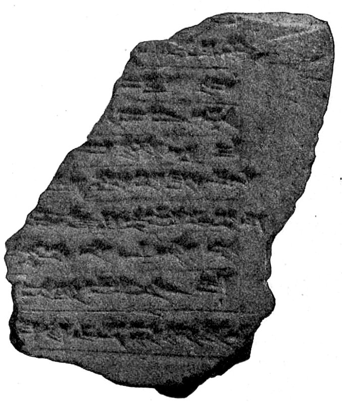
Fig. 42.—Kisu inscription of Emach.
Fig. 42.—Kisu inscription of Emach.
This “Kisu,” as the wall is named on the inscriptions, was built with the object of strengthening the external walls of the building as the floor-level was heightened. The mass of new material brought in for this work must have pressed very seriously on the outer walls, and rendered such strengthening necessary. We find the same method adopted for several monumental buildings as they were raised in height. It was a special delight to the Babylonians to seize the opportunity afforded by rebuilding to raise the level. To build higher and yet higher always on the same ground plan is the characteristic tendency of all restorers of buildings.
This "Kisu," as it's referred to in the inscriptions, was built to reinforce the building's outer walls as the floor level was raised. The amount of new material brought in for this work must have put a significant strain on the outer walls, making this strengthening essential. We see the same approach used in several monumental buildings as they were elevated. The Babylonians particularly enjoyed the opportunity to increase the level during renovations. Continuously building higher while maintaining the same layout is a defining tendency among all building restorers.
In the debris of the Kisu, which was largely destroyed by early plunderers, we have found a considerable number of inscribed bricks that refer to the rebuilding of the temple, and to the Kisu (Fig. 42): “Nebuchadnezzar, King of Babylon, son of Nabopolassar, King of Babylon, am I. E-maḫ, the temple of Ninmaḫ in Babylon, have I built anew to Nin-maḫ the Princess, the Exalted, in Babylon. I caused it to be surrounded with a mighty Kisu of bitumen and burnt brick,” etc. (trans. by Winckler). The inscription is identical with that on small cylinders now in various museums, but of which we have found none (K.B. iii. 2, p. 67). We see here what Nebuchadnezzar meant by “mighty”: it is a wall 2.02 metres thick.
In the ruins of the Kisu, which was mostly destroyed by early looters, we've discovered a significant number of inscribed bricks that mention the rebuilding of the temple and the Kisu (Fig. 42): “I am Nebuchadnezzar, King of Babylon, son of Nabopolassar, King of Babylon. I have rebuilt E-maḫ, the temple of Ninmaḫ in Babylon, for Nin-maḫ the Princess, the Exalted, in Babylon. I had it surrounded by a powerful Kisu made of bitumen and burnt brick,” etc. (trans. by Winckler). The inscription matches those found on small cylinders in various museums, none of which we have discovered (K.B. iii. 2, p. 67). Here, we see what Nebuchadnezzar meant by “powerful”: it refers to a wall that is 2.02 meters thick.
62The heightening of the floor-level involved also the raising of the immediate surroundings, apparently to about the same level. The upper floor lies at about the same height as the old Procession Street.
62The raising of the floor level also included lifting the surrounding area, apparently to about the same height. The upper floor is roughly the same level as the old Procession Street.
Round this older Kisu, which exactly follows the outer lines of the temple with all its projections, there runs a later one, which has only large tower projections in some places. It is built with Nebuchadnezzar’s bricks, and its foundations are not so deep as those of its predecessor. Towards the south there appear to be remains of a third Kisu of still shallower foundation.
Round this older Kisu, which perfectly aligns with the outer edges of the temple and all its extensions, there is a later version that only has larger tower extensions in a few areas. It's made with Nebuchadnezzar’s bricks, and its foundations are not as deep as those of the earlier one. To the south, there seem to be remnants of a third Kisu with even shallower foundations.
In the south behind the temple, as low down as the ancient Kisu, are buildings of mud brick which we have not sought further. They show that the Citadel square was formerly occupied by buildings of a private character.
In the south behind the temple, as low down as the ancient Kisu, are mud brick buildings that we haven't explored further. They indicate that the Citadel square was once filled with private buildings.
To whom the two upper pavements which still remain in the entrance doorway may be ascribed cannot be stated with certainty. In this case we cannot place much reliance on the Nebuchadnezzar stamps. On the upper pavement stood an entirely unimportant construction of Nabonidus bricks.
To whom the two upper pavements that still exist in the entrance doorway can be attributed is uncertain. In this case, we can't really rely on the Nebuchadnezzar stamps. On the upper pavement stood a completely insignificant structure made of Nabonidus bricks.
This building in later years was demolished and levelled above the upper pavement, and on it was erected a building of mud brick on the lines, however, of the ancient temple. So little of it now remains that it is impossible to make out its purpose with any certainty.
This building was torn down in later years and leveled above the upper pavement, and a mud brick structure was built on it, following the design of the ancient temple. So little of it remains now that it's impossible to determine its purpose with any certainty.
In order to secure more strength for the building, wooden clamps were inserted about half-way between the bottom of the foundations and the main flooring, which reached from the outer walls to those opposite. We found the holes left by them in the walls of the north-east room, and in chamber W 2.
In order to add more stability to the building, wooden clamps were placed about halfway between the foundation and the main floor, extending from the outer walls to the walls across from them. We discovered the holes they left in the walls of the northeast room and in chamber W 2.
At about each 8th course there is a thick layer of reeds laid crossways over each other, which have now rotted to a white powder. They were certainly intended in some way to strengthen the walls, but it is now difficult to estimate the length of time for which they served this purpose.
At roughly every 8th layer, there's a thick mat of reeds laid crosswise over each other, which have now decayed into a white powder. They were definitely meant to help reinforce the walls in some way, but it's hard to determine how long they actually served that purpose.
The angles of the walls at the gates were secured by the insertion of pieces of wood washed over with tar. A plank of wood, the height of a brick course, lay in the 63jamb, and another, one course higher on each side, thus forming a frame, which probably also served as an attachment for the door or door casing.
The angles of the walls at the gates were reinforced by inserting pieces of wood coated with tar. A plank of wood, the same height as a brick layer, rested in the 63jamb, and another, one layer higher on each side, creating a frame that likely also acted as a support for the door or door frame.
We should, of course, wish to give a clearer explanation of the object and use of the various parts of the building, but this is a difficult matter. We have very little information as to the usages of the cult connected with the temple. It is therefore of great importance that in Babylon we have not only one, but a series of four temples, in which the arrangement of the chambers is clearly repeated. From these we can conclude with certainty that for a temple the towered façade, the vestibule, the court, the cella with its postament in the shallow niche, were regarded as indispensable. It is not difficult to recognise the small side-chamber near the cella as the store-place for the various requirements of the cult. The chamber next the vestibule can be identified with some certainty as either a waiting-room or the porter’s lodge. The long narrow passages near the cella are remarkable; others exactly similar have been found in other temples. They would be well adapted to enclose the ramps or staircases that led to the flat roof, and some part of them may, in fact, have been used for that purpose. But it is by no means easy to understand why two such arrangements so completely alike as G 1, G 2, G 3 and O 3, G 4, G 5 should have been placed close together. I might provisionally suppose that these passages represent the remains of a more ancient and certainly an unknown type of ground-plan. The whole arrangement gives an impression that the original Babylonian house was essentially a four-sided walled enclosure, inside which opposite the entrance, separated from the enclosing wall by a narrow intermediate space, stood a detached house of one room. In course of its development other single chambers were added, which were built near the other sides of the enclosing wall. The intermediate space would make it possible to guard the main house from any danger from robbers who might break through the outer walls. But this, as we have said, is all hypothetical, and entirely depends on the result of further research.
We should definitely aim to provide a clearer explanation of the purpose and function of the different parts of the building, but that’s a tough task. We have very limited information about the rituals associated with the temple. This makes it really important that in Babylon, we have not just one, but a series of four temples, where the layout of the rooms is clearly repeated. From these, we can confidently conclude that for a temple, the towered façade, vestibule, court, and the cella with its base in the shallow niche were considered essential. It’s not hard to identify the small side chamber next to the cella as a storage area for the various needs of the cult. The chamber next to the vestibule can likely be identified as either a waiting room or the porter’s lodge. The long, narrow passages near the cella are interesting; similar ones have been found in other temples. They seem well-suited to house the ramps or staircases leading to the flat roof, and some parts of them might have actually been used for that. However, it’s not easy to understand why two arrangements as similar as G 1, G 2, G 3 and O 3, G 4, G 5 would be placed so close together. I could tentatively suggest that these passages are remnants of an older, and definitely unknown, type of layout. The overall setup gives the impression that the original Babylonian house was essentially a four-sided walled enclosure, inside which, directly opposite the entrance, separated by a narrow space, stood a detached house with a single room. Over time, other single rooms were added, built against the other sides of the enclosing wall. This space would allow for protection of the main house from potential threats posed by robbers who might breach the outer walls. However, as we’ve said, this is all speculative and completely relies on the outcomes of further research.
64No cultus image has been found. In many temples the postaments are supported on gigantic and deep foundations although their height above the flooring is invariably very slight. We may conclude from this that they were intended to bear heavy weights. Herodotus (i. 183) states that the seated statue of Marduk in the temple Esagila with its accessories weighed 800 talents of gold, and speaks of another sacred statue 12 ells high in massive gold. It is obvious that such costly statues could not survive to a later period. Their immense value was their certain ruin. Thus if we attempt to form an idea of the appearance of a temple statue we must have recourse to the terra-cottas. They are found by many thousands over the entire city area. Only a few of these are uninjured, by far the largest number are in small fragments. These, however, even when they are very small, can be recognised as belonging to a well-known type. Great as is the number of these terra-cottas, the number of different types is proportionately small. They appear to have been used as a species of household gods, and they are all of the same modest size, about 12 centimetres high. They are moulded, and the design is only on the front, the back is smooth and merely rounded; thus they are absolutely full face. The men are clothed, but the women are nude until the Greek times, when the woman with a child in her arms appears for the first time draped. All other female types remain unclothed up to the latest period. With regard to technique, in the later Greek period a slight change was introduced, and a mould was made for the back as well as for the front of the figure; the two edges must have been fastened together, leaving the inside hollow. These terra-cottas now show only the yellowish, or occasionally reddish, colour of the burnt clay, but originally they were painted, as we learn from some few better-preserved specimens. Of the time of Nebuchadnezzar and earlier there are some that appear to be glazed in one colour; but the glaze is always so much decayed that it is impossible to say whether or not the figures were originally glazed in a variety of colours.
64No cult image has been found. In many temples, the bases rest on huge, deep foundations, even though their height above the floor is always very low. This suggests they were designed to support heavy weights. Herodotus (i. 183) notes that the seated statue of Marduk in the temple Esagila, along with its accessories, weighed 800 talents of gold and mentions another sacred statue that stood 12 ells high and was made of solid gold. It's clear that such valuable statues couldn't last until later periods. Their immense worth led to their inevitable destruction. Therefore, if we want to imagine what a temple statue looked like, we have to rely on the terra-cottas. Thousands of these have been discovered throughout the entire city area. Only a few of them are intact; most are in small fragments. However, even the tiniest pieces can be identified as belonging to a familiar type. Despite the large number of these terra-cottas, the variety of different types is relatively small. They seem to have been used as a form of household gods, all of the same modest size, around 12 centimeters tall. They are molded, with the design only on the front, while the back is smooth and rounded, making them appear completely face-on. The male figures are clothed, but the female figures remain nude until Greek times, when we first see a woman with a child draped. All other female types stay unclothed right up to the latest period. Regarding technique, a slight change was introduced in the later Greek period, creating molds for both the front and back of the figure; the edges would have been secured together, leaving the inside hollow. These terra-cottas now show only a yellowish or sometimes reddish color from the baked clay, but they were originally painted, as we can see from a few better-preserved examples. From the time of Nebuchadnezzar and earlier, some appear to have a single-color glaze; however, the glaze is usually so deteriorated that it's impossible to tell if the figures were originally glazed in a variety of colors.
65The characteristic form of each of these somewhat rare types of divinities occurs with such convincing similarity in the numerous examples of each type that the cultus image of the respective gods in their temples must have had the same form. Now, if we find in, or near, one temple a considerable number identical in type, we are, in some measure, justified in forming from them a conjectural restoration of the divine image. We must bear in mind, however, that coincidence may here play a part. In any case, I am quite prepared later to modify the conclusions here put forward with regard to each temple, in favour of what may be thought more solid and more probable considerations.
65The distinct form of each of these somewhat rare types of deities appears with such convincing similarity in the many examples of each type that the worship image of the respective gods in their temples must have looked the same. Now, if we find a significant number of identical types in or near one temple, we can somewhat justifiably create a hypothesized reconstruction of the divine image based on them. However, we must keep in mind that coincidence might play a role here. In any case, I am fully prepared to later revise the conclusions presented here regarding each temple, in favor of what might be considered more solid and more likely considerations.
The terra-cottas of the Ninmach temple (cf. Fig. 202) show the type of a standing female figure, with hands laid in one another and folded in the Babylonian fashion, with well-dressed hair, a necklet, and several anklets. The figure is thoroughly symmetrical, the face round and full, and exactly in accord with the Arab ideal of feminine beauty.
The terra-cottas from the Ninmach temple (cf. Fig. 202) display a standing female figure, with her hands placed together and folded in the traditional Babylonian style, styled hair, a necklace, and multiple anklets. The figure is completely symmetrical, with a round, full face that perfectly matches the Arab ideal of feminine beauty.
The tablets found in the temple contain lists of the delivery of building materials, of workmen, and of others who did not work. Also the name of an architect, Labashi, occurs.
The tablets found in the temple include lists of delivered building materials, workers, and those who didn’t work. The name of an architect, Labashi, is also mentioned.
Emach, as this temple of Ninmach was called, has provided us with the type of the Babylonian temple which, previous to our excavations, was entirely unknown. The consideration of all the other temples will be much more quickly accomplished, as it will only be needful to bring forward the individual peculiarities of each temple.
Emach, as this temple of Ninmach was called, has given us the model of the Babylonian temple, which was completely unknown before our excavations. Examining all the other temples will be much faster, as we only need to highlight the unique characteristics of each temple.
X
THE SOUTHERN CITADEL

Fig. 43.—Reconstruction of Southern Citadel, from the north. The excavation of the western part is incomplete.
N. Temple of Ninmach. I. Ishtar Gate.
Fig. 43.—Reconstruction of Southern Citadel, viewed from the north. The digging of the western section is still unfinished.
N. Temple of Ninmach. I. Ishtar Gate.
The southern, most ancient part of the Acropolis of Babylon we have been accustomed to distinguish as the Southern Citadel (Figs. 43, 44). This also was not all built at one time but at successive periods. The oldest part lies between the squaring lines i to m of the Kasr plan (cf., for the squares, Fig. 13). Here apparently stood a palace of Nabopolassar, which Nebuchadnezzar preserved in order to dwell there during the building of the eastern portion. This eastern side in front of the ancient palace, which was originally unoccupied or only built upon with private houses, was enclosed by a fortification wall of which certain of the more ancient parts still remain, such as the arched door on the eastern side. Nebuchadnezzar’s first work consisted in rebuilding the surrounding walls of the eastern part of this fortress with burnt brick, raising the whole square to a higher level, and placing on it a new palace. The new part was connected for a time with the older, lower portion by ramps (Fig. 67), which have been discovered uninjured beneath the pavement. The second building period of Nebuchadnezzar also renewed the ancient palace, raised it to the same height, and extended the western boundary as far as the squaring line g of the Kasr plan. Thus the whole formed a connected uniform building of quite unusual size. The further and later important enlargement of the palace by Nebuchadnezzar, which extended to the north and the west of the Southern Citadel, we will consider later. In the meantime we will turn to the inspection of the Southern Citadel, which presents itself as being uniformly the work of Nebuchadnezzar. Neriglissar’s work consisted of a restoration of the upper parts of the western portion. Nabonidus repaved the great court with fine large bricks, many of which still remain in position, and Artaxerxes built an Apadana against the west front, of which the foundations, as well as enamelled bricks and fragments of marble pillars and inscriptions, have been found (f 25 in plan). (Cf. p. 127 et seq.)
The southern, oldest part of the Acropolis of Babylon is commonly known as the Southern Citadel (Figs. 43, 44). This structure wasn't built all at once but rather over several periods. The oldest section is located between the squaring lines i to m of the Kasr plan (see the squares, Fig. 13). Here, it seems a palace of Nabopolassar existed, which Nebuchadnezzar kept intact to live in while the eastern part was being constructed. The eastern side, in front of the ancient palace—originally unoccupied or only developed with private houses—was enclosed by a fortification wall, parts of which still exist, including the arched door on the eastern side. Nebuchadnezzar's initial work involved rebuilding the surrounding walls of the eastern part of this fortress using burnt brick, raising the entire square to a higher level, and building a new palace on it. For a time, the new part was connected to the older, lower section by ramps (Fig. 67), which have been found intact beneath the pavement. The second building phase of Nebuchadnezzar also renovated the ancient palace, elevated it to match the new height, and extended its western boundary up to the squaring line g of the Kasr plan. This created a cohesive structure of impressive size. We will discuss the later significant expansion of the palace by Nebuchadnezzar, which extended to the north and west of the Southern Citadel, at another time. For now, let's examine the Southern Citadel itself, which is uniformly attributed to the work of Nebuchadnezzar. Neriglissar restored the upper parts of the western section. Nabonidus repaved the large central court with fine bricks, many of which remain in place, and Artaxerxes constructed an Apadana on the west front, of which the foundations, along with enamelled bricks and fragments of marble pillars and inscriptions, have been discovered (f 25 in plan). (See p. 127 et seq.)

Fig. 44.—Complete plan of Southern Citadel. N. Ninmach Temple. I. Ishtar Door.
Fig. 44.—Complete plan of Southern Citadel. N. Ninmach Temple. I. Ishtar Door.
XI
THE EAST FRONT OF THE SOUTHERN CITADEL
The east front consists of a defensive wall that ran parallel with the Procession Street (cf. Fig. 44). It is guarded by cavalier towers placed at short intervals, and the principal entrance is a doorway inserted in a shallow recess and flanked as usual by two towers. The recess is shallower on the north than on the south side. The wall itself does not run exactly north to south, which is the direction of the greater part of the palace, and care has evidently been taken to render this deviation as little 69noticeable as possible. This doorway is perhaps that of Beltis (Steinplatten inscription, col. 5, 17).
The east front features a defensive wall that runs parallel to Procession Street (cf. Fig. 44). It’s protected by cavalier towers at short distances apart, and the main entrance is a door set in a shallow recess, typically flanked by two towers. The recess is shallower on the north side than on the south. The wall itself doesn’t run perfectly north to south, which is the direction of most of the palace, and it’s clear that efforts have been made to make this deviation as minimal as possible. This doorway might be that of Beltis (Steinplatten inscription, col. 5, 17).

Fig. 45.—Arched doorway in Southern Citadel.
Fig. 45.—Arched doorway in the Southern Citadel.
To the south near this gateway is an older piece of 70wall which in many respects is different from the rest. The bricks are smaller (31.5 × 31.5 × 7.5), the joints are formed of asphalt and reeds, the asphalt is laid flush with the face of the wall and has oozed out over it, giving it a blackish appearance, in marked contrast with the neighbouring wall of Nebuchadnezzar’s time, which is lighter in colour, as the asphalt does not show on the surface. This piece of wall contains an arched gateway (Fig. 45), with a threshold that lies about 6 metres below the street pavement. This gate, which is generally known as the arched doorway, was blocked up with mud bricks during the general raising of the ground. It seems, however, that during a later period a door of secondary importance was placed here, of which a small part of the frame still exists. It must have led into the palace that lay behind it. It had two doors, one directly behind the other, as we may infer from the rebates that project by one brick both on the inner and outer sides of the wall. The inner door could only be opened by any one who wished to enter after he had entered the small chamber and had closed the outer door behind him. The outer door could be fastened by a large wooden bolt which pushed backwards and forwards in a cavity in the northern wall.
To the south near this gateway is an older section of 70wall that differs significantly from the rest. The bricks are smaller (31.5 × 31.5 × 7.5), and the joints are made of asphalt and reeds. The asphalt is level with the wall surface and has overflowed slightly, giving it a dark appearance, which stands out in contrast to the neighboring wall from Nebuchadnezzar’s era, which is lighter since the asphalt isn't visible on the surface. This section of the wall has an arched gateway (Fig. 45), with a threshold about 6 meters below the street level. This gate, commonly referred to as the arched doorway, was filled in with mud bricks when the ground was raised. However, it appears that, at a later time, a secondary door was added here, and a small part of the frame still remains. It likely led into the palace located behind it. It had two doors, one directly behind the other, as indicated by the recesses that extend out by one brick on both the inner and outer sides of the wall. The inner door could only be opened by someone wishing to enter after they had stepped into the small chamber and closed the outer door behind them. The outer door could be secured with a large wooden bolt that slid back and forth in a slot in the northern wall.
Very interesting, and very characteristic both of this time and of its art, is the construction and the external appearance of this arch. It consisted of a series of three ring courses one above another, each of them covered by a flat course. The lower ring of the outside is destroyed and has disappeared completely. The bricks of our arch are of the usual form, not wedge-shaped. The laying is so slightly radial that at the vertex an actual three-cornered gap remains filled in with chopped brick. The central bricks were covered with asphalt before being laid, the lower ones are laid in mud and asphalt. The inner imposts are bound together by clamps made of poplar wood soaked in asphalt on a system which can no longer be clearly worked out. The lower ring alone formed an actual arch, each of the two higher rings begin some courses higher than the last and follow only a part of the semicircle, thus forming a segment. They begin nevertheless with a brick 71laid horizontal and not sloping. It is obvious that the planning of this arch construction is very faulty and inconsistent in comparison with Roman stone vaulting.
Very interesting and very typical of this time and its art is the design and outward appearance of this arch. It consisted of three stacked ring courses, each topped by a flat course. The lower ring on the outside has completely collapsed and is no longer there. The bricks used for our arch are standard, not wedge-shaped. The stacking is only slightly angled, leaving a triangular gap at the top filled with chopped brick. The central bricks were coated with asphalt before being placed, while the lower ones were set in a mix of mud and asphalt. The inner imposts are held together by clamps made of poplar wood soaked in asphalt, following a system that is no longer completely understood. Only the lower ring forms a true arch, while each of the two upper rings starts some courses higher than the last and only covers part of the semicircle, creating a segment instead. They nonetheless start with a brick laid flat rather than sloping. It’s clear that the design of this arch construction is quite flawed and inconsistent compared to Roman stone vaulting.
The wall stands throughout on a level foundation bed. On the outside it is perpendicular, but on the inside the courses recede a little one behind the other, causing a slight slope and rendering the walls somewhat thicker below than they are above. This batter of the walls never occurs in buildings that are indisputably of the time of Nebuchadnezzar.
The wall sits on a flat foundation. On the outside, it’s straight up and down, but on the inside, the layers step back slightly, making a gentle slope and making the walls a bit thicker at the bottom than at the top. This slant in the walls never happens in buildings clearly from the time of Nebuchadnezzar.
On to this old piece of wall, with its three towers to the north and the south, the later walls are built with grooved and tongued expansion joints (see p. 36), for which purpose the old wall was hacked out as far as necessary. The later wall is plain; it formed, however, only a foundation for the now destroyed upper part, which certainly must have been furnished with towers. By this new building the old wall appears to have been strengthened within as by a Kisu, to which the palace walls are closely fitted by means of plain expansion joints.
On this old section of wall, with its three towers to the north and south, the newer walls are constructed with grooved and tongued expansion joints (see p. 36), for which the old wall was chiseled away as needed. The newer wall is simple; it primarily serves as a foundation for the now-destroyed upper section, which must have included towers. This new construction seems to have reinforced the old wall internally, similar to a Kisu, to which the palace walls are tightly connected using plain expansion joints.
The lower part of the long northern portion with its seven towers is similar both in age and style of building to the arched door. The upper part is contemporary with the Citadel Gate, and of course the tongued expansion joints are employed throughout, and a powerful strengthening is added on the inside; according to the principles of the ancient architects it was not permissible to rest the footings of this inner strengthening on the lowest level of the foundations, and accordingly there remained in the mesopyrgia narrow spaces that were filled up by small independent walls only one brick thick. Nebuchadnezzar’s architects were very consistent on these points. The gate on the north corresponds with the arched door and is closed with later brickwork. The door in the angle abutting on the Ishtar Gate afforded the entrance to the area enclosed by the two mud walls of the Ishtar Gate. In order to leave this door clear the Citadel wall here in the corner is set back.
The lower part of the long northern section, with its seven towers, is similar in both age and architectural style to the arched door. The upper section is from the same period as the Citadel Gate, and of course, it features tongue-and-groove expansion joints throughout. A strong support has also been added inside; according to the principles of ancient architects, it was not allowed to place the footings of this internal support on the lowest level of the foundations. As a result, there were narrow spaces left in the mesopyrgia, which were filled with small, independent walls only one brick thick. Nebuchadnezzar’s architects were very consistent in these practices. The north gate aligns with the arched door and is sealed with later brickwork. The door in the corner next to the Ishtar Gate provided access to the area surrounded by the two mud walls of the Ishtar Gate. To keep this door clear, the Citadel wall at this corner is set back.
The other sides of the Citadel wall we will observe later. The palace must now be studied in detail.
The other sides of the Citadel wall will be examined later. Right now, we need to look at the palace in detail.
XII
THE EASTERN COURT OF THE SOUTHERN CITADEL
Through the Beltis door we first enter the usual gateway court, out of which open two rooms with large doorways. These are well adapted for the use of the castle guard and afford access to the court. Two other chambers close by may be regarded as waiting-rooms.
Through the Beltis door, we first enter the usual gateway court, which leads to two rooms with large doorways. These are suitable for the castle guard and provide access to the court. Two other nearby chambers can be seen as waiting rooms.
To the north and south of the eastern court (Fig. 46, O), accessible by passages or alleys, were the houses of the officials employed here, similar to those found in other courts. Here they are of smaller dimensions than in the other courts, where they are clearly built in accordance with their degree of importance. The largest dwellings are always placed on the south side of the courts. The chambers of these houses are invariably grouped round a small court, which can easily be distinguished from the chambers by its square ground-plan. The smaller houses have only one court, while the larger ones have two or more. Thus 1, 2, 3, 6, 10 have only one court; 4 with 5, 8 with 9, and 11 with 12 have two. Owing to the curtailed space below the wall the latter is slightly out of the square. It appears that a royal manufacture of flasks was established here. A very large number of those graceful vases, which in Greek art are called alabastra (Fig. 47), were found here, especially waste products of the manufacture. For the purpose of hollowing them out a crown-bit was used first of all, which cut out a cylindrical piece and afforded room for other boring instruments. Masses of these cylindrical cores were found here.
To the north and south of the eastern courtyard (Fig. 46, O), connected by pathways or alleys, were the residences of the officials working here, similar to those in other courtyards. Here, they are smaller than in the other courtyards, which are clearly built based on their significance. The largest homes are always located on the south side of the courtyards. The rooms in these homes are always arranged around a small courtyard, which is easy to distinguish by its square layout. The smaller homes have only one courtyard, while the larger ones have two or more. Thus, 1, 2, 3, 6, and 10 have just one courtyard; 4 with 5, 8 with 9, and 11 with 12 have two. Due to the reduced space below the wall, the latter is slightly out of the square. It seems that a royal workshop for flasks was set up here. A large number of those elegant vases, which are referred to as alabastra in Greek art (Fig. 47), were discovered here, particularly manufacturing waste. To hollow them out, a crown-bit was initially used, which cut out a cylindrical piece and made room for other boring tools. Many of these cylindrical cores were found here.

Fig. 46.—Eastern part of Southern Citadel.
Fig. 46.—Eastern section of the Southern Citadel.

Fig. 47.—An Alabastron.
Fig. 47.—An Alabaster Vase.
The house 8 with 9 had two large rooms which opened on the great court (O), but had no direct communication with the other rooms. They thus possess the characteristics of offices open to the public from the great court, while the official could enter them by a small passage from the open court in front of his own rooms. As in all the great courts the largest buildings lay to the south, so in each of these houses the principal chamber lay on the south side of the court; and this must have been the pleasantest part of the whole house, as it lay in shadow almost all day. Owing to the peculiar climate of Babylon it is obvious that in laying out a house, only the summer and the heat would be taken into consideration. The summer lasts 8 months, from the middle of March to the middle of November, and during June, July, and August the temperature is at times abnormally high. We have observed a maximum of 49½ grades Celsius in the shade, and 66 in the sun, and the heat lasts for many hours of the day. It begins in the morning by 9 o’clock, and only at 9 o’clock in the evening does it begin to abate: the minimum heat is in the early hours of the morning after sunrise. The months of December and February correspond on the whole with our autumn and spring. The only cold weather is in January, if the sun does not shine, and sometimes there are night frosts. Frosty days can be counted on the fingers of one hand, and the unaccustomed body feels these cold days very keenly. Rain is very scanty. I believe if all the hours in the whole year in which there were more than a few drops of rain were reckoned up, they would barely amount to 7 or 8 days. The annual downfall has been registered by Buddensieg at 7 centimetres, in North Germany Herr Hellmann informs me it is 64, and in places in India 1150 centimetres. Naturally there are exceptional years. The winter of 1898 was severe and long, the thorn bushes of the desert were thickly frosted over, and the breath of a rider froze as he rode. In 1906 hundreds of palms were 75frozen in the neighbourhood of Babylon, and in 1911 the snow lay ankle deep all over the plain between Babylon and Bagdad for a whole week. But these are exceptions, and then people usually pretend that such a thing has not happened for 100 years. The result of this fine climate is that for the greater part of the year all business is carried on in the open air, in the courts, or at any rate with open doors.
The house 8 with 9 had two large rooms that opened onto the main courtyard (O), but there was no direct access to the other rooms. They functioned like offices accessible to the public from the main court, and the official could enter them through a small passage from the open court in front of his own rooms. In all the main courts, the largest buildings were positioned to the south, so in each of these houses, the main chamber was located on the south side of the courtyard; this must have been the most pleasant part of the entire house since it was in shadow for almost the whole day. Given Babylon's unique climate, it's clear that when designing a house, only the summer and heat were considered. Summer lasts about 8 months, from mid-March to mid-November, and during June, July, and August, temperatures can become extremely high. We've recorded a maximum of 49.5 degrees Celsius in the shade and 66 in direct sunlight, with the heat lasting for many hours throughout the day. It starts in the morning by 9 a.m. and only begins to ease off around 9 p.m.; the coolest time is early in the morning just after sunrise. The months of December and February generally align with our autumn and spring. The only cold weather occurs in January, particularly when the sun isn't shining, and sometimes there are night frosts. Frosty days can be counted on one hand, and an unaccustomed body feels these cold days very acutely. Rain is very sparse. I believe if we counted all the hours in the year when there were more than a few drops of rain, it would barely add up to 7 or 8 days. The annual rainfall has been recorded by Buddensieg at 7 centimeters, while in North Germany Herr Hellmann reports it at 64 centimeters and in parts of India, it's 1150 centimeters. Of course, there are exceptional years. The winter of 1898 was long and harsh, with desert thorn bushes heavily frosted, and a rider's breath would freeze as he rode. In 1906, hundreds of palm trees in the area around Babylon froze, and in 1911, snow accumulated ankle-deep across the plain between Babylon and Baghdad for an entire week. But these are exceptions, and people usually claim such things haven’t happened for a century. The result of this pleasant climate is that for most of the year, all business takes place outdoors, in the courtyards, or at least with open doors.
Windows do not appear to have existed. None have ever been found, and the evidence of the ground-plans bears out this presumption. The evenings and nights were spent on the flat roofs. Thus the chambers were used very much as refuges or store chambers, with the exception of the principal rooms, where in any case as a matter of business the official must have installed himself. He may, however, have often done his business in the court in front of his office.
Windows don't seem to have existed. None have ever been discovered, and the evidence from the ground plans supports this assumption. Evenings and nights were spent on the flat roofs. Therefore, the chambers were primarily used as storage or refuge spaces, except for the main rooms, where the official would likely have set up his office for work. However, he probably often conducted his business in the courtyard in front of his office.
In the south-east corner of the Kasr the earliest brick stamps of Nebuchadnezzar occur, and the king appears to have begun his new building here. These stamps have six lines of inscription, ending with the words “am I,” anaku (Figs. 48, 51). In general the legends on these different varieties of stamps are the same: “Nebuchadnezzar, King of Babylon, fosterer of Esagila and Ezida, son of Nabopolassar, King of Babylon.” There are 6–lined, 4–lined, 3–lined, and 7–lined stamps, and one single specimen is 5–lined. The 4–, 3–, and 7–lined stamps substitute for the old simple “son,” maru, the more detailed “first-born son,” aplu ašaridu, after which the name of the father that follows is introduced with ša, which does not occur on the 6–lined stamps.
In the southeast corner of the Kasr, the earliest brick stamps of Nebuchadnezzar can be found, indicating that the king likely started his new construction here. These stamps feature six lines of inscription, ending with the phrase “am I,” anaku (Figs. 48, 51). Generally, the wording on these various types of stamps is consistent: “Nebuchadnezzar, King of Babylon, supporter of Esagila and Ezida, son of Nabopolassar, King of Babylon.” There are stamps with 6 lines, 4 lines, 3 lines, and 7 lines, and one unique specimen has 5 lines. The 4–, 3–, and 7–lined stamps replace the older simple term “son,” maru, with the more detailed phrase “first-born son,” aplu ašaridu, which is introduced with ša before the father's name that follows, a term not used in the 6–lined stamps.

Fig. 48.—Brick stamps of Nebuchadnezzar.
Fig. 48.—Nebuchadnezzar's brick stamps.
We can distinguish three methods by which the working stamps were produced. In the first the original inscription was produced in terra-cotta, in which the signs were most carefully and beautifully written, and the strokes show the regular three-cornered section. From this original inscription the working stamp could then be struck in clay and baked. These we call “pottery stamps.” In them the rows of cuneiform writing are separated from each other by ruled lines. In the second sort the signs were cut out separately in wood, joined together in one block, and then moulded in sand. From this mould the working stamp was apparently cast in bronze. The strokes of these are of roundish section. Of this “metal stamp” the impressions are fine and deep, but, on the other hand, the ground between the strokes easily becomes clogged during the stamping, and thus on the bricks the signs frequently appear only in outline, while the wedges are confused and flattened. Lines between the rows of writing in these metal stamps are rare, and it is possible there was some difficulty in producing them. With the third method the original inscription is produced in stone, undoubtedly by grinding. In this way the wedges acquire a scratched appearance, as is more especially the case with the stone objects bearing votive inscriptions of the time of the Kassite kings. The working stamp made from this may have been taken either in bronze or in pottery. We have found no actual working stamp, but this is not surprising, considering that in the course of our excavations we have not yet met with a brick-kiln, and it is of course possible that the method of production was very different from what I have suggested. In the 77meantime it is important to describe the technical characteristics of the different kinds of stamps as they exist, and to give a concise name to each of them. The 6– and 7–lined stamps occur both as pottery and metal stamps, never as “Kassite,” the 4–lined are almost exclusively pottery, and the 3–lined are never metal, but either pottery or “Kassite.”
We can identify three methods for producing the working stamps. The first method involved creating the original inscription in terracotta, where the characters were crafted with great care and beauty, and the strokes have a distinct triangular cross-section. From this original inscription, the working stamp could then be created in clay and baked. We refer to these as “pottery stamps.” In these stamps, the rows of cuneiform writing are separated by ruled lines. In the second method, the signs were individually cut from wood, assembled into one block, and then molded in sand. From this mold, the working stamp was likely cast in bronze. The strokes of these stamps are more rounded in shape. The impressions from these “metal stamps” are fine and deep; however, the spaces between the strokes can easily get clogged during the stamping process, leading to instances where the signs on the bricks only appear as outlines, with the wedges becoming muddled and flattened. Lines between the rows of writing in these metal stamps are uncommon, suggesting some difficulty in creating them. The third method involves crafting the original inscription in stone, most likely through grinding. This results in the wedges having a scratched look, which is particularly noticeable on stone objects with votive inscriptions from the time of the Kassite kings. The working stamp made from this may have been created in either bronze or pottery. We have not discovered any actual working stamp, but that’s not surprising, given that during our excavations we haven’t yet found a brick kiln, and it’s possible that the production method was quite different from what I have proposed. In the meantime, it’s essential to describe the technical features of the different types of stamps as they are found, and to assign a concise name to each of them. The 6- and 7-lined stamps exist as both pottery and metal stamps, but never as “Kassite”; the 4-lined stamps are almost exclusively pottery, and the 3-lined stamps are never metal, but rather either pottery or “Kassite.”

Fig. 49.—Stamped brick of Nebuchadnezzar, omitting his father’s name.
Fig. 49.—Stamped brick of Nebuchadnezzar, excluding his father's name.
The orthographical differences also arrange themselves with the same distinctness in clearly defined groups. On the 6–lined stamps Ba-bi-lu or Ba-bi-i-lu is written for Babylon, while on the 7–, 4–, and 3–lined stamps it is exclusively called Ka-dingir-ra. The term Tin-tir, which is by far the most usual on stone inscriptions, only occurs once on a 3–line and once on a 4–line stamp on bricks. Very rare is a 4–line stamp on which the father’s name is omitted (Fig. 49), and as a curiosity 7–line metal stamps occur on which the order of the lines has been reversed. What elsewhere is the 7th line is here the 1st. We have no wish to decide whether this is mere carelessness. We must, however, remember in this connection that we have Assyriologists of repute who read the cuneiform writing from above downwards, with 78which its historical development certainly agrees. The literature of the tablets for the ordinary right-handed man was written from left to right, but were the scribe left-handed he would be forced to write from above downwards, and many of the archaic stone inscriptions indeed convey the impression that they should be read in this fashion. All will agree that the later writings must be read from left to right. It is quite possible that Nebuchadnezzar, who so greatly preferred the archaic characters which were so highly decorative, also made an attempt to employ the ancient method of arranging them vertically. The stamps are all inscribed with these monumental, early Babylonian characters.
The spelling differences also fall into clear categories. On the 6-lined stamps, it says Ba-bi-lu or Ba-bi-i-lu for Babylon, while on the 7-, 4-, and 3-lined stamps, it’s always referred to as Ka-dingir-ra. The term Tin-tir, the most common on stone inscriptions, only appears once on a 3-line stamp and once on a 4-line stamp on bricks. A 4-line stamp where the father’s name is omitted is quite rare (Fig. 49), and interestingly, there are 7-line metal stamps where the order of the lines is reversed. What is usually the 7th line here is the 1st. We don’t want to say this is just carelessness. However, we must remember that some respected Assyriologists read cuneiform writing from top to bottom, which matches its historical development. The literature on the tablets for the average right-handed person was written from left to right, but if the scribe was left-handed, he would have to write from top to bottom, and many of the older stone inscriptions suggest they should be read this way. Everyone agrees that later writings should be read from left to right. It’s definitely possible that Nebuchadnezzar, who really liked the ancient characters that were very decorative, might have tried to use the old vertical arrangement. All the stamps are inscribed with these monumental, early Babylonian characters.

Fig. 50.—Brick stamp of Evil-Merodach.
Fig. 50.—Brick stamp of Evil-Merodach.
The 6–lined stamp gives Nabu-ku-dur-ru-u-ṣur or Nabu-ku-dur-ri-uṣur, the 7–lined gives either the latter 79or Nabu-ku-du-ur-ri-uṣur. The 4–lined is exclusively characterised by the use of ap-lam instead of tur-uš, which is universally used elsewhere.
The 6-lined stamp shows Nabu-ku-dur-ru-u-ṣur or Nabu-ku-dur-ri-uṣur, and the 7-lined stamp presents either the latter 79 or Nabu-ku-du-ur-ri-uṣur. The 4-lined stamp is uniquely identified by the use of ap-lam instead of tur-uš, which is commonly used in other contexts.

Fig. 51.—Brick stamps of Nebuchadnezzar (E, F), of Neriglissar (G), and Nabonidus (H).
Fig. 51.—Brick stamps of Nebuchadnezzar (E, F), Neriglissar (G), and Nabonidus (H).
It may be advisable at this juncture to consider the stamps used by Nebuchadnezzar’s successors. Of Evil-Merodach we have found only two examples (Fig. 50), one of 3 lines, exactly analogous to the stamps of Nebuchadnezzar. Neriglissar (Fig. 51 G) has 3– and 4–lined stamps, with the text, “Neriglissar, King of Babylon, fosterer of Esagila and Ezida, who accomplishes good deeds.” Of Nabonidus (Fig. 51 H) are 3– and 6–lined stamps, with the text, “Nabonidus, King of Babylon, the chosen one of Nabu and Marduk, son of Nabubalatsuikbi, the wise prince, am I,” and “Nabonidus, King of Babylon, fosterer of Esagila and Ezida, son of Nabubalatsuikbi, the wise prince.” So far no stamp has been found of Labashi-Marduk. All these stamps bear general texts, applicable to any building. In contrast to them are the special stamps, which like the inscribed bricks refer to individual buildings, for which they were exclusively intended. We have such of Nabopolassar, Sardanapalus, Esarhaddon, Sennacherib, and 80Sargon, and shall speak of them when we come to the buildings to which they refer.
It might be a good idea at this point to look at the stamps used by Nebuchadnezzar’s successors. For Evil-Merodach, we’ve found only two examples (Fig. 50), one of which has 3 lines, very similar to the stamps of Nebuchadnezzar. Neriglissar (Fig. 51 G) has 3- and 4-lined stamps that say, “Neriglissar, King of Babylon, supporter of Esagila and Ezida, who does good deeds.” For Nabonidus (Fig. 51 H), there are 3- and 6-lined stamps that read, “Nabonidus, King of Babylon, the chosen one of Nabu and Marduk, son of Nabubalatsuikbi, the wise prince, am I,” and “Nabonidus, King of Babylon, supporter of Esagila and Ezida, son of Nabubalatsuikbi, the wise prince.” So far, no stamp has been found for Labashi-Marduk. All these stamps have general texts that could apply to any building. In contrast, there are the special stamps, which, like the inscribed bricks, refer to specific buildings for which they were intended. We have examples from Nabopolassar, Sardanapalus, Esarhaddon, Sennacherib, and Sargon, and we will discuss them when we get to the buildings they refer to.

Fig. 52.—Aramaic addition on Nebuchadnezzar brick.
Fig. 52.—Aramaic inscription on a Nebuchadnezzar brick.
In addition, a fair number of stamps are found in
Aramaic, either alone or in conjunction with cuneiform
(Fig. 52). Of these no convincing translation has yet
reached me; they appear to be names sometimes abbreviated.
The name
of Nabonidus is
easily recognised,
as it often
occurs in Aramaic
in conjunction
with his
cuneiform stamp.
 (Fig. 53)
appears to be an
abbreviation of
the canal name
Libil-ḫigalla, and
in
(Fig. 53)
appears to be an
abbreviation of
the canal name
Libil-ḫigalla, and
in  we may
recognise the
initial letters of
Nimitti-Bel.
we may
recognise the
initial letters of
Nimitti-Bel.
In addition, several stamps are found in Aramaic, either on their own or alongside cuneiform (Fig. 52). I haven't come across any convincing translations yet; they seem to be names, sometimes shortened. The name of Nabonidus is easily recognizable, as it frequently appears in Aramaic with his cuneiform stamp. (Fig. 53) seems to be an abbreviation of the canal name Libil-ḫigalla, and in we might identify the initial letters of Nimitti-Bel.
Among other signs more symbolic in character are the lion, the double axe, and the symbol of Marduk, a triangle on a shaft, either alone or combined with other stamps.
Among other more symbolic signs are the lion, the double axe, and Marduk's symbol, a triangle on a shaft, either alone or combined with other stamps.
The manufacture of these bricks was carried on as it is with us at the present day. The fairly pure clay was well kneaded and pressed into a rectangular wooden frame laid on a rough reed matting. Nebuchadnezzar’s bricks almost invariably show the impress of the matting on one side, while the bricks of the other monarchs appear to have been made without this underlay. The frames were frequently grooved on one or more of their inner sides, which caused corresponding ridges on the narrow edges of the bricks. We can thus distinguish bricks with 1, 2 (see Fig. 71), or even 7 of these ridges. In Nebuchadnezzar’s first building 81period the bricks had no ridges, then only one, while in his latest buildings, such as the Principal Citadel, there are seven. It thus happens that no 7–ridged brick has a 6–line stamp, as by that time they were disused. Besides their number, the ridges vary in breadth, depth, and position. The sign of early manufacture is that they are placed in the centre of the side, and are of greater breadth, while later they are placed near the corners. Thus we have ample material for dividing them, not only according to the places where they were made but also as to their age. In the course of the 43 years’ reign of Nebuchadnezzar, it is obvious that with the gradual multiplication of brick factories the necessity of being able to distinguish between their several productions increased in like measure. The bricks are not always accurately separated from each other in the buildings, according to their marks, but on the whole the stamps, in addition to the ridges on the sides, enable us to distinguish the relative ages of the various walls.
The making of these bricks was done just like it is today. The fairly pure clay was well kneaded and pressed into a rectangular wooden frame placed on a rough reed mat. Nebuchadnezzar’s bricks almost always show the imprint of the mat on one side, while the bricks from other rulers seem to have been made without this underlay. The frames often had grooves on one or more of their inner sides, which created corresponding ridges on the narrow edges of the bricks. This way, we can identify bricks with 1, 2 (see Fig. 71), or even 7 of these ridges. In Nebuchadnezzar’s early building phase, the bricks had no ridges, then only one, while in his later buildings, like the Principal Citadel, there are seven. Consequently, no 7-ridged brick has a 6-line stamp since that style was no longer used by that time. Besides the number of ridges, they vary in width, depth, and placement. A sign of early production is that the ridges are centered on the side and are wider, whereas later they are closer to the corners. Therefore, we have a lot of information to categorize them, not only by the locations where they were made but also by their age. Over the 43 years of Nebuchadnezzar’s reign, it's clear that as brick factories increased, so did the need to differentiate between their various products. The bricks are not always neatly separated in the buildings by their markings, but overall, the stamps, along with the ridges on the sides, help us to determine the relative ages of the different walls.

Fig. 53.—Aramaic addition on Nebuchadnezzar brick.
Fig. 53.—Aramaic addition on a brick from Nebuchadnezzar.
It is evident from the bricks themselves that the burning was done in ovens, which can scarcely have differed 82materially from the brick-kilns used to-day both here and in Bagdad. They are built outside the town, where the clay is good and fuel—the low bushes of the desert—is abundant. They form great fantastic groups of buildings, to which the people attach tales of horror. With the Persians it was a favourite method of execution to throw persons into these heated ovens, and when one sees the flickering glare from their mouths rising up against the evening sky of Babylon, one is unconsciously reminded of the striking account in the third chapter of Daniel of the three men, Shadrach, Meshach, and Abednego, in the fiery furnace. Herodotus states that the manufacture of bricks for the town walls was always carried on close to the site where they were to be used. This may have been done in exceptional cases, but ordinarily the ovens were certainly farther outside.
It's clear from the bricks themselves that they were fired in ovens, which likely weren't much different from the brick kilns used today both here and in Baghdad. They are located outside the town, where the clay is high-quality and fuel—the low bushes from the desert—is plentiful. They form large, unusual clusters of buildings, which people have attached stories of horror to. For the Persians, it was a common method of execution to throw people into these hot ovens, and when you see the flickering light from their openings against the evening sky of Babylon, it unconsciously reminds you of the dramatic account in the third chapter of Daniel about the three men, Shadrach, Meshach, and Abednego, in the fiery furnace. Herodotus notes that the bricks for the town walls were typically made close to where they would be used. This may have happened in rare instances, but generally, the ovens were indeed located further outside.
The whole of the walls of the Southern Citadel have been pillaged by brick robbers even below the pavement, the level to which our excavations usually extend (Fig. 54). Everywhere we have laid the walls bare as far as the bricks still remain in position. Here in the south-east corner we have gone still deeper and have dug down to the foundation fillings, reaching nearly to water-level. The fillings consist almost exclusively of sand and clayey earth, river settlement with occasional patches of ancient building material, rubbish, charcoal and ashes, bones and some broken pottery. Possibly the sediment was taken from the watercourse that flowed past the southern side of the Citadel, and which would then be considerably deepened and widened. The footings are carried down almost to water-level, of the same even thickness without any broadening. At this depth the soil is interspersed with the remains of a very ancient settlement, characterised, as in other quarters of the city, by pipe wells and much pottery. Thus in the foundations everything is avoided that could prevent the settlement of the walls, and they are perfectly free to sink vertically. In laying the foundations the doorways were left open. Hence there are separate blocks of buildings, which doubtless even before the floor-level was reached settled independently of each other during the course of erection. In order to bind these blocks together across the door spaces, beams of poplar wood soaked in tar were inserted at intervals and fixed in the wall head with short transverse pieces, thus forming huge ├──┤-rivets.
The entire walls of the Southern Citadel have been stripped by brick thieves, even below the pavement, the level to which our excavations usually go (Fig. 54). We've uncovered the walls as much as the bricks still remain in place. Here in the south-east corner, we've dug even deeper, reaching almost to water-level. The fill consists mainly of sand and clayey soil, river deposits with occasional bits of ancient building materials, debris, charcoal and ashes, bones, and some broken pottery. It's likely that the sediment was sourced from the watercourse that flowed along the southern side of the Citadel, which would have been considerably deeper and wider. The footings extend nearly to water-level, maintaining a consistent thickness without broadening. At this depth, the soil is dotted with the remnants of a very ancient settlement, marked, like in other parts of the city, by pipe wells and a lot of pottery. Therefore, in the foundations, everything is designed to allow for the settling of the walls, which are free to sink straight down. When the foundations were laid, the doorways were left open. As a result, there are separate blocks of buildings that likely settled independently of one another even before reaching the floor level. To connect these blocks across the door openings, beams of poplar wood that had been soaked in tar were placed at intervals and secured at the wall tops with short transverse pieces, creating large ├──┤-shaped rivets.

Fig. 54.—Excavations in Southern Citadel, from the north.
Fig. 54.—Excavations in the Southern Citadel, viewed from the north.
84The jointing of the brick courses can be clearly observed at this point. It is very simple, owing to the square shape of the bricks that necessitates two-handed manipulation. The cross-joints run straight through the walls, and if in one course a whole brick—a binder—lies at one corner, the next course has a half brick—a stretcher. At the edges and in the corners the sequence of the series changes. When on occasion the change does not occur owing to some irregularity, a quarter brick was employed at the edge, and in the corner a whole brick with its corner cut out was used, or one wall penetrated to the depth of half a brick into the adjoining wall, with a vertical joint extending from top to bottom. This is to be seen at this part of the Citadel. The care bestowed on applying these building regulations sometimes leaves much to be desired. The vertical joints are of uneven thickness, the walls were patched with inserted fragments, and in thick walls the regularity is frequently broken by small channels that extend transversely or lengthways through the wall, of the height and breadth of a course, and are only closed on the outer surface by an inserted fragment; they appear to have been constructed to secure the dryness of the building. In the Arachtu wall of Nabopolassar, and in his palace, as well as in the ascent on the north-east angle of the Kasr (t 4), an exceptional feature occurs, a border series in which, within the same course, a half brick laid behind a whole one is regularly alternated with a whole brick laid behind a half one, so that the whole mass of the wall is joggled together by this border series. This is another instance of the false principles of construction which are found throughout antiquity far more frequently than enthusiastic admirers would credit.
84The way the bricks are joined can be easily seen here. It’s quite straightforward because of the square shape of the bricks, which requires both hands to manipulate. The cross-joints run straight through the walls, and if in one row there’s a whole brick—a binder—at one corner, the next row has a half brick—a stretcher. At the edges and corners, the order changes. If this change sometimes doesn't happen due to irregularities, a quarter brick is used at the edge, and a whole brick with a corner cut out is placed at the corner, or one wall goes half a brick deep into the adjacent wall, with a vertical joint running from top to bottom. You can see this in this section of the Citadel. The attention given to these building standards often falls short. The vertical joints vary in thickness, the walls have been patched with inserted pieces, and in thick walls, the uniformity is often disrupted by small channels that cut across or along the wall, matching the height and width of a course, and are only covered on the outside by an inserted fragment; it seems they were built to ensure the building stayed dry. In the Arachtu wall of Nabopolassar, and in his palace, as well as in the climb at the northeast corner of the Kasr (t 4), a unique feature appears, a border pattern where, within the same row, a half brick set behind a whole one is regularly alternated with a whole brick set behind a half one, so the entire structure of the wall is interlocked by this border pattern. This is another example of the flawed construction principles that are found in antiquity much more often than enthusiastic fans would admit.

Fig. 55.—The six-lined Lebanon inscription from Southern Citadel.
Fig. 55.—The six-lined inscription from Lebanon at the Southern Citadel.

Fig. 56.—The eight-lined standard inscription from Southern Citadel.
Fig. 56.—The eight-lined standard inscription from the Southern Citadel.
In the house court, v 27, we found a brick built into the wall low down, bearing a 6–lined inscription (Fig. 55), which ran thus: “Nebuchadnezzar, King of Babylon, son of Nabopolassar, King of Babylon, am I. The palace, the dwelling of my kingship on the soil of Babylon (or “the place Babil” [Delitzsch]), which is in Babylon, I built. Mighty cedars from the mountain of Lebanon the splendid forest, I brought, and for its ceiling I laid them. Marduk the compassionate god who hears my prayer: the house that I built, may it satisfy him by its delights; the Kisu that I constructed, may its decay be renewed; in Babylon may my walks therein be continued to old age; may my posterity for ever rule over the blackheads” (trans. by Weissbach). Thus the palace was ceiled with cedars of Lebanon, and with exceptions to be dwelt on later, it was not vaulted. By the Kisu the king must have meant the strengthening wall that we have already seen on the eastern side, and that we shall see on other parts of the surrounding walls. These 6–lined inscribed bricks, of which we have found 80, were principally in the eastern part of the Southern Citadel, but few are in position. Strewn over the whole of the Southern Citadel, more especially in the central part, was a second kind of inscribed brick, the 8–lined 86legend on which ran much like the previous one (Fig. 56), but the cedars of Lebanon are not mentioned: “Nebuchadnezzar, King of Babylon, the fosterer of Esagila and Ezida, son of Nabopolassar, King of Babylon, am I. The palace, the dwelling place of my Majesty I built on the Babil place (irṣit Babil) of Babil. I grounded its foundations firm on the bosom of the underworld, and with asphalt and baked bricks I raised it mountain high. By thy behest, wise one of the gods, Marduk, may I be satisfied with the fullness of the house that I have built, along with my posterity. May my posterity bear rule in it for ever over the blackheads” (trans. by Delitzsch, cf. K.B. iii. 2, p. 69). Of these 8–lined bricks we have found altogether 412, many of them in the foundations of the great hall of the Principal Court and of its great gateway. Here they were frequently laid in the same course (Fig. 57), only separated by a few uninscribed bricks. The script is Neo-Babylonian, and always very good and carefully executed. The arrangement of the lines is always the same; they almost convey the impression that a certain rhythmic utterance was intended, which was expressed by the arrangement, for while in some lines the signs are placed so far apart as to produce considerable gaps, in others the signs are crowded together. The lines of inscription are separated by dividing lines which appear to have been made by a 2–ply cord stretched across and pressed into the pottery. Such numerous and monotonous repetitions are very vexatious for the excavator. He would be better pleased if the texts varied on the different bricks, and afforded him an opportunity of acquiring more details of building achievements, and their nomenclature and purpose. But this desire for information on the part of later scholars was evidently not foreseen by the King of Babylon. The principal object was to preserve the name of the king as the promoter of mighty works, and the hundreds of inscribed bricks, and the millions of stamped bricks do in fact form an enduring monument to the king, which it would be difficult to surpass.
In the house court, v 27, we found a brick built into the wall low down, marked with a 6-lined inscription (Fig. 55), which read: “I am Nebuchadnezzar, King of Babylon, son of Nabopolassar, King of Babylon. I built the palace, the dwelling of my kingship on the land of Babylon (or ‘the place Babil’ [Delitzsch]), which is in Babylon. I brought mighty cedars from the splendid forest of the Lebanon mountains for its ceiling. Marduk, the compassionate god who hears my prayers: may the house that I built satisfy him with its delights; may the Kisu that I constructed be renewed; may my walks in Babylon continue into old age; may my descendants rule forever over the blackheads” (trans. by Weissbach). Thus, the palace was topped with cedars from Lebanon, and with some exceptions to be discussed later, it wasn’t vaulted. By the Kisu, the king must have meant the strengthening wall we have already seen on the eastern side, as well as on other parts of the surrounding walls. Of these 6-lined inscribed bricks, we found 80, mainly in the eastern part of the Southern Citadel, but few are still in position. Scattered throughout the Southern Citadel, especially in the central area, was a second type of inscribed brick, with an 8-lined inscription (Fig. 56), which was similar to the previous one but did not mention the cedars of Lebanon: “I am Nebuchadnezzar, King of Babylon, the sponsor of Esagila and Ezida, son of Nabopolassar, King of Babylon. I built the palace, the dwelling place of my Majesty on the Babil place (irṣit Babil) of Babil. I set its foundations firmly on the bosom of the underworld, and I raised it mountain high with asphalt and baked bricks. By your command, wise one of the gods, Marduk, may I be satisfied with the fullness of the house that I have built, along with my descendants. May my descendants forever rule in it over the blackheads” (trans. by Delitzsch, cf. K.B. iii. 2, p. 69). We found a total of 412 of these 8-lined bricks, many of them in the foundations of the great hall of the Principal Court and its grand gateway. They were often laid in the same row (Fig. 57), only separated by a few uninscribed bricks. The script is Neo-Babylonian and is always very neat and well-executed. The arrangement of the lines is consistent; they almost give the impression that a certain rhythmic delivery was intended, as in some lines the signs are spaced far enough apart to create significant gaps, while in others they are packed closely together. The lines of inscription are separated by dividing lines that seem to have been made by a 2-ply cord stretched across and pressed into the pottery. Such numerous and monotonous repetitions can be quite frustrating for the excavator. It would be more pleasing if the texts varied across the different bricks, providing an opportunity to gain more insights into building achievements, their nomenclature, and purpose. However, this desire for information from later scholars was evidently not anticipated by the King of Babylon. The main aim was to preserve the name of the king as the promoter of grand works, and the hundreds of inscribed bricks, along with the millions of stamped bricks, indeed create an enduring monument to the king that would be hard to surpass.

Fig. 57.—Inscribed bricks in situ, Southern Citadel.
Fig. 57.—Inscribed bricks in situ, Southern Citadel.
According to these inscriptions the Southern Citadel stands on the “Babil place,” and in my opinion that is the site of the earliest settlement, which was named Babilu or Babilani, the gate of god or gate of the gods. At that time Esagila was separate from Babylon. It was later, though at a very early date, that both were united in one great Babylon. Later on, however, Esarhaddon, on one of the bricks found by us, says (No. 38940) that he built “Babylon and Esagila” anew, and on the numerous bricks of his Arachtu wall (No. 30522) Nabopolassar calls himself “the restorer of Esagila and Babylon.” The measurements of 190 metres broad by 300 metres long are amply sufficient for those very ancient cities. The acropolis of Tiryns, with its length of 150 metres and breadth of 50 metres, could be placed inside the eastern part of the Southern Citadel, which comprises the eastern court with its two gateways, and stretches from the northern to the southern wall. The 6th level of Troy, the Mycenaean level, is also considerably smaller than the southern acropolis, with its 130 × 180 metres; its two ancient 88encircling walls measure only 80 × 110 metres and 100 × 110 metres. Thus on the irṣit of Babylon there is certainly sufficient room for an ancient settlement of the size usual at that very remote period. Esagila lay 800 metres away, and therefore we must not imagine that from the beginning Babylon and Esagila formed a combined township. On the other hand, it is quite possible that when they were first founded, the entrance to the sacred place Esagila was completely dominated by the fortress Babil, and that it was only through this god’s door that access could be obtained to Esagila.
According to these inscriptions, the Southern Citadel is located on the “Babil place,” and I believe that is where the earliest settlement, called Babilu or Babilani—meaning the gate of god or the gate of the gods—was established. Back then, Esagila was separate from Babylon. It was later, though still in ancient times, that both were joined together to form one great Babylon. However, Esarhaddon mentions on one of the bricks we found (No. 38940) that he rebuilt “Babylon and Esagila” anew, and on many bricks of his Arachtu wall (No. 30522), Nabopolassar refers to himself as “the restorer of Esagila and Babylon.” The dimensions of 190 meters wide by 300 meters long are certainly sufficient for those ancient cities. The acropolis of Tiryns, measuring 150 meters long and 50 meters wide, could fit inside the eastern part of the Southern Citadel, which includes the eastern court with its two gateways and stretches from the northern to the southern wall. The 6th level of Troy, the Mycenaean level, is also much smaller than the southern acropolis, at 130 × 180 meters; its two ancient surrounding walls are only 80 × 110 meters and 100 × 110 meters. Therefore, on the irṣit of Babylon, there is definitely enough space for an ancient settlement of typical size for that very distant period. Esagila was located 800 meters away, so we shouldn't assume that Babylon and Esagila were initially part of the same town. However, it's quite possible that when they were first established, the entrance to the sacred place Esagila was completely overshadowed by the fortress Babil, and that access to Esagila was only possible through this god’s door.
These conditions may have been modified quite early, possibly by the beginning of the historical times. In Merkes, as far back as Hammurabi, we certainly find fully developed houses in straight streets, which we have excavated and which show a remarkably wide expansion of the town. The Hammurabi period, the 3rd millennium, is the oldest so far attained by our excavation. Of the prehistoric existence of Babylon we only find the evidence of flints and other stone implements, which owing to the continuous occupation of this site and the frequent disturbance of the soil, have been raised to the levels accessible to us.
These conditions may have changed quite early, possibly by the start of recorded history. In Merkes, as far back as Hammurabi's time, we definitely find well-built houses on straight streets, which we have excavated, showing a surprisingly large expansion of the town. The Hammurabi period, during the 3rd millennium, is the earliest level we've reached in our excavation so far. Regarding the prehistoric existence of Babylon, we only find evidence of flints and other stone tools, which, due to the ongoing occupation of this site and the constant disturbance of the soil, have been brought up to levels we can access.
We will once more return to the Southern Citadel and examine the Eastern Court. It is paved with Nebuchadnezzar’s bricks, which became chipped and damaged, and was then restored. The level was slightly raised above the old pavement, which was covered with an even wash of asphalt, and on the piled-up material a new flooring was laid of fine tiles almost exactly 50 centimetres square, that bear Nebuchadnezzar’s stamps on one edge. The vertical joints are filled with gypsum mortar and no asphalt is used. Thus the pavement could be sprinkled and kept pleasantly moist, for the burnt tiles absorb the moisture readily while the underlying wash of asphalt prevented its penetrating to the foundations.
We will return to the Southern Citadel and check out the Eastern Court. It's paved with Nebuchadnezzar’s bricks, which got chipped and damaged and then were restored. The level was slightly raised above the old pavement, which was covered with a smooth layer of asphalt, and on top of that, a new floor was laid with fine tiles, almost exactly 50 centimeters square, featuring Nebuchadnezzar’s stamps on one edge. The vertical joints are filled with gypsum mortar, and no asphalt is used. This way, the pavement could be sprinkled and kept nicely moist, as the burnt tiles soak up moisture easily while the underlying asphalt layer prevents it from reaching the foundations.
Whether the walls of the court were left uncovered, or whether they had a coat of plaster, we do not know. We know that the gateways at any rate were decorated with the coloured enamelled bricks with lions, which are found in 89all the courts. The inner chambers were covered with a fine plaster of pure gypsum laid on over a thicker coating of gypsum. In the chamber of the eastern gateway there is still a piece of this remaining, where the ancient wall is protected by the accumulated earth of the raised level of the floor.
Whether the court walls were left bare or had a layer of plaster, we don't know. What we do know is that the gateways were decorated with colorful enameled bricks featuring lions, which can be found in all the courts. The inner chambers were finished with a smooth layer of pure gypsum applied over a thicker base of gypsum. In the chamber of the eastern gateway, there is still a piece of this left, where the old wall is shielded by the soil that has built up from the raised floor level.

Fig. 58.—Base of column, Southern Citadel.
Fig. 58.—Bottom of the column, Southern Citadel.
In the court we found the base of a column (Fig. 58) and a capital of fine white limestone. The base has the same bowl-shaped form and the circular leaf ornament, with a contour of fillets, as the base of Kalach (Nimrud). The capital is severely damaged, but the circular drum can still be recognised, as well as two projecting masses which appear to be the remains of two bulls’ heads, similar to those on the capitals of Persepolis. The fragments lay on a pile of rubbish 1 metre high, and must therefore have been removed here after the palace was destroyed. It is possible that the base belonged to the round circular pedestal in front of the Ishtar Gate near the north-west bastion. In the court itself there is no place whatever for a column. It is in the vaulted building (see p. 99) alone that we can imagine columns to have been used.
In the courtyard, we discovered the base of a column (Fig. 58) and a capital made of beautiful white limestone. The base has the same bowl-like shape and circular leaf design, with a series of fillets, as the base from Kalach (Nimrud). The capital is heavily damaged, but the circular drum is still identifiable, along with two protruding sections that seem to be the remnants of two bull heads, similar to those found on the capitals at Persepolis. The fragments were found on a pile of debris about 1 meter high, indicating they were likely relocated here after the palace was destroyed. It's possible that the base belonged to the round pedestal in front of the Ishtar Gate near the north-west bastion. There is no space in the courtyard itself for a column. Only in the vaulted building (see p. 99) can we envision columns being used.
XIII
THE CENTRAL COURT OF THE SOUTHERN CITADEL
The central court (M on Fig. 46) is entered by a doorway, similar to the eastern gate. Here, however, both the adjoining rooms have a side-chamber connected with them by a wide opening without any door, and with the large adjoining houses by a door. Here we see clearly the idea of a government bureau. These gateway chambers I am disposed to regard as courts of justice, where the judge occupied the side-chambers, which could only be reached from the house, while the litigants made use of the gateway chambers, which could be reached both from the courts and from the gateways. In the Old Testament the gateways are represented as places for administering justice. We have no proof, however, of a similar use of our gateway chambers.
The central court (M on Fig. 46) is accessed through a doorway, similar to the eastern gate. However, both adjoining rooms have a side chamber connected by a wide opening without any door, as well as a door leading to the large adjacent houses. Here, we clearly see the concept of a government office. I consider these gateway chambers as courts of justice, where the judge used the side chambers, which could only be accessed from the house, while the litigants utilized the gateway chambers that could be accessed from both the courts and the gateways. In the Old Testament, the gateways are depicted as places for administering justice. However, we have no evidence of a similar use for our gateway chambers.
Here, again, the southern house is exceptionally spacious, with its two courts (21 and 22) and a large hall opening on the central court. It must certainly have belonged to the highest state officials. Behind the great hall there are three chambers, much like courts, which with their respective side-chambers may have served for the administration of public business. From here, as well as from the adjoining house, which also comprised a number of rooms round 23, there was direct communication, only interrupted by many doors, with the royal private offices on the western side.
Here, once again, the southern house is very spacious, featuring two courtyards (21 and 22) and a large hall that opens onto the central courtyard. It likely belonged to the highest government officials. Behind the grand hall, there are three chambers that resemble courtyards, which, along with their adjacent side chambers, may have been used for managing public affairs. From this location, as well as from the nearby house, which also had several rooms around 23, there was direct access, only interrupted by many doors, to the royal private offices on the west side.
On the north was a house with two courts (13 and 14) and two business offices opening on to the central court, and six one-court houses (15, 16, 17, 18, 19, 20). Unfortunately we do not know the purpose of the long large chamber near court 13. In the adjoining office there is a walled well, an unusual feature in a house.
On the north side, there was a house with two courtyards (13 and 14) and two business offices that opened into the central courtyard, as well as six one-courtyard houses (15, 16, 17, 18, 19, 20). Unfortunately, we don’t know the purpose of the large long room near court 13. In the neighboring office, there is a walled well, which is an unusual feature in a house.
The paving of the court is similar to that already 91described, even to the repaving by Nabonidus, who covered the older flooring with his stamped paving blocks 50 centimetres broad.
The court's paving is similar to what was described earlier, right down to Nabonidus repaving it, covering the older flooring with his stamped paving blocks that are 50 centimeters wide.
XIV
THE VAULTED BUILDING
From the north-east corner of the central court a wide passage leads to a building in the north-east corner of the Southern Citadel, which from every point of view occupies an exceptional place among the buildings of the Citadel and even of the whole city—one might almost say of the entire country.
From the northeast corner of the central courtyard, a broad pathway leads to a building in the northeast corner of the Southern Citadel, which stands out remarkably among the structures of the Citadel and even the whole city—one might even say the entire country.
Fourteen cells, similar in size and shape, balance each other on the two sides of a central passage, and are surrounded by a strong wall. Round this slightly irregular quadrangle runs a narrow corridor, of which the far side to the north and east is in large measure formed of the outer wall of the Citadel, while other ranges of similar cells abut on it to the west and south. In one of these western cells there is a well which differs from all other wells known either in Babylon or elsewhere in the ancient world. It has three shafts placed close to each other, a square one in the centre and oblong ones on each side, an arrangement for which I can see no other explanation than that a mechanical hydraulic machine stood here, which worked on the same principle as our chain pump, where buckets attached to a chain work on a wheel placed over the well. A whim works the wheel in endless rotation. This contrivance, which is used to-day in this neighbourhood, and is called a dolab (water bucket), would provide a continuous flow of water. We will speak later of the use to which we presume it to have been put.
Fourteen cells, similar in size and shape, balance each other on either side of a central passage and are surrounded by a strong wall. A narrow corridor runs around this slightly irregular quadrangle, with the far northern and eastern sides mostly formed by the outer wall of the Citadel, while other ranges of similar cells connect to it on the west and south. In one of these western cells, there's a well that stands out from all other wells known in Babylon or anywhere else in the ancient world. It has three shafts positioned close together: a square one in the center and oblong ones on each side. The only explanation I can think of for this setup is that a mechanical hydraulic machine was located here, working on the same principle as our modern chain pump, where buckets attached to a chain operate a wheel positioned over the well. A mechanism drives the wheel in continuous rotation. This device, which is still used in this area today and is called a dolab (water bucket), would provide a steady flow of water. We will discuss later what we believe it was used for.
The ruin (Fig. 59) lies completely below the level of the palace floor, and is the only crypt found in Babylon. It was approached from the upper passage by steps of crude brick faced with burnt brick that led into one of the southern chambers.
The ruin (Fig. 59) is entirely beneath the palace floor and is the only crypt discovered in Babylon. It was accessed from the upper passage by rough brick steps covered with burnt brick that led into one of the southern chambers.

Fig. 59.—The Vaulted Building, from the south-west.
Fig. 59.—The Vaulted Building, from the southwest.

Fig. 60.—Arches of the Vaulted Building.
Fig. 60.—Arches of the Vaulted Building.
We must here observe the difference that exists between arches, underground vaulting, and outstanding vaulting. The wall in which the arch is placed provides it with the necessary abutments; there are no difficulties to encounter in its construction, and we meet with it in the earliest times, at Nippur and Fara as early as the invention of writing. In Fara there is an underground canal which consists of actual arches placed close together; in Babylon and Assur there are underground vaults which certainly date back to the year 1000. Such vaultings are easily constructed, for the earth in which they are buried affords the necessary abutments. But the case is very different when the vaulting has to be carried from one free standing wall to another. Then the building has to be so constructed that the thrust of the vaulting is counterbalanced by the walls themselves. This distinct advance appears to have been first attempted, or at any rate planned, 94in Mesopotamia by Nebuchadnezzar. Certainly, no house vaulting older than ours on the Southern Citadel has been found in Mesopotamia, roofing as it does a huge connected complex of chambers. The vaultings asserted by Place to be over the chambers at Khorsabad are, without exception, absolute inventions. Sargon was only acquainted with the arch in the wall, which, as we have already seen, is not a noteworthy achievement, and with the sloping courses employed in forming the arched roofing of a canal. Those Assyrian-Babylonian palaces were entirely roofed with wooden beams, like the cedars of Lebanon of our Southern Citadel. It is possible that the throne-room of the principal court was vaulted, but that is not certain. The vaulted building shows clear signs of tentative and inexperienced work in the arrangement of the vaulting. It consists merely of simple barrel-vaults, and there is, of course, no cross vaulting, cupola, or any arrangement of the kind. The thrust of the central chambers is on the north against the strong Citadel wall, and on the south against the outer row of chambers vaulted in the other direction (Fig. 62).
We need to point out the difference between arches, underground vaults, and above-ground vaults. The wall where the arch is located gives it the necessary support; there aren’t any construction challenges, and we can find it in early history, in Nippur and Fara, as far back as the invention of writing. In Fara, there is an underground canal made up of actual arches placed closely together; in Babylon and Assur, there are underground vaults that definitely date back to around 1000. These vaults are easy to build because the earth around them provides the needed support. However, the situation changes when the vaulting needs to span from one free-standing wall to another. In that case, the structure has to be designed so that the pressure from the vaulting is balanced by the walls themselves. This significant advancement seems to have first been attempted, or at least planned, by Nebuchadnezzar in Mesopotamia. Certainly, no house vaulting older than what we see at the Southern Citadel has been found in Mesopotamia, which covers a large connected complex of chambers. The vaults that Place claims exist over the chambers at Khorsabad are, without exception, complete fabrications. Sargon was only familiar with the arch within the wall, which, as we have noted, isn’t particularly remarkable, and with the sloped courses used in creating the vaulted roof of a canal. Those Assyrian-Babylonian palaces were fully roofed with wooden beams, similar to the cedars of Lebanon found in our Southern Citadel. It's possible that the throne room of the main courtyard was vaulted, but that’s uncertain. The vaulted structure displays clear signs of tentative and inexperienced work in its vaulting arrangement. It consists solely of simple barrel vaults, and obviously, there is no cross vaulting, dome, or any similar design. The pressure from the central chambers pushes north against the strong Citadel wall and south against the outer row of chambers vaulted in the opposite direction (Fig. 62).

Fig. 61.—Abutments of arches of the Vaulted Building.
Fig. 61.—Supports of the arches in the Vaulted Building.
Further observation of the ground-plan shows that the central chambers with the same span as the outside row have thicker walls. The only explanation for this must be that the former were more heavily weighted than the latter, 95a supposition which is corroborated by the expansion joints that surround them, by which the vaulting itself is disconnected from the wall surrounding it on all four sides. Owing to this the whole of the 14 barrel-vaultings could move as freely upwards or downwards within the enclosing quadrangle as the joint of a telescope. In this respect the vaulted building is unique among the buildings of Babylon, and in another respect also it is exceptional. Stone was used in the building, as is proved by the numerous fragments, shapeless though they now are, that are found in the ruins. In excavating this makes a far deeper impression than the mere report can do.
Further examination of the floor plan shows that the central rooms, which are the same width as the outer row, have thicker walls. The only explanation for this must be that the former were under more weight than the latter, 95 a notion confirmed by the expansion joints surrounding them, which disconnect the vaulting from the walls on all four sides. As a result, all 14 barrel vaults could move freely up or down within the enclosing courtyard, similar to the joint of a telescope. In this aspect, the vaulted building is unique among Babylon's structures, and it is also exceptional in another way. Stone was used in the construction, as evidenced by the many fragments, although they are now shapeless, found in the ruins. Excavating this site leaves a much stronger impression than mere reports can convey.

Fig. 62.—Section through the Vaulted Building.
Fig. 62.—Cross-section of the Vaulted Building.
There are only two places where hewn stone occurs in any large quantity—in the Vaulted Building and on the north wall of the Kasr, and it is remarkable that in all the literature referring to Babylon, including the cuneiform inscriptions, stone is only mentioned as used in two places, in the north wall of the Kasr and in the hanging gardens. The Street and the Euphrates bridge, where stone was also used, do not come under consideration here. Add to this, that the ruins themselves, as well as the written evidence, only speak of one single building that differed from the others to a striking extent, the vaulted building of the Kasr and the κρεμαστὸς κῆπος; and therefore I consider them to be identical.
There are only two places where hewn stone is found in significant amounts—in the Vaulted Building and on the north wall of the Kasr. It's noteworthy that in all the literature about Babylon, including the cuneiform inscriptions, stone is only mentioned in relation to two locations: the north wall of the Kasr and the hanging gardens. The street and the Euphrates bridge, where stone was also used, aren't included in this discussion. Additionally, both the ruins and the written records reference only one building that stands out distinctly from the others: the vaulted building of the Kasr and the hanging gardens. Therefore, I believe they are the same.
That the identification when studied in detail bristles with difficulties, will surprise no one who has more than once had to bring ancient statements of facts into accordance 96with discoveries of the present day. We can always rejoice when they agree in the main points. For the convenience of readers I will here give extracts from the ancient writers who describe the hanging gardens.
That the identification, when examined closely, comes with challenges will be no surprise to anyone who has had to align ancient claims with current discoveries. We can always celebrate when they line up on the major points. For the convenience of readers, I will now provide excerpts from the ancient writers who describe the hanging gardens. 96
1. Berosus in Josephus, Antiq. Jud. x. 11: Ναβουχοδονόσορος ... τειχίσας ἀξιολόγως τὴν πόλιν καὶ τοὺς πυλῶνας κοσμήσας ἱεροπρεπῶς προσκατεσκεύασε τοῖς πατρικοῖς βασιλείοις ἕτερα βασίλεια ἐχόμενα αὐτῶν· ὧν τὸ μὲν ἀνάστημα καὶ τὴν λοιπὴν πολυτέλειαν περισσὸν ἴσως ἂν εἴη λέγειν, πλὴν ὡς ὄντα μεγάλα καὶ ὑπερήφανα συνετελέσθη ἡμέραις πεντεκαίδεκα. Ἐν δὲ τοῖς βασιλείοις τούτοις ἀναλήμματα λίθινα ἀνοικοδομήσας καὶ τὴν ὄψιν ἀποδοὺς ὁμοιοτάτην τοῖς ὄρεσι καταφυτεύσας δένδρεσι παντοδαποῖς ἐξειργάσατο, καὶ κατεσκεύασε τὸν καλούμενον κρεμαστὸν παράδεισον, διὰ τὸ τὴν γυναῖκα αὐτοῦ ἐπιθυμεῖν τῆς οἰκείας διαθέσεως, ὡς τεθραμμένην ἐν τοῖς κατὰ Μηδίαν τόποις.
1. Berosus in Josephus, Antiq. Jud. x. 11: Nebuchadnezzar magnificently strengthened the city and decorated the gates with great splendor. He established additional kingdoms related to his heritage; while their height and overall luxury might seem excessive to mention, they were truly grand and impressive, all finished in fifteen days. In these palaces, he built stone terraces, shaping them to resemble mountains, and planted various trees to create a beautiful landscape. He also constructed what is known as the Hanging Gardens because his wife missed her homeland, having been raised in the region of Media.
2. Ktesias in Diodorus, ii. 10: Ὑπῆρχε δὲ καὶ ὁ κρεμαστὸς καλούμενος κῆπος παρὰ τὴν ἀκρόπολιν, οὐ Σεμιράμιδος ἀλλά τινος ὕστερον Σύρου βασιλέως κατασκευάσαντος χάριν γυναικὸς παλλακῆς· ταύτην γάρ φασιν οὖσαν τὸ γένος Περσίδα καὶ τοὺς ἐν τοῖς ὄρεσι λειμῶνας ἐπιζητοῦσαν ἀξιῶσαι τὸν βασιλέα μιμήσασθαι διὰ τῆς τοῦ φυτουργείου φιλοτεχνίας τὴν τῆς Περσίδος χώρας ἰδιότητα. (2) Ἔστι δ’ ὁ παράδεισος τὴν μὲν πλευρὰν ἑκάστην παρεκτείνων εἰς τέτταρα πλέθρα τὴν δὲ πρόσβασιν ὀρεινὴν καὶ τὰς οἰκοδομίας ἄλλας ἐξ ἄλλων ἔχων, ὥστε τὴν πρόσοψιν εἶναι θεατροειδῆ. (3) Ὑπὸ δὲ ταῖς κατεσκευασμέναις ἀναβάσεσιν ᾠκοδόμηντο σύριγγες, ἅπαν μὲν ὑποδεχόμεναι τὸ τοῦ φυτουργείου βάρος, ἀλλήλων δὲ ἐκ τοῦ κατ’ ὀλίγον ἀεὶ μικρὸν ὑπερέχουσαι κατὰ τὴν πρόσβασιν· ἡ δ’ ἀνωτάτη σῦριγξ οὖσα πεντήκοντα πηχῶν τὸ ὕψος εἶχεν ἐφ’ αὑτῇ τοῦ παραδείσου τὴν ἀνωτάτην ἐπιφάνειαν συνεξισουμένην τῷ περιβόλῳ τῶν ἐπάλξεων. (4) Ἔπειθ’ οἱ μὲν τοῖχοι πολυτελῶς κατεσκευασμένοι τὸ πάχος εἶχον ποδῶν εἴκοσι δύο, τῶν δ’ ἐξόδων ἑκάστη τὸ πλάτος δέκα· τὰς δ’ ὀροφὰς κατεστέγαζον λίθιναι δοκοί, τὸ μὲν μῆκος σὺν ταῖς ἐπιβολαῖς ἔχουσαι ποδῶν ἑκκαίδεκα, τὸ δὲ πλάτος τεττάρων. (5) Τὸ δ’ ἐπὶ ταῖς δοκοῖς ὀρόφημα πρῶτον μὲν εἶχεν ὑπεστρωμένον κάλαμον μετὰ πολλῆς ἀσφάλτου, μετὰ δὲ ταῦτα πλίνθον ὀπτὴν διπλῆν ἐν γύψῳ δεδεμένην, τρίτην δ’ ἐπιβολὴν ἐπεδέχετο μολιβᾶς στέγας πρὸς τὸ μὴ διικνεῖσθαι κατὰ βάθος τὴν ἐκ τοῦ χώματος νοτίδα. Ἐπὶ δὲ τούτοις 97ἐσεσώρευτο γῆς ἱκανὸν βάθος, ἀρκοῦν ταῖς τῶν μεγίστων δένδρων ῥίζαις· τὸ δ’ ἔδαφος ἐξωμαλισμένον πλῆρες ἦν παντοδαπῶν δένδρων τῶν δυναμένων κατά τε τὸ μέγεθος καὶ τὴν ἄλλην χάριν τοὺς θεωμένους ψυχαγωγῆσαι. (6) Αἱ δὲ σύριγγες τὰ φῶτα δεχόμεναι ταῖς δι’ ἀλλήλων ὑπεροχαῖς πολλὰς καὶ παντοδαπὰς εἶχον διαίτας βασιλικάς· μία δ’ ἦν ἐκ τῆς ἀνωτάτης ἐπιφανείας διατομὰς ἔχουσα καὶ πρὸς τὰς ἐπαντλήσεις τῶν ὑδάτων, ὄργανα δ’ ὧν ἀνεσπᾶτο πλῆθος ὕδατος ἐκ τοῦ ποταμοῦ, μηδενὸς τῶν ἔξωθεν τὸ γινόμενον συνιδεῖν δυναμένου. Οὗτος μὲν οὖν ὁ παράδεισος, ὡς προεῖπον, ὕστερον κατεσκευάσθη.
2. Ktesias in Diodorus, ii. 10: There was also a garden known as the Hanging Gardens near the acropolis, built not by Semiramis but by a later Syrian king in honor of a concubine. It's said that she was of Persian descent and encouraged the king to create a landscape similar to that of Persia through the artistry of the gardens. (2) The paradise extended four plethra on each side, and the pathway was hilly, with various buildings spaced apart, giving the view a theater-like appearance. (3) Beneath the terraces were pipes that supported the weight of the garden, each pipe slightly elevated at the entrance; the tallest pipe was fifty cubits high, with the highest point of the garden even with the tops of the walls. (4) The walls were extravagantly built, measuring twenty-two feet thick, with each exit being ten feet wide; the roofs were held up by stone beams, each sixteen feet long and four feet wide. (5) The roofs above the beams were first covered with reeds and a lot of asphalt, then double-baked bricks set in plaster, and finally, a top layer of lead was added to stop moisture from the ground from seeping through. On top of this, 97 enough earth was piled on to support the roots of the largest trees; the ground was thoroughly covered with various trees that captivated onlookers with their size and beauty. (6) The pipes allowed light from multiple openings and provided several royal dining areas; one of these had a cross-section leading from the highest point to the water-lifting mechanisms, using various tools to draw water from the river, which was hidden from view. So, as I mentioned, this paradise was built later.
3. Strabo xvi. 1, 5: διόπερ τῶν ἑπτὰ θεαμάτων λέγεται καὶ τοῦτο (i.e. the walls of Babylon) καὶ ὁ κρεμαστὸς κῆπος, ἔχων ἐν τετραγώνῳ σχήματι ἑκάστην πλευρὰν τεττάρων πλέθρων· συνέχεται δὲ ψαλιδώμασι καμαρωτοῖς, ἐπὶ πεττῶν ἱδρυμένοις κυβοειδῶν ἄλλοις ἐπ’ ἄλλοις· οἱ δὲ πεττοὶ κοῖλοι πλήρεις γῆς, ὥστε δέξασθαι φυτὰ δένδρων τῶν μεγίστων, ἐξ ὀπτῆς πλίνθου καὶ ἀσφάλτου κατεσκευασμένοι καὶ αὐτοὶ καὶ οἱ ψαλίδες καὶ τὰ καμαρώματα. ἡ δ’ ἀνωτάτη στέγη προσβάσεις κλιμακωτὰς ἔχει, παρακειμένους δ’ αὐταῖς καὶ κοχλίας, δι’ ὧν τὸ ὕδωρ ἀνῆγον εἰς τὸν κῆπον ἀπὸ τοῦ Εὐφράτου συνεχῶς οἱ πρὸς τοῦτο τεταγμένοι. ὁ γὰρ ποταμὸς διὰ μέσης ῥεῖ τῆς πόλεως σταδιαῖος τὸ πλάτος· ἐπὶ δὲ τῷ ποταμῷ ὁ κῆπος.
3. Strabo xvi. 1, 5: That's why it's said that among the seven wonders, the walls of Babylon and the Hanging Gardens are included. They are square in shape, with each side measuring four plethra. They're supported by arched beams placed on stones arranged in a staggered pattern. The gaps in between are filled with soil to support large trees, made of baked bricks and asphalt, including both the beams and the arches. The top level features sloped entrances, with snails nearby, through which water is continuously brought from the Euphrates to the garden by designated workers. The river runs right through the center of the city, its width measured in stadia, and the garden is located alongside the river.
4. Curtius Rufus, Hist. Alex. V1: Super arcem, vulgatum Graecorum fabulis miraculum, pensiles horti sunt, summam murorum altitudinem aequantes multarumque arborum umbra et proceritate amoeni. Saxo pilae, quae totum opus sustinent, instructae sunt, super pilas lapide quadrato solum stratum est patiens terrae, quam altam iniciunt, et humoris, quo rigant terras: adeoque validas arbores sustinet moles ut stipites earum VIII cubitorum spatium crassitudine aequent, in L pedum altitudinem emineant frugiferaeque sint, ut si terra sua alerentur. Et cum vetustas non opera solum manu facta, sed etiam ipsam naturam paulatim exedendo perimat, haec moles, quae tot arborum radicibus premitur tantique nemoris pondere onerata est, inviolata durat, quippe XX [pedes] lati parietes sustinent, XI pedum intervallo distantes, ut procul visentibus silvae montibus suis inminere videantur. Syriae regem Babylone regnantem hoc opus esse molitum memoriae proditum est, amore 98conjugis victum, quae desiderio nemorum silvarumque in campestribus locis virum conpulit amoenitatem naturae genere hujus operis imitari.
4. Curtius Rufus, Hist. Alex. V1: At the top of the hill, according to popular Greek legends, are the hanging gardens, which are as high as the towering walls and surrounded by many trees that provide beautiful shade and elevation. The stone pillars supporting the entire structure are designed so that a square stone floor rests on them, allowing the earth above to flourish and draw moisture that nourishes the land. The massive trees supported by this structure are so robust that their trunks are as thick as eight cubits and rise to a height of forty feet, bearing fruit as if they were nurtured by their own soil. And as time inevitably wears down both human creations and nature itself, this grand structure, pushed by the roots of all the trees and weighed down by the forest, still stands strong, with walls thirty feet wide that are eleven feet apart, creating the illusion that the forests tower over distant mountains when viewed from afar. It is said that this remarkable work was created by the king of Syria, ruling in Babylon, out of love for his wife, who longed for the beauty of forests and meadows, prompting him to replicate nature's allure through this project.
It would lead us too far afield were I to attempt here to emphasise all the points that weigh for or against my contention; I may safely leave the decision to time. According to Berosus, the hanging gardens must have been on the Kasr, as he places them in a formal and detailed manner in the area of the buildings by which Nebuchadnezzar enlarged the palace of Nabopolassar. The Principal Citadel may also be taken into consideration in this connection, and the question can only be settled by excavation. A difficulty that is apparently serious lies in the length of the side of the quadrangle, which is given by Strabo and Diodorus as 4 plethra (about 120 metres). On examining the central building we find this is exactly four times its actual measurement, and any one who holds fast by these figures will naturally reject my hypothesis. I have been too often misled by ancient statements of measurements to treat this information as conclusive, and as in the case of Herodotus’ statements with reference to the town walls, I consider it possible that the length and breadth have been confused with the circumference. The central building rested on the 16 walls that supported the vaults, and on the 4 walls surrounding them, 20 in all. Thus a non-philologist might readily conclude that the text of Curtius quoted above, “Haec moles ... durat, quippe XX lati parietes sustinent,” can be correct without the addition of “pedes” inserted between XX and lati. The 10– to 11–foot span of the vaults can be seen to-day in the ruins in approximate accordance with the statement of Diodorus and Curtius. I would attach little importance to any of these details, and lay stress only on the main facts. Our authors here speak of a building, with characteristics completely different from all others, and precisely similar to those of the vaulted building. It is possible to reconstruct what has perished from their description and from the evidence of the ruins in more than one way.
It would take us too far off track if I tried to highlight all the points for or against my argument; I can safely leave the conclusion to the future. According to Berosus, the hanging gardens must have been at the Kasr, as he places them in a clear and detailed way in the area of the buildings by which Nebuchadnezzar expanded the palace of Nabopolassar. The Principal Citadel might also be considered in this context, and the issue can only be resolved through excavation. A challenge that seems significant lies in the length of the quadrangle's side, which Strabo and Diodorus report as 4 plethra (about 120 meters). When we look at the central building, we find that this is exactly four times its actual measurement, so anyone who sticks to these figures will likely dismiss my hypothesis. I have often been misled by ancient statements of measurements to treat this information as definitive, and as with Herodotus' claims about the city walls, I believe it's possible that the length and width have been confused with the circumference. The central building rested on the 16 walls that supported the vaults and on the 4 walls surrounding them, totaling 20. Thus, a non-specialist might easily conclude that the text of Curtius quoted above, “Haec moles ... durat, quippe XX lati parietes sustinent,” can be correct without needing to add “pedes” between XX and lati. The 10- to 11-foot span of the vaults can still be seen today among the ruins, roughly matching the statements of Diodorus and Curtius. I would attach little importance to any of these details and focus solely on the main facts. Our authors here refer to a building with characteristics completely different from all others and exactly similar to those of the vaulted building. It's possible to reconstruct what has been lost based on their descriptions and the evidence of the ruins in more than one way.
99Either the central portion towered high above the upper storey which, in any case, we must suppose to have been above the outer series of vaulted chambers, or else the vaulted roof of the central chambers directly bore the layer of earth in which the trees were planted, thus forming an inner garden court on the ground level. In the latter case the surrounding corridor wall can be regarded as having served as the foundation for the columns or pillars of which the base found in the Eastern Court (p. 89) may have formed part. A court planted with trees, connected with pillared halls, would show such a striking analogy with the festival house of Assur (M.D.O.-G. No. 33, Fig. 8) that one might be tempted to recognise in the vaulted building E-sigiši the “house of offerings for the exalted festival of Marduk, lord of the gods” (Steinplatten inscription, 3, l. 7), were it not that some difficulties seem for the present to forbid it. The practical result of the whole arrangement was, no doubt, to neutralise to the greatest possible extent the oppressive heat of summer.
99Either the central part stood much higher than the upper level, which we must assume was above the outer series of vaulted rooms, or the vaulted ceiling of the central rooms directly supported the layer of earth where the trees were planted, creating an inner garden court at ground level. In the latter scenario, the surrounding corridor wall could be seen as the foundation for the columns or pillars that may have been part of the base found in the Eastern Court (p. 89). A court with trees, connected to pillared halls, would closely resemble the festival house of Assur (M.D.O.-G. No. 33, Fig. 8), leading one to consider the vaulted building E-sigiši as the “house of offerings for the exalted festival of Marduk, lord of the gods” (Steinplatten inscription, 3, l. 7), if not for the fact that some challenges currently prevent this interpretation. Ultimately, the arrangement likely aimed to minimize the oppressive summer heat as much as possible.
The entire building was roofed over, and the central part corresponds with the courts of other houses except that it is ceiled. The roof is protected by an unusually deep layer of earth. The air that entered the chambers, the διαίτας βασιλικάς of Diodorus, through the leaves of the trees must have been delightfully cooled by the continuous watering of the vegetation. Possibly the palace officials did a great part of their business in these cool chambers during the heat of summer. At the present time, in the Turkish government offices, the window is hung with a frame composed of two pieces of wide-meshed trellis work of palm leaves between which a layer of agul is fixed. Agul is a prickly desert plant with a great power of retaining water. This is continually sprinkled, and as the wind blows through it, cools the room to a very remarkable degree, at the same time darkening it, but this is not objected to by the clerks, as especially in summer the people are contented with very little light.
The whole building was covered, and the central area is similar to the courtyards of other houses except it has a ceiling. The roof is protected by a notably thick layer of earth. The air that flowed into the rooms, the royal apartments of Diodorus, through the tree leaves must have been pleasantly cooled by the ongoing watering of the plants. It's likely that the palace officials conducted much of their business in these cool rooms during the hot summer months. Nowadays, in the Turkish government offices, the window is covered with a frame made of two sections of wide-meshed trellis work made from palm leaves, between which a layer of agul is placed. Agul is a spiky desert plant that retains a lot of water. This is continuously sprinkled, and as the wind passes through it, it cools the room significantly while also darkening it, but the clerks don't mind, especially in summer when people are satisfied with very little light.
In any case the building was intended to be much in use, for two doors in the south wall lead to it, and the 100passage from the central court is unusually wide. The crypt below shared fully in the advantage of security from heat. The remains of the vaulted portions show that at all times it must have been very dark, and can therefore hardly have been used except as a storehouse for all manner of goods, a use for which the numerous uniform chambers are well adapted. The large number of tablets found in the stairway chamber on the south side also point to this use, as the inscriptions on them relate to grain.
In any case, the building was meant to be heavily used, as two doors in the south wall lead to it, and the passage from the central court is unusually wide. The crypt below also benefited from protection against the heat. The remains of the vaulted areas indicate that it must have been very dark at all times, so it likely served only as a storage space for various goods, which the many uniform chambers are well-suited for. The large number of tablets discovered in the stairway chamber on the south side also supports this purpose, as the inscriptions on them refer to grain.
The protection of the roof from the permeation of moisture, as described by Greek and Roman authors, agrees well with what we know of the practice of the ancient architects. A layer of reeds and asphalt was placed over a strong roofing of hewn stone, part of which has been found in the ruins, and above this rested two courses of bricks laid in mortar. A lead covering again separated these from the deep layer of earth placed on the top.
The roof was protected from moisture, as explained by Greek and Roman authors, which aligns with what we know about how ancient architects worked. A layer of reeds and asphalt was laid over a sturdy roof made of cut stone, parts of which have been discovered in the ruins. On top of this, there were two rows of bricks set in mortar. A lead covering separated these bricks from the thick layer of earth placed on top.
These hanging gardens have aroused the wonder of the world for centuries and indeed for millenniums. Their legendary connection with the name of Semiramis has largely contributed to this, although it was directly denied by Diodorus. Also the expression “hanging” has no doubt heightened their fame, although the terms κρεμαστός and pensilis conveyed no such marvellous ideas to ancient scholars as they do to us. Pensilia are the balconies of the Romans, and were nothing out of the common for them. The reason why the hanging gardens were ranked among the seven wonders of the world was that they were laid out on the roof of an occupied building.
These hanging gardens have amazed the world for centuries, even for millennia. Their legendary association with the name Semiramis has played a big role in this, although Diodorus directly denied it. The term “hanging” has certainly increased their fame, even though the Greek word κρεμαστός and the Latin pensilis didn’t inspire the same sense of wonder in ancient scholars as they do for us today. Pensilia were the balconies of the Romans and were nothing unusual for them. The reason the hanging gardens were considered one of the seven wonders of the world was that they were designed on the roof of a building where people lived.
XV
THE PRINCIPAL COURT (H)

Fig. 63.—The central part of the Southern Citadel.
Fig. 63.—The main section of the Southern Citadel.
102The gate leading to the Principal Court (Fig. 63) is considerably larger than the two previous ones; it is more spacious and the walls are stronger, and therefore must have been carried higher. Here also we find the two side-chambers. In the northern one there are the foundations of an ascending stairway, which led to an upper storey, or to the roof. It is one of the very few examples of its kind to be found in Babylon, and with the outside steps in the canal wall on the south-east of the Kasr, at the well, and on the transverse wall of the Ishtar Gate, the ascent to the north-eastern bastion of the Kasr affords evidence of the way in which these stairways were constructed. The long narrow passages in the temples may quite possibly have contained the staircases. In private houses we never find similar passages, and yet we can feel certain that during the long summer heat the people must have had some means of access to the roof, that exceedingly delightful and important part of the house. We can therefore only imagine that in private houses they used some wooden contrivance, made in the simplest fashion (see Fig. 238). The villagers of to-day often use a palm tree with steps roughly cut in it, which they lean against the wall. This total absence of staircases bears on the question of whether or not the Babylonian house consisted of many storeys. Herodotus (i. 180) speaks of houses of three or four storeys. Such do not now exist, and the mud walls of the private houses in the town are scarcely strong enough to support even one upper storey. The burnt-brick walls of the houses in the Southern Citadel, or at any rate many of them, could undoubtedly have carried several storeys. We cannot at present decide the question, but we shall not be far wrong if we assume that the ordinary house was on one floor. Certain dwellings, on the contrary, may have had upper storeys, in which case wooden steps may have formed the means of communication.
102The gate leading to the Principal Court (Fig. 63) is much larger than the two previous ones; it's more spacious, and the walls are sturdier, suggesting it was built higher. Here, we also find the two side chambers. In the northern one, there are the remains of an ascending stairway, which led to an upper level or the roof. This is one of the very few examples of its type found in Babylon. Together with the external steps in the canal wall southeast of the Kasr, at the well, and on the transverse wall of the Ishtar Gate, the access to the northeastern bastion of the Kasr demonstrates how these stairways were constructed. The long narrow corridors in the temples may have included staircases. In private homes, we don't find similar corridors, yet it's reasonable to believe that during the long summer heat, people must have had ways to get to the roof, an essential and pleasant part of the house. Therefore, we can only speculate that in private houses, they used some kind of wooden setup, made in a simple way (see Fig. 238). Today, villagers often use a palm tree with rough steps carved into it, leaning it against the wall. The lack of staircases raises the question of whether Babylonian houses were multi-story. Herodotus (i. 180) mentions houses that were three or four stories tall. None exist now, and the mud walls of the private houses in the town are hardly strong enough to support even one upper story. The fired-brick walls of the houses in the Southern Citadel, or at least many of them, could likely handle several stories. We can't definitively answer this now, but it's safe to assume that the typical house was one floor. Some homes, on the other hand, may have had upper levels, in which case wooden steps might have provided access.
The Principal Court occupies an imposing site 55 metres broad by 60 metres long. Like the others, it was paved with tiles, and towards the close of the Sassanide period it was used for burials. Endless shallow coffins either of trough or slipper shape, made of terra-cotta, and frequently in blue glaze, were deposited in the soil as low as the earliest floor-level, and frequently one above another. The brick robbers have left them displaced and smashed to pieces.
The Principal Court sits on a striking piece of land that measures 55 meters wide and 60 meters long. Like the other areas, it was tiled, and toward the end of the Sassanid period, it was utilized for burials. Countless shallow coffins, either shaped like troughs or slippers, made of terra-cotta and often glazed in blue, were buried in the ground down to the original floor level, frequently stacked one on top of another. The brick thieves have left them dislocated and shattered.
103Exactly in the centre is a somewhat small basin for water. It has been cut through the brick pavement, and may therefore date back only to the Persian period and not to Nebuchadnezzar. An outflow channel led the water into the drain of the western passage; there are no signs of an inflow. The sides are constructed of upright bricks, and the inside is washed over first with asphalt and then with gypsum mortar. Gypsum decomposes in water, but only very slowly. When our Expedition House was built at Assur, the necessary reservoirs for water were made with gypsum mortar, and the gypsum wash on the walls, the roof, and balustrades of our house at Babylon has already lasted perfectly for twelve years. The basin corresponds with the indispensable “Hudeh” of modern Persian houses, in which everything employed for eating and drinking, and much besides, is washed.
103Right in the center is a small water basin. It has been cut through the brick pavement, so it likely dates back only to the Persian period and not to Nebuchadnezzar. An outflow channel directed the water into the drain of the western passage; there are no signs of an inflow. The sides are made of upright bricks, and the interior is coated first with asphalt and then with gypsum mortar. Gypsum breaks down in water, but very slowly. When our Expedition House was built at Assur, we used gypsum mortar for the necessary water reservoirs, and the gypsum coating on the walls, roof, and balustrades of our house at Babylon has lasted well for twelve years. The basin is similar to the essential “Hudeh” found in modern Persian homes, where everything used for eating and drinking, and much more, is washed.
To the north lies a house of two courts (28 and 29) and one of four courts (30, 31, 32, and 33); the bureau that adjoins the first is connected with it by a door, while the two bureaus in front of the second house are only accessible from the court. In the north-east corner two parallel passages lead northwards. In one are the entrances to 28 and 29, in the other are those to the eastern houses. These open separately on to the passage, but the three northern houses are also connected with each other by doors, and it thus appears that they could be used if necessary either as separate dwellings or as one large one. This passage, like the one yet farther to the east, led to a door in the Citadel wall. In order to separate the two entrances to the Principal Court as completely as possible, the dividing wall is reinforced by an additional block that projects into the court.
To the north, there's a house with two courtyards (28 and 29) and another with four courtyards (30, 31, 32, and 33). The office that connects to the first one has a door leading to it, while the two offices in front of the second house can only be accessed from the courtyard. In the northeast corner, two parallel hallways lead north. One hallway has the entrances to 28 and 29, while the other has the entrances to the eastern houses. These entrances open separately into the hallway, but the three northern houses are also connected to each other by doors, making it possible for them to function either as individual homes or as one larger unit if needed. This hallway, like the one further east, leads to a door in the Citadel wall. To completely separate the two entrances to the Principal Court, an additional block that extends into the courtyard reinforces the dividing wall.
To the south lies the largest chamber of the Citadel, the throne-room of the Babylonian kings. It is so clearly marked out for this purpose that no reasonable doubt can be felt as to its having been used as their principal audience chamber. If any one should desire to localise the scene of Belshazzar’s eventful banquet, he can surely place it with complete accuracy in this immense room. It is 17 metres broad and 52 metres long. The walls on the longest side 104are 6 metres thick, considerably in excess of those at the ends, and lead us to suppose that they supported a barrel-vaulting, of which, however, there is no proof. A great central door and two equally important side doors open upon the court. Immediately opposite the main door in the back wall there is a doubly recessed niche in which doubtless the throne stood, so that the king could be visible to those who stood in the court, an arrangement similar to that of the Ninmach temple, where the temple statue could be clearly seen from the court. The pavement does not consist in the usual manner of a single layer of brick, but of at least six, which were laid in asphalt and thus formed a homogeneous solid platform which rested on a projecting ledge built out from the walls. As we have already seen from the east gate, the walls of these chambers were washed over with white gypsum.
To the south is the largest room in the Citadel, the throne room of the Babylonian kings. It's so clearly designed for this purpose that there's no reasonable doubt it served as their main audience chamber. If anyone wants to pinpoint where Belshazzar’s famous banquet took place, they can definitely locate it accurately in this vast room. It measures 17 meters wide and 52 meters long. The walls on the longer side are 6 meters thick, significantly thicker than those at the ends, suggesting they supported a barrel vault, although there’s no evidence for this. A large central door and two equally important side doors open into the courtyard. Directly opposite the main door in the back wall is a recessed niche where the throne probably stood, allowing the king to be visible to those in the courtyard, similar to the setup in the Ninmach temple, where the temple statue could easily be seen from the court. The floor isn't made up of the usual single layer of brick but consists of at least six layers, laid in asphalt to create a solid, even platform supported by a ledge extending from the walls. As noted from the east gate, the walls of these rooms were coated with white gypsum.
The façade of the court was very strikingly decorated with richly ornamented enamelled tiles (M.D.O.-G. No. 13). On a dark blue ground are yellow columns with bright blue capitals, placed near together and connected by a series of palmettos. The capitals with the bold curves of their double volutes remind us of the forms long known to us in Cyprus (Fig. 64). Above was a frieze of white double palmettos, bordered below by a band of squares, alternately yellow, black, and white. The various colours of the decoration were effectively heightened on the dark background by means of white borders. This fantastic representation of a pillared building, such as the king and his followers would naturally have seen in their military expeditions, must have appeared strangely foreign to the Babylonian countryman, who was unaccustomed to either capitals or entablatures.
The front of the court was impressively decorated with ornate enamel tiles (M.D.O.-G. No. 13). On a dark blue background, there were yellow columns topped with bright blue capitals, placed closely together and connected by a series of palmettos. The capitals, with their bold curves and double scrolls, remind us of shapes we’ve known from Cyprus (Fig. 64). Above, there was a frieze of white double palmettos, bordered below by a band of squares in yellow, black, and white. The different colors of the decoration stood out even more against the dark background thanks to white borders. This amazing depiction of a pillared structure, something the king and his followers would have naturally experienced during their military campaigns, must have seemed quite strange and foreign to the Babylonian farmer, who was not used to seeing capitals or entablatures.

Fig. 64.—DECORATION OF THE THRONE-ROOM.
Fig. 64.—THRONE ROOM DECORATION.

Fig. 65.—Position marks on the enamelled bricks.
Fig. 65.—Position markers on the glazed bricks.
The technique is similar to that of the flat enamels of the Ishtar Gate; each colour is outlined in black, and the position marks are also employed here in the same manner. They can be better studied here than elsewhere, for the greater number of the bricks were found in their original connection. After the destruction of the wall by brick robbers the outer coating fell towards the north, and we could take them up, one piece after another, as though no accident had befallen them. The system of signs can be seen best on the capitals (Fig. 65). Here the markings consist of numerals combined with dots. They are marked on the upper edge of the bricks with a poor, somewhat blackened, glaze. The signs that distinguish the courses are in the centre, those for the lateral arrangement are close to the vertical joints. Each of the latter signs is a counterpart of the sign near the vertical joint of the brick adjoining it. Of the central signs that mark the courses the top course of the upper row of volutes has one stroke, the second has two, and so on up to seven. The seven courses of the lower row of volutes are numbered in the same way, but the groups of strokes are preceded by a dot to distinguish them from those of the upper series. For the sequence of the bricks one of the intermediate 106ornaments forms a single unit with the capital adjoining it on the right. All the bricks that belong to the same unit bear the same number of strokes. The counting runs from left to right. The numerals are crossed by a transverse stroke, which, in order to mark the direction of the signs, has a dot attached to it. This direction line is parallel to the vertical joint on the central ornament, and parallel with the front of the brick on the volutes. It is quite probable that the separate groups were first provisionally built together, at any rate for the purpose of drawing the design, which is still visible in red colour under the enamel, so as to secure that boldness and freedom of outline which delights us with its beauty at the present time. But when once the process of enamelling began—the transportation of the bricks, the drying, the burning, and all the unavoidable processes that had to be carried through before the bricks could be placed in the wall—it would be impossible to keep them apart. The marks would then afford the only means of placing them correctly on the walls, and rendering it easy to deliver them in groups to the respective masons.
The technique is similar to the flat enamels of the Ishtar Gate; each color is outlined in black, and the positioning marks are used here in the same way. They can be studied better here than elsewhere, as more of the bricks were found in their original arrangement. After brick thieves destroyed the wall, the outer layer fell to the north, allowing us to lift them up one by one as if nothing had happened to them. The system of signs is most visible on the capitals (Fig. 65). Here, the markings consist of numbers combined with dots. They are marked on the top edge of the bricks with a poor, somewhat dark glaze. The signs that identify the courses are in the center, while those for lateral arrangement are close to the vertical joints. Each of these last signs corresponds to the sign next to the vertical joint of the adjoining brick. Among the central signs that mark the courses, the top course of the upper row of volutes has one stroke, the second has two, and this continues up to seven. The seven courses of the lower row of volutes are numbered in the same way, but the groups of strokes are preceded by a dot to distinguish them from those of the upper series. For the sequence of the bricks, one of the intermediate ornaments forms a single unit with the capital next to it on the right. All the bricks that belong to the same unit have the same number of strokes. The counting proceeds from left to right. The numerals are crossed by a horizontal stroke, which, to indicate the direction of the signs, has a dot attached to it. This direction line is parallel to the vertical joint on the central ornament and parallel to the front of the brick on the volutes. It's quite likely that the separate groups were initially built together, at least for the purpose of drawing the design, which is still visible in red color under the enamel, to ensure the boldness and freedom of outline that still captivates us today with its beauty. But once the enameling process began—the transportation of the bricks, drying, burning, and all the necessary steps that had to be completed before the bricks could be installed in the wall—it would have been impossible to keep them separate. The marks would then provide the only way to correctly place them on the walls and make it easier to deliver them in groups to the respective masons.
In order to close the joints completely the bricks are slightly wedge-shaped. The joints between the courses are laid in mud over asphalt, which, as we observe in other careful building, does not extend to the front of the building but stops at a distance of half a brick, thus avoiding any blotching of the face of the wall.
To completely close the joints, the bricks are slightly wedge-shaped. The joints between the rows are filled with mud over asphalt, which, as seen in other meticulous construction, doesn’t go all the way to the front of the building but stops half a brick's length away, preventing any smudging on the wall’s surface.
In addition to the black outline and the dark blue ground, the colours employed are white, light blue, yellow, and red. The red now has everywhere the appearance of green, but where this colour is thickened, as for instance where drops have trickled down, a core of brilliant red is found coated with green, which must be the result of a superficial change of colour that has occurred during the course of ages. We have also some large pieces of enamel from ancient breakages in which we can observe this same fact. The green coating extends to a depth of 2 to 3 millimetres, which in the ordinary enamel on the brick would entirely supersede the original red colouring. This is an important point, because the manufacture of opaque red 107enamel has been attended with considerable difficulty even in recent times, while transparent red glaze is made with ease at the present time. Thus in forming a judgment on the sense of colour of the ancient Babylonian it must not be forgotten that this fine red was included in their scheme. We can well imagine a red-haired, but not a green-haired lion (see above, p. 28).
In addition to the black outline and dark blue background, the colors used include white, light blue, yellow, and red. The red now looks green everywhere, but where this color is thick, like where drops have dripped down, a core of bright red is found covered with green. This must be due to a surface color change that has happened over the years. We also have some large pieces of enamel from ancient breaks where we can see the same thing. The green coating goes to a depth of 2 to 3 millimeters, which in the regular enamel on the brick would completely replace the original red color. This is an important point because making opaque red enamel has been quite difficult even in modern times, while transparent red glaze is easily made today. So, when judging the color sense of the ancient Babylonians, we must remember that this fine red was part of their palette. We can easily imagine a red-haired, but not a green-haired lion (see above, p. 28).
Beside the decoration already described we find other designs which belonged to a floral frieze. This was undoubtedly placed on the façade of the throne-room, but nothing definite has so far been found to show its exact position. It must always be remembered that an exhaustive study of these bricks and of other similar objects found in Babylon requires far more space than our Expedition House can afford; the things must be spread out, and that cannot be done here. We have always to be careful to pack away the finds as quickly as possible, and that renders them inaccessible for any further comparison, however desirable it may be. The conditions of our work are by no means easy, and in dealing with small objects such as terra-cottas, cylinder seals, implements, ceramics and the like, I have experienced serious and unavoidable difficulties.
Beside the decoration already described, we find other designs that belonged to a floral frieze. This was definitely placed on the façade of the throne room, but nothing concrete has been found yet to show its exact location. It’s important to remember that a thorough study of these bricks and other similar items found in Babylon requires much more space than our Expedition House can provide; the items need to be spread out, and that isn’t possible here. We always have to make sure to pack away the finds as quickly as we can, which makes them inaccessible for any further comparison, no matter how much we might want to. The conditions of our work are far from easy, and when dealing with small items like terra-cottas, cylinder seals, tools, ceramics, and similar objects, I’ve faced serious and unavoidable challenges.
As the purpose of the principal hall is unusual, so also the chambers behind differ considerably from the usual arrangement, but they show some similarity to the inner chambers near the great hall of the central court. They are three lofty chambers or courts each provided with a side-chamber on the south side, which can also be entered from the open passage behind the wall of the Citadel. The side courts are connected with the throne-room by an intermediate chamber, and with the side corridors by another apartment, while they communicate with each other through the central court 35. In each of the two chambers that abut on the rear wall of the throne-room there is a circular walled well, and each of these chambers is completely walled in from the floor down to water-level with broken brick, asphalt, and mud. The wells in each case lie in the south-west corner of the chamber. The object of this solid walling-off of the wells must have been to secure absolutely pure water for the use of the royal household. The river 108water would naturally be well filtered by the earth through which it passed before reaching the wells. A peculiarity of this country at the present time is the fine distinction made between the various kinds of drinking water, as a natural result of the climate. The people distinguish the various kinds of water, such as sweet, salt, flat or brackish, much as we distinguish our alcoholic drinks, and as we speak of light or heavy beer, so the Oriental speaks of light or heavy water. The water of the Euphrates is famed, and is considered lighter than the water of the Tigris. One of the earlier governors of Bagdad drank Euphrates water exclusively, and had it sent daily from Musseyib. Another travelled from Bagdad to Constantinople with a large supply of Euphrates water stored in leather bottles, just as a celebrated modern traveller drank nothing but champagne during a long journey to Haïl in Central Arabia. Nowadays the water in most of the wells on the town site of Babylon, as in many other ruined sites, is brackish or salt and not good. I still do not understand fully why this should be the case; it certainly was not so in early times, otherwise it would be difficult to explain the number of wells found in all the ruins, where the soil is now so salt that the Arabs in early summer collect the upper crust of earth and from it obtain salt for cooking and saltpetre for gunpowder. As a result of this the ruins are extremely bare of vegetation, and stand out grey and barren in contrast with the surrounding plain, which is green, at any rate during the spring-tide, when there is some slight rainfall.
As the main hall serves a unique purpose, the rooms behind it also differ significantly from the usual layout, although they resemble the inner rooms near the large hall of the central court. There are three tall chambers, each with a side room on the south side, which can also be accessed from the open passage behind the Citadel’s wall. The side chambers are linked to the throne room by an intermediate chamber and with the side corridors by another room, while they connect with each other through the central court 35. In each of the two chambers that are adjacent to the back wall of the throne room, there is a circular walled well, completely enclosed from the floor to the water level with broken bricks, asphalt, and mud. The wells are located in the southwest corner of each chamber. The purpose of this solid enclosure for the wells was likely to ensure completely clean water for the royal household. The river water would be naturally filtered by the earth before reaching the wells. A notable aspect of this country today is the refined distinction made between different types of drinking water, which is a natural consequence of the climate. People identify various types of water, such as sweet, salty, flat, or brackish, much like we categorize alcoholic beverages, and just as we refer to light or heavy beer, the locals refer to light or heavy water. The Euphrates water is renowned and is considered lighter than that of the Tigris. One of the earlier governors of Baghdad exclusively drank Euphrates water, having it sent daily from Musseyib. Another traveled from Baghdad to Constantinople with a large supply of Euphrates water stored in leather bottles, similar to how a famous modern explorer consumed only champagne during a long journey to Haïl in Central Arabia. Nowadays, the water in most wells on the site of Babylon, like many other ruined sites, is salty or brackish and not potable. I still do not fully understand why this is the case; it certainly wasn't so in ancient times, otherwise it would be hard to explain the numerous wells found in all the ruins, where the soil is now so salty that Arabs collect the top layer of earth in early summer to obtain salt for cooking and saltpeter for gunpowder. Consequently, the ruins are very bare of vegetation, appearing grey and barren in stark contrast to the surrounding plain, which is green, at least during the spring when there is some rainfall.
At a later period, apparently during Persian times, two pillars formed of two roughly hewn palm stems were set up in court 36 to support a roof constructed either half way or completely over the court. They stood on the brick pavement, which here as in the adjoining chambers is composed of tiles measuring 40 × 41 centimetres. The lower end of the pillars was encased in a socket of brickwork covered with plaster (Fig. 66). The interior of this base still retains the impressions of the palm stems, the upper portion of which was also plastered. Strabo describes this kind of pillar (xvi. 1, 5): “διὰ δὲ τὴν τῆς ὕλης σπάνιν ἐκ φοινικίνων ξύλων αἱ οἰκοδομαὶ συντελοῦνται καὶ 109δοκοῖς καὶ στύλοις· περὶ δὲ τοὺς στύλους στρέφοντες ἐκ τῆς καλάμης σχοινία περιτιθέασιν, εἶτ’ ἐπαλείφοντες χρώμασι καταγράφουσι, τὰς δὲ θύρας ἀσφάλτῳ.” Nothing now remains of the reed rope that was twisted round the palm stems, but it is fairly certain that the stems were plastered over.
At a later time, likely during the Persian era, two pillars made from roughly shaped palm trunks were erected in court 36 to support a roof that covered either part or the entirety of the court. They stood on the brick flooring, which like the adjacent rooms, consists of tiles measuring 40 × 41 centimeters. The bottom ends of the pillars were set in a brick socket that was covered with plaster (Fig. 66). The inside of this base still shows the impressions of the palm trunks, which were also plastered at the top. Strabo describes this type of pillar (xvi. 1, 5): “Due to the scarcity of materials, buildings are constructed from Phoenician wood, along with beams and columns. Around the columns, they wrap ropes made from reeds, then they apply colors for decoration, while the doors are sealed with asphalt.” Nothing remains of the reed rope that was wrapped around the palm trunks, but it is quite likely that the trunks were covered with plaster.

Fig. 66.—Bases of late columns in court 36, Southern Citadel.
Fig. 66.—Bases of later columns in court 36, Southern Citadel.
The rear wall of the group of chambers behind the throne-room is toothed in a peculiar fashion. Since the wall joins the building at an oblique angle the series of rooms must either have been oblique, or, if the architects insisted on making them rectangular, the inner face of the wall could not have been parallel with the outer face. The latter could only have been effected by inserting wedge-shaped portions in the single brick courses, which would have imperilled the cohesion of the bricks and would have been very clumsy workmanship. If, on the contrary, the wall were built in retreating steps, the inner chambers could be rectangular and the rows of bricks laid straight, thus ensuring good bonding of the wall. This very characteristic feature of the outside of the building completely dominated the whole of the secular Babylonian architecture of the later period (cf. Fig. 156). All the streets of the town excavated by us in Merkes show these walls faced with remarkable one-sided projections, a method which was still adhered to in the later Graeco-Parthian period, when so much building was done with broken brick, 110although it was not then justified by technical considerations. It must not, therefore, be regarded as a mere requirement of the workmen, but as a model arising from the technique of an early art, unusual but very characteristic.
The back wall of the group of rooms behind the throne room has a unique toothed design. Since the wall meets the building at an angle, the rooms must have been angled as well, or if the architects wanted them to be rectangular, the inner part of the wall couldn’t be parallel with the outer part. The latter would have required inserting wedge-shaped pieces into the brick layers, which would have compromised the bricks' stability and resulted in very poor workmanship. On the other hand, if the wall was built with step-like retreats, the inner rooms could be rectangular and the bricks arranged straight, ensuring a solid bond in the wall. This distinctive feature of the building’s exterior heavily influenced the secular Babylonian architecture during the later period (see Fig. 156). All the streets we excavated in Merkes reveal these walls with notable one-sided projections, a technique that continued into the later Graeco-Parthian period, even though it wasn’t technically necessary then. Therefore, it shouldn’t be seen just as a workers’ requirement, but rather as a model stemming from the techniques of an early, albeit unusual, art form.
In the houses 28, 29, 30, a large chamber is interposed between the court and the usual principal room lying to the south of it. This additional chamber is a hall that opens with a wide arch on to the court. This must have been a very pleasant room in summer, for the entrance lies all day in shadow. These halls opening with wide arches into the court played a prominent part in Parthian and Sassanide times in the ground-plans of Ktesiphon, Hatra, Assur and other towns of that period, especially in the palaces; and as liwan they now play an important part in modern oriental architecture. Visitors to Mossul, Aleppo, and many other cities have a vivid recollection of them.
In houses 28, 29, and 30, there’s a big room situated between the courtyard and the main room to the south. This extra room is a hall that has a wide archway opening up to the courtyard. It must have been a really nice room in the summer since the entrance stays shaded all day. These halls with wide arches opening into the courtyard were important features in ancient Parthian and Sassanian times, seen in the layouts of Ktesiphon, Hatra, Assur, and other towns from that era, especially in palaces; and now, as liwan, they are a key element in modern Oriental architecture. Visitors to Mosul, Aleppo, and many other cities remember them vividly.
Here in Babylon the idea shows itself tentatively and timidly. The houses 13, 14, and 16 have similar rooms. In 25, 26, 27, the entrance hall opens in liwan fashion on to the court. We can here observe the uncertainty that attends a new idea, which only after the course of centuries, and not without reiterated fertilisation from the west, has at last emerged into glorious fruition.
Here in Babylon, the concept appears hesitantly and cautiously. Houses 13, 14, and 16 have similar rooms. In 25, 26, and 27, the entrance hall opens into the court in a liwan style. We can see here the uncertainty that comes with a new idea, which, only after centuries and much influence from the west, has finally come to successful realization.
In the north-west corner of the Principal Court a broad passage guarded by a series of three arched doorways leads to a gate in the city wall. Here the eastern portion of the Citadel wall, with its closely set towers, adjoins the western portion, of which only the foundations remain which show no traces of towers. In the passage is a large drain, roofed over with corbelled brick courses, which carried off the surface water from the Principal Court through the door in the wall past the palace and then farther west to the Euphrates. The same drain also branched off to the south, down through the southern wall of the Citadel, where, as the wall was already in existence, an outlet was cut for it. Thus it had a fall to the north and another to the south.
In the north-west corner of the Main Court, a wide passageway protected by three arched doorways leads to a gate in the city wall. Here, the eastern part of the Citadel wall, with its closely spaced towers, connects to the western part, where only the foundations remain, showing no signs of towers. In the passageway, there's a large drain, covered with corbelled brick courses, which carried surface water from the Main Court through the door in the wall, past the palace, and further west to the Euphrates. This same drain also branched off to the south, going down through the southern wall of the Citadel, where, since the wall was already there, an outlet was created for it. This way, it had a slope to the north and another to the south.

Fig. 67.—Ramps between the Nebuchadnezzar and Nabopolassar Palaces.
Fig. 67.—Ramps between the Nebuchadnezzar and Nabopolassar Palaces.
The entire west front of the Principal Court was occupied by the façade of the earliest part of the palace, which extended from north to south, the building named by us the Nabopolassar Palace. This palace on its older and lower level was still in use when the newer eastern portion on its higher level was completed. In order, however, not to render communication between the two buildings unnecessarily difficult, the following method was adopted: the Principal Court was shut off on the west by a mud wall, which left an intermediate space between it 112and the old palace, of the same breadth as the northern passage, and a second one lying at the same level as the old palace. A wide doorway, which later was narrowed, led through the mud wall. Ramps led up to the higher levels (Fig. 67). At first they were constructed in the shape of shallow funnels which led upwards from the doorways in all directions. With the first relaying of the pavement, however, they were ingeniously enclosed on both sides with walls of mud brick. Finally, the old palace itself was raised to the same level as the later one, the ramps were filled up, and overlaid with fine large tiles bearing Nebuchadnezzar’s stamp on the side. As a consequence of this the two ramps with their ancient pavement of roughened limestone flags are in a state of perfect preservation. The mud wall still remained and was only demolished on a further raising of the pavement. This last pavement, which again had the usual bricks with Nebuchadnezzar’s stamps, is almost destroyed owing to its later use as a burial-place.
The entire west front of the Principal Court was taken up by the façade of the earliest part of the palace, which stretched from north to south, the building we call the Nabopolassar Palace. This palace, on its older and lower level, was still in use when the newer eastern part on its higher level was finished. To keep communication between the two buildings from being overly complicated, the following method was put in place: the Principal Court was blocked off on the west by a mud wall, which created a space between it and the old palace, the same width as the northern passage, and a second one at the same level as the old palace. A wide doorway, which was later made narrower, opened through the mud wall. Ramps led up to the higher levels (Fig. 67). Initially, they were built in the shape of shallow funnels that directed upwards from the doorways in all directions. However, with the first relaying of the pavement, they were cleverly enclosed on both sides with walls made of mud brick. Eventually, the old palace was raised to the same height as the new one, the ramps were filled in, and covered with large, fine tiles that had Nebuchadnezzar’s stamp on the side. As a result, the two ramps with their ancient pavement of rough limestone flags are perfectly preserved. The mud wall remained and was only torn down when the pavement was raised again. This last pavement, which again had the usual bricks with Nebuchadnezzar’s stamps, is almost completely destroyed due to being used later as a burial site.
Such is the palace which Nebuchadnezzar in the Grotefend cylinder (K.B. iii. 2, p. 39, col. 3 l. 27) specially designates as a palace intended both for government and for administration, in these words: “In those days I built the palace, the seat of my kingdom, the bond of the vast assemblage of all mankind, the dwelling-place of joy and gladness, where I ... the gifts, in Babylon anew, laid its foundations on Earth’s wide breast with bitumen and bricks, mighty trunks of cedars I brought from Lebanon, the bright forest, for its roofing, I caused it to be surrounded with a mighty wall of bitumen and brick, the royal command, the lordly injunction I caused to go forth from it” (trans. by Winckler and Delitzsch).
Such is the palace that Nebuchadnezzar specifically mentions in the Grotefend cylinder (K.B. iii. 2, p. 39, col. 3 l. 27) as a palace for governance and administration, stating: “In those days I built the palace, the center of my kingdom, the connection of the vast gathering of all humanity, the place of joy and happiness, where I... the gifts, in Babylon anew, laid its foundations on Earth’s wide surface with bitumen and bricks, mighty trunks of cedars I brought from Lebanon, the shining forest, for its roof, I had it surrounded by a massive wall of bitumen and brick, I issued the royal decree, the noble command from it.” (trans. by Winckler and Delitzsch).
XVI
THE PALACE OF NABOPOLASSAR
So far we have traced the eastern, official portion of the palace, which is quite distinct from the private part on the western side of the Principal Court. Here the lowest part represents the earliest palace of those we can recognise on the Kasr. We have named this the palace of Nabopolassar, without, however, having found written authority for it on the site itself. Our grounds for the hypothesis are as follows. In the great Steinplatten inscription, 7, 34, Nebuchadnezzar says: “In Babil, my favourite city, that I love, was the palace, the house the marvel of mankind, the centre of the land, the shining residence, the dwelling of Majesty, upon the Babil place in Babil, from Imgur-bel to the eastern canal Libil-ḫigalla, from the bank of the Euphrates to Aiburšabû, which Nabopolassar, King of Babylon, my father, my begetter, built of crude bricks and dwelt in it—in consequence of high waters its foundations had become weak, and owing to the filling up of the street of Babil the gateways of that palace had become too low. I tore down its walls of dried brick, and laid its corner-stone bare and reached the depth of the waters. Facing the water I laid its foundation firmly, and raised it mountain high with bitumen and burnt brick. Mighty cedars I caused to be laid down at length for its roofing. Door leaves of cedar overlaid with copper, thresholds and sockets of bronze I placed in its doorways. Silver and gold and precious stones, all that can be imagined of costliness, splendour, wealth, riches, all that was highly esteemed I heaped up within it, I stored up immense abundance of royal treasure within it” (trans. by Delitzsch). Nebuchadnezzar undoubtedly speaks here of the whole Southern Citadel. We need not infer from this, however, that the palace of Nabopolassar was of the same extent, for the ancient kings were not too exact with regard to such statements (cf. the inscription of Neriglissar).
So far, we have explored the eastern, official part of the palace, which is clearly separate from the private area on the western side of the Principal Court. The lowest section represents the earliest palace among those we can identify at the Kasr. We’ve called this the palace of Nabopolassar, although we haven't found written proof of this on the site itself. Our reasoning for this idea is as follows. In the great Steinplatten inscription, 7, 34, Nebuchadnezzar states: “In Babylon, my favorite city, that I cherish, was the palace, the house that amazed humanity, the center of the land, the glorious residence, the abode of Majesty, upon the Babylon place in Babylon, from Imgur-bel to the eastern canal Libil-ḫigalla, from the bank of the Euphrates to Aiburšabû, which Nabopolassar, King of Babylon, my father, my ancestor, built with crude bricks and lived in it—in response to high waters its foundations had weakened, and due to the filling of the street of Babylon, the gateways of that palace had become too low. I tore down its walls of dried brick, exposed its corner-stone, and reached the depth of the waters. Facing the water, I firmly established its foundation and raised it high with bitumen and fired brick. I had mighty cedars laid down lengthwise for its roof. I placed cedar door leaves overlaid with copper, thresholds and sockets of bronze in its doorways. Silver, gold, and precious stones, everything imaginable that signifies luxury, splendor, wealth, all that was highly valued, I piled up inside it; I stored a tremendous amount of royal treasures within it” (trans. by Delitzsch). Nebuchadnezzar undoubtedly refers here to the entire Southern Citadel. However, we should not assume from this that the palace of Nabopolassar was the same size, as ancient kings were not very precise regarding such claims (see the inscription of Neriglissar).
114The walls of mud brick of which the ancient palace consisted can of course no longer be found, as Nebuchadnezzar states that he destroyed them, but the foundations remain, which he improved and strengthened, and which therefore must have been built of burnt brick and not of crude brick. This method adopted by Nabopolassar of building a wall of crude brick on a foundation of burnt brick is actually seen on the north-west corner of his Arachtu wall, and appears also in the houses in Merkes that date from the time of Hammurabi. It is my opinion that these burnt brick foundations of Nabopolassar still exist on the western part of the Southern Citadel, and if so Nebuchadnezzar made use of them without any alteration in laying out his new building.
114The mud brick walls of the ancient palace are no longer there, as Nebuchadnezzar mentioned that he destroyed them, but the foundations are still intact. He improved and reinforced them, which means they must have been made of fired brick rather than unbaked brick. This technique used by Nabopolassar of building a wall of unbaked brick on a fired brick foundation can actually be seen at the northwest corner of his Arachtu wall, and it also appears in the houses in Merkes that date back to Hammurabi's time. I believe that these fired brick foundations of Nabopolassar still exist in the western part of the Southern Citadel, and if that's the case, Nebuchadnezzar built his new structure using them without any changes.
We have dug out the ancient building to a considerable depth, especially on the north and south sides. The bricks are of the small size (32 × 32 centimetres), and bear no stamp. They are laid in asphalt and reeds and are crushed and split in every direction. The wall surfaces are daubed over with asphalt, which also covers the split and damaged portions, and thus we have ample evidence of the handiwork of the restorer. On the north side Nebuchadnezzar added to the foundations of the chambers a strengthening length of rubble wall laid with asphalt and reeds, which faced the north front for a breadth of about 10 metres. The ancient wall rises to a height of about 7 metres above zero (see p. 167). Above this lie the usual 33–centimetre bricks with Nebuchadnezzar’s 4–lined stamp, also laid in asphalt and reeds, with the border courses laid in mud. In the lower courses of the later building a number of tiles measuring 44 × 44 × 6 centimetres are built into the wall, which can be recognised with certainty as having been previously used as flagstones by the fragments of gypsum mortar that still adhere to their joints, and show that Nebuchadnezzar very naturally took up the pavement of Nabopolassar, and used it in part as material for the walls. His new pavement consists of ten courses of brick laid in asphalt alone, covered with a layer of brick rubble, over which paving-stones measuring 38·5 × 38·5 are laid. Of this pavement, however, we have found little 115more than a small piece, which still remains in the southern chambers. This later pavement was apparently higher than the old one, but 7 metres lower than that in the great eastern portion. Of the final alterations that brought the whole up to one and the same level there are only traces, for instance, the building by which the principal hall adjoining the Western Court (W) was enlarged.
We have excavated the ancient building to a significant depth, particularly on the north and south sides. The bricks are small (32 × 32 centimeters) and have no stamp. They are set in asphalt and reeds and are cracked and broken in various directions. The wall surfaces are coated with asphalt, which also covers the cracked and damaged areas, providing clear evidence of the restorer's work. On the north side, Nebuchadnezzar reinforced the foundations of the chambers with an additional rubble wall laid with asphalt and reeds, extending about 10 meters along the north front. The ancient wall rises to about 7 meters above ground level (see p. 167). Above this are the usual 33-centimeter bricks with Nebuchadnezzar’s 4-line stamp, also set in asphalt and reeds, with the border courses made of mud. In the lower layers of the later building, several tiles measuring 44 × 44 × 6 centimeters are embedded in the wall, which can be confidently identified as having been used previously as flagstones due to the fragments of gypsum mortar still clinging to their joints. This indicates that Nebuchadnezzar naturally reused the pavement of Nabopolassar as some of the material for the walls. His new pavement consists of ten courses of bricks laid solely in asphalt, topped with a layer of brick rubble, over which paving stones measuring 38.5 × 38.5 are placed. However, we have only found a small piece of this pavement, which still exists in the southern chambers. This later pavement was apparently higher than the old one but 7 meters lower than that in the large eastern section. Only traces remain of the final modifications that brought the entire structure to a uniform level, such as the building that enlarged the main hall next to the Western Court (W).

Fig. 68.—Space between the Nabopolassar Palace and Citadel wall, on the south.
Fig. 68.—Area between the Nabopolassar Palace and the Citadel wall, on the south side.
The ancient palace comes to an end at the squaring line i of Fig. 44. Originally it extended farther, and the wall that faces west was here chipped off, when the portion 116farthest to the west was added. On the south, on the contrary, the ancient palace wall still stands and is distinctly escarped (Fig. 68). Here Nebuchadnezzar jointed his brickwork with a grid-like insertion of beams of poplar wood laid lengthways and crossways to strengthen it. The foundations of the adjoining chambers have also a filling of broken brick to the east and of mud brick to the west.
The ancient palace ends at the squaring line i of Fig. 44. It originally extended further, and the wall on the west side was chipped away when the section farthest to the west was added. On the south side, however, the ancient palace wall still stands and is clearly visible (Fig. 68). Here, Nebuchadnezzar reinforced his brickwork with a grid of poplar wood beams laid both lengthwise and crosswise to strengthen it. The foundations of the adjacent rooms also have a filling of broken bricks to the east and mud bricks to the west.
Of the eastern side nothing is visible except on the north. Here we see that the pillars of the doors of the three arches of the broad passage-way do not exist below in the ancient building, as was only to be expected, as the eastern building was not yet in existence at that time. Near the corner is a groove forming an expansion joint for the wall that originally joined it at this place, the fortification wall of Nabopolassar, which must have united here with the line of the palace wall. Nebuchadnezzar, however, substituted for it a brick wall of his own, which he pushed farther to the north.
Of the eastern side, nothing is visible except for the north. Here, we can see that the columns supporting the doors of the three arches in the wide passageway were not present below in the ancient building, which was to be expected since the eastern building didn’t exist back then. Near the corner, there's a groove that served as an expansion joint for the wall that originally connected here to the fortification wall of Nabopolassar, which must have joined with the palace wall at this spot. However, Nebuchadnezzar replaced it with a brick wall of his own design, moving it further north.
The north front is in good preservation at this point and is very remarkable (Fig. 69). It is treated in the stepped or toothed fashion that we have already met with. As the deviation from the line of the walls of the building is very considerable, the steps are short, and on the façade, which is 80 metres long, there are 80 of these vertical steps, which give a unique appearance, to be met with in no other order of architecture. The stepped wall rests on a level foundation at the height at which Nabopolassar’s pavement must originally have been laid. At the same level a grid of poplar wood is inserted in the brickwork, and a beam is placed on each long side and another on the short side of each projection. This can be clearly seen in the photograph. Where the doorway leads to the passage to the court, the step is made larger in order to afford convenient space for the door.
The north front is well-preserved at this point and is quite remarkable (Fig. 69). It features the stepped or toothed design we’ve encountered before. Since the deviation from the line of the building's walls is quite significant, the steps are short, and on the façade, which is 80 meters long, there are 80 of these vertical steps, giving it a unique look not found in any other architectural style. The stepped wall sits on a level foundation at the height where Nabopolassar’s pavement was originally laid. At this same level, a grid of poplar wood is integrated into the brickwork, with a beam on each long side and another on the short side of each projection. This is clearly visible in the photograph. Where the doorway leads to the passage to the court, the step is larger to provide ample space for the door.

Fig. 69.—North wall of the Nabopolassar Palace.
Fig. 69.—North wall of the Nabopolassar Palace.
118A large part of the ground-plan is still buried under rubbish, which up to the present time has prevented our gaining a clear idea of the general arrangement. The entrance from the east consists of a three-chambered building, which differs somewhat in arrangement from the usual plan of a gateway building. The towers that are found elsewhere at the sides of gateways of any importance are absent here. The first room, which is unusually spacious, affords access to the double house 37 and 38. Two doors lead to the chamber near the court, and two more direct to the court. At these doors there are still the great stone sockets of the hinges. Owing to uneven setting they became much distorted, but they were already in this condition when they were washed over with gypsum mortar.
118A large part of the ground plan is still covered in debris, which has so far kept us from getting a clear picture of the overall layout. The entrance from the east features a three-chambered structure that is somewhat different from the typical design of a gateway building. Unlike other important gateways, there are no towers on the sides here. The first room, which is unusually large, leads to houses 37 and 38. Two doors lead to the chamber near the courtyard, and two more go directly to the courtyard. At these doors, you can still see the large stone sockets for the hinges. Due to uneven placement, they got quite warped, but they were already like this when they were covered with gypsum mortar.
The houses of this part of the palace are remarkable for the strength of their walls and the admirable regularity with which they are laid out. Court 38 is reached by a passage-way from the Western Court and also by the wide passage from the Principal Court, the latter through a hall which, as in the case of 25, 26, and 27, opens with three doors on to court 38. Between the doors, pillars project from the walls, and correspond with others on the opposite side. They must have served as piers to support arches for the ceiling, although it is difficult to make out clearly what was the object of this structure. In this house, as in the neighbouring one and in the house farther east, the irregularity of the floor space has been utilised to form an alcove or niche, and these rooms may safely be regarded as sleeping chambers. In one of the doorways we found a statuette of Papsukal, such as we have elsewhere found only in the temples (Fig. 70).
The houses in this section of the palace are notable for their strong walls and the impressive layout. Court 38 is accessible via a passage from the Western Court and also through a broad passage from the Principal Court, the latter leading through a hall that, like 25, 26, and 27, has three doors opening into court 38. Between the doors, pillars extend from the walls, aligning with others on the opposite side. They likely served as supports for arches in the ceiling, although it's hard to determine the exact purpose of this structure. In this house, as well as in the nearby one and the house further east, the irregularity of the floor space has been used to create an alcove or niche, and these rooms can reasonably be considered sleeping quarters. In one of the doorways, we discovered a statuette of Papsukal, which we have found in other locations only in the temples (Fig. 70).

Fig. 70.—Statuette of Papsukal in Nabopolassar Palace.
Fig. 70.—Statuette of Papsukal in Nabopolassar Palace.
At the north-west corner, where, as we have already stated, the palace is broken off, although it did not end there originally, a hole is cut from the north low down into the massive brickwork, which contained a pottery coffin of very unusual size. After it had been inserted the hole was once more bricked up with Nebuchadnezzar’s bricks. As the outer fortification wall, which runs parallel and completely concealed the opening, also dates from the time of Nebuchadnezzar, it is obvious that the burial must be of his time. The dead man must have been the object of deepest reverence, and with this his funerary outfit is in entire agreement. The place had been opened and plundered before we came, but in the rubbish concealed by the immense sarcophagus we found gold beads, and also a large number of small gold plates, with a hole by which they had been sewn on to some material, forming a sumptuous decoration. Most of them are circular, but with them are some rectangular plates somewhat larger, which bear moulded representations; a bearded man offering before the symbol of Marduk, or the gateway of a fortress with towers and battlements (see Fig. 20). When we consider that only a very small portion of the outfit has escaped the tomb robbers, we realise that the body was provided with rich gold ornaments, and arrayed in garments richly spangled with gold, and that this personage during his lifetime must have occupied a very conspicuous and important position at the court of Babylon, our thoughts turn to Nabopolassar, and we almost wonder whether he 120himself had not been laid within his palace wall by his son.
At the northwest corner, where we previously mentioned the palace ends, even though it didn't originally stop there, there's a hole cut low into the sturdy brickwork, which held a pottery coffin of quite unusual size. After the coffin was placed inside, the hole was sealed again with bricks from Nebuchadnezzar. Since the outer fortification wall, which runs parallel and completely hides the opening, also dates back to Nebuchadnezzar's time, it’s clear that the burial happened during his era. The deceased must have been highly revered, which is reflected in the elaborate funerary items that accompanied him. The site had already been disturbed and looted before we arrived, but among the debris hidden by the massive sarcophagus, we found gold beads and a significant number of small gold plates with holes for stitching onto fabric, creating a lavish decoration. Most of them are circular, but there are also some larger rectangular plates that feature molded images; one depicts a bearded man making an offering before the symbol of Marduk, and another shows the entrance of a fortress with towers and battlements (see Fig. 20). Considering that only a tiny fraction of the burial items survived the tomb robbers, it’s evident that the body was adorned with rich gold ornaments and dressed in garments lavishly embellished with gold. This person must have held a prominent and significant position at the Babylonian court, which leads us to think of Nabopolassar, and we can’t help but wonder if he himself was laid to rest within the palace wall by his son. 120

Fig. 71.—Wall of two-ridged bricks in Southern Citadel.
Fig. 71.—Wall made of double-ridged bricks in the Southern Citadel.
Of the remaining buildings on this side, we have nothing of importance to communicate owing to the unfinished state of the excavations, nor is there much to report with regard to the buildings to the south of the Western Court: only a part of the Great Hall is excavated. We recognise the additional building, with its wall pushed towards the north. It is built with the two-ridged bricks of Nebuchadnezzar, and the peculiar effect of this method of building can here be seen clearly (Fig. 71). Behind the hall we again find a series of three chambers, all apparently similar to each other, such as we find behind the great halls of the Principal and Central Courts. In the chambers next to court 40 are two circular walled-in wells, and in each case the foundation of the chamber that contains them is also filled in with rubble brickwork.
Of the remaining buildings on this side, we have nothing important to share because the excavations are not finished, and there's not much to report about the buildings south of the Western Court: only part of the Great Hall has been excavated. We can see the additional building, which has its wall pushed to the north. It's constructed with Nebuchadnezzar's two-ridged bricks, and you can clearly see the unique effect of this building method here (Fig. 71). Behind the hall, we find a series of three chambers, all seemingly similar to each other, like those behind the great halls of the Principal and Central Courts. In the chambers next to court 40, there are two circular walled wells, and in each case, the foundation of the chamber that contains them is also filled with rubble brickwork.
XVII
THE FORTIFICATION WALLS TO THE NORTH AND SOUTH OF THE PALACE OF NABOPOLASSAR.

Fig. 72.—Door in south wall of Southern Citadel.
Fig. 72.—Door in the south wall of the Southern Citadel.
In the fortification wall south of Nabopolassar’s palace, which has been excavated to a considerable depth, Nebuchadnezzar’s bricks occur even in the lower courses, 122while close by on the east the bricks are unstamped. There is an opening here in the wall to form an exit for the drain which runs from the Principal Citadel through the long passage. The three arched openings (Fig. 72) are very remarkable. They resemble doorways, but they have no rabbets, such as are usually found in this kind of archway. The bricks are laid in asphalt and reeds.
In the fortified wall south of Nabopolassar’s palace, which has been dug out to a significant depth, Nebuchadnezzar’s bricks can be found even in the lower layers, 122 while nearby to the east, the bricks are unmarked. There is an opening in the wall here to serve as an exit for the drain that runs from the Principal Citadel through the long passage. The three arched openings (Fig. 72) are quite striking. They look like doorways, but they lack the rabbets typically seen in this type of archway. The bricks are set in asphalt and reeds.

Fig. 73.—South wall of the Nabopolassar Palace, from the west.
Fig. 73.—South wall of the Nabopolassar Palace, viewed from the west.
At about 7 metres above zero, near this old wall another wall begins, which is also constructed with Nebuchadnezzar’s bricks. It rests on a projecting smooth foundation, and its towers do not correspond with those of the lower wall. In order to form a base for this projecting foundation the space between the palace and the old wall was filled up with brickwork (Fig. 68), divided into separate blocks, each of which overlaps its neighbour in stepped fashion. This in a sense forms the exact contrary of the expansion joint, and the builders must have calculated that in this case the unequal sinking occurred so completely and satisfactorily during the course of the building that the whole of the upper portions might safely be bonded together in one solid mass.
At about 7 meters above ground level, near this old wall, another wall starts, which is also made from Nebuchadnezzar’s bricks. It sits on a smooth, projecting foundation, and its towers don’t line up with those of the lower wall. To create a base for this projecting foundation, the area between the palace and the old wall was filled in with brickwork (Fig. 68), divided into separate blocks, each overlapping its neighbor in a stepped pattern. This essentially creates the opposite of an expansion joint, and the builders must have figured that the uneven settling happened so completely and effectively during construction that the entire upper structure could safely be joined into one solid piece.
Outside a strengthening kisu is added, which permits of the opening of the doors, but which cuts off the outlet for the drain (Fig. 73). Where the later building is joined on, a grid of wooden beams laid at right angles to each 123other is inserted. The later building can be easily recognised on the whole of the southern side, but here it is especially clear.
Outside, a stronger kisu is added, allowing the doors to open while blocking the drain's exit (Fig. 73). Where the newer building connects, a grid of wooden beams is laid at right angles to each other. The newer building is easily recognizable on the entire southern side, but it's especially clear here.

Fig. 74.—Foundation of the fortification wall north of the Southern Citadel.
Fig. 74.—Base of the fortification wall to the north of the Southern Citadel.
On the north, in order to support the later fortification wall, a thick foundation has been laid immediately in front of the palace. The base of this foundation is arranged on the same principle as on the southern side, with separate projecting stepped blocks (Fig. 74). Above this foundation the wall, with its closely set projecting courses, gradually extended so close to the palace wall that it actually touched it (see Fig. 69), and farther up, where they have now perished, the two must have formed one combined wall. From this point the proper towered fortification wall, which still stretches from here eastwards, may have continued on the same line. We do not know, however, in which form it originally extended westward beyond the ancient palace, for here the foundations, as well as the palace itself, were completely destroyed to make room for the junction with the western extension.
On the north side, to support the later fortification wall, a thick foundation has been laid right in front of the palace. The base of this foundation is set up on the same principle as on the south side, with separate projecting stepped blocks (Fig. 74). Above this foundation, the wall, with its closely spaced projecting courses, gradually extended so close to the palace wall that it actually touched it (see Fig. 69). Higher up, where they have now crumbled, the two must have formed a single combined wall. From this point, the main towered fortification wall, which still stretches from here eastward, may have continued on the same line. However, we don’t know how it originally extended westward beyond the ancient palace, because here the foundations, as well as the palace itself, were completely destroyed to make way for the connection with the western extension.

Fig. 75.—Drains between wall of Southern Citadel and the mud wall.
Fig. 75.—Drains between the wall of the Southern Citadel and the earthen wall.
Along the north front of the palace there is a walled-in drain which collected the water of the palace and of the top of the fortification walls, and carried it off to the west (Fig. 75). The level of the intermediate space between the palace and the mud wall was originally very deep, but in the course of successive alterations it was gradually raised in about the same degree as the palace pavement. Fig. 75 shows the peculiar construction of these drains. Above the low side walls are placed either plain bricks or moulded bricks of half-moon shape, set edgeways. Larger drains, such as that of the Principal Court or those in the Principal Citadel, are roofed over with corbelled courses, but 125in these small drains vaulting is obviously avoided. Yet smaller drains were constructed of two flat brick courses placed together at the lower edge and closed in with bricks laid flat, thus forming a triangular section, such as occurs in the north-west corner of Sachn. The top of the fortification walls is regularly drained by means of vertical gutters inserted in the towers; if the towers were built of burnt brick, these gutters are simply carried down inside the towers at a distance of one brick from the front. This kind of gutter is found in the towers on the south side of Nabopolassar’s palace, and in the east part of the north wall. In walls of mud brick, however, it was of course necessary to construct the gutters of burnt brick, and thus the gutter forms a vertical shaft inserted in the mud brick building which surrounds it on three sides (see Fig. 95), while the fourth side lies flush with the outer wall. We shall meet with this remarkable construction, which often attains very considerable proportions, both in the inner and outer town walls, as well as in some of the temples.
Along the north front of the palace, there is a walled-in drain that collected water from the palace and the top of the fortification walls, then carried it off to the west (Fig. 75). The level of the area between the palace and the mud wall was originally quite deep, but over time, it was gradually raised to match the height of the palace pavement. Fig. 75 illustrates the unique design of these drains. Above the low side walls, there are either plain bricks or half-moon-shaped molded bricks set on their edges. Larger drains, like those in the Principal Court or the Principal Citadel, have roofs made of corbelled courses, but in these smaller drains, vaulting is clearly avoided. Smaller drains were built with two flat brick courses placed together at the lower edge and closed in with bricks laid flat, creating a triangular shape, as seen in the northwest corner of Sachn. The top of the fortification walls is regularly drained using vertical gutters inserted in the towers; if the towers were made of burnt brick, these gutters extend down inside the towers, one brick away from the front. This type of gutter can be found in the towers on the south side of Nabopolassar's palace and in the eastern part of the north wall. However, in mud brick walls, the gutters had to be made of burnt brick, so the gutter creates a vertical shaft surrounded on three sides by the mud brick structure (see Fig. 95), with the fourth side flush against the outer wall. This remarkable construction, which often reaches significant proportions, can be seen in both the inner and outer town walls, as well as in some of the temples.
18
THE WESTERN EXTENSION
To the west of the palace of Nabopolassar there is an additional building 40 metres in breadth, the lower courses of which, judging by the stamps on the bricks, date from the time of Nebuchadnezzar, and the upper courses from that of Neriglissar. It is the last addition actually made to the Southern Citadel which concerns it alone. The later buildings are connected with the Principal Citadel, and include with it the Southern Citadel, which points to an extension of the whole towards the north and west (Fig. 76).
To the west of Nabopolassar's palace, there's another building that’s 40 meters wide. The lower levels, based on the stamps on the bricks, are from the time of Nebuchadnezzar, while the upper levels are from the era of Neriglissar. This was the final addition made specifically to the Southern Citadel. The later structures are linked to the Principal Citadel and include the Southern Citadel, indicating an expansion of the entire area toward the north and west (Fig. 76).

Fig. 76.—Western part of the Southern Citadel.
Fig. 76.—Western section of the Southern Citadel.
127From the first it was intended that this building should be on the same level as the eastern portion. The foundations, however, are different. The walls stand on a broadly widened base, and all the chambers are filled in to the intended pavement level with brickwork. Small deep spaces are frequently left in this filling near the corners of the chambers, and perhaps were used in some way in marking out the lines of the building. Elaborate precautions are taken to guard the west wall against damp. A high bank was piled up against it which reached almost to the “moat wall of Imgur-Bel,” and on the north and south was supported by low walls of brick rubble. In order to insulate the wall it was washed over with asphalt, and overlaid with plaited matting, on which bricks were set edgeways. Thus the wall carries, so to speak, a course of upright bricks in addition to the usual jointing material. The supporting walls connect with the corners of the palace by grooved expansion joints.
127From the beginning, it was planned for this building to sit at the same level as the eastern section. However, the foundations are different. The walls rest on a wide base, and all the rooms are filled up to the intended floor level with brickwork. Small, deep spaces are often left in this fill near the corners of the rooms, and they might have been used to mark the building's outlines. Careful measures have been taken to protect the west wall from moisture. A high mound was built up against it, reaching nearly to the “moat wall of Imgur-Bel,” and on the north and south sides, it was supported by low walls made of brick rubble. To insulate the wall, it was coated with asphalt and covered with woven matting, on top of which bricks were placed vertically. As a result, the wall effectively has a layer of upright bricks in addition to the usual mortar. The supporting walls are connected to the corners of the palace by grooved expansion joints.
Of the arrangement of the chambers there is little to report, as here also the excavations are not far advanced. The northern of the two gateways is protected by a projecting tower, which had one large doorway in front and two small ones at the sides, an unusual arrangement, not found elsewhere in Babylon.
Of the layout of the rooms, there’s not much to say since the digging hasn’t progressed very far here either. The northern of the two entrances is shielded by a jutting tower, which had one large door in the front and two smaller doors on the sides, an unusual setup that isn’t seen anywhere else in Babylon.
On the south-west corner, in the rubbish, was found the lower part of a large inscribed 8–sided prism.
On the southwest corner, in the debris, the bottom part of a large inscribed 8-sided prism was discovered.
19
THE PERSIAN BUILDING
The space between the palace and the “moat wall of Imgur-Bel” divides into two parts, of which the more southern is filled in with a packing of broken brick in mud. A peculiarity of this packing is that the horizontal joints of the courses are almost as deep as the bricks themselves, and this again indicates Persian work, so far as we have learnt to know it in Susa. The northern portion, on the other hand, was filled in with sand, supporting a building which for the greater part has perished, but of which sufficient remains still exist to enable us to assign it unhesitatingly to the time of the Persian kings.
The area between the palace and the “moat wall of Imgur-Bel” splits into two sections. The southern part is packed with broken bricks and mud. A unique feature of this packing is that the horizontal joints between the layers are nearly as deep as the bricks themselves, which is indicative of Persian craftsmanship, as we've come to understand it in Susa. The northern section, however, is filled with sand and supported a structure that has mostly fallen apart, but enough remains to confidently attribute it to the era of the Persian kings.

Fig. 77.—Apadana of Xerxes in Persepolis.
Fig. 77.—Apadana of Xerxes in Persepolis.
The foundation trenches still exist, containing some scanty remains of good brickwork, which permit us to recognise a ground-plan of the type of an apadana, as it appears in the well-known palaces of Persepolis (Fig. 77), a pillared hall with a pillared fore-hall, flanked, in front, by two towers. It is remarkable that the distinctive character of this beautiful type of building should always have been mistaken in a most unaccountable manner. The reconstructions which have been so widely circulated even in the most recent handbooks show only the pillars, while the whole of the surrounding walls and the fronting towers are omitted. When confronted with such a representation the scholar receives much the same impression that a naturalist would experience if a boned turkey were offered him for serious study.
The foundation trenches are still there, showing some sparse remains of decent brickwork, which allow us to recognize the layout of an apadana, as seen in the famous palaces of Persepolis (Fig. 77), a pillared hall with a pillared entrance area, flanked in front by two towers. It's striking that the unique character of this beautiful type of building has consistently been misunderstood in an inexplicable way. The reconstructions that have been widely shared, even in the most recent reference books, show only the pillars, while leaving out the surrounding walls and the front towers. When faced with such a depiction, a scholar gets a similar impression to what a naturalist would feel if presented with a boned turkey for serious examination.
The pavements in the chambers as well as on the square to the north of the building consist of a flooring of lime mortar and pebbles in three layers: a coarse thick bottom layer—the festucatio of Vitruvius,—a fine shallow layer, and lastly a thin overlay of a fine red colour. This is entirely Greek, and it is a pleasure to meet with this fine coating we know so well in Athens, in Babylon of the fifth century. There are remains of a pavement made in exactly the same fashion in the ruins of Babil, where, according to the parallel inscription to the great Steinplatten inscription (K.B. iii. 2, p. 31), Nebuchadnezzar also built an appa danna.
The walkways in the chambers and in the square to the north of the building are made of a flooring of lime mortar and pebbles in three layers: a coarse, thick bottom layer—the festucatio of Vitruvius—a fine, shallow layer, and finally, a thin overlay of a fine red color. This technique is entirely Greek, and it’s delightful to see this beautiful finish that we recognize so well from Athens and fifth-century Babylon. There are remnants of a pavement made in exactly the same way in the ruins of Babil, where, according to the parallel inscription to the great Steinplatten inscription (K.B. iii. 2, p. 31), Nebuchadnezzar also constructed an appa danna.
Among the scanty but varied remains of this building, fragments of a plinth of black limestone found on the ruins show sufficient cuneiform signs to enable us to recognise without difficulty the remains of the name of King Darius (Fig. 78), and bases of columns of the same material reproduce precisely the forms of the bases of 129Persepolis (Fig. 79). Bricks, which like those of Persepolis are not made of clay, but of an artificial mass of lime mixed with sand, bear representations in coloured enamels (Fig. 80). Here, as in the enamelled bricks of the Ishtar Gate, the fields are separated by lines of black glaze. There are ornaments and figures both flat and in relief, the figures with rich garments decorated with the woven patterns of the Persian guard of Persepolis. A woman’s face in white enamel is the only piece of the sort that we possess up to the present time.
Among the limited yet diverse remains of this building, fragments of a black limestone plinth found on the ruins display enough cuneiform signs for us to easily recognize parts of the name of King Darius (Fig. 78). The bases of columns made of the same material closely resemble the bases of 129Persepolis (Fig. 79). The bricks, which, like those of Persepolis, are not made of clay but rather an artificial mix of lime and sand, feature designs in colored enamels (Fig. 80). Here, as in the enamelled bricks of the Ishtar Gate, the fields are divided by lines of black glaze. There are various ornaments and figures, both flat and in relief, with the figures dressed in rich garments adorned with the woven patterns of the Persian guard of Persepolis. A woman's face in white enamel is the only piece of its kind we have so far.

Fig. 78.—Inscription from the Persian building.
Fig. 78.—Inscription from the Persian structure.

Fig. 79.—Base of column from Persian building.
Fig. 79.—Base of a column from a Persian structure.
We can here recall what Diodorus, whose description was derived from Ctesias, the body surgeon of King Artaxerxes Mnemon, reports of the polychrome decorations of the royal castle of Babylon. To begin with, he quotes (ii. 8) that there were two castles, one on the eastern bank of the Euphrates, on the modern mound “Babil,” and the other on the western bank, the modern “Kasr.” He continues:
We can remember what Diodorus, who got his description from Ctesias, the doctor for King Artaxerxes Mnemon, says about the colorful decorations of the royal palace in Babylon. First, he notes (ii. 8) that there were two palaces, one on the eastern bank of the Euphrates, on the current mound “Babil,” and the other on the western bank, the modern “Kasr.” He goes on to say:
τοῦ μὲν γὰρ [εἰς τὸ] πρὸς ἑσπέραν κειμένου μέρους ἐποίησε τὸν πρῶτον περίβολον ἑξήκοντα σταδίων, ὑψηλοῖς καὶ πολυτελέσι 130τείχεσιν ὠχυρωμένον, ἐξ ὀπτῆς πλίνθου· ἕτερον δ’ ἐντὸς τούτου κυκλοτερῆ κατεσκεύασε, καθ’ ὃν ἐν ὠμαῖς ἔτι ταῖς πλίνθοις διετετύπωτο θηρία παντοδαπὰ τῇ τῶν χρωμάτων φιλοτεχνίᾳ τὴν ἀλήθειαν ἀπομιμούμενα. οὗτος δ’ ὁ περίβολος ἦν τὸ μὲν μῆκος σταδίων τετταράκοντα, τὸ δὲ πλάτος ἐπὶ τριακοσίας πλίνθους, τὸ δ’ ὕψος, ὡς Κτησίας φησίν, ὀργυιῶν πεντήκοντα· τῶν δὲ πύργων ὑπῆρχε τὸ ὕψος ὀργυιῶν ἑβδομήκοντα. κατεσκεύασε δὲ καὶ τρίτον ἐνδοτέρω περίβολον, ὃς περιεῖχεν ἀκρόπολιν, ἧς ἡ μὲν περίμετρος ἦν σταδίων εἴκοσι, τὸ δὲ μῆκος καὶ πλάτος τῆς οἰκοδομίας ὑπεραῖρον τοῦ μέσου τείχους τὴν κατασκευήν. ἐνῆσαν δ’ ἔν τε τοῖς πύργοις καὶ τείχεσι ζῷα παντοδαπὰ φιλοτέχνως τοῖς τε χρώμασι καὶ τοῖς τῶν τύπων ἀπομιμήμασι κατεσκευασμένα. τὸ δ’ ὅλον ἐπεποίητο κυνήγιον παντοίων θηρίων ὑπάρχον πλῆρες, ὦν ἦσαν τὰ μεγέθη πλέον ἢ πηχῶν τεττάρων. κατεσκεύαστο δ’ ἐν αὐτοῖς καὶ ἡ Σεμίραμις ἀφ’ ἵππου πάρδαλιν ἀκοντίζουσα, καὶ πλησίον αὐτῆς ὁ ἀνὴρ Νίνος παίων ἐκ χειρὸς λέοντα λόγχῃ.
He built the first enclosure, measuring sixty stadia, made strong and luxurious with tall walls of baked brick, facing west. Inside, he constructed a circular structure, where wild animals were intricately painted on the walls for accurate representation. This outer enclosure measured forty stadia in length, three hundred bricks in width, and, as Ctesias mentions, fifty orguia in height; the towers reached a height of seventy orguia. He also made a third inner enclosure, which included the acropolis, with a perimeter of twenty stadia, while the length and width of the building greatly exceeded that of the main wall structure. There were various animals artfully crafted in the towers and walls, skillfully designed with colors and representations. The entire structure served as a hunting ground filled with all kinds of beasts, which were larger than four cubits. Inside, there was also Semiramis, ready to spear a leopard from horseback, and nearby, her husband Ninus, skillfully striking a lion with his hand.
The length of the walls are exaggerated about fourfold, and the other measurements yet more, but the three periboli are easily recognisable, as we shall see later. The middle one was laid out κυκλοτερῆ, which may certainly be rendered “annular, enclosed in itself, not open on one side, like the outer peribolos.” In any case it must not be translated “circular,” for a circular peribolos is found nowhere in Babylon. In the central peribolos there were representations of wild animals in naturalistic colours, which were applied to the bricks while they were still moist. These are obviously the lions, bulls, and dragons of the Procession Street and the Ishtar Gate. The central peribolos of Diodorus enclosed both the Southern and the Principal Citadel. On the walls and towers in the third peribolos, which can be no other than the Southern Citadel, there were also representations, coloured to life, of a chase of wild beasts, in which Ninus and Semiramis themselves took an active part. On no other site have we found human figures on the brick enamels, and had there been any, they could hardly have escaped us. We can scarcely doubt, therefore, that Diodorus was describing the enamels of the Persian building, and that the white face of a woman is the same that Ctesias recognised as a portrait of Semiramis. Whether Diodorus included among the wild animals those on the sides of the gateways of the other courts of the third peribolos—or, as we now call it, the Southern Citadel—may remain uncertain; it is a matter of no consequence. It is, however, a most unusual incident in the history of art, that we should have been able to recover by excavation at the present day such works of art described by a celebrated historian of antiquity, and in the very place where he beheld them.
The walls are about four times longer than they actually are, and the other measurements are even more exaggerated, but the three enclosures are easily identifiable, as we will see later. The middle one was designed in a circular shape, which can definitely be interpreted as “ring-shaped, self-contained, not open on one side, like the outer enclosure.” However, it should not be translated as “circular,” since you won’t find a circular enclosure in Babylon. The central enclosure featured realistic depictions of wild animals in natural colors, which were applied to the bricks while they were still wet. These are clearly the lions, bulls, and dragons found on Procession Street and the Ishtar Gate. Diodorus's central enclosure surrounded both the Southern and the Main Citadel. On the walls and towers of the third enclosure, which can only be the Southern Citadel, there were also life-like depictions of a wild beast hunt, in which Ninus and Semiramis themselves participated. We haven't found human figures on the brick decorations anywhere else, and if there had been any, we surely would have noticed. Therefore, we can hardly doubt that Diodorus was describing the decorations of the Persian building, and that the white face of a woman is the same one that Ctesias recognized as a portrait of Semiramis. It's unclear whether Diodorus included the wild animals on the sides of the gateways of the other courtyards of the third enclosure—or what we now call the Southern Citadel; it doesn't really matter. However, it is quite unusual in art history that we have been able to uncover today through excavation such artworks described by a famous ancient historian, and right in the very place where he saw them.

Fig. 80.—ENAMELLED ARTIFICIAL BLOCK FROM PERSIAN BUILDING.
Fig. 80.—EMBELLISHED ARTIFICIAL BLOCK FROM PERSIAN STRUCTURE.
XX
THE WALLS OF THE FORTIFICATIONS AND QUAYS TO THE WEST AND NORTH OF THE SOUTHERN CITADEL.
We must now turn to the consideration of the fortifications that are connected both directly and indirectly with the Southern Citadel. It is not always easy to gain a clear idea of these structures. In course of time the walls are displaced, the area enlarged, ancient walls are demolished, and the whole appearance of the place altered. All this occurred to a marked extent during the 43 years of Nebuchadnezzar’s reign. Of the period previous to that we have only the Arachtu wall of Nabopolassar, and the supporting wall of the Assyrian Sargon north-west of the palace of Nabopolassar, which are marked A and S on the plan (Fig. 81). We will first examine those various walls in order to learn their purport and their extent, and then attempt to realise this somewhat complicated system of fortifications in its entire aspect and gradual formation.
We now need to look at the fortifications that are linked directly and indirectly to the Southern Citadel. It can be challenging to get a clear understanding of these structures. Over time, the walls shift, the area expands, old walls are torn down, and the whole appearance of the site changes. This transformation was especially significant during the 43 years of Nebuchadnezzar’s reign. From the period before that, we only have the Arachtu wall from Nabopolassar and the supporting wall of the Assyrian Sargon to the northwest of Nabopolassar’s palace, which are marked A and S on the plan (Fig. 81). We will first look at these different walls to understand their purpose and extent, and then we’ll try to grasp this somewhat complex system of fortifications in its entirety and its gradual development.

Fig. 81.—The north-west corner of the Southern Citadel.
A1 Arachtu wall of Nabopolassar, 1st period.
A2 Arachtu wall, 2nd period.
A3 Arachtu wall, 3rd period.
ÄG Older moat wall.
B Wells.
G Graves.
GI Moat wall of Imgur-Bel.
NL Northern mud wall.
NP Palace of Nabopolassar.
NS Northern wall of Southern Citadel.
PZ Parallel intermediate wall.
QW Cross wall with outlets for water.
S Sargon wall.
SL Southern wall of mud brick.
VM Connecting wall.
WS Western part of the Southern Citadel.
WV Western outworks of the Southern Citadel.
Fig. 81.—The northwest corner of the Southern Citadel.
A1 Arachtu wall of Nabopolassar, 1st period.
A2 Arachtu wall, 2nd period.
A3 Arachtu wall, 3rd period.
ÄG Older moat wall.
B Wells.
G Graves.
GI Moat wall of Imgur-Bel.
NL Northern mud wall.
NP Palace of Nabopolassar.
NS Northern wall of Southern Citadel.
PZ Parallel intermediate wall.
QW Cross wall with outlets for water.
S Sargon wall.
SL Southern wall of mud brick.
VM Connecting wall.
WS Western part of the Southern Citadel.
WV Western outworks of the Southern Citadel.
XXI
THE MOAT WALL OF IMGUR-BEL
We began our investigation of the western portion of the Southern Citadel, so far as we have carried it at present, by cutting a long and wide trench (Figs. 84, 85), which, 133in its western part, laid bare the walls of the western outworks, which in places are remarkably thick.
We started our investigation of the western part of the Southern Citadel, as far as we've gotten so far, by digging a long and wide trench (Figs. 84, 85), which, in its western section, exposed the walls of the western outworks, which in some areas are impressively thick.

Fig. 82.—The moat wall of Imgur-Bel, west of the Southern Citadel.
Fig. 82.—The moat wall of Imgur-Bel, located west of the Southern Citadel.

Fig. 83.—Inscribed brick from the moat wall of Imgur-Bel.
Fig. 83.—Inscribed brick from the moat wall of Imgur-Bel.

Fig. 84.—Trench on the west of the Southern Citadel, during excavation.
Fig. 84.—Trench on the west side of the Southern Citadel, during excavation.

Fig. 85.—Trench on the west of the Southern Citadel, completely excavated.
Fig. 85.—Excavated trench on the west side of the Southern Citadel.
Not far from the Southern Citadel the trench brought to light two walls, of which the thicker one on the west replaced the older and narrower one (ÄG) (Fig. 81); they cannot therefore both have been standing at the same time. In the upper courses of the thicker wall (GI, cf. fig. 82) there is a large number of bricks placed closely together, all of which bear the following inscription (Fig. 83): “Nebuchadnezzar, King of Babylon, the exalted prince, the nourisher of Esagila and Ezida, son of Nabopolassar, King of Babylon, am I. Since Nabopolassar, my father, my begetter, made Imgur-Bel the great Dûr of Babylon, I, the fervent suppliant, worshipper of the Lord of lords, dug its fosses and raised its banks of asphalt and baked bricks mountain high. Marduk, great Lord, behold with contentment the costly work of my hands, mayest thou be my helper, my standbye! Length of days send as a gift” (trans. by Delitzsch). Here then we have the slope, the escarpment of the most celebrated and earliest fortification of Babylon that bore the name of Imgur-Bel, “grace of Bel.” Nebuchadnezzar explicitly refers to an Imgur-Bel that was built by Nabopolassar. This Imgur-Bel of Nabopolassar no longer exists, with the exception possibly of some fragmentary remains, but we have a foundation record of Nabopolassar that concerns it. The cylinder, which is small and in excellent condition, was found in the Southern Citadel (u 22) close to the Citadel wall, in rubbish south of the Vaulted Building, and therefore not in situ. The text on it runs: “Nabopolassar, King of Babylon, the chosen 136of Nabu and Marduk, am I. Imgur-Bel, the great Dûr of Babylon, which before me had become weak and fallen, I founded in the primeval abyss. I built it anew with the help of the hosts, the levies of my land. I caused Babylon to be enclosed by it towards the four winds of heaven. I set up its top as in the former time. Dûr, speak to Marduk my Lord on my behalf” (trans. by Delitzsch). From this it appears that the Imgur-Bel of Nabopolassar formed a quadrilateral, closed on all sides, and that it was constructed of burnt brick, as the deep foundations would be neither necessary nor possible for crude brick. The old part of the eastern city wall may thus have formed a portion of the Imgur-Bel of Nabopolassar. The wall of the moat unites on the south with the Citadel wall by a grooved expansion joint, but the groove is cut in the moat wall, which originally extended farther to the south and is older than the Citadel wall at this point. In the north it turns in an easterly direction, and the corner is marked by an immense bastion. On the outer side in the angle of the bastion there are two well shafts hewn out of the brickwork, the openings closed with a grating of pierced stone slabs.
Not far from the Southern Citadel, the trench revealed two walls. The thicker one on the west replaced the older and narrower one (ÄG) (Fig. 81). Therefore, both walls couldn't have been standing simultaneously. In the upper sections of the thicker wall (GI, cf. fig. 82), there are many closely placed bricks, all of which have the following inscription (Fig. 83): “I am Nebuchadnezzar, King of Babylon, the exalted prince, the nurturer of Esagila and Ezida, son of Nabopolassar, King of Babylon. Since Nabopolassar, my father, my creator, built Imgur-Bel, the great Dûr of Babylon, I, the devoted follower, worshipper of the Lord of lords, dug its ditches and raised its banks of asphalt and baked bricks to great heights. Marduk, great Lord, look upon the fine work of my hands with satisfaction; may you be my helper, my support! Grant me a long life as a gift” (trans. by Delitzsch). Here we see the slope, the escarpment of the most famous and oldest fortification of Babylon known as Imgur-Bel, meaning “grace of Bel.” Nebuchadnezzar specifically mentions an Imgur-Bel that was built by Nabopolassar. This Imgur-Bel of Nabopolassar no longer exists, except possibly for some fragmentary remains, but we have a foundation record of Nabopolassar related to it. The small, well-preserved cylinder was found in the Southern Citadel (u 22) near the Citadel wall, in debris south of the Vaulted Building, and therefore not in situ. The inscription on it states: “I am Nabopolassar, King of Babylon, the chosen of Nabu and Marduk. Imgur-Bel, the great Dûr of Babylon, which had weakened and fallen before me, I founded in the primeval abyss. I rebuilt it with the help of my people and the forces of my land. I enclosed Babylon with it towards the four directions of the heavens. I restored its top as it was before. Dûr, speak to Marduk my Lord on my behalf” (trans. by Delitzsch). This indicates that Nabopolassar's Imgur-Bel formed a quadrilateral that was closed on all sides and constructed of burnt brick, as deep foundations would not have been necessary or possible for crude brick. Thus, the old part of the eastern city wall may have been part of Nabopolassar's Imgur-Bel. The wall of the moat connects to the Citadel wall on the south through a grooved expansion joint, but the groove is cut into the moat wall, which originally extended farther south and is older than the Citadel wall at this spot. To the north, it turns eastward, and the corner is marked by a massive bastion. On the outer side of the bastion's angle, there are two wells carved from the brickwork, with the openings covered by a grating of pierced stone slabs.
Farther to the north the wall is still buried under the rubbish as far as its eastern termination, where it starts again from another great outstanding bastion to the north of the Ishtar Gate, and there rests against the exactly similarly constructed bastion of the older moat wall.
Farther north, the wall is still covered with debris all the way to its eastern end, where it begins again from another large, prominent bastion north of the Ishtar Gate. There, it rests against the similarly built bastion of the older moat wall.
This older moat wall runs on almost the same lines as the later one, but somewhat within it. Like the latter it is laid with asphalt and reeds, but has smaller unstamped bricks, measuring 32 × 32 centimetres. In the trench near the Persian building we found it at a great depth, and excavated the northern portion of it with the corner bastion, in the angle of which is a well, this time a walled one. A tablet that referred to the construction of this well was found close by. The wall rests on a broad foundation banquette, and stretches in an easterly direction, ending with a substantial tower at the Arachtu wall of Nabopolassar, and reappearing at the Ishtar Gate with the above-mentioned outstanding bastion. Here we can 137recognise a later addition, a raising of the wall, for the strengthening of which powerful beams are jointed in. The lower part has a slight batter, and was later washed over with asphalt, like the walls of Nabopolassar’s palace, which we have already described.
This older moat wall runs almost parallel to the later one but is set slightly inside it. Like the latter, it's made of asphalt and reeds but contains smaller, unstamped bricks measuring 32 × 32 centimeters. In the trench near the Persian building, we found it at a great depth and excavated the northern section with the corner bastion, which has a walled well in the angle. A tablet mentioning the construction of this well was found nearby. The wall is built on a broad foundation and stretches eastward, ending with a substantial tower at the Arachtu wall of Nabopolassar and reappearing at the Ishtar Gate along with the previously mentioned bastion. Here, we can identify a later addition—an elevation of the wall, which has been reinforced with strong beams. The lower part has a slight batter and was later coated with asphalt, similar to the walls of Nabopolassar’s palace, which we've already described.
In the well-built but not deeply-founded cross wall, between the bastion and the Ishtar Gate, a broad doorway with a flight of steps led down westward from the level of the earlier Procession Street.
In the sturdy but not deeply anchored cross wall, between the bastion and the Ishtar Gate, a wide doorway with a set of steps descended westward from the height of the earlier Procession Street.
It is possible that the bastions were symmetrically repeated on the other side of the street, but the site has not yet been excavated.
It’s possible that the bastions were laid out symmetrically on the other side of the street, but that area hasn’t been excavated yet.
XXII
THE ARACHTU WALL OF NABOPOLASSAR AND THE WALL OF SARGON THE ASSYRIAN.
North-west of the palace of Nabopolassar, and deep below the three fortification walls which here lie in front of the Southern Citadel, there are the remains of four ancient walls, the discovery of which has been of great importance for the topography of Babylon. All four are the rounded-off corners—if we may call them so—of quay walls which slope sharply on their north and west fronts. All four are built with a lavish number of stamped and inscribed bricks, so that no doubt whatever can exist as to their use and name.
Northwest of the palace of Nabopolassar, and deep below the three fortress walls in front of the Southern Citadel, lie the remains of four ancient walls, which have been crucial for understanding the layout of Babylon. All four have rounded corners—if that's the right way to describe them—of quay walls that sharply slope on their north and west sides. Each wall is constructed with a generous amount of stamped and inscribed bricks, leaving no doubt about their purpose and identity.
Each of these quay walls represents a rebuilding of the one behind it, and indicates a thrusting forward of the quay front to the north and west. They consist of good burnt brick, and are for the most part laid in pure asphalt (section on Fig. 87).
Each of these quay walls represents a reconstruction of the one behind it and shows an extension of the quay front to the north and west. They are made of quality burnt brick, and mostly built with pure asphalt (section on Fig. 87).
The wall of Sargon is the thickest, but with its crown it only attains a height of .27 metres below zero, where it is covered over with a thick layer of asphalt. Above this 138burnt brick has never been laid, crude brick may have been, but there is nothing to show it. Where the wall abuts on the line of the Southern Citadel it is cut away to make room for the new building. The corner is formed of a circular projecting bastion. In one special course of the front of the bastion, as well as of the straight extent of the wall, in one continuous row, there are inscribed bricks (Fig. 86) with the following legend: “To Marduk! the great Lord, the divine creator who inhabits Esagila, the Lord of Babil, his lord; Sargon the mighty king, King of the land of Assur, King of all, Governor of Babil, King of Sumer and Akkad, the nourisher of Esagila and Ezida. To build Imgur-Bel was his desire: he caused burnt brick of pure kirû to be struck, built a kâr with tar and asphalt on the side of the Ishtar Gate to the bank of the Euphrates in the depth of the water (?), and founded Imgur-Bel and Nimitti-Bel mountain high, firm upon it. This work may Marduk, the great lord, graciously behold and grant Sargon, the prince who cherishes him, life! Like the foundation stone of the sacred city may the years of his reign endure” (trans. by Delitzsch).
The wall of Sargon is the thickest, but even with its top, it only reaches a height of 0.27 meters below zero, where it’s covered with a thick layer of asphalt. Above this, 138no burnt brick has ever been laid; there may have been some crude brick, but there's no evidence of it. Where the wall meets the Southern Citadel, it has been cut back to make space for the new building. The corner features a circular projecting bastion. In one specific course along the front of the bastion, as well as on the straight part of the wall, there are inscribed bricks (Fig. 86) with the following inscription: “To Marduk! the great Lord, the divine creator who resides in Esagila, the Lord of Babil, his lord; Sargon the mighty king, King of the land of Assur, King of all, Governor of Babil, King of Sumer and Akkad, the nurturer of Esagila and Ezida. His desire was to build Imgur-Bel: he had pure kirû burnt bricks made, constructed a kâr with tar and asphalt from the Ishtar Gate to the bank of the Euphrates at a great depth (?), and established Imgur-Bel and Nimitti-Bel, towering high and solid upon it. May Marduk, the great lord, graciously witness this work and grant Sargon, the prince who cherishes him, life! May the years of his reign last like the foundation stone of the sacred city” (trans. by Delitzsch).

Fig. 86.—Inscribed brick from the Sargon wall.
Fig. 86.—Inscribed brick from the Sargon wall.
The two great fortifications of Imgur-Bel and Nimitti-Bel, so far as Sargon marks them out as his work, are no longer to be recognised. They must have been destroyed by the buildings of Nabopolassar and Nebuchadnezzar on the Southern Citadel. These cannot, however, have stood exactly over our wall, which is only 8 metres broad. Two ordinary fortification walls, such as the two mud walls which stand here above the walls of Sargon, with their intermediate space of one metre filled in with rubbish, occupy with the outer spring of their towers a breadth of 23 metres. Thus they must have lain behind, and Sargon’s wall must have served practically to protect the bank, exactly as we have already observed in the moat wall of Imgur-Bel.
The two major fortifications of Imgur-Bel and Nimitti-Bel, as Sargon described them, can no longer be seen. They must have been destroyed by the constructions of Nabopolassar and Nebuchadnezzar on the Southern Citadel. However, these buildings couldn't have been directly over our wall, which is only 8 meters wide. Two conventional fortification walls, similar to the two mud walls that stand here above Sargon's walls, with an intervening space of one meter filled with debris, cover a total width of 23 meters with the outer edges of their towers. Therefore, they must have been situated behind, and Sargon's wall likely served to protect the bank, just as we have previously noted in the moat wall of Imgur-Bel.

Fig. 87.—Section through fortification walls north of the Southern Citadel.
A1 Arachtu wall of Nabopolassar, 1st period.
A3 Arachtu wall of Nabopolassar, 3rd period.
AG Older moat wall.
GI Moat wall of Imgur-Bel.
NL Northern mud wall.
NS Northern wall of the Southern Citadel.
PZ Parallel intermediate wall.
R Ruins of an older mud-brick wall.
S Sargon wall.
SL Southern mud-brick wall.
Fig. 87.—Cross-section of the fortification walls located north of the Southern Citadel.
A1 Arachtu wall built by Nabopolassar, 1st period.
A3 Arachtu wall built by Nabopolassar, 3rd period.
AG Older moat wall.
GI Moat wall of Imgur-Bel.
NL Northern mud wall.
NS Northern wall of the Southern Citadel.
PZ Parallel intermediate wall.
R Ruins of an older mud-brick wall.
S Sargon wall.
SL Southern mud-brick wall.
140It is an important point that Sargon mentions the position of his wall: on the side of the Ishtar Gate to the bank of the Euphrates. This shows that in Sargon’s time the Euphrates flowed here.
140It's important to note that Sargon refers to the location of his wall: from the Ishtar Gate to the bank of the Euphrates. This indicates that during Sargon's time, the Euphrates flowed through this area.

Fig. 88.—Stamped brick of Nabopolassar’s Arachtu wall.
Fig. 88.—Stamped brick from Nabopolassar’s Arachtu wall.
The Nabopolassar inscriptions on the bricks of his wall that directly adjoins the Sargon wall are, some of them stamped, some chiselled, and some written. They are, however, placed without any sort of method, mixed together in close proximity in all three periods of the wall. In the stamped legend (Fig. 88) the king states that he had bright burnt bricks struck, and with them made the wall of the Arachtu. Thus in the time of Nabopolassar the Arachtu must have flowed here, and indeed at exactly the same place where, according to the Sargon bricks, the Euphrates flowed. The difficulties raised by this circumstance, as well as by a number of statements in the Babylonian literature, may be overcome in two different ways. Either Arachtu is only another term for Euphrates, or we must arrive at the somewhat involved conclusion that in course of time the Euphrates frequently changed its bed and had interchanged with that of the Arachtu. In this case the ancient Euphrates must be supposed to have described a curve or bow towards the west, the chord of which was the Arachtu in its straight 141southward course, thus forming an island of half-moon shape. This would have been the position of affairs which Sennacherib happened upon when he cast the zikurrat Etemenanki into the Arachtu.
The Nabopolassar inscriptions on the bricks of the wall next to the Sargon wall include some that are stamped, some that are chiseled, and some that are written. However, they are placed haphazardly, mixed closely together from all three periods of the wall. In the stamped legend (Fig. 88), the king mentions that he had bright burnt bricks made and used them to construct the wall of the Arachtu. This means that during Nabopolassar's time, the Arachtu must have flowed through here, exactly where the Sargon bricks indicate the Euphrates flowed. The challenges posed by this situation, along with several statements in Babylonian literature, can be resolved in two ways. Either Arachtu is just another name for Euphrates, or we have to conclude, albeit in a complicated way, that over time the Euphrates often changed its course and swapped places with the Arachtu. In this scenario, the ancient Euphrates would have formed a curve or bend towards the west, while the straight course of the Arachtu headed south, creating a half-moon shaped island. This would have been the situation that Sennacherib encountered when he threw the ziggurat Etemenanki into the Arachtu.
In Sargon’s time, on the contrary, the western bed of the Euphrates would have been sanded up, and its waters would have flowed directly in the bed of the earlier Arachtu, and thus past our Sargon wall. Nabopolassar, on the other hand, would have restored the Arachtu, for by his time the Euphrates must have once more resumed its earlier western channel, while Nebuchadnezzar would have destroyed the Arachtu, and extended his citadel actually to the Euphrates. As already said, this is a very perplexing theory, but it is the only one that remains for those who reject the complete identity of the Euphrates and the Arachtu.
In Sargon's time, however, the western channel of the Euphrates would have been filled with sand, and its waters would have flowed directly through the earlier Arachtu, passing by our Sargon wall. On the other hand, Nabopolassar would have restored the Arachtu, because by his time the Euphrates must have returned to its earlier western route, while Nebuchadnezzar would have destroyed the Arachtu and expanded his citadel all the way to the Euphrates. As mentioned earlier, this is a very confusing theory, but it is the only one left for those who reject the complete identity of the Euphrates and the Arachtu.
The building of the Southern Citadel destroyed the Arachtu wall at this point, but immediately to the south of the Southern Citadel the excavations have once more laid it bare and followed it up nearly to the Amran mound. Here also there are numerous Arachtu bricks of Nabopolassar in the brick masonry.
The construction of the Southern Citadel has obliterated the Arachtu wall at this location, but just to the south of the Southern Citadel, excavations have revealed it again and traced it almost up to the Amran mound. Also, there are many Arachtu bricks from Nabopolassar in the brickwork.

Fig. 89.—Inscribed brick of Nabopolassar’s Arachtu wall.
Fig. 89.—Inscribed brick from Nabopolassar’s Arachtu wall.
On the inscribed bricks (Fig. 89) it is stated that “Nabopolassar, etc., the restorer of Esagila and Babylon, made the wall of the Arachtu for Marduk, his lord.” In this the explicit placing together of Babylon and Esagila as two parallel names of equal importance is very striking. It entirely agrees, however, with what has been already said of the original and actual Babylon, in its narrowest meaning, that in the earliest period Esagila was independent of it (cf. p. 87 et seq.).
On the inscribed bricks (Fig. 89) it is noted that “Nabopolassar, etc., the restorer of Esagila and Babylon, built the wall of the Arachtu for Marduk, his lord.” Here, the deliberate pairing of Babylon and Esagila as two equally important names is very striking. This also aligns perfectly with what has already been mentioned about the original and actual Babylon, in its most specific sense, that in the earliest period, Esagila was independent of it (cf. p. 87 et seq.).
142The inscriptions chiselled on the burnt brick (Fig. 90) state that “Nabopolassar, etc., surrounded the Dûr of Babylon with a wall of burnt brick for protection.” Of this we have found only four examples, and they are all in the walls to the north of the Southern Citadel.
142The inscriptions carved into the burnt brick (Fig. 90) say that “Nabopolassar, etc., surrounded the Dûr of Babylon with a wall of burnt brick for protection.” We have only found four examples of this, and they are all in the walls north of the Southern Citadel.
The beginning of the oldest Nabopolassar wall rests on the round tower of the Sargon wall. Its bricks, which are laid in pure asphalt, are very irregular in size. Their length varies between 30, 31, 32, 33, and 34 centimetres; the last have the chiselled inscriptions. The wall outside has a decided batter and inside is markedly stepped. It reaches only to 20 centimetres below zero, and on it was placed, at the part that runs from north to south, a wall of brick rubble.
The start of the oldest Nabopolassar wall sits on the round tower of the Sargon wall. Its bricks, which are laid in pure asphalt, are quite irregular in size. Their lengths range from 30 to 34 centimeters, with the longest featuring chiselled inscriptions. The exterior of the wall has a noticeable incline, while the interior is clearly stepped. It rises only to 20 centimeters below zero, and along the section that runs north to south, there’s a wall made of brick rubble.

Fig. 90.—Chiselled brick of Nabopolassar’s Arachtu wall.
Fig. 90.—Carved brick from Nabopolassar’s Arachtu wall.
At the rounded-off corner a wall, of which a small portion only now remains, stretches out to the west, and belongs to a second building period (Fig. 91).
At the rounded corner, a wall, of which only a small part remains now, extends to the west and belongs to a second building period (Fig. 91).
Immediately in front lies the building of the third period, which towards the east only extends a very short way beyond the corner, but of which the north to south portion adds to the earliest building a strip of land about 16 metres broad. It rises higher, and is as much as one metre above zero; in the west it is formed of broken brick, in the north of crude brick. This wall passes under the two mud walls, and within the Southern Citadel it breaks off with a set-back. This latter must certainly have formed part of an outlet of which the corresponding half must have been destroyed by the building of the Southern Citadel. In this place a bonding of the wall front is employed, which rarely occurs elsewhere. It is formed throughout of one whole brick with a half one behind it, followed by a half brick with a whole one behind it. In the course above there is the same arrangement shifted by a half brick placed sideways. This same method of bonding occurs with Nebuchadnezzar’s bricks at the stairway which leads up to the north-east corner of the Kasr.
Right in front is the building from the third period, which extends only a short distance beyond the corner on the east, but the north-south section adds about 16 meters of land to the earliest building. It rises higher, reaching about one meter above zero; on the west, it consists of broken brick, and on the north, of crude brick. This wall goes underneath the two mud walls, and inside the Southern Citadel, it ends with a set-back. This set-back must have been part of an exit, with the corresponding half likely destroyed when the Southern Citadel was built. In this area, a specific type of wall bonding is used, which is uncommon elsewhere. It consists of a whole brick with a half brick behind it, followed by a half brick with a whole brick behind it. In the upper section, the same pattern is shifted by a half brick placed sideways. This same bonding method is also found with Nebuchadnezzar’s bricks at the stairway that leads up to the northeast corner of the Kasr.

Fig. 91.—View of north-west corner of the Southern Citadel.
Fig. 91.—View of the northwest corner of the Southern Citadel.
144It is now evident that the older moat wall is also no other than an Arachtu wall, which for the greater part of its northern length lay in front of its predecessor, with no intervening space, while its western portion added once more a strip of land to the old enclosure.
144It is now clear that the older moat wall is nothing but an Arachtu wall, which largely ran along the front of its predecessor without any gap in between, while its western part once again expanded the old enclosure.
XXIII
THE WESTERN OUTWORKS
To the west of the Southern Citadel, and therefore at the place where originally the Euphrates flowed, there is a remarkable building that strikes one by the immense thickness of its walls, 20 to 25 metres in width. It is not yet completely excavated. The upper part has been removed at no very distant period by modern brick robbers, and the many holes and mounds in the neighbourhood still bear witness to their nefarious handiwork. The wall throughout is of solid compact brickwork, built with excellent Nebuchadnezzar bricks laid in asphalt.
To the west of the Southern Citadel, where the Euphrates used to flow, there's an impressive building known for its incredibly thick walls, measuring 20 to 25 meters wide. It hasn't been fully excavated yet. Recently, modern brick thieves have removed parts from the top, and the numerous holes and mounds nearby still show the evidence of their wrongdoing. The walls are made of solid, compact brickwork, constructed with high-quality Nebuchadnezzar bricks set in asphalt.
Between this building and the moat wall of Imgur-Bel a narrow ditch is left; at its north and south ends only connecting pieces are jointed in, pierced by several holes to allow the water to pass. The western limits are not yet clearly definable. The somewhat long quadrilateral of the ground-plan was divided by cross walls into a number of separate divisions, of which the southernmost remained open, while the others were occupied by a number of dwelling-like chambers. A great stairway or ascending ramp is recognisable in the north-east corner of the southern 145open space. During the building the ground plan was subjected in various places to slight alterations.
Between this building and the moat wall of Imgur-Bel, there’s a narrow ditch left; at its north and south ends, only connecting pieces are joined in, with several holes to let the water flow through. The western limits aren’t clearly defined yet. The somewhat elongated quadrilateral of the ground plan was divided by cross walls into several separate sections, with the southernmost section left open while the others contained several living spaces. A large stairway or ascending ramp is noticeable in the northeast corner of the southern open area. During construction, the ground plan underwent slight modifications in various places.
The Nabonidus wall, which stretches from the south, joins on to the south-west corner of the building with a tower, and the canal that flows from the east passes through this tower.
The Nabonidus wall, which runs from the south, connects to the southwest corner of the building with a tower, and the canal that flows from the east passes through this tower.
It is evident that this building is the place referred to in Nebuchadnezzar’s Sippar cylinder (K.B. iii. 2, p. 49, col. 2 l. 19): “In order that no harm (?) should happen to the stronghold of Esagila and Babylon, I caused a great fortification to be built in the river (ḫa-al-zi ra-bi-tim i-na nâri) of bitumen and bricks. I raised its foundation on the depths of the water, its top I exalted like the wooded mountains” (trans. by Winckler).
It’s clear that this building is the one mentioned in Nebuchadnezzar’s Sippar cylinder (K.B. iii. 2, p. 49, col. 2 l. 19): “To ensure that no harm (?) would come to the stronghold of Esagila and Babylon, I had a massive fortification built in the river (ḫa-al-zi ra-bi-tim i-na nâri) using bitumen and bricks. I raised its foundation deep in the water, and I elevated its top like the forested mountains” (trans. by Winckler).
XXIV
THE THREE GREAT FORTIFICATION WALLS NORTH OF THE SOUTHERN CITADEL
We now turn our attention to the three fortification walls, that follow the direction of the ancient Arachtu walls, but which overlap them and stretch farther to the west.
We now shift our focus to the three fortification walls that follow the path of the ancient Arachtu walls, but overlap them and extend further to the west.
The northernmost consists of brick rubble, and extends from the cross wall near the Ishtar Gate right over the ancient fosse wall, apparently to the moat wall of Imgur-Bel. In front of it lay a building of which several parallel lines of wall still remain. In these are cavities, due to the insertion of upright bricks, where the beams of an upper storey rested; the lower storey, of which the flooring still exists, has the very moderate height of about 1.5 metres. Corresponding cavities for beams are hewn out in the wall of brick rubble, as well as some isolated niches, which may well have served to afford more space in these narrow chambers. The two mud-brick walls are of course later than the Nabopolassar walls that lie below them, but older 146than Nebuchadnezzar’s Ishtar Gate. Where the southern thicker wall abuts on the wing of the gate, there was a space one metre wide, enclosed on the north side only by a slight mud wall. Here also it is obvious that the mud wall was cut off for the purpose of building the Ishtar Gate. At the time when the latter was built the two walls were repaired and raised, and the narrower wall was turned slightly northward in order to secure a flush fitting to the wing of the gate erected there. The southern wall, which is 6 metres thick and has a scarcely perceptible batter, has a curtain length of 15.3 metres, with large towers placed across it and smaller ones placed lengthways in regular alternation (see Fig. 81). At the west it ends with a specially large tower. In the second mesopyrgion from the west there is a door, of which the earliest embrasure consists of unstamped burnt bricks measuring from 32 × 32 to 31 × 31 centimetres. The pavement is only 2 metres above zero. At a later period the jamb also was faced with burnt brick with Nebuchadnezzar’s stamps, and the pavement was raised to 2.65 metres, and later again to 4.5 above zero. At this later period the part of the Southern Citadel which is opposite our door did not yet exist, and the threshold rested on a sharply sloped supporting wall which lies immediately in front of the Southern Citadel. It is built of mud brick, and on the inside every second course was laid with broken brick. It is possible that this supporting wall was made in order to safeguard the path while these portions of the Citadel were built. At a later period the embrasure was strengthened and the pavement was raised to 5.5 metres above zero. It is a double layer, the lower one of broken brick and the upper one of Nebuchadnezzar’s paving tiles, 51 centimetres square, and completely covered the interval to the Southern Citadel. In the pavement and in holes made for the purpose in the mud walls there were interments in brick coffins, with gable-shaped covers formed of bricks placed edgeways, which are very characteristic of the culture of Greece and its allies. It is the latest important style of pavement lying here, and we can scarcely err if we assign it to the Babylonian kingdom on account of its great similarity with the pavement of the Southern 147Citadel. On this floor rests also a reinforcement of a section of the mud wall accompanying it on the south side.
The northernmost part is made up of brick rubble and stretches from the cross wall near the Ishtar Gate right over the ancient fosse wall, apparently to the moat wall of Imgur-Bel. In front of it is a building, of which several parallel wall lines still remain. These have voids from where upright bricks were inserted, indicating where the beams of an upper floor rested; the lower floor, which still has its flooring, is only about 1.5 meters high. Corresponding voids for beams are carved into the wall of brick rubble, along with some isolated niches that likely provided extra space in these narrow chambers. The two mud-brick walls were obviously built later than the Nabopolassar walls below them but are older than Nebuchadnezzar’s Ishtar Gate. Where the thicker southern wall meets the gate's wing, there was a space one meter wide, enclosed only by a slight mud wall on the north side. It’s clear that the mud wall was cut off to construct the Ishtar Gate. When the gate was built, both walls were repaired and raised, and the narrower wall was turned slightly northward to ensure a flush fit with the gate's wing. The southern wall, measuring 6 meters thick with a barely noticeable batter, has a length of 15.3 meters with large towers placed across it and smaller ones along the length in regular alternation (see Fig. 81). At the western end, there is a particularly large tower. In the second mesopyrgion from the west, there's a door where the earliest embrasure consists of unstamped burnt bricks sized from 32 × 32 to 31 × 31 centimeters. The pavement is only 2 meters above ground level. Later on, the jamb was also faced with burnt brick stamped by Nebuchadnezzar, and the pavement was raised to 2.65 meters, and then again to 4.5 meters above ground level. At this later time, the part of the Southern Citadel opposite our door did not yet exist, and the threshold rested on a sharply sloping supporting wall right in front of the Southern Citadel. This supporting wall is made of mud brick, with every second course lined with broken bricks on the inside. It’s possible that this wall was built to safeguard the path while constructing these parts of the Citadel. Later, the embrasure was reinforced, and the pavement was raised to 5.5 meters above ground level. It featured a double layer, with the lower part made of broken brick and the upper part of Nebuchadnezzar’s paving tiles, measuring 51 centimeters square, which completely covered the gap to the Southern Citadel. In the pavement and in holes specifically made in the mud walls, there were burials in brick coffins with gable-shaped covers formed of edge-laid bricks, which are very characteristic of the culture of Greece and its allies. This is the latest significant style of pavement found here, and it seems reasonable to attribute it to the Babylonian kingdom because of its strong resemblance to the pavement of the Southern Citadel. On this floor also rests a reinforcement of a section of the accompanying mud wall on the south side.
All these pavements lead upwards from west to east, and under each is the drain belonging to it that carried off the water towards the west.
All these walkways go from west to east, and beneath each one is the drain that carries the water away to the west.
On the 5th tower from the west, at a height of 13 metres above zero, there can be seen the cavities of a thick grid work laid lengthways. It apparently carried the baulks of a cross grid which no longer exists, and both were intended to serve as a new footing for a heightening of the wall. The corners of the towers are secured in places by wooden braces inlaid at the corners one over another.
On the 5th tower from the west, at a height of 13 meters above the ground, you can see the indentations of a thick grid laid out lengthwise. It seems to have supported the beams of a cross grid that’s no longer there, and both were meant to serve as a foundation for raising the wall. In some spots, the corners of the towers are reinforced with wooden braces layered on top of each other.
In the space between the walls we again find several pavements laid one above another. Among them, in the eastern part, are the great paving tiles of Nebuchadnezzar, 13 to 14 metres above zero. Less substantial mud walls have been patched in the central part and extend over the northern wall, which must therefore have been ruined at that time. On the other hand, near the 3rd tower from the east, there is part of an older thick mud wall, which was cut through at the building of the double wall. It is over 3 metres thick, with a marked batter on the north side, and descends as deep as 3 metres above zero. Its direction differs somewhat from that of the double wall, and is roughly that of the Sargon wall. It is not probable, however, that it dates back to the time of Sargon; we have dug especially deep at this point, as much as one metre below zero (Fig. 92), and can therefore state with certainty that there is no foundation here such as that of the Sargon wall. Remains of a flooring of bricks measuring 29 × 29 centimetres lie 20 centimetres below zero.
In the space between the walls, we again find several layers of pavements stacked one on top of the other. Among them, in the eastern section, are the large paving tiles from Nebuchadnezzar, 13 to 14 meters above sea level. Less sturdy mud walls have been patched in the central area and extend over the northern wall, which must have been damaged at that time. On the other hand, near the third tower from the east, there is a section of an older, thick mud wall that was cut through during the construction of the double wall. It is over 3 meters thick, has a noticeable batter on the north side, and extends down as deep as 3 meters above sea level. Its alignment differs slightly from that of the double wall, and it roughly follows the line of the Sargon wall. However, it's unlikely that it dates back to the time of Sargon; we dug especially deep at this spot, up to one meter below sea level (Fig. 92), and can confidently state that there’s no foundation here like that of the Sargon wall. Remnants of a flooring made of bricks measuring 29 × 29 centimeters are found 20 centimeters below sea level.
Originally the northern wall consisted entirely of mud bricks, but at the time of the building of the Ishtar Gate it was faced on both sides with broken brick laid in asphalt and mud. On the east these descend as deep as 4.5 metres above zero, and on the west, where the whole enclosure lay lower, 2.2 metres. This refacing formed only part of the alterations (see Fig. 87). At the level where the old mud wall ended a massive wall of burnt brick began, of the 148thickness of the mud wall, including its two facings. At the western part this was placed at a height of 13 metres, where, as in the southern wall, the thick wooden grid still remains in its cavities. At the west end the burnt-brick wall begins at 3.5 metres, and still stands in place on the mud wall. Thus the wall appears as one of burnt brick, containing an older core of mud brick in the lower part.
Originally, the northern wall was made entirely of mud bricks, but by the time they built the Ishtar Gate, it was faced on both sides with broken brick set in asphalt and mud. On the east side, this layer goes down as deep as 4.5 meters above zero, and on the west side, where the whole enclosure was lower, it goes down 2.2 meters. This refacing was just part of the renovations (see Fig. 87). At the level where the old mud wall ended, a massive wall of burnt brick began, matching the thickness of the mud wall along with its two facings. In the western part, this wall was built to a height of 13 meters, where, like in the southern wall, the thick wooden grid still remains in its cavities. At the west end, the burnt-brick wall starts at 3.5 meters and continues to stand on the mud wall. So, the wall looks like it’s made entirely of burnt brick, with an older core of mud brick in the lower section.
That the refacing was not part of the original plan is shown by the fact that in some of the mud-brick towers the cavities of walled-up gutters still remain, such as we find in the city walls and the temples. The brick casings of the gutters were taken away, and in their place the brickwork of the facing was jointed in. With the exception of being widened the wall was little altered by the new building. The towers correspond in no way with those of the principal wall, at any rate it is only in the eastern portion that the same principle has been adopted, and a tower placed crossways is always succeeded by a smaller one placed lengthways. Here too, however, the western end consists of an especially large tower exactly in a straight line with that of the principal wall.
That the refacing wasn't part of the original plan is evident from the fact that in some of the mud-brick towers, the empty spaces where gutters were filled in still remain, just like we see in the city walls and temples. The brick covers of the gutters were removed, and in their place, the brickwork of the new facing was integrated. Aside from being made wider, the wall was hardly changed by the new construction. The towers don’t match those of the main wall; in fact, only the eastern section follows the same design principle, where a tower placed sideways is always followed by a smaller one placed lengthwise. However, here, the western end features a particularly large tower that is perfectly aligned with that of the main wall.
The gateway in the west forms, in its position, its facings, and alterations a fairly exact counterpart of that in the principal wall. But, besides this, the mud wall had also four other gateways, of which only the one in the 5th mesopyrgion was retained in the rebuilding. A drain with two inlet shafts carried off the surface water from here with a sharp fall to the south, probably to the main conduit behind the principal wall.
The gateway on the west side closely matches the one in the main wall in its location, appearance, and modifications. However, in addition to this, the mud wall originally had four other gates, but only the one in the 5th mesopyrgion was preserved during rebuilding. A drain with two inlet shafts removed surface water from this area, sloping down sharply to the south, likely leading to the main conduit behind the main wall.
In front of the two wall heads at the west lay a building with the usual arrangement of a court and surrounding chambers. It was built over the ancient fosse wall, which by that time was destroyed, and might well represent the dwelling of the commandant of the walls.
In front of the two wall heads on the west side was a building with the typical layout of a courtyard and surrounding rooms. It was built over the old fosse wall, which by then was gone, and could likely have been the home of the commander of the walls.

Fig. 92.—Space between the two mud walls.
Fig. 92.—Space between the two mud walls.
150There were also two wall lengths of mud brick of a similar kind on the east of the Ishtar Gate. They are not long. The thicker one breaks off in the 2nd mesopyrgion, and is there supported by a later sloping embankment wall, which turns off in a south-easterly direction, where we have already followed it for 25 metres. The northern wall length is still shorter. The excavations, which at this point were carried considerably below the base of the mud wall, yielded mud and river sediment that apparently came from the Euphrates, which during the Persian period washed the eastern side of the Acropolis. In Nebuchadnezzar’s time these walls certainly extended farther east, and united themselves in some way, which is not yet entirely explained, with the inner city wall, which according to the inscriptions found there is to be recognised as the Nimitti-Bel of Sardanapalus. This is the more certain because the Ishtar Gate is also named in inscriptions as belonging to Imgur-Bel and Nimitti-Bel. Thus it is imperative that we should make a slight digression of 1000 metres to the east in order to observe this fortification. After that we will return to the Kasr.
150There were also two sections of mud brick wall of a similar type on the east side of the Ishtar Gate. They aren't very long. The thicker wall ends at the 2nd mesopyrgion and is supported by a later sloping embankment wall that turns off to the southeast, where we've already traced it for 25 meters. The northern wall section is even shorter. The excavations here went well below the base of the mud wall and revealed mud and river sediment that likely came from the Euphrates, which during the Persian period washed against the eastern side of the Acropolis. In Nebuchadnezzar’s time, these walls probably extended farther east and connected in some way, still not fully explained, with the inner city wall, recognized from the inscriptions found there as the Nimitti-Bel of Sardanapalus. This is more certain because the Ishtar Gate is also referred to in inscriptions as belonging to Imgur-Bel and Nimitti-Bel. Therefore, it's important for us to take a slight detour of 1000 meters to the east to observe this fortification. After that, we'll return to the Kasr.
XXV
THE INNER CITY WALL
A low embankment (Fig. 93), which passes Homera closely on the east, and runs approximately from north to south through the plain for a length of 1700 metres, conceals the ruins of the inner town wall (see Fig. 249). This is a double wall with an intermediate space of 7.2 metres. The western wall, which is 6.5 metres thick, has large towers placed crossways alternating with smaller ones placed lengthways, with a frontage varying from 9.4 to 9.7 metres, at regular intervals of 18.1 metres. The larger towers have a depth of 11.4 metres, the smaller ones of 8.06 metres (Fig. 94). The mud bricks measure 32 centimetres square. In the west side of the smaller towers gutters are constructed of burnt brick from 30 to 32 centimetres square. They open below with triangular mouths.
A low embankment (Fig. 93), which closely borders Homera on the east, runs roughly from north to south through the plain for about 1700 meters, hiding the remains of the inner town wall (see Fig. 249). This is a double wall with a space of 7.2 meters between them. The western wall, which is 6.5 meters thick, has large towers alternating with smaller ones, spaced at regular intervals of 18.1 meters, with a front that varies from 9.4 to 9.7 meters. The larger towers are 11.4 meters deep, while the smaller ones are 8.06 meters deep (Fig. 94). The mud bricks are 32 centimeters square. On the west side of the smaller towers, there are gutters made of fired brick, measuring 30 to 32 centimeters square, which open below with triangular mouths.
The eastern wall, which is only 3.72 metres thick, has towers at regular intervals of 20.5 metres with a frontage of 5.1 metres and depth of 5.8. The crude bricks measure 33 centimetres square. Here also there were gutters to 151carry off the water, but they were inserted in the curtains (Fig. 95). The base of the thick wall reaches a depth of 67 centimetres and that of the narrower wall of 19 centimetres below zero. The thick wall alone shows traces of an earlier building on which it stands, and was later repaired by short lengths of supporting walls built with 33–centimetre bricks in front of it.
The eastern wall, which is just 3.72 meters thick, has towers at regular intervals of 20.5 meters with a width of 5.1 meters and a depth of 5.8 meters. The rough bricks are 33 centimeters square. There were also gutters here to 151drain the water, but they were placed within the curtains (Fig. 95). The base of the thick wall extends 67 centimeters deep, while the base of the thinner wall is 19 centimeters below ground level. The thick wall shows signs of an earlier building that it rests on and was later reinforced with short sections of support walls made from 33-centimeter bricks in front of it.

Fig. 93.—Northern end of the inner city wall, from the south-east.
Fig. 93.—Northern end of the inner city wall, viewed from the southeast.

Fig. 94.—System of the inner city walls.
Fig. 94.—Layout of the inner city walls.
In the intermediate space, close to the narrower wall, but in the rubbish of the fallen walls, and not in situ, several foundation cylinders of Sardanapalus were found (Fig. 96), with the following text: “To Marduk, the King of all the Iggigi and Anunnaki, the creator of heaven and of earth, the predestinator of the final aim (?) who inhabits Esagila, the lord of Babil, the great lord. I Sardanapalus, the great king, the mighty king, the king of all, king of the land of Assur, king of the 4 quarters of the world, son of Esarhaddon, the great king, the mighty king, the king of all, king of the land of Assur, the ruler of Babil, king of Sumer and Akkad, the repopulator of Babil, builder of Esagila, renewer of the temples of all cities, who appointed the rites in them, and established their regular offerings which had come to an end, and restored the statutes and ordinances as of old, grandson of Sennacherib, the great king, the mighty king, the king of all, king of the land of Assur, am I.—Under my government the great lord Marduk held his entry into Babil with rejoicing and entered upon his dwelling in Esagila for ever. The regular offerings of Esagila and of the gods of Babylon I established, the protectorship of Babil I retained. In order that the strong should not injure the weak I appointed Shamashshumukin, my twin (?) brother to reign as king over Babil. Also I filled Esagila with silver and gold and precious stones, and made Ekua shining as the constellations in the sky.—At that time Imgur-Bel the dûr of Babil and Nimitti-Bel its šalḫû, which had become old and fallen, had sunk to the ground. In order to make the fortress of Esagila and the temple of Babil strong, with the might of my troops with all haste (?) I caused Nimitti-Bel its šalḫû with the art of the brick god to be made new and raised its city gateways. Door leaves I caused to be made and placed them in its doorways.—Future prince, under whose 153rule this same work may come to ruins, consult wise artists. Imgur-Bel the dûr, Nimitti-Bel the šalḫû make according to their ancient excellence. Behold the records of my name, and anoint them with oil and offer a sacrificial lamb, lay them near the records of thy name, so will Marduk hear thy petition. Whoever shall destroy the records of my name or of the name of my twin (?) brother with most evil deed, and will not lay the records of my name near the records of his name, him may Marduk the King of all behold with wrath and destroy his name and his seed in the land” (trans. by Delitzsch).
In the middle area, near the narrower wall, yet in the debris of the collapsed walls, and not in situ, several foundation cylinders of Sardanapalus were found (Fig. 96), featuring the following inscription: “To Marduk, the King of all the Iggigi and Anunnaki, the creator of heaven and earth, the one who determines the ultimate purpose (?) residing in Esagila, the lord of Babylon, the great lord. I, Sardanapalus, the great king, the powerful king, the king of all, king of the land of Assur, king of the four corners of the world, son of Esarhaddon, the great king, the powerful king, the king of all, king of the land of Assur, the ruler of Babylon, king of Sumer and Akkad, the restorer of Babylon, builder of Esagila, renewer of the temples in all cities, who set the rituals within them, and established their regular offerings that had ceased, and restored the laws and ordinances as they were in ancient times, grandson of Sennacherib, the great king, the powerful king, the king of all, king of the land of Assur, am I. — Under my rule, the great lord Marduk entered Babylon with joy and took his place in Esagila forever. I established the regular offerings of Esagila and the deities of Babylon and maintained the protection of Babylon. So that the strong wouldn't harm the weak, I appointed Shamashshumukin, my twin (?) brother, to reign as king over Babylon. I also filled Esagila with silver, gold, and precious stones, making Ekua shine like the stars in the sky. — At that time, Imgur-Bel the fort of Babylon and Nimitti-Bel its šalḫû, which had become old and destroyed, sunk to the ground. To strengthen the fortress of Esagila and the temple of Babylon, I quickly caused Nimitti-Bel its šalḫû to be rebuilt with the help of my troops and the skills of the brick god, raising its city gates. I had door leaves made and put them in its doorways. — Future prince, under whose153rule this work may fall into ruin, consult wise craftsmen. Imgur-Bel the fort, Nimitti-Bel the šalḫû should be made according to their ancient excellence. Behold the records of my name, anoint them with oil, and offer a sacrificial lamb, laying them near the records of your name, so that Marduk will hear your request. Whoever destroys the records of my name or the name of my twin (?) brother with most evil intent, and does not place the records of my name beside his own, may Marduk, the King of all, regard him with anger and erase his name and his lineage from the land.” (trans. by Delitzsch).

Fig. 95.—Drain in the inner city wall.
Fig. 95.—Drain in the inner city wall.
Thus the inscription refers expressly to the building of Nimitti-Bel alone, and it is important to discover from which of the two walls it came; that, however, cannot be ascertained at present. It is true that the cylinders lay close to the narrow outer wall, but the fact must be taken into consideration that at the foot of the broader wall there is a much larger bank of its own fallen rubbish than there is at the base of the narrow one, and that any object such as the cylinders which came from it would roll down the bank much nearer the narrow wall than that from which it fell. If the cylinder belonged to the thick wall, Nimitti-Bel must have been a double wall; if it belonged to the narrow wall, the thick one may be Imgur-Bel; certainty can only be obtained by further excavation, which must level the greater part of the thicker wall, in order to bring to light the records which 154are probably hidden somewhere inside it. Such levelling would so greatly disfigure the ruins that hitherto I have avoided entering on the work, but it must be done before the conclusion of the excavations. The difficulties connected with the mud walls on the Kasr are very similar, though with some slight differences. Here also the simplest solution would be to identify the thick wall with Imgur-Bel and the narrow one with Nimitti-Bel. Many difficulties, however, arise against doing so. The moat wall of Imgur-Bel lies to the west of the Southern Citadel, where these mud walls actually do not survive. According to the above-quoted cylinder, Nebuchadnezzar surrounded Babylon on all four sides with the wall Imgur-Bel, while the two mud walls enclosed an area which undoubtedly was open towards the west. Here also complete and decisive understanding of the problem must await further excavations.
The inscription specifically refers to the construction of Nimitti-Bel, and it's important to determine which of the two walls it originated from; however, that can't be figured out right now. It's true that the cylinders were found near the narrow outer wall, but we also need to consider that at the base of the broader wall there’s a much larger pile of its own fallen debris compared to the narrow one, meaning any object, like the cylinders, that fell from it would roll down the slope much closer to the narrow wall than to the thick wall. If the cylinder came from the thick wall, then Nimitti-Bel must have been a double wall; if it came from the narrow wall, then the thick wall might be Imgur-Bel. We can only get certainty through further excavation, which would require leveling a significant part of the thicker wall to uncover the records that are likely hidden inside it. Such leveling would severely damage the ruins, which is why I’ve avoided starting this work, but it needs to be done before the excavation wraps up. The issues with the mud walls on the Kasr are somewhat similar, though with minor differences. Here too, the easiest answer would be to link the thick wall to Imgur-Bel and the narrow wall to Nimitti-Bel. However, several challenges make this difficult. The moat wall of Imgur-Bel is located to the west of the Southern Citadel, where these mud walls do not actually survive. According to the previously mentioned cylinder, Nebuchadnezzar surrounded Babylon on all four sides with the Imgur-Bel wall, while the two mud walls enclosed an area that was definitely open to the west. A complete and definitive understanding of this issue will have to wait for more excavations.

Fig. 96.—Nimitti-Bel foundation cylinder of Sardanapalus.
Fig. 96.—Nimitti-Bel foundation cylinder of Sardanapalus.
At the site of the 14th tower from the north in the thick wall there is below a piece of wall the breadth of the tower, which consists of Nebuchadnezzar’s burnt bricks laid in asphalt. A small drain roofed with high-pitched slanting bricks pierces this block of brickwork and continues for 19 metres farther to the east. This block of brickwork, which is 4.2 metres broad and contains the channel, gives the impression of being a roadway, and therefore one would expect to find a gateway at this place in the city wall (Fig. 97). Both walls, however, are so ruined here that nothing of the kind can now be recognised. The brickwork of the drain is strengthened with small pilasters at the sides, 155which grip into the ground like teeth, and would clearly prevent any slipping of the walls which slope towards the east. The drain itself also continues westward.
At the location of the 14th tower from the north in the thick wall, there is a section of wall below the width of the tower, made from Nebuchadnezzar’s burnt bricks set in asphalt. A small drain covered with high-pitched slanting bricks cuts through this block of brickwork and extends 19 meters further to the east. This section of brickwork, which is 4.2 meters wide and contains the channel, looks like it could be a roadway, so one might expect a gateway to be located here in the city wall (Fig. 97). However, both walls are so damaged in this area that nothing of that sort can be recognized now. The brickwork of the drain is supported by small pilasters at the sides, which grip into the ground like teeth, and would clearly prevent any slipping of the walls that slope towards the east. The drain itself also continues westward.

Fig. 97.—Drain through inner city wall.
Fig. 97.—Drain through the inner city wall.
Apart from this, on the entire length of 1½ kilometres of the city wall, there is no indication of any gateway. A short distance from the southern end there is a small mound with walls of burnt brick laid in asphalt, which may perhaps be the remains of a gateway, but which is not yet excavated.
Apart from this, along the entire length of 1.5 kilometers of the city wall, there's no sign of any gateway. Just a short distance from the southern end, there's a small mound with walls made of burnt brick set in asphalt, which might be the remains of a gateway, but it hasn't been excavated yet.
Upon the ruins of the wall and near it there are numerous clay coffins, often as many as 30 between one tower and the next. They are widened with a bulge on one side, and many are anthropoid, and may belong to the Persian or latest Babylonian period.
Upon the ruins of the wall and nearby, there are many clay coffins, often as many as 30 between one tower and the next. They are wider with a bulge on one side, and many are shaped like human figures, possibly dating back to the Persian or the late Babylonian period.
The exploration of the inner city wall cannot be regarded as complete. We will now turn back to the Kasr to study the northern extension, which abuts on the Southern Citadel.
The exploration of the inner city wall isn’t finished yet. We will now go back to the Kasr to examine the northern extension, which borders the Southern Citadel.
XXVI
THE PRINCIPAL CITADEL
That part of the Kasr that is enclosed on the south by the two mud walls, and on the north by the deep valley in square 7 of the Kasr plan (Fig. 13), we call the Principal Citadel. It was enclosed by a fortification wall, which in the east ran by the side of the Procession Street and in the north turned westward in the great valley just mentioned, where it must have reached the Euphrates of that period. The Principal Citadel in this quarter is, however, only the outcome of a second scheme of Nebuchadnezzar, and the one that was actually carried out. The first scheme, which does not appear to have been carried out, only enclosed one half of the area which was later built upon. Of this we have found the remains of a thick wall in the centre of the Principal Citadel which was intended to form the northern end. It (k 13) ran from west to east, and where it reaches the Procession Street it turned in a southerly direction to join the bastion of the fosse wall at the Ishtar Gate. The wall of burnt brick laid in pure asphalt is 17 metres thick, and is therefore one of the strongest and most massive fortification walls we possess. At the part already excavated there is a doorway which leads through the wall and looks like a long passage. On the north side there are outstanding towers; the extension to the west and eventually to the south we have not yet made out. It is only built to a height of 6.8 metres above zero, and at 4.25 it rests on a foundation banquette.
That section of the Kasr that is bordered to the south by two mud walls and to the north by the deep valley in square 7 of the Kasr plan (Fig. 13) is called the Principal Citadel. It was surrounded by a fortified wall that ran along the east side next to Procession Street, and on the north side, it turned westward in the aforementioned valley, likely reaching the Euphrates of that time. However, the Principal Citadel in this area is just the result of Nebuchadnezzar's second design, which was actually executed. The initial design, which doesn’t seem to have been implemented, only enclosed half of the area that was later constructed. We have discovered remnants of a thick wall in the center of the Principal Citadel that was meant to be the northern boundary. It (k 13) extended from west to east, and where it meets Procession Street, it veered south to connect with the bastion of the fosse wall at the Ishtar Gate. The wall, made of burnt brick laid in pure asphalt, is 17 meters thick, making it one of the strongest and most massive fortification walls we have. In the area that has been excavated, there’s a doorway that goes through the wall and resembles a long passage. On the north side, there are impressive towers, but the extension to the west and eventually to the south hasn’t been fully determined yet. It only rises to a height of 6.8 meters above ground level and rests on a foundation platform at 4.25 meters.
Of the second completed scheme a terrace of brick rubble was constructed over the entire area, of which the upper level lies at 8 metres above zero. On this terrace stand the foundation walls of the palace, which even now rise as high in parts as 15.5 metres. At about this height the ancient pavement must have been laid. The space between the foundation walls was built up with brick rubble. Thus, in comparison with the Southern Citadel, immense care has been bestowed on the regularity of the foundations. The area lies immediately north of the Arachtu wall, which points to the conclusion that the Principal Citadel was constructed in the bed of the original watercourse, and this explains the unusual form of foundations both here and in the western part of the Southern Citadel, which also overlapped the ancient Arachtu wall.
Of the second completed plan, a terrace made of brick rubble was built across the entire area, with the upper level sitting at 8 meters above sea level. On this terrace rest the foundation walls of the palace, which still rise to about 15.5 meters in some places. At this height, the ancient pavement must have been laid. The space between the foundation walls was filled with brick rubble. In comparison to the Southern Citadel, great care has been taken with the regularity of the foundations. The area is located just north of the Arachtu wall, suggesting that the Principal Citadel was built in the path of the original watercourse, which explains the unusual shape of the foundations here and in the western part of the Southern Citadel, which also overlaps the ancient Arachtu wall.

Fig. 98.—Blocks of brickwork in the Principal Citadel.
Fig. 98.—Blocks of brickwork in the Main Citadel.
158In the great courts round which the palace buildings are grouped, as in the Southern Citadel, the filling of brickwork is not arranged in a solid mass but in the form of long blocks about 2 metres in breadth and height. One course of these runs from east to west, the next above from north to south, as is clearly seen in m 12, and again in the south-east corner.
158In the large courtyards where the palace buildings are located, like in the Southern Citadel, the brickwork isn't built up solidly but instead in long blocks that are about 2 meters wide and high. One row runs from east to west, and the next row above it runs from north to south, as can be clearly seen in m 12 and again in the southeast corner.
The bright yellow bricks in the upper parts are some of the hardest and best of those struck by Nebuchadnezzar; 7– or 3–lined stamps are used almost exclusively. In the narrow, often scarcely measurable joints there is fine white lime mortar as hard as stone, and here and there matting or reeds, which, however, do no damage to the hardness of the brickwork. In the lower parts the bricks are redder and softer and the mortar is grey, less solid, and reddish at the edges. For this reason the brick robbers have here preferred to work underground in search of the lower bricks, which are more easily removed. Thus the high walls have been largely robbed of their supports, and they are now sunk and split, as though they had been flung together by an earthquake (Fig. 98).
The bright yellow bricks at the top are some of the hardest and best made by Nebuchadnezzar; 7- or 3-lined stamps are used almost exclusively. In the narrow, often barely noticeable joints, there's fine white lime mortar as hard as stone, and here and there you find matting or reeds, which don’t harm the durability of the brickwork. In the lower sections, the bricks are redder and softer, and the mortar is gray, less sturdy, and reddish at the edges. Because of this, brick thieves have preferred to dig underground to find the lower bricks, which are easier to remove. As a result, the tall walls have lost much of their support and now lean and crack, as if they’ve been thrown together by an earthquake (Fig. 98).
During the progress of the building the details of the plan were frequently altered. Walls were thrown down and doors were displaced, so that at every 10th or 12th course a new plan was adopted. The royal builder must have insisted very specially and with great energy on his own wishes being carried out, for no architect would of his own free will alter plans so frequently during the course of building.
During the construction of the building, the details of the plan were often changed. Walls were taken down and doors were moved, so that every 10th or 12th level a new plan was put in place. The royal builder must have strongly insisted on his own preferences being followed because no architect would willingly change plans so often during the building process.
The decorations were still more splendid than those of the southern palace. Remains have been found of large reliefs consisting of a beautiful blue paste, similar to lapis lazuli. The figures were made up of separate pieces, each 159of which only contained a small part, such as a lock of hair. On the back of these separate pieces there was a prismatic addition, by which they were affixed to some background of which we know nothing.
The decorations were even more impressive than those in the southern palace. Remnants have been discovered of large reliefs made of a stunning blue paste, resembling lapis lazuli. The figures were composed of individual pieces, each containing just a small part, like a lock of hair. On the back of these pieces, there was a prismatic addition that attached them to some background we know nothing about. 159

Fig. 99.—Inscribed paving slabs—above of Evil-Merodach, below of Nebuchadnezzar.
Fig. 99.—Engraved paving stones—above of Evil-Merodach, below of Nebuchadnezzar.
Paving stones of white and mottled sandstone, limestone, and black basalt were used for the pavements, at any rate in the courts. They measure 66 centimetres square, and bear on their edges the name of Nebuchadnezzar, and in one case that of Evil-Merodach (Fig. 99). Here also the ceilings were not vaulted, but according to the inscription quoted later on, they consisted of cedar, cypress, and other wood. In the entrances stood gigantic basalt lions similar to those of Assyrian palaces; of these we have found immense paws and other portions in the north-east corner.
Paving stones made of white and mottled sandstone, limestone, and black basalt were used for the pavements, especially in the courts. Each stone measures 66 centimeters square and has the name of Nebuchadnezzar carved on its edges, along with the name Evil-Merodach in one instance (Fig. 99). The ceilings were not arched; instead, according to the inscription mentioned later, they were made of cedar, cypress, and other woods. At the entrances stood massive basalt lions similar to those found in Assyrian palaces; we have discovered large paws and other parts in the northeast corner.
All these facts we have gained as the result of the comparatively trifling excavations hitherto undertaken. These are limited to the central portion with the thick wall mentioned above, a cutting against the east front, and a similar one against the north front and on the north-east corner, but they have occupied a great deal of time owing to the amount of rubbish, as much as 8 to 12 metres deep or more, which has had to be cut through. Limited as the 160work has been, it has already yielded abundant proofs of the treasures of art and learning that Nebuchadnezzar and his successors heaped up in this portion of the palace for the “amazement of mankind,” as the king states in his inscription. It must always be remembered in this connection that the Kasr has been burrowed over, not once or twice, but repeatedly by brick robbers, for it is not without reason that the mound bears in addition to the name Kasr that of Mudshallibeh, which means “the overturned.” Here in the Principal Citadel this is more apparent than in the Southern Citadel, for here not only the foundation walls but also the spaces between them, which in the Southern Citadel consisted chiefly of earth, have yielded a supply of the greedily-sought brick materials.
All these facts have come from the relatively minor excavations we've done so far. These efforts are focused on the central area with the thick wall mentioned earlier, a section on the east front, and a similar one on the north front and the northeast corner. However, they have taken a lot of time due to the amount of debris, which is as much as 8 to 12 meters deep or more, that we’ve had to dig through. Despite being limited, the work has already provided plenty of evidence of the artistic and scholarly treasures that Nebuchadnezzar and his successors accumulated in this part of the palace for the "amazement of mankind," as stated in the king's inscription. It's important to remember that the Kasr has been tunneled into repeatedly by brick thieves, which is why the mound is also known as Mudshallibeh, meaning "the overturned." This is especially evident in the Principal Citadel compared to the Southern Citadel, where not only the foundation walls but also the spaces between them, which in the Southern Citadel were mostly filled with earth, have produced a good supply of the highly sought-after bricks.
At the north-east corner (Fig. 100), in q 8 of the plan, before our excavations began there was a great basalt figure of a lion trampling on a man who lay beneath him with his right hand on the flank of the animal, and the left on his muzzle. This latter has been chopped away by superstitious hands, and he is marked all over by the stones and flint balls that have been, and are still, flung at him; for he is regarded as the much-feared “Djin.” On one side the Arabs have dug out a deep hole in his flanks, which is now filled in with cement. The reason of this is as follows. A European once came here, and inquired about the lion, which he had probably read of in the books of earlier travellers. The Arabs showed it to him, and after looking at it attentively, he chose from among the small holes in the basalt the right one, into which he thrust a key and turned it, whereupon his hand was immediately filled with gold pieces. Having accomplished his practical joke the traveller went his way, unable as he was to speak Arabic. The worthy Arabs, however, in order to render the treasure available, hammered this hole in the lion, which must have caused them immense labour, for the stone is extremely hard. The figure is not completely carved, and is still little more than blocked out. It therefore looks more ancient than it really is, for it can scarcely be earlier than the time of Nebuchadnezzar (Fig. 101). People are divided as to its meaning. Some see in it Daniel in the lions’ den, and others Babylonia above defeated Egypt. But a concrete past is throughout this period never represented otherwise than in reliefs, and, on the other hand, it is foreign to Babylonian art to take as a basis the representation of an abstract idea.
At the northeast corner (Fig. 100), in q 8 of the plan, before we began our excavations, there was a large basalt figure of a lion standing over a man lying beneath it. The man placed his right hand on the lion's side and his left on its muzzle, which has been chopped off by superstitious people. The figure is pockmarked all over from stones and flint balls that have been thrown at it; it is feared as the "Djin." On one side, the Arabs dug a deep hole in its flank, which has now been filled with cement. The story goes like this: a European visitor came here and asked about the lion, probably having read about it in earlier travelers' accounts. The Arabs showed it to him, and after examining it closely, he picked one of the small holes in the basalt, inserted a key, and turned it. Immediately, his hand was filled with gold coins. After pulling off this practical joke, the traveler left, unable to speak Arabic. To make the treasure accessible, the Arabs went to the trouble of hammering that hole in the lion, which must have been a huge effort since the stone is extremely hard. The figure isn't fully carved and is still mostly a rough block. As a result, it looks older than it actually is; it can't date back any earlier than Nebuchadnezzar's time (Fig. 101). Opinions on its meaning vary. Some interpret it as Daniel in the lions’ den, while others see it as Babylonia overcoming Egypt. However, in this period, a concrete past is usually depicted only in reliefs, and Babylonian art does not typically base itself on abstract ideas.

Fig. 100.—North-east corner or Principal Citadel, from the north.
Fig. 100.—Northeast corner or Main Citadel, from the north.

Fig. 101.—The basalt lion in the Principal Citadel.
Fig. 101.—The basalt lion in the main citadel.

Fig. 102.—The Shamash-resh-ussur stela.
Fig. 102.—The Shamash-resh-ussur stone.
Close to the lion but deeper down was found a fine large stela of white limestone, which the “governor of the lands of Sukhi and of the lands of Maër” caused to be made in his honour (Fig. 102). His name was Shamashresh-ussur, and his lands lay in the neighbourhood of the Khabur, on the Euphrates. He caused himself to be represented in the midst of the gods worshipped by him, and the name of each figure is inscribed close to it. In his left hand he holds the club with the rounded stone head, the same that is in use here to-day and called “Hattre.” When the club has the same shaped head in asphalt instead of stone it is called “Mugwar.” His right hand, which is clenched in votive fashion, is raised to the statue of Adad the weather god, who stands before him, with a long beard and long hair, and with shafts of lightning in his hand, and a feather crown on his head. His girdle is wound twice round his body, and then tucked in slanting, exactly as the town Arabs of to-day wear their girdles. Next to Adad stands the somewhat smaller statue of Ishtar. She is raising the right hand in greeting, and is leaning on the bow with her left, upon which her star Venus is resting. The arrangement of her hair differs from that of a man, as one lock hangs long in front of the ear. The third statue is largely broken away. The three great shields worn by the figures in front of the lower part of the 164body are remarkable, but they are found on representations of other divinities. They hang one above another, and are held in place from behind by ornamented bands. We must suppose them to be gold plates, and they do not occur on the dress of human beings. The statues stand on pedestals, which are decorated with a pattern representing mountains, rows of semicircular peaks which form the same scheme of decoration that the cotton-printer in Persia to-day uses to express mountains on his so-called “Perde” hangings. Other divinities beside these three are introduced by means of their emblems: Marduk by the shafted triangle on a pedestal, Nabu by his writing-stick, Shamash by the winged disc of the sun, which, however, is half broken away, and Sin by the new moon. The relief is worked in the flat level manner characteristic of the Assyrian provincial style of the seventh century B.C.
Close to the lion but deeper down, there was a big stela made of white limestone that the “governor of the lands of Sukhi and Maër” commissioned in his honor (Fig. 102). His name was Shamashresh-ussur, and his territory was near the Khabur River, on the Euphrates. He had himself depicted among the gods he worshipped, with each figure's name inscribed nearby. In his left hand, he holds a club with a rounded stone head, the same type commonly used today called “Hattre.” When the club has a similarly shaped head made of asphalt instead of stone, it's known as “Mugwar.” His right hand, clenched in a sign of devotion, is raised toward the statue of Adad, the weather god, who stands before him. Adad has a long beard and hair, holds lightning bolts in his hands, and wears a feather crown. His belt is wrapped twice around his waist, tucked in at an angle, just like the way town Arabs wear their belts today. Next to Adad stands a somewhat smaller statue of Ishtar. She is raising her right hand in greeting and leaning on her bow with her left, where her star, Venus, rests. Her hairstyle is different from that of a man, with one long lock hanging in front of her ear. The third statue is significantly damaged. The three large shields worn by the figures on the lower part of their bodies are noteworthy, though similar shields are seen in representations of other deities. They are stacked on top of each other and held in place by decorated bands from behind. We can assume these were gold plates since they aren't found in human clothing. The statues stand on pedestals adorned with a design depicting mountains, featuring rows of semicircular peaks that resemble the style used by modern cotton printers in Persia for “Perde” hangings to depict mountains. Other deities are represented through their symbols: Marduk by a shafted triangle on a pedestal, Nabu with his writing stick, Shamash by the winged disc of the sun, which is partially broken, and Sin by the new moon. The relief is created in the flat style characteristic of the Assyrian provincial art of the seventh century B.C.
On the stone face surrounding this sunk relief there is a Neo-Babylonian inscription of many columns, which is thus epitomised by Weissbach: “It begins with a sudden invasion of neighbouring foes (the Tu’mânu people) who were some of them killed, and some overthrown (col. 2, 17–26). Restoration of the fallen canal of Suḫi and inauguration of the same by a trial voyage (2, 27–37). The planting of date palms and setting up of his throne in Ribaniš (2, 38–44). Founding and laying out of the town Gabbari-KAK. Malediction (col. 3). With this the inscription originally ended. The governor, however, continued his works of peace, the planting of palms and introducing of bees (?), and described these further in the 4th and 5th columns.” The stela was inserted in a plinth with the aid of a tenon at the base, as was always done with stelae. This one does not appear to have arrived in Babylon by peaceful methods. As a rule a prince would not have allowed any addition to be made to his inscription.
On the stone surface surrounding this sunk relief, there's a Neo-Babylonian inscription made up of many columns, which Weissbach summarizes as follows: “It starts with a sudden attack by nearby enemies (the Tu’mânu people), some of whom were killed, and some were defeated (col. 2, 17–26). The restoration of the fallen canal of Suḫi and its inauguration through a trial voyage (2, 27–37). The planting of date palms and the establishment of his throne in Ribaniš (2, 38–44). The founding and layout of the town Gabbari-KAK. A curse (col. 3). This was how the inscription originally concluded. However, the governor continued his peaceful initiatives, including planting palms and introducing bees (?), detailing these in columns 4 and 5.” The stela was mounted on a base using a tenon at the bottom, as was common with stelae. This one doesn’t seem to have reached Babylon through peaceful means. Typically, a prince would not have allowed any modifications to be made to his inscription.
The ancient Hittite stela which was found to the east of the lion (Figs. 103, 104) must also be regarded as booty. On the front of the somewhat coarse-grained block of dolerite there stands the weather god (Teshup?), with the rays of lightning in his left hand, the axe in his right hand, and a sword in his girdle. He wears a short-sleeved 165garment, peaked shoes, and a remarkable cap with a knob at the top and horns or double rims at the sides, as well as bracelets and an anklet on the right foot. The lips are shaven, and a long lock of hair falls down on his shoulder. The rounded back of the stela contains a long, well-preserved inscription of Hittite hieroglyphs,—a script which is still undeciphered. There is a similar representation on the east side of the outer citadel gateway of Sendjirli, and no doubt our stela comes from the same region of Northern Syria. The style of its relief is between that of the citadel gateway and of the town gate of Sendjirli, and it may therefore be ascribed to the tenth century B.C. (see F. v. Luschan, Ausgrabungen von Sendschirli, iii.).
The ancient Hittite stela found east of the lion (Figs. 103, 104) should also be considered as loot. On the front of the somewhat rough block of dolerite stands the weather god (Teshup?), holding lightning bolts in his left hand, an axe in his right hand, and a sword at his waist. He is dressed in a short-sleeved garment, pointed shoes, and a distinctive cap with a knob on top and horns or double rims on the sides, along with bracelets and an anklet on his right foot. His lips are clean-shaven, and a long lock of hair falls over his shoulder. The rounded back of the stela features a lengthy, well-preserved inscription of Hittite hieroglyphs, which remains undeciphered. A similar depiction can be found on the east side of the outer citadel gateway of Sendjirli, suggesting that our stela originated from the same area in Northern Syria. The style of its relief is between that of the citadel gateway and the town gate of Sendjirli, so it may be dated to the tenth century BCE (see F. v. Luschan, Excavations at Sendschirli, iii.).

Figs. 103, 104.—The Hittite stela.
Obverse. Reverse.
Figs. 103, 104.—The Hittite stela.
Front. Back.

Fig. 105.—Pavement slab of Adad-nirari.
Fig. 105.—Adad-nirari pavement slab.
The same prolific site yielded also a basalt paving stone with an inscription that showed it to belong to the palace of Adad-nirari (ii.), the son of Asurdan, son of Tiglathpileser (Fig. 105). Whether this palace of Adad-nirari (911?–891) stood here or in Assyria cannot be proved. At any rate this paving stone appears to have been set in the Principal Citadel of Nebuchadnezzar as an object of interest.
The same productive site also produced a basalt paving stone with an inscription indicating that it belonged to the palace of Adad-nirari II, the son of Asurdan, the son of Tiglathpileser (Fig. 105). It's unclear whether this palace of Adad-nirari (911?–891) was located here or in Assyria. Regardless, this paving stone seems to have been placed in the Principal Citadel of Nebuchadnezzar as an item of interest.
Fifteen fragments of dolerite with inscriptions belong to stelae of the same kind as one that was found by brick robbers shortly before the beginning of our excavations, in the north-east corner of the Principal Citadel. It is an upright semi-cylindrical block inscribed on both sides, on which Nabonidus reports in detail on his endowment of temples in Babylon and other places (see Scheil, “Inscription de Nabonide,” in the Recueil de travaux rel. à la philologie, etc., xviii. p. 15). A block of dolerite which formed part of a thick large stela was found in r 9 of the Kasr plan. It contains in Neo-Babylonian writing a duplicate of the famous inscription which Darius Hystaspes (521–485) engraved on the rocks of Bagistana in Persian, Susian, and Babylonian.
Fifteen pieces of dolerite with inscriptions are from stelae similar to one that was discovered by brick thieves just before we started our excavations in the northeast corner of the Principal Citadel. It is an upright semi-cylindrical block inscribed on both sides, where Nabonidus provides a detailed account of his temple endowments in Babylon and other locations (see Scheil, “Inscription de Nabonide,” in the Collection of works related to philology, etc., xviii. p. 15). A dolerite block, which was part of a large thick stela, was found in r 9 of the Kasr plan. It contains a Neo-Babylonian writing duplicate of the famous inscription that Darius Hystaspes (521–485) carved into the rocks of Bagistana in Persian, Susian, and Babylonian.
The numerous fragments of building cylinders which have been found on the Kasr, naturally refer principally to the building of the palace, the Ishtar Gate, and the fortification walls. The greater number are Nebuchadnezzar’s, but there are a few of Sardanapalus, Nabopolassar, Nabonidus, and Neriglissar.
The many pieces of construction cylinders found at the Kasr mainly relate to the construction of the palace, the Ishtar Gate, and the fortification walls. Most of them belong to Nebuchadnezzar, but there are also a few from Sardanapalus, Nabopolassar, Nabonidus, and Neriglissar.
167A number that were found actually in the Principal Citadel are of buildings outside the Kasr, such as Etemenanki, and of buildings outside Babylon. Thus we have an inscription of Nabonidus of E-ḫul-ḫul in Haran, one of E-bar-ra in Sippara, and one of Nebuchadnezzar from E-ul-la in Sippara, and also an E-an-na of Sardanapalus and others. It appears therefore that such documents were systematically collected and preserved in the Principal Citadel.
167A number that were found actually in the Main Citadel are from buildings outside the Kasr, like Etemenanki, and from buildings outside Babylon. We have an inscription from Nabonidus of E-ḫul-ḫul in Haran, one from E-bar-ra in Sippara, and one from Nebuchadnezzar from E-ul-la in Sippara, as well as an E-an-na of Sardanapalus and others. It seems that these documents were systematically collected and stored in the Main Citadel.
Any one who compares the comparatively small area that is excavated with the extent of that which is yet untouched, and realises how much has already been found, will see how much yet remains to be done and acquired in the Principal Citadel, apart from the gain to science that would ensue from laying open the palace buildings.
Anyone who compares the relatively small area that has been dug up with the vast amount that is still untouched, and realizes how much has already been discovered, will understand how much more there is to explore and learn in the Principal Citadel, aside from the benefits to science that would come from uncovering the palace buildings.
The palace did not extend quite as far as the fortification wall on the north. The foundations of the front consist of excellent brickwork laid in asphalt and reeds, while in the foundations behind broken brick laid in lime mortar is employed throughout.
The palace didn’t reach all the way to the fortification wall to the north. The front foundations are made of high-quality bricks set in asphalt and reeds, while the foundations behind are made with broken bricks set in lime mortar throughout.
Between the palace and the fortification walls there was an open strip in which a wide canal, originally 13 metres broad, which led from the Euphrates, flowed from here almost to the eastern wall. Smaller conduits, 1.2 metres wide, roofed over with tilted bricks, branched off from it through the massive foundations of the Principal Citadel to supply it with water. They were connected with the palace level by quadrangular well shafts. The embankment of the canal in front of the palace and of the northern fortification wall, projecting from their foundations, formed a rampart 2 metres broad, and at this level we have fixed our zero, which serves as the starting-point for the level of the entire city and its buildings. The water-level of Nebuchadnezzar’s time was at about this height, for here the projecting courses of the coverings of the smaller conduits begin, and the pavement in the door of the northern wall is only some 1.5 metres higher than our zero.
Between the palace and the fortification walls, there was an open area with a wide canal, originally 13 meters wide, flowing from the Euphrates almost to the eastern wall. Smaller channels, 1.2 meters wide, covered with slanted bricks, branched off from it through the solid foundations of the Principal Citadel to provide it with water. These were linked to the palace level by square well shafts. The embankment of the canal in front of the palace and the northern fortification wall, extending from their foundations, created a rampart 2 meters wide, and at this level, we've established our zero point, which serves as the baseline for the elevation of the entire city and its buildings. The water level during Nebuchadnezzar’s time was about this height since here the protruding layers of the coverings of the smaller channels begin, and the pavement at the door of the northern wall is only about 1.5 meters higher than our zero.
It is obvious that the great canal was open above. It was later replaced by a smaller one only 1.8 metres wide, which runs beside its southern bank wall and was certainly 168covered in. At this later period a broad road 9.5 metres wide led between the palace and the north wall, which consisted of three brick courses laid in asphalt. Upon it were Parthian houses and brick graves. We cut into them with our trench at the mound “Atele” (n 8). On this hill, which rises to 18 metres above zero, stood in Oppert’s time a nebek tree; the Arabs believed that this had grown out of a tent stake that Ali had driven in here. From a shoot of this tree the solitary nebek sprang that still flourishes in the long low region of the Northern Citadel.
It’s clear that the large canal was open at the top. It was later replaced by a smaller one that was only 1.8 meters wide, which runs along its southern bank and was definitely covered up. During this later time, a wide road, 9.5 meters across, ran between the palace and the northern wall, made up of three layers of bricks laid in asphalt. Along this road were Parthian houses and brick graves. We dug into them with our trench at the mound “Atele” (n 8). On this hill, which rises 18 meters above sea level, there used to be a nebek tree during Oppert’s time; the Arabs believed it grew out of a tent stake that Ali had hammered in here. From a shoot of this tree, the lone nebek tree still thrives in the long low area of the Northern Citadel.
For a time I held the opinion that this canal was the Libil-ḫigalla, because bricks with the Aramaic stamp “Libilḫi” were found here. Later on, however, similar bricks were found on other parts of the Kasr, which rendered my earlier reasons fallacious.
For a while, I thought this canal was the Libil-ḫigalla because bricks stamped with the Aramaic “Libilḫi” were found here. However, later on, similar bricks were discovered in other areas of the Kasr, which proved my earlier reasoning to be incorrect.
The following passage in the great Steinplatten inscription, 8, 31–9, 28 (K.B. iii. 2, p. 27), refers principally to the palace of the Principal Citadel, but includes also the fortification walls of the Northern Citadel, to which we shall return later: “Because my heart did not wish the dwelling-place of my Majesty to be in another place, because I did not build a royal dwelling in any other place, and because I did not consign the kingly property to all lands, my dwelling-place in Babylon grew insufficient for the dignity of my Majesty. Because the fear of Marduk my lord dwelt in my heart, I did not change his street in order to widen my fortress, the seat of my royalty in Babylon. I did his sanctuary no damage, nor did I dam up his canal, but I sought at a distance room for myself. That no assault of battle may approach Imgur-Bel the dûr of Babil, on the other side of Nimitti-Bel the šalḫû of Babil, for 490 ells of land I made for a protection two mighty walls of asphalt and burnt bricks as dûr like mountains, and built between them a building of burnt brick (bitik agurri), and made upon it a lofty seat for my royal dwelling of asphalt and burnt brick, and joined it to the palace of my father. In a not unfavourable month, on a propitious day, I grounded its foundations firmly on the bosom of the underworld, and 169raised its summit high like the mountains. Within 15 days I finished the building and made the seat of government illustrious. I caused mighty cedars, the product of high mountains, thick asûḫu-trees, and selected fine cypresses to be laid lengthways for its roofing. Door leaves of mismakanna, cedar, cypress, and usû-wood and ivory inlaid with silver and gold and adorned with copper; bronze hinges and thresholds I fitted into its doorways, and caused its summits to be encompassed with a blue cornice (? kilîli). A mighty dûr of asphalt and burnt brick I caused to surround it mountains high” (trans. by Delitzsch).
The following passage in the great Steinplatten inscription, 8, 31–9, 28 (K.B. iii. 2, p. 27), mainly talks about the palace of the Principal Citadel, but also includes the fortification walls of the Northern Citadel, which we will discuss later: “Because my heart did not want the place of my Majesty to be anywhere else, because I didn’t build a royal residence anywhere else, and because I did not assign the royal property to all lands, my residence in Babylon became inadequate for the dignity of my Majesty. Since the fear of Marduk, my lord, was in my heart, I didn’t change his street to enlarge my fortress, the center of my royalty in Babylon. I did no harm to his sanctuary, nor did I block his canal, but I looked for space far away for myself. To ensure that no battle could approach Imgur-Bel, the fortress of Babylon, on the other side of Nimitti-Bel, the stronghold of Babylon, I created two powerful walls of asphalt and burnt bricks, towering like mountains, across 490 ells of land for protection. I built a structure of burnt brick (bitik agurri) between them and made a tall seat for my royal residence of asphalt and burnt brick, connecting it to my father’s palace. In a favorable month, on an auspicious day, I firmly established its foundations deep in the earth and raised its summit high like the mountains. Within 15 days, I completed the building and made the seat of government magnificent. I had mighty cedars, sourced from high mountains, thick asûḫu-trees, and selected fine cypresses placed lengthwise for its roof. I fitted door leaves made of mismakanna, cedar, cypress, and usû-wood, decorated with ivory, silver, and gold, and adorned with copper; bronze hinges and thresholds were installed in its doorways, and I surrounded its tops with a blue cornice (?? kilîli). A mighty fortress of asphalt and burnt brick I caused to rise to mountain heights” (trans. by Delitzsch).
By the blue cornice is meant either the frieze of lions on a blue ground or the above-mentioned reliefs in lapis-lazuli paste. That asphalt alone is mentioned as mortar, and not the lime that was so freely used in the Principal Citadel, need cause no wonder in face of the usual inaccuracy in regard to details. The statement that the palace was built and completed in 15 days is, however, truly marvellous and scarcely credible, and something must lie behind these words that has not yet been correctly understood. It was believed, however, in the ancient world without reservation. Berosus (Josephus, Antiq. Jud. x. 11) apparently derived his information from the same inscription when he says that the second palace which joined on to the ancestral palace was finished in 15 days, notwithstanding its magnificence and size.
By the blue cornice, we’re referring either to the frieze of lions on a blue background or to the previously mentioned reliefs made of lapis lazuli paste. The fact that only asphalt is noted as the mortar, and not the lime that was commonly used in the Principal Citadel, is not surprising given the usual inaccuracies regarding details. However, the claim that the palace was built and completed in just 15 days is truly astonishing and hard to believe; there must be something behind this statement that hasn't been fully understood. Still, it was accepted without question in the ancient world. Berosus (Josephus, Antiq. Jud. x. 11) likely got his information from the same inscription when he mentioned that the second palace attached to the ancestral palace was completed in 15 days, despite its grandeur and size.
XXVII
THE FORTIFICATION WALLS OF THE PRINCIPAL CITADEL
The Principal Citadel, which adjoins the Arachtu wall on the south, was protected on the east and north by two strong walls, while the western front probably lay open until Nabonidus built his Euphrates wall here.
The Principal Citadel, which is next to the Arachtu wall on the south, was shielded on the east and north by two sturdy walls, while the western side was likely exposed until Nabonidus constructed his Euphrates wall there.
The southern portion of the 7–metres-thick west wall 170was placed on the old wall of Nebuchadnezzar’s first projected building, which we lighted on in the centre of the Principal Citadel. In it the main entrance to the palace undoubtedly lay, but the wall is not yet completely excavated. Small mud houses backed against the wall and were placed on the upper Nebuchadnezzar pavement, but they were buried below the later pavement that laid the Street horizontal.
The southern part of the 7-meter-thick west wall 170was built on top of the old wall from Nebuchadnezzar’s first planned building, which we discovered in the center of the Principal Citadel. The main entrance to the palace was definitely located there, but the wall hasn’t been fully excavated yet. Small mud houses were built against the wall and were situated on the upper Nebuchadnezzar pavement, but they were covered by the later pavement that leveled the street.
On the other side of the Procession Street there ran a parallel wall also 7 metres thick. The part that connects it with the Ishtar Gate corresponds with the cross wall on the other side, and like it has shallow foundations. Later a strengthening piece was added to it. It contains two doors close to each other, and a third door lies at a short distance from the northern end. The footing of the wall at the east was concealed by a bank of earth piled up against it, which with its walk on the top reached almost to the height of the Procession Street. At the edge of this walk there is an additional slender wall which may have been built in Persian times, and which appears to have surrounded the whole of the northern Kasr, and to have cut through several of the older walls that stretched eastwards. At the north both walls end in a powerful bastion. These marked the corners at which one turned westward, the other eastward from the Procession Street at an obtuse angle. Transversely across the Procession Street between the bastions there are two mud walls, each with a door in the centre, forming a gateway court, which in conjunction with the bastions bore the appearance of an actual fortified gateway. This gateway was destroyed when the whole length of the Street was laid horizontal with the latest pavement of broken brick.
On the other side of Procession Street, there was a parallel wall that was also 7 meters thick. The section that connects it to the Ishtar Gate aligns with the cross wall on the opposite side and has shallow foundations like it. Later, a reinforcing piece was added. There are two doors located close to each other, and a third door is positioned a short distance from the northern end. The base of the wall on the east side was hidden by a bank of earth piled against it, which, with a walkway on top, rose almost to the height of Procession Street. At the edge of this walkway, there’s an additional slender wall that may have been built during Persian times, and it seems to have surrounded the entire northern Kasr, cutting through several older walls extending eastward. At the north, both walls end in a strong bastion. These marked the points where one would turn westward or eastward from Procession Street at an obtuse angle. Across Procession Street between the bastions, there are two mud walls, each with a door in the center, creating a gateway court, which along with the bastions, looked like an actual fortified gateway. This gateway was destroyed when the entire length of the Street was leveled with the latest pavement of broken brick.
The wall that turned westward protected the palace of the Principal Citadel on the north. Not far from the corner there is a gateway (Fig. 106), which was roofed over at the very moderate height of 1.5 metres with beams of palm wood. Bricks placed upright formed the cavities for inserting the beams, and in them the print of the wood in the asphalt can still be seen; in the middle of the pavement, which is strongly laid in asphalt, a well-shaft led 171down to the small conduit. This roofed-in space appears to have been only a sort of underground chamber that gave access to the well-shaft; the actual door must have been higher at about the level of the palace. In the outside angle near the bastion Neriglissar constructed a quadrangular well-shaft with his stamped bricks. We have not yet followed up the wall to its western end.
The wall that faced west protected the palace of the Principal Citadel on the north side. Not far from the corner, there’s a gateway (Fig. 106), which was covered at a modest height of 1.5 meters with palm wood beams. Bricks set upright created the slots for inserting the beams, and you can still see the imprint of the wood in the asphalt; in the center of the strongly laid asphalt pavement, a well shaft leads down to a small conduit. This covered area seems to have been just an underground chamber that provided access to the well shaft; the actual door likely was higher, around the level of the palace. At the outside corner near the bastion, Neriglissar built a square well shaft with his stamped bricks. We have not yet traced the wall to its western end.

Fig. 106.—Doorway with drain, in the north wall of the Principal Citadel.
Fig. 106.—Doorway with a drain, on the north wall of the main citadel.

Fig. 107.—Plan of the northern bastions, north-east of the Kasr.
AH Ancient wall of the Principal Citadel.
K Canal.
MH Wall of the Principal Citadel in the north.
MN Wall of the Northern Citadel.
ÖH Eastern wing of wall of Principal Citadel.
ÖN Eastern wing of wall of Northern Citadel.
PS Procession Street.
T Ascent by steps or ramps.
Fig. 107.—Plan of the northern bastions, located northeast of the Kasr.
AH Ancient wall of the Main Citadel.
K Canal.
MH Wall of the Main Citadel in the north.
MN Wall of the Northern Citadel.
ÖH Eastern section of the wall of Main Citadel.
ÖN Eastern section of the wall of Northern Citadel.
PS Procession Street.
T Stairs or ramps for ascent.
We have, on the contrary, followed the wall that turns to the east up to the end (Fig. 107). It has a length of about 250 metres, guarded by towers placed closely together, and a door in each mesopyrgion. It represents therefore a site admirably adapted for sorties. The gateway embrasures lie exclusively on the north. At the east the wall turns to the south and joins with one leading from the Procession Street that has not yet been 173examined in detail. All these eastern walls have been destroyed from the point where they were cut through by the Persian advanced wall down to a great depth, so that it is only with difficulty that a few brick courses could be found above water-level. Above the ruins there lies silt which was evidently formed by water passing over it at some time. On this and immediately below the present level there are remains of later houses either of mud brick or of burnt brick. A little above the ruins, in the line of the northern wall, there was an anthropoid clay coffin (see Fig. 200), the face represented with an Egyptian beard. I believe that the Euphrates, as in Persian times it worked its channel eastwards, thus placing the Kasr on the right bank, first ruined these eastern walls and then formed a muddy peninsula with their ruins, while the actual river flowed still farther east. This is, however, not yet proved.
We have, on the contrary, followed the wall that turns east all the way to the end (Fig. 107). It measures about 250 meters, protected by closely placed towers, with a door in each mesopyrgion. This makes it a site that's really well-suited for launching attacks. The gateway openings are only on the north side. To the east, the wall turns south and connects with another wall coming from Procession Street, which hasn't been examined in detail yet. All of these eastern walls have been destroyed from the point where the Persian advance wall cut through them down to a significant depth, making it hard to find a few brick courses above water level. Above the ruins is silt that was clearly created by water flowing over it at some point. On this silt and just below the current level, there are remnants of later houses made of either mud brick or fired brick. A little above the ruins, in the line of the northern wall, there was an anthropoid clay coffin (see Fig. 200), with the face depicted having an Egyptian beard. I believe that the Euphrates, as it changed its course eastward during Persian times, originally caused the destruction of these eastern walls and then formed a muddy peninsula with their ruins while the actual river flowed even farther east. However, this has yet to be proven.
The position of the double walls that flanked the Procession Street is described in the inscription on a great cylinder that we found on the eastern slope of the Amran hill. It had been used there for some technical purpose, and is much worn. The part that refers to our site runs thus: “At that time I bethought myself to strengthen the stronghold of Babylon. 360 ells of the land the sides (or of the sides) of Nimitti-Bel, the šalḫû of Babylon, I built as a protection from the banks of the Euphrates to the left threshold of the Ištar Gate two mighty walls of asphalt and burnt brick for a dûru like a mountain. Between them I erected a terrace of burnt brick, and upon it a great castle (?) as a dwelling-place of my kingdom. Of asphalt and burnt brick I built high, joined (it) with the palace, which (lay) within the city, and caused the dwelling of my lordship to be glorious. Besides, from the right threshold of the Ištar Gate to the lower turru of Nimitti-Bel in the east 360 ells broadside, (measured) from Nimitti-Bel, for protection, a mighty dûru of asphalt and burnt brick I built mountain high. The stronghold I strengthened with skill. The city of Babylon I protected” (trans. by Weissbach).
The placement of the double walls that lined Procession Street is mentioned in an inscription on a large cylinder we found on the eastern slope of Amran Hill. It had been used for some technical purpose and is quite worn. The section that relates to our site reads: “At that time I decided to reinforce the stronghold of Babylon. I built 360 cubits of land along the sides of Nimitti-Bel, the šalḫû of Babylon, as a defense from the banks of the Euphrates to the left threshold of the Ištar Gate, two massive walls of asphalt and burnt brick, towering like a mountain. Between them, I constructed a terrace of burnt brick and on it, a grand castle (?) as the dwelling place of my kingdom. Using asphalt and burnt brick, I built high, connected it with the palace, which was within the city, and made my lordship's dwelling magnificent. Additionally, from the right threshold of the Ištar Gate to the lower turru of Nimitti-Bel in the east, spanning 360 cubits wide, I measured from Nimitti-Bel and built a mighty dûru of asphalt and burnt brick, towering high for protection. I reinforced the stronghold with skill. I protected the city of Babylon” (trans. by Weissbach).
As we have seen, the Ishtar Gate had a central door 174and two side ones. These last are evidently intended for the left- and right-hand thresholds of the Ishtar Gate. The distance from the wall at the threshold to the north side of the bastion on the eastern wall is 192 metres, and on the western wall 196 metres. This gives as measure for Nebuchadnezzar’s ells .533 or .544 metres. These measurements must, however, be taken again more accurately on the completion of the excavations. The length of 490 ells, which is quoted for the same area in the great Steinplatten inscription, includes the northern extension of the wall, to which we shall soon turn.
As we've seen, the Ishtar Gate had a central door 174 and two side doors. These are clearly meant for the left and right thresholds of the Ishtar Gate. The distance from the wall at the threshold to the north side of the bastion on the eastern wall is 192 meters, and on the western wall, it's 196 meters. This gives a measure for Nebuchadnezzar’s ells of .533 or .544 meters. However, these measurements will need to be taken again more accurately once the excavations are completed. The length of 490 ells, mentioned for the same area in the great Steinplatten inscription, includes the northern extension of the wall, which we will discuss next.
XXVIII
THE NORTHERN CITADEL
The Northern Citadel, as we call the part of the Kasr north of the square 6, is still in process of excavation. Various results have already been gained from it which admit of description, though with some reservations. The work has been on the eastern part, the prolongation of the Procession Street and its termination at the north.
The Northern Citadel, which we refer to as the section of the Kasr located north of square 6, is still being excavated. We’ve already obtained various results that can be described, although with some caveats. The work has focused on the eastern part, extending the Procession Street and its endpoint to the north.
The site, so far as it has been opened up, is on the whole a repetition of what we have seen in the previous chapter. Both the measurements and directions of the walls are entirely analogous with those of the earlier ones. Here again are the two walls flanking the Procession Street, ending in bastions, and then turning off east and west.
The site, as much as it has been revealed, is mostly a repeat of what we saw in the previous chapter. Both the measurements and layout of the walls are completely similar to those of the earlier ones. Once again, there are two walls on either side of Procession Street, ending in bastions, and then turning off to the east and west.
Here also we have followed the eastern wall to the end, where it turns southwards until it joins the corner of the earlier wall. There is some indication that the architect intended at least a continuation of this plan towards the east, and in fact at the east end of the inner and older wall there was a groove in the brickwork that points to such an intention. We, however, have not found the slightest trace of any such wall, although we have carefully searched for it both close to the angle of the wall, and also farther east. Nothing has been found in the trenches made for this purpose except the ruins of later houses above and mud with a complete absence of buildings below. Thus from ancient days till its downfall this site remained without any prolongation to the east.
Here, we also followed the eastern wall to the end, where it turns south until it meets the corner of the earlier wall. There's some evidence that the architect planned to continue this design towards the east, and at the eastern end of the inner and older wall, we found a groove in the brickwork that suggests such a plan. However, we haven't found any trace of this wall, even after carefully searching both close to the corner of the wall and farther east. In the trenches dug for this purpose, we found nothing but the ruins of later houses on top and mud with no signs of any buildings below. So, from ancient times until its downfall, this site remained without any extension to the east.

Fig. 108.—Ascent to the Acropolis. Homera in the background.
Fig. 108.—Climbing to the Acropolis. Homer is in the background.

Fig. 109.—Stone wall of the Northern Citadel, from west looking east.
Fig. 109.—Stone wall of the Northern Citadel, viewed from the west towards the east.
At the angle of the bastions near the Street smaller towers were added, which strengthened the fortifications that guarded this main entrance to the Acropolis, while 177the later Persian outer wall appears to have narrowed and thus strengthened the entrance.
At the corner of the bastions by the street, smaller towers were added to enhance the fortifications guarding this main entrance to the Acropolis, while the later Persian outer wall seems to have become narrower, thereby reinforcing the entrance. 177
An ascent is added at the inner corner of the eastern bastion (Fig. 108) which united the low-lying area between the two parallel walls with the Procession Street, and actually with the crown of the wall and the plateau of the bastion. It was a winding path, which ran round a newel wall, but whether or not it had steps we do not know. In front of the gate that faced eastward there was another defensive building with two exits.
An incline was added at the inner corner of the eastern bastion (Fig. 108), connecting the low area between the two parallel walls with Procession Street, and actually with the top of the wall and the plateau of the bastion. It was a winding path that went around a newel wall, but we don't know if it had steps or not. In front of the gate facing east, there was another defensive building with two exits.

Fig. 110.—Stone wall of Northern Citadel with inscription.
Fig. 110.—Stone wall of the Northern Citadel with inscription.
We have excavated the western wall at its junction with the bastion. Its farther course is marked in a deep valley which extends almost as far as the Euphrates on the west (Fig. 109). In the north, immediately in front of the bastion, without any intermediate space, there is a stone wall formed of immense blocks of limestone bound together with dove-tailed wooden clamps laid in asphalt. Four courses of this have so far been laid open above 178water-level (Fig. 110). In the upper courses a wall of burnt brick overlaps the stone masonry. In the third course of masonry from the top each block has an inscription chiselled out in large Old Babylonian characters (Fig. 111): “Nebuchadnezzar, etc., am I. The dûru of the palace of Babylon I have made with stones of the mountain (followed by a prayer).” With this statement we will compare that part of the great Steinplatten inscription (9, 22) where it says, “Beyond the dûr of burnt brick I built a great dûr of mighty stones, the production of the great mountains, and raised its summit high as a mountain.” Thus it is clear that the previous mention of the Principal Citadel included the Northern Citadel, and in consequence the length there assigned to the wall of 490 ells covers the entire stretch from the Ishtar Gate to the north front of the northern bastion. According to our provisional measurement, this length consisted of 251 metres, which would make an ell of .512 metres. If this result does not agree exactly with that quoted above (p. 174) the reason is probably that we do not know accurately the points to which Nebuchadnezzar measured.
We have dug up the western wall where it meets the bastion. Its further stretch is marked by a deep valley that extends almost to the Euphrates on the west (Fig. 109). To the north, right in front of the bastion and with no gap in between, there is a stone wall made up of huge blocks of limestone held together with dove-tailed wooden clamps set in asphalt. So far, four rows of this wall have been uncovered above 178water-level (Fig. 110). In the upper rows, a wall of fired bricks overlaps the stone structure. In the third row of masonry from the top, each block has a large inscription carved in Old Babylonian characters (Fig. 111): “I am Nebuchadnezzar, etc. The palace of Babylon I have built with stones from the mountains (followed by a prayer).” We will compare this statement with that part of the great Steinplatten inscription (9, 22) which says, “Beyond the wall of burnt brick I built a great wall of massive stones, sourced from the great mountains, and raised its summit high like a mountain.” Thus, it is clear that the earlier mention of the Principal Citadel included the Northern Citadel. As a result, the length given there for the wall of 490 ells spans the entire distance from the Ishtar Gate to the northern front of the northern bastion. According to our preliminary measurement, this length came to 251 meters, which would make an ell equal to .512 meters. If this result doesn’t match exactly with what was mentioned earlier (p. 174), it's likely because we don’t know for certain the points that Nebuchadnezzar used for his measurements.

Fig. 111.—Inscription on the stone wall of the Northern Citadel.
Fig. 111.—Inscription on the stone wall of the Northern Citadel.
Close to the bastion a gateway led through the western wall, which is exactly similar both in plan and construction to the gateway in the wall of the Principal Citadel. The canal that passes through the gateway must certainly have been connected with the canal in the wall of the Principal Citadel. The construction is very plain here; so far as it lies in the burnt brick wall it is covered in with corbelled tiles, and in the stone masonry with large blocks of limestone laid flat (Fig. 112).
Close to the bastion, there was a gateway through the western wall that is exactly like the gateway in the wall of the Principal Citadel in both layout and design. The canal that flows through this gateway must have definitely been linked to the canal in the wall of the Principal Citadel. The construction here is quite simple; where it’s part of the burnt brick wall, it’s covered with corbelled tiles, and in the stone masonry, large flat blocks of limestone are used (Fig. 112).
179In front of the wall to the north there was water, the moat of the fortress, a part of the Euphrates or of the Arachtu. A sudden assault on the fortress by water might easily be accomplished by means of these canals, and to guard against this huge gratings formed of stone blocks were placed across the channel below the water, thus closing the passage. Every part of the defences, wherever they are intersected by a water-channel, is carefully guarded by gratings either of stone or of burnt brick, to safeguard them against invaders.
179In front of the northern wall, there was water, the moat of the fortress, part of the Euphrates or the Arachtu. A sudden water assault on the fortress could easily happen through these canals, so huge stone grates were placed across the channel below the water to block the passage. Every section of the defenses, wherever a water channel intersects, is carefully protected by grates made of stone or baked bricks to keep out invaders.

Fig. 112.—Doorway with canal in the stone wall.
Fig. 112.—Doorway with a channel in the stone wall.
180An assault by means of the water-channel must therefore have been feared by the ancient architects, even if the account of the sacking of Babylon in this manner by the Persians is legendary.
180Ancient architects must have feared an attack through the water channels, even if the story of how the Persians looted Babylon this way is considered legendary.

Fig. 113.—Canal in front of the Northern Citadel, on the north.
Fig. 113.—Canal in front of the Northern Citadel, to the north.
The wall like that of the Principal Citadel was guarded by alternate narrow and wide projecting towers. The principal wall in the north is clad by a later strengthening wall.
The wall, similar to that of the Main Citadel, was protected by alternating narrow and wide towers. The main wall to the north is reinforced by an additional strengthening wall.
The moat, which lay in front of this wall, and which we have also to surmise in front of the eastern wall, was bridged over by a dam which led up to the gentle ascent to the Procession Street. This dam was flanked with sloping walls, of which we have excavated the western one. It bites into the earth with short projecting buttresses. At the northern end a circular cistern was inserted later.
The moat in front of this wall, and likely in front of the eastern wall as well, was crossed by a dam that connected to the gentle slope leading up to Procession Street. This dam had sloping walls on either side, and we've excavated the western one. It features short, jutting buttresses that dig into the ground. A circular cistern was added later at the northern end.
Thus the dam led over the defensive moat, and afforded access to the main entrance to the Acropolis. A narrow roofed-in canal led through the dam (K in Fig. 107) and conducted the water from west to east. The roof is laid sloping with bricks placed edgeways (Fig. 113), and like the rubble walls of Nebuchadnezzar it is laid in mud. The technique is the same as that of the canal on the south of the Kasr. Close to the place where the canal turned off from the principal one a brick with the Arachtu stamp of Nabopolassar has been inserted. The canal itself can scarcely be recognised as 181Arachtu, but we may perhaps conclude from the reverential reuse of the ancient brick that the channel from which this canal branched off bore the name.
Thus, the dam extended over the defensive moat and provided access to the main entrance of the Acropolis. A narrow, roofed canal ran through the dam (K in Fig. 107) and directed the water from west to east. The roof is sloped with bricks placed edgewise (Fig. 113), and, similar to the rubble walls of Nebuchadnezzar, it is built in mud. The technique is the same as that of the canal on the south side of the Kasr. Near the spot where the canal branches off from the main one, a brick with the Arachtu stamp of Nabopolassar has been inserted. The canal itself is hardly recognizable as Arachtu, but we might conclude from the respectful reuse of the ancient brick that the channel it branched from was named as such.
If these descriptions will enable the reader to picture to himself the accumulation of masses of towered defensive walls that guarded the entrance to the Citadel, he will realise that it could hardly have been possible to construct a more imposing approach to this ancient gateway than this one, with its gradual ascent between the walls of the Procession Street, decorated with the long multi-coloured rows of lions, up to the Ishtar Gate and through that to the actual Bab-ilani.
If these descriptions help the reader imagine the massive, towering defensive walls that protected the entrance to the Citadel, they will understand that it would have been hard to create a more impressive approach to this ancient gateway than this one, with its gradual rise between the walls of Procession Street, adorned with long rows of colorful lions, leading up to the Ishtar Gate and then to the actual Bab-ilani.
XXIX
RETROSPECT OF THE KASR
The gradual raising of the buildings on the Kasr and their development into the Acropolis of Babylon may be classified in their principal features under the following periods:
The gradual raising of the buildings on the Kasr and their development into the Acropolis of Babylon can be classified into their main characteristics under the following periods:
1. The wall of the river bank built by Sargon. Imgur-Bel and Nimitti-Bel, the walls connected with it, no longer exist.
1. The wall of the riverbank built by Sargon. Imgur-Bel and Nimitti-Bel, the walls attached to it, no longer exist.
2. Nabopolassar’s palace of mud brick on a foundation of burnt brick, surrounded by an enclosing wall which included the irṣit Babil and to which the arched door belongs. Building of the Arachtu walls in three successive periods.
2. Nabopolassar’s palace made of mud bricks on a foundation of burnt bricks, surrounded by an enclosing wall that included the irṣit Babil and to which the arched door belongs. The walls of the Arachtu were built in three consecutive periods.
3. Nebuchadnezzar replaced the mud brick of his father by walls of burnt brick, restored the enclosing wall, built the older moat wall, and renewed the Ninmach temple of Sardanapalus.
3. Nebuchadnezzar replaced his father's mud brick with walls made of fired brick, repaired the surrounding wall, built the older moat wall, and renovated the Ninmach temple of Sardanapalus.
4. Building of the two mud walls, which may prove to be Imgur-Bel and Nimitti-Bel, and in which stood the ancient Ishtar Gate, which no longer exists.
4. The construction of the two mud walls, which might have been Imgur-Bel and Nimitti-Bel, where the ancient Ishtar Gate used to stand, is no longer there.
1825. Building of the east part of the Southern Citadel. Raising of the enclosing wall, of the Ninmach temple, and of the Procession Street.
1825. Construction of the eastern part of the Southern Citadel. Building the surrounding wall, the Ninmach temple, and the Procession Street.
6. Rebuilding of the Ishtar Gate with the brick reliefs, and heightening of the two mud-brick walls.
6. Rebuilding the Ishtar Gate with brick reliefs, and raising the two mud-brick walls.
7. Construction of the moat wall of Imgur-Bel. Raising of the Nabopolassar palace.
7. Building the moat wall of Imgur-Bel. Construction of the Nabopolassar palace.
8. Extension of the palace to the west. The whole Southern Citadel now lay on the higher level. Completion of the southern water arm (Libil-ḫigalla?), which also encircled the Southern Citadel in the east.
8. Extension of the palace to the west. The entire Southern Citadel was now at a higher elevation. The southern water arm (Libil-ḫigalla?) was completed, which also surrounded the Eastern part of the Southern Citadel.
9. Project for an advanced building in the north, of which the 17–metres-thick wall in the Principal Citadel is part.
9. Project for an advanced building in the north, which includes the 17-meter-thick wall in the Main Citadel.
10. Building of the Principal Citadel, with the two parallel walls that flank the Procession Street and the two wall lengths that turn east and west. Raising of the Procession Street and stone pavement, of the Ishtar Gate with the enamel reliefs, and of the Ninmach temple.
10. Construction of the main citadel, with the two parallel walls lining the Procession Street and the two wall sections that extend east and west. Elevation of the Procession Street and stone pavement, as well as the Ishtar Gate featuring the enamel reliefs, and the Ninmach temple.
11. Lengthening of the parallel walls to the north. Building of the flanking walls and the stone wall.
11. Extending the parallel walls to the north. Constructing the side walls and the stone wall.
12. Neriglissar’s and Nabonidus’ restorations, of which there are scanty traces.
12. There are only a few remnants of the restorations by Neriglissar and Nabonidus.
13. Uniting of the entire Kasr by means of the Persian advanced wall of the Acropolis, after the Euphrates had removed its channel to the east side. Building of a palace on the western Southern Citadel by Artaxerxes Mnemon.
13. Uniting the entire Kasr using the Persian advanced wall of the Acropolis, after the Euphrates shifted its course to the east side. Construction of a palace on the western Southern Citadel by Artaxerxes Mnemon.
14. In the Parthian period the downfall and demolition began. Houses of burnt brick and brick graves among the ruins. The Euphrates returned to its ancient bed.
14. During the Parthian period, the decline and destruction started. Buildings made of burnt brick and brick tombs lay among the ruins. The Euphrates flowed back to its original course.
15. A large necropolis of late Parthian or Sassanide times in the principal court of the Southern Citadel.
15. A large cemetery from late Parthian or Sassanid times in the main courtyard of the Southern Citadel.
It must be admitted that these epochs cannot be always clearly differentiated. They form only an approximate sketch of the development so far as it has hitherto been possible to recognise it, and for some time to come will require emendation and amplification.
It must be acknowledged that these periods can’t always be clearly separated. They provide only an approximate overview of the development as we’ve been able to understand it so far, and will need to be revised and expanded for some time to come.
XXX
THE PERIBOLOS OF ETEMENANKI
The route from the south-west corner of the Kasr to Amran leads first to a small mound which we have named the south-west building. It consists largely of mud-brick masonry that belongs to the later Parthian (?) period. So far we have done little excavation here. We next pass the long low-lying stretch that now represents a water-channel that once lay here. We then ascend a range of mounds that also extends from east to west. A cross-cut has shown that it consists of the ruins of Babylonian houses of crude brick, lying one above another, as we shall find them later in Merkes. This was the town site of the common people.
The path from the southwest corner of the Kasr to Amran first leads to a small mound we've called the southwest building. It mostly features mud-brick construction from the later Parthian (?) period. So far, we haven't excavated much here. Next, we go past a long, low-lying area that used to be a water channel. Then we climb a series of mounds that also run from east to west. A cross-section has revealed that it contains the remains of Babylonian houses made of crude brick, stacked on top of each other, similar to what we'll discover later in Merkes. This area was where the common people lived.
On the other side of this range of mounds a somewhat considerable plain of remarkable uniformity stretches away to the hill of Amran Ibn Ali, cut through diagonally by the road that leads from our village of Kweiresh to Hilleh. It is called Sachn, literally “the pan,” a term which in modern days is applied to the open space enclosed by arcades that surrounds the great pilgrimage mosques, such as those of Kerbela or Nedjef. Our Sachn, however, is no other than the modern representation of the ancient sacred precinct in which stood the zikurrat Etemenanki, “the foundation stone of heaven and earth,” the tower of Babylon, surrounded by an enclosing wall against which lay all manner of buildings connected with the cult (Fig. 114).
On the other side of this range of mounds, a pretty large plain stretches out evenly towards the hill of Amran Ibn Ali, crossed diagonally by the road that leads from our village of Kweiresh to Hilleh. It's called Sachn, which literally means “the pan,” a term that's now used to refer to the open space surrounded by arcades around the great pilgrimage mosques, like those in Kerbela or Nedjef. Our Sachn, however, is actually the modern version of the ancient sacred area where the zikurrat Etemenanki, “the foundation stone of heaven and earth,” the tower of Babylon, once stood, surrounded by a wall that enclosed various buildings related to the cult. (Fig. 114).
This enclosing wall forms almost a square, divided by cross walls into separate parts, three of which we have already recognised. All the buildings consisted largely of crude brick, and only, as an exception, the very considerable crude-brick core of the tower in the south-west corner was enclosed in a thick wall of burnt brick, which has been removed deep down by brick robbers. Now only their deep and broad trenches are to be seen, but these 184enable us to recognise the site of a great open stairway which led up to the tower from the south. The ruin is not yet excavated.
This enclosing wall is almost square and divided by cross walls into separate sections, three of which we've already identified. Most of the buildings were made mostly of crude brick, with the notable exception of the substantial crude-brick core of the tower in the southwest corner, which was surrounded by a thick wall of fired brick that has been taken down significantly by brick thieves. Now, all that remains are their deep and wide trenches, which help us identify the location of a large open staircase that once led up to the tower from the south. The ruins have not been excavated yet. 184
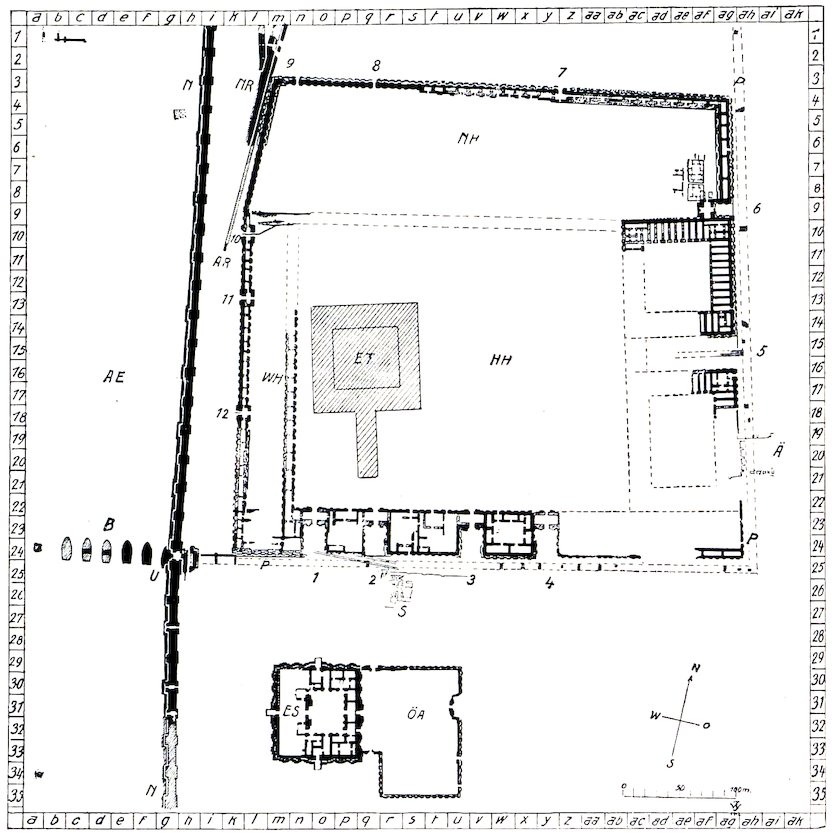
Fig. 114.—Plan of Esagila and Etemenanki.
AE Ancient bed of Euphrates.
AR Arachtu wall.
Ä Earlier building.
B Bridge over the Euphrates.
ES E-Sagila, the temple of Marduk.
ET E-Temenanki, the tower of Babylon.
HH Principal Citadel.
N Nabonidus wall.
NH Northern court.
NR Nebuchadnezzar wall.
ÖA Eastern annex.
P Procession Street of Marduk.
S Later Parthian (?) buildings.
U Urash(?) Gate.
WH Western court.
1–12. The doorways in the peribolos of Etemenanki.
Fig. 114.—Map of Esagila and Etemenanki.
AE Ancient Euphrates riverbed.
AR Arachtu wall.
Ä Earlier building.
B Bridge over the Euphrates.
ES E-Sagila, the temple of Marduk.
ET E-Temenanki, the Tower of Babylon.
HH Main Citadel.
N Nabonidus wall.
NH Northern courtyard.
NR Nebuchadnezzar wall.
ÖA Eastern annex.
P Procession Street of Marduk.
S Later Parthian (?) buildings.
U Urash(?) Gate.
WH Western courtyard.
1–12. The doorways in the enclosure of Etemenanki.

Fig. 115.—East side of the peribolos of Etemenanki.
Fig. 115.—East side of the outer wall of Etemenanki.

Fig. 116.—Esarhaddon’s Etemenanki inscription.
Fig. 116.—Esarhaddon's Etemenanki inscription.

Fig. 117.—Sardanapalus’ Etemenanki inscription.
Fig. 117.—Sardanapalus’ Etemenanki inscription.
Many additions and restorations were carried out in connection with these buildings, and they can clearly be distinguished, especially in the enclosing wall itself. The east end of the northern front is very instructive in this respect. We can distinguish the original building and a strengthening wall, the kisu, in front of it. Here it is of crude brick, but on the west front, like the kisu of Emach, it is of burnt brick. On the original building three periods lie superposed, as also on the kisu. Of each of these building periods slightly projecting towers are placed on the walls close together, and differently distributed, which considerably aids us in distinguishing the periods, as the mud-brick courses are frequently placed immediately over each other (Fig. 115). Inside the lowest kisu, somewhat farther to the west, there is a vertical gutter of the kind we have already observed in the inner city walls. In this were inscribed bricks of Esarhaddon (Fig. 116), with the statement that he built the zikurrat of Etemenanki. The two upper portions of the kisu must therefore belong to a later period, and the 187lower part of the main building to an earlier period, than that of Esarhaddon. The other excavations have produced in addition 12 stamped bricks of Sardanapalus (Fig. 117) and 4 inscribed bricks of Nebuchadnezzar (Fig. 118), all of which refer to the building of Etemenanki. Even if these bricks were not intended for the peribolos, but for the tower itself, their occasional use for the former is in no way surprising. All that we have been able to excavate so far is connected with the original building, of which the later repairing and rebuilding carefully follow the ancient line of wall. We need not therefore lay too much stress on the various periods.
Many additions and restorations were made to these buildings, and they can easily be distinguished, especially in the surrounding wall itself. The east end of the northern front is very informative in this regard. We can identify the original structure and a support wall, the kisu, in front of it. Here it’s made of crude brick, but on the west front, like the kisu of Emach, it’s made of fired brick. The original building shows three overlapping periods, as does the kisu. Each of these building phases has slightly protruding towers placed closely together on the walls, distributed differently, which helps us significantly in distinguishing the periods, since the mud-brick layers are often stacked directly on top of each other (Fig. 115). Inside the lowest kisu, further west, there is a vertical drainage channel similar to what we’ve seen in the inner city walls. This contained bricks inscribed with Esarhaddon's name (Fig. 116), stating that he built the ziggurat of Etemenanki. Therefore, the two upper sections of the kisu must belong to a later time period, while the lower part of the main building is from an earlier period than Esarhaddon’s. The other excavations also uncovered 12 stamped bricks from Sardanapalus (Fig. 117) and 4 inscribed bricks from Nebuchadnezzar (Fig. 118), all referring to the construction of Etemenanki. Even if these bricks weren’t meant for the peribolos, but for the tower itself, their occasional use for the former isn’t surprising. Everything we’ve excavated so far is related to the original building, which later repairs and renovations carefully followed the ancient wall line. Therefore, we don’t need to emphasize the different periods too much.

Fig. 118.—Nebuchadnezzar’s Etemenanki inscription.
Fig. 118.—Nebuchadnezzar's Etemenanki inscription.
The surrounding wall is for the greater part a double wall, in which uniform broad chambers are constructed by means of cross walls. The ornamental towers on the inner walls are always placed between two doors of these chambers, while on the outside, where the two ornamental grooves that used to decorate both the towers and the intermediate spaces still exist in places, both towers and spaces are of the same breadth.
The surrounding wall is mostly a double wall, with wide, uniform chambers created by cross walls. The decorative towers on the inner walls are positioned between two doors of these chambers, while on the outside, where the two decorative grooves that once adorned both the towers and the spaces in between still exist in some areas, both the towers and spaces are the same width.
There are buildings at other points of the encircling walls always joined to the outer wall. Large as they are, they have none of the characteristics of temples. Two large buildings lay on the east side, each with a large court surrounded by deep chambers uniform in size. In the corner there is a dwelling grouped round a courtyard, and on the south side there are four similar ones, which, although smaller, are very large and dignified mansions. At the east of the northern part the usual small private houses form an independent line of street.
There are buildings at other points of the surrounding walls that are always connected to the outer wall. As large as they are, they don't have any of the features of temples. Two large buildings sit on the east side, each with a spacious courtyard surrounded by deep rooms of the same size. In the corner, there's a house arranged around a courtyard, and on the south side, there are four similar houses, which, although smaller, are still very large and impressive homes. On the eastern side of the northern part, the usual small private houses create a standalone line of street.

Fig. 119.—Reconstruction of the peribolos, with the tower of Babylon, the temple Esagila, the quay wall of Nabonidus, and the Euphrates bridge. The tower is shown incomplete. (B) Bridge. (ET) Etemenanki.
Fig. 119.—Reconstruction of the perimeter, featuring the Tower of Babylon, the temple Esagila, the quay wall of Nabonidus, and the Euphrates bridge. The tower is depicted as unfinished. (B) Bridge. (ET) Etemenanki.
189Two doors in the north and ten elaborate gateways with an inner court and towered façade afforded access to the interior. The two eastern of these and the four at the south are placed at the end of deep recesses formed by the outer wall being carried back, thus forming roomy forecourts. The four southern gateways have the typical towered façade also on the side that faces inwards. The southern gate on the east side, which was the largest, is destroyed, but we can reconstruct it without difficulty.
189Two doors in the north and ten ornate gates with an inner courtyard and towered facade provided entry to the interior. The two eastern gates and the four on the south are set at the end of deep recesses created by the outer wall being recessed, resulting in spacious forecourts. The four southern gates also feature the typical towered facade on the side that faces inward. The southern gate on the east side, which was the largest, is gone, but we can easily reconstruct its appearance.
Very little remains of the south-east corner. Near the south-west corner a chambered wall projects to the north, and with the outer wall forms a long narrow court in which there were no other chambers than those formed in the wall. Apparently this narrow court extended as far as the northern gateway in the western wall, and here apparently it joined at right angles another wall which extended here in the same line as the northern front of the great building on the east side; of this wall, however, only the western end now exists. It skirted a northern area, in which the above-mentioned private houses lay.
Very little is left of the southeast corner. Near the southwest corner, a walled chamber extends to the north, creating a long narrow courtyard with no other rooms besides those built into the wall. It seems this narrow courtyard stretched all the way to the northern gateway in the western wall, where it connected at a right angle to another wall that ran parallel to the northern front of the large building on the east side; however, only the western end of this wall still exists. It bordered a northern area where the previously mentioned private houses were located.
Low down on the north, close to the zikurrat, there were ancient buildings orientated in an entirely different direction, and on the east front, also at a great depth, there lay a large ancient building (Ä), over which the main building of the peribolos was carried. Neither of these had anything to do with the sanctuary as such.
Low down on the north, near the zikurrat, there were ancient buildings facing a completely different direction, and on the east side, also at a significant depth, there was a large ancient building (Ä), which supported the main structure of the peribolos. Neither of these had anything to do with the sanctuary itself.
We can only hazard a guess as to the purpose of all those buildings. The wall chambers are adapted by their simplicity to house a number of pilgrims, who could dwell there and have direct access to the great courts. The 190buildings in the south I take to have been priests’ dwellings. Under no circumstances can they have been temples, as all the necessary features are absent, such as the towered façade and the postament niche. The priests of Etemenanki must have occupied very distinguished positions as representatives of the god who bestowed the kingship of Babylon, and the immense private houses to the south of our peribolos agree very well with the supposition in regard to this Vatican of Babylon, that the principal administrative apparatus would be housed there. The numerous chambers of the two great buildings in the east will be recognised by all as store-rooms where the property of the sanctuary and the things needed for processions, etc., could be stored. In one of these chambers, which for the most part are not yet cleared, we found a great stone weight in the form of a duck (Fig. 120), the usual form of such weights. It weighs 29.68 kilogrammes and, according to the chiselled inscription on it, was called a “correct talent.” All the buildings are much ruined, often as low down as beneath the ancient pavement. In the north-east corner of the peribolos a stela with emblems of the gods was found (Fig. 121).
We can only make an educated guess about the purpose of all those buildings. The wall chambers are simply designed to accommodate a number of pilgrims, who could live there and have direct access to the large courtyards. The buildings in the south seem to have been residences for the priests. There's no way they could have been temples since they lack essential features like the towered façade and the postament niche. The priests of Etemenanki must have held very prominent positions as representatives of the god who granted the kingship of Babylon, and the large private houses to the south of our peribolos fit well with the idea that this was Babylon's Vatican and that the main administrative functions would be located there. The many chambers of the two large buildings in the east are clearly storage rooms for the sanctuary's property and items needed for processions, etc. In one of these chambers, most of which are still unexcavated, we found a large stone weight shaped like a duck (Fig. 120), which is the usual design for such weights. It weighs 29.68 kilograms and, according to the inscription on it, was referred to as a “correct talent.” All the buildings are significantly damaged, often down to below the old pavement. In the north-east corner of the peribolos, a stela with symbols of the gods was discovered (Fig. 121).

Fig. 120.—Duck weight with inscription.
Fig. 120.—Duck weight with label.
The main approach lay between the two store-houses just mentioned, where from the existence of a specially 191deep and wide recess we can surmise a specially large gateway, which, though it exists no longer, admits of easy reconstruction. The turminabanda pavement of the Procession Street reaches as far as this, and continues in the recess where the paving-blocks still lie that bear the inscription of Nebuchadnezzar on their edge. Some of these have the name and title of Sennacherib on the under side (cf. Fig. 36).
The main path was located between the two storage buildings mentioned earlier, where the presence of a particularly deep and wide recess suggests there used to be a large gateway, which, although no longer there, can be easily imagined. The turminabanda pavement of Procession Street extends to this point and continues into the recess, where the paving stones that are still there bear the inscription of Nebuchadnezzar on their edges. Some of these stones have the name and title of Sennacherib on the underside (cf. Fig. 36).

Fig. 121.—Upper part of a stela with divine emblems.
Fig. 121.—Top section of a stela featuring divine symbols.
In the Ripley-cylinder of Neriglissar (K.B. iii. 2, p. 79) the peribolos is called “lânu ma-ḫir-tim.” According to Muss-Arnolt’s dictionary the words mean “enclosure” and 192“storehouse.” With the exception of these two words I give Bezold’s translation, which otherwise only requires correction in slight details: “The peribolos of the store-houses of Esagila to the north, wherein the consecrated temple treasury of Esagila rests (trans. by Delitzsch, ‘wherein the priests of Esagila dwell’) whose foundations an earlier king laid but did not build its summit, (this building) had sunk in its foundations, its walls were fallen down, its joints were loosened, and its base had become weak. Then my lord the great Marduk inspired me to raise up the building, entrusted me (?) with the splendour (?) and the regulation of the temple tribute. In order to incur no Shiddim and no offences, I dug up the ancient foundation stone and read it (its records). On its ancient foundation stone I based it (the building), its summit I raised like a mountain, I made firm its threshold and fixed the doors in its doorway. The firm Kisu I built of asphalt and burnt brick (?)” According to this the Kisu of burnt brick which was found in the excavations on the west side was of Neriglissar.
In the Ripley cylinder of Neriglissar (K.B. iii. 2, p. 79), the peribolos is referred to as “lânu ma-ḫir-tim.” According to Muss-Arnolt’s dictionary, these words mean “enclosure” and “storehouse.” Aside from these two terms, I follow Bezold’s translation, which only needs minor corrections: “The peribolos of the storehouses of Esagila to the north, where the consecrated temple treasury of Esagila rests (translated by Delitzsch as ‘wherein the priests of Esagila dwell’), whose foundations an earlier king laid but did not complete its summit, (this structure) had sunk in its foundations, its walls had collapsed, its joints were loose, and its base had weakened. Then my lord the great Marduk inspired me to rebuild the structure, entrusted me (?) with its grandeur (?) and the management of the temple tribute. To avoid any Shiddim and offenses, I unearthed the ancient foundation stone and read its inscriptions. I based the construction on its ancient foundation stone, raised its summit like a mountain, reinforced its threshold, and secured the doors in its doorway. I built the sturdy Kisu from asphalt and burnt brick (?)” Based on this, the Kisu of burnt brick discovered during the excavations on the west side belonged to Neriglissar.
The original of the second Babylonian text that refers to the enclosure has disappeared. We possess only an epitome of it given by Smith[3] (Hommel, Geographie 193Vorderasiens und Nordostafrikas, p. 315, and Thureau-Dangin, Journal asiatique, janvier 1909). But the statements can only be reconciled with the existing remains with great difficulty, and then only in general. The 194measurements given for the three courts should agree with the ruins, at least as regards the relations of length to breadth, but this is not so whether we take the measurement of the walls outside or of the open space within the courts. The only possible solution appears to me to be that we take the measures given as those of the “great court” to be meant for the south-east portion, including the buildings surrounding it, that we take the “court of Ishtar and Zamana” to mean what we call the north court, and the third to mean the inner open space of our great court. But even so there are difficulties. Under these circumstances we need not attach any great importance to the measurements given for the alleged 7 stages of the tower. Those uncertainties are caused by the fact that the original inscription is not at hand, we do not know the object for which these statements were made (see App. p. 327).
The original second Babylonian text that mentions the enclosure has been lost. We only have a summary of it provided by Smith[3] (Hommel, Geography 193 of the Middle East and Northeastern Africa, p. 315, and Thureau-Dangin, Asian Journal, January 1909). However, the information can only be matched with the existing remains with significant difficulty, and even then only generally. The 194measurements provided for the three courts should align with the ruins, at least in terms of the ratio of length to width, but this isn't the case whether we consider the measurements of the external walls or the open space within the courts. The only viable solution seems to be that we interpret the measurements given for the “great court” as referring to the southeast area, including the surrounding buildings, that we consider the “court of Ishtar and Zamana” to refer to what we call the north court, and the third court to mean the inner open space of our great court. Yet even then, there are challenges. Given this, we shouldn't place too much importance on the measurements stated for the supposed 7 levels of the tower. These uncertainties arise because the original inscription is not available, and we don't know the purpose behind these statements (see App. p. 327).
Herodotus (i. 181) names the group of buildings “the brazen-doored sanctuary of Zeus Belus.” The zikurrat inside the sanctuary he describes as a massive tower on which stood a second, third, up to an eighth tower, above which was a “great temple.” This is the sole ground for our conception of the “terraced towers” of Mesopotamia. In Khorsabad there was the ruin of a tower, where the excavators suspected similar retreating stages to have existed, but Place clearly formed his conclusion under the long-accepted suggestion drawn from the description given by Herodotus, and the ruins themselves no longer exist. In the words of Herodotus himself, however, there is nothing whatever about stepped terraces. He speaks of 8 towers standing one above another, but he does not say that each was smaller than the one below it. I myself desired to accept the general conception of stepped towers, but I know of no safe ground for such a conception. The only remedy I can see for this difficulty is to excavate the best-preserved zikurrat we possess, that of Borsippa.
Herodotus (i. 181) refers to the group of buildings as “the brazen-doored sanctuary of Zeus Belus.” He describes the ziggurat inside the sanctuary as a massive tower with a second, third, and up to an eighth tower on top, culminating in a “great temple.” This is the only basis we have for our idea of the “terraced towers” of Mesopotamia. In Khorsabad, there was the remains of a tower where the excavators thought similar tiers might have existed, but Place seemed to reach his conclusion based on the long-accepted interpretation stemming from Herodotus's account, and the ruins themselves are no longer there. However, Herodotus's own words don’t mention stepped terraces. He talks about 8 towers stacked on top of each other but doesn’t say that each was smaller than the one below it. I wanted to support the common idea of stepped towers, but I don’t have reliable evidence for such a notion. The only solution I see for this issue is to excavate the best-preserved ziggurat we have, that of Borsippa.
From the ruins as they now exist before excavation, we must assume that a colossal stairway led up from the south to the top of the immense mass of building. Steps in antiquity were always extremely steep, as we have found them here, and the height and breadth were usually the 195same, so according to the measurements of the length of the foundations of the steps we may take their height to have been 50 metres.
From the ruins as they stand before excavation, we can assume that a huge stairway led up from the south to the top of the massive structure. Steps in ancient times were always very steep, as we have discovered here, and the height and width were typically the same. So based on the measurements of the length of the foundations of the steps, we can estimate their height to have been 50 meters. 195
We do not know the complete height of the tower. Nabopolassar, however, lays great stress on it (M’Gee, Zur Topographie Babylons, A. i.), and so does Nebuchadnezzar (M’Gee, B. vi.) in his cylinder inscription of Etemenanki. Nabopolassar says: “At this time Marduk commanded me ...; the tower of Babylon, which in the time before me had become weak, and had been brought to ruin, to lay its foundation firm on the bosom of the underworld, while its top should stretch heavenwards” (trans. by Delitzsch). Nebuchadnezzar says: “To raise up the top of Etemenanki that it may rival heaven, I laid to my hand.” In both inscriptions mud brick, burnt brick, asphalt, mud, and mighty cedars of Lebanon are mentioned as the materials employed. The latter could scarcely have been employed otherwise than to roof in the temple on the top of the tower.
We do not know the full height of the tower. Nabopolassar, however, emphasizes it (M’Gee, On the Topography of Babylon, A. i.), and so does Nebuchadnezzar (M’Gee, B. vi.) in his cylinder inscription of Etemenanki. Nabopolassar states: “At this time Marduk commanded me...; the tower of Babylon, which before my time had become weak and had fallen into ruin, to lay its foundation strong on the bosom of the underworld, while its top should reach towards heaven” (trans. by Delitzsch). Nebuchadnezzar states: “To raise up the top of Etemenanki so it may rival heaven, I took action.” In both inscriptions, mud brick, burnt brick, asphalt, mud, and mighty cedars of Lebanon are mentioned as the materials used. The latter could hardly have been used for anything other than to cover the temple on top of the tower.
In distinction to this upper temple Herodotus calls Esagila lying before it to the south the κάτω νηός, the lower temple. In the upper temple, according to Herodotus, there was only a golden table and a κλίνη, and according to Ctesias three gold figures of Zeus, Hera, and Rhea. My opinion is that the designation of the zikurrat as bearing a temple is confirmed by this. The Babylonian term only expresses height, and nothing that can suggest stages. It is obvious that the roof of so lofty a temple would be welcomed by the Babylonian astronomers as a platform for their observations. It would be necessary for them to be raised above the thick atmosphere of the plain. Owing to excessive dryness, the air is almost opaque at a distance, and the horizon up to a height of 10 or 20 grades is a dusky circle of dust, through which the sun and moon often assume torn and distorted forms, if their setting can be seen at all.
In contrast to this upper temple, Herodotus refers to Esagila, located to the south of it, as the κάτω νηός, or the lower temple. According to Herodotus, the upper temple contained only a golden table and a κλίνη, while Ctesias mentioned three gold figures of Zeus, Hera, and Rhea. I believe that labeling the ziggurat as having a temple supports this idea. The Babylonian term indicates height but does not imply different levels. It’s clear that the roof of such a tall temple would serve as a great vantage point for Babylonian astronomers to observe the skies. They would need to be elevated above the thick atmosphere of the plain. Due to the extreme dryness, the air is nearly opaque at a distance, and the horizon rises to 10 or 20 degrees as a dim circle of dust, making the sun and moon often appear fragmented and distorted, if they can be seen at all.
It is true that during the summer we have no clouds, with the exception of the Bachura, a type of weather that occurs at the beginning of August, but we have sandstorms, through which the sun appears like a blood-red 196disc. The greatly-renowned clearness of the Babylonian sky is largely a fiction of European travellers, who are rarely accustomed to observe the night sky of Europe without the intervention of city lights.
It’s true that during the summer we have no clouds, except for the Bachura, a type of weather that happens at the beginning of August. However, we do have sandstorms, where the sun looks like a blood-red 196 disc. The much-celebrated clarity of the Babylonian sky is mostly a myth created by European travelers, who are not used to seeing the night sky in Europe without the interference of city lights.
The original complete height of the tower of Babylon we do not know. The east side of the peribolos, which is almost similar to the north side, measures 409 metres in round numbers. For the entire sacred enclosure Herodotus gives a measure of 2 square stadia, and 1 stadion as the side length of the area of the zikurrat; the ruins themselves show 90 metres.
The exact original height of the Tower of Babylon is unknown. The east side of the perimeter, which is almost the same as the north side, measures about 409 meters. Herodotus states that the entire sacred area is about 2 square stadia, with the side length of the ziggurat measuring 1 stadion; the ruins themselves measure 90 meters.
But what is all this written information in comparison with the clearness of the evidence we gain from the buildings themselves, ruined though they are. The colossal mass of the tower, which the Jews of the Old Testament regarded as the essence of human presumption, amidst the proud palaces of the priests, the spacious treasuries, the innumerable lodgings for strangers—white walls, bronze doors, mighty fortification walls set round with lofty portals and a forest of 1000 towers,—the whole must have conveyed an overwhelming sense of greatness, power, and wealth, such as could rarely have been found elsewhere in the great Babylonian kingdom.
But what is all this written information compared to the clear evidence we get from the buildings themselves, even though they are in ruins? The massive structure of the tower, which the Jews of the Old Testament saw as the epitome of human arrogance, among the impressive palaces of the priests, the large treasuries, and countless accommodations for travelers—white walls, bronze doors, strong fortification walls surrounded by tall gateways and a forest of 1,000 towers—must have given an overwhelming sense of greatness, power, and wealth that was rarely found elsewhere in the vast Babylonian kingdom.
I once beheld the great silver standing statue of the Virgin, over life-size, laden with votive offerings, rings, precious stones, gold and silver, borne on a litter by forty men, appear in the portal of the dome of Syracuse, high above the heads of the assembled crowds, to be brought out in festival procession with inspiring music and among the fervent prayers of the people into the garden of the Latomia. After the same fashion I picture to myself a procession of the god Marduk as he issued forth from Esagila, perhaps through the peribolos, to proceed on his triumphant way through the Procession Street of Babylon.
I once saw the impressive silver statue of the Virgin, larger than life, covered in offerings like rings, precious stones, and gold and silver, carried on a platform by forty men. It appeared at the entrance of the dome in Syracuse, towering over the gathered crowds, to be taken out in a festive procession with uplifting music and the heartfelt prayers of the people into the Latomia garden. Similarly, I imagine a procession of the god Marduk as he came out of Esagila, maybe through the courtyard, to make his triumphant journey down the Procession Street of Babylon.
Herodotus must have seen the enclosure in a comparatively good state of preservation. Under Alexander it needed repairs, and 600,000 days’ wages were spent on clearing out the precincts and removing the rubbish (Strabo, xvi. 1). During the eleven years of our work we have 197expended about 800,000 daily wages for the great clearance of Babylon.
Herodotus likely saw the enclosure in relatively good condition. During Alexander's time, it required repairs, and 600,000 days' wages were spent on cleaning up the area and getting rid of the debris (Strabo, xvi. 1). Over the eleven years of our efforts, we have spent about 800,000 daily wages on the major cleanup of Babylon.
Before we pass to the temple of Esagila, which was so closely connected with Etemenanki (p. 204), we will inspect the walls that lie to the west of the enclosure, and the Euphrates bridge.
Before we head to the temple of Esagila, which is closely linked to Etemenanki (p. 204), we’ll take a look at the walls that are to the west of the enclosure and the Euphrates bridge.
XXXI
THE EUPHRATES BRIDGE
The Procession Street which, with its strongly-asphalted brick pavement, runs close to the southern side of the peribolos, ended in the west at the land pier of a bridge of burnt brick and asphalt. Seven river piers have been excavated. The western one differs somewhat in plan, and may have been the end pier on the bank at that side (Fig. 122), but this is not yet certain. The complete length of this bridge, as far as we have made it out, amounted to 123 metres, and the pier lengths of 21 metres may have exceeded the breadth of the roadway very considerably. The piers are 9 metres wide and are placed 9 metres apart. They are built with a very marked batter. Their bricks are of the small size 31 × 31 centimetres and are unstamped, from which we may conclude that the building dates from Nebuchadnezzar’s first period or from Nabopolassar. There are rectangular cavities in the piers in which, as far as we can judge, strengthening baulks of wood once lay 50 centimetres apart. Above this, at a distance of 2 metres, there was a second similar course of wood. The sides of the piers are convex and meet in a point in front facing the current on the north. The back is also slightly curved. Thus the ground-plan of the pier follows the water-line of a ship.
The Procession Street, lined with its solid asphalt brick pavement, runs along the southern side of the peribolos and ends to the west at a land pier of a bridge made from burnt brick and asphalt. Seven river piers have been dug out. The western one has a slightly different design and may have been the end pier on that bank (Fig. 122), but this isn’t confirmed yet. The total length of this bridge, as far as we’ve figured out, is 123 meters, and the pier lengths of 21 meters may have been much wider than the roadway. The piers are 9 meters wide and spaced 9 meters apart. They are built with a noticeable tilt. The bricks are small, measuring 31 × 31 centimeters and are unstamped, suggesting that the construction is from Nebuchadnezzar’s early reign or from Nabopolassar. There are rectangular cavities in the piers where, as far as we can tell, wooden supports once rested 50 centimeters apart. Above this, at a distance of 2 meters, there was a second similar layer of wood. The sides of the piers curve outward and meet at a point facing the current to the north. The back is also slightly curved. Thus, the ground plan of the pier follows the waterline of a ship.
Herodotus (i. 186), Diodorus (ii. 8, after Ctesias), and others speak of this bridge. They report that stone blocks were used for it, and it is very probable that the brick piers were roofed over with stone, on which the rafters for the 198roadway were laid. We have seen in the north wall of the Kasr that Nebuchadnezzar bound his blocks together with dove-tail clamps, and this is also reported of the bridge. Diodorus calls special attention to the peculiar shape of the piers, which is specially adapted to the requirements of the current. The measurements here also do not agree on all points. The length is given as 5 stadia, the breadth 30 feet, and the distance between the piers 12 feet. But it appears to me rash to argue from this lack of agreement the existence of a second stone bridge. This is the most ancient stone bridge of which we have any record, and its well-deserved fame is evident from the fact that it was the only one remarked on in the scanty reports of the ancient historians.
Herodotus (i. 186), Diodorus (ii. 8, after Ctesias), and others mention this bridge. They say it was made of stone blocks, and it seems likely that the brick piers were covered with stone, on which the rafters for the 198roadway were placed. We have observed in the north wall of the Kasr that Nebuchadnezzar connected his blocks using dove-tail clamps, and this is also noted for the bridge. Diodorus highlights the unique shape of the piers, which is particularly suited to the flow of the current. The measurements here also don’t align on all aspects. The length is stated as 5 stadia, the width as 30 feet, and the space between the piers as 12 feet. However, I think it's unwise to claim that this discrepancy indicates the existence of a second stone bridge. This is the oldest stone bridge we have any record of, and its well-deserved reputation is clear since it was the only one mentioned in the limited writings of ancient historians.

Fig. 122.—The western pier of the bridge over the Euphrates.
Fig. 122.—The west side of the bridge over the Euphrates.
199The ancient bed of the river is clearly marked just in the vicinity where a long depression between the mounds of ruins extends to the village of Kweiresh. In the south-west, close to the bridge head, one of these mounds of ruins rises to a considerable height. Its western side is worn away by the modern Euphrates into a vertical steep declivity, and the mud walls of the houses that stand out between the usual rubbish in the mound are here laid bare and clearly visible. They extend down below the usual level of the water.
199The ancient riverbed is clearly marked near the long depression that stretches between the mounds of ruins and the village of Kweiresh. In the southwest, near the bridgehead, one of these mounds rises quite high. Its western side has been eroded by the modern Euphrates into a steep cliff, and the mud walls of the houses that emerge among the usual debris on the mound are exposed and easily seen. They extend below the typical water level.
Among the Babylonian texts that refer to the bridge, it is described by Nebuchadnezzar as the work of Nabopolassar in the E-ulla cylinder (M’Gee, B. ii. col. 1, 8): “The embankment wall of Arachtu ... from the Ishtar Gate to the Urash Gate, my father, my begetter, had built with asphalt and brick, had erected piers of burnt brick for the crossing over of the Euphrates” (see K.B. iii. 2, p. 21, l. 7, and p. 41, l. 38). The meaning of the words ma-ka-at a-bar-ti Purâti as “bridge over the Euphrates” was kindly given me as early as the year 1904 by Lehmann-Haupt.
Among the Babylonian texts that mention the bridge, Nebuchadnezzar describes it as the work of Nabopolassar in the E-ulla cylinder (M’Gee, B. ii. col. 1, 8): “The embankment wall of Arachtu ... from the Ishtar Gate to the Urash Gate, my father, my creator, built with asphalt and brick and erected piers of fired brick for crossing over the Euphrates” (see K.B. iii. 2, p. 21, l. 7, and p. 41, l. 38). The interpretation of the words ma-ka-at a-bar-ti Purâti as “bridge over the Euphrates” was kindly provided to me as early as 1904 by Lehmann-Haupt.
XXXII
THE BRIDGE GATEWAY
Between the land pier of the bridge, and the first river pier, a gateway was inserted that lay in the line of a long fortification wall that stretches to the north with stamped bricks in it of Nabonidus. As usual with city gateways, it had an inner court and two massive fronting towers. The bricks, so far as we can see, have Nebuchadnezzar’s stamp, and, like the wall itself, are laid in asphalt. In the entrance lies a brick pavement of many courses, and also the great 200southern door socket of the west door. In the middle of the east doorway there is a brick set upright, which projects slightly above the pavement and served as a stop for the leaves of the door. The pavement is 3.10 metres above zero, rather higher than that of the Procession Street, and above it 12 metres of the rubbish of the Amran hill is still piled. The gateway was inserted partly in the land and partly in the river pier, and both are cut away to some extent to accommodate the later building.
Between the land pier of the bridge and the first river pier, a gateway was added that aligns with a long fortification wall stretching north, featuring stamped bricks from Nabonidus. As typical for city gateways, it included an inner courtyard and two massive front-facing towers. The bricks, as far as we can see, bear Nebuchadnezzar’s stamp and, like the wall itself, are laid in asphalt. Inside the entrance is a brick pavement with multiple layers, along with the large southern door socket of the west door. In the middle of the east doorway, there’s a brick set upright, which sticks up slightly above the pavement and served as a stop for the door leaves. The pavement is 3.10 meters above the ground level, which is higher than that of Procession Street, and above it, there are still 12 meters of debris from the Amran hill piled up. The gateway was integrated partly into the land and partly into the river pier, both of which have been cut back somewhat to fit the later construction.
As we have followed the Arachtu wall from the Southern Citadel up to the peribolos, and as this is the first great gateway in this vicinity after the Ishtar Gate, this building must, I think, according to the inscription just referred to, be the Urash Gate. It is, therefore, a matter of indifference whether our building is the same that existed in Nebuchadnezzar’s time, or whether it is later and dates from Nabonidus, for in the latter case a gateway that bore the name of the Urash Gate existed previously and in much the same place if not on exactly the same spot. It is possible that the massive brickwork that lies immediately to the west of the land pier belonged to this earlier gateway. This consists of two projections, between which there is a stepped wall.
As we’ve tracked the Arachtu wall from the Southern Citadel to the peribolos, and since this is the first major gateway in the area after the Ishtar Gate, I believe this building must be the Urash Gate, based on the inscription I just mentioned. Therefore, it doesn’t really matter if our building is the same one from Nebuchadnezzar’s time or if it was built later during Nabonidus’s reign. In that case, there would have been a gateway named the Urash Gate that existed before in a similar location, if not exactly in the same spot. It’s possible that the large brick structure just west of the land pier belonged to this earlier gateway. This structure has two projections with a stepped wall between them.
The excavations here are still incomplete.
The excavations here are still not finished.
XXXIII
THE WALL OF NABONIDUS
We have not yet followed the fortification wall connected with the gateway just described far to the south. The ruins here lie deep under the rubbish of the Amran mound, and are difficult to get at. On the north the excavations have laid open this wall as far as the village of Kweiresh.
We haven't explored the fortification wall linked to the gateway we just discussed far to the south yet. The ruins here are buried deep under the debris of the Amran mound, making them hard to access. To the north, the excavations have revealed this wall all the way to the village of Kweiresh.
The wall, which is 7.67 metres thick, with its cavalier towers stands on the river bank upon a massive projecting 201banquette like the older moat wall, the Arachtu wall, and the north wall of the Principal Citadel. This arrangement can thus be clearly recognised as a peculiarity of walls that lie on a water-channel. Towers, alternately broad and narrow, are placed at a distance of about 19 metres from each other. The broad ones are 7.3, the narrow ones 6.3 metres wide. In some of these towers there are fittings for double doors, from which a somewhat steep ramp leads down to the river. The walls are in very bad condition, and it is impossible to say whether there were similar doors in every tower, or, if not, at what length of interval. The pavement is .47 above zero. In the north, a short distance in front of the Southern Citadel, the wall for two mesopyrgia bends somewhat towards the west to unite by a tower with the Western Outworks (p. 144). In this tower was the outflow of the eastern canal that flowed past the Southern Citadel. The bend is obviously contrived in order to include the Western Outworks of the Southern Citadel in the city area.
The wall, which is 7.67 meters thick, with its cavalier towers stands on the riverbank atop a large projecting 201banquette like the older moat wall, the Arachtu wall, and the north wall of the Principal Citadel. This setup is clearly a feature of walls located near a water channel. Towers, alternating in width, are spaced about 19 meters apart. The wide ones are 7.3 meters across, while the narrow ones are 6.3 meters. Some of these towers have fittings for double doors, from which a somewhat steep ramp descends to the river. The walls are in very poor condition, and it's unclear if there were similar doors in every tower, or if not, how far apart they were. The pavement is .47 above zero. To the north, a short distance in front of the Southern Citadel, the wall curves slightly westward for two mesopyrgia to connect with a tower that links to the Western Outworks (p. 144). In this tower was the outflow of the eastern canal that flowed past the Southern Citadel. The bend is clearly designed to incorporate the Western Outworks of the Southern Citadel into the city area.
Not far from the north-western corner of the peribolos we made a cross-cut through the high mounds that cover the wall, and here we found also the Arachtu wall of Nabopolassar and Nebuchadnezzar. The cut has been continued for some length to the north on the other side of the depression caused by the river-bed, and there it yielded walls of burnt-brick buildings of considerable thickness, but the river wall that corresponds with that on the left bank we have not yet uncovered. This excavation is very far from complete. The wall is apparently the same that was called by Herodotus (i. 180) αἱμασιή, which joined on to the wings of the outer city wall, and which Ctesias (Diodorus, ii. 3) called κρηπίς.
Not far from the north-western corner of the peribolos, we made a cross-cut through the high mounds that cover the wall, and here we also found the Arachtu wall of Nabopolassar and Nebuchadnezzar. The cut has been extended for some distance to the north on the other side of the depression caused by the riverbed, and there it revealed walls of thick burnt-brick buildings. However, we have not yet uncovered the river wall that corresponds with the one on the left bank. This excavation is still far from complete. The wall seems to be the same one mentioned by Herodotus (i. 180) as αἱμασιή, which connected to the wings of the outer city wall, and which Ctesias (Diodorus, ii. 3) referred to as κρηπίς.
XXXIV
THE ARACHTU WALLS AT THE PERIBOLOS OF ETEMENANKI
Immediately in front of the northern portion of the west front of the peribolos there lies the Arachtu wall of Nabopolassar, of which we saw the commencement in the north at the Southern Citadel. As soon as we began the cross-cut mentioned above, we came on a length of wall in which was an inscribed brick that explained its purpose. Later on in the farther reaches of the wall we found numerous bricks of the same kind in situ. The text is identical with that already quoted on page 138 et seq. The wall lies lower than the burnt-brick kisu of the peribolos wall at this point. The Arachtu wall, which stands in water, reaches up only to .33 metres below zero with its ruins, while the kisu of the peribolos extends down to 2.24 metres above zero. The upper level of the river banquette lies without any intermediate space in front of the Nebuchadnezzar wall, which is 6 metres thick, and is exactly at zero level. The Nabopolassar wall consists of unstamped 31–centimetre bricks, the facing wall of 33–centimetre bricks, with the Nebuchadnezzar stamp. The smooth front of both walls faces west, the back is left rough as it was built up against the bank behind.
Right in front of the northern part of the west side of the peribolos lies the Arachtu wall of Nabopolassar, which we first observed in the north at the Southern Citadel. As soon as we started the cross-cut mentioned earlier, we discovered a section of wall that contained an inscribed brick explaining its purpose. Later, in the deeper parts of the wall, we found many bricks of the same type in situ. The text is the same as the one already quoted on page 138 et seq. The wall is positioned lower than the burnt-brick kisu of the peribolos wall at this location. The Arachtu wall, which is underwater, reaches only to 0.33 meters below zero with its ruins, while the kisu of the peribolos extends down to 2.24 meters above zero. The upper level of the river bank has no gap in front of the Nebuchadnezzar wall, which is 6 meters thick and exactly at zero level. The Nabopolassar wall is made of unstamped 31-centimeter bricks, while the facing wall is made of 33-centimeter bricks stamped with Nebuchadnezzar's mark. The smooth front of both walls faces west, while the back is left rough as it was built against the bank behind.
Both walls extend as far as the northern corner of the peribolos. From there the Nabopolassar wall runs in a straight line northwards to a distance of about 20 metres from the Southern Citadel, where it breaks off in ruins. Its line runs approximately on the western boundary of the additional building, and must therefore originally have made a curve in order to join at its commencement with the Sargon wall. From the Nebuchadnezzar wall a branch turns off at a very sharp angle at the above-mentioned place, and runs exactly in the direction of the ancient moat wall. Another branch joins on here with a doubly-grooved expansion joint, and runs in the direction 203of the northern part of the Nabonidus wall. Thus there are parts of four walls close together here, all of which belong to four consecutive changes in direction. At the same place a culvert passes through each of the walls, which must have carried off the surface water that collected to the north of the peribolos. Somewhat farther to the north we came upon two descending stairways in the Nabopolassar wall, which were walled up in a second building period. They are similar to those in the gateways in the Nabonidus wall.
Both walls extend to the northern corner of the peribolos. From there, the Nabopolassar wall runs straight north for about 20 meters from the Southern Citadel before breaking off into ruins. Its line roughly follows the western edge of the additional building, so it must have originally curved to connect with the Sargon wall. A branch from the Nebuchadnezzar wall sharply angles at the previously mentioned spot and heads directly toward the ancient moat wall. Another branch connects here with a double-grooved expansion joint and runs toward the northern section of the Nabonidus wall. So, there are parts of four walls closely situated here, each representing a different change in direction. At this same location, a culvert runs through each of the walls, likely draining the surface water that pooled to the north of the peribolos. A bit further north, we found two descending stairways in the Nabopolassar wall, which were sealed up during a second construction phase. They resemble those in the gateways of the Nabonidus wall.
The three walls are so near together, and follow so closely in the same direction, that if we prefer to consider the Arachtu to be a canal of the Euphrates, it here lies so close to the Euphrates that its existence is very problematic. The Euphrates wall of Nabonidus has here obviously replaced the Arachtu wall of Nabopolassar, which further argues for the identity of the Euphrates and the Arachtu (see p. 140). That the Nabonidus wall and the stone bridge are buildings on the Euphrates, no systematic investigator can doubt. Otherwise we must assume that besides the two buildings found by us there existed yet a second embankment wall of Nabonidus which lay on the Euphrates, and a second stone bridge that led over the Euphrates. Without wishing to anticipate further research, I am inclined to assume the Arachtu to be, not a canal nor an arm of the Euphrates, but a semicircular widening of the river (see Hommel, op. cit. p. 283, note 1, Arach) (moon, fem. Arachtu?), which possessed a special name, and for which the name Arachtu could be used as well as that of Euphrates, as in the case of the Binger Lock on the Rhine. Possibly it was the haven of Babylon.
The three walls are so close together and follow the same direction that if we consider the Arachtu to be a canal of the Euphrates, it is situated so near the Euphrates that its existence is very questionable. The wall of Nabonidus along the Euphrates has clearly replaced the wall of Arachtu from Nabopolassar, which further supports the idea that the Euphrates and the Arachtu are the same (see p. 140). No serious researcher can doubt that the Nabonidus wall and the stone bridge are structures on the Euphrates. Otherwise, we would have to assume that, in addition to the two buildings we found, there was another wall from Nabonidus on the Euphrates and another stone bridge crossing the Euphrates. Without wanting to jump ahead of further research, I tend to think of the Arachtu as not a canal or an arm of the Euphrates, but rather a semicircular widening of the river (see Hommel, op. cit. p. 283, note 1, Arach) (moon, fem. Arachtu?), which had a specific name, and both the name Arachtu and Euphrates could be used for it, similar to the Binger Lock on the Rhine. It could possibly have been the harbor of Babylon.
Nebuchadnezzar mentions his own wall among others in the Eharsagila cylinder (K.B. iii. 2, p. 41, l. 41): “I ... built the embankment walls of the Arachtu of asphalt and burnt brick, and strengthened it by means of the embankment walls that my father had made.”
Nebuchadnezzar talks about his own wall along with others in the Eharsagila cylinder (K.B. iii. 2, p. 41, l. 41): “I ... built the embankment walls of the Arachtu using asphalt and fired brick, and reinforced it with the embankment walls that my father had constructed.”
XXXV
ESAGILA, THE TEMPLE OF MARDUK
(A. The Principal Building)
(A. The Main Building)
The ancient celebrated temple, Esagila, according to Jastrow “the lofty house” (Religion of Babylonia, p. 639), the temple of Marduk, lies beneath the hill of Amran Ibn Ali (Fig. 123) buried to a depth of 21 metres below the upper level of the hill. We have already excavated some part of it, and by means of deep shafts and galleries we have established the ground-plan and the different divisions. There are two buildings adjacent to each other; the principal one on the east is very regularly and magnificently planned, of the Western Annex we have only recovered the outer circuit. We will first survey the principal building.
The ancient celebrated temple, Esagila, referred to by Jastrow as “the lofty house” (Religion of Babylonia, p. 639), the temple of Marduk, is located beneath the hill of Amran Ibn Ali (Fig. 123) buried 21 meters below the upper level of the hill. We have already excavated some of it, and through deep shafts and galleries, we have established the layout and various sections. There are two buildings next to each other; the main one on the east is very well-planned and impressive, while for the Western Annex, we have only uncovered the outer perimeter. We will first examine the main building.
The temple is almost square, with its northern front of 79.3 metres and its western front of 85.8 metres long. Inside it is a court 31.3 metres broad and 37.6 metres long. On the west of this court, as we learn from the mighty-towered façade, there was the principal cella, that of Marduk. The chambers are not yet excavated. On the south side towards the east there is a smaller cella, which can be recognised as such by the niche in the wall. The cella lies on the east side of a square, which on the west side has a door leading to a small chamber which may also be the remains of a cella.
The temple is nearly square, with its northern side measuring 79.3 meters and its western side measuring 85.8 meters long. Inside, there’s a courtyard that is 31.3 meters wide and 37.6 meters long. To the west of this courtyard, as indicated by the impressive façade, was the main cella dedicated to Marduk. The chambers haven't been excavated yet. On the south side toward the east, there’s a smaller cella, identifiable by the niche in the wall. This cella is on the east side of a square, with a door on the west side that leads to a small chamber, which may also be the remnants of another cella.
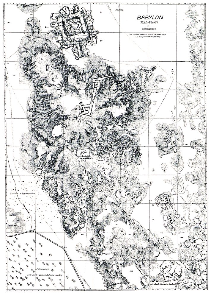
Fig. 123.—Plan of the mound Amran.
Fig. 123.—Layout of the Amran mound.

Fig. 124.—Section through Esagila.
Fig. 124.—Cross-section of Esagila.
A third cella has been excavated on the north side of the court. It is apparently the sanctuary of the god Ea, who in Greek times was identified with Serapis (see Tempel von Babylon, p. 43). It was here that the generals of Alexander sought counsel of the god with regard to his illness, whether the king should permit himself to be transported hither in search of healing. Doors lead north to two chambers behind the cella, an arrangement that is not found in any other cella. If my expressed opinion is correct these chambers may have been the dormitories in which oracular dreams could be secured. In the cella, which also had a side chamber at the east end, the postament for the statue still stands in front of the niche. Imprinted on the asphalt covering of its flat top we found traces of a wooden throne, which, during the conflagration, had become charred and broken up. Of the richly carved 207work some fragments could still be recognised, the figures that supported the throne, holding the water vase with which Ea, god of the abyss of waters, was usually represented, a fine head of a dragon, a fish, and so forth.
A third cella has been uncovered on the north side of the courtyard. It seems to be the sanctuary of the god Ea, who was identified with Serapis during Greek times (see Temple of Babylon, p. 43). This is where Alexander’s generals sought guidance from the god regarding the king's illness and whether he should be brought here for healing. There are doors leading north to two chambers behind the cella, a layout not found in any other cella. If my opinion is correct, these chambers may have served as dormitories where oracular dreams could be received. Inside the cella, which also had a side chamber at the east end, the base for the statue still stands in front of the niche. We found marks of a wooden throne imprinted on the asphalt covering of its flat top, which had been charred and broken during the fire. Some fragments of the intricately carved work were still recognizable, including figures that supported the throne, holding the water vase that Ea, the god of the abyss of waters, was typically represented with, along with a fine dragon head, a fish, and so on.
The paved floor with its wash of asphalt is slightly dominated by the postament, which has in front of it a shallow step flanked by two small balustrades.
The paved floor, with its layer of asphalt, is somewhat overshadowed by the pedestal, which has a shallow step in front of it, flanked by two small railings.

Fig. 125.—Esagila brick of Sardanapalus.
Fig. 125.—Esagila brick of Sardanapalus.
The pavement was repeatedly raised, and with it the mighty door sockets and the postament (Fig. 124). Of the six pavements the two upper ones are Nebuchadnezzar’s, and the two middle ones are of Sardanapalus, who states on the stamps of his brick, 33 × 33 centimetres (Fig. 125), that he made the “bricks of Esagila and Etemenanki.” In this pavement there was one, 40 × 40 centimetres, brick of Esarhaddon, which, according to the stamp, belonged to “the pavement of Esagila” (Fig. 126). The name of the temple is therefore fully established by inscription as Esagila. On bricks found by us in the vicinity, Esagila 208is often mentioned in conjunction with Etemenanki or with Babylon (Fig. 127). The two lower pavements have no stamps. The walls of the court at this lower and more ancient level are adorned with mouldings, while the walls above are plain.
The pavement was repeatedly raised, along with the powerful door sockets and the base (Fig. 124). Of the six pavements, the two upper ones are from Nebuchadnezzar, and the two middle ones are from Sardanapalus, who notes on the stamps of his bricks, 33 × 33 centimeters (Fig. 125), that he made the “bricks of Esagila and Etemenanki.” In this pavement, there was one brick of Esarhaddon, measuring 40 × 40 centimeters, which, according to the stamp, belonged to “the pavement of Esagila” (Fig. 126). The name of the temple is therefore fully confirmed by inscription as Esagila. On bricks we found nearby, Esagila 208 is often mentioned alongside Etemenanki or Babylon (Fig. 127). The two lower pavements have no stamps. The walls of the courtyard at this lower and more ancient level are decorated with moldings, while the upper walls are plain.
At the doors, and in front of the wall piers, we again found the brick caskets; in one of these lay a clay figure of a bearded man with bull’s feet, and holding a palm or something of the kind (Fig. 128).
At the doors, and in front of the wall supports, we found the brick caskets again; in one of these was a clay figure of a bearded man with bull's feet, holding a palm or something like that (Fig. 128).

Fig. 126.—Esagila brick of Esarhaddon.
Fig. 126.—Esagila brick from Esarhaddon.
The upper pavement lies on an average 4.5 metres above zero. The enclosing walls, which, including the 2–metres-thick kisu, are 6 metres thick, consist, like the entire building, of mud brick, and the kisu of 32 × 32–centimetre unstamped burnt brick; it must therefore be older than the time of Nebuchadnezzar, who does not appear to have carried out any vigorous restoration here.
The upper pavement is about 4.5 meters above sea level. The surrounding walls, which are 6 meters thick including the 2-meter thick kisu, are made of mud brick, just like the whole building. The kisu is made of 32 × 32-centimeter unstamped burnt brick, suggesting it predates Nebuchadnezzar, who doesn’t seem to have done any major restoration work here.
The treatment of the walls is similar to that of Emach in an intensified form. Here every tower is placed between two flanking towers, thus forming a unit of three 209towers. This also occurs in the great temple of Nebo in Borsippa. Exactly in the middle of each side there is a great gateway elaborated with massive projecting towers. Paved ramps, with side balustrades, lead up to the three gateways on the north, west, and south. All is on a larger scale than in other temples. The symmetrical planning which in other temples leaves much to be desired, is here remarkably accurate, and here alone is an entrance to be found on each side.
The design of the walls is similar to that of Emach but in a more intense way. Here, every tower is positioned between two flanking towers, creating a unit of three towers. This setup is also seen in the great temple of Nebo in Borsippa. Right in the center of each side, there’s a large gateway designed with massive projecting towers. Paved ramps with side balustrades lead up to the three gateways on the north, west, and south sides. Everything is on a larger scale than in other temples. The symmetrical planning, which is often lacking in other temples, is remarkably precise here, and there is an entrance on each side.

Fig. 127.—Esagila and Babylon brick of Esarhaddon.
Fig. 127.—Esagila and Babylon brick from Esarhaddon.
Although from the outside these gateways all appear to be alike, the east gate must have been the principal entrance, as it has a passage through a magnificent vestibule that leads direct to the court, while the entrance through the north and south doors leads first into a small vestibule and then through a corridor that runs by the side of it. On the walls of the court also doorways and towers are symmetrically alternated.
Although these gateways may look similar from the outside, the east gate was likely the main entrance. It has a grand vestibule that leads directly to the courtyard, while the entrances through the north and south doors first go into a small vestibule and then through a corridor next to it. The walls of the courtyard also feature doorways and towers arranged symmetrically.

Fig. 128.—Terra-cotta figure from brick casket at Esagila.
Fig. 128.—Clay figure from brick casket at Esagila.
A considerable similarity exists between our temple and the description of the “temples” that lay near the zikurrat given in Smith’s summary of an inscription (see p. 192 et seq.). Smith was not then aware of the difference between Esagila and the Bel sanctuary of Herodotus. His “temples” have measurements and proportions which, on account of their disproportionate length, are entirely impossible as such. For enclosed chambers they are far too widely spanned. They can therefore only be measurements of the area of separate parts of the temples, including the adjacent walls. If all of these are added together we find that they amount almost exactly to the occupied area of Esagila. Furthermore, these areas can with ease be arranged so as to fill in the ground plan of Esagila with very few discrepancies.
There’s a significant similarity between our temple and the description of the “temples” that are near the ziggurat mentioned in Smith’s summary of an inscription (see p. 192 et seq.). At that time, Smith didn’t realize the difference between Esagila and the Bel sanctuary that Herodotus talked about. His “temples” have dimensions and proportions that are completely unrealistic because of their disproportionate length. They’re way too broad for enclosed chambers. So, they can only be measurements of the area of separate parts of the temples, including the adjacent walls. If we add all these up, they almost equal the occupied area of Esagila. Moreover, these areas can easily be arranged to fit the ground plan of Esagila with very few discrepancies.
Then again the principal cellae are here, that of Marduk and of Zarpanit in the west, and that of Ea in the north, while that of Anu and Bel may at least find its counterpart in the double cella in the south of Esagila. Thus the measurements of Smith’s “temples” must have been taken either directly from Esagila or perhaps from the temple on the top of the zikurrat, which must then have had much the same dimensions and arrangements as Esagila. It is to be expected that the further excavations of Esagila will throw light on these most interesting questions.
Then again, the main temples are here: Marduk and Zarpanit in the west, and Ea in the north, while Anu and Bel may at least have their equivalent in the double temple in the south of Esagila. So, Smith's measurements of the "temples" must have been taken either directly from Esagila or possibly from the temple at the top of the ziggurat, which would have had similar dimensions and layout to Esagila. It's likely that further excavations at Esagila will provide insights into these fascinating questions.
Allusions to Esagila, and information regarding its rebuilding and endowment, are, of course, very frequent in Babylonian inscriptions, especially in those of Nebuchadnezzar, who calls himself the “fosterer of Esagila” on every one of his millions of bricks. In the Steinplatten inscription he says (col. 2, 30, K.B. iii. 2, p. 15): “Silver, gold, costly precious stones, bronze, mismakannu—and cedar wood, all conceivable valuables, great (?) superabundance, the product of the mountains, the wealth of 211the sea, a heavy burden, a sumptuous gift, I brought to my city of Babil before him, and deposited in Esagila, the palace of his lordship, a gigantic abundance. Ekua, the chamber of Marduk, lord of the gods, I made to gleam like the sun. Its walls I clothed with solid (?) gold instead of clay (?) or chalk (?), with lapis and alabaster the temple area. Kaḫilisir, or the ‘door of state,’ as also the Ezida gate of Esagila, I caused to be made bright as the sun—Du-azag, the place of the naming of destiny, that is Ub-šu-ukkenna, the chamber of destiny, in which at Zakmuk or the New Year, on the 8th and 11th day, the ‘King of the gods of heaven and of earth’ the lord of the gods takes up his abode, while the gods of heaven and of earth, reverentially awaiting him, bow before him, at the place where he allotteth the destiny of eternal duration as the lot of my life:—the same chamber, the chamber of majesty, the chamber of the lordship of the wise one among the gods, the exalted Marduk, that an earlier king had furnished with silver, I clothed with shining gold, a magnificent adornment. The outfit of the temple of Esagila I beautified with solid (?) gold, the Kua-ship with sarîr and stones like unto the stars of heaven.—The temples of Babil I caused to be re-established and I took care of them. I covered the top of Etemenanki with blue glazed burnt brick.—My heart impels me to build Esagila, I keep it perpetually before mine eyes. The best of my cedars, that I brought from Lebanon, the noble forest, I sought out for the roofing over of Ekua, the chamber of his lordship, with deliberate care, the mightiest cedars I covered with gleaming gold for the roofing of Ekua. The šîbi below the roofing cedars I decorated with gold and precious stones. For the restoration of Esagila I make supplication every morning to the king of gods, the lord of lords” (trans. by Delitzsch).
Allusions to Esagila and details about its restoration and funding are very common in Babylonian inscriptions, particularly those of Nebuchadnezzar, who refers to himself as the “fosterer of Esagila” on every one of his millions of bricks. In the Steinplatten inscription, he states (col. 2, 30, K.B. iii. 2, p. 15): “Silver, gold, precious gemstones, bronze, mismakannu—and cedar wood, all sorts of valuables, immense excess, the treasures of the mountains, the riches of the sea, a heavy load, a lavish gift, I brought to my city of Babil before him, and placed in Esagila, the palace of his lordship, a massive wealth. Ekua, the chamber of Marduk, lord of the gods, I made shine like the sun. Its walls I covered with solid gold instead of clay or chalk, and adorned the temple area with lapis lazuli and alabaster. Kaḫilisir, or the ‘door of state’—as well as the Ezida gate of Esagila, I made bright like the sun—Du-azag, the place of determining fate, which is Ub-šu-ukkenna, the chamber of destiny, in which at Zakmuk or the New Year, on the 8th and 11th days, the ‘King of the gods of heaven and earth’ the lord of the gods resides, while the gods of heaven and earth respectfully await him and bow before him, at the place where he allocates the fate of eternal duration as the lot of my life:—the same chamber, the chamber of greatness, the chamber of the lordship of the wise one among the gods, the exalted Marduk, that a previous king had adorned with silver, I decorated with gleaming gold, a magnificent enhancement. I beautified the outfit of the temple of Esagila with solid gold, and adorned the Kua-ship with sarîr and stones like the stars in the sky.—I helped re-establish the temples of Babil and took care of them. I covered the top of Etemenanki with blue glazed burnt brick.—My heart urges me to build Esagila; I keep it constantly in my mind. The best of my cedars, which I brought from Lebanon, the noble forest, I selected carefully for the roofing of Ekua, the chamber of his lordship; the strongest cedars I covered with gleaming gold for the roof of Ekua. The šîbi beneath the roofing cedars I decorated with gold and precious stones. Every morning, I plead for the restoration of Esagila to the king of gods, the lord of lords” (trans. by Delitzsch).
The four doors of Esagila are mentioned by Neriglissar in his cylinder inscription (K.B. iii. 2, p. 73): “Esagila and Ezida I beautified. The temples I placed in order, noble worship (?) I adhered to (?) perpetually. The bronze serpents ... (?) on the face of the walls (i-na ki-si-i) of the doorways of Esagila which ... are placed standing 212at the ‘door of the Rising Sun,’ at the ‘door of the Setting Sun,’ at the ‘door of Abundance,’ at the ‘door of ...’ (which) no earlier king had erected, I the humble, the submissive, who am learned in the worship of the gods, have erected. Eight serpents standing upright (sirruš) ... (?) which hiss deadly poison against the nefarious and the foe, I have clothed with a covering of shining silver; and at the door of the Rising Sun, at the door of the Setting Sun, at the door of Abundance, and at the door of ... on the walls of these self-same doors according to ancient custom ... silver ... in accordance with its exalted destiny, set up in ...” (trans. by Bezold). The eight sirrush were undoubtedly on the balustrades of the entrance ramps, two at each gate.
The four doors of Esagila are mentioned by Neriglissar in his cylinder inscription (K.B. iii. 2, p. 73): “I beautified Esagila and Ezida. I organized the temples, consistently following noble worship. The bronze serpents on the walls of the doorways of Esagila, which stand at the ‘door of the Rising Sun,’ at the ‘door of the Setting Sun,’ at the ‘door of Abundance,’ and at the ‘door of...’ (that) no previous king had built, I, the humble and submissive one, who is knowledgeable in the worship of the gods, have constructed. Eight upright serpents that hiss deadly poison against the wicked and the enemy, I have covered with shining silver; and at the door of the Rising Sun, at the door of the Setting Sun, at the door of Abundance, and at the door of... on the walls of these very doors, in line with ancient tradition, silver... set up in...” (trans. by Bezold). The eight sirrush were definitely on the balustrades of the entrance ramps, two at each gate.
Herodotus calls the temple the κατω νηος, in which, according to him, there was a great seated statue of Zeus, that like the throne, the footstool, and table was formed of gold of the weight of 800 talents.
Herodotus refers to the temple as the down boat, where he claims there was a massive seated statue of Zeus, which, along with the throne, footstool, and table, was made of gold weighing 800 talents.
Small objects found on the pavement show that this must have remained open as late as the Seleucid period. Thus the building existed long unroofed, and crumbled into an accumulation of rubbish amounting to 4 or 5 metres high. Then the mud walls fell down flat, and in this position we found them (Fig. 129), and over them rubbish of all sorts was accumulated for a long period, which, during our excavations, appeared in most unpleasant guise as a horrible, black, powdery mass. At a height of 14 metres above zero mud-brick houses begin once more, which become poorer in the higher parts of the midden, until at last they almost entirely disappear. The upper layer certainly contains traces of habitation, and among them many Arabic glazed sherds, but scarcely walls, and the Babylon of that period, whose inhabited area was confined to this mound, must have presented a somewhat miserable aspect. As Hilleh was founded in the eleventh century A.D., we may assume that Babylon ceased to be inhabited at that time. The sacred tomb of Amran Ibn Ali (Fig. 130), somewhat to the south of the temple, consists of two cupolas inside the walls of a court, against which various halls and secondary buildings are placed. It is the latest building on the town site of Babylon, for the Euphrates flowed previously where the village of Kweiresh now lies.
Small objects found on the pavement indicate that this area must have remained open as late as the Seleucid period. Thus, the building existed long without a roof and crumbled into a pile of debris about 4 or 5 meters high. Then the mud walls collapsed flat, and in that position, we found them (Fig. 129), with all kinds of rubbish accumulated over them for a long time, which, during our excavations, appeared in a most unpleasant form as a horrible, black, powdery mass. At a height of 14 meters above sea level, mud-brick houses start again, becoming poorer in the upper parts of the midden until they almost completely vanish. The top layer definitely shows signs of habitation, including many Arabic glazed sherds, but hardly any walls, and the Babylon of that time, whose inhabited area was limited to this mound, must have looked somewhat miserable. As Hilleh was founded in the eleventh century CE, we can assume that Babylon stopped being inhabited at that time. The sacred tomb of Amran Ibn Ali (Fig. 130), located somewhat to the south of the temple, consists of two domes inside the walls of a courtyard, against which various halls and secondary buildings are positioned. It is the latest structure on the town site of Babylon, as the Euphrates previously flowed where the village of Kweiresh now stands.

Fig. 129.—The excavation of Esagila.
Fig. 129.—The dig at Esagila.

Fig. 130.—Tomb of Amran Ibn Ali.
Fig. 130.—Tomb of Amran Ibn Ali.
XXXVI
THE EASTERN ANNEX (B) OF ESAGILA
On the east front of Esagila there lies an annex, of which so far we have only excavated the external ground-plan by means of underground galleries. The quadrangle projects at the south beyond the line of the principal temple. Like it, it consists of mud brick with a kisu of burnt brick. The north front measures 89.4, the east front 116 metres. In addition to several doors there are four gateways that lead into the interior, two close to the principal building on the north and on the south, and two at the east, of which the northern one, placed in a shallow recess of the enclosing wall, may be regarded as the main entrance. They all have the usual towered façade, and the walls have the closely placed grooved towers.
On the east side of Esagila, there's an annex that we've only been able to partially excavate, focusing on the exterior layout through underground tunnels. The courtyard extends to the south beyond the main temple's line. Like the temple, it's made of mud brick with a layer of fired brick on top. The north side measures 89.4 meters, and the east side is 116 meters. Besides several doors, there are four gateways leading to the interior, two near the main building on the north and south, and two on the east. The northern gateway, set in a shallow recess of the surrounding wall, can be seen as the main entrance. They all feature the typical towered façade, and the walls have closely spaced grooved towers.
The method of excavation was as follows. We dug 215out narrow galleries following the wall lines deep down, and rendered them accessible from the hill level by means of narrow shafts. On one side of these shafts stepped recesses were constructed, of a man’s height, each of which afforded standing room for a workman. As many as twelve men could stand in these recesses one above another, who could reach the baskets of earth and pass them on to the next man in succession without changing their place. Above-ground the earth was carried off in trucks and thrown somewhat to the side, thus preventing the accumulation of heaps near the opening of the shaft.
The excavation method was as follows. We dug out narrow tunnels following the wall lines deep down and made them accessible from the hill level through narrow shafts. On one side of these shafts, stepped recesses were built, each about a man's height, providing standing room for a worker. As many as twelve men could stand in these recesses one on top of another, allowing them to reach the baskets of earth and pass them to the next person in line without moving from their spot. Above ground, the earth was transported in trucks and disposed of somewhat to the side, preventing piles from accumulating near the shaft opening.
Our first digging, by which we ascertained the existence of Esagila at this place, was an open excavation. We cut a trench half-way up the hill from the north, thus making a road for our tramway. At the end of this trench, which lay at about the centre of the hill, we marked out a square space about 40 metres each way, which we contracted slightly as we descended deeper. After much toil and difficulty, and notwithstanding incessant reiterated assertions both from Europeans and Arabs that we were working in an entirely wrong direction, the pavement of Esagila was at length reached, and on the 23rd November 1900 the inscribed bricks of Sardanapalus and Esarhaddon were found. To accomplish this eight months’ work was necessary, and the removal of about 30,000 cubic metres of earth.
Our first excavation, which confirmed the existence of Esagila at this site, was an open dig. We created a trench halfway up the hill from the north, which also served as a path for our tramway. At the end of this trench, located roughly in the center of the hill, we outlined a square area about 40 meters on each side, which we slightly narrowed as we went deeper. After much hard work and facing constant claims from both Europeans and Arabs that we were heading in the wrong direction, we finally reached the pavement of Esagila. On November 23, 1900, we uncovered the inscribed bricks of Sardanapalus and Esarhaddon. This accomplishment took eight months of effort and the removal of about 30,000 cubic meters of earth.
XXXVII
THE LATER BUILDINGS ON THE NORTHERN EDGE OF AMRAN
Immediately at the entrance to the hill Amran, the above-mentioned tramway trench cut through some buildings of later—apparently Parthian—times, which would be well worthy of being completely excavated. We have hitherto only been able, however, to widen the trench slightly to east and west. A pillared hall can be seen, a peristyle 216with several chambers, the walls of crude brick still standing to a considerable height in the mass of the hill (Fig. 131). The pillars consist of brick rubble laid in mud and plastered over with gypsum, a method of building which is characteristic of the later Grecian and Parthian periods. By the walls there were peculiar small mud constructions thickly covered with gypsum; flat shallow pans supported by tiny columns sharply contracted half way up their height. What they were intended for I do not know.
Right at the entrance to Amran Hill, the tramway trench mentioned earlier cuts through some buildings from later times—clearly from the Parthian period—that deserve complete excavation. So far, we’ve only managed to slightly widen the trench to the east and west. You can see a pillared hall, a colonnade with several chambers, the walls made of crude bricks still standing tall within the hillside (Fig. 131). The pillars are made of brick rubble set in mud and coated with gypsum, a building technique typical of the later Grecian and Parthian periods. Next to the walls, there were unusual small mud structures thickly covered with gypsum; flat shallow dishes supported by tiny columns that taper sharply halfway up. What they were meant for, I don't know.
Somewhat farther to the north there lies a Stoa built in the same way, of coupled semi-columns, of which we have excavated 23 transoms without arriving at the end. A similar series is near the Bridge Gateway. Several pillars of the peristyle of a house also came to light on the east side of the Eastern Annex. All these remains lie at about the same height of 10 metres above zero, which is about 6 metres higher than the Nebuchadnezzar pavement of Esagila. At Amran it is hardly possible to dig at this level without coming upon such pillars. A similar unmistakable introduction of Greek pillared architecture can be observed in all ruined sites which flourished at the time of the Neo-Babylonian kings, as at Nippur, where the great palace belongs to this period, but which Fisher has strangely ascribed to the Mycenaean period (Journal of the Archaeological Institute of America, vol. viii. 1904, No. 4, p. 403). Meanwhile it appears that the Babylonian house grouped round a courtyard was also at this period still in use by the autochthonous population, while the Greek insisted on having his pillars even in this land, the climate of which was so unpropitious to columnar art.
Somewhat farther north, there’s a Stoa constructed similarly, with paired semi-columns, of which we’ve excavated 23 transoms without reaching an end. A similar series is near the Bridge Gateway. Several pillars from the peristyle of a house were also uncovered on the east side of the Eastern Annex. All these remains are at about the same height of 10 meters above sea level, which is about 6 meters higher than the Nebuchadnezzar pavement of Esagila. At Amran, it's nearly impossible to dig at this level without encountering such pillars. A similar clear introduction of Greek columned architecture can be seen in all the ruined sites that thrived during the Neo-Babylonian kings’ era, like Nippur, where the great palace belongs to this period, but which Fisher has oddly attributed to the Mycenaean period (Journal of the Archaeological Institute of America, vol. viii. 1904, No. 4, p. 403). Meanwhile, it seems that the Babylonian houses arranged around courtyards were still in use during this period by the local population, while the Greeks insisted on having their pillars even in this region, which was not ideal for columnar art.

Fig. 131.—Later buildings on northern slope of Amran.
Fig. 131.—Newer structures on the northern slope of Amran.
218Near the railway trench to the westward of the first-mentioned house there was a large number of Graeco-Parthian burials. Pottery sarcophagi and wooden coffins, surrounded by brickwork, lie here as low as 80 centimetres above zero. Some of them are rich in small plastic deposits. There are alabaster statuettes of women with finely worked wigs of black asphalt and inlaid eyes (Fig. 132). One type is lying on the hip, and another is standing, and both occur also in hollow terra-cotta. They vary between the older fine and animated style and the later dry lifeless treatment. The ancient Babylonian forms, such, for instance, as those of the Ninmach terra-cottas (p. 277), have entirely disappeared by this time, and are superseded by Greek models. Simultaneously with these decidedly graceful pieces there occurs, sometimes in the same coffin, another style of modelling, which strikes one as rather barbaric. They are small nude female figures made from cylindrical bones flattened on one side and carved on the face. There were seven of these pieces in one grave, which differ greatly from one another in style. All alike have a coarsely formed body with disproportionately broad hips, while the head is frequently very finely worked.
218Next to the railway trench to the west of the previously mentioned house, there were many Graeco-Parthian burials. Pottery sarcophagi and wooden coffins, surrounded by brickwork, are found here at a depth of as little as 80 centimeters above ground level. Some of these are adorned with intricate small decorative elements. There are alabaster statuettes of women featuring delicately crafted wigs made of black asphalt and inlaid eyes (Fig. 132). One type is lying on its side, while another is standing, and both types also exist in hollow terra-cotta. They range from the older, graceful, and lively style to the later, dry, lifeless version. The ancient Babylonian styles, such as those seen in the Ninmach terra-cottas (p. 277), have completely vanished by this time and have been replaced by Greek designs. Alongside these distinctly elegant pieces, there is sometimes, even in the same coffin, another style of modeling that appears quite barbaric. These are small nude female figures made from cylindrical bones that are flattened on one side and carved on the face. One grave contained seven of these figures, which vary significantly in style. They all share a crudely formed body with disproportionately wide hips, while the head is often very finely crafted.

Fig. 132.—Alabaster figure with asphalt perruque.
Fig. 132.—Alabaster figure with asphalt wig.
Some of the alabaster and clay figures certainly wore genuine tiny garments, as is shown by the movable jointed arms. The corpse itself frequently wears a naturalistic wreath of leaves or a narrow diadem of very thin gold fastened by a band that was inserted in two holes. The face was often wrapped in pieces of thin gold-leaf.
Some of the alabaster and clay figures definitely had real tiny clothes, as indicated by their movable jointed arms. The body itself often has a realistic wreath made of leaves or a slim gold crown secured by a band that went through two holes. The face was frequently covered in bits of thin gold leaf.
In addition to the plain wooden coffins, others are found, though not in situ, very richly decorated. The remains of one of these lay in the western cross-cut at the peribolos, rich with the gilded bases of small pillars, the channellings of which were overlaid with glass fillets, gilded 219cupids, and the like, all made of gypsum and specially adapted for fitting on to wood. The sarcophagus in which the wooden coffin was placed was built of bricks, with a gable roof formed of bricks placed edgeways, and tilted up over the opening, the whole bedded in a liberal supply of gypsum mortar.
In addition to the plain wooden coffins, there are others, although not in situ, that are very richly decorated. The remains of one of these were found in the western cross-cut at the peribolos, adorned with gilded bases of small pillars, whose channellings were lined with glass fillets, gilded219cupids, and similar elements, all made of gypsum and specifically designed to fit onto wood. The sarcophagus that contained the wooden coffin was made of bricks, with a gable roof constructed from bricks placed on their sides and tilted over the opening, all set in a generous amount of gypsum mortar.

Fig. 133.—A slipper sarcophagus.
Fig. 133.—A slide-on casket.
Besides this class of burial we find still in use at this time the usual Babylonian trough coffins of terra-cotta, either with a separate cover, or tilted up over the body. The slipper sarcophagus is also naturalised in Babylon (Fig. 133), which, like many of the trough sarcophagi, has a beautiful blue glaze, which, however, easily flakes off. The necropolis in the principal court of the Southern Citadel was full of them. The shape of the slipper sarcophagus, in which the head of the corpse lay below an opening which was closed by a separate cover, appears to date back in Nippur to a very early period. It is evident that a great variety of types of burial were in use in Babylonia. The long trough sarcophagi which here in Babylon were first used in Neo-Babylonian times, and later, with the double-urn coffin and the short high pan coffin, were already common in Fara (Shuruppak), in the prehistoric period, only deeper in shape; while the double-urn coffin first appeared there with the beginning of writing (3000 B.C.). In prehistoric Surgul the body was burnt with the help of high inverted coffins. Interments in underground vaults, which are numerous in Assur, occur very rarely in Babylon, and only under Assyrian domination (?) The methods of burial and their sequence differ in every town where research has been carried on. 220If it appears amazing that burial by burning should have been practised in Surgul, it must be remembered that up to the present time, with the exception of the lowest levels of Fara, it is the only prehistoric site that has been explored in that part of the world. While the ethnologist and the student of western prehistoric and early culture possesses a wealth of material to illustrate the development of a few centuries, in Babylonia the prehistoric period embraces many thousands of years, and its material is confined to that derived from Surgul and Fara. From Bismaya, where, according to Banks the excavator, burnt interments were found, little has yet been gained, and nothing is known of Telloh in this connection. It also happens that the difference in time between the periods of these culture strata is very great. At Fara the upper layer belongs to the period of the beginning of writing in the fourth or fifth millennium, while the lowest strata 8 or 10 metres lower down belong perhaps to the tenth. This we can only surmise, we cannot prove it. Surgul after its time of prosperity apparently lay deserted for countless centuries, before its occupation in the time of Gudea of which the scanty remains now lie upon the surface. The interval between Nebuchadnezzar and Entemena, which is generally regarded as very long, is, in fact, remarkably short when compared with the duration of the prehistoric period in Babylonia, the length of which it is at present impossible for us to estimate. And what do we know of it? Only a few disconnected strophes from among the great, lengthy, and doubtless highly didactic epic of the development of Babylonian culture. It is therefore no wonder that there is a marked, and at present an incomprehensible difference between the various data. But it is urgently to be desired that these ancient ruins should be more widely and actively studied in order to gain the fullest possible elucidation regarding the long dawn of the development of Babylonian culture, for what I was able to gain by the excavations at these two sites was nothing but the result of a mere preliminary reconnoitre.
Besides this type of burial, we still see the traditional Babylonian trough coffins made of terracotta, either with a separate lid or tilted up over the body. The slipper sarcophagus is also established in Babylon (Fig. 133), which, like many of the trough sarcophagi, has a beautiful blue glaze that easily chips off. The necropolis in the main court of the Southern Citadel was filled with them. The shape of the slipper sarcophagus, where the head of the corpse rested beneath a cover, seems to date back in Nippur to a very early period. Clearly, a wide variety of burial types were practiced in Babylonia. The long trough sarcophagi, which were first used in Neo-Babylonian times in Babylon and later appeared alongside the double-urn coffin and the short high pan coffin, were already common in Fara (Shuruppak) during the prehistoric period, though they were deeper in shape; the double-urn coffin first appeared around the start of writing (3000 B.C.). In prehistoric Surgul, bodies were cremated using tall inverted coffins. While underground vault interments are common in Assur, they are quite rare in Babylon, only occurring during the Assyrian rule. The burial methods and their order differ significantly from town to town where research has been conducted. If it seems surprising that cremation was practiced in Surgul, it's important to note that, aside from the lowest levels of Fara, it's the only prehistoric site that has been explored in that region. While ethnologists and students of early western culture have a wealth of material to map the development over a few centuries, the prehistoric period in Babylonia spans thousands of years, with evidence primarily from Surgul and Fara. From Bismaya, where burnt burials were reportedly found according to Banks the excavator, little has been gained, and nothing is known about Telloh in this regard. It's also notable that the time difference between the periods of these cultural layers is considerable. At Fara, the upper layer corresponds to the onset of writing in the fourth or fifth millennium, while the lower layers, which are 8 or 10 meters down, might belong to the tenth millennium. This is only a guess; we cannot prove it. Following its period of prosperity, Surgul appears to have been abandoned for many centuries until it was occupied again during the time of Gudea, of which only minimal remains are visible today. The interval between Nebuchadnezzar and Entemena, typically seen as quite long, is actually relatively short when compared to the prehistoric period in Babylonia, the length of which we currently cannot estimate. And what do we know about it? Just a few disconnected fragments from the vast, lengthy, and likely very instructive epic of Babylonian culture’s development. So, it’s no wonder there’s a marked and currently confusing difference in the data we have. It is urgently needed that these ancient ruins be studied more extensively and actively to achieve a deeper understanding of the long beginnings of Babylonian culture, as what I uncovered from the excavations at these two sites was just a basic preliminary survey.
In the mud-brick houses under the previously 221mentioned Parthian building, a bead manufacturer appears to have deposited his raw material. It lay there in two baskets, of which the structure could be easily recognised, and included ancient valuables of onyx, lapis lazuli, agates, rock-crystal, and other stones. We need not here describe them in detail, some of them are of interest as samples of the temple treasure of Esagila as it once existed. A strip of lapis lazuli bored through its length like a gigantic bead, shows the figure of the god Adad with the feather crown, brandishing the lightning in his right hand (Fig. 134). With the left he is holding the reins of some fabulous creature which cowers before him, and another thunderbolt. Three shields adorned with stars hang one below another suspended by belts from his girdle. On the piece there is an Assyrian votive inscription of Esarhaddon, and a Neo-Babylonian supplementary inscription on which the object is called “treasure of the god Marduk” and “Kunukku of the god Adad of Esagila.”
In the mud-brick houses beneath the previously mentioned Parthian structure, a bead maker seems to have left his raw materials. They were found in two baskets, which were easy to recognize, containing ancient treasures made of onyx, lapis lazuli, agate, rock crystal, and other stones. There’s no need to describe them in detail here, but some are significant as examples of the temple treasure of Esagila as it once was. A piece of lapis lazuli, drilled through its length like a giant bead, depicts the god Adad wearing a feather crown, wielding lightning in his right hand (Fig. 134). With his left hand, he holds the reins of a mythical creature cowering before him, along with another thunderbolt. Three shields decorated with stars hang one below the other, suspended by belts from his waist. On the piece, there’s an Assyrian votive inscription from Esarhaddon, along with a Neo-Babylonian supplementary inscription that refers to it as the “treasure of the god Marduk” and “Kunukku of the god Adad of Esagila.”

Fig. 134.—Esarhaddon’s Adad kunukku from Esagila.
Fig. 134.—Esarhaddon's Adad kunukku from Esagila.

Fig. 135.—Marduk-nâdin-shum’s Marduk kunukku.
Fig. 135.—Marduk-nâdin-shum’s Marduk artifact.
Even if this were not so named there are other objects that might be recognised as having formed part of the treasure of Esagila. There is a similar bar of lapis lazuli dedicated to the god Marduk by an inscription of the King Marduk-nâdin-shum (circa 850 B.C.). The figure of Marduk is very finely carved on it (Fig. 135), with a ring and a kunukku in his left hand, and a boomerang (?) in his right. Before him lies the sirrush, the dragon of Babylon, already known to us from the reliefs on the 222Ishtar Gate, and which here shows both horns. On this god also three decorative shields are hanging, the lowest adorned with oxen. The garment on the upper part of the body is beset with stars and the plinth is marked with the rippled lines of water. Thus Marduk is here represented as supreme god of the heavens, the earth (sirrush), and of the water. We may picture to ourselves the golden cultus statue of Marduk, which, according to Herodotus, was enthroned in Esagila, as similar to this, but seated.
Even if this wasn't specifically named, there are other items that could be recognized as part of the treasure of Esagila. There's a similar bar of lapis lazuli dedicated to the god Marduk with an inscription from King Marduk-nâdin-shum (circa 850 B.C.). The figure of Marduk is intricately carved on it (Fig. 135), holding a ring and a kunukku in his left hand, and a boomerang (?) in his right. In front of him lies the sirrush, the dragon of Babylon, already familiar to us from the reliefs on the Ishtar Gate, and here it is shown with both horns. Three decorative shields also hang from this god, with the lowest one adorned with images of oxen. The garment on his upper body is covered in stars, and the base is marked with rippled lines representing water. Thus, Marduk is depicted here as the supreme god of the heavens, the earth (sirrush), and the water. We can imagine the golden cult statue of Marduk, which, according to Herodotus, was seated in Esagila, looking similar to this.
If the principal statues were of gold others consisted of a combination of stones of many colours, which we discovered in separate pieces in our find. The hair was made of separate fragments of lapis lazuli which formed curls and locks and fitted into each other. The white of the eyes was represented by the core of a shell, the iris by a conical piece of stone, which was surrounded by a thin cornet-shaped piece of lapis lazuli forming a narrow blue line round the iris. For decorating the garment and the feather crown, the numerous button-shaped discs of onyx were employed, which are frequently inscribed with dedicatory texts. They are usually fixed on to the underlay by means of an invisible hole bored in the top. Numbers of them can easily be recognised on the crown of Marduk in our illustration. We do not yet know what formed the main part of such a statue. According to his Bavian inscription, Sennacherib battered the statues to pieces, and it is quite possible that such broken-up statues may yet be found in the lowest levels of Esagila.
If the main statues were made of gold, others were made from a mix of colorful stones that we found in separate pieces. The hair consisted of individual fragments of lapis lazuli that formed curls and locks fitting together. The whites of the eyes were made from the core of a shell, while the iris was represented by a conical piece of stone, surrounded by a thin, cone-shaped piece of lapis lazuli creating a narrow blue line around the iris. For decorating the garment and the feather crown, numerous button-shaped discs of onyx were used, which often have dedicatory texts inscribed on them. They are usually attached to the base through an invisible hole drilled in the top. Many of them can easily be seen on the crown of Marduk in our illustration. We still don't know what made up the main part of such a statue. According to his Bavian inscription, Sennacherib smashed the statues into pieces, and it's quite possible that such broken statues may still be found in the lowest levels of Esagila.
From a throne, and apparently from the projecting end of the chair back, comes a thick piece of rock-crystal the size of a hand, bored through with irregularly disposed holes, to which at some time other separate ornaments were attached.
From a throne, and seemingly from the jutting end of the chair back, hangs a thick piece of rock crystal about the size of a hand, drilled through with unevenly placed holes, to which other separate ornaments had once been attached.
All this when considered as a whole may give some idea of the exceptional splendour of such statues of the divinities.
All of this, when looked at as a whole, may provide some sense of the extraordinary beauty of these divine statues.
XXXVIII
THE OTHER PARTS OF THE HILL OF AMRAN IBN ALI
Close to the sacred tomb of Amran, where there is also the cupola of a private burial, lies the modern Arab cemetery, which stretches out as far as the western plain. Here a high mud wall called a Tof surrounds the palm gardens of the village of Djumdjumma. Towards the south the hill gradually falls away in irregular lines. We have not yet dug there, but isolated walls of mud brick, which project out of the ground, show that here also there are ruins of dwelling-houses. On the eastern slope some excavations undertaken by us yielded dated business tablets of the time of the Persian kings. Here also the great Nimitti-Bel cylinder was found which had been removed here, and of which we have already (p. 173 et seq.) given an account.
Close to the sacred tomb of Amran, where there's also a dome for private burials, lies the modern Arab cemetery, which stretches out toward the western plain. Here, a tall mud wall called a Tof surrounds the palm gardens of the village of Djumdjumma. To the south, the hill gradually declines in uneven lines. We haven't dug there yet, but isolated mud brick walls that stick out of the ground indicate that there are also ruins of houses here. On the eastern slope, some excavations we conducted uncovered dated business tablets from the time of the Persian kings. We also found the great Nimitti-Bel cylinder, which had been brought here, and we have already (p. 173 et seq.) reported on it.
XXXIX
TEMPLE “Z”
Opposite Amran on the east there stretch out the low “Ishin aswad” (Fig. 136), as the heaped-up city ruins are called. In the valley between them lie the ruins of a temple of which we have not yet found the name, and which we therefore distinguish as “Z.”
Opposite Amran to the east are the low “Ishin aswad” (Fig. 136), which is what we call the piled-up city ruins. In the valley between them are the ruins of a temple whose name we haven’t discovered yet, so we refer to it as “Z.”

Fig. 136.—Plan of Ishin aswad.
Fig. 136.—Map of Ishin aswad.

Fig. 137.—Ground-plan of temple “Z.”
Fig. 137.—Temple "Z" ground plan.

Fig. 138.—Cella façade in temple “Z.”
Fig. 138.—Cella facade in temple “Z.”
The temple was built with great regularity (Figs. 137, 138). It is an accurate rectangle of mud brick, with a kisu of burnt brick, for, like so many others, it has been heightened. It is divided into two clearly distinguishable parts: the eastern, intended for the cult with the cella to the south, in which the postament stood in the niche in the wall; and the western, which resembled a private house of two courts. Here the priest, the temple administrator, may have lived. Two gates distinguished by the towered façade, led, each of them, through a vestibule into the court in front of the cella. In addition a doorway gave direct access to the chamber in the north-east corner, where the public could transact business with the temple officials, without being forced to enter the enclosed part of the temple. The northern gate was indicated as the main entrance by the paved site for an altar (Fig. 139). The brick casket at its eastern jamb contained a pottery dove, and a small piece of pottery with an inscription that has not been satisfactorily explained hitherto, although it is fairly clearly written.[4]
The temple was built with great precision (Figs. 137, 138). It's a perfect rectangle made of mud bricks, with a base of fired bricks, as it has been raised like many others. It's divided into two distinct parts: the eastern section for worship, featuring a cella on the south side, where the platform stood in a niche in the wall; and the western section, which looked like a private house with two courtyards. The priest or temple administrator may have lived here. Two gates marked by a towered façade each led through a vestibule into the courtyard in front of the cella. Additionally, there was a doorway providing direct access to the chamber in the north-east corner, where the public could conduct business with temple officials without having to enter the enclosed part of the temple. The northern gate was designated as the main entrance due to the paved area for an altar (Fig. 139). The brick receptacle at its eastern jamb contained a pottery dove and a small piece of pottery with an inscription that has not been satisfactorily explained so far, although it is quite clearly written.[4]

Fig. 139.—Reconstruction of temple “Z.”
Fig. 139.—Rebuilding of temple “Z.”

Fig. 140.—Figure of Papsukal from temple “Z”—front view.
Fig. 140.—Front view of Papsukal from temple “Z.”

Fig. 141.—Figure of Papsukal from temple “Z”—back view.
Fig. 141.—Figure of Papsukal from temple “Z”—rear view.
Even at the lowest pavement level of 20 centimetres below zero the temple was in use. Here stood the oldest postament, and below it, as was to be expected, was the brick casket (simâku) with the statuette of Papsukal inscribed on its shoulder-blades (Figs. 140, 141). Above this postament there lay four more pavements divided from each other by layers of earth, which represent four successive heightenings of the temple level, carrying it up to 5.84 metres above zero. The slight raising of half a metre would make scarcely any change in the building, but when the level was heightened as much as 4 metres at one time, a heightening of the roof and other rebuilding was unavoidable. At the same time the former ground-plan was generally retained with 228such great care, that at this temple we observed nothing on the walls themselves resulting from such rebuilding, although we laid them bare to a height of 9 metres.
Even at the lowest pavement level of 20 centimeters below zero, the temple was in use. Here stood the oldest pedestal, and below it, as expected, was the brick casket (simâku) with the statuette of Papsukal inscribed on its shoulder blades (Figs. 140, 141). Above this pedestal, there were four more pavements separated by layers of earth, which represent four successive raises of the temple level, bringing it up to 5.84 meters above zero. The slight increase of half a meter would hardly change the building, but a level increase of as much as 4 meters at one time would require a heightening of the roof and other rebuilding. At the same time, the original ground plan was so carefully retained in this temple that we noticed nothing on the walls themselves indicating such rebuilding, even though we uncovered them to a height of 9 meters. 228
The outer circuit shared in this heightening to an equal extent, or, to speak more accurately, it was the continual heightening of the roads that lay around it that was the reason for raising the temple. The same arrangement can be seen to-day in Oriental cities. The newly-built houses are of course so constructed that the ground floor is on about the same level as the street. As the latter, however, serves as the depository of all sorts of rubbish it is not long before the ground floor is below the street level. In Bagdad, for example, one has always to step down on entering an old house from the street, and the older the house the deeper the step. When the building becomes ruinous and requires rebuilding, the new floor is of course made level with the street. Part of the rubbish of the destroyed house is used to raise the level of the house, the rest is thrown into the street. If the houses are built of burnt brick a large part of the building material can be re-used, but with houses of mud brick almost the whole of the material becomes rubbish, which when spread out gradually raises the whole area. It follows that in the course of hundreds or thousands of years such a town site must become very considerably higher (see Fig. 154).
The outer circuit was raised to the same level as the surroundings, or more accurately, it was the constant elevation of the nearby roads that led to the temple being raised. You can see this same setup today in many Eastern cities. New buildings are designed so that the ground floor is roughly at street level. However, since the street often ends up collecting all sorts of trash, it doesn’t take long before the ground floor sits lower than the street. For instance, in Baghdad, you always have to step down when entering an old house from the street, and the older the house, the deeper the step. When a building starts to fall apart and needs to be rebuilt, the new floor is made level with the street again. Some of the debris from the old house is used to raise the new one, while the rest gets thrown into the street. If the houses are made of fired brick, a lot of the materials can be reused, but with mud brick houses, nearly everything ends up as waste, which ends up spreading out and gradually raising the entire area. As a result, over hundreds or thousands of years, such a town site must become significantly higher (see Fig. 154).
It must be taken into consideration that later and more cultured periods yield higher deposits of rubbish than earlier ones, which are remains of simpler conditions of life, and of unpretentious dwelling-places. Also in the course of a long period the rubbish is much more pressed together by its own weight than in a shorter period, when the process of compression has not been so prolonged.
It should be considered that later and more developed times produce more waste than earlier ones, which are leftovers from simpler lifestyles and modest homes. Over a long time, the waste is compressed more by its own weight than in a shorter time, when the compression process hasn't lasted as long.
Thus in the 1700 years between Nebuchadnezzar and the eleventh century A.D., Amran rose 21 metres, while at Merkes, as we shall see presently, the mounds of rubbish, which are also the accumulation of 1700 years, from the time of Hammurabi 2250 B.C. to Nabonidus 550 B.C., rose only 6 metres. According to this we must 229reckon on a retrocessive sequence of the density of the layers, which is expressed in the figures 21 and 6. While in Amran we must reckon 80 years for every metre of depth of rubbish, in Merkes every metre represents 280 years. The application of even an approximately rapid sequence at Fara leads to a height of antiquity which at first we hesitate to accept, but to which we may have to accustom ourselves, as geology has accustomed itself to the remote periods which are now universally accepted for the genesis of certain strata.
Thus, in the 1700 years between Nebuchadnezzar and the eleventh century CE, Amran gained 21 meters in height, while at Merkes, as we will see shortly, the debris, which also accumulated over 1700 years—from the time of Hammurabi in 2250 BCE to Nabonidus in 550 BCE—rose only 6 meters. Based on this, we must consider a backward sequence of the density of the layers, which is shown in the figures 21 and 6. In Amran, we account for 80 years for every meter of debris, while in Merkes, every meter represents 280 years. The use of even a roughly rapid sequence at Fara suggests an age of antiquity that we might initially hesitate to accept, but we may need to become accustomed to it, just as geology has adapted to the distant periods now widely accepted for the formation of certain strata.
In spite of all these heightenings which were carried on in the temples, they rarely rose to any considerable height above their surroundings, and they were always on the same level as the city, in opposition to the highly placed temples at the zikurrats.
In spite of all these enhancements made to the temples, they rarely stood much taller than their surroundings, and they were always at the same level as the city, unlike the elevated temples at the ziggurats.
Somewhat to the north of temple “Z” we made a transverse cut through the narrow back of the mound, and in the mud-brick houses that lay there we found a number of business and scientific tablets.
Somewhat to the north of temple "Z," we made a cross-section through the narrow back of the mound, and in the mud-brick houses located there, we found several business and scientific tablets.
XL
EPATUTILA, THE TEMPLE OF NINIB
A short distance to the east of temple “Z,” in the actual Ishin aswad, lies the temple of Ninib, of which the name Epatutila, according to Hommel (Geographie Vorderasiens, p. 313), means “House of the sceptre of life” (Bit-ḫaṭ-ṭu-balâṭi).ubalâṭi?] Its principal part was built by Nabopolassar (Figs. 142, 143).
A short distance to the east of temple “Z,” in the actual Ishin aswad, lies the temple of Ninib, which is called Epatutila. According to Hommel (Geography of the Near East, p. 313), it means “House of the Sceptre of Life” (Bit-ḫaṭ-ṭu-balâṭi). Its main section was built by Nabopolassar (Figs. 142, 143).
The somewhat oblique-angled ground-plan shows three entrances which led into the great court through vestibules, with the usual side-chambers. In front of the eastern one lay the altar, and opposite it on the other side of the court was the principal cella, with towered front and two side cellae. Each cella had its postament for the statue in front of the wall niche exactly opposite the 230door. On the north and on the south were wide gateways, also with towered façades, which must have been placed there to provide entrance and exit for the festival processions that passed in front of the cellae.
The somewhat angled ground plan shows three entrances that led into the grand courtyard through vestibules, along with the usual side chambers. In front of the eastern entrance was the altar, and opposite it, on the other side of the courtyard, was the main cella, which had a towered front and two side cellae. Each cella had its pedestal for the statue in front of the wall niche directly across from the 230door. To the north and south were wide gateways, also with towered facades, likely positioned there to allow entry and exit for the festival processions that passed in front of the cellae.

Fig. 142.—Plan of Epatutila.
Fig. 142.—Map of Epatutila.
From a small secondary court in the north-west corner a long narrow passage runs behind the cellae to the chamber at the south corner, from which a concealed entrance appears to have been contrived to the three cellae, which were themselves connected with each other by doors.
From a small secondary courtyard in the north-west corner, a long narrow hallway runs behind the cellae to the room in the south corner, from which a hidden entrance seems to have been created to access the three cellae, which were also linked to each other by doors.

Fig. 143.—Section of Epatutila.
Fig. 143.—Cross-section of Epatutila.
The main flooring, a double layer of 31 × 31–centimetre bricks, lies 2.4 metres above zero, while the walls reach down to 22 centimetres below zero. Close under this flooring, in the doorways of the cellae, and merely laid in the sand of the filling, were the foundation cylinders of Nabopolassar (Fig. 144). In the inscriptions, which are identical, Nabopolassar says (l. 17): “The Assyrian who since many days had ruled the whole of the peoples and had placed the people of the land under his heavy yoke;—I the weak one, the humble one, who reveres the lord of lords, through the mighty war power of Nabu and Marduk my lords kept back their foot from the land of Akkad and caused their yoke to be thrown off. At that time E-pa-tu-ti-la, the temple of Ninib, which (is) in Šú-an-na-ki, which before me an earlier king had caused to be built, but had not completed his work, upon the renewing of this temple was my desire (fixed), I summoned the vassals of Enlil, Šamaš and Marduk, caused them to bear the allu, laid upon them the dupšíkku. Without 232ceasing I caused the work of the temple to be completed. Mighty beams I laid for its roof, lofty doors I placed in its gateways. This temple I caused to shine like the sun and for Ninib my lord to glow like the day” (trans. by Weissbach). There is nothing in the ruins to show how much of the lower part of the walls should be ascribed to the earlier building mentioned in this inscription.
The main flooring, made of a double layer of 31 × 31-centimeter bricks, sits 2.4 meters above sea level, while the walls extend down to 22 centimeters below sea level. Right beneath this flooring, in the doorways of the cellae, and simply placed in the sand of the filling, were the foundation cylinders of Nabopolassar (Fig. 144). In the inscriptions, which are the same, Nabopolassar states (l. 17): “The Assyrian who had been ruling over all the people for many days and had placed the locals under his heavy yoke;—I, the weak one, the humble one, who respects the lord of lords, through the great military strength of Nabu and Marduk my lords kept their foot from the land of Akkad and made them throw off their yoke. At that time E-pa-tu-ti-la, the temple of Ninib, which is in Šú-an-na-ki, which an earlier king had built before me but hadn’t finished his work, upon the restoration of this temple was my desire (fixed), I summoned the vassals of Enlil, Šamaš, and Marduk, made them carry the allu, and imposed the dupšíkku on them. Without stopping, I had the work of the temple completed. I laid mighty beams for its roof and placed tall doors in its gateways. This temple I made shine like the sun and for Ninib my lord glow like the day” (trans. by Weissbach). There is nothing in the ruins to indicate how much of the lower part of the walls should be attributed to the earlier building referenced in this inscription.

Fig. 144.—Epatutila foundation cylinder of Nebuchadnezzar.
Fig. 144.—Foundation cylinder of Nebuchadnezzar from Epatutila.

Fig. 145.—Figure from brick casket of Epatutila, restored.
Fig. 145.—Image from the brick casket of Epatutila, restored.

Fig. 146.—Figure of Papsukal from principal cella postament in Epatutila.
Fig. 146.—Figure of Papsukal from the main cell pedestal in Epatutila.
A number of brick caskets lay at each side of the main gateways and in the entrance of those at the north and south. In them, formed of some perishable material (wood?) (Fig. 145), there stood figures of which some remains have been recovered; sword belts with a copper sword, a silver girdle, small clubs with 233knobs of onyx still clasped in the wooden hand, and small copper buckets (situlae). About 1 metre below the postament of the principal cella stood a well-preserved figure of Papsukal, the divine messenger, now so well known to us, in his narrow brick simâku (Fig. 146).
A number of brick caskets were positioned on either side of the main gateways and at the entrances to those on the north and south sides. Inside them, made from some perishable material (wood?) (Fig. 145), there were figures, of which some remains have been found; sword belts with a copper sword, a silver girdle, small clubs with 233onyx knobs still grasped in the wooden hand, and small copper buckets (situlae). About 1 meter below the base of the main cella, there was a well-preserved figure of Papsukal, the divine messenger, now well known to us, in his narrow brick simâku (Fig. 146).

Fig. 147.—Ruins of Epatutila.
Fig. 147.—Ruins of Epatutila.
After the time of Nabopolassar the floor was three times raised with Nebuchadnezzar’s bricks to a height of 4.2 metres above zero. At 6 metres above zero the wall ruins end. Here in the rubbish of the ruins lie the trough sarcophagi of the Seleucid period.
After Nabopolassar's time, the floor was raised three times with Nebuchadnezzar's bricks to a height of 4.2 meters above ground level. The wall ruins end at 6 meters above ground level. Here, among the debris of the ruins, are the trough sarcophagi from the Seleucid period.
The exterior (Fig. 147), as well as the court, is enriched with plain towers, while the gateway towers are grooved. At the northern door, through which the processions passed out, the projection of the towers is less than in the other two. At the south-east corner, where two gateways adjoin each other, an additional grooved tower is introduced. A large vertical gutter, built of 31 × 31 centimetre bricks, in the east front carried off the rain-water from the roof.
The outside (Fig. 147) and the courtyard are adorned with simple towers, while the gateway towers have grooves. The northern door, used by the processions, has towers that project less than the other two. At the southeast corner, where two gateways meet, there is an extra grooved tower. A large vertical gutter, made of 31 × 31 centimeter bricks, on the east front drained rainwater from the roof.

Fig. 148.—Terra-cotta apes, male and female.
Fig. 148.—Clay apes, males and females.
Among the terra-cottas found here during the excavations, the most frequent types are: (1) a bearded figure holding a vase in both hands (see Fig. 212) and wearing a long frilled garment on the cylindrical lower part of the body; (2) a nude female figure with arms hanging down (see Fig. 211); (3) an ape. If the two first represent Ninib and his consort Gula, the third cella is left for the ape. What part was played by these creatures in Babylon I will not attempt to discover. It must have been an important one, for the figures of these squatting apes are found not only here, but over the whole area in great numbers (Fig. 148). The workmanship varies; some are modelled in the finest and most realistic manner, others are treated more or less as idols, and many are practically mere crude upright lumps of clay, in which the figure of an ape would be unrecognisable were it not possible to compare them with innumerable examples of somewhat better workmanship.
Among the terra-cottas found here during the excavations, the most common types are: (1) a bearded figure holding a vase with both hands (see Fig. 212) and wearing a long, frilled garment on the cylindrical lower part of the body; (2) a nude female figure with arms hanging down (see Fig. 211); (3) an ape. If the first two represent Ninib and his consort Gula, the third spot is reserved for the ape. I won’t try to figure out what role these creatures played in Babylon. It must have been significant, as the figures of these squatting apes are found not only here but throughout the entire area in large numbers (Fig. 148). The craftsmanship varies; some are crafted in the finest and most realistic way, while others are more or less treated as idols, and many are almost just rough upright lumps of clay, where the figure of an ape would be unrecognizable if not for the ability to compare them to countless examples of somewhat better craftsmanship.
Beside these types we found a number of small figures of horsemen. The oldest of these, which date back to the time before Nabopolassar, and of which several have 235been found in the temple, are some of them glazed (Fig. 149); the details are always roughly modelled by hand, and the rider sits like a lump of clay on the neck of a barely recognisable horse. Later on these riders were more carefully worked, the horse’s head was slightly modelled, while the legs remain shapeless stumps, the rider becomes a long strip sitting across the animal, and only the bearded head of the rider is produced from a fairly good mould (Fig. 150). He wears a hood, which in one type has the point erect, while in another it falls on one side, as in the figure of Darius in the mosaic of Pompeii.
Beside these types, we found several small figures of horsemen. The oldest of these, dating back to the time before Nabopolassar, with several found in the temple, are glazed (Fig. 149); the details are always roughly hand-molded, and the rider sits like a lump of clay on the neck of a barely recognizable horse. Later on, these riders were crafted more carefully, the horse's head was slightly formed, while the legs remained shapeless stumps. The rider became a long strip sitting across the animal, and only the bearded head of the rider was made from a fairly good mold (Fig. 150). He wears a hood, which in one version has a pointed top, while in another, it falls to one side, similar to the figure of Darius in the mosaic of Pompeii.

Fig. 149.—Early horseman, glazed.
Fig. 149.—Ancient horseman, glazed.

Fig. 150.—Later horseman, Parthian (?).
Fig. 150.—Later horseman, Parthian (?).

Fig. 151.—Woman in covered litter, on horseback.
Fig. 151.—Woman in a covered carriage, on horseback.
It is only in yet later examples that the complete modelling of both horse and rider first makes its appearance. The figure of a woman, of which several examples have been found in the temple, is entirely analogous both in form and general workmanship. She is carried on a horse 236in a covered litter with a semicircular top (Fig. 151). A similar form of litter is in use in the neighbourhood to-day under the name of Ketshaue.
It is only in later examples that the full representation of both horse and rider first comes into play. The figure of a woman, of which several examples have been discovered in the temple, is completely similar in both design and overall craftsmanship. She is depicted on a horse 236 in a covered litter with a semicircular top (Fig. 151). A similar type of litter is still used in the area today, known as Ketshaue.
XLI
THE EXCAVATIONS TO THE NORTH OF THE NINIB TEMPLE
North-east of the Ninib temple we have cut four trenches through the hill to the plain beyond. Here we found the same strata of private houses and streets that we shall meet with again in Merkes.
North-east of the Ninib temple, we dug four trenches through the hill to the flat land beyond. Here, we discovered the same layers of private houses and streets that we will encounter again in Merkes.
Here, at the depth of the water-level, were some small plano-convex clay tablets with carefully modelled reliefs of lions, fabulous creatures, etc., on the flat side, as well as some figures in the round, also worked with great minuteness. Among these there is a fine bearded head with the hair tied up in a napkin, as, beside others, it is worn by Marduk on the piece of lapis lazuli described above. They appear to be working models for a large statue.
Here, at the bottom of the water level, were some small plano-convex clay tablets featuring detailed reliefs of lions, mythical creatures, and more on the flat side, along with some three-dimensional figures that were also crafted with great precision. Among these is a striking bearded head with hair styled in a cloth, similar to how Marduk wears it on the lapis lazuli piece mentioned earlier. They seem to be prototypes for a larger statue.
Beside the numerous scantily ornamented pottery vases, there were some decorated in coloured glazes with concentric lines, rosettes, and plaited bands (Fig. 152—Frontispiece). They come from the lower levels, which apparently date back to the time of the Assyrian domination. In one place where rubbish had been thrown, there were numerous tablets containing business, literary, or scientific inscriptions. It is possible that they came from the temple and formed part of the temple library, which, as is generally supposed, every temple possessed. No systematic storing of inscriptions has yet been discovered in any temple, including those of Babylon, Khorsabad, and Assur, all of which have been completely excavated. It is true that these were buried under a proportionately shallow covering of earth, while Esagila lay protected under fully 20 metres of untouched accumulations, and is still unexcavated.
Next to the many simply decorated pottery vases, there were some adorned with colorful glazes featuring concentric lines, rosettes, and woven bands (Fig. 152—Frontispiece). These items are from the lower levels, which seemingly date back to the Assyrian era. In one area where refuse had been discarded, there were many tablets with business, literary, or scientific inscriptions. It's possible they came from the temple and were part of the temple library, which, as is generally believed, every temple had. So far, no organized collection of inscriptions has been found in any temple, including those in Babylon, Khorsabad, and Assur, all of which have been fully excavated. It’s true that these were buried under a relatively thin layer of soil, while Esagila was shielded by about 20 meters of untouched deposits and remains unexcavated.
The mound itself proves to be thickly strewn throughout 237with potsherds, and the mud-brick walls of the houses lie close below the surface. They are only thinly covered by a uniform layer of dust. In the plain, on the contrary, as our trenches at the Ninib temple have shown, the house ruins lie under a layer more or less high, of drifted sand, and the surface contains exceedingly few potsherds. All this is explained if we take the trouble to realise the antecedents of the formation of these ruins. At the time when the site was deserted and fell into ruins the surrounding contours were far more marked than they are at present. The heights were higher and the depths were deeper. The mud-brick walls, which at first stood out above the soil, crumbled away after they lost their roofs into dusty heaps of clay, which accumulated against the walls and covered the pavement higher and higher, while the walls themselves, so far as they over-topped these heaps, disappeared, and thus all was levelled to an irregular undulating surface.
The mound itself is packed with potsherds, and the mud-brick walls of the houses are just below the surface. They're barely covered by a consistent layer of dust. In contrast, as our trenches at the Ninib temple have revealed, the remains of the houses in the plain are buried under a more significant layer of drifting sand, and the surface has very few potsherds. This is all understandable if we take the time to recognize what led to the formation of these ruins. When the site was abandoned and started to fall into decay, the surrounding landscape was much more pronounced than it is now. The heights were greater, and the depths were deeper. The mud-brick walls, which initially stood above the ground, crumbled after losing their roofs into dusty piles of clay that built up against the walls and raised the pavement higher and higher. As the walls gradually sank below these heaps, they eventually disappeared, leveling everything into an uneven, rolling surface.

Fig. 153.—Schematic diagram of the transfer of the upper levels (A, B, left) of a mound of debris to lower-lying region (A, B, on the right).
Fig. 153.—Schematic diagram showing the movement of the upper levels (A, B, left) of a debris mound to a lower-lying area (A, B, on the right).
But the process of destruction of the city did not end here. Every winter, however short, with its frost and rain, and the long summer with the torrid heat of the sun, split, shattered, and pulverised all that still clung together and turned it to a light powdery dust, which was easily whirled away by the strong recurrent summer winds and deposited in the lower-lying parts. Thus the heights were continually denuded and lowered and the depths were gradually raised (Fig. 153). The heavier objects, such as pieces of burnt brick and fragments of pots and sarcophagi, were thus sifted as it were and left exposed on the surface, and the higher the mound had been in which they lay scattered, the closer they would now lie together. Thus on the surface of ancient mounds that were not inhabited later we 238find small objects in very large numbers. Clay coffins, which at the time of burial were laid deep in the ground, are now on the surface, and as the process continues they form a small heap of sherds. A specially striking example is the appearance of the wells and sunk shafts, which consist of pottery rings placed one above another. Originally, of course, they all ended at the level of the pavement of the buildings to which they belonged. When these fell to pieces and were blown away and disappeared with a large part of the earth on which they stood, the lower part of the well which was in the ground was covered over with a small heap of fragments from the broken upper part, which stood out above the surrounding ground as an exposed drum (Fig. 154).
But the destruction of the city didn’t stop here. Every winter, no matter how brief, with its frost and rain, and the long summer with the scorching heat of the sun, broke apart, shattered, and ground down everything that was still holding together, turning it into a light powdery dust that could easily be swept away by the strong summer winds and deposited in the lower areas. As a result, the heights were continually stripped away and lowered while the depths were gradually raised (Fig. 153). Heavier objects, like pieces of burned brick and fragments of pots and sarcophagi, were sifted in a way and left exposed on the surface, and the higher the mound had been where they lay scattered, the closer they would now be together. Thus, on the surface of ancient mounds that were not later inhabited, we find an abundance of small objects. Clay coffins, which were buried deep in the ground at the time of burial, are now at the surface, and as this process continues, they form a small heap of shards. A particularly striking example is the appearance of wells and sunken shafts, which are made up of pottery rings stacked one on top of another. Originally, of course, they all reached the level of the pavement of the buildings they belonged to. When these fell apart and were blown away along with much of the earth they stood on, the lower part of the well that was underground got covered with a small pile of fragments from the broken upper part, which now stands out above the surrounding ground like an exposed drum (Fig. 154).

Fig. 154.—Schematic diagram of section through Babylonian house ruins, with wells.
Fig. 154.—Schematic diagram of a section through the ruins of a Babylonian house, showing wells.
The longer the ruin as such had remained fallow the more marked are the traces of this abrasion of the fallen material and the emergence of the harder objects. In Merkes and in Ishin aswad we can, on the whole, scarcely count on more than one wind-swept stratum of habitations. At Fara (Shuruppak) there were more of them, and at Surgul and El-Hibbah there were many. Every new inhabited stratum, so long as the mounds rose, joined on new wells to the old ones as the latter disappeared from sight, while on every denuded dwelling site the well appeared on the surface together with those of the preceding layer. This is the reason why the well rings 239visible on very ancient ruins, such as Surgul and El-Hibbah, are so exceedingly numerous, a fact which is unintelligible to those who do not understand their origin. Many erroneous explanations have been given, among others that they were drains intended to keep the hill dry, whereas they had absolutely nothing to do with that purpose.
The longer the ruins have remained abandoned, the more obvious the signs of erosion from the fallen materials and the appearance of sturdier objects become. In Merkes and Ishin aswad, we can barely count more than one wind-swept layer of dwellings. At Fara (Shuruppak), there were more layers, and at Surgul and El-Hibbah, there were many. Each new inhabited layer, as the mounds grew, added new wells to the old ones as the latter disappeared from view, while on every stripped dwelling site, the well from the previous layer emerged alongside those of the current layer. This is why the well rings visible on very ancient ruins, like Surgul and El-Hibbah, are so incredibly numerous, which is confusing to those who do not understand their origin. Many incorrect explanations have been proposed, including that they were drains designed to keep the hill dry, when in fact they had nothing to do with that purpose. 239
XLII
MERKES
Merkes, which means a city as a trade centre in distinction to a village, is the name given by the Arabs to the line of mounds to the north of Ishin aswad (Fig. 155). Here the houses of the citizens of Babylon are easier of access than in the lower quarters of the town. They occupy in different levels, one above another, the entire mass of the hill, which rises to 10 metres above zero. Our excavations cut through the layers down to a depth of 12 metres below the surface, where the water-level stopped farther progress, although the ruins themselves continued lower. Thus the water must now stand at a higher level than in ancient times.
Merkes, which refers to a city as a trade center as opposed to a village, is the name given by the Arabs to the line of mounds north of Ishin aswad (Fig. 155). Here, the homes of Babylon's citizens are more accessible than in the lower parts of the town. They occupy various levels, stacked on top of each other, across the entire hill, which rises to 10 meters above ground level. Our excavations reached depths of 12 meters below the surface, where the water level halted further progress, although the ruins themselves extended deeper. This indicates that the water must currently be at a higher level than it was in ancient times.
As it did not seem advisable to accumulate great masses of rubbish in the vicinity where occupied town area was everywhere to be expected, we worked over the site with a system of pits 7 metres square, with gangways between them 3 metres wide. Thus when the first pit had been sunk completely to water-level the earth from the next one could be thrown into it, thus avoiding any possible damage to the ruins, for the upper layers at any rate had to be removed in order to reach the lower ones. I need not say that all the walls, graves, and separate finds were recorded in the drawings and sections we made of the site.
Since it didn't seem wise to pile up a lot of debris near the expected occupied town area, we worked on the site using a system of pits that were 7 meters square, with walkways between them that were 3 meters wide. This way, when we finished digging the first pit down to the water level, we could dump the dirt from the next one into it, avoiding any potential damage to the ruins. We had to remove the upper layers to reach the lower ones, anyway. I should mention that all the walls, graves, and individual finds were documented in the drawings and sections we created of the site.
In the 2 to 3 upper metres lay the scanty ruins of the Parthian period, thin house walls of mud brick or of brick 240rubble, with wide spaces between them, which may be regarded as gardens or waste land.
In the 2 to 3 upper meters lay the sparse remains from the Parthian period, thin walls of mud brick or brick rubble, with large gaps in between, which could be seen as gardens or unused land. 240
The 4 metres below this represent the brilliant time of the city under the Neo-Babylonian kings on into the Persian and Greek periods. The houses are closely crowded together in the narrow streets. There was little open ground, and what was at first a court or the garden of a house was increasingly required for house building. It was at this time that the population was richest and most numerous. The houses have strong walls of mud brick, good brick floorings, and numerous circular wells and sunk shafts, which bear witness to the comparatively high level of the requirements demanded by the culture of that time. Greek sherds and tablets with dates of the Persian period lay at the height of 7 metres above zero, and bricks with the stamps of Nabonidus and Nebuchadnezzar at 5.5 metres.
The 4 meters below represent the thriving era of the city under the Neo-Babylonian kings, continuing into the Persian and Greek periods. The houses are tightly packed in the narrow streets. There was little open space, and what started as a courtyard or garden was increasingly needed for new construction. This was when the population was at its wealthiest and most numerous. The houses have sturdy walls made of mud brick, solid brick floors, and many circular wells and sunken shafts, which reflect the relatively high standards of living demanded by the culture of that time. Greek pottery fragments and tablets dated to the Persian period are found at a height of 7 meters above zero, while bricks stamped by Nabonidus and Nebuchadnezzar are at 5.5 meters.
Below, the signs of dwellings are again more scanty until the level of 2.4 above zero is reached, when there are once more thick house walls similar to those of the Neo-Babylonian level, though at wider distances apart. At this level there were tablets with the dates of Merodach-Baladan, Belnadinshum, Melishikhu, and others. Thus the stratum dates from about 1300 to 1400 B.C.
Below, signs of habitation are again limited until reaching a level of 2.4 above zero, where there are once again thick house walls resembling those of the Neo-Babylonian era, although they are spaced farther apart. At this level, tablets dated to the time of Merodach-Baladan, Belnadinshum, Melishikhu, and others were found. Therefore, this layer dates from around 1300 to 1400 BCE
Deeper down the strata were irregular. Here they do not lie throughout in one solid uniform line. At 1 metre below zero we came once more on a uniform, clearly marked stratum with houses lying rather closely together, in which were found tablets with dates of the time of the first Babylonian kings, the immediate successors of Hammurabi (2250 B.C.), Samsuiluna, Ammiditana, Samsuditana, etc. The mud-brick walls of the houses are not very thick, but all of them rest on a foundation of burnt brick. They show numerous traces of a conflagration in which they were destroyed. The tablets lay among these undisturbed ashes, so there can be no doubt that they were contemporary (see section on Fig. 237).
Deeper down, the layers were uneven. Here, they don't all lie in a solid, uniform line. At 1 meter below ground level, we once again found a uniform, clearly defined layer with houses situated fairly close together, containing tablets dated to the time of the first Babylonian kings, the direct successors of Hammurabi (2250 BCE), Samsuiluna, Ammiditana, Samsuditana, and others. The mud-brick walls of the houses aren't very thick, but they all stand on a foundation of fired brick. They show many signs of a fire that led to their destruction. The tablets were discovered among these undisturbed ashes, so there’s no doubt they were from the same period (see section on Fig. 237).

Fig. 155.—Plan of Merkes.
Fig. 155.—Map of Merkes.
242This is a bare outline of the find in the north of Merkes. If we dig farther in the plain, we find the Nebuchadnezzar stratum nearer the surface, and the Hammurabi stratum disappears below water-level. This means undoubtedly that as far back as the latter period the town level here was rising in the form of a mound, and that at the Parthian period no substantial buildings stood in the plain.
242This is a basic overview of the discovery in the north of Merkes. If we dig deeper in the plain, we find the Nebuchadnezzar layer closer to the surface, while the Hammurabi layer is submerged below water level. This clearly indicates that as far back as the later period, the town level here was increasing in the form of a mound, and by the Parthian period, there weren’t any significant buildings in the plain.
The streets, though not entirely regular, show an obvious attempt to run them as much in straight lines as possible, so that Herodotus (i. 180) was able to describe them as straight (ἰθέαι). They show a tendency to cross at right angles, about 16 degrees west of north, and therefore as many degrees north of east. The Procession Street on the whole follows the same direction, and so do the inner city walls and all the temples, including Esagila, which may perhaps be held mainly responsible for this orientation. Only the Palace buildings on the Kasr and the mound Babil face exactly towards the astronomical north. The lower and more ancient levels also maintain this direction, in general with very slight deviations in the lines of the streets. Too little is known of the Hammurabi period at present to give any general valid rule with certainty; the house walls that have been excavated face somewhat accurately to the north, as do those of the upper levels. It was this fact, in conjunction with the usual inexact rectangular arrangement of the plots of land, and the exact rectangles of the inner chambers that gave rise to the peculiar construction of the street walls, which on their whole length were furnished with projecting corners or steps, an extraordinary characteristic of Neo-Babylonian architecture, which we have already met with at the Southern Citadel (Fig. 156).
The streets, although not perfectly straight, clearly show an effort to align them as much as possible in straight lines, allowing Herodotus (i. 180) to describe them as straight (ἰθέαι). They tend to intersect at right angles, about 16 degrees west of north, and the same number of degrees north of east. The Procession Street generally follows this same direction, as do the inner city walls and all the temples, including Esagila, which may largely be responsible for this orientation. Only the Palace buildings on the Kasr and the Babil mound face directly toward astronomical north. The lower and older levels also mostly maintain this alignment, with very slight deviations in the street lines. Not much is known about the Hammurabi period at this time to definitively establish any general rule; the house walls that have been excavated face quite accurately north, as do those of the upper levels. This fact, combined with the usual irregular rectangular arrangement of land plots and the exact rectangles of the inner chambers, led to the unique design of the street walls, which were throughout their length equipped with projecting corners or steps, an unusual feature of Neo-Babylonian architecture, which we already encountered at the Southern Citadel (Fig. 156).
Where there was a house door the corner is advanced so that the door might be placed in a sufficiently wide wall surface. As the corners frequently lie very close together, we may conclude that there were no windows toward the street. Also we observe no stalls for selling or other trade facilities, although this is no proof that they may not exist in other parts of the city, not yet excavated. For this reason it is much to be wished that the streets of Babylon could be laid bare to a much larger extent than has hitherto been possible, so that we might be able to study the entire 243plan of a very wide area. Outside Babylon it is only in Fara and Abu-Hatab that a small part of the town has been unearthed, and there the streets are noticeably more irregular and crooked than those of the metropolis. Of other Babylonian towns nothing is known of the planning of the streets.
Where there was a house, the corner is set back so that the door can fit into a sufficiently wide wall. Since the corners are often very close to each other, we can infer that there were no windows facing the street. We also notice no stalls for selling goods or other trade facilities, although this doesn’t mean they don’t exist in other parts of the city that haven’t been excavated yet. For this reason, it would be ideal if the streets of Babylon could be uncovered to a much greater extent than has been possible so far, allowing us to study the overall layout of a much broader area. Outside of Babylon, only in Fara and Abu-Hatab has a small part of the town been dug up, and there the streets are noticeably more irregular and winding than those in the capital. We know nothing about the street planning of other Babylonian towns.

Fig. 156.—View of street in Merkes.
Fig. 156.—View of a street in Merkes.
The latest researches do not uphold the statement that is to be found in modern literature of some years back, that the Babylonian buildings were orientated with their corners towards the four points of the compass. The orientation is different in every town, and in every case the circumstances determining it must be studied separately.
The latest research does not support the claim found in modern literature from a few years ago that Babylonian buildings were aligned with their corners facing the four cardinal directions. The orientation varies in each town, and in each case, the factors influencing it need to be examined individually.
With the exception of the Procession Street and a few streets in other quarters, such as to the south of the Ninib temple, the streets are usually unpaved. Remains of systems of drainage, such as those to the south of the “great house” of Merkes, are rare.
With the exception of Procession Street and a few other streets in different areas, like those south of the Ninib temple, most streets are typically unpaved. Remnants of drainage systems, like those south of Merkes' "great house," are uncommon.
The smaller temples, “Z,” the Ninib temple, and the temple of Ishtar of Agade to the north of our excavations in Merkes, lay in the midst of the bustle of the houses, except that in front of the latter the street widened somewhat on its southern façade.
The smaller temples, “Z,” the Ninib temple, and the temple of Ishtar of Agade to the north of our excavations in Merkes, were surrounded by the activity of the houses, except that in front of the latter, the street expanded a bit on its southern side.
244At the south end of the excavations in Merkes, on the street which broadens at that place, there is a quadrilateral block of mud-brick building, which in default of a better explanation might be regarded as the altar. On three sides it has broad ornamental grooves, and on the west side it has two narrow ones. Similar blocks, which perhaps were built for the same purpose, have been found in Telloh. There they consist of semicircular fillets (de Sarzec, Fouilles de Telloh), of which the elements, though they only project from the main building as semicircles, are in reality built completely round like pillars, for which they have been mistaken. The mouldings in the ruin called Wuswas in Warka are treated in the same way, with this difference, that there the working of one course is semicircular, and the succeeding one is round.
244At the southern end of the excavations in Merkes, on the street that widens at that spot, there’s a rectangular block of mud-brick structure, which, lacking a better explanation, might be seen as an altar. It features wide decorative grooves on three sides and two narrow ones on the west side. Similar blocks, which were likely built for the same purpose, have been discovered in Telloh. There, they consist of semicircular bands (de Sarzec, Telloh Excavations), where the elements, although appearing as semicircles extending from the main structure, are actually constructed completely round like pillars, which is a common misconception. The moldings in the ruin known as Wuswas in Warka are designed similarly, with the difference that one layer is semicircular while the next one is round.
XLIII
THE SMALL OBJECTS, PRINCIPALLY FROM MERKES
Among the small objects, the tablets take the first place. Our predecessors merely turned over the upper layers, the middle and more especially the lower ones were untouched. Of the inscriptions found we shall learn more of the contents when they have been worked through by experts. The most ancient, those of the time of Hammurabi, consist, as do many of the middle and upper levels, of business documents (Fig. 157). Letters also are frequently found still in the clay cases which, by some, are regarded as the equivalents of our envelopes; if this be right, it is extraordinary to observe how very large a percentage of these letters can never have been opened in ancient days. There were also numerous specimens of omen-literature. According to Weber (Literatur der Babylonier und Assyrer, p. 189), these include “all texts that had for their object the observation and meaning of 245signs, of whatever nature they might be, which were sent to men by the gods as indications of their wishes, and form perhaps the most extensive group of cuneiform texts that still exists.” To the same class we must certainly ascribe some of our tablets, which bear curious groups of linear scroll-work interspersed with script (Fig. 158). A series of designs on tablets of horses and chariots, fights between wild beasts (Fig. 159), etc., and some charming reliefs are interesting from an artistic point of view.
Among the small objects, the tablets are the most important. Our ancestors only scratched the surface; the middle and especially the lower layers were left untouched. We'll learn more about the inscriptions once experts analyze them. The oldest ones, dating back to the time of Hammurabi, consist, like many from the middle and upper layers, of business documents (Fig. 157). Letters are often found still in the clay cases, which some consider the equivalent of our envelopes. If that’s the case, it’s remarkable how many of these letters were never opened in ancient times. There were also many examples of omen literature. According to Weber (Literature of the Babylonians and Assyrians, p. 189), these include “all texts that focused on observing and interpreting signs, of whatever kind, sent to people by the gods as signs of their wishes, and likely form one of the largest groups of cuneiform texts that still exist.” We must certainly classify some of our tablets in the same category, featuring intriguing groups of linear scroll-work interspersed with text (Fig. 158). A collection of designs on tablets depicting horses and chariots, battles between wild animals (Fig. 159), etc., along with some beautiful reliefs, are interesting from an artistic perspective.

Fig. 157.—Tablets of the first dynasty.
Fig. 157.—Tablets from the first dynasty.

Fig. 158.—Labyrinthine lines on a tablet.
Fig. 158.—Intricate lines on a tablet.
When these tablets were found in their original position they were in jars, which appears to have been the usual 246method of storing tablets that were not too large (Fig. 160). In Fara, in a room of a house that was destroyed by fire, there was a number of larger tablets lying together in disorder, not on the floor-level but on a heap of rubbish, so that their original storage-place could not be identified with certainty. It appeared that they were lying above the fragments of the ruined ceiling of the room, and that they had fallen from the storey above, or from the roof, on which they may perhaps have been laid out to dry at the time when the house was burnt down.
When these tablets were discovered in their original location, they were inside jars, which seems to have been the typical way of storing tablets that weren’t too large (Fig. 160). In Fara, in a room of a house that had been destroyed by fire, there were several larger tablets scattered together in disarray, not on the floor but on a pile of debris, so their original storage place couldn't be identified for sure. It seemed that they were resting above the fragments of the collapsed ceiling of the room and had likely fallen from the floor above or from the roof, where they may have been spread out to dry when the house caught fire.

Fig. 159.—Drawing on a tablet.
Drawing on a tablet.
We found the tablets far more frequently in an early secondary position than in the original one, a fact which clearly proves that these documents were often thrown away when they were of no further use. They are found in groups, either in the street or inside the houses. The Hammurabi tablets in room 25 þ (cf. Fig. 155) lay immediately under the floor in the filling of the foundations, and had been laid level with some care; that these were cancelled documents is shown by certain examples which were struck through across and across, and also that besides those that were complete a very large proportion were
We found the tablets much more often in a later secondary position than in their original spot, which clearly shows that these documents were frequently discarded when they were no longer needed. They are discovered in groups, either on the street or inside buildings. The Hammurabi tablets in room 25 þ (cf. Fig. 155) were located right under the floor in the foundation fill, and were placed there relatively carefully; that these were cancelled documents is indicated by certain examples that were crossed out repeatedly, along with the fact that, in addition to the complete ones, a very large portion were

Fig. 160.—Pottery urn with tablets.
Fig. 160.—Ceramic urn with tablets.

Fig. 161.—Bowls.
Fig. 161.—Bowls.
in fragments. In the house in Fara just mentioned there were a number of smaller ones in good condition embedded in the mud mortar between the courses of mud brick. It seems as though a certain reverence for written documents frequently led the Babylonians, the graphomaniacs of the ancient world, to cherish the specimens of their beloved art even after they were no longer needed and had to be put out of the way, for a later period unforeseen by them, when after thousands of years the lucky people of to-day can gain the information conveyed by them.
in fragments. In the house in Fara mentioned earlier, there were several smaller ones in good condition mixed in with the mud mortar between the layers of mud brick. It seems that a certain respect for written documents often led the Babylonians, the scribes of the ancient world, to treasure examples of their beloved craft even after they were no longer necessary and had to be stored away for an unexpected future, when after thousands of years, fortunate people today can access the information they contain.

Fig. 162.—Aramaic incantation bowl.
Fig. 162.—Aramaic spell bowl.
The specimens of ceramics are so extremely numerous that we cannot attempt in this place to obtain even an approximate knowledge of them, and thus we can only occasionally point out the changes in form and ornamentation of the different periods. We include in the following observations some finds that occurred on other parts of the site.
The ceramic specimens are so incredibly numerous that we can’t even begin to gain a rough understanding of them here, so we can only occasionally highlight the changes in shapes and decorations from different periods. In the following observations, we’ll include some discoveries that were made in other areas of the site.
The small flattish bowls are innumerable, they have no brim or only a very simple one, and small inadequate bases (Fig. 161). They have often owner’s marks made of punctured rows of dots. The deeper round bowls have generally no base, and the walls of some of them are extremely thin. In the upper layers there lay Aramaic incantation bowls (Fig. 162) inscribed with signs resembling letters arranged in a spiral, and with rough drawings of men and of demons. When found undisturbed, the rims of two of them are placed together like a small double-urn coffin. Also birds’ eggs are found with fine Aramaic writing. The beakers are cylindrical or bell-shaped, with a poorly-worked base (Fig. 163), and the pointed vases are cylindrical or of cup form (Fig. 164).
The small, flat bowls are countless; they either have no rim or just a very simple one, and their bases are small and inadequate (Fig. 161). They often bear owner’s marks made of rows of punctured dots. The deeper round bowls usually lack a base, and some of their walls are extremely thin. In the upper layers, there are Aramaic incantation bowls (Fig. 162) inscribed with symbols that look like letters arranged in a spiral, along with rough drawings of men and demons. When found undisturbed, the rims of two of them fit together like a small double-urn coffin. Birds’ eggs with fine Aramaic writing are also discovered. The beakers are cylindrical or bell-shaped, with poorly-made bases (Fig. 163), and the pointed vases are either cylindrical or cup-shaped (Fig. 164).

Fig. 163.—Beakers.
Beakers.

Fig. 164.—Vases.
Fig. 164.—Vases.
250Small vases have often a white glaze, some of them a yellow or a blue one, or a blue edge. Such vases occur as early as the old Kassite times, when they are also made of a coarse frit. The outline is globular, or like a calyx, or a reversed calyx. Here also the bases are small and very poor. The larger vases of coloured enamels, which we have already referred to (cf. Fig. 152), are completely rounded in profile. Their footless base is sometimes slightly rounded, and is added to the body at an angle.
250Small vases often have a white glaze, while some have a yellow or blue glaze, or a blue rim. These vases date back to the old Kassite period, when they were also made of coarse frit. The shapes are either globular, resembling a flower cup, or an inverted flower cup. The bases here are also small and quite simple. The larger vases with colored enamels, which we've already mentioned (cf. Fig. 152), have a completely rounded profile. Their base, which lacks a foot, is sometimes slightly rounded and connects to the body at an angle.

Fig. 165.—Storage jars, on ring stands below.
Fig. 165.—Storage jars, placed on ring stands below.

Fig. 166.—Large storage jars.
Fig. 166.—Big storage jars.
Jars for containing liquids (Figs. 165, 166) are always of a specially long form, rather like the pupa of an insect. They were pointed below, and were either leant up against a wall or some other support or were placed in ring stands. Their rounded throats resembled the profile of an upright cup, or of a deep bowl turned upside down. During the Greek and later periods, amphorae, bearing the stamp of 251the Greek amphora on the handle (Fig. 167), were used. In the later Parthian period a rounded jar with a neck and no foot was common, made in two halves, and worked together. The join is quite obvious on the outside. These jars are often washed over, inside and outside, with asphalt. The long jars for storage were also used for drain pipes by cutting off the ends and placing the jars one inside another. Covers for these jars are found in numbers, in the form of small bowls either bored through to attach a handle, or with a projecting knob, an omphalos.
Jars for holding liquids (Figs. 165, 166) are typically elongated, resembling the pupa of an insect. They were pointed at the bottom and were either leaned against a wall or another surface, or placed in ring stands. Their rounded openings looked like the shape of an upright cup or an upside-down deep bowl. During the Greek and later periods, amphorae featuring the stamp of the Greek amphora on the handle (Fig. 167) were used. In the later Parthian period, a rounded jar with a neck and no base became common, made from two halves that were joined together. The seam is quite noticeable on the outside. These jars are often coated inside and out with asphalt. The long jars used for storage were also adapted as drain pipes by cutting off the ends and nesting the jars inside one another. Many covers for these jars are found, designed as small bowls either drilled through for attaching a handle or with a projecting knob, an omphalos.

Fig. 167.—Fragments of Greek Vases.
Fig. 167.—Pieces of Greek Vases.

Fig. 168.—Flasks.
Fig. 168.—Containers.
Small jars or flasks for 252storing liquids have very much the same form, with a handle, a short neck, and a plain flattened base (Fig. 168). Some are found still closed with a pottery stopper surrounded by a bit of rag. On the stopper there is an impressed sealing. As early as the time of Nebuchadnezzar the alabastron was in general use, both in pottery and also in white alabaster; they vary from very small dimensions to a considerable size. The amount of the contents is frequently marked on them in cuneiform characters. Several fragments of large alabaster vases bear Egyptian inscriptions. The handles of the alabastron are typical; they are semicircular pierced discs placed on a small flat surface which projects slightly, broadening from below, and looks like a rag hanging down. Flat circular vases, usually glazed, are common both in the late and early periods (Fig. 169).
Small jars or flasks for storing liquids have a similar shape, featuring a handle, a short neck, and a flat base (Fig. 168). Some are still sealed with a pottery stopper wrapped in a bit of cloth. The stopper has an impressed seal. As early as the time of Nebuchadnezzar, the alabastron was commonly used, both in pottery and white alabaster; their sizes range from very small to quite large. The amount inside is often marked on them in cuneiform writing. Several fragments of large alabaster vases have Egyptian inscriptions. The handles of the alabastron are distinctive; they are semicircular pierced discs on a small flat surface that slightly projects outward, widening from below, and looks like a bit of cloth hanging down. Flat circular vases, usually glazed, are common in both the late and early periods (Fig. 169).

Fig. 169.—Flat circular vases.
Flat round vases.
The early Babylonian lamp consists of a rather high vase with a long protruding curved nozzle (Fig. 170). It is often represented in this form on the ancient kudurru, for it is the emblem of the god Nusku. In the later forms the vase is flatter and the nozzle shorter. In both forms the vase is made on the wheel and the nozzle is fashioned by hand. The earlier higher form is only found unglazed. Some of the later form are glazed, and some of them, with their blistered surface, resemble the ancient enamel. Contemporary with these there are always some poor examples which were entirely made by hand, as is the case with 253other forms of pottery. But even in the most ancient ruins, the deepest levels of Fara or Surgul, we have never penetrated to depths where the potter’s wheel was unknown. Occasional instances of hand-made pottery can always be identified as direct copies of contemporary ware made on the wheel, so that it would appear that in Babylonia pottery and the potter’s wheel were invented at the same time.
The early Babylonian lamp features a tall vase with a long, curved spout (Fig. 170). It's often shown in this shape on the ancient kudurru, symbolizing the god Nusku. In later versions, the vase is flatter and the spout is shorter. In both types, the vase is made on a potter's wheel, while the spout is crafted by hand. The earlier, taller style is typically unglazed. Some of the later versions are glazed, and their blistered surfaces resemble ancient enamel. Alongside these, there are always some lesser-quality examples made entirely by hand, similar to other pottery types. However, even in the oldest ruins, like the deepest layers of Fara or Surgul, we've never found depths where the potter’s wheel wasn't used. Instances of hand-made pottery can usually be recognized as direct copies of contemporary wheel-made versions, suggesting that pottery and the potter's wheel were invented simultaneously in Babylonia.

Fig. 170.—Lamps.
Fig. 170.—Lights.
The older higher form of lamp which, like the bowls, has often owner’s marks punctured in groups of dots, is not intended to stand, and the base is always rounded while the later lower form has a small flattened base. Handles first make their appearance on the shallow glazed lamps, often in the form of a separate piece added on. On these lamps also the usual ornamentation of rows of dots and beads first appears. In this and in the development of shape, the influence of the Greek lamp that came in about this period is not to be ignored. This was a shallow pottery lamp with a short semi-cylindrical nozzle, always well glazed and of the finest clay, and combined an elegance of appearance with a high level of practical utility such as had not been approached in Babylonia during the course of thousands of years. In the later Parthian forms the nozzle became less and less distinct from the body of the lamp, which was then moulded in two separate pieces, an 254upper and a lower half. They were rarely unornamented and were invariably glazed. Green glazed polylychnae were also produced in Greek fashion with several nozzles on one side, or with many all round them. All of these are apparently oil lamps.
The older, more sophisticated lamp, which, like the bowls, often has owner’s marks made up of groups of dots, is not designed to stand upright; its base is always rounded, while the newer, simpler type has a small flat base. Handles first appeared on the shallow glazed lamps, often as a separate piece attached later. These lamps also introduced the common decoration of rows of dots and beads. It's important to note the influence of the Greek lamp that emerged around this time. This was a shallow pottery lamp with a short semi-cylindrical spout, always well-glazed and made from the finest clay, combining elegance with practical utility that hadn’t been seen in Babylonia for thousands of years. In the later Parthian designs, the spout became less distinct from the lamp's body, which was then formed in two separate pieces, an upper and a lower half. They rarely came without decoration and were always glazed. Green glazed polylychnae were also made in Greek style, featuring several nozzles on one side or multiple nozzles all around. All of these are clearly oil lamps.
In yet later Sassanide times a lamp was in use which consisted of a small saucer in which the nozzle was formed by pinching it together with the fingers into the shape of a trefoil; this was intended to contain solid fat, and has generally a separate foot worked on to it. It was always glazed blue or green with a black edge. Of a period at present undetermined, and of unknown origin, is a boat-shaped lamp of black stone. The wick passed through a hole in the solid prow, and in the other rounded end there was also a solid piece left, in which a vertical hole was bored to contain the stick that formed the handle.
In later Sassanid times, there was a lamp made up of a small saucer where the nozzle was shaped by pinching it into a three-leaf clover form with fingers; it was designed to hold solid fat and usually had a separate foot attached. It was always glazed in blue or green with a black edge. There's also a boat-shaped lamp made of black stone, whose period and origin are currently unknown. The wick passed through a hole in the solid prow, while at the other rounded end, there was a solid piece with a vertical hole drilled to hold the stick that served as the handle.
All the earlier vases, which are distinguished by very poorly-formed flattened bases, are adapted for a state of culture in which a table was not reckoned among the household furniture of the ordinary folk. It was Greek civilisation that first brought the table into general use.
All the earlier vases, which have very poorly-formed flattened bases, were designed for a culture where a table wasn't considered part of the everyday furniture for regular people. It was Greek civilization that first made tables commonly used.
The great storage vessels for dry goods are of semi-globular form with an annular roll for the foot. Inside one of these and half-way up its height there are three projecting brackets, on which a second jar could be placed for special purposes. The great Pithos which played so important a part in western culture does not appear here.
The large storage containers for dry goods are semi-globular in shape with a raised edge for the base. Inside one of these, about halfway up, there are three protruding brackets where a second jar can be placed for specific uses. The significant Pithos, which was so important in Western culture, is not mentioned here.
Hellenistic vases are found in abundance, but always in fragments, and also an earlier form with black figures and a Greek inscription (see Fig. 167). The shape cannot always be made out, but beside plates there are the cylix, the aryballos, the alabastron, and others. This ware, which is always highly polished, is not found in the graves, and we may therefore conclude that the Greeks of that period had a special cemetery which we have not yet found. A green glazed rhyton (Fig. 171) in the form of a calf’s head lay in the upper levels of Merkes. The masses of pottery and glass fragments of the Sassanide and Arab levels of Amran still await examination by specialists.
Hellenistic vases are commonly found, but always in pieces, along with an earlier style featuring black figures and a Greek inscription (see Fig. 167). The shape isn't always clear, but in addition to plates, there are cylixes, aryballoi, alabastra, and others. This type of pottery, which is always highly polished, isn’t found in graves, suggesting that the Greeks of that time had a specific cemetery that we haven’t discovered yet. A green glazed rhyton (Fig. 171) shaped like a calf’s head was found in the upper levels of Merkes. The large amounts of pottery and glass fragments from the Sassanid and Arab levels of Amran still need to be examined by experts.

Fig. 171.—Glazed rhyton.
Fig. 171.—Ceramic drinking vessel.

Fig. 172.—Glass goblet and jug.
Fig. 172.—Glass cup and pitcher.
Several transparent glass goblets profusely decorated with polished concave facets lay near the rhyton. At the same Seleucid-Parthian level there were numerous fragments of transparent colourless or pale-blue glass vessels, among them finely-formed handles of oinochoae and amphorae moulded while the material was still soft (Fig. 172). The earlier glass is invariably opaque and multi-coloured. The usual form is the small alabastron either pointed or rounded at the base. The ornamentation consists of a web of multi-coloured glass lines encircling the vase, which is made of a rough gritty frit. The lines while still hot are broken first from above and then from below, thus forming lines roughly S-shaped (Fig. 173). These vases certainly date back here to the same early period as in Egypt (cf. Kisa, Glas im Altertum, i. p. 9, “about 1500 B.C.”). We need not necessarily regard them as imports, however, for the older the civilisations 256the more their products resemble one another. Thus the pottery vases of Nagada resemble those of Surgul. From the time of the Sargonids onwards, the importation of Egyptian glass and other wares may first be observed without any doubt, such as apotropaic eyes, weird scaraboids, and the like. Decorative glass beads made like the alabastrons just described, and which are general in Babylon in early times, date back as far as the fourth millennium in Fara.
Several clear glass goblets richly decorated with polished, curved facets were found near the rhyton. At the same Seleucid-Parthian level, there were many fragments of clear colorless or pale-blue glass vessels, including finely-formed handles of oinochoae and amphorae that were shaped while the material was still soft (Fig. 172). The earlier glass is always opaque and multi-colored. The typical form is the small alabastron, either pointed or rounded at the base. The decoration consists of a web of multi-colored glass lines wrapping around the vase, which is made of a rough, gritty frit. The lines, while still hot, are first broken from above and then from below, creating lines that are roughly S-shaped (Fig. 173). These vases definitely date back to the same early period as those in Egypt (cf. Kisa, Glass in Antiquity, i. p. 9, “about 1500 BCE”). However, we don't necessarily need to consider them as imports, since the older civilizations’ products increasingly resemble each other. Thus, the pottery vases of Nagada are similar to those of Surgul. From the time of the Sargonids onward, the importation of Egyptian glass and other goods can be observed without a doubt, such as protective eyes, strange scaraboids, and similar items. Decorative glass beads made like the alabastrons just described, which were common in Babylon in early times, can be traced back to as early as the fourth millennium in Fara.

Fig. 173.—Ancient glass.
Fig. 173.—Old glass.

Fig. 174.—Earthenware bell.
Fig. 174.—Clay bell.
A number of utensils and toys were found, especially in Merkes. Several pottery utensils of remarkable form, which must have been employed for some business purpose unknown to us, are still inexplicable. A bell of burnt clay that occurs rather frequently is worthy of notice (Fig. 174). It looks like a pointed beaker, but it is always perforated at the base, and near the hole it has two projections, which are often fashioned like animals’ heads and must have served for suspension. A string passed through the hole, with a clapper of unburnt clay attached to it. It was only when we found one of these clappers still bearing the print of the string inside a bell that we could distinguish the bells as such, and not as pierced beakers; it is, of course, only rarely that the clappers are found in place.
A number of utensils and toys were discovered, particularly in Merkes. Several pottery items with unique shapes, likely used for some unknown purpose, remain a mystery. A clay bell that appears quite often is worth mentioning (Fig. 174). It resembles a pointed beaker, but it's always pierced at the bottom, and near the hole, it has two projections that often look like animal heads, which were probably used for hanging. A string was threaded through the hole with a clay clapper attached to it. It wasn't until we found one of these clappers still showing the imprint of the string inside a bell that we could recognize the bells as such, rather than as simply pierced beakers; it is, of course, quite rare to find the clappers in place.

Fig. 175.—Woman on a beaker or omphalos.
Fig. 175.—Woman on a cup or navel stone.
At the top of an upturned beaker a female (?) figure is often seated (Fig. 175). Behind the seat there is a hole through which the smoke of a pastille concealed within the beaker could ascend and surround the figure with mystic vapour. Three panther (?) heads on a stake, widening out in the shape of a foot, as they are often represented on kudurru as symbols of a god, were doubtless intended for some religious purpose, as well as the bark (Figs. 176, 177) that frequently occurs, and in which an animal is lying. This latter cannot be identified owing to the roughness of the workmanship. The vessel is of equal height both at stem and stern, which end above in two volutes that curve inwards and are often in the form of human heads. In other, later, types the stem is often armoured with a ram. The keel is always flat and is certainly intended for use on terra firma, on which the boats could be dragged by a cord passed through a hole in the stem, for certainly these terra-cotta vessels could not float. The bark played a very important part in the religious ceremonies of the Babylonian, as it did in those of the Egyptian. It was in them that the gods performed their processions under Gudea as they did under Nebuchadnezzar. Among many other divinities, Marduk and Nabu had their sacred barks, to the furnishing of which Nebuchadnezzar refers in the great Steinplatten inscription (3, 8, and 70). “The furniture of the temple of Esagila I adorned with massive (?) gold, the Kua-bark with ṣarîr and stones like the stars of heaven.—The Ḫêtu-canal-bark, the means of conveyance of his lordship, the bark of the procession of the New Year, the feast of Babil—its wooden karê, the zarâti which are in it, I caused to be clothed with tîri šašši and stone” (trans. by Delitzsch). The animal that lies in these pottery boats must therefore undoubtedly have represented a sirrush.
At the top of an upside-down beaker, there is often a female figure seated (Fig. 175). Behind her seat, there’s a hole that allows the smoke from a pastille hidden inside the beaker to rise up and envelop the figure in mystical vapor. Three panther heads on a stake, flaring out like a foot, which are commonly depicted on kudurru as symbols of a god, were definitely intended for some religious purpose, along with the bark (Figs. 176, 177) that often appears, with an animal lying in it. This animal is hard to identify due to the rough craftsmanship. The vessel is the same height at both ends, tapering into two curls that curve inward and often resemble human heads. In other, later versions, the stem is sometimes decorated with a ram. The bottom is always flat and clearly meant for use on solid ground, where the boats could be pulled by a cord threaded through a hole in the stem, as these terra-cotta vessels could not float. The bark was very important in Babylonian religious ceremonies, just like it was in those of the Egyptians. It was on these that the gods made their processions under Gudea, just as they did under Nebuchadnezzar. Among many other deities, Marduk and Nabu had their sacred barks, which Nebuchadnezzar mentions in the great Steinplatten inscription (3, 8, and 70). “The furnishings of the temple of Esagila I decorated with massive gold, the Kua-bark with a throne and stones like the stars of heaven.—The Ḫêtu-canal-bark, the means of conveyance of his lordship, the bark of the procession of the New Year, the feast of Babil—its wooden frame, the zarâti within it, I caused to be adorned with fine cloth and stone” (trans. by Delitzsch). The animal resting in these pottery boats must therefore have definitely represented a sirrush.
Spinning whorls are of stone or burnt clay. The stone whorls are in the form of a flat double convex disc, or a 258truncated cone, as are also the pottery whorls. Some of the latter have two holes instead of the usual single one, and the spindle must, therefore, have been split below, as the modern Arab spindle frequently is. The whorls of the earlier time often have ornaments or owner’s marks scratched on them.
Spinning whorls are made from stone or fired clay. The stone whorls are shaped like flat, double-convex discs or truncated cones, just like the pottery whorls. Some of the pottery ones have two holes instead of the typical single one, indicating that the spindle must have been split below, similar to how modern Arab spindles often are. The whorls from earlier times often have decorative designs or owner’s marks scratched into them.

Fig. 176.—Earthenware boat.
Fig. 176.—Ceramic boat.

Fig. 177.—Earthenware boats with animal inside.
Fig. 177.—Clay boats with animals inside.
Of the whole range of pottery, with the exception of the enamelled vases already described, only very few stand out as worthy of notice owing to superior technique or decoration that would render them fit for more advanced 259needs and necessities. It appears that all such demands were met by the use of more or less costly stone, as, for example, the fine white alabaster employed for the alabastron.
Of all the pottery available, except for the enamelled vases mentioned earlier, very few are notable for their superior technique or decoration that would make them suitable for more advanced needs. It seems that these demands were met by using stone of varying costs, such as the fine white alabaster used for the alabastron.

Fig. 178.—Stone vessel.
Fig. 178.—Stone container.

Fig. 179.—Basalt bowl for rubbing out grain.
Fig. 179.—Basalt bowl for grinding grain.
Storage jars of limestone were of huge dimensions. Bowls, plates, and similar forms of slate, serpentine, and finely-veined marble with delicate and graceful outlines were very numerous. Several vases in schist (Fig. 178), with a flattened base, belong to a very ancient period, possibly prehistoric; they are decorated on the outside with incised lines in imitation of mat-work. There are numerous bowls for rubbing made in basalt, with three strong short feet (Fig. 179), and strong limestone mortars roughly hewn on the outside, but completely smoothed on the inside by use. Like the rice mortars of the present day, they must have been used specially for beating out grain, and required a wooden pestle. It is doubtful whether the limestone pestles found by us were used in these stone mortars.
Storage jars made of limestone were very large. Bowls, plates, and similar items made of slate, serpentine, and finely-veined marble with elegant outlines were quite common. Several vases in schist (Fig. 178), with a flat base, date back to a very ancient period, possibly prehistoric; they are decorated on the outside with incised lines that mimic mat-work. There are many basalt bowls for grinding, featuring three sturdy short feet (Fig. 179), and rugged limestone mortars that are roughly shaped on the outside but smoothed on the inside from use. Like today's rice mortars, they were likely used specifically for grinding grain and needed a wooden pestle. It's unclear whether the limestone pestles we found were used with these stone mortars.

Fig. 180.—Ancient Babylonian rubbing-mill, in use by an Arab.
Fig. 180.—Ancient Babylonian rubbing mill, used by an Arab.

Fig. 181.—Prehistoric utensils.
Fig. 181.—Ancient tools.
The hand mill from the earliest period down to the latest consists of a flat lower stone, usually hollowed by use, and a rubbing stone, which was rubbed backwards and forwards on it, both of basalt (Fig. 180). Fragments of these rubbing-mills are found in great numbers on all the ruined sites of Babylonia, where they are mistaken by 261inexperienced observers for the upper parts of stelae with reliefs. Of the circular revolving mills that are found to-day in almost every Arab house, there are scarcely any remains in the upper level of Amran. Funnel-shaped mills, such as the Romans possessed, were apparently unknown. As the rubbing stone was employed with the mill, so also the rubbing-bowls possessed small rubbers, which were held in the hand. The lower side of these show the smoothness that results from use (Fig. 181). Beside these rubbers there are many stones of much the same size that show marks of having been used for pounding; many are cubes, and have been used on all sides, others are discs, and their edges have been used. Not all of these can be assigned to the historic period.
The hand mill from ancient times to the present consists of a flat lower stone, often worn down from use, and a rubbing stone that is moved back and forth on it, both made of basalt (Fig. 180). Fragments of these rubbing mills are commonly found at all the ruined sites in Babylonia, where inexperienced observers often mistake them for the upper parts of stelae with carvings. Of the circular revolving mills that are found in nearly every Arab home today, there are hardly any remains in the upper level of Amran. Funnel-shaped mills, like those used by the Romans, were apparently unknown. Just as the rubbing stone is used with the mill, the rubbing bowls had small rubbers that were held in hand. The underside of these shows the smooth finish that comes from use (Fig. 181). In addition to these rubbers, there are many stones of similar size that show signs of having been used for pounding; many are cubes that have been used on all sides, while others are discs with worn edges. Not all of these can be dated to the historic period.

Fig. 182.—Prehistoric implements.
Fig. 182.—Ancient tools.
Some stones with holes bored in them are apparently prehistoric. Some are certainly mace heads, or something of the sort. Of the palaeolithic saws of obsidian and of flint, with their nuclei (Fig. 182), which are spread over the entire prehistoric world with such remarkable uniformity, various specimens are found, though naturally not so many as on more ancient sites, Fara or Surgul. In Fara some of these saws were still in their ancient setting, which consisted of an asphalt backing, in which they were set on the cutting side, often one after another, in order to lengthen the implement. In this way it was impossible to use the fine cutting edge, 262and in fact the polish acquired by long use appears only on the toothed edges; but owing to the projection of the backing the latter could never have cut into anything to a greater depth than about 1 centimetre. Of neolithic implements only one single arrow-head has been found, and in Fara and Surgul, so far as I can remember, no neolithic implements have been found.
Some stones with holes drilled into them are clearly prehistoric. Some are definitely mace heads or something similar. Various specimens of Palaeolithic obsidian and flint saws, along with their cores (Fig. 182), are found all over the prehistoric world with impressive uniformity, although there aren't as many as at older sites like Fara or Surgul. In Fara, some of these saws were still in their original setting, which consisted of an asphalt backing where they were arranged with the cutting side facing down, often lined up to extend the tool. Because of this arrangement, it was impossible to use the fine cutting edge, and the polish from long use appears only on the toothed edges. However, because of the way they were set, these edges could only cut to a maximum depth of about 1 centimeter. Only one Neolithic arrowhead has been found, and as far as I can remember, no Neolithic tools have been discovered in Fara or Surgul.

Fig. 183.—Swords, lance-head, and knives in bronze.
Fig. 183.—Bronze swords, lance tips, and knives.

Fig. 184.—Bronze arrow-heads; prehistoric flint knife and saws.
Fig. 184.—Bronze arrowheads; prehistoric flint knife and saws.

Fig. 185.—Chain of onyx beads from a grave in Merkes.
Fig. 185.—A necklace made of onyx beads found in a tomb in Merkes.
Babylonian weapons are comparatively rare even in the graves. We have recovered only a few short swords, knives, and flat lance-heads in bronze (Fig. 183). The arrow-heads alone are very numerous, and they of course occur far more frequently in the walls of the fortifications than in peaceful Merkes. They are 3–edged bolts cast in bronze, which were fixed to a shaft and are often barbed; the edges are sharply ground. The 2–edged, leaf-shaped bolts that were inserted by a tenon into the shaft belong to a later Parthian (?) period (Fig. 184). There are no clear traces of slings, unless we accept as evidence of them the smooth pebbles that are found in groups, and which are certainly well adapted for such use. In a room of a house at Senkereh large numbers of these were found placed together, and were obviously selected pebbles of the right size and shape. Of the great stone projectiles for the later balistae, we have already spoken (p. 50). A common weapon was the short mace with a stone knob. It is still in general use among the Arabs to-day under the name of hattre, and is frequently represented on reliefs and seal cylinders. The same club with an asphalt head is 264called mugwar by the Arabs. The form of the head varies, and is sometimes globular, pear-shaped, egg-shaped, or the like; in some cases they bear the inscription of their whilom owner. Thus we have the mace head of Melishiḫu with the inscription, “... to the great ... ra-an, his lord, has Melishiḫu, the son of Kurigalzu given (it).” Another mace head that resembles a knot of wood bears the inscription, “mace head (ḫi-in-gi) of diorite (šu-u) belonging to Uluburariaš, son of Burnaburariaš the king, the king of the sea land. Whosoever removes this name, and inserts his name, may Anu, Bel, Ea, Marduk and Belit remove his name!” (trans. by Weissbach).
Babylonian weapons are quite rare, even in graves. We've only found a few short swords, knives, and flat bronze lance heads (Fig. 183). Arrowheads, on the other hand, are abundant, and they are much more commonly found in the walls of fortifications than in peaceful Merkes. These arrowheads are three-edged bronze bolts that were attached to a shaft and often have barbs; their edges are sharpened. The two-edged, leaf-shaped bolts that were inserted into the shaft with a tenon belong to a later Parthian (?) period (Fig. 184). There aren’t clear signs of slings, unless we consider the smooth pebbles found in groups as evidence, as they are definitely suitable for such use. In a room of a house at Senkereh, a large number of these pebbles were found together, clearly selected for their right size and shape. We've already mentioned the large stone projectiles for the later balistae (p. 50). A common weapon was the short mace with a stone knob, which is still widely used among Arabs today, known as hattre, and is frequently depicted in reliefs and seal cylinders. The same club with an asphalt head is referred to as mugwar by Arabs. The shape of the head varies, sometimes being globular, pear-shaped, egg-shaped, or similar; in some cases, they bear the inscription of their former owner. For example, we have the mace head of Melishiḫu with the inscription, “… to the great ... ra-an, his lord, has Melishiḫu, the son of Kurigalzu given (it).” Another mace head, resembling a knot of wood, carries the inscription, “mace head (ḫi-in-gi) of diorite (šu-u) belonging to Uluburariaš, son of Burnaburariaš the king, the king of the sea land. Whoever removes this name and inserts his name, may Anu, Bel, Ea, Marduk, and Belit remove his name!” (trans. by Weissbach).

Fig. 186.—Grave deposits of gold, glass, and shell, from Merkes.
Fig. 186.—Grave deposits of gold, glass, and shell from Merkes.

Fig. 187.—Leg-bones, each with five anklets, from Merkes.
Fig. 187.—Leg bones, each with five ankle bracelets, from Merkes.
The ornaments found (Figs. 185, 186) came mainly from the graves, although, with some exceptions, they are not furnished very richly. From the early times onwards the most usual ornaments are rows of beads, often of considerable length. In the earliest prehistoric times which we reached at Fara, the Babylonian appears to have been hung round with beads, somewhat like the wildest tribesmen of Polynesia. Glass, or a glassy frit, was early in use for beads, but semi-precious stones, such as agate, onyx, rock-crystal, and amethyst, were principally employed. At Fara, in the earlier times, the method of polishing them was unknown, and they were merely ground, but this art rapidly developed under the Sargonids, and specially in the Neo-Babylonian epoch, to extraordinary perfection, while the variety and beauty of form is very striking. The beads are sometimes globular, sometimes discs or slender ellipsoids; small sheets were often perforated once or several times through the flat surface, and thus formed a variety of caesurae in the threading of the separate pieces. Human heads and tiny figures, such as frogs, bulls, or tortoises, were carved with minute detail in agate and similar stones. Rings and perforated discs of oyster-shell were popular, and so were seashells, perforated for threading, ctenobranchia (cowries), dentalia, and also the siphonal cylinders of the siphoniatae—the latter more especially at a very early period—and others. Circlets of bronze, silver, and iron decorated wrists and ankles. In the graves we often found the lower end of the leg-bones decorated with as many as three or five pairs (Fig. 187). Ear-rings were generally of gold or silver; the usual form is either a roll drawn out in narrow wires bent together into a ring or a boss soldered on to a hook-shaped wire. Elaborate patterns are rare (Fig. 188); often on one corpse there 266would be not merely one or two, but many of the same form, which must surely indicate that they were deposited in the coffin with the deceased as votive offerings. The fibula (Fig. 189) for fastening the garments together consists of a semicircular or angularly bent hoop decorated with a regular series of transverse rings. The pin fastened at one end and made elastic by various twists, fits at the other end into a haft shaped like a hand, and often actually modelled as one. The semicircular form is represented on the clothing in sculpture, and also on the kudurru, where it forms the figure of a constellation.
The ornaments found (Figs. 185, 186) primarily came from graves, although, with some exceptions, they aren't very richly adorned. Since early times, the most common ornaments have been rows of beads, often quite long. In the earliest prehistoric period we uncovered at Fara, the Babylonian seemed to have decorated themselves with beads, somewhat like the most colorful tribes of Polynesia. Glass or a glass-like material was used early on for beads, but semi-precious stones like agate, onyx, rock crystal, and amethyst were mainly used. At Fara, in earlier periods, polishing was not yet known, and beads were merely ground. However, this technique quickly advanced under the Sargonids, particularly during the Neo-Babylonian era, reaching extraordinary levels of skill, with remarkable variety and beauty in their shapes. The beads varied from globular to discs or slender ellipsoids; small sheets were often perforated once or multiple times through the flat surface, creating various gaps in the threading of the separate pieces. Human heads and tiny figures, such as frogs, bulls, or tortoises, were intricately carved from agate and similar stones. Rings and perforated discs made from oyster shell were popular, as were seashells, perforated for threading, cowries, dentalia, and also the siphonal cylinders of the siphoniatae—the latter especially in very early periods—and others. Bronze, silver, and iron circlets decorated wrists and ankles. In graves, we frequently found the lower ends of leg bones adorned with as many as three to five pairs (Fig. 187). Earrings were typically made of gold or silver; the usual design is either a rolled wire shaped into a ring or a decorative piece soldered onto a hook-shaped wire. Elaborate designs are rare (Fig. 188); often on one body, there would be not just one or two, but many of the same style, indicating they were likely placed in the coffin with the deceased as offerings. The fibula (Fig. 189) for fastening garments consists of a semicircular or angularly bent loop decorated with a regular series of transverse rings. The pin, attached at one end and made flexible through various twists, fits into a handle shaped like a hand at the other end, often actually modeled to resemble one. The semicircular shape appears on clothing in sculpture and on the kudurru, where it represents a constellation.

Fig. 188.—Gold ornaments.
Fig. 188.—Gold jewelry.

Fig. 189.—Bronze fibulae.
Fig. 189.—Bronze brooches.
Finger-rings are not so numerous in the early period, but they begin to come into common use during the Persian period, when they were used as seals, and superseded the ancient seal cylinders (Fig. 190).
Finger rings weren't very common in the early period, but they started to be widely used during the Persian period, when they served as seals and replaced the ancient seal cylinders (Fig. 190).
The form of the seal face, which is also frequently impressed on tablets of Persian dating, is elliptical or bi-segmental. Animals are most frequently represented. Those rings, which are generally cast in bronze and more rarely in silver, consist usually of a small plate, which, when not engraved as a seal, is set with precious stones, on a plain hoop.
The shape of the seal face, which is often found on Persian tablets, is either elliptical or bi-segmental. Animals are the most commonly depicted subjects. These rings, which are usually made of bronze and less frequently of silver, typically consist of a small plate that, when not engraved as a seal, is set with precious stones on a simple band.

Fig. 190.—Rings and their seal impressions.
Fig. 190.—Rings and their seal impressions.

Fig. 191.—Cylinder seals and signet with their impressions.
Fig. 191.—Cylinder seals and signet with their impressions.
The most important form of the Babylonian seal was the cylinder (Fig. 191). In addition to these there were at all periods numerous button seals, parallelepipeda, and calottes of circular and ellipsoidal forms; also comparatively early there were scarabs and scaraboids. The materials used included agate, lapis lazuli, marble, flint, magnetite, and sea-shell, as well as glass and frit. All seals were bored, in order that an eyed peg might be fixed into them. If the perforation were long, as with the seal cylinders, it was worked from both ends, and a slight projection may be seen inside in the centre. The usual representations are of divinities and their emblems, heroes and animals in combat with each other, or with gods and champions. The 269principal gods are symbolised thus: Shamash by the sun’s disc, Sin by the new moon, Ishtar by a star, and here in Babylon more especially, Marduk by a triangle on a staff, and Nebo by a rod. Ornamentation is extremely rare. Inscriptions in cuneiform, the name of the owner and his devotion to a specified god, who is not always necessarily indicated in the representation, are specially frequent on seal cylinders, while Aramaic inscriptions are found only on other forms of seals. Owing to the great number of these objects we can observe the gradual development of art with delightful clearness. The ancient seal, which reaches back into prehistoric times, notwithstanding the primitive tools employed, often shows great vigour of execution. These are merely engraved, but with the discovery of the wheel and drill the art progressed with the development of the means of expression, and gradually and steadily rose to its greatest perfection at the time of the last of the Assyrian and Babylonian monarchs. In consequence of the overwhelming use of the wheel, the art then became gradually though not uniformly so conventionalised that the representations often consist merely of dots and lines. But even at this stage specimens of astounding artistic merit are not rare. Glyptic art in Babylon is always in advance of the other contemporary plastic arts. It is only moulded pottery reliefs that in any degree keep step with it. Modelling in the round, more especially in stone, remains markedly behind the contemporary productions of the stone-cutter. Babylonian plastic art in the round never attained the excellence of the Greek masterpieces of about the fourth century B.C. In any case it was gem-cutting that from the beginning was the pioneer of Babylonian art.
The most important type of Babylonian seal was the cylinder (Fig. 191). Alongside these, there were many button seals, rectangular shapes, and dome-shaped seals of circular and oval forms throughout all periods; scarabs and scaraboids also appeared relatively early. The materials used included agate, lapis lazuli, marble, flint, magnetite, seashell, as well as glass and frit. All seals were drilled so that an eyed peg could be inserted. If the hole was long, as with seal cylinders, it was made from both ends, leaving a slight bump visible in the center inside. The common designs featured gods and their symbols, heroes and animals fighting each other, or battling gods and warriors. The main gods are represented as follows: Shamash by the sun’s disc, Sin by the new moon, Ishtar by a star, and especially in Babylon, Marduk by a triangle on a staff, and Nebo by a rod. Decorative elements are quite rare. Inscriptions in cuneiform, including the owner's name and their devotion to a specific god—who is not always represented—are particularly common on seal cylinders, while Aramaic inscriptions appear only on other types of seals. Due to the large number of these items, we can see the gradual evolution of art very clearly. The ancient seals, tracing back to prehistoric times, despite the basic tools used, often display great energy in their craftsmanship. These are simply engraved, but with the invention of the wheel and drill, the art advanced alongside the means of expression and steadily rose to its peak during the reign of the last Assyrian and Babylonian kings. Because of the extensive use of the wheel, the art gradually became more conventionalized, though not uniformly, leading to representations that often consist of just dots and lines. However, even at this stage, examples of remarkable artistic quality are not uncommon. Glyptic art in Babylon consistently outperformed other contemporary plastic arts. Only molded pottery reliefs somewhat matched it. Three-dimensional modeling, especially in stone, lagged significantly behind the contemporary works of stone carvers. Babylonian three-dimensional art never reached the level of excellence found in Greek masterpieces from around the fourth century BCE Ultimately, gem-cutting was the pioneer of Babylonian art from the very beginning.

Fig. 192.—Stone amulets.
Fig. 192.—Stone charms.

Fig. 193.—Greek coins in a jar.
Fig. 193.—Greek coins in a jar.
Representations or reliefs of an apotropaic nature occur on stone amulets, which must have been hung on sick persons (Fig. 192). They are small tablets, which bear the representation on one side and an inscription on the other; at the top a hole is bored to admit a string.
Representations or reliefs intended to ward off evil appear on stone amulets, which were likely worn by sick individuals (Fig. 192). These are small tablets featuring an image on one side and an inscription on the other; a hole is drilled at the top for a string.

Fig. 194.—Two vertebrae, a boar’s tusk, and three bone joints prepared as sword handles.
Fig. 194.—Two vertebrae, a boar’s tusk, and three bone joints crafted as sword handles.
There are no Babylonian coins, although minting commenced in the West, in Lydia or in Ægina, as early as 700 B.C. The first coins we find in Babylon, rare though they are, are Graeco-Persian (Darius). The coins of the time of Alexander are more numerous, and specially those of his successor Lysimachus (Fig. 193). Parthian, Sassanide, and Arab coins are found occasionally, especially in Amran. There also a glazed amphora was found, filled with Arab coins, and still stoppered with a wad plugging; the contents have not yet been laid out and examined.
There are no Babylonian coins, even though minting began in the West, in Lydia or Ægina, as early as 700 BCE The first coins found in Babylon, which are quite rare, are Graeco-Persian (Darius). The coins from the time of Alexander are more common, especially those of his successor Lysimachus (Fig. 193). Parthian, Sassanid, and Arab coins are occasionally discovered, particularly in Amran. There, a glazed amphora was found, filled with Arab coins and still sealed with a stopper; the contents have not yet been laid out and examined.
The remains that have been found of food and of 271domestic animals still require to be studied by experts. Charred grain and date stones are frequently found. The latter occur absolutely all over the ruins, and in all the levels of Babylon, as well as of Fara and Surgul. The ancient Babylonians do not appear to have eaten shell-fish, but on the contrary we often find fish bones, among them the lower jaw of a carp, such as is still caught in the Euphrates. Sheep, cattle, poultry, and pigeons are also not infrequent. The knuckle bones of sheep have survived more especially, possibly because they were used, as they were by the Romans, for the well-known game. They are also found cast in bronze. There is often the boar’s tusk (Fig. 194), which was bored through at one end and carried as an amulet, perhaps on the horses’ harness. The mongoose (Herpestes mungo), of which the skull is often found, appears to have been a household pet, as it is at the present day in the neighbourhood. The fore-leg of a pachyderm, 1.15 metres long, which is almost too large to be that of an elephant, was found at a great depth, 1.2 metres below zero, in Merkes (25 n). Fragments of ostrich eggs are found sporadically.
The food remains and domestic animal remains that have been discovered still need to be analyzed by experts. Charred grains and date stones are commonly found. The date stones are found throughout the ruins and in all levels of Babylon, as well as in Fara and Surgul. The ancient Babylonians didn’t seem to eat shellfish, but we frequently find fish bones, including the lower jaw of a carp, which is still caught in the Euphrates. Sheep, cattle, poultry, and pigeons are also quite common. Sheep knuckle bones, in particular, have survived, possibly because they were used, like the Romans did, for the well-known game. They are also found cast in bronze. There is often a boar’s tusk (Fig. 194), which was drilled at one end and carried as an amulet, perhaps on horse harnesses. The mongoose (Herpestes mungo), whose skull is often found, seems to have been a pet, similar to how it is today in the area. A foreleg of a pachyderm, measuring 1.15 meters long, which is almost too big to be from an elephant, was found at a depth of 1.2 meters below zero in Merkes (25 n). Fragments of ostrich eggs are found occasionally.
XLIV
THE GRAVES IN MERKES
In Babylon the dead were buried by the fortification walls, in the streets, and in such parts of the inhabited town as were unappropriated for dwelling-houses at the time of the burial. They were laid from 1 to 2 metres deep in the ground. The house ruins of an earlier period were often encroached upon, and where the ancient walls were recognisable the pit was dug parallel with them; where they were not recognisable the walls of the ancient house were often cut through by the grave, while the wall of a later building period once more turned off from the burial site. If an ancient brick pavement was reached this also was frequently cut through, and the sarcophagus lay partly 272above and partly below it. From such clear cases, against which situations that cannot be made out can adduce no conclusive evidence, it can be distinctly seen that in Babylon, at any rate, no interments took place inside inhabited houses. We have already (p. 219 ff.) seen how various were the methods of burial at different times, and in the few ruined sites of Babylonia hitherto excavated. We cannot here enter into all the peculiarities, and we can only attempt to sketch out the classes of burial that are clear, and easily distinguishable from each other.
In Babylon, the dead were buried near the fortification walls, in the streets, and in areas of the town that weren't used for houses at the time of burial. They were placed 1 to 2 meters deep in the ground. The ruins of older houses were often disturbed, and where the ancient walls were visible, the burial pit was dug parallel to them; where the walls weren't recognizable, the grave often cut through the walls of the old house, while the wall of a newer building would shift away from the burial site. If an ancient brick pavement was encountered, it was frequently cut through, and the sarcophagus would be positioned partly above and partly below it. From these clear cases, it is evident that in Babylon, at least, no burials occurred inside inhabited houses. We have already seen (p. 219 ff.) how burial methods varied over time and across the few ruined sites in Babylonia that have been excavated so far. We can't cover all the specific details here, but we can outline the types of burials that are clear and easily distinguishable from one another.

Fig. 195.—Double-urn burial from Merkes.
Fig. 195.—Double-urn burial from Merkes.
The lowest levels, of the time of the first Babylonian kings, Hammurabi and his successors, contain no sarcophagi. The bodies either lay simply in the earth, or at most were rolled in reed mats or were roughly surrounded by mud bricks. They were almost always laid out at full length, and often in an attitude that gives an impression that they were left in the same place and situation in which they died.
The lowest levels, from the time of the first Babylonian kings, Hammurabi and his successors, have no sarcophagi. The bodies were either buried directly in the ground or, at most, wrapped in reed mats or loosely enclosed by mud bricks. They were almost always positioned at full length, and often in a way that suggests they were left in the same place and situation in which they died.

Fig. 196.—Trough coffin, with lid.
Fig. 196.—Trough coffin with lid.
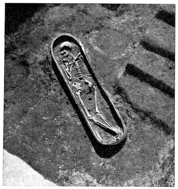
Fig. 197.—Trough coffin, opened.
Trough coffin, opened.
Between zero line and about 3 metres above zero, we come almost exclusively on double-urn burials (Fig. 195). They consist of two pottery vessels with the mouths joined together, in which the body is placed in a crouching position, and generally tightly packed. These double jars, of which one is perforated at the foot end, lie together horizontally or slightly sloping, never upright, although both vessels are provided with a broadened end. They are either alone or in groups of 6 or 8 crowded into a small space. Generally close by there is a layer of ashes, which appears to represent some burial ceremony; in this layer there are a few brick-built subterranean chambers, with barrel-shaped vaulting, such as are often found in Asshur. Their great rarity, when compared with the masses of pottery coffins, shows them undoubtedly to be foreign to Babylonian usage.
Between ground level and about 3 meters above it, we mostly find double-urn burials (Fig. 195). These consist of two pottery vessels with their openings joined together, where the body is placed in a crouching position, typically packed tightly. These double jars, with one being perforated at the bottom, lie together either horizontally or at a slight angle, never upright, even though both vessels have a wider end. They can be found alone or in groups of 6 or 8 crammed into a small space. Usually nearby, there’s a layer of ashes, likely related to some burial ritual; within this layer, there are a few brick-built underground chambers with barrel-shaped ceilings, similar to those often found in Asshur. Their rarity compared to the numerous pottery coffins clearly indicates that they are not typical of Babylonian practices.

Fig. 198.—Crouching burial.
Crouching burial.

Fig. 199.—Brick grave from Merkes.
Fig. 199.—Brick tomb from Merkes.

Fig. 200.—Anthropoid sarcophagus, north-east of Kasr.
Fig. 200.—Human-like sarcophagus, northeast of Kasr.
Above the double-urn level, at 3 metres above zero, the high pottery coffins begin, which are shown by isolated finds in the Southern Citadel to belong undoubtedly to the time of Nebuchadnezzar and earlier. On the side where the head lay they are angular, the other side is rounded. The body lies crouched in them, or slightly on one side. These “crouching burials” were somewhat shallower in the upper levels, so that the body lay with the knees drawn up on one side, while the upper part of the body perhaps lay on the back; hence the sarcophagus assumes a bulging shape at the foot end. It was covered over with a flat or slightly curved clay cover.
Above the double-urn level, at 3 meters above ground level, the high pottery coffins start appearing, which isolated finds in the Southern Citadel clearly show belong to the time of Nebuchadnezzar and earlier. On the side where the head rests, they are angular, while the opposite side is rounded. The body is positioned crouched inside them, or slightly on one side. These "crouching burials" were somewhat shallower in the upper levels, so the body lay with the knees pulled up on one side, while the upper part of the body might have rested on the back; as a result, the sarcophagus takes on a bulging shape at the foot end. It was covered with a flat or slightly curved clay lid.
At 4 metres above zero are the shallow, somewhat short, trough-shaped coffins, in which the body lay at full length, with the knees only slightly flexed (Figs. 196, 197). The shallow vaulted covering was made of two pieces that leant against each other in the centre. Generally, however, the coffin was placed upside down over the body as it lay on the ground, thus rendering the cover unnecessary. These “crouching burials” are found as high as 7 metres above zero (Fig. 198).
At 4 meters above sea level are the shallow, somewhat short, trough-shaped coffins, where the body lay flat, with the knees only slightly bent (Figs. 196, 197). The shallow vaulted cover was made of two pieces that leaned against each other in the center. Generally, though, the coffin was placed upside down over the body as it lay on the ground, making the cover unnecessary. These “crouching burials” can be found as high as 7 meters above sea level (Fig. 198).
It is only in the topmost levels of Merkes that the brick-built sarcophagi are found which we have already mentioned (p. 216) and assigned to the Graeco-Parthian 276period (Fig. 199). There is no doubt that they were usually sunk in the ground. Often, however, the roof is so carefully built with bricks tilted up cornerwise, and covered over with gypsum mortar, that we are forced to admit the possibility that this part at least may in some cases have stood above the ground. The remains of the wooden coffin that actually enclosed the body have frequently been found inside the sarcophagus.
It is only in the highest levels of Merkes that we find the brick tombs we've already talked about (p. 216) and attributed to the Graeco-Parthian 276 period (Fig. 199). There's no doubt that they were typically buried in the ground. However, the roofs are often constructed so carefully with bricks angled up at the corners and covered with gypsum mortar that we have to consider the possibility that at least some of these may have been above ground. Fragments of the wooden coffin that actually held the body have frequently been discovered inside the sarcophagus.

Fig. 201.—Deposits from a coffin.
Fig. 201.—Coffin deposits.
Glazed trough coffins, which were so numerous on the Kasr in the principal court of the Southern Citadel (p. 102), are almost entirely absent in Merkes, and so are the slipper and anthropoid coffins. A fine example of the latter lay on the north-east corner of the Kasr (Fig. 200). The glazed trough coffin must therefore date from a period when the main part, the wide town area of Babylon, was already completely abandoned, and only Amran, the Kasr, and Babil were inhabited.
Glazed trough coffins, which were quite common at the Kasr in the main courtyard of the Southern Citadel (p. 102), are mostly missing in Merkes, along with the slipper and anthropoid coffins. A notable example of the latter was found in the northeast corner of the Kasr (Fig. 200). Therefore, the glazed trough coffin must be from a time when most of Babylon, the expansive urban area, had already been completely deserted, and only Amran, the Kasr, and Babil were still populated.
The graves on the whole were not rich in deposits. The deceased generally retained some of his wonted adornments of necklaces, rings, fibulae, bracelets, and anklets. Other ornaments, such as ear-rings, were only 277occasionally added (Fig. 201). All sorts of pottery vessels were numerous, especially beakers and bowls. These did not often reach the coffin uninjured. Even in entirely untouched coffins there are often large fragments, or broken vessels with some pieces missing. Weapons are very rarely found, but this is not surprising when we consider the eminently peaceful character of the householders of Babylon. Seals and seal cylinders are extremely rare in the coffins. It is obvious that the seal was not given to the dead man in his grave, but that it was retained by the heir for further use. Under these circumstances it is impossible to draw conclusions from the dated character of the seal impression, as to the date of the document on which the impression is found, without further evidence.
The graves, overall, didn't contain many valuable items. The deceased usually kept some of their usual adornments like necklaces, rings, brooches, bracelets, and anklets. Other ornaments, like earrings, were only occasionally included (Fig. 201). There were many pottery vessels, especially beakers and bowls. These rarely made it to the coffin in one piece. Even in completely untouched coffins, there are often large pieces or broken vessels with missing parts. Weapons are found very infrequently, which isn't surprising given the generally peaceful nature of the householders of Babylon. Seals and seal cylinders are extremely rare in the coffins. It's clear that the seal wasn't given to the deceased in their grave but was kept by the heir for future use. Given these circumstances, it's impossible to make conclusions about the date of the document based on the dated seal impression without additional evidence.
XLV
THE TERRA-COTTA FIGURES
The number of terra-cottas found in Babylon is enormous. Including very small fragments, it exceeds 6000. Those of the early Babylonian period are not so numerous as those of the Middle, the Neo-Babylonian, and finally of the Graeco-Parthian periods. The style of the latter entirely supersedes the Babylonian, although the types are on the whole retained. Any figures modelled by hand are rare. We will here describe the main characteristics of those that were moulded, of which all that fall within the same group naturally display a great resemblance to each other. The great mass of them exemplify only a few types, they are almost all of them worked merely on one side, and the female figures greatly exceed the male figures in number.
The number of terra-cottas found in Babylon is huge. Including very small fragments, it exceeds 6,000. The early Babylonian pieces aren’t as numerous as those from the Middle, Neo-Babylonian, and Graeco-Parthian periods. The style of the latter completely takes over the Babylonian style, though the general types are mostly kept. Hand-modeled figures are quite rare. Here, we will describe the main characteristics of those that were molded, with all pieces in the same group showing a strong resemblance to one another. The vast majority display only a few types; almost all are worked on just one side, and there are far more female figures than male figures.
1. The nude female figures with the hands folded in each other below the breast we have already (p. 65) observed as probably representing Ninmach (Fig. 202). The abundant wavy hair falls on the shoulders. She 278always wears a necklace of several rows, and has numerous anklets and bracelets. In the rounded, full-moon countenance we can recognise the Babylonian standard of beauty which occurs in all female figures. The type goes back to the early Babylonian period, as is seen in Fig. 203; here the rolled-up locks, when seen full face, appear like round discs.
1. The nude female figures with their hands folded together below the breast are likely representing Ninmach (Fig. 202). Her flowing wavy hair rests on her shoulders. She 278always wears a multi-strand necklace and has a variety of anklets and bracelets. In her rounded, full-moon face, we can see the Babylonian standard of beauty that appears in all female figures. This style dates back to the early Babylonian period, as shown in Fig. 203; here, the rolled-up hair, when viewed from the front, resembles round discs.

Fig. 202.—Female figure with folded hands (Ninmach?).
Fig. 202.—Female figure with hands folded (Ninmach?).

Fig. 203.—Woman with folded hands, old Babylonian style.
Fig. 203.—Woman with hands folded, in the old Babylonian style.

Fig. 204.—Woman and child.
Fig. 204.—Mother and child.
2. A nude female figure with a child at her breast (Gula?) also occurs very frequently. The arrangement of the hair is the same, but the figure is entirely without ornaments (Fig. 204). This type survived into the Graeco-Parthian period, but it is then clothed, and a fillet is added to the hair (Figs. 205, 206).
2. A naked woman holding a child at her breast (Gula?) is also seen quite often. The hairstyle is the same, but the figure has no decorations (Fig. 204). This style continued into the Graeco-Parthian period, but at that point, the figure is dressed, and a band is added to the hair (Figs. 205, 206).
3. A second rarer figure of a woman and child represents her with her legs crossed beneath her and sitting on a cushion; the lower part of the body at least appears to be clothed (Fig. 207).
3. A second, less common figure of a woman and child shows her sitting cross-legged on a cushion; the lower part of her body seems to be clothed (Fig. 207).
4. There are numerous examples of a nude woman with widely spread elbows, laying her hands on her breasts. 279Those that are entirely early Babylonian are wearing a necklace, the Graeco-Parthian examples have in addition a diadem and ear-rings (Figs. 208–210).
4. There are many examples of a nude woman with her elbows spread wide, resting her hands on her breasts. 279 The completely early Babylonian ones are wearing a necklace, while the Graeco-Parthian examples also have a diadem and earrings (Figs. 208–210).

Fig. 205.—Woman and child, Graeco-Parthian style.
Fig. 205.—Woman and child, Graeco-Parthian style.

Fig. 206.—Woman and child, Graeco-Parthian style.
Fig. 206.—Woman and child, Graeco-Parthian style.

Fig. 207.—Seated woman and child.
Fig. 207.—Sitting woman and child.

Fig. 208. Woman with hands supporting breasts.
Fig. 208. Woman holding her breasts with her hands.

Fig. 209. Woman with hands supporting breasts.
Fig. 209. Woman with hands holding breasts.
6. These five female deities are at present only counterbalanced by three male types, at least so far as moulded terra-cottas are concerned. The first is a standing bearded man clothed in a long flounced garment, who holds a small vase to his breast with both hands. We have already attempted (p. 234) to identify him with Ninib. He is distinguished from Anu, who also holds a circular vessel with both hands, by the overflowing water that is pouring out of the vessel held by the 280latter. Of Anu we have in addition to seals a terra-cotta finely modelled by hand, with a great horned hat (Fig. 212).
6. Right now, these five female deities are only balanced out by three male figures, at least when it comes to shaped terracotta figures. The first one is a standing bearded man dressed in a long, flouncy garment, holding a small vase close to his chest with both hands. We have already tried (p. 234) to identify him as Ninib. He can be told apart from Anu, who also holds a circular vessel with both hands, by the overflowing water that spills from the vessel held by the 280latter. For Anu, in addition to seals, we have a terracotta piece that is finely hand-modeled, complete with a large horned hat (Fig. 212).
7. The second male type is less common. The hands are folded on the breast like Ninmach, and the flounced garment and arrangement of the hair are exactly the same as No. 6. It is possible that we may find it surviving in a rare Parthian type (Figs. 213, 214).
7. The second type of male is less common. The hands are folded on the chest like Ninmach, and the ruffled garment and hairstyle are exactly the same as No. 6. It’s possible we might find it still existing in a rare Parthian type (Figs. 213, 214).

Fig. 210.—Woman with hands supporting breasts, Graeco-Parthian style.
Fig. 210.—Woman with hands supporting breasts, Graeco-Parthian style.

Fig. 211.—Woman with arms hanging down.
Fig. 211.—Woman with arms down at her sides.
8. The only seated divinity is represented as a man with an unusually long beard, wearing a flounced garment, and holding some object in his left hand which it has not been possible to identify from the few specimens found; the right hand rests on the right knee (Fig. 215). The temple statue of Marduk in Esagila, according to Herodotus (i. 183), was also depicted as sitting, a resemblance with this type which can hardly be regarded as merely accidental.
8. The only seated god is shown as a man with an unusually long beard, wearing a flowing garment, and holding an unidentified object in his left hand; his right hand rests on his right knee (Fig. 215). The temple statue of Marduk in Esagila, according to Herodotus (i. 183), was also depicted as sitting, and this similarity to this type seems unlikely to be just a coincidence.

Fig. 212.—Male figure with goblet (Anu?).
Fig. 212.—Male figure holding a goblet (Anu?).

Fig. 213.—Man with folded hands.
Fig. 213.—Man with hands clasped.

Fig. 214.—Man with folded hands, Parthian style.
Fig. 214.—Man with hands folded, Parthian style.

Fig. 215.—Bearded male figure, seated (Marduk?).
Fig. 215.—Bearded male figure, sitting (Marduk?).

Fig. 216.—Man with flower in his hand.
Fig. 216.—Person holding a flower.

Fig. 217.—Woman with flower in her hand.
Fig. 217.—Woman with a flower.
2829. Of the Parthian period there are numerous examples of a standing man with a flower in the right hand, which is laid on the breast; the left hand is hanging down and holds a wreath (?). He is clothed in a sleeved garment that reaches to the knees, and wears trousers; in addition he has a cloak with a hood that covers his head and chin, leaving his moustache visible; round his hips is a girdle with the ends hanging down. The cross ribbing on the sleeves and trousers is characteristic of this period (Fig. 216).
2829. From the Parthian period, there are many examples of a standing man holding a flower in his right hand, resting it on his chest; his left hand hangs down, possibly holding a wreath. He’s dressed in a long-sleeved garment that goes down to his knees, and he wears trousers. Additionally, he has a cloak with a hood that covers his head and chin, leaving his mustache visible; around his waist is a belt with the ends hanging down. The cross ribbing on the sleeves and trousers is typical of this period (Fig. 216).
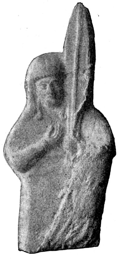
Fig. 218.—Woman holding palm branch (?).
Fig. 218.—Woman holding a palm branch (?).

Fig. 219.—Woman holding palm branch (deity?).
Fig. 219.—Woman holding a palm branch (goddess?).

Fig. 220.—Woman holding palm branch, Greek style.
Fig. 220.—Woman holding a palm branch, Greek style.
10. The female figure corresponding to this male type also holds a flower in the right hand on the breast, and a wreath in the left hand that hangs down, but the hood leaves the round hairless face uncovered; long ringlets fall over the shoulders, and the sleeved garment is tucked up above the knees and confined below the waist with a girdle. The legs are bare (Fig. 217).
10. The female figure that corresponds to this male type also holds a flower in her right hand against her chest and a wreath in her left hand that hangs down. However, the hood leaves her round, hairless face exposed; long ringlets cascade over her shoulders, and the long-sleeved garment is pulled up above the knees and cinched at the waist with a belt. Her legs are bare (Fig. 217).
11. A rare type that belongs to the same period is the figure of a man in exactly the same clothing, but with the arms crossed on the breast.
11. A unique type from the same era is the figure of a man dressed in the exact same clothing, but with his arms crossed over his chest.
12. A clothed figure of a woman with Babylonian 283characteristics (Fig. 218) holds an upright palm branch (?) in her left hand. Some strands of hair hang down her cheeks; the right hand is laid on the breast. The same type occurs also roughly worked as an idol (Fig. 219), as well as in good Greek workmanship (Fig. 220).
12. A dressed figure of a woman with Babylonian features (Fig. 218) holds a straight palm branch (?) in her left hand. Some strands of hair fall down her cheeks; her right hand rests on her breast. The same type is also found roughly carved as an idol (Fig. 219), as well as in high-quality Greek craftsmanship (Fig. 220).

Fig. 221.—Terra-cotta amulet.
Fig. 221.—Clay amulet.

Fig. 222.—Musician with double flute.
Fig. 222.—Musician with a double flute.

Fig. 223.—Lute-player.
Fig. 223.—Guitarist.

Fig. 224.—Lute-player.
Fig. 224.—Guitarist.
13. A head of appalling horror is either bored through at the top to be worn as an amulet or hollowed out at the throat to be fixed on to a stick. Two cross-ribbed horns stretch from the forehead over the skull; the goggle eyes are widely open; 284the gaping muzzle shows all the teeth, including four powerful canines. The bristly beard is either represented by short locks or indicated by rows of holes in the smooth lower jaw (Fig. 221).
13. A grotesque head of horror is either bored through at the top to be worn as an amulet or hollowed out at the throat to be attached to a stick. Two ribbed horns extend from the forehead over the skull; the wide-open goggle eyes stare intensely; 284the gaping mouth reveals all the teeth, including four strong canines. The bristly beard is either shown with short locks or indicated by rows of holes in the smooth lower jaw (Fig. 221).

Fig. 225.—Woman with harp.
Fig. 225.—Woman playing a harp.
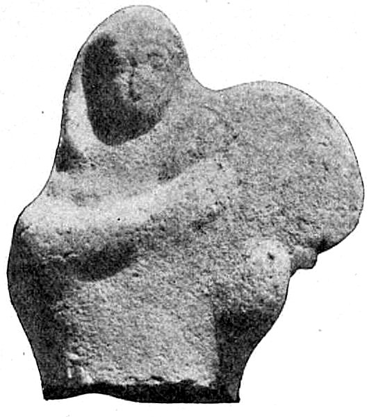
Fig. 226.—Woman with tambourine.
Fig. 226.—Woman with tambourine.

Fig. 227.—Woman reclining.
Fig. 227.—Woman lying down.

Fig. 228.—Woman reclining.
Fig. 228.—Woman lying down.

Fig. 229.—Pottery mask.
Fig. 229.—Ceramic mask.
14. Musicians were less frequently represented in the Babylonian period than in the Greek period. They play the double flute (Fig. 222) which is in use among the Arabs at the present day and known as the mutbak; the panpipe, a long lute with smaller or wider sounding-board (Figs. 223, 224); the oriental harp (Fig. 225), the tambourine (Fig. 226), the cithara, and other instruments which will afford an interesting study for connoisseurs of musical instruments.
14. Musicians were less commonly represented in the Babylonian period than in the Greek period. They play the double flute (Fig. 222), which is still used by Arabs today and is known as the mutbak; the panpipe, a long lute with smaller or larger sounding boards (Figs. 223, 224); the oriental harp (Fig. 225), the tambourine (Fig. 226), the cithara, and other instruments that will provide an interesting study for music enthusiasts.
15. The figure seated on the censer has already (p. 257) been described, also.
15. The figure sitting on the censer has already (p. 257) been described, too.
16. The ape (p. 234).
The monkey (p. __A_TAG_PLACEHOLDER_0__).
17. Female figures, clothed and lying on the left side, 285belong exclusively to the Greek and Parthian periods. With the left arm they support themselves on a cushion, and the right arm rests on the hips. Like similar figures in alabaster (Fig. 132), they are frequently found in the graves (Figs. 227, 228).
17. Female figures, dressed and lying on their left side, 285are exclusively from the Greek and Parthian periods. With their left arm, they prop themselves up on a cushion, and their right arm rests on their hips. Like similar figures made of alabaster (Fig. 132), they are often discovered in graves (Figs. 227, 228).

Fig. 230.—Pottery mask.
Fig. 230.—Ceramic mask.
18. From the later graves come pottery masks with holes round the edge by which they could be affixed to a binding of some material. Many of these masks, with wide-open mouth and eyebrows drawn together in grief, have the characteristics of professional mourners (Figs. 229, 230). Satyrs, cupids, etc., also appear as masks.
18. From the later graves come pottery masks with holes around the edge that allowed them to be attached to some kind of binding. Many of these masks, with their mouths wide open and eyebrows knitted together in sadness, resemble professional mourners (Figs. 229, 230). Satyrs, cupids, and others also show up as masks.

Fig. 231.—Greek terra-cotta.
Fig. 231.—Greek clay pottery.

Fig. 232.—Greek terra-cotta.
Fig. 232.—Greek terra cotta.
19. The number of Greek genre figures in terra-cotta is very remarkable. In great measure they recall those of Tanagra and Myrina. They are mostly of women and girls in ample clothing, and their inimitable grace is almost as remarkable in the slightly executed examples as in those of the finest and most careful workmanship (Figs. 231–233). These inexpensive and charming figures, with the respective details of position, drapery, and head-dress in never-ending variety, as well as the costly 286and important examples, were widely distributed over the city in inexhaustible abundance. A small winged cupid was popular as a jar handle (Fig. 234).
19. The number of Greek genre figures made of terra-cotta is quite remarkable. They largely resemble those from Tanagra and Myrina. Most of them depict women and girls in flowing clothing, and their unique grace is just as striking in the simpler examples as it is in those crafted with the highest quality and attention to detail (Figs. 231–233). These affordable and delightful figures, showcasing endless variations in posture, drapery, and headgear, along with the more expensive and significant pieces, were spread throughout the city in vast quantities. A small winged cupid became quite popular as a jar handle (Fig. 234).
20. The figures of horsemen we have already (p. 235) described.
20. We've already described the horsemen figures (p. 235).

Fig. 233.—Greek terra-cotta.
Fig. 233.—Greek clay art.

Fig. 234.—Cupid as a jar handle.
Fig. 234.—Cupid as a jar handle.
We have thus enumerated some of the principal types from among the very large number of small objects already found on the actual inhabited site of Merkes, and this slight review of the luxuries and requirements and the relative artistic feeling of the citizens of Babylon must suffice for the present, until the material can be spread out and further examined, when a more complete description may be rendered possible.
We have listed some of the main types from the vast array of small objects discovered at the actual inhabited site of Merkes. This brief overview of the luxuries, necessities, and artistic sensibilities of the citizens of Babylon will have to do for now, until we can spread out the materials for further examination, at which point a more detailed description may be possible.
XLVI
THE GREAT HOUSE IN MERKES
In planning a Babylonian private house a square principal chamber on the south side of a court appears under all circumstances to have been indispensable. Everything else might vary according to circumstances and temporary requirements; the side-chambers might be more or less numerous, several courts with the chambers connected with them might be added to the house, but the court and the principal chamber are always there. Before the introduction of Greek art there were no pillars either in the court or in the house.
In planning a Babylonian private house, a square main room on the south side of a courtyard seems to have always been essential. Everything else could change based on the situation and temporary needs; the side rooms could be more or less numerous, and multiple courtyards with connected rooms could be added to the house, but the courtyard and the main room were always present. Before Greek art was introduced, there were no columns in either the courtyard or the house.

Fig. 235.—Reconstruction of the Great House in Merkes.
Fig. 235.—Reconstruction of the Great House in Merkes.
The largest house (Fig. 236) that we have yet found in Merkes possesses three courts (4, 19, 26), each with its principal chamber on the south (12, 23, 27), which corresponds in size with the court to which it is attached. The wide doorway of the house on the north is in a flat length of wall which has no toothed projections, such as all the other walls have. Through this we enter the vestibule (1), and can turn either left to the main portion with the large court, or right to the private or secondary portion with two courts. The former part of the house was certainly consecrated to business and to intercourse with the general public. This is indicated by the fact that in this part only there was a second outer door on the south side, which later was walled up. This opened on a small room (13) that communicated immediately with the principal chamber, and may have served as a shop. In any case, the owner could here communicate with the outside world without being obliged to use the ceremonious northern entrance. On entering by the latter, one passed a very small room (2), the entrance chamber and porter’s 288lodge, the cloak- or waiting-room (3) before reaching the court (4). To the east of this lay the servants’ apartment (5), and to the south the stately principal chamber, about 14 by 7 metres in size; with a smaller series of four chambers to the right (17, 14, 15, 16) and a larger one of six chambers (6–11) to the left of it. Both these series of rooms communicated with the principal chamber by a corridor (14, 8) and with the court by their most northerly chamber (17, 6), which was perhaps a merchant’s office. The inner rooms (15, 16, 10, 11) must have been perfectly dark unless they were lighted by windows on the street, which is very improbable. In one of them (15) there was a well, constructed as usual of pottery cylinders. They may have been store-rooms or sleeping- and living-rooms for the people employed there. It is scarcely necessary to warn our readers that all these suggestions as to the purpose of the various rooms rest entirely on supposition. We have no other authority for them than the arrangement of the ground-plan appears to afford.
The largest house (Fig. 236) we've found in Merkes has three courtyards (4, 19, 26), each with its main room facing south (12, 23, 27), matching the size of the courtyard it connects to. The wide doorway on the north side is part of a flat wall without any protruding features, unlike all the other walls. Through this entrance, we enter the vestibule (1), where we can either turn left to the main section with the large courtyard or right to the private or secondary section with two courtyards. The front part of the house was clearly meant for business and public interaction. This is shown by the fact that in this section, there was a second outer door on the south side, which was later bricked up. This door led to a small room (13) that connected directly to the main chamber and likely served as a shop. In any case, the owner could communicate with the outside world without needing to use the formal northern entrance. Entering through that door, one would walk past a very small room (2), which served as the entrance chamber and porter’s lodge, and then a waiting room (3) before reaching the courtyard (4). To the east of this was the servants’ apartment (5), and to the south was the impressive main chamber, about 14 by 7 meters in size; it had a smaller series of four rooms to the right (17, 14, 15, 16) and a larger series of six rooms (6–11) to the left. Both series communicated with the main chamber through a corridor (14, 8) and with the courtyard through their northernmost room (17, 6), which might have been a merchant’s office. The inner rooms (15, 16, 10, 11) would have been completely dark unless they had windows facing the street, which is very unlikely. One of these rooms (15) had a well, built as usual from pottery cylinders. They might have served as storage or living/sleeping quarters for the staff. It’s probably unnecessary to remind readers that all these suggestions about the purpose of the various rooms are purely speculative. We have no other evidence for them other than the layout of the floor plan suggests.

Fig. 236.—Ground-plan of the Great House in Merkes.
Fig. 236.—Floor plan of the Great House in Merkes.
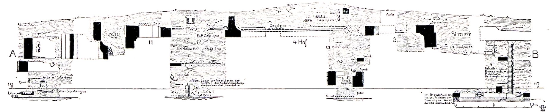
Fig. 237.—Section of the Great House in Merkes.
Fig. 237.—Cross-section of the Great House in Merkes.
The secondary group of chambers was reserved apparently for the private life of the owner. The rooms are grouped round two smaller courts (19 and 26) which communicated with the principal chamber of the northern one (23), and with each other by means of a corridor (25). From this corridor a door on the west led to an adjoining house, which had been built previously, and of which, on the whole, the great house represented an extension. The entrance chamber (18) and the two principal chambers (23, 27) are also easily recognised. It is not necessary at present to hazard conjectures as to the purpose of the other rooms.
The secondary group of rooms was clearly meant for the owner's private life. The rooms are arranged around two smaller courtyards (19 and 26) that connect to the main northern chamber (23) and to each other through a corridor (25). From this corridor, a door on the west leads to an adjacent house, which was built earlier and essentially served as an extension of the larger house. The entrance room (18) and the two main rooms (23, 27) can also be easily identified. There’s no need right now to guess the purpose of the other rooms.

Fig. 238.—Steps to roof in village of Kweiresh.
Fig. 238.—Steps to cover the roof in the village of Kweiresh.
The original pavement of the house has twice undergone restoration (Fig. 237). Between the layers of brick, most of which bear Nebuchadnezzar stamps, only a little earth is laid. No one was buried in the house while it was occupied; the 21 graves that occur on the site are all of the period when the building lay in ruins. This is shown by the way in which the walls and pavement were cut through, and by the fact that the pavements were not repaired in any way after the burials had taken place. The graves are chiefly of brick, as they are exclusively of the Parthian period. It is quite possible that the house was built during the reign of Nebuchadnezzar; no difficulty is involved by the occurrence of the bricks bearing his stamp, as it does not force us to infer any complete destruction of one of Nebuchadnezzar’s buildings. The bricks may very well be older material offered for sale by the king on the occasion of one of his rebuildings. It is impossible to say how late into Persian or Greek times the house existed; a poorer house was built on its ruins after the heap of rubbish had reached a height of about 2 metres.
The original pavement of the house has been restored twice (Fig. 237). Between the layers of brick, most of which have Nebuchadnezzar's stamps, there's only a small amount of earth. No one was buried in the house while it was still in use; the 21 graves found on the site all date from the time when the building was in ruins. This is evident from how the walls and pavement were cut through, and the fact that the pavements were not repaired after the burials occurred. The graves are mostly made of brick, which is typical for the Parthian period. It's quite possible that the house was built during Nebuchadnezzar's reign; the presence of bricks with his stamp doesn't imply that one of his buildings was completely destroyed. These bricks could have very well been older materials sold by the king during one of his reconstruction efforts. It's impossible to determine how long the house remained standing into Persian or Greek times; a simpler house was built on its ruins after the pile of debris had reached about 2 meters in height.
Before the main house was built the site must long have remained unoccupied. Under the pavement lay 4 metres of rubbish above the floor of an earlier house. Three metres deeper again there were tablets of the time of Kadashmanturgu, Kadashmanbel, and Kurigalzu; and 291again, 2 to 3 metres deeper, were some of Samsuiluna, Ammiditana, and Samsuditana.
Before the main house was built, the site must have been empty for a long time. Beneath the pavement, there were 4 meters of debris above the floor of an earlier house. Another 3 meters down, there were tablets from the time of Kadashmanturgu, Kadashmanbel, and Kurigalzu; and 291 again, 2 to 3 meters deeper, were some from Samsuiluna, Ammiditana, and Samsuditana.
The mud-brick walls were plastered with mud, and over this was a wash of white gypsum mortar.
The mud-brick walls were covered in mud, and on top of that was a layer of white gypsum mortar.
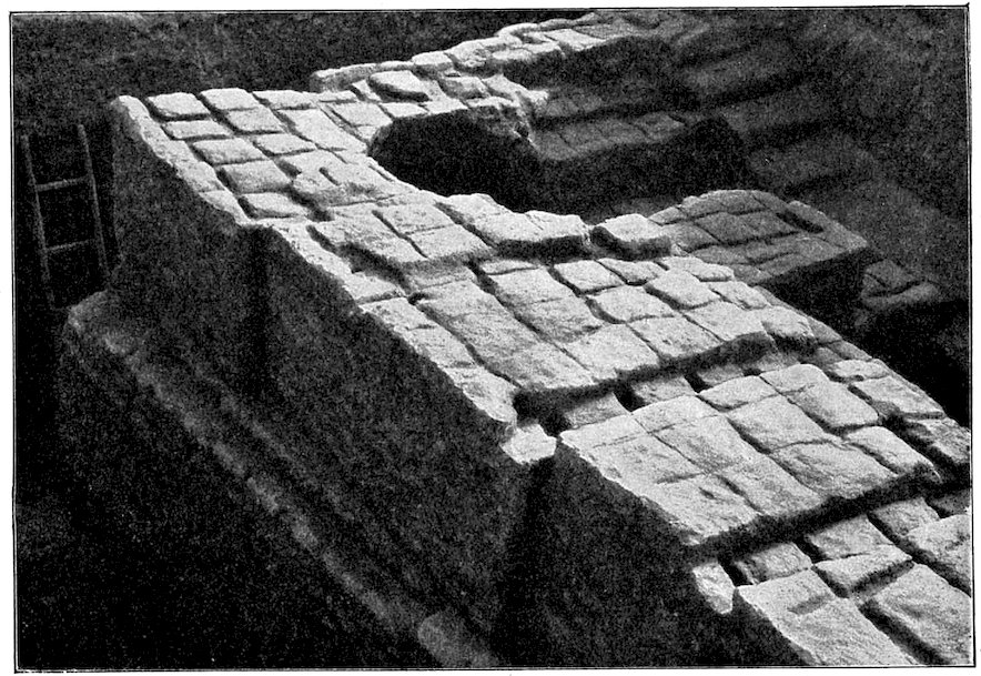
Fig. 239.—North-east corner of the Great House in Merkes.
Fig. 239.—North-east corner of the Great House in Merkes.
Not one of the chambers showed any traces from which we could infer the existence of a stairway to an upper storey. If there were steps, which we cannot doubt, they were certainly of wood, something like the simple stairways to the roof that are used at the present time by the people of Kweiresh (Fig. 238).
Not one of the rooms had any signs that could tell us there was a stairway to an upper floor. If there were steps, which we can’t doubt, they were definitely made of wood, similar to the basic stairways to roofs that people in Kweiresh use today (Fig. 238).
When the house was built, the entire area was first surrounded by a sloping wall without any toothed projections, filled up inside with earth, this forming a substantial terrace on which the actual building stood (Fig. 239). The top of the terrace was 1½ metres higher than the brick pavement of the street on the north. The terrace wall is not so thick as the outer walls of the superstructure, but 292it projects out on the outer side about as far as the toothed projections above it stand out, and thus forms a kind of plinth. Owing to the constant raising of the street level this is little observable; the plinth disappeared with the subsequent heightening of the street. The outer wall itself had more than 90 of those toothed projections, to which we have frequently referred, and is provided with a system of wooden braces, intended to strengthen the projections. A beam lies on the outside, parallel with each wall face, about the length of one projection, in the next brick course this is gripped at one end by a beam placed more or less at right angles to it. The outside must have appeared very much as it is figured in the reconstruction (Fig. 235). The frontage of another house in Merkes is given in Fig. 240.
When the house was built, the whole area was first surrounded by a sloping wall without any indented features, which was filled with earth, creating a solid terrace where the actual building stood (Fig. 239). The top of the terrace was 1.5 meters higher than the brick pavement of the street to the north. The terrace wall isn't as thick as the outer walls of the main structure, but it sticks out on the outside about as far as the indented features above it, forming a sort of base. Because the street level has been consistently raised, this base is barely noticeable; it disappeared with the subsequent elevation of the street. The outer wall had over 90 of those indented features we've often mentioned and is supported by a system of wooden braces designed to strengthen them. A beam runs along the outside, parallel to each wall, about the length of one projection, and in the next row of bricks, this beam is connected at one end to another beam placed roughly at a right angle to it. The exterior must have looked very much like it is shown in the reconstruction (Fig. 235). The front of another house in Merkes is shown in Fig. 240.

Fig. 240.—Façade of house with doorway, brick grave in front, Merkes.
Fig. 240.—Front of the house with a doorway, brick grave in front, Merkes.
For comparison we also give a ground-plan from Fara of about the fifth millennium (Fig. 241). It will show how few changes the internal arrangements of a Babylonian house underwent during the lapse of thousands of years. 293Nothing shows more conclusively than these ground-plans the immense age of Babylonian civilisation; for even in this remote period, which is in part prehistoric, they give clear indications of a yet earlier development from a presumably simpler and more primitive building.
For comparison, we also provide a floor plan from Fara dating back to around the fifth millennium (Fig. 241). It illustrates how little the internal layout of a Babylonian house changed over thousands of years. 293 Nothing demonstrates more clearly than these floor plans the incredible age of Babylonian civilization; even in this ancient period, which is partly prehistoric, they indicate a clear progression from a likely simpler and more primitive structure.

Fig. 241.—Ground-plan of house in Fara (Shuruppak).
E, Entrance.
H, Court.
R, Principal chamber.
V, Vestibule.
Fig. 241.—House layout in Fara (Shuruppak).
E, Entrance.
H, Courtyard.
R, Main room.
V, Vestibule.
The original Babylonian house, as we may assume it to have been from the present state of our knowledge, was probably a rectangular roofed-in space within a walled court. It is most desirable that we should obtain explicit evidence as to the form of the early Babylonian house in one of the prehistoric sites, but to do this is attended with difficulties. They occur generally in narrow crosscuts, or in deep trenches where the limited space renders the following up of these ancient sites very difficult. It would be necessary to open up a much wider area down to a considerable depth to afford sufficient material for arriving at conclusions, and at Surgul and El-Hibba, as well as at Fara, there was not time to do this.
The original Babylonian house, based on what we currently know, was likely a rectangular space with a roof, situated within a walled courtyard. It’s crucial that we get clear evidence about the design of early Babylonian homes at one of the prehistoric sites, but this comes with challenges. These sites are usually found in narrow crosscuts or deep trenches, where the limited space makes it very difficult to explore these ancient areas thoroughly. To gather enough information for conclusions, we would need to excavate a much larger area down to a significant depth, but at Surgul and El-Hibba, as well as at Fara, there wasn't enough time to do this.

Fig. 242.—Ground-plan from Telloh.
Fig. 242.—Ground plan from Telloh.
In strange contrast to these Babylonian ground-plans is the palace of Telloh. The reason why the account given of it by de Sarzec is so difficult to understand, is because it was built at three different periods, which should be clearly differentiated from each other, but which are all placed together and attributed to Gudea as the builder. Only a small part, on the contrary, the inner part B (Fig. 242), which is not organically connected with the building as a whole, belongs to Gudea. All the rest is later, most of it very much later. In 1886 I examined and surveyed all that then survived of the palace. The dotted portion of the plan I give here was then no more to be seen; these walls had already been carried away by brick robbers. At my second visit in 1898 the work of destruction had not been carried much further. The ancient portion, marked black on the plan, represents part of the facing wall of a zikurrat that lay behind it to the south-east, with a stepped and grooved façade and a large gutter for water, such as is usually found in ancient zikurrats. This portion is built of Gudea bricks laid in asphalt and mud. The grooved façade of a lower-lying wall that belongs to it, which formed part of a lower floor, a terrace, or a later kisu, is given by de Sarzec in the court (B); on the north-east various chambers abut on it, the walls of which are built with re-used Gudea bricks. The asphalt still clings in many places to the lower side of the bricks, and the drops 295of asphalt which naturally when the bricks were first used fell on the outer face of the bricks and left slight traces pointing downwards, in their later use point upwards.
In a strange contrast to these Babylonian layouts is the palace of Telloh. The reason why de Sarzec's description of it is so hard to understand is that it was built at three different times, which should be clearly separated from each other, but they're all grouped together and credited to Gudea as the builder. Only a small part, specifically the inner part B (Fig. 242), which isn’t organically connected to the building as a whole, actually belongs to Gudea. Everything else is from a later period, much later for most of it. In 1886, I examined and mapped out all that was left of the palace at that time. The dotted part of the plan I present here was no longer visible then; these walls had already been taken away by brick thieves. On my second visit in 1898, the destruction hadn’t progressed much further. The ancient section, marked in black on the plan, represents part of the facing wall of a ziggurat that was behind it to the southeast, featuring a stepped and grooved façade and a large drainage channel, which is typically found in ancient ziggurats. This section is made of Gudea bricks set in asphalt and mud. The grooved façade of a lower wall that is part of it, which belonged to a lower floor, a terrace, or a later kisu, is shown by de Sarzec in the court (B); various rooms to the northeast connect to it, with walls built using recycled Gudea bricks. The asphalt still sticks in many areas to the underside of the bricks, and the drops of asphalt that originally fell on the outer surface of the bricks and left slight downward traces now point upwards in their later usage.
The north-western outer front of rooms 31, 29, show simple grooved work, which disappeared behind the walls of the later building round court C, and were cut off by the surrounding wall. In our plan these portions are heavily scored. Of the third later building, lightly scored in the plan, which was also built partly of re-used Gudea bricks, and partly of unstamped bricks, laid in mud mortar, two courts can be recognised (C and B). Here we do not find the unmistakably important principal chamber, which is so remarkable a feature of genuine Babylonian buildings. In chambers 11, 35, and 18 de Sarzec reports table-shaped fireplaces, such as I have never found either in Old or Neo-Babylonian buildings, while, on the contrary, such a flat raised hearth is found in chamber XXXV of an unmistakably Parthian house in Nippur that has a peristyle (Fisher, Journal of the Archaeological Institute of America, vol. viii., 1904, No. 4, p. 411). In the pavement of the court adjoining it, the well-known bricks of Adadnadinakhe are said to have been found. An examination of the south-eastern quarter, which must evidently have been already much destroyed at the time of de Sarzec, furnishes the strongest evidence against his representations. Thus in front of 23, he represents a door as constructed of a thick and a very thin wall, and at 24 and 25 he reports a door embrasure actually standing opposite a door-opening. We are therefore forced to the conclusion that here also buildings of entirely different and disconnected periods have been erroneously placed together by the modern draughtsman as having formed one complete building. The peristyle that we expect to find in connection with the two courts (C and B) should be placed in A.
The north-western outer front of rooms 31 and 29 shows simple grooved work, which was hidden behind the walls of the later building around court C and cut off by the surrounding wall. In our plan, these sections are heavily marked. Of the third later building, lightly marked in the plan, which was built partly with reused Gudea bricks and partly with unstamped bricks laid in mud mortar, two courts can be identified (C and B). Here, we don’t find the unmistakably significant main chamber, which is a notable feature of authentic Babylonian buildings. In chambers 11, 35, and 18, de Sarzec reports table-shaped fireplaces, which I have never encountered in either Old or Neo-Babylonian buildings. In contrast, such a flat raised hearth is found in chamber XXXV of a clearly Parthian house in Nippur that has a peristyle (Fisher, Journal of the Archaeological Institute of America, vol. viii., 1904, No. 4, p. 411). In the pavement of the adjoining court, the well-known bricks of Adadnadinakhe are reported to have been found. An examination of the south-eastern quarter, which must have already been heavily damaged by the time of de Sarzec, provides strong evidence against his descriptions. Thus, in front of 23, he shows a door constructed of a thick and a very thin wall, and at 24 and 25, he describes a door frame actually facing a door opening. We are therefore led to conclude that here too, buildings from entirely different and unrelated periods have been mistakenly grouped together by the modern draftsman as if they formed one complete structure. The peristyle that we expect to find associated with the two courts (C and B) should actually be placed in A.
XLVII
THE TEMPLE OF ISHTAR OF AGADE

Fig. 243.—Figure of Papsukal, from foundation casket of Ishtar temple.
Fig. 243.—Image of Papsukal, from the foundation casket of the Ishtar temple.
The temple of Ishtar of Agade lies among the houses of the northern group of Merkes (Fig. 244). The entrance façade faces the south, where the street that passes it widens out into a somewhat lengthy piazza.
The temple of Ishtar of Agade is located among the houses in the northern area of Merkes (Fig. 244). The entrance facade faces south, where the street in front of it expands into a somewhat long plaza.
Through the principal portal, with its grooved towers, we enter the vestibule (1), from which doors to right and left lead to the side-chambers, and which opens directly on to the square court. In the cella (18) with the adyton (19) the postament that stood in the niche immediately opposite the entrance had been taken away, and only the brick casket (k) that contained the statuette of Papsukal (Fig. 243) was still there. Similar brick caskets lay in the court doorway that led to the buildings connected with the cella, in the middle and on the western side of the southern main entrance. The two small chambers (20 and 21) near the chamber in front of the cella are accessible from it, as well as directly from the court. The entire cella building (17–22), as in the temple of Borsippa (Fig. 246), forms a completely self-contained block, separated from the enclosing wall of the temple by a narrow passage (10). From this passage room 9 can be reached, and also the southern series of rooms. This series (11–15) consists of four rather small rooms and apparently a court (13), in which two circular storage places are built.
Through the main entrance, with its textured towers, we enter the vestibule (1), which has doors on the right and left leading to the side chambers, and opens directly into the square courtyard. In the cella (18) with the adyton (19), the pedestal that was in the niche directly opposite the entrance has been removed, and only the brick box (k) containing the statuette of Papsukal (Fig. 243) remains. Similar brick boxes can be found at the courtyard entrance leading to the buildings associated with the cella, located in the middle and on the western side of the southern main entrance. The two small chambers (20 and 21) near the room in front of the cella can be accessed from it as well as directly from the courtyard. The entire cella building (17–22), like in the temple of Borsippa (Fig. 246), is a completely self-contained structure, separated from the temple’s enclosing wall by a narrow passage (10). From this passage, room 9 can be accessed, along with the southern series of rooms. This series (11–15) consists of four relatively small rooms and apparently a courtyard (13), which contains two circular storage areas.

Fig. 244.—Ground plan of temple of Ishtar of Agade, Merkes.
Fig. 244.—Blueprint of the temple of Ishtar in Agade, Merkes.

Fig. 245.—Section of temple of Ishtar of Agade, Merkes.
Fig. 245.—Section of the Ishtar Temple in Agade, Merkes.
There is a side entrance on the east which opens into the court through a small vestibule (4) that communicates with the main vestibule through chambers 3 and 2. Two small rooms (5 and 6) are accessible from the court. The wall decoration is as usual composed of flat pillars on the 298outside of the building and in the court. The main entrance on the south, and the door from the court leading to the cella (Fig. 247), are distinguished by a double framing. The three doors on the east side of the court, the side entrance, and the actual cella door have a single frame. The grooving on the front of the towers of the main entrance, and of the door leading from the court to the cella is simply rectangular. It was only during the last restoration of the building that the simple grooves were elaborated by stepped additions, like those of the Ninib temple.
There’s a side entrance on the east that opens into the court through a small vestibule (4) which connects to the main vestibule via chambers 3 and 2. Two small rooms (5 and 6) are accessible from the court. The wall decoration typically consists of flat pillars on the outside of the building and in the court. The main entrance on the south, and the door from the court leading to the cella (Fig. 247), are characterized by double framing. The three doors on the east side of the court, the side entrance, and the actual cella door have single frames. The grooving on the front of the towers of the main entrance and the door leading from the court to the cella is simply rectangular. It was only during the last restoration of the building that the simple grooves were enhanced with stepped additions, similar to those of the Ninib temple.

Fig. 246.—Ground-plan of Ezida, the temple of Nebo, in Borsippa.
Fig. 246.—Floor plan of Ezida, the temple of Nebo, in Borsippa.

Fig. 247.—Temple of Ishtar of Agade in Merkes; view of cella façade.
Fig. 247.—Temple of Ishtar of Agade in Merkes; view of the entrance façade.
Three building periods can be recognised here (Fig. 245). Of the earliest building only the 7 lower courses remain. The ground-plan is in the main the same as that of the later building that rests upon it, but the wall fronts everywhere deviate slightly from the lines of the latter. The pavement of the later building consists of one plain layer, that lies almost at the level at which the walls begin. The gypsum wash still adheres to the walls. At several of the more important places, such as the main entrance to the temple, the entrance from the court to the cella, the cella door, and the postament niche, instead of a gypsum wash there is a thin wash of black asphalt, which near the edges is broken with ornamental vertical lines of white gypsum. Similar decorations, though not so well preserved and recognisable, were visible in temple “Z,” and in the temples of Ninib and Ninmach. These portions stood out from the white walls with mysterious and startling effect.
Three building periods can be identified here (Fig. 245). Only the seven lower courses of the earliest structure remain. The ground plan is mostly the same as that of the later building that sits on top of it, but the wall fronts deviate slightly from the lines of the latter. The flooring of the later building consists of a single plain layer, which is almost level with where the walls start. The gypsum wash still clings to the walls. In several key areas, such as the main entrance to the temple, the entrance from the courtyard to the cella, the cella door, and the niche for the postament, there's a thin wash of black asphalt instead of the gypsum wash, which near the edges is broken up with decorative vertical lines of white gypsum. Similar decorations, although not as well-preserved and identifiable, were found in temple “Z,” as well as in the temples of Ninib and Ninmach. These details stood out against the white walls, creating a mysterious and striking effect.
The temple was raised and a new double pavement of 300Nebuchadnezzar bricks was laid at a height of 4 to 4½ metres above zero. To this pavement, of course, all the brick caskets belong which lay close to the pavement of the earlier periods but above it, as, for instance, the casket in the door from the court to the cella.
The temple was built, and a new double layer of 300Nebuchadnezzar bricks was set at a height of 4 to 4½ meters above ground level. All the brick caskets that were nearby the pavement from earlier times belong to this new pavement but are positioned above it, like the casket by the door that leads from the courtyard to the cella.
An additional raising with a new brick pavement at 5 metres above zero, belongs apparently to a rebuilding undertaken by Nabonidus, according to the inscription on his foundation cylinder which was found here. The cylinder lay at about the height of the last-mentioned pavement, in the middle of the northern enclosing wall, between the first two pillars on the west, and exactly at the place where it was deposited by Nabonidus. It stood upright in a sort of basket of plaited work, of which the remains were still quite recognisable, and which had formerly shielded it from damage in the small aperture within the mud-brick wall. In the inscription the king speaks of the ruinous condition of this “Temple of Ishtar of Agade,” and the work undertaken by him for its restoration.
An additional layer with a new brick pavement at 5 meters above zero seems to belong to a reconstruction done by Nabonidus, based on the inscription on his foundation cylinder that was found here. The cylinder was located roughly at the height of the aforementioned pavement, in the middle of the northern enclosing wall, between the first two pillars on the west, exactly where Nabonidus had placed it. It was upright in a kind of woven basket, the remnants of which were still clearly visible, and which had previously protected it from damage in the small opening within the mud-brick wall. In the inscription, the king mentions the dilapidated state of this “Temple of Ishtar of Agade,” along with the work he undertook for its restoration.
The building was surrounded by a kisu of Nebuchadnezzar bricks which reaches down as far as 3.6 metres above zero, and which must therefore belong to one of the later rebuildings. A water conduit constructed on the south side (W in the plan), similar to that in the Ninib temple, was walled up by the kisu.
The building was surrounded by a kisu of Nebuchadnezzar bricks that extends down to 3.6 meters above ground level, indicating that it must be part of one of the later reconstructions. A water conduit built on the south side (W in the plan), similar to the one in the Ninib temple, was enclosed by the kisu.
XLVIII
THE GREEK THEATRE
Close to the inner city walls on the east there lies a group of mounds which on account of their reddish colour are called “Homera” by the Arabs (Fig. 249). Of these we have examined a northern, a central, and a southern mound, somewhat carefully, and find that from top to bottom they all are artificial heaps of broken burnt brick. Of their origin we will speak later (p. 308 et seq.).
Close to the inner city walls on the east, there’s a group of mounds that the Arabs call “Homera” because of their reddish color (Fig. 249). We’ve examined a northern, a central, and a southern mound pretty carefully and found that from top to bottom, they’re all made of artificial piles of broken burnt brick. We’ll discuss their origin later (p. 308 et seq.).
301The southern of these mounds has been utilised as a foundation for the auditorium of a theatre. In the débris of the building there was found the Greek dedicatory inscription on an alabaster slab (Fig. 248), according to which one “Dioscurides (built) the theatre and a stage.”
301The southern mound has been used as the base for the auditorium of a theater. In the rubble of the building, there was a Greek dedicatory inscription found on an alabaster slab (Fig. 248), stating that one “Dioscurides (built) the theater and a stage.”

Fig. 248.—Inscription from Greek theatre.
Fig. 248.—Inscription from a Greek theater.
For the upper part of the auditorium the artificial mound was not sufficiently high, and therefore a retaining wall of mud brick supported the upper seats, which have now disappeared. On the three broad projections of the retaining wall on the north stairways were apparently constructed. Of the seats only the 5 lower ranges, which must have been up to the first diazoma, now remain; they consist of mud bricks on which are laid uniform courses of brick rubble. Every seat of 5 courses high has a footstool 2 courses high in front of it. Nine narrow stairs, with steps only 2 courses high, separate the kerkides from each other. The central stairway, with steps 3 courses high, is broader than the others, and led to a compartment which occupied an entire wedge from the orchestra to the diazoma, the proëdreia, intended for distinguished personages, probably the priests of Dionysos. The auditorium, the orchestra with its parodoi, and the stage at some later period, which it is not necessary to estimate as very remote from the first one, were raised by about 1 metre, which caused the rows of seats and apparently also the proscenium to intrude by about 60 to 90 centimetres into the orchestra.
For the upper part of the auditorium, the artificial mound wasn't high enough, so a retaining wall made of mud bricks supported the upper seats, which are now gone. The three wide projections of the retaining wall were likely built on the north stairways. Only the five lower rows of seats remain, which would have extended up to the first diazoma; they are made of mud bricks with uniform layers of brick rubble on top. Every seat, which is five courses high, has a footstool in front that is two courses high. Nine narrow stairs, with steps only two courses high, separate each kerkides from the others. The central stairway, with steps three courses high, is wider than the others and leads to a section that took up an entire wedge from the orchestra to the diazoma, the proëdreia, meant for important guests, probably the priests of Dionysos. The auditorium, the orchestra with its parodoi, and the stage were raised by about one meter at a later time, which caused the rows of seats and seemingly also the proscenium to intrude by about 60 to 90 centimeters into the orchestra.

Fig. 249.—Plan of the mounds, Homera.
Fig. 249.—Map of the mounds, Homera.

Fig. 250.—General view of the Greek theatre.
Fig. 250.—Overall view of the Greek theater.

Fig. 251.—Pedestals for statues in orchestra.
Fig. 251.—Pedestals for statues in the orchestra.
At the edge of the orchestra, which was rather more than a semicircle, near the lowest row of seats, there was a row of statues placed on brick postaments (Fig. 251), of which two at the lower level of the orchestra, with their coating of fine white plaster, are still in good condition. The statues have now disappeared, but they have left deep traces on the top of their pedestals. On the east there are remains of 8 other postaments of the same sort at the level of the second building period.
At the edge of the orchestra, which was more than just a semicircle, close to the lowest row of seats, there was a row of statues set on brick pedestals (Fig. 251). Two of them, located at the lower level of the orchestra and coated with fine white plaster, are still in good shape. The statues are now gone, but they've left deep marks on the tops of their pedestals. To the east, there are remnants of 8 other pedestals of the same type from the second building period.
The stage exhibits between the versurae, in a similar external course, a row of 12 proscenium piers, small and rectangular in form, and bearing on their front face somewhat narrower semi-pillars. The intercolumnar spaces were roofed over with roughly hewn stone blocks, one of which has fallen over and lies immediately in front of the proscenium. All these portions of the building were originally covered with two washes of fine white plaster (Fig. 252).
The stage shows between the versurae, in a similar external layout, a row of 12 proscenium piers, small and rectangular in shape, each carrying somewhat narrower semi-pillars on their front face. The spaces between the columns were covered with roughly cut stone blocks, one of which has fallen and is now lying right in front of the proscenium. All these parts of the building were originally covered with two layers of fine white plaster (Fig. 252).
Similar semi-columns stand on both sides of the door leading to the orchestra. They led through two-chambered parodoi into the open air. Of these chambers the one to 305the west, especially long and narrow, must have served as a waiting-room for the public or the chorus.
Similar semi-columns stand on both sides of the door leading to the orchestra. They led through two-chambered parodoi into the open air. Of these chambers, the one to 305 the west, especially long and narrow, must have served as a waiting room for the public or the chorus.

Fig. 252.—View of the proscenium pillars.
Fig. 252.—View of the stage's side pillars.
Of the back wall of the logeion, the “scaenae frons,” only the foundation walls of brick rubble remain in situ. This was as usual liberally decorated; many of the reliefs in gypsum plaster with which it was adorned have been found (Fig. 254). The two lengthy halls behind the scaenae frons must have been connected with each other in the upper floors by arched openings, as is taken for granted in our reconstructed plan. In the foundation—above which the building is in large measure ruined—the doorways are not arranged for, whereas in Babylonian houses, such as in those of Merkes, the door openings are almost without exception carried right down to the lowest course.
Of the back wall of the logeion, the “scaenae frons,” only the foundation walls of brick rubble remain in situ. This was typically well-decorated; many of the gypsum plaster reliefs that adorned it have been found (Fig. 254). The two long halls behind the scaenae frons must have been connected to each other on the upper floors by arched openings, as is assumed in our reconstructed plan. In the foundation—above which the building is mostly in ruins—the doorways are not laid out, whereas in Babylonian houses, like those in Merkes, the door openings are almost always extended down to the lowest course.
A large peristyle with adjoining and almost uniform chambers abuts on the stage at the south. The southern row of these chambers is very largely destroyed, but of the peristyle sufficient of the brick rubble foundations remain to enable us to judge of the main part. The peristyle had a double nave at the south side, as is often the case with palaestra-peristyles. Fairly numerous remains still exist of the columns that stood on these foundations; they are of burnt brick cut into circular forms, and some of them that were roughly shaped were undoubtedly covered with a fine whitewash that gave them a clearly cut outline.
A large peristyle with connected and almost identical rooms is located next to the stage on the south side. Most of the southern row of these rooms is mostly gone, but enough of the brick rubble foundations of the peristyle remain for us to understand its main structure. The peristyle featured a double nave on the south side, which is common in palaestra-peristyles. There are still quite a few remnants of the columns that used to stand on these foundations; they are made of burned brick shaped into circular forms, and some of the roughly shaped ones were definitely coated with a fine whitewash that highlighted their distinct outlines.

Fig. 253.—Plan of Greek theatre, restored.
Fig. 253.—Plan of a Greek theater, updated.
307On the east, by the side of the peristyle hall, there opened out a long narrow exedra, which was also columned. Both stage and peristyle stand on ancient ruined dwellings, of which the mud-brick walls were brought to light in a cross-cut we made through the central axis.
307To the east, next to the colonnaded hall, there was a long, narrow exedra that also had columns. Both the stage and the colonnade are built on top of ancient ruined homes, revealed when we dug a trench through the center.
The plan, therefore, represents on the whole a combination of a theatre and of a palaestra. In any case the Greek population of Babylon found here an indispensable centre for those amusements and intellectual interests which they would have been most unwilling to abandon in that remote metropolis of the East, on the development of which Alexander the Great had founded such far-seeing plans.
The plan is basically a mix of a theater and a gym. Either way, the Greek community in Babylon found an essential hub for the entertainment and intellectual pursuits they wouldn’t want to give up in that far-off eastern city, where Alexander the Great had laid out such ambitious plans.

Fig. 254.—Gypsum decorations of Greek theatre.
Fig. 254.—Gypsum decorations of Greek theatre.
The building, as it was first constructed, may well date back to the time of Alexander himself, even though the foundation inscription found here, which appears to refer to a restoration, belongs to a later period.
The building, as it was originally built, might date back to the time of Alexander himself, even though the foundation inscription found here, which seems to refer to a restoration, is from a later period.
49
THE NORTHERN MOUND OF HOMERA

Fig. 255.—Section through the northern mound of Homera.
Fig. 255.—Cross-section of the northern mound of Homera.
About 16 metres in height, and with somewhat steep sides, the most northern of the mounds of Homera (w 13 on plan, Fig. 249) occupies a dominating position above the whole of the adjacent surroundings, and forms a remarkable object from a very considerable distance. In order to discover its nature we carried a trench through it, from east to west, cutting the mound in half like an apple; with the surprising result that the mound proved to contain no building such as we might have expected, judging from the Kasr. The entire mass from the top to 1 metre below zero consists of brick rubble, which has been intentionally and artificially heaped up. The layers (Fig. 255), which are alternately coarse and finer, are fairly horizontal at the base, but above they fall in the natural slope of about 45 grades towards the north-east. The mound must, therefore, have been gradually heaped up with débris thrown on it from the south-west.
About 16 meters high and with somewhat steep sides, the northernmost mound of Homera (w 13 on plan, Fig. 249) stands in a commanding position above the surrounding area and is an impressive sight from quite a distance. To understand what it was made of, we dug a trench through it from east to west, slicing the mound in half like an apple. Surprisingly, we found that the mound didn't contain any structures that we might have expected based on the Kasr. The entire mass from the top down to 1 meter below zero is made up of brick rubble that has been intentionally and artificially piled up. The layers (Fig. 255), alternating between coarse and finer material, are pretty level at the base, but above that, they slope naturally at about 45 degrees towards the northeast. This indicates that the mound must have been gradually built up with debris thrown onto it from the southwest.
The broken bricks have, for the most part, ancient asphalt or lime mortar clinging to them. Some of them 309also are unburnt, and the finer layers more especially contain much clay. The Nebuchadnezzar stamps have been found there, but no potsherds, a few Greek terra-cottas, and a fragment of a cylinder of Nebuchadnezzar with an inscription referring to the building of Etemenanki, the tower of Babylon. It is a duplicate of the cylinder: Neb. Hilp. iii. l. 18–24, and iv. l. 15–19 (M’Gee, Zur Topographie von Babylon, vi.).
The broken bricks mostly have old asphalt or lime mortar stuck to them. Some are unburnt, and the finer layers especially contain a lot of clay. The Nebuchadnezzar stamps have been found there, but no potsherds—only a few Greek terra-cottas and a piece of a cylinder from Nebuchadnezzar with an inscription about the construction of Etemenanki, the tower of Babylon. It's a duplicate of the cylinder: Neb. Hilp. iii. l. 18–24, and iv. l. 15–19 (M’Gee, On the Topography of Babylon, vi.).
Thus the mass of débris comes from a Babylonian building brought here in Greek times, and contains a document belonging to Etemenanki. At the ruins of Etemenanki the absence of débris had already struck us as remarkable. What is to be seen there at the present time—low banks round the deep trenches—is merely the result of modern digging by Arab brick robbers. Before this Arab disfigurement of the place, the site of the tower was completely level. At the Kasr and the hill of Babil, as elsewhere, the huge mounds of rubbish bear witness to the immensity of the ruins they represent. In Sachn we have the insignificant remains of a colossal building without débris, and in Homera a colossal mass of rubbish without a building, and we may therefore safely conclude with the greatest possible certainty that the débris of Etemenanki lies in Homera. This agrees admirably with the statement of Greek authors (Strabo, xvi. 1, 5), according to which Alexander the Great intended to replace the tower which had fallen in his time, and expended 600,000 days’ wages on having the débris removed: “ἦν δὲ πυραμὶς ... ἣν Ἀλέξανδρος ἐβούλετο ἀνασκευάσαι, πολὺ δ’ ἦν ἔργον καὶ πολλοῦ χρόνου (αὐτὴ γὰρ ἡ χοῦς εἰς ἀνακάθαρσιν μυρίοις ἀνδράσι δυεῖν μηνῶν ἔργον ἦν), ὤστ’ οὐκ ἔφθη τὸ ἐγχειρηθὲν ἐπιτελέσαι.” The mass of rubbish that lies in Homera—the middle and southern groups also consist of exactly similar broken material—may be roughly estimated at 300,000 cubic metres, which corresponds well with the amount of wages quoted above. As the Euphrates flowed westward close to Etemenanki, and also between the Kasr and Homera, in the Greek period we can suppose that the transport was effected by water.
Thus, the pile of debris comes from a Babylonian building that was brought here during Greek times, and it includes a document connected to Etemenanki. At the ruins of Etemenanki, we had already noticed that the lack of debris was striking. What you can see there now—low banks around the deep trenches—is just the result of modern digging by Arab brick thieves. Before this alteration of the site, the area where the tower stood was completely flat. At the Kasr and the hill of Babil, like in other places, the massive mounds of waste show the vastness of the ruins they represent. In Sachn, we find the meager remains of a colossal building with no debris, and in Homera, a huge pile of rubbish without a building. Therefore, we can confidently conclude that the debris of Etemenanki is in Homera. This aligns perfectly with what Greek authors stated (Strabo, xvi. 1, 5), noting that Alexander the Great planned to rebuild the tower that had fallen during his time and spent 600,000 days’ wages on clearing the debris: “There was a pyramid that Alexander wanted to renovate, but it was a huge task that required a lot of time (for the very soil needed to be cleared by countless men for two months), so the undertaking was never completed.” The mass of rubbish in Homera—the middle and southern groups are also made up of exactly similar broken materials—can be roughly estimated at 300,000 cubic meters, which matches up well with the amount of wages mentioned earlier. Since the Euphrates flowed westward near Etemenanki and also between the Kasr and Homera, we can assume that transportation was done via water during the Greek period.
It may be supposed that the work of piling up débris 310in this place would not be undertaken without some object. The heaps might well have served good purpose in the erection of new buildings, such as were undoubtedly planned by Alexander. It is true that the northern mound was never utilised, but we have already seen that the southern one was used as the substructure for a theatre, and the central group we will now observe more closely.
It can be assumed that the task of stacking debris in this area wouldn't happen without a reason. The piles could have been useful for constructing new buildings, which were definitely part of Alexander's plans. It's true that the northern mound was never used, but we’ve already noted that the southern mound served as a base for a theater, and now let's take a closer look at the central group.
L
THE CENTRAL MOUND OF HOMERA
The central group of Homera (w 21 on plan, Fig. 249), which consists below of exactly the same débris as that we have just described at the northern mound, differs greatly from the latter in that at a height of 7.5 metres above zero a platform is constructed, and that not by merely levelling down a mound that already existed, but by actually piling up materials to the requisite height and levelling them. Upon this platform at the present time there is a layer of earth, from 2 to 3 metres high, with some fragments of brick and a few potsherds; no walls are to be seen in it. It appears, therefore, that this top layer comes from quite late and very inferior dwellings, for which the platform itself was not constructed. The materials of which the level of this platform consists are very much reddened, as though they had been burnt. Indications of a great conflagration are to be found in blocks of mud brick smelted together by a fierce fire, and bearing clear imprints of palm and other wood. In many places the prints show the sharp edges of good carpenter’s work. All this is remarkable, and we should like to find the explanation of it.
The central area of Homera (w 21 on plan, Fig. 249), which contains exactly the same debris as the northern mound we just described, is very different because it has a platform built at a height of 7.5 meters above ground level. This wasn't done by just flattening an existing mound but by actually stacking materials to reach the necessary height and leveling them off. Currently, on this platform, there’s a layer of earth that’s about 2 to 3 meters deep, with some brick fragments and a few pottery shards; no walls are visible in it. It seems this top layer is from fairly recent and lower-quality dwellings, for which the platform itself wasn’t built. The materials that make up this platform are heavily burnt, as if they’ve been through a fire. Evidence of a large blaze can be seen in the mud brick blocks that have fused together from intense heat, showing clear impressions of palm and other types of wood. In many spots, the prints reveal the sharp edges typical of fine carpentry. All of this is quite remarkable, and we would like to understand what caused it.
This may perhaps be found in the report given by Diodorus (xvii. 115[5]) of the funeral pyre Alexander the 311Great caused to be erected to solemnise the funeral ceremonies of Hephaestion. In order to form a platform for this magnificently decorated wooden construction, he had part of the city wall of Babylon demolished, and used the brick materials thus obtained. The platform has perished very considerably on all sides, and the level surface that still survives is undoubtedly only a small part of the original, so that it is useless to endeavour to recover the traces of the construction in detail.
This might be found in the report by Diodorus (xvii. 115[5]) about the funeral pyre that Alexander the Great had built to honor Hephaestion's funeral rites. To create a base for this beautifully decorated wooden structure, he had a section of the city wall of Babylon taken down and used the bricks from it. The platform has significantly deteriorated on all sides, and the level surface that remains is certainly just a small fraction of the original, making it pointless to try to recover the details of the construction.
The place lies exactly opposite the Citadel, and was divided from it in the time of Alexander by the Euphrates. The magnificent pyre, which is said to have cost 12,000 talents, when seen from the Acropolis must have stood out in a most impressive manner against the eastern horizon.
The site is directly across from the Citadel and was separated from it during Alexander's time by the Euphrates. The impressive pyre, believed to have cost 12,000 talents, would have been strikingly visible on the eastern horizon when viewed from the Acropolis.
LI
RETROSPECT
From the central position occupied by Homera we can command a peculiarly instructive view over the ruins of Babylon, and piece together and recall all that excavation has brought to light of the development of the city. In doing so, we will leave unnoticed the information obtained from written sources. They belong to a different kind of treatment.
From the central spot where Homera stands, we can get a uniquely informative view of the ruins of Babylon, piecing together and remembering everything that excavations have revealed about the city's development. In doing this, we will not discuss the information gathered from written sources, as that falls under a different kind of approach.
The existence of Babylon in prehistoric times, before the fifth millennium, is proved by flint and other stone implements. It is impossible to carry excavations down to that depth, owing to the rise in the water-level (p. 261).
The existence of Babylon in ancient times, before the fifth millennium, is supported by flint and other stone tools. It's not feasible to dig down that deep due to the rising water level (p. 261).
The earliest accessible ruins belong to the time of the first Babylonian kings (Hammurabi, circa 2500 B.C.), and lie yonder in Merkes (p. 240). The city, therefore, by that time included at least that region.
The earliest ruins we can access date back to the time of the first Babylonian kings (Hammurabi, around 2500 BCE) and are located over there in Merkes (p. 240). So by then, the city included at least that area.
The same neighbourhood gave us the plan of houses of the time of the Kassite kings, Kurigalzu III. to Kudur-Bel (circa 1400–1249), Bel-nâdin-šum to Marduk-aplu-iddina II. (circa 1219–1154); and the strata above afforded 312those of the Assyrian, Neo-Babylonian, Persian, and Graeco-Parthian periods. All of these show that the division of the city into streets and blocks of houses remained practically unchanged throughout the course of centuries (p. 239 et seq.).
The same neighborhood gave us the layout of houses from the time of the Kassite kings, Kurigalzu III to Kudur-Bel (around 1400–1249), and Bel-nâdin-šum to Marduk-aplu-iddina II. (around 1219–1154). The layers above revealed the structures from the Assyrian, Neo-Babylonian, Persian, and Graeco-Parthian periods. All of these indicate that the city's division into streets and blocks of houses remained almost unchanged over the centuries (p. 239 et seq.).
When the Assyrian kings ruled over Babylon they repaired mainly the great temple of Esagila, now under Amran, where the pavements of Esarhaddon (680–668 B.C.) and Sardanapalus (668–626 B.C.) still lie (p. 204). Sennacherib (705–681) had caused the Procession Street near Sachn to be paved.
When the Assyrian kings ruled over Babylon, they mainly worked on restoring the great temple of Esagila, which is now under Amran. The pavements laid by Esarhaddon (680–668 BCE) and Sardanapalus (668–626 BCE) are still there (p. 204). Sennacherib (705–681) had the Procession Street near Sachn paved.
On the Kasr, Sargon (710–705) built the wall of the Southern Citadel, with the rounded corner tower (p. 137). Sardanapalus restored Nimitti-Bel lying close to our point of observation, Homera, and Emach on the Kasr. At that time the great extension of the Southern Citadel itself was not built, nor yet that part of the Kasr that lay to the north of it, the mound of Babil and the outer city wall. All that belongs to the building period of the Neo-Babylonian kingdom (625–538 B.C.).
On the Kasr, Sargon (710–705) constructed the wall of the Southern Citadel, featuring a rounded corner tower (p. 137). Sardanapalus restored Nimitti-Bel, which is located near our observation point, Homera, as well as Emach on the Kasr. At that time, the significant expansion of the Southern Citadel itself hadn’t been built, nor had the part of the Kasr to the north of it, the mound of Babil, and the outer city wall. All of this is from the building period of the Neo-Babylonian kingdom (625–538 BCE).
Nabopolassar (625–604) began with the western part of the Southern Citadel, built the Arachtu wall from the Kasr as far as Amran, and also the temple of Ninib (p. 229), and Imgur-Bel on the Kasr.
Nabopolassar (625–604) started with the western section of the Southern Citadel, constructed the Arachtu wall from the Kasr all the way to Amran, and also built the temple of Ninib (p. 229), along with Imgur-Bel on the Kasr.
With Nebuchadnezzar (604–561) began the colossal rebuilding of the entire city, with the restoration of the temple of Emach on the Citadel, of Esagila, of Etemenanki, the tower of Babylon with its wide temenos, of the Ninib temple in Ishin aswad, of temple “Z” and the earlier Ishtar temple in Merkes. He restored the Arachtu wall, constructed the earliest stone bridge over the Euphrates (p. 197) at Amran, the canal Libil-ḫigalla, that flowed round the Kasr on the north, east, and south, completed the Southern Citadel with his palace, and enlarged it towards the north in three successive extensions, in which the Procession Street was heightened and paved with stone, and the Ishtar Gate acquired its latest form, while both were decorated with the coloured enamelled frieze of animals. He built a new castle far out on the north and surrounded the city which he had enlarged in this fashion 313with the great outer city wall, of which from Homera we can see the white chain of mounds on the eastern horizon.
With Nebuchadnezzar (604–561), the massive rebuilding of the entire city began, including the restoration of the temple of Emach on the Citadel, Esagila, Etemenanki, the Tower of Babylon with its large sacred area, the Ninib temple in Ishin aswad, temple "Z," and the older Ishtar temple in Merkes. He restored the Arachtu wall, built the earliest stone bridge over the Euphrates at Amran, and the canal Libil-ḫigalla, which flowed around the Kasr to the north, east, and south. He completed the Southern Citadel along with his palace, expanding it northward in three successive extensions, during which the Procession Street was raised and paved with stone, and the Ishtar Gate was updated, both featuring the colorful enamelled frieze of animals. He constructed a new castle far to the north and surrounded the city, which he had enlarged in this way, with a large outer city wall, of which we can see the white line of mounds on the eastern horizon from Homera. 313
Of Nabonidus (555–538) we have more especially the strong fortification wall on the banks of the Euphrates, that has been excavated from Kasr to the Urash gate, near the bridge at Amran (p. 200), and the Ishtar temple in Merkes.
Of Nabonidus (555–538), we particularly have the strong fortified wall along the Euphrates, which has been uncovered from Kasr to the Urash gate, close to the bridge at Amran (p. 200), and the Ishtar temple in Merkes.
In the time of the Persian kings (538–331 B.C.), of which Artaxerxes II. (405–358) has left us a memorial in the marble building on the Southern Citadel (p. 127), the great change must have occurred that essentially altered the aspect of Babylon. The Euphrates, which until then had only washed the west side of the Kasr, now flowed eastward round the Acropolis. From this time dates the plan of the city as it is described by Herodotus (484–424? B.C.) and Ctesias, the physician of Artaxerxes. The apparently wide bend of the river that then flowed round the east of the Kasr we must now reconstruct in imagination as we look across to the castle of Nebuchadnezzar from Homera.
During the reign of the Persian kings (538–331 BCE), Artaxerxes II (405–358) left us a mark in the marble structure on the Southern Citadel (p. 127). A major change must have taken place that fundamentally changed the appearance of Babylon. The Euphrates, which had previously only washed the west side of the Kasr, now flowed eastward around the Acropolis. This marks the beginning of the city's layout as described by Herodotus (484–424? BCE) and Ctesias, Artaxerxes' physician. We must now imagine the seemingly wide bend of the river that flowed around the east side of the Kasr as we look towards the castle of Nebuchadnezzar from Homera.
Alexander the Great (331–323) set himself to prevent the decline of Babylon, which was then beginning, and to restore it to its former magnitude. The great tower Etemenanki, the sanctuary of Bel, and a marked feature of Babylon, was to have been rebuilt. The fallen masses were carried away, and the débris lies here in the mounds of Homera (p. 308), but the king died before he could rebuild the tower.
Alexander the Great (331–323) aimed to stop the decline of Babylon, which was starting at that time, and to restore it to its former glory. The massive tower Etemenanki, the temple of Bel, and a notable landmark of Babylon, was supposed to be rebuilt. The fallen debris was removed, and the rubble can be found in the mounds of Homera (p. 308), but the king passed away before he could restore the tower.
From this time onward the burnt brick of the ancient royal buildings was re-used for all manner of secular buildings. The Greek theatre at Homera (p. 301) is built of such material. Thus the pillared buildings of Amran (p. 215 et seq.) and houses at Merkes, that are built of brick rubble, belong either to the Greek (331–139 B.C.) or the Parthian (139 B.C.–226 A.D.) periods, but to which of them cannot be determined. At that time began the process of demolishing the city area, which perhaps was now only occupied by isolated dwellings, a process that certainly continued throughout the Sassanide period (226–636 A.D.).
From this point on, the burnt brick from the ancient royal buildings was reused for all kinds of secular structures. The Greek theater at Homera (p. 301) is made from this material. Consequently, the pillared buildings of Amran (p. 215 et seq.) and the houses at Merkes, which are made of brick rubble, date back to either the Greek (331–139 BCE) or the Parthian (139 BCE–226 CE) periods, but we can't determine which one. During this time, the process of demolishing the city area began, which may have only been home to isolated dwellings, a process that definitely continued throughout the Sassanid period (226–636 CE).
Amran alone was inhabited, and that only scantily, as 314is shown by the uppermost levels there, which reach down as late as the Arab middle age (circa 1200 A.D.). When we gaze to-day over the wide area of ruins we are involuntarily reminded of the words of the prophet Jeremiah (l. 39): “Therefore the wild beasts of the desert, with the wild beasts of the islands, shall dwell there, and the owls shall dwell therein: and it shall be no more inhabited for ever; neither shall it be dwelt in from generation to generation.”
Amran was largely deserted, and even the few who lived there were sparse, as shown by the upper levels that date back to the Arab Middle Ages (around 1200 A.D.). Today, when we look over the vast expanse of ruins, we can't help but think of the words of the prophet Jeremiah (l. 39): “Therefore the wild beasts of the desert, along with the wild beasts of the islands, will live there, and the owls will settle there: it will never be inhabited again; it will not be lived in from generation to generation.”
LII
APPENDIX
Herodotus i. 178–187
178. Κῦρος, ἐπείτε τὰ πάντα τῆς ἠπείρου ὑποχείρια ἐποιήσατο, Ἀσσυρίοισι ἐπετίθετο. τῆς δὲ Ἀσσυρίης ἐστὶ μέν κου καὶ ἄλλα πολίσματα μεγάλα πολλά, τὸ δὲ οὐνομαστότατον καὶ ἰσχυρότατον καὶ ἔνθα σφι Νίνου ἀναστάτου γενομένης τὰ βασιλήια κατεστήκεε, ἦν ΒΑΒΥΛΩΝ, ἐοῦσα τοιαύτη δή τις πόλις. κέεται ἐν πεδίῳ μεγάλῳ, μέγαθος ἐοῦσα μέτωπον ἕκαστον εἴκοσι καὶ ἑκατὸν σταδίων, ἐούσης τετραγώνου· οὗτοι στάδιοι τῆς περιόδου τῆς πόλιος γίνονται συνάπαντες ὀγδώκοντα καὶ τετρακόσιοι. τὸ μέν νυν μέγαθος τοσοῦτόν ἐστι τοῦ ἄστεος τοῦ Βαβυλωνίου, ἐκεκόσμητο δὲ ὡς οὐδὲν ἄλλο πόλισμα τῶν ἡμεῖς ἴδμεν. τάφρος μὲν πρῶτά μιν βαθέα τε καὶ εὐρέα καὶ πλέη ὕδατος περιθέει, μετὰ δὲ τεῖχος πεντήκοντα μὲν πηχέων βασιληίων ἐὸν τὸ εὖρος, ὕψος δὲ διηκοσίων πηχέων· ὁ δὲ βασιλήιος πῆχυς τοῦ μετρίου ἐστὶ πήχεος μέζων τρισὶ δακτύλοισι.
178. After conquering everything in the continent, Cyrus attacked the Assyrians. In Assyria, there are many large cities, but the most famous and powerful one, where Nimrod's royal authority was established, is BABYLON, a city of significant nature. It is located in a vast plain that stretches twenty-one hundred stadia in each direction, forming a square; the total distance around the city is four hundred and eighty stadia. The size of Babylon is so impressive that it is adorned like no other city we know. A deep and wide moat filled with water surrounds it, followed by a wall that is fifty royal cubits wide and two hundred cubits high; a royal cubit is three finger-breadths larger than an ordinary cubit.
179. Δεῖ δή με πρὸς τούτοισι ἔτι φράσαι, ἵνα τε ἐκ τῆς τάφρου ἡ γῆ ἀναισιμώθη καὶ τὸ τεῖχος ὅντινα τρόπον ἔργαστο. ὀρύσσοντες ἅμα τὴν τάφρον ἐπλίνθευον τὴν γῆν τὴν ἐκ τοῦ ὀρύγματος ἐκφερομένην, ἑλκύσαντες δὲ πλίνθους ἱκανὰς ὤπτησαν αὐτὰς ἐν καμίνοισι· μετὰ δὲ τέλματι χρεώμενοι ἀσφάλτῳ θερμῇ καὶ διὰ τριήκοντα δόμων πλίνθου ταρσοὺς καλάμων διαστοιβάζοντες ἔδειμαν πρῶτα μὲν τῆς τάφρου τὰ χείλεα, δεύτερα δὲ αὐτὸ τὸ τεῖχος τὸν αὐτὸν τρόπον. ἐπάνω δὲ τοῦ τείχεος παρὰ 315τὰ ἔσχατα οἰκήματα μουνόκωλα ἔδειμαν, τετραμμένα ἐς ἄλληλα· τὸ μέσον δὲ τῶν οἰκημάτων ἔλιπον τεθρίππῳ περιέλασιν. πύλαι δὲ ἐνεστᾶσι πέριξ τοῦ τείχεος ἑκατόν, χάλκεαι πᾶσαι, καὶ σταθμοί τε καὶ ὑπέρθυρα ὡσαύτως. ἔστι δὲ ἄλλη πόλις ἀπέχουσα ὀκτὼ ἡμερέων ὁδὸν ἀπὸ Βαβυλῶνος· Ἲς οὔνομα αὐτῇ. ἔνθα ἐστὶ ποταμὸς οὐ μέγας· Ἲς καὶ τῷ ποταμῷ τὸ οὔνομα. ἐσβάλλει δὲ οὗτος ἐς τὸν Εὐφρήτην ποταμὸν τὸ ῥέεθρον, οὕτως ὦν ὁ Ἲς ποταμὸς ἅμα τῷ ὕδατι θρόμβους ἀσφάλτου ἀναδιδοῖ πολλούς, ἔνθεν ἡ ἄσφαλτος ἐς τὸ ἐν Βαβυλῶνι τεῖχος ἐκομίσθη.
179. I need to elaborate on how the land was raised from the ditch and how the wall was built. As they dug the trench, they used the soil they removed to make bricks. They produced enough bricks and baked them in kilns; then, using hot asphalt and stacking thirty layers of bricks, they first reinforced the edges of the trench and then the wall itself in the same way. On top of the wall, near the outermost section, they built solid houses that were arranged to connect with each other. They left the middle part of the houses open for horse-drawn vehicles to pass through. There are about a hundred bronze gates around the wall, along with checkpoints and lintels. There’s another city eight days’ journey from Babylon called Is. There, there's also a small river named Is. This river flows into the Euphrates, and as a result, the Is River frequently brings up many lumps of asphalt with its water, which were then transported to the wall in Babylon.
180. Ἐτετείχιστο μέν νυν ἡ Βαβυλὼν τρόπῳ τοιῷδε, ἔστι δὲ δύο φάρσεα τῆς πόλιος. τὸ γὰρ μέσον αὐτῆς ποταμὸς διέργει, τῷ οὔνομά ἐστι Εὐφρήτης. ῥέει δὲ ἐξ Ἀρμενίων, ἐὼν μέγας καὶ βαθὺς καὶ ταχύς· ἐξίει δὲ οὗτος ἐς τὴν Ἐρυθρὴν θάλασσαν. τὸ ὦν δὴ τεῖχος ἑκάτερον τοὺς ἀγκῶνας ἐς τὸν ποταμὸν ἐλήλαται· τὸ δὲ ἀπὸ τούτου αἱ ἐπικαμπαὶ παρὰ χεῖλος ἑκάτερον τοῦ ποταμοῦ αἱμασιὴ πλίνθων ὀπτέων παρατείνει. τὸ δὲ ἄστυ αὐτό, ἐὸν πλῆρες οἰκέων τριωρόφων τε καὶ τετρωρόφων, κατατέτμηται τὰς ὁδοὺς ἰθέας, τάς τε ἄλλας καὶ τὰς ἐπικαρσίας τὰς ἐπὶ τὸν ποταμὸν ἐχούσας. κατὰ δὴ ὦν ἑκάστην ὁδὸν ἐν τῇ αἱμασιῇ τῇ παρὰ τὸν ποταμὸν πυλίδες ἐπῆσαν, ὅσαι περ αἱ λαῦραι, τοσαῦται ἀριθμόν. ἦσαν δὲ καὶ αὗται χάλκεαι, φέρουσαι καὶ αὐταὶ ἐς αὐτὸν τὸν ποταμόν.
180. Babylon is surrounded by walls, and the city is divided into two parts. A river called the Euphrates flows through the center. It comes from Armenia and is large, deep, and fast-moving; eventually, it leads to the Red Sea. The walls reach toward the river at every bend. Additionally, the riverbanks are lined with baked bricks. The city has three- and four-story buildings and is organized with straight streets, some of which connect to the river. Along each street, particularly near the river, there are gates, matching the number of canals. These gates were also made of bronze and opened directly into the river.
181. Τοῦτο μὲν δὴ τὸ τεῖχος θώρηξ ἐστί, ἕτερον δὲ ἔσωθεν τεῖχος περιθέει, οὐ πολλῷ τέῳ ἀσθενέστερον τοῦ ἑτέρου τείχεος, στεινότερον δέ. ἐν δὲ φάρσεϊ ἑκατέρῳ τῆς πόλιος ἐτετείχιστο ἐν μέσῳ ἐν τῷ μὲν τὰ βασιλήια περιβόλῳ τε μεγάλῳ καὶ ἰσχυρῷ, ἐν δὲ τῷ ἑτέρῳ Διὸς Βήλου ἱρὸν χαλκόπυλον, καὶ ἐς ἐμὲ ἔτι τοῦτο ἐόν, δύο σταδίων πάντῃ, ἐὸν τετράγωνον. ἐν μέσῳ δὲ τοῦ ἱροῦ πύργος στερεὸς οἰκοδόμηται, σταδίου καὶ τὸ μῆκος καὶ τὸ εὖρος, καὶ ἐπὶ τούτῳ τῷ πύργῳ ἄλλος πύργος ἐπιβέβηκε, καὶ ἕτερος μάλα ἐπὶ τούτῳ, μέχρι οὗ ὀκτὼ πύργων. ἀνάβασις δὲ ἐς αὐτοὺς ἔξωθεν κύκλῳ περὶ πάντας τοὺς πύργους ἔχουσα πεποίηται. μεσοῦντι δέ κου τῆς ἀναβάσιός ἐστι καταγωγή τε καὶ θῶκοι ἀμπαυστήριοι, ἐν τοῖσι κατίζοντες ἀμπαύονται οἱ ἀναβαίνοντες. ἐν δὲ τῷ τελευταίῳ πύργῳ νηὸς ἔπεστι μέγας. ἐν δὲ τῷ νηῷ κλίνη μεγάλη κέεται εὖ ἐστρωμένη καί οἱ τράπεζα παρακέεται χρυσέη. ἄγαλμα δὲ οὐκ ἔνι οὐδὲν αὐτόθι ἐνιδρυμένον· οὐδὲ νύκτα οὐδεὶς ἐναυλίζεται ἀνθρώπων ὅτι μὴ γυνὴ μούνη τῶν ἐπιχωρίων, τὴν ἂν ὁ θεὸς ἕληται ἐκ πασέων, ὡς λέγουσιν οἱ Χαλδαῖοι, ἐόντες ἱρέες τούτου τοῦ θεοῦ.
181. This wall serves as a barrier, and there's another one around it, not much weaker than the outer wall but narrower. Each side of the city has fortifications: on one side, there's a large, strong enclosure around the royal palaces, and on the other side stands the temple of Zeus Belus, which I also refer to, extending two stadia on all sides, and shaped like a square. In the center of the temple, there's a solid tower that measures a stadion in both length and width, and on top of this tower, another tower is built, and then another on top of that, resulting in eight towers in total. There’s a path leading up to these towers, surrounded by an outer walkway that goes around all of them. In the middle of the path, there are descending routes and resting areas where those climbing up can take a break. In the highest tower, there's a magnificent temple. Inside this temple, there's a large, well-prepared bed, and a golden table is set up. There's no statue present; no one stays there overnight except for one local woman, chosen by the god from among all, according to the Chaldeans, who are the priests of this god.
316182. Φασὶ δὲ οἱ αὐτοὶ οὗτοι, ἐμοὶ μὲν οὐ πιστὰ λέγοντες, τὸν θεὸν αὐτὸν φοιτᾶν τε ἐς τὸν νηὸν καὶ ἀμπαύεσθαι ἐπὶ τῆς κλίνης, κατάπερ ἐν Θήβῃσι τῇσι Αἰγυπτίῃσι κατὰ τὸν αὐτὸν τρόπον, ὡς λέγουσι οἱ Αἰγύπτιοι (καὶ γὰρ δὴ ἐκεῖθι κοιμᾶται ἐν τῷ τοῦ Διὸς τοῦ Θηβαιέος γυνή, ἀμφότεραι δὲ αὗται λέγονται ἀνδρῶν οὐδαμῶν ἐς ὁμιλίην φοιτᾶν), καὶ κατάπερ ἐν Πατάροισι τῆς Λυκίης ἡ πρόμαντις τοῦ θεοῦ, ἐπεὰν γένηται. οὐ γὰρ ὦν αἰεί ἐστι χρηστήριον αὐτόθι· ἐπεὰν δὲ γένηται, τότε ὦν συγκατακληίεται τὰς νύκτας ἔσω ἐν τῷ νηῷ.
316182. These same people say that, as for me, they're not being truthful, claiming that the god enters the temple and rests on the bed, similar to how it's described in Egyptian Thebes (where the god also rests in the house of Zeus the Theban, and both are said to never mingle with people), and like in Patara of Lycia where the god's oracle is found, whenever that happens. It's not always a sacred space there; but whenever it does occur, they gather inside the temple at night.
183. Ἔστι δὲ τοῦ ἐν Βαβυλῶνι ἱροῦ καὶ ἄλλος κάτω νηός, ἔνθα ἄγαλμα μέγα τοῦ Διὸς ἔνι κατήμενον χρύσεον, καί οἱ τράπεζα μεγάλη παρακέεται χρυσέη καὶ τὸ βάθρον οἱ καὶ ὁ θρόνος χρύσεός ἐστιν. καὶ ὡς ἔλεγον οἱ Χαλδαῖοι, ταλάντων ὀκτακοσίων χρυσίου πεποίηται ταῦτα. ἔξω δὲ τοῦ νηοῦ βωμός ἐστι χρύσεος. ἔστι δὲ καὶ ἄλλος βωμὸς μέγας, ἐπ’ οὗ θύεται τὰ τέλεα τῶν προβάτων· ἐπὶ γὰρ τοῦ χρυσέου βωμοῦ οὐκ ἔξεστι θύειν ὅτι μὴ γαλαθηνὰ μοῦνα, ἐπὶ δὲ τοῦ μέζονος βωμοῦ καὶ καταγίζουσι λιβανωτοῦ χίλια τάλαντα ἔτεος ἑκάστου οἱ Χαλδαῖοι τότε ἐπεὰν τὴν ὁρτὴν ἄγωσι τῷ θεῷ τούτῳ· ἦν δὲ ἐν τῷ τεμένεϊ τούτῳ ἔτι τὸν χρόνον ἐκεῖνον καὶ ἀνδριὰς δυώδεκα πηχέων χρύσεος στερεός. ἐγὼ μέν μιν οὐκ εἶδον, τὰ δὲ λέγεται ὑπό Χαλδαίων, ταῦτα λέγω. τούτῳ τῳ ἀνδριάντι Δαρεῖος μὲν ὁ Ὑστάσπεος ἐπιβουλεύσας οὐκ ἐτόλμησε λαβεῖν, Ξέρξης δὲ ὁ Δαρείου ἔλαβε καὶ τὸν ἱρέα ἀπέκτεινε ἀπαγορεύοντα μὴ κινέειν τὸν ἀνδριάντα. τὸ μὲν δὴ ἱρὸν τοῦτο οὕτω κεκόσμηται, ἔστι δὲ καὶ ἴδια ἀναθήματα πολλά.
183. There’s another inner sanctuary in Babylon that has a large golden statue of Zeus. Next to it is a big golden table, and both the pedestal and the throne are made of gold. The Chaldeans say this costs eight hundred talents of gold. Outside the temple, there’s a golden altar. There’s also a large altar where flawless sheep are sacrificed because only unblemished lambs can be sacrificed on the golden altar, while on the larger altar, they burn a thousand talents of incense each year during the Chaldeans' festival for this god. At that time, there was also a solid gold statue twelve palms high in this area. I haven't seen it myself, but this is what the Chaldeans say. Darius, son of Hystaspes, plotted against this statue but didn’t dare to take it, while Xerxes, son of Darius, took it and killed the priest who was stopping him from moving it. This is how the temple is decorated, and there are also many individual offerings.
184. Τῆς δὲ Βαβυλῶνος ταύτης πολλοὶ μέν κου καὶ ἄλλοι ἐγένοντο βασιλέες, τῶν ἐν τοῖσι Ἀσσυρίοισι λόγοισι μνήμην ποιήσομαι, οἳ τὰ τείχεά τε ἐπεκόσμησαν καὶ τὰ ἱρά, ἐν δὲ δὴ καὶ γυναῖκες δύο· ἡ μὲν πρότερον ἄρξασα, τῆς ὕστερον γενεῇσι πέντε πρότερον γενομένη, τῇ οὔνομα ἦν Σεμίραμις, αὕτη μὲν ἀπεδέξατο χώματα ἀνὰ τό πεδίον ἐόντα ἀξιοθέητα· πρότερον δὲ ἐώθεε ὁ ποταμὸς ἀνὰ τὸ πεδίον πᾶν πελαγίζειν.
184. Many kings came from Babylon, and I will remember some of those noted in the Assyrian texts—those who decorated the walls and temples, including two women. The first ruler was Semiramis, who was born five generations earlier. She claimed the land across the plain, which was seen as an important area; in the past, the river used to flood the entire plain.
185. Ἡ δὲ δὴ δεύτερον γενομένη ταύτης βασίλεια, τῇ οὔνομα ἦν Νίτωκρις, αὕτη δὲ συνετωτέρη γενομένη τῆς πρότερον ἀρξάσης τοῦτο μὲν μνημόσυνα ἐλίπετο, τὰ ἐγὼ ἀπηγήσομαι, τοῦτο δὲ τὴν Μήδων ὁρῶσα ἀρχὴν μεγάλην τε καὶ οὐκ ἀτρεμίζουσαν, <ἀλλ’> ἄλλα τε ἀραιρημένα ἄστεα αὐτοῖσι, ἐν δὲ δὴ καὶ τὴν Νίνον, προεφυλάξατο ὅσα ἐδύνατο μάλιστα. πρῶτα μὲν τὸν Εὐφρήτην ποταμόν, ῥέοντα πρότερον ἰθύν, ὅς σφι διὰ τῆς πόλιος μέσης 317ῥέει, τοῦτον ἄνωθεν διώρυχας ὀρύξασα οὕτω δή τι ἐποίησε σκολιόν, ὥστε δὴ τρὶς ἐς τῶν τινὰ κωμέων τῶν ἐν τῇ Ἀσσυρίῃ ἀπικνέεται ῥέων. τῇ δὲ κώμῃ οὔνομά ἐστι, ἐς τὴν ἀπικνέεται ὁ Εὐφρήτης, Ἀρδέρικκα. καὶ νῦν οἳ ἂν κομίζωνται ἀπὸ τῆσδε τῆς θαλάσσης ἐς Βαβυλῶνα, καταπλέοντες [ἐς] τὸν Εὐφρήτην ποταμὸν τρίς τε ἐς τὴν αὐτὴν ταύτην κώμην παραγίνονται καὶ ἐν τρισὶ ἡμέρῃσι. τοῦτο μὲν δὴ τοιοῦτο ἐποίησε, χῶμα δὲ παρέχωσε παρ’ ἑκάτερον τοῦ ποταμοῦ τὸ χεῖλος, ἄξιον θώυματος, μέγαθος καὶ ὕψος ὅσον τι ἐστί. κατύπερθε δὲ πολλῷ Βαβυλῶνος ὤρυσσε ἔλυτρον λίμνῃ, ὀλίγον τι παρατείνουσα ἀπὸ τοῦ ποταμοῦ, βάθος μὲν ἐς τὸ ὕδωρ αἰεὶ ὀρύσσουσα, εὖρος δὲ τὸ περίμετρον αὐτοῦ ποιεῦσα εἴκοσί τε καὶ τετρακοσίων σταδίων· τὸν δὲ ὀρυσσόμενον χοῦν ἐκ τούτου τοῦ ὀρύγματος ἀναισίμου παρὰ τὰ χείλεα τοῦ ποταμοῦ παραχέουσα. ἐπείτε δέ οἱ ὀρώρυκτο, λίθους ἀγαγομένη, κρηπῖδα κύκλῳ περὶ αὐτὴν ἤλασε. ἐποίεε δὲ ἀμφότερα ταῦτα, τόν τε ποταμὸν σκολιὸν καὶ τὸ ὄρυγμα πᾶν ἕλος, ὡς ὅ τε ποταμὸς βραδύτερος εἴη περὶ καμπὰς πολλὰς ἀγνύμενος, καὶ οἱ πλόοι ἔωσι σκολιοὶ ἐς τὴν Βαβυλῶνα, ἔκ τε τῶν πλόων ἐκδέκηται περίοδος τῆς λίμνης μακρή. κατὰ τοῦτο δὲ ἐργάζετο τῆς χώρης, τῇ αἵ τε ἐσβολαὶ ἦσαν καὶ τὰ σύντομα τῆς ἐκ Μήδων ὁδοῦ, ἵνα μὴ ἐπιμισγόμενοι οἱ Μῆδοι ἐκμανθάνοιεν αὐτῆς τὰ πράγματα.
185. The second queen to rule here was named Nitocris. She was more intelligent than the previous ruler, and while leaving behind memorials that I will describe, she noticed the powerful Persian Empire that was not afraid, alongside other cities scattered around, including Nineveh. She protected everything she could. First, she redirected the Euphrates River, which ran straight through the city, by digging a channel above it in a way that made its path so winding that it reached the towns in Assyria three times. The town where the Euphrates flows into is called Arderikka. Even now, those who come from the sea to Babylon, when they sail to the Euphrates River, arrive at this same town three times in three days. This was her project, and she built a wall on both sides of the riverbank, impressive and as tall as anything. She also dug a basin a good distance beyond Babylon, extending slightly from the river, continually digging deep into the water, and making its circumference between twenty and four hundred stadia wide; from this excavation, she redirected the earth to the riverbanks. Once it was dug out, she brought in stones and built a circular foundation around it. She accomplished both of these things: she made the river winding and created a marsh from the entire excavation, so that the river would slow down as it turned often and the ships would have to navigate awkwardly to Babylon, while ships would have to take a long detour around the lake. In this way, she focused on the area, concerning both the entrances and shortcuts from the Persian road, to ensure that the Medes wouldn't learn the details through mixing with them.
186. Ταῦτα μὲν δὴ ἐκ βάθεος περιεβάλετο, τοιήνδε δὲ ἐξ αὐτῶν παρενθήκην ἐποιήσατο. τῆς πόλιος ἐούσης δύο φαρσέων, τοῦ δὲ ποταμοῦ μέσον ἔχοντος, ἐπὶ τῶν πρότερον βασιλέων, ὅκως τις ἐθέλοι ἐκ τοῦ ἑτέρου φάρσεος ἐς τοὔτερον διαβῆναι, χρῆν πλοίῳ διαβαίνειν, καὶ ἦν, ὡς ἐγὼ δοκέω, ὀχληρὸν τοῦτο. αὕτη δὲ καὶ τοῦτο προεῖδε· ἐπείτε γὰρ ὤρυσσε τὸ ἔλυτρον τῇ λίμνῃ, μνημόσυνον τόδε ἄλλο ἀπὸ τοῦ αὐτοῦ ἔργου ἐλίπετο. ἐτάμνετο λίθους περιμήκεας, ὡς δέ οἱ ἦσαν οἱ λίθοι ἑτοῖμοι, καὶ τὸ χωρίον ὀρώρυκτο, ἐκτρέψασα τοῦ ποταμοῦ τὸ ῥέεθρον πᾶν ἐς τὸ ὤρυξε χωρίον, ἐν ᾧ ἐπίμπλατο τοῦτο, ἐν τούτῳ ἀπεξηρασμένου τοῦ ἀρχαίου ῥεέθρου, τοῦτο μὲν τὰ χείλεα τοῦ ποταμοῦ κατὰ τὴν πόλιν καὶ τὰς καταβάσιας τὰς ἐκ τῶν πυλίδων ἐς τὸν ποταμὸν φερούσας ἀνοικοδόμησε πλίνθοισι ὀπτῇσι κατὰ τὸν αὐτὸν λόγον τῷ τείχεϊ, τοῦτο δὲ κατὰ μέσην κου μάλιστα τὴν πόλιν τοῖσι λίθοισι, τοὺς ὠρύξατο, οἰκοδόμεε γέφυραν, δέουσα τοὺς λίθους σιδήρῳ τε καὶ μολύβδῳ. ἐπιτείνεσκε δὲ ἐπ’ αὐτήν, ὅκως μὲν ἡμέρη γένοιτο, ξύλα τετράγωνα, ἐπ’ ὧν τὴν διάβασιν ἐποιεῦντο οἱ Βαβυλώνιοι· τὰς δὲ νύκτας τὰ ξύλα ταῦτα ἀπαιρέεσκον τοῦδε εἵνεκα, ἵνα μὴ διαφοιτέοντες τὰς νύκτας κλέπτοιεν παρ’ ἀλλήλων. ὡς δὲ τό 318τε ὀρυχθὲν λίμνη πλήρης ἐγεγόνεε ὑπὸ τοῦ ποταμοῦ καὶ τὰ περὶ τὴν γέφυραν ἐκεκόσμητο, τὸν Εὐφρήτην ποταμὸν ἐς τὰ ἀρχαῖα ῥέεθρα ἐκ τῆς λίμνης ἐξήγαγε· καὶ οὕτω τὸ ὀρυχθὲν ἕλος γενόμενον ἐς δέον ἐδόκεε γεγονέναι καὶ τοῖσι πολιήτῃσι γέφυρα ἦν κατεσκευασμένη.
186. He was lost in thought, which led him to come up with this plan. Since the city was located between two channels and a river ran right through the middle, anyone wanting to cross from one side to the other had to use a boat, which I think was pretty inconvenient. However, she had foreseen this; when she dug the channel at the lake, a crucial detail from the same project was overlooked. She cut through long stones, and once the stones were ready and the area was excavated, she redirected the river’s flow completely into the dug-out area, which filled up as the old riverbed dried. This meant that the riverbanks by the city and the slopes from the gates to the river were reconstructed with fired bricks similar to the wall’s design. In the city center, she built a bridge with the stones she had excavated, needing iron and lead to secure them. During the day, they laid squared timber for the Babylonians to cross; at night, these timbers were removed to prevent people from stealing from each other. As the 318 excavated lake filled from the river and the area around the bridge was beautified, the Euphrates was redirected back into its old channels from the lake; thus, the excavated marsh returned to its rightful state, and a bridge was constructed for the citizens.
187. Ἡ δ’ αὐτὴ αὕτη βασίλεια καὶ ἀπάτην τοιήνδε τινὰ ἐμηχανήσατο. ὑπὲρ τῶν μάλιστα λεωφόρων πυλέων τοῦ ἄστεος τάφον ἑωυτῇ κατεσκευάσατο μετέωρον ἐπιπολῆς αὐτέων τῶν πυλέων, ἐνεκόλαψε δὲ ἐς τὸν τάφον γράμματα λέγοντα τάδε·
187. The queen devised a clever trick like this. She constructed a raised tomb for herself above the main streets of the city, right over the gates, and etched the following words into the tomb:
ΤΩΝ ΤΙΣ ἘΜΕΤ ὙΣΤΕΡΟΝ ΓΙΝΟΜΕΝΩΝ ΒΑΒΥΛΩΝΟΣ ΒΑΣΙΛΕΩΝ ἨΝ ΣΠΑΝΙΣΗι ΧΡΗΜΑΤΩΝ, ἈΝΟΙΞΑΣ ΤΟΝ ΤΑΦΟΝ ΛΑΒΕΤΩ ὉΚΟΣΑ ΒΟΥΛΕΤΑΙ ΧΡΗΜΑΤΑ. MΗ ΜΕΝΤΟΙ ΓΕ ΜΗ ΣΠΑΝΙΣΑΣ ΓΕ ἈΛΛΩΣ ἈΝΟΙΞΗι. ὈΥ ΓΑΡ ἈΜΕΙΝΟΝ.
For those who later became kings of Babylon and were short on wealth, anyone wanting money can open the tomb and take whatever they want. However, if it doesn't run out, it will be opened anyway. It’s not any better.
Οὗτος ὁ τάφος ἦν ἀκίνητος μέχρι οὗ ἐς Δαρεῖον περιῆλθε ἡ βασιληίη. Δαρείῳ δὲ καὶ δεινὸν ἐδόκεε εἶναι τῇσι πύλῃσι ταύτῃσι μηδὲν χρᾶσθαι καὶ χρημάτων κειμένων καὶ αὐτῶν τῶν χρημάτων ἐπικαλεομένων μὴ οὐ λαβεῖν αὐτά. τῇσι δὲ πύλῃσι ταύτῃσι οὐδὲν ἐχρᾶτο τοῦδε εἵνεκα, ὅτι ὑπὲρ κεφαλῆς οἱ ἐγίνετο ὁ νεκρὸς διεξελαύνοντι. ἀνοίξας δὲ τὸν τάφον εὗρε χρήματα μὲν οὔ, τὸν δὲ νεκρὸν καὶ γράμματα λέγοντα τάδε·
This tomb stayed untouched until it was acquired by Darius. However, for Darius, it was frightening that nothing had been disturbed at these gates, even though treasures were kept there and could have been taken. For this reason, nothing was used at these gates, as the deceased was being dragged above his head. When he opened the tomb, he found no treasure, but instead the deceased and writings that said the following:
ἘΙ ΜΗ ἈΠΛΗΣΤΟΣ ΤΕ ἘΑΣ ΧΡΗΜΑΤΩΝ ΚΑΙ ἈΙΣΧΡΟΚΕΡΔΗΣ, ὈΥΚ ἈΝ ΝΕΚΡΩΝ ΘΗΚΛΣ ἈΝΕΩιΓΕΣ.
If you're not motivated by greed and shameful profit, the graves of the deceased will remain closed.
Αὕτη μέν νυν ἡ βασίλεια τοιαύτη τις λέγεται γενέσθαι.
This is said to be the essence of the kingdom.
Diodorus ii. 7–10
7. Ὁ δὲ Νίνος τούς τε ἐν Βάκτροις παρέλαβε θησαυρούς, ἔχοντας πολὺν ἄργυρόν τε καὶ χρυσόν, καὶ τὰ κατὰ τὴν Βακτριανὴν καταστήσας ἀπέλυσε τὰς δυνάμεις. μετὰ δὲ ταῦτα γεννήσας ἐκ Σεμιράμιδος υἱὸν Νινύαν ἐτελεύτησε, τὴν γυναῖκα ἀπολιπὼν βασίλισσαν. τὸν δὲ Νίνον ἡ Σεμίραμις ἔθαψεν ἐν τοῖς βασιλείοις, καὶ κατεσκεύασεν ἐπ’ αὐτῷ χῶμα παμμέγεθες, οὗ τὸ μὲν ὕψος ἦν ἐννέα σταδίων, τὸ δ’ εὖρος, ὥς φησι Κτησίας, δέκα. διὸ καὶ τῆς πόλεως παρὰ τὸν Εὐφράτην ἐν πεδίῳ κειμένης ἀπὸ πολλῶν σταδίων ἐφαίνετο τὸ χῶμα καθαπερεί τις ἀκρόπολις. ὃ καὶ μέχρι τοῦ νῦν φασι διαμένειν καίπερ τῆς Νίνου κατεσκαμμένης ὑπὸ Μήδων, ὅτε κατέλυσαν τὴν Ἀσσυρίων βασιλείαν. ἡ δὲ Σεμίραμις, οὖσα φύσει μεγαλεπίβολος καὶ φιλοτιμουμένη τῇ δόξῃ τὸν βεβασιλευκότα πρὸ 319αὐτῆς ὑπερθέσθαι, πόλιν μὲν ἐπεβάλετο κτίζειν ἐν τῇ Βαβυλωνίᾳ, ἐπιλεξαμένη δὲ τοὺς πανταχόθεν ἀρχιτέκτονας καὶ τεχνίτας, ἔτι δὲ τὴν ἄλλην χορηγίαν παρασκευασαμένη, συνήγαγεν ἐξ ἁπάσης τῆς βασιλείας πρὸς τὴν τῶν ἔργων συντέλειαν ἀνδρῶν μυριάδας διακοσίας. ἀπολαβοῦσα δὲ τὸν Εὐφράτην ποταμὸν εἰς μέσον περιεβάλετο τεῖχος τῇ πόλει σταδίων ἑξήκοντα καὶ τριακοσίων, διειλημμένον πύργοις πυκνοῖς καὶ μεγάλοις, ὥς φησι Κτησίας ὁ Κνίδιος, ὡς δὲ Κλείταρχος καὶ τῶν ὕστερον μετ’ Ἀλεξάνδρου διαβάντων εἰς τὴν Ἀσίαν τινὲς ἀνέγραψαν, τριακοσίων ἑξήκοντα πέντε σταδίων. καὶ προστιθέασιν ὅτι τῶν ἴσων ἡμερῶν εἰς τὸν ἐνιαυτὸν οὐσῶν ἐφιλοτιμήθη τὸν ἴσον ἀριθμὸν τῶν σταδίων ὑποστήσασθαι. ὀπτὰς δὲ πλίνθους εἰς ἄσφαλτον ἐνδησαμένη τεῖχος κατεσκεύασε τὸ μὲν ὕψος, ὡς μὲν Κτησίας φησί, πεντήκοντα ὀργυιῶν, ὡς δ’ ἔνιοι τῶν νεωτέρων ἔγραψαν, πηχῶν πεντήκοντα, τὸ δὲ πλάτος πλέον ἢ δυσὶν ἅρμασιν ἱππάσιμον. πύργους δὲ τὸν μὲν ἀριθμὸν διακοσίους καὶ πεντήκοντα, τὸ δ’ ὕψος καὶ πλάτος ἐξ ἀναλόγου τῷ βάρει τῶν κατὰ τὸ τεῖχος ἔργων. οὐ χρὴ δὲ θαυμάζειν εἰ τηλικούτου τὸ μέγεθος τοῦ περιβόλου καθεστῶτος ὀλίγους πύργους κατεσκεύασεν. ἐπὶ πολὺν γὰρ τόπον τῆς πόλεως ἕλεσι περιεχομένης, κατὰ τοῦτον τὸν τόπον οὐκ ἔδοξεν αὐτῇ πύργους οἰκοδομεῖν, τῆς φύσεως τῶν ἑλῶν ἱκανὴν παρεχομένης ὀχυρότητα. ἀνὰ μέσον δὲ τῶν οἰκιῶν καὶ τῶν τειχῶν ὁδὸς πάντῃ κατελέλειπτο δίπλεθρος.
7. Ninus took treasures from Bactria, which included a lot of silver and gold. After sorting things out in Bactria, he dismissed his forces. Later, he had a son named Ninyas with Semiramis and passed away, leaving his wife as queen. Semiramis buried Ninus in the royal tomb and built a huge mound over him, said to be nine stadia high and, according to Ctesias, ten stadia wide. Because of this, the mound looked like a citadel from many stadia away, sitting in the plain next to the Euphrates. It is said to still be there, even though Ninus's city was destroyed by the Medes when they overthrew the Assyrian kingdom. Naturally ambitious and seeking glory, Semiramis wanted to build a city in Babylon. She selected architects and craftsmen from all over and prepared the necessary resources, gathering two hundred thousand men from across the kingdom to complete the project. Centering the city around the Euphrates River, she surrounded it with a wall that was six hundred stadia long, with thick and tall towers, as Ctesias of Cnidus states, while later accounts from Cleitarchus and others who traveled to Asia with Alexander mention three hundred sixty-five stadia. They even add that during leap years, Semiramis intended to have an equal number of stadia. She constructed a wall of baked bricks sealed with asphalt, with a height of fifty orguia, according to Ctesias, while some later writers say it was fifty cubits; the width was enough for two horse-drawn chariots to pass side by side. There were two hundred and fifty towers, with their height and width proportional to the scale of the construction along the wall. Given such a vast enclosure, it’s not surprising that she built only a few towers. Because the large area of the city was enclosed, it didn't seem necessary for her to build more towers in that space, as the marshy environment provided enough strength. A double road was left open between the houses and the walls.
8. Πρὸς δὲ τὴν ὀξύτητα τῆς τούτων οἰκοδομίας ἑκάστῳ τῶν φίλων στάδιον διεμέτρησε, δοῦσα τὴν ἱκανὴν εἰς τοῦτο χορηγίαν καὶ διακελευσαμένη τέλος ἐπιθεῖναι τοῖς ἔργοις ἐν ἐνιαυτῷ. ὧν ποιησάντων τὸ προσταχθὲν μετὰ πολλῆς σπουδῆς, τούτων μὲν ἀπεδέξατο τὴν φιλοτιμίαν, αὐτὴ δὲ κατὰ τὸ στενώτατον μέρος τοῦ ποταμοῦ γέφυραν σταδίων πέντε τὸ μῆκος κατεσκεύασεν, εἰς βυθὸν φιλοτέχνως καθεῖσα τοὺς κίονας, οἳ διειστήκεσαν ἀπ’ ἀλλήλων πόδας δώδεκα. τοὺς δὲ συνερειδομένους λίθους τόρμοις σιδηροῖς διελάμβανε, καὶ τὰς τούτων ἁρμονίας ἐπλήρου μόλιβδον ἐντήκουσα. τοῖς δὲ κίοσι πρὸ τῶν τὸ ῥεῦμα δεχομένων πλευρῶν γωνίας προκατεσκεύασεν ἐχούσας τὴν ἀπορροὴν περιφερῆ καὶ συνδεδεμένην κατ’ ὀλίγον ἕως τοῦ κατὰ τὸν κίονα πλάτους, ὅπως αἱ μὲν περὶ τὰς γωνίας ὀξύτητες τέμνωσι τὴν καταφορὰν τοῦ ῥεύματος, αἱ δὲ περιφέρειαι τῇ τούτου βίᾳ συνείκουσαι πραΰνωσι τὴν σφοδρότητα τοῦ ποταμοῦ. ἡ μὲν οὖν γέφυρα, κεδρίναις καὶ κυπαριττίναις δοκοῖς, ἔτι δὲ φοινίκων στελέχεσιν ὑπερμεγέθεσι κατεστεγασμένη καὶ τριάκοντα ποδῶν οὖσα τὸ 320πλάτος, οὐδενὸς ἐδόκει τῶν Σεμιράμιδος ἔργων τῇ φιλοτεχνίᾳ λείπεσθαι. ἐξ ἑκατέρου δὲ μέρους τοῦ ποταμοῦ κρηπῖδα πολυτελῆ κατεσκεύασε παραπλησίαν κατὰ τὸ πλάτος τοῖς τείχεσιν ἐπὶ σταδίους ἑκατὸν ἑξήκοντα. ᾠκοδόμησε δέ καὶ βασίλεια διπλᾶ παρ’ αὐτὸν τὸν ποταμὸν ἐξ ἑκατέρου μέρους τῆς γεφύρας, ἐξ ὧν ἅμ’ ἔμελλε τήν τε πόλιν ἅπασαν κατοπτεύσειν καὶ καθαπερεὶ τὰς κλεῖς ἕξειν τῶν ἐπικαιροτάτων τῆς πόλεως τόπων. τοῦ δ’ Εὐφράτου διὰ μέσης τῆς Βαβυλῶνος ῥέοντος καὶ πρὸς μεσημβρίαν καταφερομένου, τῶν βασιλείων τὰ μὲν πρὸς ἀνατολὴν ἔνευε, τὰ δὲ πρὸς δύσιν, ἀμφότερα δὲ πολυτελῶς κατεσκεύαστο. τοῦ μὲν γὰρ [εἰς τὸ] πρὸς ἑσπέραν κειμένου μέρους ἐποίησε τὸν πρῶτον περίβολον ἑξήκοντα σταδίων, ὑψηλοῖς καὶ πολυτελέσι τείχεσιν ὠχυρωμένον, ἐξ ὀπτῆς πλίνθου. ἕτερον δ’ ἐντὸς τούτου κυκλοτερῆ κατεσκεύασε, καθ’ ὃν ἐν ὠμαῖς ἔτι ταῖς πλίνθοις διετετύπωτο θηρία παντοδαπὰ τῇ τῶν χρωμάτων φιλοτεχνίᾳ τὴν ἀλήθειαν ἀπομιμούμενα· οὗτος δ’ ὁ περίβολος ἦν τὸ μὲν μῆκος σταδίων τετταράκοντα, τὸ δὲ πλάτος ἐπὶ τριακοσίας πλίνθους, τὸ δ’ ὕψος, ὡς Κτησίας φησίν, ὀργυιῶν πεντήκοντα. τῶν δὲ πύργων ὑπῆρχε τὸ ὕψος ὀργυιῶν ἑβδομήκοντα. κατεσκεύασε δὲ καὶ τρίτον ἐνδοτέρω περίβολον, ὃς περιεῖχεν ἀκρόπολιν, ἧς ἡ μὲν περίμετρος ἦν σταδίων εἴκοσι, τὸ δὲ μῆκος καὶ πλάτος τῆς οἰκοδομίας ὑπεραῖρον τοῦ μέσου τείχους τὴν κατασκευήν. ἐνῆσαν δ’ ἔν τε τοῖς πύργοις καὶ τείχεσι ζῷα παντοδαπὰ φιλοτέχνως τοῖς τε χρώμασι καὶ τοῖς τῶν τύπων ἀπομιμήμασι κατεσκευασμένα. τὸ δ’ ὅλον ἐπεποίητο κυνήγιον παντοίων θηρίων ὑπάρχον πλῆρες, ὧν ἦσαν τὰ μεγέθη πλέον ἢ πηχῶν τεττάρων. κατεσκεύαστο δ’ ἐν αὐτοῖς καὶ ἡ Σεμίραμις ἀφ’ ἵππου πάρδαλιν ἀκοντίζουσα, καὶ πλησίον αὐτῆς ὁ ἀνὴρ Νίνος παίων ἐκ χειρὸς λέοντα λόγχῃ. ἐπέστησε δὲ καὶ πύλας τριττάς, [ἐφ’] ὧν ὑπῆρχον διτταὶ χαλκαῖ διὰ μηχανῆς ἀνοιγόμεναι. ταῦτα μὲν οὖν τὰ βασίλεια καὶ τῷ μεγέθει καὶ ταῖς κατασκευαῖς πολὺ προεῖχε τῶν ὄντων ἐπὶ θάτερα μέρη τοῦ ποταμοῦ. ἐκεῖνα γὰρ εἶχε τὸν μὲν περίβολον τοῦ τείχους τριάκοντα σταδίων ἐξ ὀπτῆς πλίνθου, ἀντὶ δὲ τῆς περὶ τὰ ζῷα φιλοτεχνίας χαλκᾶς εἰκόνας Νίνου καὶ Σεμιράμιδος καὶ τῶν ὑπάρχων, ἔτι δὲ Διός, ὃν καλοῦσιν οἱ Βαβυλώνιοι Βῆλον. ἐνῆσαν δὲ καὶ παρατάξεις καὶ κυνήγια παντοδαπά, ποικίλην ψυχαγωγίαν παρεχόμενα τοῖς θεωμένοις.
8. To ensure the precision of their construction, each friend measured a distance of a stadium, supplying the necessary resources and instructing them to add the final touches to the work within a year. After diligently completing the task, they embraced their ambition, and she built a bridge spanning five stadiums across the narrowest part of the river, skillfully embedding the columns deep into the ground, spaced twelve feet apart. The stones were joined with iron clamps, and the joints were filled with molten lead. For the columns, she designed a circular drainage system on the sides facing the current, tapering gradually to match the width of the column, allowing the edges to intercept the force of the water while the circular shapes reduced the river's strength. The bridge, made of cedar and cypress beams, was topped with oversized palm tree trunks and measured thirty feet wide, rivaling the artistry of Semiramis’s works. On each side of the river, she built impressive foundations, as wide as the walls, extending for one hundred sixty stadia. She also constructed double palaces on either side of the bridge, providing views over the entire city and allowing control of its most strategic areas. As the Euphrates River flowed through the center of Babylon and turned southward, the eastern and western palaces were built lavishly. On the west side, she erected the first outer wall, sixty stadia long, reinforced with tall, ornate walls made of baked brick. Inside, another circular structure housed intricately designed animals crafted from colorful bricks that mimicked their natural colors; this enclosure measured forty stadia long, three hundred bricks wide, and, according to Ctesias, fifty cubits high. The towers reached seventy cubits in height. She also built a third inner enclosure that contained the citadel, with a perimeter of twenty stadia, surpassing the dimensions of the middle wall. The towers and walls were adorned with numerous beautifully crafted animals in colorful patterns and diverse designs. The entire structure resembled a hunting ground filled with large beasts, each over four cubits in size. Among them was Semiramis, riding a horse and spearing a leopard, while her husband Ninus was nearby, slaying a lion with a spear. She established three gates, featuring two bronze doors that opened mechanically. These palaces were more expansive and elaborately built than those on the opposite side of the river. The wall enclosure there measured only thirty stadia and was made of baked brick, while instead of elaborately crafted animals, there were bronze statues of Ninus and Semiramis, along with Jupiter, known to the Babylonians as Bel. Additionally, this area featured displays and various hunting scenes, offering diverse entertainment for spectators.
9. Μετὰ δὲ ταῦτα τῆς Βαβυλωνίας ἐκλεξαμένη τὸν ταπεινότατον τόπον ἐποίησε δεξαμένην τετράγωνον, ἧς ἦν ἑκάστη 321πλευρὰ σταδίων τριακοσίων, ἐξ ὀπτῆς πλίνθου καὶ ἀσφάλτου κατεσκευασμένην καὶ τὸ βάθος ἔχουσαν ποδῶν τριάκοντα καὶ πέντε. εἰς ταύτην δ’ ἀποστρέψασα τὸν ποταμὸν κατεσκεύασεν ἐκ τῶν ἐπὶ τάδε βασιλείων εἰς θάτερα διώρυχα. ἐξ ὀπτῆς δὲ πλίνθου συνοικοδομήσασα τὰς καμάρας ἐξ ἑκατέρου μέρους ἀσφάλτῳ κατέχρισεν ἡψημένῃ, μέχρι οὗ τὸ πάχος τοῦ χρίσματος ἐποίησε πηχῶν τεττάρων. τῆς δὲ διώρυχος ὑπῆρχον οἱ μὲν τοῖχοι τὸ πλάτος ἐπὶ πλίνθους εἴκοσι, τὸ δ’ ὕψος χωρὶς τῆς καμφθείσης ψαλίδος ποδῶν δώδεκα, τὸ δὲ πλᾶτος ποδῶν πεντεκαίδεκα. ἐν ἡμέραις δ’ ἑπτὰ κατασκευασθείσης αὐτῆς ἀποκατέστησε τὸν ποταμὸν ἐπὶ τὴν προϋπάρχουσαν ῥύσιν, ὥστε τοῦ ῥεύματος ἐπάνω τῆς διώρυχος φερομένου δύνασθαι τὴν Σεμίραμιν ἐκ τῶν πέραν βασιλείων ἐπὶ θάτερα διαπορεύεσθαι μὴ διαβαίνουσαν τὸν ποταμόν. ἐπέστησε δὲ καὶ πύλας τῇ διώρυχι χαλκᾶς ἐφ’ ἑκάτερον μέρος, αἳ διέμειναν μέχρι τῆς [τῶν] Περσῶν βασιλείας. μετὰ δὲ ταῦτα ἐν μέσῃ τῇ πόλει κατεσκεύασεν ἱερὸν Διός, ὃν καλοῦσιν οἱ Βαβυλώνιοι, καθάπερ εἰρήκαμεν, Βῆλον. περὶ τούτου δὲ τῶν συγγραφέων διαφωνούντων, καὶ τοῦ κατασκευάσματος διὰ τὸν χρόνον καταπεπτωκότος, οὐκ ἔστιν ἀποφήνασθαι τὸ ἀκριβές· ὁμολογεῖται δ’ ὑψηλὸν γεγενῆσθαι καθ’ ὑπερβολήν, καὶ τοὺς Χαλδαίους ἐν αὐτῷ τὰς τῶν ἄστρων πεποιῆσθαι παρατηρήσεις, ἀκριβῶς θεωρουμένων τῶν τ’ ἀνατολῶν καὶ δύσεων διὰ τὸ τοῦ κατασκευάσματος ὕψος. τῆς δ’ ὅλης οἰκοδομίας ἐξ ἀσφάλτου καὶ πλίνθου πεφιλοτεχνημένης πολυτελῶς, ἐπ’ ἄκρας τῆς ἀναβάσεως τρία κατεσκεύασεν ἀγάλματα χρυσᾶ σφυρήλατα, Διός, Ἥρας, Ῥέας. τούτων δὲ τὸ μὲν τοῦ Διὸς ἑστηκὸς ῆν καὶ διαβεβηκός, ὑπάρχον δὲ ποδῶν τετταράκοντα τὸ μῆκος σταθμὸν εἶχε χιλίων ταλάντων Βαβυλωνίων· τὸ δὲ τῆς Ῥέας ἐπὶ δίφρου καθήμενον χρυσοῦ τὸν ἴσον σταθμὸν εἶχε τῷ προειρημένῳ. ἐπὶ δὲ τῶν γονάτων αὐτῆς εἱστήκεσαν λέοντες δύο, καὶ πλησίον ὄφεις ὑπερμεγέθεις ἀργυροῖ, τριάκοντα ταλάντων ἕκαστος ἔχων τὸ βάρος. τὸ δὲ τῆς Ἥρας ἑστηκὸς ἦν ἄγαλμα, σταθμὸν ἔχον ταλάντων ὀκτακοσίων, καὶ τῇ μὲν δεξιᾷ χειρὶ κατεῖχε τῆς κεφαλῆς ὄφιν, τῇ δ’ ἀριστερᾷ σκῆπτρον λιθοκόλλητον. τούτοις δὲ πᾶσι κοινὴ παρέκειτο τράπεζα χρυσῆ σφυρήλατος, τὸ μὲν μῆκος ποδῶν τετταράκοντα, τὸ δ’ εὖρος πεντεκαίδεκα, σταθμὸν ἔχουσα ταλάντων πεντακοσίων. ἐπὶ δὲ ταύτης ἐπέκειντο δύο καρχήσια, σταθμὸν ἔχοντα τριάκοντα ταλάντων. ἦσαν δὲ καὶ θυμιατήρια τὸν μὲν ἀριθμὸν ἴσα, τὸν δὲ σταθμὸν ἑκάτερον ταλάντων τριακοσίων. ὑπῆρχον 322δὲ καὶ κρατῆρες χρυσοῖ τρεῖς, ὧν ὁ μὲν τοῦ Διὸς εἷλκε τάλαντα Βαβυλώνια χίλια καὶ διακόσια, τῶν δ’ ἄλλων ἑκάτερος ἑξακόσια. ἀλλὰ ταῦτα μὲν οἱ τῶν Περσῶν βασιλεῖς ὕστερον ἐσύλησαν· τῶν δὲ βασιλείων καὶ τῶν ἄλλων κατασκευασμάτων ὁ χρόνος τὰ μὲν ὁλοσχερῶς ἠφάνισε, τὰ δ’ ἐλυμήνατο. καὶ γὰρ αὐτῆς τῆς Βαβυλῶνος νῦν βραχύ τι μέρος οἰκεῖται, τὸ δὲ πλεῖστον ἐντὸς τείχους γεωργεῖται.
9. After this, Babylon selected the lowest area and built a square basin, each side measuring three hundred stadiums, made of baked brick and asphalt, with a depth of thirty-five feet. She diverted the river to this basin, creating channels on either side using the land from the kingdoms. She constructed arches with baked brick and covered them with asphalt up to four cubits thick. The walls of the channel were twenty bricks wide, standing twelve feet high without the sloping part, and measured fifteen feet wide. In seven days, she restored the river to its original flow, allowing Semiramis to travel from the neighboring kingdoms without crossing the river. She also installed bronze gates at each end of the channel, which remained until the reign of the Persians. After this, she built a temple to Zeus in the center of the city, whom the Babylonians refer to as Bel, as we have mentioned. There are differing opinions among scholars regarding this construction, and due to the passage of time, it's impossible to determine its exact nature; however, it's agreed that it was exceptionally tall, enabling the Chaldeans to make accurate observations of the stars from there, clearly seeing both the east and west due to the height of the structure. From the entire building, beautifully crafted from asphalt and brick, three golden statues of Zeus, Hera, and Rhea were placed at the top. The statue of Zeus stood upright and sturdy, measuring forty feet tall and weighing a thousand Babylonian talents; the statue of Rhea, seated on a golden throne, had the same weight. At her knees were two lions, and nearby were two oversized silver serpents, each weighing thirty talents. The statue of Hera stood upright, weighing eight hundred talents, holding a snake in her right hand and a stone scepter in her left. A common table of hammered gold was set before all of them, measuring forty feet long and fifteen feet wide, weighing five hundred talents. On this table were two shark-shaped offerings, each weighing thirty talents. Additionally, there were censers in equal number, with each weighing three hundred talents. Three golden kraters existed, one for Zeus weighing one thousand two hundred Babylonian talents, and the others each weighing six hundred. But later, the Persian kings looted all these. As for the kingdoms and other constructions, time has completely erased some, while it has destroyed others. Indeed, only a small portion of Babylon is now inhabited, while most of the area within the walls is cultivated land.
10. Ὑπῆρχε δὲ καὶ ὁ κρεμαστὸς καλούμενος κῆπος παρὰ τὴν ἀκρόπολιν, οὐ Σεμιράμιδος ἀλλά τινος ὕστερον Σύρου βασιλέως κατασκευάσαντος χάριν γυναικὸς παλλακῆς. ταύτην γάρ φασιν οὖσαν τὸ γένος Περσίδα καὶ τοὺς ἐν τοῖς ὄρεσι λειμῶνας ἐπιζητοῦσαν ἀξιῶσαι τὸν βασιλέα μιμήσασθαι διὰ τῆς τοῦ φυτουργείου φιλοτεχνίας τὴν τῆς Περσίδος χώρας ἰδιότητα. ἔστι δ’ ὁ παράδεισος τὴν μὲν πλευρὰν ἑκάστην παρεκτείνων εἰς τέτταρα πλέθρα, τὴν δὲ πρόσβασιν ὀρεινὴν καὶ τὰς οἰκοδομίας ἄλλας ἐξ ἄλλων ἔχων, ὥστε τὴν πρόσοψιν εἶναι θεατροειδῆ. ὑπὸ δὲ ταῖς κατεσκευασμέναις ἀναβάσεσιν ᾠκοδόμηντο σύριγγες, ἅπαν μὲν ὑποδεχόμεναι τὸ τοῦ φυτουργείου βάρος, ἀλλήλων δ’ ἐκ τοῦ κατ’ ὀλίγον ἀεὶ μικρὸν ὑπερέχουσαι κατὰ τὴν πρόσβασιν· ἡ δ’ ἀνωτάτω σῦριγξ οὖσα πεντήκοντα πηχῶν τὸ ὕψος εἶχεν ἐφ’ αὑτῇ τοῦ παραδείσου τὴν ἀνωτάτην ἐπιφάνειαν συνεξισουμένην τῷ περιβόλῳ τῶν ἐπάλξεων. ἔπειθ’ οἱ μὲν τοῖχοι πολυτελῶς κατεσκευασμένοι τὸ πάχος εἶχον ποδῶν εἴκοσι δύο, τῶν δὲ διεξόδων ἑκάστη τὸ πλάτος δέκα· τὰς δ’ ὀροφὰς κατεστέγαζον λίθιναι δοκοί, τὸ μὲν μῆκος σὺν ταῖς ἐπιβολαῖς ἔχουσαι ποδῶν ἑκκαίδεκα, τὸ δὲ πλάτος τεττάρων. τὸ δ’ ἐπὶ ταῖς δοκοῖς ὀρόφωμα πρῶτον μὲν εἶχεν ὑπεστρωμένον κάλαμον μετὰ πολλῆς ἀσφάλτου, μετὰ δὲ ταῦτα πλίνθον ὀπτὴν διπλῆν ἐν γύψῳ δεδεμένην, τρίτην δ’ ἐπιβολὴν ἐπεδέχετο μολιβᾶς στέγας πρὸς τὸ μὴ διικνεῖσθαι κατὰ βάθος τὴν ἐκ τοῦ χώματος νοτίδα. ἐπὶ δὲ τούτοις ἐσεσώρευτο γῆς ἱκανὸν βάθος, ἀρκοῦν ταῖς τῶν μεγίστων δένδρων ῥίζαις. τὸ δ’ ἔδαφος ἐξωμαλισμένον πλῆρες ἣν παντοδαπῶν δένδρων τῶν δυναμένων κατά τε τὸ μέγεθος καὶ τὴν ἄλλην χάριν τοὺς θεωμένους ψυχαγωγῆσαι. αἱ δὲ σύριγγες τὰ φῶτα δεχόμεναι ταῖς δι’ ἀλλήλων ὑπεροχαῖς πολλὰς καὶ παντοδαπὰς εἶχον διαίτας βασιλικάς· μία δ’ ἣν ἐκ τῆς ἀνωτάτης ἐπιφανείας διατομὰς ἔχουσα καὶ πρὸς τὰς ἐπαντλήσεις τῶν ὑδάτων ὄργανα, δι’ ὧν ἀνεσπᾶτο πλῆθος ὕδατος ἐκ τοῦ ποταμοῦ, μηδενὸς τῶν ἔξωθεν τὸ γινόμενον συνιδεῖν δυναμένου. οὗτος μὲν οὖν ὁ παράδεισος, ὡς προεῖπον, ὕστερον κατεσκευάσθη.
10. There was also a hanging garden by the acropolis, created not by Semiramis, but by a later Syrian king for his concubine. It's said she was of Persian descent and looked for meadows in the mountains, asking the king to recreate the charm of her homeland through the garden's design. The garden spread out on each side for four plethra, featuring a mountainous entrance and various structures that gave it a theater-like appearance. Beneath the constructed ramps were channels that supported the garden's weight, each one slightly higher than the last leading to the entrance; the highest channel was fifty cubits tall, aligning the upper part of the garden with the top of the surrounding walls. The walls were lavishly built, twenty-two feet thick, with each exit measuring ten feet wide. The roofs were held up by stone beams, seventeen feet long including the extensions, and four feet wide. On top of these beams, the first level of the roof was made with reeds and plenty of asphalt, followed by double-baked brick set in gypsum, and a third layer added to keep moisture from the ground out. On top of this, enough earth was piled to support the roots of the tallest trees. The ground was leveled out and filled with various trees, differing in size and other features to entertain onlookers. The channels contained many different and lavish meals, illuminated by their varying heights; one channel, with an opening from the highest point and designed for drawing water, extracted a large amount of water from the river that no one outside could see. This paradise, as I mentioned, was built later.
Strabo xvi. 5–7.
5. Ἡ δὲ Βαβυλὼν καὶ αὐτὴ μέν ἐστιν ἐν πεδίῳ, τὸν δὲ κύκλον ἔχει τοῦ τείχους τριακοσίων ἑξήκοντα πέντε σταδίων, πάχος δὲ τοῦ τείχους ποδῶν δύο καὶ τριάκοντα, ὕψος δὲ τῶν μὲν μεσοπυργίων πήχεις πεντήκοντα, τῶν δὲ πύργων ἑξήκοντα, ἡ δὲ πάροδος τοῖς ἐπὶ τοῦ τείχους ὥστε τέθριππα ἐναντιοδρομεῖν ἀλλήλοις ῥᾳδίως. διόπερ τῶν ἑπτὰ θεαμάτων λέγεται καὶ τοῦτο καὶ ὁ κρεμαστὸς κῆπος ἔχων ἐν τετραγώνῳ σχήματι ἑκάστην πλευρὰν τεττάρων πλέθρων· συνέχεται δὲ ψαλιδώμασι καμαρωτοῖς ἐπὶ πεττῶν ἱδρυμένοις κυβοειδῶν ἄλλοις ἐπ’ ἄλλοις· οἱ δὲ πεττοὶ κοῖλοι πλήρεις γῆς ὥστε δέξασθαι φυτὰ δένδρων τῶν μεγίστων, ἐξ ὀπτῆς πλίνθου καὶ ἀσφάλτου κατεσκευασμένοι καὶ αὐτοὶ καὶ αἱ ψαλίδες καὶ τὰ καμαρώματα. ἡ δ’ ἀνωτάτω στέγη προσβάσεις κλιμακωτὰς ἔχει, παρακειμένους δ’ αὐταῖς καὶ κοχλίας δι’ ὧν τὸ ὕδωρ ἀνῆγον εἰς τὸν κῆπον ἀπὸ τοῦ Εὐφράτου συνεχῶς οἱ πρὸς τοῦτο τεταγμένοι. ὁ γὰρ ποταμὸς διὰ μέσης ῥεῖ τῆς πόλεως σταδιαῖος τὸ πλάτος, ἐπὶ δὲ τῷ ποταμῷ ὁ κῆπος. ἔστι δὲ καὶ ὁ τοῦ Βήλου τάφος αὐτόθι, νῦν μὲν κατεσκαμμένος, Ξέρξης δ’ αὐτὸν κατέσπασεν, ὥς φασιν· ἦν δὲ πυραμὶς τετράγωνος ἐξ ὀπτῆς πλίνθου καὶ αὐτὴ σταδιαία τὸ ὕψος, σταδιαία δὲ καὶ ἑκάστη τῶν πλευρῶν· ἣν Ἀλέξανδρος ἐβούλετο ἀνασκευάσαι, πολὺ δ’ ἦν ἔργον καὶ πολλοῦ χρόνου (αὐτὴ γὰρ ἡ χοῦς εἰς ἀνακάθαρσιν μυρίοις ἀνδράσι δυεῖν μηνῶν ἔργον ἦν), ὥστ’ οὐκ ἔφθη τὸ ἐγχειρηθὲν ἐπιτελέσαι· παραχρῆμα γὰρ ἡ νόσος καὶ ἡ τελευτὴ συνέπεσε τῷ βασιλεῖ, τῶν δ’ ὕστερον οὐδεὶς ἐφρόντισεν. ἀλλὰ καὶ τὰ λοιπὰ ὠλιγωρήθη καὶ κατήρειψαν τῆς πόλεως τὰ μὲν οἱ Πέρσαι τὰ δ’ ὁ χρόνος καὶ ἡ τῶν Μακεδόνων ὀλιγωρία περὶ τὰ τοιαῦτα, καὶ μάλιστα ἐπειδὴ τὴν Σελεύκειαν ἐπὶ τῷ Τίγρει πλησίον τῆς Βαβυλῶνος ἐν τριακοσίοις που σταδίοις ἐτείχισε Σέλευκος ὁ Νικάτωρ. καὶ γὰρ ἐκεῖνος καὶ οἱ μετ’ αὐτὸν ἅπαντες περὶ ταύτην ἐσπούδασαν τὴν πόλιν καὶ τὸ Βασίλειον ἐνταῦθα μετήνεγκαν· καὶ δὴ καὶ νῦν ἡ μὲν γέγονε Βαβυλῶνος μείζων ἡ δ’ ἔρημος ἡ πολλή, ὥστ’ ἐπ’ αὐτῆς μὴ ἂν ὀκνῆσαί τινα εἰπεῖν ὅπερ ἔφη τις τῶν κωμικῶν ἐπὶ τῶν Μεγαλοπολιτῶν τῶν ἐν Ἀρκαδίᾳ “ἐρημία μεγάλη ’στὶν ἡ Μεγάλη πόλις.” διὰ δὲ τὴν τῆς ὕλης σπάνιν ἐκ φοινικίνων ξύλων αἱ οἰκοδομαὶ συντελοῦνται καὶ δοκοῖς καὶ στύλοις. περὶ δὲ τοὺς στύλους στρέφοντες ἐκ τῆς καλάμης σχοινία περιτιθέασιν, εἶτ’ ἐπαλείφοντες χρώμασι καταγράφουσι, τὰς δὲ θύρας ἀσφάλτῳ· ὑψηλαὶ δὲ καὶ αὗται 324καὶ οἱ οἶκοι καμαρωτοὶ πάντες διὰ τὴν ἀξυλίαν· ψιλὴ γὰρ ἡ χώρα καὶ θαμνώδης ἡ πολλὴ πλὴν φοίνικος· οὗτος δὲ πλεῖστος ἐν τῇ Βαβυλωνίᾳ, πολὺς δὲ καὶ ἐν Σούσοις καὶ ἐν τῇ παραλίᾳ [τῇ] Περσίδι καὶ ἐν τῇ Καρμανίᾳ. κεράμῳ δ’ οὐ χρῶνται· οὐδὲ γὰρ κατομβροῦνται. παραπλήσια δὲ καὶ τὰ ἐν Σούσοις καὶ τῇ Σιτακηνῇ.
5. Babylon is located in a plain and is surrounded by a wall that has a circumference of 365 stades. The wall is 32 feet thick, and the middle towers are 50 cubits tall, while the outer towers reach 60 cubits high. The pathway on top of the wall is wide enough for chariots to easily race against each other. This is counted among the seven wonders, along with the Hanging Gardens, which are square-shaped with each side measuring 4 plethra. These gardens are supported by beautiful arches built from stone, with multiple layers stacked on top of each other. The hollow spaces are filled with soil, allowing for the growth of large trees, all constructed from baked bricks and bitumen, including the arches and supports. The top roof features stepped access and has screw pumps that continuously draw water from the Euphrates into the garden. The river flows through the center of the city, measuring a width of a stade, and the garden is located alongside the river. There is also the tomb of Bel, which has now collapsed; it is said that Xerxes destroyed it. It was a square pyramid made of baked bricks, standing a stade high with each side also measuring a stade. Alexander intended to restore it, but the task was enormous and would take considerable time (the earth needed for the restoration would require many men working for two months), so he couldn't finish the plan. Illness and death soon caught up with the king, and no one attended to it after him. Other areas of the city also fell into neglect, some due to the Persians and others because of the passage of time and the Macedonians' indifference, particularly since Seleucus Nicator fortified a nearby city on the Tigris, about 300 stades from Babylon. Both he and his successors focused on that city and moved the kingdom there; thus, while Babylon has grown larger, the surrounding desert has expanded, making it hard not to echo what someone from the Comedy said about the Megalopolites in Arcadia: “The Great City is a vast wilderness.” Due to the lack of materials, buildings are made from Phoenician wood, using beams and columns. Around the columns, they wrap cords made from reeds, then paint them with colors, while the doors are made of bitumen; these structures, including houses, are tall and impressive because of their beauty; the land is mostly bare and covered with shrubs, except for the abundance of palm trees found in Babylon, Susa, along the Persian coast, and in Carmania. They do not use ceramics and do not need to withstand the rains. The buildings in Susa and the Sitacene are similar.
6. Ἀφώριστο δ’ ἐν τῇ Βαβυλῶνι κατοικία τοῖς ἐπιχωρίοις φιλοσόφοις τοῖς Χαλδαίοις προσαγορευομένοις, οἳ περὶ ἀστρονομίαν εἰσὶ τὸ πλέον· προσποιοῦνται δέ τινες καὶ γενεθλιαλογεῖν, οὓς οὐκ ἀποδέχονται οἱ ἕτεροι. ἔστι δὲ καὶ φῦλόν τι τὸ τῶν Χαλδαίων καὶ χώρα τῆς Βαβυλωνίας ὑπ’ ἐκείνων οἰκουμένη, πλησιάζουσα καὶ τοῖς Ἄραψι καὶ τῇ κατὰ Πέρσας λεγομένῃ θαλάττῃ. ἔστι δὲ καὶ τῶν Χαλδαίων τῶν ἀστρονομικῶν γένη πλείω. καὶ γὰρ Ὀρχηνοί τινες προσαγορεύονται καὶ Βορσιππηνοὶ καὶ ἄλλοι πλείους ὡς ἂν κατὰ αἱρέσεις ἄλλα καὶ ἄλλα νέμοντες περὶ τῶν αὐτῶν δόγματα. μέμνηνται δὲ καὶ τῶν ἀνδρῶν ἐνίων οἱ μαθηματικοί, καθάπερ Κιδηνᾶ τε καὶ Ναβουριανοῦ καὶ Σουδίνου. καὶ Σέλευκος δ’ ὁ ἀπὸ τῆς Σελευκείας Χαλδαῖός ἐστι καὶ ἄλλοι πλείους ἀξιόλογοι ἄνδρες.
6. In Babylon, there is a community of local philosophers called the Chaldeans, who mainly focus on astronomy. Some of them also claim to study astrology, but others don’t agree with this. A distinct group of Chaldeans lives in Babylonia, which is near the Arabs and the sea known as the Persian Gulf. The Chaldeans have various branches of astronomy, including some known as the Orchenoi, the Borsippai, and many others, each with different beliefs about the same teachings. Mathematicians remember certain notable figures, such as Kidinnu, Naburimannu, and Sudinu. Selucus, who is also a Chaldean from Seleucia, is among other distinguished individuals.
7. Τὰ δὲ Βόρσιππα ἱερὰ πόλις ἐστὶν Ἀρτέμιδος καὶ Ἀπόλλωνος, λινουργεῖον μέγα. πληθύουσι δὲ ἐν αὐτῇ νυκτερίδες μείζους πολὺ τῶν ἐν ἄλλοις τόποις. ἁλίσκονται δ’ εἰς βρῶσιν καὶ ταριχεύονται.
7. The city of Borsippa is a holy site for Artemis and Apollo, and it features a large linen factory. There are much larger bats here than in other areas. They are caught and processed for food.
Flavius Josephus Antiquities x. 11
Παραλαβὼν δὲ τὰ πράγματα διοικούμενα ὑπὸ τῶν Χαλδαίων καὶ διατηρουμένην τὴν βασιλείαν ὑπὸ τοῦ βελτίστου αὐτῶν, κυριεύσας ὁλοκλήρου τῆς πατρικῆς ἀρχῆς, τοῖς μὲν αἰχμαλώτοις παραγενομένοις συνέταξεν ἀποικίας ἐν τοῖς ἐπιτηδειοτάτοις τῆς Βαβυλωνίας τόποις ἀποδεῖξαι, αὐτὸς δ’ ἀπὸ τῶν ἐκ τοῦ πολέμου λαφύρων τό τε τοῦ Βήλου ἱερὸν καὶ τὰ λοιπὰ κοσμήσας φιλοτίμως, τήν τε ὑπάρχουσαν ἐξ ἀρχῆς πόλιν ἀνακαινίσας καὶ ἑτέραν καταχαρισάμενος πρὸς τὸ μηκέτι δύνασθαι τοὺς πολιορκοῦντας τὸν ποταμὸν ἀναστρέφοντας ἐπὶ τὴν πόλιν κατασκευάζειν, ὑπερεβάλετο τρεῖς μὲν τῆς ἔνδον πόλεως περιβόλους, τρεῖς δὲ τῆς ἔξω, τούτων δὲ τοὺς μὲν ἐξ ὀπτῆς πλίνθου καὶ ἀσφάλτου, τοὺς δὲ ἐξ αὐτῆς τῆς πλίνθου. καὶ τειχίσας ἀξιολόγως τὴν πόλιν καὶ τοὺς πυλῶνας κοσμήσας ἱεροπρεπῶς προσκατεσκεύασε τοῖς πατρικοῖς βασιλείοις ἕτερα βασίλεια ἐχόμενα αὐτῶν· ὧν τὸ μὲν ἀνάστημα 325καὶ τὴν λοιπὴν πολυτέλειαν περισσὸν ἴσως ἂν εἴη λέγειν, πλὴν ὡς ὄντα μεγάλα καὶ ὑπερήφανα συνετελέσθη ἡμέραις πεντεκαίδεκα. ἐν δὲ τοῖς βασιλείοις τούτοις ἀναλήμματα λίθινα ἀνοικοδομήσας καὶ τὴν ὄψιν ἀποδοὺς ὁμοιοτάτην τοῖς ὄρεσι, καταφυτεύσας δένδρεσι παντοδαποῖς ἐξειργάσατο, καὶ κατεσκεύασε τὸν καλούμενον κρεμαστὸν παράδεισον, διὰ τὸ τὴν γυναῖκα αὐτοῦ ἐπιθυμεῖν τῆς οἰκείας διαθέσεως ὡς τεθραμμένην ἐν τοῖς κατὰ Μηδίαν τόποις.
After taking charge of the affairs overseen by the Chaldeans and ensuring the kingdom was led by its best ruler, he claimed all of his ancestral rights. For those who had been taken captive, he set up settlements in the most suitable areas of Babylon. He himself, from the spoils of war, honorably decorated both the temple of Bel and other treasures, rebuilt the existing city from the ground up, and created a new one, stopping the attackers from surrounding the river to launch assaults on the city. He constructed three walls for the inner city and three for the outer city, some made of baked brick and bitumen, and others from the same brick. Having built the city impressively and adorned the gates beautifully, he prepared other kingdoms to be under the control of his ancestral rulers. While some might argue that the height and overall grandeur of these structures were perhaps excessive, it took a total of fifteen days to finish these great and magnificent buildings. In these royal palaces, he rebuilt stone terraces to resemble mountains, planted various trees, and created what is known as the Hanging Garden because his wife longed for a landscape similar to what she had known in Media.
Q. Curtius Rufus, History of Alexander, Book 1, Chapters 24–35
Ceterum ipsius urbis pulchritudo ac vetustas non regis modo, sed etiam omnium oculos in semet haud inmerito convertit. Samiramis eam condiderat, non, ut plerique credidere, Belus, cuius regia ostenditur. Murus instructus laterculo coctili bitumine interlito spatium XXX et duorum pedum in latitudinem amplectitur: quadrigae inter se occurrentes sine periculo commeare dicuntur. Altitudo muri L cubitorum eminet spatio: turres denis pedibus quam murus altiores sunt. Totius operis ambitus CCCLXV stadia complectitur; singulorum stadiorum structuram singulis diebus perfectam esse memoriae proditum est. Aedificia non sunt admota muris, sed fere spatium iugeri unius absunt. Ac ne totam quidem urbem tectis occupaverunt—per LXXX stadia habitabatur—, nec omnia continua sunt, credo, quia tutius visum est pluribus locis spargi. Cetera serunt coluntque, ut, si externa vis ingruat, obsessis alimenta ex ipsius urbis solo subministrentur. Euphrates interfluit magnaeque molis crepidinibus coercetur. Sed omnium operum magnitudinem circumveniunt cavernae ingentem in altitudinem pressae ad accipiendum impetum fluminis: quod ubi adpositae crepidinis fastigium excessit, urbis tecta corriperet, nisi essent specus lacusque, qui exciperent. Coctili laterculo structi sunt, totum opus bitumine adstringitur. Pons lapideus flumini inpositus iungit urbem. Hic quoque inter mirabilia Orientis opera numeratus est. Quippe Euphrates altum limum vehit, quo penitus ad fundamenta iacienda egesto vix suffulciendo operi firmum reperiunt 326solum: harenae autem subinde cumulatae et saxis, quibus pons sustinetur, adnexae morantur amnem, qui retentus acrius, quam si libero cursu mearet, inliditur. Arcem quoque ambitu XX stadia conplexam habent. XXX pedes in terram turrium fundamenta demissa sunt, ad LXXX summum munimenti fastigium pervenit. Super arcem, vulgatum Graecorum fabulis miraculum, pensiles horti sunt, summam murorum altitudinem aequantes multarumque arborum umbra et proceritate amoeni. Saxo pilae, quae totum onus sustinent, instructae sunt, super pilas lapide quadrato solum stratum est patiens terrae, quam altam iniciunt, et humoris, quo rigant terras: adeoque validas arbores sustinet moles, ut stipites earum VIII cubitorum spatium crassitudine aequent, in L pedum altitudinem emineant frugiferaeque sint, ut si terra sua alerentur. Et cum vetustas non opera solum manu facta, sed etiam ipsam naturam paulatim exedendo perimat, haec moles, quae tot arborum radicibus premitur tantique nemoris pondere onerata est, inviolata durat: quippe XX [pedes] lati parietes sustinet XI pedum intervallo distantes, ut procul visentibus silvae montibus suis inminere videantur. Syriae regem Babylone regnantem hoc opus esse molitum memoriae proditum est, amore coniugis victum, quae desiderio nemorum silvarumque in campestribus locis virum conpulit amoenitatem naturae genere huius operis imitari.
The beauty and age of the city not only catch the king's eye but also understandably attract everyone else's attention. Samiramis established it, not Belus as many think, whose palace remains visible. The walls, made from baked brick and covered in tar, extend 32 feet wide, allowing chariots to safely pass each other. The walls rise to 100 cubits tall, with the towers being ten feet taller. The total perimeter is 365 stadia, and each stadium was reportedly completed in just one day. The buildings are set about an acre away from the walls, and not the entire city is covered by roofs—it spans over 80 stadia, and various sections are separate, which I believe was a safety measure. The rest of the land is cultivated and planted, ensuring that if there is an attack, the besieged can sustain themselves with food from their own fields. The Euphrates River flows alongside, contained by massive foundations. The scale of all the structures is surrounded by large caverns high enough to handle the force of the river; without these caverns and lakes to catch the overflow, the city's roofs would be swept away when the waters rise above the foundations. They're made of baked brick, and everything is held together with tar. A stone bridge connects the city to the river, also considered one of the wonders of the East. The Euphrates carries a deep silt that barely supports the foundation work, making consistent footing a challenge. However, a buildup of sand and stones supporting the bridge helps regulate the river's flow. The citadel has a perimeter of 20 stadia, with the tower foundations extending 30 feet into the ground and reaching 80 feet at the highest point. Above the citadel, as Greek legends suggest, are the Hanging Gardens, matching the wall's height and filled with trees that provide shade and beauty. The stone pillars supporting the weight are structured to hold a square stone pavement, firmly anchoring the earth and retaining the moisture that nourishes the land. These robust mounds can support trees with trunks as thick as eight cubits and can rise up to 40 feet, producing fruit if cultivated in their own soil. While time gradually wears down both man-made structures and nature, this mass, pressed down by countless tree roots and the weight of the forest, remains untouched: indeed, 20-foot wide walls support an 11-foot distance, making the forest appear to rise against the mountains from a distance. It is noted that this project was commissioned by the king of Syria while ruling in Babylon, inspired by his love for his wife, who longed for forests and pastoral areas, prompting her husband to recreate this natural beauty.
G. SMITH’S ESAGILA TABLET
The tablet was hurriedly transcribed by G. Smith on his journey to Nineveh, from which he was destined never to return, and his account of it remained our only source of information on the subject until V. Scheil discovered the text in private possession. It has now been fully edited by V. Scheil and M. Dieulafoy under the title Esagil ou le temple de Bêl-Marduk à Babylone in the Mémoires de l’Académie des Inscriptions et Belles-lettres (Paris, Picard, 1913). It is obvious that this important document, drawn up in the Seleucid era, is a first-hand authority and must now be taken into account in any fresh attempt to reconcile the data of the excavations with ancient inscriptions. Koldewey cannot be reproached for forming his conclusions from the only data before him, and no one could be more willing to modify his conclusions if necessary. Whether what has been laid bare by the excavator be recognisable as consistent with the temple buildings as they stood in Seleucid times, or must be referred to earlier ages, remains to be seen, and the excavator himself has the first right to be heard on this point.—[C. H. W. Johns.]
The tablet was quickly copied by G. Smith during his trip to Nineveh, a place he was never meant to return from, and his account was our only source of information on the topic until V. Scheil found the text in private hands. It has since been fully edited by V. Scheil and M. Dieulafoy under the title Esagil or the temple of Bel-Marduk in Babylon in the Memoirs of the Academy of Inscriptions and Fine Letters (Paris, Picard, 1913). It's clear that this important document, created in the Seleucid era, is a first-hand source and must now be considered in any new efforts to align the excavation findings with ancient inscriptions. Koldewey can’t be criticized for basing his conclusions on the only data available, and he would be more than willing to adjust his conclusions if needed. Whether what the excavator has uncovered aligns with the temple structures as they existed in Seleucid times, or should be linked to earlier periods, is still to be determined, and the excavator himself has the first right to speak on this issue.—[C. H. W. Johns.]
PUBLICATIONS OF THE GERMAN ORIENTAL SOCIETY
| Assur | ||||
| Fabric | ||||
| M. | M. | |||
|---|---|---|---|---|
| Der Anu-Adad-Tempel | 1909 | 40 | 44 | |
| Keilinschriften historischen Inhalts | 1911 | 12 | 12.50 | |
| Die Festungswerke. 2 Bände | 1913 | 135 | 147 | |
| Die Stelenreihen | 1913 | 45 | 50 | |
| Babylon | ||||
| Die Tempel von Babylon und Borsippa | 1911 | 32 | 36 | |
| Die Hettitische Inschrift der Königsburg | 1900 | 4 | 22.50 | |
| Die Pflastersteine von Aiburschabu | 1901 | 4 | ||
| Babylonische Miscellen | 1903 | 12 | ||
| Die Inschriften Nebukadnezars II. im Wadi Brisā und am Nahr el-Kelb | 1906 | 20 | 22.50 | |
| Die Ausgrabungen von Jericho | 1913 | 60 | 66 | |
| Kasr Firaun in Petra | 1910 | 16 | 19 | |
| Die Bauwerke von Boghazköi | 1912 | 60 | 66 | |
| Die Ruinen von Hatra. 2 Bände | 1908, 1912 | 91 | 100 | |
| Die Ruinen von Ocheïdir | 1912 | 30 | 35 | |
| Nordmesopotamische Baudenkmäler altchristlicher und islamischer Zeit | 1911 | 50 | 58 | |
| Kirchen und Moscheen in Armenien und Kurdistan | 1913 | 40 | 46 | |
| Abusir | ||||
| Das Grabdenkmal des Königs Ne-user-re | 1907 | 60 | 64 | |
| Priestergräber und andere Grabfunde vom Ende des alten Reiches bis zur griechischen Zeit vom Totentempel des Ne-user-re | 1908 | 54 | 58 | |
| Griechische Holzsarkophage aus der Zeit Alexanders d. Gr. | 1905 | 35 | 37.50 | |
| Der Timotheos-Papyrus | 1903 | 12 | 15 | |
| Das Grabdenkmal des Königs Nefer-ir-ke-re | 1909 | 30 | 34 | |
| Das Grabdenkmal des Königs Sahu-re: 1: Der Bau, 2: Die Wandbilder. 3 Tle. | 1910, 1913 | 144 | 158 | |
| Das Hohe Tor von Medinet Habu | 1910 | 25 | 29 | |
| Der Porträtkopf der Königin Teje | 1911 | 16 | 19 | |
INDEX
- Abu-Hatab, streets in, 243
- Abundance, door of, 212
- Acropolis, 14, 65, 150, 176, 180, 181, 311, 313
- Adad, 163, 221
- Adadnadinakhe, bricks of, 295
- Adad-nirari, 166
- Adyton, or side chamber, 59, 60, 296
- Ægina, coins of, 270
- Agade (Ishtar of), 243, 296, 300
- Agate, 221, 265, 268
- Agul, 99
- Aiburšabù, Ai-ibur-shabu, 26, 51;
- Akkad, 152, 231
- Alabaster, 29, 211, 218, 252;
- dedicatory inscription on, 301
- Alabastra, 72, 252, 254, 255
- Aleppo, 110
- Alexander, 11, 196, 204, 270, 307, 309, 310, 311, 313
- Ammiditana, 240, 291
- Amphora, 251, 255, 270
- Amran, 15, 16, 141, 173, 183, 200, 204, 223, 228, 229, 254, 261, 276, 312, 313
- Amran Ibn Ali, tomb of, 212
- Amulets, 270, 271, 283
- Anah, 25
- Anaku, 75
- Ananeh, 14
- Anklets, 276
- Anthropoid coffins, 276
- Anu, 193, 210, 264, 279
- Anunnaki, 151
- Apadana (appa danna), 12, 68, 128
- Ape, 234, 284
- Ap-lam, 79
- Aplu ašaridu, 75
- Arab cemetery, 223;
- Arabs, 11, 15, 108, 160, 212, 223, 258, 261, 264, 300;
- and the basalt lion, 160
- Arachtu Canal, 52;
- Aramaic brick stamps, 80, 168
- Archaic characters, 78
- Arch construction, 70, 93
- Arched doorway, 70, 71
- Architects, 71, 109, 174, 180
- Arrow-heads, 263
- Artaxerxes, 68, 313
- Artaxerxes Mnemon, 129, 182
- Arval, 46
- Arx or Kasr, 14
- Aryballos, 254
- Ashes, in funeral ceremony, 273
- Asphalt, 25, 31, 42, 49, 52, 54, 59, 70, 86, 88, 100, 104, 114, 122, 127, 134, 136, 137, 138, 144, 154, 155, 156, 168, 173, 192, 197, 294, 295
- Assur, 93, 99, 103, 110, 151, 219, 236, 275
- Assyrian alabaster reliefs, 29
- Asûḫu-trees, 169
- Atele, 168
- Audience chamber, 103
- Auditorium, 301
- Axe, 80
- Bâb bilti, 53
- Babel Street, 25
- Babil, city of, 16, 19, 22, 44, 152, 211;
- Bab-ilani, 181
- Babylon, climate, 74;
- compared with Nineveh, 5;
- comparison of, with modern cities, 5;
- Dragon of, 46;
- Dûr of, 134, 136, 142;
- excavations, 5;
- 330Hanging Gardens, 98, 100;
- main gate of, 46;
- mounds of, 15;
- prehistoric existence, 88;
- private houses, planning of, 286;
- sacking of, 180;
- towers, 1, 2, 4, 5, 15, 34, 195, 196, 309;
- wall of, 1–6, 31, 34, 137, 311;
- Vatican of, 190
- Babylon and Esagila of equal importance, 141;
- united, 87
- Babylonia, glyptic art of, 29
- Babylonian ell, 1, 40
- Bachura, 195
- Bagdad, 8, 75, 82, 108, 228
- Bagistana, 166
- Balls, limestone, 50
- Barks, sacred, 257
- Basalt, 159, 166, 259
- Bas-reliefs, 29
- Bastion, 89, 136, 137, 138, 176, 178
- Bavian inscription, 222
- Beads, 118–19, 256, 264, 265
- Beakers, 248, 257
- Beams, 94
- Bedri Bey, 10
- Bees, 164
- Bel, 60, 193, 210, 264, 313;
- and the Dragon, 46
- Belit, 264
- Bell, earthenware, 256
- Belnadinshum, Bel-nâdin-šum, 240, 311
- Belshazzar’s banquet, 103
- Beltis, 26, 69, 72
- Berosus, 96, 98, 169
- Bezold, 192, 212
- Binder, 84
- Bismaya, 220
- Bitumen, 6, 12, 44, 51, 54, 61, 112
- Boar’s tusk, 271
- Boats, earthenware, 258
- Boomerang, 221
- Borsippa, temple of, 31, 56, 209, 296;
- Bowls, 248, 259, 261
- Breccia, 25
- Brick robbers, 82, 102, 144, 158, 160, 183, 294, 309
- Bricks, baked, 134;
- Bridge, 197;
- gateway, 216
- Bronze, 44, 76, 113, 169, 210, 263, 265, 267
- Buddensieg, 74
- Bulls, 38, 41, 45, 46, 130, 265, 272
- Bureau, 103
- Burial, methods of, 271, 272
- Burials, double-urn, 273;
- crouching, 275
- Burnaburariaš, 264
- Canal, 8, 9, 18, 19, 50, 51, 52, 167, 168, 180
- Casket, 59
- Cavalier towers, 4, 68, 200
- Cedar wood, 6, 12, 44, 113, 169, 210
- Ceilings, cedar, 159
- Cella, 31, 57, 58, 59, 63, 204, 206, 210, 230, 231, 234, 296, 298
- Celsius, 74
- Ceramics, 248
- Chamber of Fate, 26, 52
- Chase, 130
- Cheetah, 48
- China, wall of, 5
- Chinese dragon, 48
- Citadel, 71, 84, 107, 110, 256, 257
- Clay, 155, 208, 238, 309
- Coffins, anthropoid, 276;
- Coins, Arabic, 270;
- Graeco-Persian, 270
- Conduit, 148, 167, 300
- Construction, false principle of, 84
- Copper, 6, 12, 44, 113, 232, 233
- Cores, 72, 148, 183
- Courts of Justice, 90
- Crypts, 91, 100
- Ctesias, 2, 4, 96, 129, 131, 195, 197, 201, 313
- Cuneiform, 75, 77, 80, 95, 128, 245, 269
- Cupids, 285, 286
- Curtains, 146, 151
- Curtius Rufus, 97, 98, 325, 326
- Cylinder, E-ulla, 199;
- Cylinder building, 166, 167
- seal, 267
- Cylix, 254
- Cypress, 169
- Cyprus, 104
- 331Damp, precautions against, 127
- Daniel, 46, 49, 160
- Darius, 49, 128, 166, 235, 270
- Delitzsch, 44, 51, 53, 60, 85, 86, 112, 113, 134, 136, 138, 153, 169, 192, 195, 211, 257, 296
- De Sarzec, 244, 293, 295
- Dieulafoy, M., 327
- Dinosaur, 48
- Diodorus, 98, 99, 100, 129, 197, 198, 201, 310, 318–322
- Dionysos, 301
- Dioscurides, 301
- Divaniyeh, 18
- Djin, 160
- Djird, 19, 21
- Djumdjumma, 14, 223
- Dolab, 19
- Dolerite, 166
- Door, 57, 211, 212
- Door leaves, cedar, 113, 169
- Door-post, bronze ferrule of, 57
- Dragons, 38, 44, 130, 221, 222
- Drainage, 243
- Drains, 110, 123, 124, 125, 147, 148, 154
- Du-azag, 26, 52, 53, 211
- Duck weight, 190
- Dul-azag, 26, 52, 53, 211
- Ea, 204, 207, 210, 264
- E-an-na, 167
- E-bar-ra, 167
- Ear-rings, 265, 276, 279
- East India House Inscription, 5
- E-ḫul-ḫul, 167
- Ekua, 152, 211
- El-Hibbah, 238, 239, 293
- Emach, 58, 60, 61, 186, 312
- Enamel, 30, 34, 41, 44, 45, 46, 104–107, 129, 130
- Enlil, 231
- Entemena, 220
- Epatutila, 229, 231
- Esagila, 145;
- Esarhaddon, 79, 87, 151, 186, 187, 207, 215, 221, 312
- E-sigiši, 99
- Etemenanki, 15, 141, 167, 183, 186, 189, 190, 192, 195, 197, 207, 208, 211, 309, 312, 313
- E-ulla, 199
- Euphrates, bridge, 53, 95;
- E-ur-imin-an-ki, 14
- Evil-Merodach, 78, 79, 159
- Exedra, 307
- Expansion joints, 36, 71, 95, 116, 122, 127, 136
- Ezida, 54, 75, 86, 134, 211
- Façade, 294, 299
- Fara, 19, 243;
- Figures, 59, 158, 218, 232, 257, 265
- Fillets, semicircular, 56;
- round pillars, 244
- Finger-rings, 267
- Fireplaces, table-shaped, 295
- Fisher, 216, 295
- Flasks, 72, 251
- Flint, 88, 261, 268, 311
- Flute, 284
- Footstools, 301
- Foundation trenches, 128
- Frieze, 169
- Frit, 268
- Gabbari-KAK, 164
- Gates, 192, 193
- Gateways, 189, 199, 209, 230
- Glass, 255, 256, 264, 268
- Goblets, 255
- Gold plate, rectangular, 34
- Graeco-Parthian burials, 216, 275
- Graeco-Parthian Period, 109, 276, 277–279, 312
- Gratings, 136, 179
- Graves, brick, 168, 182, 290;
- Greek Period, 216, 240, 250, 285, 313
- Greek Theatre, 300, 301, 307
- Gudea, 220, 257;
- bricks, 293–295
- Gula, 234, 279
- Gutters, 125, 150, 186, 233, 294
- Gypsum, 88, 89, 103, 104, 114, 118, 216, 219, 276, 291, 299, 301, 305
- Habl Ibrahim, 18
- Hail, 108
- Hair and bitumen, concoction of, 46
- Halil Bey, 10
- Hanging Gardens, 98, 100
- Hammurabi, 29, 88, 114, 228, 240, 242, 244, 246, 311
- Haran, 167
- 332Harp, 284
- Hatra, 110
- Hattre, 66, 162
- Hea, 193
- Hellenistic vases, 254
- Hellmann, 74
- Hephaestion, 311
- Hera, 195
- Herodotus, 2, 3, 5, 31, 64, 82, 98, 102, 193–197, 201, 210, 212, 222, 242, 280, 313–318
- Hilani, 12
- Hilleh, 8, 14, 183, 212
- Hindiyeh, 10, 18
- Hit, 25
- Hittite hieroglyphic inscription, 165
- stela, 164
- Holy of Holies, 58
- Homera, 32, 150, 309, 312, 313
- Hommel, 192, 203, 229
- Hudeh, 103
- Iggigi, 151
- Illu Gate, 26
- Imgur-Bel, 5, 34, 44, 113, 127, 134–136, 138, 140, 144, 145, 150, 152–154, 168, 181, 182, 312
- India, rainfall, 74
- Inscription—
- Assyrian votive, 221;
- Bavian, 52, 222;
- Darius Hystaspes, 166;
- Greek Theatre, 301;
- Hittite hieroglyphic, 165;
- Nabopolassar, 87, 140, 142, 195;
- Nebuchadnezzar, 25, 45, 54, 84, 133, 160, 178, 187, 191, 195;
- Nebuchadnezzar’s Steinplatten, 5, 26, 38, 44, 52, 69, 99, 113, 128, 168, ]174, 178, 210, 257;
- Neo-Babylonian, 164, 221;
- Neriglissar, 113, 211;
- pottery, 227;
- Sardanapalus, 60, 151, 207
- Interments, 146, 219
- Invasion by water feared, 180
- Iron, 265
- Irrigation, 8, 20, 21
- Irsit Babylon, 14
- Ishin aswad, 15, 229, 238, 239, 312
- Ishtar Gate, 24, 25, 26, 31, 32, 35, 38, 42, 46, 49, 53, 55, 71, 89, 102, 104, 129, 130, 136–138, 145–148, 150, 156, 166, 170, 173, 174, 178, 181, 182, 199, 222;
- consecration inscription, 45
- Ishtar, statue of, 163;
- Ivory, 169
- Jars, storage, 250, 251, 259
- Jastrow, 204
- Jeremiah, 314
- Jews and the Tower of Babylon, 196
- Joints, 70, 127, 158
- Josephus, 324, 325
- Kadashmanbel, 290
- Kadashmanturgu, 290
- Kaḫilisir, 211
- Kalach, 89
- Kâr, 138
- Karabet, 14
- Kasr, 10 et passim
- Kassite, 77, 248
- Kassite kings, 76
- Kerbela, 183
- Ketshaue, 236
- Khabur, 162
- Khan Mhauil, 14
- Khorsabad, 94, 194, 236
- Kilns, 76, 82
- Kirû, 138
- Kisa, 255
- Kisu, 61, 62, 85, 122, 186, 192, 208, 214, 223, 300
- Knives, 263
- Koldewey, 327
- Ktesiphon, 110
- Kua-bark, 257
- Kua-ship, 211
- Kudur-Bel, 311
- Kudurru, 252, 257, 266
- Kunukku, 221
- Kurigalzu, 290, 311
- Kutha, 14
- Kweiresh, 14, 16, 22, 183, 199, 200, 214, 291
- Kyanos, 46
- Labashi, 65
- Labashi-Marduk, 79
- Lady Gate, 52, 53
- Lamps, 252, 253, 254
- Lapis lazuli, 46, 158, 169, 221, 236, 268
- Latomia, 196
- Lebanon, cedars of, 85, 86, 94, 112, 195, 211
- Leg-bones, decorated, 265
- Lehmann-Haupt, 199
- Libil-ḫigalla, 50, 51, 80, 113, 168, 312
- Libraries, 236
- Limestone, 25, 45, 50, 51, 89, 159, 177, 259
- Lion, 46, 80, 130
- Lions represented on tiles, 28, 80, 107, 159, 236
- 333Lizard, 49
- Logeion, 305
- Luschan, F. von, 165
- Lydia, 270
- Lysimachus, 270
- Mace heads, 261
- McGee, 195, 199, 309
- Maër, 162
- Magnetite, 268
- Marble, 268
- Marduk, 24, 25, 26, 45, 46, 51, 53, 54, 79, 85, 86, 134, 136, 138, 141, 151, 153, 168, 192, 195, 221, 236, 264;
- Marduk-aplu-iddina II., 311
- Marduk-nâdin-shum, King, 221
- Maru, 75
- Mats, 30, 31
- Melishikhu, 240, 264
- Merkes, 15, 239, 244, 311;
- Merodach-Baladan, 240
- Mesopotamia, 32, 94, 194
- Mesopyrgion, 146, 148, 172, 201
- Messerschmidt, 45
- Metal stamp, 76
- Mills, 260, 261
- Mirage, 8
- Mismakanna, 169
- Moat-bridge, 180
- Mongoose, 271
- Mortar, 4, 247
- Mossul, 110
- Moulds, 28, 29
- Mudshallibeh, 160
- Mugwar, 162
- Musical instruments, 284
- Muss-Arnolt, 191
- Musseyib, 10, 18, 108
- Mutbak, 284
- Mycenaean Period, 216
- Myrina, 285
- Nabalu, 12
- Nabonidus, 80, 91, 166, 182, 203, 228, 300;
- Nabopolassar’s palace wall, 116
- Nabû, 46, 54, 79, 136, 164, 231, 257
- Nabubalatsuikbi, 79
- Nagada, 256
- Nana, gate of, 45
- Na’ura, 19
- Nebek tree, 168
- Nebo, 193, 209, 269
- Necklaces, 276
- Necropolis, 182, 219
- Nedjef, 183
- Neo-Babylonian architecture, 242
- Neriglissar, 51, 68, 79, 113, 125, 166, 171, 182, 192, 211
- Niches, 104, 145, 204
- Nil canal, 6
- Nimitti-Bel, 32, 34, 44, 80, 138, 150, 152–154, 168, 173, 181, 223, 312
- Nineveh, 5, 327
- Ninib, identification of, 279;
- Ninmach, 60, 61, 218;
- Ninus, 130
- Nippur, 18, 19, 93, 216, 219, 295
- Noah’s Ark, 18
- Nusku, 193, 252
- Oheimir, mound of, 14
- Oil, 153
- Omen-literature, 244
- Onyx, 222, 233, 263, 265
- Oppert’s excavations, 5
- Ornaments, 34, 129, 264, 266
- Ostrich eggs, 271
- Ovens, 81
- Oxen, pictures of, 44
- Oyster-shell, 265
- Pachyderm, 271
- Palace, 71, 99, 113, 166, 169
- Palaeolithic saws, 261
- Palaestra, 307
- Panpipe, 284
- Papsukal, 118, 227, 233, 296
- Parthian buildings, 49, 221
- 334Passages, 63, 72
- Pavements, 114, 115, 128, 146, 156, 170, 290, 300, 312
- Paving-stones, 52, 53, 159, 166
- Pedestals, 304
- Peiser, 227
- Pensilia, 100
- Perde hangings, 164
- Peribolos, 52, 53, 130, 187, 192
- Peristyle, 215, 216, 295, 305, 307
- Persepolis, 12, 89, 128, 129
- Persian building, 129, 131, 136
- Pestle and mortar, 259
- Pigeons, 271
- Pilasters, 154
- Pillars, 216
- Pithos, 254
- Place, 94, 194
- Plaster, 304
- Plastic art, 29, 269, 270
- Plough, hooked, 21
- Polynesia, 264
- Pompeii, mosaic of, 235
- Poplar wood, 70, 116
- Postament, 59, 64
- Potsherds, 237
- Pottery, 82, 252, 258, 273
- Procession Street, 31, 44, 46, 54, 62, 68, 130, 137, 156, 170, 172, 174, 177, 182, 191, 196, 200, 242, 312
- Proscenium, 304
- Quarrying, 10, 25
- Quay wall, 137
- Rain, 19, 74
- Ram, 257
- Ramman, 46
- Ramps, 63, 68, 112, 144, 201, 209, 212
- Rathgen, 30
- Reed straw, 31
- Reeds, 70, 100, 114, 122, 136
- Reliefs, 28, 29, 32, 41, 42, 158, 162, 169, 236, 263
- Rhea, 195
- Rhine, Binger Lock, 203
- Ribaniš, 164
- Ripley-cylinder, 191
- Rising Sun, door of, 212
- Rock-crystal, 221, 265
- Roofs, 75, 99, 108, 169, 170, 195
- Roman stone vaulting, 71
- Rubbing-mill, 259, 260
- Sachn, 15, 125, 183, 309
- Šalḫû, 152, 153
- Šamaš, 231
- Samaua, 18
- Samsuditana, 240, 291
- Samsuiluna, 240, 291
- Sandstone, 159
- Sandstorms, 195, 196
- Sarcophagi, 216, 219, 233, 275, 276
- Sardanapalus, brick stamps of, 79, 187, 207, 215
- Sargon, brick stamp of, 80
- Sargonids, 256, 265
- Sarîr, 211, 257
- Sarrateia, 60
- Sassanide fort, 10
- Satyrs, 285
- Saws, 261, 263
- Sceptre of Life, House of the, 229
- Scheil, 166, 327
- Schöne, 26
- Seal, 267, 268, 269
- Sea-shell, 268
- Sedde, 10, 11
- Seleucia, town wall, 5
- Seleucid Period, 212, 233, 327
- Semiramis, 100, 130, 131
- Sendjirli, 57, 165
- Senkereh, 263
- Sennacherib, 52, 53, 79, 141, 191, 222, 312
- Serapis, 204
- Serpent, figures of, 38, 45
- Setting Sun, door of, 212
- Shadu stone, 25, 26, 41
- Shamash, 164, 269
- Shamash-resh-ussur, 162
- Shamash shumukin, 152
- Sherds, glazed, 212
- Shiddim, 192
- Shields, 163, 164, 221
- Shuruppak, 18, 219
- Silver, 265
- Sin, 164, 269
- Sindjar, 2, 14
- Sippar, 12
- 335Sippar cylinder, 145
- Sippara, 167
- Sirrush, 38, 41, 46, 48
- Sluice, 51
- Smith, Etemenanki inscription of, 192, 210;
- Esagila tablet, 327
- Spinning whorls, 258
- Stamps, 62, 75, 88, 199, 309
- Stelae, 162, 164, 166, 190
- Stoa, 216
- Stone carving, 29
- Strabo, 97, 98, 108, 196, 309, 323
- Stucco, 42
- Šú-an-na-ki, 231
- Suḫi canal, 164
- Sukhi, 162
- Sumer, 152
- Surgul, 219, 220, 238, 239, 253, 261, 293
- Susa, 127
- Swords, 263
- Syracuse, 196
- Tablets, 61, 65, 100, 136, 223, 236, 244–247, 291
- Tambourine, 284
- Tanagra, 285
- Tasmit, 193
- Tell Ibrahim, 14
- Telloh, 220, 244, 293
- Terraces, 156, 173
- Terra-cotta, 64, 65, 102, 216, 218, 219, 234, 257, 277, 285, 309
- Teshup, weather god, 164
- Thureau-Dangin, 193
- Tigris, 16, 108
- Tiles, 28, 88, 104, 112
- Tin-tir, 77
- Tiryns, acropolis of, 87
- Tomb robbers, 119
- Towers, 1, 55, 110, 146, 150, 156, 171, 176, 180, 187, 201, 214, 296, 298
- Trenches, 133, 136, 183
- Trough coffins, 276
- Troy, 87
- Tu’mânu, 164
- Turminabanda, 25, 26, 41, 50, 191
- Tur-uš, 79
- Ub-šu-ukkenna, 211
- Uknû, 45
- Uluburariaš, 2, 64
- Ungnad, 227
- Urash gate, 57, 200, 313
- Urmit, 193
- Usu-wood, 169
- Vases, 248, 252, 259
- Vaulted building, 93, 94, 95, 135
- Vaulting, 93, 94, 99, 100, 104, 125
- Venus, 163
- Viper, horned, 48
- Virgin, statue of, 196
- Vitruvius, 128
- Wages, 24
- Walking serpent, 46
- Warka, 244
- Water course, 19, 50
- Weber, 244
- Weissbach, 54, 85, 164, 173, 232, 264
- Well, 38, 91, 107, 136
- Whorls, spinning, 257
- Wigs, 216
- Winckler, 51, 52, 61, 112, 145
- Wristlets, 265
- Wuswas, 244
- Zakmuk, 211
- Zamana, 194
- Zarâti, 210, 257
- Zarpanit, 210
- Zeus, 194, 195, 212
- Zeus Belus, 194
- Zikurrat, 141, 186, 189, 193–196, 210, 229, 294
3. Smith’s Etemenanki Inscription:—
__A_TAG_PLACEHOLDER_0__. Smith’s Etemenanki Inscription:—
I have discovered a Babylonian text, giving a remarkable account of the temple of Belus at Babylon, and as my approaching departure for Nineveh does not allow me time to make a full translation of the document, I have prepared a short account for your readers, giving the principal points in the arrangement and dimensions of the building....
I found a Babylonian text that provides an amazing description of the temple of Belus in Babylon. Since I need to leave for Nineveh soon and don’t have time to translate the whole document, I’ve put together a brief summary for your readers, highlighting the main aspects of the building's layout and size....
First, I must remark on the Babylonian measures used, that they are principally the cubit, equal to about one foot eight inches English, and the gar or sa, equal to 12 cubits, or 20 feet English; but there is another series of numbers used in measuring, consisting apparently of numbers of barleycorns arranged in sixties, thus the first number is a length of 11. 33. 20, which consists of 11 × 3600 ÷ 33 × 60 ÷ 20 barleycorns, or 1155 feet 7 inches. The barleycorn was the standard unit of measure among the Babylonians, and for this reason was used sometimes in measures of length without the other terms.
First, I should point out the Babylonian measurements used, mainly the cubit, which is about one foot eight inches in modern English, and the gar or sa, which equals 12 cubits or 20 feet in modern terms. There’s also another set of numbers used for measuring, seemingly based on units of barleycorns grouped in sixties. For example, the first number is a length of 11. 33. 20, which breaks down to 11 × 3600 ÷ 33 × 60 ÷ 20 barleycorns, equating to 1155 feet 7 inches. The barleycorn was the standard unit of measurement among the Babylonians, which is why it was sometimes used for measuring length without referencing the other terms.
First in the tablet we have the measure of the outer court, called the “Grand Court,” which is given at 11. 33. 20 in length (that is about 1156 feet) and 9 in breadth (that is, 900 feet). There is a calculation as to the area of this court, which I pass over, and come to the next court called the “Court of Ishtar and Zamama.” This space is reckoned as 10. 33. 20 in length (1056 feet) and 430 (450 feet) in breadth. There is again here a calculation of the area which I omit.
First on the tablet, we have the measurements of the outer court, known as the “Grand Court,” which is 11. 33. 20 in length (about 1156 feet) and 9 in width (900 feet). There's a calculation for the area of this court, but I’ll skip that and move on to the next court called the “Court of Ishtar and Zamama.” This area measures 10. 33. 20 in length (1056 feet) and 430 (450 feet) in width. There’s also an area calculation here that I’ll omit.
Round the court were 6 gates admitting to the temples. These were: 1, the grand gate; 2, the gate of the rising sun (east); 3, the great gate; 4, the gate of the Colossi; 5, the gate of the Canal; and 6, the gate of the tower-view.
Round the court were 6 gates leading to the temples. These were: 1, the grand gate; 2, the gate of the rising sun (east); 3, the great gate; 4, the gate of the Colossi; 5, the gate of the Canal; and 6, the gate of the tower-view.
The next division is the space or platform apparently walled, and called a ki-galli, sur, or birut. It is uncertain if this was paved, and its extent is also uncertain. It is stated as a square, 3 ku in length, and 3 ku in breadth, but the value of the ku is uncertain. The 4 walls faced the cardinal points, in this agreeing with the other parts, all the buildings having their sides east, west, north, and south.
The next section is the area or platform that seems to be enclosed, known as a ki-galli, sur, or birut. It’s unclear if it was paved, and its size is also not well-defined. It’s described as a square, 3 ku long and 3 ku wide, but the actual value of a ku is uncertain. The four walls faced the cardinal directions, which aligns with the other structures, all of which have their sides oriented east, west, north, and south.
There were 4 gates, one in the centre of each side of this division: 1, the gate of the rising sun (east); 2, the southern gate; 3, the gate of the setting sun (west); 4, the northern gate.
There were 4 gates, one in the center of each side of this division: 1, the gate of the rising sun (east); 2, the southern gate; 3, the gate of the setting sun (west); 4, the northern gate.
Inside stood some building or enclosure, the name of which is damaged. It was 10 gar long and 10 gar broad (200 feet by 200), connected with the great Ziggurat or tower, which was the inner and crowning edifice of the group. Round the base of the Ziggurat or tower were ranged the chapels or temples of the principal gods, on its 4 sides and facing the cardinal points.
Inside was a building or enclosure, the name of which is unclear. It measured 10 gar long and 10 gar wide (200 feet by 200), connected to the great Ziggurat or tower, which was the main and tallest structure of the group. Around the base of the Ziggurat or tower were the chapels or temples of the main gods, positioned on its four sides and facing the cardinal directions.
On the eastern side stood a sanctuary or temple 70 or 80 cubits long and 40 cubits broad (117 or 133 feet by 67), with 16 shrines, the principal being the shrines devoted to the god Nebo and Urmit, or Tasmit his Wife. Nebo was considered the eldest son of Bel, the great deity of the temple.
On the eastern side was a sanctuary or temple about 70 or 80 cubits long and 40 cubits wide (117 or 133 feet by 67), featuring 16 shrines, with the main ones dedicated to the god Nebo and his wife Urmit, or Tasmit. Nebo was regarded as the oldest son of Bel, the main deity of the temple.
On the northern side stood 2 temples, one devoted to the god Hea, the other to Nusku. The temple of Hea was 85 cubits long and 30 broad (142 feet by 50 feet), and that of Nusku was a square, 35 cubits each way (58 feet by 58 feet).
On the northern side were 2 temples, one dedicated to the god Hea and the other to Nusku. The temple of Hea was 85 cubits long and 30 cubits wide (142 feet by 50 feet), while the temple of Nusku was a square shape, measuring 35 cubits on each side (58 feet by 58 feet).
On the southern side stood a single temple dedicated to the two great gods Anu and Bel. This was 70 cubits long and 30 cubits broad (117 feet by 50 feet).
On the southern side stood a single temple dedicated to the two great gods Anu and Bel. This was 70 cubits long and 30 cubits wide (117 feet by 50 feet).
On the western side were the principal buildings, consisting of a double house, with a court between the two wings. On the one side the wing was 100 cubits long and 65 cubits broad (166 feet by 108 feet), and the space between them was 35 cubits wide (58 feet). The building at the back was 125 cubits long and 30 cubits broad (208 feet by 50 feet). I do not properly comprehend the disposition of the buildings of this side, and my description of the position of the western temples must be taken as conjectural. In these western chambers stood the couch of the god, and the throne of gold mentioned by Herodotus, besides other furniture of great value. The couch is stated to have been 9 cubits long and 4 cubits broad (15 feet by 6 feet 8 inches).
On the western side were the main buildings, which included a double house with a courtyard between the two wings. One wing measured 100 cubits long and 65 cubits wide (166 feet by 108 feet), and the gap between them was 35 cubits wide (58 feet). The building at the back was 125 cubits long and 30 cubits wide (208 feet by 50 feet). I don’t fully understand the arrangement of the buildings on this side, so my description of the location of the western temples should be considered speculative. In these western chambers were the god's couch and the gold throne mentioned by Herodotus, along with other valuable furnishings. The couch was said to be 9 cubits long and 4 cubits wide (15 feet by 6 feet 8 inches).
In the centre of these groups of temples stood the grandest portion of the whole pile, the great Ziggurat, or temple tower, built in stages, its sides facing the cardinal points.
In the center of these groups of temples stood the most impressive part of the entire structure, the great Ziggurat, or temple tower, built in tiers, with its sides facing the cardinal directions.
The bottom or first stage was a square in plan 15 gar in length and breadth, and 5½ gar in height (300 feet square, 110 feet high). This stage appears to have been indented or ornamented with buttresses.
The bottom or first stage was a square measuring 15 gar in length and width, and 5½ gar in height (300 feet square, 110 feet high). This stage seems to have been decorated or enhanced with buttresses.
The next or second stage of the tower was also square, being 13 gar in length and breadth, and 3 gar in height (260 feet square, 60 feet high). The epithet applied to this stage is obscure; it had probably sloping sides.
The second level of the tower was also square, measuring 13 gar in length and width, and 3 gar in height (260 feet square, 60 feet high). The name given to this level is unclear; it likely had sloping sides.
The third stage differs widely from the lower ones, and commences a regular progressive series of stages, all of equal height. It was 10 gar in length and breadth, and 1 gar in height (200 feet square, 20 feet high).
The third stage is quite different from the lower ones and marks the beginning of a consistent series of stages, all of the same height. It measured 10 gar in length and width, and 1 gar in height (200 feet square, 20 feet high).
The fourth stage was 8½ gar in length and breadth, and 1 gar in height (170 feet square, 20 feet high).
The fourth stage was 8½ gar long and wide, and 1 gar high (170 feet square, 20 feet tall).
The fifth stage was 7 gar in length and breadth, and 1 gar in height (140 feet square, 20 feet high).
The fifth stage was 7 gar long and wide, and 1 gar tall (140 feet square, 20 feet high).
Probably by accident, the dimensions of the sixth stage of the tower are omitted in the inscription, but they can be easily restored in accordance with the others. This stage must have been 5½ gar in length and breadth, and 1 gar in height (110 feet square, 20 feet high).
Probably by accident, the dimensions of the sixth stage of the tower are omitted in the inscription, but they can be easily restored in accordance with the others. This stage must have been 5½ gar in length and breadth, and 1 gar in height (110 feet square, 20 feet high).
On this was raised the seventh stage, which was the upper temple or sanctuary of the god Bel. This building had a length of 4 gar, a breadth of 3½ gar, and a height of 2½ gar (80 feet long, 70 feet broad, and 50 feet high).
On this was raised the seventh stage, which was the upper temple or sanctuary of the god Bel. This building had a length of 4 gar, a breadth of 3½ gar, and a height of 2½ gar (80 feet long, 70 feet wide, and 50 feet high).
Thus the whole height of this tower above its foundation was 15 gar or 300 feet, exactly equal to the breadth of the base; and, as the foundation was most probably raised above the level of the ground, it would give a height of over 300 feet above the plain for this grandest of Babylonian temples ... (see App. p. 327).
Thus the entire height of this tower above its foundation was 15 gar or 300 feet, which is exactly the same as the width of the base; and since the foundation was most likely elevated above the ground level, it would reach a height of over 300 feet above the plain for this most impressive of Babylonian temples... (see App. p. 327).
4. Oriental Literaturzeitung, 1911, No. 7:—
__A_TAG_PLACEHOLDER_0__. Oriental Literature Journal, 1911, No. 7:—
Ungnad translates the inscription: 1. (iṣu) ṣupur iṣṣuri(?) li (?)-in-ti-ka (?) 2. paan ... -šù(?)-du abulli-šu 3. l[i]-ni’-irat-su 4. mit-gar-śu u(?) ki-bi-su(?) li-in-na(?)[...]. “May the claw of the bird (?) tear to pieces (?) the countenance of him, who ... his gate, and may it hold back his breast; him who is favourable to him and (?) ... may he....”
Ungnad translates the inscription: 1. (iṣu) ṣupur iṣṣuri(?) li (?)-in-ti-ka (?) 2. paan ... -šù(?)-du abulli-šu 3. l[i]-ni’-irat-su 4. mit-gar-śu u(?) ki-bi-su(?) li-in-na(?)[...]. “May the bird’s claw (?) rip apart (?) the face of the one who ... his gate, and may it restrain his heart; him who supports him and (?) ... may he....”
Peiser translates: 1. ṣupur iṣṣuri lintikā 2. pān nakri šudu abullim 3. linī’ iratsu 4. nuḳarśu u kibīsu linnasiḫ. “May the bird’s claw press down the countenance of the foe before the door, and check his breast, may his devastating step be turned away.”
Peiser translates: 1. ṣupur iṣṣuri lintikā 2. pān nakri šudu abullim 3. linī’ iratsu 4. nuḳarśu u kibīsu linnasiḫ. “May the bird's claw press down the face of the enemy at the door, and restrain his heart, may his destructive step be diverted.”
5. Αὐτὸς δὲ τοὺς ἀρχιτέκτονας ἀθροίσας καὶ λεπτουργῶν πλῆθος, τοῦ μὲν τείχους καθεῖλεν ἐπὶ δέκα σταδίους, τὴν δ’ ὀπτὴν πλίνθον ἀναλεξάμενος, καὶ τὸν δεχόμενον τὴν πυρὰν τόπον ὁμαλὸν κατασκευάσας, ὠκοδόμησε τετράπλευρον πυράν, σταδιαίας οὔσης ἑκάστης πλευρᾶς. (2) εἰς τριάκοντα δὲ δόμους διελόμενος τὸν τόπον, καὶ καταστρώσας τὰς ὀροφὰς φοινίκων στελέχεσι, τετράγωνον ἐποίησε πᾶν τὸ κατασκεύασμα.
5. He brought together the architects and many craftsmen, took down the wall over a distance of ten stadia, and after gathering the right bricks, he flattened the ground for the hearth. He constructed a square furnace, with each side measuring a stadium. (2) Dividing the area into thirty sections and using palm tree trunks for the roofs, he made the whole structure square.
- Silently corrected obvious typographical errors and variations in spelling.
- Retained archaic, non-standard, and uncertain spellings as printed.
Download ePUB
If you like this ebook, consider a donation!